DESCRIPTION OF THE CLINE PROP - Geology Ontario
568
42C08SW8739 J ACOBSON0076 JACOBSON 010 C H August 30th, 1926 The following i* a description of the Cline propertj givinj all the information I have been able to collect. This property consists of a group of s ix. claims numbers 3SM 2183, 2186, 2188, 2189, 2190 and 2271, all of which have b*en patented. The property is located in the cintral part of Township 48, eleven mile* Northeast of Coudroau iition on the Algoma Central Railway The Provincial Government ha.' constructed a road suitable ir motor traffic from Goudreau station to this property. This road is in a good state of repair at the present time. Th* work on this property has largely boon confined to claims 2185 and 2186 which for* the north-west- trn part of the group. A large amount of surface trenching has been dono and several narrow but high grade veins have been uncovered. No. l shaft was sunk to a depth of one hundred and thirty feet on one of these high grade veins. This vein was not continuous all the way down the shaft, and varied in width fron a few inches to three feet. l hnve not seen the aas.iy plan of the shaft, but considerable free g old w as visible in a greater part of the vein material. A level wa3 established at the eighty foot level and about seventy-five feet of drifting done from this point. It appeared to be fron thej limited observations l was allowed to make, that bettor an'd nore consistent material was encountered in this lower work, than frora the surface down to this point. l would Judge that the vein, which is reality is a scries of lenses, was visible in the shaft for about two-thirds of the distance. The remaining one third forming the dead ground between tho various lenses. As I mentioned above, I do not know what the values were, but Mr.Vebb told me on sovoral occasions that a cons idcra'.ilc amount of the development work at this point vas in commercial orw. There are several small veins in the vicinity of tho one Just referred to, but those wore not explored fron this shaft Vork vas being continued in this shaft up until the time the option was dropped. During the winter of 1924-25 a drilling campaign was carried on by the Clics Canadian TConpany, consisting of seven holes at various points on the property. Mr.Webb reported that one of these holes had cut a vein earrying commercial nore over a width of twelve feet, and a ilcw shaft was planned to open up this vein which apparently did not outcrop at surface. At the point whore this shaft was started free gold was visible on surface in a quartz Jcnse from a few inches to two feet in
-
Upload
khangminh22 -
Category
Documents
-
view
4 -
download
0
Transcript of DESCRIPTION OF THE CLINE PROP - Geology Ontario

42C08SW8739 JACOBSON0076 JACOBSON 010
C H
August 30th, 1926
The following i* a description of the Cline propertj givinj all the information I have been able to collect.
This property consists of a group of s ix.claims numbers 3SM 2183, 2186, 2188, 2189, 2190 and 2271, all of which have b*en patented. The property is located in the cintral part of Township 48, eleven mile* Northeast of Coudroau iition on the Algoma Central Railway The Provincial Government ha.' constructed a road suitable ir motor traffic from Goudreau station to this property. This road is in a good state of repair at the present time.
Th* work on this property has largelyboon confined to claims 2185 and 2186 which for* the north-west- trn part of the group. A large amount of surface trenching has been dono and several narrow but high grade veins have been uncovered. No. l shaft was sunk to a depth of one hundred and thirty feet on one of these high grade veins. This vein was not continuous all the way down the shaft, and varied in width fron a few inches to three feet. l hnve not seen the aas.iy plan of the shaft, but considerable free g old w as visible in a greater part of the vein material. A level wa3 established at the eighty foot level and about seventy-five feet of drifting done from this point. It appeared to be fron thej limited observations l was allowed to make, that bettor an'd nore consistent material was encountered in this lower work, than frora the surface down to this point. l would Judge that the vein, which is reality is a scries of lenses, was visible in the shaft for about two-thirds of the distance. The remaining one third forming the dead ground between tho various lenses. As I mentioned above, I do not know what the values were, but Mr.Vebb told me on sovoral occasions that a cons idcra'.ilc amount of the development work at this point vas in commercial orw. There are several small veins in the vicinity of tho one Just referred to, but those wore not explored fron this shaft Vork vas being continued in this shaft up until the time the option was dropped.
During the winter of 1924-25 a drilling campaign was carried on by the Clics Canadian TConpany, consisting of seven holes at various points on the property. Mr.Webb reported that one of these holes had cut a vein earrying commercial nore over a width of twelve feet, and a ilcw shaft was planned to open up this vein which apparently did not outcrop at surface. At the point whore this shaft was started free gold was visible on surface in a quartz Jcnse from a few inches to two feet in

2.
vidth, and the shaft followed this vein to a depth of forty-five feet where it apparently swung into the foot vail of the ahaft. Mr.Webb stated that he considered this rein to be of commercial value as far as they explored it. Tron a depth of forty-five feet to eighty feet no values were encountered in the shaft. At eighty feat a series of small rich stringers were encountered which continued to the one hundred foot level where they swung into the hanging wall of the shaft. At the one hundred level a crosscut was run both north and south from the shaft for about twenty feet each way, and in this cross-cutting three veins were encountered, but I do not know the values contained in any of them. From the one-hundred foot to one hundred and ixty foot level nothing was encounered in the shaft. At one hundred and sixty feot a vein about five feet in visth cane in angling across the shaft, and going out at a depth of one hundred and eighty feet on the opposite side. The shaft was then continued to a depth of two hundred ftet, at which point another vein was reported by the miners, but at this round was not mucked out, nothing is known about it The vein which came into the shaft at one hundred and sixty and one hundred and eighty feet, according to Mr.Webb was the one which the drill hole had encountered, and it had boon the original intention to carry on development work on this vein from the point the shaft entered dit. Mr.Webb was in England at this tine, and hia assay department was turning in very incorrect values of the material encountered in! the shaft. From a point immediately above the one hundred and sixty foot mark in this shaft the assayer was reporting commercial ore at all points smapled. The results continued so iniforroly that the programne was altered, and instead of developing the vein when encountered,d the shaft was continued on down to the two hundred foot level. Vhen Mr.Webb returned from England, he choked this sampling, sending his samples to us for analysis. Witli the exception of a group of five samples, which averaged about 512.00 and which Mr. Vfebb stated same fron the vein nentioned, we obtained no results. I went to Ooudreau Eith Xr.Vobb to find out what was wrong with their assay office, and found that the assay::-, vho vas apparently very inexperienced was using a balaio; which vas extremely Inaccurate, and which, in part, accounted for erroneous results obtained. The method of assaying used by the assayer in itself was far enough away from the standard practices to account for any discrepancies in the results. The net result was that with a years operation, and the expenditure of ^75.00 the Company had practically no nore infornationan tho vein they were attempting to develop that they already knew from the drill hole, There is no doubt that the Directors of the Company were expecting a report from Mr.Webb verifying the fine results obtained fron the shaft, which if true, showed that 'they were in a very important oro body. I imagine that when the truth was made known to then, coupled with the fact that within a few days thcro wac a largo cash payment due on the purchase price of the property, they wore very iiuch disgusted.

3.
The york at thi* property, I think, holds the record for high cost, and length of time consumed.
At this tine t. e Mines Inspector visited the property and ,suspended operations, due to dageroua working conditions in the shaft. The health authorities had been threatening for sometime to close down the operation, due to unsanitary conditions.
I an of the opinion that all these factorscombined were responsible fornthe decision to drop the optionthe rather than the merits of the property itielf.
On the property there are a lot of canps vhichvith some minor changes suggested by the health authorities, are suitable for any preliminary operations. There is a tvo-hundred foot gasoline driven Holroan portable compressor, a small Holman hoist, together vith drills, blacksmith equipment ate, on the property. There is also a pump at the shafts.
I do not consider that it vould be a veryexpensive undertaking to make a thorough examination of the development work at this property.

42C08SW8739 JACOBSON007& JACOBSON 020
REPORT ON
PICK MINES IOUITED
LOCATED
TOWNSHIP 48,
SAULT STE. MARIE MINING DIVISION
DISTRICT OF ALGOMA
ONTARIO.
BY
August 20th, I960.Niela Ae. Andersen
./r

42C08SW8739 JACOBSON0076 JACOBSON 0S0C
INDEX
PACE NUMDER
SUMMARY
PROPERTY
ACCESS AND POWER
HISTORY
GEOLOGY
MINERAL DEPOSITS AND DEVELOPMENT THEREOF
PRODUCTION. PAST AND ANTICIPATED
CONCLUSION AND RECOMMENDATIONS
CERTIFICATE
GENERAL MAP AND ASSAY RESULTS
1. 2
2
2-3
3
4
4-5-6
7-8-9
10
11

SUMfoARY
Tho development of Zone 2, (a new ore structure), indicated
to grade 1.739 o*. AU. per ton for a length of J00' from H bulk samples
over average width of 13.5" indicate an uncut grade of . 62 os. au. per ton
over 3* stoping width* well above the mill-heads of former operators, must
be considered important.
Th* arrangements mad* to test this newly developed Zone 2
by means of production IB as economically sound as probing by drilling, is
more conclusive and, in th* present circurastances of Pick Mines Limited
having acquired by purchase both raluing and mill equipment, tho only satis
factory means by which the merit of a property containing high grade ore
shoots can efficiently bo proven or disproren.
The estimated over-all cost of putting the property to produc
tion stages of approximately 5125,000.00 reflects the savings in capital out-
Lay represented by value of previous development and, in more particular,
tho purchase price of mine and mill equipment as shown ia financial state
ments.
The fact that no positive ore tonnage has been blocked out on
four sides ruust be considered as Immaterial during tho present stages of
development as the proposed programme seeks to reach this classification
oooner, more conclusively and economically than by the conventional methods.
The chances for finding and developing ore reserves are excell
ent along the newly found structure as well as to the north and from tho old
workings.

- 2 -
SUMMARY (Cont'd)
The area abound with high grade loose* and flhoots from which
ore may be drawn on a custom milling basis, all of which may be uatnmariz-
ed as a further assurance that the proposed mill at least is assured of mill
feed for an indefinite period.
The decision to install, equip and operate a mill of moderate
capacity ahead of the blocking out of positive ore is substantially sound
when based on the economic factors Involved.
PROPERTY
Pick Mines limited holds two contiguous groups of mining
claims which will be referred to aa the Pick Croup and the Cline Group.
The Pick Group comprises a group of ten unpatented and
unsurveyed ruining claims numbered S.S. M. 58621-2-3-4-5-6-7-3-9 and
58630 inclusively, with a total area of -400 acres more or less.
The Cliue Group lies adjacent and to the south of the Pick
Group. It comprises a group of six patented claims of 293 acres more
or less and arc numbered S.S.M.2185,2136,2188,2189.2190 and 2271.
Both groups are in Townohip 48, Sault Ste. Mining Division,
District of Algoma, Ontario, Canada.
ACCESS AND POWER
The Cline Lake Gold Mines property is on a gravelled high
way which extends from the Town of Goudreau on the Algoma Central Ei
Hudson B,-'y Railway at mile 168 north of the City of Sault Ste. Marie, Ont.
and the Town of Lochalsh on the main lino of the Canadian Pacific Railway.
ACCESS AND POWER (Cont'd)
The property ip 6 miles from LochaUh and 12
roiled from Goudro&u. Ontario.
Tha 44,000 volt power line of th* C real Lako Power
Company crosses both the Pick and Cline Group of Claim*.
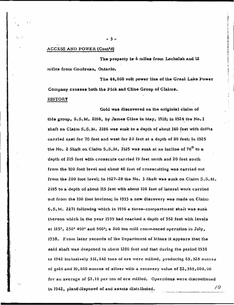
HISTORY
Cold was discovered on the originial claim of
this group, S.S.M. 2188, by James Cline in May, 1913; in 1924 the No. l
shaft on Claim S.S.M. 2166 was auuk to a depth of about 140 fo*t with drifts
carried cast for 70 feet and west for 20 feet at a depth of 80 feet; ia 1925
the No. 2 Shaft on Claim S.S.M. 2135 was sunk at an incline of 70O to a
depth of 215 feet with crosscuts carried 19 feet north and 20 feet south
from the 100 foot level and about 40 feet of crosscutting was carried out
from the 200 foot level; in 1927-23 tho No. 3 Shaft was sunk on Claim S.S.M.
2185 to a depth of about 115 feet with about 100 feet of lateral work carried
out from the 100 foot horizon; in 1933 a new discovery was made on Claim
S.S. M. 2271 following -which in 1936 a throe-compartment shait was sunk
thereon v/hich in the year 1939 had reached a depth of 552 feet with levels
at 125', 250' 400' and 500'; a 200 ton mill commenced operation in July,
1938. From later records of tho Department of Mines it appears that the
aaid shaft was deepened to about 12 O L) feet and that during tho period 1938
to 1942 inclusively 331,042 tons of ore were milled, producing 63,328 ounccu
of gold and 10,600 ounces of silver with a recovery value of $2,369.000.00
for an average of &7.14 per ton of ore milled. Operations were discontinued
in 1942, planti disposed of and assets dlsttibuted. '
-4-'•*
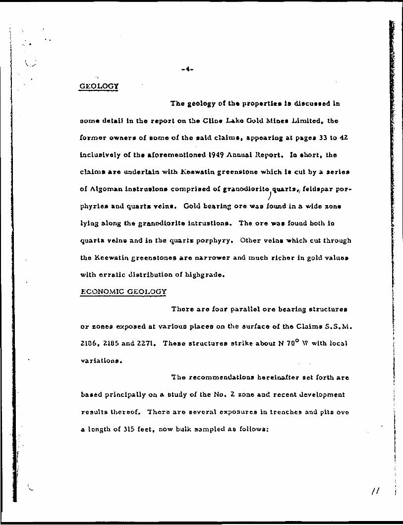
GEOLOGY
The geology of the properties is discussed in
Dome detail in the report on the Cline Lako Gold Mines .Limited, the
former owners of some of tho said claims, appearing at pages 33 to 42
inclusively of the aforementioned 1949 Annual Report. lo short, the
claims are underlain with Keewatin greenstone which is cut by a series
of Algoman instrusions comprised of granodiorite quarts,/ feldspar por
phyries and quarts veins. Gold bearing ore was found in a wide zone
lying along the granodiorite iatrustions. The ore was found both in
quarts veins and in the quartz porphyry. Other veins which cut through
the Keewatin greenstones are narrower and much richer in gold values
with erratic distribution of highgrade.
ECONOMIC GEOLOGY
There are four parallel ore bearing structures
or zones exposed at various places on the surface of the Claims S.S.M.
2106, 2185 and 2271. These structures strike about N 70O VI w ith local
variations.
The recommendations hereinafter aet forth are
based principally on a otudy of the No. 2 zone and recent development
results thereof. There are several exposures in trenches and pits ovo
a length of 315 feet, now bulk sampled as follows:
\
It l

l-5-
ECONOMIC GEOLOGY ( eonfc'd)
BULK -
Grade Oc.Au.
.39
.53
.4*1.94
.12
.IB1*281.26
.77
.404.332.369.31
11.39
Width17"IB-14"12"20*18*16"14*24"IB"i*'12"8-8"
Sample Mo.
1A IB23456789 .40 IB"10 4.33 i"' f111213
DRILL HOLE
C #3 197 - 200Pf3 160.0 ~ 161,6 35.34 .7' .
lftl.6 ~ 164 .29 2.6* 164.0 - 169.5 .26 5.5'
No. 1/2 and 4 failed objectives but confirmed rhyolite structure. Values
Hole* 3 and 5 occur at Rhyolite basic Lava contact considered a control
structure Lo bo further developed underground.
Previous samples taken by the writer of eome of
remains of the ore dump at the No.3 Shaft, No.Z Zone chowod numerous
DpecJt-S of visible gold. A composite ea m pi e of about ten pounds sent in
for ADsay returned:
0.60 02. of gold and 0.07 oa. of silver per ton for a combined, value of about $^0.00.
From the same location a further composite sample
of about ten poundo of dump material in which no visible gold was

- 6-
ECONOMIC GEOLOGY (con 1 'd)
observed assayed:
4.93 os. of gold and 0.35 02. of silver per ton for a combined value of about ^16-5.00.
tFurther earaple of about ten pounds taken across
about sixteen Inches c f vein material and two inches of wall rock No. 2t
Zone in a pit of about 510 feet south-easterly of the No. 3 Shaft assayed:
2.07 o*, of gold .and 0.14 oa. of silver per ton for a combined vale* of about 569.00.
The .7* split core remaining on the property
from recent drill hole No. 5 returning 35.34 oz. reveals some 200 specks
of fine visible gold and no doubt represents the same type of rein material
of which No. 3 Shaft originally was sunk, located approximately 600 feet
north, 7 O0 to the west. The No. 3 Shaft is within a rhyolite structureclose
to the basic green stone contact to the north, concluding that a uow struct
ure io in process of being developed on the Cline Lake group which, in the
writer's opinion, represents the desired Btrcngthening of structure to date
not developed in Any of the old workings.
The development of this new economic aspect, in
the writer's opinion, lends considerable hope of finding concentrations of
ore along Mie rhyolite contact and again to the unexplored north portion of
the properties.
Presently no useful or very accurate estimate of
eit'.uertonnage or grade can be made. It is, however, certain that the
proposed mill tests will give accurate results and that development will
block out ore accordinclv. _________________________

- *- lPRODUCT. )H - PAST AND ANTICIPATED
History, pagd 3, sets out the past production
records. The anticipated future production plans will bo commencement
of the production of 50 tons per day through a 100 ton capacity cyanidation
plant Indicated from past records to represent ml least 987* recovery. It
is expected that production will commence in December of this y e* r and
that prior to th*t a stock pile of or* from development will see continuous
production at 50 ton per day to be increased subject to ore development.
Ore will be drawn from Z faces, drifting, raising
and stoping from 100 foot level and adit dravra from the 2 compartment
No. 3 Shaft. The mill will bo constructed at the old eite No. 4 Zone using
existing footings, pillars and cement work, ali in excellent repair.
CONCLUSION AND RECOMMENDATIONS
Th* report herein ia based on recent personal
examination of the Pick and Cline groups of clalme June 1-4,1960, study
of the report of T. L,.Gledhill published by the Ontario Department of Minos
in the 36th Annual R.epovt for 1927, the report of E. L,.Bruce published in the
49th Annual Report for 1940, the production records of said Department for
the years 1939 to 1942 inclusively, and rny knowledge of the ground gained
while prospecting in the area in 1937, 1946 and May, June this year, as well
aa supervisory visits to the property during recent bulk sampling, develop
ment work, etc., from which flow recommendations as follows:
1. That since recommendation* 2 and 3, July 31, 1959 Report have been
carried out with anticipated results, installation of the purchased raining
equipment be pursued forthwith and, , jj

. e .
CONCLUSION AND RECOMMENDATIONS (coot'd)
2. (that transformers and hydro electric power lines be installed,
3. that No* 3 Shaft bc dowateretl and equipped with head frame prep
aratory to drifting on the 100 foot level,
4. that the existing adit be extended?O 1 south-east to develop No. Z
Zone simultaneously with the 100 foot level drift advance from the
No. 3 Shaft.
5. that warehouse* and mine building* bo built* all in anticipation and
.preparation for milling on or before December 15th, I960,
6. that as the adit and the 100 foot level progress drilling should be
undertaken to test both the No. 3 Zone and parallel xones to the
north for purposes of Indicating further ore by drilling parallel
breaks known to exist.
COSTS
1. To erect and equip corkery* sleeping camp,
dry hou* o and warehouse, equip the ea w e andeqolp and install necessary
mining plant, all acquired at considerable lessthan the replacement value
thereof, le estimated at an expenditure of about $32,000,00.
2. To equip, install and place in operation head
frame, hoists, dewatering, commencement of tniuiug and to place in
operation the mill to treat 50 tona of ore per day, again with equipment
available at considerably lessthan replacement value, will require an
additional expenditure of about $30,000.00.
3. To install transformers andhydro electric power
15lin** connoetincr flame to shaft and mill Site, about S5.000.00.

- 9-
COSTS
4. To develop, block out hoist and deliver stock
pile ore and mill feed - $30,000.00.
5. Working capital oi* about 930.000.00 ahould be
made available for tune up production period* pending return* from the
taint and, finally,
6. Adequate provision* for the cyanidation unit*
mu*t bo wade and estimated to coat from 515,000.00 to 320,000.00,
depending on availability to the Company*
Respectfully submUitd,
Niel* Ae. Andersen,DATED at Barrie,Ontario,August 20th, I960.

t 4
- 10 -
CERTIFICATE
1. I a CD Niels Ae* Andersen, Prospector-Geologist, engaged la exploration management, prospecting, development And have cond ucted mining operations to production) including shipments of gold bullion to the iloyal Canadian Mint, all within th* past 15 years. I have prospected in Canada for 30 year*.
l reside and maintain office at Littlewood Farms, A.K*Pt, Shanty Bay* Ontario, Canada, for the past 10 years.
2. I attended University of Copenhagen, Denmark, in Commerce 1924-25 and Montreal Board of Trade, Commerce k Law, 1924-28; since 1929 l have been actively engaged In practical study of economic geology, pros pecting and mining to this date; except the wary years, 1940*45.
3. i hold no professional degrees and ana not a professional geologist or mining engineer*
4. I have no interest either direct or indirect in the property or securities of the* Company and I do not oxpect any interest either direct or indirect in the properties or securities of the Company, Pick Mines Limited.
5* This report is based OD roy personal examination of the properties of Pick Mines Limited between July 24th and 27th, 1959 inclusively and May and June this year, also prospecting inthe area in 1937 and again in 1946. I have obtained information from the following publications:
36th Annual Report - Ontario Department of Mines, Vol. 36, Part 2,Pages 50 to 06 incisively - T. L. Gledhill.
49.th Annual Report - Ontario Department of Wines, VoJ. 59* Pages 33-42inclusively - E . L . Bruce:
Production records to 1942 of said Department of Mines, and convuUed recently -with engineer actually engaged with production and exploration of Cline Laka Mines, 1933-1942. No work was seen oa the properties other than that reported.
6. Tho accompanying report covers Claims Nos. S.S.M. 5S621 to 58630 inclusively, known as tho PICK GROUP,and Claims Nos. S.S.M. 2185-6, 2133-9-30, and S.S.M,2271, known as the CLINE GROUP.
Si&TED at Barrie, Ontario,^ August 20th, I960, Niels Ae. Andersen

42C08SW8739 JACOBSON007E, JACOBSON 030
REPORT ON PICK MINES LIMITED
PROPERTY, LOCHALSH - GOUDREAU
AREA - ONTARIO
By
W.A. MOORE
22 APRIL 1961
No. 3 S, No. 4 SHAFT ORE
DUPLICATE COPYPOOR QUALITY ORIGINAL
TO FOLLOW
''' 1

ppp. ' ••-.r- ' , ,"
' - ; '- V- ' REPORT ON TICK 'MINKS LIMITED' V. . ,1 PRDFEHTY; LOCHALSK - GOUIJREAU - .. v. - ...\ ' , j'' AREA, f.ONTAHIO -' ' . .
. . , , .' - ' " - ' ' ) ,* ; V ''
'
. S . ! , ':

April 22nd,
Report on Pick Mines Limited, Property, Lochalsh - Goudreau Area, Ontario -
1. GENERAL On April 21st, 1961, the writer visitedthe property of Pick Mines Limited which is located about 9 miles south west of Lochalsh, Ontario, on the main C.P.R. lines West of Chapleau, Ontario.
The resident manager of the property is M.C. Halstead, P.Eng. The crew at the mine on April 21st, consisted of about 2 5 men all told, of whom 6 were miners.
The ore that Pick Mines Limited are planning to mine lies about 2000" West of the main shaft of the old Cline Lake Mines property, which was operated by O'Brien Minss Limited and which closed down in 1941.
The plant at the Pick Mines consists of a mill building, a warehouse, a headframe, a hoistroom, powder magazine, cabhouse, cookery, bunkhouse and office.
2 - MILL The mill equipment was purchased from, the Jardun Mines Limited, and consists of the following:
l - 10" x 20" Primary Allis-Chalmers Jaw Crusher.l - 4' x 6' Dillon Screenl - 8" x 10" Secondary Gardner-Denver Jaw Crusher Jl - 8' x 3' Hardings Conical Ball Mill. |1-6' Dorr Classifier.l - Jig1-18' Thickener, single tray 12' deep.8 - Denver Flotation Cells. -,1-18' Hydroclone 6' deep. ;3 8' x 16' Agitators. \2 - 8 1 x 10' Thickeners ;l - 8' x 16' Prog. Soln. Tank. \l - 8 1 x 16' Mill Soln. tank. fl - 3' x 5 1 Regrind ball mill. |l - Clarifier 6' x 8' Il - Zinc Feeder \l - Cromer Tower ll - Sock Type Pre ? Filler \l - Small bullion furnace ? pumps j
DUPLICATE COPYPOOR QUALITY ORIGINAL
TO FOLLOW

Jlpfrll 2Snd, 1961.
'i, ", ! r
Report on Pick Mines Lisdted, ' : ' ".' V." . :', '-, Property, Lochalsb '^ Goudreau. -'- ; ' -, v-v- . '\ ; ', ; ~Area. Ontario, : ' , ' . !' ; '; ;-'/-.-;-". .''/ '..' / ; '..- - ( -.'y ——" ~.. T . "~-*- • 1 '~7*J~T7 r ^ . "- 1 . V j n^~~ ^ ""* - ; -- '" * '' - '. ' * ^ * ' '
1. OBL?JKRAL -' :~ ' On April 21st. 1961, the writer visitedproperty of; Pick Mines Lift! ted,,.which is located about
-- - - - '— * l - *-*-- —-j— /^T^T\
\l
9 attlee south wast of Lo chai ah, Ontario, .oa the main C. P. B linos .West of Chapleau, Ontario. . . ' ~
t Th* resident nanager of the property is M. C. Halstead, P. tog. , The crew at, the mine on April 21st, consisted of about 25 von all told, of whoa 6 were miners. v ; - .. -, ' ' '; r.* '. :.\ . . \. - . - .
; The ore that Pick Mines Limited are planning to mine lies about 2000* West of the Bain shaft of the old Clino Lake Mines property, which was operated by O'B'-len
, Mines Lltt.it.ad and which closed down in 1941.
i The plant at the Pick Mines consists of a Bill building, a warehouse, a headfrane, a holstroon, powder magazine, ea^house, cookery, bookhouse and office.
MILL The mill equipment was purchased fro* th* Jardun Mines Limited, and consists of the following;
l - .l -l - l - l .-
10" x 20" Primary Allla-Chalmers Jaw Cruehcr.4' x 6' Dillon Screen.8" T 1C" Secondary Gardner-Denver Jaw crushes6' S3 1 Hardinge Conical Ball Mill.6' /Dorr '.(
8 .'
''Thickener, slzvgle tray 12' deep. DenVsr. flotation Cells. . ' 18' 5ydroblone\6' deep
/9

The mill is set up ?straight cyanidation, for 200 T.P.D. on flotation. The ? mill is larger than necessary for the size of the rest of the equipment and the grind is believed to be quite fine, possibly 90% - 325 mesh. The mill has operated for a few days in March and early April, while repairs and adjustments were made. It operated steadily on a 50 T.P.D. basis from April 5-llth 1961. The Mill heads for that time were around $15.00 - $16.00 per ton from development ore.
Evidently it is believed that the mill equipment is now in good condition and will operate satisfactorily. The Mill Superintendent is Raymaond Menasse.
3. DEVELOPMENT WORK
Pick Mines is presently driving a 6' x 7' adit into a hill to follow a narrow high grade vein. The face of the adit is in about 150'. In one place where the overlaying rock was too thin, a cave in occurred which they are now by passing. They hope to learn more about the vein with this adit and to prepare some ore for mining. Actually, there will be barely 75' of ground overhead when the face of the adit is well into the hill.
They also have a two compartment sahft just to the West, which was sunk to a depth of 115' by the Cline Lake people. Later, the Pick Mines will drive out from the one statjon in the shaft, and follow this same vein on the 100' level.
4. MINING EQUIPMENT
There is a framed timber head frame about 60'high and a hoistroom. The hoist is a Canadian Ingersoll Rand double drum electric hoist, 24" x 36" in si^e. There is a 13i x 8 x 8 V.H.E. CIR Compressor, 3 Copco Jackleg drills, 2 small mucking machines, a cage, and several l ton end dump cars. The drills, hoist and compressor look in fair condition. The track is 18" gauge, with 20 Ib. rails.
j5. ORE PICTURE - PICK MINES
(A) Adit Vein The first vein, or adit vein, is a narrow high grade blue quartz vein, in a greenstone wall rock. The vein is narrow, varying from l" to 2.5' in width, and it pinches and swells rapidly in a short distance.
The. quartz is blueish white, well fractured, and quite well mineralized with fine pyrite and minor galena. The writer saw several samples said to be from this vein, which were examined with a glass, showed tiny specks of visible gold. The writer took several random grab samples from therein in the back of the adit and even after washing them and examining them carefully with a glass, could not find

, T..~possibly. fSi .
' day* in March.aDd early :'April/ while irVpalre- and arf j\'stn?.' 'were 'made..- 'It -operated; etea'dilyVon : a 50 T. P. D.' baala ft .'April 5-11 th .1961- "The Mill u,eadr,f,or .Uat U*e.werel 15.00. -116.00 per tori from .development ore. . ' ' " ' ' '
-* , ' ' ' v , Xrtdently' l iv.'tolytd-'tlMti tb* mill quipmeutl* bow lo .'good -eohditiomand will optrat* atisfactorlly. Th*iMill Superintendent i* Raymond Menaaee.
3* : DZVELOPMSNT WORK . '\' ' ' '', \ , '' ' ,V .'; ,' "- . |L
.^ -. Piok^Minea'i* presently iirlTl'ng a, 6' i 7' adit into a hill to follbw a narrow high grade rain. - The faet of t h t adit la in about 150*. In one place ^ere tbe overlaying rock waa too thin, a OAre in occurred wbiob they are now by paaalng. They hope' to learn nore about the rein with tr.le adit and to 1 prepare so ne ore for Mining. Actually, there ill be barely 75' of ground oterhead wben the face of tbe adit ia well into the lil 11.- : ;
' l? 'They alao haTe a^#41**at*eot '8haf Juct to thi* \'
Wect, which war *unk ^,r^^*^'^,a5b.lth!p;\CUne Lake ?iSJj&Jlje. .Later, the Pick kinea will dri*e out froa the one *atation in the ahaft, and follow this same rein on the 100' {l.tel.. .'.' , : - -. ,- ,,^ . , , ;, * '- ' l
4. MINING SQUIPM3SNT .-'-'- ,'.";"," j ' ; - ,-, '
' V - ' There .Is a framed timber head frame a&out 60' high and a-hoietroom, .The hoist is a Canadian/Ingersoll Rand double drum electric hoist,"'E4-* x-36" in si*e/ There ia a 13|'x B :x 8-Y.H.K. -CIR Compressor, 3 Copoo Jacklcg drilla, 2 small audking machines, a cage, and several l ton end dump oars* The drills, hoist and oompree-sor look in fair condition.
The track is 18" gauge, wJth.SO ib. rails.
5-'"'" OR3 PICTUBK '* ; PI CK'MINES. - - i ^ .-V : '' \
'\' :{A) Adit Tt in 'The first .vein, or adit vein, is a narrow high gra de blue qua r t z vein, in a greenstone wall rook. 'The vein is narrow,, varying 'from l" Ito x.6 1 In width, and it pinohea And swells rapidly in a short .distance. ,'
: : The quartx i a bluelsh wfeite; well fractured, and quits well mineralized with fin* pyrite and minor galena. The writer saw several samples said to be from this vein, which were examined with a glass, showed tiny speoka of visible gold.. The writer took several random grab ea api* a from tbevsia/in tb* back, of t bs adit aid eve* after washing Jth*m and'examining the* carefully with a flaw, eouU not fin^

-3-
Pick Mines
any V.G.
April 22nd, 1961
These samples were assayed at Renabio Mines Limited, and the results are as follows:
Sample No. l - Blue quartz, well mineralized, 0.54 ozs./ton Sample No. 2 - Blue quartz, well mineralized, 1.58 ozs./ton. Sample No, 3 - l" wide Quartz vein (the main adit vein at
this point) fc some mineralized greenstone wallrock.
Sample No. 4 - Wall rock adjacent to vein,mineralized sheared greenstone 0.10 ozs./ton.
An assay plan of the adit showed the following results:
Station O V.G.
10' 9.13
30'
40'
50'
60'
80'
2'
V.G.
V.G.
13.09 2'
0.202 1
V.G.
DUPLICATE COPYPOOR QUALITY ORIGINAL
TO FOLLOW90' V.G.
100' 3.38
110
120
140
160
.5
7.18 .7
0.30 2.5'
0.99 1.3
V.G.
4.5
These assay values are not cut, nor was any attempt made to cut a sample from the wall rock, across the face or back of the drift. A few inches away from the vein, the writer could

Pick Mines -4- April 22nd, 1961
not see anything that would indicate that the greenstone wall rock would carry values. The samples were not cout with a moil, but just chip samples.
Thereare 3 D.D.H. intersections about 75' below the adit, and perhaps 250' from the 1st hole to the 3rd along the strike.
These holes give the following results:
Hole # l West 1.64 ozs.275"1"
Hole # 2 Middle 35.3 ozs 0.29 0.260.5 1.7' 3'
Hole # 3 East 0.41 ozs.1.8'
Again the assays are not cut.
Indicated reserves on this vein, using the assays from the adit, some surface trenching and the 3 D.D. Hs. are:
Block A 13,875 tons c 3 1 width.Grade S25.32Xton (cut values) Value $351,000
All assays over 1.0 ozs. cut to I.L oz.
b) f 2 Vein
About 200' to the South of the shaft there is another parallel vein on which Cline Lake Mines did some stope preparation and some drilling.
Indicated reserves in this vein, down to the 500' level, 4th, using the results of 8 D.D. Hs. and l small stope:
Block E 35,100 tons c 5' width Grade $ 16.35/ton. Value $ 574,000
c) f 3 Vein
About 140 0 to the south of the shaft there is athird parallel vein on which Cline Lake Mines are?preparation and some drilling.
DUPLICATE COPYPOOR QUALITY ORIGINA!
TO FOLLOW

*?TT ?r't T-r*y??rr* TTT?f ?vnm rT--r?--r--Tr-^rrsyCT.TTV;'* yy-yT'-- vf'TT-ITT'^' T-v-''lav;;**. ;V ;^vyj- ; ;-HV^^ii:; Sx-^.,i .'
Pick Mines
any T.O.
- :'-v' April . 1961
f t
The e t sample t were assayed at Renabie Jtln ea Limited, and the results are as follows: .' h . , ; . v. ......, -
Sample No. 1. :- Blue quartz, well mineralized, o.54 on. / ton.Sanpl* No. E* - Blue quartz, veil mineralized, 1.68 oza. / ton.Sample No. 5. - l" wide Quartz tain (the aain adit vein at
this point) it a oaJe mineralised greenstone vail rook. . T , 0.24 oi*. /ton.
Sample No. 4. - Wall rock adjacent to Tein, . -mineralized sheared greenstone 0*10 oza. /ton.
An assay plan of the adit ehowad the following result*:
Station O
10'
V.G. ,
30 '
40*
50'
, 60'
* -J These a a say raines ajr e Aot cut, nor wa e any atttcpt
to cut a aa api e from the wall reek, across the face or bs ok of the-drift'. - A fewMnehe* ,a*ay; fjom the .T*ia, ..the writer oould

' April 22nd. 1961
not .'any,thlng that would Indleat* that th* greenstone wall rock would o*rtry Taluea. -. Th*..*a*pl*^,: **r* not out with a moil, but Just'chip MKplai r ] . : . . ; . ;;' s ;' -V '' v':' iY/-.O- .
. 'V/'.-.'"..V ; ; '"' -.r' -, , - ; : \ vi'.': '.-.: ;'f ^.-'. ; *. .i J * - .-' ' '- , i ; 'i V'.' -
'- 'ther* are'3 D.D.H, int*rs*ction* about 75' below the adit, and perhaps 250' from th* l*t hoi* to t he. 3rd along the" '' ' '
**"'-'i.v--.".:;';* /.,---- :v.:v,-v.v^'"-- Y' ,Y''W - 'Thew'hdle* giY* tb* following result*:
Hoi* fi f*Bt' '
.
.Hole ^ 2 Middle 35.3 oza. x": ; '-'. ...i.'V ' :; .'" ' ' .'P.5 -' .
0.41 oza.Hole # 3 Kait
. .Again the aaaays are not cut.
Indicated reaerres on thla.veln, using thefrom 1 the adit, BO m* eurface trenching and th e 3 D. D. He. are:
Block i 13,875 tona O 3' width. Grade fES.JE/ton (cut Talues) Talue l 351,000
All aisaya over 1.0 ozs. cut to 1.0 oz.
About EOO 1 to the South of th* Shaft there la another
rH^*T V^"*Or\Ji*T "a v*4
ri. .-RtfeM.t(T f- ,*'*^*V*J"1 '** l

Pick Mines -5- April 2 2, 1 961
Indicated reserves in this block (top one, from surface to 2nd level.) using the information from 5 D.D.Hs. and 2 stopes.
Block B 26,759 tons (3.5* wide) Grade $ 21.73/ton Value $ 581,000
Block C (below Block B) using 2 D.D.Hs. E. Stope (1)
8,125 tons (3.5' wide)Grade $26.60/ton.Value $216,000
Block D (below Block C) down to 4th level. using 4 D.D.Hs.and l stope.
7,009 tons (3.5' wide) Grade $22.54/ton Value S157,000
The above calculations were done by Mr. Halstead. His reasoning was checked by the writer.
6. CLINE LAKE MINES ORE PICTURE
The writer spent some time examining numerous level plans, D.D.H. results, and stope sections of the old Cline Lake Property. From these and by questioning Mr. Halstead who had worked at Cline Lake Mines the following picture of the Cline Lake ore evolved.
There were 8 levels in the main shaft, the first 4 levels at 125' intervals; the second 4 levels at 150' intervals.
The most of the ore was over a length of 600' and since there were several parallel veins, the width of the ore zone would be around 100'.
Most of the stoping was sone from the 5th level to surface. A few stopes were prepared on the 6th level. No work was one on the 7th level and only some stone-cutting and drilling was one on the 8th level.
DUPLICATE COPYPOOR QUALITY ORIGINAL
TO FOLLOW

rick -5-
Indicated rooerTcs in ihlo block (top om, fromto ?nd level.) using the information fron O U.D.n.s md 8
EG,7aa tons (^.5'Mrndo f 21,73/ ton Valuo J 581,000
Block H
Block JC. (below Block D) niOng R D. D. lin *. O tope (1)
' ( 3. r* 1 wldn)26.60/^011. 210,000
J.U')ok U (btilon Dlock C ) '\onn to 4th Imwl. 'injnr(: nml l n tops.
1 l '
; 7,00{i tons (3.!.'t S3. Hi/ trm. 1157,000
Tho ftboire calculptlonn n*srfl rlono by Mr. Illn roRPouing wan checked by tlie nrltor.
.F: LAKT. ' MJ n RI onr. ri CTURF.6 'The writer- epent nynn tin** rn."nin.lii'-. n"n*r"""
plni\n, D.D.H. repultr, nnd D tope .T^ntloi'6 of th- oi-i l^iV.^i Tropwrty. From th"* A nn'1 bj q'l^sHonlnp. Mr. I'iJ
h*jd worked ^t. CJ.lne J.^ke Hine a th*j follow! n/j plc^ur* of tt) o Olln9 J*ake oro
There were 8 le**!!** In thn nf\Ju nh^ft, fc-120* luterral*; the eocuud ^
1 Thf* irofltU'f *Jrtp ir e ntp i*7*r n i "tip*'i o r nnd .Bind* there wero severn l '}vi;ell^l tTlnn. tm i*I

Pick Mines -6- April 22, 1961
They were fairly continuous in height and some stopes went through 1,2,3, and even 4 levels. The "A" vein went from the 5th level to surface. But not all the veins were that regular or continuous. Some stopes were not mined through to the level above.
It was noticed that the grade appeared lower on the 5th and 6th levels, and on the 8th level, there were only 2 ore values in the 8 holes drilled.
There was one long drift to the West driven on the 4th level, which reached the vicinity of the Pick Mines workings. Several back stops were started and then the mine closed down.
It is the writer's opinion that the Cline Lake Mine ore should have yielded a higher grade if the mining widths could have been kept smaller, perhaps by the ? method of cut and fill. The Mill heads of the Cline were around S8.50/ ton at the start and decreased to ST.OO/ton at the end of the mine. They even tried a big glory hole at surface, taking the mining width 40'-60' x 300' long.
7. SUMMARY
The Cline Lake Mines has the necessary equipment to operate a small tonnage high grade mine. They lack machine shop equipment and personnel to do the necessary repairs. They should also spend some money on diamond drilling to try to prove more ore.
It is very doubtful whether they can maintain the mining widths indicated in their tonnage calculations, if they use shrinkage mining. The slabby greenstone walls will make a lot of dilution.
But the management appears to have a sound idea of the problems and how to face them. With some more funds, and perhaps some guidance it should be possible to have a profitable venture here, if kept to definite limits on the exploration, the mining and the capital expenditures. ^
In view of the assays returned on the grab samples in the adit, the writer would recommend that a more extensive program of channel samples in the adit be taken, togetherwith channel samples of the surface trenches on this vein, * before any funds be advanced to Pick Mines Limited.
Secondly, if it is decided to loan them some money, the writer suggests that the amount be small, and that it be specified that a good part of it must be spent on a small D. l), program to prove their ore.
it
DUPLICATE COPYPOOR QUAUTY ORIGINAL
TOFOLLOW

, , ; 'V'.; "- ' ':'*4 -'they .ware; falVly.'eah^iiudua la haight and aoai ' atopes went ,through'1^6,3, -ahfl ;*t*i*o 4'levels. '-The * A "
' ^ ' : vein went; fro*.^th* Stix'}avel {to'^uxfa.ea. -;, But aot.all,f . - - the rein*,were "that jegular Jor'1^aUnAioui,'v r 9os**JBtopeB were Y- " - : .;S 'no t' *lri*d ^roiigh .tV-'tfcb 'Je-T'eii-*fcov*^ 'v^jH^V T' J ' •: - ' !-' " '' 1 ' '''- '''---'' - f *-'
^,-;; ( ': .'..ii waa-hbtieed ,that^ the 'graQe appeared'lower on the and 6th-levels,and on the" Bth level,- there were only 2
hate hat*
v , p . of cut 'and fi 11* 'The All l V ''head* ' *f the Clio*V*rw around ;V .-, '..''••'c'" t on at the -start and decreased ,to-- ff , 00/ton at" ih* end of the
mine. They even.tried.a big glory hole at surface, taklng ' ths mining width. 40' X 601.1 300'.;ione.-..: , 'v
;-.'"'"'.7 - SOMf-iARY f. . ;-- y :,v/,., :.' j 'V.f',; '' '•'•''f r',- :. -.'t''.'' -'' ' •'.•'
1 '; - The Cline LaJce Mines baa Hhe necessary equipment . ,, . to operate a small tonnage high grade mine. They lack machine
. ! '. shop equipment and personnel 'to do the necessary repairs. They , ,, ' should also spend some money on diamond .drilling to try to prove
.more.ore. - .•••/. - (.'' '' -'/. ;; ,-. - - I p ,\; ' .-. . ' V ' .
'\ ;,''.':. j.',^ :-'f'-. v-i.t is'^^ry doubtful 'whether .they can maintain theaining widths indicated in their tonnage calculations, if they
: use shrinkage mining. ; The. alabby greens-tone walls will mak* a ..lot of dilution." ; -'.''.-- ( v : ; i., . '-.' vv."' ' :\
- - ' * - v , i '-' i ' ' - " -' ' ' ,, !, , ' . But the rDanagenent vapp*ara'to have a sound idea of
- ) - the problems and how to face the*. With sane wore funds, andperhaps some guidance it should be possible to have a profitable .venture here, if kept to definite limits on the exploration, the mininVand the.capital -expenditures* ,-
t.-:v*/ . v ; 1' In view'of .thaaaiaya returned'on tkt grab samples '^ --"-I In- the adit, the writer would taobBawd that'a^ sore eitensive
,':\V prograja'of ohannal, aampl** in ,th* *4U ''h* takah; ^together .with .channel aamp'laa-of tha ' urfdi^i'/.trajiehas on tbia vein,
uggeatibe specified that a good par x of it must b* spent on a anall P.D. prograsi to... prove,their ore.

Pick Mines -7- April 22, 1961
Then and then only should it be considered to advance them a larger sum.
Respectfully submitted,
RENABIE MINES LIMITED
W.A. Moore, Manager
WAM:dht

. "v -
^7c a
S .B,:*r *--vV
y .J
v v,**r..v; -' 3
. v*i - ' --.
m:
.-'^.'•rT
1.-;. ro .
^^X
*f A
.B-V
-•;.-^...r-i-. JB
•-,•'
-
'vr
1-1 . M
1
;::.-'^r:*' '"^ .^TCT:
** M
•~....',V;.-f O
' l-l W
.,.?^'.-8
,;;l?v, *
*--v
^r,*
-. j- . -^.—
—^
i*-*-*:.:---.x*i.- * . H ,..-
-.., - : -
i* .•.•;--.J...-.ft; \.--K.
,. -^
^r2"*'^w.^-v-
- "•"••-•'•- ' ':-
-'3JK
*L-M
-- •-•./-'
- rr
. :
...
- -
-.•.•••••.Q
rv.3;.;.'V -;^'r'%:^"-. ••-- . s
-- -^
^
•*.,^ v '"'O—
' *-
•'S1*1*'"* J-
.••is'-r""V? •i*1"-^, ^.
'ir^-.c.^-C..*^:-. -••i ."--s- -- -,-
r... -
^tlTf-*;^..*-.
:..-.. - ' - •.-..-...
••--•V
,v'-?*'t^-'r-•.-.'••h' "r' ,--'-
..^"•j-:,A
^.- * -: . - - -
, -
-.•-;g*:;:.-.cg'"-;---''r.-*-:----. '--.
'r '-' -
^""^r-^v.g-,^^---- -* -. -
*. '^;v,;r~^—
- : v.-.5 '
- --•"r
.a - --..
j, -
"
-•f*,-~,.
- •..-.:,. .r*. - .
. M ,
•t ' '
;-- - ,. .
:. - w
-^S
|f. .
,. '
-' .
. .
W''-: :-~.---.™
^x.c^.-^.

42C8I8SW8739 JACOBSON0076 JACOBSON 040
\.,
•i. .J 1 .-- f..:
The Pretldont to Directors, Pick Mrnes Limited. Suite 302,100 Ad*Ulda Street, West, Toronto l, Ontario.
Gentlemen:
Further to your request w* are making a review of the engineering and other property data oa your gold c l* lau In the Goudreau area, Ontario.
. ' ' ' - . ' '
The attached report will cover that portion of the group on claim* 8. S. M. 2485 axxl 2186, which i* the area La the vicinity of the #3 sha/t. - .'
'.'-.'•'VS-' V'i-' X: .'''.••"•li*' --
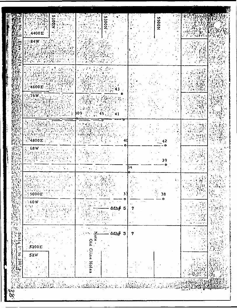
03 shaft area If takes a* eoverlnf some 100 feet of length oast and west by 600 feet north and aouth. It le designated en the ml&e plans a*:-
Latitude(I.e. longitude)
5, DOON to 5* 60ON to 5,2001:
Previous Work
The work done to date can be ouxomarlaed a*follow*:-
Dy Cline By Plch Surface elavation-f3 ahajCt collar la 6,274'
1. Shaft f3 - 2 comp nhaft to the* ICO 1 horlnon and level station •utabllshsd.
2. Bar f ac 9 - mse.
1. Shaft - headframe erected with bin, dewatered and limited x* cutting on 1st level.
2. Surface - trenching followed by adit below surface work, 400' east of Dhaft on f3 vein system.
3. D.O. Holes 3. D.D. HolesThe first 400' caat of shaft DOC- rive ahort holes drilled below tlonod by holes Q 1 00' Intervals. surface trench and adit. Locations Theao hoi e o o tap eouth going weat, still to be determined In plan, which leaves a 200 foot gap oouth and oast at the abaft. :
* .' i -'. ~'•-i-s r

.'.^••flviVf.;--^.:
. .-y.. -. ,;
4. 1st Lavel - elevatloa 6174' station cut.
4.. 1st Level - elevation x-cutting
5. 2nd Level - elevation 6074* 5. None t* date. O.D.H. sections Indicate values. ":-
. " * ~ - ' ' - -6. 3rd Level - elevation 5974' 6. Nono to date.
472 Sub Dr. - horizontal drill hol*s , . Q and Q north veins.
, '; ;- :- ^:^:m-^^^\V :*'...:.!M'--. y ^-;!\V.ttt.*J.^-\rt*^-'-
-., --:, s-:v-^,.^.^iv.;\V^^^rl^;K^^: 7. Hone to date. '--fe^fer^i^'- . ' -^^Jte-^fe^^Mj;'7. -4th Level - elevation 5974*
v^ The old 4th level workings are , at elev'n 5S25'. Vein R orV-v Pick 12.-;-' ? :.-'! ;' .'.- . ..- -- ';--:'. f ;:'.-/:.'.----'^ ^V- . --^.-.^ V ''-'' "',.' '. . The purpose of this report lv to correlate the data re veins and values, etc. In that block fronx the surface to an eleva tion three hundred feet vertically belenr the collar of shaft #3. ' ,.
The 4th horizon, which Is sccoae 4) feet above Ihe " ";.' Cline 4th level will be considered In a later report. 1 '!~* . . . i ' '.; . * - ' i* * \
riadlngs -..'••' . '', , ' ..' ..''-V i '-. ~.,''':( Jl'!:^ry^\,- . ' ' : ' -, .' ,- : '-: '. T -' ' '..- ' •^.l^''-'*r'^!* : ^^Z
This report then deals with a block, 000 f*.t In ^ V leagth, 600 feet In width, having a vertical component of 300 feet. .
To facilitate this study, all data has been compiled on a series of plans at 100 foot Intervals. All at a scale of l" totoo feet. ../j... - :. . . ... ,; :'^:..\;^V;:a" . It Is ptrtlnent to note here, that In the xrtaln Cline \ .; workings, In the vicinity of their main shaft, that the shoot* vary lo strike from N 70*W to 8 70* W but with an overall east west r trend, all have steep dip* to the north, and pinch and swell on strike. Vho stop*d ore sections vary from 50 to 200 feet In length, which Indicates why a close diamond drill pattern was established under ground, with vertical sections at 25 foot Intervals.
Three vein systems are Indicated la the block • frudy, and have been deyglnated fr*m north to seuth aa, the #3, the Q and Q north, and the R or Pick 02 vein.
'•* - ; - :-.*....- -- -';l f.i*' ' -'.: -' ' - , •: St a
.•C'

't-'. ' •J
:t .
, : - .: Th* 13 vein system l* indicated cm surface an4 in . Pick holes 13 aad 15. H appears to haw a N75* W tread with a steep dip to th* north. , '",\ - . . , ,
The Q and Q north vein system Is exposed on the 3rd horlson or 472 Sub Drift by flat undergrcamd diamond drill holes and drifting. H has a strike of 330* W, aad the system has bo en cut invarlous of th* surface sectional drill holes. On the . upper horizons the strike becomes mor* o*at aad west. Y -
''-•'i: i :":'.. '.-, ... /- The R or Pick f 2 vein system would appear le have •;;j an cast west trend/ but this is s cane what confused by the outline ,,f. .of the 4th level workings. ., . ; V
. ' '. The 100 seal* drawings indicate a convergence of ,' the Q* Q north and 13 vein systems to the east of th* adit. :
Proposed Surface D Una cod Drilling
. To open up the fcdlt ar*t on the 100* level horlsoa would call for 400 to 500 feet of underground devela^nenl or three to four months of dead work, at aa estimated cost of 560, 090 to 575, CCO. It Is essential therefore, that the maximum Information be available before consideration Is given to a resumption of under ground effort. . - .-. ,.' . ;: . . . - .'.. t :':'-. ,;'
The following surface diamond drilling program, in th* 13 shaft area is laid out to-
, , ;* V * ' '
:, 1. Check the possible convergence of the #3 and Q vein systems in the vicinity of the adit.
2. Determine what sections occur between th* c4it and 13 shaft.
3. Glv* th* relationship of th* various values, th* on* to th* other. In the first 300 feet of vertical d*pth.
The drill holes will be laid out from north to south, with th* collars at 45* south. The collar locations to b* as close as possible to the old mine co-ordinate system.
? ' l
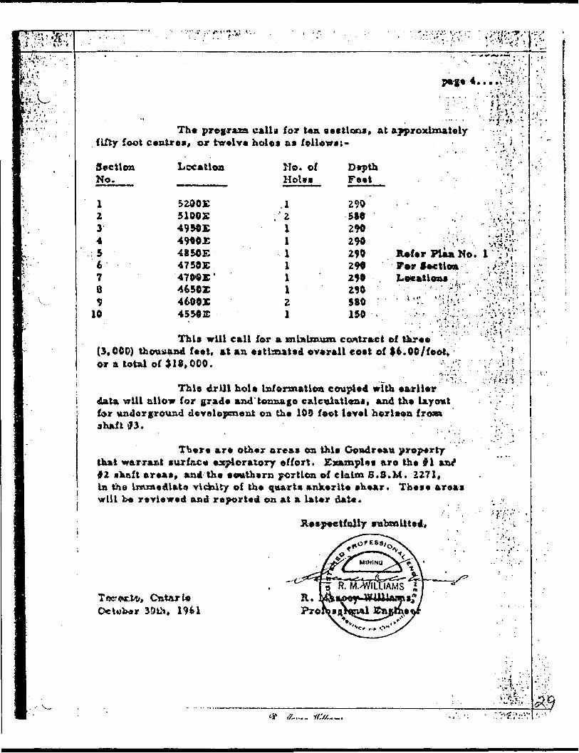
* -C*~ *page 4..
Th* program call j for ten sections, at approximately fifty foot centres, or twelve holes as ftllows:-
Soctlon No.
1234567 O
10
Location
5 20 O Z 51005
4940JC485054 7 50 E4700K '46502460014550JC
Mo. ofHoles
.121
111121
DepthFeet
290580290
290290290290580150
Refer Plan No. F*r flectionLocations ;
This will call for a minimum contract of three ' , (3,000) thousand feet, at an estimated overall cost of It.OO/foot, or a total of
This drill hoi* Information coupled with earlier data will allow for grade and tonnage calculation*, and the layout for underground development on the 109 foot level herlaon from shaft 03.
There are other areas on this Govdreau property that warrant surface exploratory effort. Examples aro the #1 anl #2 shaft areas* and th* southern portion of claim S.8.M. 2271, In the Immediate vldolty of the quarts ankerite shear. These areas vrlll be reviewed and reported on at a later date.
Respectfully submitted,
30th, 19*1
S9

l- \
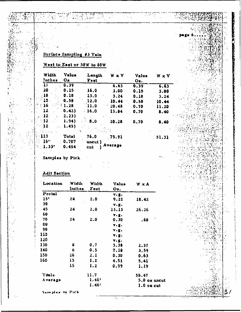
' No. 3 Vein
Strike N75*
Section
68W65W64W
63W-56W1
; 63W-58W, ,:"
, .-
55W
Not*:
: -
W Dip Steep North
Elevation Tvpe
DDH 40/42DDH 39DDH 34
•, ' ' - .
6274 , trenching
6274 adit
s6184 DDH 5
6182 DDH 3
1. D. D. H. 3 St 5 not known
•-..-i- ~^Ziti^!jg^ '.3'?.'. ' ; y /t'"J.i *j?J\*j'^7-j' v n? j
.•..^.'^S^i/pM 'S-' ' V i ' ''-"t- ^ * -M MS*',"!'-*- ' "'. :'-'
Remarks ' ' ' ' - "" "'- '••• t-: '. ; '.".
ItTltV '-'" J."'1^ i -": •**'i —' '- -' -"•Jill) . j..., j *-' •.-.•'•!'. . . . - . :ND) A^MirenUy cloved to wesl ' -.Mil) holes on section* 70W.72W,
etc. collared too fat south.
130' of length 7f sampled ": vT"': , J.width 1.33^ @ 0.454 OB/Um cwt. t ;
' : Y-'^1i')) li l-i -'.i.'^'v/.vii'',1? -. -"^ ~130' of length, 100' sampled' *width l . 46' @ 1 .00 os/ tem cut.
'p -. .'."i tr "."' . ; '' \v/ '"' V'' ' '' -'0 . 50' @ 1 .00 o*/ ton cut (33. 34 os)
2.10* S 0.41 om/toa uncut. . \.. ^- •'v.- v 'VV- :'' vU-'V-i .In plan, could Y 1-
therefore be either #3 or Q vein (see plans).2. AU assays In our face trenching weighted k cut.3. All assays In adit Bc hole 5 cut to 1.00 os.
iiNo. 3 Vein
j ElevationJ
Surface6274 ~/
4. Open to ear*.
Intersections
Section Type Lengthrt.
58W-60W trench 76.058W-60W adit 100.056W trench50W trench
" ,- ' •*.' ." -' -- ' : ' ; '.''-: :' :''. ;
t . ~ ^ -t " ..' '
Width Value TypeFt. Os. " -- ' i
- . - -. ' ,-;.-. .
1.33 0.454 cut1.46 1.000 cut1.10 1 . 260 uncut2.00 0.770 uncut j1.50 0.440 uncut0.20 11.380 uncut0.70 9.310 uncut1.50 3.610 uncut
100' H.orUun (6174)6164
via;
53W DDH 5
54W DDH 3
#. .ff.,U.y t/.'//,., m i
0.50 35.340 uncut1.63 0.290 uncut3.55 0.260 uncut -.'* i i2.10 0.410 uncut V— j/v^i-v 3c
•''^^•••^''^'•^.r */ i^-
v-'--.' .*'-T ' fr?f " H*.- -V*.jv... i -f.-,' . . t-
*\ ' .:
lji-.;v;-x. .fr ' -*. 'T'*'*** '-v- V
•iO,'V .-'-^.8 l - - ' .;r' t .- , -*- , , ' .^.:; : ; :- :-®; •;-- :;''. ; - ' '.'
:'; '
,l' '
. . ..'s
r'; 1;' ' . - .'
,. - j
* ' ,:
:\'' : '''Vi ;; '
i '
i"
^ ' ;. . -.c?
Surlace
We*t to
Width!ncbc8IV2018:'.-i3 ' ;
••'.;. 16 ••.••:512
, 1212-;'r . .-,'.-."' -
' 1. 1 , . .. ....'"' ' - : '
!i ,. - .; '
* j '
: ; 113: 16"
1 \\t * j -f
; " ;- Sample*' '*
;- -j' -\
. r ' -. --; .-,y
Sampling
i f- if: -^ -- r -M"' '
-
#3 Vein
.'r ''
Eaet or 58 W to 60 W
ValueOs0.390.150.180.581.280.42)2.23)1.94)1.45)
\Total0.707 0.454
by Pick
LengthFeet
16.013.012.011.016.0
8.0t- ' '.:
76.0uncut ) cut )
W x V
6.633.003.24
10.4420.4815.84
20.28.,' , ..
79.91Average
ValueOs.
0.390.150.180.580.700.70
0.70
Adit Section
Location Width
Portal15'3045
j 60• ' 70
8090
1 no120130140150160
TdnlaAverage
\*WJ )*4 M *
Inches
24
24
24
86
261515
*ry Pick
WidthFeet
2.0
2.0
2.0
0.70.52.11.21.2
11.71.46'1,46'
ValueOB.v.g.9.21v.g.
13.13v.g.0.30v.g.v.g.v.g.v.g.3.387.180.304.510.99
W xA
18.42
26.26
.60
2.373.590.635.411.19
58.475.0 OB1.0 os
.- " "" "."•,',--!A-.i '.'*5n?l?^?J^ l r ''^**^J8w3#{^
, \"-:-^^m ^••\*f*mizpage t ......-'®iteil
.. "f, .:-;.i ij-tf'jixw, . (-;- .' .v-yTV.S":^/U^i^&E*V :-^t*?tf.4tyR•-.-A'-^k••'-;*-ft^
: ^VV#VY.- ^:^;:'^Hj
W x V - ' ' - • •' "'. v ^ - ' , ; *
6.63 - . ••YJ-'Y-3.00 ' . ;. : '-.'-f:J^-':
3 ~ M . - .] - . - . ,-i ' *!t .- , . *4 . -. - - . - , - : ' - .. '. 1 * '* ..' , /* . . '. .- * ,
10.44 :-.'^: ;;:r:^' :11.20 "Y.:'- .;"^^.i'.:-;:-:.-:.8.40 . -,-..; ; : -';'|V:^.;Vti s! :.;
. .r ' ".i ', t ..t 1 .!* i*" 1 *" 1 j-. . '" ,** tv *.''1 •lV'' t *-*' '- i :*" * ' ^VY* '"'-
8.40 r-. -. i! .--:.'-;^;;N:.. ... ' - ( i ;, . ;.: i. . '.- ..-.•- - -t ~
•' :'~' "t;:'t.-'.'..'--'';'-Viij •.i.-i-'.V' ' 1
EI -*i .-. ' ".•'•'' '.- - .' V ••v'r^i;.-.a*. Jl ^ -- -. y v- '--. " \t,' -.'.-••i /- . v ;..,,v,' .^i..-,- -' ' :' '••.•'•'- - ; -v" 1.''.* •^.".••f" J1
. . v';\- ''•?--v.;vv. ;-i.*V.: l'\
. J
;
\ .
/
•:
- ; ,' v. T- /•jV^Vrj.'.^A;/ -~~" -./•'•' : .v''' :V.SS^S^
.;.,'.'-,*'* v ^ ti : ''-.x""i;",*? : .*\ ,'j i -*- *"' - " -
•••:V-.Vv?..--A.v'rv^:.'. ."'' .. '.. -' .'i' "-'.f i '|V'~ "-, . . ;v • ; :-: 1 .:' •^'•:- 'l
•V " ' v ""* '. -' : -V "'. ' :'~- .".'
- ". ;.- .'..;- .:- ,..
.
-
. . - '. . ; P. 'X- " . '' '-' ' ' ' - . ••-•. t' :"'....- '.' '•'".'•,-'i-if '".''-
.r . '-. vV-V-t;. '•-,' . .\ :. ; i -'./.*-*',.-- ..- - - 1 - '••.•.-•- --r\ - .- -i^ , " : -t, - :-••- - - • '••\- ^ .' ' '. ' ' V-".-- '.-/•••.'.•v,'':..
. - .: ^ -. .;, -. ' . •1 'S'^ j;'-'' - \ ' '.'i .''.;', .".•-'•••j?v^\v
': ,' -' , ;*V ••*•. . •;:.;!.v^. - .•: . .- y: . i; v i'.';,: ''- .
^ i * * J-..'' ' ' - r. . . V . -
. .''-V- --
- ' - -.,
.'•'5'Ji .
uncut '-: \ ( : ;.;?-:;''cut • ;;^'^^^;ife:v-i- V'~ST?' : ( 4 r'-'-tfeiX1;!. ; -y'-:v,:-^|^;4j^;C
.
^
iij^^-w''^: r^'-:;-::v .''KtV''^'.'" S •"•'-. . ' •"^•'•'•' '
Kfe^-^S^,-^.-'' :
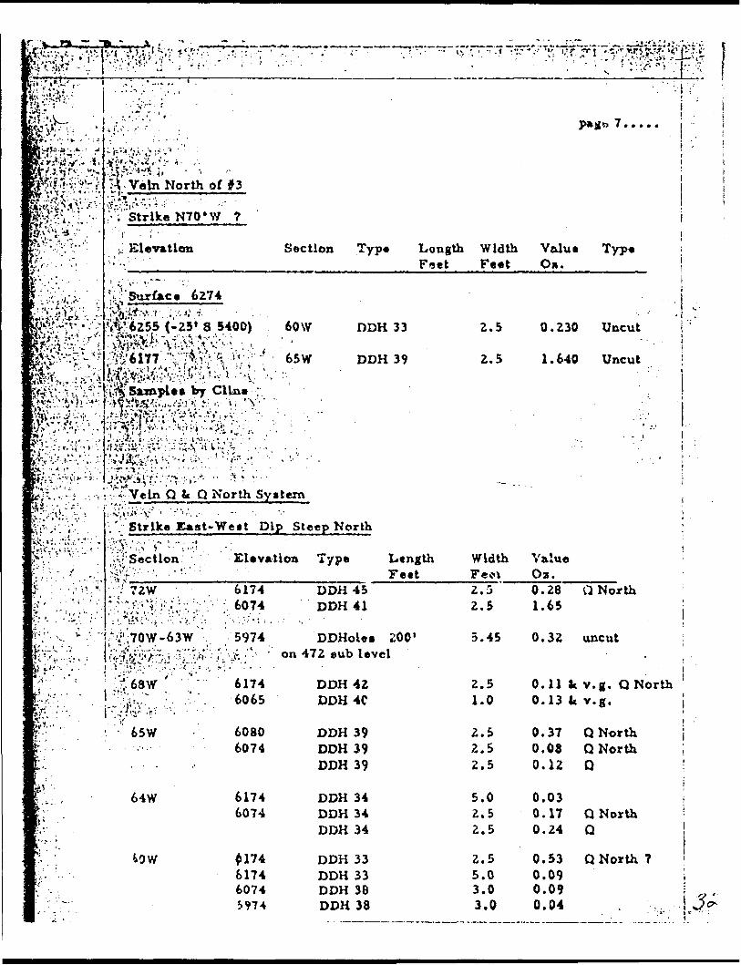
jpfefe;^ S' -Vein^North of #3ifevVvv-xv ^V--- - - ..- -P^J^-V.--..'- :"-Y Strike NTO'W 7
i^v-'i'V- ;. Elevation
B-:';^':j.-i- ' ^ '^ Surface 6274
fe^''-f '*255(-25'S 5400) 'B^'-^-:r;'-^v^V;SV\^-v; . ,K^f'^v '•'•.-/A *^^V#*^'vV rH^ V ! ^ J ''Y- ''-
K^^'^v-^-"!/^***0^** t*7 Cline ;;Rj-r:'.'!'.". '. P!|,\v"x-l! v";.V*;'.i ';'v '.' :. : .-^.. ^^^V^''f - ':-' ;^^r'j'^ "'•^S'^-' 3^ •;'^- -, \
pS^^^^fe^--^- 5^- - '
: . ,- . ,' - . r . - - o.
Section Type Length
60 W DDH 33
65W DDH 39
\' ' ' t
' '. "' '* •••-
Width Feet
2.5
2.5
^'l'.''.'.-'-^ - -vv-^Veln Q k Q North System
OxV" .'.Strike East-West Dip Steep North
jilVr^'r - \ii : Sectlon Elevation Type LtngthCV-V-.^.,.,: ^••••. •• ! -'-'' Fetty ; . ^," •-•/. ?2W 6174jV,-i:;;.;; : ;;f^;:-^ :q:;: r ; :: 6074 DDH 45
DDH 41
^; v c ; .'f J70W-63W V 5974 DDHoles 200'K'%, '-' , ; 'Vr'-fV^'/''*;, ' -Js''^* ' :i*'v '''.J*. - '' 'on 472 sub level[j i i'.. - ;V ' j .'l":U?!;. v'':~ .' V'Vi '.,. il .' ' - :. ~
•^ ; ;;^68W' -;"."" 6174 DDH 42|r;''-;.' ' - .?^v ~ . -'. : ; ' - . ' 6o65 DDH 4C
r- ' 65W 6080K: 6074
If \ ' . 64W 6174 K: . 6074
•s: - '" B^- ^OW i 174M;. ' 6174 1; . 6074l.'-':V"'. J 974
DDH 39 DDH 39 DDH 39
DDH 34DDH 34 DDH 34
DDH 33 DDH 33 DDH 38 DDH 38
Width FecV2.5 2.5
5.45
2.5 1.0
2.5 2.5 2.5
5.0 2.5 2.5
2.5 5.0 3.0 3.0
-•;:V^^I::V^P^
ji -r
Valus Type i On.
1
. ; L0.230 Uncut
1
1.640 Uncut \
1
i\i -
Value ' Oa.0.26 Q North 1.65
0.32 uncut
0.11 k v.g. Q North 0.13 k v.g.
0.37 Q North 0.08 Q North i 0.12 Q '
0.03 0.17 Q North ] 0.24 Q !
0.53 Q North ? 0.09 l 0.09

Kv 472 3ab Drift - Vein Q1'"P?',' j Want to East
K: -' ' HoU Width Valuel' No. Feet Oa./fo1- S30 2.5 0.06) li- 1.0 2.74) l ' . . 3.5 0.05)1 . 832 : 3.5 ; 0.03 t- 1.5 0.05lv;"'" ' . -"H- , 5.0 : 0.11I; - . ' -'",, 5.0 0.09^' \ .;-. - 4.0 ;0.07f" ' •^•; ; 2.0 ' 1.14.. ,- - .v* 834 2.0 0.06 ;-.'' ; ".836 0.7 \ 2.95 v : - /. 2 .0 ; 0.74•f ' . . .. * Length 200'
, Width 5.45';' i Value 0.32 uncut
' . ; ' 1 Vein R or Pick 02
1 4th Level (Cline)
nA* 0.150)
7.0 2.740) 3.065 0.175)0.105 0.0750.550
21.0 0.450 3.7400.2302.230
Tctals Aver.
WidthFeet7.0
21.0
2.0 0.7 2.0
32.75.45
, - i ^ !~ pag* 3..... -.', ^'
V '"
Valuo W x AOz.0.437 3.065
.
. " ' -t i : \- -' i :
.173 3.740' : : . . - 1 .
.06 0.120 2.95 2.035 0.74 1.480
10.420 0.313 uncut
, ~ , '. . . '- j
T ' - ^ p -
M S trike East-West Dip Steep North . -
M S ection Elevation
1 i 73W 5850
M 7 2W 60741 6055 1 ! 6055
m 7 1\Y 5875
W 6SW 5850jB
3 G5V/ 5975.
m - s. i w 60 i
Type Length - Feet
DDH 4279
DDH 41DDH 41DDH 41
DDH 691
DDH 697
DDH 39
DDH 34•i' M....... ii://.-.-..
Width Feet3.63.0
5.02.52.5
3.32.71.41.4J:.00.52.5 2.52.5
Value Om. i0.10 ,0.42 i \ .
0.610.64 ? 0.22 ?
0 . 280.130.090.480.27
35.410.14 :- ;: 0.83 , ; :V .,::2.14 •.. ; ;;' : -. : :,'^|::
, ..^...: i .- .., . ,, v,^-^^.,^
i/; s :
' 1 ; :
''*
r t t ,
v' • .-.' -
?- :
; i' r -'i ' * *'^.i-.;uv?

t,l-'" "*" •r ..., .
r .-?- .;-. .1-
•i:'.-.V':-'--
*?tt..
'\t^;:t:-^l'.v,v^ : - -.V.", tam '•j^'/i; * .^>i,'l ~ s i ' i', ' ,- - i^;^^^t -' :: :v;-ievX'-; ?:vTr\-':--' : -'. ' 'x tloi
''Before consideration caa be •urnptlon of under ground devclopm
. -. ' .:--^:-. :V:\'.^'-i'j^v-^'-'.'S!-?'^ ' '••f\^-'^:•- - - - v -.' . :-.*rv*- -i -; \ .l^ -'i \\:*. r•e given to a re- c-^:':i . .' ". • '•'•J^'-' lentjt It **co-V:^^.^^^
mcontract at an overall estimated cost of 515,000 to 518,000.
'. "iUpoa completion of this drilling and tonnage calculations can be made together '\ ' V;-. '. with a program for underground development
;-;';'' --Vf/v- -' .-' : '- t':' - v f V, . '
''•^•fv'fe^

r
'".'-
. -:
LEGEND
~^r\ S wamp••-
. - ,- .' ' -' '' '-;' ; . ' -- " :'-- .. . -,'-; .. ;'
''- - : • -'"•.V"-
Workingl*--l Surface D.D.H/,
\——\ U .G. D.D.H.
f^n Intersection in D. D. H.
Valutis O z Gold Foct
v.g. Visible. Gold
i-' ..."--
PICK MINES LIMITED PLANS
.V 100' Ft Horizons#3 Shaft Area Scah-s l" to lOO'1
October IQ6.1100'
R . M . W .
,. - 'iW..'"'
"-y'"
-l
- '-*
..i i'•'' ."i :
V l
i
:?
v :. ^.h^;t :r^v^i&r*^•"-"---•-'-;" v^ ; " ; -'-^^^PV^:;!^r-, . ,-... * '...'.. ..-. k"... ', *' .,-^.r".. v ,' . -.,- - - •.•'..... t , ,'-, i. . i.... -.,- j. v' -.' ; ... ^-v,a 7 :

r (-
v ;: '-i :*.*^ 4
S'J:\rt.
''"•'Vi' ;m
•!v-,';j- :'-"•.".'':1 -* , ' - ' .- * -. .
; .. The following plans on a 'J-'scale of l" to 100' have i L', been compiled from old
: , ' Cline and Pick records
- -* .V*
Plan #1 SurfacePlan b L Surface diamond drill holes
f Plan #3 Intersections felOO 1 horizonPlan ^*i Intersections i~ iIOO : horizon: , .. -. ^ \ , "*" " - •'•••ci oci.HUJIB .y. (.w nortzon
, ' to 'show workings and ;' ' . ^ Plan #5 Old workings gc intersection, intersections from gur- Plan *A ni^ ^-i,;.,,,.. K. :...^.,...-,'.intersections from
,; face diamond drill holes.,. Plan. #6 Old workings fc intersections i -
.;face diamond drill holes. ' ',i--'.. ,. : : . ..: - .' ' .'
l—,—:————J .. , ' ; , /;',; - . -.•.-'•••, ,' ' ,'' :,' ' '.";. .'.'. '•'.':- l '."'S'""' 1 : 1 -, - I'-'-JCO 1 ' ' - I'.^'CKMINES LIMITED V . ^^ ' .' - : ; ; -'.,. '' VV
". Gouclrenii. Onta rin ' ' ' ' : ? ' ' ."-';;-
. ;. Goudrenu Ontario . Shaft Area -, - ; ;- , .,; -'' - " -
••:.•c*
* " *
.-:: -
•vi';/
of ',
.; i.
•f'"
"-.
. v
. " \

.. ' ) - - ' f -
; ; v- - -' "
: - ^ - *;;;
r i . . . . . '.; -"-''-
i - * ' .:-:-..-..,'.9.
)RILLING' -•••"' " V' l- •••••vvi-vE BCTIONS
to holes '
/.H, . r' " •- ; v i' .v •••';
MZS
- --.
,'.';-' : -' ; -' ; '' ; .','3ooos' .v.' - , .'•.'''.' i ''-' : -,,?:! -";'-'iy:\.** ' ):*
'H
- -v..sr^-;'? ,;:V.,V..;
o- o^:-
';1- '. -*
3
sioo^-.-;"-.0^4s
^ o to
sg^.ii ^•;a?-s
- - : .- - - . r
./-'•H:-.
~ \
i'A':*Kl-* ote - .
- :
Old C
line Holes
•y '
:- V- - :
•. 1.-
-.-..
u-
•- -1-: •••••. ^ J.U
^S
^'--^
: .::
0^-..-?-:|X-.
r-:...
-4
.
w.

•.•••.•.•••••;i-: -, 1 :. - . -,...t./'- *- : - . . . . '•? .' V: i*. V' ''-''•'
.' '''-c.
Il

' " '.' ' '.. ' ...'' - 1'-';
. . ' '
; : ..'C1 : :'*: 'tVv'- ".'v r-rr^f
. ' r ,. ,.' -. , uIt ' ' . \t" "'v-.:^i-:
. V' ''••J'^-

, . ." .. . ' ^ - . - .-.: -. . s.-.. .. - .

-:- ' ^i'.;*''^--;1 "--.^ .\.;'!'
^•^'•; . - y- -1 * ' ^ t
. . . ' ' -,- : ' '-.; . l - . ' 'vr - . ' l:-:^ v^-;:r,;,:-',S
tSSB-V: \-^?'v:)\''.. •-.••. - J v.-.-.-f'.."'.'-. : 's---.v
wsw:. .;^j S:?:--;r'

I
VEGA GOLDVIBBA CORE D Bil* I- TEST
HOLE N OS 840322 t6 840326
HOLE 840322 in Claim SSM 2232539882223222322232
840323840324840325840326
REMARKSPENETRATED
Location Date
0.0
840322
Normal Overburden
End of Hole
0.0
0.0
5.0
0.0
4.0
0.0
7.0 Normal
7.0
5.0
64.0 Normal
64.0
4.0
59.0
59.0
34.0
34.0
Normal
Normal
Overburden
End of Hole Bedrock
Water
Overburden
End of Hole
Water
Overburden
End of Hole
Overburden
End of Hole Bedrock
bedrock 9 5 ' .0 Made 3 attempts all tosame depth.
HOLE 840323
Fine sandy clay
HOT.E 840324
Fine sandy clayNot on bedrock - no more rods.
KOT.E 840325
Fine sandy clay Bedrock
HOLE 840326
Sandy clay
Page l of l
JACOBSON TWP.
April 1984
SAMPLE j AUFROM TO P.P.B.
4.0 5.0 41
6.0 7.0 14
63.0 64.0 N.D.
58.0 59.0 64
33.0 34.0 14

HOLE 840327 in Claim SSM 2232 " 840328 " 2232 " 840329 " 2232
VEGA GOLD'EXPLORATIONS'INCVIRRA CORE DRILL 'TEST
HOLE N os 840327 to 840329
Page l of l
Location JACOBSON TWP.Date April 1984
FOOTAGEFROM
0.0
0.0
0.0
TO
45.0
45.0
57.5
57.5
56.5
56.5
DRILL SPEED
Normal
Normal
Normal
MATERIAL PENETRATED
Overburden
End of Hole
Overburden
End of Hole
Overburden
End of Hole
REMARKS
HOLE 840327
ClayNot on bedrock, hard pulling
HOLE 840328
Fine sandy clay and gravelNot on bedrock
MOLE 84C329
ClayDrill would go no further - but not on bedrock.
s- A M P L EFROM
44.0
56.5
55.5
TO
45.0
57.5
56.5
AU
P. P. B
28
69
7
Iff :?iV.,: -
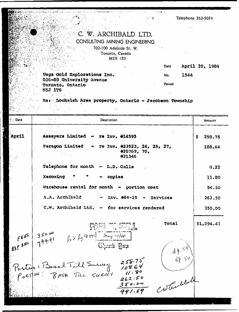
.'•C-W.' ARCHIBALD LTD.CONSULTING MINING ENGINEERING
A 702-100 Adelaide St. W. Toronto, Canada
M5H 1S3
Vega Gold Explorations Inc.006-88 University Avanue Toronto, Ontario
1T6 '
Telephone. 363-5054
Date April 30, 1984
NO. 1544
Period
Lochalah Ar*a property, Ontario - Jacobson Township
Date
April
Description
Assayers Limited - re Znv. #14595
Paragon Limited - re Znv. #23523, 24, 25, 27,#20769, 70,#21346
Telephone for month - L.D. Calle
Xeroxing " " copies
Warehouse rental for month - portion cost
A.A. Archibald - Inv. #84-19 - Services
C.vr. Archibald Ltd. - for services rendered
p^A prT1 nr-." pnnwrj nl*'-' "' li **''.I-.'*a W V- - 4 ^ *^.MM
311| ?^ t e/fif- J
Total
3?* *^
Amount
$ 258.75
108.64
13.22
11.80
94,50
262.50
350.00
51,094.41
^ ?*i:^?33J^*)i!^!^ '•.-•.^•-"^•f:^ 'f~y/'-. - - ^'''^'^^ v-^'-. '-' v ' : ':" i ' i .'-'. : ''. ? -V'-.r'..' -TV ' ' --Telephone 363-5054
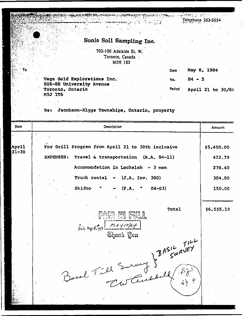
D*tt
(April21-30
Sonic Soil Sampling Inc.. :' . . -
702-100 Adelaide St. W. Toronto, Canada -
M5H IS3
Vega Gold Explorations Inc. 806-88 University Avenue Toronto* Ontario M5J 1T6
Due May 8, 1984
No. 84-5
Period April 21 to 30/84
Res Jacobson-R'iggs Townships, Ontario* property
Description
For Drill Program from April 21 to 30th inclusive
EXPENSES: Travel St transportation (A.A. 84-11)
Accommodation in Lochalah - 3 men
Truck rental - (J.A. Inv. 380)
Skidoo M - (F.A. " 84-03)
Totaljm m (MIL
Amount
$5,400.00
422.79
278.40
304.00
150.00
56,555.19

Telephone 363-5054
C. W. ARCHIBALD LTD.CONSULTING MINING ENGINEERING
702-100 Adelaide St. W. Toronto, Canada
M5H 1S3xiji'-.J"1 \ ',-"i ^ ^ * M *"*-'' S'^.^••.To^.-.v M^^AV'-^,:.
Vega Ooid Explorations Inc. 806-88 University Avenue Toronto* Ontario M5J 1T6
Date
No.
Period
May 31, 1984
1552
Rei vLochalsh Area property* Ontario - Jacobson Twp.
-\ Date Description Amount
. ..I'f'May 31 Paragon Limited - blueprints re Inv's 24783* 25829*
and 25831
Telephone - for month - L.D. Calls
Xeroxing " " copies
Warehouse Rental " - portion cost re storage
For services rendered - re logs, basal till survey and maps
m m em Total
$ 38.83
1.77
27.60
95.00
175.00
5338.20

99390 1*99397*946 -
.'Z8I 1*99)882 |69928B — — f- —'— — S*~
1699385 1699366
6470^6 '647^5?'
^1*28002(626003' 59 !9 21
.———x' 382-.5 -"~ 158251* K -__L...^- V" -Vv, L,,,..''--' 15825..^^ " : '' ; ""
V- — -*- - -i — —- — ! ?CM .rsi- '*sx - ?ii
r .'M. j. ——"- - v- SSM i SSM i ;
l -- i7O64Z2 J 706423I
~ SSM SSl4 SSM
l : t .7-564/5:706-^23S76S04 37*507
'ei8!3* '6I8I3C j
ZOQ ^' !A^|WW^ |7--HV'J^.6-' ^^*^-W*M- .595939351393936 59T95lo- - . -,™-*??
l ta*ki3SM ^YU 633831 63385C T!" i
ISSM l ( SSM . SiU
-59 399-593993^ M39*.' - - "" ""
I7M
.48*16'*0'
BIRD TP
DISPOSITION OF CROWN LAND!
TYPE OF DOCUMENT
PATENT, SURFACE a MINING RIGHTS
SURFACE RIGHTS ONLY
MINING RIGHTS ONLY
LEASE. SURFACE 8 MINING RIGHTS
SURFACE RIGHTS ONLY
MINING RIGHTS ONLY
LICENCE OF OCCUPATIONCROWN LAND SALE,.ORDER -IN- C*lfNC!L
RESERVATION Kc
CANCELLED '
-1J-
NOV.
SCALE 5 l INCH ; 40 CHAINS
rEET METRES
•UOO IOOC ~. P
i 2OO *OO tOO *OC
HECTARES
J
TOWNSHIP
JACOBSOM(Former TP 48)
DISTRICTALGOMA
MINING DIVISION
SAULT STE MARIEUN 1A RIO
j'fAiNisTsv OP NATURAL RESOURCES-.li^v BRANCH
DATESEPT. '72
WHITNEY BLOCK QUEENS PARK. TORONTO
PLAN NO.
M. 1583

9' fis*.1-^
f \i
t
f^zv .Ministry 01 . Technical Assessr VfVI Natural ' . . - ... i^2x Resources Work Credits
Dniariotc^Af."' '"- . -'
nent Fiitg 7362
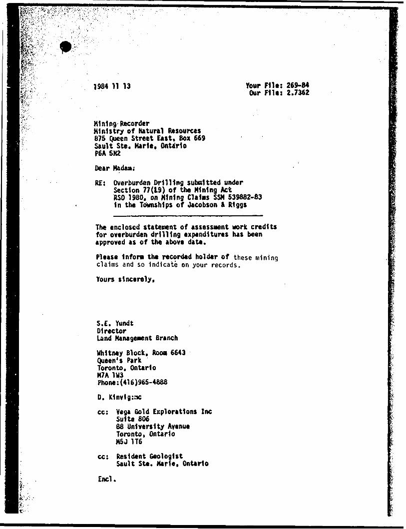
1984 11 13 Work 0'
Recorded Holder ' ' ' "'VEGA GOLD EXPLORATIONS INC
Township or AreaJACOBSON AND RIGGS TOWNSHIPS
Type ol survey and number ol A*se**ment days credit per claim
Geophysical
Section 77 (19) 5** "Mining CUIrm AtiMMd" column
Man days Q Airborne C3
Special provision O Ground O
O Credits have been reduced because of partial coverage of claim*.
O Credits have been reduced because of correction* lo work dales and figures of applicant
Mining Claim Avweed
13,271.00 SPENT ON OVERBURDEN DRILLING ON MINING CLAIMS:
SSM 539882-83
218 ASSESSMENT WORK DAYS ARE ALLOWED WHICH MAY BE GROUPED IN ACCORDANCE WITH SECTION 76(6) OF THE MINING ACT.
Special crediu under lection 77 (16) for the following mining claims
No crediti have been allowed for the following mining claims
(l not lufficiently covered by the turvey LJ Inefficient technical dete filed
Mining Recorder may reduce the above credits II nacessary in order that the total number of approved assessment days recorded on claim doe* not exceed the maximum Allowed a* follow*: Geophysical — BO; Geological—40; Geochemical — 40; Section 77 U9)—60:
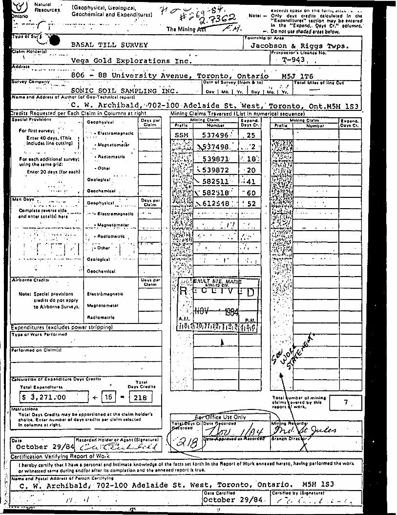
Natural Resources. (Geophysical, Geological,
Geochemical and Expenditures)
The Mining
i on tnis fuifii, tiiu;. . v ... Not*: — Only diyi crtditi Cllcutilcd In th*
"Expindlturai" mtlon may b* entertd In the "Expend.. Qeyi Cr." column),
-. Do not use f haded trial below.
BASAL TILL SURVEY;i*!m Holdtr(i)
\ Vega Gold Explorations Inc.
Townihlp or Aril !
Jacobson A Riggs Twps.Proipictor'i Lionel No.
T-943, .
B06 - 88 University Avenue, Toronto, Ontario M5J 1T6Survty Comptny
SONIC SOIL SAMPLING INC.Del* o' Survty (from A to)
1 l 'l -'- -' Di y j Mb. l Yr. j Oty | Mo. | Yr.
Total Mllei of lin* Cut
|Nim* end Addren of Author (of Geo-Technlctl report)
C. W. Archibald,''902- 100 Adelaide St* West, Toronto, Ont.MSH 153Mining Claims Traversed (List In numerical sequence)-rediti Requested per Each Claim in Columni at right
ISpicUI Provliloni
For tint turviy; , Enur 40 diyt. (Thlt
. Includil llni cutting)
l For nch additlonil turvty;1 uiins th* urn* grid:
Enter 20 diyi (for nch)
' 'i - - - -t
.. ... ,- (
IMin Diyt v ^ .
Complin riviri* ildi^ -^- andintir totiUi) hiri ~
•' .
. ' . : --, . --.,i -:, ; ..
;-rT:i.-r1i 4'
Airborni Cridllt
Not*; Special proviilont
to Airborni Surviyi.
______________ ——— .
Oiophyilcil
•' ' - * EUctromignttle
- Mignitomitir
- n idlomitrlc
- Oth*r
Oiologlc*!
Oiophyilctl
•- -- E lictromignitle
- * Mignitomitir
1 , - flidlomttrlc
. i . Othir 'i :1 II
Oiochimlcil
El*eu6m*gn*tle
M4gnitom*t*r
Rldlomitrlc
Oiyi p*r Cl*lm
-
Diyt pir Culm
.. -.
i -. . —
Ulyl ptr CI fi m
Expenditures (excludes power stripping)Type Ol Work Pirformid
P*rformid on
C*lcuUllon of Expendlturi Oiyi Cridlti
Tottl Enpindltu'dToiil
Diyi Cridlll
S 3, 271 .00 1
Initruciloni ,Told Oiyi Cridlti m*y b* ipportlontd (t thi ctilm holdir'i cholc*. Enur numbir ol diyt crtdlii p*r clilm Kl*ct*d In eolumni it right.
Oil*October 29/84
Ricordtd Holdtr or Agint (Slgrxturt)
Certification Verifying Report of Woikl hereby cenlly that l hav* a ptnonal and Intlmati knowltdg* ol th* licit ut lorth In thi Report ol Work annexid h*r*to, having p*r(orm*d th* work or wltnvuid timi during and/or altir Its eomplitlon and th* innixed riport It tru*.^^^^
N*m* *nd Poilil Addrcii of Ptrion Cirillylng
C. w'. Archibald; 702-100 Adelaide St. West, Toronto, Ontario. M5H 1S3
rt.Oiti Cirtl'lidOctober 29/84.
Cirtlflid by (Signituri),-v r.: .-t

W. ARCHIBALD LIMITEDCONSULTING MINING ENGINEERS
Mr. E. F. AndersonDirectorLand Management BranchWhitney Block, Room 6450Queen's ParkToronto, OntarioM7A 1W3
Dear Sir:
RECEIVEDLand Management Branch"'C.-RCULATE QcoMUEHjt nuts r~]
. 1OO ADELAIDE STREET W. TORONTO 1, CANADA
TEL. 983.9094
)ctober 29, 1984
M5H 183
OCT301984
J-
w - L. GOOD
f . H :.
onid i t i,; j
Enclosed are two copies of a Basal Till Survey Report with maps completed on the claims of Vega Gold Explorations Inc. in Jacobson Township, Ontario.
this work.Also enclosed are two copies of invoices regarding
Part of the work was done on patented claims which does not apply for assessment work but 4296 of the work was done on unpatented claims. For this reason, I have applied 42* of the total billing of $7,788.31 or a sum of 53,271.00 towards assessment credits. At 515.00 per man day, this comes to 218 man days of credits.
Yours very truly,
C. W. Archibald
c.c. Mrs. M. St. Jules

^"'-;y;\v'.;.feiW:."^:-.-;-'-
P* ;:
1984 11 05 Your Filet Our Filet 2.7362
Mining RecorderMinistry of Natural Resources875 Queen Street EastBox 669Sault Ste. Marie, OntarioP6A 5N2
Dear Madam
He received Data for a Basil Till Survey on October 30, 1984 submitted under Section 77(19) of the Mining Act R.S.O. 1980 for Mining Claims SSM 537496 et al 1n the Townships of Jacobson i Riggs.
This material will be examined and assessed and a statement of assessment work credits will be Issued.
We do not have a copy of the report of work which 1s normally filed with you prior to the submission of this technical data. Please forward a copy as soon as possible.
Yours sincerely,
S.E. YundtDirectorLand Management Branch
Whitney Block, Room 6643Queen's ParkToronto, OntarioH7A 1W3Phone: (416)965-4888
S. Hurst:sc
ccl Vega Gold Explortlons Inc 806 - 88 University Avenue Toronto, Ontario M5J 1T6
cc: C.W. Archibald702 - 100 Adelaide Street WEst Toronto, Ontario M5H 1S3
Ipvlifer:
t;
m* 1984 1 1 13 Your F1lt: 269-84 Our File: 2.7362
If-
Mining Recorder Ministry of Natural Resources 675 Queen Street East, Box 669 Sault Ste. Marie, Ontario P6A 5H2Dear Madam;RE: Overburden Drilling submitted under
Section 77(19) of the Mining Act RSO 1980, on Mining Claims SSM 539882-83 In the Townships of Jacobson ft Riggs
The enclosed statement of assessment work credits for overburden drilling expenditures has been approved as of the above date.
Please Infora the recorded holder of these mining claims and so Indicate on your records.
Yours sincerely,
S.E. YundtDirectorLand Management Branch
Whitney Block, ROOM 6643 Queen's Park Toronto, Ontario M7A 1U3 Phone:(416)965-4888
D. K1nv1g:ac
cc: Vega Gold Explorations Ine Suite 80688 University Avenue Toronto, Ontario M5U 1T6
cc: Resident GeologistSault Ste. Marie, Ontario
Encl.

W-l*'"' l l
(6)
Tn-e//N/ "TfiE FoLLOuJ/MG
5E6HL5NCB C X)

Mpagfv'::*
J
l
S.S.M.2IS3 J
MINES LIMITEDLOCATION SMAFT SITES ^ FAULT ZQME5 U.5SCALE: i* - 200'
EYGEOMETAL EXPLOKATlOKt MAMAGEMENTN- ^C. A. JUiy SO.
-f y l

5-6
Pick Mines Limited Claim Group Township 48
Sault Ste Marie Mining Division Goudreau Gold Area District of Algoma
Ontario
DUPLICATE COPYPOOR QUALITY ORIGIN A f
TO FOLLOW
Toronto, Ontario R. Massey Williams
January 10, 1962 Professional Engineer
St. ^

PICK MINISS LIMITED ClaUv: Group Tov/nohip 48
Sault Ste Marie IvUning Divicicn Coudreau Gold Area Dietrict of -Algoma
Ontario
Toronto( Jaaup.ry 10,
K. Mascey V/ilUn.rr.0 Professional Engineer
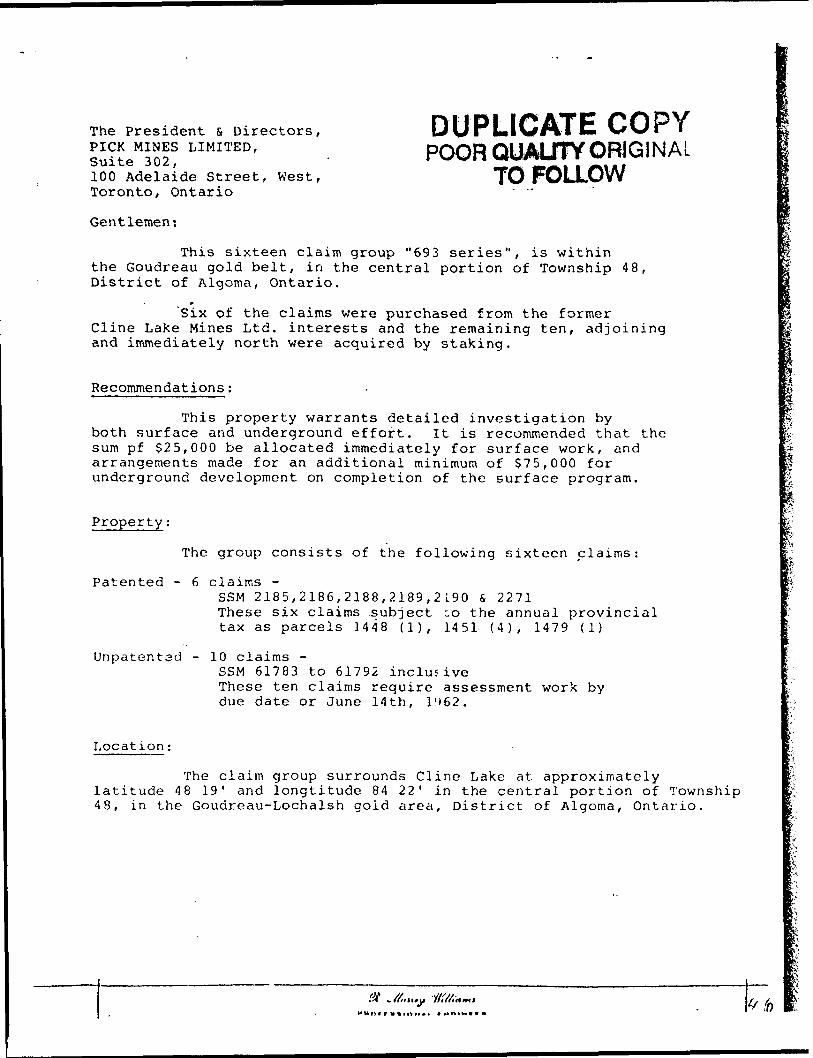
The President s Directors, PICK MINES LIMITED, Suite 302,100 Adelaide Street, West, Toronto, Ontario
Gentlemen:
DUPLICATE COPYPOOR QUALITY ORIGINAL
TO FOLLOW
This sixteen claim group "693 series", is within the Goudreau gold belt, in the central portion of Township 48, District of Algoma, Ontario.
f
'Six of the claims were purchased from the former Cline Lake Mines Ltd. interests and the remaining ten, adjoining and immediately north were acquired by staking.
Recommendations;
This property warrants detailed investigation by both surface and underground effort. it is recommended that the sum pf S25,000 be allocated immediately for surface work, and arrangements made for an additional minimum of $75,000 for underground development on completion of the surface program.
al
Property;
The group consists of the following sixteen claims:
Patented - 6 claims -SSM 2185,2186,2188,2189,2190 S 2271These six claims subject -o the annual provincialtax as parcels 1448 (1), 1451 (4), 1479 (1)
Unpatentsd - 10 claims -SSM 61783 to 61792 inclusiveThese ten claims require assessment work bydue date or June 14th, l'(62.
Location:
The claim group surrounds Cline Lake at approximatelylatitude 48 19' and longtitude 84 22' in the central portion of Township 48, in the Goudreau-Lochalsh gold area, District of Algoma, Ontario.
st ^//,.,,, j)

- o,The, Profluent v. Sir ac -r one?.; 3v:n-::r2 Li-rirrji;?,Suite 30 2f100 /*;^le.iic Street, We
i-ciilo i ( Crtarto.
This- cb-.Seor: claiir. frci'.i*."C93 tcrtc/'llie v/lth!;- the C-ouc'roftu col:! *.:U, hvt'uc ctntL-a' yovMon c.* Tov/iichip '18, Dictrict of Altp^Ss Cr.tnvio.
CU'.ie Lc.Us Mine;* Lsil. hi*i:'o'Et^ fr.tl vb; rc-rr. ani Liir.'.co.iaCcly r?rt:.: ^vj-rt r.c-cuh-iiu Ly ?lc.!;
.Ree or.ii e ri Co 1 1 c-n o : -
TLis f •.•cv-.s:-:';-/ v.-ai*i-r.r.^:: tC.z.\\i~. lu bctu surface arci u^ir.i'cji'CL'j'iU tf'io'.rc, it is rito:.-r. sur/i of SZSj 000 b*; a !.lc.-t.v j?.lt^. 11:1^.1.3; tfctsly :Ccr cui-^f
S nir.'jc f o:- av* uai'.tlonal t.- iii!.-..,-.vvr). c?.uvt-loj :r. ;-.:* cr,. r; c rv^ t -.t i 0:1 c* fehi
aii that the V7ovl;. end . OOJ for
program.
Ths pji'ouf.' coacieto of thj following eixtc-en claims
Patented - 6 cl.tlj.vjo -SS!/- 2?.Gt, 2186.. 21GG, 2IG9, H W L Z7.1lThese six cU.Lrr.a cubjcct to Hit- c.iu:u*,l provincial
Unjratented - 10 clc-lmi; -53K 6i?a3 to 61792 inclucsvc- TJseso ten cl&itun re-.iuirs; fc t.us dale or Juns Htht 196?..
woru by
The cir.cn croup oarroundc Clin-2 Lake at approximateiy tatllude 48 0 19' and longitude S4 C 22' in tho central portion of Township 48 f In tho Goudreau-L-ochtloh gold srca r District of Algoma, Ontario.
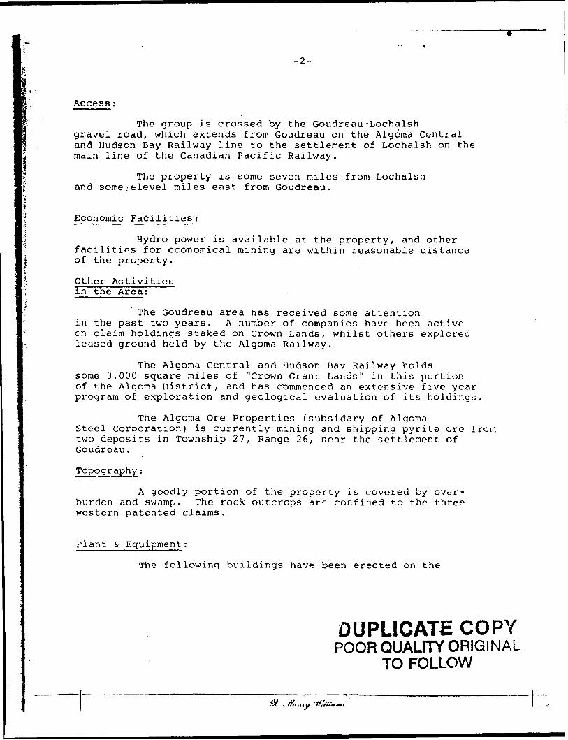
-2-
Access;
The group is crossed by the Goudreau-Lochalshgravel road, which extends from Goudreau on the Algoma Central and Hudson Bay Railway line to the settlement of Lochalsh on the main line of the Canadian Pacific Railway.
The property is some seven miles from Lochalsh and some .vfelevel miles east from Goudreau.
Economic Facilities;
Hydro power is available at the property, and other facilities for economical mining are within reasonable distance of the property.
Other Activities in the Area:
The Goudreau area has received some attentionin the past two years. A number of companies have been active on claim holdings staked on Crown Lands, whilst others explored leased ground held by the Algoma Railway.
The Algoma Central and Hudson Bay Railway holds some 3,000 square miles of "Crown Grant Lands" in this portion of the Algoma District, and has commenced an extensive five year program of exploration and geological evaluation of its holdings.
The Algoma Ore Properties (subsidary of AlgomaSteel Corporation) is currently mining and shipping pyrite ore from two deposits in Township 27, Range 26, near the settlement of Goudreau.
Topography;
A goodly portion of the property is covered by over burden and swamp. The rock outcrops ar^ confined to the three western patented claims.
Plant & Equipment;
The following buildings have been erected on the
DUPLICATE COPYPOOR QUALITY ORIGINAL
TO FOLLOW
St. ~M,u.
Tho grcap i s c rose od by the Gcudreau-LochaUh g?.-*.vcl iOE.'Sr which er.iirr.s frc*ft Goudresm ou ths Algoma C'^ntrfcl s.r.tt Kv-J-cr. Jl.-y r;.:.l!v.^y in-.? to tiv.? sctiicmea: of LcchaUb on the i-T-.ii". lh;v. cv t: i-i C-.ntdU--: Pi.cLHn Krihvr.y.
The prcjici'ty le corns e aven railec from LochriUL f.r,'A uciMC clcvr.r. raitef esc c frc^i Goudrccu.
j-c.v.vju' to SkV&ilc.bic. tt the proptrLy, and vtbor c..l Uilylv,^ avct \v ! tblsi reaso;:c?.tufacilities for ctot:
of the pvopcriy.
Othoi- jA^liv[tI t c jo to g /U*GC.:-
TJ.c Gov.'.-i cr v. c-i-iX h?ie i-outivcd so:x*s atientio'i in UiG pifl. two yell's. /. :iunr-.ba.v of cc;.uj,:ar,!se hav* baan r.ctivc OH cic.irc boldiucp sts.h-jj Ws Crcv/r. 7--r.r.dc P v/bUet otriors e leveed p'.voyviCi he-Id by ibc Aij;o:-;iU R&LUvay.
Ths /il*jcir.a C--nt.7s.i r.nd Kucr.on Bay Rf.ilw c cm e 3 f ODD aouars miler, of "C^o-Aii Gr&nt lAnoib" in tbio of tac A i gome. District^ nnd htif; ccm!vieuc6d c.ii exieneive five year p.'Of.ra.xn of esploritior) anu fiooic^lccl evaluaticr. of Itti holdings .
Th-3 AlfcOrari O:-c Properitoe .subsidiary (ft Al^o^ns. Steel Coruovatior.} ic cuvrocily aaivzing and shippinj, py/ito ore fror.i two tlejxssU-2 m Tov.-neii;- ."i"/, .Rr.stje 2(. : ne?.i' the eottlcraer.t of
-A goodly poi-tloii of the property i o c overed by ove?- burden asicl ov/ara^. The vcc tc outcrops are uoafiaed to the three wccturn t^.tciit'Jt!
Piant tt iur.t ant: -
butldlngr have b&tn erected on tho
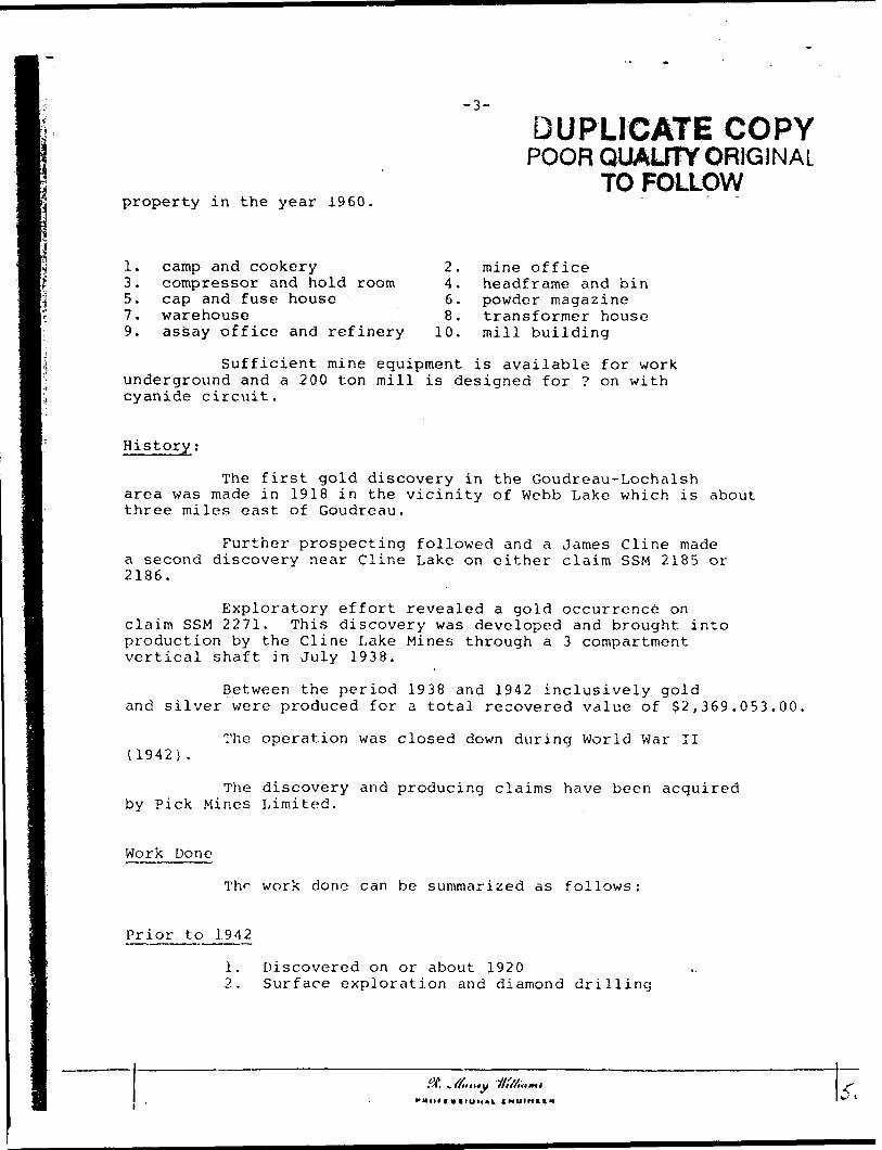
property in the year 1960.
-3-
DUPLICATE COPYPOOR QUALITY ORIGINAL
TO FOLLOW
1. camp and cookery 2.3. compressor and hold room 4.5. cap and fuse house 6.7. warehouse 8.9. assay office and refinery 10.
mine office headframe and bin powder magazine transformer house mill building
Sufficient mine equipment is available for work underground and a 200 ton mill is designed for ? on with cyanide circuit.
History;
The first gold discovery in the Goudreau-Lochalsharea was made in 1918 in the vicinity of Webb Lake which is about three miles east of Goudreau.
Further prospecting followed and a James Cline made a second discovery near Cline Lake on either claim SSM 2185 or 2186.
Exploratory effort revealed a gold occurrence on claim SSM 2271. This discovery was developed and brought into production by the Cline Lake Mines through a 3 compartment vertical shaft in July 1938.
Between the period 1938 and 1942 inclusively gold and silver were produced for a total recovered value of S2,369.053.00.
(1942) .The operation was closed down during World War II
The discovery and producing claims have been acquired by Pick Mines Limited.
Work Done
Prior to 1942
work done can be summarized as follows:
1. Discovered on or about 19202. Surface exploration and diamond drilling
"Hlttl U ltUMlt. IHUINItH

I
pi'oysvty ivi tii? yc.c..r 19^0.
1. cL'r.f ana coD;:ovy,-. c c: r ; ;; i- c r s c :* ant ii o t r i. r c5. cr.v c.r.:" fo.rc iioi-.r-.-7 . '.VelVcllOSPC
9. ftccr.y cisists r.ni rt'hierj
2. tuliio of ci c e ***i. hsr.^/i'e-iSie i ad bin6. co-.v-isr mag .sine6. Srs.usformer house
10. rr.lll buildiiv
Su.^ic i c nt iTiinc c^uijriitcnt Is feva'labis Tor wotk underground a.r-o a 200 ton mill li. cifc^igr.-iri for flpvc.? 0:1 \rlth
Klctory:-
Tho fisc* gcli dlrccvery iu Mis Goudret -i-Locluilch trca \vai? rnsc'o In l e;ir? ir. tho vUlslty cf Y'jbb Lths, v 'iich Ir. aVyjt three mtiss or-.rt r.f Grv.d-er.u.
Further ri-OGj.^ciiu^ followed Cvr.-,'. r. Js.ir.co CUn-a J7i2.'.:.c a second discovery r.EZ.y Ciiui; Lr.i-.t o?; cllli&i1 clt.ur. SS1/I iilSs or 2)36.
L'jcyloi'iitr/vy uuort ixvffi.lic'. r. gcie occun-tucc en cl&ini S S M 3271. This c'i.ocovcvj' \rao d e ve-1 oy ut! and brought into prcdutti^;i Ly tli-s Cline LiiUc- Iviinou throu^i* a S ccrnp^itir.,ent vertical phaC'i: in/uiy 193S.
Feircectt the period 1933 e.nt 19'i2 Inclusively geld and oilvv.-i- wevo pi-educed for a to'if,! rccover-aiL value ox $2f 369,053.00
The operation v.'ac closed dov/n, during V.'orlr] V/tr U
The clic-covcry and pro.i;\chip clainio fci.ve bsen r.cquirecl 'oy Plclt l.Clncs LUmitcd.
Work ponor
Prio? to 19-i2
The \7orh co::^ ctn bc cum-.Tiarissa ac (olloxvs.
1. Diocovorea oa or about 1920,2. Suricce- exploration and diamond drilling

-4-
Prior to 1942 (cont'd)
Three - 2 comp. - prospect shafts# l to 140' - 90' lateral work on SSM 2186# 2 to 215' -79' lateral work on SSM 2185 e 70'# 3 to 115' - 100' lateral work on SSM 2185
A 3-comp. (1175-1 in depth with 7 levels) production shaft on SSM 2271, with a period production 1928 to 1942.
1942 to 1960
5. Property dormant.
1960 to 1961
6. Acquired in part by Pick Mines Limited.7. Surface trenching and exploration.8. Sampling old dumps.9. Surface diamond drilling.
1960-5 holes for 1,000 feet1961-4 holes for 1,037 feet
10. Erection of camp, mine and mill buildings.11. #3 shaft dewatered and station enlarged @ 100' horizon12. Adit development.
Geology
The rock formation underlying the Goudreau areaform a northeast striking belt, made up of acid to basic volcanics with interbedded tuffs and iron formation. Younger sediments are found along the northeast margin of the belt. In the north, south and east, the district is bounded by extensive granite areas.
Acid volcanics occur toward the western part ofthe belt, whereas in the eastern area, including the Pick property, basic to intermediate types are more common and are generally referred to as greenstones. The iron formations vary from insig nificant bands to pyrite concentrations of commercial iron sulphides.
Intruding the formations of the Goudreau belt area number of intrusives related to the granite masses north and south of the area.
These intrusives follow roughly the strike of theformations, and they occur in a narrow belt extending from Goudreau in a straight line to a point just south of the Cline Lake and then east- war'1 to Godin Lake. They occur as bosses, dikes and dikelete.
L\. *, f font *y

rior to I WZ -yont'di""~*""* " 3. Three - Z conip. - proapact ohafts
#1 to 1-1-0' - c,0' lateral work on SSM 2136f 2. to 215' *- 79' lateral woi-k on SSM 21G5 g 70*#3 to 1!5' -ICO 1 lateral work en SSM 2-105
4. A 3-cotnp. (i 175' in d e pt'* vrith 7 Uvele) prod-c t i 0:1 ehc,'s on CSM 2Z71, wii-i a pariod of production 1923 to 1942. .
1942 to I960Prc'ic-rl dor
1960 to 19fc6. /.cqv.irad in p?.rt by Pici: Mines Limited,7. Surfo-is ti'ciis S. Se.m25r.32 old9. Surfece dir.rnor*d
1560 -S hclcs for l, 000 feet 1961 - 4 he-lea for i, 037 feet.
10. Ersctica of ct.tr p, mine and rr.iil biii11. #3 eh?.*t dc-A-fc12. A tit*
Geclo.'-.v:-
Tac rest: fcrr^a-Uoac undo j-lv ir.g tha Gcudrcau area- Zorra c. northeast ctriiuittj; teli, r.ir.c.c up of c.cid to b&slc volcanics with interbedded tvJfs o.ud iron formation. Voacgcr cedirnenta are found c^lcus tbe Ticrthoasfc r/iarjjiri o/ tb-2 belt. Ir. the northf oouth and GwEt, th-i district lo bcujiescl bj- c::tsi.-Givc. grtr/its cre-ac.
/ieid vo5.c2.nice occur toward ti-e wosteru part of the belt r whovccc in tbe eastern r.roa r inciudic^ the Pick properly, taele to in.terr.'jeCiato tyneo Arc morre cotru-ncn: and arc gcnertUy referred to co f:resnctcmce. The iron formatictjo vs.ry from tncig- niiicani bavxdu to iyyriis; coucerxtrattoiio OK commercial iron nulphicco .
Intruding the fcrmatioiai? of the Goudrcr.a belt tro s. number of intrusive c related to tbe grat/.te inassco norfh c.nd coutb of the arcs.
These intyaoivcfc fellow rotiglit;' t'us strike of theforrnAtioRpj asic tlsay occur tn c. narrosv bult euteadlng from Gcudrenc In a iitraicht Una tot. poiiat Just couth oi Cline Ixikc tind then eaot- ward to Godin La'r.e. Thsy occur eo b&ocear c'iUoR and dllcelctc.
*...... -OfM..^..

The rocks would appear to have the follov/ing sequence 1. granodiorite, 2. quartn porphyry, 3. f els ito porphyry, 4. golddeposits.
jYounger diabase dikee cut the older formations tt
various angles along the belt.
There aro no detailed geological maps available from the \vorh dene In the ps.ct ac regai-on the Pick property.
That portion of tho property oout'a of Clin* Lake le Uildcrlain by RK ea.ot pkuigi&s granodiorite nCock or p?ug, which hso recletcd erosion. It kae intruded a. r-erles of bant?od audooUes and tuftc c.nd hoc in turn bsea cut by younger diabase dtUea.
Sbnilar plugs aro found elsewhere on the property, but require detailed mapping to dotarmlne thair sizo and extent.
Structural Geology:"
.The ctructiiral .features In the Goudreau area are complex. There lo ovidsace that Oio bolt underwent cxtsnoiva folding before tha Intrucioa o? the Igenous rocks. The forrn&tiona and vein material have been affected by considerable faulting, both pro and post ore.
The entire region Is traversed by innumerablefractures and f?.ulto v/hich ntriha and dip in all possible directions. Thiro apiwr.vc to bs two major lines of woaknsso, one striking K20 C - 70 0 W and tho other N450 - 90 P E. Eotb of thaoe directions pre dominate as lincB of fracturing,, faulting and diking. The caine strtUe also prevails am oy g the sold deposits of the area.
Gold D epos ito; -
Tha gold deposits are associated with fractures and shear zone c ( which wcro foraiod aft ter the iatruoion of the granltea and porphyries, end appear to follow along tbo same line o of weakness as these Intrusive*.
They show a considerable variation as regards their dimensions and general characteristics, some being true fissure veins whilst otbars are associated with shear zones. They r.U have lenticular forms and vary In width and lengths, and have been sub- . jected to post ore movements.

-6-
? From Earlier Work
A study and compilation of old data pertinent to the Fisk property would indicate that in -
The f 4 Shaft Area
1. The Cline production came from the first five levels {625 vertical feet) of shaft l 4 on claim SSM 2371.
2. The vertical continuity below the 5th level has been disrupted by a flat diabase sill. The attitude and significance of which has still to be determined.
3.
4.
5.
6.
7.
A strong east-west trending, north dipping quartz-ankerit.e shear is found at the earlier shaft # 4. This shear is a regional feature and can be traced w., st and east for a distance of two to three miles,
The shaft # 4 vein system ties to the north of this shear, general overall N 70 W trend. This would indicate that the values are associated with a subsidary structure at a ? angle to the regional shear.
It .ias gold
The ore bodice orvein systems ir this area showed a varied character dependent on the rock type, from lenticular veins to quartz impregnated shears. The ore is not easily distinguished from material below ore grade, and the walls are assay walls.
A study of the old Cline level plans and vertical sections show stops lengths of fifty to five hundred feet with closely spaced diamond drill centers.
It is pertinent to note that on claim SSM 60128, which is half a mile to the west, gold values occur in complimentary struc tures south of the quartz-ankerite shear that cuts the collar at shaft i 4.
The f 3 Shaf/t Area
8. Gold discoveries have been made in the vicinities of the numbers l, 2 and 3 prospect shafts on claims SSM 2185 and 2186.
9. Lateral work with seme subdrift Ing on the # 4 shaft's fourth level was carried onto claims SSM 2185 and 2186 to develop a vein system, which lies some 300 to 400 feet south of # 3 shaft.
This work was not completed prior to the shut down in the year 1942. It followed an earlier surface diamond drilling program in the same general area. The possible potential remains.
DUPLICATE COPYPOOR QUAUTY ORIGINAL
TO FOLLOWSt, affinit

y C.U.-J cci-.7wiiavlor. 0.:.c?.lj ths-t in -*
-r cic. dai?. lertUv.ni to the
I'.'u; Ci::;- r,:-:,' r c l i s r. Conic, f c*:} o? c!^i H'' -.-y slclnrx S
ire:: 1 t'.iu fivnt five levels (625 ve.
Tlvt vcv-::itc.{ ecu** h:':.Uy LiL-j\v t'u ^i's. I'jvct he,c b;cu GICJ v.f-'.iu oy r. fl:. ;; dit-'jc-D'. sill. Ths z:Jiii-cc!c f.?^v cljnificcr-ct c i whit h t.zz ctill to '05 cctivisr5:-.t;'..
/j ctrcr.?: cist- v.f sr.l tvcv.f.ii:^:- rcrlU ol;;.iyr; qui.vi:.- ti; !.'.ci'i!;o fihiii ir. ?cur;'j; r.; thj ooU^i- c!;c.."; i/.-. Tisic cIitM- Is r. r^z\(tz\. Ecf.iu"s jr.a erin b i ti't.-*2c! went nnd car-', fo-.- c. tiislf.rjic o? two lo tlircs n;i
The chr.ii; 5!: -C vo'r. -rysici.r. ti^^ to tac: r.or'.l. cf t-iin r:\:^r. It Lac gtnarc.1 ovii-f.ii i'VO'v; trcr.c'.. Thi- vr.vl.-i lndi.cc.ti tliat the c"^i v^•uco z.ro a 3 r c c i" .'.r; .i v/L^U su*.:-rltl;i^v ctrutUu-o.^ v.'i c -. n^oJ.ust aTt^lf.': tc tiic :ft?^ici',r.j ci.^r-::.
"irco c^-c bc-clicr or vtt;: c--c*::^r tc tv:ic crcr, ckc-.vfit t vsvlcd cii?.r.?,ctG~ cei-ir-Jci:'; c;, tl:.o roc L*, tyj.-r, fro.-y. Ur.'iua;^}.- veins toCUC.Vt.T UV.:v.'C^l-:^^r,-; SJv'^.k':: , Ti;-T CVf- :~ Si C*. tF.?i'.5' fcioliU-'Jtffhtifrocij jriE.'-cyi-' bc Ir. -.7 o:;c ^••'.•Jr L e-J-.c" tiic wa'iic- c.rc aoc^y vrcilr .
A tt 1.*.:/* ci Lhc di Ciisvy isvc-' v!*nr f:r.d v*vrtlt-.s.! ccctic.is ebovv ctojit; IK^^::"I:C o.^ fiii^r to five JiiMvr-jL'cc!, fecS v/lth tiocc!'/ r.r-ucediii.rao^ic ir i'. I c:^i'.::-ci.
Shri? c:: ck.lrv: Et^ 60i^C. \vLich it hr.is '1^ Valuor' cccui* iu coniptlniontary o true 'tr.-M^i.'i'Lts eb^ar tltc.t cuts the collar e.
V. U lo iiciOhiC-a*. to ::oi^ a mi?-? to tJia v/sGt.- n fcurco eoulb cf the cw'
The S3 ShrvCt Area
8. Gold discover ice Un'/o be,:xi iriadc in tlic vicinities oi ths mvmbc*-o i, 2 and 3 pyosjmct sL-?Jts ou cls.imo SSM 21C5 and 2JC6.
9. Lttt-ral wcri- v:iih .-o:r/,- ectiJi-U'tiv.j; cii ti:c ^-i chift'fl fourth Uveiv/ae cr.rru.ci cj.io t:!;.i ^r Sc'v" i,lo:'i 5.uJ 2!Gi to develop a vein
iaiii, which iisc ro-rai 300 to 400 feet oouih of #3 chaft.
This v/ori; was not coxupictsi! prior to the chut down in tUe ye^i- 1942. It fclioT^ti ati t.-.i-licr cuvfaco diar.ion.cl dvilii-nj f-.rogr&nt Ir. the cr.rn.: ;n:iirc.: r.vc.-i. The ycrclbls j;j;c?r.-ir.t rc.y,5ia3. ——-—
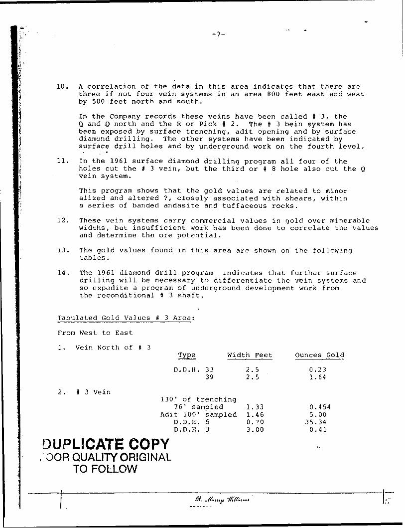
-7-
10. A correlation of the data in this area indicates that there are three if not four vein systems in an area 800 feet east and west by 500 feet north and south.
In the Company records these veins have been called # 3, the Q and .Q north and the R or Pick # 2. The t 3 bein system has been exposed by surface trenching, adit opening and by surface diamond drilling. The other systems have been indicated by surface drill holes and by underground work on the fourth level.
, f
11. In the 1961 surface diamond drilling program all four of theholes cut the # 3 vein, but the third or t 8 hole also cut the Q vein system.
This program shows that the gold values are related to minor alized and altered ?, closely associated with shears, within a series of banded andasite arid tuffaceous rocks.
12. These vein systems carry commercial values in gold over minerablewidths, but insufficient work has been done to correlate the values and determine the ore potential.
13. The gold values found in this area are shown on the following tables.
14. The 1961 diamond drill program indicates that further surfacedrilling will be necessary to differentiate the vein systems and so expedite a program of underground development work from the reconditional # 3 shaft.
Tabulated Gold VaJues t 3 Area;
From West to East
l. Vein North of # 3
D.D.H. 33 39
Width Feet
2.5
2. #3 Vein130' of trenching
76' sampled
D.D.H. 5 D.D.H. 3
DUPLICATE COPY.GOR QUALITY ORIGINAL
TO FOLLOW
1.33Adit 100' sampled 1.46
0.703.00
Ounces Gold
0.231.64
0.4545.00
35.340.41
St. ^ft.H. 1l'M.,,~*
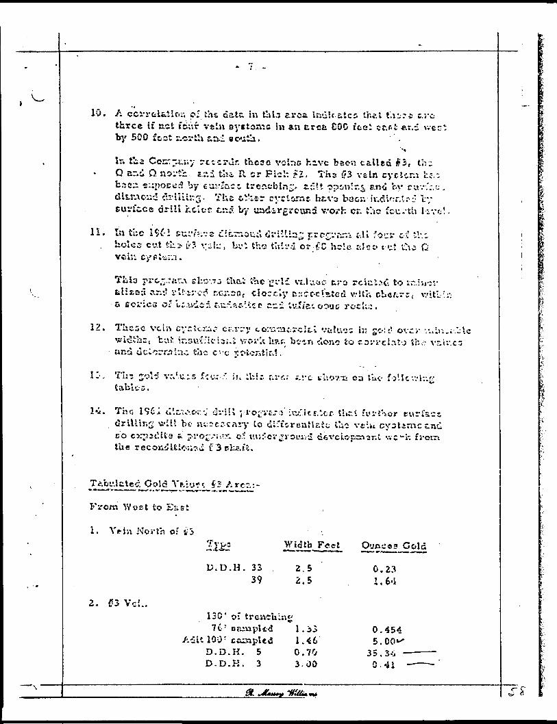
10, A cci'rfelfciiOii pi the data m t!il.7 area indJraics the t t'.i^-rs c.rc three if net fs;Vr vein oystonic hi an e,rea 600 ice* ct.fit er.d wec- by 500 foot tcrSi s.ai south.
Ir. t'ia Ccrr7^.uy rcccrur these volr-c hive been called #5, thu Q ar.d O. ttoi-tb- zv.i the. R. cr Fich ?2, Tfas C'3 vain cycttr.i he.-, t.7s;i e::i)occ3 by tu;.*;acc trcncblnrr a:*It opinir.^. ano fcv cuv-.".-;^ . cHuuoud clrit'i"^. The oVier cvTt&rnc h&vs baor.-h-.d*':r.'r^ ly eurfc.ce drill hcior c:i5 by und-3.-rground vvo/h cr. the fcu/th l;vc!.
H. la tUe 1961 su:v"*-.-5S c:c.rrioud Oi'i'lin^ rrc^-'^^ &K **!;" e-.? :V.c holes cut tlii- u-?. . :i i^, bi.': the tIr.i-.-l or f;C hilc a 11; o tut t!\i Q
TLio prc^.rar^ eho'~o thai the ucld viJuoc t j-o rciui.n". to ir.Isj-:;- zilisc:i cir-:! i-lt-src^ r-c.r.Dr. f cioctiy crjcc-c'.atect v.-ltr. r-bafirr, v/itl.-!:; a Eoi'ies o? i:.iiiif. r-.ii-.ar. :.tcc c.c.i tv.fi"et oout rotl:.:.
12. These vein cyrtcj^.? c p. r i* y tor^tacrclti vtlu-js ir go!-' ovci- •.•- 4 i);,;."-lc witJthc, tut ir.suv'ici^i.i vvorU li?.c. bean c'lOjio io covi-clr.tj the viiv.c" und dclorrahio the c'-'c yc-tc^tic.?.
IZ-. Th? jjoH v:,'u-5 ':c.: ;' i.'i lUir. firr.; ;.vc thov.is oa l ut f j'lcv.-lr.^ tables.
1*1.' Tho 19Ci o'.c.*^.o;:-J i3vi!l j-vo^vtj::'Lrw,"itr.',cf t'nr.t fyi-thor turfact drilling will bc- ns:5cr-cnry to dirfcruafir-Jc; tlii velu cyotimcz.nd BO C3:p2t'.tte t pi'o^^.'-.rr. c.? ui;:"ov^i'OLU;d dsx'elc-psnar.t \vc-L". f the recojaiUk-r^.vi f"3 tiUa.t'i.
^ot'.latec. Cold Vftiu-^S3 Arc~.:-
From ^Y9ct to EiiBt
1. Vein North o: tf 3
2. i73 Ve;..
D. D. H. 33 39
W^tdtb Feet
E.5 2.5
130' o: trcncuing7C' eaivaplfd l. 3
Aait 100 : campled 1.46D.D.H. 5 0.70D-D.K. 3 3-00
Ounce a Cold
0.23
0.454 5.00"
35.3-^ 0.41
df. *mmufy "rlt4fc*9*t
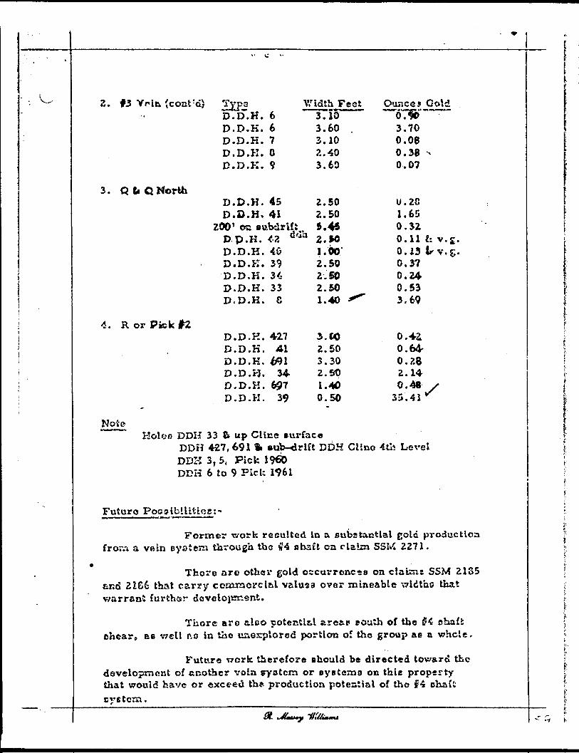
2. #3 Yrin (coat rd) iXF*D.D.H. D.D.K.
.D.K.
.D.K.D. D,
667 O
3. Q fi. C North
4. R or Pick #2
D. D. K. 9
D.D.H. 45 D.D.H. 41
ZOO' ©c BttbdrifS D-p.H. *2 D.D.H. 40 D.D.K. 39 D.D.K. 34 D.D.K. 33 D.D.K. S
D.D.H. 427 D.D.K. 41 D.D.K D.D.H
D.KDD.D.H.
34697
39
2.502.505.45Z. MJ. 002.502.502.501.40
3.002.503.302.501.400.50
U.2C1.650.320.11 li v .s.0.13 t-v.g.0.3?0.240.533.69
0.42L 0.64- 0.28 2.14 0.48
33.41 v/
NoteHoi en DDH 33 8t up Cline surface
DDH 427,691 ft sub-drift DDH Clino 4tli Level DDK 3, 5, Pick I960 DDK 6 to 9 Pick 1961
Futuro Poc o ibjLUttcgj -
Former t/ork resulted in a substantial gold production froivi a vfiin system through tho #4 shaft on claim SSM 2271,
There are other gold occurrences oa claiznt SSM 21S5 eud 2266 that carry comraorcltl valusa over mineable widtho that warrant furthar development.
Thore arc tloo potentls.1 aretp e oath of the #4 o ho.ll chear p ae well r.o in the unexplored portion of tho group ae a whole.
Future v?crk therefore should be directed toward the development of another voia pyetcm or eye t em o on thie property that would have or exceed th* production potential of tho f4 ohaft cvBtcra.
dt.

-9-
The # 3 shaft headframe has been erected and the shaft reconditioned with a level established at the 100 foot horizon
Lateral work from this first level horizon would develop the various ore shoots in the vein systems, put ore in sight and give backs for tonnage.
Before consideration can be given to underground work it will be necessary to do further surface work which will include the following:
Recommended Future Work and Cost Estimate:
Surface Work
A detailed geological mapping program of the whole property, with emphasis on possible structural controls-
Estimated costs S2,500.00
The assessment coverage requirement on the ten (10) unpatented claims-
Estimated one years work g 40 days per c.laim $2,000.00
A continuation of the 1961 diamond drilling progi^m to differentiate the various vein systems indicated.
This surface drilling program will call for a number of closely spaced north-south sections at 100' intervals, east and west of the # 3 shaft. Each alternate section sufficiently wide to cover the area as a whole.
Estimated cost3,000 feet of AXT drilling,including logging, sampling, etc.@ $6,00/ft $18,000.00
Allowance for contingencies
TOTALS
$ 2,500.00
^25,000.00
DUPLICATE COPYi OOR QUALITY ORIGINAL
TO FOLLOW
M t IK r l)lt)M*i CNOIHCI*

lTi- #S B^ft hcSLda-r-rae tee bsen erected r.nd the
** *ith e. level wtabllohed at the 100 Coot horton.
7.i-**rel rcrkfrora thin first level horlaon v/quld iavsi&p S" varlc-M oro shoots In K.o Yste cyclosas, put crc m sight c^5. j-Lvc Vichs fo:.* tcnnagc.
na?ov,'. coft5lv.a?atioK CLH bs ^ivsn U- cxisvpro^nd vert; it will b; n6C*ncM"/ to do Zurtbcr ccr^ce wcrl: Wr*u:n wiu ij; elude t c o se! lowing.
sand
1. A cstf.llci Ecclr.-ic?! property, T.-iti c or.tr ci 5 *-
? ea
S-Z.. SC'v.OO
~n*, on the t;2. Ths as-ec&sm&r.* covcrft'c (10) taspr.totttci claiai.') -~
Estixns.'.5c- oue yw.rc v.'orU@ 40 days pa? clato $Zr OtO.OO
3 A eonttoattea of the 19-31 dtewm* drilling P- Co ilSfereatlatc the varloas vela oyotcana lr.d
Thic .uvfecc drllltec P^srarn Wlll call ^ of closely spaced ncrtb-cou^ option* tt rOO wc.S ftafi\7.8t ci! the 03 tbrft. Each alternate tufClctantiy wldo to eovsr the avea eo a wncle
Ectbaattd coat3 r 000 Ccct of AXT driiai^.iccluding los^e. consplteg^te.©06.00/ffc 518,000.00
-i. Allowance Eor contingencies $Z^500.00
Totals S25r OOO.OO
6 f

- 10 -
Ung or gr oun d W or U
On completion cf the surface drilling program, It is Qg^imated that e.r. underground program would call for 1 ( 500 feet of lateral \vorU fc.nd valeing from the {13 ehaft.
Estimated coetAll hue lac i ve contract including lateral short hoU diamond drilling program (g $ 50.00 1 foot
Summary of Costs
Surface work Underground
Totals
, OpO.OO ^75,000.00
$100.000.00
Coaclac iona: -
This Pich Minao property V7arrtnto detailoi Inveati- gatioii to deterc&Lac tee ore potsntiat In order that tho mont efficient use can be made of the mine and mill equipcnftr.t already preacnt and erected on tho property.
Respectfully
TorontOt Ontario January 10tb r 1962
R. Mace Profesalo;

Certificate
I, RICHARD MASSEY WILLIAMS, of the City of Toronto, in the County of York, in the Province of Ontario, hereby certify,
1. THAT?I am a Mining Engineer and Geologist and reside at 84 Giencairn Avenue, Toronto 12, Ontario
2. THAT I am a graduate of Dalhouse University, Nova ScotiaTechnical College and the Massachussetts Institute of Tech nology and have been practising try profession as an engineer and geologist for the past twer.uy five years.
3. THAT I have no direct or indirect interest, whatsoever in the property or mining claims covered by this report nor have I direct or indirect interest in the shares of PICK MINES LIMITED. I do not expect to receive any further direct or indirect interest in the shares or mining claims held by PICK MINES LIMITED.
4. THAT the accompanying report is based on:
a) a general knowledge of the areab) a review of all old company and governmental records
availablec) an examination at the property October 9th and 10th, 1961d) the laying out and supervision of the December 1961 surface
drilling program
5. THAT I am a member of the Professional Engineers Associa tion cf Ontario, the Canadian Institute of Mining and Metalurgy, the American Institute of Mining and Metalurgical Engineers and a Fellow of the Geological Association of Canada.
Dated at Toronto, Ontario, this 10th day of 'January, 1962.
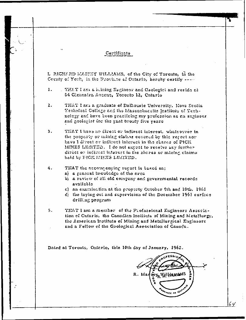
Certificate
I, RICH/ ?,D IvlftS?3Y WILLIAMS, of the City of Toronto, In the Gcur.ty o5 Y c:-: h, i a the Pi.-ovu.tK ci Ontario, hereby certify -----
1.
2.
3.
4.
5.
TH/iT I r.rt s. iv..inlng Evgtncs r and Geologic i and ree ids ci G4 Glcucalvn Avcr.us, Toronto IE, Ontario
T K A T I ari a graduate of Dalhousie University, Kovs Scotia Technical College c.r.i iha Mascachuetlto .Icctitutc- o." Tech- KCicjy an:. bave been practicing my profession ?.c r.n sr.ginaer ft EI d (jcolc^'tPt for the j: to t tvvcuty rive yearc
THAT I hrxva ::o divert o** indirect iutercot, wbatcoa^'er In the ju'cpirty ov uilsLr.g claLrne covered by thic x-cjovt nor h&vo l dir/cct nv uidli-oci interact in the charc-.c of PICK MINES LIM1T2D. I do not c j;y-ccl to receive ar:y furthc-r direct: or in5ivf-ci hit* r 6? t iu t\\s a ur.reo or mining claims held by PICK J/IKSS LIMITED.
THAT the rtccorA^rvnyJnf rsi: or t is ban c d or; ;a) Q gr&nsval laicv/lctlce of tlie creiib) a vtrvifcv/ o? ali old company arse', gcvcrnmcntal records
availablec) an ex&'.ilntticn. at tbo r-ropc-rty October ?th and iOtb, 1961 d} tbe laying out and eupervieicn of the Decezaber 1961 Eurfc.cs
g program
THAT I arn a raernber of th^ P;ofasalcnal EiigiBaQro Associa tion of Cntario. tbo Canadian Inctiiutt oC Mining and Metallurgy, the .American Inotituto of M ining and Metallurgical Englnuorc and a Fellow cf the Geological Asecciatton o/
Dated at Toronto, Ontario, thle 10th day of January, 1962.

APPENDIX
1. References t, Maps
2. In Pocket
Index map and property plan
^ fftt 1 1 * u In f fat j
CNOIMCCN
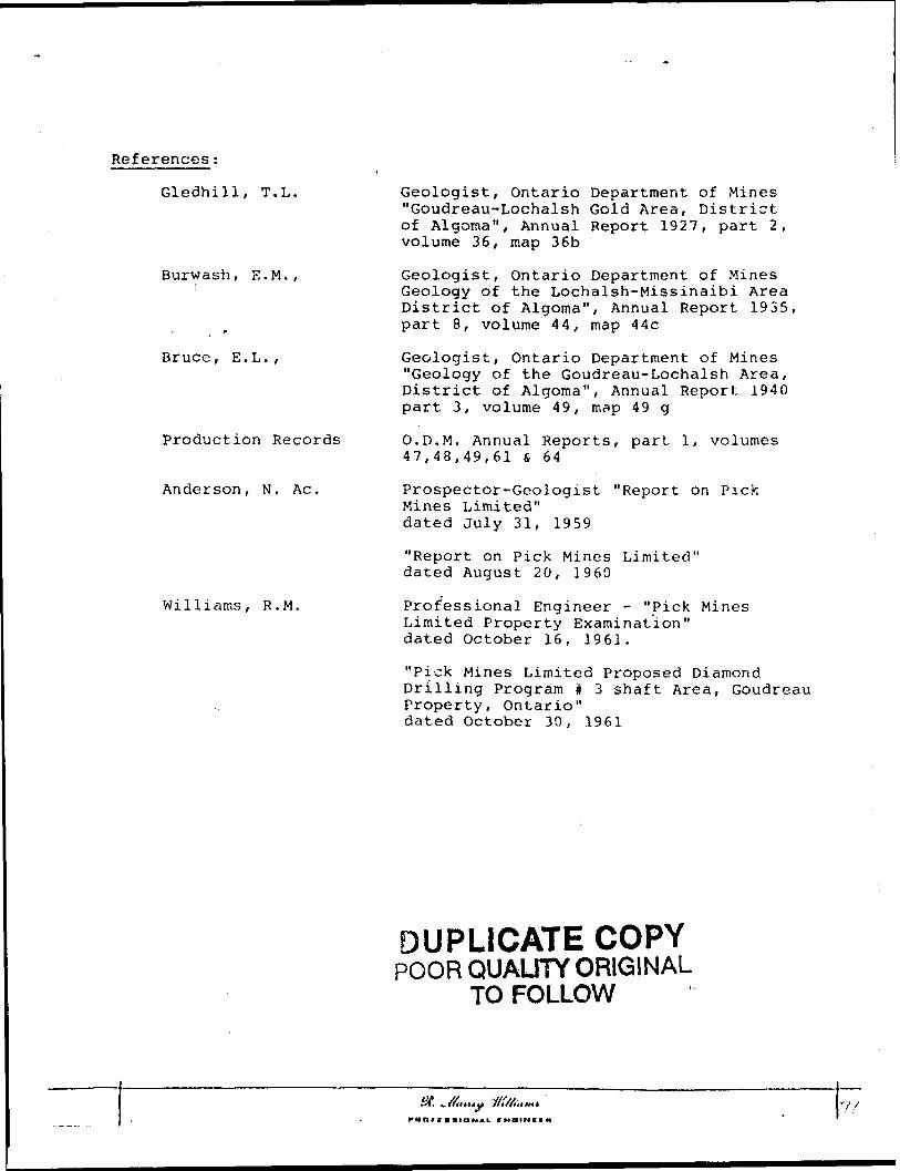
References:
Gledhill, T.L.
Burwash, E.M.,
Bruce, E.L.,
Production Records
Anderson, N. Ac.
Williams, R.M.
Geologist, Ontario Department of Mines "Goudreau-Lochalsh Gold Area, District of Algoma", Annual Report 1927, part 2, volume 36, map 36b
Geologist, Ontario Department of Mines Geology of the Lochalsh-Missinaibi Area District of Algoma", Annual Report 1935, part 8, volume 44, map 44c
Geologist, Ontario Department of Mines "Geology of the Goudreau-Lochalsh Area, District of Algoma", Annual Report 1940 part 3, volume 49, map 49 g
O.D.M. Annual Reports, part l, volumes 47,48,49,61 s, 6 4
Prospector-Geologist "Report on Pick Mines Limited" dated July 31, 1959
"Report on Pick Mines Limited" dated August 20, 1960
Professional Engineer - "Pick Mines Limited Property Examination" dated October 16, 1961.
"Pick Mines Limited Proposed Diamond Drilling Program # 3 shaft Area, Goudreau Property, Ontario" dated October 30, 1961
DUPLICATE COPYPOOR QUAUTY ORIGINAL
TO FOLLOW
St. ^ If li II t y Hl/Aantl
(••tin (HOMCL (MOIMOH

Glofihill, T.I-..,
Burwash, E.lv!
Bri^.cc, E. L. P
Gsolcgictr Ontario Department of Minos "Gou.-jraau-Lc-chalih Gold Area, Dictrict of Ai-joaia", Annual Report 1927, par; 2, volume. 36, map 36b
Geologist, Gn';r,i-lo Department oi M i "Geology of tbe Lochalssb-Micslcaibl Area DiotrlcC of Alsoraa", Aiu*.u;.l Report 1933, jari G, volusau 44, me.p 44c
Geolojict, Ont?.rl9 Dopw.'tj-.-ieut o: l:Gsolocy o? tlse Geaiireau-IjO2h?.lch Area, Cif-irlct of AlncrnaT, Aniiar.l Repori Iv^O part 3 r volume ^-9 r map 4? g
Prod-action Re"ovdo O. l?. l,-'. Aruiual Repcrtc, pari i,. x-olu:
K. Ao. t
Sr R.M.,
Prcnccc'for-Gsclo^lct "F.ei^ovl os PL^h
ck-tcf. July 3i, 1 {;59
l:?Cei*ovt on. Pick Mines Lir/iltcd" ca-tccl Ausuot 20, I960
ProfesDiona.1 Engir.eer - "Pick Mines Litait&d Properly Ezamuaation" cLsitcc. Octobar 16, 1961
"Fish Mines Llmltsd Proixiccd DiamondProgrrja S3 ehaft Avfca,
pertjr , Oatarlo" dated Octobar 30, 1961
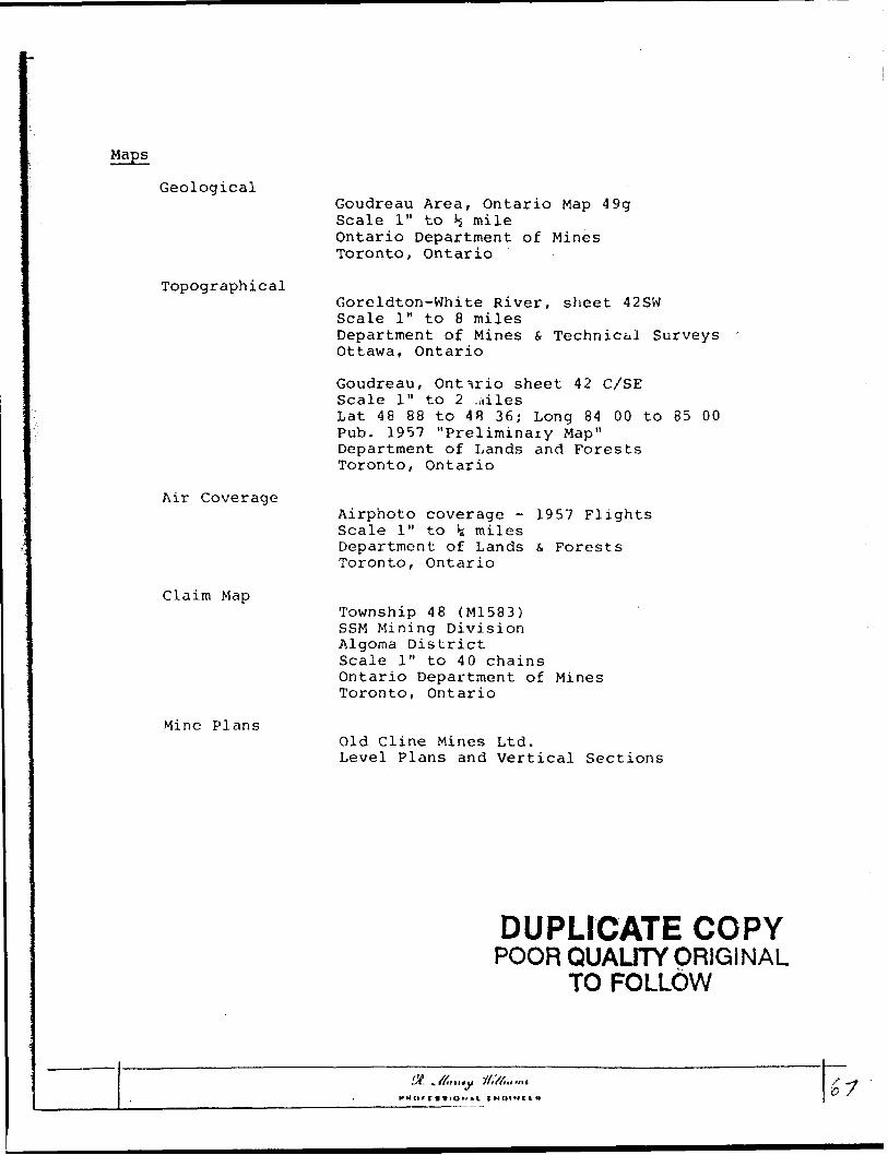
Geological
Topographical
Air Coverage
Claim Map
Mine Plans
Goudreau Area, Ontario Map 49g Scale l" to Jj mile Ontario Department of Mines Toronto, Ontario
Goreldton-White River, sheet 42SW Scale l" to 8 milesDepartment of Mines & Technical Surveys Ottawa, Ontario
Goudreau, Ontario sheet 42 C/SEScale l" to 2 ...ilesLat 48 88 to 48 36; Long 84 00 to 85 00Pub. 1957 "Preliminary Map"Department of Lands and ForestsToronto, Ontario
Airphoto coverage - 1957 Flights Scale l" to \ miles Department of Lands f, Forests Toronto, Ontario
Township 48 (M1583) SSM Mining Division Algoma District Scale l" to 40 chains Ontario Department of Mines Toronto, Ontario
Old Cline Mines Ltd.Level Plans and Vertical Sections
DUPLICATE COPYPOOR QUALITY ORIGINAL
TO FOLLOW
st. .a,H.y rf,'//..,,,, i^

GeologicalGcudrstu A roe., Ontario Map Sctlo l" to 1/2 mils Ontario Derarfcsiont o* Minec Toronto Or.tevio
TopographicalGc-salitOR-V/hlto Rive---, sheet -12 SY; Setts l" to B mite*
t o! M hise St Tech'/.icr.i Survey;
Gov.dffec.Kj Ontario cheoi 42 C/SE Scaio l" to EiTiiicsI -tt -tS CO to 4P 3C ; Lcnc 84 00 to 85 00 Pub. i557 "Preliminary J,5r.p" DcvaffcJiSiii of Lr.ndo C: Forests Toronto Gastric
Air Covcvs.?coAiri-botoccv.irE.ee - 1957 Sctls l" to iMKil'.ee Dsp^rimcn* of Laiiic tt Forests Toronto Outcvlo
Toxmrhip -iG (li 1 583) SSr.i ?.HniRg Divlolor. Al2or'ia District ScsAc l" to 40 chains Ontario Dapartmcnt of Toronto Ontario
Mine PlansOld Cline Mines Ltd.Lovel Piana and Vertical Sections

(fd
r jl
A SUHWRY ;* , l
OF RESULTS OF EIAMQHD OKU.UHG l
IN Tig *3, SHAFT AREAl
WITH RECOMMENDATIONS FOR FUTURE l' ——— — —— '
AT PICK H^HgS LTD.
GOUOREAU GOLD AREA. OKT.
TORONTO, ONT.^RIO A.C.A. HOWE, P. EIJG. HAY 23, 1962. RESIDENT ENGINEER.

666
CONTENTS
Mo.SUMMARY
INTRODUCTION (J)
DIAMOND DRILL RESULTS: (l) fr ( 2)
PICK HOLES (}) 5. (2)
CONCLUSIONS (2) f ( 3)
RECOMMENDATIONS (3)
MAPS: -~ Plan of drill ho!es In pocket
Longitudinal Section of #3 zone
11 " " 1& end 5 zones
" " " Q zone
70

V..
SUMMARY'——— ~
The drill program just concluded, has Increased the
length of all known zones. In addition two new zones have
been outlined namely Jfr and #5. At present an area 600 ft.
long by 250 ft. wide has been outlined, containing five
separate zones of gold mineral lzatlon. All zones are still
open ot each end.
It Is recotnnehJed that further diamond drilling be
carried out to extend the length of these zones, and
thereby Increasing their tonnage potential. In addition
It Is recommended that the area already drilled be
Investigated underground.

iNTROOUCTIOHt
The #3 area of Pick Mines Limited, which has been explored by
diamond drilling to date, lies east of the #3 shaft. It also adjoins to the
north end west of the old workings that were developed from #4 shaft by the
Cline Company. The veins In this #3 area ara approximately parallel to and
north of the veins previously developed from the #4 shaft, and therefore
constitute a new mineralized zone not previously mined by the Cline Company.
DIAMOND DRILL RESULTS:
A summary of the Intersections obtained In all holes drilled by Pick to date follows:
PICK HOLESDollar Valu** / Ton
Drill Mole No. Width Fee t Ounces Cold At $35 per oz. At 538 per oz.11 " ' per ton n • 11" —— ~ ~ —
P. 2 2.2 0.14 $ 4.90 $ 5.32
P. 3 3.0 0.1*1 li*. 35 15.53
P. 5 0.7 35.34 1,236.90 1,342.92 and 3.4 0.35 12.25 13.30 and 4.4 0.22 7.70 8.36
P. 6 3.1 0.90 31.50 34.20 and 3.5 0.14 4.90 5.32 and 3.6 3.70 129.50 140.60 and 2.3 1.63 57.05 61,94
P. 7 3.1 0.08 2.80 3.04 and 2.0 0.19 6.65 7.22
P. 0 4.8 0.11 3.85 4.10 and 2.4 0.38 13.30 14.44 and 1.4 3.69 129.15 140.22
P. 9 1.0 0.09 3.15 3.42 and 1.0 0.17 5.95 6.46
•-
Zono
Rif
3 f
3 i1 l3 {
l \3 * 3 |
3 |R 1
S
J 1

-2-Dollar Value f Ton
1 Hole No.l(
P. 10and
P. 11
P. 12andandand
P. 13P. 1**and
P. 15ondand
P. 16ondandand
Width Feet
3.52.5
1.5
0.55.01.52.5
1.51.52.0
2.00.51.0
1.53.01.01.0
Ounces Goldper ton
0.300.63
0,33
2.311.580.230.1 J*
3.5**0.370.610.3**0.253.30
0.111.310.330.12
At $35 per o*.
^10.6123.80
11.55
80.0555.308.05**.90
123.90
12.9521.3511.908.75
115.50
3.85**5.8511.67^. 20
At 338 per 02.
311.5125.8**
12.67
87.7860.02*
8.7**5.32
13*1.521*4.0623.18
12.929.50
125.**0
**.I8149,7312.5***i.56
Zone 1
ii
* k3 r1J) i
l
3 i3 'f3
533 t C
3 |3Q
5 ili3 or3 j
COHCLlKIQtiS AMD RECOMMENDATIONS:
The diamond drilling programs carried out by both the Clino and Pick
companies have shown that there are 5 separate zones of gold mineralization.
These zones have been numbered R, Q (which were developed by the Cline Company),
and 3, ** and 5 (explored by the Pick). The Pick drilling has outlined the 3
and 't zones over a length of 600'. The 5 zone Is a new one discovered at the
west end of the area by holes P. 13 and P. 16. It Is 100' long arid open at
both ends.
Within each zone the gold minerallzatlon Is found In ore grado shoots,
that are concentrated near quartz veins and otrlngers, Each zone may contain
up to three separate parallel veins or shoots, which vary In strike ond dip
along the length of the shoot and which may reduce In number fr on three to one
narrow shoot, or oil rnay Join together to form a wide high grade zone.

-3-
It Is these enriched areas, producing pockets of high grade ore
that can be cheaply mined, which Mill contribute substantially to the profits
that can be gained from mining of the zone. It Is therefore* Important to
discover the size of those pockets both In length and depth. This can best
be done front underground by drifting along the zone. It Is also Important
to determine the overall grade of the zone which can be nore effectively done
with the bulk samples available from drifting. Owing to the erratic
distribution of the visible gold, It Is expected that the muck samples from
drifting would show an Improvement in grade over the core samples, since by
law of averages the visible gold must report where a large number of samples
are taken.
It Is also Important to discover the strike and pattern of occurence
of the ore shoots, so that diamond drill results can be Interpreted moro
effectively, and future underground operations can bo planned.
Diamond drilling has shown that in an area 600 feet long by 250
foot wide, thore occur 5 gold bearing zones. Also that all the zones are
continuing strongly both to the east and west Into ground never previously
tested by olomond drilling.
RECOHHENOATJONS:
Further work will be divided Into two programs, which will consist
of diamond drilling to increase the length and tonnage of the area, and
underground drifting along the #3 zone.
(1) A total of 3,000 ft. of drilling Is recommended both east and west of
the known zones.
(2) An underground program Is reconroendcd as follows: ~
(a) The #3 shaft should be dewatered, thus giving access to the
station and cross-cut on tta first level
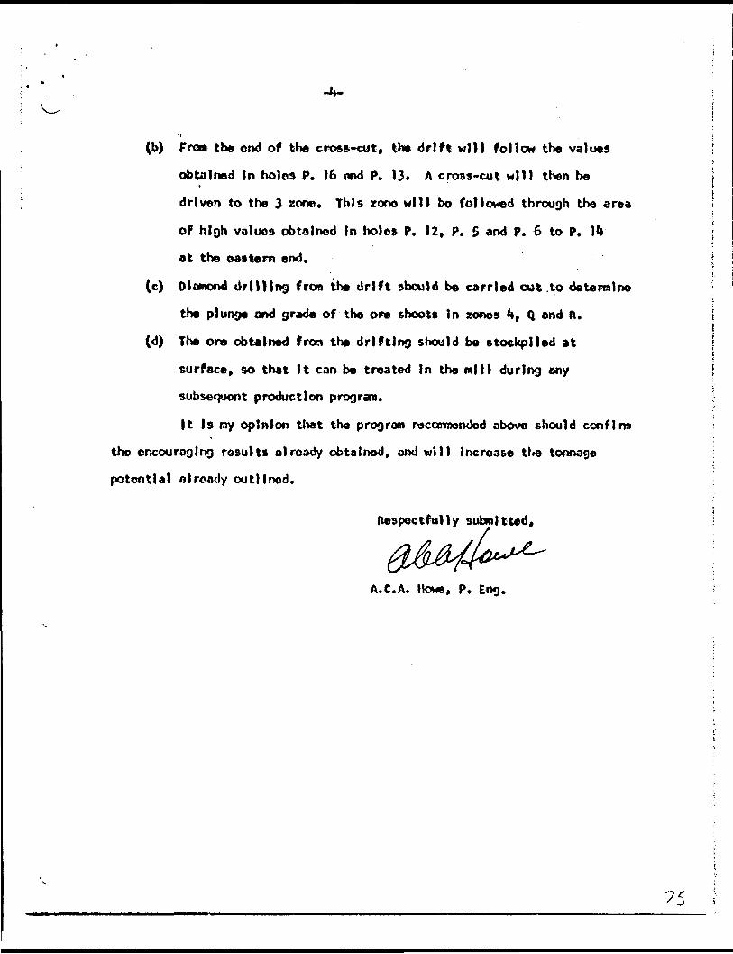
(b) From the end of the cross-cut, the drift will follow the values
obtained In holes P. 16 and p. 13. A cross-cut will then be
driven to the 3 zone. This zone will bo followed through the area
of high values obtained in holes P, 12, P. 5 and p. 6 to P. J**
at the eastern end.
(c) Diamond drilling from the drift should be carried out .to tie terra l no
the plunge ond grade of the ore shoots In zones ** f Q and ft.
(d) The ore obtained fron the drifting should be stockpiled at
surface* so that It can be treated in the mill during any
subsequent production program.
|t Is my opinion that the program racanmenOcd above should confirm
the encouraging rosults already obtained* ond will increase the tonnage
potential already outlined.
Respectfully submitted,
A.C.A. l tone, p. Eng,
v..
RESULTS OF DIAHOUD DRILL PROGRAM
INCLUDING HOLES P. 10 - P. 16 AT
PICK MINES L lHITEP. GOUDREAU PROPERTY
TORONTO, ONTARIO A.C.A. HOWE, P. EHG JUiJE 5, 1962. RESIDENT ENGINEER.
RESULTS OF DIAMOND DRILL PROGRAM
INCLUDING HOLES P. 10 -- P. 16 AT
PICK MINES L!HITED. GOUDREAU PROPERTY
TOROi'TO, ONTARIO A. C. A. H WE, P. EHG JUNE 5, 1962. RESIDENT ENGINEER.

70 c
CONTENTS
INTRODUCTION
RESULTS
CONCLUSIONS
RECOMMENDATIONS
Page No.
l
3
3

INTRODUCTION:
Holes P. 10 - P. 16 were drilled to extend zones outlined in
previous drill programs, These previous programs included the Cline holes
drilled by the Cline Company, and P, l - P. 9 drilled by pick Mines Ltd.
RESULTS;
Five separate mineralized zones have been outlined. These have
been numbered R, li, 3. ^ and 5, In this order from south to north. These
zones consist of shears with injected quartz stringers, and quartz veins
up to 3 ft. in width.
The gold occurs both In the free form and associated with pyrite.
The free gold appears to be confined to the quartz veins, and some visible
gold was noted in hole P, 10. The pyrite occurs disseminated and in thin
stringers throughout the shear zone, however it has been noted that gold
va-liies are higher where quartz injection occurs also. In each zone, more
than one section of quartz pyrite enrichment may occur. This means that
there may be two or more sections with good gold values in any one zone.
|n zone 3. as an example, two parallel shoots have been outlined which
appear to dip in opposite directions. Where these shoots join to-gether
wide sections of ore grade material occur as in the area of #3 adit, and
in holes P. 5, P. 6, P. 10 and P. 12.
It is these enriched areas producing pockets of high grade material
which will largely determine the overall grade of a zone, Without knowing
their strike and dip or plunge, an accurate average grade for a zone
cannot be calculated. The lengths and depths of the various shoots can
be seen on the accompanying longitudinal sections. These show that:
(1) The R zone has been Intersected over a length of 600 ft. and is still
open at each end. The elevations, of the intersections occur over e

FLIGHT
AKOMALY LIST - GOUL'REAU
FREQUENCY 4575 LIME ANOMALY CATEGORY INPHASE QUAD.
r-A G i:
CONDUCTOR BIRD GTP DEPTH HEIGHT
MHOS MTRS MTRS
11111
11111
111111
1111111
111111
111111
1111
300300300300
' 300
310310310310310
3203203203?03?0320
.130330320330330330330
340340340340340340
350350350350350350
360360360360
BCDEF
ABCDE
ABCDEF
ABCnEFG
ABCDEF
ABCDEF
ABC[i
00000
00000
000000
1000000
000000
000000
0000
4,70.20.80.94.4
-0,31 .21 .02.46.3
1.80.60.81.94.14.9
7.71 .93.42.2
-0,24.53.6
3.17.31 .73.93.43.0
2.21 .9A . 43.97.18.6
4.76. G2.01 .7
10.82,13.65.06.1
2.03.42.410.131 .1
8.43.22.22.58.28.5
4.93.64.35.64.29.4
11.3
8.49.47.83.84.44.0
3.04.47.016.915.713.5
13.716.85.81 .8
0.20.00.00.00.4
0.00.00.00.00.0
0.00.00.00.30.20.3
1 .70.10.40. 10.00.20. 1
0.10.60.00.70.40.3
0.30.10.30.00.20.5
0.10.20.00.4
116
171324
0144640
11931501210
201938270
171 1
0230
382936
422613009
f *J
51850
3141353035
4246263339
373240323740
47483025332927
472946353834
343342324335
32313244
Estimated depth si a y be unreliable because the stronger part of the conductor may be deeper or to one side of the f l i d h t li ri e? or because of a shallow dip or overburden effects.

-2-
vertlcal range f rom 275' below the #3 shaft collar in C. 39 to 40'
below the collar in hole P. 2.
(2) The Q zone has been Intersected over a length of 600 ft,, is open at
each end, and at elevations ranging from 230' below shaft collar in
C. 39 up to 30' below shaft collar in P. 14.
(3) The 3 zone has been intersected over a length of 400', is open at the
east end, and probably faulted at the west end. Elevations of the inter
sections range from 200' below collar in C. 39 to 25' above collar in
P. 14. The west end of the zone appears to end abruptly west of P. 12.
However, good values obtained 200' further west in P. 16 Indicate either
a new zone commencing, or that the 3 zone has been faulted and displaced
northwards. The intervening ground should bo explored by further drilling.
(4) The 4 zone has been intersected by drilling over a length of 600 ft.
However, ore grade intersections occur over 75 ft, in the centre, and in
hole P. 16 at the west end. At the east end, it has been explored by
the Cline Company in an od i t 25' long. Further drilling should be done
to determine whethor the ore shoots have a plunge to either the east or
west, which would mean that they would plunge below the present series
of drill intersections.
(5) Tlie 5 zone is a new one discovered at the west end of the area by holes
P, 13 and P, 16, The remainder of the Pick holes lie south of this zone
and so could not intersect it. However, no trace of It is apparent in
C. 42 and there remains the possibility that this zone is the faulted
west end of the 4 zone. However, whichever way the zone is designated,
it has been intersected in two holes 100 ft, apart and is still open to
the west.
7'i

L, -CCNCLUSIONS;
The drilling has outlined 5 separate zones of gold mineralization.
Within each zone the gold Is concentrated In one or more shoots, and it
Is necessary to know the strike, dip, width and continuity of each shoot
in order to calculate an average grade and tonnage figure for a zone.
Further work will be necessary to outline these shoots, and this can
be done in either of two ways,
(1) By further drilling of the area from surface
or
(2) By an underground drift to explore one zone, accompanied by
.detailed drilling of the other zones from this drift.
If sufficient money is available, an underground explorationf
program would be preferable. This would provide close inspection of the
geological structure of a zone and enable the various ore shoots to be
outlined more accurately than would be possible from surface. Tonnage and
grade calculations can then be made.
In addition to the above work, further diamond drilling will
be necessary to extend these ~, zones which are still open both to the east
and west.
RECOMMENDATIONS;
Further work wi 1 1 be divided into two phases, which will
consist of diamond drilling to increase the tonnage outlined in the area,
and underground drifting and diamond drilling to investigate and develop
the known ore shoots.
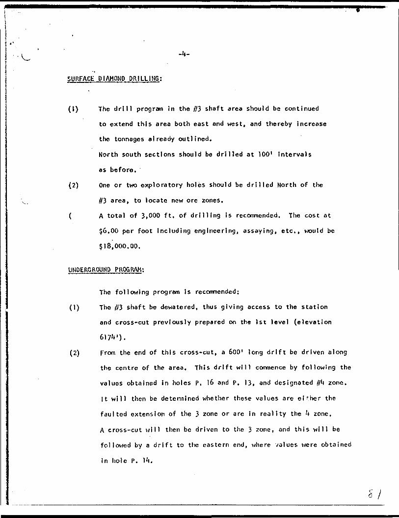
SURFACE DIAMOND DRILLING;
(1) The drill program in the #3 shaft area should be continued
to extend this area both east and west, and thereby Increase
the tonnages already outlined.
North south sections should be drilled at 100 1 intervals
as before,
(2) One or two exploratory holes should be drilled North of the
#3 area, to locate new ore zones,
{ A total of 3,000 ft. of drilling is recommended. The cost at
$6.00 per foot Including engineering, assaying, etc,, would be
$18,000.00,
UNDERGROUND PROGRAM;
The following program Is recommended;
(1) The #3 shaft be dewatered, thus giving access to the station
and cross-cut previously prepared on the Jst level (elevation
617V).
(2) From the end of this cross-cut, a 600' long drift be driven along
the centre of the area. This drift will commence by following the
values obtained in holes P, 16 and P, 13, and designated f}b zone.
It will then be determined whether these values are either the
faulted extension of the 3 zone or are in reality the ^ zone,
A cross-cut will then be driven to the 3 zone, and this will be
followed by a drift to the eastern end, where values were obtained
in hole P. 1^.

-5-
(3) " Drill stations will be blasted at 50' intervals, so that under
ground diamond drilling may proceed simultaneously with the
drifting. The object of this drilling will be to determine the
plunge and grade of ore shoots in the other zones, as well as in
#3 zone itself. Short holes, of 200' length maximum will be
sufficient to reach any of the other zones. It can be observed
that there will be considerable savings in diamond drill costs
over a similar program from surface, and these savings can be
considered to offset part of the extra cost of the underground
development.
(4) The ore obtained from the drifting should be stockpiled at surface,
so that it can be treated In the mill during any subsequent
production program. This ore v/i i l also help offset the costs of
underground development.
The cost of this program Is estimated as follows;
(1) New equipment, including replacement of hoistmotor, 5 ton truck and standby pump $10,000.00
(2) preparation of equipment already installed at#3 shaft, and dewatering of #3 shaft 5,000,00
(3) A total of 600 ft. of drifting, and 200 ft. of cross-cuttlnj and drill station preparation at a contract price of $30 per foot 24,000,00
(li) A total of 3,000 ft. of diamond drilling at$2.50 per ft. 7,500.00
(5) Engineering and supervision for a minimum 6month program 8,000.00
(6) Maintenance and supplies 3,000.00
(7) Sampling and assaying 3,500,00
(8) Contingencies, particularly for grouting ofwater bearing seams 5,000.00
TOTAL $66,000.00

The total cost of both underground and surface work will
therefore be;
(1) For underground drifting, cross-cutting anddiamond drill ing $66,000.00
(2) For surface diamond drilling 18,000.00
TOTAL
In my opinion, the expenditure of $8t^,000.00 is well justified
in view of the encouraging results already obtained.
Respectfully submitted,
A.C,A. Howe, P. Eng.
0*0
PICK MINES LIMITED
DIAMOND DRILL
RECORD
Hole* l to 5 Inet. I960 Hole* 6 to 9 Incl. 1961
Logged by: Nlgel Campbell Sup*rvl**d byi R. Ma...y WUlUun*
February 2 , 1 962 R. Matsey W lUUmi
Si. ^,,u.y -ffiua••O'OVIOMAL CMOINCC*

S3 O '
CONTENTS
1. Diamond Drill Summary
2. Assay Results Summary
3. Old Sample Records
4. Assay Hole 11 Log Hole 11
5. Assay Hole f 2 Log Hole |2
6. Assay Hole 13Log Hole 13
7. Assay Hole 14 Log Hole 14
8. Assay Hole 15 Log Hole IS
9. Assay Hole 16 Log Hole 16
10. Assay Hole f7 Log Hole 17
11. Assay Hole f 8 Log Hole 18
12. Assay Hole a!9 Log Hole f 9
13. Assay Certificates - Thomas Keys t* Son*
Si.

PICK MINES LIMITED
DIAMOND DRILL SUMMARY
1960 and 1961
Toronto, Ontario February 14, 1962
Nigel Campbell Geologist
St.
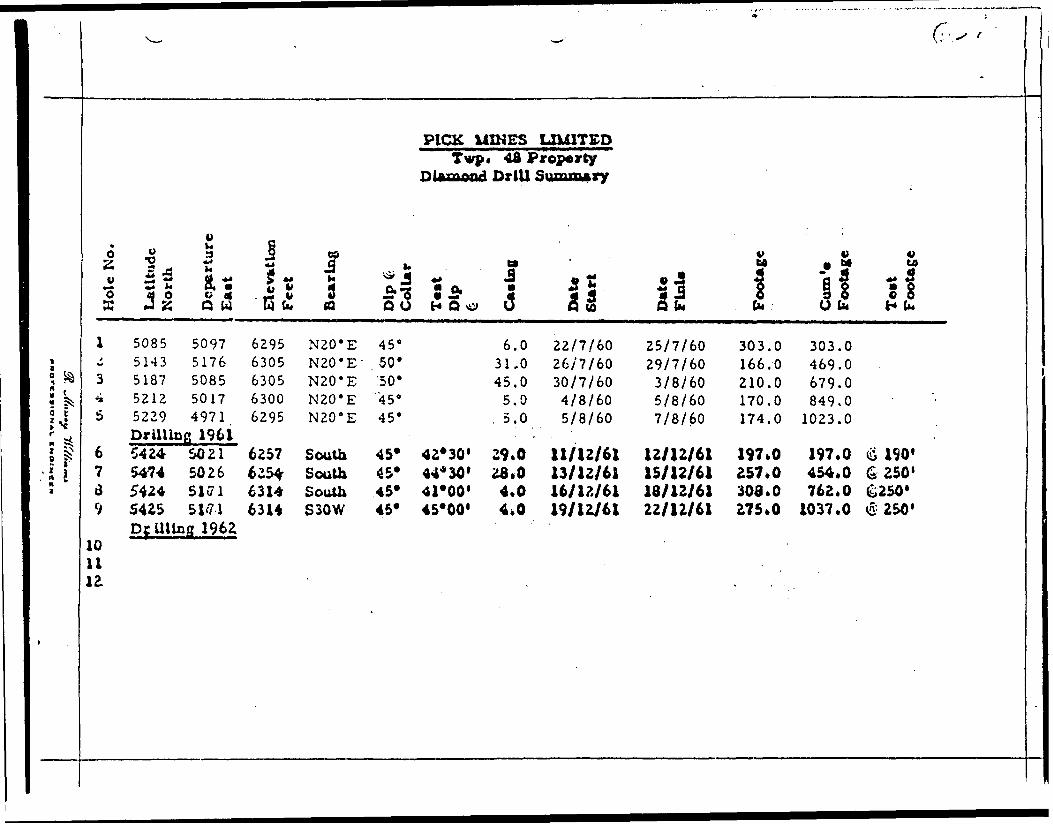
fct
^14^
; J
t
^
* , ** 6 O o "i 9 os^ -0 3 f* rf2 ^? ** ^ -*"3 "So o d , J* v 9 S J SJ Q W WU, tt
1 5085 5097 6295 N20*E-i 5143 5176 6305 N20'E'3 5187 5085 6305 N20*Ei 5212 5017 6300 N20*E5 5229 4971 6295 N20 e E
Drilling 19616 5424 SO 21 6257 South7 54-74 5026 6254- Southa 5424 51(71 63U South9 5425 51*71 6314 S30W
DcUltog 196Z1011
PICK UZNESTwp* 481
DUuuood Drill
a. tt*J -' |3*3 5 J21 S Q O H O o O
45 s 6.0.50* 31. 050" 45.0
'45 0 5.045' , 5.0
45* 42*30' 29.045* 44*30' 28*045* 41*00' 4*045* 45*00' 4*0
~"'
LXUITEDPropertySumxu*ry
5tli
22/7/6026/7/6030/7/604/8/605/8/60
11/12/6113/12/6116/12/6119/12/61
(T-v -
-
4^ 4) 4) U 0 M UJ
w J! 3 ~Q 5 ** 5^1 8 1 8 S 8Q tw b O IK H (M
25/7/60 303.0 303.029/7/60 166.0 469.03/8/60 210.0 679.05/8/60 170.0 849.07/8/60 174.0 1023.0
12/12/61 197*0 197*0 ^ 190'15/12/61 257*0 454*0 6250'18/12/61 308*0 762.0 &250*22/12/61 275*0 1037.0 i5 250'

The President 8t Directors, PICK MINES LIMITED, Suite 302,100 Adelaide Street, West, Toronto l, Ontario.
Gentlemen:
Mr. R. Massey Williams P.Eng. in a report dated October 30, 1961 recommended a 3,000 foot program of diamond drilling in the vicinity of the #3 shaft.
On page 3 of the above dated report Mr. Williamsstated:-
"To open up the adit area on the 100' level horizon would call for 400 to 500 feet of underground development or three to four months of dead work, at an estimated cost of $60, 000 to $75, 000. It is essential therefore, that the maximum information be available before consideration is given to a resumption of under ground effort.
The following surface diamond drilling program, in the #3 shaft area is laid out to:-
1. Check the possible convergence of the #3 and Q vein systems In the vicinity of the adit.
2. Determine what sections occur between the adit and #3 shaft.
3. Give the relationship of the various values, the one to the other, in the first 300 feet of vertical depth.
The drill holes will be laid out from north to south, with the collars at 45" south. The collar locations to be as close as possible to the old mine co-ordinate system."
One third of this recommended drilling program namely holes 6 to 9 inclusive was completed in the month of December 1961 and in January 1962 we re-logged holes l to 5 inclusive that were drilled by the Company in I960. (The location of all nine holes is shown on the plan accompanying R.M. Williams' report of January 10, 1962 a copy of which is enclosed).
CNOIMCI*
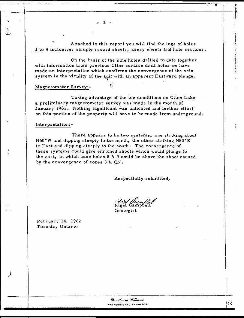
- 2 -
Attached to this report you will find the logs of holes l to 9 inclusive, sample record sheets, assay sheets and hole sections,
On the basis of the nine holes drilled to date together with information from previous Cline surface drill holes we have made an interpretation which confirms the convergence of the vein system in the vicinity of the adit with an apparent Eastward plunge.
Magnetometer Survey;- "'
Taking advantage of the ice conditions on Cline Lake a preliminary magnetometer survey was made in the month of January 1962. Nothing significant was indicated and further effort on this portion of the property will have to be made from underground.
Interpretation;-
There appears to be two systems, one striking about N60*W and dipping steeply to the north, the other striking N80*E to East and'dipping steeply to the south. The convergence of these systems could give enriched shoots which would plunge to the east, in which case holes 8 St 9 could be above the shoot caused by the convergence of zones 3 k QN.
Respectfully submitted,
Nigel CampD^U Geologist
February 14, 1962 Toronto, Ontario
IHOINfCJ C C

Hole 3
Hole 6
Hole 7
Hole 8
Hole 9
)
LEGEND
1. Andesite2. Rhyolite3. Tuff4. Granodiorite5. Quartz6. Felsite
Nomenclature Changes
118.9 135.0 Felsite from Silicified Tuff157.8 184.5 Rhyolite Omission
87.8133.1183.1
114.0 Andesite 142.5 Felsite
Granodiorite Silicified Tuff Silicified Tuff191.6 Felsite
228.0 Probably Felsitic Dyke
Felsite from Silicified Tuff
145.0 151.0 Felsite from Silicified Tuff
223.0
269.2 275.1
Assay Results
Plotted on Sections Gold in Ounces/Ton Width in Feet
Diamond Drill Holes
Prefix C Cline P Pick
Si. Jf.m.y Itff/uim*
OriOIOHAL CHOIMCC'

l '
^*^^*
)
)
————— , —————— . ————————————————— . —————— - ...... ... v
PICK MINES LIMITED Old Sample Record*
Hole No. 2'Ft. Os Gold Sample No. Cert. Date
132.0 to 155. 6 3.6 Nil 26 6088 3/8/60 164.0 to 166.0 2.0 Nil 27 6088 3/8/60
Hole No. 36"6.0to 65.0 5.0 0.005 28 6117 4/8/60 65.0 to 67.5 2.3 Tr 29 67.5 to 72.5 5.0 Tr 30
125.0 to 130.0 5.0 Tr 31 6204 8/8/60 130.0 to 135.0 5.0 Tr 32 197.0 to 200.0 3.0 0.41 33
Hole No. 4 '153.0 to 154.0 1.0 Nil 34 6261 8/8/60 154.0 to 155. 6 1.6 0.01 35
Hole No. 50.03 36 6467 15/8/60 Tr 38
160. 9 to 161. 6 0.7 35.34- 38 161. 6 to 164.0 2.4 0.29- 39 164.0 to 169. 5 4.5 0.26 40
The above taken from Bell-WhlU Analytical Laborltorlea Ltd. P.O. Box 187 Ha Hey bury, Ontario
The descriptions are pencilled along side of the typed reaulU on laid certificates.
No B ample number rscord book available.
Si. vV?"jj*u rti/Aairt*
o

CONTENTS
1. Diamond Drill Summary Report by Nlgel Campbell
2. Plans b. S ections re above
3. Diamond Drill Records Holes l to 9 inclusive
)
CMOIMCCK

Summary Assay Resuita
Hole No. 6 (first)
U)
533.00 Cold
(2)
113.5'to U6.6' B.I' Avor*0.3S2o* or S12.327tonwith
123.3* to U6.6' 3.1* Avar. 0.90 o* or S31.50/ton
133.1' to 142.5* 9.4* Avor. 1.91 o*oror
136.6* to 1*2.5' 5.9* Avor. 2.89 ox or jlQl . 15/tonwith
136.6' to 140.2* 3.6* Av*r. 3.70 oa er $1^9.SO/ton
Hole No* 7 (second)
(D
(2)
(3)
73.0' to 75.3* 3.3' Avar. 0.07 OB or |2.437ton
135. 5* to 144. 9 1 9.4' Aw. 0.05 oa oy S1.75;tonwith
138.6' to 141.9' 3.1* Aver. Q. 08 oc' or SZ
183.3' to 194.5' 11.2' Avar. 0.04 oa or S l. 40 /tonwith
191.8' to 194.5'-i 2.7' Aver. 0.03 oa or Sl.757ton
215.6' to 218.6' 3.0* Aver, d. 1ft oa or $S.^3/tonwith- *
E16.6' to 218.6' 1.0' Avtf.0.19 oa o^6
Hole No. 8 (third)
(1) 175.2' to 190.6' 13.4*with
188.2* to 190.6' 2.4'
(2) 264.3'to 265.4' 1.1'
(3) 283.5' to 284.9' 1.4'
Aver. 0.119 o* or S4.17/ton
Aver. 0.38 oa or513.307ton
Avar. 0,07 oa or S f 45/ton
Av*r. 3.69 ot or 5129.13/ton
St.
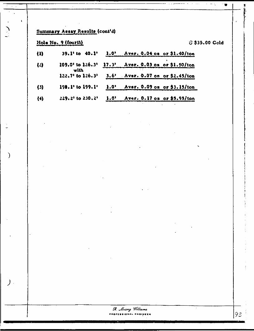
ef
Summary R* sal tt (cont'd)
Hols No. 9 (fourth) G 333. 00 Cold
U) 39.l* to 40.1* 1.0* Avar. 0.04 oa or 51.407ton
109.0* to 126.3* 17.3* Avar. 0.03oa orSI.SO/toawith
122.7* lo 126.3* 3.6* Avar. 0.07 oa or 32.45/100
198.1'to 199.1' 1.0* Avar. 0.09 o* orS3.137ton
229.2* to 230.2* 1.0* Av*r c 0.17 o* or |S.9S7ton
St. J6,v

i
^•--
.
, *
SampleNo.
926667686970
9271
927?.
927374
9275
927*
9277
9278
92798081
-
FootageFrom
70.072.575.577.580.5
96.0
106.0
127.4128.5
149.7
195.1
224.3
233.9
272.4274.4275.4
PICK MINES LIMITEDSample Record
Hole No. 1
WidthTo Feet
72.5 2.575.5 3.077.5 2.080.5 3.083.5 3.0
100.0 . 4.0
111.6 5,0
1.3.5 1.113^.7 4.2
154.7 5.0
198.5 3.4
226.3 2.0
237.0 3.1
274.4 2.0275.4 1,0277.4 2.0
St. ~fl,tv.y I/fa**,* raorcBsioNAL (MOINI
ColdOx
NilNilNilNilNil
Nil
Nil
NilNil
Nil
Nil
Nil
Nil
Nil0.04Nil
i" rr

PROPERTY. Pick Mines Limited HOLE N UMBER.
SHEET NUMBER.
DIAMOND DRILL RECORD SECTION FROM .TO 303.0
LM 5085N LOCATION: n fp' 5097E^ STARTED 22/60
ELEVATION OF COLLAR,. 6 29 5' DATUM ————————^^.
COMPLETED 25/60
DIRECTION AT START:BEARIN N 20 0 E ULTIMATE DEPTH 303.0'
PROPOSED DEPTH.
OIMH rriT
0.0-6.06.0-75.5
75.5-96.0
96.0-111.6
111.6-128.5
128.5-132.7132.7-149.7149.7-166.2166.2-189.6189.6-198.5
198.5-215.6215.6-237.0
237.0-302.0 303.0
FORMATION
CasingAndesite quart? 6 feldspar veinlets, at 61.5" 3" felsit
Db 70 0 c , a, chloritic, low carbonate, last 5' sonAndesite chloritic, increased carbonate, carbonate stri
D k scattered fine pyrite to 83' at 86' flat shearAndesite as above, but sheared 10 0-20" plentiful carbon
occasional quartz stringers but very minor minAndesite-^ b as above, unsheared and decreased carbonate, f
pyrite in last l 1Felsite minor pyrite ^Andesite chloritic medium carbonate unmineralizedFelsite minor pyrite in first 5'Andesitei5b chloritic medium carbonate unmineralizedFelsite upper contact 40V lower 80 0 last 3' quartz st
and minor pyrite.Andesite^ 1"* decreased chlorite medium carbonate unmineraliFelsite T)b 224.3-226.3 nunor pyrite along fracture planes
last 3' quartz stringers and some pyriteRhyolite at 275' fair pyrite trending 55 0
END OF HOLE
SAMPLf No
5 dyke3 fine piigers,Lngite andaralizatair ,
F
ringers
zed
WIDTHor (AMPLI
rite
on
JUPIOORC
COLD *
1CA]fUAirr
ip ECU.
GOt O *'
———————————————
'
. -.^^.-..
i
r^ORIGf^'AiLOW
'
i
i
— -
—
—
Irnr, y Cloutier Bros. D.D. Co. Ltd. SIGNED

DIAMOND DRILL RECORD- PROPERTY' ' Pick Mlnea Limited . * i*
NO^-^
l
SHEET NUMBER LATITUDE —— S085N.
DEPARTURE. BEARING. N 20' E
ELEVATION
•-"303.0 -^^rV J**r 22/ 60 -/'"'r'——-—.^.i ," ^OHP^BTFP July 25/60^' y;
_____ .*- VLTIMATEJDEPTH - 303 * 0 ' '_____ PROPOSED DEPTH
DCTTM ftrr
0.0 - 6.06,0 - 75,5
75.5 - 96.0
96.p -, 111, 6
111.6 - 128.5
128 . 1 y 132.7132.7 V 149.71-4^.7 ^' 166.2J6/).? - 189,6189.6 - 198.5
\ ^
198.5 - E15.6
215,6 - 237.0
237.0 - 302.0
10^0
FORMATION*
C* a in g 1. ::
Andorite ^uartc L fvldiMr votnlet*. at 61.5' 3" fe\^ P , 7 0* c. a. chloritic, low carbonate, La* t 5' a
Andevlte chloritic. Increased carbonate, carbonate'pi? scattered fine pyrite to S3' at 86' fUt •he*i
AnH^aJf^ , ;a s abovc.but ^hea^red 10*. 20* p*jept\ful Carloccasional quarts ttrlngert but very minor
Andesite^ a* above, unffa^are^ a.pd dccrcaf ed ^'frbor^pyrite In U*t l 1
V *J *. . 'FftVVJfy'"^'. Tr^^nor pifrlt* tAnJc*lta -^chloritic medrtirn cirhoriat/i ujirpiBf r*ll*ed
- A ...^y- -z V . *-Fclfjff m/n^r py r lt*. ip flrjl *i ' " '
An^tllM** '' " VHJnfttlr, tnf^fjll"1" r* r ^rtr**'* nyimln/" r^l ! c*H. Vi .j ' r .-' . ,, . 'Felsite upp^r cofjfaf f ^0* f lower 80* La^t 5' gyaft^
J. , and minor pyrlt*-'" u * -.Andesite' [/p decreased chlorite medium carbonate tuonl
T -v i Felsic Y* 224.3 - 226.3 mbinr pyritp alfmg frff^ur^ ]•{\Lil(^'kp U ttt 3' quart* at ringer* and •ome pyrite
RhYoltte / at 275' f*lr nvrlte trending 55*, . - . i ^ . .' l - FNn 'or ijrii.F
l•AM PU M*.
Vite dykeome fbx
trlnferbag
onate aimineral
te. fair''.i *
' T^-
-
. m
f tf Jug f^T-.
ttraJUe* *
i!*^fl^j-.
WIDTH O* *JkM*X(
pyrite
a *
dration
'
1 ' 4
H
'
.
*ACO *
' .
V *
. ' t J .'~
' v i , '
*
.1
- '
1
* '4 '
|LUM|
,
\
i'
V
.
'f \
5
** M r , T O'0*TO - tio^'t F OAM N* Mi u t*. 1 1*11
DRM irotr Cloutier Bros. D.D. Co, Ltd.

)
/OO'
if. Fi
/'ICK MINES LIMITED
D.D.H. P l .
Bearing N 20" E
Scale l" - 40' J

W-: '
NiV...
i i
•'
Sample " Footage No i From
92JB2 85*0 83 90*0 84 95*0 85 100*0 86 105*0 87 110*0 88 115*0 89 120.0 90 123.0 91 126.0
9292 152.0
9293 164.0
PICK MINES LIMITED Sample Records - Hole No* 2
Width Gold To Feet Oa
t
90 JO 5*0 Nil 95*0 5*0 Nil
100*0 5*0 0.01 105.0 5*0 Nil 110.0 5*0 Nil 115*0 5*0 HU 120.0 5*0 0*01 123.0 3*0 0*02 126.0 3;0 Nit 128.2 2*2 0*14
155.6 3*6 Nil Split Core
166.0 2.0 0*01 Split Core
St. U^.y -//Ma^
y/

l tDIAMOND DRiU RECCED
SHEET NUMBER
LATITUDE
DEPARTURE
kLEVATION
-PROPIRTY
- ' ' r•' ' 521? V
•- 50-KH5-'l
- " 6305'
.- : -"
514'3N --
5176E
ricK Mines uuniiea
" '! 'SETTlftN FBOM , P. . , 1
BPADiNr, N20*E1 a i
DIP 5*^ 5 0 "
HOU HO-
T4 '11?6,^' ' STARTPn Tnly 7.A/J
rnMPtFTPn Julv
•' ' ' - ULTIMATE DFPTH
' - m PROPO*;Fn DFPTH
* . *
29/6.Q
166.0'* . t
k i.*
t
. *-j .
otrTM rccT
0.0 - 3KD
31,0 - 77^P
77.8 - 80.1fiO. 1 - 110,0
110.0 - 120.0
120.0 - 133.0
133,0 - 142. 0
H2.0 - 166.0
](.'',.0
P OK M AT ION "' ''-
Ca.a}ng1 * ' u
Rhynl|t^ flr^t fi' Srojf^n rnr* ^v^li •nmi' 40* •K^arlnjj
51' 6" .beared 40* 61 - 74' badly brok*n (^•beared 10*-20*
Felflite
KhyoUlc with rhyolite brect^tf. badly ah4tfprerfj'^l[ 8heavily iheared 10* , 90' - 95' weU oxydUe95'-110' decreatlcg oxydatloa - . .
rhyolite badly broken core, ruttYj (raf^nents of andRbyollt* well oxydlied, brownlth colour, oxydaioji K
^ dec r cai Lug after 123*
FeUlre , l"-. . ' . - ---• * 4 *
JUiyqflVfe shjBttcr^d^ rt\lKO r o-ryd^tipn* 152.0-155,6 h• pill cor* .' ;.
FHO DF* HOLC ' :J . . t * J J ' f
t "*
-
• *H*V* M*
i{re-'
5'-90'i
•'
alteadually
164.0 -
WIOTM O' *AM*XI
'
'
166.0-
#
•OLD i li-i^eai. ftOLirr
\ . 't
*
* i
t
—
Cloutier D.D. Co. L td,OKHUO SIGN f O

^' o
.
f f C t. Ifvfi
s.'-- 3oo
/Od'
PICK M INES LIMITED
D.D.H. P 2
Bearing N 20* E ,
Scale l" - 40' l ^
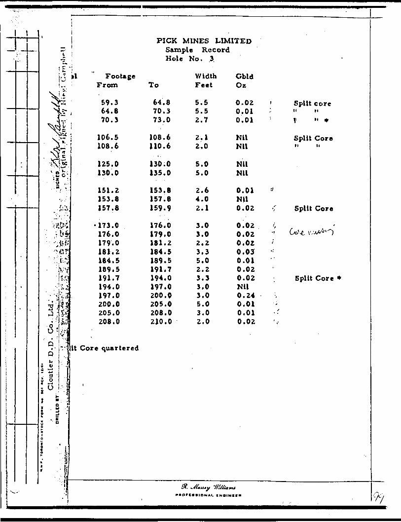
1
-
•- ^MV -
.
'
--
7
J4i\2o ;
• so ,..••Vi
t -t.^ -Jf'f
Tj a ft. j*^J 'V ' * i
;S;|Q ^
* 4-*
i o* Vl \ ;5 v^oM
O
1
1
i -PICK MINES LIMITED
! Sample Record Hole No. .3
a ' FooUge Width Cbld From To Feet Oz
59.3 64.B 5 .5 0.02 ' Split corei U .B 70.3 5.5 0.01 - " "
70.3 73.0 2.7 0.01 : 1 " *
i 106.5 108.6 2.1 Nil Split Core108.6 110.6 2.0 Nil " "
125.0 130.0 5.0 Nil 130.0 135.0 5.0 Nil
151.2 153.8 2.6 0.01 'J 153.8 157.8 4.0 Nil157.8 159.9 2.1 0.02 1 Split Core
•173.0 176.0 3.0 0.02 . /, 176.0 179.0 3.0 0.02 ^ Uvt v^O 179.0 181.2 2.2 0.02 181.2 184.5 3.3 0.05 ' 184.5 189.5 5.0 0.01 189*5 191.7 2.2 0.02 191.7 194.0 3.3 0.02 Split Core * 194.0 197.0 3.0 Nil 197.0 200.0 3.0 0.24 200.0 205.0 5.0 0.01 205.0 208.0 3.0 0.01 208.0 210.0 2.0 0.02
It Core quartered
^® y "vyx y/, t^*. *^r rAJLltf y f f tt lift tttA^*Ort*tiONAL CMOIMKC** r---

PROPERTY ' Pick Mines Limited
LAT.
DIAMOND DRILL RE5187N
LOCATION: n rp 4971E 5085E STARTE
HOLE NUMBE
SHEET NUMB
jGORD SECTION FRC
D July 30/60
R,
ER J- ...
5M Tn
i210.0
ELEVATION OF COLLAR 6305' COMPLETED .Aug 3/60 . ^DATUM —————————— rc 2 QO E ————————————————— ULTIMA TE DEPTH,
DIRECTION AT START: 45 0 bO 0 PROPOSED DEPTH
DCPTH r ill
0.0-45.045.: .9.359. j- 70.370.3-73.073.0-108.6
108.6-118.9118.9-135.0
135.0-150.0150.0-153.0153.0-157.8157.8-184.5
184.5-197-5
197.5-199.1
199.1-205.0 205.0-210.0 210.0
FORMATION
CasingAndesite porphyrtic, fair chlorite, low carbonate
" ? heavily oxydized rock, split coreAndesi?e fine grain, very sparce pyrite, split coreAndesiCe^ decreased chlorite, high carbonate unmineral
minor pyrite in last 2'Rhyolite minor pyrite in first 2'Andesite fine grained, low chlorite, low carbonate, L
core with minor pyrite (L*-"Ut- mx^d-^v*-.Andesite fair chlorite, high carbonate, occasional pyRhyolite ^ minor pyrite in last 2'Andesite ^ fair chlorite, high carbonate, minor pyriteAndesite Gd low chlorite, low carbonate scattered flecks
increased pyrite, after 173', 176.0-179.0 sp!Andesite *s chloritic high carbonate, minor shearing 20 0
with fine pyriteQuartz smoky, very sparce pyrite, mineralization he
wall rock, 197.0-200.0 split coreAndesite chloritic, high carbonate, minor shearing 2(Andesite^d low chlorite, low carbonate minor pyrite
END OF HOLE
ORIUET DY Cloutier Bros. D. D. Co. Ltd.
tAMPLI No
Lzed exce
JSt 10' !
/a^- /.rite, lo\
pyriteit core, sectioi
avier in
o
210.0
WIDTH Or SAMPLI
pt for
pi it\Ser contai
IS
LilP0(
COLD f
:t lost
JHLK
91 VOGE &OL.D |"
JATEDR QUALITY r
TO- .^5 Tf . R3LLO
j
j
i
i
0(1RIG
P
IN,
SIGNED ..... . . . ..... ......
—
Yu
,-M

DIAMOND DRILL RECuRDt - - . i . '' ' ' . .
PftOPtHTY ' - '' * P frfc M ines Limited HQJJ NO.
SHETT
LATITUDE .y: 51R7N
SECTION PRO*/.
HATI TM
-TO. 210.0' STARTED. JalT 30/60
Aug 3/60
DEPARTURE 4971E- 5Q85Eo rv.
ELEVATION , 6305'BEAJUNG.
PIP
ULTIMATE HFPTH 210.0
PROPOSED DEPTH ______
DtrrM ri rf.1
0.0 45.0
xs 0 ^ ^59.3 - '70.370.3 - 73.073.0 - 108.6
108.6 - 11*8.9
118.9 -.135.0-
135.0 - 150.0150.0 - "153.0153.0- - 157;8157.8 - 18-4.5'* , '
184.5 - 197^5;
197.5 - 199.1
199.1 - Z05.0205. n - 210.0210.0
' ,O*M A T,ON . , " ".
Caslnf ' ' ' . - ;-..
A^Vft^' TV^WrHr f*lr rVt^U. 1 ft* r.rSn^t*M ?
AndeiltcAndestte
be^T^ly oxfdlred rockv spilt corefine fraln. Terr snarce prrite. split coredecreased chlorite, hlch carbonate onmlneminor pyrite In last 2* T
RhyoliteAndesite
" ' T
'^*~ i^2'
minor pyrite Ln first 2'. fine t ra l^i* d. low chiprlte,\low carbonate!
- . core with minor pyrite . C*.\s. ^Kc^-^ "- -V
fair chlorite" tffiA. carbonate* occasional pRkyolit*^" whioT wrrlte bi last 2' - -i -Andesli* ^Falr Chlorite* htnh carbonate, -minor pyrltAndevlte^ low chlorite, low Carbonate scattered fleck
Increased pyrite after 173 1 , 176.0 - 179.0
^Andesite! chloritic Klffb. caTboAate^ minor shearlni 2••
Quarts -
with, fine -pyrite . " -. -* .
omoky, very sparCe pyrite, mineral leat IOTIwall rock, 197.0 - 200.0 split core
AndesiteAnHr.ltrf
IiNp OF
chloritic, high carbonate, minor shearings low chlorite, low carbonate m[nor pyriteHOLE
t ,04IJ|*V g M0
4
allied e
Last 10' tl3T-~
•rlt*. lo
.w pryltesplit coi
3*. sect
heavier
10*
W1OTM
'
xcept fo
ipllt; -i.4"T"
wer c on t
e
on s
In
*OIB t
'
ict lost
WiSf-
r
,
iii
1 ii
——
.:,..
:-
Clnutlrr Droa, D.D. Co. Ltd.

PICK MINES LIMITED
-D. D. H. P 3
/O/ CL

.J-' f.- :' ~''
'-
\
-
-
PICKM1KES LlMITtD Sample Record Hole No. 4
Sample , FctoUge \Vldth Cold No. From To F.et Oi XpHt Cor.
9316 Zl. 5 22.7 l.Z 0.02
9317 49.5 51.0 1.5 Nil
9318 124.6 126.9 2.3 Nil
9319 134*0 135.0 1.0 Nil
93ZO 142.8 If3.fi 1.0 0.03
9321 152.5 155.5 3.0 Nil Wtt C*r.
*
^MOrCWlOMAt CMO1MIC* ' /o
PROPERTY - Pick Mines Limited
LAT,
DIAMOND DRILL RE5212N
LOCATION: n rp ^ STARTE
HOLE NUMBE
SHEET NUME
1GORD SECTION FRC
D Aug 4/60
•p 4
IER A
1M 0 TOI
,70.0
ELEVATION OF COLLAR 6300' COMPLETED AU9 5/60DATUM
DIRECTION AT ST;
oifiH rin
0.0-5.05.0-84.7
84.7-89.789.7-124.6124.6-126.9126.9-170.0
170.0
... . , ..-
—————————— fj^cg ——————————————————— ULTIMA" nrPTH 170.0
.RT: d c-o PROPOSED DEPTHnip 4 b
FORMATION
CasingAndesite \}v low to medium chlorite, low carbonate, quartz
stringers 30 0 6 60 0 , flecks pyrite, 21.5-22.7split core
FelsiteAndesite T)b medium chlorite, low carbonate, unmineralizecFelsite minor pyriteAndesite ])b slightly increased chlorite, low carbonate, 1
S. 143-144' 30" quartz stringers with fair pyr152.5-155.5' split core showing sections of 1with vary minor pyrite
END OF HOLE
•AMPLI No
34 '-135'
iteel site
-BWPOOR
- -- - -
WIDTH Of S AMPL1
*ttttTnjAcTO R
-.
-
GOLD f
kTEt
GOLO i '
JOPYITY ORIGINAL)LLOW
',
. LIED OY ..... .r^94.. ®f... ..f?.?.V..7;.?.T?".../^.."............,.......-........ .. ... SIGNED....... . f ^ -^
: ELEVATION " DIP.•45V
. ULTIMATE nnrrn 170.0'
J.";, '/PROPOSED' nFtm-f - ^
;—— ' D~Wr~T- '
: ;.-. 0.0 . 5k*7^-.' 3,0.;-. 84*1•••'.':-V' '' ; l ' '
- M 34. r .'-89i7i^ 89.7 - 124 Jf: .r . 1Z4.1. 126.*
^ Y:' 126/9 - 170. ft !^.vji ' -; '.-••:. ?:i.r;-
' ''"-li ' •'•'•V '- ? '
*"f* 1 70.0 ' " '.- '
•' ..''•j ,...t
0. '-
J ., '
,i;-^-- yo^AT.oN ,. .; : ,.".- :V.,vVCad bs R "' - , . L -' -' - ' ' •••"•- - i "-'
XtidwHlta'P 5 TOW tp TnlJ/Hlfra ^MArl^*^ t^*r i*^vlw*Af fr^ m
.trfnr*r. 10* 1, Sfl* rt^V. ; W^I^ *4 r^* ^ IT Til IF fini^W ' ~ '" 4 ' j ' ' *- 1*
^•tmltm ' '-. ••'- '- ' •'••'':- -' - ' ' ^ 'AttdetltoH medimn chlorlUt low car boa* t*, unm tot ni x(nt9' rnUsor wrrlt* . ; - ' ' ' -j -AiuivvLt^b •llehttr Uacr*a*ed chlorlUi' low carbonAtJv.!.''?J?^"V :
^^J^^.;;.; 1
,-' v: ,r; ^"'1 ——— . —— . —— ——— , —— — ..^ —
fc 143'... 144' 30' quarU BV^to^rt wtlii fa. ii2.3 r A 5,' 5 ' *^1 C OTe B tumU)4 a*c^ilkf- w "^."* A w* * j j:'"': i ^•'•-•.'1^J
'':v ; ;.^ . - ."-f.. '-'.- y- r- vr •:'"- ' -^* ; :''*-' :.': v i^ ! ' ' o ; ,r*" ?''.-', -S-/'•;. ' ••'.•.'.- - ;. ' ;V 9 -' '. •!;' : '^
•."' ' : '•'•'' f-'-''' " . - ' . ' i ' * ' '! '
- 1 # -' .-"i''-1
..
*-~~
rrf'rr'?? 7 ' " '
, 7- ;- '
. -' '
Us*d"' .
134' -.ar.^yrlt*tif.filJilk.•*.'\ ; . '•../. , .- fc-
. ."' ' --: -
ft,
WIVTM
...^-,'
35^- ;: -.-.-M -;
* -ws .' ."V ~
;"...;' . . .
-
-., i
'i *
. ^
•\ ,
••••'..*
^M*,
-
,
•t• o
1 1 .
'•'. '.. ' '
•;
. ',
?m-
^
' -.
J
^
' -;
.
,
-
.
N m f . T O'Oxto-irixr lo*" H* **i "ty. il/tl
ttmutoCloutler Bros. D.D. Co.
SICNfO

\6300(TJoo
63oO
/00 /
-PICK MINES LIMITED
-D.D.H. P 4
-Bearing N20,* E
-Scale l" - 40'

PICK MINES LIMITED
Sample Record Hole No. 5
Sample No.
932223
'9324
9325
93262728293031323334
missing35363738
Footage From To
35.037.0
55.7
71.8
124.8127.8130.8133.3138.3143.3148.3153.3158.3160.9161.6165.0169.4171.5
37.039.0
58.0
74.1
127.8130.8133.3138.3143.3148.3153,158160.9161.6165.0169.4171.3174.0
33
Width Feet
2.0 2.0
2.3
2.3
3, 3,
5. 5. 5. 5,
2.5
5.0 2.6 0.7 3.4 4.4 2.1 2.5
Gold Oz
Nil Nil
0.03
Nil
Nil Nil Nil Nil Nil Nil Nil Nil Nil 35.34 0.35 0.22 0.02 0.02
Split Core
missing core split core split core
DUPLICATE COPYPOOR QUALITY ORIGINAL
TO FOLLOW
il. ^//itui
CMDI r V 1IOIKL IHUIMtt* /C,.

r •1JMIONJ IVNOIlUJOMd
-
20*0 5*2 20*0 1*2
• 403 111*9 f Cf *() fc'f
^-.oj? Svlsil^/ l -^ f 'J fi 1*0
11K 9*ZHM 0*5
.11M 0*5 I1M 0*5
j / I1M 0*5
7 /' ' ' ^ 11M O'C. MM o*c
11M C*2
*iOo nHg to*o c*?
11M 0*2 I1M 0*2
*O 1**J
.-ffsSS
; ' 0**11 5*U1 ' 8C5*141 t*691 AC
0*591 9*191 SC 9*191 6*091 ^••itn 6*091 C*W1 tC C*851 C'CSl CC
C*8^1 C*W1 1C C*CH C*8t1 OC 5*8t1 K'Cei 62 C'CCI 8*OC1 82 8*OC1 ••AL'I A2 8*A2T( 8*V21 92C6
1'U 9*U 52C6
0*85 J-,'55 KC6
0*6C 0*1C Ct 0*1C O'SC 2tf6
o,j, xnotfj *OH offtrjooj tjJurtg
-
* —
i
tt
DIAMOND DRILL RECORD, Pick Mtnei Limited ' -' - :. -' : '\ m 'l
MBER 1 * '"t" ^
5229N •j ', - ^' 497 IE-
; - ;. r' T :^1 r 6295 " '
* ' ' K '
' * * f tf^^pll ftf^J J"lJ^
nATllM
BEARING '
DIP V
tM- -*' 0 : : T:TC^ ^^'0 *' : ' ^sTAfe-ren A o ff 5/ 60 1
•" 't ' ' -" '-" 'mMMPTFn "AQK7/60 , ^
N20 * E : ~: -' tn.TTMAWnptn^- 174.0*r* -" ' ' i * D ppnw-KPn npPTH
\ **7TM r**T
.0 - 5.0
5.0 - 35.235.2 -' 37.0
37.0 - 83.7
•-
t (
83.7 - 119.3- ' ' ' ' '. ' -4
'•H*. -li- 124. 8r--' ; ;r^ .
124.8 - 127.8' - ,. ,
r t. \ *
' 1*7.8 - 174.01 " * ' o * ,•lib ?- ^^.'-^i . "' -/y/r- '7f 2174.0
FORMATION- - ~
Catlng -. i" - i ' ' .--' . i/
Andesite - low to meyiam chlPITlt*, low ea.rVmAt"t M wrFelilte contact i 30*, f * Ir pyrite e i pec Ultf along tAndettte AS Above, flrit 1 1/2" with maty racs with•^o. (lrt^a, termlnAtlng In 6" fel.lt. dyke with (In e pyr
•conlActt, 55.7 - 58.0 Aplll core wllh lome '- "prrU* mertnrnra trgmitnr 5Q*^r ^'"•/,3 I rt TM
J*J m * * ^* w** k * * ^ -w * w **V. **Vi *** K ^** ^ Vt* — V^ K t WVI
7K8 - 74,1 fjne A \f * fm|Ti*t^rt pyrlt*
f**iflte jilpjy^r ^npf^rl XQ'^'lf*^ ?-0' r*rKncttml* *H-^nI^A^ -.v^'lnclueloni of Andesite At lower cdnUct *AndefcitA. . fjow to medium chlorite, low Ckrbomtfli 12
•st.*-.y-f *'2,f: w n*t fracture ' .'. . V' ' '. :- -. ~ , -'-.-. '
Qximrta- ' ' whUe with chlorite ind Inclusion! of Afideil20* no vlvtble mlaerAll*Atlon
Andesite chloritic, hleh CArbojftAte. fjrit 3' flat qiiir/,/ o* d\i ' c arbonate velnreta. with fine pyrite Ijv the AC
; ' . andesite, section! of .qtuu-tz paralleling coi 2-2-* —— 1 60.9 * 161.6 cui g mUslng, !jfci .6 * ,i6l'.4
with fin* H 1 m •*rm Inf t*i^ j*ri-Jf* , *
-fah^s . J.S-^.^.' - " -'v'- ' -END' or HOLEi
i
• AMMJI M*
(lf!*r*ll^p p* r COTsome qtte And 4quartz ilil C Ol ^i ,
"Vf*f j" ' ,
'-122*•T "
c. c out*i
r and wJoininge to MdD pill Ci*
wtorw e* iAMn.1
ed xUctartr)*nd
-
cts
ilte
. ."e
*m.o *'
-
\
. - [
'
VJ^F
- *
*-
-
/O-7

130f'
lOO'
/ea t. f t-f i
PICK MINES LIMITED
D.D.H. P 5
Bearing N 20* E
Scale l" - '10' .y'
- X .-7 a

u
-PICK MINES UUtlTED
i
Saxnpl* Record
Sam pitNo.
9101234
91056 .
9107
9108
91091011
13141516171619
91ZO21222324
-
FooUgoFrom
29.031.033.837.4
53.354.8
75.0
85.9
114.0116.5118.5122.3123.5126.6128.1133.1136.6140.2142.5
173.3179.3163.1184.1169.1
Hot* No.
To
11.033.837.442.4
54. B37.1
77.5
87.9
116.3118.5U2.3123.5126.6128.1133.1136.6140.2142.5144.0
179.5183.1184.1189.1191.6
St.piton
6
WidthFI.
2.02.83.65.0
1.52.3
2.5 '
2.0
2.52.03.81.23.11.55.03.33.6;2.3.'1.5
4*03.61.03.02.3
C*lclO*.
NilNU.01Nil
.03NU.02'
NU
.01NU.04.01.90 -NUNil.14 ~\
3.70 i1.63 '
.01
.04NU.01NU.01
SilverOs.
NUNU.04Nil
NUNU
.12
NU
ft ft I S \s~* j*-X Q *Uo ^* t-*^t-^^ • Jf-
.04 d-?/ -' -'
.11 ;2WU-.-'-7/-• w- os ;X ( T-.16 Clt r ti/.Zs
Ml o . *j . T f '' fMil ^ ,Ml '- y.os. fr-S* ' '7;-'
- .26^ * /--'i --' X" " "".20 ,, ' -' ,Ml ^1,/^VV"' -' '
NU 0-5/^-'.NUTr.NUNU
l1
fi
l
ji
|i
:
"
; - ' \

-"•nUt——~
D.AMOND DRILL RECORD"•^ v 9 -* * * v ^sr- * i mr . sasr * ^ sj
PROPERTY H CK MFNfS UMITFD— HOU NO..
SHLET NUMBER
LATITUDE M24 N
DI PARTUKi: ..
M.I.VAT1ON . l
SECTION FROM 0.0
DATUM
TO H 2 . S
BEARING S outh
D I P SUM 4S* 190' 4 2
STARTED .JJ. T-
COMPLETED 12 D*cgnnWr 19 6j,
ULTIMATE DEPTH..j-2 7-' 0- ————
PROPOSED DHPTH______ — .^-—
OI"M 'If'
0.0 29.0
29.0 42.4
42.4 54.8
54.8 *7,j'
57.1 87.8
^7,y - l o' o87.8 114.0io| 0 - l i *- '
114.0 118.5///•-* -'^ ?
11A.5 126.6
126.6 133.1
133. 1 142.5* '
roHMATION
Cai Ing
Andmite ^ qutrtr h pyrite • trlneers 50* Se 10* C.j*S,/ ^, T ' ter^nlnAtlng In 70* qutz itrlngeri. Lac
Andelate occasional quarti itrlngera ai above, UC, 1 C ' 1-. ip*rce mineralization
AfldfBile nlllflflprf ^nH K*nH*^ in*.4n*anrrni fin** J-
Tuff occaiilonal quartz bleb* and *p*rce pyrlt- banded 30* minor pyrite, lait 2 T banded
Granodiorite dark greenish grey, porphyritic, high' l" PY r ' te * n ^ pjrirhotlte "— "
Andenlte 20* contact* low to medlom^ carbonate,V^tV^^t y '-^ 3 ; dltsemlnated pyrite and pyrrhotite
Anrfenitt! illlcl/led. quartz strlnaers 20* - 40*, d122.3' -123.5' fUr mloerallaatlon
Andenlte unilllcifled, aotne fine pyrite and occaal133' ru.iy fractures 70* 1. 20*
Anrfeilte silicified, fine disseminated pyrite, 140'" -^- XV" :^ contacts but no visible mlnerallutlon
'
• *nri.t H*
(
^ iom?5" deer
st T qu
fr(tf
75.0 ./Ith qua
:arbona
lections
is em Ins
mal qua-
141 qua
-
• lOTM O' ••MH.I
fine pyrea d ft d m
i rt r. sirl
77.5 siltz strln
e, first
of grant
:ed pyrltf i -
ts strln
tt velnl
• OCO 1
?e Apr! rvnerallzA
ifiern 20
clfled an;ers 70'
J 1 somet
dlcrlte 1
! and pyi
:ers 40*
t with 9(
Wtl'f
rrhot,IJ*Ion
. 30*.1
•l•** c A *
Ine
t first
rhotlte
93*
* •s. '
,.) ---^i.
*
t
-
h" --

SHEET NUMBER
LATITUDE ———
DIAMOND D RILL RECORD
FROM 142.5 TO 197.0
NO.- t
DATUM. COMPLETED.
DEPARTURE
LLEVATION
BEARING.
DIP
ULTIMATE DEPTH-
PROPOSED DEI
M FT M ntT
142.5 17S5.
175.5 183.1
J83.1 191,6'191,6 197.0
197.0
FORMATION '
SAndesite chloritic, hi f h carbonate, quarts string*
^'tJ i'f^ Pr rllr l 47 - 7 - H8.3 (elsectlc dyke withidd. j wtui 40* contacts, ai 16r 4 H frey
Andesite as above but witii scattered quart* stringf nated pyrite
r.' -r - 4 -^-'~ - '. . i , ^Andesite ^ silicified with minor rrrlte and prrrhotltAndesite chloritic, hlojn carbonate very sparce mo.f x /.,r^.ETTO OF HOLE
'
.
-
-
(
. kt ..
• AMPV4T W*.
rs 60*-C10* cont• lllcltir
srs at v
e•Ite
WI0TMor k*M*t.f
0* occaicts andd lull
rlous at.
. *oco t
lonal bl*it 157.5
glei and
.
Kt^-Fbs-
dlsseml-
* *
.
.
-
-
-
-
.
-f"
'
NW*. fOB
0*11 Iff"*Bradley Bros , ' ^

PICK HIKES UM1TLD Sample Record
Hole No. 7
SimpleNo.
91Z52627252930313Z3334353637383940
9141
9142434445
91*6
9147484950515253545556575859
FooUfleFrom
53.757.058.559.664.668.070.472.075.377,078.079.583.214.298.790.7
120.5
135. S137.)138.8141.9
159.0
172.0174.0176.0177.0180.8183.3186.3189.3191.6194.5196.5199.8203.6
To
57.058.559.6J*4.668.070.472.075.377.078.079.583.284.288.790.793.0
122.0
137.1138.8141.9144.9
-^ .-*-.161.1
174.0176,0177.0180.8183.3186.3169.3191.8194.5196.5199.8203.6204.6
WidthFI.
3.31.51.15.03,42.41.63.31.71.01.53.71.04.52.02.3
1.5
1.61.73.13.0
*-s *f 6 -5 .3.1
2.02.01.03. e2.53.03.02.52.72.03.33.81.0
Cold0*.
.01
.02
.02
.02
.01NUKU.07NU.01.01NU.01.02.01.02
.03
.03
.04
.08
.04,J- X .-1 ' S
.01
.03Nil.03.01.01.04.04.03.05.02NU.02.01
SilverOK.
.08NUNUTr.NUNUNilNUNUNUNilNUNU
. NUNUNU
NU
NUNU xNU 'NU
' tf.Nil
^ NU ,NU ; '.03 '.26.08.10* *" j
.07 ;
.02 j
.20 JNUNUNUNil

PICK MINES LIMITED Sample Record Hole No. 7 (coctM)
Sample FooUge Width Cold Silver No. From To Fi. O*. O*.
9160 215.6 216.6 1.0 . 06 . 1061 216.6 218.6 2.0 .19 .2362 218.6 219.6 1.0 Nil .1763 219.6 229.0 3.4 Nil NU64 223.0 226.0 5.0 .01 Nil65 228.0 232.3 " 4.3 Nil Nil66 232.3 2*4.9 2.6 .01 Nil '
di jXuxXIOMAl tNVIMIIH
PICK MINES LIMITED Additional Samples
Hole No. 7 Footage
Sain pi c - From To Width Cold .No.________________________Feet Ox.
9Z42. 204.6 209.6 5.0 Nil 43 209.6 213.6 4-. O Nil
9254- 251.4 252.7 1.3 N il
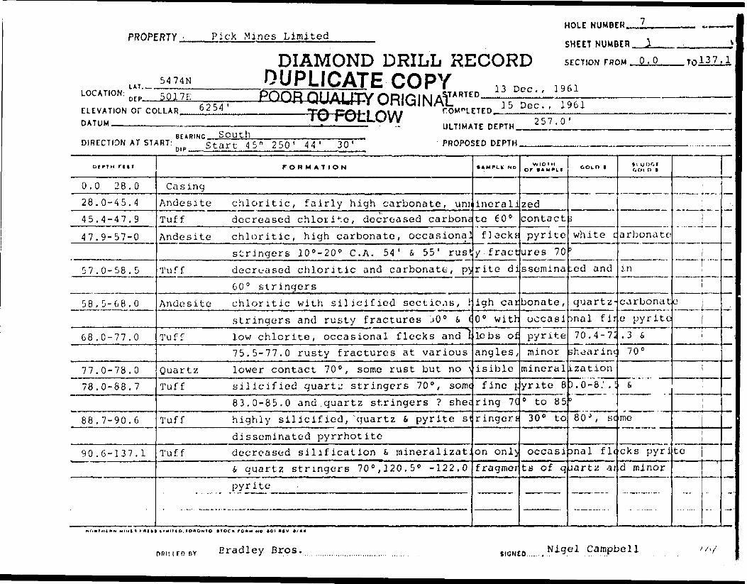
HOLE NUMBER.PROPERTY. Pick Mines Limited
SHEET NUMBER
LOCATION:LAT..
5474N
DIAMOND DRILL RECORDDUPLICATE COPY
nrp 5017E
ELEVATION Of COLLAR. DATUM ___________.
6254 'POOR QUALITY ORIGINALJARTED.
SECTION FROM - Q. O
13 Dec., 1961
.ToiiUL
TO FOLLOW15 Dec., 1961
DIRECTION AT START:South
ULTIMATE DEPTH. 257.0'
Start 45" 250' 44 ' 30 PROPOSED DEPTH.
oerTH rt IT
0.0 28.0
28.0-45.4
45.4-47.9
47.9-57-0
57.0-58. 5
58. 5-68.0
68.0-77.0
77.0-78.0
78.0-88.7
88.7-90.6
90.6-137. 1
rORMATION
Casing
Andesite chloritic, fairly high carbonate, uniTuff decreased chlorite, decreased carbene
Andesite chloritic, high carbonate, occasional
stringers 10 0 -20 0 C. A. 54' S 55' rust
Tuff decreased chloritic and carbonate, p^
60 0 stringers
Andesite chloritic with silicified sections, 1
stringers and rusty fractures .i0 0 S (
Tuff low chlorite, occasional flecks and l
75.5-77.0 rusty fractures at various
Quart/. lower contact 70", some rust but no \
Tuff silicified quarts stringers 70 0 , some
83.0-85.0 and quartz stringers ? she;
Tuff highly silicified, ^quartz 4 pyrite st
disseminated pyrrhotiteTuff decreased silification (t mineralizat.
i quartz stringers 70 0 ,120,5* -122.0
pyrite
AMPLt NO
ineralite 60'
flacks
y f ract
rite di
igh carO 0 witt-
lebs of
angles,
isible
fine f
ring 7C
ringers
on onlif ragmer
WIDTHor IAMM.I
zedcontact
pyrite
ures 70
ssemina
bonate,
occasi
pyrite
minor
mineral
yrite 8
0 to 8530 0 to
occasi
ts of q
GOLD 1
5
white c)
;cd and
quartz-
tnal fir
70.4-7;
shear im;
ization
).o-8: .1)80 J, se
anal fit
uartz ar
*l UOOI OOID t
arbonate
in
carbonat
e pyrite
.3 670 0
i.
me
cks pyri
d minor
. ,,
l
e
ii
i
ite
....
--
:
Bradley Bros. SIGNED...... Nigel Campbell
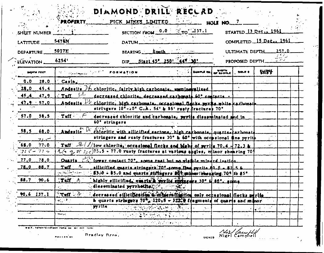
' DIAMOND DRILL RECXAD•. - * : j -. - , ^ ' i . . - * i
' PICK MTKTS LIMITED r'- ' 'V MO.*
SHEET NUMBER
tjorrunp
DEPARTl/RE
" ^ ' * *"•" i'S474N"
501TT
ft rt ' 'T' ' ' "l ^7 1SprTTftN UtOM. u' 0 .j- TO -i-* 7 **
HATITW ,' COMRFTTP 15
ULTIMATt
C^ 1961
Start 45* 2Sfl' ' PROPOSED DEPTH
t J h chloritic, ftlrl13,0 45,44*.4 47,9
54' V 15' rvvffchloritic tad carboaaUj Uiattd and In
hloritic with i Ilk JHnd(rastr (rachir*i 30* li 60* occkflon^l an* pyrli
-77.0 ruity
Ifnrmr c fmtACt 70*
- IS.O 1*4 mart*
K-V /•.-•.•,-^r*-.*- ' l. . - .'.T*^
.6 137.1It quart* .Lrbif*rf 70^ UO^S -
M4 M * VI* l 1 1 f *
Hriri'*v Arn* .
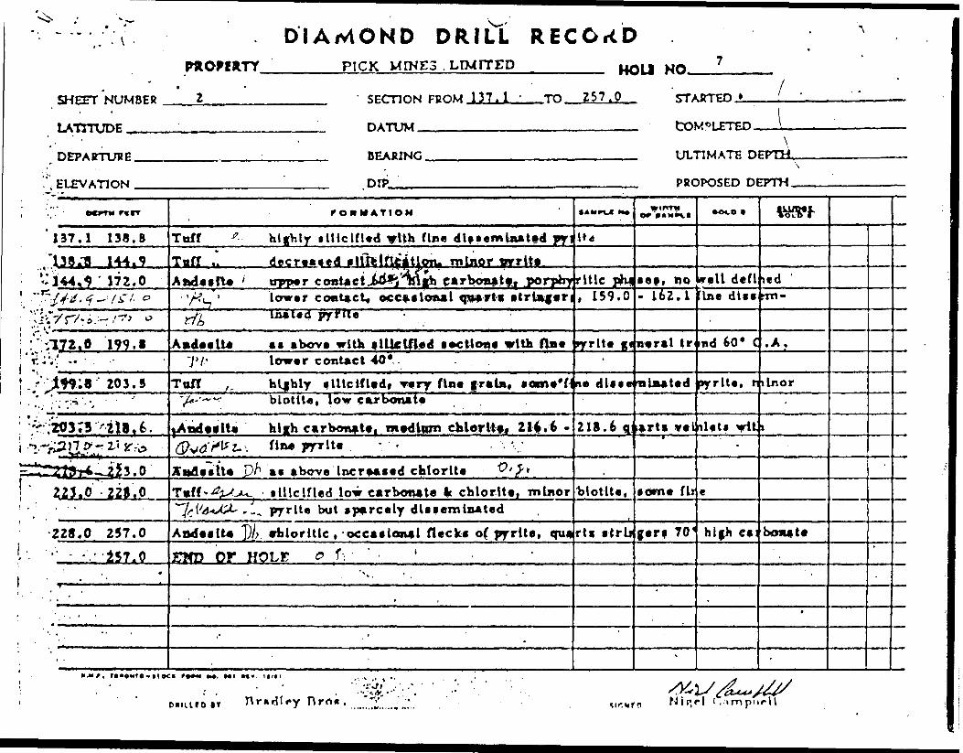
DIAMOND DRILL RECORDPICK M INE3 . LIMITED
LATITUDE
DEPARTURE
'.', ELEVATION
UBER 2 SECTION FBOM 137,1 ' TO 257.0
DATiTU
P? BFABINfi
1 DIP
*rrAirrpn t ' '
tOM 0lFTTO \ . . -. -\
Vn.TIMATr: nPPTH,\
ppnpo^cn PPPTH
'.".' ocrrw rwcr
137.1 138. B"138.TS 144.9
*: 144 172.0"^jf^/f-Vs-/. o
~Vm,o 199.1-.;v; ii -- . .~- Jly9;8 203.5', •'•; : ;- '- -. ' ' '
'r.:203;3 v 2l8,fe.•"^ViV^J l fT* ""^ Z'* if r A
•^^Vjfn'J*
U^^—^A^ - *' J- - -
223.0 22S.O' , ' p '
228.0 257.0•' - -'.' 'i57.0
. ' ' . '.. ,' . - '
rOHMATtOM
Toff r h ijhly •Ulclfled ylth flee dl.**mlnat*d jy\
..- ——
U4Tnff .. decreased ilfftlflc^Uoiv minor mrr^t* lAftdeelle ' trpper contact jW*i''^lVih etrbotiatf, porphyjrltlc phi
- 'A?L. "' lower contact* occasional qnart* *trl*ferJ, 159.0yft Inaled py^tle
Andeelte a* above with tJUclfled ••ctlon* with fine pyrite g*7'/.' lower contact 40* . . -
Toff j , b l|bly flllclfledt Tery fine fraln* lame'ffi* dl**w•/d-'-^'v biotite, low carbonate
fAnd elite hl^h carbonate! medium chlorltfi Z l^.t -Q^d-^t-: fi*** PTTlt* ". ' '
Xttfleitle P/1 a* above tncre**ed chlorite ^'^*T*ff"^--Cx^. illlclfled low carbonate It chlorite, minor
\A'A*J^- -- -^ pyrite but sparcely dlcfemlnated
Aadeelte ')/; vklorltlc , occasional fleck* of pyrite, quaZ3fD OF HOLE o . l--.' ' '
- -
,
''
218.6 q
,biotite,
rti etrli
'
o^TKti
• eft no- 162.1
neral tr
•nLnated
Larti ve l
fomc f li
ferf 70'
*
*
~c*.
Irell deflIn e dips
nd 60* C
pyrite, n
nlfti vU-
c
hl|h e*:
,
\W?l
*ed 'rm-
.A.
ilnor-
i
bonate
-
t
'
-
Rro*.S&l/^/^N i P, r l f , -i m p 11 r H
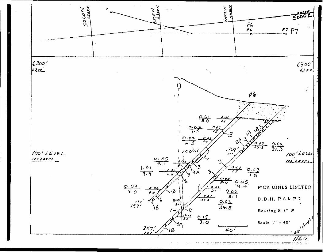
PICK MINES LIMITED
D , D . H . P 6 k P 7
Bearing S 5* W
Scale l" - 40'
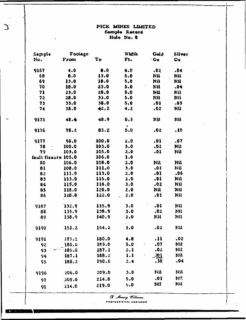
PICK MINES LIMITED Saxnpl* Record
Hole No. 8
.
'
StpapltNo.
916768697071727374
9175
9176
917778 -79
fault ClivureSO818283848586
9187ae89
9190
91919293 •-•'9495
9196979G
FooUgeFrom
4.08.0
13.018.023.028.033.038.0
4S.+
78.2
98.0100.0103.0105.0106.0108.0111.0113.0115.0118.0120.0
132.9135.9138.9
151.2
175. 2ISO. Q485.0167.1188,2
206.0209.0214.0
To
8.013.018.023.028.033.038.04fZ.Z
48.9
83.2
100.0103.0105.0106.0108.0111.0113.0115.0118. C120.0122.0
135.9138.9140.9
154.2
180.0If 3.0187.1188. Z190.6
209.0214.0219.0
WidthFt.
4.05.05.05.05.05.05.04.2
0.5
5.0
2.03.02.01.02.03.02.02.03.02.0
. 2.0
3.03.02.0
3.0
4.65.02.11.12.4
3.05.05.0
ColdOs
.02NilNUNUNUNil.01.02
NW
.02
.01
.02
.01
Nil.01.01.01.02NU.01
.01
.02NU
.02
.11
.07
.02J5!'YsT
NU.01NU
SilverOs
.04NUNU.04NilNU.05NU
Nil
.10
.07NUNU
NUNU.06NUNU*NUNU
NUNUNU
NU
.02NUNilNil.04
NUNJ!NU
~?;.±^T±T..
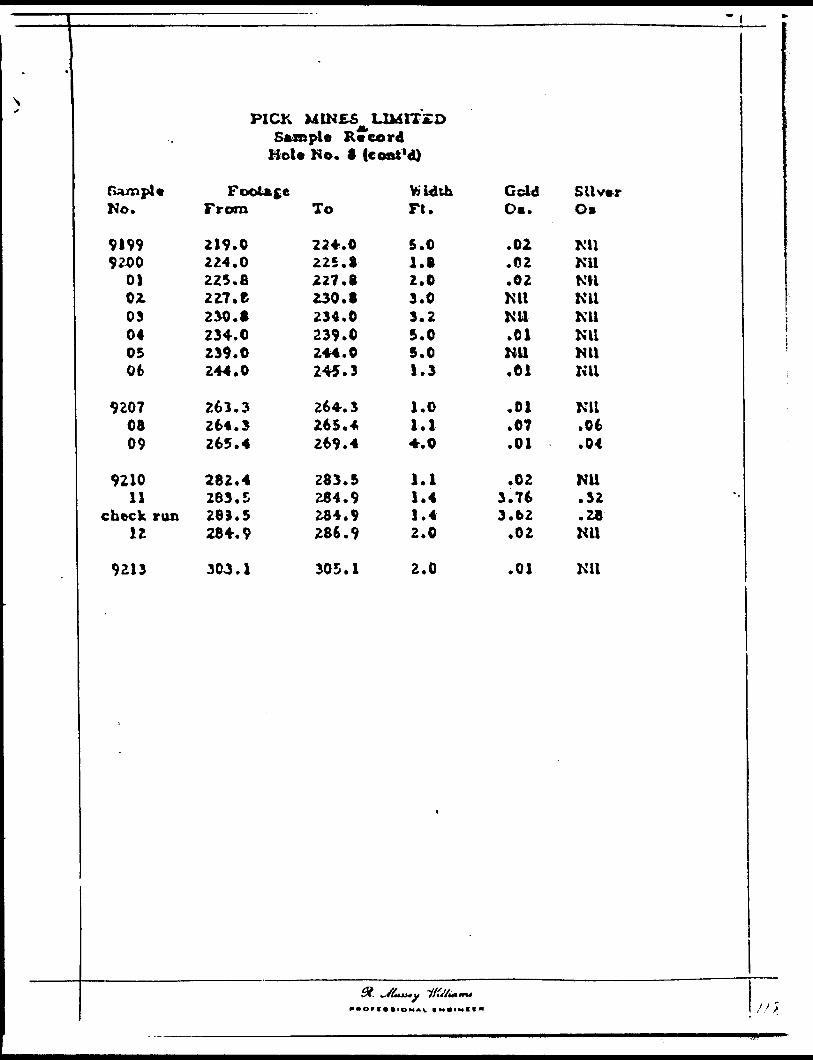
s.x
PICK 1
-
UINS5 LU4ITZDSfcxaple R •"cor d
SampleNo.
91999200
01OZ03040506
92070809
921011
chock ran12
9213
Hot*
FooUceFrom
219.0224.0225.8227. e230.8234.0239.0244.0
261.3264.3265.4
282.4283.528). 5284.9
303.1
No. 8 (coak*
To
224.0225.3227. B230.8234.0239.0244.0245.3
264.3265.4269.4
283.5284.9284.9286.9
305.1
d)
WidthFt.
5.01.82.03.03.25.05.01.3
1.01.14.0
1.11.41.42.0
2.0
i
OddDm.
.02
.62
.02NilNU.01NU.01
.01
.07
.01
.023.763.62
.02
.01
SilverO*
MlNUNilNUNUNUNUNU
NU.06.04
NU.32.28NU
Nil
~f,;±:^±::.. .fi

\* *
PICK MIKES LUS1TZD Sample Record
Hole No. 8 (coni 'd)
fcunple No.
91999200
01 02 03 04 05 06
9207 08 09
9210 11
check run 12-
9213
FooUgeFrom
219.0
215. B2 2.7. t 230.8 234.0 239.0 244.0
261.3 264.1 265.4
282.4 283.5 283.5 284.9
303.1
To
224.0 225.1 227.8 230.8 234.0 239.0 244.0 245.3
264.3 265.* 269.4
283.5 284.9 284.9 286.9
305.1
ttidth FI.
5.0 1.8 2.0 3.0 3.2 5.0 5.0 1.3
1.0 1.14.0
1.1 1.4 1.42.0
2.0
i
Geld Os.
.01
.02
.02miNil .01NU.01
.01
.07
.01
.02 3.76 3.62
.02
.01
———————— ————— Z—J
Silver O*
Ml NU Kll Kll Ml Nil NU Kll
NU .06.04
Nil .32 .28 Nil
Nil
**0*t ••tOMAL tNVIHII*

PROPERTY - Pick Minos Limited
L*I.
DIAMOND DRILL RE542SN
LOCATION: t iv b JOBT STARTC
HOLE NUMUC
SHEET NUMB
jGORD SECTION rnc
D .16 Dec,, 1961
K 0
rn 1iM 0.0 Tft
K
1Q6.0
ELEVATION Of COLLAR 0314' COMPLETED 18 DCC . , 1961HiTlIM TiuiTr nrPTii Tfift fi '
RfiB ,., SouthDIRECTION AT START: B |p R fnrt , r, 0 ^ A , H n f) , PROPOSED DEPTH
Of FT M fill
0.0-4.04.0-8.0
8.0-38.3
38.3-42.242.2-64.4
64.4-68.3
68.3-83.2
83.2-98.0
98.0-1-0.0100.0-105.0
105.0-106.0
FORMATION
CasingTuff banded 70 0 , minor shearing 70 C , jiortially silic;
and niijior pyrite, high carbonateAndesite chloritic, quartz stringers at varying singles,
carbonate, speckled with blebs of pyrite and a iAndesite aphanitec, low carbonate, decreased chlorite ancAndesite chloritic, high carbonate, mineralization except
whore flecks of pyrite; and fine grained grey natvuggy white quartz with 60 c contacts, no visible
Felsite very fine grained grey rock with stringers of w?mineralized, lowar contact 45 0
Andesite chloritic, high carbonate, last 5' quartz stride.ingles and minor pyrite
Andesite fine grained decreased chlorite, high carbonate,flecks of pyrite
Tuff banded 60 0 -70 C rusty sections, quartz stringersTuff sheared 70 0 , rusty vuggy sections, quartz strinc
pyriteFAULT
DULLED BY .......Dradley Drps.............................................. ..... .. .
•AMPlf No
fied, qu
vuggy soine graimineralfor las
crial' 48mineral
ite carb;
ers at v.
occasio)
70 0
ers and i
SIGNE
W 1 0 T Mor C AMPII
irtz str.
itions hied grey-zation. 4'
4-48.9.zotionmate
rying
— D^al PO
linor
OOID |
xjers
,hlaterial
W.
o Nigel Can|3bel]
nuooiOO. O 1
-,. ———
——— j
- -
—
— ;
wV,i-*ix-\l
rULLUVyLK4-^IIN^
—.
L , . x
—— -
•\i
—— T
'.0 :

DIAMOND DRILL RECORDP1CK
UP*c. t 1 9610.0 - TQ ;'-' IO*'Q -
COMPLETED l 8 Dec 'f 1 961
ULTIMATELATITUDE
Rpxirw, Sooth
DIP Start 45' 250' 41* 00'
70*, minor 70*| ntrtland m lac r pjrriU, bljh c*rbotut*
•y^ckl^d ylth of pyrlU *tiH *
•ph4aitee l to**
o? pyrltf fnd flag*hitf *iu*rtn with 60* e oaUcU, i
lo^r^r c ontact 45*
chloritic,*jui minor pjrrlt*
n*ckj of p/fitf
Bradlry Hro* ,

PROPERTY p jck M JJ*-' S L^u'd
IAT.LOCATION: [il r, . ..ELEVATION OF CCDATUM
DIRECTION AT ST/
Din x riii
106.0-131.4
131.4-138-9
138.9-140.8
140.8-154.2
154.2-156.0
156.0-169.5
169.5-175.2
175.2-180.0
180.0-185.0
185.0-190.5
190.5-198.0
190.0-244.8
244.8-264,5,
DIAMOND DRILL RE
HOt f MUMHf
SHEET NUMfl
jCORD SECTION FRC
p 8FR ^
,M 106.0 T n,
264.5
STARTED
(LLAR COMPLETED . , ..——— ...- ————————————————————— ————— ULTIMA
^RT: PROPO' nip . -
FORMATION
Tuff as oJjove, rusty sections to 120' after which uoccasional quartz stringers
Andesite chloritic, high carbonate, last 6' quartz stri70 0 vi tii occasional pyrite
Tuff highly silicified {possibly felsite) some fineAndes i to chloritic, high carbonate, last 3' quartz stri
with minor pyriteTuff silicified, uivnineralizedAndesite chloritic, high carbonate, quartz stringers bu
pyriteAndesite decreased chlorite, high carbonate, unmineraliAndesite chloritic, quartz stringers at varying angles,Tuff silicified, quartz i pyrite stringers, no specAndes itc chloritic, high carbonate, quartz i. pyrite str
187 '-188' well mineralized with pyrite trendinBreccia unsilicifiod but gradual increasing silicifica
stringers but otherwise low carbonate, well alBreccia silicified, sections of andesite, minor pyrite
224 '-226' fair- pyriteAndesite chloritic, low carbonate
TE DFPTH.
5ED DEPTH
•AMPLf No
mineral:
igers anc
mineral.igers 10'
't only t]
zedminor pi
Lal trencingers usj 70 0t ion, cajtered uniafter 2(
———— —. — ... —— . —— . ———— . — ..WIDTH
or *Aupt.i
zed with
ve inlet!
zation-20 0
"Dttl
OOLO 1
*trc.
r.fil O l
wrcPOOR QUALITY OF
TO FOLLOW
rite
above
bonatelineraliz*•6'
K]
~. -—
--—
JOPVIGINA
— . ——
.
— -
^.- . ..-
-
--.
f
J
-
S
1,^ .
•t
— \
k\
Rradlev Bros. Nigel Campbell

DIAMOND DRILL RECORDPrrry \irnr*i t -n/Trrn *' U*MI urt 8
SHFFT NUMBER ' ' * O.. '...... . .' SECTION FPOll6 ( 0 TO' 264.5f t'*'. i - ' , ,
LATTTUDR , DATUM ^
ST/
CO!
DEPABTTJBK ,' , , BRABING - Ul/1
tLPV ATION - DIP ! PfiC,
' OC^TW PWT
106.0131.4
131.4 13fl.q
J 38', 9 140.8-140. V 154.2
- 154,2 156.0156*0 169.5
•~
169,5 175,2175.2 lAO.fl180.0 185,0185,0 '190.5
'•'XV : ' *
1^0 f i If t. 0;,-. -*X^KsJ\'-'
1 1^;^:'^^*4 ' 4* i i * *
144.1 "264 f 5
^, " - - ' f OH M ATION
Toff - kaa aber*, rotter i*ctlor,f to 120' afttr w*.i occasional quart* f t r Us j* ri
AM" i** ^ chloritic, hlih Ci r bon* t*! Lait 6' qoartxo 1,^ 70* wltH oeeaalonal fyrltf. ^M-^^t^^' ^
Toff blffblr iltlcUUd (^••Iblr fflfltel lomtAndjalfB ; ^ — rhlnrltlr. high pfTbniPN* lift V qgirtf
with minor pyrlt* -To/f illlclfUj, onmln*rallMdA Mff f Itt c'5' chloritic,, blity carbonat*. Quarts itrlof
pjrrU* K 1-^-^/'./'^ .-.x ' 'VAiA ' ' ' '
Andftlta f i-' d vcrfaied chiorll** h t eh carbonat0* mxnA~f..l.. S, -'t,' efcin,,!!^ q^-rt, f t r i.ff*. f| ^rT^f f
T^f '•/'•-7/J' •tllcinxi. aturti le frrlte •.trinctrfl TBO/^••It* t' I T chloritic, hick carbonat*^ quarta fc Vfr}••'-•*-. . 187' . 188' w.U mlaaralUed with prrlt.Ar+cti*^/;^. ~vnaU le I/ltd bvf frfdaal Increff Ui| f li le l•^;tv - - ^ a trlagaf* bat otKjrwtt* low carbonat*, '
.Bt4ccU ^yy^ ilUcina^i aactltmii ttClU|d**lta f minor fi•- 1:- ;. . . . ' ZZ4' - Z16 1 fair pyrlt* ^
Andailta P chloritic, low carborkti
t A H PU M*
le h uurn
itrlt\g6i7 'In f m jpJLiflftfCM
. ..' -
rf bul c
InaraMitf-*r Vi
JUfiJ^ll.
W'***
neralUc
t and ve
rmJlEati1 10 r ,*
ilr t rae,
odnnr prrltrtnd•r* at a
BTPn
^pirrrnHMATE D
)POSED D!
•CM.* t
d vith
InUti-
inLO! ^^
.
h-r70- |
IcftlonJ carbona)ter*U alt*frit* aft
•ed unminerall*^,r 206*
FPTH
rpTH
- wtw
J
'-
-'
'
M*, t!*l M*, tttl
nititro IT Bradley Bro*.

DU MOND DRILL RECC ID* ; PROPERTY
. " i - ' . " SHEET NUMBER 3
LATTTLmH
DEPARTURE
ELEVATION
PICK MINES LIMITED '
. spcnoN FBOM 264,5
HATtlM
BRABTNT,
DIP,
UrtfB MA 8
TO 308.0 STABTFO
mMWFTFD
ULTIMATP DPPTH
-PROPO^Pp OPtrrw
^^l 9 9t P9 tT ^
2f^..5 269.2
' 269.2 275.1
275.1 508. 0
\ r
; :308.0
•~ ' s1
.
* .* f -
\. i " : --i * * '
f OH M ATIOM
Toff lUlclfled, flrtt 1' well mineral l*ed brecpyrite Lo fracture*, low carbonate
faff t Ile If led, faction* of chloritic andeitU iocc*lcmal fltcki pyrite :
'T^/ - . - ;. ,"
283.5 - 284.9 quar 1 1 *trlnger* and reUilfair pyrite 30 3 ' - 305' qoart* *trbtftr* 4
END OF HOLE - V; '1 . . '
'
.
. ' . - ., -- '- - '
* t- : - - . ' ' , - '
t.-'
.f AMPU H*
:U folio
Ith low
'ti fltrlfist* 50*0 pyrite
'
t
*'BTIp
*ed by Ot
rarbonat
Iff60* wit
ftringei
.
.'
,-
'
-
^.
: c* f Ion*
tif oniy
i - V.l 1 45*
; '.. '
•* c., .
' 'p1 J'*
..ly"
-..;''.•' .i
.'.
st
WtVf
t
'
'
t
f
-
-
PIIUIOIY B radley Bro*.

Ir
CD

9241
PICK MINES LIMITED Sample Record Hele No. 9
S&mpteNo.
921415
92161718192021
9236
92222324252627Z829303i323334
9235
9237
9230
923940
FootageFrom
4.08.0
37.639.140.144.546. B50.8
83.0
98.0101.0105.0109.0110.4112.0113.0117.7122.7125.2126.3128.3129.4
148.1
183.0
198.1
227.2229.2
To
B.O10.5
39.140.144.546.650.855.0
65.0
101.0105.0109*0110.4112.0113.0117.7122.7125.2126.3128.3129.4131.4
150.9
185.2
199.1
229.2230.2
WidthFt,
4.02.5
1.51.04.42.34.04.2
2.0
3.04.04.01.41.61.04.75.02.51.1Z.O1.12.0
2.8
2.2
1.0
2.01.0
GoldOz
.02
.01
,S2.04.01.01.01Ml.02
.02
.01
.01
.06
.02
.03
.02
.01
.06
.08
.01
.01mi.01
.01
.09
.01
.17
SilverOz
.11K li
Nil ,'Nil yNilNilNilNil
Nil
NilNilNil.04 JNilNilNilNil.02 i.02 -jNilNilNil
Nil
Nil
.05 4
.03 ^
.06 '
273.0 275.0 2.0 Nil Nil

t l"
1
1 J
ij !i -,r " —————
l
*
SampU Footage No. From
9255 194.9
9256 199.1 57 202.1
9258 214.2
9259 224.0
9260 230.2 61 233.5 62 238.5 63 241.5 64 . 245.5
9265 259.8
:**~" -— -1 -- * ,
PICK MIKES LIMITED Additional Samples
Hole No. 9
Width Cold To Feet OB.
198.1 3.2 NU
202.1 3.0 NU 204.5 2.4 Nil
216.4 2.2 Nil
227.2 3.2 Nil
233.5 3.3 NU 230.5 5.0 NU 241.5 3.0 NU 245.5 4.0 Nil 250.5 5.0 NU
262.8 3.0 NU
* .-A-y HBK—— |y-

DIAMOND DRILL RECORDPICK M INES LIMITED
-^^^r^T.'NtJMBEfi 1 ' SECTION reoM 0.0 TD 105,0 STARTFD 19 .De. jc. 12 6 J ————— —
\frmtnr 5425 N DATITM ,' COMPI FTPD 2 2 P*f-. 1 9.61
nFPAB-njvF m A* r. RRAfirwr, S 30* W "v '' INTIMATE DEPTH 275^0
ELEVATION 63W nrP Start 45* 250' 45* 00* Pfic
^j^?r" w '' r*' U * V 4 Ov^. ; r-Sc ——— !txi! —— a*il ——
**?*^^ ' J - A 1 M V^T -. 4.0 JO, 5
10,5' 37,6
37.6 39.1
39.1 *6.8
4A-* iftJJL-
50.8 76,9'x.'
76.9 80.880.8 91.0
91.0 98.098.0 10.5Q
rOMMATIOM.
r..!nf (r..m.^-tn ? l*)
Tnff minor *)i*mr-!** miwl hjmtUn* 60* - 70* e/? j .jjs.T^ ' | trlB|*ri W minor pyrltt, high car bo'"lAfwdeilt* O,' J chloritic, feljh cirbcmatt decreasing af
• trlngera 40* - BO* fpecMed with tmaig r*,-mHx*rai, op^ ll*.ur. at ZO'
Andeilt* aphanU'c. occail6fia||. quafti itflngf rf -carboru te
Atvietltfl chjorf^c^ loif c^rVvnAtfli QttftTtl ftr^rtgflrat 1' Ulrly.wfLJ mtnarallfcd
yarylnf angUe' ' i r . And?f Its J ' c hlorlllc. low carbo^ta. tract f of my^
*s^ •**^'^b'*)*~'-'- unrnliMpralixcd a(t*r 55'
-AndefltB chloritic, low carbop^^a. ipeckled ap ^An4*flta ' chloritic high, carboijata. uni|McVled.i f
mUnrallttd with pfriU and o^arts ftriTuff u ' low chlbrlta. hlfh C|rbxmat*. tmmln.raT^f J*\*,*j4fS4 ^hflarid 60* - 70* fTi|JJfclilpd IT^f Pf ff" f
unjlllclfled axir*pt for occaclonal quart
•*MDUI M*
icjuiani^-i^i.i. l y .ji.j.in l ^p
*r 29' oblcbi o
nd bit b
•ii-i?)4-''
Sil
, 10.5 -rit 2' f*
laedtlon* mnt ttrlngf
ft* V4M4VI
:iMlon*Pf'rlt* j
)POSED DI
*oc,,
quart*nd fla*
of ^rll*. low
nlnor w*
nd 71 f 5'
37.6 feeIrly wf|
Lbi*b*.sr. 60*
•He.
tlon
tjttxitt*
ww
—
f
i rn nroa. v ir. urn

PROWI7T.
SHEET NUMBER ______!*
LATITUDE ____________L—.
.MOND DRILLPl'cK MINES LIMITED HOU HO.
SECTION FROM.
DATUM ^————
.TO.
DEPARTURE.w
tLEVATION .
BEARING'DIP
ULTIMATF DFPTH
6trrw rtrr
105.0 117.'Wo f- - 1*7.7
117,7 128,9If r ~ ',:r..7
'128.9 131,4
131.4 145.0145.0 164.6164.6 176.0
1 -. - jt}*~
176,0 '180.9' f " -^ ^n^) ,' IfiQ.q - 229,2
^r-^"- .iii-f
229,2 ..250,3".;-
210.3 252.0252.0 ; 275,0
# *
?,7*;. rr
ronuATlOM
Tuff /.- qwrtf ftrU)g*rf and minor pfrit*, fill&J* .^ 1 09 '- U 0 ' ^^ U 2 ' " l 13 ' r if rmln^r* 1
Andetlt* chloritic, Mfb orbwmte, qy*rt* itrlii|(iId. ^ pyrite
Tuff /. o *- flllclflfd, upper ccmttst JO*, qu*rti |trJ
•*M*ur tw
Ifled peitatlon
rt JO* 1 -,
nfert a*pp*K:L*Uy *rotto4 uppfr contact, low e*|b0n*t*
AndBilU f0) chloritic, hljh c*rbon*ta, only fP^Vl Wrlt*Tnff ' iltlfclfUd, low'ctrbon*t* lectlofl* p? wJdjpfltf UlIVn^^.H. '/-5 chlorite i*clloni f bl^i c** bon* t. , onlyM , ay^l't O ' c; *a4 y*rr occtilonfl pyriteT^ff-T-.-^, pmrtUtly flllclflfd, high Cf r bom* t a , unit)
f.. -ri* x' ^ ' j
Andftiltt ' ' chloritic, low carbonate except for t trillJjJ. , U it 2' weU,mlBer*lUed with fine pyrl
Qr^ccl* ^ commencluf with 6" b*rr*n wHlt* quar 1 1-/f* p . ' 2 ' ' - tuff, no vlflble wilnertllMtlon
\ xrcailon
l|i*TfUfK*r*i *!|eiradlnf
—————— (-a —— . ———— . ————————— . ———————————————————— —————— And*ilte fir* cralned. unmlnermlltedBrnceU f !- i lllclfUd. low carbonate, Uft 2' fP*rc*-r^e^j ~-J fracture platte i, drill left let up ovtr hi
J ' ,, to ••tjTbllih tower contact of breccia or,f* f* ff A **
END OF HOLp
fin* piyile in ea4*1 Z il
w itrm o* **mr(.t
tin*,
70 f , ml
\d m inor
1 - 15|'
k l qu*rti
id
Ctlofif O
Into lit
Ile flonfe It if d
OW vitlM
•oca t
nor
pyrlU
1
f*lr jryrl•trlng*
tuff
Iflod.
welded*
. fcW**
'
e1
/'X- /'
f f j} h'- i l^ f t S
Jl
/'..
(
t
IICMCD

h o
V O rt\ m r
\ \
e ^
o
~ oo

.PICK MINES LIMITED
Surface Plan of Drilling
Scale l" - 40'

The Trace Of The 3 it Cline Adit Zones
(North dipping)on the
100' Horizon
.PICK MINES Lt.V.ITED
Surface Plan of Drilling

/ 4 O if Vif l
PICK M INES LIMITED
".'.terpretation Of
Jones and Shoots
.Scale l" -
ra-*^*wte*f*g^s#ilfl^ ^

T*/
PICK MINES LIMITED
Geological Plan hit c r prc tat ion SKI s "d on D.
lOir L i-vv-l ^ ocalo l 1 - -JO 1 ^

i' -:"! : :::i: ;^
x .
•••r;'
-r-,.- . i '
;:V;.
l.:. . '
V. V:•t
. c
r* i j*.S ,? rf '
v. .
-o co-o o'C
'' "r.- ,^:-1:-
;oj ;; *w iVEsv v-iuam.v l'-.
'S'-

9
P?
s' is g
gl l l
gW.
U.
c 6
K
O
D
O
.8 ' S
fi
l o-AfC
e S
- -*-*
ISo
•S
'riO
i!
•*
"
feivi' w.
r
T
fiVd
yx v\
•KQ
*S
SO
^ L
O
E
S
.^ to
^5ti
E-& - 5
J2 C
v•>
*?
K
C
g .
fi.o
.
s e^
^
c c
r e
5
iS1'
ri O
X
~
R
SJ'
-" r
cr-' o
o ^r J
CM-
-a CU
ir\ \r\ - o
-'V
\ - \iv V
?**i
XA ^i,
*-iJ. ••y;.-t*v\*cu
e-r-
^o
'v
\ VN
-\A., o
-O
~ -^A ••'O
*A
* *—
* **
*-
*.-a
v*5
" .
6t -cv
cw
U\
**\ , -co
-'
VQ '*Q
^
"^
"^
77
77
7
"
i•S
S
.•s., oj- oy V
'S.-
-C- W
H'
V- ^

- l
GAHFLB roauLig or HOLS f P. ID*
SAHPU5f ft.
ASSAY ft. OoM J
DESCRIPTION
9l* 153*5-155.5 1*595 155.0-15A.O 1.0
/
96 ^ l^S.OiCL5d.5 . 0.597 156.5-^57.0
Quarts Yoirt, ndnor elilorito on Slips, pyr. f1 ."',* . ''"'n -t w - '. n ' n 'B * ' ' f '.
- ' ; ' i '
" " Boattorod-ray fino V.O., pyr. ,;'k H n'-n'nn n r
,* l'.'4 '
i ,ir j\' ,i' t" i.' .r -
••' ' 1ICTK i TliiB sootiohj oonsijrtdng .of bluo quart* frorA 153.5-157.0, vtia
Bplit ond Bont fox1 assay1 as1 astpla ^ 39. 7Se ooony rboult vno o.?0 cold
- and 0.19 silTGr* As visible epld had boon at 15li,5 and 156.5 rt., it
N , .vos deeidod to sond the renaiidAg split eoro for aoosy no ^rell* Tlda
'- split core tms rb*oxminod and diriOod into ftbaM^rilonctJvj.clTlnft four• i ' -. i ' ' " "'-"' '1 , , BarploO| vitli 7,0* oocurrlnfl in two of tfaori - ff 96, ami 97. IJo rloiblo
• ' 'r- :. j : cold vaa noted in l 9b* "^ ^5 but ray bo prooont witldn tJio chlorlto'/'•.'.-y v -•'•••; ' ' '-." .'''.^/'; -i-" 1 :' -'' . - ;- -. - ; ; ' ';';bonda* ' ' ;- --.:;:.'- '.'•':\- ; - -
. f f..".
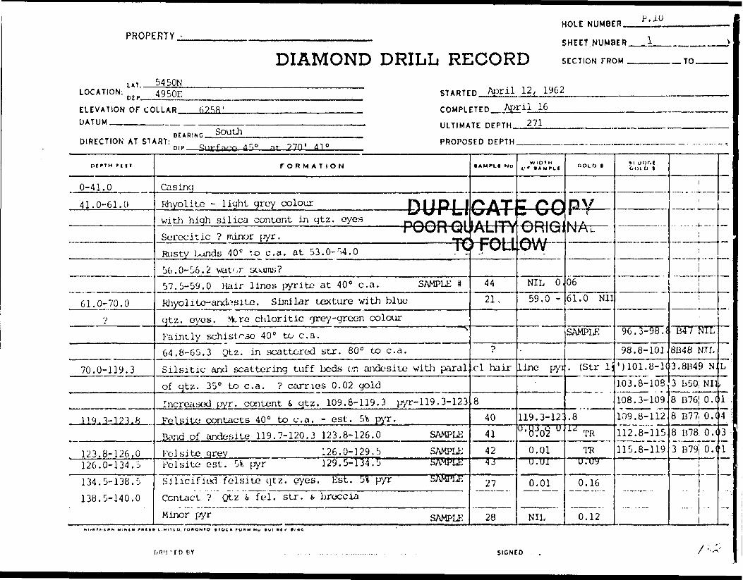
HOLE NUMBER.PROPERTY
DIAMOND DRILL RECORDSHEET NUMDER__..L
SECTION FROM ^—-— .— TO.
LOCATION;lAT.
DTP-
54 SON4950E STARTED April 12, 1962
ELEVATION OF COLLAR. DATUM —™———m—.
6258 '
DIRECTION AT START:BEARING. SouthDIP. at- di 0
COMPLETED April 16ULTIMATE DEPTH 271
PROPOSED DEPTH_____
oiriH r i IT
0-41.0
41.0-61.0
61.0-70.0r)
70.0-119.3
. 119,3-123.8
123.8-126.0126.0-134.5134.5-138.5 138.5-140.0
FORMATION
CasingRhyolite - liyht grey colour DI J PI 1with high silica content in qtz. eyes Dr\rU"J r\\
i \J\J\\ \j4\tScree it ic ? minor [yr. -y,Rusty l^nds 40 C to c. a. at 53.0-54.0 .' V56.0-56.2 vat' .r soajns?57.5-59.0 Hair lines pyrite at 40 0 c. a. SAMPLE #RJiyol i to- andesite. Sijnilar texture with blueqtz. eyes. Mere chloritic grey-green colourFaintly schistose 40 0 to c. a.64.8-65.3 Qtz. in scattered str. 80 0 to c. a.Silsitic and scattering tuff beds on andesite with paralof qtz. 35 0 to c. a. ? carries 0.02 goldIncreased wr. content i qtz. 109.8-119.3 pyr-119. 3-123
felsite contacts 40 0 to c. a. - est. 5t Pi'r.Band of andesite 119.7-120.3 123.8-126.0 SAMPUiFelsite qrey 126.0-129.5 SAMPU:Felsite est. 54 i^yr 129. 5- 134. l SAMPLESilicified felsite qtz. eyes. Est. 5* pyr SAMPLEContact ? Qtz i fei. str. k breccia
Minor pyr SAMPLE
1AMPLI NO
PATLrMitALiTV'/AU. 1 1 I
hFOLl
4421,
•p
ci hair
84041424 J" '
27
28
W 1 0 1 H V* t AMPCI COLD 1
, , ,
GHnv 4J F-t —ORieNAu-/^\AI,ow
NIL 0.59.0 -
line pyi;
119.3-12!U 'B^ U
0.011 U.U1
0.01
NIL
0661.0 Nil
SAMPLE
. (Str li
.8" TO
TOu.uy
0.16
0.12
*i wpr.l(•01 O t
96. 3-98. J
98.8-101.•uoi.y-K103.8-108108.3-109. 109.8-112112.8-115115.8-119
1
1
it
^
i ,
B47 \Xl8B48 NIL3.8B49 NJ
3 B50, Nil8 B76 0.(8 B77| O .I8 B78, O.C3 B79 O.C
i j|
L
i
1 43T
-.,
' TD n v SIGNED

4 7DIAMOND DRILL RECORD
SHEET NUMBER
LATITUDE ———
PROPERTY
t- '
HOLI NO.
SO \l
SECTION FROM.
DATUM.——-—
-TO. STARTED.
COMPLETED ~
DEPARTURE
ELEVATION
4 -'t S-D TULTIMATE DEPTH.
PROPOSED DEPTH.
, TOHOMTe —1TOCJI fOIIH M*. Ml *CV. It/*)

HOLE NUMBER. J.U
PROPERTY.
DIAMOND DRILL RECORDSHEET NUMBER
SECTION FROM .TO.
LAT..LOCATION:
OEP-——————
ELEVATION OF COLLAR. DATUM ___________
STARTED.
COMPLETED.
BEARING ______DIRECTION AT START: Surface 45 D at 2 ~W
DIP———————————————.—-
ULTIMATE DEPTH,
PROPOSED DEPTH.
DIPTH fVf 1
140.0-153.5
153.5-157.0
157.0-168.5
-
FORMATION
Porphyritic? with fei S qtz phenocrysts140.0-143.5 Fine grained altered similarcorqp. to andesite above. Gneissicat 40 0 to c. a. Scattered pyr. |143.5-148.5 Porphyritic, massive with 1/8" qtz. peyes becoming progressively finer. Scatt. pyr.148.5-151.0 Fine grained, massive, interned.(andesite) conp.151.0 - 151.5 Felsite. Dark green, chilled edge? ^151.5-153.5 Fine grained, gneissic.Felsite at lower contact - 40 0 to c. a.Mainly quartz, some feldspar S.ferromac. Scatt. pyr. (silver colour) 4 V.G.at 154.5, also 156.- Contacts 450 to c. a. SAMPLEQtz. injected shear? Banded, dark olilvegreen more basic than above, finegrained. Numerous quartz str, ifelsite bands. Pyrite (yellow) inbands S disseminated.Bands 45 0 at top changing to 60 s at bottom.
•AMPLf NO
)UP!:)ORC—— i
39
WIDTH Of 9 AMPLI COLD f
ICATE GfUAUT^ORIfO-^Ol LOW
0.20
GOLD t'
v "~^ x p
IK. ,L
0.19
i
———— 1t —
!
'
DRILLED OY SIGNED.
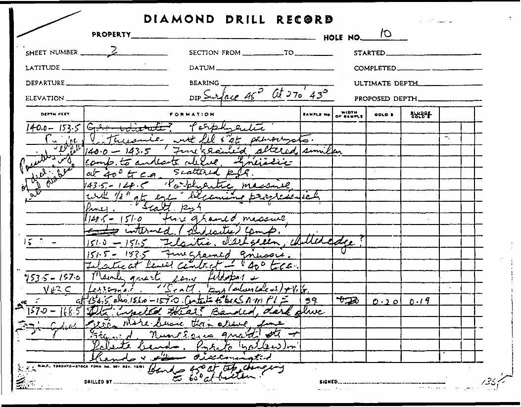
DIAMOND DRILLPROPERTY
REC0RD—————— HOU /O
SHEET NUMBER
LATITUDE ——
SECTION FROM
DATUM™——
TO STARTED.
DEPARTURE
ELEVATION
COMPLETED.
ULTIMATE

HOLE NUMBER 10
PROPERTY ———————;—————— SHEET NUMBER.
DIAMOND DRILL RECORD S ECTION FROM .TO.
LOCATION:. UT..
DEP- STARTED
ELEVATION OF COLLAR. DATUM———-™-—..—.
COMPLETED.
ULTIMATE DEPTH.
DIRECTION AT START: PROPOSED DEPTH
DtPTH rif
168.5-169.0
169.0-242.0
242.0-256.0
FORMATION
157.0-159.5 Numerous qtz. S, fei. etc. 20* pyr. SAMPLE159.5-162.0 Tuffaceous. Felsite 10* pyr. SAMPLE162.0-164.5 Andesite 5* pyr. . SAMPLE164.5-167.0 Numer. qtz. S, fei. str. 51 pyr. SAMPLE167.0-168.5 Banded tuffaceous 101 pyr. SAMPLEFelsite Scattered pyr. (white) SAMPLEContacts 90 0 to c. a.Diabase. Upper contact 90 0 to c. a. Massive, olive greFine grained, with dissem. magnetite 4 calcitethroughout. Also scatt. pyr. cubes ^
194.0-201.0 Fine grained basic dykes.Scattered pyr i pyrrhot. Contacts 45 0 to c. a. ?194.0-^5.0, 196.0-196.5, 200.3-201.0 H\J217.3-222.3 Fine grained, basic, dyke p^with scatt. qtz. str. Qtz. at 217.3 at35 0 to c. a, Dissem. pyr.239.0-242.0 Fine grained siliceousQuartz injected zone. Dissem. pyr. fi. in bands.244.5-245.0 Feldspathic dykeContacts 45 0 to c. a.242.0-245.0 SAMPLE
• AMPtC H o
29303132
.3334
3"! ,
[JDI Ijj/fUIORQL
B46
WIDTH OF (AMPLI
f\ J1**M9AT1ALJTYPOLL... ..
COLD B
0.03.02.03.68.01
NIL
* COORIG/I!5W- -^^ .
NIL
ooLb i '
0.08.14.06.12.04.15
Pv\1A t
DRILLED OY SIGNED .
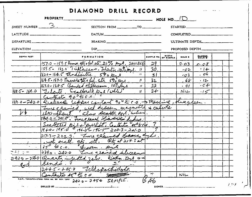
DIAMOND DRILL RECORD
SHEET NUMBER
LATITUDE ^.^
PROPERTY.
rvHOLE NO.
SECTION FROM
DATUM —————
TO STARTED.
COMPLETED.
DEPARTURE,.
ELEVATION .
BEARING.
DIP———
ULTIMATE DEPTH.
PROPOSED DEPTH.
rtrr FORMATION • AMPLE MB. WIDTHor CAMBIC OOCO f • moor
60lb l
'57-0 - 0-03n 14-
22.3.? o/
f /?* 4
3/7*3 2 i z,. 3 .
C *G .
J*i - AsL^tiL^.
HM*. T OaONTO-ilOCK F O* M M*. Ml *(V. 11/11
DRILLED IY .. SIGNED.
MtU
J
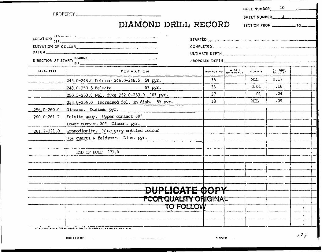
PROPERTY -
. LAI.
DIAMOND DRILL RE
HOLE NUMBE
SHEET. NUMB
ICORD SECTION FRC
D 10
ER 4 i
)M TO — -
LOCATION: ftrp STARTED , . r . .
ELEVATION OF COLLAR - COMPLETEDDATUM
DIRECTION AT ST/
DtCTH f tir
256.0-260.0260.0-261.7
261.7-271.0
- - --
—————————————————————————————————— ULTIMATE DEPTHBEARING .,.. 1 . 1 . ,.....-
tRT: PROPOSED DEPTHmp , , ,.,, , .
FORMATION
245.0-248.0 Felsite 246.0-246.5 51 pyr.248.0-250.5 Felsite 51 pyr.250.5-253.0 Fei. dyke 252.0-253.0 1(K pyr.253.0-256.0 Increased fei. in diab. 5% pyr.Diabase. Dissem. pyr.Felsite grey. Upper contact 60 QLower contact 30 0 Dissem. pyr.Granodiorite. Blue grey mottled colour75% quartz i feldspar. Diss. pyr.
"
HO OF miE 2 71.0
nilDI If^ATF? tL/UfLIVsM! C 1————————————— PQORQUAUTYOFTp FOLLOV
lAM^CC No
35363738
-
11 " "
*f\Tl\ s\J\r 1rt^MA^— }
T
WIDTHo' i*wrLt
-- — - -
f ———t ———————
GOLD f
NIL0.01
.01NIL
1VV PPI.GOLD f
0.17.16.24.09
;
—.
—
'*?

DIAMOND DRILL RECORD
SHEET NUMBER
LATITUDE ,——.
DEPARTURE,
ELEVATION .
PROPERTY4-. HOLE
SECTION FROM,
DATUM——..——
.TO. STARTED.
BEARING.
DIP———
ULTIMATE DEPTH.
PROPOSED DEPTH,
l
DcrTM rccr FORMATION S AM rk! Mo. WIDTHor VAMPCC BOU) • moorCOt-O l
'C/
•ci
- ni-r
f^/up OF
MM. r .. T o*3MTe-*Toc- ro*u MC. HI mv. m /ai
DUILLED BY . SIGNCD.

SAMPLE RESULTS OF HOLE # P.11.
Box # 3
Saitple#
76
77
78
79
80
81
82
83
84
85
86
87
Depth FT.
34.5-35.5
37.2-39.2
62.0-63.5
62.0-63.5
136.8-137.8
154.0-156.0
192.5-196.5
196.5-199.0
303.7-304.7
304.7-307.2
307.2-309.2
317.0-319.0
WidthFT.
1.0
2.0
1.5
1.0
1.0
2.0
4.0
2.5
1.0
2.5
2.0
2.0
Assay Gold/ Silv. ozs./ ton.
NIL
0.02
0.33
0.02
0.02
0.02
0.01
0.01
NIL
NIL
NIL
NIL
0.10
TR
0.47
0.04
0.16
0.08
0.10
NIL
0.09
0.11
0.07
0.38
88 319.0-322.0
Box l 4
3.0
Description
Aplitic dyke, dissem. pyr.
" with andesitic bands d
Quartz vein
Silicified shear, 2\ pyr.11 " 5% "
Rhyolite with 6" qtz. f, dissem. pyr. Dioritic with qvz., felsite, 5% pyr.
" " felsite, minor pyr.
" " qtz.-calcite stringers" 6" felsite, dissem. pyr.
" " qtz.-calcite string.
" " " " f, dissentpyr.
0.01 0.12
l
DUPLICATE COPYPOOR QUALITY ORIGINAL
TO FOLLOW

•U-'-T -
m^**.-•fi . ..;.'? .'-'8AJ1PLB rami^, ' ' f - FT.
\nvR\FT* Gold. Silr.
ORO./ton.
- Doocrlpfclon
'.!*0 ., *
37.2-39.2 2.0 •V~-"\ J ' '', .(70) 62.0-^3.5 ;.i.5 ;
:-^,:
'
Aplitio
,tio bondn L-f. . ' , , iir '''(5) 62-o-^3
;| ( v,;': .79 , 133^-13,1*roin
,'•l', l
2.0.
5 ; :JO'0|
' " '
MLorltlo With folflito pyr,
feloito, minor pyr.
••-• vi|;i^^^^^^^ .r'";;--fr -^to''^-^-'ag'^j^;, 06-;, 307.^09.42 .-y ft,0| t'^l^^T : / " - " qtt.^aloito otrrlnr. . ^|f
|^;.67-\^ " ' - . " ' " t, ftdlaae^'3h#"
|:|^Oo';:V3^^ "'^ , "- n " n* .;" * ! x -' - - i '' ' * * '- ' l ' - . ' ' . - ; -1" ' ; ':fr-''-mv-'-:.'-sj " ' .' ''' ' r^' -'- '' - ''''i'. ' v ' Wi:irtP-r*r4t'*?*-.' V- : .Vv '- i' ...' -- :. '|^;^^vv v^'-'J: .' - ' ' ; ;I|'-',':^M.- : -- ; '•••' ; ',.-'"''." : ' :;f -' ' '' -'- ' . - i'?Wte;:\ ; ; " -:-- ; •-.-V': "/vy -,. ' - -, .,.. : ...|||^;|;: ;i|||;: :;^J;:;,'v: ,V ?^^/•^^^•i\^'V'^.^J^^^^ -'^,x ' -,- i
. . - . , . ,*
;

ADDITIONAL SAMPLE KESUL'iF OF HOLE # P. 11.
DescriptionSanple ft
B. 80
81
82
84
85
86
87
83
Depth FT.
57.0-60.5
60.5-62.0
63.5-66.0
134.3-136.8
137.8-139.3
139.3-140.8
156.0-157.0
181.5-182.5
Width FT.
3.5
1.5
2.5
2.5
1.5
1.5
1.0
1.0
Assay Gold/Silv. ozs./ton.
NIL
NIL
0.01
NIL
NIL
0.01
NIL
0.02
DUPLICATE COPYPOOR QUAUTY ORIGINAL
TO FOLLOW

V.v -.-W -^"i;:.'i^^SW^'f^SK'lfc, •1.^i?^^ir-,^^ •s' i:'' .. r-'.,.f rt; :-^{ ••^i".V;.1-i:ji;;'i
..
1 ''^-r: ••::^?a^llfe^^^ ' 1 ' /:''ir.;'r- ' v ' ' •';' h"
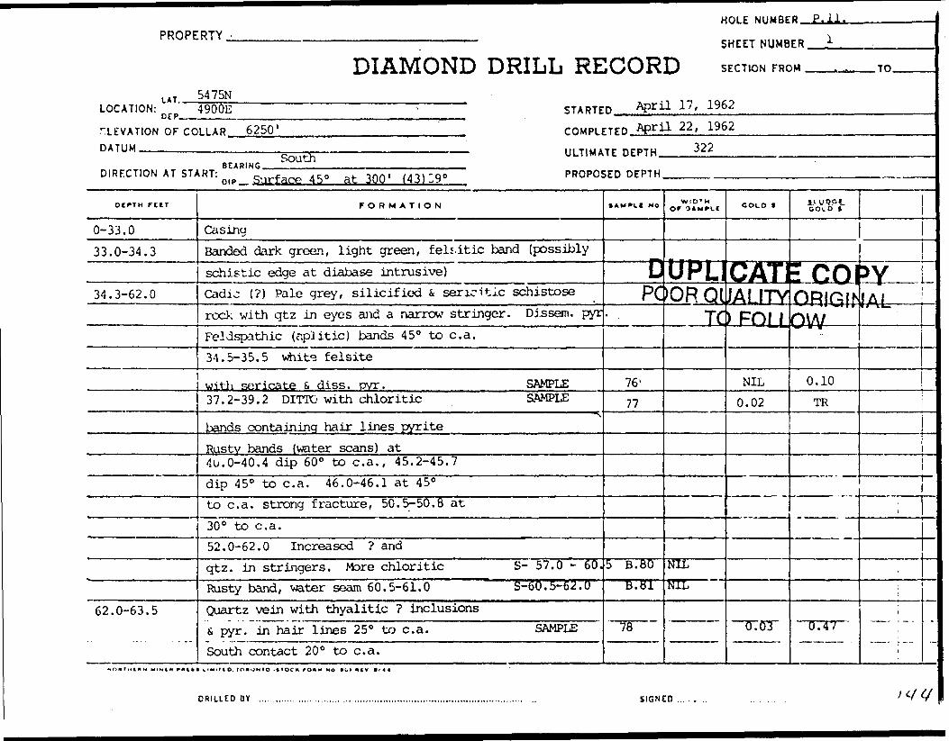
PROPERTY -
LAT.
DIAMOND DRILL RE5475N
LOCATION: n rp 4900E - STARTE
TLEVATION OF CO DATUM
HOLE NUMBE
SHEET NUMB
ICORD SECTION FRC
D April 17, 1962
O P 1 .
ER i
)M . .... TO
LLAR 6250' COMPLETED April 22, 1962———————————————————— . ———————————————————————————— . III TIUATr nrPTH 322
• r,.,™ ^UU ' ~., —— ™.... .. . ,. .
DIRFCT.ON AT START: n |p g.jrface45. at 300 ' (43) 39' PROPOSED DEPTH
oirTH rtiT
0-33.033.0-34.3
34.3-62.0
62.0-63.5
FORMATION
CasingBanded dark green, light green, felsitic band (possiblyschistic edge at diabase intrusive)Cadic (?) Pale grey, silicified fc sericitic schistoserock with qtz in eyes and a narrow stringer. Disseni. pyrFeldspathic (aplitic) bands 45 0 to c. a.34.5-35.5 white felsite
with sericate S dies. pyr. SAMPLE37.2-39.2 DITTO with chloritic SAMPLE
'"S
bands containing hair lines pyriteRusty bands (water scans) at•lu.0-40.4 dip 60 0 to c. a., 45.2-45.7dip 45 0 to c. a. 46.0-46.1 at 45 0to c. a. strong fracture, 50.5-50.8 at30 0 bo c. a.52.0-62.0 Increased ? andqtz. in stringers. More chloritic S- 57.0 - 60.Rusty band, water seam 60.5-61.0 S-60. 5-62.0Quartz vein with thyalitic ? inclusions& pyr. in hair lines 25 0 to c. a. SAMPLESouth contact 200 to c. a.
5AWV.I NO
—— L!PC
- .
76 l
77
5 B. 80B. 81
78
WtD T M OF 3AMPLC COLD f jiyQpi.
OOLO t
J 1
UFL GATE COPYKDRQllJALITYlORin^iAi
Td
NILNIL
JFOLLj
NIL0.02
0.03
——— —— ——————— ———— —— :
ovv
0.10TR
0.47
——— ,, ———
,
l
l
—
-
DRILLED OY ............. ...... ....... ,. ... ....................,..................................... . ... SIGNED...... .. . ' V V

DIAMOND DRILL RECORD
SHEET NUMBER
LATITUDE m
PROPERTY.
/.
HOLE
SECTION FROM.
DATUM.———
.TO. STARTED.
DEPARTURE.
ELEVATION .
-q 4 0 0 t- BEARING. ULTIMATE DEPTH.
PROPOSED DEPTH.
f7
ocrrn FBCT FORMATION WIDTH OF (AMPLC OOLtt * •Luoar
ebi.0 r
44*k~r.c j-l.j-'Ai 1 eJr K*6cr.*. 50 -f-
"
** St,fcj-o- 63-
-.—r —— 4I.M.P,. TCXOOTO— HOC1* FO*M M*. *OI KtV.

PROPERTY -
LAT. __
DIAMOND DRILL RE
HOLE NUMBE
SHEET NUMB
1CORD SECTION FRC
R "V
CR 2
)M Tn
LOCATION: [ (;p STARTED
ELEVATION OF CODATUM
DIRECTION AT ST;
OtPTM TUT
63.5-66.0
66.0-71.671.6-81.0
81.0-156.0(a}
toM/t)^ifiAi.cL^
LLAR COMPLETED
————————————————————————————————————— ULTIMATE DEPTHBFABING ,.,™, ,,,.,,,., ,—
.RT: PROPOSED DEPTH0'* ,,..., -.
FORMATION
Andesite- No marked chancre f ran rhyoliterock above, but morechloritic s hiaher % ferromasOtz. str. on shear or fracture 64.5 S ,64.5-66.0 Feldspar. No chloriteMore basic (a) massive andesiteFelsite dyke U. contact 40 0 fine grained,dark grey, diss, pyr.79.0-79.6 Andesite, banded with tuff. Diss. pyr.
NAndesite (a) (possibly altered, finegrained ?) . Mainly feldsparschistose 45 0 to c. a. Occ.i" qtz. str. Fine brown fei. ?
96.6 S, 102.0 Banded ? 96.6-97.6102.6-133.1 More massive fine grained 101.6-102.6dioritic texture (a) chlorite on bands133.3-134.3 Silicified shear zone 2* pyr. SAMPLE134.3-136.8 scattered i" qtz. str. SAMPLE136.8-137.8 i" otz. str. -i 51 pyr. SAMPLE137.8-139.3 Fei. str. in silicif. and SAMPLE139.3-140.8 Otz. str. S, minor pyr. SAMPLE
SAMFII NO
53.5 - J
WIDTH OF SAMPLI
*6.0
DUpLICPOU
A79?A80B85B86
^UUATO F
COLD 1
0.01
i!-.UQG|. COLD t
rATE pOP\LIIYUHIUINAL'OLLOW
423424
0.02NIL0.02NIL0.01
0.010.02
0.04
0.16
i
i i
i
li
i
-
DRILLED OY ...,................ ........, ............,....................................................... SIGNEfl...... .... . . . ...,. .... . ///^
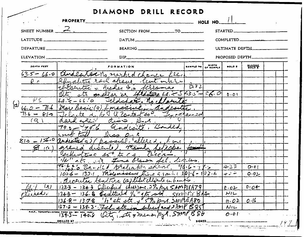
SHEET NUMBER LATITUDE ....—
DIAMOND DRILL RECORDPROPERTY________________________.__________ HOLE NQ l \ ,
-2..
DEPARTURE.
ELEVATION .
SECTION FROM,
DATUM.-———
-TO. STARTED.
COMPLETED-
BEARING.
DIP
ULTIMATE DEPTH.
PROPOSED DEPTH.
BtrTH rcrr FORMATION • AMPkJ M* WIDTH • OLD t • moorBOLD *
63- r- U -
01•y-' s; 14 ^ - U So
L^-.^dL*^tjL4*b'4~, ,
. 7 O- 01
GU 1 33-3 - 13*134-4- 1 3^. ft S/'^'-
-R- 0-lC
MJV^, TOMOMTO-tTOC*
. P.R.I UJtOY. IICMtO.. /f 7

DIAMOND D RILL RECORD.-i-e? y^*X*vv-X-M L/ O
PROPERTY._______________________,__________ HOLE NO. l f. X^:/ ^——'^. " * t.
SHEET NUMBER _____.2————--—————- _____ STARTED__'.ery ixx)r ciuality original -—-
LATITUDE______________________ J y y _____ COMPLETED
XU^t ,* ^^-e. XL^AO ^*Vv—C-
^^1 [xx)r quality original
Copy could not be transcribedDEPARTURE.
ELEVATION .
^ _ without great difficulty.
__ D IP
ULTIMATE DEPTH.
PROPOSED DEPTH.

PROPERTY -
LAT.
DIAMOND DRILL RE
HOLE NUMBE
SHEET NUMB
1CORD SECTION FRC
R V .J-±-
ER .4 . '
)M TO ^
LOCATION: n rp STARTED .. . . . .-
ELEVATION OF COLLAR COMPLETEDDATUM
DIRECTION AT SJt
DIPTM ftCT
279.1-327.0
f h (i\\•si w )
.. .
————————————————————————————————————— ULTIMATE DEPTHHFARINf. , ,...,, ,..
,RT: PROPOSED DEPTHnip
FORMATION
244.3-245.2 Felsite dykeDark green Contacts 45*278.5-279.1 Gneissic 45 0to c. a. as contact approached. tLower contact 30 0 to c. a. pDioritic as before with bluequartz eyes 151 feldspar in elongatedblebs i sericitic ?286.5-287.0 Felsite dyke. Greycolour. Contacts 45 0 to c. a. ^Scattered i" qts-calcite str. SAMP.
303,7-304.7 Scattered 1/8" qtz-calcite str. 45 0 to c. a.304.7-307.2 FelpitQ dyke 5% diss.pyr. from 306.7-307.2 , SAMPLEcontacts 45 0 to c. a.307.2-309.2 1" qtz-calcite str. at 60 0 to c. a.
at 308.2 and i" at 309.0 SAMPLE310.4-311.2 Felsite dyke diss. pyr.
l*~wer '••ontact 30 0 tn r,ri-\L6 6-^17 0 F^RJi-f dykp, J 1? 0 f-O ^- a -317.0-319.0 Dioritic as before. Feldspar
DRILLED OY ................... ..................,...........................................................
SAMPlt No
^UPLDOR C
Ti
*84
85
86
WIDTHor S AMPLE
ICA1UALITOFOI
\
s7
SIGNED...... ....
GOLD *
r"OR!GLOW
ktfiLT,
\NIL ^
/
//NIL
/
JLgOGCaoLO i""
st
\^.\[
//
.o///0. 11\\0.07\
\
7//
-
\1
i
S. '
\ i'\ '
11
-
, m

DIAMOND DRILL RECORDPROPERTY,.________________________________ HOLi N(x
SHEET NUMBER
LATITUDE -^—
SECnON FROM ,
DATUM,-^———
-TO. STARTED.
COMPLETED.
DEPARTURE.
ELEVATION .
BEARING.
DIP
ULTIMATE DEPTH.
PROPOSED DEPTH.
M.M.*.. TOftOWTO-ftTOCK r0MM M*. Ml HfV.^
DRILIEO BY ............. tlONtO........
I^^^H
l
^

PROPERTY -
LAT.
DIAMOND DRILL RE
HOLE NUMBE
SHEET NUMB
ICORD SECTION FRC
B P. li.
ER . 5
)M TO
LOCATION: n fp STARTED ,. ,
ELEVATION OF CCDATUM
DIRECTION AT ST/
otrrn F IIT
- --
LLAR COMPI FTED
————————————————————————————————————— ULTIMATE DEPTH ,
VRT: PtP Surface 4 5' at 300' (43)41 PROPOSED DEPTH.
FORMATION
and qtz. str. at 317.0-317.2 withdiss. pyr. Qtz. str. parallelwith core at 30 0 to c. a. from 3.18.0319.0 with 51 diss. pyr. Sanple319.0-322.0 Qtz. str. at 321.0-321.2 at 30 0 to c. a. Sanple
EM) OF HOLE 322.0
nu PLICATE C^rOOR QUALITY ORIGINAL
TO FOLLOW
l*MP*Ll NO
87
S3
i
.
WIDTH OF SAMPH
\\
sys
GOLD S
"\.01
\ x.up\
s
06 L o T
./'0^8
k^^ ' IA
\\\
xx' '
x
'x
i
. r -.
^
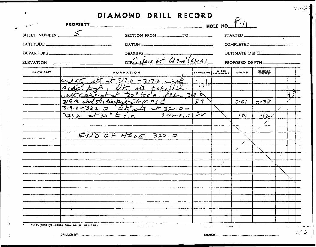
l.
^ *
SHEET NUMBER
LATITUDE ____
DIAMOND DRILL RECORDPROPERTY,
DEPARTURE.
ELEVATION .
HOU NO. /LSECTION FROM .
DATUM ^^——^.
-TO. STARTED.
COMPLETED.
BEARING
DIpLuZj.
ULTIMATE DEPTH-
PROPOSED DEPTH.
DIITM rKCT FORMATION WIDTH •LUPOt COUD t
, Ko-oi 0-3^
r. \ o\X
g: -3.2-9*0 \
\
\
\\
, TONOWtO-tTOCX FOAM N*. Ml WCV.
DPHLUD IY SIGNED .

:;3-';ft::::-V- ;H^--^,'.
JV?T,M''J' : . •''•'' v f v .-' :li- . l . L* .- - r . . l .'
3 Or" HOU8 ^ P.
rr t - mmii -^ ASSAY, w. . '
-v 7B.o-Bo.o;:.2A0 :
'A! '
99*0-101.*- ' ,
'lOl.JJ-lOlj.O 2.5
lo^.o-ioS.b' '1.5 io^. 5-107. o i.S
'
1.5
i 190,0-191.5-; \ i
-'.191*^-193*0 '
; ..'•'.
; 221.0-222,* . ;
,..2.^ O- 1 f
. . ,. .. .
IC9CIUIT10M
s Aoidib with fol. fr qic. *tr. ^t pyr.
Dioaom.
Acidld. n. - n
Querta. flinor pyr.
Qtp..-calci)to injectofl tuff. Glacon
Tuff. J)looor. pyr.
" Siliceous. IrLoswn.
AruJonlte, ty P7T*
Tuff, flildoocrua.
" Acid. Scatt, qtz.
JW-orlUo with qtB. eir. fi minor pyr,n n tt it n M
n n n R t; nt "
fflKjar rpno. Qta. f/ pyr.
Oranodlorite, Fino grained, 2l
llowo. y-v
f ^s ^

s-*.*, s s g i i

PICK MINES LIMITED 1962 Assay Results
Hole No. l i Additional Samples
SampleNo.
401 402 403 404 405 406 407
408 409 410 411 412
418 419
420 421
422
4-23
424
4?.5
426
427 428
,. Footage From
195.0 197.5 200.0 202.5 205.0 207.5 210.0
223.5 225.5 227.5 230.0 233.5
285.5 288.0
291.5 294.0
59.6
96.6
101.6
162.5
172.0
199.0 201.5
Width To Feet
197.5 2.5 200.0 t . 5 202.5 2.5 205.0 2.5 207.5 2.5 210.0 2.5 212.5 2.5
225.5 2.0 227.5 2.0 230.0 2.5 232.5 2.5 236.0 2.5,
Additional Samp'
288.0 2.5 290.5 2.5
294.0 2.5 296.5 2.5
Additional Samples
61.0 1.4
Additional Samples
97.6 1.0
102.6 1.0
165.0 2.5
174.5 2.5
201.5 2.5 204.0 2.5
OZB. O/,*. Gold Silver
0.02 0.02 0.01 0.02. 0.03o.oz0.02
0.01 0.01 nil 0.01 0.02
'oia p 15nil nil
nil nil
Hole P 10
nil
Hole P 11
0.01
0.02
0.01
0.01
0.02 0.01
Samples Taken In Mill
1. 2. 3.
Mill tailings Mill tailings 1 (chener (residue after cyaiidatlon)
nil 0.01 1.59

HOLE NUMBERPROPERTY.
LOCATION:UT..
5475N
DIP, 4850E
DIAMOND DRILL RECORDApril 23, 1962
SHEET.NUMBER^
SECTION FROM ^ .TO.
STARTED.
ELEVATION OF COLLAR. DATUM———————-.—
6250' COMPLETED,April 27, 1962
BEARING. South______. DIRECTION AT START: m p Surface 45" at 250'(43)17^
ULTIMATE DEPTH. 255'
PROPOSED DEPTH.
DIPTH FICT
0-43.043.0-45.0
45.0-46.0
46.0-47.5
47.5-48.0
48.0-51.0
51.0-95.5
•---
FORMATION
Casing43.0-45.0 Acidic mod. gr. mainlyfeldspar with qti. S. sericitic. 21dissem. pyr. (4" core missing i badly broken at 45.0) SAMEAcidic with some chlorite. Badly broken 5. rustyfrom 45.0-45.5 SAMPLI
Acidic as before. Rustyfracture at 46.3, and 47.0. Core broken up. SAMPLE
Quartz vein. ? brown withminor pyr. Core broken up. SAMPDIntermediate, med-fine grainschistose, mainly fei., with minor chlorite-qtz eyes.Calcite, qtz, S fei. str.45 0 to c. a.Rusty ? at 48.0-48.5 49.0-50,048.0-49.0 Banded tuffaceous as at top of hole P. 11 SAMP. I49.0-51.0 Badly brcten s, ?. 6" core missing SAMP. B89
Gradational change to diotite. Massive with ? f eld. S. c*65.5-67.0 Light grey siliceous phase. ? f. fractured 66.5-73.0-74,0 Pyrite fc calcite veinlets SAMP78.0-80.0 Qtz., calcite S fei. str.
(AMPiC No
. A89
A90
A91
: A92
rvrv,88
rb str.67.0 SAM
B91
WIDTH OF SAMPLt
lUPIdDORO."3!
?. B90
COLD t
0.05
NIL
NIL
2.31
si- w PC i.GOLD t
IMpX|0flol!*lf]'*L.
1—H
P Yr 1MAb —ilr^l-.
, NI
NIi NI
^ •'•— -— "
i ?
1i
-J
L,
L
DRILLED OY .................... ....... . ......,............................................................. SIGNED......... .. . . ...,. ....... ,. . . . 1^ h,,...

DIAMOND DRILL RECORD- ' PROPERTY____________________,_________ HOLE NO
SHEET NUMBER l '___________ SECTION FROM ________TO________ STARTED
LATITUDE —™ -7 r M2\ /?62-\
DEPARTURE.
ELEVATION .
4S.5TO H"DATUM.
BEARING.
COMPLETED.
ULTIMATE DEPTH. ^*
PROPCKFH HFPTH
rtrr FORMATION SAMFCI NO. or COLD t ILUDOr C OLO 1
X*C , t
4-3 4-\ L
/t
u A/ii"
- 47- T4-*6* 7. o ' '
M/t-
/? r.'i ^ //t/" -*2. o - r't* b A /'c /
--- 4A k
- 7. y•73-0- 7^.0 O O
-o -KM*, TOKOKTO-tTOCK 7OKN H*. Ml *ly. 11/tl j f

PROPERTY -
l AT
DIAMOND DRILL RE
HOLE NUMBE
SHEET NUMB
1OORD SECTION F'RC
R P. 12
ER 2 .
m Tn
LOCATION: n rp STARTED . . ..
ELEVATION OF COLLAR ^ COMPLETEDDATUM
DIRECTION AT ST;
OtPTH FllT
95.5-108.5
108.5-158.3
158.3-160.3
————————————————————————————————————— ULTIMATE DEPTHBFARINr, ..j-,,.... __ ,~.
^RT: Surface 45" at 250' (47)44 0 PROPOSED DEPTH
FORMATION
injected in shear 7/zone. Bandingat 45" to c.a. ^ss p^ SAMpLE84.2-84.6 Pink feldspar dyke 40 0 to c.a.87.0- Calcite blebs increase in size S, content92.0 1" qtz S. calc. strings 40 0 to c.a.95.5-99.0 Schistose 6 banded,shear zone in diorite. Increasedpyrite. SAMPLE99.0-101.5 SAMPLEChange to lighter greenish grey sericitic with qtz. eyes7minor chlorite. Less pyr. in bands. Qtz.strs. at 45 C to c.a. at 99.5-100.0101.5-104,0 Qtz. str. at 103.0 SAMPLE104.0-105.5 Massive. 2% pyr.. SAMPLE105.5-107.0 Qtz. str. 25l;pyr^ SAMPLE107.0-108.5 Breccia 107.5-108.5 SAMPLEAltered diorite and mainly fei. with minor calcite fcchlorite as above. More massive S darker green with brovSericitic. Scatt.i" qtz. str. Less pyr. SAMPLE
DRILLED OY . ................. ......... .......................................................,............
• AMPL.C No
93
—— lDP
98,99
100
111112113
n f eld.
114
SIGNI
WIDTH Of S *MPLt
U-LDJU^urLjOnQ
COLD 1
0.02
•••^^^•W."a. a -A^a*a^Ma rAJU^^Iil*Ti*3Si— --i^i-^'. .^.^.
NILNIL
NIL Of
NILNILNIL
0.03
S L y po f. GOLD t
E^eL^V^llvli
this assa;
D........... .. . . ...,, ........ ... .
HY^NKL7-
'
i
!
i l
i
1
ji
;
1 1
—
-
rt 8

,v
DIAMOND DRILL RECORDPROPERTY ^ ' unit JJ \ 'HOLE NO.
SHEET NUMBER
LATITUDE ——.
SECTION FROM,
DATUM—.—-—
TO
DEPARTURE.
ELEVATION .
BEARING. ULTIMATE DEPTH.
DTP SJJ+'Jt
DIPTM r trr FORMATION -VVV 1' ' • AMPi.1 NO. WIDTH or t AMPLI OOID f iiupor
.^ x fi ^' -7#4*1-34-6 4c'd
. o ^ ,
/r.
s
f J S'WU
. f*,?, 99 -r-ov . -r- - ik) J
/O 4- J? - /r •/r
\ o 7- 7 o -? - • ip tun /oy- S// /- r' ' i { - -Lt'C}
M*. Ifl *CV. tt/tl
W*K*^^W"fS?^W!W^W,''*S'^^ *^-^-. -. ^^r-..-^

PROPERTY -
DIAMOND DRILL RECORLOCATION: n fp STARTED ^^^^
ELEVATION OF COLLAR . C OMPLETEDDATUM ...
HOLE NUMBE
SHEET. NUMB
D SECTION FRC
DUPLIC4rLJvn
————————— .... —————————————————————— in TiMiTr nrPTWBEARING -. .,.
WUALJTOTRC
. P.".
ER .3
)M Tn
JE CO,TYORIC3INA,1LOW
DIRECTION AT START: PROPOSED DEPTH01 P ————————————— ————————————— . — ———^——,
OtfTH F IIT
160.3-190.0
190.0-195.0
195.0-217.0
. ...
FORMATION
Similar composition with scattered brownfeldsp. blebs and getting norechlorite and nore olive green massivefrom 180.0. Scattered narrow lelsite bands and pyr. S. i"176.5-177.5 i" qtz. str. cutting core and parallel to SAMI180.0-181.5 Felsite dyke 40 0 to c. a.190.0-192.5 Qtz. str. parallel SAMPIto core at 190.0. i" str. 45 0 at 191.0 SAMPI
192.5-194.0 Otz. strings parallel with core. rtiuror SAMPIpyr.
194.0-195.0 i" qtz. str. at 194.2 SAMPLI195.8-201.0 Similar conp. nore darkqreen S. chloritic with blue qtz. eyes 10% a.25 0 to c. a. Feldspar blebs aligned 35 0 to c. a.201.0 1" qtz. str. 35 0 to c. a. SAMPLE212.5-213.0 1" qtz. str. 80 0 to c. a. SAMPLE
213,0-214.5 dark qreen, blue qtz. eves214.5-217.0 Increased pyr. No cal. carb.Qtz. 6 fei. in breccia zone 212.8-215.4and qtz. injected fracture 216.0 Dissempyr.; fei. blebs 6 chlorite SAMPLE
DRILLED OY .................. ...,..... ...,...... ......,..................................................
SAMPLI NO
qtz. strLE. B92
E B93p 11,5
E 1 16
B94195.0-1197.5-2200.0-2
B95B96
111
SIGNI
WIDTHor 3*MPLf
at 55 0
'
)7.5)0.0)2.5
COLD f
0.03
0.530.133.62
0.070.23
0.14
:o ..... .... ... . ....... .......
GOLD "t"
V.
V.
1.720.02^00.02^00.04^0
2.5-205.05.0-207.57.5-21.0.03.0-212.?
.
l
i
~-
-
,6o

SHEET NUMBER
LATITUDE —.—
DIAMOND DRILL RECORDPROPERTY______________________i_______.—— H OLE
3) .
~1 /
SECTION FROM ,
DATIJM
TO STARTED.
DEPARTURE.
ELEVATION .
BEARING.
DIP
ULTIMATE DEPTH.
PROPOSED
DCPTH rCCT FORMATION • AMPLC NO. WIDTH OOLC * nuporOOLO C
T^T-
i g 0 . C? .
10-03
O,*?*,
3.4,7.''
/o
. ^/.v^ V.
0-I4-,
, T OUONTC-HOC* r0*M M*. Ml *fv.
DRILUO BY.............
X

PROPERTY -
LAT.
DIAMOND DRILL RELOCATION: n ro STARTE
HOLE NUMBE
SHEET. NUMB
ICORD SECTION FRC
DUPLICA
P.12.
ER 4 ]
)M TO
TE COPYr,™™- o;™,.. rn.,,™, ^UH QUALITY ORIGINALDATUM u. T.u.Tr nrPTn TO FOLLOW
BEABINT. , .,.,..,.,DIRECTION AT START: PROPOSED DEPTH
"IP . .
DCKTH r tfT
216.0-221.0
-4 ———
221.0-223.5
223.5-255.0
FORMATION
Fine grained, dark green porphyrite dyke. Fine whitefeldspar phenocrysts. Phenocrystsalioned 40 0 to c. a. 216.0-218.0Massive porphyrite 219.0-221.0
Contacts 40 C to c. a. SAMPLEShear zone minor chlorite, olive green brecciatt pyr. in bands at 15 0 to c. a. 221.0-222.5 SAMPLE222.5-223.5 Contact v. faint at 15 0 to c. a. SAMPLEFine gr. massive diorite with brown fei. blebs, minor cMfine blue qtz. eyes 35% less pyr.232.5-233.5 qtz. injected fracture 1" wide at 233' SAMPI236.0-238.0 1' wide shear? at 15 0 to c. a. Fine gr. pyr.238.0-240.0 Similar conp. Increased pyr. 2% SAMPLE240.0-243.5 Dioritic J" fels, str at 242 SAMPLE243.5-245.0 Coarse pyr. 21 SAMPLE247.0-248.5 Felsite dyke. V. contact 40" low cant. 20 0250.5-255.0 Interbanded fei. S, dior. Minor qtz. contactProbably felsite phases of diorite
END OF HOLE High 255.0water pressure at 180fracture at 224'
IAMPIC NO
B91
118B98 ,
orite
E B99bands SAI
119B101
120
s band bB102B103
^ - -••~
WIDTM OF 9AMPI t
NIL
0.080.06
1PLE 100
) line245.0-24248.5-25
GOLD t
MO*
MC^qi D
t' 1
V*
0.02
7.0).5
Sj.yp.cc. GOLD t
223.5-22!225.5-22'227.5-231230.0-23:233.5-231
0.010.02
0.040.01
NILNIL
..5 0.0).'.5 0.0).1.0 NIL
!.5 0.0).0 .0.0^
'
i
iiii ii
l"""" ' f " i
-
r- o i * i t- n ri v v i ^ *j r r* ' " ^"

SHEET NUMBER
LATITUDE .——
PROPERTY4-
i .M. m w r* u w iv i L i. rv t c w n fHOU NO.
DEPARTURE.
ELEVATION .
SECTION FROM.
DATUM..^.^^
.TO. STARTED.
COMPLETED.
BEARING.
DIP
ULTIMATE DEPTH.
PROPOSED DEPTH.
Dcr-TM rcrr FORMATION IAMFL* MO. WIDTH Of * AMPV.C GOLD t aiUOOt
GOLD *
^ "g* r- v-oi0'0{
2 /1'Q -a 3 A O . A- 1 C) r - 2.5*3-3J- ' O-OI
O-o^.U-
o - ofe
* l".' ,.TT7f—rC -C {
6,0,4.o
- Jr ^l ll
U.
J^M.^*AJ t ((S-
TOKONTO-irOCK COHM N9. Ml "IV.
DMIU.CO er SIGNIO.,

SAMPLE RESULTS OF HOLE i P.13.
SAMPLEt
121
122
123
124
125
126
127
128
129
130
131
133
132
134
135
136
137
138
139
DEPTHFT.
25.0-26.5
48.8-50.3
50.3-51.8
51.8-53.8
53.8-55.8
58.4-59.4
105.0-106.0
128.0-129.5
129.5-131.5
131.5-133.5
145.5-146.5
158.9-160.4
160.4-161.4
161.4-161.9
168.9-170.4
173.1-175.1
175.1-176.6
176.6-178.6
178.6-179.6
WIDTHFT.
1.5
1.5
1.5
2,0
2.0
1.0
1.0
1.5
2.0
2.0
1.0
1.5
1.0
0.5
1.5
2.0
1.5
2.0
1.0
ASSAYGOLD
ozs/ton
NIL
0.05
3.54
0.02
0.02
.01
.02
.01
NIL
NIL
NIL
0.01
0.04
.02
NIL
NIL
NIL
NIL
NIL
DESCRIPTION
Sheared rhyoliteM M
Felsitic, Qtz. injected shear 51 pyr.
Feldspar injected rhyolite
Sheared felsite, 5% pyr.
Fractured zone.
Andesite. J" qtz. stringer.
Andesite band in felsite zone
Andesite with qtz. S. chlorite injected slips
Qtz. injected rhyolite 2\ pyr.
Pyr. bands in rhyolite at felsite contact
Pyr. S. chlorite filled slips in rhyolite
Qtz. vein, minor pyr.
Rhyolite with minor qtz. stringers
Feldspar 6 chlorite injected diorite
Feldspar injected diorite
with qtz.S tt pyr.
Diorite
Brecciated diorite with chlorite S. pyrbands
DUPLICATE
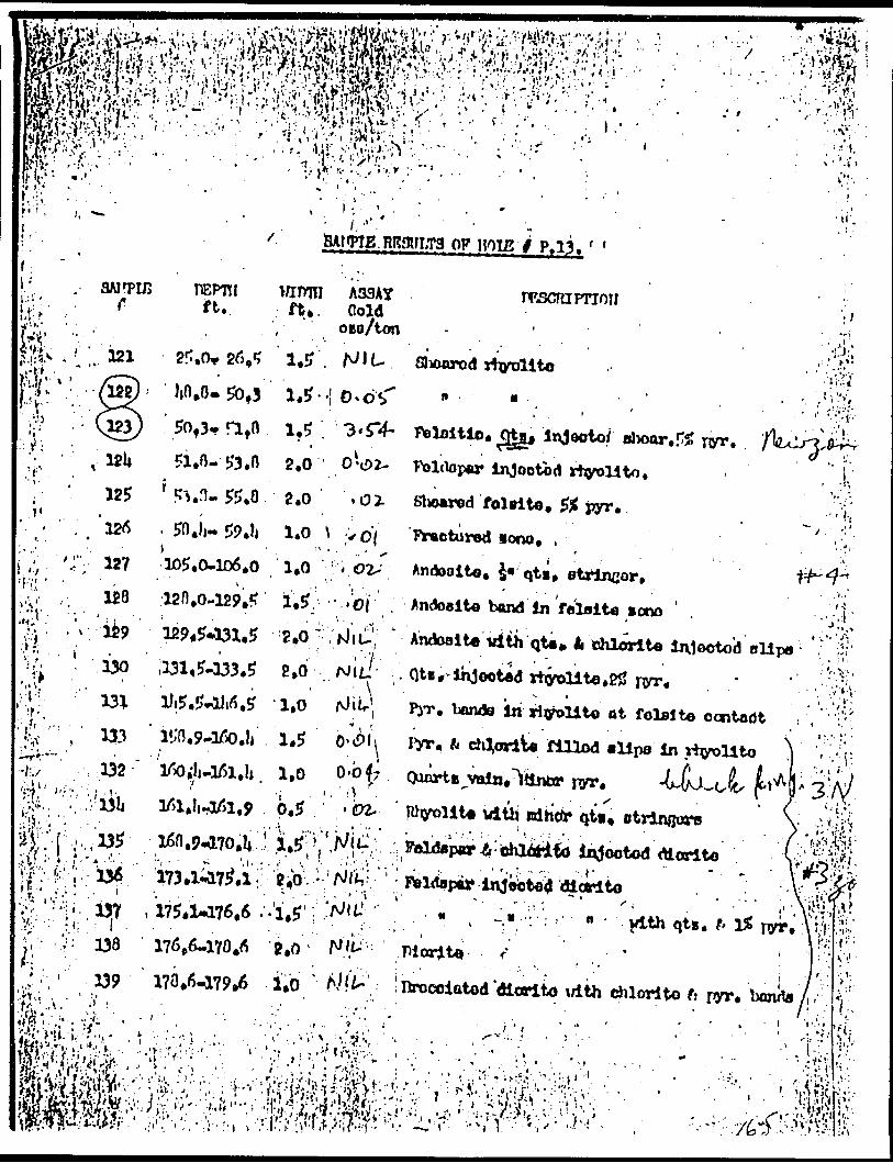
. ; f ' ,
'HI '
•^ .N; (
vtf
•l-./
-
125
'.r 127.. 1*8
. \ 129
' 130
133132
137- I. .138
BAtffrJB; RRgff,T3 OF HOIg
ft.WIDTH A33AY ft*. Gold
oto/ton
1.5
rescniFTioiii
* ' .* *Slioarod rtvolito
5of3^ri tn i ?5, ? ?i.n-53.n 2,0 0-02-
105.0-106.0 i.o ,
Feloitlo. (Hfij Jnjeoto/ elwor,.^ TV* rolcloper Injootbd
2.0 -02- Blioared foleito. !
1.0 l y o j- lYactursd looo. ,t i Andooito. S* qti.
Andoalte bond in felsite icno ' .
Andosito with qta* li chlorite in.1eotod ollpa 2,0 . NJt/
l .1.5 O'C^h
l, 1,0 0-b^r .
Ji-1^1,9 . 0.5
. bands in rlyolito at felsite ccntadt
. ft chVvliji. filled alipo in xiyollto
vltb
'175.1^76.6 ..'i.5' i
. - . . ;176,6-170^ B.O l
i;.,(
n''i' V 'V- - f..t
'•••l-
-

.2
HOLE l P.13 cent.
140
141
142
143
144
145
146
147
148
149
150
151
152
153
185.5-187.0
202.2-204.7
204.7-207.2
207.2-209.2
218.8-219.8
237.1-238.6
247.1-248.1
258.1-260.7
260.7-262.7
262.7-265.7
265.7-267.7
293.0-296.0
296.0-299.2
299.2-300.2
1.5
2.5
2.5
2.0
1.0
1.5
1.0
2.5
2.0
3.0
2.0
3.0
3.0
1.0
NIL
NIL
0.01
.02
NIL
.01
NIL
NIL
.02
NIL
NIL
NIL
NIL
NIL
Qtz. Si feldspar injected fault zone in rhyolite
" " injected rhyolite.No. pyr.
" " injected rhyolite 251 qtz.
" " injected rhyolite 51 pyr.
Feldspar S. chlorite slips in diorite. U pyr.
Qtz. injected shear zone in andesite.
M 11 II rhyolite
20'i qtz. 5*i pyr.
" in andesite
zone in rhyolite qtz. 5% pyr.
Felsite. Disseminated pyr.
Diorite with felsitic phases
Diorite
DUPLICATE COPYPOOR CHRISTY ORIGINAL
TO FOLLOW
A.C.A. Howe Resident Engineer

C-'- -: - '*m
- Ji' s:; :
'wi'ttVr \ - -^ '-vu ' i - - - 'I'M'^VI%/iii' ••- ; . i- 1 ",..r.-.:r..-.iv \-v-'. - ? - , ; - - - : -r.'Rl^^i^^^.^^l^*^^^^ g!^Wr^^u^' 2.^;:^-v,: ;:; v..v:: ;^ -y^;'|-'-1'Da' 201,^^07.2 siS^'^l^r "' '". V,^,-; *. - ' 25*1**. ...v^;.-;,,f ,.:^ OT.s^W'^o^p.-: ..--r,, ;-. w, y,,,', ^;-.^',i!* .ziii.o^is^V.;';^ 1^**^*^"^^^^*^^^^ ^^^;VjW ;z37.i4aB.6-l.S^'^0|^(^.in3ootp**h^.cM-lnm^oUo. \ .. .
i -f'. -•V J*ii...~
.*
150 2^*7-^67.7; 2.0 /^^ " " ...J1.;..-lA 293*0-296*0- 3.0 - MIL Folflito. TdoWdnatod
^52 296.0J299.2 - 3.0 - NIL. riorlto with folaiUo
1^3 299.2-300*2-1,0,- N'L;. W.orlto
1 l! .11.
. t *
it;.
V. -
fi••l';-1 :!,
.rr -
- f . ; - ; ! -i ,'w . '.. ... '
f i , i f '' ' j 1 " ' ^ ' ' ' ' '^,i:,;n-;;'-^l -' ;"^4':;'.': r .;- -f*;.W .-'.-.'.' -. -l - -
'- ' l
,|;.,r
Hove
- -' . I'-i.r•if!v.
r "} r - -/' i? x
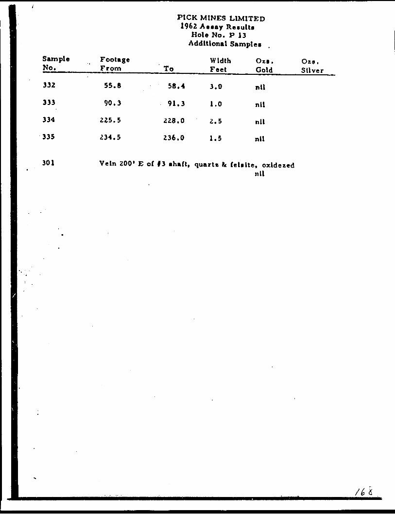
fl11 Sample Footage 8 No. From
I 332 55.8
I 333 90.3
1 334 225.5
1 335 234.5
PICK MINES LIMITED 1962 Assay Results
Hole No. P 13 Additional Samples
Width Ozs. Ots. To Feet Gold Silver
58.4 3.0 nil
91.3 1.0 nil
228.0 2.5 nil
236.0 1.5 nil
301 Vein ZOO' E of 13 shaft, quart* fc felsite* oxldezednil
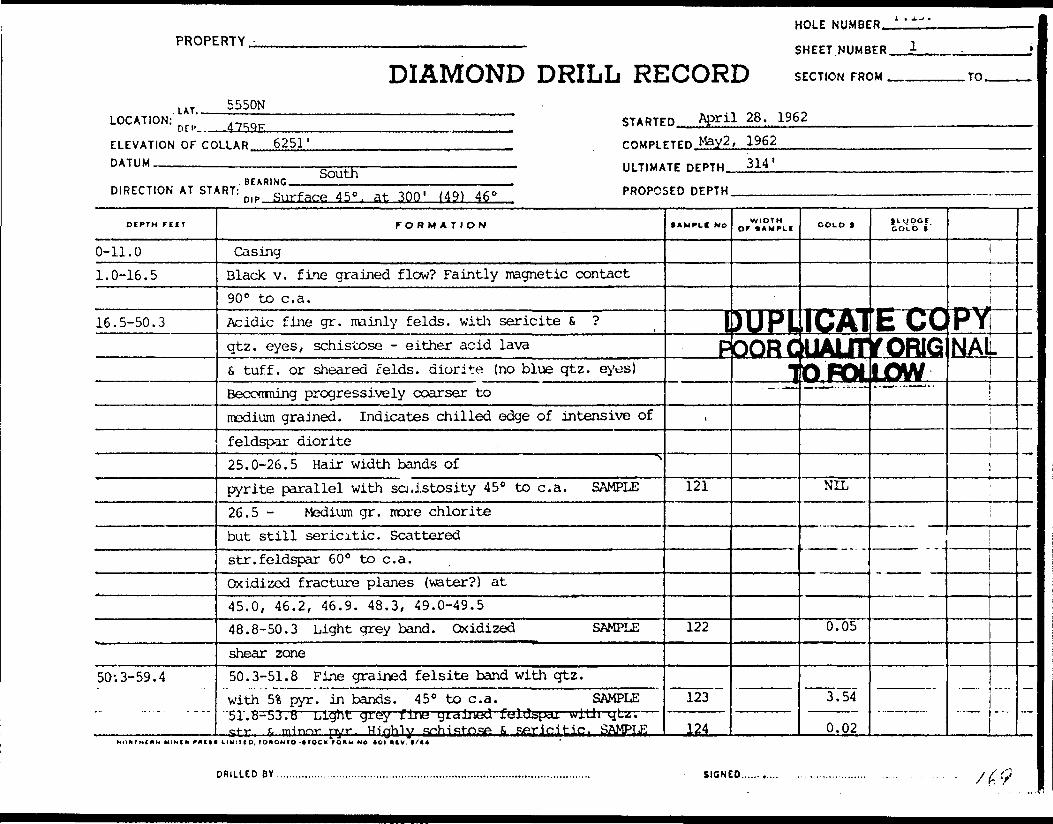
PROPERTY -
LAT.
DIAMOND DRILL RE5550N
LOCATION: o n, ,^QTr STARTE
ELEVATION OF CC DATUM
HOLE NUMBE
SHEET. NUMB
jOORD SECTION FRO
D April 28. 1962
R i' ——
ER 1 . j
M TO
LLAR 6251' COMPLETED May2 , 1962——————————————————————— i ———————————————————————————— . III TIUATF nrPTW 314
.r..,™ SUUU * ~.....^,......,.,.. . ..
DIRECTION AT START: m p ftirfafie 4 5 o. at 30Q , M 9) 450 PROPC!
DIPTM rtlT
0-11.01.0-16.5
16.5-50.3
50; 3-59. 4
FORMATION
CasingBlack v. fine grained flow? Faintly magnetic contact90 0 to c. a.Acidic fine gr. mainly f elds, with sericite 6 ?qtz. eyes, schistose - either acid lavaS tuff, or sheared f elds, diorite (no blue qtz. eyes)Beconming progressively coarser tomedium grained. Indicates chilled edge of intensive offeldspar diorite25.0-26.5 Hair width bands ofpyrite parallel with schistosity 45 0 to c. a. SAMPLE26.5 - Medium gr. nore chloritebut still sericitic. Scatteredstr. feldspar 60 0 to c. a.Oxidized fracture planes (water?) at45.0, 46.2, 46.9. 48.3, 49.0-49.548.8-50.3 Light grey band. Oxidized SAMPLEshear zone50.3-51.8 Fine grained felsite band with qtz.with 5% pyr. in bands. 45 0 to c. a. SAMPLE51.8-53.8 Light gYey fine y i dined jLtjlJ^pcu. will i ^L*.. c-t-f x, ii|irmr pyr Highly c^hifit-OfiP ft Rftf i ft^tip , SAMJPLE
DRILLED BY ................ ...........,. ......,.............................................................
5ED DEPTH
•AMPLI No WIDTH Or IkMPLI
IDUPL
COLD t
TCK1doORdUALIT1 ib'poi
t
121
122
123
124
SIGN!
— . .^*.
NIL
0.05
3.54
0.02
Q
51 UDC.t COl D *
COrORIGow
PYNAL
il
\
. — -.— —
. . /^
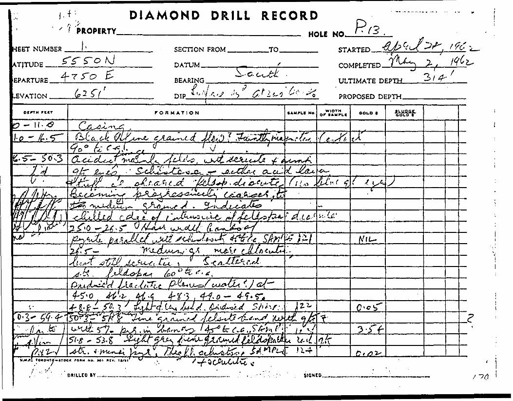
iEET NUMBER
ATJTUDE __
DIAMOND DRILL RECORDPROPERTY.
l-HOLE NO. /T (3 .
EPARTURE.
EVATION .
SECTION FROM,
DATUM -———
-TO. STARTED.
b*
BEARING
DIP.
COMPLETED.J
P 1 3 f Xi'' •'.'t -V 6 * l'~l W !
ULTIMATE DEPTH.
PROPOSED
otrTM r i ir FORMATION • AUPLI NO. WIDTH OOLO IkUCSJL
lo ~ •( t^sti,
7V6'
60"**-*.
-f- g.^- , t**
r'U •7,r
i T OAONTO-tTOC*
OKILLCD SICNtO..,

HOLE NUMBER. P. 13
PROPERTY
DIAMOND DRILL RECORDSHEET NUMBER.
SECTION FROM .TO.
LOCATION:LAT,.
DEP.
ELEVATION OF COLLAR. DATUM -——-^————
STARTED.
COMPLETED
ULTIMATE DEPTH
DIRECTION AT START:BEARING
DUPLICATE COPYQUALITY QRI( TffJFtitlOW
PROPOSED DEPTH ,.
DIPTH rrtr
55.8-58.4
59.4-97.5
97.5-102.5
102.5-116.5
FORMATION
53.8-55.8 - Fine gr felsite band contact 50 0
5S, pyr. in bands. Minimal qtz SAMPLE
Andesite? Greenish grey, fine gr. chloritic, mi
Rusty fractures at 58.8 and 59.0 (water?)
58.4-59.4 Increased pyrite, feldspar and qtz.
along fracture at 59.0 SAMPLE
Increased chlorite becoming gradually andesite
70.6-72.6 Feldspar dykes d qtz.
injections. Fracture at 72.4
72.6-97.5 Occasional narrow feldspar at 45 C , e^l
Occasional qtz. d calcite stringers (as at top c
Black and fine grained flow. Ferruginous
S, carbonaceous. Faintly magnetic d ?
Numerous slip planes, calcite d epidote filled v
continue with andesite above d below. Contacts
Andesite, massive as above.
105.0-106.0 J" qtz, str. with pyr. SAMPLE
Bands on each side at 35" to c. a.
111.2 oxidized fracture. Water:
113.0 i" str. quartz, with pyr. on outside?
AMPLI No
125
nor ser
126
?.
g. 90.3
f hole)
hich45 0
127
WIDTH Of 9 AMPLI
scitic .
-91.3
COLD t
0.02
minor
0.01
111 qtz.
0.02
jv-gpct.GOLD *
pyr . SAM
i, fei.
^LE LJ32
i
____
^v
NnNTHlAN MINiM rftltl LIMlTID, IOAONTO -itOCK fOftM Mb t/44

DIAMOND DRILL RECORD
SHEET NUMBER
LATITUDE ————
PROPERTY.
^ i
DEPARTURE.
ELEVATION .
SECTION FROM,
DATUM——-^
.TO.
BEARING.
DIP.——
COMPLETED
ULTIMATE
PROPOSED DEPTH
ocrrH rrrr FORMATION lAUFLf NO. WIDTH C f AMPIC OOLO 1 SOLO t
-a ~o .02-
^5{t^' ''//r
Z Z* 4-1 *Tf. J-
•w* '
•S.Nil,
A? / vA/.
7. r-.AA.c fu-*
i* J , .t;'
X 0 v 07**"
1 1 3- 0N.M.F.. TOKONTO^- tTOCK f ODM NO. 101 H tV. 1 1/11 J '
DRILLED B Y. SICNEO..

HOLE NUMBER P. 13.
PROPERTY.SHEET NUMBER.
DIAMOND DRILL RECORD SECTION FROM .TO.
LOCATION:LAT.-.
DER- STARTED.
ELEVATION OF COLLAR. DATUM-————.——
COMPLETED.
ULTIMATE DEPTH.
DIRECTION AT START:BEARING.DIP.
PROPOSED DEPTH..
DEPTH rilT
? - 131.5
? - 160.4
- --
FORMATION
Felsite band. Fine grainedbecoming increasingly lighterin color with depth.122.8 i" qtz. str. 45 0 to c. a.125.5 " " " " "128.0-131.5 Colour changed gradually to produce
white. Increased quartz content. Minor pyr.128.0-129.5 6" andesite band with pyr. 128.5 SA129.5-131.5 i" qtz. str. at 130.0 chlorite bane
from 130.5 ? s AMPLE"Rhyolite. Faintly schistose . Much fei. S. chicquartz, minor sericite. Med. grained. Possibly131.5-133.5 ? pyr. S, qtz.eyes s felds. S qtz. injections SAMPLE136.3-137.8 Felsite. Blue-green. Contacts 4V139.5 2" qtz. str. 45 0 to c. a.
145.5-146.5 ? pyr. SAMPLI146.5-147.5 Fine gr. felsiteFeldspar filled fracture^ 40 0 to c. a. withbands Pvr. at 151.5, 155.0, 157.0
f AMPLI NO
—————
WIDTH OF SAMPLE
imi l
COLD t
f* ATIwi i-ijwr-ti i— PQORQUALJTY
^-X. r-^Ni i
MPLE, 12s
129rite, intuff.
130
131
ivrryuL
B 0.01
NILinor
NIL
NIL
SlUOGC. GOL O t
^COIORIGIN™^
).y1 Alpw ' ——
i
..—. —
no)t i m

NUMBER
TUDE.—-
iRTURE.
ATION .
DIAMOND DRILL RECORDPROPERTY
^ SECTION FROM .
DATUM,--———-
.TO. STARTED.
COMPLETED.
BEARING.
DIP.™-
ULTIMATE DEPTH.
PROPOSED DEPTH.
trrn rctT FORMATION *Awruc NO. WIDTHor IAMPLI OOLO * • moat coco *
/'. )r
i* O'O/r
^.* r 'i. A6-^.
f- r
- M7- r ex., JUlihu! .^
c -o
To*ON7o-iroo ro*M NO. to i ^jv. ii/n
DfllllTO BY...................... tICNED.

HOLE NUMBER,P-"
PROPERTY.-.
DIAMOND DRILL RECORDSHEET.NUMBER.
SECTION FROM .
LOCATION:LAT..
DER..
ELEVATION OF COLLAR. DATUM-————.-———.
STARTED.
COMPLETED
ULTIMATE DEPTH
DUPLICATE C
DIRECTION AT START:^TO FOLLOW
nip PROPOSED DEPTH
.TO.
DEPTH riCT
? - 161.9
161.9-167.4
167.4-168.9
168.9-170.4
170.4-173.1
173.1-179.6
FORMATION
158.9-160.4. Increased pyr.
4- chlorite filled slips. SAMPLE
160.4-161.4 Quartz vein with rhyolite
bands S. chlorite filled slips S, minor pyr.
Contacts 45 0 SAMPLE
161.4-161.9 Rhyolite with i" qtz. str. from
161.4-161.5 similar comp. but more yellow
in colour 161.5-161.9 SAMPLE
Fine grained diabase. Colour change to dark ol
green with yellowish tinge. Possibly basic dyfo
Chlorite filled slips 35 0 to c. a.
Felsite dyke, olive green, chlorite, U. contact
Lower contact 45"
Intermed, - basic Similar diabasezone above. Feldspar 6 chlorite filled
fracture 25 0 to c. a. at 170.3 SAMPLE
Felsite. Light colour. Sericitic. U. contact
Andesite. Fine grained, banded appearance
due to chlorite bands, s. feldspathic
AMPLC NO
133
132
134,
.ve l
!? (j
15 0
13535"
WIDTHor tAMPLi
tJL ID
COLD 1
0.01
0.04
0.02
V X
NIL
}i goct COLD i "
#3N
xs \
l
SIGNfOX ' i -"

DIAMOND DRILL RECORD
FT NUMBER
ITUDE ———
PROPERTY.
4-HOLE
SECTION FROM.
DATUM-™——
.TO. STARTED.
ARTURE.
VATION .
BEARING.
DIP,———
COMPLETED
ULTIMATE
PROPOSED DEPTH.
otrrn fin FORMATION NO. WIDTH OF (AMI*LI OOLO * fLUPCt
-4- o-o/
f-
-?f
A-t.-'-/ . 'Cfee*, J 3
c. j -j./- W,
./r/i.u.f. roxoxTO-iToo rooH MO, *oi *fv. 11/11
OMIUCO tlAMVO

PROPERTY -
DIAMOND DRILL RELOCATION: n rp STARTE
HOLE NUMBE
SHEET .NUMB
1CORD SECTION FRC
DUPLICAELEVATION OP COLLAR COMPLETED POOR OUALT
DATUM. ———————————————————————————————————————————— . IIITIMiTF nrPTH IlJ FCl
BEARING. — , ______ .
R ^.l-*'
ER . 5
)M TO
TECOPYrYORIGINA!i inw
DIRECTION AT START: PROPOSED DEPTHO'P.. , , ,... ,..,..,. . .
DEPTH f UT
179.6-180.0180.0-187.0
187.0-202.2
202.2-209.2
.. .
FORMATION
bands, 35 0 to c. a.173.1-175.1 Feldspar injectedf-acture at 173.8. Minor pyr. SAMPLE175.1-176.6 Feldspar in bands, qtz.injected fracture 177.1 increased pyr. to 1 1in bands at 35 0 . SAMPLE176.6-178.6 More massive SAMPLE178.6-179.6 Chlorite filled slips,pyr. bands in brecciatedzone at 179.6 SAMPLE ^Light grey -felsite at 50 0 to c . a.Rhyolite tuffaceous possibly due to shearings, scattered 1" qtz. str. ?" felsite at 182.5185.5-187.0 Qtz. S. feldsparinjected ? Minor pyr. SAMPLEMore massive with J" qtz. str.al 195.0, 197.8, 199.7, 201.5Banded appearance with chlorite 4. feldspar bandstringers. Sheared s, Qtz. in j. tuff?
xrxrndiN MINO ructt i IMIMO. IO*ONTO-KQC* ro** n o tot mv. u t*
. ^,.-s..*...^..-vW.v^^^-v*Ww**wWr~^i-iw*~w*wwniwr*-"
tAMPLI NO
136
137138
l
139
140
; i. qtz
SIGN!
WIDTHor I AMPLI COLD t
NIL
;;IL;JIL
NIL
NIL
:o...........
GOLD t
n
\
i
i
—
,/ S 'l
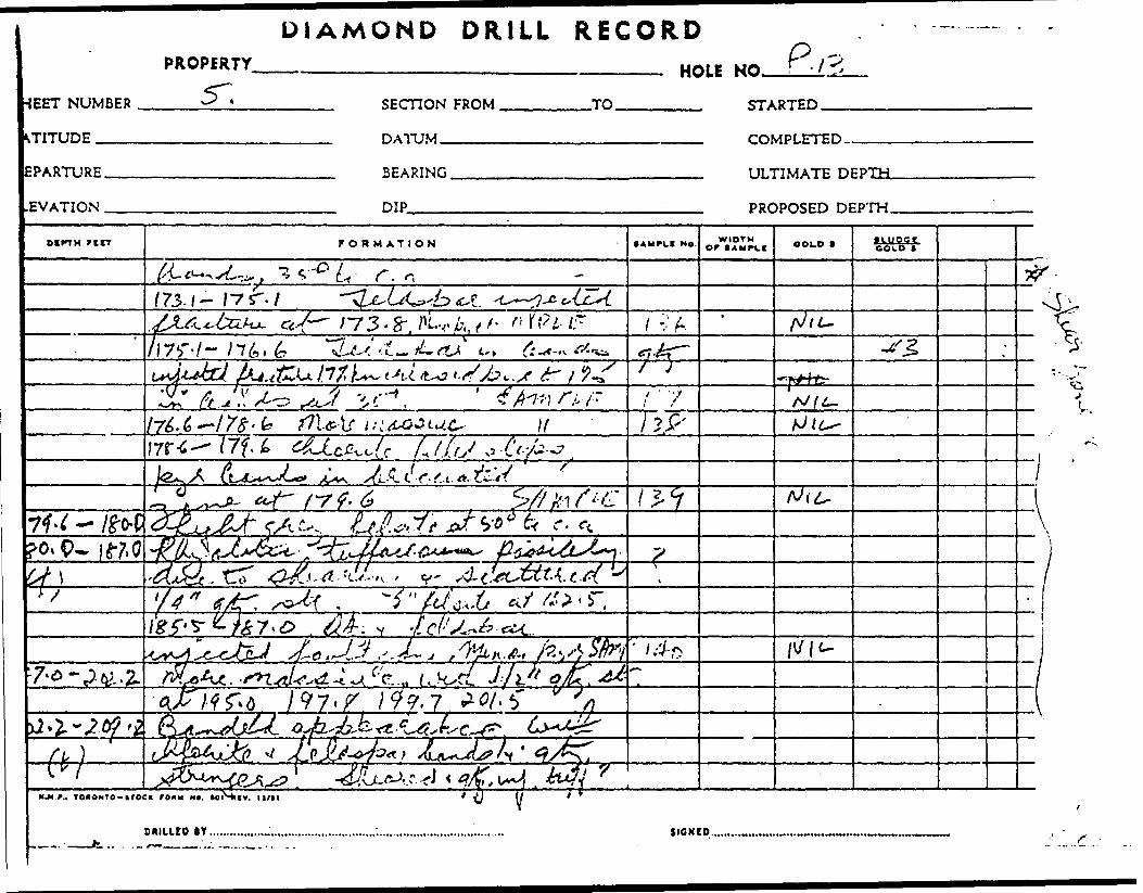
1EET NUMBER
TITUDE .——.
EPARTURE.
EVATION .
DIAMOND D RILL RECORDPROPERTY.5~, HOLE NO..
FROM, .TO. STARTED.
DATUM. COMPLETED-
BEARING.
DIP——-
ULTIMATE DEPTH.
PROPOSED DEPTH.
ocrTH rtrr FORMATION • AUPLI Ne. WIDTH OF lAM^Lt COLD f JLUOCt
tt O CO *
r. of 73. f — 1*7 ". 7
,^3~6~-t-\for-!-
-- A fi/lL-
x j J
tfl&ir ui. if
. ,'fo*.*, rf
MM*., T oiONTO-irocs r oxu M*. loiSiiv. it/n
OHIUIO IY.............,™...
* ^J ( 1 t *
SICNCO.
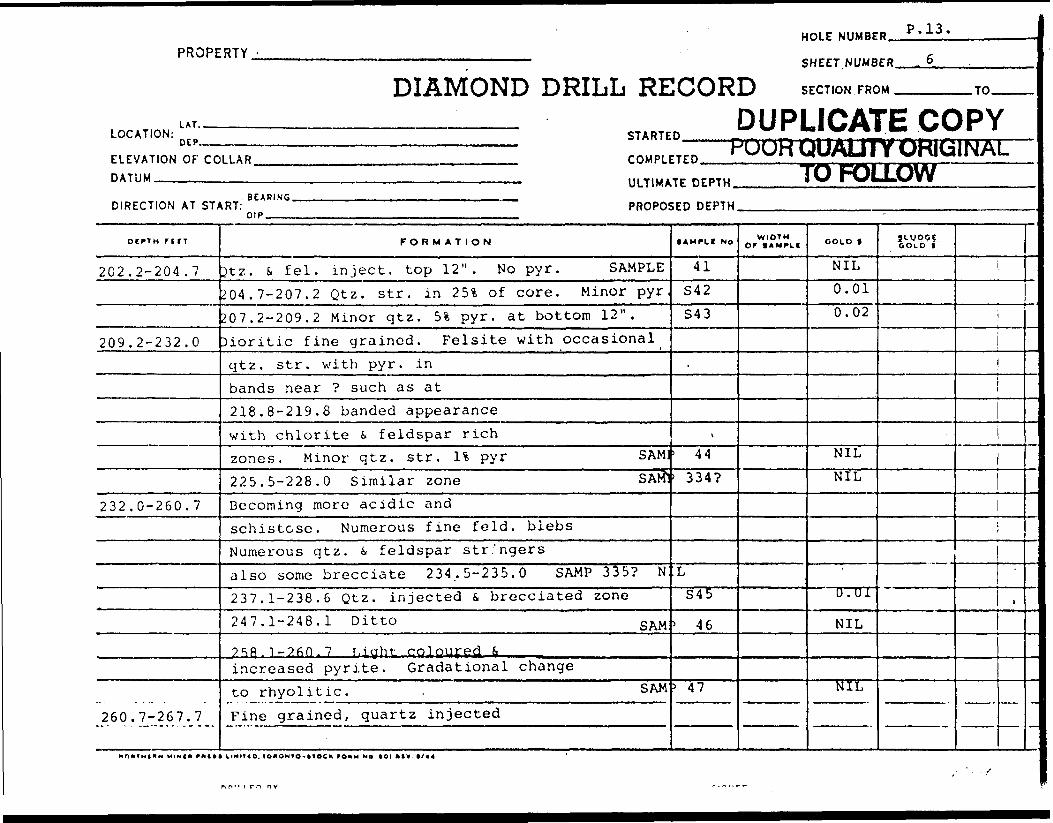
PROPERTY -
lil
DIAMOND DRILL RELOCATION: STARTE
HOLE NUMBE
SHEET. NUMB
iCORD SECTION FRC
D DUPLICA1
B P. 13.
E-R . 6)M rn
re COPYELEVAT.ONOFCOUA. m.*™ ' UUH UU/UJ 1 T UKItillWM-DATUM
DIRECTION AT ST/
DCPTH fttT
202.2-204 .7
209.2-232.0
232.0-260.7
260.7-267.7
II, T.MAT, DEPTH TO FOLLOWBFAPINC
,RT: PROPOSED DEPTHnip
FORMATION
St z. S fei. inject, top 12". No pyr. SAMPLE204.7-207.2 Qtz. str. in 25% of core. Minor pyr,207.2-209.2 Minor qtz. 5*. pyr. at bottom 12".Dioritic fine grained. Felsite with occasionalqtz. str. with pyr. inbands near ? such as at218.8-219.8 banded appearancewith chlorite 6. feldspar richzones. Minor qtz. str. 1 * pyr SAM:225.5-228.0 Similar zone SAM"Becoming more acidic andschistose. Numerous fine feld. blebsNumerous qtz. i feldspar str'ngersalso some brecciate 234..5-235.0 SAMP 335? N:237.1-238.6 Qtz. injected S brecciated zone247.1-248.1 Ditto S AM;
^5^ 1-260.7 r.iyht coloured, ^increased pyrite. Gradational changeto rhyolitic. . SAMFine grained, quartz injected
lAMPLt NO
41S42S43
\
. 44
' 334?
LS45
' 46
5 47
'WIDTH
Or 1 AMPLI COLD t
NIL0.010.02
NILNIL
0 . 01
NIL
NIL
Jl-VP?? OOLO t
i
1
1
-
j/

DIAMOND DRILL RECORDPROPERTY
HEET NUMBER
LATITUDE __
(R;3.MQ. V /-?
SECTION FROM.
DATUM.—^--—
.TO. STARTED.
DEPARTURE. 'LEVATION .
BEARING.
DIP————
ULTIMATE DEPTH.
PROPOSED DEPTH.
o* PT H rcrr FORMATION SAUPLI NO. orWIDTH COLD 1 ILUOOte olo r
204. y- P-o7. 3--30'!-*.- .20?.
b?-z~-, ..j-s,^-'
A***Ltint*:;
Nit-
^
TL*3*l&TTO*OMTO-*TOCK ro*M NO. tot (mf v. l a/ii
oniuco BY.

HOLE NUMBER,i-.U
PROPERTY
DIAMOND DRILL RECORDSHEET. NUMBERJL
SECTION FROM ^. .TO.
LOCATION:LAT..
ELEVATION OF COLLAR. DATUM ———.———.——
STARTED.^
COMPLETED.
ULTIMATE DEPTH.
DIRECTION AT START:BEARING.
PROPOSED DEPTH
DtPTH rtlT
267.7-293.2
293.0-29b.O
2.96.0-299.2299.2-300.2
300.2-314.0
FORMATION
rhyolite zone. Pale olive greencolour (as in vein at ?) due tofine mucas? 11 pyr in bands fc disseminated.260.7-262.7 Contains 20%qtz. in stringers S. 51 pyr. SAMP262.7-265.7 Darker colour, much qtz. S. pyr. SAM]265.7-267.7 Similar to top 2 ft.with 151 qtz, 6 51 pyr. SAMGreen-grey f. gr. dioritic withfine phenocrysts (elongated b]ebs) of feldspar?Upper contact, feldspar injected45 0 to c. a.Rhyolitic, sericitic, mainly fei. withdiss. pyr. Upper contact 60 0 SAMPDioritic as before with felsitic phases SAMPFelsitic. Dark yellow green coloursimilar to diorite. Dissem. pyr. SAMPFine gr. diorite, grey-green with brown fei
SAMPtC NO
. 148'. 149
' 15.0
151152
153
WIDTHor * AMPi(
DUU\J-POO
t
OOLD f
0.02NIL
NIL
PUCr*Bi\*i^QUAI
TO-r'
Similarottom h(
JLUDGfcoLb t ~
ftlEj]r^ i MM ^JWOFULLUV]
^ 1 f* 1 7"?' JLC JL *- *
;oi, u3\
i
'
BY SIGNED........... ....... .............. ... . . . .....frMr^-ty^'^ifftfyr^nrrn^^m.1" f^KfvWWBrPBi.ianHWf ir;*W *Pt7wr**B'fvr*^WW-1I
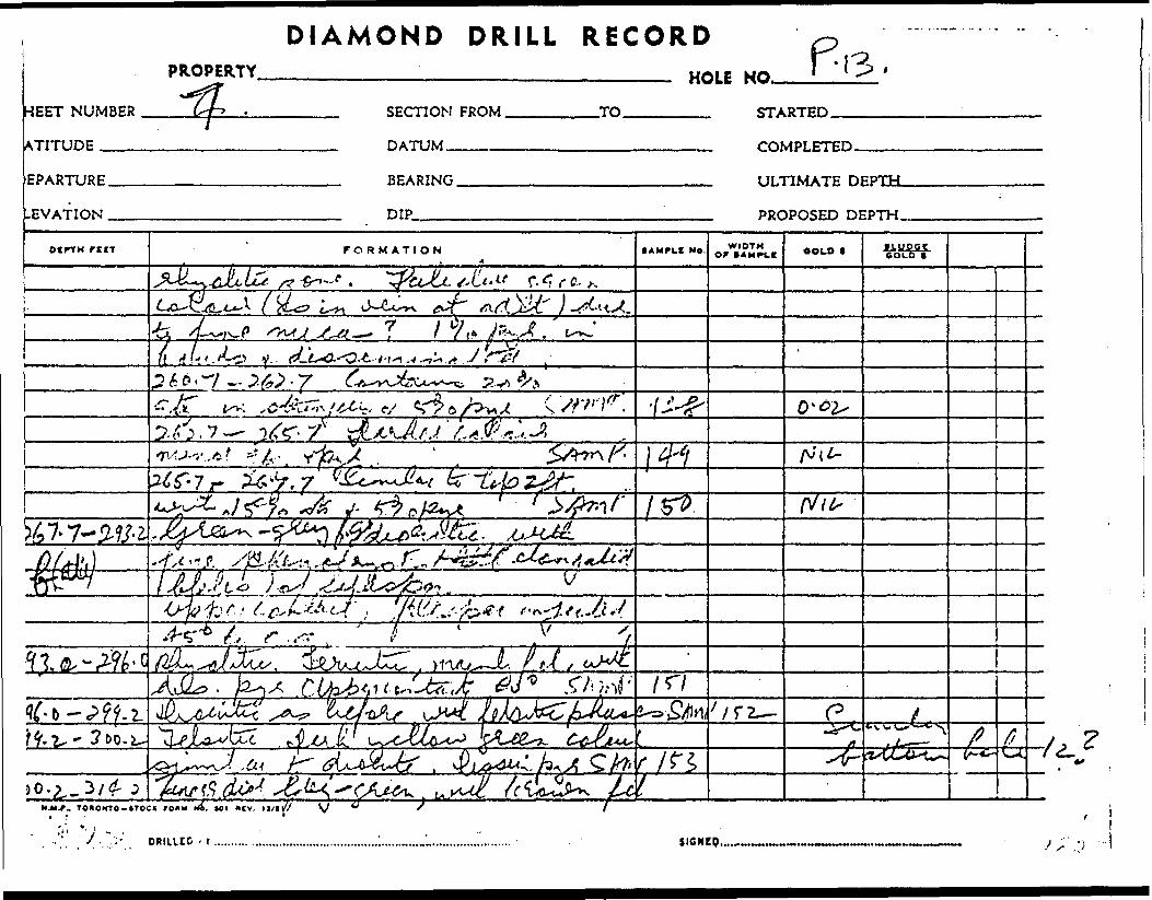
HEET NUMBER
ATITUDE ™—
EPARTURE.
-EVATION .
PROPERTY
if.
DRILL RECORD—————————————— HOLE NO. fWl l ^ '
SECTION FROM.
DATUM^^.^,
-TO. STARTED.
BEARING.
DIP™.™
COMPLETED
ULTIMATE
PROPOSED DEPTH M
otrfM rtn FORMATION NO. WIDTHor IAMPIK OOLO t
c.-
L&L -t -t-^.A^+.A J
) V
- TOftOMTO-ftTOCK;
* 1
y.":-' DRILLED . r
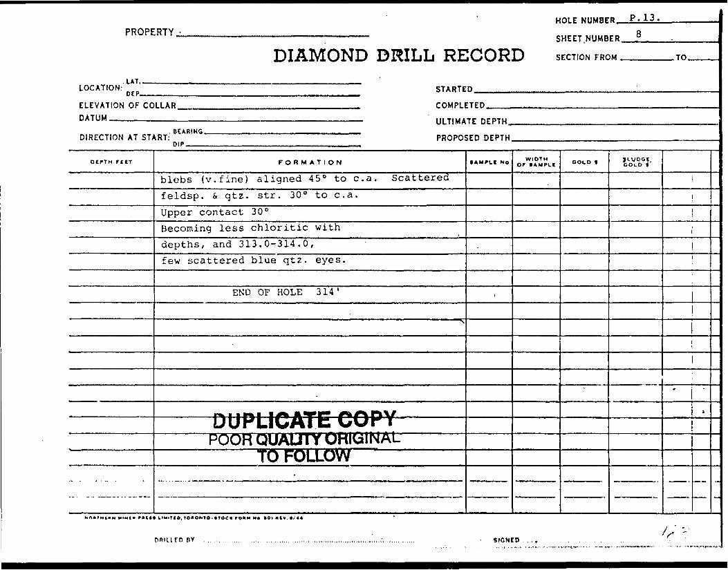
HOLE NUMBER. P.13,PROPERTY,
DIAMOND DRILL RECORDSHEET.NUMBER.
SECTION FROM .
8
LOCATION:UT..DEP. STARTED.
ELEVATION OF COLLAR. DATUM ———————.-.
COMPLETED.
ULTIMATE DEPTH.
DIRECTION AT START:BEARING.
DIP.PROPOSED DEPTH.
.TO.
DCPTH fClT FORMATION
blebs (v.fine) aligned 45 0 to c. a. Scatteredfeldsp. S, qtz. str. 30 0 to c. a.Upper contact 30 0Becoming less chloritic withdepths, and 313.0-314.0,few scattered blue qtz. eyes.
END OF HOLE 314 '
*\
——— DUPLICATE COPY ———POOR QUALITY OHIGINAL
TO FOLLOW.
lAMPtf No
t
WIDTHor tAMPit COLD t J LW DO f.
GOLD f
1
|
*
1
1
-
BY SIGNCD

DIAMOND DRILL RECORD ^ -PROPERTY u^le u* (M?.
ET NUMBER ST SECTION FROM
rrunp HATTIM
ARTURF BEARING
NATION DIP
DIPTH rccT
TO ST/
rof
1 11,1
pur
rORMATION
•J/^AL^I f^^j. Ou^^ r. W 4** c'k.i *? .^.l-i'j(. r^^^p e^— "5X^~ ^s-v^ ^i P tV
^c*t^tcxx-*(.r. r
^/CU^JUM ^e^ X. .7-" 2.. ...rt 0^^-o-v^-*v^ ^pla^ ^^J.&L^'CZZ M i r/'
if A t N A ,* ^i f J f M y ^( if t 1^ J 1 ^ ^ /"^^^ fi— * ^ Si^rt ^^t^* V *-^-^*^,— -v^^w^ .^.X^"— - **^v /Lx^^ ^' We. - - ^ *— * -"^ ^ *-*— - ^^
A " -* (!/
c: /j J^ t? /^ /cAo ^^/- J/ ^
,*.r~ TOOOKTO-ITOCI fOIM M*. Ml OCV. 1 I/I 1
Din ten BY . .... . . . . . . . .. ...,... ..
• AMPLE Ne.
f
SICNI
WIDTH
RTpn
vlPLETED.. . - -
TIMATE DI
)POSED DE
ooto l
5PTH
:PTW
f\.\JOOfc o t o*
rp ' , ,,,.,,.,,,..

SAMPLE RESULTS OF HOLE # P.14
SAMPLEft
154
155
156
157
158
159
160
161
162
163
164
165
166
167
168
169
170
171
DEPTH FT.
14.0-17.0
17.0-20.0
20.0-21.0
21.0-22.5
22.5-23.5
23.5-26.5
26.5-30.0
53.0-55.5
55.5-57.5
57.5-59.0
59.0-61.3
61.3-63.0
63.0-64.0
120.5-121.0
128.9-129.9
138.6-141.6
141.6-143.6
143.6-145.1
WIDTH FT.
3.0
3.0
1.0
1.5
1.0
3.0
3.5
2.5
2.0
1.5
1.3
1.7
1.0
0.5
1.0
3.0
2.0
1.5
ASSAY GOLD
ozs/ton
NIL
NIL
0.02
0.04
0.01
NIL
NIL
NIL
0.04
0.37
0.01
NIL
NIL
NIL
NIL
NIL
0.61
0.02
DESCRIPTION
Sheared diabase. Disseminated
II M
Felsitic, 2 * pyr.
11 Qtz. injected. 30-i pyr. 30%
Fault zone
Qtz. injected diabase. Disseminated pyr
same as above
same as above
same as above
Qtz. injected felsitic shear. 15* pyr.
Diabase
Felsite
Qtz, injected shear in diabase. 51 pyr.
Qtz. stringers in diabase. Minor pyr.
Felsite, Pyr. in bands
Diabase. Silicified S, feldspathized
Blue quartz
Qtz. calcite stringers in
172 145.1-148.6 3.5 0.01
diabase. Diss. pyr,
Diabase. Pyr. in bands
DUPLICATE COPYPOOR QUAUTY ORIGINAL
TO FOLLOW
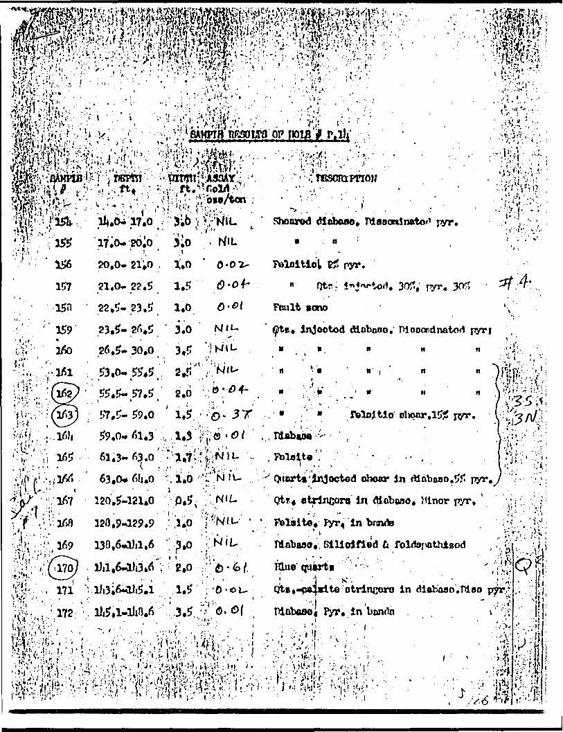
f * ," 1
•:. v-'tf^M)?; ... -- ,i 'I'ijft i t i f i; '^ilp' ''W"
. 'V-'-T'i-; .j-???. 'V'^y. :. . y -.-;. v.v,:*:.--, - . . v-.;---l^f'^V/^^.^.-^f^^'fc. J i^ ':^ ,,V ,: r ^M^i^iMoPpoiflfP.i)t ,^Kiii^^im^--'^m^r1 5Vn* * '. h**4***^0* l^i f - ' a i Vi - Lmsm ~ - ti ai'ara*k*- * ^WJ^a j .- * M^I.^ -^^ -^ _JalP.Vj-'.flAMHB'v-f i Ifiral ;-pWnTl^AaittY.A . ' -., rCSCIttlTIO?/
W^^^^^'-^^^W^'^^- ^' .;lfe'.':i'35U. ll4.6^17.0 -3.6 t Ki-K/IL ' Shonred diobww.•V?lrs-v ' ' " ., '•-'•" *~ -'r 155 17,0*26.0 3.0 - KIL - n ::'r-f.s - ' ' i ' i :- .' : - .-- -. . --•/. ' J, - - . . - . ... ', .^
pyr.) '. . '' l
20,0- 21*0 . 1.0
157 21.0- 22.5 1.5
15H 22.5-23.5 1.0
159 23.5- 26*5 ' 3.0*
26,5-30.0 3,5 53,0-5545 1' : 2J'55*5-57.5 2.0 : e ;..' ' - . "... t
; 57,5-59.0 ' 1,5. - - :o- 3 T 59,0*61.3 '.\, .1*3 H; e- (9 f
Foloitiot
Ftmlt
. 30?; pyr.
injoctod dlobooo, TVJ ooondnatorf pyr ii• a'/.
v.
.15?
63.0*6!j.O V1.0 ''^NJU
120.5-121*0 0.5, -.'..r120,9-129.9 ;!l*0 j
; Niu
- -.--' Quart*'injoctod
Qtr4-.
In dlaboao.5? pyr.y
in Mobaoo. Jtinor pyr,
in
- ii.Tdabaao, Silicified fi
Hlue qutrti ' -j j - M-, - . ' -Qte0-9*4*1 te'otrincoro in diaboao.moo
PlQboaOf Pyr. in bonrtn \ -

2.
HOLE P. 14 continued
173 148.6-150.1 1.5 0.01 Qtz. S, feldspar stringers indiabase 51 pyr.
174 150.1-152.1 2.0 NIL Diabase, minor qtz. feldspar, pyr.
175 180.5-183.0 2.5 NIL Fault zone. Silicified fcoxidised
176 183.0-184.0 1.0 0.01 Feldspathized contact zone-diab.andes.
178 184.0-187.0 3.0 NIL Andesitic
177 187.0-188.0 1.0 0.01 Qtz. injected contact zone withfelsite.
A.C.A. Howe Resident Engineer
TO FOLLOW
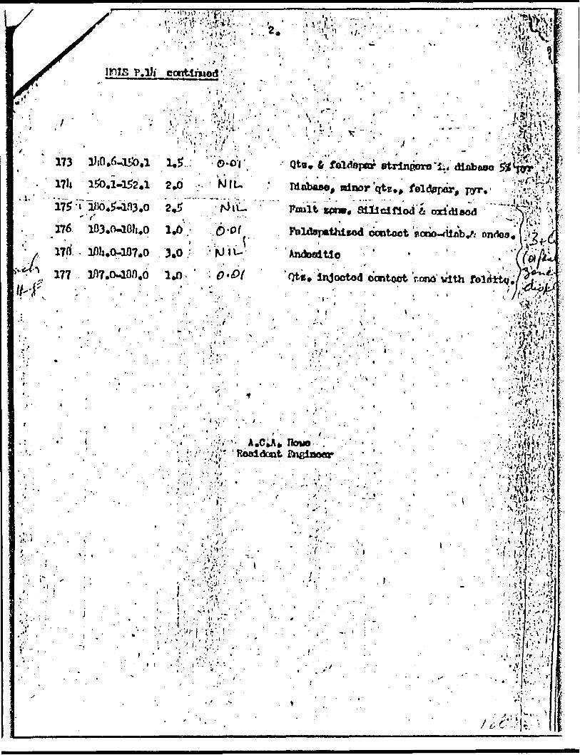
P.Di contlruod ;
173#
l?!* 1&.1-152.1 2.6 NIL175 -T im.*-an3.o 2,5176
'l7ri
177
A
3.0
.''
Tw '
f."'
t
6 feldspar frtrlneoro'ii. dlaboso
Bdnor qt*., feldppdr, i^'
Poult v**. sillclllodift ad'dlaod
Qte. InJoctod ccwtoct 'rond' trtth\ -
1 lv. '
. r
'••' ..' - - - - ' ' ^ - ' ' ''.','; l*."-'-,' ' - . ' - ' ' . -.•'', , , - ' *' ' '- .-'.'''' j t 1? ' ' ' - ' . - ' i ' - ' ' :
-. " . '•..•'•". ' i ' :'r! -'' .- . - ' ' '.* -- - .: ' ',..':' v; , - 1 : ./' .- ;.
••-.t
"•.ir, .J,'

PROPERTY.-
i if, ,,
DIAMOND DRILL RE5403N
LOCATION: n rp 520? STARTE
ELEVATION OF CO DATUM
DIRECTION AT ST;
OtPTH rttT
0-14.014.0-17.0
(a)
17.0-20.0
20.0-21.0
21.0-22.5
22.5-23.5
23.5-30.0
.... -.. . — .-..--.^
HOLE NUMBE
SHEET.NUMB
ICORD SECTION FRC
D May 4, 1962
B ' '^
ER L .. .
)M rn
LLAR 6326' COMPLETED, ,.
——————————————————————————————— ULTIMA" nrPTHBEARIUr. , , , . ,. —
^RT: Surface 45" 150(50)47 PROPO* HIP,,
FORMATION
CasingDark olive green andesite basic borebroken up S. ? on slips 6" core missingGneissic at GO 0 similar to sheared N. edge of ? in P. 10Dissem pyr. Minor sericite SAMPSheared andesite? tuffaceous, chloresticappearance with oxidised .fractures at 17.0 i 18.0 SAMPShear zone, Schistose andincreased pyr. S, fei. Heavilyoxidised. 6" str. missingQuartz injected shear - 304 qtz.(t 30% pyrite in bands 60" to c. a. SAMPoxidised fracture at 21.3,22.0, S, 22.2
Fault zone bore groundbut appears to be basic , SAMPDark green chloritic, basicappearance. Quartz injections,with dissem. pyr.23.5-26.5 SAMP
NOdf H l" M MINI* mil* IIUITIO. IO*ONTO-( 1 GC K roiu He tOI "lv t/44
nnnirnnY . . . ... ............. .................... ... .
5EO DEPTH
•AMPLI No
1154
1155
1156
1157
1158
1158
SIGN!
WIDTH Of *AMPL( GOLD f
NIL
NIL
0.02
0.04
0.01
NIL
ILWPSJ, GOLD t
z*— Qc^z— o^rf* ^ "™— t^d• ••CUlw
o s*Ur mi— st-e
— Q^e-3 CQ-C
—— ' i g
:o...... ..... ........,............. ... ,. . ... ,. .... . .
^"S-iH:uir
f — ii
-
/H

DIAMOND DRILL
1EET NUMBER
PROPERTY
h
RECORD—————— HOLE NO.
TITUDE 54-03 NPARTURE.
sVATION .
SECTION FROM.
DATUM —————
-TO. 7 ^S
BEARING,
DIP.
ULTIMATE DEPTH.
PROPOSED DEPTH
OtPTM rtCT FORMATION (AMFLJ NO. WIDTHor oouo * yLypgtCOLD t
0 -
Co. ^-
IS/o
v/
ff A-I t r r , t....'*{
A,s
;-X
Xr-
N.M*. TO*OMTO-*TOCK fOUM N*. Ml *tv. It/H
DAIUUO BY...................... SISNtO,

HOLE NUMBER.PROPERTY.
DIAMOND DRILL RECORDSHEET.NUMBER.
SECTION FROM. .TO.
. LAT,LOCATION: n rp
ELEVATION OF COLLAR. DATUM___________
STARTED.
COMPLETED.
ULTIMATE DEPTH.
DIRECTION AT START:. BEARING.DIP.
PROPOSED DEPTH.
DEPTH FtlT
30.0-34.5
34.5-36.8
36.8-42.5
42.5-45.045.0-51.3
51.3-52.052.0-57.5
57,5-59,0 ^9,Qr61.3........
FORMATION
26.5-30.0 Ditto SAMPDiorite. Fane brown feldsp.blebs, chloritic B, calciteupper contact 60 031.9-32.4 oxidised fracture zoneGradational changeto felsitic dark qreen band - chilled edgeDiabase? Dark blue green chlorite 30% calcite in blebs, qiniections. Minor magnetic similar -to altered diabase in....J.— ... , ——————————— S ————————————————————————————————————————————
Felsite - grey. Contacts to 60 0 to c. a.Altered diabase as before.water filled fractures 46.3,51.3, 52.0, 53.0, 55.0-55.5.Felsite. Light green Contacts 55eAltered diabase as above53.0-55.5 Increased pyr. dissem.with increased qtz. SAMP55.5-57.5 Otz. str. 55.7-60.0 fei S, qtz.on fracture at 57.0 SAMPQuartz iniected shear. 151 pyr. SAMPAltered diabase, Qtz-calcite str. SAMP
1AMPLI No
1160
r—— 0 — P(
;z. 6. 'calP. 10
161
162163164
WIDTHor t AUPLt COLD f
NIL
S "- W PSI, GOLD t
UPLICATfe COvf^nfu' 1 *" t^^J^**i**.i.'v^n Vi(^———W
cite str,
'MLJ1 T^~FOtt
4
NIL
0.040.370.01
wnivarrow —
1
iAtr
t
1
-
MINI* mill LIMITIO. tOIIONTO-*TOC * *OHM Mo IOI HtV. k/44
DRILLED BY SIGNED.,
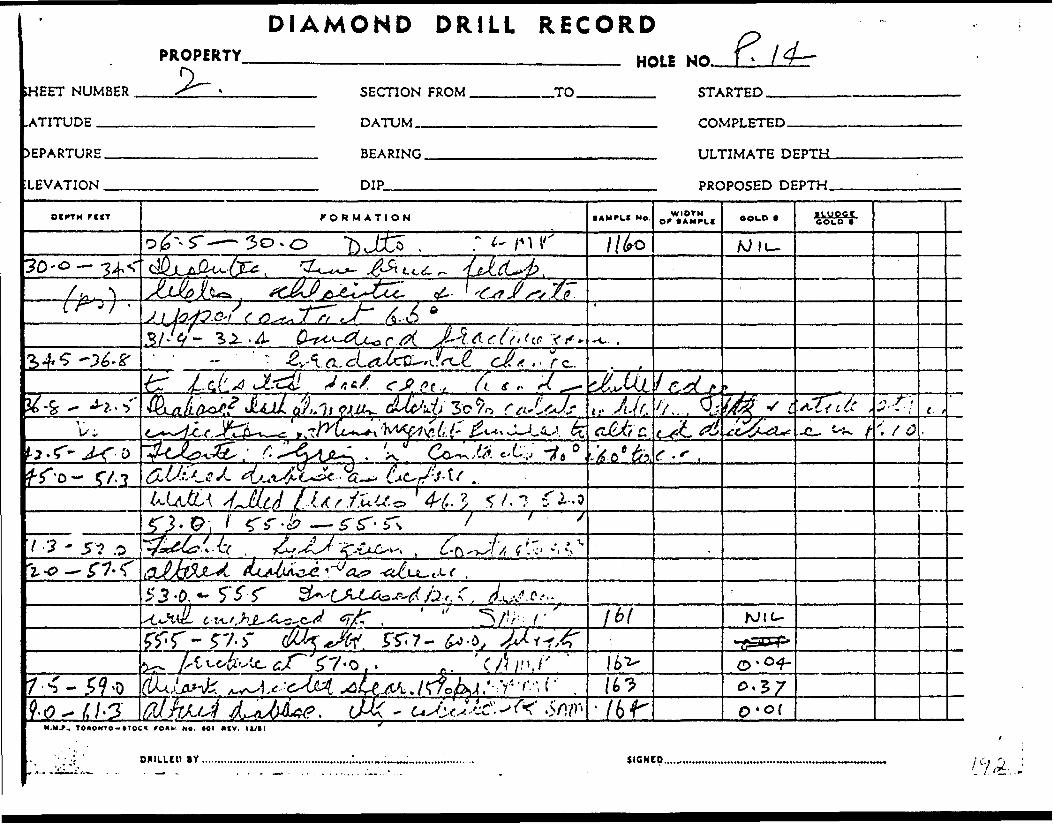
DIAMOND DRILLPROPERTY
SHEET NUMBER
.ATITUDE ___
DEPARTURE.
LEVATION .
RECORD—————— HOLE NO. f\
SECTION FROM
DATUM..———
.TO. STARTED.
COMPLETED.
BEARING.
DIP
ULTIMATE DEPTfcL
PROPOSED DEPTH.
OltTH ftlT FORMATION fAMPLS No. WIOTM OOLD t ILUOCC
//fro70 ~o— 34,
/^.S'1 t
y c..
/y.
s -g- '-'~.; i J-v c
7
3-0,*- 5"5T' t/
M.M.F.. TO*ONTO-*TOC( f O*kl Ne. 101 * IV.
DRIILCU BY. SICNCO..
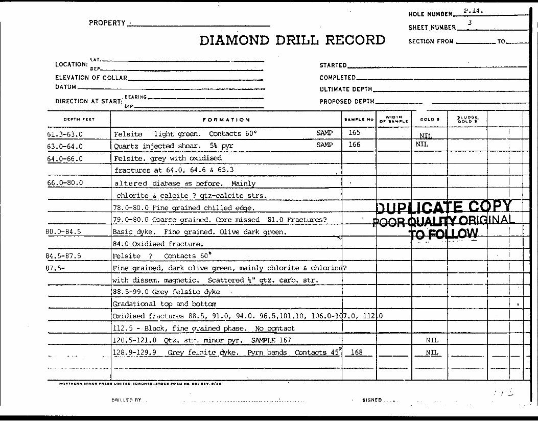
HOLE NUMBER. P, 14.
PROPERTY.
DIAMOND DRILL RECORDSHEET NUMBER.
SECTION FROM . .TO.
LOCATION:LAT..
DEP. STARTED.
ELEVATION OF COLLAR. DATUM——————.———.
COMPLETED.
ULTIMATE DEPTH.
DIRECTION AT START:. BEARING.
DIP.PROPOSED DEPTH.
OC^TM FtIT
61.3-63.063.0-64.064.0-66.0
66.0-80.0
80.0-84,5
84.5-87.587.5-
FORMATION
Felsite light green. Contacts 60 0 SAMPQuartz injected shear. 5% pyr SAMPFelsite, grey with oxidisedfractures at 64.0, 64.6 S 65.3
altered diabase as before. Mainlychlorite 4 calcite ? qtz-calcite strs.
78.0-80.0 Fine grained chilled edge.79.0-80.0 Coarse drained. Core missed 81.0 Fractures?Basic dyke. Fine grained. Olive dark green. "\ 84.0 Oxidised fracture.Felsite ? Contacts 60*Fine grained, dark olive green, mainly chlorite S. chlorinewith dissem. magnetic. Scattered k " cftz. carb. str.88.5-99.0 Grey felsite dykeGradational top and bottomOxidised fractures 88.5, 91.0, 94.0. 96.5,101.10, 106. 0-K112.5 - Black, fine arained phase. No contact120.5-121.0 Qtz. str. minor pyr. SAMPLE 167128.9-129.9 Grey felsite dyke. Pym bands Contacts 45s
• AMFlt NO
165166
.
t . ————— J
p
7.0, 112
168
WIDTHOr * *MPLt
DUPJ\j w r i)noR(\f\J\ 1 *
1
0
COLD t
NILNIL
ICA1• - ^**^'HJALJ1\*tnmm lY} CAIXX l *^l
NIL
NIL
3\.VP55. COLD t
[EIXYORIGjjOV^.. . .— -*-
JPVINAl
r
L.
i
nv SIGNED . .

PROPERTY
SHEET NUMBER
LATITUDE ^^
3.
DIAMOND DRILL RECORD—————————————————.————————— HOLE NO. z
DEPARTURE.
ELEVATION .
SECTION FROM.
DATUM ———-.
-TO. STARTED.
BEARING.
DIP.———.
ULTIMATE DEPTH.
rur FORMATION • AMPLf NO. WIDTH Of S AMPLE OOLO f 1 Lunar
CO LO f"
3 -M
x ^ ., , *
0 -v f ,C- "' ( "CT^uc;-*-*-"--x t C.&^J1 c-yij jL*}(i.f(. S Ao
rr
-:? 'Sf' '
?. -5 - ftfi^^v. .A. •-r'- /J-/
H.M./-.. TOMONTO-tTOCX fOUMM H*. Ml IHV. ll/II/" f//*/* *^T (l d**?~^ ^ /6*DRIU.EO BY. SICNCP...,

HOLE NUMBER.PROPERTY,
DIAMOND DRILL RECORDSHEET NUMBER.
SECTION FROM. .TO.
UT,LOCATION:
DEP.———-——
ELEVATION OF COLLAR. DATUM .——-—.™-—.
STARTED.
COMPLETED.
ULTIMATE DEPTH.
DIRECTION AT START: BEARING.
DIP.PROPOSED DEPTH.
DEPTH riCT
159.6-171.5171.5-179.5
... . . . .., .
FORMATION
Oxidised fractures at 118.5, 120.5,129.6-130.6, 131.5138.6-141.6 Silicified i feldsparhized, increased pyr. E141.6-143.6 Blue quartz vein, oxidisedbrown l, fracture at top. V.G. at 142.0'6" missing from 142.0-143.0 Contacts 45" SAMP143 .6-145.1 Qtz. t carb st. at topi, 145.1-148.6 Fine gr. altered calcite SAMPdiab. as above, pyr. in bands d dissim. SAMP148,6-150.1 Qtz. S fei. str. with "5% pyr. Fracture at 150.1 SAMP
150.1-152.1 minor qtz S fei. S pyr. SAMP152.1-168.5 Coarse grain, more
4ioritic lookina, with fei. phenocrvsts. Minor calcite.More magnetite. Gradational change.154.7-159.6 Olive green felsite. Contacts 45Grey felsite dykeFine gr, olive green chilled edged dbcore badly fractured at 176.0, 177.0-179.5
lAMPLI No
AMP 169
170
171172
173174
-DLpod
WIDTHor *AMPLI
ELK*RQU/
GOLD *
NIL
0.61
0.020.01
0.01
NIL
'
JfTYC
JMJPSC. GOLD t
COPY-^C-^C-B —— .12 —————
ORIGINALTQtnnrkA/ 1
i
-
OY SIGNED.
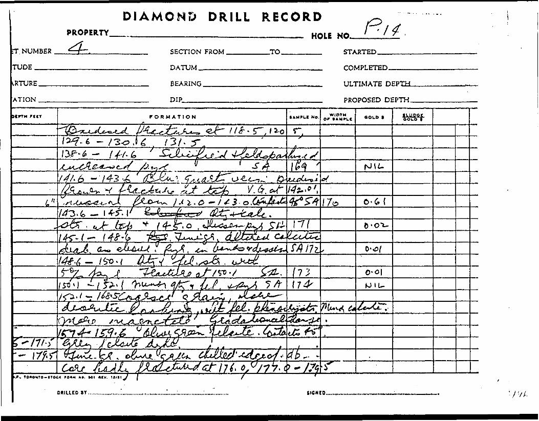
DIAMOND DRILL RECORDPROPERTY______________________________ HOU ^
~' '//.
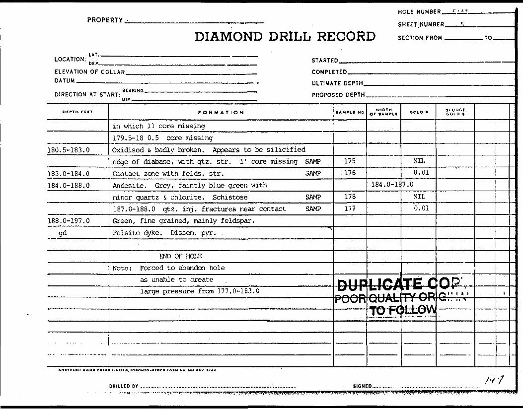
PROPERTY -
LAT.
DIAMOND DRILL RE
HOLE NUMBE
SHEET.NUMB
iOORD SECTION FRC
R r..:*-*
ER 5.. .
)M TO
LOCATION: n rp STARTED
ELEVATION OF mil AP. COMPl FTFD
DATUM
DIRECTION AT ST/
DEPTH rtCT
180.5-183.0
183.0-184.0184.0-188.0
188.0-197.0gd
———————————————————————————————— . ULTIMA™ nep™BEiRINf. , - M1 , llll ,.
^RT: PROPO!nip , , , . . ... ,.
FORMATION
in which 11 core missing179.5-18 0.5 core missingOxidised s badly broken. Appears to be silicifiededge of diabase, with qtz. str. 1' core missing SAMPContact zone with f elds. str. SAMPAndesite. Grey, faintly blue green withminor quartz s chlorite. Schistose SAMP187.0-188.0 qtz. in j. fractures near contact SAMPGreen, fine grained, mainly feldspar.Felsite dyke. Dissem. pyr.
PM) OF HOLENote: Forced to abandon hole
as unable to createlarge pressure from 177.0-183.0
-
;ED DEPTH
tAMPLI NO
175.176
178177
D44JP-trrPOOR
.
WIDTH Of ( AMPLE
184.0-1*
COLD *
NIL0.01
7.0
NIL0.01
LICATE CQSSfSGRr^^-n
Jl-VpCi. COLD t
: OP'^^ * *ir*" ' * . *
Tf\ p/1 '* ' ^*N* A ''LJLAJVW.fc^w-..-**— - ' -••—•I .
ii
t
-
/^ 'fDRILLED BY..........,............,......,.............,..............,........................;.........,..,., - SIGNED.............. .............................. ......... ..........

DIAMOND DRILL RECORDPROPERTY HOLE NO.
ET NUMBER
ITUDE —^-
SECTION FROM.
DATUM -————
.TO. STARTED.
COMPLETED.
*RTURE.
/ATION .
BEARING.
DIP———
ULTIMATE DEPTH.
PROPOSED DEPTH.
DtrrM ri IT FORMATION WIOTM r •AMPI.t
iLUPor
u-X .' .P./ .v -- w t^*- N/
rJfcl uXktff f -7 7
^ /)
77C3T?
r?r-Q
*, TOiONT-o-trocic ro*M H*. MI n cv.
DRILLED BY. SICNCD, A;;

PICK MINES LIMITED 1962 A ssay R esults Hole No. P 15
Sample No.
1179
1180
1181
1182
1183
1184
1185
^1186.'
1187
1188118V1190119111921193119-11195
1196306
1197
11981199
12UO312
312302
303
304
Footage From
18.5
27.0
32.0
37.2
47.0
59.0
71.5
80.5
09.2
92. E93.79^.297.7
100.2102.7103.2105.0
117.5116.5119.0
124.5126.0
135.8
143.2H4.7
155.4
176.0
To
21.5
30.0
34.0
39.2
48.5
62.0
73.0
82.5
92.2
93.795.297.7
100.2102.7103.2105.0106.0
119.0117.5121.5
126.0127.6
137.3
144.7146.2
157.4
178.0
Width Feet
3.0
0.0
2.0
2.0
1.5
3.0
1.5
2.0
3.0
1.51.5i.5'.i. 52..')0.51.81.0
1.51.02.5
1.51.6
1.5
1.51.5
2.0
2.0
Ozs. Ozs. Cold Silver
nil andesite
nil
nil
0.03
O.O.J
nil
0.03
0.34
0.02
0.026.020.02 )0.01 )0.02 ) 03 Vein0.25 )0.01 )nil )
0.02)nil )0.01) *3S Vein
0.02)0.03)
0.02
0.01nil
nil \
nil

- l -
Sam pi Q,O 3 No.
305
307 u308309
313
314-
315316317318319 320321
32.2
323
32432.53263273283Z9
330
331
Footage From
181.8
187.3189.8191.3
195.8
203.5
221.5222.5223.5224.5226.5 227.5228.5
236.5
246.0
E51.5253.0a54.0256.0257.0259.0
290.5
306.7
To
183.3
189.8191.3192.8
196.8
205.0
222.5223.5224.5226.5227.5 228.5229.5
238.5
247.5
253.0254.0256.0257.0259.0Z61.5
791.5
308.2
Width Feet
2.0
2.51.51.5
1.0
1.5
1.01.01.0t. Q1.0 1.01.0
*.o
1.5
1.51.0i.Q1.0^.0^.5
1.0
1.5
Oza. Ozs. Gold Silver
nil )) IO Vein
0.01)nil )0.02)
0.02
O..0i
0.01nil3.30 laVeln0.02)nU ) IRN Vein 0.02)nil )
nil
nil
0.010.02)0.01) IR Vein0.01)0.05)nil
nil
nil
S oo

-l . -J'
j
J
J
o"z. "2- .5
z
x 6
m
tn'
m
tn r*.
l
MX o
o\ o
S^t: 8
S *-
*
m.
r*
mo
trv
' o*s*^
- w\
co w
f** r-,
t** eo
i A.2?
o
C
*
O-6trvtCO*m
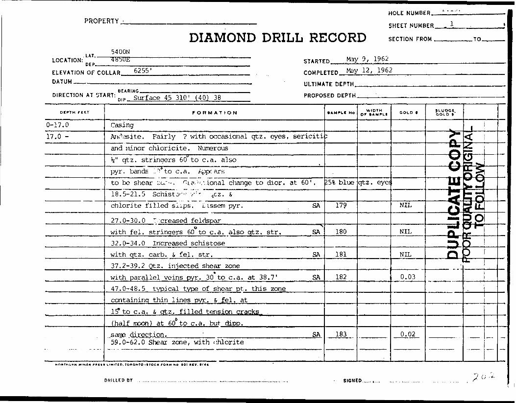
HOLE NUMBER.PROPERTY. ————————;—————— SHEET NUMBER.
DIAMOND DRILL RECORD S ECTION FROM . .TO.
LOCATION:LAT..
5400N
DEP.STARTED May 9, 1962
ELEVATION OF COLLAR.
DATUM -————————,
6255' COMPLETED May 12, 1962
BEARING.DIRECTION AT START: m p Surface 45 310' (40) 38
ULTIMATE DEPTH..
PROPOSED DEPTH.
DtPTH FIKT
0-17.017.0 -
FORMATION
CasingAiKVjsite. Fairly ? with occasional qtz. eyes, sericitiand lainor chloricite. Numeroush" qtz. stringers 60"to c. a. also
t
pyr. bands ",'Vto c. a. Appc.-arsto be shear ^o/-. ^i?.''-. -..ional change to dior. at 60'.18.5-21.5 Schist^--- y : t -^cz. s,chlorite filled sl-ps. Lissem pyr. SA
27.0-30.0 ^creased feldspar0 ^
with fei. stringers 60 to c. a. also gtz. str. ^SA32.0-34.0 Increased schistosewith qtz. carb. S fei. str. SA37.2-39.2 Qtz. injected shear zonewith parallel veins pyr. 30 to c. a. at 38.7' SA47.0-48.5 typical type of shear pt. this zonecontaining thin lines pyr. 6 fei. at15* to c. a. fi qtz. filled tension cracks
c (half moon) at 60 to c. a, but dipp.same direction. ' SA59.0-62.0 Shear zone, with chlorite
• AMPLI No
;
^ blue
179
180
181
182
183
WIDTHor IAMPLI
qtz. eye:
GOLD 1
NIL
NIL
NIL
0.03
0.02
j Lg DC*.COLD *
^^
———————— fit^
O-
"— orSmtm———— 5=1
—— O^
Q
J<gr-SSL^i
n^ES^Rs?*12P3rt-*E —
DS —
—
MINln PMIt* UMITtD. TON OH ?O -1TOC K FOMM No ftOI HiV, V/44
DRILLED OY SIGNED.
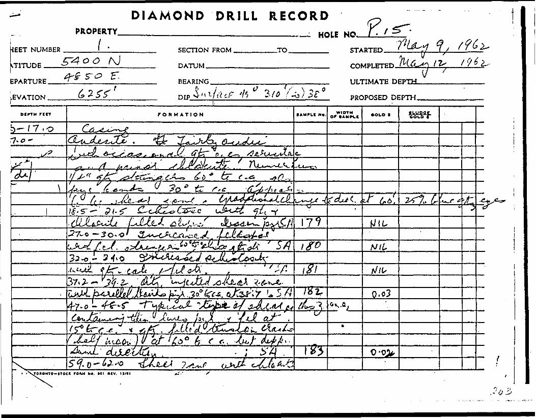
DIAMOND DRILL RECORD
KEET NUMBER . STITUDE —
PROPERTYfl '
HOLE NO.
SECTION FROM ,
DATUM.———
-TO.
COMPLETED
EPARTURE.
vEVATION .
BEARING
DIP.' ULTIMATE DEPTH.
hPROPOSED DEPTH.
DCPTH r trr FORMATION MO. or *AMrt.c •OLD t •Luoqr ~
b-/7.o
/c f -c /) t
•LMUL ^\l ^f J.4 ^X S-l P
17?.27-0 —Jo -
NH
37* 2- -
4-7-0L/
) -5 f. o-
TOHOXTO-4TOC* rOKM N*. Ml mv. li/*!
Jo 3
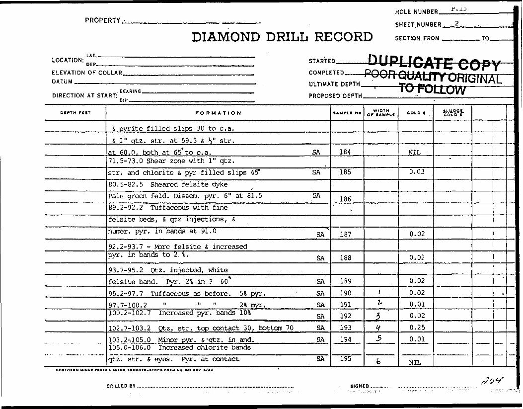
HOLE NUMBER. P. J. J
PROPERTY.
DIAMOND DRILL RECORDSHEET.NUMBER.
SECTION FROM . .TO.
l 1 T •P^ B H ^M. |LOCATION: n rp STARTED U (J PLJO ATE? f* f\ DVELEVATION OF rOLLAR COMPt ETED D^OFVDATUM
DIRECTION AT ST;
DCPTM FIIT
... . . -.- .
— -^•W-BB AM V/V/r I/^l 1 A C VMB . — —— . . . .- y i i WUMLJI T WHIG NAI
.RT: " PROPOSED DEPTH
FORMATION
S pyrite filled slips 30 to c. a.S 1" qtz. str. at 59.5 s, H " str.
at 60,0, both at 65* to c. a. SA71.5-73.0 Shear zone with 1" qtz.str. and chlorite s pyr filled slips 45* SA80.5-82.5 Sheared felsite dykePale green feld. Dissem. pyr. 6" at 81.5 SA89.2-92.2 Tuffaceous with finefelsite beds, S qtz injections, Snumer. pyr. in bands at 91.0 -.^
92.2-93.7 - Mare felsite S increasedpyr. in bands to 2 . fc. SA
93.7-95.2 Qtz. injected, whitefelsite band. Pyr. 2% in ? 60* SA95.2-97.7 Tuffaceous as before. 5i pyr. SA97.7-100.2 " " " 21 pyr. SA100.2-102.7 Increased pyr. bands ^ ^
102.7-103.2 Qtz. str. top contact 30, bottom 70 SA103.2-rl05.0 Minor pyr. 4'qtz. in and. SA105.0-106.0 Increased chlorite bandsqtz. str, S eyes. Pyr. at contact SA
•AMTLf NO
184
.185
186'
187
188
189190191192193194
195
10 FOLLOW'WIDTH
Of * AMPLf
1
i-
}
tf
5
b
OOLO 1
NIL
0.03
0.02
0.02
0.'020.020.010.020.250.01
NIL
3-LUQ5E. COLD 1
"
|
1 :
NnHTHCIIN MINI* met! IIMITIO, TOUONTO-t TOCX fOKM Ho *OI *IV. t/44 '
"7^) ^V^DRILLED BY SIGNED,

DIAMOND DRILL RECORDPROPERTY. HOLE NO.
SHEET NUMBER SECTION FROM.
DATUM —————
-TO. STARTED.
COMPLETED.
)EPARTURE. ELEVATION .
BEARING.
DIP-———
ULTIMATE DEPTH-
PROPOSED DEPTH.
otrtM rtrr FORMATION •AMFLX MO. WIDTH •OLD * •moor a o L of
s-O — t? t* 11,l- / .(T 0-0)
- P j
fcy^.9/./
6 * . ^O-tg
r/;.7 - Q.O// O T* O *- y A
A/IUf, ronONTo-troc^roAM u t. w i ncv, u/ii ^

PROPERTY -
1 AT.,
DIAMOND DRILL RELOCATION: ^ p STARTE
ELEVATION OF CO DATUM
HOLE NUMBE
SHEET. NUMB
iCORD SECTION FRO
DUPLICA
n P.15.
ER 3
M TO
JE COPYrn-P, rrrn ^ UUH UUAU 1 Y UHIUINAL,,,T,u*TrnrnT,, TO FO L LOW
RFARINr,DIRECTION AT ST/
ocriH rccr
106.0-117.5
Db.
117.5-126.0
126.0-128.9
128.9-137.3
137.3-140.7
^RT: PROPO: nip
FORMATION
Porphyry - dark olive greenwith feld. i qtz. phenocrysts. Possibly green felsite :
Upper contact 50? Bot. 45 0 , Top S bot.. IVfine grained. Dissem. pyr.V qtz. carb. str. Scattered ?116.5-117.5 -1" str. qtz. s, fei at 117.0 other h " strDioretic. Similar carp, but with qtz. eyes (blue)
? appearance with grey felsiteblue green felsite beds 45 0also hair lines pyr.117.5-119.0 2% of pyr. SA119.0-121.5 minor qtz. S, 2% pyr. SA124.5 - 126.0 Increased pyr. SAGrey felsite bed. Both contact 10 X 126.0-127.6 SAOxidised fractures at 127.0. Water seam causing water toflow out of hole.Andesite - dioritic as before with blue qtz. eyesoxidised fractures at 133.0 and 136.0 causing increased w135.8-137.3 Increased pyr. 2" SAbrown oxidised qtz, at 137.1Grey fine grained felsite. Contacts 50
5ED DEPTH
lAMPLf NO
nected z-
SA 306
t
196197198199
iter flov.200
| - ' T—m.
WIDTH Of 1 AMPLI
ane.
COLD t -
NIL
0.020.010.02
0.03
0.02
31.^051GOLD t
•*
l
i
1 1
l|
!1 'i .i1
i
—
20&DRILLED BY . . . .... ................. ............... ,. . SIGNED

DIAMOND DRILL RECORDPROPERTY. HOLE NO.
NUMBER
LATITUDE ———
SECTION FROM
DATUM —————
.TO. STARTED.
COMPLETED.
DEPARTURE,
b'LEVATION .
BEARING.
DIP
ULTIMATE DEPTH.
PROPOSED DEPTH.
OtrTH FCtT f O R M ATION WIDTH Of tAMPlf •OLD ( ILUPQtttoio r
^? . -L •••?*(JU .t. t.tc.'tf^ (IZ.fSJa, t
,L W r { V
~7o -o/ -35
t** 0^.^*^7.0,
,/ f- /3 7- ' O- 0
N.M.P.. TOK6MTO-tTOC* fniH NO/MI HfV. It/11 C/TOK6MT
(li

PROPERTY,HOLE NUMBER. P.15.
DIAMOND DRILL RECORD S ECTION FROM .TO.
LOCATION:.LAT..
CEP- STARTED^.
ELEVATION OF COLLAR. DATUM ————————^.
DIRECTION AT START:BEARING.
DIP.
COMPLETED..™.
ULTIMATE DEPTH.
PROPOSED DEPTH.
DUPLICATE COPYPOOR QUALIFY ORIGINAL•^——ro FOLLOW——
otPTH r ttt
140.7-151.8
151.8-152.8152.8-155.4
155.4-157.4
157.4-183.3
FORMATION
Dioritic 401 blue qtz. eyes. Ferromags
altered i with schistose appearance. Fine gr.
143.2-144.7 3" qtz. that filled fracture
at 144.6 i b" at 144.5 SA,
144.7-146.2 11 hair lines pyrite 50* to c. a. SA
Grey felsite contacts 75 0Granodiorite. Similar camp, with 40* qtz. eyes, Due more
massive, s coarser gr.Grey felsite band from 155.4 -
156.3 and qtz. S felsite 157.0-157.4
Contacts 800 to c. a. minor pyr. SA
Granodiorite. Dark blue-grey, med-gr.
massive. Altered ferrcroag
176.0-178.0 Minor qtz. 4, pyr. in the str. SA
Finer grained. Increased alteration. Fairly schistose *181.8-183.3 Increased alteration
0felsite intrusions 65 to c. a. qtz. S, pyr.in slips 30* to c. a. in opp. direction. g^
Diorite as before. Fine-grained,
faintly schistose, altered. Andesite, but
AMPLI NO
312
. 302
i
303
3045*
305
WIDTH Of tAMfLI COLD |
0.01
NIL
NIL
NIL
1XUQ9I. GOLD 1
*
t
nrm iFO nr
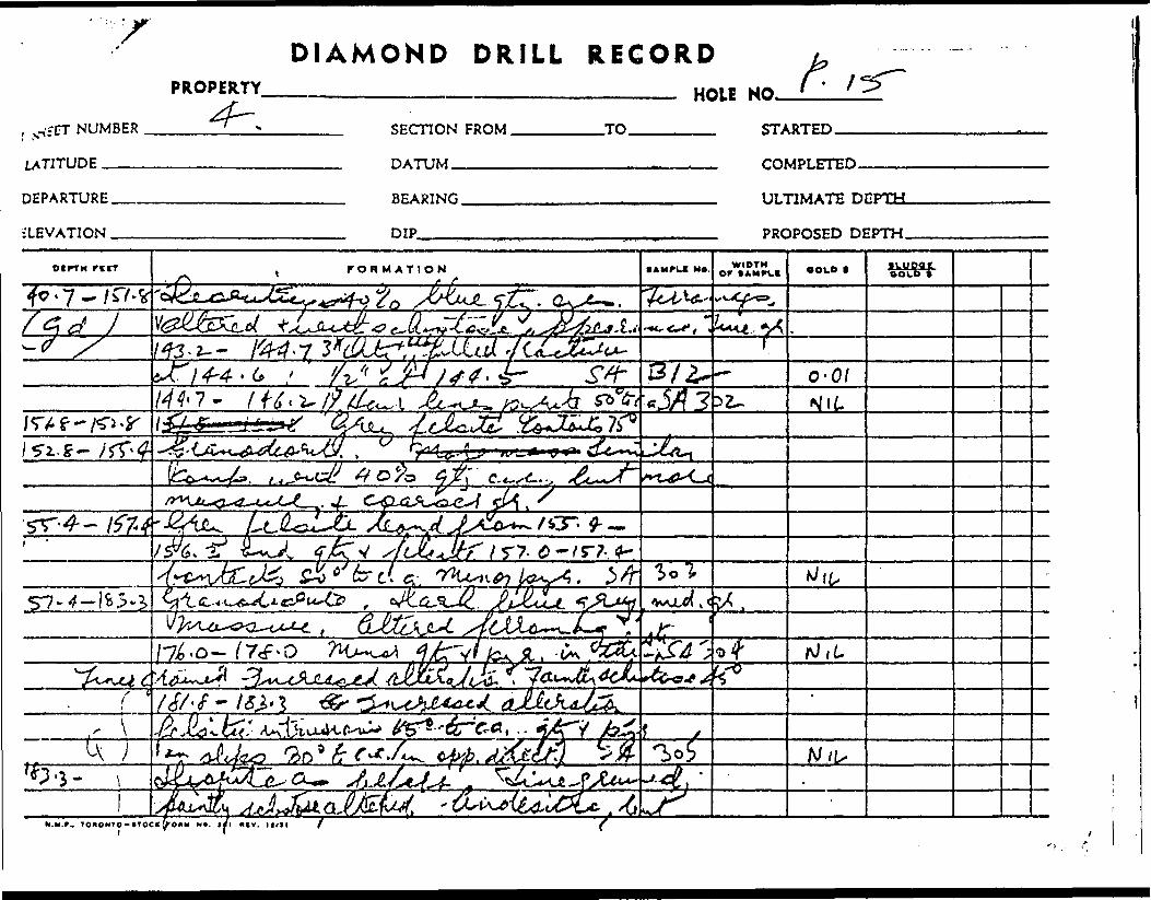
DIAMOND DRILL RECORDPROPERTY
, yVfET NUMBER
LATITUDE ..——
DEPARTURE.
ELEVATION .
HOLE NO.SECTION FROM .
DATUM ——-—.
-TO. STARTED.
COMPLETED.
BEARING.
DIP
ULTIMATE DEPTH.
PROPOSED DEPTH.
ocrTH r trr FORMATION • AMPUI M*. WIDTH Of (AMPIC •OLD t tlUDOCcoco*
O'OI7 - / f g^j ^ik
f -
^^L.
7^-0- ^7^-0

HOLE NUMBER. P.15.
PROPERTY.
DIAMOND DRILL RECORDSHEET, NUMBER —.JL
SECTION FROM .TO.
LOCATION:. LAT..DEP- STARTED.
ELEVATION OF COLLAR. DATUM —————————,
COMPLETED.
ULTIMATE DEPTH.
DIRECTION AT START:BEARING.
DIP.PROPOSED DEPTH.
OtPTM f t If
209.3-211.2
211.2-218.0218.0-218.5218.57221.5 221.5-222.5
FORMATION
with fine blue qtz. eyes187.3-189.8 Schistose, felsitics with chlorite s, pyr. filled slips 75 to c. a. SA189.8-191.3 Increased schistosity SA191.3-192.8 Shear 2" qtz. in centre withcalc., chlor 4 pyr 51 in parallel slips SA195.8-196.8 y qtz. S, felsite str. SAin centre. 400 to c. a.203.5-205.0 4" qtz. S 2" felsite SAat GO^to c. a.
205.0-207.5 Schistose, 20% pyr SA207.5-209.0 5" str. pink feldsparwith qtz. f, chlorite str. 10* pyr. on each side SAGrey felsite. Contacts 65*. Appearsto be brecciated with minor pyr. on slips.brecciated lower contact.Granodioente . Similar carp. Fine gr.Grey felsite. Contacts 45 0Granodioe. as before.Granodiee, fine gr. more altered.
• 4MPLI NO
307308—————
309313
i
314
310
311
— BtJC
WIDTHor *AM*H
12-
3t5
4
1
COLD 1
0.01
w/c.
0.02
0.02
0.02
NIL
NIL
pi iQATE•~ """Mf !.JLr^ iP OIJ/11 rrvr'ri vrfwr-T& FOL-bC
1VUQ5L cot. o i
* (
1
1
11
,1!
COPY iRIGIN^WW V
kl-~
onn i FO BY SIGNED
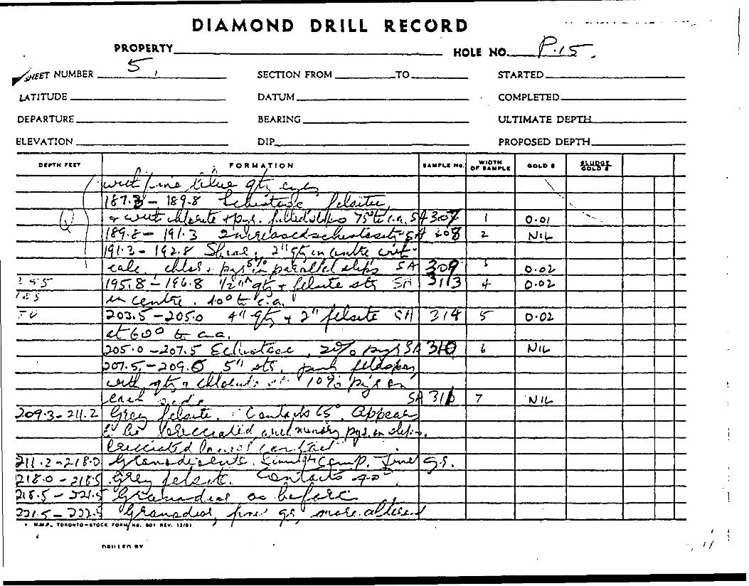
DIAMOND DRILL
NUMBER
PROPERTYS~.
DEPARTURE.
ELEVATION .
RECORD———.—— HOLE NO. B,
SECTION FROM .
DATUM-————
-TO. STARTED.
COMPLETED.
BEARING.
DIP—.—.
ULTIMATE DEPTH.
DEPTH.
CfFTM Ne. WIDTH OP (AMftf OOID f
0-02,
t*?* '^fJ/U
i MMf, ronoMto-iTOO roiWN*. *oi *tv.
Vnon i rn nv

HOLE NUMBER.i'.
PROPERTY
LOCATION:.LAT,.DfP.
DIAMOND DRILL RECORDPUP
SHEET NUMBER.
SECTION FROM.
ELEVATION OF COLLAR. DATUM —————.....——
STARTED,
COMPLETED.
DIRECTION AT START:BEARING.
TO FOLLOWPROPOSED DEPTH
.TO.
DtrtH F IfT
222,5-223.5
223.5-224.5
224.5-229.5
229.5-253.0
FORMATION
with V otz. str. S. 6" felsite SA
Granod. with V qtz. str. d minor pyr. SA
Otz. vein with 3" felsite at top,1" at centre and 3" at bottom
Contacts 65! Pyr. in felsite f, gd. SA
Granodios. linear, dissem. pyr.,
altered S felsite.
224.5-226.5 Gd., f. gr, felsite SA
226.5-227.5 v. finger and fei. Rhyolite SA
227.5-228.5 " " " " " ? S pyr H SA
228.5-229.5 Gd. fgr., felsite SA
Gd. fine grained. Fractured
with qtz S chlorite S ruin. pyr.
236.5-238.5 Gd. , increased
felsite l alteration, V qtz at 55*4,
1" qtz at 50 in app. dir. in ? SA
246.0-247.5 Gd. increased felsite f, chlor.
1" qtz S H" qtz at 80*. Chlorite on slips. SA
251.5-253.0 Gd. increased alt. S
alignment. SA
lAMPLI NO
315
316
.317
319
319
320
321
322
323
324
WIDTHor SAMFLI COLD t
0.01
NIL'
3.30
0.02
NIL
0.02
NIL
NIL
NIL
0.01
IkUPSt COLD 1
"
-
DRILLED BY SIGNED.........,. . .... ......, ........__^__ ... .. ."WftHEwwrae* 1? .^MWSswmwwwvwSiiBWM
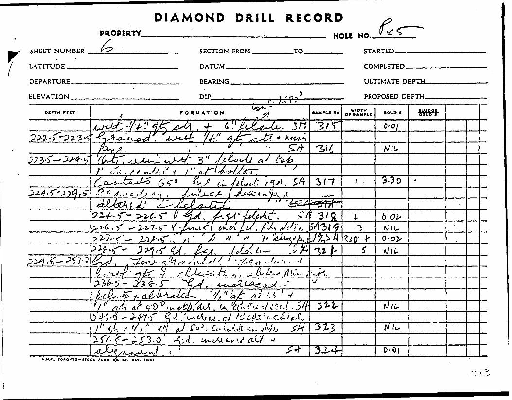
DIAMOND DRILL RECORDPROPERTY
SHEET NUMBER
HOLI HO. 6LATITUDE
DEPARTURE.
ELEVATION .
SECTION FROM
DATUM___.-
BEARING ————
DIP________
.TO. STARTED.
COMPLETED.
ULTIMATE DEPTH.
K k'?3PROPOSED DEPTH.
ocrrtf rtrr FORMATION • AMPLf MO. orWIDTH OOLO *
"( 3/7 3-30
-r U 3/5^
0-0^
'W* t: A.i ^^ -t•^T——J7—r-
" r** 0 , ^v^5-57- ^5*3.0
3^4- 0-0|M.M.*, TO*OMTO-ITOC( fOAM H}). 101 IHV. l I/I l

HOLE NUMBER. P,15
PROPERTY.
DIAMOND DRILL RECORDSHEET.NUMBEH.
SECTION FROM. .TO.
LOCATION: ftrp STARTED ——————— ?LICA1ELEVATION OF mtl AR rOMPI FTED L ^" * W*~1 *DATUM
* F" 'f^ f* y^ Y—,,, T,,,, TrnrnW - -^ UUAU J Y ORIGINAL
BEARISir. . , , , ,, . 1,.... l . ,, ^ ,DIRECTION AT START: PROPOSED DEPTH.
nlP ,., .n, ,,, , ,,..n.,... ™.,
OI^TH r ttr
253.0-261.5
261.5-306.0
... . . . . . - .
FORMATION
Shear zone in gd, increased chlorite S, felsite injections253.0-254.0 6 qtz S. silicousfine gr. calcite, granod. contacts 60 SA254.0-256.0 fine gr. schistoseincreased chlorite with calcite S feiblebs. Minor qtz. S, fei alt. ,, SA256.0-257.0 Badly shattered core SA257.0-259.0 Highly schistosewith felsite S, chlorite beds S b"qtz. str. at 258.5, i 11 pyr. SA^259.0-261.5 more massive butstill fine gr. s highly altered. SAGranodioente, massive f. gr.as before. Becominggradually coarser gr. 6 more acidics less chlor. i ferromags from 265.271.7 Oxidised fracture. Water?275.0-276.0 Oxidised fracture. Core in hole290.5-291.5 1" qtz at 30 -with pyr 5faint alignment of crystals SA
306.7-308.2 h " str. pyr at 15*, minor
• AMPI.C NO
d dissem
325
326327
t
328
329
330
10 FOLLOWWIDTH
OW lAMPl!
pyr.
NILNILNILNIL
GOLD 1
0.02
0.01
0.01
0.05
NIL
418419420421
NIL
1LUR5C. COLD 1
*
285.5-288288.0-290291.5-294294.0-296
i
1
11
^^0 )'5 (
.0
.5
:v J
^23*'^~
•-\ f V
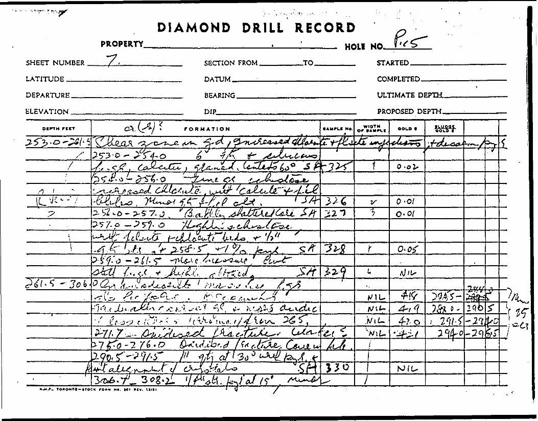
DIAMOND DRILL RECORD
SHEET NUMBER
LATITUDE
PROPERTY"7 ,
HOU NO*
SECTION FROM
HATIIM
TO STARTED
COMPLETED.
DEPARTURE.
ELEVATION .
BEARING.
DIP-——.
ULTIMATE DEPTH.
PROPOSED DEPTH.
DCFTH rcrr FORMATION s AM rue NO. WIDTH r (AMPXf BOLD •LUpQC
COCO f
5TV-3 l'-O
/ O-ol,
O-017. T o-o/
. P - P s^. o
o-o?P- S' ff/J - 3/. HT
tr ' s'-.i'./l-j-s /i
f f1 L f -j-;? r A' .''-r 4-r o
NJ/U
NJJ.r. TOAONTO-tTOCK rOKM M*. WU *(V. /
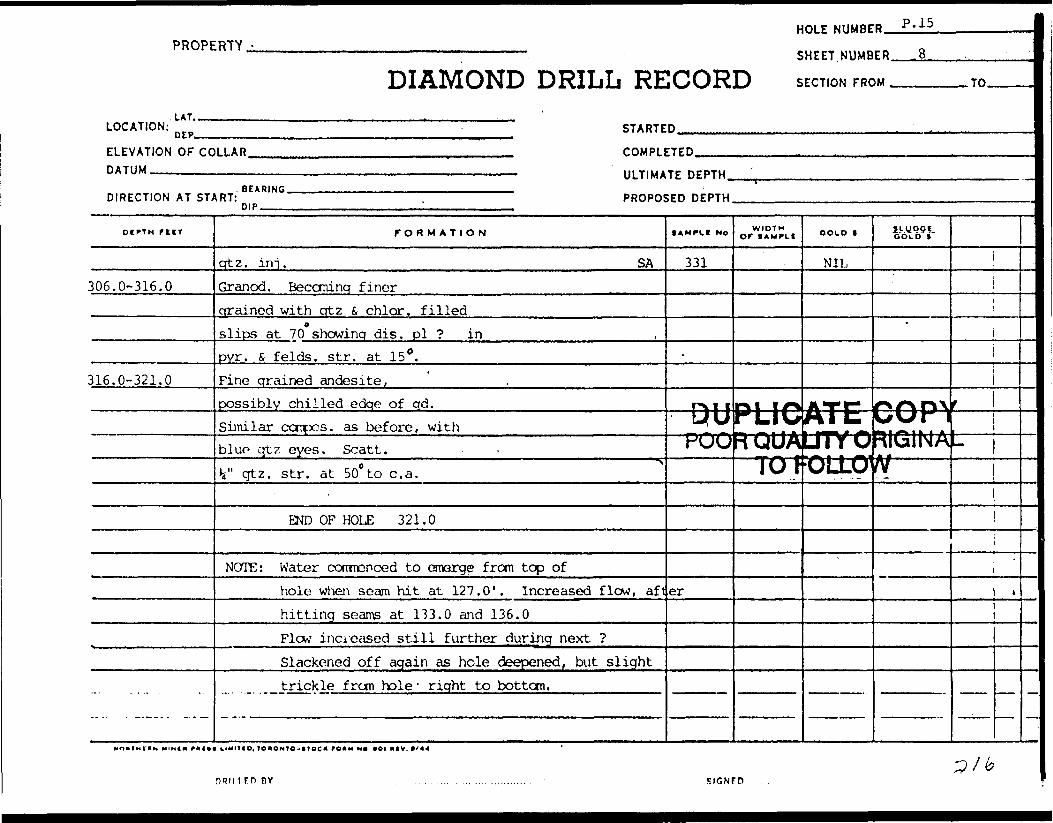
HOLE NUMBER. P.15
PROPERTY,
DIAMOND DRILL RECORDSHEET.NUMBER.
SECTION FROM ^ -TO.
LOCATION:.LAT..
DEP- STARTED.
ELEVATION OF COLLAR. DATUM ——-——....——.
COMPLETED.
ULTIMATE DEPTH.
DIRECTION AT START:BEARING.
DIP ————PROPOSED DEPTH.
DEPTH FtlT
306.0-316.0
316.0-321.0
FORMATION
qtz. ini. SAGranod. Beccminq finerqrained with qtz fi chlor. filled
oslips at 70 showinq dis. pi ? inpyr. S felds. str. at 15 0 .Fine qrained andesite,possibly chilled edqe of qd.Similar ccnpos. as before, withblue qtz eyes. Scatt.V qtz. str. at 50* to c. a.
END OF HOLE 321.0
NOTE: Water conmenced to emarge from top ofhole when seam hit at 127.0'. Increased flow, afthitting seams at 133.0 and 136.0Flow increased still further during next ?Slackened off again as hole deepened, but slighttrickle from hole ' right to bottom.
lAMPLt No
331
r\ i i
POO
er
WIDTHor lAMPit
m i r*PLIC—— — - - m AR QUA~Tcn
GOLD 1
NIL
ATCA I t. i * — .LJTYOoiixy
S!-.UP5f, COLD f
*
COP^iv-rv-rr ifeMM. i ^^ t *. a ARIG1NAw —
fi ~
.
r mtt LIMITIO, TO*ONTO-*ioe* ro*M NO *oi ( lv. c/44
nun irn nv SIGNFD

.. ,-y
DIAMOND DRILL RECORD r
SHEET NUMBER
LATITUDE ____
PROPERTYi?"
DEPARTURE..
ELEVATION —
HOLE NO.SECTION FROM.
DATUM_____
TO STARTED.
COMPLETED.
BEARING.
DIP
ULTIMATE DEPTH.
PROPOSED DEPTH.
OIPTH recr r OK M ATION M*. WIDTHor OOID nupqr
sA,^
1 3' OV \ r-
HM.f.. T OAOMrO-tTOCX rO*M MO. Ml *CV.

l PICK MINES LIMITED 1962 Aeaay Result*H le No. P 16 o
Sample S No.
336337438338339340141
342343
344
345346
347348349
350351352353354
(SsSy
356
357358
359
•IfeV)361^f362363364365366
Footage From
14.215.7
19.020.523.024.5
28.730.2
35.4-
37. f38.9
4E.A44.946.4
50.753.256.257.759.7
66.0
104.2
113.0115.5
129.7
141.3142.8149.3150.3151.8153.3154.8
To
15.716.7
20.523.0
24.526.0
30. i32.4
36.4-
38.941.4
44.946.447.4
53.256.2S7.759.761.2
67.5
106.7
115.5118.0
131.7
142.8144.3150.3151.8153.3154.8156.3
Width Feet
1.51.0
1.052.51.51.5
1.52. Z
1.0
1.52.5
2.51.51.0
2.53.01.52.01.5
1.5
2.5
Z. 52.5
2.0
.5
.5
.0
.5
.5
.5
.5
Ozs. Ozg. Gold Silver
nil0.02
nilnilnil0.01
0.010.02
nil
nilnil
nilnilnil
0.01 Us0.01 ^nil0.02nil
l f i . ' s—
0.11 r/'M^1 -0.02
nil0.03
0.01
0.132.490.020.02-0.030.03nil
367 166.3 168.3 2.0 nil
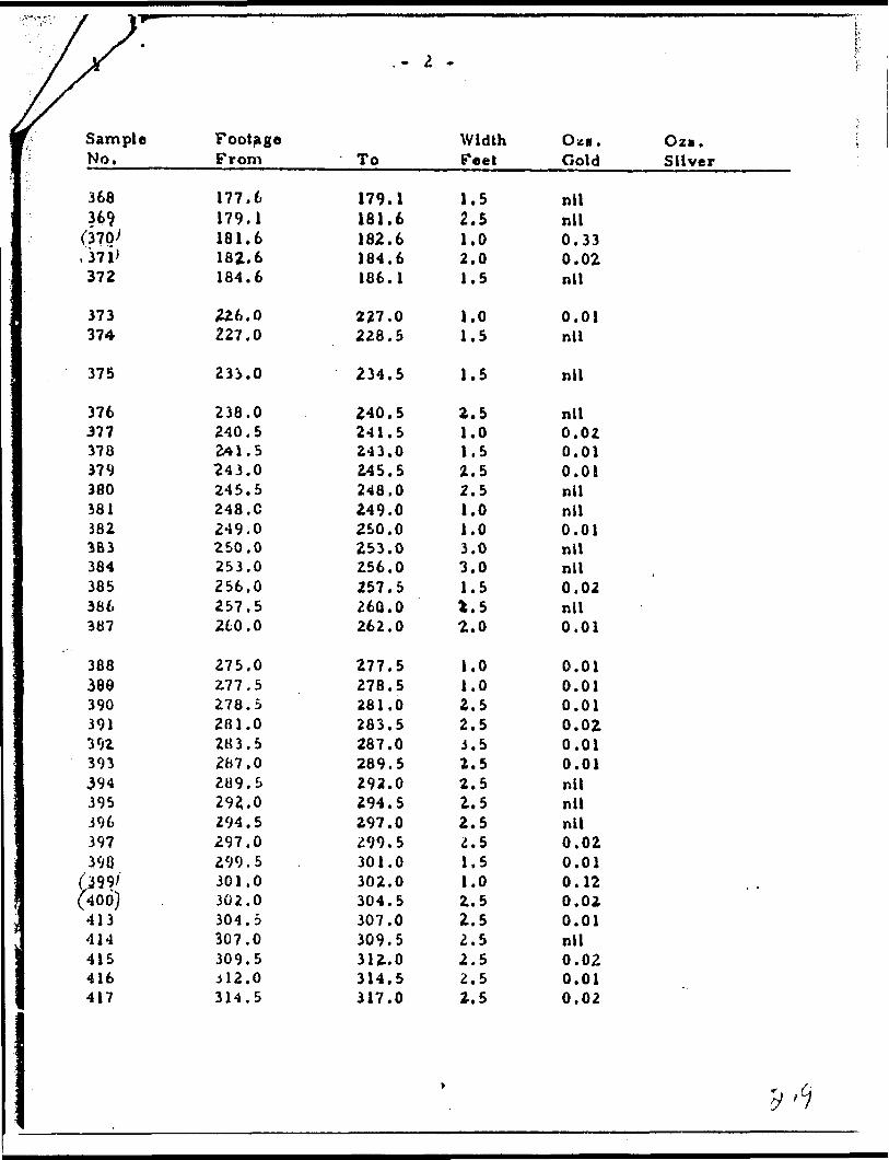
.- 2 -
Sample No.
368369
(370'.371'372
373374
375
376377378379380381382383384385366387
388388390391392393394395396397398
f2g9/(400)413414415416417
Footage From
177.6179.1181.6182.6184.6
226.0227.0
233.0
238.0240.52*1.5243.0245.5248. C249.0250.0253.0256.0257.5260.0
275.0277.5278.52B1.0283.52B7.0209.5292.0294.5297.0299.5301.0302.0304.5307.0309.5JJ2.0314.5
To
179.1181.6182.6184.6186.1
227.0228.5
234.5
240.5241.5243.0245.5248.0249.0250.0253.0256.0257.5260. 0262.0
277.5278.5281.0283.5287.0289.5292.0294.5297.0299.5301.0302.0304.5307.0309.53U.O314.5317.0
Width Feet
1.52.51.02.01.5
1.01.5
1.5
2.51.01.52.52.51.01.03.03.01.5t, S2.0
1.01.02.52.5J. 52.52.52.52.5i. 51.51.02.52.52.52.52.52.5
O*a. Oza. Gold Silver
nilnil0.330.02nil
0.01nil
nil
nil0.020.010.01nilnil0,01nilnil0.02nil0.01
0.010.010.010.020.010.01nilnilnil0.020.010.120.020.01nil0.020.010.02

PROPERTY
DIAMOND DRILL RECORD
HOLE NIIMRFB P'l6
SHEET.NUMBER ..A.,.
SECTION FROM ....^
LOCATION:. LAT.. 5575 N
4650 E STARTED Mav. 13,. .1962ELEVATION OF COLLAR. DATUM —————,-^——
6256 ' COMPLETED May 15, 1962
DIRECTION AT START: m p Surface~T5B^at" 310 (48*) 45'ULTIMATE DEPTH.
PROPOSED DEPTH.
.TO.
OCPTH rtlT
0 - 8.0
8.0 - 53.2
FORMATION
Casing
Feldspathized chlorite gneiss (Sheared diorite? some ?)Dark green (not olive green) chlorite ?with feldspar d minor qtz. Gneissosity shear {diabase neavaries between 25c to 40 to c. a.Feldspar rich zones contain pyr. parallelwith landing.14.2-15.7 Increased feldspar,gneiss at 30* Has diorite appearancewith chlorite in fine lines (injected?) SA ^15.7- 16.7 Qtz. S felds. str. andpyrite parallel at 25 to c. a. SA19.0-20.5 Greyish felsite band12" long in centre with upper. contactat 30 f Lower contact 55? Pyr. on contacts SA20.5-23.0 Gneiss, with minoratz. str, 6 pyr. parallel SA23.0-24.5 Felds. S, qtz. str. 50% SA24.5-26.0 3" felds at top i 3"fei. t qtz. in centre. Pyrite parallelwith contact at 25? SA
tAMPLI MO
17) 1—— F
t
336
337
338
339340
347
WIDTH Of 1 AMPLI
ttjptOORC1
GOLD f
ICAiIUAUTOFOL
NIL
0.02
NIL
NILNIL
0.01
SL.ypciLCOLD t
i r* f^ f*
irORIGLOW
ff*\"\Jm *
W yV 1
.
1
NOMTHCMN WIN |d * ft Ift t U*lT|O, TORONTO-* TOC* POftMtiOftOIIIIV. ft/44
DRILLED BY SIGNED.'i^^

DIAMOND DRILL RECORD
SHEET NUMBER
PROPERTY
l——flf6.
LATITUDE S" I\J
SECTION FROM.
DATUM^——. —
.TO. STARTED. -. y
DEPARTURE.
ELEVATION .
BEARING
DIP-ir±
-*-' ULTIMATE
PROPOSED DEPTH—.
D f PT H reiT rORMATION t A writ N*. Or • OLD * f Lui?9C
c -
-O-f y- Xr*,.. /.
/f0' ^-7^.C-
6k/"
r. r 3 o:' ••
, c - 3 r., o 3 "#
M.M.P.. TO*OMTO-ttOC(
o -O/ v

HOLE NUMBER. P. 16PROPERTY
DIAMOND DRILL RECORDSHEET. NUUBER^JL
SECTION FROM .TO.
LOCATION:
ELEVATION OF COLLAR. DATUM ————^————.
STARTED
COMPLETEDULTIMATE DEPTH.
POOR QUALITY ORIGIN A l
DIRECTION AT START:BEARING.nip PROPOSED DEPTH.
ni^TH riiT
53.2 -
FORMATION
28.7-30.2 Otz. S, feld. str. 25%
of core at 3.0 to c, a. Pyr. in parallel line SA
3Q.2-32.4 Grey rhyolitic zone mainlv feldsp.
with dissanin. pyr. i minor cttz. SAUpper contact 30. Lower contact 50*
35.4-36.4 1" qtz i feld. str. in centre ^
37.4-38.9 1" crtz str. IV feld. 30* to c. a. Fine
qtz. inj . in rest of section. Minor pyr. SA
-\9-41.4 6" str. of feldspar in ^\centre 6 at bottom. Minor qtz. SA
42.4-44.9 Feldspar 6 qtz str.
throughout section. Dissem. pyr. SA
44.9-46.4 Ditto SA
46.4-47.4 Ditto - SA
47.4-49.4 Felsite, qrey, core shattered
50.7-53.2 2" otz. f, fei, str. at totten SA
Felsitic, qrey, fine ar. schistose 45 sericite
S, minor ferrcmaq aligned. Mainly feldspar
with piinor white crtz. eves, 53.2-56.2 SA
56,2-57.7 Otz. irrj. zone. 51 pyr. parallelto schistosity, 35 to c. a. water seams at 57.5, 65.0 Sf
lAMPLI No
342
343.
344
345
346
347
348
349
350
351
352
WIDTHor tAMPLi COLD *
0.0.1
0.02
NIL
NIL
NIL
NIL
NIL
NIL
0.01
0.01
NIL
JXUQSi. COLD 1
'
1
PHI! t FD OY

DIAMOND DRILL RECORDPROPERTY. HOLE NO.
SHEET NUMBER
LATITUDE ———
DEPARTURE.
ELEVATION.
SECTION FROM.
DATUM————
-TO. STARTED.
BEARING.
DIP——^.
COMPLETED.
ULTIMATE DEPTH-
PROPOSED DEPTH.
W-M.f. TOAOxro-tTOCl rO*H M*. Ml *IV. 11/11

PROPERTY -
DIAMOND DRILL RE
HOLE NUMBE
SHEET.NUMB
CORD SECTION FRO
P P.16
ER 3 .
M TO
LOCATION: n rp STARTED . .. . ... ' .
ELEVATION OF COLLAR COMPLETEDBATIJM —————————————————————————————————— —— ——————— . 111 TIUATF riFPTM
DIRECTION AT START: * C ' ' """""" "" "'— —— PROPOS PIP
Dtrrn rttr
59.7-78.3
78.3-95.3
95.3 -
113.0-115.5
FORMATION
51.7-59.7 Ditto SAAndesite. Becoming morechloritic in depth 4 ? blue qtz eyes59.7-61.2 minor qtz. str. S dissem. pyr. ^
66.0-67,5 Qtz s fei str. minor pyr. SABlack 4 fine gr. dyke. Contacts 35! ...Carbonaceous. Numerous fine
cslips 45 to c. a.Core broken fi ? at 94 ' . 6" core missingRhyolite - mainly feldsp. with minor white qtz. eyesSchistose. Occasion, qtz, str.with pyr. pai" al lei at 55!104.2-106.7 1" qtz. str. at top. 2* pyr. in bandscore silicified s schistose shear? increased chlor.113.0-115.5 12" piriV feldspar at bottom.115.5-118.0 Highly schistose. Qtz. inj. 5i pyr.129.7-131.7 Silicified schistose U pyr.136.0 Water seam. Oxidised fracture141.3-142.8 y feldsp. i otz. chilledfracture running along core at 5p to c. a.Qtz. with pyr. at bottom. Sericitic SA
;ED DEPTH
SAMPkl NO
353
354355
niii— POf^Crwwr
356
357358359
360
1WIDTH Or 1 AMPLI
teg* ^^i i a tlUUAl
.OOLO t
0.02
NIL0.11
V[E (
GOLD t"
*
%/^ny ^Ur*!JTYOfUkallNAL
TOFULLUV
0.02*
NIL0.030.01
0.13
1
l
*
.,
-
DRILLED OY

X
i f
SHEET NUMBER
LATITUDE ___
DIAMOND DRILL RECORDP*OP**TY—————————————————____________ HOLE NO.
FROM. -TO. STARTED.
DEPARTURE.
ELEVATION .
DATUM.
BEARING.
DIP———
COMPLETED
ULTIMATE
PROPOSED
- - .t
ocrrH r UT FORMATION f AMFLI Ne. WIDTH Of (AMdf OOID t ILUPOt
eoLO f
5/7- 5^-7 J S//^
f/
^,o-^:/- r s 4 /5"
35-43*0
l*?-7- i 3/-; Jjui V K2. 35?
0-(3M.M.r, TOUONTO-ITOCK FOAM *. Ml HIV. llfll
DRM ICO 8V
'fi(^ / /

^ —— ' " —
PROPERTY -
.LAT.
DIAMOND DRILL RE
HOLE NUMBE
SHEET. NUMB
CORD SECTION FRO
D P.16
FR 4 . . .
M TO
LOCATION: D Ep STARTED ,, l in ..^. .
ELEVATION OF CO DATUM
DIRECTION AT ST;
DCPTH TUT
156.3 -
LLAR COMPLETED . .. . . . . ^.
——————————————————————————————————— ULTIMATE DEPTH. 'v , .BEARING , ,
t RT: PROPOSnip -— -— ,—
FORMATION
142.8-144.3 Quartz blow (pink) enone side of core for top 6". Qtz. feld.6 pvr. 5% over remainder. Fteldsp.str. at bottom cut ting off section at 55" SA ,149.3-150.3 Increased qtz. S sericite SA150.3-151.8 Qtz. inj. shear zone U... contact fei. str. a 1Schistose banded 101 pyr. . SA151.8-153.3 Ditto SA153.3-154.8 Less schistose, li pyr, SABottom contact 60*154.8-156.3 Schistose sericitic, minor pyr. SAGranodiorite. Fine grained, mainly feldsp.with 304 blue qtz. eyes. Minorferromag. Contact indefinite,but h " fei. str. at 55" at 156.3appears to ? at shear zone.Faintly schistose. to166.3-168.3 Feldspar enrichmentwith qtz. i li pyr. at 5* to q. a. alonglength of section. Water seamat 168.3, 25 to c. a. SA
,ED DEPTH
•AMPLI Ho
361•362
35363364365
366
-W
PUU
367
WIDTH Or tAMPLt
-ji i/*rLIU•JUtlA
JU*
OOLO |
2.490.02
0.02
0.030.03
NIL
V
ILW*ATE-UTYOOLLO'
NIL
ituestCOLD t
*
r*f\r}\ UUr 1'
RIGINAp —N
—
*
•i
DHIUf P BY ..

^^^^^^^^^^
IX DIAMOND DRILL RECORDPROPERTY 2 X
SHEET NUMBER
LATITUDE --—
FROM. .TO. STARTED.
DATUM. COMPLETED.
DEPARTURE.
ELEVATION .
BEARING.
DIP.———
ULTIMATE DEPTH.
PROPOSED DEPTH.
DIPTH rcrr FORMATION M*. WIDTHor t Auric OOLO V ytypjig
-crV fjt~~ dt*Jtt\ 0-02.
t-1
^0-03
sdsJL. ^^7-C /T
TO*OMTo-*TOCx f o w M M*. M* ncv. ll/ii
- -j 1

^
PROPERTY -
UT,
DIAMOND DRILL RE
HOLE NUMBE
SHEET.NUMB
CORD SECTION FRC
B P.16
ER 5
M TO
LOCATION: ^ f STARTED
ELEVATION OF CO DATUM
DIRECTION AT ST;
Df f f H P UT
179.1-184.6
184.6-200.0
200.0-200.9200.9-213.0
213.0-227.0
-. . ....., .
LLAR , ,, COMPLETED,——————————————————————————————————— ULTIMATE DEPTH ., 1|MH'V . ,,
BEARING . __ .,RT: PROPOSED DEPTH nip
FORMATION
.177.6-179.1 Granod. f. qr. Gneissic SAShear zone. Mainlyfeldspar, with sericite S minorph,lorite, Schistose ?fel.str. at 50*. L. contact 35?179.1 -181.6 Sheared rhyolite ,, SA181.6-182.6 6" qtz. vein S, 6 " pinkfeldspar. 101 pyr. at contact SA182.6-184.6 Sheared rhyolite . SA184.6-186.1 more massive SAGneissic granodiorite as before,with 35% blue qtz. eyes.Black basic, fine gr. dyke. Contacts 50",Rhyolitic. Fine gr. mainlyfeldspar with sericite Z minor chloriteSchistoseGranodior. Fine gr. Containing15* blue qtz. eyes. No changein appearance. Contact indistinctat 50*. Sudden occurence. of qtz. eyes
226.0-227.0 Sheared, f. gr., no qtz. eyes.
• AMPL* NO
368
-
369
' 370'
371372
orpnr
WIDTHor *AMPLI
PIJCiRQU/*^^m^^^^^^
T/^— +Q-1
GOLD f
NIL
NIL
0.030.02NIL
x
ATS
IkU-QSt. COLD f
"
nnp^
;
*
s
LJTY ORIGINALIQttOluU ———— l ———
' 'i * i 'iORILLtO BY

DIAMOND DRILL RECORDPROPERTY ft*.
SHEET NUMBER SECTION FROM.
DATUM.™..—.
.TO. STARTED.
DEPARTURE.
ELEVATION .
BEARING.
DIP-——
COMPLETED
ULTIMATE
PROPOSED DEPTH.
DIFTH FORMATIONN^ • AUFLI Ne. OOLO t
f 77*6— (7?, 7 MIL
JJ.L.
37 -O-02-
U.
./..i r r. /l A1'
- -22-7-0Ho -
TO'ONt j.|TOC( rO*H M*. K3I *IV, 11/11
nun i rn RV
\J J

HOLE NUMBER. P.16
PROPERTY.
DIAMOND DRILL RECORDSHEET NUMBER
SECTION FROM
LOCATION:.UAT,.CEP.
ELEVATION OF COLLAR. DATUM ~—————————
STARTED^
COMPLETED
ULTIMATE DEPTH
DIRECTION AT START:BEARING.
DIP.PROPOSED DEPTH_______TO FQ[ f^QW
DtPTH rt(T
227.0-242.5
240.5-241.5
241.5-248.0
FORMATION
S, 3 " qtz, Pyr. at contact. SA
Feldspar diorite. Feldspar
eyes S minor ferromag. No. qtz.
227.0-228.5 Schistose contact zone SA
233.0-234.5 Qtz. injected in
*i" diam. blebs. Feldspar rich s, schistose SA
238.0-240.5 Finer grained.. Scattered
blue qtz. eyes 5i SA
240.5-241.5 Qtz. s, feldsparinjected fracture at contact b(Pto c . a.
pyr. 20% grey . SARhyolitic , fine gr. Mainly feldspar,
schistose S sericit-.ic. Pyr. in
hair lines, calcite.
241.5-243.0 Feldsp. inj. on str.
at 50* to c. a. Pyr. in. parallel bands ^
243.0-245.5 Fine gr. schistose
dissem. pyr. ^
245.5-248.0 Ditto with feldsp. l
chlorite bands bottom 9" -at contact
AMPkl No
373
374
.375
1 37(j
377
378
379
380
WIDTH O' tAMPUI
;
2
v3
OOCO 1
0.01
NIL
NIL
NIL
0.02
s
0.01
0.01
NIL
IMiPOL CO1.O *
*
*
'.
NOIttMirtM MINI* m itt l luttlO. TO*OMrO-*IOCK fO*M X* tOI KV. t/44
DRILLED BY. SISNFO

JffiDIAMOND DRILL RECORD
M'i-
,. TOUOxro-troCX fO*M Ml. Ml *CV. U/ll i H:
DSIUCDBr......
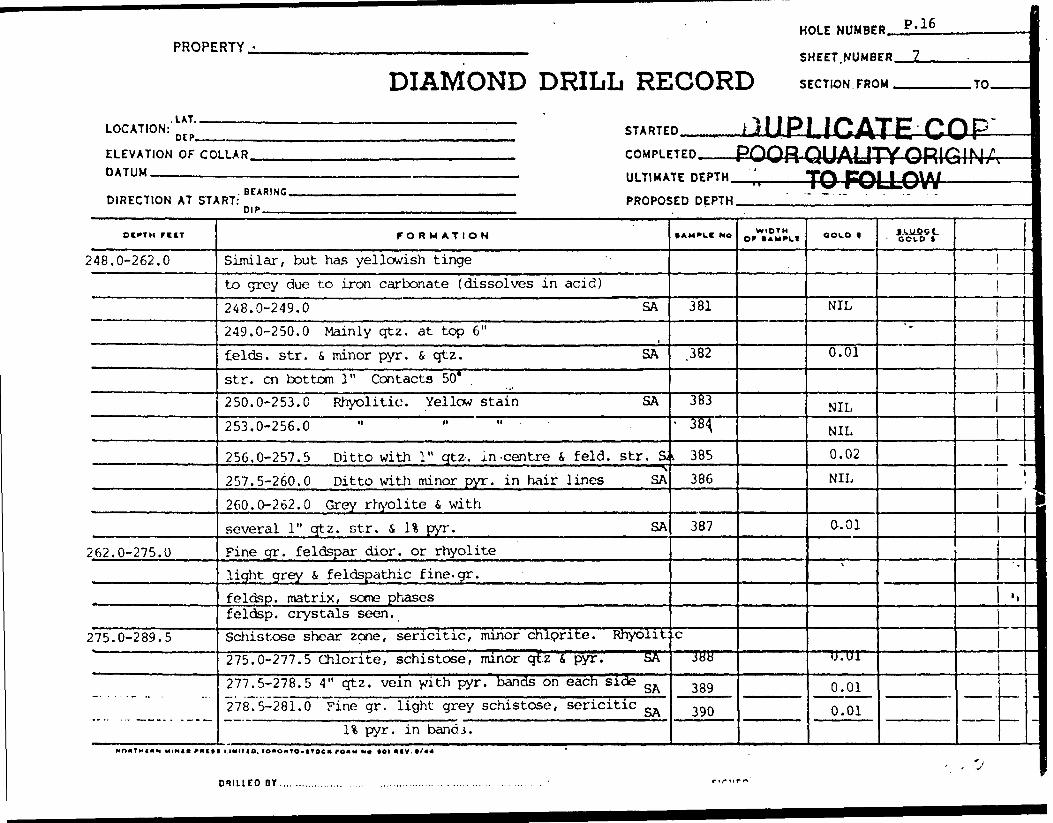
PROPERTY - .... .. ...
DIAMOND DRILL RECOR.'
HOLE NUMBE
SHEET. NUMB
D SECTION FRO
ill r*\ i i *^ A i
D P.16
ER 7
M TO
LOCATION:^*' STARTED MU K LHJ A 1 t (J U PELEVATION OF COLLAR rOMPLFTED PHHP YM 1 A 1 ITV ODIrfO I M /*DATUM ———— — .. — —————————— ^ —— mB— III TlMA^r nrPTH ' *T^\ P"*^l 1 f\\ A *
BEARINGDIRECTION AT START: PROPOSED DEPTH.
DEPTH rtn
248.0-262.0
262.0-275.0
275.0-289.5
FORMATION
Similar, but has yellowish tingeto grey due to iron carbonate (dissolves in acid)248.0-249.0 SA249.0-250.0 Mainly qtz. at top 6"felds. str. S minor pyr. S qtz. SAstr. en bottom 1" Contacts 50*250.0-253.0 Rhyolitic. Yellow stain SA253.0-256.0
256.0-257.5 Ditto with 1" qtz-. in -centre t. feld. str. a257.5-260.0 Ditto with minor pyr. in hair lines SA260.0-262.0 Grey rhyolite s withseveral 1" qtz. str. s. It pyr. SAFine gr. feldspar dior. or rhyolitelight grey 6 feldspathic fine. gr.feldsp. matrix, some phasesfeldsp. crystals seen.Schistose shear zcne, sericitic, minor chlprite. Rhyolit275.0-277.5 Chlorite, schistose, minor qtz f, pyr. SA277.5-278.5 4" qtz. vein with pyr. bands on each side gA278.5-281.0^ Fine gr. light grey schistose, sericitic ^
11 pyr. in band j.
• AMPLE No
381
.382
383- 384,
L 385386
387
cJbH
389390
. -. - . .- . . .. . ..
WIDTHor (AMPLf OOLD |
NIL
0.01
NILNIL0.02NIL
0.01
V
U.U1
0.010.01
IkUOCt - GOLD *
*
i
1
*
'l
i
ORIUED or .

PROPERTY.•7.DIAMOND DRILL RECORD——————————————————————————— HOLI NO.
SECTION FROM .
DATUM———.-
-TO. STARTED.
COMPLETED.
BEARING.
3IP^--
ULTIMATE DEPTH-
PROPOSFD rjFPTH
ocrrx rt tt FORMATION *AMPLS N*. OfWIDTH OOLO t •LUPor
2-4^-0 - Z-ft. 0 5 /f
Z /r yIt
r
5 /f 0 -O/

HOLE NUMBER. P.16PROPERTY
DIAMOND DRILL RECORDSHEET.NUMBER.
SECTION FROM. .TO.
LOCATION:'. LAT. .DIP.
ELEVATION OF COLLAR. DATUM.————-^....—
DIRECTION AT START:. SEARING.
STARTED.
COMPLETED,
ULT.MATE DEPTH POOR QUALITY
PROPOSED DEPTH ——______TO FOLLOW
DtrTH fICT
289.5-301.3
301.3-317.0
-- -- — --- --- —
FORMATION
281.0-283.5 Ditto SA283.5-287,0 tore chloritic, qtz injectedminor pyr. 1" core missinq SA287.0-289.5 Brecciated zonechlorite s pyr. bands 25*^0 c. a. 31 pyr SARhyolite. Light grey to whiteFine feldspar sericite f, qtz. matrixwith pyr. 11 akigned at 480minor anphibole also aligned at 48WQtz S, feld. injected ^
289.5-292.0 Minor qtz. H pyr. on top 12"292.0-294.5 Qtz. i felsite inj. 450 H pyr.294.5-297.0 Qtz. inj. 5% pyr.297.0-299.5 1" qtz. str. at 298.0' Minor pyr.299.5-301.0 ^
301.0-302.0 Brecciated i qtz. inj at 302.0' Pyr.qtz. on bottom contact 60"
diorite. Fine grained 751 feldspwith 20% chlorite S, minor .blue qtz. eyes.
Brown feld. blebs. Schistose S, qtz.injected. Pyr. in band i, dissem.
SAMPIC No
391
392
•393
'
394395396397398399
WIOTM Of 1 AMPI.I COLD 1
0.02
0.01
0.01
NILNILNIL0.020.010.12
IkUSSS. COLD *
V1
l
i /i*-*\ f hLw
\ p3*^vr
j
i
^ )fcp\ u jP ito> 11 \\\
i \*' ste" lfl*
'
1,
t
-
DY .... .

DIAMOND DRILLPROPERTY
RECORD—————— HOLE NO.
5HEET NUMBER
LATITUDE .™.
SECTION FROM.
DATUM ————
.TO. STARTED.
DEPARTURE.
ELEVATION .
BEARING.
DIP——-.
COMPLETED.
ULTIMATE DEPTH.
PROPOSED DEPTH.
O tt M ATION •Aurut M* WIOtH OF tAMFLC OOLD * • moor
197
-cjBJ.eirn.h~ *- f- O'01
X
391
122.O-t,
.,/'0
JQ/.3 ~117-0 -7S
tOKONTO-troc* ro*M(^e. MI *cv. ii/ti
ORIUCO BY...................... SIGMCO.,
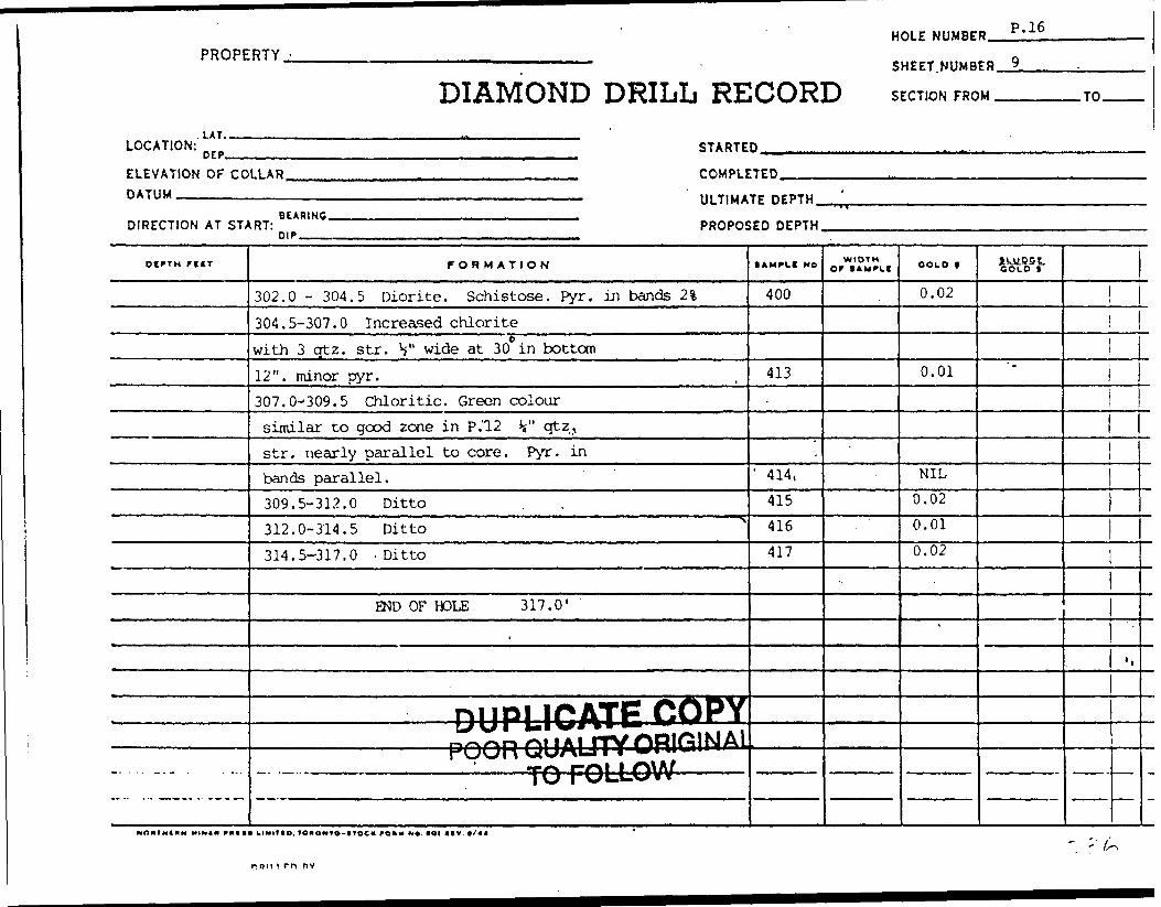
HOLE NUMBER. P.16
PROPERTY,
DIAMOND DRILL RECORDSHEET.
SECTION FROM .TO.
LOCATION:.UT..DIP, STARTED.
ELEVATION OF COLLAR. DATUM .—-.™....—.
COMPLETED.
ULTIMATE DEPTH.
DIRECTION AT START:. BEARING.
DIP.PROPOSED DEPTH.
-. . . . .-.- .
FORMATION
302.0 - 304.5 Diorite. Schistose. Pyr. in bands 2%304.5-307.0 Increased chloritewith 3 qtz. str. V wide at 30 in bottom12". minor pyr.307.0-309.5 Chloritic. Green coloursimilar to good zone in P.'12 V qtz,str. nearly parallel to core. Pyr. inbands parallel.309.5-312.0 Ditto312.0-314.5 Ditto314.5-317.0 -Ditto
END OF HOLE 317.0'
,
POOR OUAUTY ORIGINALr^\j\jr\ \x\sr~\*~ i * * ^ i " w *rf^ r-^M 1 /"MA/...M . , ,. ,,,, ... ..,. j ^j f^wl—i— vVV
(AMPLt NO
400
413-
1 414,415416417
WIDTH Of t AMPll COLD |
0.02
0.01
NIL0.020.010.02
*
GOLD i*
*
1
. *,
-
Nomxtnw MINI* r *ttm k ixitio. io*o~io-tioc* ro*x x*, toi "lv t /44
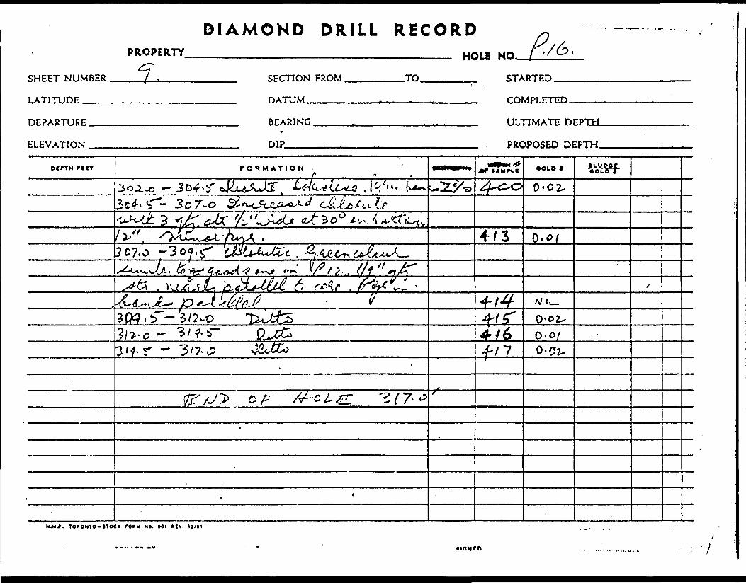
DIAMOND DRILL RECORD
SHEET NUMBER
LATITUDE .--—
PROPERTY
f .
HOLE NO.
SECTION FROM ,
DATUM ————
TO STARTED.
DEPARTURE.
ELEVATION .
BEARING.•*
DIP———
COMPLETED.
ULTIMATE DEPTH-
PROPOSED DEPTH.
DCFTH PICT FORMATION • OLD t pi UP o rC OLD *
0-02-
4/3307,0 -
6rtt
- 5/2-0o-o/
3 'f r *^ "3/7 w? f/7 0-02.
.. TCKONTO-HOCl fOIM Ut. M l *(V, ll/tl

PROPERTY - P|ck Mines Ltd.
DIAMOND DRILL RECORD14T 5575 N
LOCATION: ^ 4 MO F
ELEVATION OF COLLARDATUM
BEARING Due SouthDIRECTION AT START: n (p Surface 45" at 240' - 36"
STARTED^ July 12July
COMPLETED
ULTIMATE
PROPOSED
nrDTU
DEPTH
HOI F NIIMRFB. P; 17
SHEET NUMBER 1.
SFCTION FROM TO
, 196216, 1962
'242' 1
11
otftn ritr
0-2.0'
2.0-13.2
]3.1 - J4.014.0-26.3
26.3-34.3
-.3.4..3r75.0
FORMATION
Casing ^ ( jgreen diorite. Fine gr. with w 1nuncrous qtz. str. . OQFOtz. str. 2 (T to c. a.Green, diorite. Schistose at30* to c. a. with "?
SAMPLE 13.1-15.1 31 pyr. .15.1-16.1 21 pyr. S qtz. str.20. 5-23. 5 Scattered V .qt 2 .
str. s H pyr.SAMPLE- 23.5-25.0 Increased qtz. 4 31 pyr.
Green felsite. Fine grained,with siliceous i pyritebands.SAMPLE 28.5-30.5 Dioritewith qtz. str. 2* pyr.
SAMPLE 32.3-34.3 Banded qtz.S, green felsite with qtz. str. calcite 40'to c. a.Green diorite. Fine gr. siliceous as before
SAMPLE 34.3-35.8 3% pyr.
• AMPIC Mo
H.IG,IQUAti VPt ^^9 W^f^F
.450
' 451,452
453
454
455
456
WIDTHor I AM'LI
^
OOLO |
"fc^Nn*jUrHYOfiivjuw3LLOW ——
2.01.0
3.0
1.5
2.0
2.0
0.17.02
-01
.UK
s
0.11
U./J
.06
IkU-QOC.COLD t
f
m
i
j
i1
'
'.
l
:DRILLED ar. SIGNED........

PROPERTYDIAMOND DRILL
r K-fc~~RECORD
HOLE NO. p.\1.SHEET NUMBER
LATITUDE ——— M.SECTION FROM ,
DATUM.-—-—
-TO. STARTED.(VXx/f.A^ tZ , f
COMPLETED. . 1 f
DEPARTURE.
ELEVATION .
BEARING
DIP.
ULTIMATE DEPTH.
rcrr FORMATION WIOTMor •OLD 1
0 - 2 - o
- 2*. 3 .'M Cdd-
. fl. - '-L f f f f ' *. v fi A r -. X.- '
i . ,. -- 1 r-"- /O*
^7 -.^ y A ^
2.5 - ^ 0.7*...'- K T ^ .. r A
33.3
J'S i' r C.A ' C^. LJU
NJ*.*.. TOKONTO-trOCIt /(JSx M"*. Ml "fvT'lJ/tl -.
. uS' -.'- v

^^^^^^•^••••••—••i^^^^^^^—
PROPERTY -
i iT ,LOCATION:
ELEVATION OF COLLAR.DATUM
DIRECTION AT START: * *Ml"'DIP
HOI F NUMBP&. ^:.i.7 .1-111 "' ' SHLLf NUMBLH , ? , ,.
DIAMOND DRIIiL REOHRp srr™™™™
STARED nilDI II^ATF PH P Y——————————— UUr^L.fiwMI C OV/I T— —————— COMPLETED. — pooffoyALITY ORIGINAL l————————————————————— ULTIMATE DEPTH —--. f-f\t l |-l\A/ 1
PROPOSED DEPTH - - - 1
OCPTH rC(T
75.0-113.7
f G * M AT IO N
SAMPLE 35.8-38.8 Increased*
white otz. in str. 50 to c, a.38.8-75.0 More massive Sgreyer in color, 30% qtz content47.3-48.0 Pink api it e oyKe au co c. a.
SAMPLE 47.1-48.1
65.0-67.0aplite stringers 65.6-66.1 pyr.
bands scattered throughout
Andesite? Schistose, felsitic or tuffaceous and banded.
Increased alteration i calcite
SAMPLE 77.3-79.8 Scattered
qtz. str. IS" pyr. 6 calcitic bands
SAMPLE 79.8-82.3 -82.3 Ditto
84.8-87.387.3-89.8
89.8-92.8
92.8-94.8
100.7-101.7 . "
101.7-103.7
103.7-107.2
AMPL( No
457
.
458
459
i
460
461
462
46?
464
465
466
467
468
WIDTHor * AM PL t
A-71 4r 4 4 —
OOLO f
.02
.01
.02
.01
#3!^-.01
NIL
.01
NIL
NIL
.02
NIL
llUfiSt- GOkO t
*
9f 5? , VR-'.
1
:
-\
3-ITOC* rO*M NO
DRILLED 8Y . SIGNED.

X'
SHEET NUMBER
LATITUDE ———
DEPARTURE.
ELEVATION .
urviuu rv t v. w rv w
HOLE NO. P,"7.
SECTION FROM
DATUM^^.^
TO STARTED.
COMPLETED.
BEARING.
DIP
ULTIMATE DEPTH.
PROPOSED DEPTH.
DtPTM r i tt FORMATION WIDTH OF tAMPlt OOID t Ill) PC t
401.0 f
o*.
1 )
4- s- g o/- . 67-0
6 S~- 6 ~
li
77, 'i- .0
-f -X- A/I-S
3 ^- AJ/t-
Of
7 - A.WMM*.. T OKOMTO-tTOC* FO1U M*. Ml MV. tl/tl
DRILLED BT JlChtO.

HOLE NUMBER. P.17PROPERTY
DIAMOND DRILL RECORDSHEET NUMBER.
SECTION FROM. .TO.
LOCATION:LAT..
CEP-
ELEVATION OF COLLAR. DATUM --.-—^........—
DIRECTION AT START:. BEARING.nip-
STARTED
COMPLETED
ULTIMATE DEPTH
PROPOSED DEPTH.
113.7-117.2
117.2-118.2
118.2-126.9
126.9-147.8
147.8-220.0
FORMATION
SAMPLE 107.2-109.2
109.2-111.7
111.7-113.7
Banded felsite or tuffaceouswith minor pyrite bands at 40SAMPLE 113.7-117.2
Andesitic. Schistose with 5* pyr.in hair lines. SAMPLE 117.2-118.2Rhyolitic - Schistose sericiticSAMPLE 127.3-127.8 2" blueqt.z. s-pyroite.Diabase. Black fine grained dyke. Uppercontact 65* to c. a. Lower contact 60*Granodiorite. Siliceous i sericiticwater flow from fractures at165.0 and 168.0oxidised S fractured 174.0-178.0SAMPLE 178.8-179.8 1" qtz. S, pyr.at 179.0 25* to c. a. and k " qtz. at 179.5SAMPLE 183.0-184.5 Minor qtz. S pyr. bands.
t*MPLt NO
469
470471
.472
' 473,
474
475476
WIDTHOf * *MrLf COLD f
.03
.01
.02
NIL
.01
.06
x
.01
.01
1W9SL COtO t
*
-
1
'
'l
MnnTHiitN MIM(* fmttt uxifio. lonoMf o-tf Od ronx M* tei liv. */** '
DRILLED B Y..........,..........,,...........,.......,.......;........^......,......__ ....;............... S lC.HtD........^-...^^..^..^.^.^^.^rF^^^
V *L

DIAMOND DRILL RECORD
SHEET NUMBER
LATITUDE ———
PROPERTY
3.HOLE NO.
SECTION FROM,
DATUM ————.
-TO. STARTED.
COMPLETED.
DEPARTURE.
b'LEVATION .
BEARING.
DIP
ULTIMATE DEPTH.
PROPOSED DEPTH.
OCPTH FORMATION • AMPCI NO. WIDTH Of (AMPLI OOLD * piypoe
8 O L 6 V
'roy. z- -/o?, z ~ i' .l/) --7 —
.-i\A.t ^ 4. r Ctfvtcv. .-*) /r
H"' "/2. -oiS-\ i t ' " f' ' "
06
r ^.V/
.r, ^.J V *k
, TOiONTO-tTOCirfOKU 'NO'. MI ncv. ii/n
-' V 3

HOLE NUMBER. p.i;PROPERTY.
DIAMOND DRILL RECORDSHEET NUMBER .4
SrCTlON FROM ^^-. .TO.
LOCATION:'. LAT,.
DER.
ELEVATION OF COLLAR. DATUM ————-—...——
DIRECTION AT START:BEARING.
STARTED._____
COMPLE7ED——POOR QUALITY ORIGINALULTIMATE DEPTH^,————TO FOLLOW————————
PROPOSED DEPTH ——...——..L.'.-J:______" '-_________
OCPTH T lit
220.0-242.0
MOHTHIUM MINI* mi*
FORMATION
SAMPLE 196.0-197.0 H" qtz. i pyr.200.0-201.0 " "208.8-210.8 Qtz. fi pyr. 2%
in shear zone.SAMPI.E 210.8-212.8 Y qtz. str. S, pyr.
212.8-214.3 " "" "217.9-218.9 " ". "
Granodiorite? Gradual increase in chlorite& lessening of sericite - conpositionbecoming andesitic. ^SAMPLE- 224,8-^225.8 H" pyr. S qtz.
227.2 228.7 1" qtz. at227.3, pyr. 4 qtz. at 228.3.SAMPLE 228.7-230.7 Minor qtz. i pyr. str.
234.5-235.5236.6-239.1
END OF HOLE 242'.
1 UUIIIO. lOaOHTO-ttOCK TO*" M* IOIIIV.*'44 '
• AH'PLI NO
478479480
481482483
i
484485
486487488
WIDTH OF tAMPLf OOLO |
.02
.02
.06
.03
.02NIL
.01
.01
NIC,.02NIL
IkUQStCOLD 1
"
^
*.
' V
1
:
DRILLED DY. SICNCD.

SHEET NUMBER
LATITUDE -——
PROPERTY
4-
DEPARTURE.
ELEVATION .
lM** l V ** *MI
HOLE NO.SECTION FROM,
DATUM ^———.
.TO. STARTED.
COMPLETED.
BEARING.
DIP
ULTIMATE DEPTH.
PROPOSED DEPTH.
DtPTM FORMATION OPWIDTH aouo t tuupoi:
CO LO f~
02.O2-
9-1
.02*4&1
c&U
01
7
23 f,/
Mjt.r, TonONTO-trocK ro*u N*. MI ney. u/ti
nut i rn *v

PROPERTY - Pick ^-nes Ltd '
.LAT.
DIAMOND DRILL RE5600 N
LOCATION: ^ p 44bU E STARTE
ELEVATION OF CODATUM
DIRECTION AT ST4
D l PT H rilT
0 - 15.015.0-40.5
40.5-45.0
45.0-46.446.4-51.4
.., . ,. -. - .
HOLE NUMBE
SHEET NUMB
CORD SECTION FRO
D July 17, 1962
B P. IR
E* 1 .
M TO
LLAR COMPLETED July 18, 1962————————————————————————————————————— ULTIMATE DEPTH ' 202 '
BEARING Due South -. .-, ~RT: Surface 45* at 200' 42* PROPOSnip.
FORMATION
CasingGreen diorite massive, fine gr. magneticoccasional qtz. S calc. str. V wideat various angles.SAMPLE 28.5-30.0 k " qtz.str. 5* to c. a.
SAMPLE 31.0-34.0 H" qtz. str. at 5* minor calc.34.0-35.5 1 h"
qtz. str. at 25* to c. a. Scattered pyr.SAMPLE 35.5 - 38.0 minor qtz. str. f, pyr.Andesite. Silicified schistose at 40*to c. a. Tuffaceous or felsitic.SAMPLE 40.5-41.5 Tuffaceous pyr. bands
11 44,0-45.0 Minor qtz. f, pyr.
Green dioriteAndesite. Shear zone ?. Silicifiedschistose with qtz.. i pyr. str. 55*SAMPLE 46.4-47.9 Qtz. (, pyr. str.
" 41.9-49.9 Fei. f, qtz. filledfractures over bottom 12". at 50 to c, a.
SAMPLE 49.9-51.4 Qtz. f, pyr.
,ED DEPTH
• AMPLC No
.489
4901 491
492
493494
495496
WIDTHor ( AMPUI
1.52.0
COLD f
NIL
NILNIL
NIL
0.010.01
0.030.02
U&tff
^^O- ZOo~f35w"~^
— -s — &1— 3i
4± —,—— Qbrfr^QSe—— O-f
;1
1
*r-3-ou.PH-T
))La
*
'.
,xV b DRiueo BY ....,Rm^.ey...Brcs......pi^rnon(3..R?;llUlia....:.........,..... - SIGNED ,. . .
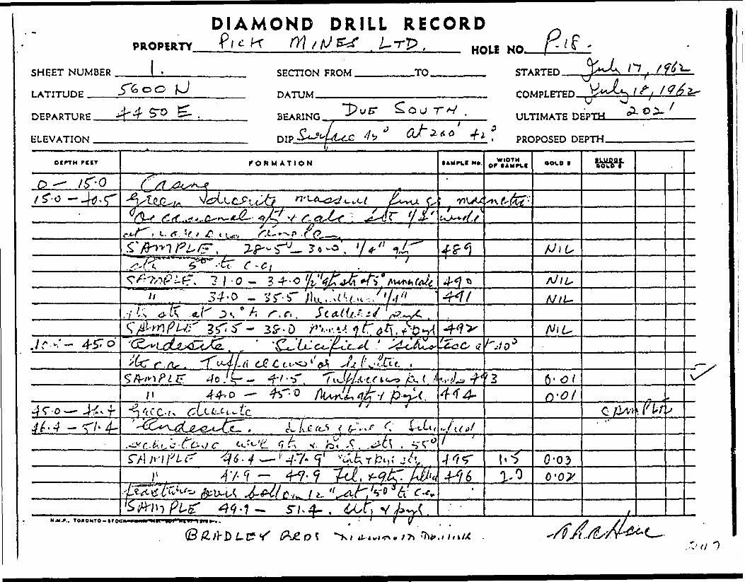
DIAMOND DRILL RECORD
SHEET NUMBER
PROPERTY.
l.' Tp , HOLS NO.
LATITUDE .T600
DEPARTURE.
ELEVATION .
SECTION FROM.
DATUM^.^
.TO. STARTED.
COMPLETED.
BEARING
DIP. f**-ULTIMATE DEPTH, OlX
PROPOSED DEPTH
DEPTH rCKT f OR M ATION IAWPt.1 MO. WIDTHor OOLO l
•moot BOLD r
L-:-, ^---P Y tf. —— .
o -A///-
-fi:;
/ oci. i-- ' tx
/i ^r-o
. v. fe.C. ,
.c^ 1 1- *ti c-*** 4- . •^
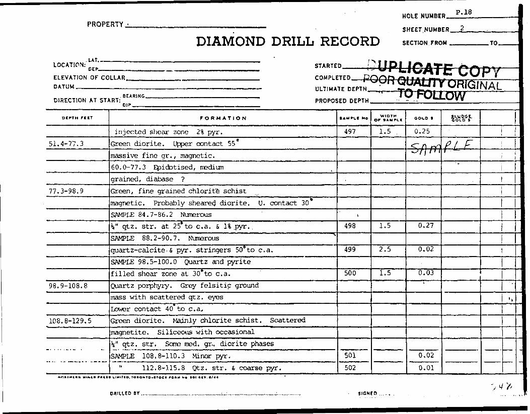
HOLE NUMBER. P.18
PROPERTY.
DIAMOND DRILL RECORDSHEET NUMBER J
SECTION FROM^—-
LOCATION:' DEP.ELEVATION OF COLLAR. DATUM —————————
STARTED
COMPLETED pQ
ULTIMATE DEPTHM
DIRECTION AT START-REARING.
PROPOSED DEPTH.
'ALTTY OR/FOLLOW
.TO.
DCPTH FllT
51.4-77.3
77.3-98.9
98.9-108,8
108.8-129.5
FORMATION
injected shear zone 2% pyr.
Green diorite. Upper contact 55
massive fine gr., magnetic.
60.0-77.3 Epidotised, medium
grained, diabase ?
Green, fine grained chlorite schist
magnetic. Probably sheared diorite. U. contact 30*SAMPLE 84.7-86.2 Numerous
V' qtz. str. at 25* to c. a. S, H .pyr. .
SAMPLE 88.2-90.7. Numerous
quartz-calcite.S pyr. stringers 508 to c. a.
SAMPLE 98.5-100.0 Quartz and pyrite
filled shear zone at 30*to c. a.
Quartz porphyry. Grey felsitic ground
mass with scattered qtz. eyes
Lower contact 40 to c. a.
Green diorite. Mainly chlorite schist. Scattered
magnetite. Siliceous with occasional
k" qtz. str. Some med. gr., diorite phases
SAMPLE 108.8-110.3 Minor pyr.
" 112.8-115.8 Qtz. str. 6 coarse pyr.
t AM PU* NO
497
.
\
498
499
500
501
502
WIDTH OF *AMFLI
1.5 .
1.5
2.5
1.5
OOID t
0.25
Sflfll
0.27
0.02
0.03'
0.02
0.01
ttJtW
PL *
'l
J
DRILLED BY. SIGNtO ... . .

DIAMOND DRILLPROPERTY
SHEET NUMBER
LATITUDE ———
DEPARTURE.
ELEVATION .
RECORDHOLS MQ
SECTION FROM,
DATUM————
-TO. STARTED.
COMPLETED.
BEARING,
DIP
ULTIMATE DEPTH.
PROPOSED DEPTH.
DIPTM FORMATION S \MPLC NO WIDTHOOID 9 iLuoor
OOLO *
r 0.^5-57- f - 77-3
CJ? I'Ltz.. o
H. L-. - . . ,-.k. ,.r
O'03
- O/H.M.r,. T OKOxTO-tTOCK f OUM U t. tOI *(V, 11/11
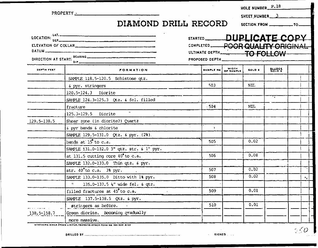
HOLE NUMBER. P.18
PROPERTY,
DIAMOND DRILL RECORDSHEET.MJMBEB.
SECTION FROM . .TO.
LOCATION:.LAT...OEP. STARTED.
ELEVATION OF COLLAR. DATUM ————^.———,
DIRECTION AT START:. BEARING.DIP.
COMPLETED——POOR QUALITY ORIGINALULTIMATE DEPTH^—————TO FOLLOW————————
PROPOSED DEPTH____________^_________________
otffn r iiT
129.5-138.5
138.5-158.7
FORMATION
SAMPLE 118.5-120.5 Schistose qtz.l pyr. stringers
120.5-124.3 DioriteSAMPLE 124.3-125.3 Qtz. S fei. filledfracture125.3-129.5 DioriteShear zone {in diorite?) Quartzs pyr bands s chloriteSAMPLE 129.5-131.0 Qtz. S pyr.. (21).
bands at 15 to c. a.SAMPLE 131.0-132.0 3" qtz. str. l 1 " pyr.at 131.5 cutting core 40* to c. a.SAMPLE 132.0-133.0 Ttiin qtz. S pyr.str. 40 0 to c. a. 31 pyr.SAMPLE 133.0-135.0 Ditto with U pyr.
135.0-137.5 V wide fei. S- qtz.filled fractures at 450 to c. a.SAMPLE 137.5-138.5 Qtz. i pyr.
stringers as before.Green diorite. Becoming graduallymore massive.
• AMPlC NO
S03
. 504
i
505
506
507508
509
510
WIDTH Of (AMPI.I COLD |
NIL
NIL
0.02
0.08
0.02
0.02
0.01
0.01
lkU.P5tCOLD t
*
'l
T
DRILLED BY. SIGNfD
'o

DIAMOND DRILL RECORD
SHEET NUMBER
LATITUDE ^^
PROPERTY3.
HOLE NO.
SECTION FROM ,
DATUM—————
-TO. STARTED.
COMPLETED.
DEPARTURE.
ELEVATION.
BEARING.
DIP
ULTIMATE DEPTH.
PROPOSED DEPTH.
DCPTH WIOTM
g/jyy^g J^r- m -ocrc.
r. roys /i IK-0 -^
- o/
O ' Oj
TOIOxrO-ITOCC fO*M O*. *OI "fV. tlftl
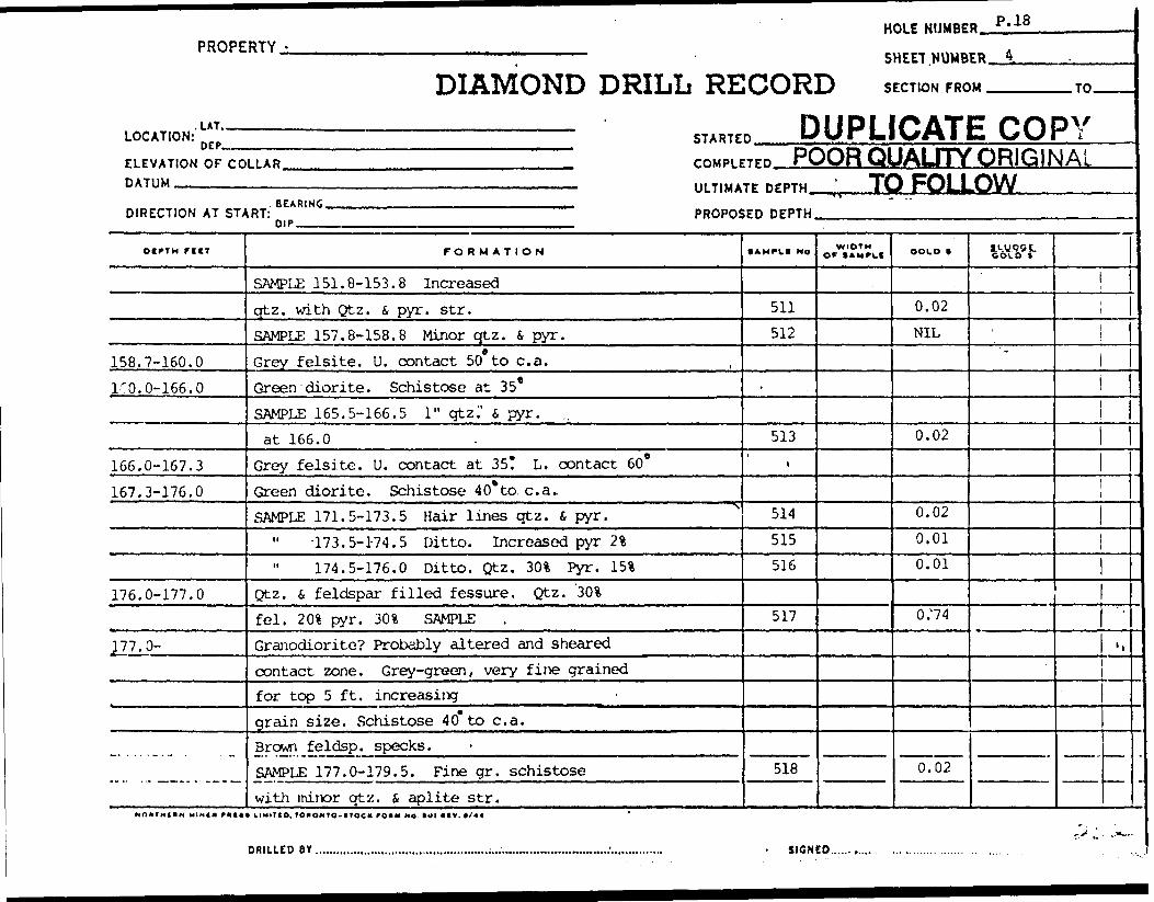
PROPERTY -
.LAT.
DIAMOND DRILL RELOCATION: n fp STARTE
HOLE NIJMBE
SHEET NUMB
CORD SECTION FRO
B DUPLICATI
B P.18
ER 4
M TO
E COPYFLrvAT,™ or mn AP TOMP, rrrn HUUH QUALl TY UHIUINALDATUM ' MiTiiiATrnrrmi TO FOL L OW
BEARING ___ __ ,. im.,. . ,,,,... ^ M-.DIRECTION AT START: PROPOSED DEPTH
P "*. ..., , ........, ....... ~
OI^TH rilT
158.7-160.0
3/0.0-166.0
166.0-167.3
167.3-176.0
176.0-177.0
J77.0-
FORMATION
SAMPLE 151.8-153.8 Increasedqtz. with Qtz. 6 pyr. sir.SAMPLE 157.8-158.8 Minor qtz. i pyr.Grey felsite. U. contact 50 to c. a.Green diorite. Schistose at 35*SAMPLE 165.5-166.5 1" qtzi' i pyr. ,,at 166.0
Grey felsite. U. contact at 35? L. contact 60*Green diorite. Schistose 40* to. c. a..SAMPLE 171.5-173.5 Hair lines qtz. fi pyr.
" -173.5-174.5 Ditto. Increased pyr 2%174.5-176.0 Ditto. Qtz. 301 Pyr. m
Qtz. 4 feldspar filled fessure. Qtz. 30%fei. 201 pyr. 301 SAMPLEGranodiorite? Probably altered and shearedcontact zone. Grey-green, very fine grainedfor top 5 ft, increasinggrain size. Schistose 40* to c. a.Brown feldsp. specks.SAMPLE 177.0-179.5. Fine gr. schistosewith minor qtz. i aplite str.
• AMPH MO
511512
.
513i
514515516
517
518
* * ~
WIOTM OP tAMPLf OOUO f
0.02NIL
0.02
0.020.010.01
0/74
0.02
1WU95C GOLO t
"
1j1
l
'.
MOHTHillM HIM** f*t*( LIMIT ID, lOIONIO-trOC* f OHM Ho tal * IV. (/44 '
r* J ,."*"--
-
DRILLED BY. SIGNED..

HEET NUMBER
.ATITUDE
DIAMOND DRILL RECORDPROPIRTY ______________________________ HOL|
SECTION FROM
DATUM
TO STARTED
COMPLETED
DEPARTURE.
•LEVATION .
BEARING.
DIP
ULTIMATE DEPTH.
PROPOSED DEPTH.
MMS. ; o*OHTO-*TOCrTi*M Ml*. Ml *IV. 11/11 II , ^ f f . A l F,.^jj^ *Xx~Vl GA^ ^ C^U/Ce X^'C* *
• •*- ^ J i V. * * j n ~ 'f ~ t, *

PROPERTY.-
LAT,^LOCATION: n rp
ELEVATION OF COLLARDATUM
BEARINGDIRECTION AT START:
P |p , ,
DIAMOND DR]SHEET NUMBER __ L.
'LL REHHRP srrTmurPou
STARTED, | M1I|| , llin -,, ,,
COMPILED..
ULTIMATE DEPTH . , ' \
PROPOSED DEPTH
TO
———
oirTH r i if
187.5-189.5
189.5-193.9193.9-202.5
FORMATION
187.5 Fissure. Sand only, no core.Qtz. i pyr'. injected shear.
SAMPLE 187,5-188.5 101 pyr.188.5-189.5 21 pyr.
Andesite. Fine grained, tuffaceousAndesite or granodiorite. 'Massive, .fine grained. Minor quart?.
End of Hole 202.5'
.
-
•AMPLC MO
519520
.
DI— PQC
WIDTH Of tAMPLt
IPLIC' m mfm\i
^QU;IU
COCO f
0.030.02
IATEfr\ m mat 1 IT\/ /"iUTYC
F^fcbC
s
COLD f
"
COP'RIGIN/W —w*
1—
*
.,
:
1
1
1
-
DfllLLEP BY. SIGNED

DIAMOND DRILL RECORD
SHEET NUMBER
LATITUDE ———.
PROPERTY.*rDEPARTURE.
ELEVATION .
otrrM rctr
HOLE NO.SECTION FROM.
DATUM-———.
-TO. STARTED.
BEARING.
DIP^^^.
ULTIMATE DEPTH.
PROPOSED DEPTH.
r on M ATION M*. WIDTHor • OUO 1 it-ypyt
H.M.fq T010NTO-ITOCK fO*M N*. 101 *tv. 13/11
...urn .w

PROPERTY. Pick Mines Ltd. HOLE NUMBER. P.19
DIAMOND DRILL RECORDSHEET.NUMBER_L
SECTION FROM ^^.
LOCATION:. LAT,.CEP-
5500 N4300 E STARTED. July 19. 1962
ELEVATION OF COLLAR. DATUM ————....———
July 23, 1962
Due soutnDIRECTION AT START: Surface 45" at 2^ T 42
COMPLETED.
ULTIMATE DEPTH '22~"
PROPOSED DEPTH_____
DtPTH f l IT
0-2.02.0-5.0
5.0-25.0
25.0-27.5
27.5-71.6
FORMATION
CasingSheared silicified, sericitic zone ingreen diorite. Possibly shearedqtz. porphyry. Pyr. dissemin.throughout 5% Qtz. str. 25 to c. a.SAMPLE 2.0-2.5 Pyr. J.%
" 2.5-4.5 Fractured .zone V qtz.str. at 25? 101 pyr.SAMPLE 4.5-5.0. V qtz. S 5 1 pyr. .Creen dioriteSAMPLE -5. 0-7.0 Dissem. pyr. minor7.0-24.0 Diabase textureQtz. injected sheared 6 5* to c. a.25.0-25.8 qtz. 501, pyr. 3* .25.8-27.5 Fine grained schistose dioriteSAMPLE 25.0-27.5 1" qtz. S pyr.at 27.3
Green diorite as above, withsane sections diabasic.Water ssam at 36.5
Sanple 36.3-37.3 1" qtz. f, pyr. in
• AMPLI Me
.
521522
\523
524
525
WIDTH Of * *MPCt OOLO 1
NIL0.03
NIL
NIL
^
NIL
COLD f
———— ?-^
^^\ 7r*
1 (f ^ S?i in OHf
i ^f B B
O5
^J OS. o:Q JjJ
i
•^ —~jpc\
-
ii
.s
MINIM P II11 * klMIT IO. lONOMTO-VtOC* fOAM MA (Ot AtV. 9/44
DRILLED OY.

PROPERTYUtAMUttU U K l L L K t C W K
l HOLE NO.SHEET NUMBER
LATITUDE O kj
SECTION FROM.
HATT ?M
TO STARTED.
DEPARTURE 4 3 O Q E.
ELEVATION ,—.————™———
BEARING
DIPJ^^ALI
COMPLETED;
D .
ULTIMATE DEPTH.
PROPOSED DEPTH.
FCCT FORMATION • AMPUI NO. orWIDTH OOLO t f t-yoQt
'./(t A -'i r/
P-?.I ,/' Ps Y, r -^
n/O
rt ^--'
ju IL.
2.7* r-A e3L^.c^ .
Ui-A^tl
, TOKONTO-tT^CK fO*t4 HO. tOI *CV, IJ/il
SIGNED........_.....T:;.^.

PROPERTY -
.LAT.
DIAMOND DRILL RELOCATION: n rp STARTE
H
S
,CORD so nupi.li
ELEVATION OF COLLAR COMPLETED PPk^P ALIDATUM
DIRECTION AT STJI
71.6-86.4
86,4-88.4
88.4-100.0
OLE NUMBE
HEET.NUMB
ECT1ON FRO
CAUEAIITY
D P.19
ER 2
M TO
•COPORIGIN
'YAL
- ——————————————————————————————— ULTIMATE DEPTH, " TVl Cf\\ 1 fMA/BEARING , —
RT: PROPOSED DEPTH.
FORMATION
fracture zone.
.SAMPLE 38.3-39,3 shearzone, minor qtz S, pyr. 30 to c. a.Grey andesite or felsite. U. contact 90*SAMPLE 71.2-71.7 Pyr. on contact
75.5-76.0 Qtz i fei injected.shear zone. Minor pyr.Saiiple 76.5-78.0 Banded tuffaceouswith hair lines pyr in bands z some. qtz. str.SAMPLE 81.0-83.0 Minor qtz. injectionsSAMPLE' 85.1-86.4 Schistose edgeof felsite at 4 5* to c. a. Minor pyr.Quartz i pyrite injected shearzone. Quartz 301 pyr 201 . SAMPLESchistose edge of granodiorite?Scattered 1/16" qtz. phenocrystsin qtz injected ? contact 50*Scattered broken blebs of feldsparSAMPLE 88.4-89.4 Qtz S pyrinjected shear zoneSAMPLE 98.5-100.0 Ditto
1AMPLI MO
527
528
.529
530'
531532
533
534
535
536
v l W 1 W
WIDTH OF SAMPLI OOlO t
0.03
NIL
NIL
NIL
0.03
NIL
MIL
.02
NIL
NIL
l.uuQqe.GOIO l
*
1
i,
Nn*fHi*M MIX** nut uuimo. lOioMto-ttoc* roKM M* (einv.*/** ' ^.. ^
100.0-119.5 Interbanded granodiorite S green diorite o* ^-) (2DR.LLEOBY,,.,,,.,,,,.,,,.,,,,,,,.,,.,,...,..,,,,,.,,,.,.....;,,,...,,.. . ....;,.*^J^v;-^^^^iuW^^-"-^.

DIAMOND DRILL RECORDPROPERTY
SHEET NUMBER
LATITUDE — ——
DEPARTURE ——
ELEVATION ——.
HOLE
SECTION FROM,
DATUM.-—.^
.TO.
COMPLETED.
BEARING.
DIP————
ULTIMATE DEPTH.
PROPOSED DEPTH,
NATION • AWPCI H*. OFWIDTH OOID t ILUPQt
ftolV f
0. 03tfn 9i-e 3 -
-//•c, — 0,U/u
- 7/ - P? C/ -l? v/ .^.5. 0
6-03P/-O -1. 7 /L, if!
*jt~' . t, i f d -*.* A H ^
M.M.F.. TORONTO -l(X)-0 ^nq.

PROPERTY -
L* T, -.
DIAMOND DRILL RE
HOLE NUMBE
SHEET NUMB
CORD SECTION FRO
D p.iyER ^ .
U TO
LOCATION: n f. p STARTED .
ELEVATION OF CO DATUM
DIRECTION AT ST^
oerTM rrtr
134.5-170.5
LLAR , [ r C OMPirrPD
————————————————————————————————————— ULTIMATE DEPTH. , ..J, . ,. , ,BEABINC
^RT: PROPOS
FORMATION
SAMPLE 100.0-101.5 Granodiorite schistose11 101.5-103.5 Qtz. inj. shear. Minor pyr." 103.5-104.5 Granodiorite schistose
104.5-105.0 Qtz. S pyr. filled fracture105.0-107.0 Qtz. inj. diorite. Minor pyr.107.0-109.0 "Ditto109.0-110.5 Diorite, minor qtz
" 110.5-112.0 Qtz. inj. diorite11 112.0-113.5 Qtz. j, pyr. inj. andesite" 113.5-116.0 Granodiorite schistose
- 116.0-118.5124.0-125.5
125.5-132.0 Green schistosewith blue qtz. eyes. Granodiorite132.0-134.5 Gradational changeto black fine grained rockwith blue qtz eyes S, dissem. pyr.Diabase134.5-142.0 Qtz. inected andwith numerous qtz. eyes. Scatteredpyr. and cholcopyente.
,ED DEPTH
• AMPIC No
537538539540
.541542543
1 544545546547548
-stPOC
WIDTH Of I AMPLI
PLICr^ lai VfrOttf
TO
COLD *
NIL
NIL
NIL
.02
.01
NIL
NIL
NIL
.02
NIL
NIL
NIL
v
AHr
COLD t
*
OQ&3
LTTYC|HIUIN/•GLLujW
j
i
l
f —L
.,
tattaTHC** MIMCN rHCt* H Mil |O4 TO*OMTQ-*?OC K PO1MMA.tOIIKV.ft/44 *
yfcODRILLED BY

DIAMOND DRILL RECORDPROPERTY————————————————————:————————— HOU N0.
SHEET NUMBER
LATITUDE ——.
DEPARTURE.
ELEVATION .
P/9SECTION FROM,
DATUM-————
.TO. STARTED.
COMPLETED.
BEARING.
DIP-.M
ULTIMATE DEPTH.
PROPOSED DEPTH.
OtPTH FfCT r OH M AT ION t AM PL* M*. orWIDTH a OLD t tlUPOt601.6 r
JO o.O -/o ) . iT -
5"- /04-r O 97#r- o S'. r o
4a 1 07- 0 , , Of
7 -t
sif A/it/
fa-*
Hfi i ***.t'JJ
t,?
M.U.P.. TOUONTO-trOCK *. Ml H(V. 11/11

PROPERTY.
DIAMOND DRILL RECORD
HOLE NUMBER,
SHEET.NUMBER
SECTION FROM
P.19
LOCATION: STARTED
ELEVATION OF CODATUM
DIRECTION AT ST*
DCPTht r UT
170.5-207.0
V ^ j
f
^H' j" s?yv!
-. . .... . , .207.0-227.0
t
LLAR COMPLETED PQQR OLJAI FTY DRIP I M \" '— - ' *-""*i i"\* w\u i TvnlvalNAi.————————————————————————————————— ULTIMATE DEPTH. ' l"** *-X-M t XN. . .
BEARING ,,,RT: PROPOS
FORMATION
SAMPLE 137.0-139.5 Dissem. pyr.139.5-142.0 " Pyr i, cholcop.
142.0-170.5 Fine grained black diabaseGranodiorite, contact in shear zoneSAMPLE 170.5-171.5 Qtz. injected contact zone 45" to c. a.
Fine grained grey-greenandesite conp. with blue qtz eyesSAMPLE 174.0-175.5 Qtz i pyr in j . shear
184.5-186.0 " " "186.0-187.5
. 187.5-rl89.0 501 qtz. at lO^to c. a. pyr" 189.0-190.5 Qtz. S pyr. in j. shear
190.5-193.0 Minor qtz. S pyr. str.193.0-195.5 Minor qtz. s pyr. str.195.5-198.0 Qtz. , fei l pyr, str.198.0-199.5 Qtz. i pyr. in j . shear199.5-201,5 Ditto 40% qtz.201.5-203.0
" 203.0-205.0 Minor qtz. S pyr.205.0-207.0
Green porphyrite i massive, with
,ED DEPTH
• AMPLI No
549550
.
5641 551,
552553554555556557558559560561562563
-^ —— i w ruu^tnrv —————
WIDTHor I AM^CI OOLO t
.01
.01
NILNIL
.01
.01
.04
.02NILNILNIL.01.01.02NILNIL
IkUP'/i- OOLO S
'
'i
11
.,
m
HINCM Putt* klM*MO, f OaONrO-t rOC ft fOMM M* IOI AIV. 9/44
ORILICD B V.. SIGNfD ., . ,
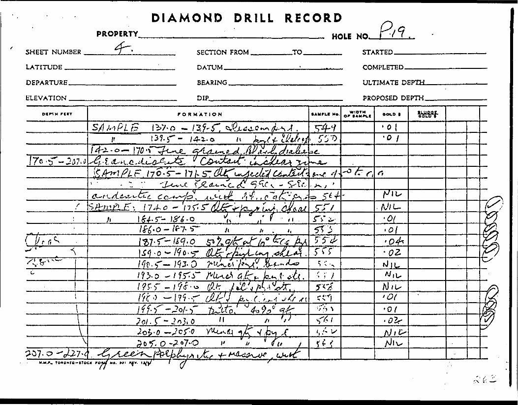
DIAMOND DRILL RECORDPROPERTY
SHEET NUMBER
LATITUDE .™—
DEPARTURE.
ELEVATION .
HOLE NO.
SECTION FROM.
DATUM.-—.-—
.TO. STARTED.
COMPLETED.
BEARING.
DIP
ULTIMATE DEPTH.
PROPOSED DEPTH.
Din H r t IT f OR M ATION • AMfUt NO. WIDTH r (AM^V.! OOt-O ( IIUPOIVolo t
- /4-1-0
fee ^j ^ . f r "^ vAs .*- ^^^"i * ^*y
. 0-^7- b— A1^7-r- c-c AA
01. s-~ ; 9 j. o '-
7 ^ M y ,^ ^ Of; f f. r - Of
\ T- 1' //^07.0
•, Tonoxra-iToc* rowtf M*. MI ' d

HOLE NUMBER. P. 19PROPERTY ————————;—————— SHEET.NUMBER.
DIAMOND DRILL RECORD S ECTION FROM. .TO.
LOCATION:.LAT..
DEP.. STARTED
ELEVATION OF COLLAR. DATUM -———^———..^
COMPLETED
ULTIMATE DEPTH.
DIRECTION AT START:. BEARING.
PROPOSED DEPTH.
FORMATION
1/16" fei. phenocrysts. Green chlorite matrix.
Upper contact 70? Porphyriticphase of qreen diorite, similarto duke in # 3 or aditzone.
END OF HOLE 227.0
s
DUPLICATE COPYPOOR QUAuTY ORIGINAL
TO FOLLOW.
• AMPLI No
-
1
WIDTH Of l AMPLt COLD | COLD t
*
!i
i
—
DRILLED BY ... SIGNED..

DIAMOND DRILL RECORDKK.UKtK.IT LI/M B Mrt \ o S^J
SHEET NUMBER -~^ SECT-TON FROM TO
LATrmnP DATUM
DEPARTURE ' BEARING
ELEVATION DIP
DtPTM riCT
'
STA
COB
UL1
PRC
. FOR M ATION
Y/6 xuc,r , 'l^cy^*t.jQ,-t-'t*. o^^' *M^44-*v. Cl*J(jl**JCi'CJy/ixf-,^ Lc^^h^Jr -r^ 0p^jck^e^ &J l^a^v. CLL&A-+&
[y fM^L^\^t.IW ^ 1 f/ J *V1J j ^^^1 j -- IT JF JM f t
5-^*^4'^ A Jcv' 7^3 o^ aJ^^^^i " -(jf ^ v^
Z^A^ D ^ ^ /V-6^ /E" ^27.
.**~ ..''AVt/f^1
c*
*-
0
WIDTHor fAMPit
^ *
.
'
fRTFD.
•iPLETED . .-. —————————
flMATE DI
5POSED DE
ooto l
,
JPTM
:DTW
*m-
-
TOflONTO-lTOCX fOKH H*. Ml KIV. t li 11

t
' *
Pick 1
Sample No.
9339 40 41 42
9343 44 45
9346 47 48
Pick 2
9349
9350 51
Pick 3
9352
9353
9354 55
Plck5
9356 57 58 59 60 61
9362 63
9364
Footage From
154.7 155.7 160.7 164.7
184.1 188.1 190.1
215.6 219.3226.3
. 128.2
155.6160.6
35.0
140.6
167.0 168.0
5.0 5.5 8.0
13.0 18.0 20.0
78.8 80.8
119.8
PICK MINES LIMITED Additional Samples
Width Cold To Feet OB
157.7 160.7 164.7 168.7
188.1 190.1 195.1
219.3 224.3 228.3
133.2
160.6 164.0
3.0 Nil 3.0 Nil 4.0 Nil 4.0 Nil
4.0 Nil 2.0 Nil 5.0 Nil
3.7 Nil 5.0 Nil 2.0 Nil
5.0 Nil
5.0 Nil 3.6 NU
38.0(cailng core)NU
141.6
168.0 173.0
5.5 8.0
13.0 18.0 20.0 23,0
80.8 82.8
124.8
9L~
1.0 NU
1.0 Nil 5.0 .01
0.5 Nil 2.5 NU 5.0 .01 5.0 .03 2.0 Nil 3.0 NU
2.0 .02 2.0 .02
5.0 NU
/t**.? "t/ftfu,**
• lOMAL CMOIHCC*-' fc

THOMAS HEYS A SONSr*t* AND A*,AY* ANALYTICAJ. CHCMIVT*
* AND A**AYCK*
.•tTAL..**u.*Tt:. MEMBER OF ASSOCIATION OF CANADIAN TESTING LABORATORIES
A8SAY CTtmnCATI r-rv
TILCPHONI EM. 4.3974
• S FRONT t. TORONTO- ^---. f T-P*
i (75) DATE , 27/61.1 '
1 ftrapk* U*A*d
i 9101. ..1 . 02. ..1 03. ..1 04. ..1 ' 05. ..1 06.f - k07. ..1 ' od. ..1 09. ..1 10 * -i n. ..l '-12. ..1 13* .*1 U. ...1 15* ..*l 16* ...m ' 17, t, t1 Id. ...1 19. ...l 20. ..,l 21. ...1 22. ...1 23. ...1 24. ...l 25. ...l 26. ...1 27. ...;l 26* ...I .29. ,..i . 30. ...I 31. ..*B 32. ..* 1 33* **.1- 34. -'v1 35. .*.B HA
Cold .V.Ki. O*. IWToo
Nil* Nil.Nil. Mil.0.01 0.35Mil, Mil.0.03' , : 1.05Nil. ;. Mil.0.02 , 0.70Nil. : ' lil.0.01 . . 0.35Mil. : Hil.0.04X 1.40
•0,01 0.350.90/ 31.50Hil. . Hil.Nil. Mil.O.UV 4.90•3.70 129,501.63/ 57.050,01 0.355X). 04 - 1 ' 1.4p 'Mil.- " ? ' Milrf"0.01 Oo35Nil. - Nil*0,01 .0^350.01 0,350.02A 0.700,02 0.70 .0.02y 0.700.01 0.35Nil. Mil.Nil. Nil.0.07) 2.45 Mil. Nil, 0.01 l 0.350.01, '0,35M 1 1 ' If* 1 1
SiW Or*.
Nil.Nil.0.04Hil. -Mil.,;Hil.vP.12Mil, '0,0d :0.04'o,n v'0,10 ,0.16 ;Mil.*''Mil.-; ;0,03 f0.26 ;0.20 ;,Nil. VHilV-;-''Mil i n'tract1111*—-Mil.0.08Nil.Nil.tractNil.Mil..MiA.Nil. Mil; " Hil.Mil.
Coppw- . % ••
'.'•'. '.'*,' •: '. '
. r '•. :'' ' ,' :' '' ( ' '"' ' '- ;• ,-'t, ',-.t
' . . . * *
•'\. . ' - ',; 't 1 - i -i'.- -,-7'' ' - "
- -•* ' .t *•*. -' . * ;. .
•1',.'- i ' Jc.t - *
?v.*i '. * - '
-
-, ..- :
Nldt*)
*- -
' i v.:' *
. ',- '•'l '
; .*t ' *
. 'i'''; '•••'•
' r ' - \
- *'. ' . -••/-•" ''.'. - 1
4 -' J
'r'l-Vl* 1*i
'.• 1 '-
.
' -
' ' ' -'
"r1
- *. '
i.-.
4
'
'•
' ^ '
* * \ '*
'
.
-
Per
. Xho-.-r
; ' ,"
' - ; V '''- 4. *.
•- -,.r t * ;.' . '
" .f ..
* ' if, '' - S 'Ji'V
' V':'';*^'*.' "' '
y. ;: .g'' * i ; .v'-i:''' ,'Ufv ..V utf f.' f*\t'
,- l* - .V M *
Uflifcfrf
*
- ' . .
*,
' ' .'
'' -* - '•'•"' '' .-" - - '.' '.' '•)- - '- - ' : :'.•' ,'- ; '-' ' r ./'.^•;"•i\'' V '.' 'O
1 -. * * . - ,
ff- v : I.'-\.V :'
' ' - ^- ' *
J-W-V* i ^.•'•' f **1''."' '"
-
l4 S**4*
's - 't
M
•'•',
FV
M *un(rmo r** o* t*M
Tw*
TMI Kxcki.in v*i or TXI r***ow. r**Tx ; MAMI t* VMM lAXMurovr MO* or Any
O* AWT
l T. WWOM tr M (ktXMOItO. AMD HCITMtM TMlor rr* .TATT. *uv M u*eo m COMNICTIOM vrm
OCX*. WITMOVT MHTTU) AUTMOWOAtlOW.//'

V
-JO
0.0
*0
V*v*vm
V*^V
^v*v*V
**-*
-*-*
-*-V
*-*
- *-
WV
-.t
• •*
•••••••"
* *
*
. .
' '
' -
. -
- ,
ae o
o x
x a
c at a
t o o
x o
ac
as o
O o
o x
O o
o o
O o
o Q
s* O
O O
o o
o o
o o
o c
H- O
0 M
M M
t-
M O
O M
p M
*-*v
M Q
O O
M.O
O O
p O
O O
O M
O O
O O
O O
O 0
O O
C
v ::.
. *T
'
1-- —
J*
' ,.^ —
— —
— -"
N
x o
o at
ac M
W m
o o
H o
x x
w
o o
m O
H M
i-* *
-* o o
i- x
i-* o
*M M
i-* M
i-* o
o o
c
* "-
^yj 9
( ^5
tNt S
tf ^3
k(
vC C
D M
l fetf
&C
SK {
5 O
O m
SK
88 5
C CD
O C
D CD
O C
D ^3
&C
M S
K S
t SsC
&C
5tf M
E &C
Sd
CC S
* i*'"
.''-..*
-'
* .
* *
^ * \
--'
- -
- "
* -*
-" .
* J
' .
. *
" -
7: j5
: l.
. .
*
1 a* .
- - -
- -
.
i C l Pi r^ ?r *f z n.
'E *'g 0
nt' .:
^ p K
* O
MX
O W
C
i
IB
Ir*
H-c
r 0.0
.9
*
to"*
et 9
* O
tJ O K)
-sj
M"
H wx O
CB' -
a K
(fi X•J.
)

AND A**AT*
, niTit.iit**. .MCTAtt o*t*, rre
THOMAS HKYS ^ SONS• •TA.IISMID l*T f
ANALYTICAL CHKMUTfl AND A88AYERS
MEMBER OF ASSOCIATION OF CANADIAN TESTING LABORATORIES
ASSAY CERTIFICATE
TtLtrHONt EM. 4-3974
63 FRONT E
TORONTO
' vv-'' ' . ' " " •-"•- J/,,;
- Suite 408, .100 ..Adelaide 3t. s.,..X. f . Toronto.
IPLES, core(30) i DATE Dec. 29/61.
ICIVEO, Dtc. 27/61. ORDER NO.
SwopU Marked
9176. ...77. ...70. ...79. ...
. 0o, ,.,01. .,.02, ...03....
05^ Ill06. ...
. 07. ...00. ...09. ...90. ...91. ...92. ...
-. "t 93 ' "*"'" ' /9f.* r.i"96. ...97. ..,90. ...99, ...
9200. ...01. ...02. ...03. ...04 . . . .05. ...06. ,..
Cold Vilur O*. Frt Ton
0.02 0,700,01 0.350.02 0.700.01. 0.35Nil.. . Mil.0,D1 0.350.01 . 0.350.01 0.35.0.02 0.70Nil. .Nil.0.01 0.350.01 0.250.02 . 0.70Mil. Nil.0.02 0.70o.n 3.050.07 2.450.02 0.70
•0.01—0.350.30 13.30Nil. Nil.
•0.01 0.35Nil.. Nil.0.02 0.700.02 0.700,02 0.70Nil. Nil,Nil. Nil,0.01 0.35Nil. Nil.0.01 0.35
SlUrt Du.
0.100.07Nil.Nil.Nil.Nil.0.06Nil.Nil.Nil.Nil.Nil.Nil,Nil.Nil.0.02Nil,Nil.Nil.0.04Nil,Nil,Nil,Nil,Nil.Nil,Nil..Nil,Nil.Kil,Nil,
-
Copper
. 9
',
NlcVrl
'
Lr.J
,
Per '
TTB^Tr™*'^!?' "if I
Zinc
i
,
*
i- ' ' -'
V'V^v
*
.1
''; .1 .' ;(' :
u ZPqn- -.
- * — Iron
*'; '
1 ^
.
. '.i* -
-V1 ^'V'j
l1*-'*- -,'-f^ :
K* 5^4
."-..i
• U*O*T K .U.MITKD f OH 1MI HC1.UIIVI UtI Or IMt rOIOH. rtHTNIIIIMIP, O* CO*re*ATieN TO WHOM IT 11 ADWXMIO. *NO NCITMllt TMt
RI'OOT NOD TMt H AM t Of INK l**CH*TOO NOR DF AMI MIMIC* Or n. turf, M AT .1 UIIO IN COHMICTION WrTM THC AbVIMTIBIH. OM .ALI DP ANY VftODUCT OM PHOCI*. WITHOUT WNITTtH AUTHOAIIATIO4*.

AMALTtt* AND AMAY*
COM. VITAL*.
THOMAS HtEYS a SONSMTA.ll.MIO 1*71
ANALYTICAL CHEMISTS AND A89AYCX*
m. M EMOER OF ASSOCIATION Of CANADIAN TESTINO LABORATORIES
ASSAY cavnncAn
EM. 4-3574
BS FRONT K. TORONTO
....--...Pljck.Klnaa..ltd*.,
OATC l Jan 2/62
"* * ** ** * v -w* ( " * * iN*.
; AS-*.M-W
i 9214...9215...
. -9216...9217...9216...9219...
-••••' 9220...9221...
- ' ' 9222...9223...9224...9225...9226...9227...•922d...9229...9230...9231...tv.K:*** ^'9232^1^** "*
**' - '* ** ' * Q2^1 v'-'' 1
9234!!.*9235.*.
* - 9236...9237...9233...9239...9240...
" 92*1...i
-.~
Y -
Cold Vila. Om. PwToa
0.02 0.700.01 0.350.02 "0.700.04 1.500.01 0.350.01 ' 0.350.01 0.35Nil -.Bil0.02 0.700.01 . 0.350.01 0.350.06 2.100.02 0.700.03 1.05.0.02 0.700.01 0.350.06 2.100.03 2.60•Q.OI""'- 4 ** Of 3 5'*0 ftl*' ' r"'*' o 1^Nil Mil0.01 0*35-0.02 0.700.01 0.350,09 3.150.01 - 0*350.17 5.95Nil Mil
SDnr On.
O.UNil.NilNilNilNilNilMilNilNil 'Nil0.04NilNilNilNil .0.020.02M1V4MNil.NilNilNilMil0.050.030.06Nii
.
Coppw
' :.
- . , r
. .
. -*
y i •w* r..*T if **'B*
- - .
.,
,. :
*
NfcU
t
' .
' " '
t' ' * .
:
.
"*ft,* Vf /j.•^•Y^t . t
*
- '
*
i^a
•* -- , .. .w
, (
Per.........
%
'
:...-W4.-*
-
t .
U^^4
Iroa
-
,.
\ A S***y
i* •uvnrrrto rou rx* ucvunvt w** or r*t rtMox, ^KTMI**MIP, o* COO*O*WTIO* TO W HOM rr i* * oo*t*tcs. AMDNO* TX( HAM* OP TMIt lAMMUro*T MO* O* AMT KIHCU O* IT* tTA^f. HA* If utlO IM CONMICTIOK WfTX
THI AOVtHTKIM* O* (At.1 O* A*V MOOU4T O* fWOCt** WITMCVr'WBlTTIM tUTMOAItATIOM.'

A
(n vi" w •o o (t
OO
OM
OO
MO
V*
**J"
5? Q
v*JV
***-
W\M
OO
OO
VM
\MV
lO A
O O
* J-
*
atO
Oae
ooie
A
W ?r 1 2 *E EO X s H OD OD
l
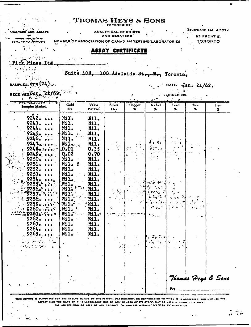
THOMAS HEYS A SONS\MALVM* AMO A**AY*
COAL. MCTALA, Wu.rrc.
ANALYTICAL. CHCMItTB " rAND ASSAYCH*'
MEMBER'OF ASSOCIATION OF CANADIAN TESTING LABORATORIES
ASSAY CERTIFICATE -
7C1.CPHONI EM. 4.3374
83 FROhTT E. TORONTO
'
SAMPLES,
Toronto.
OATE, .jant 24/62.
t*.'
' -iS,ffjSw' "
9242. ...9243. ...
1 9244. ...9245, .. 4
•J? 246," . . ..9247*. - k * * *.
f 924*..'* .4., '^r* ' - '9250.".;. 'VV- : , 9251. ...'"•^..- 9252. ...
9253. ...'.' ^k^HzjjV"*'***''^
" v * t^^^A* * * *•'.;,;;,1^57.-^r.nv•. !'. :9259l.l';i' : -1 -
v.. 9260..-. A .'v-*- *T^?Xp26l,'' 'i^. . * '
9262. ..,9263. ,..9264. ...
, 9265.,...^ -. .. -'' - ' . .- - t;
. -iw; .-.-w; /r
:
N. * '
CoU V.K- Ox. Pcf Too
Nil. Mil.Nil. Nil.Nil. . Nil.Nil, .v JU1,Ni;. , c Nil.NU..- , Nil..0.01 0,35q.ol 0,70Mil. Mil.Nil. d Nil.Nil. Nil.Nil. Mil.Mil.. Mil,Jfil, . Mil.Nil.' ".Mil.'Nil. /. Mili
:Milvv 'Nil!.Nil. ' 'Nil.MUr, Nil,^Nil. Nil.Nil. Nil.Mil, Nil,Nil. Mil..
Silver On.
*
*
. . .- • "•• r-
. .•'
•'"i 1 "**.-, 'i 1
'
Coppw
^ . .
', * *' " *
t)-
.
. - '-v* - ' "'
' ' -' '
\
i (... * f .
•~
'
Nickel
.
j - '"f. ' * s
.'t . 1 **
' '.' :
•* x V*^" ' t * -
^.^,''e t*-
' * * *" * " l* *
•' -*" *-' r- i - '
i, r., r. 4' - -t 'c
U.d%
*'- \
' #
*-
•' : ".- -i
- ^ v :". ...-','r
'.••' - ' -
. .. ; '-
•7X~*Per
Zinc *
' * ,-t
j..' .. ' -
" *' : -;
r
uWcf*
Iront
*
.
-
St S 6*4
TMM •vcurrrto re* TNI ticiudtn u t t of Tut rtntott. ***TM***Mir, ** OOOTOMATIOM TO WHOM rt K AOOXIIXD, AMD Mt irm*NO* TXI NAWI or TMIf LA.04UTO*r MOO *T JkMY MrMMft Cr m rTATT. HAT .1 UHO IN COMHICtlON WfTM
TMI *Dv**-rittnt o* CAL* or ANT r*o*vcT oo rwoc*M wnxour wu m t x AUiHoviitiiox.
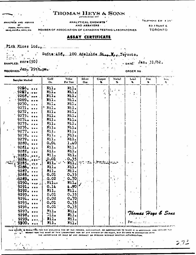
HOMAS H KVS f* SONSAND A**AVI tt'
rooot.
ANALYTICAL CHEMIST* ' AND A6SAYERS - .
MEMBER OF ASSOCIATION OF CANADIAN TESTING LABORATORIES"l .
Af&AY CERTIFICATE
EM 4 :
63 FRONT E
TORONTO
SAMPLE):
RECEIVED
eor*(50) 1/62.
ORDER NO
Sample* Mirkftd
92*6. ....-.92*7....*
9268.' *.a-' -9269. ..~
9270. ...9271. ...9272. ,..
' 9273; .,.9274. *..9275. -..9276. ,..9277. ...92?8. ...9279. ...9280. .,.
- 9281. ...9282, ...
1 9283. ....v:.?9.2^1f.,'*f."•*"S"ti'V '285. ' .t ." ^286. '...
9287. ..., .9288. ...
i-9289* . *. .9^90. . .f9291. ..."9292. ...9293. ...9294. ... ,9295. ...9296. ...9297, ...9298. ..,
, t 9299. *.... (9*v?D. •••.
Cold Vuliir O*. Prt Tori
Nil. Nil.Nil. Mil.Nil. Nil.Mil. Nil.Nil. Nil.
* Nil. Nil.Nil. Nil.Nil, Nil.Nil. Nil,.Nil. Mil.Nil. Nil.Mil. Mil.Nil. . Nil.Nil. Nil,0.04 1.40Nil. Nil.Mil. Nil.Mil. Nil.
,p.01 -0.35Mil.'- •••Hil;Nil. Nil.Mil. "Nil.
. 0.01 0.35
..0..02 0.70,Nil.. Nil.0.14 4.90Mil. Mil.0,01 0.350.02 0.700.01 0,350.01- 0.35Nil. Nil.Sil. Mil.Mil. Mil.MJ * W4 1
* "10.*
On
'
T* "*J-
j . '* .
Copjx*
.
•.*'r^,J?*^
-
*
- '
Nlclrl
V : -
•r^~"
,
* ) -'
'
*
^
Lr*.l%
'
. ~
,,
.
^•k t tr7ZMl . M/80*M
Per
7.inc
*
.
1A ^2/AMA\4r 9TOf4
IK •7.
-
4*XMC4
TMI. * tro)ri ft M uiMirrfo re* THI ttcLUiivi b.i or TMI rtotOH. rAmxiotHip. o* COA^OUIIOM TO w NO w IT i* fcco'ittio. AND•l ' 9.'. .tTWlT MO* TMC N1M* Of THU LA.OKtTtMHT MO* Of ANT tHOCLII O' fT* .V'', MAT *. iXfD M) CONNICTION ••UN
TMI AOVCWTItlN. O* (ALI Of A NT PRODUCT (M P*CK:((( WITHOUT ***fTTIN

KOCKJ
-^ .
v;,v- h4;
•"0
C" ". "^ vK'o iQ'o Vx-.o J-f.i"'.'
fc'o?0*T
JO'0
20*0 JO'0 J ?0*0.
C*0 T0*0
t f -- 'i ., -'n ---f f . . . c - J
C
* * - -- } ^ •dTi'X4 .
••••- *90C6|(.'T:* •ene*-\*'
•29/TC "2iGOT
-S4U7VJa .2'OKTJL33HS
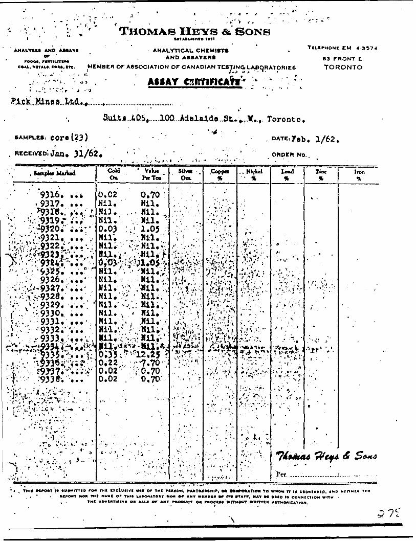
;V ' 'J f ' "
.. f
AND AMAYI
THOMAS HEYS A SONS
rooo., e*Ai.
UTAftUtHIO UTl
ANALYTICAL CHKMirr* AND ASSAYCRt
L.MrTAu.o*M,m. MEMBER OF ASSOCIATION OF CANADIAN TCSTINC* LABORATORIES
.:--'"V- 4 .' ;-'V,' , - .' AIIAY crcirfiFiCAfri'' : c "* ^. : -
EM 4.3574
83 FRONT E. TORONTO
3.ui.tfi...4Qb,..,,100...Adalaide.,St^.,.1f..,. Toronto.
SAMPLES, core (23)* *
*I Jan. 31/62.. DATE,Feb. 1/62.
ORDER No..-^ t.:t
9316. ..A9317. ...
9326, -
l' :.- -'.9330,. .,. V, ; 9331. -.'' . -9332."...
. ...i/ . t **'•f;-" .^33^.'..
f, t *.
j -t ' •.'••;. t -v--
Cold Oi.
' V*k* PecTon
0.02 Nil. Nil. Nil, 0.03
Nil.
0,70Nil,
... Nil..Nil.:.' 1.05 ..'\Wii*
W*W^;i,^.VA.V^ v-Nil. . ' 'Nil*; Nil.- Nil,/
.':'; ' Nil.';,'Cv; Mil;.,*
Nil. . . *- Nil,Nii.-:, ; .Nu.vylil.
0,220.02' 0.02
--7.70 , 70.70.
0.70"
On.NkUJ ZJDC
•'-.5 r'i .
7/^^44
Per
Iron
(^4
;. , TMI* nfO*r'l* *u*wrrriD roa TMI octuirvi VM e* TMI rote*). rAJinut.Hir, on •••rekAnoM To WHOM n n *otxi(tip. t xo H fn^n TMIMO* Tfl NAMI of TMII LAMWIATOIIT *KM *r A NT MUXI* ^ rT* rtAfT, HAT M VMO (M CONMICTION WITM
Tut AftVMTItlN. CHI *AL* PT AMT ntOOWCt O* ("BOOM KrlTMPWT WHfTTtH AI/TXOAIIATION.

llEVS 6* SONSio n#' : .--. . ,
-.. :' '
,y. ..- -..,- v';;i '. ANALYTICAL CHEMIST* i. . . r, AND ASKAYCRft
Ton
•- *- - - —— —— v
V'-Nil. fcNil.'l-Nil.' "^Nil.
vNii.'V••^Hil.;g•M'Nili 11 ;f,;:iiii;^
i. *. -,•X r -''
,..9359.9360.9361. '..
•9362. -.^.'9363. V.
:f * ' ' . * - -- ' . .
'^.NiiV^/Nii;^, ^MII.V,:MU;-.
Nil. - Nil.Nil, r 'Nil.
B.02 0.700.02 0.70Nil, Nil.
- V -v*.\ y,;..-; r- : . . :. ' ;' ..r..^j. :...v.- i. V
i'•?t*Xu tftff
. f X ; ':;*').'f--i?t,il*f" *i.ti v'rV-"-.. ^
- . . . . - . : - :, : - ' . - t,. i .. ' . -- .it.i*,'.*. Ko.Mrmo ro| THt nciutivt U M or THI MIHOH. rk*tMi.*Mi^. o- 00*^*010- to V.HO* IT i t .oo.nnu *"o,.t.i
O* 'MI h AM I Or TMII L*10ll*IIXr HO* O^ *HT MIHtl* O' lit rt
f- im ADVimiH". on no.t o r *NT rcoovcr o* rwocoi . .' ' :- .- " •• :,'"' ': .- '! , ' '. ,"' '-. ' ' '- '.. - - '-' '"'.
l . ' l ' " '. '

3 f
REPORT ON THE
PICK MINES LTD. PROPERTY
GOUDREAU GOLD AREA
ALGOMA DISTRICT, ONTARIO
Toronto, Ontario June 19, 1962.
A.C.A. Howe, P, Eng., Mining Engineer
CONTENTS
Page
Summary l
Property 2
^-- . Location and Access 2
Topography . 2
History 2
Work Done 3
plant and Equipment 't
Geology A
Gold Deposits 5
Results of Work In the //3 shaft area 5
Conclusions 8
Recommendations 8
Surface diamond drilling . 8
Underground program 9
Costs 10
Certification 11
Hap In Pocket
P 90

'C -i-M
SUMMARY;
Pick Mines Limited have outlined 5 gold bearing
zones In an area designated the #3 shaft area. This area lies
Immediately north of similar zones mined by a predecessor company
from which a production of $2,369,053.00.Is recorded between 1938
and I9'i2.
The results obtained from diamond drilling of the
#3 shaft area are sufficiently encouraging that they warrant
Investigation underground.
A headframe, hoist and compressor were Installed
previously at the #3 shaft. Sufficient mining equipment Is
available on the property for an underground operation as
recommended.
In addition a mill has been erected sufficient for
any future production at a rate of 200 tons per day.
A program of 3000 ft. of diamond drilling from
surface Is also recommended to extend the length ond depth of
the 5 proven zones.
p

-2-
V PROPERTY;
The property consists of 16 contiguous mining claims,
as follows:
Claims SSH 2185, 2186, 2188, 2189, 2190 and 2271 are patented,
and known as parcels IMS (l), 1**51 C*), and 1*479 (1).
Claims SSH 61783 to 61792, Inclusive arc unpatented, and adjoin
the north side of the patented group.
LOCATION AND ACCESS;
v. The group of claims is located In the central portion
of Township '18, In the Goud reau-Locha l sh gold area, District of
Algoma, Ontat'~
The property can be reached by grave) road from
either Goudreau or Lochalsh. Goudreau lies on the Algoma Central -
and Hudson Day railway line and Is 12 miles southwest of the
property. Lochalsh lies on the Canadian pacific Railway and Is
7 miles northeast of the property.
TOPOGRAPHY!
The property overlies mainly overburden and swamp,
however the mine workings are located on a rocky ridge which
traverses the property in an east-west direction.
HISTORY;
Gold was discovered by James Cline on Claim SSH 2188
in Hay, 1918.
In 192'l the property was optioned by Cline Canadian
Gold Mines Ltd. Buildings wore erected, and //l shaft on claim
f SSH 2186 was sunk to a depth of about 1^0 ft.
Work was discontinued In Hoy, 1926 and the property
reverted to James Cline, the original ovncr,

-3-9
( In 1927, Cline Mines was formed and #3 shaft was
sunk to a depth of about 115 ft. on claim SSH 2185. l
In 1932 Cline Lake Gold Mines Ltd. was formed, and j
In 1933 a new vein was discovered on claim SSM 2?-71, In 1936 \j
control of the company was acquired by O'Brlen Gold Mines Ltd. ;f
A 3 compartment shaft was sunk to a depth of 522 feet (subsequently :
deepened to 1175 ft.) and a 200 ton per day mill commenced operation
In July, 1938. From 1938 to 19^2, gold and silver were produced
valued at $2 ) 369,053.00.
The operation was closed down In 19*42, during World
War 2.
The property was acquired by Pick Mines Ltd, In I960.
WORK DONE;
By Cline Lake Gold Mines Ltd.:
(1) Surface exploration and diamond drilling.
(2) Three - 2 compartment shafts
#1 to 1^0' 90' of latera] work at 80' level.
#2 to 215' (at 700) 39' of lateral work at 100' level.
- Ito 1 " " " at 200' "
#3 to 115' -- 50' of lateral work at 100' level.
(3) A 3 compartment shaft to 1175', with seven levels, the shaft
(//4) was used for production from 1938 to 19^2.
By Pick Mines Ltd. (I960 to 1962):--
(1) Surface trenching and exploration.
' ( 2) S ampling of old dumps.
(3) Erection of camp, mine and mill buildings.
('O //3 shaft dewatorcd and cross-cutting performed at 100' level.
(5) //3 adit driven for length of 130*.
(6) Surface diomonfl drilling
Holes P. l - 5 for total 1000', 3 Cl'6

i '
( ., 1961. Holes P. 6 - 9 for total 1037'.
1962. Holes P. 10 - 16 for total 1997'.
PLANT and EQUIPMENT;
The following were erected on the property during I960.
(1) Camp and cookery.
(2) Mine office.
(3) Compressor and holstroqm at #3 shaft,
(li) Headframe at #3 shaft.
(5) Cap and fuse house.
(6) Powder magazine,
(7) Warehouse and garage.
(8) Hydro substation and transformer house.
(9) Assay office and refinery.
' (10 Hill building and mill plant sufficient for 200 tons per day.
The company possesses all necessary equipment for an
underground development program,
GEOLOGY;
The geology of the property is described In the Ontario
Department of Mines report -- "Geology of the Goudreau-Lochalsh area."
The following Is a brief summary; —
The oldest rocks are lavas of Keewatin age, which are
Intermediate to basic In composition In the area of the property.
These have a general east-west strike.
The lavas are Intruded by a series of bosses, dykes
and sills of varying composition, and of pre-cambrlan age. The earliest
of these being a diorite followed In sequence by granodiorite,
porphyries, felsite and d'abase. The granodlorlte generally parallels
the strike of the lavas; the porphyries and felsite generally cut

-5-
Wacross the earlier rocks In a northeast direction, and the diabaseC 'occurs In dykes end sills cutting the older formations at varying
angles.
A strong shear zone lies a short distance south of
the old workings. It strikes a few degrees north of east and dips
70O to 80 N. It Is J|0 to 50 feet wide and contains a large amount
of quartz end carbonates.
GOLD DEPOSITS; '
The gold bearing vein systems vary In character and
strike. They are associated with fractures and shear zones that
are probably'related to the great shear zone to the south. The
ore bodies mined In the past occured either as lenticular quartz
veins in the greenstones, or as zones of shearing In the granodiorite
t and porphyries. In both these rocks ore was not costly distinguishable
from material below ore grade, and walls were assay walls giving
widths ranging from 4 to 8 feet.
In the #3 shaft area adjoining north of the old
workings, gold has been found In five separate shear zones. These
zones vary In strike from slightly south of E - W to slightly north.
Within each zone the gold occurs within quartz enriched shoots,
either In the free form In the quartz itself or associated w! th
pyrite In the neighbouring country rock. In some zones two and
occasionally three separate shoots occur In one zone. These shoots
vary In width from 2-8 feet and occasionally join together to form
a zone of enrichment 12 - 16 feet wide,
RESULTS OF HORK IN THE #3 SHAFT AREA;
( The five zones outlined by both the Cline (C holes) and
pick (P holes) have been numbered R, Q, 3, ** and 5, in order from
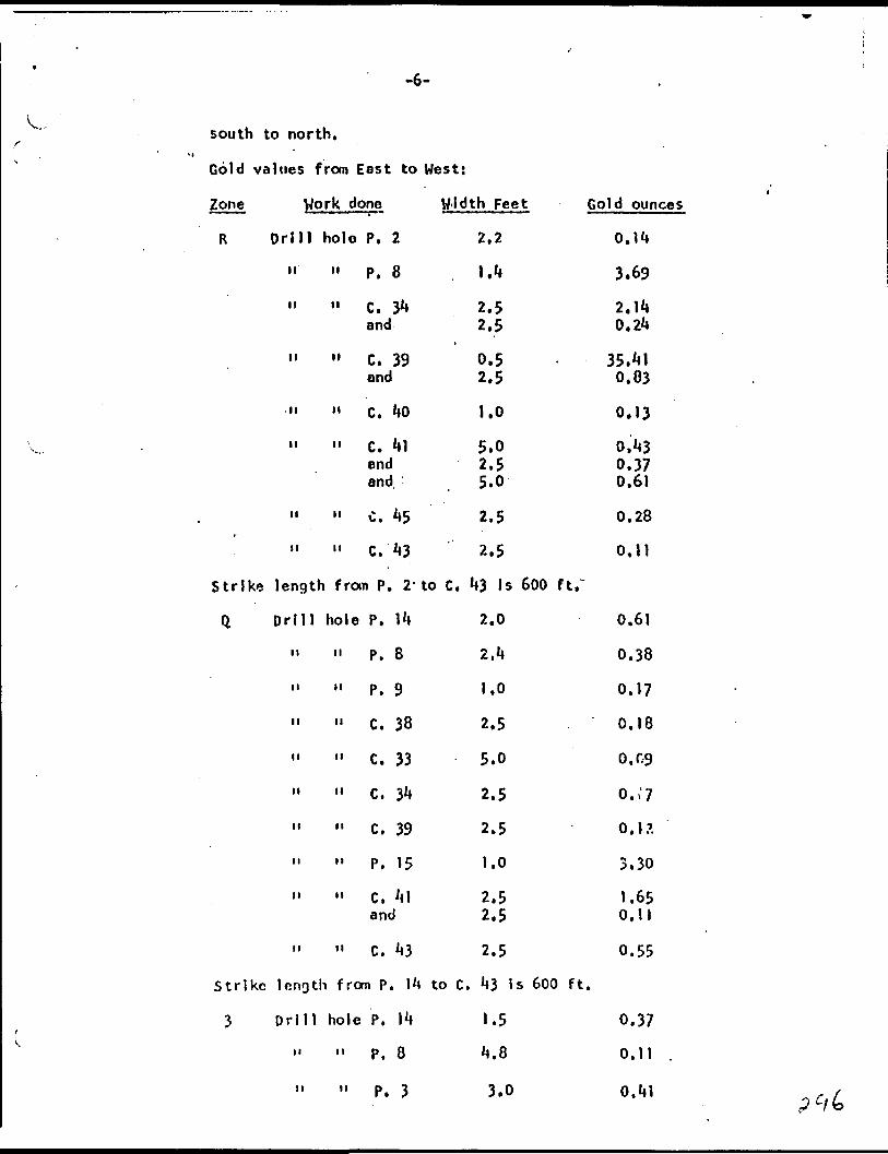
-6-
south to north.**
Gold values from East to West:
Zone Work done
R Drill hole P. 2
it
it
M
II
II
II
II
Strike length
" P. 8
11 C. 34and
" C. 39and
" C. 40
" C. 41endand
" C. 45
" C. 43
from P, 2'
Q Drill hole P. 14
it
n
n
n
n
n
tt
n
ti
Strike length
3 Drill
H
M
11 P. 8
" P. 9
11 C. 38
" C. 33
11 C. 34
11 c. 39
" P. 15
11 C. 41and
" C. 43
from P. l*
hole P. 14
11 P. 8
11 P. 3
Width Feet Gold ounces
2.2
1.4
2.52,5
0,52.5
1.0
5.02.5
. 5.0
2.5
2.5
to C. 43 Is 600 ft.~
2.0
2.4
1.0
2.5
5.0
2.5
2.5
1.0
2.52.5
2.5
i to C. 43 Is 600 ft.
1.5
4.8
3.0
0.14
3.69
2.140.24
35.410.83
0.13
0,430.370.61
0.28
0.11
0.61
0.38
0.17
0.18
0.09
0.,'7
0.1?.
3.30
1.650.11
0.55
0.37
0.11
0.41

Zone V/ork done
3 Drill hole P. 9
" " P, 6 and
H -H p. 7
11 " C. 33 and
" " C. 38
11 V P. 5
Adit 100' sampled
Surface trenches 76' sampled
Drill hole P. 10 and
" " C. 31*
11 " C. 39
M M p. 12 and
" " P. 15 and
ii H p, 16and
Strike length from P, 1*4
b D rill hole P. 1*1
11 n P. 9II M p, 7
" " P. 11
11 " C. 39
H n p. 12
•i M p. 16
V/idth Feet Gold ounces
l.o3.1 5.9
2.0
5.0 2.5
3.0
0.7
1.1*6
1.33
2.5 3.5
2.5
2.5
1.5 5.0
2.0 -.5l.o'1.0
to P. 16 Is 550 ft.
1.5
1.0
3.3
1.5
2.5
2.5
3.0
0,09
0.90 2.89
0.19
0.31 0.23
0.09
35.34
5.00
0.1*5
0.68 0.30
0.15
0.37
0.23 1.58
0.3** 0.25
0.12 0.33
O.ot*
0.0**
0.07
0.33
1.61*
0.50
1.31
Strike length from P. l** to P. 16 Is 550 ft,

-8-
Zone . V/ork done Width Feet Gold ounces
5 Drill hole P. 13 3.0 1.80
11 ." -P. 16 1.5 0.11
Strike length from P. 13 to P. 16 Is 100 ft.
CONCLUSIONS;
Close spaced drilling, at intervals of 50 ft., has outlined
5 separate zones of gold mineralization, over a drilled length of
600 ft. The assay values have been sufficiently encouraging that
this area should nov; be Investigated underground.
In addition further diamond drilling from surface should be
carried out to extend the length of the known zones, and also to
explore for additional zones to the north of them.
HECOMMENDATIONS:
The work will be divided into two phases, which will consist
of diamond drilling to increase the tonnage outlined in the area,
and underground drifting and diamond drilling to Investigate and
develop the known ore shoots.
SURFACE DIAMOND DRILLING;
(1) The drill program In the //3 shaft area should be continued
to extend this area both east and west, and thereby Increase
the tonnages already outlined.
North south sections should be drilled at 100' intervals
as before,
(2) One or two exploratory holes should be drilled North of the
#3 area, to locate new ore zones.
A total of 3|000 ft. of drilling is recommended. The cost
at $6.00 per foot including engineering, assaying, etc,,
would be $18,000.00.

-9-
UNDERGROUND PROGRAM;
The following program is recommended;
(1) The #3 shaft be dewatered, thus giving access to the station
and cross-cut previously prepared on the 1st level (elevation
6W).
(2) From the end of this cross-cut, a 600 1 long drift be driven
along the centre of the area, This drift will commence by
following the values obtained in holes P, 16 and P. 13, and
designated #*4 zone. It will then be determined whether these
values are either the faulted extension of the 3 zone or ore
In reality the ^ zone. A cross-cut will then be driven toi
the 3 zone, and this will be followed by a drift to the
eastern end, where values were obtained In hole p. 1*4.
(3) Drill stations wi.l l be blasted at 50' intervals, so that
underground diamond drilling may proceed simultaneously with
the drifting. The object of this drilling will be to determine
the plunge and grade of ore shoots In the other zones,, as
well as In #3 zone Itself. Short holes, of 200' length
maximum wl'l be sufficient to reach any of the other zones.
It can be observed that there will be considerable savings
In diamond drill costs over a similar program from surface,
and these savings can be considered to offset part of the
extra cost of the underground development.
(*t) The ore obtained from the drifting should be stockpiled at
surface, so that It can be treated In the mill during any
subsequent production program. This ore will also help
offset the costs of underground development.

-10-
The cost of this program Is estimated as follows:
(1) New equipment, Including replacement of hoist motor, S ton truck and standby pump
(2) Preparation of equipment already installed at #3 shaft, and dewatering of #3 shaft
(3) A total of 600 ft. of drifting, and 200 ft. of cross-cutting and drill station preparation at a contract price of 530 per foot
(*0 A total of 3*000 ft. of diamond drilling at $2.50 per ft.
(5) Engineering and supervision for a minimum 6 month program
(6) Maintenance and supplies
(7) Sampling and assaying
(8) Contingencies, particularly for grouting of water bearing seams
TOTAL
The total cost of both underground and surface work
will therefore be:
(1) For underground drifting, cross-cutting and diamond dri11 ing
(2) For surface diamond drilling
TOTAL
^10,000.00
5,000.00
2k, 000.00
7,500.00
8,000.00
3,000,00
3,500.00
5.000.00
566,000.00
in my opinion, the expenditure of 58^,000.00 is well
In view of the encouraging results already obtained.
566,000.00 ;
18.000.00j
S8^.000.00 -
Justified
Respectfully submitted,
A.C.A. Howe, P. Eng.
V C

-II-
Certification
t, A.C.A. HOV/E, of the City of Toronto, Ontario, hereby certify that:
(1) l am a Mining Engineer and reside at 308, 85 Wellesley St. East, Toronto, Ont.
(2) l am a graduate of London University, England, B. Se, 19^9, and a member of the Association of Professional Engineers of the Province of Ontario.
(3) l have no interest, nor do l expect any interest, either directly or Indirectly, in either the property or securities of pick Mines Limited,
This report is based on Government geological maps of the area, the records of the previous producer on the property, and from a personal knowledge of the property gained during the supervision of a'diamond drill program from March 20, 1962 to May 20, 1962.
Dated at Toronto, Ontario, this 19th day of June,
A.C.A, Mowe, P. Eng,
|06
fit POUT ON TllE
PICK HlllliS LIMITED PROPERTY
GOIWREW GOLD AKEA
ALGOHA DISTRICT,
Toronto, Ontorio A.C.'*. Huvic, P. ?.0, )1XS2. MJniny t;:ylnccr
3.

CONTENTS
Sicnary t
Property 2
Loco t I on and Access 2
Topcxjrephy . 2
History 2
. Work Dor 5 . 3
( P t Ant end Equipment **v—
Geology ^
Cold Ocpoolto **
noaults of SanploB of Adit and TroncJwa on til Zono 6
Ho suits of DiocKJnd Drilling In Ilw i?3 Shaft Aroa 6, 7, O
Olhar Worli Oon-j ?
Conclustona 9
//3 Zorio 10
Other Zcnos H
Futuro Work l)
Rocorrrxjndotlons 12
Program 12
Coato . l 'i
Cartlftcotlcn 15
Hop In Pocket
-l-
Pick MInot LIml tod have outlined 5 gold bearing zones
In on area doslgnotod tho #3 shaft area.
The results ob to l nod frcra dloaond drilling of Iho //3
shaft oroa oro sufficiently encouraging thot tlwy warrant Invo&tlgotlon
undorground.
A hoadfremo, hoist ond compressor vara I n&tollod previously
ot tho /O shaft. Sufficient ratnlng equipment Is ova 11 obio on tho
property for on underground onoratlon aa rocomnendnd.
In addition a ml 11 has boon erected sufficient for ony
futuro production ot a rote of 7.00 tons par day.
A proyran of 3000 ft. of dlanond drilling from surface Is
also rocammendod to extend ttva length ond depth of tin 5 proven
zones.

-2-
v..7ho property consists of 16 contiguous mining claims.
as follows:
Claims IfSM 2133, 2126, 2!oJ. 21G9. 2)90 ond 2271 arc patented,
ond known os parcels ll'iO (1), 1^51 (U), and 1**79 (l).
Claims SMI 61703 to 617^2, Inclusive arc unpotcntod, ond adjoin
the north s(do of the patontod group.
IOC.ATIQJI.AUP. ACCESS;
Tim group of claims Is located In the central portion
of Township MS, in tiro Goudroou-Lochalsh gold area, District of
Algona, Ontario.
Tho property can bo roociicd by gravel rood frorc
oltlwr Coudroau or Lochalsh. Goudrcau lies on 11 w Alcona Central
o?xJ Hudson Buy rolhmy llrto and lo 12 miles southvjost of the
property. Lochulsh lies on the Canadian Pacific Uollnoy ond Is
7 wiles northeast of tho property.
TOPQGUAP'.IY;
Tho property ovorllos mainly overburden and sixvnp,
Ix^-jovor tho P J no workings a rc l ocated on a rocky ridge which
travoroce tlxi property In an cost-west direction.
HI^TQKV;
Gold v*03 discovered by Jones Clino on Claim SSM 2160
In Hay, 11)18.
In \ i)2^ t lx) property was optioned by Cline Conodlun
Cold Nines Ltd, Uulldings \vero erected, and //l oho f t on claln
SIM 21C6 vias sunk to a depth of about MO ft.
Work was discontinued In llay, 1925 or.d lira property
reverted to James Clino, the original cvaior.
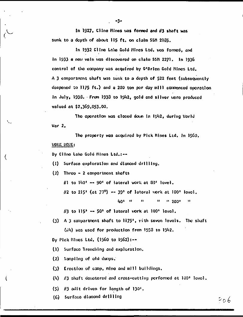
. -3-
t In 1927* Clino Mine* vws formed ond i/3 shaft wasrounk to a dopttt of about 115 ft. on claim SSM 2165.
In 1932 Clino Lnko Cold Mines Ltd. was foroed, and
In 1^33 o new vein was discovered on data SSM 22/1. In 1936
control of tha company was acquired by O'Brlcn Gold Mines Ltd.
A 3 compartment shaft was sunk to a depth of 522 feet (subsequently
deepened ;o 1175 f O ond o 200 ton per day mil) commenced operation
In July, 1933. - From 193d to 1^2, gold end silver wore produced
valued ot $2,369,053.00.
Tho operation was closed doun In Iy*i2, during Worldk^
Wor 2.
Tho property was acquired by Pick Mines Ltd. In 1&60,
WORK .UOK'E;
, Oy Clino Loko Gold Mlnoa ltd.: —
(1) Surfuco exploration ond dlonxxid drilling.
(2) Thrco - 2 canporunont siiofts
//l to I'lO' — 90* of lateral work at 80' level.
{12 to 215' (ot 730) — 39' of lotorol uork ot 100' level.
1*0' " " " " 200' "
r/3 to 115' — 50' of lateral wrk at 100' level.
(3) A 3 compartment shaft to 1175', vith seven lovoU. The shaft
(//'O was used for production from (933 to l D-'* 2.
Dy Pick Minos Ltd. (1^0 to 1S&2):--
(1) Surface Trench l rnj and oxplorotlon.
(2) ^ompllny of old duriips.
(3) Erection of camp, mine ond mill buildings.
( ('O //3 shaft dovxitored and cross-cut t i ny pcrforr,ed at 100' level.
(5) //3 adit driven for length of 130".(6) Surface diamond drilling

•J*-1960. Holes P. l - 5 for totol 1000*.
llXil. Holes P. 6 - 9 for totol 1037'.
19G2. Moles P. 10 - 19 for totol 2700*.
Deviate r Ing of #3 shaft ond sampling of drift ond
cross-cut.
Overhaul of equipment ond buildings for underground
work.
Ilw following woro erected on tho proporty during
(l) Canp ond cookery.
^- (2) Mlno office.
(3) Compressor and hoi s t rocca at #3 flhoft.
(^4) IkDodfrcrno at //3 shaft.
(5) Cop ond fuso houBO,
(6) Powder mogaalno.
(7) Worclxxioo ond goroge,
(3) Hydro cubstotlon ond tron&fomor house.
(9) Asooy office ond refinery.
(10) Hill building ond mill plant sufficient for 200 tons per day.
V. Tin company possossoft all accessory equipment for on
underground development progr cm.
GC.QlOSYj
Tho geology of tho proporty lo described In tho Ontario
Department of Mines report — "Geology of tho Goudreou-Lochalch oreo."
Tfhe following Is o brief curaary: -*
Tho oldest rocks oro loves of Keewatin 030, which oro
IntomoUluto to boo I c In composition In the oreo of ttxi property.
Those Ittva a general co3t-vwst ttrlko.
t Tho lovos oro Intruded b/ o sorlcc of bcssoc, dykes-
-5-
and sills of varying composition, and of pre-carobrla* ago. The earliest
of those being o diorite followed In sequence by granodiorite,
porphyries, felsite and dlobate, Tho gronodlorlto generally parallels
tho striko of tho lavas; tho porphyries ond felsite generally cut
across tho earlier rocks in a northeast direction, end tho diabase
occurs in dykes ond sills cutting tho oldor formations at varying
onglos,
A strong shoor zone Iles a short distance south of Ilw
old workings. It strikes a few degrees north of east and dips ?0O
to 80O H. It Is *40 to 50 feet wide and contains a largo amount of
quartz and carbonates.
COf.0 DEPOSITS t
Tho gold bearing voln systems vary tn character and
striko. They aro associated with fractures ond shear conoa that
aro probably rolotod to the great shoar sono to tho south. Tho
ore bodies olnod In tho past occurod cither OB lenticular quortz
veins In the greenstones, or os zones of shearing In tho granodiorite
and porphyries. In both theno rocks oro was not easily distinguishable
from materiel below ore grade, and wall o wcro essay walls giving
widths ranging from k to O feet.
In tho #3 shaft oree adjoining north of tho old
workings, gold has been found In five separate shoar zones. These
aonos vary tn striko frow slightly south of E - W to slightly north.
Within eoch zone tho gold occurs within quortz enriched shoots,
either In tho free foro In tho quartz It&olf or associated with
pyrite In tho neighbouring country rock. In setno 201*05 two end
occasionally three separate shoots occur In coo zone. Tho&o shoots
vary in width from 2-8 foot ond occasionally Join together to form*
a zone of cnrlcisnont 12 - 16 foot wldo, y ^ e

Resuls.. OF. s.vines OF ADIT AIID TKEHCHSS at //3Avorogo of oil K
30' E. of Portol.
f ran 70' W. of Portal of Adit to
Widthf fr 4 ,
222
* 31.5
* h751.670.70.51.52.2
* 3.171.332.502.0
,-?**Q-,
29. C2
1.49
V
Avoro&o
1.16* 4
21.5.7.7
L5.0.56
1.22
4'
Voluo-&U.
9.2113.13
.30
.08
.39
.06
.153.307.160.50
.30
.751.202.731.33JtiJiii2.30
of osscys from
1.263.06
.77.4411.309.31
-1*63
V.JLM*1B.4?26.' 26
.60.2*1• 525. J oy.25
2.373.59
.84
.662.331.706.0752.663u*3J3
70.915
2.33
.09
130' to 230'
1.1*63.051.54.66
7-^66.51
-i*3i27.51
3.22
.97
W x VCut to/\vrj. Vtj3fj
i*.76^.*76
.60• 2h.505.105.25
1.671.19
,0*j.66
2.301.705.952.663,39
31.730
1.07.1*0
oc&t of Porto).
I.'*63^221.5*4.66
2.252.25
Jbft16.21
1.01
.55
W K VCut toDoubleAvn. lj.76
9.529.52
.60
.2*1
.585
.105
.252.372.30
.G**
.662.381.706.C752.663.30
1.43
.55
1.463!221.54.66
4.504.50
...51&2) .40
2.5
.76
All ocnplos tolcon during I960 - 1961 explorotion vwrk,
except for clxock soraplos mo r ted * v/hlch v/cro toloon during 1962,

RESULTS OF OlfflQKO DRIU.IMB .IB TtiE #3 SHAFT AT.EAt
TUo flvo zones outlined by both tho Clino (C'holes) ond
Pick (P holos) lavo boon nuroborod fi, Q, 3, l* ond 5, In ortlor from
south to north.
Gold voluos from East to West:
(See Pago 7)
3/0

II z
IVOH'O
iC'O
55*0
1 1*0 59* t
ore21*0
iroGO'0
eroiroGC'O
19*0
iro02*0
19*0
cro
ft*
*J2*0 *?t*2
69*C
wo
o*CC**;
5*1
•5,1 009 sl t*? '3 01
5-2
5*2S'2
0*1
5*2
5*2
O'S
5*2
0*1
1*2
0*2
*1J 009 sl C*? *3 *
5*2 .
5*2
0*5 5*2 0*5
0*1
5*2 5*0
5*2 5*2
1*1
2*2
S *d
C *d
'M 'd
\ *a -d ooe*j *3
puo 1*1 *3
SI *d
Ct *3
IjC *3
CC *3
ec *36 *d
C *d
ni *dX| 2 'd U3
CV *3
5*; *3
puo puo
|tj *3
0*j *3
puo GS *3
puo *jC *3
8 *d
2 *d
-
II *l
M II
O|oq ItJJQ i
j .j i{)Cuo| crit-US
H II
II M
n H
M .1
II II
11 II
II II
II II
M M
Oioq | l|4(j
JJ IplGuot 0){|J7S
II M
M II ^
II II
II M
It M
II II
II II
O|(X| l||JQ y
' ..-""——SL

Zons. l.'ork i-'ono Wldt'i Feet Cold ounces
3 Drill holeII M
II 1C
M II
II II
1, 1,
II II
M It
M M
II M
M II
H II
P. 9
P. 6OIK!
P, 7
C. 33UixJ
c. 38P. 5P. 10o od
c. 3**C. 39
P. 12tind
P. 15OIK)
P. 16and
Strlko length frcti P. 1** to P.
'l Drill holen n
n n
M II
" "
II II
II II
P. \k
J'. 9
P. 7P. 11
c. 39
P. 12
P. 16
StrllB lonyth froci P. H* to P.
5 Drill lw lo
M II
P. 13
P. 16
1.0
3.15.9
2.0
5.02.5
3.00.72.53.52.52.51.5
. 5.02.00.5
1.01.0
16 Js 550 ft.
1.5
l.o3.3
1.5
2.5
2.5
3.0
16 Is 550 ft.
3.0
1.5
o.os0.902.69
0.19
0.310.23
0.03
35 31*
0.680.36
0.15
0.37
0.231.58
0.3^o!25
0.120.33
O.OU
O.Cfc
0.67
0.33
1.6**
8.50
1.31
1.80
0.1)

*
is
-9- ;
Zono Work donq Width Fcot Cold ouncoa
5 Drill hole P. 17 2.0 0.17and ^. O 0.17
5 (?) " " P. 18 - 1 .5 0.25
Strike length from P , 13 to P. 1.0 Is 300 ft.
(?) Shaft Drill holo P. 13 1.5 0.27ond 1.0 0.74
(?) Shaft " " P. 19 1.5 0.02
OTncn WORK POKE;During 1962 tho //3 shaft was dowotored, ond tho drift ond
cross-cut wore sonplod and surveyed. In addition, ono holo was
drilled from tlx) ond of tho croso-cut, This was port of tho prog r OD
prlof to tho underground development to de terra I no In v;h|ch direction
tlxD Initial drift should corswonco. Two other holes wore proposed,
but ttaso havo bean delayed until the rcconrocndod underQrouixl
development ccnrmncos.
All equipment has bcon cvorhaulcd, ond tho buildings havo
bocn painted, and In sosno cases Insulated in proporotlon for a winter
work project. All tho roconnendcd surface drilling ond preparation
of equipment prior to tho roccnxncndcd underground development progrcca
havo bcon completed.
Aa a result, on December 11, 1962 tlra puap v^oo rcnovcd from
t/3 olioft and this will bo o M oued to flood again. Ihis 1^5 been done
to aovo costs In electricity ond labour pending tho start of tho
rocuirrcnded underground vxjrk.
Thlo Initial pltaso of exploration recommended by the Company
fiylncor, R. hosscy U! i l lams, o t tho comnicnccraent of i^CZ lias no^f been
completed.
conclusions:Clone spaced drilling, at Intervals of 50 ft., has outlined
-10-
v 5 soporato ronos of gold mineralization, ovor o drilled length of
,COO ft. Tho assay values IKJVO bcon sufficiently encouraging thot
till o area should now bo Investigated undo rg round.
In addition further dionond drilling f rea curfcco should bo
carried out to cut tend tho length of Uio (UKXXI canes, end o) so to
explore for additional zones to tlw north of Uicxn.
fljl ZttS:
In order to assess tho potential valuo of tho property soroo
estimates of grodos end tonnages bovo boon tnado. Sinco drill results
do not always provide a reliable Indication of tho grado, oomotloas
being too high, othortimes too le*/, tho grodo haa bcon calculated on
tho rosulta of undo ro round tgork and surface tranches. Tlw uix3o rg round
work consists of on od!t on tho #3 2000 tvtoro chonno) fecnploa \toro
tulion ocroso tho exposed voIn. In tho curfaco ironcljos on tho i/3
zono, bulk sanplos of 50 Ibo, uolght vxjre blostod out of tlx) voln
during t!to llXiO-61 vjorU. Both adit and t rone Uo a tuvo oxplorod tho ^3
zotx) ovor o length of 360'. An ovor090 of oil oa^plco toiicn In both tho
adit ond trenches, with tlvo high asooya cuf to 2.33 ocs.. Indicated on cvor
grodo of 0.^0 oza, per ton. An ovorcQo of all sonploo cut to A.76 (double
tho obovo) gavo on ossey of 0.66 oxs. Therefore, o grc-'Xs of cbcut 520 per
ton could bo OKpccted for this zono across a mining width of t*.O 1 * A total
of 17 diauond drill liolos bolav the adit ond trenches havo confirmed thet
this gracJ? Is possible. Tto&o holoo \x*ro d rilled In 11 crooo-scctlons
along a lengtlt of ^00', ond Intorsoctlons rented frora o vortlcol Oopth
of 70' bolow t)x) odlt l oval da^n to 250' bo l at tho od i t.
It can ttorcforo bo seen thot ovor tho o:tplorcd lenotii of
A00', to an avorago dopth of 120', a possible 16,000 tons will bo
ovailoblo obovo Uio lot lovel. Stnco tho zone Is still open to t!o
cost, furtlwr tor;nofjca roay bo avolloblo.

-11-onniEK zgjfisi
In oddltlon, k othor zonos havo boon explored nearby. Of
those zonos, Q end U havo been drilled at 50* Intervals over a length
of 600' and to o depth of 350'. Zonos iik and //5 hovo not been drilled
co thoroughly and oro therefore not Included In 1 1x3 so estimates.
Doth zones Q. and t\ vjoro exposed by drifts on tho **th level
during previous operations. However, no assay plans are available on
which to calculate tlio grade, DO that tho osccssroont must bo oado on
drill results. Those results Indicate that a grade similar to tho #3
zone could bo possible,
FUTUliE
Tho results obtained to dato on tho 3* d and U zonos aro
sufficiently encouraging that furtlior work is warranted. SInco tho
#3 shaft Is located nearby, and has recently been rehabilitated, also
a head frame* hoist and compressor Installed, tt Is rocorr.iondcdf
tho t those zonos bo Investigated underground In two stages.
(1) The //3 zone will bo tho Initial target since o possible
16,000 tons, groding about 920 per ton had been Indicated by on
adit, surface trenching and d lomond drilling.
(2) SInco proviouft dioraond drilling ho s shcvm that g redes and
tonnages dial lor to that In the //3 aro possible In each of tho Q. and
R, those will bo tho next target for Investigation by both underground
dlofijond drilling from //'3 zone, end If warranted, by cross-cutting
and drifting.
(3) Tho i!1* and //5 zonos should bo Investigated also, as well os
u program of surface dioraond drilling for now zones.
Stone. 2 :
Providing stogo l proves tltat tho tonnages and g r ode s
3r

-12-
Indlcotod cbovo oro ovalloble, then tho following progrcra lo
roccranoixtodt
(1) Dcop dlcropnd drill Ing f ran tho Ut lovol to prove tin
continuity of tho 3, d end (l ronos down to o dopth of **00 ft,
(2) Slnco It Is ovldont that If continuity la proven, than
3 times tho tonncgo available fran tho 1st lovol could bo available
cbovo tho *4th lovol. Consideration clout d bo given to o l tho r
(e) devote r tho old workings down to tlw *tth levol vX*oro o croos-cut
gives OCCOSB to tho oroo frora tho ilk shaft
or (b) dcopon tto //3 shaft to Ilw lotos t depth of ony provon
oro-shoots.
After oil thils M)rlt hos boon conplotod ostloatoc of to to l
provon tonnogo and grodo can then bo modo*
Since Stnrjo 2 lo dependent on tho rosulta obulnod In
S togo l, only tho latter cost estlootos aro Included.
eo ,roirga
(1) Tho drill program In tho ft") shaft oroa should bo continued
to uxtcnd this oroa both ooot and wot, In ordor to incroo^o tho
tonn-xpo ovalloblo.
(2) Exploratory holes should bo drilled north of tho #3 arco
to loco to DOW zonos.
A totol of 3000* of drilling Is rocccraon&xi. Tho coot
^ t6.00 por Foot Including engineering, asGoylpg, etc. iwuld bo
(1) 7ho #3 shaft bo dewaterod again end a 600 ft. long drift
bo driven olong tho contra of'the oroa. Thla drift will eocsnonco by
following tho values obtained In bole* P. 16 and P. 13, and
designated ilk xooo. It will thon be determined whether those
values oro el thor tho faulted extension of tho 03 aono or oro
In reality tho k isone. A cross-cut will then ba driven to
tho 3 *ono, and this will bo followed by a drift to tho eastern on d,
whore values woro obtained In hole P. )*i.
(2) Undo rg round dlcmond drilling will bo carried out to
do to ml no the plunge and grade of oro shoots In the other ^onos, as well
os In #3 zone Itself. Short holes* of 200' length maximum will bo
sufficient to roach any of the other zones.
(3) Any oro obtained fran tho drifting should bo stockpiled at
surfoco, so that It can bo treated In the mill during any subsequent
production program, ThU ore will help offset the coots of underground
dovolopBont.
(*0 The Q and B zones will subsequently bo Investigated by
drifting whore warranted.

The coot of this program Is cs Una ted os follows:
(1) Equipment 55,000.00
(2) A total of IJDO ft. of drifting, and cross cutting ot 530 por ft. 39*000.00
(3) A total of 3.000 ft. of diamond drilling atVI.73 per ft. ; - , 5,250.00
(h)- Cnglnoorlng ond uuporvl&lon for e 3 monthprogram l*,250.00
(5) Maintenance urvd supplies 3*000.00
(6) Sampling and o&caylng 3,500.00
(7) Contingencies, particularly for grouting ofv;ator bearing aeons 6.030.PQ
TOTAL Sf6jjOQ,00* MVWMKWMM
Tix) total coot of both underground and surface vork will thoroforo bo j
(l) Por underground drifting, crosscutting anddiamond drilling 566,000.00
18.0Q.OO
In nty opinion, tlxs oxpcndlturo of 58^,000*00 la vwll Justified
In view of the encouraging ro&ults already obtained. , ' ' '" -^ - v
submitted f V- ,', . ,... .. ':
\ ''" * -' ~ f A. C. A. HOWD, P. Qeq*^*-—^'^'/
'^

\ l
ir.Knrjc.Yrio?;
l, A, C. A. IICI&, of tho City of toronto, Ontario, horoby certify 4liat: — .
0) l M ^ (lining Engineer and roil da at 803, 65 l.'o J l cal oy S t. Host, Toronto, Ont.
(2) l on a graduate of London University, England, U. Se. ]2*fi), on'J o CKxfcor of tho Association of Profoaslonol Engincora of itio Province of Ontario.
t havo no Intcroot, nor do l oxpoct ony Intoroot, oltixir -^Injctly or Indirectly, inoiU'or tiic projxjrty or securities of Pick lil ras l. (raited.
7hlfi report la based on Government geological iijpa of Uw dixo, ond frai o porjoooi ivxxjloUQe of tho property gainad during tho uuporvlolon uf dJ.Try^d ^rllllr^j otxJ otlxir v.orl; f ran 20, l i* 2 to date.
Dotod at Toronto, Oittorio, this lj)tl* day of December,
A.C.A. Houo, P.

REPORT ON THE
PICK MINES LIMITED ?g :???.TY
GOU3REAU GO/.:: AREA
ALGOMA DISTRICT. ONTARIO
Toronto, Ontario A.C.A. Howe, P. Eng., May 3rd, 1963. Mining Engineer
XA- C. A.

CONTENTS
Summary
Property
Location and Access
Topography
History
Work Done
Plant and Equipment
Geology
Gold Deposits
Results of Samples of Adit and Trenches on #3 Zone
Results of Diamond drilling in the 03 Shaft Area
Other Work Done
Conclusions
03 Zone
Other Zones
Future Work
Recommendations and Costs
Certification
Maps
1
2
2
2
263
3 fi. A
4 6. 5
5
5 6 6
667
7, 8 6 9
9 6. 10
10
11
12
12 S, 13
14, 15 6 16
17
In Pocket

-1-
SUMMARY
Pick Mines Limited have outlined 5 gold bearing
zones in an area designated the # 3 shaft area.
The results obtained from diamond drilling of the
#3 shaft area are sufficiently encouraging that they warrant
investigation underground. It is recommended that an underground
program consists, initially, of 1,000 feet of drifting and cross
cutting on the 1st level and 4,000 feet of diamond drilling to
explore and develop the S3, Q and R zones.
A headframe, hoist and compressor were installed previously
at the # 3 shaft. Sufficient mining equipment is available
on the property for an underground operation as recommended.
In addition a mill has been erected sufficient for
any future production at a rate of 200 tons per day.
A program of 3,000 ft. of diamond drilling from
surface is also recommended to extend the length and depth of
the 5 proven zones.
DUPLICATE COPVPOOR QUALTTY ORIGINAL
TO FOLLOW

-l-
SUMMARY;
Pick Mines Limited have outlined 5 gold bearing
zones in an area designsted the #3 shaft area.
~Tthe results oltiiiiv?.'. from diamond drilling of the V,
"03 shaft irsz are sufrici'intlv -: :-.-:,:raging that they warrant
investigation undergrou:'.J.. It ij ricoarser.dsd that an underground
program consist, ir.itiilly, i " 1 ,000 f:, of drifting and cross
cutting on tha let 1-ivil *nd i,OCf f-J. ;f d: i^.;nd drilling to
^( explore and develop tht #", C ^nd R ^:.'.ae.^
A headfrace, heist ir.d compressor vere I..stalled
previously at the #2 ih;f'.. ."efficient mining ec.-Ipaent ia
available on the property for s.r. underground ope ri t io^ ar
recommended.
In addi!i-.. t :nill ^. boar, erected sufficient for
any future production at a rate ~J 200 tons per day,
A program of 3,000 ft. of dianond dr:'."."..' .:g from
surface is nlss recocmended to extend the length and depth of
the 5 proven zcnes.

-2-
^OC PROPERTY;
The property consists of 16 contiguous mining claims,
as follows:i
Claims SSM.2185, 2186, 2188, 2189, 2190 and 2271 are patented,
and known as parcels 1148 (1), 1451 (4), and 1479 (1).
Claims SSM 61783 to 61792 inclusive, are unpatented, and adjoin
the north side of the patented group.
LOCATION AND ACCESS;
The group of claims ij located in the ;tr.tral port f on
of Township 48, in the Gcudreeu-Lochalsh gold area, District of
Algoma, Ontario.
The property can be reached by gravel road from
either Goudreau or Lochalsh. Goudceou lies on the Al&oma Central
and Hudson Bay railway line and is 12 miles eoukhwest of the
property. Lochalsh lie* on the Canadian Pacific Railway and is
7 miles northeast of t hi property.V
TOPOGRAPHY;
The property overlies mainly overburden and swamp,
however the mine workings are located on n rocky ridge which
traverses the property in an east-west direction.
HISTORY;
Gold was discovered by James Cline on Claim SSM 2188
in May, 1918.
In 1924 the property was optioned by Cline Canadian
- A. C. A. HOWK. P.BNO.

-3-
Gold Mines Ltd. Buildings were erected, and 01 shaft on claim
SSM 2186 was sunk to a depth of about 140 ft.
Work was discontinued in May, 1926 and the property
reverted to James Cline, the original owner.
In 1927, Cline Mines was formed and 03 shaft was
sunk to a depth of about 115 ft. on claim SSM 2185.
In 1932 Cline Lake Gold Mines Ltd. was formed, and
in 1933 a new vein was discovered on claim SSM 2271. In 1936
control of the company was acquired by O'Brien Gold Mines Ltd.
A 3 compartment shaft was sunk to a depth of 522 feet (subsequently
deepened to 1175 ft.) and a 200 ton per day mill commenced operation
in July, 1938. From 1938 to 1942, gold and silver were produced
valued at $2,369,053.00.
The operation was closed down in 1942, during World
Wnr 2.
The property was acquired by Pick Mines Ltd. in 1959.
WORK DONE;
By Cline Lake Gold Mines Ltd.:--
(1) Surface exploration and diamond drilling.
(2) Three - 2 compartment shafts
01 to 140' -- 90'.of lateral work at 80' level.
02 to 215' (at 700) .. 39* Of lateral work at 100' level.
40' " " " " 200' level.
03 to 115' 50' of lateral work at 100' level.
(3) A 3 compartment shaft to 1175', with seven levels. The shaft
(04) was used for production from 1938 to 1942.
A. C. A, HOWE, P.

s-4-
By Pick Mines Ltd. (1960 to 1962):--
(1) Surface Trenching and exploration.
(2) Sampling of old dumps.*
(3) Erection of camp, mine and mill buildings.
(4) 03 shaft dewatered and cross-cutting performed at 100' level.
(5) #3 adit driven for length of 130'.
(6) Surface diamond drilling.
1960. Holes P. l - 5 for total 1000'.
1961. Holes P. b - 9 for total 1037'
1962.\ Holes P. 10 - 19 for total 2700'.
(7) 1962. Dewatering of 03 shaft and sampling of drift and
cross-cut. Also underground hole #101 from face of cross-cut
for 197 ft.
(8) 1962. Overhaul of equipment and buildings for underground- *
work.
' PLANT AND EQUIPMENT;
The following were erected on the property during 1960.
(1) Camp and" cookery.
(2) Mine office.
(3) Compressor and hoistroom at 03 shaft,
(A) Ile ad frame at 03 shaft.
(5) Cap and fuse house.
(6) Powder magazine.
(7) Warehouse and garage.
(8) Hydro substation and transformer house.
(9) Assay office and refinery.
(10) Mill building and mill plant sufficient for 200 tons per day.
-5-
x^ ' The company possesses all necessary equipment for an
underground development program.
GEOLOGY;
The geology of the property is described in the Ontario
Department of Mines report - - "Geology of the Goudreau-Lochalsh Area."
The following is a brief sunxnary: --
The oldest rocks are lavas of Keewatin age, which are i
intermediate to basic in composition in the area of the property.
-These have a general east-west strike.t
The lavas are intruded by a series of bosses, dykes
and sills of varying composition, and of pre-cambrian age. The
earliest of these being a diorite followed in sequence by
OV granodiorite, porphyries, felsite and diabase. The granodiorite
generally parallels the strike of the lavas; the porphyries and
felsite generally cut across the earlier rocks in a northeast
direction, and the diabase occurs in dykes and sills cutting
the older formations at varying angles.B
A strong shear zone lies a short distance south of
the old workings. It strikes a few degrees north of east and
dips 700 to 800 N. It is 40 to 50 feet wide and contains a
large amount of quartz and carbonates.
GOLD DEPOSITS;
The gold bearing vein systems vary in character and
strike. They are associated with fractures and shear zo:*es
' that are probably related to the great shear zona to the south.
The ore bodies mined in the past occured either as lenticular -
?^ A. C. A. HOWE, f.Kita. ^ O*-

-6-
quartz veins in the greenstones, or as zones of shearing in
*- the granodiorite and porphyries. In both these rocks ore was
not easily distinguishable from material below ore grade, and
walls were assay walls giving widths ranging from 4 to 8 feet.
In the (3 shaft area adjoining north of the old
workings, gold has been found in five separate shear zones.
These zones vary in strike from slightly south of B - W to
slightly north. Within each zone the gold occurs within quartz
enriched shoots, either in the free form in the quartz itself
or associated with pyrite in the neighbouring country rock.
In some zones two and occasionally three separate shoots occur
in one zone. These shoots vary in width from 2-8 feet and
cccassionally join together to fors a zone of enrichment 12 - 16
f?" feet wide.M
RESULTS OF SAMPLES OF ADIT AND TRENCHES ON 03 ZONE;
Average of all samples from 70' W. of Portal cf Adit to
80' E. of Portal.
WidthFt.
22231.51.751.670.70.51.52.23.171.332.502.02.0
ValueOz.
9.2113.13
.30
.08
.39
.06
.153.387.180.58
.30
.751.282.751.331.69
W x V.
18.4226.26
.60
.24
.585
.105
.252.373.59.84.66
2.381.706.8752.663.38
W x VCut toAVK. 2.38
4.764.76
.60
.24
.585
.105
.251.671.19
.84
.662.381.705.952.663.38
W x VCut toDoubleAvg. 4.76
9.529.52
.60
.24
.585
.105
.252.372.38'.84
.662.381.706.8752.663.38

( WidthFt.
29.821.49
4'
Average
1.16121.5.7.7
1.5
8.56
1.22
4'
gote;except
RESULTS
W xValue CutOz. W x V. Avg
2.38 70.9152.38
.89
of assays from 130* to 290
1.26 1.463.86 3.86.77 1.54.44 .66
11.38 7.969.31 6.513.68 5.52
27.51
3.22
.97
Vto
. 2.38
31.7301.07
.40
W x VCut toDoubleAvg. 4.76
44.0751.48
.55
1 east of Portal.
1.463.221.54.66
2.252.254.83
16.21
1.81
.55
All samples taken during 1960 - 1961for check samples marked *
OF DIAMOND DRILLING IN THE
which were
03 SHAFT
1.463.221.54.66
4.504.505.52
21.40
2.5
.76
exploration work,taken during 1962
AREA:
The five zones outlined by both the Cline (C holes)
and Pick (P holes) have been numbered R, Q, 3, 4 and 5, i^
order from south to'north.
Gold values from East to West:
Zone Work done
R Drill hole P. 2
11 " P. 8
11 " C. 34and
" " C. 39and
11 " C. 40
11 " C. 41 and and
Width Feet
2.2
1.4
2.5 2.5
0.5 2.5
1.0
5.0 2.5 5.0
Gold ounces
0.14
3.69
2.14 0.24
35.41 0.83
0.13
0.43 0.37 0.61
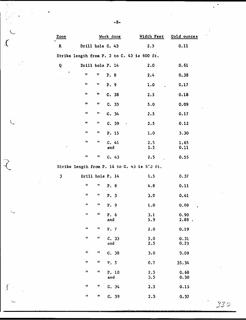
-8-
C
L
^
Zone
R
Strike
Qi
-
Strike
3
Work done
Drill hole C. 43
length from P. 2 to C. 43
Drill hole P. 14
" " P. 8
II II p Q
11 " C. 38
n i, C t 33
11 C. 34
n M c^ 39 .
11 P. 15
" " C. 41 and
" " C. 43
length from P. 14 to C. t*.
Drill hole P. 14
" " P. 8
11 " P. 3
n n p, 9
11 " P. 6end
11 " P. 7
n n c^ 33 and
" " C. 38
" " V. 5
11 " P. 10 and
11 " C. 34
11 " C. 39
Width Feet
2.5
is 600 ft.
2.0
2.4
1.0
2.5
5.0
2.5
2.5
1.0
2.5 2.5
2.5
j is e:o ft.
1.5
4.8
3.0
1.0
3.1 5.9
2.0
5.0 2.5
3.0
0.7
2.5 3.5
2.5
2.5
Gold ounces
0.11
0.61
0.38
0.17
0.18
0.09
0.17
0.12
3.30
1.65 0.11
0.55
0.37
0.11
0.41
0.09
0.90 2.89 .
0.19
0.31 0.23
0.09
35.34
0.68 0.30
0.15
0.37
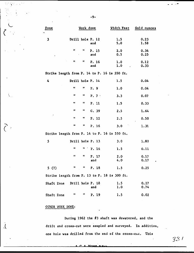
-9-
Zone Work done Width Feet Gold ounces
(
3
Strike
4
Strike
5
5 (?)
Strike
Shaft
Drill
M
n
length from
Drill
i
H
H
n
n
n
length from
Drill
M
II
tl
length from
Zone Drill
hole P. 12 and
11 P. 15 and
11 P. 16 and
P. 14 to P.
hole P. 14
" P. 9
11 P. 7 '
11 P. 11
" C. 39
11 P, 12
" P. 16
P. 14 to P.
hole P. 13
11 P. 16
11 P. 17 and
" P. 18
P. 13 to P.
hole P. 18 and
1.5 5.0
2.0 0.5
1.0 1.0
16 is 550 ft.
1.5
1.0
3.3
1.5
2.5
2.5
3.0
16 is 550 ft.
3.0
1.5
2.0 4.0
1.5
18 ia 300 ft.
1.5 1.0
0.23 1.58
0.34 0.25
0.12 0.33
0.04
0.04
0.07
0.33
1.64
0.50
1.31
1.80
0.11
0.17 0.17
0.25
0.27 0.74
Shaft Zone " " P. 19 1.5 0.02
OTHER WORK DONE;V
During 1962 the #3 shaft was dewatered, and the
drift and cross-cut were sampled and surveyed. In addition,
one hole was drilled from the end of the cross-cue. This
______________________A r* A Itniar* n •g.....______________________________________
33*

~ -10- l
V was part of the program prior to the underground development
to determine in which direction the initial drift should
commence. Two other holes were proposed, but these have been
delayed until the recommended underground development commences.
All equipment has been overhauled, and the buildings
have been painted, and in some cases insulated in preparation
for a winter work project. All the recommended surface
drilling and preparation of equipment prior to the recommended
underground development program have been completed.
As a result, on December 11, 1962 the pump was
removed from #3 shaft and was allowed to flood again. This
has been done to save costs in electricity and labour perd ing
^ the start of the recommended underground work.
The initial phase of surface exploration, recommended
by the Company's Consulting engineer R. Massey Williams at the
commencement of 1962, has now been completed.
CONCLUSIONS;
Close spaced drilling, at intervals of SO ft., has
outlined 5 separate zones of gold mineralization, over a
drilled length of 800 ft. The assay values have been
sufficiently encouraging that this area should now be
investigated underground.
In addition further diamond drilling from surface
should be carried out to extend the length of the known zones,
f and also to explore for additional zones to the north of them.

-11-
C ' 03 ZONE;
In order to assess the potential value of the
property some estimates of grades and tonnages have been made.
Since drill results do not *'. y s provide a reliable indication
of the grade, sometimes being too high, othertimcs too low, the
grade has been calculated on the results of underground work and
surface trenches. The underground work consists of an edit on
the #3 zone where channel samples were taken across the exposed
vein. In the surface trenche's on the #3 zone, bulk samples of
50 Ibs. weight were blasted out of the vein during the 1960-61
work. Both adit and trenches have explored the #3 zone over a
length of 360'. An average of all samples taken in both the adit
Y and trenches, with the high assays cut to 2.38 ozs., Indicated an
average grade of 0.48 ozs. per ton. An average of ali samples cut
to 4.76 (double the above) gave an assay of 0.66 ozs. Therefore,
a grade of about $20 per ton could be expected for this zone
across a mining width of 4.0'. A total of 17 diamond drill holes
below the adit and trenches have confirmed that this grade is
possible. These holes v;ere drilled in 11 cross-sections along a
length of 400', and intersections ranged from a vertical depth of
70' below the adit level down to 250' below the adit.
It can therefore be seen that over the explored lengthf
of 400', to an average depth of 120', a possible 16,000 tons will
be available above the 1st level. Si. ;e the zone is still open to
the east, further tonnages may be available.

-12-
( , , OTffiR^ZONES;
In addition, 4 other zones have been explored nearby.
Of these zones, Q and R have been drilled at 50' intervals over
a length of 600' and to a depth of 350'. Zones 04 and 05 have
not been drilled so thoroughly and are therefore not included
in these estimates.
Both zones Q and R were exposed by drifts on the 4th
level during previous operations. However, no assay plans are
available on which to calculate the grade, so that the assessment
must be made on drill results. These results indicate that a
grade similar to the 03 zone could be possible.
FUTURE WORK;. *x ^
The results obtained to date on the 3, Q and R zones
are sufficiently encouraging that further work is warranted.
Since the 03 shaft is located nearby, and has recently been
: rehabilitated, also a head frame, hoist and compressor installed,
' it is recommended that these zones be investigated underground,
' in two.stages.
j Stage 1;
(1) The 03 zone will be the initial target since a i l possible 16,000 tons, grading about $20 per ton has beenj
indicated by an adit, surface trenching rnd diamond drilling.
Investigation should consist of drifting on the 1st level
from the 03 shaft.
l . (2) Since previous diamond drilling.has shown that
JL. fi..A

-13-
grades and tonnages similar to that in the 03 are possible in
each of the Q and R, these will be the next target for
investigation by underground diamond drilling from the drift
in 03 zone. This work will consist of short flat holes to
outline ore above the 1st level, and some deeper drilling to
prove the continuity of the zones to a depth of 400 ft.
(3) The 04 and 05 zones should be investigated also, as
well as a program of surface diamond drilling for new zones.
Stage 2;
When stage l has been completed estimates of total
proven tonnage and grade can be calculated. Providing that
this confirms the 16,000 tons at $20 indicated in the 03 zone
above the 1st level, and a similar amount in each of the Q and
R zones, so that a total of 100,000 tons above the 4th level
is indicated, then preparation for production could proceed.
Pick Mines have previsusly erected a mill of 200
ton per day capacity which is in working order, so thet it can
be started up ne little cost.
In order to develop the lower levels two means of
access can be used.
O Dewnter the old workings down to the 4th level
where a cross-cut gives access to the area from the 04 shaft,
or
(2) Deepen the 03 shaft to the lowest depth of any
proven ore-shoots. It should be noted also that the 02
shaft nearby reaches a depth of 200 ft.

-14-
/' ' RECOMMENDATIONS AND COSTS;
Stage l
Surface Program
(1) ' The drill program in the #3 shaft area should be
continued to extend this area both east and west, in order
to increase the tonnages available.
(2) Exploratory holes should be drilled north of the
#3 area to locate new zones.
Underground Program.
Stage l
(1) The #3 shaft be dewatered and a 600 ft. long drift
be driven along the centre of the area. This drift will commence
by following the values obtained in holes P. 16 and P. 13, and
designated #4 zone. It will then be determined whether these
values are either the faulted extension of the #3 zone or are
in reality the 4 zone. A crces-cut will then be driven to the
3 zone, and this will be followed by a drift to the eastern end,
where values were obtained in hole P. 14.
(2) Underground diamond drilling will be carried out to
determine the plunge and grade of ore shoots in the other zones,
as we l 1, as .in #3 zone itself. Short holes, of 200' length
maximum will be sufficient to reach any of the other zones.
Some deeper drilling should be done also to outline the zones
below the 1st level.
(3) Any ore obtained from the drifting should be stock
piled at surface, so that it can be treated in the mill during
any subsequent production program.
A. C. A. Howe. F.BNO. '

'C'Stage 2
Providing that a minimum of 100,000 tons grading
$20 is proven in stage l, then the zones should be developed
by drifts and raises from the 1st level in preparation for
production. Some additional equipment will'have to be bought,
and a Change House to be built.
COSTS: i
\ .Stage 1; Underground
(1) Equipment . 55,000.00
(2) A total of 1000 ft. of drifting andcross-cutting at $50 per ft. (includingsupervision and assaying) $50,000.00
C--*
1 (3) A total of 4000 ft. of diamond drillingfrom underground at $l.?5 per ft. $7,000.00
(4) Contingencies 54,000.00
jjS6,000.00
Surface
A total of 3,000 ft. of diamond drilling at $6.00 per ft. including supervision, .sampling and assaying 518,000.00
The total cost of Stage l will therefore be:
(1) For underground drifting, cross-cuttingand diamond drilling 566,000.00
(2) For surface drilling 518,000.00
584,000.00
A r. A
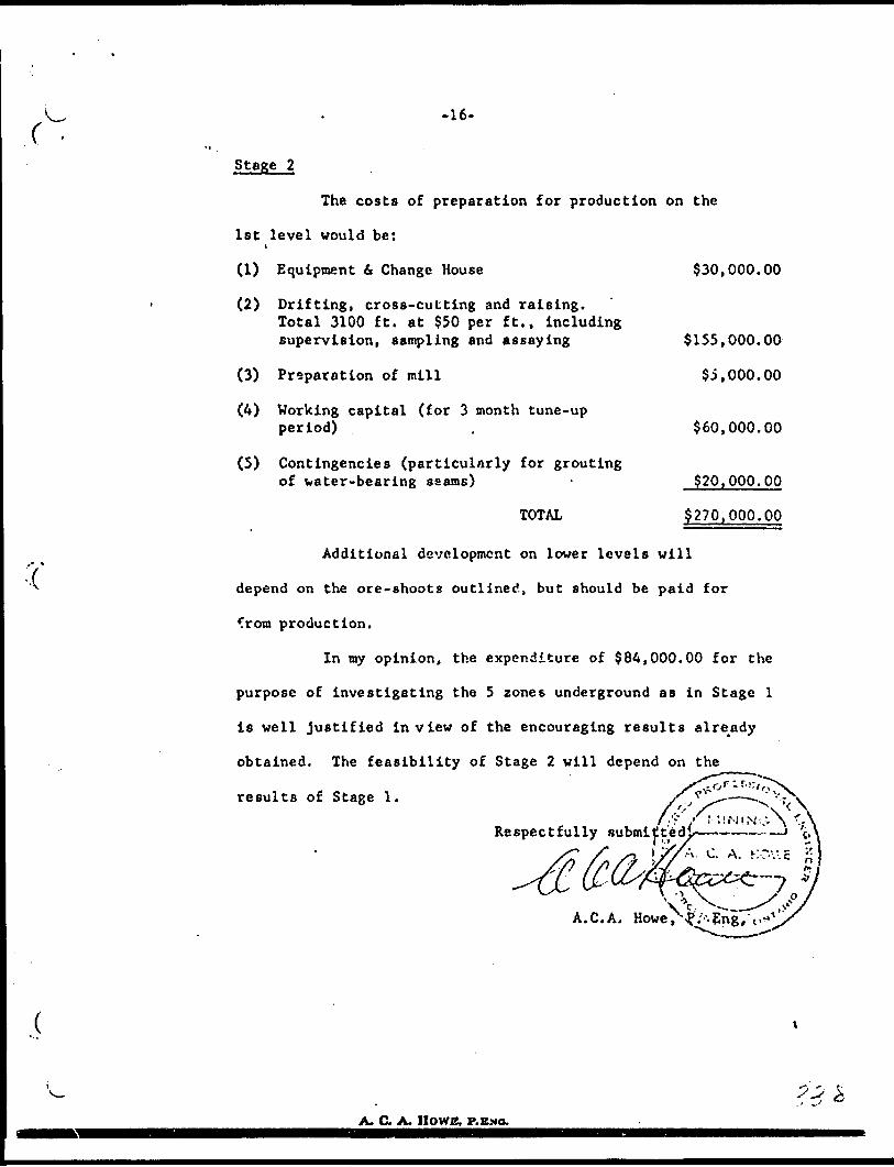
-16-
Stage 2
The costs of preparation for production on the
1st level would be:
(1) Equipment (t Change House
(2) Drifting, cross-cutting and raising.Total 3100 ft. at $50 per ft., including supervision, sampling and assaying
(3) Preparation of mill
(4) Working capital (for 3 month tune-up period) .
(5) Contingencies (particularly for grouting of water-bearing seams) -
TOTAL
$30,000.00
$155,000.00
$5,000.00
$60,000.00
320,000.00
$270 > 000.00
Additional development on lower levels will
depend on the ore-shoots outlined, but should be paid for
from production.
In my opinion, the expenditure of $84,000.00 for the
purpose of investigating the 5 zones underground as in Stage l
is well justified in view of the encouraging results already
obtained. The feasibility of Stage 2 will depend on the
results of Stage 1.
Respectfully submitt6
A.C.A.
A. C. A. IIOWC. P.

-17-
CERTIFICATION
I, A. C. A. HOWE, of the City of Toronto, Ontario, hereby certify that: --
(1) I ara a Mining Engineer, and reside at 567 Avenue Road, Toronto, Ontario.
(2) I am a graduate of London University, England, B. Se. 1949, and a member of the Association of Professional Engineers of the Province of Ontario.
(3) I have no interest, nor do I expect anyeither directly or indirectly, in either the property or securities of Pick Mines Limited.
(4) This report is based on Government geological maps of the area, and from a personal knowledge of the property gained during the supervision of diamond drilling and other work from March 20, 1962 to date.
(5) No viork has been performed on the property my last report dated December 20, 1962.
Dated at Toronto, Ontario, this 3rd day of May
Bin
A.C.A. Howe, P.
A. C. A. HOWE, P.EMO.

t1" -v
V
STRUCTURAL OE010GY
OP THE
PICK HlNJiS LIMITED
TOWNSHIP 48 PROPSRTTf, CKTARIO
An interpretation of aerial photographs
by
Vi. '/i a l kor
Ohov.'-i.alker /iooociates 164 Ni picon Avenue Vi i l lov.'Ualo i On t.
14 iu , 1964
l? VC

Structural Geology of the Twp. 48 property, Goudreau Lochaloh area, Ontario
-********""***""^~*******^**^*— "*^^ OX i ~ i-i - -~i J— n —— i i .1 . - n— BT..JU j - ~ - i-i - - n mai i LI u r J MBVM^
Pick Mines Limited
geophysical otudieo of the Pick property have i.ia.ic'ited a need for a baoic geologic compilation to guide any interpretation prior to further proving of the gold bhoots neceeoary for development of an economi cally producing nine,
In the present v;ork a basic for compilation has been traced directly from aerial photographs at 400 ft. to the inch*. On this are shown geological features, largely structural, beet recognised on aerial photographs, it io recommended that to these be added data extracted from all property maps, supplemented by field mapping as required, and that the geophysical data then be properly interpreted as a guide to development of new ore.
The purpose of the present study of aerial photo graphs io primarily to indicate structures best recog nised from the air, and incidentally to provide a reas onably accurate /nap of the terrain at a scale suitable for a compilation of data on the property.
The study comprised an interpretation of aerial photographs at a scale of 4 inches to the mile of most of Twp. 48. Such a broad study ensures that faint but perniotent features on the property are lesa likely to be missed, and provide a regional background. Photo graphs of the property itself were enlarged to a scale of 40^ ft. to the inch. All photographs were provided by ti'C Ontario De partrae-n t of Lands 6. i'orcsts.
f^ubliehed data used in the study are "Geology of the Goudree.u-Lochalsh Area" by E. L. Bruce, O.JJ.k. vol.49, part 3, 1940, with accompanying aap 498 and E. S. Moore's map 40e , which accompanies his report on the "Goudreau
- -^ *^. A M *l /"\ fc n . ---~. ^r,xJ-t J-i-t--i.fX.AeromagneticGold Area, O.B.E. vol. 40, part 4, 1931. man 2207G, Lochalsh, includes Tp. 48.
Unpublished data available at the time of v/riting are J. P. oheridans Jan. 1964 report on a jnaanetometer survey of the Uhaynee it. L'ick properties, with the result ing data conveniently compiled at 200 ft. to the inch; and a surface plan of the Pick property at nominally 450 ft. to the inch (in fact about 350 ft. to the inch)
-l-
11 j
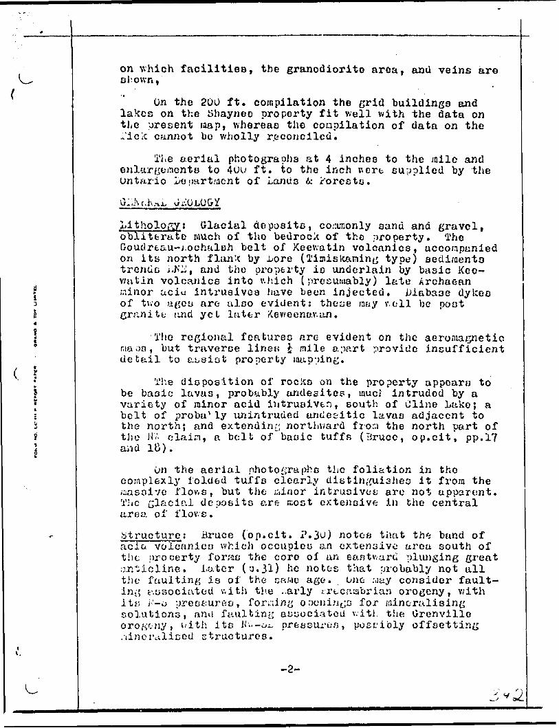
on which facilities, the granodiorite area, and veins are chown,'
On the 200 ft. compilation the grid buildings and lakes on the JShaynee property fit well with the data on the present map, whereas the coapilation of data on the Tide cannot bo wholly reconciled.
The aerial photographs at 4 inches to the jnile and enlargements to 40u ft. to the inch v.ert supplied by the Ontario veoart/acnt of Lands Ac r'oresto.
GI-.Nr.h.nJu JrlOLO&Y
Lithology i Glacial deposits, co.ar;only sand ana gravel, obliterate much of tlio bedrock of the .nroperty. The Goudreau-i-ochulsh belt of Keewatin volcanics, accompanied on its north f Ionic by i/ore (Ti:nis learning type) sediment o trencic i.NU, and the property io underlain by basic Kee- v/ntin volcanics into v.hich (presumably) late Archaean Minor aciu intrusivoa have been injected. Diabase dykes of two ages are also evident: these may v.oll bc poot granite tind yet later Keweenav.an.
The regional features are evident on the ma on, but traverse linen i mile apart provide de bail to assist property mapping.
aeromagnetic insufficient
The disposition of rocks on the property appears to be basic lavas, probubly undesites, mud intruded by a variety of minor acid intrusive.:; , south of Cline Lake; a bolt of probu^ ly un intrude d aridetitic lavas adjacent to the north; and extending northward frora the north part of the HV. c lain, a bolt of basic tuffs (Bruce, op.cit, pp.17 and 18).
On the aerial photographs the foliation in the complexly iolded tuffs clearly distin^/uishes it from the massive flows, but the ;,'tinor intrusive*; are not apparent. The glacial deposits are rcost extensive in the central area of flows.
.Structure.; Bruce (op.cit. P.3^1 ) notes that the bund of ac i ci volcanic a which occupies an extensive urea south of tiic property for;as the core of an eantv.uru plunging great o.r.ticline. Later (0.31) he notc-s that probably not all the faulting is of the s ara c age. one ;,iay consider fault ing c'.osociatou v.ith the ..arly rrt cambrian orogeny, v/ith i t r. i'-o preoturi'jo, for^iny openings for mineralising solutions, anil faulting associated v.itJ. the Grenville orogtny, with ite K'.'.-oi, pressurus, poet.-ibly offsetting /linoraliced structures.
-2-

GEOLOGY
Evidence of slickensidos and offset should be notod in field so that pre- and post-mineralisation faulting can be differentiated. From the evidence available it appears that gold bearing veins are located at the inter section of major fault zones which trend NjJ, h"W, and LNJ5.
Thus the Ho. 4 shaft and open pit of Pick nines are at the intersection of M and fir, fault zones, and the tihayneo abaft and veins at the intersection of flfi, KJi and jtflD fault
Similar intersections may be seen immediately SW of Loughlin Lake, 80u ft. NE of the open pit. The strong fault aone which trends fi** across claim 61782 (in the MV of the property), also merits investigation.
These environments 1; will be enhanced as potential gold bearing horizons v.hore they coincide with contacts between rocks of differing competence: herein lies the value of field mapping and jnagnotic indications of differing rocks.
The most obvious variation from the regional li-Yf trend of magnetic data on the Pick property is a Mi trend at 70COE, on tho base lino, which coincides with the power lino: tl.iu would nullify the effect of an e. ra. anomaly, but in the present cr.se another cause should be sought.
It is recommended, firat that any geological maps of the property be brought to a common scale, either 200 or 400 ft. to the inch; second that areas where data is lacking bc ruraappeci, paying attention not only to rock types but to etructural stylo (in this regard note the difference in fault patterns evident in the three differ ent rock units); third that the resulting geological data be correlated to known mineralisation, and lastly that the geophysical data be reviewed in light of the knowledge gained.
COliCLUiUUHS
Areas v/h or e intersecting fault soncs appear to have localised mineralisation are indicated. A review of exist ing data complemented where necessary by field studies aay affirm this concept, t^nd may bc expected to add to tJie knowledge of ore emplacement on the property. From this knowledge it io rcixsonablo to suppose that further ore will be developed.
-3-
A. C. A. HOWE, P.ENO,tS3-*4*X . S ' ' 961-4017
•U1TC 4OS - tOO ADKIAIDC B T. WHT. TORONTO l. CANADA
SUPPLEMENTARY
. REPORT
PICK MINES LIMITED
APRIL 20. 1964
WORK DONE IN 95 SHAFT AREA;
The results of sampling of the adit and trenches were tabulated in ..iy report dated May 3, 1963. Also the results of diamond drilling of zones Q, R, 03, 04 and 05. There lias been no additional drilling or sampling of these zones oince that date.
WORK DOME DURING 1963;
Four diamond drill holes numbered P.20 - 23 totalling 1,213 feet were drilled for assessment purposes. These holes were located on the unpatented group of claims, about Jj mile north of the 03 shaft area. They were drilled to investigate geological structure only, since gold veins had not previously been fo"nd in the area.
Hole No. P24 was drilled to a depth of 509 feet to cross-section the area immediately north of the 03 shaft area. Several interesting sections were obtained as follows:
Cold Assay Depth in Hole F t. ozs./ton
05.4 - 86.3 0.9 0.27177.0 - 179.0 2.0 0.09236.3 - 237.6 1.3 0.15493.4 - 495.5 2.1 0.10
A magnetometer survey was performed along the length of the major quart?, ankerite shear. The purpose of the survey vas to explore for cross-fractures, silicified zones and granodiorite intrusives which may be the hosts for gold veins. The survey was successful in outlining the south edge of the knovrn granodiorite plug in the 03 shaft area. A lengthy anomalous

(-2-
"low" south of this granodiorite plug and extending to the 04 shaft area indicates the possible extension of this plug between the two areas,
A photo-geological survey was completed by W. Walker, in which fracture patterns and faulting were outlined. It was observed that the known gold zones occur at the intersection of two sets of fractures at joints, these consist of a fault zone striking northeast and a fracture pattern striking northwest. Other northwest striking fractures intersect the same fault zone on claims 61782 and 61783, where strong fracture patterns can be observed.
CONCLUSIONS;
My conclusions and recommendations remain the same as outlined in my report of Hay 3, 1963.
Briefly, they are as follows:--
Five separate zones of gold mineralization have been outlined by drilling over a length of 800 feet. The assay values obtained to date are sufficiently encouraging that further work is warranted. Since the #3 shaft is located nearby, and has recently been rehabilitated, also a head frame, hoist and compressor installed, it is recommended that these zones be investigated underground.
In addition, further diamond drilling from surface should be carried out to extend the length of the known zones. Also to investigate further the gold values found recently to the north of the known zones, and areas of interest indicated in the recent surveys,
RECOMMENDATIONS AND COSTS:
SURFACE PROGRAM: --
A total of 3,000 feet of diamond drilling at 56.00 per ft., including supervision, sampling and assaying
Estimated cost $18,000.00
UNDERGROUND PROGRAM: --
Stage 1:
(1) The #3 shaft be dewatercd and a 600 ft. long drift be driven along the centre of the area. This drift will commence by following the values obtained in holes P. 16 and P. 13, and designated #4 zone. It will then be determined whether these values are either the faulted extension of the #3 zone or are in reality the #4 zone. A cross-cut will then be driven to the #3 zone, and thin will be followed by a drift to the eastern end, where values were obtained in hole P. 14.
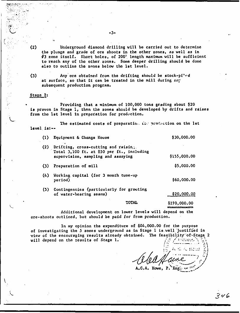
. j". ' ' - **
(2) Underground diamond drilling will be carried out to determine the plunge and grade of ore shoots in the other zones, as well as in f3 zone itself. Short holes, of 200' length maximum will be sufficient to reach any of the other zones. Some deeper drilling should be done also to outline the zones below the 1st level.
(3) Any ore obtained from the drifting should be stock-pi1 *-d at surface, so that it can be treated in the mill during any subsequent production program.
Stage 2;
- Providing that a minimum of 100,000 tons grading about $20is proven in Stage l, then the zones should be developed by drifts and raises
: from the 1st level in preparation for production.
The estimated costs of prcparatio.. io - production on the 1st level is:
(1) Equipment 6 Change House $30,000.00
(2) Drifting, cross-cutting and raisin,;.Total 3,100 ft. at $50 per ft,, includingsupervision, sampling and assaying $135 ) 000.00
l
(3) Preparation of mill $5.000.00
(A) Working capital (for 3 month tune-upperiod) $60,000.00
(5) Contingencies (particularly for groutingof water-bearing seams) $20.OOP.00
TOTAL 3270,000.00
Additional development on lower levels will depend on the ore-shoots outlined, but should be paid for from production.
In my opinion the expenditure of 504,000.00 for the purpose of investigating the 5 zones underground as in Stage l is.well justified in view of the encouraging results already obtained. The feasibility of-Stage^ 2 will depend on the results of Stage 1. ,'.: : /'f ::.:.v;'r..'\ "..\
A.C.A. Howe, P. EngV

Cv.
CERTIFICATION
I, A. C. A. HOWE, of the City of Toronto, Ontario, hereby certify that: -~
(1) I am a Mining Engineer and reside at 567 Avenue Road, Toronto, Ontario.
(2) I am a graduate of London University, England, B. Se. 1949, and a member of the Association of Professional Engineers of tlie Province of Ontario.
(3) I have no interest, nor do I expect any interest, either directly or indirectly, in either the property or securities of Pick Mines Limited.
C*) This report is based on Government geological maps of the area, and from a personal knowledge of the property gained during the supervision of diamond drilling and other work from March 20, 1962 to date.
' .-. Dated at Toronto, Ontario, this 20th day of April, '1964. " '"^.'"•:\
A.C.A. Howe, Eng.- '
A. C. A. IlOWli. I'.ENO,

PROPERTY Mines Ltd.
DIAMOND DRILL RECORD
HOLE NUMBER..
SHEET .NUMBER.
SECTION FROM .TO.
LOCATION:.UT.. STARTED August 19, 1963
ELEVATION OF COLLAR.
. BEARING____________________________.HIP Surface 45 0 at 460' - 37'
COMPUTER August 27, 1963
ULTIMATE DEPTH. BO 9 . 0
DIRECTION AT START: PROPOSED DEPTH
DtFTH r f.lt
0-10.010.0-29.2
29.2-30.230.2-31.031.0-62.6
FORMATION
CasingDiabase. Black, fine grainedLower contact 45 0GranodioriteDiabaseGranodiorite, sheared S. schistose 45 C to c. a.,fine grained with numerous blue qtz eyes. LoweSAMPLE: 34.0-36.5 Disseminated pyrite
36.5-39.040.0-41.041'. 0-43.043.0-44.044.0-45.0 1" blue qtz 50 0 to c. a.
" 45.0-47.0 Scattered qtz. str.^
1
nllFPOOF
•AMPLI No
r contat719-
720721
72272:724725
fcl l f\.
t-QUAL-TO*
WIDTH Or tAMPLI
:t 50 0 t
2.52.51.0
2.01.01.02.0
WE JITYOli^iinv
COLD t
o c . a .
nilnilnil
nilnil0.02nil
**np\fuQlNAJ
Si U 55 L COLD *
i—
ORIllFODY SIGNED..
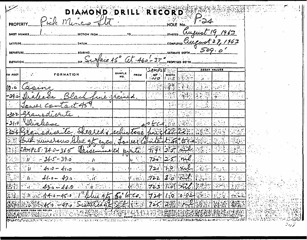
, f- *
V-. -. -. . :,--. .-•-.i--.: , ' -.- '; ,- .
:j-;. v.:.-v;;v; ,, .. ; ; ..;.-:. .^^ivi^if:^^.^:•-.•.'.^.•r'.\-:-' r ^'-::^:\\-r,^t . .;-- '-'.v,-';:.-'-^; ; ^ ••••- - 1 :-. .'-i^r ",
. P * flv- .*-l *
^ i, V•-.- . .r. ..••...- '.i-:;..vV.-.^'-;
'•*..i ^* **7 * )

HOLE KIIIV^ER P. 24PROPERTY
DIAMOND DRILL RECORDSHEET .NUMBER.
SECTION FROM .TO.
LOCATION:.L AT..
STARTED ,
ELEVATION OF COLLAR. DATUM ———.-.......-
COMPLETED
ULTIMATE DEPTH.
DIRECTION AT START:B E AB INK
PROPOSED DEPTH
DEPTH rtCT
?
FORMATION
SAMPLE: 47.0-49.0 Minor qtz." 49.0-50.0 Minor qtz. pyr.
50.0-51.0" 51.0-54.0 minor qtz S. pyr
54.0-56.558.0-59.5 minor qtz str.59.5-61.061.0-62.5
Greenstone. Andesitic, fine grained,massive with numerous qtz injections.SAMPLE: 62:5-63.0 Contact zone withseveral 1/8" qtz. str. and 51 pyr.SAMPLE: 64.4-85.4 Qtz. str.
85.4-86.3 2" blue qtz dissem pyr.v
DUPLICATE GCPOOR QUALITY uRlva
TO FOLLOW
• AMPLE NO
726727728729730731838839'
840732733
DYr TNAt-
WIDTHor (AMFLI
2.01.01.03.02.51.51.51.5
0.51.00.9
COLD *
nil0.02nil0.02nil
nil0.27
SA.UP51, GOLD 1
*Oft?HlAM MINI* **lt* O, TOMOMtO-VfOCK f Oft M HO *0l MV.9/44
DRILUD BY. SIGNED..
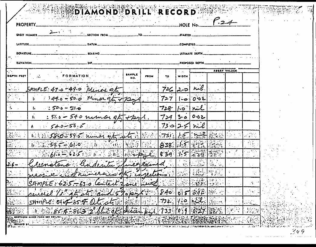
W^. '^•'.-. .'M: ? A''!'- ••••."'•••r- r-, \ •••.•'.•''•••'•'•' v V-' '- 1 - ' . :-' ' •:',' s? ' ' '•' ••"•"•••" ";r •"•v-1 - -'". ;:'"- -- '.' . ; - '.'"'-- -'- . ' - r^^ -^ - v - --- - . .- -PROPERTY
. FORMATION'' - ••'••'•'-1 .\: ' ' . .
:^9

HOLE NUMBER, P. 24
PROPERTY
DIAMOND DRILL RECORD SECT.ON FRCiiT ,
)M TO
LOCATION: n rp STARTED
ELEVATION OF COLLAR COMPLETEDniTllU
DIRECTION AT ST/
DCPTH ritT
? - 128.0
128.0-138.0
————————————————————————————————————— ULTIMATE DEPTH.. , ,BEA3ING ____ 1—
^RT: PROPOSED DEPTHP'p,
FORMATION
SAMPLE: 98.2-100.2 white qtz. seam 5 0 to c. a.
101.3-102.3 white qtz. str. 5 0 to c. a.103.4-104.0 white qtz f. p inkfcl 45" to c. a106.6-107.0 " " " " " "
107.0-108.0 " " " " " "120.2-120.8 1" blue qtz S, 15* pyr
in greenstone, 30 0 to c. a.SAMPLE 120.8-121.6 Patches blue i, white qtzFracture zone in greenstone
\
SAMPLE 123.0-124.0 white qtz." 124.0-124.3 white qtz injections
126.0-127.0127.0-128.0 white qtz.
Granodiorite, with digested greenstone S qtz. stLower contact 45 0 to c. a.
——————————————— BUM——————— : —————— POOR cm
•AMPLt NO
734735
. 736737
•738
841842
739740741742
r.
tlPAlIWfll l
WIDTH Or tAMPLI
2.0.1.00.60.41.0
0.61.0
1.00.91.01.0
"E C'\7rtDISfcJAtHr.——— 1
•/^ col' * ^^**'O fOlO-W**
'
COLD t
nilnilnilnilnil
nilnilnilnil
•v r^* 'i) t"* '"
UNAU
3i.UPSL GOLD f
1
NOIIHIHN MINK mi** UMIflD, 1 0* ON t O -1 1 DC * fOXX *O *OI *IV, C/44
DRILLED BY.................,.....................:...........-...-..............................,1............... - SIGNED............. ..................... ......... ....... .......,./ - : V 9 #

DIAMOND l^fflf^lliPROPLRTY.
win NUMut
UTITUDE.—™.
DErAITUU™.
IUVATION.——
"2*"* ' ...JtCTION flOM ...,_________...TO..
...HOLE No,.
rccr
•M ;'
-Y.
.1,
,1CAUNG..._............_.-...._____.______________.._ULTIMATE DlfTH..
DtPTH..
FORMATION
4- - /h o
•
MorrxcuN M
DlfUIO B r.
fcfxr:- ..,i-TT
? - X :V^ Yi.;:;
•AUPLI NO. .
H /t.
TO
7.5*
WIDTH
ASSAY VALUES
' ' ~ - , ^ ' - -*V-' '" '.-\ - '.' ' . -." •'.'- ;* v'-'
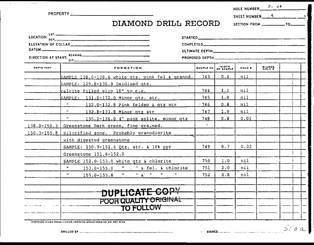
HOLE NUMBER.P. 24
PROPERTY.
DIAMOND DRILL RECORDSHEET NUMBER.
SECTION FROM . .TO.
LOCATION:. LAT..
DtP--. STARTED.
ELEVATION O F C OLLAR. DATUM -————————
COMPLETED.
ULTIMATE DEPTH.
DIRECTION AT START:BEARING.
DIP.PROPOSED DEPTH.
OIPTH rifT
138.0-150.3150.3-155.8
FORMATION
SAMPLE 128,0-128.6 white qtz. pink fei S. qranod.SAMPLE: 129.8-130.9 Oxidised qtz.calcite filled slip 10 0 to c. a.SAMPLE: 131.0-132.0 Minor qtz. str.
132.0-132.8 Pink feldsp S, qtz str" 132.8-133,8 Minor qtz str" 135.2-136.0 4" pink aplite, minor qtz
Greenstone Dark qreen, fine grained.Silicified zone. Probably granodioritewith digested greenstoneSAMPLE: 150'.9-151.6 Qtz. str. S, 101 pyrGreenstone 151.6-152.0SAMPLE 152.0-153.0 white qtz i chlorite
153.0-155.0 " . " S, fei. i chlorite155.0-155.8 " " & 1 "
——— DUPLICATE: COPY —POOH QUAUTT ORIGINAL
TO FOLLOW
• AUPtI NO
743
744745
- 746747748
.
749
750751752
WIDTHor IAUPLI
0.6
1.11.00.81.00.8
0.7
1.02.00.8
COLD t
nil
nilnilnilnil0.01
0.02
nilnilnil
GOLD t
DRILLED BY SIGNED..

"' 'v'-rV-.-. : ,. J. :
w**
s w pz\
^.,.^,^
• ' s;.. ' ..' -.- ;'.!\' \. ". ..-.v.'••\:.v! .-.-' r:: "
v^^^;••- '-IT ...-. ' .•. -. p. ^.. .\...

HOLE NUMBER.PROPERTY.
DIAMOND DRILL RECORD SECTION FROM .TO.l
LOCATION: STARTED
ELEVATION OF COLLAR. DATUM —————————.
COMPl FTPD
DIRECTION AT START:BEARING.
ULTIMATE DEPTH^.
PROPOSED DEPTH..
OIPTH rtlT
? - 177.0
? - 178.0
? - 181.8
FORMATION
Greenstone as beforeSAMPLE: 158.4-158.9 Grey qt^; 45 0 to c. a.
158.9-160.4 White qtz S, fei str.160.4-162.9 Siliceous zone166.3-167.7 Silicified zone with
white qtz, blue qtz S. 10% pyr.SAMPLE: 168.4-169.0 Feldspathized zonewhite-grey qtz oxidised browniron carb. Dissem. pyr. 2%SAMPLE 177.0-179.0 Qtz. vein S, felsiteFelsitic, light brown colour, dissem. pyr.f, pyrrholite. Quartz porphyry ?SAMPLE: 180.3-181.8Granodiorite with digested greenstone
*
DUPLICATE COPYPOOR QUALITY RKi 1 N A '
TO ITOLLiOW— — :---— --— - -— -
• AMPLC NO
753754755
756757
-
758
759
WIDTH Of tAUPLI
0.51.52.5
1.40.6
2.0
1.5
COLD f
nilnilnil
0.03nil
0.09
nil
COLD *"
o. IO*OM*O-*TOCK ronu NO *oi *iv. Hit
DRILICD OY ..... SIGNED.
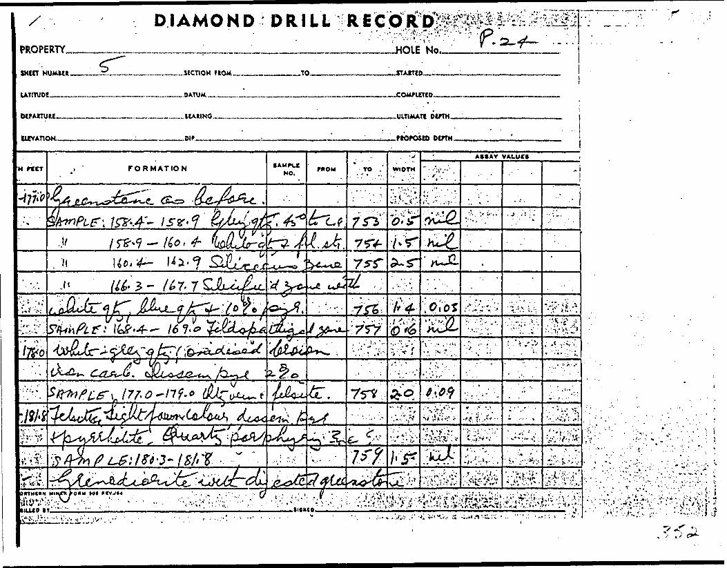
DI AMO H D D R l L L'-; R E C O ^D
#u-fj^;^2VIsV w . ft*\ T *
M3^
•f;. i: :.'.v.. *-"; - - iW.- - ...'.;.-: -.. - -;... , : !.
: .v.- . .' j. . . . - - i

HOLE NUMBER P* 24PROPERTY
DIAMOND DRILL RECORDSHEET NUMBER.
SECTION FROM.
LOCATION:.LAT..OEP, STARTED
ELEVATION OF COLLAR. DATUM .————————.
COMPLETED
ULTIMATE DEPTH.
DIRECTION AT START- PROPOSED DEPTH.
.TO.
DEPTH rtIT
? - 191.2
? - 202.4
? - 203.0? - 205.0
7
— .-. — -- -
FORMATION
SAMPLE: 184.0-185.4Change to ? felsitic mass as before. Qtz. porohSAMPLE 187.0-188.5
189.2-191.2 Qtz t, pyr str.GranodioriteSAMPLE: 191.2-192.4 Minor qtz. S. pyr
" 201.7-202.4 Minor qtz S. pyr str.Greenstone, 60 c to c. a.Qtz. porphyry with qtz strSAMPLE: 203.2-205.0 6" white qtz fcseveral qtz-. str.Greenstone - Upper contact 60 0SAMPLE: 214.6-215.0 Pink b white fei b q tz injein vein 45 0 to c. a.
'
DMDI IS*A*rr* A An
• AMPLI No
760?
761762
763764
\
765
:t.B43
..fJUI'LICATE COP|YPOOR QUALITY urtlGIN,
TO FOLLOW\L
WIDTH OF (AMPLf
1.4
1.52.0
1.20,7
1.8
COLD *
.01
.02
.02
.01nil
nil
COLD **
MOUfMlllft MINI* PAftftt UMlTIO, tOIIOMYO-t VOCM rOBW No tOIMIV.t/44
DRILLED BY. SIGNED..

PROPERTY
lATITUOI... ..COMPUTED,
fo&^t
•m-.mm^. ;,-r-.^^J-.^K:;/: -^ .vi!*.' \ . i-,* \ - . j ...-\--,^. . ;, i: 'jJ.'Vi''-Y : kv'i - ::i -/i^^^V ..^v/x.. '.;V-.t. V-'Vi••v^.^Ci^•^^:^^•^.^v:^^•ii,•^ : >^v^;^•.
i.s .
' V : i- - , ' '--.-^•T-vr-j..
- x

HOLE NUMBER. P. 24PROPERTY
DIAMOND DRILL RECORDSHEET NUMBER.
SECTION FROM . .TO.
LOCATION:.LAT..
DEP- STARTED ,
ELEVATION OF COLLAR. DATUM.————.....——
TftMPl FTFn
ULTIMATE DEPTH.
DIRECTION AT START:. BEARING.
PROPOSED DEPTH
OCPTM rtIT
? - 231. a
? - 244.5
FORMATION
SAMPLE: 227.3-228.4 Q-z S, fei. str . 1"wide, oxidised fracturedOtz. porphyry. Brown, fracturedSAM.PLE :Greenstone
SAMPLE: 231.8-232.8232,8-234,1 301 atz, 101 ovr
in shear zone 60" to c. a.SAMPLE: 234.1-235.2 2" qtz S, pyr
235.2-236.3 2" qtz in felsiteband (light "brown to pink in colour)SAMPLE: 236.3-237.6 4" white qtz S,101 pyr in bands 60 0 to c. a.SAMPLE: ?
'
DUPLICATE COPY- —— POOR QUALITY ORIGINAL ————
——— TO FOLLOW ———————
SAMPI.C NO
766
767
768769
t
770771
772
773
WIDTH Or JAWCLl
1.1
0.8
1.01.3
1.11.1
1.3
1.8
COLD f
.02
nil
nilnil
nilnil
.15
GOLD f
11
ORILLtO BY. SIGNED., 'y J? ft

DIAMND
'•tstXj&io'--'JfrU- eSr-jt

PROPERTY -
,LAT.
DIAMOND DRILL RE
HOLE NUMBE
SHEET .NUMB
iCORD SECTION FRC
R p. 24
ER - 8. . '
)M TO
LOCATION: n rp STARTED....................... . . ' .
ELEVATION OF COLLAR TOMPl P7EDDATUM
DIRECTION AT ST^
OIPTH Tilt
? - 2 51.8
? - 257.4
————————————————————————————————————— ULTIMATE DEPTH ,, ,,B F AB INC
,RT: PROPOSED DEPTHDIP, ^ ——--
FORMATION
Granodiorite Pink to brownishqreen. Numerous qtz. str.SAMPLE: 244.5-246.3
246.3-248.3248.3-250.0250.0-251.8
GreenstoneSAMPLE: 253.4-254.0 Qtz. inject.
254.0-255.2 white qtz-* minor\
white fei.Quartz porphyry? Silicified felsiticzone with digested greenstone.Sample: 257.4-258.6 white i grey Qtz str.
" 258.6-256.0 " .*
DUPLICATE COPY-•---^OQR QUALITY ORIGIN Al. —————— ————— TO FOLLOW —————————
*AMCLI No
773774775776
777
778
779780
WIDTH Or 1 4MPLI
1.82.01.71.8
0.6
1.2
1.21.4
coco t
nilnilnilnil
nil
nil
nilnil
SVifPS*.COLD t
j
1
l
DRILLED DY...................................,...;.......,.,;...'...............................1............... - SIGNED.............. ........................................ .......... ' c-^'/ (\

D l AMO N D D R l L L R E C O K
?-MiMMfax*6 . , ••7. • ; --.-,: y.--*; . ,- > .r -. - ' -' ::-jMig?w*fcMc:.
' ^
'•*'V^S^'v.\:''-iv- -o ^,^.^.';v"V/'.':: '.] .:.;v-.vr.*.;-V'.:: --. ' '••'•' ij- "l-
r?i^|Q?^-

HOLE N UMBER. P. 24PROPERTY,
DIAMOND DRILL RECORDSHELT.NUMBER.
SECTION FROM . .TO.
LOCATION:UT..OtP. STARTED.
L'LEVATION OF COHA71IM
DIRECTION AT ST^
DIPTH f t If
? - 265.6
? - 273.5
?
LLAR roMPiFTFn,————————————————————————————————————— ULTIMATE DEPTH
HEARINft,RT: PROPOSED DEPTH
FORMATION
SAMPLE: 260.0-261.7 Felsitic, palebrown colourGreenstone d felsite bandsSAMPLE: 261.7 - 262.7 Felsitic
262.7-264.0 Q.Porphyr 4 qtz S, pyr. str.264.0-265.0 Qtz. inj. in qtz265.0-265.6 Brown felsite
GreenstoneSAMPLE: 266.0-266.6 Felsitic S, pyr. bands
269.0-269.4 Blue qtz str. 70 0 to c. a.269;8-272.3 Brown felsitic band
" 273.0-273.5 Qtz. i. pyr. injects 70 0 to cGreenstone, white qtz S. fei phenocrysts occas. lSAMPLE: 277.8-278.3 Brown felsite porphy
'
DUPLICATE COPYW
i ^^,, . — . ~ . - ^f"\yu.u.v/ w * '
• AMPLt NO
781
782783784785
t
786787788
.a. 789rown pc
790
WIDTH O' (AMPIC
1.7
1.01.31.00.6
0.60.42.50.5
rph . ba0.5
COLD t
.01
.03
.03
.01nil
nil.01nil.03
ids.01
GOLD 1
NO* I Ml* M MINI* mill HUH l D, tO HONlO-tlOCK rO*u NO *0t my. t/44
PRI1 l FO DY SIGNED.

HOLE NUMBER * " 4
PROPERTY.
DIAMOND DRILL RECORDSHEET.NUMBERJJL
SECTION FROM . .TO.
LOCATION:LAT.-
DC P. STARTED.
ELEVATION OF COLLAR. DATUM-.———-.———
COMPLETED.
ULTIMATE DEPTH.
DIRECTION AT START:BEARING.
DIP.PROPOSED DEPTH.
DEPTH rilT
282.9-288.0
288.0-305.0
305.0-:20.4
320.4-
FORMATION
Brown Qtz, Dorph. 282.0-282.4 Contacts 80 0 to c.Quartz porphyry. Grey-pink qreen . ContactsSO 0 to c. a.Greenstone, with granodiorite or silicified bandSAMPLE: 294.0-295.5 Pink fei fi whiteqtz. bandsSAMPLE: 302.7-303.4 GranodioriteGreenstone f, felsite bands 75 0 to c. a.SAMPLE: 308.8-309.0 white qtz.-
310.5-310.8 white qtz. fei t pyr." 316/6-317.4 Pink (. b rown felsite bands
Brown to white porphyry formations. PhyoliteSAMPLE 320.4-321.3 white to brown fels
321.3-322.5 felsitic green322.5-323.0 white to bxtown felsite
DUPLICATE COPY-•-— DOR QUALITY QRIGINA1 ——————— ————— TO FOLLOW ———————
•AMPLC No
1 .
5
791792
i
793794795
796797798 ,
WIDTHor (AMPti
1.50.7
0.20.30.8
0.91.50.5
COLD S
nil.02
.02
.03
.01
nilnilnil
3i-.WQ5L GOLD t
DRILLED B Y. SIGNED..
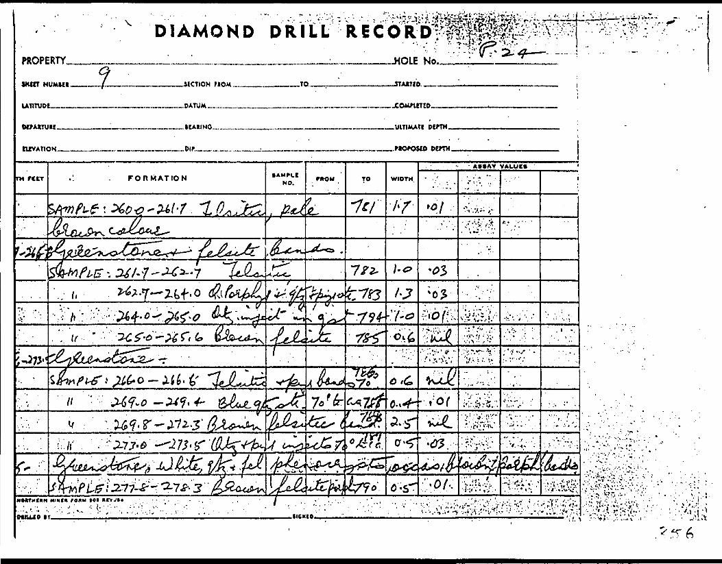
^ DIAMOND DRILL VECORDINo
^;:.l J: 'V -:'- ' ;' *

.DIAMOND D RiLLfR'ECbOf"3^*^'
PROPERTY
, . - - - .. \ -. ?; ';•' . " - . .-' : -. ,;- -
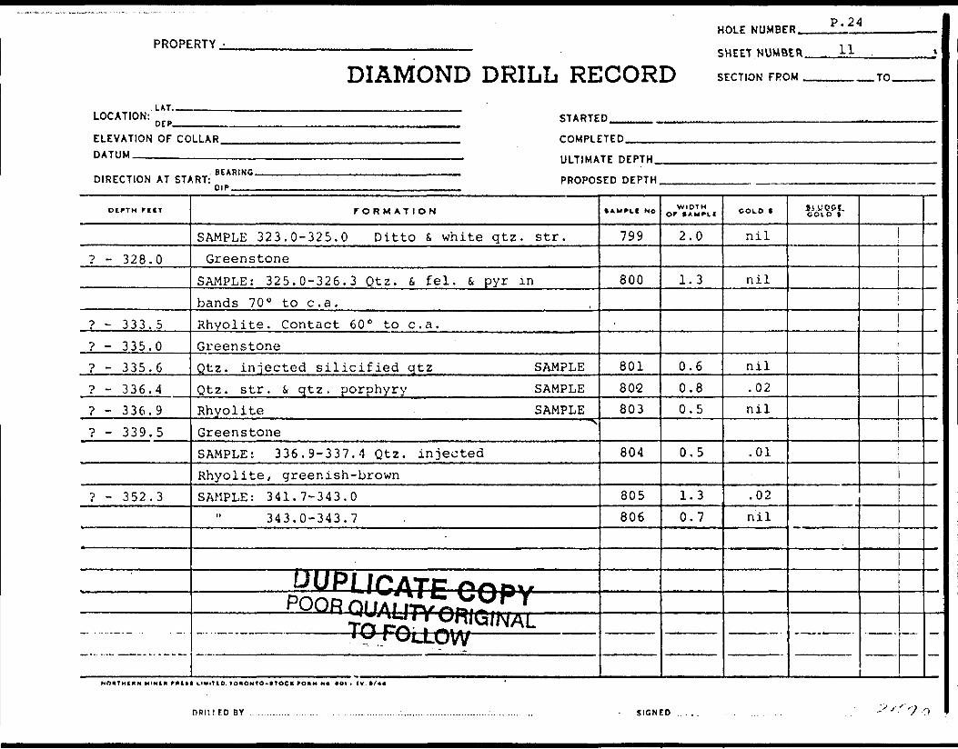
PROPERTY -
LAT.
DIAMOND DRILL RE
HOLE NUMBE
SHEET NUMB
1OORD SECTION FRC
D P. 24
ER . 11 .
M TO
LOCATION: D tp STARTED
ELEVATION OF CODATUM
DIRECTION AT ST^
DIPTH FtlT
? - 328.0
? - 333.5? - 335.0? - 335.6? - 336.4? - 336.9? - 339.5
? - 352.3
— • "•••-.- -
LLAR COMPLETED
————————————————————————————————————— ULTIMATE DEPTHRFiRmr. i il ..lll ... —
^RT: PROPOSED DEPTH"i" - - ,, ...,. .
FORMATION
SAMPLE 323.0-325.0 Ditto 6 white qtz. str.Greenstone
SAMPLE: 325.0-326.3 Qtz. 6. fei. 6, pyr inbands 70 0 to c. a.Rhyolite. Contact 60 0 to c. a.GreenstoneQtz. injected silicified qtz SAMPLEQtz. str. s qtz. porphyry SAMPLERhyolite SAMPLE. j , . - ...... ———————————————————————————— ^ GreenstoneSAMPLE: 336.9-337.4 Qtz. injectedRhyolite, greenish-brownSAMPLE: 341.7-343.0
343.0-343.7
DUPL/pATp r*no\j-,. "POR.Q(JALI7VnBi**i*iiii iTO rn i S5i^iNAL
* y rULLOW
• AMPtt MO
799
800
80180'2
803
804
805806
WIDTHor SAMPLI
2.0.
1.3
0.60.80.5
0.5
1.30.7
COLD t
nil
nil
nil.02nil
.01
.02nil
Si.WPPf. COLD t
NnVTHtlN MINI* full* tlxlIID, lOIONTO-tTOCK fO*M Ne *OI . IV t/44 '
DRIllED BY .............. ........ . . .................................................... .. - SIGNED..... . . .. . . . -''•'''7')

.^• :-
PROPERTY™
JHtrf NUMKEt...
LATITUDE—————
PDAtTUM--™™
IUVATIOH.——m
://..
•H recr
OITHCAN MIMCI
/*'. . ' *.''
nuee ** ''t-. - .-..•.. .. ...,^^.-.-ji^.,.
DIAMOND PRILL RECORD______L...,-.........™_.™..,™..,..,.._.^........,_..^™™.HOLE No.™
-.____SECTION MOM............_.____......TO....™.....™—————............JTAITfO...—.——..
______DATUM.._....l..._....™...™............™..___....-......-.......—._.-._COM? IfTfO___..
...^.UlTIMAIt DOTH™
DOTH..
FORMATION
J^
•AMFLC NO. TO
7? fWIDTH
0.7
ASKAY VAL.UCC
•o/
••0-L.
'. , t . ^ . .r . , -. ',. - ' , . ,
.IIOMIO
.•".'V",^;"""• l' ' .'. , i
:'~ - l l

PROPERTYHOLE NUMBER-
———————;—————— SHEET.NUMBER.
DIAMOND DRILL RECORD S ECTION FROM
LOCATION:LAT..
DEP^ STARTED
ELEVATION OF COLLAR. DATUM.————-.—..^
COMPLETED
ULTIMATE DEPTH.
DIRECTION AT START:SCARING.
PROPOSED DEPTH
OCFTH r ift
? - 361.0
361.0-377.0
FORMATION
SAMPLE: 343.7-344.7344.8-345.9345.9-346.9346.9-348.0
Greenstone. Massive, becoming schistoseat 75 0 to c. a. from 360.0Greenstone. Banded, fine cjrained, numerous
white qtz c*-.r. (hair width - i") 75 0 to c. a. SheSAMPLE: 361.0-361.8 30% white qtz str.
362,0-362.7 151362.7-363.7 301364.5-364.8 i" white qtz str369,0-369.5 white qtz. S pyr371.0-372.0 Rhyolite
UUPLICAitCOHVPOOR QUALITY ORIGINAL
TO FOLLOW.
• AMPLC NO
807808809810
ar zone811812813-
814815816
WIDTHor S AMPUf
1.01.11.0.1.1
p
0.80.71.00.30.51.0
COLD 1
nil.01.01nil
nilnilnilnil.03
nil
GOLD" i"
nnitirnny SIGNED ~~ '** O

DIAMOND
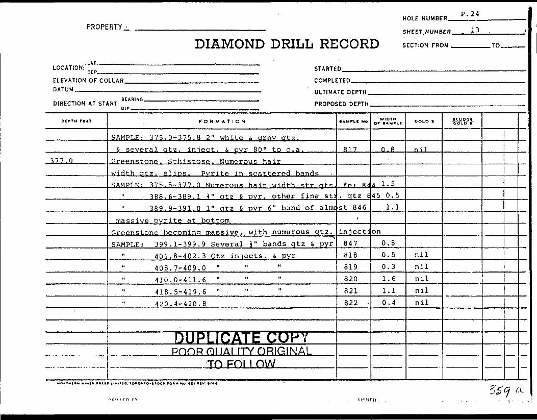
HOLE NUMBER.PROPERTY
DIAMOND DRILL RECORDSHEET.NUMBER.
SECTION FROM .
13
.TO.
LOCATION:.UT,.DEP- STARTED
ELEVATION OF COLLAR. DATUM—————.,.——
COMPLETED
ULTIMATE DEPTH.
DIRECTION AT START: PROPOSED DEPTH
DCPTH ftlT
377.0
FORMATION
SAMPLE: 375.0-375.8 2" white i arev qtz.k several qtz, iniect. S. pyr SO 0 to c. a.
Greenstone. Schistose- Numerous hairwidth qtz. slips. Pvrite in scattered bandsSAMPLE: 375.5-377.0 Numerous hair width str qhs.
388.6-389.1 4" qtz 6 ovr, other fine sti389. 9-391. Q 1" qtz f. pyr 6" band of almc
massive pyrite at bottomGreenstone becominq massive f with numerous qtz.
SSAMPLE: 399.1-399.9 Several J" bands qtz S, pyr
11 401.8-402.3 Qtz injects, i pyr408.7-409.0 "410.0-411.6 "418.5-419.6 " -420.4-420.8
DUPj-ICATE COPYPOOR DUALITY ORIGINAL
70 pni i nw
• AMPLf No
817
ffi; 84. qtz Est 846
t
injecti847818819820821822
WIDTH Of S AMPLI
O.R
4 1.545 0.5
1.1
on0.80.50.31.61.10.4
COLD f
nil
nilnilnilnilnil
GOLD t
r o"i rn rv
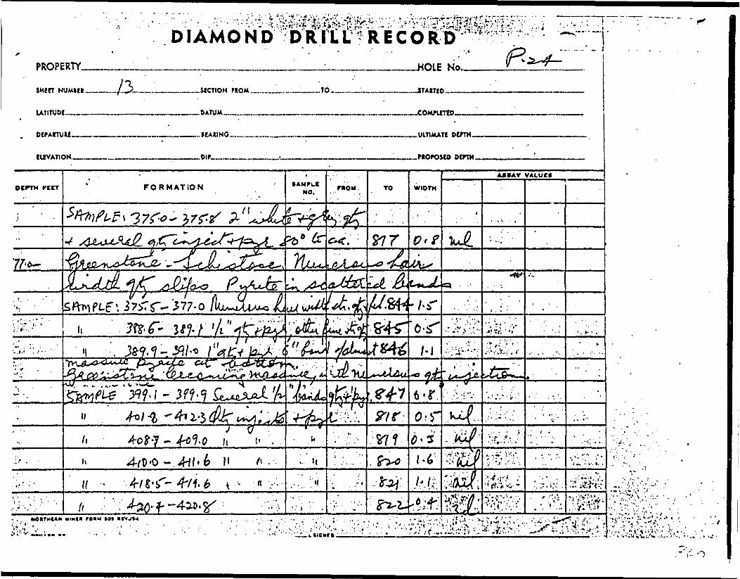
v - '
..7**y"ON 31OKAlHadOtfd
o D a li i^^cr a N o w vi a

PROPERTY -
lit,
DIAMOND DRILL RE
HOLE NUMBE
SHEET. NUMB
• CORD SECTION FRC
p P- 24
ER 14 .
)M TO
i
!OCATION: nrp STARTED
ELEVATION OF COLLAR .OMPLETEDDATUM
DIRECTION AT ST/
DtfTH F ill
473. 7--J74.7
474.7-496.8
————————————————————————————————————— ULTIMATE DEPTH. .BFARIkG ., —
.RT: PROPOSED DEPTHmp-
FORMATION
Greenstone becoming less fractured,rare qtz. str.SAMPLE: 433.0-433.5 Qtz. str. 60 0 to c. a.
470.0-470.1 Qtz. slips i pyr472.2-47? ?472.9-473.7 ?
Quartz vein. Silicified zone withbands of grey quartz d pyr 60 0 to c. a. SAMPLEGreenstone as before. More olive in colour epicSAMPLE: 474.7-475.7 Scattered 1/16' cubes pyrite
475-7-477.3477.3-478.4 " bands of pyrite478.4-479.8 " lines of qtz 4 pyr
" 493.4-495.5 felsite Dissem. pyr.
DUPLICATE COPV—————— PQQRQUAUTYOniGINAL — —
- - — ——— TO FOLLOVV ——————
• AMPLE H i
823824
•825
826
827stised
828829830831832
WIDTHor t AM^LI
0.51.10.50.8
1.0
1.61.11.42.1
COLD 1
nilnilnilnil
nil
nilnilnilnil0.10
liJJPSf.GOLD t
1
Is (?Q c '
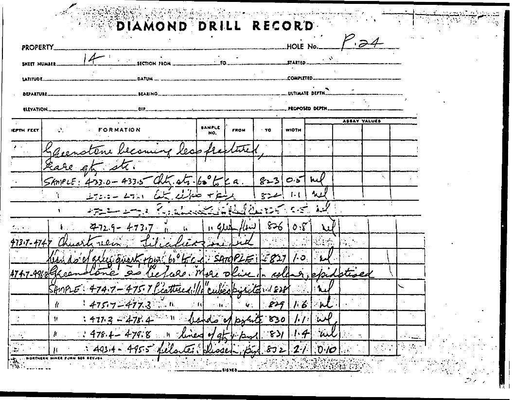
^•^•;^Y^.v:.*:.-:.". 1 .
PROPERTY,
sxtn
lATITUDE.™
DETAtTUU.
DRILL RECORD* . '
*
m.______^__.HOLE No.-.
..SICTION flOM.
..DATUM -. .........
——STAttlO.
.___.__.___..........^.,.____.UlTtMATt OtfTM.
lUVATlON.-. Dip
rttr FORMATION
/C - ^K t
•AMPI.CNO.
TO WIOTM
AXAY VALUE*
*7t-i—±.-1.1. .

PROPERTY -
. LAT. .
DIAMOND DRILL RE
HOLE NUMBE
SHEET. NUMB
[CORD SECTION FRC
B P. 24
ER 15 '
)M TO
LOCATION: n rp STARTED ...........
ELEVATION OF COLLAR COMPLETEDDATUM
DIRECTION AT ST/
DlfTH r ilT
? - 498.4
?
1
————————————————————————————————————— ULTIMATE DEPTHBrARIXlK -. m
iRT: PROPOSED DEPTH0"P.
FORMATION
SAMPLE 496.0-496.8 Thin lines pyr S. qtzQtz. vein. Brecciated i silicifiedzone with quartz S pyr in str. i. bandsthroughout at 60 0 to c. a. SAMPLEGreenstone as before. Green colour again,i occasional qtz. filled slips.SAMPLE: 499.3-499.7 Bands of pyr.
501.8-502.4 Qtz. slips f. 5% pyr.
END OF HOLE 509.0'
* r~" ^ f r* /iTr™, i' .S: .^.'4Q'y/ .MTV-^tjCaii"* i' rv i f \ — - - -*ft c^j I ^H'^'NAL—————— TQf^y^ovv —————
.
lAMPLI No
833
834
835836'
WIDTH OF tAMFK
0.8
1.6
0.40.6
COLD *
nil
nil
nilnil
SVU95J,COLD f
1
NOJITHl IN MIHIN -**** LIMIT i O. 1 DHOMTO-VTOC K rOMMNOtOIAtV.t/44
3k 1 ^ DRinroBY . iifiwrn

PROPERTY.
win HUMIC*.
DlMITUn..
lUVATION.-
D R ILL RECORD
LlZL ..SECTION MOM. ..TO.-™-
—HOLE No.™
—.-STAITIO....-——-
———COM?intD
——..UlTtMATI
.Dir— .PtOrOSCO DOTH.

r; HO
SUMMARY REPORTON
PICK MINES LIMITED GOUDREAU - LOCHALSH AREA
DISTRICT OP ALGOMA, ONTARIO
BY
A. C. A. HOWE INTERNATIONAL LIMITED
A. C. A. HOWE, P. ENG.
TORONTO, XDNTAR10 OULY 25, 1967 REPORT NQ. 77,
A. C. A. HOWE INTERNATIONAL LIMITED

CON T.E NTS
SUMMARY
PROPERTY
LOCATION AND ACCESS
TOPOGRAPHY
WORK DONE
GEOLOGY
SURFACE DIAMOND DRILLING
RESULTS OF DIAMOND DRILLING
GRADE CALCULATIONS
CONCLUSIONS AND RECOMMENDATIONS
CERTIFICATE
PAGE NO,
1
2
2
2
3
4
5
6
7
10
A. C, A. HOWE INTERNATIONAL LIMITED
36 V

SUMMARY
A summary of the results to date of the underground
program of drifting and diamond drilling and the surface diamond
drilling program are outlined in this report. Several high grade
gold-bearing veins occur in the No. 3 zone. These veins are
sufficiently high grade to justify further underground work.
It is suggested that further work should consist of
raises to determine the continuity of the veins from the first
level to the No. 3 adit. In addition, the first level drift
should be extended eastwards about 200 feet to explore the area
below the surface trenches in which high grade values were ob
tained in previous sampling.
A cross-cut should be driven 100 feet south to explore
a new vein which is indicated to the south of the drift. Further
investigation of the mineralized zones to the oouth and to the
east of the present first level should consist of flat holes
from the end of the new cross-cut.
A. C. A. HOWE INTERNATIONAL LIMITED

- 2 -
PROPERTY
The property consists of 16 contiguous mining claims,
as follows:
Claims SSM-2185, 2186, 2188, 2189, 2190 and 2271 are
patented, and known as parcels 1148 (1), 1451 (4), and 1479 (1).
Claims SSM-61783 to 61792 inclusive, are unpatented,
and adjoin the north side of the patented group.
LOCATION AND ACCESS
The group of claims is located in the central portic
of Township 48, in the Goudreau-Lochalsh gold area, District of
Algoma, Ontario.
The property can be reached by gravel road from either
Goudreau or Lochalsh. Goudreau lies on the Algoma Central and
Hudson Bay Railway line and ia 12 miles southwest of the
property. Lochalsh lies on the Canadian Pacific Railway line
and is 7 miles northeast of the property.
TOPOGRAPHY
The property overlies mainly overburden and swamp,
however the mine workings are located on a rocky ridge which
A. C. A. HOWE INTERNATIONAL LIMITED

-3-
traverses the property in an east-west direction.
WORK DONE
Work done by Pick Mines Limited (1960 to 1966) i-
1. Surface trenching and exploration.
2. Sampling of old dumps.
3. Erection of camp, mine and mill buildings.
4. No. 3 shaft dewatered and cross-cutting performed at 100' level.
5. No. 3 adit driven for length of 130'.
6. Surface diamond drilling.
1960 - Holes P. l - 5 for total 1000'.
1961 - Holes P. 6 - 9 for total 1037*.
1962 - Holes P.10 - 19 for total 2700'.
7. 1962 - Dewatering of No. 3 shaft and sampling of drift and cross-cut. Also underground hole No. 101 from face of cross cut for 197 ft.
8. 1962 - Overhaul of equipment and buildings for underground work. Work ceased and shaft allowed to flood.
9. 1963 - 1213 ft. surface diamond drilling for assessment purposes.
10. 1965 - 630 ft. drifting and cross-cutting, 2855 cu. ft. of slashing (cross-cutting) for drill stations, and 1155 ft. of diamond drilling on the first level.
A. C. A. HOWE INTERNATIONAL LIMITED

- 4 -
11. 1966 - approximately 2500 ft. surface diamond drilling and 511 ft. of diamond drilling on the first level.
GEOLOGY
The geology of the property is described in the
Ontario Department of Mines report "Geology of the Goudreau
Lochalsh Area." The following three paragraphs are a brief
summary:-
The oldest rocks are lavas of Keewatin Age, which are
intermediate to basic in composition in the area of the property.
These have a general east-west strike.
The lavas are intruded by a series of bosses, dykes
and sills of varying composition, and of Precambrian Age. The
earliest of these being a diorite followed in sequence by grano
diorite, porphyries, felsite and diabase. The granodiorite
generally parallels the strike of the lavas; the porphyries anc1
felsite generally cut across the earlier rocks in a northeast
direction, and the diabase occurs in dykes and sills cuttingt
the older formations at varying angles.
A strong shear zone lies a short distance south of
the old workings. It strikes a few degrees north of east and
dips 70 0 to 80" N. It is 40 to 50 feet wide and contains a
A. C. A. HOWE INTERNATIONAL LIMITED

- 5 -
large amount of quartz and carbonates.
Diamond drilling results on the Pick property in
dicate that the basic lavas in the area of the No. 3 shaft re
present large remnant blocks within the granodiorite. On the
No. 3 zone, gold-bearing quartz veins occur in an area where
considerable shearing has taken place. Three veins A, B and
C, lie within the granodiorite while another vein to the south
of these veins lies within the greenstone mass.
SURFACE DIAMOND DRILLING
In the spring, 1966, a total of nine surface diamond
drill holes were completed for a total of approximately 2500
feet of diamond drilling.
All holes with the exception of holes P.29, P.30, and
P.31 were drilled in the area of the No. 3 shaft in order to
correlate the veins in the No. 3 zone exposed on the first
level and in the No. 3 adit, and to test the eastward extension
of the veins in the No. 3 zone.
Early in 1966, the underground drilling program begun
in December of 1965 was completed.
A. C. A. HOWE INTERNATIONAL LIMITED
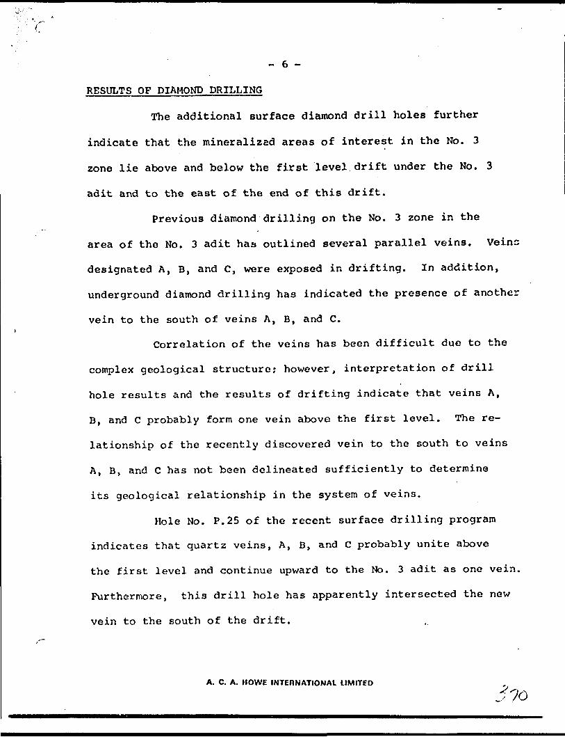
- 6 -
RESULTS OF DIAMOND DRILLING
The additional surface diamond drill holes further
indicate that the mineralized areas of interest in the No. 3
zone lie above and below the first level drift under the No. 3
adit and to the east of the end of this drift.
Previous diamond drilling on the No. 3 zone in the
area of the No. 3 adit has outlined several parallel veins. Veins
designated A, B, and C, were exposed in drifting. In addition,
underground diamond drilling has indicated the presence of another
vein to the south of veins A, B, and C.
Correlation of the veins has been difficult due to the
complex geological structure; however, interpretation of drill
hole results and the results of drifting indicate that veins A,
B, and C probably form one vein above the first level. The re
lationship of the recently discovered vein to the south to veins
A, B, and C has not been delineated sufficiently to determine
its geological relationship in the system of veins.
Hole No. P.25 of the recent surface drilling program
indicates that quartz veins, A, B, and C probably unite above
the first level and continue upward to the No. 3 adit as one vein.
Furthermore, this drill hole has apparently intersected the new
vein to the south of the drift.
A. C. A. HOWE INTERNATIONAL LIMITED

~ 7
Holes P. 26 and P.27 did not encounter high gold values
in quartz veins. Apparently the quartz veins encountered in the
Ho. 3 adit area are not present in the area of these two drill
holes.
The quartz veins intersected in hole P. 28 indicate an
upward continuation of the veins exposed on the first level.
Vein intersections in hole P.33 probably coincide with
the eastward extension of the veins exposed in drifting. However
it is possible that the vein to the south of the present drift may
also have been intersected in this drill hole.
GRADE CALCULATIONS
In the area of the No. 3 shaft on the Pick Mines
property, significant gold mineralization is indicated in the
quartz veins of the No. 3 zone under the No. 3 adit.
Calculation of the tonnage and grade was carried out
with the usual method of weight averaging of the assays, assum
ing that the influence of each assay extends one half the distance
to the adjacent assay across the vein. The final tonnage and
grade figures are based on drill hole intersections and chip
samples (in the drift) on sections 4900. 4S50, 5000, and 5017 E.
A. C. A. HOWE INTERNATIONAL LIMITED

- 8 -
A comparison of the underground assay values from chip
samples of veins A, B, and C with the values obtained from the
surface trench and the adit indicated that the surface samples
returned a much higher average value than the drift samples.
Surface and adit samples returned a weighted average value of
2.38 oz. Au/ton (uncut) while the weighted average values of
veins A, B, and G were 1.68 (3 samples), 1.15 (11 samples) and
0.33 (10 samples) oz. Au/ton respectively. Thus, the under
ground results, with the exception of the 1.68 Au/ton average
obtained from only 3 samples, indicate that the average assay
of 2.38 02. Au/ton should be lower to correlate with t "ne other
assays obtained from underground work. In .preliminary calculations
of the grade, the average surface assay of 2.38 oz. Au/ton was
cut to 1.00 oz. Au/ton, and this resulted in an estimated 4,400
tons of vein quartz material grading 0.83 oz. Au/ton existing
over a length of 117 feet (from section 4900 E to section 5017 E)
and combined average width of 3.2 feet.
The vein material outlined by 4,400 tons represents
vein material from the Mo. 3 adit continuing downward a projected
20 feet below the deepest intersection of the veins either in a
drill hole or in the drift.
A. C. A. HOWE INTERNATIONAL LIMITED
-; z

-9-
The average width of the veins consists of an arithmetic
average of all vein anniplco. Where veins A, B, and C are separated as
on section 4950, the waste material between the veins has been dis
regarded. However on several sections, veins A, B, and C have joined
together and are considered as one vein. A d ilution factor will there
fore have to be considered for any mining operation, but cannot be
calculated at this time.
To further assess grade possibilities, a calcination was
made with all underground assays over l oz./ton cut to l oz./ton, in
addition to using a l oz./ton grade (instead of 2.38) for surface and
adit assays. This resulted in a grade of 0.37 oz./ton Au. for the
4,400 tons of vein material.
Of the calculated 4,400 tons of vein material, 3570 tons
lies between the first level and the No. 3 adit. Reducing the sur
face and adit average to 1.0 oz./ton Au. as before, a grade of 0.54
ozs./Au./ton is obtained for the 3570 tons of vein material.
Quartz veins with gold values exist at the southern boundary
of the No. 3 zone and the northern limit of the Q zone in the area to
the east of the end of the present drift on the first level. No mean
ingful correlation of tonnage and grade calculations could be made for
these veins based on the information to date. Further drifting and
drilling will be required to investigate these veins.
A. C. A. HOWE INTERNATIONAL LIMITED•y -p

- 10 -
CONCLUSIONS AND RECOMMENDATIONS
Gold values in the quartz veins of the No. 3 zone are
sufficiently high to warrant further work. Although the tonnage
indicated to-date above the 1st level is small there remains the
possibility of additional tonnage in the area below the surface
trenches to the east. This area is unexplored by underground work,
although originally intended as the main target for underground ex
ploration. Underground drifting carried out on the 1st level in
1965 was halted 100 feet short of the trenches because it was
recommended that further drilling be done to determine which of the
various vein structures the drift should follow. This drilling
was completed in .1966, and it is now recommended that drifting be
continued ur.Jer the trenches where high grade assays were obtained
in 1960-61 programs.
The following program is therefore recommended:
1. Drifting from the end of the present first leveldrift eastward to tho atsa under the surface trench in order to test the continuity of the veins in the end of the drift and to sample the veins under the trench.
Estimated 200 feet at $75.00 per foot. 15,000.00
A. C. A. MOWE INTERNATIONAL LIMITED

- 1 1 -
2. Cross-cutting south from the present first level to tost veins to the south of the drift and to establish a drill station for further underground drilling.
Estimated 100 feet at $75.00 per foot. 5 7,500.00
3. Raising from the first level to the No. 3adit to test the upward continuity and grade of the veins.
Estimated cost of 200 feet of raising at$45.00 per foot. 9,000.00
4. Underground drill program consisting of flat holes to test the continuity of veins to the east of the present drift on the first level, and also, to test for additional veins in the Q zone.
Estimated cost of 2000 feet of drilling at?5.50 per foot. __11.000.00
TOTAL ? 42,500.00
Further work will depend on the results of the recommended
program, but should be directed towards proving a sufficient tonnage
to re-open the mill either on a salvage or a continuing basin.
The cost of rehabilitating the mill and developing the
mine is estimated at $100 > 000.00.
Respectfully submitted,A. C. A. HOHE INTERNATIONAL LIMITED,
Vi
A. ,C. A. Howe, P. Eng. DATED AT TORONTO, ONTARIO THIS 25th DAY OF JULY, 1967.
A. C. A. HOWE INTERNATIONAL LIMITED

CERTIFICATE
I, A. C. A. Howe, of the City of Toronto, in the County of York, Province of Ontario, hereby certify that:
1. I am a Mining Engineer with offices at 826-159 Bay Street, Toronto, Ontario.
2. I am a graduate of London University, England, B.Se., in 1949.
3. I am a member of the Association of Professional Engineers of Ontario.
4. I have no interest, direct or indirect, in either the pro perty or securities of Pick Mines Limited, nor do I expect to receive any such interest.
5. This report is based on a personal knowledge of the property gained from supervision of previous work programs on the property, and on reports by R. A. Grouse, resident geologist during the 1965-1966 work progra*m.
DATED AT TORONTO, ONTARIO THIS 25 DAY OF JULY,,1967.
A, C. A. HOWE, P. ENG.
A. C. A. HOWE INTERNATIONAL LIMITED 2V

/W^.'.-'~ A''''/* 't. J1 S*" ^ '*'
r
0in n
SUMMARY REPORT ON THEPICK MINE PROPERTY,
GOUDREAU-LOCHALSH AREA,ALGOMA DISTRICT, ONTARIO
for
CAVENDISH INVESTING LTD.
l
l
l
J
l
l
l
Report 0435 April 21, 1982
by
A. C. A. HOWE INTERNATIONAL LTD. 159 Bay Street, Suite 826
Toronto, Ontario
G. W. Felderhof, B.Se., F.G.A.C.
Toronto, Ontario

TABLE OP CONTENTS
Contents Page No.
SUMMARY............................... l
1. INTRODUCTION........................ 6
2. TERMINOLOGY......................... 7
3. PROPERTY STATUS AND DESCRIPTION..... 7
4; HISTORY............................. 8
5. GEOLOGY.............................14A. INTRODUCTION . . . . . . . . . . . . . . . . . . . . . . . . . . . 14
B. GENERAL DESCRIPTION . . . . . . . . . . . . . . . . . . . . . . . . 15a) Diorite . . . . . . . . . . . . . . . . . . . . . . . . . . . . 16b) Granodiorite ..........................16c) Quartz Porphyry and Feldspar Porphyry . . . . . . . . . . . . . 17d) Felsite . . . . . . . . . . . . . . . . . . . . . . . . . . . . 17e) Quartz-Carbonates .......................17
C. STRUCTURE . . . . . . . . . . . . . . . . . , . . . . . . . . . . . 18
6. ECONOMIC GEOLOGY....................18A. INTRODUCTION . . . . . . . . . . . . . . . . . . . . . . . . . . . 18
B. CHARACTER OF GOLD MINERALIZATION . . . . . . . . . . . . . . . . . 20
C. DESCRIPTION OF MINERALIZED ZONES AND ORB RESERVES . . . . . . . , . 22i) No. l Shaft . . . . . . . . . . . . . . . . . . . . . . . . . 22
ii) No. 2 Shaft . . . . . . . . . . . . . . . . . . . . . . . . . 23iii) No. 3 Shaft . . . . . . . . . . . . . . . . . . . . . . . . . 24
a) Introduction and General Description . . . . . . . . , . . 24b) "R" Zone . . . . . . . . . . . . . . . . . . . . . . . . . 27c) "Q" Zone . . . . . . . . . . . . . . . . . . . . . . . . . 30d) "3" Zone . . . . . . . . . . . . . . . . . . . . . . . . . 33e) "4" Zone . . . . . . . . . . . . . . . . . . . . . . . . . 39f) "5" Zone(includes Shaft Zone) . . . . . . . . , . . . . . . 40g) Summary of Ore Reserve Estimates . . . . . . . . . . . . . 41
lv) No. 4 Shaft . . . . . . . . . . . . . . . . . . . . . . . . . 42a) Underground . . . . . . . . . . . . . . . . . . . . . . . . 42b) Surface Tailings . . . . . . . . . . . . . . . . . . . . . 45
v) Summary of Ore Reserve Estimates, No. l to No. 4 Shaftsinclusive . . . . . * . , . . . . . . . . . . . . . . . . . . 45
7. GEOPHYSICS................... '' 45
8. METALLURGY..........................''6
9. CONCLUSIONS.........................46
A. C. A. HOWE INTERNATIONAL LIMITED

TABLE OF CONTENTS (Cont 1 d)
Contents Page No.
10. RECOMMENDATIONS
11. BIBLIOGRAPHY...
49
51
APPENDICES
Appendix l - Photographic Record - No. 3 Shaft, Pick Mine, 1965.
Appendix 2 - Selected Summary Reports written by various authors during the period 1926-1967.
Appendix 3 - Selected progress reports by Halstead and Howe, 1960-1966.
Appendix 4 - Copies of Drill Logs on file at Howe International.
Appendix 5 - Corses of Assay Certificates on file at Howe International.
Appendix 6 - C ^y of Prospectus, April 20, 1964.
Appendix 7 - Copy of Mines Branch Investigation Report I.R. 62-97; Flotationand Cyanidation Tests on Drill Core Samples from the Cold Property of Pick Mines Ltd., Lochalsh, Ontario, R. P, Bailey, 1962.
A. C. A. HOWE INTERNATIONAL LIMITED

MOSTSue-
Afce
LIST OF MAPS ACCOMPANYING REPORT
I. NO. 3 SHAFT AREA AND REGIONAL
A. Plans
Map l - Ontario Department of Mines Map No. 49g, Geology of Goudreau- Lochalsh Area, 1940; scale of 1"-^ mile.
2 - Perimeter Survey No. C.L.M. 133, being composed of claims SSM 61783 through SSM 61729, 1969; scale of 1"-300'.
3 \ Geology, 1964; scale of 1"-400'.
4 \ Surface Plan, 1962; scale of 1"-200*.
5 - Surface Plan, 1961; scale of 1"-60'.
6 - Plan of Surface Diamond Drilling (drill holes C.39 to C.43, C.45 and C.309), 1962; scale of 1"-10G'.
7 - Diamond Drilling with Assays, 1962; scale of 1"-20'.
8\ Plan of Drill Holes with Assays, 196:; scale of 1"-40'.
8A - Magnetometer Survey - Southwest Portion of Property, 1963; scale of 1"-40'.
SB - Magnetometer Survey - Southeast Portion of Property, 1963; scale of 1"-40'.
9 - Sample Location Plan - 1st Level, 1965; scale of 1"-60'.
10 -- Assay Plan - 1st Level, 1965; scale of l"-20 f .
11 - Geological Plan of Drift - 1st Level, 1965; scale of 1"-10'.
12 - Geological Plan - 1st Level, 1965; scale of 1"-20'.
13 - Geological Plan - 1st Level, 1966; scale of 1"-20'.
14 - Assay Plan - 1st Level, 1966; scale of 1"-20'.
15 - Plan of Drill Hole Locations and Quartz Veins - 1st Level, 1966; scale of 1"-20'.
16 - Diamond Drill Assay Plan - 1st Level, 1966^ scale of 1"-20'.
17 J- Diamond Drilling with Assays, 1967; scale of 1"-20'.
Continued . . .A. C. A. HOWE INTERMATIONAL LIMITED

B. Cross-Sections
18 - Cross-Section at Drill Hole P.16, 1962; scale of 1"-20'.
19 - Cross-Sections showing No. 3 Adit, 1st Level, Drill Holes and Proposed Drill Holes, 1966; scale of 1"-20'.
20 - Cross-Section 5100E, 1962-66; scale of 1"-20'.
21 - Cross-Section 5050E, 1962-66; scale of 1"-20'.
22 - Cross-Section 5017E, 1962-66; scale of 1"-20'.
23 - Cross-Section A950E, 1962-66; scale of 1"-20'.
2A - Cross-Section A900E, 1962-66; scale of 1"-2Q'.
25 - Cross-Section A925E, 1962-66; scale of 1"-20'.
26 - Cross-Section A875E, 1962-66; scale of 1"-20'.
27 - Cross-Section A850E, 1962-66; ocale of 1"-20'.
28 - Cross-Section A800E, 1962-66; scale of 1"-20'.
C. Longitudinal Sections
0 Longitudinal Section - No. 3 Shaft, Proposed Adit and Pits, 1959; scale of 1"-60' (7).
30 - Longitudinal Section - No. 3 Vein, Shaft and Trenches, 1960; scale of l"-AO f .
31 - Longitudinal Section - No. 3 Adit Vein, 1961; scale of 1"-10'.
32 - Longitudinal Section - 'R" Vein (Pick No. 2 Vein), 1960; scale of 1"-20'.
33 - Longitudinal Section - "Q" Zone, 1962; scale of 1"-20'.
3A - Longitudinal Section - "3" Zone, 1962; scale of 1"-20'.
35 - Longitudinal Section - "A" i, "5" Zones, 1962; scale of 1"-20' .
D. Miscellaneous (Promotional maps which accompanied Pick Mines Ltd.Prospectus)
36 - Assay Plan and Sections, 1st Level - No. 3 Shaft Area, 1966; scale of r'*2G', and l"-75'.
37 - Plan of Drill Holes with Assays, 1963; scale of approx. 1"-135'
Continued . . .
A. C, A, HOWE INTERNATIONAL LIMITED
B II. NO. 4 SHAFT AREA
38 - Isometric Diagram of the Underground Workings to 4th Level;Ontario Department of Mines Report by E. L. Bruce, Vol. XLIX, Part 3, 1940; scale of 1"-60'.
;!

SUMMARY
A. C. A. Howe International Ltd. was contracted by Cavendish Investing
Ltd. to research all the data in the Howe International files pertaining to
the "Pick Mine" and compile the pertinent data into a single report. This
data is contained in correspondence, progress reports, summary reports, num-t
erous maps, etc., that were acquired by Howe International during thn period
between 1962 and 1967 when Howe International were engaged as the consultants
on the Pick Mine.
The Pick Property is composed of 16 claims covering 693 acres and is
located 170 miles north of Sault Ste. Marie in Jacobson Township, northwestern
Ontario. The.nearest villages are Lochalsh, situated on the Canadian Pacific
Railway seven miles to the northeast, and Goudreau Station, on the Algoma
Central Railway eleven miles to the southwest.
The claims are patented claims which were expropriated by the Crown and
have been withheld from staking.
The property is characterized by low relief and is covered by overburden,
swamp and a small lake known as Cline Lake.
Geologically, the property is situated ir a northeasterly trending belt
composed of predominantly Keewatin age acid to basic volcanics, with inter
bedded tuffs and iron formations. These rocks generally strike northeast to .
east and have steep to vertical dips. Intruding them are Algoman age diorite,
granodiorite, quartz and feldspar porphyry, and felsite, which are present in
the form of bosses, dikes and veins. The dikes and veins have a tendency to
parallel the strike of the volcanics, or cross them obliquely.
Both the Keewatin volcanics and the Algoman intrusives are intruded by
diabase dikes and sills of Keweenawan age.

- 2 -
J!
Gold, mineralization on the property is contained in blue-grey quartz
veins and shear structures which strike east, northeast and northwest, and
dip 70 to 85 N, vertical or 70 to 85OS. These veins and shear structures are
closely associated with the granodiorite-andeslte contact and with protru
sions of the granodiorite in the andesite.
The property's history dates back to 1918 when gold was first discovered
in outcrop by a Mr. James Cline. During the years between 1918 and 1936,
several attempts were made by Cline Gold Mines Ltd. to bring the property
into production. Three shafts, No. l, 2 and 3 were sunk and a small amount
of lateral work undertaken, however, all three attempts ended in failure.
In 1936, another gold discovery was made on claim SSM2271 and the No.
4 Shaft was sunk. O'Brlen Gold Mines Ltd. took control of Cline Gold Mines
Ltd. in the same year and commenced production in 1938. In the Interval
between the years 1938 and 1942, 331,842 tons of ore was mined and milled,
from which 63,328 ounces of gold and 10,600 ounces of silver was extracted.
This indicates * grade of 0.191 oz. Au/ton and .032 oz. Ag/ton (Au to Ag
ratio of 6 to 1).
The mine closed down in 1942 with the reasons given as shortage of
labour and materials, and a decrease in ore grade beneath the fifth level
in the mine. Before closing down, however, a drive was established on the
fourth level, 2250 feet west to ore blocks indicated by diamond drilling in
the No. 3 Shaft area. These blocks were partially developed, and only a
small quantity of ore removed.
The property remained dormant until 1959 when Pick Mines Ltd. acquired
it and began exploration and development work in the No. 3 Shaft area. Dur
ing the period between 1959 and 1966, considerable drilling was conducted
(both surface and underground), some drifting and cross cutting was completed,
and a plant established.

- 3 -
Pick Mines Ltd. delineated five mineralized zones in the No. 3 Shaft*(
area (from south to north), the "R", "Q", "3", "4" and "5" Zones, however,
most of their efforts were directed toward the "3" Zone. For reasons which
are not stated in the reports, this attempt to bring the Pick Mine into pro
duction was unsuccessful. With the exception of some assessment drilling in
1967, no work has since been conducted ou the property.
No ore reserve calculations have been done on the No. 3 Shaft area,
with the exception of an attempt by a Mr. Halstead, the consultant on the
project in 1961. His estimates are presented below, however, it should be
noted that these were not verified by Howe, who was the consultant during
the period 1962 and 1967, and that the estimates are likely to be inaccurate.
No. 3 Shaft
"R" Zone: Block B - 26,759 tons grading .57 oz. Au/ton
Block C - 8,125 tons grading .7 oz. Au/ton
Block D - 7,009 tons grading .59 oz. Au/ton
"Q" Zone: Block E - 35,100 tons grading .43 oz. Au/ton
"3" Zone: Block A - 13,875 tons grading .72 oz. Au/ton
"4" Zone:
"5" Zone: Block F - 2,000 tons grading .556 oz, Au/ton
His calculations for the No. 4 Shaft (between fourth and fifth levels
are as follows:
No. 4 ShaftI .ir -B. Ji in i .11 l
Block G - 30,437 tons grading .19 oz. Au/ton
It is not known how Mr. Halstead derived his estimates because none of
the maps show these ore blocks, nor the individual veins or mineralized
shear structures within the mineralized zones.
A. C. A. HOWE INTERNATIONAL LIMITED
'
The extensive exploration in the No. 3 Shaft area and.the 4*5 years of
mining in the No. 4 Shaft area has provided a great 'deal of information with
respect to the character of the mineralization. Particularly noteworthy
points include:
a) The gold mineralization is erratically distributed in veins and shear
structures. In the No. 3 Shaft area, these veins and shear structures are
found within the mineralized zones designated "R", "Q", "3", "4" and "5".
b) The mineralized veins and shear structures are lenticular or discontinu
ous as a result of natural plnch-outs and/or post-ore faulting.
c) The mineralized structures generally trend east or just north or south
of east, dip vertically or steeply (70-850) north or south.
d) The mineralized veins and shear structures show an association with the
granodiorite-andesite contact and with "tongues" and protrusions of gran
odiorite into andesite.
e) In places the wall rocks to the mineralized veins and shears are themselves
mineralized and are indistinguishable from barren wall rocks.
f) The mineralized veins and shears appear to have an association with the
"great quartz-carbonate shear" being actually subsidiary to it in the No.
A Shaft area.
It is concluded that the Pick Mines Property has ore potential but does
not have demonstrated ore reserves. The area with the best potential for
proving ore reserves with the least amount of work, is the No. 3 Shaft area,
followed by the No. 2 Shaft, No. 4 Shaft and No. l Shaft areas. Other areas
with potential include:
a) the southern margin of the granodiorite body on which the No. 3 Shaft is
located,
b) ttva region between the southern margin of the granodiorite body and the
No. 4 shaft, andVe- l

l-u
- 5 -
c) the region immediately south of the "great quartz-andesite shear".
The initial target should be the Ho. 3 Shaft area, and to demonstrate
proven reserves, preliminary work consisting of correlation of the ore
intersections indicated on the maps is necessary. Once individual veins
and shoots are delineated, fill-in drilling will be required to enable
tonnage and grades to be calculated with a high degree of reliability.
Underground development and bulk sampling should not be commenced
prior to delineation of adequate proven reserves.
The tailings from the ore mined and milled at the No. 4 Shaft should
be tested for its residual gold content.
f! i
l LI

- 6 -
J
LJLJ
LJ
1. INTRODUCTION
A. C. A. Howe International Ltd. was contracted by Cavendish Investing
Ltd. on March 2, 1982, to undertake a compilation of data and information in
Howe International's files pertaining to the dormant Pick Mine in the Lochalsh-
Goudreau area of northwestern Ontario. Cavendish also requested Howe Inter
national to undertake preliminary discussions with the Ontario Ministry ofi
Natural Resources to determine the types of improvements they might require to
the surface environment, should Cavendish be granted the lease on claims
covering the property. In addition, Cavendish requested Howe International's
opinion on the type of exploration program required to come to a production
decision on the Pick property.
The assessment files at the Ontario Ministry of Natural Resources were
researched to determine whether or not they contained information which might
be missing from the Howe International files. This research showed the Ontario
Department of Natural Resources to have only a limited quantity of data on the
Pick Mine, all of which is present in the Howe International fil^s.
The former president of Pick Mines Ltd., Mr. George Sherman, had consi
derable data on the Pick Mines, however, according to N. E. Brewster (personal
communication), Vice-President, Howe International, he lost this information Jn
a fire.
Mr. M. C. Halstead of G f, H Mine Consultants Ltd., Sault Ste. Marie, Ontario,
was the mining engineer in charge of the evaluation program during the initial
period of work (1960-1961), and it is possible that some additional information
may be acquired from that firm. The writer did not contact G d H Mine Consultants
Ltd. in this regard, to avoid raising any undue Interest in the Pick Mine propert)
A. C. A, HOWE INTERNATIONAL UMITED

B
- 7 -
li' \ by third parties. Furthermore, it appears that Mr. Halstead lost a consi-
M derable quantity of data in a basement flood (N. Brewster, personal communi-i
j cation).
l With the possible exception of G S H Mine Consultants Ltd., it appears
LJ that the most complete records pertaining to the Pick Mine are contained in
the Howe International files. In the process of compiling this report, they V writer has read and evaluated all correspondence, progress reports, summary
j l reports, maps, etc., and extracted all pertinent information. All the rele
vant maps have been updated (as much as could be accomplished within the time
WJ frame of this program) and included in this report. In addition, assay
certificates, diamond drill logs and selected reports are found in the appen-
Jjm dices.
The writer has not personally visited the property.44
4
2. TERMINOLOGY
The term "ore is used throughout the report in describing rock mineralized4with gold which may not necessarily be economically retrievable. Although
technically this term is normally restricted to minerals which are commercially
extractable, it is the writer's opinion that confusion would be avoided by
^W utilizing the same terminology as found in the original reports. Furthermore,
the rapidly fluctuating price of gold could result in gold-bearing rock which
is sub-economic in one month to be economic in the next - and vice versa.
3. PROPERTY STATUS AND DESCRIPTION
4The present property is composed of 16 claims totalling approximately
4 693 acres, the title to which is presently held by the Ontario Ministry of
Natural Resources. The property is not open to staking, however, it may be
A. C. A. HOWE INTERNATIONAL LIMITED
- 8 -
possible to acquire it through a lease from the Ministry of Natural Resources,
although the basis on which the Ministry might grant the lease is not known.
The property is composed of what originally was two groups of claims,
namely the Cline Goup, comprising claims SSM 2185, 2186, 2188, 2189, 2190 and
2271, and the Pick Group comprising claims 61783 to 61792 inclusive (see
Maps l, 2 and 17). Collectively, all these claims are now referred to as the
"Pick Property".4
The Pick Property is located in the central part of Township A8 (now
Jacobson Township), approximately 11 miles northeast of Goudreau Station on
the Algoma Central Railway, and 170 miles north of Sault Ste. Marie (see Figure
1). The village of Lochalsh on the Canadian Pacific Railway is located l
miles northeast of the Pick Mines Property. A gravel road connects both Goudreau
and Lochalsh to the Pick Property.
Topographically, the property is characterized by low relief, being covered
for the most part by overburden and swamp. A small lake (Cline Lake), measu
ring approximately 1,600* x 400' occurs in the center of the claim group.
4. HISTORY
The following is a chronological list of events commencing with the
initial discovery of gold on the property, to its ultimate expropriation by
the Ontario Ministry of Natural Resources.
1918 - James Cline discovered gold on claim SSM 2188, on which he
subsequently did some surface trenching exposing several high
grade veins.
1924-1925 - Cline Canadian Gold Mines Ltd. was formed and acquired control
of six claim? Known as the "Cline Group", which consisted of
A. C. A. HOWE INTERNATIONAL LIMITED

- 9 -
SAULT .STE. MARIE'
PICK MINES LTD.
A/flP
A. C, A. HOWE IKTERNATtOMAL UMITED

- 10 -
claims SSM 2185 to 2189, and SSM 2271. Further discoveries
were made on the adjacent claim (SSM 2186), to the west of
2185. Seven diamond drill holes were drilled, the locations
of which are not known, however, it is likely that they were
on claims SSM 2186 and 2185 because shaft sinking was subse
quently undertaken on both of these claims.
The Mo. l Shaft was sunk vertically on claim SSM 2186 to a
depth of 140 feet with drifts established 70 feet east and 20
feet west of the shaft on the 80-foot level.
The No. 2 Shaft was sunk inclined at -70O on claim SSM 2185.
It reached an ultimate depth of 215 feet with crosscuts driven
19 feet north and 20 feet south on the first level and 40 feet
. on the 200-foot level. The veins intersected in the shaft were
sampled and assayed.
1926 - Work was temporarily suspended and .the property reverted to
James Cline, the original owner.
1927-1928 - Cline Lake Mines Ltd. was formed and acquired the property from
James Cline. This company sank the No. 3 Shaft approximately
400 feet east of the No. 2 Shaft, on claim SSM 2185. This shaft
was sunk vertically to a depth of 115 feet, with some lateral
development (approximately 100 feet) done on the 100-foot level
(first level).
1932 - Cline Lake Gold Mines Ltd. was formed end took control of the
property from Cline Lake Mines Ltd.
1933 - A new gold discovery was made on claim SSM 2271.
1936 - O'Brien Gold Mines Ltd. acquired control of Cline Lake Gold
Mines Ltd. O'Brien sank a three-compartment, vertical shaft,
A. C. A. HOWE INTERNATIONAL UMITEC z
- 11 -
m1
No. A ShafC, to 522 feet on the new discovery on claim SSM
2271.
The "C" series of drill holes were probably drilled prior to
the O'Brien takeover.
1938-1942 - Levels were established at 125, 250, 400 and 500 feet, the
mine was equipped and a 200-ton per day mill commenced opera
tion in July, 1938. The shaft was subsequently deepened to
1,175 feet and 4 nore levels established.
A tunnel was driven northwest for 2,250 feet on the fourth
level to develop Btopes in the No. 3 Shaft area, where diamond
drilling had indicated good gold values.
In 1942, the mine was closed down, plant disposed of, and assets
distributed. Reasons cited for the closure were given as:
a) decline in ore grade below the fifth level (O.D.M. assessment
file - NTS 42 c/8, Ref. Au 3), and
b) shortage of material and labour due to World War II (Appendix
2, Halstead, 1960).
At the time of closure, the No. 4 Shaft had 12,229 feet of
drifts and 6,340 feet of crosscuts.
During the five-year interval between 1938 and 1942, 331,842
tons of ore were mined and milled, from which 63,328 ounces of
gold and 10,600 ounces of silver were extracted.
1959 - Pick Mines Ltd. purchased the six claims comprising the Cline
Claim Group, and staked 10 adjoining claims to the north.
1960-1962 - Pick Mines Ltd. completed an exploration program which Included
surface trenching, sampling of old dumps, and diamond drilling.
The following diamond drill holes were drilled during this period.
r* A unvjc
- 12 -
i?. 1960 - Holes P. 1-5, totalling 1,000 feet
1961 - Holes P. 6-9, totalling, 1,037 feet
1962 - Holes P. 10-19, totalling 2,700 feet.
The No. 3 Shaft was dcwatered, rehabilitated and a new headframe
erected. Drifting, cross-cutting, sampling, and surveying were
undertaken on the first level. Drill hole 101 was drilled south
from the face of the crosscut^ on the first .level.
The No. 3 Adit was driven east-southeast for a distance of 150
feet and sampled.
- Camp, mine, and mill buildings were erected and equipment over
hauled.
1963 - Four drill holes, P. 20 to P. 23, totalling 1,213 feet were
drilled to investigate a geological structure located * one-
half mile north of the No. 3 Shaft. This drilling was under
taken for assessment purposes.
A magnetometer survey was conducted along the length of the
"great quartz-carbonate shear".
1964 - A photo-geological interpretation wan done with emphasis on
faulting and fracture patterns.
1965-1966 - The No. 3 Shaft was dewatered and 630 feet of drifting and
cross-cutting, 2,855 cubic feet of slashing (cross-cutting)
for drill stations, and 1,666 feet of drilling was undertaken
on the first level.
Nine diamond drill holes, totalling, 2,500 feet, were drilled
on surface. These were:
a) P. 25 to P. 28 inclusive, P. 33 and P. 34 in the No. 3 Shaft
area, and
b) P. 29 to P. 31 on claim SSM 61783 (see Figure 2).
A. C. A. HOWE INTERNATIONAL LIMITED ? 1

w l
- 14 -
1971
1973
1974
1978
1978 to Present
Exploration and development work by Pick Mines Ltd. was
terminated.
Pick Mines Ltd. amalgamated with Texron Explorations to form
Picktex Mining and Investments Ltd. Picktex took over the
Pick Mines Property.
Picktex attempted to reactivate in 1973; however, it went bank
rupt and a cease trading order was issued against it by the
O.S.C.
The Pick Mines Property was purchased by Mr. Frank Tripolis of
Buffalo, New York, who subsequently vended it into Crown Gold
Mines Ltd., a company in which he had a controlling interest.
Crown Gold Mines Ltd. suffered financial difficulties and the
Pick Mines Property reverted to the Crown (Ontario Ministry
of Natural Resources).
Ministry of Natural Resources requested submission of tenders
for Pick Mines Ltd.'s mining equipment and building.
Mining equipment and buildings disposed of by the Crown. Pick.
Property kept closed to staking by Ministry of Natural Resources.
5. GEOLOGY
A. INTRODUCTION
A detailed account of the geology of the Goudreau-Lochalsh area lo
found in a paper by Bruce, 1940, No detailed geological studies or mapping
has been undertaken on the Pick Mines Property, with the exception of the
work done by G. M. Furnival, which is illustrated on Map 38 of this report.
A, C. A. HOWE INTERNATIONAL LIMITED :, y

- 15 -
JLL
B. GENERAL DESCRIPTION
" On a regional scale, the Pick Mine Property occurs in a broad, north
easterly trending belt, composed predominantly of acid to basic volcanics
with interbedded tuffs and iron formations of Keewatin age (see Map 1). .
Included in this belt, particularly at its northern boundary, are east-
west striking metasediments belonging to the Dore Series of Timiskaming
age. An unconformity marks the boundary between these two groups of rocks.
Bounding the volcanics and rcetasedlments on all sides are extensive
areas of younger, Algoman age, granitic rocks. Intrusives genetically
related to these granitic rocks and ranging from intermediate to acid in
composition occur as bosses, dikes and veins along east-west trending
linears within the Keewatin volcanics.
All'of the rocks described above are intruded by diabase dikes nnd
sills of Keweenawan age.
On the Pick Mines Property and the immediate vicinity, only the
Keewatin volcanics, Algoman intermediate to acid intrusives and Keweenawan
diabases are present. (See Maps l, 4 and 38}.
The Keewatin age volcanics in the Pick Mire are predominantly andesite
flows and to a lesser extent, rhyolite flows. Minor, narrow lenses of
rhyolite tuff and iron formation (massive pyrite) occur sporadically in
the sequence of andesite-rhyolite flows. Where shearing has occurred, the
rhyolite has been altered to sericite schist and the andesite to chlorite
and serpentine.
These rocks strike in a general east-west direction and dip from near
vertical (steeply to both north and south) to vertical. The schistosity is
parallel to sub-parallel to the bedding.
The Keewatin volcanics are host to a subordinate portion of the gold-
bearing quartz veins in the Pick Mine.
A. C. A. HOWE INTERNATIONAL UMfTED

- 16 -
The Algoman age intrusives were emplaced in various phases, with each
successive phase being of different composition and having an intrusive
contact with the preceding one. It appears that the parent magma was
highly differentiated because each successive intrusion is more acidic in
character than the one previous to it. The gold mineralization shows a
close spatial relationship to these intrusives, and possibly represents a
portion of the hydrothermal phase of the magma's hi&'iory.
The intrusives generally trend in an east-west direction, indicating
that the similarly trending bedding and schistosity were plnnt* of struc
tural weakness which were favoured by the invading magmas.
The rock types described below are Mstnd according to age, com
mencing with the oldest.
a) Diorite
This rock outcrops in theNos. l, 2 and 3 Shaft areas (claims 2185
and 2186), and occurs as small bosses and dikes. It has also bee inter
sected in diamond drill holes in the Mo. 3 Shaft area.
It is medium-grained in texture, dark green in colour when fresh
and generally barren of any mineralization.
b) Granodiorite
Granodiorite is the second most abundant intrusive rock on the
property. Although it is reported to outcrop only in the No. 4 Shaft
area, it has been encountered in the underground exploratory work and
diamond drilling in the Nos. l, 2 and 3 Shaft areas. In the area
beneath the No. A Shaft, it is quite extensive, forming a small boss
plunging in an easterly direction.
"Tongues" protruding from the granodiorite bodies tend to follow
the direction of bedding and schistosity in the Keewatin volcanics.
A. C. A. HOWE INTERNATIONAL LIMITED
w - 17 -
-K
H*
l*
Bruce (19AO) describes the granodiorite as follows: "The grano
diorite is a light to dark greenish-grey, holocrystalline rock that shows
noticeable variations in texture from fine to medium grain. Jn places
it is porphyritic."
This rock type is an Important host rock to the gold-bearing quartz
veins and shears, and in places, the wall rock itself is mineralized.
c) Quartz Porphyry and Feldspar Porphyry
These rock types occur aa easterly and northeasterly striking dikes
in the earlier intrusives as well as the volcanics. The relationship
between the quartz and feldspar porphyrys with re :pect to time of
emplacement is no t known.
Both rock types are fine-grained with phenocrysts of quartz and
feldspar visible in hand specimen, and are light b' cf to grey in colour.
Like the granodiorite, these rock types arc also important host
rocks to the gold-bearing quartz veins and shears, and in places, the
wall rock Itself is mineralized.
d) Felsite
The felsite occurs as dikes cross-cutting all the older rock types,
and exhibit strikes ranging from northwest, east and northeast. Mo
outcrops have been observed, however, it has been encountered in diamond
drilling and in the mine workings beneath the No. A Shaft.
It is generally greenish-grey in colour and very fine-grained in
texture. The felsite is also a host rock to the gold-bearing quartz
veins.
e) Quartz-Carbonates
This rock type occurs as alteration zones within the Keewatin
volcanics and granodiorite. A very prominant quartz-carbonate struc
ture is present immediately south of the No. A Shaft. This structure,
A. C. A. HOWE INTERNATIONAL LIMITED ' 't 7
- 18 -
known as the "great quartz-carbonate shear zone", strikes a few degrees
north of east, dips 700 to 80 north, and ranges from 40 to 50 feet in
width. Shear zones and faults subsidiary to the "great quartz-carbonate
shear zone" cut across all the Intrusive and volcanic rocks, and are host
to the auriferous vein systems.
C. ' STRUCTURE
As indicated in the previous section, structure played an important
role in localizing the gold mineralization. Although a detailed account
of the structural features is not within the scope of this report, the
following excerpt is taken from a report by R. M. Williams (1962), and gives
an adequate overview, with the exception that he has neglected to mention
the "great quartz-carbonate shear zone", which is a most noteworthy feature
not only of the property, but the surrounding area.
"The structural features in the Coudreau area are complex. There is evidence that the belt underwent extensive folding before the intrusion of the igenous rocks. The formations and vein material have been affected by considerable faulting, both pre and post ore.
"The entire region is traversed by innumerable fractures and faults which strike and dip in all possible directions. There appears to be two major lines of weakness, one striking N200 - 700W and the other N45O - 90OE. Both of these directions predominate as lines of fracturing, faulting and diking. The same strike also prevails among the gold deposits in the area."
6. ECONOMIC GEOLOGY
A. INTRODUCTION
In the 42-year period between 1924 and 1966, five attempts vnre made
to bring a gold mine into production on the Pick Property. O: these
succeeded and became known as the Cline Lake Gold Mine (operated by O'Brien
Gold Mines Ltd.), which produced 63,328 ounces of gold and 10,600 ounces of
silver from 331,842 tons of ore. This successful mine centered around the
A C. A HOWF

- 19 -
No. A Shaft on claim 2271 (see Maps 4 and 38). Gold production from this
mine was sold at a gold price of U.S. $35.00 per ounce.
The first two attempts at mining were made at the No. l and.No. 2
Shafts on claims 2186 and 2185 respectively, both of which failed. This
Isn't surprising considering the shafts were sunk on the basis of very
minimal information, i.e., the No. l Shaft based on surface trenching
results and the No. 2 Shaft on surface trenching and seven diamond drill
holes.
These twc shafts were abandoned when high-grade gold was found in
trenching east of the No. 2 Shaft on claim 2185. The No. 3 Shaft was sunk
on this discovery, however, initial results weren't encouraging and atten
tion subsequently shifted to another new discovery on claim 2271. The
fourth attempt was made on the discovery on claim 2271, where the No. 4
Shaft was sunk, and which proved to bc successful.
The fifth and last attempt centered once again around the No. 3 Shaft,
however, failed for reasons which are not known to the writer. Because
of the large amount of exploration work undertaken in the No. 3 Shaft area,
and actual mining in the Ko. 4 Shaft, most of the geological information
presented in the reports on file at Howe International pertain to these two
specific areas. However, virtually all of the maps accompanying this report
pertain to the No. 3 Shaft area because
a) this is the area of greatest potential for development work leading to
a viable gold mining operation, and
b) Howe International were the consultants on the last and most recent
attempt to bring the No. 3 Shaft area into production, which resulted
in the acquisition of a fairly large data base.
A, C. A. HOWE INTERNATIONAL LIMITEDt/ -- f
l - 20 -
B. CHARACTER OF GOLD MINERALIZATION
"The gold mineralization is structurally controlled, occurring in
fissure-type veins and shear structures which in turn are associated with
faults and broad shear zones. The veins and shear zones either parallel
the "great quartz-carbonate shear zone" or strike at angles northeast and
northwest to it.
The veins are generally lenticular in form with unpredictable down
ward and lateral continuity, although some veins (most notably the "A"
vein) in the No. 4 Shaft area proved to be exceptions. The mineralized
shear structures are also discontinuous and somewhat erratically distri
buted. A noteworthy feature is the association of the gold-bearing zones
with the andesite-granodiorite contacts and their tendency to occur in
the granodiorite and porphyries rather than the volcanics.
The mineralized shear structures consist of narrow zones hosting
numerous small stringers or veinlets of quartz, silicified county rock
and small drar*. folds, all of which are often gold-bearing.
Where intersections of mineralized shear structures or veins occur,
high-grade shoots ranging between 2-8 feet thick are found. Occasionally,
high-grade shoots occur close enough together to form an enriched zone 12
to 16 feet thick. This is evident in both the No. 3 and No. 4 Shaft areas.
The wall rocks to the mineralized veins and shears are often mineral
ized, particularly where granodiorite or quartz porphyry is the host rock.
The extent to which the wall rocks have been impregnated with gold in these
instances is not reported; however, it is noteworthy that ore grade wall
rocks are visually indistinguishable from barren wall rocks.
The principal gangue mineral accompanying the gold is bluish-grey
quartz, while subordinate non-metallic minerals include chlorite, sericite,
A. C. A. HOWE INTERNATIONAL LIMITED O

f-\: tourmaline and carbonates. The most abundant metallic mineral associated
K ,, with the gold is pyrite, which occurs in quantities generally less than
mm j ten percent. Other metallic minerals occurring in very ulnor quantities
include chalcopyrite, sphalerite, molybdenite, pyrrhotite and arsenopyrite,
g j the latter three minerals actually being rare constituents.
' For the most part, the gold mineralization is not visible, occurring
^ J as very fine particles of native gold in or near grains and lenses of
fine-grained pyrite. However, in the richer ore shoots, the gold is quite
visible, as is evident by the references to "V.C." on various maps and in
the reports. The diamond drill log for drill hole P. 5 reports that the
portion of the core assaying 35.34 oz./ton, visually appeared to be composed
of 45 percent gold.
The' production records from the No. 4 Shaft indicate the gold to have
a fineness of approximately 850 with the contaminant being native silver.
Thus, the ratio of gold to silver is approximately 6:1.
Bruce (1940, page 41) indicates that the wall rocks of the gold-bearing
veins are not extensively altered. He states:
"Where tha wall rock is granodiorite or quartz porphyry, there is commonly a thin band, adjacent to the vein, made up largely of fine-grained quartz with some sericite and some of the coarse- grained type of pyrite. In the greenstone, some magnetite has developed, probably by the destruction of chlorite. Chlorite is also replaced by pyrite. Tourmaline occurs in all types of wall rock."
It is possible this assessment of the wall rock alteration is either
inaccurate or applicable only to the No. 4 Shaft area. It would seem
that the five shear zones evident in the No. 3 Shaft area have undergone
considerable alteration, because the gold-bearing veins and structures
occur over a width (N to S) of 400 feet. Furthermore, the "great quartz-
carbonate shear zone" immediately to the south of both the No. 3 and No. 4
Shafts is itself one large zone of completely altered rocks.
A. C. A. HOWE INTERNATIONAL LIMITED .,
- 22 -
if j The recognition of these alteration zones in future exploration pro-
grams may lead to the discovery of additional gold-bearing.structures.l l
With respect to determining the gold potential of quartz veins in the
Pick Property, it is noteworthy that a barren, glassy quartz occurs in
northerly striking veins vhich predate the gold-bearing, bluish-grey quartz
veins.
C. DESCRIPTIONS OF MINERALIZED ZONES AMD ORE RESERVES
i) No. l Shaft
This shaft is located in the south central area of claim 2186, and
was apparently sunk on veins carrying visible gold (see Haps l and A).
The shaft reached an ultimate depth of 4; 140 feet and drifts were
established 70 feet east and 20 feet west of the shaft at the 80-foot
level.
There is no information pertaining to the results of any sampling
(if any was indeed done) of the veins encountered in the shaft and
drifts. However, the following extract (Appendix 2, unsigned report,
1926) , gives a brief account of the quartz veins that were intersected
and followed in the drifts.
"A large amount of surface trenching has been done and several narrow but high-grade veins have been uncovered. Mo. l shaft was sunk to a depth of one hundred and thirty feet on one of these high-grade veins. This vein was not continuous all the way down the shaft, and varied in width from a few inches to three feet. I have not seen the assay plan of the shaft, but considerable free gold was visible in a greater part of the vein material. A level was established at the eighty foot level and about seventy-five feet of drif ting done from this point. It appeared to be from the limited observations I was allowed to make, that better and more con sistent material was encountered in this lower work, than from the surface down to this point. I would judge that the vein, which in reality is a series of lenses, was visible in the shaft for about two-thirds of the distance. The remaining one-third forming the dead ground between the various lenses. As I mentioned above, I do not know what the values were, but
4A. C. A. HOWE INTERNATIONAL UMITED

- 23 -
Mr. Webb told me on several occasions that a considerable ., amount of the development work at this point was in commer
cial ore. There are several small veins in the vicinity of the one just referred to, but these were not explored from this shaft. Work was being continued in this shaft up until the time the option was dropped."
Additional information concerning the No. l Shaft area is found
in the following extract from a report by Halstead, 1960, (Appendix 3).
"In addition to the above veins No. 2 and 3, the No. l vein lies further north. Diamond drill hole No. 311 from the drift of this area cut 1.4 feet averaging .38 oz. gold per ton, which is probably the downward extension of the No. l vein. A shaft was sunk on this vein. It is 1,250 feet east of the No. 3 shaft. Then one hundred and fifty feet east of this main No. l vein shaft is another 65-foot shaft, this was dewatered in 1936. Native gold was seen in the vein at var ious places down the shaft."
While no ore reserve estimates are possible on the available
information, the No. l Shaft area appears to have significant explor
ation potential,
ii) No. 2 Shaft
The No. 2 Shaft is located in the south central area of claim 2185,
approximately 1,560 feet west of the No. l Shaft (see Maps 1,4, 7 and
17). This shaft was sunk to determine the continuity of a gold-bearing
quartz lens ranging from a few inches to two feet in thickness which
was exposed on the surface, and also to conduct development work on a
vein with "commercial values" which was intersected over a 12-foot width
in an earlier diamond drilling program.
The No. 2 Shaft was sunk at an inclination of -700 and a bearing of
1590 azimuth, and reached an ultimate depth of 215 feet. Crosscuts
were established for distances of 19 feet north and 20 feet south of the
shaft on the 100-foot level and for 40 feet (direction not known) on
the 200-foot level.

SPlilftf-
- 24 -
As in the case of the No. l Shaft, there is virtually -no infor
mation pertaining to the results of sampling undertaken .during the
course of shaft sinking and drifting. The vein on surface was fol
lowed to a depth of 45 feet whereupon it swung into the footwall
(north) of the shaft.
A series of narrow, rich stringers were encountered between 80
feet and 100 feet, whereupon these swung into the hanging wall (south)~N
of the shaft. Below the 100-foot level, nothing was intersected until
the 160-foot level was reached, at which point, the vein encountered in
the drilling program was intersected at an angle such that it was
exposed for a distance of 20 feet in the shaft. The vein is five feet
in width, and five samples from it assayed at an average of $12.00 per
ton, i.e., .34 oz. Au/ton.
At the 200-foot level, another vein is reported to occur, and
although it was blasted, it was apparently not mucked out, consequently
nothing is known about it.i
For a somewhat more detailed account of the work undertaken in
the No. 2 Shaft, refer to Appendix 2, unsigned report (1926).
As in the case of the No. l Shaft, insufficient information is
available to permit an estimate on ore reserves; however, it is obvious
that the No. 2 Shaft area has excellent exploration potential. This
area is of special interest in view of its proximity to the No. 3 Shaft
which is only 430 feet to the east of the No. 2 Shaft,
lil) No. 3 Shaft
a) Introduction and General Description
The No. 3 Shaft is located in the southeastern portion of
claim 2185, approximately 1,150 feet west of the No. l Shaft and
430 feet east of the No. 2 Shaft (see Maps l, 4, 5, 7, and 17).
A. C. A. HOWE INTERNATIONAL LIMITED
tI
Like the No. l and No. 2 Shafts, it was sunk on a surface showing
I D which showed "considerable native gold" (Halstead, 1960), however,
as indicated previously in this report, the initial work program on
this showing was short-lived. Attention was shifted to the No. 4
Shaft area after only 115 feet of shaft sinking and 100 feet of
lateral work was completed on the No. 3 Shaft.
There was a time lapse of ^ 14 years (1928-1942) before atten
tion reverted from the No. 4 Shaft to the No. 3 Shaft. Diamond
drilling (the C. series of drill holes) was successful in outlining
new ore zones in the No. 3 Shaft area and prompted the establishment
of a drive (405W DR) from the fourth level in the No. 4 Shaft to
: this new zone.
, Py means of the 405 W Drive, six stopes (Q30, Q24, 461-1,i
464-2, 464-3, and 464-3B) were commenced and a small quantity of
ore removed prior to closure of the mine in 1942.' In addition, at
least 13 underground drill holes (300, 311, 427, 428, 451, 493,
500, 615, 830, 832, 834, 836 and 853) were drilled from the 472 R.
sub-drive, 464 E. sub-drive, and the 405 W. Drive. The locations of
the stopes and results of Lhe underground drill holes are presented
in Maps 32 and 33.
The vein system that was being investigated and developed by
these underground drill holes and stopes was designated the "No. 2
Vein System". Other vein systems Intersected immediately north of
the No. 2 Vein were designated 2A and 3, and the vein at the No. l
Shaft was named the No. l Vein.
Subsequent to this, it is not known by whom or when, the names
were changed as follows:
A. C. A. HOWE INTERNATIONAL LIMITED
K

Itl - 26 -
The "2" Vein System became the "R" Zone; 4
the "2A" Vein System became tha "Q" Zone; and
the "3" Vein System became the "3" Zone.
In addition, two additional zones located to the north of the
"3" Zone were named "4" and "5" Zones. Unfortunately, these new
designations have resulted in some confusion because it has become
evident during the course of this data review that veins which were
once considered part of the "2" Vein now partly fall in the zone
designated "R" and also in the one designated "Q". Furthermore, the
"R" and "Q" Zones have been further subdivided, with the designations
QN, QS, RN and RS referring to specific veins.
Similarly, in the "3" Zone, specific veins were named "3N", "3S"
and "C" (e.g., longitudinal section, Map 34) and later referred to
in reports and Map 13 as Veins "A", "B" and "C". These changes in
designations of the various veins and zones were not adequately up
dated on the maps, with the exception of Map 13. This is particularly
true for the cross sections and plan maps, on which ore intersections
are plotted but not correlated. It is possible that in some areas,
lack of information prevented correlation.
In any event, because the individual veins have not been pro
perly defined, no meaningful ore reserve calculations have been done.
Consequently, the ore reserve figures presented below, which are
taken from a report by Halstead (1961) should not be regarded as
accurate, but rather as an estimate of possible ore. Furthermore,
because it is not possible to refer to individual veins, the minerali
zation will be discussed according to the five zones, namely the "R",
"Q", "3", "4" and "5" Zones, which encompass all the mineralization
encountered to date in the No. 3 Shaft area.
A. C. A. HOWE INTERNATIONAL UMITED
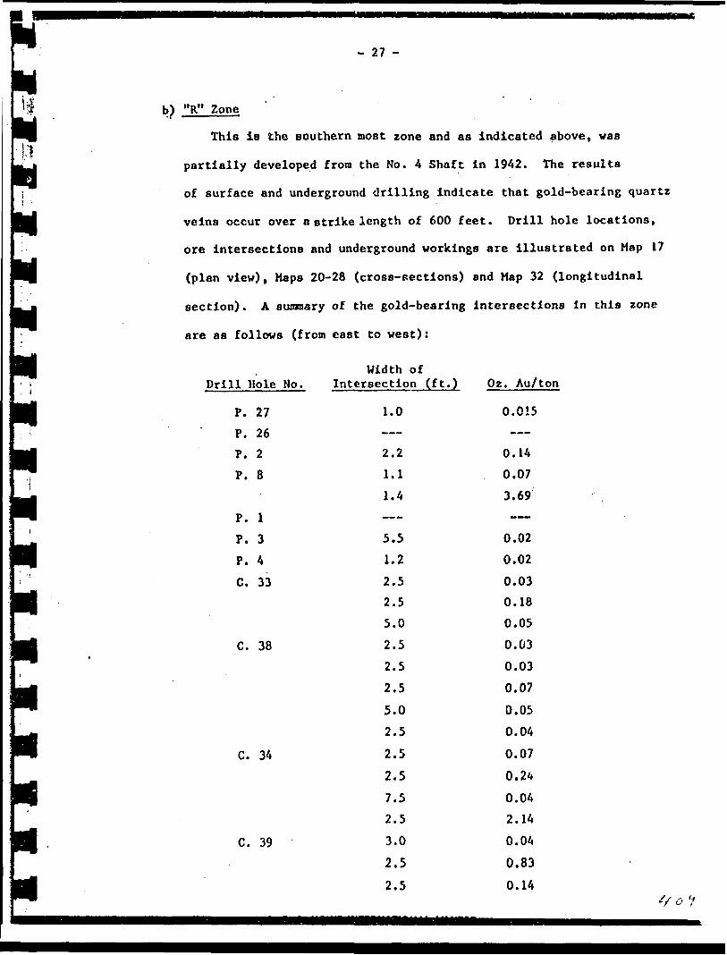
- 27 -
"R" Zone
This is the southern most zone and as indicated above, was
partially developed from the No. 4 Shaft in 1942. The results
of surface and underground drilling indicate that gold-bearing quartz
veins occur over a strike length of 600 feet. Drill hole locations,
ore intersections and underground workings are illustrated on Map 17
(plan view), Maps 20-28 (cross-sections) and Map 32 (longitudinal
section). A summary of the gold-bearing intersections in this zone
are as follows (from east to west):
Width ofDrill Hole No.
P.
P.
P.
P.
P.
P.
P.
C.
C.
C.
C.
27
26
2
8
1
3
433
38
34
39
Intersection (ft.)
1.0——
2.2
1.1
1.4——
5.5
1.2
2.5
2.5
5.0
2.5
2.5
2.5
5.0
2.5
2.5
2.5
7.5
2.5
3.0
2.5
2.5
Oz. Au/ton
0.015——
0.14
0.07
3.69——
0.02
0.02
0.03
0.18
0.05
0.03
0.03
0.07
0.05
0.04
0.07
0.24
0.04
2.14
0.04
0.83
0.14o 'f
; . - 28 -
IhI* Wldth Of
'l! Drill Hole No. Intersection (ft
j*o. C. 39 0.5yj 1.0P,' P. 15 2.0 Li C. 42 2.5•f 2-51 !1 C. 40 2.5Pi" 2.5
m 5-0•' !- 0F| j C. 41 2.5m' 2 * 5ffi 2- 5U j 5.0PI 2.5l| i ' 5.0W 2- 5F7| ' 5.0
•l 2.5
P 2' 5Lu' 2.5
P 2' 5Ik 2' 5ff c' 45 5' 0 |t i 2.5
Pi 2' 5EI 2*1)
Pi 2* 5|T| 2.5H C. 43 5.0
JP^ 2' 5U 309 2.5
JH 2- 5U 2' 0PI 2.5j^ 428 2.0
IT ' K 0 1 i * A. C. A. HOWE INTERNATIONAL
.) Oz. Au/ton
35.410.090.05 0.040.090.030.030.07 0.130.030.210.060.61n.180.070.370.030.030.220.640.050.030.03 0.030.280.030.030.090.030.110.130.362.220.220.22
0.52 LIMITED ' ' ' ^
- 29 -
Drill Hole No.Width of
Intersection (ft.) Oz. Au/ton
428
451
493
500
615
853
2.3
2.0
1.0
1.0
2.8
2.0
0.63
5.62
2.42
0.25
0.23
1.5
The P. and C. series of holes were surface holes which inter
sected the zone at a maximum depth of 275 feet below the No. 3
Shaft collar elevation. The holes, numbered 428 to 853, were
underground holes drilled on the fourth level. Drill hole 309
was a vertical surface hole drilled to the fourth level.
Based on the above results, Mr. Halstead, the consulting
engineer on the Pick Mine in 1961 (see Appendix 3, Halstead, 1961),
outlined three blocks of ore in the "R" Zone. These are as follows:
tt
tt
tt
tt
tt
tt^^^fm
tt^^^ff t
M•H
tttf
Block "B"
Location:
Dimensions:
Tonnage :
Grade:
Block "C"
Location:
Dimensions:
Tonnage:
Grade:
Block "D"
Location:
Dimensions:
Tonnage:
Grade:
TOTAL:
A
"That section of No. 2 Vein or Cline 472-R26 Vein
lying above the old workings of the Cline Mine."
297 feet (1) x 318 feet (d) x 3.4 feet (w)
26,759 tons
$21.73 per r.on gold (.57 oz. /ton)
"That section of No. 2 Vein in the old workings
between 472-R26 drift and 464E sub-drift."
Not indicated.
8,125 tons
$26.60 per ton gold (0.7 oz./ton)
"That section of No. 2 Vein lying below the 464E sub
drift and 461-1 stope."
Not indicated.
7,009 tons
$22.54 per ton gold (.59 oz./ton).
Block "B" -f Block "C" * Block "D" - 41,893 tons grading
0.598 oz. Au/ ton. W/C. A HnWF IMTFRNATinNAL IIMITED

- 30 -
,; f
These ore reserves have not been verified by subsequent workM
undertaken during the period (1962-1966) when A. C. A. Howe Inter
national were engaged as the consultants on the project. .Emphasis
during that period was on the "3" Zone.
c) "Q" Zone
This zone is situated adjacent and to the north of the "R"
Zone. Like the "R" Zone, it was partially developed on the fourth
level from the Ho. 4 Shaft by O'Brien Gold Mines Ltd. in 1942.
The results of surface and underground drilling indicate that gold-
bearing quartz veins and shear structures occur over a strike length
of almost 800 feet. Two veins were considered sufficiently pre
dictable to be designated "N" and "S"; however, these have only
been indicated on the longitudinal section (Map 33), and are not
defined on the other maps.
It is noteworthy that significant results were obtained in
surface trenching in the eastern portion of the zcne. Assay values
of samples taken from these trenches range between .44 and 11.3 oz.
Au/ton. The ground beneath these trenches (the easternmost one in
particular) has not been adequately tested by drilling.
Drill hole locations, ore intersections and underground work
ings in the "Q" Zone are illustrated on Map 17( plan view), Maps
20-28 (cross-sections) and Map 33 (longitudinal section). A sum
mary of the gold-bearing intersections in this zone are as follows
(from east to west):
Drill Hole No.Width of
Intersection (ft.) Oz. Au/ton
P. 27P. 26
1.01.02.0
0.40.010.23
A. C. A. HOWE INTERNATIONAL LIMITED 2

i.1.•ifl i)K• ';-P*V : jr*Hii i :IL'f"i.i.. . :
1.'
*"
u.•w9 j.•w: : f
W' ;
SJu
u
- 31 -
Width of Drill Hole, No. Intersection (ft.) Oz. Au/ton
P. 14 P. 1 P. 8
P. 3
P. 9P. 4C. 33
C. 38P. 5P. 28P. 10 P. 11
C. 34
C. 39
P. 15
C. 42C. 40
C. 41
A. C.
4.82.4 2.13.31.0——
5.03.0 2.5
——2.2
5.0
2.0
3.0 2.52.52.52.52.5 1.02.02.52.52.52.52.52.57.57.52.52.52.5
2.5A. HOWE INTERNATIONAL LIMtTFD
0.11
0.38
0.02
0.030.17——
0.090.04 0.04
——3.150.01 0.010.01 0.060.170.030.120.03 3.300.020.110.030.030.040.03
0.010.040.040.111.650.03
0,04 ^/?
i'
K
i:
- 32 -
Width ofFt.) Oz. Au/ton
0.030.06
0.050.04
0.030.04
0.550.062.740.050.11
0.090.07
1.14
0.030.062.950.10
0.74
The P. and C. series of holes were surface holes which inter
sected the zone at a maximum depth of 230 feet below the No. 3
Shaft collar elevation. The Violet, numbered 830 to 838, were under
ground holes drilled on the fou'.th level.
Based on the above results (bearing in mind that drill holes
P. 6 to P. 27 were drilled at a later date), Mr. Halstead, the con
sulting engineer on the mine in 1961 (see Appendix 3, Halstead,
1961), outlined one block of ore in the "Q" Zone. A description of
this ore block is as follows:
Block "E"
Drill Hole No. Intersectior
C. 45
C. 43
830
832
834
836
838
5.05.05.02.5
2.52.5
2.52.51.03.5
5.0
5.04.0
2.0
2.0
2.00.70.6
2.0
lLocation: "That section of Vein 2A or Q30 and Q24 which lies
parallel and approximately 30 feet north of Vein No. 2",
A. C. A. HOWE INTERNATIONAL LIMITED f * V

- 33 -
Dimensions: Mot indicated
Tonnage: 35,100 tons
Grade: $16.38 per ton gold (.43 oz./ton).
Like the "R" Zone, this estimate of ore reserves has not been
verified by Howe International who were the project consultants
subsequent to Mr. Halstead. Although additional drilling had been
done by Howe in the "Q" Zone, no records can be found which show
alterations in the figures regarding ore reserves.
d) "3" Zone
This zone is situated immediately north of the "Q" Zone, and
IB the zone which was most intensively investigated during the
period between 1960 and 1966. During this period, 630 feet of
drifting and cross-cutting was done, drill stations established,
1,666 feet of underground drilling completed (all on the first
level) and 28 surface drill holes totalling 7,237 feet completed
(most of which were in the "3" Zone). In addition, the No. 3 Adit
was extended and extensively sampled.
Although surface diamond drilling was done over a strike length
of approximately 800 feet, the best results were obtained in the cen
tral area, a distance of 400 feet. Drill hole locations and ore
intersections arc illustrated on Map 17 (plan view), Maps 20-28
(cross-sections) and Map 33 (longitudinal section). A summary of
the mineralized (gold values of 0.04 oz./ton or more) intersections
from this drilling program is as follows:
Drill Hole No.
P. 27
P. 26
Width of Intersection (ft.)
1.5
Oz. Au/ton
0.025

•i,,.M . Width of'1 Drill Hole No. Intersection (ft.
n* p. 14 2.01J K 5PP P. P All values'J !| P. 3 3.0 Ijj P. 9 1.4
f (| 1*0&J P. 33 2.0
FT ' 1.0\ g ^ . 1.5P* P. 34 1.4yj. i.oM P.. 7 3.1kj 3- 0H 11.2'i ' 1.0
U 2.0f^
P. 6 2.5JU 3.1IT 3- 5y l 3.6pP 2.3L - P. 6 4.0Ml C. 33 2.51 2.5
M 2- 5j 2.5jLJ 2.5JT C. 38 2.5|j 2.5[^ 3.0
Ij P. 28 2.0PP 1.5
la 3' 0Pi 2.0l P. 10 3.0
rrl ' _____ ' __________________ A. C. A. HOWE INTERNATIONAL UMfi
) Oz. Au/ton
0.04
0.37less than 0.03
0.41 0.06 0.09 0.28 0.140.240.05 0.360.080.040.040.060.190.020.900.143.701.630.040.230.080.080.090.530.090.050.09
0.210.220.100.300.040.68
'//b[ED ___________

- 35 -
Drill Hole No.Width of
Intersection ( ft.) Oz. Au/ ton
p.
p.c.c.
p.
,
p.
c.c.p.c.p.c.p.p.
25
11
34
39
12
15
42
40
13
41
16
43
17
19
1.0
3.3
2.5
3.0
3.3
1.2
2.0
1.6
All values less
2.5
2.5
2.5
1.0
1.5
1.5
1.0
0.5
1.5
2.5
1.5
1.0
2.0
2.0
2.5
All values less——
All values less——
1.0——
2.01.5
0.18
0.055
0.08
0.06
0.05
5.42
0.33
2.08
than 0.03
0.15
0,05
0.37
0.53
0.13
3.62
1.72
0.07
0.23
0.14
0.08
0.06
0.04
0.34
0.25
than 0.03———
than 0.03——
0.12
———
0.060.04
Significant results were obtained from sampling program* in
the No. 3 Adit and nearby trenches, with values greater than l oz./ton
- 36 -
being quite numerous. All sample locations and assays are plotted
on the drawings (see Maps 17, 29, 30, 31 and 34), and a large por
tion of these assay values accompanied by sampling widths-are listed
in Appendix 6, Copy of Prospectus (1964).
The first level drifts and cross-cuts were driven:
i) to obtain a clearer understanding of the geological structure
of the "3" Zone;
ii) to more accurately delineate the ore shoots; and
lii) to obtain more representative samples of the mineralized veins
by collecting bulk samples. The results of the underground samp
ling, mapping and drilling programs are illustrated on Maps 9
to 16 Inclusive.
With respect to the results of the underground sampling, the
majority of better values were obtained in the portion of the drift
beneath the No. 3 Adit. Results from channel sampling across the
mineralized veins and shears are consistently higher than the assay
values for samples taken from the muck (see Maps 10 and 14). This
probably reflects dilution of the vein material by barren wall rocks.
West of this mineralized section, i.e., that portion of ground
between, the No. 3 Shaft and underground drill hole 109, the assay
values of both the muck and channel samples were very low, i.e.,
.03 oz. Au/ton or less.
Geological mapping of the crosscuts and drifts revealed that
most of the mineralized veins and shears are discontinuous, and that
both pinch-cuts and post-ore faulting are the causes. The veins and
shears for the most part strike east and just north and south of
east. Dips are generally steep (70-850) to the north, vertical or
very steep (80-85 ) to the south.
A. C . A. HOWE INTERNATIONAL LIMITED f r t

- 37 -
l
u u u
LILI
J
At the eastern extremity of the drift, three veins are desig
nated "A", "B" and "C" (see Maps 13 and 19); however, these are not
illustrated in the cross-section maps (excepting Map 19) , longitu
dinal section map, or plan maps. These veins are believed to join
and form one vein in the interval between the first level drift
and the adit directly above. The eastward continuity of the "A",
"B", and "C" veins has not been demonstrated.
The drift crosses the eastern margin of the granodiorite
intrusive which is serrated in character, with tongues and pro
trusions of granodiorite in the andesite. The best mineralized
veins and shears are associated with these tongues and protrusions
of granodiorite (see Mapo 10, 11, 12, 13, 15 and 19).
A diabase dike striking 075 azimuth occurs at the face of
the crosscut that parallels drill holes P. 12 and P. 15. There
is no apparent significance of this dike relative to the gold
mineralization.
The underground drilling program showed the mineralized zone
to be restricted to the area in the immediate vicinity of high-
grade zone encountered in the drift. Drilling to the east and west
of this area was not overly encouraging. The locations and results
of the underground drilling program are illustrated on Maps 13, 15
and 16.
Two sets of ore reserve figures are presented in the reports,
one by Halstead (Appendix 3, Halstead, 1961) and the other by Hove
(Appendix 2, Howe, 1967). Halstead 's figures are based on data
available up to 1961 and pertains to a section of the "3" Zone with
a 400-foot strike length; while Howe's figures are based on data
available up to 1966 and is restricted to only a small central
A. C. A. HOWE INTERNATIONAL LIMITED

- 38 -
section of the "3" Zone, i.e., that section incorporating veins
"A", "B", and "C".
Halstead*s estimates are as follows:
Block "A"
Location: "That section of Vein No. 3 on which work was done
by Pick Mines this year", (probably the section bet
ween drill holes C. 40 and P. 14).
Dimensions: 400 feet (1) x 150 feet (d) x 3 feet (w)
Tonnage: 13,875 tons
Grade: $25.32 per ton gold (.72 oz./ton)
Howe's estimates are as follows:
Location: Veins "A", "B" and "C" in the central portion of
"3" Zone
Dimensions: length - 117 feet
width -3.2 feet
depth - 143 feet (this figure not given, however has
been calculated by determining volume
utilizing a tonnage factor of 12.2)
Tonnage 6 Grade: a) 4400 tons grading .38 oz. Au/ton (weighted average
of 2.38 oz./ton for surface and adit samples cut to
l oz./ton).
b) 3,570 tons grading .54 oz. Au/ton (surface and adit
assay values cut to l oz./ton), above first level.
Maps Illustrating the boundaries of the ore blocks determined
by both Halstead and Howe are lacking, consequently, these estimates
could not be verified. It is likely, however, that drilling under
taken subsequent to Halstead's calculations would snow his estimates
A. C. A. HOWE INTERNATIONAL LIMITED
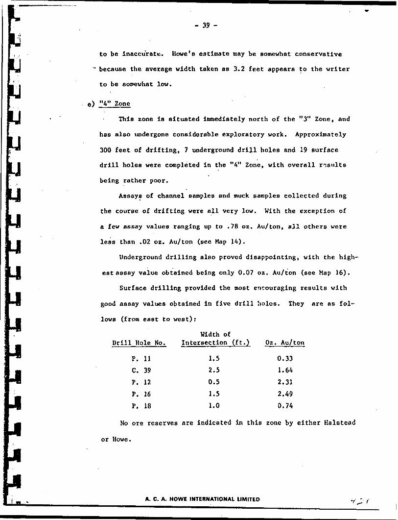
- 39 -
to be inaccurate. Howe's estimate may be somewhat conservative
" because the average width taken as 3.2 feet appears to the writer
to be somewhat low.
e) "4" Zone
This zone is situated immediately north of the "3" Zone, and
has also undergone considerable exploratory work. Approximately
300 feet of drifting, 7 underground drill holes and 19 surface
drill holes were completed in the "4" Zone, with overall results
being rather poor.
Assays of channel samples and muck samples collected during
the course of drifting were all very low. With the exception of
a few assay values ranging up to .78 oz. Au/ton, all others were
less than .02 oz. Au/ton (see Map 14).
Underground drilling also proved disappointing, with the high
est assay value obtained being only 0.07 oz. Au/ton (see Map 16).
Surface drilling provided the most encouraging results with
good assay values obtained in five drill holes. They are as fol
lows (from east to west):
Drill Hole No.Width of
Intersection (ft.) Oz. Au/ton
P.c.p.p.p.
1139121618
12011
.5
.5
.5
.5
.0
0.331.642.312.490.74
No ore reserves are indicated in this zone by either Halstead
or Howe.
A. C. A. HOWE INTERNATIONAL LIMITED

- 40 -
i M
f) "5" Zone (includes Shaft Zone)
This zone is located north of and adjacent to the "4" Zone,
and straddles the No. 3 Shaft. Exploratory work undertaken here
includes 35 feet of drifting, 45 feet of cross-cutting, 2 und?r-
ground drill holes and 9 surface drill holes.
Mo assays are available for the crosscuts south of the shaft,
and it is possible that no samples were taken (see Map 17). Samples
taken in the drift west of the shaft returned the .following assays
greater than 0.03 oz. Au/ton:
Width of Channel Sample____ (inches)______ Oz. Au/ton
10 .17
24 .19
26 .11
14 .16
Two underground drill holes (104 and 105) intersected the "5"
Zone, however, no gold values of interest were intersected (see Map
16).
Surface drilling provided the most encouraging results, with
reasonable gold values obtained in four drill holes (see Map 17).
They are as followti:
Drill Hole No.Width of
Intersection (ft.) Oz. Au/ton
P.p.p.
p.
131617
18
1.51.52.0
2.02.0
1.51.5
3.540.11
f
0.17
0.11
0.230.250.27
A. C. A. HOWE INTERNATIONAL LIMITED

R;". An ore reserve estimate for this zone is provided by Halstead
Appendix 3, Halstead, 1961), however, this has not been verified
by Howe. A description of the ore block is as follows:
Block "F"
Location: "That part of the No. 3 Vein in the vicinity of No. 3
Shaft"
Dimensions: Not indicated
Tonnage: 2,000 tons
Grade: $28.00 per ton gold (.74 oz./ton^
Given the assay results from both the channel samples and drill
core, it is clear that the grade estimate is inaccurate.
g) Summary of Ore Reserve Estimates*
"R" Zone: Block "B" - 26,759 tons Q . 57 oz./ton
Block "C" - 8,125 tons @ .7 oz./ton
Block "D" - 7,009 tons 9 . 59 oz./ton
"Q" Zone: Block "E" - 35,100 tons 6 .43 oz./ton
"3" Zone: Block "A" - 13,875 tons g .72 oz./ton
(Howe estimates: 4,000 tons @ .83 oz./ton or3,570 tons @ .47 oz./ton above 1st level)
"4" Zone: None indicated
"5" Zone: Block "F" - 20,000 tons @ .74 oz./ton
TOTAL: (Blocks "A" to "F" inclusive)
92.868 tons @ .556 oz./ton
As indicated previously in this report, these estimates are
believed to be inaccurate and should be viewed with skepticism until
they can be verified.
*A11 estimates by Halstead (see Appendix 3, Halstead, 1961) unless Indicated otherwise.
A. C. A. HOWE INTERNATIONAL LIMITED

- A2 -
lv) No. 4 Shaft '
a) Underground
This area of the Pick Property was the most productive in
the past. Between the years 1938 and 1942, 331,842 tons of ore
was mined from this area, out of which 63,328 ounces of gold and
10,600 ounces of silver were extracted. Although the No. 4 Shaft
was sunk to 1,175 feet and development work was done on eight lev
els, most of the ore came from the top five levels. The average
grade of the ore was .191 oz. Au/ton and .032 oz. Ag/ton.
The mineralization is contained in veins and silicified shear
which branch off from the "great quartz-carbonate shear zone",
which traverses the area Just north of the No. 4 Shaft. There
' are three vein systems that provided the largest portion of the
ore in the post, namely, the "A" Vein, "C" Vein and "D" Vein.
It is important to note that these were not actually Individual
veins, and that each "vein" is composed of a series of veins.
A concise description of the "A", "C" and "D" Veins is
given in the extract below which is taken from Bruce, 1940, page
37-38, and in the Isometric diagram comprising Map 38.
"The "A" vein is the most important vein yet found in the mine. It had material of ore grade in it for a length of 500 feet on the surface and has continued to the deepest levels yet opened in the mine. It is actually a series of veins lying in a zone along the "A" fault, which forms the footwall. The hanging wall is an assay wall. In the vein zone, granodiorite and quartz porphyry have been sheared and silicified. Inli this material narrow quartz veins, which carry considerable gold, have been introduced. The ore shoot ends irregularly at both ends where the "A" fault passes out into andesite.
"The "C" vein branches from the "A" vein (fig. 2). On surface it dips to the south at a fairly low angle.
A. C. A. HOWE INTERNATIONAL LIMITED

- 43 -
On the 125-foot level the dip is 48 S. Below that level the vein becomes steeper, and ii;? rake ,of its line of intersection with the "A" vein also steepens. This is true also of the line of intersection of the "A" fault and the mass of quartz porphry.
"Where the "A" vein and the "C" vein are not far apart, the rock between them is highly fractured and there are many quartz veins, some of which have high- grade ore shoots. In places these veins are sufficiently numerous to make it possible to stope the whole block between the two faults.
"The "D" vein is not important on the first level, but is Important between the first and fourth levels. It extends from the tip of a tongue of ganodiorlte on the first level and has been followed downward to the tip of a tongue of rhyolite on the fourth level.
"Other branches from the "A" vein have been given special designations, but they may be considered as parts of that zone.
-"The structural relations of the veins may be summarized as follows:
1. The "A" vein zone lies along the "A" fault, which forms its footwall. The hanging wall may be greenstone, granodiorite, or quartz porphry.
2. Subsidiary veins branch off from the "A" vein, localized by tongues of felsite or quartz porphyry.
3. Some subsidiary veins branch off from the "A" vein into apparently homogeneous granodiorite, localized by secondary and tertiary fault planes.
4. Some veins occur in greenston . These veins originate from the ends of lenses of rhyolite or grano diorite, or of felsite dikes, or from the noses of folds in rhyolite.
5. Continuations of type 4 3ie entirely within the rhyolite or felsite.
''These are not exclusive groups: Veins have various relations at different places. Those which appear to lie in homogeneous greenstone or granodiorite at one level may be found to have the relationships listed in group 4 at other levels."
With respect to the potential of additional ore reserves
being available in the No. 4 Shaft area, the following extract is
an appraisal by W. A. Moore, 1961, (see Appendix 2), which indicates
where most of the ore was mined and what can be expected at depth.
"Most of the stoping was done from the fifth level to surface. A few stopes were prepared on the sixth level. No work was done on the seventh level and only some cross cutting and drilling was done on the cigth level.
"The veins were very narrow, though where several small parallel stringers occurred close together, the stoping
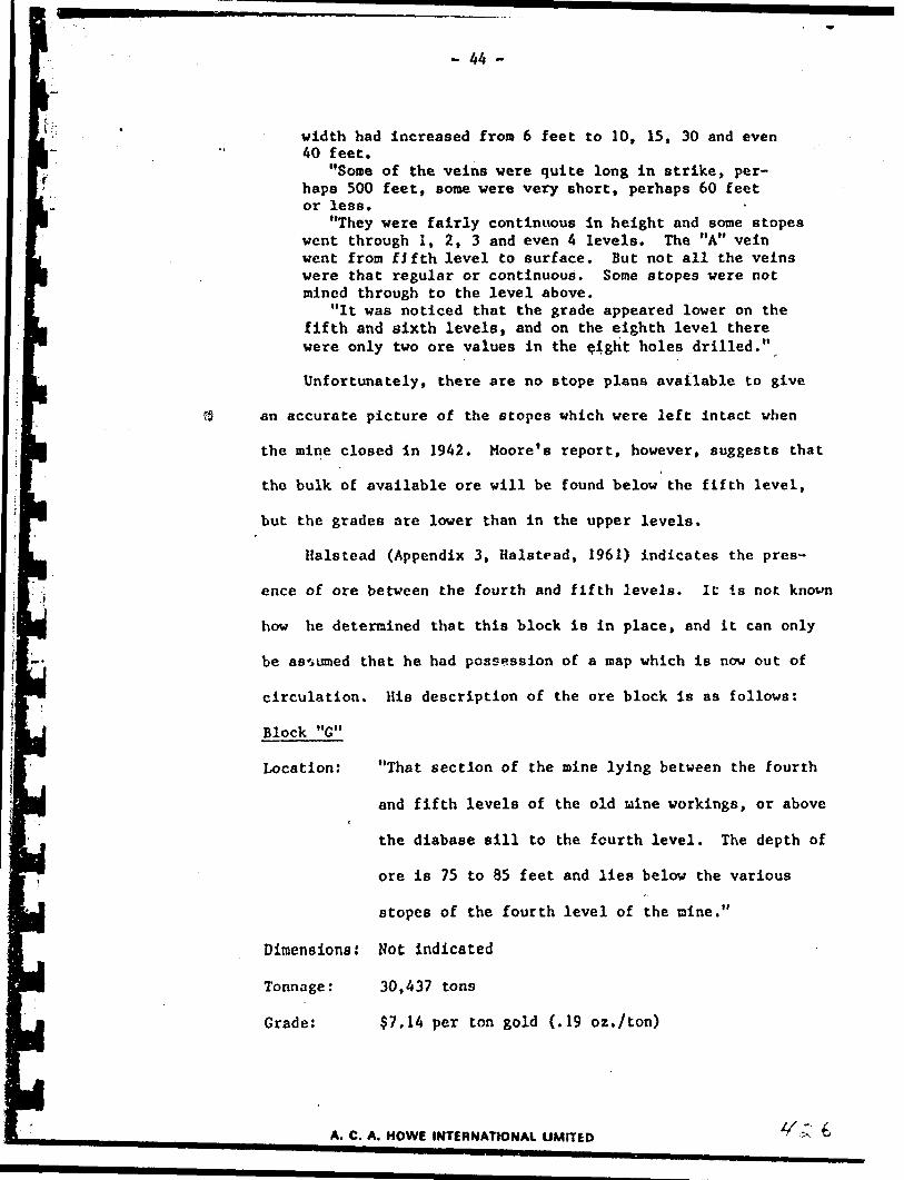
- 44 -
width had increased from 6 feet to 10, 15, 30 and even 40 feet.
"Some of the veins were quite long in strike, per haps 500 feet, some were very short, perhaps 60 feet or less.
"They were fairly continuous in height and some stopes went through l, 2, 3 and even A levels. The "A" vein went from fifth level to surface. But not all the veins were that regular or continuous. Some stopes were not mined through to the level above.
"It was noticed that the grade appeared lower on the fifth and sixth levels, and on the eighth level there were only two ore values in the eight holes drilled."
Unfortunately, there are no stope plans available to give
an accurate picture of the stopes which were left intact when
the mine closed in 1942. Moore's report, however, suggests that
the bulk of available ore will be found below the fifth level,
but the grades are lower than in the upper levels.
Halstead (Appendix 3, Halstead, 1961) indicates the pres
ence of ore between the fourth and fifth levels. 1C is not known
how he determined that this block is in place, and it can only
be assumed that he had possession of a map which is now out of
circulation. His description of the ore block is as follows:
Block "G"
Location: "That section of the mine lying between the fourth
and fifth levels of the old mine workings, or abover
the diabase sill to the fourth level. The depth of
ore is 75 to 85 feet and lies below the various
stopes of the fourth level of the nine."
Dimensions: Not indicated
Tonnage: 30,437 tons
Grade: $7.14 per ton gold (.19 oz./ton)
A. C. A. HOWE INTERNATIONAL LIMITED

- 45 -
This estimate of tonnage and grade cannot be verified without
re-entry and inspection of the old workings. It is also worth
noting that Halstead assigned this ore block with the same value
that was obtained from ore mined above this level, and that the
actual gold content is not known,
b) Surface Tailings
There are no records pertaining to the tailings from the
331,842 tons of ore milled at the No. 4 Shaft, however, it is the
writer's opinion that this may be considered a potential resource.
A sampling program would be necessary to determine whether eco
nomically retrievable gold remains in the tailings.
v) Summary of Ore Reserve Estimates, No. l to No. 4 Shafts Inclusive
Remarks
Ore potential
Ore potential
Needs verification
Needs verification
Gold content unknown
Shaft
No. 1 Shaft
No. 2 Shaft
No. 3 Shaft
Underground Indicated*
, None
None
92,868 tons @
Surface
None
None
None
No. 4 Shaft
.556 oz. Au/ton
30,437 tons O .19 oz. Au/ton
331,842 tons of tailings
7. GEOPHYSICS
A magnetometer survey was
the Pick Mine Property and the
The results of this survey are
Ltd., 1964 (Appendix 3) and on
Unfortunately, the survey
ground immediately adjacent to
conducted over the southern portions of
adjacent Edwards Mine Property in 1963.
presented in a report by Sheridan Geophysics
Haps 8-A and 8-B.
only covers the No. 4 Shaft area and the
the west and doesn't cover the No. 3 Shaft are.
*Estimates by Halstead (1961). See report in Appendix 3.
A. C. A. HOWE tMTERNAYIONAL LIMITED"l

- A6 -
It is apparent from the survey that the andesite has a more intense
magnetic signature than the granodiorite, and the resulting magnetic
contrast can be used in the interpretation of geological boundaries where
geological information is lacking. This feature can be utilized in tar
geting exploration diamond drill holes because of the association of gold
mineralization and the granodiorite-andesite contact.
8. METALLURGY
There are no metallurgical problems associated with the extraction
of the gold from the host rock. This is indicated by the success of the
operation at the No. A Shaft and by tests conducted by the Department of
Mines and Technical Surveys, Ottawa, R. P. Bailey (1962), (see Appendix 7).
9. CONCLUSIONS
A. The gold mineralization on the Pick Property has characteristics
which are important with respect to future exploration and development4
work which might be conducted on the property. These are:
i) The gold mineralization is erratically distributed in veins and
shear structures.
li) The mineralized veins and shear structures are lenticular or dis
continuous as a result of natural plnch-outs and/or post-ore faul
ting.
lil) The mineralized structures generally trend east or just north or
south of east, dip vertically or steeply north or south, and show
an association with the granodiorite-andesite contact and with
"tongues" and protrusions of granodiorite into andesite.
A. C. A. HOWE INTERNATIONAL LIMITED
- 47 -
lv) In places, the wall rocks to the mineralized veins and shears
are themselves mineralized and are indistinguishable from barren
wall rocks.
v) The mineralized veins and shears appear to have an associction
with the "great quartz-carbonate shear", being actually subsi
diary to it in the No. 4 Shaft area,
vi) The gold in the mineralized shear structures is associated with
pyrite,
vii) The gold-bearing quartz veins are generally bluish-grey in colour.
B. The Pick Property has ore potential but does not have demonstrated
ore reserves.
C. The ore potential of immediate interest is centered around four
shafts on the property. These are listed below in the order beg
inning with the one requiring the least amount of work to come to a
production decision:
i) No. 3 Shaft
li) No. 2 Shaft
lil) No. 4 Shaft
iv) No. l Shaft
D. Other areas warranting exploration work include:
i) the south margin of the granodiorite body on which the No. 3
Shaft area is located,
ii) the ground in the interval between this granodiorite body and the
one on which the No. 4 Shaft is sank, and
iii) the area immediately to the south of the "great quartz-carbonate
shear".
A. C. A. HOWE INTERNATIONAL LIMITED 7

- 48 -
E. In the No. 3 Shaft area, there are five zones of mineralization,-t
"R", "Q", "3", "A", and "5" Zones, of which the "3", "R", and "Q"
Zones (in that order) are of immediate interest and require the
least amount of work to delineate ore reserves.
F. To determine the ore reserves of the No. 3 Shaft area and to come to
a production decision, the following work is required:
1) Correlate the ore intersections where possible, in order to
delineate individual veins, shears and shoots.
ii) Where the ore Intersections cannot be rationalized according to
individual veins, shears and shoots, diamond drill holos should
be targeted to delineate the extent of the mineralization,
iii) Where individual veins, shears and shoots of apparent adequate
grade can be recognized, a fill-in diamond drilling program should
be undertaken to acquire sufficient ore intersections to enable
tonnage and grades to be calculated with a high degree of relia
bility.
G. The "R" and "Q" Zones should be fully investigated simultaneo 'sly
with the "3" Zone because the results obtained from investigations in
these zones will undoubtedly have an effect on the design of any
underground development program, and possibly the viability of the
project as a whole.
H. The tailings from the 331,824 tons of ore willed at the No. 4 Shaft
should be examined for its residual gold content.
I. Dewatering of the No. 4 Shaft and sampling of the stopes on the
5, 6, 7, and 8 levels may be warranted, although the reports indi
cate that grades greater than .19 oz. Au/ton are unlikely.

- 49 -
J. It is likely that individual ore blocks in both the No. 3 and No. 4
Shaft will not be large and they will be separated by barren or low-
grade zones. Tills will require selective mining coupled with care
ful planning.
10. RECOMMENDATIONS
Should the Pick Mines Property be acquired by Cavendish Investing
Ltd., the following work is recommended:
STAGE l
A. Update the maps where necessary and correlate the ore intersections
in an attempt to delineate individual mineralized veins, shears and
shoots in the "R", "Q" and "3" Zones.
B. Determine where fill-in drilling is required to acquire sufficient
data to enable tonnage and grades of the individual veins, etc., to
be calculated with •a high degree of reliability.
C. Target diamond drill holes between existing holes which are spaced
at such a distance that correlation between ore intersections is
impossible.
STAGE 2
A. Diamond drilling as dictated by the results of the Stage l program
and other selected targets, e.g., are the No. 2 Shaft area and the
south margin of the main granodiorite body.
B. Sampling of the No. 4 Shaft tailings to determine its residual gold
content. Core samples from the tailing's surface to just beneath
its base should be taken in order to determine whether or not enrich
ment has taken place at the base as a result of downward migration
of the gold particles.A. C. A. HOWE INTERNATIONAL LIMITED ,
- 50 -
C.. Conduct a magnetometer survey over all the areas of interest, i.e.,
Shaft No. l r A Inclusive, the area between the two granodiorite
bodies, the region over the main granodiorite body, and the "great
quartz-carbonate shear".
RESPECTFULLY SUBMITTED,
G. W. FelderhofPrincipal GeologistA. C. A. Howe International Ltd.

JJ " ""~"~ "———---P - 51 -
M-H. BIBLIOGRAPHY
M ~, Anderson, N. A.
1960: Report on Pick Mines Ltd., located Township 48, Sault Ste. Marie Mining Division, District of Algoma, Ontario.
Bruce, E. L.1940: Geology of the Goudreau-Lochalsh Area; O.D,M., 49th Annual
Report, Vol. XLIX, Pt. III.
Gledhill, T. L.1927: Goudreau-Lochalsh Gold Area, District of Algoma; O.D.M.,
36th Annual Report, Vol. XXXVI, Pt. II, p. 50-86.
Howe, A. C. A.1962: A Summary of Results of Diamond Drilling in the No. 3 Shaft
Area with Recommendations for Future Work Programs at Pick Mines Ltd., Goudreau Gold Area, Ontario (May 29).
1962: Results of Diamond Drill Program including Holes P. 10 to P. 16 at Pick Mines Ltd., Goudreau Property (June 5).
1962: Report on the Pick Mines Ltd. Property, Goudreau Gold Area, Ontario (June 19).
1962: Report on the Pick Mines Ltd. Property, Goudreau Gold Area, Algoma District, Ontario (Dec. 20).
1963: Report on the Pick Mines Ltd. Property, Goudreau Gold Area, Algoma District, Ontario.
Jji 1964: Supplementary Report, Pick Mines Ltd.
1966: Pick Mines Ltd.; Report on Underground Drilling Program (1966), Goudreau Area, Algoma District, Ontario.
1967: Sutfnary Report on Pick Mines Ltd., Goudreau-Lochalsh Area, HI District of Algoma, Ontario; Report No. 77.
1968: Summary Report on Pick Mines Ltd., Goudreau-Lochalsh Area, District of Algoma, Ontario; Report No. 105.
1968: Summary Report on Pick Mines Ltd., Goudreau-Lochalsh Area, District of Algoma, Ontario; Report No. 220,
Moore, W. A.1961: Report on Pick Mines Ltd. Property, Lochalsh-Goudreau Area,
JlA. C. A. HOWE INTERNATIONAL LIMITED

- 52 -
Williams, R. M.M 1962: Pick Mines Ltd. Claim Group, Township 48, Sault Ste. Marie
Mining Division, Goudreau Gold Area, District of Algoma, Ontario.
1961: Summary: A compilation of all available data in the No. 3 Shaft area, Pick Mines Ltd.
Miscellaneous
Halstead and Howe1960-1966: Progress Reports and Correspondence pertaining to work
completed at the Pick Mine, No. 3 Shaft area.
Unsigned Report1926: Description of Cline Property.
C. A. HOWE INTERNATIONAL UMITED

F
i; ' NOTE: Please see File 02-2402 Cavendish Investing Ltd,
Reports for Appendices 2, 4, 5, and 6.
Nj
HI

IT'
APPENDIX l
PHOTOGRAPHIC RECORD - NO. 3 SHAFT,
PICK MINE, 1965
a i.
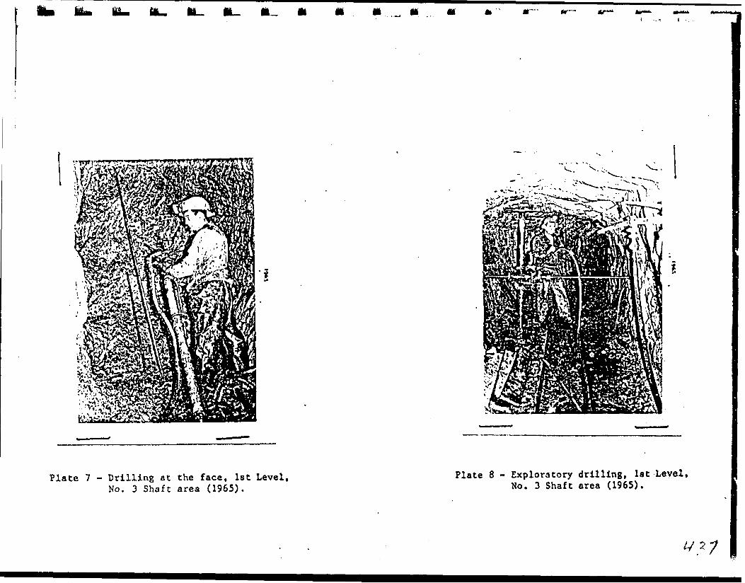
Mm IL. t*-, to
Plate 7 - Drilling at the face, 1st Level, No. 3 Shaft area (1965).
Plate 8 - Exploratory drilling, 1st Level, No. 3 Shaft area (1965).

ki k* ka
Plate 9 - Core racks, No. 3 Shaft area (1965).
Plate 10 - Headframe and related ancillary gear, No. 3 Shaft (1965).

I*U
r
k
Plate 3 - Pick Property as it appeared in 1965. Thebuildings have since bean dismantled and sold,
Plate 4 - Dumping waste rock in swamp near the No. 3 Shaft, (1965).
4 21
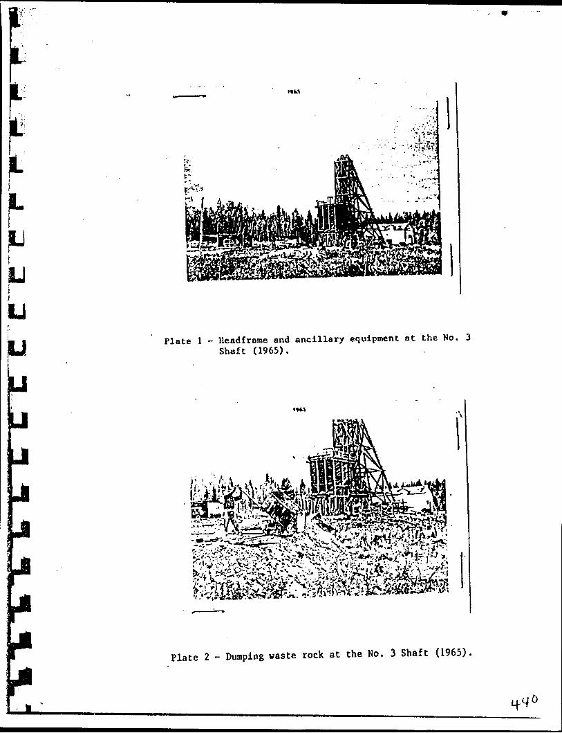
Ll!UiLIj t
U
M Plate l - lleadfrome and ancillary equipment at the No. 3 Shaft (1965).
Plate 2 - Dumping waste rock at the No. 3 Shaft (1965).
iff
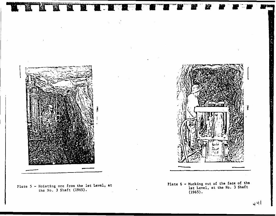
-.i^rr
Plate 5 - Hoisting ore from the 1st Level, at the No. 3 Shaft (1965).
Plate 6 - Mucking out of the face of the 1st Level, at the No. 3 Shaft (1965).

APPENDIX 2
SELECTED SUMMARY REPORTS
WRITTEN BY VARIOUS AUTHORS
DURING THE PERIOD 1926-1967
f. if;APPENDIX 3
J ' SELECTED PROGRESS REPORTS* BY
s iJJ- HALSTEAD AND HOWE,
j j 1960-1966
SI
l

L ADDENDUM TO REPORT OF M. C. HALSTEAD. Dated February 17th. 1961
LIm
u
A projected future development program for Pick Mines Limited that could add years of life to the present ore picture.
The No. l Shaft Area
This area lies about 1,000 feet east of the No. 3 shaft area which is now being opened up to supply ore for the Pick Mines Cold Mill.
This No. l shaft area had a shaft sunk 140 feet on a narrow quartz vein in which visible gold was apparent. This shaft is filled with water and not sampled. However, a representative sample from the dump at No. l shaft assayed .94 ozs. Gold and .11 ozs. Silver per ton or $32.90 per ton Gold. Not far from this shaft a second small shaft was sunk to a depth of 75 feet. This was sampled while I worked at Cline Lake Gold Mines. The vein in the shaft varies from a foot to over three feet in width and the sampling of this vein averaged over -1.2 oz. per ton Gold or $17.50 per ton for the depth of the shaft.
This vein has not been diamond drilled and its exact length has not been reported. However, there are old trenches along the strike for about 300 feet. These are in deep overburden and now partially filled.
Lying to the east of this vein is a fourth vein which l have never reported or referred to before. We called it the Guest House vein. There are a few trenches on it in which the vein showed interacting gold values.
This area, when explored by diamond drilling, may possi bly add years to the life of the mine.
The Ho. 2 Shaft Area
This shaft lies about 300 feet west of the No. 3 shaft. The shaft was sunk 215 feet. The shaft was inclined and it was intended to'follow the vein. However, the vein being somewhat erratic was in and out of the shaft, but did show good gold values where it was exposed in the shaft.
The vein was found in the 200 foot level but it isfaulted and needs careful mining with systematic sampling to keep the development within the ore. Continuous sampling of the development faces would be necessarv.

11'•-T Hfl.,.,/0 'V*-
l
'•. V
(J
The President h Directors*Mines Limited.
te 302.100 Adelaide Street, W-ret. Toronto 1. Ontario.
Gentlemen: Re: Surface Diamond Drilling Claims SSM 2185 - 2186 Goudreau Area. Ontario
At your request we have reviewed the first six (6) progress reports re the surface diamond drilling lr\ the 13 shaft area*m
The current drilling program started on April 13th1962 and holes P10 and Pll have been completed. Hole P12 Is underway nd hole P13 has been laid out.
The locations of these holes are shown on the attachedsketch map.
Hole P10 assay result* (0.68 oz gold over 2.5 feet) Indicates the westward continuity d the 93 vein system. The Q vein system (with low values) was cut lower In the hole.
y/ Holes PH, P12 and P13 have been laid out to trace tnb continuity oC the #3 vein system westward toward the 03 shaft.
The Q vein system on the 472 sub-drift and the Rvein system on the 400 foot horizon should be drilled by extending tho current sections southward.
Respectfully submitted.
Toronto, OntarioR. Massey Williams
.'/T, flifi

lil -- . -I f - . Lochnloh,
L , . Ont.
l j . . .^v X)/ a^-8.' ' 'tr.TIaoooy UllUnno
1^3-100 Adolaldo St. '.foot, Toronto, Ont.
Ttoar *fooooy,Tliank yew for yovir lottor of May lot. I noto your
ouccootlon that tho drill occtiono bo contiiraod PCTitltwnrd to cut
tlio Q ond R aonoo. Ilolo I'.lS Juot conplotot^, VTJO drillod on tho
otv.io ooction ao P*12 nnd collarod 75' South of it aa dlocuoood
diirlnn' our tolofJiono convnroatlon of Vjgy 3rd,- P.35 vma otoppod at a dopth of 321 ft. and intorooc-
•*ted tlio Q, QM, R and RN volno. It \\aa onablod uo to oxtond tlioi
Coolof^.cal intorprotation to tho Q and R sonoo.Ilio roaoon for ry layiitf: out holoa P,U, 12, and
13 rrofyoooivoily norUnmrdo aa tho olvift irca apjiroacJiod MOO to^s
onoiiro tlwt tlw holoa intorooctod tlio Jfa voin ( or Clino udlt voin
. I had noted tiuxt C.39 had dlitaiJiod 1^6U oso* trvor 2.*?', but tliat*P.IO liad boon looated too 'for South to llltorooct thin voin. Holoo
* * t 'p.H, nnd 12 hoirervor voro ouccoaoful, and obtained 0,33 oao. ovor
1.5', and 2.31 oso, ovor 0.5', roopoctlvoly.
Pron tlio rooulto obtainod in PU ami 12 it

-c
t
l l l I
i it
thot'tho noJji voija in tho ff3 sono \nx\ owincinc oouthwoot
Hol to o tttribnso intruoivo ( I dotrinnatod this voto 03 )". Do-
cauoo of thin fact, and fron tho rooulto in Cji2, I conducted* *
that tlio 83- cono \ma not tho ono that would pnoo thraif^i tho aroai " of C' 3 abaft* I dooidod tliat .tlio 0k vein and poooibly anothor' vcdn llorth of it voro tho onoo wo oboald follcw in our curresit
* drill procTora, boorino in nind ytwr orlfjinal jxupooo of dovo-
' . - \ lopdnc oro dooo to tho j?3 oliaft. I thoroforo located P*13 at
75' IJorth ( and 100' VJoat ) of I*JL2, and P*U5 at 23'' llorU) of' * .
P.13 ( ond 100' Ifcat of it ),
IdoaUyv vo nltajld now oxtond thono soctiono
oouthwnrOo to covror t3io f' !3 voixw, and Q, lioi.xnrar J pathor that
tlio drill profppon io tooini; amixintSod. .
I bstvo jjcrcpnred a j)ltxn of all drill holoo and
- tl^olr intorooctionn at l" — 20 ' ," and look f onrard to
tliooo rooulto \dtli yxxi on ry roturn 'to Torortto naxt \rook.J .
Yauro truly,
A.C..V.
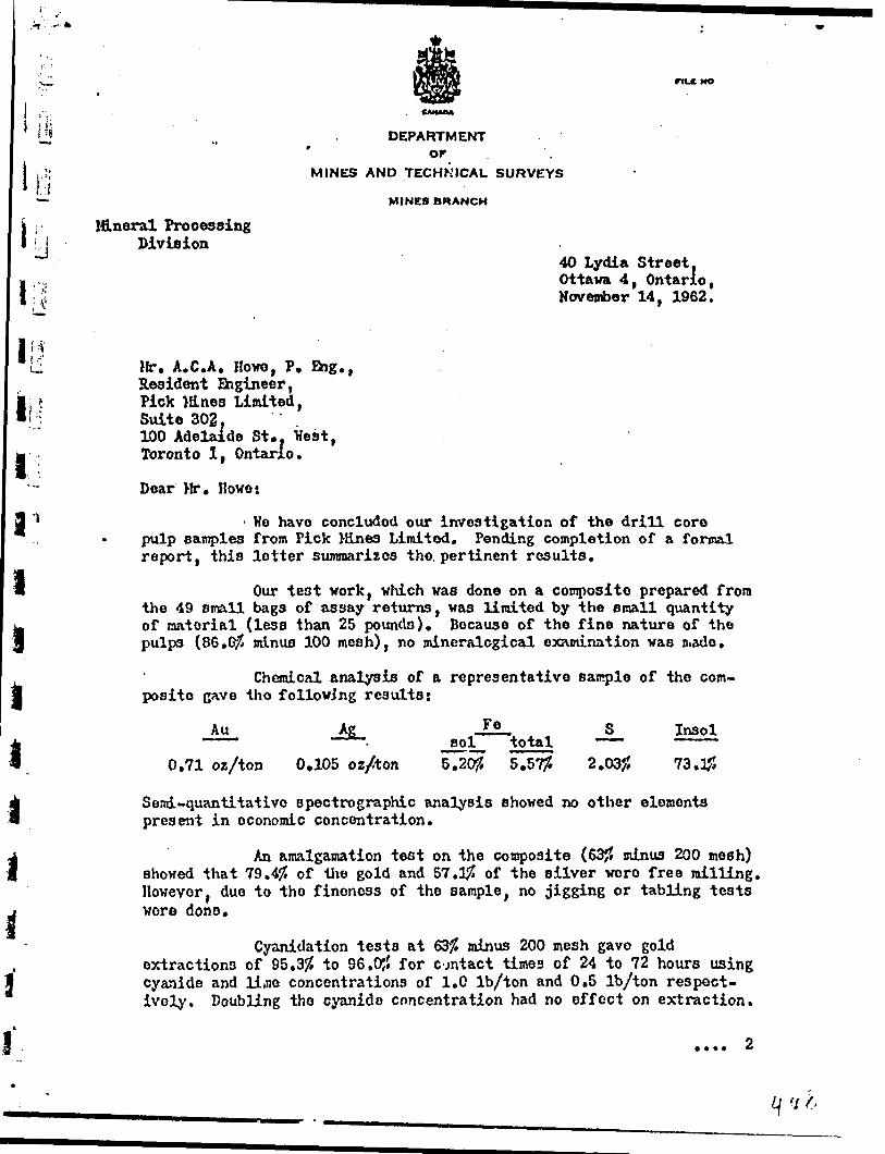
Hi
l rt
nLC NO
DEPARTMENTOF
MINES AND TECHNICAL SURVEYS
MINES BRANCH
l&neral Processing Division
40 Lydia Street, Ottawa 4, Ontario, November 14, 1962.
ill
i
i
i iil l.i
Mr. A.C.A. Howo, P. Big., Resident Engineer, Pick lines Limited, Suite 302,100 Adelaide St.. Hest, Toronto l, Ontario.
Dear Mr. Howe:
He have concluded our investigation of the drill core pulp samples from Pick Mines Limited. Pending completion of a formal report, this letter summarizes the pertinent results.
Our test work, which was done on a composite prepared from the 49 small bags of assay returns, was limited by the small quantity of material (less than 25 pounds). Because of the fine nature of the pulps (8S.G/5 minus 100 mesh), no mineralogical examination was juado.
Chemical analysis of a representative sample of the com posite gave tho following results:
Au Ag
0,71 oz/ton 0,105 oz/ton
Fesol total
5.20JJ 5.57#
S
2.03;;Insol
73.#
Send-quantltatlvo spectrograph^ analysis showed no other elements present in economic concentration.
An amalgamation test on the composite (63J5 minus 200 mesh) showed that 79.4# of the gold and 57.1# of the silver were free milling. However, due to the fineness of the sample, no jigging or tabling tests wore done.
Cyanidation tests at 63# minus 200 mesh gave goldextractions of 95.35? to 96.0J5 for contact times of 24 to 72 hours using cyanide and lime concentrations of 1.0 Ib/ton and 0.5 Ib/ton respect ively. Doubling tho cyanide concentration had no effect on extraction.

jr—*^- *
li i.
l
Ifr rrrrrrrnn
-2 ~
By grinding to 89.2JJ minus 200 mesh, gold extraction was increased to 98.2JJ.
Bulk sulphide flotation produced a concentrate containing 92.4J? of the gold and 90.0J5 of the silver at a concentration ratio of about 11.5. Cyanidation of this concentrate, reground to 99 f4j5 minus 200 mesh, gave sold and silver extractions of 97.9# and 90.6# respect ively, for corresponding overall recoveries of 90.5# and 81.5#.
Yours very truly,
R. P. Bailey,Non-Ferrous Metals Section, for L. E. Djingheuzian,
Chief of Division. ,
n
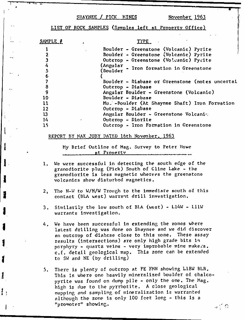
i i\ ii i
SHAYNEE l PICK MINES November 1963,
LIST OF ROCK SAMPLES (Samples left at Property Office)
SAMPLE
\23 A56789
101112131415
BoulderBoulderOutcrop(Angular(Boulder
TYPE -
- Greenstone (Volcanic) Pyrite- Greenstone (Volcanic) Pyrite- Greenstone (Volcanic) Pytite- Iron formation in Greenstone
Boulder - Diabase or Greenstone (notes uncertalOutcrop - DiabaseAngular Boulder - Greenstone (Volcanic)Boulder - DiabaseMu. -Boulder (At Shaynee Shaft) Iron FormationOutcrop - DiabaseAngular Boulder - Greenstone VolcanicOutcrop - DioriteOutcrop - Iron Formation in Greenstone
REPORT BY MAX JUBY DATED 16th November. 1963
My Brief Outline of Mag. Survey to Peter Howe ________at Property^^.^^^^^^^^^^^^
1. We were successful in detecting the south edge of the granodiorite plug (Pick) South of Cline Lake - the granodiorite is less magnetic where?s the greenstone volcanics show disturbed magnetics.
2. The N-W to W/H/W Trough to the immediate south of this contact (BLA west) warrant drill investigation.
3. Siroilarily the low south of BLA (west) - L1AW - L11W warrants investigation.
A. We have been successful in extending the zones wherelatest drilling was done on Shaynee and we did discover an outcrop of diabese close to this vxme. These assay results (intersections) are only high grade bits in porphyry - quartz veins - very improbable mine makers, c.f. detail geological map. This zone can be extended to SW and NE (by drilling)
5. There is plenty of outcrop at FE FMN showing L18W BLB. This is where one heavily mineralized boulder of chalco pyrite was found on dump pile - only the one. The Mag. high is due to the pyrrhotite. A close geological mapping find sampling of mineralization is warranted although the zone is only 100 feet long - this is a "pronK)tpr" showing.

- 2 "i--
6./ A new quartz vein system in porphyry was discovered in the process of the survey ELB L39W 1+20S. Outcrop is plentiful and we did strip the moss to reveal a 10' length and* A f cot width of quartz veining. Surface sampling was recommended (as Peter Howe did). Previous trenching has been done nearly - no mineralization except minor iron oxide stain along quartz faces - it is probably barren. Peter Howe will have the assay results soon.
7. No further criticism was given. However detail around Shaynce Shaft was done on last day. The detail geological map should be used to complete geophysics.
Note; The list of Rock samples above has been discussed with Peter Hove.
November 23, 1960
Authorized Capital Issued to date
In Treasury
- 5,000,000 shares- 1,712,648______
- 3 ,237,352 shares
PROPERTY
Pick Mines Limited holds two continuous groups of miningclaims which will be referred to as the "Pick Group" and the "Cline Group". The Pick Group comprises a group of 10 unpatented mining claims with a total area of 1400 acres more or less.
"Cline Group" lies adjacent and to the south of the Pick Group. It comprises a group of 6 patented claims of 273 acres more or less
ACCESS f, POWER
Properties are located on a gravelled highway which extends from the Town of Goudreau on the Algoma Central S. Hudson Bay Railway at mile 168 north of the City of Sault Ste. Marie, Ont,, and the Town of Lochalsh on the main line of the Canadian Pacific Railway. The property is 6 miles from Lochalsh and 12 miles from Goudreau, Ontario.
The 44,000 volt power line of the Great Lakes Power Co., crosses both the Pick and Cline group of claims.
HISTORY
The Cline group was formerly known as the Cline Lake Gold Mines Limited. The property was developed by the former management by 3 shafts. During the period 1938 to 1942 inclusively, 331,842 tons of ore were milled with a money value of $2,369,000.00 . As the second World War was then being fought, making supplies and labour difficult to obtain; operation were discontinued in 1942, plant disposed of and assets distributed.
PRESENT DEVELOPMENT
No. 3 Vein has been surface trenched at intervals for a length of 300 ft. Sampling gave an uncut grade of 1.73 ozs. Gold per ton over an average width of 13.5 inches, diamond drilling this vein Hole No. 3 cut 2.1 ft. width of ore assaying 0.42 ozs. Gold per ton. Hole No. 3 cut 6.02 ft. width of ore averaging 3.12 ozs.Gold per ton, uncut. Work done on the vein indicates a commercial grade of ore over mining widths. Mr. M.C. Halstead, P.Eng., the Company's Consulting Engineer, plans to commence mining this vein, leaving a safe floor between this new level to be developed from the No. 3 shaft and the old workings of the mine.
DUPLICATE COPYPOOR QUALITY ORIGINAL
TO FOLLOW

*3rd, I960.
Author!*** Capital - 5,000,000 share* Issite* to oat* -
In Treasury * 3,337,3*2 anar**
fit* MlM* tialted bold* two contUuou* froapa of •lain* claim* which will b* r*f*rred to a* tb* "Piek Orottg' aed th* "Clio* Oroup*. Tb* Pick Oroup coapri*** a groUy of 10 uapat*at*4 mining elaiaa vitb a
*r*fc of IMX) Mr** MOIVOT l***.
"Clio* Qroup* li** fedjACMt mad to tb* *ovtb of tb* Pick It eoapyi*** A ftroup of 6 patented olaiv* of 873 M r** nor* or le**
JCC2SQ
Prop* rt t** AT* located on a gror*ll*d blEhvA/ vbleb rxtead* f rea to* Tovn of Oott&nrmi oa tb* AI^OMA Central a fladfon B*y JUiliray At nil* 150 norta of tb* City of e&uLt Ct*. Marie, Dot., Md tb* Town of Lo?bal*h OCA tb* Bain lin* of tb* Canadian ravlfie R*ilv*y. Tb* property it 6 afle* frovi Loababib nad Id nil** frcw Ooadreau, Ontario.
Tb* 4V, 000 Tolt povvr lin* of the Great LeXes rover Co., crosses potb tb* Piok cod Cline groap of claitM.
7h* Clio* group vas formerly knova aa tb* Cline Lake Ooid Hi ae* Liaitftd* Tb* property va* developed by tb* fonotr oanagejetat by 3 abaft*. Duricm the poriod 1930 to X9^2 InoluelToly, 331/^3 tona of oro were ttilled vltb a money ralu* of 12,369*000.00, A* tb* second World Ver VA* tbea beinj fought, Baking supplies nad labor difficult to obtain j optratioha v*r* di*eoatinu*d in 15^2, plant diepoiod of and
' asset* distributed.
Ao* 3 Vein baa been eorfao* tren*b*d At interraJUi for a length of 300 ft. EMBpling ftar* an unourt gred* of 1.73 c*** Ooid per
* ten or*r an arerege vidth of 13.5 Inches, diaacod drilling this voin l Tola Bo. 3 cut a.l ft. vidth of oro assigring O,Hi ox*. Ooid r*tr ton.
Hole Mo. y cut 6.02 ft. width of'or* emrftjjlna '3,12 cts. Ooid p^r too, . uacnt. Work done oa the voin indicntes a occmrelnl grede of ore j crer nlolna vidtba. Mr. M. C. lljilat-jad, P.Cng., tb* Ccmpftny'e
Coniultioj rnffltwer, plans to cocnoaoe ainln^ this Ye in, le at In 3 a safe floor between tbi* nev lerel to be deroloped froa th* Ho. 3
{md tbo old working* of the nine.

-2-
PRESENT DEVELOPMENT (cont'd)
Lying avove the workings at the 500 ft. level from which Cline Lake Gold Mines Limited (former operator) partially mined No. 2 Vein, .-md well located for mining from the No. 3 shaft is an indicated 29,974 '-.ons of ore with an estimated value of $603,930.00. Mr. Halstead states l e is confident this will be found in place and may even exceed this estimate. Present indicated ore amounts to about 80,000 tons; the devf iopment of this ore will be commenced as soon as power is available. A contract is now being made with the Great Lakes Power Company and it is expected that power will be available within the next ten days.
INSTALLATION OF HILL S EQUIPMENT FOR PRODUCTION
The head frame over No. 3 shaft is now up to 40 ft. and will be completed this week. The hoist and compressor house has been framed and is now being sheeted in.
All the necessary buildings and equipment for power such as sub station towers and sub station buildings, transformers, etc., have been erected and in place. Construction of mill building is underway and all the necessary equipment for a mill for 100 tons capacity has been purchased; is now at the property and is being installed. A bunkhouse for 40 men is now in use and a cookery set up to provide the necessary service for feeding the men.
A crew of 23 men is now at the property carrying out theconstruction program and by the time the property is in actual production, a cres of at least 40 men will be employed. The target date set for the commencement of production, at a minimum of 50 tons per day, is the 31st of December, 1960, with the objective of gradual increase to 100 tons per day.
In the opinion of M.C. Halstead, mine heads should run in the neighbourhood of 320.00 per ton.
FINANCES
There are still remaining in the Treasury 3,287,352 shares of an authorized capitalization of 5,000,000; also cash sufficient to carry out the program to production.
DUPLICATE COPYPOOR QUALITY ORIGINAL
TO FOLLOW

(con't.). tt .
lyla* above the working* at tbe 500 ft. level froa vhich Cline l*** Ooid Mine* Limited (fomor operator) partially alned Bo. 2 Y* In, and veil located for nlaing froa the Ho. 3 abaft i* aa indicated 29,97* toaa of ore with* ea e at tooted value of ^603, 930*00. Mr. Halatead atatea bo la confident thie will be foxmd in place and aay even exeead thla eatiaate. Preaent indicated ore eaounta to aboo*. 00,000 ton* j the development of this ore will be coanenoed aa aoon aa pover la available. A contract ia now being nade vitb the Great Lakes Pover Ccnpany and it ia expected that pover vlll be available vlthin tbo next ten daya*
oy um. a aquimsirr TOT FHODUCTIOBThe bead freaw over Ho. 3 abaft ia BOV up to *0 ft* and
will be completed tala veek. Ihe boiet and coapreaaor bouae baa bean fraowd and ia nov b^ing abeeted in.
All the neoeeaarr buildUxa* and equipaent for povar oiutb aa aub atation tovera and aub a tat ion bulldinga, tronafonoara, etc., bare been erected aad in place. Construction of will building la undervay and all tbe neceaaary equipment for a Bill for 100 ton* capacity baa been purehaaedj ia nov at tbe property nnd lo being inatallod. A Dunkbouae for **0 ww\ ia nov ia uae and a cooker/ set up to provide tbe neceaaary eervioea for feed tag tbe sen.
A crew of 23 "-wu ia nov at tbe property carrying out tb* •construction progriui and by tbe tine tbe property ia In actual production, a c rev of at lenat HO men vlll be employed. The target date act for the comenceoent of production, at a ninlcw of 50 toaa per day, la the 31*t of DaccFtoer, I960, vith tbe objective of grcdual l&croaae to 100 tcna par day.
In the opinion of M. C. Halstead, nine beada abould run in tbe neiaUbourbocd of #X).OQ per ton.
are ^till remaining in tbe Treaaury 3*^67,352 abarea of ea tvjthorlyed onpitalication of 3,000,000; also ceab auf fie lent to carry out the progrea to product ion.
l l l. l li l l l l l l. lr irf:
PROGRESS REPORT
PICK MINES LIMITED
SEPTEMBER 21st. 1966
The recommended surface drilling on Pick Mines has been completed. The drill holes Intersected a new vein to the south of tho veins that were being explored In the adit and underground drifting. This new vein carried high gold values, some of them over 2 oz./ton.
Hew crooB-secfcions and irm p a are being compiledas a result of the drilling. Our final report and r- commendations will bo available shortly.
There has been considerable activity by other Companies In the area. Texron Mines, located approximately 2 miles west of tho Pick property, hove completed line-cutting and a geological survey. Two shear zones were observed on their property and because a large portion of the property la covered by glacial drift, the next stage of their property Investigation will probably be a magnetometer survey.
Acme Gas (x Oil have been doing extensive aerial surveys and United prospecting In the area during the past few months. Along with obtaining exploration rights on large trccts of Algoma Central Railway property, Acme have been purchasing claims adjacent to Pick Mines.
Ego Mines, from surface drill Ins, a*c reported to have outlined an ore body of economic Interest In the Goudreau area and arc now In the process of financing for shaft sinking and underground development.
A.C.A. Howe, P. Eng,
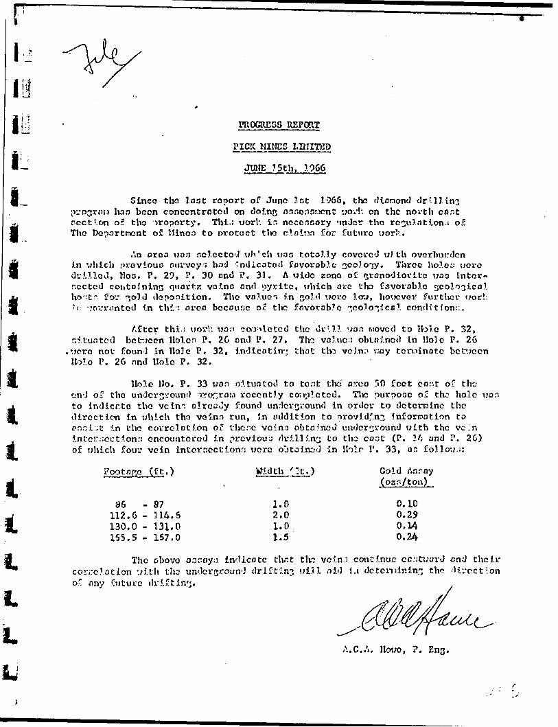
13
i i i i i i t A i t li. l.L
PROGRESS REPORT
PICK MIHCS LIMITED
JUNE ?5th. 1966
Since tho loot report of Juno lot 1966, the diamond drill ins lw a been conccntrotcil on doinf* nsnonaucn* VTOV!: on the north cor.t
section of the n-oporty. Thl.; worl: ir. noconcory nnJor tho regulation.! o.? Tho Department of Hinoo to protect the ci o inn for future w or!'..
i'.n croa woo selected wli'ch was totolly covered with overburden In which previouo cui-vcy:} had vnilicotcd favorable 3Oo?o'-y. Three hole:: wove drilled, Hon. P. 29, P. 30 ond P. 31. A wide zone of fjrano'Jlovite woo Intcr- r.cctcd coiitolnlns quortr. ve In o and pyrite, which arc tkz favorable geological ho':t" fo';' sold deposition. Tlie value-; j.n cold xicrc low, hovTCver further i;or!: *?: vovrrtmted In thi-: area beccu:;c oC tlic f.nvovab?c 7,0 o lo ".Ice! condition::.
After thi;; worh wan coa^lctcd the ilrMl uan r.iovcd to Hole P. 32, nftuotcd bct-jccn Holcn P. 26 ond P. 27. Th-2 value: obtoincc) In Hole P. 26
,uero not found in Hole P. 32, indicating that t lw veJ.n:' way ten^inotc bct*.;ccn llolo P. 26 and Hole P. 32.
Hole Ho. P. 33 won oituatod to to:;t tha ovuo fi O feet cnr.t o-; the cn-J of tho underground :r?onrou recently cortolctcd. Tlx! purpooc 0? the hole wo: to Indicr.to tho vein". olrccJy found underground in order to determine the direction in which tha ve inn run, in addition to nrovldf.nj information to pnni:;U in tho covrclotion oT thc.".c vovno obtained underground with the vein intci:;-.cct?.on:; encountered 5.n previous dr5.lli.nc; to tho cost (P. \l; and P. 2G) of which fou" vein interccctionr; were oJtoi.nod in Holr I1 . 33, or. folio;;.;:
I? oo t a go, (ft.)
86112.6130.0155.5
87114.6131.0157.0
Width /-t.)
1.0 2.0 1.0 1.5
Gold Anroy (ozr./ton)
O.LO 0.2? 0.14 0.24
The obovo aoKoyt) indicate th.it tlv3 ve in.i continue cc:;t;;ard end their correlation *.;lth tlic undcvground drifting ui5.1 aid 1.1 de t c mining tho direct'.on o' any Cntucc dr?.j!tlnrj.
A.C.A. Ilcn;o, P. Ens-

PROGRESS REPORT - June 1st, 1966
PICK MINES LTD. DIAMOND DRILL PROGRAM
The assay results for holes 27 and 28 have been received.
Bole Ho. 28 intersected high grade gold valvies and vos drilled in the
area of the Ho. 3 zone to correlate known veins which were previously
outlined in drifting on the first level. It interoectcd the veins
above the first level and below the adit, and about 30 feet west of
hole P.25 of tjiia program. Four vein intersections wei*. obtained, and*
the assay results* ore tabulated below.
GOLD ASSAY FOOTAGE (ft.) WIDTH (ft) (ozo/ton)
DOLLAR VALUE (at $30. per 02.
8. C -47.0 -56.0 ~73.0 -
132.0 -
10.048.559.075.0
135.0
2.01.53.02.02.2
0.210.220.100.303.15
5 7.988.363.80
11.40119.70
Hole 27 \tas drilled 100' cast of hole 26, which in turn
was 100' east of all previous drilling. Hole 27 intersected low values
in ooid, and the veins intersected in previous hole 26 were not inter
sected in hole 27. Since this may be due to a chanqc in strike of the
veins, further drilling is warranted in order to tent the possibility.
Respectfully submitted A.C.A. HOWE fi, ASSOCIATES LTD.
•CA.C.A. Howe, P.Eng. x lU ' r-

Mr. O. Sherman May 25, 1966*
A.C.A. Howe, P. Eng.
PICK MINES - SURFACE DIAMOND DRILL PROGRAM
Tho assays have been received for hole Ho. 26. This hole is
io oituatcd at 100 ft. caot of any previoun drilling, and obtained
two vein intersections with encouraging gold values.
These are as follows t
Drill fbotuge UidUi Gold Assay Ft. Ft. ozs/ton
215.6 - 217.6 2 .0 0 .23 ) Average 0.12
210.2 - 220.0 l.B 0.04 ) 4.4
403.S - 404.5 1.0 0.10
The intersection from 215.G - 220.0 ia on otriko with the Ho. 3
r.ono and indicates the possible extension of this zone for a further
100 ft. An average of 0.12 o/.c. per ton across a 4.4 ft. width in
dicates that the gold values persist to the cast and that the vein
has a good width in this area.
It is interesting to note that the Ho. l shaft is pituuted a
further 300 ft, to the cant, and was sunk on a quartz vein contain
ing gold values.l
Further work v/ill bo necessary to determine the relationship be
tween tho veins intersected by drilling and the one in the shaft.
Role No. 27 situated between No. 20 and the shaft will aid in this
correlation. "
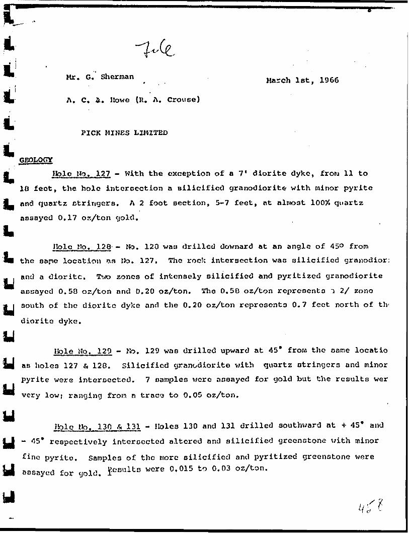
l
Mr. G. OUCUIM.., torch lat( lg66
A. C. i. Howe (R. A. Grouse)
PICK MINES LIMITED
GEOLOGY
S jHQloHo. 127 - With the exception of a 7' diorite dyke, f row 11 to
10 feet, the hole intercection a silicified granodiorite with minor pyrite
^— and quartz otringers. A 2 foot section, 5-7 feet, at almost 10034 quartz
assayed 0.17 oa/ton gold.
LIlolo Ho. 128- - No. 123 was drilled downard at an angle of 45O from
l* the sapc location as Ho. 127. The rock intersection was silicified granodior:
and a diorite. Two zones of intensely silicified and pyritized granodiorite
assayed 0.58 oz/ton and 0.20 oz/ton. The 0.58 oz/ton represents i 2/ zone
ji south of the diorite dyke and the 0.20 oz/ton represents 0.7 feet north of tlv
diorite dyke.
UHole Ho. 129 - to. 129 was drilled upward at 45* from the oaroe locatio
JOB as holes 127 fi 120. Silicified granodiorite with quartz otringers and minor
pyrite were intersected. 7 samples were assayed for gold but the results wery" very lowj ranging from a tracxa to 0.05 oz/ton.
yHole lip. 130 b 1 31 - Holes 130 and 131 drilled southward at H- 45* and
- 45* respectively intersected altered and silicified greenstone with minor
fine pyrite. Samples of the more silicified and pyritized greenstone were assayed for gold. SesultD were 0' 015 to 0' 03 OzAan '
y
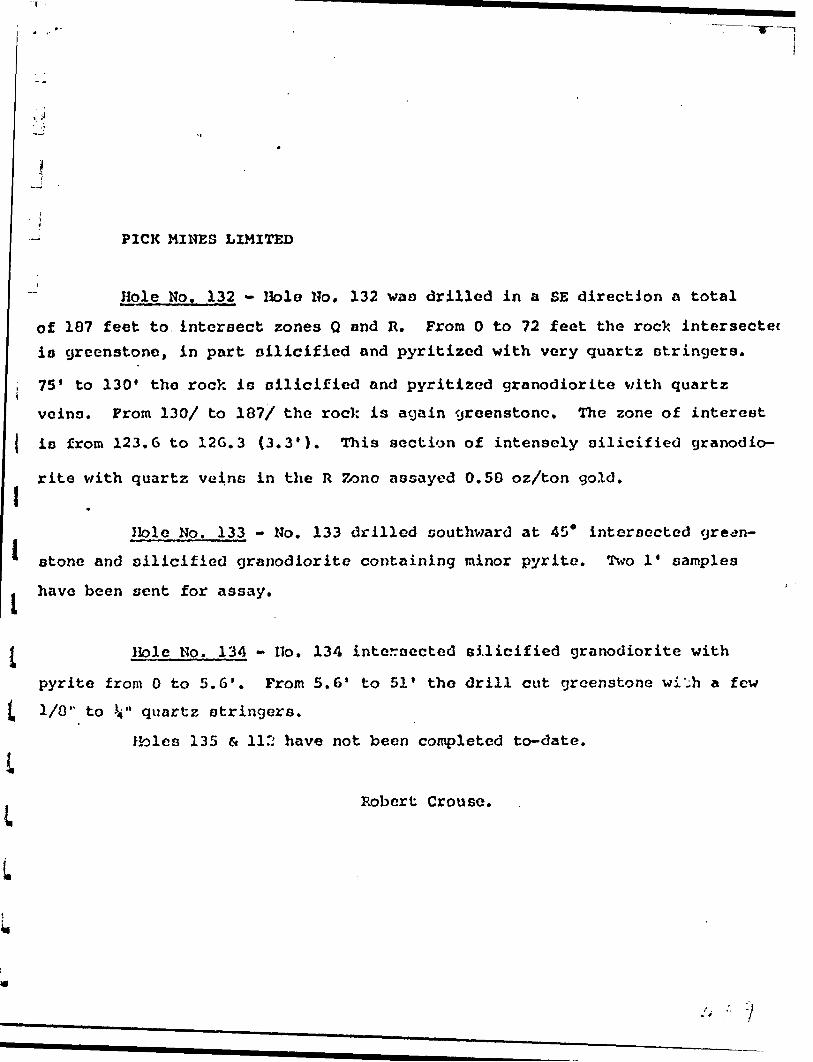
PICK MINES LIMITED
Hole No. 132 - Hole Ho. 132 wan drilled in a SE direction a total
of 187 feet to intersect zones Q and R. From O to 72 feet the rocX intersectet io greenstone, in part oilicified and pyritized with very quartz stringers.
i 75' to 130' the rock is oilicified and pyritized granodiorite with quartz
veins. From 130/ to 187/ the rock is again greenstone. The zone of interest
{ io from 123.6 to 12G.3 (3.3'). This section of intensely oilicified granodio
rite with quartz veins in the R Zone assayed 0.50 oz/ton gold.l
l
lL
l
Ilole No. 133 - No. 133 drilled southward at 45* intersected green
stone and silicified granodiorite containing minor pyrite. Two l' samples
have been sent for assay.
l Hole No. 134 - Ho. 134 intersected silicified granodiorite with
pyrite from O to 5.6'. From 5.6' to 51' the drill cut greenstone wi'.h a few
1/0" to V quartz stringers.
Holes 135 e* 112 have not been completed to-date.
Robert Grouse.

PICK MOTES LIMITED
SUMMARY REPCRT
JAmiARY. 17th. 1966
l
l
i i tl VLl
Drifting and underground drill ing revealed a zone
150 feet long, In which three high grade veins hove been indicated,
varying in thlcUnena frora l' to 5'. Value* rongc from .09 to 3.93
oz. of gold per ton, over a length i-.f 130 feet.
It is rccoranendcd 11 vat on additional 1,300 feet of
underground drilling bo carried out to assist in blocklivj out
tonnages. At the some tine It la Dusfjocted thot "Q" and "R"
rone o bo tested by undcrjround drill ins.
Surface drilling over the 150' zone is rccormonded
in order to correlate between the first level and No. 3 Adit.
Surface drilling should also be curried out cast of the zone to
evaluate this area of unknown potential. It is estimated that
a tnlnlnura of 2,000 feet of surface drilling will bo required.
A.C.A. HOWE fi ASSOCIATES LTD.,
A,C.A. Howe, F.
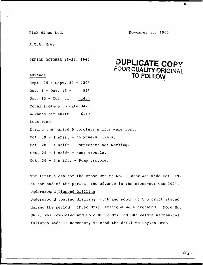
Pick Mines Ltd. November 10, 1965
A.C.A. Howe
PERIOD OCTOBER 16-22, 1965 D UPLICATE COPY
POOR QUALITY ORIGINALAdvance TO FOLLOW
Sept. 25 - Sept. 30 - J20'
Oct. l - Oct. 15 - 87'
Oct. 15 - Oct. 31 140'
Total footage to date 347'
Advance per shift 6.19'
Lost Time
During the period 5 complete shifts were lost.
Oct. 19-1 shift - no miners 1 lamps.
Oct. 20-1 shift - Compressor not working.
Oct. 25-1 shift - cump trouble.
Oct. 2G - 2 shifts - Pump trouble.
The first slash for the cross-cut to No. '* zone was made Oct. 19.
At the end of the period, the advance in the cross-cut was 102'.
Underground Diamond Drilling
Underground toating drilling north and south of t h^ drift stated
during the period. Three drill stations were prepared. Hole No.
U65-1 was completed and Hole U65-2 drilled 50' before mechanical
failures made it necessary to send the drill to Boyles Bros.

^ Pick M.ino* Ltd-. tin-rat MX J C, !T)fci
A. C, A. 3av*
PERIOD OCTOBER it - :i, ;.s-j
i-J l,*
, Oct. I - Oct. 15 ~ t."
l i Total ?octa9* to dktc 3*7'
Advance pir *Mft 6.19*
li.5 oonplAi- ahifto vor- lout.
Oct. 19-1 ohlJtt - Wo aincrn*il . Oct. 20 ~ i shift - Coaipi:oi*iw,f r*rit
I Oct. 25 - \ a hlt*, - J':i.V t.i-..ijhir..
Oct.. 26-2 rhlft9~ ?\urtp trinibJ*-.
It The /J.tct *).n*h for fchv nrc-.v-.'-cut to Bo. 3 *onr v,;,- oado Oc*:. l?
At the fir*! of tht*. parlcKJ, ';hu ixTvanen in th* **ro***.-c*:t -ym ).03*.
l L'jvJorground touting drillln:j north njvl nouth c f t'.tf. *jrl/^ ot.^rted during tha porioU, TJuros dcl.M at.itions wex-a f-r*^vh.\. it.l* 1^7.
l U65-1 vac C05td*twl anci Hole UC.O-'2 SrUlrd 50* b*-r;-c* n
failtvrA* lartrto it nftctsoai'y to wsnrl the drill ho Dcv len Drc-*.i. ^
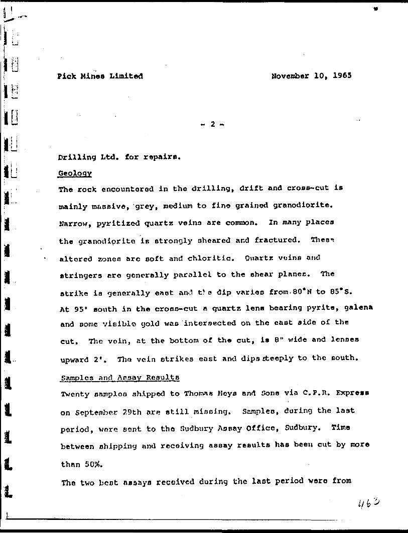
PicX Mines Limited November 10, 1965
t ! 'i i
~ 2 -
Drilling Ltd. for repairs.
^Geology
The rock encounterod in the drilling, drift and cross-cut is
mainly ra&asive, grey, medium to fine grained granodiorite.
Narrow, pyritized quartz veina are conuaon. In many places
the granodiorite is strongly aheared and fractured. Thes-
altered zonen arc ooft and chloritic. Quartz veins and
stringers are generally parallel to the shear planes. The
strike ia generally eaot anO t?o dip variao from.80*N to 85*S.
At 95' south in the crone-cut a quartz lens bearing pyrite, galena
and oome vieiblo gold wac intersected on the cast side of the
cut. Tlic voin, at the bottom of the cut, is 8" wide and lenses
upward 2*. Tho vein strikes east and dipssteeply to the eouth.
Samples and Assay Reoulta
Tventy snmploo shipped to Thorvie Keys and Sons via C. P. R. Express
on September 29th are still niooing. Scropleo, during the last
period, voro sent to the Sudbury Assay Office, Sudbury. Time
between shipping and receiving assay results has been cut by more
than 5054.
The two bcot assays received during the laot period were from
l/b
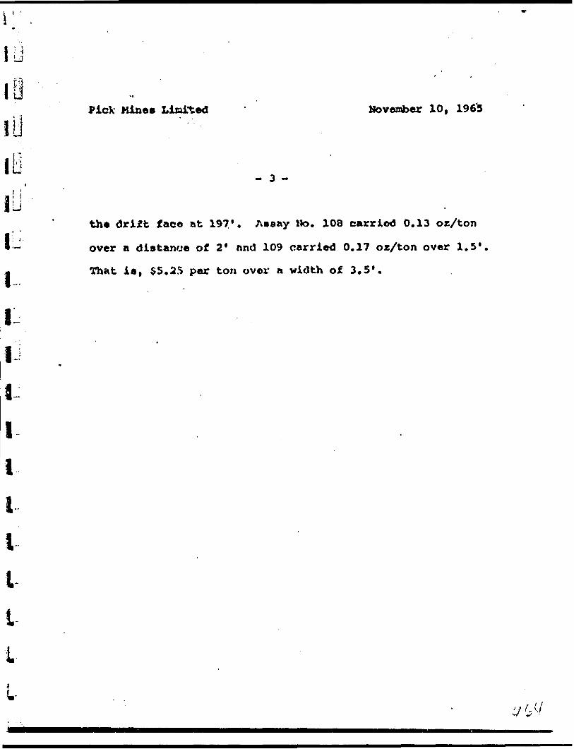
PicX Mine* Limited November 10, 1963
- 3 -
the drift face at 197*. Awaay No. 108 carried 0.13 or/ton
over a distance of 2* nnd 109 carried 0.17 or/ton over 1.5*
That is, $5.25 per ton over a width of 3.5*.

Pick Nines Limited Novcmhsr 9, 1965
A. C. A. Howe
REPORT FOR PERIOD OCTOBER 1-15, 1965
Drift Advance
Sept. 15 - Sept. 30 ~ 126'
Oct. l - Oct. 15 - 01'
Advance to date 207'
Advance per shift , 6.2'
Lo B t Tinio '
Oct. 8 and 9 ~ Hoist not working propoily.
Oct. 12 and 13 - Wo forward advance due to water.
Water
The night shift on Oct. lith when drilling a 'knee hole' in the
foce at 193' hit water. The flow gunned from the hole under
strong presnure at a rate of approximately 30 gallons per minute.
The following day a hole was drilled ahead with a 16' steel.
This hole wao dry. Several additional holoo were drilled
around tho hole that was making waterj oil these holeo were
dry, indicating that tho source of the water must be a diainond
drill hole and not a water nenra ng suspected. Lucien arrived
and decided to blast. When the round was mucked a diron od
drill hole was exposed. The hole entered the drift through the
north side nnd entered the floor at an angle of 40*. Frcm tho

Pick Mines Limitcfd
J
li
- 3 -
the south half of the face shear planes and fractures strike
southerly, 20* with drift direction. Northern part of face -
shearing nnd Ji" quartz vein strike northerly 25* vith drift.
168'-Northorn part oi face 2" quartz vein striking lo* Worth of
drif.t axia and dipping 6S*H. South port of faco - narrow
quarti, veino ami stringers parallel to drift direction dipping
south at 80* to vertical.
173'-*Strong break, 2' from oouth wall, dipping at 60*H. 2"
quarts and feldspar vein. Granodiorite badly sheared and
slightly brecciated. Cross break and 4" quart?, vein dipping
north at 40*. Quartz opaque and yellowish. Stron9 liroonitic
stain along quartz contact, and pyrite cokes in granodiorite
near contact altered to pyrite.
178'-Same fracture and 2" vein aa above, striking 20* north of
drift.
183'-Sheared granodiorite - narrow quartz stringers.
lB7'-Same.
193'-Same.
196'-Same. Quartz veins 3/4" dipping 1105*. V.G. noted et bottom
where vein widenc to 12".

f
l J
iii
PicX Minos Limited
- 4 -
202* - Sheared silicified granodiorite. Quartz veino on ri?ht
hand aide of the face dipping 85*H. On right hand sida
of face flat lying quartz lens, 2" vide, dipping oouth.
207' - Two narrow quartz veino in silicified granodiorite. Fine
pyrite cryotalu over l* width.
li

Q. Sherman
A. C. A. Howe (R.A. Crouso)
October 21, 1965
PICK MINES LIMITED ~ Lochalah, Ontario.
Report for period October l - 15th. 196S
Dr i ft Ad yar* f-e
September 15 - September 30 126'
October l - October 15 81*
Advance to date 207*
Advance per ohift 6.2*
Lost Time
October O and 3 ~ lloiat not working properly
October l?, and 13 - Mo forwaia advance due to water
Water
The night shift on October 11, when drilling a 'knee hole* in
the face at 193 1 , hit water. The flow guahed from the hole
under strong pressure at a rate of approximately 30 gallons
per minute. The following day a hole was drilled ahead with a
16* oteel. Thin hole wao dry. Several additional holes were
drilled around the hole that was making water i oil these holes
v/cre dry, indicating that the source of the water muet b : n
diatrond drill hole and not n water seam an suspected. Lucien
arrived and decided to blaat. Then the round waa outked and a
Jn.9

G. Sherman ' October 21, 1965
- 2 -
diamond drill hole was exposed. The hole entered the drift
through the north aide and entered the floor at an angle of 40*.
From tho location of the hole it is the surface holo designated
C-42.
Geology
The drift cut through strongly sheared and partly silicified
medium grained granodiorite and felsitic rock. Narrow quartz
veino and stringers containing some pyrite were observed through
out. Tha shearing and the quartz veins tend to run parallel
and strike in a northeast direction. The dip varies from 80*N
to 80* S. Tho following its a brief description of tho facen
an they were sampled i
130' - Two *i" quartz voino in sheared granodiorite. Striking
30* north of drift direction and vertical.
135' - Several very narrow quartz stringers in granodiorite.
141* - Pour ^i to l" quartz veins in ntrongly choired fine
grained granodiorite. Veino atrikt 30* north of drift
direction -dip 00* S.
146* - Same, Quartz stringers dip 85*S,
O. Sherman October 21, 1965
- 3 -
Jl l
151* - Same. Quartz stringora on right side of face dip
80*3. Those on the left or north half of the face ere
157*
163*
168* -
173' -
vertical.
Sheared granodiorite - quartz vein *i" dip 85*.
Two shear oyateins appear in the face. Two foot width
on the couth half of the face shear planen and fractures
strike southerly, 20* with drift direction. Northern
part of face - shearing and ^i" quartz vein strike
northerly 25* with drift.
Northern part of face 2* quartz vein atrikinq 10* north
of drift axio end dipping 65*N. South part of face -
narrow quartz vains and stringers parallel to drift
direction dipping south tit 130* to vertical.
Strong break, 2 1 from south wall, dipping nt GO*H. 2"
quartz and feldspar vein. Granodiorite badly sheared
ant! nlightly brecciated. Cross brealc and 4" quartz.
vein dipping north at 40*. Quartz opaque and yellowish.
Strony limonitic stain along quartz contact and pyrite
cakes in granodiorite near contact altered to pyrite.
;'.' ^ 'y -- f

p
liG. Sherman October 21, 1965
li
178' -
183' -
187* -
193* -
197' -
202* -
207'
- 4 -
Same fracture and 2." vein as above. Striking 20* north
of drift.- Sheared granodiorite - narrow quartz stringero.
- sane.
- &AIR6.
- Same. Quartz veins 3/4" dipping north 85*,
- Sheared silicified granodiorite. Quartz veins on right
hand aide of the face dipping 05*N. On right hand side
of face, flat lying quartz lens, 2" wide, dipping south.
- Few narrow quartz veins in silicified granodiorite. Pine
pyrite crystals over l 1 width.
lbyu
t
Q. Sherman Sept. 30, 1965
Oopy tot R. M. Williams
PICK MINES LTD. , LO&JU.SH, ONTARIO ~ DRIFTING
A. C. A. Howe (R, A. Crouae - Writer)
Report for period Septetnber 16th to September 30th, 1965.
*
SURVEYING
A check survey by Mr. Howe and the writer (R.A.Crouoc) re-
vealod an error in plotting of Shaft No. 3 and the X-cut. On
September ?,2nd the writer measured tho depth of the shaft and
found it to be 94* and not 100*,
DRIFTING
Drifting in an easterly direction waa started at a point
61.04* oouth of the shaft in the X-cut. On Septetnber 30th
the drift had advanced to the 126' wark. This represents an
advance of 6.'4" per shift.
GEOLOGY
The rock observed to date is mainly a medium to light greyi
granodiorite. This rock is commonly medium grained but changes.f
to fine grained. Although shearing and alteration has been
noted throughout - the ohearing, schistosity and chlorite
contents increase markedly eastward from about the 70* mark.
A north-south trending diabase dyke dipping 65*E was cut at
72'E. 73..2

G, Sherman
- 2 -
The schistosity trends east and has an almost vertical dip.
From the 19* nark to the present face numerous quarts veins
and stringers wore seen. These quarts veins are in most
instances mineralize*] with pyrite and vary in thickness
from ^" to l*. Unfortunately the veino are very lensitic
and appear to 'pinch out* both along strike and down dip.
From an economic point of view the moot interesting section
lies between 73* and 97*. Quartz veins up to l* occurred
in a strongly sheared zone. The average dip of the voins
io 70*3. In tho face at 97' a 14" mineralized vein, miner
alized with fino pyrite crystals, split into a dendritic
pattern of small veins nnd had almost dioappcared in the
fnee at 104',
Tho veins appear to be following the strike of the schis
tosity and wo are drifting east endeavouring tp stay with
tho zone.
SAMPLING
To dato, 44 samples, in 4 shipments, have been sent to Thomas
Hoya, via C.P.Express. To date we have not received any assay
rooulto. Hence, although wo are following quartz veins and
...3 y 7'/
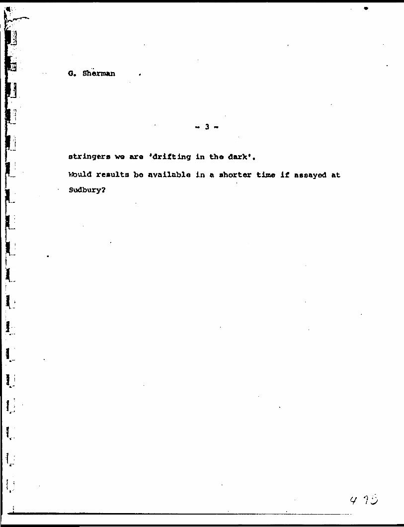
O. Sherman
-i
i l
1.
l
- 3 -
stringers wo are 'drifting in the darX*.
Vtould results bo available in a shorter time if aeoayed at
Sudbury?
M
—PROGRESS
A. C. A. HOWE
uA^ f ftoyemberL JJt—
During tho post few months Independent engineers representing
a financial group and a mining company have o*^lned tho property and
records of work done to date.
In consultation with then, my personal estimates have been
j confirmed that a tirade of from $20 to ?25 per ton (gold at 538 por oz.)
J^Q across a width of V can be obtained from the #3* R, and Q zones. These
L . are tho zones which have been explored by considerable work including
^* diamond drilling and underground drifts,
rf Tho #3 zone has been explored by an adit over a length of 160'
; and surface trenching over an additional length of 200'. Samples taken
ip a long this length Indicated an average grade across **,0 ft. of 0.^8 ozs.
per ton, with assays cut to tho average assay of 2.38 ozs., end 0.66 ozs.
^ per ton, with assays cut to double tho average assay which Is ^.76 ozs.
l A grade of about 520 per ton can therefore be predicted across a mining
width of *4 ft. O lomond drill holes, below tho adit and trenches, have
Vi confirmed this Indicated grade. Altogether l) cross-sectional lines
g wore drilled along o length of t*00 ft,, consisting of'17 holes, andm
Intersections woro obtained at elevations ranging from 70' below adit
1 level down to 250' bolav adit lovol. Tho zone Is still open at tho cast

13Nylily
A. C. A. HOWE, p.Eng.,MINING ENGINEER
PICK MINES UNITED
PROGRESS REPORT
A. C. A. HOWE
November Ifr, 1962.
During the past few months Independent engineers representing
financial groups and mining companies have examined the property and
records of work done to date.
The consensus of their opinions Indicates that an overall grade
of from 320 to 325 per ton (gold at 538 per oz.) across a width of V can
be obtained from the #3, R, and Q, zones. These are the zones which have
been explored by considerable work Including diamond drilling and
underground drifts.
t
i
The 03 zone has been explored by an adit over a length of 160'
and surface trenching over on additional length of 200*. Samples taken
along this length Indicated an average grade across A.O ft. of 0.^8 ozs,
per ton, with assays cut to the average assay of 2.38 ozs., and 0.66 ozs.
per toni with assays cut to double the average assay which Is J*.76 ozs.
A grade of about 520 per ton can therefore be predicted across a mining
width of *t ft, Diamond drill holes, below the adit and trenches, have
confirmed this Indicated grade. Altogether 11 cross-sectional lines
wore drilled along a length of 1)00 ft., consisting of 17 holes, and
Intersections were obtained at elevations ranging from 70* below adit
level down to 250' below adit level. The zone Is still open at the east
ill
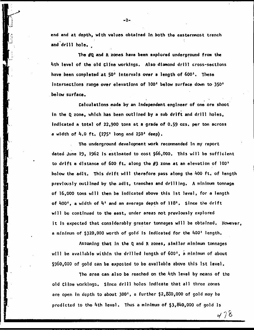
PJu
-2-
end and at depth, with values obtained In both the easternmost trench
and drill hole.
The #Q and R zones have been explored underground from the
*tth level of the old Cline workings. Also diamond drill cross-sections
have been completed at 50* Intervals over a length of 600'. These
Intersections range over elevations of 100* below surface down to 350'
below surface*
Calculations made by an Independent engineer of one ore shoot
In the Q zone, which has been outlined by a sub drift and drill holes,
Indicated a total of 22,900 tons at a grade of 0.59 ozs. per ton across
a width of *4,0 ft. (275 1 long and 250' deep).
The underground development work recomnended In my report
dated June 19, 1962 Is estimated to cost 566,000. This will be sufficient
to drift a distance of 600 ft. along the #3 zone at an elevation of 100'
bo low the adit. This drift will therefore pass along the 1*00 ft. of length
previously outlined by the adit, trenches and drilling. A minimum tonnage
of 16,000 tons will then be Indicated above this 1st level, for a length
of JtOO 1 , a width of U 1 and an average depth of 118*. Since the drift
will bc continued to the east, under areas not previously explored
It Is expected that consldorably greater tonnages will be obtained. However,
a minimum of $320,000 worth of gold Is Indicated for the ^00' length.
Assuming that In the Q and R zones, similar minimum tonnages
will be available within the drilled length of 600', a minimum of about
5960,000 of gold can be expected to bo avail obi e above this 1st level.
The area can also be reached on the *tth level by means of the
old Cline workings. Since drill holes Indicate that all three zones
ore open In depth to about 300', a further 52,880,000 of gold may be
predicted to the Mth level. Thus a minimum of 53,81*0,000 of gold Is
. . y 7*

-3-
Indlcated to be available from the existing shafts to a depth of *tOO ft.
This figure does, not take Into account that all zones are open on strike,
and also that ore grade shoots have been Intersected In the ff1* and #5
zones which have not been considered In the above figure.
If necessary, the #3 zone could be mined and milled at a rate
of say 100 tons per day. on completion of the proposed development work,
since a mill has already been erected. However It may be considered more
advisable to develop the remainder of the 1st level before commencing
milling operations. Funds for this should be readily available assuming
that the 1st level drift confirms the assays previously obtained In tho
adit, trenches, and drill holes.
It Is therefore very apparent that the initial expenditure of
566,000 to develop tho #3 zone on the 1st level (s well Justified. This
will then enable the Company to proceed with subsequent production plans,
which can be paid for by cash flow and by further public financing.
Respectfully submitted,
Toronto, Ontario A. C. A. Howe, P. Eng.
y-;;
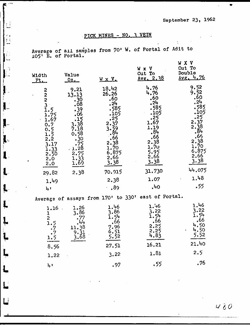
September 23, 1962
pICK MINES - NO. ^ VEIN
Average of ail samples from 70' W. of Portal of Adit to 105' E. of Portal.
Width •pf. . y 1 1 .2 2 2
J.51.75 1.67 0.7 0.51.5 2.23.17 1.33 2.50 2.0 2.0
29.821.^9If'
Average of1.16 12 l 5J-. s
.7
.7 1.58.561.22
If'
Value07\jti .
9.21 13.13• 32
.08* 3? .06•1?
3.38 7.180.58
.30•75
. 1.282.75 1.33 1.692.38
assays1.26 3.86
.77 ifW# T*
11.389 -?i 3.68
W x V.
18. *f 2 26.26
.60
.2U
.585
.105
.25 2.373 *I?
.Sif
.66 2.38 1.706.875 2.663.38
70.9152.38
.89from 170' to
1.W6 3.861.5W
.667.96 6.51 5.52
27.513.22
.97
W x VCut To Avtr. 2.^8
U.76 U.76
.60
.2^
.585
.105
.25 1.67 1.19
.8U
.66 2.38 1.705.95 2.66 3.38
31.7301.07
.Wo
W X VCut ToDouble Ayz. W. 76
9.52 9.52
.60 pU. *-~
.585
.105
.25 2.37 2.^8
^66 2.38 1.706.875 2.663.38
Mf. 075Uf8
.55
330' east of Portal,
1.V6 3.22 i tfoJ.* 2^
.662.25 2.25 W. 83
16.211.81
.55
1.H6 3.22 l ^j. . 7~
.66W. 50
- W. 50 5.52
21.WO2.5
.76

j
u
Miui i
LILi
' l
LJj l
LJ
Cobalt, Ontario.**
Juno 22, 196?.
lo Whon It May Concern:
Gentlemen:i
I have been asked to verify the assays as shown on plans compiled by
A. C, A. Howe, dated Kay 25, 1962; being a Plan of Drill Holes with assays,
showing zones R, Q, 3-4 * 5, and having longitudinal section of 3 zone,
shoving Drill Holes and Adit working assays. To thes-j I have added in red,
the surface snmple assays c for PioV Mines, reported by the writer.
I have checked the assays as reported as being those of Cline I.aUe Gold
Minos Linibed and also those for Drill Holos drilled under my own supervis
ion.
The assays are as shown for the various Drill Holes etc, with the except-
ion cf C-5 and C-41. C-5 shows 4.4 feet of 0.22 oz. of gold, 3.4 feet of
'..35 . and 0.7 feet of 35.34 oz. of gold, tbe last assqy only agrees with
my figures. Hole C-41 shows 2.5 feet of 1.65 this should be 1.61. All
other assays appear to check.
In checking the Diamond Drill results as shown in Mr. Howe 's report,
tinder Pick Holes, you will find Drill Hole Number and following this
width in feet. Tho width shown is the core length. It is not the
true width of the vein. The true width will be about 80^ of the width
shown for most holos drilled,
In checking Mr. Howe 's report, I fully agrse with him, inregp.nJa to
Hevelopinc the na-nber 3 zone from the number 3 shaft. His estimates
are a little high. R. Fry ft Ascoclates, will supply Engineering Ser-
U vices, and do 600 feet of Driftins for leas than $ 3Z, 000.00.

t
t
t
t
iL
- 2 -
Diamond Drilling will bo done by various comjianies at Three
r.or foot. Core Boxes and Encineering should pot cost r.n tdditicnal Three
Dollars per foot, as shovm in the estimate,
The assays as shown for Cline Lako Drill Holes are taken directly from
the plp.ns given to me by Cline Lake Cold Minee Limited. These assays
were nade by tha company who had a very conpetant assayer, and are in
my opinion, correct*
J...i
i
Yours very truly,
l .C. Halstead, P. Ens.

ADDENDUM TO REPORT
ON-PICK NINES DATED JUNE 19. 1962
BY A.C.A. HOWE
With reference to P.10 of tho report regarding the cost of the
underground program;
(1) A btd has been made by R.F* Fry fr Associates for this work, and for 800'
of drifting. Their target price Is 5*42.00 per ft. If the cost of the work Is
below this price the difference will be shared with tho Company on a 50-50
basis.
It was pointed out by Fry that a larger program of work could be
carried out at a considerable savings in cost per foot.
it Is my opinion that If the company hire their own crews this work
could be done for a price of 530,00 per ft*
(2) If the work was carried out by Fry, their bid includes the provision by
them of a truck for rock disposal. This would therefore mean a savings of
approximately 53,000. from Item #1 in my report.
(3) The Item #2 of my report has been completed Including deWaterlng of the
shaft and preparation of equipment.
(*j) Underground diamond drilling has been commenced on the property at a
price of 51.05 per ft. this means a savings of 52,000, on Item tfk of my report.
jfc (5) The length of tho program has been considerably reduced owing to '*he work
already completed. Supervision costs will therefore be reduced by about
|| 52,000. from my estimate.
(6) Of the recommended surface drill program, approximately 1,000 ft. havea already been completed. This moans a savings of 5^,000, on this Item In my
|| report.*
r 'J6 -^
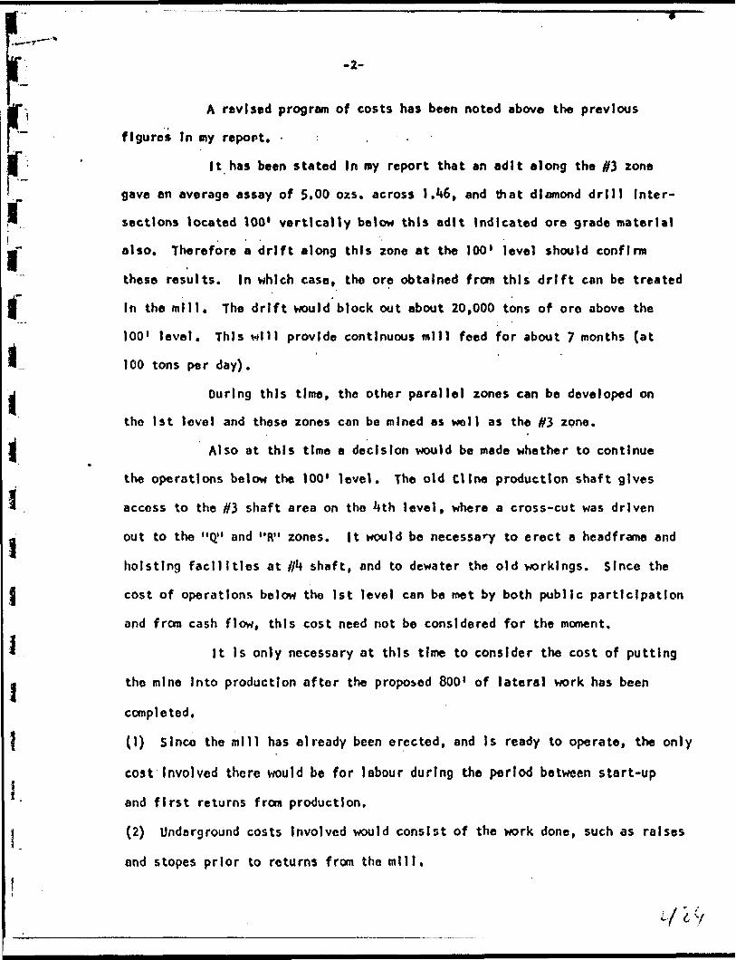
-2-
A revised program of costs has been noted above the previous
figures In my report. - : .
It has been stated In ray report that an adit along the #3 zone
gave an average assay of 5.00 ozs. across J.^6, and that diamond drill Inter
sections located 100* vertically below this adit Indicated ore grade material
also. Therefore a drift along this zone at the 100* level should confirm
these results. In which case, the ore obtained from this drift can be treated
In the mill. The drift would block out about 20,000 tons of oro above the
100' level. This Mill provide continuous mill feed for about 7 months (at
100 tons per day).
During this time, the other parallel zones can be developed on
the 1st level and these zones con be mined as woll as the #3 zone.
Also at this time a decision would be made whether to continue
the operations below the 100* level. The old Cline production shaft gives
access to the #3 shaft area on the **th level, where a cross-cut was driven
out to the "Q" and "R" zones, ft would be necessary to erect a headframe and
hoisting facilities at //4 shaft, and to dewater the old workings. Since the
cost of operations below the 1st level can be met by both public participation
and from cash flow, this cost need not be considered for the moment.
It Is only necessary at this time to consider the cost of putting
the mine Into production after the proposed 800' of latera] work has been
completed.
(1) Since the mill has already been erected, and Is ready to operate, the only
cost Involved there would be for labour during the period between start-up
and first returns from production.
(2) Underground costs Involved would consist of the work done, such as raises
and stopes prior to returns from the mill.
j d y

l
-3-
Tho extra cost required after completion of the recommended
program and prior to production Is therefore estimated as !J50,000 giving
a total required of 5128,000.00.
Respectfully submitted,
Toronto, Ontario October 17, 1962.
A.C.A. Howe, P. Eng
li
\

s.u
y u
y
PICK M INES LIMITED(000-10 *TAH BUIUDINO
00 KINO STREET WESTTORONTO 1, ONTARIO
CANADA
TELBFHONKI E MiM** 4-1673 , ^fnNovember 23rd, I960.
Authorized Capital - 5/000,000 shares Issued to date - 1,712.61*8 "
In Treasury - 3*287,352 shares
Pick Mines Limited holds two contiguous groups of miningclaims which will be referred to os the "Pick Group" and the "Cline Group". The Pick Group comprises a group of 10 unpatented mining claims with a tc":al area of lUOO acres mor or less.
"Cline Group" lies adjacent and to the south of the Pick Group. It comprises a group of 6 patented claims of 273 acres more or less
ACCESS A POWER .
Properties are located on a gravelled highway which extends•from the Town of Goudrenu on the Algoma Central tt Hudson Day Railway*t milo l63 north of the City of Sault Ste. Marie, Ont., and the Town o* Lochalsh on the main line of the Canadian Pacific Railway. The property is 6 miles from Lochalch and 12 miles from Goudreau, Ontario.
The M,OOO volt power line of the Great Lakes Power Co., crosses both the Pick jond Cline group of claims.
HISTORY
The Cline group was formerly known aa the Cline Lake Gold Mines Limited. The property was developed by the former management by 3 charts. During the period 1938 to 193*2 inclusively, 331,61*2 tons of ore were milled with a money value of ^2, 369, 000. 00. As the second World War wan then being fought, making supplies and labor difficult to obtaiuj operations were discontinued in 19^2, plant disposed of and asoete distributed.
PRESENT DEVEDOR-ENTa-jjL-m, ______ -^jrn - "- IT. -... - .T- J -J- .. J -L -~ '
No. 3 Vein has been surface trenched at Intervals for a length of 300 ft. Sampling gavo on uncut grode of 1.73 ozs* Gold per . ton over an overage width of 13*5 inches, diamond drilling this vein Ifolc No. 3 cut 2.1 ft. width of ore aeoaying O.Ul ozs. Ooid per ton. Hole No. 5 cut 6.02 ft. width of ore averaging 3.12 ozs. Gold per ton, uncut. Work done on the vein indicates a commercial grode of ore over mining widths. Mr. M. C. Halstead, P.Eng., the Company's Consulting Engineer, pinna to commence mining this vein, leaving a safe floor between this new level to be developed from the Ho. 3 Bhnft and the old workings of the mine.
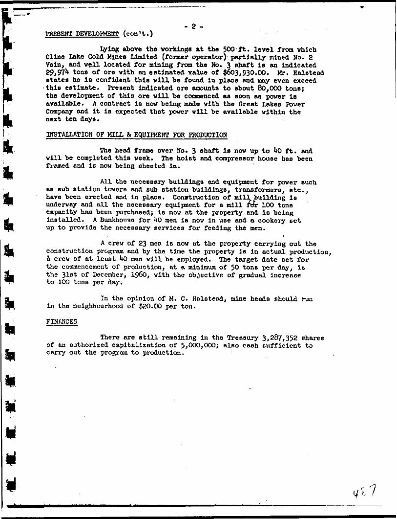
- 2 -PRESENT DEVELOPMENT (con't.)
lying above the vorkinge at the 500 ft. level from vhich Cline Lake Gold Mines Limited (former operator) partially mined No. 2 Vein, and veil located for mining from the No. 3 shaft is an indicated 29,97** tons of ore vith an estimated value of ^603,930.00. Mr. Halstead states he is confident this vill be found in place and may even exceed •this estimate. Present Indicated ore amounts to about 80,000 tons; the development of this ore vill be commenced as soon as power is available. A contract is nov being made vith the Great Lakes Power Company and it is expected that power will be available within the next ten days.
INSTALLATION OF MILL fc EQUIPMENT FOR PRODUCTION
The head frame over No. 3 shaft is nov up to 1*0 ft. and vill be completed this veek. The hoist and compressor house has been framed and is nov being sheeted in.
All the necessary buildings and equipment for power such as sub station towers and sub station buildings, transformers, etc., have been erected and in place. Construction of mill, building is underway and all the necessary equipment for a mill Tor 100 tons capacity has been purchased; is nov at the property and IB being installed. A Bunkho"3e for 1*0 men is nov in use and a cookery set up to provide the necessary services for feeding the men.
A crew of 23 men is nov at the property carrying out the construction program and by the time the property is in actual production, a crew of at least kO men will be employed. The target date set for the commencement of production, at a minimum of 50 tons per day, is the 31st of December, 19&), with the objective of gradual increase to 100 tons per day.
In the opinion of M. C. Halstead, mine heads should run in the neighbourhood of ^20.00 per ton.
FINANCES
There are still remaining in the Treasury 3,287,352 shares of an authorized capitalization of 5,000,000; also cash sufficient to carry out the program to production.
Y t

DUPLICATE COPYPOOR QUALITY ORIGINAL
TO FOLLOWPROJECTION OF ESTIMATED PROFITS FROM THE * 3 SHAFT
AREA OF PICK MINES LIMITED
In order to calculate indicated grades and available
tonnages, certain assumptions, relative to structural condi
tions and continuity, were necessarily used. In all cases
these assumptions have been conservative as possible, and
for this reason it cai: be expected that available tonnages
for the urea? consir.c:red will be much greater than those
presented in the calculations which follow:
Profit, and Cost Factors in Respect to the
Development of the 1st Leve3 from ft 3 Shaft
Indicated are reserves from 1st level:
# 3 zone (400 ft. long x 4 ft. wide x 120 ft. deep - 16,000 tons
Q and R zones (similar sheets) - 32,000 tons
TOTAL 48,000 tons
Gross value of contained gold (48,000 tons x 320) - 5960,000.00
Predicted Costs and Profits from 1st level
Bnsed on mill rate of 100 tons per day, with estimated cost
of milling and development of 314.00 per ton (part of develop
ment costs being included in capital expenditure), leaves an
estimated profit of $6.00 per ton. Operating profit from 1st
level (48,000 x 36.00), equals 3288,000.V 1
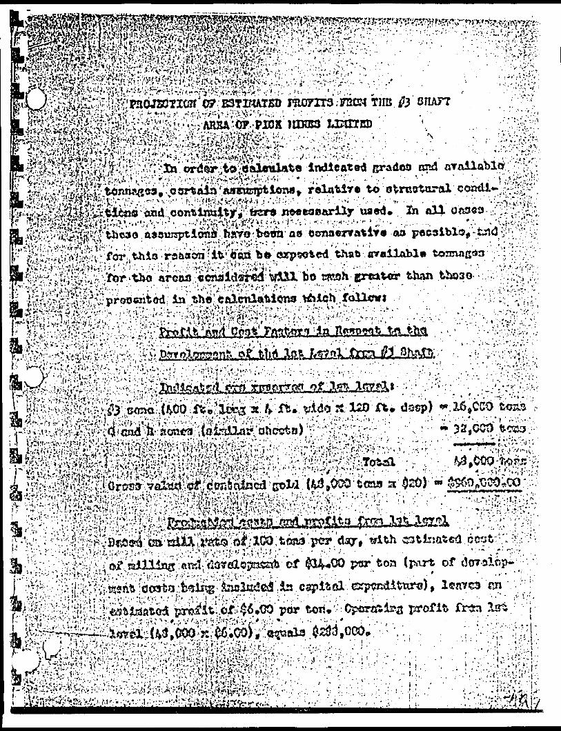
e .:-g '*^.B:-!-
.'- .
-' ' 9 . .
9':
- :
-••'t&tf^fritZ
J^r^;--|;-:;Sv: •-,
^'.--' ^. *H *j.
;-n.-;v:^5.:^.:::s-'-fe^
;-^\?;^'^B
'-i-:-{'rv'.- . ' ^.' S ' ' -w*.
^iS^-'ivwSw:*. vt-*-v ji'i'gyv*;-'.'i2i^^S^?.vg~?fc?; vw-'-; ^t^sfew
-;M;jw
:?--#^^^.jw^^;p^sft!a;^v™
^: ~te^^B
^^^m
^f^W
^.-?.^:
Siiil&
iHiM
si^ s-ttiip
*^';:i '4

-2-
Profit and Cost Factors in Respect to the
Development of the 2nd, 3rd and 4th Levels
Since a cross-cut from the # 4 shaft extends to the Q and R
zones on the 4th level, this cross-cut will be used for
development below the 1st level. The cost of rehabilitating
the f 4 shaft, ? the former workings, installation
of headframe, hoist, etc., is estimated to be $100.000.
Production costs and profits from 2nd, 3rd and
4th levels
The if 3 zone has been drilled to a depth of 250 feet; the Q
and R zones to a depth of 400 feet. The drill results in
dicate that grades and tonnages available will be similar
to those on the 1st level. Therefore, projected ore reserves
are calculated as 3 x 48,000 tons, a total of 144,000 tons.
Cross value of contained gold (144,000 tons x S20) ~ S 2,880,000
Assuming similar operating profit of S6.00 per ton, operating
profit from 2nd, 3rd and 4th levels (144,000 x S6.00), equals
$864,000.
^UPLICATE COPYTotal Potential Estimated PrffftQ* QUALITY ORIGINAL
TO FOLLOWProfits from 1st level S288,000
Less capital costs 100,OCO
5188,000
Profits from 2nd, 3rd and 4th
levels 3864,000

- : . ' .
' M:;•*r ;
::.v; .--r*,''.'.''-; v"'* " ••"•,. ' . \ " '- i -.-. .':. -- ' •.''•••, ' . . . ". . . . : ' ,-*,v^k^;,dwoio3wwifc b^lcw the lut iotcl. /n^ ecsife of r*habUittibi*#.^••^^.,, •.^•^.^v-^^y-,. ^: - ; ' '
oxtondd to th* Q crid n ! will bo used for
•/•i
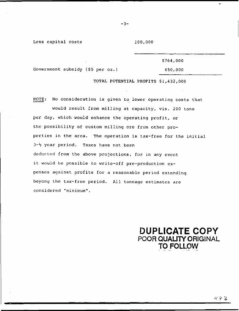
-3-
Less capital costs 100,000
$764,000
Government subsidy C$5 per oz.) 450,000
TOTAL POTENTIAL PROFITS $1,432,000
NOTE; No consideration is given to lower operating costs that
would result from milling at capacity, vis. 200 tons
per day, which would enhance the operating profit, or
the possibility of custom milling ore from other pro
perties in the area. The operation is tax-free for the initial
3-b year period. Taxes have not been
deducted from the above projections, for in any event
it would be possible to write-off pre-production ex
penses against profits for a reasonable period extending
beyong the tax-free period. All tonnage estimates are
considered "minimum".
DUPLICATE COPYPOOR QUALITY ORIGINAL
TO FOLLOW
'i i
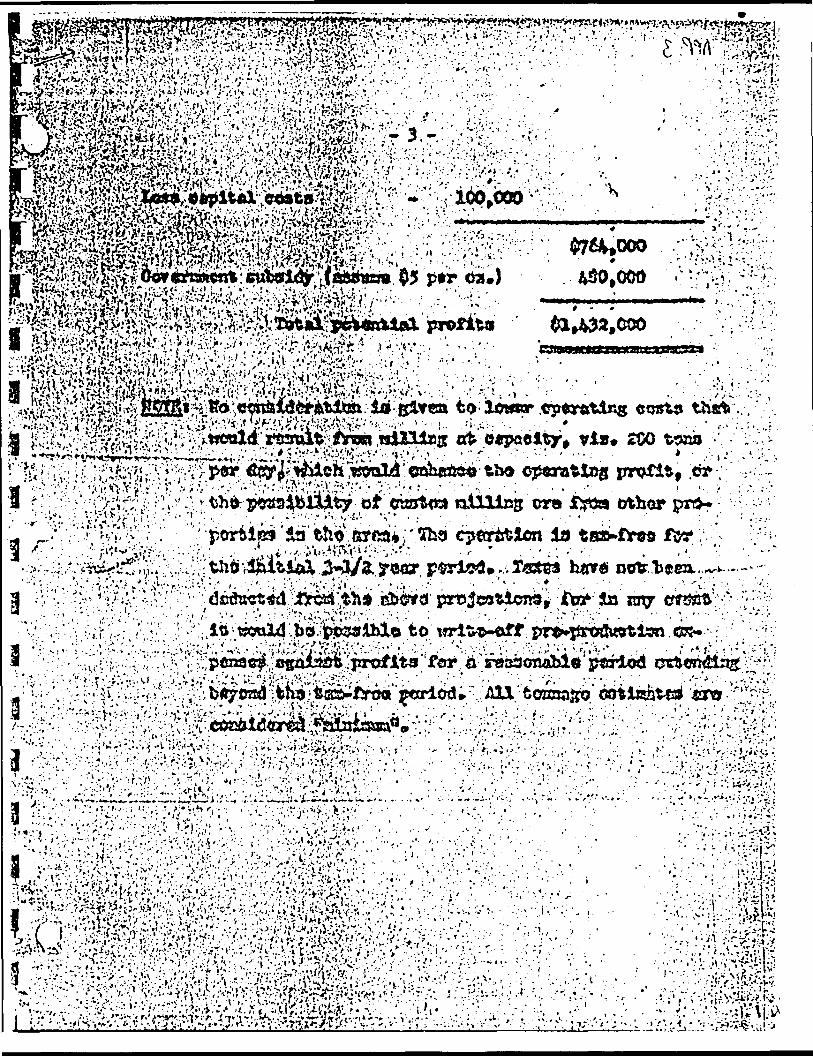

ADDENDUM TO REPORTON PICK MINES DATED JUNE 19, 1962
BY A.C.A. HOWE
The results of the work done to date have been presented to a group of independent engineers. Sections and plans were drawn at 50' intervals and an attempt made to correlate the various ore shoots within ; each shear zone. It is interesting to note that their calculations : showed that within the Q zone, one shoot alone contained 23,000 tons of ore grading $20 per ton across a width of 4 ft. All assays were adjusted to true widths, and dilution calculated for a mining width of 4 ft. All assays below $10 per ton were deemed non-economic and the shoots were cut-off at this grade.
The writer feels that a cut-off grade of $7 per ton would have been more realistic, particularly since the Government gold subsidy is an important item to offset against costs. However, this one shoot alone has been shown to contain S460,000 of gold which would amply repay the costs of the development program outlined in the report of June 19th, 1962.
Diamond drilling has been resumed at the property and holes P. 17, 18 and 19 have been completed west of # 3 shaft. These have been located to investigate the veins between #3 and #2 shaft (400' to the west), and drilled 100' apart. No assays have been received as yet but an examination of the core of P.17 and p.18 by the writer indicates two or three parallel veings west of the shaft. Hole p.19 was drilJed to investigate the granodiorite contact. A phone call received fro:n the property yesterday reports a 24' wide zone of heavy mineralization near the contact.
Some rock cuts 600' west of this hole which were blasted on the contact by previous operators exposed a shear zone 30' wide. A report by the company geologist dated March 31, 1939 states that gold values were obtained across the whole width, with some sections assaying more than one ounce across full mining widths. ;
This appears to be a very important development, since a new zone of major proportions may have been discovered.
Respectfully submitted, il
A.C.A. Howe, P .Eng. \ Toronto, Ontario (
July 5, 1962
DUPLICATE COPYPOORQUALJTYORIG1NAL
TO FOLLOW
(4
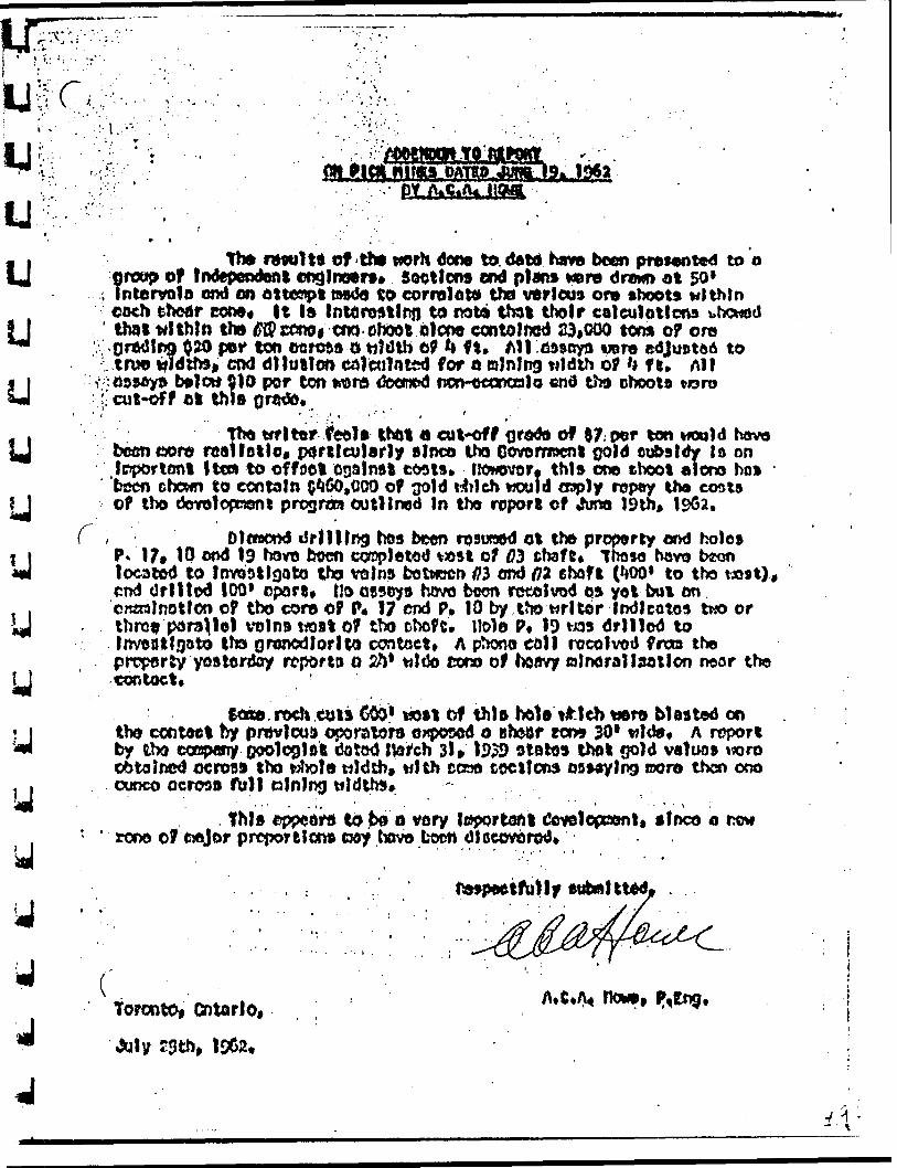
luu
/,,,. -V-
W . : I.:'". ' ' - . **
r . p. . H " .'"
OATBO
tt* rwult* of -th* worH dor* to. daw havo boon presented to o of Independent englnttrs* Sections end plant were drowo at 50*
Inlcrvolo end on ottonpt tasdo to correlate the various or* shoots within each enear COM* It Is tntftrestlnj) to rota thai thofr csleulptlons showed that ttlthln tho ^cmogcm-choot olcoo contained 23*000 tem of ore Grading 0. 20 pot* ton ire rods o tjJdlb of 4 ft* All ,69saya irere edJutJto6 to trw trldtte* end dilution edVcnlnt^ for o erinlng tildth of '* f e. Alt
:oowyn Dfflott 910 por ton Mara deonod norMjconcolo end tto ohooto t oro . cut*of f ei this qrodo*
Tho t#fltor teol* thftt a eut*off oredo of 97, per ton would havo roan oil o, p^rtlculsrly alnco tho Covomocnt 0old eobsldv lo onItem to of fact osatnai coats* fiowovor. this one choot a l oro ho* -
been ctjcwn to contain ^60,000 of ^old t4rich would oaply ropay tha coats of tho doYoloprtent program outlined In tto report of *hma 19th,
C , - D lttBcnd drilling bos been rosutaod ot the property ond holes P* 17t 10 ond 19 havo boon cosplatod v^st of W chaft* Ihoso hovo beon located to InvoDtlgoto tha veins botvccn /?3 ond f72 chaft ('iOO* to tho ra 9 1), end Orlltod 100* cpare, Uo aesoys hovo boon retolvod os yot but on CRsalnotlon of tbo coro of P* 17 end P* 10 by tho wl tor Indicates two or thro?? porallo) t*olns tfoat Of tbo ohofe. Hole P* 19 vos drlllod to Invcatlfjato fhs granodiorite ccntcet* A ptrano eoll rocolvod frm tho property yesterday reports o 2ft1 wIOo coro of twavy aJnorallaatlon necir the contact* . '
rodi eyls C061 MSI df this tala **teh wro blasted on tho contact by pmvlcuD oporatord exposed o Bheor tens 30* wld9* A report by tbo tXBpany goologlafe dotod Itor'ch 3!, 1939 stotos tho t Q0)d valuo* w r o obtained ocrot)* tho t^wla wJdth, with ccno toctlons assaying rooro then ono cunco ocrws ftill olnlntji
. this c^pcoru to bo o very leper tart l Cflvolopocmt, sfnco o now rono of ciejor p report leo* roy hove boon
toronto, 0)tarlo. ! Ho*.
-••1
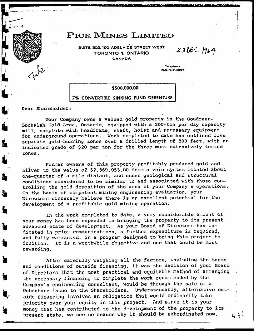
- -t
PICK MINESSUITE 302. 100 ADELAIDE STREET WEST
TORONTO 1, ONTARIOCANADA
TvUphon CMplc
$500,000.00
7"Xo CONVERTIBLE SINKING FUND DEBENTURE
Dear Shareholder:
Your Company owns a valued gold property in the Goudreau- Lochalsh Gold Area, Ontario, equipped with a 200-ton per day capacity mill, complete with headframe, shaft, hoist and necessary equipment for underground operations. Work completed to date has outlined five separate gold-bearing zones over a drilled length of 800 feet, with an indicated grade of $20 per ton for the three most extensively tested zones.
Former owners of this property profitably produced gold and silver to the value of $2,369,053.00 from a vein system located about one-quarter of a mile distant, and under geological and structural conditions considered to be eimilac to and associated with those con trolling the gold deposition of the area of your Company's operations. On the basis of competent mining engineering evaluation, your Directors sincerely believe there is an excellent potential for the development of a profitable gold mining operation.
In the work completed to date, a very considerable amount of your money has been expended in bringing the property.to its present advanced state of development. As your Board of Directors has in dicated in prio; communications, a further expenditure is required, and fully warranted, in a program designed to bring this project to fruition. It is a worthwhile objective and one that could be most rewarding.
After carefully weighing all the factors, including the terms and conditions of outside financing, it was the decision of your Board of Directors that the most practical and equitable method of arranging the necessary financing to complete the work recommended by the Company's engineering consultant, would be through the sale of a Debenture issue to the Shareholders. Understandably, alternative out- side financing involves an obligation that would ordinarily take priority over your equity in this project. And since it is your money .that has contributed to the development of the property to its present state, we see no reason why it should be subordinated now.

-2-
If there are rewards to be realized, they should accrue to you, the Shareholders.
Accordingly, your Directors authorized the creation of a Debenture issue in the maximum principal amount of $500,000.00 for this purpose. The T& Convertible Sinking Fund Debenture issue is a direct obligation of the company. The Debentures are convertible at the option of the holder, into Common Shares at varying prices be tween $2.00 and ?5.00 per share, depending upon the date of conver sion. The Debentures carry a bonus of 10 common shares (escrowed) for each $100 principal amount, and will be entitled to interest payments from production at the rate of T& per annum, such payments to commence 9 months after production is achieved.
The Debentures may also be redeemed by the Company at its option, either in whole or in part, at any time before maturity, by giving advance notice of not less than 30 days, of its intention to redeem. The Debentures will be issued in denominations of ?100, 5500 and $1,000 I or any multiple of these amounts, and are convertible at the holders option into fully-paid non-assessable common shares at the rate of 2,.00 per share up to December l, 1966, at ?3.50 per share up to December l, 1967, and thereafter at $5.00 per share up to December l, 1969.
In order that Shareholders may consider their desired degree of participation in this Debenture issue, the following brief summary of the results of work completed on the property is presented:
There are five known gold-bearing zones in the No. 3 Shaft Area where your Company has concentrated the bulk of its work. Diamond drilling, consisting of some 22 holes, has sampled these zones over a drilled length of 000 feet, with gold values obtained in 53 separate intersections. The five zones are designated as the #3, 'Q', 'R', #4 and #5. The #3 zone has received the most extensive sampling, by surface trenching and diamond drilling to vertical depths ranging from 70 feet to 250 feet below the adit level, and over an explored length of 400 feet.
For the #3 Zone, the available tonnage above the 1st level (100 feet) is estimated at 16,000 tons of an expected grade of $20 per ton. While insufficient work has been done to enable a tonnage estimate for the 'Q' and 'R' zones, results to date indicate a grade of ore similar to the #3 Zone. The 'Q 1 and 'R 1 zones have been drilled at 50' intervals over a length of 600 feet and to a depth of 350 feet, and while no estimate is made of the expected tonnage for these zones, the engineer has stated that grades and tonnages similar to that in the #3 are possible in each of the 'Q 1 and 'R 1 zones.
On this assumption, there is a possible 48,000 tons of likely- i

-3-
520 ore above the 1st level, combining the #3, 'Q 1 and 'R 1 zones.
In the foregoing projections, no allowances have been madefor the #4 and #5 zones, since the latter have not been drilled sothoroughly and therefore are not included in any estimates.
Recommended Exploration and
Development Procedure
The engineer has recommended that the surface and underground work be done in progressive stages. Stage l will involve a surface drilling program in the #3 shaft area to extend this area both east [and west, in order to increase the tonnages available. On com-•pletion of this 3,000 feet of surface drilling it is recommended that the shaft be dewatered and underground drilling, crosscutting and drifting be carried out, to enable an investigation of the 'Q* and 'R 1 zones, as well as #4 and #5 at the existing level horizon.
Stage 2, which will be predicated on the results of Stage l, will consist of drilling from the 1st level to prove the continuity of the 3, 'Q 1 and 'R' zones to a depth of 400 feet. Results of this will enable plans to either dewater the old workings to the 4th level where a crosscut gives access to the #3 Shaft Area for the #4 Shaft (site of the former operation), or, in the alternative, deepen the#3 Shaft to the lowest depth of any proven ore shoots.
Providing that a minimum of 100,000 tons grading about $20 is proven in Stage l, then the zones should be developed by drifts and raises from the 1st level in preparation for production.
The estimated costs of preparation for production on the 1st level is:—
(1) Equipment 6 Change House
(2) Drifting, cross-cutting and raising.Total 3,100 ft. at $50 per ft., including supervision, sampling and assaying
(3) Preparation of mill
(4) Working capital (for 3 month tune-up period)
(5) Contingencies (particularly for grouting of water-bearing seams)
TOTAL
$30,000.00
5155,000.00
55,000.00
560,000.00
520.000.005270,000.00
Additional development on lower levels will depend on the ore-shoots outlined, but should be paid for from production.

V'.*'*-' 1 '
/-
i
a
- -4-The engineer has recommended that any ore obtained from the
drifting in Stage l should be stockpiled for later treatment in the mill to help offset costs of .underground development. The principal amount of the Debenture issue amply provides for both stages of the recommended exploration and development procedure.
TO SUBSCRIBE FOR THE DEBENTURES
A Subscription Form is enclosed. Fill in the desired amount of your Subscription, in denominations of $100, $500 or $1,000 or any multiple thereof, and send this Form, along with your remittance in full payment to Pick Mines Limited, Suite 302, 100 Adelaide Street West, Toronto l, Ontario, Canada. If remitting in U. S, Funds please deduct 796 representing the discount of the value of the Canadian Dollar. Make all cheques payable to PICK MINES LIMITED.
Your Board of Directors earnestly solicits the support and co-operation of each and every Shareholder in making thin Debenture issue a success, thereby providing your Company with adequate funds to carry forward the project to its logical conclusion. It is your Company, and definitely deserves your support.
On behalf of the Board of Directors,
PICK MINES LIMITED,
November 23rd, 1964. , President.
a
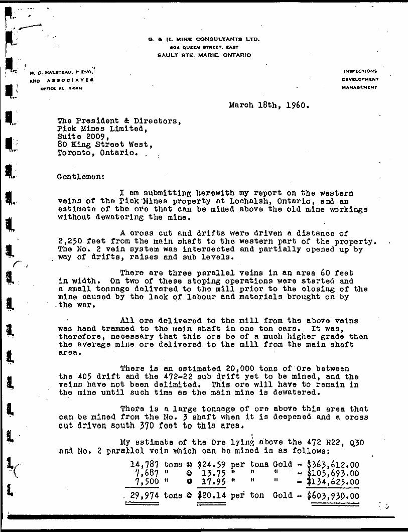
lll
O. 8c (l. MINE CONSULTANTS LTD.604 QUEEN STREET. CAST
SAULT STE. MARIE. ONTARIO
1' M . C. HALSTEAD, f ENO." INSPECTIONS
AND ASSOCIATE* ' DEVELOPMENT
Ornct AL. *.0**l ' MANAGEMENT
l i l l
March 18th, I960.
The President A Directors, Pick Mines Limited, Suite 2009, 80 King Street West, Toronto, Ontario. ,
Gentlemen:
I am submitting herewith my report on the western veins of the Pick Mines property at Loohalsh, Ontario, and an estimate of the ore that oan be mined above the old mine workings without dewatering the mine.
A cross cut and drifts were driven a distance of2,250 feet from the main shaft to the western part of the property,
m The No. 2 vein system was intersected and partially opened up by T^ way of drifts, raises and sub levels.
f jThere are three parallel veins in an area 60 feet
, ; in width. On two of these stoping operations were started anda small tonnage delivered to the mill prior to the closing of the mine caused by the lack of labour and materials brought on by .the war.
All ore delivered to the mill from the above veins was hand trammed to the main shaft in one ton oars. It was, therefore, necessary that this ore be of a much higher grade then the average mine ore delivered to the mill from the main shaft area.
There is an estimated 20,000 tons of Ore between the 405 drift and the 4?2-22 sub drift yet to be mined, and the veins have not been delimited. This ore will have to remain in the mine until such time as the main mine is dewatered.
There is a large tonnage of ore above this area that oan be mined from the No. 3 shaft when it is deepened and a cross cut driven south 370 feet to this area.
** My estimate of the Ore lying above the 4?2 R22, Q30 and No. 2 parailol vein which oan be mined is as follows:
J,x- 14,78? tons O ^24.59 per tons Gold - 5363,612.00"V. 7,687 " o 13.75 " " " - J105,693*00
7,500 " ei 17.95 " " " - |134,625.00i 29,974 tons O {20.14 per ton Gold ~ $603,93P.OO

-2-i
The President A Directors,Pick Mines Limited. March 18th, I960.
i
-In addition to the above there is an estimated 33,0?4 tons of probable ore that should grade Jl6.38 per ton with a value of 5541,801.00. The above is enough ore to supply a 50 ton mill for three and a half years.
above veins are along the strike of the No. 2 shaft vein system which was only partially developed. Several hundred feet of lateral work will be required to reach the No. 2 shaft area.
The No. *ir shaft was sunk to a depth of 115 feet on a vein showing considerable native Gold. The dump from this shaft was taken and milled in the Cline Lake Gold Mines mill. A sample of this taken by the writer assayed 25.64 02. Gold per ton. 430 feet directly below this shaft visible Gold was reported in Diamond Drill Hole No. 300.
Two test pits about 400 feet east of this shaft on the strike of the vein assayed 2.23 02. Gold and 1.45 02. Gold per ton, both samples wore cut by the writer and were 14 ond 18 inches in width respectively. These pits are on the side of a hill from which point an adit could be driven on the vein.
In addition to the above veins No. 2 and 3i the No. l vein lies further north. Diamond Drill Hole No. 311 fromhe drift in this area cut 1.4 feet averaging .38 02. Gold per
ton, which is probably the downward extension of the No. l vein. A shaft was sunk on this vein. It is 1,250 feet east of the No. 3 shaft. Then one hundred and fifty feet east of this main No. l vein shaft is another 65 foot shaft, this was dev/atered in 1936. Native Gold was seen in the vein at various places down the shaft.
On the No. 3 vein visible Gold was encountered down the shaft and on the levels and good grade ore is found on surface on the strike of the vein. Diamond Drill Hole No. 300 cut the vein 430 feet below the shaft showing visible Gold. It therefore seems logical that a good tonnage of ore will be developed on the No. 3 voin as on the No. 2 vein system. The No. l vein system will possibly prove up considerably more ore.
It is, therefore, quite probable that the life of the mine would be extended many years by opening up and develop ing all three vein systems. This could be done by making the No. 3 shaft the main shaft on the property and by developing all the veins from this one shaft.
Respeotfully submitted, ;
MCH/ec*M.C. Halstead, P. Eng.
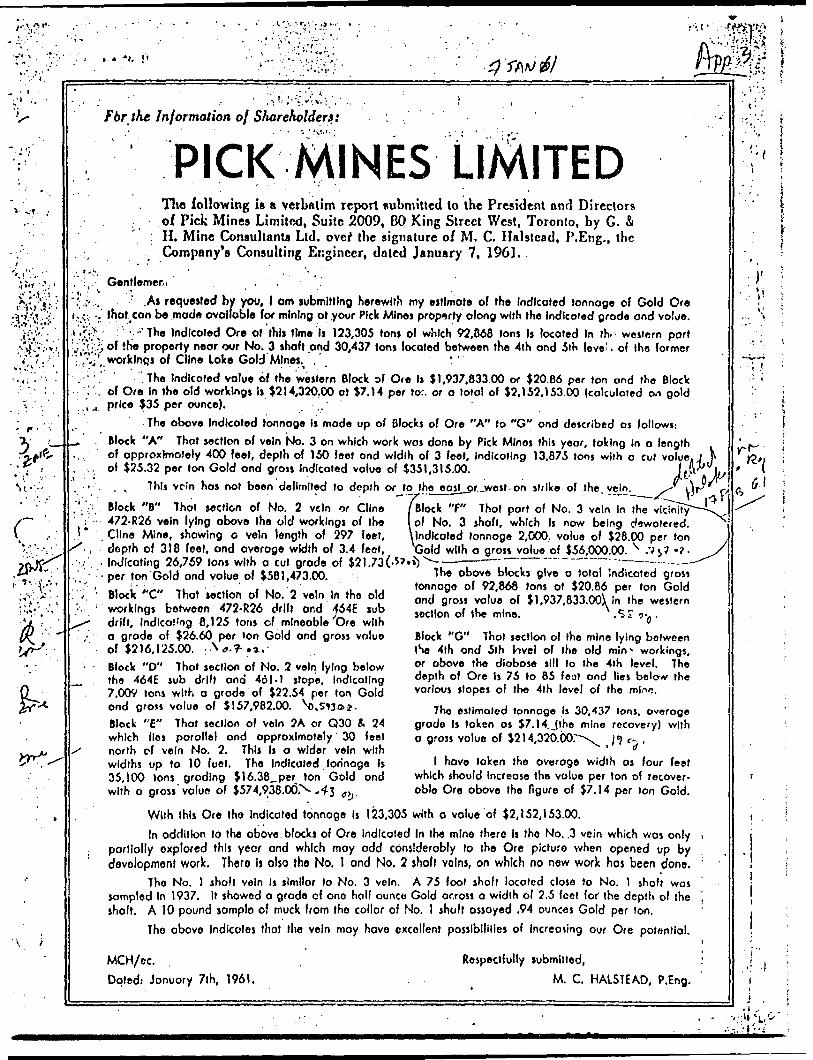
.^VVr.: ..j,
s
r
Fbr the Information of Shareholders:
The following is a verbatim report submitted to the President nml Directors of Pick Mines Limited, Suite 2009, 80 King Street West, Toronto, by G. A
: H. Mine Consultants Ltd. ovef the signature of M. C. Halstead, P.Eng., the Company's Consulting Engineer, dnted January 7, 1961.
Gentlemer i ' . . .
.As requested by you, l om submitting herewith my estlmofe of the Indlcoted tonnoge of Gold Ore Ihot con be modi* ovolloble for mining of your Pick Mines property along with the Indicated grade and value.
' --'The Indlcoted Or* of this time Is 123,305 tons of which 92,868 Ions Is located In lh. western port of the property near our No. 3 shofl and 30,437 tons located between the 4th and 5ih leve' . of the former worklnps of Cline Lake Gold Mines. . ''
! The Indicated value of the western Block of Ore Is $1,937,833.00 or 520.86 per ton ond the Block of Ore In the old workings Is 1214,320.00 at $7.14 per tor. or o total of 52, 1 52, 1 53.00 (calculated on gold price 535 per ounce). , ..'
The above Indicated tonnoge is mode up o( Blocks of Or* "A" to "G" ond described os follows.-Block "A" That section of vein No. 3 on which work was done by Pick Minos this year, taking in o lengthof opproxlmafely 400 feet, depth of 150 feet ond width of 3 feet. Indicating 13,875 tons with o cut value. J Nof 525.32 per Ion Gold ond gross Indicated value of 5351,315.00. JfJ* It
. , This vein has not been delimited to depth or to the eosl or.jwest-on strike- of the vein. ^ \\r ,— y ———— •" —— — -*CV -Block "B" Thot section of No. 2 vein or Cline /Block "F" That port of No. 3 vein In the vicinity 472-R26 vein lying above the old workings of the l of No. 3 shofl, which Is now being dewotered. Cline Mine, showing o vein length of 297 feet, \lndlcoted tonnoge 2,000., value of 528.00 per ton depth of 318 feet, ond overage width of 3.4 foot, XJold with o gross value of 556,000.00. x .Vj7 -7 Indicating 26,759 tons with a cul grade of 52 1.73 C*'**) " " — ~~ —per ton Gold and value of 5581,473.00.Block "C" Thot section of No. 2 vein In the old workings between 472-R26 drift or.d 464E sub drift. Indicating 8,125 tons cf mineable Ore with o grade of 526.60 per Ion Gold ond gross value of 52)6,125.00. : WT-.I.Block "D" Thot section of No. 2 vein lying below the 464E sub drift and 461-1 slope, Indicating 7,009 Ions with o grade of 522.54 per Ion Gold ond gross value of 5157,982.00. \),5^3a?.Block "E" Thot section of vein ?A or Q30 i 24 which Iles parallel and approximately 30 feet north of vein No. 2. This Is a wider vein with widths up to 10 fool. The Indlcoted tonnage Is 35,100 Ions grading 516.38, per ton Gold ond with o gross'value of 5574,938.00N -*3 ^
The obove blocks give o total Indicated gross tonnage of 92,868 tons at 520.86 per Ion Gold ond gross value of 5l,037,833.00\ In the western section of the mine. ,5i cr-, .
Block "G" Thot section of the mine lying between tSe 4th ond 5th hvel of the old m^ workings, or obove the diabase sill to the 4th level. The depth of Ore Is 75 lo 85 feat and lies below the various slopes of the 4th level of the mino.
The estimated tonnage is 30,437 Ions, overage grade Is loken os 57.14.Jthe mine recovery) with o gross value of 5214,320.00r~\ 1 1 r- .
l have loken the overage width as four feet which should Increase the value per ton of recover able Ore obove the figure of 57.14 per Ion Gold.
With this Ore Ihe Indicated lonnoge Is 123,305 with o value of 52,152,153.00.In addition lo the above blocks of Ore Indicated In the mine there Is the No. .3 vein which was only
partially explored this yecr and which may odd considerably lo the Ore picture when opened up by development work. Thero l) also the No. I ond No. 2 shofl veins, on which no new work has been done.
The No. l shaft vein Is similar lo No. 3 vein. A 75 fool shofl located close to No. l shaft was sampled In 1937. It showed a grade of one half ounce Gold across o width of 2.5 feet for the depth of the shaft. A 10 pound somplo of muck from tho collar of No. l shaft assayed .94 ounces Gold per ton.
The above Indicates that the vein may hove excellent possibilities of Increasing our Ore potential.
MCH/ec.
Doted.- January 7lh, J961.
Respectfully submitted,
M. C. HALSTEAD, P.Eng.
tf-l
i
i . • i .:**V '•\L'i
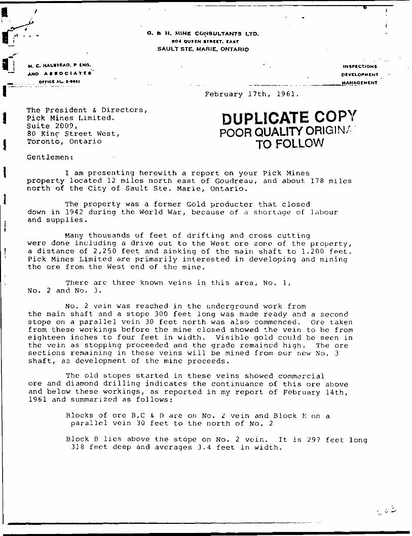
O. ft H. MINE CONSULTANTS LTD.
OO4 QUEEN STREET, EAST
SAULT STE. MARIE. ONTARIO
j M. C. HAUSTEAD. P EMO.
-" AND ASSOCIATES'- orrict AU
The President s Directors, Pick Mines Limited. Suite 2009, 80 Kinr Street West, Toronto, Ontario
Gentlemen:
INSPECTIONS
DEVELOPMENT
MANAGEMENT
February 17th, 1961
DUPLICATE COPYPOOR QUALITY ORIGIN;
TO FOLLOW
I am presenting herewith a report on your Pick Minesproperty located 12 miles north east of Goudreau, and about 178 miles north of the City of Sault Ste. Marie, Ontario.
The property was a former Gold producter that closed down in 1942 during the World War, because of a shortage of labour and supplies.
Many thousands of feet of drifting and cross cuttingwere done including a drive out to the West ore zone of the property, a distance of 2,250 feet and sinking of the main shaft to 1.200 fpet. Pick Mines Limited are primarily interested in developing and mining the ore from the West end of the mine.
There are three known veins in this area, No. l, No. 2 and No. 3.
No. 2 vein was reached in the underground work fromthe main shaft and a stope 300 feet long was made ready and a second stope on a parallel vein 30 feet north was also commenced. Ore taken from these workings before the mine closed showed the vein to be from eighteen inches to four feet in width. Visible gold could be seen in the vein as stopping proceeded and the grade remained high. The ore sections remaining in these veins will be mined from our new No. 3 shaft, as development of the mine proceeds.
The old stopes started in these veins showed commercial ore and diamond drilling indicates the continuance of this ore above and below these workings, as reported in my report of February 14th, 1961 and summarized as follows:
Blocks of ore B,C S D are on No. 2 vein and Block E on a parallel vein 30 feet to the north of No. 2
Block B lies above the stope on No. 2 vein. It is 297 feet long 3] 8 feet deep and averages 3.4 feet in width.

O. ft H. MINE CONSULTANTS LTD.
BO4 QUICN STREET. CAST
SAULT STE. MARIE. ONTARIO
H. C. HAUSTtAO. f" INO.
AND AIIOCIATCS'
orricc AU
INSPECTIONS
DEVELOPMENT
MANAOEMCNT
Q
rebrunry 17th, 1961,The President * Director*, Pick Mitt** Waited, Suit* 2009, 60 Kies Street Weot, Toronto l, Ontario.
I en preheating herewith a report on your Pick Mine* property located Id nil** north ea*t of Ooudresu, end (bout 1?S allen •north of the City of De-ult Dte. Wsrid, Ontario*
The property va* a foraer Ooid producer th*t closed dovn lo 15^2 during the World War, becaua* of e. ebortaa* of labour nad fupplie**
K*ny thou*fcod* of feat of drifting and croon cutting were done including n drlre out to th* Von t ore item* of tlio property, a dlttanca of 2,21*0 feet (md linking of tho jw'n *h*ft to 1,200 feet. McH lUne* United oro primarily interested in dereloplos end tain ing the ore from the Weat end of the aloe.
There we three knovn rein* in this ereo, So* l, Ko* 2 and fto* 3*
Ho. 2 Vela v&v reached in the undersrouod vork fron the twvin ehecft tad 6 atope 300 feet loos vtwt made reedy cod ft tec and 0topa on a rarallel rein 30 feot north * ~** eleo cocenenoed* Ore taker, fron th**e vorhln^* before the aine closed ehoved the rein to ba froa elebteern Incnee to four feet in vldth* Vlslbla gold could bo caen in the vain ea otopins proceeded aaA tlie grade rorwlned high. The ore eectlonn remaining in t Ut D e vain* will be mined frets our nev Ho. 3 shaft, aa deTRlopfflcnt of tho nine proceed*.
The old *tcptA ottvrteA in tbeae. melno Ahoved eccomercieJL ore end dlfcnoad drilll/ift irtdleatev tho continuance of this ore above end belov thee* workings, *a reported in vty report of Febraary 1961 ftnd suitfMtrlted fva follcvai
Q Blosta of on? B, O fc D sore on Ho. C teln cod Blook E on p paraliol vein 30 feet to tho north of Ho. 2*
BXook B Ile* ebove the stope on Bo, 2 vein. Zt la 277 f*et foe t deep ead arernget 3* 1* f o* t In vldth*

-2-
Indicating 26,759 tons with a cut grade of $21.73 per ton Gold and value of 5581,473.000.
Block C. That section of No. 2 vein between 472-R26 drift and 464E sub drift indicating 8,125 tons with a grade of 526.60 and gross value of $216,125.00
Block D. That section of No. 2 vein lying below 464E sub drift and 461-1 stope indicating 7,009 tons with a grade of 522.54 per ton Gold and gross value of $157,982.00.
Block E. The parallel vein to No. 2. This is a wider vein with widths up to 10 feet. The indicated tonnage is 35,100 tons grading $16,38 per ton Gold with a gross value of 5574,938.00.
About 270 feet north of this No. 2 vein lies the No. 3 vein in which work was commenced this past year comprising surface trenching and diamond drilling.
Block A. Is that section of No. 3 vein in which work was done by Pick Mines Limited. It indicates a length of 400 feet, depth of 150 feet and width of 3 feet or 13,875 tons of ore with a cut value of 325.32 Gold per ton and gross indicated value of 5351,315,00.
Work has commenced on this block of ore, which willbe mined by way of a surface level or adit level and also a level 100 feet down the No. 3 shaft.
The start of the open cut for the adit level showsthe vein to be two feet wide, much fine visible gold can be seen in the broken muck. A two foot sample across the vein at this point asaayed 9.21 ounces of Gold per ton, which is much higher than anticipated. In this western section of the mining property there is indicated a 5 year ore supply at s milling rate of 50 tons per day.
The indicated grade is $20.71 per ton with 520.02per ton recoverable and mining and milling costs are estimated at $15.66 per ton.
This would give a monthly production for recoverable gold of 530.030.00. The mining, milling and development costs are estimated at 523,490.00 ptr month, leaving an operating profit of $6,540.00 per month, or 578,480.00 for the 1st year. The first year's ore will be drawn from Block A at the end of which time Block B will be developed, so that ore can be drawn for the mill.
Block A has never been delimited to the east, westor to depth. It is very possible that the vein will go down to the diabase sill ac a depth of 575 feet and also continue on strike. Therefore, it is possible that an additional 50,000 tons of ore will be developed in the No. 3 vein below Block A, and also new ore may be found and blocked out on the strike of the vein.
DUPLICATE COPYPOOR QUALITY ORIGINAL
TO FOLLOWd ^i

l
IJ
11
UuLIy y y
l ' Indicating 26,759 ton* vith ft cut grade of ^21*73 per ton Gold ' and value of 456M73.00,
J f 0 * . |*x. Block C* That oeotioa of no* Z vein betveen V?2-R26 drift and
b&B eub drift indicating 0,125 ton* vith a grode of ^26.60
I and groat value of #216,125*00. A
fc^Block D* That keotioa of no* 2 vein lying bolov t^E cub drift ' and 46l-l atop* indicating 7,009 tons vith a grade of l22.*k
l per ton Ooid and grooa valuo of ^157,902.00.
/Q Dlock E* Ttuj parallel vein to Bo. 2. This la a vlder vein vith
1 ^ vidtha up to 10 feat* Th* Indicated tonnage l* 35,ICO tons grndlng ^16.30 par ton Ooid vith a grota vnluo of ^57'*,933*00.
About 270 fo*t north of thi* No. 2 vein Ile* the llo. 3 Tain la vhloh vork va* coemmced thlo p&at year cce pricing surfnco tr^DChlng and ditnond drilling,
Block A. I* thtt sectioa of 3o. 3 vein in vhich vork VR* dono by Pick Mine* United. It Indlcnte* a length of J*00 feet, depth of 150 f*ct and vldth of 3 feet or 13,075 ton* of oro vith n cut yelua of 4.23*32 Ooid per ton end grosa Indicated value of ^351,315.00.
Work hao coeoenccd on this block of oro, vhlch will/ bo aland by vny of n narf wo level or edit level end idoo a lcvol 100 feet dovn tho Ho. 3 ehaft*
at&rt of tba open out for th9 Adit level nhovs vain to be tvo feet vide, much fioo visible gold cnn ba POOQ in
the broken nuck* A tvo foot 0ojnple ne rosa the vein at thlo point ne B eyed 9.21 ouncea Ooid per ton, vhlch l* touch higher thnn tmticlpnted. la thio veotorrt Bcction of the olalng property thore in indicated *i J year ore supply nt ft nlUUng rate of y) tooo per day.
The inAlcoited Grade i* ^20. 71 per ton vith ^20.02 por ton recoverable *nd nloing And railllns contfl oro estimated At ^13*66 per ton.
This vould give a Donthly production for recoverable gold of 030,030*00. The Dialog, nllXing exnd development costa era entliaated at ^23,^50*00 per nsonth, leaving to opirating profit of (6,51*0.00 por noath or ^70,1*80, CO for the let yewr. The first year 1 * oro vilX be dffivn from Dlock A At the cod of vhich tiara Block 8 will be developed, to that ore cea bo drmm for the mill.
Dlock A hw never beta doliaited to the east, voet or to depthi It in very poflpiblo tbat tho vein will fio dovn tt the diabase oil! nt ft depth of 57? foot and *Loo ccntlnuo oa strike t Therefore, it la poaoiblo that na Rddition*l 50,000 tons of ore vlll bo developed in the Ho* 3 vein balcv Block A, and aleo ney ore cay be found txnd blocked out on tho strike of the voin.

•'
l
l
l
l
l
l
l
l
" 3 "
In addition to the 5 years of higher grade ore Indicated or 90,868 tons In the western section of the mine, there is one and a half years ore In the old section of the mine remaining In place. This lies belov the old stopes in the mine workings; it is a block of ore lying belov the 500 foot level and extending dovn to the flat diabase sill 85 feet belov the 500 foot level. The estimated tonnage in this block is 30,1*37 tons. I have no means of estimating the grade of this ore, therefore, I can only give it a value per ton; as shown recovered In the previous operations of $7•l'^ per ton Ooid for the ore taken out above the level.
It is possible by selective mining and by taking narrower widths to increase this grade considerably.
I anticipate no difficulty in providing the required 50 tons per day for the mill.
Unless anything unforseen happens,'it is our intention to start the grinding and flotation end of the mill on February 2Uth, 1961.
Concentrates from the circuit will go to the concentrate t' thickener for a period of two weeks; then the cyanide circuit will start up to recover the gold from the firot batch of concentrates.
From this point on the mill will be in steady production. The estimated costs from the 1st of February to the pouring of our
. first Brick ore estimated at ^50,000.00 and cade up as follows:
I Electric cable and supplies for the mill ^ h ,700.00Rails 1,651.00Welding 1,203.00
I Oas, Oil for Heating ft Transportation 700.00Power 1,2H5.92Supplies for surface mill 3,000.00Installment payments on equipment 2,000.00
l O. tt H . Mine Consultants 1,000.00Reserve k , 500.00Waees 30,000.00
I There are no other forseeable coste. I am satisfied that the above funds will bc ample to the time we pour our first brick;
. Irora which time the mine production will be sufficient to take, care of B all costs and show a profit os previously outlined in this report.
Respectfully submitted,
0. 4 H. MINE CONSULTANTS LTD.l
lM. C. Halstead, B.Sc.,P.Eng.
a

lil
APPENDIX 4
COPIES OF DRILL LOGS
ON FILE
AT HOWE INTERNATIONAL

lli -it ijijUli APPENDIX5
rf
1 ! COPIES OF ASSAY CERTIFICATES .j
ON FILE
"- AT HOWE INTERNATIONAL
L tLL
"•3
li
APPENDIX 6
COPY OF PROSPECTUS,
APRIL 20, 1964
J .1
•T-1''.
APPENDIX 7
COPY OF MINES BRANCH INVESTIGATION REPORT I.R. 62-97;
FLOTATION AND CYANIDAT10N TESTS ON DRILL CORE SAMPLES
FROM THE GOLD PROPERTY OF PICK MINES LTD.
LOCHALSH, ONTARIO
R. P. BAILEY, 1962
^^^^^^^^^•^•':^ -^v-Vi-,-.^-. , '•v,---.v:: ,MZ^F-WWMFtt^^iMpc: ;r Awn TFrwwir.Ai QMDVCVC ; -
t-.~ '
:. , v—':'.;-;.::v; ; v-X--
•V'V : ^-/^:^;;':-^^-;^f^MINERAL^PROCESSING DIVISION .v, , -' ; ^: : :;?; ;
^•^i®;^t^^ii^S^^^^
: ;^^-;0;V;::[v^P.P-Yv^^p.:i;-2;v;iv.l; ^V;.-V^ f.-1:-A':^S^^S^I^:^h!^;^i^'n-:^^,i;;;^^^K?;:-^^^^^; -:-o.;^^.^ /- A '-^-.^'-^^t^*•:^^••^•^^:•^;^•f^^yMv^^>^^^^^

r* -
lJl
...-., ;. rv- L;-.,
•vi; A V-
555 Booth Street, Ottawa, Ontario.
April 22, 1963.
Mr. A. C. A. Howe, Resident Engineer, Pick Mine* Limited, Suite 302,100 Adelaide Street, "W., Toronto l, Ontario.
Pear Sir j
l am enclosing three copir* (No*, l to 3) of Ration Report No. IR 62-97 entitled, "notation and Cyanldation Te*U on Drill Core Sajtiplf * Irom the Gold Property of Pick Mine* } Limited, Ne*r LocaJsh, Ontario", prepared by tha atalf of ^ur Mineral Procetning Divl*ion.
Yours very truly,
- '.' .•i-'--••'f;'V'.;i'••li,''•' 'i
^
ir-'-
Encl. 3
John Convey, Director, Mines Branch.
•' *" . i f-1 * *.'*
, -'. ^k:^'•v-!.1.v.^-
f.;f:

- i -
Induotrial Confidential
r* Mines Dranch Investigation Report IR 62-97
FLOTATION AND CYANIDATION TESTS ON DRILL CORE SAMPLES THE GOLD PROPERTY OF PICK MINES LIMITED,
NEAR LOCALS!!, ONTARIO
by
R. P. Bailey*
SUMMARY OF RESULTS
A preliminary investigation wan done on a small composite sample of diamond drill core pulps containing 0.71 02 Au/ton and 0.105 oz Ag/ton.
Barrel amalgamation showed that 79.4J5 of the gold was free milling at 63jJ minus 200 mesh.
Straight cyanidation of the oro ground to 89.2# minus 200 mesh extracted 98.2# of the gold with moderate reagent consumption. Flotation followed by cyanidation of tho concentrate gave overall gold and silver recoveries of 90.4# and 81.5# respectively.
Senior Scientific Officer, Mineral Processing Division, Mines Branch, Department of Mines and Technical Surveys, Ottawa, Canada.
i' 1 /

JH
l.1.1
u
INTRODUCTION
Location of Property
Pick Kinos Limited is developing a gold prospect in the Algoma Mining District near Localsh, Ontario, about 168 miles north of Sault Ste. Marie, Ontario.
History
The Company's property includes claims which were worked by Cline Lake Gold Mines Limited from 1938 to 1942. Reported production during that
-l period wao 63,328 oz of gold and 10,600 oz of silver from 331,842 tons of l oro milled. Operations wore suspended in 1942.
Early in 19G1 the present company erected a' concentrating plant with a reported capacity of 200 tons per day, equipped for flotation and cytxnidation. This was operated for a brief period in April, 19G1.
Shipment
A' package containing 49 small samplo bags of assay retains from diamond drill coro pulps, weighing about 25 pounds, was received from Thomas Hoys and Sons, assayers, Toronto, Ontario, on July 24, 19G2. These samples were shipped on instructional from )lr. A.C.A. Howe, Resident Engineer, Pick Mines Limited, Suite 302, 100 Adelaide Street Went, Toronto l, Ontario.
Purpose of Investigation
In letters dated Juno 13th and July 4, 1962, Mr. Howe stated that drilling had been done on new veins north of the old workings and requested as much milling information as could be provided by test work on the small quantity of samplo submitted. In particular, ho asked (l) whether free gold should bo collected by jigging prior to cyanidation, and (2) whether flotation colls would be necessary.
Sampling and Analysis
A composite was prepared by thoroughly mixing all 49 drill core pulp samples. After riffling out three head samples for screen test, chemical and semi-quantitative spectrographic analysis, the remainder was used for test work.
V

. 2 -
Chemical analysis pave the following results:
ColdSilverIron (oolublo)
Sulphur Insoluble
0.71 oz/ton 0.105 oz/ton 5.20 J{ 5.57 Jl 2.03 JJ
73.10 j!.ft*Send -quantitative electrographic analysis showed no other
elements present in economic concentration* Elements detected are listed below in decreasing order of abundance:
I Si (principal constituent)II Ca, Al, Na, To, Mg
UT tot, TiIV Hn, Cd, Ba, Cu, Ni, V, ZrV Co, Cr, B, Mo, Ag (all in trace amounts)
A screen test of the pulp composite showed the following size distribution:
Size
+40 mesh-48 4G5 "-65 +100 "-100 +150 "-150 4200 "-200 "
Weight, fl
1.83.38.312.411.263.0
100.0
Because of the fino nature of the composite sample (86. 100 mesh), no mineralogical examination was made.
minus
From Mineral Sciences Division Internal Reports HS-AC-G2-897, by L. Lutes, August 22, 19G2, and )E-AC-62-930, by R. Buckmaster, August 28, 1962.
From Mineral Scicncoo Division Internal Report HSJIC-G2-883, by E.M. Kranck, August 17, 1962.

~ 3 -
DETAILS OF INVESTIGATION
Because of the omall quantity of sample received (less than 25 pounds) and ito finely ground state, this inveotigation was of a preliminary nature. Toot work vao limited to amalgamation, straight cyanidation of the oro, flotation and cyanidation of the flotation conccntrats.
Teat l, Amalgamation
A1 1,000 g sample of composite pulp as received (63# minus 200 nosh) was amalgamated for one hour with 10 ml of clean mercury and lime equivalent to 2.0 Ib per ton of oro. Amalgam and residue wore analyzed, with results as shown in Table 1.
TAJ1LG l
Rcoults of Amalgamation Test
t
l
L
Lt,
L L.
L
Product
Amalgam Tailing
Feed (calcd) Feed (analyzed)
Annayo * oz /ton of feedAu
0.576 0.150
0.726 0.71
Ag
0.045
**
0.105
Distribution jJ
Au
79.4 20.6
100.0
Ag
A* 57.l"42.9
/
100.0
* From Internal Report H3-AC-S2-897.** The amalgam was not assayed for Ag. Distribution
wao calculated by difference.
Althouch this test indicated that 79.4# of the gold and 57. of the silver wore free milling, no jigging or tabling teats were done because of the finely ground state of the cample.

- 4 -
Tests 2 to fi, Str?.it'ht Cyanidation-1
Four straight .cyanidation teats were dono at 2*1 dilution on 500- gram lots of the composite sample (63^ minus 200 mesh, as received). Agitation times wci'c v&ried from 24- to 72 hours at cyanido and lime solution concentrations of 1.0 Ib/ton and 0.5 Ib/ton respectively, except in Test 5 where cyaniclo concentration was increased to 2.0 Ib/ton of solution. In Test 6, 1000 grams of tha. composite was ground in 750 ml of water for 15 minutes to 89.2^ minus 200 mash and cyanidcd at 2:1 dilution in a solution containing 1.0 Ib NaCN per ton and 0.5 Ib CaO per ton. Because of the very low silver content of the ore, cyanidation residues wore assayed for gold only. Results nro summarized in Table 2.
TABLE 2
Results, of Direct Cyanidation
Teot No.
* 23456**
1. -200m
63.0nHti
89.2
Timo hro
2448724848
1
Concentration Ib/ton solnNaCN
1.0nn
2.01.0
CaO
0.5ttnII
II
Consumption Ib/ton oroNaCN
0.400.480.560.401.28
CaO
1.361.681.921.603.0
Residue Aooaya* oz/ton
Atl
0.0330.0300.0280.0300.013
Gold Extraction
95.495.896.095.898.2
From Internal Reports }S-AC-62-897 and 968.
Reducing povor in thin teat was 112 ml 0.1 N KHn04 per litre.
Although these results rcarkcd the ore as being very amenable to straight cyanidation, tho fact that flotation equipment was already installed in Pick Mines mill prompted tests of bulk /dotation followed by cyanidation of the flotation concentrate.
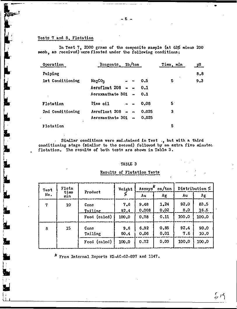
- 5 -
Testa 7 and 8, Flotation
In Test 7, 2000 grans of tho composite sample (at 63JJ minus 200 mesh ( as received) vcro floated under tho folloving conditions:
Operation
Pulping1st Conditioning
Flotation
2nd Conditioning
Flotation
Reagents, Ib/ton Time, min JE!L
Aerofloat 208 - Aoroxanthato 301
Pino oil ,-
Aerofloat 208 - Acroxanthato 301
0.5 0.1 0.1
0.08
0.025 0.025
8.8 5 9.3
5
3
i. Similar conditions voro maintained in Teat ,, but with a third conditioning stago (similar to tho occond) followed by on extra five minutes, flotation. Tho results of both tests aro shown in Tablo 3.
lli i.L
TADLE 3
Rooults of Flotation Testa
Test No.
7
8
Flotn timo min
10
15
Product
Cone TallinnFood (calcd)
Cone Tailing
Feed (calcd)
Height *
7.6 92.4
100.0
9.6 90.4
100.0
X . Assays oz/tonAu
9.48 O.OG80.78
6.92 0.06
0.72
Ag
1.24 0.020.11
0.85 0.01
0.09
Distribution #Au
92.0 0.0
100.0
92.4 7.6
100,0
Ag
83.5 16.5
100.0
90.0 10.0
100.0
From Internal Reports )B-AC-62-897 and 1147.
uLLi.

- G -
Lov-povcr microscopic elimination of tho bulk concentrate showed sulphides, chiefly pyrito, in fine quartz gangue. Ono grain of gold attached to pyrite Mao, observed. T^o presence of pyrite-quartz middlings, seen in tho concentrate and in tho tailing, suggested that higher recoveries might bo achieved by finer grinding, but lack of oro provontod further flotation testing.
Test 9, Cyanidation of Flotation Concentrate
A 150-sram oamplo of flotation concentrate from Tost 8, was re- ground for 15 minutes to 99.4# minuo 200 mesh and cyanidod at 4tl dilution for 48 hours uning sodium cyanido and limo solution concentrations of 1.0 Ib/ton and 0.5 Ib/ton respectively. Results are summarized in Table 4.
TABLE 4
Cyanidation of Flotation Concentrate
Consumption Ib/ton of .oro
NaCN CaO
0.48 0.64
Reducing Tower
mlO.1 N iain04/!
240
Assays oz/tonConcentrateAu
G.92 ,
Ag
0.85
ResidueAu
0.145
AE
0.08
Extraction t
Au
97.9
Ag
90.6
From Internal Report )!S-v\C-62-1147.
On tho basis of feed to flotation, overall recoveries worej
Gold, 90.4#; Silver, 81.5#.

- 7 -
CONCLUSIONS
This investigation, done on a composite prepared from assay retains of 49 drill core pulp samples, was limited by the small quantity of material (loss than 25 pounds). Assay of the blended composite sample showed gold and silver contents of 0.71 oz/ton and 0.105 oz/ton respectively.
Because of tho fine nature of the pulps (86.6# minus 100 mesh), no mineralogical examination was made. However, the presence of free gold and silver waa indicated by extractions of 79.4J& and 57.2/J respectively, in barrel amalgamation. Partial association of tho remaining fcold and silver with tho sulphides may be inferred from tho increased recover!?-, obtained in the bulk oulphido flotation.
Tho fine state of the submitted sample made gravity separation tests impractical. It is probable that jigging or other means will recover the free gold, but this would have to be confirmed by tests on a repre sentative sample of raw ore.
On tho basis of teats on tho drill core pulp samples, the ore seems particularly well suited to treatment by straight cyanidation. By that method, 98.2# of tho gold was extracted in 48 hours from ore at 89.2J5 minus 200 mesh, with cyanide and limo consumptions of 1.28 Ib/ton and 3.0 Ib/ton respectively.
Tho effectiveness of bulk flotation is indicated by tho fairly high recoveries of gold and silver (92.4J* and 90.0/5 respectively) obtained by treatment of tho composite sample at 63J{ minus 200 mesh. Lack of ore prevented further flotation tests. Subsequent cyanidation of the bulk concentrate extracted 97,9# of tho gold and 90.6# of the silver for overall recoveries of 90.4# and 81.5J5 respectively. These results and tho relat ively high concentration ratio (averaging 11.6 in two tests) warrant consideration of flotation and cyanidation of tho concentrates, particularly in view of tho presence of these facilities in tho existing mill.
Tf the gold and silver are to be recovered by straight cyanidation (which gave tho best results in this limited investigation), it would be advisable to have a jig. table or trap in the grinding circuit between the ball mill and tho classifier. Without such facility for removal of coarse, free-culling gold, its build-up in tho circuit v/ould cause metallurgical itibalonco bot\.'ccn tho amount of gold in the mill feed and tho quantity re covered, and vrould eventually cause high tailing loss whenever surges occurred in mill operation. In a flotation-cyanidaticn mill circuit, a unit coll installed after tho ball mill would be eindlarly effective.

- 8 -
ACKNOKLEWEHENTS
Tho vritov wishes to acknowledge the contribution to thisinvestigation by nor.iboro of the liinernl Scienceo Division, namely, L. Luteu, C. A , Berry, D. H. Cumming, and R. W, Puckmaotor for chemical analyses, and ' E. M. Krwick for spectrographic nnalyooa.
l
ii
c., f

Awer
es
Twp.
M.
122
1
' ^
A ;
iJU&s
L -
; - ^
r\5
!,H
y
J^^^
Ti^
Til-
T^
!'*iW
Y'hi
; V7
^4^|
""i j
j 2 f?;
g; ir i-
if! r^lf SP
"; I^
Ta^
v [
; s^
i\| s
i/
^r^
ll^li
r!^^
^ a\
'2
st vs
a i
s
i a
s *
a i r
^r^f
7'
S^^*
?~s
^~ *
•u.H
rv"-.-
wr-i--
--'
* i"
' /: s
i "
' 8
I'i k^
l *
121
* j
i c
i i
S i
---T
|--^
S
i i
? ig
vi'
f i 5
4 i-
'^V
1 r
\ s
'.---
4--
-J ..
--i-,.
is-A
L-
t i ^
f.\' ^
-* vi
si?
?H
f'
s1
i s
gf
gs i
si "
"sjj'
i/ " ""
" ^
X ^
' J
' S
" ;
! S
' 5
' ^^T
^^X
^-N
. ^
^
----
--V
L^_i_
-l
. 'f
" Lr
^Tu"
J
L -i
^X
-A^
^I'l^
isi'
i| "^
IJr^
Cl^
T
^: 0
i -
' "
; i
S'
"r IT
! v.
"
ijl^
utj"f
^F
fl^X
*
L
/-x^
^xr^
j—
^ i T
\ri-^
i3i
81 J
' V
——
^/^
^
^^
Ande
rson
Twp
. M
.113
7

ROAO
o z AU.IA.O
SHAFT.ROAD
\ 2 3 64*02 GRAB
o o
POSSIBLE ORE 9.000 TONS ABOVE AOiT
50.000 " BELOW
1WT- LTD.100-435
u CLINE LAKE GOLD MINES
LOCHAL3H. ONTARIO
PLAN S HOWING
SHAFT, PROPOSED AOIT a pfTs
OATEO APRIL 22*.; ! S3 j

00-
330*i^^
NO a f w y GUN-i v/voui Qqy'W*
42C08SW8739 JACOBSON0876 JACOBSON 900
THIS MATERIAL WAS DONATED BY:
A.C.A. HOWE INTERNATIONAL LTD.
AND
CLINE DEVELOPMENT CORP.

CO
NS
^
l

XPICK M INES L IMITEDPLAN OF DRILL HOLES WITH ASSAYS
Bunkhout*
CooVer f
Office
HOIlt
M Jf fur e Shop
H c US t'Scale 40 fuet to t inch
Li AIM GROUPSi ui*- 1/2 Ti' Hydro Subnotion
2 O -O 17o-o o^
30-OOI
2 0-0 06O- O O 3
f S-O 02
16235 H-4 -O 06 (6223*1 3 6'-0-0
m5-3 62 0-1 72(6100)
20-0 19 7 . \ 16174)10 -O
2 5- O O '1161 35 2 5'-O 55 (6093
1 d-3 JO2 O O 02
H-OO7(6i2O)
t 4'. 3 69(61051500 6!l6Q75](60B5')50 . O- 07 'P- 4 (fi300 l
50"-0 05(6103')50 -0.07(6053 ) 5-0 375.O*-0.03 (6080*) ^' c s osX
• "vtrllcol ^ o l i
2 5-022(6035 l 2 3 -O 64
IVJT.LID
- ^^7^42C0SSW8739 JACOBSON0076 JACOBSON'

MIN
ES
LT
DS
HA
YN
EE
CO
NSO
LID
ATED
PIC
K
MIN
ES
LI
MIT
ED
Stro
bus
Lake
HOWE
RIC
K
MIN
ES
U
.MIT
ED
Folia
tion
Conta
ct
Majo
r F
aults
Min
or
Faults
GEO
LOG
YTW
R
48
. S
AU
LT
SA
INT
M
AR
IE
MIN
ING
D
IVIS
ION
ON
TA
RIO
0076

^ 11 16 N i' 30" 26': 14" 30
//V JV J2/-f" 10" 24" 18
\-H-hH. ^ 0^ O?"~ ~" 12" 26" 2O
- :* "^ ' Vs' * '
."X* -.V'.A--.^