RPT ON THE PHASE I EXPL PROG - Geology Ontario
105
42L03NW2004 2.19111 OBOSHKEGAN 010 19111 OBOSHKEGAN PROJECT REPORT ON THE PHASE X EXPLORATION PROGRAM for "RECEIVED" c:: ' s '393 GEOSCSENCf ASSESSkAENT OfHCt Douglas P. Parker September 3, 1998
-
Upload
khangminh22 -
Category
Documents
-
view
0 -
download
0
Transcript of RPT ON THE PHASE I EXPL PROG - Geology Ontario

42L03NW2004 2.19111 OBOSHKEGAN 010
19111
OBOSHKEGAN PROJECT
REPORT ON THE PHASE X
EXPLORATION PROGRAM
for
"RECEIVED"
c:: ' s '393GEOSCSENCf ASSESSkAENT
OfHCt
Douglas P. Parker September 3, 1998

TART.K QF COM'i'KMTS 42L03NW2004 2.19111 OBOSHKEGAN 010C
INTRODUCTION...................................... lLOCATION................................... . . . . . . . lACCESS................................... . . . ...... l
REGIONAL LOCATION MAP........................ 2PROPERTY.................................... . . . . . . 3PREVIOUS WORK..................................... 3
CLAIM MAP.......................... . . .. . . . . . . 4REGIONAL GEOLOGY MAP......................... 6REGIONAL GEOLOGICAL COMPILATION MAP.......... 7
GEOLOGY........................ . . . . . . . . . . . . . . . . . . . 8CURRENT STUDY....................... . . . . . . . . . . . . . . 9
GEOLOGICAL+GEOCHEMICAL COMPILATION MAP....... 10GEOPHYSICAL COMPILATION MAP.................. 11
RESULTS............................ . ..... . . . . . . . . . 12CONCLUSIONS AND RECOMMENDATIONS................... 14
APPENDIX I: Rock Sample DescriptionsAPPENDIX II: Assay CertificatesAPPENDIX III: Geophysical Survey Theory and ProcedureAPPENDIX IV: Report by M. LavigneAPPENDIX V: Report by F. GlassAPPENDIX VI: Diamond Drill Hole Logs
MAPS IN BACK POCKETMAP l Magnetic Contours (1:5000 scale)MAP 2 VLF Profiles (1:5000 scale)MAP 3 VLF Fraser Filtered Contours (1:5000 scale)MAP 4 HLEM 444Hz Profiles (1:5000 scale)MAP 5 HLEM 1777HZ Profiles (1:5000 scale)MAP 6 HLEM 3555Hz Profiles (1:5000 scale)MAP 7 IP Section Line HE (1:5000 scale)MAP 8 IP Section Line 12E (1:5000 scale)MAP 9 IP Section Line 13E (1:5000 scale)MAP 10 Diamond Drilling Section (1:500 scale)FIG 5 Geological+Geochemical Comp. (1:2500 scale)FIG 7 Geophysical Compilation (1:2500 scale)

INTRODUCTION
The Oboshkegan Lake Property is located 230 kilometres northeast of Thunder Bay and is underlain by rocks of the Wabigoon subprovince part of the Superior structural province of the Canadian Shield.
The area around the Oboshkegan Lake Property hosts numerous significant occurrences, deposits and past and present producers of gold and base metals yet the project area is largely unexplored.
The rationale of the project was to investigate the potential for economic gold mineralization along the strike extension of Knucklethumb Deformation Zone which contains significant gold mineralization on Cameco Gold's property immediately to the west.
From the fall of 1997 to July of 1998 Landis Mining Corporation undertook a systematic exploration program. Due to a lack of bedrock exposure and perceived thick overburden, the program relied heavily on geophysics with followup testing by diamond drill.
LOCATIOM
The project is located 230 kilometres northeast of Thunder Bay and 14 kilometres south of Tashota, a railroad siding on the C.N.R.'s northern line (Fig 1).
Claim Map Sheet: G-173 Oboshkegan Lake, Thunder Bay MiningDivision
ACCESS
The project area is accessed by traveling on the all weather Kinghorn Road which departs north from Highway 11 about 6 kilometres east of the town of Jellico. At kilometre 92 on the Kinghorn Road, a skidder trail turns southeastward through cutover for about four kilometres where it crosses Red Paint Creek and proceeds to Landis's 1998 drill setups. Access is also achieved by float plane on Gledhill and Oboshkegan Lakes.
-l-

Oboshkegan Lake PropertyLandis Mining Corporation
Figure l : Property Location50 kilometres
PROpjKRl'Y
The property consists of 17 contiguous unpatented mining claims (191 units, 7,640 acres) recorded in the Oboshkegan Lake Area of the Thunder Bay Mining Division as follows (Fig 2):
1215526, 1215527, 1215528, 1215529, 1215530, 1215531,1215532, 1215533, 1215534, 1216579, 1216582, 1216583,1216584, 1216585, 1216586, 1216651, 1228183
PREVIOUS WORK
Lavigne (1998) describes the exploration history of the area.
Portions of the Oboshkegan Lake property were explored for iron, and two significant exploration programs explored portions of the property for base metals. No record exist of any gold exploration on the property. From 1973 to 1977, Noranda Exploration Co. Ltd. conducted ground EM and Mag, soil and basal till sampling, and diamond drilling on a claim block bordering on Oboshkegan Lake, extending southeastward (MNDM files 2.1304, 2.1979, 2.236). A government airborne survey found a high density of strong EM anomalies in this area(OGS Map 81291, 81292, 81285). Soil anomalies with values as high as 96 ppm Cu and 460 ppm Zn, and basal till samples with values as high as 625 ppm Cu and 625 ppm Zn were generated. Five coincident EM-soil^asal till anomalies were drilled, only one of these holes was on the property (hole OB4-77). The results were consistently disappointing in that zones containing pyrrhotite and graphite with low base metal values were intersected. Hole OB4-77 was selectively assayed. Only sulphide rich portion were assayed. Significantly, sericitic volcanics with fine disseminated sulphides described in the drill logs were not assayed. Some soil and basal till samples did not coincide with EM conductors. One such zone, on the south shore of the north end of Oboshkegan Lake, called the North Zone by Noranda, was not drilled. At this location the soil anomalies were broader, and only partly coincided with two EM conductors. Holmer Gold Mines conducted an extensive airborne survey in 1984. Their southeast boundary is the south shore of Oboshkegan Lake, and the overlap between their survey and the present property was minimal.
Of greater significance to the mineral potential of the Oboshkegan Lake Property is the historical and current activity and the geology of the Knucklethumb property, which lies to the west, and is bounded south and east by the
-3-

•m m
V'#,
"t 1207198———— -n. . ——— .—— ————i 1207146 1210507 I2I53I3 F—-*
•^16586
121552.9
Oboshkegan Lake PropertyLandis Mining Corporation
Figure 2 : Claim Map; Oboshkegan Lake, G173

Oboshkegan Lake Property (Figs 3+4). This property contains six gold showings that define an east-west trending structure within a felsic volcanic package. Both the structure and the host lithology continue onto the Oboshkegan Lake property. The Knucklethumb property has been under option to Cameco Gold Inc. for the past two years. Exploration on the property has been escalating, and a second diamond drilling campaign is planned for early 1998. Gold was originally discovered on this property in 1915 and the property has been explored intermittently ever since, often for base metals only.
The northernmost two zones are the Etilahxe and the MVP zones. The Etilahxe zone has been described as laminated cherty tuff and pyrite, 0.2 m wide, traced for 75 m. Grab samples assay results were as high as 1.58% Cu, Q.98% Zn, 0.64 opt Ag, and 0.017 opt Au. At the MPV zone, pyrite and chalcopyrite bearing veins and veinlets are hosted by silicified mafic volcanics. The zone is 1.2 to 1.5 m wide and contains up to 5% pyrite. A grab sample collected by the Ontario Geological Survey assayed 0.49 opt Au. On the southern trend of the gold occurrences, the westernmost is the Jazz occurrence. The mineralization consists of massive, stringer, and disseminated pyrite in iron carbonate altered felsic volcanics. Surface samples assayed 0.71 opt Au over 1.52 m. To the east, the Claimlin zone consists of coarse gold, chalcopyrite and pyrite in sheared, sericitic felsic volcanics that contain up to 3% pyrite. This east trending zone was traced for "several chains". Drill intercepts assayed 0.16 opt Au over 5.8 m and 0.21 opt Au over 3.0 m. The Rhyne zone consist of sheared and altered felsic volcanics containing fine disseminated pyrite. The zone is east striking, 10 metres wide, and may extend for 120 m. A grab sample of altered felsic volcanics containing disseminated pyrite assayed 0.670 opt Au. The most easterly zone, the Cabin zone, has produces assays from grab samples as high as 0.137 opt Au. One kilometre east of the Knucklethumb property, along the same trend, the Kipper- Cameron gold prospect received much attention prior to WW2, as evidenced by a shaft and trenches. This mineralization is described as a shear zone along a mafic and felsic volcanic contact.
It is evident from the above compilation of gold occurrences on the Knucklethumb property, that they are contained within a one kilometre wide corridor containing numerous mineralized shear zone. This corridor can be traced for 10 kilometres, onto the Oboshkegan Lake Property to the east. Collectively, these numerous shear zones found at the sites of gold mineralization, and mapping in 1996 by the Ontario Geological Survey which characterized much of the rock as strongly deformed (OGS Map P3365), defines a deformation
-5-

__^.--p r- * vv\sj; .V ^l* - 'C 1 i\ K
D
i s / ,..E —R
.**i5/
Oboshkegan Lake PropertyLandis Mining Corporation
Figure 3 : Regional Geology,
i^s-i

OBOSHKEGAN LAKE PROPERTY BEARDMORE - GERALDTON AREA
GEOLOGICAL COMPILATION
ETIAKXE ZONE 0.017opl Au. 0.64cpl Ag,
JAZZONE0.71oplAu, 0.l6oplAg/ l .Em
and 0.40floct Au,
LANDIS MINING CORPORATION (LIS - ASH)
1 kilometre
PROPERTY LOCATION
METASEDIMENTS
MAFIC INTRUSIVES
FELSIC INTRUSIVES
GOLD OCCURRENCE
SHEARING
LANDIS MINING CORP.
PROPERTY

zone, which will be referred to as the Knucklethumb Deformation Zone. Thios deformation zone is a significant crustal structure, that has served as a pathway for mineralizing fluids, that can be projected onto the Oboshkegan Lake Property with confidence. It has produced various styles of mineralization, a common one being the occurrence of gold in pyritized felsic volcanics over substantial widths. This style of mineralization is more common to larger tonnage gold deposits, and is a favoured target type.
GEOLOGY
Lavigne (1998) describes the geology of the area.
The "Oboshkegan Lake" property is underlain by Archean age volcanic rocks of the northeastern portion of the Onaman- Tashota greenstone belt in the eastern Wabigoon Subprovince of the superior Province in the Canadian Shield (Figs, l, 3+4). They consist of east-west trending altered mafic and felsic volcanic rocks which contain an abundance of interflow, sulphide bearing, graphitic mudstone and iron formation. These rocks have been intruded by numerous gabbroic bodies. The belt is bound by late tectonic plutons of granodiorite to monzodiorite. The volcanic rocks have been metamorphosed to greenschist facies with amphibolite facies rock located in the thermal aureoles of the plutons. Alteration in the area consist of; synvolcanic chlorite alteration of the matrix in rhyolite autobreccias, (hornblende in higher grade rocks); syntectonic iron carbonate alteration (*/- chlorite, sericite, and minor green mica) is associated with gold mineralization in sheared mafic and felsic volcanics and gabbro; and post tectonic calcite, epidote and albite along fractures. Tourmaline is common accessory mineral in veins, and kyanite an exotic alteration mineral in felsic volcanics.
The north-eastern portion of the Onaman-Tashota greenstone belt, an area 1400 square kilometres in size, contains an abundance of mineral deposits. The first discovery in this area was made in 1904 by a survey crew for the Transcontinental Railway. Their initial discovery of iron led to many more. Soon after the completion of the railway in 1913, the first of many gold discoveries was made. Minor production came from the Tashota-Nipigon Mine, 8 km SW of the property and the Consolodated Louanna Gold Mine, 40 km to the northeast. Base metal occurrences are also common in this area. Much of the exploration activity in this area in the last 40 years has been the search for volcanogenic massive sulphide deposits. The largest deposit found to date is the Marshall Lake deposit, which contains 2.2 mt averaging 1.22% Cu, 4.2% Zn, 62.45 opt Ag and 0.012 opt Au.
-8-

CURRENT STUDY:
From the fall of 1997 to July of 1998 Landis Mining Corporation undertook a systematic exploration program on the Oboshkegan Lake Property which examined the projected eastern extension of the Knucklethumb Deformation Zone in order to identify gold mineralization. Due to a lack of bedrock exposure and perceived thick overburden, the program relied heavily on geophysics with followup testing by diamond drill.
A 40 kilometre cut grid was established on the eastern boundary with Cameco Gold's property. The base line was cut at 070 degrees with lines turned off at 100 metre spacings with stations at 25 metre intervals. Mike Tremblay of Quantec Consulting Inc. of Timmins supervised the line cutting.
Magnetometer and VLF EM surveys were conducted across the entire grid. Mike Tremblay of Quantec Consulting Inc. of Timmins supervised the surveys. Survey data is plotted at 1:5000 scale on Maps #1, 2 + 3. Instrumentation and survey procedures are described in the appendix.
Max-min EM was conducted over 8.8 kilometres of line on the northeastern part of the grid. Larry Mealey of Grey Owl Resources of Thunder Bay supervised the survey. Survey data is plotted at 1:5000 scale on Maps # 4, 5 + 6. Instrumentation and survey procedures are described in the appendix.
IP EM was conducted over 3.3 kilometres of line on the northeastern part of the grid. Larry Mealey of Grey Owl Resources of Thunder Bay supervised the survey. Survey data is plotted at 1:5000 scale on Maps #7, 8 + 9. Instrumentation and survey procedures are described in the appendix.
A technical report and interpretation of VLF/magnetic/IP data was prepared by F. Glass in March, 1998 and is included in the appendix.
16 soil, 25 peat and 5 rock samples were collected from the northeastern part of the grid under the supervision of M. Lavigne and were analyzed for Au, Ag, Cu, Pb and Zn by Chemex Labs Ltd. Assay results are listed in Appendix I and plotted on Figure #5.
28 rock samples were collected by the author during prospecting of the northeastern part of the grid as well as on Oboshkegan Lake and were analyzed for Au by Accurassay Labs of Thunder Bay. Assay results are listed in Appendix I and plotted on Figures 15+6.
-9-

9+OON
8+OON
7+OON
6+OON
5+OON
4+OON
3 + OON
964 (^) A 963 ^5) A 962(4)
SDA1
LIGEND
J FELSIC TUFF
2 WTERUEDIATE TUFF
1 MAFIC VOLCANIC
Fotatiwi Vvticol.
Outcrop
0 1998 Diomond Drill Hoto
4 * Soil SompU Au (ppb)
Crab Sompta Numtxr (Au ppb)
Port of Claim 1215531
150
L9E L10E L11E L12E L13E L14E
LANDIS MINING CORPORATION
DBDSHKEGAN PROPERTYOEOJXilCAL AND GEOCHEMICAL COPILATIDN
FIGURE 3
DOUG PARKER

Sample No. Au(ppb)965 ^966 ^967 <5968 <5969 ^970971972973974975976977
<5 <5 <5
11 13 9 <5
1215527
1.0
LANP1S MINING COKPOKATION
DBDSHKEGAN PROPERTYPROSPECTING SAMPLE UEAT1QNS
FIGURE 6
SDA GBOLOfflCAL SERVKRS UHRED

94'
8+OON
7+OON
6-t-OON
5+OON
4+OON
3+OON
L9E L10E L11E L12E L13E L14E
GEOPHYSICAL COMPILATION
- x UN; PROFILES ( i cm - 500 nr) v BOM Lrm 58700 nT
Q] f CHARGEABILITY
IP RESISTMTY
f "'i V\f FRASER FILTER CONTOUR
Port of Clolm 1215531
LANDIS MINING CORPORATION
DBDSHKEGAN PROPERTYGEDPYSICAL COHP1LATICN
FIGURE 7
MUG PARKER

Three NQ diamond drill holes totalling 500 metres tested the eastern part of the grid. Forage St Lambert under the supervision of Marc Bourgela conducted the drilling. The author provided geological supervision of the drilling program. 96 samples were split and analyzed for Au by Accurassay Labs in Thunder Bay. The drill section is plotted at 1:500 scale on Map #10.
RESULTS:
Lavigne (1998) describes the results of the magnetic and VLF-EM surveys, (Maps #1, 2 * 3).
In the southern portion of the survey, well defined northeast trending conductors are coincident with magnetic highs. These are the same conductors that Noranda Exploration Co. found in the course of their surveys, and later discovered by diamond drilling to be barren massive pyrrhotite and graphite. These are interflow sediments and corresponding EM conductors are formational. These strong conductors mask the disseminated sulphides within hydrothermally altered felsic volcanics that were intersected in Noranda's drilling, and not assayed for gold. Within the north half of the grid, the conductors found are parallel to the Knucklethumb deformation zone. Several half kilometre long, east trending conductors are stacked in an area that is transitional from "normal" magnetic response to one that is low and flat.
The anomalies which Lavigne describes within the north half of the property occur from Line 9E to Line 14E and from 1+OON to 10+OON. He suggests that the low flat magnetic response may be attributed to hydrothermal alteration of felsic volcanic rocks possibly related to gold mineralization and that the VLF-EM conductors may be produced by zones of shearing.
Limited prospecting and soil sampling was undertaken over the most prominent anomaly in this area which is centered from Line 9E to Line 14E from 5+50N to 8+OON. The area of the VLF-EM anomaly is extensively covered by cedar swamp with linear outcrops of felsic to intermediate volcanics occurring immediately north and south of the indicated anomaly. Of the five rock samples collected, all returned ^ ppb Au. Lavigne describes the results of the soil sampling. Of the 16 soil samples collected, 2 were clearly anomalous in copper, and 3 in zinc. These anomalies coincide perfectly with the conductors. The 25 peat samples collected established a threshold level of 8 ppm for copper, 3 samples exceeding that value, Ippm for lead, 3 samples exceeding that value, 50 ppm for zinc, 4 samples exceeding
-12-

that value. These geochemical anomalies also coincided with the conductors, but tend to be on the north side.
On the basis of the geophysical and geochemical anomalies and the geological setting Lavigne suggested that both VMS and mesothermal gold mineralization similar to that which exists at Les Mines Selbaie, a major producer of Cu-Zn-Ag-Au in northwestern Quebec, may be present in this area.
Max-min EM surveys were then conducted over this area but failed to indicate the presence of strong conductors or confirm the previously identified VLF-EM anomalies, (Maps#4, 5 * 6).
IP-EM was conducted over three lines which crossed the VLF- EM anomalies, (Maps f 7, 8+9) . Frank Glass, a consulting geophysicist, identified resistivity low and chargeability high anomalies which occurred immediately north and south of the VLF-EM anomaly, (Figure #7). These IP anomalies correspond well with outcrop exposure of felsic to intermediate volcanic rocks containing local concentrations of fine disseminated pyrite, quartz-tourmaline stringers and ankerite alteration.
Three diamond drill holes were used to fence across the main VLF-EM anomaly as well as test the southern IP-EM anomaly which appeared to become stronger with depth, (Map #10). The northern IP-EM anomaly was partially tested by LO98-02 which collared in the anomaly but was not completely tested by drilling due to extensive exposure of outcrop in the anomaly area and a desire to limit the program to 500 metres. The drill holes intersected intermediate crystal to lapilli tuff with minor felsic tuff and mafic dykes south of 6+45N and felsic crystal to lapilli tuffs with minor mafic dykes to the north of 6+45N. Slightly elevated gold values 10-50 ppb occur with very fine grained pyrite mineralization and quartz tourmaline stringers. The highest gold value returned was 135ppb.
Of the 28 rock samples collected by the author, only sample 956 located on TB1215531 at 13+OOE 8+65N returned significant gold (276 ppb Au) from a selective grab of a 10cm quartz tourmaline vein with rusty spots and irregular folding, (Fig #5).
-13-

CONCLUSIONS AMD
The Oboshkegan Lake Property exhibits stratigraphy, alteration and mineralization similar to that found on Cameco Gold's Knucklethumb Property located immediately to the west. The Oboshkegan Lake Property is along the projected strike extension of the Knucklethumb Deformation Zone which may be a significant control of regional gold mineral i zat ion .
The lack of bedrock exposure on the northern half of the property is a hindrance in evaluating the strike extension of the Knucklethumb Deformation Zone, however, overburden thickness may be minimal over a large portion of this area.
The next phase of exploration should concentrate on identifying gold and base metal mineralization in rock and soil followed by appropriate geophysical methods to prioritize targets for mechanical stripping and diamond drilling.
An orientation geochemical survey should be undertaken on lines 2E to 8E north of the baseline. Humus and B horizon should be sampled at 25 metre intervals. Analysis by neutron activation for multi-elements should include Au, Ag, As, Cu and Zn as a minimum.
Airphoto analysis could be used effectively to identify areas of outcrop and aid in prospecting and reconnaissance mapping over the entire property.
-14-

STATEMENT OF QUALIFICATIONS
I, Douglas P. Parker do hereby certify:
I ara a resident of 365 Lark Street, Thunder Bay, Ontario, P7B 1P4.
I am a graduate of Lakehead University, Thunder Bay, Ontario (HBSc Geology 1985).
I have been employed as an exploration geologist for government and industry since 1985.
I am a member in good standing of the Canadian Institute of Mining and Metallurgy and the Northwestern Ontario Prospectors Association.
I have not received nor do I expect to receive any direct or indirect interest in the company or its properties.
Douglas P. Parker

APPENDIX I
Rock Samole Descriotions

970 (TB1215528 NORTH SHORE OF OBOSHKEGAN LAKE) ^ ppb Au Representative Composite Grab: cherty felsic volcanic with quartz vein stockwork, ankerite and tourmaline.
971 (TB1215528 SOUTH SHORE OF OBOSHKEGAN LAKE) ^ ppb Au Representative Grab: cherty felsic volcanic, up to S-5% pyrite.
972 (TB1215528 ISLAND IN OBOSHKEGAN LAKE) ^ ppb Au Representative Composite Grab: shear zone 3mxlm 060-080N, intermediate to felsic tuff l-3% fine to medium grained pyrite.
973 (TB1215528 NORTH SHORE OF OBOSHKEGAN LAKE) ^ ppb Au Representative Composite Grab: quartz stringer zone over 40cm in medium grained gabbro.
974 (TB1215528 NORTH SHORE OF OBOSHKEGAN LAKE) 11 ppb Au Representative Composite Grab: irregular quartz vein pod with minor pyrite and ankerite.
975 (TB1215528 NORTH SHORE OF OBOSHKEGAN LAKE) 13 ppb Au Representative Composite Grab: graphitic argillite, 25cm, 3- 5% pyrite, rusty.
976 (TB1215528 @ 975) 9 ppb AuRepresentative Composite Grab: intermediate to felsicvolcanic, S-4% very fine pyrite.
977 (TB1215528 @ 975) ^ ppb AuRepresentative Composite Grab: felsic lapilli tuff, rusty,S-5% very fine grained pyrite and pyrite clasts.

960 (TB1215531 10+30E 5+20N) <5 ppb Au
Selective grab: felsic-intermediate tuff, minor ankerite,trace pyrite, minor quartz-tourmaline stringer.
961 (TB1215531 11+90E 8+17N) <5 ppb AuSelective grab: felsic tuff It very fine grained pyrite.
962 (TB1215531 11+90E 8+25N) <5 ppb Au
Selective grab: felsic tuff It very fine grained pyrite,rusty.
963 (TB1215531 11+90E 8+32N) ^ ppb AuSelective grab: felsic tuff ^* very fine grained pyrite,rusty.
964 (TB1215531 11+85E 8+40N) <5 ppb AuSelective grab: 2cm quartz tourmaline stringer, minor rust.
965 (TB1215528 NORTH SHORE OF OBOSHKEGAN LAKE) ^ ppb Au Representative Composite Grab: quartz tourmaline stringers l-3cm.
966 (TB1215528 @ 965) ^ ppb AuRepresentative Composite Grabintermediate tuff hostingquartz stringers
967 (TB1215528 NORTH SHORE OF OBOSHKEGAN LAKE) ^ ppb Au Representative Grab: quartz vein 5cm minor ankerite, flat dip.
968 (TB1215528 @ 967) ^ ppb AuRepresentative Composite Grab: felsic volcanic, cherty,silicified?, It very fine grained pyrite.
969 (TB1215528 NORTH SHORE OF OBOSHKEGAN LAKE) ^ ppb Au Representative Composite Grab: cherty horizon in felsic tuff, 2-3 % very fine pyrite, numerous sinistral offsets Imxlm along 3300 vertical slips.

SAMPLE NUMBER. LOCATION, ASSAY AND DESCRIPTION
951 (TB1215531 12+30N 5+30E) ^ ppb Au
Selective grab: quartz-tourmaline stringer with tr. py 4cmin intermediate to mafic volcanic minor ankerite andsericite.
952 (TB1215531 12+25E 4+95N) ^ ppb AuSelective grab: quartz-tourmaline stringer with tr. py 10cm in intermediate tuff moderate ankerite and sericite, irregular folding.
953 (TB1215531 11+50E 4+50N) ^ ppb AuSelective grab: quartz-tourmaline stringer 8cm inintermediate tuff moderate ankerite and sericite, irregularfolding.
954 (TB1215531 11+OOE 4+40N) ^ ppb AuRepresentative Composite Grab: quartz-tourmaline vein up to0.75mx5.0m moderate ankerite and sericite, rusty.
955 (TB1215531 11+50E 7+75N) ^ ppb Au Representative Composite Grab: felsic tuff l* fine disseminated pyrite, 1(^ quartz tourmaline stringers.
956 (TB1215531 13+OOE 8+65N) 276 ppb AuSelective grab: 10cm quartz tourmaline vein irregularfolding, rusty.
957 (TB1215531 13+OOE 8+65N) 7 ppb AuRepresentative Composite Grab: felsic tuff, rusty, minorvery fine grained pyrite.
958 (TB1215531 10+05E 3+80N) ^ ppb AuRepresentative Composite Grab: mafic volcanic, ankerite,minor fine grained pyrite
959 (TB1215531 10+30E 4+60N) ^ ppb AuSelective grab: 10cm quartz tourmaline vein trace pyrite,minor ankerite, at contact of felsic and intermediate tuffs.

APPENDIX II
Assay Certificates

ACCURASSAY LABORATORIESA DIVISION OF ASSAY LABORATORY SERVICES INC.
Landis Mining Corp.Suite 400, 604 1st Street SouthwestCalgary, AlbertaT2P 1M7
1070 LITHIUM DRIVE, UNIT 2Paae THUNDER BAY. ONTARIO P7B 6G3
PHONE (807) 623-6448 FAX (807) 623-6820
July 21, 1998
Jot* 9840466
SAMPLE # Accurassay Customer
1234567891011 Check12131415161718192021 Check2223242526272829
501502503504505506507508509510510511512513514515516517518519519520521522523524525526527
Goldppb
^31142053
5^
613^^^^^^
5^^^^^^15
86^^^<5
GoldOz/t
^.001^.001^.001•eO.0010.002
^.001<0.001<0.001^.001^.001^.001^.001^.001^.001<0,001<0.001^.001^.001•sO.OOI^.001^.001<0,001<0.001^.001<0.001^.001^.001^.001•^0.001
Certified By:
t?e:0Q f 6617 To/SO

ACCURASSAY LABORATORIESA DIVISION OF ASSAY LABORATORY SERVICES INC.
Landis Mining Corp.Suite 400, 604 1st Street SouthwestCalgary, AlbertaT2P 1M7
1070 LITHIUM DRIVE. UNIT 2Paae JHUNDER BAY, ONTARIO P?B 6G3
PHONE (807) 623-6448 FAX (807) 623-6820
July 21, 1998
Job* 9840466
SAMPLE # Accurassay Customer
3031 Check32333435363738394041 Check42434445464748495051 Check5253545556575859
528528529530531532533534535536537537538539540541542543544545546546547548549550551552553554
Goldppb
^^^109
135
1823355051271776^
6^10897
135^^^^^^
GoldOz/t
•^0. 001<0.001^.001^.001^001^.001^.001^.001<0.001
0.0010.0010.001
^.001^.001<0.001^.001^.001*:0.001^.001^.001<0.001^.001^.001
0.004^.001^.001^.001O.001^.001^.001
Certified By:
sawn : 00 f66T/ li /S0

ACCURASSAY LABORATORIESA DIVISION OF ASSAY LABORATORY SERVICES INC.
Landis Mining Corp.Suite 400. 604 1st Street SouthwestCalgary. AlbertaT2P 1M7
1070 LITHIUM DRIVE, UNIT 2Paae JHUNOER BAY, ONTARIO P/B 6G3
v PHONE (807) 623-6448 FAX (807) 623-6820
July 21, 1998
Job* 9840466
SAMPLE # Accurassay Customer
6061 Check62636465666768697071 Check72737475767778798081 Check8283848586878889
555555556557558559560561562563564564565566567568569570571572573573574575576577578579580581
Goldppb
^<5<511*5
12<5^^2136651717161118^14^^<5<5^
5<5<5<5^
GoldOz/t
<0001^.001^.001^.001
^.001^.001<0.0010.0010.0010.001
0.0010.002
0.0010.001O.001O.001O.001O.001O.001O.0010.001O.0010. 001O.001O.001O.0010.001O.001O.001
Certified By:

ACCURASSAY LABORATORIESA DIVISION OF ASSAY LABORATORY SERVICES INC.
Landis Mining Corp.Suite 400,604 1st Street SouthwestCalgary, AlbertaT2P 1M7
1070 LITHIUM DRIVE, UNIT 2Pan** THUNDER BAY. ONTARIO P7B 6G3r aye f PHONE (807) 623-6448
FAX (807) 623-6820
July 21, 1998
Job* 9840466
SAMPLE # Accurassay Customer
9091 Check9293949596979899
100101 Check102103104105106107108109110111 Check112113114115116117118119
582582583584585586587588589590591591592593594595596951952953954954955956957958959960961962
Goldppb
^^^^^^^^
53331331545^^
5^^^^^^
2767^<5^^<5
GoldOzrt
O.001^.0010.001O.001O.001O.001O.0010.0010.0010.001O.0010.001O.001
0.0010.0010.001O.001O.001O.001O.001O.0010.001O.001
0.0080.0010.0010.0010.001O.0010.001
Certified By:
-qy f|R T

OlJH h ax Jui 2y Oy: 52
ACCURASSAY LABORATORIESDIVISION OF ASSAY LABORATORY SERVICES
Landis Mining Corp.Suite 400, 604 1st Street SouthwestCalgary. AlbertaT2P 1M7
SAMPLE #Accurassay Customer
120121 ChecK122123124125126127128129130131 Check132133134135136
963963964966966967968969970971972972973974975976977
1070 LITHIUM DRIVE. UNIT 2Page SHUNOER BAY, ONTARIO m eoaPHONE (807) 623-6448
FAX (807) 623-6820
July 21, 1998
Job* 9840466
Gold Goldppb Oz/t
*S ^0.001*5 *0.001^ O.001•C5 0.0010 O.001^ O.001O O.001*S O.001*5 0.001O O.001o 0.001<5 O.001<6 <0.00111 O.00113 O.001
9 0001<5 O.001
*"——5
Certified By.
9289E 33/108 T

APPENDIX III
Geophysical Survey Theory and Procedure

GEM Systems Inc. VLF-2 GSM-19GEM Systems Inc.52 West Beaver Creek Rd. Unit 14Richmond Hill, OntarioCanada L4B 1L9
Phone: (905) 764-8008 Fax : (905) 764-9329
Specifications
Frequency Range: Parameters Measured:
Resolution:Number of Stations:Storage:
Terrain Slope Range: Sensor Dimensions: Sensor Weight:
physical Overview
15 - 30.0 kHz.Vertical In-phase and Out-of-phase components aspercentage of total field.2 components of horizontal field.Absolute amplitude of total field.D.1%.Up to 3 at a time.Automatic with: time, coordinates, magneticfield/gradient, slope, EM field, frequency, in-andout-of-phase vertical, and both horizontal componentsfor each selected station.QO - go 0 (entered manually).14 X 15 X 9 cm. (5.5 X 6 X 3 inches).1.0 kg (2.2 Ib).
*The sensor is a dual coil type designed to reduce noise and improve gradient tolerance. The coils are electrostatically shielded and contain a proton rich liquid in a pyrex bottle, which also acts as an RF resonator.*The sensor cable is coaxial, typically R.-58/U, up to 100m long.*The staff is made of strong aluminum tubing sections (plastic staff optional). This.construction allows for a selection of sensor elevations above ground during surveys. For best precision the full staff length should be used. Recommended sensor separation in gradiometer mode is one staff section (56cm from sensor axis to sensor axis), although two or more sections are sometimes used for maximum sensitivity.
*The console contains all the electronic circuitry. It has a 16 key keyboard, a 4 X 20 character alphanumeric display, and sensor and power/input/output connectors. The keyboard also serves as an ON-OFF switch.
*The power7input/output connector also serves as RS232C input/output and optionally as analog output and/or contact closure triggering input.*The keyboard, front panel, and connectors are sealed i.e. the instrument can operate under rainy conditions.*The charger has 2 levels of charging, full and trickle, switching automatically from one to another. Input is normally 110V 50/60HZ. Optionally, 12 VDC input can be provided.*The all-metal housing of the console guarantees excellent EMI protection.
principal of OperationThe VLF transmitting stations operating from communications with submarines have concentric horizontal magnetic fields around them. When the fields meet conductive bodies in the ground, there will be secondary fields radiating from these bodies. The VLF-2 16 measures the vertical components of these secondary fields. The instrument is simply a sensitive receiver covering the frequency band of the selected station with means of measuring the vertical field components.

Magneti c Survey Theory; *
The magnetic method la based on measuring alteration in the shape and magnitude of the earth's naturally occurring magnetic field caused by changes in the magnetization of the rocks in the earth. These changes in magnetization are due mainly to the presence of the magnetic minerals, of which the most common is magnetite, and to a lesser extent Ilmenite, pyrrhotite, and some less common minerals. Magnetic anomalies in the earth's filed are caused by changes in two types of magnetization; (1) Induced, caused by the magnetic field being altered and enhanced by Increases in the magnetic susceptibility of the rocks, which is a function of the concentration of the magnetic minerals. (2) Remanent magnetism is independent of the earth's magnetic field, and is the permanent magnetization of the magnetic particles (magnetite, etc..) in the rocks. This is created when these particles orient themselves parallel to the ambient field when cooling. This magnetization may not be in the same direction as the present earth's field, due to changes in the orientation of the rock or the field. The unit of measurement (variations in intensity) is commonly known as the Gamma which is equivalent to the nanotesla (nT).
Method:
The magnetometer, GSM-19 with an Overhauser sensor measures the Total Magnetic Field (TFM) perpendicular to the earth's field (horizontal position in the polar region). The unit has no moving parts, produces an absolute and relatively high resolution measurement of the field and displays the measurement on a digital lighted display and is recorded (to memory). Initially, the tuning of the instrument should agree with the nominal value of the magnetic field for each particular area. The Overhauser procession magnetometer collected the data with a 0.2 nanoTaala accuracy. The operator read each and every line at a 12.5 m interval with the sensor attached to the top of three (56cm) aluminum tubing sections. The readings were corrected for changes in the earth's magnetic field (diurnal drift) with a similar GSM-19 magnetometer, ^base stations which automatically read and stored the readings at every 30 seconds. The data from both units was then downloaded to PC and base corrected values were computed.
(9)

GEM Systems Advanced Magnetometers GSM-19V 4.0
6EN Systems Inc52 West Beaver Creek Road, Unit 14Richmond Hill, Ontario Phone; (905) 764- 8008Canada, L4B-1L9 Fax ; (905) 764- 9329
1.0 Instrument Description The sensor is a dual coil type designed to reduce noise and improve gradient tolerance. The coils are electrostatically shielded and contain a proton rich liquid in a pyrex bottle, which also acts as an RF resonator. The sensor cable is coaxial, typically RG-5E/U, up to 100m long.
The staff is made of strong aluminum tubing sections. This construction allows for a selection of sensor elevationsabove the ground during surveys. For best precision the full staff length should be used. Recommended sensorseparation in gradiometer mode is one staff section, although two or three section separations are sometimesused for maximum sensitivity.The console contains all the electronic circuitry. It has a sixteen key keyboard, i 4x20 character alphanumericdisplay, and sensor and power input/ output connectors. The keyboard also serves as an ON-OFF switch.The power input/output connector also serves as a RS232 Input/output and optionally as analog output and contactclosure triggering input.The keyboard front panel, and connectors are sealed (can operate under rainy conditions)The charger has two levels of charging, full and trickle, switching automatically from one to another. Inputis normally 110V 50/60HZ. Optionally, 12V DC can be provided.The all-metal housing of the console guarantees excellent EM protection.
2.0 Instrument SpecificationsResolution 0.01 nT, magnetic field and gradientAccuracy 0.20 nT over operating rangeRange 20,000 to 120,000 nT automatic tuning, requiring initial setupGradient Tolerance over 10,000 nT/mOperating Interval 3 seconds minimum, faster optional. Reading initiated from keyboard,external trigger, or carriage return via RS-232Input/Output 6 pin weatherproof connectorsPower Requirements 12V, 200mA peak, 30mA standby, 300mA peak with GradiometerPower Source Internal 12V, l.SAh sealed lead-acid battery standard, external sourceoptional.Battery Charger Input; HO/ 220VAC, 50/COHz and/or 12VDC
Output; 12V dual level charging Operating Ranges Temperatures; -40*C to *60*C
Battery'Voltages; 10.0 V min to 1S.OV maxHumidity; up to 901 relative, non condensing
Storage Temperature -50*C to *65*C Dimensions Console; 223 X 69 X 240 cm
Sensor Staff; 4 x 450mm sectionsSensor; 170 x Tl am diameterWeight; Console 2.1Kg Staff 0.9Kg Sensors; I.iKg
(8)

LOGISTICS AND OPERATIONAL REPORTLANDIS MINING CORP.
OBOSHKEGAN LAKE PROPERTY
INTRODUCTION
This report summarizes work completed during the month of February,
1998, on Landis Mining Corp.'s Oboshkegan Lake Property. Horizontal Loop EM
and Induced Polarization surveys were carried out over select portions of an
already established grid which had Magnetic and VLF-EM surveys carried out
over it previously.
LOCATION AND ACCESS
Landis Mining Corp.'s Oboshkegan Lake Property is located in the
Oboshkegan Township approximately 90 kilometres north of Jellicoe, Ontario,
NTS 42L/3. Co-ordinates for the centre of the property are approximately 87
degrees 28 minutes west and 50 degrees 10 minutes north.
Access to the property can be made via the Kinghorn logging road which
departs Highway 11 approximately 6 kilometres east of Jellicoe and thence to
mileage 87.5 where a cut and skid road leads to the southeast to the north shore
of Oboshkegan Lake. A trail leads to the base line or the creek from the northeast
end of the lake can be used to get to the base line and thence into the property. A
log bridge had to be built over the creek for access during the IP survey. Access
from the Kinghorn Road at mileage 87.5 was via snowmachine and sled.

PROPERTY
The property consists of an option to acquire 1000Xo interest in 9 mining
claims numbered TB: 1215526, 1215527, 1215528, 1215529, 1215530, 1215531,
1215532, 1215533 and 1215534 containing 117 claim units and a further 8 claims
staked by Landis Mining Corporation numbered TB: 1216579, 1216582, 1216583,
1216584, 1216585, 1216586, 1216651 and 1228183 containing a total of 74
units. All of this claims are a contiguous block of 7,640 acres. The claims are
located on the Oboshkegan Township claim map G-173, located in the Thunder
Bay Mining Division of the Province of Ontario.
PERSONNEL
Horizontal Loop: Gary Rollick Thunder Bay, Ont.Jim Mealey Murillo, Ont.
IP Survey: Gary Rollick Thunder Bay, Ont.Jim Mealey Murillo, Ont.Steve Shore Thunder Bay, Ont.Dave Brown Thunder Bay, Ont.Josh Guthrie Thunder Bay, Ont.Mike Duguay Thunder Bay, Ont.
GEOPHYSICAL EQUIPMENT
Horizontal Loop Apex Max Min 11 Serial 441
IP Units Receiver: Model: Iris Elrec 6 SerialiseTransmitter: Model: GDD 1400W Serial Tx 208Generator: Model: Honda EZ 1800
Specification Equipment data is appended to this report

SURVEY DATES
Horizontal Loop January 28, 29, 30, 31, 1998
IP Survey February 13, 20, 21, 1998.
Reports March 5, 6, 8, 9, 17, 18, 1998.
SURVEY COVERAGE
Horizontal Loop
IP Survey
Lines 8E to 15E inclusive from baseline to 1200N Total of 9.6 kilometres
Lines 11 E, 12E, 13E from baseline to 1200N Total of 3.6 kilometres
REPORTS
Logistics A Operational: G. L. Mealey
Technical Frank Glass
G. L. Mealey, GET General Manager

CERTIFICATE
I, George Lawrence Mealey of 132 Mining Road, Murillo, Ontario, POT 2GO, do certify that:
1. I am a prospector and mining exploration contractor and owner of 757410 Ontario Limited operating as Grey Owl Resources.
2. I attended Cambrian College of Applied Arts and Technology in Sault Ste. Marie, Ontario and obtained a Diploma for the two year course for Geological technician in 1969.
3. I have practised my profession continuously since my graduation and have been employed in the mining exploration industry since 1969.
4. I am the author of this report
5. The information in this report is based upon personal knowledge and the authors and sources quoted in the report
6. I am a Member of the local Chapter of the CIM.
7. I am a Director and the Treasurer of the Northwestern Ontario Prospector's Association.
8. I am a Certified Senior Engineering Technician registered with the Ontario Association of Certified Engineering Technicians and Technologists.
Dated at Murillo, Ontario, this /B day of .M * A c u ,
George Lawrence Mealey, GET

"X
••anxt-rj-ea ^ -*^ ] -JJ]
.
Five frequencies: 222, 444, BBS, 1777 and 3555 Hz.
Maximum coupled C horizontal-loop 3 operation with reference cable.
Minimum coupled operation with reference cable.
Vertical-loop operation without reference cable.
Coil separations: 25, 50,100,150,800 and 25Om C with cable l or 100,200,300,400,600 and BOD ft.
Reliable data from depths of up to IBOm C BOO ft 3.
Built-in voice communication circuitry with cable.
Tilt meters to control coil orientation.

. BBS. 1777 and 3555Hz.
r ' — sKrssiar MAX: Transmitter coil plane and re ceiver coil plane horizontal CMax-coupled; Horizontal-loop mode]. Used with refer, cable .
M IN: Transmitter col plane horizon tal and receiver coil plane ver tical CMin-coupled mode). Deed with reference cable.
V.L. : Transmitter coil plane verti cal and receiver coil plane hori zontal (Vertical-loop model. Used without reference cable , in parallel lines.
.-i --.-ions' 25.50.100.150,200 S25Om CMMin or 1OO. 2OO, 3OO. 4OO.SOO and BOO ft. CMMHF}. Coil separations in VL.mode not re stricted to fixed values.
cwcri. P.c2r:d . |n-Phase and Quadrature compo nents of the secondary field i n MAX and M IN modes.
- Tilt-angle of the total field in V.L. mode .
-- - Automatic, direct readout on 3D mm C3.5 "5 edgewise meters in MAX and MIN modes. No null ing or compensation necessary .
- Tilt angle and null in 3D mm edge wise meters in V.L.mode .
-•- - '-r••••- In-Phase: *2Or..±1OC)r. by push button switch .
Quadrature: ±2O V.. ±1OO*/. by push button switch .
Tilt: *75"/. slope .NullCVLJ: Sensitivity adjustable
by separation switch.
In-Phase and Quadrature : O.2S V. to 0.5 V. ; Tilt: 1 V. .
±O.25V. to±1V. normally, deper on conditions, frequencies ana separation used .
- S22Hz : 22OAtma- 444 Hz : 2OO Atm2- BBSHz : 12OAtm2- 1777HZ : BOAtm2- 3555 Hz : 3O Atm2
9V trans, radio type batteries Life: approx. 35hrs. continuou ty (alkaline, O.5 Ah), less in weather.
12V B Ah Gel- type recharg; battery. [Charger supp
Light weight 2- conductor t cable for minimum friction. Uns ed. All reference cables opt at extra cost. Please spt
Built-in intercom systenr voice communication betweer ceiver and transmitter opere in MAX and MIN modes, vu ference cable .
Built-in signal and reference ing lights to indicate erron readings .
-4O*Cto*SO0C (-
Bkg (13 IbsJ
13kg (23-lbs.)
: - " Typically BOkg (135lbs.3, de ing on quantities of refer cable and batteries inclu Shipped in two field/shipping c:
Specifications suoject to cnange without notific-
Vcisr. -i
Dut+ftrr

MULTICHANNEL IP RECEIVER FOR MINERAL EXPLORATION
. Six simultaneous d i poles
. Ten programmable chargeability windows
. High accuracy and sensitivity
Time '2s
i f,it 1,1 J. '::-.rrrr3
programmable
logarithmic l
Vlogarithmic 2
' ELREC 6 SAMPLING MODES
ELREC 6 is a six dipole Time Domain Induced Polarization receiver designed for nigh productivity surveys in mineral exploration.
ELREC 6 has been designed for being both a user friendly and very sensitive EP receiver.
ELREC 6 OUTSTANDING FEATURES. Six dipole :
The six channels of the receiver permit to measure six dipoies simultaneously, which provides a high efficiency in the field.
. Ten programmable windows :Beside the classical preset logarithmic and arithmetic modes, ELREC 6 also offers ten fully independant programmable windows which the operator can define by himself according to the way he wants to sample the EP decay curve.
. Automatic measuring process :A microprocessor fully controls the synchronization, the gain ranging, the stacking, and the display of the results including the apparent resistivity.
Monitoring display : During the acquisition, the chargeability the six dipoles can be displ simultaneously on the LCD display f global visualization of the readings : standard deviations of these chargeabi. can also be displayed simultaneously : real time monitoring of the quality of th going readings.
Internal memory :The memory can store up to 2500 read each reading including the full se parameters characterizing the measureme the date and time of the reading, give: the Real Time Clock of the instrument. also stored. A serial link permits to tnu the data to a printer or a micro computer
Remote control :ELREC 6 can be fully driven by a r computer through the serial link :"or re; operation applications.
Frequency mode :The frequency effect and the phase between the fundamental and the harmonics may be measured for a Freque Domain waveform (ON+, ON-), or f c Time Domain waveform (ON + , OFF, C OFF}.Time Domain waveform (ON-l-, OFF, O' OFF).
Field proof instrument : ELKEC rt operates m a wide temper:: range and features a fiber-glass case resisting to field shocks and vibrations.
Instruments

ELREC 6 measuring process has been optimized to provide the best possible accuracy in real field conditions.
ELREC 6 features:. A cots* monitoring system :
A monitor function enables the operator the check the level of noise observed on each dipole before the measurement : the digital voltmeter function displays on the LCD the raw instantaneous value of potential. In particular, it is possible to numerically observe the presence of a pulse square waveform corresponding to a primary voltage signal and showing the operation of a transmitter. This function is also available during the acquisition of a reading.'
. A line check/ground resistance measurement which permits to check that all seven electrodes are properly connected lo the receiver.
. A low-pass analog filter which reduces the effect of higher frequency natural and cultural noises (50-60 Hz).
. Automatic SP compensation, including linear drift correction (up lo l mV/s) through a digital filter.
. Automatic gain ranging, within a voltage range of ± 10V.
. Automatic synchronization process : ELREC 6 automatically synchronizes with the signal through a waveform recognition process ; besides it automatically re- synchronizes at each new pulse to avoid errors due to a possible shift in the period of the transmitted signal.
. Automatic digital stacking to enhance the signal-to-noise ratio for as long as the operator wants, with a maximum of 220 stacks. During the stacking, the operator can monitor either the instantaneous value (to observe the level of noise), or the cumulative value (to observe the convergence of the average value).
. A continuous quality test procedure, which stops the averaging process when the noise level becomes loo high, but keeps the previously stacked data. The averaging procedure starts again when noise decreases. This procedure optimizes the time of data acquisition in very noisy areas.
. A resolution after stacking of l jiv for primary voltage, and of 0.01 mV/V for chargeability, for pointing out low amplitude anomalies. The standard deviations of the chargeability of the six dipoles are displayed dunng and after the acquisition to give an indication on the noise level.
. A Normalized chargeability option : The Normalized chargeability option refers the chargeability to a standard IP decay curve, and permits to point out any EM coupling effect on the measured signal.
Automatic calibration
Automatic synchronization
SP compensation
Digital ranging
HOI4E
Digital sucking
- M,}'/ N)'"
Standard deviation
' OIPOIC OIPOU MtASUMMtNTS WITH CLHfC t HCCEIVf H
teroplteTERRAPLUS INC.,
52 West Beover Creek Road, Unit 1 4,
'.icnncnc Hill. Ontario Telephone: (905] 764-5505 :cx: !905! 764-8093
" Signal waveform :Time Domain (ON+, OFF, ON-, with pulse duration of 0.2, l, seconds;
* Up to ten arithmetic, logarithm! programmable IP chargeability wi
* Computation of apparent resistivi chargeability and standard deviatii
* Input impedance 10 Mohm
' Input ovcrvoltagc protection up tc
' Input voltage range: each dipole : 10V max sum of voltage of dipoles 2 to 6 :
' Automatic SP bucking ± 10V drift correction up to l mV/s
* 50 to 60 Hz power line rejection
" Sampling rate : 10 mS
* Common mode rejection ' 100 dB (for RS ~ 0)
" Grounding resistance measure 0. l to 467 Kohm
* Battery test : manual and auto: each measurement
" Primary voltage :resolution : l ^V after stacking accuracy : typ. 0,3 SS
* Chargeability :resolution : O'.Ol mV/V accuracy : typ. 0.65S
* Memory capacity : 2500 reading
" RS 232 link for data transfe computers and printers (300 to rate)
* Remote control through the seri:
FREQUENCY MODE
" Signal waveform :(ON-r-, ON-) or (ON-h, OFF,
" Pulse duration : Is or 2s
' Frequency effect and relati fundamental and third harmonic
* Resolution : about 0.01 degree
GENERAL FEATURES :" Dimensions : 31x21x21 cm
" Weight : 6 kg with dry cells8 kg with internal batt
* Operating temperature : -20-C to -4-70*Cto -l-70'C optional)
Power supply :12V internal battery,or six 1.5V D size dry cells.In both cases, a 12V extern:also be used.

The Tx II1400-W I.P. Transmitter
l Only S 12,500 CAD -One-year warranty m Protection against short circuits even at
zero (0) ohms j Output voltage range: 150V-2000V
nis
Power source: 120V 1 60 Hz -Optional: 220V/50 HzOperates from a light backpackable standard 120 V generator
igh-quality I.P. surveys in all possible field conditions.Manufactured by Instrumentation GDD inc.

The Tx I11400-W I.P. TransmitterSpecificationsGENERALl Size: 21 x 34 x 39 cml Weight: approximately 20 kgl Operating temperature: -40"C to 65'C
E ZC73SCAL CHARACTERISTICSm Used for time-domain I.R.: 2 sec. ON, 2 sec. OFFB Output current range: 0.005 to 10 Am Output voltage range: 150 to 2000V
CONTROLSm Power ON/OFFm Output voltage range switch: 150 V, 350 V, 500 V,
700V, 1000V, 1400V, 2000V
C.SPLAYSm Output current LCD: reads to ± 0.001 Am Standard LCD heater for very cold weatherH Total protection against short circuits even at zero
(0) ohms B Indicator lamps:
- High voltage ON/OFF- Output overcurrent- Generator over or undervoltage- Overheating- Logic failure- Open loop protection
F JWE3m Recommended motor/generator set:
standard 120 V 1 60 Hz backpackable Honda generator (650,1400, or 1900 W)
C JSTl The Tx II1400-W I.P. transmitter including shipping
box: S 12,500* (CAD); r Optional backpack frame for transmitter or generator:
S 500* (CAD).
SERVICEH Any instrument manufactured by GDD that breaks
down while under warranty or service contract is replaced free of charge upon request, subject to instruments availability.
WARRANTYH A one-year warranty on parts and labour.
Repairs done at GDD's office in Sainte-Foy.
Instrumentation GDD inc.
3700, boul. de la Chaudiere Sainte-Foy (Quebec) Canada G1X4B7Tel. : (418) 877-4249 Fax:(418)877-4054http://www.qbc.clic.net/-gdd E-Mail: [email protected]
* Prices and specifications subject to change without notice. Taxes, transportation and duties are extra, if applicable.
instruments available for rental or sale.
© Copyright 1997 Instrumentation GDD inc.

APPENDIX IV
Report Bv M. Lavigne

"OBOSHKEGAN PROPERTY"
Recommendations for Exploration
Prepared by:
Maurice LavigneMatawin Mineral ExplorationJanuary 31,1998

EXECUTIVE SUMMARY
Landis Mining Corporation's Oboshkegan Lake property is the on strike extension of a polymetallic gold bearing structure that has been mostly explored for base metals, and whose gold potential has only recently been recognized. Currently, Carneco Gold Inc is conducting an exploration program on this structure and is commencing its second diamond drilling program. Their property contains at least six gold occurrence with values as high as 0.16 opt Au over 5.8 metres, in a structure than can be traced for ten kilometres, prior to crossing onto the Oboshkegan Lake property. Sheared, hydrothermally altered and mineralized rock found on the Oboshkegan Lake property likely represent the eastern extension of this structure. First pass geophysical and geochemical surveys discovered anomalies sufficiently encouraging to justify continuing a exploration program. The initial 40 km grid should be expanded and additional electromagnetic surveys should be conducted to better define previously located anomalies prior to diamond drilling.

CONTENT
INTRODUCTION...............................................................................l
LOCATION AND ACCESS................................................................2
REGIONAL GEOLOGY.........................................;...........................2
EXPLORATION HISTORY................................................................6
CURRENT PROGRAM.......................................................................8
CONCLUSIONS AND RECOMMENDATIONS................................ 9
PROPOSED WORK PROGRAM.........................................................10
FIGURES
Figure l ; Location map.......................................................................3
Figure 2 ; Claim map............................................................................4
Figure 3 ; Regional geology..................................................................5
Figure 4 ; Property geology..................................................................?
APPENDIX
Statement of qualifications
I; bedrock Au assays
H; bedrock Ag, Cu, Zn, Pb assays
m ; soil analysis, C.of A. A9654163
IV ; peat analysis, C.of A A9654162

INTRODUCTION
Matawin Mineral Exploration was commissioned by Abraham Drost, S.D.A. Geological Services, to generate mineral exploration recommendations, but not the costing, for Landis Mining Corp.'s Oboshkegan Lake property in the Onaman-Tashota Greenstone Belt. The recommendations are based on an evaluation of the geology and mineral occurrences in the area, previous and current exploration activities, and a one day site visit on December 18th, 1997. During this visit, Abraham Drost and the author collected soil and humus samples, while property vendor, John Temowsky, prospected. This visit was restricted to claim 1215531.
LOCATION AND ACCESS
Landis Mining Corporation's Oboshkegan Lake property consist of an option to acquire a 1000Xo interest in 9 claims, numbers 1215526, 1215527, 1215528, 1215529, 1215530, 1215531, 1215532,1215533 and 1215534, which amount toll7 claim units in total; and 8 claims staked by Landis Mining Corporation, numbers 1216579, 1216582,1216583, 1216584,1216585, 1216586, 1216586, and 1228183, which amount to 74 claim units (Fig.2). All of the above claims are contiguous, and form a claim block which is 7,640 acres in size. These claims are located on claim map G-173, Oboshkegan Lake, Thunder Bay Mining Division, Province of Ontario, Canada. The property is located 14 km southeast of the railroad siding Tashota, on the C.N.R 's northern line, 230 km northeast of the city of Thunder Bay (Fig.l). From Thunder Bay, the l property is accessed by driving 220 km northeasterly along Hwy 11, to the Kinghorn Rd, 5 km east of the village of Jellicoe. From 80 to 100 km north of Highway 11, along the Kinghorn Rd, secondary and tertiary logging roads access western parts of the property.
REGIONAL GEOLOGY
The "Oboshkegan Lake" property is underlain by Archean age volcanic rocks of the north eastern portion of the Onaman-Tashota greenstone belt in the eastern Wabigoon Subprovince of the Superior Province in the Canadian Shield (Figs. 1& 2A 3). They consist of east-west trending altered mafic and felsic volcanic rocks which contain an abundance of interflow, sulphide bearing, graphitic mudstone and iron formation. These rocks have been intruded by numerous gabbroic bodies. The belt is bound by late tectonic plutons of granodiorite to monzodiorite. The volcanic rocks have been metamorphosed to greenschist facies with amphibolite facies rock located in the thermal aureoles of the plutons. Alteration in the area consist of; synvolcanic chlorite alteration of the matrix in rhyolite autobreccias, (hornblende in higher grade rocks); syntectonic iron carbonate alteration (+J- chlorite, sericite, and minor green mica) is associated with gold mineralization in sheared mafic and felsic volcanics and gabbro; and post tectonic calcite, epidote and albite along fractures. Tourmaline is common accessory mineral in veins, and kyanite an exotic alteration mineral in felsic volcanics.
The north-eastern portion of the Onaman-Tashota greenstone belt, an area 1400 square kilometres in size, contains an abundance of mineral deposits. The first discovery in this area was made in 1904 by a survey crew for the Transcontinental Railway. Their initial discovery of iron

Oboshkegan Lake PropertyLandis Mining Corporation
Figure l : Property Location 50 kilometres

ok.^
7 1207198 ——.^.—.— ——,'^07146 J 1210507^1 1215313
i 1202236 ! 12
Oboshkegan Lake PropertyLandis Mining Corporation
Figure 2 : Claim Map; Oboshkegan Lake, G173

x F!.----IFi- s- r r f" P1
- U
f, : //iniifrtfj).'.'*u^!S^
i ""l-,, t ut
*\j- -/^./J,^^P"^ -r 7"^4tfr ii^-:f""3iiiiS^S^ .''^'"i '^^f^^SallitS^ . ..'jr^Q. . ., ,x. a *,... !
: i/ ir^M^SSiMlif -i -•-••-".,./.HCV
D
lif^p;t-^'Si^-aifciwiK,
H uttv/j^-'1 ,^X"
^Xl LttkC
^(jtuM/iA,;
^* 'TT'*1 ,^" i 'i :s*.*T/ __ j**^f*. -v. '^feifetep^i i'^^•p^K1?^' i
x
Oboshkegan Lake PropertyLandis Mining Corporation
Figure 3 : Regional Geology;

led to many more. Soon after the completion of the railway in 1913, the first of many gold discoveries was made. Minor production came from the Tashota-Nipigon Mine, 8 kin southwest of the property and the Consolidated Louanna Gold Mine, 40 km to the northeast. Base metal occurrences are also common in this area. Much of the exploration activity in this area in the last 40 years has been the search for volcanogenic massive sulphide deposits. The largest deposit found to date is the Marshall Lake deposit, which contains 2.2 mt averaging l .2207o Cu, 4.207o Zn, 62.45 opt Ag and 0.012 opt Au.
EXPLORATION HISTORY
Portions of the Oboshkegan Lake property were explored for iron, and two significant exploration programs explored portions of the property for base metals. No record exist of any gold exploration on the property. From 1973 to 1977, Noranda Exploration Co. Ltd. conducted ground EM and Mag, soil and basal till sampling, and diamond drilling on a claim block bordering on Oboshkegan Lake, extending southeastwards (MNDM files 2.1304, 2.1979, 2.2236). A government airborne survey found a high density of strong EM anomalies in this area (OGS Map 81291, 81292, 81285). Soil anomalies with values as high as 96 ppm Cu and 460 ppm Zn, and basal till samples with values as high as 625 ppm Cu and 625 ppm Zn were generated. Five coincident EM-soil-basal till anomalies were drilled, only one of these holes is on the property(hole OB4-77). The results were consistently disappointing in that zones containing pyrrhotite and graphite with low base metal values were intersected. Hole OB4-77 was selectively assayed. Only sulphide rich portion were assayed. Significantly, sericitic volcanics with fine disseminated sulphides described in the drill logs were not assayed. Some soil and basal till samples did not coincide with EM conductors. One such zone, on the south shore of the north end of Oboshkegan Lake, called the North Zone by Noranda, was not drilled. At this location the soil anomalies were broader, and only partly coincided with two EM conductors Holmer Gold Mines conducted an extensive airborne survey in 1984. Their southeast boundary is the south shore of Oboshkegan Lake, and the overlapp between their survey and the present property was minimal.
Of greater significance to the mineral potential of the Oboshkegan Lake Property is the historical and current activity and the geology of the Knucklethumb property, which lies to the west, and is bounded to the south and east by the Oboshkegan Lake property (Fig. 4). This property contains 6 gold occurrences that define an east-west trending structure within a felsic volcanic package. Both the structure and the host lithology continue onto the Oboshkegan Lake property. The Knucklethumb property has been under option to Cameco Gold Inc. for the past two years. Exploration on this property has been escalating, and a second diamond drilling campaign is planned for early 1998. Gold was originally discovered on this property in 1915 and the property has been explored intermittently ever since, often for base metals only.
The northernmost two zones are the Etilahxe and MVP zones. The Etilahxe zone has been described as laminated cherty tuff and pyrite, 0.2 m wide, traced for 75m. Grab samples assay results were as high as 1.5807o Cu, Q.98% Zn, 0.64 opt Ag, and 0.017 opt Au. At the MPV zone, pyrite and chalcopyrite bearing veins and veinlets are hosted by silicified mafic volcanics. The zone is l .2 to l .5 m wide and contains up to 5"7o pyrite. A grab sample collected by the Ontario

m- m
OBOSHKEGAN LAKE PROPERTY BEARDMORE - GERALDTON AREA
GEOLOGICAL COMPILATION
ETIAHXE ZONE 0.017opt Au, 0.64opl Aa
PROPERTY LOCATION,
Liiatl^lW*fail
LEGEND
METASEDIMENTS
MAFIC INTRUSIVES
FELSIC INTRUSIVES
COLD OCCURRENCE
SHEARING
PROPERTY
LANDIS MINING CORPORATION (LIS - ASE)

Geological Survey assayed 0.49 opt Au. On the southern trend of gold occurrences, the westernmost is the Jaz occurrence. The mineralization consist of massive, stringer, and disseminated pyrite in iron carbonate altered felsic volcanics. Surface samples assayed 0.71 opt Au over 1.52 m. To the east, the Claimlin zone consist of coarse gold, chalcopyrite and pyrite in sheeted veins in sheared, sericitic felsic volcanics that contain up to 30Xo pyrite. This east trending zone was traced for "several chains". Drill intercepts assayed 0.16 opt Au over 5.8 m and 0.21 opt Au over 3.0m. The Ryne zone consist of sheared and altered felsic volcanics containing fine disseminated pyrite. The zone is east striking, 10 metres wide, and may extend for 120 m. A grab sample of altered felsic volcanics containing disseminated pyrite assayed 0.670 opt Au. The most easterly zone, the Cabin Zone, has produced assays from grab samples as high as 0.137 opt Au. One kilometre east of the Knucklethumb property, along the same trend, the Kipper- Cameron gold prospect received much attention prior to WW2, as evidenced by a shaft and trenches. This mineralization is described as a shear zone along a mafic and felsic volcanic contact.
It is evident from the above compilation of gold occurrence on the Knucklethumb property, that they are contained within a one kilometre wide corridor containing numerous mineralized shear zone. This corridor can be traced for 10 kilometres, onto the Oboshkegan Lake property to the east. Collectively, these numerous shear zones found at the sites of gold mineralization, and mapping in 1996 by the Ontario Geological Survey which characterized much of the rock in this area as strongly deformed (OGS Map P 3365), defines a deformation zone, which will be refered to as the Knucklethumb Deformation Zone. This deformation zone is a significant crustal structure, that has served as a pathway for mineralizing fluids, that can be projected onto the Oboshkegan Lake property with confidence. It has produced various styles of mineralization, a common one being the occurrence of gold in pyritized felsic volcanics over substantial widths. This style of mineralization is more common to the larger tonnage gold deposits, and is a favoured target type.
CURRENT PROGRAM
In the fall of 1997, Landis Mining Corporation conducted a magnetometer and VLF-EM survey on a grid with 40 km of cut line at a position designed to test and find mineralized zones within the strike extension of the east trending, gold bearing deformation zone from the adjacent Knucklethumb property of Cameco Gold. In the southern portion of the survey, well defined northeast trending conductors are coincident with magnetic highs. These are the same conductors that Noranda Explo. Co. found in the course their surveys, and later discovered by diamond drilling to be barren massive pyrrhotite and graphite. These are interflow sediments and the corresponding EM conductors are formational. These strong conductors mask the disseminated sulphides within the hydrothermally altered felsic volcanics that were intersected in Norandas' drilling, and not assayed for gold. Within the north half of the grid, the conductors found are parallel to the Knucklethumb deformation zone. Several half kilometer long, east trending conductors are stacked in an area that is transitional from "normal" magnetic response to one that is low and flat. Based on government mapping, this area should be entirely underlain by felsic volcanics, and the change in magnetic signature is possibly a reflection of magnetite destructive

hydrothermal alteration associated with gold mineralization. The VLF-EM conductors in such an environment can be produced by highly sheared rock, with or without mineralization. A cursory, one day ground check of these conductors by soil sampling and prospecting revealed that the bedrock consisted of strongly foliated felsic volcanics that have undergone sericite and chlorite alteration, contained quartz veinlets and disseminated pyrite. Five samples collected from bedrock north of the conductors did not contain anomalous gold values.
Augers were utilized with the intent to collect B horizon soil sample. In most cases this consisted of the first 15 cm of soil beneath the thick cover of peat. At 4007o of the sample sites, peat was collected as the soil depth was greater than the reach of the auger. Of the 16 soil samples collected, 2 were clearly anomalous in copper, and 3 in zinc. These anomalies coincided perfectly with the conductors. The 25 peat samples collected established a threshold level of 8 ppm for copper, 3 samples exceeding that value, l ppm for lead, 3 samples exceeding that value, 50 ppm for zinc, 4 samples exceeding that value. These geochemical anomalies also coincided with the conductors, but tend to be on the north side.
CONCLUSIONS AND RECOMMENDATIONS
The Oboshkegan Lake property encompasses the on strike extension of the gold bearing, east trending Knucklethumb Deformation Zone which extends for at least ten kilometres to the west. The discovery potential for gold within this deformation zone is perhaps demonstrated by the commitment made to h by Cameco Gold Inc. No record exists of prospecting for gold on the Oboshkegan property, partly due to its remoteness, and to the amount of overburden. Although not amenable to standard surface prospecting techniques, this situation can be dealt with by dependance on geophysical and geochemical techniques. Discovery will depend heavily on the use of geophysical and geochemical techniques and diamond drilling. The presence of graphitic horizons, barren massive pyrrhotite and pyrite, conductive unmineralized shear zones in the midst of the possibility of several styles of gold bearing mineralization, such as sulphide bearing quartz veins, disseminated sulphides and semi-massive to massive sulphides are all possible geological environments which may be present or are expected on the Oboshkegan Lake property. A variety of geophysical responses may therefore be expected.
A similar situation exist at Les Mines Selbaie, a major producer of Cu-Zn-Ag-Au in northwestern Quebec discovered by airborne EM survey. The overall geological environment has affinities to both VMS and late mesothermal gold deposits, as is the case in Oboshkegan. A similar mix of barren sulphides and Cu-Zn-Ag-Au bearing suphides exist. These targets were resolved by using several geophysical techniques. At Oboshkegan, the VLF-EM and magnetic data should be supported by Max-Min EM in order to increase the level of confidence in the selection of diamond drill targets.
The styles of mineralization found at the Knucklethumb property of Cameco Gold would likely respond well to an Induced Polarization E.M. survey. However, thick overburden conductivity such as expected on the Oboshkegan Lake property, require a more judicious use of this expensive method.
In addition to geophysical exploration methods, mineralization can be effectively discovered by prospecting in those portions of the property with outcrop. Many of the areas perceived as
having few outcrops, in fact have flat bedrock with a thin moss cover. It is unlikely that this remote area has ever been systematically, and thoroughly prospected for gold.
PROPOSED WORK PROGRAM
All the geological data for the property and adjoining areas should be scrutinized and compiled. Even though this area has seen more base metal and iron exploration, observations and data generated by these programs may lead to gold mineralization. Based on the amount of data available, 5 to 10 days should be allocated to complete this task.
The present grid and VLF-EM and Mag surveys should be expanded by 160 km to cover the northeast extension of the favourable host rocks and the Knucklethumb Deformation Zone. Forty kilometres of Max-Min EM should be allocated to detail the VLF-EM conductors, and an equal amount of IP-EM should be allocated for additional definition of conductors. Selected geophysical anomalies should confirmed by soil and rock analysis where possible. One thousand gold and base metal analysis should be allocated.
In order to better define the geological structures, delineate zones of higher discovery potential, and discover surface mineralization, the bedrock should be mapped and prospected. The potential of both the east trending and northeast trending structures should be evaluated.
It should be expected that this property could generate fifty or more targets. Twenty of the best targets, those which are confirmed by all the generated data, should be diamond drilled. At least two 100 metre holes per target should be allocated (4000 m).
Data compilation...................................................................53,000.00Geological mapping and prospecting..................................5150,000.00Geochemical analysis, 1000 samples....................................520,000.00VLF EM and Mag survey, 160 km.......................................568,000.00Max-Min EM, 40 km...........................................................514,000.00IP EM, 40 km......................................................................560,000.00Diamond drilling, 4000 m................................................. 5400,000.00
Total..........5715,000.00

STATEMENT OF QUALIFICATIONS
OBOSHKEGAN PROPERTY, LANDIS MINING CORPORATION
I, MAURICE JEAN LAVIGNE, of 193 East Amelia Street, Thunder Bay, Ontario, do certify that
1) I am a graduate of Brock University (H.BSc. Geology, 1979) and McMaster University (M.Sc. Geology, 1983)
2) I have practiced my profession for 19 years since my graduation from Brock University
3) I am a Fellow of the Geological Association of Canada
4) I have no beneficial interest, expressed or implied, in the property discussed in this report nor in the securities of Landis Mining Corporation, nor do I expect to receive any in the future.
Maurice Jean Lavigne January 31, 1998

ACCURASSAY LABORATORIESA DIVISION OF ASSAY LABORATORY SERVICES INC.
i
l
l
l
l
1070 LITHIUM DRIVE, UNIT 2THUNDER BAY. ONTARIO P7B 6G3
PHONE (807) 623-6448FAX (807) 623-6820
Page l
SDA GEOLOGICAL Dec 19, 1997 215 VAN NORMAN ST.THUNDER BAY, ONTARIO Job* 9741124 P7A 4B6
SAMPLE # Gold GoldAccurassay Customer ppb Oz/t
1 SDA l ^ ^.0012 SDA 2 ^ CO.0013 SDA 3 ^ -cO.OOl4 SDA 4 ^ -cO.OOl5 SDA 5 ^ .cO.OOl6 Check SDA 5 ^ cO
Certified By:

ACCURASSAY LABORATORIESA DIVISION OF ASSAY LABORATORY SERVICES INC.
1070 LITHIUM DRIVE. UNIT 2THUNDER BAY. ONTARIO P7B 6G3
PHONE (807) 623-6448FAX (807) 623-6820Page l
SDA GEOLOGICAL 215 VAN NORMAN ST. THUNDER BAY, ONTARIO F7A 4B6
Dec 19, 1997
Job* 9741124
SAMPLE # Accurassay Customer
12345
SDA l SDA 2 SDA 3 SDA 4 SDA 5
Silver ppm
2•ci 2 2
Copper ppm
48
22193
Zinc ppm
1685497518
Lead ppm
1613105
18
Certified By:

Chemex Labs Ltd,Analytical Chemists " Geochemists * Registered Assayers
5175Timbertea Blvd., MississaugaOntario, Canada L4W 2S3PHONE: 905-624-2806 FAX: 905-624-6163
To: **un v^i JAL Si., . . .OES, . . — .
215 VAN NORMAN ST. THUNDER BAY, ON P7A4B6
Project : OBOSHComments: ATTN: ABRAHAM DROST
jeNu :1 Total Pages :1 Certificate Date: 30-DEC-97 Invoice No. : 19754163 P.O. Number : Account :NCW
CERTIFICATE OF ANALYSIS A9754163
SAMPLE
L12E-5+OOH L12E-5+12N L12E-5+25N L12E-5+37N L12E-5+50N
L12E-5+62N L12E-5+75N L12E-5+87N L12E-6+25N L12E-7+62N
L12E-7+87N L12E-B+OON L13E-8+50N L13E-B+75N L13E-8+B7N
L13E-9+OON
PREP CODE
201 201 201 201 205
201 201 201 205 201
201 201 201 205 201
205
238 238 238 238 203
238 238 238 203 238
238 238 238 203 238
203
Au ppb EXT-AA
1 < 1
2 < 1
1
3 2 3 1 3
32
< 1 1 4
2
Cu ppm
5 7 5
19 16
12 25
1047 6
157 6 B
55
18
Pb ppm
2 < i
2 5 3
< l 3 3
< 13
15a4
< 1 < 1
1
Zn ppm
17 17 14 29 28
32 55 60 27 15
2426 26 21 26
42
Ag ppm Aqua R
< 0.2 < 0.2 < 0.2 < 0.2 < 0.2
< 0.2 < 0.2 < 0.2 < 0.2 < 0.2
< 0.2 < 0.2 < 0.2 < 0.2 < 0.2
< 0.2
CERTIFICATION:.

ChelTleX Ltu.Analytical Chemists ' Geochemlsls * Registered Assayere
51 75 Timberlea Blvd., MississaugaOntario, Canada L4W 2S3PHONE: 905-624-2806 FAX: 905-624-6163
To: snA GEO! OGICAL SERVICES. LTD.
215 VAN NORMAN ST. THUNDER BAY, ON P7A4B6
Project: Comments:
O BOSHATTN: ABRAHAM DROST
Huinuei . i ~ talPf :1 oertifica.e uate:31-ucv-.-97 Invoice No. : 19754162 P.O. Number : Account :NCW
CERTIFICATE OF ANALYSIS
SAMPLE
L10E-7+OON L10E-7+12N L10B-7+25N L10E-7+37N L10E-7+50N
L10B-7+62N L10E-7+75N L10E-7+87N L10E-8+OON L12E-6+OON
Z.12B-6+12N L12E-6+37N L12B-6+50N L12B-6+62N L12B-6+75N
L12E-6+87N L12E-7+OON L12E-7+12N L12E-7+25N L12E-7+37N
L12E-7+50N L13E-9+12N L13E-9+25N L13E-9+37N L13E-9+50N
PREP CODE
217 217 217 217 217
217 217 217 217 217
217 217 217 217 217
217 217 217 217 217
217 217 217 217 217
238 238 238 238 238
238 238 238 238 238
238 238 238 238 238
238 238 238 238 238
238 238 238 238 238
AU ppb EXT-AA
< 1 2
< 1 < 1< 1
< 1 < 1 < 1 * 1< 1
< 1< 1 < 1 * 1 < 1
< 12 2
< 1 < 1
2 1
< 11 2
CU ppm
5 5 55 5
6 4 5 6
11
10 68 67
65 6 5 5
153 3 2 3
Pb ppm
3< l < i < l< i < i < i< l < i< i < i < i< i < l< i < l * l< l < i10
* i < i< i
2
Zn ppm
35 22 23 37 38
3348 4457 62
45 46 5542 43
33 39 3350 43
4430 32 32 55
Ag ppm Aqua R
< 0.2 •c 0.2 * 0.2 < 0.2< 0.2
< 0.2 < 0.2 < 0.2 < 0.2 < 0.2
< 0.2 < 0.2 < 0.2 < 0.2 •c 0.2
< 0.2 < 0.2 * 0.2 < 0.2 < 0.2
< 0.2 * 0.2 < 0.2 < 0.2 < 0.2
A9754162
i —— r-* ————— *V-

APPENDIX V
Report Bv F. Glass

LANDIS MINING CORPORATIONTECHNICAL REPORT 4 INTERPRETATION
OBOSHKEGAN LAKE PROPERTY
Interpretation of VLF/magnetic/IP data of Onboshkegan Lake Property.
An IP survey using the dipole-dipole configuration with a 50 metre dipole
was completed over lines 1100E, 1200E and 1300E from the baseline to 1200N.
Readings were taken with dipole separation nz 1 to r\^G. VLF and magnetic data
of the area of interest was also interpreted to improve the selection of potential
drill targets. Horizontal loop EM surveys were also completed over lines 800E to
1500E at 3 frequencies with a 100 metres cable separation.
Profiles of the magnetic data were plotted for lines 10E to 14E (O to
11+50N). These profiles were interpreted and indicate a non-magnetic rock type
to the north. This rock type is quite uniform in magnetic intensity. A meta
sediment or felsic/granitic intrusion may be present. The magnetic contours show
a broad zone of uniform low intensity in the northern sector of the grid.
On lines 10E to 14E from about station 0+00 to about 5N on line 10E and
to about 8N on line 14E, a 600 nT anomaly is present. This anomaly shows
multiple sources and the northern contact is also irregular. In contrast the
southern contact (0+20N on line 10E and about 2N on line 14E) is better defined
as a single contact. Some of the northern contacts are also faulted; dip is to the
north or vertical (see the compilation map at 1:5000 scale). The irregularity of
the magnetic profile for the 600 nT anomaly is similar to what could be expected
from contact metamorphic effects or from intrusive events, intruding concentric

2
faults or a series of sub-parallel faults. Note that portions of the interpreted
contacts for the 600 nT anomaly have linear trends striking approximately NE.
Depth to source for some of the magnetic anomalies is less than 15
metres for some of the more shallow anomalies and up to 25 metres for some of
the deeper anomalies.
The VLF profiles were interpreted and the conductive zones or conductor
axes have been placed on the compilation map. Between stations 6N and 7N on
lines 10E to 13E, a broad VLF conductor is present; from profile amplitude and
gradient, the source of this anomalous zone is also quite shallow (likely less than
15 metres for the contacts nearest the surface). North and north-west of the local
grid area, the VLF profiles are quite uniform and regular with a subdued
amplitude. Using this relationship, a contact has been interpreted which cuts
across the entire grid, striking approximately NNE to NE. On the north-western
side of the VLF contact, the magnetic field is both subdued and uniform.
Both the resistivity and chargeability data of the IP survey were
interpreted. The resistivity contrasts are more pronounced and better defined
than for the chargeability data. Two conductor zones of bedrock origin varying
from about 20 to 25 metres in depth to about 35 metres in depth have been
delimited; these conductors have resistivity contrasts in excess of 10 to 1 (and
therefore should exhibit the characteristics of EM current channeling). The fact
that the deeper conductors delimited by the IP survey have not been equally well
defined by the VLF or the HEM survey may be explained as follows:

3
i) The broad, near surface horizontal conductive zone between stations 6N
and 7N delimited by VLF will not be defined by a 50 metre dipole-dipole array
because of minimum coupling.
ii) The IP conductors of likely steep near vertical dip with good depth extensions
will not be defined by VLF if a layer of conductive overburden is present. The
IP conductors have depths estimated in excess of 20 metres which is the limit of
detection for the VLF method in conductive overburden. (The resistivity psuedo-
sections do not indicate the presence of excessive overburden near the
interpreted conductor axes; on line 1300E, overburden could be deeper where
bedrock troughs have been interpreted to the south).
iii) The HEM method will typically define only 5007o of those anomalies defined by
the IP resistivity method which exhibit EM characteristics. In addition, large cable
lengths reduce the saturation of EM conductors.
The bedrock conductor areas and possibly a third, situated in a bedrock
trough have been defined by the IP survey. The two most important are situated
near station 8N and near 5N. The third conductor, likely associated in part with a
bedrock trough is near 2N on lines 12E and 13E. The two bedrock conductors
have chargeability response surrounding them but because of the high resistivity
contrasts, the chargeability readings are not stable. These two IP conductors
bracket the VLF conductive zone. The IP conductors also coincide with or are
near faults (same rock) or faulted contacts (different rocks) as have been
interpreted from the profiles of the magnetic survey data.

It is general practice to drill examine a survey line that is bracketed on
each side by survey lines showing a similar geophysical response, particularly for
IP where strike determinations can still result in a well defined response on a
nearby line. For this reason, line 1200E should be selected even if the responses
on line 1100E have higher conductivity. However, the magnetic profiles show
continuity of response on line 1000E, so it should be acceptable to drill examine
the conductor on line 1100E. The drill section for line 1100E is enclosed.
Selecting just one line will be better if fence drilling is later contemplated.
The two drill collars on line 1100E may be positioned at 5+75N, dip 45 degrees
south and at 9+OON, dip 45 degrees south.
The length of both holes will be in excess of 150 metres each; the drill
collars have been positioned to test the conductors at 50 metres below surface
allowing for 15 metres of fresh rock below top. The drill site geologist may
terminate both holes near 150 metres if each anomaly has been adequately
explained. However, the drill at 9+OON may be extended slightly if the fault,
predicted near 150 metres along the hole has not been intersected by that depth.
There should also be a change of rock type.
F. Glass, Geoscientist, Quebec, Que. March 6th , 1998.

CURRICULUM VITAE
FRANK GLASS
71, avenue Wilfrid-Laurier Quebec (QC)
G1R2K6 Tel Z Fax : (418) 522-6105
EDUCATION
1993 Waste Management and Groundwater Resources, special studentGraduate Studies, Department of Civil Engineering Z Applied Mechanics McGill University, Montreal (Quebec)
Project: Co-ion competition effects in metal bio-adsorption (Ni, Cd, Zn)
1992 Global Seismology, Tectonophysics, Graduate Studies, Department of Earth andPlanetary Sciences, McGill
Project Intraplate seismicity and reactivation of relict lineaments
1987 Advanced Electromagnetic Methods in Prospecting GeophysicsSchool of Graduate Studies, Department of Physics University of Toronto, Toronto (Ontario)
1978 M.Sc.(A), Mineral Exploration Program, Department of Geological SciencesMcGill
Project Nuclear industry and processing of carbonatites
1971 B.Sc.(Honours), Geophysics and Geology, Department of Geophysics and Astronomy,University of British Columbia, Vancouver (BC)
1966 Mining Diploma with DistinctionThe Technical College, Bulawayo, Rhodesia
1963 Lord Byng High School (University Program)Vancouver (BC)

F. Glass (cont'd)
WORK EXPERIENCE
1993-present
1987-1991
Contract geophysicist and geologist (exploration manager, project manager) West Africa, North America, S. E. Asia.
. detailed soil geochemistry (insttu regolith) for structural control (Burkina Faso)* structural analysis of reactivated crust for mineralisation controls (West Africa,
central B.C., N.E. Malaysia) and civil engineering (Ha Noi - deltaic loading).* recognition of structural corridors and collapsed blocks from airborne geophysics
(West Africa, Kalimantan).* transported soil and palaeo-laterite recognition.* surficial faulting (civil engineering - Syracuse).* rigid and parallel faulting of iron formation (N.W. Ontario, Labrador) - shortening and
diiational opening.* calibrated aeromag surveys (mining and petroleum), Indonesia, B.C.. Falkland
Islands.* linear regression analysis of regolith conductivity contrasts (multi-frequency AEM -
Ghana).* DDH, RC., company registration and office setup.
Contact mining geophysicist
* Execution of advanced surveys for:
- mining exploration (U/G and surface).- engineering and scientific projects (MT and calibrated TEM for crustal depth
sounding - B.C., geothermal - Japan).- structural mapping (S,, S,, S, - Nova Scotia) and helicopter supported claim
staking (carbonatjtes - Ontario/Quebec).- interpretation of regional and detailed data bases for gold. -
1981-1986 Reid geophysicist (Australia, North America, Mexico) using :
- UTEM.* ground probing radar (digital and analog; low and high frequency) and TOR.- high resolution roll-over seismic.* hole-hole gee-electric.- airborne EM and mag.* advanced digital signal enhancement
Applications :
mining sites (U/G and surface; VMS and brecia pipes).dams (site investigation and discharge control).sub-bedrock profiling and ground water mapping.solid and liquid mudear waste mapping.permafrost mapping (pipe lines).sono-bathymelry (contaminated basins).rock mecanics (P and S - mine tunnelling).rock cavities (stopes, karst topography and potash mines).

F. Glass (cont'd)
1971 -1981 Senior geophysicist for Geoterrex Ltd (Ottawa)
- airborne EM (INPUT) and ground follow-up surveys of AEM (Australia, U.S.A.).. advanced aero-mag interpretation (CGG method).' multi-disciplinary programs (mapping, DDH, geochemistry).
Project manager/chief geophysicist SOQUEM (Quebec).
- DDH, lake geochem, mapping.- daim administration.
1968-1970 Reid geophysicist and chief sampler (U/G and surface lithogeochem). Canada.
1964-1967 Learner mine official; hard rock tin mine in schist horst (O/C and U/G - 50 000 t/mo),concentrator and smelter. Billiton, Kamativi, Zimbabwe.
- mine surveying (U/G and surface).- ore reserves and sampling (DDH and venturi).- U/G mapping (structural, faces).
RECENT SHORT COURSES
Jan. 1994 Structural geology ; G.S.C., Ottawa
Jan. 1997 Tropical geochemistry ; M.R.D.U., Vancouver

APPENDIX VI
Diamond Drill Hole Loas

Diamond Journal de Complete this lorrn and1 Wl Nonnern ueveiopmem ueveioppemenl au Hora DrM|ina forage BU w""*d **lch In duplicate. Fill in on every page Hole No. Page No SJ 8ndMine8 8ld88MineS LOQ diamant R.n,P,,r en deux ex.mpl.,re. ,. Retirees cases a t 01113110 L09 """"am presente tortnule et le croqule annex* chaque page F Lo ao 0, | /x
Drilling Company Collar Elevation Compagnie de forage Elevation du collier
Date Hole Started Dale Completed Date Logged Date de commencement du forage Date d'achevemenl Date description au
journal
JULY 12 , l^nS7 -JU/.V S.mS* OT/isAlo*Exptoratlon Co.. Owner or Optionee ' Date Submitted Compagnie d'exptorallon, proprieialre ou titulalre d'oplion Date de depot
L- f\*~SV3\ ^ fA i M i K) (S CDFLPOfeATioN
Footage/AvancementFrom/De
0
2-*
To/A
Z. . rt
llfO.t
Rock Type Type de roche
OUefcBuBDCAO
J/uTEBLMrfrk/AT?
rjav^-na^ -rv?t-APttJ-t TUFF
,'
Betrmg of nolt Irom true Total Footage Dip ol Hole at ' NomvPositiHi du foreoi Avancement total du Indlnaison du forage au pv ripport au md vrai forage
34O 0 2.3lrsA co..,,co*.r| - 4 5 0Logged by Inscrltpar -.f- , ne. O
(JO IA-C? rftRJCE K- 'Submitted by (Signature) l c/^...,-.! .. (J C. 1' Depose par (^gnalure) 1 WM fim \ —— 1L3—-
\. ^*\. S 7'j\ 1 in* N. N x^ ^ jJr-^ f"p| l ~ 4t
F1./PII
Description (Colour, grain size, texture, minerals, alteration, etc.) Description (Couleur, granulometric, texture, mlneraux, transformation, etc.)
L-,Gu-r f^RLAV T P
P. ft K.\ c rrKiTTt qTi
P"C L-t) S P Afe (i R- ft
T2^A \i^ *S. C f~n^J C C
51 /M l i- C3R -Tf-J
/^Usr^.^-T-^- fei
IAo(P GRLZir.je^ L^iT-M LPCA-L
(3 *^J 5 LX r* -T(^3 5 ^ /O P" / - 7 A-f A^
*J*. ^tAR A"-lk"~l-aS- ^.\T-,
^)T~ R /^ Ti 3 ^ J *1 fO F~ L, A fi t— L- 1
A^vATR-lX C/O*^-* K*^9S IT"/ rt /^ T
i(^ *-/ t^J lT~l-{ f-ti/UcyO. C A'^OE-l-TiS'
4^ /r^xi^c-/ /y^te ^ ^^AL^ t^-F-nzn-r-e: .C^*-rP"^S \-r-i n ^f^f ^A-y^KLj^G. A-^ -frFFujeh
B.V r7 r^ a i ^ ; c^ i S' er (VAte-i /i —f r iP/^X AfP".S"^fcS
-Trt ^P- S^-R?*AI^A^^-^ T-o M^r&erfexa-r^r
r™ i^i-r/^/0 A-T- fn^^A . L^xj/^y T^ACf Fv
Address/Location where core stored Adrease/endroh ou la carolte eel stockee
SOOCTH sibtr OF
7OO M AJOR.-T K ^*3 POST IZ 15531
FOl^ COMTftCT
^5:
fo"
^^
Ho 0
You SpnpK No
AiprapMur
Map Relerence No. Claim No N* de reference sur la cane N* de concesilon mlnlete
G IT3 /2LISS3ILocation (Twp Lot. Con. or Ut. and Long ) Emplacement (canton, lot, concesxon. ou latllude el longitude)
L 12 ^ 5-t-5O rf
Property Neme Norn de la proprielt
FrOfnlOt TCW*
Simpl. LMk
r******Assays t/Analyses mlneralurglques
\ •For features such as foliation, bedding, schistosity, measured from the long axis of the cor*.•Examples de caractertstlques : foliation, schlstoslte, stratification. L'angte est mesure par rapport a I'axe longitudinal de la carotte.
t Additional credit available. See Assessment Work Regulation.t Dei credits luppMmentalrei lonl offerti. Contulter let reglementi relatlft aux travaux devaluationNota : Ding cette formuto. lorequ'U detigne dm peraonnet. to muculln m utilise au wni neulre

Diamond Journal de Complete this form amtV2^ an^Min.,"" r e, des Mm., " " Drilling forage au Ontario Log diaiTiant——————————————————————————————— T" —————— 1 ————
Foouge/AvancemenlFrom/0*
'
To/ARock Type
Type de rocheDescription (Colour, grain size
Description (Couleur, granulometric.
related sketch in duplicate. Fill m on every page H, Remplir en deux exemplelres le Remplir ces cases a k F' present* lorrnule el le croquta annexe chaque page r j
r ' itexture, minerals, alteration, etc.) texture, mineraux, transformation, etc.)
3uATC--r-zi -TOLi^^A^. x iss ST-E^;A j^erR^i AT-Y.7~ /c* Sn*cAItf-^NA Ir AA Sc,^ZS.^^r,^ ^ 0^*(X
2-6. 5 ^ J.CA^ 50'e
' X,H*~ Ir^ -?0 0C.A\
a /^..cvoKi X?A.)I^ ( TV Pv*n" To Got lAj-iO*j} Tr Py '
4 Z-^.py'3/.Sr-i le Mt,0 0r*^ •SZ-'i^ lp M ^^-CA; 57-7 Z.^^
10 0CLA' t-tX.'? lc.^ ,r?3ieaut stK CL^'A j-r^c-r^'^.-i/, IC *A sn 0 CA - W.AM le. M Wc.*'^70.^^ le.** 'S^CA'l^Py, -75-7^ Ir 5?f9 0 ox, a^^ j -7 h. 5^ lc^ Za'r* IV, Py\OZ.-Z-~ /c.^, ^a^A -
1
\0.6-\l.2. tWrtC- TO I-A..T- *c^ t A.-T-f hvki^DATZ-k- ^GAV-C^pr^ 1 1 F=| i -.fr (^C?XV,.lfc-b
O.^Lrtfe-;-r-ir. ( M.H.J/^R r Afe^oKi/^-r^,/xJ^Awciy ^A^^IC-M0 0 C.A COO-TAC-
yv.i-jf.* S^,^^T-^V c
T-iC. fAiFAlr'f y Rat lATTb
r^ kno,^^ SrO 0^^
:^coR^Tir. (^J(TW s^O- S- I.O CA* ^awAKJdix^/OR S/cicro^i^ ccxx;r-Sr raMTTTQr-r-^ cr^AT^p 3 R^ Cfl .
pot..
40
coirrna
Sp
rourSmHMaupreacix
Si^a rmminiiniii at m
FxMOi TttA
Erato Lingm
I'MIMIM
He No. Pigi Kige n* Pagi
.01^-01 z/tAssays t/Analysas mineralurgic
1
1
1
1i11
am town -For features such as foliation, bedding, schistosity, measured from the long axis of the core. T Additional credit available. See Assessment Work Regulation. •Examples de caracteristiques : foliation, schistosity stratification. L'angle est mesuri par rapport a. I'axe longitudinal de la carotte. t Des credits supplemental tom offens. Consuller les reglements relalifs aux travaux d'evalual
v Nota : DIM cette lomule. tonou'll cMegne OM penonnn. li muculm MI ulili* au Mm neutre

Ontario diamant Rempllr en deux axemplalrea la Rempiir ces cases i presenle lorimMe at la croquls annexe chaque page
Hots No. ~orag* rt*
Pagi Pag.
Footage/Avancemenl From/Da | To/A
Rock Type Type de roche
Description (Colour, grain size, texture, minerals, alteration, etc.) Description (Coulaur, granulometric, texiure, mineraux, transformation, etc.)
/7..Z. -Z3-5" r e A C, ^ e *. /T-S
PotTolA SKS: Assays 17 Analyses mmiralurBic
-TR Ac P pyi? H[. al L^Q.
1.2.
fOLL I-O
PV/? f -r P"
C^/OAJ^PH/I JTi5-^i~i fOO S I^L "p-77,9 P/ C t. y
5 3
CM
-For laaturai such aa foliation, bedding, schistosity, measured from lha long axis ol the core.•Examples de caracteristiques : foliation, schistosity slratilication. L'angle est mesure par rapport a I'axe longitudinal de la carone.
t Additional credit available. See Asaessmen Work Regulation.'t Des credits suppMmentaires sem offerts. Consulter lea reglemaws ralatils aux (ravaux d'evaluatNoli : Dam cam tonnule. lonqu'U Maori* m pcnonnn. li muculin ut uiuii* iu wni niuiri

y- 'jt-
I-
Ontario
wimstry o* Mimstere du Diamond Journal deNorthern Development Developpement du Nord I. ?" iand Mines et des Mines Drilling forage 8U
Log diamant
Complete this form andrelated sketch In duplicate. Fill in on every page Rempllr en deux exemplalres la Remplir ces cases 4 preaente forrnule et le croquls annexe ehaque page
Hoi* No. fortgt n'
Page
0904(own -For leatures such as foliation, bedding, schistosity, measured from the long axis of the core.•Exemples de caracterisliques : foliation, schistose, stratification. L'angle est mesure par rapport a I'axe longitudinal de la carotte.
relat, au, travau, d,va,uat No,. : Dm. c.n. tormul,. lor^'N dtogn. d* p^onn., i. muculm ,,i utlli.* .u MO, nw,r..

Ministry ol Ministers du Diamond Journal de Complete this form andU7^ .ndMine. ' et'd.s Mine, " Drilling tOrage au r.,.,.d.K.,cn,n duplicate. Fill in on every page H Ontario LOO. dlamant Rempllr en deux exempMre* la Remplir ces cases a k
a presents formule ei le croquls annexe chaque page T ,— : r^ r~ r ' i : i —————————
Footage/AvancemanlFrom/De
I33.H
To/A
W-H
Rock Type Type de roche
fet^\ c^LM*li-L-\
T7XFF
Description (Colour, grain size, texture, minerals, alteration, etc.) Description (Couleur, granulometric, texture, mineraux, transformation, etc.)
AL^Tie:Tt.ft-rirt*J ^Lffci^L. Knee r .q-n&A^
MiL^C /^/*jg T} 1 •SS^A'I U J AT^b *PVR-\-t^ .
co^macrT #r I3T..M- ^rti^ L^0r *
LI^H-T- rrR^Av F?i*se- T-& f-t&T*,,^*** tSKj^MjfT)^n \c^e.(ou ^ K.•(/J-T-E-IX t^ji-rn /-TA^AX*Git^fa&rr ^ ^j^JTi pr^-cy^^Af^ tZftL^jU^
tif.)^ -Z.K - Ao "7* <,J a a-iJ^n, -4-T2- L^r'iLL.i/-'^C-A^ OP <;^-<u.A^^ Oo /- PW-S ; -TI&^J-rs} f-( ATT2LI ^ .
rfORJeH^-r^-CiPWL-I^V-TirtAJ
F-i^^TA^fr^rr^ ^R.J^•p/vrc/w t-r^/ -re? i+J^A-m
A-r c,n c^A . -ryPi^AL.^-/-rp-Ace pvrtiT-c: - r^x rr-Ar-r- *.-riir-7. -^ 5,^AK^ HS&CLA
I3Y.O-7^V.5 MAPI(^ -DVI^AT A^ /ZZ.3-/ZZ.VC^A-j-r-Ar-r--?, SOC'C,*.
IW,l-iW.S M^P,r T^y^e- r.rtcsxtmr ,dAR ft0Mffrf' A^uG ST&y+JC-, frtC/riT/s?^
FG*9 r- zi /^/xJo2- rt}f^^j-7 s-T-,eA,vK:^2S.M IA jnkl. PVLi-ns , eoAjTx*rT-v SV^iZ-Pso^r/j
FOU-
50'
SS*
connna
15 0
q/7
c,,r
6(15r? e
YoubnnNt
'V^
/w.o
/Vf5
SMaPI f OOUBeVHBllU M pfj*
FmVDt
IV? 6
1^-5
IS?, c?
To/A
O. ^
tf,5
(5. 5
s^rtXSo?
d* No. Pig, aria* n* Pagi
.Ol*-0\ ^/(Assays t'Analyses minsrslurgic
fabpli
11
<51
^c 11
< 51
11
0204 Kxvsi) -For features such as foliation, bedding, schistosity, measured from the long axis of the core. t Additional credit available. See Assessme t Work Regulation. ' "" •Examples de caracteristiques : foliation, schistose, stratification. L'angle est mesurS par rapport a I'axe longitudinal de la carotte. t D*s credits supplementaires son offerts. Consulter les reglements relalifs aux travaux d'evaljai
Noli : Din. ctn* forniule, lorWI otagn. dm personnn. 1. mattttn w utm* iu i*nt muir.

l,II
© Ministry of "I"'5,'*"6 du , ., Diamond Journal de Complete this form end Nn?Minne. ,*nU™ Drilling forage au releted sketch In duplicate. Fill m on every pag
Ontario * 'ne* Loo diamant Hempllr en deux exemplalree le Remplir ces cases u presente formule el le croquls ennexe chaque page
FootageMvancementFrom/De
If 7^
Z3I-C
To/A
211.0
flock Type Type de roche
f^L^SlCL
C (SLVST-A^
cT0H
l 1 1Description (Colour, grain size, texture, minerals, alteration, etc.)
Description (Couleur, granulometric, texture, mmeraux, transformation, etc.)
l^A^it^Or^ S/VMFV e~ ftV C. MAr.T-t-A^jti
1 /O A. ^— tf-
T~R.A-r r^- pvR^i-i-E".
LI^H-T (^(*.Ay- y^i-i-nc^ j ri/uc^ GISL^V/A^ETS^. l c. i c. e: /^j) / -rw ^ s. ^ y - /M /^v(5buAnBL-T--2- A^J-O /rfez T-.-SPAia-. CjeLV^T}4CJs.
7
U^C^A-t— C^^^JCL^ /^JTiS^AT/e^^J ^ 0F~
S 1 L~ i CL SfD t A -Z. F^fZ^A Grt^^J^r^. L^F* -TO
toPCAkC (S'F'/Ti^D-nS"" frC-rT-f^t^A-r-ia^J ^
-2.oy.2- "L i -^ .^ 5 Cf7^ (3aARJ~z- C^eivx^-r-e-^^T^./A^fS" eri^, /f 7^ \X4r2-ic?ttS (L-dTZJE^/Uj^c-er-s MiA^rf)T2- piuer -bi^'seMnJATV^IR ,-re- '
7.12- .2 - 2./Z .T ^/-LJ^ Ge^/^y^Ti ftlv-r-i-TTi c ,
/^iLjrtii- ^/A^E: T^^e'M/A/flT-irt. PVfejTE"r^.j-rft^.-r-q. ^.UOc-p S^^C/3
'rSlUt} C^F j4dL-^
FOU.
5(9^
^T^
CONDa
e H
^ ^
rcutnMNo
dupMOMMtf
5Z.f9
52-1
52.2.
63.3
52,^
Si 5
52-6
5^7
S 2, J-
Sa?
53^
531
FrofM)*
I7/.6
20 J 2
2^Y-2
Z05.-Z.
^96-2
2o7.2
303-.^
2^)9. Z
2fd.z
Zil.z
2,f2.2
Z(7 ,q
TolA
172 6
22V.Z.
Zosa
2oc,.7
2^7 ,2
10?, Z
2.O1 i
2-io-Z.
Zn.i.
ZlZ-Z
2, z cj
2-13.9
SwnoltL*ngm
rtcMnuui
1- 0
1. o
1.0
1 0
1. 0
, ^
I'C*
1-0
(- 0
10
0.7
/'O
K* No Page )faoa n 1 Page
Assays f /Analyses mineralogic
Aw.f'ppl,
^5
/s
y
^^ 5
^
< 5
^ 5
,c c;
^^
10
CJ
M04 jam) -For features such as foliation, bedding, schistosity, measured from the long axis of the core. t Additional credit available. See Assessment Work Regulation. •Examples de caracteristiques : foliation, schistosity stratification. L'angle est mesure par rapport t I'axe longitudinal de la carotte. t Des credits supplementairas som offerts. Consulter les reglements relalils aux iravaux d'evaljat
Noli : Dam on* lormuW. lonqu'U d**gn* on ptnonnn. It muculm til ullliit w wni ntulrt

© Ministry ol Mmistere du Diamond Journal de Northern Development Developpement du Nord — fnraae au and Mines el des Mines Drilling lorage au
Ontario Log diamantDrilling Company Collar Elevation Compagnia da lorage Elevation du collier
Fo*-bG,e ST- LAMTiEfe-T-Date Hole Started Date Completed Date Logged Date de commencement du lorage Data d'achavemenl Data description au
journal
JULV l S. my JctL^ 16,111*" oi/nfoExploration Co.. Owner or Optionae Data Submitted Cornpagnie d'exploration, propritlaire ou titulaire d'oplion Data da depot
Lftf-JtM^ hAiMiio^ Co Rjp®feA~n o AJ
Footage/AvancementFrom/De
0
To/A
/S. 5
Rock Type Type de roche
F^SICLCJIZ-YSTA^
TTjrrs-
Bearing ol note Iron nut Ncnti/Ponion du lorage par rapport au nord vrsi
Logged Dy Inserit par
Submitted by (Slgnalu Depose per (signature
Description (Colour, grain size, texture Description (Couleur, granulometric, texture
&XL-& C #S t^A-BLPTi liU 0
Complete this form end related sketch In duplicate. Fill in on every pai Rempllr en deux exemplalrea la Remplir ces cases presente formule et le croquls annex* chaque page
Total Footage Dip ol Hole st ' Avancamenl total du Indmsison du Image au lorage
WU NA CelUrlcolMt ~ *fS
I*1 mOMn.m| - 43 0
S FIJPI
•s2-^L^. minerals, alteration, etc'.) mineraux, transformation, etc.)
r^. -r c Rio P* luo /oiyB&Kj
l /rt UT y(StX^7 00 -C, EL/* y f,^J^ ^•SLAtKJtt
^\L^ ir eat* -s, /-4
(jj E A \^ t? p 1 1-* f O
rt, Tils. \ x
-TISL A^J
/^J 1 ~TH 1 P^Z? 1 — ~?A-ff^
/)T2-. f^ fey4 /A^ *L .
li C-/4L-C ^ T-S^
A-UTZK-A--ria*.J TH^-OULGH cuT u *j IT^,^^,-r-L.-^ Co^-Vc?^ rTirt^JAL AJLJT)
C,\^f^\J -Si Zf
S ex f*, P A fe-Xl e i ^
rt -r Sr?*cA , T\
L/A iE. t A~T~ 1 {3
L. 7~fO L
^;S C?cc: f^ fei
^ACE: -ra I'Th IJ&RLY ft^jErD i^.^ c"f-A ii)A~~r^ ri PY/? /T
(Qrv/lPTZ- "T^iyfcNiAL^lAJf 5YT2Li*jee'i2S T^ P/ AT":
5.t3Ay\ /(-(^\ 10 O(LA\ 5.*?w 5c/^ (RJi^Guc.*vB-J-5/^ lc/ut ^^"^ 7 IfVi lc(v^ IR.i/t.Sf-v ^r^ ie
' ^,rw AiiKCRi
Vxv ' y . 7 AA Ic./^ ^ B^CA -— j — ' ' ————————————— ,, i' lil ^ 1 "- r r* ^12. pr-^tiL AiX ' V3.Z r^ lc*x\ 75cAj
(t f?^ U L 4 E- T 5(^.^1 KA tfc.!^ C.\tTU
T& M 1 *) fi
Addrasa/Locaiion wnare core stored Adresse/endrolt ou la carotle eat itockee
5i5M,TH S t)tS" OF
Po-ST |ZI55il
•^5^-J^Ss!
So"
^OF VawainoleNo.
auprapiGMr
S32.
553
546
567
"5^5"
5^9
Map Retefe N' d* rafer
G
|e Hole No. Page i . w Forage n* Page i
nee No Claim No. •nee aur la cane N* da concession miniare
13 1215531Location (Twp Lot, Con. or Lat. and Long.) Emplacement (canton. W. concession, ou latitude at longitude
LIZ E- y 1-15 N
Property Name Norn de la proprteta
From/Dt
5-^
?-3
22 O
23.0
2^. d)
zs.o
To/A
C-O
If -r?
23-0
EJf-O
2.S-C)
^6-0
IMMUM
I'kMMU
0-5
O. S
\, Q
,. Q
1.0
1.0
Assays t'Anaryses miniralurgigiAu. {ppi
13
5
n
17
i^
n•For features such as foliation, bedding, schistosity, measured from the long axis of the core.•Exemples de caracteristiques : foliation, schistosity, stratification. L'angle est mesure par rapport t I'axe longitudinal de la carotte.
t Additional credit available. See Assessment Work Regulation.t Des credits suppttmentalres son! oflerts. Consulter les reglements relatils aux travaux d'evaluatiiNota : Dana cane tornule. knaou'l! oaslgne des personnel, it muculin M utilise au sens nautra.

l
Ministry of Ministers du Northern Development and Mines
Onano
Diamond Journal deDrilling forage auLog diamant
sssrKstss-.Rempllr mi deux .xempl.ire. la flemplir ces cases a k preiante formule tt l* croquli annex* chaqua page r
Md. No. Pong* n*
P.g. Pigs
•For features such as foliation, bedding, schistosity, measured from the lono axis of the ear* —————————;———————————————————. .•Examples de earache, : foliation, schist, s,ra,,,ica,,o, L^^pTSp-* . ,axe longitud-na, de la caron. IS^ZZSZZXXZZZSZ*--—-——--- ——- """•"•""0111 ••win noyuiauon.
tDes credits supplemental™, som offerts. Consul.., les reg.em.nts r.la.if, aux travaux d'Svalua, Hou . DW. C.R. tormul.. torWU o*^n. On pwonn*., i. mucutn .,, ullbW .u Mn, nw™.

© Ministry of Ministere du Diamond Journal de y Complete this form and Northern Development Developpernenl du Nord Drj|||ng forage 3U related sketch Ir. duplicate. Fill m on every pag
rv,,,,,, andMinM ei des Mines S d|amam Remplir en deux exemplalrea la Remplir ces cases Ontano L09 aiamam preeente lonmile el le eroquls anneie cheque page
e H,a k, Fc
r x
ill iFootage/AvancemenlFrom/De
^ Cf
tf?~ 1
To/A
frZ- \
?7-Z
Rock Type Type de roche
pZl^tC
C,fr V-ST-A-d--nxF^p^
f^e^sicLAf/t-t- t
-TlLf^L
Description (Colour, grain size, texture, minerals, alteration, etc.) Description (Couleur, granulometry, texture, mineraux, transformation, etc.)
,ds 0,(,^i*jF i^
* -rn 65. S M yyp/c A t ^ -~/ -nzActriis^A-A-t/Ay^-r^T-s pye f-r-e?
7X .2- lew /fcd^S' ^.TSTEiiJ^e'^ Z.*J5 Py*K2.- F
/( MTi-f
3^ ^ - ^f^fi^ \
, ^ ~*ttO ^7^ \^\2^S^L^L-A^. -dLmATZrTZ
•\AL-\*jizr C^A-I r \~rf *^~n^j*J(Szn^s.2-3**?* /KA/^ K^K^i-r'e <^^^^;^J<>
P. *^ tJ-fTol^ Plof t5i^^ey^( x A^ A-T^rT5•T-^
rvo^rrxir-T~ f±~r %'S'. 1 (^ l^T^-r/^'-'xr-^ nuea10 c *
A ^ O~O -Tn ^5". ^ UUl-T (ZfOf^-T'A-I^J^ 2-rt
i o-re- R ^
S^^CA
^5* - ^ T'O "? .0 (^ i^ f-EL-^. (^ T~f?
c-rii-QT-rr ^ ( ^K AA.J 6u c. A 1^ F^zJK^/fi/K
95-7/^1 1 e *-l &UA R-TX- *TT72;AJ(^-C2L Lfn'cA
C^^^-r-Ac -r- AT- 97 F ^ A/ A j? P tT^^r/?- 1 A4- 1 1 1 - n ~) r? rt 1^- r I? "j L-^rt
Pot---
5(P 0
55e
co*rntr
5 5 ^
voutmkNo
5^7
S 4/ s*
s */*?
5^
S5/
552.
55?
55 f
•554
556
557
5*5 y
FmMDl
?f.^)
w
111:~Z-
t3
yy
45
Lj/l V
^7
/i C/- t?
r?/-/
^/. fS
TulA
W-V
H \
iyz.
ZJ.2
^^
^5
^/^
/7
^
r?/- f
r/, 6
5"Z- 1
SMM ungliISKk.
; i c?
/•^
/. ^
y ^
10
10
1.0
to
f. d
0 5
c?. 5
t?. ^
X* No. Page rag* n* Page
Assays t/Analyses mineralurgiqAH./PPL
7
135
^<5
< 5
^< s
^ 5
< 5
^ 5
i/
^ 5
004 tom) 'For teaturea such as foliation, bedding, schistosity, measured from the long axis of the core. t Additional credit available. See Assessment Work Regulation. •Examples de caractertstiques : foliation, schistosity stratification. L'angle est mesurd par rapport a I'axe longitudinal de la carone. t Des credits supplemental^! ton onerti. Consuller lei reglements relatifs aux Iravaux d'evaluat
Noll : Dam cam (ormurt, lonqu'll Mmgn On panonnn. It maKulm ait ullM au Mm nautra.

\
® SE — ' 5S— - SK" fi?- ssBBKsu —— Orrtano LOQ dlamant Rempllr en deux eramplalrea la Remplir ces cases
3 presente lormute d le croqula annexe chaque page
. - . . -,. i 1 i' ' 1 Footage/AvancementFrom/0*
?7^To/A
119-0Rock Type
Type de roche
FZLSI cC^Ys-r^c-ra r F
,
Description (Colour, grain size, texture, minerals, (Iteration, etc.) Description (Couleur. granulometric, texture, mlneraux, transformation, etc.)
A*, O. f)- ^S.q -n^tfcr T^i-s^Fw^jtvrc'b\ytTRV F/.JE Pvfci-r-^ ; r^x^-r^r-rA-T li y- r; ^/-/AR.P ^rt^r.A
7-7.6/vA SC-M. (5LX.ARJT-? TSui? ^i XU /xJi^
<-rte /AJ^^I^ ^/^^C.A
/-on.'a^A 5 ex* ^u/q&T^ -mufo^tu-iiJGs-n* ULI^CTR 20-60 0 rA
l(OV.7r\A VC./WH Glrjai?-rZ- l/, JZ..M XI t. llJSr
•CTTR lnjr,elL /(D"^A
lin.^Ki 2d^ rfiuAerr^ Tau.zjL4ALjjJSc,-TT2 /AjG/FfZ- 2(9a CA
//•2-7-ilz^ LAPILLI rurr A± Zfj-77.fa
'12 -q -1/34 MAP, r ny^r A^ ^5. S-/Mr.^M-TAr-rs ^rfAQ^P 7^7-^^ a r.Al
!lT.i?-ll^.^ LAP,tM r/yrp ^^ ^^./-^Z^/MWP TO j*^ F/AJfi^ D^S^/M^J ATf??PVR iT6
rot- connetI jssm
55?
St C?
A 6 ;s* z
55^
^r^Y
^5
tux r-CO^KKF^Iu H fit
fnMOt
fc- o
SS-S
U-^
fl^
XX ^—'
W-P
107*
To/A
^5.5
^.5
^7-5
rfr?.^
)?^0
^?.5
/^.tf
ImHUngnI'MllMBI
^-5
/'f^I'rtl d
o.^
10
O- S
e HI•KAntyit/
DU No. Plgt xtg* n* Psgi
olZ-oz VXAnalytet mmeralurgig
Au-fPPt
< 5
iz
-iS
^5
^s
i|
65
1
1
1•Examples de caracteristiques : foliation, schistosity stratification. L'angle est mesure par rapport a I'axe longitudinal de la carotte. t Des credits suppWmentaires son! offerts. Consulter les reglements relalifs aux travaux d'evaluai
Noli : Dans celt* mm*!, kmqu'li dtagn. an penonnn. K mwcuim MI utllirt u wni n.uir.

© Ministry of Mimslere du Diamond Journal de Complete this form and Northern Development Developpemenl du Nord o,|,,lnn foraae 3U '•'•'W 'ketch In duplicate. Fill in on every pag
omano an" M""" 81deSMineS LOO dlamanf R.mp,,r en deux e,.,np,.,r.. 1. Remplir ces cases umaflQ uua presents formule el le croquls annexe chaque page
e HI'*:l 1 l 1 . .. ( ,— . .. i
Footage/Avancement Rock Tvna n..*.i.*i — *^-i— .. — :- — — - . . ~From/De
\\8.0
11^.6
in.^
W-*
To/A
ll0!^
in.1
IW.O
Rock Type Type de roche
A^r/r nvfc'f
F^LSIC.
L-APlLL. l
-Tr.^F
Fr^ reCT2.VS-TACTa P-F
e-.o.tf.
Description (Colour, grain size, texture, minerals, alteration, etc.) Description (Couleur, granulometric, texture, mineraux. transformation, etc.)
A-^ t, S. Z -Trt bX. 0!** U)f^AK rrt^ia-TTlrtfJ
(*n 0Cb } M,*;0^ CAL.CL ( -r^ Sf^AK^ A-L^DlZ
F,)i ift-ridkJ, r/-?* jrr Ae-T f\T H*?- 6 OV/tl^PV^^C.A
A-^ K 8. \ -17 .fr ij^kii-r B.ec.(5*cAp -S P"*AJ^feAE^lOE^) D^9lA)*J r-fOLE^ t CO^JT-AC-r 4T
qy. s- -SH.ORLP 6O 0C*KO',-%- 1 Z 0 r fi urt 1 ^* WPP-Y PiiVfT Pl5 r FY^lT^\^^~i 2cw QUAKJ-Z- ^Ajk^E^-rs^
STR irt/^Eit 5(9 0 CA
As /9-tf - ^.^^
ZtJ^ rt F M-nt^S^
iS-fi^T^o/^ SA^Pt-cr p.v C, MA-i-rz-A/JTb
pot..-
^o aCONTIKJ
W
(.0*
IvubmkitodupnaVKtwr
S?f?
5l/
*iSlnrMSTii!5MFnMDi
y 2^9-2
77-^
Tax
12/9-7
111
-.V
SevnpMUnvm
rtcftMUM
d). 6
/-^
x* NO. Page rag* n* Page
0*38-02 54
Assays t/ Analyses mmeralurgigb*(pp\?J
Ir?
^ 1l t
1as* lOMi) -For features sucn as foliation, bedding, schistosity, measured from the long axis ol the core. t Additional credit available. See Assessment Work Regulation.
•Examples de caracteristiques : foliation, schistosity, stratification. L'angle est mesure par rapport a I'axe longitudinal de la carotte. t Des credits supplementary* sont offens. Consutter lee reglemems ralatits aux travaux d'evaluat Nod : Dam c.n. lorniuM. lonxju'll dengrw on penwnnn, U maaculin til utlliM iu Mni n.olr.

\
"fy 9fr'-
Ministry of Ministere du Diamond Journal de Complete thlt form andITTI "u""e" ue lop ' umeloWP*ine.ii uu NOIU nrilllnn foraoe BU related sketch In duplicate. RK m on every page Hoi* No Pag* S andM'ne8 8ldeSM'ne8 LOO diamant H.mp.lr en d.u, .x.mp..,r.. ,. Remplirces cases a k F""" "' Onlano U09 wmiiiBM. preeente formule el le croquls annexe chaque page Y LO'ffl'-O'J l A
bulling Company Compagni* d* loiag*
^T^ l— A 1MB i
Collit EKvaion Elevation du coiliei
Dal* Hoi* Started Dal* Completed Dal* Logged Dal* d* comm*nc*m*nl du toiaga D*t* d'acMnmant Dal* d'tntorlption au
pumalJU.L.V 17, 1^1? Jtu.v IS7 . \^1S" o-i /i^ fa
Exploration Co.. Owim'or Option** Dal* Submitted CornpagrM d'wploration, propnouiro ou litulalr* d'oplion Dal* d* depot
Footage/AvancementFrom/De
n2. b
To/A
Z. k
Z5, f
Rock Type Type de roche
ofe^ t IA Eis&fO
y /v/rCE-M srn //HP-TtA^f
Bunng ol noM tram nut Total Foolag* Dip ol Hoi* at ' NonWPoiilion du lorag* Avanc*m*m total du Inclmaiaon du loiag* au par iippon tu nord vrai loiag*
3^(3* /Z 6?^ c —— I-V5*Logg*dby Inacrit par -.f- . ^, q Q
DouQ r-feli.K-*S it. . *Submmed by (Slgnaturo) l 7 Of.. n m | U 1 u Depoet par (lignatuie) ' ^' '^i " ' —— -^ —— -.
^v \ ^\ x' Ft/Pll
IJ . }^^^^^ Rjm|
Description (Colour, grain size, texture, minerals, alteration, etc.) Description (Couleur, granulometric, texture, mineraux, transformation, etc.)
QT^ AV ^(^ I?^ET^A^
fr^TZ-PiiO^T) /, i )t
T ^ e Tills H t. tr A.JS^O^ci.(-AP/^c-/ ? MusCoiyt-re J2,rA-/ t^J.i-*v ^tyx^??
cm rorz. n -F M ^T?tri2Ja-r-f ' F^OL i A-TISJ*. ) ^8*LEGALL -y u^e Ai^t v MASA^-r/c r tf AJTx)-c-r'
A A-r- Z^. ^^, 1 1'
•2,6 -,T.^M H)AJc?I5L Kd-^ckiV C^j^c^
1-2 i^ 1 C t^\ tiu/izr^ TaiAZ-MA/ IL/E' "yrT&LbE?'k)t-TH 1*70 Pv /)AJ7^ y/^ Cp Vn"cA.
\^-Qt^ l5rrt s3u(ApT-r T^t/IZM/U ./i J C? *3re.H XZ&Z
^^ C^f\ \~A\OV ^ py"2-0.0 ^ cr^v (2u.flr2-rz -rp ut Ft AU.; e c^rTcji/cee
' 5(9-^(70 CA
Adorns/Location wh*f* cor* stor*d Adrnav/androll ou la caron* **t ttocit**
5otA.T"H Si li E" OF
PO*T" 1 2 1 5S 3
^yjjrfb^w^-
V 1?^
riSw^™"^fe"~
5(90
TouSnMNo
0\l pWOKWII
S'T'Z
57*3
Map R*l*f*nco No Claim No. N* d* r4Hc.no lui la cart* N* d* concnwon mimtie
6173 ZI553Ucaeon (Twp Lot, Con. or Lat. and Long.) Emptecamant (canton, lot, concniion, ou lattlud* *t longitude
LiZZ ^?5(V
Property Nam* Norn d* la proprtet*
From/Dij
^ ^
/ "2^- ' ^^
TtfA
7-7
J~5-3
SWIQlO UHWHLanguMrM I'WWUW
^7. t;
(9- 5
Assays t/Analyse* mineralurgiqiAuJppl
'f
<5~
•-
•For features such as foliation, bedding, schistosity, measured from the long axis of the core.•Exemples de caracleristlques : foliation, schistosity stratification. L'angle est metur* par rapport a I'axe longitudinal de la caron*.
t Additional credit available. See Assessment Work Regulation.t Des credits supplementalres son! offerts. Consulter les reglements relatifs aux travaux d'evaluaticNoa : Dam celt* torntul*, lonqu'U dtiign* dn pmonnM, l* maiculin MI utllM au wni n*utn.

© Ministry of Ministere du Diamond Journal de X Complete this form and Northern Development Dev.topp.ment du Nord Dr||||ng forage 8U r*'"*0 •"•ten In duplicate. nil in on every pag
nnl,™ sndMme8 ei des Mines S d|amant Remplir en deux exemplalre. la R.mplir ces cases Onlano L09 uiomum preaente lormuto el 1. croqul. annex, chaque page
e H(•K.. .... .. . . . 1 1 1 i .j ————— ! ——————— , ——————— , ——— t -r
Footage/Avancement RockTvna rv...^-n — H*-I~... — i- -~- . - . . .From/D.
28.4
M^.l
To/A
3*.?
5*f- B
Rock Type Type de roche
Fkt-^IC
c fcys-rai--rt/pp-
f
/KJTERMf bl/JTf
Ti^Ff
Description (Colour, grain size, texture, minerals, alteration, etc.) Description (Couleur, granulometric, texture, mlneraux, transformation, .le.)
2^5 -2^-. M ^/^ vZKV P/x/JT /:/?^^^^
Txss^A^/^xJ-r^D Pye /T2"
(Se-^yS ILIC&AUt^ F
-770 GfeAV- V4r^. f;^j ; r*ji;ckrz^ii*jp-D (^rx s U)\TH 20*7,) 1-2. M** ^u/nrrr.f t.!-) S PA ^ GT^ 0 /-L) "5 A J eH X^ UT( V
F^r in-t-K t* C,C,*9 r ^ ; ^.rtCAl/.i V < /"^
Fyei7-^ ; cr^^-rxi f T A -r- ?6,Z^ S^^A
2^-^"PVR:T
3^9.5 ^/^ iye-Rv tlue "bts&MHJ*-^
^5--6 -C-.U./OU-T-T^AC
2-V- f A^/^J^^ l^f^rkiV 4^J-D
*..J 1-5 C ,OTZ-^ FO 1^ i^E^C^^tVE:")^-^ ,
P H^ OL) ^L.\ PS
31-tf-:?/. Z. ^/^^ (^c/^iJrz.-w/XEH'/?^^-•^TTSl/A.yGF'l^ S, /x-J IT)-/ A^\ iA.JrtI? Py^/T^cr'
^r:)^ ^i .
A ^ . 2 - 6 -ZJ,^ r^.-r^r-r ST 2fcM iRRFfiutAL
,-3u^ri-r:- -J-^ui? A^t^i-xx iC" *5rf J/ i :^ /or r//3,^M Uc^ 70 "CA; ^.3r^ Zr./^ V5VA -.
'44 .^ M CM ^B 0 r,A j. W^r^ 2c/^ ^S^eA'
Feu--
5S^
rs-^
V5"
CONDCT
5^"
rwiloWNidupnWHW
57?
575
57A
5?7
^7^
57?
^6*
SMX fimtuHiami tt m
fmHOt
?t.z
16-127,7
7S-.T
2?. 7
1^.7
3/^7
ra*
n.-?27 7
Z?- 7
Z?. 7
7^.7
37.7
3Z 2
ImkLMl'******
^
/. 0
1 . C'
l.o
1.0
i.O
p*
X* No. Pige rag* n* Page
M 2-0 3 l /iAssays t/Analyses mineValurgiqi
AwlpFfc
<5
-^5
^ 5
5
^5
^
< 5
1-For i.nurm such as loliuion. bedding, schistosny. measured trom the long axis of the core.•Examples de caracteristiques : foliation, schistosity stratification. L'angle .st mesure par rapport a Tax. longitudinal de la calotte.
t Additional credit available. See Assenrnem Work Regulation.t Des credits suppMmentairm son ofletts. Consutt.r tos regl.mems relatifs aux Iravaux d'.valuatNou : Dim cm* torniule, loraqu't (Meqnt an pwionnn. K muculm til ullliX iu wnt n*uira

tS^M-r, rrpementduNord D"""O"d l*""" Complete this form and
.^p,., de earaches : to,,10n, schis,osit, stratic, ,angt.s, par rapport . ,a, long^na, de 1. carone.
\j^S ana Mines ei aes Mines " IMMI.SJ .—.—5,,. -- i.i.mu 1*011.11 m aupnceie. Fill in on every page Onlano Log dlamant Remplir en deux exemplalrea la Remplir ces cases a L '
preaente lormule ei le croqula annexe chaque page W ;
Footage/A From/De
Sf.S
55. 6
irancement To/A
55. k
^-9
Rock Type Type de roche
MA-FlC-
n-} Vr^E"
KiTC^Hrb/ATTTtx FF
r. JJ^BS00 (Cotour' 'raln sua- Wxlure ' mlnwu*. deration, etc.) Description (Couleur, granulometrte, texture, mineraux, transformation etc )
_ S -O -~ 1&, y /-AA^Pfe./^ p^vte: z^y^tr ReTi ————— c^i^eprv) FIUE TC? rt&m/si^i r,is*4njE:rt
f M t ^T i? i T i c . C 4 f r i T f /y PP^cfT?r^) L j-T-Ar-r ^n^isp V^'D 7 doo^-Rc- ,-NA. j~rA r ^ C, c,o
—— Gift V - f R F E lu ; F^/AJP- C-, f-Ai^Jr T^ AM fl S S x iVc^ ;
— r /v^ roR i 7~ir M //iJ/oiC-. r1 A ; r ; -rf^ ujpn-i^ ^v- -rr? /M rtTj AP A-rf t V /-A ^4 C^.X J /ir T-/ r C/'J/v JTATT
/V~T C .c /j "S /^ A v2 P C r;0 r - ,j
AS z - 6 - z y. f
^"7--^- Ci c?- 7 L AwPteOF'HVK. G- T^i/f^P^ AS
——————— '-AlLo - L\XK rrtjL.j-r^nT. -^/mpp f^^cA
b^.O- m^~] l—(\i^ p&^jp/./ vrep' T^y^f:" fc'^y?, ft —UK . X f~f, A ;-rwr T c -c //x? f p LndC ft
12.2-12.1 MAPIC, r^Ykr^' A.J g- 4 . 5 - c; c; A——————— C^^JT-^CT^ ^AV^T2P zg^ x. Aj ^ ^(0" C/J
7^-7-75-1 MAFIC DVi/fT ,q s SV t; t;c.^— . CeKj-r/scrrs ^HRRP 7o^ca
fou
mm row) , u. lmmmu. .U(-1 , al, 1U,,.UU,,, uBumny. uiiuaiosity, meaaured trom the long axis ot the core " —————————— TAdditT
Coirno
5/9^
y*
^^
Iff 0
nal credit n
C rouiSm* N'fMlM
(ilabl. SIM
S*^* fnnigHH HIM p*. limn, o rfchBOai m m^jw-r
—————
^
u
A lAssayit
u— 1 —L-
—
———I
——
^oto No Pag, "ortge n' Pags
-W 01 '3/tAnalytnmi
l-
1\-— —— .1—
-j
1
1
————— -
————— -
1
neralurgiqi
————
- ————
-^— —— - —— -
- ———
——— —
——— -
Not. : D.n, c.it. .onrnile. lonqu'y dtagn. d. prwnnn. 1. muculm .,i ulll.rtlj(s aux ,favau,
.u MO. nK)tr..

© Ministry of Mimstere du PfaiTlOnd Journal de Complete this loon and Northern Development Devetoppemenl du Nord J,r,,|,ng forage 3U related akelch In dupllcele. Fill in on every pag
- . ind lnM 8 " 'neS i on diamant Rempllr en deux exemplelree le Remplir ces cases un ™no "'o present! formule el le croquls annex* chaque page
FooUge/AvancemeniFrom/De
9-?. 7
To/A
7S-0
Rock Type Type de roche
MA-F^lC
DVkie'
Description (Colour, grain size, texture, minerals, alteration, etc.) Description (Couleur, granulometric, texture, mineraux, transformation, etc.)
7V, 7- -7T-S C ^ t^S-v-y F'/^jc. ( .T-.-^/xJrTirt-r-R-0 p-y^ n ^- AJ -T-MFF^.
H, )\-v TV/KE^L .
"75-9-7^,5 M/a-irir T5Yk-^, A< S^. 5-55. 6^rtf/urrA-c— s,
-77-^-7^-2 y-irt
•xWxvi^P A c;"^A
^ic. T^Vktr A-^ Sf S-^S-^
-79, D- 7?- c, ^,CnKj-r/^rT
^F,r t)VKE~. A- S S^.c,-S5.^/--c, -^.rf^R P A S V A
^2 ., O _ - "V^'SLr "^ L ^^\ P*i? /O^ /-A V 12—^^ ~T^ V \^f^~ Q~ ^
^ 5" (0 — *~f ^' ?? A-A. ^*~* i**) A 3*1 — /^ O ~1 — ^ *^ A-i Xl 15 "P
70 ec A
^^.6 - ^^.^ M^ (C TV/fcTS" . A- "^ C V.5" -5"^- ^MSy-fAl^P A 0? C. A
. '
A.? ^V-5-55.^ r^xTT-^cT-^ ^^w&P ^gf/5
^H.f^ Z^M /i?CLc-^Lc L ^i7 (^/XXJ^T'^~~| ~n\i i2 n/l ^ L/ nJ K ^TTS. l A. J f-i K R.
^TANAR^S" 5^?6 By C- M ; T"/- /l AJ ts
m.. corrncr
x cz^
/^
Q ^
7^*
(y(s
Ls 0
laitmMHt
5X1
5^2,
5?3
SS'f
5^5
5V^
5^7
5^y
5^t,
MM ItrMnZTm MMFtoMOl
7^-
7f7
75.2
75.
7^. 5
77- S
TP. -2
77 0
^V- 1
To/A
7^-7
7 F. 2
7?-?
76,5
77-9
7r,z
79.^9
7f. 5
9 V.b'
StmcHHnjoi
IfcHinoWl
^, ^
C?, 5
^- 7
0.^,
\.oo,7
0.^
o . ^
o - *?
fl H,'KDi* No. Pigi irag* n' Psji
O^fg-O 3 -|/^
Assays t/ Analyses mineralogic/Wppi."1
<5
< 5
< 5
< 5
<5
^ 5
^
^5
5
M04IU/I1) -For features such at foliation, bedding, schistosity, measured from the long axis of the core. T Additional credit available. See Assessment Work Regulation. ' Examples de caractertstiques : foliation, schistosity stratification. L'angle esl mesure par rapport a I'axe longitudinal de la carotte. t D*s credits supplemental^ sont oflerts. ConsuBer les reglemenis relatifs aux Iravaux d'evalual
Mots : Dim nni lonnul*, laraqu'il devgne on ptnaram. li muculm HI utilii* tu uni neuire.

Ministry ol Mlnistere du Diamond Journal de Complete this torm andllTI N0" p uimnoHpimi.ni uu nora Drilllna forage au related eketch In duplicate. Fill in on every page t* ^L/ and Mine, e, de, Mine. Willing ^ R.n,pHr en deux ex.mpl.lre. I. Remplir c.s cases a L Ft unlano UUM present! formule at le croquls annexe chaque page T L
Footage/AvtncementFrom/De
9?. 0
1*- 1
\00. |
To/Acfftd
100. \
IZZ-4
Rock Type Type de roche
Krrg^MCT^tfTrTMFF
MAFir •Qy^r
i f^J \ (- Kl *M t \2lA~V-
T7AFP
Description (Colour, grain size, texture, minerals, alteration, etc.) Description (Couleur, granulometrle, texture, mineraux. transformation, etc.)
ft --~7/ "7^iJ /*-- i-^ /l ^-^- ^ -i— (^7 *t* t-/A 'S ^L (? — ^~o. "f~* c ^/-JT /4 Ci /\ i l" - '•c.a-xa72L-p' f, S,'5'^ A-
Ac, "5V.S-S5.t/^ r rtx )-rv\r-r /^T l/ow 1Sr) 'V /^ ;
A S 2. 6 - 2-r V^ C^/vJTA-c-T" /v-r 12.^,4^ MAT5 p ^C,^CA '
1(53.2. - 1^? t k ^ MAFlo T^Vi'/sr- AS S?.S-
\O2..~7 2e/^ tSa/A^rrZL- /a^'^&e.i-r^'STR.r-u6erRL ^00r A
^^"7/2. | A y' (^ f^ |5^ 7 r ^ f ^
1/0.2 1 C /-\ ^M,4p-r^^ /S/UK^R-y-re'
/i^.^ - m. 1)? Tl^^r^ T?? < l^ PviZj-rr
1pot.-*
w tt"
XV0
bS"
60 0
r ou ton* M
^y^
5?cp
57)
57?
573
S^f-f
B 0!^
taMOi
ti-e s
/i^-c*
llf.O
,I5. 0
//To
M 7. t)
)I!T f)
to/A
113 0
\lt^
It^ .0
116. U
]l"7-0
\\?.o
HIT. 5
SmltUngm
IMWMUA
(9-5
1- ^
|, c5
|.0
^ cJ
/. 0
/.O
X* No Page wge n* Page
0^-03 .5^
Assays t/ Analyses mineralurgiaAufppA
5
33
31
/S
45
<5
^ j
0204 (OMiT -For tealuras such ei foliation, bedding, schistosity, measured from the long axis of the core. t Additional credit available. See Assessment Work Regulation. •Examples de caraclenstiques : foliation, schistosity, stratification. L'angle ast mesure par rapport a Taxa longitudinal de la carotta. t Des credits suppUmentatres sort otferts. Consumer les reglements relatifi aux travaux d'evaluat
NO* : Oint cent tormuM, torequ'j dMgrn da pvwnnn. K muculm mn uUhU tu uni neutrt

® M,n,slryol Ministers du Diamond Journal de Complete tin. lorm and Northern Developmenl Developpement du Nord Dr,||,na' forage 8U "M" ***teh '" duplicele. Fill m on every pag
Ontano "^ Ml"" el des M.ne. a Rempllr en deu, exemplelree le Rempl,r ce, cases Onlano L09 f"""""* presents lormule el le croouis annexe chaque page
e H('K" ~ r - i - - i- "'— i i 'Foouge/AvencementFrom/De
/2Z.*/
/2.3.S
J2T.O
To/A
^5-S
129.0
Rock Type Type de roche
MARC ry/fcft
lAJT-ERMtDlATE
T^FF
E-Q M
Description (Colour, grain size, texture, minerals, alteration, etc.) Description (Couleur, granulometrle, texture, mmeraux, transformation, etc.)
///-7 )c^ fluAtt-r. -TTyulZrtAt-nsef^-iiz Kj&^fi, , /^ loois. -p/R-i-n?7B*r ^
/y"/-./ /c A^I f^P^/ii^-r^. A^jKlcriSj-n^^~l li. i A. J(S f^" 12^ A/1 /iO-7 12 _ - fV J2-'T"E^
-7^^^^
A.S 5^.c,-55.^ ^ , n^^jrr^c,-r^ ^A/^EP"s S 'V A
xv^ 2.L-Z*.4*^
/2.y.q ZT.M (O^Ai^o-^- ^J*^eT?;-rp-c.-nsL.iO(^Pfe A-r 2^9 "C,A
^oli ^o p- i4-^,i^c^
rot.-
^0
comncr
550
vetfsmiNt.AKmtMM
SWK FooUftfNnMM M p*
FKMOf To,* "
tMltunggi
rtdlinWoi
Xt No. Page mg* n* Page
D ^-03 ^
Assays t/Analyrses mineralurgiq
OHM (OMt) -For feituret fuch ea foliation, bedding, schistosity, measured from the long axis of the core. t Additional credit available. See Assessment Work Regulaton. * Examples de caractenstiques : foliation, schistosite. stratification. L'angle est mesure par rapport a I'axe longitudinal de la carotte. t Des credits suppUmentairn sont otfertt. Consulter let reglements relatifs aux travaux d'evaluai
Noli : Dun ctn. tormult. lorequ'll (Magiw dm pmonnn. li muc*n Ml ulllii4 au MHI nwjira

Ontario Ministry ofNorthern Developmentand P*ne8
Declaration of Assessment Work Performed on Mining LandMining Act, Subsection 66(2) end 66(3), R.S.0.1990
Transaction Number (office use)
Assessment Files Researcntmaging
subsection 65(2) and 66(3) of the Mining Act. Under section 8 of the Mining Act, issesment work and correspond with the mining land holder. Questions about this lorthem Development and Mines, 3rd Floor, 933 Ramsey Lake Road, Sudbury,
42L03NW2004 2.19111 OBOSHKEGAN 900Thunder Bav
Instructions: - For work performed on Crown Lands before recording a claim, use form 0240. , . .^^- Please type or print in ink. L..,, i 5 '~^o
1. Recorded holders) (Attach a list if necessary) xU^Ciii V &UName John Edward Temowesky SAddress 132 Robinson DriveThunder Bay, Ontario M5H 3V5Name
Address
Client Number 200961Telephone Number (807) 767-1862Fax Number (807)767-1528Client Number
Telephone Numberp 1 Q
FaxNumbefC* * JL *7 1 1 12. Type of work performed: Check (S) and report on qpJ/ONE of the following groups for this declaration.n Geotechnical: prospecting, surveys, i-' assays and work under section 18 (regs)
Physical: drilling stripping, trenching and associated assays
Rehabilitation
work Type Diamond Drilling, geological evaluation, assays and reports.
Dates Work From To Performed Day 1 j Month 10 | Year 1997 Day 14 | Month 09 | Year 199S
Global Positioning System Data (if available) Township/Area Oboshkegan
M or G-Plan Number G-173 Oboshkegan Lake
Office UseCommodityTotal S Value of Work ClaimedNTS Reference
Mining DivisionResident Geologist District
Please remember to: - obtain a work permit from the Ministry of Natural Resources as required;- provide proper notice to surface rights holders before starting work;- complete and attach a Statement of Costs, form 0212;- provide a map showing contiguous mining lands that are linked for assigning work;- include two copies of your technical report.
3. Pereon or companies who prepared the technical report (Attach a list if necessary)Name Douglas P. ParkerAddress 365 Lark Street Thunder Bay, Ontario P7B 1P4Name Matawin Mineral Exploration (Maurice Lavigne)Address 193 East Amelia Street Thunder Bay, OntarioName Frank GlassAddress 71, Avenue Wilfrid-Laurier, Quebec (QC) G1R2K6
rRECFiVED"—— D|CJ5 ;"j ——
3 -306 dutuhutlYCE ASSESSMENT
—— Q^IHF
Telephone Number (807) 345-3860Fax Number
Telephone Number (807) 623-7257Fax Number
Telephone Number (418) 522-6105Fax Number
4. Certification by Recorded Holder or AgentI.. ~ , do hereby certify that l have personal knowledge of the facts set forth in
(Print Name)this Declaration of Assessment Work having caused the work to be performed or witnessed the same during or after its completion and, to the best of my knowledge, the annexed report is true.Signature of Recorded Holder or Agent
Agent's Address Landis Mining CorporationSuite 400, 604 - First Street SW Calgary. Alberta T2P 1M7
Telephone Number (403)263-2118
Fax Number (403)263-0135
0241 (03/97)
1C
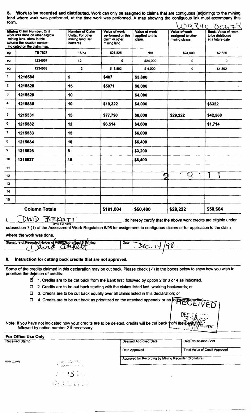
5. Work to be recorded and distributed. Work can only be assigned to claims that are contiguous (adjoining) to the mining land where work was performed, at the time work was performed. A map showing the contiguous link must accompany this form. i - - i..-, . c )
Mining Claim Number. Or rf work was done on other eligible mining land, show in this
column the location number indicated on the claim map.
eg
eg
eg
1
2
3
4
5
6
7
8
9
10
11
12
13
14
15
TB7827
1234567
1234568
1216584
1215528
1215529
1215530
1215531
1215532
1215533
1215534
1215526
1215527
Column Totals
Number of Claim Units. For other mining land, list hectares.
16 ha
12
2
9
15
10
10
15
12
15
16
8
16
Value of work performed on this claim or other mining land.
526,825
0
$ 6,892
S407
S5971
110,322
S77.790
SWA
1101,004
Value of work applied to this claim.
N/A
524,000
54,000
S3,600
56,000
KOOO
54,000
56,000
54,800
56,000
56,400
53,200
56,400
f^
S50,400
Value of work assigned to other mining claims.
524,000
0
0
529,222
T! Q 1
S29.222
Bank. Value of work to be distributed at a future date
52,825
0
54,892
16322
S42.568
S1.714
1 Tl
S50,604
i. , do hereby certify that the above work credits are eligible under(Print Full Name)
subsection 7 (1) of the Assessment Work Regulation 6/96 for assignment to contiguous claims or for application to the claim where the work was done.Signature of.'JJeewdedHoldei
, l YU^t'riling Date
6. Instruction for cutting back credits that are not approved.
Some of the credits claimed in this declaration may be cut back. Please check (S) in the boxes below to show how you wish to prioritize the dejetion of credits:
Q 1. Credits are to be cut back from the Bank first, followed by option 2 or 3 or 4 as indicated.D 2. Credits are to be cut back starting with the claims listed last, working backwards; orD 3. Credits are to be cut back equally over all claims listed in this declaration; orO 4. Credits are to be cut back as prioritized on the attached appendix or as /oil
Note: If you have not indicated how your credits are to be deleted, credits will be cut back followed by option number 2 if necessary.
For Office Use Only_______________^_Received Stamp
0241 (03/97)
Deemed Approved Date
Date Approved
Date Notification Sent
Total Value of Credit Approved
Approved for Recording by Mining Recorder (Signature)
. '5 .

Statement of Costs for Assessment Credit
Transaction Number (office use)
Personal information collected on this form is obtained under the authority of subsection 6 (1) of the Assessment Work Regulation 6/96. Under section 8 of the Mining Act, this information is a public record. This information will be used to review the assessment work and correspond with the mining land holder. Questions about this collection should be directed to a Provincial Mining Recorder, Ministry of Northern Development and Mines, 3rd Floor, 933 Ramsey Lake Road, Sudbury, Ontario, P3E 6B5.
Units of work Work Type Depending on the type of work, list the number of
hours/day worked, metres of drilling, kilometres of grid line, number of samples, etc.
Line cutting 41.25km
Magnetic and VLF surveys 41 .25 km
Assays 148
Max min (HLEM) survey 1 1 km
IP Survey 3 Km
Diamond Drilling 500 mGeology, prospecting, core splitting, etc 44.5 days Digitizing and plotting
Average cost per day
Associated Costs (e.g. supplies, mobilization and demobilization).
Associated Costs Phone, Fax, and other supplies
~
Transportation Costs ^
Air, Boat mileage
Food and Lodging Costs
Food
Lodging| RECEIVED
Cost Per Unit of work
S321
S1 33.75
S86.187m3249/day
.1911)
DEC 1 6 I., 3 JTotal Value of Assessment Work
GEOSCI?N'CF ASSESSMENTOfFiCE
Total Cost
SI 3,240 '
55 517
S2.540
S5.072
S5,450
S43.091311,085 S406.60
52,412
S7.673
S2.631
51,887
3 101,004
1. Work filed within two years of performance is claimed at 10007o of the above Total Value of Assessment Work.2. If work is filed after two years and up to five years after performance, it can only be claimed at 50"7o of the Total
Value of Assessment Work. If this situation applies to your claims, use the calculation below:
TOTAL VALUE OF ASSESSMENT WORK x 0.50 Total S value of worked claimed.
Note:- Work older than 5 years is not eligible for credit.- A recorded holder may be required to verify expenditures claimed in this statement of costs within 45 days of a request for verification and/or correction/clarification. If verification and/or correction/clarification is not made, the Minister may reject all or part of the assessment work submitted.
Certification verifying costs:
____, do hereby certify, that the amounts shown are as accurate as may reasonably(pteaseprint full name)
be determined and the costs were incurred white conducting assessment work on the lands indicated on the accompanying
Declaration of Work form as(recorded holder, agent, or state company position with signing authority)
l am authorized to make this certification.
0212 (OV97)
Sinature Date
;5

OntarioMinistry of Ministere duNorthern Development DeVeloppement du Nordand Mines et des Mines
Geoscience Assessment Office 933 Ramsey Lake Road
March 10, 1999 6th FloorSudbury, Ontario
ABRAHAM PETER DROST P3E 6B5304 OTTO STREETTHUNDER BAY, Ontario Telephone: (888) 415-9846P7A-2T9 Fax: (877)670-1555
Visit our website at: www.gov.on.ca/MNDM/MINES/LANDS/mlsmnpge.htm
Dear Sir or Madam: Submission Number: 2.19111
Status Subject: Transaction Number(s): W9840.00678 Approval
We have reviewed your Assessment Work submission with the above noted Transaction Number(s). The attached summary page(s) indicate the results of the review. WE RECOMMEND YOU READ THIS SUMMARY FOR THE DETAILS PERTAINING TO YOUR ASSESSMENT WORK.
If the status for a transaction is a 45 Day Notice, the summary will outline the reasons for the notice, and any steps you can take to remedy deficiencies. The 90-day deemed approval provision, subsection 6(7) of the Assessment Work Regulation, will no longer be in effect for assessment work which has received a 45 Day Notice. Allowable changes to your credit distribution can be made by contacting the Geoscience Assessment Office within this 45 Day period, otherwise assessment credit will be cut back and distributed as outlined in Section #6 of the Declaration of Assessment work form.
Please note any revisions must be submitted in DUPLICATE to the Geoscience Assessment Office, by the response date on the summary.
If you have any questions regarding this correspondence, please contact Lucille Jerome by e-mail at [email protected] or by telephone at (705) 670-5858.
Yours sincerely,
ORIGINAL SIGNED BYBlair KiteSupervisor, Geoscience Assessment OfficeMining Lands Section
Correspondence ID: 13474
Copy for: Assessment Library

Work Report Assessment Results
Submission Number: 2.19111
Date Correspondence Sent: March 10,1999 Assessor: Lucille Jerome
Transaction NumberW9840.00678
First Claim Number1216584
Township(s) 1 Area(s) OBOSHKEGAN
StatusApproval
Approval Date
March 10, 1999
Section:17 Assays ASSAY 14 Geophysical IP 14 Geophysical MAG 16 Drilling PDRILL 14 Geophysical VLF 14 Geophysical EM
Assessment work credit has been redistributed, as outlined on the attached Distribution of Assessment Work Credit sheet, to better reflect the location of the work.
Correspondence to: Recorded Holder(s) and/or Agent(s):Resident Geologist David BirkketThunder Bay, ON CALGARY, ALBERTA
Assessment Files Library ABRAHAM PETER DROST Sudbury, ON THUNDER BAY, Ontario
JOHN EDWARD TERNOWESKY THUNDER BAY, ONTARIO
Page: 1Correspondence ID: 13474

Distribution of Assessment Work Credit
The following credit distribution reflects the value of assessment work performed on the mining land(s).
Date: March 10, 1999
Submission Number: 2.19111
Transaction Number: W9840.00678
Claim Number Value Of Work Performed
1216584 5,971.00
1215528 407.001215530 10,322.001215531 77,790.001215532 6,514.00
Total: S 101,004.00
Page: l
Correspondence ID: 13474

NOTES!- : cationt W Open For Staking Ste. IHcl
42L03HW2004 2.19111 OB03HKEOAN 200THF INK iMMATU )N 1HA1APPEAR:, ON THIS MAPHAS RF EN COMPILED fHOM VARIOUS oOURCtS ANO ACCURACY IS MOT GUAHAN T E t IJ i rnjL.i.WISHING TO STAKE MIN ING CLAIMS SHOULD OON SUIT WITH THE MINING RECORDER. MINISTRY OF NORTHERN DEVELOP MENT AND MINES FOR AD- DITIONA1 INFORMATION ON THE STATUS' OF THE LMNDS SHOWM HE-REON
uD
-l
IjJ
u. J
o
GZOWSKI TP. (G - 182)
1215349 VI2I590U
'1216519i 1216^18
^•^"^216625
121601215534 216626
1216007 ^15657 T s* —— lL.^s,^ j207198
1207146 ' 1210507 ! 1215.513
i 1202236 120*8282;i^-'2; 5?b3 2.264 ,' 3145
—r.-i--*-i2i36i5yiS; 12105051210506 215530l l l—— l **f ***r ^r ^" f j p—.-"-—
h5643 i 4797
2I5526/- —— — 12 55Z7
^,.^-----J -^
ASS A^ \3RAHSTROM
-* Vf/?.
PAQ.J1.CTJD —..- .
COUGHLAN LAKE (G-26) ONAMAN LAKE (G-IOf-)
APR Q fi
H;JHV r AND .^•*
TRAILS SURVCV C 0 LlN'ES
TOWr.n HP?. 3' F L TS. elfLOTS, '.'i' 1 1C, CLAIMS. PARC. ' S.
UNSURVtYED '.i SSjLOT LINESPARCEL BOON;MININC CLAI'V ETC
RA'L-'.AY Mi. j RloHT CI V '. '
UTILITY LINES NON-PERENNIAL. .1!:-*,., P LOOPING OR FI 00.: r, - .iGUin SUBDIVISION C:. 0. i; .;. TE PLAN Rt 'E^^'AT'ONS
C^IGINAI ^'.OH l .; MARC 1 C ri MU:K ^ M.NESTRAVERSF i. J-N'-'MtNT
LAND USE'ERMIT.S f OUmSM,.j-J r f OS l (ft
TYPEQFDC r ( i^ NX
PATENT, SURF \:E 81 MINING RiLjHTr
" .SURF i"F. RIGHTS ON l .. .MINK1 o ...lihl.- r'^'VL\ ...
'JRF^" X3. W.INING ;,lL.'HT -
,SU*FA:E RIGHTS ONLY
LICENCE oF O'T.u'^ ORDEB-tN-COi;NC!L
CANCF .' FO ......
SAND .. GRA\ EL ,.
9aQ
YocO
s?
: MININ j Rl u n . r-*..-1 { LS. PATi s ' t L' ("*1OH TO W A v fc. iJ13, VESTED IN ORIGINAL PATE-Ni^. (V THi P'jBi : C LA JDS *CT, K.S.O 1S70. CHAP J*0, SEC. 93, SUBSEC 1
SCALE: 1 ifJCH - 40 CHAINS
MOO BOOO
METRE*1000
(1 KM]JfKKI
(7 K?' l
'o oeruice De-'. 'J'-W)
TOWNSHIP '
M.N.R 40MINISTR..MVE OlGTRjCT
NIPIGONMINING DIVK'CxN
THUNDER 5A VL^NH TITLES ' REGIST" V DIV.SION
3AY
Ministry of ; ]Natural Monags ientResources Broncti
Ontario
Date P'.nNo.February , 1981 'l
G-173

50QW 400-W 300W 200W 100W 1 GOE 2GOE 300E 400 E 500E 600E 700E 800E 900E 1QOOE 1100E 200 E: 300E 400E ISQOt 600E
1700N
1600N
500N
1400N
130QN
—— V200N
OON
* OOON
ii iDECEIVED
DEC 1 6 1933
8GOS
900S -
10.00S
800S
900S
1000S
500W 400W 1300E 1400E 1 50CE 1 600E
42L03NW2004 2.19111 OBOSHKEGAN 210
LANDIS MINING CORP.OBOSHKEGAN LAKE PROPERTY
Oboshkegan Lake Area. ON (42L/3)GROUND MAGNETIC SURVEYTOTAL FIELD CONTOUR PLAN MAP
(Diurnal Corrected)Magnetic Datum- 58, ."500 nTMagnate Indinofon: appro*. 77degNMagnetic Declination; - aponw. 5degWDiurnal Correction- Base Staliofi (60 sec/gyc)Station Interval; 12.5 metres Bow L&sd (temwed on Postings 'SSQQOnTGridding Metliod; RandomGrid Cell Size; ' -'25mContour Interval: 5Q; 250, 1000 nTOdour .Zoning; Equal Area / Colour. Vi-
Survey Date; Inatnjmentation:
, .1997 GEM GSM 19 (MarVLf)
KES - MFnsmbby.
QUANTSC CONSULTING /JVC

500W 400W 300W 200W 100W O 100E l
200E 300E 400E 500E 600E l
700E 800E 900E 1000E 1100E 1200E 1300E 1400E 1500E 1600E l l l
1700N -
1600N-
1SOON -
1400N-
1300N -
1200N -
1100N-
1000N
900N-
SOON -
700N
600N-
500N
400N-
300N-
200N-
100N -
1700N
100S-
200S -
300S
400S
500S-
6005-
700S-
800S-
900S
1000S-
-21. t -. -te,9 -. -17
-28 4 " -17 .1 - -H.S -17 S
22.6 v 17 25.1 --16-.0 20.3 - 19.5)f -Jfl.O - -17
-29.B - -16
28.9- 3C.3" 15.1k^^ .a -23.4 -- 16. i 32.7 - 28. 9--19.4 -. 18
21.9JE.B -- 15 B26.1 -- 1ft.H
28.3 - 14. 3X19 y is *29.8 - 18.3
-25.9-38. 5 - -'B.-22.4---17 7
•' -17.9ta.J
31-.5--1G- 4 Xas.s v 16.1 k23.2 - 17.2 27.2 -- 17.1 25.B ' 18.2 24.9 - 17. S
GEOSCIENCF ASSESSMENT OfFlCE _
J0.4+-1B- *15.9 X
2C.3 - 17.S 27.* -- 17.3 X Scale 1:5000
O 50 100 15033.0 -171 24.3 ' 17 O 3t.2- 16. fl 30.4 -' IT. 36 8--I7-.* 29.6 - le. 6 31.7 - 3Z.4 -
^1J.6 * -20.513 6 li -it. 2
rf' -2* 5- -le.fi-Ib. 7
5.7 - -19.2 It -26 1 -17
2&.0 - -IT,B X -28 O -' -'
t
jlr*-0.1 10-18. 4"17
27,2 -' 18,0 24.B - IS 5 3t
27.2 - 15 5 J(K. 1 - - 1 7 .
200
-900S
-10QOS
500W 400W 300W 200W 100W 100E 200E 300E 400E 500E 600E 700E 800E 900E 1000E 1100E 1200E 1300E HOOE 1500 E 1600E
LANDIS MINING CORP.OBOSHKEGAN LAKE PROPERTY
Oboshkegon Lake Area, ON (42L/3)VLF EUECTROMAGNETIC SURVEY
IN PHASE/OUT PHASE PROFILE PLAN MAP Cutter. Maine, USA (NAA) -
-24,0'hHz qpprox. NtOO deg
. 12.5 metres Neq-lo-Pos heading H or t 20 (bgBe^o.possrt.fieg^rt]
In Phase: ' sialid Line wilh box. Posted. Top/Left Out ot Phase:DdSheiJ Line with X,
Station Frequency Station Ajirmtth; Sampling Interval; Cross-over Convention'
Scales (%/cfn):
Survey Dcrt,e: Instrumentalion: Opercto^ ^
25-2?, 1997 GEMGSM-tS (Mog/W)
KES -'
QUANTEC CONSULTING INC.DWG. -NO. C395e-VI.J-PROr-Cutler

500Wi 400W
i300W 200W 100W
1100E 200E
i300E 400E
i500Ei
600E f
700E 800E i
900E 1000E 11 GOE 1200E 1300E i
UOOE 1500E 1600E
1700N -
1600N -
1500N-
1400N-
1300N
1200N -
110ON -
1000N-
900N-
800N-
700N-
600N-
500N-
400N-
300N-
200N-
100N-
0-
100S-
200S-
300S-
400S-
500S-
600S-
700S-
800S-
900S-
1000S-
-1700N
-1600N
-1500N
l
~ 14QON
-r1300Nf
- 1200N
-1100N
-1000N
-900N
-SOON
-700N
-600N
-SOON
-400N
-300N
-200N
-100N
-O
-100S
-200S
-300S
-400S
-500S
-600S
-700S
-BOOS
-900S
-1000S
42L03NW2004 2.19111 OBOSHKEGAN 230
50Scale 1:5000
O 50 100 150 200
(mater*)
500W 400W 300W 200W 100W 100E 200E 300E 400E 500E 600E 700E 800E 900E 1000E 11 GOE 1200E 1300E UOOE 15COE 1600E
LANDIS MINING CORP.OBOSHKEGAN LAKE PROPERTY
Oboshkegan Lake Area, ON (42L/3)
VLF EM SURVEYIN-PHASE FRASER FILTER PLAN MAP
Frequency: 24.Q KHzStation: MM Cutter', MaineStation A^imutt]: oppcnx. NIOOdeq Crues-ovBf Cawitiott Neg-to-Pos heading N or EContour Interval: 5. 20, 100 unitsPosting; Irv-Phose \:raaer FitterRter Oesigi: 11-1-1 (U.Srn spacing)
Survey Date: Instrumentation:
Ncwember 25-27, 1997Gem G"M 19 MagArt-F
KES - M. rrembtoy
KANADIAN EXPLORATION SERVICESby OliANTEC ^ONSUtflNG tN" DWG. NO. OWt-Wf-rr-ca^

700E
o o—CM
o
z o of- a
-z.o,.o01
g^CO
z8*-to
I*-m
zai ot-
zQ-Lo
i1-(N
Q.. O
O-
800E
OO -t^
(--r-
8,5 -r\0 O
TL 10QQN.....
700
70 -- 68
00
7.0 -- D
6.5 --/O.O
6.5 -- 0.0
7.0 -- O
6.5 r
70 l
7,0 r - H .2
6.5 f
8.5 -
75 r
7,0
70 ' -l
BO
70
Q. C
oo
-0 ?
-O.I
B.8 -- 0.0
7.0
a.o-- o-o
-gO rn
" 800?"
900C
to o m
7.0 -r 0,0
S.5
6.5\
fi S 1-
85-J--
6.5
es --
1.3
B.5 i
T.O
fi S
8.51'
0 1 t
6.5
70
7.0 - H
65
S E, L
0.0
oo
0.0
0.0
-0.3
-Q. t
(1,2
S 5 - - -O 1
-03
-0 J
-02
H J
-03
-gCD
m
-, —L. . .
900E
1000E
6.0 p -0.2
6.0 t - -0.2
/.O - - OW
7 0 f
7.0
Li.
7.0
6.C t - -0.2
7. C
65
-o.?
•0.2
-0.!
0.3
0 0
i- -0.!
7.0 ! - 4.2y
6.0 -*- 0.1
-eCD CD
1000E
11 DOE 1200E 1300E 1 400E
5.5 t- -O 2
6.5
-o:
-t 0.2
6.5
6.5
5.5
55 J
\
B.S t
t
B.S-
E.O
6.S
3 M
-0-I
r- -0-J
-0.2
-0.3
3 5 h - -0.3
60 l - -07.
-01
-0.1
B.O J - -0.1
6.5 -
5.i/- - -0,1
CDenm
Vio"oE~"
5.5J:- -O.J
4.0 l- -01
6.0 -- 0,0
7.5
B.5 --/-O.I
3.5 f
6 5
55
-0.2
- -0.2
4 i J - -O l
-o.?
-O.I
6.0 i -
5.5/-- -O.T
60--0 O
-0.3
-- -0.4
HJ.J
80 -- 0.0
l——
^O Om
lTdOE
-O.J
s s,-i- -o j
- 0
8.8 ~-
-O.Z
4.B l- -02
45 -- -0.1
55
-0.1
-0.3
S.5.-J- -0.1
-O.I
6,5 l-\-0 J
-/•02
6,5. T - -fl.Z
G.O ,- - -O.
6 O r - -03
-- -0-3
\ •1-0.S.5 t -1-0-1
S(0 J - -O i
MH
;0 T -O.I
s si J- -01
-0 l
OOm
1300E
1* i
55
55
-*- -O l
-- -02
t -O 2\l l - -IJ.J
6.5
./fi-5
4 l\\e o i - -0.1
5 S
50
55
-O.i
HJ3
H). J
07
-0.1J-
6.51-.-
B b -- (l Os1
-C J
6 5 - -V0.2
-0.1
-0.2
L. .0-z
-\0,3
-0 J
• - -O t
-0.1
-0.2
T- -02
H) 2
O J. -O
O C3m
1500E
1400E
8.0 J - -O l
B-fl
B O t- -O ? L
s.s
6, S -fl2
yl
S(0 4 - H).J
B. Q l.
5 s
B 0y50
60 f
U 1
-0 2
-0.)
-OJ
6.U J - -0.1
8.0 - - 0.0
i- -0.1
7 0
8.0 -j - -0.7
SO - -O I
-0.2
-o.i
4.S J - -0.1
J O -1- 0.0
O O
m
TsooF
1 600E, .. . T . .. , . ,,-. . J ..-.- — ,
i — r—
O ~-45 -Q o orn n i
7.5 -
B.O -
l
s.w-
fi/0 -
7
\6.0 -
-i" 1
1 1
60*
7 65 -
1*- 0.0 56
-0.0 56
- 0.0 5.5
- 0.0 S.5
r 0.0 5.5
-f
.Jl
t 1i1 1t\ x
V -,JV f i' -O-l S 5 i
yO.O B.O
f
r \~ -0.1 6-0
--01 8.0
r -0.2 8.0
L -0-2 5.5
'x
- -0,2 5-S
i '—T - ' ——— "••' --—r ———————————————
r~ . r~ i— r-
r^o Cjsi -p* en-e -e -e -ern nn rn m
A
ix1l
1 it i r
Ll
l1 l i-
-00 6.0 n
- -o.i a.sj-
- -0.2 B 0 -
l- -02 5.6(f
t h -0.3 8.5 1
1
f- -0.3 ' 55*
1
1
- -0 1 5.5 -
•00 60-1
l
- -O.I 5SJ-I
--OI 10-
- -Q.I S. if"\
\ -1-O.J 6. i t
; i- -C ) S.* ,
1
- -0 ' 5,5, -
-oo to
- 0 Q 6 P -
- -0 l 60 -
- -0 1 S. if-N
-l-o : 7.0 '
- -0.2 8. Q iA
J\0.' ^
-CO 6.0 -
- 00
- o.o
-0.0
- -0 l
\Jf- -0.2
TL 1000N
r o.o
N) O O
O•o o z
(Oo"O
-j-8
o~ o
o -•o
-Oo
-o
1600E
2.18 11 l
N
50
Scale 1:2500O 50 100 !50
(metres)
42L03NW2004 2. 19111 OBOSHKEGAN 240
Note: ta-Phose Profile Hose l.*vel
LANDIS MINING CORP.OBOSHKEGAN LAKE PROPERTY
OBOSHKEGAN LAKE AREA NTS: 42 L/3HLEM SURVEY 444 Hz
Instrument: Max-MIn II Coil Sep. 100 mProfile Scale: 1 cm - 2.57*In-Phase Profiles: Solid Line
Quadrature Profiles: Dashed Line
Survey By: Grey Owl Resources

700E 800E 9QOE 1000E 11 GOE 1200E 1300E 1400E 1500E 1600E
oo-hCN
li-
O Oo
o. o en
o..o00
Q..o
oCD
04- O
Ci.O
CI O
ZCU- o
o-
1 — i —
OO CO CD -^-e -e -e -sn n rn rn
BO
50
5.5 -J
10 -
5.0
5.0
TL 1000N ^
5.0
60 -
S.O
so -,
4. S -
5.0
6.0 -
i.O-
5.0
5 0
60 -
50-
50
5.0
l
4.0 '
50-1
4.3
4 0
SO
40 -t-
5,0 -
5.0
4. C
4.0-
40
60
50
SO-
SO
S.O
5.0
4.ft-
4.5
5.0
50 L
4 0 -
. 4,0 -
- 0.3 jf 1.6 -
1 f•j oft *.s -t li \t- o.z) 4 s -i
1 1i"1l1 0
11t 011
f1*!1111 "
1 11 D1t
l"
11
"l"
2 46 -
l 45 -
2 5.0
2 45 -i
2 4.5 -
1 45 -
4 45-
77Hfl.l 4.S -
'\
|o1 11 3
1 140
11
-'o
1f-,o1fi 01t
r"
- 0
2 4.5
l 4.5 -
i 4.5-
4 4.S -
3 45 -
2 45 -
2 45-
0 4.5 -
2 45-
X i- -0-1 4.5 fH
\ ]
- OJO 4.5 *
1L/O.l 4.5 -
1
- 0.0 4. S -
y\
OJO 4.5 -
ff
--03 4.5-1
V
- 0\0 4.5
0/0 4. S -f
x1 0.2 45-1l
j- 0,2 4.0-
1J 0.2 4 i -
1t
0
1trai
- 0
- 0
- 0
2 S.O -
41 1
7 4.5-
0 46 -
D 6.0 --
0 5.0 -
' 11l
-'-01 4,6-5
. ,
* -
.2 4.5 -i
.J 45-
-0.0 45-
. 1-01 45-
^5.0 -* tfl 5 5 -1
r, o 4 , B o i
/ 1•iltL1 1
-
0.3 5.0 -
0.2 a.o-
01 45-
0.1 4.5 -t \\
- 01 5.0 -1 j
(
lr
ij iiiti
tiri,
m.
l M- ——————— ,- ——————————— fr.6-
0.1 5.0 -
0 t 6.0 -
,
01 \ 0
O.I 40-t
t1
OD 4 0 l
1
0 i 5.0 -
O.I SO -
O.J 4,0-
D 1 tot
0 3 4.5 (-ll
101 5.0 -
0.1 4.0 -
-Q t 5.0 -
-0.2 4.5 -
1
-0.3 4fll-
1
0.0 4.5
1
-04., 4.S -
-04 4.0 -
-J 0 4 3.6J-
i0.3 6.0
1\ O.Z 4.0
LO,; 4.5
1 \-Ol 4.0 -V 0 l 40
l
44 0.2 4.5 4\0.1 4-0
\
-00 4.5 - 0 1 4.0
J,-DO 4.0 -
,
-00 4.U ~} 1
f••03 4 5 r
- -O.J 4 51-1
y- -0.7 3 Sf-
\ \- OVo 4.0 j-
\-10/4 4.0 t
7i 0.2 4. S J
i\-o.o 4. e -1
-0.7 4 5 -
\\ t-\-0.4 3 5 -
- OW 3.5 -
f
yl 0,2 35 -k \
1- 0 1 4.0
- -0.2 35
\
- \ -/l 1 1 ^;-/ -0 5 3/0
i f
|-0,4 llo
- -0.3 35
- -0.1 4,0
\i- -O.I 4,1
-OO 4.0
•01 yor \•1 O.J Z 1
0. 3 3J.O
0.2 If. S
-ojo 40101 3\0
1 ^-/•O.I 4.5 T
1 f
t- -0 * 3.11J-
\ '-1-0.2 4,5 '
l
0.0 4.0 -j- 0.0 4.0 i
t0.1 4.0 -
Jfl
-0.1 S.Sl-
\
-0.2 4 0 -
•01 45-
0.1 4.5 -
1lr 0.2 4.1-
\•l\0.3 4.0 -
;\- Bil 4. S
J 1
-
-
4.1 40 r
0.0 4.S L
\
-01 45-
\ j-00 40-
L 0 i J.6/-l
\
-Wl 4.0
- -0.3 - )[o
\-1-0.2 4.0
1
- -O.' 4.9
- 0.0 3.5
I
03 4 OH- -0 l *0
1 0.2 3.8 f
\01 .15-1
"
- 0.1 4.S -
1 1 0-2 4.5-
1'
D.O 4. i -
• \-0.1 4-5 -
1 l- -fl.l . 3.6 t
L- -13.. i 3.S -
- 0.0 3.5
l \I
- 0.0 4.5 -
n.o 45-
;
tI"
1 4
-0.1 4.0-
•O.I i.O -
0.0 4.5 -
01 40 -
-0.0 4.6
V i\
i- OJO 4 S f
l
-/o.o 4.5 ;
•0.0 * S -
1l
02 4.0-4-0,1 45-
0.3 4,0 -
V-1 a ^ 5.0 -
1
i D 2 4.5 -v- P4 BO -
- -C.3 35
h- -0 1 45
\•01 4.0
1•t 0.3 4.0
J 0 J 40i
- 0.1 J.S1••01 35
NJ OJ -P*-Q .0 4^) 0 O 0m rn p i
-
iriit-iii.ii
||
iiij
\
"
iiiticiiii
1
r;4.
1yi
-
if.
1 i
i i-
?
\- -0.1 4 O1 -
- -0.2 40
\-0.0 40
•01 40
•0.0 40
- -O.J 3 S
- -O.I 4.0
•Of 4.0
'iit\
if- 0.3 jfo-) \
i 0.3 40
\L03\ 4*
S 5 ^ iO 0 O O
0 Om rnm m
i i i i
\
•j 0.1 s 4.5 -7 i0 1 3. 5J-
\ \-JO 0 40-
'•-02 * 0 -
1-0.3 4,0 t-
1i
-0.3 40-1
•01 4.0 -
f0.0 1.5 -
- -0.1 3 S -
--0.1 3.5-1
00 35-
\0.1 4. D -
1
'O.! 40-
\i,3y
1 0.3 4.5 -
.— 'Ri /5 *i ^
^- -0.2 J S -f
- -0.2 35-
\
-O.I *5 -
- -0.3 4.0 -
j- 0.3 3 5|-
V0.0 4.0 -
lr o.i 3.6 -llJ 0 3 3.5
03 40-
1
' o 2 :.s(-
•J0,0 4,5
' 1- -0.1 3.5|-
\- -0.4 4.0 f-
11
-04 4.0 *-
- -0.4 J. 5 |
11
- -O.S J.S t-
f- -0.6 4.0 L
11l
- -0.5 40 j-
-03 404
0 t 43-
l1j 0 1 4.0 -
11t o.i 45-111 0.1 4.0 -
11 t^02 4.0 -
l1
KJ J 1 Si-
J \
01 45-
•'0-0 4,5 -
,02 4 i
* 0.2 4 S -
1
- 0,' 3 s{-
\- -0.1 40-
- -0.1 40-
- -O.J 4,5 -
4
- O.t 4.0 -
•{11 40-
--01 4.0 -
-•01 404
i/*-00 3 S J
-01 3.5 1
\•CI 4.0 t
\\
-U..7 4.0 J
1 1' f^0.1 3.S(,
\
-00 4.1 H
1
- -C 1 3.S[-\
\
--01 40
1- BO 3.5 -
•ID 1 3-5 -
\- -0 1 4.0 -
1-0.0 i 5 -
l
T Q 2 3,0
4.0.2 3.5
/1
i 0.2 35
CI 40
0 t 4.0,\
0 1 4.0lij
'}
i 0,2 4 a
l(J l 4,0
•-01' 40
- -02 40
- -0 1 4.0
- 0.1 4.5
-02 40
- -0.2 4 D
! - 0.1 4.5
\-i-n i 4.0
t- O.I 310
-DI 40
h a. t 40
•00 t. S
' O.I 4.0
^0,1 4.0
O.I 4 0 \ C.I 4.0
l \
-01 5.S -
1
1 0.2 3 5f1
;d 2 3 i, -
: 7- 0 .1 U 5 -
-]-0 1 3 1\
--01 4.5
--03 4.5-
- -0.3 40
- -0.1 4.5 -
f- -0-3 3.S
-HJ3 3.5-
- -02 i.S -
- -^ i i. s \i02 * 0
-O.' 40
.\-O.I *-0 -i
1O.i 4.0 -
D 2 4.0 -
i jl- 0 3 3 V-1
10 2 35
-0.1 3S
f 0.31 3.5
F 0.1 40
--01 40
- 0.0 4.0
- 0.0 40
V
\fl.t 35'
-ft .8 4.0Ifli
0.1 4.0
-jo.o 4. ai
•0,0 40
-BO 40
•00 4 D
1- 0 I 4.0
C.I 40
0.0 4,0
- -0 1 3-0
- -O." 4.0
- -0 1 40
K O.I 40
1
J 0.2 4.51
1 !
i- 0 2 40
^ -5 ' ^000000m m mi i i
en-8rn
\
-
-
l\
.
-
-
j-ii.
-
1 i-l
'iij
-
-
-
-
.1
\ iT 0 1
1
-0 T
- DO
- 0.0
- 0,0
TL 1000N—M ————— - ———
' 0,1
i. 0 !
- 00
t
- 0.0 -i
- 0.0
JO. Q
- 0.0
\y' 0\-o.o
jt0.0
- 00
-80
i 02*\
\ 0-3 \
1 s/
\ 0.21 1j
1
- 0.1
- o.a
00
-00
- o a
- -0 l
- -0 1
--01
-0 1
- 0.0
- 0.0
-00
- 0.1
,1t 0211J 0.2 1
-o.oV\
- OW
f- 0.0
0.1
1KOI
03
^ 0.2
-E?Oorn
i
— ttoOo•z.
-J.
oo ~z.
_ ,o•o o
tOoTD2
ODO "DZ
^o"O-z.
01o t?
Uio"Oz
iz
g•z.
NO-8Z
O"O
z
o
GOE 800E 900E 1000E 1100E 1 200E . ; 130QE . 1 400E 150GE ! 1600E
-N
50
Scale 1:2500O 50_____ 100
(metres)
150
42L03NW2004 2.19111 OBOSHKEGAN 250
Note: In-Phasfl Profile Base Level
UNDIS MINING CORP.OBOSHKEGAN LAKE PROPERTY
OBOSHKEGAN LAKE AREA NTS: 42 L/3 _____HLEM SURVEY 1777 Hz_____
Instrument: Max-Min II Coil Sep. 100 mProfile Scale: 1 cm ^ 2.535In-Phase Profiles: Solid Line
Quadrature Profiles: Dashed Line
Survey By: Grey Owl Resources

7QQE
zo o-CN
o o-
oof-o
zQi-oo*
zs4-
Q..cH^
i1-tD
zeao ••fr
zQ..o
o-
700E.
800E
-104
o --'0.4
1.0
10
BO
•-U4
8.5- -b.
-- 0.4
98--10
--1) e
*.C - - 0.4
1.0
7.0 -- i
/.O
8 S --fc g
70 -
70
7.Q -- Q O
e.s
'0
7.0U-
104
8.4
01
07
- -O
.-JO
0,0
-- 0.*
00
-0-2
-SO
m
800E
900E
rn
6.0
1.9
7.3 --p.e
;s -- e
BS
--U.4
- 0.4
80 - - 0.1
aa -- OD
BO 0.3
--,fls
B 5 J -
7.C -i OU
65
85
7.0 -f
85
7.0
l 9 -
I.O-V
7 O J- 014
a i -- o i
.6 - - O O
T s t- -a
BO-- 00
7 S -f 01
70 -- l JO
8.5 --
.01
l'
l S --00
0.0
0.0
O.U
O
m
900E
1 0OOE
11.0
10.0 --04
i.a - -i o
9.4 -*"
8 S - ' O.J
70-0
BO--00
B.O -- 0.0
7.0 r -
70'--
60 - - 04
7.5 --b i
60--, O.J
B.O
60 -
6.5
70 t
SO-; O.J
-o.j
60 --00
O.J
6.0 —t 0.4
03
60. - - 0-S
fl.O
60 -i e.;
a.o - J c.4
60 -
70
OO
^ 1 GOE
50
8-S - - 0-7
8.0 -- 00
7 5 t- 4
7 S --C.Q\
75 l- -O,
7 D •••'O.S
6 i
5.9
6,0 " O '
i
f
O.J
0 l
OS
-- -0-i
-- -05
55H- -01
BO O '
6.5l--\H)5
1-0 l
5.5 --'O 4
0 J
6,5 -h
sif-- -o a
e.a ---o*
--HJJ
6.5 --
65 —
B.S
7.S -1- 1 O 4
.
O O
m
1QOOE 11 GOE
1 200E
(0,0 -- fl.O
BO -- 0.0
B.O - - 0.0
70I-- -f 4
5.5(-- 0,0
0 J
00
80-- 03
60 -
80 --
SO-- -05
-- -OS
i- -O?
60, ---06
-O.J
6 S --00
J.8
e 5 - i\c j
J. -,CI
50 ---10
-i 7
-- -10
B O — tt,ft
70 --
'.O - O'O
O(Om
1200E
1 30QE
65, --
G S - - O I
6.5
64 --
I.ft -
4.6 -f* e
I.S -J-'
-- -O J
5 5
,.o-U ?
I.O r O
^
•v-
01
6.5 -01
10
S5/--I04
S.O - - O J
6 C
S.5 -- 0.1
-C J
-06
6 0)- - -0.1
S.9f- - C 6
t? i o-i
6 S -
S i
6.0 --t O J
70
70 -HO
O.J
0 *
CDOm
1300E
1 400E
65 r
6,5
6S -
65 -,
6.5
8.S
B.O
80
-0.!
-01
00
-02
0.-1
0-3
5 Sf-- -O l t
b li- - O C
l l,
O I
\i \
'.0.4
o.;
0.2
6.S --Jfl I
BO - i O 2
o:
8.5 p-
0 3
-B.4
8.5--,4
6,5 r
5 S/*-. -O J
65 -
••S-T
85 -
e o - ci
7.5
1 02
03
0.2
oO
1400E
1 500E
m
B.5 --
8.5 --
70-- 01
Y
70
85 - - O Q
7.0 L - -\
7.0 :-
88
B. d
80
B.O --fO.*
6 O -
0.0
0,0
Oil
137
7-0 - Ojo
6 5 - /O.O
oi
6 O -t D 7
60-' 01
8 5 J-
7 O -- -f l
6.0 r- -*
\
B.O --00
l 5-fO l
1.5 -
DO
•OJ
tl 04
t
B. S --W.4
SO - -O 7
1.5 - L 0-J
7.0 -- 0/5
B.5 -^-'-fl 1
O O
rn
1500E
600E
ho-•oo
LO-J? TO
03O"TD
en J?ro z
o^O
M O
--O
1600E
2.19111
- N -
50Scale 1:2500
O 50 TOO 150
{metres)
42L03NW2004 2 . 19111 OBOSHKEGAN 260
Note: In-Phase Profile Base level 6S
LANDIS MINING CORP.OBOSHKEGAN LAKE PROPERTY
OBOSHKEGAN LAKE AREA NTS: 42 L/3HLEM SURVEY 3555 Hz
Instrument: Max-Min II Coil Sep. 100 mProfile Scale: 1 cm = 2.5X
In-Phase Profiles: Solid Line Quadrature Profiles: Dashed Line
Survey By: Grey Owl Resources

~LJ——.L~~^H~~~ -— — -•J... 1.1.
1200E L09B-02, J. 098-01 J.098-03 1200E
-100 -1001*1. Ull l L 096-02
\
231.00 i. L098-01
-200 -200
42L03NW2004 2.19111 OBOSHKEGAN 270
LANDIS MINING CORPORATION
OBOSHKEGAN PROPERTY (MAP 10)
SECTION 1200EBAR SCALE 1cm. - 25 ppb Au
DOUG PARKER
DATE: 98/09/03 SCALE: 1/500

RES394CL
1970.
IP MF 22., 6.5.
3.2-
oJ o. i i t i \ /\ i lvl i i VK i i i i y
•\v jV - ——————— J
MF iP -6.5 r22
.3.2 (-11
.o Lo
RES ..3940
625
)N | .2+00 N t 3tOON | | 4+00 hi | | 5+00 N, | 6+pO N ( ^ 7+00 N^ f | B+OOJj^
1645 2234 1578 696 495 1968 1922 2305 3288 3024 876 836 28H 358Z 1361 642
t 10*00 N | , 11+00 N
666 422 398 431Resistivity
n*l 6M 635 \ 337 ^ W -^ 122 111
n*2 725 wVja m^™^(1 = 3 569 617 622 1 288^ \m 1230
n^4
n=5 647
n-6
519 ( 614.' Jjjfy^'™ "^sl^V
" i^.y^y^ ^333 ^ 'ffi8341 — iOK^ 471*641
1159 1060 —J+W ^r 1228 2003 VVM4
1+00 N 2+00 N 3+00 N 4+OON 5tODN 5+OON 7+00 N 8+OON
0.64 0.43 0.90 0.68 0.46 -0.75 -2.3 1.8 2.3 -3.2 0.95 -J.6 -2.2 2.8 1.6 7,4 -0.80 -7.9 20 0.44 0.12Chargeability
0=1 0.88 , ^65
0=2 0.93 0.93, , 0.71 0,46 -0,18
0=3 1 f'.' '0.28 " 0.44 -0.47
0=4 0.47 -0.062 -0.25
0=5 0.25 -0.29 . O
^=6 0.0030 0.38 " f 2
0.53 - - 0.49 0.20 0.26 O.SO 0 = 10.81——1.53.7 3.3 \ Q. 44 ^ '-\ ' ( .2.5 2.4" —— ~ 1.9 s 1.3 f 4.S
0.67^t-2.45 -3.4 ~ 0. -1.3 -36 0.031-.47 -1.1 -7.8 1 .3 "- ~ T.57 S 2.Srt ' 1 - B
'^ste.- ^^^0.60 ' 3.2 - -8 0.19 0.41 — 1.3
0.1GJ.2 4.4
1.5 -t. 2 -10 -1,9 -119
0.92-^1.9 -C" 1.2.'t// ) L' . X
1+00 N 2+00 N 3+00 N——l———————H
6+00 N———l———i———H7+00 N 8+OON 10+00 N
———l———————h-11+OQN
l 0.62 1.4 1 0.57 -27 -83 -2489 1.3 O.E2 -115 0.22 -2481 -29 2.3 -0.79 -15 -8.4 5.9 1.3 1.3Metal Factor
0=2
1-4 1 3.4 3.3 4.8 4.4 1.2 1.8 0.84 0.88 O.J7 Q. IS 3.1 3.2 7.7 3.4 i. B 3.5 3.6 2.6 4 t.4 r^1
1.3 1.5 1.7 1.4 -1,8 0,72 2 1.2 1.7 2 1.2 7.9 1.4 2.8 -9.2 1.6 2.2 1,3 2.2 0.66 3.9 11=2
1.8 0.43 0.70 -1.6 0.74 1.3 0.87^-0.55 1.7 1.5 0.6S 0.44 0.66 1.1 -6.6 0.37 -20-44 1.3 -1.5
0.90 -0.076 -0.43 0.24 1.1 0,62 ;" , 15 -68 0.88 1.8 0.11 1.8 -13 -J46 0.55 __ 5 ' 4^fC-S)T '5 ' S 0 - 3*
0.38 -0.36 0.15 0.35 0.72 -8 -1003 1.7 6.2 0.48 0,25 -3.1 -10 -80 19 \S 0.74 "*1.8 -7.2
0.0047 0.0+5 0.2D O 32 -6.4 -318 -14 -30K 0.56 0.42 -0.29 3.8 *"-^5 ** -58 2.8 0.46 0.63
[1=3
0=5
[1=6
Line 1100 E
Dipole-Dipole Arraya na a
r8!a = 50 M
V plot point
Logarithmic Contours 1, 1.5, 2, 3, 5, 7.5, 10,
INTERPRETATION
B Strong increase in polarizationaccompanied by marked decrease in resistivity.
O Well defined increase in polarization without marked resistivity decrease.
d Poorly defined polarization increase with no resistivity signature.
T Low resistivity feature.
SCALE 1:500050 O 50 100 150 200 250 300
•d......'Si(metres)
MAP 7
LANDIS MINING CORPORA! ONINDUCED POLARIZATION SURVEYOBOSHKEGAN UVKE PROPERTY
OBOSHKEGAN LAKE AREA ON. NTS 42L/3Date: 98/02/26Interpretation:
GREY OWL RESOURCESCeosoft Software for the Earth Sciences
42L03NW2004 2.19111 OBOSHKEGAN 280

RES IP 4760- 4.6-
2380-
MF 22-,
2.4J 11.
OJ 0.
i——i——i——i——i——i——i——i——i——i——i——i——i——i——i——i——r
A'
\ V \ ,' A A\ ff\ Vi ' ' V ' * -"*\ 'p-lp'; /\'"-" ^-., ; .
Vi \i./ i i iiV i—ii ii i A i i 'i* i i i i i i^l
MF-22
IP.4.8
2.4
.0 LO
RES ^4760
-2380
1-+OON 2+00 N 3+OON 6+00 N 10+00 N
0 = 1
500Resistivity
2588
11=2
(1=3
11=4
11=5
11=6
5tOON 7+00 N 9+00 N 10+00 N 11+OON0.41 1.1
n-1
n=2
^=3
(1=4
11=5 0=6
3.7 1,8 3.6 1.6 -0.28 2.2
1.2- 0.90 r- O * fl.B.-.18
-3.1 0.073 0.53 -0.38Chargeability
-0.039 -0.45
-0.19 -2.e -5.9
0.34 0.30 0.086 0.22 0=1
.5 0.11 0.29 -0.23 0=2
-2.1 -0.080 -0.13 0=3
-0.33 0=4-4.3
Q.SB ' 1.9 Z.4
11=5 11=6
2+00^ 5+OON 4+OON 5+OON 6MMN 7+00 N &+OON 10+00 N 11+QON0.62 1.1 0.62 8.9 3,2 -5.4 20 -14 -45 -5.4 -S.9 -11 -16 -42 -2.8 -0.61 -2.3
45 s 0.81 --- 1. -9 0.83^^-t1.1's -7,2 D.M 1.JJ/ -2.3
-27 -15 0.28 '-sCi^jL -12 -0,42 ' "'-0.56
-31 -66 -3,5 -1.6 A. 1"- 5 * -9 ' 7 -1-5
-86 -33*"^ 2.1 ^-2i -19
0.25 -S.4 -18 -41 -361
Metal Factor
O LU
UJoUJ DC
Geosoft Software for the Earth Sciences
oo
Q
oo
oUJ
Line 1200 E
Dipole-Dipole Arraya na a
liter
' d ^ 50 M
Vplot point
Logarithmic Contours 1, 1.5, 2, 3, 5, 7.5, 10,
INTERPRETATION
B Strong increase in polarizationaccompanied by marked decrease in resistivity.
D Well defined increase in polarization without marked resistivity decrease.
O Poorly defined polarization increase with no resistivity signature .
T Low resistivity feature.
SCALE 1:500050 O 50 100 150 200 250 300
BS b(metres)
MAP 8
LANDIS MINlsfG CORPORATIONINDUCED POLARIZATION SURVEY OBOSHKEGAN LAKE PROPERTY
OBOSHKEGAN LAKE AREA ON. NTS 42L/3Date: 98/02/26 Interpretation:
GREY OWL RESOURCES
42L03KW2004 2.19111 OBOSHKEGAN 290

RES IP MF 4421-, 3.8^ 6.1
2210. i.d1.9J 3.1.
OJ 0.
WF IP RES n6.1 ^3.8 ..4421
Li. 9 ,
o Lo
2210
.-O
1+00 N 2+00 N 3+OON 5+OON 6+OQN 7+00 N &+OON 9+00 N 10+00 N 11+flON
1055 506 760 !!29 747 1*26 1921 263! 3380 1Z21 1676 1430 4019 2626 1196 7S4 672 635 522 555
436 464 353 Nl l 2563 ^^441
N. 1556 -811
5B7\ 1672 - 951 ^l .-x ^X\
2091 3589 1617 1368 2313' MOK —' 7668 '' 5!7 549 271-^-795 887
Resistivity
1+00 N 2400 N 3+OON 4+OON-H———l———H5+OON
0.80 5.9 3.5 -4,4 -t.3 1.4 1.5 !.B
6+00 N | 7*O)N 2.2 2.4 1.S 2.6 3.4
-Sff^———52^———n^ Chargeability5 1.4 1.9 O.J5 0.71 D.7D
6+OON—t———'———h' .
3 2.5 1.4 1.9 0.75 0.71 0.70
-71 0.55 1,5,1- 0X,64 Vl.6xVV ^, .^ ) X
-90 I.I 1.3 ' 0.44 1-9
1+00 N 2+00 N J+OON 4+OON 9+00 N 10+00 N 11+00 N k i , , r ,^—'—'——'——'——'— Metal factor3.8 -147 1.2 2.6 4,4 -42 -56 2.2 2.4 1.7 1.5 2.8 1.2 5.6 1.1 0.89 2.5 3.1 4.5 1.2 1.5 1.3
5.2 2.8,— 2.
2.3 __ 2.4 t V 0.21 0.92 [1=24.1 1.8 2.8
,40 0.29 0.39 .9- -0.14 -x 1.5
1=1 7.4 M -0.77 ,,Z, 5.4
0=2 2,6 |[( -0.
[1=3
(1=4 2.7 rZ M UJk'K.ti. —— i.* "J,
^=5 275"^ -516 E TOT' 0.'[1=6 iU -790 0.51' 0.36 0.27 0.15
Line 1300 E
Dipole-Dipole Arrayno
Filterr0"!
a = 50 M
Vplot point
LogarithmicContours ^ 5 7 5 10 ' J ' D ' ''*' 10 '
INTERPRETATION* Strong increase In polarization
accompanied by marked decrease in resistivity.
D Well defined increase in polarization without marked resistivity decrease.
D Poorly defined polarization increase with no resistivity signature.
T Low resistivity feature.
SCALE 1:500050 O 50 100 150 200 250 300~ "- ———"" d i b """————————
(metres)
MAP 9LANDIS MINING CORPORATION
INDUCED POLARIZATION SURVEYOBOSHKEGAN LAKE PROPERTY
OBOSHKEGAN LAKE AREA ON. NTS 42L/3Date: 98/02/26Interpretation:
GREY OWL RESOURCESGeosoft Software for the Earth Sciences
42L03NH2004 2.19111 OBOSHKEGAN 300
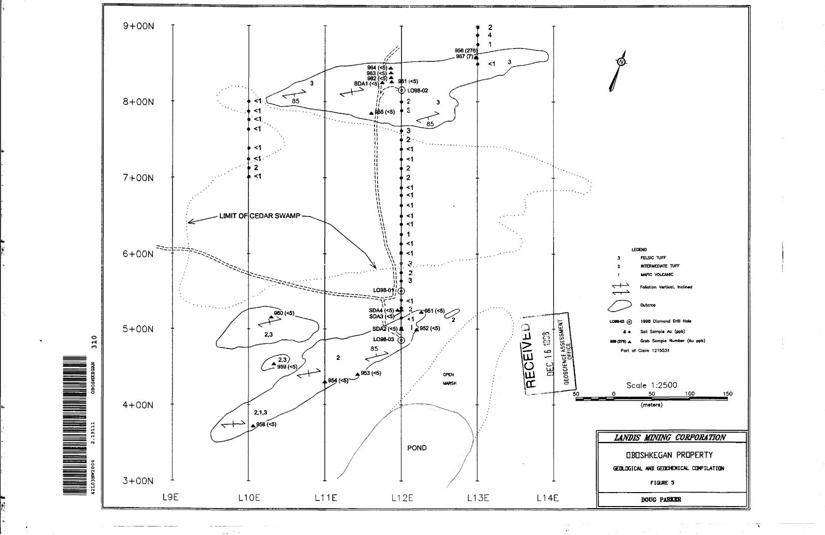
9+OON
8+OON
7+OON
6+OON
5+OONorHm
ra
l
4+OON
3+OON
LEGEND
3 FELSIC TUFF
2 INTERMEDIATE TUFF
t MAFIC VOLCANIC
Foliation Vortical, Inclined
Outcrop
LOW43 0 1990 Diamond Drill Hole
4 * Soil Sample Au (ppb)
966(279) A '•rob Sample Number (Au ppb)
Part of Claim 1215531
Scale 1:2500O 50 100 150
(meters)
L9E L10E L11E L12E L13E L14E
LANDIS MINING CORPORATION
OBOSHKEGAN PROPERTYGEOLOGICAL AND GFJKHEMICAL COMPILATION
FIGURE 5
DOUG PARKER

9-fOON T
8-r-OON
7+OON
6+OON
5+OON
o w m
ea Oea o 4+OON
3+OONl")o
L9E L10E L11E L12E L13E
50
L14E
GEOPHYSICAL COMPILATION
' ^ MAG PROFILES ( 1 cm - 500 nT)
N Bow Lev*) 56700 nT
O) IP CHARGEABILITY
ft f. IP RESISTMTY
VtF FTWSER riLTER CONTOUR
Part of Claim 1215531
LU
UJO LUOC
Scale 1:2500O 50 _100
(meters)
CO CDCO
CO ^'— i-u —CJ " 0uj a Q ^
150
LAMIS MINING CORPORATION
OBOSHKEGAN PROPERTYGEDPYSICAL COMPILATION
FIGURE 7
DOUG PARKER