Active tectonics and human survival strategies
16
JOURNAL OF GEOPHYSICAL RESEARCH, VOL. 99, NO. B10, PAGES 20,063-20,078, OCTOBER 10, 1994 Active tectonics and human survival strategies Geoffrey King Institutde Physique du Globe, Strasbourg, France Geoffrey Bailey Department of Axchaeology, Universityof Cambridge, Cambridge, England Derek Sturdy Department of Archaeological Sciences, University of Liverpool,Liverpool, England Abstract. Tectonic movements continuously remould the surface of Earth in response to plate motion. Yet such deformation is rarelytaken into account whenassessing landscape change and its impact on human landuse, except perhaps asanoccasional hazard to human life or a temporary disruption in the longer termpaRems of human history. However,active tectonics also create andsustain landscapes thatcan be beneficial to human survival, forminga complex topography of potentially fertilesedimentary basins enclosed by mountain bard• thatcanfacili- tate thecontrol andexploitation of foodresources, especially animal prey. We discuss the tec- tonic history of northwest Greece andshow how the Paleolithic sites of the regionare located to takeadvantage of tectonically created features at botha localanda regional scale. We suggest thattheassociation of significant concentrations of earlyPaleolithic sites with tectonically ac- tive regions is not coincidental andthat on the longer time spans of human biologicalevolution, active tectonics has beenan importam selective agent contributing to the development of the human species asan intelligent predator. Introduction Tectonicprocesses and human socialand economic changes are usually assumed to operate on such disparate time scales that there is virtually no overlap between them. Large-scale uplift or subsidence, driven by the motionsof the continental plates, seems to operatetoo slowly or to belong to a geologi- cal pasttoo distant to have any relevance to major episodes of human development. Short-lived events such as earthquakes and volcanoes clearly have a visible impact, especiallyif they resultin spectacular episodes of destruction, as at Pompeii or the Bronze Age settlement of AkrotLrion the island of Thera, but they are rarely perceived as being other than temporary or disruptivein effect, unless they seemto trigger far-reaching social changes. The explosion of Thera volcano in the Aegeanin the mid second millenniumB.C. has excitedunusual interest and investment of research effort because of its poten- tial role in the downfall of Minoan civilization and suggested links with the myth of Atlantis. However, it is now clear that the eruption occurredlater than the main destruction levels in most of the Minoanpalaces andthat its impact in human terms was much more restricted [Hardy et al., 1989]. Tectonic changes over longer time spans are sometimes cited in the an- thropological literature, but here too the effects are usuallyde- scribed in negative terms. For example, Moseley [1983] and Moseley and Feldman[1988] have argued that tectonic uplift on the Peruvian coastline hasresulted in repeated disruption of prehistoric irrigation canals and that Andean civilization must Copyright 1994 by the American Geophysical Union. Paper number94JB00280. O148-0227/94/94JB-00280505.00 therefore have been founded on maritime fishing rather than crop agriculture. In general, however, the impact of environ- mental processes on human palaeoeeonomiesis described without reference to tectonics. Fertility or barrenness of soils, erosion or deposition of sediment, and droughts or floods are most readily explained by the variable influence of climate, or in recent millennia of human interference,acting on an unchanging geological substratum. Here we argue that this perspective is too restricted. Changes in landscape geometry caused by deformation of the solid earth can determine the way in which climate affects the landscape and the way in whichthe landscape in its turn affects and is affectedby human activity. In many partsof the world, an appreciation of tectonics is needed to understand the distri- bution of agriculturalsoils or of animal herds. On the longer time scales of prehistory, tectonically driven landscape change may become an active agent of selection, creating pressures or opportunities for changes in behavior. It is easy to see that tectonic uplift can destroyan environment by trig- gering erosion,but active deformation is by no means always negative in effect. Tectonic subsidence can create well-waterexi sediment traps,while volcaniceruptions can renew the supply of fertile agricultural soils. Uplift and subsidence also create natural barriers to animal movement that can be exploited by humans. It is interesting to note that many early Paleolithic sitesaroundthe Mediterranean(Figure 1) are in regionsof tec- tonic activity, and sites in the East African Rift Valley and Sub-Himalayan India provide further examples. Undoubtedly, the ease of site discovery can be assisted by tectonicchanges. Tectonically active areas are those most likely to develop thick, rapidly formed sequences of terres•al sediments favor- ing burial and fossilization of archaeological evidence, fol- 20,063
-
Upload
independent -
Category
Documents
-
view
1 -
download
0
Transcript of Active tectonics and human survival strategies

JOURNAL OF GEOPHYSICAL RESEARCH, VOL. 99, NO. B10, PAGES 20,063-20,078, OCTOBER 10, 1994
Active tectonics and human survival strategies
Geoffrey King Institut de Physique du Globe, Strasbourg, France
Geoffrey Bailey Department of Axchaeology, University of Cambridge, Cambridge, England
Derek Sturdy Department of Archaeological Sciences, University of Liverpool, Liverpool, England
Abstract. Tectonic movements continuously remould the surface of Earth in response to plate motion. Yet such deformation is rarely taken into account when assessing landscape change and its impact on human land use, except perhaps as an occasional hazard to human life or a temporary disruption in the longer term paRems of human history. However, active tectonics also create and sustain landscapes that can be beneficial to human survival, forming a complex topography of potentially fertile sedimentary basins enclosed by mountain bard• that can facili- tate the control and exploitation of food resources, especially animal prey. We discuss the tec- tonic history of northwest Greece and show how the Paleolithic sites of the region are located to take advantage of tectonically created features at both a local and a regional scale. We suggest that the association of significant concentrations of early Paleolithic sites with tectonically ac- tive regions is not coincidental and that on the longer time spans of human biological evolution, active tectonics has been an importam selective agent contributing to the development of the human species as an intelligent predator.
Introduction
Tectonic processes and human social and economic changes are usually assumed to operate on such disparate time scales that there is virtually no overlap between them. Large-scale uplift or subsidence, driven by the motions of the continental plates, seems to operate too slowly or to belong to a geologi- cal past too distant to have any relevance to major episodes of human development. Short-lived events such as earthquakes and volcanoes clearly have a visible impact, especially if they result in spectacular episodes of destruction, as at Pompeii or the Bronze Age settlement of AkrotLri on the island of Thera, but they are rarely perceived as being other than temporary or disruptive in effect, unless they seem to trigger far-reaching social changes. The explosion of Thera volcano in the Aegean in the mid second millennium B.C. has excited unusual interest and investment of research effort because of its poten- tial role in the downfall of Minoan civilization and suggested links with the myth of Atlantis. However, it is now clear that the eruption occurred later than the main destruction levels in most of the Minoan palaces and that its impact in human terms was much more restricted [Hardy et al., 1989]. Tectonic changes over longer time spans are sometimes cited in the an- thropological literature, but here too the effects are usually de- scribed in negative terms. For example, Moseley [1983] and Moseley and Feldman [1988] have argued that tectonic uplift on the Peruvian coastline has resulted in repeated disruption of prehistoric irrigation canals and that Andean civilization must
Copyright 1994 by the American Geophysical Union.
Paper number 94JB00280. O148-0227/94/94JB-00280505.00
therefore have been founded on maritime fishing rather than crop agriculture. In general, however, the impact of environ- mental processes on human palaeoeeonomies is described without reference to tectonics. Fertility or barrenness of soils, erosion or deposition of sediment, and droughts or floods are most readily explained by the variable influence of climate, or in recent millennia of human interference, acting on an unchanging geological substratum.
Here we argue that this perspective is too restricted. Changes in landscape geometry caused by deformation of the solid earth can determine the way in which climate affects the landscape and the way in which the landscape in its turn affects and is affected by human activity. In many parts of the world, an appreciation of tectonics is needed to understand the distri- bution of agricultural soils or of animal herds. On the longer time scales of prehistory, tectonically driven landscape change may become an active agent of selection, creating pressures or opportunities for changes in behavior. It is easy to see that tectonic uplift can destroy an environment by trig- gering erosion, but active deformation is by no means always negative in effect. Tectonic subsidence can create well-waterexi sediment traps, while volcanic eruptions can renew the supply of fertile agricultural soils. Uplift and subsidence also create natural barriers to animal movement that can be exploited by humans. It is interesting to note that many early Paleolithic sites around the Mediterranean (Figure 1) are in regions of tec- tonic activity, and sites in the East African Rift Valley and Sub-Himalayan India provide further examples. Undoubtedly, the ease of site discovery can be assisted by tectonic changes. Tectonically active areas are those most likely to develop thick, rapidly formed sequences of terres•al sediments favor- ing burial and fossilization of archaeological evidence, fol-
20,063
20,064 KING ET AL.' ACTIVE TECTONICS AND HUMAN SURVIVAL
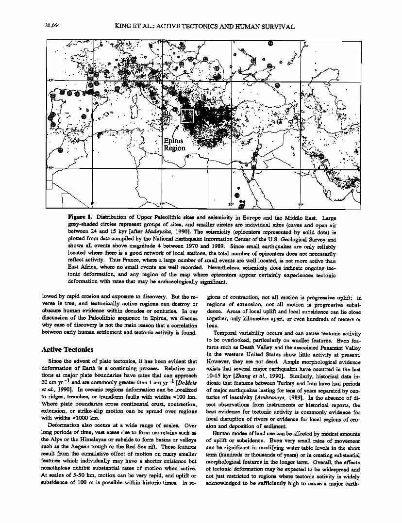
Figure 1. Distribution of Upper Paleolithic sites and seismicity in Europe and the Middle East. Large grey-shaded oireles represent groups of sites, and smaller oireles are individual sites (oaves and open air between 24 and 15 kyr [after Madeyslca, 1990]. The seismioity (epioentem represented by solid dots) is plotted from data oompiled by the National Earthqu• Information Center of the U.S. Geological Survey and shows all events above magnitude 4 between 1970 and 1989. Sinoe small earthquakes are only reliably located where there is a good network of local stations, the total number of epioentem does not necessarily reflect aotivity. Thus France, where a large number of small events are well located, is not more aotive than East Afrioa, where no small events are well recorded. Nevertheless, seismioity does indioate ongoing tec- tonio deformation, and any region of the map where epioenters appear oertainly experienoes tectonio deformation with rates that may be archaeologioally significant.
lowed by rapid erosion and exposure to discovery. But the re- verse is true, and tectonically active regions can destroy or obscure human evidence within decades or centuries. In our
discussion of the Paleolithic sequence in Epirus, we discuss why ease of discovery i• not the main reason that a oorrelation between early human settlement and tectonic activity is found.
Active Tectonics
Since the advent of plate tectonics, it has been evident that deformation of Earth is a continuing process. Relative mo- tions at major plate boundaries have rates that can approach 20 cm yr -1 and a• commonly g!eater than 1 cm yr -1 [DeMets et al., 1990]. In oceanic regions deformation can be localized to ridges, trenches, or transform faults with widths <100 km. Where plate boundaries cross continental crust, contraction, extension, or strike-slip motion can be spread over regions with widths > 1000 km.
Deformation also occurs at a wide range of •cales. Over long periods of time, vast areas rise to form mountains such as the Alps or the Himalayas or subside to form basins or valleys such as the Aegean trough or the Red Sea rift. These features result from the cumulative effect of motion on many smaller features which individually may have a shorter existence but nonetheless exhibit substantial rates of motion when active.
At •cales of 5-50 km, motion can be very rapid, and uplift or subsidence of 100 m is possible within historic times. In re-
gions of contraction, not all motion is progressive uplift; in regions of extension, not all motion is progressive subsi- dence. Areas of local uplift and local subsidence can lie close together, only kilometers apart, or even hundreds of meters or less.
Temporal variability occurs and can cause teetonic activity to be overlooked, particularly on smaller features. Even fea- tures such as Death Valley and the associated Panamint Valley in the western United States show little activity at present. However, they are not dead. Ample morphological evidence exists that several major earthquakes have occurred in the last 10-15 kyr [Zhang et al., 1990]. Similarly, historical data in- dicate that features between Turkey and Iran have had periods of major earthquakes lasting for tens of years separated by cen- turies of inactivity [Ambraseys, 1989]. In the absence of di- rect observations from instruments or historical reports, the best evidence for tectonic activity is commonly evidence for local disruption of rivers or evidence for local regions of ero- sion and deposition of sediment.
Human modes of land use can be affected by modest amounts of uplift or subsidence. Even very small rates of movement can be significant in modifying water table levels in the short term (hundreds or thousands of years) or in creating substantial morphological features in the longer term. Overall, the effects of tectonic deformation may be expec• to be widespread and not just restricted to regions where tectonic activity is widely acknowledged to be sufficiently high to cause a major earth-
KING ET AL.: ACTIVE TECTONICS AND H'LrMAN SURVIVAL 20,065
a)
b)
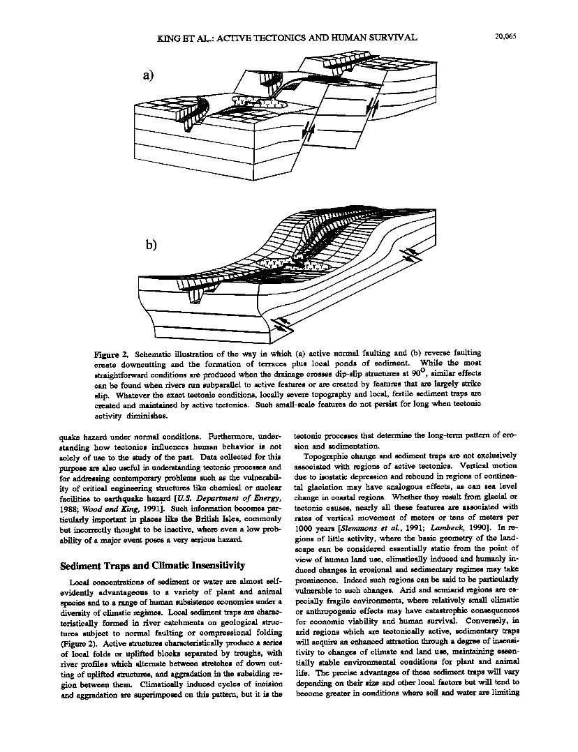
Figure 2. Schematic illustration of the way in which (a) active normal faulting and (b) reverse faulting create downcutting and the formation of terraces plus local ponds of sediment. While the most straightforward conditions are produced when the drainage crosses dip-slip structures at 90 ø , similar effects can be found when rivers run subparallel to active features or are created by features that are largely strike slip. Whatever the exact tectonic conditions, locally severe topography and local, fertile sediment traps are created and maintained by active tectonics. Such small-scale features do not persist for long when tectonic activity diminishes.
quake hazard under normal conditions. Furthermore, under- standing how tectonics influences human behavior is not solely of use to the study of the past. Data collected for this purpose are also useful in understanding tectonic processes and for addressing contemporary problems such as the vulnerabil- ity of critical engineering structures like chemical or nuclear facilities to earthquake haza, rd [U.S. Detazrtment of Energy, 1988; Wood and King, 1991]. Such information becomes par- ticularly important in places like the British Isles, commonly but incorrectly thought to be inactive, where even a low prob- ability of a major event poses a very serious hazard.
Sediment Traps and Climatic Insensitivity Local concentrations of sediment or water are almost self-
evidently advantageous to a variety of plant and animal species and to a range of human subsistence economies under a diversity of climatic regimes. Local sediment traps are charac- teristically formed in river catchments on geological struc- tures subject to normal faulting or compressional folding (Figure 2). Active structures characteristically produce a series of local folds or uplifted blocks separated by troughs, with fiver profries which alternate between stretches of down cut- ting of uplifted structures, and aggradation in the subsiding re- gion between them. Climatically induced cycles of incision and aggradation are superimposed on this pattern, but it is the
tectonic processes that determine the long-term pattern of ero- sion and sedimentation.
Topographic change and sediment traps are not exclusively associated with regions of active tectonics. Vertical motion due to isostatic depression and rebound in regions of continen- tal glaciation may have analogous effects, as can sea level change in coastal regions. Whether they result from glacial or tectonic causes, nearly all these features are associated with rates of vertical movement of meters or tens of meters per
1000 years [Slemmons eta!., 1991; Lainbeck, 1990]. In re- gions of little activity, where the basic geometry of the land- scape can be considered essentially static from the point of view of human land use, climatically induced and humanly in- duced changes in erosional and sedimentary regimes may take prominence. Indeed such regions can be said to be particularly vulnerable to such changes. Arid and semiarid regions are es- pecially fragile environments, where relatively small climatic or anthropogenic effects may have catastrophic consequences for economic viability and human survival. Conversely, in arid regions which are tectonically active, sedimentary traps will acquire an enhanced attraction through a degree of insensi- tivity to changes of climate and land use, maintaining essen- tially stable environmental conditions for plant and animal life. The precise advantages of these sediment traps will vary depending on their size and other local factors but will tend to become greater in conditions where soil and water are limiting
20,066 KIN(• ET AL.: ACTIVE TECTONICS AND HI3MAN SURVIVAL
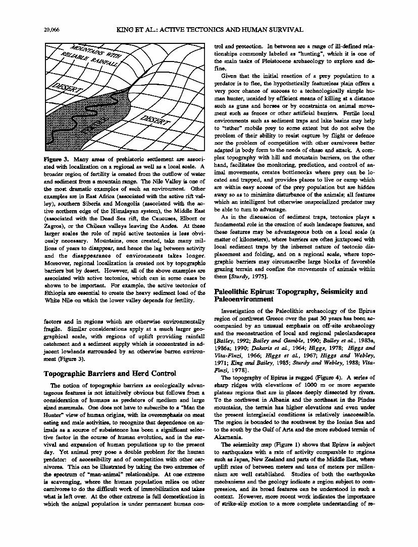
Figure 3. Many areas of prehistoric setfiement are associ- ated with loc•l•.ation on a regional as well as a local scale. A broader region of fertility is created from the outflow of water and sediment from a mountain range. The Nile Valley is one of the most dramatic examples of such an environment. Other examples are in East Africa (associated with the active rift val- ley), southern Siberia and Mongolia (associated with the ac- tive northern edge of the Himalayan system), the Middle East (associated with the Dead Sea rift, the Caucuses, Elborz or Zagros), or the Chilean valleys leaving the Andes. At these larger scales the role of rapid active tectonics is less obvi- ously necessary. Mountains, once created, take many mil- lions of years to disappear, and hence the lag between activity and the disappearance of environments takes longer. Moreover, regional localization is created not by topographic barriers but by desert. However, all of the above examples are associated with active tectonics, which can in some cases be
shown to be important. For example, the active tectonics of Ethiopia are essential to create the heavy sediment load of the White Nile on which the lower valley depends for fertility.
factors and in regions which are otherwise environmentally fragile. Similar considerations apply at a much larger geo- graphical scale, with regions of uplift providing rainfall catehment and a sediment supply which is concentrated in ad- jacent lowlands surrounded by an otherwise barren environ- ment (Figure 3).
Topographic Barriers and Herd Control
The notion of topographic barriers as ecologically advan- tageous features is not intuitively obvious but follows from a consideration of humans as predators of medium and large sized mammals. One does not have to subscribe to a "Man the
Hunter" view of human origins, with its overemphasis on meat eating and male activities, to recognize that dependence on an- imals as a source of subsistence has been a significant selec- tive factor in the course of human evolution, and in the sur-
vival and expansion of human populations up to the present day. Yet animal prey pose a double problem for the human predator: of accessibility and of competition with other car- nivores. This can be illustrated by taking the two extremes of the spectrum of "man-animal" relationships. At one extreme is scavenging, where the human population relies on other carnivores to do the difficult work of inunob•ation and takes
what is left over. At the other extreme is full domestication in
which the animal population is under Permanent human con-
trol and protection. In between are a range of ill-der'reed rela- tionships commonly labeled as "hunting •, which it is one of the main tasks of Pleistocene archaeology to explore and de- fine.
Given that the initial reaction of a prey population to a prcdator is to flee, the hypothetically featureless plain offers a very poor chance of success to a technologically simple hu- man hunter, unaided by efficient means of killing at a distance such as guns and horses or by constraints on animal move- ment such as fences or other artificial barriers. Fertile local
environments such as sediment traps and lake basins may help to "tether" mobile prey to some extent but do not solve the problem of their ability to resist capture by •ght or defence nor the problem of competition with other carnivores better adapted in body form to the needs of chase and attack. A com- plex topography with hill and mountain barriers, on the other hand, facilitates the monitoring, prediction, and control of an- imal movements, creates bottlenecks where prey can be lo- cated and trapped, and provides places to live or camp which are within easy access of the prey population but are hidden away so as to minimize disturbance of the animals; all features which an intelligent but otherw• unspecialized prv•tor may be able to turn to advantage.
As in the discussion of sediment traps, tectonics plays a fundamental role in the creation of such landscape features, and these features may be advantageous both on a local scale (a matter of kilometers), where barriers are often juxtaposed with local sediment traps by the inherent nature of tectonic dis- placement and folding, and on a regional scale, where topo- graphic barriers may circumscribe large blocks of favorable grazing terrain and confane the movements of animals within them [Sturdy, 1975].
Paleolithic Epirus: Topography, Seismicity and Paleoenvironment
Investigation of the Paleolithic archaeology of the Epirus region of northwest Greece over the past 30 years has been companied by an unusual emphasis on off-site archaeology and the reconstruction of local and regional palcolandscapes [Bailey, 1992; Bailey and Gamble, 1990; Bailey et al., 1983a, 1986a; 1990; Dakaris et al., 1964; Higgs, 1978; Higgs and Vita-Finzi, 1966; Higgs et al., 1967; Higgs and Webley, 1971; King and Bailey, 1985; Sturdy and Webley, 1988; Vita- Finzi, 1978].
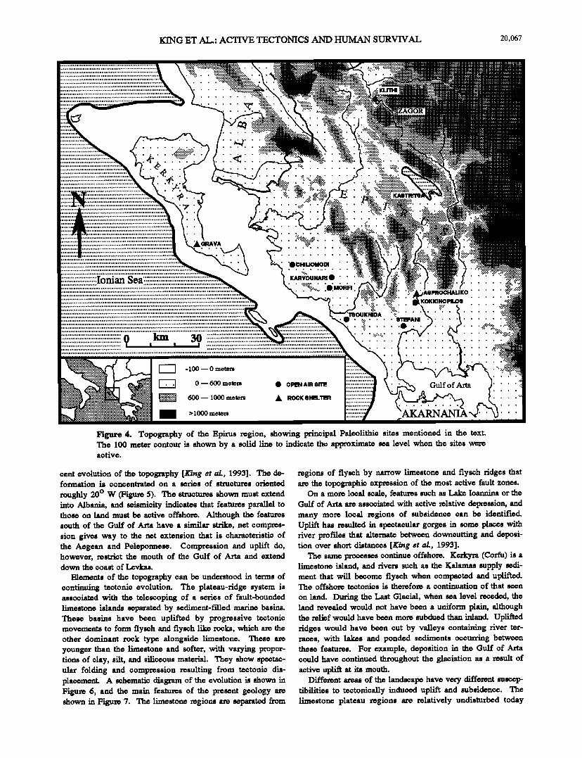
The topography of Epirus is rugged (Figure 4). A series of sharp ridges with elevations of 1000 m or more separate plateau regions that are in places deeply dissected by rivers. To the northwest in Albania and the northeast in the Pindus
mountains, the terrain has higher elevations and even under the present interglacial conditions is relatively inaccessible. The region is bounded to the southwest by the Ionian Sea and to the south by the Gulf of Arta and the more subdued terrain of Akarnania.
The seismicity map (Figure 1) shows that Epirus is subject to earthquakes with a rate of activity comparable to regions such as Japan, New Ze.•and and parts of the Middle East, where uplift rates of between meters and tens of meters Per millen- nium are well established. Studies of both the earthquake mechanisms and the geology indicate a region subject to com- pression, and its broad features can be understood in such a context. However, more recent work indicates the importance of strike-slip motion to a more complete understanding of re-
KING ET AL.: ACTIVE TECTONICS AND I-RJMAN SURVW• 20,067
•k•:IAVA
,.
ß
Ionian Sea ...........................................
................. 0 km 30 I I "
'O•m.mlfom ' '
KARVOUNARIß ' ' ß
ß' '?i{•:..;.•.
• -100 • 0 meters
• 0 • 600 meters "':"':• 600 • 1000 meters
• > 1000 meters
•AB•UKO ..... * ß
::i:i*.:.:::* KOKKINOPIL09
'r90UKNIDA '::: ß ......: .... OTEFAei ......
ß •: ..... ß ...7%:..:.... ß :•.:..:$. ß
• OPlg•l AIR 91TE
,k smc• otm.'rm
Gulf o f Arm
Figure 4. Topography of the Epirus region, showing principal Paleolithic sites mentioned in the text. The 100 meter contour is shown by a solid line to indicate the approximate sea love1 when the sites were active.
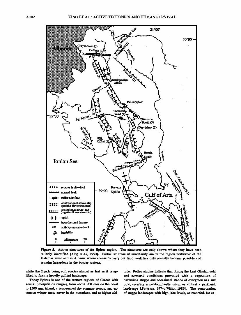
cent evolution of the topography [King et al., 1993]. The de- formation is concentrated on a series of structures oriented
roughly 20 ø W (Figure 5). The structures shown must extend into Albania, and seismicity indicates that features parallel to those on land must be active offshore. Although the features south of the Gulf of Arta have a similar strike, net compres- sion gives way to the net extension that is characteristic of the Aegean and Pelepormese. Compression and uplift do, however, restrict the mouth of the Gulf of Arta and extend down the coast of Levkas.
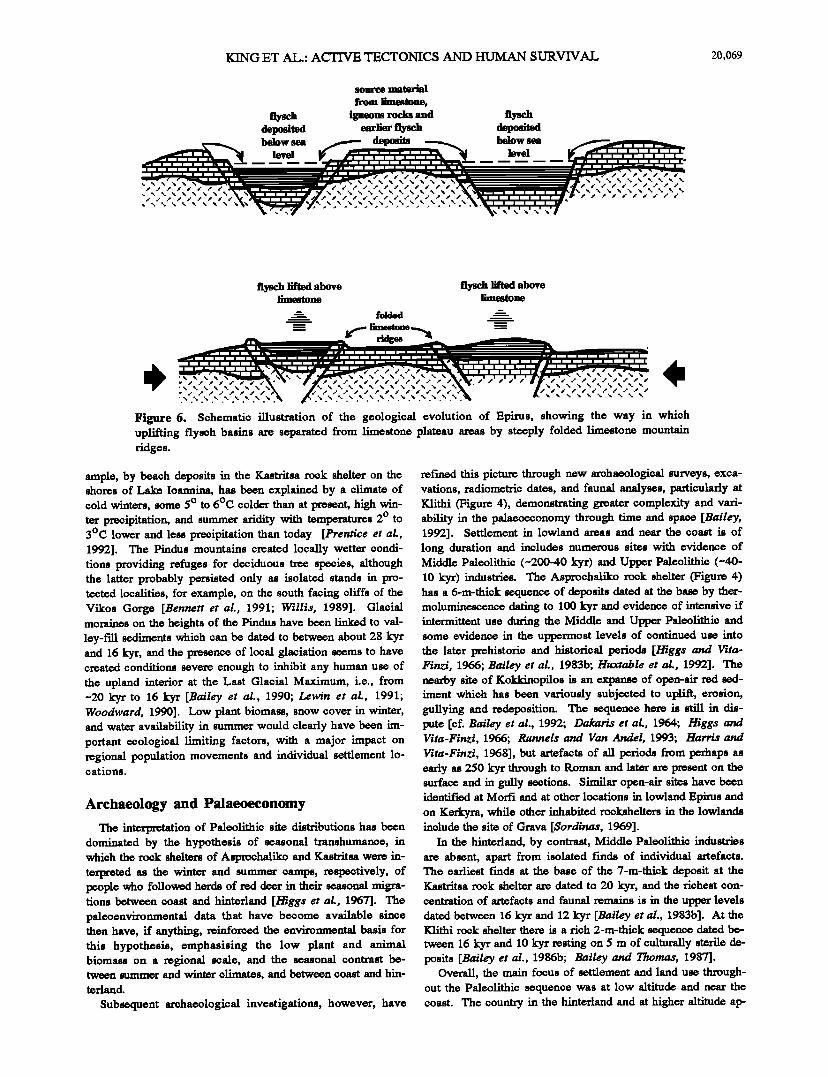
Elements of the topography can be understood in terms of continuing tectonic evolution. The plateau-ridge system is associated with the telescoping of a series of fault-bounded limestone islands separated by sediment-filled marine basins. These basins have been uplifted by progressive tectonic movements to form fiyseh and fiyseh like reeks, which are the other dominant rock type alongside limestone. These are younger than the limestone and softer, with varying propor- tions of clay, silt, and siliceous material. They show speetac- ular folding and compression resulting from tectonic dis- placemcnt• A schematic diagram of the evolution is shown in Figure 6, and the main features of the present geology are shown in Figure 7. The limestone •egions are separated from
regions of flyseh by narrow limestone and flyseh ridges that are the topographic expression of the most active fault zones.
On a more local scale, features such as Lake Ioannina or the Gulf of Arta are associated with active •elative depression, and many more local regions of subsidence can be identified. Uplift has resulted in spectacular gorges in some places with river profries that alternate between downcutting and deposi- tion over short distances [King et al., 1993].
The same processes continue offshore. Kerkyra (Corfu) is a limestone island, and rivers such as the Kalamas supply sedi- ment that will become fiysch when compacted and uplifted. The offshore tectonics is therefore a continuation of that seen
on land. During the Last Glacial, when sea level •, the land revealed would not have been a uniform plain, although the relief would have been more subdued than inland. Uplift• ridges would have been cut by valleys containing river ter- races, with lakes and ponded sediments occurring between these features. For example, deposition in the Gulf of Arta could have continued throughout the glaciation as a result of active upli• at its mouth.
Different areas of the landscape have very different suscep- tibilities to tectonically induced uplift and subsidence. The limestone plateau regions are relatively undisturbed today
20,068 KING ET AL.: ACTIVE TECTONICS AND HUMAN SURVIVAL
Ionian Sea
I I i 1 reverse fault--fold
..... normal fault
• strike-slip fault
contractional strike-slip I I I I (positive flower structure)
9xten9io_nal strike-slip. : : :" : (negative tlower stmc•)
v !
(•)
uplift
hypothesized feature
activity on scale 0•3
landslide
kilometers 20 • I
39 ø00' Uplifts Gulf of Arm
Figure 5. Active structures of the Epims region. The structures are only shown where they have been reliably identified [King et al•, 1993]. Particular areas of uncertainty are in the region northwest of the Kalamas river and in Albania where access to carry out field work has only recently become possible and remains hazardous in the border regions.
while the flysoh being soft erodes almost as fast as it is up- lifted to form a heavily gullied landscape.
Today Epims is one of the wettest regions of Gxv, ece with annual precipitation ranging from about 900 mm on the coast to 1300 mm inland, a pronounced dry summer season, and ex- tensive winter snow cover in the hinterland and at higher alti-
tude. Pollen studies indicate that during the Last Glacial, cold and semiarid conditions prevailed with a vegetation of Artemisia steppe and occasional stands of evergreen oak and pine, creating a predominantly open, or at best a parkland, landscape [Bottema, 1974; Willis, 1989]. The combination of steppe landscapes with high lake levels, as recorded, for ex-
KING ET AL.: ACTIVE TECTONICS AND I-1UMAN SURVIVAL 20,069
source material
from limestone,
flysch igneous rocks and flysch deposited earlier fiysch deposited below sea deposits below sea
level level
fiysch lifted above fiysch lifted above limestone limestone
•- folded ----
•"n'"'n'"'n'"'n'"%'" .r' .r' .r' .r' .r' .r' .r' .r' .r' .r' .r' .r' .r' .r' .r' .r' .r' .r' .r' .r' .r' .-'
Figure 6. Schematic illustration of the geological evolution of Epirus, showing the way in which uplifting flysob basins axe separated from limestone plateau areas by steeply folded limestone mountain ridges.
ample, by beach deposits in the Kastritsa rock shelter on the shores of Lake Ioannina, has been explained by a climate of cold winters, some 5 ø to 6øC colder than at present, high win- ter precipitation, and summer aridity with temperatures 2 ø to 3øC lower and less precipitation than today [Prentice et al., 1992]. The Pindus mountains created locally wetter condi- tions providing refuges for deciduous tree species, although the latter probably persisted only as isolated stands in pro- teeted localities, for example, on the south facing cliffs of the Vikos Gorge [Bennett et al., 1991; Willis, 1989]. Glacial moraines on the heights of the Pindus have been linked to val- ley-f'd! sediments which can be dated to between about 28 kyr and 16 kyr, and the presence of local glaciation seems to have created conditions severe enough to inhibit any human use of the upland interior at the Last Glacial Maximum, i.e., from ~20 k3rr to 16 kyr [Bailey et al., 1990; Lewin e; al., 1991; Woodward, 1990]. Low plant biomass, snow cover in winter, and water availability in summer would clearly have been im- portant ecological limiting factors, with a major impact on regional population movements and individual settlement lo- cations.
Archaeology and Palaeoeconomy
The inteWretation of Paleolithic site distributions has been dominated by the hypothesis of seasonal transhumance, in which the rock shelters of Asprochaliko and Kastritsa were in- terpreted as the winter and summer camps, respectively, of people who followed herds of red deer in their seasonal migra- tions between coast and hinterland [Higgs et al., 1967]. The palcoenvironmental data that have become available since then have, if anything, reinforced the environmental basis for this hypothesis, emphasising the low plant and animal biomass on a regional s•ale, and the seasonal contrast be- tween summer and winter climates, and between coast and hin- terland.
Subsequent archaeological investigations, however, have
refined this picture through new archaeological surveys, exca- vations, radiometric dates, and faunal analyses, particularly at Klithi (Figure 4), demonstrating greater complexity and vari- ability in the palaceeconomy through time and space [Bailey, 1992]. Settlement in lowland areas and near the coast is of long duration and includes numerous sites with evidence of Middle Paleolithic (~20040 kyr) and Upper Paleolithic (~40- 10 kyr) industries. The Asprochaliko rock shelter (Figure 4) has a 6-m-thick sequence of deposits dated at the base by ther- moluminescence dating to 100 kyr and evidence of intensive if intermittent use during the Middle and Upper Paleolithic and some evidence in the uppe•ost levels of continued use into the later prehistoric and historical periods [Higgs and Vita- Finzi, 1966; Bailey et al., 1983b; Huxtable et al., 1992]. The nearby site of Kokldnopilos is an expanse of open-air red sed- iment which has been variously subjected to uplift, erosion, gullying and redeposition. The sequence here is still in dis= pute [of. Bailey et M., 1992; Dakaris et M., 1964; Higgs and Vita-Finzi, 1966; Runnels and Van Andel, 1993; Harris and Vita-Finzi, 1968], but artefacts of all periods from perhaps as early as 250 kyr through to Roman and later are present on the surface and in gully sections. Similar open-air sites have been identified at Morfi and at other locations in lowland Epirus and on Kerlcyra, while other inhabited rocksheltem in the lowlands include the site of Grava [Sordinas, 1969].
In the hinterland, by contrast, Middle Paleolithic industries are absent, apart from isolated finds of individual artefacts. The earliest finds at the base of the 7-m-thick deposit at the Kastritsa rock shelter are dated to 20 kyr, and the richest con- centration of artefacts and faunal remains is in the upper levels dated between 16 kyr and 12 kyr [Bailey et al., 1983b]. At the Klithi rock shelter there is a rich 2-m-thick sequence dated be- tween 16 kyr and 10 kyr resting on 5 m of culturally sterile de- posits [Bailey et al., 1986b; Bailey and Thornt•, 1987].
Overall, the main focus of settlement and land use through- out the Paleolithic sequence was at low altitude and near the coast. The country in the hinterland and at higher altitude ap-
20,070 KING ET AL.' ACTIVE TECTONICS AND • SURVIVAL
+
<
ß . .
KOKKINOPILOS
high relief
low relief
i•n•ou•
limestone
fiyseh and fiysehlike
Gulf of A•m
a!luvia, lake marls, fans
0 kilometers 20 I • I
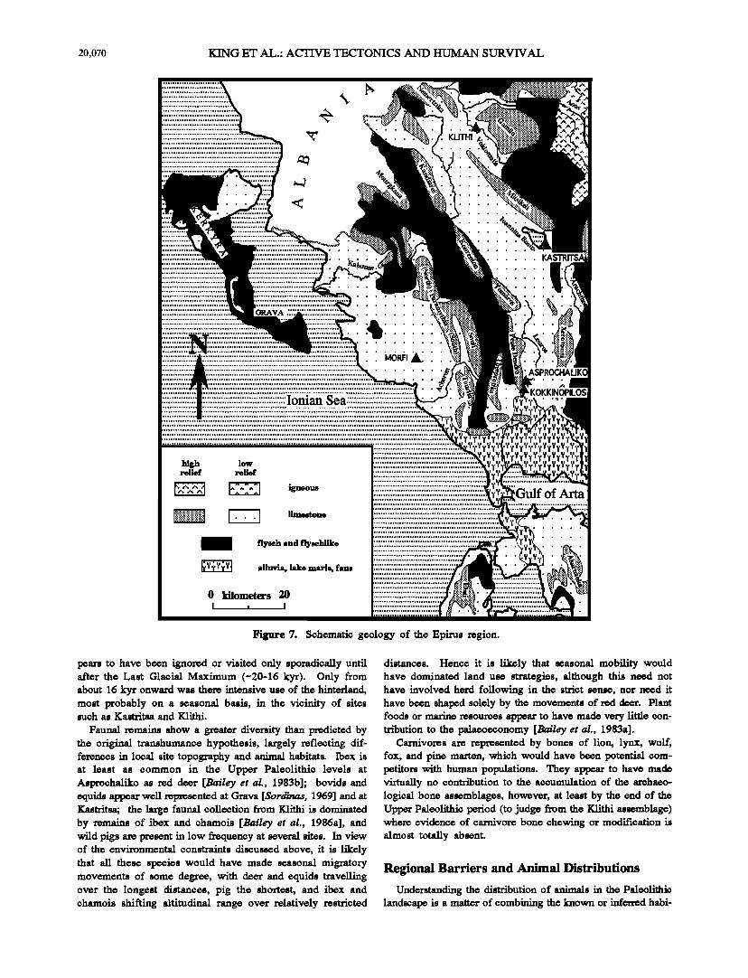
Figure 7. Schematic geology of the Epirus region.
pears to have been ignored or visited only sporadically until after the Last Glacial Maximum (-20-16 kyr). Only from about 16 kyr onward was there intensive use of the hinterland, most probably on a seasonal basis, in the vicinity of sites such as Kastritsa and Klithi.
Faunal remains show a greater diversity than predicted by the original transhumance hypothesis, largely reflecting dif- ferences in local site topography and animal habitats. Ibex is at least as common in the Upper Paleolithic levels at Asproohaliko as red deer [Bailey et al., 1983b]; bovids and equids appear well represented at Grava [Sordinas, 1969] and at Kastritsa; the large faunal collection from Klithi is dominated by remains of ibex and chamois [Bailey et al., 1986a], and wild pigs are present in low frequency at several sites. In view of the environmental constraints discussed above, it is likely that all these species would have made seasonal migratory movements of some degree, with • and equids travelling over the longest distances, pig the shortest, and ibex and chamois shifting altitudinal range over relatively restricted
distances. Hence it is likely that seasonal mobility would have dominated land use strategies, although this need not have involved herd following in the strict sense, nor need it have been shaped solely by the movements of red deer. Plant foods or marine resources apf•ar to have made very little con- tribution to the palaeoeconomy [Ba/ley et al., 1983a].
Carnivores are represented by bones of lion, lynx, wolf, fox, and pine marten, which would have been potential com- petitors with human populations. They apf•ar to have made virtually no contribution to the accumulation of the archaeo- logical bone assemblages, however, at least by the end of the Upper Paleolithic period (to judge from the Klithi assemblage) where evidence of carnivore bone chewing or modification is almost totally absent.
Regional Barriers and Animal Distributions
Understanding the distribution of animals in the Paleolithic landscape is a matter of combining the known or inferred habi-
KING ET AL.- ACTIVE TECTONICS AND I-ILrMAN SURVIVAL 20,07!
N
marine barrier even during lee age
barrier due to flysoh and mountain ridges
swamp conditions
0 kilometers 20
Figure 8. Simplified physical barriers of the Epirus region.
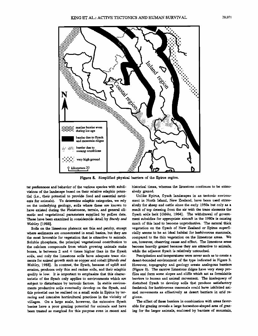
tat preferences and behavior of the various species with subdi- visions of the landscape based on their relative edaphic poten- tial (i.e., their potential to provide food and essential nutri- ents for animals). To determine edaphic categories, we rely on the underlying geology, soils where these are known to have existed during the Pleistocene, terrain, and general cli- matic and vegetational parameters supplied by pollen data. These have been examined in considerable detail by Sturdy and WebIcy [1988].
Soils on the limestone plateaux are thin and patehy, except where sediments are concentrated in small basins, but they are the most favorable for vegetation that is attractive to animals. Soluble phosphate, the principal vegetational contribution to the calcium compounds from which growing animals make bones, is between 2 and 4 times higher than in the fiysch soils, and only the limestone soils have adequate trace ele- ments for animal growth such as copper and cobalt [Sturdy and WebIcy, 1988]. In contrast, the fiysch, because of uplift and erosion, produces only thin and ranker soils, and their edaphic quality is low. It is important to emphasize that this charac- teristic of the fiysch only applies to environments which are subject to disturbance by tectonic factors. In stable environ- ments productive soils eventually develop on the fiysch, and this potential can be realised on a small scale in Epirus by ter- racing and intensive horticultural practices in the vicinity of villages. On a large scale, however, the extensive fiysch basins have a poor grazing potential for animals and have been treated as marginal for this purpose even in recent and
historical times, whereas the limestone continues to be exten- sively grazed.
Unlike Epirus, fiysch landscapes in an tectonic environ- ment in North Island, New Zealand, have been used exten-
sively for sheep and cattle since the early 1950s but only as a result of top dressing from the air with the trace elements the fiysch soils lack [Gibbs, 1964]. The withdrawal of govern- ment subsidies for appropriate aire• in the 1980s is causing much of this land to become unproductive. The natural thick vegetation on the fiysch of New Zealand or Epirus superfi- cially seems to be an ideal habitat for herbivorous mammals, compared to the thin vegetation on the limestone areas. We are, however, observing cause and effect. The limestone areas become heavily grazed because they are attractive to animals, while the adjacent fiysch is relatively untouched.
Plv•ipitation and temperatures were never such as to oreate a desert-bounded environment of the type indicated in Figure 3. However, topography and geology create analogous barriers (Figure 8). The narrow limestone ridges have very steep pro- fries and form scree slopes and cliffs which act as formidable barriers to human and animal movement. The inadequacy of disturbed fiysch to develop softs that produce satisfactory feedstock for herbivorous mammals could have inhibited ani-
mal movements as effectively as desert barriers in arid re- gions.
The effect of these barriers in combination with areas favor-
able for grazing reveals a large horseshoe-shapexi area of graz- ing for the larger animals, enclosed by barriers of mountain,
20,072 KING ET AL.: ACTIVE TECTONICS AND HUMAN SURVIVAL
0
=====================
:::::::::::::::::::::::::::::::::::::: ..:%.
•..• •. • ?4.:..
TSOUKN!DA
KASTRITSA
HALIKO
If i i] l•::testone platcarat winter water retentive fans, marls and Neogene deposits
plateaux summer -'_']_• gravel fans
main herd movements
of deer, cattle, & horse
ridges • flysch archaeological site
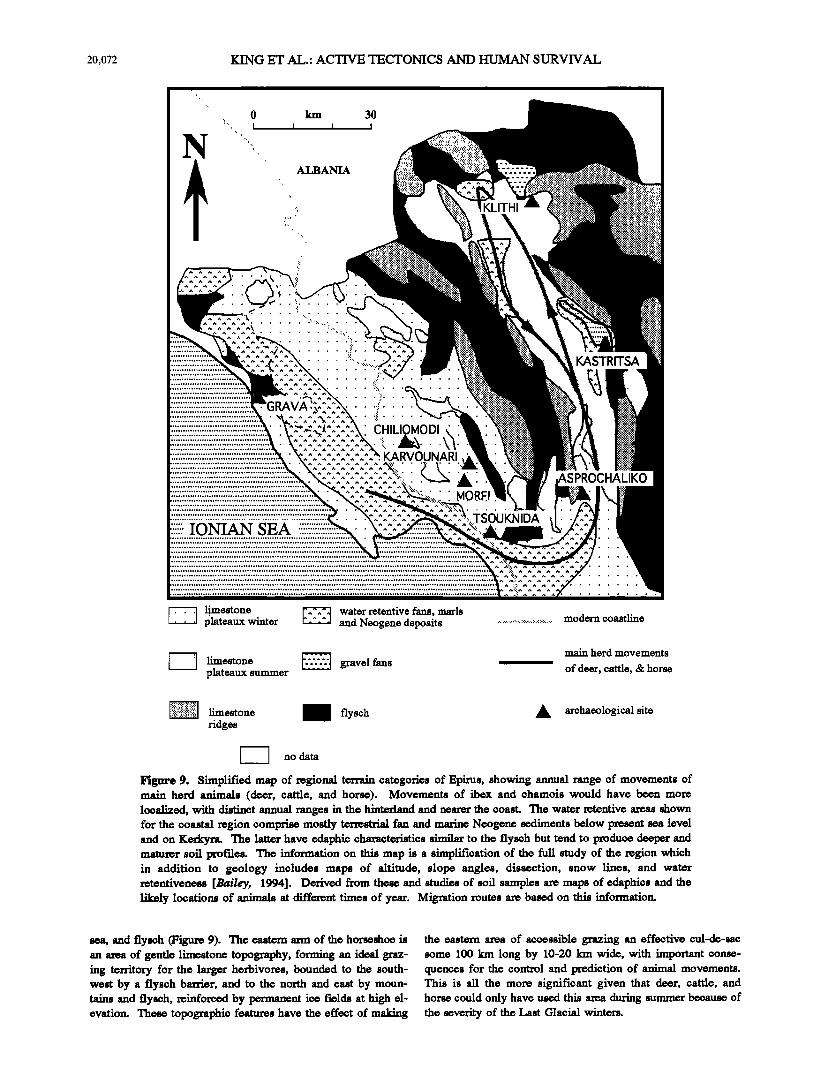
I no data Figure 9. Simplified map of regional terrain categories of Epirus, showing annual range of movements of main herd animals (deer, cattle, and horse). Movements of ibex and chamois would have been more localized, with distinct annual ranges in the hinterland and nearer the coast. The water retentive areas shown for the coastal region comprise mosfiy terrestrial fan and marine Neogene sediments below present sea level and on Kerkyra. The latter have edaphie characteristics similar to the fiysch but tend to produce deeper and maturer soil prof'des. The information on this map is a simplification of the full study of the region which in addition to geology includes maps of altitude, slope angles, dissection, snow lines, and water retentiveness [Bailey, 1994]. Derived from these and studies of soil samples are maps of edaphies and the likely locations of animals at different times of year. Migration mutes are based on this information.
sea, and fiyseh (Figu• 9). The eastern arm of the horseshoe is an area of gentle limestone topography, forming an i&al graz- ing territory for the larger herbivores, bounded to the south- west by a fiysch barrier, and to the north and east by moun- tains and flysch, reinfomed by permanent ice fields at high el- evation. These topographic features have the effect of making
the eastern area of accessible grazing an effective cul-de-sac some 100 km long by 10-20 Inn wide, with important conse- quences for the control and prediction of animal movements. This is all the more significant given that deer, cattle, and horse could only have used this area during summer because of the severity of the Last Glacial winters.
KING ET AL.: ACTIVE TECTONICS AND ttUMAN SURVIVAL •o,o?•
• •eeent deposits o• deposits w•th•n flood m•e of the current •//••/////•
• l•ed fans, te•ces, •d s•aces that now lose material to the •• • •r•Se•t river symem bu,.•.would not •ve done so • Pal•lithic ••
PM•p•s
• / Asprochaliko • • • Rock shelter •' Kokkinopilos
UPL[• UPL[• • Beds UPLI•
N 4 Kilomotors I I
_2• •%- River Profile I __ '"•cøt%.•'•'"•.• clepositional
depositional•
.1111•'•••,•"'" i[,••.,•*aime•t' ' -
II II
:::::::::::::::::::::::::::::::::::::::::::::::::::::::::::::::::::::::::::::::::::::::::::::::::::::::::::::::::::::::::::::::::::::::::::::::::::::::::::::::::::::::::::::::`:•:`:`:`:`:`:`:`:•:`:`:`:`:`:`•`:`:`:`:`:`:`:`:`:`:`:`:`:`:`:`:`:`:`:`:`:`:•:`:`:`:`:`:•:`:`:`:`:`:`:`:`:`:`:`:`:`:`:`:`:`:`:`:`:`:`:`:`:•:`:`:`:`:`:`:`:`:`:`:`:`:`:`:`:`:`:`:`:`:`:`:`:`:`:`:`:`:`:`:`:`:`:`:`:`:`:`:`:`:`:• ......................................................................................................................................................................................................
::::::::::::5:::::: :::::::::::::::::::::::::::::::::::::::::::::::::: :::::::::::::::::::::::::::::::::: :: :::::::::::::::::::::::::::::::::: 5:::::: :: ::::::::::::::5:::: 5:::::::::::::: ::5:::::::: ::5::::: :5::::: :::5:: ::::::5:::::: ::::::5 :: ::5::: :::5:::: 5: :::5:::: ::5:::::::::::::::: ::::5:: :: ::5:::: ::5:::: ::5:::: :: ::5::::::::::::: :5:: :: ::::::::::::::::::::: :5:::::
:: :: :: :::5 ::::::::::::::::::::::::::::: :::::::::::::::::::::::::::: :::5::::::::::::: :::5::::: :::::::5::::: :::5 :: 5: :5::: :::::::::::::::::::::::::::::::::::::: :::::5:::::: 5:::::::::: ::::5::::: :::::5: :: :5::::: :: :::::::::::::5:::: ::::5::: :::::5::: :: :5::: :: :::::5: :::::5::::::::::::: :::5: :: :: :::5::::: :: :5: :5:::::::: ::::5::::: :::5::: :5: :5: :5:: ::::::5 ::5 5::,'
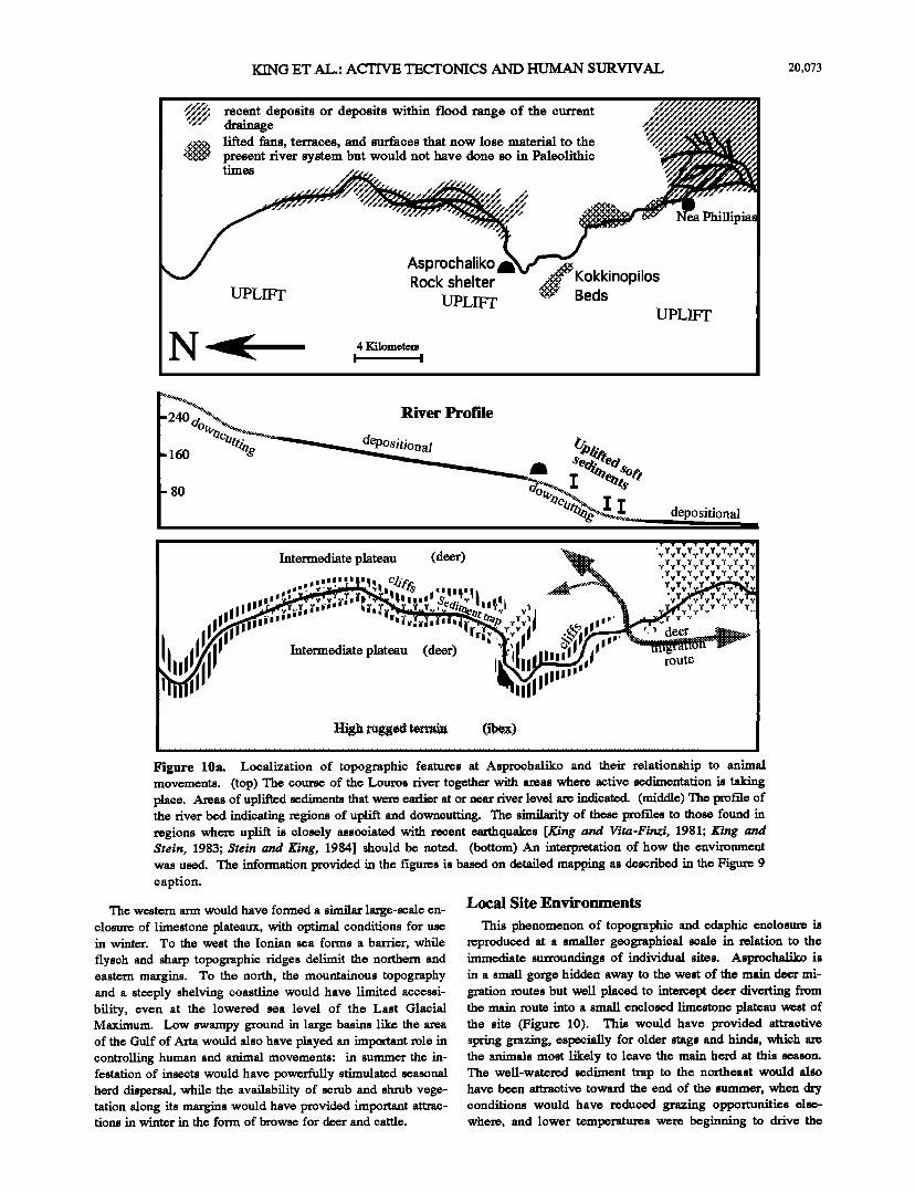
Figure 10a. LocOmotion of topo•pbic fe•tu•s nt Asp•cb•o and the• relationship to •n• movements. (top) •e cou• of the Louros dv• to•e•er with •s wb• •ctive ••enmtion place. •s of upl• •en• •t we• e•r •t or ne• dyer level • •c•. (•d•e) •e the dyer • •dic•t• •ions of upl• and do•cu•. •e s••• of the• •o•des to •o• found •ions •e• upl• is clo•1• nss•i•t• •th r•ent e•qu•s [• • V•r•-••, 1981; •rei•, 1983; •re• • E•, 19•] should • nord. (boSom) An •te•mtion of how the env••ent w•s u•d. •e •o•fion •ovi•d • the fi•ms is bn• on •m•ed m•• •s deeded • •e Fi• caption.
The western axrn would have formed a similar large-scale en- closure of limestone plateaux, with optimal conditions for use in winter. To the west the Ionian sea forms a barrier, while
flysch and sharp topographic ridges delimit the northern and eastern margins. To the north, the mountainous topography and a steeply shelving coastline would have limited accessi- bility, even at the lowered sea level of the Last Glacial Maximum. Low swampy ground in large basins like the area of the Gulf of Arta would also have played an important role in controlling human and animal movements: in summer the in- festation of insects would have powerfully stimulated seasonal herd dispersal, while the availability of scrub and shrub vege- tation along its margins would have provided important attrac- tions in winter in the form of browse for deer and cattle.
Local Site Environments
This phenomenon of topographic and edaphic enclosure is reproduced at a smaller geographical scale in relation to the immediate surroundings of individual sites. Asprochaliko is in a small gorge hidden away to the west of the main deer mi- gration routes but well placed to intercept deer diverting from the main route into a small enclosed limestone plateau west of the site (Figure 10). This would have provided attractive spring grazing, cspe, cially for older stags and hinds, which arc the animals most likely to leave the main herd at this season. The well-watered sediment trap to the northeast would al•io have be, on attractive toward the end of the summer, when dry conditions would have reduced grazing opportunities else- where, and lower temperatures were beginning to drive the

20,074 KING ET AL.: ACTIVE TECTONICS AND HUMAN SURVIVAL
Figure 10b. Two possible tectonic interpretations for the Asprochaliko-Kokkinopilos region are shown. (top) The river cuts directly across rising anticlines. (bottom) The river meanders toward and away from a single uplifting anticline. King and Bailey [1985] entertained both possibilities but favored the former. However, a broader view of the tectonics of Epirus [King et al., 1993] now favors the second. It is important to appreciate that deformation of the form shown is superimposed on a preexisting topography left by earlier tectonic processes. Thus, for example, the Lourcs river follows a valley inherited from much earlier times, and tectonic activity merely determines how it is currently being modified.
herds back toward their winter territories nearer the coast. The
site is also well placed to intercept ibex in local movements from high ground in the northwest to lower and more sheltered terrain in the southeast.
Kastritsa is on the northwest slope of a limestone "island" protruding through lake sediments and partly surrounded by the waters of the lake (Figure 11). Shallow gravel fans and wa-
ter retentive lake sediments fringing the open water would have atlxacted horse and cattle, respectively, with deer concen- trating on the gentle limestone terrain to the south and west, feeding closer to the lake at the end of the summer. As at Asprochaliko, the site is placed to one side of the main migra- tion routes but also controls a local enclosure formed by the eastern arm of the lake and s• ground farther to the east
KING ET AL.: ACTIVE TECTONICS AND HUMAN SURVIVAL 20,075
iiii ": ii!i!i!i!ii!iii:!:ii!:i:i ............
i:i:?i:i:i:i:i:i:!:!:i:!:!:i:i:i:i:i:i:!:!i..•.i!i!i!
Rock Shelter
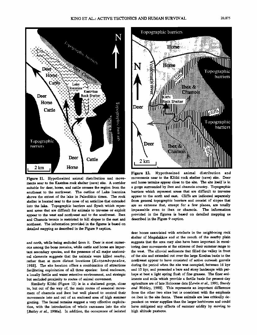
Figure 11. Hypothesized animal distribution and move- ments near to the Kastritsa rock shelter (cave) site. A corridor suitable for deer, horse, and cattle crosses the region from the southeast to the northwest. The outline of Lake Ioannina
shows the extent of the lake in Paleolithic times. The rock
shelter is located near to the nose of an anticline that extended
into the lake. Topographic barriers and fiysch which repre- sent areas that are diff'lcult for animals to traverse or exploit appear to the west and northwest and to the southwest. Ibex and Chamois tenain is restricted to hill slopes to the east and northeast.The information provided in the figures is based on detailed mapping as described in the Figure 9 caption.
and north, while being secluded from it. Deer is most numer- ous among the bone remains, while cattle and horse are impor- tarit secondary species, and the presence of all major anatomi- cal elements suggests that the animals were killed nearby, rather than at more distant locations [Kotzambopoulou, 1988]. The site location offers a combination of attractions facilitating exploitation of all three species: local enclosure, a locally fertile and water retentive environment, and strategic but secluded proximity to routes of animal movement.
Similarly Klithi (Figure 12) is in a sheltered gorge, close to, but out of the way of, the main routes of seasonal move- ment of chamois and ibex but well placed to control their movements into and out of an enclosed area of high summer grazing. The faunal remains suggest a very effective exploita- tion, with the introduction of whole carcasses into the site [Bailey ½t al., 1986a]. In addition, the occurrence of isolated
Figure 12. Hypothesized animal distribution and movements near to the Klithi rock shelter (cave) site. Deer and horse tenains appear close to the site. The site itself is in a gorge surrounded by ibex and chamois country. Topographic barriers which represent areas that are difficult to traverse appear to the north and east. Cliffs are indicated separately from general topographic barriers and consist of slopes that are so extreme that, except for a few places, are totally impassable even to ibex or chamois. The information provided in the figures is based on detailed mapping as described in the Figure 9 caption.
deer bones associated with artefacts in the neighboring rock shelter of Megalakkos and at the mouth of the nearby plain suggests that the area may also have been important in moni- toring deer movements at the extreme of their summer range to the west. The alluvial sediments that filled the valley in front of the site and extended out over the large Konitsa basin to the northwest appear to have consisted of active outwash gravels during the period when the site was occupied, between 16 kyr and 10 kyr, and presentext a bare and stony landscape with per- haps at best a light spring flush of fme grasses. The fmer sed- iments and soils which provide a fertile basis for present-day agriculture are of late Holocene data [Le,•v/n et al., 1991; Sturdy and Webley, 1988]. This represents an important difference from the other two sites but is consistent with the emphasis on ibex in the site fauna. These animals are less critically de- pendent on water supplies than the larger herbivores and could have mitigated any effects of summer aridity by moving to high altitude pastures.
20,076 KING ET AL.: ACTIVE TECTONICS AND HUMAN SURVIVAL
Long-Term Dynamics
The above reconstructions describe the average conditions for the Last Glacial, and as such give a largely static piere.re of the landscape and of human economic activities within it. However, in assessing the long-term success of human and other populations in the regional environment, it is not so much the average conditions that are relevant as the shorter- term fluctuations, and especially the extremes in the range of such variability [King and Lindh, 1994]. It is these extremes that are critical in defining the selective pressures which shape longer term trends, giving a competitive edge to those species and populations which are better equipped to cope with periods of environmental deterioration, and hence axe better placed to respond rapidly when environmental conditions improve.
•V'mter cold and snow cover, especially in bad winters, is an obvious limiting factor of the Last Glacial environment, which would have placed a high premium on conditions of lo- cal shelter or at low altitude. The rock shelter of Asprochaliko has long been recognized, with its south facing aspect, as a favorable location for winter use [Legge, 1972]. The south facing Klithi in its protected gorge offers a similar atm•tion, important even in the summer months for habitation near high-altitude terrrain in close proximity to a permanent ice field. Recent palcoenvironmental data underline this point while also demonstrating that summer aridi• would have been another powertiff limiting factor, placing an equally high pre- mium on areas of water-retentive sediments. The importance of tectonics in sustaining local areas of fertility under these circumstances cannot be overemphasized. The fact that the three sites discussed offer advantages of shelter, access to lo- cally fertile and well-watered sediments, or both is thus of great significance. By controlling those local areas of the landscape best protected against extremes of cold and aridity, the human population would have been well placed to cope with temporal variability in environmental conditions, both the large-scale changes associated with the Last Glacial Maximum, when aridi• and cold would have been at their max- imum and smaller-scale fluctuations from year to year.
The hinterland region, being available for humans on only a seasonal basis, was probably always a marginal area for hu- man exploitation. It certainly appears to have been visited only sporadically until quite late in the regional sequence of Paleolithic occupation, and was therefore an area in which other earnivores could have competed suoeessfially for prey. With climatic deterioration at the Last Glacial Maximum, all animal activity in the hinterland would have been severely re- strioted, and the oamivores would have been forced into the coastal lowlands into closer competition with humans who were already well established there. When conditions began to improve again after 16 k-yr, the human population, by virtue of their ability to control key topographic features in the landscape, would have been able to respond quickly and thus to secure and maintain an increasingly effective control of the hinterland region and its seasonal population of herbivorous mammals. To the extent that deformation has not simply ere- ated those features of the landscape that human populations have turned to their advantage but has also actively sustained and even accentuated them during the course of human occupa- tion, active tectonics needs to be considered as an important agent in human-environment interactions, with far-reaching consequences for an understanding of other processes: eli- mario, vegetational, cultural, and social.
Conclusions
The essential tecto•o style of northwest Greece has pro- dueed limestone plateau areas which are separated from each other by regions less attractive to humans and animals, whether because they are steep, narrow mountains or the gul- lied terrain and unproductive soils of the Epims fiysch. At present this is certainly reflected in the distribution of Paleolithic sites. Cave sites are almost bound to be in lime-
stone, but the large number of small and large open sites are also all on the limestone plateaux of western or eastern Epims. So far there have been no discoveries of Paleolithic artefacts
in the flysoh basins. The association of inland grazing areas, which are both attractive to herbivores and surrounded by natu- ral topographic barriers, would have been particularly advan- tageous to the human monitoring and control of animal re- sources. Large sediment basins, notably the Gulf of Arta re- gion, are also likely to have persisted as important areas of at- traction, with a fertility periodically renewed by tectonic pro- eesses and effectively independent of climatic changes. These features of topographic barriers, attractive grazing areas, and climatically insensitive sediment traps are reproduced at a smaller scale in relation to individual site locations, with lo- cal enclosures, discreetly placed camp sites, and small concen- trations of sediment accumulation facilitating the attraction, observation, and control of animals.
The inferred constraints placed on animal distribution and movement at various seasons by physical barriers have more general consequences for the techniques of human exploitation of herbivores. The location of sites in the complex landscape of Epims has been discussed largely within the timescale of anatomically modem humans. But there is no reason why such an approach should not contribute a valuable understanding to much earlier periods and other parts of the world. The ecologi- cal and evolutionary "drama" has traditionally been viewed in terms of ecological interactions between human populations and the biological organisms which provide food or act as predaters, competitors and parasites. Quaternary elimarie and vegetational change typically provide changes of scenery and may frequently be more active "players". Changes in the solid earth, however, have been treated as external, adventitious, and disruptive, eausing a temporary halt in production or a change of venue but not otherwise actively shaping the per- formanco. This view is clearly oversimplifed, and tectonics, like other environmental or biological processes, needs to be more actively incorporated as a variable shaping the long- term interactions which affect the course of human evolution.
Uplift can divert the course of rivers or cause them to ereate deeply incised channels. Fold and fault fronts produce local enclosures or natural fences. Such features lead to a complex topography which, by channelling or restricting animal movements, offers much more potential than a featureless plain to a prodater that must use its wits to be competitive. In the complex topography of tectonically active areas, the hu- man brain had the resources to fashion a unique technical com- petitiveness.
Aeimowledgmonts. Fieldwork was supported by grants from the British Academy, the British School at Athens, the National Geographic Society, and the Society of Antiquaries and by permits issued through the good offices of the British School at Athens, the Ministry of Cult•e, Athens, the Institute of Geological and Mineralogical Research (IGMIg), Athens, the ]gphoroia of Palaceanthropology and Speleology, Athens, and the ]gphoroia of Prehistoric and Classical Archaeology,
KING ET AL.: ACTIVE TECTONICS AND HUMAN SURVIVAL 20,077
Ioann;na, We are grateful to the Oxford Radiocarbon Accelerator Unit and the British Museum for radiometric dating. The tectonic part of this work was carried out within the framework of the AR•lVl]•ES
Project, funded by DG XH of the European Commission as part of the Envi•nment (Desertification) Programme under contract EVSV-0021.
References
Ambraseys, N.H., Temporary seismic quiescence: S.E. Turkey, Geephys. .r. lnt;, 96, 311-331, 1989.
Bailey, G.N., The Palaeolithic of FAithi in its wider context, Annu. Br. Sch. ArchaeoL Athens, 87, 1-28, 1992.
Bailey, GaN, F, xcavat/on• at K//th/, 1983-1988: Palaeolithic archaeol- ogy and lan•capes in Epirus, northwest Greece, McDonald Institute, Cambridge, in press, 1994.
Bailey, GAN., and C.S. Gamble, The Balkans at 18 000 B.P.: The view from Epirua, in The World at 18 000 BP, vol.l, oclited by C. Gamble and O. Softer, pp.148-167, Unwin and Hyman, Boston, Mass., 1990.
Bailey, GaN, and G. Thomas, The use of percussion drilling to obtain core samples from rookshelter deposits, Ant/qu/ry, 61, 430-439, 1987.
Bailey, G.N., P.L. Carter, C.S. Gamble, and H.P. Higgs, Epims revisited: Seasonality and inter-site variation in the Upper Palaeolithic of north- west Greece, in Hunter-Gatherer Economy in Prehistory: A European Perspective, oclited by GaN. Bailey, pp. 64-78, Cambridge University Press, New York, 1983a.
Bailey, GAN., P.L. Carter, C.S. Gamble, and H.P. Higgs, Asprochaliko and Kastritsa: Further investigations of Palaeolithic settlement and economy in Epims (north-west Crmece), Proc. Prehist. Sec., 49, 15- 42, 1983b.
Bailey, GAN., P.L. Carter, C.S. Gamble, H.P. I-Iiggs, and C. Roubet, Palaeolithic investigations in F_•irus: The results of the first seasoh's excavations at Klithi, 1983, Annu. Br. Sch. Archaeol. Axhens, 79, 7- 22, 1984.
Bailey, GAN., C.S. Gamble, H.P. I-Iiggs, C. Roubet, D.A. Sturdy, and D•P.Webley, Palaeolithic investigations at Klithi: Preliminary results of the 1984-1985 field seasons, Annu. Br. Sch. ArchaeoL Athens, 81, 7-35, 1986a.
Bailey, GAN., C.S. Gamble, H.P. I-Iiggs, C. Roubet, D.P. Webley, I.A.J. Gowlett, D.A. Sturdy, and C. Turner, Dating results from Palaeolithic sites and palaeoonvironments in Epirus (north-west Greece), in Archaeological Results j•om Accelerator Dating, edited by LA.J. Gowlett and R.E.M. Hedges, pp. 99-107, Oxford University Commltteo for Arohaeology, Oxford, 1986b.
Bailey, GAN., •. Lowin, M.G. Maclcli• and LC. Woodward, The 'Older Fill' of the Voidomatis valley, north-west Crroece and its relationship to the Palaeolithic arohaeology and glacial history of the region, J. ArchaeoLS•, 17, 145-150, 1990.
Bailey, G.N., V. Papaconstantinou, and D.A. Sturdy, Asprochaliko and Koiddnpilos: TL dating and reinterpretation of Middle Palaeolithic sites in Epirus, north-west Greece, Cambridge Archaeol. •., 2, 136- 44, 1992.
Bennett, K.D., P.C. Tzodakis, and KJ. Willis, Quaternary refugia of north Fatrop ean trees, •. Bio geo gr. , 18, 103-115, 1991.
Bottama, S., Late Quaternary Vegetation History of Northwestern Greece, Gronln•en University Press, Groningen, Netherlands, 1974.
Dakaris, S_l., B.S. Higgs, and R.W. Hey, The climate, environment and industries of Stone Age Greece, part L Proc. Prehist. Sec., 30, 199- 244, 1964.
DeMets, C., R.G. Gordon, D.F. Argus, and R.S. Stein, Charrent plate motions, Int. Geephys. ,r., 101, 425-478, 1990.
Gibbs, H.S., Soils of Northland, in New Zealand Natural Resources Survey, pp.25-37, Government Printer, Wellington, New Zealand, 1964.
Hardy, D.A, Keller, L, Galanopoulos, V.P., Fienaming, N.C., and T.H. Druitt (Eds.), 27tera and the Aegean World, Ill, Proceedings of the Third International Congress, Santorini, Greece, $-9 September 1989, vol. 2, Earth Sciences, Thea-a Foundation, London, 1989.
Harris, D.R., and C. Vita-Fin7.1: Koiddnopilos-A Greek badland, Geegr. •., 134, 537-546, 1968.
Higgs, E.S, Environmental changes in northern Greeoo, in The Environmental History of the Near and Middle East •ince the La• Ice Age, edited by W.C. Brice, pp. 41-49, Academic, San Diego, Calif., 1978.
Higgs, tI.S, and C. Vita-Finzi, The climate, environment and industries of Stone Age Crmece, part IL Proc. Prehiza ,Sec., 32, 1-29, 1966.
Higgs, E.S., and D.P. Webley, Further information concerning the environment of Palaeolithic man in Epirus, Proc. Prehist. Sec., 37, 367-380, 1971.
Higgs, I•.S., C. Vita-P'mzi, D.IL Harris, and A.E. Fagg, The climate, environment and industries of Stone Age Greece, part HI, Proc. Prehi•. Sot, 33, 1-29, 1967.
Huxtable, L, LA.L Gowlett, GaN. Bailey, P.L. Carter, and V. Papaconstantinou, Thermolnminescence dates and a new analysis of the early Mousterian from Asprochaliko, Current Anthropol., 33, 109-14, 1992.
King, G.C.P., and GaN. Bailey, The palaeoenvironment of some ar- chaeological sites in Greece: The influence of accumulated uplift in a seismically active region, Proc. Prehist. Sec., 51, 273-82, 1985.
King, G.C.P., and A.G. IAndh, Predictability and the evolution of culture, in Time and Tra•formation•, Proceedings of the Cambridge Conference on Dyna•cal Description• and Human Systems, edited by S. Van der Leeuw, Routledge, Boston, in press, 1994.
King, G.C.P., and R.S. Stein, Surface folding, deformation rate, and earthquake repeat time in a reverse faulting environment: The Coalinga, California, earthquake of May 2, 1983, in The 1983 Coaiinga, California F. atthquakes, Calif. Div. M•ne• GeoL Spec. Publ. 66, 165-176, 1983.
King, G.C.P., and C. Vita-Finzi, Active folding in the Algerian earth- quake of 10 October, 1980, Nature, 292, 22-26, 1981.
King, G.C.P., D.A. Sturdy, and L Whitney. Landscape geometry and the active tectonics of northwest Greece, Bull. Geol. Sec. AJ•, 105, 137- 161, 1993.
Kotzambopoulou, If., Faunal analysis of the Kastritsa Cave, Greece, M.Phil. thesis, Cambridge University, Cambridge, England, 1988.
Lambeck, K., Late Pleistocene, Holocene and present sea-levels: Constraints on future change, Palaeogeogr. Palaeoclimatol. PalaeoecoL, 89, 205-217, 1990.
Logge, A.J., Cave climates, in Papers in Economic Prehistory, edited by E.S. Higgs, pp. 97-103, Cambridge University Press, New York, 1972.
Lowin, •., M.G. Macklin & I.C. Woodward, Late Quaternary fluvial sedimentation in the Voidomatis basin, Bpirus, Northwest Greece, Quaternary Research, 35, 103-115, 1991.
Madeyska, T., The distribution of human settlement in the extra-tropical Old World 24 000 - 15 000 BP, The World at 18 000 BP, vol. 2, edited
by C. Gamble and O. Softer, pp, 24-37, Unwin and Hyman, Boston, Mass., 1990.
Moseley, M.tI., The good old days were better:. Agrarian collapse and tectonics, Arr• AnthropoL, 85, 773-799, 1983.
Moseley, M.E., and ILA. Peldman, Fishln•, farming and the foundation of Andean civilization, in The Archaeology of Prehi•oric Coastlines, edited by G. Bailey and •. Parkington, pp. 125-134, Cambridge University Press, New York, 1988.
Prentice, I.C., •. Guiot, and S.P. Harrison, Mediterranean vegetation, lake levels and palaeoclimate at the Last Glacial Maximum, Nature, 36O, 658-60, 1992.
Runnels, C., and T. Van Andel, A handaxe from Koirk•opilos, Epirus, and its implications for the Palaeolithic of Greece, •. Field ArchaeoL,
Slemmons, D.B., tI.R. tlngdahl, M.D. Zoback, and D.D. Blackwell (Eds.), The Neetectonics of North America, Decade Map, vol. 1, Geological Society of America, Boulder, Col., 1991.
Sordinas, A., Investigations of the prehl-tory of Corfu during 1964-1966, Balkan Stud., 10, 393.424, 1969.
Stein, R.S., and G.C.P. King, Seismic potential revealed by surface folding: The 1983 Coalinga, California, earthquake, Science, 224, 869-872, 1984.
Sturdy, D.A., Some reindeer economies in prehistoric Europe, in
20,078 KING ET AL.: ACTIVE TECTONICS AND HUMAN SURVIVAL
Palaceeconomy, edited by E.S. Higgs, pp. 55-95, Cambridge University Pros, New York, 1975.
Sturdy, D.A., and D.13.Webley, 13alaeolithie geography: Or where are the deer?, World ArchaeoL 29, 262-280, 1988.
U.S. Department of Energy, Office of Scientific and Technical Information, Site Characterization Plan, Yucca Mountain Site, Nevada Research and Development Area, Nevada, Oak Ridge, Tenn., 1988.
Valansise, G., Geological reco• of combined tectonic processes in the central Santa Cruz Mountains, report, U.S.G.S., Menlo Park, Calif., 1992.
Vita-Finzi, C., The Mediterranean Valleys: Geological Changes in Hiswrical Times, Cambridge University Press, New York, 1969.
Vita-Finzi, C., Archaeological Sites in Their Setting. Thames and Hudson, London, 1978.
Willis, K.J., Late Quaternary vegetation history of Epinm northwest Greece, 13h. D. dissertation, Cambridge University, Cambridge, England, 1989.
Wood, ILM., and G.C.P. King, An empirical data base for the inves- tigation of earthquake-related changes in crustal hydrology, paper presented at the Second International High-Level Radioactive Waste
Management Conference, American Nuclear Society, Las Vegas, Nov. 1991.
Woodward, J., Late Quaternary sedimentary environments in the Voidomatis Basin, northwest Greece, 13h-D. dissertation, Cambridge University, Cambridge, England, 1990.
Zhang, 13., M. Ellis, D.B. Slommons, and F. Mac, Right-lateral dis- placements and the Holocene slip rate associated with prehistoric earthquakes along the southern Panamint Valley fault zone: Implications for southern Basin and Range tectonics and coastal California deformation, Y. Geephys. Res., 9.•, 4857-4872, 1990.
G. Bailey, Department of Archaeology. University of Cambridge, Downing Street, Cambridge CB2 3DZ, England. (e-mail: [email protected])
G. King, Institut de Physique du Globe, 5 me Rene Descartos, 67084 Strasbourg, France. (e-mail: king(•klakmuf. u•bg.fr)
D. Sturdy, Department of Archaeological Sciences, University of Liverpool, P.O. Box 147, Liverpool L69 3BX, England.
(Received March 29, 1993; revised December 8, 1993; accepted January 28, 1994.)