F: Chapter 4: Plate Tectonics - Amazon AWS
28
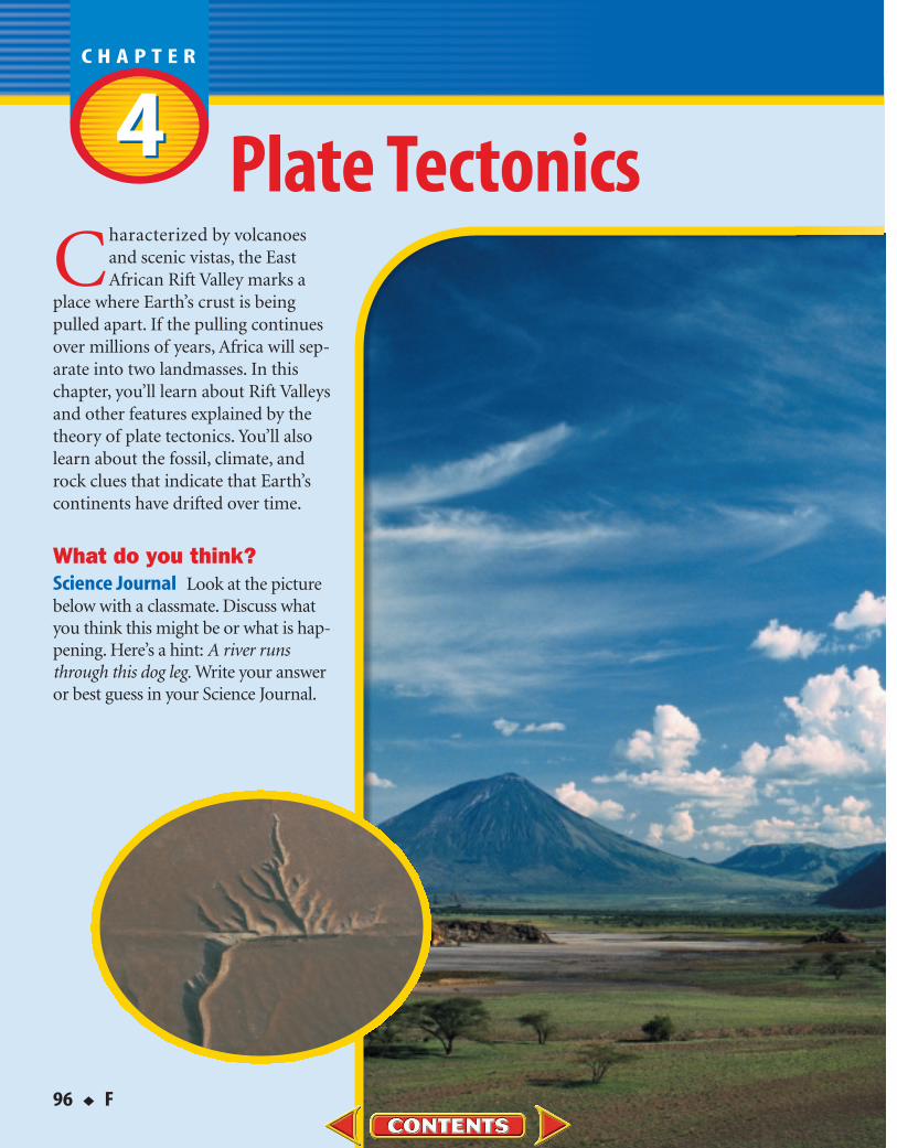
96 ◆ F C haracterized by volcanoes and scenic vistas, the East African Rift Valley marks a place where Earth’s crust is being pulled apart. If the pulling continues over millions of years, Africa will sep- arate into two landmasses. In this chapter, you’ll learn about Rift Valleys and other features explained by the theory of plate tectonics.You’ll also learn about the fossil, climate, and rock clues that indicate that Earth’s continents have drifted over time. What do you think? Science Journal Look at the picture below with a classmate. Discuss what you think this might be or what is hap- pening. Here’s a hint: A river runs through this dog leg. Write your answer or best guess in your Science Journal. Plate Tectonics 4 4
-
Upload
khangminh22 -
Category
Documents
-
view
0 -
download
0
Transcript of F: Chapter 4: Plate Tectonics - Amazon AWS
96 ◆ F
Characterized by volcanoesand scenic vistas, the EastAfrican Rift Valley marks a
place where Earth’s crust is beingpulled apart. If the pulling continuesover millions of years, Africa will sep-arate into two landmasses. In thischapter, you’ll learn about Rift Valleysand other features explained by thetheory of plate tectonics. You’ll alsolearn about the fossil, climate, androck clues that indicate that Earth’scontinents have drifted over time.
What do you think?Science Journal Look at the picturebelow with a classmate. Discuss whatyou think this might be or what is hap-pening. Here’s a hint: A river runsthrough this dog leg. Write your answeror best guess in your Science Journal.
Plate Tectonics44

F ◆ 97
Can you imagine a giant landmass that broke intomany separate continents and Earth scientists
working to reconstruct Earth’s past? Do this activity tolearn about clues that can be used to reassemble asupercontinent.
Reassemble an image 1. Collect interesting photographs
from an old magazine.
2. You and a partner each select onephoto, but don’t show them toeach other. Then each of you cutyour photos into pieces no smallerthan about 5 cm or 6 cm.
3. Trade your cut-up photo for yourpartner’s.
4. Observe the pieces, and reassemble the photograph your partner has cut up.
ObserveIn your Science Journal, describe the characteristics of the cut-up photographthat helped you put the image back together. Think of other examples inwhich characteristics of objects are used to match them up with other objects.
EXPLOREACTIVITY
Making a Know-Want-Learn Study Fold It would be helpful toidentify what you already know and what you want to know.Make the following Foldable to help you focus on reading aboutplate tectonics.
1. Place a sheet of paper in front of you so the long side isat the top. Fold the paper in half from top to bottom.
2. Fold both sides in to divide the paper into thirds.Unfold the paper so three sections show.
3. Through the top thickness of paper, cut along each of the fold lines to the topfold, formingthree tabs. Label the tabs Know, Want, and Learn, as shown.
4. Before you read the chapter, write what you know about plate tectonics under the left taband what you want to know under the middle tab.
5. As you read the chapter, write what you learn about plate tectonics under the right tab.
FOLDABLESReading & StudySkills
FOLDABLESReading & Study Skills

98 ◆ F CHAPTER 4 Plate Tectonics
Continental DriftS E C T I O N
Evidence for Continental DriftIf you look at a map of Earth’s surface, you can see that
the edges of some continents look as though they could fittogether like a puzzle. Other people also have noticed this fact.For example, Dutch mapmaker Abraham Ortelius noted the fitbetween the coastlines of South America and Africa more than400 years ago.
Pangaea German meteorologist Alfred Wegener (VEG nur)thought that the fit of the continents wasn’t just a coincidence.He suggested that all the continents were joined together atsome time in the past. In a 1912 lecture, he proposed thehypothesis of continental drift. According to the hypothesis ofcontinental drift, continents have moved slowly to their currentlocations. Wegener suggested that all continents once were con-nected as one large landmass, shown in Figure 1, that brokeapart about 200 million years ago. He called this large landmassPangaea (pan JEE uh), which means “all land.”
Who proposed continental drift?
■ Describe the hypothesis of continental drift.
■ Identify evidence supporting continental drift.
Vocabularycontinental driftPangaea
The hypothesis of continental driftled to plate tectonics—a theory thatexplains many processes in Earth.
Figure 1This illustration represents howthe continents once were joinedto form Pangaea. This fittingtogether of continents accordingto shape is not the only evidencesupporting the past existence of Pangaea.
PA
NG
AE
A
NorthAmerica
South America Africa
Eurasia
India
AntarcticaAustralia

SECTION 1 Continental Drift F ◆ 99
Figure 2 Fossil remains of plants andanimals that lived in Pangaeahave been found on morethan one continent. How dothe locations of Glossopteris,Mesosaurus, Kannemeyerid,Labyrinthodont, and otherfossils support Wegener’shypothesis of continental drift?
A Controversial Idea Wegener’s ideas about continentaldrift were controversial. It wasn’t until long after Wegener’sdeath in 1930 that his basic hypothesis was accepted. The evi-dence Wegener presented hadn’t been enough to convince manypeople during his lifetime. He was unable to explain exactly howthe continents drifted apart. He proposed that the continentsplowed through the ocean floor, driven by the spin of Earth.Physicists and geologists of the time strongly disagreed withWegener’s explanation. They pointed out that continental driftwould not be necessary to explain many of Wegener’s observa-tions. Other important observations that came later eventuallysupported Wegener’s earlier evidence.
Fossil Clues Besides the puzzlelike fit of the continents, fos-sils provided support for continental drift. Fossils of the reptileMesosaurus have been found in South America and Africa, asshown in Figure 2. This swimming reptile lived in freshwater andon land. How could fossils of Mesosaurus be found on land areasseparated by a large ocean of salt water? It probably couldn’tswim between the continents. Wegener hypothesized that thisreptile lived on both continents when they were joined.
How do Mesosaurus fossils support the pastexistence of Pangaea?
Research Visit the GlencoeScience Web site at science.glencoe.comfor more information aboutthe continental drift hypoth-esis. Communicate to yourclass what you learn.
KannemeyeridGlossopteris
MesosaurusLabyrinthodont

A Widespread Plant Another fossil that supports thehypothesis of continental drift is Glossopteris (glahs AHP tur us).Figure 3 shows this fossil plant, which has been found in Africa,Australia, India, South America, and Antarctica. The presence ofGlossopteris in so many areas also supported Wegener’s idea thatall of these regions once were connected and had similar climates.
Climate Clues Wegener used continental drift to explain evi-dence of changing climates. For example, fossils of warm-weatherplants were found on the island of Spitsbergen in the ArcticOcean. To explain this, Wegener hypothesized that Spitsbergendrifted from tropical regions to the arctic. Wegener also used con-tinental drift to explain evidence of glaciers found in temperateand tropical areas. Glacial deposits and rock surfaces scoured andpolished by glaciers are found in South America, Africa, India,and Australia. This shows that parts of these continents were cov-ered with glaciers in the past. How could you explain why glacialdeposits are found in areas where no glaciers exist today?Wegener thought that these continents were connected andpartly covered with ice near Earth’s south pole long ago.
Rock Clues If the continents were connected at one time,then rocks that make up the continents should be the same inlocations where they were joined. Similar rock structures arefound on different continents. Parts of the Appalachian Moun-tains of the eastern United States are similar to those found inGreenland and western Europe. If you were to study rocks fromeastern South America and western Africa, you would find otherrock structures that also are similar. Rock clues like these sup-port the idea that the continents were connected in the past.
100 ◆ F CHAPTER 4 Plate Tectonics
Figure 3This fossil plant, Glossopteris,grew in a temperate climate.
Interpreting Fossil DataProcedure1. Build a three-layer
landmass using clay ormodeling dough.
2. Mold the clay into mountain ranges.
3. Place similar “fossils” intothe clay at various locationsaround the landmass.
4. Form five continents fromthe one landmass. Also,form two smaller land-masses out of different claywith different mountainranges and fossils.
5. Place the five continentsand two smaller land-masses around the room.
6. Have someone who didnot make or place the land-masses make a modelthat shows how they oncewere positioned.
7. Return the clay to its con-tainer so it can be usedagain.
AnalysisWhat clues were useful inreconstructing the originallandmass?

SECTION 1 Continental Drift F ◆ 101
Section Assessment
1. Why were Wegener’s ideas about continen-tal drift initially rejected?
2. How did Wegener use climate clues to sup-port his hypothesis of continental drift?
3. What rock clues were used to support thehypothesis of continental drift?
4. In what ways do fossils help support thehypothesis of continental drift?
5. Think Critically Why would you expectto see similar rocks and rock structures ontwo landmasses that were connected atone time?
6. Comparing and Contrasting Compare andcontrast the locations of fossils of the temperateplant Glossopteris, as shown in Figure 2, with theclimate that exists at each location today. Formore help, refer to the Science Skill Handbook.
7. Communicating Imagine that you are AlfredWegener in the year 1912. In your Science Journal,write a letter to another scientist explaining youridea about continental drift. Try to convince thisscientist that your hypothesis is correct. For morehelp, refer to the Science Skill Handbook.
How could continents drift?Although Wegener provided evidence to support his hypothe-
sis of continental drift, he couldn’t explain how, when, or whythese changes, shown in Figure 4, took place. The idea suggestedthat lower-density, continental material somehow had to plowthrough higher-density, ocean-floor material. The force behindthis plowing was thought to be the spin of Earth on its axis—anotion that was quickly rejected by physicists. Because other scien-tists could not provide explanations either, Wegener’s idea of con-tinental drift was initially rejected. The idea was so radicallydifferent at that time that most people closed their minds to it.
Rock, fossil, and climate clues were the main types of evi-dence for continental drift. After Wegener’s death, more clueswere found, largely because of advances in technology, and newideas that related to continental drift were developed. You’lllearn about one of these new ideas, seafloor spreading, in thenext section. Seafloor spreading helped provide an explanationof how the continents could move.
Figure 4 These computer models showthe probable course the conti-nents have taken. On the farleft is their position 250 millionyears ago. In the middle istheir position 135 million yearsago. At right is their currentposition.

102 ◆ F CHAPTER 4 Plate Tectonics
Seafloor SpreadingS E C T I O N
Mapping the Ocean FloorIf you were to lower a rope from a boat until it reached the
seafloor, you could record the depth of the ocean at that partic-ular point. In how many different locations would you have todo this to create an accurate map of the seafloor? This is exactlyhow it was done until World War I, when the use of soundwaves was introduced to detect submarines. During the 1940sand 1950s, scientists began using sound waves on moving shipsto map large areas of the ocean floor in detail. Sound waves echooff the ocean bottom—the longer the sound waves take toreturn to the ship, the deeper the water is.
Using sound waves, researchers discovered an underwatersystem of ridges, or mountains, and valleys like those found onthe continents. In the Atlantic, the Pacific, and in other oceansaround the world, a system of ridges, called the mid-oceanridges, is present. These underwater mountain ranges, shown inFigure 5, stretch along the center of much of Earth’s ocean floor.This discovery raised the curiosity of many scientists. Whatformed these mid-ocean ridges?
How were mid-ocean ridges discovered?
■ Explain seafloor spreading.■ Recognize how age and magnetic
clues support seafloor spreading.
Vocabularyseafloor spreading
Seafloor spreading helps explainhow continents moved apart.
Figure 5 As the seafloor spreads apart at a mid-ocean ridge, new seaflooris created. The older seafloormoves away from the ridge inopposite directions.
A rift, or split, in the crust andupper mantle forms. Molten rockis forced up into the rift and flowsonto Earth’s surface as lava. Thelava hardens to form new volcanic rock.
Hot, partly molten rockis forced upward,because its density isless than surroundingmaterial.
As this hot material rises, itmoves sideways. The crust andupper mantle move along with it.
The Seafloor Moves In the early 1960s,Princeton University scientist Harry Hess sug-gested an explanation. His now-famous theoryis known as seafloor spreading. Hess pro-posed that hot, less dense material belowEarth’s crust rises toward the surface at themid-ocean ridges. Then, it flows sideways, car-rying the seafloor away from the ridge in bothdirections, as seen in Figure 5.
As the seafloor spreads apart, magma movesupward and flows from the cracks. It becomessolid as it cools and forms new seafloor. Asnew seafloor moves away from the mid-oceanridge, it cools, contracts, and becomes denser.This denser, colder seafloor sinks, helping toform the ridge. The theory of seafloor spread-ing was later supported by the followingobservations.
How does new seafloorform at mid-ocean ridges?
Evidence for Spreading In 1968, scientists aboard theresearch ship Glomar Challenger began gathering informationabout the rocks on the seafloor. Glomar Challenger wasequipped with a drilling rig that allowed scientists to drill intothe seafloor to obtain rock samples. They made a remarkablediscovery as they studied the ages of the rocks. Scientists found that the youngest rocks are located at the mid-oceanridges. The ages of the rocks become increasingly older in sam-ples obtained farther from the ridges, adding to the evidence forseafloor spreading.
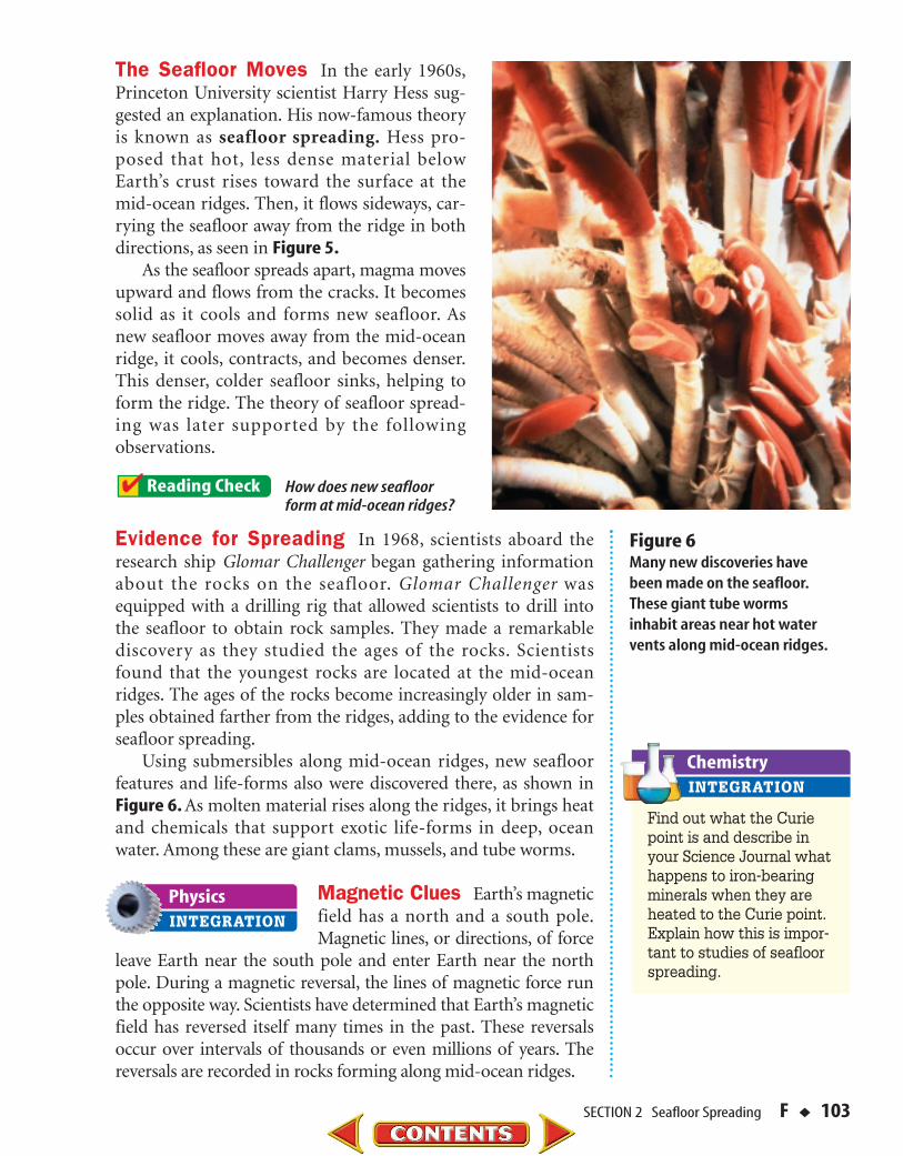
Using submersibles along mid-ocean ridges, new seafloorfeatures and life-forms also were discovered there, as shown inFigure 6. As molten material rises along the ridges, it brings heatand chemicals that support exotic life-forms in deep, oceanwater. Among these are giant clams, mussels, and tube worms.
Magnetic Clues Earth’s magneticfield has a north and a south pole.Magnetic lines, or directions, of force
leave Earth near the south pole and enter Earth near the northpole. During a magnetic reversal, the lines of magnetic force runthe opposite way. Scientists have determined that Earth’s magneticfield has reversed itself many times in the past. These reversalsoccur over intervals of thousands or even millions of years. Thereversals are recorded in rocks forming along mid-ocean ridges.
SECTION 2 Seafloor Spreading F ◆ 103
Figure 6Many new discoveries havebeen made on the seafloor.These giant tube wormsinhabit areas near hot watervents along mid-ocean ridges.
Find out what the Curiepoint is and describe inyour Science Journal whathappens to iron-bearingminerals when they areheated to the Curie point.Explain how this is impor-tant to studies of seafloorspreading.

Magnetic Time Scale Iron-bearingminerals, such as magnetite, that arefound in the rocks of the seafloor canrecord Earth’s magnetic field directionwhen they form. Whenever Earth’smagnetic field reverses, newly formingiron minerals will record the magneticreversal.
Using a sensing device called a mag-netometer (mag nuh TAH muh tur) todetect magnetic fields, scientists foundthat rocks on the ocean floor showmany periods of magnetic reversal. Themagnetic alignment in the rocksreverses back and forth over time instrips parallel to the mid-ocean ridges,as shown in Figure 7. A strong mag-
netic reading is recorded when the polarity of a rock is the sameas the polarity of Earth’s magnetic field today. Because of this,normal polarities in rocks show up as large peaks. This discov-ery provided strong support that seafloor spreading was indeedoccurring. The magnetic reversals showed that new rock wasbeing formed at the mid-ocean ridges. This helped explain howthe crust could move—something that the continental drifthypothesis could not do.
Section Assessment
1. What properties of iron-bearing mineralson the seafloor support the theory ofseafloor spreading?
2. How do the ages of the rocks on the ocean floor support the theory ofseafloor spreading?
3. How did Harry Hess’s hypothesis explainseafloor movement?
4. Why does some partly molten materialrise toward Earth’s surface?
5. Think Critically The ideas of Hess,Wegener, and others emphasize that Earthis a dynamic planet. How is seafloorspreading different from continental drift?
6. Concept Mapping Make a concept map thatincludes evidence for seafloor spreading using thefollowing phrases: ages increase away from ridge,pattern of magnetic field reversals, mid-oceanridge, pattern of ages, and reverses back and forth.For more help, refer to the Science Skill Hand-book.
7. Solving Simple Equations North America ismoving about 1.25 cm per year away from a ridgein the middle of the Atlantic Ocean. Using thisrate, how much farther apart will North Americaand the ridge be in 200 million years? For morehelp, refer to the Math Skill Handbook.
Figure 7Changes in Earth’s magneticfield are preserved in rock thatforms on both sides of mid-oceanridges. Why is this considered to beevidence of seafloor spreading?
Nor
mal
mag
neti
c po
lari
ty
Rev
erse
mag
neti
c po
lari
ty
104 ◆ F CHAPTER 4 Plate Tectonics

ACTIVITY F ◆ 105
Seafloor Spreading Rates
How did scientists use their know-ledge of seafloor spreading and
magnetic field reversals to reconstructPangaea? Try this activity to see howyou can determine where a continentmay have been located in the past.
What You’ll InvestigateCan you use clues, such as magneticfield reversals on Earth, to help recon-struct Pangaea?
Materialsmetric rulerpencil
Goals■ Interpret data about magnetic field reversals.Use these magnetic clues to reconstruct Pangaea.
Procedure1. Study the magnetic field graph above. You
will be working only with normal polarityreadings, which are the peaks above thebaseline in the top half of the graph.
2. Place the long edge of a ruler vertically onthe graph. Slide the ruler so that it lines upwith the center of peak 1 west of the Mid-Atlantic Ridge.
3. Determine and record the distance andage that line up with the center of peak1 west. Repeat this process for peak 1 eastof the ridge.
4. Calculate the average age and distance forthis pair of peaks.
5. Repeat steps 2 through 4 for the remainingpairs of normal-polarity peaks.
6
150 100 50 0 50 100125 75 25 25 75 125 150
5 43 2
1
1
2
3 45
6
12 8 4 0
Age (millions of years)
Distance (km)
Normalpolarity
Reversepolarity
West East
Mid
-Atl
anti
cR
idg
e
210 6 2 1 3
45
67
89
1011
12
6. Calculate the rate of movement in cm peryear for the six pairs of peaks. Use the for-mula rate � distance/time. Convert kilome-ters to centimeters. For example, to calculatea rate using normal-polarity peak 5, west ofthe ridge:
rate � 125 km � 12.5 km �
1,250,000 cm � 1.25 cm/year
Conclude and Apply1. Compare the age of igneous rock found near
the mid-ocean ridge with that of igneousrock found farther away from the ridge.
2. If the distance from a point on the coast ofAfrica to the Mid-Atlantic Ridge is approxi-mately 2,400 km, calculate how long agothat point in Africa was at or near the Mid-Atlantic Ridge.
3. How could you use this method to recon-struct Pangaea?
1,000,000 years
million years10 million years

Theory of Plate TectonicsS E C T I O N
■ Compare and contrast differenttypes of plate boundaries.
■ Explain how heat inside Earthcauses plate tectonics.
■ Recognize features caused byplate tectonics.
Vocabularyplate tectonicsplatelithosphereasthenosphereconvection current
Plate tectonics explains how manyof Earth’s features form.
Figure 8 Plates of the lithosphereare composed of oceaniccrust, continental crust,and rigid upper mantle.
Continentalcrust
Lithosphere
Asthenosphere
Oceaniccrust
Lithosphere
Upper Mantle
106 ◆ F CHAPTER 4 Plate Tectonics
Plate TectonicsThe idea of seafloor spreading showed that more than just
continents were moving, as Wegener had thought. It was nowclear to scientists that sections of the seafloor and continentsmove in relation to one another.
Plate Movements In the 1960s, scientists developed a newtheory that combined continental drift and seafloor spreading.According to the theory of plate tectonics, Earth’s crust and partof the upper mantle are broken into sections. These sections,called plates, move on a plasticlike layer of the mantle. Theplates can be thought of as rafts that float and move on this layer.
Composition of Earth’s Plates Plates are made of thecrust and a part of the upper mantle, as shown in Figure 8.These two parts combined are the lithosphere (LIH thuh sfihr).This rigid layer is about 100 km thick and generally is less densethan material underneath. The plasticlike layer below the litho-sphere is called the asthenosphere (as THE nuh sfihr). The rigidplates of the lithosphere float and move around on theasthenosphere.

Plate BoundariesWhen plates move, they can interact in several ways. They
can move toward each other and converge, or collide. They alsocan pull apart or slide alongside one another. When the platesinteract, the result of their movement is seen at the plate bound-aries, as in Figure 9.
What are the general ways that plates interact?
Movement along any plate boundary means that changesmust happen at other boundaries. What is happening to theAtlantic Ocean floor between the North American and AfricanPlates? Compare this with what is happening along the westernmargin of South America.
Plates Moving Apart The boundary between two platesthat are moving apart is called a divergent boundary. You learnedabout divergent boundaries when you read about seafloorspreading. In the Atlantic Ocean, the North American Plate ismoving away from the Eurasian and the African Plates, as shownin Figure 9. That divergent boundary is called the Mid-AtlanticRidge. The Great Rift Valley in eastern Africa might become adivergent plate boundary. There, a valley has formed where acontinental plate is being pulled apart. Figure 10 shows a sideview of what a rift valley might look like and illustrates how thehot material rises up where plates separate.
SECTION 3 Theory of Plate Tectonics F ◆ 107
PACIFICPLATE
NORTH AMERICANPLATE
SOUTHAMERICAN
PLATE
AFRICAN PLATE
EURASIAN PLATE
PACIFICPLATE
INDO-AUSTRALIANPLATE
ANTARCTICPLATE
ANTARCTICPLATE
PHILIPPINEPLATE
NORTHAMERICAN
PLATE
COCOS PLATE
SCOTIA PLATE
ARABIANPLATE
NAZCAPLATE
CARIBBEANPLATE
JUAN DE FUCAPLATE
Convergent boundaryDivergent boundaryStrike-slip boundary
Figure 9 This diagram shows the majorplates of the lithosphere, theirdirection of movement, and thetype of boundary between them.Based on what is shown in this figure, what is happening wherethe Nazca Plate meets the Pacific Plate?
Recall the Explore Activity you performedat the beginning of this chapter. While
you were trying to fit pieces of a cut-up pho-tograph together, what clues did you use?
Identifying the ProblemTake a copy of a map of the world and
cut out each continent. Lay them on atabletop and try to fit them together,using techniques youused in the ExploreActivity. You will findthat the pieces of yourEarth puzzle—thecontinents—do not fit together well. Yet,several of the areas onsome continents fittogether extremely well.
How well do the continents fit together?
Take out anotherworld map—one thatshows the continentalshelves as well as thecontinents. Copy it andcut out the continents,this time including thecontinental shelves.
Solving the Problem1. Does including the
continental shelvessolve the problem offitting the continentstogether?
2. Why should continental shelves be included withmaps of the continents?
Problem-Solving Activity
108 ◆ F CHAPTER 4 Plate Tectonics
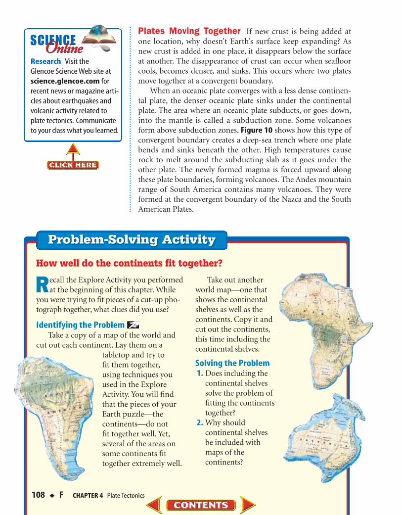
Plates Moving Together If new crust is being added atone location, why doesn’t Earth’s surface keep expanding? Asnew crust is added in one place, it disappears below the surfaceat another. The disappearance of crust can occur when seafloorcools, becomes denser, and sinks. This occurs where two platesmove together at a convergent boundary.
When an oceanic plate converges with a less dense continen-tal plate, the denser oceanic plate sinks under the continentalplate. The area where an oceanic plate subducts, or goes down,into the mantle is called a subduction zone. Some volcanoesform above subduction zones. Figure 10 shows how this type ofconvergent boundary creates a deep-sea trench where one platebends and sinks beneath the other. High temperatures causerock to melt around the subducting slab as it goes under theother plate. The newly formed magma is forced upward alongthese plate boundaries, forming volcanoes. The Andes mountainrange of South America contains many volcanoes. They wereformed at the convergent boundary of the Nazca and the SouthAmerican Plates.
Research Visit the Glencoe Science Web site atscience.glencoe.com forrecent news or magazine arti-cles about earthquakes andvolcanic activity related toplate tectonics. Communicateto your class what you learned.
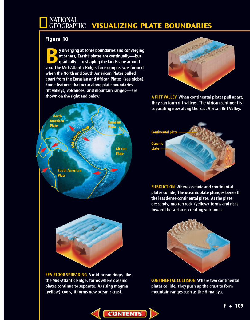
Figure 10
F ◆ 109
A RIFT VALLEY When continental plates pull apart,they can form rift valleys. The African continent isseparating now along the East African Rift Valley.
B y diverging at some boundaries and convergingat others, Earth’s plates are continually—butgradually—reshaping the landscape around
you. The Mid-Atlantic Ridge, for example, was formedwhen the North and South American Plates pulled apart from the Eurasian and African Plates (see globe).Some features that occur along plate boundaries—rift valleys, volcanoes, and mountain ranges—areshown on the right and below.
VISUALIZING PLATE BOUNDARIES
SEA-FLOOR SPREADING A mid-ocean ridge, likethe Mid-Atlantic Ridge, forms where oceanicplates continue to separate. As rising magma(yellow) cools, it forms new oceanic crust.
Continental plate
Oceanic plate
EurasianPlate
AfricanPlate
NorthAmericanPlate
South AmericanPlate
Mid
-Atla
nticRidge
NorthAmericanPlate
EurasianPlate
AfricanPlate
South AmericanPlate
Mid
-Atla
nticRidge
SUBDUCTION Where oceanic and continentalplates collide, the oceanic plate plunges beneaththe less dense continental plate. As the platedescends, molten rock (yellow) forms and risestoward the surface, creating volcanoes.
CONTINENTAL COLLISION Where two continentalplates collide, they push up the crust to formmountain ranges such as the Himalaya.
Where Plates Collide A subduction zone also can formwhere two oceanic plates converge. In this case, the colder, older,denser oceanic plate bends and sinks down into the mantle. TheMariana Islands in the western Pacific are a chain of volcanicislands formed where two oceanic plates collide.
Usually, no subduction occurs when two continental platescollide, as shown in Figure 10. Because both of these plates areless dense than the material in the asthenosphere, the two platescollide and crumple up, forming mountain ranges. Earthquakesare common at these convergent boundaries. However, volca-noes do not form because there is no, or little, subduction. TheHimalaya in Asia are forming where the Indo-Australian Platecollides with the Eurasian Plate.
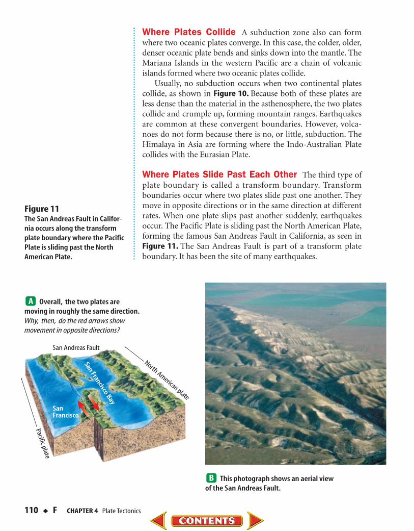
Where Plates Slide Past Each Other The third type ofplate boundary is called a transform boundary. Transformboundaries occur where two plates slide past one another. Theymove in opposite directions or in the same direction at differentrates. When one plate slips past another suddenly, earthquakesoccur. The Pacific Plate is sliding past the North American Plate,forming the famous San Andreas Fault in California, as seen inFigure 11. The San Andreas Fault is part of a transform plateboundary. It has been the site of many earthquakes.
110 ◆ F CHAPTER 4 Plate Tectonics
Figure 11 The San Andreas Fault in Califor-nia occurs along the transformplate boundary where the PacificPlate is sliding past the NorthAmerican Plate.
San Andreas Fault
SanFrancisco
North American plate
Pacific plate
San Francisco BayOverall, the two plates are
moving in roughly the same direction.Why, then, do the red arrows showmovement in opposite directions?
This photograph shows an aerial view of the San Andreas Fault.
Causes of Plate TectonicsMany new discoveries have been made about Earth’s crust
since Wegener’s day, but one question still remains. What causesthe plates to move? Scientists now think they have a good idea.They think that plates move by the same basic process thatoccurs when you heat soup.
Convection Inside Earth Soup that is cooking in a pan onthe stove contains currents caused by an unequal distribution ofheat in the pan. Hot, less dense soup is forced upward by thesurrounding, cooler soup. As the hot soup reaches the surface, itcools and sinks back down into the pan. This entire cycle of heat-ing, rising, cooling, and sinking is called a convection current. Aversion of this same process, occurring in the mantle, is thoughtto be the force behind plate tectonics. Scientists suggest thatdifferences in density cause hot, plasticlike rock to be forcedupward toward the surface.
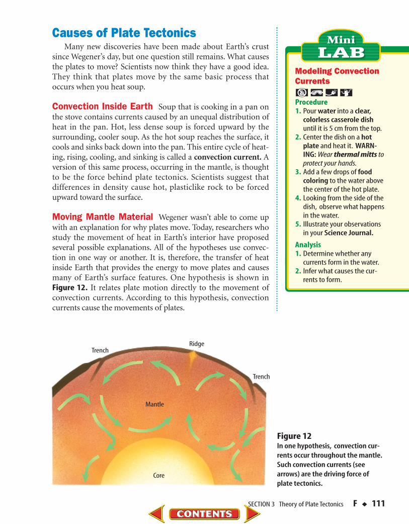
Moving Mantle Material Wegener wasn’t able to come upwith an explanation for why plates move. Today, researchers whostudy the movement of heat in Earth’s interior have proposedseveral possible explanations. All of the hypotheses use convec-tion in one way or another. It is, therefore, the transfer of heatinside Earth that provides the energy to move plates and causesmany of Earth’s surface features. One hypothesis is shown in Figure 12. It relates plate motion directly to the movement ofconvection currents. According to this hypothesis, convectioncurrents cause the movements of plates.
SECTION 3 Theory of Plate Tectonics F ◆ 111
Modeling ConvectionCurrents
Procedure1. Pour water into a clear,
colorless casserole dish until it is 5 cm from the top.
2. Center the dish on a hotplate and heat it. WARN-ING: Wear thermal mitts to protect your hands.
3. Add a few drops of food coloring to the water abovethe center of the hot plate.
4. Looking from the side of thedish, observe what happensin the water.
5. Illustrate your observationsin your Science Journal.
Analysis1. Determine whether any
currents form in the water.2. Infer what causes the cur-
rents to form.
Core
Ridge
Trench
Trench
Mantle
Figure 12In one hypothesis, convection cur-rents occur throughout the mantle.Such convection currents (seearrows) are the driving force ofplate tectonics.

Features Caused by Plate TectonicsEarth is a dynamic planet with a hot interior. This heat leads
to convection, which powers the movement of plates. As theplates move, they interact. The interaction of plates producesforces that build mountains, create ocean basins, and cause vol-canoes. When rocks in Earth’s crust break and move, energy isreleased in the form of seismic waves. Humans feel this releaseas earthquakes. You can see some of the effects of plate tectonicsin mountainous regions, where volcanoes erupt, or where land-scapes have changed from past earthquake or volcanic activity.
What happens when seismic energy is releasedas rocks in Earth’s crust break and move?
Normal Faults and Rift Valleys Tension forces, which areforces that pull apart, can stretch Earth’s crust. This causes largeblocks of crust to break and tilt or slide down the broken surfacesof crust. When rocks break and move along surfaces, a faultforms. Faults interrupt rock layers by moving them out of place.Entire mountain ranges can form in the process, called fault-block mountains, as shown in Figure 13. Generally, the faults thatform from pull-apart forces are normal faults—faults in whichthe rock layers above the fault move down when compared withrock layers below the fault.
Rift valleys and mid-ocean ridges can form where Earth’scrust separates. Examples of rift valleys are the Great Rift Valleyin Africa, and the valleys that occur in the middle of mid-oceanridges. Examples of mid-ocean ridges include the Mid-AtlanticRidge and the East Pacific Rise.
112 ◆ F CHAPTER 4 Plate Tectonics
Figure 13Fault-block mountains can formwhen Earth’s crust is stretched bytectonic forces. The arrows indi-cate the directions of movingblocks. What type of force occurswhen Earth’s crust is pulled inopposite directions?

Mountains and Volcanoes Compression forces squeezeobjects together. Where plates come together, compressionforces produce several effects. As continental plates collide, theforces that are generated cause massive folding and faulting ofrock layers into mountain ranges such as the Himalaya, shownin Figure 14, or the Appalachian Mountains. The type of fault-ing produced is generally reverse faulting. Along a reverse fault,the rock layers above the fault surface move up relative to therock layers below the fault.
What features occur where plates converge?
As you learned earlier, when two oceanic plates converge, thedenser plate is forced beneath the other plate. Curved chains ofvolcanic islands called island arcs form above the sinking plate.If an oceanic plateconverges with a conti-nental plate, the denseroceanic plate slidesunder the continentalplate. Folding andfaulting at the conti-nental plate margincan thicken the conti-nental crust to pro-duce mountain ranges.Volcanoes also typ-ically are formed atthis type of convergentboundary.
SECTION 3 Theory of Plate Tectonics F ◆ 113
Asthenosphere
Lithosphere
Continental crust
Oceanic crust
Mou
ntai
n ra
nge
Hig
h P
late
au
Figure 14 The Himalaya still are formingtoday as the Indo-Australian Platecollides with the Eurasian Plate.
Are there any features caused byplate tectonics in your area? Tofind out more about these fea-tures, see the Field Guide toFaults and Folds at the back ofthe book.

Strike-Slip Faults At transform boundaries, two plates slidepast one another without converging or diverging. The platesstick and then slide, mostly in a horizontal direction, alonglarge strike-slip faults. In a strike-slip fault, rocks on oppositesides of the fault move in opposite directions, or in the samedirection at different rates. This type of fault movement isshown in Figure 15. One such example is the San Andreas Fault.When plates move suddenly, vibrations are generated insideEarth that are felt as an earthquake.
Earthquakes, volcanoes, and mountain ranges are evidenceof plate motion. Plate tectonics explains how activity insideEarth can affect Earth’s crust differently in different locations.You’ve seen how plates have moved since Pangaea separated. Is itpossible to measure how far plates move each year?
Testing for Plate TectonicsUntil recently, the only tests scientists could use to check for
plate movement were indirect. They could study the magneticcharacteristics of rocks on the seafloor. They could study volca-noes and earthquakes. These methods supported the theory thatthe plates have moved and still are moving. However, they didnot provide proof—only support—of the idea.
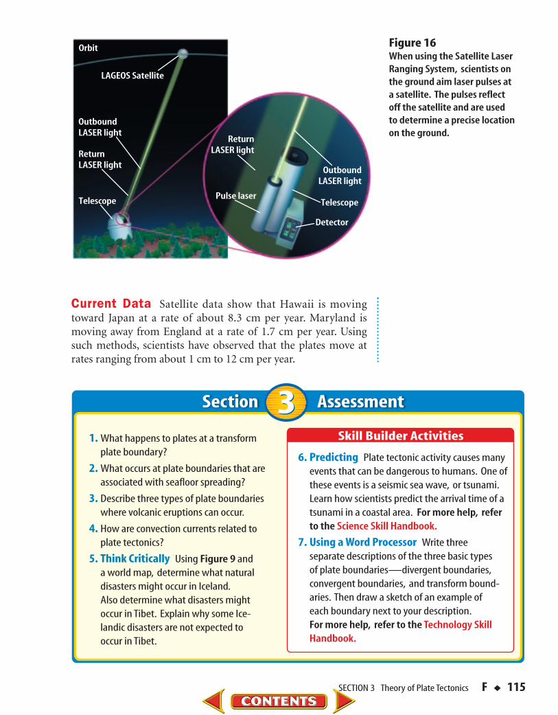
New methods had to be discovered to be able to measurethe small amounts of movement of Earth’s plates. One method,shown in Figure 16, uses lasers and a satellite. Now, scientistscan measure exact movements of Earth’s plates of as little as1 cm per year.
114 ◆ F CHAPTER 4 Plate Tectonics
In which directions doforces act at convergent,divergent, and transformboundaries? Demonstratethese forces using woodenblocks or your hands.
Figure 15Most of the movement along a strike-slip fault is parallel toEarth’s surface. When movementoccurs, human-built structuresalong a strike-slip fault are off-set, as shown here in this road.
SECTION 3 Theory of Plate Tectonics F ◆ 115
Section Assessment
1. What happens to plates at a transformplate boundary?
2. What occurs at plate boundaries that areassociated with seafloor spreading?
3. Describe three types of plate boundarieswhere volcanic eruptions can occur.
4. How are convection currents related toplate tectonics?
5. Think Critically Using Figure 9 and a world map, determine what natural disasters might occur in Iceland.Also determine what disasters might occur in Tibet. Explain why some Ice-landic disasters are not expected to occur in Tibet.
6. Predicting Plate tectonic activity causes manyevents that can be dangerous to humans. One ofthese events is a seismic sea wave, or tsunami.Learn how scientists predict the arrival time of atsunami in a coastal area. For more help, referto the Science Skill Handbook.
7. Using a Word Processor Write three separate descriptions of the three basic types of plate boundaries—divergent boundaries,convergent boundaries, and transform bound-aries. Then draw a sketch of an example of each boundary next to your description.For more help, refer to the Technology Skill Handbook.
Pulse laser
OutboundLASER light
OutboundLASER light
ReturnLASER lightReturn
LASER light
LAGEOS Satellite
Orbit
Telescope Telescope
Detector
Figure 16When using the Satellite LaserRanging System, scientists onthe ground aim laser pulses ata satellite. The pulses reflectoff the satellite and are usedto determine a precise locationon the ground.
Current Data Satellite data show that Hawaii is movingtoward Japan at a rate of about 8.3 cm per year. Maryland ismoving away from England at a rate of 1.7 cm per year. Usingsuch methods, scientists have observed that the plates move atrates ranging from about 1 cm to 12 cm per year.
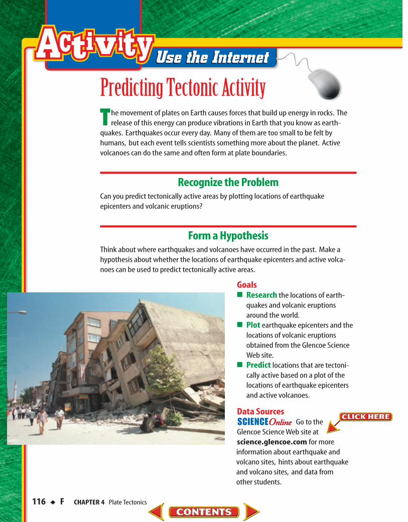
The movement of plates on Earth causes forces that build up energy in rocks. Therelease of this energy can produce vibrations in Earth that you know as earth-
quakes. Earthquakes occur every day. Many of them are too small to be felt byhumans, but each event tells scientists something more about the planet. Active volcanoes can do the same and often form at plate boundaries.
Recognize the ProblemCan you predict tectonically active areas by plotting locations of earthquake epicenters and volcanic eruptions?
Form a HypothesisThink about where earthquakes and volcanoes have occurred in the past. Make ahypothesis about whether the locations of earthquake epicenters and active volca-noes can be used to predict tectonically active areas.
Goals■ Research the locations of earth-
quakes and volcanic eruptionsaround the world.
■ Plot earthquake epicenters and thelocations of volcanic eruptionsobtained from the Glencoe ScienceWeb site.
■ Predict locations that are tectoni-cally active based on a plot of thelocations of earthquake epicentersand active volcanoes.
Data SourcesGo to the
Glencoe Science Web site at science.glencoe.com for moreinformation about earthquake and volcano sites, hints about earthquakeand volcano sites, and data from other students.
Predicting Tectonic Activity
116 ◆ F CHAPTER 4 Plate Tectonics
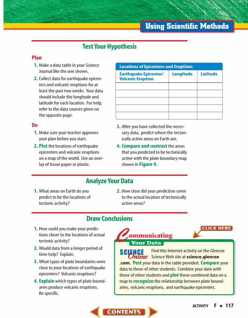
Test Your Hypothesis
Analyze Your Data
Draw Conclusions
3. After you have collected the neces-sary data, predict where the tecton-ically active areas on Earth are.
4. Compare and contrast the areasthat you predicted to be tectonicallyactive with the plate boundary mapshown in Figure 9.
Plan1. Make a data table in your Science
Journal like the one shown.
2. Collect data for earthquake epicen-ters and volcanic eruptions for atleast the past two weeks. Your datashould include the longitude andlatitude for each location. For help,refer to the data sources given onthe opposite page.
Do1. Make sure your teacher approves
your plan before you start.
2. Plot the locations of earthquakeepicenters and volcanic eruptionson a map of the world. Use an over-lay of tissue paper or plastic.
2. How close did your prediction cometo the actual location of tectonicallyactive areas?
1. What areas on Earth do you predict to be the locations of tectonic activity?
1. How could you make your predic-tions closer to the locations of actualtectonic activity?
2. Would data from a longer period oftime help? Explain.
3. What types of plate boundaries wereclose to your locations of earthquakeepicenters? Volcanic eruptions?
4. Explain which types of plate bound-aries produce volcanic eruptions.Be specific.
Find this Internet activity on the GlencoeScience Web site at science.glencoe
.com. Post your data in the table provided. Compare yourdata to those of other students. Combine your data withthose of other students and plot these combined data on amap to recognize the relationship between plate bound-aries, volcanic eruptions, and earthquake epicenters.
Earthquake Epicenter/ Longitude LatitudeVolcanic Eruption
Locations of Epicenters and Eruptions
ACTIVITY F ◆ 117

nucleus organelle marsupial mantle element ibosome primate sea otter hypertension jet icior
wanome
dog
ntumcaiha
ppuatimou
digco
aganiheenc
breoz
opopoioem
nucleus organelle marsup al mantle element ibosome primate sea otter hypertension jet icior
wanome
dog
ntumcaiha
ppuatimou
digco
aganiheenc
breoz
opopoioem
Science & Language ArtsandandScience Language Arts
Respond to the ReadingRespond to the Reading
1. Who is narrating thepoem?
2. Why might the narra-tor think he or shehasn’t “moved forages”?
3. Who or what is thenarrator’s “bestmate”?
I’m just a bit of seafloor on this mighty solid sphere.With no mind to be broadened, I’m quite content down here.The mantle churns below me, and the sea’s in turmoil, too;But nothing much disturbs me, I’m rock solid through and
through.
I do pick up occasional low-frequency vibrations –(I think, although I can’t be sure, they’re sperm whales’
conversations).I know I shouldn’t listen in, but what else can I do?It seems they are all studying for degrees from the OU.
They’ve mentioned me in passing, as their minds begin improving:I think I’ve heard them say “The theory says the sea-floor’s
moving…”.Well, that shook me, I can tell you; yes, it gave me quite a fright.Yet I’ve not moved for ages, so I know it can’t be right.
They call it “Plate Tectonics”, this new theory in their noddle.If they would only ask me, I could tell them it’s all twaddle.Apparently, I “oozed out from a mid-Atlantic split,Solidified and cooled right down, then moved out bit by bit”.
But, how can I be moving, when I know full well myselfThat I’m quite firmly anchored to a continental shelf?“Well, the continent is moving, too; you’re pushing it, you see,”I hear those OU whales intone, hydro-acoustically.
Now, my best mate’s a sea floor in the mighty East Pacific.He reckons life is balmy there: the summers are terrific!He’s heard the whale-talk, too, and found it pretty scary.“Subduction” was the word he heard, which sounded rather hairy.
It was to be his fate, they claimed with undisguised great relish:A hot and fiery end to things – it really would be hellish.In fact, he’d end up underneath my continent, lengthwise,So I would be the one to blame for my poor mate’s demise.
Well, thank you very much, OU. You’ve upset my composure.Next time you send your student whales to look at my exposureI’ll tell them it’s a load of tosh: it’s they who move, not me,Those arty-smarty blobs of blubber, clogging up the sea!
Listening Inby Gordon Judge
118 ◆ F CHAPTER 4 Plate Tectonics

m grat on compound d chotomous greenhoexoskeleton permafrost magma isotopes plat
cellgymmaionthekidproignparzonmoorpetalalloomogeproacctabnoleathtemsolahavdim
m grat on compound d chotomous greenhoexoskeleton permafrost magma isotopes plat
cellgymmaionthekidproignparzonmoorpetaalloomogeproacctabnoleattemsolhavdim
Using Point of View Using thefirst-person point of view, writean account from the point of viewof a living or nonliving thing. Youcould write an account of anobject, such as a pencil, that youuse or encounter every day. Youalso could write from the point ofview of a living thing, such as afamily pet. Be sure to use the personal pronoun “I” in youraccount.
andandLinking Science Linking Science
Ed Klimasauskas is a volcanologist at the Cascades Volcano Observatory in Washington State. His job is to study volcanoes inorder to predict eruptions. Volcanologists’ predictions can save lives:people can be evacuated from danger areas before an eruptionoccurs. Klimasauskas also educates the public about the hazards ofvolcanic eruptions and tells people who live near active volcanoeswhat they can do to be safe in case a volcano erupts. Volcanologiststravel all over the world to study new sites.
To learn more about careers in volcanology, visitthe Glencoe Science Web site at science.glencoe.com.
Volcanologist�
CareerCareer ConnectionConnection
SCIENCE AND LANGUAGE ARTS F ◆ 119
Understanding LiteraturePoint of View Point of view refers to the perspectivefrom which an author writes. This poem begins, “I’mjust a bit of sea floor….” Right away, you know that thepoem, or story, is being told from the point of view ofthe speaker, or the “first person.” Not all first-personstories are told from the point of view of a person. Thenarrator in this poem is a geological feature, not a per-son. This point of view helps give the poem a fantasticor outlandish quality. It also gives a playful tone to thepoem. What other effects does the first-person narra-tion have on the story?
Science Connection Volcanoes can occur where twoplates move toward each other. In the poem, the authorgives several clues that a volcano will form. First, thenarrator’s “best mate” is a seafloor in the Pacific Ocean.When an oceanic plate and a continental plate collide, avolcano will form. The narrator also hears the wordsubduction spoken. Subduction zones occur when oneplate sinks under another plate. Rocks melt in the zoneswhere these plates converge, causing magma to moveupward and form volcanic mountains. What other cluesdoes the author give that a volcano will form?
Point of View

120 ◆ F CHAPTER STUDY GUIDE
3. The theory of seafloor spreading is sup-ported by magnetic evidence in rocks andby the ages of rocks on the ocean floor.
Section 3 Theory of Plate Tectonics1. In the 1960s, scientists combined the ideas
of continental drift and seafloor spreadingto develop the theory of plate tectonics. Thetheory states that the surface of Earth isbroken into sections called plates that movearound on the asthenosphere.
2. Currents in Earth’s mantle called convec-tion currents transfer heat in Earth’s inte-rior. It is thought that this transfer of heatenergy moves plates.
3. Earth is a dynamic planet. As the platesmove, they interact, resulting in many ofthe features of Earth’s surface. How do converging plates form mountains?
Section 1 Continental Drift
1. Alfred Wegener suggested that the conti-nents were joined together at some point in the past in a large landmass he calledPangaea. Wegener proposed that conti-nents have moved slowly, over millions ofyears, to their current locations.
2. The puzzlelike fitof the continents,fossils, climaticevidence, andsimilar rockstructures sup-port Wegener’s idea of continental drift.However, Wegener could not explain whatprocess could cause the movement of thelandmasses. How do fossils support thehypothesis of continental drift?
Section 2 Seafloor Spreading
1. Detailed mapping of the ocean floor in the1950s showed underwater mountains andrift valleys.
2. In the 1960s, Harry Hess suggested seafloorspreading as an explanation for the forma-tion of mid-ocean ridges. How is magneticevidence preserved in rocks forming along amid-ocean ridge?
Normal magnetic polarity
Reversed magnetic polarityMid-ocean ridge
Lithosphere
Study GuideChapter Study GuideChapter
To help you review what you learned aboutplate tectonics, use
the Foldable you made at the beginning of the chapter.
After You ReadFOLDABLESReading & StudySkills
FOLDABLESReading & Study Skills
44

CHAPTER STUDY GUIDE F ◆ 121
Vocabulary Wordsa. asthenosphere e. Pangaeab. continental drift f. platec. convection current g. plate tectonicsd. lithosphere h. seafloor spreading
Using VocabularyEach phrase below describes a vocabulary
term from the list. Write the term that matchesthe phrase describing it.
1. plasticlike layer below the lithosphere
2. idea that continents move slowly acrossEarth’s surface
3. large, ancient landmass that consisted of allthe continents on Earth
4. process that forms new seafloor as hotmaterial is forced upward
5. driving force for plate movement
6. composed of oceanic or continental crustand upper mantle
7. explains locations of mountains, trenches,and volcanoes
8. piece of the lithosphere that moves over aplasticlike layer
9. theory proposed by Harry Hess thatincludes processes along mid-ocean ridges
10. forms as warm material rises and coldmaterial sinks
Make a note of anything you don’t understand so that you’ll remember to ask your teacherabout it.
Study Tip
Study GuideChapter Study GuideChapter
evidence evidence
caused by movement and interactions ofsections of Earth’s crust and upper mantle
Magnetic evi-dence in rocks
Seafloorspreading
Puzzlelike fit ofcontinents
Continental drift
Complete the concept map below about continental drift, seafloor spreading, and plate tectonics.
44
Choose the word or phrase that best answersthe question.
1. Which layer of Earth contains the astheno-sphere?A) crust C) outer coreB) mantle D) inner core
2. What type of plate boundary is the SanAndreas Fault part of?A) divergent C) convergentB) subduction D) transform
3. What hypothesis states that continents slowlymoved to their present positions on Earth?A) subduction C) continental driftB) seafloor spreading D) erosion
4. Which plate is subducting beneath theSouth American Plate to form the Andesmountain range?A) North American C) Indo-AustralianB) African D) Nazca
5. Which of the following features indicatesthat many continents were once nearEarth’s south pole?A) glacial deposits C) volcanoesB) mid-ocean ridges D) earthquakes
6. What evidence in rocks supports the theoryof seafloor spreading?A) plate movement C) subductionB) magnetic reversals D) convergence
7. Which type of plate boundary is the Mid-Atlantic Ridge a part of?A) convergent C) transformB) divergent D) lithosphere
8. What theory states that plates move aroundon the asthenosphere?A) continental drift C) subductionB) seafloor spreading D) plate tectonics
9. What forms when one plate slides pastanother plate?A) transform boundaryB) divergent boundaryC) subduction zoneD) mid-ocean ridge
10. When oceanic plates collide, what volcaniclandforms are made?A) folded mountainsB) island arcsC) strike-slip faultsD) mid-ocean ridges
11. Why do many earthquakes but few volcaniceruptions occur in the Himalaya?
12. Glacial deposits often form at high latitudesnear the poles. Explain why glacial depositshave been found in Africa.
13. How is magnetism used to support thetheory of seafloor spreading?
14. Explain why volcanoes do not form alongthe San Andreas Fault.
15. Explain why the fossil of an ocean fishfound on two different continents wouldnot be good evidence of continental drift.
16. Forming Hypotheses Mount St. Helens in the Cascade Range is a volcano. Use Figure 9 and a U.S. map to hypothesize how it might have formed.
17. Measuring in SI Movement along theAfrican Rift Valley is about 2.1 cm per year.If plates continue to move apart at this rate,how much larger will the rift be (in meters)in 1,000 years? In 15,500 years?
122 ◆ F CHAPTER ASSESSMENT
Assessment & ReviewChapter AssessmentChapter 44
CHAPTER ASSESSMENT F ◆ 123
18. Concept Mapping Make an events chainconcept map that describes seafloor spread-ing along a divergent plate boundary.Choose from the following phrases: magmacools to form new seafloor, convection cur-rents circulate hot material along divergentboundary, and older seafloor is forced apart.
19. Observe and Infer In the MiniLab Model-ing Convection Currents, you observedconvection currents produced in water as itwas heated. Repeat the experiment, placingsequins, pieces of wood, or pieces of rubberbands into the water. How do their move-ments support your observations and infer-ences from the MiniLab?
AssessmentChapter AssessmentChapter
Go to the Glencoe Science Web site at science.glencoe.com or use theGlencoe Science CD-ROM for additionalchapter assessment.
TECHNOLOGY
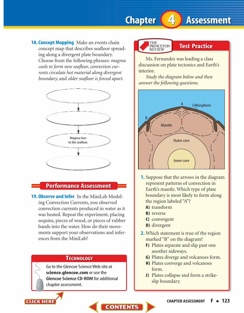
Ms. Fernandez was leading a classdiscussion on plate tectonics and Earth’sinterior.
Study the diagram below and thenanswer the following questions.
1. Suppose that the arrows in the diagramrepresent patterns of convection inEarth’s mantle. Which type of plateboundary is most likely to form alongthe region labeled “A”?A) transformB) reverseC) convergentD) divergent
2. Which statement is true of the regionmarked “B” on the diagram?F) Plates separate and slip past one
another sideways.G) Plates diverge and volcanoes form.H) Plates converge and volcanoes
form.J) Plates collapse and form a strike-
slip boundary.
Mantle
Lithosphere
Outer core
Inner core
A
B
Magma risesto the seafloor.
Test Practice
44
Test Practice