Morpho-sedimentary records of active tectonics at the Kameng river exit, NE Himalaya
12
Morpho-sedimentary records of active tectonics at the Kameng river exit, NE Himalaya Pradeep Srivastava ⁎ , Dileep K. Misra Wadia Institute of Himalayan Geology, 33 GMS Road, Dehradun 248001, India Received 26 April 2007; received in revised form 20 July 2007; accepted 31 July 2007 Available online 17 August 2007 Abstract The Kameng River in the NE India cuts through the rising Siwaliks, the frontal ranges of the Himalaya and forms four levels of alluvial terraces. The geomorphic configuration and overlying alluvial cover of each terrace has been studied to decipher the uplift history of the Himalayan front and varying sedimentation pattern of the river. The ratio (SA ratio) of the thicknesses of alluvial cover and bedrock strath is used as a measure of geomorphic instability (GI) and a GI-Index has been calculated for each incision and aggradation phase. It is suggested that the area was geomorphologically most unstable when the Kameng River was incising from terrace T 2 to T 1 . The Luminescence chronology constrained this phase to be at ∼ 7 ka B.P. The older incision phases namely T 4 –T 3 and T 3 –T 2 occurred ∼ 14 and ∼ 10 ka B.P. respectively. The alluvial cover of the terraces is composed of four major lithofacies viz. (1) Matrix-supported pebble, (2) Clast-supported pebble, (3) Parallel laminated medium sand, and (4) Bioturbated fine sand. The vertical variation of the lithofacies indicates that the river was flowing under a braided pattern. The study suggested that Kameng river incised 95 m from terrace T 4 to T 2 in the span of ∼ 8 ka between 14–6 ka BP, suggested the uplift rate of 11.9 mm/year. However, the total uplift in the Siwaliks, as indicated by the height difference of terraces T 4 –T 0 in the area is 105 m which occurred during the last 14 ka at the rate of 7.5 mm/year, indicating a varying rate of Siwalik uplift in the Holocene. The studies corroborate with published incision rates from the central Himalaya in Nepal. © 2007 Elsevier B.V. All rights reserved. Keywords: Fluvial terraces; Geomorphic instability; Kameng River; NE Himalayan front 1. Introduction Geomorphic development of the Himalayan moun- tain chain is a consequence of interplay between climate and tectonics. This interaction through the last 55 Ma has resulted in the formation of various southward- younging thrusts, namely the Main Central Thrust MCT), contact between Higher Himalayan Crystallines (HHC) and Lesser Himalaya (LH); the Main Boundary Thrust (MBT), contact between Lesser Himalayan rocks and the Siwaliks; and the Himalayan Frontal Thrust (HFT) that brings the Siwaliks over Ganga plain alluvium. The neotectonic deformation in the HHC and LH zones occurs along the splays of the MCT and MBT, and due to formation of out-of-sequence thrusts it is said to be the result of high precipitation and erosion leading to isostatic adjustments (Bookhagen et al., 2005; Bookhagen, 2004; Hodges et al., 2004; Thiede et al., 2004; Wobus et al., 2005). The mountain front along the HFT is suggested to be tectonically active because of southward progression of deformation of the Himalayan orogen (Lave and Avouac, 2001). In the NW and the Central Himalayan sectors the rates of uplift of the Available online at www.sciencedirect.com Geomorphology 96 (2008) 187 – 198 www.elsevier.com/locate/geomorph ⁎ Corresponding author. E-mail address: [email protected] (P. Srivastava). 0169-555X/$ - see front matter © 2007 Elsevier B.V. All rights reserved. doi:10.1016/j.geomorph.2007.07.019
Transcript of Morpho-sedimentary records of active tectonics at the Kameng river exit, NE Himalaya
Available online at www.sciencedirect.com
2008) 187–198www.elsevier.com/locate/geomorph
Geomorphology 96 (
Morpho-sedimentary records of active tectonics at theKameng river exit, NE Himalaya
Pradeep Srivastava ⁎, Dileep K. Misra
Wadia Institute of Himalayan Geology, 33 GMS Road, Dehradun 248001, India
Received 26 April 2007; received in revised form 20 July 2007; accepted 31 July 2007Available online 17 August 2007
Abstract
The Kameng River in the NE India cuts through the rising Siwaliks, the frontal ranges of the Himalaya and forms four levels ofalluvial terraces. The geomorphic configuration and overlying alluvial cover of each terrace has been studied to decipher the uplifthistory of the Himalayan front and varying sedimentation pattern of the river. The ratio (SA ratio) of the thicknesses of alluvialcover and bedrock strath is used as a measure of geomorphic instability (GI) and a GI-Index has been calculated for each incisionand aggradation phase. It is suggested that the area was geomorphologically most unstable when the Kameng River was incisingfrom terrace T2 to T1. The Luminescence chronology constrained this phase to be at ∼7 ka B.P. The older incision phases namelyT4–T3 and T3–T2 occurred ∼14 and ∼10 ka B.P. respectively. The alluvial cover of the terraces is composed of four majorlithofacies viz. (1) Matrix-supported pebble, (2) Clast-supported pebble, (3) Parallel laminated medium sand, and (4) Bioturbatedfine sand. The vertical variation of the lithofacies indicates that the river was flowing under a braided pattern.
The study suggested that Kameng river incised 95 m from terrace T4 to T2 in the span of ∼8 ka between 14–6 ka BP, suggestedthe uplift rate of 11.9 mm/year. However, the total uplift in the Siwaliks, as indicated by the height difference of terraces T4–T0 inthe area is 105 m which occurred during the last 14 ka at the rate of 7.5 mm/year, indicating a varying rate of Siwalik uplift in theHolocene. The studies corroborate with published incision rates from the central Himalaya in Nepal.© 2007 Elsevier B.V. All rights reserved.
Keywords: Fluvial terraces; Geomorphic instability; Kameng River; NE Himalayan front
1. Introduction
Geomorphic development of the Himalayan moun-tain chain is a consequence of interplay between climateand tectonics. This interaction through the last 55 Mahas resulted in the formation of various southward-younging thrusts, namely the Main Central ThrustMCT), contact between Higher Himalayan Crystallines(HHC) and Lesser Himalaya (LH); the Main BoundaryThrust (MBT), contact between Lesser Himalayan rocks
⁎ Corresponding author.E-mail address: [email protected] (P. Srivastava).
0169-555X/$ - see front matter © 2007 Elsevier B.V. All rights reserved.doi:10.1016/j.geomorph.2007.07.019
and the Siwaliks; and the Himalayan Frontal Thrust(HFT) that brings the Siwaliks over Ganga plainalluvium. The neotectonic deformation in the HHCand LH zones occurs along the splays of the MCT andMBT, and due to formation of out-of-sequence thrusts itis said to be the result of high precipitation and erosionleading to isostatic adjustments (Bookhagen et al., 2005;Bookhagen, 2004; Hodges et al., 2004; Thiede et al.,2004; Wobus et al., 2005). The mountain front along theHFT is suggested to be tectonically active because ofsouthward progression of deformation of the Himalayanorogen (Lave and Avouac, 2001). In the NW and theCentral Himalayan sectors the rates of uplift of the
188 P. Srivastava, D.K. Misra / Geomorphology 96 (2008) 187–198
Siwalik mountains along the HFT have been computedto be of the order of 10–15 mm/year. A suggestion isalso made that in this sector at a timescale of 103–
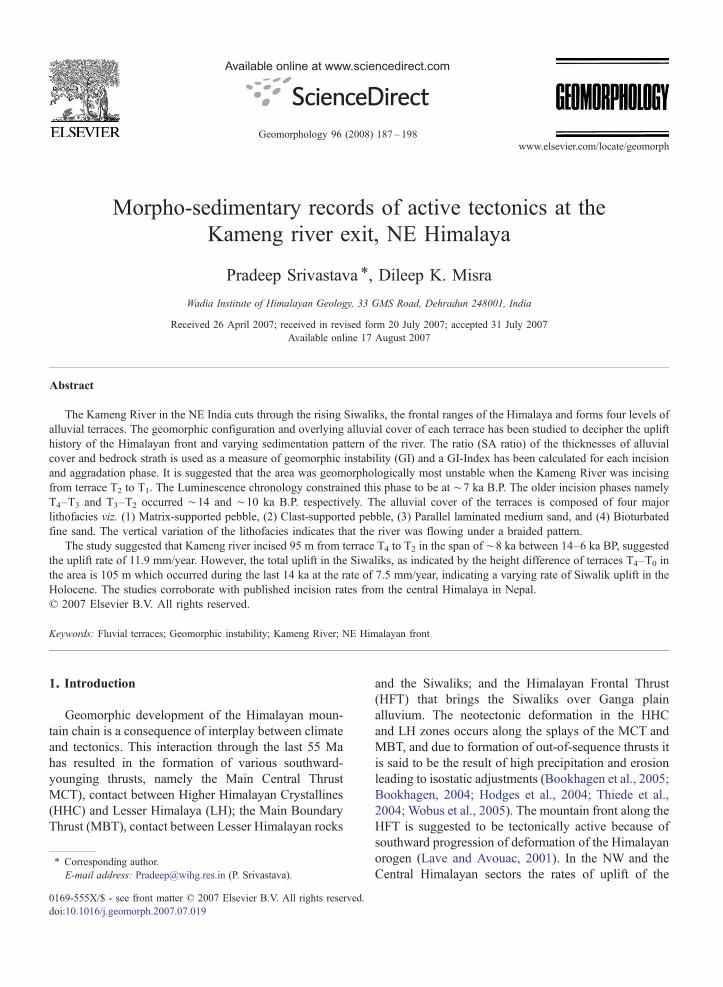
Fig. 1. (A) Location and general geology of the Kameng catchment. (B) Lotectonic features. (C) Satellite picture of the Bhalukpong area showing the N–and alluvial terraces. Note the braided character of the river.
104 years, a greater percentage of crustal shorteningbetween Indian and Asian plates is being accommodatedalong the HFT (Lave and Avouac, 2001). These studies
ngitudinal profile of the river showing major topographic breaks andS-trending Kameng fault, the eastward-shifting Kameng river channel

Table 1Radioactive element concentrations, dose rate, paleodose and ages ofthe samples collected from deposits of various terraces
Lab. no. Sample U(ppm)
Th(ppm)
K(%)
Dose rate(Gy/ka)
Paleodose(Gy)
SAR ages(ka)
Terrace T1
LD-95 BPT1 1.0 17.9 1.6 3.1±0.3 23.0±1.0 7.3±1.0
Terrace T2
LD-97 BPT2–1
1.8 17.7 2.4 3.8±0.3 28.1±1.2 7.2±0.7
LD-98 BPT2 3.4 17.9 2.3 3.5±0.3 24.8±0.3 8.2±0.7
Terrace T3
LD-99 BPT3 3.3 20.8 2.1 3.5±0.3 37.0±3.6 10.4±1.4
Terrace T4
LD-100 BPT4 2.2 20.4 1.8 3.3±0.3 46.5±9.6 13.9±3.1
Terrace T2 at TippiLD-96 BPT3 1.0 21.5 2.2 3.7±0.3 39.9±3.9 10.7±1.7
Moisture content of 10±5% was assumed for all samples.Cosmic ray induced Gamma dose is considered as 150 μGy/yr.
Fig. 2. Luminescence bleaching analysis of the samples. (A) Wellbleached sample LD-95 showing a poor relationship between thepaleodose and luminescence intensity. (B) Poorly bleached sampleLD-96 showing better correlation (R2=0.57) between palaeodose andthe luminescence intensity.
189P. Srivastava, D.K. Misra / Geomorphology 96 (2008) 187–198
have used cosmogenic radionuclide (CRN) of bedrockstraths (Bookhagen, 2004; Vance et al., 2003), 14Cdating alluvial fills in the higher Himalaya mountainfront (Pratt et al., 2004), and fluvial terraces on thegrowing fold in the Siwalik ranges (Lave and Avouac,2001) to understand the climate–tectonic interaction inthe orogenic deformation. A study from the mountainfront of the Darjiling Himalaya incorporating lumines-cence dated fluvial terraces of the Teesta Riversuggested uplift of ∼4 mm/yr in the Siwaliks and thedeformation is explained via formation of out-of-sequence thrust development in the Siwaliks (Mukulet al., in press). The sentence can be reframed as“However, in the NE sector of Himalaya, the absence ofchronology has limited the understanding of behavior ofHFT and neo-deformation of Siwaliks.
This paper deals with the question of determiningtectonic uplift of the Siwaliks in theNE sector ofHimalayaby using morphostratigraphy and Optically StimulatedLuminescence (OSL) dating of fluvial terraces of theKameng River, developed on the Siwalik range betweenthe MBT and HFT. Terrace configuration and chronologyhas been used to determine the phase of high deformationand uplift in the Siwaliks during the Holocene.
2. Geological setting and study area
The Kameng River with a catchment of about9860 km2 originates from the southern slopes of HigherHimalaya and drains through Dafla Hill in Lesser
Himalaya (Nandy, 2001). Cutting deep gorges throughSiwalilk Hills the river enters the Brahmaputra Plainnear Bhalukpong (Fig. 1A). The river valley profile as itcrosses the MCT near Linchup and the MBT near Tipitownships shows prominent knick points (Fig. 1B). Inthe Kameng valley, to north of the MCT, HHCs arecomposed of high-grade, kyanite–sillimanite-bearingschist and gneiss with intrusions of Tertiary leucograniteand quartzites (Kumar, 1997). The Lesser Himalayansuccession that lies between the MCT and MBT iscomposed of three thrust bound lithotectonic units,namely low-medium grade metamorphics of BomdilaGroup followed by the Quartzite and carbonateassociation of the Miri-Buxa Group and the Gondwanasediments (Nandy, 2001; Kumar, 1997). The study areais located south of the MBT, on the Siwalik Hillsbetween Tipi and Bhalukpong where these rocks formthe most frontal ranges of the Himalayas. The HFTthrusts the Siwalik rocks over the Brahmaputraalluvium. The rocks of the Siwalik sequence in thearea are made up of green–grey-earthy brown sandstone

Fig. 3. Sketch map showing geomorphic configuration and luminescence ages of the fluvial terraces of Kameng River at Bhalukpong. Note thethickness of alluvial cover and the underlying bedrock strath.
190 P. Srivastava, D.K. Misra / Geomorphology 96 (2008) 187–198
with streaks of coal; salt and pepper sandstone, nodulargrey siltstone and shale are present (Verma and Tandon,1976; Singh and Chowdhary, 1990). A N–S-trending,seismogenic Kameng fault passes through the area thatmeets the MBTat Tipi (Fig. 1C). This is one of the zoneswhere the Himalayas change trend from E–W to ENE–WSW and gradually assume a NE–SW trend (Nandy,2001; Kayal, 2003). The Kameng River in the areashows the development of four levels of unpaired fluvialterraces. A morphostratigraphic section of the river atBhalukpong is studied in detail and presented here.
3. Methodology
The geomorphic study was based on the satellite data,Survey of India (SOI) topographic maps and extensivefield survey. The height determination of terrace surfaceswas done using a combination of data procured viatoposheets, altimeter and hand-held global positioningsystems (GPS). Fluvial terraces have been studied interms of bedrock strath and overlying alluvial cover. Theheight of the individual terrace includes the total thicknessof strath and alluvial cover. The thickness of the alluvialcover wasmeasured usingmeasuring tapes and rods at theoutcrop. Lithofacies analysis of alluvial cover was doneby careful observation of grain size, color, degree ofbioturbation, matrix percentage, physical structures,lateral geometry, and top and bottom contacts of theindividual unit. Gravel diameter and matrix percentageestimation is based on field observation made by makinggrids of 1 m2 on the outcrop. The data presented are based
on the field observation on several outcrops, where arepresentative section has been discussed in detail. Therelative abundances of the constituent lithologies of thebedload of the presently active river bed (Terrace T0) arederived after counting and classifying the pebbles in thefield. The morphological details are presented aftercareful examination of SOI topographic maps andimagery data derived from web-based remote sensingdata (http://www.virtual-globe.info/globe.vgml) andobservations made in the field. Sample collection fordating purposes was done in light-protected steel pipesfrom the sandy units of alluvial cover.
OSL dating was carried out to ascertain the durationand time frame of river aggradation and the rate ofincision of alluvium and bedrock. Six samples LD-95 toLD-100 were collected in opaque pipes from the alluvialcover of different terraces. Sample LD-95 was collectedfrom 1 m below the surface of terrace T1. LD-97 and LD-98 were collected from near the top and bottom of terraceT2, LD-99 from 3.3m below the surface of terrace T3, andLD-100 was collected from 2.2 m below the surface ofterrace T4. To check the regional continuity of the terracesan additional sample LD-96 was collected from terrace T3
located 5 km upstream of Bhalukpong at Tipi town. Thesample preparation was done following widely acceptedprotocols (for details see Srivastava et al., 2006). OSLwasrecorded for 100 s at 125 °C temperature through filtercombination of BG-39+U-340 on a Riso TL/OSL-12system with a halogen lamp source for stimulation.A90Sr/90Y beta source delivering a dose rate of 3.6 Gy/min was used for irradiation. A 5-point single aliquot

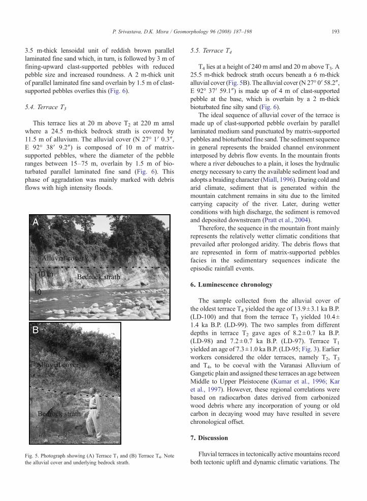
Fig. 4. Photographs showing (A) Matrix-supported pebble and(B) Clast supported pebble and Parallel laminated fine sand.
191P. Srivastava, D.K. Misra / Geomorphology 96 (2008) 187–198
regeneration (SAR) protocol suggested by Murray andWintle (2000) was applied on all the samples to estimatepalaeodose (ED). A preheat of 220 °C/10 s for natural andregeneration doses was used. Uranium, thorium andpotassium concentration for dose rate estimation weredetermined by XRF analysis.
The age and dose rate data are given in the Table 1. Theextent of bleaching of the sediments was assessed by themethod outlined by Srivastava et al. (2006). The methodutilizes the relationship between the natural luminescenceintensity and the paleodose of individual aliquots.Incomplete bleaching results in higher luminescenceand a proportionally higher paleodose with considerablevariation from aliquot to aliquot (Colls et al., 2001). Bycontrast, paleodose measurements on aliquots from well-bleached sediments are more consistent and do notcorrelate well with natural luminescence. Thus higher R2
values (Pearson's correlation coefficient) between aliquotpaleodose and natural intensity indicate partial bleachingof the sample. Five out of six samples showed poorcorrelation with R2 values ranging between 0.02–0.1(Fig. 2), sample LD-96, collected from terrace T2 at Tipitownship showed higher correlation (R2 =0.6). Thisindicated that all the samples are well bleached and suitedfor OSL, dating except LD-96, which is likely to yield anoverestimated age.Hence,we excluded age data of LD-96from further interpretations.
Uplift rate is derived from dated fluvial terraces, wherethe height of the bedrock strath surface from the presentday river bed has been considered as total uplift and isbeen measured in meters (Kumar et al., 2006; Mukulet al., in press). The chronology obtained from the alluvialcover of the particular strath has been used to estimate theuplift rate. It is based on the direct relationship betweentectonic uplift, formation of terrace and river incision rate.Rates of river incision are the ratio of the elevationdifferenceΔh between the two successive incision phasesof the river and total time elapsed during the incision. Therelative role of climate and tectonic factors in theformation of the terrace has been determined after thehypothesis of Starkel (2003) where the relative thick-nesses of bedrock strath and alluvial cover are used.
4. Fluvial terraces and sedimentation
Geomorphic study along the Kameng River nearBhalukpong indicates the presence of five levels of terracesurfaces. These are terrace T4 (oldest), T3, T2, T1 and theyoungest being the active channel, termed as terrace T0,that lies at 130 m amsl (abovemean sea level). From T4 toT0 the river shows an eastward shift of ∼700 m (Fig. 3).These terraces are noticeable from 5 km upstream (Tipi
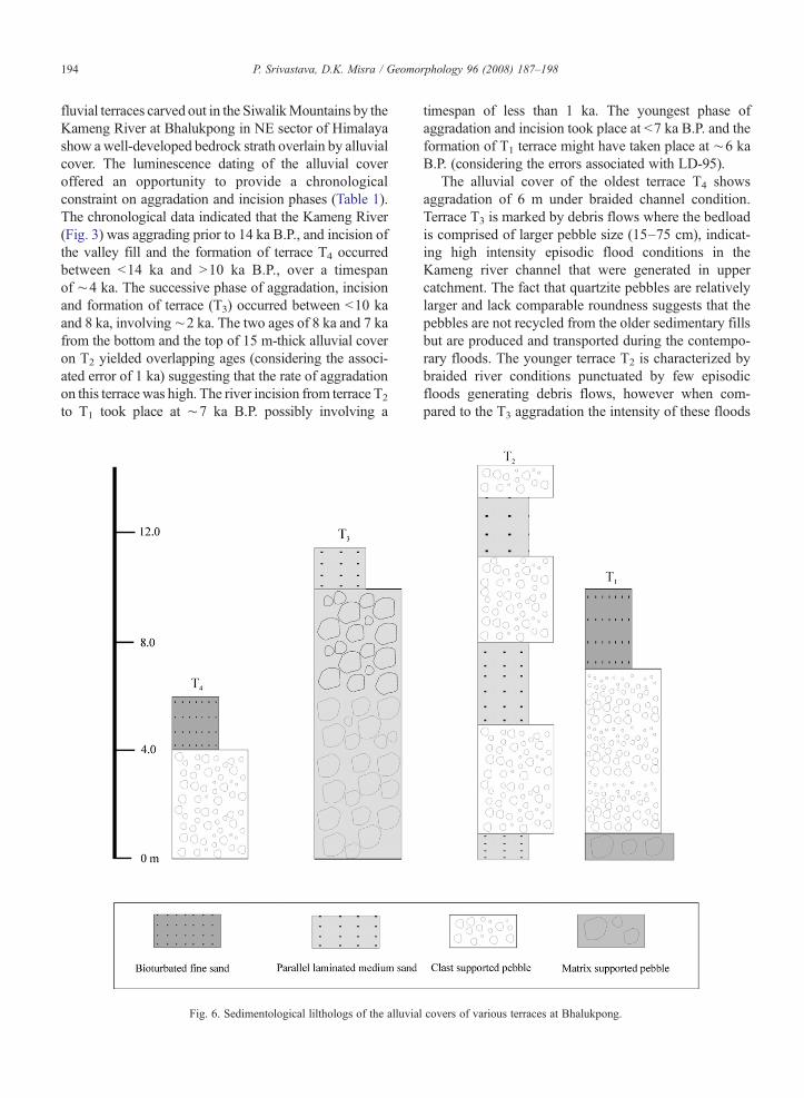
township) to almost 15 km downstream of Bhalukpong(Fig. 1C) in the Siwalik belt. The stratigraphy of alluvialcover was studied to determine the palaeoclimaticconditions and temporal changes in bedload conditions.Based on grain size, matrix, bioturbation and color, thefollowing four lithofacies were identified:
4.1. Matrix-supported pebbles
0.75–2.5 m-thick, this unit is made up of matrix-supported, angular to sub-rounded poorly sortedpebbles. The clasts size ranges up to 20 cm and thepopulation in general is made up of clasts derived fromrocks of Bomdila, Miri-Buxa, Gondwana and Siwaliklithotectonic units, in decreasing order. The matrix thatranges between 30–50% of volume is composed ofcoarse to fine sand with lithic fragments. The upper andlower contacts of the beds are erosive. This faciesrepresents sedimentation by debris flows (Nemec andSteel, 1984; Meetei et al., 2007). The facies is wellrepresented in all terraces (Fig. 4A).

Table 2Thicknesses of alluvial cover and bedrock strath of different terraces
Terrace Height(m)
Strath(m)
Alluvialcover(m)
SAratio
Incision GIindex a
Phase Duration(ka)
T4 240 25.5 6.0 4.25 T4–T3 4 1.1T3 220 24.5 11.5 2.13 T3–T2 2 1.1T2 200 45.0 15.0 3.00 T2–T1 1 3.0T1 150 10.0 10.0 1.00 T1–T0 2 0.5
SA ratio is the one between thickness of bedrock strath and overlyingalluvial cover. Degree of geomorphic instability is represented as theGI-Index, which SA-ratio is normalized by the time span of thegeomorphic activity.Height of the individual terrace is above mean sea-level.a Associated with ±10–15% errors.
192 P. Srivastava, D.K. Misra / Geomorphology 96 (2008) 187–198
4.2. Clast-supported pebbles
0.75–10 m-thick, this is a fining-upward unit madeup of rounded to sub-rounded, moderately sortedpebbles. Clast size ranges from 5–75 cm and showsimbrication. Individual fining-upward units range from1–4 m in thickness. Matrix, made of coarse to mediumsand, makes up ∼10% of the volume. The upper andlower contacts of the units are erosional in nature. Theseare the deposits of channel bar formed in a braidedchannel environment (Nemec and Steel, 1984) and havealso been recognized in the terrace sequences of Teestariver valley (Meetei et al., 2007). This facies isrepresented in all the terraces (Fig. 4B).
4.3. Parallel laminated fine sand
This is 1–3.0 m thick parallel-laminated fine sand.Individual laminae are up to 2 mm thick and often showdiscordances (Fig. 4B). In places the unit shows redcoloration due to iron staining. Vertically this facies isassociated with the clast-supported pebbles unit, whereany association with muddy floodplain facies is notnoticed and, therefore, it represents sedimentation on achannel bar during a waning flood (Miall, 1996). Thislithofacies is represented in all the terrace sequences.The units with iron staining may represent the reducedflooding intensity and relatively drier conditions(Srivastava et al., under review).
4.4. Bioturbated fine sand
This unit is made up of primarily gray colored,bioturbated fine sand. Laterally, the individual sedimentlayers are lensoidal in shape with maximum thicknessup to 1.5 m and width up to 10 m. This is the deposit of asmall channel formed on a braid plain during low floodconditions.
5. Terrace configuration and alluvial aggradation
The height of the fluvial terraces above mean sealevel, actual thickness of the bedrock strath and alluvialcover of each terrace is given in the Table 2. Each terraceis comprised of a bedrock strath and overlying alluvialcover (Fig. 5). The thickness of bedrock strath providesinsight into the amount of vertical incision achieved bythe river, whereas the alluvial cover archives thetemporal changes in depositional style and bedloadcharacteristic variations of the river. Below we describethe bedrock strath thickness and the nature of alluvialcover of each individual terrace.
5.1. Terrace T0
This surface, represented by the present river bedwidens from ∼200 m to 3 km. The river as it flows onT0 is braided in character with several N3 m-high braidbars being vegetated and occupying N7 km2 (Fig. 1C).The bedload is comprised of pebbles with diameterranging between 5–75 cm. The pebble population ismainly comprised of quartzite, gneisses, schist, lime-stone, shale, sandstone and basic volcanics in decreasingorder. Bedrock is not exposed in this terrace.
5.2. Terrace T1
Terrace T1 lies at a height of 150 m amsl and at 20 mabove T0. The total thickness of this terrace is composedof 10 m bedrock and 10 m of overlying alluvial cover(Fig. 5A). A representative section (N 27° 1′ 2.4″, E 92°38′ 48.9″) of alluvial cover starts with a 1 m-thick matrix-supported pebble bed at the base followed by 6m of clast-supported pebble with three fining-upward cycles. Thesediment sequence is capped by a 2.8 m-thick lensoidalunit of fining-upward parallel laminated fine sand (Fig. 6).
5.3. Terrace T2
Terrace T2 lies 50 m above T1 at 200 m amsl where a45 m-thick bedrock strath lies below 15 m of alluvialcover. The alluvial cover (N 27° 0′ 53.6″, E 92° 38′ 16.3″)is made up of several cycles of pebble unit capped byparallel laminated fine sand. From the base upward, thesequence starts with a ∼1 m-thick fine sand with highlithic fragments followed by a 4 m-thick unit of matrix-supported pebbles. The pebbles are poorly sorted withmaximum size ranging up to 20 cm. This is followed by a
193P. Srivastava, D.K. Misra / Geomorphology 96 (2008) 187–198
3.5 m-thick lensoidal unit of reddish brown parallellaminated fine sand which, in turn, is followed by 3 m offining-upward clast-supported pebbles with reducedpebble size and increased roundness. A 2 m-thick unitof parallel laminated fine sand overlain by 1.5 m of clast-supported pebbles overlies this (Fig. 6).
5.4. Terrace T3
This terrace lies at 20 m above T2 at 220 m amslwhere a 24.5 m-thick bedrock strath is covered by11.5 m of alluvium. The alluvial cover (N 27° 1′ 0.3″,E 92° 38′ 9.2″) is composed of 10 m of matrix-supported pebbles, where the diameter of the pebbleranges between 15–75 m, overlain by 1.5 m of bio-turbated parallel laminated fine sand (Fig. 6). Thisphase of aggradation was mainly marked with debrisflows with high intensity floods.
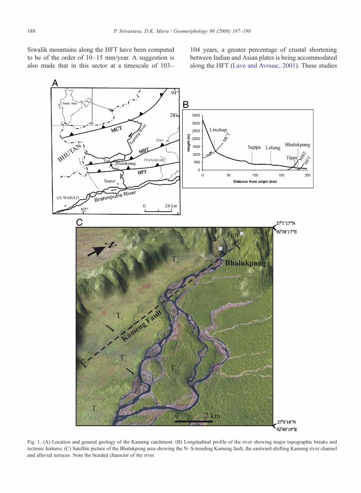
Fig. 5. Photograph showing (A) Terrace T1 and (B) Terrace T4. Notethe alluvial cover and underlying bedrock strath.
5.5. Terrace T4
T4 lies at a height of 240 m amsl and 20 m above T3. A25.5 m-thick bedrock strath occurs beneath a 6 m-thickalluvial cover (Fig. 5B). The alluvial cover (N 27° 0′ 58.2″,E 92° 37′ 59.1″) is made up of 4 m of clast-supportedpebble at the base, which is overlain by a 2 m-thickbioturbated fine silty sand (Fig. 6).
The ideal sequence of alluvial cover of the terrace ismade up of clast-supported pebble overlain by parallellaminated medium sand punctuated by matrix-supportedpebbles and bioturbated fine sand. The sediment sequencein general represents the braided channel environmentinterposed by debris flow events. In the mountain frontswhere a river debouches to a plain, it loses the hydraulicenergy necessary to carry the available sediment load andadopts a braiding character (Miall, 1996). During cold andarid climate, sediment that is generated within themountain catchment remains in situ due to the limitedcarrying capacity of the river. Later, during wetterconditions with high discharge, the sediment is removedand deposited downstream (Pratt et al., 2004).
Therefore, the sequence in the mountain front mainlyrepresents the relatively wetter climatic conditions thatprevailed after prolonged aridity. The debris flows thatare represented in form of matrix-supported pebblesfacies in the sedimentary sequences indicate theepisodic rainfall events.
6. Luminescence chronology
The sample collected from the alluvial cover ofthe oldest terrace T4 yielded the age of 13.9±3.1 ka B.P.(LD-100) and that from the terrace T3 yielded 10.4±1.4 ka B.P. (LD-99). The two samples from differentdepths in terrace T2 gave ages of 8.2±0.7 ka B.P.(LD-98) and 7.2±0.7 ka B.P. (LD-97). Terrace T1
yielded an age of 7.3±1.0 ka B.P. (LD-95; Fig. 3). Earlierworkers considered the older terraces, namely T2, T3
and T4, to be coeval with the Varanasi Alluvium ofGangetic plain and assigned these terraces an age betweenMiddle to Upper Pleistocene (Kumar et al., 1996; Karet al., 1997). However, these regional correlations werebased on radiocarbon dates derived from carbonizedwood debris where any incorporation of young or oldcarbon in decaying wood may have resulted in severechronological offset.
7. Discussion
Fluvial terraces in tectonically activemountains recordboth tectonic uplift and dynamic climatic variations. The
194 P. Srivastava, D.K. Misra / Geomorphology 96 (2008) 187–198
fluvial terraces carved out in the SiwalikMountains by theKameng River at Bhalukpong in NE sector of Himalayashow a well-developed bedrock strath overlain by alluvialcover. The luminescence dating of the alluvial coveroffered an opportunity to provide a chronologicalconstraint on aggradation and incision phases (Table 1).The chronological data indicated that the Kameng River(Fig. 3) was aggrading prior to 14 ka B.P., and incision ofthe valley fill and the formation of terrace T4 occurredbetween b14 ka and N10 ka B.P., over a timespanof ∼4 ka. The successive phase of aggradation, incisionand formation of terrace (T3) occurred between b10 kaand 8 ka, involving∼2 ka. The two ages of 8 ka and 7 kafrom the bottom and the top of 15 m-thick alluvial coveron T2 yielded overlapping ages (considering the associ-ated error of 1 ka) suggesting that the rate of aggradationon this terrace was high. The river incision from terrace T2
to T1 took place at ∼7 ka B.P. possibly involving a
Fig. 6. Sedimentological lilthologs of the alluvia
timespan of less than 1 ka. The youngest phase ofaggradation and incision took place at b7 ka B.P. and theformation of T1 terrace might have taken place at ∼6 kaB.P. (considering the errors associated with LD-95).
The alluvial cover of the oldest terrace T4 showsaggradation of 6 m under braided channel condition.Terrace T3 is marked by debris flows where the bedloadis comprised of larger pebble size (15–75 cm), indicat-ing high intensity episodic flood conditions in theKameng river channel that were generated in uppercatchment. The fact that quartzite pebbles are relativelylarger and lack comparable roundness suggests that thepebbles are not recycled from the older sedimentary fillsbut are produced and transported during the contempo-rary floods. The younger terrace T2 is characterized bybraided river conditions punctuated by few episodicfloods generating debris flows, however when com-pared to the T3 aggradation the intensity of these floods
l covers of various terraces at Bhalukpong.
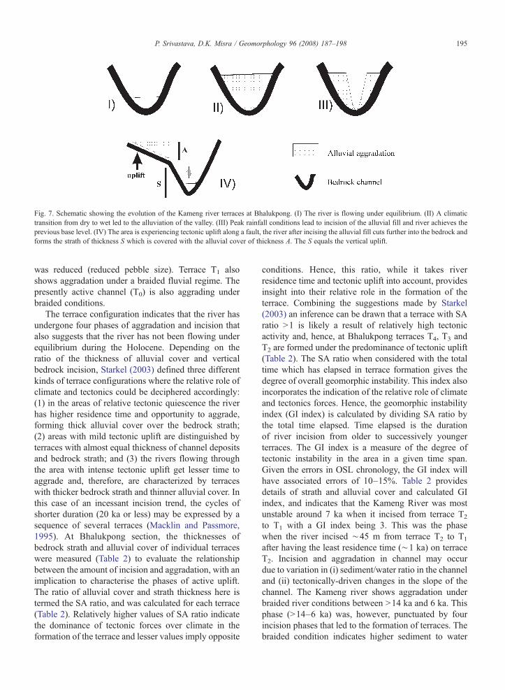
Fig. 7. Schematic showing the evolution of the Kameng river terraces at Bhalukpong. (I) The river is flowing under equilibrium. (II) A climatictransition from dry to wet led to the alluviation of the valley. (III) Peak rainfall conditions lead to incision of the alluvial fill and river achieves theprevious base level. (IV) The area is experiencing tectonic uplift along a fault, the river after incising the alluvial fill cuts further into the bedrock andforms the strath of thickness S which is covered with the alluvial cover of thickness A. The S equals the vertical uplift.
195P. Srivastava, D.K. Misra / Geomorphology 96 (2008) 187–198
was reduced (reduced pebble size). Terrace T1 alsoshows aggradation under a braided fluvial regime. Thepresently active channel (T0) is also aggrading underbraided conditions.
The terrace configuration indicates that the river hasundergone four phases of aggradation and incision thatalso suggests that the river has not been flowing underequilibrium during the Holocene. Depending on theratio of the thickness of alluvial cover and verticalbedrock incision, Starkel (2003) defined three differentkinds of terrace configurations where the relative role ofclimate and tectonics could be deciphered accordingly:(1) in the areas of relative tectonic quiescence the riverhas higher residence time and opportunity to aggrade,forming thick alluvial cover over the bedrock strath;(2) areas with mild tectonic uplift are distinguished byterraces with almost equal thickness of channel depositsand bedrock strath; and (3) the rivers flowing throughthe area with intense tectonic uplift get lesser time toaggrade and, therefore, are characterized by terraceswith thicker bedrock strath and thinner alluvial cover. Inthis case of an incessant incision trend, the cycles ofshorter duration (20 ka or less) may be expressed by asequence of several terraces (Macklin and Passmore,1995). At Bhalukpong section, the thicknesses ofbedrock strath and alluvial cover of individual terraceswere measured (Table 2) to evaluate the relationshipbetween the amount of incision and aggradation, with animplication to characterise the phases of active uplift.The ratio of alluvial cover and strath thickness here istermed the SA ratio, and was calculated for each terrace(Table 2). Relatively higher values of SA ratio indicatethe dominance of tectonic forces over climate in theformation of the terrace and lesser values imply opposite
conditions. Hence, this ratio, while it takes riverresidence time and tectonic uplift into account, providesinsight into their relative role in the formation of theterrace. Combining the suggestions made by Starkel(2003) an inference can be drawn that a terrace with SAratio N1 is likely a result of relatively high tectonicactivity and, hence, at Bhalukpong terraces T4, T3 andT2 are formed under the predominance of tectonic uplift(Table 2). The SA ratio when considered with the totaltime which has elapsed in terrace formation gives thedegree of overall geomorphic instability. This index alsoincorporates the indication of the relative role of climateand tectonics forces. Hence, the geomorphic instabilityindex (GI index) is calculated by dividing SA ratio bythe total time elapsed. Time elapsed is the durationof river incision from older to successively youngerterraces. The GI index is a measure of the degree oftectonic instability in the area in a given time span.Given the errors in OSL chronology, the GI index willhave associated errors of 10–15%. Table 2 providesdetails of strath and alluvial cover and calculated GIindex, and indicates that the Kameng River was mostunstable around 7 ka when it incised from terrace T2
to T1 with a GI index being 3. This was the phasewhen the river incised ∼45 m from terrace T2 to T1
after having the least residence time (∼1 ka) on terraceT2. Incision and aggradation in channel may occurdue to variation in (i) sediment/water ratio in the channeland (ii) tectonically-driven changes in the slope of thechannel. The Kameng river shows aggradation underbraided river conditions between N14 ka and 6 ka. Thisphase (N14–6 ka) was, however, punctuated by fourincision phases that led to the formation of terraces. Thebraided condition indicates higher sediment to water
196 P. Srivastava, D.K. Misra / Geomorphology 96 (2008) 187–198
ratio and the river does not have sufficient energy totransport the available sediment load. Therefore, anyincision occurring in such condition should be sup-ported by increased channel gradient induced bytectonic uplift. The palaeoclimatic scenario during thelast 15 ka, based on continental pollen and oceanrecords, suggests that following the Last GlacialMaxima (24–18 ka), Indian summer monsoon strength-ened ∼12 ka B.P., with peak rainfall at ∼9 ka B.P., andhas been stable since then (Swain et al., 1983; Dill et al.,2003; Sarkar et al., 2000; Chauhan, 2003). We arguethat the incision in Kameng is more governed byincreased river gradient due to tectonic uplift, and whichis explained below and in Fig. 7:
Stage I: The river flowing in equilibrium state.Stage II: A climatic shift from a drier to wetter, leads toa huge amount of sediment being transmitted down intothe river valley, the sediment to water ratio increasesand results in valley aggradation (N15–12 ka).Stage III: As the climate achieves peak rainfallconditions (∼12–9 ka), the sediment to water ratiodecreases and the river incises to its previous baselevel, i.e. to the bottom of the valley fill, and forms afill terrace.Stage IV: Tectonic uplift effectively lowers therelative base level and, following the incision of thevalley fill, the river cuts into the bedrock leaving thealluvial cover (A) over the elevated bedrock strath(S), where the thickness (H) of the strath will begoverned by the amount of uplift.
At Bhalukpong due to uplift along the Kameng fault,unpaired terraces (except Terrace T1) were formed onthe uplifting block. Further, the fact that the terraces arecharacterized by thin alluvial cover over thick bedrockstrath suggests low residence time of the river. Thisindicates that the river has been flowing underdisequilibrium during Holocene, the phase when theclimate has been stable and therefore tectonic upliftremains as the dominant natural force. Other evidence,such as tilted terraces, change in channel width andsediment transport capacity are not observed in thisstudy but gives scope for detailed study in future.
Therefore, at Bhalukpong the thickness of incisedbedrock indicates total tectonic uplift. The highest strathterrace lies at 105 m above the present day river bedrepresenting amount of uplift that has occurred in the areaduring the last 14 ka. This suggests that the river, overtimescales of 103 years, incised at the rate of 7.5mm/year.This can be suggested as the minimum uplift rate of theSiwalik belt in NEHimalaya. This incision rate, however,
seems to have varied during the Holocene if we considerthe incision rate of the channel separately from terrace T4
to T2, which amounts to total incision of 95 m during aspan of∼8 ka between 14 ka and 6 ka. This equates to anuplift rate of 11.9 mm/year. Therefore, we suggest that theuplift rate of the Siwaliks in NE Himalaya may have beenbetween 7.5–11.9 mm/year. The fact that OSL chronol-ogies are associatedwith 10–15% errors gives estimationsof incision and uplift rates that are also coupledwith errorsof the similar order. Other studies on uplift rates of theSiwaliksinclude the Darjiling sub-Himalaya in the Teestariver valley where disjointed strath terraces are datedusing OSL between 11.3±1.3 ka and 1.4±0.3 ka. TheTeesta River responded to the deformation by migrating150 m eastwards at the rate∼13mm/year and by incising48m verticallywith an average rate∼4.4mm/year, whereuplift in the Siwaliks is explained via out-of-sequencedeformation on surface-breaking faults north of the HFT(Mukul et al., in press). In the Central Himalaya, Nepal,the measured fluvial terrace on growing anticline in theSiwaliks along the Bagmati and Bakeya rivers indicateduplift rates of 10-15 mm/yr (Lave and Avouac, 2001). InNWHimalaya, Holocene uplift rates of 4–6mm/yr for theSiwaliks is determined from estimates of the rate ofincision of bedrock underlying uplifted fluvial terracedeposits of Ghaggar, Markanda, Shajahanpur and Kosirivers (Kumar et al., 1996). Based on lineament and activefault mapping using the satellite images, intense neotec-tonic deformation of the Siwalik ranges in NE Himalayahas also been suggested (Das, 2004).
The zone confining to the MBT near Tipi experi-enced an earthquake of magnitude 5.3 on October 12th,1985 at a depth of 9 km. Later, numerous events ofmagnitudes 3.0bMdb4.5 occurred in this zone atdepths of 10–30 km. The Kameng fault also passesvertically and meets the MBT through this point. This isone of the zones where the Himalayas change trend fromE-W to ENE–WSW and gradually assume a NE–SWtrend. Two temporary micro earthquake-monitoringnetworks established at Tipi and another in Rangavalley (east of Tipi) recorded more than 2000 earth-quakes in 10 months (Fig. 1A). The epicenters of theearthquakes lie south of the MBT and show a N–S trend(Kayal, 2003). However, studies reporting the amountvertical uplift due to single earthquakes in NE Indiahave not been done and remain a focus of futureinvestigations, yet clear evidence of fault scarps anddisplacements in young alluvium and progressive andcontinued offset of fluvial terrace deposits along theHFT are observed (Kumar et al., 1996). This givesstrength to the suggestion that the Kameng fault, aseismogenic fault, is responsible for the tectonic uplift of
197P. Srivastava, D.K. Misra / Geomorphology 96 (2008) 187–198
the Siwalik rocks and formation of four levels of riverterraces at Bhalukpong.
Inferences based on the calculations of GI indexassume that after the river abandoned the surface andincised to the younger terrace, the alluvial cover of theabandoned terrace underwent least erosion. Thisassumption needs careful examination, but the factthat the alluvial terraces in NE Himalaya are thicklyvegetated due to high rainfall (∼3 m/year) and are leastsusceptible to erosion provides confidence in thisassumption. However, detailed investigations in manymore such sections will better inform the limitations andgeneralization of the overall concept.
Acknowledgements
Authors acknowledge Prof. B.R. Arora, Director,Wadia Institute of Himalayan Geology, Dehra Dun forhis support and encouragements. Critical commentsmade by anonymous reviewers and the editor helpedimproving the manuscript. Sri Chandrashekhar isacknowledged for XRF analysis. Sri V.P. Gupta helpedin chemical processing of the samples for OSL dating.
References
Bookhagen, B., 2004. Late Quaternary climatic changes and landscapeevolution in NW India. Unpublished Ph.D. Thesis, PotsdamUniversity, Germany, 78p.
Bookhagen, B., Thiede, R., Strecker, M.R., 2005. Abnormal Monsoonyears and their control on erosion and sediment flux in the high,arid northwestern Himalaya. Earth and Planetary Science Letters231, 131–146.
Chauhan, O.S., 2003. Past 20,000-year history of Himalayan aridity:Evidence from oxygen isotope records in the Bay of Bengal.Current Science 84, 90–93.
Colls, A.E., Stokes, S., Blum, M.D., Straffin, E., 2001. Age limits onthe late Quaternary evolution of the upper Loire River. QuaternaryScience Reviews 20, 743–750.
Das, J.D., 2004. Active tectonics of the Eastern Himalayan foothillsregion and adjoining Brahmaputra Basin based on satellite images.International Journal of Remote Sensing 25, 549–557.
Dill, H.G., Khadka, D.R., Khanal, R., Dohrmann, R., Melcher, F.,Busch, K., 2003. Infilling of the younger Kathmandu–Banepaintermontane lake basin during the Late Quaternary (LesserHimalaya, Nepal): a sedimentological study. Journal of QuaternaryScience 18, 41–60.
Hodges, K.V., Wobus, C., Ruhl, K., Schildgen, T., Whipple, K., 2004.Quaternary deformation, river steepening, and heavy precipitationat the front of the Higher Himalayan ranges. Earth and PlanetaryScience Letters 220, 379–389.
Kar, S.K., Prasad, S., Kumar, G., 1997. Quaternary sediments in partsof Indo-Gangetic, Brahmaputra and adjoining inland basins andthe problem of demarcation of Pleistocene–Holocence Boundary.Golden Jubilee Conference on Physical and Biological ChangesAcross the Major Geological Boundaries, November 15-17, 1996,
Birbal Sahni Institute of Paleobotany, Lucknow. Palaeobotanist,vol. 46, pp. 196–209.
Kayal, J.R., 2003. Seismotectonic structures of the western and easternHimalayas: constraint from Microearthquake data. Memoirs of theGeological Society of India 53, 279–311.
Kumar, G., 1997. Geology of the Arunachal Pradesh, Geol. Soc. India,Bangalore. Kumar, S., Wesnousky, S. G., Rockwell, T. K., Briggs,R. W. Thakur, V. C., Jayangondaperumal, R., 2006. Paleoseismicevidence of great surface rupture earthquakes along the IndianHimalaya. Journal of Geophysical Research 111, B03304.
Kumar, G., Khanna, P.C., Prasad, S., 1996. Sequence stratigraphy offoredeep and evolution of Indo-Gangetic Plai, Uttar Pradesh.Proceedings of Symposium on NW Himalaya and Foredeep, Feb.1995. Geological Survey of India Special Publication, vol. 21(2),pp. 173–207.
Lavé, J., Avouac, J.P., 2001. Fluvial incision and tectonic upliftmentacross the Himalayas of central Nepal. Journal of GeophysicalResearch 106, 26561–26591.
Macklin,M.G., Passmore,D.G., 1995. Pleistocene environmental changesin the Guadalope basin, northeast Spain: fluvial and archeologicalrecords. In: Lewin, J., Macklin, M.G., Woodward, J.C. (Eds.),MediterraneanQuaternary River Environments. Balkema, Rotterdam,pp. 100–111.
Mukul, M., Jaiswal, M., Singhvi, A.K., in press. Timing of recent out-of-sequence active deformation in the frontal Himalayan wedge:Insights from the Darjiling sub-Himalaya, India. Geology.
Meetei, L.I., Pattanayak, S.K., Bhaskar, A., Pandit, M.K., Tandon, S.K.,2007. Climatic imprints in Quaternary valley fill deposits of themiddle Teesta valley, Sikkim Himalaya. Quaternary International159, 32–46.
Miall, A.D., 1996. The Geology of Fluvial Deposits. Springer, Berlin.Murray, A.S., Wintle, A.G., 2000. Luminescence dating of quartz
using an improved single aliquot regenerative-dose protocol.Radiation Measurement, 32, 57–73.
Nandy, D.R., 2001. Geodynamics of Northeastern India and theadjoining region. ABC Publications, Kolkata.
Nemec, W., Steel, R.J., 1984. Alluvial and coastal conglomerates: theirsignificant features and some comments on gravelly mass-flowdeposits. In: Koster, E.H., Steel, R.J. (Eds.), Sedimentology ofGravels and Conglomerates. Canadian Society of PetroleumGeologists Memoir, vol. 10, pp. 1–31.
Pratt, S.B., Burbank, D.W., Heimsath, A., Ojha, T., 2004. Landscapedisequilibrium on 1000–10,000 year scales Marsyandi River,Nepal, central Himalaya. Geomorphology 58, 223–241.
Sarkar, A., Ramesh, R., Somayajulu, B.L.K., Agnihotri, R., Jull, A.J.T.,Burr, G.S., 2000. High resolution Holocene monsoon record fromthe eastern Arabian Sea. Earth and Planetary Science Letters 177,209–218.
Singh, S., Chowdhary, P.K., 1990. An outline of the geologicalframework of the Arunachal Himalaya. Journal of HimalayanGeology 1, 189–197.
Srivastava, P., Brook,G.A.,Marais, E.,Morthekai, P., Singhvi, A.K., 2006.Depositional environment and OSL chronology of the Homeb siltdeposits, Kuiseb River, Namibia. Quaternary Research 65, 478–491.
Srivastava, P., Tripathi, J.K., Islam, R., Jaiswal, M.K., (under review).Fashion and phases of Late Pleistocene aggradation and incision inAlaknanda River, western Himalaya, India. Quaternary Research.
Starkel, L., 2003. Climatically controlled terraces in upliftingmountain areas. Quaternary Science Reviews 22, 2189–2198.
Swain, A.M., Kutzbach, J.E., Hastenrath, S., 1983. Estimation of theHolocene precipitation for Rajasthan, India, based on the pollenand lake level data. Quaternary Research 19, 1–17.

198 P. Srivastava, D.K. Misra / Geomorphology 96 (2008) 187–198
Thiede, R., Bookhagen, B., Arrowsmith, J., Sobel, E., Strecker, M.R.,2004. Climatic Control on rapid exhumation along the SouthernHimalayan Front. Earth and Planetary Science Letters 222, 791–806.
Verma, P.K., Tandon, S.K., 1976. Geological observations in parts ofKameng district, Arunachal Pradesh (NEFA). Himalayan Geology6, 259–286.
Vance, D., Bickle, M., Ivy-Ochs, S., Kubik, P.W., 2003. Erosion andexhumation in theHimalaya fromCosmogenic isotope inventories ofriver sediments. Earth and Planetary Science Letters 206, 273–288.
Wobus, C., Heimsath, A., Whipple, K., Hodges, K.V., 2005. Activeout-of-sequence thrust faulting in the central Nepalese Himalaya.Nature 434, 1008–1011.