PHASE I ENVIRONMENTAL SITE ASSESSMENT REPORT
240
PHASE I ENVIRONMENTAL SITE ASSESSMENT REPORT BROADBENT BUSINESS PARK 3607-3667 West 1987 South Street Salt Lake City, Utah 84104 December 3, 2013 Partner Project No. 13-112385.2 Prepared for INDUSTRY CAPITAL 1 Sansome Street, 15 th Floor San Francisco, California 94104
-
Upload
khangminh22 -
Category
Documents
-
view
1 -
download
0
Transcript of PHASE I ENVIRONMENTAL SITE ASSESSMENT REPORT

PHASE I ENVIRONMENTAL SITE ASSESSMENT REPORT
BROADBENT BUSINESS PARK 3607-3667 West 1987 South Street Salt Lake City, Utah 84104
December 3, 2013 Partner Project No. 13-112385.2 Prepared for INDUSTRY CAPITAL 1 Sansome Street, 15th Floor San Francisco, California 94104

2154 Torrance Blvd., Suite 200, Torrance, CA 90501 ◊ Phone 800-419-4923 ◊ Fax 866-928-7418
December 3, 2013
Mr. Larry Munoz Industry Capital 1 Sansome Street, 15th Floor San Francisco, California 94104 Subject: Phase I Environmental Site Assessment
Broadbent Business Park 3607-3667 West 1987 South Street Salt Lake City, Utah 84104 Partner Project No. 13-112385.2
Dear Mr. Munoz:
Partner Engineering and Science, Inc. (Partner) is pleased to provide the results of the Phase I Environmental Site Assessment (Phase I ESA) report of the abovementioned address (the “subject property”). This assessment was performed in general conformance with the scope and limitations as detailed in the ASTM Practice E1527-13 Standard Practice for Environmental Site Assessments: Phase I Environmental Site Assessment Process.
This assessment included a site reconnaissance as well as research and interviews with representatives of the public, property ownership, site manager, and regulatory agencies. An assessment was made, conclusions stated, and recommendations outlined.
We appreciate the opportunity to provide environmental services to you. If you have any questions concerning this report, or if we can assist you in any other matter, please contact me at (214) 666-6800 or [email protected].
Sincerely,
Summer D. Gell Principal

Phase I Environmental Site Assessment Project No. 13-112385.2 December 3, 2013 Page i
EXECUTIVE SUMMARY
Partner Engineering and Science, Inc. (Partner) has performed a Phase I Environmental Site Assessment (ESA) in general accordance with the scope of work and limitations of ASTM Standard Practice E1527-13, the Environmental Protection Agency Standards and Practices for All Appropriate Inquiries (AAI) (40 CFR Part 312) and set forth by Industry Capital for the property located at 3607-3667 West 1987 South Street in the City of Salt Lake City, Salt Lake County, Utah (the “subject property”). The Phase I Environmental Site Assessment is designed to provide Industry Capital with an assessment concerning environmental conditions (limited to those issues identified in the report) as they exist at the subject property.
Property Description
The subject property is between 2100 South Street (to the south) and 1987 South Street (to the north) and between 3600 West Street (to the east) and 3730 West Street (to the west) within a mixed commercial, retail, and industrial area of Salt Lake County. Please refer to the table below for further description of the subject property:
Subject Property Data Address(es): 3607-3667 West 1987 South Street, Salt Lake City, Utah Property Use: Commercial/Retail/Office/Industrial/Vacant Land Acreage (Ac): 8.35 Ac Number of Buildings: Eight Number of Floors: One Gross Building Area (SF): 11,070 SF (Building 1); 15,640 SF (Building 2); 12,225 SF (Building
3); 16,130 SF (Building 4); 12,160 SF (Building 5); 15,700 SF (Building 6); 12,225 SF (Building 7); 16,130 SF (Building 8).
Net Rentable Area (SF): 11,070 SF (Building 1); 15,640 SF (Building 2); 12,225 SF (Building 3); 16,130 SF (Building 4); 12,160 SF (Building 5); 15,700 SF (Building 6); 12,225 SF (Building 7); 16,130 SF (Building 8).
Date of Construction: 1976 Assessor’s Parcel Number (APN): 15-17-300-029 Type of Construction: Concrete Tilt-Up Current Tenants: See Section 2.2 Site Assessment Performed By: David B. Simon of Partner Site Assessment Conducted On: November 21 and 22, 2013
The subject property is currently occupied by Broadbent Business Park for commercial/retail/industrial use. Onsite operations are described in Section 2.2. In addition to the current structures, the subject property is also improved with municipal sewer, water, power, concrete driveways, asphalt-paved parking areas, and associated landscaping.
According to available historical sources, the subject property was formerly undeveloped as early as 1895 until development with the current structures in 1976. Tenants on the subject property are outlined in Section 2.2. The immediately surrounding properties consist of two commercial structures to the north across 1987 South Street, one vacant and the other occupied Sun Products Corporation; Highway 201 to the south across 2100 South Street; First Bank of Utah and undeveloped land to the east across 3600 West Street; and Reul’s Distribution Center to the west across 3730 West Street.
Phase I Environmental Site Assessment Project No. 13-112385.2 December 3, 2013 Page ii
According to a previous subsurface investigation conducted on a nearby property (1825 South 3730 West and Case # 4000624), the depth of groundwater in the vicinity of the subject property is inferred to be approximately 5 feet below ground surface (bgs), groundwater flow direction was to the northeast.
Findings
A recognized environmental condition (REC) refers to the presence or likely presence of any hazardous substances or petroleum products in, on, or at a property: due to release to the environment; under conditions indicative of a release to the environment; or under conditions that pose a material threat of a future release to the environment.
• Partner did not identify any recognized environmental conditions during the course of this assessment.
A controlled recognized environmental condition (CREC) refers to a REC resulting from a past release of hazardous substances or petroleum products that has been addressed to the satisfaction of the applicable regulatory authority, with hazardous substances or petroleum products allowed to remain in place subject to the implementation of required controls. The following was identified during the course of this assessment:
• Partner did not identify any controlled recognized environmental conditions during the course of this assessment.
A historical recognized environmental condition (HREC) refers to a past release of any hazardous substances or petroleum products that has occurred in connection with the property and has been addressed to the satisfaction of the applicable regulatory authority or meeting unrestricted use criteria established by a regulatory authority, without subjecting the property to any required controls. The following was identified during the course of this assessment:
• Partner did not identify any historical recognized environmental conditions during the course of this assessment.
An environmental issue refers to environmental concerns identified by Partner, which do not qualify as RECs; however, warrant further discussion.
• Partner did not identify any environmental issues during the course of this assessment.
Conclusions, Opinions and Recommendations
Partner has performed a Phase I Environmental Site Assessment in conformance with the scope and limitations of ASTM Practice E1527-13 of 3607-3667 West 1987 South Street in the City of Salt Lake City, Salt Lake County, Utah (the “subject property”). Any exceptions to, or deletions from, this practice are described in Section 1.5 of this report.
This assessment has revealed no evidence of recognized environmental conditions or environmental issues in connection with the subject property. Based on the conclusions of this assessment, Partner recommends no further investigation of the subject property at this time.

Phase I Environmental Site Assessment Project No. 13-112385.2 December 3, 2013 Page i
TABLE OF CONTENTS 1.0 INTRODUCTION .............................................................................................................................. 1
1.1 Purpose ................................................................................................................................................................................ 1 1.2 Scope of Work ................................................................................................................................................................... 1 1.3 Limitations .......................................................................................................................................................................... 2 1.4 User Reliance ..................................................................................................................................................................... 2 1.5 Limiting Conditions ......................................................................................................................................................... 3
2.0 SITE DESCRIPTION ........................................................................................................................ 4 2.1 Site Location and Legal Description ......................................................................................................................... 4 2.2 Current Property Use ...................................................................................................................................................... 4 2.3 Current Use of Adjacent Properties .......................................................................................................................... 9 2.4 Physical Setting Sources ............................................................................................................................................. 10
2.4.1 Topography ........................................................................................................................................................... 10 2.4.2 Hydrology .............................................................................................................................................................. 10 2.4.3 Geology/Soils ....................................................................................................................................................... 10
3.0 HISTORICAL INFORMATION ....................................................................................................... 12 3.1 Aerial Photograph Review ......................................................................................................................................... 12 3.2 Fire Insurance Maps ..................................................................................................................................................... 14 3.3 City Directories ............................................................................................................................................................... 14 3.4 Historical Topographic Maps ................................................................................................................................... 19
4.0 REGULATORY RECORDS REVIEW ............................................................................................ 21 4.1 Regulatory Agencies .................................................................................................................................................... 21
4.1.1 State Department ............................................................................................................................................... 21 4.1.2 Health Department ............................................................................................................................................ 21 4.1.3 Fire Department .................................................................................................................................................. 21 4.1.4 Building Department ......................................................................................................................................... 22 4.1.5 Planning Department ........................................................................................................................................ 22 4.1.6 Oil & Gas Exploration ........................................................................................................................................ 22 4.1.7 Assessor’s Office .................................................................................................................................................. 23
4.2 Mapped Database Records Search ........................................................................................................................ 23 4.2.1 Regulatory Database Summary ..................................................................................................................... 23 4.2.2 Subject Property Listings ................................................................................................................................. 24 4.2.3 Adjacent Property Listings .............................................................................................................................. 24 4.2.4 Sites of Concern Listings .................................................................................................................................. 24 4.2.5 Orphan Listings .................................................................................................................................................... 24
5.0 USER PROVIDED INFORMATION AND INTERVIEWS .............................................................. 26 5.1 Interviews ......................................................................................................................................................................... 26
5.1.1 Interview with Owner ........................................................................................................................................ 26 5.1.2 Interview with Report User .............................................................................................................................. 27 5.1.3 Interview with Key Site Manager .................................................................................................................. 27 5.1.4 Interviews with Past Owners, Operators and Occupants .................................................................... 28 5.1.5 Interview with Others ........................................................................................................................................ 28
5.2 User Provided Information ........................................................................................................................................ 28 5.2.1 Title Records, Environmental Liens, and AULs ......................................................................................... 28

Phase I Environmental Site Assessment Project No. 13-112385.2 December 3, 2013 Page ii
5.2.2 Specialized Knowledge ..................................................................................................................................... 28 5.2.3 Actual Knowledge of the User ....................................................................................................................... 28 5.2.4 Valuation Reduction for Environmental Issues ....................................................................................... 28 5.2.5 Commonly Known or Reasonably Ascertainable Information .......................................................... 28 5.2.6 Previous Reports and Other Provided Documentation ....................................................................... 28
6.0 SITE RECONNAISSANCE ............................................................................................................ 29 6.1 General Site Characteristics....................................................................................................................................... 29 6.2 Potential Environmental Hazards............................................................................................................................ 30 6.3 Non-ASTM Services...................................................................................................................................................... 32
6.3.1 Asbestos-Containing Materials (ACMs) ..................................................................................................... 32 6.3.2 Lead-Based Paint (LBP) ..................................................................................................................................... 32 6.3.3 Radon ...................................................................................................................................................................... 32 6.3.4 Lead in Drinking Water ..................................................................................................................................... 32 6.3.5 Mold ......................................................................................................................................................................... 32
6.4 Adjacent Property Reconnaissance ........................................................................................................................ 33 7.0 FINDINGS AND CONCLUSIONS ................................................................................................. 34 8.0 SIGNATURES OF ENVIRONMENTAL PROFESSIONALS ......................................................... 35 9.0 REFERENCES ............................................................................................................................... 36 FIGURES Figure 1 Site Location Map Figure 2 Topographic Map Figure 3 Site Plan APPENDICES Appendix A Site Photographs Appendix B Historical/Regulatory Documentation Appendix C Regulatory Database Report Appendix D Qualifications
Phase I Environmental Site Assessment Project No. 13-112385.2 December 3, 2013 Page 1
1.0 INTRODUCTION
Partner Engineering and Science, Inc. (Partner) has performed a Phase I Environmental Site Assessment (ESA) in general conformance with the scope and limitations of ASTM Standard Practice E1527-13 and the Environmental Protection Agency Standards and Practices for All Appropriate Inquiries (AAI) (40 CFR Part 312) for the property located at 3607-3667 West 1987 South Street in the City of Salt Lake City, Salt Lake County, Utah (the “subject property”). Any exceptions to, or deletions from, this scope of work are described in the report.
1.1 Purpose
The purpose of this ESA is to identify existing or potential Recognized Environmental Conditions (as defined by ASTM Standard E1527-13) affecting the subject property that: 1) constitute or result in a material violation or a potential material violation of any applicable environmental law; 2) impose any material constraints on the operation of the subject property or require a material change in the use thereof; 3) require clean-up, remedial action or other response with respect to Hazardous Substances or Petroleum Products on or affecting the subject property under any applicable environmental law; 4) may affect the value of the subject property; and 5) may require specific actions to be performed with regard to such conditions and circumstances. The information contained in the ESA Report will be used by Client to: 1) evaluate its legal and financial liabilities for transactions related to foreclosure, purchase, sale, loan origination, loan workout or seller financing; 2) evaluate the subject property’s overall development potential, the associated market value and the impact of applicable laws that restrict financial and other types of assistance for the future development of the subject property; and/or 3) determine whether specific actions are required to be performed prior to the foreclosure, purchase, sale, loan origination, loan workout or seller financing of the subject property.
This ESA was performed to permit the User to satisfy one of the requirements to qualify for the innocent landowner, contiguous property owner, or bona fide prospective purchaser limitations on scope of Comprehensive Environmental Response, Compensation and Liability Act (CERCLA) (42 U.S.C. §9601) liability (hereinafter, the “landowner liability protections,” or “LLPs”). ASTM Standard E1527-13 constitutes “all appropriate inquiry into the previous ownership and uses of the property consistent with good commercial or customary practice” as defined at 42 U.S.C. §9601(35)(B).
1.2 Scope of Work
The scope of work for this ESA is in general accordance with the requirements of ASTM Standard E1527-13. This assessment included: 1) a property and adjacent site reconnaissance; 2) interviews with key personnel; 3) a review of historical sources; 4) a review of regulatory agency records; and 5) a review of a regulatory database report provided by a third-party vendor. Partner contacted local agencies, such as environmental health departments, fire departments and building departments in order to determine any current and/or former hazardous substances usage, storage and/or releases of hazardous substances on the subject property. Additionally, Partner researched information on the presence of activity and use limitations (AULs) at these agencies. As defined by ASTM E1527-13, AULs are the legal or physical restrictions or limitations on the use of, or access to, a site or facility: 1) to reduce or eliminate potential exposure to hazardous substances or petroleum products in the soil or groundwater on the subject property; or 2) to prevent activities that could interfere with the effectiveness of a response action, in order to ensure maintenance of a condition of no significant risk to public health or the environment. These legal or physical restrictions, which may include institutional and/or engineering controls (IC/ECs),

Phase I Environmental Site Assessment Project No. 13-112385.2 December 3, 2013 Page 2
are intended to prevent adverse impacts to individuals or populations that may be exposed to hazardous substances and petroleum products in the soil or groundwater on the property.
If requested by Client, this report may also include the identification, discussion of, and/or limited sampling of asbestos-containing materials (ACMs), lead-based paint (LBP), mold, and/or radon.
1.3 Limitations
Partner warrants that the findings and conclusions contained herein were accomplished in accordance with the methodologies set forth in the Scope of Work. These methodologies are described as representing good commercial and customary practice for conducting an ESA of a property for the purpose of identifying recognized environmental conditions. There is a possibility that even with the proper application of these methodologies there may exist on the subject property conditions that could not be identified within the scope of the assessment or which were not reasonably identifiable from the available information. Partner believes that the information obtained from the record review and the interviews concerning the subject property is reliable. However, Partner cannot and does not warrant or guarantee that the information provided by these other sources is accurate or complete. The conclusions and findings set forth in this report are strictly limited in time and scope to the date of the evaluations. The conclusions presented in the report are based solely on the services described therein, and not on scientific tasks or procedures beyond the scope of agreed-upon services or the time and budgeting restraints imposed by the Client. No other warranties are implied or expressed.
Some of the information provided in this report is based upon personal interviews, and research of available documents, records, and maps held by the appropriate government and private agencies. This report is subject to the limitations of historical documentation, availability, and accuracy of pertinent records, and the personal recollections of those persons contacted.
This practice does not address requirements of any state or local laws or of any federal laws other than the all appropriate inquiry provisions of the LLPs. Further, this report does not intend to address all of the safety concerns, if any, associated with the subject property.
Environmental concerns, which are beyond the scope of a Phase I ESA as defined by ASTM include the following: ACMs, LBP, radon, and lead in drinking water. These issues may affect environmental risk at the subject property and may warrant discussion and/or assessment; however, are considered non-scope issues. If specifically requested by the Client, these non-scope issues are discussed in Section 6.3.
1.4 User Reliance
Industry Capital engaged Partner to perform this assessment in accordance with an agreement governing the nature, scope and purpose of the work as well as other matters critical to the engagement. All reports, both verbal and written, are for the sole use and benefit of Industry Capital. Either verbally or in writing, third parties may come into possession of this report or all or part of the information generated as a result of this work. In the absence of a written agreement with Partner granting such rights, no third parties shall have rights of recourse or recovery whatsoever under any course of action against Partner, its officers, employees, vendors, successors or assigns. Any such unauthorized user shall be responsible to protect, indemnify and hold Partner, Client and their respective officers, employees, vendors, successors and assigns harmless from any and all claims, damages, losses, liabilities, expenses (including reasonable attorneys’ fees) and costs attributable to such Use. Unauthorized use of this report shall constitute

Phase I Environmental Site Assessment Project No. 13-112385.2 December 3, 2013 Page 3
acceptance of and commitment to these responsibilities, which shall be irrevocable and shall apply regardless of the cause of action or legal theory pled or asserted. Additional legal penalties may apply.
1.5 Limiting Conditions
The findings and conclusions contain all of the limitations inherent in these methodologies that are referred to in ASTM E1527-13.
Specific limitations and exceptions to this ESA are more specifically set forth below:
• Interviews with past or current owners, operators and occupants were not reasonably ascertainable and thus constitute a data gap. Based on information obtained from other historical sources (as discussed in Section 3.0), this data gap is not expected to alter the findings of this assessment.
• Partner submitted Freedom of Information Act (FOIA) requests to Salt Lake City Builing, Engineering, and Planning Departments for information pertaining to hazardous substances, underground storage tanks, releases, inspection records, etc. for the subject property and/or adjacent properties. As of this writing, these agencies have not responded to Partner’s request. Based on information obtained from other historical sources, this limitation is not expected to alter the overall findings of this assessment.
• Partner observed approximately 90% of all interior units and all common areas. Based on the size and nature of use of the unobserved units, this limited method of survey is not expected to alter the overall findings of this assessment.
Phase I Environmental Site Assessment Project No. 13-112385.2 December 3, 2013 Page 4
2.0 SITE DESCRIPTION 2.1 Site Location and Legal Description
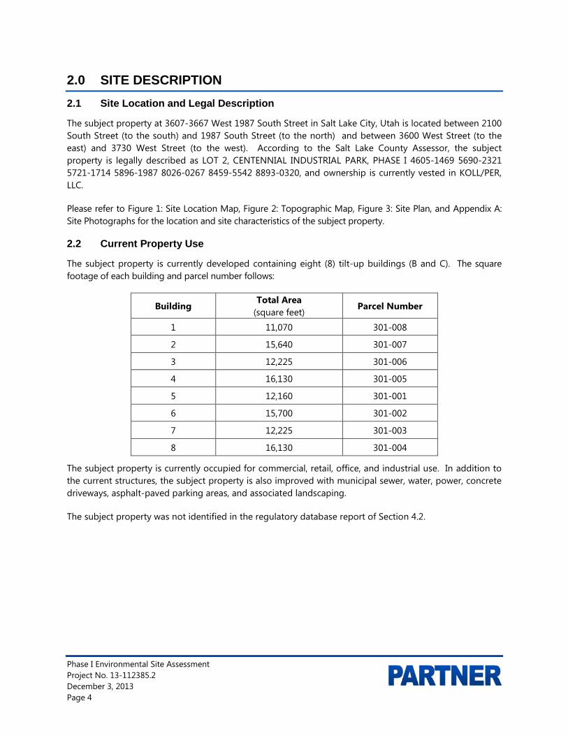
The subject property at 3607-3667 West 1987 South Street in Salt Lake City, Utah is located between 2100 South Street (to the south) and 1987 South Street (to the north) and between 3600 West Street (to the east) and 3730 West Street (to the west). According to the Salt Lake County Assessor, the subject property is legally described as LOT 2, CENTENNIAL INDUSTRIAL PARK, PHASE I 4605-1469 5690-2321 5721-1714 5896-1987 8026-0267 8459-5542 8893-0320, and ownership is currently vested in KOLL/PER, LLC.
Please refer to Figure 1: Site Location Map, Figure 2: Topographic Map, Figure 3: Site Plan, and Appendix A: Site Photographs for the location and site characteristics of the subject property.
2.2 Current Property Use
The subject property is currently developed containing eight (8) tilt-up buildings (B and C). The square footage of each building and parcel number follows:
Building Total Area
(square feet) Parcel Number
1 11,070 301-008
2 15,640 301-007
3 12,225 301-006
4 16,130 301-005
5 12,160 301-001
6 15,700 301-002
7 12,225 301-003
8 16,130 301-004
The subject property is currently occupied for commercial, retail, office, and industrial use. In addition to the current structures, the subject property is also improved with municipal sewer, water, power, concrete driveways, asphalt-paved parking areas, and associated landscaping.
The subject property was not identified in the regulatory database report of Section 4.2.

Phase I Environmental Site Assessment Project No. 13-112385.2 December 3, 2013 Page 5
Tenants and associated onsite operations follow:
Building 1
Unit Occupant Use or Storage of
Hazardous Materials
3608 Vacant (3608 West 1987 South) No
3610 Select Staffing – employment agency (3610 West 1987 South) No
3612 CDL Training – truck driving school (3612 West 1987 South) No
3614 Recording Studio (3614 West 1987 South) No
3616/3618 Vacant (3616 West 1987 South) No
3620 MSI Mountain States Instruments - sales office (3620 West 1987 South) No
3626 Vaporiz Delight - e-cigarette smoke store (3626 West 1987 South) No
3628 USA Today-Gannett: storage of newspaper dispensers (3628 West 1987 South) No
Building 2
Unit Occupant Use or Storage of
Hazardous Materials 3636 Subway Restaurant (3636 West 2100 South Street) No 3638 Vacant (3638 West 2100 South Street) No 3640 Vacant (3640 West 2100 South Street) No
3642 Samar Audio LLC – audio visual equipment and supplies and metal manufacturing (3642 West 2100 South Street)
No
3644 Precision Garage Door Service (3644 West 2100 South Street) No
3646 Signature Glass - cutting and repairing of glass, primarily mirrors, fabrication off-site (3646 West 2100 South Street)
No
3648 Sms Systems Maintenance Svc. (3648 West 2100 South Street) No
3650 U.S. Foods - office food supplies and call-center (3650 West 2100 South Street)
No
3652 Acquire Media - software development (3652 West 2100 South Street)
No
3654 Logo Carriers - Main office for paper work for carriers (trucks) (3654 West 2100 South Street)
No
3656 Alliance Airport Advertising (3656 West 2100 South Street) No
3658 Panasonic Avionics Corp. - maintenance services for Delta and NW airlines (3658 West 2100 South)
No

Phase I Environmental Site Assessment Project No. 13-112385.2 December 3, 2013 Page 6
Building 3
Unit Occupant Use or Storage of
Hazardous Materials
3362 Earthtec Engineering Inc. - geotechnical consultants (appeared vacant) (3662 West 2100 South Street)
No
3664/3666 BioSonix - design, manufacture and testing of ultra-sonic medical devices (3664 West 2100 South Street)
No
3668 Single Source Business Products – provider of office products (3668 West 2100 South Street)
No
3670 Backhus Event Services - bar service for catering (3670 West 2100 South Street)
No
3672 Ken's Beverage Inc. - beverage supplies (3672 West 2100 South Street)
No
3674 Nexus Pharma, Inc. - research and development in biotechnology (3674 West 2100 South Street)
Yes
3676/3678 Lucky Spoon Bakery – bakery (3676 West 2100 South Street) No
Building 4
Unit Occupant Use or Storage of
Hazardous Materials
3684 Mettler Toledo Scales & Systems – sales and service (3684 West 2100 South Street)
No
3688/3688A Walker Component Group - sales office for electronic components (3688 West 2100 South Street)
No
3690 Latino Express Loans – lending agency (3690 West 2100 South Street)
No
3692 Vacant (3692 West 2100 South Street) No
3696 Romaine Electric Corp. - sale of rotating electrical motors (3696 West 2100 South Street)
No
3698 Vacant (3698 West 2100 South Street) No
3700 Gandy's Candy - cotton candy manufacturing (3700 West 2100 South Street)
No
3702/3710 J. Chapman Academy - virtual reality weapons training (3710 West 2100 South Street)
No
Building 5
Unit Occupant Use or Storage of
Hazardous Materials
3689 Vacant (3689 West 1987 South) No
3691 Meadow Gold - administrative office (3691 West 1987 South) No

Phase I Environmental Site Assessment Project No. 13-112385.2 December 3, 2013 Page 7
3693/3695 StoraGenergy - research on Lithium batteries (3695 West 1987 South) Yes
3697 Vacant (3697 West 1987 South) No
3699 Noah H. Hanawalt - did not access (3699 West 1987 South) No
3701 Vacant (3701 West 1987 South) No
3703/3705 Vacant (3705 West 1987 South) No
Building 6
Unit Occupant Use or Storage of
Hazardous Materials
3661 Hydrographic Printing - new tenants with hood and tank (3661 West 1987 South)
Likely
3663 Vacant (3663 West 1987 South) No
3665/3667 Premier Employee Solutions – employment agency (3665 West 1987 South)
No
3669/3671 Vacant (3669 West 1987 South) No 3673/3675 Vacant (3673 West 1987 South) No 3677/3679 1-800 Got Junk (3677 West 1987 South) No
3681 Vacant (grease trap interceptor) (3681 West 1987 South)
No
3683 Los Angeles Bread Two – bakery (3683 West 1987 South)
No
Building 7
Unit Occupant Use or Storage of
Hazardous Materials
3641 Paragon Bio-Chemical: manufacture of organic compounds not found in nature (3641 West 1987 South)
Yes
3643 Accent Custom Coatings - concrete - occupant no present (3643 West 1987 South)
Yes
3645 Bowers Industrial - sale of industrial coatings and lining, manufactured off-site (3645 West 1987 South)
No
3647 United Weld Tech – welding (3647 West 1987 South)
No
3649 Vacant (3649 West 1987 South) No
3651 Clearly Corporate - fabrication of etched crystalline glass awards (3651 West 1987 South)
No
3653/3655/3657 Hoggan Scientific LLC., assembly of medical devices (3653 West 1987 South)
No

Phase I Environmental Site Assessment Project No. 13-112385.2 December 3, 2013 Page 8
Building 8
Unit Occupant Use or Storage of Hazardous Materials
3611 Vacant (3611 West 1987 South) No
3613 Pioneer Land Surveying (3613 West 1987 South) No
3615 Vacant (3615 West 1987 South) No
3617 Vacant (3617 West 1987 South) No
3619/3621 Vacant (3619 West 1987 South) No
3623/3625 Vacant (3623 West 1987 South) No
3627 Vacant (3627 West 1987 South) No
3629/3631/3633 Vacant (3629 West 1987 South) No
A discussion of the units containing hazardous material follow:
1. Samar Audio, LLC., Building 2, Unit 3642 (3642 West 2100 South) : Audio-visual equipment and supplies, which involves metal fabrication. There was one, five-gallon container of compressor oil stored adjacent to the compressor. No staining or discoloration indicative of spills.
2. Biosonix, Inc., Building 3, Units 3664 and 3666 (3666 West 2100 South): Design and testing of ultra-sonic medical equipment. Chemicals on-site consisted of one-gallon of isopropyl alcohol; 2-quarts of epoxy, and; 1.5 gallons of urethane. Chemicals were properly stored, no staining or discoloration indicative of spills.
3. Nexus Pharma, Inc., Building 3, Units 3674 (3674 West 2100 South): Occupant not present during site visit. Internet indicates the company is involved in research and development in biotechnology. Several small quantities of solvents were present and properly stored. No staining or discoloration indicative of spills.
4. StoraGENergy., Building 5, Units 3695 (3666 West 1987 South): Research on Lithium batteries. Company about six-months old and generates about 500 ml of waste annually, which will be properly disposed in accordance with state laws. Chemicals properly stored, no staining or discoloration indicative of spills. Chemicals on-site follow: one liter containers of hydrochloride, hexane, toluene, 2-proporal, and 1-methyl,2-pryrrolidinene; 500 ml bottles of formic acid and hydrogen peroxide; one kg bottle of sulfuric acid, 25 grams of sodium sulfide; 1 gram bottle of tetrafluoroethylene; 20 gram bottle of acrylic acid; 350 gram bottle of polyvinylpyrrolidone; 100 grams of Pluronic F-127, and; 500 grams of sulfur powder and sodium thiosulfate pentahydrate.
5. Hydrographic printing, Building 6, Units 3661 (3661 West 1987 South): Occupant not present during site visit and company name not posted. According to site manager, company will be involved in hydrographic printing. In warehouse were two new tanks and a new chemical hood/table (to be vented). No chemicals present. Internet indicates hydrographic printing or immersion printing, or water transfer printing, is a method of applying printed designs to three-dimensional objects. Generally involves a plasticizer which may consist of xylene, MEK, butoxyethanol, texanol, etc.
Phase I Environmental Site Assessment Project No. 13-112385.2 December 3, 2013 Page 9
6. Paragon Bio-Chemical, Building 7, Unit 3641 (3641 West 1987 South): Synthetic organic chemistry, manufacture of organic chemical not found in nature, such as modified amino acids and biologically active bio-molecules which are sold to universities and research laboratories. Unit has four floor drains, one in the center of each laboratory, which have not been used in over 15 years. Primary chemicals used and replenished consist of: 20 liter containers of ethanol, methanol, hexane, ethyl-acetate, isopropanol, ethyl ether, methylene chloride, xylene, and toluene.
Waste is stored in 5-gallon buckets and disposed at the hazardous waste facility at the Salt Lake Valley landfill. During busy years, waste is disposed annually, during lien years every 3 to 4 years. The last time waste was disposed was 2010. The Salt Lake Valley Landfill disposal certificate is enclosed in Appendix B. The Salt Lake City Fire Department inspects the facility annually and the 2013 inspection certificate is enclosed in Appendix B.
Overall “house cleaning” was very poor. However, primary chemicals used and replenished were properly stored in a fire proof, metal storage cabinet. Other than on the tables under the laboratory hoods, there was no staining or discoloration indicative of spills.
7. Accent Custom Coatings, Building 7, Unit 3643 (3643 West 1987 South): Occupant not present during site visit. According to internet, company involved in concrete coatings and deck water proofing systems. The following chemical were properly stored and there was no staining or discoloration indicative of spills: six, 5-gallon containers of acetone; one 5-gallon container of denatured alcohol; one five-gallon container of lithium-sulfate sealer; tow one-gallon containers of epoxy resin, and; one 55-gallon container of Prosoco, a hardener for concrete.
8. Bowers Industrial, Inc., Building 7, Unit 3645 (3645 West 1987 South): Provider of coating and lining products for industrial and commercial businesses. Facility is solely for the sale of coating and lining products and the products are shipped to the facility from the factory. The following chemical were properly stored and there was no staining or discoloration indicative of spills: 25, 5-gallon containers of epoxy hardener; 40, one-gallon containers of epoxy base; 4, 5-gallon containers of urethane; 22, 5-gallon containers of chlor-rid (removes chlorides from metal), and; about 15 quart and gallon size samples of the preceding products.
2.3 Current Use of Adjacent Properties
The subject property is located within a mixed commercial, retail, and industrial area of Salt Lake County. During the vicinity reconnaissance, Partner observed the following land use on properties in the immediate vicinity of the subject property:
Immediately Surrounding Properties
North: 1987 South Street beyond which are two commercial structures, one vacant and formerly occupied by EPEDX (1987 South 3700 West Street) and one occupied by Sun Products, Corp (3540 West 1987 South Street)
South: 2100 South Street (frontage road), beyond which is Highway 201. On the south side of Highway 201 are four commercial structures occupied by Wells Fargo Bank (2117 South 3600 West Street), Hertz Equipment Rental (2120 South 3600 West Street ), Ames Construction (3737 West 2100 South Street ) and an unmarked building (3765 West 2100 South Street )
East: 3600 South Street, beyond which are two commercial structures occupied by First Utah Bank (1991 South 3600 South Street) and United Parcel Service (3530 West 2100 South Street)

Phase I Environmental Site Assessment Project No. 13-112385.2 December 3, 2013 Page 10
West: 3700 West Street, beyond which is one commercial structure, occupied Reul’s Distribution Center (3750 West 2100 South Street)
The adjacent properties to the north were identified as UST and LUST sites in the regulatory database report of Section 4.2.
2.4 Physical Setting Sources
2.4.1 Topography
The United States Geological Survey (USGS) Salt Lake City South, Utah Quadrangle 7.5-minute series topographic map was reviewed for this ESA. According to the contour lines on the topographic map, the subject property is located at approximately 4,252 feet above mean sea level (MSL). The contour lines in the area of the subject property indicate the area is sloping gently toward the northeast. The subject property is depicted on the 2011 map as developed commercial/industrial property
A copy of the most recent topographic map is included as Figure 2 of this report.
2.4.2 Hydrology
According to topographic map interpretation, the direction of groundwater in the vicinity of the subject property is inferred to flow toward the northeast. The nearest surface water in the vicinity of the subject property is the Brighton Canal located approximately 2,870 feet to the east of the subject property. No settling ponds, lagoons, surface impoundments, wetlands or natural catch basins were observed at the subject property during this assessment.
According to available information, a public water system operated by the Salt Lake City Department of Public Works serves the subject property vicinity. According to information provided by Salt Lake City, shallow groundwater beneath the subject property is not utilized for domestic purposes; the closest municipal well is about 4,500 feet to the south of the subject site The sources of public water for the City of Salt Lake City are surface water from surface water and municipal groundwater extraction wells.
According to a previous subsurface investigation conducted on a nearby property (1825 South 3730 West and Case # 4000624), the depth of groundwater in the vicinity of the subject property is inferred to be approximately 5 feet below ground surface (bgs), groundwater flow direction was to the northeast.
2.4.3 Geology/Soils
The subject property is situated within the Basin and Range physiographic province of the State of Utah. The uppermost geologic formation underlying the soils at the subject property is Holocene to uppermost Pleistocene Age lacustrine, marsh, and alluvial deposits consisting of clay, silt, sand, peat, and very minor pebble gravel deposited after the regressive phase of the Bonneville lake cycle in shallow lakes and marshes, The thickness of the deposits is 1 to 3 meters.
Based on information obtained from the USDA Natural Resources Conservation Service Web Soil Survey online database, the subject property is mapped as Lasil silty loam. The Lasil silty loam is somewhat poorly drained, contain up to 40 percent calcium carbonate, are moderately to strongly saline, occurring on lake plains and terraces with slopes of 0 to 2 percent. Typical soil profiles can be up to 80 inches thick and depth to water table ranges from about 30 to 48 inches.

Phase I Environmental Site Assessment Project No. 13-112385.2 December 3, 2013 Page 11
2.4.4 Flood Zone Information
Partner performed a review of the Flood Insurance Rate Map, published by the Federal Emergency Management Agency. According to Community Panel Number 280 dated September 21, 2001, the subject property appears to be located in Zone X, an area located outside of the 100-year and 500-year flood plains.
A copy of the reviewed flood map is not included in Appendix B of this report.

Phase I Environmental Site Assessment Project No. 13-112385.2 December 3, 2013 Page 12
3.0 HISTORICAL INFORMATION
Partner obtained historical use information about the subject property from a variety of sources. A chronological listing of the historical data found is summarized in the table below:
Historical Use Information Period/Date Source Description/Use 1895-1976 Aerial Photographs, City Directories,
Interviews, Topographic Maps Undeveloped/Native land
1976-Present Aerial Photographs, Salt Lake County Assessor’s Data, City Directories, Interviews
Commercial/Retail/Industrial
Current tenants on the subject property are summarized in Section 2.2. Information on past tenants was not provided to Partner. No potential environmental concerns were identified in association with the current use of the subject property.
3.1 Aerial Photograph Review
Partner obtained available aerial photographs of the subject property and surrounding area from Environmental Data Resources (EDR) and from the Utah Geological Survey. The following observations were noted to be visible on the subject property and adjacent properties during the aerial photograph review:
Date: 1937 Scale: 1’’=2000’ Subject Property: Undeveloped (grassland) North: Undeveloped (grassland) South: Undeveloped (grassland) East: Undeveloped (grassland) West: Undeveloped (grassland) Date: 1943 Scale: 1’’=500’
Subject Property: Undeveloped (grassland) North: Undeveloped (grassland) South: Undeveloped (grassland) East: Undeveloped (grassland) West: Undeveloped (grassland) Date: 1950 Scale: 1’’=750’
Subject Property: Undeveloped (grassland) North: Undeveloped (grassland) South: Undeveloped (grassland) East: Undeveloped (grassland) West: Undeveloped (grassland) Date: 1958 Scale: 1’’=500’
Subject Property: Undeveloped (grassland) North: Undeveloped (grassland) South: Undeveloped (grassland) East: Undeveloped (grassland) West: Undeveloped (grassland)
Phase I Environmental Site Assessment Project No. 13-112385.2 December 3, 2013 Page 13
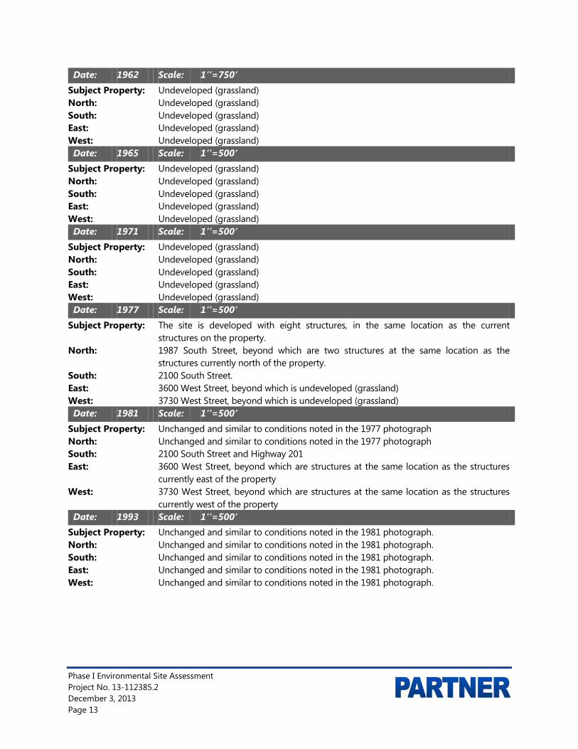
Date: 1962 Scale: 1’’=750’ Subject Property: Undeveloped (grassland) North: Undeveloped (grassland) South: Undeveloped (grassland) East: Undeveloped (grassland) West: Undeveloped (grassland) Date: 1965 Scale: 1’’=500’
Subject Property: Undeveloped (grassland) North: Undeveloped (grassland) South: Undeveloped (grassland) East: Undeveloped (grassland) West: Undeveloped (grassland) Date: 1971 Scale: 1’’=500’
Subject Property: Undeveloped (grassland) North: Undeveloped (grassland) South: Undeveloped (grassland) East: Undeveloped (grassland) West: Undeveloped (grassland) Date: 1977 Scale: 1’’=500’
Subject Property: The site is developed with eight structures, in the same location as the current structures on the property.
North: 1987 South Street, beyond which are two structures at the same location as the structures currently north of the property.
South: 2100 South Street. East: 3600 West Street, beyond which is undeveloped (grassland) West: 3730 West Street, beyond which is undeveloped (grassland) Date: 1981 Scale: 1’’=500’
Subject Property: Unchanged and similar to conditions noted in the 1977 photograph North: Unchanged and similar to conditions noted in the 1977 photograph South: 2100 South Street and Highway 201 East: 3600 West Street, beyond which are structures at the same location as the structures
currently east of the property West: 3730 West Street, beyond which are structures at the same location as the structures
currently west of the property Date: 1993 Scale: 1’’=500’
Subject Property: Unchanged and similar to conditions noted in the 1981 photograph. North: Unchanged and similar to conditions noted in the 1981 photograph. South: Unchanged and similar to conditions noted in the 1981 photograph. East: Unchanged and similar to conditions noted in the 1981 photograph. West: Unchanged and similar to conditions noted in the 1981 photograph.
Phase I Environmental Site Assessment Project No. 13-112385.2 December 3, 2013 Page 14
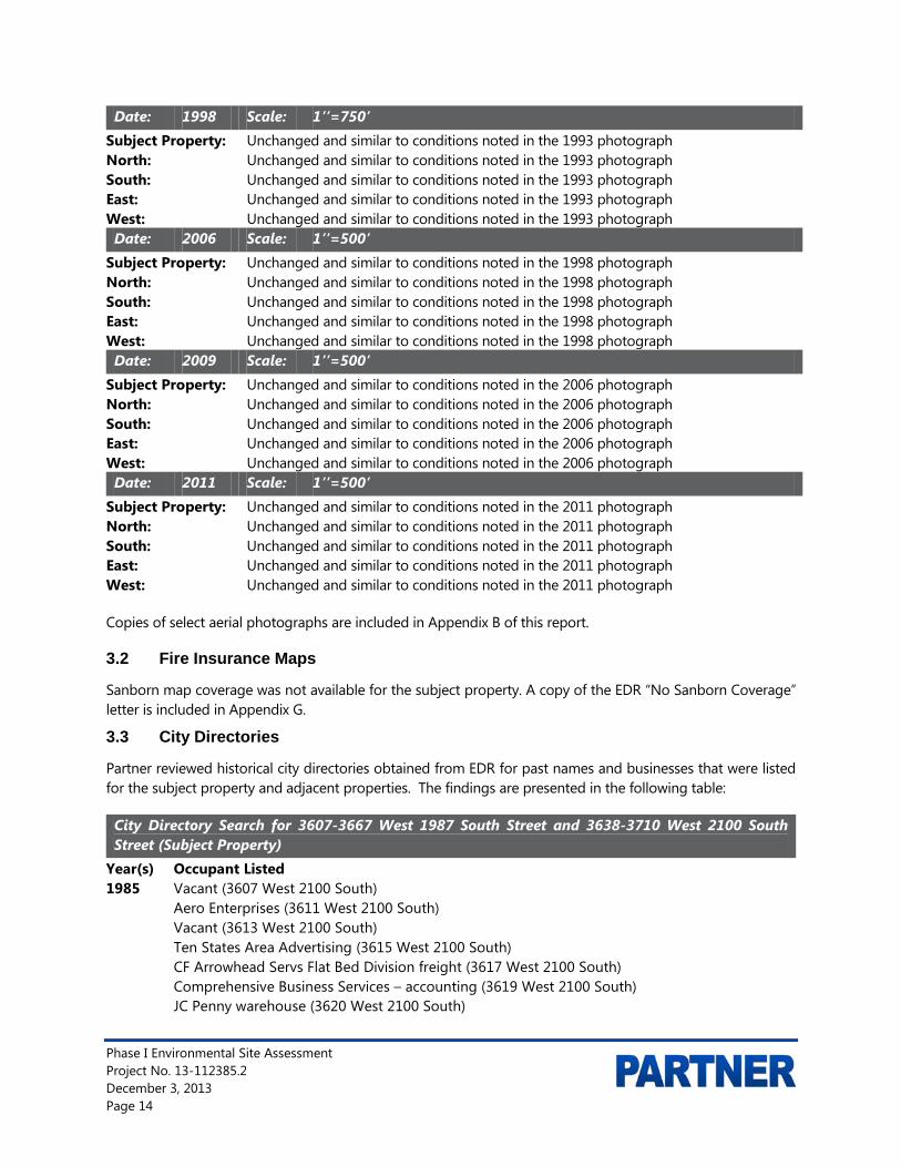
Date: 1998 Scale: 1’’=750’ Subject Property: Unchanged and similar to conditions noted in the 1993 photograph North: Unchanged and similar to conditions noted in the 1993 photograph South: Unchanged and similar to conditions noted in the 1993 photograph East: Unchanged and similar to conditions noted in the 1993 photograph West: Unchanged and similar to conditions noted in the 1993 photograph Date: 2006 Scale: 1’’=500’
Subject Property: Unchanged and similar to conditions noted in the 1998 photograph North: Unchanged and similar to conditions noted in the 1998 photograph South: Unchanged and similar to conditions noted in the 1998 photograph East: Unchanged and similar to conditions noted in the 1998 photograph West: Unchanged and similar to conditions noted in the 1998 photograph Date: 2009 Scale: 1’’=500’
Subject Property: Unchanged and similar to conditions noted in the 2006 photograph North: Unchanged and similar to conditions noted in the 2006 photograph South: Unchanged and similar to conditions noted in the 2006 photograph East: Unchanged and similar to conditions noted in the 2006 photograph West: Unchanged and similar to conditions noted in the 2006 photograph Date: 2011 Scale: 1’’=500’
Subject Property: Unchanged and similar to conditions noted in the 2011 photograph North: Unchanged and similar to conditions noted in the 2011 photograph South: Unchanged and similar to conditions noted in the 2011 photograph East: Unchanged and similar to conditions noted in the 2011 photograph West: Unchanged and similar to conditions noted in the 2011 photograph
Copies of select aerial photographs are included in Appendix B of this report.
3.2 Fire Insurance Maps
Sanborn map coverage was not available for the subject property. A copy of the EDR “No Sanborn Coverage” letter is included in Appendix G.
3.3 City Directories
Partner reviewed historical city directories obtained from EDR for past names and businesses that were listed for the subject property and adjacent properties. The findings are presented in the following table:
City Directory Search for 3607-3667 West 1987 South Street and 3638-3710 West 2100 South Street (Subject Property)
Year(s) Occupant Listed 1985 Vacant (3607 West 2100 South) Aero Enterprises (3611 West 2100 South) Vacant (3613 West 2100 South) Ten States Area Advertising (3615 West 2100 South) CF Arrowhead Servs Flat Bed Division freight (3617 West 2100 South) Comprehensive Business Services – accounting (3619 West 2100 South) JC Penny warehouse (3620 West 2100 South)

Phase I Environmental Site Assessment Project No. 13-112385.2 December 3, 2013 Page 15
Vacant (3621 West 2100 South) Vacant (3623 West 2100 South) SK Specialties (3625 West 2100 South) Vacant (3627 West 2100 South) Technicare medical diagnostic equipment, mfg. (3629 West 2100 South) National Pipe & Casing Corp, pipe distributor (3631 West 2100 South) Nalley’s Fine Foods, food products (3633 West 2100 South) Vacant (3641 West 2100 South) Vacant (3643 West 2100 South) Chesterton Utah (3645 West 2100 South) Vacant (3647 West 2100 South) Vacant (3649 West 2100 South) Convenience Foods of Utah, juice vending machines (3651 West 2100 South) Vacant (3653 West 2100 South) Kraft Inc., food services (3655 West 2100 South) Applies Hydraulics & Pumps (3657 West 2100 South) Alpine Telecommunications (3661 West 2100 South) Vacant (3663 West 2100 South) Acorn Computer Products (3665 West 2100 South) Alanthus Data Communications (3667 West 2100 South) Art & Frame Warehouse (3669 West 2100 South) Art & Frame Warehouse (3671-73 West 2100 South) Martin’s Machine Shop (3675 West 2100 South) Crown Litho Supply (3677 West 2100 South) MJB Coffee distr. hotel and restr. (3679 West 2100 South) Panasonic Company (3681 West 2100 South) Panasonic Co, electronic equip. & sup. (3683 West 2100 South) Vacant (3689 West 2100 South) Vacant (3691 West 2100 South) ITT Courier Terminal System computer sls. (3693 West 2100 South) Vacant (3695 West 2100 South) Xerox, service center (3697 West 2100 South) Tech Distributing, windows and doors (3699 West 2100 South) Dixon Paper Company, paper dirs. (3700 West 2100 South) Mountain States Electrical, contractors (3701 West 2100 South) Allo Tech (3703 West 2100 South) PGI computer hardware distr. (3705 West 2100 South) Mohan, newspaper prints (3707 West 2100 South) Closet Connection (3608 West 1987 South) Professional Graphics (3610 West 1987 South) Vacant (3612 West 1987 South) Access Engineering Graphic blueprints (3614 West 1987 South) Vacant (3616-18 West 1987 South) Broadbent Center office (3620 West 1987 South) Vacant (3624-28 West 1987 South) Customer’s Choice, restr. (3636 West 1987 South)

Phase I Environmental Site Assessment Project No. 13-112385.2 December 3, 2013 Page 16
Toledo Scales (3638 West 1987 South) Mosler Safe Co. (3640-42 West 1987 South) USA Today newspaper (3644 West 1987 South) Applied Hydraulics and Pneumatics (3656 West 1987 South) Teletype Corp Product Service Center (3650 West 1987 South) Classic Tours and Travel (3652 West 1987 South) Modular Sales Inc. (3654 West 1987 South) Applied Hydraulics, addl. space (3656 West 1987 South) Weather Tech, equipment (3658 West 1987 South) Vacant (3662 West 1987 South) General Design Group (3664 West 1987 South) Spectrum Tickets (3666-68 West 1987 South) Vacant (3670 West 1987 South) Loonam Computer Products (3672 West 1987 South) ADP Dealer Services (3674 West 1987 South) Western Food Equipment (3676 West 1987 South) Access Software, Inc. Vacant (3678 West 1987 South) Vacant (3682 West 1987 South) Van Tec (3684 West 1987 South) Learn by Video, Inc. (3686 West 1987 South) Boyles Bros. Drilling Federal Credit Union (3688 West 1987 South) Kraft Inc. food prod. (3692 West 1987 South) Kraft Inc. Retail (3690 West 1987 South) Vacant (3696-98 West 1987 South) Vacant (3700 West 1987 South) Vacant (3702 West 1987 South) Micro security Systems Inc., software (3706 West 1987 South) 1990 SJ Products book binding (3609 West 1987 South) SJ Products book binding (3611 West 1987 South) ADP Dealer Services (3613 West 1987 South) Vacant (3615 West 1987 South) Norman Jensen customs broker (3617 West 1987 South) Roth Distributing Co., appl. Distrs. (3619 West 1987 South) Vacant (3620 West 1987 South) IT Texcom Group (3621 West 1987 South) Capital Controls Company, chlorine feed control sys. (3623 West 1987 South) Page Corp International, sign mfg. (3625 West 1987 South) Page Corp International, sign mfg. (3627 West 1987 South) Panasonic West, electrical equip. (3629 West 1987 South) Nalley’s Fine Foods (3631 West 1987 South) Nalley’s Fine Foods (3633 West 1987 South) Dental Manufacturers Direct Inc., sales (3641 West 1987 South) Vacant (3643 West 1987 South) Chesterton Co. (3645 West 1987 South) San Jul Inc., costume jwlry. (3647 West 1987 South) Vacant (3649 West 1987 South)

Phase I Environmental Site Assessment Project No. 13-112385.2 December 3, 2013 Page 17
Tech Distributing Co., insulating windows (3651 West 1987 South) Amtec International, mfg. elec. components (3653 West 1987 South) Vacant (3655 West 1987 South) Metaprint (3657 West 1987 South) Alpine Telecommunications (3661 West 1987 South) Alpine Telecommunications (3663 West 1987 South) Vacant (3665 West 1987 South) Central Information Systems (3667 West 1987 South) Vacant (3669 West 1987 South) Vacant (3673 West 1987 South) Vacant (3675 West 1987 South) Vacant (3677 West 1987 South) Vacant (3679 West 1987 South) Davis Technologies, mfg. cable harness (3681 West 1987 South) Vacant (3683 West 1987 South) Cummins Allison Group (3689 West 1987 South) Cummins Allison Group (3691 West 1987 South) ITT Courier Terminal System (3693 West 1987 South) ITT Courier Terminal System (3695 West 1987 South) Color Image (3697 West 1987 South) Color Image (3699 West 1987 South) Dixon Paper Company (3700 West 1987 South) Winward Electric contractors (3701 West 1987 South) Vacant (3703 West 1987 South) Vacant (3705 West 1987 South) Full Court Press coml. prntg (3707 West 1987 South) Vacant (3608 West 2100 South) STS , Inc. blue staking (3608 West 2100 South) Pioneer Electric Supply (3610 West 2100 South) Professional Graphics (3614 West 2100 South) Transportation Interiors, sls. seat covers (3618 West 2100 South) Broadbent Center office (3620 West 2100 South) Vacant (3624 West 2100 South) USA Today newspaper (3626 West 2100 South) USA Today newspaper (3628 West 2100 South) Customer’s Choice, rest. (3636 West 2100 South) Toledo Scales (3638 West 2100 South) Mosler Inc. (3638-40-42 West 2100 South) Applied Hydraulics and Pneumatics (3644 West 2100 South) Fab Turn Equipment (3650 West 2100 South) Interstate Brokerage Inc. food (3652 West 2100 South) Modular Sales Inc. (3654 West 2100 South) Data Access Systems (3656 West 2100 South) Data Access Systems (3658 West 2100 South) Interstate Brokerage Inc. food (3662 West 2100 South) Express America Trucking (3664 West 2100 South)
Phase I Environmental Site Assessment Project No. 13-112385.2 December 3, 2013 Page 18
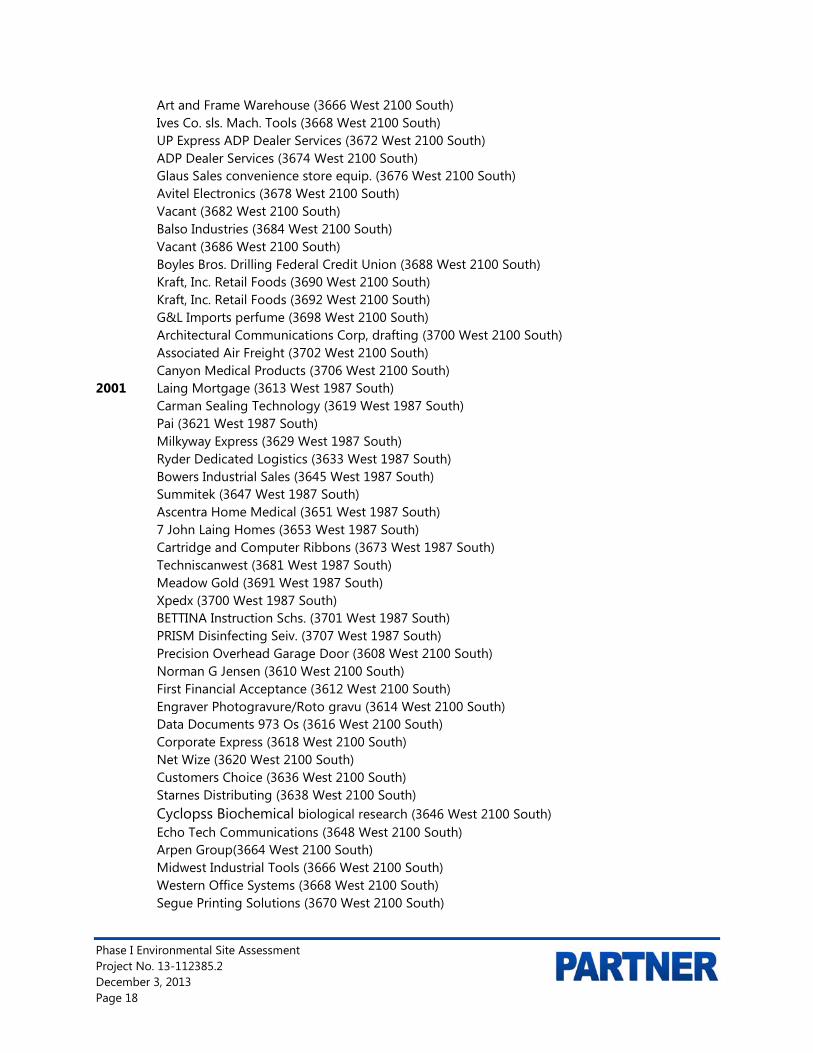
Art and Frame Warehouse (3666 West 2100 South) Ives Co. sls. Mach. Tools (3668 West 2100 South) UP Express ADP Dealer Services (3672 West 2100 South) ADP Dealer Services (3674 West 2100 South) Glaus Sales convenience store equip. (3676 West 2100 South) Avitel Electronics (3678 West 2100 South) Vacant (3682 West 2100 South) Balso Industries (3684 West 2100 South) Vacant (3686 West 2100 South) Boyles Bros. Drilling Federal Credit Union (3688 West 2100 South) Kraft, Inc. Retail Foods (3690 West 2100 South) Kraft, Inc. Retail Foods (3692 West 2100 South) G&L Imports perfume (3698 West 2100 South) Architectural Communications Corp, drafting (3700 West 2100 South) Associated Air Freight (3702 West 2100 South) Canyon Medical Products (3706 West 2100 South) 2001 Laing Mortgage (3613 West 1987 South) Carman Sealing Technology (3619 West 1987 South) Pai (3621 West 1987 South) Milkyway Express (3629 West 1987 South) Ryder Dedicated Logistics (3633 West 1987 South) Bowers Industrial Sales (3645 West 1987 South) Summitek (3647 West 1987 South) Ascentra Home Medical (3651 West 1987 South) 7 John Laing Homes (3653 West 1987 South) Cartridge and Computer Ribbons (3673 West 1987 South) Techniscanwest (3681 West 1987 South) Meadow Gold (3691 West 1987 South) Xpedx (3700 West 1987 South) BETTINA Instruction Schs. (3701 West 1987 South) PRISM Disinfecting Seiv. (3707 West 1987 South) Precision Overhead Garage Door (3608 West 2100 South) Norman G Jensen (3610 West 2100 South) First Financial Acceptance (3612 West 2100 South) Engraver Photogravure/Roto gravu (3614 West 2100 South) Data Documents 973 Os (3616 West 2100 South) Corporate Express (3618 West 2100 South) Net Wize (3620 West 2100 South) Customers Choice (3636 West 2100 South) Starnes Distributing (3638 West 2100 South) Cyclopss Biochemical biological research (3646 West 2100 South) Echo Tech Communications (3648 West 2100 South) Arpen Group(3664 West 2100 South) Midwest Industrial Tools (3666 West 2100 South) Western Office Systems (3668 West 2100 South) Segue Printing Solutions (3670 West 2100 South)

Phase I Environmental Site Assessment Project No. 13-112385.2 December 3, 2013 Page 19
Motorola Communications (3672 West 2100 South) Inter Tech Computer (3674 West 2100 South) Glaus Sales (3676 West 2100 South) Perkins Layne (3682 West 2100 South) Mettler Toledo (3684 West 2100 South) Verizon Communications (3692 West 2100 South) Clearly Corporate (3696 West 2100 South) E UITAX (3698 West 2100 South) A B Dick Company Printing (3700 West 21000 South) Pitney Bowes (3710 West 21000 South) Ames Construction (3737 West 21000 South) Designs By Julie (3750 West 21000 South) 2008 NU Art Lighting Products (3613 West 1987 South) Adopt an Angel (3615 West 1987 South) Bowers Industrial Sales Inc. (3645 West 1987 South) Rev It Deliveries Inc. (3647 West 1987 South) Johnsonville Grills Of Utah (3681 West 1987 South) Los Angeles Bread Co (3683 West 1987 South) Meadow Gold Employees (3691 West 1987 South) Precision Door Services Inc. (3608 West 2100 South) Myers Nuart (3612 West 2100 South) Gannett Co Inc. (3626 West 2100 South) Starnes Distributing Inc. (3638 West 2100 South) RCI Inc. (3646 West 2100 South) E T Technologies (3656 West 2100 South)
Based on the city directory review, no environmentally sensitive listings were identified for the subject property address(es).
City Directory Search for Adjacent Properties
Year(s) Occupant Listed 1985/1990/2001/2008 Reul’s Art Supplies (3750 West 2100 South) 1985/1990/2001/2008 XPEDX (1987 South 3700 West) 1985/1990/2001/2008 Sun Products (3540 West 1987 South )
Based on the city directory review, no environmentally sensitive listings were identified for the adjacent property addresses.
Copies of reviewed city directories are not included in Appendix B of this report.
3.4 Historical Topographic Maps
Partner reviewed historical topographic maps obtained from EDR The following observations were noted to be depicted on the subject property and adjacent properties during the topographic map review:
Date: 1895 Subject Property: Undeveloped North: Undeveloped

Phase I Environmental Site Assessment Project No. 13-112385.2 December 3, 2013 Page 20
South: Undeveloped East: Undeveloped West: Undeveloped Date: 1951
Subject Property: Undeveloped (grassland) North: Undeveloped (grassland) South: 2100 South Street, beyond which is undeveloped (grassland) East: Undeveloped (grassland) West: Undeveloped (grassland) Date: 1963
Subject Property: Unchanged and similar to conditions noted on the 1951 map North: Unchanged and similar to conditions noted on the 1951 map South: Unchanged and similar to conditions noted on the 1951 map East: Unchanged and similar to conditions noted on the 1951 map West: Unchanged and similar to conditions noted on the 1951 map Date: 1969
Subject Property: Unchanged and similar to conditions noted on the 1963 map North: Unchanged and similar to conditions noted on the 1963 map South: Unchanged and similar to conditions noted on the 1963 map East: Unchanged and similar to conditions noted on the 1963 map West: Unchanged and similar to conditions noted on the 1963 map, except for a north-south
trending unimproved road Date: 1975
Subject Property: Unchanged and similar to conditions noted on the 1969 map North: Unchanged and similar to conditions noted on the 1969 map, except 1820 South and
1987 South Streets and 3730 West Street are present South: Unchanged and similar to conditions noted on the 1969 map, except Highway 201 is
present East: Unchanged and similar to conditions noted on the 1969 map, except 3600 West Street
is present West: Unchanged and similar to conditions noted on the 1969 map Date: 1999
Subject Property: Unchanged and similar to conditions noted on the 1975 map North: Unchanged and similar to conditions noted on the 1975 map, except two structures
are present adjacent to the north side of 1987 South Street, at the same location as the structures currently north of the subject site, and there is a structure at the northeast corner of 1987 South and 3600 West Streets, at the same location as the current structure
South: Unchanged and similar to conditions noted on the 1975 map East: Unchanged and similar to conditions noted on the 1975 map West: Unchanged and similar to conditions noted on the 1975 map, except 3730 West Street
is present
Copies of reviewed topographic maps are included in Appendix B of this report.

Phase I Environmental Site Assessment Project No. 13-112385.2 December 3, 2013 Page 21
4.0 REGULATORY RECORDS REVIEW 4.1 Regulatory Agencies
4.1.1 State Department
Regulatory Agency Data Name of Agency: Utah Department of Environmental Quality (DEQ)
Point of Contact: DEQ Interactive Map (http://enviro.deq.utah.gov/)
Agency Address: 195 North 1950 West, Salt Lake City, Utah
Agency Phone Number: (801) 536-4400
Date of Contact: November 27, 2013
Method of Communication: DEQ Interactive Map (http://enviro.deq.utah.gov/)
Summary of Communication: No records regarding hazardous substance use, storage or releases, or the presence of USTs and AULs on the subject property were on file with the Utah DEQ.
4.1.2 Health Department
Regulatory Agency Data Name of Agency: Salt Lake County Health Department, Division of Environmental
Health (SLCHD).
Point of Contact: Ashley Hall, Supervisor
Agency Address: 788 E. Woodoak Ln, Murray, UT 84107
Agency Phone Number: 385-468-3871
Date of Contact: November 26, 2013
Method of Communication: Email
Summary of Communication: No records regarding hazardous substance use, storage or releases, or the presence of USTs and AULs on the subject property were on file with the SLCHD.
A copy of pertinent documents is included in Appendix B of this report.
4.1.3 Fire Department
Regulatory Agency Data Name of Agency: Salt Lake City Fire Department (SLCFD)
Point of Contact: N/A
Agency Address: N/A
Agency Phone Number: N/A
Date of Contact: November 25, 2013
Method of Communication: GRAMA via the internet

Phase I Environmental Site Assessment Project No. 13-112385.2 December 3, 2013 Page 22
Summary of Communication: As of the date of this report, Partner has not received a response from the SLCFD for inclusion in this report.
4.1.4 Building Department
Regulatory Agency Data Name of Agency: Salt Lake City Building Department (SLCBD)
Point of Contact: N/A
Agency Address: N/A
Agency Phone Number: N/A
Date of Contact: November 25, 2011
Method of Communication: GRAMA request via the internet
Summary of Communication: As of the date of this report, Partner has not received a response from the SLCBD for inclusion in this report.
4.1.5 Planning Department
Regulatory Agency Data Name of Agency: Salt Lake City Planning Department (SLCPD)
Point of Contact: N/A
Agency Address: N/A
Agency Phone Number: N/A
Date of Contact: November 25, 2011
Method of Communication: GRAMA request via the internet
Summary of Communication: As of the date of this report, Partner has not received a response from the SLCPD for inclusion in this report. According to the SLCPD internet site, the property is zoned M -1, Light Manufacturing.
A copy of pertinent documents is included in Appendix B of this report.
4.1.6 Oil & Gas Exploration
Regulatory Agency Data Name of Agency: Utah Division of Oil, Gas and Mining (DOGM)
Point of Contact: DOGM interactive map (http://oilgas.ogm.utah.gov/Maps/OG_Maps.htm)
Agency Address: 1594 West North Temple, Suite 1210, Salt Lake City, Utah
Agency Phone Number: (801) 538-5283
Date of Contact: November 25, 2013
Method of Communication: DOGM interactive map
Summary of Communication: According to DOGM, no oil or gas wells are located on or adjacent to the subject property.

Phase I Environmental Site Assessment Project No. 13-112385.2 December 3, 2013 Page 23
4.1.7 Assessor’s Office
Regulatory Agency Data Name of Agency: Salt Lake County Assessor (SLCA)
Point of Contact: Internet site (http://www.assessor.slco.org)
Agency Address: 2001 South State Street N2300, Salt Lake City, Utah
Agency Phone Number: (385) 468-8000
Date of Contact: November 25, 2013
Method of Communication: Internet
Summary of Communication: According to records reviewed, the subject property is identified by Assessor Parcel Number (APN) 15-17-300-029 and is currently owned by KOLL/PER, LLC. The legal description is LOT 2, CENTENNIAL INDUSTRIAL PARK, PHASE I 4605-1469 5690-2321 5721-1714 5896-1987 8026-0267 8459-5542 8893-0320.
The current buildings were constructed in 1976 and total approximately 111,280 square feet on a 8.35 acre lot. Property type is “flex commercial.”
A copy of pertinent documents is included in Appendix B of this report.
4.2 Mapped Database Records Search
Information from standard federal, state, county, and city environmental record sources was provided by EDR. Data from governmental agency lists are updated and integrated into one database, which is updated as these data are released. The information contained in this report was compiled from publicly available sources and the locations of the sites are plotted utilizing a geographic information system, which geocodes the site addresses. The accuracy of the geocoded locations is approximately +/-300 feet.
4.2.1 Regulatory Database Summary
Radius Report Data
Database Search Radius
(mile) Subject
Property Adjacent
Properties Sites of Concern
Federal NPL or Delisted NPL Site 1.00 N N N Federal CERCLIS Site 0.50 N N N Federal CERCLIS-NFRAP Site 0.50 N N N Federal RCRA CORRACTS Facility 1.00 N N N Federal RCRA TSDF Facility 0.50 N N N Federal RCRA Generators Site (LQG, SQG, CESQG)
0.25 N N N
Federal IC/EC Registries 0.50 N N N Federal ERNS Site Subject
Property N N N
State/Tribal Equivalent NPL 1.00 N N N State/Tribal Equivalent CERCLIS 1.00 N N N

Phase I Environmental Site Assessment Project No. 13-112385.2 December 3, 2013 Page 24
Radius Report Data
Database Search Radius
(mile) Subject
Property Adjacent
Properties Sites of Concern
State/Tribal Landfill/Solid Waste Disposal Site 0.50 N N N State/Tribal Leaking Storage Tank Site 0.50 N Y N State/Tribal Registered Storage Tank Sites (UST/AST)
0.25 N Y N
State/Tribal Voluntary Cleanup Sites (VCP) 0.50 N N N State/Tribal Spills 0.50 N N N Federal Brownfield Sites 0.50 N N N State Brownfield Sites 0.50 N N N EDR MGP Varies N N N EDR US Hist Auto Station Varies N Y N EDR US Hist Cleaners Varies N N N
4.2.2 Subject Property Listings
The subject property is not identified in the regulatory database report.
4.2.3 Adjacent Property Listings
The adjacent properties to the north are identified as a UST and LUST sites in the regulatory database report, as discussed below:
• The adjacent property, identified as Huish Chemical Company at 3620 West 1987 South Street, is located adjacent to the north of the subject property (hydrologically down-gradient). This site reported a release of gasoline on October 24, 1990, which reportedly impacted soil and groundwater. The release was identified during removal of the tank from the ground and was reported to the lead agency (Department of Environmental Quality, DEQ, Division of Environmental Remediation and Response, DERR) on October 24, 1990. A subsurface remediation program was implemented. The responsible party is identified as Huish Chemical Company, and regulatory closure was obtained via a DERR “No Further Action Letter,” on April 20, 1998 (DERR Case File 4000437). Based on the regulatory status and hydrologic gradient, this listing is not expected to represent a recognized environmental condition.
• The adjacent property, identified as Dixon Paper Company at 3700 West 1987 South Street, is located adjacent to the north of the subject property (hydrologically down-gradient). According to the Utah DERR, the tank was installed in 1976 and was last used on November 1, 1985. The tank was removed from the ground and the tank removal closed by the DEQ on October 27, 1990 (DERR Case File 4000249). Based on the regulatory status and hydrologic gradient, this listing is not expected to represent a recognized environmental condition.
4.2.4 Sites of Concern Listings
No sites of concern are identified in the regulatory database report.
4.2.5 Orphan Listings
No orphan listings are identified in the regulatory database report.

Phase I Environmental Site Assessment Project No. 13-112385.2 December 3, 2013 Page 25
A copy of the regulatory database report is included in Appendix C of this report.

Phase I Environmental Site Assessment Project No. 13-112385.2 December 3, 2013 Page 26
5.0 USER PROVIDED INFORMATION AND INTERVIEWS
In order to qualify for one of the Landowner Liability Protections (LLPs) offered by the Small Business Liability Relief and Brownfields Revitalization Act of 2001 (the Brownfields Amendments), the User must conduct the following inquiries required by 40 CFR 312.25, 312.28, 312.29, 312.30, and 312.31. The User should provide the following information to the environmental professional. Failure to provide this information could result in a determination that all appropriate inquiries is not complete. The User is asked to provide information or knowledge of the following:
• Review Title and Judicial Records for Environmental Liens and AULs
• Specialized Knowledge or Experience of the User
• Actual Knowledge of the User
• Reason for Significantly Lower Purchase Price
• Commonly Known or Reasonably Ascertainable information
• Degree of Obviousness
• Reason for Preparation of this Phase I ESA
Fulfillment of these user responsibilities is key to qualification for the identified defenses to CERCLA liability. Partner requested our Client to provide information to satisfy User Responsibilities as identified in Section 6 of the ASTM guidance.
Pursuant to ASTM E1527-13, Partner requested the following site information from Industry Capital (User of this report).
User Responsibilities
Item Provided By
User Not Provided
By User Discussed
Below Does Not
Apply Environmental Pre-Survey Questionnaire X
Title Records, Environmental Liens, and AULs X
Specialized Knowledge X
Actual Knowledge X
Valuation Reduction for Environmental Issues X
Identification of Key Site Manager Section 5.1.3
Reason for Performing Phase I ESA Section 1.1
Prior Environmental Reports X Other X
5.1 Interviews
5.1.1 Interview with Owner
The owner of the subject property, identified as KOLL/PER LLC, was not available to be interviewed at the time of the assessment.

Phase I Environmental Site Assessment Project No. 13-112385.2 December 3, 2013 Page 27
Ms. Diane Holms, Cushman & Wakefield-Commerce, Portfolio Manager for subject property, has not returned the Partner Pre-Survey and User Phase I Questionnaires prior to the issuance of this report.
5.1.2 Interview with Report User
Please refer to Section 5.2 below for information requested from the Report User. The information requested was not received prior to the issuance of this report. The lack of this information is not considered to represent a significant data gap.
Industry Capital, report user, was not aware of any pending, threatened, or past litigation relevant to hazardous substances or petroleum products in, on, or from the subject property; any pending, threatened, or past administrative proceedings relevant to hazardous substances or petroleum products in, on, or from the subject property; or any notices from a governmental entity regarding any possible violation of environmental laws or possible liability relating to hazardous substances or petroleum products.
According to information provided, the subject property was developed in 1976 for commercial/retail/industrial use. Prior to that, the subject property was undeveloped.
5.1.3 Interview with Key Site Manager
Ms. Diane Holms, Cushman & Wakefield-Commerce, Portfolio Manager for subject property, (site contact), was interviewed during the site reconnaissance. Ms. Holms indicated that she had no information pertaining to any pending, threatened, or past litigation relevant to hazardous substances or petroleum products in, on, or from the subject property; any pending, threatened, or past administrative proceedings relevant to hazardous substances or petroleum products in, on, or from the subject property; or any notices from a governmental entity regarding any possible violation of environmental laws or possible liability relating to hazardous substances or petroleum products.
According to Ms. Holms, the subject property was developed in 1976 for commercial/retail/industrial use. Prior to that, the subject property was undeveloped. Ms. Holms further stated that there are no USTs, ASTs, clarifiers, oil/water separators, groundwater monitoring wells, or hazardous substance use/storage/generation on the subject property to the best of her knowledge.
Mr. Rusty Bollow, Director, Cushman & Wakefield-Commerce, was also interviewed during the site reconnaissance. Mr. Bollow indicated that he had no information pertaining to any pending, threatened, or past litigation relevant to hazardous substances or petroleum products in, on, or from the subject property; any pending, threatened, or past administrative proceedings relevant to hazardous substances or petroleum products in, on, or from the subject property; or any notices from a governmental entity regarding any possible violation of environmental laws or possible liability relating to hazardous substances or petroleum products.
According to Mr. Bollow, the subject property was developed in 1976 for commercial/retail/industrial use. Prior to that, the subject property was undeveloped. Mr. Bollow further stated that there are no USTs, ASTs, clarifiers, oil/water separators, groundwater monitoring wells, or hazardous substance use/storage/generation on the subject property to the best of his knowledge.
Phase I Environmental Site Assessment Project No. 13-112385.2 December 3, 2013 Page 28
Mr. Wade Cox, Maintenance Supervisor for current owner (KOLL) was interviewed during the site reconnaissance. Mr. Cox further stated that there are no USTs, ASTs, clarifiers, oil/water separators, groundwater monitoring wells, or hazardous substance use/storage/generation on the subject property to the best of his knowledge.
5.1.4 Interviews with Past Owners, Operators and Occupants
Interviews with past owners, operators and occupants were not reasonably ascertainable and thus constitute a data gap.
5.1.5 Interview with Others
As the subject property is not an abandoned property as defined in ASTM 1527-13, interview with others were not performed.
5.2 User Provided Information
5.2.1 Title Records, Environmental Liens, and AULs
Partner was not provided with title records or environmental lien and AUL information for review as part of this assessment.
5.2.2 Specialized Knowledge
No specialized knowledge of environmental conditions associated with the subject property was provided by the User at the time of the assessment.
5.2.3 Actual Knowledge of the User
No actual knowledge of any environmental lien or AULs encumbering the subject property or in connection with the subject property was provided by the User at the time of the assessment.
5.2.4 Valuation Reduction for Environmental Issues
No knowledge of valuation reductions associated with the subject property was provided by the User at the time of the assessment.
5.2.5 Commonly Known or Reasonably Ascertainable Information
The User did not provide information that is commonly known or reasonably ascertainable within the local community about the subject property at the time of the assessment.
5.2.6 Previous Reports and Other Provided Documentation
No previous reports or other pertinent documentation was provided to Partner for review during the course of this assessment.

Phase I Environmental Site Assessment Project No. 13-112385.2 December 3, 2013 Page 29
6.0 SITE RECONNAISSANCE
The weather at the time of the site visit was overcast, raining, and snowing. Refer to Section 1.5 for limitations encountered during the field reconnaissance and Sections 2.1 and 2.2 for subject property operations. The table below provides the site assessment details:
Site Assessment Data
Site Assessment Performed By: David B. Simon
Site Assessment Conducted On: November 21 and 22, 2013
The table below provides the subject property personnel interviewed during the field reconnaissance:
Site Visit Personnel for 3607-3667 West 1987 South Street (Subject Property) Name Title/Role Contact Number Site Walk*
Yes/No Ms. Diane Holms Portfolio Manager Key Site Contact (801) 401-3100 Yes Mr. Rusty Bollow Secondary Site Contact 801-633-4800 Yes Mr. Wade Cox Maintenance Supervisor N/A Yes
* Accompanied Partner during the field reconnaissance activities and provided information pertaining to the current operations and maintenance of the subject property
No potential environmental concerns were identified during the onsite reconnaissance.
6.1 General Site Characteristics
6.1.1 Solid Waste Disposal
Solid waste generated at the subject property is disposed of in commercial dumpsters located adjacent to the east side of Building 2, the northwest corner of Building 3, and the southeast corner of Building 7 on the subject property. An independent solid waste disposal contractor, ACE Recycling and Disposal, removes solid waste from the subject property. Solid waste generated at the subject property includes household trash and food waste. No evidence of illegal dumping of solid waste was observed during the Partner site reconnaissance.
6.1.2 Sewage Discharge and Disposal
Sanitary discharges on the subject property are directed into the municipal sanitary sewer system. The City of Salt Lake services the subject property vicinity. No wastewater treatment facilities or septic systems are observed or reported on the subject property.
6.1.3 Surface Water Drainage
Storm water is removed from the subject property primarily by sheet flow action across the paved surfaces towards storm water drains located throughout the subject property and in the public right of way. Site storm water from roofs, landscaped areas, and paved areas is directed to paved areas, which drain to the public right of way, and to on-site storm water drains. The subject property is connected to a municipal owned and maintained sewer system.
The subject property does not appear to be a designated wetland area, based on information obtained from the U.S. Fish and Wildlife Wetlands Inventory maps; however, a comprehensive wetlands survey

Phase I Environmental Site Assessment Project No. 13-112385.2 December 3, 2013 Page 30
would be required in order to formally determine actual wetlands on the subject property. No surface impoundments, wetlands, natural catch basins, settling ponds, or lagoons are located on the subject property. No drywells were identified on the subject property.
6.1.4 Source of Heating and Cooling
Heated and conditioned air is typically provided to the tenant office spaces by roof-top package units (RTUs). The observed RTUs were manufactured by Carrier, Bryant, Day & Night, Goodman, Lennox, Payne, Rheem, Trane, and York. The RTUs have capacities generally ranging between 2 and 6 tons.
Cooling is typically not provided to the tenant warehouse spaces; but some of the tenant spaces are equipped with roof-top evaporative (swamp) cooling units for their warehouse areas. The tenant warehouse spaces are typically heated by gas-fired heaters that are suspended from the roof framing. Some of the tenants have installed dedicated split systems to supplement cooling, heating and de-humidification requirements within their individual spaces.
Ventilation from the toilet rooms is provided by fans which vent through the ceilings.
6.1.5 Wells and Cisterns
No aboveground evidence of wells or cisterns was observed during the site reconnaissance.
6.1.6 Wastewater
Domestic wastewater generated at the subject property is disposed by means of the sanitary sewer system. No industrial process is currently performed at the subject property.
6.1.7 Septic Systems
No septic systems were observed or reported on the subject property.
6.1.8 Additional Site Observations
No additional general site characteristics were observed during the site reconnaissance.
6.2 Potential Environmental Hazards
6.2.1 Hazardous Substances and Petroleum Products Used or Stored at the Site
Partner identified hazardous substances used, stored, and/or generated on the subject property as noted in Section 2.2.
The materials were found to be properly labeled and stored at the time of the assessment with no signs of leaks, stains, or spills. Secondary containment is not provided. Based on the nature of use, overall small quantities observed, presence of secondary containment, and lack of violations on-file with the local fire department, these materials are not expected to represent a recognized environmental condition.
6.2.2 Aboveground & Underground Hazardous Substance or Petroleum Product Storage Tanks (ASTs/USTs)
No evidence of current or former ASTs or USTs was observed during the site reconnaissance.

Phase I Environmental Site Assessment Project No. 13-112385.2 December 3, 2013 Page 31
6.2.3 Evidence of Releases
No spills, stains or other indications that a surficial release has occurred at the subject property were observed.
6.2.4 Polychlorinated Biphenyls (PCBs)
Older transformers and other electrical equipment could contain PCBs at a level that subjects them to regulation by the U.S. EPA. PCBs in electrical equipment are controlled by United States Environmental Protection Agency regulations 40 CFR, Part 761. Under the regulations, there are three categories into which electrical equipment can be classified: 1) Less than 50 parts per million (ppm) of PCBs – “Non-PCB;” 2) 50 ppm-500 ppm – “PCB-Contaminated;” and, 3) Greater than 500 ppm – “PCB-Containing.” The manufacture, process, or distribution in commerce or use of any PCB in any manner other than in a totally enclosed manner was prohibited after January 1, 1977.
The on-site reconnaissance addressed indoor and outdoor transformers that may contain PCBs. Three pad-mounted transformers were observed on the subject property. One of the transformers is labeled as not containing PCB. Two of the transformers are not labeled indicating PCB content. No staining or leakage was observed in the vicinity of the transformers. Partner contacted a customer service representative of PacifiCorp who confirmed that PacifiCorp maintains ownership and operational responsibility for the transformers and that the units do not contain PCBs. Based on the good condition of the equipment, the transformers are not expected to represent a recognized environmental condition.
Additionally, no other potential PCB-containing equipment (interior transformers, oil-filled switches, hoists, lifts, dock levelers, hydraulic elevators, balers, etc.) was observed on the subject property during Partner’s reconnaissance.
6.2.5 Strong, Pungent or Noxious Odors
No strong, pungent or noxious odors were evident during the site reconnaissance.
6.2.6 Pools of Liquid
No pools of liquid were observed on the subject property during the site reconnaissance.
6.2.7 Drains, Sumps and Clarifiers
Floor drains were observed in several of the units. None of the floor drains were being used and allegedly discharge to the sewer system.
6.2.8 Pits, Ponds and Lagoons
No pits, ponds or lagoons were observed on the subject property.
6.2.9 Stressed Vegetation
No stressed vegetation was observed on the subject property.
6.2.10 Additional Potential Environmental Hazards
No additional environmental hazards, including landfill activities or radiological hazards, were observed.

Phase I Environmental Site Assessment Project No. 13-112385.2 December 3, 2013 Page 32
6.3 Non-ASTM Services
6.3.1 Asbestos-Containing Materials (ACMs)
Due to the commercial nature of use of the subject property, ACMs were not considered within the scope of this assessment.
6.3.2 Lead-Based Paint (LBP)
Due to the commercial nature of use of the subject property, LBP was not considered within the scope of this assessment.
6.3.3 Radon
Radon is a colorless, odorless, naturally occurring, radioactive, inert, gaseous element formed by radioactive decay of radium (Ra) atoms. The US EPA has prepared a map to assist National, State, and local organizations to target their resources and to implement radon-resistant building codes. The map divides the country into three Radon Zones, according to the table below:
EPA Radon Zones EPA Zones Average Predicted Radon Levels Potential Zone 1 Exceed 4.0 pCi/L Highest Zone 2 Between 2.0 and 4.0 pCi/L Moderate Zone 3 Less than 2.0 pCi/L Low
It is important to note that the EPA has found homes with elevated levels of radon in all three zones, and the US EPA recommends site-specific testing in order to determine radon levels at a specific location. However, the map does give a valuable indication of the propensity of radon gas accumulation in structures.
Radon sampling was not conducted as part of this assessment. Review of the US EPA Map of Radon Zones places the subject property in Zone 2. Based upon the radon zone classification, radon is not considered to be a recognized environmental condition.
6.3.4 Lead in Drinking Water
According to available information, a public water system operated by the Salt Lake City Department of Public Works serves the subject property vicinity. According to the Salt Lake City Water Quality Report, shallow groundwater beneath the subject property is not utilized for domestic purposes. The sources of public water for the City of Salt Lake City are surface water municipal groundwater wells. According to the City of Salt Lake City and the 2012 Annual Water Quality Report, water supplied to the subject property is in compliance with all State and Federal regulations pertaining to drinking water standards, including lead and copper.
6.3.5 Mold
Molds are microscopic organisms found virtually everywhere, indoors and outdoors. Mold will grow and multiply under the right conditions, needing only sufficient moisture (e.g.in the form of very high humidity, condensation, or water from a leaking pipe, etc.) and organic material (e.g., ceiling tile, drywall, paper, or natural fiber carpet padding).
Phase I Environmental Site Assessment Project No. 13-112385.2 December 3, 2013 Page 33
Partner observed accessible, interior areas for the subject property buildings for significant evidence of mold growth with the exceptions detailed in Section 1.5 of this report; however, this ESA should not be used as a mold survey or inspection. Additionally, this limited assessment was not designed to assess all areas of potential mold growth that may be affected by mold growth on the subject property. Rather, it is intended to give the client an indication as to whether or not conspicuous (based on observed areas) mold growth is present at the subject property. This evaluation did not include a review of pipe chases, mechanical systems, or areas behind enclosed walls and ceilings.
Water damaged ceiling tiles from a past roof leak was observed in Suite 4-3684. In addition, past water intrusion at the front office area of Suite 1-3618 with holes drilled into drywall to vent and dry the wall materials. No obvious indications of water damage or mold growth were observed during Partner’s visual assessment. Therefore, the water damage is not expected to be a recognized environmental condition.
6.4 Adjacent Property Reconnaissance
The adjacent property reconnaissance consisted of observing the adjacent properties from the subject property premises. No items of environmental concern were identified on the adjacent properties during the site assessment, including hazardous substances, petroleum products, ASTs, USTs, evidence of releases, PCBs, strong or noxious odors, pools of liquids, sumps or clarifiers, pits or lagoons, stressed vegetation, or any other potential environmental hazards.

Phase I Environmental Site Assessment Project No. 13-112385.2 December 3, 2013 Page 34
7.0 FINDINGS AND CONCLUSIONS Findings
A recognized environmental condition (REC) refers to the presence or likely presence of any hazardous substances or petroleum products in, on, or at a property: due to release to the environment; under conditions indicative of a release to the environment; or under conditions that pose a material threat of a future release to the environment.
• Partner did not identify any recognized environmental conditions during the course of this assessment.
A controlled recognized environmental condition (CREC) refers to a REC resulting from a past release of hazardous substances or petroleum products that has been addressed to the satisfaction of the applicable regulatory authority, with hazardous substances or petroleum products allowed to remain in place subject to the implementation of required controls. The following was identified during the course of this assessment:
• Partner did not identify any controlled recognized environmental conditions during the course of this assessment.
A historical recognized environmental condition (HREC) refers to a past release of any hazardous substances or petroleum products that has occurred in connection with the property and has been addressed to the satisfaction of the applicable regulatory authority or meeting unrestricted use criteria established by a regulatory authority, without subjecting the property to any required controls. The following was identified during the course of this assessment:
• Partner did not identify any historical recognized environmental conditions during the course of this assessment.
An environmental issue refers to environmental concerns identified by Partner, which do not qualify as RECs; however, warrant further discussion.
• Partner did not identify any environmental issues during the course of this assessment.
Conclusions, Opinions and Recommendations
Partner has performed a Phase I Environmental Site Assessment in conformance with the scope and limitations of ASTM Practice E1527-13 of 3607-3667 West 1987 South Street in the City of Salt Lake City, Salt Lake County, Utah (the “subject property”). Any exceptions to, or deletions from, this practice are described in Section 1.5 of this report.
This assessment has revealed no evidence of recognized environmental conditions or environmental issues in connection with the subject property. Based on the conclusions of this assessment, Partner recommends no further investigation of the subject property at this time.

Phase I Environmental Site Assessment Project No. 13-112385.2 December 3, 2013 Page 35
8.0 SIGNATURES OF ENVIRONMENTAL PROFESSIONALS
Partner has performed a Phase I Environmental Site Assessment of the property located at 3607-3667 West 1987 South Street in the City of Salt Lake City, Salt Lake County, Utah in general conformance with the scope and limitations of the protocol and the limitations stated earlier in this report. Exceptions to or deletions from this protocol are discussed earlier in this report.
By signing below, Partner declares that, to the best of our professional knowledge and belief, we meet the definition of Environmental Professional as defined in §312.10 of 40 CFR §312. Partner has the specific qualifications based on education, training, and experience to assess a property of the nature, history, and setting of the subject property. Partner has developed and performed the all appropriate inquiries in conformance with the standards and practices set forth in 40 CFR Part 312.
Prepared By: David B. Simon Environmental Scientist
Reviewed By: Sau San Senior Author
Summer D. Gell Senior Author

Phase I Environmental Site Assessment Project No. 13-112385.2 December 3, 2013 Page 36
9.0 REFERENCES
Reference Documents
American Society for Testing and Materials, Standard Practice for Environmental Site Assessments: Phase I Environmental Site Assessment Process, ASTM Designation: E1527-13.
Environmental Data Resources (EDR), Radius Report and Certified Sanborn Map Report, November 18, 2013.
Federal Emergency Management Agency, Federal Insurance Administration, National Flood Insurance Program, Flood Insurance Map, accessed via internet, September 2001.
Salt Lake City Water Quality Report, accessed via the internet, 2012.
Salt Lake City Zoning Map, accessed via the internet, 2013.
Salt Lake County Planning and Development Services, accessed via the internet, 2013.
Salt Lake County Assessor's Office, accessed via the internet, 2013.
United States Department of Agriculture, Natural Resources Conservation Service, Web Soil Survey, accessed via the internet, 1974
United States Environmental Protection Agency, EPA Map of Radon Zones (Document EPA-402-R-93-071), accessed via the internet, 2007.
United States Fish and Wildlife Service National Wetlands Inventory, accessed via the Internet, 2013
United States Geological Survey Historic Topographic Map of Salt Lake City, 1895, scale 1:250,000.
United States Geological Survey Salt Lake City South 7.5 Topographic Map, 1951, scale 1:24,000.
United States Geological Survey Salt Lake City South 7.5 Topographic Map, 1963, scale 1:24,000.
United States Geological Survey Salt Lake City South 7.5 Topographic Map, 1969, scale 1:24,000.

Phase I Environmental Site Assessment Project No. 13-112385.2 December 3, 2013 Page 37
United States Geological Survey Salt Lake City South 7.5 Topographic Map, 1975, scale 1:24,000.
United States Geological Survey Salt Lake City South 7.5 Topographic Map, 1999, scale 1:24,000.
United States Geological Survey Salt Lake City South 7.5 Topographic Map, 2011, scale 1:24,000.
United States Geological Survey Miscellaneous Investigation Series Map I-2106, scale: 1:50,000, Personius, S.F. and Scott, W.E., 1992, Surficial geologic map of the Salt Lake City segment and parts of adjacent segments of the Wasatch fault zone, Davis, Salt Lake and Utah counties, Utah.
FIGURES
1- SITE LOCATION MAP
2- TOPOGRAPHIC MAP
3- SITE PLAN

FIGURE 1: SITE LOCATION MAP Project No. 13-112385.2
Drawing Not To Scale

FIGURE 2: TOPOGRAPHIC MAP Project No. 13-112385.2
Drawing Not To Scale
N

FIGURE 3: SITE PLAN Project No. 13-112385.2
KEY:GROUNDWATERFLOW
Telecommunications Building
Transformer T Subject Site
T T
T
APPENDIX A: SITE PHOTOGRAPHS

APPENDIX A: SITE PHOTOGRAPHS Project No. 13-112385.2
1. Broadbent Business Park, 3607 – 3667 West 1987
South, Salt Lake City, Utah
2. Typical landscaping, walkway, paving, and parking on the front (north) side of Building 7
2
3. Past water intrusion at the front office area of Suite 1-
3618 with holes drilled into drywall to vent and dry the wall materials
4. Typical paving, parking, and concrete storm-water drainage swale at the south side of Building 3
5. Asphalt paving with concrete swale along the south
side of Building 2
6. Asphalt paving with concrete swale along the south side
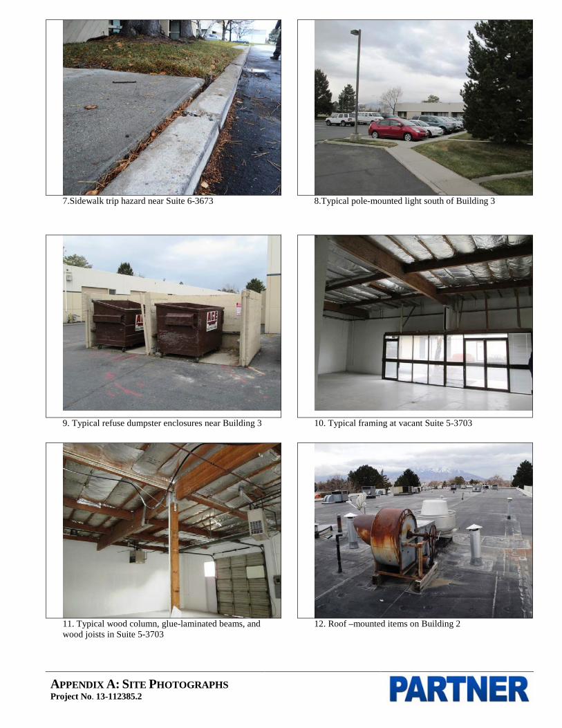
APPENDIX A: SITE PHOTOGRAPHS Project No. 13-112385.2
7.Sidewalk trip hazard near Suite 6-3673 8.Typical pole-mounted light south of Building 3
9. Typical refuse dumpster enclosures near Building 3
10. Typical framing at vacant Suite 5-3703
11. Typical wood column, glue-laminated beams, and wood joists in Suite 5-3703
12. Roof –mounted items on Building 2

APPENDIX A: SITE PHOTOGRAPHS Project No. 13-112385.2
13. Typical front window and door system at Suite 8-3617
14. Southeast corner of Building 1
15. Southwest corner of Building 2
16. Southwest corner of Building 4
17. Southwest corner of Building 5
18. Rear (east) wall of Building 5

APPENDIX A: SITE PHOTOGRAPHS Project No. 13-112385.2
19. Rear (south) wall of Building 7
20. Deteriorated parapet top at Building 1’s rear (west)
wall
21. Deteriorated parapet top at Building 7’s rear (south) wall
22. Typical front window and door system at Suite 4-3688
23. Suite 1-3610
24. Suite 1-3612

APPENDIX A: SITE PHOTOGRAPHS Project No. 13-112385.2
25. Vacant Suite 1-3618
26. Suite 3-3666
27. Suite 1-3612 warehouse
28. Water-stained ceiling tiles from past roof leak in Suite
4-3684
29.Suite 4-3696
30. Suite 6-3677 warehouse

APPENDIX A: SITE PHOTOGRAPHS Project No. 13-112385.2
31. Suite 2-3646 restroom
32. Suite 2-3636
33. Damaged wall in Suite 1-3608 warehouse
34. Ceiling stain and reported current roof leak in Suite 2-
3644
35.Two handicap-accessible parking spaces at the west side of Building 4
36.Restroom in Suite 2-3636

APPENDIX B: HISTORICAL/REGULATORY DOCUMENTATION

APPENDIX B: AERIAL PHOTOGRAPHS Project No. 13-112385.2
Date of Photograph: 1937

APPENDIX B: AERIAL PHOTOGRAPHS Project No. 13-112385.2
Date of Photograph: 1943

APPENDIX B: AERIAL PHOTOGRAPHS Project No. 13-112385.2
Date of Photograph: 1950
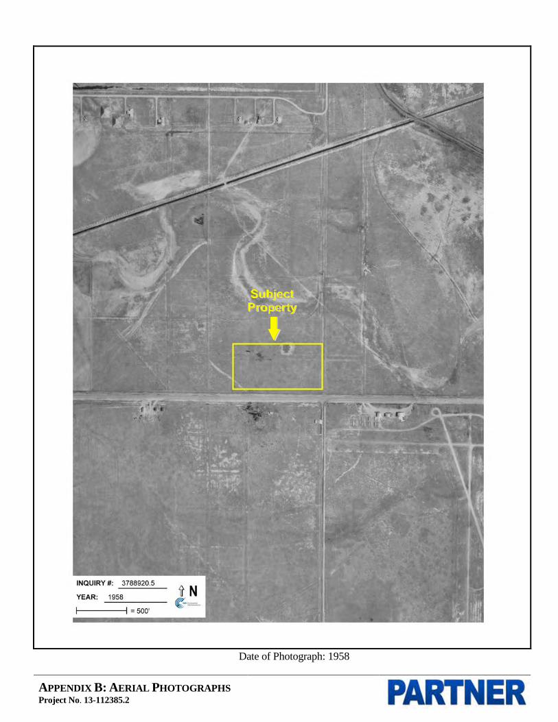
APPENDIX B: AERIAL PHOTOGRAPHS Project No. 13-112385.2
Date of Photograph: 1958
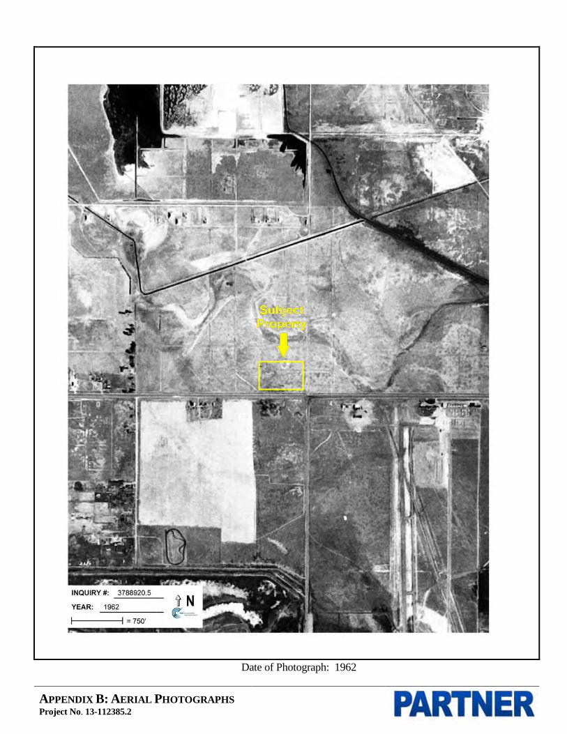
APPENDIX B: AERIAL PHOTOGRAPHS Project No. 13-112385.2
Date of Photograph: 1962
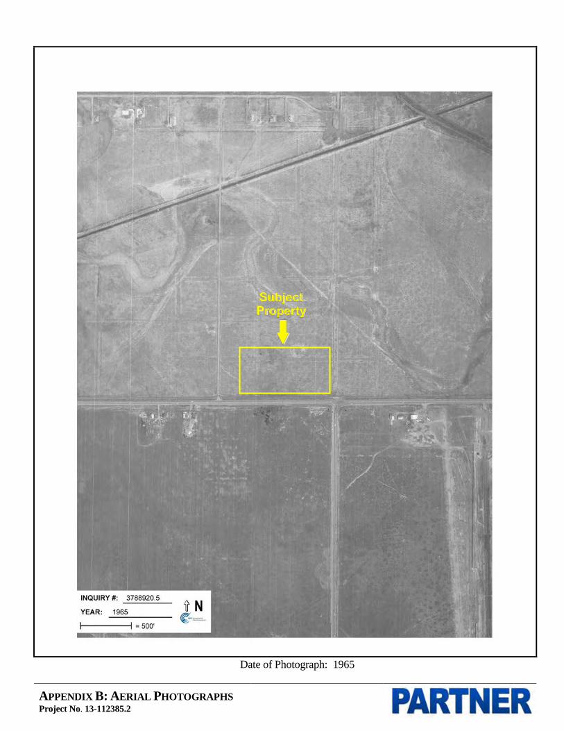
APPENDIX B: AERIAL PHOTOGRAPHS Project No. 13-112385.2
Date of Photograph: 1965

APPENDIX B: AERIAL PHOTOGRAPHS Project No. 13-112385.2
Date of Photograph: 1971

APPENDIX B: AERIAL PHOTOGRAPHS Project No. 13-112385.2
Date of Photograph: 1977

APPENDIX B: AERIAL PHOTOGRAPHS Project No. 13-112385.2
Date of Photograph: 1981

APPENDIX B: AERIAL PHOTOGRAPHS Project No. 13-112385.2
Date of Photograph: 1993

APPENDIX B: AERIAL PHOTOGRAPHS Project No. 13-112385.2
Date of Photograph: 1998

APPENDIX B: AERIAL PHOTOGRAPHS Project No. 13-112385.2
Date of Photograph: 2006
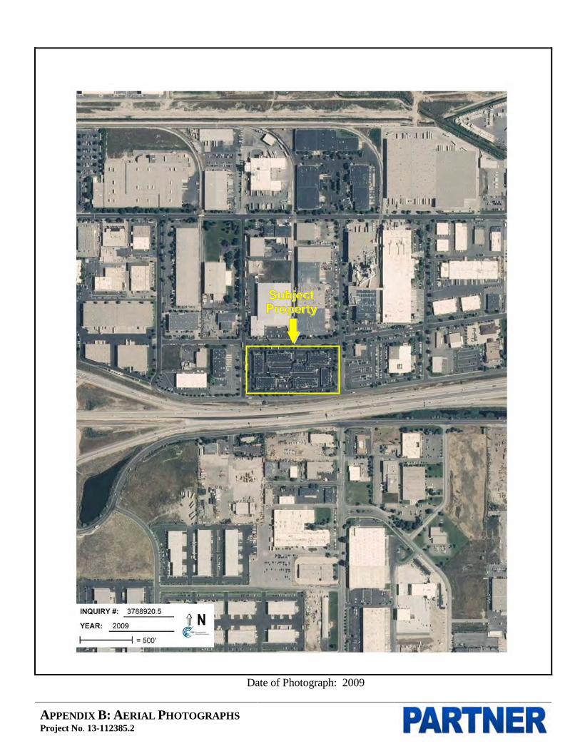
APPENDIX B: AERIAL PHOTOGRAPHS Project No. 13-112385.2
Date of Photograph: 2009

APPENDIX B: AERIAL PHOTOGRAPHS Project No. 13-112385.2
Date of Photograph: 2011
Certified Sanborn® Map Report
Broadbent Business Park
3607-3667 West 1987 South
Salt Lake City, UT 84104
Inquiry Number: 3788920.3
November 18, 2013

Certified Sanborn® Map Report 11/18/13
Site Name:Broadbent Business Park3607-3667 West 1987 SouthSalt Lake City, UT 84104
Client Name:Partner Engineering and2154 Torrance Blvd, Suite 200Torrance, CA 90501-0000
Contact: Sarah Van SonEDR Inquiry # 3788920.3
The complete Sanborn Library collection has been searched by EDR, and fire insurance maps covering the targetproperty location provided by Partner Engineering and Science, Inc. were identified for the years listed below. Thecertified Sanborn Library search results in this report can be authenticated by visiting www.edrnet.com/sanborn andentering the certification number. Only Environmental Data Resources Inc. (EDR) is authorized to grant rights forcommercial reproduction of maps by Sanborn Library LLC, the copyright holder for the collection.
Certified Sanborn Results:
Site Name: Broadbent Business ParkAddress: 3607-3667 West 1987 SouthCity, State, Zip: Salt Lake City, UT 84104Cross Street:P.O. # Broadbent Business ParkProject: 13-112385.2Certification # 8711-441D-9167
Library of Congress
University Publications of America
EDR Private Collection
The Sanborn Library LLC Since 1866™
The Sanborn Library includes more than 1.2 millionSanborn fire insurance maps, which track historicalproperty usage in approximately 12,000 Americancities and towns. Collections searched:
Sanborn® Library search resultsCertification # 8711-441D-9167
UNMAPPED PROPERTYThis report certifies that the complete holdings of the SanbornLibrary, LLC collection have been searched based on clientsupplied target property information, and fire insurance mapscovering the target property were not found.
Limited Permission To Make CopiesPartner Engineering and Science, Inc. (the client) is permitted to make up to THREE photocopies of this Sanborn Map transmittal and each fireinsurance map accompanying this report solely for the limited use of its customer. No one other than the client is authorized to make copies. Uponrequest made directly to an EDR Account Executive, the client may be permitted to make a limited number of additional photocopies. Thispermission is conditioned upon compliance by the client, its customer and their agents with EDR's copyright policy; a copy of which is availableupon request.
Disclaimer - Copyright and Trademark noticeThis Report contains certain information obtained from a variety of public and other sources reasonably available to Environmental Data Resources, Inc. It cannot beconcluded from this Report that coverage information for the target and surrounding properties does not exist from other sources. NO WARRANTY EXPRESSED ORIMPLIED, IS MADE WHATSOEVER IN CONNECTION WITH THIS REPORT. ENVIRONMENTAL DATA RESOURCES, INC. SPECIFICALLY DISCLAIMS THEMAKING OF ANY SUCH WARRANTIES, INCLUDING WITHOUT LIMITATION, MERCHANTABILITY OR FITNESS FOR A PARTICULAR USE OR PURPOSE. ALLRISK IS ASSUMED BY THE USER. IN NO EVENT SHALL ENVIRONMENTAL DATA RESOURCES, INC. BE LIABLE TO ANYONE, WHETHER ARISING OUT OFERRORS OR OMISSIONS, NEGLIGENCE, ACCIDENT OR ANY OTHER CAUSE, FOR ANY LOSS OF DAMAGE, INCLUDING, WITHOUT LIMITATION, SPECIAL,INCIDENTAL CONSEQUENTIAL, OR EXEMPLARY DAMAGES. ANY LIABILITY ON THE PART OF ENVIRONMENTAL DATA RESOURCES, INC. IS STRICTLYLIMITED TO A REFUND OF THE AMOUNT PAID FOR THIS REPORT. Purchaser accepts this Report "AS IS". Any analyses, estimates, ratings, environmental risklevels or risk codes provided in this Report are provided for illustrative purposes only, and are not intended to provide, nor should they be interpreted as providingany facts regarding, or prediction or forecast of, any environmental risk for any property. Only a Phase I Environmental Site Assessment performed by anenvironmental professional can provide information regarding the environmental risk for any property. Additionally, the information provided in this Report is not to beconstrued as legal advice.
Copyright 2013 by Environmental Data Resources, Inc. All rights reserved. Reproduction in any media or format, in whole or in part, of any report or map ofEnvironmental Data Resources, Inc., or its affiliates, is prohibited without prior written permission.
EDR and its logos (including Sanborn and Sanborn Map) are trademarks of Environmental Data Resources, Inc. or its affiliates. All other trademarks used herein arethe property of their respective owners.
3788920 - 3 page 2


APPENDIX B: HISTORIC TOPOGRAPHIC MAPS Project No. 13-112385.2
USGS 1:250,000 Salt Lake, Utah Quadrangle Created: 1895

APPENDIX B: HISTORIC TOPOGRAPHIC MAPS Project No. 13-112385.2
USGS 7.5 Minute Salt Lake City South Quadrangle Created: 1951
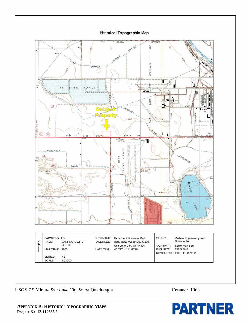
APPENDIX B: HISTORIC TOPOGRAPHIC MAPS Project No. 13-112385.2
USGS 7.5 Minute Salt Lake City South Quadrangle Created: 1963

APPENDIX B: HISTORIC TOPOGRAPHIC MAPS Project No. 13-112385.2
USGS 7.5 Minute Salt Lake City South Quadrangle Created: 1969

APPENDIX B: HISTORIC TOPOGRAPHIC MAPS Project No. 13-112385.2
USGS 7.5 Minute Salt Lake City South Quadrangle Created: 1975
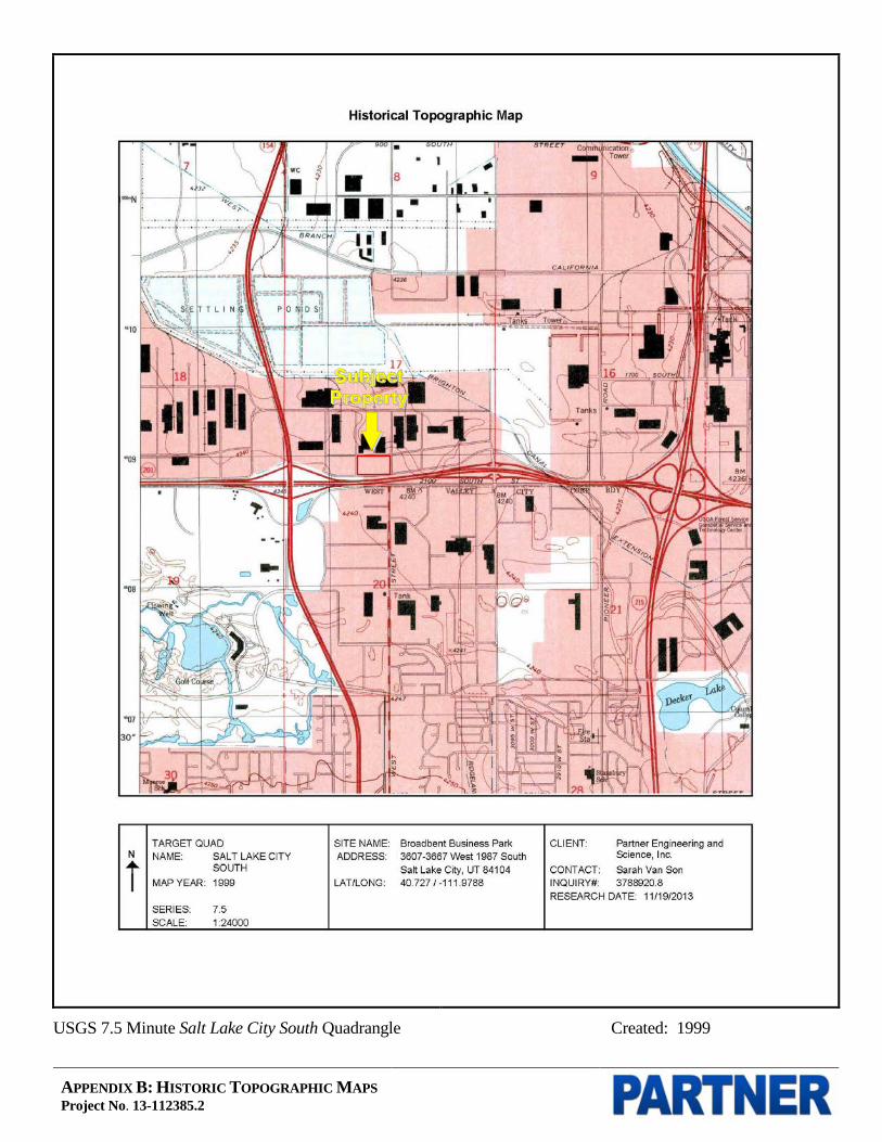
APPENDIX B: HISTORIC TOPOGRAPHIC MAPS Project No. 13-112385.2
USGS 7.5 Minute Salt Lake City South Quadrangle Created: 1999

Broadbent Business Park
3607-3667 West 1987 SouthSalt Lake City, UT 84104
Inquiry Number: 3788920.7November 20, 2013
The EDR-City Directory Abstract
440 Wheelers Farms RoadMilford, CT 06461800.352.0050www.edrnet.comEnvironmental Data Resources IncEnvironmental Data Resources IncEnvironmental Data Resources IncEnvironmental Data Resources Inc

TABLE OF CONTENTS
SECTION
Executive Summary
Findings
City Directory Images
Thank you for your business. Please contact EDR at 1-800-352-0050
with any questions or comments.
Disclaimer - Copyright and Trademark Notice
This Report contains certain information obtained from a variety of public and other sources reasonably available to Environmental Data Resources, Inc. It cannot be concluded from this Report that coverage information for the target and surrounding properties does not exist from other sources. NO WARRANTY EXPRESSED OR IMPLIED, IS MADE WHATSOEVER IN CONNECTION WITH THIS REPORT. ENVIRONMENTAL DATA RESOURCES, INC. SPECIFICALLY DISCLAIMS THE MAKING OF ANY SUCH WARRANTIES, INCLUDING WITHOUT LIMITATION, MERCHANTABILITY OR FITNESS FOR A PARTICULAR USE OR PURPOSE. ALL RISK IS ASSUMED BY THE USER. IN NO EVENT SHALL ENVIRONMENTAL DATA RESOURCES, INC. BE LIABLE TO ANYONE, WHETHER ARISING OUT OF ERRORS OR OMISSIONS, NEGLIGENCE, ACCIDENT OR ANY OTHER CAUSE, FOR ANY LOSS OR DAMAGE, INCLUDING, WITHOUT LIMITATION, SPECIAL, INCIDENTAL, CONSEQUENTIAL, OR EXEMPLARY DAMAGES. ANY LIABILITY ON THE PART OF ENVIRONMENTAL DATA RESOURCES, INC. IS STRICTLY LIMITED TO A REFUND OF THE AMOUNT PAID FOR THIS REPORT. Purchaser accepts this Report "AS IS". Any analyses, estimates, ratings, environmental risk levels or risk codes provided in this Report are provided for illustrative purposes only, and are not intended to provide, nor should they be interpreted as providing any facts regarding, or prediction orforecast of, any environmental risk for any property. Only a Phase I Environmental Site Assessment performed by an environmental professional can provide information regarding the environmental risk for any property. Additionally, the information provided in this Report is not to be construed as legal advice.
Copyright 2013 by Environmental Data Resources, Inc. All rights reserved. Reproduction in any media or format, in whole or in part, of any report or map of Environmental Data Resources, Inc. or its affiliates is prohibited without prior written permission.
EDR and its logos (including Sanborn and Sanborn Map) are trademarks of Environmental Data Resources, Inc. or its affiliates. All other trademarks used herein are the property of their respective owners.

EXECUTIVE SUMMARY
DESCRIPTION
Environmental Data Resources, Inc.’s (EDR) City Directory Abstract is a screening tool designed to assist environmental professionals in evaluating potential liability on a target property resulting from past activities. EDR’s City Directory Abstract includes a search and abstract of available city directory data. For each address, the directory lists the name of the corresponding occupant at five year intervals.
Business directories including city, cross reference and telephone directories were reviewed, if available, at approximately five year intervals for the years spanning 1926 through 2013. This report compiles information gathered in this review by geocoding the latitude and longitude of properties identified and gathering information about properties within 660 feet of the target property.
A summary of the information obtained is provided in the text of this report.
RECORD SOURCES
EDR is licensed to reproduce certain City Directory works. Reproduction of City Directories without permission of the publisher may be a violation of copyright.
RESEARCH SUMMARY
The following research sources were consulted in the preparation of this report. An "X" indicates where information was identified in the source and provided in this report.
Source TPYear Adjoining Text Abstract Source Image
2013 Cole Information Services - X X -
Cole Information Services X X X -
2008 Cole Information Services - X X -
Cole Information Services X X X -
2007 Polk City Directories - - - -
2001 Polk Directories - X X X
Polk Directories X X X X
2000 Polk City Directory - X X X
1995 R. L. Polk Co., Publishers - X X X
1991 R. L. Polk Co., Publishers - - - -
1990 R.L. Polk Co - X X X
R.L. Polk Co X X X X
1985 R. L. Polk Co., Publishers - X X X
R. L. Polk Co., Publishers X X X X
1981 R. L. Polk Co., Publishers - - - -
3788920- 7 Page 1

EXECUTIVE SUMMARY
Source TPYear Adjoining Text Abstract Source Image
1980 R. L. Polk Co., Publishers - - - -
1976 R. L. Polk Company, Publishers - - - -
1975 R. L. Polk Co., Publishers - - - -
1971 R.L. Polk Co., Publishers - - - -
1970 R. L. Polk Co., Publishers - - - -
1965 R. L. Polk Co. Publishers - - - -
1961 R.L. Polk Co., Publishers - - - -
1956 R.L. Polk Co., Publishers - - - -
1951 R.L. Polk Co., Publishers - - - -
1946 R.L. Polk Co., Publishers - - - -
1941 R.L. Polk Co., of Utah, Publishers - X X X
1936 R.L. Polk Co., of Utah, Publishers - X X X
1931 R. L. Polk Co., Publishers - - - -
1926 R. L. Polk Co., Publishers - - - -
3788920- 7 Page 2
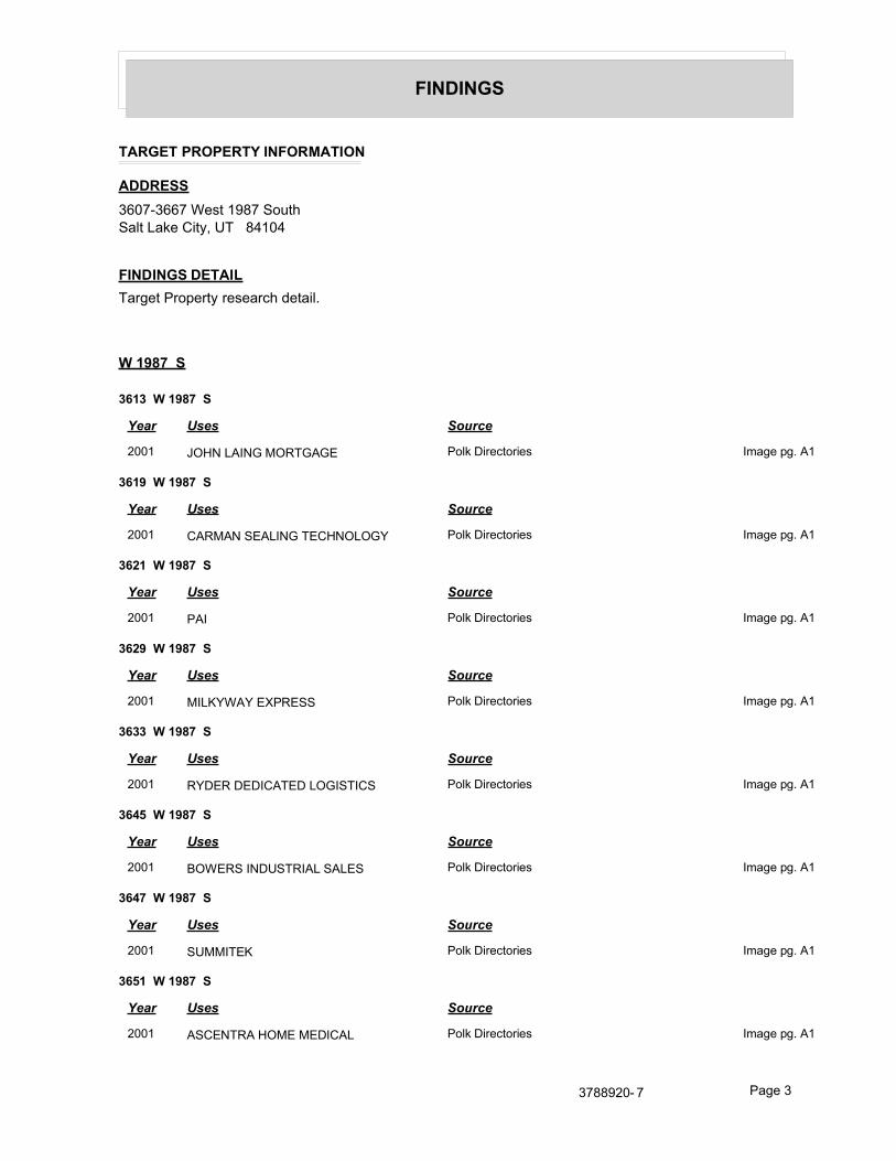
FINDINGS
TARGET PROPERTY INFORMATION
ADDRESS
3607-3667 West 1987 SouthSalt Lake City, UT 84104
FINDINGS DETAIL
Target Property research detail.
W 1987 S
3613 W 1987 S
Year Uses Source
2001 JOHN LAING MORTGAGE Polk Directories Image pg. A1
3619 W 1987 S
Year Uses Source
2001 CARMAN SEALING TECHNOLOGY Polk Directories Image pg. A1
3621 W 1987 S
Year Uses Source
2001 PAI Polk Directories Image pg. A1
3629 W 1987 S
Year Uses Source
2001 MILKYWAY EXPRESS Polk Directories Image pg. A1
3633 W 1987 S
Year Uses Source
2001 RYDER DEDICATED LOGISTICS Polk Directories Image pg. A1
3645 W 1987 S
Year Uses Source
2001 BOWERS INDUSTRIAL SALES Polk Directories Image pg. A1
3647 W 1987 S
Year Uses Source
2001 SUMMITEK Polk Directories Image pg. A1
3651 W 1987 S
Year Uses Source
2001 ASCENTRA HOME MEDICAL Polk Directories Image pg. A1
3788920- 7 Page 3
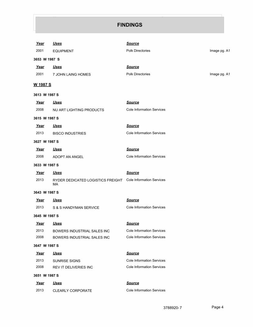
Year Uses Source
FINDINGS
Year Uses Source
2001 EQUIPMENT Polk Directories Image pg. A1
3653 W 1987 S
Year Uses Source
2001 7 JOHN LAING HOMES Polk Directories Image pg. A1
W 1987 S
3613 W 1987 S
Year Uses Source
2008 NU ART LIGHTING PRODUCTS Cole Information Services
3615 W 1987 S
Year Uses Source
2013 BISCO INDUSTRIES Cole Information Services
3627 W 1987 S
Year Uses Source
2008 ADOPT AN ANGEL Cole Information Services
3633 W 1987 S
Year Uses Source
2013 RYDER DEDICATED LOGISTICS FREIGHT MA
Cole Information Services
3643 W 1987 S
Year Uses Source
2013 S & S HANDYMAN SERVICE Cole Information Services
3645 W 1987 S
Year Uses Source
2013 BOWERS INDUSTRIAL SALES INC Cole Information Services
2008 BOWERS INDUSTRIAL SALES INC Cole Information Services
3647 W 1987 S
Year Uses Source
2013 SUNRISE SIGNS Cole Information Services
2008 REV IT DELIVERIES INC Cole Information Services
3651 W 1987 S
Year Uses Source
2013 CLEARLY CORPORATE Cole Information Services
3788920- 7 Page 4

Year Uses Source
FINDINGS
W 1987 SOUTH ST
3607 W 1987 SOUTH ST
Year Uses Source
1985 3607 08 Vacant R. L. Polk Co., Publishers Image pg. A15
3609 W 1987 SOUTH ST
Year Uses Source
1990 S J Products book binding R.L. Polk Co Image pg. A11
1985 Aero Enterprises R. L. Polk Co., Publishers Image pg. A15
3611 W 1987 SOUTH ST
Year Uses Source
1990 S J Products Add Sp R.L. Polk Co Image pg. A11
1985 Vacant R. L. Polk Co., Publishers Image pg. A15
3613 W 1987 SOUTH ST
Year Uses Source
1990 A D P Dealer Services automatic data proc R.L. Polk Co Image pg. A11
1985 T R I Inc R. L. Polk Co., Publishers Image pg. A15
3615 W 1987 SOUTH ST
Year Uses Source
1990 Vacant R.L. Polk Co Image pg. A11
1985 Ten States Area Advertising R. L. Polk Co., Publishers Image pg. A15
3617 W 1987 SOUTH ST
Year Uses Source
1990 Norman G Jensen Inc customs brokers R.L. Polk Co Image pg. A11
1985 C F Arrowhead Servs Flat Bed Division R. L. Polk Co., Publishers Image pg. A15
freight R. L. Polk Co., Publishers Image pg. A15
Riggs & Allen Transportation freight R. L. Polk Co., Publishers Image pg. A15
truck lines R. L. Polk Co., Publishers Image pg. A15
3619 W 1987 SOUTH ST
Year Uses Source
1990 Roth Distributing Co appi distrs R.L. Polk Co Image pg. A11
1985 accounting & bkpg R. L. Polk Co., Publishers Image pg. A15
Comprehensive Business Service financial R. L. Polk Co., Publishers Image pg. A15
Comprehensive Business Services bkpg R. L. Polk Co., Publishers Image pg. A15
3788920- 7 Page 5
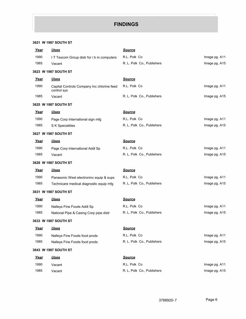
Year Uses Source
FINDINGS
3621 W 1987 SOUTH ST
Year Uses Source
1990 I T Texcom Group distr for i b m computers R.L. Polk Co Image pg. A11
1985 Vacant R. L. Polk Co., Publishers Image pg. A15
3623 W 1987 SOUTH ST
Year Uses Source
1990 Capital Controls Company Inc chlorine feed control sys
R.L. Polk Co Image pg. A11
1985 Vacant R. L. Polk Co., Publishers Image pg. A15
3625 W 1987 SOUTH ST
Year Uses Source
1990 Page Corp International sign mfg R.L. Polk Co Image pg. A11
1985 S K Specialities R. L. Polk Co., Publishers Image pg. A15
3627 W 1987 SOUTH ST
Year Uses Source
1990 Page Corp International Addl Sp R.L. Polk Co Image pg. A11
1985 Vacant R. L. Polk Co., Publishers Image pg. A15
3629 W 1987 SOUTH ST
Year Uses Source
1990 Panasonic West electroninc equip & sups R.L. Polk Co Image pg. A11
1985 Technicare medical diagnostic equip mfg R. L. Polk Co., Publishers Image pg. A15
3631 W 1987 SOUTH ST
Year Uses Source
1990 Nalleys Fine Foods Addl Sp R.L. Polk Co Image pg. A11
1985 National Pipe & Casing Corp pipe distr R. L. Polk Co., Publishers Image pg. A15
3633 W 1987 SOUTH ST
Year Uses Source
1990 Nalleys Fine Foods food prods R.L. Polk Co Image pg. A11
1985 Nalleys Fine Foods food prods R. L. Polk Co., Publishers Image pg. A15
3643 W 1987 SOUTH ST
Year Uses Source
1990 Vacant R.L. Polk Co Image pg. A11
1985 Vacant R. L. Polk Co., Publishers Image pg. A15
3788920- 7 Page 6
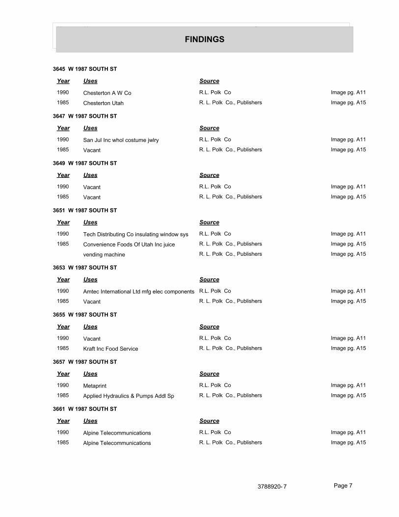
Year Uses Source
FINDINGS
3645 W 1987 SOUTH ST
Year Uses Source
1990 Chesterton A W Co R.L. Polk Co Image pg. A11
1985 Chesterton Utah R. L. Polk Co., Publishers Image pg. A15
3647 W 1987 SOUTH ST
Year Uses Source
1990 San Jul Inc whol costume jwlry R.L. Polk Co Image pg. A11
1985 Vacant R. L. Polk Co., Publishers Image pg. A15
3649 W 1987 SOUTH ST
Year Uses Source
1990 Vacant R.L. Polk Co Image pg. A11
1985 Vacant R. L. Polk Co., Publishers Image pg. A15
3651 W 1987 SOUTH ST
Year Uses Source
1990 Tech Distributing Co insulating window sys R.L. Polk Co Image pg. A11
1985 Convenience Foods Of Utah Inc juice R. L. Polk Co., Publishers Image pg. A15
vending machine R. L. Polk Co., Publishers Image pg. A15
3653 W 1987 SOUTH ST
Year Uses Source
1990 Amtec International Ltd mfg elec components R.L. Polk Co Image pg. A11
1985 Vacant R. L. Polk Co., Publishers Image pg. A15
3655 W 1987 SOUTH ST
Year Uses Source
1990 Vacant R.L. Polk Co Image pg. A11
1985 Kraft Inc Food Service R. L. Polk Co., Publishers Image pg. A15
3657 W 1987 SOUTH ST
Year Uses Source
1990 Metaprint R.L. Polk Co Image pg. A11
1985 Applied Hydraulics & Pumps Addl Sp R. L. Polk Co., Publishers Image pg. A15
3661 W 1987 SOUTH ST
Year Uses Source
1990 Alpine Telecommunications R.L. Polk Co Image pg. A11
1985 Alpine Telecommunications R. L. Polk Co., Publishers Image pg. A15
3788920- 7 Page 7

Year Uses Source
FINDINGS
3663 W 1987 SOUTH ST
Year Uses Source
1990 Alpine Telecommunications Addl Sp R.L. Polk Co Image pg. A11
1985 Vacant R. L. Polk Co., Publishers Image pg. A15
3665 W 1987 SOUTH ST
Year Uses Source
1990 Vacant R.L. Polk Co Image pg. A11
1985 Acorn Data Products computer products R. L. Polk Co., Publishers Image pg. A15
3667 W 1987 SOUTH ST
Year Uses Source
1990 Centel Information Systems data communications
R.L. Polk Co Image pg. A11
1985 Alanthus Data Communications R. L. Polk Co., Publishers Image pg. A15
3788920- 7 Page 8

FINDINGS
ADJOINING PROPERTY DETAIL
The following Adjoining Property addresses were researched for this report. Detailed findings are provided for each address.
1987/S 3600 W
1987/S 3600 W
Year Uses Source
2001 1987/S 3600 W Polk Directories Image pg. A1
2100/3730
2100/3730
Year Uses Source
2001 2100/3730 Polk Directories Image pg. A2
2100/S 3600 W
2100/S 3600 W
Year Uses Source
2001 2100/S 3600 W Polk Directories Image pg. A2
2100/S 3600 W Polk Directories Image pg. A2
2000 2100/S 3600 W Polk City Directory Image pg. A8
3600/W 1987 S
3600/W 1987 S
Year Uses Source
2001 3600/W 1987 S Polk Directories Image pg. A3
3600/W 2100 S
3600/W 2100 S
Year Uses Source
2001 3600/W 2100 S Polk Directories Image pg. A3
3730/W 1987 S
3730/W 1987 S
Year Uses Source
2001 3730/W 1987 S Polk Directories Image pg. A4
3788920- 7 Page 9

Year Uses Source
FINDINGS
E 3600 S
2030 E 3600 S
Year Uses Source
1995 CLOCK PEDDLER R. L. Polk Co., Publishers Image pg. A9
2080 E 3600 S
Year Uses Source
1995 Sorenson Eugene R. L. Polk Co., Publishers Image pg. A9
N 3600 W
2068 N 3600 W
Year Uses Source
1995 PLAIN CITY R. L. Polk Co., Publishers Image pg. A9
PEDIATRICS R. L. Polk Co., Publishers Image pg. A9
S 3600 W
1991 S 3600 W
Year Uses Source
2001 FIRST UTAH BANK Polk Directories Image pg. A5
38456 S 3600 W
Year Uses Source
1995 Clark L Keith R. L. Polk Co., Publishers Image pg. A9
S 3600 W
1991 S 3600 W
Year Uses Source
2013 FIRST UTAH BANK Cole Information Services
2008 FIRST UTAH BANK Cole Information Services
S 3600 WEST ST
1991 S 3600 WEST ST
Year Uses Source
1990 Utah Central Credit Union R.L. Polk Co Image pg. A12
1985 First Interstate Bank Of Utah R. L. Polk Co., Publishers Image pg. A16
Centennial Ofc R. L. Polk Co., Publishers Image pg. A16
3788920- 7 Page 10

Year Uses Source
FINDINGS
W 1987 S
3673 W 1987 S
Year Uses Source
2001 software/acce Polk Directories Image pg. A1
CARTRIDGE computer Polk Directories Image pg. A1
COMPUTER RIBBON Polk Directories Image pg. A1
3681 W 1987 S
Year Uses Source
2001 TECHNISCANWEST Polk Directories Image pg. A1
3691 W 1987 S
Year Uses Source
2001 MEADOW GOLD EMPLOYEES CU Polk Directories Image pg. A1
3700 W 1987 S
Year Uses Source
2001 XPEDX Polk Directories Image pg. A1
3701 W 1987 S
Year Uses Source
2001 BETTINA instruction schs Polk Directories Image pg. A1
3707 W 1987 S
Year Uses Source
2001 PRISM disinfecting seiv Polk Directories Image pg. A1
3740 W 1987 S
Year Uses Source
2001 TECHNOLOGIES gas producers Polk Directories Image pg. A1
WATER & POWER Polk Directories Image pg. A1
equip Polk Directories Image pg. A1
W 1987 S
3673 W 1987 S
Year Uses Source
2013 COMMERCIAL MECHANICAL Cole Information Services
3788920- 7 Page 11

Year Uses Source
FINDINGS
3677 W 1987 S
Year Uses Source
2013 1800GOTJUNK Cole Information Services
3681 W 1987 S
Year Uses Source
2008 JOHNSONVILLE GRILLS OF UTAH Cole Information Services
3683 W 1987 S
Year Uses Source
2013 LOS ANGELES BREAD COMPANY Cole Information Services
2008 LOS ANGELES BREAD CO Cole Information Services
3691 W 1987 S
Year Uses Source
2013 MEADOW GOLD EMPLOYEES CREDIT UNION
Cole Information Services
2008 MEADOW GOLD EMPLOYEES Cole Information Services
3695 W 1987 S
Year Uses Source
2013 CAREFUSION Cole Information Services
3740 W 1987 S
Year Uses Source
2013 TRANE Cole Information Services
WATER & POWER TECHNOLOGIES Cole Information Services
W 1987 SOUTH ST
3608 W 1987 SOUTH ST
Year Uses Source
1985 3607 08 Vacant R. L. Polk Co., Publishers Image pg. A15
3620 W 1987 SOUTH ST
Year Uses Source
1990 Vacant R.L. Polk Co Image pg. A11
1985 Penney J C Co Inc dept store warehouse R. L. Polk Co., Publishers Image pg. A15
3669 W 1987 SOUTH ST
Year Uses Source
1990 Vacant R.L. Polk Co Image pg. A11
3788920- 7 Page 12

Year Uses Source
FINDINGS
Year Uses Source
1985 Art & Frame Warehouse The R. L. Polk Co., Publishers Image pg. A15
3671 W 1987 SOUTH ST
Year Uses Source
1985 3671 73 Art & Frame Warehouse The Ofc R. L. Polk Co., Publishers Image pg. A15
3673 W 1987 SOUTH ST
Year Uses Source
1990 Vacant R.L. Polk Co Image pg. A11
1985 3671 73 Art & Frame Warehouse The Ofc R. L. Polk Co., Publishers Image pg. A15
3675 W 1987 SOUTH ST
Year Uses Source
1990 Vacant R.L. Polk Co Image pg. A11
1985 Martins Machine Shop R. L. Polk Co., Publishers Image pg. A15
3677 W 1987 SOUTH ST
Year Uses Source
1990 Vacant R.L. Polk Co Image pg. A11
1985 Crown Litho Supply R. L. Polk Co., Publishers Image pg. A15
3679 W 1987 SOUTH ST
Year Uses Source
1990 Vacant R.L. Polk Co Image pg. A11
1985 M J B Coffee coffee distr hotel & restr R. L. Polk Co., Publishers Image pg. A15
3681 W 1987 SOUTH ST
Year Uses Source
1990 Davis Technologies mfg cable harness R.L. Polk Co Image pg. A11
1985 Panasonic Company Addl Sp R. L. Polk Co., Publishers Image pg. A15
3683 W 1987 SOUTH ST
Year Uses Source
1990 Vacant R.L. Polk Co Image pg. A11
1985 Panasonic Co electronic equip & sup R. L. Polk Co., Publishers Image pg. A15
3689 W 1987 SOUTH ST
Year Uses Source
1990 Cummins Allison Corp Addl Sp R.L. Polk Co Image pg. A11
1985 Vacant R. L. Polk Co., Publishers Image pg. A15
3788920- 7 Page 13

Year Uses Source
FINDINGS
3691 W 1987 SOUTH ST
Year Uses Source
1990 Cummins Allison Corp sis & serv ofc machs
R.L. Polk Co Image pg. A11
1985 Vacant R. L. Polk Co., Publishers Image pg. A15
3693 W 1987 SOUTH ST
Year Uses Source
1990 I T T Courier Terminal System computer als
R.L. Polk Co Image pg. A11
1985 I T T Courier Terminal System computer R. L. Polk Co., Publishers Image pg. A15
3695 W 1987 SOUTH ST
Year Uses Source
1990 I T T Courier Terminal System Addl Sp R.L. Polk Co Image pg. A11
1985 Vacant R. L. Polk Co., Publishers Image pg. A15
3697 W 1987 SOUTH ST
Year Uses Source
1990 Color Image Addl Sp R.L. Polk Co Image pg. A11
1985 Xerox Service Center R. L. Polk Co., Publishers Image pg. A15
3699 W 1987 SOUTH ST
Year Uses Source
1990 Color Image Inc pmtrs R.L. Polk Co Image pg. A11
1985 Tech Distributing windows & doors R. L. Polk Co., Publishers Image pg. A15
3700 W 1987 SOUTH ST
Year Uses Source
1990 Dixon Paper Company dlrs R.L. Polk Co Image pg. A11
1985 Dixon Paper Company paper dirs R. L. Polk Co., Publishers Image pg. A15
3701 W 1987 SOUTH ST
Year Uses Source
1990 Fromell Corp holding co R.L. Polk Co Image pg. A11
Winward Electric contractors R.L. Polk Co Image pg. A11
1985 Mountain States Electrical contractors R. L. Polk Co., Publishers Image pg. A15
Fromell Corp holding com R. L. Polk Co., Publishers Image pg. A15
3703 W 1987 SOUTH ST
Year Uses Source
1990 Vacant R.L. Polk Co Image pg. A11
3788920- 7 Page 14
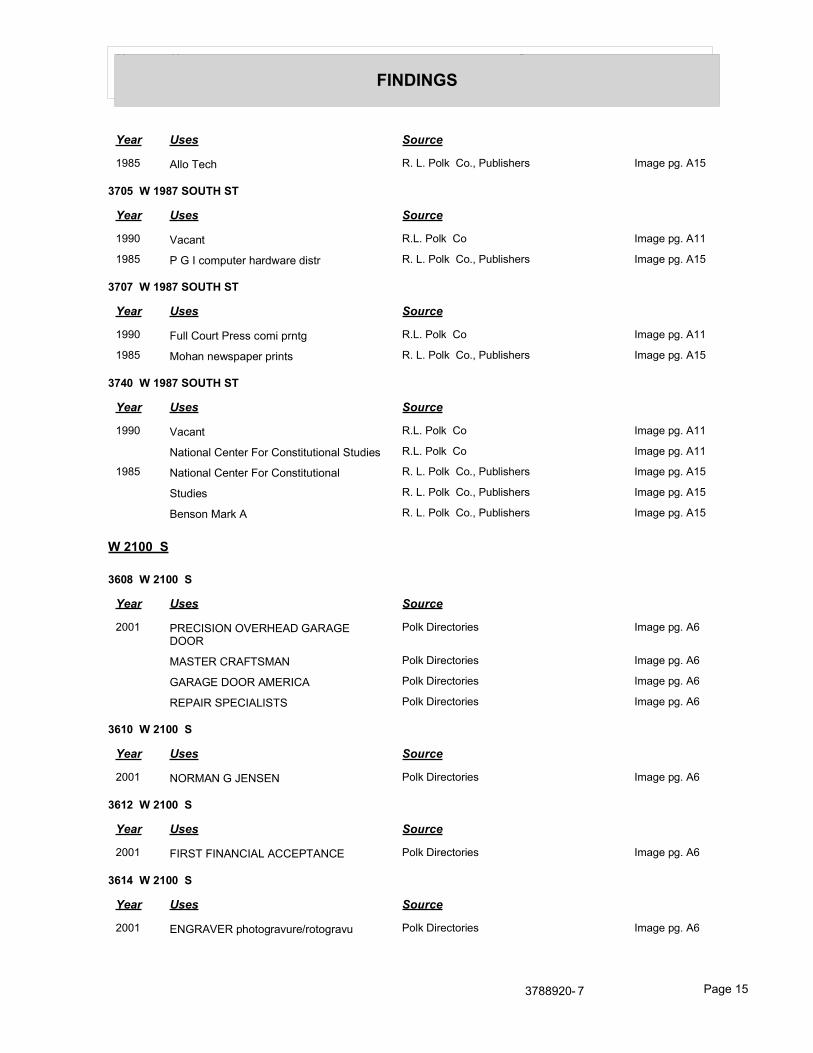
Year Uses Source
FINDINGS
Year Uses Source
1985 Allo Tech R. L. Polk Co., Publishers Image pg. A15
3705 W 1987 SOUTH ST
Year Uses Source
1990 Vacant R.L. Polk Co Image pg. A11
1985 P G I computer hardware distr R. L. Polk Co., Publishers Image pg. A15
3707 W 1987 SOUTH ST
Year Uses Source
1990 Full Court Press comi prntg R.L. Polk Co Image pg. A11
1985 Mohan newspaper prints R. L. Polk Co., Publishers Image pg. A15
3740 W 1987 SOUTH ST
Year Uses Source
1990 Vacant R.L. Polk Co Image pg. A11
National Center For Constitutional Studies R.L. Polk Co Image pg. A11
1985 National Center For Constitutional R. L. Polk Co., Publishers Image pg. A15
Studies R. L. Polk Co., Publishers Image pg. A15
Benson Mark A R. L. Polk Co., Publishers Image pg. A15
W 2100 S
3608 W 2100 S
Year Uses Source
2001 PRECISION OVERHEAD GARAGE DOOR
Polk Directories Image pg. A6
MASTER CRAFTSMAN Polk Directories Image pg. A6
GARAGE DOOR AMERICA Polk Directories Image pg. A6
REPAIR SPECIALISTS Polk Directories Image pg. A6
3610 W 2100 S
Year Uses Source
2001 NORMAN G JENSEN Polk Directories Image pg. A6
3612 W 2100 S
Year Uses Source
2001 FIRST FINANCIAL ACCEPTANCE Polk Directories Image pg. A6
3614 W 2100 S
Year Uses Source
2001 ENGRAVER photogravure/rotogravu Polk Directories Image pg. A6
3788920- 7 Page 15

Year Uses Source
FINDINGS
3616 W 2100 S
Year Uses Source
2001 DATA DOCUMENTS 973 OS Polk Directories Image pg. A6
3618 W 2100 S
Year Uses Source
2001 CORPORATE EXPRESS Polk Directories Image pg. A6
3620 W 2100 S
Year Uses Source
2001 NET WIZE Polk Directories Image pg. A6
3636 W 2100 S
Year Uses Source
2001 CUSTOMERS CHOICE rastr Polk Directories Image pg. A6
3638 W 2100 S
Year Uses Source
2001 STARNES DISTRIBUTING bev Polk Directories Image pg. A6
3646 W 2100 S
Year Uses Source
2001 CYCLOPSS BIOCHEMICAL Polk Directories Image pg. A6
biological research Polk Directories Image pg. A6
CYCLOPSS Polk Directories Image pg. A6
3648 W 2100 S
Year Uses Source
2001 ECHO TECH COMMUNICATIONS Polk Directories Image pg. A6
3664 W 2100 S
Year Uses Source
2001 ARPEN GROUP Polk Directories Image pg. A6
3666 W 2100 S
Year Uses Source
2001 MIDWEST INDUSTRIAL TOOLS Polk Directories Image pg. A6
3668 W 2100 S
Year Uses Source
2001 WESTERN OFFICE SYSTEMS Polk Directories Image pg. A6
3788920- 7 Page 16

Year Uses Source
FINDINGS
3670 W 2100 S
Year Uses Source
2001 promo prtg litho Polk Directories Image pg. A6
SEGUE PRINTING SOLUTIONS Polk Directories Image pg. A6
ALPINE TELECOMMUNICATIONS Polk Directories Image pg. A6
3672 W 2100 S
Year Uses Source
2001 MOTOROLA COMMUNICATIONS Polk Directories Image pg. A6
3674 W 2100 S
Year Uses Source
2001 PRODUCTS Polk Directories Image pg. A6
INTER TECH COMPUTER Polk Directories Image pg. A6
3676 W 2100 S
Year Uses Source
2001 GLAUS SALES Polk Directories Image pg. A6
3682 W 2100 S
Year Uses Source
2001 Perkins Layne Polk Directories Image pg. A6
1995 Perkins Layne R. L. Polk Co., Publishers Image pg. A10
3684 W 2100 S
Year Uses Source
2001 METTLER TOLEDO tool repr serv Polk Directories Image pg. A6
3692 W 2100 S
Year Uses Source
2001 online serv providers Polk Directories Image pg. A6
VERIZON COMMUNICATIONS Polk Directories Image pg. A6
3696 W 2100 S
Year Uses Source
2001 CLEARLY CORPORATE Polk Directories Image pg. A6
3698 W 2100 S
Year Uses Source
2001 E UITAX Polk Directories Image pg. A6
WESTCORE GROUP ind U/labor Polk Directories Image pg. A6
consit serv Polk Directories Image pg. A6
3788920- 7 Page 17

Year Uses Source
FINDINGS
3700 W 2100 S
Year Uses Source
2001 plates Polk Directories Image pg. A6
A B DICK COMPANY printing Polk Directories Image pg. A6
UTAH CENTRAL CREDIT UNION Polk Directories Image pg. A6
3710 W 2100 S
Year Uses Source
2001 Pi TNEY BOWES typewriter/dictation Polk Directories Image pg. A6
3737 W 2100 S
Year Uses Source
2001 AMES CONSTRUCTION Polk Directories Image pg. A6
3750 W 2100 S
Year Uses Source
2001 DESIGNS BY JULIE womens spity Polk Directories Image pg. A6
clothg s Polk Directories Image pg. A6
W 2100 S
3608 W 2100 S
Year Uses Source
2013 PRECISION DOOR SERVICE Cole Information Services
PRECISION GARAGE DOOR Cole Information Services
PRECISON OVERHEAD GARAGE DOOR SERVIC
Cole Information Services
2008 PRECISION DOOR SERVICES INC Cole Information Services
PRECISION OVERHEAD GARAGE DOOR SERVI
Cole Information Services
PRECISION OVERHEAD DOORS Cole Information Services
3612 W 2100 S
Year Uses Source
2008 MYERS NUART Cole Information Services
3620 W 2100 S
Year Uses Source
2013 MOUNTAIN STATES INSTRUMENTS Cole Information Services
3788920- 7 Page 18

Year Uses Source
FINDINGS
3626 W 2100 S
Year Uses Source
2008 GANNETT CO INC Cole Information Services
3636 W 2100 S
Year Uses Source
2013 SUBWAY SANDWICHES Cole Information Services
2100 LOCKSMITH Cole Information Services
3638 W 2100 S
Year Uses Source
2008 STARNES DISTRIBUTING INC Cole Information Services
3640 W 2100 S
Year Uses Source
2013 JV EXPRESS Cole Information Services
3644 W 2100 S
Year Uses Source
2013 PRECISION DOOR SERVICE Cole Information Services
3646 W 2100 S
Year Uses Source
2013 RISK CONTROL INC Cole Information Services
2008 RCI INC Cole Information Services
RISK CONTROL INC Cole Information Services
3648 W 2100 S
Year Uses Source
2013 SYSTEMS MAINTENANCE SERVICES Cole Information Services
3652 W 2100 S
Year Uses Source
2013 ACQUIRE MEDIA Cole Information Services
3656 W 2100 S
Year Uses Source
2013 APPLIED SIMULATION TECHNOLOGIES Cole Information Services
2008 E T TECHNOLOGIES Cole Information Services
3788920- 7 Page 19

Year Uses Source
FINDINGS
3658 W 2100 S
Year Uses Source
2013 PANASONIC AVIONICS CORPORATION Cole Information Services
3666 W 2100 S
Year Uses Source
2013 RITHYORKE INC Cole Information Services
3670 W 2100 S
Year Uses Source
2013 BACCHUS PROFESSIONAL EVENT SERVICES
Cole Information Services
3672 W 2100 S
Year Uses Source
2013 KENS BEVERAGE INC Cole Information Services
3674 W 2100 S
Year Uses Source
2013 NEXUS FARMER Cole Information Services
W 21ST SOUTH ST
3608 W 21ST SOUTH ST
Year Uses Source
1990 Vacant R.L. Polk Co Image pg. A13
1985 Closet Connection Shop design custom R. L. Polk Co., Publishers Image pg. A17
home closets R. L. Polk Co., Publishers Image pg. A17
3610 W 21ST SOUTH ST
Year Uses Source
1990 S T S Inc blue staking for u a west R.L. Polk Co Image pg. A13
Sls Philips Medical Systems Inc sas & serv x ray equip
R.L. Polk Co Image pg. A13
1985 Professional Graphic sls & serv R. L. Polk Co., Publishers Image pg. A17
3612 W 21ST SOUTH ST
Year Uses Source
1985 Vacant R. L. Polk Co., Publishers Image pg. A17
3614 W 21ST SOUTH ST
Year Uses Source
1990 Pioneer Electric Supply electrical sas R.L. Polk Co Image pg. A13
3788920- 7 Page 20

Year Uses Source
FINDINGS
Year Uses Source
1985 supplies retail R. L. Polk Co., Publishers Image pg. A17
Access Engineering Graphic blueprint R. L. Polk Co., Publishers Image pg. A17
3616 W 21ST SOUTH ST
Year Uses Source
1990 Professional Graphics pmtg equip sas & serv
R.L. Polk Co Image pg. A13
1985 3616 18 Vacant R. L. Polk Co., Publishers Image pg. A17
3618 W 21ST SOUTH ST
Year Uses Source
1990 Transportation Interiors sas seat covers R.L. Polk Co Image pg. A13
1985 3616 18 Vacant R. L. Polk Co., Publishers Image pg. A17
3620 W 21ST SOUTH ST
Year Uses Source
1990 Broadbent Salt Lake Business Center real est
R.L. Polk Co Image pg. A13
1985 Broadbent Salt Lake Business Center real R. L. Polk Co., Publishers Image pg. A17
3624 W 21ST SOUTH ST
Year Uses Source
1990 Vacant R.L. Polk Co Image pg. A13
1985 3624 28 Vacant R. L. Polk Co., Publishers Image pg. A17
3626 W 21ST SOUTH ST
Year Uses Source
1990 U S A Today newspaper distr R.L. Polk Co Image pg. A13
3628 W 21ST SOUTH ST
Year Uses Source
1990 U S A Today Addl Sp R.L. Polk Co Image pg. A13
1985 3624 28 Vacant R. L. Polk Co., Publishers Image pg. A17
3636 W 21ST SOUTH ST
Year Uses Source
1990 Customers Choice The restr R.L. Polk Co Image pg. A13
1985 Customers Choice The restr R. L. Polk Co., Publishers Image pg. A17
3638 W 21ST SOUTH ST
Year Uses Source
1990 Toledo Scales retail sales & serv R.L. Polk Co Image pg. A13
3788920- 7 Page 21
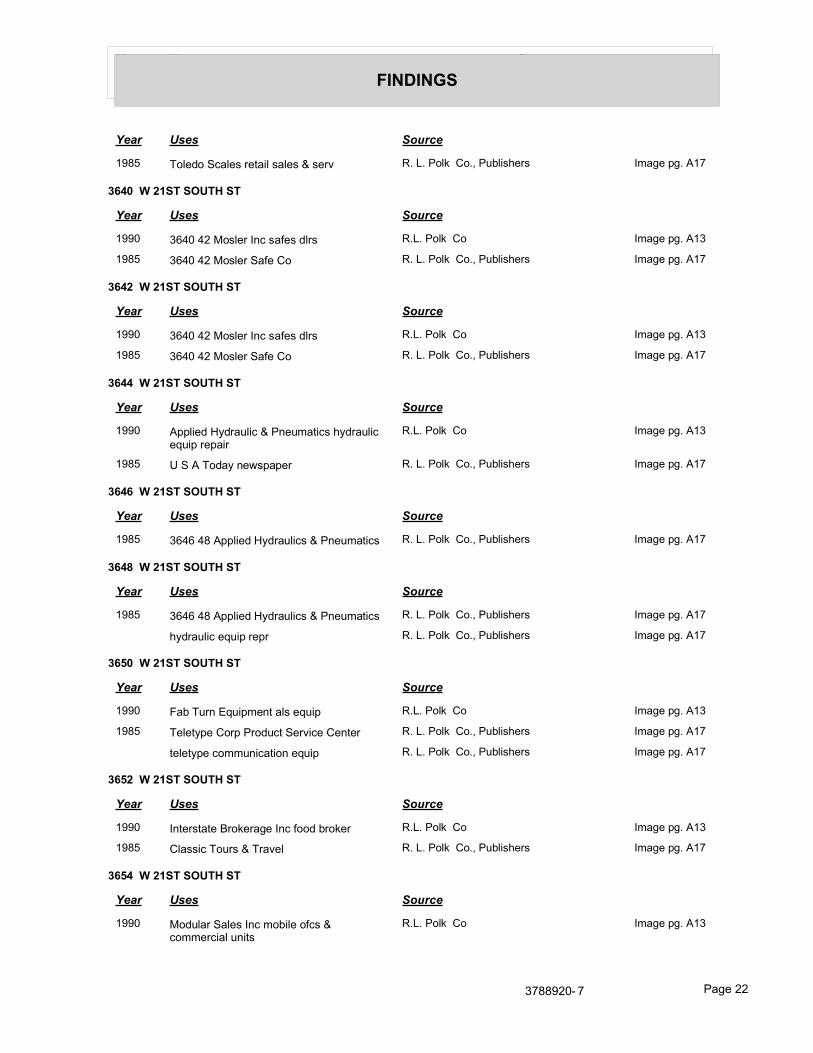
Year Uses Source
FINDINGS
Year Uses Source
1985 Toledo Scales retail sales & serv R. L. Polk Co., Publishers Image pg. A17
3640 W 21ST SOUTH ST
Year Uses Source
1990 3640 42 Mosler Inc safes dlrs R.L. Polk Co Image pg. A13
1985 3640 42 Mosler Safe Co R. L. Polk Co., Publishers Image pg. A17
3642 W 21ST SOUTH ST
Year Uses Source
1990 3640 42 Mosler Inc safes dlrs R.L. Polk Co Image pg. A13
1985 3640 42 Mosler Safe Co R. L. Polk Co., Publishers Image pg. A17
3644 W 21ST SOUTH ST
Year Uses Source
1990 Applied Hydraulic & Pneumatics hydraulic equip repair
R.L. Polk Co Image pg. A13
1985 U S A Today newspaper R. L. Polk Co., Publishers Image pg. A17
3646 W 21ST SOUTH ST
Year Uses Source
1985 3646 48 Applied Hydraulics & Pneumatics R. L. Polk Co., Publishers Image pg. A17
3648 W 21ST SOUTH ST
Year Uses Source
1985 3646 48 Applied Hydraulics & Pneumatics R. L. Polk Co., Publishers Image pg. A17
hydraulic equip repr R. L. Polk Co., Publishers Image pg. A17
3650 W 21ST SOUTH ST
Year Uses Source
1990 Fab Turn Equipment als equip R.L. Polk Co Image pg. A13
1985 Teletype Corp Product Service Center R. L. Polk Co., Publishers Image pg. A17
teletype communication equip R. L. Polk Co., Publishers Image pg. A17
3652 W 21ST SOUTH ST
Year Uses Source
1990 Interstate Brokerage Inc food broker R.L. Polk Co Image pg. A13
1985 Classic Tours & Travel R. L. Polk Co., Publishers Image pg. A17
3654 W 21ST SOUTH ST
Year Uses Source
1990 Modular Sales Inc mobile ofcs & commercial units
R.L. Polk Co Image pg. A13
3788920- 7 Page 22
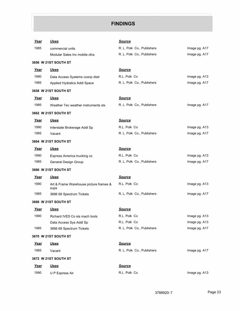
Year Uses Source
FINDINGS
Year Uses Source
1985 commercial units R. L. Polk Co., Publishers Image pg. A17
Modular Sales Inc mobile ofcs R. L. Polk Co., Publishers Image pg. A17
3656 W 21ST SOUTH ST
Year Uses Source
1990 Data Access Systems coxnp distr R.L. Polk Co Image pg. A13
1985 Applied Hydralics Addl Space R. L. Polk Co., Publishers Image pg. A17
3658 W 21ST SOUTH ST
Year Uses Source
1985 Weather Tec weather instruments sls R. L. Polk Co., Publishers Image pg. A17
3662 W 21ST SOUTH ST
Year Uses Source
1990 Interstate Brokerage Addl Sp R.L. Polk Co Image pg. A13
1985 Vacant R. L. Polk Co., Publishers Image pg. A17
3664 W 21ST SOUTH ST
Year Uses Source
1990 Express America trucking co R.L. Polk Co Image pg. A13
1985 General Design Group R. L. Polk Co., Publishers Image pg. A17
3666 W 21ST SOUTH ST
Year Uses Source
1990 Art & Frame Warehouse picture frames & sups
R.L. Polk Co Image pg. A13
1985 3666 68 Spectrum Tickets R. L. Polk Co., Publishers Image pg. A17
3668 W 21ST SOUTH ST
Year Uses Source
1990 Richard IVES Co sls mach tools R.L. Polk Co Image pg. A13
Data Access Sys Addl Sp R.L. Polk Co Image pg. A13
1985 3666 68 Spectrum Tickets R. L. Polk Co., Publishers Image pg. A17
3670 W 21ST SOUTH ST
Year Uses Source
1985 Vacant R. L. Polk Co., Publishers Image pg. A17
3672 W 21ST SOUTH ST
Year Uses Source
1990 U P Express Air R.L. Polk Co Image pg. A13
3788920- 7 Page 23

Year Uses Source
FINDINGS
Year Uses Source
1985 Loonam Computer Products R. L. Polk Co., Publishers Image pg. A17
3674 W 21ST SOUTH ST
Year Uses Source
1990 A D P Dealer Services instin corctp software
R.L. Polk Co Image pg. A13
1985 A D P Dealer Services R. L. Polk Co., Publishers Image pg. A17
3676 W 21ST SOUTH ST
Year Uses Source
1990 Glaus Sales Inc convenience Store equip R.L. Polk Co Image pg. A13
1985 UTClaus Lloyd R. L. Polk Co., Publishers Image pg. A17
Western Food Equip R. L. Polk Co., Publishers Image pg. A17
3678 W 21ST SOUTH ST
Year Uses Source
1990 Avitel Electronics mfg R.L. Polk Co Image pg. A14
1985 Access Software Inc R. L. Polk Co., Publishers Image pg. A17
3682 W 21ST SOUTH ST
Year Uses Source
1990 Vacant R.L. Polk Co Image pg. A14
1985 Vacant R. L. Polk Co., Publishers Image pg. A17
3684 W 21ST SOUTH ST
Year Uses Source
1990 Baico Industries indus sls R.L. Polk Co Image pg. A14
1985 Van Tec R. L. Polk Co., Publishers Image pg. A17
3686 W 21ST SOUTH ST
Year Uses Source
1990 Vacant R.L. Polk Co Image pg. A14
1985 Learn By Video Inc video tapes R. L. Polk Co., Publishers Image pg. A17
3688 W 21ST SOUTH ST
Year Uses Source
1990 Boyles Bros Drilling Federal Credit Union R.L. Polk Co Image pg. A14
1985 Boyles Bros Drilling Federal Credit Union R. L. Polk Co., Publishers Image pg. A17
3788920- 7 Page 24

Year Uses Source
FINDINGS
3690 W 21ST SOUTH ST
Year Uses Source
1990 Uphol Clearly Corporate crystal engrs R.L. Polk Co Image pg. A14
Kraft Inc Retail Offices R.L. Polk Co Image pg. A14
1985 Kraft Inc Retail Offices R. L. Polk Co., Publishers Image pg. A17
3692 W 21ST SOUTH ST
Year Uses Source
1990 Kraft Inc Retail food prod R.L. Polk Co Image pg. A14
1985 Kraft Inc food prod R. L. Polk Co., Publishers Image pg. A17
3696 W 21ST SOUTH ST
Year Uses Source
1985 3696 98 Vacant R. L. Polk Co., Publishers Image pg. A17
3698 W 21ST SOUTH ST
Year Uses Source
1990 G & L Imports whol perfume R.L. Polk Co Image pg. A14
1985 3696 98 Vacant R. L. Polk Co., Publishers Image pg. A17
3700 W 21ST SOUTH ST
Year Uses Source
1990 Architectural Communications Corp drafting
R.L. Polk Co Image pg. A14
1985 Vacant R. L. Polk Co., Publishers Image pg. A17
1941 Boren Wilford R.L. Polk Co., of Utah, Publishers Image pg. A18
Rueckert Geo F R.L. Polk Co., of Utah, Publishers Image pg. A18
1936 Rueckert A L Mrs R.L. Polk Co., of Utah, Publishers Image pg. A19
3702 W 21ST SOUTH ST
Year Uses Source
1990 Associated Air Freight frt forwarding R.L. Polk Co Image pg. A14
1985 Vacant R. L. Polk Co., Publishers Image pg. A17
3706 W 21ST SOUTH ST
Year Uses Source
1990 Canyon Medical Products sis disposable med prods
R.L. Polk Co Image pg. A14
1985 Micro Security Systems Inc mfg computer R. L. Polk Co., Publishers Image pg. A17
software R. L. Polk Co., Publishers Image pg. A17
3788920- 7 Page 25
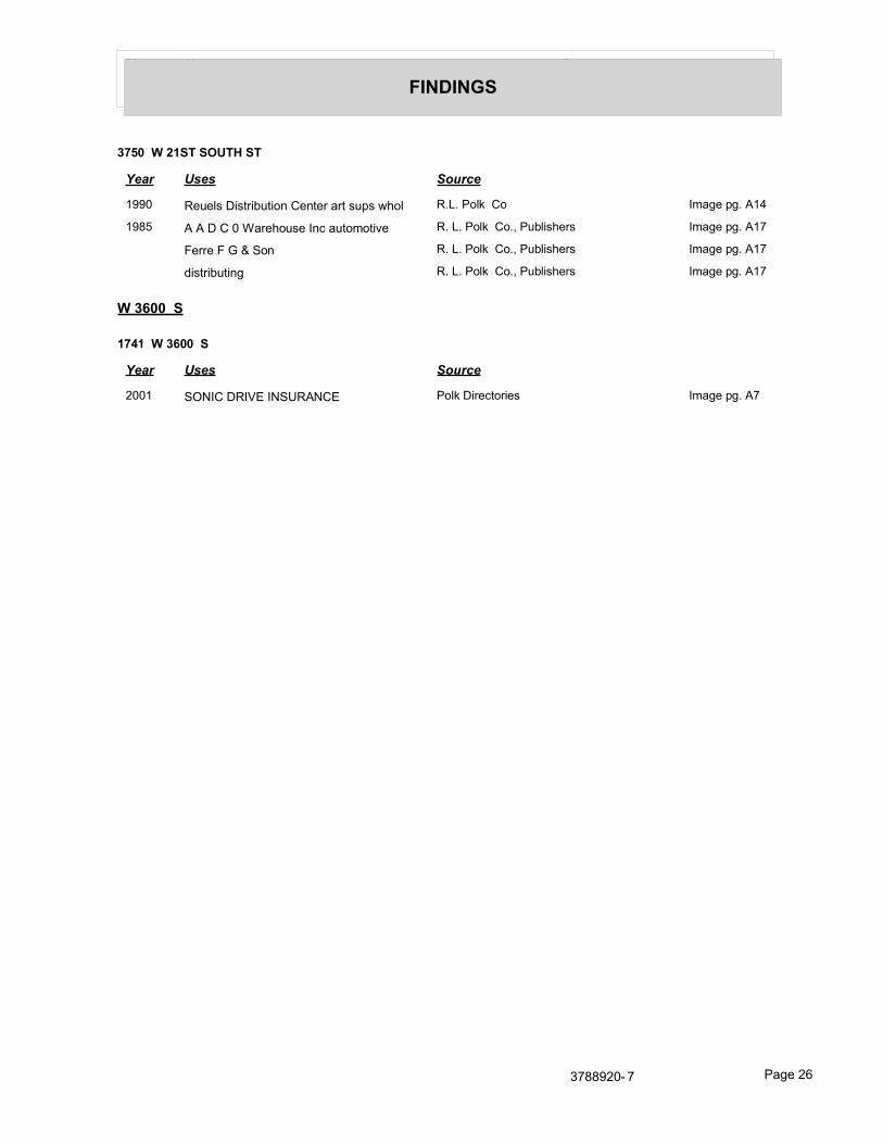
Year Uses Source
FINDINGS
3750 W 21ST SOUTH ST
Year Uses Source
1990 Reuels Distribution Center art sups whol R.L. Polk Co Image pg. A14
1985 A A D C 0 Warehouse Inc automotive R. L. Polk Co., Publishers Image pg. A17
Ferre F G & Son R. L. Polk Co., Publishers Image pg. A17
distributing R. L. Polk Co., Publishers Image pg. A17
W 3600 S
1741 W 3600 S
Year Uses Source
2001 SONIC DRIVE INSURANCE Polk Directories Image pg. A7
3788920- 7 Page 26

FINDINGS
TARGET PROPERTY: ADDRESS NOT IDENTIFIED IN RESEARCH SOURCE
The following Target Property addresses were researched for this report, and the addresses were not identified in the research source.
Address Researched Address Not Identified in Research Source
3607-3667 West 1987 South 2007, 2000, 1995, 1991, 1981, 1980, 1976, 1975, 1971, 1970, 1965, 1961, 1956, 1951, 1946, 1941, 1936, 1931, 1926
ADJOINING PROPERTY: ADDRESSES NOT IDENTIFIED IN RESEARCH SOURCE
The following Adjoining Property addresses were researched for this report, and the addresses were not identified in research source.
Address Researched Address Not Identified in Research Source
1987/S 3600 W 2013, 2008, 2007, 2000, 1995, 1991, 1990, 1985, 1981, 1980, 1976, 1975, 1971, 1970, 1965, 1961, 1956, 1951, 1946, 1941, 1936, 1931, 1926
2100/3730 2013, 2008, 2007, 2000, 1995, 1991, 1990, 1985, 1981, 1980, 1976, 1975, 1971, 1970, 1965, 1961, 1956, 1951, 1946, 1941, 1936, 1931, 1926
2100/S 3600 W 2013, 2008, 2007, 1995, 1991, 1990, 1985, 1981, 1980, 1976, 1975, 1971, 1970, 1965, 1961, 1956, 1951, 1946, 1941, 1936, 1931, 1926
3600/W 1987 S 2013, 2008, 2007, 2000, 1995, 1991, 1990, 1985, 1981, 1980, 1976, 1975, 1971, 1970, 1965, 1961, 1956, 1951, 1946, 1941, 1936, 1931, 1926
3600/W 2100 S 2013, 2008, 2007, 2000, 1995, 1991, 1990, 1985, 1981, 1980, 1976, 1975, 1971, 1970, 1965, 1961, 1956, 1951, 1946, 1941, 1936, 1931, 1926
3730/W 1987 S 2013, 2008, 2007, 2000, 1995, 1991, 1990, 1985, 1981, 1980, 1976, 1975, 1971, 1970, 1965, 1961, 1956, 1951, 1946, 1941, 1936, 1931, 1926
1741 W 3600 S 2013, 2008, 2007, 2000, 1995, 1991, 1990, 1985, 1981, 1980, 1976, 1975, 1971, 1970, 1965, 1961, 1956, 1951, 1946, 1941, 1936, 1931, 1926
1991 S 3600 W 2013, 2008, 2007, 2000, 1995, 1991, 1990, 1985, 1981, 1980, 1976, 1975, 1971, 1970, 1965, 1961, 1956, 1951, 1946, 1941, 1936, 1931, 1926
1991 S 3600 W 2007, 2001, 2000, 1995, 1991, 1990, 1985, 1981, 1980, 1976, 1975, 1971, 1970, 1965, 1961, 1956, 1951, 1946, 1941, 1936, 1931, 1926
1991 S 3600 WEST ST 2013, 2008, 2007, 2001, 2000, 1995, 1991, 1981, 1980, 1976, 1975, 1971, 1970, 1965, 1961, 1956, 1951, 1946, 1941, 1936, 1931, 1926
2030 E 3600 S 2013, 2008, 2007, 2001, 2000, 1991, 1990, 1985, 1981, 1980, 1976, 1975, 1971, 1970, 1965, 1961, 1956, 1951, 1946, 1941, 1936, 1931, 1926
2068 N 3600 W 2013, 2008, 2007, 2001, 2000, 1991, 1990, 1985, 1981, 1980, 1976, 1975, 1971, 1970, 1965, 1961, 1956, 1951, 1946, 1941, 1936, 1931, 1926
2080 E 3600 S 2013, 2008, 2007, 2001, 2000, 1991, 1990, 1985, 1981, 1980, 1976, 1975, 1971, 1970, 1965, 1961, 1956, 1951, 1946, 1941, 1936, 1931, 1926
3608 W 1987 SOUTH ST 2013, 2008, 2007, 2001, 2000, 1995, 1991, 1990, 1981, 1980, 1976, 1975, 1971, 1970, 1965, 1961, 1956, 1951, 1946, 1941, 1936, 1931, 1926
3608 W 2100 S 2013, 2008, 2007, 2000, 1995, 1991, 1990, 1985, 1981, 1980, 1976, 1975, 1971, 1970, 1965, 1961, 1956, 1951, 1946, 1941, 1936, 1931, 1926
3608 W 2100 S 2007, 2001, 2000, 1995, 1991, 1990, 1985, 1981, 1980, 1976, 1975, 1971, 1970, 1965, 1961, 1956, 1951, 1946, 1941, 1936, 1931, 1926
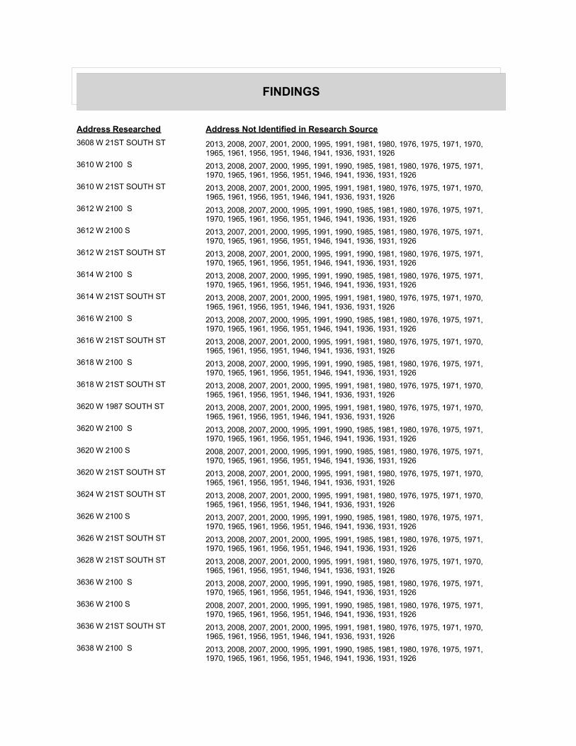
FINDINGS
Address Researched Address Not Identified in Research Source
3608 W 21ST SOUTH ST 2013, 2008, 2007, 2001, 2000, 1995, 1991, 1981, 1980, 1976, 1975, 1971, 1970, 1965, 1961, 1956, 1951, 1946, 1941, 1936, 1931, 1926
3610 W 2100 S 2013, 2008, 2007, 2000, 1995, 1991, 1990, 1985, 1981, 1980, 1976, 1975, 1971, 1970, 1965, 1961, 1956, 1951, 1946, 1941, 1936, 1931, 1926
3610 W 21ST SOUTH ST 2013, 2008, 2007, 2001, 2000, 1995, 1991, 1981, 1980, 1976, 1975, 1971, 1970, 1965, 1961, 1956, 1951, 1946, 1941, 1936, 1931, 1926
3612 W 2100 S 2013, 2008, 2007, 2000, 1995, 1991, 1990, 1985, 1981, 1980, 1976, 1975, 1971, 1970, 1965, 1961, 1956, 1951, 1946, 1941, 1936, 1931, 1926
3612 W 2100 S 2013, 2007, 2001, 2000, 1995, 1991, 1990, 1985, 1981, 1980, 1976, 1975, 1971, 1970, 1965, 1961, 1956, 1951, 1946, 1941, 1936, 1931, 1926
3612 W 21ST SOUTH ST 2013, 2008, 2007, 2001, 2000, 1995, 1991, 1990, 1981, 1980, 1976, 1975, 1971, 1970, 1965, 1961, 1956, 1951, 1946, 1941, 1936, 1931, 1926
3614 W 2100 S 2013, 2008, 2007, 2000, 1995, 1991, 1990, 1985, 1981, 1980, 1976, 1975, 1971, 1970, 1965, 1961, 1956, 1951, 1946, 1941, 1936, 1931, 1926
3614 W 21ST SOUTH ST 2013, 2008, 2007, 2001, 2000, 1995, 1991, 1981, 1980, 1976, 1975, 1971, 1970, 1965, 1961, 1956, 1951, 1946, 1941, 1936, 1931, 1926
3616 W 2100 S 2013, 2008, 2007, 2000, 1995, 1991, 1990, 1985, 1981, 1980, 1976, 1975, 1971, 1970, 1965, 1961, 1956, 1951, 1946, 1941, 1936, 1931, 1926
3616 W 21ST SOUTH ST 2013, 2008, 2007, 2001, 2000, 1995, 1991, 1981, 1980, 1976, 1975, 1971, 1970, 1965, 1961, 1956, 1951, 1946, 1941, 1936, 1931, 1926
3618 W 2100 S 2013, 2008, 2007, 2000, 1995, 1991, 1990, 1985, 1981, 1980, 1976, 1975, 1971, 1970, 1965, 1961, 1956, 1951, 1946, 1941, 1936, 1931, 1926
3618 W 21ST SOUTH ST 2013, 2008, 2007, 2001, 2000, 1995, 1991, 1981, 1980, 1976, 1975, 1971, 1970, 1965, 1961, 1956, 1951, 1946, 1941, 1936, 1931, 1926
3620 W 1987 SOUTH ST 2013, 2008, 2007, 2001, 2000, 1995, 1991, 1981, 1980, 1976, 1975, 1971, 1970, 1965, 1961, 1956, 1951, 1946, 1941, 1936, 1931, 1926
3620 W 2100 S 2013, 2008, 2007, 2000, 1995, 1991, 1990, 1985, 1981, 1980, 1976, 1975, 1971, 1970, 1965, 1961, 1956, 1951, 1946, 1941, 1936, 1931, 1926
3620 W 2100 S 2008, 2007, 2001, 2000, 1995, 1991, 1990, 1985, 1981, 1980, 1976, 1975, 1971, 1970, 1965, 1961, 1956, 1951, 1946, 1941, 1936, 1931, 1926
3620 W 21ST SOUTH ST 2013, 2008, 2007, 2001, 2000, 1995, 1991, 1981, 1980, 1976, 1975, 1971, 1970, 1965, 1961, 1956, 1951, 1946, 1941, 1936, 1931, 1926
3624 W 21ST SOUTH ST 2013, 2008, 2007, 2001, 2000, 1995, 1991, 1981, 1980, 1976, 1975, 1971, 1970, 1965, 1961, 1956, 1951, 1946, 1941, 1936, 1931, 1926
3626 W 2100 S 2013, 2007, 2001, 2000, 1995, 1991, 1990, 1985, 1981, 1980, 1976, 1975, 1971, 1970, 1965, 1961, 1956, 1951, 1946, 1941, 1936, 1931, 1926
3626 W 21ST SOUTH ST 2013, 2008, 2007, 2001, 2000, 1995, 1991, 1985, 1981, 1980, 1976, 1975, 1971, 1970, 1965, 1961, 1956, 1951, 1946, 1941, 1936, 1931, 1926
3628 W 21ST SOUTH ST 2013, 2008, 2007, 2001, 2000, 1995, 1991, 1981, 1980, 1976, 1975, 1971, 1970, 1965, 1961, 1956, 1951, 1946, 1941, 1936, 1931, 1926
3636 W 2100 S 2013, 2008, 2007, 2000, 1995, 1991, 1990, 1985, 1981, 1980, 1976, 1975, 1971, 1970, 1965, 1961, 1956, 1951, 1946, 1941, 1936, 1931, 1926
3636 W 2100 S 2008, 2007, 2001, 2000, 1995, 1991, 1990, 1985, 1981, 1980, 1976, 1975, 1971, 1970, 1965, 1961, 1956, 1951, 1946, 1941, 1936, 1931, 1926
3636 W 21ST SOUTH ST 2013, 2008, 2007, 2001, 2000, 1995, 1991, 1981, 1980, 1976, 1975, 1971, 1970, 1965, 1961, 1956, 1951, 1946, 1941, 1936, 1931, 1926
3638 W 2100 S 2013, 2008, 2007, 2000, 1995, 1991, 1990, 1985, 1981, 1980, 1976, 1975, 1971, 1970, 1965, 1961, 1956, 1951, 1946, 1941, 1936, 1931, 1926

FINDINGS
Address Researched Address Not Identified in Research Source
3638 W 2100 S 2013, 2007, 2001, 2000, 1995, 1991, 1990, 1985, 1981, 1980, 1976, 1975, 1971, 1970, 1965, 1961, 1956, 1951, 1946, 1941, 1936, 1931, 1926
3638 W 21ST SOUTH ST 2013, 2008, 2007, 2001, 2000, 1995, 1991, 1981, 1980, 1976, 1975, 1971, 1970, 1965, 1961, 1956, 1951, 1946, 1941, 1936, 1931, 1926
3640 W 2100 S 2008, 2007, 2001, 2000, 1995, 1991, 1990, 1985, 1981, 1980, 1976, 1975, 1971, 1970, 1965, 1961, 1956, 1951, 1946, 1941, 1936, 1931, 1926
3640 W 21ST SOUTH ST 2013, 2008, 2007, 2001, 2000, 1995, 1991, 1981, 1980, 1976, 1975, 1971, 1970, 1965, 1961, 1956, 1951, 1946, 1941, 1936, 1931, 1926
3642 W 21ST SOUTH ST 2013, 2008, 2007, 2001, 2000, 1995, 1991, 1981, 1980, 1976, 1975, 1971, 1970, 1965, 1961, 1956, 1951, 1946, 1941, 1936, 1931, 1926
3644 W 2100 S 2008, 2007, 2001, 2000, 1995, 1991, 1990, 1985, 1981, 1980, 1976, 1975, 1971, 1970, 1965, 1961, 1956, 1951, 1946, 1941, 1936, 1931, 1926
3644 W 21ST SOUTH ST 2013, 2008, 2007, 2001, 2000, 1995, 1991, 1981, 1980, 1976, 1975, 1971, 1970, 1965, 1961, 1956, 1951, 1946, 1941, 1936, 1931, 1926
3646 W 2100 S 2013, 2008, 2007, 2000, 1995, 1991, 1990, 1985, 1981, 1980, 1976, 1975, 1971, 1970, 1965, 1961, 1956, 1951, 1946, 1941, 1936, 1931, 1926
3646 W 2100 S 2007, 2001, 2000, 1995, 1991, 1990, 1985, 1981, 1980, 1976, 1975, 1971, 1970, 1965, 1961, 1956, 1951, 1946, 1941, 1936, 1931, 1926
3646 W 21ST SOUTH ST 2013, 2008, 2007, 2001, 2000, 1995, 1991, 1990, 1981, 1980, 1976, 1975, 1971, 1970, 1965, 1961, 1956, 1951, 1946, 1941, 1936, 1931, 1926
3648 W 2100 S 2013, 2008, 2007, 2000, 1995, 1991, 1990, 1985, 1981, 1980, 1976, 1975, 1971, 1970, 1965, 1961, 1956, 1951, 1946, 1941, 1936, 1931, 1926
3648 W 2100 S 2008, 2007, 2001, 2000, 1995, 1991, 1990, 1985, 1981, 1980, 1976, 1975, 1971, 1970, 1965, 1961, 1956, 1951, 1946, 1941, 1936, 1931, 1926
3648 W 21ST SOUTH ST 2013, 2008, 2007, 2001, 2000, 1995, 1991, 1990, 1981, 1980, 1976, 1975, 1971, 1970, 1965, 1961, 1956, 1951, 1946, 1941, 1936, 1931, 1926
3650 W 21ST SOUTH ST 2013, 2008, 2007, 2001, 2000, 1995, 1991, 1981, 1980, 1976, 1975, 1971, 1970, 1965, 1961, 1956, 1951, 1946, 1941, 1936, 1931, 1926
3652 W 2100 S 2008, 2007, 2001, 2000, 1995, 1991, 1990, 1985, 1981, 1980, 1976, 1975, 1971, 1970, 1965, 1961, 1956, 1951, 1946, 1941, 1936, 1931, 1926
3652 W 21ST SOUTH ST 2013, 2008, 2007, 2001, 2000, 1995, 1991, 1981, 1980, 1976, 1975, 1971, 1970, 1965, 1961, 1956, 1951, 1946, 1941, 1936, 1931, 1926
3654 W 21ST SOUTH ST 2013, 2008, 2007, 2001, 2000, 1995, 1991, 1981, 1980, 1976, 1975, 1971, 1970, 1965, 1961, 1956, 1951, 1946, 1941, 1936, 1931, 1926
3656 W 2100 S 2007, 2001, 2000, 1995, 1991, 1990, 1985, 1981, 1980, 1976, 1975, 1971, 1970, 1965, 1961, 1956, 1951, 1946, 1941, 1936, 1931, 1926
3656 W 21ST SOUTH ST 2013, 2008, 2007, 2001, 2000, 1995, 1991, 1981, 1980, 1976, 1975, 1971, 1970, 1965, 1961, 1956, 1951, 1946, 1941, 1936, 1931, 1926
3658 W 2100 S 2008, 2007, 2001, 2000, 1995, 1991, 1990, 1985, 1981, 1980, 1976, 1975, 1971, 1970, 1965, 1961, 1956, 1951, 1946, 1941, 1936, 1931, 1926
3658 W 21ST SOUTH ST 2013, 2008, 2007, 2001, 2000, 1995, 1991, 1990, 1981, 1980, 1976, 1975, 1971, 1970, 1965, 1961, 1956, 1951, 1946, 1941, 1936, 1931, 1926
3662 W 21ST SOUTH ST 2013, 2008, 2007, 2001, 2000, 1995, 1991, 1981, 1980, 1976, 1975, 1971, 1970, 1965, 1961, 1956, 1951, 1946, 1941, 1936, 1931, 1926
3664 W 2100 S 2013, 2008, 2007, 2000, 1995, 1991, 1990, 1985, 1981, 1980, 1976, 1975, 1971, 1970, 1965, 1961, 1956, 1951, 1946, 1941, 1936, 1931, 1926
3664 W 21ST SOUTH ST 2013, 2008, 2007, 2001, 2000, 1995, 1991, 1981, 1980, 1976, 1975, 1971, 1970, 1965, 1961, 1956, 1951, 1946, 1941, 1936, 1931, 1926

FINDINGS
Address Researched Address Not Identified in Research Source
3666 W 2100 S 2013, 2008, 2007, 2000, 1995, 1991, 1990, 1985, 1981, 1980, 1976, 1975, 1971, 1970, 1965, 1961, 1956, 1951, 1946, 1941, 1936, 1931, 1926
3666 W 2100 S 2008, 2007, 2001, 2000, 1995, 1991, 1990, 1985, 1981, 1980, 1976, 1975, 1971, 1970, 1965, 1961, 1956, 1951, 1946, 1941, 1936, 1931, 1926
3666 W 21ST SOUTH ST 2013, 2008, 2007, 2001, 2000, 1995, 1991, 1981, 1980, 1976, 1975, 1971, 1970, 1965, 1961, 1956, 1951, 1946, 1941, 1936, 1931, 1926
3668 W 2100 S 2013, 2008, 2007, 2000, 1995, 1991, 1990, 1985, 1981, 1980, 1976, 1975, 1971, 1970, 1965, 1961, 1956, 1951, 1946, 1941, 1936, 1931, 1926
3668 W 21ST SOUTH ST 2013, 2008, 2007, 2001, 2000, 1995, 1991, 1981, 1980, 1976, 1975, 1971, 1970, 1965, 1961, 1956, 1951, 1946, 1941, 1936, 1931, 1926
3669 W 1987 SOUTH ST 2013, 2008, 2007, 2001, 2000, 1995, 1991, 1981, 1980, 1976, 1975, 1971, 1970, 1965, 1961, 1956, 1951, 1946, 1941, 1936, 1931, 1926
3670 W 2100 S 2013, 2008, 2007, 2000, 1995, 1991, 1990, 1985, 1981, 1980, 1976, 1975, 1971, 1970, 1965, 1961, 1956, 1951, 1946, 1941, 1936, 1931, 1926
3670 W 2100 S 2008, 2007, 2001, 2000, 1995, 1991, 1990, 1985, 1981, 1980, 1976, 1975, 1971, 1970, 1965, 1961, 1956, 1951, 1946, 1941, 1936, 1931, 1926
3670 W 21ST SOUTH ST 2013, 2008, 2007, 2001, 2000, 1995, 1991, 1990, 1981, 1980, 1976, 1975, 1971, 1970, 1965, 1961, 1956, 1951, 1946, 1941, 1936, 1931, 1926
3671 W 1987 SOUTH ST 2013, 2008, 2007, 2001, 2000, 1995, 1991, 1990, 1981, 1980, 1976, 1975, 1971, 1970, 1965, 1961, 1956, 1951, 1946, 1941, 1936, 1931, 1926
3672 W 2100 S 2013, 2008, 2007, 2000, 1995, 1991, 1990, 1985, 1981, 1980, 1976, 1975, 1971, 1970, 1965, 1961, 1956, 1951, 1946, 1941, 1936, 1931, 1926
3672 W 2100 S 2008, 2007, 2001, 2000, 1995, 1991, 1990, 1985, 1981, 1980, 1976, 1975, 1971, 1970, 1965, 1961, 1956, 1951, 1946, 1941, 1936, 1931, 1926
3672 W 21ST SOUTH ST 2013, 2008, 2007, 2001, 2000, 1995, 1991, 1981, 1980, 1976, 1975, 1971, 1970, 1965, 1961, 1956, 1951, 1946, 1941, 1936, 1931, 1926
3673 W 1987 S 2013, 2008, 2007, 2000, 1995, 1991, 1990, 1985, 1981, 1980, 1976, 1975, 1971, 1970, 1965, 1961, 1956, 1951, 1946, 1941, 1936, 1931, 1926
3673 W 1987 S 2008, 2007, 2001, 2000, 1995, 1991, 1990, 1985, 1981, 1980, 1976, 1975, 1971, 1970, 1965, 1961, 1956, 1951, 1946, 1941, 1936, 1931, 1926
3673 W 1987 SOUTH ST 2013, 2008, 2007, 2001, 2000, 1995, 1991, 1981, 1980, 1976, 1975, 1971, 1970, 1965, 1961, 1956, 1951, 1946, 1941, 1936, 1931, 1926
3674 W 2100 S 2013, 2008, 2007, 2000, 1995, 1991, 1990, 1985, 1981, 1980, 1976, 1975, 1971, 1970, 1965, 1961, 1956, 1951, 1946, 1941, 1936, 1931, 1926
3674 W 2100 S 2008, 2007, 2001, 2000, 1995, 1991, 1990, 1985, 1981, 1980, 1976, 1975, 1971, 1970, 1965, 1961, 1956, 1951, 1946, 1941, 1936, 1931, 1926
3674 W 21ST SOUTH ST 2013, 2008, 2007, 2001, 2000, 1995, 1991, 1981, 1980, 1976, 1975, 1971, 1970, 1965, 1961, 1956, 1951, 1946, 1941, 1936, 1931, 1926
3675 W 1987 SOUTH ST 2013, 2008, 2007, 2001, 2000, 1995, 1991, 1981, 1980, 1976, 1975, 1971, 1970, 1965, 1961, 1956, 1951, 1946, 1941, 1936, 1931, 1926
3676 W 2100 S 2013, 2008, 2007, 2000, 1995, 1991, 1990, 1985, 1981, 1980, 1976, 1975, 1971, 1970, 1965, 1961, 1956, 1951, 1946, 1941, 1936, 1931, 1926
3676 W 21ST SOUTH ST 2013, 2008, 2007, 2001, 2000, 1995, 1991, 1981, 1980, 1976, 1975, 1971, 1970, 1965, 1961, 1956, 1951, 1946, 1941, 1936, 1931, 1926
3677 W 1987 S 2008, 2007, 2001, 2000, 1995, 1991, 1990, 1985, 1981, 1980, 1976, 1975, 1971, 1970, 1965, 1961, 1956, 1951, 1946, 1941, 1936, 1931, 1926
3677 W 1987 SOUTH ST 2013, 2008, 2007, 2001, 2000, 1995, 1991, 1981, 1980, 1976, 1975, 1971, 1970, 1965, 1961, 1956, 1951, 1946, 1941, 1936, 1931, 1926

FINDINGS
Address Researched Address Not Identified in Research Source
3678 W 21ST SOUTH ST 2013, 2008, 2007, 2001, 2000, 1995, 1991, 1981, 1980, 1976, 1975, 1971, 1970, 1965, 1961, 1956, 1951, 1946, 1941, 1936, 1931, 1926
3679 W 1987 SOUTH ST 2013, 2008, 2007, 2001, 2000, 1995, 1991, 1981, 1980, 1976, 1975, 1971, 1970, 1965, 1961, 1956, 1951, 1946, 1941, 1936, 1931, 1926
3681 W 1987 S 2013, 2008, 2007, 2000, 1995, 1991, 1990, 1985, 1981, 1980, 1976, 1975, 1971, 1970, 1965, 1961, 1956, 1951, 1946, 1941, 1936, 1931, 1926
3681 W 1987 S 2013, 2007, 2001, 2000, 1995, 1991, 1990, 1985, 1981, 1980, 1976, 1975, 1971, 1970, 1965, 1961, 1956, 1951, 1946, 1941, 1936, 1931, 1926
3681 W 1987 SOUTH ST 2013, 2008, 2007, 2001, 2000, 1995, 1991, 1981, 1980, 1976, 1975, 1971, 1970, 1965, 1961, 1956, 1951, 1946, 1941, 1936, 1931, 1926
3682 W 2100 S 2013, 2008, 2007, 2000, 1991, 1990, 1985, 1981, 1980, 1976, 1975, 1971, 1970, 1965, 1961, 1956, 1951, 1946, 1941, 1936, 1931, 1926
3682 W 21ST SOUTH ST 2013, 2008, 2007, 2001, 2000, 1995, 1991, 1981, 1980, 1976, 1975, 1971, 1970, 1965, 1961, 1956, 1951, 1946, 1941, 1936, 1931, 1926
3683 W 1987 S 2007, 2001, 2000, 1995, 1991, 1990, 1985, 1981, 1980, 1976, 1975, 1971, 1970, 1965, 1961, 1956, 1951, 1946, 1941, 1936, 1931, 1926
3683 W 1987 SOUTH ST 2013, 2008, 2007, 2001, 2000, 1995, 1991, 1981, 1980, 1976, 1975, 1971, 1970, 1965, 1961, 1956, 1951, 1946, 1941, 1936, 1931, 1926
3684 W 2100 S 2013, 2008, 2007, 2000, 1995, 1991, 1990, 1985, 1981, 1980, 1976, 1975, 1971, 1970, 1965, 1961, 1956, 1951, 1946, 1941, 1936, 1931, 1926
3684 W 21ST SOUTH ST 2013, 2008, 2007, 2001, 2000, 1995, 1991, 1981, 1980, 1976, 1975, 1971, 1970, 1965, 1961, 1956, 1951, 1946, 1941, 1936, 1931, 1926
3686 W 21ST SOUTH ST 2013, 2008, 2007, 2001, 2000, 1995, 1991, 1981, 1980, 1976, 1975, 1971, 1970, 1965, 1961, 1956, 1951, 1946, 1941, 1936, 1931, 1926
3688 W 21ST SOUTH ST 2013, 2008, 2007, 2001, 2000, 1995, 1991, 1981, 1980, 1976, 1975, 1971, 1970, 1965, 1961, 1956, 1951, 1946, 1941, 1936, 1931, 1926
3689 W 1987 SOUTH ST 2013, 2008, 2007, 2001, 2000, 1995, 1991, 1981, 1980, 1976, 1975, 1971, 1970, 1965, 1961, 1956, 1951, 1946, 1941, 1936, 1931, 1926
3690 W 21ST SOUTH ST 2013, 2008, 2007, 2001, 2000, 1995, 1991, 1981, 1980, 1976, 1975, 1971, 1970, 1965, 1961, 1956, 1951, 1946, 1941, 1936, 1931, 1926
3691 W 1987 S 2013, 2008, 2007, 2000, 1995, 1991, 1990, 1985, 1981, 1980, 1976, 1975, 1971, 1970, 1965, 1961, 1956, 1951, 1946, 1941, 1936, 1931, 1926
3691 W 1987 S 2007, 2001, 2000, 1995, 1991, 1990, 1985, 1981, 1980, 1976, 1975, 1971, 1970, 1965, 1961, 1956, 1951, 1946, 1941, 1936, 1931, 1926
3691 W 1987 SOUTH ST 2013, 2008, 2007, 2001, 2000, 1995, 1991, 1981, 1980, 1976, 1975, 1971, 1970, 1965, 1961, 1956, 1951, 1946, 1941, 1936, 1931, 1926
3692 W 2100 S 2013, 2008, 2007, 2000, 1995, 1991, 1990, 1985, 1981, 1980, 1976, 1975, 1971, 1970, 1965, 1961, 1956, 1951, 1946, 1941, 1936, 1931, 1926
3692 W 21ST SOUTH ST 2013, 2008, 2007, 2001, 2000, 1995, 1991, 1981, 1980, 1976, 1975, 1971, 1970, 1965, 1961, 1956, 1951, 1946, 1941, 1936, 1931, 1926
3693 W 1987 SOUTH ST 2013, 2008, 2007, 2001, 2000, 1995, 1991, 1981, 1980, 1976, 1975, 1971, 1970, 1965, 1961, 1956, 1951, 1946, 1941, 1936, 1931, 1926
3695 W 1987 S 2008, 2007, 2001, 2000, 1995, 1991, 1990, 1985, 1981, 1980, 1976, 1975, 1971, 1970, 1965, 1961, 1956, 1951, 1946, 1941, 1936, 1931, 1926
3695 W 1987 SOUTH ST 2013, 2008, 2007, 2001, 2000, 1995, 1991, 1981, 1980, 1976, 1975, 1971, 1970, 1965, 1961, 1956, 1951, 1946, 1941, 1936, 1931, 1926
3696 W 2100 S 2013, 2008, 2007, 2000, 1995, 1991, 1990, 1985, 1981, 1980, 1976, 1975, 1971, 1970, 1965, 1961, 1956, 1951, 1946, 1941, 1936, 1931, 1926

FINDINGS
Address Researched Address Not Identified in Research Source
3696 W 21ST SOUTH ST 2013, 2008, 2007, 2001, 2000, 1995, 1991, 1990, 1981, 1980, 1976, 1975, 1971, 1970, 1965, 1961, 1956, 1951, 1946, 1941, 1936, 1931, 1926
3697 W 1987 SOUTH ST 2013, 2008, 2007, 2001, 2000, 1995, 1991, 1981, 1980, 1976, 1975, 1971, 1970, 1965, 1961, 1956, 1951, 1946, 1941, 1936, 1931, 1926
3698 W 2100 S 2013, 2008, 2007, 2000, 1995, 1991, 1990, 1985, 1981, 1980, 1976, 1975, 1971, 1970, 1965, 1961, 1956, 1951, 1946, 1941, 1936, 1931, 1926
3698 W 21ST SOUTH ST 2013, 2008, 2007, 2001, 2000, 1995, 1991, 1981, 1980, 1976, 1975, 1971, 1970, 1965, 1961, 1956, 1951, 1946, 1941, 1936, 1931, 1926
3699 W 1987 SOUTH ST 2013, 2008, 2007, 2001, 2000, 1995, 1991, 1981, 1980, 1976, 1975, 1971, 1970, 1965, 1961, 1956, 1951, 1946, 1941, 1936, 1931, 1926
3700 W 1987 S 2013, 2008, 2007, 2000, 1995, 1991, 1990, 1985, 1981, 1980, 1976, 1975, 1971, 1970, 1965, 1961, 1956, 1951, 1946, 1941, 1936, 1931, 1926
3700 W 1987 SOUTH ST 2013, 2008, 2007, 2001, 2000, 1995, 1991, 1981, 1980, 1976, 1975, 1971, 1970, 1965, 1961, 1956, 1951, 1946, 1941, 1936, 1931, 1926
3700 W 2100 S 2013, 2008, 2007, 2000, 1995, 1991, 1990, 1985, 1981, 1980, 1976, 1975, 1971, 1970, 1965, 1961, 1956, 1951, 1946, 1941, 1936, 1931, 1926
3700 W 21ST SOUTH ST 2013, 2008, 2007, 2001, 2000, 1995, 1991, 1981, 1980, 1976, 1975, 1971, 1970, 1965, 1961, 1956, 1951, 1946, 1931, 1926
3701 W 1987 S 2013, 2008, 2007, 2000, 1995, 1991, 1990, 1985, 1981, 1980, 1976, 1975, 1971, 1970, 1965, 1961, 1956, 1951, 1946, 1941, 1936, 1931, 1926
3701 W 1987 SOUTH ST 2013, 2008, 2007, 2001, 2000, 1995, 1991, 1981, 1980, 1976, 1975, 1971, 1970, 1965, 1961, 1956, 1951, 1946, 1941, 1936, 1931, 1926
3702 W 21ST SOUTH ST 2013, 2008, 2007, 2001, 2000, 1995, 1991, 1981, 1980, 1976, 1975, 1971, 1970, 1965, 1961, 1956, 1951, 1946, 1941, 1936, 1931, 1926
3703 W 1987 SOUTH ST 2013, 2008, 2007, 2001, 2000, 1995, 1991, 1981, 1980, 1976, 1975, 1971, 1970, 1965, 1961, 1956, 1951, 1946, 1941, 1936, 1931, 1926
3705 W 1987 SOUTH ST 2013, 2008, 2007, 2001, 2000, 1995, 1991, 1981, 1980, 1976, 1975, 1971, 1970, 1965, 1961, 1956, 1951, 1946, 1941, 1936, 1931, 1926
3706 W 21ST SOUTH ST 2013, 2008, 2007, 2001, 2000, 1995, 1991, 1981, 1980, 1976, 1975, 1971, 1970, 1965, 1961, 1956, 1951, 1946, 1941, 1936, 1931, 1926
3707 W 1987 S 2013, 2008, 2007, 2000, 1995, 1991, 1990, 1985, 1981, 1980, 1976, 1975, 1971, 1970, 1965, 1961, 1956, 1951, 1946, 1941, 1936, 1931, 1926
3707 W 1987 SOUTH ST 2013, 2008, 2007, 2001, 2000, 1995, 1991, 1981, 1980, 1976, 1975, 1971, 1970, 1965, 1961, 1956, 1951, 1946, 1941, 1936, 1931, 1926
3710 W 2100 S 2013, 2008, 2007, 2000, 1995, 1991, 1990, 1985, 1981, 1980, 1976, 1975, 1971, 1970, 1965, 1961, 1956, 1951, 1946, 1941, 1936, 1931, 1926
3737 W 2100 S 2013, 2008, 2007, 2000, 1995, 1991, 1990, 1985, 1981, 1980, 1976, 1975, 1971, 1970, 1965, 1961, 1956, 1951, 1946, 1941, 1936, 1931, 1926
3740 W 1987 S 2013, 2008, 2007, 2000, 1995, 1991, 1990, 1985, 1981, 1980, 1976, 1975, 1971, 1970, 1965, 1961, 1956, 1951, 1946, 1941, 1936, 1931, 1926
3740 W 1987 S 2008, 2007, 2001, 2000, 1995, 1991, 1990, 1985, 1981, 1980, 1976, 1975, 1971, 1970, 1965, 1961, 1956, 1951, 1946, 1941, 1936, 1931, 1926
3740 W 1987 SOUTH ST 2013, 2008, 2007, 2001, 2000, 1995, 1991, 1981, 1980, 1976, 1975, 1971, 1970, 1965, 1961, 1956, 1951, 1946, 1941, 1936, 1931, 1926
3750 W 2100 S 2013, 2008, 2007, 2000, 1995, 1991, 1990, 1985, 1981, 1980, 1976, 1975, 1971, 1970, 1965, 1961, 1956, 1951, 1946, 1941, 1936, 1931, 1926
3750 W 21ST SOUTH ST 2013, 2008, 2007, 2001, 2000, 1995, 1991, 1981, 1980, 1976, 1975, 1971, 1970, 1965, 1961, 1956, 1951, 1946, 1941, 1936, 1931, 1926

FINDINGS
Address Researched Address Not Identified in Research Source
38456 S 3600 W 2013, 2008, 2007, 2001, 2000, 1991, 1990, 1985, 1981, 1980, 1976, 1975, 1971, 1970, 1965, 1961, 1956, 1951, 1946, 1941, 1936, 1931, 1926

Source Page Images Appendix

Polk Directories
3788920.7 Page: A1
SourceTP Adjoining
1987/S 3600 W 2001

- Polk Directories
3788920.7 Page: A2
SourceTP Adjoining
2100/3730 2001

- Polk Directories
3788920.7 Page: A3
SourceTP Adjoining
3600/W 1987 S 2001
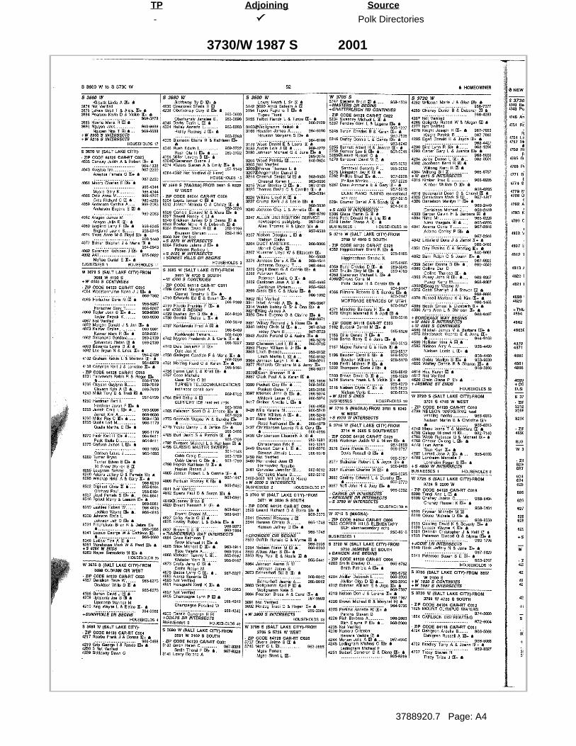
- Polk Directories
3788920.7 Page: A4
SourceTP Adjoining
3730/W 1987 S 2001

- Polk Directories
3788920.7 Page: A5
SourceTP Adjoining
S 3600 W 2001

- Polk Directories
3788920.7 Page: A6
SourceTP Adjoining
W 2100 S 2001

- Polk Directories
3788920.7 Page: A7
SourceTP Adjoining
W 3600 S 2001

- Polk City Directory
3788920.7 Page: A8
SourceTP Adjoining
2100/S 3600 W 2000

- R. L. Polk Co., Publishers
3788920.7 Page: A9
SourceTP Adjoining
E 3600 S 1995

- R. L. Polk Co., Publishers
3788920.7 Page: A10
SourceTP Adjoining
W 2100 S 1995

R.L. Polk Co
3788920.7 Page: A11
SourceTP Adjoining
W 1987 SOUTH ST 1990

- R.L. Polk Co
3788920.7 Page: A12
SourceTP Adjoining
S 3600 WEST ST 1990

- R.L. Polk Co
3788920.7 Page: A13
SourceTP Adjoining
W 21ST SOUTH ST 1990

- R.L. Polk Co
3788920.7 Page: A14
SourceTP Adjoining
W 21ST SOUTH ST 1990

R. L. Polk Co., Publishers
3788920.7 Page: A15
SourceTP Adjoining
W 1987 SOUTH ST 1985

- R. L. Polk Co., Publishers
3788920.7 Page: A16
SourceTP Adjoining
S 3600 WEST ST 1985

- R. L. Polk Co., Publishers
3788920.7 Page: A17
SourceTP Adjoining
W 21ST SOUTH ST 1985
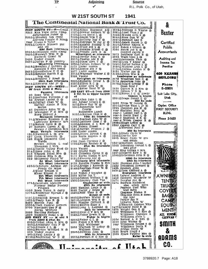
- R.L. Polk Co., of Utah,
3788920.7 Page: A18
SourceTP Adjoining
W 21ST SOUTH ST 1941
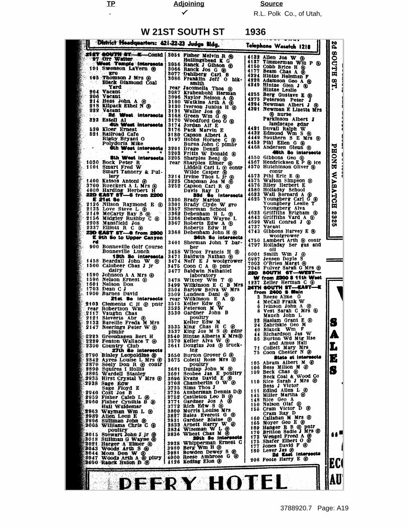
- R.L. Polk Co., of Utah,
3788920.7 Page: A19
SourceTP Adjoining
W 21ST SOUTH ST 1936
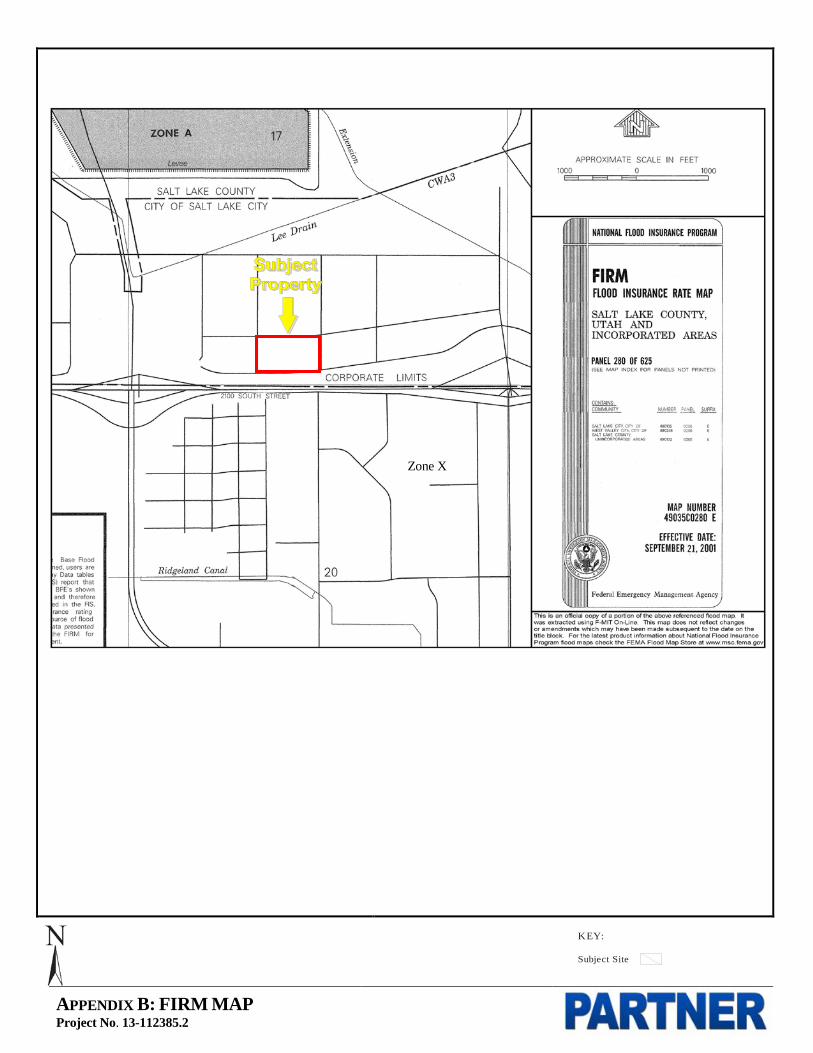
APPENDIX B: FIRM MAP Project No. 13-112385.2
KEY:
Subject Site
Zone X
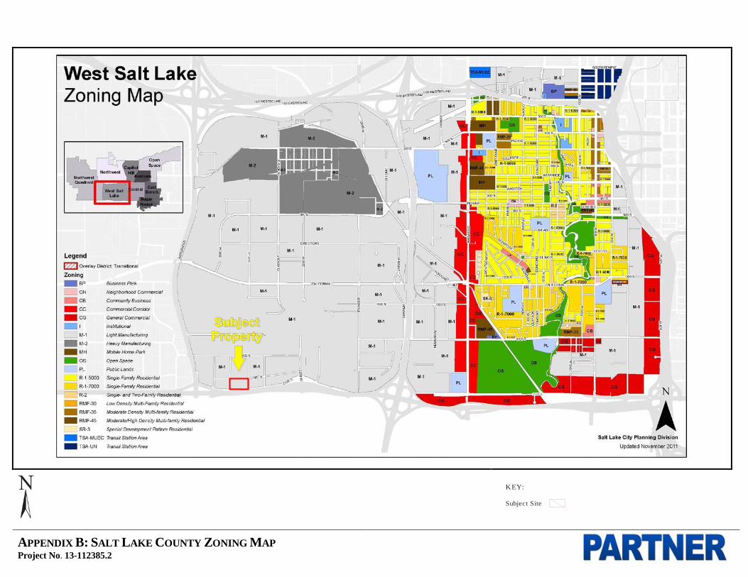
APPENDIX B: SALT LAKE COUNTY ZONING MAP Project No. 13-112385.2
KEY:
Subject Site

APPENDIX B: SALT LAKE COUNTY PARCEL MAP Project No. 13-112385.2
KEY:
Subject Site
Subject Property

APPENDIX B: NATIONAL WETLANDS INVENTORY MAP Project No. 13-112385.2
KEY:
Subject Site

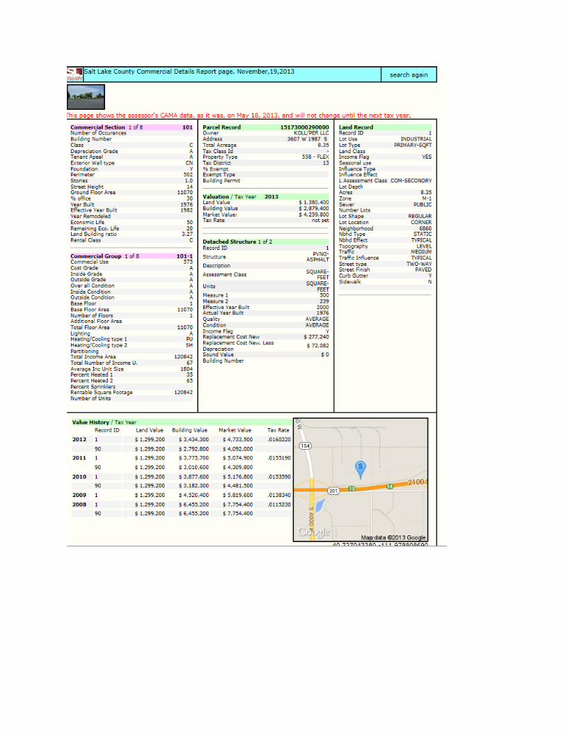

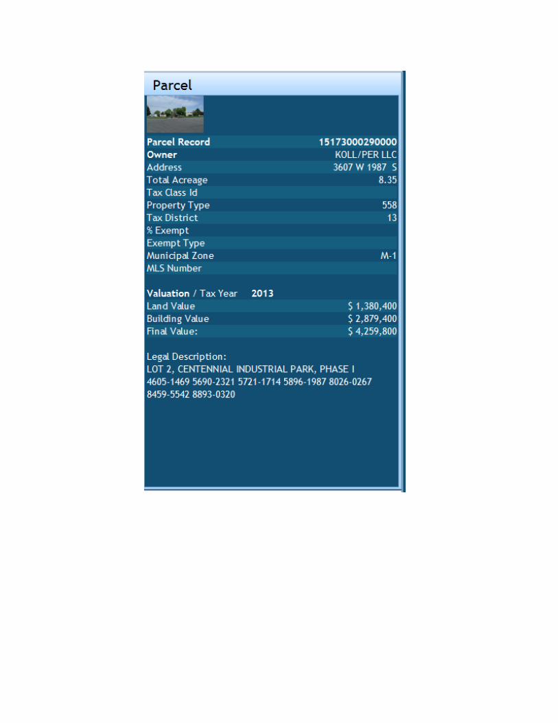

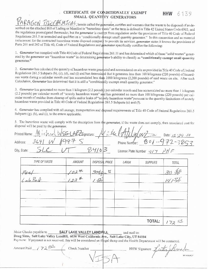

APPENDIX B: NRCS SOIL MAP Project No. 13-112385.2
KEY:
Subject Site

APPENDIX C: REGULATORY DATABASE REPORT

FORM-BPK-ROM
tropeR ™paM suidaR RDE ehT
440 Wheelers Farms RoadMilford, CT 06461Toll Free: 800.352.0050www.edrnet.com
Broadbent Business Park3607-3667 West 1987 SouthSalt Lake City, UT 84104
Inquiry Number: 3788920.2sNovember 18, 2013

SECTION PAGE
Executive Summary ES1
Overview Map 2
Detail Map 3
Map Findings Summary 4
Map Findings 7
Orphan Summary 54
Government Records Searched/Data Currency Tracking GR-1
GEOCHECK ADDENDUM
GeoCheck - Not Requested
TC3788920.2s Page 1
Thank you for your business.Please contact EDR at 1-800-352-0050
with any questions or comments.
Disclaimer - Copyright and Trademark Notice
This Report contains certain information obtained from a variety of public and other sources reasonably available to Environmental DataResources, Inc. It cannot be concluded from this Report that coverage information for the target and surrounding properties does not exist fromother sources. NO WARRANTY EXPRESSED OR IMPLIED, IS MADE WHATSOEVER IN CONNECTION WITH THIS REPORT. ENVIRONMENTALDATA RESOURCES, INC. SPECIFICALLY DISCLAIMS THE MAKING OF ANY SUCH WARRANTIES, INCLUDING WITHOUT LIMITATION,MERCHANTABILITY OR FITNESS FOR A PARTICULAR USE OR PURPOSE. ALL RISK IS ASSUMED BY THE USER. IN NO EVENT SHALLENVIRONMENTAL DATA RESOURCES, INC. BE LIABLE TO ANYONE, WHETHER ARISING OUT OF ERRORS OR OMISSIONS, NEGLIGENCE,ACCIDENT OR ANY OTHER CAUSE, FOR ANY LOSS OF DAMAGE, INCLUDING, WITHOUT LIMITATION, SPECIAL, INCIDENTAL,CONSEQUENTIAL, OR EXEMPLARY DAMAGES. ANY LIABILITY ON THE PART OF ENVIRONMENTAL DATA RESOURCES, INC. IS STRICTLYLIMITED TO A REFUND OF THE AMOUNT PAID FOR THIS REPORT. Purchaser accepts this Report "AS IS". Any analyses, estimates, ratings,environmental risk levels or risk codes provided in this Report are provided for illustrative purposes only, and are not intended to provide, norshould they be interpreted as providing any facts regarding, or prediction or forecast of, any environmental risk for any property. Only a Phase IEnvironmental Site Assessment performed by an environmental professional can provide information regarding the environmental risk for anyproperty. Additionally, the information provided in this Report is not to be construed as legal advice.
Copyright 2013 by Environmental Data Resources, Inc. All rights reserved. Reproduction in any media or format, in wholeor in part, of any report or map of Environmental Data Resources, Inc., or its affiliates, is prohibited without prior written permission.
EDR and its logos (including Sanborn and Sanborn Map) are trademarks of Environmental Data Resources, Inc. or its affiliates. All othertrademarks used herein are the property of their respective owners.
TABLE OF CONTENTS
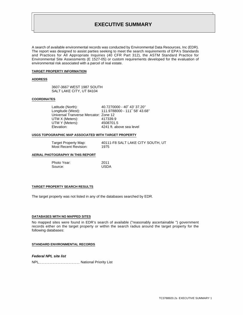
EXECUTIVE SUMMARY
TC3788920.2s EXECUTIVE SUMMARY 1
A search of available environmental records was conducted by Environmental Data Resources, Inc (EDR).The report was designed to assist parties seeking to meet the search requirements of EPA’s Standardsand Practices for All Appropriate Inquiries (40 CFR Part 312), the ASTM Standard Practice forEnvironmental Site Assessments (E 1527-05) or custom requirements developed for the evaluation ofenvironmental risk associated with a parcel of real estate.
TARGET PROPERTY INFORMATION
ADDRESS
3607-3667 WEST 1987 SOUTHSALT LAKE CITY, UT 84104
COORDINATES
40.7270000 - 40˚ 43’ 37.20’’Latitude (North): 111.9788000 - 111˚ 58’ 43.68’’Longitude (West): Zone 12Universal Tranverse Mercator: 417339.9UTM X (Meters): 4508701.5UTM Y (Meters): 4241 ft. above sea levelElevation:
USGS TOPOGRAPHIC MAP ASSOCIATED WITH TARGET PROPERTY
40111-F8 SALT LAKE CITY SOUTH, UTTarget Property Map:1975Most Recent Revision:
AERIAL PHOTOGRAPHY IN THIS REPORT
2011Photo Year:USDASource:
TARGET PROPERTY SEARCH RESULTS
The target property was not listed in any of the databases searched by EDR.
DATABASES WITH NO MAPPED SITES
No mapped sites were found in EDR’s search of available ("reasonably ascertainable ") governmentrecords either on the target property or within the search radius around the target property for thefollowing databases:
STANDARD ENVIRONMENTAL RECORDS
Federal NPL site list
NPL National Priority List
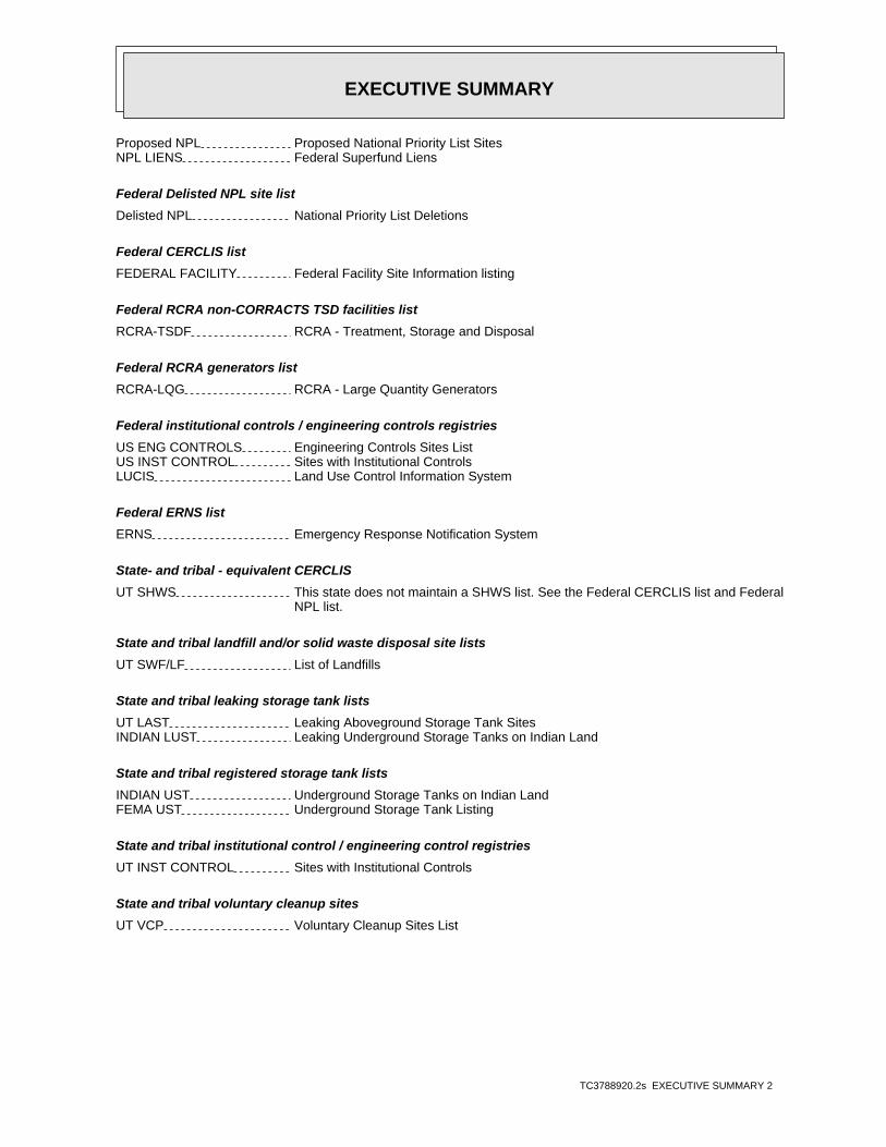
EXECUTIVE SUMMARY
TC3788920.2s EXECUTIVE SUMMARY 2
Proposed NPL Proposed National Priority List SitesNPL LIENS Federal Superfund Liens
Federal Delisted NPL site list
Delisted NPL National Priority List Deletions
Federal CERCLIS list
FEDERAL FACILITY Federal Facility Site Information listing
Federal RCRA non-CORRACTS TSD facilities list
RCRA-TSDF RCRA - Treatment, Storage and Disposal
Federal RCRA generators list
RCRA-LQG RCRA - Large Quantity Generators
Federal institutional controls / engineering controls registries
US ENG CONTROLS Engineering Controls Sites ListUS INST CONTROL Sites with Institutional ControlsLUCIS Land Use Control Information System
Federal ERNS list
ERNS Emergency Response Notification System
State- and tribal - equivalent CERCLIS
UT SHWS This state does not maintain a SHWS list. See the Federal CERCLIS list and Federal NPL list.
State and tribal landfill and/or solid waste disposal site lists
UT SWF/LF List of Landfills
State and tribal leaking storage tank lists
UT LAST Leaking Aboveground Storage Tank SitesINDIAN LUST Leaking Underground Storage Tanks on Indian Land
State and tribal registered storage tank lists
INDIAN UST Underground Storage Tanks on Indian LandFEMA UST Underground Storage Tank Listing
State and tribal institutional control / engineering control registries
UT INST CONTROL Sites with Institutional Controls
State and tribal voluntary cleanup sites
UT VCP Voluntary Cleanup Sites List
EXECUTIVE SUMMARY
TC3788920.2s EXECUTIVE SUMMARY 3
INDIAN VCP Voluntary Cleanup Priority Listing
State and tribal Brownfields sites
UT BROWNFIELDS Brownfields Assessment Sites Listing
ADDITIONAL ENVIRONMENTAL RECORDS
Local Brownfield lists
US BROWNFIELDS A Listing of Brownfields Sites
Local Lists of Landfill / Solid Waste Disposal Sites
DEBRIS REGION 9 Torres Martinez Reservation Illegal Dump Site LocationsODI Open Dump InventoryINDIAN ODI Report on the Status of Open Dumps on Indian Lands
Local Lists of Hazardous waste / Contaminated Sites
US CDL Clandestine Drug LabsUT CDL Methamphetamine Contaminated Properties ListingUS HIST CDL National Clandestine Laboratory Register
Local Land Records
LIENS 2 CERCLA Lien Information
Records of Emergency Release Reports
HMIRS Hazardous Materials Information Reporting SystemUT SPILLS 90 SPILLS 90 data from FirstSearch
Other Ascertainable Records
DOT OPS Incident and Accident DataDOD Department of Defense SitesFUDS Formerly Used Defense SitesCONSENT Superfund (CERCLA) Consent DecreesROD Records Of DecisionUMTRA Uranium Mill Tailings SitesTRIS Toxic Chemical Release Inventory SystemTSCA Toxic Substances Control ActFTTS FIFRA/ TSCA Tracking System - FIFRA (Federal Insecticide, Fungicide, & Rodenticide Act)/TSCA (Toxic Substances Control Act)HIST FTTS FIFRA/TSCA Tracking System Administrative Case ListingSSTS Section 7 Tracking SystemsICIS Integrated Compliance Information SystemPADS PCB Activity Database SystemMLTS Material Licensing Tracking SystemRADINFO Radiation Information DatabaseRAATS RCRA Administrative Action Tracking SystemRMP Risk Management PlansUT UIC UIC Site Location Listing

EXECUTIVE SUMMARY
TC3788920.2s EXECUTIVE SUMMARY 4
UT DRYCLEANERS Registered DrycleanersINDIAN RESERV Indian ReservationsSCRD DRYCLEANERS State Coalition for Remediation of Drycleaners ListingUT FUDS Formerly Used Defense SitesUS FIN ASSUR Financial Assurance InformationEPA WATCH LIST EPA WATCH LISTPRP Potentially Responsible Parties2020 COR ACTION 2020 Corrective Action Program ListPCB TRANSFORMER PCB Transformer Registration DatabaseCOAL ASH DOE Steam-Electric Plant Operation DataCOAL ASH EPA Coal Combustion Residues Surface Impoundments ListLEAD SMELTERS Lead Smelter Sites
EDR HIGH RISK HISTORICAL RECORDS
EDR Exclusive Records
EDR MGP EDR Proprietary Manufactured Gas PlantsEDR US Hist Cleaners EDR Exclusive Historic Dry Cleaners
SURROUNDING SITES: SEARCH RESULTS
Surrounding sites were identified in the following databases.
Elevations have been determined from the USGS Digital Elevation Model and should be evaluated ona relative (not an absolute) basis. Relative elevation information between sites of close proximityshould be field verified. Sites with an elevation equal to or higher than the target property have beendifferentiated below from sites with an elevation lower than the target property.Page numbers and map identification numbers refer to the EDR Radius Map report where detaileddata on individual sites can be reviewed.
Sites listed in bold italics are in multiple databases.
Unmappable (orphan) sites are not considered in the foregoing analysis.
STANDARD ENVIRONMENTAL RECORDS
Federal CERCLIS list
CERCLIS: The Comprehensive Environmental Response, Compensation and Liability Information Systemcontains data on potentially hazardous waste sites that have been reported to the USEPA by states,municipalities, private companies and private persons, pursuant to Section 103 of the ComprehensiveEnvironmental Response, Compensation and Liability Act (CERCLA). CERCLIS contains sites which are eitherproposed to or on the National Priorities List (NPL) and sites which are in the screening and assessment phasefor possible inclusion on the NPL.
A review of the CERCLIS list, as provided by EDR, and dated 04/26/2013 has revealed that there is 1 CERCLIS site within approximately 0.5 miles of the target property.
PageMap IDDirection / Distance Address Equal/Higher Elevation ____________________ ________ ___________________ _____ _____
3700-3800 WEST 2100 SOUTH SOLV 3737 WEST 2100 SOUTH WSW 1/8 - 1/4 (0.199 mi.) E15 26

EXECUTIVE SUMMARY
TC3788920.2s EXECUTIVE SUMMARY 5
Federal CERCLIS NFRAP site List
CERC-NFRAP: Archived sites are sites that have been removed and archived from the inventory of CERCLISsites. Archived status indicates that, to the best of EPA’s knowledge, assessment at a site has been completedand that EPA has determined no further steps will be taken to list this site on the National Priorities List(NPL), unless information indicates this decision was not appropriate or other considerations require arecommendation for listing at a later time. This decision does not necessarily mean that there is no hazardassociated with a given site; it only means that, based upon available information, the location is not judgedto be a potential NPL site.
A review of the CERC-NFRAP list, as provided by EDR, and dated 04/26/2013 has revealed that there is 1 CERC-NFRAP site within approximately 0.5 miles of the target property.
PageMap IDDirection / Distance Address Lower Elevation ____________________ ________ ___________________ _____ _____
GTE/BUSINESS COMMUNICATIONS SY 3880 W 1820 S WNW 1/4 - 1/2 (0.487 mi.) 24 42
Federal RCRA CORRACTS facilities list
CORRACTS: CORRACTS is a list of handlers with RCRA Corrective Action Activity. This report showswhich nationally-defined corrective action core events have occurred for every handler that has had correctiveaction activity.
A review of the CORRACTS list, as provided by EDR, and dated 07/11/2013 has revealed that there is 1 CORRACTS site within approximately 1 mile of the target property.
PageMap IDDirection / Distance Address Equal/Higher Elevation ____________________ ________ ___________________ _____ _____
E-SYSTEMS INC/MONTEK DIV 2268 S 3270 W SE 1/2 - 1 (0.635 mi.) 25 45
Federal RCRA generators list
RCRA-CESQG: RCRAInfo is EPA’s comprehensive information system, providing access to data supportingthe Resource Conservation and Recovery Act (RCRA) of 1976 and the Hazardous and Solid Waste Amendments (HSWA)of 1984. The database includes selective information on sites which generate, transport, store, treat and/ordispose of hazardous waste as defined by the Resource Conservation and Recovery Act (RCRA). Conditionallyexempt small quantity generators (CESQGs) generate less than 100 kg of hazardous waste, or less than 1 kg ofacutely hazardous waste per month.
A review of the RCRA-CESQG list, as provided by EDR, and dated 07/11/2013 has revealed that there are 2 RCRA-CESQG sites within approximately 0.25 miles of the target property.
PageMap IDDirection / Distance Address Equal/Higher Elevation ____________________ ________ ___________________ _____ _____
AMES CONSTRUCTION INC. 3737 WEST 2100 SOUTH WSW 1/8 - 1/4 (0.199 mi.) E14 19
PageMap IDDirection / Distance Address Lower Elevation ____________________ ________ ___________________ _____ _____
SUN PRODUCTS CORPORATION (PREV 3540 WEST 1987 SOUTH ENE 1/8 - 1/4 (0.186 mi.) 11 16

EXECUTIVE SUMMARY
TC3788920.2s EXECUTIVE SUMMARY 6
State and tribal landfill and/or solid waste disposal site lists
WY SWF/LF: The Solid Waste Facilities/Landfill Sites records typically contain an inventory of solidwaste disposal facilities or landfills in a particular state. The data come from the Department ofEnvironmental Quality’s Municipal Landfills/Industrial Landfills list.
A review of the WY SWF/LF list, as provided by EDR, and dated 06/01/2013 has revealed that there is 1 WY SWF/LF site within approximately 0.5 miles of the target property.
PageMap IDDirection / Distance Address Lower Elevation ____________________ ________ ___________________ _____ _____
ET TECHNOLOGIES (52.258) 3556 WEST 2100 SOUTH ESE 1/8 - 1/4 (0.141 mi.) 5 11
State and tribal leaking storage tank lists
UT LUST: The Leaking Underground Storage Tank Incident Reports contain an inventory of reportedleaking underground storage tank incidents. The data come from the Department of Environmental Quality’sPotential Leaking UST Sites.
A review of the UT LUST list, as provided by EDR, and dated 10/22/2013 has revealed that there are 11 UT LUST sites within approximately 0.5 miles of the target property.
PageMap IDDirection / Distance Address Equal/Higher Elevation ____________________ ________ ___________________ _____ _____
CONSTRUCTION EQUIPMENT 2120 S 3600 W SE 1/8 - 1/4 (0.156 mi.) B6 12Date Closed: 07/06/1993
AMES CONSTRUCTION INC. 3737 WEST 2100 SOUTH WSW 1/8 - 1/4 (0.199 mi.) E14 19Date Closed: 03/31/2008
BROWNING-FERRIS INDUSTRIES 3765 W 2100 S WSW 1/8 - 1/4 (0.234 mi.) F17 28Date Closed: 01/05/2004
KUTV, INC. 2185 S 3600 W SSE 1/8 - 1/4 (0.242 mi.) 19 33Date Closed: 11/01/1996
RASMUSSEN EQUIPMENT COMPANY 3333 WEST 2100 SOUTH E 1/4 - 1/2 (0.460 mi.) 23 39Date Closed: 07/08/2002Date Closed: 07/08/1999Date Closed: 04/17/1990
PageMap IDDirection / Distance Address Lower Elevation ____________________ ________ ___________________ _____ _____
HUISH CHEMICAL CO. 3620 W 1987 S NE 0 - 1/8 (0.079 mi.) 4 11Date Closed: 04/20/1998
LAUNDRY SUPPLY CO., INC 3785 W 1987 S WNW 1/8 - 1/4 (0.170 mi.) C9 14Date Closed: 12/09/1996
CARLSON DISTRIBUTING CO, INC. 1864 S 3730 W NNW 1/8 - 1/4 (0.210 mi.) 16 28Date Closed: 03/21/2000
MOUNT OLYMPUS WATERS,INC. 1825 S 3730 W NNW 1/8 - 1/4 (0.249 mi.) 20 34Date Closed: 01/26/1995
MEADOW GOLD DAIRIES, INC. 3730 W 1820 S NNW 1/4 - 1/2 (0.282 mi.) 21 34 PEPSI COLA BOTTLING CO 3388 W 1987 S ENE 1/4 - 1/2 (0.367 mi.) 22 37
Date Closed: 05/02/1995Date Closed: 02/01/2009

EXECUTIVE SUMMARY
TC3788920.2s EXECUTIVE SUMMARY 7
State and tribal registered storage tank lists
UT UST: The Underground Storage Tank database contains a listing of Facility, Owner, Location &Tanks not Closed or Removed. USTs are regulated under Subtitle I of the Resource Conservation and Recovery Act(RCRA). The data come from the Department of Environmental Quality’s Facilities with at Least One Non-exemptTank.
A review of the UT UST list, as provided by EDR, and dated 10/22/2013 has revealed that there are 9 UT UST sites within approximately 0.25 miles of the target property.
PageMap IDDirection / Distance Address Equal/Higher Elevation ____________________ ________ ___________________ _____ _____
CONSTRUCTION EQUIPMENT 2120 S 3600 W SE 1/8 - 1/4 (0.156 mi.) B6 12 AMES CONSTRUCTION INC. 3737 WEST 2100 SOUTH WSW 1/8 - 1/4 (0.199 mi.) E14 19 BROWNING-FERRIS INDUSTRIES 3765 W 2100 S WSW 1/8 - 1/4 (0.234 mi.) F17 28 KUTV, INC. 2185 S 3600 W SSE 1/8 - 1/4 (0.242 mi.) 19 33
PageMap IDDirection / Distance Address Lower Elevation ____________________ ________ ___________________ _____ _____
DIXON PAPER COMPANY 3700 W 1987 S NNW 0 - 1/8 (0.066 mi.) A3 10 HUISH CHEMICAL CO. 3620 W 1987 S NE 0 - 1/8 (0.079 mi.) 4 11 LAUNDRY SUPPLY CO., INC 3785 W 1987 S WNW 1/8 - 1/4 (0.170 mi.) C9 14 CARLSON DISTRIBUTING CO, INC. 1864 S 3730 W NNW 1/8 - 1/4 (0.210 mi.) 16 28 MOUNT OLYMPUS WATERS,INC. 1825 S 3730 W NNW 1/8 - 1/4 (0.249 mi.) 20 34
UT AST: The Aboveground Storage Tank database contains registered ASTs. The data come from theDepartment of Environmental Quality’s Facilities with at Least One Non-exempt Tank.
A review of the UT AST list, as provided by EDR, and dated 09/11/2013 has revealed that there is 1 UT AST site within approximately 0.25 miles of the target property.
PageMap IDDirection / Distance Address Equal/Higher Elevation ____________________ ________ ___________________ _____ _____
AMES CONSTRUCTION INC. 3737 WEST 2100 SOUTH WSW 1/8 - 1/4 (0.199 mi.) E14 19
ADDITIONAL ENVIRONMENTAL RECORDS
Other Ascertainable Records
RCRA NonGen / NLR: RCRAInfo is EPA’s comprehensive information system, providing access to data supportingthe Resource Conservation and Recovery Act (RCRA) of 1976 and the Hazardous and Solid Waste Amendments (HSWA)of 1984. The database includes selective information on sites which generate, transport, store, treat and/ordispose of hazardous waste as defined by the Resource Conservation and Recovery Act (RCRA). Non-Generators donot presently generate hazardous waste.
A review of the RCRA NonGen / NLR list, as provided by EDR, and dated 07/11/2013 has revealed that there are 6 RCRA NonGen / NLR sites within approximately 0.25 miles of the target property.
PageMap IDDirection / Distance Address Equal/Higher Elevation ____________________ ________ ___________________ _____ _____
E.T. TECHNOLOGIES 3656 WEST 2100 SOUTH SSE 0 - 1/8 (0.041 mi.) 1 7 NAUMAN EQUIPMENT HANDLING 2120 SO 3600 W SSE 1/8 - 1/4 (0.161 mi.) B7 12 BROWNING-FERRIS INDUSTRIES OF 3765 WEST 2100 SOUTH WSW 1/8 - 1/4 (0.234 mi.) F18 30
PageMap IDDirection / Distance Address Lower Elevation ____________________ ________ ___________________ _____ _____
WATER RECOVERY SCIENCES -PREV 3671 WEST 1987 SOUTH NNW 0 - 1/8 (0.061 mi.) A2 8

EXECUTIVE SUMMARY
TC3788920.2s EXECUTIVE SUMMARY 8
PageMap IDDirection / Distance Address Lower Elevation ____________________ ________ ___________________ _____ _____
LAUNDRY SUPPLY INC. 3785 WEST 1987 SOUTH WNW 1/8 - 1/4 (0.170 mi.) C8 13 LAUNDRY SUPPLY COMPANY 3785 WEST 1987 SOUTH WNW 1/8 - 1/4 (0.170 mi.) C10 15
US MINES: Mines Master Index File. The source of this database is the Dept. of Labor, Mine Safetyand Health Administration.
A review of the US MINES list, as provided by EDR, and dated 08/01/2013 has revealed that there is 1 US MINES site within approximately 0.25 miles of the target property.
PageMap IDDirection / Distance Address Equal/Higher Elevation ____________________ ________ ___________________ _____ _____
AMES CONSTRUCTION INC. 3737 WEST 2100 SOUTH WSW 1/8 - 1/4 (0.199 mi.) E14 19
EDR HIGH RISK HISTORICAL RECORDS
EDR Exclusive Records
EDR US Hist Auto Stat: EDR has searched selected national collections of business directories and has collectedlistings of potential gas station/filling station/service station sites that were available to EDRresearchers. EDR’s review was limited to those categories of sources that might, in EDR’s opinion, includegas station/filling station/service station establishments. The categories reviewed included, but were notlimited to gas, gas station, gasoline station, filling station, auto, automobile repair, auto service station,service station, etc. This database falls within a category of information EDR classifies as "High RiskHistorical Records", or HRHR. EDR’s HRHR effort presents unique and sometimes proprietary data about pastsites and operations that typically create environmental concerns, but may not show up in current governmentrecords searches.
A review of the EDR US Hist Auto Stat list, as provided by EDR, has revealed that there are 2 EDR US Hist Auto Stat sites within approximately 0.25 miles of the target property.
PageMap IDDirection / Distance Address Equal/Higher Elevation ____________________ ________ ___________________ _____ _____
Not reported 3675 W 2150 S SSE 1/8 - 1/4 (0.195 mi.) D12 19 Not reported 3650 W 2150 S SSE 1/8 - 1/4 (0.196 mi.) D13 19
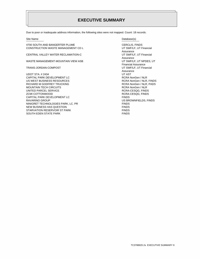
EXECUTIVE SUMMARY
TC3788920.2s EXECUTIVE SUMMARY 9
Due to poor or inadequate address information, the following sites were not mapped. Count: 18 records.
Site Name Database(s)____________ ____________
4700 SOUTH AND BANGERTER PLUME CERCLIS, FINDSCONSTRUCTION WASTE MANAGEMENT CD L UT SWF/LF, UT Financial
AssuranceCENTRAL VALLEY WATER RECLAMATION-C UT SWF/LF, UT Financial
AssuranceWASTE MANAGEMENT-MOUNTAIN VIEW ASB UT SWF/LF, UT NPDES, UT
Financial AssuranceTRANS-JORDAN-COMPOST UT SWF/LF, UT Financial
AssuranceUDOT STA. # 2434 UT ASTCAPITAL PARK DEVELOPMENT LC RCRA NonGen / NLRUS WEST BUSINESS RESOURCES RCRA NonGen / NLR, FINDSRICHARD M GODFREY TRUCKING RCRA NonGen / NLR, PADSMOUNTAIN TECH CIRCUITS RCRA NonGen / NLRUNITED PARCEL SERVICE RCRA-CESQG, FINDSZCMI COTTONWOOD RCRA-CESQG, FINDSCAPITAL PARK DEVELOPMENT LC FINDSRAVARINO GROUP US BROWNFIELDS, FINDSNINIGRET TECHNOLOGIES PARK, LC. PR FINDSNEW BUSINESS HAS QUESTION FINDSSTARVATION RESERVOIR ST PARK FINDSSOUTH EDEN STATE PARK FINDS
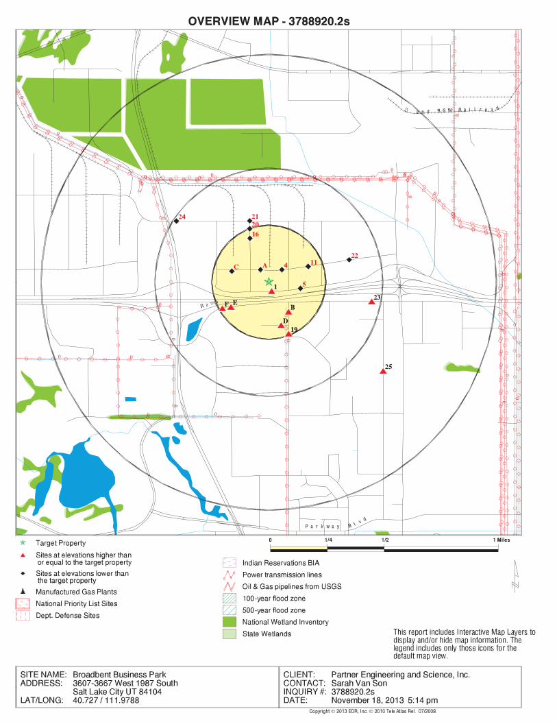
EDR Inc.EDR Inc.EDR Inc.EDR Inc.EDR Inc.EDR Inc.EDR Inc.EDR Inc.EDR Inc.EDR Inc.EDR Inc.EDR Inc.EDR Inc.EDR Inc.EDR Inc.EDR Inc.EDR Inc.EDR Inc.EDR Inc.EDR Inc.EDR Inc.EDR Inc.EDR Inc.EDR Inc.EDR Inc.EDR Inc.EDR Inc.EDR Inc.EDR Inc.EDR Inc.EDR Inc.EDR Inc.EDR Inc.EDR Inc.EDR Inc.EDR Inc.EDR Inc.EDR Inc.EDR Inc.EDR Inc.
00
0 0
0
0
0
0
00
0
0
0
00
0
0 0
0
0 00
0
00
0
0
0
0
4
24
0
42
40
4 2 4 0
4 2 4 0
4 2 4 0
4240

EDR Inc.EDR Inc.EDR Inc.EDR Inc.EDR Inc.EDR Inc.EDR Inc.EDR Inc.EDR Inc.EDR Inc.EDR Inc.EDR Inc.EDR Inc.EDR Inc.EDR Inc.EDR Inc.EDR Inc.EDR Inc.EDR Inc.EDR Inc.EDR Inc.EDR Inc.EDR Inc.EDR Inc.EDR Inc.EDR Inc.EDR Inc.EDR Inc.EDR Inc.EDR Inc.EDR Inc.EDR Inc.EDR Inc.EDR Inc.EDR Inc.EDR Inc.EDR Inc.EDR Inc.EDR Inc.EDR Inc.
0
4240

MAP FINDINGS SUMMARY
SearchTargetDistance Total
Database Property(Miles) < 1/8 1/8 - 1/4 1/4 - 1/2 1/2 - 1 > 1 Plotted
STANDARD ENVIRONMENTAL RECORDS
Federal NPL site list
0 NR 0 0 0 0 1.000NPL 0 NR 0 0 0 0 1.000Proposed NPL 0 NR NR NR NR NR TPNPL LIENS
Federal Delisted NPL site list
0 NR 0 0 0 0 1.000Delisted NPL
Federal CERCLIS list
1 NR NR 0 1 0 0.500CERCLIS 0 NR NR 0 0 0 0.500FEDERAL FACILITY
Federal CERCLIS NFRAP site List
1 NR NR 1 0 0 0.500CERC-NFRAP
Federal RCRA CORRACTS facilities list
1 NR 1 0 0 0 1.000CORRACTS
Federal RCRA non-CORRACTS TSD facilities list
0 NR NR 0 0 0 0.500RCRA-TSDF
Federal RCRA generators list
0 NR NR NR 0 0 0.250RCRA-LQG 0 NR NR NR 0 0 0.250RCRA-SQG 2 NR NR NR 2 0 0.250RCRA-CESQG
Federal institutional controls /engineering controls registries
0 NR NR 0 0 0 0.500US ENG CONTROLS 0 NR NR 0 0 0 0.500US INST CONTROL 0 NR NR 0 0 0 0.500LUCIS
Federal ERNS list
0 NR NR NR NR NR TPERNS
State- and tribal - equivalent CERCLIS
N/A N/A N/A N/A N/A N/A N/AUT SHWS
State and tribal landfill and/orsolid waste disposal site lists
0 NR NR 0 0 0 0.500UT SWF/LF 1 NR NR 0 1 0 0.500WY SWF/LF
State and tribal leaking storage tank lists
11 NR NR 3 7 1 0.500UT LUST 0 NR NR 0 0 0 0.500UT LAST 0 NR NR 0 0 0 0.500INDIAN LUST
TC3788920.2s Page 4

MAP FINDINGS SUMMARY
SearchTargetDistance Total
Database Property(Miles) < 1/8 1/8 - 1/4 1/4 - 1/2 1/2 - 1 > 1 Plotted
State and tribal registered storage tank lists
9 NR NR NR 7 2 0.250UT UST 1 NR NR NR 1 0 0.250UT AST 0 NR NR NR 0 0 0.250INDIAN UST 0 NR NR NR 0 0 0.250FEMA UST
State and tribal institutionalcontrol / engineering control registries
0 NR NR 0 0 0 0.500UT INST CONTROL
State and tribal voluntary cleanup sites
0 NR NR 0 0 0 0.500UT VCP 0 NR NR 0 0 0 0.500INDIAN VCP
State and tribal Brownfields sites
0 NR NR 0 0 0 0.500UT BROWNFIELDS
ADDITIONAL ENVIRONMENTAL RECORDS
Local Brownfield lists
0 NR NR 0 0 0 0.500US BROWNFIELDS
Local Lists of Landfill / SolidWaste Disposal Sites
0 NR NR 0 0 0 0.500DEBRIS REGION 9 0 NR NR 0 0 0 0.500ODI 0 NR NR 0 0 0 0.500INDIAN ODI
Local Lists of Hazardous waste /Contaminated Sites
0 NR NR NR NR NR TPUS CDL 0 NR NR NR NR NR TPUT CDL 0 NR NR NR NR NR TPUS HIST CDL
Local Land Records
0 NR NR NR NR NR TPLIENS 2
Records of Emergency Release Reports
0 NR NR NR NR NR TPHMIRS 0 NR NR NR NR NR TPUT SPILLS 0 NR NR NR NR NR TPUT SPILLS 90
Other Ascertainable Records
6 NR NR NR 4 2 0.250RCRA NonGen / NLR 0 NR NR NR NR NR TPDOT OPS 0 NR 0 0 0 0 1.000DOD 0 NR 0 0 0 0 1.000FUDS 0 NR 0 0 0 0 1.000CONSENT 0 NR 0 0 0 0 1.000ROD
TC3788920.2s Page 5
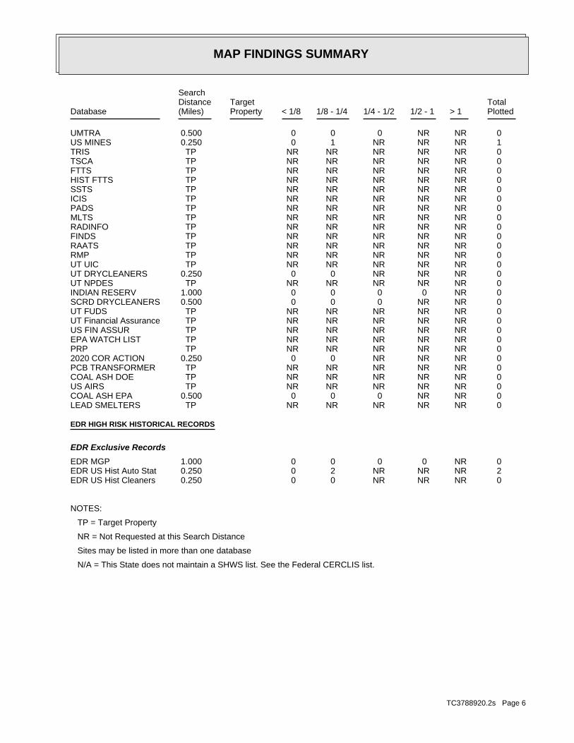
MAP FINDINGS SUMMARY
SearchTargetDistance Total
Database Property(Miles) < 1/8 1/8 - 1/4 1/4 - 1/2 1/2 - 1 > 1 Plotted
0 NR NR 0 0 0 0.500UMTRA 1 NR NR NR 1 0 0.250US MINES 0 NR NR NR NR NR TPTRIS 0 NR NR NR NR NR TPTSCA 0 NR NR NR NR NR TPFTTS 0 NR NR NR NR NR TPHIST FTTS 0 NR NR NR NR NR TPSSTS 0 NR NR NR NR NR TPICIS 0 NR NR NR NR NR TPPADS 0 NR NR NR NR NR TPMLTS 0 NR NR NR NR NR TPRADINFO 0 NR NR NR NR NR TPFINDS 0 NR NR NR NR NR TPRAATS 0 NR NR NR NR NR TPRMP 0 NR NR NR NR NR TPUT UIC 0 NR NR NR 0 0 0.250UT DRYCLEANERS 0 NR NR NR NR NR TPUT NPDES 0 NR 0 0 0 0 1.000INDIAN RESERV 0 NR NR 0 0 0 0.500SCRD DRYCLEANERS 0 NR NR NR NR NR TPUT FUDS 0 NR NR NR NR NR TPUT Financial Assurance 0 NR NR NR NR NR TPUS FIN ASSUR 0 NR NR NR NR NR TPEPA WATCH LIST 0 NR NR NR NR NR TPPRP 0 NR NR NR 0 0 0.2502020 COR ACTION 0 NR NR NR NR NR TPPCB TRANSFORMER 0 NR NR NR NR NR TPCOAL ASH DOE 0 NR NR NR NR NR TPUS AIRS 0 NR NR 0 0 0 0.500COAL ASH EPA 0 NR NR NR NR NR TPLEAD SMELTERS
EDR HIGH RISK HISTORICAL RECORDS
EDR Exclusive Records
0 NR 0 0 0 0 1.000EDR MGP 2 NR NR NR 2 0 0.250EDR US Hist Auto Stat 0 NR NR NR 0 0 0.250EDR US Hist Cleaners
NOTES:
TP = Target Property
NR = Not Requested at this Search Distance
Sites may be listed in more than one database
N/A = This State does not maintain a SHWS list. See the Federal CERCLIS list.
TC3788920.2s Page 6

MAP FINDINGSMap IDDirection
EDR ID NumberDistanceEPA ID NumberDatabase(s)SiteElevation
Not a generator, verifiedClassification: E.T. TECHNOLOGIESFacility name: 11/10/1992Date form received by agency:
Historical Generators:
NoUsed oil transporter: NoUsed oil transfer facility: NoUsed oil Specification marketer: NoUsed oil fuel marketer to burner: NoUser oil refiner: NoUsed oil processor: NoUsed oil fuel burner: NoFurnace exemption: NoOn-site burner exemption: NoUnderground injection activity: NoTreater, storer or disposer of HW: NoTransporter of hazardous waste: NoRecycler of hazardous waste: NoMixed waste (haz. and radioactive): NoU.S. importer of hazardous waste:
Handler Activities Summary:
Not reportedOwner/Op end date: 01/01/0001Owner/Op start date: OwnerOwner/Operator Type: PrivateLegal status: (801) 972-4111Owner/operator telephone: Not reportedOwner/operator country: CEDAR RAPIDS, NE 52499 4333 EDGEWOOD DROwner/operator address: CEDAR INCOME FUND LTDOwner/operator name:
Owner/Operator Summary:
Handler: Non-Generators do not presently generate hazardous wasteDescription: Non-GeneratorClassification: PrivateLand type: 08EPA Region: Not reportedContact email: (801) 977-0731Contact telephone: USContact country: SALT LAKE CITY, UT 841201202 3656 WEST 2100 SOUTHContact address: CINDY MORGANContact: SALT LAKE CITY, UT 841201202 WEST 2100 SOUTHMailing address: UTD988077699EPA ID: SALT LAKE CITY, UT 841201202 3656 WEST 2100 SOUTHFacility address: E.T. TECHNOLOGIESFacility name: 05/21/2007Date form received by agency:
RCRA NonGen / NLR:
218 ft.0.041 mi.
Relative:Higher
Actual:4242 ft.
< 1/8 SALT LAKE CITY, UT 84120SSE FINDS3656 WEST 2100 SOUTH UTD9880776991 RCRA NonGen / NLRE.T. TECHNOLOGIES 1000837426
TC3788920.2s Page 7

MAP FINDINGSMap IDDirection
EDR ID NumberDistanceEPA ID NumberDatabase(s)SiteElevation
corrective action activities required under RCRA.program staff to track the notification, permit, compliance, andand treat, store, or dispose of hazardous waste. RCRAInfo allows RCRAevents and activities related to facilities that generate, transport,Conservation and Recovery Act (RCRA) program through the tracking ofRCRAInfo is a national information system that supports the Resource Environmental Interest/Information System
110005206972Registry ID:
FINDS:
StateEvaluation lead agency: Not reportedDate achieved compliance: Not reportedArea of violation: COMPLIANCE ASSISTANCE VISITEvaluation: 05/17/2007Evaluation date:
Evaluation Action Summary:
No violations foundViolation Status:
WHICH WOULD BE CONSIDERED AS IGNITABLE HAZARDOUS WASTE. MATERIAL. LACQUER THINNER IS AN EXAMPLE OF A COMMONLY USED SOLVENT WHICH CAN BE OBTAINED FROM THE MANUFACTURER OR DISTRIBUTOR OF THE FLASH POINT OF A WASTE IS TO REVIEW THE MATERIAL SAFETY DATA SHEET, CLOSED CUP FLASH POINT TESTER. ANOTHER METHOD OF DETERMINING THE LESS THAN 140 DEGREES FAHRENHEIT AS DETERMINED BY A PENSKY-MARTENS IGNITABLE HAZARDOUS WASTES ARE THOSE WASTES WHICH HAVE A FLASHPOINT OFWaste name: D001Waste code:
Hazardous Waste Summary:
E.T. TECHNOLOGIES (Continued) 1000837426
Handler: Non-Generators do not presently generate hazardous wasteDescription: Non-GeneratorClassification: PrivateLand type: 08EPA Region: Not reportedContact email: (801) 972-5050Contact telephone: USContact country: SALT LAKE CITY, UT 84104 WEST 1987 SOUTHContact address: FREDRICK HAYDOCKContact: SALT LAKE CITY, UT 84104 WEST 1987 SOUTHMailing address: UTD988079091EPA ID: SALT LAKE CITY, UT 84104 3671 WEST 1987 SOUTHFacility address: WATER RECOVERY SCIENCES -PREV TED BROWNFacility name: 07/10/2007Date form received by agency:
RCRA NonGen / NLR:
323 ft. Site 1 of 2 in cluster A0.061 mi.
Relative:Lower
Actual:4239 ft.
< 1/8 SALT LAKE CITY, UT 84104NNW FINDS3671 WEST 1987 SOUTH UTD988079091A2 RCRA NonGen / NLRWATER RECOVERY SCIENCES -PREV TED BROWN 1000877736
TC3788920.2s Page 8

MAP FINDINGSMap IDDirection
EDR ID NumberDistanceEPA ID NumberDatabase(s)SiteElevation
NoUsed oil transfer facility: NoUsed oil Specification marketer: NoUsed oil fuel marketer to burner: NoUser oil refiner: NoUsed oil processor: NoUsed oil fuel burner: NoFurnace exemption: NoOn-site burner exemption: NoUnderground injection activity: NoTreater, storer or disposer of HW: NoTransporter of hazardous waste: NoRecycler of hazardous waste: NoMixed waste (haz. and radioactive): NoU.S. importer of hazardous waste:
Handler Activities Summary:
Not reportedOwner/Op end date: 09/05/2000Owner/Op start date: OperatorOwner/Operator Type: PrivateLegal status: (801) 972-5050Owner/operator telephone: Not reportedOwner/operator country: SALT LAKE CITY, UT 84104 3671 WEST 1987 SOUTHOwner/operator address: WATER RECOVERY SERVICESOwner/operator name:
Not reportedOwner/Op end date: Not reportedOwner/Op start date: OwnerOwner/Operator Type: PrivateLegal status: (801) 973-6132Owner/operator telephone: Not reportedOwner/operator country: SALT LAKE CITY, UT 84104 3671 WEST 1987 SOUTHOwner/operator address: TED R. BROWNOwner/operator name:
Not reportedOwner/Op end date: 01/01/0001Owner/Op start date: OwnerOwner/Operator Type: PrivateLegal status: (801) 973-6132Owner/operator telephone: Not reportedOwner/operator country: SALT LAKE CITY, UT 84104 3671 WEST 1987 SOUTHOwner/operator address: TED R. BROWNOwner/operator name:
Not reportedOwner/Op end date: 01/01/1999Owner/Op start date: OwnerOwner/Operator Type: PrivateLegal status: (801) 972-5050Owner/operator telephone: Not reportedOwner/operator country: SALT LAKE CITY, UT 84104 3671 WEST 1987 SOUTHOwner/operator address: FOCUS COMMERCIAL, INC.Owner/operator name:
Owner/Operator Summary:
WATER RECOVERY SCIENCES -PREV TED BROWN (Continued) 1000877736
TC3788920.2s Page 9
MAP FINDINGSMap IDDirection
EDR ID NumberDistanceEPA ID NumberDatabase(s)SiteElevation
corrective action activities required under RCRA.program staff to track the notification, permit, compliance, andand treat, store, or dispose of hazardous waste. RCRAInfo allows RCRAevents and activities related to facilities that generate, transport,Conservation and Recovery Act (RCRA) program through the tracking ofRCRAInfo is a national information system that supports the Resource Environmental Interest/Information System
110005207686Registry ID:
FINDS:
StateEvaluation lead agency: Not reportedDate achieved compliance: Not reportedArea of violation: COMPLIANCE ASSISTANCE VISITEvaluation: 07/10/2007Evaluation date:
Evaluation Action Summary:
No violations foundViolation Status:
WHICH WOULD BE CONSIDERED AS IGNITABLE HAZARDOUS WASTE. MATERIAL. LACQUER THINNER IS AN EXAMPLE OF A COMMONLY USED SOLVENT WHICH CAN BE OBTAINED FROM THE MANUFACTURER OR DISTRIBUTOR OF THE FLASH POINT OF A WASTE IS TO REVIEW THE MATERIAL SAFETY DATA SHEET, CLOSED CUP FLASH POINT TESTER. ANOTHER METHOD OF DETERMINING THE LESS THAN 140 DEGREES FAHRENHEIT AS DETERMINED BY A PENSKY-MARTENS IGNITABLE HAZARDOUS WASTES ARE THOSE WASTES WHICH HAVE A FLASHPOINT OFWaste name: D001Waste code:
Hazardous Waste Summary:
Small Quantity GeneratorClassification: TED R. BROWN & ASSOC. INC.Site name: WATER RECOVERY SCIENCES -PREV TED BROWNFacility name: 06/30/1993Date form received by agency:
Not a generator, verifiedClassification: WATER RECOVERY SCIENCES -PREV TED BROWNFacility name: 05/29/2003Date form received by agency:
Historical Generators:
NoUsed oil transporter:
WATER RECOVERY SCIENCES -PREV TED BROWN (Continued) 1000877736
1Total Tanks: (801) 972-2661Owner Phone: SALT LAKE CITY, UT 84130Owner City,St,Zip: 3700 W 1987 SOwner Address: DIXON PAPER COMPANYOwner Name: 4000249Facility ID:
UST:
350 ft. Site 2 of 2 in cluster A0.066 mi.
Relative:Lower
Actual:4239 ft.
< 1/8 SALT LAKE CITY, UT 84130NNW 3700 W 1987 S N/AA3 UT USTDIXON PAPER COMPANY U000558583
TC3788920.2s Page 10
MAP FINDINGSMap IDDirection
EDR ID NumberDistanceEPA ID NumberDatabase(s)SiteElevation
1Closed Tanks:
DIXON PAPER COMPANY (Continued) U000558583
1Closed Tanks: 1Total Tanks: (206) 228-6100Owner Phone: RENTON, WA 98055Owner City,St,Zip: 500 W PERIMETER RDOwner Address: JOSEPH C LANE LANE INVESTMENTSOwner Name: 4000437Facility ID:
UST:
[Evan Sullivan]Project Manager: RENTON, WA 98055Owner City,St,Zip: 98055Owner Zip: WAOwner State: RENTONOwner City: 500 W PERIMETER RDOwner Address: JOSEPH C LANE LANE INVESTMENTSOwner Name: 10/24/1990Notification Date: 04/20/1998Closed Date: GFWRelease Id: 4000437Facility ID:
LUST:
418 ft.0.079 mi.
Relative:Lower
Actual:4239 ft.
< 1/8 SALT LAKE CITY, UT 84104NE UT UST3620 W 1987 S N/A4 UT LUSTHUISH CHEMICAL CO. U003149880
ClosedFacility Status: Not reportedRange: Not reportedTownship: Not reportedSection: Not reportedEPA Id: Mobile Treatment Unit (MTU)Facility Type: 403Facility Id:
SWF/LF:
747 ft.0.141 mi.
Relative:Lower
Actual:4238 ft.
1/8-1/4 SALT LAKE CITY, UT, WY 84120ESE 3556 WEST 2100 SOUTH N/A5 WY SWF/LFET TECHNOLOGIES (52.258) S104995629
TC3788920.2s Page 11

MAP FINDINGSMap IDDirection
EDR ID NumberDistanceEPA ID NumberDatabase(s)SiteElevation
1Closed Tanks: 1Total Tanks: (801) 973-9466Owner Phone: WEST VALLEY CITY, UT 84119Owner City,St,Zip: 1515 W 2200 S STE E-2Owner Address: STANGL/HEINES CO PARTNERSHIPOwner Name: 4001857Facility ID:
UST:
[Ben Anderson]Project Manager: WEST VALLEY CITY, UT 84119Owner City,St,Zip: 84119Owner Zip: UTOwner State: WEST VALLEY CITYOwner City: 1515 W 2200 S STE E-2Owner Address: STANGL/HEINES CO PARTNERSHIPOwner Name: 02/13/1992Notification Date: 07/06/1993Closed Date: HJKRelease Id: 4001857Facility ID:
LUST:
824 ft. Site 1 of 2 in cluster B0.156 mi.
Relative:Higher
Actual:4244 ft.
1/8-1/4 WEST VALLEY CITY, UT 84120SE UT UST2120 S 3600 W N/AB6 UT LUSTCONSTRUCTION EQUIPMENT U003150961
PrivateLegal status: (999) 999-9999Owner/operator telephone: Not reportedOwner/operator country: DATA NOT REQUESTED, UT 99999 DATA NOT REQUESTEDOwner/operator address: NAUMANN CORPOwner/operator name:
Owner/Operator Summary:
Handler: Non-Generators do not presently generate hazardous wasteDescription: Non-GeneratorClassification: 08EPA Region: Not reportedContact email: (801) 972-5652Contact telephone: USContact country: SALT LAKE CITY, UT 84119 2120 SO 3600 WContact address: VERNON DRAPERContact: SALT LAKE CITY, UT 84119 SO 3600 WMailing address: UTD089323562EPA ID: SALT LAKE CITY, UT 84119 2120 SO 3600 WFacility address: NAUMAN EQUIPMENT HANDLINGFacility name: 02/22/2007Date form received by agency:
RCRA NonGen / NLR:
849 ft. Site 2 of 2 in cluster B0.161 mi.
Relative:Higher
Actual:4244 ft.
1/8-1/4 SALT LAKE CITY, UT 84119SSE 2120 SO 3600 W UTD089323562B7 RCRA NonGen / NLRNAUMAN EQUIPMENT HANDLING 1010335553
TC3788920.2s Page 12

MAP FINDINGSMap IDDirection
EDR ID NumberDistanceEPA ID NumberDatabase(s)SiteElevation
No violations foundViolation Status:
WHICH WOULD BE CONSIDERED AS IGNITABLE HAZARDOUS WASTE. MATERIAL. LACQUER THINNER IS AN EXAMPLE OF A COMMONLY USED SOLVENT WHICH CAN BE OBTAINED FROM THE MANUFACTURER OR DISTRIBUTOR OF THE FLASH POINT OF A WASTE IS TO REVIEW THE MATERIAL SAFETY DATA SHEET, CLOSED CUP FLASH POINT TESTER. ANOTHER METHOD OF DETERMINING THE LESS THAN 140 DEGREES FAHRENHEIT AS DETERMINED BY A PENSKY-MARTENS IGNITABLE HAZARDOUS WASTES ARE THOSE WASTES WHICH HAVE A FLASHPOINT OFWaste name: D001Waste code:
Hazardous Waste Summary:
Not a generator, verifiedClassification: NAUMAN EQUIPMENT HANDLINGFacility name: 09/02/1986Date form received by agency:
Historical Generators:
NoUsed oil transporter: NoUsed oil transfer facility: NoUsed oil Specification marketer: NoUsed oil fuel marketer to burner: NoUser oil refiner: NoUsed oil processor: NoUsed oil fuel burner: NoFurnace exemption: NoOn-site burner exemption: NoUnderground injection activity: NoTreater, storer or disposer of HW: NoTransporter of hazardous waste: NoRecycler of hazardous waste: NoMixed waste (haz. and radioactive): NoU.S. importer of hazardous waste:
Handler Activities Summary:
Not reportedOwner/Op end date: 01/01/0001Owner/Op start date: OwnerOwner/Operator Type:
NAUMAN EQUIPMENT HANDLING (Continued) 1010335553
(801) 972-5123Contact telephone: USContact country: SLC, UT 84126 3785 WEST 1987 SOUTHContact address: KEN REAVELEYContact: SLC, UT 84126 WEST 1987 SOUTHMailing address: UT0000228338EPA ID: SLC, UT 84126 3785 WEST 1987 SOUTHFacility address: LAUNDRY SUPPLY INC.Facility name: 02/22/2007Date form received by agency:
RCRA NonGen / NLR:
896 ft. Site 1 of 3 in cluster C0.170 mi.
Relative:Lower
Actual:4240 ft.
1/8-1/4 SLC, UT 84126WNW 3785 WEST 1987 SOUTH UT0000228338C8 RCRA NonGen / NLRLAUNDRY SUPPLY INC. 1010334945
TC3788920.2s Page 13
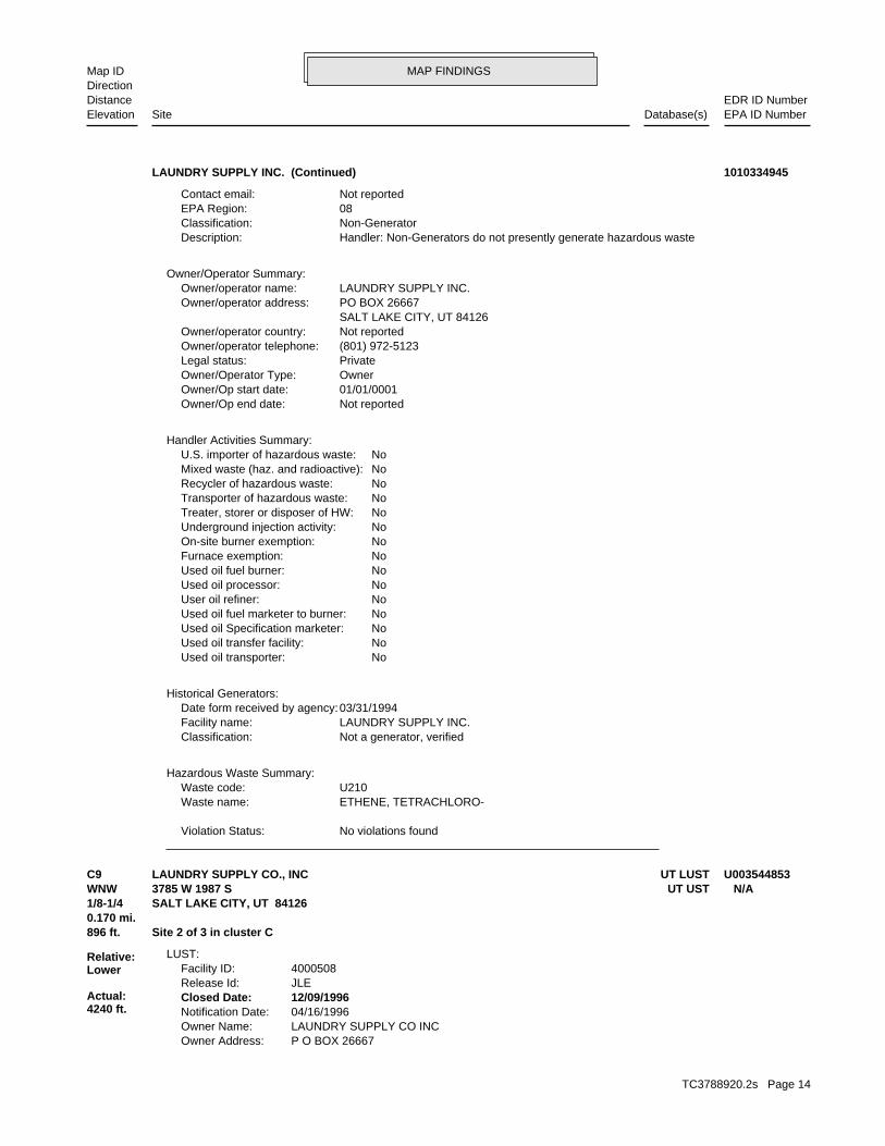
MAP FINDINGSMap IDDirection
EDR ID NumberDistanceEPA ID NumberDatabase(s)SiteElevation
No violations foundViolation Status:
ETHENE, TETRACHLORO-Waste name: U210Waste code:
Hazardous Waste Summary:
Not a generator, verifiedClassification: LAUNDRY SUPPLY INC.Facility name: 03/31/1994Date form received by agency:
Historical Generators:
NoUsed oil transporter: NoUsed oil transfer facility: NoUsed oil Specification marketer: NoUsed oil fuel marketer to burner: NoUser oil refiner: NoUsed oil processor: NoUsed oil fuel burner: NoFurnace exemption: NoOn-site burner exemption: NoUnderground injection activity: NoTreater, storer or disposer of HW: NoTransporter of hazardous waste: NoRecycler of hazardous waste: NoMixed waste (haz. and radioactive): NoU.S. importer of hazardous waste:
Handler Activities Summary:
Not reportedOwner/Op end date: 01/01/0001Owner/Op start date: OwnerOwner/Operator Type: PrivateLegal status: (801) 972-5123Owner/operator telephone: Not reportedOwner/operator country: SALT LAKE CITY, UT 84126 PO BOX 26667Owner/operator address: LAUNDRY SUPPLY INC.Owner/operator name:
Owner/Operator Summary:
Handler: Non-Generators do not presently generate hazardous wasteDescription: Non-GeneratorClassification: 08EPA Region: Not reportedContact email:
LAUNDRY SUPPLY INC. (Continued) 1010334945
P O BOX 26667Owner Address: LAUNDRY SUPPLY CO INCOwner Name: 04/16/1996Notification Date: 12/09/1996Closed Date: JLERelease Id: 4000508Facility ID:
LUST:
896 ft. Site 2 of 3 in cluster C0.170 mi.
Relative:Lower
Actual:4240 ft.
1/8-1/4 SALT LAKE CITY, UT 84126WNW UT UST3785 W 1987 S N/AC9 UT LUSTLAUNDRY SUPPLY CO., INC U003544853
TC3788920.2s Page 14

MAP FINDINGSMap IDDirection
EDR ID NumberDistanceEPA ID NumberDatabase(s)SiteElevation
2Closed Tanks: 2Total Tanks: (801) 972-5123Owner Phone: SALT LAKE CITY, UT 84126Owner City,St,Zip: P O BOX 26667Owner Address: LAUNDRY SUPPLY CO INCOwner Name: 4000508Facility ID:
UST:
[DeAnn Rasmussen]Project Manager: SALT LAKE CITY, UT 84126Owner City,St,Zip: 84126Owner Zip: UTOwner State: SALT LAKE CITYOwner City:
LAUNDRY SUPPLY CO., INC (Continued) U003544853
NoTreater, storer or disposer of HW: NoTransporter of hazardous waste: NoRecycler of hazardous waste: NoMixed waste (haz. and radioactive): NoU.S. importer of hazardous waste:
Handler Activities Summary:
Not reportedOwner/Op end date: 01/01/0001Owner/Op start date: OwnerOwner/Operator Type: PrivateLegal status: (801) 972-5123Owner/operator telephone: Not reportedOwner/operator country: SALT LAKE CITY, UT 84145 3785 WEST 1987 SOUTHOwner/operator address: LAUNDRY SUPPLY COMPANYOwner/operator name:
Owner/Operator Summary:
Handler: Non-Generators do not presently generate hazardous wasteDescription: Non-GeneratorClassification: 08EPA Region: Not reportedContact email: (801) 972-5123Contact telephone: USContact country: SALT LAKE CITY, UT 84145 3785 WEST 1987 SOUTHContact address: CRAIG REAVELEYContact: SALT LAKE CITY, UT 841044935 1987 SOUTHMailing address: UTR000005421EPA ID: SALT LAKE CITY, UT 841044935 3785 WEST 1987 SOUTHFacility address: LAUNDRY SUPPLY COMPANYFacility name: 12/21/1999Date form received by agency:
RCRA NonGen / NLR:
896 ft. Site 3 of 3 in cluster C0.170 mi.
Relative:Lower
Actual:4240 ft.
1/8-1/4 SALT LAKE CITY, UT 84104WNW 3785 WEST 1987 SOUTH UTR000005421C10 RCRA NonGen / NLRLAUNDRY SUPPLY COMPANY 1008375459
TC3788920.2s Page 15

MAP FINDINGSMap IDDirection
EDR ID NumberDistanceEPA ID NumberDatabase(s)SiteElevation
No violations foundViolation Status:
ETHENE, TRICHLORO-Waste name: U228Waste code:
ETHANE, 1,1,1-TRICHLORO-Waste name: U226Waste code:
ETHENE, TETRACHLORO-Waste name: U210Waste code:
ETHANE, 1,2-DICHLORO-Waste name: U077Waste code:
ETHANE, 1,1-DICHLORO-Waste name: U076Waste code:
Hazardous Waste Summary:
NoUsed oil transporter: NoUsed oil transfer facility: NoUsed oil Specification marketer: NoUsed oil fuel marketer to burner: NoUser oil refiner: NoUsed oil processor: NoUsed oil fuel burner: NoFurnace exemption: NoOn-site burner exemption: NoUnderground injection activity:
LAUNDRY SUPPLY COMPANY (Continued) 1008375459
other debris resulting from the cleanup of a spill, into or on any waste; or 100 kg or less of any residue or contaminated soil, waste or month, and accumulates at any time: 1 kg or less of acutely hazardous or generates 1 kg or less of acutely hazardous waste per calendar month, and accumulates 1000 kg or less of hazardous waste at any time; Handler: generates 100 kg or less of hazardous waste per calendarDescription: Conditionally Exempt Small Quantity GeneratorClassification: PrivateLand type: 08EPA Region: [email protected] email: (801) 975-8527Contact telephone: USContact country: SALT LAKE CITY, UT 84104 1987 SOUTHContact address: MICHELLE COMASContact: SALT LAKE CITY, UT 84104 1987 SOUTHMailing address: UTD070931480EPA ID: SALT LAKE CITY, UT 84104 3540 WEST 1987 SOUTHFacility address: SUN PRODUCTS CORPORATION (PREV. HUISH)Facility name: 11/17/2008Date form received by agency:
RCRA-CESQG:
984 ft.0.186 mi.
Relative:Lower
Actual:4238 ft.
1/8-1/4 SALT LAKE CITY, UT 84104ENE 3540 WEST 1987 SOUTH UTD07093148011 RCRA-CESQGSUN PRODUCTS CORPORATION (PREV. HUISH) 1000381152
TC3788920.2s Page 16

MAP FINDINGSMap IDDirection
EDR ID NumberDistanceEPA ID NumberDatabase(s)SiteElevation
NoUsed oil transporter: NoUsed oil transfer facility: NoUsed oil Specification marketer: NoUsed oil fuel marketer to burner: NoUser oil refiner: NoUsed oil processor: NoUsed oil fuel burner: NoFurnace exemption: NoOn-site burner exemption: NoUnderground injection activity: NoTreater, storer or disposer of HW: NoTransporter of hazardous waste: NoRecycler of hazardous waste: NoMixed waste (haz. and radioactive): NoU.S. importer of hazardous waste:
Handler Activities Summary:
Not reportedOwner/Op end date: 02/27/2008Owner/Op start date: OperatorOwner/Operator Type: PrivateLegal status: (801) 975-8527Owner/operator telephone: USOwner/operator country: SALT LAKE CITY, UT 84104 1987 SOUTHOwner/operator address: SUN PRODUCTS CORPORATIONOwner/operator name:
Not reportedOwner/Op end date: Not reportedOwner/Op start date: OwnerOwner/Operator Type: PrivateLegal status: (801) 975-3100Owner/operator telephone: Not reportedOwner/operator country: SALT LAKE CITY, UT 84125 P.O. BOX 25057Owner/operator address: DAN HUISHOwner/operator name:
Not reportedOwner/Op end date: 03/03/2007Owner/Op start date: OwnerOwner/Operator Type: PrivateLegal status: (801) 975-8527Owner/operator telephone: USOwner/operator country: SALT LAKE CITY, UT 84101 SOUTH TEMPLE SUITE 1400Owner/operator address: SPOTLESS HOLDING CORP.Owner/operator name:
Owner/Operator Summary:
hazardous waste the cleanup of a spill, into or on any land or water, of acutely any residue or contaminated soil, waste or other debris resulting from time: 1 kg or less of acutely hazardous waste; or 100 kg or less of hazardous waste during any calendar month, and accumulates at any from the cleanup of a spill, into or on any land or water, of acutely of any residue or contaminated soil, waste or other debris resulting land or water, of acutely hazardous waste; or generates 100 kg or less
SUN PRODUCTS CORPORATION (PREV. HUISH) (Continued) 1000381152
TC3788920.2s Page 17

MAP FINDINGSMap IDDirection
EDR ID NumberDistanceEPA ID NumberDatabase(s)SiteElevation
StateEvaluation lead agency: Not reportedDate achieved compliance: Not reportedArea of violation: FOCUSED COMPLIANCE INSPECTIONEvaluation: 12/08/1987Evaluation date:
StateEvaluation lead agency: Not reportedDate achieved compliance: Not reportedArea of violation: COMPLIANCE EVALUATION INSPECTION ON-SITEEvaluation: 12/08/1987Evaluation date:
StateEvaluation lead agency: Not reportedDate achieved compliance: Not reportedArea of violation: COMPLIANCE EVALUATION INSPECTION ON-SITEEvaluation: 09/07/1990Evaluation date:
StateEvaluation lead agency: Not reportedDate achieved compliance: Not reportedArea of violation: FOCUSED COMPLIANCE INSPECTIONEvaluation: 04/03/1997Evaluation date:
StateEvaluation lead agency: Not reportedDate achieved compliance: Not reportedArea of violation: COMPLIANCE EVALUATION INSPECTION ON-SITEEvaluation: 03/20/2008Evaluation date:
Evaluation Action Summary:
No violations foundViolation Status:
CHLOROFORMWaste name: D022Waste code:
WHICH WOULD BE CONSIDERED AS IGNITABLE HAZARDOUS WASTE. MATERIAL. LACQUER THINNER IS AN EXAMPLE OF A COMMONLY USED SOLVENT WHICH CAN BE OBTAINED FROM THE MANUFACTURER OR DISTRIBUTOR OF THE FLASH POINT OF A WASTE IS TO REVIEW THE MATERIAL SAFETY DATA SHEET, CLOSED CUP FLASH POINT TESTER. ANOTHER METHOD OF DETERMINING THE LESS THAN 140 DEGREES FAHRENHEIT AS DETERMINED BY A PENSKY-MARTENS IGNITABLE HAZARDOUS WASTES ARE THOSE WASTES WHICH HAVE A FLASHPOINT OFWaste name: D001Waste code:
Hazardous Waste Summary:
Small Quantity GeneratorClassification: HUISH DETERGENTS INC.Site name: SUN PRODUCTS CORPORATION (PREV. HUISH)Facility name: 12/08/1994Date form received by agency:
Historical Generators:
SUN PRODUCTS CORPORATION (PREV. HUISH) (Continued) 1000381152
TC3788920.2s Page 18

MAP FINDINGSMap IDDirection
EDR ID NumberDistanceEPA ID NumberDatabase(s)SiteElevation
3675 W 2150 SAddress: 2009Year: DYNAMICS AUTOName:
3675 W 2150 SAddress: 2002Year: DYNAMICS AUTOName:
EDR Historical Auto Stations:
1030 ft. Site 1 of 2 in cluster D0.195 mi.
Relative:Higher
Actual:4244 ft.
1/8-1/4 SALT LAKE CITY, UT 84120SSE 3675 W 2150 S N/AD12 EDR US Hist Auto Stat 1015452138
3650 W 2150 SAddress: 2012Year: CM AUTO BODY REPAIR LLCName:
EDR Historical Auto Stations:
1037 ft. Site 2 of 2 in cluster D0.196 mi.
Relative:Higher
Actual:4244 ft.
1/8-1/4 SALT LAKE CITY, UT 84120SSE 3650 W 2150 S N/AD13 EDR US Hist Auto Stat 1015451307
of any residue or contaminated soil, waste or other debris resulting land or water, of acutely hazardous waste; or generates 100 kg or less other debris resulting from the cleanup of a spill, into or on any waste; or 100 kg or less of any residue or contaminated soil, waste or month, and accumulates at any time: 1 kg or less of acutely hazardous or generates 1 kg or less of acutely hazardous waste per calendar month, and accumulates 1000 kg or less of hazardous waste at any time; Handler: generates 100 kg or less of hazardous waste per calendarDescription: Conditionally Exempt Small Quantity GeneratorClassification: PrivateLand type: 08EPA Region: Not reportedContact email: (801) 977-8012Contact telephone: USContact country: SALT LAKE CITY, UT 84120 3737 WEST 2100 SOUTHContact address: ANDY ANDERSONContact: SALT LAKE CITY, UT 84120 2100 SOUTHMailing address: UTR000001156EPA ID: SALT LAKE CITY, UT 84120 3737 WEST 2100 SOUTHFacility address: AMES CONSTRUCTION INC.Facility name: 07/22/2010Date form received by agency:
RCRA-CESQG:
UT AST1051 ft. UT USTSite 1 of 2 in cluster E0.199 mi. UT LUST
Relative:Higher
Actual:4244 ft.
1/8-1/4 FINDSSALT LAKE CITY, UT 84120WSW US MINES3737 WEST 2100 SOUTH UTR000001156E14 RCRA-CESQGAMES CONSTRUCTION INC. 1001091728
TC3788920.2s Page 19

MAP FINDINGSMap IDDirection
EDR ID NumberDistanceEPA ID NumberDatabase(s)SiteElevation
CLOSED CUP FLASH POINT TESTER. ANOTHER METHOD OF DETERMINING THE LESS THAN 140 DEGREES FAHRENHEIT AS DETERMINED BY A PENSKY-MARTENS IGNITABLE HAZARDOUS WASTES ARE THOSE WASTES WHICH HAVE A FLASHPOINT OFWaste name: D001Waste code:
Hazardous Waste Summary:
Small Quantity GeneratorClassification: AMES CONSTRUCTION INC.Facility name: 02/16/1996Date form received by agency:
Historical Generators:
NoUsed oil transporter: NoUsed oil transfer facility: NoUsed oil Specification marketer: NoUsed oil fuel marketer to burner: NoUser oil refiner: NoUsed oil processor: NoUsed oil fuel burner: NoFurnace exemption: NoOn-site burner exemption: NoUnderground injection activity: NoTreater, storer or disposer of HW: NoTransporter of hazardous waste: NoRecycler of hazardous waste: NoMixed waste (haz. and radioactive): NoU.S. importer of hazardous waste:
Handler Activities Summary:
Not reportedOwner/Op end date: 08/18/1993Owner/Op start date: OperatorOwner/Operator Type: PrivateLegal status: (801) 977-8012Owner/operator telephone: USOwner/operator country: SALT LAKE CITY, UT 84120 2100 SOUTHOwner/operator address: AMES CONSTRUCTION, INC.Owner/operator name:
Not reportedOwner/Op end date: 08/18/1993Owner/Op start date: OwnerOwner/Operator Type: PrivateLegal status: (612) 435-7106Owner/operator telephone: USOwner/operator country: BURNSVILLE, MN 55337 14450 COUNTY RD. 5Owner/operator address: AMES CONSTRUCTION, INC.Owner/operator name:
Owner/Operator Summary:
hazardous waste the cleanup of a spill, into or on any land or water, of acutely any residue or contaminated soil, waste or other debris resulting from time: 1 kg or less of acutely hazardous waste; or 100 kg or less of hazardous waste during any calendar month, and accumulates at any from the cleanup of a spill, into or on any land or water, of acutely
AMES CONSTRUCTION INC. (Continued) 1001091728
TC3788920.2s Page 20

MAP FINDINGSMap IDDirection
EDR ID NumberDistanceEPA ID NumberDatabase(s)SiteElevation
non-Coal MiningOperation Class: 20130204Status date: 2Status: UTAHCounty FIPS code: UTState FIPS code: AMES CONSTRUCTION INC.Company: AMES PU 42-02347Entity name: 14410 00000 00000 00000 00000 00000SIC code(s): 4202347Mine ID:
US MINES:
StateEvaluation lead agency: Not reportedDate achieved compliance: Not reportedArea of violation: FOCUSED COMPLIANCE INSPECTIONEvaluation: 01/02/1997Evaluation date:
StateEvaluation lead agency: Not reportedDate achieved compliance: Not reportedArea of violation: COMPLIANCE ASSISTANCE VISITEvaluation: 06/10/2010Evaluation date:
Evaluation Action Summary:
No violations foundViolation Status:
THESE SPENT SOLVENTS AND SPENT SOLVENT MIXTURES. LISTED IN F001, F002, OR F004; AND STILL BOTTOMS FROM THE RECOVERY OF ONE OR MORE OF THE ABOVE NON-HALOGENATED SOLVENTS OR THOSE SOLVENTS CONTAINING, BEFORE USE, A TOTAL OF TEN PERCENT OR MORE (BY VOLUME) OF 2-ETHOXYETHANOL, AND 2-NITROPROPANE; ALL SPENT SOLVENT MIXTURES/BLENDS KETONE, CARBON DISULFIDE, ISOBUTANOL, PYRIDINE, BENZENE, THE FOLLOWING SPENT NON-HALOGENATED SOLVENTS: TOLUENE, METHYL ETHYLWaste name: F005Waste code:
MIXTURES. BOTTOMS FROM THE RECOVERY OF THESE SPENT SOLVENTS AND SPENT SOLVENT MORE OF THOSE SOLVENTS LISTED IN F001, F002, F004, AND F005, AND STILL SOLVENTS, AND, A TOTAL OF TEN PERCENT OR MORE (BY VOLUME) OF ONE OR CONTAINING, BEFORE USE, ONE OR MORE OF THE ABOVE NON-HALOGENATED NON-HALOGENATED SOLVENTS; AND ALL SPENT SOLVENT MIXTURES/BLENDS MIXTURES/BLENDS CONTAINING, BEFORE USE, ONLY THE ABOVE SPENT ALCOHOL, CYCLOHEXANONE, AND METHANOL; ALL SPENT SOLVENT ACETATE, ETHYL BENZENE, ETHYL ETHER, METHYL ISOBUTYL KETONE, N-BUTYL THE FOLLOWING SPENT NON-HALOGENATED SOLVENTS: XYLENE, ACETONE, ETHYLWaste name: F003Waste code:
METHYL ETHYL KETONEWaste name: D035Waste code:
BARIUMWaste name: D005Waste code:
WHICH WOULD BE CONSIDERED AS IGNITABLE HAZARDOUS WASTE. MATERIAL. LACQUER THINNER IS AN EXAMPLE OF A COMMONLY USED SOLVENT WHICH CAN BE OBTAINED FROM THE MANUFACTURER OR DISTRIBUTOR OF THE FLASH POINT OF A WASTE IS TO REVIEW THE MATERIAL SAFETY DATA SHEET,
AMES CONSTRUCTION INC. (Continued) 1001091728
TC3788920.2s Page 21

MAP FINDINGSMap IDDirection
EDR ID NumberDistanceEPA ID NumberDatabase(s)SiteElevation
10/29/2003Date Abated: 104(a)Action Type: 02/04/2013Status Date: IntermittentMine Status: 10/28/2003Date Issued: 6274794Violation Number:
2003Year: 60Assessment Amount: ProposedAssess. Case Status code: ClosedAssessment Status code: 60Paid Penalty: 60Proposed Penalty: NSig and Sub Designation: CitationCitation/Order: 10/28/2003Date Abated: 104(a)Action Type: 02/04/2013Status Date: IntermittentMine Status: 10/28/2003Date Issued: 6274793Violation Number:
2011Year: 117.00Assessment Amount: ProposedAssess. Case Status code: ClosedAssessment Status code: 117.00Paid Penalty: 117.00Proposed Penalty: YSig and Sub Designation: CitationCitation/Order: 01/09/2012Date Abated: 104(a)Action Type: 02/04/2013Status Date: IntermittentMine Status: 11/03/2011Date Issued: 6580743Violation Number:
2011Year: 176.00Assessment Amount: ProposedAssess. Case Status code: ClosedAssessment Status code: 176.00Paid Penalty: 176.00Proposed Penalty: NSig and Sub Designation: CitationCitation/Order: 12/12/2011Date Abated: 104(a)Action Type: 02/04/2013Status Date: IntermittentMine Status: 11/30/2011Date Issued: 6580759Violation Number:
Violations Details:
000 00 00Longitude: 00 00 00Latitude: 0Number of plants: 0Number of shops:
AMES CONSTRUCTION INC. (Continued) 1001091728
TC3788920.2s Page 22

MAP FINDINGSMap IDDirection
EDR ID NumberDistanceEPA ID NumberDatabase(s)SiteElevation
IntermittentMine Status: 05/10/2012Date Issued: 6591578Violation Number:
2002Year: 55.00Assessment Amount: ProposedAssess. Case Status code: ClosedAssessment Status code: 55.00Paid Penalty: 55.00Proposed Penalty: NSig and Sub Designation: CitationCitation/Order: 09/04/2002Date Abated: 104(a)Action Type: 02/04/2013Status Date: IntermittentMine Status: 07/10/2002Date Issued: 6273578Violation Number:
2011Year: 100.00Assessment Amount: ProposedAssess. Case Status code: ClosedAssessment Status code: 100.00Paid Penalty: 100.00Proposed Penalty: NSig and Sub Designation: CitationCitation/Order: 10/18/2011Date Abated: 104(a)Action Type: 02/04/2013Status Date: IntermittentMine Status: 10/12/2011Date Issued: 6580736Violation Number:
2011Year: 117.00Assessment Amount: ProposedAssess. Case Status code: ClosedAssessment Status code: 117.00Paid Penalty: 117.00Proposed Penalty: YSig and Sub Designation: CitationCitation/Order: 10/18/2011Date Abated: 104(a)Action Type: 02/04/2013Status Date: IntermittentMine Status: 10/12/2011Date Issued: 6580735Violation Number:
2003Year: 60Assessment Amount: ProposedAssess. Case Status code: ClosedAssessment Status code: 60Paid Penalty: 60Proposed Penalty: NSig and Sub Designation: CitationCitation/Order:
AMES CONSTRUCTION INC. (Continued) 1001091728
TC3788920.2s Page 23

MAP FINDINGSMap IDDirection
EDR ID NumberDistanceEPA ID NumberDatabase(s)SiteElevation
CERCLIS (Comprehensive Environmental Response, Compensation, and
discharge does not adversely affect water quality.requirements, and include other provisions to ensure that thelimits on what can be discharged, impose monitoring and reportingStates are required to obtain a permit. The permit will likely containdischarge pollutants from any point source into waters of the Unitedissued under the Clean Water Act. Under NPDES, all facilities thatthe Compliance Information System (ICIS) tracks surface water permitsUS National Pollutant Discharge Elimination System (NPDES) module of Environmental Interest/Information System
110012595619Registry ID:
FINDS:
2005Year: 60.00Assessment Amount: ProposedAssess. Case Status code: ClosedAssessment Status code: 60.00Paid Penalty: 60.00Proposed Penalty: NSig and Sub Designation: CitationCitation/Order: 01/20/2005Date Abated: 104(a)Action Type: 02/04/2013Status Date: IntermittentMine Status: 01/20/2005Date Issued: 4662701Violation Number:
2012Year: 2000Assessment Amount: ProposedAssess. Case Status code: ClosedAssessment Status code: 2000Paid Penalty: 2000Proposed Penalty: YSig and Sub Designation: CitationCitation/Order: 05/16/2012Date Abated: 104(d)(1)Action Type: 02/04/2013Status Date: IntermittentMine Status: 05/10/2012Date Issued: 6591577Violation Number:
2012Year: 2000Assessment Amount: ProposedAssess. Case Status code: ClosedAssessment Status code: 2000Paid Penalty: 2000Proposed Penalty: YSig and Sub Designation: OrderCitation/Order: 05/10/2012Date Abated: 104(d)(1)Action Type: 02/04/2013Status Date:
AMES CONSTRUCTION INC. (Continued) 1001091728
TC3788920.2s Page 24

MAP FINDINGSMap IDDirection
EDR ID NumberDistanceEPA ID NumberDatabase(s)SiteElevation
DieselSubstance Stored: 15000Tank Capacity: Currently In UseTank Status: 4Tank Id:
AMES CONSTRUCTION COOwner Name: 4000315Facility Id:
AST:
3Closed Tanks: 3Total Tanks: (801) 569-8012Owner Phone: SALT LAKE CITY, UT 84120Owner City,St,Zip: 3737 W 2100 SOwner Address: AMES CONSTRUCTION COOwner Name: 4000315Facility ID:
UST:
[Doug Hansen]Project Manager: SALT LAKE CITY, UT 84120Owner City,St,Zip: 84120Owner Zip: UTOwner State: SALT LAKE CITYOwner City: 3737 W 2100 SOwner Address: AMES CONSTRUCTION COOwner Name: 04/01/1996Notification Date: 03/31/2008Closed Date: JKNRelease Id: 4000315Facility ID:
LUST:
Incident Tracking, Compliance Assistance, and Compliance Monitoring.that support Compliance and Enforcement programs. These include;has the capability to track other activities occurring in the Regionthat information with Federal actions already in the system. ICIS alsoCompliance System (PCS) which supports the NPDES and will integrateit Headquarters. A future release of ICIS will replace the Permitinformation is maintained in ICIS by EPA in the Regional offices andFederal Administrative and Judicial enforcement actions. Thisa single repository for that information. Currently, ICIS contains allreplace EPA’s independent databases that contain Enforcement data withinformation across most of EPA’s programs. The vision for ICIS is tocomplete, will contain integrated Enforcement and ComplianceCompliance Information System and provides a database that, whenICIS (Integrated Compliance Information System) is the Integrated
operations.Environmental Quality (UDEQ) mechanism for compliance and permittingThe CIM (Utah - Common Identifier Mechanism) is Utah’s Department of
and financial information.including an inventory of sites, planned and actual site activities,system contains information on all aspects of hazardous waste sites,to support management in all phases of the Superfund program. TheLiability Information System) is the Superfund database that is used
AMES CONSTRUCTION INC. (Continued) 1001091728
TC3788920.2s Page 25

MAP FINDINGSMap IDDirection
EDR ID NumberDistanceEPA ID NumberDatabase(s)SiteElevation
Not ListedSubstance Stored: 500Tank Capacity: Currently In UseTank Status: 7Tank Id:
Not ListedSubstance Stored: 8000Tank Capacity: Currently In UseTank Status: 6Tank Id:
Not ListedSubstance Stored: 10000Tank Capacity: Currently In UseTank Status: 5Tank Id:
AMES CONSTRUCTION INC. (Continued) 1001091728
CERCLIS Site Contact Name(s):
Not reportedSite FUDS Flag: Not reportedAlias EPA ID: Not reportedCC Concurrence FY: / /CC Concurrence Date: 49035Site Fips Code: 10/30/08Non NPL Status Date: ESI OngoingNon NPL Status: Not reportedRResp Fed Agency Code: Not reportedRBRAC Code: Not reportedDMNSN Unit Code: Not on the NPLNPL Status: Not reportedSite Settings Code: Not reportedClassification: 08EPA Region: Not reportedRST Code: Not reportedParent ID: Not reportedNFRAP Flag: SSite Init By Prog: Not reportedUSGS Quadrangle: Not reportedRCRA ID: Not reportedSite Orphan Flag: 0.00000DMNSN Number: Not a Federal FacilityFederal Facility: Not reportedUSGC Hydro Unit: Not reportedSMSA Number: 08TMIFMS ID: 03Congressional District: 3700-3800 WEST 2100 SOUTHShort Name: SALT LAKEFacility County: UT0001575406EPA ID: 0801698Site ID:
CERCLIS:
1051 ft. Site 2 of 2 in cluster E0.199 mi.
Relative:Higher
Actual:4244 ft.
1/8-1/4 WEST VALLEY, UT 84120WSW 3737 WEST 2100 SOUTH UT0001575406E15 CERCLIS3700-3800 WEST 2100 SOUTH SOLVENT PLUME 1001475668
TC3788920.2s Page 26
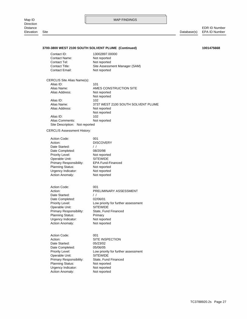
MAP FINDINGSMap IDDirection
EDR ID NumberDistanceEPA ID NumberDatabase(s)SiteElevation
Not reportedAction Anomaly: Not reportedUrgency Indicator: Not reportedPlanning Status: State, Fund FinancedPrimary Responsibility: SITEWIDEOperable Unit: Low priority for further assessmentPriority Level: 05/06/05Date Completed: 05/23/02Date Started: SITE INSPECTIONAction: 001Action Code:
Not reportedAction Anomaly: Not reportedUrgency Indicator: PrimaryPlanning Status: State, Fund FinancedPrimary Responsibility: SITEWIDEOperable Unit: Low priority for further assessmentPriority Level: 02/06/01Date Completed: / /Date Started: PRELIMINARY ASSESSMENTAction: 001Action Code:
Not reportedAction Anomaly: Not reportedUrgency Indicator: Not reportedPlanning Status: EPA Fund-FinancedPrimary Responsibility: SITEWIDEOperable Unit: Not reportedPriority Level: 08/20/98Date Completed: / /Date Started: DISCOVERYAction: 001Action Code:
CERCLIS Assessment History:
Not reportedSite Description: Not reportedAlias Comments: 102Alias ID: Not reported Not reportedAlias Address: 3737 WEST 2100 SOUTH SOLVENT PLUMEAlias Name: 102Alias ID: Not reported Not reportedAlias Address: AMES CONSTRUCTION SITEAlias Name: 101Alias ID:
CERCLIS Site Alias Name(s):
Not reportedContact Email: Site Assessment Manager (SAM)Contact Title: Not reportedContact Tel: Not reportedContact Name: 13002897.00000Contact ID:
3700-3800 WEST 2100 SOUTH SOLVENT PLUME (Continued) 1001475668
TC3788920.2s Page 27

MAP FINDINGSMap IDDirection
EDR ID NumberDistanceEPA ID NumberDatabase(s)SiteElevation
3Closed Tanks: 3Total Tanks: (801) 972-6000Owner Phone: SALT LAKE CITY, UT 84104Owner City,St,Zip: 1864 S 3730 WOwner Address: CARLSON DISTRIBUTING CO INCOwner Name: 4000140Facility ID:
UST:
[Kimberly Shelley]Project Manager: SALT LAKE CITY, UT 84104Owner City,St,Zip: 84104Owner Zip: UTOwner State: SALT LAKE CITYOwner City: 1864 S 3730 WOwner Address: CARLSON DISTRIBUTING CO INCOwner Name: 12/29/1999Notification Date: 03/21/2000Closed Date: LCVRelease Id: 4000140Facility ID:
LUST:
1107 ft.0.210 mi.
Relative:Lower
Actual:4238 ft.
1/8-1/4 SALT LAKE CITY, UT 84104NNW UT UST1864 S 3730 W N/A16 UT LUSTCARLSON DISTRIBUTING CO, INC. U003149952
UTR000306Permit:NPDES:
2Closed Tanks: 2Total Tanks: (801) 569-8012Owner Phone: SALT LAKE CITY, UT 84120Owner City,St,Zip: 3737 W 2100 SOwner Address: AMES CONSTRUCTION COOwner Name: 4000816Facility ID:
UST:
[Dale Urban]Project Manager: SALT LAKE CITY, UT 84120Owner City,St,Zip: 84120Owner Zip: UTOwner State: SALT LAKE CITYOwner City: 3737 W 2100 SOwner Address: AMES CONSTRUCTION COOwner Name: 06/02/2003Notification Date: 01/05/2004Closed Date: LSMRelease Id: 4000816Facility ID:
LUST:
1235 ft. Site 1 of 2 in cluster F0.234 mi.
Relative:Higher
Actual:4244 ft.
1/8-1/4 UT NPDESWEST VALLEY CITY, UT 84120WSW UT UST3765 W 2100 S N/AF17 UT LUSTBROWNING-FERRIS INDUSTRIES 1001187428
TC3788920.2s Page 28

MAP FINDINGSMap IDDirection
EDR ID NumberDistanceEPA ID NumberDatabase(s)SiteElevation
-111.9825Facility Site Long: +40.725278Facility Site Lat: Not reportedDMR Cognizant Official Tele: Not reportedDMR Cognizant Official: BFI WASTE SYSTEMS OF NOTH AMERICA, INCPermit Name: Storm Water Non-ConstructionPermit Type: Not reportedNot Received: Not reportedNo Exposure: Not reportedInactivated: 12/31/1998Date Coverage Expires: 01/01/1998Date Coverage Effective: 01/01/1998Date Coverage Issued/Renewed: Not reportedDate Noi Complete: Not reportedDate Noi Received: Not reportedAmount Paid: Not reportedDate Signed: Not reportedCertification Name: Not reportedFourth Sector: Not reportedThird Sector: Not reportedSecondary Sector: Not reportedPrimary Sector: Not reportedGroup 5: Not reportedGroup 4: Not reportedGroup 3: Not reportedGroup 2: Not reportedGroup 1: Not reportedPrimary SIC Code: Not reportedReceiving Water Body: Not reportedMuni Operating Storm Sewer System: Not reportedFacility Site Contact Phone: Not reportedFacility Site Contact Tile: Not reportedFacility Site Contact Person: Not reportedFacility Oper Contact Phone: Not reportedFacility Oper Contact Title: Not reportedFacility Oper Contact Person: Not reportedStatus Of Owner/Oper: Not reportedFacility Oper Phone #: Not reportedFacility Oper Zip: Not reportedFacility Oper State: Not reportedFacility Oper City: Not reportedFacility Oper Address: Not reportedFacility Oper Name: GRAMANonConstruction Storm Water: Not reportedState Water Body Name: 12/31/1998Expiration Date: 01/01/1998Issue Date: Not reportedFacility Contact Name:
BROWNING-FERRIS INDUSTRIES (Continued) 1001187428
TC3788920.2s Page 29

MAP FINDINGSMap IDDirection
EDR ID NumberDistanceEPA ID NumberDatabase(s)SiteElevation
Small Quantity GeneratorClassification: BFI OF UTAH INCFacility name: 11/10/1980Date form received by agency:
Historical Generators:
NoUsed oil transporter: NoUsed oil transfer facility: NoUsed oil Specification marketer: NoUsed oil fuel marketer to burner: NoUser oil refiner: NoUsed oil processor: NoUsed oil fuel burner: NoFurnace exemption: NoOn-site burner exemption: NoUnderground injection activity: NoTreater, storer or disposer of HW: NoTransporter of hazardous waste: NoRecycler of hazardous waste: NoMixed waste (haz. and radioactive): NoU.S. importer of hazardous waste:
Handler Activities Summary:
Not reportedOwner/Op end date: Not reportedOwner/Op start date: OwnerOwner/Operator Type: PrivateLegal status: (801) 972-4234Owner/operator telephone: Not reportedOwner/operator country: MURRAY, UT 84107 5205 SOUTH 300 WESTOwner/operator address: VLT FAMILY PARTNERSHIPOwner/operator name:
Owner/Operator Summary:
Handler: Non-Generators do not presently generate hazardous wasteDescription: Non-GeneratorClassification: PrivateLand type: 08EPA Region: Not reportedContact email: (801) 972-4234Contact telephone: USContact country: WEST VALLEY CITY, UT 84120 3765 WEST 2100 SOUTHContact address: DAN HOWARDContact: WEST VALLEY CITY, UT 84120 WEST 2100 SOUTHMailing address: UTD086812906EPA ID: WEST VALLEY CITY, UT 84120 3765 WEST 2100 SOUTHFacility address: BFI OF UTAH INCFacility name: 09/04/2007Date form received by agency:
RCRA NonGen / NLR:
1235 ft. Site 2 of 2 in cluster F0.234 mi.
Relative:Higher
Actual:4244 ft.
1/8-1/4 US AIRSWEST VALLEY CITY, UT 84120WSW FINDS3765 WEST 2100 SOUTH UTD086812906F18 RCRA NonGen / NLRBROWNING-FERRIS INDUSTRIES OF UTAH 1000472345
TC3788920.2s Page 30
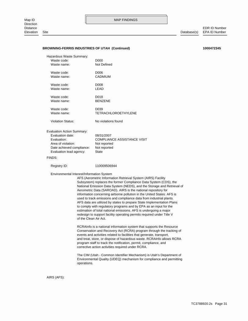
MAP FINDINGSMap IDDirection
EDR ID NumberDistanceEPA ID NumberDatabase(s)SiteElevation
AIRS (AFS):
operations.Environmental Quality (UDEQ) mechanism for compliance and permittingThe CIM (Utah - Common Identifier Mechanism) is Utah’s Department of
corrective action activities required under RCRA.program staff to track the notification, permit, compliance, andand treat, store, or dispose of hazardous waste. RCRAInfo allows RCRAevents and activities related to facilities that generate, transport,Conservation and Recovery Act (RCRA) program through the tracking ofRCRAInfo is a national information system that supports the Resource
of the Clean Air Act.redesign to support facility operating permits required under Title Vestimation of total national emissions. AFS is undergoing a majorto comply with regulatory programs and by EPA as an input for theAFS data are utilized by states to prepare State Implementation Plansused to track emissions and compliance data from industrial plants.information concerning airborne pollution in the United States. AFS isAerometric Data (SAROAD). AIRS is the national repository forNational Emission Data System (NEDS), and the Storage and Retrieval ofSubsystem) replaces the former Compliance Data System (CDS), theAFS (Aerometric Information Retrieval System (AIRS) Facility Environmental Interest/Information System
110009506944Registry ID:
FINDS:
StateEvaluation lead agency: Not reportedDate achieved compliance: Not reportedArea of violation: COMPLIANCE ASSISTANCE VISITEvaluation: 08/31/2007Evaluation date:
Evaluation Action Summary:
No violations foundViolation Status:
TETRACHLOROETHYLENEWaste name: D039Waste code:
BENZENEWaste name: D018Waste code:
LEADWaste name: D008Waste code:
CADMIUMWaste name: D006Waste code:
Not DefinedWaste name: D000Waste code:
Hazardous Waste Summary:
BROWNING-FERRIS INDUSTRIES OF UTAH (Continued) 1000472345
TC3788920.2s Page 31
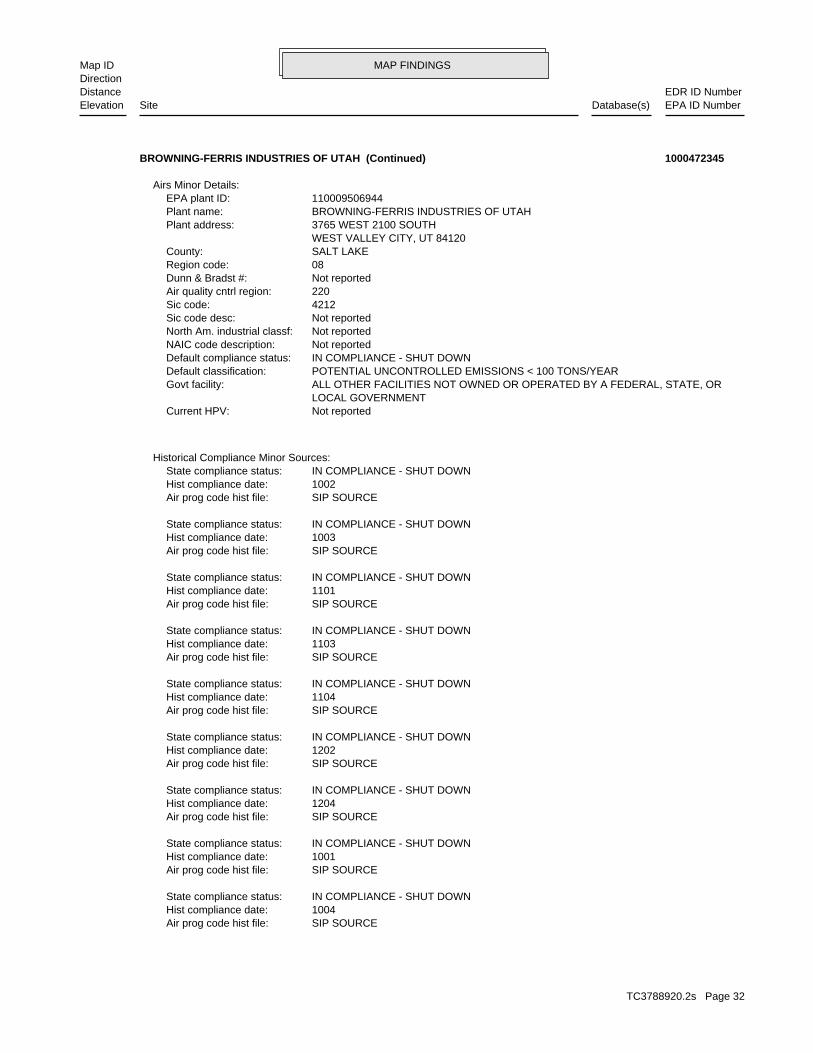
MAP FINDINGSMap IDDirection
EDR ID NumberDistanceEPA ID NumberDatabase(s)SiteElevation
SIP SOURCEAir prog code hist file: 1004Hist compliance date: IN COMPLIANCE - SHUT DOWNState compliance status:
SIP SOURCEAir prog code hist file: 1001Hist compliance date: IN COMPLIANCE - SHUT DOWNState compliance status:
SIP SOURCEAir prog code hist file: 1204Hist compliance date: IN COMPLIANCE - SHUT DOWNState compliance status:
SIP SOURCEAir prog code hist file: 1202Hist compliance date: IN COMPLIANCE - SHUT DOWNState compliance status:
SIP SOURCEAir prog code hist file: 1104Hist compliance date: IN COMPLIANCE - SHUT DOWNState compliance status:
SIP SOURCEAir prog code hist file: 1103Hist compliance date: IN COMPLIANCE - SHUT DOWNState compliance status:
SIP SOURCEAir prog code hist file: 1101Hist compliance date: IN COMPLIANCE - SHUT DOWNState compliance status:
SIP SOURCEAir prog code hist file: 1003Hist compliance date: IN COMPLIANCE - SHUT DOWNState compliance status:
SIP SOURCEAir prog code hist file: 1002Hist compliance date: IN COMPLIANCE - SHUT DOWNState compliance status:
Historical Compliance Minor Sources:
Not reportedCurrent HPV: LOCAL GOVERNMENT ALL OTHER FACILITIES NOT OWNED OR OPERATED BY A FEDERAL, STATE, ORGovt facility: POTENTIAL UNCONTROLLED EMISSIONS < 100 TONS/YEARDefault classification: IN COMPLIANCE - SHUT DOWNDefault compliance status: Not reportedNAIC code description: Not reportedNorth Am. industrial classf: Not reportedSic code desc: 4212Sic code: 220Air quality cntrl region: Not reportedDunn & Bradst #: 08Region code: SALT LAKECounty: WEST VALLEY CITY, UT 84120 3765 WEST 2100 SOUTHPlant address: BROWNING-FERRIS INDUSTRIES OF UTAHPlant name: 110009506944EPA plant ID:
Airs Minor Details:
BROWNING-FERRIS INDUSTRIES OF UTAH (Continued) 1000472345
TC3788920.2s Page 32

MAP FINDINGSMap IDDirection
EDR ID NumberDistanceEPA ID NumberDatabase(s)SiteElevation
Not reportedTurnover compliance: Not reportedRepeat violator date: ATTAINMENT AREA FOR GIVEN POLLUTANTDef. attainment/non attnmnt: IN COMPLIANCE - SHUT DOWNDef. poll. compliance status: POTENTIAL UNCONTROLLED EMISSIONS < 100 TONS/YEARDefault pollutant classification: VOLATILE ORGANIC COMPOUNDSPlant air program pollutant: SIP SOURCEAir program code:
Compliance & Violation Data by Minor Sources:
SIP SOURCEAir prog code hist file: 1203Hist compliance date: IN COMPLIANCE - SHUT DOWNState compliance status:
SIP SOURCEAir prog code hist file: 1201Hist compliance date: IN COMPLIANCE - SHUT DOWNState compliance status:
SIP SOURCEAir prog code hist file: 1102Hist compliance date: IN COMPLIANCE - SHUT DOWNState compliance status:
BROWNING-FERRIS INDUSTRIES OF UTAH (Continued) 1000472345
6Closed Tanks: 6Total Tanks: (801) 973-3000Owner Phone: SALT LAKE CITY, UT 84119Owner City,St,Zip: 2185 S 3600 WOwner Address: KUTV INCOwner Name: 4000492Facility ID:
UST:
[Doug Hansen]Project Manager: SALT LAKE CITY, UT 84119Owner City,St,Zip: 84119Owner Zip: UTOwner State: SALT LAKE CITYOwner City: 2185 S 3600 WOwner Address: KUTV INCOwner Name: 05/11/1994Notification Date: 11/01/1996Closed Date: IORRelease Id: 4000492Facility ID:
LUST:
1279 ft.0.242 mi.
Relative:Higher
Actual:4244 ft.
1/8-1/4 SALT LAKE CITY, UT 84119SSE UT UST2185 S 3600 W N/A19 UT LUSTKUTV, INC. U003150525
TC3788920.2s Page 33

MAP FINDINGSMap IDDirection
EDR ID NumberDistanceEPA ID NumberDatabase(s)SiteElevation
2Closed Tanks: 2Total Tanks: Not reportedOwner Phone: SALT LAKE CITY, UT 84125Owner City,St,Zip: 1825 S 3730 WOwner Address: MOUNT OLYMPUS WATERS INCOwner Name: 4000624Facility ID:
UST:
[Dale Urban]Project Manager: SALT LAKE CITY, UT 84125Owner City,St,Zip: 84125Owner Zip: UTOwner State: SALT LAKE CITYOwner City: 1825 S 3730 WOwner Address: MOUNT OLYMPUS WATERS INCOwner Name: 09/18/1992Notification Date: 01/26/1995Closed Date: HUYRelease Id: 4000624Facility ID:
LUST:
1315 ft.0.249 mi.
Relative:Lower
Actual:4238 ft.
1/8-1/4 SALT LAKE CITY, UT 84125NNW UT UST1825 S 3730 W N/A20 UT LUSTMOUNT OLYMPUS WATERS,INC. U003150639
7746New Incident Number:SPILLS:
1Closed Tanks: 4Total Tanks: (801) 973-2409Owner Phone: SALT LAKE CITY, UT 84104Owner City,St,Zip: 3730 W 1820 SOwner Address: MEADOW GOLD DAIRIES INCOwner Name: 4000909Facility ID:
UST:
Hong Lei TaoProject Manager: SALT LAKE CITY, UT 84104Owner City,St,Zip: 84104Owner Zip: UTOwner State: SALT LAKE CITYOwner City: 3730 W 1820 SOwner Address: MEADOW GOLD DAIRIES INCOwner Name: 11/06/2003Notification Date: Not reportedClosed Date: LULRelease Id: 4000909Facility ID:
LUST:
1490 ft. UT Financial Assurance0.282 mi. UT NPDES
Relative:Lower
Actual:4238 ft.
1/4-1/2 UT SPILLSSALT LAKE CITY, UT 84104NNW UT UST3730 W 1820 S N/A21 UT LUSTMEADOW GOLD DAIRIES, INC. U003149960
TC3788920.2s Page 34

MAP FINDINGSMap IDDirection
EDR ID NumberDistanceEPA ID NumberDatabase(s)SiteElevation
INDUSTRIALPermit Type: Not reportedNot Received: 0No Exposure: Not reportedInactivated: 12/31/2015Date Coverage Expires: 02/01/2011Date Coverage Effective: Not reportedDate Coverage Issued/Renewed: Not reportedDate Noi Complete: 12/27/2010Date Noi Received: 500Amount Paid: 12/27/2010Date Signed: KENNETH LANGFORDCertification Name: Not reportedFourth Sector: Not reportedThird Sector: Not reportedSecondary Sector: 2026Primary Sector: Not reportedGroup 5: Not reportedGroup 4: Not reportedGroup 3: Not reportedGroup 2: Not reportedGroup 1: 2026Primary SIC Code: LEE DRAINReceiving Water Body: SALT LAKE CITYMuni Operating Storm Sewer System: (801) 973-2409Facility Site Contact Phone: PLANT MANAGERFacility Site Contact Tile: KENNETH LANGFORDFacility Site Contact Person: (214) 721-1166Facility Oper Contact Phone: VP ENVIRON, H&SFacility Oper Contact Title: DENNIS BUSCHFacility Oper Contact Person: MAINStatus Of Owner/Oper: (214) 303-3400Facility Oper Phone #: 75204Facility Oper Zip: TXFacility Oper State: OTHERFacility Oper City: 2711 N HASKELL AVE, STE 3400Facility Oper Address: SOUTHERN FOODS GROUP, LLCFacility Oper Name: STORMWATERNonConstruction Storm Water: LEE DRAINState Water Body Name: 12/31/2015Expiration Date: Not reportedIssue Date: KENNETH LANGFORDFacility Contact Name: UTR000060Permit:
NPDES:
spill site. into a storm drain. He said that a pumper truck is on its way to the Caller reported a release of approximately 500-1000 gallons of milkIncident Summary: milkMaterial: 0Mile Marker: Not reportedHighway: 8019732409RP Phone: 3730 W 1820 S, Salt Lake City, Utah, 84104RP Address: Meadow GoldResponsible Party Name: 04/19/2010Incident Start Date: 04/19/2010Date Reported: Not reportedOld incident number:
MEADOW GOLD DAIRIES, INC. (Continued) U003149960
TC3788920.2s Page 35
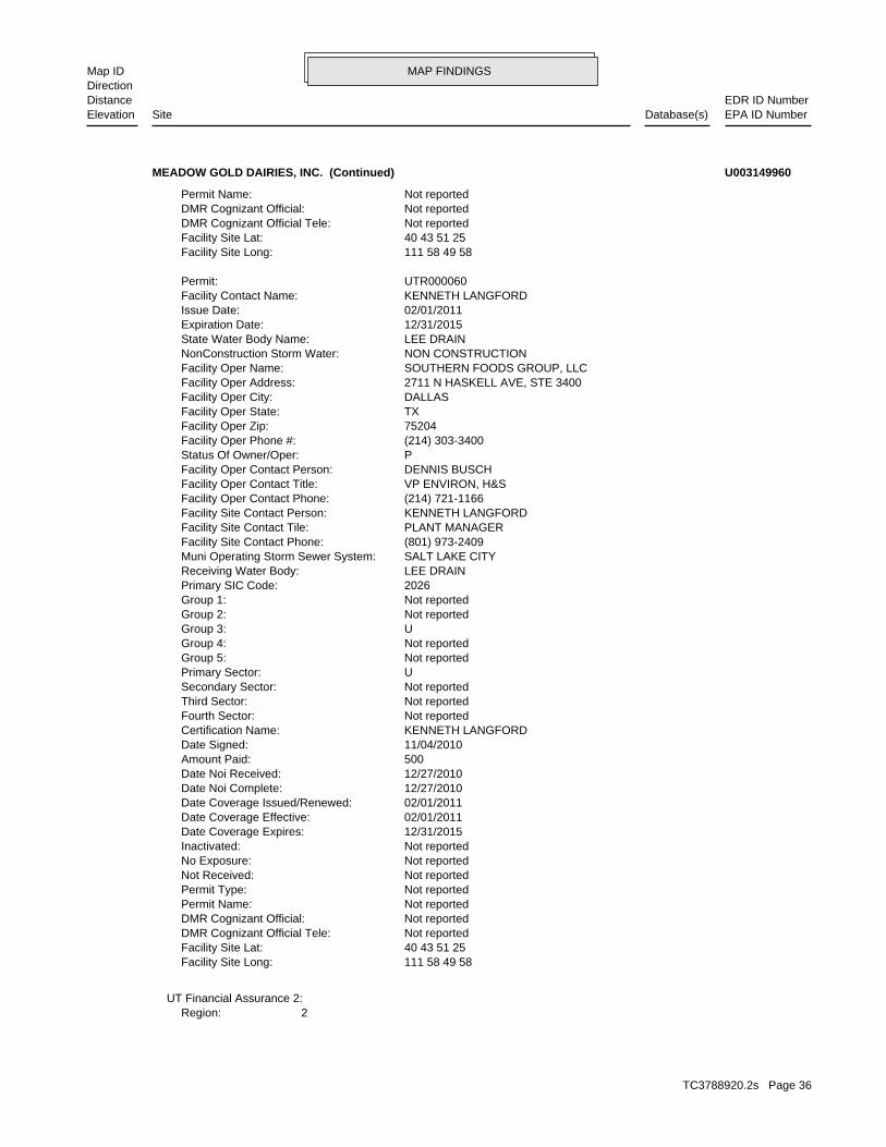
MAP FINDINGSMap IDDirection
EDR ID NumberDistanceEPA ID NumberDatabase(s)SiteElevation
2Region:UT Financial Assurance 2:
111 58 49 58Facility Site Long: 40 43 51 25Facility Site Lat: Not reportedDMR Cognizant Official Tele: Not reportedDMR Cognizant Official: Not reportedPermit Name: Not reportedPermit Type: Not reportedNot Received: Not reportedNo Exposure: Not reportedInactivated: 12/31/2015Date Coverage Expires: 02/01/2011Date Coverage Effective: 02/01/2011Date Coverage Issued/Renewed: 12/27/2010Date Noi Complete: 12/27/2010Date Noi Received: 500Amount Paid: 11/04/2010Date Signed: KENNETH LANGFORDCertification Name: Not reportedFourth Sector: Not reportedThird Sector: Not reportedSecondary Sector: UPrimary Sector: Not reportedGroup 5: Not reportedGroup 4: UGroup 3: Not reportedGroup 2: Not reportedGroup 1: 2026Primary SIC Code: LEE DRAINReceiving Water Body: SALT LAKE CITYMuni Operating Storm Sewer System: (801) 973-2409Facility Site Contact Phone: PLANT MANAGERFacility Site Contact Tile: KENNETH LANGFORDFacility Site Contact Person: (214) 721-1166Facility Oper Contact Phone: VP ENVIRON, H&SFacility Oper Contact Title: DENNIS BUSCHFacility Oper Contact Person: PStatus Of Owner/Oper: (214) 303-3400Facility Oper Phone #: 75204Facility Oper Zip: TXFacility Oper State: DALLASFacility Oper City: 2711 N HASKELL AVE, STE 3400Facility Oper Address: SOUTHERN FOODS GROUP, LLCFacility Oper Name: NON CONSTRUCTIONNonConstruction Storm Water: LEE DRAINState Water Body Name: 12/31/2015Expiration Date: 02/01/2011Issue Date: KENNETH LANGFORDFacility Contact Name: UTR000060Permit:
111 58 49 58Facility Site Long: 40 43 51 25Facility Site Lat: Not reportedDMR Cognizant Official Tele: Not reportedDMR Cognizant Official: Not reportedPermit Name:
MEADOW GOLD DAIRIES, INC. (Continued) U003149960
TC3788920.2s Page 36
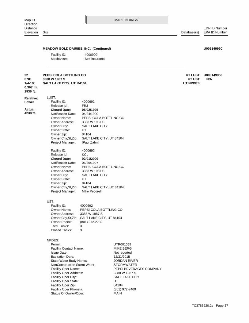
MAP FINDINGSMap IDDirection
EDR ID NumberDistanceEPA ID NumberDatabase(s)SiteElevation
Self-insuranceMechanism: 4000909Facility ID:
MEADOW GOLD DAIRIES, INC. (Continued) U003149960
MAINStatus Of Owner/Oper: (801) 972-7400Facility Oper Phone #: 84104Facility Oper Zip: UTFacility Oper State: SALT LAKE CITYFacility Oper City: 3388 W 1987 SFacility Oper Address: PEPSI BEVERAGES COMPANYFacility Oper Name: STORMWATERNonConstruction Storm Water: JORDAN RIVERState Water Body Name: 12/31/2015Expiration Date: Not reportedIssue Date: MIKE BERGFacility Contact Name: UTR001059Permit:
NPDES:
3Closed Tanks: 3Total Tanks: (801) 972-2732Owner Phone: SALT LAKE CITY, UT 84104Owner City,St,Zip: 3388 W 1987 SOwner Address: PEPSI COLA BOTTLING COOwner Name: 4000692Facility ID:
UST:
Mike PecorelliProject Manager: SALT LAKE CITY, UT 84104Owner City,St,Zip: 84104Owner Zip: UTOwner State: SALT LAKE CITYOwner City: 3388 W 1987 SOwner Address: PEPSI COLA BOTTLING COOwner Name: 06/26/1997Notification Date: 02/01/2009Closed Date: KCLRelease Id: 4000692Facility ID:
[Paul Zahn]Project Manager: SALT LAKE CITY, UT 84104Owner City,St,Zip: 84104Owner Zip: UTOwner State: SALT LAKE CITYOwner City: 3388 W 1987 SOwner Address: PEPSI COLA BOTTLING COOwner Name: 04/24/1990Notification Date: 05/02/1995Closed Date: FRJRelease Id: 4000692Facility ID:
LUST:
1936 ft.0.367 mi.
Relative:Lower
Actual:4238 ft.
1/4-1/2 UT NPDESSALT LAKE CITY, UT 84104ENE UT UST3388 W 1987 S N/A22 UT LUSTPEPSI COLA BOTTLING CO U003149953
TC3788920.2s Page 37

MAP FINDINGSMap IDDirection
EDR ID NumberDistanceEPA ID NumberDatabase(s)SiteElevation
JORDAN RIVERReceiving Water Body: SLC DEPT OF PUBLIC UTILITIESMuni Operating Storm Sewer System: (801) 972-7474Facility Site Contact Phone: PLANT MANAGERFacility Site Contact Tile: MIKE BERGFacility Site Contact Person: (801) 972-7474Facility Oper Contact Phone: PLANT MANAGERFacility Oper Contact Title: MIKE BERGFacility Oper Contact Person: PStatus Of Owner/Oper: (801) 972-7400Facility Oper Phone #: 84104Facility Oper Zip: UTFacility Oper State: SALT LAKE CITYFacility Oper City: 3388 W 1987 SFacility Oper Address: PEPSI BEVERAGES COMPANYFacility Oper Name: NON CONSTRUCTIONNonConstruction Storm Water: JORDAN RIVERState Water Body Name: 12/31/2015Expiration Date: 02/01/2011Issue Date: MIKE BERGFacility Contact Name: UTR001059Permit:
111 58 19 65Facility Site Long: 40 43Facility Site Lat: Not reportedDMR Cognizant Official Tele: Not reportedDMR Cognizant Official: Not reportedPermit Name: INDUSTRIALPermit Type: Not reportedNot Received: 0No Exposure: Not reportedInactivated: 12/31/2015Date Coverage Expires: 02/01/2011Date Coverage Effective: Not reportedDate Coverage Issued/Renewed: Not reportedDate Noi Complete: 10/27/2010Date Noi Received: 500Amount Paid: 10/27/2010Date Signed: MICHAEL O BERGCertification Name: Not reportedFourth Sector: Not reportedThird Sector: Not reportedSecondary Sector: 2086Primary Sector: Not reportedGroup 5: Not reportedGroup 4: Not reportedGroup 3: Not reportedGroup 2: Not reportedGroup 1: 2086Primary SIC Code: JORDAN RIVERReceiving Water Body: SLC DEPT OF PUBLIC UTILITIESMuni Operating Storm Sewer System: (801) 972-7474Facility Site Contact Phone: PLANT MANAGERFacility Site Contact Tile: MIKE BERGFacility Site Contact Person: (801) 972-7474Facility Oper Contact Phone: PLANT MANAGERFacility Oper Contact Title: MIKE BERGFacility Oper Contact Person:
PEPSI COLA BOTTLING CO (Continued) U003149953
TC3788920.2s Page 38

MAP FINDINGSMap IDDirection
EDR ID NumberDistanceEPA ID NumberDatabase(s)SiteElevation
111 58 19 65Facility Site Long: 40 43Facility Site Lat: Not reportedDMR Cognizant Official Tele: Not reportedDMR Cognizant Official: Not reportedPermit Name: Not reportedPermit Type: Not reportedNot Received: Not reportedNo Exposure: Not reportedInactivated: 12/31/2015Date Coverage Expires: 02/01/2011Date Coverage Effective: 02/01/2011Date Coverage Issued/Renewed: 10/27/2010Date Noi Complete: 10/27/2010Date Noi Received: 500Amount Paid: 10/12/2010Date Signed: MICHAEL O BERGCertification Name: Not reportedFourth Sector: Not reportedThird Sector: Not reportedSecondary Sector: UPrimary Sector: Not reportedGroup 5: Not reportedGroup 4: UGroup 3: Not reportedGroup 2: Not reportedGroup 1: 2086Primary SIC Code:
PEPSI COLA BOTTLING CO (Continued) U003149953
land or water, of acutely hazardous waste; or generates 100 kg or less other debris resulting from the cleanup of a spill, into or on any waste; or 100 kg or less of any residue or contaminated soil, waste or month, and accumulates at any time: 1 kg or less of acutely hazardous or generates 1 kg or less of acutely hazardous waste per calendar month, and accumulates 1000 kg or less of hazardous waste at any time; Handler: generates 100 kg or less of hazardous waste per calendarDescription: Conditionally Exempt Small Quantity GeneratorClassification: PrivateLand type: 08EPA Region: Not reportedContact email: (801) 972-5588Contact telephone: USContact country: SALT LAKE CITY, UT 841191197 3333 WEST 2100 SOUTHContact address: TOM MCELREATHContact: SALT LAKE CITY, UT 841191197 WEST 2100 SOUTHMailing address: UT0000018044EPA ID: SALT LAKE CITY, UT 841191197 3333 WEST 2100 SOUTHFacility address: RASMUSSEN EQUIPMENT COMPANYFacility name: 09/24/1993Date form received by agency:
RCRA-CESQG:
2429 ft. UT Financial Assurance0.460 mi. UT UST
Relative:Higher
Actual:4244 ft.
1/4-1/2 UT LUSTSALT LAKE CITY, UT 84119East FINDS3333 WEST 2100 SOUTH UT000001804423 RCRA-CESQGRASMUSSEN EQUIPMENT COMPANY 1000877696
TC3788920.2s Page 39

MAP FINDINGSMap IDDirection
EDR ID NumberDistanceEPA ID NumberDatabase(s)SiteElevation
BOTTOMS FROM THE RECOVERY OF THESE SPENT SOLVENTS AND SPENT SOLVENT MORE OF THOSE SOLVENTS LISTED IN F001, F002, F004, AND F005, AND STILL SOLVENTS, AND, A TOTAL OF TEN PERCENT OR MORE (BY VOLUME) OF ONE OR CONTAINING, BEFORE USE, ONE OR MORE OF THE ABOVE NON-HALOGENATED NON-HALOGENATED SOLVENTS; AND ALL SPENT SOLVENT MIXTURES/BLENDS MIXTURES/BLENDS CONTAINING, BEFORE USE, ONLY THE ABOVE SPENT ALCOHOL, CYCLOHEXANONE, AND METHANOL; ALL SPENT SOLVENT ACETATE, ETHYL BENZENE, ETHYL ETHER, METHYL ISOBUTYL KETONE, N-BUTYL THE FOLLOWING SPENT NON-HALOGENATED SOLVENTS: XYLENE, ACETONE, ETHYLWaste name: F003Waste code:
WHICH WOULD BE CONSIDERED AS IGNITABLE HAZARDOUS WASTE. MATERIAL. LACQUER THINNER IS AN EXAMPLE OF A COMMONLY USED SOLVENT WHICH CAN BE OBTAINED FROM THE MANUFACTURER OR DISTRIBUTOR OF THE FLASH POINT OF A WASTE IS TO REVIEW THE MATERIAL SAFETY DATA SHEET, CLOSED CUP FLASH POINT TESTER. ANOTHER METHOD OF DETERMINING THE LESS THAN 140 DEGREES FAHRENHEIT AS DETERMINED BY A PENSKY-MARTENS IGNITABLE HAZARDOUS WASTES ARE THOSE WASTES WHICH HAVE A FLASHPOINT OFWaste name: D001Waste code:
Hazardous Waste Summary:
NoUsed oil transporter: NoUsed oil transfer facility: NoUsed oil Specification marketer: NoUsed oil fuel marketer to burner: NoUser oil refiner: NoUsed oil processor: NoUsed oil fuel burner: NoFurnace exemption: NoOn-site burner exemption: NoUnderground injection activity: NoTreater, storer or disposer of HW: NoTransporter of hazardous waste: NoRecycler of hazardous waste: NoMixed waste (haz. and radioactive): NoU.S. importer of hazardous waste:
Handler Activities Summary:
Not reportedOwner/Op end date: Not reportedOwner/Op start date: OwnerOwner/Operator Type: PrivateLegal status: (801) 972-5588Owner/operator telephone: Not reportedOwner/operator country: SALT LAKE CITY, UT 84119 3333 WEST 2100 SOUTHOwner/operator address: RICHARD & ROBERT RASMUSSENOwner/operator name:
Owner/Operator Summary:
hazardous waste the cleanup of a spill, into or on any land or water, of acutely any residue or contaminated soil, waste or other debris resulting from time: 1 kg or less of acutely hazardous waste; or 100 kg or less of hazardous waste during any calendar month, and accumulates at any from the cleanup of a spill, into or on any land or water, of acutely of any residue or contaminated soil, waste or other debris resulting
RASMUSSEN EQUIPMENT COMPANY (Continued) 1000877696
TC3788920.2s Page 40

MAP FINDINGSMap IDDirection
EDR ID NumberDistanceEPA ID NumberDatabase(s)SiteElevation
KYORelease Id: 4000784Facility ID:
[Doug Hansen]Project Manager: SALT LAKE CITY, UT 84119Owner City,St,Zip: 84119Owner Zip: UTOwner State: SALT LAKE CITYOwner City: 3333 W 2100 SOwner Address: RASMUSSEN EQUIPMENT COOwner Name: 12/27/2001Notification Date: 07/08/2002Closed Date: LMKRelease Id: 4000784Facility ID:
LUST:
operations.Environmental Quality (UDEQ) mechanism for compliance and permittingThe CIM (Utah - Common Identifier Mechanism) is Utah’s Department of
corrective action activities required under RCRA.program staff to track the notification, permit, compliance, andand treat, store, or dispose of hazardous waste. RCRAInfo allows RCRAevents and activities related to facilities that generate, transport,Conservation and Recovery Act (RCRA) program through the tracking ofRCRAInfo is a national information system that supports the Resource Environmental Interest/Information System
110002296284Registry ID:
FINDS:
StateEvaluation lead agency: 08/04/1994Date achieved compliance: Generators - GeneralArea of violation: COMPLIANCE EVALUATION INSPECTION ON-SITEEvaluation: 08/04/1993Evaluation date:
Evaluation Action Summary:
Not reported Paid penalty amount: Not reported Final penalty amount: Not reported Proposed penalty amount: State Enforcement lead agency: Not reported Enf. disp. status date: Not reported Enf. disposition status: 10/13/1993 Enforcement action date: WRITTEN INFORMAL Enforcement action: StateViolation lead agency: 08/04/1994Date achieved compliance: 10/13/1993Date violation determined: Generators - GeneralArea of violation: Not reportedRegulation violated:
Facility Has Received Notices of Violations:
MIXTURES.
RASMUSSEN EQUIPMENT COMPANY (Continued) 1000877696
TC3788920.2s Page 41
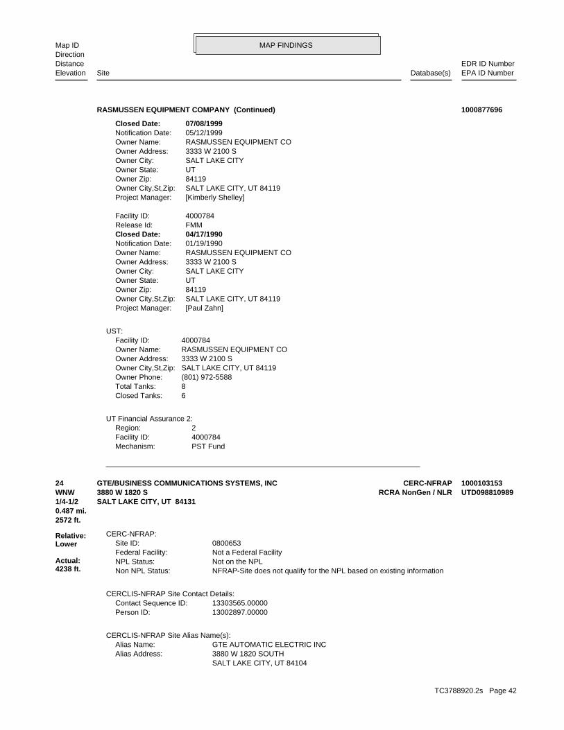
MAP FINDINGSMap IDDirection
EDR ID NumberDistanceEPA ID NumberDatabase(s)SiteElevation
PST FundMechanism: 4000784Facility ID: 2Region:
UT Financial Assurance 2:
6Closed Tanks: 8Total Tanks: (801) 972-5588Owner Phone: SALT LAKE CITY, UT 84119Owner City,St,Zip: 3333 W 2100 SOwner Address: RASMUSSEN EQUIPMENT COOwner Name: 4000784Facility ID:
UST:
[Paul Zahn]Project Manager: SALT LAKE CITY, UT 84119Owner City,St,Zip: 84119Owner Zip: UTOwner State: SALT LAKE CITYOwner City: 3333 W 2100 SOwner Address: RASMUSSEN EQUIPMENT COOwner Name: 01/19/1990Notification Date: 04/17/1990Closed Date: FMMRelease Id: 4000784Facility ID:
[Kimberly Shelley]Project Manager: SALT LAKE CITY, UT 84119Owner City,St,Zip: 84119Owner Zip: UTOwner State: SALT LAKE CITYOwner City: 3333 W 2100 SOwner Address: RASMUSSEN EQUIPMENT COOwner Name: 05/12/1999Notification Date: 07/08/1999Closed Date:
RASMUSSEN EQUIPMENT COMPANY (Continued) 1000877696
SALT LAKE CITY, UT 84104 3880 W 1820 SOUTHAlias Address: GTE AUTOMATIC ELECTRIC INCAlias Name:
CERCLIS-NFRAP Site Alias Name(s):
13002897.00000Person ID: 13303565.00000Contact Sequence ID:
CERCLIS-NFRAP Site Contact Details:
NFRAP-Site does not qualify for the NPL based on existing informationNon NPL Status: Not on the NPLNPL Status: Not a Federal FacilityFederal Facility: 0800653Site ID:
CERC-NFRAP:
2572 ft.0.487 mi.
Relative:Lower
Actual:4238 ft.
1/4-1/2 SALT LAKE CITY, UT 84131WNW RCRA NonGen / NLR3880 W 1820 S UTD09881098924 CERC-NFRAPGTE/BUSINESS COMMUNICATIONS SYSTEMS, INC 1000103153
TC3788920.2s Page 42

MAP FINDINGSMap IDDirection
EDR ID NumberDistanceEPA ID NumberDatabase(s)SiteElevation
NoUsed oil fuel burner: NoFurnace exemption: NoOn-site burner exemption: NoUnderground injection activity: NoTreater, storer or disposer of HW: NoTransporter of hazardous waste: NoRecycler of hazardous waste: NoMixed waste (haz. and radioactive): NoU.S. importer of hazardous waste:
Handler Activities Summary:
Not reportedOwner/Op end date: 01/01/0001Owner/Op start date: OwnerOwner/Operator Type: PrivateLegal status: (801) 972-4121Owner/operator telephone: Not reportedOwner/operator country: SALT LAKE CITY, UT 84015 3880 WEST 1820 SOUTHOwner/operator address: GTE AUTOMATIC ELECTRIC INCORPORATEDOwner/operator name:
Owner/Operator Summary:
Handler: Non-Generators do not presently generate hazardous wasteDescription: Non-GeneratorClassification: 08EPA Region: Not reportedContact email: (312) 681-7100Contact telephone: USContact country: NORTHLAKE, IL 60164 400 NORTH WOLF ROADContact address: R-SUPV CUDZEWICZContact: NORTHLAKE, IL 60164 NORTH WOLF ROADMailing address: UTD098810989EPA ID: SALT LAKE CITY, UT 84015 3880 WEST 1820 SOUTHFacility address: GTE AUTOMATIC ELECTRIC INCORPORATEDFacility name: 02/22/2007Date form received by agency:
RCRA NonGen / NLR:
Not reportedPriority Level: 08/01/80Date Completed: / /Date Started: DISCOVERYAction:
Not reportedPriority Level: 03/30/87Date Completed: / /Date Started: ARCHIVE SITEAction:
NFRAP-Site does not qualify for the NPL based on existing informationPriority Level: 03/30/87Date Completed: / /Date Started: PRELIMINARY ASSESSMENTAction:
CERCLIS-NFRAP Assessment History:
GTE/BUSINESS COMMUNICATIONS SYSTEMS, INC (Continued) 1000103153
TC3788920.2s Page 43

MAP FINDINGSMap IDDirection
EDR ID NumberDistanceEPA ID NumberDatabase(s)SiteElevation
U002Waste code:
THESE SPENT SOLVENTS AND SPENT SOLVENT MIXTURES. LISTED IN F001, F002, OR F004; AND STILL BOTTOMS FROM THE RECOVERY OF ONE OR MORE OF THE ABOVE NON-HALOGENATED SOLVENTS OR THOSE SOLVENTS CONTAINING, BEFORE USE, A TOTAL OF TEN PERCENT OR MORE (BY VOLUME) OF 2-ETHOXYETHANOL, AND 2-NITROPROPANE; ALL SPENT SOLVENT MIXTURES/BLENDS KETONE, CARBON DISULFIDE, ISOBUTANOL, PYRIDINE, BENZENE, THE FOLLOWING SPENT NON-HALOGENATED SOLVENTS: TOLUENE, METHYL ETHYLWaste name: F005Waste code:
MIXTURES. BOTTOMS FROM THE RECOVERY OF THESE SPENT SOLVENTS AND SPENT SOLVENT MORE OF THOSE SOLVENTS LISTED IN F001, F002, F004, AND F005, AND STILL SOLVENTS, AND, A TOTAL OF TEN PERCENT OR MORE (BY VOLUME) OF ONE OR CONTAINING, BEFORE USE, ONE OR MORE OF THE ABOVE NON-HALOGENATED NON-HALOGENATED SOLVENTS; AND ALL SPENT SOLVENT MIXTURES/BLENDS MIXTURES/BLENDS CONTAINING, BEFORE USE, ONLY THE ABOVE SPENT ALCOHOL, CYCLOHEXANONE, AND METHANOL; ALL SPENT SOLVENT ACETATE, ETHYL BENZENE, ETHYL ETHER, METHYL ISOBUTYL KETONE, N-BUTYL THE FOLLOWING SPENT NON-HALOGENATED SOLVENTS: XYLENE, ACETONE, ETHYLWaste name: F003Waste code:
SPENT SOLVENT MIXTURES. F005, AND STILL BOTTOMS FROM THE RECOVERY OF THESE SPENT SOLVENTS AND OF THE ABOVE HALOGENATED SOLVENTS OR THOSE LISTED IN F001, F004, OR BEFORE USE, A TOTAL OF TEN PERCENT OR MORE (BY VOLUME) OF ONE OR MORE 1,1,2-TRICHLOROETHANE; ALL SPENT SOLVENT MIXTURES/BLENDS CONTAINING, ORTHO-DICHLOROBENZENE, TRICHLOROFLUOROMETHANE, AND CHLOROBENZENE, 1,1,2-TRICHLORO-1,2,2-TRIFLUOROETHANE, METHYLENE CHLORIDE, TRICHLOROETHYLENE, 1,1,1-TRICHLOROETHANE, THE FOLLOWING SPENT HALOGENATED SOLVENTS: TETRACHLOROETHYLENE,Waste name: F002Waste code:
SPENT SOLVENTS AND SPENT SOLVENT MIXTURES. IN F002, F004, AND F005, AND STILL BOTTOMS FROM THE RECOVERY OF THESE ONE OR MORE OF THE ABOVE HALOGENATED SOLVENTS OR THOSE SOLVENTS LISTED CONTAINING, BEFORE USE, A TOTAL OF TEN PERCENT OR MORE (BY VOLUME) OF FLUOROCARBONS; ALL SPENT SOLVENT MIXTURES/BLENDS USED IN DEGREASING 1,1,1-TRICHLOROETHANE, CARBON TETRACHLORIDE, AND CHLORINATED TETRACHLOROETHYLENE, TRICHLOROETHYLENE, METHYLENE CHLORIDE, THE FOLLOWING SPENT HALOGENATED SOLVENTS USED IN DEGREASING:Waste name: F001Waste code:
Hazardous Waste Summary:
Not a generator, verifiedClassification: GTE AUTOMATIC ELECTRIC INCORPORATEDFacility name: 08/18/1980Date form received by agency:
Historical Generators:
NoUsed oil transporter: NoUsed oil transfer facility: NoUsed oil Specification marketer: NoUsed oil fuel marketer to burner: NoUser oil refiner: NoUsed oil processor:
GTE/BUSINESS COMMUNICATIONS SYSTEMS, INC (Continued) 1000103153
TC3788920.2s Page 44
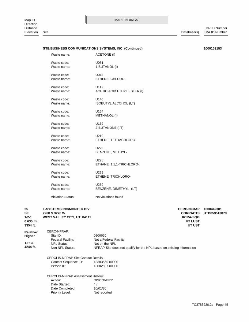
MAP FINDINGSMap IDDirection
EDR ID NumberDistanceEPA ID NumberDatabase(s)SiteElevation
No violations foundViolation Status:
BENZENE, DIMETHYL- (I,T)Waste name: U239Waste code:
ETHENE, TRICHLORO-Waste name: U228Waste code:
ETHANE, 1,1,1-TRICHLORO-Waste name: U226Waste code:
BENZENE, METHYL-Waste name: U220Waste code:
ETHENE, TETRACHLORO-Waste name: U210Waste code:
2-BUTANONE (I,T)Waste name: U159Waste code:
METHANOL (I)Waste name: U154Waste code:
ISOBUTYL ALCOHOL (I,T)Waste name: U140Waste code:
ACETIC ACID ETHYL ESTER (I)Waste name: U112Waste code:
ETHENE, CHLORO-Waste name: U043Waste code:
1-BUTANOL (I)Waste name: U031Waste code:
ACETONE (I)Waste name:
GTE/BUSINESS COMMUNICATIONS SYSTEMS, INC (Continued) 1000103153
Not reportedPriority Level: 10/01/80Date Completed: / /Date Started: DISCOVERYAction:
CERCLIS-NFRAP Assessment History:
13002897.00000Person ID: 13303560.00000Contact Sequence ID:
CERCLIS-NFRAP Site Contact Details:
NFRAP-Site does not qualify for the NPL based on existing informationNon NPL Status: Not on the NPLNPL Status: Not a Federal FacilityFederal Facility: 0800630Site ID:
CERC-NFRAP:
3354 ft. UT UST0.635 mi. UT LUST
Relative:Higher
Actual:4244 ft.
1/2-1 RCRA-SQGWEST VALLEY CITY, UT 84119SE CORRACTS2268 S 3270 W UTD05951387925 CERC-NFRAPE-SYSTEMS INC/MONTEK DIV 1000442381
TC3788920.2s Page 45
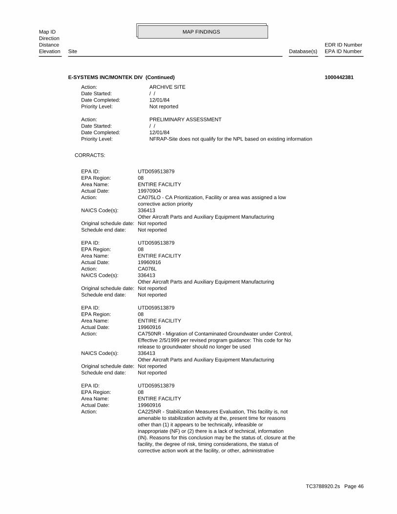
MAP FINDINGSMap IDDirection
EDR ID NumberDistanceEPA ID NumberDatabase(s)SiteElevation
corrective action work at the facility, or other, administrative facility, the degree of risk, timing considerations, the status of (IN). Reasons for this conclusion may be the status of, closure at the inappropriate (NF) or (2) there is a lack of technical, information other than (1) it appears to be technically, infeasible or amenable to stabilization activity at the, present time for reasons CA225NR - Stabilization Measures Evaluation, This facility is, notAction: 19960916Actual Date: ENTIRE FACILITYArea Name: 08EPA Region: UTD059513879EPA ID:
Not reportedSchedule end date: Not reportedOriginal schedule date: Other Aircraft Parts and Auxiliary Equipment Manufacturing 336413NAICS Code(s): release to groundwater should no longer be used Effective 2/5/1999 per revised program guidance: This code for No CA750NR - Migration of Contaminated Groundwater under Control,Action: 19960916Actual Date: ENTIRE FACILITYArea Name: 08EPA Region: UTD059513879EPA ID:
Not reportedSchedule end date: Not reportedOriginal schedule date: Other Aircraft Parts and Auxiliary Equipment Manufacturing 336413NAICS Code(s): CA076LAction: 19960916Actual Date: ENTIRE FACILITYArea Name: 08EPA Region: UTD059513879EPA ID:
Not reportedSchedule end date: Not reportedOriginal schedule date: Other Aircraft Parts and Auxiliary Equipment Manufacturing 336413NAICS Code(s): corrective action priority CA075LO - CA Prioritization, Facility or area was assigned a lowAction: 19970904Actual Date: ENTIRE FACILITYArea Name: 08EPA Region: UTD059513879EPA ID:
CORRACTS:
NFRAP-Site does not qualify for the NPL based on existing informationPriority Level: 12/01/84Date Completed: / /Date Started: PRELIMINARY ASSESSMENTAction:
Not reportedPriority Level: 12/01/84Date Completed: / /Date Started: ARCHIVE SITEAction:
E-SYSTEMS INC/MONTEK DIV (Continued) 1000442381
TC3788920.2s Page 46

MAP FINDINGSMap IDDirection
EDR ID NumberDistanceEPA ID NumberDatabase(s)SiteElevation
waste during any calendar month and accumulates less than 6000 kg of Handler: generates more than 100 and less than 1000 kg of hazardousDescription: Small Small Quantity GeneratorClassification: PrivateLand type: 08EPA Region: [email protected] email: (801) 974-7586Contact telephone: USContact country: SALT LAKE CITY, UT 84119 3270 WESTContact address: TROY L MURRAYContact: SALT LAKE CITY, UT 84119 3270 WESTMailing address: UTD059513879EPA ID: SALT LAKE CITY, UT 84119 2268 SOUTH 3270 WESTFacility address: MOOG INC.Facility name: 11/24/2010Date form received by agency:
RCRA-SQG:
Not reportedSchedule end date: Not reportedOriginal schedule date: Other Aircraft Parts and Auxiliary Equipment Manufacturing 336413NAICS Code(s): CA077LAction: 19960916Actual Date: ENTIRE FACILITYArea Name: 08EPA Region: UTD059513879EPA ID:
Not reportedSchedule end date: Not reportedOriginal schedule date: Other Aircraft Parts and Auxiliary Equipment Manufacturing 336413NAICS Code(s): CA070NO - RFA Determination Of Need For An RFI, RFI is Not NecessaryAction: 19960916Actual Date: ENTIRE FACILITYArea Name: 08EPA Region: UTD059513879EPA ID:
Not reportedSchedule end date: Not reportedOriginal schedule date: Other Aircraft Parts and Auxiliary Equipment Manufacturing 336413NAICS Code(s): necessary- should no longer be used per revised program guidance: This code for -No control measures CA725NC - Current Human Exposures Under Control, Effective 2/5/1999Action: 19960916Actual Date: ENTIRE FACILITYArea Name: 08EPA Region: UTD059513879EPA ID:
Not reportedSchedule end date: Not reportedOriginal schedule date: Other Aircraft Parts and Auxiliary Equipment Manufacturing 336413NAICS Code(s): considerations
E-SYSTEMS INC/MONTEK DIV (Continued) 1000442381
TC3788920.2s Page 47

MAP FINDINGSMap IDDirection
EDR ID NumberDistanceEPA ID NumberDatabase(s)SiteElevation
MOOG AIRCRAFT GROUP- SLC OPERATIONSSite name: MOOG INC.Facility name: 01/24/2008Date form received by agency:
Large Quantity GeneratorClassification: MOOG AIRCRAFT GROUP- SLC OPERATIONSSite name: MOOG INC.Facility name: 02/25/2010Date form received by agency:
Large Quantity GeneratorClassification: MOOG AIRCRAFT GROUP- SLC OPERATIONSSite name: MOOG INC.Facility name: 08/23/2010Date form received by agency:
Historical Generators:
NoUsed oil transporter: NoUsed oil transfer facility: NoUsed oil Specification marketer: NoUsed oil fuel marketer to burner: NoUser oil refiner: NoUsed oil processor: NoUsed oil fuel burner: NoFurnace exemption: NoOn-site burner exemption: NoUnderground injection activity: NoTreater, storer or disposer of HW: NoTransporter of hazardous waste: NoRecycler of hazardous waste: NoMixed waste (haz. and radioactive): NoU.S. importer of hazardous waste:
Handler Activities Summary:
Not reportedOwner/Op end date: 10/15/1998Owner/Op start date: OperatorOwner/Operator Type: PrivateLegal status: Not reportedOwner/operator telephone: USOwner/operator country: SALT LAKE CITY, UT 84119 2268 SOUTH 3270 WESTOwner/operator address: MOOG, INC.Owner/operator name:
Not reportedOwner/Op end date: 10/15/1998Owner/Op start date: OwnerOwner/Operator Type: PrivateLegal status: Not reportedOwner/operator telephone: USOwner/operator country: EAST AURORA, NY 14052 SENECA AND JAMISON RDOwner/operator address: MOOG, INC.Owner/operator name:
Owner/Operator Summary:
hazardous waste at any time waste during any calendar month, and accumulates more than 1000 kg of hazardous waste at any time; or generates 100 kg or less of hazardous
E-SYSTEMS INC/MONTEK DIV (Continued) 1000442381
TC3788920.2s Page 48

MAP FINDINGSMap IDDirection
EDR ID NumberDistanceEPA ID NumberDatabase(s)SiteElevation
CLOSED CUP FLASH POINT TESTER. ANOTHER METHOD OF DETERMINING THE LESS THAN 140 DEGREES FAHRENHEIT AS DETERMINED BY A PENSKY-MARTENS IGNITABLE HAZARDOUS WASTES ARE THOSE WASTES WHICH HAVE A FLASHPOINT OFWaste name: D001Waste code:
Hazardous Waste Summary:
Large Quantity GeneratorClassification: E-SYSTEMS, MONTEK DIVISIONSite name: MOOG INC.Facility name: 02/28/1990Date form received by agency:
Large Quantity GeneratorClassification: E-SYSTEMS - MONTEK DIVISIONSite name: MOOG INC.Facility name: 03/27/1992Date form received by agency:
Large Quantity GeneratorClassification: E-SYSTEMS - MONTEK DIVISIONSite name: MOOG INC.Facility name: 03/03/1994Date form received by agency:
Large Quantity GeneratorClassification: E-SYSTEMS, INC.-MONTEK DIV.Site name: MOOG INC.Facility name: 03/28/1996Date form received by agency:
Large Quantity GeneratorClassification: RAYTHEON AIRCRAFT MONTEK COMPANYSite name: MOOG INC.Facility name: 08/03/1998Date form received by agency:
Large Quantity GeneratorClassification: MOOG, AIRCRAFT GROUP(MONTEK)Site name: MOOG INC.Facility name: 12/15/1998Date form received by agency:
Large Quantity GeneratorClassification: MOOG AIRCRAFT-SALT LAKE OPERATIONSSite name: MOOG INC.Facility name: 05/21/2001Date form received by agency:
Large Quantity GeneratorClassification: MOOG AIRCRAFT - SALT LAKE OPERATIONSSite name: MOOG INC.Facility name: 02/20/2002Date form received by agency:
Large Quantity GeneratorClassification: MOOG AIRCRAFT, SALT LAKE OPERATIONSite name: MOOG INC.Facility name: 02/24/2004Date form received by agency:
Large Quantity GeneratorClassification: MOOG AIRCRAFT, SALT LAKE OPERATIONSSite name: MOOG INC.Facility name: 02/08/2006Date form received by agency:
Large Quantity GeneratorClassification:
E-SYSTEMS INC/MONTEK DIV (Continued) 1000442381
TC3788920.2s Page 49

MAP FINDINGSMap IDDirection
EDR ID NumberDistanceEPA ID NumberDatabase(s)SiteElevation
the facility, or other administrative considerations. risk, timing considerations, the status of corrective action work at conclusion may be the status of closure at the facility, the degree of there is a lack of technical information (IN). Reasons for this it appears to be technically infeasible or inappropriate (NF) or 2- stabilization activity at the present time for reasons other than 1- Stabilization Measures Evaluation,This facility is not amenable toEvent: 09/16/1996Event date:
more recent codes. updated, but may remain in the database until they are replaced by no longer be used. Previously entered NC status codes should be program guidance: This code for ’No control measures necessary’ should Current Human Exposures under Control, Effective 2/5/1999 per revisedEvent: 09/16/1996Event date:
RFA Determination Of Need For An RFI, RFI is Not Necessary;Event: 09/16/1996Event date:
Corrective Action Summary:
THESE SPENT SOLVENTS AND SPENT SOLVENT MIXTURES. LISTED IN F001, F002, OR F004; AND STILL BOTTOMS FROM THE RECOVERY OF ONE OR MORE OF THE ABOVE NON-HALOGENATED SOLVENTS OR THOSE SOLVENTS CONTAINING, BEFORE USE, A TOTAL OF TEN PERCENT OR MORE (BY VOLUME) OF 2-ETHOXYETHANOL, AND 2-NITROPROPANE; ALL SPENT SOLVENT MIXTURES/BLENDS KETONE, CARBON DISULFIDE, ISOBUTANOL, PYRIDINE, BENZENE, THE FOLLOWING SPENT NON-HALOGENATED SOLVENTS: TOLUENE, METHYL ETHYLWaste name: F005Waste code:
METHYL ETHYL KETONEWaste name: D035Waste code:
SILVERWaste name: D011Waste code:
LEADWaste name: D008Waste code:
CHROMIUMWaste name: D007Waste code:
CADMIUMWaste name: D006Waste code:
DISPOSED, THE WASTE WOULD BE A CORROSIVE HAZARDOUS WASTE. THESE CAUSTIC OR ACID SOLUTIONS BECOME CONTAMINATED AND MUST BE USED BY MANY INDUSTRIES TO CLEAN METAL PARTS PRIOR TO PAINTING. WHEN OR DEGREASE PARTS. HYDROCHLORIC ACID, A SOLUTION WITH A LOW PH, IS CAUSTIC SOLUTION WITH A HIGH PH, IS OFTEN USED BY INDUSTRIES TO CLEAN CONSIDERED TO BE A CORROSIVE HAZARDOUS WASTE. SODIUM HYDROXIDE, A A WASTE WHICH HAS A PH OF LESS THAN 2 OR GREATER THAN 12.5 ISWaste name: D002Waste code:
WHICH WOULD BE CONSIDERED AS IGNITABLE HAZARDOUS WASTE. MATERIAL. LACQUER THINNER IS AN EXAMPLE OF A COMMONLY USED SOLVENT WHICH CAN BE OBTAINED FROM THE MANUFACTURER OR DISTRIBUTOR OF THE FLASH POINT OF A WASTE IS TO REVIEW THE MATERIAL SAFETY DATA SHEET,
E-SYSTEMS INC/MONTEK DIV (Continued) 1000442381
TC3788920.2s Page 50

MAP FINDINGSMap IDDirection
EDR ID NumberDistanceEPA ID NumberDatabase(s)SiteElevation
0 Proposed penalty amount: State Enforcement lead agency: Not reported Enf. disp. status date: Not reported Enf. disposition status: 05/01/1995 Enforcement action date: WRITTEN INFORMAL Enforcement action: StateViolation lead agency: 05/02/2002Date achieved compliance: 05/02/1995Date violation determined: Generators - GeneralArea of violation: SR - cfr 262(d)(5)(ii)Regulation violated:
Not reported Paid penalty amount: Not reported Final penalty amount: Not reported Proposed penalty amount: State Enforcement lead agency: Not reported Enf. disp. status date: Not reported Enf. disposition status: 06/07/1991 Enforcement action date: FINAL 3008(A) COMPLIANCE ORDER Enforcement action: StateViolation lead agency: 05/02/2002Date achieved compliance: 04/02/2002Date violation determined: Generators - GeneralArea of violation: Not reportedRegulation violated:
Not reported Paid penalty amount: Not reported Final penalty amount: Not reported Proposed penalty amount: State Enforcement lead agency: Not reported Enf. disp. status date: Not reported Enf. disposition status: 04/02/2002 Enforcement action date: WRITTEN INFORMAL Enforcement action: StateViolation lead agency: 05/02/2002Date achieved compliance: 04/02/2002Date violation determined: Generators - GeneralArea of violation: Not reportedRegulation violated:
Facility Has Received Notices of Violations:
action priority. CA Prioritization, Facility or area was assigned a low correctiveEvent: 09/04/1997Event date:
CA076LEvent: 09/16/1996Event date:
replaced by more recent codes. codes should be updated, but may remain in the database until they are groundwater’ should no longer be used. Previously entered NR status per revised program guidance: This code for ’No release to Igration of Contaminated Groundwater under Control, Effective 2/5/1999Event: 09/16/1996Event date:
CA077LEvent: 09/16/1996Event date:
E-SYSTEMS INC/MONTEK DIV (Continued) 1000442381
TC3788920.2s Page 51
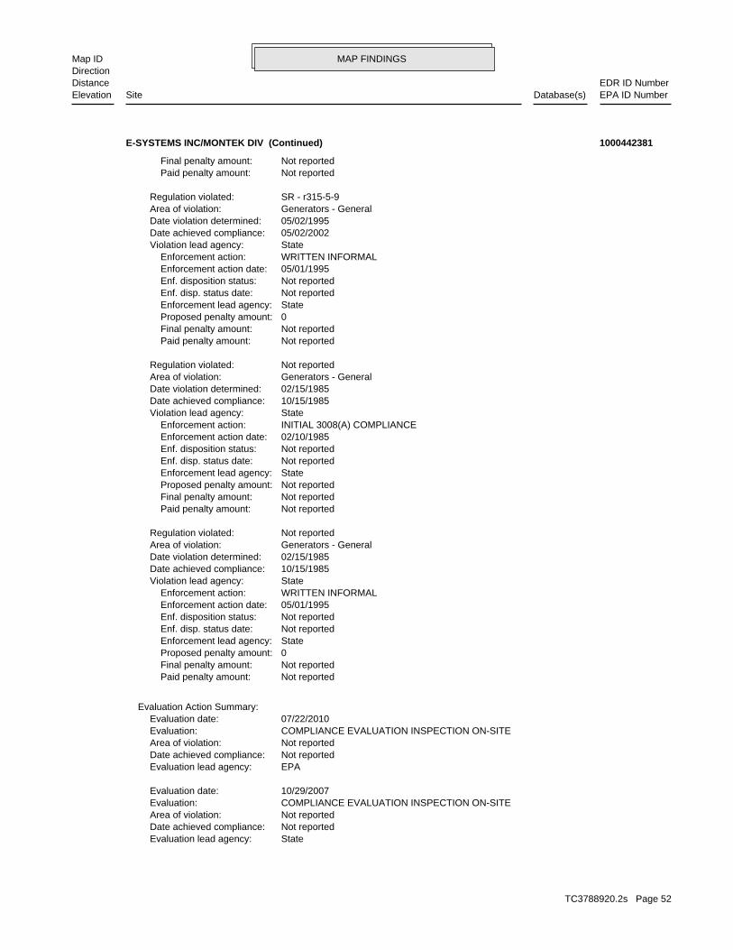
MAP FINDINGSMap IDDirection
EDR ID NumberDistanceEPA ID NumberDatabase(s)SiteElevation
StateEvaluation lead agency: Not reportedDate achieved compliance: Not reportedArea of violation: COMPLIANCE EVALUATION INSPECTION ON-SITEEvaluation: 10/29/2007Evaluation date:
EPAEvaluation lead agency: Not reportedDate achieved compliance: Not reportedArea of violation: COMPLIANCE EVALUATION INSPECTION ON-SITEEvaluation: 07/22/2010Evaluation date:
Evaluation Action Summary:
Not reported Paid penalty amount: Not reported Final penalty amount: 0 Proposed penalty amount: State Enforcement lead agency: Not reported Enf. disp. status date: Not reported Enf. disposition status: 05/01/1995 Enforcement action date: WRITTEN INFORMAL Enforcement action: StateViolation lead agency: 10/15/1985Date achieved compliance: 02/15/1985Date violation determined: Generators - GeneralArea of violation: Not reportedRegulation violated:
Not reported Paid penalty amount: Not reported Final penalty amount: Not reported Proposed penalty amount: State Enforcement lead agency: Not reported Enf. disp. status date: Not reported Enf. disposition status: 02/10/1985 Enforcement action date: INITIAL 3008(A) COMPLIANCE Enforcement action: StateViolation lead agency: 10/15/1985Date achieved compliance: 02/15/1985Date violation determined: Generators - GeneralArea of violation: Not reportedRegulation violated:
Not reported Paid penalty amount: Not reported Final penalty amount: 0 Proposed penalty amount: State Enforcement lead agency: Not reported Enf. disp. status date: Not reported Enf. disposition status: 05/01/1995 Enforcement action date: WRITTEN INFORMAL Enforcement action: StateViolation lead agency: 05/02/2002Date achieved compliance: 05/02/1995Date violation determined: Generators - GeneralArea of violation: SR - r315-5-9Regulation violated:
Not reported Paid penalty amount: Not reported Final penalty amount:
E-SYSTEMS INC/MONTEK DIV (Continued) 1000442381
TC3788920.2s Page 52
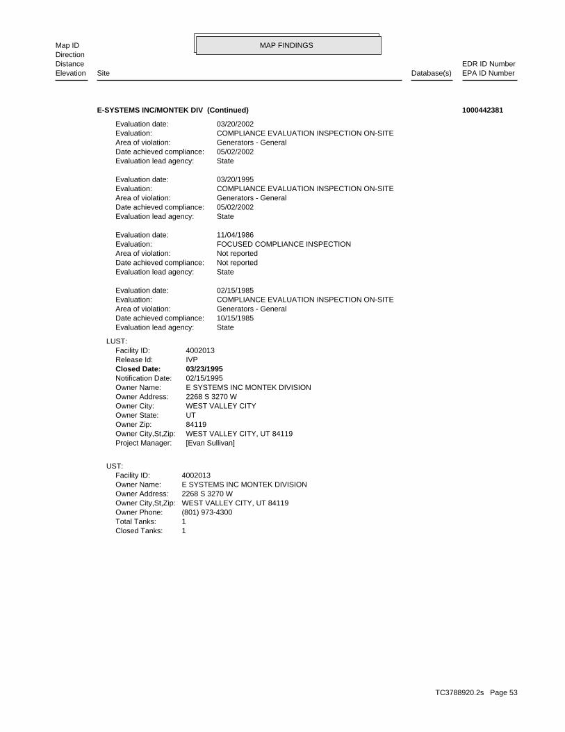
MAP FINDINGSMap IDDirection
EDR ID NumberDistanceEPA ID NumberDatabase(s)SiteElevation
1Closed Tanks: 1Total Tanks: (801) 973-4300Owner Phone: WEST VALLEY CITY, UT 84119Owner City,St,Zip: 2268 S 3270 WOwner Address: E SYSTEMS INC MONTEK DIVISIONOwner Name: 4002013Facility ID:
UST:
[Evan Sullivan]Project Manager: WEST VALLEY CITY, UT 84119Owner City,St,Zip: 84119Owner Zip: UTOwner State: WEST VALLEY CITYOwner City: 2268 S 3270 WOwner Address: E SYSTEMS INC MONTEK DIVISIONOwner Name: 02/15/1995Notification Date: 03/23/1995Closed Date: IVPRelease Id: 4002013Facility ID:
LUST:
StateEvaluation lead agency: 10/15/1985Date achieved compliance: Generators - GeneralArea of violation: COMPLIANCE EVALUATION INSPECTION ON-SITEEvaluation: 02/15/1985Evaluation date:
StateEvaluation lead agency: Not reportedDate achieved compliance: Not reportedArea of violation: FOCUSED COMPLIANCE INSPECTIONEvaluation: 11/04/1986Evaluation date:
StateEvaluation lead agency: 05/02/2002Date achieved compliance: Generators - GeneralArea of violation: COMPLIANCE EVALUATION INSPECTION ON-SITEEvaluation: 03/20/1995Evaluation date:
StateEvaluation lead agency: 05/02/2002Date achieved compliance: Generators - GeneralArea of violation: COMPLIANCE EVALUATION INSPECTION ON-SITEEvaluation: 03/20/2002Evaluation date:
E-SYSTEMS INC/MONTEK DIV (Continued) 1000442381
TC3788920.2s Page 53
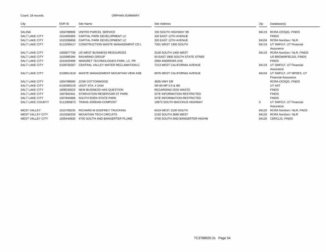
ORPHAN SUMMARY
City EDR ID Site Name Site Address Zip Database(s)
Count: 18 records.
SALINA 1004788906 UNITED PARCEL SERVICE 150 SOUTH HIGHWAY 89 84119 RCRA-CESQG, FINDSSALT LAKE CITY 1010455983 CAPITAL PARK DEVELOPMENT LC 320 EAST 12TH AVENUE FINDSSALT LAKE CITY 1010336858 CAPITAL PARK DEVELOPMENT LC 320 EAST 12TH AVENUE 84104 RCRA NonGen / NLRSALT LAKE CITY S110295417 CONSTRUCTION WASTE MANAGEMENT CD L 7301 WEST 1300 SOUTH 84119 UT SWF/LF, UT Financial
AssuranceSALT LAKE CITY 1000877739 US WEST BUSINESS RESOURCES 3100 SOUTH 1400 WEST 84119 RCRA NonGen / NLR, FINDSSALT LAKE CITY 1015995394 RAVARINO GROUP 50 EAST 3900 SOUTH STATE STREE US BROWNFIELDS, FINDSSALT LAKE CITY 1010429498 NINIGRET TECHNOLOGIES PARK, LC. PR 2950 ANDREWS AVE FINDSSALT LAKE CITY S109700357 CENTRAL VALLEY WATER RECLAMATION-C 7213 WEST CALIFORNIA AVENUE 84119 UT SWF/LF, UT Financial
AssuranceSALT LAKE CITY S108911618 WASTE MANAGEMENT-MOUNTAIN VIEW ASB 6976 WEST CALIFORNIA AVENUE 84104 UT SWF/LF, UT NPDES, UT
Financial AssuranceSALT LAKE CITY 1004788690 ZCMI COTTONWOOD 4835 HWY DR RCRA-CESQG, FINDSSALT LAKE CITY A100350225 UDOT STA. # 2434 SR-65 MP 0.5 & I80 UT ASTSALT LAKE CITY 1008232623 NEW BUSINESS HAS QUESTION REGARDING DOG WASTE FINDSSALT LAKE CITY 1007842441 STARVATION RESERVOIR ST PARK SITE INFORMATION RESTRICTED FINDSSALT LAKE CITY 1007840688 SOUTH EDEN STATE PARK SITE INFORMATION RESTRICTED FINDSSALT LAKE COUNTY S112365872 TRANS-JORDAN-COMPOST 10873 SOUTH BACCHUS HIGHWAY 0 UT SWF/LF, UT Financial
AssuranceWEST VALLEY 1015758235 RICHARD M GODFREY TRUCKING 6419 WEST 2100 SOUTH 84120 RCRA NonGen / NLR, PADSWEST VALLEY CITY 1010336329 MOUNTAIN TECH CIRCUITS 2150 SOUTH 3695 WEST 84120 RCRA NonGen / NLRWEST VALLEY CITY 1005440830 4700 SOUTH AND BANGERTER PLUME 4700 SOUTH AND BANGERTER HIGHW 84120 CERCLIS, FINDS
TC3788920.2s Page 54

To maintain currency of the following federal and state databases, EDR contacts the appropriate governmental agencyon a monthly or quarterly basis, as required.
Number of Days to Update: Provides confirmation that EDR is reporting records that have been updated within 90 daysfrom the date the government agency made the information available to the public.
STANDARD ENVIRONMENTAL RECORDS
Federal NPL site list
NPL: National Priority ListNational Priorities List (Superfund). The NPL is a subset of CERCLIS and identifies over 1,200 sites for prioritycleanup under the Superfund Program. NPL sites may encompass relatively large areas. As such, EDR provides polygoncoverage for over 1,000 NPL site boundaries produced by EPA’s Environmental Photographic Interpretation Center(EPIC) and regional EPA offices.
Date of Government Version: 04/26/2013Date Data Arrived at EDR: 05/09/2013Date Made Active in Reports: 07/10/2013Number of Days to Update: 62
Source: EPATelephone: N/ALast EDR Contact: 11/11/2013Next Scheduled EDR Contact: 01/20/2014Data Release Frequency: Quarterly
NPL Site Boundaries
Sources:
EPA’s Environmental Photographic Interpretation Center (EPIC)Telephone: 202-564-7333
EPA Region 1 EPA Region 6Telephone 617-918-1143 Telephone: 214-655-6659
EPA Region 3 EPA Region 7Telephone 215-814-5418 Telephone: 913-551-7247
EPA Region 4 EPA Region 8Telephone 404-562-8033 Telephone: 303-312-6774
EPA Region 5 EPA Region 9Telephone 312-886-6686 Telephone: 415-947-4246
EPA Region 10Telephone 206-553-8665
Proposed NPL: Proposed National Priority List SitesA site that has been proposed for listing on the National Priorities List through the issuance of a proposed rulein the Federal Register. EPA then accepts public comments on the site, responds to the comments, and places onthe NPL those sites that continue to meet the requirements for listing.
Date of Government Version: 04/26/2013Date Data Arrived at EDR: 05/09/2013Date Made Active in Reports: 07/10/2013Number of Days to Update: 62
Source: EPATelephone: N/ALast EDR Contact: 11/11/2013Next Scheduled EDR Contact: 01/20/2014Data Release Frequency: Quarterly
NPL LIENS: Federal Superfund LiensFederal Superfund Liens. Under the authority granted the USEPA by CERCLA of 1980, the USEPA has the authorityto file liens against real property in order to recover remedial action expenditures or when the property ownerreceived notification of potential liability. USEPA compiles a listing of filed notices of Superfund Liens.
Date of Government Version: 10/15/1991Date Data Arrived at EDR: 02/02/1994Date Made Active in Reports: 03/30/1994Number of Days to Update: 56
Source: EPATelephone: 202-564-4267Last EDR Contact: 08/15/2011Next Scheduled EDR Contact: 11/28/2011Data Release Frequency: No Update Planned
TC3788920.2s Page GR-1
GOVERNMENT RECORDS SEARCHED / DATA CURRENCY TRACKING

Federal Delisted NPL site list
DELISTED NPL: National Priority List DeletionsThe National Oil and Hazardous Substances Pollution Contingency Plan (NCP) establishes the criteria that theEPA uses to delete sites from the NPL. In accordance with 40 CFR 300.425.(e), sites may be deleted from theNPL where no further response is appropriate.
Date of Government Version: 04/26/2013Date Data Arrived at EDR: 05/09/2013Date Made Active in Reports: 07/10/2013Number of Days to Update: 62
Source: EPATelephone: N/ALast EDR Contact: 11/11/2013Next Scheduled EDR Contact: 01/20/2014Data Release Frequency: Quarterly
Federal CERCLIS list
CERCLIS: Comprehensive Environmental Response, Compensation, and Liability Information SystemCERCLIS contains data on potentially hazardous waste sites that have been reported to the USEPA by states, municipalities,private companies and private persons, pursuant to Section 103 of the Comprehensive Environmental Response, Compensation,and Liability Act (CERCLA). CERCLIS contains sites which are either proposed to or on the National PrioritiesList (NPL) and sites which are in the screening and assessment phase for possible inclusion on the NPL.
Date of Government Version: 04/26/2013Date Data Arrived at EDR: 05/29/2013Date Made Active in Reports: 08/09/2013Number of Days to Update: 72
Source: EPATelephone: 703-412-9810Last EDR Contact: 11/11/2013Next Scheduled EDR Contact: 12/09/2013Data Release Frequency: Quarterly
FEDERAL FACILITY: Federal Facility Site Information listingA listing of National Priority List (NPL) and Base Realignment and Closure (BRAC) sites found in the ComprehensiveEnvironmental Response, Compensation and Liability Information System (CERCLIS) Database where EPA Federal FacilitiesRestoration and Reuse Office is involved in cleanup activities.
Date of Government Version: 07/31/2012Date Data Arrived at EDR: 10/09/2012Date Made Active in Reports: 12/20/2012Number of Days to Update: 72
Source: Environmental Protection AgencyTelephone: 703-603-8704Last EDR Contact: 10/11/2013Next Scheduled EDR Contact: 01/20/2014Data Release Frequency: Varies
Federal CERCLIS NFRAP site List
CERCLIS-NFRAP: CERCLIS No Further Remedial Action PlannedArchived sites are sites that have been removed and archived from the inventory of CERCLIS sites. Archived statusindicates that, to the best of EPA’s knowledge, assessment at a site has been completed and that EPA has determinedno further steps will be taken to list this site on the National Priorities List (NPL), unless information indicatesthis decision was not appropriate or other considerations require a recommendation for listing at a later time.This decision does not necessarily mean that there is no hazard associated with a given site; it only means that,based upon available information, the location is not judged to be a potential NPL site.
Date of Government Version: 04/26/2013Date Data Arrived at EDR: 05/29/2013Date Made Active in Reports: 08/09/2013Number of Days to Update: 72
Source: EPATelephone: 703-412-9810Last EDR Contact: 11/11/2013Next Scheduled EDR Contact: 12/09/2013Data Release Frequency: Quarterly
Federal RCRA CORRACTS facilities list
CORRACTS: Corrective Action ReportCORRACTS identifies hazardous waste handlers with RCRA corrective action activity.
TC3788920.2s Page GR-2
GOVERNMENT RECORDS SEARCHED / DATA CURRENCY TRACKING

Date of Government Version: 07/11/2013Date Data Arrived at EDR: 08/08/2013Date Made Active in Reports: 09/13/2013Number of Days to Update: 36
Source: EPATelephone: 800-424-9346Last EDR Contact: 10/02/2013Next Scheduled EDR Contact: 01/13/2014Data Release Frequency: Quarterly
Federal RCRA non-CORRACTS TSD facilities list
RCRA-TSDF: RCRA - Treatment, Storage and DisposalRCRAInfo is EPA’s comprehensive information system, providing access to data supporting the Resource Conservationand Recovery Act (RCRA) of 1976 and the Hazardous and Solid Waste Amendments (HSWA) of 1984. The databaseincludes selective information on sites which generate, transport, store, treat and/or dispose of hazardous wasteas defined by the Resource Conservation and Recovery Act (RCRA). Transporters are individuals or entities thatmove hazardous waste from the generator offsite to a facility that can recycle, treat, store, or dispose of thewaste. TSDFs treat, store, or dispose of the waste.
Date of Government Version: 07/11/2013Date Data Arrived at EDR: 08/08/2013Date Made Active in Reports: 09/13/2013Number of Days to Update: 36
Source: Environmental Protection AgencyTelephone: 303-312-6149Last EDR Contact: 10/02/2013Next Scheduled EDR Contact: 01/13/2014Data Release Frequency: Quarterly
Federal RCRA generators list
RCRA-LQG: RCRA - Large Quantity GeneratorsRCRAInfo is EPA’s comprehensive information system, providing access to data supporting the Resource Conservationand Recovery Act (RCRA) of 1976 and the Hazardous and Solid Waste Amendments (HSWA) of 1984. The databaseincludes selective information on sites which generate, transport, store, treat and/or dispose of hazardous wasteas defined by the Resource Conservation and Recovery Act (RCRA). Large quantity generators (LQGs) generateover 1,000 kilograms (kg) of hazardous waste, or over 1 kg of acutely hazardous waste per month.
Date of Government Version: 07/11/2013Date Data Arrived at EDR: 08/08/2013Date Made Active in Reports: 09/13/2013Number of Days to Update: 36
Source: Environmental Protection AgencyTelephone: 303-312-6149Last EDR Contact: 10/02/2013Next Scheduled EDR Contact: 01/13/2014Data Release Frequency: Quarterly
RCRA-SQG: RCRA - Small Quantity GeneratorsRCRAInfo is EPA’s comprehensive information system, providing access to data supporting the Resource Conservationand Recovery Act (RCRA) of 1976 and the Hazardous and Solid Waste Amendments (HSWA) of 1984. The databaseincludes selective information on sites which generate, transport, store, treat and/or dispose of hazardous wasteas defined by the Resource Conservation and Recovery Act (RCRA). Small quantity generators (SQGs) generatebetween 100 kg and 1,000 kg of hazardous waste per month.
Date of Government Version: 07/11/2013Date Data Arrived at EDR: 08/08/2013Date Made Active in Reports: 09/13/2013Number of Days to Update: 36
Source: Environmental Protection AgencyTelephone: 303-312-6149Last EDR Contact: 10/02/2013Next Scheduled EDR Contact: 01/13/2014Data Release Frequency: Quarterly
RCRA-CESQG: RCRA - Conditionally Exempt Small Quantity GeneratorsRCRAInfo is EPA’s comprehensive information system, providing access to data supporting the Resource Conservationand Recovery Act (RCRA) of 1976 and the Hazardous and Solid Waste Amendments (HSWA) of 1984. The databaseincludes selective information on sites which generate, transport, store, treat and/or dispose of hazardous wasteas defined by the Resource Conservation and Recovery Act (RCRA). Conditionally exempt small quantity generators(CESQGs) generate less than 100 kg of hazardous waste, or less than 1 kg of acutely hazardous waste per month.
Date of Government Version: 07/11/2013Date Data Arrived at EDR: 08/08/2013Date Made Active in Reports: 09/13/2013Number of Days to Update: 36
Source: Environmental Protection AgencyTelephone: 303-312-6149Last EDR Contact: 10/02/2013Next Scheduled EDR Contact: 01/13/2014Data Release Frequency: Varies
TC3788920.2s Page GR-3
GOVERNMENT RECORDS SEARCHED / DATA CURRENCY TRACKING

Federal institutional controls / engineering controls registries
US ENG CONTROLS: Engineering Controls Sites ListA listing of sites with engineering controls in place. Engineering controls include various forms of caps, buildingfoundations, liners, and treatment methods to create pathway elimination for regulated substances to enter environmentalmedia or effect human health.
Date of Government Version: 06/17/2013Date Data Arrived at EDR: 06/21/2013Date Made Active in Reports: 10/03/2013Number of Days to Update: 104
Source: Environmental Protection AgencyTelephone: 703-603-0695Last EDR Contact: 09/10/2013Next Scheduled EDR Contact: 12/23/2013Data Release Frequency: Varies
US INST CONTROL: Sites with Institutional ControlsA listing of sites with institutional controls in place. Institutional controls include administrative measures,such as groundwater use restrictions, construction restrictions, property use restrictions, and post remediationcare requirements intended to prevent exposure to contaminants remaining on site. Deed restrictions are generallyrequired as part of the institutional controls.
Date of Government Version: 06/17/2013Date Data Arrived at EDR: 06/21/2013Date Made Active in Reports: 10/03/2013Number of Days to Update: 104
Source: Environmental Protection AgencyTelephone: 703-603-0695Last EDR Contact: 09/10/2013Next Scheduled EDR Contact: 12/23/2013Data Release Frequency: Varies
LUCIS: Land Use Control Information SystemLUCIS contains records of land use control information pertaining to the former Navy Base Realignment and Closureproperties.
Date of Government Version: 08/20/2013Date Data Arrived at EDR: 08/23/2013Date Made Active in Reports: 11/01/2013Number of Days to Update: 70
Source: Department of the NavyTelephone: 843-820-7326Last EDR Contact: 11/18/2013Next Scheduled EDR Contact: 03/03/2014Data Release Frequency: Varies
Federal ERNS list
ERNS: Emergency Response Notification SystemEmergency Response Notification System. ERNS records and stores information on reported releases of oil and hazardoussubstances.
Date of Government Version: 12/31/2012Date Data Arrived at EDR: 01/17/2013Date Made Active in Reports: 02/15/2013Number of Days to Update: 29
Source: National Response Center, United States Coast GuardTelephone: 202-267-2180Last EDR Contact: 10/01/2013Next Scheduled EDR Contact: 01/13/2014Data Release Frequency: Annually
State- and tribal - equivalent CERCLIS
SHWS: This state does not maintain a SHWS list. See the Federal CERCLIS list and Federal NPL list.State Hazardous Waste Sites. State hazardous waste site records are the states’ equivalent to CERCLIS. These sitesmay or may not already be listed on the federal CERCLIS list. Priority sites planned for cleanup using state funds(state equivalent of Superfund) are identified along with sites where cleanup will be paid for by potentiallyresponsible parties. Available information varies by state.
Date of Government Version: N/ADate Data Arrived at EDR: N/ADate Made Active in Reports: N/ANumber of Days to Update: N/A
Source: Department of Environmental QualityTelephone: 801-536-4100Last EDR Contact: 11/04/2013Next Scheduled EDR Contact: 02/17/2014Data Release Frequency: N/A
TC3788920.2s Page GR-4
GOVERNMENT RECORDS SEARCHED / DATA CURRENCY TRACKING
State and tribal landfill and/or solid waste disposal site lists
SWF/LF: List of LandfillsSolid Waste Facilities/Landfill Sites. SWF/LF type records typically contain an inventory of solid waste disposalfacilities or landfills in a particular state. Depending on the state, these may be active or inactive facilitiesor open dumps that failed to meet RCRA Subtitle D Section 4004 criteria for solid waste landfills or disposalsites.
Date of Government Version: 06/01/2013Date Data Arrived at EDR: 07/18/2013Date Made Active in Reports: 09/13/2013Number of Days to Update: 57
Source: Department of Environmental QualityTelephone: 801-538-6170Last EDR Contact: 10/10/2013Next Scheduled EDR Contact: 01/27/2014Data Release Frequency: Semi-Annually
State and tribal leaking storage tank lists
LUST: Sites with Leaking Underground Storage TanksLeaking Underground Storage Tank Incident Reports. LUST records contain an inventory of reported leaking undergroundstorage tank incidents. Not all states maintain these records, and the information stored varies by state.
Date of Government Version: 10/22/2013Date Data Arrived at EDR: 10/25/2013Date Made Active in Reports: 11/14/2013Number of Days to Update: 20
Source: Department of Environmental QualityTelephone: 801-536-4115Last EDR Contact: 10/25/2013Next Scheduled EDR Contact: 02/03/2014Data Release Frequency: Quarterly
LAST: Leaking Aboveground Storage Tank SitesA listing of leaking aboveground storage tank locations.
Date of Government Version: 09/11/2013Date Data Arrived at EDR: 09/13/2013Date Made Active in Reports: 10/17/2013Number of Days to Update: 34
Source: Department of Environmental QualityTelephone: 801-536-4141Last EDR Contact: 09/10/2013Next Scheduled EDR Contact: 12/23/2013Data Release Frequency: Varies
INDIAN LUST R7: Leaking Underground Storage Tanks on Indian LandLUSTs on Indian land in Iowa, Kansas, and Nebraska
Date of Government Version: 08/27/2013Date Data Arrived at EDR: 08/27/2013Date Made Active in Reports: 11/01/2013Number of Days to Update: 66
Source: EPA Region 7Telephone: 913-551-7003Last EDR Contact: 10/28/2013Next Scheduled EDR Contact: 02/11/2014Data Release Frequency: Varies
INDIAN LUST R6: Leaking Underground Storage Tanks on Indian LandLUSTs on Indian land in New Mexico and Oklahoma.
Date of Government Version: 09/12/2011Date Data Arrived at EDR: 09/13/2011Date Made Active in Reports: 11/11/2011Number of Days to Update: 59
Source: EPA Region 6Telephone: 214-665-6597Last EDR Contact: 10/28/2013Next Scheduled EDR Contact: 02/11/2014Data Release Frequency: Varies
INDIAN LUST R9: Leaking Underground Storage Tanks on Indian LandLUSTs on Indian land in Arizona, California, New Mexico and Nevada
Date of Government Version: 03/01/2013Date Data Arrived at EDR: 03/01/2013Date Made Active in Reports: 04/12/2013Number of Days to Update: 42
Source: Environmental Protection AgencyTelephone: 415-972-3372Last EDR Contact: 10/28/2013Next Scheduled EDR Contact: 02/11/2014Data Release Frequency: Quarterly
TC3788920.2s Page GR-5
GOVERNMENT RECORDS SEARCHED / DATA CURRENCY TRACKING

INDIAN LUST R10: Leaking Underground Storage Tanks on Indian LandLUSTs on Indian land in Alaska, Idaho, Oregon and Washington.
Date of Government Version: 07/29/2013Date Data Arrived at EDR: 07/30/2013Date Made Active in Reports: 11/01/2013Number of Days to Update: 94
Source: EPA Region 10Telephone: 206-553-2857Last EDR Contact: 10/28/2013Next Scheduled EDR Contact: 02/11/2014Data Release Frequency: Quarterly
INDIAN LUST R5: Leaking Underground Storage Tanks on Indian LandLeaking underground storage tanks located on Indian Land in Michigan, Minnesota and Wisconsin.
Date of Government Version: 08/20/2013Date Data Arrived at EDR: 08/23/2013Date Made Active in Reports: 11/01/2013Number of Days to Update: 70
Source: EPA, Region 5Telephone: 312-886-7439Last EDR Contact: 10/28/2013Next Scheduled EDR Contact: 02/11/2014Data Release Frequency: Varies
INDIAN LUST R1: Leaking Underground Storage Tanks on Indian LandA listing of leaking underground storage tank locations on Indian Land.
Date of Government Version: 02/01/2013Date Data Arrived at EDR: 05/01/2013Date Made Active in Reports: 11/01/2013Number of Days to Update: 184
Source: EPA Region 1Telephone: 617-918-1313Last EDR Contact: 11/01/2013Next Scheduled EDR Contact: 02/11/2014Data Release Frequency: Varies
INDIAN LUST R4: Leaking Underground Storage Tanks on Indian LandLUSTs on Indian land in Florida, Mississippi and North Carolina.
Date of Government Version: 08/01/2013Date Data Arrived at EDR: 08/02/2013Date Made Active in Reports: 11/01/2013Number of Days to Update: 91
Source: EPA Region 4Telephone: 404-562-8677Last EDR Contact: 10/28/2013Next Scheduled EDR Contact: 02/11/2014Data Release Frequency: Semi-Annually
INDIAN LUST R8: Leaking Underground Storage Tanks on Indian LandLUSTs on Indian land in Colorado, Montana, North Dakota, South Dakota, Utah and Wyoming.
Date of Government Version: 08/27/2012Date Data Arrived at EDR: 08/28/2012Date Made Active in Reports: 10/16/2012Number of Days to Update: 49
Source: EPA Region 8Telephone: 303-312-6271Last EDR Contact: 10/28/2013Next Scheduled EDR Contact: 02/11/2014Data Release Frequency: Quarterly
State and tribal registered storage tank lists
UST: List of Sites with Underground Storage TanksRegistered Underground Storage Tanks. UST’s are regulated under Subtitle I of the Resource Conservation and RecoveryAct (RCRA) and must be registered with the state department responsible for administering the UST program. Availableinformation varies by state program.
Date of Government Version: 10/22/2013Date Data Arrived at EDR: 10/25/2013Date Made Active in Reports: 11/14/2013Number of Days to Update: 20
Source: Department of Environmental QualityTelephone: 801-536-4115Last EDR Contact: 10/25/2013Next Scheduled EDR Contact: 02/03/2014Data Release Frequency: Quarterly
AST: Listing of Aboveground Storage TanksAboveground storage tank site locations.
TC3788920.2s Page GR-6
GOVERNMENT RECORDS SEARCHED / DATA CURRENCY TRACKING
Date of Government Version: 09/11/2013Date Data Arrived at EDR: 09/13/2013Date Made Active in Reports: 10/17/2013Number of Days to Update: 34
Source: Department of Environmental QualityTelephone: 801-536-4100Last EDR Contact: 09/10/2013Next Scheduled EDR Contact: 12/23/2013Data Release Frequency: Varies
INDIAN UST R7: Underground Storage Tanks on Indian LandThe Indian Underground Storage Tank (UST) database provides information about underground storage tanks on Indianland in EPA Region 7 (Iowa, Kansas, Missouri, Nebraska, and 9 Tribal Nations).
Date of Government Version: 12/31/2012Date Data Arrived at EDR: 02/28/2013Date Made Active in Reports: 04/12/2013Number of Days to Update: 43
Source: EPA Region 7Telephone: 913-551-7003Last EDR Contact: 10/28/2013Next Scheduled EDR Contact: 02/11/2014Data Release Frequency: Varies
INDIAN UST R10: Underground Storage Tanks on Indian LandThe Indian Underground Storage Tank (UST) database provides information about underground storage tanks on Indianland in EPA Region 10 (Alaska, Idaho, Oregon, Washington, and Tribal Nations).
Date of Government Version: 02/05/2013Date Data Arrived at EDR: 02/06/2013Date Made Active in Reports: 04/12/2013Number of Days to Update: 65
Source: EPA Region 10Telephone: 206-553-2857Last EDR Contact: 10/28/2013Next Scheduled EDR Contact: 02/11/2014Data Release Frequency: Quarterly
INDIAN UST R9: Underground Storage Tanks on Indian LandThe Indian Underground Storage Tank (UST) database provides information about underground storage tanks on Indianland in EPA Region 9 (Arizona, California, Hawaii, Nevada, the Pacific Islands, and Tribal Nations).
Date of Government Version: 02/21/2013Date Data Arrived at EDR: 02/26/2013Date Made Active in Reports: 04/12/2013Number of Days to Update: 45
Source: EPA Region 9Telephone: 415-972-3368Last EDR Contact: 10/28/2013Next Scheduled EDR Contact: 02/11/2014Data Release Frequency: Quarterly
INDIAN UST R8: Underground Storage Tanks on Indian LandThe Indian Underground Storage Tank (UST) database provides information about underground storage tanks on Indianland in EPA Region 8 (Colorado, Montana, North Dakota, South Dakota, Utah, Wyoming and 27 Tribal Nations).
Date of Government Version: 07/29/2013Date Data Arrived at EDR: 08/01/2013Date Made Active in Reports: 11/01/2013Number of Days to Update: 92
Source: EPA Region 8Telephone: 303-312-6137Last EDR Contact: 10/28/2013Next Scheduled EDR Contact: 02/11/2014Data Release Frequency: Quarterly
INDIAN UST R1: Underground Storage Tanks on Indian LandThe Indian Underground Storage Tank (UST) database provides information about underground storage tanks on Indianland in EPA Region 1 (Connecticut, Maine, Massachusetts, New Hampshire, Rhode Island, Vermont and ten TribalNations).
Date of Government Version: 09/28/2012Date Data Arrived at EDR: 11/07/2012Date Made Active in Reports: 04/12/2013Number of Days to Update: 156
Source: EPA, Region 1Telephone: 617-918-1313Last EDR Contact: 11/01/2014Next Scheduled EDR Contact: 02/11/2014Data Release Frequency: Varies
INDIAN UST R4: Underground Storage Tanks on Indian LandThe Indian Underground Storage Tank (UST) database provides information about underground storage tanks on Indianland in EPA Region 4 (Alabama, Florida, Georgia, Kentucky, Mississippi, North Carolina, South Carolina, Tennesseeand Tribal Nations)
TC3788920.2s Page GR-7
GOVERNMENT RECORDS SEARCHED / DATA CURRENCY TRACKING

Date of Government Version: 08/01/2013Date Data Arrived at EDR: 08/02/2013Date Made Active in Reports: 11/01/2013Number of Days to Update: 91
Source: EPA Region 4Telephone: 404-562-9424Last EDR Contact: 10/28/2013Next Scheduled EDR Contact: 02/11/2014Data Release Frequency: Semi-Annually
INDIAN UST R6: Underground Storage Tanks on Indian LandThe Indian Underground Storage Tank (UST) database provides information about underground storage tanks on Indianland in EPA Region 6 (Louisiana, Arkansas, Oklahoma, New Mexico, Texas and 65 Tribes).
Date of Government Version: 05/10/2011Date Data Arrived at EDR: 05/11/2011Date Made Active in Reports: 06/14/2011Number of Days to Update: 34
Source: EPA Region 6Telephone: 214-665-7591Last EDR Contact: 10/28/2013Next Scheduled EDR Contact: 02/11/2014Data Release Frequency: Semi-Annually
INDIAN UST R5: Underground Storage Tanks on Indian LandThe Indian Underground Storage Tank (UST) database provides information about underground storage tanks on Indianland in EPA Region 5 (Michigan, Minnesota and Wisconsin and Tribal Nations).
Date of Government Version: 08/20/2013Date Data Arrived at EDR: 08/23/2013Date Made Active in Reports: 11/01/2013Number of Days to Update: 70
Source: EPA Region 5Telephone: 312-886-6136Last EDR Contact: 10/28/2013Next Scheduled EDR Contact: 02/11/2014Data Release Frequency: Varies
FEMA UST: Underground Storage Tank ListingA listing of all FEMA owned underground storage tanks.
Date of Government Version: 01/01/2010Date Data Arrived at EDR: 02/16/2010Date Made Active in Reports: 04/12/2010Number of Days to Update: 55
Source: FEMATelephone: 202-646-5797Last EDR Contact: 10/17/2013Next Scheduled EDR Contact: 01/27/2014Data Release Frequency: Varies
State and tribal institutional control / engineering control registries
INST CONTROL: Sites with Institutional ControlsSites included on the Brownfields Sites listing that have institutional controls in place.
Date of Government Version: 11/06/2013Date Data Arrived at EDR: 11/08/2013Date Made Active in Reports: 11/14/2013Number of Days to Update: 6
Source: Department of Environmental QualityTelephone: 801-536-4100Last EDR Contact: 11/08/2013Next Scheduled EDR Contact: 02/17/2014Data Release Frequency: Varies
State and tribal voluntary cleanup sites
INDIAN VCP R1: Voluntary Cleanup Priority ListingA listing of voluntary cleanup priority sites located on Indian Land located in Region 1.
Date of Government Version: 09/28/2012Date Data Arrived at EDR: 10/02/2012Date Made Active in Reports: 10/16/2012Number of Days to Update: 14
Source: EPA, Region 1Telephone: 617-918-1102Last EDR Contact: 10/01/2013Next Scheduled EDR Contact: 01/13/2014Data Release Frequency: Varies
INDIAN VCP R7: Voluntary Cleanup Priority LisitngA listing of voluntary cleanup priority sites located on Indian Land located in Region 7.
TC3788920.2s Page GR-8
GOVERNMENT RECORDS SEARCHED / DATA CURRENCY TRACKING
Date of Government Version: 03/20/2008Date Data Arrived at EDR: 04/22/2008Date Made Active in Reports: 05/19/2008Number of Days to Update: 27
Source: EPA, Region 7Telephone: 913-551-7365Last EDR Contact: 04/20/2009Next Scheduled EDR Contact: 07/20/2009Data Release Frequency: Varies
VCP: Voluntary Cleanup Sites ListThe purpose of the program is to encourage the voluntary cleanup of sites where there has been a contaminant releasethreatening public health and the environment, thereby removing the stigma attached to these sites which blockseconomic redevelopment. Voluntary cleanup of these sites will hopefully result in clearing the pathway for returningthese properties to beneficial use.
Date of Government Version: 09/04/2013Date Data Arrived at EDR: 09/05/2013Date Made Active in Reports: 09/13/2013Number of Days to Update: 8
Source: Department of Environmental QualityTelephone: 801-536-4100Last EDR Contact: 11/18/2013Next Scheduled EDR Contact: 03/03/2014Data Release Frequency: Varies
State and tribal Brownfields sites
BROWNFIELDS: Brownfields Assessment SitesA Brownfields site means real property, the expansion, redevelopment or reuse of which may be complicated by thepresence or potential presence of a hazardous substance, pollutant or contaminant, controlled substance or petroleumproduct.
Date of Government Version: 09/04/2013Date Data Arrived at EDR: 09/05/2013Date Made Active in Reports: 09/13/2013Number of Days to Update: 8
Source: Department of Environmental QualityTelephone: 801-536-4100Last EDR Contact: 11/18/2013Next Scheduled EDR Contact: 03/03/2014Data Release Frequency: Varies
ADDITIONAL ENVIRONMENTAL RECORDS
Local Brownfield lists
US BROWNFIELDS: A Listing of Brownfields SitesBrownfields are real property, the expansion, redevelopment, or reuse of which may be complicated by the presenceor potential presence of a hazardous substance, pollutant, or contaminant. Cleaning up and reinvesting in theseproperties takes development pressures off of undeveloped, open land, and both improves and protects the environment.Assessment, Cleanup and Redevelopment Exchange System (ACRES) stores information reported by EPA Brownfieldsgrant recipients on brownfields properties assessed or cleaned up with grant funding as well as information onTargeted Brownfields Assessments performed by EPA Regions. A listing of ACRES Brownfield sites is obtained fromCleanups in My Community. Cleanups in My Community provides information on Brownfields properties for which informationis reported back to EPA, as well as areas served by Brownfields grant programs.
Date of Government Version: 06/24/2013Date Data Arrived at EDR: 06/25/2013Date Made Active in Reports: 08/09/2013Number of Days to Update: 45
Source: Environmental Protection AgencyTelephone: 202-566-2777Last EDR Contact: 09/24/2013Next Scheduled EDR Contact: 01/08/2014Data Release Frequency: Semi-Annually
Local Lists of Landfill / Solid Waste Disposal Sites
DEBRIS REGION 9: Torres Martinez Reservation Illegal Dump Site LocationsA listing of illegal dump sites location on the Torres Martinez Indian Reservation located in eastern RiversideCounty and northern Imperial County, California.
Date of Government Version: 01/12/2009Date Data Arrived at EDR: 05/07/2009Date Made Active in Reports: 09/21/2009Number of Days to Update: 137
Source: EPA, Region 9Telephone: 415-947-4219Last EDR Contact: 10/28/2013Next Scheduled EDR Contact: 02/11/2014Data Release Frequency: No Update Planned
TC3788920.2s Page GR-9
GOVERNMENT RECORDS SEARCHED / DATA CURRENCY TRACKING

ODI: Open Dump InventoryAn open dump is defined as a disposal facility that does not comply with one or more of the Part 257 or Part 258Subtitle D Criteria.
Date of Government Version: 06/30/1985Date Data Arrived at EDR: 08/09/2004Date Made Active in Reports: 09/17/2004Number of Days to Update: 39
Source: Environmental Protection AgencyTelephone: 800-424-9346Last EDR Contact: 06/09/2004Next Scheduled EDR Contact: N/AData Release Frequency: No Update Planned
INDIAN ODI: Report on the Status of Open Dumps on Indian LandsLocation of open dumps on Indian land.
Date of Government Version: 12/31/1998Date Data Arrived at EDR: 12/03/2007Date Made Active in Reports: 01/24/2008Number of Days to Update: 52
Source: Environmental Protection AgencyTelephone: 703-308-8245Last EDR Contact: 11/04/2013Next Scheduled EDR Contact: 02/17/2014Data Release Frequency: Varies
Local Lists of Hazardous waste / Contaminated Sites
US CDL: Clandestine Drug LabsA listing of clandestine drug lab locations. The U.S. Department of Justice ("the Department") provides thisweb site as a public service. It contains addresses of some locations where law enforcement agencies reportedthey found chemicals or other items that indicated the presence of either clandestine drug laboratories or dumpsites.In most cases, the source of the entries is not the Department, and the Department has not verified the entryand does not guarantee its accuracy. Members of the public must verify the accuracy of all entries by, for example,contacting local law enforcement and local health departments.
Date of Government Version: 08/06/2013Date Data Arrived at EDR: 09/11/2013Date Made Active in Reports: 10/03/2013Number of Days to Update: 22
Source: Drug Enforcement AdministrationTelephone: 202-307-1000Last EDR Contact: 09/04/2013Next Scheduled EDR Contact: 12/16/2013Data Release Frequency: Quarterly
CDL: Methamphetamine Contaminated Properties ListingUtah Administrative Rule 19-6-901 Illegal Drug Operations Site Reporting and Decontamination Act requires localhealth departments to maintain a list of properties believed to be contaminated by the illegal manufacture ofdrugs. The following properties were reported to the Salt Lake Valley Health Department by a complaint or reportfrom a law enforcement agency and the Department has determined that reasonable evidence exists that the propertyis contaminated.
Date of Government Version: 07/25/2013Date Data Arrived at EDR: 08/28/2013Date Made Active in Reports: 09/13/2013Number of Days to Update: 16
Source: Salt Lake Valley Health DepartmentTelephone: 801-468-2750Last EDR Contact: 08/28/2013Next Scheduled EDR Contact: 12/09/2013Data Release Frequency: Varies
US HIST CDL: National Clandestine Laboratory RegisterA listing of clandestine drug lab locations. The U.S. Department of Justice ("the Department") provides thisweb site as a public service. It contains addresses of some locations where law enforcement agencies reportedthey found chemicals or other items that indicated the presence of either clandestine drug laboratories or dumpsites.In most cases, the source of the entries is not the Department, and the Department has not verified the entryand does not guarantee its accuracy. Members of the public must verify the accuracy of all entries by, for example,contacting local law enforcement and local health departments.
Date of Government Version: 09/01/2007Date Data Arrived at EDR: 11/19/2008Date Made Active in Reports: 03/30/2009Number of Days to Update: 131
Source: Drug Enforcement AdministrationTelephone: 202-307-1000Last EDR Contact: 03/23/2009Next Scheduled EDR Contact: 06/22/2009Data Release Frequency: No Update Planned
TC3788920.2s Page GR-10
GOVERNMENT RECORDS SEARCHED / DATA CURRENCY TRACKING

Local Land Records
LIENS 2: CERCLA Lien InformationA Federal CERCLA (’Superfund’) lien can exist by operation of law at any site or property at which EPA has spentSuperfund monies. These monies are spent to investigate and address releases and threatened releases of contamination.CERCLIS provides information as to the identity of these sites and properties.
Date of Government Version: 02/06/2013Date Data Arrived at EDR: 04/25/2013Date Made Active in Reports: 05/10/2013Number of Days to Update: 15
Source: Environmental Protection AgencyTelephone: 202-564-6023Last EDR Contact: 11/13/2013Next Scheduled EDR Contact: 02/11/2014Data Release Frequency: Varies
Records of Emergency Release Reports
HMIRS: Hazardous Materials Information Reporting SystemHazardous Materials Incident Report System. HMIRS contains hazardous material spill incidents reported to DOT.
Date of Government Version: 12/31/2012Date Data Arrived at EDR: 01/03/2013Date Made Active in Reports: 02/27/2013Number of Days to Update: 55
Source: U.S. Department of TransportationTelephone: 202-366-4555Last EDR Contact: 10/01/2013Next Scheduled EDR Contact: 01/13/2014Data Release Frequency: Annually
SPILLS: Spills DataIncidents reported to the Division of Environmental Response and Remediation
Date of Government Version: 04/23/2013Date Data Arrived at EDR: 04/23/2013Date Made Active in Reports: 06/13/2013Number of Days to Update: 51
Source: Department of Environmental QualityTelephone: 801-536-4100Last EDR Contact: 10/10/2013Next Scheduled EDR Contact: 01/27/2014Data Release Frequency: Semi-Annually
SPILLS 90: SPILLS90 data from FirstSearchSpills 90 includes those spill and release records available exclusively from FirstSearch databases. Typically,they may include chemical, oil and/or hazardous substance spills recorded after 1990. Duplicate records that arealready included in EDR incident and release records are not included in Spills 90.
Date of Government Version: 07/31/2011Date Data Arrived at EDR: 01/03/2013Date Made Active in Reports: 02/11/2013Number of Days to Update: 39
Source: FirstSearchTelephone: N/ALast EDR Contact: 01/03/2013Next Scheduled EDR Contact: N/AData Release Frequency: No Update Planned
Other Ascertainable Records
RCRA NonGen / NLR: RCRA - Non GeneratorsRCRAInfo is EPA’s comprehensive information system, providing access to data supporting the Resource Conservationand Recovery Act (RCRA) of 1976 and the Hazardous and Solid Waste Amendments (HSWA) of 1984. The databaseincludes selective information on sites which generate, transport, store, treat and/or dispose of hazardous wasteas defined by the Resource Conservation and Recovery Act (RCRA). Non-Generators do not presently generate hazardouswaste.
Date of Government Version: 07/11/2013Date Data Arrived at EDR: 08/08/2013Date Made Active in Reports: 09/13/2013Number of Days to Update: 36
Source: Environmental Protection AgencyTelephone: 303-312-6149Last EDR Contact: 10/02/2013Next Scheduled EDR Contact: 01/13/2014Data Release Frequency: Varies
TC3788920.2s Page GR-11
GOVERNMENT RECORDS SEARCHED / DATA CURRENCY TRACKING

DOT OPS: Incident and Accident DataDepartment of Transporation, Office of Pipeline Safety Incident and Accident data.
Date of Government Version: 07/31/2012Date Data Arrived at EDR: 08/07/2012Date Made Active in Reports: 09/18/2012Number of Days to Update: 42
Source: Department of Transporation, Office of Pipeline SafetyTelephone: 202-366-4595Last EDR Contact: 11/06/2013Next Scheduled EDR Contact: 02/17/2014Data Release Frequency: Varies
DOD: Department of Defense SitesThis data set consists of federally owned or administered lands, administered by the Department of Defense, thathave any area equal to or greater than 640 acres of the United States, Puerto Rico, and the U.S. Virgin Islands.
Date of Government Version: 12/31/2005Date Data Arrived at EDR: 11/10/2006Date Made Active in Reports: 01/11/2007Number of Days to Update: 62
Source: USGSTelephone: 888-275-8747Last EDR Contact: 10/18/2013Next Scheduled EDR Contact: 01/27/2014Data Release Frequency: Semi-Annually
FUDS: Formerly Used Defense SitesThe listing includes locations of Formerly Used Defense Sites properties where the US Army Corps of Engineersis actively working or will take necessary cleanup actions.
Date of Government Version: 12/31/2011Date Data Arrived at EDR: 02/26/2013Date Made Active in Reports: 03/13/2013Number of Days to Update: 15
Source: U.S. Army Corps of EngineersTelephone: 202-528-4285Last EDR Contact: 09/10/2013Next Scheduled EDR Contact: 12/23/2013Data Release Frequency: Varies
CONSENT: Superfund (CERCLA) Consent DecreesMajor legal settlements that establish responsibility and standards for cleanup at NPL (Superfund) sites. Releasedperiodically by United States District Courts after settlement by parties to litigation matters.
Date of Government Version: 06/30/2013Date Data Arrived at EDR: 08/07/2013Date Made Active in Reports: 10/03/2013Number of Days to Update: 57
Source: Department of Justice, Consent Decree LibraryTelephone: VariesLast EDR Contact: 09/30/2013Next Scheduled EDR Contact: 01/13/2014Data Release Frequency: Varies
ROD: Records Of DecisionRecord of Decision. ROD documents mandate a permanent remedy at an NPL (Superfund) site containing technicaland health information to aid in the cleanup.
Date of Government Version: 04/26/2013Date Data Arrived at EDR: 06/11/2013Date Made Active in Reports: 11/01/2013Number of Days to Update: 143
Source: EPATelephone: 703-416-0223Last EDR Contact: 09/13/2013Next Scheduled EDR Contact: 12/23/2013Data Release Frequency: Annually
UMTRA: Uranium Mill Tailings SitesUranium ore was mined by private companies for federal government use in national defense programs. When the millsshut down, large piles of the sand-like material (mill tailings) remain after uranium has been extracted fromthe ore. Levels of human exposure to radioactive materials from the piles are low; however, in some cases tailingswere used as construction materials before the potential health hazards of the tailings were recognized.
Date of Government Version: 09/14/2010Date Data Arrived at EDR: 10/07/2011Date Made Active in Reports: 03/01/2012Number of Days to Update: 146
Source: Department of EnergyTelephone: 505-845-0011Last EDR Contact: 05/28/2013Next Scheduled EDR Contact: 09/09/2013Data Release Frequency: Varies
TC3788920.2s Page GR-12
GOVERNMENT RECORDS SEARCHED / DATA CURRENCY TRACKING
US MINES: Mines Master Index FileContains all mine identification numbers issued for mines active or opened since 1971. The data also includesviolation information.
Date of Government Version: 08/01/2013Date Data Arrived at EDR: 09/05/2013Date Made Active in Reports: 10/03/2013Number of Days to Update: 28
Source: Department of Labor, Mine Safety and Health AdministrationTelephone: 303-231-5959Last EDR Contact: 09/05/2013Next Scheduled EDR Contact: 12/16/2013Data Release Frequency: Semi-Annually
TRIS: Toxic Chemical Release Inventory SystemToxic Release Inventory System. TRIS identifies facilities which release toxic chemicals to the air, water andland in reportable quantities under SARA Title III Section 313.
Date of Government Version: 12/31/2011Date Data Arrived at EDR: 07/31/2013Date Made Active in Reports: 09/13/2013Number of Days to Update: 44
Source: EPATelephone: 202-566-0250Last EDR Contact: 08/30/2013Next Scheduled EDR Contact: 12/09/2013Data Release Frequency: Annually
TSCA: Toxic Substances Control ActToxic Substances Control Act. TSCA identifies manufacturers and importers of chemical substances included on theTSCA Chemical Substance Inventory list. It includes data on the production volume of these substances by plantsite.
Date of Government Version: 12/31/2006Date Data Arrived at EDR: 09/29/2010Date Made Active in Reports: 12/02/2010Number of Days to Update: 64
Source: EPATelephone: 202-260-5521Last EDR Contact: 09/24/2013Next Scheduled EDR Contact: 01/08/2014Data Release Frequency: Every 4 Years
FTTS: FIFRA/ TSCA Tracking System - FIFRA (Federal Insecticide, Fungicide, & Rodenticide Act)/TSCA (Toxic Substances Control Act)FTTS tracks administrative cases and pesticide enforcement actions and compliance activities related to FIFRA,TSCA and EPCRA (Emergency Planning and Community Right-to-Know Act). To maintain currency, EDR contacts theAgency on a quarterly basis.
Date of Government Version: 04/09/2009Date Data Arrived at EDR: 04/16/2009Date Made Active in Reports: 05/11/2009Number of Days to Update: 25
Source: EPA/Office of Prevention, Pesticides and Toxic SubstancesTelephone: 202-566-1667Last EDR Contact: 08/22/2013Next Scheduled EDR Contact: 12/09/2013Data Release Frequency: Quarterly
FTTS INSP: FIFRA/ TSCA Tracking System - FIFRA (Federal Insecticide, Fungicide, & Rodenticide Act)/TSCA (Toxic Substances Control Act)A listing of FIFRA/TSCA Tracking System (FTTS) inspections and enforcements.
Date of Government Version: 04/09/2009Date Data Arrived at EDR: 04/16/2009Date Made Active in Reports: 05/11/2009Number of Days to Update: 25
Source: EPATelephone: 202-566-1667Last EDR Contact: 08/22/2013Next Scheduled EDR Contact: 12/09/2013Data Release Frequency: Quarterly
HIST FTTS: FIFRA/TSCA Tracking System Administrative Case ListingA complete administrative case listing from the FIFRA/TSCA Tracking System (FTTS) for all ten EPA regions. Theinformation was obtained from the National Compliance Database (NCDB). NCDB supports the implementation of FIFRA(Federal Insecticide, Fungicide, and Rodenticide Act) and TSCA (Toxic Substances Control Act). Some EPA regionsare now closing out records. Because of that, and the fact that some EPA regions are not providing EPA Headquarterswith updated records, it was decided to create a HIST FTTS database. It included records that may not be includedin the newer FTTS database updates. This database is no longer updated.
TC3788920.2s Page GR-13
GOVERNMENT RECORDS SEARCHED / DATA CURRENCY TRACKING

Date of Government Version: 10/19/2006Date Data Arrived at EDR: 03/01/2007Date Made Active in Reports: 04/10/2007Number of Days to Update: 40
Source: Environmental Protection AgencyTelephone: 202-564-2501Last EDR Contact: 12/17/2007Next Scheduled EDR Contact: 03/17/2008Data Release Frequency: No Update Planned
HIST FTTS INSP: FIFRA/TSCA Tracking System Inspection & Enforcement Case ListingA complete inspection and enforcement case listing from the FIFRA/TSCA Tracking System (FTTS) for all ten EPAregions. The information was obtained from the National Compliance Database (NCDB). NCDB supports the implementationof FIFRA (Federal Insecticide, Fungicide, and Rodenticide Act) and TSCA (Toxic Substances Control Act). SomeEPA regions are now closing out records. Because of that, and the fact that some EPA regions are not providingEPA Headquarters with updated records, it was decided to create a HIST FTTS database. It included records thatmay not be included in the newer FTTS database updates. This database is no longer updated.
Date of Government Version: 10/19/2006Date Data Arrived at EDR: 03/01/2007Date Made Active in Reports: 04/10/2007Number of Days to Update: 40
Source: Environmental Protection AgencyTelephone: 202-564-2501Last EDR Contact: 12/17/2008Next Scheduled EDR Contact: 03/17/2008Data Release Frequency: No Update Planned
SSTS: Section 7 Tracking SystemsSection 7 of the Federal Insecticide, Fungicide and Rodenticide Act, as amended (92 Stat. 829) requires allregistered pesticide-producing establishments to submit a report to the Environmental Protection Agency by March1st each year. Each establishment must report the types and amounts of pesticides, active ingredients and devicesbeing produced, and those having been produced and sold or distributed in the past year.
Date of Government Version: 12/31/2009Date Data Arrived at EDR: 12/10/2010Date Made Active in Reports: 02/25/2011Number of Days to Update: 77
Source: EPATelephone: 202-564-4203Last EDR Contact: 10/28/2013Next Scheduled EDR Contact: 02/11/2014Data Release Frequency: Annually
ICIS: Integrated Compliance Information SystemThe Integrated Compliance Information System (ICIS) supports the information needs of the national enforcementand compliance program as well as the unique needs of the National Pollutant Discharge Elimination System (NPDES)program.
Date of Government Version: 07/20/2011Date Data Arrived at EDR: 11/10/2011Date Made Active in Reports: 01/10/2012Number of Days to Update: 61
Source: Environmental Protection AgencyTelephone: 202-564-5088Last EDR Contact: 10/09/2014Next Scheduled EDR Contact: 01/27/2014Data Release Frequency: Quarterly
PADS: PCB Activity Database SystemPCB Activity Database. PADS Identifies generators, transporters, commercial storers and/or brokers and disposersof PCB’s who are required to notify the EPA of such activities.
Date of Government Version: 06/01/2013Date Data Arrived at EDR: 07/17/2013Date Made Active in Reports: 11/01/2013Number of Days to Update: 107
Source: EPATelephone: 202-566-0500Last EDR Contact: 10/18/2013Next Scheduled EDR Contact: 01/27/2014Data Release Frequency: Annually
MLTS: Material Licensing Tracking SystemMLTS is maintained by the Nuclear Regulatory Commission and contains a list of approximately 8,100 sites whichpossess or use radioactive materials and which are subject to NRC licensing requirements. To maintain currency,EDR contacts the Agency on a quarterly basis.
Date of Government Version: 07/22/2013Date Data Arrived at EDR: 08/02/2013Date Made Active in Reports: 11/01/2013Number of Days to Update: 91
Source: Nuclear Regulatory CommissionTelephone: 301-415-7169Last EDR Contact: 09/10/2013Next Scheduled EDR Contact: 12/23/2013Data Release Frequency: Quarterly
TC3788920.2s Page GR-14
GOVERNMENT RECORDS SEARCHED / DATA CURRENCY TRACKING

RADINFO: Radiation Information DatabaseThe Radiation Information Database (RADINFO) contains information about facilities that are regulated by U.S.Environmental Protection Agency (EPA) regulations for radiation and radioactivity.
Date of Government Version: 09/30/2013Date Data Arrived at EDR: 10/09/2013Date Made Active in Reports: 11/01/2013Number of Days to Update: 23
Source: Environmental Protection AgencyTelephone: 202-343-9775Last EDR Contact: 10/09/2013Next Scheduled EDR Contact: 01/20/2014Data Release Frequency: Quarterly
FINDS: Facility Index System/Facility Registry SystemFacility Index System. FINDS contains both facility information and ’pointers’ to other sources that contain moredetail. EDR includes the following FINDS databases in this report: PCS (Permit Compliance System), AIRS (AerometricInformation Retrieval System), DOCKET (Enforcement Docket used to manage and track information on civil judicialenforcement cases for all environmental statutes), FURS (Federal Underground Injection Control), C-DOCKET (CriminalDocket System used to track criminal enforcement actions for all environmental statutes), FFIS (Federal FacilitiesInformation System), STATE (State Environmental Laws and Statutes), and PADS (PCB Activity Data System).
Date of Government Version: 03/08/2013Date Data Arrived at EDR: 03/21/2013Date Made Active in Reports: 07/10/2013Number of Days to Update: 111
Source: EPATelephone: (303) 312-6312Last EDR Contact: 09/11/2013Next Scheduled EDR Contact: 12/23/2013Data Release Frequency: Quarterly
RAATS: RCRA Administrative Action Tracking SystemRCRA Administration Action Tracking System. RAATS contains records based on enforcement actions issued under RCRApertaining to major violators and includes administrative and civil actions brought by the EPA. For administrationactions after September 30, 1995, data entry in the RAATS database was discontinued. EPA will retain a copy ofthe database for historical records. It was necessary to terminate RAATS because a decrease in agency resourcesmade it impossible to continue to update the information contained in the database.
Date of Government Version: 04/17/1995Date Data Arrived at EDR: 07/03/1995Date Made Active in Reports: 08/07/1995Number of Days to Update: 35
Source: EPATelephone: 202-564-4104Last EDR Contact: 06/02/2008Next Scheduled EDR Contact: 09/01/2008Data Release Frequency: No Update Planned
RMP: Risk Management PlansWhen Congress passed the Clean Air Act Amendments of 1990, it required EPA to publish regulations and guidancefor chemical accident prevention at facilities using extremely hazardous substances. The Risk Management ProgramRule (RMP Rule) was written to implement Section 112(r) of these amendments. The rule, which built upon existingindustry codes and standards, requires companies of all sizes that use certain flammable and toxic substancesto develop a Risk Management Program, which includes a(n): Hazard assessment that details the potential effectsof an accidental release, an accident history of the last five years, and an evaluation of worst-case and alternativeaccidental releases; Prevention program that includes safety precautions and maintenance, monitoring, and employeetraining measures; and Emergency response program that spells out emergency health care, employee training measuresand procedures for informing the public and response agencies (e.g the fire department) should an accident occur.
Date of Government Version: 05/08/2012Date Data Arrived at EDR: 05/25/2012Date Made Active in Reports: 07/10/2012Number of Days to Update: 46
Source: Environmental Protection AgencyTelephone: 202-564-8600Last EDR Contact: 10/28/2013Next Scheduled EDR Contact: 02/11/2014Data Release Frequency: Varies
BRS: Biennial Reporting SystemThe Biennial Reporting System is a national system administered by the EPA that collects data on the generationand management of hazardous waste. BRS captures detailed data from two groups: Large Quantity Generators (LQG)and Treatment, Storage, and Disposal Facilities.
TC3788920.2s Page GR-15
GOVERNMENT RECORDS SEARCHED / DATA CURRENCY TRACKING

Date of Government Version: 12/31/2011Date Data Arrived at EDR: 02/26/2013Date Made Active in Reports: 04/19/2013Number of Days to Update: 52
Source: EPA/NTISTelephone: 800-424-9346Last EDR Contact: 08/26/2013Next Scheduled EDR Contact: 12/09/2013Data Release Frequency: Biennially
UIC: UIC Site Location ListingA listing of underground injection control wells.
Date of Government Version: 09/03/2013Date Data Arrived at EDR: 09/05/2013Date Made Active in Reports: 09/13/2013Number of Days to Update: 8
Source: Department of Natural ResourcesTelephone: 801-538-5329Last EDR Contact: 09/05/2013Next Scheduled EDR Contact: 12/16/2013Data Release Frequency: Quarterly
DRYCLEANERS: Registered DrycleanersA listing of registered drycleaners.
Date of Government Version: 12/31/2012Date Data Arrived at EDR: 05/24/2013Date Made Active in Reports: 06/14/2013Number of Days to Update: 21
Source: Department of Environmental QualityTelephone: 801-536-4437Last EDR Contact: 10/21/2013Next Scheduled EDR Contact: 02/03/2014Data Release Frequency: Varies
NPDES: Permitted Facilities ListingA listing of Division of Water Quality permits.
Date of Government Version: 09/26/2013Date Data Arrived at EDR: 09/26/2013Date Made Active in Reports: 10/17/2013Number of Days to Update: 21
Source: Department of Environmental QualityTelephone: 801-538-6146Last EDR Contact: 09/16/2013Next Scheduled EDR Contact: 12/30/2013Data Release Frequency: Varies
INDIAN RESERV: Indian ReservationsThis map layer portrays Indian administered lands of the United States that have any area equal to or greaterthan 640 acres.
Date of Government Version: 12/31/2005Date Data Arrived at EDR: 12/08/2006Date Made Active in Reports: 01/11/2007Number of Days to Update: 34
Source: USGSTelephone: 202-208-3710Last EDR Contact: 10/18/2013Next Scheduled EDR Contact: 01/27/2014Data Release Frequency: Semi-Annually
SCRD DRYCLEANERS: State Coalition for Remediation of Drycleaners ListingThe State Coalition for Remediation of Drycleaners was established in 1998, with support from the U.S. EPA Officeof Superfund Remediation and Technology Innovation. It is comprised of representatives of states with establisheddrycleaner remediation programs. Currently the member states are Alabama, Connecticut, Florida, Illinois, Kansas,Minnesota, Missouri, North Carolina, Oregon, South Carolina, Tennessee, Texas, and Wisconsin.
Date of Government Version: 03/07/2011Date Data Arrived at EDR: 03/09/2011Date Made Active in Reports: 05/02/2011Number of Days to Update: 54
Source: Environmental Protection AgencyTelephone: 615-532-8599Last EDR Contact: 11/18/2013Next Scheduled EDR Contact: 02/03/2014Data Release Frequency: Varies
PRP: Potentially Responsible PartiesA listing of verified Potentially Responsible Parties
Date of Government Version: 04/15/2013Date Data Arrived at EDR: 07/03/2013Date Made Active in Reports: 09/13/2013Number of Days to Update: 72
Source: EPATelephone: 202-564-6023Last EDR Contact: 10/04/2013Next Scheduled EDR Contact: 01/13/2014Data Release Frequency: Quarterly
TC3788920.2s Page GR-16
GOVERNMENT RECORDS SEARCHED / DATA CURRENCY TRACKING

FEDLAND: Federal and Indian LandsFederally and Indian administrated lands of the United States. Lands included are administrated by: Army Corpsof Engineers, Bureau of Reclamation, National Wild and Scenic River, National Wildlife Refuge, Public Domain Land,Wilderness, Wilderness Study Area, Wildlife Management Area, Bureau of Indian Affairs, Bureau of Land Management,Department of Justice, Forest Service, Fish and Wildlife Service, National Park Service.
Date of Government Version: 12/31/2005Date Data Arrived at EDR: 02/06/2006Date Made Active in Reports: 01/11/2007Number of Days to Update: 339
Source: U.S. Geological SurveyTelephone: 888-275-8747Last EDR Contact: 10/18/2013Next Scheduled EDR Contact: 01/27/2014Data Release Frequency: N/A
US AIRS (AFS): Aerometric Information Retrieval System Facility Subsystem (AFS)The database is a sub-system of Aerometric Information Retrieval System (AIRS). AFS contains compliance dataon air pollution point sources regulated by the U.S. EPA and/or state and local air regulatory agencies. Thisinformation comes from source reports by various stationary sources of air pollution, such as electric power plants,steel mills, factories, and universities, and provides information about the air pollutants they produce. Action,air program, air program pollutant, and general level plant data. It is used to track emissions and compliancedata from industrial plants.
Date of Government Version: 01/23/2013Date Data Arrived at EDR: 01/30/2013Date Made Active in Reports: 05/10/2013Number of Days to Update: 100
Source: EPATelephone: 202-564-5962Last EDR Contact: 09/30/2013Next Scheduled EDR Contact: 01/13/2014Data Release Frequency: Annually
2020 COR ACTION: 2020 Corrective Action Program ListThe EPA has set ambitious goals for the RCRA Corrective Action program by creating the 2020 Corrective ActionUniverse. This RCRA cleanup baseline includes facilities expected to need corrective action. The 2020 universecontains a wide variety of sites. Some properties are heavily contaminated while others were contaminated buthave since been cleaned up. Still others have not been fully investigated yet, and may require little or no remediation.Inclusion in the 2020 Universe does not necessarily imply failure on the part of a facility to meet its RCRA obligations.
Date of Government Version: 11/11/2011Date Data Arrived at EDR: 05/18/2012Date Made Active in Reports: 05/25/2012Number of Days to Update: 7
Source: Environmental Protection AgencyTelephone: 703-308-4044Last EDR Contact: 11/15/2013Next Scheduled EDR Contact: 02/24/2014Data Release Frequency: Varies
LEAD SMELTER 2: Lead Smelter SitesA list of several hundred sites in the U.S. where secondary lead smelting was done from 1931and 1964. These sitesmay pose a threat to public health through ingestion or inhalation of contaminated soil or dust
Date of Government Version: 04/05/2001Date Data Arrived at EDR: 10/27/2010Date Made Active in Reports: 12/02/2010Number of Days to Update: 36
Source: American Journal of Public HealthTelephone: 703-305-6451Last EDR Contact: 12/02/2009Next Scheduled EDR Contact: N/AData Release Frequency: No Update Planned
LEAD SMELTER 1: Lead Smelter SitesA listing of former lead smelter site locations.
Date of Government Version: 01/29/2013Date Data Arrived at EDR: 02/14/2013Date Made Active in Reports: 02/27/2013Number of Days to Update: 13
Source: Environmental Protection AgencyTelephone: 703-603-8787Last EDR Contact: 09/24/2013Next Scheduled EDR Contact: 01/20/2014Data Release Frequency: Varies
Financial Assurance 1: Financial Assurance Information ListingFinancial assurance is intended to ensure that resources are available to pay for the cost of closure, post-closurecare, and corrective measures if the owner or operator of a regulated facility is unable or unwilling to pay.
TC3788920.2s Page GR-17
GOVERNMENT RECORDS SEARCHED / DATA CURRENCY TRACKING

Date of Government Version: 10/15/2013Date Data Arrived at EDR: 10/16/2013Date Made Active in Reports: 11/14/2013Number of Days to Update: 29
Source: Department of Environmental QualityTelephone: 801-538-6794Last EDR Contact: 10/10/2013Next Scheduled EDR Contact: 01/27/2014Data Release Frequency: Varies
US AIRS MINOR: Air Facility System DataA listing of minor source facilities.
Date of Government Version: 01/23/2013Date Data Arrived at EDR: 01/30/2013Date Made Active in Reports: 05/10/2013Number of Days to Update: 100
Source: EPATelephone: 202-564-5962Last EDR Contact: 09/30/2013Next Scheduled EDR Contact: 01/13/2014Data Release Frequency: Annually
EPA WATCH LIST: EPA WATCH LISTEPA maintains a "Watch List" to facilitate dialogue between EPA, state and local environmental agencies on enforcementmatters relating to facilities with alleged violations identified as either significant or high priority. Beingon the Watch List does not mean that the facility has actually violated the law only that an investigation byEPA or a state or local environmental agency has led those organizations to allege that an unproven violationhas in fact occurred. Being on the Watch List does not represent a higher level of concern regarding the allegedviolations that were detected, but instead indicates cases requiring additional dialogue between EPA, state andlocal agencies - primarily because of the length of time the alleged violation has gone unaddressed or unresolved.
Date of Government Version: 06/30/2013Date Data Arrived at EDR: 08/13/2013Date Made Active in Reports: 09/13/2013Number of Days to Update: 31
Source: Environmental Protection AgencyTelephone: 617-520-3000Last EDR Contact: 11/15/2013Next Scheduled EDR Contact: 02/24/2014Data Release Frequency: Quarterly
US FIN ASSUR: Financial Assurance InformationAll owners and operators of facilities that treat, store, or dispose of hazardous waste are required to provideproof that they will have sufficient funds to pay for the clean up, closure, and post-closure care of their facilities.
Date of Government Version: 03/04/2013Date Data Arrived at EDR: 03/15/2013Date Made Active in Reports: 05/10/2013Number of Days to Update: 56
Source: Environmental Protection AgencyTelephone: 202-566-1917Last EDR Contact: 11/18/2013Next Scheduled EDR Contact: 03/03/2014Data Release Frequency: Quarterly
FUDS: Formerly Used Defense SitesFormerly used defense sites.
Date of Government Version: 05/15/2013Date Data Arrived at EDR: 08/02/2013Date Made Active in Reports: 09/13/2013Number of Days to Update: 42
Source: Utah AGRCTelephone: 801-538-3665Last EDR Contact: 11/01/2013Next Scheduled EDR Contact: 02/11/2014Data Release Frequency: Varies
PCB TRANSFORMER: PCB Transformer Registration DatabaseThe database of PCB transformer registrations that includes all PCB registration submittals.
Date of Government Version: 02/01/2011Date Data Arrived at EDR: 10/19/2011Date Made Active in Reports: 01/10/2012Number of Days to Update: 83
Source: Environmental Protection AgencyTelephone: 202-566-0517Last EDR Contact: 11/01/2013Next Scheduled EDR Contact: 02/11/2014Data Release Frequency: Varies
COAL ASH DOE: Sleam-Electric Plan Operation DataA listing of power plants that store ash in surface ponds.
TC3788920.2s Page GR-18
GOVERNMENT RECORDS SEARCHED / DATA CURRENCY TRACKING

Date of Government Version: 12/31/2005Date Data Arrived at EDR: 08/07/2009Date Made Active in Reports: 10/22/2009Number of Days to Update: 76
Source: Department of EnergyTelephone: 202-586-8719Last EDR Contact: 10/15/2013Next Scheduled EDR Contact: 01/27/2014Data Release Frequency: Varies
Financial Assurance 2: Financial Assurance Information ListingFinancial assurance information for underground storage tank facilities. Financial assurance is intended to ensurethat resources are available to pay for the cost of closure, post-closure care, and corrective measures if theowner or operator of a regulated facility is unable or unwilling to pay
Date of Government Version: 09/11/2013Date Data Arrived at EDR: 09/13/2013Date Made Active in Reports: 10/22/2013Number of Days to Update: 39
Source: Department of Environmental QualityTelephone: 801-536-4141Last EDR Contact: 09/10/2013Next Scheduled EDR Contact: 12/23/2013Data Release Frequency: Varies
COAL ASH EPA: Coal Combustion Residues Surface Impoundments ListA listing of coal combustion residues surface impoundments with high hazard potential ratings.
Date of Government Version: 08/17/2010Date Data Arrived at EDR: 01/03/2011Date Made Active in Reports: 03/21/2011Number of Days to Update: 77
Source: Environmental Protection AgencyTelephone: N/ALast EDR Contact: 09/13/2013Next Scheduled EDR Contact: 12/23/2013Data Release Frequency: Varies
EDR HIGH RISK HISTORICAL RECORDS
EDR Exclusive Records
EDR MGP: EDR Proprietary Manufactured Gas PlantsThe EDR Proprietary Manufactured Gas Plant Database includes records of coal gas plants (manufactured gas plants)compiled by EDR’s researchers. Manufactured gas sites were used in the United States from the 1800’s to 1950’sto produce a gas that could be distributed and used as fuel. These plants used whale oil, rosin, coal, or a mixtureof coal, oil, and water that also produced a significant amount of waste. Many of the byproducts of the gas production,such as coal tar (oily waste containing volatile and non-volatile chemicals), sludges, oils and other compoundsare potentially hazardous to human health and the environment. The byproduct from this process was frequentlydisposed of directly at the plant site and can remain or spread slowly, serving as a continuous source of soiland groundwater contamination.
Date of Government Version: N/ADate Data Arrived at EDR: N/ADate Made Active in Reports: N/ANumber of Days to Update: N/A
Source: EDR, Inc.Telephone: N/ALast EDR Contact: N/ANext Scheduled EDR Contact: N/AData Release Frequency: No Update Planned
EDR US Hist Auto Stat: EDR Exclusive Historic Gas StationsEDR has searched selected national collections of business directories and has collected listings of potentialgas station/filling station/service station sites that were available to EDR researchers. EDR’s review was limitedto those categories of sources that might, in EDR’s opinion, include gas station/filling station/service stationestablishments. The categories reviewed included, but were not limited to gas, gas station, gasoline station,filling station, auto, automobile repair, auto service station, service station, etc. This database falls withina category of information EDR classifies as "High Risk Historical Records", or HRHR. EDR’s HRHR effort presentsunique and sometimes proprietary data about past sites and operations that typically create environmental concerns,but may not show up in current government records searches.
Date of Government Version: N/ADate Data Arrived at EDR: N/ADate Made Active in Reports: N/ANumber of Days to Update: N/A
Source: EDR, Inc.Telephone: N/ALast EDR Contact: N/ANext Scheduled EDR Contact: N/AData Release Frequency: Varies
TC3788920.2s Page GR-19
GOVERNMENT RECORDS SEARCHED / DATA CURRENCY TRACKING

EDR US Hist Cleaners: EDR Exclusive Historic Dry CleanersEDR has searched selected national collections of business directories and has collected listings of potentialdry cleaner sites that were available to EDR researchers. EDR’s review was limited to those categories of sourcesthat might, in EDR’s opinion, include dry cleaning establishments. The categories reviewed included, but werenot limited to dry cleaners, cleaners, laundry, laundromat, cleaning/laundry, wash & dry etc. This database fallswithin a category of information EDR classifies as "High Risk Historical Records", or HRHR. EDR’s HRHR effortpresents unique and sometimes proprietary data about past sites and operations that typically create environmentalconcerns, but may not show up in current government records searches.
Date of Government Version: N/ADate Data Arrived at EDR: N/ADate Made Active in Reports: N/ANumber of Days to Update: N/A
Source: EDR, Inc.Telephone: N/ALast EDR Contact: N/ANext Scheduled EDR Contact: N/AData Release Frequency: Varies
EDR US Hist Auto Stat: EDR Proprietary Historic Gas Stations - Cole
Date of Government Version: N/ADate Data Arrived at EDR: N/ADate Made Active in Reports: N/ANumber of Days to Update: N/A
Source: N/ATelephone: N/ALast EDR Contact: N/ANext Scheduled EDR Contact: N/AData Release Frequency: Varies
EDR US Hist Cleaners: EDR Proprietary Historic Dry Cleaners - Cole
Date of Government Version: N/ADate Data Arrived at EDR: N/ADate Made Active in Reports: N/ANumber of Days to Update: N/A
Source: N/ATelephone: N/ALast EDR Contact: N/ANext Scheduled EDR Contact: N/AData Release Frequency: Varies
OTHER DATABASE(S)
Depending on the geographic area covered by this report, the data provided in these specialty databases may or may not becomplete. For example, the existence of wetlands information data in a specific report does not mean that all wetlands in thearea covered by the report are included. Moreover, the absence of any reported wetlands information does not necessarilymean that wetlands do not exist in the area covered by the report.
NY MANIFEST: Facility and Manifest DataManifest is a document that lists and tracks hazardous waste from the generator through transporters to a TSDfacility.
Date of Government Version: 11/01/2013Date Data Arrived at EDR: 11/07/2013Date Made Active in Reports: 11/18/2013Number of Days to Update: 11
Source: Department of Environmental ConservationTelephone: 518-402-8651Last EDR Contact: 11/07/2013Next Scheduled EDR Contact: 02/17/2014Data Release Frequency: Annually
PA MANIFEST: Manifest InformationHazardous waste manifest information.
Date of Government Version: 12/31/2012Date Data Arrived at EDR: 07/24/2013Date Made Active in Reports: 08/19/2013Number of Days to Update: 26
Source: Department of Environmental ProtectionTelephone: 717-783-8990Last EDR Contact: 10/21/2013Next Scheduled EDR Contact: 02/03/2014Data Release Frequency: Annually
TC3788920.2s Page GR-20
GOVERNMENT RECORDS SEARCHED / DATA CURRENCY TRACKING

WI MANIFEST: Manifest InformationHazardous waste manifest information.
Date of Government Version: 12/31/2012Date Data Arrived at EDR: 08/09/2013Date Made Active in Reports: 09/27/2013Number of Days to Update: 49
Source: Department of Natural ResourcesTelephone: N/ALast EDR Contact: 09/16/2013Next Scheduled EDR Contact: 12/30/2013Data Release Frequency: Annually
Oil/Gas Pipelines: This data was obtained by EDR from the USGS in 1994. It is referred to by USGS as GeoData Digital Line Graphsfrom 1:100,000-Scale Maps. It was extracted from the transportation category including some oil, but primarilygas pipelines.
Electric Power Transmission Line DataSource: Rextag Strategies Corp.Telephone: (281) 769-2247U.S. Electric Transmission and Power Plants Systems Digital GIS Data
Sensitive Receptors: There are individuals deemed sensitive receptors due to their fragile immune systems and special sensitivityto environmental discharges. These sensitive receptors typically include the elderly, the sick, and children. While the location of allsensitive receptors cannot be determined, EDR indicates those buildings and facilities - schools, daycares, hospitals, medical centers,and nursing homes - where individuals who are sensitive receptors are likely to be located.
AHA Hospitals:Source: American Hospital Association, Inc.Telephone: 312-280-5991The database includes a listing of hospitals based on the American Hospital Association’s annual survey of hospitals.
Medical Centers: Provider of Services ListingSource: Centers for Medicare & Medicaid ServicesTelephone: 410-786-3000A listing of hospitals with Medicare provider number, produced by Centers of Medicare & Medicaid Services,a federal agency within the U.S. Department of Health and Human Services.
Nursing HomesSource: National Institutes of HealthTelephone: 301-594-6248Information on Medicare and Medicaid certified nursing homes in the United States.
Public SchoolsSource: National Center for Education StatisticsTelephone: 202-502-7300The National Center for Education Statistics’ primary database on elementaryand secondary public education in the United States. It is a comprehensive, annual, national statisticaldatabase of all public elementary and secondary schools and school districts, which contains data that arecomparable across all states.
Private SchoolsSource: National Center for Education StatisticsTelephone: 202-502-7300The National Center for Education Statistics’ primary database on private school locations in the United States.
Daycare Centers: Child Care Provider ListSource: Department of HealthTelephone: 801-538-9299
Flood Zone Data: This data, available in select counties across the country, was obtained by EDR in 2003 & 2011 from the FederalEmergency Management Agency (FEMA). Data depicts 100-year and 500-year flood zones as defined by FEMA.
NWI: National Wetlands Inventory. This data, available in select counties across the country, was obtained by EDRin 2002 and 2005 from the U.S. Fish and Wildlife Service.
State Wetlands Data: Wetlands in UtahSource: Automated Geographic Reference CenterTelephone: 801-537-9201
TC3788920.2s Page GR-21
GOVERNMENT RECORDS SEARCHED / DATA CURRENCY TRACKING

Scanned Digital USGS 7.5’ Topographic Map (DRG)Source: United States Geologic SurveyA digital raster graphic (DRG) is a scanned image of a U.S. Geological Survey topographic map. The map imagesare made by scanning published paper maps on high-resolution scanners. The raster imageis georeferenced and fit to the Universal Transverse Mercator (UTM) projection.
STREET AND ADDRESS INFORMATION
© 2010 Tele Atlas North America, Inc. All rights reserved. This material is proprietary and the subject of copyright protectionand other intellectual property rights owned by or licensed to Tele Atlas North America, Inc. The use of this material is subjectto the terms of a license agreement. You will be held liable for any unauthorized copying or disclosure of this material.
TC3788920.2s Page GR-22
GOVERNMENT RECORDS SEARCHED / DATA CURRENCY TRACKING

APPENDIX D: QUALIFICATIONS/INSURANCE

David B.Simon Partner Associate Education Bachelor’s Degree - Geology, University of California at Santa Barbara, 1976. Post Graduate Studies, University of Nevada, Reno, Engineering Geology, 1977-79. Registrations Licensed Professional Geologist - California, Idaho, Utah, and Wyoming. Certified Engineering Geologist – California. 40-Hour Hazardous Waste Operations and Emergency Response. Summary of Professional Experience Mr. Simon has over 30 years of experience in the environmental and engineering geology industries. He has significant experience in due diligence assessments for a variety of property types and the needs and requirements of varied number of reporting standards, including ASTM standards, EPA’s All Appropriate Inquiry (AAI), and customized client formats. Specifically, Mr. Simon has performed Phase I Environmental Site Assessments, Environmental Transaction Screens, Phase II and III Subsurface Investigations, Remediation Design projects, Construction Progress Monitoring, and Regulatory Compliance Assessments. Mr. Simon served as a senior project manager on:
• A natural gas transmission pipeline in Wyoming providing environmental surveillance and project management services during construction and installation of the pipeline.
• Subsurface investigation conducted in conjunction with the USEPA and State of Utah Department of Environmental Quality, Division of Solid and Hazardous Waste to identify potential sources of chlorinated hydrocarbons detected in groundwater and in the Malad River.
• Subsurface investigation conducted to characterize the lateral and vertical extent of contamination from a release of gasoline into the subsurface from leaking underground storage tanks. The investigation involved use of geo-probe soil sampling equipment and conventional hollow-stem auger drilling equipment for the installation of groundwater monitoring wells.
• Phase I Environmental Site Assessments and Environmental Transaction Screens, of commercial, residential, office, and industrial properties in California, Idaho, Utah, and Wyoming.
Finally, Mr. Simon’s diversity across residential, industrial, municipal, and commercial environments is a major contribution to Partner Engineering and Science’s Associate team in the West, Southwest, Pacific Northwest, and Rocky Mountain region of the United States.

Sau San, REA Project Staff II Education Bachelor of Science, Environmental Horticulture and Urban Forestry, Emphasis on Restoration and Biodiversity University of California, Davis Registrations Registered Environmental Assessor (REA I #30062) – California (program cancelled in July 2012), ASTM Property Condition Assessment Course Summary of Professional Experience Ms. San has 13 years of experience in the environmental consulting industry. She has significant experience in due diligence assessments for a variety of property types and the needs and requirements of varied number of reporting standards, including ASTM standards, EPA’s All Appropriate Inquiry (AAI), and customized client formats and scopes. Specifically, Ms. San has performed Phase I Environmental Site Assessments (ESAs), Limited Environmental Site Assessments (LESAs), Environmental Transaction Screens (ETSs), Database Reviews, Property Condition Assessments (PCAs), Records Search & Risk Assessments (RSRAs), Asbestos Surveys, and Radon Studies. In addition, Ms. San has trained personnel, reviewed peer reports, and conducted limited Phase II Site Assessments. Ms. San is familiar with all aspects of due diligence property assessments. She has completed thousands of Phase I Environmental Assessments, Environmental Transaction Screens, and other related environmental assessments for a variety of sites. Ms. San has completed environmental assessments for properties in California as well as Nevada, Oregon, Hawaii, Alaska, and Tennessee. In addition, Ms. San provides senior review for assessments of properties nationwide.
Professional Experience Ms. San’s professional experience includes:
• Completion of thousands of assessments of properties involved in the sale, transfer, foreclosure, and/or redevelopment including multi-family residences, offices, retail shopping centers, gas stations, dry cleaning facilities, auto repair facilities, hotels, agricultural land, industrial/manufacturing facilities, mining facilities, and former military sites
• Reviewed and evaluated hundreds of third-party Phase I and Phase II reports
• Completion of radon, asbestos, and lead-based paint sampling to meeting client requirements including Fannie Mae and Freddie Mac
• Completion of limited Phase II Site Assessments in the San Francisco Bay Area

Sau San, REA (Continued)
Ms. San has technical experience working for a diverse group of clients including national and regional lenders, investors, equity stakeholders, and property owners, including:
• California Bank & Trust • Wells Fargo Bank • Bay Area Development Company • United Commercial Bank • East West Bank • Citibank • US Bank • JP Morgan Chase Bank
• Cathay Bank • Bank of the West • Fremont Bank • HSBC Bank • Union Bank • Umpqua Bank • Bellwether Real Estate Capital
Ms. San’s diversity of experience across residential, industrial, and commercial environments is a major contribution to Partner Engineering and Science’s Associate team in the West region of the United States.

Summer Gell Principal Education B.S. in Environmental Health, Cum Laude Western Carolina University Registrations North Carolina-Licensed Asbestos Inspector (No. 11425) South Carolina-Licensed Asbestos Inspector (No. 22156) AHERA Certified Asbestos Building Inspector OSHA 40-hour Hazardous Materials Safety Certification OSHA 8-hour HAZWOPER Annual Refresher
Summary of Professional Experience Mrs. Gell has over 15 years of experience in the real estate due diligence field. She has a strong background in providing environmental due diligence for debt and equity transactions, as well as the performance of Phase I environmental site assessments, Phase II subsurface investigations, soil and groundwater remediation, National Environmental Policy Act (NEPA) Reviews and Environmental Assessments, regulatory compliance audits, asbestos surveys, lead-based paint surveys, mold assessments, and indoor air quality studies. She also has extensive portfolio management experience throughout the United States. Mrs. Gell currently serves as a National Client Manager for Partner Engineering and Science, providing solutions to clients’ due diligence and engineering needs. She is responsible for ensuring consistency, quality, and on-time delivery of due diligence and engineering services provided by Partner. Current day-to-day responsibilities include project oversight, staff supervision, report review, and client management. Mrs. Gell has been personally involved in the details of thousands of real estate transactions for various client types and therefore understands the specific needs and scopes of work required for the different parties involved in the transaction. Mrs. Gell has served as an environmental scientist, project manager, or senior author for projects associated with over 5,000 real estate transactions. Mrs. Gell is familiar with the due diligence requirements of a varied number of reporting standards, including ASTM E1527, EPA’s All Appropriate Inquiry (AAI), Fannie Mae DUS, Freddie Mac, HUD, and Federal Communications Commission (FCC) 47 CFR Part 1. She also has experience with fulfilling numerous customized client scopes of work. Previously, Mrs. Gell was a client manager for a Fortune 500 company and was responsible for managing due diligence projects throughout the United States. Mrs. Gell was also responsible for developing report templates to meet the Phase I ESA requirements of Freddie Mac and Fannie Mae’s small loan program. Her primary clientele focus included real estate investors, DUS lenders, CMBS lenders, insurance lenders, and real estate equity funds.
Summer Gell (Continued)
Mrs. Gell was also the Geoscience Group Manager for an international engineering firm, where she was responsible for business development for due diligence services within North Carolina and South Carolina, staff management, and QA/QC review of all Phase I ESAs, asbestos surveys, and Industrial Hygiene-related reports. In addition, Mrs. Gell was the project manager on multiple Phase II assessments and remedial investigations with cleanups under various regulatory programs for former textile mills, drycleaners, and Brownfields sites located in the southeastern United States. Prior to being promoted to Geoscience Group Manager, Mrs. Gell was responsible for managing and completing environmental site assessments, and soil and groundwater contamination assessments associated with USTs, drycleaners, and former industrial properties. She was also responsible for conducting asbestos, lead-based paint, and mold surveys, and the oversight of subsequent abatement projects. She also performed regulatory compliance audits and indoor air quality assessments to evaluate potential worker exposure issues. For a national geoscience company, Mrs. Gell served as a staff environmental scientist and conducted soil and groundwater assessments at multiple petroleum retail sites located throughout Florida. Some relevant project experience includes:
Performed, managed, or reviewed due diligence projects associated with more than 5,000 real estate transactions on multi-family properties, agricultural properties, commercial office buildings, retail shopping centers, gasoline service stations, medical and hospitality properties, dry cleaning plants, auto repair shops, industrial properties, and various manufacturing operations throughout the United States.
Responsible for managing due diligence in support of the National Environmental Policy Act (NEPA) on telecommunications projects throughout Texas, New Mexico, Arizona, South Carolina and Tennessee.
Managed a portfolio of Phase I ESAs for over 200 gas stations located in Texas and Utah. Managed and served as a team leader for a Phase I and Phase II assessment of five
housing areas associated with the Marine Corps Air Station and Parris Island Recruit Depot in Beaufort, South Carolina. Scope of Services included asbestos sampling, lead based paint sampling, mold investigation of housing areas, geophysical surveys for USTs and possible land fill area, and soil and groundwater assessment.
Managed and performed indoor air monitoring project of a former industrial facility located in Orlando, Florida. Air monitoring parameters consisted of VOCs, formaldehyde, carbon monoxide, carbon dioxide, environmental bacteria, fungi, radon, and lead. Provided expert witness testimony for workers compensation claims filed against the existing property owner.
Completed UST Closure Reports, Limited Site Assessments, Soil Assessment Reports, Soil Closure Reports, and Corrective Action Plans for submittal to North Carolina Department of Environment and Natural Resources for UST sites owned by various industrial and government entities.
Summer Gell (Continued)
Completed Tier I, Tier II, and Corrective Action reports for submittal to South Carolina Department of Health and Environmental Control (SCDHEC) for UST sites owned by various developers and industrial entities.
Conducted soil and groundwater assessments at multiple petroleum retail sites located throughout Florida. Activities included field oversight of groundwater monitoring well installation using mud-rotary, air-rotary, and hollow-stem augers; soil and groundwater sampling; receptor surveys; and elevation surveys of installed monitoring wells and soil borings. Prepared Contamination Assessment Reports (CARs) documenting field assessment activities and evaluation of laboratory analytical results for submittal to the Florida Department of Environmental Protection (FDEP).
Field Team Leader for Phase I ESAs and subsequent Phase II investigations conducted of multiple closed furniture manufacturing sites located in North Carolina and South Carolina as part of a joint venture between an international engineering firm and a Brownfields investment company.
Speaking
Panel speaker at the Environmental Bankers Association’s January 2010 Conference on the subject of Fannie Mae DUS engineering and environmental guidelines in comparison to HUD and Freddie Mac.
Publications
Going through a Phase? All About Fannie Mae and Freddie Mac Due Diligence, Scotsman Guide, April 2009
Freddie Mac Due Diligence: Environmental/Engineering Best Practices, GlobeSt.com Blog Network,
July 2011

DATE (MM/DD/YYYY)CERTIFICATE OF LIABILITY INSURANCETHIS CERTIFICATE IS ISSUED AS A MATTER OF INFORMATION ONLY AND CONFERS NO RIGHTS UPON THE CERTIFICATE HOLDER. THISCERTIFICATE DOES NOT AFFIRMATIVELY OR NEGATIVELY AMEND, EXTEND OR ALTER THE COVERAGE AFFORDED BY THE POLICIESBELOW. THIS CERTIFICATE OF INSURANCE DOES NOT CONSTITUTE A CONTRACT BETWEEN THE ISSUING INSURER(S), AUTHORIZEDREPRESENTATIVE OR PRODUCER, AND THE CERTIFICATE HOLDER.IMPORTANT: If the certificate holder is an ADDITIONAL INSURED, the policy(ies) must be endorsed. If SUBROGATION IS WAIVED, subject tothe terms and conditions of the policy, certain policies may require an endorsement. A statement on this certificate does not confer rights to thecertificate holder in lieu of such endorsement(s).
CONTACTPRODUCER NAME:FAXPHONE(A/C, No):(A/C, No, Ext):
E-MAILADDRESS:
INSURER(S) AFFORDING COVERAGE NAIC #
INSURER A :INSURED INSURER B :
INSURER C :
INSURER D :
INSURER E :
INSURER F :
COVERAGES CERTIFICATE NUMBER: REVISION NUMBER:THIS IS TO CERTIFY THAT THE POLICIES OF INSURANCE LISTED BELOW HAVE BEEN ISSUED TO THE INSURED NAMED ABOVE FOR THE POLICY PERIODINDICATED. NOTWITHSTANDING ANY REQUIREMENT, TERM OR CONDITION OF ANY CONTRACT OR OTHER DOCUMENT WITH RESPECT TO WHICH THISCERTIFICATE MAY BE ISSUED OR MAY PERTAIN, THE INSURANCE AFFORDED BY THE POLICIES DESCRIBED HEREIN IS SUBJECT TO ALL THE TERMS,EXCLUSIONS AND CONDITIONS OF SUCH POLICIES. LIMITS SHOWN MAY HAVE BEEN REDUCED BY PAID CLAIMS.
ADDL SUBRINSR POLICY EFF POLICY EXPTYPE OF INSURANCE LIMITSPOLICY NUMBERLTR (MM/DD/YYYY) (MM/DD/YYYY)INSR WVD
GENERAL LIABILITY EACH OCCURRENCE $DAMAGE TO RENTED
COMMERCIAL GENERAL LIABILITY $PREMISES (Ea occurrence)
CLAIMS-MADE OCCUR MED EXP (Any one person) $
PERSONAL & ADV INJURY $
GENERAL AGGREGATE $
GEN'L AGGREGATE LIMIT APPLIES PER: PRODUCTS - COMP/OP AGG $PRO- $POLICY LOCJECT
COMBINED SINGLE LIMITAUTOMOBILE LIABILITY (Ea accident) $BODILY INJURY (Per person) $ANY AUTO
ALL OWNED SCHEDULED BODILY INJURY (Per accident) $AUTOS AUTOSNON-OWNED PROPERTY DAMAGE $HIRED AUTOS (PER ACCIDENT)AUTOS
$
UMBRELLA LIAB EACH OCCURRENCE $OCCUREXCESS LIAB CLAIMS-MADE AGGREGATE $
$DED RETENTION $WC STATU- OTH-WORKERS COMPENSATION
TORY LIMITS ERAND EMPLOYERS' LIABILITY Y / NANY PROPRIETOR/PARTNER/EXECUTIVE E.L. EACH ACCIDENT $
N / AOFFICER/MEMBER EXCLUDED?(Mandatory in NH) E.L. DISEASE - EA EMPLOYEE $If yes, describe under
E.L. DISEASE - POLICY LIMIT $DESCRIPTION OF OPERATIONS below
DESCRIPTION OF OPERATIONS / LOCATIONS / VEHICLES (Attach ACORD 101, Additional Remarks Schedule, if more space is required)
CERTIFICATE HOLDER CANCELLATION
SHOULD ANY OF THE ABOVE DESCRIBED POLICIES BE CANCELLED BEFORETHE EXPIRATION DATE THEREOF, NOTICE WILL BE DELIVERED INACCORDANCE WITH THE POLICY PROVISIONS.
AUTHORIZED REPRESENTATIVE
© 1988-2010 ACORD CORPORATION. All rights reserved.The ACORD name and logo are registered marks of ACORDACORD 25 (2010/05)
PARTASS-01 SINSA1
10/7/2013
(OC) Heffernan Insurance Brokers6 Hutton Centre Drive, Suite 500Santa Ana, CA 92707
1 (714) 361-7700 1 (714) 361-7701
Landmark American Insurance Company
Partner Assessment Corporation dba: Partner Engineering & Science2154 Torrance Blvd., Suite 200Torrance, CA 90501
Hartford Casualty Insurance Company 29424James River Insurance Company 12203Travelers Casualty and Surety Company of Americ 31194
1,000,000A X LHC822108 10/1/2013 9/27/2014 100,000
XX GL Deductible $35K 1,000,000X E&O $1,000,000 2,000,000
1,000,000X 1,000,000
1,000,000B X 72UENVK4979 9/27/2013 9/27/2014
X X
X 5,000,000C X 00055029-1 10/1/2013 9/27/2014 5,000,000
XX
D UB3790T56A-13 9/27/2013 9/27/2014 1,000,0001,000,0001,000,000
A Professional Liabili LHC822108 10/1/2013 9/27/2014 Limit 1,000,000A Pollution Liability LHC822108 10/1/2013 9/27/2014 Limit 1,000,000
Professional/E&O Deductible $50,000; Pollution Deductible $50,000
Issued as Proof of Coverage.
Evidence of Insurance- $1M limits