Phase I Environmental Site Assessment Seaton Avenue and Perry ...
262
Phase I Environmental Site Assessment Seaton Avenue and Perry Street Perris, California 92570 December 9, 2020 Prepared for: Dedeaux Properties, LLC 1299 Ocean Avenue, 9th Floor Santa Monica, CA 90401 Prepared by: Stantec Consulting Services Inc. 735 East Carnegie Drive, Suite 280 San Bernardino, California 92408 Project No.: 185804970.200.0001
-
Upload
khangminh22 -
Category
Documents
-
view
0 -
download
0
Transcript of Phase I Environmental Site Assessment Seaton Avenue and Perry ...

Phase I Environmental Site
Assessment
Seaton Avenue and Perry Street
Perris, California 92570
December 9, 2020
Prepared for: Dedeaux Properties, LLC 1299 Ocean Avenue, 9th Floor Santa Monica, CA 90401 Prepared by: Stantec Consulting Services Inc. 735 East Carnegie Drive, Suite 280 San Bernardino, California 92408
Project No.: 185804970.200.0001

Sign-off Sheet and Signatures of Environmental Professionals
Project No.: 185804970.200.0001
This Phase I Environmental Site Assessment, Seaton Avenue and Perry Street, Perris, California was prepared
by Stantec Consulting Services Inc. (“Stantec”) for Dedeaux Properties, LLC (the “Client”). The material in it
reflects Stantec’s professional judgment in light of the scope, schedule and other limitations stated in the
document and in the Master Services Agreement between Stantec and the Client (the “MSA”). The opinions in
the document are based on conditions and information existing at the time the document was published and do
not consider any subsequent changes.
All information, conclusions, and recommendations provided by Stantec in this document regarding the Phase
I ESA have been prepared under the supervision of and reviewed by the professionals whose signatures appear
below.
I declare that, to the best of my professional knowledge and belief, I meet the definition of Environmental
Professional as defined in § 312.10 of 40 CFR 312. I have the specific qualifications based on education,
training, and experience to assess a property of the nature, history, and setting of the Property. I have developed
and performed all the appropriate inquiries in conformance with the standards and practices set forth in 40 CFR
Part 312.
Author:
Jennifer Alvarado
Project Scientist
Quality Reviewer:
Alicia Jansen
Associate Scientist
Independent Reviewer:
Kyle Emerson, C.E.G., P.G.
Managing Principal Geologist

PHASE I ENVIRONMENTAL SITE ASSESSMENT SEATON AVENUE AND PERRY STREET PERRIS, CALIFORNIA 92570
Project No.: 185804970.200.0001 i
Table of Contents
ABBREVIATIONS .....................................................................................................................III
1.0 SUMMARY ................................................................................................................... 1.1
2.0 INTRODUCTION .......................................................................................................... 2.1
2.1 PROPERTY DESCRIPTION ........................................................................................ 2.2
2.2 SPECIAL TERMS, CONDITIONS, AND ADDITIONAL ASSUMPTIONS ...................... 2.2
2.3 EXCEPTIONS AND LIMITING CONDITIONS .............................................................. 2.3
2.4 PERSONNEL QUALIFICATIONS ................................................................................. 2.4
3.0 USER-PROVIDED INFORMATION .............................................................................. 3.1
4.0 RECORDS REVIEW .................................................................................................... 4.1
4.1 PHYSICAL SETTING ................................................................................................... 4.1 4.1.1 Property Topography and Surface Water Flow ............................................ 4.1 4.1.2 Regional and Property Hydrogeology .......................................................... 4.2
4.2 FEDERAL, STATE AND TRIBAL ENVIRONMENTAL RECORDS ................................ 4.2 4.2.1 Listings for Property .................................................................................... 4.2 4.2.2 Listings for Nearby Sites with Potential to Impact Property .......................... 4.3
4.3 LOCAL/REGIONAL ENVIRONMENTAL RECORDS .................................................... 4.4 4.3.1 California Geologic Energy Management Division (CalGEM) ...................... 4.4 4.3.2 California State Water Resources Control Board ......................................... 4.4 4.3.3 Local Environmental Department ................................................................ 4.4 4.3.4 Department of Toxic Substances Control .................................................... 4.5
4.4 HISTORICAL RECORDS REVIEW .............................................................................. 4.5 4.4.1 Land Title Records/Deeds ........................................................................... 4.5 4.4.2 Aerial Photographs ...................................................................................... 4.5 4.4.3 City Directories ............................................................................................ 4.6 4.4.4 Historical Fire Insurance Maps .................................................................... 4.6 4.4.5 Historical Topographic Maps ....................................................................... 4.7 4.4.6 Other Historical Sources ............................................................................. 4.8
5.0 SITE RECONNAISSANCE ........................................................................................... 5.1
5.1 SITE RECONNAISSANCE METHODOLOGY .............................................................. 5.1
5.2 GENERAL DESCRIPTION ........................................................................................... 5.1
5.3 HAZARDOUS SUBSTANCES AND PETROLEUM PRODUCTS .................................. 5.2
5.4 INTERIOR OBSERVATIONS ....................................................................................... 5.2
5.5 EXTERIOR OBSERVATIONS ...................................................................................... 5.2
5.6 UNDERGROUND STORAGE TANKS/STRUCTURES ................................................. 5.3
5.7 ABOVEGROUND STORAGE TANKS .......................................................................... 5.3
5.8 ADJOINING PROPERTIES .......................................................................................... 5.3 5.8.1 Current Uses of Adjoining Properties .......................................................... 5.3 5.8.2 Observed Evidence of Past Uses of Adjoining Properties ........................... 5.4 5.8.3 Pits, Ponds or Lagoons on Adjoining Properties .......................................... 5.4
5.9 OBSERVED PHYSICAL SETTING ............................................................................... 5.4

PHASE I ENVIRONMENTAL SITE ASSESSMENT SEATON AVENUE AND PERRY STREET PERRIS, CALIFORNIA 92570
Project No.: 185804970.200.0001 ii
6.0 INTERVIEWS ............................................................................................................... 6.1
7.0 EVALUATION .............................................................................................................. 7.1
7.1 FINDINGS AND OPINIONS ......................................................................................... 7.1
7.2 DATA GAPS ................................................................................................................. 7.2
7.3 CONCLUSIONS ........................................................................................................... 7.2
8.0 NON-SCOPE CONSIDERATIONS ............................................................................... 8.1
8.1 LEAD-BASED PAINT ................................................................................................... 8.1
8.2 ASBESTOS .................................................................................................................. 8.1
8.3 RADON ........................................................................................................................ 8.1
9.0 REFERENCES ............................................................................................................. 9.1
LIST OF FIGURES
FIGURE 1 Property Location Map FIGURE 2 Property Vicinity Map
LIST OF APPENDICES
APPENDIX A PHOTOGRAPHS OF THE PROPERTY AND VICINITY ............................ A.1
APPENDIX B STANTEC RESUMES................................................................................ B.1
APPENDIX C USER PROVIDED RECORDS ................................................................... C.1
APPENDIX D ENVIRONMENTAL AGENCY DATABASE SEARCH REPORT ................ D.1
APPENDIX E HISTORICAL RECORDS .......................................................................... E.1
APPENDIX F AGENCY RECORDS ................................................................................. F.1

PHASE I ENVIRONMENTAL SITE ASSESSMENT SEATON AVENUE AND PERRIS STREET PERRIS, CALIFORNIA 92570
Project No.: 185804970.200.0001 iii
Abbreviations
AAI All Appropriate Inquiry
ACM Asbestos-Containing Material
amsl Above Mean Sea Level
AP Alquist-Priolo
APN Assessor’s Parcel Number
AST Aboveground Storage Tank
ASTM ASTM International
BER Business Environmental Risk
btoc Below Top of Well Casing
CalGEM California Department of Conservation Geologic Energy Management
Division (formerly, the Division of Oil, Gas, and Geothermal Resources)
CERCLA Comprehensive Environmental Response, Compensation, and Liability Act
CERS California Environmental Reporting System
CFR Code of Federal Regulation
CIWQS California Integrated Water Quality System
CREC Controlled Recognized Environmental Conditions
DOGGR Division of Oil, Gas, Geothermal Resources
DTSC Department of Toxic Substances Control
DWR California Department of Water Resources
EDR Environmental Database Records
EMI Emissions Inventory Database
ENVIROSTOR California DTSC Online Data Tracking System
EP Environmental Professional
EPA Environmental Protection Agency
ESA Environmental Site Assessment
FINDS Facility Index System
FOIA Freedom of Information Act
HREC Historical Recognized Environmental Conditions

PHASE I ENVIRONMENTAL SITE ASSESSMENT SEATON AVENUE AND PERRIS STREET PERRIS, CALIFORNIA 92570
Project No.: 185804970.200.0001 iv
LBP Lead-based paint
LUST Leaking Underground Storage Tank
PCB Polychlorinated Biphenyl
RCRA Resource Conservation and Recovery Act
RCRA NonGen/NLR RCRA Non-Generator
RCRA-LQG RCRA Large Quantity Generator
RCRA-SQG RCRA Small Quantity Generator
REC Recognized Environmental Condition
STATSGO State Soil Geographic Dataset
SWRCB State Water Resources Control Board
USDA United States Department of Agriculture
USGS United States Geological Survey
UST Underground Storage Tank
VEC Vapor Encroachment Condition

PHASE I ENVIRONMENTAL SITE ASSESSMENT SEATON AVENUE AND PERRY STREET PERRIS, CALIFORNIA 92570
Summary
December 3, 2020
Project No.: 185804970.200.0001 1.1
1.0 SUMMARY
Stantec Consulting Services Inc. (Stantec) has completed a Phase I Environmental Site Assessment (ESA)
of the property located at Seaton Avenue and Perry Street, Perris, California (the “Property”), on behalf of
Dedeaux Properties, LLC (the “Client”). The work was performed according to the MSA. Dedeaux
Properties, LLC (the “User”) has been designated as the User of this report. It is Stantec’s understanding
that Dedeaux Properties, LLC is considering purchase of the Property for future commercial development.
The Phase I ESA was conducted in conformance with the requirements of ASTM International (ASTM)
Designation E 1527-13, and All Appropriate Inquiry (AAI) as defined by the United States Environmental
Protection Agency (EPA) in Title 40 of the Code of Federal Regulations, Part 312, except as may have
been modified by the scope of work, and terms and conditions, requested by the Client. Any exceptions to,
or deletions from, the ASTM or AAI practice are described in Section 2.3.
The Property, identified by Assessor’s Parcel Number (APN) 314-091-005, consists of approximately 9.8
acres of vacant land at the corner of Seaton Avenue and Perry Street, in the city of Perris, California. The
Property is currently vacant and undeveloped. Surrounding properties are a mix of vacant land, residential
and retail/commercial properties. A Property location map is illustrated on Figure 1. A Property map
illustrating the main features of the Property is provided as Figure 2. Photographs taken during the site
reconnaissance visit are provided in Appendix A.
Based on Stantec’s review of historic aerial photographs, topographic maps, and city permit records, the
Property has been vacant land since at least 1938 with the exception of two structures between 1978 and
1985 as depicted in aerial photographs.
We have performed a Phase I ESA in conformance with the scope and limitations of ASTM Practice E1527
of Seaton Avenue and Perry Street (vacant lot), Perris, California, or the “Property”. Any exceptions to, or
deletions from, this practice are described in the Data Gaps section of this report. This assessment has
revealed no evidence of recognized environmental conditions (RECs) in connection with the Property.
The following de minimis condition was identified during this ESA:
• Several piles of illegally-dumped municipal waste, including asphalt, roof shingles, a plastic tote,
and unidentified waste were observed throughout the Property. Hazardous materials and asbestos-
containing materials may be present within the waste at levels that could potentially require special
handling in accordance with local and/or state regulations. It is recommended that this material be
removed from the Property prior to Site development and disposed of to a proper disposal facility.
The preceding summary is intended for informational purposes only. Reading of the full body of this report
is recommended.

PHASE I ENVIRONMENTAL SITE ASSESSMENT SEATON AVENUE AND PERRY STREET PERRIS, CALIFORNIA 92570
Introduction
December 3, 2020
Project No.: 185804970.200.0001 2.1
2.0 INTRODUCTION
The objective of this Phase I ESA was to perform All Appropriate Inquiries (AAI) into the past ownership
and uses of the Property consistent with good commercial or customary practice as outlined by the ASTM
in “Standard Practice for Environmental Site Assessments: Phase I Environmental Site Assessment
Process”, Designation E1527-13. “All Appropriate Inquiry” (AAI) is the process for evaluating a property’s
environmental conditions for the purpose of qualifying for landowner liability protections under the
Comprehensive Environmental Response, Compensation, and Liability Act (CERCLA). following final rule
of Part 312 of Title 40, Code of Federal Regulations (40 CFR Part 312). The purpose of this Phase I ESA
was to identify, to the extent feasible, adverse environmental conditions including recognized environmental
conditions (“RECs”) of the Property.
The ASTM E1527-13 standard indicates that the purpose of the Phase I ESA is to identify RECs, including
historical recognized environmental conditions (“HRECs”), and controlled recognized environmental
conditions (“CRECs”) that may exist at a property. The term “recognized environmental conditions” means
the presence or likely presence of any hazardous substances or petroleum products in, on, or at a property:
1. Due to any release to the environment;
2. Under conditions indicative of a release to the environment; or
3. Under conditions that pose a material threat of a future release to the environment.
ASTM defines a “HREC” as a REC that has occurred in connection with a property, but has been addressed
to the satisfaction of the applicable regulatory authority and meets current unrestricted use criteria
established by a regulatory authority, without subjecting the property to any required controls (e.g., property
use restrictions, activity and use limitations, institutional controls, or engineering controls). Before calling
the past release a HREC, the environmental professional (EP) must determine whether the past release is
a REC when the current Phase I ESA is conducted (e.g., if there has been a change in the regulations). If
the EP considers the past release to be a REC at the time the Phase I ESA is conducted, the condition
shall be included in the conclusions section of the report as a REC.
ASTM defines a “CREC” as a REC resulting from a past release of hazardous substances or petroleum
products that has been addressed to the satisfaction of the applicable regulatory authority (e.g., as
evidenced by the issuance of a no further action letter or equivalent, or meeting risk-based criteria
established by regulatory authority), but with hazardous substances or petroleum products allowed to
remain in place subject to the implementation of required controls (e.g., property use restrictions, activity
and use limitations, institutional controls, or engineering controls).
As defined by ASTM, RECs can include hazardous substances or petroleum products present under
conditions in compliance with laws if that presence represents a material threat of future release. The
presence of hazardous substances or petroleum products is, however, not a REC if that presence is a de
minimis condition. De minimis conditions are minor occurrences of contamination that generally do not
present a material risk to human health and would not likely be subject to enforcement action if brought to

PHASE I ENVIRONMENTAL SITE ASSESSMENT SEATON AVENUE AND PERRY STREET PERRIS, CALIFORNIA 92570
Introduction
December 3, 2020
Project No.: 185804970.200.0001 2.2
the attention of governmental agencies. ASTM also considers the potential for a business environmental
risk (BER), defined as a risk which can have a material environmental or environmentally-driven impact on
the business associated with the current or planned use of the Property, not necessarily limited to those
environmental issues required to be investigated by the ASTM standard. Consideration of BERs may
involve addressing one or more ASTM non-scope considerations,
This Phase I ESA was conducted in accordance with the MSA. The scope of work conducted during this
Phase I ESA consisted of a visual reconnaissance of the Property, interviews with key individuals, and
review of reasonably ascertainable documents. The scope of work did not include an assessment for
environmental regulatory compliance of any facility ever operated at the Property (past or present), or
sampling and analyzing of environmental media. Stantec was not contracted to perform an independent
evaluation of the purchase or lease price of the Property and its relationship to current fair market value.
The conclusions presented in this Phase I ESA report are professional opinions based on data described
herein. The opinions are subject to the limitations described in Section 2.3.
ASTM E1527-13 notes that the availability of record information varies from source to source. The User or
Environmental Professional is not obligated to identify, obtain, or review every possible source that might
exist with respect to a property. Instead, ASTM identifies record information that is reasonably ascertainable
from standard sources. “Reasonably ascertainable” means:
1. Information that is publicly available;
2. Information that is obtainable from its source within reasonable time and cost constraints; and
3. Information that is practicably reviewable.
2.1 PROPERTY DESCRIPTION
The Property, identified by Assessor’s Parcel Number (APN) 314-091-005, consists of approximately 9.8
acres of vacant land at the corner of Seaton Avenue and Perry Street, in the city of Perris, California. The
Property is currently vacant and undeveloped. Surrounding properties are a mix of vacant land, residential
and retail/commercial properties. A Property location map is illustrated on Figure 1. A Property map
illustrating the main features of the Property and its vicinity is provided as Figure 2. Photographs taken
during the property reconnaissance visit are provided in Appendix A.
It is Stantec’s understanding that Dedeaux Properties, LLC, plans to purchase the Property for future
commercial development.
2.2 SPECIAL TERMS, CONDITIONS, AND ADDITIONAL ASSUMPTIONS
Other than adherence to Client specific scope of work requirements, there were no special terms,
conditions, or additional assumptions associated with this Phase I ESA.

PHASE I ENVIRONMENTAL SITE ASSESSMENT SEATON AVENUE AND PERRY STREET PERRIS, CALIFORNIA 92570
Introduction
December 3, 2020
Project No.: 185804970.200.0001 2.3
2.3 EXCEPTIONS AND LIMITING CONDITIONS
This report documents work that was performed in accordance with generally accepted professional
standards at the time and location in which the services were provided and given the schedule and budget
constraints established by the client. No other representations, warranties, or guarantees are made
concerning the accuracy or completeness of the data or conclusions contained within this report, including
no assurance that this work has uncovered all potential and actual liabilities and conditions associated with
the Property.
This report provides an evaluation of selected environmental conditions associated with the Property that
was assessed at the time the work was conducted and is based on information obtained by and/or provided
to Stantec at that time. There are no assurances regarding the accuracy and completeness of this
information. All information received from the client or third parties in the preparation of this report has been
assumed by Stantec to be correct. Stantec assumes no responsibility for any deficiency or inaccuracy in
information received from others.
Conclusions made within this report consist of Stantec’s professional opinion as of the time of the writing
of this report and are based solely on the scope of work described in the report, the limited data available,
and the results of the work. They are not a certification of the property’s environmental condition.
The client did not provide or contract Stantec to provide recorded title records or search results for
environmental liens or activity and use limitations encumbering the property or in connection with the
property. Stantec did not obtain historical records that document the property history in 5-year intervals,
and this resulted in data gaps. Although this represents data gaps, these data gaps are not considered to
impact the EPs ability to identify RECs and are not significant. Based on the information obtained during
the course of this ESA and general knowledge of development at and near the Property, the absence of
this information did not affect the ability of the Environmental Professionals to identify RECs, HRECs,
CRECs, or de minimis conditions.
This report relates solely to the specific project for which Stantec was retained and the stated purpose for
which this report was prepared and shall not be used or relied upon by client for any variation or extension
of this project, any other project, or any other purpose.
This report has been prepared for the exclusive use of the client identified herein and any use of or reliance
on this report by any third party is prohibited, except as may be consented to in writing by Stantec or as
required by law. The provision of any such consent is at Stantec’s sole and unfettered discretion and will
only be authorized pursuant to the conditions of Stantec’s standard form reliance letter. Stantec assumes
no responsibility for losses, damages, liabilities, or claims, howsoever arising, from third party use of this
report.
Project Specific limiting conditions are provided in Section 2.2.
The locations of any utilities, buildings and structures, and property boundaries illustrated in or described
within this report, if any, including pole lines, conduits, water mains, sewers and other surface or sub-

PHASE I ENVIRONMENTAL SITE ASSESSMENT SEATON AVENUE AND PERRY STREET PERRIS, CALIFORNIA 92570
Introduction
December 3, 2020
Project No.: 185804970.200.0001 2.4
surface utilities and structures, are not guaranteed. Before starting site work, the exact location of all such
utilities and structures must be confirmed by the client and the party performing the work, and Stantec
assumes no liability resulting from damage to such utilities and structures.
The conclusions are based on the conditions encountered at the Property by Stantec at the time the work
was conducted. Accordingly, additional studies and actions may be required.
As the purpose of this report is to identify Property conditions which may pose an environmental risk; the
identification of non-environmental risks to structures or people on the Property is beyond the scope of this
assessment.
The findings, observations, and conclusions expressed by Stantec in this report are not an opinion
concerning the compliance of any past or present owner or operator of the Property which is the subject of
this report with any Federal, state, provincial or local law or regulation.
This report presents professional opinions and findings of a scientific and technical nature. It does not and
shall not be construed to offer a legal opinion or representations as to the requirements of, nor compliance
with, environmental laws, rules, regulations, or policies of Federal, state, provincial or local governmental
agencies. It is recommended that issues raised by the report should be reviewed for the client by its legal
counsel.
Stantec specifically disclaims any responsibility to update the conclusions in this report if new or different
information later becomes available or if the conditions or activities on the property subsequently change.
In the event of any conflict between the terms and conditions of this report and the terms and conditions of
the MSA, the MSA shall control.
2.4 PERSONNEL QUALIFICATIONS
This Phase I ESA was conducted by, or under the supervision of, an individual that meets the ASTM
definition of an Environmental Professional (EP). The credentials of the EP and other key Stantec personnel
involved in conducting this Phase I ESA are provided in Appendix B.

PHASE I ENVIRONMENTAL SITE ASSESSMENT SEATON AVENUE AND PERRY STREET PERRIS, CALIFORNIA 92570
User-Provided Information
December 3, 2020
Project No.: 185804970.200.0001 3.1
3.0 USER-PROVIDED INFORMATION
ASTM E1527-13 describes responsibilities of the User to complete certain tasks in connection with the
performance of “All Appropriate Inquiries” into the Property. The ASTM standard requires that the
Environmental Professional request information from the User on the results of those tasks because that
information can assist in the identification of RECs, CRECs, HRECs, or de minimis conditions in connection
with the Property. Towards that end, Stantec requested that the User provide the following documents and
information:
Description of Information Provided (Yes / No)
Description and/or Key Findings
User Questionnaire and/or Interview
Yes No environmental issues were identified in the user questionnaire.
Environmental Liens or Activity Use Limitations
No The User is not aware of any environmental liens or activity and land use limitations on the Property.
Previous Environmental Permits or Reports Provided by User
No The User is not aware of any previous permits or reports associated with the Property.
Purpose of the Phase I ESA Yes Environmental due diligence in support of potential purchase of the Property for commercial development.
Pertinent User provided information is included in Appendix C.

PHASE I ENVIRONMENTAL SITE ASSESSMENT SEATON AVENUE AND PERRY STREET PERRIS, CALIFORNIA 92570
Records Review
December 3, 2020
Project No.: 185804970.200.0001 4.1
4.0 RECORDS REVIEW
The objective of consulting historical sources of information is to develop the history of the Property and
surrounding area and evaluate if past uses may have resulted in RECs. Physical setting records are
evaluated to determine if the physical setting may have contributed to adverse environmental conditions in
connection with the Property. During the review of historical records, Stantec attempted to identify uses of
the Property from the present to the first developed use of the Property. Stantec’s research included the
reasonably ascertainable and useful records described in this section.
4.1 PHYSICAL SETTING
A summary of the physical setting of the Property is provided in the table below with additional details in
the following subsections:
Topography: The Property is approximately 1,552 feet above mean sea level (amsl) with a general topographic gradient to the east (EDR, 2020).
Soil/Bedrock Data: Based on the USDA NRCS Web Soil Survey Data (https://websoilsurvey.nrcs.usda.gov/app/HomePage.htm) the Property soils are classified as Cieneba rocky sandy loam, which has 8 to 15 percent slopes, is somewhat excessively drained and eroded, has low runoff, and a parent material of residuum weathered from igneous rock; Fallbrook fine sandy loam, which has 2 to 8 percent slopes, is eroded and well-drained, has medium runoff, and a parent material of residuum weathered from granodiorite and/or residuum weathered from tonalite; and Hanford coarse sandy loam, which has 2 to 8 percent slopes, is well-drained, has low runoff, and a parent material of alluvium derived from granite.
Estimated Depth to Groundwater/
Estimated Direction of Gradient:
According to information obtained from the State Water Resources Control Board (SWRCB) online database (Geotracker) for a site located approximately 1.18 miles to the north, groundwater is encountered between approximately 7.51 and 21.94 feet below top of well casing (btoc) with a groundwater flow direction most frequently to the northeast (Aerostar SES, LLC, 2018).
NOTE: Site-specific groundwater flow direction and depth can only be determined by conducting site-specific testing, which Stantec has not conducted.
4.1.1 Property Topography and Surface Water Flow
The Property elevation is approximately 1,552 feet amsl with a general topographic gradient to the east
(EDR, 2020). Based on the topography, surface water on the Property likely flows to the east.

PHASE I ENVIRONMENTAL SITE ASSESSMENT SEATON AVENUE AND PERRY STREET PERRIS, CALIFORNIA 92570
Records Review
December 3, 2020
Project No.: 185804970.200.0001 4.2
4.1.2 Regional and Property Hydrogeology
According to the California Department of Water Resources (DWR) 2020 Groundwater Bulletin 118, the
Property is underlain by the San Jacinto Groundwater Basin. The basin is bound by the Box Springs
Mountains to the north, the San Jacinto fault and San Timoteo Badlands to the northeast, the San Jacinto
Mountains to the east, hills and mountains to the south, and metamorphic rock and granitic rock hills to the
west. The Perris Valley is drained by the San Jacinto River and associated tributaries. Average rainfall
ranges from 10 to 18 inches.
The DWR’s 2003 Groundwater Bulletin 118 states that the San Jacinto Groundwater Basin is comprised of
younger alluvium and older alluvium sediments that have filled valleys and canyons. The younger alluvium
within the southeastern portion of the basin is generally comprised of course and permeable rock. The older
alluvium generally contains finer material and is associated with Pleistocene-age sediments that are located
in the San Timoteo Badlands a beneath the San Jacinto River.
According to California Department of Conservation’s (DOC) Earthquake Zone Map (Department of
Conservation Map Server (ca.gov), the Property is not located within an Alquist-Priolo (AP) Earthquake
Fault Zone boundary. The closest fault zone, the Casa Loma Fault (San Jacinto Fault Zone) is located
approximately 10 miles to the northeast of the Property.
According to information obtained from the SWRCB online database Geotracker for a site located
approximately 1.18 miles to the north, groundwater is encountered between approximately 7.51 and 21.94
feet below top of well casing (btoc) with a groundwater flow direction most frequently to the northeast
(Aerostar SES, LLC, 2018).
4.2 FEDERAL, STATE AND TRIBAL ENVIRONMENTAL RECORDS
A regulatory agency database search report was obtained from EDR, a third-party environmental database
search firm. A complete copy of the database search report, including the date the report was prepared,
the date the information was last updated, and the definition of databases searched, is provided in Appendix
D.
Stantec evaluated the information listed within the database relative to potential impact to the Property,
assessing the potential for impacts based in part on the physical setting. As part of this process, inferences
have been made regarding the likely groundwater flow direction at or near the Property. As described in
4.1.1, the inferred shallow groundwater flow direction is most frequently to the northeast. Observations
about the Property and surrounding properties made during the Property reconnaissance are provided in
more detail in Section 5.
4.2.1 Listings for Property
The Property is not listed in any of the databases searched by EDR.

PHASE I ENVIRONMENTAL SITE ASSESSMENT SEATON AVENUE AND PERRY STREET PERRIS, CALIFORNIA 92570
Records Review
December 3, 2020
Project No.: 185804970.200.0001 4.3
4.2.2 Listings for Nearby Sites with Potential to Impact Property
Stantec assessed data presented in the environmental agency database search report to evaluate the
potential for conditions on adjacent and nearby sites to pose a REC, CREC, or HREC for the Property. The
evaluation included an opinion of the potential for contamination by hazardous substances or petroleum
products to migrate to the Property from a nearby property, including by vapor migration or encroachment
(i.e., potential for a vapor encroachment condition [VEC]).
Based on this evaluation, the following individual facilities were identified as the most likely potential sources
of impact to the Property. The basis for why (or why not) each of the following listed databases creates a
REC for the Property is also provided.
Listed Facility Name/Address Database Listing Distance/Direction from Property
REC? (YES / NO)
Painted Rhino/
Painted Rhino Perris
22850 Perry Street
Perris, CA
CERS HAZ WASTE
EMI
NPDES
CIWQS
CERS
RCRA NonGen/NLR
0.034 mile/177 feet southeast at lower elevation
No
The site is listed as hazardous waste generator since at least 2017. In 2018, the site received a violation for failure to properly store and manage hazardous chemicals and their containers, keep updated materials inventory and appropriate labels/signage, and maintain alarm and emergency equipment. These were returned to compliance in 2018. Due to the lack of spills or releases, this site is not considered a REC for the Property.
Green Bee Yard
18890 Seaton Avenue
Perris, CA
RCRA-SQG 0.205 mile/1,084 feet south southeast at lower elevation
No
The site is listed as a small quantity generator of hazardous waste, including ignitable waste, cadmium, chromium, and lead. Due to lack of reported releases or violations, this site is not considered a REC for the Property.
White House Sanitation/
Universal Waste Systems Inc
18916 Seaton Avenue
Perris, CA
CERS HAZ WASTE
CERS TANKS
CIWQS
CERS
RCRA NonGen/NLR
0.229 mile/1,211 feet south southeast at lower elevation
No
The site is listed as a hazardous waste generator and is reported as having an AST containing petroleum. In 2020, the site received a violation for failure to provide personnel training and maintain permit-related documents/requirements. In 2019, the site received violations for failure to pay appropriate fees, provide personnel training, maintain inventory lists, maintain active permit, and maintain adequate safety facility operations and permit-related documents. In 2018, the site received a violation for failure to comply with permit requirements. In 2017, the site received a violation for failure to comply with permit requirements. In 2016, the site received violations for failure to submit permit-related documentation/requirements,
PHASE I ENVIRONMENTAL SITE ASSESSMENT SEATON AVENUE AND PERRY STREET PERRIS, CALIFORNIA 92570
Records Review
December 3, 2020
Project No.: 185804970.200.0001 4.4
Listed Facility Name/Address Database Listing Distance/Direction from Property
REC? (YES / NO)
submit material inventory, and submit a completed site map. All violations have since been corrected. Due to lack of reported leaks or releases, this site is not considered a REC for the Property.
The remaining listings in the database search report provided in Appendix D do not constitute a potential
REC for the Property.
4.3 LOCAL/REGIONAL ENVIRONMENTAL RECORDS
Stantec contacted the following sources to obtain information pertaining to Property use and/or indications
of RECs in connection with the Property:
4.3.1 California Geologic Energy Management Division (CalGEM)
Agency Name, Contact Information Findings
California Geologic Energy Management Division (CalGEM)
Online database:
https://maps.conservation.ca.gov/ doggr/wellfinder/
Accessed November 30, 2020
Stantec searched for oil wells on the California Geologic Energy Management Division (CalGEM) online database. There are no oil wells, active or otherwise, mapped within a one-mile radius of the Property.
4.3.2 California State Water Resources Control Board
Agency Name, Contact Information Findings
California State Water Resources Control
Online database:
https://geotracker.waterboards.ca.gov/
Accessed November 30, 2020
No records were available for the Property on the SWRCB Geotracker website.
4.3.3 Local Environmental Department
Agency Name Contact Information Finding
Custodian of Records
Riverside County Department of
Environmental Health
4065 County Circle Dr. Rm. 104
Riverside, CA 92513
A written request subject to the Freedom of Information Act (FOIA) was submitted to the Riverside County Department of Environmental Health to review their files regarding the Property and adjacent properties. The information requested included file information regarding permits, hazardous materials, waste, complaints, violations, underground or aboveground storage tanks ASTs), remedial action, and case closure documentation,

PHASE I ENVIRONMENTAL SITE ASSESSMENT SEATON AVENUE AND PERRY STREET PERRIS, CALIFORNIA 92570
Records Review
December 3, 2020
Project No.: 185804970.200.0001 4.5
4.3.4 Department of Toxic Substances Control
4.4 HISTORICAL RECORDS REVIEW
4.4.1 Land Title Records/Deeds
The User provided Stantec with a First American Title Insurance document. No environmental concerns
were identified in the review of the land title records.
4.4.2 Aerial Photographs
Stantec reviewed historical aerial photographs provided by EDR. The general type of activity on a property
and land use changes can often be discerned from the type and layout of structures visible in the
photographs. However, specific elements of a facility's operation usually cannot be discerned from aerial
photographs alone.
The following table summarizes Stantec’s observations of the reviewed historical aerial photographs.
Year Scale Observations, Property and Adjoining Properties
1938 1” = 500’ The Property appears vacant with trees. The surrounding properties
appear vacant and undeveloped. Plowed land is observed to the north,
east, and south. Undeveloped roads are depicted through adjacent
properties.
1949 1” = 500’ No significant changes since the 1938 photograph.
Online:
www.rivcoeh.org
November 20, 2020
or any records that indicate environmental concern at the Property.
As of the preparation of this report, a complete response to the FOIA request has not been received from the agency.
Agency Name Contact Information Finding
Custodian of Records
Department of Toxic Substances Control (DTSC)
Via email:
November 20, 2020
A written request subject to the FOIA was submitted to Cypress Regional Office of the DTSC to review their files regarding the Property and adjacent properties. The information requested included file information regarding permits, hazardous materials, waste, complaints, violations, underground or aboveground storage tanks, remedial action, and case closure documentation, or any records that indicate environmental concern at the Property.
On November 23, 2020, the DTSC Cypress Regional Office responded that no records were found for the Property.

PHASE I ENVIRONMENTAL SITE ASSESSMENT SEATON AVENUE AND PERRY STREET PERRIS, CALIFORNIA 92570
Records Review
December 3, 2020
Project No.: 185804970.200.0001 4.6
Year Scale Observations, Property and Adjoining Properties
1953 1” = 500’ No significant changes to the Property since the 1949 photograph,
except two-three structures are depicted to the south of the western
portion of the Property.
1959 1” = 500’ Possible residential structures appear to the west and southwest of the
Property.
1961 1” = 500’ No significant changes since the 1959 photograph.
1967 1” = 500’ The western half of the Property appears plowed with several trees
removed. Additional structures appear to the south.
1974 1” = 500’ No aerial photograph shown.
1978 1” = 500’ Two structures appear on the Property within the southwestern portion.
Undeveloped roads are depicted through the Property. Residential
development is observed to the north, south, and west.
1985 1” = 500’ The structures are no longer depicted on the Property. A commercial
building is observed to the south. Development continues to the north,
west, and south. The property to the east remains vacant and
undeveloped.
1989 1” = 500’ No significant changes since the 1985 photograph, except several
small structures to the south are no longer depicted.
1990 1” = 500’ A new commercial structure is depicted to the south.
2006 1” = 500’ Trees have been cleared from the Property. Increased residential
development is observed to the north, west, and south.
2009 1” = 500’ No significant changes since the 2006 photograph.
2012 1” = 500’ No significant changes since the 2009 photograph.
2016 1” = 500’ No significant changes since the 2012 photograph.
Source: The EDR Aerial Photo Decade Package
4.4.3 City Directories
Stantec retained a third party to research available reverse city directories for the Property, in approximately
five-year intervals. The surrounding area is listing primarily as residential. No environmental concerns
were identified in the review of the city directory listings.
4.4.4 Historical Fire Insurance Maps
Fire insurance maps were developed for use by insurance companies to depict facilities, properties, and
their uses for many locations throughout the United States. These maps provide information on the history
of prior land use and are useful in assessing whether there may be potential environmental contamination

PHASE I ENVIRONMENTAL SITE ASSESSMENT SEATON AVENUE AND PERRY STREET PERRIS, CALIFORNIA 92570
Records Review
December 3, 2020
Project No.: 185804970.200.0001 4.7
on or near the Property. These maps, which have been periodically updated since the late 19th century,
often provide valuable insight into historical Property uses.
Stantec requested fire insurance maps from EDR; the following is a general summary of Stantec’s review
of historical fire insurance maps. The Sanborn® Map Search Report indicating “no coverage” is presented
in Appendix E.
4.4.5 Historical Topographic Maps
Stantec reviewed historical USGS 7.5-Minute Topographic Maps of the Perris and Steele Peak, California
Quadrangles (scale 1:24,000; years 2012, 1978, 1973, 1967, 1953), and the historical USGS 15-Minute
Topographic Maps of the Riverside and Perris, California Quadrangles (scale 1:50,000 and 1:62,500; years
1947, 1942, 1901) to help identify past Property usage and areas of potential environmental concern. No
RECs were noted during our review of the topographic maps. Copies of the historical maps are provided
in Appendix E. The following table summarizes the maps reviewed and our observations.
Year Scale Observations, Property and Adjoining Properties
1901 1:62,500 A road is depicted through the Property. Roads and several small
structures are depicted to the north, south, east and west. A railway line
is depicted to the east.
1942
1947
1:62,500
1:50,000
The Property is depicted as vacant. Roads and small structures are
depicted to the north, east, south and west. A railway line is depicted to
the east.
1953 1:24,000 The Property is depicted as having woodland cover. Three small
structures and Perry Street are depicted to the south. An intermittent
stream, Markham Street, and shrubland are depicted to the north. A
small structure and Decker Road are depicted to the west. A railway
line is depicted to the east.
1967 1:24,000 The Property is depicted as vacant. An intermittent stream and
Markham Street are depicted to the north. An orchard is depicted to the
northeast. A railway line is depicted to the east. Three small structures
and Perry Street are depicted to the south. Several small structures and
Decker Road are depicted to the west.
1973 1:24,000
The Property is depicted as vacant. Structures and undeveloped roads
appear to the north. Additional structures are depicted to the west.
1978 1:24,000 The Property appears similar to the 1973 map.
2012 1:24,000 White shading indicates dense development throughout the area.
Source: The EDR Historical Topographic Map Report

PHASE I ENVIRONMENTAL SITE ASSESSMENT SEATON AVENUE AND PERRY STREET PERRIS, CALIFORNIA 92570
Records Review
December 3, 2020
Project No.: 185804970.200.0001 4.8
4.4.6 Other Historical Sources
No other historical sources were searched.

PHASE I ENVIRONMENTAL SITE ASSESSMENT SEATON AVENUE AND PERRY STREET PERRIS, CALIFORNIA 92570
Site Reconnaissance
December 3, 2020
Project No.: 185804970.200.0001 5.1
5.0 SITE RECONNAISSANCE
A visit to the Property and its vicinity was conducted by Joshua Sargent (Stantec) on November 21, 2020.
Stantec was unaccompanied during the Property visit. Figure 2 provides information about the Property
and adjoining properties and the location of potential areas of environmental concern. Photographs
collected during the Property visit are included in Appendix A.
5.1 SITE RECONNAISSANCE METHODOLOGY
The site reconnaissance focused on observation of current conditions and observable indications of past
uses and conditions of the Property that may indicate the presence of RECs. The reconnaissance of the
Property was conducted on foot and Stantec utilized the following methodology to observe the Property:
• Traverse safely accessible outer Property boundaries.
• Traverse transects across the Property.
Weather conditions during the visit to the Property were warm and sunny. There were no weather-related
Property access restrictions encountered during the reconnaissance visit.
5.2 GENERAL DESCRIPTION
Property and Area Description:
The Property consists of approximately 9.8 acres of vacant land at the corner of Seaton Avenue and Perry Street, in Perris, California. The Property is currently vacant and undeveloped. Municipal waste was observed throughout the Property. Surrounding properties are a mix of vacant land, residential and retail/commercial properties.
Property Operations: The Property is currently vacant.
Structures, Roads, Other Improvements:
The Property is vacant and developed. An unimproved dirt road runs through the Property, as well as a concrete drainage channel within the northeast corner of the Property.
Property Size (acres): 9.8 acres
Estimated % of Property Covered by Buildings and/or Pavement:
3%
Observed Current Property Use/Operations:
None observed.
Observed Evidence of Past Property Use(s):
None observed.
Sewage Disposal Method (and age):
None observed.

PHASE I ENVIRONMENTAL SITE ASSESSMENT SEATON AVENUE AND PERRY STREET PERRIS, CALIFORNIA 92570
Site Reconnaissance
December 3, 2020
Project No.: 185804970.200.0001 5.2
Potable Water Source: None observed.
Electric Utility: None observed.
5.3 HAZARDOUS SUBSTANCES AND PETROLEUM PRODUCTS
The following table summarizes Stantec’s observations during the Property reconnaissance.
Observations Description/Location
Hazardous Substances and Petroleum Products as Defined by CERCLA 42 U.S.C. § 9601(14):
Municipal waste including asphalt, roof shingles, a plastic tote, and unidentified waste observed throughout the Property.
Drums ( 5 gallons): None observed.
Strong, Pungent, or Noxious Odors: None observed.
Pools of Liquid: None observed.
Unidentified Substance Containers: One plastic tote potentially containing asphalt or tar.
PCB-Containing Equipment: None observed.
Other Observed Evidence of Hazardous Substances or Petroleum Products:
None observed.
5.4 INTERIOR OBSERVATIONS
No structures are present at the Property.
5.5 EXTERIOR OBSERVATIONS
Stantec made the following observations during the site reconnaissance of exterior areas of the Property
and/or identified the following information during the interview or records review portions of the assessment:
Observations Description
On-site Pits, Ponds, or Lagoons: None observed.
Stained Soil or Pavement: None observed.
Stressed Vegetation: None observed.
Waste Streams and Waste Collection Areas:
Municipal waste was observed throughout the Property on vegetated ground.
Solid Waste Disposal: None observed.
Potential Areas of Fill Placement: None observed.
Wastewater: None observed.

PHASE I ENVIRONMENTAL SITE ASSESSMENT SEATON AVENUE AND PERRY STREET PERRIS, CALIFORNIA 92570
Site Reconnaissance
December 3, 2020
Project No.: 185804970.200.0001 5.3
Observations Description
Stormwater: No exterior stormwater discharge was observed. Surface water on the Property would likely flow to the east following the general topography of the Property.
Wells: No water wells were observed.
Septic Systems: No visible evidence of the existence of a septic system was observed.
Other Exterior Observations: None observed.
5.6 UNDERGROUND STORAGE TANKS/STRUCTURES
Existing USTs:
No visible evidence (fill pipes, vent pipes, dispensers, surface patches), which would indicate the presence of USTs, was discovered during the site reconnaissance.
Former USTs:
No visible evidence (fill pipes, vent pipes, dispensers, surface patches), reports, or other evidence of the former presence of USTs was discovered during this Phase I ESA.
Other Underground Structures:
None observed.
5.7 ABOVEGROUND STORAGE TANKS
Existing ASTs:
No visible evidence (fill pipes, vent pipes, dispensers, surface stains), which would indicate the presence of ASTs, was discovered during the site reconnaissance.
Former ASTs:
No visible evidence (fill pipes, vent pipes, dispensers, surface stains), reports, or other evidence of the former presence of ASTs was discovered during this Phase I ESA.
5.8 ADJOINING PROPERTIES
5.8.1 Current Uses of Adjoining Properties
As viewed from the Property and/or from public rights-of-way, Stantec made the following observations
about use and activities on adjoining properties:
NORTH Commercial and residential properties
SOUTH Commercial properties and Perry Street
EAST Seaton Avenue and vacant land
WEST Beck Street and residential properties

PHASE I ENVIRONMENTAL SITE ASSESSMENT SEATON AVENUE AND PERRY STREET PERRIS, CALIFORNIA 92570
Site Reconnaissance
December 3, 2020
Project No.: 185804970.200.0001 5.4
5.8.2 Observed Evidence of Past Uses of Adjoining Properties
Observations of adjoining properties providing indications of past use and activities, if any, are described
below.
NORTH None observed.
EAST None observed.
SOUTH None observed.
WEST None observed.
5.8.3 Pits, Ponds or Lagoons on Adjoining Properties
As viewed from the Property and/or from public rights-of-way, Stantec made the following observations
about the presence of pits, ponds and lagoons on adjoining properties:
NORTH None observed.
EAST None observed.
SOUTH None observed.
WEST None observed.
5.9 OBSERVED PHYSICAL SETTING
Topography of the Property and Surrounding Area:
General slope to the east.

PHASE I ENVIRONMENTAL SITE ASSESSMENT SEATON AVENUE AND PERRY STREET PERRIS, CALIFORNIA 92570
Interviews
December 3, 2020
Project No.: 185804970.200.0001 6.1
6.0 INTERVIEWS
Stantec conducted an interview with the following individual:
Name and contact information
Relationship to Property Key findings:
Brandon Bank
Project Manager
Project Manager Mr. Bank was not aware of any of the following conditions:
• Current or past use or storage of hazardous substances or petroleum products on the Property.
• Spills or leaks of hazardous substances or petroleum products, or other environmental incidents on the Property.
• Government agency enforcement actions, investigations, citations, notices of violations, or active or threatened litigation pertaining to environmental issues at the Property.
• Concerns or complaints expressed by occupants of neighbors of the Property pertaining to environmental matters; or
• Spills of hazardous substances or petroleum products, or other environmental incidents or concerns at adjoining or nearby properties.

PHASE I ENVIRONMENTAL SITE ASSESSMENT SEATON AVENUE AND PERRY STREET PERRIS, CALIFORNIA 92570
Evaluation
December 3, 2020
Project No.: 185804970.200.0001 7.1
7.0 EVALUATION
This section provides a summary overview of or Findings, Opinions, and Conclusions.
7.1 FINDINGS AND OPINIONS
Information gathered from interviews, reviews of existing data review, and a Property inspection was
evaluated to determine if RECs are present in connection with the Property. Based on this information,
Stantec made the following findings and developed the following opinions.
Finding 1: Based on Stantec’s review of historic aerial photographs, topographic maps, and city
permit records, the Property has been vacant land since at least 1938 with the exception
of two structures between 1978 and 1985 as depicted in aerial photographs.
Opinion 2: There is evidence of historical agricultural use on the Property based on the evidence of
plowing on and off, of the Property. The plowing appears to be a result of dry land farming
known to have occurred in the area over the years. The use of pesticides and herbicides
are not common in this type of farming. Therefore, the potential for these types of chemicals
in the site soils is considered low. As a result, this issue does not represent a REC and
Stantec recommends no further assessment regarding this issue.
Finding 2: Several piles of illegally dumped municipal waste, including asphalt, roof shingles, a plastic
tote, and unidentified waste were observed throughout the Property.
Opinion 2: Although no contamination of any significance is anticipated, some amount of hazardous
materials or asbestos-containing materials may be present within the waste. It is
recommended that this material be removed from the Property prior to Site development
and disposed of to a proper disposal facility, in accordance with all applicable handling
requirements.
Finding 3: An environmental records search was performed and identified sites within their respective
ASTM E 1527-13 search radii of the Property that may represent RECs, HRECs, or minimis
conditions.
Opinion 3: Based on one or more of the following reasons: distance from the Property, position of sites
with respect to assumed groundwater flow direction, the native soils, and regulatory status,
none of the sites identified in the in the environmental records search report are expected
to affect soil or groundwater quality at the Property. The environmental records search
identified no RECs, HRECs or de minimis conditions at or near the Property.

PHASE I ENVIRONMENTAL SITE ASSESSMENT SEATON AVENUE AND PERRY STREET PERRIS, CALIFORNIA 92570
Evaluation
December 3, 2020
Project No.: 185804970.200.0001 7.2
7.2 DATA GAPS
The federal AAI final rule [40 CFR 312.10(a)] and ASTM E1527-13 identify a “data gap” as the lack or
inability to obtain information required by the standards and practices of the rule despite good faith efforts
by the Environmental Professional or the User.
Any data gaps resulting from the Phase I ESA described in this report are listed and discussed below.
Gap Discussion
Deletions or Exceptions from Scope of Work Referenced in Section 1.4:
None.
Weather-Related Restrictions to Site Reconnaissance:
None.
Facility Access Restrictions to Site Reconnaissance:
None.
Other Site Reconnaissance Restrictions:
None.
Data Gaps from Environmental Records Review:
To date, some electronic records have not yet been received, but are not considered to impact the ability of the EP to identify RECs and do not represent a significant data gap.
Data Gaps from Historical Records Review:
None.
Data Gaps from Interviews: None.
Other Data Gaps: None.
7.3 CONCLUSIONS
We have performed a Phase I ESA in conformance with the scope and limitations of ASTM Practice E1527
of Seaton Avenue and Perry Street (vacant lot), Perris, California, or the “Property”. Any exceptions to, or
deletions from, this practice are described in the Data Gaps section of this report. This assessment has
revealed no evidence of recognized environmental conditions (RECs) in connection with the Property.
The following de minimis condition was identified during this ESA:
• Several piles of illegally-dumped municipal waste, including asphalt, roof shingles, a plastic tote,
and unidentified waste were observed throughout the Property. Hazardous materials and asbestos-
containing materials may be present within the waste at levels that could potentially require special
handling in accordance with local and/or state regulations. It is recommended that this material be
removed from the Property prior to Site development and disposed of to a proper disposal facility.

PHASE I ENVIRONMENTAL SITE ASSESSMENT SEATON AVENUE AND PERRY STREET PERRIS, CALIFORNIA 92570
Evaluation
December 3, 2020
Project No.: 185804970.200.0001 7.3
The preceding summary is intended for informational purposes only. Reading of the full body of the report
is recommended.

PHASE I ENVIRONMENTAL SITE ASSESSMENT SEATON AVENUE AND PERRY STREET PERRIS, CALIFORNIA 92570
Non-Scope Considerations
December 3, 2020
Project No.: 185804970.200.0001 8.1
8.0 NON-SCOPE CONSIDERATIONS
The following ASTM E1527-13 non-scope services were performed as part of this Phase I ESA:
8.1 LEAD-BASED PAINT
Concern for LBP is primarily related to residential structures. The EPA’s Final Rule on Disclosure of Lead-
Based Paint in Housing (40 CFR Part 745) defines LBP as paint or other surface coatings that contain lead
equal to or in excess of 1.0 milligram per square centimeter or 0.5 percent by weight.
The risk of lead toxicity in LBP varies based upon the condition of the paint and the year of its application.
The U.S. Department of Housing and Urban Development (HUD) has identified the following risk factors:
• The age of the dwelling as follows:
− Maximum risk is from paint applied before 1950.
− There is severe risk from paint applied before 1960.
− There is moderate risk from deteriorated paint applied before 1970.
− There is slight risk from the paint that is intact but applied before 1977.
• The condition of the painted surfaces.
• The presence of children and certain types of households in the building.
• Previously reported cases of lead poisoning in the building or area.
No structures or suspect LBP exist on the Property; therefore, a survey for LBP is not recommended at this
time.
8.2 ASBESTOS
Asbestos can be found in many applications, including sprayed-on or blanket-type insulation, pipe wraps,
mastics, floor and ceiling tiles, wallboard, mortar, roofing materials, and a variety of other materials
commonly used in construction. The greatest asbestos-related human health risks are associated with
friable asbestos, which is ACM that can be reduced to powder by hand pressure. Friable asbestos can
become airborne and inhaled, which has been associated with specific types of respiratory disease. The
manufacturing and use of asbestos in most building products was curtailed during the late 1970s.
Several piles of illegally dumped municipal waste, including asphalt, roof shingles, a plastic tote, and
unidentified waste were observed throughout the Property. Asbestos containing materials may be present
within the waste at the Property that may require appropriate handling with local and/or state regulations.
8.3 RADON
Radon is a colorless, tasteless radioactive gas with an EPA-specified action level of 4.0 PicoCuries per liter
of air (pCi/L) for residential properties. Radon gas has a very short half-life of 3.8 days. The health risk

PHASE I ENVIRONMENTAL SITE ASSESSMENT SEATON AVENUE AND PERRY STREET PERRIS, CALIFORNIA 92570
Non-Scope Considerations
December 3, 2020
Project No.: 185804970.200.0001 8.2
potential of radon is primarily associated with its rate of accumulation within confined areas near or in the
ground, such as basements, where vapors can readily transfer to indoor air from the ground through
foundation cracks or other pathways. Large, adequately ventilated rooms generally present limited risk for
radon exposure. The radon concentrations in buildings and homes depend on many factors, including soil
types, temperature, barometric pressure, and building construction (EPA, 1993).
Stantec reviewed regional data published by the EPA on average indoor radon concentrations in the vicinity
of the Property (http://www.epa.gov/radon/zonemap.html).
EPA Radon Zones (w/Average Measured Indoor Radon concentrations)
Zone 1 – High (>4.0 pCi/L)
Zone 2 – Moderate (2 to 4 pCi/L)
Zone 3 – Low (<2 pCi/L)
X
Normally occupied sub grade areas present? (i.e., basement apartments, offices, stores, etc.)
No subgrade areas currently present at the Property.
The Property is located in Zone 2 and is considered to have a moderate potential for radon. To determine
Property-specific radon levels, a radon survey would have to be conducted. However, because the Property
does not have any buildings, further investigation of indoor radon issues does not appear to be warranted.

PHASE I ENVIRONMENTAL SITE ASSESSMENT SEATON AVENUE AND PERRY STREET PERRIS, CALIFORNIA 92570
References
December 3, 2020
Project No.: 185804970.200.0001 9.1
9.0 REFERENCES
Aerostar SES, LLC, 2018. Final Site Inspection Report for Aqueous Film Forming Foam Areas, Former
March Air Force Base. July.
ASTM International, 2015. Standard Guide for Vapor Encroachment Screening on Property Involved in
Real Estate Transactions, Designation E 2600-15.
ASTM International, 2013. Standard Practice for Environmental Site Assessments: Phase I
Environmental Site Assessment Process, Designation: E 1527-13.
Environmental Data Resources (EDR), 2020. EDR Radius Map Report, Inquiry Number 6276190.2s.
November 20.
_____, Certified Sanborn Map Report, Inquiry Number 6276190.2s. November 20.
_____, Historical Topographic Map Report, Inquiry Number 6276190.2s. November 20.
_____, Aerial Photo Decade Package, Inquiry Number 6276190.2s. November 20.
_____, City Directory Image Report, Inquiry Number 6276190.2s. November 30.
United States Environmental Protection Agency (EPA), 2005. All Appropriate Inquiry Final Rule.
EPA, 1993. USEPA Map of Radon Zones Throughout United States, Document No. EPA-402-R-93-071.
Websites:
http://Geotracker.swrcb.ca.gov/
Department of Conservation Map Server (ca.gov)
http://www.epa.gov/radon/zonemap.html
https://www.conservation.ca.gov/calgem/Pages/WellFinder.aspx
www.envirostor.dtsc.ca.gov
8-005 SAN JACINTO (ca.gov)
B118 Basin Boundary Description 2003 - 8_005 (ca.gov)
https://websoilsurvey.nrcs.usda.gov/app/HomePage.htm

PHASE I ENVIRONMENTAL SITE ASSESSMENT SEATON AVENUE AND PERRY STREET PERRIS, CALIFORNIA 92570
Project No.: 185804970.200.0001
FIGURES

ProjectLocation
Project Location
C:\U
sers\
dalaw
\Des
ktop\1
8580
4970
-Sea
ton Av
enue
and P
erry S
treet,
Perr
is, C
A Pha
se 1\
Figure
1_Sit
eLoc
ation
Map_
1201
2020
.mxd
R
evise
d: 20
20-12
-03 B
y: da
law
1
185804970Dedeaux Properties, LLCPhase 1 Environmental Site Assessment
Seaton Avenue & Perry StreetAPN:314-091-005Perris, CA 92570
Prepared by DL on 2020-12-01TR by SET on 2020-12-01
IR Review by JA on 2020-12-01
Project Location Map
Disclaimer: This document has been prepared based on information provided by others as cited in the Notes section. Stantec has not verified the accuracy and/or completeness of this information and shall not be responsible for any errorsor omissions which may be incorporated herein as a result. Stantec assumes no responsibility for data supplied in electronic format, and the recipient accepts full responsibility for verifying the accuracy and completeness of the data.
Notes1. Coordinate System: NAD 1983 StatePlane California VI FIPS 0406 Feet2. Data Sources:Parcel: Riverside County.3. Background: Sources: Esri, HERE, Garmin, Intermap, increment P Corp., GEBCO, USGS, FAO, NPS, NRCAN, GeoBase, IGN, Kadaster NL, OrdnanceSurvey, Esri Japan, METI, Esri China (Hong Kong), (c) OpenStreetMap contributors, and the GIS User Community
Figure No.
Title
Project Location
Client/Project
Project Location(At original document size of 8.5x11)
1:30,408,659
0 1,000 2,000Feet

C:\U
sers\
dalaw
\Des
ktop\1
8580
4970
-Sea
ton Av
enue
and P
erry S
treet,
Perr
is, C
A Pha
se 1\
Figure
2_Sit
eVici
nityM
ap_1
2012
020.m
xd
Rev
ised:
2020
-12-03
By:
dalaw
2
185804970
Dedeaux Properties, LLCPhase 1 Environmental Site Assessment
Seaton Avenue & Perry StreetAPN:314-091-005Perris, CA 92570
Prepared by DL on 2020-12-01TR by SET on 2020-12-01
IR Review by JA on 2020-12-01
Property Vicinity Map
Disclaimer: This document has been prepared based on information provided by others as cited in the Notes section. Stantec has not verified the accuracy and/or completeness of this information and shall not be responsible for any errorsor omissions which may be incorporated herein as a result. Stantec assumes no responsibility for data supplied in electronic format, and the recipient accepts full responsibility for verifying the accuracy and completeness of the data.
Notes1. Coordinate System: NAD 1983 StatePlane California VI FIPS 0406 Feet2. Data Sources: Parcel: Riverside County.3. Background: Sources: Esri, HERE, Garmin, Intermap, increment P Corp., GEBCO, USGS, FAO, NPS, NRCAN, GeoBase, IGN, Kadaster NL, OrdnanceSurvey, Esri Japan, METI, Esri China (Hong Kong), (c) OpenStreetMap contributors, and the GIS User Community© 2020 Microsoft Corporation © 2020 Maxar ©CNES (2020) Distribution Airbus DS
Figure No.
Title
Project Location
Client/Project
Approximate Property Boundary(At original document size of 8.5x11)
1:4,800
0 200 400Feet

PHASE I ENVIRONMENTAL SITE ASSESSMENT SEATON AVENUE AND PERRY STREET PERRIS, CALIFORNIA 92570
Project No.: 185804970.200.0001
APPENDICES

PHASE I ENVIRONMENTAL SITE ASSESSMENT SEATON AVENUE AND PERRY STREET PERRIS, CALIFORNIA 92570
Appendix A Photographs of the Property and Vicinity
November 20, 2020
Project No.: 185804970.200.0001 A.1
Appendix A Photographs of the Property and Vicinity

Photographs of the Property and Vicinity Site Name: Seaton Avenue Property Photographer: Joshua Sargent Date: November 21, 2020
Page 1 of 6
Photo #1 View of drainage area located in northeast corner of the Property. View looking to the west.
Photo #2 Overview of the Property looking to the east. Various dumped debris is located near the west entrance of the Property.

Photographs of the Property and Vicinity Site Name: Seaton Avenue Property Photographer: Joshua Sargent Date: November 21, 2020
Page 2 of 6
Photo #3 View of dumped municipal waste located in western portion of the Property. View looking to the north.
Photo #4 View of dumped municipal waste located in western portion of the Property. View looking to the south.

Photographs of the Property and Vicinity Site Name: Seaton Avenue Property Photographer: Joshua Sargent Date: November 21, 2020
Page 3 of 6
Photo #5 View of dumped asphalt waste located in western portion of the Property. View looking to the south.
Photo #6 View of dumped roofing shingles and municipal waste located in the western portion of the Property. View looking to the east.

Photographs of the Property and Vicinity Site Name: Seaton Avenue Property Photographer: Joshua Sargent Date: November 21, 2020
Page 4 of 6
Photo #7 View of dumped chemical tote located in the western portion of the Property. The tote appears to have contained asphalt or tar, and is currently empty. View looking to the southwest.
Photo #8 View of dumped asphalt debris located in the western portion of the Property. A water heater tank is visible in the background of the photograph.

Photographs of the Property and Vicinity Site Name: Seaton Avenue Property Photographer: Joshua Sargent Date: November 21, 2020
Page 5 of 6
Photo #9 View of wood debris located in the northern portion of the Property, near the north Property boundary.
Photo #10 View of dumped municipal waste located along northern Property boundary. View looking to the northwest.

Photographs of the Property and Vicinity Site Name: Seaton Avenue Property Photographer: Joshua Sargent Date: November 21, 2020
Page 6 of 6
Photo #11 View of dumped soil stockpiles located immediate west of the Property (off-site). View looking to the east.
Photo #12 View of northern-adjacent commercial property.

PHASE I ENVIRONMENTAL SITE ASSESSMENT SEATON AVENUE AND PERRY STREET PERRIS, CALIFORNIA 92570
Appendix B Stantec Resumes
November 20, 2020
Project No.: 185804970.200.0001 B.1
Appendix B STANTEC RESUMES

* denotes projects completed with other firms
Jenny Alvarado
Project Biologist8 years of experience · Thousand Oaks, CaliforniaA wildlife biologist who specializes in the avian and
botanical fields, Jenny performs threatened and
endangered species surveys, protocol nesting bird
surveys, biological resource assessments, habitat
characterization surveys, and restoration monitoring
across Southern California. Jenny has prepared
permit applications for CDFG Streambed Alteration
Agreements (CDFG Section 1600), Regional Water
Quality Control Board Water Quality Certifications
(Clean Water Act Section 401), and U.S. Army Corps
of Engineers Permits (Clean Water Act Section 404).
Jenny is also experienced with California
Environmental Quality Act and National Environmental
Policy Act compliance. Although her background is
mainly avian biology, she has experience identifying
mammals, reptiles, and aquatic species. She performs
compliance monitoring for a wide array of clients,
including Southern California Gas Company, Plains All
American Pipeline, and Caltrans. She assists in
preparing Initial Studies, Mitigated Negative
Declarations, Environmental Assessments, and
Environmental Impact Reports for a variety of land
uses. Additionally, she has experience assisting with
asbestos and lead building surveys in California and
Hawaii.
EDUCATIONEcology, Zoology, Ornithology, Santa Barbra City College, Santa Barbara, California, 2011
BA, Physical Anthropology, University of California, Santa Barbra, Santa Barbara, California, 2008
AA, Liberal Arts, Ventura College, Ventura, California, 2005
CERTIFICATIONS & TRAININGAsbestos Building Inspector Initial, Natec International, Inc., Thousand Oaks, California, 2016
Asbestos 40-Hr Contractor/Supervisor, Natec International, Inc., Thousand Oaks, California, 2016
CPR and First Aid Certification, American Red Cross, Port Hueneme, California, 2015
California Plant Family Identification Workshop, California Native Plant Society, Ojai, California, 2015
40-Hr HAZWOPER, OSHA, Temecula, California, 2015
Desert Tortoise Field Techniques Workshop, Desert Tortoise Council, Ridgecrest, California, 2014
Metrolink Contractor Safety Railroad Training, Metrolink, Pico Rivera, California, 2014
10-Hr Industrial Safety Training, OSHA, Ventura, California, 2014
REGISTRATIONSCertified Erosion, Sediment and Storm Water Inspector #1586, Certified Inspector of Sediment and Erosion Control
Certified Erosion, Sediment and Storm Water Inspector #1586, CISEC, Inc., 6/30/2018
PROJECT EXPERIENCEWILDLIFE BIOLOGYLos Angeles County Beaches and Harbors Beach Berm Construction* | Los Angeles County, California | Snowy Plover Monitor
Jenny conducted snowy plover monitoring on five Los Angeles County beaches during berm construction and deconstruction. Daily monitoring reports were submitted to the County.
United Water District, Least Tern Surveys* | United Water Conservation District | Saticoy, California | Biologist
Jenny conducted weekly least tern surveys over two nesting seasons at the United Water facility. She drafted the final results report for the District.
McGrath State Beach Tidewater Goby and Water Quality Monitoring* | California Department of Fish and Wildlife | Ventura, California | Biologist
Jenny conducted daily tidewater goby sein netting surveys and relocation for an emergency construction project in the Santa Clara River estuary. She also performed daily water quality sampling and invasive species removal.
Ormond Beach Snowy Plover and Least Tern Surveys* | California Department of Fish and Wildlife | Ventura, California | Biologist
Jenny conducted protocol nesting bird surveys for the snowy plover and least tern within protected enclosures. Nesting behaviors, nest location, and young were tracked, documented and monitored throughout the nesting season.
California State University Channel Islands, Least Bell’s Vireo Surveys* | California State University Channel Islands | Camarillo, California | Biologist
Jenny conducted least Bell’s vireo surveys on the CSUCI campus for one nesting season, and assisted in preparation of final reporting.

* denotes projects completed with other firms
Special-Status Species Surveys* | Recurrent Energy | Kern County, California | Biologist
Jenny conducted desert tortoise, burrowing owl and kit fox surveys for several solar projects across Kern County.
Stantec Architecture, FedEx Construction Site Burrowing Owl Survey | Bloomington, California | Biologist
Jenny performed a pre-construction special status species survey as well as burrowing owl presence/absence surveys in support of a proposed expansion project at a FedEx Ground facility. While conducting the survey, Jenny observed one burrowing owl within the proposed project area and helped coordinate additional protocol surveys in accordance with the project’s mitigation requirements.
Luis Oasis Senior Center, Biological Constraints Analysis | Orcutt, California | Biologist
Jenny performed a field reconnaissance survey to document existing site conditions, the potential for sensitive biological resources, and took an inventory of protected native trees. Jenny also drafted the Biological Constraints Analysis Report for the project.
Town Building and Development, ISBA | Ventura County, California | Biologist
Jenny performed a field reconnaissance survey and prepared an ISBA to document existing habitat conditions and the potential for sensitive biological resources in accordance with County of Ventura ISBA requirements.
Algonquin Power, SKIC 10 Solar Project San Joaquin Kit Fox, Burrowing Owl, Nesting Bird and Wildlife Clearance Surveys | Bakersfield, California | Biologist
Jenny performed San Joaquin kit fox, burrowing owl, nesting bird, and wildlife clearance surveys prior to project construction.
Comstock Homes, Burrowing Owl Surveys | Camarillo, California | Biologist
Jenny prepared a proposal and conducted burrowing owl presence/absence surveys for a residential development project in Camarillo. She also concurrently performed a nesting bird survey of the project area and prepared a report of the results.
ENVIRONMENTAL MONITORINGPipeline Safety Enhancement Plan* | Southern California Gas Company | Ventura and Los Angeles Counties, California | Lead Environmental Monitor
Jenny conducted environmental monitoring for several gas pipeline replacement projects. She monitored biological resources, storm water and air quality, hazardous waste control, and cultural and archaeological resources, as well as performing water and polychlorinated biphenyl sampling. She also conducted pre-construction surveys, prepared project reports, and compliance monitoring documents.
Caltrans Bridge Replacement Project* | Santa Barbara, California | Biologist
Jenny conducted the biological monitoring for two bridge replacements that required monitoring stream diversion installation and removal. She performed aquatic species surveys, nesting bird surveys, and water diversion as well as general construction compliance monitoring.
Biological Monitoring, Line 63 Pipeline Replacement Project | Plains All American Pipeline Company | Castaic, California | Biologist
Jenny conducted biological and restoration monitoring of a petroleum pipeline replacement within the Angeles National Forest. She conducted sensitive species clearance surveys prior to daily construction activities and monitored habitat restoration and Best Management Practices (BMP) installation.
Plains All American Pipeline Drilling Project | Posey Canyon, Angeles National Forest, California | Biologist
Jenny provided biological resource monitoring, and nesting bird and wildlife surveys for a drilling project in the Angeles National Forest.
Riparian Habitat Assessment, Line 63 Replacement Project | Plains All American Pipeline Company (PAALP) | Santa Clara River, Los Angeles County, California | Biologist
Jenny was approved by CDFW as a qualified biological monitor and conducted environmental compliance monitoring for installation of a pipeline through the Santa Clara River via Horizontal Directional Drilling (HDD). During monitoring of construction activities Jenny also surveyed for potential frac- out during HDD operations.
Carpinteria Sanitary District, Carpinteria Creek Aquatic Species Surveys and Horizontal Direction Drilling (HDD) Monitoring | Carpinteria, California | Biologist
Jenny conducted pre-construction aquatic surveys within Carpinteria Creek for red-legged frog, southwestern pond turtle, tidewater goby, and two-striped garter snake. She also provided biological construction monitoring during HDD construction activities within the creek. Jenny detected a frac-out and was able to prevent any frac-out material from entering Carpinteria Creek by promptly alerting project personnel.
Phillips 66 Pipeline Biological Monitoring Project | Phillip 66 Pipeline LLC | Arroyo Grande, California | Biologist
Jenny conducted environmental compliance monitoring for a 5.6 mile pipeline project that crossed the Arroyo Grande Creek and an additional tributary. The project entailed dewatering a 70- foot section of creek and replacing a portion of pipeline underneath. Jenny also conducted SWPPP inspections for the entire project.

* denotes projects completed with other firms
STREAM/RIVER RESTORATIONCalifornia State University Channel Islands, Restoration Monitoring* | Camarillo, California | Biologist
Jenny conducted quarterly and annual qualitative and quantitative monitoring for a creek restoration site on CSUCI campus. She also prepared quarterly status memos and annual restoration monitoring reports in accordance with agency requirements.
Restoration Monitoring* | City of Santa Barbara | Santa Barbara, California | Biologist
Jenny performed quarterly and annual qualitative and quantitative monitoring for two bridge projects over Mission Creek. She prepared annual restoration monitoring reports in accordance with agency requirements.
BOTANICAL SURVEYSCalifornia State University Channel Islands, Vegetation Mapping* | California State University Channel Islands | Camarillo, California | Biologist
Jenny conducted vegetation habitat mapping on CSUCI campus and prepared survey results reports.
Oak Tree Inventory and Vegetation Mapping* | Confidential | Castaic, California | Biologist
Jenny conducted oak tree inventories for several hundred trees and prepared vegetation habitat maps for three adjacent parcels.
High Speed Rail Special-Status Floral Surveys* | Tehachapi, California | Biologist
Jenny conducted focused, rare plant surveys for a portion of a high-speed rail project through Tehachapi.
NATURAL RESOURCE DAMAGE ASSESSMENT AND OIL SPILL RESPONSEHabitat Restoration Monitoring, Refugio Oil Spill | Plains All American Pipeline Company | Goleta, California | Biologist
Jenny conducted restoration monitoring and assisted with habitat assessments at multiple sites along the California coast following spill cleanup response efforts.
ASBESTOS, LEAD BASED PAINT, AND HAZARDOUS MATERIAL (MERCURY, PCB) ASSESSMENTSAsbestos and Lead Surveys | Hawaii | Environmental Scientist
Jenny assisted with asbestos and lead surveys for several multi-story buildings for a confidential client. The surveys included exterior and interior sampling, mapping, and reporting. Additionally, inventories of hazardous materials were taken, including potential mercury and PCB-containing materials.
Asbestos and Lead Surveys | Westlake and Thousand Oaks, California | Environmental Scientist
Jenny assisted with asbestos and lead surveys for several shopping centers for a confidential client. The surveys included exterior and interior sampling, mapping, and reporting. Additionally, inventories of hazardous materials were taken, including potential mercury and PCB-containing materials.
PUBLICATIONSA VanDwerwarker, J Alvarado, P Webb. Analysis and Interpretation of Intrasite Variability in Paleoethnobotanical Remains: A Consideration and Application of Methods at the Ravensford Site, North Carolina. In: Method and Theory in Paleoethnobotany., 2014.

Alicia R Jansen CAC, LRCIA
Environmental Scientist
* denotes projects completed with other firms
Alicia is an Associate Scientist with over ten years of experience in Phase I and II Environmental Assessments, with strong emphasis in water quality and environmental research. She is experienced in California Environmental Quality Act (CEQA) compliance and the preparation of initial studies. Alicia has managed the preparation of environmental documents, training programs, and environmental compliance during large environmental monitoring projects. Alicia’s environmental consulting experience includes performing asbestos and lead-based paint surveys, oversight of contractors during asbestos abatement, hazardous materials surveys, and Phase I Environmental Site Assessments in accordance with the practices identified in the American Society for Testing and Materials (ASTM) Standard Practice for Environmental Site Assessments: Phase I Environmental Site Assessment Process, ASTM Designation E 1527-13.
EDUCATION BA, Environmental Studies, San Jose State University, San Jose, California, 2004 CERTIFICATIONS & TRAINING Residential Measurement Provider, 108212, National Radon Proficiency Program, Anaheim, California, 2015 REGISTRATIONS Certified Asbestos Consultant #CAC #15-5379, State of California Division of Occupational Safety and Health Lead Related Construction Inspector Assessor #19526, California Department of Public Health MEMBERSHIPS Member, Groundwater Resources Association of California
PROJECT EXPERIENCE Health, Safety & Industrial Hygiene Confidential Health Care Company, Asbestos, Lead-Based Paint, and Hazardous Materials Survey, Northern California (Staff) Alicia assisted with site inspections for asbestos, lead-based paint, and hazardous materials at multiple occupied hospitals and office spaces. The scope of work involved sample collection for asbestos and lead-based paint in addition to the quantification of universal wastes (PCBs, mercury containing equipment, refrigerants, etc.) that would require special handling and disposal. She assisted with the preparation of reports summarizing findings. State of California General Services, Asbestos, Lead-Based Paint, and Hazardous Materials Survey, Northern California (Project Lead) Alicia assisted with site inspections for asbestos, lead-based paint, and hazardous materials at multiple communication towers in remote areas. The scope of work involved sample collection for asbestos and lead-based paint in addition to the quantification of universal wastes (PCBs, mercury containing equipment, refrigerants, etc.) that would require special handling and disposal. She assisted with the preparation of reports summarizing findings.

Alicia R Jansen CAC, LRCST
Environmental Scientist
* denotes projects completed with other firms
Indoor Air Quality Assessments*, San Jose, California (Staff) Alicia performed site inspections, interviews, and collected air samples to be analyzed for various air pollutants and molds including formaldehyde, penicillium, aspergillus, cladosporium, and stachybotry. She prepared reports summarizing findings and made recommendations. Veteran's Administration of Puget Sound, Asbestos and Lead-Based Paint Survey, Seattle, Washington (Project Scientist) Alicia served as the Project Scientist responsible for hazardous building material assessments, specifically asbestos and lead-based paint. These services were required as part of the pre-design tasks for this project. Over 300 samples were collected over the span of four days culminating in a final hazardous building materials report to be incorporated into the facility design as well as demolition activities once the construction phase of the project commences. Interim Remedial Action, Indoor Air Sampling, and Sub-Slab Soil Gas Sampling, Sunnyvale, California (Staff) Alicia conducted an indoor air sampling survey using air sampling pumps, dosimeter badges, and flame ionization detector (FID) during a sump excavation. She performs semi-annual sub-slab soil vapor sampling and indoor air quality surveys using summa canisters. She assists with the preparation and submittal of reports summarizing the findings and provides recommendations to the RWQCB.
Lead Dust Assessment and Abatement Oversight, Fremont, California (Project Scientist) Alicia assisted with the evaluation of lead dust in an industrial facility. A total of 307 dust wipe samples were collected in order to evaluate the potential presence of lead dust throughout the two-story, 500,000 square foot manufacturing building. Former Tesoro Coke Facility, Asbestos, Lead-Based Paint Survey, Pittsburg, California (Project Scientist) Alicia assisted with an asbestos and lead paint survey of 20 structures at the facility ultimately scheduled for demolition. More than 200 samples were collected over the span of two days. A report was prepared that will stand up to regulatory scrutiny for demolition while providing the information needed for worker safety during demolition activities at the facility Permitting, Compliance, Auditing Tesoro Refinery, Initial Study*, Benicia, California (Staff) Alicia assisted with the background research and preparation of applicant-prepared initial study for the upgrade of a refinery. Transmission Line Upgrade*, San Mateo to San Francisco, California (Staff) Alicia supported the environmental compliance program for the construction of a 27-mile 230 kV underground and overhead transmission line. She assisted with the preparation and submittal of variance requests, extra work space requests, and daily and weekly reports for submittal to the California Public Utilities Commission. She also conducted research and assisted with training and report preparation.
Alicia R Jansen CAC, LRCST
Environmental Scientist
* denotes projects completed with other firms
Remedial Investigations & Assessments Multiple Confidential Clients, Phase I Environmental Site Assessments (ESA), Multiple Sites, California (Project Lead) Alicia performs Phase I ESA in accordance with the practices identified in the American Society for Testing and Materials (ASTM) Standard Practice for Environmental Site Assessments: Phase I Environmental Site Assessment Process, ASTM Designation E 1527-13 to achieve compliance with requirements of the “All Appropriate Inquiries” rule required to obtain protection from liability under the federal Comprehensive Environmental Response, Cleanup and Liability Act (CERCLA). Previous sites include large industrial warehouses, multi-tenant commercial buildings, and residential properties. She reviews topographic maps, Sanborn Fire Insurance Maps, and files at local regulatory agencies. She interviews present and former property owners and performed site and adjacent property reconnaissance. She prepares reports summarizing the findings and provides recommendations for further assessment if applicable. California Department of Transportation Portfolio, Multiple Sites, Northern California (Project Lead) Alicia prepared quarterly groundwater monitoring reports, subsurface investigation reports, sensitive receptor surveys, and preferential pathway studies for various California Department of Transportation locations throughout northern California. She assisted with the utility locating, work plan preparation, field coordination, archived data onto the State Water Resource Control Board’s (RWQCB) Geotracker electronic filing system.
Homebuilder, Soil Gas Sampling and Human Health Risk Assessment, San Jose, California (Project Lead) Alicia performed a soil vapor survey in conformance with the DTSC, Advisory Active Soil Gas Investigations, using a low-dead volume soil vapor sampling device and a mobile laboratory for onsite chemical analysis. She also assisted with the report preparation summarizing the findings and providing recommendations for further assessment, if applicable. Goodyear Portfolio, Northern California and Hawaii (Project Lead) Alicia performed Phase I ESAs and Phase II Site Assessments for various Goodyear Tire & Rubber Company locations throughout California and Hawaii. She assisted with the installation of monitoring wells and exploratory borings; underground storage tank removals; site restoration; product removal with passive recovery system; archived data onto the State Water Resource Control Board’s Geotracker electronic filing system; and assisted with the preparation of quarterly groundwater monitoring reports, sensitive receptor surveys, site conceptual models, and subsurface investigation reports.

Kyle D. Emerson PG, CEG
Managing Principal Geologist
* denotes projects completed with other firms
Kyle has more than 28 years of professional experience—17 of those years with Stantec—providing geotechnical and environmental consulting. During the course of his experience, he has been involved with a wide variety of geological and engineering projects. He has been in direct charge of quality control/quality assurance (QA/QC) work for Stantec and previous firms for geological, engineering geological, and environmental services primarily in California. Additionally, Kyle has been a primary contact for Stantec with many different clients (including multi-party actions) and regulatory bodies involving contracting, workplan approvals, site assessments and closures, permitting, remedial action, and litigation support. With regard to litigation services, Kyle has extensive experience providing expert witness testimony, second-party review, and litigation support and analysis. Kyle's extensive experience includes assessment and remediation of property-specific and regional issues involving soil and groundwater contaminated with petroleum hydrocarbons, chlorinated solvents, heavy metals, pesticides, and PCBs. He currently serves as the managing principal geologist in Stantec's Redlands, California office.
EDUCATION Engineering Geology/Hydrogeology, California State University, Los Angeles, California, 1984 AS, General Science, Crafton Hills College, Yucaipa, California, 1975 BS, Geological Sciences, California State University, Long Beach, California, 1982 REGISTRATIONS Certified Engineering Geologist #1271, State of California, Issued 1985, Expires 2011 Professional Geologist #4066, State of California, Issued 1985, Expires 2011 PROJECT EXPERIENCE Bioremediation Excavation and Treatment of Petroleum-Contaminated Soil Kyle designed the excavation and treatment of 45,000 cubic yards of petroleum-contaminated soil. Soil treatment included utilizing vapor extraction, combined with bioremediation.

Kyle D. Emerson PG, CEG
Managing Principal Geologist
* denotes projects completed with other firms
Chemicals & Polymers Two Former Chemical Plants, Environmental Site Assessments and Remediation, Vernon, California Mr. Emerson was part of the team for conducting Phase I and Phase II Environmental Site Assessments (ESA) and developing remedial action plans for two former chemical plant sites with 80-year industrial histories. Phase I ESAs used historical files, maps, aerial photographs, available documents, and data from public agencies and historical directories for identifying recognized environmental concerns. Extensive Phase II ESA survey activities aided in identifying below-grade structures such as vaults/USTs, as well as assessing the extent of influence and nature of the contamination. These investigations confirmed the presence of heavy metals, petroleum hydrocarbons, volatile organic compounds, polychlorinated biphenyls, radioactive materials, semi-volatile organic compounds, and polycyclic aromatic compounds in the soils for these sites. Specific areas of concern included former settling ponds, a bone yard, maintenance areas, transformer and substations, wastewater treatment facilities, and above-ground storage tank farms. A conceptual mode was developed for use in a health risk assessment and developed risk-based corrective actions to address potential health and environmental concerns. He assisted with the development and implementation of a remedial action plan, combined administrative controls, engineering controls, and active remediation; this resulted in the cost-effective return of one site to active use, and is reducing health risks to occupants and the public at the second site.
CONFIDENTIAL: Aerospace Adhesives and Coatings Plant, Glendale, California Mr. Emerson was part of the team that conducted feasibility studies to evaluate remedial alternatives for remediation of chlorinated VOCs, 1,4 dioxane, and hexavalent chromium (CrVI) in soil, soil vapor, and groundwater. Feasibility studies included groundwater pump testing, benchscale column testing to evaluate in situ alternatives for reducing CrVI to the less mobile CrIII valence state, soil vapor extraction, capping, and excavation. Field pilot studies were performed to evaluate the efficiency of various CrVI reductants including the use of ferrous sulfate, calcium polysulfide, emulsified oil, and fructose. Extensive multi-depth soil vapor testing was conducted to evaluate the distribution of VOCs in the subsurface and to support vapor intrusion risk assessment. Feasibility studies were completed in 2008. Remedial actions are expected to be completed in 2011. Condition Assessments Assessment and Mitigation of Manufacturing Facility Kyle managed the assessment and mitigation of an ammunition manufacturing facility covering 1,100 acres in a complex geologic environment. The contaminates involved red and white phosphorous, TNT, chlorinated solvents, solid wastes, and live ordinance. Soil Contamination Assessment Supervision and Management Kyle managed and supervised soil contamination assessment and in-situ remediation of heavy metals involving chromium, cadmium, nickel and zinc by chemical fixation to depths in excess of 40 feet below ground surface beneath existing structures within several manufacturing facilities.

Kyle D. Emerson PG, CEG
Managing Principal Geologist
* denotes projects completed with other firms
Litigation Support and Expert Testimony Kyle provided litigation support and expert testimony on more than 20 separate projects involving service stations, chlorinated solvent cases, heavy metal, and semi-volatile releases. Corporate / Office CT Realty Environmental Remediation of Former Dry Cleaners, El Centro, California Mr. Emerson was responsible for assessments and remediation at this former dry cleaners which released the dry cleaning chemical tetrachloroethene (PCE) to the ground and underlying groundwater. The work included initial site assessment, agency interaction and negotiations with the California Regional Water Quality Control Board (CRWQCB), and Colorado Basin Region human health risk assessment (HHRA), design and implementation of remedial investigations, feasibility studies, remedial action plans, and implementation of remediation in mitigating chlorinated solvent contamination in vadose and saturated zones at concentrations indicative of DNAPL. The results of the completed remediation, as well as continued confirmation sampling and monitoring, allowed the CRWQCB to issue site closure in 2008. The site has since been redeveloped into a new commercial development. Environmental Assessments Siting Studies Kyle performed initial siting studies for potential Class I, II, and III landfills. The project included detailed geologic mapping, hydrogeological studies, and permeability studies of caps and liners.
Environmental Site Remediation Assessment and Remedial Design, California (Project Supervisor) Kyle supervised the assessment and remedial design of a system to eliminate salt brine contamination in shallow perched water horizons in the Yucaipa, San Bernardino, and Riverside areas of southern California. Design and Installation of Recovery Systems* Kyle designed and installed numerous free-product recovery systems that successfully recovered product. One of the sites contained product up to 11-feet thick covering more than three city blocks. The dissolved phase had affected a multi-aquifer system and a public drinking water system. Geophysical Characterizations* Kyle performed and supervised numerous geophysical characterizations to determine the extent of old landfills. He provided classification studies, landfill gas monitoring, removal verification during grading, methane collection and mitigation plans, permitting, and closure plans. Domestic Landfill Development* Kyle designed and supervised the dynamic consolidation of a domestic landfill for development. He used this process to minimize expected settlement to overlying structures. Kyle designed commercial developments on closed landfills that involved complex methane collection and monitoring systems and building settlement controls.

Kyle D. Emerson PG, CEG
Managing Principal Geologist
* denotes projects completed with other firms
Clay Borrow Site Studies Kyle performed more than 10 separate clay borrow site studies for determining sources of material to cap landfills; ranged from a 20-acre dry lakebed to a 450-acre parcel in complex folded marine sediments. Assessment, Clean Up, and Regulatory Support Management, Santa, Monica (Project Manager) Kyle managed the assessment, clean up, and complex regulatory support of a PRP site in an MTBE case (Charnock subbasin). His work involved more than 20 environmental professionals working full time for two years to complete the assessment and clean up mandated by the regulatory agencies. Hazardous Waste San Gabriel Valley Superfund Site, Remediation & Closure of Multiple Source Areas, Industry, California Mr. Emerson performed feasibility studies to evaluate appropriate and relevant remedial alternatives to mitigate constituents of concern in five AOCs contaminated with chlorinated hydrocarbons, heavy metals, petroleum fuel, and cutting oils. Ultimately, a combination of remedial alternatives was implemented that included large-diameter auger excavation to 45 feet to minimize impacts on facility operations, vapor extraction, vapor intrusion risk assessment, deed restriction, and monitored natural attenuation. At the completion of remedial actions, confirmation soil, soil vapor, and groundwater sampling were conducted and followed with risk assessment to demonstrate that remedial objectives had been achieved. No further action was recently granted by the US EPA and Los Angeles Regional Water Quality Control Board.
Mixed-Use Port of San Diego Rohr Facility, Chula Vista, California Mr. Enerson assisted in a detailed subsurface assessment of the Rohr facility. The intent of the assessment was to evaluate the 40-acre former aircraft part manufacturing facility for acquisition by the Port of San Diego for redevelopment into a business park and entertainment complex. The assessment identified the presence of soil, soil vapor, and groundwater impacts by petroleum hydrocarbons, VOCs, heavy metals, PCBs, and semi-volatile organic compounds. He utilized many sampling techniques to assess the limits and concentrations of contaminants in the subsurface. Ultimately, the team was able to develop a cost estimate for potential remedial action cost associated to corrective action to allow redevelopment. Master Planned Commercial/Residential Redevelopment Project, Whittier, California (Project Manager) Kyle oversaw the assessment of 26 contiguous properties that are part of a 21-acre master planned commercial/residential redevelopment project. The properties included industrial facilities, platting lines, fuel USTs, and metal processing plants, among others. The estimated cleanup costs are approximately $2 million.

Kyle D. Emerson PG, CEG
Managing Principal Geologist
* denotes projects completed with other firms
Multi-Unit / Family Residential Residential Development Assessment, Ventura, California (Project Director) Kyle directed an assessment of a 40-acre former agricultural property proposed for residential development. Pesticides were identified above hazardous waste levels and preliminary remediation goals established by the U.S. Environmental Protection Agency. Through corrective grading methods and onsite placement of the pesticide impacted soils, all material were re-used on site without offsite disposal. The over-all cost savings for the client was more than $1 million. Total cost was less than $250,000 for all necessary activities. Oil & Gas Oil Field Site Assessments* Kyle performed site assessments at oil field leases involving refineries, bulk storage areas, piping systems and wellhead, and drilling mud pit contamination. Environmental Protection Agency Superfund Action, Culver City, California (Project Manager) Kyle served as the project manager representing a major oil company in the assessment, remedial action, and litigation support in a multi-party contamination case affecting a City water supply. The assessment involved more than 250 continuous core borings up to 100 feet, as well as extensive remedial actions. The total cost for all related activities was $22 million. The case is settled and the closure of the site is pending.
Project Management Liability and Property Management Consulting Services Kyle is providing liability and property management consulting services to more than 10 medium to large property development firms in the US. His work involves property transaction assessments, contract review, acquisition guideline development, liability management evaluation, insurance acquisition, and strategic planning. Residential Development Environmental Development Management and Review (Project Manager) Kyle manages and reviews environmental development issues for a large residential developer specializing in development of contaminated industrial properties by providing innovative solutions in developing contaminated properties for residential use through risk assessment, engineering, and administrative and property development controls. Site Management and Remediation Design and Implementation of Biodegradation Programs*, California Kyle designed and implemented one of the first in-situ biodegradation programs in California; it involved 50,000 cubic yards of diesel-contaminated soils, and groundwater to depths of 70 feet below ground surface.

Kyle D. Emerson PG, CEG
Managing Principal Geologist
* denotes projects completed with other firms
Soil and Groundwater Remediation Systems Soil and Groundwater Contamination Assessments and Mitigation*, California (Project Manger) Kyle managed numerous chlorinated solvent soil and groundwater contamination assessments and mitigation programs in southern California. The projects involved releases that impacted soil and groundwater to depth of groundwater more than 700 feet in multi-aquifer systems. One case involved with plume dimensions more than 1 mile from the source affecting residential properties. Soil and Groundwater Assessment and Remediation Programs* Implemented hundreds of soil and groundwater assessment and remediation programs at various service station facilities in Southern and Northern California, and Nevada. Work involved assessment, remedial design, installation, maintenance and monitoring. Closure has been received on a majority of these sites. Assessment and Remediation Management* Kyle managed the assessment and remediation of soil and groundwater manufacturing at dry cleaning facilities contaminated with chlorinated solvents.
Warehouse / Light Industrial Glendale Redevelopment Project, Glendale, California (Project Manager) Kyle managed the assessment and remedial actions during the redevelopment of and industrial property. The project involved the demolition of a historic manufacturing facility and a commercial dry cleaner. Each of these facilities were associated with releases of solvents and petroleum hydrocarbons. Remedial actions involved excavation by pattern drilling and off-site disposal along with removal of former USTs. The total cost of remediation and assessment was $450,000.00. Compton Redevelopment Project, Compton, California (Project Manager) Kyle is serving as project manager for the assessment and remedial actions for a large redevelopment project. The project involves the redevelopment of a historic manufacturing facility and a former dry cleaner. Each of these facilities were associated with releases of solvents and petroleum hydrocarbons. The industrial facility was also associated with significant volumes of buried waste that required removal and disposal. These wastes also included the chemical referenced above, as well as PCBs and heavy metals. Remediation has included excavation, vapor extraction, and chemical fixation. The total cost of this project has been $2.8 million to date. PUBLICATIONS In-Situ Bioremediation of an Underground Diesel Fuel Spill: A Case Study. Environmental Management, 1989.

PHASE I ENVIRONMENTAL SITE ASSESSMENT SEATON AVENUE AND PERRY STREET PERRIS, CALIFORNIA 92570
Appendix C User Provided Records
November 20, 2020
Project No.: 185804970.200.0001 C.1
Appendix C USER PROVIDED RECORDS

V:\1858\active\185804970\05_report_deliv\deliverable\reports\Appendix_C_User\Seaton - Phase I ESA User Questionnaire 11.19.2020.doc Stantec Consulting Services, Inc
PHASE I ESA USER’S QUESTIONNAIRE In order to qualify for protection from land owner liability under CERCLA as an innocent landowner, bona fide prospective purchaser, or contiguous property owner, ASTM standard practice E1527-13 and the federal AAI rule (40 CFR 312) require that the User of the Phase I ESA report provide certain information (if available) to the Environmental Professional completing the assessment. Failure to provide this information could result in a determination that “all appropriate inquiry” is not complete. Information that is not or cannot be provided to the Environmental Professional may be identified as a “data gap” in the Phase I ESA report. Please answer the following questions as completely as possible. Attach additional pages as needed. Return the completed questionnaire to Stantec along with the executed Authorization For services form. 1. Property Information
Property Name: Seaton Ave Development Property Address(es): Seaton Ave and Perry Street (Vacant) City: Perris State CA Zip 92570 Property Owner Name: Dedeaux Properties
Property Owner Phone #: 323.981.8226
2. Contact For Site Access
Name: Benjamin Horning Company/Organization/Title: Dedeaux Properties/Director of Development
Phone # 323.981.8226 E-Mail Address: [email protected]
3. Environmental Cleanup Liens. Are you aware of any environmental cleanup liens against
the property that are filed or recorded under federal, tribal, state or local law? __________ Yes _____X_____ No
If yes, describe or attach details of the lien
4. Activity and Land Use Limitations. Are you aware of any activity and use limitations, such as
engineering controls, land use restrictions, or institutional controls that are in place at the property and/or have been filed or recorded as applicable to the property as a result of environmental contamination, investigation, cleanup, or related matters?
__________ Yes _____X_____ No
If yes, describe or attach details of the limitations

5. Specialized Knowledge or Experience. As the User of this ESA, do you have any
specialized knowledge or experience related to the property or nearby properties? For example, are you involved in the same line of business as the current or former occupants of the property or an adjoining property, such that you would have specialized knowledge about chemicals and processes used by this type of business?
__________ Yes _____X_____ No
If yes, describe or attach details of your specialized knowledge or experience
6. Relationship of Purchase Price to Fair Market Value of Property. Does the purchase price
being paid for the property reasonably reflect the fair market value? X Yes No
Not applicable. User is not involved in a purchase of the property.
If you conclude that there is a difference, do you have any reason to believe that the reduced purchase price may be related to contamination known or believed to be present at the property?
Yes, I have reason to believe that the purchase price for the property has been reduced in comparison with the fair market value due to contamination known or believed to be present at the property. No, I have no reason to believe that the purchase price for the property has been reduced in comparison with the fair market value due to contamination known or believed to be present at the property.
7. Commonly Known or Reasonably Ascertainable Information. Are you aware of commonly
known or reasonably ascertainable information about the property that would help the Environmental Professional to identify conditions indicative of releases or threatened releases of hazardous substances or petroleum products? For example:
Do you know the past uses of the property? Yes (describe) X No Do you know of chemicals, hazardous substances or petroleum products that are present or once were present at the property? Yes (describe) X No

Do you know of spills or other releases of chemicals, hazardous substances or petroleum products that have taken place at the property? Yes (describe) X No Do you know of any environmental cleanups that have taken place at the property? Yes (describe) X No
8. The Degree of Obviousness of Contamination. E1527-13 and the federal AAI rule (40 CFR
312.31) require that the Phase I ESA consider the degree of obviousness of the presence or likely presence of contamination at the property, and the ability to detect the contamination by appropriate investigation. Based on your knowledge and experience related to the property, are there any obvious indictors that point to the presence or likely presence of contamination at the property?
Yes (describe) X No
9. Availability of Previous Environmental Reports. Are you aware of previous environmental
site assessment reports, other environmental reports, documents, correspondence, etc. concerning the property and its environmental condition?
Yes (describe) X No
Signature: Name (printed): Brandon Bank Title: Project Manager Date: 11/19/2020

This page is only a part of a 2016 ALTA® Commitment for Title Insurance issued by First American Title Insurance Company. This Commitment is not valid without the Notice; the Commitment to Issue Policy; the Commitment Conditions; Schedule A; Schedule B, Part I-Requirements; Schedule B, Part II-Exceptions.
Copyright 2006-2016 American Land Title Association. All rights reserved.
The use of this Form (or any derivative thereof) is restricted to ALTA licensees and ALTA members in good standing as of the date of use. All other uses
are prohibited. Reprinted under license from the American Land Title Association.
Form 50003700 (8-23-18) Page 1 of 11 ALTA Commitment for Title Insurance (8-1-16) California
Commitment
ALTA Commitment for Title Insurance
ISSUED BY
First American Title Insurance Company
File No: NCS-1036796-SA1
COMMITMENT FOR TITLE INSURANCE
Issued By
FIRST AMERICAN TITLE INSURANCE COMPANY
NOTICE
IMPORTANT-READ CAREFULLY: THIS COMMITMENT IS AN OFFER TO ISSUE ONE OR MORE TITLE INSURANCE POLICIES. ALL CLAIMS OR REMEDIES SOUGHT AGAINST THE COMPANY INVOLVING THE CONTENT OF THIS COMMITMENT OR THE POLICY MUST BE BASED SOLELY IN CONTRACT.
THIS COMMITMENT IS NOT AN ABSTRACT OF TITLE, REPORT OF THE CONDITION OF TITLE, LEGAL OPINION, OPINION OF TITLE, OR OTHER REPRESENTATION OF THE STATUS OF TITLE. THE PROCEDURES USED BY THE COMPANY TO DETERMINE INSURABILITY OF THE TITLE, INCLUDING ANY SEARCH AND EXAMINATION, ARE PROPRIETARY TO THE COMPANY, WERE PERFORMED SOLELY FOR THE BENEFIT OF THE COMPANY, AND CREATE NO EXTRACONTRACTUAL LIABILITY TO ANY PERSON, INCLUDING A PROPOSED INSURED.
THE COMPANY'S OBLIGATION UNDER THIS COMMITMENT IS TO ISSUE A POLICY TO A PROPOSED INSURED IDENTIFIED IN SCHEDULE A IN ACCORDANCE WITH THE TERMS AND PROVISIONS OF THIS COMMITMENT. THE COMPANY HAS NO LIABILITY OR OBLIGATION INVOLVING THE CONTENT OF THIS COMMITMENT TO ANY OTHER PERSON.
COMMITMENT TO ISSUE POLICY
Subject to the Notice; Schedule B, Part I-Requirements; Schedule B, Part II-Exceptions; and the Commitment Conditions, First American Title Insurance Company, a Nebraska Corporation (the "Company"), commits to issue the Policy according to the terms and provisions of this Commitment. This Commitment is effective as of the Commitment Date shown in Schedule A for each Policy described in Schedule A, only when the Company has entered in Schedule A both the specified dollar amount as the Proposed Policy Amount and the name of the Proposed Insured.
If all of the Schedule B, Part I-Requirements have not been met within six months after the Commitment Date, this Commitment terminates and the Company's liability and obligation end.
If this jacket was created electronically, it constitutes an original document.

This page is only a part of a 2016 ALTA® Commitment for Title Insurance issued by First American Title Insurance Company. This Commitment is not valid without the Notice; the Commitment to Issue Policy; the Commitment Conditions; Schedule A; Schedule B, Part I-Requirements; Schedule B, Part II-Exceptions.
Copyright 2006-2016 American Land Title Association. All rights reserved.
The use of this Form (or any derivative thereof) is restricted to ALTA licensees and ALTA members in good standing as of the date of use. All other uses
are prohibited. Reprinted under license from the American Land Title Association.
Form 50003700 (8-23-18) Page 2 of 11 ALTA Commitment for Title Insurance (8-1-16) California
COMMITMENT CONDITIONS 1. DEFINITIONS
(a) “Knowledge” or “Known”: Actual or imputed knowledge, but not constructive notice imparted by the Public Records. (b) “Land”: The land described in Schedule A and affixed improvements that by law constitute real property. The term “Land”
does not include any property beyond the lines of the area described in Schedule A, nor any right, title, interest, estate, or easement in abutting streets, roads, avenues, alleys, lanes, ways, or waterways, but this does not modify or limit the extent that a right of access to and from the Land is to be insured by the Policy.
(c) “Mortgage”: A mortgage, deed of trust, or other security instrument, including one evidenced by electronic means authorized by law.
(d) “Policy”: Each contract of title insurance, in a form adopted by the American Land Title Association, issued or to be issued by the Company pursuant to this Commitment.
(e) “Proposed Insured”: Each person identified in Schedule A as the Proposed Insured of each Policy to be issued pursuant to this Commitment.
(f) “Proposed Policy Amount”: Each dollar amount specified in Schedule A as the Proposed Policy Amount of each Policy to be issued pursuant to this Commitment.
(g) “Public Records”: Records established under state statutes at the Commitment Date for the purpose of imparting constructive notice of matters relating to real property to purchasers for value and without Knowledge.
(h) “Title”: The estate or interest described in Schedule A.
2. If all of the Schedule B, Part I—Requirements have not been met within the time period specified in the Commitment to Issue Policy, this Commitment terminates and the Company’s liability and obligation end.
3. The Company’s liability and obligation is limited by and this Commitment is not valid without: (a) the Notice; (b) the Commitment to Issue Policy; (c) the Commitment Conditions; (d) Schedule A; (e) Schedule B, Part I—Requirements; and (f) Schedule B, Part II—Exceptions.
4. COMPANY’S RIGHT TO AMEND The Company may amend this Commitment at any time. If the Company amends this Commitment to add a defect, lien, encumbrance, adverse claim, or other matter recorded in the Public Records prior to the Commitment Date, any liability of the Company is limited by Commitment Condition 5. The Company shall not be liable for any other amendment to this Commitment.
5. LIMITATIONS OF LIABILITY (a) The Company’s liability under Commitment Condition 4 is limited to the Proposed Insured’s actual expense incurred in the
interval between the Company’s delivery to the Proposed Insured of the Commitment and the delivery of the amended Commitment, resulting from the Proposed Insured’s good faith reliance to: (i) comply with the Schedule B, Part I—Requirements; (ii) eliminate, with the Company’s written consent, any Schedule B, Part II—Exceptions; or (iii) acquire the Title or create the Mortgage covered by this Commitment.
(b) The Company shall not be liable under Commitment Condition 5(a) if the Proposed Insured requested the amendment or had Knowledge of the matter and did not notify the Company about it in writing.
(c) The Company will only have liability under Commitment Condition 4 if the Proposed Insured would not have incurred the expense had the Commitment included the added matter when the Commitment was first delivered to the Proposed Insured.
(d) The Company’s liability shall not exceed the lesser of the Proposed Insured’s actual expense incurred in good faith and described in Commitment Conditions 5(a)(i) through 5(a)(iii) or the Proposed Policy Amount.
(e) The Company shall not be liable for the content of the Transaction Identification Data, if any. (f) In no event shall the Company be obligated to issue the Policy referred to in this Commitment unless all of the Schedule B,
Part I—Requirements have been met to the satisfaction of the Company. (g) In any event, the Company’s liability is limited by the terms and provisions of the Policy.

This page is only a part of a 2016 ALTA® Commitment for Title Insurance issued by First American Title Insurance Company. This Commitment is not valid without the Notice; the Commitment to Issue Policy; the Commitment Conditions; Schedule A; Schedule B, Part I-Requirements; Schedule B, Part II-Exceptions.
Copyright 2006-2016 American Land Title Association. All rights reserved.
The use of this Form (or any derivative thereof) is restricted to ALTA licensees and ALTA members in good standing as of the date of use. All other uses
are prohibited. Reprinted under license from the American Land Title Association.
Form 50003700 (8-23-18) Page 3 of 11 ALTA Commitment for Title Insurance (8-1-16) California
6. LIABILITY OF THE COMPANY MUST BE BASED ON THIS COMMITMENT (a) Only a Proposed Insured identified in Schedule A, and no other person, may make a claim under this Commitment. (b) Any claim must be based in contract and must be restricted solely to the terms and provisions of this Commitment. (c) Until the Policy is issued, this Commitment, as last revised, is the exclusive and entire agreement between the parties with
respect to the subject matter of this Commitment and supersedes all prior commitment negotiations, representations, and proposals of any kind, whether written or oral, express or implied, relating to the subject matter of this Commitment.
(d) The deletion or modification of any Schedule B, Part II—Exception does not constitute an agreement or obligation to provide coverage beyond the terms and provisions of this Commitment or the Policy.
(e) Any amendment or endorsement to this Commitment must be in writing and authenticated by a person authorized by the Company.
(f) When the Policy is issued, all liability and obligation under this Commitment will end and the Company’s only liability will be under the Policy.
7. IF THIS COMMITMENT HAS BEEN ISSUED BY AN ISSUING AGENT The issuing agent is the Company’s agent only for the limited purpose of issuing title insurance commitments and policies. The issuing agent is not the Company’s agent for the purpose of providing closing or settlement services.
8. PRO-FORMA POLICY The Company may provide, at the request of a Proposed Insured, a pro-forma policy illustrating the coverage that the Company may provide. A pro-forma policy neither reflects the status of Title at the time that the pro-forma policy is delivered to a Proposed Insured, nor is it a commitment to insure.
9. ARBITRATION
Arbitration provision intentionally removed.

This page is only a part of a 2016 ALTA® Commitment for Title Insurance issued by First American Title Insurance Company. This Commitment is not valid without the Notice; the Commitment to Issue Policy; the Commitment Conditions; Schedule A; Schedule B, Part I-Requirements; Schedule B, Part II-Exceptions.
Copyright 2006-2016 American Land Title Association. All rights reserved.
The use of this Form (or any derivative thereof) is restricted to ALTA licensees and ALTA members in good standing as of the date of use. All other uses
are prohibited. Reprinted under license from the American Land Title Association.
Form 50003700 (8-23-18) Page 4 of 11 ALTA Commitment for Title Insurance (8-1-16) California
Schedule A
ALTA Commitment for Title Insurance
ISSUED BY
First American Title Insurance Company
File No: NCS-1036796-SA1
Transaction Identification Data for reference only: Issuing Agent: First American Title Insurance Company National Commercial Services
Issuing Office: 3281 E Guasti Road, Suite 440, Ontario, CA 91761
Commitment No.: NCS-1036796-SA1 Issuing Office File No.: NCS-1036796-SA1
Property Address: Vacant, Perris, CA Escrow Officer/Assistant: Daniel Bell/Steven Sinohui
Revision No.: 01 Phone: (949)885-2448/(949)885-2469
Email: [email protected]/[email protected]
Title Officer/Assistant: Greg Franke/Erin West
Phone: (909)510-6200/(909)510-6215
Email: [email protected]/[email protected]
SCHEDULE A
1. Commitment Date: October 20, 2020 at 7:30 AM
2. Policy to be issued:
(a) ☒ 2006 ALTA® Standard Owner Policy Proposed Insured: Dedeaux Properties, LLC Proposed Policy Amount: $ To Be Determined
(b) ☒ 2006 ALTA® Extended Loan Policy Proposed Insured: To Be Determined Proposed Policy Amount: $ To Be Determined
(c) ☐ 2006 ALTA® Policy Proposed Insured: Proposed Policy Amount: $
3. The estate or interest in the Land described or referred to in this Commitment is
Fee
4. The Title is, at the Commitment Date, vested in:
SSR Investment Co., a limited partnership
5. The Land is described as follows: See Exhibit "A" attached hereto and made a part hereof

This page is only a part of a 2016 ALTA® Commitment for Title Insurance issued by First American Title Insurance Company. This Commitment is not valid without the Notice; the Commitment to Issue Policy; the Commitment Conditions; Schedule A; Schedule B, Part I-Requirements; Schedule B, Part II-Exceptions.
Copyright 2006-2016 American Land Title Association. All rights reserved.
The use of this Form (or any derivative thereof) is restricted to ALTA licensees and ALTA members in good standing as of the date of use. All other uses
are prohibited. Reprinted under license from the American Land Title Association.
Form 50003700 (8-23-18) Page 5 of 11 ALTA Commitment for Title Insurance (8-1-16) California
Schedule BI & BII
ALTA Commitment for Title Insurance ISSUED BY
First American Title Insurance Company
File No: NCS-1036796-SA1
Commitment No.: NCS-1036796-SA1
SCHEDULE B, PART I
Requirements
All of the following Requirements must be met:
A. The Proposed Insured must notify the Company in writing of the name of any party not referred to in this Commitment who will obtain an interest in the Land or who will make a loan on the Land. The Company may then make additional Requirements or Exceptions.
B. Pay the agreed amount for the estate or interest to be insured.
C. Pay the premiums, fees, and charges for the Policy to the Company.
D. Documents satisfactory to the Company that convey the Title or create the Mortgage to be insured, or both, must be properly authorized, executed, delivered, and recorded in the Public Records.
E. Releases(s) or Reconveyance(s) of Item(s): None
F. Other: None
G. You must give us the following information: a. Any off record leases, surveys, etc. b. Statement(s) of Identity, all parties. c. Other: None
The following additional requirements, as indicated by "X", must be met:
[X] H. Provide information regarding any off-record matters, which may include, but are not limited to: leases, recent works of improvement, or commitment statements in effect under the Environmental Responsibility Acceptance Act, Civil Code Section 850, et seq.
The Company's Owner's Affidavit form (as provided by the company) must be completed
and submitted prior to close in order to satisfy this requirement. This Commitment will then be subject to such further exceptions and/or requirements as may be deemed necessary.
[] I. An ALTA/NSPS survey of recent date, which complies with the current minimum standard
detail requirements for ALTA/NSPS land title surveys, must be submitted to the Company for review. This Commitment will then be subject to such further exceptions and/or requirements as may be deemed necessary.

This page is only a part of a 2016 ALTA® Commitment for Title Insurance issued by First American Title Insurance Company. This Commitment is not valid without the Notice; the Commitment to Issue Policy; the Commitment Conditions; Schedule A; Schedule B, Part I-Requirements; Schedule B, Part II-Exceptions.
Copyright 2006-2016 American Land Title Association. All rights reserved.
The use of this Form (or any derivative thereof) is restricted to ALTA licensees and ALTA members in good standing as of the date of use. All other uses
are prohibited. Reprinted under license from the American Land Title Association.
Form 50003700 (8-23-18) Page 6 of 11 ALTA Commitment for Title Insurance (8-1-16) California
[]
J. The following LLC documentation is required from:
(i) a copy of the Articles of Organization (ii) a copy of the Operating Agreement, if applicable (iii) a Certificate of Good Standing and/or other evidence of current Authority to Conduct Business within the State (iv) express Company Consent to the current transaction
[X]
K. The following partnership documentation is required :
(i) a copy of the partnership agreement, including all applicable amendments thereto (ii) a Certificate of Good Standing and/or other evidence of current Authority to Conduct Business within the State (iii) express Partnership Consent to the current transaction
[]
L. The following corporation documentation is required:
(i) a copy of the Articles of Incorporation (ii) a copy of the Bylaws, including all applicable Amendments thereto (iii) a Certificate of Good Standing and/or other evidence of current Authority to Conduct Business within the State (iv) express Corporate Resolution consenting to the current transaction
[X] M. Based upon the Company's review of that certain partnership/operating agreement dated Not
disclosed for the proposed insured herein, the following requirements must be met:
Any further amendments to said agreement must be submitted to the Company, together with an affidavit from one of the general partners or members stating that it is a true copy, that said partnership or limited liability company is in full force and effect, and that there have been no further amendments to the agreement. This Commitment will then be subject to such further requirements as may be deemed necessary.
[] N. A copy of the complete lease, as referenced in Schedule A, #3 herein, together with any
amendments and/or assignments thereto, must be submitted to the Company for review, along with an affidavit executed by the present lessee stating that it is a true copy, that the lease is in full force and effect, and that there have been no further amendments to the lease. This Commitment will then be subject to such further requirements as may be deemed necessary.
[X] O. Approval from the Company's Underwriting Department must be obtained for issuance of the
policy contemplated herein and any endorsements requested thereunder. This Commitment will then be subject to such further requirements as may be required to obtain such approval.
[] P. Potential additional requirements, if ALTA Extended coverage is contemplated hereunder, and
work on the land has commenced prior to close, some or all of the following requirements, and any other requirements which may be deemed necessary, may need to be met:
[] Q. The Company's "Indemnity Agreement I" must be executed by the appropriate parties.

This page is only a part of a 2016 ALTA® Commitment for Title Insurance issued by First American Title Insurance Company. This Commitment is not valid without the Notice; the Commitment to Issue Policy; the Commitment Conditions; Schedule A; Schedule B, Part I-Requirements; Schedule B, Part II-Exceptions.
Copyright 2006-2016 American Land Title Association. All rights reserved.
The use of this Form (or any derivative thereof) is restricted to ALTA licensees and ALTA members in good standing as of the date of use. All other uses
are prohibited. Reprinted under license from the American Land Title Association.
Form 50003700 (8-23-18) Page 7 of 11 ALTA Commitment for Title Insurance (8-1-16) California
[] R. Financial statements from the appropriate parties must be submitted to the Company for
review.
[] S. A copy of the construction contract must be submitted to the Company for review.
[] T. An inspection of the Land must be performed by the Company for verification of the phase of
construction.
[] U. The Company's "Mechanic's Lien Risk Addendum" form must be completed by a Company
employee, based upon information furnished by the appropriate parties involved.

This page is only a part of a 2016 ALTA® Commitment for Title Insurance issued by First American Title Insurance Company. This Commitment is not valid without the Notice; the Commitment to Issue Policy; the Commitment Conditions; Schedule A; Schedule B, Part I-Requirements; Schedule B, Part II-Exceptions.
Copyright 2006-2016 American Land Title Association. All rights reserved.
The use of this Form (or any derivative thereof) is restricted to ALTA licensees and ALTA members in good standing as of the date of use. All other uses
are prohibited. Reprinted under license from the American Land Title Association.
Form 50003700 (8-23-18) Page 8 of 11 ALTA Commitment for Title Insurance (8-1-16) California
Schedule BI & BII (Cont.)
ALTA Commitment for Title Insurance
ISSUED BY
First American Title Insurance Company
File No: NCS-1036796-SA1
Commitment No.: NCS-1036796-SA1
SCHEDULE B, PART II
Exceptions
THIS COMMITMENT DOES NOT REPUBLISH ANY COVENANT, CONDITION, RESTRICTION, OR LIMITATION CONTAINED IN ANY DOCUMENT REFERRED TO IN THIS COMMITMENT TO THE EXTENT THAT THE SPECIFIC COVENANT, CONDITION, RESTRICTION, OR LIMITATION VIOLATES STATE OR FEDERAL LAW BASED ON RACE, COLOR, RELIGION, SEX, SEXUAL ORIENTATION, GENDER IDENTITY, HANDICAP, FAMILIAL STATUS, OR NATIONAL ORIGIN.
The Policy will not insure against loss or damage resulting from the terms and provisions of any lease or easement identified in Schedule A, and will include the following Exceptions unless cleared to the satisfaction of the Company:
1. Any defect, lien, encumbrance, adverse claim, or other matter that appears for the first time in the Public Records or is created, attaches, or is disclosed between the Commitment Date and the date on which all of the Schedule B, Part I-Requirements are met.
2. (a) Taxes or assessments that are not shown as existing liens by the records of any taxing authority that levies taxes or assessments on real property or by the Public Records; (b) proceedings by a public agency that may result in taxes or assessments, or notices of such proceedings, whether or not shown by the records of such agency or by the Public Records.
3. Any facts, rights, interests, or claims that are not shown by the Public Records but that could be ascertained by an inspection of the Land or that may be asserted by persons in possession of the Land.
4. Easements, liens or encumbrances, or claims thereof, not shown by the Public Records.
5. Any encroachment, encumbrance, violation, variation, or adverse circumstance affecting the Title that would be disclosed by an accurate and complete land survey of the Land and not shown by the Public Records.
6. (a) Unpatented mining claims; (b) reservations or exceptions in patents or in Acts authorizing the issuance thereof; (c) water rights, claims or title to water, whether or not the matters excepted under (a), (b), or (c) are shown by the Public Records.

This page is only a part of a 2016 ALTA® Commitment for Title Insurance issued by First American Title Insurance Company. This Commitment is not valid without the Notice; the Commitment to Issue Policy; the Commitment Conditions; Schedule A; Schedule B, Part I-Requirements; Schedule B, Part II-Exceptions.
Copyright 2006-2016 American Land Title Association. All rights reserved.
The use of this Form (or any derivative thereof) is restricted to ALTA licensees and ALTA members in good standing as of the date of use. All other uses
are prohibited. Reprinted under license from the American Land Title Association.
Form 50003700 (8-23-18) Page 9 of 11 ALTA Commitment for Title Insurance (8-1-16) California
7. General and special taxes and assessments for the fiscal year 2020-2021.
First Installment: $8,565.25, OPEN Penalty: $0.00 Second Installment: $8,565.25, OPEN Penalty: $0.00 Tax Rate Area: 098-112 A. P. No.: 314-091-005
8. The lien of supplemental taxes, if any, assessed pursuant to Chapter 3.5 commencing with Section 75 of the California Revenue and Taxation Code.
9. A right of way for ditches and canals as reserved by the United States of America in the patent recorded April 18, 1906 in Book 3 of Patents, Page 304.
10. This item has been intentionally deleted.
11. A waiver of any claims for damages by reason of the location, construction, landscaping or maintenance of a contiguous freeway, highway, roadway or transit facility as contained in the document recorded December 14, 1981 as Instrument No. 1981-230160 of Official Records.
12. The terms and provisions contained in the document entitled "Resolution No. 1482.5" recorded June 09, 1992 as Instrument No. 1992-208420 of Official Records.
13. An easement for public utilities and incidental purposes, recorded February 28, 1994 as Instrument No. 1994-83254 of Official Records. In Favor of: County of Riverside, a Body Corporate and Politic
Affects: as described therein
A document recorded June 14, 1995 as Instrument No. 95-190828 of Official Records provides that the interest of the easement holder was transferred to Riverside County Flood Control and Water Conservation District, a Body Corporate and Politic.
14. The effect of a map purporting to show the land and other property, filed in Book 125, Page 51 of Record of Surveys.
15. Rights of the public in and to that portion of the Land lying within road, street or/and highway.
16. We find no outstanding voluntary liens of record affecting subject property. An inquiry should be made concerning the existence of any unrecorded lien or other indebtedness which could give rise to any security interest in the subject property.
17. Water rights, claims or title to water, whether or not shown by the Public Records.
18. Rights of parties in possession.

This page is only a part of a 2016 ALTA® Commitment for Title Insurance issued by First American Title Insurance Company. This Commitment is not valid without the Notice; the Commitment to Issue Policy; the Commitment Conditions; Schedule A; Schedule B, Part I-Requirements; Schedule B, Part II-Exceptions.
Copyright 2006-2016 American Land Title Association. All rights reserved.
The use of this Form (or any derivative thereof) is restricted to ALTA licensees and ALTA members in good standing as of the date of use. All other uses
are prohibited. Reprinted under license from the American Land Title Association.
Form 50003700 (8-23-18) Page 10 of 11 ALTA Commitment for Title Insurance (8-1-16) California
INFORMATIONAL NOTES
ALERT - CA Senate Bill 2 imposes an additional fee of $75 up to $225 at the time of
recording on certain transactions effective January 1, 2018. Please contact your First American Title representative for more information on how this may affect your closing.
1. The property covered by this report is vacant land.
2. According to the public records, there has been no conveyance of the land within a period of twenty-four months prior to the date of this report, except as follows: None
3. This preliminary report/commitment was prepared based upon an application for a policy of title insurance that identified land by street address or assessor's parcel number only. It is the responsibility of the applicant to determine whether the land referred to herein is in fact the land that is to be described in the policy or policies to be issued.
The map attached, if any, may or may not be a survey of the land depicted thereon. First American Title Insurance Company expressly disclaims any liability for loss or damage which may result from reliance on this map except to the extent coverage for such loss or damage is expressly provided by the terms and provisions of this Commitment or the Policy, if any, to which the map is attached.

This page is only a part of a 2016 ALTA® Commitment for Title Insurance issued by First American Title Insurance Company. This Commitment is not valid without the Notice; the Commitment to Issue Policy; the Commitment Conditions; Schedule A; Schedule B, Part I-Requirements; Schedule B, Part II-Exceptions.
Copyright 2006-2016 American Land Title Association. All rights reserved.
The use of this Form (or any derivative thereof) is restricted to ALTA licensees and ALTA members in good standing as of the date of use. All other uses
are prohibited. Reprinted under license from the American Land Title Association.
Form 50003700 (8-23-18) Page 11 of 11 ALTA Commitment for Title Insurance (8-1-16) California
Exhibit A
ISSUED BY
First American Title Insurance Company
File No: NCS-1036796-SA1
File No.: NCS-1036796-SA1 The Land referred to herein below is situated in the City of Perris, County of Riverside, State of California, and is described as follows: THE NORTH HALF OF THE SOUTH HALF OF THE NORTHEAST QUARTER OF THE SOUTHEAST QUARTER OF SECTION TWO IN TOWNSHIP FOUR SOUTH, RANGE FOUR WEST, SAN BERNARDINO BASE AND MERIDIAN. ACCORDING TO THE OFFICIAL PLAT THEREOF. EXCEPTING THE EAST 30 FEET CONVEYED TO THE STATE OF CALIFORNIA BY DEED RECORDED DECEMBER 14, 1981 AS INSTRUMENT NO. 81-230160, OFFICIAL RECORDS.
For conveyancing purposes only: APN 314-091-005

.. • ..
.. • ..
.. • ..
• ..
•
• • ..
.. • ..
• • ..
RCFC EASEMENT ~
N89°53'50"E 1293.53'
...._.___ 30' DEDICATION NEEDED
EXISTING FENCE~
EXISTING PP-,.....__ 14' DEDICATION NEEDED-~
I
- ----*---------X- -----*-ll-----X-~-)! -*"II --*"-X --i<X----"""*"""-~-+----X x x x I .. r x JC-----* A ,
~i1-x~i1-~x~x-x--x~x-x-x~x-xx---~1-ll--x-~-;K--x-~ -1 ~I • R • ~ ~ * X * X x H
- -- - - --- - - --- - - --'---,,J -----__..-Jk-*""' )Ii )( X JI 'I " Y_v __ ~__ " ------------------ - --- - - --- - - --- - - --- - - N89°55'07"E 1293.53' 3Q'
PERRY STREET N89°56'24"E 1323.53'
I .. ~ -I I I .. ~ -
.. • y -I I I .. • y -I I
w ::> z
wW => ~<( CX)
~z 80 z I-
<( w Cl)


PHASE I ENVIRONMENTAL SITE ASSESSMENT SEATON AVENUE AND PERRY STREET PERRIS, CALIFORNIA 92570
Appendix D Environmental Agency Database Search Report
November 20, 2020
Project No.: 185804970.200.0001 D.1
Appendix D ENVIRONMENTAL AGENCY DATABASE SEARCH
REPORT

FORM-LBC-ASH
®kcehCoeG htiw tropeR ™paM suidaR RDE ehT
6 Armstrong Road, 4th floorShelton, CT 06484Toll Free: 800.352.0050www.edrnet.com
Seaton Avenue and Perry StreetSeaton Avenue and Perry StreetPerris, CA 92570
Inquiry Number: 6276190.2sNovember 20, 2020

SECTION PAGE
Executive Summary ES1
Overview Map 2
Detail Map 3
Map Findings Summary 4
Map Findings 9
Orphan Summary 41
Government Records Searched/Data Currency Tracking GR-1
GEOCHECK ADDENDUM
Physical Setting Source Addendum A-1
Physical Setting Source Summary A-2
Physical Setting SSURGO Soil Map A-5
Physical Setting Source Map A-16
Physical Setting Source Map Findings A-18
Physical Setting Source Records Searched PSGR-1
TC6276190.2s Page 1
Thank you for your business.Please contact EDR at 1-800-352-0050
with any questions or comments.
Disclaimer - Copyright and Trademark Notice
This Report contains certain information obtained from a variety of public and other sources reasonably available to Environmental DataResources, Inc. It cannot be concluded from this Report that coverage information for the target and surrounding properties does not exist fromother sources. NO WARRANTY EXPRESSED OR IMPLIED, IS MADE WHATSOEVER IN CONNECTION WITH THIS REPORT. ENVIRONMENTALDATA RESOURCES, INC. SPECIFICALLY DISCLAIMS THE MAKING OF ANY SUCH WARRANTIES, INCLUDING WITHOUT LIMITATION,MERCHANTABILITY OR FITNESS FOR A PARTICULAR USE OR PURPOSE. ALL RISK IS ASSUMED BY THE USER. IN NO EVENT SHALLENVIRONMENTAL DATA RESOURCES, INC. BE LIABLE TO ANYONE, WHETHER ARISING OUT OF ERRORS OR OMISSIONS, NEGLIGENCE,ACCIDENT OR ANY OTHER CAUSE, FOR ANY LOSS OF DAMAGE, INCLUDING, WITHOUT LIMITATION, SPECIAL, INCIDENTAL,CONSEQUENTIAL, OR EXEMPLARY DAMAGES. ANY LIABILITY ON THE PART OF ENVIRONMENTAL DATA RESOURCES, INC. IS STRICTLYLIMITED TO A REFUND OF THE AMOUNT PAID FOR THIS REPORT. Purchaser accepts this Report "AS IS". Any analyses, estimates, ratings,environmental risk levels or risk codes provided in this Report are provided for illustrative purposes only, and are not intended to provide, norshould they be interpreted as providing any facts regarding, or prediction or forecast of, any environmental risk for any property. Only a Phase IEnvironmental Site Assessment performed by an environmental professional can provide information regarding the environmental risk for anyproperty. Additionally, the information provided in this Report is not to be construed as legal advice.
Copyright 2020 by Environmental Data Resources, Inc. All rights reserved. Reproduction in any media or format, in wholeor in part, of any report or map of Environmental Data Resources, Inc., or its affiliates, is prohibited without prior written permission.
EDR and its logos (including Sanborn and Sanborn Map) are trademarks of Environmental Data Resources, Inc. or its affiliates. All othertrademarks used herein are the property of their respective owners.
TABLE OF CONTENTS

EXECUTIVE SUMMARY
TC6276190.2s EXECUTIVE SUMMARY 1
A search of available environmental records was conducted by Environmental Data Resources, Inc (EDR).The report was designed to assist parties seeking to meet the search requirements of EPA’s Standardsand Practices for All Appropriate Inquiries (40 CFR Part 312), the ASTM Standard Practice forEnvironmental Site Assessments (E 1527-13), the ASTM Standard Practice for Environmental SiteAssessments for Forestland or Rural Property (E 2247-16), the ASTM Standard Practice for LimitedEnvironmental Due Diligence: Transaction Screen Process (E 1528-14) or custom requirements developedfor the evaluation of environmental risk associated with a parcel of real estate.
TARGET PROPERTY INFORMATION
ADDRESS
SEATON AVENUE AND PERRY STREETPERRIS, CA 92570
COORDINATES
33.8496090 - 33˚ 50’ 58.59’’Latitude (North): 117.2636830 - 117˚ 15’ 49.25’’Longitude (West): Zone 11Universal Tranverse Mercator: 475606.0UTM X (Meters): 3745318.5UTM Y (Meters): 1552 ft. above sea levelElevation:
USGS TOPOGRAPHIC MAP ASSOCIATED WITH TARGET PROPERTY
5641324 STEELE PEAK, CATarget Property Map:2012Version Date:
5641330 PERRIS, CASoutheast Map:2012Version Date:
AERIAL PHOTOGRAPHY IN THIS REPORT
20140603Portions of Photo from:USDASource:

6276190.2s Page 2
B5 UNIVERSAL WASTE SYST 18916 SEATON AVE RCRA NonGen / NLR Lower 1214, 0.230, SSE
B4 WHITE HOUSE SANITATI 18916 SEATON AVE CERS HAZ WASTE, CERS TANKS, CIWQS, CERS Lower 1211, 0.229, SSE
B3 GREEN BEE YARD 18890 SEATON AVE RCRA-SQG Lower 1084, 0.205, SSE
A2 PAINTED RHINO PERRIS 22850 PERRY ST RCRA NonGen / NLR Lower 238, 0.045, SE
A1 PAINTED RHINO 22850 PERRY STREET CERS HAZ WASTE, EMI, NPDES, CIWQS, CERS Lower 177, 0.034, SE
Reg MARCH AIR FORCE BASE DOD Same 4455, 0.844, NE
MAPPED SITES SUMMARY
Target Property Address:SEATON AVENUE AND PERRY STREETPERRIS, CA 92570
Click on Map ID to see full detail.
MAP RELATIVE DIST (ft. & mi.)ID DATABASE ACRONYMS ELEVATION DIRECTIONSITE NAME ADDRESS

EXECUTIVE SUMMARY
TC6276190.2s EXECUTIVE SUMMARY 3
TARGET PROPERTY SEARCH RESULTS
The target property was not listed in any of the databases searched by EDR.
DATABASES WITH NO MAPPED SITES
No mapped sites were found in EDR’s search of available ("reasonably ascertainable ") governmentrecords either on the target property or within the search radius around the target property for thefollowing databases:
STANDARD ENVIRONMENTAL RECORDS
Federal NPL site list
NPL National Priority ListProposed NPL Proposed National Priority List SitesNPL LIENS Federal Superfund Liens
Federal Delisted NPL site list
Delisted NPL National Priority List Deletions
Federal CERCLIS list
FEDERAL FACILITY Federal Facility Site Information listingSEMS Superfund Enterprise Management System
Federal CERCLIS NFRAP site list
SEMS-ARCHIVE Superfund Enterprise Management System Archive
Federal RCRA CORRACTS facilities list
CORRACTS Corrective Action Report
Federal RCRA non-CORRACTS TSD facilities list
RCRA-TSDF RCRA - Treatment, Storage and Disposal
Federal RCRA generators list
RCRA-LQG RCRA - Large Quantity GeneratorsRCRA-VSQG RCRA - Very Small Quantity Generators (Formerly Conditionally Exempt Small Quantity Generators)
Federal institutional controls / engineering controls registries
LUCIS Land Use Control Information SystemUS ENG CONTROLS Engineering Controls Sites List

EXECUTIVE SUMMARY
TC6276190.2s EXECUTIVE SUMMARY 4
US INST CONTROLS Institutional Controls Sites List
Federal ERNS list
ERNS Emergency Response Notification System
State- and tribal - equivalent NPL
RESPONSE State Response Sites
State- and tribal - equivalent CERCLIS
ENVIROSTOR EnviroStor Database
State and tribal landfill and/or solid waste disposal site lists
SWF/LF Solid Waste Information System
State and tribal leaking storage tank lists
LUST Geotracker’s Leaking Underground Fuel Tank ReportINDIAN LUST Leaking Underground Storage Tanks on Indian LandCPS-SLIC Statewide SLIC Cases
State and tribal registered storage tank lists
FEMA UST Underground Storage Tank ListingUST Active UST FacilitiesAST Aboveground Petroleum Storage Tank FacilitiesINDIAN UST Underground Storage Tanks on Indian Land
State and tribal voluntary cleanup sites
INDIAN VCP Voluntary Cleanup Priority ListingVCP Voluntary Cleanup Program Properties
State and tribal Brownfields sites
BROWNFIELDS Considered Brownfieds Sites Listing
ADDITIONAL ENVIRONMENTAL RECORDS
Local Brownfield lists
US BROWNFIELDS A Listing of Brownfields Sites
Local Lists of Landfill / Solid Waste Disposal Sites
WMUDS/SWAT Waste Management Unit DatabaseSWRCY Recycler DatabaseHAULERS Registered Waste Tire Haulers ListingINDIAN ODI Report on the Status of Open Dumps on Indian LandsODI Open Dump InventoryDEBRIS REGION 9 Torres Martinez Reservation Illegal Dump Site Locations

EXECUTIVE SUMMARY
TC6276190.2s EXECUTIVE SUMMARY 5
IHS OPEN DUMPS Open Dumps on Indian Land
Local Lists of Hazardous waste / Contaminated Sites
US HIST CDL Delisted National Clandestine Laboratory RegisterHIST Cal-Sites Historical Calsites DatabaseSCH School Property Evaluation ProgramCDL Clandestine Drug LabsToxic Pits Toxic Pits Cleanup Act SitesUS CDL National Clandestine Laboratory RegisterPFAS PFAS Contamination Site Location Listing
Local Lists of Registered Storage Tanks
SWEEPS UST SWEEPS UST ListingHIST UST Hazardous Substance Storage Container DatabaseCA FID UST Facility Inventory Database
Local Land Records
LIENS Environmental Liens ListingLIENS 2 CERCLA Lien InformationDEED Deed Restriction Listing
Records of Emergency Release Reports
HMIRS Hazardous Materials Information Reporting SystemCHMIRS California Hazardous Material Incident Report SystemLDS Land Disposal Sites ListingMCS Military Cleanup Sites ListingSPILLS 90 SPILLS 90 data from FirstSearch
Other Ascertainable Records
FUDS Formerly Used Defense SitesSCRD DRYCLEANERS State Coalition for Remediation of Drycleaners ListingUS FIN ASSUR Financial Assurance InformationEPA WATCH LIST EPA WATCH LIST2020 COR ACTION 2020 Corrective Action Program ListTSCA Toxic Substances Control ActTRIS Toxic Chemical Release Inventory SystemSSTS Section 7 Tracking SystemsROD Records Of DecisionRMP Risk Management PlansRAATS RCRA Administrative Action Tracking SystemPRP Potentially Responsible PartiesPADS PCB Activity Database SystemICIS Integrated Compliance Information SystemFTTS FIFRA/ TSCA Tracking System - FIFRA (Federal Insecticide, Fungicide, & Rodenticide Act)/TSCA (Toxic Substances Control Act)MLTS Material Licensing Tracking SystemCOAL ASH DOE Steam-Electric Plant Operation DataCOAL ASH EPA Coal Combustion Residues Surface Impoundments ListPCB TRANSFORMER PCB Transformer Registration DatabaseRADINFO Radiation Information Database

EXECUTIVE SUMMARY
TC6276190.2s EXECUTIVE SUMMARY 6
HIST FTTS FIFRA/TSCA Tracking System Administrative Case ListingDOT OPS Incident and Accident DataCONSENT Superfund (CERCLA) Consent DecreesINDIAN RESERV Indian ReservationsFUSRAP Formerly Utilized Sites Remedial Action ProgramUMTRA Uranium Mill Tailings SitesLEAD SMELTERS Lead Smelter SitesUS AIRS Aerometric Information Retrieval System Facility SubsystemUS MINES Mines Master Index FileABANDONED MINES Abandoned MinesFINDS Facility Index System/Facility Registry SystemECHO Enforcement & Compliance History InformationDOCKET HWC Hazardous Waste Compliance Docket ListingUXO Unexploded Ordnance SitesFUELS PROGRAM EPA Fuels Program Registered ListingCA BOND EXP. PLAN Bond Expenditure PlanCortese "Cortese" Hazardous Waste & Substances Sites ListCUPA Listings CUPA Resources ListDRYCLEANERS Cleaner FacilitiesEMI Emissions Inventory DataENF Enforcement Action ListingFinancial Assurance Financial Assurance Information ListingHAZNET Facility and Manifest DataICE ICEHIST CORTESE Hazardous Waste & Substance Site ListHWP EnviroStor Permitted Facilities ListingHWT Registered Hazardous Waste Transporter DatabaseMINES Mines Site Location ListingMWMP Medical Waste Management Program ListingNPDES NPDES Permits ListingPEST LIC Pesticide Regulation Licenses ListingPROC Certified Processors DatabaseNotify 65 Proposition 65 RecordsUIC UIC ListingUIC GEO UIC GEO (GEOTRACKER)WASTEWATER PITS Oil Wastewater Pits ListingWDS Waste Discharge SystemWIP Well Investigation Program Case ListMILITARY PRIV SITES MILITARY PRIV SITES (GEOTRACKER)PROJECT PROJECT (GEOTRACKER)WDR Waste Discharge Requirements ListingCIWQS California Integrated Water Quality SystemCERS CERSNON-CASE INFO NON-CASE INFO (GEOTRACKER)OTHER OIL GAS OTHER OIL & GAS (GEOTRACKER)PROD WATER PONDS PROD WATER PONDS (GEOTRACKER)SAMPLING POINT SAMPLING POINT (GEOTRACKER)WELL STIM PROJ Well Stimulation Project (GEOTRACKER)MINES MRDS Mineral Resources Data SystemHWTS Hazardous Waste Tracking System
EDR HIGH RISK HISTORICAL RECORDS
EDR Exclusive Records
EDR MGP EDR Proprietary Manufactured Gas Plants

EXECUTIVE SUMMARY
TC6276190.2s EXECUTIVE SUMMARY 7
EDR Hist Auto EDR Exclusive Historical Auto StationsEDR Hist Cleaner EDR Exclusive Historical Cleaners
EDR RECOVERED GOVERNMENT ARCHIVES
Exclusive Recovered Govt. Archives
RGA LF Recovered Government Archive Solid Waste Facilities ListRGA LUST Recovered Government Archive Leaking Underground Storage Tank
SURROUNDING SITES: SEARCH RESULTS
Surrounding sites were identified in the following databases.
Elevations have been determined from the USGS Digital Elevation Model and should be evaluated ona relative (not an absolute) basis. Relative elevation information between sites of close proximityshould be field verified. Sites with an elevation equal to or higher than the target property have beendifferentiated below from sites with an elevation lower than the target property.Page numbers and map identification numbers refer to the EDR Radius Map report where detaileddata on individual sites can be reviewed.
Sites listed in bold italics are in multiple databases.
Unmappable (orphan) sites are not considered in the foregoing analysis.
STANDARD ENVIRONMENTAL RECORDS
Federal RCRA generators list
RCRA-SQG: RCRAInfo is EPA’s comprehensive information system, providing access to data supportingthe Resource Conservation and Recovery Act (RCRA) of 1976 and the Hazardous and Solid Waste Amendments (HSWA)of 1984. The database includes selective information on sites which generate, transport, store, treat and/ordispose of hazardous waste as defined by the Resource Conservation and Recovery Act (RCRA). Small quantitygenerators (SQGs) generate between 100 kg and 1,000 kg of hazardous waste per month.
A review of the RCRA-SQG list, as provided by EDR, and dated 06/15/2020 has revealed that there is 1 RCRA-SQG site within approximately 0.25 miles of the target property.
PageMap IDDirection / Distance Address Lower Elevation ____________________ ________ ___________________ _____ _____
GREEN BEE YARD 18890 SEATON AVE SSE 1/8 - 1/4 (0.205 mi.) B3 21EPA ID:: CAR000279141
ADDITIONAL ENVIRONMENTAL RECORDS
Local Lists of Hazardous waste / Contaminated Sites
CERS HAZ WASTE: List of sites in the California Environmental Protection Agency (CalEPA) Regulated SitePortal which fall under the Hazardous Chemical Management, Hazardous Waste Onsite Treatment, HouseholdHazardous Waste Collection, Hazardous Waste Generator, and RCRA LQ HW Generator programs.
A review of the CERS HAZ WASTE list, as provided by EDR, and dated 07/20/2020 has revealed that there

EXECUTIVE SUMMARY
TC6276190.2s EXECUTIVE SUMMARY 8
are 2 CERS HAZ WASTE sites within approximately 0.25 miles of the target property.
PageMap IDDirection / Distance Address Lower Elevation ____________________ ________ ___________________ _____ _____
PAINTED RHINO 22850 PERRY STREET SE 0 - 1/8 (0.034 mi.) A1 9 WHITE HOUSE SANITATI 18916 SEATON AVE SSE 1/8 - 1/4 (0.229 mi.) B4 24
Local Lists of Registered Storage Tanks
CERS TANKS: List of sites in the California Environmental Protection Agency (CalEPA) Regulated SitePortal which fall under the Aboveground Petroleum Storage and Underground Storage Tank regulatory programs.
A review of the CERS TANKS list, as provided by EDR, and dated 07/20/2020 has revealed that there is 1 CERS TANKS site within approximately 0.25 miles of the target property.
PageMap IDDirection / Distance Address Lower Elevation ____________________ ________ ___________________ _____ _____
WHITE HOUSE SANITATI 18916 SEATON AVE SSE 1/8 - 1/4 (0.229 mi.) B4 24
Other Ascertainable Records
RCRA NonGen / NLR: RCRAInfo is EPA’s comprehensive information system, providing access to data supportingthe Resource Conservation and Recovery Act (RCRA) of 1976 and the Hazardous and Solid Waste Amendments (HSWA)of 1984. The database includes selective information on sites which generate, transport, store, treat and/ordispose of hazardous waste as defined by the Resource Conservation and Recovery Act (RCRA). Non-Generators donot presently generate hazardous waste.
A review of the RCRA NonGen / NLR list, as provided by EDR, and dated 06/15/2020 has revealed that there are 2 RCRA NonGen / NLR sites within approximately 0.25 miles of the target property.
PageMap IDDirection / Distance Address Lower Elevation ____________________ ________ ___________________ _____ _____
PAINTED RHINO PERRIS 22850 PERRY ST SE 0 - 1/8 (0.045 mi.) A2 19EPA ID:: CAL000424296
UNIVERSAL WASTE SYST 18916 SEATON AVE SSE 1/8 - 1/4 (0.230 mi.) B5 37EPA ID:: CAL000365292
DOD: Consists of federally owned or administered lands, administered by the Department ofDefense, that have any area equal to or greater than 640 acres of the United States, Puerto Rico, and the U.S.Virgin Islands.
A review of the DOD list, as provided by EDR, and dated 12/31/2005 has revealed that there is 1 DOD site within approximately 1 mile of the target property.
PageMap IDDirection / Distance Address Equal/Higher Elevation ____________________ ________ ___________________ _____ _____
MARCH AIR FORCE BASE NE 1/2 - 1 (0.844 mi.) 0 9

EXECUTIVE SUMMARY
TC6276190.2s EXECUTIVE SUMMARY 9
Due to poor or inadequate address information, the following sites were not mapped. Count: 1 records.
Site Name Database(s)____________ ____________
CDL

EDR Inc.EDR Inc.EDR Inc.EDR Inc.EDR Inc.EDR Inc.EDR Inc.EDR Inc.EDR Inc.EDR Inc.EDR Inc.EDR Inc.EDR Inc.EDR Inc.EDR Inc.EDR Inc.EDR Inc.EDR Inc.EDR Inc.EDR Inc.EDR Inc.EDR Inc.EDR Inc.EDR Inc.EDR Inc.EDR Inc.EDR Inc.EDR Inc.EDR Inc.EDR Inc.EDR Inc.EDR Inc.EDR Inc.EDR Inc.EDR Inc.EDR Inc.EDR Inc.EDR Inc.EDR Inc.EDR Inc.
17
2 0
1 7 2 0
0
1 72 0
17
20
1 7 6 0
176
01
76
0
1 800
1
76
0
1800
1760
17
60
1 7 20
17
20
17
20
17
20
1 7 2 0
15
20
1520
15
20
16
80
80
15
60
1560
15
60
16
00
16
00
16
00
1 6 4 0
16
40
16
40
16
80
16
80
1 6 80
16
80
1 6 8 0
14801
48
0

EDR Inc.EDR Inc.EDR Inc.EDR Inc.EDR Inc.EDR Inc.EDR Inc.EDR Inc.EDR Inc.EDR Inc.EDR Inc.EDR Inc.EDR Inc.EDR Inc.EDR Inc.EDR Inc.EDR Inc.EDR Inc.EDR Inc.EDR Inc.EDR Inc.EDR Inc.EDR Inc.EDR Inc.EDR Inc.EDR Inc.EDR Inc.EDR Inc.EDR Inc.EDR Inc.EDR Inc.EDR Inc.EDR Inc.EDR Inc.EDR Inc.EDR Inc.EDR Inc.EDR Inc.EDR Inc.EDR Inc.
1520
1560
1560

MAP FINDINGS SUMMARY
SearchTargetDistance Total
Database Property(Miles) < 1/8 1/8 - 1/4 1/4 - 1/2 1/2 - 1 > 1 Plotted
STANDARD ENVIRONMENTAL RECORDS
Federal NPL site list
0 NR 0 0 0 0 1.000NPL 0 NR 0 0 0 0 1.000Proposed NPL 0 NR 0 0 0 0 1.000NPL LIENS
Federal Delisted NPL site list
0 NR 0 0 0 0 1.000Delisted NPL
Federal CERCLIS list
0 NR NR 0 0 0 0.500FEDERAL FACILITY 0 NR NR 0 0 0 0.500SEMS
Federal CERCLIS NFRAP site list
0 NR NR 0 0 0 0.500SEMS-ARCHIVE
Federal RCRA CORRACTS facilities list
0 NR 0 0 0 0 1.000CORRACTS
Federal RCRA non-CORRACTS TSD facilities list
0 NR NR 0 0 0 0.500RCRA-TSDF
Federal RCRA generators list
0 NR NR NR 0 0 0.250RCRA-LQG 1 NR NR NR 1 0 0.250RCRA-SQG 0 NR NR NR 0 0 0.250RCRA-VSQG
Federal institutional controls /engineering controls registries
0 NR NR 0 0 0 0.500LUCIS 0 NR NR 0 0 0 0.500US ENG CONTROLS 0 NR NR 0 0 0 0.500US INST CONTROLS
Federal ERNS list
0 NR NR NR NR NR TPERNS
State- and tribal - equivalent NPL
0 NR 0 0 0 0 1.000RESPONSE
State- and tribal - equivalent CERCLIS
0 NR 0 0 0 0 1.000ENVIROSTOR
State and tribal landfill and/orsolid waste disposal site lists
0 NR NR 0 0 0 0.500SWF/LF
State and tribal leaking storage tank lists
0 NR NR 0 0 0 0.500LUST
TC6276190.2s Page 4

MAP FINDINGS SUMMARY
SearchTargetDistance Total
Database Property(Miles) < 1/8 1/8 - 1/4 1/4 - 1/2 1/2 - 1 > 1 Plotted
0 NR NR 0 0 0 0.500INDIAN LUST 0 NR NR 0 0 0 0.500CPS-SLIC
State and tribal registered storage tank lists
0 NR NR NR 0 0 0.250FEMA UST 0 NR NR NR 0 0 0.250UST 0 NR NR NR 0 0 0.250AST 0 NR NR NR 0 0 0.250INDIAN UST
State and tribal voluntary cleanup sites
0 NR NR 0 0 0 0.500INDIAN VCP 0 NR NR 0 0 0 0.500VCP
State and tribal Brownfields sites
0 NR NR 0 0 0 0.500BROWNFIELDS
ADDITIONAL ENVIRONMENTAL RECORDS
Local Brownfield lists
0 NR NR 0 0 0 0.500US BROWNFIELDS
Local Lists of Landfill / SolidWaste Disposal Sites
0 NR NR 0 0 0 0.500WMUDS/SWAT 0 NR NR 0 0 0 0.500SWRCY 0 NR NR NR NR NR TPHAULERS 0 NR NR 0 0 0 0.500INDIAN ODI 0 NR NR 0 0 0 0.500ODI 0 NR NR 0 0 0 0.500DEBRIS REGION 9 0 NR NR 0 0 0 0.500IHS OPEN DUMPS
Local Lists of Hazardous waste /Contaminated Sites
0 NR NR NR NR NR TPUS HIST CDL 0 NR 0 0 0 0 1.000HIST Cal-Sites 0 NR NR NR 0 0 0.250SCH 0 NR NR NR NR NR TPCDL 0 NR 0 0 0 0 1.000Toxic Pits 2 NR NR NR 1 1 0.250CERS HAZ WASTE 0 NR NR NR NR NR TPUS CDL 0 NR NR 0 0 0 0.500PFAS
Local Lists of Registered Storage Tanks
0 NR NR NR 0 0 0.250SWEEPS UST 0 NR NR NR 0 0 0.250HIST UST 1 NR NR NR 1 0 0.250CERS TANKS 0 NR NR NR 0 0 0.250CA FID UST
Local Land Records
0 NR NR NR NR NR TPLIENS
TC6276190.2s Page 5

MAP FINDINGS SUMMARY
SearchTargetDistance Total
Database Property(Miles) < 1/8 1/8 - 1/4 1/4 - 1/2 1/2 - 1 > 1 Plotted
0 NR NR NR NR NR TPLIENS 2 0 NR NR 0 0 0 0.500DEED
Records of Emergency Release Reports
0 NR NR NR NR NR TPHMIRS 0 NR NR NR NR NR TPCHMIRS 0 NR NR NR NR NR TPLDS 0 NR NR NR NR NR TPMCS 0 NR NR NR NR NR TPSPILLS 90
Other Ascertainable Records
2 NR NR NR 1 1 0.250RCRA NonGen / NLR 0 NR 0 0 0 0 1.000FUDS 1 NR 1 0 0 0 1.000DOD 0 NR NR 0 0 0 0.500SCRD DRYCLEANERS 0 NR NR NR NR NR TPUS FIN ASSUR 0 NR NR NR NR NR TPEPA WATCH LIST 0 NR NR NR 0 0 0.2502020 COR ACTION 0 NR NR NR NR NR TPTSCA 0 NR NR NR NR NR TPTRIS 0 NR NR NR NR NR TPSSTS 0 NR 0 0 0 0 1.000ROD 0 NR NR NR NR NR TPRMP 0 NR NR NR NR NR TPRAATS 0 NR NR NR NR NR TPPRP 0 NR NR NR NR NR TPPADS 0 NR NR NR NR NR TPICIS 0 NR NR NR NR NR TPFTTS 0 NR NR NR NR NR TPMLTS 0 NR NR NR NR NR TPCOAL ASH DOE 0 NR NR 0 0 0 0.500COAL ASH EPA 0 NR NR NR NR NR TPPCB TRANSFORMER 0 NR NR NR NR NR TPRADINFO 0 NR NR NR NR NR TPHIST FTTS 0 NR NR NR NR NR TPDOT OPS 0 NR 0 0 0 0 1.000CONSENT 0 NR 0 0 0 0 1.000INDIAN RESERV 0 NR 0 0 0 0 1.000FUSRAP 0 NR NR 0 0 0 0.500UMTRA 0 NR NR NR NR NR TPLEAD SMELTERS 0 NR NR NR NR NR TPUS AIRS 0 NR NR NR 0 0 0.250US MINES 0 NR NR NR 0 0 0.250ABANDONED MINES 0 NR NR NR NR NR TPFINDS 0 NR NR NR NR NR TPECHO 0 NR NR NR NR NR TPDOCKET HWC 0 NR 0 0 0 0 1.000UXO 0 NR NR NR 0 0 0.250FUELS PROGRAM 0 NR 0 0 0 0 1.000CA BOND EXP. PLAN 0 NR NR 0 0 0 0.500Cortese 0 NR NR NR 0 0 0.250CUPA Listings
TC6276190.2s Page 6

MAP FINDINGS SUMMARY
SearchTargetDistance Total
Database Property(Miles) < 1/8 1/8 - 1/4 1/4 - 1/2 1/2 - 1 > 1 Plotted
0 NR NR NR 0 0 0.250DRYCLEANERS 0 NR NR NR NR NR TPEMI 0 NR NR NR NR NR TPENF 0 NR NR NR NR NR TPFinancial Assurance 0 NR NR NR NR NR TPHAZNET 0 NR NR NR NR NR TPICE 0 NR NR 0 0 0 0.500HIST CORTESE 0 NR 0 0 0 0 1.000HWP 0 NR NR NR 0 0 0.250HWT 0 NR NR NR 0 0 0.250MINES 0 NR NR NR 0 0 0.250MWMP 0 NR NR NR NR NR TPNPDES 0 NR NR NR NR NR TPPEST LIC 0 NR NR 0 0 0 0.500PROC 0 NR 0 0 0 0 1.000Notify 65 0 NR NR NR NR NR TPUIC 0 NR NR NR NR NR TPUIC GEO 0 NR NR 0 0 0 0.500WASTEWATER PITS 0 NR NR NR NR NR TPWDS 0 NR NR NR 0 0 0.250WIP 0 NR NR NR NR NR TPMILITARY PRIV SITES 0 NR NR NR NR NR TPPROJECT 0 NR NR NR NR NR TPWDR 0 NR NR NR NR NR TPCIWQS 0 NR NR NR NR NR TPCERS 0 NR NR NR NR NR TPNON-CASE INFO 0 NR NR NR NR NR TPOTHER OIL GAS 0 NR NR NR NR NR TPPROD WATER PONDS 0 NR NR NR NR NR TPSAMPLING POINT 0 NR NR NR NR NR TPWELL STIM PROJ 0 NR NR NR NR NR TPMINES MRDS 0 NR NR NR NR NR TPHWTS
EDR HIGH RISK HISTORICAL RECORDS
EDR Exclusive Records
0 NR 0 0 0 0 1.000EDR MGP 0 NR NR NR NR 0 0.125EDR Hist Auto 0 NR NR NR NR 0 0.125EDR Hist Cleaner
EDR RECOVERED GOVERNMENT ARCHIVES
Exclusive Recovered Govt. Archives
0 NR NR NR NR NR TPRGA LF 0 NR NR NR NR NR TPRGA LUST
7 0 1 0 4 2 0- Totals --
TC6276190.2s Page 7

MAP FINDINGS SUMMARY
SearchTargetDistance Total
Database Property(Miles) < 1/8 1/8 - 1/4 1/4 - 1/2 1/2 - 1 > 1 Plotted
NOTES:
TP = Target Property
NR = Not Requested at this Search Distance
Sites may be listed in more than one database
TC6276190.2s Page 8

MAP FINDINGSMap IDDirection
EDR ID NumberDistanceEPA ID NumberDatabase(s)SiteElevation
CARIVERSIDETile name:YesDOD Site:CAState:Not reportedName 3:Not reportedName 2:March Air Force Base (Closed)Name 1:Not reportedURL:Not reportedFeature 3:Not reportedFeature 2:Air Force DODFeature 1:
DOD:
4455 ft.1/2-1NE MARCH AIR FORCE BASE (CLO (County), CA Region N/ADOD DODMARCH AIR FORCE BASE (CLOSED) CUSA143538
CAS000001NPDES Number: ActiveFacility Status: PERRIS, CA 92570City,State,Zip: 22850 PERRY STREETAddress: PAINTED RHINOName:
NPDES:
1Part. Matter 10 Micrometers and Smllr Tons/Yr: 1Particulate Matter Tons/Yr: 0SOX - Oxides of Sulphur Tons/Yr: 0NOX - Oxides of Nitrogen Tons/Yr: 0Carbon Monoxide Emissions Tons/Yr: 2Reactive Organic Gases Tons/Yr: 2Total Organic Hydrocarbon Gases Tons/Yr: Not reportedConsolidated Emission Reporting Rule: Not reportedCommunity Health Air Pollution Info System: SOUTH COAST AQMDAir District Name: 2821SIC Code: SCAir District Name: 15274Facility ID: SCAir Basin: 33County Code: 1987Year: PERRIS, CA 92370City,State,Zip: 22850 PERRY STAddress: PREWAY INCName:
EMI:
Hazardous Waste GeneratorCERS Description: 10724119CERS ID: 425098Site ID: PERRIS, CA 92570City,State,Zip: 22850 PERRY STAddress: PAINTED RHINOName:
CERS HAZ WASTE:
177 ft. CERSSite 1 of 2 in cluster A0.034 mi. CIWQS
Relative:Lower
Actual:1546 ft.
< 1/8 NPDESPERRIS, CA 92570SE EMI22850 PERRY STREET N/AA1 CERS HAZ WASTEPAINTED RHINO S106837683
TC6276190.2s Page 9

MAP FINDINGSMap IDDirection
EDR ID NumberDistanceEPA ID NumberDatabase(s)SiteElevation
Not reportedOperator Address: Not reportedOperator Name: Not reportedContact Email: Not reportedContact Phone Ext: Not reportedContact Phone: Not reportedContact Title: Not reportedContact: Not reportedPlace Size Unit: Not reportedPlace Size: Not reportedStatus Date: Not reportedStatus: Not reportedProcessed Date: Not reportedReceived Date: 92553Discharge Zip: CaliforniaDischarge State: Moreno ValleyDischarge City: 14310 Veterans WayDischarge Address: Painted RhinoDischarge Name: Not reportedTermination Date Of Regulatory Measure: Not reportedExpiration Date Of Regulatory Measure: 08/21/2017Effective Date Of Regulatory Measure: Not reportedAdoption Date Of Regulatory Measure: IndustrialProgram Type: 8 33NEC003499WDID: Not reportedPlace ID: EnrolleeRegulatory Measure Type: 97-03-DWQOrder Number: 484305Regulatory Measure ID: 8Region: 0Agency Number: ActiveStatus: CAS000001NPDES Number:
NPDES as of 03/2018:
Not reportedOperator Zip: Not reportedOperator State: Not reportedOperator City: Not reportedOperator Address: Not reportedOperator Name: Not reportedStatus Date: Not reportedStatus: 92553Discharge Zip: CaliforniaDischarge State: Moreno ValleyDischarge City: Painted RhinoDischarge Name: 14310 Veterans WayDischarge Address: Not reportedExpiration Date Of Regulatory Measure: Not reportedTermination Date Of Regulatory Measure: 08/21/2017Effective Date Of Regulatory Measure: Not reportedAdoption Date Of Regulatory Measure: IndustrialProgram Type: EnrolleeRegulatory Measure Type: 8 33NEC003499WDID: 97-03-DWQOrder Number: Not reportedPlace ID: 484305Regulatory Measure ID: 0Agency Number: 8Region:
PAINTED RHINO (Continued) S106837683
TC6276190.2s Page 10

MAP FINDINGSMap IDDirection
EDR ID NumberDistanceEPA ID NumberDatabase(s)SiteElevation
IndustrialRegulatory Measure Type: 8 33NEC003499WDID: Not reportedOrder Number: Not reportedPlace ID: Not reportedRegulatory Measure ID: Not reportedAgency Number: Not reportedRegion: Not reportedNPDES Number: Not reportedFacility Status: PERRIS, CA 92570City,State,Zip: 22850 PERRY STREETAddress: PAINTED RHINOName:
Not reportedTertiary Sic: Not reportedSecondary Sic: Not reportedPrimary Sic: Not reportedCertification Date: Not reportedCertifier Title: Not reportedCertifier: Not reportedReceiving Water Name: Not reportedDir Discharge Uswater Ind: Not reportedConstype Water Sewer Ind: Not reportedConstype Utility Ind: Not reportedConstype Utility Description: Not reportedConstype Transport Ind: Not reportedConstype Residential Ind: Not reportedConstype Recons Ind: Not reportedConstype Other Ind: Not reportedConstype Other Description: Not reportedConstype Industrial Ind: Not reportedConstype Gas Line Ind: Not reportedConstype Electrical Line Ind: Not reportedConstype Commertial Ind: Not reportedConstype Comm Line Ind: Not reportedConstype Cable Line Ind: Not reportedConstype Below Ground Ind: Not reportedConstype Above Ground Ind: Not reportedEmergency Phone Ext: Not reportedEmergency Phone: Not reportedConstype Linear Utility Ind: Not reportedDeveloper Contact Title: Not reportedDeveloper Contact: Not reportedDeveloper Zip: Not reportedDeveloper State: Not reportedDeveloper City: Not reportedDeveloper Address: Not reportedDeveloper: Not reportedOperator Type: Not reportedOperator Contact Email: Not reportedOperator Contact Phone Ext: Not reportedOperator Contact Phone: Not reportedOperator Contact Title: Not reportedOperator Contact: Not reportedOperator Zip: Not reportedOperator State: Not reportedOperator City:
PAINTED RHINO (Continued) S106837683
TC6276190.2s Page 11

MAP FINDINGSMap IDDirection
EDR ID NumberDistanceEPA ID NumberDatabase(s)SiteElevation
Not reportedOperator Contact Phone Ext: Not reportedOperator Contact Phone: Not reportedOperator Contact Title: Not reportedOperator Contact: Not reportedOperator Zip: Not reportedOperator State: Not reportedOperator City: Not reportedOperator Address: Not reportedOperator Name: Not reportedContact Email: Not reportedContact Phone Ext: Not reportedContact Phone: Not reportedContact Title: Not reportedContact: Not reportedPlace Size Unit: Not reportedPlace Size: Not reportedStatus Date: Not reportedStatus: Not reportedProcessed Date: Not reportedReceived Date: 92553Discharge Zip: CaliforniaDischarge State: Moreno ValleyDischarge City: 14310 Veterans WayDischarge Address: Painted RhinoDischarge Name: Not reportedTermination Date Of Regulatory Measure: Not reportedExpiration Date Of Regulatory Measure: 08/21/2017Effective Date Of Regulatory Measure: Not reportedAdoption Date Of Regulatory Measure: IndustrialProgram Type: 8 33NEC003499WDID: Not reportedPlace ID: EnrolleeRegulatory Measure Type: 97-03-DWQOrder Number: 484305Regulatory Measure ID: 8Region: 0Agency Number: ActiveStatus: CAS000001NPDES Number:
NPDES as of 03/2018:
92553Operator Zip: CaliforniaOperator State: Moreno ValleyOperator City: 14310 Veterans WayOperator Address: Painted RhinoOperator Name: 08/21/2017Status Date: ActiveStatus: Not reportedDischarge Zip: Not reportedDischarge State: Not reportedDischarge City: Not reportedDischarge Name: Not reportedDischarge Address: Not reportedExpiration Date Of Regulatory Measure: Not reportedTermination Date Of Regulatory Measure: Not reportedEffective Date Of Regulatory Measure: Not reportedAdoption Date Of Regulatory Measure: Not reportedProgram Type:
PAINTED RHINO (Continued) S106837683
TC6276190.2s Page 12

MAP FINDINGSMap IDDirection
EDR ID NumberDistanceEPA ID NumberDatabase(s)SiteElevation
Not reportedExpiration/Review Date: Not reportedTermination Date: 08/21/2017Effective Date: Not reportedAdoption Date: CAS000001NPDES Number: 8 33NEC003499WDID: 2014-0057-DWQOrder Number: Storm water industrialRegulatory Measure Type: ActiveRegulatory Measure Status: INDSTWProgram: 8Region: 3089SIC/NAICS: Industrial - Plastics Products, NECPlace/Project Type: 14310 Veterans Way, Moreno Valley, CA 92553Agency Address: Painted RhinoAgency: PERRIS, CA 92570City,State,Zip: 22850 PERRY STREETAddress: PAINTED RHINOName:
CIWQS:
Not reportedTertiary Sic: Not reportedSecondary Sic: Not reportedPrimary Sic: Not reportedCertification Date: Not reportedCertifier Title: Not reportedCertifier: Not reportedReceiving Water Name: Not reportedDir Discharge Uswater Ind: Not reportedConstype Water Sewer Ind: Not reportedConstype Utility Ind: Not reportedConstype Utility Description: Not reportedConstype Transport Ind: Not reportedConstype Residential Ind: Not reportedConstype Recons Ind: Not reportedConstype Other Ind: Not reportedConstype Other Description: Not reportedConstype Industrial Ind: Not reportedConstype Gas Line Ind: Not reportedConstype Electrical Line Ind: Not reportedConstype Commertial Ind: Not reportedConstype Comm Line Ind: Not reportedConstype Cable Line Ind: Not reportedConstype Below Ground Ind: Not reportedConstype Above Ground Ind: Not reportedEmergency Phone Ext: Not reportedEmergency Phone: Not reportedConstype Linear Utility Ind: Not reportedDeveloper Contact Title: Not reportedDeveloper Contact: Not reportedDeveloper Zip: Not reportedDeveloper State: Not reportedDeveloper City: Not reportedDeveloper Address: Not reportedDeveloper: Not reportedOperator Type: Not reportedOperator Contact Email:
PAINTED RHINO (Continued) S106837683
TC6276190.2s Page 13

MAP FINDINGSMap IDDirection
EDR ID NumberDistanceEPA ID NumberDatabase(s)SiteElevation
6.95, Section(s) 25508(a)(1) HSC 6.95 25508(a)(1) - California Health and Safety Code, ChapterCitation: 7/31/2018Violation Date: Painted RhinoSite Name: 425098Site ID:
CERSViolation Source: HMRRPViolation Program: Riverside County Department of Env HealthViolation Division: containers shall be stored closed when not in use. unauthorized fire, explosion, or release. All hazardous materials store all hazardous materials in a manner which will prevent bucket of resin without a lid. CORRECTIVE ACTION: Owner/operator shall gallon drums without bung caps in place. Also observed a 5 gallon Returned to compliance on 08/07/2018. OBSERVATION: Observed several 55Violation Notes: Ordinance Business Plan Program - Operations/Maintenance - General LocalViolation Description: Un-SpecifiedCitation: 7/31/2018Violation Date: Painted RhinoSite Name: 425098Site ID:
Violations:
Chemical Storage FacilitiesCERS Description: 10724119CERS ID: 425098Site ID: PERRIS, CA 92570City,State,Zip: 22850 PERRY STAddress: PAINTED RHINOName:
Not reportedAffiliation Phone: 92553Affiliation Zip: Not reportedAffiliation Country: CAAffiliation State: Moreno ValleyAffiliation City: 14310 Veterans WayAffiliation Address: OperatorEntity Title: Painted RhinoEntity Name: Owner/OperatorAffiliation Type Desc:
Affiliation:
Industrial Facility Storm WaterCERS Description: 858163CERS ID: 538888Site ID: PERRIS, CA 92570City,State,Zip: 22850 PERRY STREETAddress: PAINTED RHINOName:
CERS:
-117.26262Longitude: 33.84874Latitude: 0Violations within 5 years: 0Enforcement Actions within 5 years: Not reportedTTWQ: Not reportedComplexity: Not reportedMajor/Minor: Not reportedDesign Flow:
PAINTED RHINO (Continued) S106837683
TC6276190.2s Page 14

MAP FINDINGSMap IDDirection
EDR ID NumberDistanceEPA ID NumberDatabase(s)SiteElevation
need to be serviced and postings for two fire extinguisher but a fire extinguishers not properly maintained. Observed fire extinguisher that Returned to compliance on 08/07/2018. OBSERVATION: Observed fireViolation Notes: of emergency. and decontamination equipment to assure its proper operation in time or alarm systems, fire protection equipment, spill control equipment, Failure to test and maintain as necessary all facility communicationsViolation Description: 1, Section(s) 265.33 40 CFR 1 265.33 - U.S. Code of Federal Regulations, Title 40, ChapterCitation: 7/31/2018Violation Date: Painted RhinoSite Name: 425098Site ID:
CERSViolation Source: HMRRPViolation Program: Riverside County Department of Env HealthViolation Division: NFPA sign. Submit photos to this department. have a label that identifies the storage of Propane and the correct hazardous materials storage areas appropriately. Propane rack shall sign. CORRECTIVE ACTION: Owner/operator shall properly identify all propane rack without a label of the contents or an proper NFPA 704 Returned to compliance on 08/07/2018. OBSERVATION: Observed theViolation Notes: Ordinance Business Plan Program - Operations/Maintenance - General LocalViolation Description: Un-SpecifiedCitation: 7/31/2018Violation Date: Painted RhinoSite Name: 425098Site ID:
CERSViolation Source: HMRRPViolation Program: Riverside County Department of Env HealthViolation Division: department. otherwise unrecognizable NFPA-704 signs. Submit photos to this building. CORRECTIVE ACTION: Owner/operator shall replace all faded or NFPA-704 signs located at the entrance gate and at the entrance to the Returned to compliance on 08/07/2018. OBSERVATION: Observed fadedViolation Notes: Ordinance Business Plan Program - Operations/Maintenance - General LocalViolation Description: Un-SpecifiedCitation: 7/31/2018Violation Date: Painted RhinoSite Name: 425098Site ID:
CERSViolation Source: HMRRPViolation Program: Riverside County Department of Env HealthViolation Division: http://cers.calepa.ca.gov. and submit to the statewide information management system at chemical inventory page for all reportable hazardous materials on site for Propane. CORRECTIVE ACTION: Owner/operator shall complete a system (CERS) failed to contain a chemical inventory description page business plan submission in the statewide information management Returned to compliance on 08/14/2018. OBSERVATION: The most recentViolation Notes: at or above reportable quantities. inventory information for all reportable hazardous materials on site Failure to complete and electronically submit hazardous materialViolation Description:
PAINTED RHINO (Continued) S106837683
TC6276190.2s Page 15

MAP FINDINGSMap IDDirection
EDR ID NumberDistanceEPA ID NumberDatabase(s)SiteElevation
07-31-2018Eval Date: Compliance Evaluation InspectionEval General Type:
Evaluation:
CERSViolation Source: HWViolation Program: Riverside County Department of Env HealthViolation Division: containers larger than 5 gallons with the dates they were emptied. CORRECTIVE ACTION: Owner/operator shall properly label all empty gallon metal drums which were empty and not labeled properly. Returned to compliance on 08/07/2018. OBSERVATION: Observed several 55Violation Notes: emptied. has been emptied and shall be managed within one year of being subsection (e) of 22 CCR 11 66261.7 shall be marked with the date it larger than five gallons in capacity which is managed pursuant to refilled. (f) A container or an inner liner removed from a container container or inner liner back to the supplier for the purpose of being (e)(2) or (e)(3) of 22 CCR 11 66261.7; or (i) By shipping the to managing the container or inner liner pursuant to subsections or to another intermediate collection location for accumulation prior liner; or (4) By shipping the container or inner liner to a supplier person who reconditions or re-manufactures the container or inner for subsequent reuse, or shipping the container or inner liner to a reconditioning or re manufacturing the container or inner liner onsite liner to a person who reclaims its scrap value; or (3) By reclaiming its scrap value onsite or shipping the container or inner CCR 11 66261.7 including but not limited to the following: (e)(2)By that previously held a hazardous material/waste in accordance with 22 Failure to manage empty containers greater than 5 gallons in capacityViolation Description: 11, Section(s) 66261.7 22 CCR 11 66261.7 - California Code of Regulations, Title 22, ChapterCitation: 7/31/2018Violation Date: Painted RhinoSite Name: 425098Site ID:
CERSViolation Source: HWViolation Program: Riverside County Department of Env HealthViolation Division: Returned to compliance on 07/31/2018.Violation Notes: date. characteristics of the Hazardous Waste, and starting accumulation name and address of the generator, physical and chemical portable tanks with the following requirements: "Hazardous Waste", Failure to properly label hazardous waste accumulation containers andViolation Description: Chapter 12, Section(s) 66262.34(f) 22 CCR 12 66262.34(f) - California Code of Regulations, Title 22,Citation: 7/31/2018Violation Date: Painted RhinoSite Name: 425098Site ID:
CERSViolation Source: HWViolation Program: Riverside County Department of Env HealthViolation Division: extinguisher sign is posted, a fire extinguisher should be available. extinguishers need to be serviced annually and where a fire shall properly test and maintain all emergency equipment. Fire extinguisher was not available. CORRECTIVE ACTION: Owner/operator
PAINTED RHINO (Continued) S106837683
TC6276190.2s Page 16

MAP FINDINGSMap IDDirection
EDR ID NumberDistanceEPA ID NumberDatabase(s)SiteElevation
(951) 358-5055Affiliation Phone: 92503Affiliation Zip: Not reportedAffiliation Country: CAAffiliation State: RiversideAffiliation City: 4065 County Circle Drive, Room 104Affiliation Address: Not reportedEntity Title: Riverside Cnty Env HealthEntity Name: CUPA DistrictAffiliation Type Desc:
Not reportedAffiliation Phone: Not reportedAffiliation Zip: Not reportedAffiliation Country: Not reportedAffiliation State: Not reportedAffiliation City: Not reportedAffiliation Address: Not reportedEntity Title: Frog EnvironmentalEntity Name: Document PreparerAffiliation Type Desc:
Not reportedAffiliation Phone: 92570Affiliation Zip: Not reportedAffiliation Country: CAAffiliation State: PerrisAffiliation City: 22850 Perry StAffiliation Address: Not reportedEntity Title: Mailing AddressEntity Name: Facility Mailing AddressAffiliation Type Desc:
Affiliation:
-117.268630Longitude: 33.847890Latitude: Center of a facility or station.Ref Point Type Desc: Not reportedCoord Name: 10724119Program ID: HMBPEnv Int Type Code: Painted RhinoFacility Name: 425098Site ID:
Coordinates:
CERSEval Source: HWEval Program: Riverside County Department of Env HealthEval Division: Not reportedEval Notes: Routine done by local agencyEval Type: YesViolations Found: 07-31-2018Eval Date: Compliance Evaluation InspectionEval General Type:
CERSEval Source: HMRRPEval Program: Riverside County Department of Env HealthEval Division: Not reportedEval Notes: Routine done by local agencyEval Type: YesViolations Found:
PAINTED RHINO (Continued) S106837683
TC6276190.2s Page 17

MAP FINDINGSMap IDDirection
EDR ID NumberDistanceEPA ID NumberDatabase(s)SiteElevation
Not reportedAffiliation Country: Not reportedAffiliation State: Not reportedAffiliation City: Not reportedAffiliation Address: Not reportedEntity Title: Painted RhinoEntity Name: OperatorAffiliation Type Desc:
Not reportedAffiliation Phone: Not reportedAffiliation Zip: Not reportedAffiliation Country: Not reportedAffiliation State: Not reportedAffiliation City: Not reportedAffiliation Address: ceoEntity Title: ryan franklinEntity Name: Identification SignerAffiliation Type Desc:
Not reportedAffiliation Phone: 92570Affiliation Zip: Not reportedAffiliation Country: CAAffiliation State: PerrisAffiliation City: 22850 Perry StAffiliation Address: Not reportedEntity Title: Ryan FranklinEntity Name: Environmental ContactAffiliation Type Desc:
(951) 901-7496Affiliation Phone: 92570Affiliation Zip: United StatesAffiliation Country: CAAffiliation State: PerrisAffiliation City: 22850 Perry StAffiliation Address: Not reportedEntity Title: ryan franklinEntity Name: Property OwnerAffiliation Type Desc:
Not reportedAffiliation Phone: Not reportedAffiliation Zip: Not reportedAffiliation Country: Not reportedAffiliation State: Not reportedAffiliation City: Not reportedAffiliation Address: Not reportedEntity Title: Painted RhinoEntity Name: Parent CorporationAffiliation Type Desc:
(951) 656-5524Affiliation Phone: 92570Affiliation Zip: United StatesAffiliation Country: CAAffiliation State: PerrisAffiliation City: 22850 Perry StAffiliation Address: Not reportedEntity Title: Ryan FranklinEntity Name: Legal OwnerAffiliation Type Desc:
PAINTED RHINO (Continued) S106837683
TC6276190.2s Page 18

MAP FINDINGSMap IDDirection
EDR ID NumberDistanceEPA ID NumberDatabase(s)SiteElevation
(951) 656-5524Affiliation Phone: Not reportedAffiliation Zip:
PAINTED RHINO (Continued) S106837683
Not reportedSub-Part K Indicator: NHazardous Secondary Material Indicator: Not reportedFederal Facility Indicator: ---Active Site State-Reg Handler: Not reportedActive Site State-Reg Treatment Storage and Disposal Facility: Not reportedActive Site Converter Treatment storage and Disposal Facility: Not reportedActive Site Fed-Reg Treatment Storage and Disposal Facility: NoFederal Universal Waste: YesUniversal Waste Destination Facility: YesUniversal Waste Indicator: NoOff-Site Waste Receipt: NoUnderground Injection Control: NoSmelting Melting and Refining Furnace Exemption: NoSmall Quantity On-Site Burner Exemption: NoRecycler Activity with Storage: NoTransfer Facility Activity: NoTransporter Activity: NoMixed Waste Generator: NoImporter Activity: NoShort-Term Generator Activity: OtherOperator Type: RYAN FRANKLINOperator Name: OtherOwner Type: RYAN FRNAKLINOwner Name: PERRIS, CA 92570Mailing City,State,Zip: 22850 PERRY STMailing Address: Not reportedState District: Not reportedState District Owner: Handler ActivitiesActive Site Indicator: Not reportedAccessibility: Not reportedBiennial Report Cycle: Not reportedNon-Notifier: Not a generator, verifiedFederal Waste Generator Description: Not reportedLand Type: 09EPA Region: Not reportedContact Title: [email protected] Email: 951-656-5535Contact Fax: 951-901-7496Contact Telephone: RIVERSIDE, CA 92504Contact City,State,Zip: 16411 JAMES CTContact Address: RYAN FRANKLINContact Name: CAL000424296EPA ID: PERRIS, CA 92570Handler City,State,Zip: 22850 PERRY STHandler Address: PAINTED RHINO PERRISHandler Name: 2017-01-19 00:00:00.0Date Form Received by Agency:
RCRA NonGen / NLR:
238 ft. Site 2 of 2 in cluster A0.045 mi.
Relative:Lower
Actual:1548 ft.
< 1/8 PERRIS, CA 92570SE 22850 PERRY ST CAL000424296A2 RCRA NonGen / NLRPAINTED RHINO PERRIS 1024858353
TC6276190.2s Page 19

MAP FINDINGSMap IDDirection
EDR ID NumberDistanceEPA ID NumberDatabase(s)SiteElevation
RIVERSIDE, CA 92504Owner/Operator City,State,Zip: 16411 JAMES CTOwner/Operator Address: Not reportedDate Ended Current: Not reportedDate Became Current: OtherLegal Status: RYAN FRANKLINOwner/Operator Name: OperatorOwner/Operator Indicator:
Not reportedOwner/Operator Email: Not reportedOwner/Operator Fax: Not reportedOwner/Operator Telephone Ext: 951-901-7496Owner/Operator Telephone: RIVERSIDE, CA 92504Owner/Operator City,State,Zip: 16411 JAMES CTOwner/Operator Address: Not reportedDate Ended Current: Not reportedDate Became Current: OtherLegal Status: RYAN FRNAKLINOwner/Operator Name: OwnerOwner/Operator Indicator:
Handler - Owner Operator:
NoSub-Part P Indicator: NoManifest Broker: NoRecycler Activity Without Storage: NoExporter of Spent Lead Acid Batteries: NoImporter of Spent Lead Acid Batteries: NoRecognized Trader-Exporter: NoRecognized Trader-Importer: 2018-09-07 19:35:34.0Handler Date of Last Change: Not reportedFinancial Assurance Required: NoSignificant Non-Complier With a Compliance Schedule Universe: NoAddressed Significant Non-Complier Universe: NoUnaddressed Significant Non-Complier Universe: NoSignificant Non-Complier Universe: Not reportedFull Enforcement Universe: Not reportedOperating TSDF Universe: N/AGroundwater Controls Indicator: N/AHuman Exposure Controls Indicator: NoInstitutional Control Indicator: NoEnvironmental Control Indicator: No NCAPS rankingCorrective Action Priority Ranking: NoTSDFs Only Subject to CA under Discretionary Auth Universe: NoTSDFs Potentially Subject to CA Under 3004 (u)/(v) Universe: NoNon-TSDFs Where RCRA CA has Been Imposed Universe: NoSubject to Corrective Action Universe: NoCorrective Action Workload Universe: No202 GPRA Corrective Action Baseline: Not reportedClosure Workload Universe: Not reportedPost-Closure Workload Universe: Not reportedPermit Progress Universe: Not reportedPermit Workload Universe: Not reportedPermit Renewals Workload Universe: Not on the Baseline2018 GPRA Renewals Baseline: Not on the Baseline2018 GPRA Permit Baseline: Not reportedTreatment Storage and Disposal Type: NoCommercial TSD Indicator:
PAINTED RHINO PERRIS (Continued) 1024858353
TC6276190.2s Page 20

MAP FINDINGSMap IDDirection
EDR ID NumberDistanceEPA ID NumberDatabase(s)SiteElevation
No Evaluations FoundEvaluations:Evaluation Action Summary:
No Violations FoundViolations:Facility Has Received Notices of Violations:
SHOWCASE, PARTITION, SHELVING, AND LOCKER MANUFACTURINGNAICS Description: 337215NAICS Code:
List of NAICS Codes and Descriptions:
Not reportedElectronic Manifest Broker: Not reportedNon Storage Recycler Activity: YesCurrent Record: NoSpent Lead Acid Battery Exporter: NoSpent Lead Acid Battery Importer: NoRecognized Trader Exporter: NoRecognized Trader Importer: NoLarge Quantity Handler of Universal Waste: Not reportedState District Owner: Not a generator, verifiedFederal Waste Generator Description: PAINTED RHINO PERRISHandler Name: 2017-01-19 00:00:00.0Receive Date:
Historic Generators:
Not reportedOwner/Operator Email: Not reportedOwner/Operator Fax: Not reportedOwner/Operator Telephone Ext: 951-901-7496Owner/Operator Telephone:
PAINTED RHINO PERRIS (Continued) 1024858353
Handler ActivitiesActive Site Indicator: Not reportedAccessibility: Not reportedBiennial Report Cycle: Not reportedNon-Notifier: Small Quantity GeneratorFederal Waste Generator Description: PrivateLand Type: 09EPA Region: FLEET MANAGERContact Title: [email protected] Email: Not reportedContact Fax: 951-795-4260 107Contact Telephone: PERRIS, CA 92570Contact City,State,Zip: SEATON AVEContact Address: DAVID BLACKContact Name: CAR000279141EPA ID: PERRIS, CA 92570Handler City,State,Zip: 18890 SEATON AVEHandler Address: GREEN BEE YARDHandler Name: 2018-01-30 00:00:00.0Date Form Received by Agency:
RCRA-SQG:
1084 ft. Site 1 of 3 in cluster B0.205 mi.
Relative:Lower
Actual:1540 ft.
1/8-1/4 PERRIS, CA 92570SSE 18890 SEATON AVE CAR000279141B3 RCRA-SQGGREEN BEE YARD 1024089858
TC6276190.2s Page 21

MAP FINDINGSMap IDDirection
EDR ID NumberDistanceEPA ID NumberDatabase(s)SiteElevation
NoRecognized Trader-Importer: 2018-01-30 19:19:28.0Handler Date of Last Change: Not reportedFinancial Assurance Required: NoSignificant Non-Complier With a Compliance Schedule Universe: NoAddressed Significant Non-Complier Universe: NoUnaddressed Significant Non-Complier Universe: NoSignificant Non-Complier Universe: Not reportedFull Enforcement Universe: Not reportedOperating TSDF Universe: N/AGroundwater Controls Indicator: N/AHuman Exposure Controls Indicator: NoInstitutional Control Indicator: NoEnvironmental Control Indicator: No NCAPS rankingCorrective Action Priority Ranking: NoTSDFs Only Subject to CA under Discretionary Auth Universe: NoTSDFs Potentially Subject to CA Under 3004 (u)/(v) Universe: NoNon-TSDFs Where RCRA CA has Been Imposed Universe: NoSubject to Corrective Action Universe: NoCorrective Action Workload Universe: No202 GPRA Corrective Action Baseline: Not reportedClosure Workload Universe: Not reportedPost-Closure Workload Universe: Not reportedPermit Progress Universe: Not reportedPermit Workload Universe: Not reportedPermit Renewals Workload Universe: Not on the Baseline2018 GPRA Renewals Baseline: Not on the Baseline2018 GPRA Permit Baseline: Not reportedTreatment Storage and Disposal Type: NoCommercial TSD Indicator: Not reportedSub-Part K Indicator: NNHazardous Secondary Material Indicator: Not reportedFederal Facility Indicator: ---Active Site State-Reg Handler: Not reportedActive Site State-Reg Treatment Storage and Disposal Facility: Not reportedActive Site Converter Treatment storage and Disposal Facility: Not reportedActive Site Fed-Reg Treatment Storage and Disposal Facility: NoFederal Universal Waste: NoUniversal Waste Destination Facility: NoUniversal Waste Indicator: NoOff-Site Waste Receipt: NoUnderground Injection Control: NoSmelting Melting and Refining Furnace Exemption: NoSmall Quantity On-Site Burner Exemption: NoRecycler Activity with Storage: NoTransfer Facility Activity: NoTransporter Activity: NoMixed Waste Generator: NoImporter Activity: NoShort-Term Generator Activity: PrivateOperator Type: PHIL SWENSENOperator Name: PrivateOwner Type: PSLQ INC. DBA GREEN BEEOwner Name: PERRIS, CA 92570Mailing City,State,Zip: SEATON AVEMailing Address: Not reportedState District: Not reportedState District Owner:
GREEN BEE YARD (Continued) 1024089858
TC6276190.2s Page 22

MAP FINDINGSMap IDDirection
EDR ID NumberDistanceEPA ID NumberDatabase(s)SiteElevation
NoSpent Lead Acid Battery Exporter: NoSpent Lead Acid Battery Importer: NoRecognized Trader Exporter: NoRecognized Trader Importer: NoLarge Quantity Handler of Universal Waste: Not reportedState District Owner: Small Quantity GeneratorFederal Waste Generator Description: GREEN BEE YARDHandler Name: 2018-01-30 00:00:00.0Receive Date:
Historic Generators:
Not reportedOwner/Operator Email: Not reportedOwner/Operator Fax: Not reportedOwner/Operator Telephone Ext: Not reportedOwner/Operator Telephone: PERRIS, CA 92570Owner/Operator City,State,Zip: 18890 SEATON AVENUEOwner/Operator Address: Not reportedDate Ended Current: 2018-01-26 00:00:00.Date Became Current: PrivateLegal Status: PHIL SWENSENOwner/Operator Name: OperatorOwner/Operator Indicator:
Not reportedOwner/Operator Email: Not reportedOwner/Operator Fax: Not reportedOwner/Operator Telephone Ext: Not reportedOwner/Operator Telephone: PERRIS, CA 92570Owner/Operator City,State,Zip: 18890 SEATON AVENUEOwner/Operator Address: Not reportedDate Ended Current: 2018-01-26 00:00:00.Date Became Current: PrivateLegal Status: PSLQ INC. DBA GREEN BEEOwner/Operator Name: OwnerOwner/Operator Indicator:
Handler - Owner Operator:
LEADWaste Description: D008Waste Code:
CHROMIUMWaste Description: D007Waste Code:
CADMIUMWaste Description: D006Waste Code:
IGNITABLE WASTEWaste Description: D001Waste Code:
Hazardous Waste Summary:
Not reportedSub-Part P Indicator: NoManifest Broker: NoRecycler Activity Without Storage: NoExporter of Spent Lead Acid Batteries: NoImporter of Spent Lead Acid Batteries: NoRecognized Trader-Exporter:
GREEN BEE YARD (Continued) 1024089858
TC6276190.2s Page 23

MAP FINDINGSMap IDDirection
EDR ID NumberDistanceEPA ID NumberDatabase(s)SiteElevation
No Evaluations FoundEvaluations:Evaluation Action Summary:
No Violations FoundViolations:Facility Has Received Notices of Violations:
RESIDENTIAL BUILDING CONSTRUCTIONNAICS Description: 23611NAICS Code:
List of NAICS Codes and Descriptions:
NoElectronic Manifest Broker: NoNon Storage Recycler Activity: YesCurrent Record:
GREEN BEE YARD (Continued) 1024089858
05/20/2015Termination Date: 12/09/2014Effective Date: Not reportedAdoption Date: CAS000001NPDES Number: 8 33I025188WDID: 2014-0057-DWQOrder Number: Storm water industrialRegulatory Measure Type: TerminatedRegulatory Measure Status: INDSTWProgram: 8Region: 4212SIC/NAICS: Industrial - Local Trucking Without StoragePlace/Project Type: PO Box 3038, Whittier, CA 90605Agency Address: Universal Waste Systems IncAgency: PERRIS, CA 92570City,State,Zip: 18916 SEATON AVENUEAddress: UNIVERSAL WASTE SYSTEMS INCName:
CIWQS:
Aboveground Petroleum StorageCERS Description: 10317379CERS ID: 85869Site ID: PERRIS, CA 92570City,State,Zip: 18916 SEATON AVEAddress: WHITE HOUSE SANITATIONName:
CERS TANKS:
Hazardous Waste GeneratorCERS Description: 10317379CERS ID: 85869Site ID: PERRIS, CA 92570City,State,Zip: 18916 SEATON AVEAddress: WHITE HOUSE SANITATIONName:
CERS HAZ WASTE:
1211 ft. Site 2 of 3 in cluster B0.229 mi. CERS
Relative:Lower
Actual:1541 ft.
1/8-1/4 CIWQSPERRIS, CA 92570SSE CERS TANKS18916 SEATON AVE N/AB4 CERS HAZ WASTEWHITE HOUSE SANITATION S113465585
TC6276190.2s Page 24

MAP FINDINGSMap IDDirection
EDR ID NumberDistanceEPA ID NumberDatabase(s)SiteElevation
CERSViolation Source: APSAViolation Program: Riverside County Department of Env HealthViolation Division: Returned to compliance on 02/03/2020.Violation Notes: Failure to pay the APSA Program fee.Violation Description: Section(s) 25270.6(b) HSC 6.67 25270.6(b) - California Health and Safety Code, Chapter 6.67,Citation: 11/18/2019Violation Date: White House SanitationSite Name: 85869Site ID:
CERSViolation Source: HMRRPViolation Program: Riverside County Department of Env HealthViolation Division: Returned to compliance on 01/18/2017.Violation Notes: Page and/or Business Owner Operator Identification Page. Failure to complete and electronically submit the Business ActivitiesViolation Description: Chapter 6.95, Section(s) 25508(a)(1) 19 CCR 6.95 25508(a)(1) - California Code of Regulations, Title 19,Citation: 10/4/2016Violation Date: White House SanitationSite Name: 85869Site ID:
CERSViolation Source: APSAViolation Program: Riverside County Department of Env HealthViolation Division: Returned to compliance on 03/09/2020.Violation Notes: 5. Contents of the SPCC Plan. control laws, rules, and regulations. 4. General facility operations. discharges. 2. Discharge procedure protocols. 3. Applicable pollution personnel: 1. Operation and maintenance of equipment to prevent Failure to provide the following training to all oil-handlingViolation Description: 6.67, Section(s) 25270.4.5(a) HSC 6.67 25270.4.5(a) - California Health and Safety Code, ChapterCitation: 2/3/2020Violation Date: White House SanitationSite Name: 85869Site ID:
Violations:
Chemical Storage FacilitiesCERS Description: 10317379CERS ID: 85869Site ID: PERRIS, CA 92570City,State,Zip: 18916 SEATON AVEAddress: WHITE HOUSE SANITATIONName:
CERS:
-117.26007Longitude: 33.84575Latitude: 0Violations within 5 years: 0Enforcement Actions within 5 years: Not reportedTTWQ: Not reportedComplexity: Not reportedMajor/Minor: Not reportedDesign Flow: Not reportedExpiration/Review Date:
WHITE HOUSE SANITATION (Continued) S113465585
TC6276190.2s Page 25

MAP FINDINGSMap IDDirection
EDR ID NumberDistanceEPA ID NumberDatabase(s)SiteElevation
appropriate supervisor or inspector. 2. Keep written procedures and Have record of inspections and integrity tests signed by the Failure to comply with one or more of the following requirements: 1.Violation Description: 6.67, Section(s) 25270.4.5(a) HSC 6.67 25270.4.5(a) - California Health and Safety Code, ChapterCitation: 1/18/2017Violation Date: White House SanitationSite Name: 85869Site ID:
CERSViolation Source: HMRRPViolation Program: Riverside County Department of Env HealthViolation Division: Returned to compliance on 01/18/2017.Violation Notes: required content. Failure to complete and electronically submit a site map with allViolation Description: 6.95, Section(s) 25508(a)(1) HSC 6.95 25508(a)(1) - California Health and Safety Code, ChapterCitation: 10/4/2016Violation Date: White House SanitationSite Name: 85869Site ID:
CERSViolation Source: HWViolation Program: Riverside County Department of Env HealthViolation Division: waste was managed to this department. statement and supporting documentation (photos) explaining how this manage according to Title 22 hazardous waste regulations. Submit a maintain all hazardous waste in a closed, properly labeled drum, and Owner/operator shall maintain secondary containment dry and clean and waste oil tank and the new hydraulic oil drums. CORRECTIVE ACTION: a large open oil pan and liquid in the secondary containment under the Returned to compliance on 02/03/2020. OBSERVATION: Observed liquid inViolation Notes: the environment. to air, soil, or surface water which could threaten human health or non-sudden release of hazardous waste or hazardous waste constituents possibility of a fire, explosion, or any unplanned sudden or Failure to maintain and operate the facility to minimize theViolation Description: 1, Section(s) 265.31 40 CFR 1 265.31 - U.S. Code of Federal Regulations, Title 40, ChapterCitation: 11/18/2019Violation Date: White House SanitationSite Name: 85869Site ID:
CERSViolation Source: APSAViolation Program: Riverside County Department of Env HealthViolation Division: Returned to compliance on 03/09/2020.Violation Notes: 5. Contents of the SPCC Plan. control laws, rules, and regulations. 4. General facility operations. discharges. 2. Discharge procedure protocols. 3. Applicable pollution personnel: 1. Operation and maintenance of equipment to prevent Failure to provide the following training to all oil-handlingViolation Description: 6.67, Section(s) 25270.4.5(a) HSC 6.67 25270.4.5(a) - California Health and Safety Code, ChapterCitation: 11/18/2019Violation Date: White House SanitationSite Name: 85869Site ID:
WHITE HOUSE SANITATION (Continued) S113465585
TC6276190.2s Page 26

MAP FINDINGSMap IDDirection
EDR ID NumberDistanceEPA ID NumberDatabase(s)SiteElevation
Failure to annually review and electronically certify that theViolation Description: Section(s) 25508.2 HSC 6.95 25508.2 - California Health and Safety Code, Chapter 6.95,Citation: 3/29/2018Violation Date: White House SanitationSite Name: 85869Site ID:
CERSViolation Source: HMRRPViolation Program: Riverside County Department of Env HealthViolation Division: certified on at least an annual basis. http://cers.calepa.ca.gov. Business plans shall be reviewed and information management system (e.g. CERS) at Owner/Operator shall submit an updated business plan in the statewide system was rejected. No resubmission was observed. CORRECTIVE ACTION: plan certification submitted in the statewide information management Returned to compliance on 02/03/2020. OBSERVATION: The annual businessViolation Notes: date. business plan is complete and accurate on or before the annual due Failure to annually review and electronically certify that theViolation Description: Section(s) 25508.2 HSC 6.95 25508.2 - California Health and Safety Code, Chapter 6.95,Citation: 11/18/2019Violation Date: White House SanitationSite Name: 85869Site ID:
CERSViolation Source: APSAViolation Program: Riverside County Department of Env HealthViolation Division: Returned to compliance on 02/03/2020.Violation Notes: annually unless a current Business Plan has been submitted. Failure to submit a tank facility statement on or before January 1Violation Description: Code, Chapter 6.67, Section(s) 25270.6(a)(1), 25270.6(a)(2) HSC 6.67 25270.6(a)(1), 25270.6(a)(2) - California Health and SafetyCitation: 11/18/2019Violation Date: White House SanitationSite Name: 85869Site ID:
CERSViolation Source: HMRRPViolation Program: Riverside County Department of Env HealthViolation Division: Returned to compliance on 01/18/2017.Violation Notes: at or above reportable quantities. inventory information for all reportable hazardous materials on site Failure to complete and electronically submit hazardous materialViolation Description: 6.95, Section(s) 25508(a)(1) HSC 6.95 25508(a)(1) - California Health and Safety Code, ChapterCitation: 10/4/2016Violation Date: White House SanitationSite Name: 85869Site ID:
CERSViolation Source: APSAViolation Program: Riverside County Department of Env HealthViolation Division: Returned to compliance on 02/21/2017.Violation Notes: 3. Keep comparison records. records of inspections and integrity tests for at least three years.
WHITE HOUSE SANITATION (Continued) S113465585
TC6276190.2s Page 27

MAP FINDINGSMap IDDirection
EDR ID NumberDistanceEPA ID NumberDatabase(s)SiteElevation
Returned to compliance on 01/18/2017. Compressed gas storage area wasViolation Notes: Ordinance Business Plan Program - Operations/Maintenance - General LocalViolation Description: Un-SpecifiedCitation: 10/4/2016Violation Date: White House SanitationSite Name: 85869Site ID:
CERSViolation Source: APSAViolation Program: Riverside County Department of Env HealthViolation Division: Returned to compliance on 03/09/2020.Violation Notes: tests, for at least three years. 3. Keep comparison records. procedures and records of inspections and tests, including integrity signed by the appropriate supervisor or inspector. 2. Keep written Have record of inspections and tests, including integrity tests, Failure to comply with one or more of the following requirements: 1.Violation Description: 6.67, Section(s) 25270.4.5(a) HSC 6.67 25270.4.5(a) - California Health and Safety Code, ChapterCitation: 2/3/2020Violation Date: White House SanitationSite Name: 85869Site ID:
CERSViolation Source: APSAViolation Program: Riverside County Department of Env HealthViolation Division: Returned to compliance on 03/09/2020.Violation Notes: tests, for at least three years. 3. Keep comparison records. procedures and records of inspections and tests, including integrity signed by the appropriate supervisor or inspector. 2. Keep written Have record of inspections and tests, including integrity tests, Failure to comply with one or more of the following requirements: 1.Violation Description: 6.67, Section(s) 25270.4.5(a) HSC 6.67 25270.4.5(a) - California Health and Safety Code, ChapterCitation: 11/18/2019Violation Date: White House SanitationSite Name: 85869Site ID:
CERSViolation Source: HWViolation Program: Riverside County Department of Env HealthViolation Division: Returned to compliance on 02/21/2017.Violation Notes: hazardous waste. disposing of, transporting or offering for transportation any Failure to obtain an Identification Number prior to treating, storing,Violation Description: 12, Section(s) 66262.12 22 CCR 12 66262.12 - California Code of Regulations, Title 22, ChapterCitation: 1/18/2017Violation Date: White House SanitationSite Name: 85869Site ID:
CERSViolation Source: HMRRPViolation Program: Riverside County Department of Env HealthViolation Division: Returned to compliance on 02/03/2020.Violation Notes: date. business plan is complete and accurate on or before the annual due
WHITE HOUSE SANITATION (Continued) S113465585
TC6276190.2s Page 28

MAP FINDINGSMap IDDirection
EDR ID NumberDistanceEPA ID NumberDatabase(s)SiteElevation
reclaiming its scrap value onsite or shipping the container or inner CCR 11 66261.7 including but not limited to the following: (e)(2)By that previously held a hazardous material/waste in accordance with 22 Failure to manage empty containers greater than 5 gallons in capacityViolation Description: 11, Section(s) 66261.7 22 CCR 11 66261.7 - California Code of Regulations, Title 22, ChapterCitation: 11/18/2019Violation Date: White House SanitationSite Name: 85869Site ID:
CERSViolation Source: HMRRPViolation Program: Riverside County Department of Env HealthViolation Division: obtain a new, valid permit for the handling of hazardous materials. Owner/operator shall remit payment to this department in order to Request form issued at time of inspection. CORRECTIVE ACTION: received. The facility may request a one time penalty reduction. * expired permit. Payment was received late and late fees have not been handling hazardous materials above threshold quantities with an Returned to compliance on 02/03/2020. OBSERVATION: Owner/operator isViolation Notes: Ordinance Business Plan Program - Administration/Documentation - General LocalViolation Description: Un-SpecifiedCitation: 11/18/2019Violation Date: White House SanitationSite Name: 85869Site ID:
CERSViolation Source: HMRRPViolation Program: Riverside County Department of Env HealthViolation Division: Returned to compliance on 02/03/2020.Violation Notes: at or above reportable quantities. inventory information for all reportable hazardous materials on site Failure to complete and electronically submit hazardous materialViolation Description: 6.95, Section(s) 25508(a)(1) HSC 6.95 25508(a)(1) - California Health and Safety Code, ChapterCitation: 11/18/2019Violation Date: White House SanitationSite Name: 85869Site ID:
CERSViolation Source: HMRRPViolation Program: Riverside County Department of Env HealthViolation Division: Returned to compliance on 01/18/2017.Violation Notes: release of a hazardous material. program in safety procedures in the event of a release or threatened Failure to establish and electronically submit an adequate trainingViolation Description: 6.95, Section(s) 25508(a)(1) HSC 6.95 25508(a)(1) - California Health and Safety Code, ChapterCitation: 10/4/2016Violation Date: White House SanitationSite Name: 85869Site ID:
CERSViolation Source: HMRRPViolation Program: Riverside County Department of Env HealthViolation Division: observed without proper postings.
WHITE HOUSE SANITATION (Continued) S113465585
TC6276190.2s Page 29

MAP FINDINGSMap IDDirection
EDR ID NumberDistanceEPA ID NumberDatabase(s)SiteElevation
control laws, rules, and regulations. 4. General facility operations. discharges. 2. Discharge procedure protocols. 3. Applicable pollution personnel: 1. Operation and maintenance of equipment to prevent Failure to provide the following training to all oil-handlingViolation Description: 6.67, Section(s) 25270.4.5(a) HSC 6.67 25270.4.5(a) - California Health and Safety Code, ChapterCitation: 1/18/2017Violation Date: White House SanitationSite Name: 85869Site ID:
CERSViolation Source: HMRRPViolation Program: Riverside County Department of Env HealthViolation Division: Returned to compliance on 01/18/2017.Violation Notes: quantities. storing/handling a hazardous material at or above reportable Failure to complete and electronically submit a business plan whenViolation Description: 6.95, Section(s) 25508(a)(1) HSC 6.95 25508(a)(1) - California Health and Safety Code, ChapterCitation: 10/4/2016Violation Date: White House SanitationSite Name: 85869Site ID:
CERSViolation Source: APSAViolation Program: Riverside County Department of Env HealthViolation Division: Returned to compliance on 02/03/2020.Violation Notes: a statement as to whether the SPCC Plan will be amended. once every five years, document the completion of the review, and sign Failure to complete a review and evaluation of the SPCC Plan at leastViolation Description: 6.67, Section(s) 25270.4.5 (a) HSC 6.67 25270.4.5 (a) - California Health and Safety Code, ChapterCitation: 11/18/2019Violation Date: White House SanitationSite Name: 85869Site ID:
CERSViolation Source: HWViolation Program: Riverside County Department of Env HealthViolation Division: larger than 5 gallons with the dates they were emptied. ACTION: Owner/operator shall properly label all empty containers gallon drums which were empty and not labeled properly. CORRECTIVE Returned to compliance on 02/03/2020. OBSERVATION: Observed three 55Violation Notes: emptied. has been emptied and shall be managed within one year of being subsection (e) of 22 CCR 11 66261.7 shall be marked with the date it larger than five gallons in capacity which is managed pursuant to refilled. (f) A container or an inner liner removed from a container container or inner liner back to the supplier for the purpose of being (e)(2) or (e)(3) of 22 CCR 11 66261.7; or (i) By shipping the to managing the container or inner liner pursuant to subsections or to another intermediate collection location for accumulation prior liner; or (4) By shipping the container or inner liner to a supplier person who reconditions or re-manufactures the container or inner for subsequent reuse, or shipping the container or inner liner to a reconditioning or re manufacturing the container or inner liner onsite liner to a person who reclaims its scrap value; or (3) By
WHITE HOUSE SANITATION (Continued) S113465585
TC6276190.2s Page 30

MAP FINDINGSMap IDDirection
EDR ID NumberDistanceEPA ID NumberDatabase(s)SiteElevation
White House SanitationSite Name: 85869Site ID:
CERSViolation Source: HMRRPViolation Program: Riverside County Department of Env HealthViolation Division: CERS) at http://cers.calepa.ca.gov. Submit site map into the statewide information management system (e.g. material handling and storage areas, and emergency response equipment. points, emergency shut offs, evacuation staging areas, hazardous roads, adjacent streets, storm and sewer drain, access and exit CA Health and Safety Code: north orientation, loading areas, internal complete an annotated site map which includes all elements outlined in evacuation staging area. CORRECTIVE ACTION: Owner/operator shall (fire extinguishers, spill kits), storm/sewer drains, and an in CERS was missing the nearest cross streets, emergency equipment Returned to compliance on 02/03/2020. OBSERVATION: Site map submittedViolation Notes: required content. Failure to complete and electronically submit a site map with allViolation Description: 6.95, Section(s) 25508(a)(1) HSC 6.95 25508(a)(1) - California Health and Safety Code, ChapterCitation: 11/18/2019Violation Date: White House SanitationSite Name: 85869Site ID:
CERSViolation Source: APSAViolation Program: Riverside County Department of Env HealthViolation Division: Returned to compliance on 02/03/2020.Violation Notes: facility. Plan and comply with certification requirements at a qualified Failure to have management or a professional engineer certify the SPCCViolation Description: 6.67 , Section(s) 25270.4.5 (a) HSC 6.67 25270.4.5 (a) - California Health and Safety Code, ChapterCitation: 11/18/2019Violation Date: White House SanitationSite Name: 85869Site ID:
CERSViolation Source: HMRRPViolation Program: Riverside County Department of Env HealthViolation Division: Returned to compliance on 01/18/2017.Violation Notes: records for a minimum of three years. hazardous material or failure to document and maintain training safety procedures in the event of a release or threatened release of a Failure to provide initial and annual training to all employees inViolation Description: 6.95, Section(s) 25505(a)(4) HSC 6.95 25505(a)(4) - California Health and Safety Code, ChapterCitation: 10/4/2016Violation Date: White House SanitationSite Name: 85869Site ID:
CERSViolation Source: APSAViolation Program: Riverside County Department of Env HealthViolation Division: Returned to compliance on 02/21/2017.Violation Notes: 5. Contents of the SPCC Plan.
WHITE HOUSE SANITATION (Continued) S113465585
TC6276190.2s Page 31

MAP FINDINGSMap IDDirection
EDR ID NumberDistanceEPA ID NumberDatabase(s)SiteElevation
Riverside County Department of Env HealthViolation Division: 11/18/19. Returned to compliance on 03/09/2020. See initial inspection onViolation Notes: records for a minimum of three years. hazardous material or failure to document and maintain training safety procedures in the event of a release or threatened release of a Failure to provide initial and annual training to all employees inViolation Description: 6.95, Section(s) 25505(a)(4) HSC 6.95 25505(a)(4) - California Health and Safety Code, ChapterCitation: 2/3/2020Violation Date: White House SanitationSite Name: 85869Site ID:
CERSViolation Source: HMRRPViolation Program: Riverside County Department of Env HealthViolation Division: Returned to compliance on 01/18/2017.Violation Notes: date. business plan is complete and accurate on or before the annual due Failure to annually review and electronically certify that theViolation Description: Section(s) 25508.2 HSC 6.95 25508.2 - California Health and Safety Code, Chapter 6.95,Citation: 10/4/2016Violation Date: White House SanitationSite Name: 85869Site ID:
CERSViolation Source: HMRRPViolation Program: Riverside County Department of Env HealthViolation Division: this department. all faded or otherwise unrecognizable NFPA-704 signs. Submit photos to are faded on the sign. CORRECTIVE ACTION: Owner/operator shall replace NFPA-704 signs located at the entrance to the facility. The numbers Returned to compliance on 03/09/2020. OBSERVATION: Observed fadedViolation Notes: Ordinance Business Plan Program - Operations/Maintenance - General LocalViolation Description: Un-SpecifiedCitation: 2/3/2020Violation Date: White House SanitationSite Name: 85869Site ID:
CERSViolation Source: HMRRPViolation Program: Riverside County Department of Env HealthViolation Division: and dated signatures of all personnel who received the training. the date of the training. Please email a copy of the training syllabus be made available for inspection for a minimum period of 3 years from provide training to all employees. Documentation shall be retained and observed for current year. CORRECTIVE ACTION: Owner/operator shall Returned to compliance on 03/09/2020. OBSERVATION: No training recordsViolation Notes: records for a minimum of three years. hazardous material or failure to document and maintain training safety procedures in the event of a release or threatened release of a Failure to provide initial and annual training to all employees inViolation Description: 6.95, Section(s) 25505(a)(4) HSC 6.95 25505(a)(4) - California Health and Safety Code, ChapterCitation: 11/18/2019Violation Date:
WHITE HOUSE SANITATION (Continued) S113465585
TC6276190.2s Page 32

MAP FINDINGSMap IDDirection
EDR ID NumberDistanceEPA ID NumberDatabase(s)SiteElevation
CERSEval Source: HMRRPEval Program: Riverside County Department of Env HealthEval Division: Not reportedEval Notes: Routine done by local agencyEval Type: YesViolations Found: 10-04-2016Eval Date: Compliance Evaluation InspectionEval General Type:
Evaluation:
CERSViolation Source: HMRRPViolation Program: Riverside County Department of Env HealthViolation Division: Returned to compliance on 02/03/2020.Violation Notes: date. business plan is complete and accurate on or before the annual due Failure to annually review and electronically certify that theViolation Description: Section(s) 25508.2 HSC 6.95 25508.2 - California Health and Safety Code, Chapter 6.95,Citation: 4/25/2019Violation Date: White House SanitationSite Name: 85869Site ID:
CERSViolation Source: HMRRPViolation Program: Riverside County Department of Env HealthViolation Division: Diesel fuel tank. Submit photos to this department. sheets and post proper NFPA-704 signs. Signs shall be posted on the CORRECTIVE ACTION: Owner/operator shall research chemical safety data this department. OBSERVATION: Required NFPA-704 signs were not posted. all faded or otherwise unrecognizable NFPA-704 signs. Submit photos to are faded on the sign. CORRECTIVE ACTION: Owner/operator shall replace NFPA-704 signs located at the entrance to the facility. The numbers Returned to compliance on 03/09/2020. OBSERVATION: Observed fadedViolation Notes: Ordinance Business Plan Program - Operations/Maintenance - General LocalViolation Description: Un-SpecifiedCitation: 11/18/2019Violation Date: White House SanitationSite Name: 85869Site ID:
CERSViolation Source: HMRRPViolation Program: Riverside County Department of Env HealthViolation Division: Returned to compliance on 01/18/2017.Violation Notes: hazardous material. response plan and procedures for a release or threatened release of a Failure to establish and electronically submit an adequate emergencyViolation Description: 6.95, Section(s) 25508(a)(1) HSC 6.95 25508(a)(1) - California Health and Safety Code, ChapterCitation: 10/4/2016Violation Date: White House SanitationSite Name: 85869Site ID:
CERSViolation Source: HMRRPViolation Program:
WHITE HOUSE SANITATION (Continued) S113465585
TC6276190.2s Page 33

MAP FINDINGSMap IDDirection
EDR ID NumberDistanceEPA ID NumberDatabase(s)SiteElevation
YesViolations Found: 02-03-2020Eval Date: Other/UnknownEval General Type:
CERSEval Source: HWEval Program: Riverside County Department of Env HealthEval Division: Not reportedEval Notes: Routine done by local agencyEval Type: NoViolations Found: 10-04-2016Eval Date: Compliance Evaluation InspectionEval General Type:
CERSEval Source: HMRRPEval Program: Riverside County Department of Env HealthEval Division: Not reportedEval Notes: Other, not routine, done by local agencyEval Type: YesViolations Found: 02-03-2020Eval Date: Other/UnknownEval General Type:
CERSEval Source: APSAEval Program: Riverside County Department of Env HealthEval Division: Not reportedEval Notes: Routine done by local agencyEval Type: YesViolations Found: 01-18-2017Eval Date: Compliance Evaluation InspectionEval General Type:
CERSEval Source: HMRRPEval Program: Riverside County Department of Env HealthEval Division: Not reportedEval Notes: Other, not routine, done by local agencyEval Type: NoViolations Found: 01-18-2017Eval Date: Other/UnknownEval General Type:
CERSEval Source: HWEval Program: Riverside County Department of Env HealthEval Division: Not reportedEval Notes: Routine done by local agencyEval Type: YesViolations Found: 11-18-2019Eval Date: Compliance Evaluation InspectionEval General Type:
CERSEval Source: APSAEval Program: Riverside County Department of Env HealthEval Division: Not reportedEval Notes: Routine done by local agencyEval Type: YesViolations Found: 11-18-2019Eval Date: Compliance Evaluation InspectionEval General Type:
WHITE HOUSE SANITATION (Continued) S113465585
TC6276190.2s Page 34

MAP FINDINGSMap IDDirection
EDR ID NumberDistanceEPA ID NumberDatabase(s)SiteElevation
Not reportedEntity Title: Riverside Cnty Env HealthEntity Name: CUPA DistrictAffiliation Type Desc:
Affiliation:
-117.260330Longitude: 33.845830Latitude: Center of a facility or station.Ref Point Type Desc: Not reportedCoord Name: 10317379Program ID: HWGEnv Int Type Code: White House SanitationFacility Name: 85869Site ID:
Coordinates:
CERSEval Source: HMRRPEval Program: Riverside County Department of Env HealthEval Division: Not reportedEval Notes: Other, not routine, done by local agencyEval Type: YesViolations Found: 03-29-2018Eval Date: Other/UnknownEval General Type:
CERSEval Source: HWEval Program: Riverside County Department of Env HealthEval Division: Not reportedEval Notes: Other, not routine, done by local agencyEval Type: YesViolations Found: 01-18-2017Eval Date: Other/UnknownEval General Type:
CERSEval Source: HMRRPEval Program: Riverside County Department of Env HealthEval Division: Not reportedEval Notes: Routine done by local agencyEval Type: YesViolations Found: 11-18-2019Eval Date: Compliance Evaluation InspectionEval General Type:
CERSEval Source: HMRRPEval Program: Riverside County Department of Env HealthEval Division: Not reportedEval Notes: Other, not routine, done by local agencyEval Type: YesViolations Found: 04-25-2019Eval Date: Other/UnknownEval General Type:
CERSEval Source: APSAEval Program: Riverside County Department of Env HealthEval Division: Not reportedEval Notes: Other, not routine, done by local agencyEval Type:
WHITE HOUSE SANITATION (Continued) S113465585
TC6276190.2s Page 35

MAP FINDINGSMap IDDirection
EDR ID NumberDistanceEPA ID NumberDatabase(s)SiteElevation
Not reportedAffiliation Phone: 92570Affiliation Zip: Not reportedAffiliation Country: CAAffiliation State: PerrisAffiliation City: 18916 Seaton AveAffiliation Address: Not reportedEntity Title: Mailing AddressEntity Name: Facility Mailing AddressAffiliation Type Desc:
(951) 943-1550Affiliation Phone: 92570Affiliation Zip: United StatesAffiliation Country: CAAffiliation State: PerrisAffiliation City: 18916 Seaton AveAffiliation Address: Not reportedEntity Title: White House SanitationEntity Name: Legal OwnerAffiliation Type Desc:
Not reportedAffiliation Phone: Not reportedAffiliation Zip: Not reportedAffiliation Country: Not reportedAffiliation State: Not reportedAffiliation City: Not reportedAffiliation Address: Not reportedEntity Title: CHRISTOPHER CARREntity Name: Document PreparerAffiliation Type Desc:
(562) 941-4900Affiliation Phone: Not reportedAffiliation Zip: Not reportedAffiliation Country: Not reportedAffiliation State: Not reportedAffiliation City: Not reportedAffiliation Address: Not reportedEntity Title: Mark BlackburnEntity Name: OperatorAffiliation Type Desc:
Not reportedAffiliation Phone: 90605Affiliation Zip: Not reportedAffiliation Country: CAAffiliation State: WhittierAffiliation City: PO Box 3038Affiliation Address: Not reportedEntity Title: Christopher CarrEntity Name: Environmental ContactAffiliation Type Desc:
(951) 358-5055Affiliation Phone: 92503Affiliation Zip: Not reportedAffiliation Country: CAAffiliation State: RiversideAffiliation City: 4065 County Circle Drive, Room 104Affiliation Address:
WHITE HOUSE SANITATION (Continued) S113465585
TC6276190.2s Page 36

MAP FINDINGSMap IDDirection
EDR ID NumberDistanceEPA ID NumberDatabase(s)SiteElevation
Not reportedAffiliation Phone: Not reportedAffiliation Zip: Not reportedAffiliation Country: Not reportedAffiliation State: Not reportedAffiliation City: Not reportedAffiliation Address: Not reportedEntity Title: Universal Waste Systems Inc.Entity Name: Parent CorporationAffiliation Type Desc:
Not reportedAffiliation Phone: Not reportedAffiliation Zip: Not reportedAffiliation Country: Not reportedAffiliation State: Not reportedAffiliation City: Not reportedAffiliation Address: Environmental Health and Safety SpecialistEntity Title: CHRISTOPHER CARREntity Name: Identification SignerAffiliation Type Desc:
(562) 941-4900Affiliation Phone: 90605Affiliation Zip: United StatesAffiliation Country: CAAffiliation State: WhittierAffiliation City: PO Box 3038Affiliation Address: Not reportedEntity Title: MARK BLACKBURNEntity Name: Property OwnerAffiliation Type Desc:
WHITE HOUSE SANITATION (Continued) S113465585
Not reportedState District Owner: Handler ActivitiesActive Site Indicator: Not reportedAccessibility: Not reportedBiennial Report Cycle: Not reportedNon-Notifier: Not a generator, verifiedFederal Waste Generator Description: Not reportedLand Type: 09EPA Region: Not reportedContact Title: [email protected] Email: 562-941-4915Contact Fax: 562-941-4900Contact Telephone: PERRIS, CA 92570Contact City,State,Zip: 18916 SEATON AVEContact Address: TRAVIS FRENCHContact Name: CAL000365292EPA ID: PERRIS, CA 92570Handler City,State,Zip: 18916 SEATON AVEHandler Address: UNIVERSAL WASTE SYSTEMS INCHandler Name: 2011-07-01 00:00:00.0Date Form Received by Agency:
RCRA NonGen / NLR:
1214 ft. Site 3 of 3 in cluster B0.230 mi.
Relative:Lower
Actual:1541 ft.
1/8-1/4 PERRIS, CA 92570SSE 18916 SEATON AVE CAL000365292B5 RCRA NonGen / NLRUNIVERSAL WASTE SYSTEMS INC 1024830375
TC6276190.2s Page 37

MAP FINDINGSMap IDDirection
EDR ID NumberDistanceEPA ID NumberDatabase(s)SiteElevation
NoRecognized Trader-Exporter: NoRecognized Trader-Importer: 2018-09-06 16:59:18.0Handler Date of Last Change: Not reportedFinancial Assurance Required: NoSignificant Non-Complier With a Compliance Schedule Universe: NoAddressed Significant Non-Complier Universe: NoUnaddressed Significant Non-Complier Universe: NoSignificant Non-Complier Universe: Not reportedFull Enforcement Universe: Not reportedOperating TSDF Universe: N/AGroundwater Controls Indicator: N/AHuman Exposure Controls Indicator: NoInstitutional Control Indicator: NoEnvironmental Control Indicator: No NCAPS rankingCorrective Action Priority Ranking: NoTSDFs Only Subject to CA under Discretionary Auth Universe: NoTSDFs Potentially Subject to CA Under 3004 (u)/(v) Universe: NoNon-TSDFs Where RCRA CA has Been Imposed Universe: NoSubject to Corrective Action Universe: NoCorrective Action Workload Universe: No202 GPRA Corrective Action Baseline: Not reportedClosure Workload Universe: Not reportedPost-Closure Workload Universe: Not reportedPermit Progress Universe: Not reportedPermit Workload Universe: Not reportedPermit Renewals Workload Universe: Not on the Baseline2018 GPRA Renewals Baseline: Not on the Baseline2018 GPRA Permit Baseline: Not reportedTreatment Storage and Disposal Type: NoCommercial TSD Indicator: Not reportedSub-Part K Indicator: NHazardous Secondary Material Indicator: Not reportedFederal Facility Indicator: ---Active Site State-Reg Handler: Not reportedActive Site State-Reg Treatment Storage and Disposal Facility: Not reportedActive Site Converter Treatment storage and Disposal Facility: Not reportedActive Site Fed-Reg Treatment Storage and Disposal Facility: NoFederal Universal Waste: YesUniversal Waste Destination Facility: YesUniversal Waste Indicator: NoOff-Site Waste Receipt: NoUnderground Injection Control: NoSmelting Melting and Refining Furnace Exemption: NoSmall Quantity On-Site Burner Exemption: NoRecycler Activity with Storage: NoTransfer Facility Activity: NoTransporter Activity: NoMixed Waste Generator: NoImporter Activity: NoShort-Term Generator Activity: OtherOperator Type: TRAVIS FRENCHOperator Name: OtherOwner Type: UNIVERSAL WASTE SYSTEMS INCOwner Name: WHITTIER, CA 90605-0000Mailing City,State,Zip: PO BOX 3038Mailing Address: Not reportedState District:
UNIVERSAL WASTE SYSTEMS INC (Continued) 1024830375
TC6276190.2s Page 38

MAP FINDINGSMap IDDirection
EDR ID NumberDistanceEPA ID NumberDatabase(s)SiteElevation
No Violations FoundViolations:Facility Has Received Notices of Violations:
PROGRAMS ADMINISTRATION OF AIR AND WATER RESOURCE AND SOLID WASTE MANAGEMENTNAICS Description: 92411NAICS Code:
List of NAICS Codes and Descriptions:
Not reportedElectronic Manifest Broker: Not reportedNon Storage Recycler Activity: YesCurrent Record: NoSpent Lead Acid Battery Exporter: NoSpent Lead Acid Battery Importer: NoRecognized Trader Exporter: NoRecognized Trader Importer: NoLarge Quantity Handler of Universal Waste: Not reportedState District Owner: Not a generator, verifiedFederal Waste Generator Description: UNIVERSAL WASTE SYSTEMS INCHandler Name: 2011-07-01 00:00:00.0Receive Date:
Historic Generators:
Not reportedOwner/Operator Email: Not reportedOwner/Operator Fax: Not reportedOwner/Operator Telephone Ext: 562-941-4900Owner/Operator Telephone: PERRIS, CA 92570Owner/Operator City,State,Zip: 18916 SEATON AVEOwner/Operator Address: Not reportedDate Ended Current: Not reportedDate Became Current: OtherLegal Status: TRAVIS FRENCHOwner/Operator Name: OperatorOwner/Operator Indicator:
Not reportedOwner/Operator Email: Not reportedOwner/Operator Fax: Not reportedOwner/Operator Telephone Ext: 951-674-6565Owner/Operator Telephone: SANTA FE SPRINGS, CA 90670-0000Owner/Operator City,State,Zip: 9016 NORWALK BLVDOwner/Operator Address: Not reportedDate Ended Current: Not reportedDate Became Current: OtherLegal Status: UNIVERSAL WASTE SYSTEMS INCOwner/Operator Name: OwnerOwner/Operator Indicator:
Handler - Owner Operator:
NoSub-Part P Indicator: NoManifest Broker: NoRecycler Activity Without Storage: NoExporter of Spent Lead Acid Batteries: NoImporter of Spent Lead Acid Batteries:
UNIVERSAL WASTE SYSTEMS INC (Continued) 1024830375
TC6276190.2s Page 39

MAP FINDINGSMap IDDirection
EDR ID NumberDistanceEPA ID NumberDatabase(s)SiteElevation
No Evaluations FoundEvaluations:Evaluation Action Summary:
UNIVERSAL WASTE SYSTEMS INC (Continued) 1024830375
TC6276190.2s Page 40

ORPHAN SUMMARY
City EDR ID Site Name Site Address Zip Database(s)
Count: 1 records.
MEAD VALLEY S107540984 VACANT LOT NEAR RIOS AVENUE AN 92570 CDL
TC6276190.2s Page 41

To maintain currency of the following federal and state databases, EDR contacts the appropriate governmental agencyon a monthly or quarterly basis, as required.
Number of Days to Update: Provides confirmation that EDR is reporting records that have been updated within 90 daysfrom the date the government agency made the information available to the public.
STANDARD ENVIRONMENTAL RECORDS
Federal NPL site list
NPL: National Priority ListNational Priorities List (Superfund). The NPL is a subset of CERCLIS and identifies over 1,200 sites for prioritycleanup under the Superfund Program. NPL sites may encompass relatively large areas. As such, EDR provides polygoncoverage for over 1,000 NPL site boundaries produced by EPA’s Environmental Photographic Interpretation Center(EPIC) and regional EPA offices.
Date of Government Version: 07/29/2020Date Data Arrived at EDR: 08/03/2020Date Made Active in Reports: 08/25/2020Number of Days to Update: 22
Source: EPATelephone: N/ALast EDR Contact: 11/05/2020Next Scheduled EDR Contact: 01/11/2021Data Release Frequency: Quarterly
NPL Site Boundaries
Sources:
EPA’s Environmental Photographic Interpretation Center (EPIC)Telephone: 202-564-7333
EPA Region 1 EPA Region 6Telephone 617-918-1143 Telephone: 214-655-6659
EPA Region 3 EPA Region 7Telephone 215-814-5418 Telephone: 913-551-7247
EPA Region 4 EPA Region 8Telephone 404-562-8033 Telephone: 303-312-6774
EPA Region 5 EPA Region 9Telephone 312-886-6686 Telephone: 415-947-4246
EPA Region 10Telephone 206-553-8665
Proposed NPL: Proposed National Priority List SitesA site that has been proposed for listing on the National Priorities List through the issuance of a proposed rulein the Federal Register. EPA then accepts public comments on the site, responds to the comments, and places onthe NPL those sites that continue to meet the requirements for listing.
Date of Government Version: 07/29/2020Date Data Arrived at EDR: 08/03/2020Date Made Active in Reports: 08/25/2020Number of Days to Update: 22
Source: EPATelephone: N/ALast EDR Contact: 11/05/2020Next Scheduled EDR Contact: 01/11/2021Data Release Frequency: Quarterly
NPL LIENS: Federal Superfund LiensFederal Superfund Liens. Under the authority granted the USEPA by CERCLA of 1980, the USEPA has the authorityto file liens against real property in order to recover remedial action expenditures or when the property ownerreceived notification of potential liability. USEPA compiles a listing of filed notices of Superfund Liens.
TC6276190.2s Page GR-1
GOVERNMENT RECORDS SEARCHED / DATA CURRENCY TRACKING

Date of Government Version: 10/15/1991Date Data Arrived at EDR: 02/02/1994Date Made Active in Reports: 03/30/1994Number of Days to Update: 56
Source: EPATelephone: 202-564-4267Last EDR Contact: 08/15/2011Next Scheduled EDR Contact: 11/28/2011Data Release Frequency: No Update Planned
Federal Delisted NPL site list
Delisted NPL: National Priority List DeletionsThe National Oil and Hazardous Substances Pollution Contingency Plan (NCP) establishes the criteria that theEPA uses to delete sites from the NPL. In accordance with 40 CFR 300.425.(e), sites may be deleted from theNPL where no further response is appropriate.
Date of Government Version: 07/29/2020Date Data Arrived at EDR: 08/03/2020Date Made Active in Reports: 08/25/2020Number of Days to Update: 22
Source: EPATelephone: N/ALast EDR Contact: 11/05/2020Next Scheduled EDR Contact: 01/11/2021Data Release Frequency: Quarterly
Federal CERCLIS list
FEDERAL FACILITY: Federal Facility Site Information listingA listing of National Priority List (NPL) and Base Realignment and Closure (BRAC) sites found in the ComprehensiveEnvironmental Response, Compensation and Liability Information System (CERCLIS) Database where EPA Federal FacilitiesRestoration and Reuse Office is involved in cleanup activities.
Date of Government Version: 04/03/2019Date Data Arrived at EDR: 04/05/2019Date Made Active in Reports: 05/14/2019Number of Days to Update: 39
Source: Environmental Protection AgencyTelephone: 703-603-8704Last EDR Contact: 10/02/2020Next Scheduled EDR Contact: 01/11/2021Data Release Frequency: Varies
SEMS: Superfund Enterprise Management SystemSEMS (Superfund Enterprise Management System) tracks hazardous waste sites, potentially hazardous waste sites,and remedial activities performed in support of EPA’s Superfund Program across the United States. The list wasformerly know as CERCLIS, renamed to SEMS by the EPA in 2015. The list contains data on potentially hazardouswaste sites that have been reported to the USEPA by states, municipalities, private companies and private persons,pursuant to Section 103 of the Comprehensive Environmental Response, Compensation, and Liability Act (CERCLA).This dataset also contains sites which are either proposed to or on the National Priorities List (NPL) and thesites which are in the screening and assessment phase for possible inclusion on the NPL.
Date of Government Version: 07/29/2020Date Data Arrived at EDR: 08/03/2020Date Made Active in Reports: 08/25/2020Number of Days to Update: 22
Source: EPATelephone: 800-424-9346Last EDR Contact: 11/05/2020Next Scheduled EDR Contact: 01/25/2021Data Release Frequency: Quarterly
Federal CERCLIS NFRAP site list
SEMS-ARCHIVE: Superfund Enterprise Management System Archive
TC6276190.2s Page GR-2
GOVERNMENT RECORDS SEARCHED / DATA CURRENCY TRACKING

SEMS-ARCHIVE (Superfund Enterprise Management System Archive) tracks sites that have no further interest underthe Federal Superfund Program based on available information. The list was formerly known as the CERCLIS-NFRAP,renamed to SEMS ARCHIVE by the EPA in 2015. EPA may perform a minimal level of assessment work at a site whileit is archived if site conditions change and/or new information becomes available. Archived sites have been removedand archived from the inventory of SEMS sites. Archived status indicates that, to the best of EPA’s knowledge,assessment at a site has been completed and that EPA has determined no further steps will be taken to list thesite on the National Priorities List (NPL), unless information indicates this decision was not appropriate orother considerations require a recommendation for listing at a later time. The decision does not necessarily meanthat there is no hazard associated with a given site; it only means that. based upon available information, thelocation is not judged to be potential NPL site.
Date of Government Version: 07/29/2020Date Data Arrived at EDR: 08/03/2020Date Made Active in Reports: 08/25/2020Number of Days to Update: 22
Source: EPATelephone: 800-424-9346Last EDR Contact: 11/05/2020Next Scheduled EDR Contact: 01/25/2021Data Release Frequency: Quarterly
Federal RCRA CORRACTS facilities list
CORRACTS: Corrective Action ReportCORRACTS identifies hazardous waste handlers with RCRA corrective action activity.
Date of Government Version: 06/15/2020Date Data Arrived at EDR: 06/22/2020Date Made Active in Reports: 09/17/2020Number of Days to Update: 87
Source: EPATelephone: 800-424-9346Last EDR Contact: 09/22/2020Next Scheduled EDR Contact: 01/04/2021Data Release Frequency: Quarterly
Federal RCRA non-CORRACTS TSD facilities list
RCRA-TSDF: RCRA - Treatment, Storage and DisposalRCRAInfo is EPA’s comprehensive information system, providing access to data supporting the Resource Conservationand Recovery Act (RCRA) of 1976 and the Hazardous and Solid Waste Amendments (HSWA) of 1984. The databaseincludes selective information on sites which generate, transport, store, treat and/or dispose of hazardous wasteas defined by the Resource Conservation and Recovery Act (RCRA). Transporters are individuals or entities thatmove hazardous waste from the generator offsite to a facility that can recycle, treat, store, or dispose of thewaste. TSDFs treat, store, or dispose of the waste.
Date of Government Version: 06/15/2020Date Data Arrived at EDR: 06/22/2020Date Made Active in Reports: 09/18/2020Number of Days to Update: 88
Source: Environmental Protection AgencyTelephone: (415) 495-8895Last EDR Contact: 09/22/2020Next Scheduled EDR Contact: 01/04/2021Data Release Frequency: Quarterly
Federal RCRA generators list
RCRA-LQG: RCRA - Large Quantity GeneratorsRCRAInfo is EPA’s comprehensive information system, providing access to data supporting the Resource Conservationand Recovery Act (RCRA) of 1976 and the Hazardous and Solid Waste Amendments (HSWA) of 1984. The databaseincludes selective information on sites which generate, transport, store, treat and/or dispose of hazardous wasteas defined by the Resource Conservation and Recovery Act (RCRA). Large quantity generators (LQGs) generateover 1,000 kilograms (kg) of hazardous waste, or over 1 kg of acutely hazardous waste per month.
Date of Government Version: 06/15/2020Date Data Arrived at EDR: 06/22/2020Date Made Active in Reports: 09/18/2020Number of Days to Update: 88
Source: Environmental Protection AgencyTelephone: (415) 495-8895Last EDR Contact: 09/22/2020Next Scheduled EDR Contact: 01/04/2021Data Release Frequency: Quarterly
TC6276190.2s Page GR-3
GOVERNMENT RECORDS SEARCHED / DATA CURRENCY TRACKING

RCRA-SQG: RCRA - Small Quantity GeneratorsRCRAInfo is EPA’s comprehensive information system, providing access to data supporting the Resource Conservationand Recovery Act (RCRA) of 1976 and the Hazardous and Solid Waste Amendments (HSWA) of 1984. The databaseincludes selective information on sites which generate, transport, store, treat and/or dispose of hazardous wasteas defined by the Resource Conservation and Recovery Act (RCRA). Small quantity generators (SQGs) generatebetween 100 kg and 1,000 kg of hazardous waste per month.
Date of Government Version: 06/15/2020Date Data Arrived at EDR: 06/22/2020Date Made Active in Reports: 09/18/2020Number of Days to Update: 88
Source: Environmental Protection AgencyTelephone: (415) 495-8895Last EDR Contact: 09/22/2020Next Scheduled EDR Contact: 01/04/2021Data Release Frequency: Quarterly
RCRA-VSQG: RCRA - Very Small Quantity Generators (Formerly Conditionally Exempt Small Quantity Generators)RCRAInfo is EPA’s comprehensive information system, providing access to data supporting the Resource Conservationand Recovery Act (RCRA) of 1976 and the Hazardous and Solid Waste Amendments (HSWA) of 1984. The databaseincludes selective information on sites which generate, transport, store, treat and/or dispose of hazardous wasteas defined by the Resource Conservation and Recovery Act (RCRA). Very small quantity generators (VSQGs) generateless than 100 kg of hazardous waste, or less than 1 kg of acutely hazardous waste per month.
Date of Government Version: 06/15/2020Date Data Arrived at EDR: 06/22/2020Date Made Active in Reports: 09/18/2020Number of Days to Update: 88
Source: Environmental Protection AgencyTelephone: (415) 495-8895Last EDR Contact: 09/22/2020Next Scheduled EDR Contact: 01/04/2021Data Release Frequency: Quarterly
Federal institutional controls / engineering controls registries
LUCIS: Land Use Control Information SystemLUCIS contains records of land use control information pertaining to the former Navy Base Realignment and Closureproperties.
Date of Government Version: 08/06/2020Date Data Arrived at EDR: 08/21/2020Date Made Active in Reports: 11/11/2020Number of Days to Update: 82
Source: Department of the NavyTelephone: 843-820-7326Last EDR Contact: 11/05/2020Next Scheduled EDR Contact: 02/22/2021Data Release Frequency: Varies
US ENG CONTROLS: Engineering Controls Sites ListA listing of sites with engineering controls in place. Engineering controls include various forms of caps, buildingfoundations, liners, and treatment methods to create pathway elimination for regulated substances to enter environmentalmedia or effect human health.
Date of Government Version: 10/28/2020Date Data Arrived at EDR: 11/05/2020Date Made Active in Reports: 11/18/2020Number of Days to Update: 13
Source: Environmental Protection AgencyTelephone: 703-603-0695Last EDR Contact: 11/05/2020Next Scheduled EDR Contact: 03/08/2021Data Release Frequency: Varies
US INST CONTROLS: Institutional Controls Sites ListA listing of sites with institutional controls in place. Institutional controls include administrative measures,such as groundwater use restrictions, construction restrictions, property use restrictions, and post remediationcare requirements intended to prevent exposure to contaminants remaining on site. Deed restrictions are generallyrequired as part of the institutional controls.
Date of Government Version: 10/28/2020Date Data Arrived at EDR: 11/05/2020Date Made Active in Reports: 11/18/2020Number of Days to Update: 13
Source: Environmental Protection AgencyTelephone: 703-603-0695Last EDR Contact: 11/05/2020Next Scheduled EDR Contact: 03/08/2021Data Release Frequency: Varies
TC6276190.2s Page GR-4
GOVERNMENT RECORDS SEARCHED / DATA CURRENCY TRACKING

Federal ERNS list
ERNS: Emergency Response Notification SystemEmergency Response Notification System. ERNS records and stores information on reported releases of oil and hazardoussubstances.
Date of Government Version: 06/15/2020Date Data Arrived at EDR: 06/22/2020Date Made Active in Reports: 09/17/2020Number of Days to Update: 87
Source: National Response Center, United States Coast GuardTelephone: 202-267-2180Last EDR Contact: 09/22/2020Next Scheduled EDR Contact: 01/04/2021Data Release Frequency: Quarterly
State- and tribal - equivalent NPL
RESPONSE: State Response SitesIdentifies confirmed release sites where DTSC is involved in remediation, either in a lead or oversight capacity.These confirmed release sites are generally high-priority and high potential risk.
Date of Government Version: 07/27/2020Date Data Arrived at EDR: 07/27/2020Date Made Active in Reports: 10/08/2020Number of Days to Update: 73
Source: Department of Toxic Substances ControlTelephone: 916-323-3400Last EDR Contact: 10/26/2020Next Scheduled EDR Contact: 02/08/2021Data Release Frequency: Quarterly
State- and tribal - equivalent CERCLIS
ENVIROSTOR: EnviroStor DatabaseThe Department of Toxic Substances Control’s (DTSC’s) Site Mitigation and Brownfields Reuse Program’s (SMBRP’s)EnviroStor database identifes sites that have known contamination or sites for which there may be reasons to investigatefurther. The database includes the following site types: Federal Superfund sites (National Priorities List (NPL));State Response, including Military Facilities and State Superfund; Voluntary Cleanup; and School sites. EnviroStorprovides similar information to the information that was available in CalSites, and provides additional site information,including, but not limited to, identification of formerly-contaminated properties that have been released forreuse, properties where environmental deed restrictions have been recorded to prevent inappropriate land uses,and risk characterization information that is used to assess potential impacts to public health and the environmentat contaminated sites.
Date of Government Version: 07/27/2020Date Data Arrived at EDR: 07/27/2020Date Made Active in Reports: 10/08/2020Number of Days to Update: 73
Source: Department of Toxic Substances ControlTelephone: 916-323-3400Last EDR Contact: 10/26/2020Next Scheduled EDR Contact: 02/08/2021Data Release Frequency: Quarterly
State and tribal landfill and/or solid waste disposal site lists
SWF/LF (SWIS): Solid Waste Information SystemActive, Closed and Inactive Landfills. SWF/LF records typically contain an inve ntory of solid waste disposalfacilities or landfills. These may be active or i nactive facilities or open dumps that failed to meet RCRA Section4004 criteria for solid waste landfills or disposal sites.
Date of Government Version: 05/11/2020Date Data Arrived at EDR: 05/12/2020Date Made Active in Reports: 07/27/2020Number of Days to Update: 76
Source: Department of Resources Recycling and RecoveryTelephone: 916-341-6320Last EDR Contact: 11/10/2020Next Scheduled EDR Contact: 02/22/2021Data Release Frequency: Quarterly
State and tribal leaking storage tank lists
TC6276190.2s Page GR-5
GOVERNMENT RECORDS SEARCHED / DATA CURRENCY TRACKING

LUST REG 9: Leaking Underground Storage Tank ReportOrange, Riverside, San Diego counties. For more current information, please refer to the State Water ResourcesControl Board’s LUST database.
Date of Government Version: 03/01/2001Date Data Arrived at EDR: 04/23/2001Date Made Active in Reports: 05/21/2001Number of Days to Update: 28
Source: California Regional Water Quality Control Board San Diego Region (9)Telephone: 858-637-5595Last EDR Contact: 09/26/2011Next Scheduled EDR Contact: 01/09/2012Data Release Frequency: No Update Planned
LUST REG 8: Leaking Underground Storage TanksCalifornia Regional Water Quality Control Board Santa Ana Region (8). For more current information, please referto the State Water Resources Control Board’s LUST database.
Date of Government Version: 02/14/2005Date Data Arrived at EDR: 02/15/2005Date Made Active in Reports: 03/28/2005Number of Days to Update: 41
Source: California Regional Water Quality Control Board Santa Ana Region (8)Telephone: 909-782-4496Last EDR Contact: 08/15/2011Next Scheduled EDR Contact: 11/28/2011Data Release Frequency: No Update Planned
LUST: Leaking Underground Fuel Tank Report (GEOTRACKER)Leaking Underground Storage Tank (LUST) Sites included in GeoTracker. GeoTracker is the Water Boards data managementsystem for sites that impact, or have the potential to impact, water quality in California, with emphasis on groundwater.
Date of Government Version: 06/08/2020Date Data Arrived at EDR: 06/09/2020Date Made Active in Reports: 08/19/2020Number of Days to Update: 71
Source: State Water Resources Control BoardTelephone: see region listLast EDR Contact: 09/08/2020Next Scheduled EDR Contact: 12/21/2020Data Release Frequency: Quarterly
LUST REG 6L: Leaking Underground Storage Tank Case ListingFor more current information, please refer to the State Water Resources Control Board’s LUST database.
Date of Government Version: 09/09/2003Date Data Arrived at EDR: 09/10/2003Date Made Active in Reports: 10/07/2003Number of Days to Update: 27
Source: California Regional Water Quality Control Board Lahontan Region (6)Telephone: 530-542-5572Last EDR Contact: 09/12/2011Next Scheduled EDR Contact: 12/26/2011Data Release Frequency: No Update Planned
LUST REG 6V: Leaking Underground Storage Tank Case ListingLeaking Underground Storage Tank locations. Inyo, Kern, Los Angeles, Mono, San Bernardino counties.
Date of Government Version: 06/07/2005Date Data Arrived at EDR: 06/07/2005Date Made Active in Reports: 06/29/2005Number of Days to Update: 22
Source: California Regional Water Quality Control Board Victorville Branch Office (6)Telephone: 760-241-7365Last EDR Contact: 09/12/2011Next Scheduled EDR Contact: 12/26/2011Data Release Frequency: No Update Planned
LUST REG 1: Active Toxic Site InvestigationDel Norte, Humboldt, Lake, Mendocino, Modoc, Siskiyou, Sonoma, Trinity counties. For more current information,please refer to the State Water Resources Control Board’s LUST database.
Date of Government Version: 02/01/2001Date Data Arrived at EDR: 02/28/2001Date Made Active in Reports: 03/29/2001Number of Days to Update: 29
Source: California Regional Water Quality Control Board North Coast (1)Telephone: 707-570-3769Last EDR Contact: 08/01/2011Next Scheduled EDR Contact: 11/14/2011Data Release Frequency: No Update Planned
LUST REG 2: Fuel Leak ListLeaking Underground Storage Tank locations. Alameda, Contra Costa, Marin, Napa, San Francisco, San Mateo, SantaClara, Solano, Sonoma counties.
TC6276190.2s Page GR-6
GOVERNMENT RECORDS SEARCHED / DATA CURRENCY TRACKING

Date of Government Version: 09/30/2004Date Data Arrived at EDR: 10/20/2004Date Made Active in Reports: 11/19/2004Number of Days to Update: 30
Source: California Regional Water Quality Control Board San Francisco Bay Region (2)Telephone: 510-622-2433Last EDR Contact: 09/19/2011Next Scheduled EDR Contact: 01/02/2012Data Release Frequency: No Update Planned
LUST REG 3: Leaking Underground Storage Tank DatabaseLeaking Underground Storage Tank locations. Monterey, San Benito, San Luis Obispo, Santa Barbara, Santa Cruz counties.
Date of Government Version: 05/19/2003Date Data Arrived at EDR: 05/19/2003Date Made Active in Reports: 06/02/2003Number of Days to Update: 14
Source: California Regional Water Quality Control Board Central Coast Region (3)Telephone: 805-542-4786Last EDR Contact: 07/18/2011Next Scheduled EDR Contact: 10/31/2011Data Release Frequency: No Update Planned
LUST REG 4: Underground Storage Tank Leak ListLos Angeles, Ventura counties. For more current information, please refer to the State Water Resources ControlBoard’s LUST database.
Date of Government Version: 09/07/2004Date Data Arrived at EDR: 09/07/2004Date Made Active in Reports: 10/12/2004Number of Days to Update: 35
Source: California Regional Water Quality Control Board Los Angeles Region (4)Telephone: 213-576-6710Last EDR Contact: 09/06/2011Next Scheduled EDR Contact: 12/19/2011Data Release Frequency: No Update Planned
LUST REG 5: Leaking Underground Storage Tank DatabaseLeaking Underground Storage Tank locations. Alameda, Alpine, Amador, Butte, Colusa, Contra Costa, Calveras, ElDorado, Fresno, Glenn, Kern, Kings, Lake, Lassen, Madera, Mariposa, Merced, Modoc, Napa, Nevada, Placer, Plumas,Sacramento, San Joaquin, Shasta, Solano, Stanislaus, Sutter, Tehama, Tulare, Tuolumne, Yolo, Yuba counties.
Date of Government Version: 07/01/2008Date Data Arrived at EDR: 07/22/2008Date Made Active in Reports: 07/31/2008Number of Days to Update: 9
Source: California Regional Water Quality Control Board Central Valley Region (5)Telephone: 916-464-4834Last EDR Contact: 07/01/2011Next Scheduled EDR Contact: 10/17/2011Data Release Frequency: No Update Planned
LUST REG 7: Leaking Underground Storage Tank Case ListingLeaking Underground Storage Tank locations. Imperial, Riverside, San Diego, Santa Barbara counties.
Date of Government Version: 02/26/2004Date Data Arrived at EDR: 02/26/2004Date Made Active in Reports: 03/24/2004Number of Days to Update: 27
Source: California Regional Water Quality Control Board Colorado River Basin Region (7)Telephone: 760-776-8943Last EDR Contact: 08/01/2011Next Scheduled EDR Contact: 11/14/2011Data Release Frequency: No Update Planned
INDIAN LUST R5: Leaking Underground Storage Tanks on Indian LandLeaking underground storage tanks located on Indian Land in Michigan, Minnesota and Wisconsin.
Date of Government Version: 04/14/2020Date Data Arrived at EDR: 05/20/2020Date Made Active in Reports: 08/12/2020Number of Days to Update: 84
Source: EPA, Region 5Telephone: 312-886-7439Last EDR Contact: 10/23/2020Next Scheduled EDR Contact: 02/01/2021Data Release Frequency: Varies
INDIAN LUST R6: Leaking Underground Storage Tanks on Indian LandLUSTs on Indian land in New Mexico and Oklahoma.
Date of Government Version: 04/08/2020Date Data Arrived at EDR: 05/20/2020Date Made Active in Reports: 08/12/2020Number of Days to Update: 84
Source: EPA Region 6Telephone: 214-665-6597Last EDR Contact: 10/23/2020Next Scheduled EDR Contact: 02/01/2021Data Release Frequency: Varies
TC6276190.2s Page GR-7
GOVERNMENT RECORDS SEARCHED / DATA CURRENCY TRACKING

INDIAN LUST R4: Leaking Underground Storage Tanks on Indian LandLUSTs on Indian land in Florida, Mississippi and North Carolina.
Date of Government Version: 04/14/2020Date Data Arrived at EDR: 05/26/2020Date Made Active in Reports: 08/12/2020Number of Days to Update: 78
Source: EPA Region 4Telephone: 404-562-8677Last EDR Contact: 10/23/2020Next Scheduled EDR Contact: 02/01/2021Data Release Frequency: Varies
INDIAN LUST R10: Leaking Underground Storage Tanks on Indian LandLUSTs on Indian land in Alaska, Idaho, Oregon and Washington.
Date of Government Version: 04/14/2020Date Data Arrived at EDR: 05/20/2020Date Made Active in Reports: 08/12/2020Number of Days to Update: 84
Source: EPA Region 10Telephone: 206-553-2857Last EDR Contact: 10/23/2020Next Scheduled EDR Contact: 02/01/2021Data Release Frequency: Varies
INDIAN LUST R7: Leaking Underground Storage Tanks on Indian LandLUSTs on Indian land in Iowa, Kansas, and Nebraska
Date of Government Version: 04/15/2020Date Data Arrived at EDR: 05/20/2020Date Made Active in Reports: 08/12/2020Number of Days to Update: 84
Source: EPA Region 7Telephone: 913-551-7003Last EDR Contact: 10/23/2020Next Scheduled EDR Contact: 02/01/2021Data Release Frequency: Varies
INDIAN LUST R9: Leaking Underground Storage Tanks on Indian LandLUSTs on Indian land in Arizona, California, New Mexico and Nevada
Date of Government Version: 04/08/2020Date Data Arrived at EDR: 05/20/2020Date Made Active in Reports: 08/12/2020Number of Days to Update: 84
Source: Environmental Protection AgencyTelephone: 415-972-3372Last EDR Contact: 10/23/2020Next Scheduled EDR Contact: 02/01/2021Data Release Frequency: Varies
INDIAN LUST R1: Leaking Underground Storage Tanks on Indian LandA listing of leaking underground storage tank locations on Indian Land.
Date of Government Version: 04/29/2020Date Data Arrived at EDR: 05/20/2020Date Made Active in Reports: 08/12/2020Number of Days to Update: 84
Source: EPA Region 1Telephone: 617-918-1313Last EDR Contact: 10/23/2020Next Scheduled EDR Contact: 02/01/2021Data Release Frequency: Varies
INDIAN LUST R8: Leaking Underground Storage Tanks on Indian LandLUSTs on Indian land in Colorado, Montana, North Dakota, South Dakota, Utah and Wyoming.
Date of Government Version: 04/14/2020Date Data Arrived at EDR: 05/20/2020Date Made Active in Reports: 08/12/2020Number of Days to Update: 84
Source: EPA Region 8Telephone: 303-312-6271Last EDR Contact: 10/23/2020Next Scheduled EDR Contact: 02/01/2021Data Release Frequency: Varies
CPS-SLIC: Statewide SLIC Cases (GEOTRACKER)Cleanup Program Sites (CPS; also known as Site Cleanups [SC] and formerly known as Spills, Leaks, Investigations,and Cleanups [SLIC] sites) included in GeoTracker. GeoTracker is the Water Boards data management system forsites that impact, or have the potential to impact, water quality in California, with emphasis on groundwater.
Date of Government Version: 06/08/2020Date Data Arrived at EDR: 06/09/2020Date Made Active in Reports: 08/19/2020Number of Days to Update: 71
Source: State Water Resources Control BoardTelephone: 866-480-1028Last EDR Contact: 09/08/2020Next Scheduled EDR Contact: 12/21/2020Data Release Frequency: Varies
TC6276190.2s Page GR-8
GOVERNMENT RECORDS SEARCHED / DATA CURRENCY TRACKING

SLIC REG 1: Active Toxic Site InvestigationsThe SLIC (Spills, Leaks, Investigations and Cleanup) program is designed to protect and restore water qualityfrom spills, leaks, and similar discharges.
Date of Government Version: 04/03/2003Date Data Arrived at EDR: 04/07/2003Date Made Active in Reports: 04/25/2003Number of Days to Update: 18
Source: California Regional Water Quality Control Board, North Coast Region (1)Telephone: 707-576-2220Last EDR Contact: 08/01/2011Next Scheduled EDR Contact: 11/14/2011Data Release Frequency: No Update Planned
SLIC REG 2: Spills, Leaks, Investigation & Cleanup Cost Recovery ListingThe SLIC (Spills, Leaks, Investigations and Cleanup) program is designed to protect and restore water qualityfrom spills, leaks, and similar discharges.
Date of Government Version: 09/30/2004Date Data Arrived at EDR: 10/20/2004Date Made Active in Reports: 11/19/2004Number of Days to Update: 30
Source: Regional Water Quality Control Board San Francisco Bay Region (2)Telephone: 510-286-0457Last EDR Contact: 09/19/2011Next Scheduled EDR Contact: 01/02/2012Data Release Frequency: No Update Planned
SLIC REG 3: Spills, Leaks, Investigation & Cleanup Cost Recovery ListingThe SLIC (Spills, Leaks, Investigations and Cleanup) program is designed to protect and restore water qualityfrom spills, leaks, and similar discharges.
Date of Government Version: 05/18/2006Date Data Arrived at EDR: 05/18/2006Date Made Active in Reports: 06/15/2006Number of Days to Update: 28
Source: California Regional Water Quality Control Board Central Coast Region (3)Telephone: 805-549-3147Last EDR Contact: 07/18/2011Next Scheduled EDR Contact: 10/31/2011Data Release Frequency: No Update Planned
SLIC REG 4: Spills, Leaks, Investigation & Cleanup Cost Recovery ListingThe SLIC (Spills, Leaks, Investigations and Cleanup) program is designed to protect and restore water qualityfrom spills, leaks, and similar discharges.
Date of Government Version: 11/17/2004Date Data Arrived at EDR: 11/18/2004Date Made Active in Reports: 01/04/2005Number of Days to Update: 47
Source: Region Water Quality Control Board Los Angeles Region (4)Telephone: 213-576-6600Last EDR Contact: 07/01/2011Next Scheduled EDR Contact: 10/17/2011Data Release Frequency: No Update Planned
SLIC REG 5: Spills, Leaks, Investigation & Cleanup Cost Recovery ListingThe SLIC (Spills, Leaks, Investigations and Cleanup) program is designed to protect and restore water qualityfrom spills, leaks, and similar discharges.
Date of Government Version: 04/01/2005Date Data Arrived at EDR: 04/05/2005Date Made Active in Reports: 04/21/2005Number of Days to Update: 16
Source: Regional Water Quality Control Board Central Valley Region (5)Telephone: 916-464-3291Last EDR Contact: 09/12/2011Next Scheduled EDR Contact: 12/26/2011Data Release Frequency: No Update Planned
SLIC REG 6V: Spills, Leaks, Investigation & Cleanup Cost Recovery ListingThe SLIC (Spills, Leaks, Investigations and Cleanup) program is designed to protect and restore water qualityfrom spills, leaks, and similar discharges.
Date of Government Version: 05/24/2005Date Data Arrived at EDR: 05/25/2005Date Made Active in Reports: 06/16/2005Number of Days to Update: 22
Source: Regional Water Quality Control Board, Victorville BranchTelephone: 619-241-6583Last EDR Contact: 08/15/2011Next Scheduled EDR Contact: 11/28/2011Data Release Frequency: No Update Planned
TC6276190.2s Page GR-9
GOVERNMENT RECORDS SEARCHED / DATA CURRENCY TRACKING

SLIC REG 6L: SLIC SitesThe SLIC (Spills, Leaks, Investigations and Cleanup) program is designed to protect and restore water qualityfrom spills, leaks, and similar discharges.
Date of Government Version: 09/07/2004Date Data Arrived at EDR: 09/07/2004Date Made Active in Reports: 10/12/2004Number of Days to Update: 35
Source: California Regional Water Quality Control Board, Lahontan RegionTelephone: 530-542-5574Last EDR Contact: 08/15/2011Next Scheduled EDR Contact: 11/28/2011Data Release Frequency: No Update Planned
SLIC REG 7: SLIC ListThe SLIC (Spills, Leaks, Investigations and Cleanup) program is designed to protect and restore water qualityfrom spills, leaks, and similar discharges.
Date of Government Version: 11/24/2004Date Data Arrived at EDR: 11/29/2004Date Made Active in Reports: 01/04/2005Number of Days to Update: 36
Source: California Regional Quality Control Board, Colorado River Basin RegionTelephone: 760-346-7491Last EDR Contact: 08/01/2011Next Scheduled EDR Contact: 11/14/2011Data Release Frequency: No Update Planned
SLIC REG 8: Spills, Leaks, Investigation & Cleanup Cost Recovery ListingThe SLIC (Spills, Leaks, Investigations and Cleanup) program is designed to protect and restore water qualityfrom spills, leaks, and similar discharges.
Date of Government Version: 04/03/2008Date Data Arrived at EDR: 04/03/2008Date Made Active in Reports: 04/14/2008Number of Days to Update: 11
Source: California Region Water Quality Control Board Santa Ana Region (8)Telephone: 951-782-3298Last EDR Contact: 09/12/2011Next Scheduled EDR Contact: 12/26/2011Data Release Frequency: No Update Planned
SLIC REG 9: Spills, Leaks, Investigation & Cleanup Cost Recovery ListingThe SLIC (Spills, Leaks, Investigations and Cleanup) program is designed to protect and restore water qualityfrom spills, leaks, and similar discharges.
Date of Government Version: 09/10/2007Date Data Arrived at EDR: 09/11/2007Date Made Active in Reports: 09/28/2007Number of Days to Update: 17
Source: California Regional Water Quality Control Board San Diego Region (9)Telephone: 858-467-2980Last EDR Contact: 08/08/2011Next Scheduled EDR Contact: 11/21/2011Data Release Frequency: No Update Planned
State and tribal registered storage tank lists
FEMA UST: Underground Storage Tank ListingA listing of all FEMA owned underground storage tanks.
Date of Government Version: 02/01/2020Date Data Arrived at EDR: 03/19/2020Date Made Active in Reports: 06/09/2020Number of Days to Update: 82
Source: FEMATelephone: 202-646-5797Last EDR Contact: 10/01/2020Next Scheduled EDR Contact: 01/18/2021Data Release Frequency: Varies
UST: Active UST FacilitiesActive UST facilities gathered from the local regulatory agencies
Date of Government Version: 06/08/2020Date Data Arrived at EDR: 06/09/2020Date Made Active in Reports: 08/20/2020Number of Days to Update: 72
Source: SWRCBTelephone: 916-341-5851Last EDR Contact: 09/08/2020Next Scheduled EDR Contact: 12/21/2020Data Release Frequency: Semi-Annually
TC6276190.2s Page GR-10
GOVERNMENT RECORDS SEARCHED / DATA CURRENCY TRACKING

UST CLOSURE: Proposed Closure of Underground Storage Tank (UST) CasesUST cases that are being considered for closure by either the State Water Resources Control Board or the ExecutiveDirector have been posted for a 60-day public comment period. UST Case Closures being proposed for considerationby the State Water Resources Control Board. These are primarily UST cases that meet closure criteria under thedecisional framework in State Water Board Resolution No. 92-49 and other Board orders. UST Case Closures proposedfor consideration by the Executive Director pursuant to State Water Board Resolution No. 2012-0061. These arecases that meet the criteria of the Low-Threat UST Case Closure Policy. UST Case Closure Review Denials and ApprovedOrders.
Date of Government Version: 05/26/2020Date Data Arrived at EDR: 06/09/2020Date Made Active in Reports: 08/20/2020Number of Days to Update: 72
Source: State Water Resources Control BoardTelephone: 916-327-7844Last EDR Contact: 09/08/2020Next Scheduled EDR Contact: 12/21/2020Data Release Frequency: Varies
MILITARY UST SITES: Military UST Sites (GEOTRACKER)Military ust sites
Date of Government Version: 06/08/2020Date Data Arrived at EDR: 06/09/2020Date Made Active in Reports: 08/19/2020Number of Days to Update: 71
Source: State Water Resources Control BoardTelephone: 866-480-1028Last EDR Contact: 09/08/2020Next Scheduled EDR Contact: 12/21/2020Data Release Frequency: Varies
AST: Aboveground Petroleum Storage Tank FacilitiesA listing of aboveground storage tank petroleum storage tank locations.
Date of Government Version: 07/06/2016Date Data Arrived at EDR: 07/12/2016Date Made Active in Reports: 09/19/2016Number of Days to Update: 69
Source: California Environmental Protection AgencyTelephone: 916-327-5092Last EDR Contact: 09/15/2020Next Scheduled EDR Contact: 12/28/2020Data Release Frequency: Varies
INDIAN UST R1: Underground Storage Tanks on Indian LandThe Indian Underground Storage Tank (UST) database provides information about underground storage tanks on Indianland in EPA Region 1 (Connecticut, Maine, Massachusetts, New Hampshire, Rhode Island, Vermont and ten TribalNations).
Date of Government Version: 04/29/2020Date Data Arrived at EDR: 05/20/2020Date Made Active in Reports: 08/12/2020Number of Days to Update: 84
Source: EPA, Region 1Telephone: 617-918-1313Last EDR Contact: 10/23/2020Next Scheduled EDR Contact: 02/01/2021Data Release Frequency: Varies
INDIAN UST R8: Underground Storage Tanks on Indian LandThe Indian Underground Storage Tank (UST) database provides information about underground storage tanks on Indianland in EPA Region 8 (Colorado, Montana, North Dakota, South Dakota, Utah, Wyoming and 27 Tribal Nations).
Date of Government Version: 04/14/2020Date Data Arrived at EDR: 05/20/2020Date Made Active in Reports: 08/13/2020Number of Days to Update: 85
Source: EPA Region 8Telephone: 303-312-6137Last EDR Contact: 10/23/2020Next Scheduled EDR Contact: 02/01/2021Data Release Frequency: Varies
INDIAN UST R4: Underground Storage Tanks on Indian LandThe Indian Underground Storage Tank (UST) database provides information about underground storage tanks on Indianland in EPA Region 4 (Alabama, Florida, Georgia, Kentucky, Mississippi, North Carolina, South Carolina, Tennesseeand Tribal Nations)
TC6276190.2s Page GR-11
GOVERNMENT RECORDS SEARCHED / DATA CURRENCY TRACKING

Date of Government Version: 04/14/2020Date Data Arrived at EDR: 05/26/2020Date Made Active in Reports: 08/12/2020Number of Days to Update: 78
Source: EPA Region 4Telephone: 404-562-9424Last EDR Contact: 10/23/2020Next Scheduled EDR Contact: 02/01/2021Data Release Frequency: Varies
INDIAN UST R5: Underground Storage Tanks on Indian LandThe Indian Underground Storage Tank (UST) database provides information about underground storage tanks on Indianland in EPA Region 5 (Michigan, Minnesota and Wisconsin and Tribal Nations).
Date of Government Version: 04/14/2020Date Data Arrived at EDR: 05/20/2020Date Made Active in Reports: 08/12/2020Number of Days to Update: 84
Source: EPA Region 5Telephone: 312-886-6136Last EDR Contact: 10/23/2020Next Scheduled EDR Contact: 02/01/2021Data Release Frequency: Varies
INDIAN UST R10: Underground Storage Tanks on Indian LandThe Indian Underground Storage Tank (UST) database provides information about underground storage tanks on Indianland in EPA Region 10 (Alaska, Idaho, Oregon, Washington, and Tribal Nations).
Date of Government Version: 04/14/2020Date Data Arrived at EDR: 05/20/2020Date Made Active in Reports: 08/12/2020Number of Days to Update: 84
Source: EPA Region 10Telephone: 206-553-2857Last EDR Contact: 10/23/2020Next Scheduled EDR Contact: 02/01/2021Data Release Frequency: Varies
INDIAN UST R9: Underground Storage Tanks on Indian LandThe Indian Underground Storage Tank (UST) database provides information about underground storage tanks on Indianland in EPA Region 9 (Arizona, California, Hawaii, Nevada, the Pacific Islands, and Tribal Nations).
Date of Government Version: 04/08/2020Date Data Arrived at EDR: 05/20/2020Date Made Active in Reports: 08/12/2020Number of Days to Update: 84
Source: EPA Region 9Telephone: 415-972-3368Last EDR Contact: 10/23/2020Next Scheduled EDR Contact: 02/01/2021Data Release Frequency: Varies
INDIAN UST R7: Underground Storage Tanks on Indian LandThe Indian Underground Storage Tank (UST) database provides information about underground storage tanks on Indianland in EPA Region 7 (Iowa, Kansas, Missouri, Nebraska, and 9 Tribal Nations).
Date of Government Version: 04/03/2020Date Data Arrived at EDR: 05/20/2020Date Made Active in Reports: 08/12/2020Number of Days to Update: 84
Source: EPA Region 7Telephone: 913-551-7003Last EDR Contact: 10/23/2020Next Scheduled EDR Contact: 02/01/2021Data Release Frequency: Varies
INDIAN UST R6: Underground Storage Tanks on Indian LandThe Indian Underground Storage Tank (UST) database provides information about underground storage tanks on Indianland in EPA Region 6 (Louisiana, Arkansas, Oklahoma, New Mexico, Texas and 65 Tribes).
Date of Government Version: 04/08/2020Date Data Arrived at EDR: 05/20/2020Date Made Active in Reports: 08/12/2020Number of Days to Update: 84
Source: EPA Region 6Telephone: 214-665-7591Last EDR Contact: 10/23/2020Next Scheduled EDR Contact: 02/01/2021Data Release Frequency: Varies
State and tribal voluntary cleanup sites
INDIAN VCP R1: Voluntary Cleanup Priority ListingA listing of voluntary cleanup priority sites located on Indian Land located in Region 1.
TC6276190.2s Page GR-12
GOVERNMENT RECORDS SEARCHED / DATA CURRENCY TRACKING

Date of Government Version: 07/27/2015Date Data Arrived at EDR: 09/29/2015Date Made Active in Reports: 02/18/2016Number of Days to Update: 142
Source: EPA, Region 1Telephone: 617-918-1102Last EDR Contact: 09/16/2020Next Scheduled EDR Contact: 01/04/2021Data Release Frequency: Varies
VCP: Voluntary Cleanup Program PropertiesContains low threat level properties with either confirmed or unconfirmed releases and the project proponentshave request that DTSC oversee investigation and/or cleanup activities and have agreed to provide coverage forDTSC’s costs.
Date of Government Version: 07/27/2020Date Data Arrived at EDR: 07/27/2020Date Made Active in Reports: 10/08/2020Number of Days to Update: 73
Source: Department of Toxic Substances ControlTelephone: 916-323-3400Last EDR Contact: 10/26/2020Next Scheduled EDR Contact: 02/08/2021Data Release Frequency: Quarterly
INDIAN VCP R7: Voluntary Cleanup Priority LisitngA listing of voluntary cleanup priority sites located on Indian Land located in Region 7.
Date of Government Version: 03/20/2008Date Data Arrived at EDR: 04/22/2008Date Made Active in Reports: 05/19/2008Number of Days to Update: 27
Source: EPA, Region 7Telephone: 913-551-7365Last EDR Contact: 04/20/2009Next Scheduled EDR Contact: 07/20/2009Data Release Frequency: Varies
State and tribal Brownfields sites
BROWNFIELDS: Considered Brownfieds Sites ListingA listing of sites the SWRCB considers to be Brownfields since these are sites have come to them through the MOAProcess.
Date of Government Version: 06/22/2020Date Data Arrived at EDR: 06/22/2020Date Made Active in Reports: 09/04/2020Number of Days to Update: 74
Source: State Water Resources Control BoardTelephone: 916-323-7905Last EDR Contact: 09/22/2020Next Scheduled EDR Contact: 01/04/2021Data Release Frequency: Quarterly
ADDITIONAL ENVIRONMENTAL RECORDS
Local Brownfield lists
US BROWNFIELDS: A Listing of Brownfields SitesBrownfields are real property, the expansion, redevelopment, or reuse of which may be complicated by the presenceor potential presence of a hazardous substance, pollutant, or contaminant. Cleaning up and reinvesting in theseproperties takes development pressures off of undeveloped, open land, and both improves and protects the environment.Assessment, Cleanup and Redevelopment Exchange System (ACRES) stores information reported by EPA Brownfieldsgrant recipients on brownfields properties assessed or cleaned up with grant funding as well as information onTargeted Brownfields Assessments performed by EPA Regions. A listing of ACRES Brownfield sites is obtained fromCleanups in My Community. Cleanups in My Community provides information on Brownfields properties for which informationis reported back to EPA, as well as areas served by Brownfields grant programs.
Date of Government Version: 06/01/2020Date Data Arrived at EDR: 06/02/2020Date Made Active in Reports: 06/09/2020Number of Days to Update: 7
Source: Environmental Protection AgencyTelephone: 202-566-2777Last EDR Contact: 09/15/2020Next Scheduled EDR Contact: 12/28/2020Data Release Frequency: Semi-Annually
Local Lists of Landfill / Solid Waste Disposal Sites
TC6276190.2s Page GR-13
GOVERNMENT RECORDS SEARCHED / DATA CURRENCY TRACKING

WMUDS/SWAT: Waste Management Unit DatabaseWaste Management Unit Database System. WMUDS is used by the State Water Resources Control Board staff and theRegional Water Quality Control Boards for program tracking and inventory of waste management units. WMUDS is composedof the following databases: Facility Information, Scheduled Inspections Information, Waste Management Unit Information,SWAT Program Information, SWAT Report Summary Information, SWAT Report Summary Data, Chapter 15 (formerly Subchapter15) Information, Chapter 15 Monitoring Parameters, TPCA Program Information, RCRA Program Information, ClosureInformation, and Interested Parties Information.
Date of Government Version: 04/01/2000Date Data Arrived at EDR: 04/10/2000Date Made Active in Reports: 05/10/2000Number of Days to Update: 30
Source: State Water Resources Control BoardTelephone: 916-227-4448Last EDR Contact: 10/20/2020Next Scheduled EDR Contact: 02/08/2021Data Release Frequency: No Update Planned
SWRCY: Recycler DatabaseA listing of recycling facilities in California.
Date of Government Version: 06/08/2020Date Data Arrived at EDR: 06/09/2020Date Made Active in Reports: 08/19/2020Number of Days to Update: 71
Source: Department of ConservationTelephone: 916-323-3836Last EDR Contact: 09/08/2020Next Scheduled EDR Contact: 12/21/2020Data Release Frequency: Quarterly
HAULERS: Registered Waste Tire Haulers ListingA listing of registered waste tire haulers.
Date of Government Version: 05/28/2020Date Data Arrived at EDR: 05/29/2020Date Made Active in Reports: 08/12/2020Number of Days to Update: 75
Source: Integrated Waste Management BoardTelephone: 916-341-6422Last EDR Contact: 11/05/2020Next Scheduled EDR Contact: 02/22/2021Data Release Frequency: Varies
INDIAN ODI: Report on the Status of Open Dumps on Indian LandsLocation of open dumps on Indian land.
Date of Government Version: 12/31/1998Date Data Arrived at EDR: 12/03/2007Date Made Active in Reports: 01/24/2008Number of Days to Update: 52
Source: Environmental Protection AgencyTelephone: 703-308-8245Last EDR Contact: 10/20/2020Next Scheduled EDR Contact: 02/08/2021Data Release Frequency: Varies
DEBRIS REGION 9: Torres Martinez Reservation Illegal Dump Site LocationsA listing of illegal dump sites location on the Torres Martinez Indian Reservation located in eastern RiversideCounty and northern Imperial County, California.
Date of Government Version: 01/12/2009Date Data Arrived at EDR: 05/07/2009Date Made Active in Reports: 09/21/2009Number of Days to Update: 137
Source: EPA, Region 9Telephone: 415-947-4219Last EDR Contact: 10/13/2020Next Scheduled EDR Contact: 02/01/2021Data Release Frequency: No Update Planned
ODI: Open Dump InventoryAn open dump is defined as a disposal facility that does not comply with one or more of the Part 257 or Part 258Subtitle D Criteria.
Date of Government Version: 06/30/1985Date Data Arrived at EDR: 08/09/2004Date Made Active in Reports: 09/17/2004Number of Days to Update: 39
Source: Environmental Protection AgencyTelephone: 800-424-9346Last EDR Contact: 06/09/2004Next Scheduled EDR Contact: N/AData Release Frequency: No Update Planned
TC6276190.2s Page GR-14
GOVERNMENT RECORDS SEARCHED / DATA CURRENCY TRACKING

IHS OPEN DUMPS: Open Dumps on Indian LandA listing of all open dumps located on Indian Land in the United States.
Date of Government Version: 04/01/2014Date Data Arrived at EDR: 08/06/2014Date Made Active in Reports: 01/29/2015Number of Days to Update: 176
Source: Department of Health & Human Serivces, Indian Health ServiceTelephone: 301-443-1452Last EDR Contact: 10/30/2020Next Scheduled EDR Contact: 02/08/2021Data Release Frequency: Varies
Local Lists of Hazardous waste / Contaminated Sites
US HIST CDL: National Clandestine Laboratory RegisterA listing of clandestine drug lab locations that have been removed from the DEAs National Clandestine LaboratoryRegister.
Date of Government Version: 03/18/2020Date Data Arrived at EDR: 03/19/2020Date Made Active in Reports: 06/09/2020Number of Days to Update: 82
Source: Drug Enforcement AdministrationTelephone: 202-307-1000Last EDR Contact: 11/16/2020Next Scheduled EDR Contact: 03/08/2021Data Release Frequency: No Update Planned
HIST CAL-SITES: Calsites DatabaseThe Calsites database contains potential or confirmed hazardous substance release properties. In 1996, CaliforniaEPA reevaluated and significantly reduced the number of sites in the Calsites database. No longer updated by thestate agency. It has been replaced by ENVIROSTOR.
Date of Government Version: 08/08/2005Date Data Arrived at EDR: 08/03/2006Date Made Active in Reports: 08/24/2006Number of Days to Update: 21
Source: Department of Toxic Substance ControlTelephone: 916-323-3400Last EDR Contact: 02/23/2009Next Scheduled EDR Contact: 05/25/2009Data Release Frequency: No Update Planned
SCH: School Property Evaluation ProgramThis category contains proposed and existing school sites that are being evaluated by DTSC for possible hazardousmaterials contamination. In some cases, these properties may be listed in the CalSites category depending on thelevel of threat to public health and safety or the environment they pose.
Date of Government Version: 07/27/2020Date Data Arrived at EDR: 07/27/2020Date Made Active in Reports: 10/08/2020Number of Days to Update: 73
Source: Department of Toxic Substances ControlTelephone: 916-323-3400Last EDR Contact: 10/26/2020Next Scheduled EDR Contact: 02/08/2021Data Release Frequency: Quarterly
CDL: Clandestine Drug LabsA listing of drug lab locations. Listing of a location in this database does not indicate that any illegal druglab materials were or were not present there, and does not constitute a determination that the location eitherrequires or does not require additional cleanup work.
Date of Government Version: 06/30/2019Date Data Arrived at EDR: 05/28/2020Date Made Active in Reports: 08/12/2020Number of Days to Update: 76
Source: Department of Toxic Substances ControlTelephone: 916-255-6504Last EDR Contact: 11/11/2020Next Scheduled EDR Contact: 01/18/2021Data Release Frequency: Varies
TOXIC PITS: Toxic Pits Cleanup Act SitesToxic PITS Cleanup Act Sites. TOXIC PITS identifies sites suspected of containing hazardous substances where cleanuphas not yet been completed.
Date of Government Version: 07/01/1995Date Data Arrived at EDR: 08/30/1995Date Made Active in Reports: 09/26/1995Number of Days to Update: 27
Source: State Water Resources Control BoardTelephone: 916-227-4364Last EDR Contact: 01/26/2009Next Scheduled EDR Contact: 04/27/2009Data Release Frequency: No Update Planned
TC6276190.2s Page GR-15
GOVERNMENT RECORDS SEARCHED / DATA CURRENCY TRACKING

CERS HAZ WASTE: CERS HAZ WASTEList of sites in the California Environmental Protection Agency (CalEPA) Regulated Site Portal which fall underthe Hazardous Chemical Management, Hazardous Waste Onsite Treatment, Household Hazardous Waste Collection, HazardousWaste Generator, and RCRA LQ HW Generator programs.
Date of Government Version: 07/20/2020Date Data Arrived at EDR: 07/21/2020Date Made Active in Reports: 10/07/2020Number of Days to Update: 78
Source: CalEPATelephone: 916-323-2514Last EDR Contact: 10/19/2020Next Scheduled EDR Contact: 02/01/2021Data Release Frequency: Quarterly
US CDL: Clandestine Drug LabsA listing of clandestine drug lab locations. The U.S. Department of Justice ("the Department") provides thisweb site as a public service. It contains addresses of some locations where law enforcement agencies reportedthey found chemicals or other items that indicated the presence of either clandestine drug laboratories or dumpsites.In most cases, the source of the entries is not the Department, and the Department has not verified the entryand does not guarantee its accuracy. Members of the public must verify the accuracy of all entries by, for example,contacting local law enforcement and local health departments.
Date of Government Version: 03/18/2020Date Data Arrived at EDR: 03/19/2020Date Made Active in Reports: 06/09/2020Number of Days to Update: 82
Source: Drug Enforcement AdministrationTelephone: 202-307-1000Last EDR Contact: 11/16/2020Next Scheduled EDR Contact: 03/08/2021Data Release Frequency: Quarterly
PFAS: PFAS Contamination Site Location ListingA listing of PFAS contaminated sites included in the GeoTracker database.
Date of Government Version: 06/08/2020Date Data Arrived at EDR: 06/09/2020Date Made Active in Reports: 08/19/2020Number of Days to Update: 71
Source: State Water Resources Control BoardTelephone: 866-480-1028Last EDR Contact: 09/08/2020Next Scheduled EDR Contact: 12/21/2020Data Release Frequency: Varies
Local Lists of Registered Storage Tanks
SWEEPS UST: SWEEPS UST ListingStatewide Environmental Evaluation and Planning System. This underground storage tank listing was updated andmaintained by a company contacted by the SWRCB in the early 1990’s. The listing is no longer updated or maintained.The local agency is the contact for more information on a site on the SWEEPS list.
Date of Government Version: 06/01/1994Date Data Arrived at EDR: 07/07/2005Date Made Active in Reports: 08/11/2005Number of Days to Update: 35
Source: State Water Resources Control BoardTelephone: N/ALast EDR Contact: 06/03/2005Next Scheduled EDR Contact: N/AData Release Frequency: No Update Planned
UST MENDOCINO: Mendocino County UST DatabaseA listing of underground storage tank locations in Mendocino County.
Date of Government Version: 05/20/2020Date Data Arrived at EDR: 05/20/2020Date Made Active in Reports: 08/06/2020Number of Days to Update: 78
Source: Department of Public HealthTelephone: 707-463-4466Last EDR Contact: 11/16/2020Next Scheduled EDR Contact: 03/08/2021Data Release Frequency: Annually
HIST UST: Hazardous Substance Storage Container DatabaseThe Hazardous Substance Storage Container Database is a historical listing of UST sites. Refer to local/countysource for current data.
TC6276190.2s Page GR-16
GOVERNMENT RECORDS SEARCHED / DATA CURRENCY TRACKING

Date of Government Version: 10/15/1990Date Data Arrived at EDR: 01/25/1991Date Made Active in Reports: 02/12/1991Number of Days to Update: 18
Source: State Water Resources Control BoardTelephone: 916-341-5851Last EDR Contact: 07/26/2001Next Scheduled EDR Contact: N/AData Release Frequency: No Update Planned
SAN FRANCISCO AST: Aboveground Storage Tank Site ListingAboveground storage tank sites
Date of Government Version: 08/03/2020Date Data Arrived at EDR: 08/05/2020Date Made Active in Reports: 10/22/2020Number of Days to Update: 78
Source: San Francisco County Department of Public HealthTelephone: 415-252-3896Last EDR Contact: 10/28/2020Next Scheduled EDR Contact: 02/15/2021Data Release Frequency: Varies
CERS TANKS: California Environmental Reporting System (CERS) TanksList of sites in the California Environmental Protection Agency (CalEPA) Regulated Site Portal which fall underthe Aboveground Petroleum Storage and Underground Storage Tank regulatory programs.
Date of Government Version: 07/20/2020Date Data Arrived at EDR: 07/21/2020Date Made Active in Reports: 10/07/2020Number of Days to Update: 78
Source: California Environmental Protection AgencyTelephone: 916-323-2514Last EDR Contact: 10/19/2020Next Scheduled EDR Contact: 02/01/2021Data Release Frequency: Quarterly
CA FID UST: Facility Inventory DatabaseThe Facility Inventory Database (FID) contains a historical listing of active and inactive underground storagetank locations from the State Water Resource Control Board. Refer to local/county source for current data.
Date of Government Version: 10/31/1994Date Data Arrived at EDR: 09/05/1995Date Made Active in Reports: 09/29/1995Number of Days to Update: 24
Source: California Environmental Protection AgencyTelephone: 916-341-5851Last EDR Contact: 12/28/1998Next Scheduled EDR Contact: N/AData Release Frequency: No Update Planned
Local Land Records
LIENS: Environmental Liens ListingA listing of property locations with environmental liens for California where DTSC is a lien holder.
Date of Government Version: 08/26/2020Date Data Arrived at EDR: 08/28/2020Date Made Active in Reports: 11/17/2020Number of Days to Update: 81
Source: Department of Toxic Substances ControlTelephone: 916-323-3400Last EDR Contact: 08/25/2020Next Scheduled EDR Contact: 12/14/2020Data Release Frequency: Varies
LIENS 2: CERCLA Lien InformationA Federal CERCLA (’Superfund’) lien can exist by operation of law at any site or property at which EPA has spentSuperfund monies. These monies are spent to investigate and address releases and threatened releases of contamination.CERCLIS provides information as to the identity of these sites and properties.
Date of Government Version: 07/29/2020Date Data Arrived at EDR: 08/03/2020Date Made Active in Reports: 08/25/2020Number of Days to Update: 22
Source: Environmental Protection AgencyTelephone: 202-564-6023Last EDR Contact: 11/05/2020Next Scheduled EDR Contact: 01/11/2021Data Release Frequency: Semi-Annually
DEED: Deed Restriction Listing
TC6276190.2s Page GR-17
GOVERNMENT RECORDS SEARCHED / DATA CURRENCY TRACKING

Site Mitigation and Brownfields Reuse Program Facility Sites with Deed Restrictions & Hazardous Waste ManagementProgram Facility Sites with Deed / Land Use Restriction. The DTSC Site Mitigation and Brownfields Reuse Program(SMBRP) list includes sites cleaned up under the program’s oversight and generally does not include currentor former hazardous waste facilities that required a hazardous waste facility permit. The list represents deedrestrictions that are active. Some sites have multiple deed restrictions. The DTSC Hazardous Waste ManagementProgram (HWMP) has developed a list of current or former hazardous waste facilities that have a recorded landuse restriction at the local county recorder’s office. The land use restrictions on this list were required bythe DTSC HWMP as a result of the presence of hazardous substances that remain on site after the facility (orpart of the facility) has been closed or cleaned up. The types of land use restriction include deed notice, deedrestriction, or a land use restriction that binds current and future owners.
Date of Government Version: 06/01/2020Date Data Arrived at EDR: 06/02/2020Date Made Active in Reports: 08/14/2020Number of Days to Update: 73
Source: DTSC and SWRCBTelephone: 916-323-3400Last EDR Contact: 08/31/2020Next Scheduled EDR Contact: 12/14/2020Data Release Frequency: Semi-Annually
Records of Emergency Release Reports
HMIRS: Hazardous Materials Information Reporting SystemHazardous Materials Incident Report System. HMIRS contains hazardous material spill incidents reported to DOT.
Date of Government Version: 06/22/2020Date Data Arrived at EDR: 06/23/2020Date Made Active in Reports: 09/17/2020Number of Days to Update: 86
Source: U.S. Department of TransportationTelephone: 202-366-4555Last EDR Contact: 09/22/2020Next Scheduled EDR Contact: 01/04/2021Data Release Frequency: Quarterly
CHMIRS: California Hazardous Material Incident Report SystemCalifornia Hazardous Material Incident Reporting System. CHMIRS contains information on reported hazardous materialincidents (accidental releases or spills).
Date of Government Version: 06/30/2020Date Data Arrived at EDR: 07/21/2020Date Made Active in Reports: 10/07/2020Number of Days to Update: 78
Source: Office of Emergency ServicesTelephone: 916-845-8400Last EDR Contact: 10/19/2020Next Scheduled EDR Contact: 02/01/2021Data Release Frequency: Semi-Annually
LDS: Land Disposal Sites Listing (GEOTRACKER)Land Disposal sites (Landfills) included in GeoTracker. GeoTracker is the Water Boards data management systemfor sites that impact, or have the potential to impact, water quality in California, with emphasis on groundwater.
Date of Government Version: 06/08/2020Date Data Arrived at EDR: 06/09/2020Date Made Active in Reports: 08/19/2020Number of Days to Update: 71
Source: State Water Qualilty Control BoardTelephone: 866-480-1028Last EDR Contact: 09/08/2020Next Scheduled EDR Contact: 12/21/2020Data Release Frequency: Quarterly
MCS: Military Cleanup Sites Listing (GEOTRACKER)Military sites (consisting of: Military UST sites; Military Privatized sites; and Military Cleanup sites [formerlyknown as DoD non UST]) included in GeoTracker. GeoTracker is the Water Boards data management system for sitesthat impact, or have the potential to impact, water quality in California, with emphasis on groundwater.
Date of Government Version: 06/08/2020Date Data Arrived at EDR: 06/09/2020Date Made Active in Reports: 08/19/2020Number of Days to Update: 71
Source: State Water Resources Control BoardTelephone: 866-480-1028Last EDR Contact: 09/08/2020Next Scheduled EDR Contact: 12/21/2020Data Release Frequency: Quarterly
TC6276190.2s Page GR-18
GOVERNMENT RECORDS SEARCHED / DATA CURRENCY TRACKING

SPILLS 90: SPILLS90 data from FirstSearchSpills 90 includes those spill and release records available exclusively from FirstSearch databases. Typically,they may include chemical, oil and/or hazardous substance spills recorded after 1990. Duplicate records that arealready included in EDR incident and release records are not included in Spills 90.
Date of Government Version: 06/06/2012Date Data Arrived at EDR: 01/03/2013Date Made Active in Reports: 02/22/2013Number of Days to Update: 50
Source: FirstSearchTelephone: N/ALast EDR Contact: 01/03/2013Next Scheduled EDR Contact: N/AData Release Frequency: No Update Planned
Other Ascertainable Records
RCRA NonGen / NLR: RCRA - Non Generators / No Longer RegulatedRCRAInfo is EPA’s comprehensive information system, providing access to data supporting the Resource Conservationand Recovery Act (RCRA) of 1976 and the Hazardous and Solid Waste Amendments (HSWA) of 1984. The databaseincludes selective information on sites which generate, transport, store, treat and/or dispose of hazardous wasteas defined by the Resource Conservation and Recovery Act (RCRA). Non-Generators do not presently generate hazardouswaste.
Date of Government Version: 06/15/2020Date Data Arrived at EDR: 06/22/2020Date Made Active in Reports: 09/18/2020Number of Days to Update: 88
Source: Environmental Protection AgencyTelephone: (415) 495-8895Last EDR Contact: 09/22/2020Next Scheduled EDR Contact: 01/04/2021Data Release Frequency: Quarterly
FUDS: Formerly Used Defense SitesThe listing includes locations of Formerly Used Defense Sites properties where the US Army Corps of Engineersis actively working or will take necessary cleanup actions.
Date of Government Version: 08/05/2020Date Data Arrived at EDR: 08/13/2020Date Made Active in Reports: 10/21/2020Number of Days to Update: 69
Source: U.S. Army Corps of EngineersTelephone: 202-528-4285Last EDR Contact: 11/17/2020Next Scheduled EDR Contact: 03/01/2021Data Release Frequency: Varies
DOD: Department of Defense SitesThis data set consists of federally owned or administered lands, administered by the Department of Defense, thathave any area equal to or greater than 640 acres of the United States, Puerto Rico, and the U.S. Virgin Islands.
Date of Government Version: 12/31/2005Date Data Arrived at EDR: 11/10/2006Date Made Active in Reports: 01/11/2007Number of Days to Update: 62
Source: USGSTelephone: 888-275-8747Last EDR Contact: 10/13/2020Next Scheduled EDR Contact: 01/25/2021Data Release Frequency: Semi-Annually
FEDLAND: Federal and Indian LandsFederally and Indian administrated lands of the United States. Lands included are administrated by: Army Corpsof Engineers, Bureau of Reclamation, National Wild and Scenic River, National Wildlife Refuge, Public Domain Land,Wilderness, Wilderness Study Area, Wildlife Management Area, Bureau of Indian Affairs, Bureau of Land Management,Department of Justice, Forest Service, Fish and Wildlife Service, National Park Service.
Date of Government Version: 04/02/2018Date Data Arrived at EDR: 04/11/2018Date Made Active in Reports: 11/06/2019Number of Days to Update: 574
Source: U.S. Geological SurveyTelephone: 888-275-8747Last EDR Contact: 10/08/2020Next Scheduled EDR Contact: 01/18/2021Data Release Frequency: N/A
SCRD DRYCLEANERS: State Coalition for Remediation of Drycleaners ListingThe State Coalition for Remediation of Drycleaners was established in 1998, with support from the U.S. EPA Officeof Superfund Remediation and Technology Innovation. It is comprised of representatives of states with establisheddrycleaner remediation programs. Currently the member states are Alabama, Connecticut, Florida, Illinois, Kansas,Minnesota, Missouri, North Carolina, Oregon, South Carolina, Tennessee, Texas, and Wisconsin.
TC6276190.2s Page GR-19
GOVERNMENT RECORDS SEARCHED / DATA CURRENCY TRACKING

Date of Government Version: 01/01/2017Date Data Arrived at EDR: 02/03/2017Date Made Active in Reports: 04/07/2017Number of Days to Update: 63
Source: Environmental Protection AgencyTelephone: 615-532-8599Last EDR Contact: 11/09/2020Next Scheduled EDR Contact: 02/22/2021Data Release Frequency: Varies
US FIN ASSUR: Financial Assurance InformationAll owners and operators of facilities that treat, store, or dispose of hazardous waste are required to provideproof that they will have sufficient funds to pay for the clean up, closure, and post-closure care of their facilities.
Date of Government Version: 06/15/2020Date Data Arrived at EDR: 06/22/2020Date Made Active in Reports: 09/10/2020Number of Days to Update: 80
Source: Environmental Protection AgencyTelephone: 202-566-1917Last EDR Contact: 09/22/2020Next Scheduled EDR Contact: 01/04/2021Data Release Frequency: Quarterly
EPA WATCH LIST: EPA WATCH LISTEPA maintains a "Watch List" to facilitate dialogue between EPA, state and local environmental agencies on enforcementmatters relating to facilities with alleged violations identified as either significant or high priority. Beingon the Watch List does not mean that the facility has actually violated the law only that an investigation byEPA or a state or local environmental agency has led those organizations to allege that an unproven violationhas in fact occurred. Being on the Watch List does not represent a higher level of concern regarding the allegedviolations that were detected, but instead indicates cases requiring additional dialogue between EPA, state andlocal agencies - primarily because of the length of time the alleged violation has gone unaddressed or unresolved.
Date of Government Version: 08/30/2013Date Data Arrived at EDR: 03/21/2014Date Made Active in Reports: 06/17/2014Number of Days to Update: 88
Source: Environmental Protection AgencyTelephone: 617-520-3000Last EDR Contact: 11/02/2020Next Scheduled EDR Contact: 02/15/2021Data Release Frequency: Quarterly
2020 COR ACTION: 2020 Corrective Action Program ListThe EPA has set ambitious goals for the RCRA Corrective Action program by creating the 2020 Corrective ActionUniverse. This RCRA cleanup baseline includes facilities expected to need corrective action. The 2020 universecontains a wide variety of sites. Some properties are heavily contaminated while others were contaminated buthave since been cleaned up. Still others have not been fully investigated yet, and may require little or no remediation.Inclusion in the 2020 Universe does not necessarily imply failure on the part of a facility to meet its RCRA obligations.
Date of Government Version: 09/30/2017Date Data Arrived at EDR: 05/08/2018Date Made Active in Reports: 07/20/2018Number of Days to Update: 73
Source: Environmental Protection AgencyTelephone: 703-308-4044Last EDR Contact: 11/06/2020Next Scheduled EDR Contact: 02/15/2021Data Release Frequency: Varies
TSCA: Toxic Substances Control ActToxic Substances Control Act. TSCA identifies manufacturers and importers of chemical substances included on theTSCA Chemical Substance Inventory list. It includes data on the production volume of these substances by plantsite.
Date of Government Version: 12/31/2016Date Data Arrived at EDR: 06/17/2020Date Made Active in Reports: 09/10/2020Number of Days to Update: 85
Source: EPATelephone: 202-260-5521Last EDR Contact: 09/18/2020Next Scheduled EDR Contact: 12/28/2020Data Release Frequency: Every 4 Years
TRIS: Toxic Chemical Release Inventory SystemToxic Release Inventory System. TRIS identifies facilities which release toxic chemicals to the air, water andland in reportable quantities under SARA Title III Section 313.
TC6276190.2s Page GR-20
GOVERNMENT RECORDS SEARCHED / DATA CURRENCY TRACKING

Date of Government Version: 12/31/2018Date Data Arrived at EDR: 08/14/2020Date Made Active in Reports: 11/04/2020Number of Days to Update: 82
Source: EPATelephone: 202-566-0250Last EDR Contact: 11/17/2020Next Scheduled EDR Contact: 03/01/2021Data Release Frequency: Annually
SSTS: Section 7 Tracking SystemsSection 7 of the Federal Insecticide, Fungicide and Rodenticide Act, as amended (92 Stat. 829) requires allregistered pesticide-producing establishments to submit a report to the Environmental Protection Agency by March1st each year. Each establishment must report the types and amounts of pesticides, active ingredients and devicesbeing produced, and those having been produced and sold or distributed in the past year.
Date of Government Version: 07/20/2020Date Data Arrived at EDR: 07/21/2020Date Made Active in Reports: 10/08/2020Number of Days to Update: 79
Source: EPATelephone: 202-564-4203Last EDR Contact: 10/19/2020Next Scheduled EDR Contact: 02/01/2021Data Release Frequency: Annually
ROD: Records Of DecisionRecord of Decision. ROD documents mandate a permanent remedy at an NPL (Superfund) site containing technicaland health information to aid in the cleanup.
Date of Government Version: 07/29/2020Date Data Arrived at EDR: 08/03/2020Date Made Active in Reports: 08/25/2020Number of Days to Update: 22
Source: EPATelephone: 703-416-0223Last EDR Contact: 11/05/2020Next Scheduled EDR Contact: 12/14/2020Data Release Frequency: Annually
RMP: Risk Management PlansWhen Congress passed the Clean Air Act Amendments of 1990, it required EPA to publish regulations and guidancefor chemical accident prevention at facilities using extremely hazardous substances. The Risk Management ProgramRule (RMP Rule) was written to implement Section 112(r) of these amendments. The rule, which built upon existingindustry codes and standards, requires companies of all sizes that use certain flammable and toxic substancesto develop a Risk Management Program, which includes a(n): Hazard assessment that details the potential effectsof an accidental release, an accident history of the last five years, and an evaluation of worst-case and alternativeaccidental releases; Prevention program that includes safety precautions and maintenance, monitoring, and employeetraining measures; and Emergency response program that spells out emergency health care, employee training measuresand procedures for informing the public and response agencies (e.g the fire department) should an accident occur.
Date of Government Version: 07/24/2020Date Data Arrived at EDR: 08/03/2020Date Made Active in Reports: 10/21/2020Number of Days to Update: 79
Source: Environmental Protection AgencyTelephone: 202-564-8600Last EDR Contact: 10/14/2020Next Scheduled EDR Contact: 02/01/2021Data Release Frequency: Varies
RAATS: RCRA Administrative Action Tracking SystemRCRA Administration Action Tracking System. RAATS contains records based on enforcement actions issued under RCRApertaining to major violators and includes administrative and civil actions brought by the EPA. For administrationactions after September 30, 1995, data entry in the RAATS database was discontinued. EPA will retain a copy ofthe database for historical records. It was necessary to terminate RAATS because a decrease in agency resourcesmade it impossible to continue to update the information contained in the database.
Date of Government Version: 04/17/1995Date Data Arrived at EDR: 07/03/1995Date Made Active in Reports: 08/07/1995Number of Days to Update: 35
Source: EPATelephone: 202-564-4104Last EDR Contact: 06/02/2008Next Scheduled EDR Contact: 09/01/2008Data Release Frequency: No Update Planned
TC6276190.2s Page GR-21
GOVERNMENT RECORDS SEARCHED / DATA CURRENCY TRACKING

PRP: Potentially Responsible PartiesA listing of verified Potentially Responsible Parties
Date of Government Version: 04/27/2020Date Data Arrived at EDR: 05/06/2020Date Made Active in Reports: 06/09/2020Number of Days to Update: 34
Source: EPATelephone: 202-564-6023Last EDR Contact: 11/05/2020Next Scheduled EDR Contact: 02/15/2021Data Release Frequency: Quarterly
PADS: PCB Activity Database SystemPCB Activity Database. PADS Identifies generators, transporters, commercial storers and/or brokers and disposersof PCB’s who are required to notify the EPA of such activities.
Date of Government Version: 10/09/2019Date Data Arrived at EDR: 10/11/2019Date Made Active in Reports: 12/20/2019Number of Days to Update: 70
Source: EPATelephone: 202-566-0500Last EDR Contact: 10/02/2020Next Scheduled EDR Contact: 01/18/2021Data Release Frequency: Annually
ICIS: Integrated Compliance Information SystemThe Integrated Compliance Information System (ICIS) supports the information needs of the national enforcementand compliance program as well as the unique needs of the National Pollutant Discharge Elimination System (NPDES)program.
Date of Government Version: 11/18/2016Date Data Arrived at EDR: 11/23/2016Date Made Active in Reports: 02/10/2017Number of Days to Update: 79
Source: Environmental Protection AgencyTelephone: 202-564-2501Last EDR Contact: 10/01/2020Next Scheduled EDR Contact: 01/18/2021Data Release Frequency: Quarterly
FTTS: FIFRA/ TSCA Tracking System - FIFRA (Federal Insecticide, Fungicide, & Rodenticide Act)/TSCA (Toxic Substances Control Act)FTTS tracks administrative cases and pesticide enforcement actions and compliance activities related to FIFRA,TSCA and EPCRA (Emergency Planning and Community Right-to-Know Act). To maintain currency, EDR contacts theAgency on a quarterly basis.
Date of Government Version: 04/09/2009Date Data Arrived at EDR: 04/16/2009Date Made Active in Reports: 05/11/2009Number of Days to Update: 25
Source: EPA/Office of Prevention, Pesticides and Toxic SubstancesTelephone: 202-566-1667Last EDR Contact: 08/18/2017Next Scheduled EDR Contact: 12/04/2017Data Release Frequency: No Update Planned
FTTS INSP: FIFRA/ TSCA Tracking System - FIFRA (Federal Insecticide, Fungicide, & Rodenticide Act)/TSCA (Toxic Substances Control Act)A listing of FIFRA/TSCA Tracking System (FTTS) inspections and enforcements.
Date of Government Version: 04/09/2009Date Data Arrived at EDR: 04/16/2009Date Made Active in Reports: 05/11/2009Number of Days to Update: 25
Source: EPATelephone: 202-566-1667Last EDR Contact: 08/18/2017Next Scheduled EDR Contact: 12/04/2017Data Release Frequency: No Update Planned
MLTS: Material Licensing Tracking SystemMLTS is maintained by the Nuclear Regulatory Commission and contains a list of approximately 8,100 sites whichpossess or use radioactive materials and which are subject to NRC licensing requirements. To maintain currency,EDR contacts the Agency on a quarterly basis.
Date of Government Version: 08/05/2020Date Data Arrived at EDR: 08/10/2020Date Made Active in Reports: 10/08/2020Number of Days to Update: 59
Source: Nuclear Regulatory CommissionTelephone: 301-415-7169Last EDR Contact: 10/13/2020Next Scheduled EDR Contact: 01/31/2021Data Release Frequency: Quarterly
TC6276190.2s Page GR-22
GOVERNMENT RECORDS SEARCHED / DATA CURRENCY TRACKING

COAL ASH DOE: Steam-Electric Plant Operation DataA listing of power plants that store ash in surface ponds.
Date of Government Version: 12/31/2018Date Data Arrived at EDR: 12/04/2019Date Made Active in Reports: 01/15/2020Number of Days to Update: 42
Source: Department of EnergyTelephone: 202-586-8719Last EDR Contact: 09/04/2020Next Scheduled EDR Contact: 12/14/2020Data Release Frequency: Varies
COAL ASH EPA: Coal Combustion Residues Surface Impoundments ListA listing of coal combustion residues surface impoundments with high hazard potential ratings.
Date of Government Version: 01/12/2017Date Data Arrived at EDR: 03/05/2019Date Made Active in Reports: 11/11/2019Number of Days to Update: 251
Source: Environmental Protection AgencyTelephone: N/ALast EDR Contact: 08/31/2020Next Scheduled EDR Contact: 12/14/2020Data Release Frequency: Varies
PCB TRANSFORMER: PCB Transformer Registration DatabaseThe database of PCB transformer registrations that includes all PCB registration submittals.
Date of Government Version: 09/13/2019Date Data Arrived at EDR: 11/06/2019Date Made Active in Reports: 02/10/2020Number of Days to Update: 96
Source: Environmental Protection AgencyTelephone: 202-566-0517Last EDR Contact: 11/06/2021Next Scheduled EDR Contact: 02/15/2021Data Release Frequency: Varies
RADINFO: Radiation Information DatabaseThe Radiation Information Database (RADINFO) contains information about facilities that are regulated by U.S.Environmental Protection Agency (EPA) regulations for radiation and radioactivity.
Date of Government Version: 07/01/2019Date Data Arrived at EDR: 07/01/2019Date Made Active in Reports: 09/23/2019Number of Days to Update: 84
Source: Environmental Protection AgencyTelephone: 202-343-9775Last EDR Contact: 09/24/2020Next Scheduled EDR Contact: 01/11/2021Data Release Frequency: Quarterly
HIST FTTS: FIFRA/TSCA Tracking System Administrative Case ListingA complete administrative case listing from the FIFRA/TSCA Tracking System (FTTS) for all ten EPA regions. Theinformation was obtained from the National Compliance Database (NCDB). NCDB supports the implementation of FIFRA(Federal Insecticide, Fungicide, and Rodenticide Act) and TSCA (Toxic Substances Control Act). Some EPA regionsare now closing out records. Because of that, and the fact that some EPA regions are not providing EPA Headquarterswith updated records, it was decided to create a HIST FTTS database. It included records that may not be includedin the newer FTTS database updates. This database is no longer updated.
Date of Government Version: 10/19/2006Date Data Arrived at EDR: 03/01/2007Date Made Active in Reports: 04/10/2007Number of Days to Update: 40
Source: Environmental Protection AgencyTelephone: 202-564-2501Last EDR Contact: 12/17/2007Next Scheduled EDR Contact: 03/17/2008Data Release Frequency: No Update Planned
HIST FTTS INSP: FIFRA/TSCA Tracking System Inspection & Enforcement Case ListingA complete inspection and enforcement case listing from the FIFRA/TSCA Tracking System (FTTS) for all ten EPAregions. The information was obtained from the National Compliance Database (NCDB). NCDB supports the implementationof FIFRA (Federal Insecticide, Fungicide, and Rodenticide Act) and TSCA (Toxic Substances Control Act). SomeEPA regions are now closing out records. Because of that, and the fact that some EPA regions are not providingEPA Headquarters with updated records, it was decided to create a HIST FTTS database. It included records thatmay not be included in the newer FTTS database updates. This database is no longer updated.
TC6276190.2s Page GR-23
GOVERNMENT RECORDS SEARCHED / DATA CURRENCY TRACKING

Date of Government Version: 10/19/2006Date Data Arrived at EDR: 03/01/2007Date Made Active in Reports: 04/10/2007Number of Days to Update: 40
Source: Environmental Protection AgencyTelephone: 202-564-2501Last EDR Contact: 12/17/2008Next Scheduled EDR Contact: 03/17/2008Data Release Frequency: No Update Planned
DOT OPS: Incident and Accident DataDepartment of Transporation, Office of Pipeline Safety Incident and Accident data.
Date of Government Version: 01/02/2020Date Data Arrived at EDR: 01/28/2020Date Made Active in Reports: 04/17/2020Number of Days to Update: 80
Source: Department of Transporation, Office of Pipeline SafetyTelephone: 202-366-4595Last EDR Contact: 10/27/2020Next Scheduled EDR Contact: 02/08/2021Data Release Frequency: Quarterly
CONSENT: Superfund (CERCLA) Consent DecreesMajor legal settlements that establish responsibility and standards for cleanup at NPL (Superfund) sites. Releasedperiodically by United States District Courts after settlement by parties to litigation matters.
Date of Government Version: 06/30/2020Date Data Arrived at EDR: 07/15/2020Date Made Active in Reports: 07/21/2020Number of Days to Update: 6
Source: Department of Justice, Consent Decree LibraryTelephone: VariesLast EDR Contact: 10/01/2020Next Scheduled EDR Contact: 01/18/2021Data Release Frequency: Varies
BRS: Biennial Reporting SystemThe Biennial Reporting System is a national system administered by the EPA that collects data on the generationand management of hazardous waste. BRS captures detailed data from two groups: Large Quantity Generators (LQG)and Treatment, Storage, and Disposal Facilities.
Date of Government Version: 12/31/2015Date Data Arrived at EDR: 02/22/2017Date Made Active in Reports: 09/28/2017Number of Days to Update: 218
Source: EPA/NTISTelephone: 800-424-9346Last EDR Contact: 09/22/2020Next Scheduled EDR Contact: 01/04/2021Data Release Frequency: Biennially
INDIAN RESERV: Indian ReservationsThis map layer portrays Indian administered lands of the United States that have any area equal to or greaterthan 640 acres.
Date of Government Version: 12/31/2014Date Data Arrived at EDR: 07/14/2015Date Made Active in Reports: 01/10/2017Number of Days to Update: 546
Source: USGSTelephone: 202-208-3710Last EDR Contact: 10/06/2020Next Scheduled EDR Contact: 01/18/2021Data Release Frequency: Semi-Annually
FUSRAP: Formerly Utilized Sites Remedial Action ProgramDOE established the Formerly Utilized Sites Remedial Action Program (FUSRAP) in 1974 to remediate sites whereradioactive contamination remained from Manhattan Project and early U.S. Atomic Energy Commission (AEC) operations.
Date of Government Version: 08/08/2017Date Data Arrived at EDR: 09/11/2018Date Made Active in Reports: 09/14/2018Number of Days to Update: 3
Source: Department of EnergyTelephone: 202-586-3559Last EDR Contact: 11/06/2020Next Scheduled EDR Contact: 02/15/2021Data Release Frequency: Varies
UMTRA: Uranium Mill Tailings SitesUranium ore was mined by private companies for federal government use in national defense programs. When the millsshut down, large piles of the sand-like material (mill tailings) remain after uranium has been extracted fromthe ore. Levels of human exposure to radioactive materials from the piles are low; however, in some cases tailingswere used as construction materials before the potential health hazards of the tailings were recognized.
TC6276190.2s Page GR-24
GOVERNMENT RECORDS SEARCHED / DATA CURRENCY TRACKING

Date of Government Version: 08/30/2019Date Data Arrived at EDR: 11/15/2019Date Made Active in Reports: 01/28/2020Number of Days to Update: 74
Source: Department of EnergyTelephone: 505-845-0011Last EDR Contact: 08/21/2020Next Scheduled EDR Contact: 11/30/2020Data Release Frequency: Varies
LEAD SMELTER 1: Lead Smelter SitesA listing of former lead smelter site locations.
Date of Government Version: 07/29/2020Date Data Arrived at EDR: 08/03/2020Date Made Active in Reports: 08/25/2020Number of Days to Update: 22
Source: Environmental Protection AgencyTelephone: 703-603-8787Last EDR Contact: 11/05/2020Next Scheduled EDR Contact: 01/11/2021Data Release Frequency: Varies
LEAD SMELTER 2: Lead Smelter SitesA list of several hundred sites in the U.S. where secondary lead smelting was done from 1931and 1964. These sitesmay pose a threat to public health through ingestion or inhalation of contaminated soil or dust
Date of Government Version: 04/05/2001Date Data Arrived at EDR: 10/27/2010Date Made Active in Reports: 12/02/2010Number of Days to Update: 36
Source: American Journal of Public HealthTelephone: 703-305-6451Last EDR Contact: 12/02/2009Next Scheduled EDR Contact: N/AData Release Frequency: No Update Planned
US AIRS (AFS): Aerometric Information Retrieval System Facility Subsystem (AFS)The database is a sub-system of Aerometric Information Retrieval System (AIRS). AFS contains compliance dataon air pollution point sources regulated by the U.S. EPA and/or state and local air regulatory agencies. Thisinformation comes from source reports by various stationary sources of air pollution, such as electric power plants,steel mills, factories, and universities, and provides information about the air pollutants they produce. Action,air program, air program pollutant, and general level plant data. It is used to track emissions and compliancedata from industrial plants.
Date of Government Version: 10/12/2016Date Data Arrived at EDR: 10/26/2016Date Made Active in Reports: 02/03/2017Number of Days to Update: 100
Source: EPATelephone: 202-564-2496Last EDR Contact: 09/26/2017Next Scheduled EDR Contact: 01/08/2018Data Release Frequency: Annually
US AIRS MINOR: Air Facility System DataA listing of minor source facilities.
Date of Government Version: 10/12/2016Date Data Arrived at EDR: 10/26/2016Date Made Active in Reports: 02/03/2017Number of Days to Update: 100
Source: EPATelephone: 202-564-2496Last EDR Contact: 09/26/2017Next Scheduled EDR Contact: 01/08/2018Data Release Frequency: Annually
MINES VIOLATIONS: MSHA Violation Assessment DataMines violation and assessment information. Department of Labor, Mine Safety & Health Administration.
Date of Government Version: 05/28/2020Date Data Arrived at EDR: 05/28/2020Date Made Active in Reports: 08/13/2020Number of Days to Update: 77
Source: DOL, Mine Safety & Health AdmiTelephone: 202-693-9424Last EDR Contact: 09/10/2020Next Scheduled EDR Contact: 12/14/2020Data Release Frequency: Quarterly
US MINES: Mines Master Index FileContains all mine identification numbers issued for mines active or opened since 1971. The data also includesviolation information.
TC6276190.2s Page GR-25
GOVERNMENT RECORDS SEARCHED / DATA CURRENCY TRACKING

Date of Government Version: 08/04/2020Date Data Arrived at EDR: 08/25/2020Date Made Active in Reports: 11/18/2020Number of Days to Update: 85
Source: Department of Labor, Mine Safety and Health AdministrationTelephone: 303-231-5959Last EDR Contact: 08/25/2020Next Scheduled EDR Contact: 12/07/2020Data Release Frequency: Semi-Annually
US MINES 2: Ferrous and Nonferrous Metal Mines Database ListingThis map layer includes ferrous (ferrous metal mines are facilities that extract ferrous metals, such as ironore or molybdenum) and nonferrous (Nonferrous metal mines are facilities that extract nonferrous metals, suchas gold, silver, copper, zinc, and lead) metal mines in the United States.
Date of Government Version: 05/06/2020Date Data Arrived at EDR: 05/27/2020Date Made Active in Reports: 08/13/2020Number of Days to Update: 78
Source: USGSTelephone: 703-648-7709Last EDR Contact: 08/28/2020Next Scheduled EDR Contact: 12/07/2020Data Release Frequency: Varies
US MINES 3: Active Mines & Mineral Plants Database ListingActive Mines and Mineral Processing Plant operations for commodities monitored by the Minerals Information Teamof the USGS.
Date of Government Version: 04/14/2011Date Data Arrived at EDR: 06/08/2011Date Made Active in Reports: 09/13/2011Number of Days to Update: 97
Source: USGSTelephone: 703-648-7709Last EDR Contact: 08/28/2020Next Scheduled EDR Contact: 12/07/2020Data Release Frequency: Varies
ABANDONED MINES: Abandoned MinesAn inventory of land and water impacted by past mining (primarily coal mining) is maintained by OSMRE to provideinformation needed to implement the Surface Mining Control and Reclamation Act of 1977 (SMCRA). The inventorycontains information on the location, type, and extent of AML impacts, as well as, information on the cost associatedwith the reclamation of those problems. The inventory is based upon field surveys by State, Tribal, and OSMREprogram officials. It is dynamic to the extent that it is modified as new problems are identified and existingproblems are reclaimed.
Date of Government Version: 06/22/2020Date Data Arrived at EDR: 06/22/2020Date Made Active in Reports: 09/10/2020Number of Days to Update: 80
Source: Department of InteriorTelephone: 202-208-2609Last EDR Contact: 09/16/2020Next Scheduled EDR Contact: 12/21/2020Data Release Frequency: Quarterly
FINDS: Facility Index System/Facility Registry SystemFacility Index System. FINDS contains both facility information and ’pointers’ to other sources that contain moredetail. EDR includes the following FINDS databases in this report: PCS (Permit Compliance System), AIRS (AerometricInformation Retrieval System), DOCKET (Enforcement Docket used to manage and track information on civil judicialenforcement cases for all environmental statutes), FURS (Federal Underground Injection Control), C-DOCKET (CriminalDocket System used to track criminal enforcement actions for all environmental statutes), FFIS (Federal FacilitiesInformation System), STATE (State Environmental Laws and Statutes), and PADS (PCB Activity Data System).
Date of Government Version: 02/03/2020Date Data Arrived at EDR: 03/03/2020Date Made Active in Reports: 05/28/2020Number of Days to Update: 86
Source: EPATelephone: (415) 947-8000Last EDR Contact: 09/15/2020Next Scheduled EDR Contact: 12/14/2020Data Release Frequency: Quarterly
ECHO: Enforcement & Compliance History InformationECHO provides integrated compliance and enforcement information for about 800,000 regulated facilities nationwide.
Date of Government Version: 06/27/2020Date Data Arrived at EDR: 07/02/2020Date Made Active in Reports: 09/28/2020Number of Days to Update: 88
Source: Environmental Protection AgencyTelephone: 202-564-2280Last EDR Contact: 10/06/2020Next Scheduled EDR Contact: 01/18/2021Data Release Frequency: Quarterly
TC6276190.2s Page GR-26
GOVERNMENT RECORDS SEARCHED / DATA CURRENCY TRACKING

UXO: Unexploded Ordnance SitesA listing of unexploded ordnance site locations
Date of Government Version: 12/31/2018Date Data Arrived at EDR: 07/02/2020Date Made Active in Reports: 09/17/2020Number of Days to Update: 77
Source: Department of DefenseTelephone: 703-704-1564Last EDR Contact: 10/08/2020Next Scheduled EDR Contact: 01/25/2021Data Release Frequency: Varies
DOCKET HWC: Hazardous Waste Compliance Docket ListingA complete list of the Federal Agency Hazardous Waste Compliance Docket Facilities.
Date of Government Version: 05/31/2018Date Data Arrived at EDR: 07/26/2018Date Made Active in Reports: 10/05/2018Number of Days to Update: 71
Source: Environmental Protection AgencyTelephone: 202-564-0527Last EDR Contact: 11/17/2020Next Scheduled EDR Contact: 03/08/2021Data Release Frequency: Varies
FUELS PROGRAM: EPA Fuels Program Registered ListingThis listing includes facilities that are registered under the Part 80 (Code of Federal Regulations) EPA FuelsPrograms. All companies now are required to submit new and updated registrations.
Date of Government Version: 08/17/2020Date Data Arrived at EDR: 08/17/2020Date Made Active in Reports: 10/21/2020Number of Days to Update: 65
Source: EPATelephone: 800-385-6164Last EDR Contact: 11/13/2020Next Scheduled EDR Contact: 03/01/2021Data Release Frequency: Quarterly
CA BOND EXP. PLAN: Bond Expenditure PlanDepartment of Health Services developed a site-specific expenditure plan as the basis for an appropriation ofHazardous Substance Cleanup Bond Act funds. It is not updated.
Date of Government Version: 01/01/1989Date Data Arrived at EDR: 07/27/1994Date Made Active in Reports: 08/02/1994Number of Days to Update: 6
Source: Department of Health ServicesTelephone: 916-255-2118Last EDR Contact: 05/31/1994Next Scheduled EDR Contact: N/AData Release Frequency: No Update Planned
CORTESE: "Cortese" Hazardous Waste & Substances Sites ListThe sites for the list are designated by the State Water Resource Control Board (LUST), the Integrated WasteBoard (SWF/LS), and the Department of Toxic Substances Control (Cal-Sites).
Date of Government Version: 06/22/2020Date Data Arrived at EDR: 06/22/2020Date Made Active in Reports: 09/04/2020Number of Days to Update: 74
Source: CAL EPA/Office of Emergency InformationTelephone: 916-323-3400Last EDR Contact: 09/23/2020Next Scheduled EDR Contact: 01/04/2021Data Release Frequency: Quarterly
CUPA LIVERMORE-PLEASANTON: CUPA Facility Listinglist of facilities associated with the various CUPA programs in Livermore-Pleasanton
Date of Government Version: 05/01/2019Date Data Arrived at EDR: 05/14/2019Date Made Active in Reports: 07/17/2019Number of Days to Update: 64
Source: Livermore-Pleasanton Fire DepartmentTelephone: 925-454-2361Last EDR Contact: 11/13/2020Next Scheduled EDR Contact: 02/22/2021Data Release Frequency: Varies
DRYCLEAN AVAQMD: Antelope Valley Air Quality Management District Drycleaner ListingA listing of dry cleaners in the Antelope Valley Air Quality Management District.
TC6276190.2s Page GR-27
GOVERNMENT RECORDS SEARCHED / DATA CURRENCY TRACKING

Date of Government Version: 08/25/2020Date Data Arrived at EDR: 08/26/2020Date Made Active in Reports: 11/13/2020Number of Days to Update: 79
Source: Antelope Valley Air Quality Management DistrictTelephone: 661-723-8070Last EDR Contact: 08/25/2020Next Scheduled EDR Contact: 12/14/2020Data Release Frequency: Varies
DRYCLEAN SOUTH COAST: South Coast Air Quality Management District Drycleaner ListingA listing of dry cleaners in the South Coast Air Quality Management District
Date of Government Version: 08/19/2020Date Data Arrived at EDR: 08/21/2020Date Made Active in Reports: 09/04/2020Number of Days to Update: 14
Source: South Coast Air Quality Management DistrictTelephone: 909-396-3211Last EDR Contact: 11/16/2020Next Scheduled EDR Contact: 03/08/2021Data Release Frequency: Varies
DRYCLEANERS: Cleaner FacilitiesA list of drycleaner related facilities that have EPA ID numbers. These are facilities with certain SIC codes:power laundries, family and commercial; garment pressing and cleaner’s agents; linen supply; coin-operated laundriesand cleaning; drycleaning plants, except rugs; carpet and upholster cleaning; industrial launderers; laundry andgarment services.
Date of Government Version: 08/06/2020Date Data Arrived at EDR: 08/28/2020Date Made Active in Reports: 11/17/2020Number of Days to Update: 81
Source: Department of Toxic Substance ControlTelephone: 916-327-4498Last EDR Contact: 08/24/2020Next Scheduled EDR Contact: 12/14/2020Data Release Frequency: Annually
EMI: Emissions Inventory DataToxics and criteria pollutant emissions data collected by the ARB and local air pollution agencies.
Date of Government Version: 12/31/2018Date Data Arrived at EDR: 06/16/2020Date Made Active in Reports: 08/28/2020Number of Days to Update: 73
Source: California Air Resources BoardTelephone: 916-322-2990Last EDR Contact: 09/18/2020Next Scheduled EDR Contact: 12/28/2020Data Release Frequency: Varies
ENF: Enforcement Action ListingA listing of Water Board Enforcement Actions. Formal is everything except Oral/Verbal Communication, Notice ofViolation, Expedited Payment Letter, and Staff Enforcement Letter.
Date of Government Version: 07/20/2020Date Data Arrived at EDR: 07/21/2020Date Made Active in Reports: 10/07/2020Number of Days to Update: 78
Source: State Water Resoruces Control BoardTelephone: 916-445-9379Last EDR Contact: 10/19/2020Next Scheduled EDR Contact: 02/01/2021Data Release Frequency: Varies
Financial Assurance 1: Financial Assurance Information ListingFinancial Assurance information
Date of Government Version: 07/13/2020Date Data Arrived at EDR: 07/16/2020Date Made Active in Reports: 09/29/2020Number of Days to Update: 75
Source: Department of Toxic Substances ControlTelephone: 916-255-3628Last EDR Contact: 10/13/2020Next Scheduled EDR Contact: 02/01/2021Data Release Frequency: Varies
Financial Assurance 2: Financial Assurance Information ListingA listing of financial assurance information for solid waste facilities. Financial assurance is intended to ensurethat resources are available to pay for the cost of closure, post-closure care, and corrective measures if theowner or operator of a regulated facility is unable or unwilling to pay.
TC6276190.2s Page GR-28
GOVERNMENT RECORDS SEARCHED / DATA CURRENCY TRACKING

Date of Government Version: 08/05/2020Date Data Arrived at EDR: 08/05/2020Date Made Active in Reports: 10/23/2020Number of Days to Update: 79
Source: California Integrated Waste Management BoardTelephone: 916-341-6066Last EDR Contact: 11/04/2020Next Scheduled EDR Contact: 02/22/2021Data Release Frequency: Varies
HAZNET: Facility and Manifest DataFacility and Manifest Data. The data is extracted from the copies of hazardous waste manifests received each yearby the DTSC. The annual volume of manifests is typically 700,000 - 1,000,000 annually, representing approximately350,000 - 500,000 shipments. Data are from the manifests submitted without correction, and therefore many containsome invalid values for data elements such as generator ID, TSD ID, waste category, and disposal method. Thisdatabase begins with calendar year 1993.
Date of Government Version: 12/31/2019Date Data Arrived at EDR: 04/15/2020Date Made Active in Reports: 07/02/2020Number of Days to Update: 78
Source: California Environmental Protection AgencyTelephone: 916-255-1136Last EDR Contact: 10/05/2020Next Scheduled EDR Contact: 01/18/2021Data Release Frequency: Annually
ICE: ICEContains data pertaining to the Permitted Facilities with Inspections / Enforcements sites tracked in Envirostor.
Date of Government Version: 08/17/2020Date Data Arrived at EDR: 08/17/2020Date Made Active in Reports: 11/05/2020Number of Days to Update: 80
Source: Department of Toxic Subsances ControlTelephone: 877-786-9427Last EDR Contact: 11/13/2020Next Scheduled EDR Contact: 03/01/2021Data Release Frequency: Quarterly
HIST CORTESE: Hazardous Waste & Substance Site ListThe sites for the list are designated by the State Water Resource Control Board [LUST], the Integrated Waste Board[SWF/LS], and the Department of Toxic Substances Control [CALSITES]. This listing is no longer updated by thestate agency.
Date of Government Version: 04/01/2001Date Data Arrived at EDR: 01/22/2009Date Made Active in Reports: 04/08/2009Number of Days to Update: 76
Source: Department of Toxic Substances ControlTelephone: 916-323-3400Last EDR Contact: 01/22/2009Next Scheduled EDR Contact: N/AData Release Frequency: No Update Planned
HWP: EnviroStor Permitted Facilities ListingDetailed information on permitted hazardous waste facilities and corrective action ("cleanups") tracked in EnviroStor.
Date of Government Version: 08/17/2020Date Data Arrived at EDR: 08/17/2020Date Made Active in Reports: 11/05/2020Number of Days to Update: 80
Source: Department of Toxic Substances ControlTelephone: 916-323-3400Last EDR Contact: 11/13/2020Next Scheduled EDR Contact: 03/01/2021Data Release Frequency: Quarterly
HWT: Registered Hazardous Waste Transporter DatabaseA listing of hazardous waste transporters. In California, unless specifically exempted, it is unlawful for anyperson to transport hazardous wastes unless the person holds a valid registration issued by DTSC. A hazardouswaste transporter registration is valid for one year and is assigned a unique registration number.
Date of Government Version: 07/06/2020Date Data Arrived at EDR: 07/07/2020Date Made Active in Reports: 09/17/2020Number of Days to Update: 72
Source: Department of Toxic Substances ControlTelephone: 916-440-7145Last EDR Contact: 10/06/2020Next Scheduled EDR Contact: 01/18/2021Data Release Frequency: Quarterly
TC6276190.2s Page GR-29
GOVERNMENT RECORDS SEARCHED / DATA CURRENCY TRACKING

MINES: Mines Site Location ListingA listing of mine site locations from the Office of Mine Reclamation.
Date of Government Version: 06/08/2020Date Data Arrived at EDR: 06/09/2020Date Made Active in Reports: 08/19/2020Number of Days to Update: 71
Source: Department of ConservationTelephone: 916-322-1080Last EDR Contact: 09/08/2020Next Scheduled EDR Contact: 12/21/2020Data Release Frequency: Quarterly
MWMP: Medical Waste Management Program ListingThe Medical Waste Management Program (MWMP) ensures the proper handling and disposal of medical waste by permittingand inspecting medical waste Offsite Treatment Facilities (PDF) and Transfer Stations (PDF) throughout thestate. MWMP also oversees all Medical Waste Transporters.
Date of Government Version: 05/28/2020Date Data Arrived at EDR: 06/02/2020Date Made Active in Reports: 08/14/2020Number of Days to Update: 73
Source: Department of Public HealthTelephone: 916-558-1784Last EDR Contact: 08/31/2020Next Scheduled EDR Contact: 12/14/2020Data Release Frequency: Varies
NPDES: NPDES Permits ListingA listing of NPDES permits, including stormwater.
Date of Government Version: 08/10/2020Date Data Arrived at EDR: 08/10/2020Date Made Active in Reports: 10/29/2020Number of Days to Update: 80
Source: State Water Resources Control BoardTelephone: 916-445-9379Last EDR Contact: 11/09/2020Next Scheduled EDR Contact: 02/22/2021Data Release Frequency: Quarterly
PEST LIC: Pesticide Regulation Licenses ListingA listing of licenses and certificates issued by the Department of Pesticide Regulation. The DPR issues licensesand/or certificates to: Persons and businesses that apply or sell pesticides; Pest control dealers and brokers;Persons who advise on agricultural pesticide applications.
Date of Government Version: 06/01/2020Date Data Arrived at EDR: 06/02/2020Date Made Active in Reports: 08/14/2020Number of Days to Update: 73
Source: Department of Pesticide RegulationTelephone: 916-445-4038Last EDR Contact: 08/31/2020Next Scheduled EDR Contact: 12/14/2020Data Release Frequency: Quarterly
PROC: Certified Processors DatabaseA listing of certified processors.
Date of Government Version: 06/08/2020Date Data Arrived at EDR: 06/09/2020Date Made Active in Reports: 08/19/2020Number of Days to Update: 71
Source: Department of ConservationTelephone: 916-323-3836Last EDR Contact: 09/08/2020Next Scheduled EDR Contact: 12/21/2020Data Release Frequency: Quarterly
NOTIFY 65: Proposition 65 RecordsListings of all Proposition 65 incidents reported to counties by the State Water Resources Control Board and theRegional Water Quality Control Board. This database is no longer updated by the reporting agency.
Date of Government Version: 08/21/2020Date Data Arrived at EDR: 08/21/2020Date Made Active in Reports: 08/27/2020Number of Days to Update: 6
Source: State Water Resources Control BoardTelephone: 916-445-3846Last EDR Contact: 08/20/2020Next Scheduled EDR Contact: 12/28/2020Data Release Frequency: No Update Planned
TC6276190.2s Page GR-30
GOVERNMENT RECORDS SEARCHED / DATA CURRENCY TRACKING

UIC: UIC ListingA listing of wells identified as underground injection wells, in the California Oil and Gas Wells database.
Date of Government Version: 06/06/2020Date Data Arrived at EDR: 06/09/2020Date Made Active in Reports: 08/20/2020Number of Days to Update: 72
Source: Deaprtment of ConservationTelephone: 916-445-2408Last EDR Contact: 09/08/2020Next Scheduled EDR Contact: 12/21/2020Data Release Frequency: Varies
UIC GEO: Underground Injection Control Sites (GEOTRACKER)Underground control injection sites
Date of Government Version: 06/08/2020Date Data Arrived at EDR: 06/09/2020Date Made Active in Reports: 08/19/2020Number of Days to Update: 71
Source: State Water Resource Control BoardTelephone: 866-480-1028Last EDR Contact: 09/08/2020Next Scheduled EDR Contact: 12/21/2020Data Release Frequency: Varies
WASTEWATER PITS: Oil Wastewater Pits ListingWater officials discovered that oil producers have been dumping chemical-laden wastewater into hundreds of unlinedpits that are operating without proper permits. Inspections completed by the Central Valley Regional Water QualityControl Board revealed the existence of previously unidentified waste sites. The water boards review found thatmore than one-third of the region’s active disposal pits are operating without permission.
Date of Government Version: 11/19/2019Date Data Arrived at EDR: 01/07/2020Date Made Active in Reports: 03/09/2020Number of Days to Update: 62
Source: RWQCB, Central Valley RegionTelephone: 559-445-5577Last EDR Contact: 10/09/2020Next Scheduled EDR Contact: 01/18/2021Data Release Frequency: Varies
WDS: Waste Discharge SystemSites which have been issued waste discharge requirements.
Date of Government Version: 06/19/2007Date Data Arrived at EDR: 06/20/2007Date Made Active in Reports: 06/29/2007Number of Days to Update: 9
Source: State Water Resources Control BoardTelephone: 916-341-5227Last EDR Contact: 11/13/2020Next Scheduled EDR Contact: 03/01/2021Data Release Frequency: No Update Planned
WIP: Well Investigation Program Case ListWell Investigation Program case in the San Gabriel and San Fernando Valley area.
Date of Government Version: 07/03/2009Date Data Arrived at EDR: 07/21/2009Date Made Active in Reports: 08/03/2009Number of Days to Update: 13
Source: Los Angeles Water Quality Control BoardTelephone: 213-576-6726Last EDR Contact: 09/16/2020Next Scheduled EDR Contact: 01/04/2021Data Release Frequency: No Update Planned
MILITARY PRIV SITES: Military Privatized Sites (GEOTRACKER)Military privatized sites
Date of Government Version: 06/08/2020Date Data Arrived at EDR: 06/09/2020Date Made Active in Reports: 08/19/2020Number of Days to Update: 71
Source: State Water Resources Control BoardTelephone: 866-480-1028Last EDR Contact: 09/08/2020Next Scheduled EDR Contact: 12/21/2020Data Release Frequency: Varies
PROJECT: Project Sites (GEOTRACKER)Projects sites
TC6276190.2s Page GR-31
GOVERNMENT RECORDS SEARCHED / DATA CURRENCY TRACKING

Date of Government Version: 06/08/2020Date Data Arrived at EDR: 06/09/2020Date Made Active in Reports: 08/19/2020Number of Days to Update: 71
Source: State Water Resources Control BoardTelephone: 866-480-1028Last EDR Contact: 09/08/2020Next Scheduled EDR Contact: 12/21/2020Data Release Frequency: Varies
WDR: Waste Discharge Requirements ListingIn general, the Waste Discharge Requirements (WDRs) Program (sometimes also referred to as the "Non Chapter15 (Non 15) Program") regulates point discharges that are exempt pursuant to Subsection 20090 of Title 27 andnot subject to the Federal Water Pollution Control Act. Exemptions from Title 27 may be granted for nine categoriesof discharges (e.g., sewage, wastewater, etc.) that meet, and continue to meet, the preconditions listed foreach specific exemption. The scope of the WDRs Program also includes the discharge of wastes classified as inert,pursuant to section 20230 of Title 27.
Date of Government Version: 06/08/2020Date Data Arrived at EDR: 06/09/2020Date Made Active in Reports: 08/20/2020Number of Days to Update: 72
Source: State Water Resources Control BoardTelephone: 916-341-5810Last EDR Contact: 09/08/2020Next Scheduled EDR Contact: 12/21/2020Data Release Frequency: Quarterly
CIWQS: California Integrated Water Quality SystemThe California Integrated Water Quality System (CIWQS) is a computer system used by the State and Regional WaterQuality Control Boards to track information about places of environmental interest, manage permits and other orders,track inspections, and manage violations and enforcement activities.
Date of Government Version: 06/01/2020Date Data Arrived at EDR: 06/02/2020Date Made Active in Reports: 08/14/2020Number of Days to Update: 73
Source: State Water Resources Control BoardTelephone: 866-794-4977Last EDR Contact: 08/31/2020Next Scheduled EDR Contact: 12/14/2020Data Release Frequency: Varies
CERS: CalEPA Regulated Site Portal DataThe CalEPA Regulated Site Portal database combines data about environmentally regulated sites and facilities inCalifornia into a single database. It combines data from a variety of state and federal databases, and providesan overview of regulated activities across the spectrum of environmental programs for any given location in California.These activities include hazardous materials and waste, state and federal cleanups, impacted ground and surfacewaters, and toxic materials
Date of Government Version: 07/20/2020Date Data Arrived at EDR: 07/21/2020Date Made Active in Reports: 10/07/2020Number of Days to Update: 78
Source: California Environmental Protection AgencyTelephone: 916-323-2514Last EDR Contact: 10/19/2020Next Scheduled EDR Contact: 02/01/2021Data Release Frequency: Varies
NON-CASE INFO: Non-Case Information Sites (GEOTRACKER)Non-Case Information sites
Date of Government Version: 06/08/2020Date Data Arrived at EDR: 06/09/2020Date Made Active in Reports: 08/19/2020Number of Days to Update: 71
Source: State Water Resources Control BoardTelephone: 866-480-1028Last EDR Contact: 09/08/2020Next Scheduled EDR Contact: 12/21/2020Data Release Frequency: Varies
OTHER OIL GAS: Other Oil & Gas Projects Sites (GEOTRACKER)Other Oil & Gas Projects sites
Date of Government Version: 06/08/2020Date Data Arrived at EDR: 06/09/2020Date Made Active in Reports: 08/19/2020Number of Days to Update: 71
Source: State Water Resources Control BoardTelephone: 866-480-1028Last EDR Contact: 09/08/2020Next Scheduled EDR Contact: 12/21/2020Data Release Frequency: Varies
TC6276190.2s Page GR-32
GOVERNMENT RECORDS SEARCHED / DATA CURRENCY TRACKING

PROD WATER PONDS: Produced Water Ponds Sites (GEOTRACKER)Produced water ponds sites
Date of Government Version: 06/08/2020Date Data Arrived at EDR: 06/09/2020Date Made Active in Reports: 08/19/2020Number of Days to Update: 71
Source: State Water Resources Control BoardTelephone: 866-480-1028Last EDR Contact: 09/08/2020Next Scheduled EDR Contact: 12/21/2020Data Release Frequency: Varies
SAMPLING POINT: Sampling Point ? Public Sites (GEOTRACKER)Sampling point - public sites
Date of Government Version: 06/08/2020Date Data Arrived at EDR: 06/09/2020Date Made Active in Reports: 08/19/2020Number of Days to Update: 71
Source: State Water Resources Control BoardTelephone: 866-480-1028Last EDR Contact: 09/08/2020Next Scheduled EDR Contact: 12/21/2020Data Release Frequency: Varies
WELL STIM PROJ: Well Stimulation Project (GEOTRACKER)Includes areas of groundwater monitoring plans, a depiction of the monitoring network, and the facilities, boundaries,and subsurface characteristics of the oilfield and the features (oil and gas wells, produced water ponds, UICwells, water supply wells, etc?) being monitored
Date of Government Version: 06/08/2020Date Data Arrived at EDR: 06/09/2020Date Made Active in Reports: 08/19/2020Number of Days to Update: 71
Source: State Water Resources Control BoardTelephone: 866-480-1028Last EDR Contact: 09/08/2020Next Scheduled EDR Contact: 12/21/2020Data Release Frequency: Varies
PCS: Permit Compliance SystemPCS is a computerized management information system that contains data on National Pollutant Discharge EliminationSystem (NPDES) permit holding facilities. PCS tracks the permit, compliance, and enforcement status of NPDESfacilities.
Date of Government Version: 07/14/2011Date Data Arrived at EDR: 08/05/2011Date Made Active in Reports: 09/29/2011Number of Days to Update: 55
Source: EPA, Office of WaterTelephone: 202-564-2496Last EDR Contact: 10/02/2020Next Scheduled EDR Contact: 01/18/2021Data Release Frequency: Semi-Annually
PCS INACTIVE: Listing of Inactive PCS PermitsAn inactive permit is a facility that has shut down or is no longer discharging.
Date of Government Version: 11/05/2014Date Data Arrived at EDR: 01/06/2015Date Made Active in Reports: 05/06/2015Number of Days to Update: 120
Source: EPATelephone: 202-564-2496Last EDR Contact: 10/02/2020Next Scheduled EDR Contact: 01/18/2021Data Release Frequency: Semi-Annually
PCS ENF: Enforcement dataNo description is available for this data
Date of Government Version: 12/31/2014Date Data Arrived at EDR: 02/05/2015Date Made Active in Reports: 03/06/2015Number of Days to Update: 29
Source: EPATelephone: 202-564-2497Last EDR Contact: 10/02/2020Next Scheduled EDR Contact: 01/18/2021Data Release Frequency: Varies
MINES MRDS: Mineral Resources Data SystemMineral Resources Data System
TC6276190.2s Page GR-33
GOVERNMENT RECORDS SEARCHED / DATA CURRENCY TRACKING

Date of Government Version: 04/06/2018Date Data Arrived at EDR: 10/21/2019Date Made Active in Reports: 10/24/2019Number of Days to Update: 3
Source: USGSTelephone: 703-648-6533Last EDR Contact: 08/28/2020Next Scheduled EDR Contact: 12/07/2020Data Release Frequency: Varies
HWTS: Hazardous Waste Tracking SystemDTSC maintains the Hazardous Waste Tracking System that stores ID number information since the early 1980s andmanifest data since 1993. The system collects both manifest copies from the generator and destination facility.
Date of Government Version: 10/13/2020Date Data Arrived at EDR: 10/14/2020Date Made Active in Reports: 11/03/2020Number of Days to Update: 20
Source: Department of Toxic Substances ControlTelephone: 916-324-2444Last EDR Contact: 10/01/2020Next Scheduled EDR Contact: 01/18/2021Data Release Frequency: Varies
EDR HIGH RISK HISTORICAL RECORDS
EDR Exclusive Records
EDR MGP: EDR Proprietary Manufactured Gas PlantsThe EDR Proprietary Manufactured Gas Plant Database includes records of coal gas plants (manufactured gas plants)compiled by EDR’s researchers. Manufactured gas sites were used in the United States from the 1800’s to 1950’sto produce a gas that could be distributed and used as fuel. These plants used whale oil, rosin, coal, or a mixtureof coal, oil, and water that also produced a significant amount of waste. Many of the byproducts of the gas production,such as coal tar (oily waste containing volatile and non-volatile chemicals), sludges, oils and other compoundsare potentially hazardous to human health and the environment. The byproduct from this process was frequentlydisposed of directly at the plant site and can remain or spread slowly, serving as a continuous source of soiland groundwater contamination.
Date of Government Version: N/ADate Data Arrived at EDR: N/ADate Made Active in Reports: N/ANumber of Days to Update: N/A
Source: EDR, Inc.Telephone: N/ALast EDR Contact: N/ANext Scheduled EDR Contact: N/AData Release Frequency: No Update Planned
EDR Hist Auto: EDR Exclusive Historical Auto StationsEDR has searched selected national collections of business directories and has collected listings of potentialgas station/filling station/service station sites that were available to EDR researchers. EDR’s review was limitedto those categories of sources that might, in EDR’s opinion, include gas station/filling station/service stationestablishments. The categories reviewed included, but were not limited to gas, gas station, gasoline station,filling station, auto, automobile repair, auto service station, service station, etc. This database falls withina category of information EDR classifies as "High Risk Historical Records", or HRHR. EDR’s HRHR effort presentsunique and sometimes proprietary data about past sites and operations that typically create environmental concerns,but may not show up in current government records searches.
Date of Government Version: N/ADate Data Arrived at EDR: N/ADate Made Active in Reports: N/ANumber of Days to Update: N/A
Source: EDR, Inc.Telephone: N/ALast EDR Contact: N/ANext Scheduled EDR Contact: N/AData Release Frequency: Varies
EDR Hist Cleaner: EDR Exclusive Historical CleanersEDR has searched selected national collections of business directories and has collected listings of potentialdry cleaner sites that were available to EDR researchers. EDR’s review was limited to those categories of sourcesthat might, in EDR’s opinion, include dry cleaning establishments. The categories reviewed included, but werenot limited to dry cleaners, cleaners, laundry, laundromat, cleaning/laundry, wash & dry etc. This database fallswithin a category of information EDR classifies as "High Risk Historical Records", or HRHR. EDR’s HRHR effortpresents unique and sometimes proprietary data about past sites and operations that typically create environmentalconcerns, but may not show up in current government records searches.
TC6276190.2s Page GR-34
GOVERNMENT RECORDS SEARCHED / DATA CURRENCY TRACKING

Date of Government Version: N/ADate Data Arrived at EDR: N/ADate Made Active in Reports: N/ANumber of Days to Update: N/A
Source: EDR, Inc.Telephone: N/ALast EDR Contact: N/ANext Scheduled EDR Contact: N/AData Release Frequency: Varies
EDR RECOVERED GOVERNMENT ARCHIVES
Exclusive Recovered Govt. Archives
RGA LF: Recovered Government Archive Solid Waste Facilities ListThe EDR Recovered Government Archive Landfill database provides a list of landfills derived from historical databasesand includes many records that no longer appear in current government lists. Compiled from Records formerly availablefrom the Department of Resources Recycling and Recovery in California.
Date of Government Version: N/ADate Data Arrived at EDR: 07/01/2013Date Made Active in Reports: 01/13/2014Number of Days to Update: 196
Source: Department of Resources Recycling and RecoveryTelephone: N/ALast EDR Contact: 06/01/2012Next Scheduled EDR Contact: N/AData Release Frequency: Varies
RGA LUST: Recovered Government Archive Leaking Underground Storage TankThe EDR Recovered Government Archive Leaking Underground Storage Tank database provides a list of LUST incidentsderived from historical databases and includes many records that no longer appear in current government lists.Compiled from Records formerly available from the State Water Resources Control Board in California.
Date of Government Version: N/ADate Data Arrived at EDR: 07/01/2013Date Made Active in Reports: 12/30/2013Number of Days to Update: 182
Source: State Water Resources Control BoardTelephone: N/ALast EDR Contact: 06/01/2012Next Scheduled EDR Contact: N/AData Release Frequency: Varies
COUNTY RECORDS
ALAMEDA COUNTY:
CS ALAMEDA: Contaminated SitesA listing of contaminated sites overseen by the Toxic Release Program (oil and groundwater contamination fromchemical releases and spills) and the Leaking Underground Storage Tank Program (soil and ground water contaminationfrom leaking petroleum USTs).
Date of Government Version: 01/09/2019Date Data Arrived at EDR: 01/11/2019Date Made Active in Reports: 03/05/2019Number of Days to Update: 53
Source: Alameda County Environmental Health ServicesTelephone: 510-567-6700Last EDR Contact: 10/01/2020Next Scheduled EDR Contact: 01/18/2021Data Release Frequency: Semi-Annually
UST ALAMEDA: Underground TanksUnderground storage tank sites located in Alameda county.
Date of Government Version: 06/30/2020Date Data Arrived at EDR: 07/01/2020Date Made Active in Reports: 07/17/2020Number of Days to Update: 16
Source: Alameda County Environmental Health ServicesTelephone: 510-567-6700Last EDR Contact: 10/01/2020Next Scheduled EDR Contact: 01/18/2021Data Release Frequency: Semi-Annually
AMADOR COUNTY:
TC6276190.2s Page GR-35
GOVERNMENT RECORDS SEARCHED / DATA CURRENCY TRACKING

CUPA AMADOR: CUPA Facility ListCupa Facility List
Date of Government Version: 05/18/2020Date Data Arrived at EDR: 05/19/2020Date Made Active in Reports: 06/01/2020Number of Days to Update: 13
Source: Amador County Environmental HealthTelephone: 209-223-6439Last EDR Contact: 10/19/2020Next Scheduled EDR Contact: 02/15/2021Data Release Frequency: Varies
BUTTE COUNTY:
CUPA BUTTE: CUPA Facility ListingCupa facility list.
Date of Government Version: 04/21/2017Date Data Arrived at EDR: 04/25/2017Date Made Active in Reports: 08/09/2017Number of Days to Update: 106
Source: Public Health DepartmentTelephone: 530-538-7149Last EDR Contact: 10/01/2020Next Scheduled EDR Contact: 01/18/2021Data Release Frequency: No Update Planned
CALVERAS COUNTY:
CUPA CALVERAS: CUPA Facility ListingCupa Facility Listing
Date of Government Version: 06/17/2020Date Data Arrived at EDR: 06/18/2020Date Made Active in Reports: 09/02/2020Number of Days to Update: 76
Source: Calveras County Environmental HealthTelephone: 209-754-6399Last EDR Contact: 10/01/2020Next Scheduled EDR Contact: 01/04/2021Data Release Frequency: Quarterly
COLUSA COUNTY:
CUPA COLUSA: CUPA Facility ListCupa facility list.
Date of Government Version: 04/06/2020Date Data Arrived at EDR: 04/23/2020Date Made Active in Reports: 07/10/2020Number of Days to Update: 78
Source: Health & Human ServicesTelephone: 530-458-0396Last EDR Contact: 10/28/2020Next Scheduled EDR Contact: 02/15/2021Data Release Frequency: Semi-Annually
CONTRA COSTA COUNTY:
SL CONTRA COSTA: Site ListList includes sites from the underground tank, hazardous waste generator and business plan/2185 programs.
Date of Government Version: 07/16/2020Date Data Arrived at EDR: 07/22/2020Date Made Active in Reports: 10/08/2020Number of Days to Update: 78
Source: Contra Costa Health Services DepartmentTelephone: 925-646-2286Last EDR Contact: 10/20/2020Next Scheduled EDR Contact: 02/08/2021Data Release Frequency: Semi-Annually
DEL NORTE COUNTY:
TC6276190.2s Page GR-36
GOVERNMENT RECORDS SEARCHED / DATA CURRENCY TRACKING

CUPA DEL NORTE: CUPA Facility ListCupa Facility list
Date of Government Version: 06/08/2020Date Data Arrived at EDR: 08/13/2020Date Made Active in Reports: 10/22/2020Number of Days to Update: 70
Source: Del Norte County Environmental Health DivisionTelephone: 707-465-0426Last EDR Contact: 10/20/2020Next Scheduled EDR Contact: 02/08/2021Data Release Frequency: Varies
EL DORADO COUNTY:
CUPA EL DORADO: CUPA Facility ListCUPA facility list.
Date of Government Version: 08/13/2020Date Data Arrived at EDR: 08/13/2020Date Made Active in Reports: 10/22/2020Number of Days to Update: 70
Source: El Dorado County Environmental Management DepartmentTelephone: 530-621-6623Last EDR Contact: 10/20/2020Next Scheduled EDR Contact: 02/08/2021Data Release Frequency: Varies
FRESNO COUNTY:
CUPA FRESNO: CUPA Resources ListCertified Unified Program Agency. CUPA’s are responsible for implementing a unified hazardous materials and hazardouswaste management regulatory program. The agency provides oversight of businesses that deal with hazardous materials,operate underground storage tanks or aboveground storage tanks.
Date of Government Version: 06/30/2020Date Data Arrived at EDR: 07/01/2020Date Made Active in Reports: 09/17/2020Number of Days to Update: 78
Source: Dept. of Community HealthTelephone: 559-445-3271Last EDR Contact: 10/02/2020Next Scheduled EDR Contact: 01/11/2021Data Release Frequency: Semi-Annually
GLENN COUNTY:
CUPA GLENN: CUPA Facility ListCupa facility list
Date of Government Version: 01/22/2018Date Data Arrived at EDR: 01/24/2018Date Made Active in Reports: 03/14/2018Number of Days to Update: 49
Source: Glenn County Air Pollution Control DistrictTelephone: 830-934-6500Last EDR Contact: 10/13/2020Next Scheduled EDR Contact: 02/01/2021Data Release Frequency: No Update Planned
HUMBOLDT COUNTY:
CUPA HUMBOLDT: CUPA Facility ListCUPA facility list.
Date of Government Version: 08/13/2020Date Data Arrived at EDR: 08/17/2020Date Made Active in Reports: 11/05/2020Number of Days to Update: 80
Source: Humboldt County Environmental HealthTelephone: N/ALast EDR Contact: 11/11/2020Next Scheduled EDR Contact: 03/01/2021Data Release Frequency: Semi-Annually
IMPERIAL COUNTY:
TC6276190.2s Page GR-37
GOVERNMENT RECORDS SEARCHED / DATA CURRENCY TRACKING

CUPA IMPERIAL: CUPA Facility ListCupa facility list.
Date of Government Version: 07/14/2020Date Data Arrived at EDR: 07/16/2020Date Made Active in Reports: 09/29/2020Number of Days to Update: 75
Source: San Diego Border Field OfficeTelephone: 760-339-2777Last EDR Contact: 10/13/2020Next Scheduled EDR Contact: 02/01/2021Data Release Frequency: Varies
INYO COUNTY:
CUPA INYO: CUPA Facility ListCupa facility list.
Date of Government Version: 04/02/2018Date Data Arrived at EDR: 04/03/2018Date Made Active in Reports: 06/14/2018Number of Days to Update: 72
Source: Inyo County Environmental Health ServicesTelephone: 760-878-0238Last EDR Contact: 11/11/2020Next Scheduled EDR Contact: 03/01/2021Data Release Frequency: Varies
KERN COUNTY:
CUPA KERN: CUPA Facility ListA listing of sites included in the Kern County Hazardous Material Business Plan.
Date of Government Version: 07/28/2020Date Data Arrived at EDR: 07/30/2020Date Made Active in Reports: 10/13/2020Number of Days to Update: 75
Source: Kern County Public HealthTelephone: 661-321-3000Last EDR Contact: 10/28/2020Next Scheduled EDR Contact: 02/15/2021Data Release Frequency: Varies
UST KERN: Underground Storage Tank Sites & Tank ListingKern County Sites and Tanks Listing.
Date of Government Version: 07/28/2020Date Data Arrived at EDR: 07/30/2020Date Made Active in Reports: 10/14/2020Number of Days to Update: 76
Source: Kern County Environment Health Services DepartmentTelephone: 661-862-8700Last EDR Contact: 10/28/2020Next Scheduled EDR Contact: 02/15/2021Data Release Frequency: Quarterly
KINGS COUNTY:
CUPA KINGS: CUPA Facility ListA listing of sites included in the county’s Certified Unified Program Agency database. California’s Secretaryfor Environmental Protection established the unified hazardous materials and hazardous waste regulatory programas required by chapter 6.11 of the California Health and Safety Code. The Unified Program consolidates the administration,permits, inspections, and enforcement activities.
Date of Government Version: 05/11/2020Date Data Arrived at EDR: 05/12/2020Date Made Active in Reports: 07/27/2020Number of Days to Update: 76
Source: Kings County Department of Public HealthTelephone: 559-584-1411Last EDR Contact: 11/11/2020Next Scheduled EDR Contact: 03/01/2021Data Release Frequency: Varies
LAKE COUNTY:
TC6276190.2s Page GR-38
GOVERNMENT RECORDS SEARCHED / DATA CURRENCY TRACKING

CUPA LAKE: CUPA Facility ListCupa facility list
Date of Government Version: 08/13/2020Date Data Arrived at EDR: 08/13/2020Date Made Active in Reports: 10/23/2020Number of Days to Update: 71
Source: Lake County Environmental HealthTelephone: 707-263-1164Last EDR Contact: 10/07/2020Next Scheduled EDR Contact: 01/25/2021Data Release Frequency: Varies
LASSEN COUNTY:
CUPA LASSEN: CUPA Facility ListCupa facility list
Date of Government Version: 07/31/2020Date Data Arrived at EDR: 08/21/2020Date Made Active in Reports: 11/09/2020Number of Days to Update: 80
Source: Lassen County Environmental HealthTelephone: 530-251-8528Last EDR Contact: 10/13/2020Next Scheduled EDR Contact: 02/01/2021Data Release Frequency: Varies
LOS ANGELES COUNTY:
AOCONCERN: Key Areas of Concerns in Los Angeles CountySan Gabriel Valley areas where VOC contamination is at or above the MCL as designated by region 9 EPA office. Dateof Government Version: 3/30/2009 Exide Site area is a cleanup plan of lead-impacted soil surrounding the formerExide Facility as designated by the DTSC. Date of Government Version: 7/17/2017
Date of Government Version: 03/30/2009Date Data Arrived at EDR: 03/31/2009Date Made Active in Reports: 10/23/2009Number of Days to Update: 206
Source: N/ATelephone: N/ALast EDR Contact: 09/10/2020Next Scheduled EDR Contact: 12/28/2020Data Release Frequency: No Update Planned
HMS LOS ANGELES: HMS: Street Number ListIndustrial Waste and Underground Storage Tank Sites.
Date of Government Version: 07/06/2020Date Data Arrived at EDR: 07/10/2020Date Made Active in Reports: 09/28/2020Number of Days to Update: 80
Source: Department of Public WorksTelephone: 626-458-3517Last EDR Contact: 10/01/2020Next Scheduled EDR Contact: 01/18/2021Data Release Frequency: Semi-Annually
LF LOS ANGELES: List of Solid Waste FacilitiesSolid Waste Facilities in Los Angeles County.
Date of Government Version: 07/13/2020Date Data Arrived at EDR: 07/13/2020Date Made Active in Reports: 09/29/2020Number of Days to Update: 78
Source: La County Department of Public WorksTelephone: 818-458-5185Last EDR Contact: 10/09/2020Next Scheduled EDR Contact: 01/25/2021Data Release Frequency: Varies
LF LOS ANGELES CITY: City of Los Angeles LandfillsLandfills owned and maintained by the City of Los Angeles.
Date of Government Version: 12/31/2019Date Data Arrived at EDR: 08/17/2020Date Made Active in Reports: 11/05/2020Number of Days to Update: 80
Source: Engineering & Construction DivisionTelephone: 213-473-7869Last EDR Contact: 10/07/2020Next Scheduled EDR Contact: 01/25/2021Data Release Frequency: Varies
TC6276190.2s Page GR-39
GOVERNMENT RECORDS SEARCHED / DATA CURRENCY TRACKING

LOS ANGELES AST: Active & Inactive AST InventoryA listing of active & inactive above ground petroleum storage tank site locations, located in the City of LosAngeles.
Date of Government Version: 06/01/2019Date Data Arrived at EDR: 06/25/2019Date Made Active in Reports: 08/22/2019Number of Days to Update: 58
Source: Los Angeles Fire DepartmentTelephone: 213-978-3800Last EDR Contact: 09/25/2020Next Scheduled EDR Contact: 01/04/2021Data Release Frequency: Varies
LOS ANGELES CO LF METHANE: Methane Producing LandfillsThis data was created on April 30, 2012 to represent known disposal sites in Los Angeles County that may produceand emanate methane gas. The shapefile contains disposal sites within Los Angeles County that once accepted degradablerefuse material. Information used to create this data was extracted from a landfill survey performed by CountyEngineers (Major Waste System Map, 1973) as well as historical records from CalRecycle, Regional Water QualityControl Board, and Los Angeles County Department of Public Health
Date of Government Version: 04/30/2012Date Data Arrived at EDR: 04/17/2019Date Made Active in Reports: 05/29/2019Number of Days to Update: 42
Source: Los Angeles County Department of Public WorksTelephone: 626-458-6973Last EDR Contact: 10/12/2020Next Scheduled EDR Contact: 01/25/2021Data Release Frequency: No Update Planned
LOS ANGELES HM: Active & Inactive Hazardous Materials InventoryA listing of active & inactive hazardous materials facility locations, located in the City of Los Angeles.
Date of Government Version: 06/01/2019Date Data Arrived at EDR: 06/25/2019Date Made Active in Reports: 08/22/2019Number of Days to Update: 58
Source: Los Angeles Fire DepartmentTelephone: 213-978-3800Last EDR Contact: 09/25/2020Next Scheduled EDR Contact: 01/04/2021Data Release Frequency: Varies
LOS ANGELES UST: Active & Inactive UST InventoryA listing of active & inactive underground storage tank site locations and underground storage tank historicalsites, located in the City of Los Angeles.
Date of Government Version: 06/01/2019Date Data Arrived at EDR: 06/25/2019Date Made Active in Reports: 08/22/2019Number of Days to Update: 58
Source: Los Angeles Fire DepartmentTelephone: 213-978-3800Last EDR Contact: 09/25/2020Next Scheduled EDR Contact: 01/04/2021Data Release Frequency: Varies
SITE MIT LOS ANGELES: Site Mitigation ListIndustrial sites that have had some sort of spill or complaint.
Date of Government Version: 03/25/2020Date Data Arrived at EDR: 04/14/2020Date Made Active in Reports: 07/01/2020Number of Days to Update: 78
Source: Community Health ServicesTelephone: 323-890-7806Last EDR Contact: 10/09/2020Next Scheduled EDR Contact: 01/25/2021Data Release Frequency: Annually
UST EL SEGUNDO: City of El Segundo Underground Storage TankUnderground storage tank sites located in El Segundo city.
Date of Government Version: 01/21/2017Date Data Arrived at EDR: 04/19/2017Date Made Active in Reports: 05/10/2017Number of Days to Update: 21
Source: City of El Segundo Fire DepartmentTelephone: 310-524-2236Last EDR Contact: 10/07/2020Next Scheduled EDR Contact: 01/25/2021Data Release Frequency: No Update Planned
TC6276190.2s Page GR-40
GOVERNMENT RECORDS SEARCHED / DATA CURRENCY TRACKING

UST LONG BEACH: City of Long Beach Underground Storage TankUnderground storage tank sites located in the city of Long Beach.
Date of Government Version: 04/22/2019Date Data Arrived at EDR: 04/23/2019Date Made Active in Reports: 06/27/2019Number of Days to Update: 65
Source: City of Long Beach Fire DepartmentTelephone: 562-570-2563Last EDR Contact: 10/13/2020Next Scheduled EDR Contact: 02/01/2021Data Release Frequency: Varies
UST TORRANCE: City of Torrance Underground Storage TankUnderground storage tank sites located in the city of Torrance.
Date of Government Version: 06/27/2019Date Data Arrived at EDR: 07/30/2019Date Made Active in Reports: 10/02/2019Number of Days to Update: 64
Source: City of Torrance Fire DepartmentTelephone: 310-618-2973Last EDR Contact: 10/05/2020Next Scheduled EDR Contact: 02/01/2021Data Release Frequency: Semi-Annually
MADERA COUNTY:
CUPA MADERA: CUPA Facility ListA listing of sites included in the county’s Certified Unified Program Agency database. California’s Secretaryfor Environmental Protection established the unified hazardous materials and hazardous waste regulatory programas required by chapter 6.11 of the California Health and Safety Code. The Unified Program consolidates the administration,permits, inspections, and enforcement activities.
Date of Government Version: 08/10/2020Date Data Arrived at EDR: 08/12/2020Date Made Active in Reports: 10/23/2020Number of Days to Update: 72
Source: Madera County Environmental HealthTelephone: 559-675-7823Last EDR Contact: 11/11/2020Next Scheduled EDR Contact: 03/01/2021Data Release Frequency: Varies
MARIN COUNTY:
UST MARIN: Underground Storage Tank SitesCurrently permitted USTs in Marin County.
Date of Government Version: 09/26/2018Date Data Arrived at EDR: 10/04/2018Date Made Active in Reports: 11/02/2018Number of Days to Update: 29
Source: Public Works Department Waste ManagementTelephone: 415-473-6647Last EDR Contact: 09/23/2020Next Scheduled EDR Contact: 01/11/2021Data Release Frequency: Semi-Annually
MERCED COUNTY:
CUPA MERCED: CUPA Facility ListCUPA facility list.
Date of Government Version: 07/28/2020Date Data Arrived at EDR: 07/30/2020Date Made Active in Reports: 07/31/2020Number of Days to Update: 1
Source: Merced County Environmental HealthTelephone: 209-381-1094Last EDR Contact: 11/11/2020Next Scheduled EDR Contact: 03/01/2021Data Release Frequency: Varies
MONO COUNTY:
TC6276190.2s Page GR-41
GOVERNMENT RECORDS SEARCHED / DATA CURRENCY TRACKING

CUPA MONO: CUPA Facility ListCUPA Facility List
Date of Government Version: 08/20/2020Date Data Arrived at EDR: 08/24/2020Date Made Active in Reports: 11/09/2020Number of Days to Update: 77
Source: Mono County Health DepartmentTelephone: 760-932-5580Last EDR Contact: 11/15/2020Next Scheduled EDR Contact: 03/08/3021Data Release Frequency: Varies
MONTEREY COUNTY:
CUPA MONTEREY: CUPA Facility ListingCUPA Program listing from the Environmental Health Division.
Date of Government Version: 07/13/2020Date Data Arrived at EDR: 07/15/2020Date Made Active in Reports: 07/31/2020Number of Days to Update: 16
Source: Monterey County Health DepartmentTelephone: 831-796-1297Last EDR Contact: 09/23/2020Next Scheduled EDR Contact: 01/11/2021Data Release Frequency: Varies
NAPA COUNTY:
LUST NAPA: Sites With Reported ContaminationA listing of leaking underground storage tank sites located in Napa county.
Date of Government Version: 01/09/2017Date Data Arrived at EDR: 01/11/2017Date Made Active in Reports: 03/02/2017Number of Days to Update: 50
Source: Napa County Department of Environmental ManagementTelephone: 707-253-4269Last EDR Contact: 11/16/2020Next Scheduled EDR Contact: 03/08/2021Data Release Frequency: No Update Planned
UST NAPA: Closed and Operating Underground Storage Tank SitesUnderground storage tank sites located in Napa county.
Date of Government Version: 09/05/2019Date Data Arrived at EDR: 09/09/2019Date Made Active in Reports: 10/31/2019Number of Days to Update: 52
Source: Napa County Department of Environmental ManagementTelephone: 707-253-4269Last EDR Contact: 11/16/2020Next Scheduled EDR Contact: 03/08/2021Data Release Frequency: No Update Planned
NEVADA COUNTY:
CUPA NEVADA: CUPA Facility ListCUPA facility list.
Date of Government Version: 07/29/2020Date Data Arrived at EDR: 07/30/2020Date Made Active in Reports: 10/13/2020Number of Days to Update: 75
Source: Community Development AgencyTelephone: 530-265-1467Last EDR Contact: 10/20/2020Next Scheduled EDR Contact: 02/08/2021Data Release Frequency: Varies
ORANGE COUNTY:
IND_SITE ORANGE: List of Industrial Site CleanupsPetroleum and non-petroleum spills.
TC6276190.2s Page GR-42
GOVERNMENT RECORDS SEARCHED / DATA CURRENCY TRACKING

Date of Government Version: 06/10/2020Date Data Arrived at EDR: 08/03/2020Date Made Active in Reports: 10/19/2020Number of Days to Update: 77
Source: Health Care AgencyTelephone: 714-834-3446Last EDR Contact: 11/02/2020Next Scheduled EDR Contact: 02/15/2021Data Release Frequency: Annually
LUST ORANGE: List of Underground Storage Tank CleanupsOrange County Underground Storage Tank Cleanups (LUST).
Date of Government Version: 07/02/2020Date Data Arrived at EDR: 08/05/2020Date Made Active in Reports: 10/23/2020Number of Days to Update: 79
Source: Health Care AgencyTelephone: 714-834-3446Last EDR Contact: 11/02/2020Next Scheduled EDR Contact: 02/15/2021Data Release Frequency: Quarterly
UST ORANGE: List of Underground Storage Tank FacilitiesOrange County Underground Storage Tank Facilities (UST).
Date of Government Version: 07/01/2020Date Data Arrived at EDR: 08/03/2020Date Made Active in Reports: 10/19/2020Number of Days to Update: 77
Source: Health Care AgencyTelephone: 714-834-3446Last EDR Contact: 11/03/2020Next Scheduled EDR Contact: 02/15/2021Data Release Frequency: Quarterly
PLACER COUNTY:
MS PLACER: Master List of FacilitiesList includes aboveground tanks, underground tanks and cleanup sites.
Date of Government Version: 06/08/2020Date Data Arrived at EDR: 06/10/2020Date Made Active in Reports: 08/24/2020Number of Days to Update: 75
Source: Placer County Health and Human ServicesTelephone: 530-745-2363Last EDR Contact: 08/25/2020Next Scheduled EDR Contact: 12/14/2020Data Release Frequency: Semi-Annually
PLUMAS COUNTY:
CUPA PLUMAS: CUPA Facility ListPlumas County CUPA Program facilities.
Date of Government Version: 03/31/2019Date Data Arrived at EDR: 04/23/2019Date Made Active in Reports: 06/26/2019Number of Days to Update: 64
Source: Plumas County Environmental HealthTelephone: 530-283-6355Last EDR Contact: 10/13/2020Next Scheduled EDR Contact: 02/01/2021Data Release Frequency: Varies
RIVERSIDE COUNTY:
LUST RIVERSIDE: Listing of Underground Tank Cleanup SitesRiverside County Underground Storage Tank Cleanup Sites (LUST).
Date of Government Version: 10/06/2020Date Data Arrived at EDR: 10/07/2020Date Made Active in Reports: 11/03/2020Number of Days to Update: 27
Source: Department of Environmental HealthTelephone: 951-358-5055Last EDR Contact: 09/15/2020Next Scheduled EDR Contact: 12/28/2020Data Release Frequency: Quarterly
TC6276190.2s Page GR-43
GOVERNMENT RECORDS SEARCHED / DATA CURRENCY TRACKING

UST RIVERSIDE: Underground Storage Tank Tank ListUnderground storage tank sites located in Riverside county.
Date of Government Version: 10/06/2020Date Data Arrived at EDR: 10/07/2020Date Made Active in Reports: 11/03/2020Number of Days to Update: 27
Source: Department of Environmental HealthTelephone: 951-358-5055Last EDR Contact: 09/10/2020Next Scheduled EDR Contact: 12/28/2020Data Release Frequency: Quarterly
SACRAMENTO COUNTY:
CS SACRAMENTO: Toxic Site Clean-Up ListList of sites where unauthorized releases of potentially hazardous materials have occurred.
Date of Government Version: 02/18/2020Date Data Arrived at EDR: 03/31/2020Date Made Active in Reports: 06/15/2020Number of Days to Update: 76
Source: Sacramento County Environmental ManagementTelephone: 916-875-8406Last EDR Contact: 10/02/2020Next Scheduled EDR Contact: 01/11/2021Data Release Frequency: Quarterly
ML SACRAMENTO: Master Hazardous Materials Facility ListAny business that has hazardous materials on site - hazardous material storage sites, underground storage tanks,waste generators.
Date of Government Version: 02/24/2020Date Data Arrived at EDR: 03/31/2020Date Made Active in Reports: 06/17/2020Number of Days to Update: 78
Source: Sacramento County Environmental ManagementTelephone: 916-875-8406Last EDR Contact: 10/02/2020Next Scheduled EDR Contact: 01/11/2021Data Release Frequency: Quarterly
SAN BENITO COUNTY:
CUPA SAN BENITO: CUPA Facility ListCupa facility list
Date of Government Version: 08/04/2020Date Data Arrived at EDR: 08/05/2020Date Made Active in Reports: 10/22/2020Number of Days to Update: 78
Source: San Benito County Environmental HealthTelephone: N/ALast EDR Contact: 10/28/2020Next Scheduled EDR Contact: 02/15/2021Data Release Frequency: Varies
SAN BERNARDINO COUNTY:
PERMITS SAN BERNARDINO: Hazardous Material PermitsThis listing includes underground storage tanks, medical waste handlers/generators, hazardous materials handlers,hazardous waste generators, and waste oil generators/handlers.
Date of Government Version: 08/04/2020Date Data Arrived at EDR: 08/05/2020Date Made Active in Reports: 10/26/2020Number of Days to Update: 82
Source: San Bernardino County Fire Department Hazardous Materials DivisionTelephone: 909-387-3041Last EDR Contact: 10/28/2020Next Scheduled EDR Contact: 02/15/2021Data Release Frequency: Quarterly
SAN DIEGO COUNTY:
TC6276190.2s Page GR-44
GOVERNMENT RECORDS SEARCHED / DATA CURRENCY TRACKING

HMMD SAN DIEGO: Hazardous Materials Management Division DatabaseThe database includes: HE58 - This report contains the business name, site address, business phone number, establishment’H’ permit number, type of permit, and the business status. HE17 - In addition to providing the same informationprovided in the HE58 listing, HE17 provides inspection dates, violations received by the establishment, hazardouswaste generated, the quantity, method of storage, treatment/disposal of waste and the hauler, and informationon underground storage tanks. Unauthorized Release List - Includes a summary of environmental contamination casesin San Diego County (underground tank cases, non-tank cases, groundwater contamination, and soil contaminationare included.)
Date of Government Version: 06/01/2020Date Data Arrived at EDR: 06/02/2020Date Made Active in Reports: 08/14/2020Number of Days to Update: 73
Source: Hazardous Materials Management DivisionTelephone: 619-338-2268Last EDR Contact: 08/31/2020Next Scheduled EDR Contact: 12/14/2020Data Release Frequency: Quarterly
LF SAN DIEGO: Solid Waste FacilitiesSan Diego County Solid Waste Facilities.
Date of Government Version: 04/18/2018Date Data Arrived at EDR: 04/24/2018Date Made Active in Reports: 06/19/2018Number of Days to Update: 56
Source: Department of Health ServicesTelephone: 619-338-2209Last EDR Contact: 11/16/2020Next Scheduled EDR Contact: 02/01/2021Data Release Frequency: Varies
SAN DIEGO CO LOP: Local Oversight Program ListingA listing of all LOP release sites that are or were under the County of San Diego’s jurisdiction. Included areclosed or transferred cases, open cases, and cases that did not have a case type indicated. The cases withouta case type are mostly complaints; however, some of them could be LOP cases.
Date of Government Version: 07/14/2020Date Data Arrived at EDR: 07/16/2020Date Made Active in Reports: 09/29/2020Number of Days to Update: 75
Source: Department of Environmental HealthTelephone: 858-505-6874Last EDR Contact: 10/13/2020Next Scheduled EDR Contact: 02/01/2021Data Release Frequency: Varies
SAN DIEGO CO SAM: Environmental Case ListingThe listing contains all underground tank release cases and projects pertaining to properties contaminated withhazardous substances that are actively under review by the Site Assessment and Mitigation Program.
Date of Government Version: 03/23/2010Date Data Arrived at EDR: 06/15/2010Date Made Active in Reports: 07/09/2010Number of Days to Update: 24
Source: San Diego County Department of Environmental HealthTelephone: 619-338-2371Last EDR Contact: 08/25/2020Next Scheduled EDR Contact: 12/14/2020Data Release Frequency: No Update Planned
SAN FRANCISCO COUNTY:
CUPA SAN FRANCISCO CO: CUPA Facility ListingCupa facilities
Date of Government Version: 08/03/2020Date Data Arrived at EDR: 08/05/2020Date Made Active in Reports: 10/22/2020Number of Days to Update: 78
Source: San Francisco County Department of Environmental HealthTelephone: 415-252-3896Last EDR Contact: 10/28/2020Next Scheduled EDR Contact: 02/15/2021Data Release Frequency: Varies
LUST SAN FRANCISCO: Local Oversite FacilitiesA listing of leaking underground storage tank sites located in San Francisco county.
TC6276190.2s Page GR-45
GOVERNMENT RECORDS SEARCHED / DATA CURRENCY TRACKING

Date of Government Version: 09/19/2008Date Data Arrived at EDR: 09/19/2008Date Made Active in Reports: 09/29/2008Number of Days to Update: 10
Source: Department Of Public Health San Francisco CountyTelephone: 415-252-3920Last EDR Contact: 10/28/2020Next Scheduled EDR Contact: 02/15/2021Data Release Frequency: No Update Planned
UST SAN FRANCISCO: Underground Storage Tank InformationUnderground storage tank sites located in San Francisco county.
Date of Government Version: 08/03/2020Date Data Arrived at EDR: 08/05/2020Date Made Active in Reports: 10/26/2020Number of Days to Update: 82
Source: Department of Public HealthTelephone: 415-252-3920Last EDR Contact: 10/28/2020Next Scheduled EDR Contact: 02/15/2021Data Release Frequency: Quarterly
SAN JOAQUIN COUNTY:
UST SAN JOAQUIN: San Joaquin Co. USTA listing of underground storage tank locations in San Joaquin county.
Date of Government Version: 06/22/2018Date Data Arrived at EDR: 06/26/2018Date Made Active in Reports: 07/11/2018Number of Days to Update: 15
Source: Environmental Health DepartmentTelephone: N/ALast EDR Contact: 09/10/2020Next Scheduled EDR Contact: 12/28/2020Data Release Frequency: Semi-Annually
SAN LUIS OBISPO COUNTY:
CUPA SAN LUIS OBISPO: CUPA Facility ListCupa Facility List.
Date of Government Version: 07/27/2020Date Data Arrived at EDR: 08/12/2020Date Made Active in Reports: 10/26/2020Number of Days to Update: 75
Source: San Luis Obispo County Public Health DepartmentTelephone: 805-781-5596Last EDR Contact: 11/11/2020Next Scheduled EDR Contact: 03/01/2021Data Release Frequency: Varies
SAN MATEO COUNTY:
BI SAN MATEO: Business InventoryList includes Hazardous Materials Business Plan, hazardous waste generators, and underground storage tanks.
Date of Government Version: 02/20/2020Date Data Arrived at EDR: 02/20/2020Date Made Active in Reports: 04/24/2020Number of Days to Update: 64
Source: San Mateo County Environmental Health Services DivisionTelephone: 650-363-1921Last EDR Contact: 09/11/2020Next Scheduled EDR Contact: 12/21/2020Data Release Frequency: Annually
LUST SAN MATEO: Fuel Leak ListA listing of leaking underground storage tank sites located in San Mateo county.
Date of Government Version: 03/29/2019Date Data Arrived at EDR: 03/29/2019Date Made Active in Reports: 05/29/2019Number of Days to Update: 61
Source: San Mateo County Environmental Health Services DivisionTelephone: 650-363-1921Last EDR Contact: 09/01/2020Next Scheduled EDR Contact: 12/21/2020Data Release Frequency: Semi-Annually
SANTA BARBARA COUNTY:
TC6276190.2s Page GR-46
GOVERNMENT RECORDS SEARCHED / DATA CURRENCY TRACKING

CUPA SANTA BARBARA: CUPA Facility ListingCUPA Program Listing from the Environmental Health Services division.
Date of Government Version: 09/08/2011Date Data Arrived at EDR: 09/09/2011Date Made Active in Reports: 10/07/2011Number of Days to Update: 28
Source: Santa Barbara County Public Health DepartmentTelephone: 805-686-8167Last EDR Contact: 11/11/2020Next Scheduled EDR Contact: 03/01/2021Data Release Frequency: No Update Planned
SANTA CLARA COUNTY:
CUPA SANTA CLARA: Cupa Facility ListCupa facility list
Date of Government Version: 08/20/2020Date Data Arrived at EDR: 08/20/2020Date Made Active in Reports: 11/09/2020Number of Days to Update: 81
Source: Department of Environmental HealthTelephone: 408-918-1973Last EDR Contact: 11/11/2020Next Scheduled EDR Contact: 03/01/2021Data Release Frequency: Varies
HIST LUST SANTA CLARA: HIST LUST - Fuel Leak Site Activity ReportA listing of open and closed leaking underground storage tanks. This listing is no longer updated by the county.Leaking underground storage tanks are now handled by the Department of Environmental Health.
Date of Government Version: 03/29/2005Date Data Arrived at EDR: 03/30/2005Date Made Active in Reports: 04/21/2005Number of Days to Update: 22
Source: Santa Clara Valley Water DistrictTelephone: 408-265-2600Last EDR Contact: 03/23/2009Next Scheduled EDR Contact: 06/22/2009Data Release Frequency: No Update Planned
LUST SANTA CLARA: LOP ListingA listing of leaking underground storage tanks located in Santa Clara county.
Date of Government Version: 03/03/2014Date Data Arrived at EDR: 03/05/2014Date Made Active in Reports: 03/18/2014Number of Days to Update: 13
Source: Department of Environmental HealthTelephone: 408-918-3417Last EDR Contact: 11/16/2020Next Scheduled EDR Contact: 03/08/2021Data Release Frequency: No Update Planned
SAN JOSE HAZMAT: Hazardous Material FacilitiesHazardous material facilities, including underground storage tank sites.
Date of Government Version: 07/30/2020Date Data Arrived at EDR: 07/31/2020Date Made Active in Reports: 10/16/2020Number of Days to Update: 77
Source: City of San Jose Fire DepartmentTelephone: 408-535-7694Last EDR Contact: 10/28/2020Next Scheduled EDR Contact: 02/15/2021Data Release Frequency: Annually
SANTA CRUZ COUNTY:
CUPA SANTA CRUZ: CUPA Facility ListCUPA facility listing.
Date of Government Version: 01/21/2017Date Data Arrived at EDR: 02/22/2017Date Made Active in Reports: 05/23/2017Number of Days to Update: 90
Source: Santa Cruz County Environmental HealthTelephone: 831-464-2761Last EDR Contact: 11/11/2020Next Scheduled EDR Contact: 03/01/2021Data Release Frequency: Varies
SHASTA COUNTY:
TC6276190.2s Page GR-47
GOVERNMENT RECORDS SEARCHED / DATA CURRENCY TRACKING

CUPA SHASTA: CUPA Facility ListCupa Facility List.
Date of Government Version: 06/15/2017Date Data Arrived at EDR: 06/19/2017Date Made Active in Reports: 08/09/2017Number of Days to Update: 51
Source: Shasta County Department of Resource ManagementTelephone: 530-225-5789Last EDR Contact: 11/11/2020Next Scheduled EDR Contact: 03/01/2021Data Release Frequency: Varies
SOLANO COUNTY:
LUST SOLANO: Leaking Underground Storage TanksA listing of leaking underground storage tank sites located in Solano county.
Date of Government Version: 06/04/2019Date Data Arrived at EDR: 06/06/2019Date Made Active in Reports: 08/13/2019Number of Days to Update: 68
Source: Solano County Department of Environmental ManagementTelephone: 707-784-6770Last EDR Contact: 08/25/2020Next Scheduled EDR Contact: 12/14/2020Data Release Frequency: Quarterly
UST SOLANO: Underground Storage TanksUnderground storage tank sites located in Solano county.
Date of Government Version: 08/25/2020Date Data Arrived at EDR: 08/26/2020Date Made Active in Reports: 09/16/2020Number of Days to Update: 21
Source: Solano County Department of Environmental ManagementTelephone: 707-784-6770Last EDR Contact: 08/25/2020Next Scheduled EDR Contact: 12/14/2020Data Release Frequency: Quarterly
SONOMA COUNTY:
CUPA SONOMA: Cupa Facility ListCupa Facility list
Date of Government Version: 07/07/2020Date Data Arrived at EDR: 07/08/2020Date Made Active in Reports: 09/25/2020Number of Days to Update: 79
Source: County of Sonoma Fire & Emergency Services DepartmentTelephone: 707-565-1174Last EDR Contact: 09/16/2020Next Scheduled EDR Contact: 01/04/2021Data Release Frequency: Varies
LUST SONOMA: Leaking Underground Storage Tank SitesA listing of leaking underground storage tank sites located in Sonoma county.
Date of Government Version: 07/01/2020Date Data Arrived at EDR: 07/02/2020Date Made Active in Reports: 09/17/2020Number of Days to Update: 77
Source: Department of Health ServicesTelephone: 707-565-6565Last EDR Contact: 09/16/2020Next Scheduled EDR Contact: 01/04/2021Data Release Frequency: Quarterly
STANISLAUS COUNTY:
CUPA STANISLAUS: CUPA Facility ListCupa facility list
Date of Government Version: 02/04/2020Date Data Arrived at EDR: 02/05/2020Date Made Active in Reports: 04/15/2020Number of Days to Update: 70
Source: Stanislaus County Department of Ennvironmental ProtectionTelephone: 209-525-6751Last EDR Contact: 10/02/2020Next Scheduled EDR Contact: 01/25/2021Data Release Frequency: Varies
SUTTER COUNTY:
TC6276190.2s Page GR-48
GOVERNMENT RECORDS SEARCHED / DATA CURRENCY TRACKING

UST SUTTER: Underground Storage TanksUnderground storage tank sites located in Sutter county.
Date of Government Version: 08/25/2020Date Data Arrived at EDR: 08/26/2020Date Made Active in Reports: 11/17/2020Number of Days to Update: 83
Source: Sutter County Environmental Health ServicesTelephone: 530-822-7500Last EDR Contact: 08/25/2020Next Scheduled EDR Contact: 12/14/2020Data Release Frequency: Semi-Annually
TEHAMA COUNTY:
CUPA TEHAMA: CUPA Facility ListCupa facilities
Date of Government Version: 08/11/2020Date Data Arrived at EDR: 08/12/2020Date Made Active in Reports: 10/26/2020Number of Days to Update: 75
Source: Tehama County Department of Environmental HealthTelephone: 530-527-8020Last EDR Contact: 11/11/2020Next Scheduled EDR Contact: 02/15/2021Data Release Frequency: Varies
TRINITY COUNTY:
CUPA TRINITY: CUPA Facility ListCupa facility list
Date of Government Version: 07/14/2020Date Data Arrived at EDR: 07/16/2020Date Made Active in Reports: 09/29/2020Number of Days to Update: 75
Source: Department of Toxic Substances ControlTelephone: 760-352-0381Last EDR Contact: 10/13/2020Next Scheduled EDR Contact: 02/01/2021Data Release Frequency: Varies
TULARE COUNTY:
CUPA TULARE: CUPA Facility ListCupa program facilities
Date of Government Version: 08/06/2020Date Data Arrived at EDR: 08/06/2020Date Made Active in Reports: 10/26/2020Number of Days to Update: 81
Source: Tulare County Environmental Health Services DivisionTelephone: 559-624-7400Last EDR Contact: 10/28/2020Next Scheduled EDR Contact: 02/15/2021Data Release Frequency: Varies
TUOLUMNE COUNTY:
CUPA TUOLUMNE: CUPA Facility ListCupa facility list
Date of Government Version: 04/23/2018Date Data Arrived at EDR: 04/25/2018Date Made Active in Reports: 06/25/2018Number of Days to Update: 61
Source: Divison of Environmental HealthTelephone: 209-533-5633Last EDR Contact: 10/13/2020Next Scheduled EDR Contact: 02/01/2021Data Release Frequency: Varies
VENTURA COUNTY:
TC6276190.2s Page GR-49
GOVERNMENT RECORDS SEARCHED / DATA CURRENCY TRACKING
BWT VENTURA: Business Plan, Hazardous Waste Producers, and Operating Underground TanksThe BWT list indicates by site address whether the Environmental Health Division has Business Plan (B), WasteProducer (W), and/or Underground Tank (T) information.
Date of Government Version: 07/10/2020Date Data Arrived at EDR: 07/22/2020Date Made Active in Reports: 10/08/2020Number of Days to Update: 78
Source: Ventura County Environmental Health DivisionTelephone: 805-654-2813Last EDR Contact: 10/19/2020Next Scheduled EDR Contact: 02/01/2021Data Release Frequency: Quarterly
LF VENTURA: Inventory of Illegal Abandoned and Inactive SitesVentura County Inventory of Closed, Illegal Abandoned, and Inactive Sites.
Date of Government Version: 12/01/2011Date Data Arrived at EDR: 12/01/2011Date Made Active in Reports: 01/19/2012Number of Days to Update: 49
Source: Environmental Health DivisionTelephone: 805-654-2813Last EDR Contact: 09/23/2020Next Scheduled EDR Contact: 01/11/2021Data Release Frequency: No Update Planned
LUST VENTURA: Listing of Underground Tank Cleanup SitesVentura County Underground Storage Tank Cleanup Sites (LUST).
Date of Government Version: 05/29/2008Date Data Arrived at EDR: 06/24/2008Date Made Active in Reports: 07/31/2008Number of Days to Update: 37
Source: Environmental Health DivisionTelephone: 805-654-2813Last EDR Contact: 11/05/2020Next Scheduled EDR Contact: 02/22/2021Data Release Frequency: No Update Planned
MED WASTE VENTURA: Medical Waste Program ListTo protect public health and safety and the environment from potential exposure to disease causing agents, theEnvironmental Health Division Medical Waste Program regulates the generation, handling, storage, treatment anddisposal of medical waste throughout the County.
Date of Government Version: 07/10/2020Date Data Arrived at EDR: 07/22/2020Date Made Active in Reports: 10/07/2020Number of Days to Update: 77
Source: Ventura County Resource Management AgencyTelephone: 805-654-2813Last EDR Contact: 10/19/2020Next Scheduled EDR Contact: 02/01/2021Data Release Frequency: Quarterly
UST VENTURA: Underground Tank Closed Sites ListVentura County Operating Underground Storage Tank Sites (UST)/Underground Tank Closed Sites List.
Date of Government Version: 05/26/2020Date Data Arrived at EDR: 06/09/2020Date Made Active in Reports: 08/20/2020Number of Days to Update: 72
Source: Environmental Health DivisionTelephone: 805-654-2813Last EDR Contact: 09/08/2020Next Scheduled EDR Contact: 12/21/2020Data Release Frequency: Quarterly
YOLO COUNTY:
UST YOLO: Underground Storage Tank Comprehensive Facility ReportUnderground storage tank sites located in Yolo county.
Date of Government Version: 06/23/2020Date Data Arrived at EDR: 06/29/2020Date Made Active in Reports: 09/15/2020Number of Days to Update: 78
Source: Yolo County Department of HealthTelephone: 530-666-8646Last EDR Contact: 10/07/2020Next Scheduled EDR Contact: 01/11/2021Data Release Frequency: Annually
YUBA COUNTY:
TC6276190.2s Page GR-50
GOVERNMENT RECORDS SEARCHED / DATA CURRENCY TRACKING

CUPA YUBA: CUPA Facility ListCUPA facility listing for Yuba County.
Date of Government Version: 08/06/2020Date Data Arrived at EDR: 08/07/2020Date Made Active in Reports: 10/26/2020Number of Days to Update: 80
Source: Yuba County Environmental Health DepartmentTelephone: 530-749-7523Last EDR Contact: 11/03/2020Next Scheduled EDR Contact: 02/08/2021Data Release Frequency: Varies
OTHER DATABASE(S)
Depending on the geographic area covered by this report, the data provided in these specialty databases may or may not becomplete. For example, the existence of wetlands information data in a specific report does not mean that all wetlands in thearea covered by the report are included. Moreover, the absence of any reported wetlands information does not necessarilymean that wetlands do not exist in the area covered by the report.
CT MANIFEST: Hazardous Waste Manifest DataFacility and manifest data. Manifest is a document that lists and tracks hazardous waste from the generator throughtransporters to a tsd facility.
Date of Government Version: 08/10/2020Date Data Arrived at EDR: 10/20/2020Date Made Active in Reports: 11/02/2020Number of Days to Update: 13
Source: Department of Energy & Environmental ProtectionTelephone: 860-424-3375Last EDR Contact: 11/09/2020Next Scheduled EDR Contact: 02/22/2021Data Release Frequency: No Update Planned
NJ MANIFEST: Manifest InformationHazardous waste manifest information.
Date of Government Version: 12/31/2018Date Data Arrived at EDR: 04/10/2019Date Made Active in Reports: 05/16/2019Number of Days to Update: 36
Source: Department of Environmental ProtectionTelephone: N/ALast EDR Contact: 10/09/2020Next Scheduled EDR Contact: 01/18/2021Data Release Frequency: Annually
NY MANIFEST: Facility and Manifest DataManifest is a document that lists and tracks hazardous waste from the generator through transporters to a TSDfacility.
Date of Government Version: 01/01/2019Date Data Arrived at EDR: 04/29/2020Date Made Active in Reports: 07/10/2020Number of Days to Update: 72
Source: Department of Environmental ConservationTelephone: 518-402-8651Last EDR Contact: 10/30/2020Next Scheduled EDR Contact: 02/08/2021Data Release Frequency: Quarterly
PA MANIFEST: Manifest InformationHazardous waste manifest information.
Date of Government Version: 06/30/2018Date Data Arrived at EDR: 07/19/2019Date Made Active in Reports: 09/10/2019Number of Days to Update: 53
Source: Department of Environmental ProtectionTelephone: 717-783-8990Last EDR Contact: 10/07/2020Next Scheduled EDR Contact: 01/25/2021Data Release Frequency: Annually
RI MANIFEST: Manifest informationHazardous waste manifest information
Date of Government Version: 12/31/2018Date Data Arrived at EDR: 10/02/2019Date Made Active in Reports: 12/10/2019Number of Days to Update: 69
Source: Department of Environmental ManagementTelephone: 401-222-2797Last EDR Contact: 11/11/2020Next Scheduled EDR Contact: 03/01/2021Data Release Frequency: Annually
TC6276190.2s Page GR-51
GOVERNMENT RECORDS SEARCHED / DATA CURRENCY TRACKING

WI MANIFEST: Manifest InformationHazardous waste manifest information.
Date of Government Version: 05/31/2018Date Data Arrived at EDR: 06/19/2019Date Made Active in Reports: 09/03/2019Number of Days to Update: 76
Source: Department of Natural ResourcesTelephone: N/ALast EDR Contact: 09/02/2020Next Scheduled EDR Contact: 12/21/2020Data Release Frequency: Annually
Oil/Gas PipelinesSource: Endeavor Business MediaPetroleum Bundle (Crude Oil, Refined Products, Petrochemicals, Gas Liquids (LPG/NGL), and SpecialtyGases (Miscellaneous)) N = Natural Gas Bundle (Natural Gas, Gas Liquids (LPG/NGL), and Specialty Gases(Miscellaneous)). This map includes information copyrighted by Endeavor Business Media. This informationis provided on a best effort basis and Endeavor Business Media does not guarantee its accuracy nor warrant itsfitness for any particular purpose. Such information has been reprinted with the permission of Endeavor BusinessMedia.
Electric Power Transmission Line DataSource: Endeavor Business MediaThis map includes information copyrighted by Endeavor Business Media. This information is provided on a besteffort basis and Endeavor Business Media does not guarantee its accuracy nor warrant its fitness for anyparticular purpose. Such information has been reprinted with the permission of Endeavor Business Media.
Sensitive Receptors: There are individuals deemed sensitive receptors due to their fragile immune systems and special sensitivityto environmental discharges. These sensitive receptors typically include the elderly, the sick, and children. While the location of allsensitive receptors cannot be determined, EDR indicates those buildings and facilities - schools, daycares, hospitals, medical centers,and nursing homes - where individuals who are sensitive receptors are likely to be located.
AHA Hospitals:Source: American Hospital Association, Inc.Telephone: 312-280-5991The database includes a listing of hospitals based on the American Hospital Association’s annual survey of hospitals.
Medical Centers: Provider of Services ListingSource: Centers for Medicare & Medicaid ServicesTelephone: 410-786-3000A listing of hospitals with Medicare provider number, produced by Centers of Medicare & Medicaid Services,a federal agency within the U.S. Department of Health and Human Services.
Nursing HomesSource: National Institutes of HealthTelephone: 301-594-6248Information on Medicare and Medicaid certified nursing homes in the United States.
Public SchoolsSource: National Center for Education StatisticsTelephone: 202-502-7300The National Center for Education Statistics’ primary database on elementaryand secondary public education in the United States. It is a comprehensive, annual, national statisticaldatabase of all public elementary and secondary schools and school districts, which contains data that arecomparable across all states.
Private SchoolsSource: National Center for Education StatisticsTelephone: 202-502-7300The National Center for Education Statistics’ primary database on private school locations in the United States.
Daycare Centers: Licensed FacilitiesSource: Department of Social ServicesTelephone: 916-657-4041
Flood Zone Data: This data was obtained from the Federal Emergency Management Agency (FEMA). It depicts 100-year and500-year flood zones as defined by FEMA. It includes the National Flood Hazard Layer (NFHL) which incorporates FloodInsurance Rate Map (FIRM) data and Q3 data from FEMA in areas not covered by NFHL.
Source: FEMATelephone: 877-336-2627Date of Government Version: 2003, 2015
TC6276190.2s Page GR-52
GOVERNMENT RECORDS SEARCHED / DATA CURRENCY TRACKING

NWI: National Wetlands Inventory. This data, available in select counties across the country, was obtained by EDRin 2002, 2005 and 2010 from the U.S. Fish and Wildlife Service.
State Wetlands Data: Wetland InventorySource: Department of Fish and WildlifeTelephone: 916-445-0411
Current USGS 7.5 Minute Topographic MapSource: U.S. Geological Survey
STREET AND ADDRESS INFORMATION
© 2015 TomTom North America, Inc. All rights reserved. This material is proprietary and the subject of copyright protectionand other intellectual property rights owned by or licensed to Tele Atlas North America, Inc. The use of this material is subjectto the terms of a license agreement. You will be held liable for any unauthorized copying or disclosure of this material.
TC6276190.2s Page GR-53
GOVERNMENT RECORDS SEARCHED / DATA CURRENCY TRACKING

TC6276190.2s Page A-1
geologic strata.of the soil, and nearby wells. Groundwater flow velocity is generally impacted by the nature of theGroundwater flow direction may be impacted by surface topography, hydrology, hydrogeology, characteristics
2. Groundwater flow velocity. 1. Groundwater flow direction, and
Assessment of the impact of contaminant migration generally has two principle investigative components:
forming an opinion about the impact of potential contaminant migration.EDR’s GeoCheck Physical Setting Source Addendum is provided to assist the environmental professional in
2012Version Date:5641330 PERRIS, CASoutheast Map:
2012Version Date:5641324 STEELE PEAK, CATarget Property Map:
USGS TOPOGRAPHIC MAP
1552 ft. above sea levelElevation:3745318.5UTM Y (Meters): 475606.0UTM X (Meters): Zone 11Universal Tranverse Mercator: 117.263683 - 117˚ 15’ 49.26’’Longitude (West): 33.849609 - 33˚ 50’ 58.59’’Latitude (North):
TARGET PROPERTY COORDINATES
PERRIS, CA 92570SEATON AVENUE AND PERRY STREETSEATON AVENUE AND PERRY STREET
TARGET PROPERTY ADDRESS
®GEOCHECK - PHYSICAL SETTING SOURCE ADDENDUM®

TC6276190.2s Page A-2
should be field verified.on a relative (not an absolute) basis. Relative elevation information between sites of close proximitySource: Topography has been determined from the USGS 7.5’ Digital Elevation Model and should be evaluated
SURROUNDING TOPOGRAPHY: ELEVATION PROFILES
Ele
vatio
n (f
t)E
leva
tion
(ft)
TP
TP0 1/2 1 Miles
✩Target Property Elevation: 1552 ft.
North South
West East
1572
1574
1572
1561
1565
1565
1560
1556
1556
1552
1550
1546
1546
1546
1546
1542
1542
1535
15311707
1719
1742
1750 1682
1674
1631
1599
1572
1552
1540
1530
1521
1513
1506
1498
1494
1489
1485
General EastGeneral Topographic Gradient:TARGET PROPERTY TOPOGRAPHY
should contamination exist on the target property, what downgradient sites might be impacted.assist the environmental professional in forming an opinion about the impact of nearby contaminated properties or,Surface topography may be indicative of the direction of surficial groundwater flow. This information can be used toTOPOGRAPHIC INFORMATION
collected on nearby properties, and regional groundwater flow information (from deep aquifers).sources of information, such as surface topographic information, hydrologic information, hydrogeologic datausing site-specific well data. If such data is not reasonably ascertainable, it may be necessary to rely on otherGroundwater flow direction for a particular site is best determined by a qualified environmental professionalGROUNDWATER FLOW DIRECTION INFORMATION
®GEOCHECK - PHYSICAL SETTING SOURCE SUMMARY®

TC6276190.2s Page A-3
Not Reported
GENERAL DIRECTIONLOCATIONGROUNDWATER FLOWFROM TPMAP ID
hydrogeologically, and the depth to water table.authorities at select sites and has extracted the date of the report, groundwater flow direction as determinedflow at specific points. EDR has reviewed reports submitted by environmental professionals to regulatoryEDR has developed the AQUIFLOW Information System to provide data on the general direction of groundwater
AQUIFLOW®
Search Radius: 1.000 Mile.
Not found Status:1.25 miles Search Radius:
Site-Specific Hydrogeological Data*:
* ©1996 Site−specific hydrogeological data gathered by CERCLIS Alerts, Inc., Bainbridge Island, WA. All rights reserved. All of the information and opinions presented are those of the cited EPA report(s), which were completed undera Comprehensive Environmental Response Compensation and Liability Information System (CERCLIS) investigation.
contamination exist on the target property, what downgradient sites might be impacted.environmental professional in forming an opinion about the impact of nearby contaminated properties or, shouldof groundwater flow direction in the immediate area. Such hydrogeologic information can be used to assist theHydrogeologic information obtained by installation of wells on a specific site can often be an indicatorHYDROGEOLOGIC INFORMATION
YES - refer to the Overview Map and Detail MapNOT AVAILABLE
NATIONAL WETLAND INVENTORYNWI ElectronicData CoverageNWI Quad at Target Property
FEMA FIRM Flood data06065C1430H
Additional Panels in search area: FEMA Source Type
FEMA FIRM Flood data06065C1410G
Flood Plain Panel at Target Property FEMA Source Type
FEMA FLOOD ZONE
and bodies of water).Refer to the Physical Setting Source Map following this summary for hydrologic information (major waterways
contamination exist on the target property, what downgradient sites might be impacted.the environmental professional in forming an opinion about the impact of nearby contaminated properties or, shouldSurface water can act as a hydrologic barrier to groundwater flow. Such hydrologic information can be used to assistHYDROLOGIC INFORMATION
®GEOCHECK - PHYSICAL SETTING SOURCE SUMMARY®

TC6276190.2s Page A-4
Map, USGS Digital Data Series DDS - 11 (1994).of the Conterminous U.S. at 1:2,500,000 Scale - a digital representation of the 1974 P.B. King and H.M. BeikmanGeologic Age and Rock Stratigraphic Unit Source: P.G. Schruben, R.E. Arndt and W.J. Bawiec, Geology
ROCK STRATIGRAPHIC UNIT GEOLOGIC AGE IDENTIFICATION
Plutonic and Intrusive RocksCategory:MesozoicEra:CretaceousSystem:Cretaceous granitic rocksSeries:KgCode: (decoded above as Era, System & Series)
at which contaminant migration may be occurring.Geologic information can be used by the environmental professional in forming an opinion about the relative speedGEOLOGIC INFORMATION IN GENERAL AREA OF TARGET PROPERTY
move more quickly through sandy-gravelly types of soils than silty-clayey types of soils.characteristics data collected on nearby properties and regional soil information. In general, contaminant plumesto rely on other sources of information, including geologic age identification, rock stratigraphic unit and soilusing site specific geologic and soil strata data. If such data are not reasonably ascertainable, it may be necessaryGroundwater flow velocity information for a particular site is best determined by a qualified environmental professionalGROUNDWATER FLOW VELOCITY INFORMATION
®GEOCHECK - PHYSICAL SETTING SOURCE SUMMARY®

EDR Inc.EDR Inc.EDR Inc.EDR Inc.EDR Inc.EDR Inc.EDR Inc.EDR Inc.EDR Inc.EDR Inc.EDR Inc.EDR Inc.EDR Inc.EDR Inc.EDR Inc.EDR Inc.EDR Inc.EDR Inc.EDR Inc.EDR Inc.EDR Inc.EDR Inc.EDR Inc.EDR Inc.EDR Inc.EDR Inc.EDR Inc.EDR Inc.EDR Inc.EDR Inc.EDR Inc.EDR Inc.EDR Inc.EDR Inc.EDR Inc.EDR Inc.EDR Inc.EDR Inc.EDR Inc.EDR Inc.
2
9 36
1
8210
3
2
4
7
6
1
2
5
2
0 1/16 1/8 1/4 Miles

TC6276190.2s Page A-6
Max: Min: Min: 0Max: 0.42 Not reported
Soils.200), Siltypassing No.than 35 pct.Materials (moreSilt-Clay
bedrockweathered27 inches24 inches 3
Max: Min: Min: 0Max: 0.42 Not reported
Soils.200), Siltypassing No.than 35 pct.Materials (moreSilt-Claysandy clay loam24 inches14 inches 2
Max: Min: Min: 0Max: 0.42 Not reported
Soils.200), Siltypassing No.than 35 pct.Materials (moreSilt-Clayfine sandy loam14 inches 0 inches 1
Soil Layer Information
Boundary Classification Saturatedhydraulicconductivitymicro m/sec
Layer Upper Lower Soil Texture Class AASHTO Group Unified Soil Soil Reaction(pH)
> 0 inchesDepth to Watertable Min:
> 0 inchesDepth to Bedrock Min:
LowCorrosion Potential - Uncoated Steel:
Hydric Status: Not hydric
Well drainedSoil Drainage Class:
movement of water, or soils with moderately fine or fine textures.Class C - Slow infiltration rates. Soils with layers impeding downwardHydrologic Group:
fine sandy loamSoil Surface Texture:
FALLBROOKSoil Component Name:
Soil Map ID: 1
in a landscape. The following information is based on Soil Conservation Service SSURGO data.for privately owned lands in the United States. A soil map in a soil survey is a representation of soil patternsSurvey (NCSS) and is responsible for collecting, storing, maintaining and distributing soil survey informationThe U.S. Department of Agriculture’s (USDA) Soil Conservation Service (SCS) leads the National Cooperative Soil
DOMINANT SOIL COMPOSITION IN GENERAL AREA OF TARGET PROPERTY
®GEOCHECK - PHYSICAL SETTING SOURCE SUMMARY®
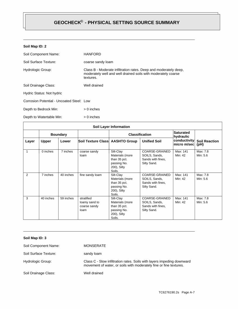
TC6276190.2s Page A-7
Well drainedSoil Drainage Class:
movement of water, or soils with moderately fine or fine textures.Class C - Slow infiltration rates. Soils with layers impeding downwardHydrologic Group:
sandy loamSoil Surface Texture:
MONSERATESoil Component Name:
Soil Map ID: 3
Min: 5.6Max: 7.8
Min: 42Max: 141
Silty Sand.Sands with fines,SOILS, Sands,COARSE-GRAINED
Soils.200), Siltypassing No.than 35 pct.Materials (moreSilt-Clay
loamcoarse sandyloamy sand tostratified59 inches40 inches 3
Min: 5.6Max: 7.8
Min: 42Max: 141
Silty Sand.Sands with fines,SOILS, Sands,COARSE-GRAINED
Soils.200), Siltypassing No.than 35 pct.Materials (moreSilt-Clayfine sandy loam40 inches 7 inches 2
Min: 5.6Max: 7.8
Min: 42Max: 141
Silty Sand.Sands with fines,SOILS, Sands,COARSE-GRAINED
Soils.200), Siltypassing No.than 35 pct.Materials (moreSilt-Clay
loamcoarse sandy 7 inches 0 inches 1
Soil Layer Information
Boundary Classification Saturatedhydraulicconductivitymicro m/sec
Layer Upper Lower Soil Texture Class AASHTO Group Unified Soil Soil Reaction(pH)
> 0 inchesDepth to Watertable Min:
> 0 inchesDepth to Bedrock Min:
LowCorrosion Potential - Uncoated Steel:
Hydric Status: Not hydric
Well drainedSoil Drainage Class:
textures.moderately well and well drained soils with moderately coarseClass B - Moderate infiltration rates. Deep and moderately deep,Hydrologic Group:
coarse sandy loamSoil Surface Texture:
HANFORDSoil Component Name:
Soil Map ID: 2
®GEOCHECK - PHYSICAL SETTING SOURCE SUMMARY®

TC6276190.2s Page A-8
Somewhat excessively drainedSoil Drainage Class:
movement of water, or soils with moderately fine or fine textures.Class C - Slow infiltration rates. Soils with layers impeding downwardHydrologic Group:
sandy loamSoil Surface Texture:
CIENEBASoil Component Name:
Soil Map ID: 4
Min: 6.6Max: 8.4
Min: 4Max: 14
Silty Sand.Sands with fines,SOILS, Sands,COARSE-GRAINED
Soils.200), Siltypassing No.than 35 pct.Materials (moreSilt-Clay
sandloamy coarse70 inches57 inches 5
Min: 6.6Max: 8.4
Min: 4Max: 14
Silty Sand.Sands with fines,SOILS, Sands,COARSE-GRAINED
Soils.200), Siltypassing No.than 35 pct.Materials (moreSilt-Claycemented57 inches44 inches 4
Min: 6.6Max: 8.4
Min: 4Max: 14
Silty Sand.Sands with fines,SOILS, Sands,COARSE-GRAINED
Soils.200), Siltypassing No.than 35 pct.Materials (moreSilt-Clayindurated44 inches27 inches 3
Min: 6.6Max: 8.4
Min: 4Max: 14
Silty Sand.Sands with fines,SOILS, Sands,COARSE-GRAINED
Soils.200), Siltypassing No.than 35 pct.Materials (moreSilt-Claysandy clay loam27 inches 9 inches 2
Min: 6.6Max: 8.4
Min: 4Max: 14
Silty Sand.Sands with fines,SOILS, Sands,COARSE-GRAINED
Soils.200), Siltypassing No.than 35 pct.Materials (moreSilt-Claysandy loam 9 inches 0 inches 1
Soil Layer Information
Boundary Classification Saturatedhydraulicconductivitymicro m/sec
Layer Upper Lower Soil Texture Class AASHTO Group Unified Soil Soil Reaction(pH)
> 0 inchesDepth to Watertable Min:
> 0 inchesDepth to Bedrock Min:
LowCorrosion Potential - Uncoated Steel:
Hydric Status: Not hydric
®GEOCHECK - PHYSICAL SETTING SOURCE SUMMARY®

TC6276190.2s Page A-9
> 0 inchesDepth to Watertable Min:
> 0 inchesDepth to Bedrock Min:
LowCorrosion Potential - Uncoated Steel:
Hydric Status: Not hydric
Well drainedSoil Drainage Class:
movement of water, or soils with moderately fine or fine textures.Class C - Slow infiltration rates. Soils with layers impeding downwardHydrologic Group:
coarse sandy loamSoil Surface Texture:
VISTASoil Component Name:
Soil Map ID: 5
Max: Min: Min: 0Max: 0.42 Not reported
and Sand.Clayey Gravel200), Silty, orpassing No.pct. or lessmaterials (35Granular
bedrockweathered22 inches14 inches 2
Max: Min: Min: 0Max: 0.42 Not reported
and Sand.Clayey Gravel200), Silty, orpassing No.pct. or lessmaterials (35Granularsandy loam14 inches 0 inches 1
Soil Layer Information
Boundary Classification Saturatedhydraulicconductivitymicro m/sec
Layer Upper Lower Soil Texture Class AASHTO Group Unified Soil Soil Reaction(pH)
> 0 inchesDepth to Watertable Min:
> 0 inchesDepth to Bedrock Min:
LowCorrosion Potential - Uncoated Steel:
Hydric Status: Not hydric
®GEOCHECK - PHYSICAL SETTING SOURCE SUMMARY®

TC6276190.2s Page A-10
> 0 inchesDepth to Watertable Min:
> 0 inchesDepth to Bedrock Min:
LowCorrosion Potential - Uncoated Steel:
Hydric Status: Not hydric
Well drainedSoil Drainage Class:
water table, or are shallow to an impervious layer.Class D - Very slow infiltration rates. Soils are clayey, have a highHydrologic Group:
sandy loamSoil Surface Texture:
FALLBROOKSoil Component Name:
Soil Map ID: 6
Max: Min: Min: 0Max: 0.42 Not reported
Sand.Gravel andFragments,200), Stonepassing No.pct. or lessmaterials (35Granular
bedrockweathered27 inches24 inches 3
Max: Min: Min: 0Max: 0.42 Not reported
Sand.Gravel andFragments,200), Stonepassing No.pct. or lessmaterials (35Granular
loamcoarse sandy24 inches14 inches 2
Max: Min: Min: 0Max: 0.42 Not reported
Sand.Gravel andFragments,200), Stonepassing No.pct. or lessmaterials (35Granular
loamcoarse sandy14 inches 0 inches 1
Soil Layer Information
Boundary Classification Saturatedhydraulicconductivitymicro m/sec
Layer Upper Lower Soil Texture Class AASHTO Group Unified Soil Soil Reaction(pH)
®GEOCHECK - PHYSICAL SETTING SOURCE SUMMARY®

TC6276190.2s Page A-11
> 0 inchesDepth to Watertable Min:
> 0 inchesDepth to Bedrock Min:
LowCorrosion Potential - Uncoated Steel:
Hydric Status: Not hydric
Well drainedSoil Drainage Class:
textures.moderately well and well drained soils with moderately coarseClass B - Moderate infiltration rates. Deep and moderately deep,Hydrologic Group:
fine sandy loamSoil Surface Texture:
ARLINGTONSoil Component Name:
Soil Map ID: 7
Max: Min: Min: 0Max: 0.42 Not reported
Soils.200), Siltypassing No.than 35 pct.Materials (moreSilt-Clay
bedrockweathered22 inches18 inches 3
Max: Min: Min: 0Max: 0.42 Not reported
Soils.200), Siltypassing No.than 35 pct.Materials (moreSilt-Claysandy clay loam18 inches 7 inches 2
Max: Min: Min: 0Max: 0.42 Not reported
Soils.200), Siltypassing No.than 35 pct.Materials (moreSilt-Claysandy loam 7 inches 0 inches 1
Soil Layer Information
Boundary Classification Saturatedhydraulicconductivitymicro m/sec
Layer Upper Lower Soil Texture Class AASHTO Group Unified Soil Soil Reaction(pH)
®GEOCHECK - PHYSICAL SETTING SOURCE SUMMARY®

TC6276190.2s Page A-12
> 0 inchesDepth to Watertable Min:
> 0 inchesDepth to Bedrock Min:
LowCorrosion Potential - Uncoated Steel:
Hydric Status: Not hydric
Well drainedSoil Drainage Class:
textures.moderately well and well drained soils with moderately coarseClass B - Moderate infiltration rates. Deep and moderately deep,Hydrologic Group:
sandy loamSoil Surface Texture:
GREENFIELDSoil Component Name:
Soil Map ID: 8
Min: 6.6Max: 7.3
Min: 42Max: 141
Silty Sand.Sands with fines,SOILS, Sands,COARSE-GRAINED
Soils.200), Siltypassing No.than 35 pct.Materials (moreSilt-Clay
loamcoarse sandy70 inches59 inches 4
Min: 6.6Max: 7.3
Min: 42Max: 141
Silty Sand.Sands with fines,SOILS, Sands,COARSE-GRAINED
Soils.200), Siltypassing No.than 35 pct.Materials (moreSilt-Claycemented59 inches50 inches 3
Min: 6.6Max: 7.3
Min: 42Max: 141
Silty Sand.Sands with fines,SOILS, Sands,COARSE-GRAINED
Soils.200), Siltypassing No.than 35 pct.Materials (moreSilt-Claysandy loam50 inches11 inches 2
Min: 6.6Max: 7.3
Min: 42Max: 141
Silty Sand.Sands with fines,SOILS, Sands,COARSE-GRAINED
Soils.200), Siltypassing No.than 35 pct.Materials (moreSilt-Clayfine sandy loam11 inches 0 inches 1
Soil Layer Information
Boundary Classification Saturatedhydraulicconductivitymicro m/sec
Layer Upper Lower Soil Texture Class AASHTO Group Unified Soil Soil Reaction(pH)
®GEOCHECK - PHYSICAL SETTING SOURCE SUMMARY®

TC6276190.2s Page A-13
> 0 inchesDepth to Watertable Min:
> 0 inchesDepth to Bedrock Min:
LowCorrosion Potential - Uncoated Steel:
Hydric Status: Not hydric
Well drainedSoil Drainage Class:
water table, or are shallow to an impervious layer.Class D - Very slow infiltration rates. Soils are clayey, have a highHydrologic Group:
sandy loamSoil Surface Texture:
FALLBROOKSoil Component Name:
Soil Map ID: 9
Min: 6.6Max: 8.4
Min: 14Max: 42
Silty Sand.Sands with fines,SOILS, Sands,COARSE-GRAINED
and Sand.Clayey Gravel200), Silty, orpassing No.pct. or lessmaterials (35Granular
sandy loamloamy sand tostratified72 inches59 inches 4
Min: 6.6Max: 8.4
Min: 14Max: 42
Silty Sand.Sands with fines,SOILS, Sands,COARSE-GRAINED
and Sand.Clayey Gravel200), Silty, orpassing No.pct. or lessmaterials (35Granularloam59 inches42 inches 3
Min: 6.6Max: 8.4
Min: 14Max: 42
Silty Sand.Sands with fines,SOILS, Sands,COARSE-GRAINED
and Sand.Clayey Gravel200), Silty, orpassing No.pct. or lessmaterials (35Granularfine sandy loam42 inches25 inches 2
Min: 6.6Max: 8.4
Min: 14Max: 42
Silty Sand.Sands with fines,SOILS, Sands,COARSE-GRAINED
and Sand.Clayey Gravel200), Silty, orpassing No.pct. or lessmaterials (35Granularsandy loam25 inches 0 inches 1
Soil Layer Information
Boundary Classification Saturatedhydraulicconductivitymicro m/sec
Layer Upper Lower Soil Texture Class AASHTO Group Unified Soil Soil Reaction(pH)
®GEOCHECK - PHYSICAL SETTING SOURCE SUMMARY®

TC6276190.2s Page A-14
> 0 inchesDepth to Watertable Min:
> 0 inchesDepth to Bedrock Min:
LowCorrosion Potential - Uncoated Steel:
Hydric Status: Not hydric
Well drainedSoil Drainage Class:
water table, or are shallow to an impervious layer.Class D - Very slow infiltration rates. Soils are clayey, have a highHydrologic Group:
sandy loamSoil Surface Texture:
FALLBROOKSoil Component Name:
Soil Map ID: 10
Max: Min: Min: 0Max: 0.42 Not reported
Soils.200), Siltypassing No.than 35 pct.Materials (moreSilt-Clay
bedrockweathered22 inches18 inches 3
Max: Min: Min: 0Max: 0.42 Not reported
Soils.200), Siltypassing No.than 35 pct.Materials (moreSilt-Claysandy clay loam18 inches 7 inches 2
Max: Min: Min: 0Max: 0.42 Not reported
Soils.200), Siltypassing No.than 35 pct.Materials (moreSilt-Claysandy loam 7 inches 0 inches 1
Soil Layer Information
Boundary Classification Saturatedhydraulicconductivitymicro m/sec
Layer Upper Lower Soil Texture Class AASHTO Group Unified Soil Soil Reaction(pH)
®GEOCHECK - PHYSICAL SETTING SOURCE SUMMARY®

TC6276190.2s Page A-15
FEDERAL FRDS PUBLIC WATER SUPPLY SYSTEM INFORMATION
LOCATIONFROM TPWELL IDMAP ID
1/2 - 1 Mile ENEUSGS40000138614 A3
FEDERAL USGS WELL INFORMATION
LOCATIONFROM TPWELL IDMAP ID
1.000State DatabaseNearest PWS within 1 mileFederal FRDS PWS1.000Federal USGS
WELL SEARCH DISTANCE INFORMATION
SEARCH DISTANCE (miles)DATABASE
opinion about the impact of contaminant migration on nearby drinking water wells.professional in assessing sources that may impact ground water flow direction, and in forming anEDR Local/Regional Water Agency records provide water well information to assist the environmental
LOCAL / REGIONAL WATER AGENCY RECORDS
Max: Min: Min: 0Max: 0.42 Not reported
Soils.200), Siltypassing No.than 35 pct.Materials (moreSilt-Clay
bedrockweathered22 inches18 inches 3
Max: Min: Min: 0Max: 0.42 Not reported
Soils.200), Siltypassing No.than 35 pct.Materials (moreSilt-Claysandy clay loam18 inches 7 inches 2
Max: Min: Min: 0Max: 0.42 Not reported
Soils.200), Siltypassing No.than 35 pct.Materials (moreSilt-Claysandy loam 7 inches 0 inches 1
Soil Layer Information
Boundary Classification Saturatedhydraulicconductivitymicro m/sec
Layer Upper Lower Soil Texture Class AASHTO Group Unified Soil Soil Reaction(pH)
®GEOCHECK - PHYSICAL SETTING SOURCE SUMMARY®

TC6276190.2s Page A-16
1/2 - 1 Mile ENECADWR8000005896 A41/2 - 1 Mile ENECAUSGSN00002987 A21/2 - 1 Mile ENECADWR0000037413 A1
STATE DATABASE WELL INFORMATION
LOCATIONFROM TPWELL IDMAP ID
Note: PWS System location is not always the same as well location.
No PWS System Found
FEDERAL FRDS PUBLIC WATER SUPPLY SYSTEM INFORMATION
LOCATIONFROM TPWELL IDMAP ID
®GEOCHECK - PHYSICAL SETTING SOURCE SUMMARY®

EDR Inc.EDR Inc.EDR Inc.EDR Inc.EDR Inc.EDR Inc.EDR Inc.EDR Inc.EDR Inc.EDR Inc.EDR Inc.EDR Inc.EDR Inc.EDR Inc.EDR Inc.EDR Inc.EDR Inc.EDR Inc.EDR Inc.EDR Inc.EDR Inc.EDR Inc.EDR Inc.EDR Inc.EDR Inc.EDR Inc.EDR Inc.EDR Inc.EDR Inc.EDR Inc.EDR Inc.EDR Inc.EDR Inc.EDR Inc.EDR Inc.EDR Inc.EDR Inc.EDR Inc.EDR Inc.EDR Inc.
17
2 01 760
1 7 2 0
0
17
20
1 7 2 0
17
20
1
7 60
176
01
760
1 800
1
76
01
800 1
760
17
60
1 72
0
17
20
17
20
17
20
1 7 2 0
1 52
01 5
20
15
20
15
20
52
0
16
80
16
80
16
80
15
60
15601
56
0
15
60
1 6 001
60
0
16
00
16
00
6 4 0
1 6 40
16
40
16
40
1 6 40
4 0
16
80
1 6 80
16
80
1
6 80
16
80
1 6 8 0
14
80
14801
48
0
14
80
CA

TC6276190.2s Page A-18
Not ReportedWell Completion Rpt #: San JacintoBasin Name: 0Well Depth: Single WellWell Type: IrrigationWell Use: EMWD12474Well Name: 48247Station ID: Not ReportedState Well #:
A4ENE1/2 - 1 MileLower
CADWR8000005896CA WELLS
Not ReportedWell Hole Depth Units: Not ReportedWell Hole Depth: Not ReportedWell Depth Units: Not ReportedWell Depth: Not ReportedConstruction Date: Not ReportedAquifer Type: Not ReportedFormation Type:
California Coastal Basin aquifersAquifer: Not ReportedContrib Drainage Area Unts: Not ReportedContrib Drainage Area: Not ReportedDrainage Area Units: Not ReportedDrainage Area: 18070202HUC: Not ReportedDescription: WellType: 004S004W01G001SMonitor Location:
USGS California Water Science CenterOrganization Name: USGS-CAOrganization ID:
A3ENE1/2 - 1 MileLower
USGS40000138614FED USGS
Not ReportedGeoTracker Data: amp_date=&global_id=&assigned_name=USGS-335119117145401&store_num= https://gamagroundwater.waterboards.ca.gov/gama/gamamap/public/GamaDataDisplay.asp?dataset=USGSNEW&sGroundwater Quality Data:
Not ReportedGAMA PFAS Testing: USGS-335119117145401Other Name: United States Geological SurveySource:
UNKWell Type: USGS-335119117145401Well ID:
A2ENE1/2 - 1 MileLower
CAUSGSN00002987CA WELLS
Not ReportedGeoTracker Data: date=&global_id=&assigned_name=04S04W01G001S&store_num= https://gamagroundwater.waterboards.ca.gov/gama/gamamap/public/GamaDataDisplay.asp?dataset=DWR&samp_Groundwater Quality Data:
Not ReportedGAMA PFAS Testing: 04S04W01G001SOther Name: Department of Water ResourcesSource:
UNKWell Type: 04S04W01G001SWell ID:
A1ENE1/2 - 1 MileLower
CADWR0000037413CA WELLS
Map IDDirectionDistanceElevation EDR ID NumberDatabase
®GEOCHECK - PHYSICAL SETTING SOURCE MAP FINDINGS®

TC6276190.2s Page A-19
0%0%100%1.700 pCi/LBasement0%0%100%0.450 pCi/LLiving Area - 2nd Floor0%0%100%0.117 pCi/LLiving Area - 1st Floor
% >20 pCi/L% 4-20 pCi/L% <4 pCi/LAverage ActivityArea
Number of sites tested: 12
Federal Area Radon Information for RIVERSIDE COUNTY, CA
: Zone 3 indoor average level < 2 pCi/L. : Zone 2 indoor average level >= 2 pCi/L and <= 4 pCi/L. Note: Zone 1 indoor average level > 4 pCi/L.
Federal EPA Radon Zone for RIVERSIDE County: 2
0292570
______________________> 4 pCi/LNum TestsZipcode
Radon Test Results
State Database: CA Radon
AREA RADON INFORMATION
GEOCHECK - PHYSICAL SETTING SOURCE MAP FINDINGSRADON
®

TOPOGRAPHIC INFORMATION
USGS 7.5’ Digital Elevation Model (DEM)Source: United States Geologic SurveyEDR acquired the USGS 7.5’ Digital Elevation Model in 2002 and updated it in 2006. The 7.5 minute DEM correspondsto the USGS 1:24,000- and 1:25,000-scale topographic quadrangle maps. The DEM provides elevation datawith consistent elevation units and projection.
Current USGS 7.5 Minute Topographic MapSource: U.S. Geological Survey
HYDROLOGIC INFORMATION
Flood Zone Data: This data was obtained from the Federal Emergency Management Agency (FEMA). It depicts 100-year and500-year flood zones as defined by FEMA. It includes the National Flood Hazard Layer (NFHL) which incorporates FloodInsurance Rate Map (FIRM) data and Q3 data from FEMA in areas not covered by NFHL.
Source: FEMATelephone: 877-336-2627Date of Government Version: 2003, 2015
NWI: National Wetlands Inventory. This data, available in select counties across the country, was obtained by EDRin 2002, 2005 and 2010 from the U.S. Fish and Wildlife Service.
State Wetlands Data: Wetland InventorySource: Department of Fish and WildlifeTelephone: 916-445-0411
HYDROGEOLOGIC INFORMATION
AQUIFLOW Information SystemR
Source: EDR proprietary database of groundwater flow informationEDR has developed the AQUIFLOW Information System (AIS) to provide data on the general direction of groundwater
flow at specific points. EDR has reviewed reports submitted to regulatory authorities at select sites and hasextracted the date of the report, hydrogeologically determined groundwater flow direction and depth to water tableinformation.
GEOLOGIC INFORMATION
Geologic Age and Rock Stratigraphic UnitSource: P.G. Schruben, R.E. Arndt and W.J. Bawiec, Geology of the Conterminous U.S. at 1:2,500,000 Scale - A digitalrepresentation of the 1974 P.B. King and H.M. Beikman Map, USGS Digital Data Series DDS - 11 (1994).
STATSGO: State Soil Geographic DatabaseSource: Department of Agriculture, Natural Resources Conservation Service (NRCS)The U.S. Department of Agriculture’s (USDA) Natural Resources Conservation Service (NRCS) leads the nationalConservation Soil Survey (NCSS) and is responsible for collecting, storing, maintaining and distributing soilsurvey information for privately owned lands in the United States. A soil map in a soil survey is a representationof soil patterns in a landscape. Soil maps for STATSGO are compiled by generalizing more detailed (SSURGO)soil survey maps.
SSURGO: Soil Survey Geographic DatabaseSource: Department of Agriculture, Natural Resources Conservation Service (NRCS)Telephone: 800-672-5559SSURGO is the most detailed level of mapping done by the Natural Resources Conservation Service, mappingscales generally range from 1:12,000 to 1:63,360. Field mapping methods using national standards are used toconstruct the soil maps in the Soil Survey Geographic (SSURGO) database. SSURGO digitizing duplicates theoriginal soil survey maps. This level of mapping is designed for use by landowners, townships and countynatural resource planning and management.
TC6276190.2s Page PSGR-1
PHYSICAL SETTING SOURCE RECORDS SEARCHED

LOCAL / REGIONAL WATER AGENCY RECORDS
FEDERAL WATER WELLS
PWS: Public Water SystemsSource: EPA/Office of Drinking WaterTelephone: 202-564-3750Public Water System data from the Federal Reporting Data System. A PWS is any water system which provides water to at
least 25 people for at least 60 days annually. PWSs provide water from wells, rivers and other sources.
PWS ENF: Public Water Systems Violation and Enforcement DataSource: EPA/Office of Drinking WaterTelephone: 202-564-3750Violation and Enforcement data for Public Water Systems from the Safe Drinking Water Information System (SDWIS) after
August 1995. Prior to August 1995, the data came from the Federal Reporting Data System (FRDS).
USGS Water Wells: USGS National Water Inventory System (NWIS)This database contains descriptive information on sites where the USGS collects or has collected data on surfacewater and/or groundwater. The groundwater data includes information on wells, springs, and other sources of groundwater.
OTHER STATE DATABASE INFORMATION
Groundwater Ambient Monitoring & Assessment ProgramState Water Resources Control BoardTelephone: 916-341-5577The GAMA Program is Californias comprehensive groundwater quality monitoring program. GAMA collects data by testing
the untreated, raw water in different types of wells for naturally-occurring and man-made chemicals. The GAMAdata includes Domestic, Monitoring and Municipal well types from the following sources, Department of Water Resources,Department of Heath Services, EDF, Agricultural Lands, Lawrence Livermore National Laboratory, Department of PesticideRegulation, United States Geological Survey, Groundwater Ambient Monitoring and Assessment Program and LocalGroundwater Projects.
Water Well DatabaseSource: Department of Water ResourcesTelephone: 916-651-9648
California Drinking Water Quality DatabaseSource: Department of Public HealthTelephone: 916-324-2319The database includes all drinking water compliance and special studies monitoring for the state of California
since 1984. It consists of over 3,200,000 individual analyses along with well and water system information.
California Oil and Gas Well LocationsSource: Dept of Conservation, Geologic Energy Management DivisionTelephone: 916-323-1779Oil and Gas well locations in the state.
California Earthquake Fault LinesSource: California Division of Mines and GeologyThe fault lines displayed on EDR’s Topographic map are digitized quaternary fault lines prepared in 1975 by the
United State Geological Survey. Additional information (also from 1975) regarding activity at specific faultlines comes from California’s Preliminary Fault Activity Map prepared by the California Division of Mines andGeology.
RADON
State Database: CA RadonSource: Department of Public HealthTelephone: 916-210-8558Radon Database for California
TC6276190.2s Page PSGR-2
PHYSICAL SETTING SOURCE RECORDS SEARCHED

Area Radon InformationSource: USGSTelephone: 703-356-4020The National Radon Database has been developed by the U.S. Environmental Protection Agency(USEPA) and is a compilation of the EPA/State Residential Radon Survey and the National Residential Radon Survey.The study covers the years 1986 - 1992. Where necessary data has been supplemented by information collected atprivate sources such as universities and research institutions.
EPA Radon ZonesSource: EPATelephone: 703-356-4020Sections 307 & 309 of IRAA directed EPA to list and identify areas of U.S. with the potential for elevated indoorradon levels.
OTHER
Airport Landing Facilities: Private and public use landing facilitiesSource: Federal Aviation Administration, 800-457-6656
Epicenters: World earthquake epicenters, Richter 5 or greaterSource: Department of Commerce, National Oceanic and Atmospheric Administration
California Earthquake Fault Lines: The fault lines displayed on EDR’s Topographic map are digitized quaternary fault lines,prepared in 1975 by the United State Geological Survey. Additional information (also from 1975) regarding activity at specific faultlines comes from California’s Preliminary Fault Activity Map prepared by the California Division of Mines and Geology.
STREET AND ADDRESS INFORMATION
© 2015 TomTom North America, Inc. All rights reserved. This material is proprietary and the subject of copyright protectionand other intellectual property rights owned by or licensed to Tele Atlas North America, Inc. The use of this material is subjectto the terms of a license agreement. You will be held liable for any unauthorized copying or disclosure of this material.
TC6276190.2s Page PSGR-3
PHYSICAL SETTING SOURCE RECORDS SEARCHED

PHASE I ENVIRONMENTAL SITE ASSESSMENT SEATON AVENUE AND PERRY STREET PERRIS, CALIFORNIA 92570
Appendix E Historical Records
November 20, 2020
Project No.: 185804970.200.0001 E.1
Appendix E HISTORICAL RECORDS

Certified Sanborn® Map Report
Inquiry Number:
6 Armstrong Road, 4th floor Shelton, CT 06484Toll Free: 800.352.0050 www.edrnet.com
Seaton Avenue and Perry Street
Seaton Avenue and Perry Street
Perris, CA 92570
November 20, 2020
6276190.3

Certified Sanborn® Map Report
Certified Sanborn Results:
Disclaimer - Copyright and Trademark Notice
EDR and its logos (including Sanborn and Sanborn Map) are trademarks of Environmental Data Resources, Inc. or its affiliates. All other trademarks used herein are the property of their respective owners.
page-
The Sanborn Library includes more than 1.2 millionfire insurance maps from Sanborn, Bromley, Perris &Browne, Hopkins, Barlow and others which trackhistorical property usage in approximately 12,000American cities and towns. Collections searched:
Library of Congress
University Publications of America
EDR Private Collection
The Sanborn Library LLC Since 1866™
Limited Permission To Make Copies
Sanborn® Library search results
Contact:EDR Inquiry #
Site Name: Client Name:
Certification #
PO #
Project
11/20/20
Seaton Avenue and Perry StreetSeaton Avenue and Perry Street Stantec
735 E. Carnegie Drive, Suite 280Perris, CA 92570
6276190.3SAN BERNARDINO, CA 92408
Alicia JansenThe Sanborn Library has been searched by EDR and maps covering the target property location as provided by Stantec were identified forthe years listed below. The Sanborn Library is the largest, most complete collection of fire insurance maps. The collection includes mapsfrom Sanborn, Bromley, Perris & Browne, Hopkins, Barlow, and others. Only Environmental Data Resources Inc. (EDR) is authorized togrant rights for commercial reproduction of maps by the Sanborn Library LLC, the copyright holder for the collection. Results can beauthenticated by visiting www.edrnet.com/sanborn.
The Sanborn Library is continually enhanced with newly identified map archives. This report accesses all maps in the collection as of theday this report was generated.
B8FA-4B2F-9A8BDedeaux
UNMAPPED PROPERTY
NA
This report certifies that the complete holdings of the Sanborn Library,LLC collection have been searched based on client supplied targetproperty information, and fire insurance maps covering the target propertywere not found.
Certification #: B8FA-4B2F-9A8B
Stantec (the client) is permitted to make up to FIVE photocopies of this Sanborn Map transmittal and each fire insurance map accompanying this report solely for thelimited use of its customer. No one other than the client is authorized to make copies. Upon request made directly to an EDR Account Executive, the client may bepermitted to make a limited number of additional photocopies. This permission is conditioned upon compliance by the client, its customer and their agents with EDR'scopyright policy; a copy of which is available upon request.
This Report contains certain information obtained from a variety of public and other sources reasonably available to Environmental Data Resources, Inc. It cannotbe concluded from this Report that coverage information for the target and surrounding properties does not exist from other sources. NO WARRANTYEXPRESSED OR IMPLIED, IS MADE WHATSOEVER IN CONNECTION WITH THIS REPORT. ENVIRONMENTAL DATA RESOURCES, INC. SPECIFICALLYDISCLAIMS THE MAKING OF ANY SUCH WARRANTIES, INCLUDING WITHOUT LIMITATION, MERCHANTABILITY OR FITNESS FOR A PARTICULAR USEOR PURPOSE. ALL RISK IS ASSUMED BY THE USER. IN NO EVENT SHALL ENVIRONMENTAL DATA RESOURCES, INC. BE LIABLE TO ANYONE,WHETHER ARISING OUT OF ERRORS OR OMISSIONS, NEGLIGENCE, ACCIDENT OR ANY OTHER CAUSE, FOR ANY LOSS OF DAMAGE, INCLUDING,WITHOUT LIMITATION, SPECIAL, INCIDENTAL, CONSEQUENTIAL, OR EXEMPLARY DAMAGES. ANY LIABILITY ON THE PART OF ENVIRONMENTALDATA RESOURCES, INC. IS STRICTLY LIMITED TO A REFUND OF THE AMOUNT PAID FOR THIS REPORT. Purchaser accepts this Report "AS IS". Anyanalyses, estimates, ratings, environmental risk levels or risk codes provided in this Report are provided for illustrative purposes only, and are not intended toprovide, nor should they be interpreted as providing any facts regarding, or prediction or forecast of, any environmental risk for any property. Only a Phase IEnvironmental Site Assessment performed by an environmental professional can provide information regarding the environmental risk for any property.Additionally, the information provided in this Report is not to be construed as legal advice.Copyright 2020 by Environmental Data Resources, Inc. All rights reserved. Reproduction in any media or format, in whole or in part, of any report or map ofEnvironmental Data Resources, Inc., or its affiliates, is prohibited without prior written permission.
6276190 3 2

EDR Historical Topo Map Report
Inquiry Number:
6 Armstrong Road, 4th floor Shelton, CT 06484Toll Free: 800.352.0050 www.edrnet.com
with QuadMatch™
Seaton Avenue and Perry Street
Seaton Avenue and Perry Street
Perris, CA 92570
November 20, 2020
6276190.4

EDR Historical Topo Map Report
EDR Inquiry #
Search Results:
P.O.# Project:
Maps Provided:
Disclaimer - Copyright and Trademark Notice
EDR and its logos (including Sanborn and Sanborn Map) are trademarks of Environmental Data Resources, Inc. or its affiliates. All other trademarks used herein are the property of their respective owners.
page-
Coordinates:
Latitude: Longitude: UTM Zone: UTM X Meters: UTM Y Meters: Elevation:
Contact:
Site Name: Client Name:
2012
1978
1973
1967
1953
1947
1942
1901
11/20/20
Seaton Avenue and Perry Street StantecSeaton Avenue and Perry Street 735 E. Carnegie Drive, Suite 280Perris, CA 92570 SAN BERNARDINO, CA 92408
6276190.4 Alicia Jansen
EDR Topographic Map Library has been searched by EDR and maps covering the target property location as provided byStantec were identified for the years listed below. EDR’s Historical Topo Map Report is designed to assist professionals inevaluating potential liability on a target property resulting from past activities. EDRs Historical Topo Map Report includes asearch of a collection of public and private color historical topographic maps, dating back to the late 1800s.
Dedeaux 33.849609 33° 50' 59" North
NA -117.263683 -117° 15' 49" WestZone 11 North475606.583745512.391553.33' above sea level
This Report contains certain information obtained from a variety of public and other sources reasonably available to Environmental Data Resources, Inc. It cannotbe concluded from this Report that coverage information for the target and surrounding properties does not exist from other sources. NO WARRANTYEXPRESSED OR IMPLIED, IS MADE WHATSOEVER IN CONNECTION WITH THIS REPORT. ENVIRONMENTAL DATA RESOURCES, INC. SPECIFICALLYDISCLAIMS THE MAKING OF ANY SUCH WARRANTIES, INCLUDING WITHOUT LIMITATION, MERCHANTABILITY OR FITNESS FOR A PARTICULAR USEOR PURPOSE. ALL RISK IS ASSUMED BY THE USER. IN NO EVENT SHALL ENVIRONMENTAL DATA RESOURCES, INC. BE LIABLE TO ANYONE,WHETHER ARISING OUT OF ERRORS OR OMISSIONS, NEGLIGENCE, ACCIDENT OR ANY OTHER CAUSE, FOR ANY LOSS OF DAMAGE, INCLUDING,WITHOUT LIMITATION, SPECIAL, INCIDENTAL, CONSEQUENTIAL, OR EXEMPLARY DAMAGES. ANY LIABILITY ON THE PART OF ENVIRONMENTALDATA RESOURCES, INC. IS STRICTLY LIMITED TO A REFUND OF THE AMOUNT PAID FOR THIS REPORT. Purchaser accepts this Report "AS IS". Anyanalyses, estimates, ratings, environmental risk levels or risk codes provided in this Report are provided for illustrative purposes only, and are not intended toprovide, nor should they be interpreted as providing any facts regarding, or prediction or forecast of, any environmental risk for any property. Only a Phase IEnvironmental Site Assessment performed by an environmental professional can provide information regarding the environmental risk for any property.Additionally, the information provided in this Report is not to be construed as legal advice.Copyright 2020 by Environmental Data Resources, Inc. All rights reserved. Reproduction in any media or format, in whole or in part, of any report or map ofEnvironmental Data Resources, Inc., or its affiliates, is prohibited without prior written permission.
6276190 4 2

page
Topo Sheet KeyThis EDR Topo Map Report is based upon the following USGS topographic map sheets.
-
2012 Source Sheets
2012Perris
7.5-minute, 240002012Steele Peak
7.5-minute, 24000
1978 Source Sheets
1978Steele Peak
7.5-minute, 24000Aerial Photo Revised 1978
1973 Source Sheets
1973Steele Peak
7.5-minute, 24000Aerial Photo Revised 1973
1973Perris
7.5-minute, 24000Aerial Photo Revised 1973
1967 Source Sheets
1967Steele Peak
7.5-minute, 24000Aerial Photo Revised 1966
1967Perris
7.5-minute, 24000Aerial Photo Revised 1966
6276190 4 3

page
Topo Sheet KeyThis EDR Topo Map Report is based upon the following USGS topographic map sheets.
-
1953 Source Sheets
1953Perris
7.5-minute, 24000Aerial Photo Revised 1951
1953Steele Peak
7.5-minute, 24000Aerial Photo Revised 1951
1947 Source Sheets
1947RIVERSIDE
15-minute, 50000
1942 Source Sheets
1942Perris
15-minute, 62500Aerial Photo Revised 1939
1942Riverside
15-minute, 62500Aerial Photo Revised 1939
1901 Source Sheets
1901Riverside
15-minute, 62500
6276190 4 4

Historical Topo Map
page
SITE NAME:
ADDRESS:
CLIENT:
This report includes information from the
following map sheet(s).
-
EW
SW S SE
NW N NE
2012
0 Miles 0.25 0.5 1 1.5
Seaton Avenue and Perry StreetSeaton Avenue and Perry StreetPerris, CA 92570Stantec
TP, Steele Peak, 2012, 7.5-minuteSE, Perris, 2012, 7.5-minute
6276190 4 5

Historical Topo Map
page
SITE NAME:
ADDRESS:
CLIENT:
This report includes information from the
following map sheet(s).
-
EW
SW S SE
NW N NE
1978
0 Miles 0.25 0.5 1 1.5
Seaton Avenue and Perry StreetSeaton Avenue and Perry StreetPerris, CA 92570Stantec
TP, Steele Peak, 1978, 7.5-minute
6276190 4 6

Historical Topo Map
page
SITE NAME:
ADDRESS:
CLIENT:
This report includes information from the
following map sheet(s).
-
EW
SW S SE
NW N NE
1973
0 Miles 0.25 0.5 1 1.5
Seaton Avenue and Perry StreetSeaton Avenue and Perry StreetPerris, CA 92570Stantec
TP, Steele Peak, 1973, 7.5-minuteSE, Perris, 1973, 7.5-minute
6276190 4 7

Historical Topo Map
page
SITE NAME:
ADDRESS:
CLIENT:
This report includes information from the
following map sheet(s).
-
EW
SW S SE
NW N NE
1967
0 Miles 0.25 0.5 1 1.5
Seaton Avenue and Perry StreetSeaton Avenue and Perry StreetPerris, CA 92570Stantec
TP, Steele Peak, 1967, 7.5-minuteSE, Perris, 1967, 7.5-minute
6276190 4 8

Historical Topo Map
page
SITE NAME:
ADDRESS:
CLIENT:
This report includes information from the
following map sheet(s).
-
EW
SW S SE
NW N NE
1953
0 Miles 0.25 0.5 1 1.5
Seaton Avenue and Perry StreetSeaton Avenue and Perry StreetPerris, CA 92570Stantec
TP, Steele Peak, 1953, 7.5-minuteSE, Perris, 1953, 7.5-minute
6276190 4 9

Historical Topo Map
page
SITE NAME:
ADDRESS:
CLIENT:
This report includes information from the
following map sheet(s).
-
EW
SW S SE
NW N NE
1947
0 Miles 0.25 0.5 1 1.5
Seaton Avenue and Perry StreetSeaton Avenue and Perry StreetPerris, CA 92570Stantec
TP, RIVERSIDE, 1947, 15-minute
6276190 4 10

Historical Topo Map
page
SITE NAME:
ADDRESS:
CLIENT:
This report includes information from the
following map sheet(s).
-
EW
SW S SE
NW N NE
1942
0 Miles 0.25 0.5 1 1.5
Seaton Avenue and Perry StreetSeaton Avenue and Perry StreetPerris, CA 92570Stantec
TP, Riverside, 1942, 15-minuteE, Perris, 1942, 15-minute
6276190 4 11

Historical Topo Map
page
SITE NAME:
ADDRESS:
CLIENT:
This report includes information from the
following map sheet(s).
-
EW
SW S SE
NW N NE
1901
0 Miles 0.25 0.5 1 1.5
Seaton Avenue and Perry StreetSeaton Avenue and Perry StreetPerris, CA 92570Stantec
TP, Riverside, 1901, 15-minute
6276190 4 12

The EDR Aerial Photo Decade Package
Seaton Avenue and Perry Street
Seaton Avenue and Perry Street
Perris, CA 92570
Inquiry Number:
November 20, 2020
6276190.8
6 Armstrong Road, 4th floorShelton, CT 06484Toll Free: 800.352.0050www.edrnet.com

2016 1"=500' Flight Year: 2016 USDA/NAIP
2012 1"=500' Flight Year: 2012 USDA/NAIP
2009 1"=500' Flight Year: 2009 USDA/NAIP
2006 1"=500' Flight Year: 2006 USDA/NAIP
1990 1"=500' Flight Date: September 06, 1990 USDA
1989 1"=500' Flight Date: August 15, 1989 USDA
1985 1"=500' Flight Date: February 24, 1985 USDA
1978 1"=500' Flight Date: September 20, 1978 USDA
1974 1"=500' Flight Date: November 06, 1974 USGS
1967 1"=500' Flight Date: May 15, 1967 USDA
1961 1"=500' Flight Date: June 14, 1961 USDA
1959 1"=500' Flight Date: October 15, 1959 USDA
1953 1"=500' Flight Date: September 22, 1953 USDA
1949 1"=500' Flight Date: May 06, 1949 USDA
1938 1"=500' Flight Date: June 14, 1938 USDA
EDR Aerial Photo Decade Package 11/20/20
Seaton Avenue and Perry Street
Site Name: Client Name:
StantecSeaton Avenue and Perry Street 735 E. Carnegie Drive, Suite 280Perris, CA 92570 SAN BERNARDINO, CA 92408EDR Inquiry # 6276190.8 Contact: Alicia Jansen
Environmental Data Resources, Inc. (EDR) Aerial Photo Decade Package is a screening tool designed to assistenvironmental professionals in evaluating potential liability on a target property resulting from past activities. EDR’sprofessional researchers provide digitally reproduced historical aerial photographs, and when available, provide one photoper decade.
Search Results:
Year Scale Details Source
When delivered electronically by EDR, the aerial photo images included with this report are for ONE TIME USEONLY. Further reproduction of these aerial photo images is prohibited without permission from EDR. For moreinformation contact your EDR Account Executive.
Disclaimer - Copyright and Trademark NoticeThis Report contains certain information obtained from a variety of public and other sources reasonably available to Environmental Data Resources, Inc. It cannotbe concluded from this Report that coverage information for the target and surrounding properties does not exist from other sources. NO WARRANTYEXPRESSED OR IMPLIED, IS MADE WHATSOEVER IN CONNECTION WITH THIS REPORT. ENVIRONMENTAL DATA RESOURCES, INC. SPECIFICALLYDISCLAIMS THE MAKING OF ANY SUCH WARRANTIES, INCLUDING WITHOUT LIMITATION, MERCHANTABILITY OR FITNESS FOR A PARTICULAR USEOR PURPOSE. ALL RISK IS ASSUMED BY THE USER. IN NO EVENT SHALL ENVIRONMENTAL DATA RESOURCES, INC. BE LIABLE TO ANYONE,WHETHER ARISING OUT OF ERRORS OR OMISSIONS, NEGLIGENCE, ACCIDENT OR ANY OTHER CAUSE, FOR ANY LOSS OF DAMAGE, INCLUDING,WITHOUT LIMITATION, SPECIAL, INCIDENTAL, CONSEQUENTIAL, OR EXEMPLARY DAMAGES. ANY LIABILITY ON THE PART OF ENVIRONMENTALDATA RESOURCES, INC. IS STRICTLY LIMITED TO A REFUND OF THE AMOUNT PAID FOR THIS REPORT. Purchaser accepts this Report "AS IS". Anyanalyses, estimates, ratings, environmental risk levels or risk codes provided in this Report are provided for illustrative purposes only, and are not intended toprovide, nor should they be interpreted as providing any facts regarding, or prediction or forecast of, any environmental risk for any property. Only a Phase IEnvironmental Site Assessment performed by an environmental professional can provide information regarding the environmental risk for any property.Additionally, the information provided in this Report is not to be construed as legal advice.
Copyright 2020 by Environmental Data Resources, Inc. All rights reserved. Reproduction in any media or format, in whole or in part, of any report or map ofEnvironmental Data Resources, Inc., or its affiliates, is prohibited without prior written permission.
EDR and its logos (including Sanborn and Sanborn Map) are trademarks of Environmental Data Resources, Inc. or its affiliates. All other trademarks used herein arethe property of their respective owners.
6276190 8- page 2

6276190.8
2016
= 500'
YEAR:
~EDR'

6276190.8
2012
= 500'
YEAR:
~EDR'

6276190.8
2009
= 500'
YEAR:
~EDR'

6276190.8
2006
= 500'
YEAR:
~EDR'

6276190.8
1990
= 500'
YEAR:
~EDR'

6276190.8
1989
= 500'
YEAR:
~EDR'

6276190.8
1985
= 500'
YEAR:
~EDR'

6276190.8
1978
= 500'
.....
YEAR: if N ~EDR'

6276190.8
1974
= 500'
YEAR:
~EDR'

6276190.8
1967
= 500'
YEAR:
~EDR'

6276190.8
1961
= 500'
YEAR:
~EDR'

6276190.8
1959
= 500'
YEAR:
~EDR'

6276190.8
1953
= 500'
INQUIRY#: ____ _
YEAR:
~EDR'

6276190.8
1949
= 500'
YEAR:
~EDR'

6276190.8
1938
= 500'
YEAR:
~EDR'

Seaton Avenue and Perry Street
Seaton Avenue and Perry StreetPerris, CA 92570
Inquiry Number: 6276190.5November 30, 2020
The EDR-City Directory Image Report
6 Armstrong RoadShelton, CT 06484800.352.0050www.edrnet.comEnvironmental Data Resources IncEnvironmental Data Resources IncEnvironmental Data Resources IncEnvironmental Data Resources Inc

TABLE OF CONTENTS
SECTION
Executive Summary
Findings
City Directory Images
Thank you for your business. Please contact EDR at 1-800-352-0050
with any questions or comments.
Disclaimer - Copyright and Trademark Notice
This Report contains certain information obtained from a variety of public and other sources reasonably available to Environmental Data Resources, Inc. It cannot be concluded from this Report that coverage information for the target and surrounding properties does not exist from other sources. NO WARRANTY EXPRESSED OR IMPLIED, IS MADE WHATSOEVER IN CONNECTION WITH THIS REPORT. ENVIRONMENTAL DATA RESOURCES, INC. SPECIFICALLY DISCLAIMS THE MAKING OF ANY SUCH WARRANTIES, INCLUDING WITHOUT LIMITATION, MERCHANTABILITY OR FITNESS FOR A PARTICULAR USE OR PURPOSE. ALL RISK IS ASSUMED BY THE USER. IN NO EVENT SHALL ENVIRONMENTAL DATA RESOURCES, INC. BE LIABLE TO ANYONE, WHETHER ARISING OUT OF ERRORS OR OMISSIONS, NEGLIGENCE, ACCIDENT OR ANY OTHER CAUSE, FOR ANY LOSS OR DAMAGE, INCLUDING, WITHOUT LIMITATION, SPECIAL, INCIDENTAL, CONSEQUENTIAL, OR EXEMPLARY DAMAGES. ANY LIABILITY ON THE PART OF ENVIRONMENTAL DATA RESOURCES, INC. IS STRICTLY LIMITED TO A REFUND OF THE AMOUNT PAID FOR THIS REPORT. Purchaser accepts this Report "AS IS". Any analyses, estimates, ratings, environmental risk levels or risk codes provided in this Report are provided for illustrative purposes only, and are not intended to provide, nor should they be interpreted as providing any facts regarding, or prediction orforecast of, any environmental risk for any property. Only a Phase I Environmental Site Assessment performed by an environmental professional can provide information regarding the environmental risk for any property. Additionally, the information provided in this Report is not to be construed as legal advice.
Copyright 2020 by Environmental Data Resources, Inc. All rights reserved. Reproduction in any media or format, in whole or in part, of any report or map of Environmental Data Resources, Inc. or its affiliates is prohibited without prior written permission.
EDR and its logos (including Sanborn and Sanborn Map) are trademarks of Environmental Data Resources, Inc. or its affiliates. All other trademarks used herein are the property of their respective owners.

EXECUTIVE SUMMARY
DESCRIPTION
Environmental Data Resources, Inc.’s (EDR) City Directory Report is a screening tool designed to assist environmental professionals in evaluating potential liability on a target property resulting from past activities. EDR’s City Directory Report includes a search of available city directory data at 5 year intervals.
RECORD SOURCES
EDR's Digital Archive combines historical directory listings from sources such as Cole Information and Dun & Bradstreet. These standard sources of property information complement and enhance each other to provide a more comprehensive report.
EDR is licensed to reproduce certain City Directory works by the copyright holders of those works. The purchaser of this EDR City Directory Report may include it in report(s) delivered to a customer. Reproduction of City Directories without permission of the publisher or licensed vendor may be a violation of copyright.
RESEARCH SUMMARY
The following research sources were consulted in the preparation of this report. A check mark indicates where information was identified in the source and provided in this report.
Year Target Street Cross Street Source
2017 þ ¨ EDR Digital Archive
2014 þ ¨ EDR Digital Archive
2010 þ ¨ EDR Digital Archive
2005 þ ¨ EDR Digital Archive
2000 þ ¨ EDR Digital Archive
1995 þ ¨ EDR Digital Archive
1992 þ ¨ EDR Digital Archive
1985 þ ¨ Haines Criss-Cross Directory
1980 þ ¨ Haines Criss-Cross Directory
1973 þ ¨ Haines Criss-Cross Directory
1971 ¨ ¨ Haines Criss-Cross Directory
6276190- 5 Page 1

FINDINGS
TARGET PROPERTY STREET
Seaton Avenue and Perry StreetPerris, CA 92570
Year CD Image Source
PERRY ST
2017 pg A2 EDR Digital Archive
2014 pg A5 EDR Digital Archive
2010 pg A8 EDR Digital Archive
2005 pg A11 EDR Digital Archive
2000 pg A14 EDR Digital Archive
1995 pg A16 EDR Digital Archive
1992 pg A19 EDR Digital Archive
1985 pg A21 Haines Criss-Cross Directory
1980 pg A23 Haines Criss-Cross Directory
1973 pg A25 Haines Criss-Cross Directory
1971 - Haines Criss-Cross Directory Street not listed in Source
SEATON AVE
2017 pg A4 EDR Digital Archive
2014 pg A7 EDR Digital Archive
2010 pg A10 EDR Digital Archive
2005 pg A13 EDR Digital Archive
2000 pg A15 EDR Digital Archive
1995 pg A18 EDR Digital Archive
1992 pg A20 EDR Digital Archive
1985 pg A22 Haines Criss-Cross Directory
1980 pg A24 Haines Criss-Cross Directory
1973 pg A26 Haines Criss-Cross Directory
1971 - Haines Criss-Cross Directory Street not listed in Source
6276190- 5 Page 2

FINDINGS
CROSS STREETS
No Cross Streets Identified
6276190- 5 Page 3

City Directory Images

-
PERRY ST
EDR Digital Archive
6276190.5 Page: A2
SourceTarget Street Cross Street
2017
20655 DIVENI, JOAQUIN M20790 GONZALEZ, YARED20810 GUERRO, ALFONSO20848 VALDEZ, A20853 NOVOA, FRANCISCO J20880 ZAPIEN, MARIA C20895 MEJIA, ANTONIO J21525 MACIAS, BERTHA21537 ALANIZ, MARK A21543 LOPEZ, RAUL21550 APODACA, CAROLYN M21565 BENDO, NORMA J21570 PORTILLO, FLORA21577 ALAMILLA, LESLEY21612 MARTINEZ, JOSE A21640 HENDERSON, NORMA D21651 APREZA, VERONICA21660 ALCANTAR, ALEJANDRO21680 MEJIA, IMELDA21714 ROJAS, JOEL C21725 ANGULO, ALFONSO21726 GRIGAS, JOSEPH P21741 BURKS, INA E21780 CHAVEZ, RAMON P21781 VALDIVIA, JUAN21797 REVELES, ANTONIO M21798 MORALES, CARLOS M21815 GONZALEZ, JOSE A21816 ROMERO, STEVEN21839 MENDOZA, REYNA21842 SANCHEZ, MARIO21861 ANTUNEZ, ALBERTA21870 HERNANDEZ, JOHN21871 DIAZ, CRISTINA21890 LOWTHER, SHELLEY21903 GARCIA, JOHANA21929 FORGUS, GLEN L21933 DIAZ, ANTONIO21940 ZUNIGA, AZUZENA21960 DOMINGUEZ, MARIA U22501 ACOSTA, TED22508 BARBO, ALBERT G22510 VALDIVIA, FELIPE22511 RODRIGUEZ, TAI22559 KEDZIOR, DENNIS L22631 GASPAR, EMILIANO R22720 RIVERA, CORY M22723 LOFFER, FLOYD W22770 CALIFORNIA COMPOSITE CONTAINER22825 CONTRERAS, MARTIN

(Cont'd)
-
PERRY ST
EDR Digital Archive
6276190.5 Page: A3
SourceTarget Street Cross Street
2017
22831 VEGA, PAULINO H22850 TORRANCE ALUMINUM22905 GONZALEZ, MAGDALENA G22933 M J PAVING
STANLEY, MICHAEL J

-
SEATON AVE
EDR Digital Archive
6276190.5 Page: A4
SourceTarget Street Cross Street
2017
18240 CASTANEDA, M18399 PERALEZ, LORI A18431 RAYMOND, KEN D18605 MAGALLON, SANDRA18775 SANDOVAL, AGUSTIN U18795 PADILLA, MARIA18890 DESIGNER SASH & DOOR18916 UNIVERSAL WASTE SYSTEMS INC
WHITE HOUSE SANITATIONWHITE HOUSE SEPTIC TANK PUMPING & SP
19081 RAMIREZ, FRANCISCO19091 VANOEL, JASON J19101 BORNT, JAMES F19111 ZACARIAS, BASILIO19165 VELO, LORENA19195 EZ TAX BOOKEEPING
FLORES, JUVENAL19201 SILVA, MANUEL L19249 HOROWITZ, MIMI
WARNER WATER WORKS19355 FUERSTENBERG, CARLOTTA A19580 GUEVARA, RAYMUNDO19600 PEREZ, SONIA19701 PEREZ, RUBEN J19991 ALPHA OWENS CORNING
AOC LLC

-
PERRY ST
EDR Digital Archive
6276190.5 Page: A5
SourceTarget Street Cross Street
2014
20648 VALDEZ, ABELINA20655 DIVENI, JOAQUIN M20785 ZUNIGA, JOSE V20790 GONZALEZ, YARED20810 GUERRO, ALFONSO20848 RODRIGUEZ, NICHOLAS20853 SANDOVAL, CEASER20880 ZAPIEN, MARIA C20895 MEJIA, DONATO D20897 PERRY, DANIEL21525 MACIAS, BERTHA21537 OCHOA, CARMEN21543 LOPEZ, RAUL21550 APODACA, MARY21565 BENDO, NORMA J21570 LOPEZ, JUAN21577 VARGAS, MARTIN A21612 OCCUPANT UNKNOWN,21630 MACIAS, RAUL21640 ZACHARY, HAYES R21651 DECASTRO, MARIA J21660 AGUILERA, MARIA21667 VILLEGOS, ANTONIO21680 MEJIA, MARTIN21701 OCCUPANT UNKNOWN,21714 ROJAS, JOEL C21725 ANGULO, ALFONSO21726 GRIGAS, JOSEPH P21741 SPINKS, ARTHUR21780 CHAVEZ, RAMON P21781 VALDIVIA, JUAN21797 MENCHACASANCHEZ, ROBERTO21798 MIRELES, RAFAEL21815 GONZALEZ, JOSE A21816 REMERO, DAVID M21839 MENDOZA, JOSE21842 SANCHEZ, MARIO21860 PEREZ, MARCELA21861 ORTEGA, MARLENE21870 HERNANDEZ, JOHN21871 DIAZ, CRISTINA21890 LOWTHER, SHELLEY21903 GARCIA, JOHANA21908 GREYBILL, GORDON
VIZCARRA, MARIA21920 FUENTES, JOSE H21929 FORGUS, GLEN L21933 DIAZ, ANTONIO21940 DIMAS, RICARDO Z21960 ARREOLA, MANUEL

(Cont'd)
-
PERRY ST
EDR Digital Archive
6276190.5 Page: A6
SourceTarget Street Cross Street
2014
22501 ACOSTA, DANIEL22508 BARBO, ALBERT G22510 VALDIVIA, LORENA22511 LOPEZ, LETICIA22559 KEDZIOR, DENNIS L22631 GASPAR, EMILIANO R22636 LONTHAIR, C22690 MITTAN, KARI L22695 RICHARDSON, B22720 RIVERA, CORY M22723 LOFFER, FLOYD W22770 CALIFORNIA COMPOSITE CONTAINER22825 CONTRERAS, MARTIN22831 VEGA, PAULINO H22850 TORRANCE ALUMINUM22905 GONZALEZ, MAGDALENA G22933 M J PAVING
STANLEY, MICHAEL J

-
SEATON AVE
EDR Digital Archive
6276190.5 Page: A7
SourceTarget Street Cross Street
2014
18240 CASTANEDA, M18399 PERALEZ, LORI A18431 RAYMOND, KEN18463 TODOROVITCH, JIM18605 MAGALLON, SANDRA18775 SANDOVAL, AGUSTIN U18795 PADILLA, MARIA18890 DESIGNER SASH & DOOR18901 OCCUPANT UNKNOWN,18910 INCE, GINNY18916 UNIVERSAL WASTE SYSTEMS INC
WHITE HOUSE SANITATIONWHITE HOUSE SEPTIC TANK PUMPING & SP
19081 RAMIREZ, FRANCISCO19091 VANOEL, JASON J19101 BORNT, JAMES F19111 ZACARIAS, BASILIO19121 LIERENA, FRANCES M19165 AGUIRRE, ARMANDO19195 EZ TAX BOOKEEPING
OCCUPANT UNKNOWN,19201 SILVA, MANUEL L19249 OCCUPANT UNKNOWN,
WARNER WATER WORKS19351 OCCUPANT UNKNOWN,19355 FUERSTENBERG, CARLOTTA A19600 PEREZ, SONIA19641 TREVINO, PAZ19683 PORRAS, JAMES19691 DEALBA, MAYRA19701 PEREZ, RUBEN J19783 OCCUPANT UNKNOWN,19865 PHAM, NGOC D19991 AOC LLC

-
PERRY ST
EDR Digital Archive
6276190.5 Page: A8
SourceTarget Street Cross Street
2010
20648 VALDEZ, ABELINA20655 OCCUPANT UNKNOWN,20760 VENEGAS, JESUS F20785 ZUNIGA, JOSE V20790 OCHOA, SUSAN20810 GUERRO, ALFONSO20848 OCCUPANT UNKNOWN,20880 TAPIEN, MARIA C20895 MEJIA, DONATO D20897 GALVAN, ABEL E21537 ALANIZ, MARK A21543 CAMACHO, FERNANDO21565 BENDO, NORMA J21570 SALINAS, FLORA21577 OCCUPANT UNKNOWN,21612 SOSA, DANIEL E21630 MACIAS, RAUL21651 OCCUPANT UNKNOWN,21660 AGUILERA, MARIA21667 VILLEGOS, ANTONIO21680 VELO, LORENA21701 OCCUPANT UNKNOWN,21706 OCCUPANT UNKNOWN,21714 DELOERA, RUBEN
MONTOYA, HECTOR D21725 ANGULO, ALFONSO21726 GRIGAS, JOSEPH P
ULTIMATE PRODUCTS CO21741 SPINKS, ARTHUR21744 FLORES, BEATRIZ21780 ARREGUIN, GUADALUPE21781 RAMIREZ, JUAN21797 MENCHACA, ANTONIO21798 MIRELES, RAFAEL21815 GONZALEZ, JOSE A21816 ROMERO, MARTHA A21839 AGUAYO, JESUS D21842 SANCHEZ, RAMIRO N21860 ANDALON, SAMUEL21861 CARSON, ANTHONY21870 HERNANDEZ, JOHN21871 ROJAS, HERMAN21890 OCCUPANT UNKNOWN,21891 OCCUPANT UNKNOWN,21903 JUAREZ, EDUARDO D21908 GREYBILL, GORDON
ORNELAS, MARIELA LVIZCARRA, MARIA
21920 ALMAZAN, MAGDALENA21929 FORGUS, GLEN L

(Cont'd)
-
PERRY ST
EDR Digital Archive
6276190.5 Page: A9
SourceTarget Street Cross Street
2010
21940 DIMAS, RICARDO Z21950 OCCUPANT UNKNOWN,21955 COLE, MARIA D21960 ARREOLA, MANUEL22501 DOAN, AMANDA L22506 NAVARRO, REINA22508 MARTINEZ, CHARLES T22510 GARCIA, OSCAR M22511 VALENCIA, EZEQUIEL22559 ROE, LILLIAN22631 MCCALL, FREDDIE L22636 LONTHAIR, PAUL J22690 PULU, RICKY22695 RICHARDSON, B22720 RIVERA, CORY M22723 LOFFER, FLOYD W22770 CALIFORNIA COMPOSITE CONTAINER22825 CONTRERAS, REYNALDO M22831 FARIAS, ESMERALDA22850 TORRANCE ALUMINUM22905 GONZALEZ, SITTO22933 M J ASPHALT PAVING
STANLEY, MICHAEL N

-
SEATON AVE
EDR Digital Archive
6276190.5 Page: A10
SourceTarget Street Cross Street
2010
18240 WILSON, SANDRA M18391 MARTINEZ, PETE G18399 PERALEZ, LORI A18431 RAYMOND, KEN18463 TODOROVITCH, JIM G18775 SANDOVAL, AGUSTIN U18795 PADILLA, MARIA18890 DESIGNER SASH & DOOR18901 OCCUPANT UNKNOWN,18910 INCE, GINNY19053 SMITH, FLETCHER E19081 MAGANA, REYNALDO C19083 SMITH, JIMMIE L19091 HURTADO, DEBBI A19101 BORNT, JAMES F19111 ZACARIAS, BASILIO19121 OCCUPANT UNKNOWN,19165 OCCUPANT UNKNOWN,19195 ZELEDON, GILMA19201 SILVA, MANUEL L19249 KELLEY, ERIC J19351 TRUJILLO, WAYNE S19355 FUERSTENBERG, CARLOTTA19580 GUEVARA, ULISES19600 PEREZ, SONIA19641 TREVINO, PAZ19654 OCCUPANT UNKNOWN,19683 OCCUPANT UNKNOWN,19691 DEALBA, MAYRA19701 PEREZ, JOSHUA19783 PLUMMER BROTHERS & FAMILY
ROGERS, ANGEL19991 AOCLLC

-
PERRY ST
EDR Digital Archive
6276190.5 Page: A11
SourceTarget Street Cross Street
2005
20655 DIDENI, J20760 VENEGAS, JESUS F20790 RAMIREZ, LAURA P20848 VALDEZ, ABELINA20853 SANDOVAL, GUMARO20897 GALVAN, ABEL E21537 ALANIZ, MARK A21543 DOMINGUEZ, JOSE21565 BENDO, NORMA J21577 DUENAS, DANIEL21612 GONZALEZ, ELIAS21630 MACIAS, RAUL21640 HAYES, FRANCIS P21651 CASTRO, ANTONIO G21660 AGUILERA, MARIA21667 VILLEGOS, ANTONIO21680 VELO, LORENA21701 OCCUPANT UNKNOWN,21726 GRIGAS, JOSEPH P
ULTIMATE PRODUCTS CO21741 SPINKS, ARTHUR21744 VARGAS, VERONICA A21780 CHAVEZ, RAMON21781 RAMIREZ, JUAN21798 MIRELES, RAFAEL21815 GONZALEZ, JOSE A21816 ROMERO, DAVID M21839 AGUAYO, JESUS D21842 SANCHEZ, MARIO21860 LARA, ANGELICA21870 HERNANDEZ, JOHN21871 OCCUPANT UNKNOWN,21890 LOWTHER, JOSE21891 OCCUPANT UNKNOWN,21903 JUAREZ, EDUARDO21908 GRAYBILL, TAMMY A21920 ALMAZAN, MAGDALENA21929 OCCUPANT UNKNOWN,21933 FRANCO, JERRY
NUEVA VISTA PROPERTIES21940 DIMAS, RICARDO Z21955 COLE, MARIA21960 ARREOLA, MANUEL22501 DUENA, MARIO22508 MARTINEZ, CHARLES T22510 GOMEZ, MARINA22551 PERRY, TINA22559 ROE, LILLIAN22631 MCCALL, FREDDIE L22636 LONTHAIR, PAUL J

(Cont'd)
-
PERRY ST
EDR Digital Archive
6276190.5 Page: A12
SourceTarget Street Cross Street
2005
22690 MITTAN, PEGGY AMITTANS CLEANING
22695 RICHARDSON, B22720 RIVERA, CORY M22770 CALIFORNIA COMPOSITE CONTAINER CORP22780 CUTLIFF, LILA22825 CONTRERAS, LAURO C22831 FARIAS, ESMERALDA22850 TORRANCE ALUMINUM WINDOW CO
WINDOW ENTERPRISES INC22905 STANLEY, RICK22933 M J PAVING
STANLEY, MICHAEL J

-
SEATON AVE
EDR Digital Archive
6276190.5 Page: A13
SourceTarget Street Cross Street
2005
18131 RUSSELL, CAMIELLE18221 JONES, ROBERT E18391 MARTINEZ, PETE G18399 HUFF, HARRY18431 RAYMOND, KEN A18463 TODOROVITCH, JIM A18605 OCCUPANT UNKNOWN,18775 SANDOVAL, AGUSTIN U18795 PADILLA, MARIA18890 DESIGNER SASH & DOOR18901 OCCUPANT UNKNOWN,18910 INCE, GINNY18916 WHITE HO ANITATION
WHITE HO EPTIC TANK PUMPING & SPEED19053 SMITH, JIMMIE L19081 HARTMAN, JAY L19091 HURTADO, DEBBIE A19101 BORNT, JAMES F19111 CORTEZ, JOE M19121 PEDREGON, ROBERT19165 OCCUPANT UNKNOWN,19195 ELIAS, DANIEL19201 SILVA, MANUEL L19249 OCCUPANT UNKNOWN,
WARNER WATER WORKS INC19351 MINARCIN, PHYLLIS J19355 FUERSTENBERG, CARLOTTA19580 OCCUPANT UNKNOWN,19641 OCCUPANT UNKNOWN,19654 OCCUPANT UNKNOWN,19691 OCCUPANT UNKNOWN,19701 OCCUPANT UNKNOWN,19783 PLUMMER, GILBERT19865 PLUMMER, GILBERT19991 ALPHA CORP OF TENNSS
AOC LLC

-
PERRY ST
EDR Digital Archive
6276190.5 Page: A14
SourceTarget Street Cross Street
2000
20785 ZUNIGA, ELODIA R20790 OCCUPANT UNKNOWN,20810 OCCUPANT UNKNOWN,20848 GALLEGO, ALICIA20853 FLORES, NICOLAS20895 MEJIA, DONATO21537 OCCUPANT UNKNOWN,21550 APODACA, ELIAS21565 BENDO, NORMA J21570 KIVI, ALEXIS21640 HAYES, FRANCIS P21651 OCCUPANT UNKNOWN,21660 IVANEZ, JOEL21741 SPINKS, ARTHUR21744 VARGAS, MERCED21780 BREWSTER, MICHAEL21797 OCCUPANT UNKNOWN,21798 ALEMAN, MARCIAL21815 BANUELOS, AMADOR21816 OCCUPANT UNKNOWN,21839 ASPIRANTE, PHIL21842 OCCUPANT UNKNOWN,21860 OCCUPANT UNKNOWN,21861 OCCUPANT UNKNOWN,21870 OCCUPANT UNKNOWN,21903 OCCUPANT UNKNOWN,21908 GRAYBILL, TAMMY21920 BATTLE, B J21929 FORGUS, GLEN L21933 CLARK, LOIS22511 FOX, DAN L22551 PERRY, TINA22631 MCCALL, FREDDIE22636 OCCUPANT UNKNOWN,22690 OCCUPANT UNKNOWN,22695 OCCUPANT UNKNOWN,22720 RIVERA, LEONARD22723 OCCUPANT UNKNOWN,22770 CALIFORNIA COMPOSITE CONTAINER22825 CONTRERAS, REYNALD22831 GUZMAN, ARACELI T22850 TORRANCE ALUMINUM

-
SEATON AVE
EDR Digital Archive
6276190.5 Page: A15
SourceTarget Street Cross Street
2000
18221 JONES, EARL18240 WILSON, SANDRA18391 MARTINEZ, PETE G18399 HUFF, HARRY18431 OCCUPANT UNKNOWN,18445 OCCUPANT UNKNOWN,18463 BUSTAMANTE, EMILIO19053 SMITH, JIMMY
TYLER, WILLIE19081 MALINOSKY, JOSEPH R19091 OCCUPANT UNKNOWN,19101 BORNT, ALICIA19111 CORTEZ, JOE19121 PEDREGON, ROBERT19165 OCCUPANT UNKNOWN,19201 SILVA, MANUEL19351 PECK, PHYLLIS J19355 FUERSTENBERG, C19580 VILLEGAS, MARIA19600 GEORGE, T19641 OCCUPANT UNKNOWN,19654 KRETZSCHMAR, HANS19991 ALPHA OWENS CORNING LLC

-
PERRY ST
EDR Digital Archive
6276190.5 Page: A16
SourceTarget Street Cross Street
1995
20785 ZUNIGA, ELODIA R20848 GALLEGO, ALICIA20853 GALAVIZ, RAUL20895 MEJIA, DONATO20897 OCCUPANT UNKNOWNN21537 KINLEY, CARL21543 OCCUPANT UNKNOWNN21550 APODACA, ELIAS21565 BENDO, NORMA J21570 KIVI, ALEXIS21577 YOST, GLORIA P21630 MACIAS, RAUL21640 HAYES, FRANCIS P21651 SEXTON, OTIS N21660 SMALL, GILLIAN21667 RETANA, ROCIO21680 ROMERO, LUCY M21706 OCCUPANT UNKNOWNN21714 OCCUPANT UNKNOWNN21725 BONILLAS, DELORES M21726 OCCUPANT UNKNOWNN21741 SPINKS, ARTHUR21744 MACIAS, PAUL M21780 MUNDY, JESSE21797 NEAL, L21798 OCCUPANT UNKNOWNN21816 OCCUPANT UNKNOWNN21839 OCCUPANT UNKNOWNN21842 DENNIS, ALEX J21861 GRIFFIN, SCOTT D21870 HERNANDEZ, CARLOS21903 OCCUPANT UNKNOWNN21908 OCCUPANT UNKNOWNN21929 FORGUS, GLEN L21940 PERKINS, FRANKI M21960 ARIAS, LORENZO
GUEVARA, ROSA22508 MARTINEZ, CHARLES T22510 OCCUPANT UNKNOWNN22511 FOX, DONALD22551 OCCUPANT UNKNOWNN22559 ROE, MILLARD22631 MCCALL, FREDDIE22636 HOSKIN, JACK22690 MITTAN, PEGGY A22695 MILLER, RICHARD22720 RIVERA, LEONARD22723 MEREDITH, JOHN22770 CALIFORNIA COMPOSITE CONTAINER
MARTIN, JERRY G

(Cont'd)
-
PERRY ST
EDR Digital Archive
6276190.5 Page: A17
SourceTarget Street Cross Street
1995
22825 CONTRERAS, R22831 OCCUPANT UNKNOWNN22850 TORRANCE ALUMINUM22905 STANKO, RICHARD22933 STANLEY, MICHAEL J

-
SEATON AVE
EDR Digital Archive
6276190.5 Page: A18
SourceTarget Street Cross Street
1995
18131 PORTER, ODESSA18240 PASILLAS, MIKE18391 MARTINEZ, ABELINA S18399 HUFF, HARRY18445 CORY, DEAN R18463 BOYD, WILLIE18890 DESIGNER SASH & DOOR SYSTEMS18901 STEINER CONSTRUCTION19019 VANOEL, JERRIE19053 SMITH, JIMMY19081 OCCUPANT UNKNOWNN19091 OCCUPANT UNKNOWNN19101 OCCUPANT UNKNOWNN19121 MOYA, M H19165 KYLES, JOHN19201 OCCUPANT UNKNOWNN19249 ROSALES, ROBERTO19351 OCCUPANT UNKNOWNN19355 FUERSTENBERG, C19580 GUEVARA, ROSA19600 OCCUPANT UNKNOWNN19641 OCCUPANT UNKNOWNN19654 KRETZSCHMAR, HANS19671 BARCENA, DAN J19691 BARCENA, DAN19701 MARAMBA, DANIEL19783 PLUMMER, GILBERT19991 ALPHA RESIN CORP

-
PERRY ST
EDR Digital Archive
6276190.5 Page: A19
SourceTarget Street Cross Street
1992
20785 ZUNIGA, ELODIA R20853 FLORES, OFELIA21537 MASON, TRACY A21550 APODACA, MARY21714 BONILLAS, DOLORES M21741 SPINKS, ARTHUR21744 GONZALES, RUFINO21780 MUNDY, JESSE21908 MIDDLEBY, VERA21940 PERKINS, FRANKI M21960 ARIAS, LORENZO
GUEVARA, ROSA22511 FOX, DONALD22559 ROE, MILLARD22631 MCCALL, FREDDIE22636 HOSKIN, JACK22720 RIVERA, LEONARD22770 CA COMPSTE CONTANR22825 CONTRERAS, R22850 TORRANCE ALUMINUM22905 STANKO, RICHARD

-
SEATON AVE
EDR Digital Archive
6276190.5 Page: A20
SourceTarget Street Cross Street
1992
18131 PORTER, ODESSA18399 HUFF, HARRY18445 CORY, DEAN R18463 BOYD, WILLIE18890 DESIGNER SSH&DR SYS
OAK DOOR THE18901 STEINER CONSTR18916 PRICE ROOF&BLDG CO19053 SMITH, JIMMY19165 DOVENPORT, SHIRLEY19201 HODDICK, AMY19249 ROSALES, ROBERTO19355 FUERSTENBERG, C19580 MARTONI, JOSEPH A19654 KRETZSCHMAR, HANS19691 BARCENA, DAN19701 MARAMBA, DANIEL19783 PLUMMER, GILBERT19991 ALPHA RESIN CORP

-
PERRY ST
Haines Criss-Cross Directory
6276190.5 Page: A21
SourceTarget Street Cross Street
1985
PERRY 92370 PERRIS 20765 207~ 11537 21ce~ 21570 21630 216•0 21651 2tE67 ~·G&O 21706 2171• 21725 l1726 217•• 21767 21761 211<1 1 118•2 n660 2 ti! 70 21903 21908 21920 21933 219•0 21980 22501 22511 22551 22559 2263• 22636 22690 <'2695 22720 22723 221-0 22650 229SI! 22960 23•72 23•9S 2•170 2C'l l I
•
l<.'o 1.1A ELOO A A xx xx
STAA T10"1 JOE nu: xx xx
V.t.IJGtl"I STEPtiEN I" xx xx
W•R• HfTIEN HOS xx xx xx xx xxxx
80'1UAS 0 FORBES FRANCIS C xxrx
GONZAltS RUFINO xx xx xx xx xx xx
VERCHER DEWITT JA RUSSELL DAVID xx xx
REIO WM A M:oDlEBY CHAS xx xx
GALLARDO JESUS PER S FAA!< I ~-.e SPEIGINEA O-.LE lOOtX
FOX DONALD CARUTHERS J $ AOC M lAf; 0 xx xx
HOSKIN JACK ()()()(
NOi. TE t'AV[ xx xx
BREUlo;(; KlN XJIXX
PREWAY INC XXJIX )Cl()()(
xxxx xiro
CANN()I. R J&B lll!CHAHICAL
2 eu~ 43 RES
f~7 1596 6 00 6s1- a099 +5 00 00 £57·0'1 I •5 00 E57-!l521 0 00 00 00 653·8922 ' 9•3· 13•11 ' 00 657-2751 I 00 00 ()()
657·82•• 2 157 0131 •5 00 657· 8112 J 656· 1073 • s 00 657·~5' 2 657· S895 0 9•3·• IC8 +S 00 657-3781 6 657-6883 657-23<17 00 657-~ 00 657·•356 • 5 00 9•" 3122 • s O' 557-3156 3 00 00 00 ()()
€51 ac51 +5 943- 1557 i 5 3 HcW

-
SEATON AVE
Haines Criss-Cross Directory
6276190.5 Page: A22
SourceTarget Street Cross Street
1985
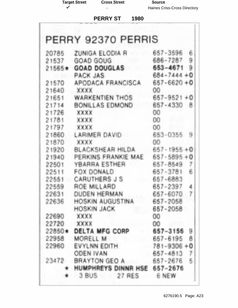
-
PERRY ST
Haines Criss-Cross Directory
6276190.5 Page: A23
SourceTarget Street Cross Street
1980
0 I

-
SEATON AVE
Haines Criss-Cross Directory
6276190.5 Page: A24
SourceTarget Street Cross Street
1980

-
PERRY ST
Haines Criss-Cross Directory
6276190.5 Page: A25
SourceTarget Street Cross Street
1973

-
SEATON AVE
Haines Criss-Cross Directory
6276190.5 Page: A26
SourceTarget Street Cross Street
1973
s 70