Elite Upland Cotton Germplasm-Pool Assessment of Fusarium Wilt Resistance in California
Upload
independentCategory
view
1download
0
NORTH AMERICAN ARCHAEOLOGIST, Vol. 30(1) 23-55, 2009
THE SETTLER’S RIDGE SITE, AN EARLY
WOODLAND LEIMBACH PHASE UPLAND
ENCAMPMENT IN NORTHERN OHIO
CRAIG S. KEENER
KEVIN NYE
JOSHUA NIEDERMIER
Professional Archaeological Services Team
ABSTRACT
In the summer of 2007 the Settler’s Ridge site (33-AS-32), an Early
Woodland upland encampment, was investigated through a series of cultural
resource investigations. Excavations at the site suggest a single or limited
occupation during the Early Woodland sometime between 569 to 624 B.C.
The size of the site, depositional patterning of the artifacts, and feature outlay
indicate a small sized encampment probably related to hunting activities in
the uplands. This article summarizes the analysis of the lithic and ceramic
assemblages, radiocarbon dates, site structure, and the depositional patterning
evident at the site. Pottery recovered during excavations is Leimbach
Cordmarked, which is representative of much of the northern Ohio area
during the Early Woodland. Few Early Woodland upland sites in northern
Ohio containing pottery have been intensively studied. Consequently,
Settler’s Ridge adds important information on how upland landforms were
used during this period.
The Early Woodland Period in northern Ohio is generally given a time frame of
600 B.C. to A.D. 1 with a “Transitional Period” between the Late Archaic and
Early Woodland occurring from 1000 B.C. to 600 B.C. It is during this transitional
23
� 2009, Baywood Publishing Co., Inc.
doi: 10.2190/NA.30.1.b
http://baywood.com

period that pottery (e.g., Leimbach series) makes it appearance and becomes
increasingly used. During the Early Woodland, termed the Early Woodland
Leimbach phase, there is a marked increase in ceramic variation and the
establishment and common place use of ceramics across the northern Ohio region
(Stothers and Abel, 1993:30). Early Woodland Leimbach sites are centered within
the region between Sandusky Bay and the Vermilion River, although sites have
been recorded in less frequency to the west and east of this area in Ohio. Settlement
strategies that arise in this period appear to be oriented around semi-permanent
residential base camps (e.g., Seaman’s Fort), most likely used throughout the
autumn and winter. These types of sites contain evidence of oval or circular
structures and appear to be comparable to the sedentary hamlets developing in
southern Ohio around the same time (Abrams and Freter, 2005; Dragoo, 1976;
Webb and Baby, 1957; Webb and Snow, 1974). The Early Woodland inhabitants
were hunter and gatherers that relied extensively on meat (deer and fish; Bowen,
1992; Price et al., 1985; Stothers and Abel, 1993) and nut harvesting. Hickory was
the dominant nut resource used followed by walnut and beechnut (Demuth, 1990,
1991; Stothers and Abel, 1993). It is during this time some domesticated cultigens
appear such as amaranth, chenopodium, knotweed, maygrass, sumpweed, squash,
and sunflower suggesting that small-scale garden cultivation was occurring (Ford,
1985; Ozker, 1982; Smith, 1995; Wymer and Abrams, 2003). Mortuary related
sites are represented by mass burial pits (e.g., Williams Cemetery, Marblehead,
and Danbury; Redmond and Scanlan, 2008) and there is less emphasis on mound
building as evidenced in southern Ohio.
In northern Ohio, hamlet-like or semi-permanent encampments (base camps)
such as Seaman’s Fort, Leimbach, and Weilnau and secondary procurement sites
that radiate from these sites, what Stothers and Abel (1993) term “auxiliary” sites,
are located in and along river valleys or along the lake front of Lake Erie.
Auxiliary sites are comparable to the short-term residential bases and field camps
as defined by Binford (1980) although we disagree with Stothers and Abel’s
placement of Leimbach and Weilnau into this category as these sites exhibit
a significant number of characteristics typical of a base camp (e.g., numerous
pit features, non-portable artifacts, a midden, diverse tool assemblages, and/or
evidence of residential structures). Field camp/short term residential bases would
not be limited to the major drainages but would radiate outward from the more
permanent base camps into the more distant upland regions. Encampments in the
uplands tend to be small in size and represent hunting and collection activities
most likely occurring in the autumn and spring (Bergman et al., 1998; Keener and
Nye, 2007; Railey, 1991; Seeman, 1986). There is far less documentation on
this type of Early Woodland site in northern Ohio. The recent excavations at
Settler’s Ridge (33-AS-32) provides intensive documentation of a small upland
site which may serve as a comparable database for other such sites in the northern
Ohio region. The site can also be compared with several other contemporary
Early Woodland site assemblages (e.g., President’s Club and 33-LI-183) recently
24 / KEENER, NYE AND NIEDERMIER

investigated in central Ohio that represent small upland residential encampments,
but that contain a different but related pottery style, Dominion Thick (Keener
and Nye, 2007).
SITE DESCRIPTION
Settler’s Ridge is located just east of the City of Ashland in Montgomery
Township, Ashland County, Ohio (Figure 1). The site is located on a glacial
hummock on a hummocky moraine of the Late Wisconsinan glacial period (Pavey
et al., 1999). A small unnamed intermittent stream is situated within 15 m (50 ft)
of the north edge of the site. The nearest sizable tributary is Jerome’s Fork, which
is a secondary drainage of the Muskingum River, and is located approximately
1.8 km (1.1 mi) to the east. Settler’s ridge is situated in the upper drainage area
of Jerome’s Fork near the watershed divide with the Vermilion River, which is
associated with the Lake Erie drainage basin. The site is 7,875 m2 (84,770 ft2) in
size and centered on the apex of the hummock landform (Keener et al., 2008).
THE SETTLER’S RIDGE SITE / 25
Figure 1. Drainage map showing the location of Settler’s Ridge.

Settler’s Ridge was first discovered in 1975 by Dr. David Bush (Heidelberg
College), during a surface collection of an agricultural field. During this
reconnaissance investigation, a grab sample totaling 169 artifacts was collected
and the site was recorded as 33-AS-32. In 2007 the area containing Settler’s Ridge
became part of a proposed 74.8 ha (185 a.) development planned by Loral
Investments, LLC. The United States Army Corp of Engineers was involved
with the project, and based on the previous findings by Bush, recommended an
archaeological survey for the development and a reassessment of Settler’s Ridge
(33-AS-32). Professional Archaeological Services Team (PAST) performed the
Phase I survey as well as the Phase III data recovery investigation of Settler’s
Ridge when the site was determined to be eligible to the National Register of
Historic Places. The archaeological investigation involved intensive controlled
surface collection transects, geophysical survey (conducted by Berle Clay of
Cultural Resources Analysts, Inc), some limited test unit excavation, and exposure
of 2,900 m2 (31,216 ft2) of the subsurface through mechanical plow zone removal
(Keener, 2007; Keener et al., 2008).
The investigations recovered a total of 6,624 artifacts (6,092 FCR, 401
lithics, and 131 prehistoric pottery fragments). A total of 20 cultural features
were uncovered that include 16 post molds, one small pit, and three large basin
shaped pits. Temporally diagnostic artifacts indicate three cultural components
associated with the site: Early Archaic, Late Archaic, and Early Woodland.
The Early Woodland period, however, appears to be the dominant
component. Table 1 lists the projectile points recovered, all from surface
collection. Over half of the points are Early Woodland (e.g., Adena
Stemmed) or Late Archaic to Early Woodland transitional types (Perkiomen
Broad and Susquehanna Broad; Justice, 1987). The Early and Late Archaic
points have a minor representation. The only temporally diagnostic group of
artifacts recovered from feature context was the pottery assemblage, which
came from one feature, a small pit. The entire ceramic assemblage , which
probably represents one vessel, is Leimbach Cordmarked. Radiocarbon dates
from three separate feature samples also confirm a strong association to the
Early Woodland. Table 2 lists the radiometric data. All three features have mean
dates that fall between 569 to 624 cal B.C. The conventional dates are virtually
identical and may suggest the features at the site represent a single occupation or
that the site was occupied only a few times at around the same time during the
Early Woodland.
THE LITHIC ASSEMBLAGE
Lithic debitage was mainly recovered from controlled surface collection
transects that were spaced at 3 m (9.8 ft) intervals. The site was walked twice in
opposite directions (north to south and east to west). Raw material type and size
grade counts were utilized as was a technological analysis of the assemblage
26 / KEENER, NYE AND NIEDERMIER

Tab
le1
.P
roje
ctile
Po
int
Lis
t,T
yp
olo
gy,an
dA
ge
Ran
ge
for
Sett
ler’s
Rid
ge
Descri
ptio
nn
Flin
tty
pe
Tem
po
ralp
eri
od
aT
ime
ran
ge
a
Lecro
yB
ifu
rcate
dS
tem
med
McW
hin
ney
Heavy
Ste
mm
ed
Bre
wert
on
co
rner
no
tch
ed
Perk
iom
en
Bro
ad
Su
sq
ueh
an
na
Bro
ad
(rew
ork
ed
into
hafted
scra
per)
Kra
mer
Ad
en
aS
tem
med
1 1 1 1 1 1 2
Up
per
Merc
er
Up
per
Merc
er
Dela
ware
Up
per
Merc
er
Up
per
Merc
er
Flin
tR
idg
e
Up
per
Merc
er
Earl
yA
rch
aic
Late
Arc
haic
Late
Arc
haic
Late
Arc
haic
/Earl
yW
oo
dla
nd
Late
Arc
haic
/Earl
yW
oo
dla
nd
Earl
yW
oo
dla
nd
Earl
yW
oo
dla
nd
6,5
00
B.C
.to
58
00
B.C
.
4,0
00
B.C
.to
10
00
B.C
.
2,9
80
B.C
.to
1,7
23
B.C
.
1,7
20
B.C
.to
1,7
23
B.C
.
an
din
toE
arl
yW
oo
dla
nd
1,7
00
B.C
.to
70
0B
.C.
55
0B
.C.to
15
0B
.C.
80
0B
.C.to
20
0B
.C.
aJu
stice
(19
87
)
THE SETTLER’S RIDGE SITE / 27

Tab
le2
.R
ad
iom
etr
icD
ate
sfr
om
Sett
ler’
sR
idg
e
Featu
re#
/Beta
#
Co
nven
tio
nal
rad
iocarb
on
ag
e
Calib
rate
dd
ate
(68
.2%
pro
bab
ility
)aC
alib
rate
dd
ate
(95
.4%
pro
bab
ility
)aM
ean
date
a
Featu
re1
/2
39
86
7
Featu
re2
/2
39
86
8
Featu
re3
/2
39
86
9
24
30
±7
0B
P
24
90
±4
0B
P
24
30
±6
0B
P
74
6–4
05
calB
C
76
3–5
41
calB
C
74
2–4
06
calB
C
76
6–3
97
calB
C
78
1–4
17
calB
C
76
1–4
00
calB
C
57
2calB
C
62
4calB
C
56
9calB
C
aD
ate
sco
rrecte
du
sin
gth
eIn
tCal0
4calib
ratio
ncu
rve
(Reim
er
et
al.,2
00
4)
an
dth
eO
xC
al4
.0calib
ratio
nso
ftw
are
(Ram
sey,2
00
1)
28 / KEENER, NYE AND NIEDERMIER
(based on Pecora, 2002). The primary flint type recovered at the site was Upper
Mercer flint (n = 321 (81.4%)), distantly followed by Vanport flint (n = 45
(11.3%)), Delaware chert (15 (3.8%)) and unknown/glacial varieties (14 (3.5%)).
Upper Mercer is a high quality flint that is the closest source material to
Settler’s Ridge located at outcrops approximately 64.3 to 80.5 km (40 to 50 mi) to
the east and southeast.
The flint debitage/tools were assigned a size grade using a series of wire
mesh sieves that include >1 in (G1), 1 in > 1/2 in (G2), 1/2 in > 1/4 in (G3), 1/4 in
> 1/8 in (G4), and < 1/8 in (G5). Table 3 shows the results of the size grade and
raw material counts for each flint type. Size grade analyses infer in a general
manner that flake size is related to the stage of manufacture (sensu Ahler, 1989),
consequently large size grades reflect early reduction stages, while smaller grades
indicate late stages. The assemblage at Settler’s Ridge has a high percentage of
Grade Size 3 and 4 artifacts, which suggests latter reduction stage activities such as
late biface blank and tool production, and tool rejuvenation.
Table 4 shows the results of a technological analysis (using Pecora, 2002) of
the Settler’s Ridge assemblage, which is a more refined approach in interpreting
the type of reduction activity that best represents the site. The analysis places
individual flakes into the following group categories: initial reduction flakes
(decortication flakes), early biface reduction flakes, late biface reduction flakes,
and pressure flakes. The analysis found that the assemblage has the highest
percentage of material represented by Late Biface Reduction and Pressure Flake
debris. This indicates a focus on late reduction activities occurring at the site such
as the conversion of late biface blanks into preforms and/or tools. It also indicates
tool rejuvenation activities. This is supported by the recovery of a number of
biface fragments, late biface blank fragments, and numerous projectile points
including a reworked point.
A total of 44 formed lithic artifacts were recovered and are listed on Table 5.
The formed artifacts can be divided into those items related to tool manufacture
(e.g., cores, bifaces, biface blanks (early and late), and performs) versus actual
tools (e.g., projectile points, modified flakes, scrapers, groundstone tools). There
were 30 tools recovered from Settler’s Ridge, which is a relatively large amount
representing 7.5% of the total lithic assemblage. Most of the tools, however, are
projectile points (n = 19 (63.3%)) and overall the tool assemblage shows a
moderate amount of diversity.
The analysis of the lithic assemblage suggests that embedded flint
procurement activities are associated with the site and that these activities
were integrated into the seasonal subsistence cycles exhibited by the local Early
Woodland population. The lack of high percentages of early to middle stage
reduction debitage at the site and distant location from Upper Mercer quarries
would appear to support the notion that prepared blanks were transported to
Settler’s Ridge where limited tool production and rejuvenation of existing tools
occurred.
THE SETTLER’S RIDGE SITE / 29

Tab
le3
.S
ize
Gra
de
an
dR
aw
Mate
rialC
ou
nts
for
Sett
ler’
sR
idg
eLith
icA
ssem
bla
ge
Site
#F
lint
typ
eG
rad
e1
Gra
de
2G
rad
e3
Gra
de
4G
rad
e5
To
tal
Sett
ler’
s
Rid
ge
aU
pp
er
Merc
er
Van
po
rt
Dela
ware
Un
kn
ow
n
To
tal
2(1
.1%
)
0(0
%)
2(1
4.3
%)
0(0
%)
4(1
.7%
)
34
(19
.2%
)
7(1
9%
)
9(6
4.3
%)
3(3
7.5
%)
54
(22
.8%
)
96
(54
.2%
)
18
(48
.6%
)
2(1
4.3
%)
4(5
0%
)
12
0(5
0.6
%)
40
(22
.6%
)
12
(32
.4%
)
0(0
%)
1(1
2.5
%)
53
(22
.4%
)
5(2
.8%
)
0(0
%)
1(7
.1%
)
0(0
%)
6(2
.5%
)
17
7(7
4.7
%)
37
(15
.6%
)
14
(5.9
%)
8(3
3.8
%)
23
7(1
00
%)a
aD
oes
no
tin
clu
de
the
Bu
sh
su
rvey
(19
75
)co
llectio
n.
30 / KEENER, NYE AND NIEDERMIER
Tab
le4
.T
ech
no
log
icalLith
icA
naly
sis
Resu
lts
for
the
Up
per
Merc
er
Assem
bla
ge
at
Sett
ler’s
Rid
ge
Co
llectio
nF
lint
Initia
l
red
uctio
n
Initia
lb
iface
red
uctio
n
Earl
yb
iface
red
uctio
n
Late
biface
red
uctio
n
Pre
ssu
re
flake
To
talte
ch
dia
gn
ostic
Su
rface
co
llectio
n/
Test
un
its
Featu
res
To
tal
U.M
erc
er
(n)
U.M
erc
er
%
U.M
erc
er
(n)
U.M
erc
er
%
U.M
erc
er
(n)
U.M
erc
er
%
23
12
.6
0 0
23
11
.6
7 3.8
2
11
.8
9 4.5
33
18
.1
2
11
.8
35
17
.6
68
37
.4
9
53
77
38
.7
51
28
.1
4
23
.5
55
27
.6
18
2
10
0
17
10
0
19
9
10
0

EARLY WOODLAND CERAMICS
There are many shared attributes among Early Woodland ceramic types from
the Western Great Lakes and Ohio Valley region as a whole such as Fayette Thick
of the Middle Ohio Valley, Marion Thick from Illinois, Indiana, Wisconsin, and
Michigan, and Leimbach Thick of northern Ohio (Cramer, 1989; Shane, 1975;
Stothers and Abel, 1993). Ceramic types are generally described as thick grit
tempered vessels with, variations in surface treatment, vessel form with typology
seemingly relying on geographic location (Clay, 1980, 1986; Griffin, 1943;
Mayer-Oakes, 1955; Ozker, 1982; Prufer et al., 1989; Shane, 1975). Cramer
(1989) presented similarities between Fayette Thick, Dominion Thick, Leimbach
Thick, and the Half Moon Cordmarked type from the Upper Ohio Valley in her
work on Dominion Thick pottery. While Dominion Thick represents an Early
Woodland type established in central Ohio it differs from the assemblage from
Settler’s Ridge in that Dominion Thick vessels are described as possessing a
plain surface and flat-bottomed bases (Cramer, 1989; Keener and Nye, 2007).
The assemblage recovered from Settler’s Ridge most resembles the Leimbach
Series as defined by Shane (1975) and redefined by Stothers and Abel (1993).
The Leimbach Site, located in Lorain County, Ohio, was excavated by Orrin
Shane in 1965. The analysis of this ceramic assemblage resulted in the naming
of the Leimbach series which is considered the earliest example of ceramics in
the region occurring as far back as ca. 1,000 B.C. however not prevalent nor
with much variation until ca. 600 B.C. (Shane, 1975; Stothers and Abel, 1993).
Further analysis of material from several sites resulted in the redefining of the
THE SETTLER’S RIDGE SITE / 31
Table 5. List and Percentages of All Formed Artifact Types
Artifact type Count %
Biface
Early Biface Blank
Late Biface Blank
Marginally Modified Flake
Projectile Points
Abrader
Hammerstone
Hafted scraper
Banded Slate Pendant
11
1
2
7
19
1
1
1
1
25
2.3
4.5
15.9
43.1
2.3
2.3
2.3
2.3
Total 44 100%

four types within the Leimbach Series; Leimbach Thick, Leimbach Cordmarked,
Leimbach Plain, and Leimbach Decorated (Stothers and Abel, 1993). Although
all four types have been found in direct association as evidenced at Seaman’s
Fort, Leimbach Thick is believed to be the earliest type (Stothers and Abel,
1993). Outside of the Leimbach Site, Leimbach pottery has been found at
several other sites in northern Ohio including Danbury (33-OT-16) in Ottawa
County, Seaman’s Fort (33-ER-85) and Weilnau in Erie County, Mohawk Rock
Shelter in Geauga County, the OEC 1 Site (33-CU-462) in Cuyahoga County,
Mentor Lagoon #4 Site in Lake County, and Stanford Knoll (33-SU-138) in
Summit County (Kollecker, 2002; Lee, 1986; Redmond, 2001, 2005; Redmond
and Scanlan, 2008; Shane, 1975; Vietzen, 1945).
The ceramic assemblage (n = 131) recovered during the excavations at Settler’s
Ridge consists of a total of 75 sherds and 56 sherdlets. Sherdlets measuring less
than 1.3 cm (½ in) in diameter or that are missing one or both surface(s) were not
used in this analysis. Prior to analysis effort was made to attempt to combine as
many sherds as possible in order to better assess manufacturing techniques applied
to the assemblage. Those efforts resulted in 47 sherds being joined to at least one
other sherd which reduces the total site assemblage to 41 ceramic items. In one
case a total of 18 sherds were joined together to form a rather large partial vessel
measuring 180 mm high by 155 mm wide and is comprised of three rim sherds, 14
body sherds, and the single lug recovered from the site (Figures 2-4). Other than
the partially reconstructed vessel 40 sherds remain that include six rim sherds
(15%), 32 body sherds (80%), and two basal sherds (5%). The assemblage likely
represents one vessel.
The entire assemblage was situated within Feature 2 (a small pit) with the
exception of two sherdlets collected from the plow zone interface of a 1m2 test unit
positioned above the feature. Radiocarbon dating of Feature 2 resulted in a
conventional radiocarbon date of 2490 ± 70 BP (BETA-239868) (see Table 2).
Analysis of the material consisted of the recording of observable attributes such as
temper, thickness, surface treatment, and shape. Based on the observed attributes
of the assemblage, geographic location of the site, and calibrated radiocarbon date;
the collection from Settler’s Ridge is most likely affiliated with the Leimbach
Phase (600 B.C.–A.D. 1) of the Early Woodland period for northern Ohio.
The following is the detailed results of the ceramic analysis of the Settler’s
Ridge assemblage based on the physical attribute observations. When appropriate,
attribute descriptions of Leimbach Thick (Shane, 1975) and Leimbach Cord-
marked (Stothers and Abel, 1993) are included after the analysis results.
PHYSICAL ATTRIBUTES OF THE SETTLER’S
RIDGE CERAMIC ASSEMBLAGE
Numerous sherds from the assemblage exhibit typical convex/concave coil
breaks. The basal sherds (n = 2) do not exhibit distinct coil breaks but based on the
32 / KEENER, NYE AND NIEDERMIER

THE SETTLER’S RIDGE SITE / 33
Figure 2. Front view of partially reconstructed Leimbach Cordmarked
vessel at Settler’s Ridge.
34 / KEENER, NYE AND NIEDERMIER
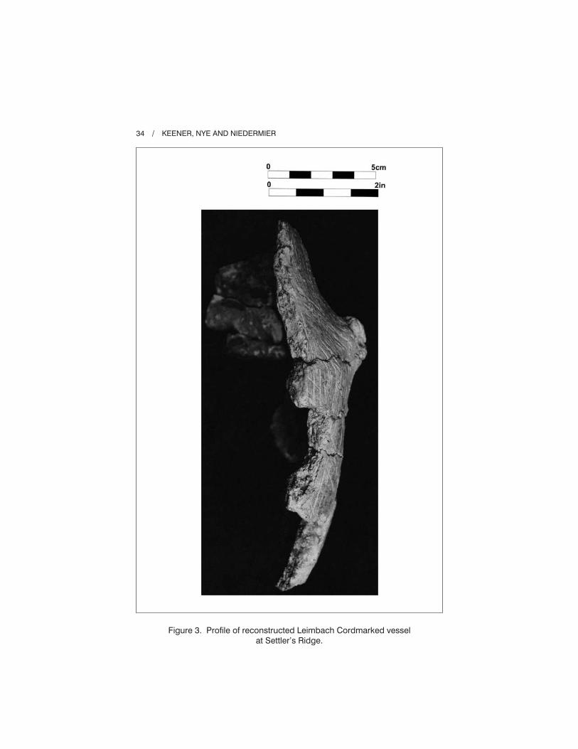
Figure 3. Profile of reconstructed Leimbach Cordmarked vessel
at Settler’s Ridge.

THE SETTLER’S RIDGE SITE / 35
Figure 4. View of various rim pieces from Settler’s Ridge
ceramic assemblage.

thickness, the base was most likely constructed as a single piece while the rest
of the vessel was coiled from the base up. Coiling is a common method of vessel
construction found in many Early Woodland types (Cramer, 1989; Stothers and
Abel, 1993). The entire assemblage is tempered with granitic material and quartz
with some small occurrences of flint and possibly iron pyrite. The average size
of the temper ranges from 0.1 mm to 6 mm with a density range of 10–50%.
Exterior color variation was found between rim and body sherds. The rim
sherds were typically very dark gray to grayish brown along with yellowish
brown (10YR 3/1-3/2 and 5/4-5/8) while the coloration of body sherds were
found to be strong brown, reddish yellow, light yellowish brown to brownish
yellow (7.5YR 5/6-6/6 and 10YR 6/4-6/6). The darker color of the rims has been
suggested by some (i.e., Cramer, 1989; Shane, 1975) to indicate an inverted firing
of the vessel.
Variation in color was also observed between the interior surfaces of body
and basal sherds. Generally speaking, the interior color of body and rim sherds
ranged from very dark gray to yellowish brown (10YR 3/1-5/4) whereas the
basal sherds exhibited a reddish yellow to strong brown (7.5YR 6/6-5/6).
Surface treatment was represented by 30 cordmarked pieces and 10 plain.
Cordmarking on the exterior surface appears to have been applied by a cord
wrapped implement. Cord thickness ranges from 0.65-2.1 mm with an average
thickness of 1 mm. Spacing between parallel cords ranges from 1-4.6 mm and
average spacing is 3.4 mm. A “Z” twist cord was utilized on all the sherds where
twist could be observed (Hurley, 1979). The cord impressions on the majority
of sherds were applied in a vertical and oblique orientation over the entire vessel
up to the lip with randomly applied impressions occurring frequently on body
sherds. The rims appear to have been marked with a cord-wrapped implement
in either a vertical or oblique fashion with the occasional overlapping impression
(Figure 4). This method is observed on the assemblages from the Leimbach Site
and Seaman’s Fort. Cord impressions do not appear on any of the interior
surfaces and appear to have been smoothed and six sherds exhibit some small
parallel grooves that may be the result of brushing. Plain interiors with “remnant
cord-roughening (often fabric impression), scarification, or channeling is often
apparent on the interior upper rim of the vessel only” is how Stothers and Abel
(1993:48) describe the surface treatment of the Leimbach Cordmarked type. The
sherds exhibiting a plain exterior surface represent either a plain exterior vessel
or a portion of a cordmarked vessel where the cord impressions have either been
obliterated or were never present on a given portion of a corded vessel. The notion
that the plain pieces are part of the same vessel was confirmed when two sherds
from this assemblage, one with a cord impressed exterior and another exhibiting
a plain exterior, were joined together. Additional support is found in a plain
exterior sherd that represents a small basal sherd; the other basal sherd is sig-
nificantly larger and possesses areas of plain surface treatment among cord
impressions elsewhere on the sherd (Figure 5).
36 / KEENER, NYE AND NIEDERMIER

There are a total of six partial rim fragments (Figure 4) all of which appear to
represent slightly flaring everted rims as was observed in the assemblages from
the Leimbach Site and Weilnau (Shane, 1975; Stothers and Abel, 1993:45-46).
The lips of the rim fragments at Settler’s Ridge are flat to slightly rounded with
some slight exterior thickening or folding toward the exterior and three were
decorated with cord impressions. The partially reconstructed vessel rim fragments
were used to estimate the vessel aperture and found an approximate diameter of
200 mm. The rim circumference of a vessel with this diameter would be 628 mm.
The reconstructed partial vessel represents approximately 24.6% of a whole
vessel (see Figure 2). The widest portion of the vessel is the shoulder where the
lug is located and measures approximately 220 mm in diameter. The maximum
THE SETTLER’S RIDGE SITE / 37
Figure 5. Basal sherds and lug from Settler’s Ridge ceramic assemblage.

circumference (not including the lug) of the vessel would be approximately
691 mm. One of the two basal sherds is significant enough in size to determine
shape, which appears to be a narrow conoidal form (see Figure 5). A similar basal
sherd from Feature 8 at Seaman’s Fort was radiocarbon dated to 460 B.C.
(Stothers and Abel, 1993:46).
The thickness varies across the vessel with the rims being the thinnest portion
possessing a range of 4.6-8.5 mm and average thickness of 7 mm, body sherd
thickness ranges from 8.1 mm-16.7 mm with an average thickness of 11 mm, and
basal sherds range in thickness from 18.2 mm-22 mm with an average thickness of
20.1 mm. Viewed in profile the thickest portion of the vessel would be the base
and from there wall thickness gradually becomes thinner up to the rim (Figure 3).
The thicknesses of the sherds from Settler’s Ridge all fall within the ranges
of Leimbach Thick as reported by Shane (1975) and Leimbach Cordmarked
presuming the thickness provided by Stothers and Abel (1993) are body sherds.
The single cylindrical “doorknob” shaped lug that was recovered occurs approxi-
mately 56 mm below the rim, has a maximum length of 28 mm, maximum exterior
diameter of 23 mm, and maximum interior diameter of 20 mm. The lug was
riveted through the vessel wall and the exterior end was then built up and
smoothed into the exterior surface of the vessel. There is a slight upward slant
of the lug toward the rim. Riveted lugs or pots are also present at Weilnau,
Leimbach, Danbury, and Seaman’s Fort (Redmond and Scanlan, 2008; Shane,
1975; Stothers and Abel, 1993).
Review of the published literature indicates that Settler’s Ridge is the southern
most recorded example of Leimbach Cordmarked pottery in northern Ohio as
defined by Stothers and Abel (1993). The site is associated with the upper drainage
system of the Muskingum River valley as opposed to the Lake Erie basin.
The topographical location of Settler’s Ridge also differs from other recorded
Leimbach sites in that it is located in the upland moraine area, at a great distance
from any major drainage. The nearest drainage, Jerome’s Fork (a secondary upper
drainage of the Muskingum River), is located approximately 1.8 km (1.1 mi) to the
east of the site. Most other Leimbach sites are located on valley floor landforms,
lake front edges, rock shelters, and bluff edge locations. Table 6 contrasts land-
form information associated with other significant Leimbach related sites.
Excavation of Settler’s Ridge produced a smaller assemblage of ceramic
artifacts than were recovered from the excavations at larger sites like Leimbach,
Seaman’s Fort, and Weilnau, but still provides valuable information regarding
the growing knowledge of Early Woodland ceramic technology. The Settler’s
Ridge assemblage greatly resembles the Leimbach Cordmarked ceramic type
in temper, sherd thickness, surface treatment, presence of riveted lugs, rim and
basal shape and comparable radiocarbon dates. The small vessel form exhibited by
the reconstructed pot from Settler’s Ridge represents the variability within the
Leimbach Series, which may reflect vessel function (see Stothers and Abel,
1993). Perhaps the smaller vessel’s size is related to transportation needs making it
38 / KEENER, NYE AND NIEDERMIER
easier to carry the item to a more distant upland encampment. Schiffer and
Skibo (1987) observed that portability and ease of manufacture of pottery was
prioritized by hunter-gatherer populations in the eastern United States. The
Settler’s Ridge vessel (based on diameter ranges) is approximately 23% smaller
than the vessel forms found at the larger base camp sites like Danbury, Seeman’s
Fort, and Weilnau (Redmond and Scanlan, 2008; Stothers and Abel, 1993) and
consequently would have been easier to carry over longer distances.
FEATURE OUTLAY AND ARTIFACT PATTERNING
The features identified at Settler’s Ridge are clustered on the top of the
hummock landform in the flatter and best drained portion. All of the features
(n = 20) were mapped in and shown to scale on Figure 6. Figure 7 shows
plan/profiles of the four pits while Table 7 presents physical attribute information.
The distribution of the features is interesting as it suggests different activity
areas. The four pits are situated in somewhat of an arc configuration along the
apex of the hummock, while most of the posts are clustered northeast of this arc
in between pits 1 and 9. The pits are not clustered together and may represent
distinct occupation episodes or alternatively may be part of one short-term occu-
pation of the landform. The radiocarbon dates (from three of the four pits)
suggest the latter explanation is more likely. The lack of numerous pits indicates
that the landform was not frequently chosen as a campsite over time, unless this
is a product of plowing.
The post cluster denotes a specific area where possible structures or specific
activities were focused. While no distinct structure outline is evident there are
THE SETTLER’S RIDGE SITE / 39
Table 6. Regional Leimbach Related Sites
with Landform Information
Site Landform
Leimbach
Danbury
Mentor Lagoon 4
Seaman’s Fort
Weilnau
Mohawk Rock Shelter
OEC 1 (33-CU-462)
Stanford Knoll (33-SU-138)
Settler’s Ridge
Terrace remnant
Lake front
Lake front
Bluff edge
Bluff edge
Rock Shelter
Terrace
Terrace
Glacial hummock

40 / KEENER, NYE AND NIEDERMIER
Fig
ure
6.
Featu
res
iden
tified
at
Sett
ler’
sR
idg
esh
ow
ing
ap
ost
clu
ste
rare
a.

THE SETTLER’S RIDGE SITE / 41
Figure 7. Plan and profile views of Features 1, 2, 7, and 9.

Tab
le7
.P
hysic
alA
ttri
bu
teIn
form
atio
no
fP
its
at
Sett
ler’
sR
idg
e
Featu
re#
Dim
en
sio
ns
Pla
nP
rofile
Fu
nctio
nD
ep
thC
on
ten
tsa
1 2 7 9
15
3cm
(60
.2”)
N-S
18
3cm
(72
”)E
-W
44
cm
(17
.3”)
dia
.
11
4cm
(44
.8”)
N-S
96
cm
(37
.8”)
E-W
10
0cm
(39
.3”)
dia
.
cir
cu
lar
cir
cu
lar
oval
cir
cu
lar
basin
flat
bo
tto
m
basin
basin
pit
sm
all
pit
pit
pit
24
cm
(9.4
”)
24
cm
(9.4
”)
27
cm
(10
.6”)
14
cm
(5.5
”)
L,F
CR
,C
,N
L,F
CR
,C
,P
,N
L,F
CR
L,F
CR
,C
,N
aL
=lit
hic
s,F
CD
=fire
cra
cked
rock,C
=ch
arc
oal,
P=
po
ttery
,an
dN
=n
uts
hell
42 / KEENER, NYE AND NIEDERMIER

five post features (11, 15, 16, 21, and 22) that may represent a portion of a linear
or partially curved wall. These five posts also have similar diameter/depth
measurements of 34/20 cm (13.4/7.9 in.), 36/35 cm (14.2/13.7 in.), 36/38 cm
(14.2/14.9 in.), 36/26 cm (14.2/10.2 in.), and 29/30 cm (11.4/11.8 in.) respec-
tively. Four posts (15, 16, 21, and 22) are rather evenly spaced from one another
with distances ranging from 2.2 m to 2.3 m (7.2 ft to 7.5 ft) apart. If these posts
are related they likely represent some kind of lean-to, wind break, or partial
enclosure. Such types of structures or post clusters have been found at other
small residential camp sites (Broyles, 1976; Keener and Nye, 2007). This is not
to say that the posts do not represent some other activity related to hunting such
as supports for drying racks. Circular structures found at larger sites like Weilnau
or Seaman’s Fort are clearly absent.
The intensive surface collection at Settler’s Ridge allowed for a distribution
analysis of the artifacts recovered at the site. These distributions were super-
imposed on the feature locations to identify if possible patterning was present and
whether any correlation with particular features or feature groupings existed.
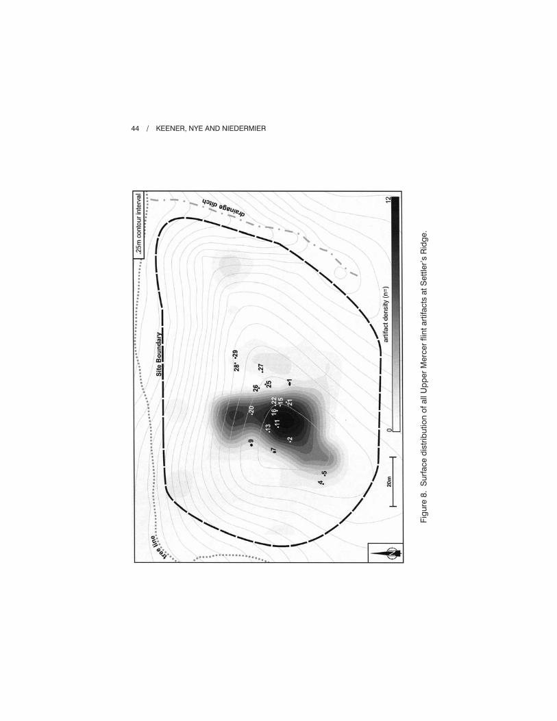
Figure 8 shows lithic debitage densities for the Upper Mercer flint assemblage, the
dominant flint type (81.4% of debitage). The Upper Mercer concentration is
clearly focused within the area of the post cluster suggesting that flint reduction
activities were occurring in this specific area.
Figure 9 shows the fire cracked rock (FCR) distribution across the site. FCR
shows a different distribution as opposed to flint debris as the highest densities are
situated in a linear band just south and adjacent to the pits (Features 1 and 2). The
highest FCR densities are adjacent to the south side of the largest pit (Feature 1).
This feature had the highest count (n = 5,161) and weight (70,171 g) of FCR
present in a feature at the site and the amount of FCR debris just south of the
feature suggests the upper portion of the feature had been truncated by cultivation.
Feature 2 had the second highest amount of FCR in weight (6,223 g) and FCR
clusters to the south of this feature. These findings are similar to other upland sites
(Keener and Nye, 2007) where surface FCR concentrations are typically found
overlapping or lying in close proximity to pit locations.
FEATURE CONTENT
Feature content was primarily represented by FCR (n = 5,549) of which
90.3% came from Feature 1 (n = 5,161). Most of the FCR (91%) recovered in
feature context was 32 mm or less in size. This is probably indicative of long
burn times as opposed to re-use of the material (Pagoulatos, 1992). Due to the
amount of FCR recovered at Feature 1 it may have served as a cooking facility.
Only a small amount of flint debitage (n = 36) was recovered from feature context,
none of which were tools. The only temporally diagnostic material found in
feature context was the ceramic assemblage in the Feature 2 pit. Flotation samples
from six of the features were analyzed which resulted in the identification of wood
THE SETTLER’S RIDGE SITE / 43
44 / KEENER, NYE AND NIEDERMIER
Fig
ure
8.
Su
rface
dis
trib
utio
no
fall
Up
per
Merc
er
flin
tart
ifacts
at
Sett
ler’
sR
idg
e.

THE SETTLER’S RIDGE SITE / 45
Fig
ure
9.
Su
rface
dis
trib
utio
no
fall
fire
cra
cked
rock
at
Sett
ler’
sR
idg
e.
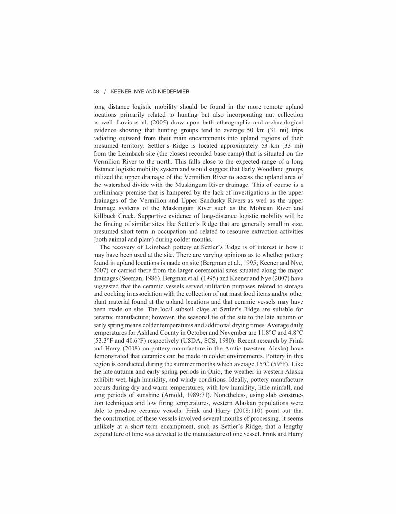
charcoal (n = 3,027 (98%)), nutshell (n = 43 (1%), squash rind (n = 2), and seeds
(n = 2) (Leone, 2008). No faunal remains were recovered. Wood charcoal was
heavily represented by hickory (39%) and oak (27%). Table 8 shows a summary
of the counts, percentages, and ubiquity of various identified wood species repre-
sented. Identifiable nutshell remains were represented by hickory and hazelnut.
Table 9 shows counts, percentages, and ubiquity of the nutshell assemblage.
Overall the nutshell quantities were low at the site suggesting it was not specif-
ically used for nut processing. Nonetheless, four out of six analyzed features
contained nutshell indicating that nuts (primarily hickory) were used by the
site occupants. Two squash rinds and two seeds (one unidentifiable and one
raspberry/bramble) were recovered in one of the pits but the seeds were likely
produced by “seed rain” after use and abandonment of the feature. The evidence
of squash indicate the probable presence of a container that could hold liquid
such as water or, as Ozker (1982) has suggested, store nut oils.
Based on the interpretation of the botanical remains, the high wood charcoal
density suggested large quantities of fuel being burnt at Settler’s Ridge, most
likely during colder months such as the late autumn or early spring (Leone, 2008).
While some nutshell was utilized at the site, the lack of high densities of this food
source or seeds and the lack of grinding slabs or nutting stones do not support a
focus on the processing of nuts or horticulture. This indicates that other logistical
activities, such as hunting, were the focus of the short-term encampment.
46 / KEENER, NYE AND NIEDERMIER
Table 8. Identified Wood Summary of Samples from Settler’s Ridge
Type Count
Percentage of
identified wood Context ubiquity
Hickory
Oaka
Elm/Hackberry
Ash
Beech
Maple
Chestnut
Sycamore
Walnut
Pine
Total – identified
45
32
19
5
5
4
3
2
1
1
117
39%
27%
16%
4%
4%
3%
3%
2%
1%
1%
100%
100%
83%
67%
33%
50%
50%
17%
17%
17%
17%
aAll oak species combined.

SITE FUNCTION
Settler’s Ridge has a moderate lithic assemblage that appears to represent a
small short-term residential base that was probably occupied by a small number
of occupants, perhaps a family group. This type of site represents the dispersal of
small groups of people from a larger base camp for the purposes of hunting and/or
collecting nut resources. Base camps are found along major drainages and are
typically large in size, contain numerous pits, middens, a very large variety
of tools, non-portable artifacts (e.g., pottery, hammerstones), storage facilities,
habitation structures, and human internments (Binford, 1980; Brown and Vierra,
1983; Stafford et al., 2000). They are often used seasonally and repeatedly over
time. In contrast, upland residential camps situated away from major drainages are
much smaller in size and often reflect a more limited time range of use so
consequently their reflective assemblages are smaller and less complex. Settler’s
Ridge contains a number of the expected features of a base camp, such as the post
cluster indicating a probable expedient habitation related structure, non-portable
artifacts (pottery, hammerstone, and abrader), but lacks storage pits, a midden, or a
large lithic assemblage. The evidence at Settler’s Ridge suggests that the site was
used for a short duration but acted as a temporary location from which the
occupants utilized upland resources during the late autumn or early spring.
Although no faunal remains were found, it is probable that the site represents a
short-term hunting encampment. The inhabitants at Settler’s Ridge most likely
spread out from this encampment on a number of logistical resource extractive or
exploitive activities (satellite sites) (Binford, 1980).
On a larger regional level, Settler’s Ridge may support the long distance
logistic mobility model proposed by Lovis et al. (2005) for hunter and gatherer
settlement systems in the Great Lakes region. In their approach, large resi-
dential bases are situated along the coastal lowland areas of the Great Lakes and
their corresponding major tributaries. Major residential sites associated with
the Leimbach phase (e.g., Danbury, Seaman’s Fort, Weilnau) are found at these
locations. During colder seasons resources were more restricted and evidence of
THE SETTLER’S RIDGE SITE / 47
Table 9. Identified Nutshell Summary from Settler’s Ridge
Type Count
Percentage of
nutshell assemblage Context ubiquity
Hickory
Hazelnut
Walnut family
Total
31
1
11
43
72%
2%
26%
100%
33%
17%
33%
long distance logistic mobility should be found in the more remote upland
locations primarily related to hunting but also incorporating nut collection
as well. Lovis et al. (2005) draw upon both ethnographic and archaeological
evidence showing that hunting groups tend to average 50 km (31 mi) trips
radiating outward from their main encampments into upland regions of their
presumed territory. Settler’s Ridge is located approximately 53 km (33 mi)
from the Leimbach site (the closest recorded base camp) that is situated on the
Vermilion River to the north. This falls close to the expected range of a long
distance logistic mobility system and would suggest that Early Woodland groups
utilized the upper drainage of the Vermilion River to access the upland area of
the watershed divide with the Muskingum River drainage. This of course is a
preliminary premise that is hampered by the lack of investigations in the upper
drainages of the Vermilion and Upper Sandusky Rivers as well as the upper
drainage systems of the Muskingum River such as the Mohican River and
Killbuck Creek. Supportive evidence of long-distance logistic mobility will be
the finding of similar sites like Settler’s Ridge that are generally small in size,
presumed short term in occupation and related to resource extraction activities
(both animal and plant) during colder months.
The recovery of Leimbach pottery at Settler’s Ridge is of interest in how it
may have been used at the site. There are varying opinions as to whether pottery
found in upland locations is made on site (Bergman et al., 1995; Keener and Nye,
2007) or carried there from the larger ceremonial sites situated along the major
drainages (Seeman, 1986). Bergman et al. (1995) and Keener and Nye (2007) have
suggested that the ceramic vessels served utilitarian purposes related to storage
and cooking in association with the collection of nut mast food items and/or other
plant material found at the upland locations and that ceramic vessels may have
been made on site. The local subsoil clays at Settler’s Ridge are suitable for
ceramic manufacture; however, the seasonal tie of the site to the late autumn or
early spring means colder temperatures and additional drying times. Average daily
temperatures for Ashland County in October and November are 11.8°C and 4.8°C
(53.3°F and 40.6°F) respectively (USDA, SCS, 1980). Recent research by Frink
and Harry (2008) on pottery manufacture in the Arctic (western Alaska) have
demonstrated that ceramics can be made in colder environments. Pottery in this
region is conducted during the summer months which average 15°C (59°F). Like
the late autumn and early spring periods in Ohio, the weather in western Alaska
exhibits wet, high humidity, and windy conditions. Ideally, pottery manufacture
occurs during dry and warm temperatures, with low humidity, little rainfall, and
long periods of sunshine (Arnold, 1989:71). Nonetheless, using slab construc-
tion techniques and low firing temperatures, western Alaskan populations were
able to produce ceramic vessels. Frink and Harry (2008:110) point out that
the construction of these vessels involved several months of processing. It seems
unlikely at a short-term encampment, such as Settler’s Ridge, that a lengthy
expenditure of time was devoted to the manufacture of one vessel. Frink and Harry
48 / KEENER, NYE AND NIEDERMIER
also point out that the coiling method is not commonly used in the colder
environment as these vessel forms take longer to dry and are less prone to hold
their shape during construction. Consequently, we agree with Seeman (1986) that
the pottery at Settler’s Ridge was made at a larger more permanent encampment
and then brought to the site. As mentioned earlier, the Settler’s Ridge vessel
may represent a specific variant of the Leimbach series, purposely made smaller
in size to help facilitate transportation to a more distant upland location.
Even though nut processing for storage may not have occurred at Settler’s
Ridge, hickory appears to have been involved in elements of daily subsistence.
The pottery provided a utilitarian function as a cooking vessel, which allows
hickory to be boiled and thus makes it easier to prepare. Other similar Early
Woodland encampments, such as the President’s Club site, 33-LI-1094, and
33-LI-183 which contained Dominion Thick pottery, found in upland settings
of central Ohio, have similar assemblages that involve a small number of vessels
(n = 1-2) (Keener and Nye, 2007; Weinberger, 2003). Nutshell totals at the
Licking County sites were also low again suggesting that nut processing was
not the focus of the encampment and that the pottery may have been used as
cooking implements for boiling meat rather than as storage items. Vessels could
be left at a site, cached, like other non-portable site furniture (e.g., nutting stones,
hammerstones) and used in subsequent seasonal occupations.
The finding of pottery in an upland setting in northern Ohio is important
as it adds to a growing number of recorded Early Woodland upland sites
(e.g., President’s Club, 33-LI-183) containing evidence of ceramic use (Keener
and Nye, 2007). This is demonstrating that the presence of ceramics was not
exclusive to valley floor locations represented by the larger hamlets or base
camps but was also an essential part of the upland field camps. The findings
at Settler’s Ridge and other upland sites suggest that one or a few ceramic vessels
were transported to these more remote locations to help in the preparation of
daily meals. Once the use of the camp was complete the pottery was discarded,
or if the site was re-used seasonally pottery could be left behind and pre-
sumably cached in pit features for future use such as may be the case at Feature 2
at Settler’s Ridge and which was found at 33-LI-1094 (Church and Updike,
2007; Weinberger, 2003).
CONCLUSIONS
Settler’s Ridge is significant since as a representative upland Early Woodland
Leimbach Phase site situated far from any major drainage it provides a distinct
contrast with other known Leimbach related sites (e.g., Danbury, Leimbach,
Seaman’s Fort, Weilnau) located on the valley floors and bluff edges of larger
drainages (e.g., terrace, levee) or in the case of Danbury and Mentor Lagoon 4,
along a lake edge. Settler’s Ridge also provides comparative similarities and
contrasts with other recently recorded Early Woodland upland sites from other
THE SETTLER’S RIDGE SITE / 49
nearby regions such as those sites situated in central Ohio that have contem-
poraneous Dominion Thick pottery associations (Church and Updike, 2007;
Keener and Nye, 2007; Weinberger, 2003). While more sedentary-like settlements
were developing in the Early Woodland there was still a great reliance on the
upland areas for food and lithic resources. Local populations dispersed into small
logistical mobile groups to take advantage of these resources (Lovis et al., 2005).
The excavations at Settler’s Ridge provide well documented information on a
short-term residential encampment occupied by a small group of people, perhaps
a family group or small hunting party, that were exploiting upland resources
during the late autumn or early spring season. The excavations also demonstrate
that the use of pottery was an essential element of the camp, and probably related
to cooking activities.
ACKNOWLEDGMENTS
The authors would like to thank Alan Ratliff of Loral Investments, LLC who
paid for the archaeological survey of the sites. David Snyder of the Ohio Historic
Preservation Office provided insightful comments during the excavations and
review of the CRM investigation. Special thanks go to Mark Seeman and Brian
Redmond for reviewing and commenting on our original drafts of this article.
We also thank Roger Moeller for editing the manuscript.
REFERENCES CITED
ABRAMS, ELLIOT M. and ANNCORINNE FRETER (eds.)
2005 The Emergence of the Moundbuilders: The Archaeology of Tribal Societies
in Southeastern Ohio, Ohio University Press, Athens, Ohio.
AHLER, STEVEN R.
1989 Mass Analysis of Flaking Debris: Studying the Forest Rather than the Trees,
in Alternative Approaches to Lithic Analysis, Donald O. Henry and George
H. Odell (eds.), Archaeological Papers of the American Anthropological
Association 1, pp. 85-118.
ARNOLD, DEAN E.
1989 Ceramic Theory and Cultural Process, Cambridge University Press, Cambridge.
BERGMAN, CHRISTOPHER A., DONALD A. MILLER, JOHN F. DOERSHUK, KEN
DUERKSEN, and TERESA W. TUNE
1998 Early Woodland Occupation of the Northern Bluegrass: The West Runway
Site (15Be391), Boone County, Kentucky, North American Archaeologist,
19:1, pp. 13-34.
BERGMAN, CHRISTOPHER, TERESA W. TUNE, and DONALD A. MILLER
1995 Fayette Thick Ceramic Chronology at the West Runway Site (15Be391),
Boone County, Kentucky, in Current Archaeological Research in
Kentucky: Volume Three, John F. Doershuk, Christopher Bergman, and
David Pollack (eds.), Kentucky Heritage Council, pp. 70-88.
50 / KEENER, NYE AND NIEDERMIER

BINFORD, LEWIS
1980 Willow Smoke and Dogs’ Tails: Hunter-Gatherer Settlement Systems
and Archaeological Site Formation. American Antiquity, 45, pp. 4-21.
BOWEN, JONATHEN
1992 The Late Prehistory of Northwestern Ohio. Ph.D. dissertation, Dept. of
Anthropology, The Ohio State University, Columbus.
BROWN, JAMES. A. and ROBERT. K. VIERRA
1983 What Happened in the Middle Archaic? Introduction to an Ecological
Approach to Koster Site Archaeology, in Archaic Hunters and Gatherers
in the American Midwest, James L. Phillips and James. A. Brown (eds.),
Academic Press, New York, pp. 201-231.
BROYLES, BETTY J.
1976 A Late Archaic Component at the Buffalo Site, Putnam County, West
Virginia, Report of Archaeological Investigations No. 3, West Virginia
Geological and Economic Survey, Morgantown.
CHURCH, FLORA and WILLIAM UPDIKE
2007 Archaeological Phase III Data Recovery for the Baker’s Bluff Site
(33LI1094/1096/1182) in Saint Albans Township, Licking County, Ohio
(FRA/LIC 161/37-23.15–PID 12139), ASC Group Inc. Copy on file at the
Ohio Historic Preservation Office, Columbus.
CLAY, R. BERLE
1980 Cultural Historical Placement of Fayette Thick Ceramics in Central
Kentucky, Tennessee Anthropologist, 5, pp. 166-178.
1986 Adena Ritual Spaces, in Early Woodland Archeology, K. B. Farnsworth
and T. E. Emerson (eds.), Center for American Archeology Kampsville
Seminars in Archeology Volume 2, Kampsville, pp. 581-595.
CRAMER, ANN C.
1989 The Dominion Land Company Site: An Early Adena Mortuary Manifes-
tation in Franklin County, Ohio, unpublished Masters thesis, Kent State
University, Kent, Ohio.
DEMUTH, GEORGE
1990 The Seaman Fort Site: An Early Woodland Site in Erie County, Ohio,
Ohio Journal of Science, 90:2, p. 27.
1991 The Seaman Fort Site (33ER85): A Sixth Century B.C. Early Woodland
Base Camp in the Huron River Valley of North Central Ohio, Ohio Journal
of Science, 91:2, p. 53.
DRAGOO, DON W.
1976 Mounds for the Dead: An Analysis of the Adena Culture (Vol. 37), Annals
of the Carnegie Museum, Pittsburgh, Pennsylvania.
FORD, RICHARD I.
1985 Patterns of Prehistoric Food Production in North America, Prehistoric
Food Production in North America. Richard I. Ford (ed.), University
of Michigan Museum of Anthropology Anthropological Papers, 75,
pp. 341-364.
THE SETTLER’S RIDGE SITE / 51
FRINK, LISA and KAREN G. HARRY
2008 The Beauty of “Ugly” Eskimo Cooking Pots, American Antiquity, 73:1,
pp. 103-118.
GRIFFIN, JAMES B.
1943 Adena Village Pottery from Fayette County, Kentucky, The Uni-
versity of Kentucky Reports in Anthropology and Archaeology, 5:7,
pp. 666-670.
HURLEY, WILLIAM M.
1979 Prehistoric Cordage Identification of Impressions on Pottery, Aldine
Manuals on Archaeology No. 3, Taraxacum, Inc., Washington, D.C.
JUSTICE, NOEL D.
1987 Stone Age Spear and Arrow Points of the Midcontinental and Eastern
United States: A Modern Survey and Reference, Indiana University Press,
Bloomington.
KEENER, CRAIG S.
2007 Phase I Cultural Resource Management Survey of Proposed 74.8 ha
(185 a.) Development in Montgomery Township, Ashland County, Ohio,
Professional Archaeological Services Team. Copy on file at the Ohio
Historic Preservation Office, Columbus.
KEENER, CRAIG S. and KEVIN NYE
2007 Early Woodland Upland Encampments of Central Ohio, Midcontinental
Journal of Archaeology. 32:2, pp. 263-296.
KEENER, CRAIG S., KEVIN NYE, and JOSHUA NIEDERMIER
2008 Phase III Archaeological Mitigation of the Settler’s Ridge site (33-AS-32)
in Montgomery Township, Ashland County, Ohio, Professional Archaeo-
logical Services Team. Copy on file at the Ohio Historic Preservation
Office, Columbus.
KOLLECKER, MARK A.
2002 Excavations at Mentor Lagoons: The 2002 Archaeology Field Experience
Program. Web article:
www.cmnh.org/site/ResearchandCollections_Archaeology_Research_
GeneralAudienceNontechnicall_MentorLagoons.aspx
LEE, ALFRED M.
1986 Excavations at the Stanford Knoll Site, Cuyahoga Valley National Recrea-
tion Area, Summit County, Ohio, Archaeological Research Reports No.
65(1), Cleveland Museum of Natural History, Cleveland.
LEONE, KAREN
2008 Archaeobotanical Analysis of Site 33-AS-32 in Ashland County, Ohio, in
Phase III Archaeological Mitigation of the Settler’s Ridge site (33-AS-32)
in Montgomery Township, Ashland County, Ohio, Professional Archaeo-
logical Services Team, Copy on file at the Ohio Historic Preservation
Office, Columbus, pp. 68-80.
LOVIS, WILLIAM A., RANDOLPH E. DONAHUE, and MARGARET B. HOLMAN
2005 Long-Distance Logistic Mobility as an Organizing Principle Among
Northern Hunter-Gatherers: A Great Lakes Middle Holocene Settlement
System, American Antiquity, 70:4, pp. 669-693.
52 / KEENER, NYE AND NIEDERMIER

MAYER-OAKES, W. J.
1955 Prehistory of the Upper Ohio Valley, Carnegie Museum, Annals, 34,
Pittsburgh.
OZKER, DOREEN
1982 An Early Woodland Community at the Schultz Site 20SA2 in the Saginaw
Valley and the Nature of the Early Woodland Adaptation in the Great
Lakes Region, in Museum of Anthropology, University of Michigan No. 70,
Ann Arbor.
PAGOULATOS, PETER
1992 The Re-use of Thermally Altered Stone, North American Archaeologist,
13:2, pp. 115-129.
PAVEY, ROBERT R., RICHARD P. GOLDTHWAITE, C. SCOTT BROCKMAN,
DENNIS N. HULL, E. MAC SWINFORD, and ROBERT G. VAN HORN
1999 Quaternary Geology of Ohio, Ohio Division of Geological Survey, Map
No. 2.
PECORA, ALBERT M.
2002 Organization of Chipped-stone Tool Manufacture and the Formation of
Lithic Assemblages, unpublished dissertation. The Ohio State University,
Columbus, Ohio.
PRICE, DOUGLAS T., MARGARET J. SCHOENINGER, and GEORGE J. ARMELAGOS
1985 Bone Chemistry and Past Behavior: An Overview, Journal of Human
Evolution, 14, pp. 449-459.
PRUFER, OLAF H., D. A. LONG, and D. J. METZGER
1989 Krill Cave: A Stratified Rockshelter in Summit County, Ohio, Kent
State Research Papers in Archaeology No. 8, Kent State University Press,
Kent.
RAILEY, JIMMY A.
1991 The Conley-Greene Rockshelter (15EL4): An Early Woodland Occu-
pation in the Cumberland Plateau of Northeastern Kentucky, in Studies
in Kentucky Archaeology, C. H. Hockensmith (ed.), Kentucky Heritage
Council, pp. 66-83.
RAMSEY, CHRISTOPHER BRONK
2001 Development of the radiocarbon calibration program OxCal, Radiocarbon,
43:2A, pp. 355-363.
REDMOND, BRIAN G.
2001 Recent Excavations at the OEC 1 Site (33Cu462), A Whittlesey Tradi-
tion Settlement in Northeast Ohio, Newsletter of the Ohio Archaeological
Council, 13:1, p. 14.
2005 A Report of Archaeological Investigations at the Danbury Site (33OT16):
2004 Season, Cleveland Museum of Natural History, Archaeological
Research Report #146.
REDMOND, BRIAN G. and BRIAN L. SCANLAN
2008 A Report of Archaeological Investigations at the Danbury Site (33OT16):
2007 Season, Cleveland Museum of Natural History, Archaeological
Research Report No. 153.
THE SETTLER’S RIDGE SITE / 53

REIMER, P. J., M. G. L. BAILLIE, E. BARD, A. BAYLISS, J. W. BECK, C. J. H.
BERTRAND, P. G. BLACKWELL, C. E. BUCK, G. S. BURR, K. B. CUTLER,
P. E. DAMON, R. L. EDWARDS, R. G. FAIRBANKS, M. FRIEDRICH, T. P.
GUILDERSON, A. G. HOGG, K. A. HUGHEN, B. KROMER, G. MCCORMAC,
S. MANNING, C. BRONK RAMSEY, R. W. REIMER, S. REMMELE, J. R. SOUTHON,
M. STUIVER, S. TALAMO, F. W. TAYLOR, J. VAN DER PLICHT, and C. E.
WEYHENMEYER
2004 IntCal04 Terrestrial Radiocarbon Age Calibration, 0-26 cal kyr BP,
Radiocarbon, 46:3, pp. 1029-1058
SCHIFFER, MICHAEL BRIAN, and JAMES M SKIBO
1987 Theory and Experiment in the Study of Technological Change, Current
Anthropology, 28:5, pp. 595-622.
SEEMAN, MARK
1986 Adena “Houses” and Their Implications for Early Woodland Settlement
Models in the Ohio Valley. In Early Woodland Archeology, K. B.
Farnsworth and T. E. Emerson (eds.), Kampsville Seminars in Archeology
No. 2, Center for American Archeology, Kampsville, Illinois, pp. 564-580.
SHANE, ORRIN. C.
1975 The Leimbach Site: An Early Woodland Village in Lorain County, Ohio, in
Studies in Ohio Archaeology (Revised Edition), O. H. Prufer and D. H.
McKenzie (eds.), The Kent State University Press, Kent, Ohio, pp. 121-186.
SMITH, BRUCE
1995 Seed Plant Domestication in Eastern North America, in Last Hunters,
First Farmers, T. D. Price and A. Gebauer (eds.), Kluwer Academic, New
York, pp. 199-213.
STAFFORD, C. RUSSELL, RONALD L. RICHARDS, and C. MICHAEL ANSLINGER
2000 The Bluegrass Fauna and Changes in Middle Holocene Hunter-
Gatherer Foraging in the Southern Midwest, American Antiquity, 65:2,
pp. 317-336.
STOTHERS, DAVID. M. and TIMOTHY J. ABEL
1993 Archaeological Reflections of the Late Archaic and Early Woodland
Time Periods in the Western Lake Erie Region, Archaeology of Eastern
North America, 21, pp. 25-109.
UNITED STATES DEPARTMENT OF AGRICULTURE, SOIL CONSERVATION
SERVICE (USDA, SCS)
1980 Soil Survey of Ashland County, Ohio, United States Department of
Agriculture, Soil Conservation Service, in cooperation with the Ohio
Department of Natural Resources, Division of Soil and Water
Conservation, and the Ohio Agricultural Research and Development
Center.
VIETZEN, R. C.
1945 The Immortal Eries, Wilmot Printing Co., Elyria.
WEBB, WILLIAM S. and RAYMOND S. BABY
1957 The Adena People No. 2, Ohio State University Press, Columbus.
WEBB, WILLIAM S. and CHARLES E. SNOW
1974 The Adena People (Reprinted Edition), Tennessee Press, Knoxville.
54 / KEENER, NYE AND NIEDERMIER

WEINBERGER, JEFFREY W.
2003 Phase II Archaeological Site Assessment Studies for the Proposed State
Route 161/37 Improvement Project [FRA/LIC-161/3723.15/0.00 (11.75);
PID 12139] in St. Albans and Granville Townships, Licking County, Ohio,
ASC Group, Inc. Copy on file at the Ohio Historic Preservation Office,
Columbus.
WYMER, DEE ANNE and ELLIOT ABRAMS
2003 Early Woodland Plant Use and Gardening: Evidence for an Adena
Hamlet in Southeastern Ohio, Midcontinental Journal of Archaeology, 28:2,
pp. 175-194.
Direct reprint requests to:
Craig S. Keener
Professional Archaeological Services Team
5180 US 42 South
Plain City, OH 43064
e-mail: [email protected]
THE SETTLER’S RIDGE SITE / 55
Copyright © 2022 FDOKUMEN