Phase I Environmental Site Assessment Mansfield Road East ...
76
Phase I Environmental Site Assessment Mansfield Road East and Island Road Block 25, Lot 6 Mansfield, New Jersey February 2020 PHASE I ENVIRONMENTAL SITE ASSESSMENT Prepared for: The Diocese of Trenton 701 Lawrenceville Road Trenton, New Jersey 08648 Prepared by: Fennelly Environmental Associates, LLC 116 Village Boulevard, Suite 200 Princeton, New Jersey 08540 (609) 954-8842 www.FennellyEA.com
-
Upload
khangminh22 -
Category
Documents
-
view
0 -
download
0
Transcript of Phase I Environmental Site Assessment Mansfield Road East ...

Phase I Environmental Site Assessment
Mansfield Road East and Island Road
Block 25, Lot 6
Mansfield, New Jersey
February 2020
PHASE I ENVIRONMENTAL SITE ASSESSMENT
Prepared for:
The Diocese of Trenton
701 Lawrenceville Road
Trenton, New Jersey 08648
Prepared by:
Fennelly Environmental Associates, LLC
116 Village Boulevard, Suite 200
Princeton, New Jersey 08540
(609) 954-8842
www.FennellyEA.com

i
TABLE OF CONTENTS
I. SUMMARY 1
1.0 INTRODUCTION 4
1.1 SCOPE OF WORK 4
1.2 LIMITATIONS 4
1.3 USER RELIANCE 5
2.0 SITE DESCRIPTION 6
2.1 LOCATION & LEGAL DESCRIPTION 6
2.2 PHYSICAL & TOPOGRAPHIC SETTING 6
2.3 CURRENT SITE USE 6
2.4 HISTORIC SITE USE 6
2.5 ADJOINING & SURROUNDING PROPERTIES USE 6
3.0 USER PROVIDED INFORMATION & INTERVIEWS 8
3.1 TITLE INFORMATION 8
3.2 ENVIRONMENTAL LIENS OR ACTIVITY AND USE LIMITATIONS 8
3.3 SPECIALIZED KNOWLEDGE 9
3.4 COMMONLY KNOWN OR REASONABLE ASCERTAINABLE INFORMATION 9
3.5 VALUATION INFORMATION 9
3.6 PREVIOUS ENVIRONMENTAL REPORTS 9
3.6.1 2016 Agricultural Soil Sampling Report 10
3.6.2 2017 Wetland Delineation Report 10
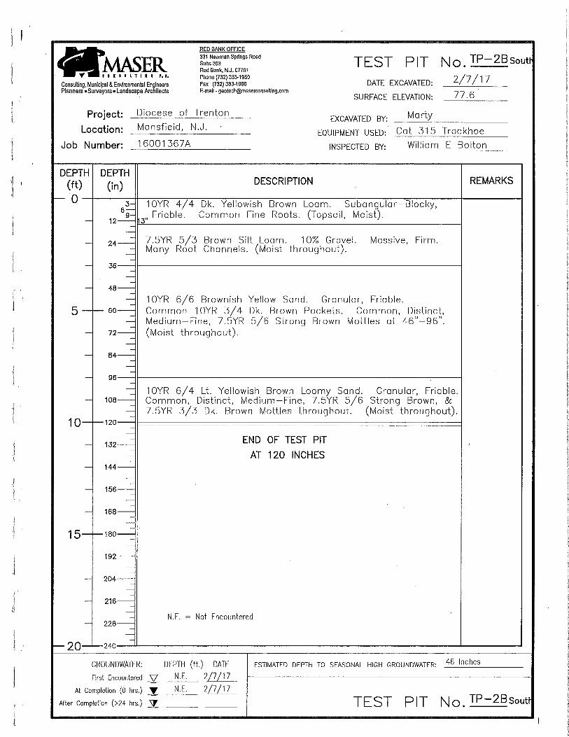
3.6.3 2017 Report of Subsurface Exploration and Septic Evaluation 11
4.0 RECORDS REVIEW 12
4.1 HISTORICAL SANBORN MAPS 12
4.2 AERIAL PHOTOGRAPH REVIEW 12
4.3 CITY DIRECTORIES 13
4.4 ENVIRONMENTAL RECORDS DATABASE SEARCH 13
4.5 INDUSTRIAL DIRECTORIES 14
4.6 LOCAL GOVERNMENT RECORDS 14
4.7 STATE AND COUNTY RECORDS 14

ii
4.8 LIMITATIONS 16
5.0 SITE RECONNAISSANCE 17
5.1 EXTERIOR OBSERVATIONS 17
5.2 INTERIOR OBSERVATIONS 19
6.0 ENVIRONMENTAL PERMITS 20
7.0 ENFORCEMENT ACTIONS 21
8.0 FILL MATERIAL 22
9.0 VAPOR INTRUSION 23
10.0 OPINIONS, CONCLUSIONS AND RECOMMENDATIONS 24
11.0 DATA GAP AND DEVIATIONS 27
11.1 DATA GAPS 27
11.2 DEVIATION 27
12.0 REFERENCES 28
FIGURES 1 SITE LOCATION MAP 2 TOPOGRAPHIC LOCATION MAP 3 TAX MAP 4 ORTHOIMAGERY MAP APPENDICES A SITE PHOTOGRAPHS B LOCAL GOVERNMENT RECORDS

iii
ENVIRONMENTAL PROFESSIONAL STATEMENT
“I declare that, to the best of my professional knowledge and belief, I meet the definition of Environmental Professional as defined in §312.10 of 40 CFR 312” and “I have the specific qualifications based on education, training, and experience to assess a property of the nature, history, and setting of the subject property. I have developed and performed the all appropriate inquiries in conformance with the standards and practices set forth in 40 CFR Part 312.”
Prepared By:
Michelle Mirigliano
Reviewed By:
Brian R. Fennelly, PE, LSRP
Fennelly Environmental Associates, LLC.

1
I. SUMMARY
Fennelly Environmental Associates, LLC (FEA) conducted a Phase I Environmental Site Assessment (Phase I ESA) for the subject property located at Mansfield Road East and Island Road in Mansfield (Block 25, Lot 6), Burlington County, New Jersey (“the Site,” see Figure 1).
This Phase I ESA was prepared in accordance with ASTM E1527-13 Standard Practice for Environmental Site Assessments: Phase I Environmental Site Assessment Process.
A site visit was conducted on February 26, 2020 by Mr. Brian Fennelly of FEA. The subject property at the corner of Mansfield Road East and Island Road is an undeveloped, vacant lot used for agricultural purposes.
Available historical information indicates that the subject property was historically used as agricultural land as early as 1931. The property owner was not aware of any environmental issues at the subject property.
FEA’s findings indicate that no Recognized Environmental Conditions (RECs) were identified. Therefore, no additional investigation is recommended.
De minimis Conditions
FEA identified other potential issues that are not a threat to human health or the environment and can be categorized as de minimis conditions, including:
Potential Impacts from Off-site Sources
NORTHERN BURLINGTON REGIONAL HIGH SCHOOL, 160 Mansfield Road East – Site has confirmed soil and groundwater contamination.
Due to ground water contamination at this site, a Classification Exception Area (CEA) has been established. The limits of the CEA extend to the property immediately adjacent to the east of the subject property. Based on FEA’s review of available information, the party responsible for this site is proceeding with remediation and is in compliance with New Jersey Department of Environmental Protection (NJDEP) requirements. Since remediation is proceeding in accordance with NJDEP regulations and the CEA does not extend onto the subject property, no further investigation is required for this issue.

2
Silo
One silo constructed of metal and concrete was observed in the wooded area centrally located on the subject property. The silo was intact with no evidence of cracks, stains, or leaks. However, several rubber tires had been dumped and filled the base of the silo, which was covered with soil, leaves, and other debris.
FEA recommends removing and properly disposing of the rubber tires.
Potential Former Heating Source
The subject property was occupied by several building structures between 1931 and 1974, which have since been demolished. However, no known heating source or records indicating how those former structures were heated have been identified.
Since no evidence was encountered which suggests that a heating oil underground storage tank (UST) is or was present at the subject property, this is not considered a REC. However, if the user of this report would like to alleviate concerns about the potential presence of a UST, FEA recommends that a ground-penetrating radar (GPR) and magnetometry survey be conducted in the vicinity of former building foundations.
Historic Agricultural Use
Based on information indicating historical agricultural use at the subject property, FEA has identified historical agricultural use as a de minimis condition.
In June 2016, Maser Consulting P.A. (Maser) completed discrete soil sampling at the subject property. A total of 8 soil samples, S1 through S8, were collected from the 0 – 6-inch interval and analyzed for volatile organic compounds (VOCs), semi-volatile organic compounds (SVOCs), PCBs, pesticides, and metals. The results for all compounds were reported below the NJDEP Residential/Non-Residential Direct Contact Soil Remediation Standards (R/NR DCSRS) for all sample locations. However, beryllium was reported above the Default Impact to Groundwater Soil Screening Level (DIGWSSL) of 0.7 mg/Kg at three soil sample locations. All beryllium concentrations were averaged (0.7 ppm) and found to be within natural background concentrations and below the R/NRDCSRS.

3
The NJDEP document Findings and Recommendations for the Remediation of Historic Pesticide Contamination (March 1999), includes a recommendation for former agricultural areas to be sampled prior to site development. Since sampling has been conducted and no exceedences of applicable regulatory criteria were identified when the compliance averaging approach was utilized, no further investigation or remediation is necessary for this issue.
Wetlands
A wetland area is present in the northwestern corner of the subject property. No evidence of spills, discharges, or other environmental impacts has been observed in this area, therefore, no further investigation or remediation is necessary.
Potential Former Septic System
As discussed above, the subject property was occupied by several structures between 1931 and 1974, which have since been demolished. However, no known septic system or records indicating how those former structures were serviced have been identified.
Since no evidence has been encountered which suggested improper discharges to a sanitary waste system at the subject property have occurred, no further investigation is recommended.
Existing Well
During a site inspection conducted on February 3, 2018, one shallow well, approximately 3 feet in diameter and 20 feet deep, was observed in the central portion of the subject property in the vicinity of former farm buildings. This well was not secured with a locking cover and was not in service; however, piping runs were observed entering the well from several directions.
Based on the condition of the well and safety concerns, FEA recommends the well be abandoned by a licensed well driller in accordance with N.J.A.C 7:9D.

4
1.0 INTRODUCTION
Fennelly Environmental Associates, LLC (FEA) conducted a Phase I Environmental Site Assessment (Phase I ESA) for the subject property located at the corner of Mansfield Road East and Island Road (Block 25, Lot 6), Township of Mansfield, Burlington County, New Jersey (“the Site,” see Figure 1).
This Phase I ESA was prepared in accordance with ASTM E1527-13 and was conducted to evaluate and identify conditions indicative of releases of hazardous substances and/or petroleum products at the subject property, and to identify the presence of any potentially contaminated areas of concern. The purpose of a Phase I ESA is to identify, to the extent feasible and pursuant to ASTM E1527-13, recognized environmental conditions (RECs), historical recognized environmental conditions (HRECs), and controlled recognized environmental conditions (CRECs) in connection with the subject property.
1.1 SCOPE OF WORK
FEA’s Phase I included the following activities:
An on-site inspection of the subject property to evaluate current conditions and identify potential areas of concern;
A review of property history using interviews, ownership records, and historical mapping;
A review of state, county, and local government files;
A review of Federal, state, and local government permits;
A review of NJDEP Data-Miner and Geographical Information System (GIS) website records; and,
A review of historical aerial photographs.
1.2 LIMITATIONS
This report has been prepared for the exclusive use of FEA’s client. No additions or deletions are permitted without express written consent of FEA. Use of this report in whole or in part by parties other than FEA’s

5
client is prohibited. FEA will not and cannot be liable for unauthorized reliance by any other party. Other than as contained in this paragraph, FEA makes no express or implied warranty as to the contents of this report.
Information obtained from public records review, the site inspection, and interviews were used to characterize the subject property. Although the services provided are extensive, findings and conclusions are limited to and by the information obtained.
1.3 USER RELIANCE
FEA will not be responsible or liable for any penalty, liability, or cost associated with any environmental contamination or condition, whether such contamination or condition existed prior to the date of this report, at the time of this report, or is discovered subsequent to the date of this report. The results of this study may not be relied upon by any parties, other than those described above, without prior written consent of FEA.
FEA acknowledges and agrees that this report may be conveyed to the Buyer, Seller or Lender associated with the proximate purchase, sale, or financing of the Site, to the extent set forth in our proposal.

6
2.0 SITE DESCRIPTION
The subject property, Block 25, Lot 6, is approximately 29.55-acres and is currently undeveloped and vacant.
2.1 LOCATION & LEGAL DESCRIPTION
The Site is located on the western side of Island Road and south of Mansfield Road East at the intersection of these two roads. The Site is identified as Block 25, Lot 6 as recorded at the Burlington County Clerk’s office.
2.2 PHYSICAL & TOPOGRAPHIC SETTING
The general location of the property and physiographic features of the surrounding area are shown on Figure 2.
The subject property is located at an elevation of approximately 69 feet above mean sea level, and slopes to the west. A tax map is presented as Figure 3. A scaled site plan detailing property boundaries and current site conditions is presented as Figure 4.
An area of mapped deciduous wooded wetlands is located in the northwestern corner of the subject property.
2.3 CURRENT SITE USE
The subject property consists of an undeveloped, vacant lot. The property is currently operated by a tenant and is used for agricultural purposes.
2.4 HISTORIC SITE USE
The site appears to have operated as a farm historically between 1931 and 1974.
2.5 ADJOINING & SURROUNDING PROPERTIES USE
The subject property is bounded to the north by Mansfield Road East beyond which are residential homes and farmland, a residential

7
development to the west, Island Road to the east beyond which is farmland, and farmland and residential properties to the south.
The area surrounding the subject property and adjoining properties are mainly developed for agricultural and residential use. The Mansfield Township Elementary School and Northern Burlington County Regional School campus property is located approximately 300-feet northeast of the subject property along Mansfield Road East.

8
3.0 USER PROVIDED INFORMATION & INTERVIEWS
In accordance with the User’s Responsibilities section of ASTM E1527-13, the individual who commissioned the performance of this Phase I ESA or their designated representative was asked to respond to the sections below, in addition to other sections which have been incorporated into this report. These items are performed by the “User” to assist in identifying RECs, HRECs, CRECs, and VECs.
A representative of the Diocese of Trenton, provided information described below except where noted.
3.1 TITLE INFORMATION
Title information was partially provided by the User; however, the ownership history of the subject property was developed through FEA’s review of deeds and tax records recorded at the Burlington County Clerk’s Office. The results of this review are summarized below.
Island Road (Block 25, Lot 6)
Name of Property Owner From To
Diocese of Trenton January 17, 2001 Present
Tower Gate Associates November 28, 1980 January 17, 2001
Archie Massei July 28, 1980 November 28, 1980
The Society for the
Propagation of the Faith
October 16, 1978 July 28, 1980
Joseph McCorristin &
Mary McCorristin
June 28, 1947 October 16, 1978
Geza & Mary Madar April 19, 1931 June 28, 1947
3.2 ENVIRONMENTAL LIENS OR ACTIVITY AND USE LIMITATIONS
Is the organization/person aware of any environmental cleanup liens against the property/Site that are filed or recorded under federal, tribal, state, or local law? No.

9
Is the organization/person aware of any Activity and Use Limitations, such as engineering controls, land use restrictions or institutional controls that are in place at the Site and/or have been filed or recorded in a registry under federal, tribal, state or local law? No.
3.3 SPECIALIZED KNOWLEDGE
Does the organization/person have any specialized knowledge or experience related to the property or nearby properties? For example, is the organization/person involved in the same line of business as the current or former occupants of the property or an adjoining property so that they would have specialized knowledge of the chemicals and processes used by this type of business? No.
3.4 COMMONLY KNOWN OR REASONABLE ASCERTAINABLE INFORMATION
Is the organization/person aware of known or reasonably ascertainable information about the property that would help FEA identify conditions indicative of releases or threatened releases? For example, does the organization/person know of past uses of the property, environmental cleanups that have taken place at the property, chemicals that are currently or were used at the property, spills, or releases that have occurred? No.
3.5 VALUATION INFORMATION
Does the purchase price being paid for this property reasonably reflect the fair market value of the property? Yes. If there is a difference, has it been considered whether the lower purchase price is because contamination is known or believed to be present at the property? NA.
3.6 PREVIOUS ENVIRONMENTAL REPORTS
The User provided an agricultural soil sampling report for the subject property to FEA.

10
3.6.1 2016 Agricultural Soil Sampling Report
In June 2016, Maser Consulting P.A. (Maser) completed discrete soil sampling at the subject property. A total of 8 soil samples, S1 through S8, were collected from the 0 – 6-inch interval and analyzed for volatile organic compounds (VOCs), semi-volatile organic compounds (SVOCs), PCBs, pesticides, and metals.
The results for all compounds were reported below the NJDEP Residential/Non-Residential Direct Contact Soil Remediation Standards (R/NR DCSRS) for all sample locations. However, beryllium was reported above the Default Impact to Groundwater Soil Screening Level (DIGWSSL) of 0.7 mg/Kg at locations S3, S5, and S8. Based on the United States Department of Agriculture (USDA) Natural Resources Conservation Service (NRCS) Web Soil Survey, the subject property is underlain by Freehold (FrmA and FrmB) soil series, Holmdel (HodA) soil series and Shrewsbury (ShsA) soil series. According to the NJDEP Baseline Concentrations of Arsenic, Beryllium and Associated Elements in Glauconite and Glauconitic Soils in the New Jersey Coastal Plain, these soil series naturally contain beryllium, with concentrations ranging from 0.09 ppm to 2.8 ppm within the 0-6-inch interval. Higher concentrations of beryllium may result from more aggressive weathering of the soil due to repeated plowing of the top ten inches of soil. The subject property is actively being farmed and no operations involving the use of beryllium have been identified. Additionally, all beryllium concentrations were averaged (0.7 ppm) and found to be within natural background concentrations. Other metals including aluminum and manganese were also reported above the DIGWSSL, however, these metals are secondary, and standards are not based on health considerations. Therefore, since no site operations involved the use of these metals, exceedences of DIGWSSL for these metals can be disregarded.
3.6.2 2017 Wetland Delineation Report
In 2017, Maser prepared a Wetland Delineation Report, a Freshwater Wetlands Letter of Interpretation (LOI) – Line Verification, Division of Land Use Regulation (DLUR) application for permit, and a site plan titled Wetlands Location Plan for Diocese of Trenton for the subject property.
Representatives from Maser performed site reconnaissance to delineate freshwater wetlands and to determine the accuracy of reestablished

11
wetland lines on the subject property. Changes in vegetation, soils, topography, and hydrology were used to establish sampling stations, which in turn determined the final wetlands/water boundaries.
In conclusion, freshwater wetlands were identified on the subject property. The location and surveyed limits are presented on the site plan titled Wetlands Location Plan for Diocese of Trenton dated January 21, 2017.
On March 20, 2017, NJDEP approved the wetlands and water boundary presented on the Wetlands Location Plan for Diocese of Trenton.
3.6.3 2017 Report of Subsurface Exploration and Septic Evaluation
In March 2017, Maser prepared a report detailing findings related to a geotechnical evaluation completed with respect to septic systems for proposed subdivision at the subject property. A total of eight test pits were installed, one test pit in each proposed lot, and soil permeability class rating testing was completed. Based on the test pit information and laboratory testing, Maser determined that the lots were suitable to support on-site septic disposal systems.

12
4.0 RECORDS REVIEW
Historical uses and site operations were investigated through a review of the following information sources:
Source of Information Name/Years Reviewed
Sanborn Fire Insurance Maps No Coverage
Aerial Photographs 1931, 1940, 1951, 1953, 1962, 1969, 1970,
1974, 1984, 1989, 1995, 2006, 2010, 2015
City Directories 1978, 1983, 1988, 1992, 1995, 2000, 2005,
2010, 2014
USGS Topographic Maps 1888, 1893, 1906, 1907, 1918, 1944, 1948,
1954, 1957, 1970, 1981, 2014
4.1 HISTORICAL SANBORN MAPS
The Sanborn Library was searched and the results were reported as “unmapped property.” Therefore, no Sanborn Fire Insurance maps were available for review.
4.2 AERIAL PHOTOGRAPH REVIEW
Aerial photographs for the subject property were obtained for the years 1931, 1940, 1951, 1953, 1962, 1969, 1970, 1974, 1984, 1989, 1995, 2006, 2010, and 2015.
The aerial photographs obtained between 1931 and 1974 indicate the subject property is cleared and being used for agricultural purposes. A driveway extends south from Mansfield Road East to several structures centrally located on the subject property. Photos from subsequent years indicate the structures were razed. The 1974 photograph appears to show the last remaining structure, a silo, and other areas of debris/foundations where the former structures were located. The areas surrounding the subject property are also cleared and being used for agricultural purposes, and in some cases, residential properties.
The aerial photographs obtained between 1984 and 1995 show the subject property clear of all structures, except for the silo, and is being used for

13
agricultural purposes. The northwest corner of the subject property is heavily vegetated with a tree line extending from the center of the subject property to the eastern boundary. The areas surrounding the subject property are similar to the previous aerial photographs.
The aerial photographs obtained between 2006 and 2015 show the subject property being used for agricultural purposes. The northwest corner of the subject property is heavily vegetated with a tree line extending from the center of the subject property to the eastern boundary. Additional areas surrounding the subject property have been developed for residential use, notably, the housing development directly west of the subject property.
4.3 CITY DIRECTORIES
Directories were reviewed from 1978, 1983, 1988, 1992, 1995, 2000, 2005, 2010, and 2014. No entries for the subject property were listed in any of the directories reviewed.
4.4 ENVIRONMENTAL RECORDS DATABASE SEARCH
A database search of public and regulatory environmental records was conducted. Available records indicate that the subject property was not listed in any of the databases searched.
The search returned records on sites within one mile of the subject property in several databases, and are summarized below.
State and Tribal Lists:
o Equivalent CERCLIS: SHWS – 11 sites are located within 1 mile of the
subject property. o Leaking storage tanks lists:
HIST LUST – 1 site is located within 0.5 miles of the subject property.
NORTHERN BURLINGTON REGIONAL HIGH SCHOOL, 160 Mansfield Road East – Site has confirmed soil and groundwater contamination (Case ID # 93-09-01-1023, TMS # C93-3201 and # C94-0997.)

14
Additional information regarding this site is included in Section 4.7 below.
4.5 INDUSTRIAL DIRECTORIES
No records were found related to industrial operations conducted at the subject property.
4.6 LOCAL GOVERNMENT RECORDS
FEA submitted a records request to the Mansfield Township Clerk’s office on February 5, 2020. The request was made for access to documents related to the presence of underground storage tanks, releases, fires, or other potential contamination issues, and/or investigation and remediation of Areas of Concern (AOCs) at the subject property. The local fire department was also contacted at this time.
On February 14, 2020, FEA received a response from the township stating that no records were on file for the subject property. However, FEA did receive the following document from a previous request made in 2018 to the township:
Report of Subsurface Exploration and Septic Evaluation dated 1
March 2017 completed by Maser.
4.7 STATE AND COUNTY RECORDS
FEA submitted an Open Public Records Act (OPRA) request to NJDEP and the Burlington County Clerk on February 5, 2020.
On February 5, 2020, FEA received a response from the county stating that no records were on file for the subject property.
FEA also searched the NJDEP DataMiner database and the NJDEP Geographical Information System (a.k.a. NJ-GeoWeb). The subject property is listed in the NJDEP Dataminer system under the Land Use Program (Freshwater Wetlands) and has been assigned PI # 0318-17-0001.1, Activity Class Code FWW.
On February 12, 2020, NJDEP responded that records were available for review. Available records were the same records obtained during a file

15
review conducted in 2018 related to a Land Use Permit. Records identified for this permit include:
Wetland Delineation Report dated February 7, 2017,
Freshwater Wetlands Letter of Interpretation (LOI) – Line Verification,
Division of Land Use Regulation (DLUR) application for permit dated February 8, 2017,
Application Withdrawal letter – General Permit 11 dated August 28, 2017, and;
Wetland Location plan map.
These documents are discussed in more detail in Section 3.6.
Also, NJ-GeoWeb was used to identify properties within 0.5 miles of the subject property that are included under the NJDEP Site Remediation Program (SRP). Results from the search indicated that properties included in the NJDEP “NJEMS” Databases are located within 0.5 miles of the subject property. Specifically, NJ-GeoWeb showed the subject property is adjacent (directly across Island Road) to a known Groundwater Contamination Area, Northern Burlington Regional High School, as indicated in Section 4.4 above. Due to ground water contamination at this site, a Classification Exception Area (CEA) has been established. NJ-GeoWeb provided the following information on the CEA established at this site:
The CEA was established on 7/11/1996.
The CEA covers two areas. Area A is a 900' long hexagon shape defined by wells MW-A8, MW-A4, MW-A20, MW-A22, MW-A15, and MW-A9. Area B is a diamond shape measuring 120' x 40' oriented N-S centered on well MW-B1R.
The duration of the CEA is indeterminate.
The depth of the CEA is 50-feet.
Groundwater flow direction is to the west {which is toward the subject property}.
Benzene, methyl-tertiary-butyl-ether (MTBE), t-butyl alcohol (TBA), and naphthalene are contaminants included in the CEA.
The limits of the CEA extend to the property immediately adjacent to the east of the subject property. Based on FEA’s review of available information, the party responsible for this site is proceeding with remediation and is in compliance with NJDEP requirements. Since remediation is proceeding in accordance with NJDEP regulations and the

16
CEA does not extend onto the subject property, no further investigation is required for this issue.
4.8 LIMITATIONS
The information documented in this report is limited to verbal and/or written statements provided to FEA, and conditions visually observed by FEA during an inspection of the subject property. Visual observations reported were limited to areas that were visually accessible. No environmental sampling and/or analysis were performed as part of this Phase I. Limitations include, but are not limited to, visual obstructions, data gaps, access to public records, accuracy of statements provided and other restrictions.

17
5.0 SITE RECONNAISSANCE
Mr. Brian Fennelly of FEA conducted the site reconnaissance on February 26, 2020. A site inspection was also conducted on February 3, 2018.
5.1 EXTERIOR OBSERVATIONS
Hazardous Substances and Petroleum Products in Connection (or Not in Connection) with Identified Uses
None observed.
Underground Storage Tanks
No underground storage tanks (USTs) or evidence of USTs (i.e., vent pipes, fill port) were observed during FEA’s site inspection.
Aboveground Storage Tanks
None observed.
Odors
None observed.
Pools of Liquid
None observed.
Drums, Containers
An empty metal container, approximately 5 feet long by 3 feet wide, was observed on the ground surface in the central part of the subject property. The container was below grade within the former foundation. It appeared that this container was empty when it was placed in this area. No indications of spills or releases were observed in the vicinity of this container. This could potentially be an old water heater.
PCBs
No transformers or other potential sources of PCBs were observed.
18
Pits, Ponds, or Lagoons
None observed.
Stained Soil or Pavement
None observed.
Stressed Vegetation
None observed.
Solid Waste
A small pile of debris consisting of corrugated metal roofing and wood planks was observed in the wooded area of the subject property. No indications of spills or releases were observed in the vicinity of this debris.
Wastewater
Potable Water
None observed.
Process Wastewater
None observed.
Storm Water
Storm water generated onsite percolates to underlying soil.
Wells
One shallow well, approximately 3 feet in diameter by 20 feet deep, was observed in the central portion of the subject property in the vicinity of former farm buildings. This well was not secured with a locking cover and was not in service; however, several pipe lines were observed entering the well from several directions.
Septic Systems
None observed.

19
5.2 INTERIOR OBSERVATIONS
Hazardous Substances and Petroleum Products in Connection (or Not in Connection) with Identified Uses
Not applicable. No building structures were observed onsite.
Underground Storage Tanks
None observed.
Aboveground Storage Tanks
None observed.
Odors
None observed.
Pools of Liquid
None observed.
Drums, Containers
None observed.
PCBs
None observed.
Heating/Cooling
Not applicable. No building structures were observed onsite.
Stains or Corrosion
Not applicable. No building structures were observed onsite.
Drains and Sumps
Not applicable. No building structures were observed onsite.

20
6.0 ENVIRONMENTAL PERMITS
The subject property is listed in the NJDEP Dataminer system under the Land Use Program (Freshwater Wetlands) and has been assigned PI # 0318-17-0001.1, Activity Class Code FWW.

21
7.0 ENFORCEMENT ACTIONS
Available information indicates the subject property has not been the subject of any enforcement actions.

22
8.0 FILL MATERIAL
During the course of this Phase I, FEA did not encounter information suggesting that fill material has been imported to the subject property. Also, a review of the New Jersey Geological Survey (NJGS) Historic Fill Map was completed at part of this Phase I ESA. No historic fill information was available for the Columbus Quadrangle or on NJ Geoweb. The area of the subject property has not been mapped.

23
9.0 VAPOR INTRUSION
FEA did not encounter any information relating to potential vapor intrusion issues at the subject property.
As discussed above, a CEA was established at the Northern Burlington Regional High School due to the presence of groundwater contamination. If future plans include constructing buildings at the subject property, it is recommended that a NJDEP file review for the High School site be conducted to determine the extent of vapor intrusion issues, if any, related to the CEA.

24
10.0 OPINIONS, CONCLUSIONS AND RECOMMENDATIONS
FEA has performed a Phase I Environmental Site Assessment in conformance with the scope and limitation of ASTM Practice E 1527-13 at the corner of Mansfield Road East and Island Road, Mansfield Township, Burlington County, New Jersey. Any exceptions to, or deletions from, this practice are described in Section 11. FEA’s findings indicate that no Recognized Environmental Conditions (RECs) were identified. Therefore, no additional investigation is recommended for the subject property.
De minimis Conditions
FEA identified other potential issues that are not a threat to human health or the environment and can be categorized as de minimis conditions, including:
Potential Impacts from Off-site Sources
NORTHERN BURLINGTON REGIONAL HIGH SCHOOL, 160 Mansfield Road East – Site has confirmed soil and groundwater contamination.
Due to ground water contamination at this site, a Classification Exception Area (CEA) has been established. The limits of the CEA extend to the property immediately adjacent to the east of the subject property. Based on FEA’s review of available information, the party responsible for this site is proceeding with remediation and is in compliance with NJDEP requirements. Since remediation is proceeding in accordance with NJDEP regulations and the CEA does not extend onto the subject property, no further investigation is required for this issue.
Silo
One silo constructed of metal and concrete was observed in the wooded area centrally located on the subject property. The silo was intact with no evidence of cracks, stains, or leaks. However, several rubber tires had been dumped and filled the base of the silo, which was covered with soil, leaves and other debris.
FEA recommends removing and properly disposing of the rubber tires.
Potential Former Heating Source

25
The subject property was occupied by several building structures between 1931 and 1974, which have since been demolished. However, no known heating source or records indicating how those former structures were heated have been identified.
Since no evidence was encountered which suggests that a heating oil underground storage tank (UST) is or was present at the subject property, this issue is not considered a REC. However, if the user of this report would like to alleviate concerns about the potential presence of a UST, FEA recommends that a ground-penetrating radar (GPR) and magnetometer survey be conducted in the vicinity of former building foundations.
Historic Agricultural Use
Based on information indicating historical agricultural use at the subject property, FEA has identified historical agricultural use as a de minimis condition.
In June 2016, Maser Consulting P.A. (Maser) completed discrete soil sampling at the subject property. A total of 8 soil samples, S1 through S8, were collected from the 0 – 6-inch interval and analyzed for volatile organic compounds (VOCs), semi-volatile organic compounds (SVOCs), PCBs, pesticides, and metals. The results for all compounds were reported below the NJDEP Residential/Non-Residential Direct Contact Soil Remediation Standards (R/NRDCSRS) for all sample locations. However, beryllium was reported above the Default Impact to Groundwater Soil Screening Level (DIGWSSL) of 0.7 mg/Kg at three soil sample locations. All beryllium concentrations were averaged (0.7 ppm) and found to be within natural background concentrations and below the R/NRDCSRS. The NJDEP document Findings and Recommendations for the Remediation of Historic Pesticide Contamination (March 1999), includes a recommendation for former agricultural areas to be sampled prior to site development. Since sampling has been conducted and no exceedences of applicable regulatory criteria were identified when the compliance averaging approach was utilized, no further investigation or remediation is necessary for this issue.
Wetlands

26
A wetland area is present in the northwestern corner of the subject property. No evidence of spills, discharges, or other environmental impacts has been observed in this area, therefore, no further investigation or remediation is necessary.
Potential Former Septic System
As discussed above, the subject property was occupied by several building structures between 1931 and 1974, which have since been demolished. However, no known septic system or records indicating how those former structures were serviced have been identified.
Since no evidence has been encountered which suggested improper discharges to a sanitary waste system at the subject property have occurred, no further investigation is recommended.
Existing Well
During a site inspection conducted on February 3, 2018, one shallow well, approximately 3 feet in diameter and 20 feet deep, was observed in the central portion of the subject property in the vicinity of former farm buildings. This well was not secured with a locking cover and was not in service; however, several piping runs were observed entering the well from several directions.
Based on conditions of the well and safety concerns, FEA recommends the well be abandoned by a licensed well driller in accordance with N.J.A.C 7:9D.
27
11.0 DATA GAP AND DEVIATIONS
11.1 DATA GAPS
None.
11.2 DEVIATION
None.

28
12.0 REFERENCES
The following sources of information were utilized during the completion of this Phase I Environmental Site Assessment:
ASTM. Standard Practice to Environmental Site Assessments: Phase I Environmental Site Assessment Process, Designation E1257-13. May 2014.
Environmental Data Resources, Certified Sanborn Map Report, Island Road, Columbus, NJ 08022, 6 Armstrong Road, Shelton, CT 06484. January 2018.
Environmental Data Resources, City Directory Report, Island Road, Columbus, NJ 08022, 6 Armstrong Road, Shelton, CT 06484. January 2018.
Environmental Data Resources, Radius Report, Island Road, Columbus, NJ 08022, 6 Armstrong Road, Shelton, CT 06484. January 2018.
Environmental Data Resources, Aerial Photo Decade Package,
Island Road, Columbus, NJ 08022, 6 Armstrong Road, Shelton, CT 06484. January 2018.
Environmental Data Resources, Historical Topo Map Report, Island Road, Columbus, NJ 08022, 6 Armstrong Road, Shelton, CT 06484. January 2018.
New Jersey Department of Environmental Protection, Data-Miner Database.
New Jersey Department of Environmental Protection, NJ-GeoWeb.
New Jersey Department of Environmental Protection, Geographical Information System (GIS).
New Jersey Geological Survey (NJGS) Historic Fill Map.

SITE LOCATION MAP
BLOCK 25, LOT 6MANSFIELD, BURLINGTON COUNTY, NEW JERSEY
0 1,000 2,000 3,000
Feet
Fennelly Environmental Associates, LLC116 Village Blvd., Suite 200Princeton, New Jersey 08540609-954-8842www.fennellyea.com
Date:
1
Sources: Base Map: ESRI
³Figure No:
02/06/2018
CHKD:
MM
SLDWN:
ArcMap\Mansfield - Island Rd\Figure 1 Site Location Map.mxd
Legend
Property Boundary
Site
Block 25, Lot 6

TOPOGRAPHIC MAP
BLOCK 25, LOT 6MANSFIELD, BURLINGTON COUNTY, NEW JERSEY
0 2,000 4,000 6,000
Feet
Fennelly Environmental Associates, LLC116 Village Blvd., Suite 200Princeton, New Jersey 08540609-954-8842www.fennellyea.com
Date:
2
Sources: Base Map: ESRI
³Figure No:
02/06/2018
CHKD:
MM
SLDWN:
ArcMap\Mansfield - Island Rd\Figure 2 Topographic Map.mxd
Legend
Property Boundary
Site

TAX MAPBLOCK 25, LOT 6
MANSFIELD, BURLINGTON COUNTY, NEW JERSEY
0 1,000 2,000 3,000
Feet
Fennelly Environmental Associates, LLC116 Village Blvd., Suite 200Princeton, New Jersey 08540609-954-8842www.fennellyea.com
Date:
3
Sources: Base Map: ESRI
³Figure No:
02/06/2018
CHKD:
MM
SLDWN:
ArcMap\Mansfield - Island Rd\Figure 3 Tax Map.mxd
Legend
Property Boundary
Burlington County Parcels
Site
Block 25, Lot 6
Manfield Road East
Isla
nd A
venue

ORTHOIMAGERY MAP
BLOCK 25, LOT 6MANSFIELD, BURLINGTON COUNTY, NEW JERSEY
0 300 600 900
Feet
Fennelly Environmental Associates, LLC116 Village Blvd., Suite 200Princeton, New Jersey 08540609-954-8842www.fennellyea.com
Date:
4
Sources: Base Map: ESRI
³Figure No:
02/06/2018
CHKD:
MM
SLDWN:
ArcMap\Mansfield - Island Rd\Figure 4 Orthoimagery Map.mxd
Legend
Property Boundary
Site
Block 25, Lot 6

APPENDIX A
SITE PHOTOGRAPHS

Photo 1 Subject Property looking west (northern farm clearing).
Photo 2 Subject Property looking east (southern farm clearing).

Photo 3 Looking north along Island Road.
Photo 4 Former Silo, central area of subject property.

Photo 5 Inside Silo
Photo 6 Former building structure foundation.

Photo 7 Shallow well
Photo 8 Inside shallow well

Photo 9 Former container located within former foundation.
Photo 10 Wetlands area in northwestern corner of the subject property.

APPENDIX B
LOCAL GOVERNMENT RECORDS

Michelle Mirigliano <[email protected]>
OPRA1 message
Ashley Jolly <[email protected]> Fri, Feb 14, 2020 at 8:47 AMTo: "[email protected]" <[email protected]>
Good Morning Michelle,
As per your OPRA request and confirming my voicemail to you; the Township has no records of underground storage tanks, release, fires, or other contamination and/or investigation remediation of areas of concern at the property located at block 25, lot 6, owned by the Diocese of Trenton.
I’ve attached our list of contaminated sites, which does not include this property.
Thank you,
Ashley
Ashley Jolly, CMR
Deputy Clerk
Recycling Coordinator
Clean Communities Coordinator
Mansfield Township
3135 Route 206, South, Suite 1
Columbus, NJ 08022
609-298-0542 ext 1010
2 attachments
Known Contamination Sites.pdf186K
2-13-2020 Mirigliano OPRA.pdf543K


State of New JerseyDepartment of Environmental Protection
GOVERNMENT RECORDS REQUEST FORM
IMPORTANT NOTICEPlease read this entire form carefully as it contains important information concerning the response to your record request, accessing records,
disputing denials, and your rights concerning government records. For further information, access WWW.NJ.GOV/DEP/OPRA.
Requestor Information State Use Only
First Name: MICHELLE MI Last Name MIRIGLIANOTracking # 265911
Company: FENNELLY ENVIRONMENTAL ASSOCIATES, LLCReceived
Date 02/05/2020
Mailing Address: 116 VILLAGE BLVD SUITE 200 Access Method Send Electronic copies
City: Princeton State: NJ Zip: 08540 Email:[email protected]
Business Telephone: (215) 380-9524 Extension
Facsimile Telephone: (609) 498-7905
All matters relating to the response and access of any records identified for this request should be directed to:
NJDEP – Office of Record Access401 East State Street
PO Box 420 Mail Code 401-06QTrenton, New Jersey 08625-0420
Tele #: (609) 341-3121 Fax #: (609) 292-1177
Record Request Details: Documents related to the presence of underground storage tanks, releases, fires, or other contamination and/or investigation and remediation of areas of concern. Additionally, permits, violations, enforcement actions or inspections related to NJEMS site ID 595107, Land Use permit #0318-17-0001.1
Disposition Notes Record Request ResponseIn
Progress - Open
Filled - Closed X
Denied - Closed
Based on this record request,responsive records have been identified and available for access. Requester should contact the Office of Record Access at 609-341-3121 to schedule a file review, copies, or to obtain further information.
Partial - Closed
02/11/2020
Addendum Disposition Notes: Based on this request, responsive records have been located. Contact us at 609-341-3121 to schedule access/inspection. Please note that the request is very broad and does not define specific records and for that reason; the Department is providing all remedial, permitting and environmental records that were able to be identified based on your request from the various Department programs that have historically provided records in response to Environmental Phase I or Due Diligence (e.g. performing a Preliminary Assessment) requests.
Custodian Signature Date

Access to Government Records Under the New Jersey Open Public Records Act (N.J.S.A. 47:1A-1 et seq.)
SONJ-RRF-2 OPRA # 265911
Information Regarding the Requested Records
If your request is in reference to a single facility, please provide the name of the facility, and the name of the operator name of the facility:
Facility Name:
Operator Name:
Please provide the owner name the facility or parcel of land: Owner Name:
If your request is in reference to a specific parcel of land, please provide the street address, block, lot and property owner of the parcel of land:(Note: if the property in question is over multiple blocks and lots, please list all in the description field below)
Street Address 1: Island Road
Street Address 2:
Block: 25 Lot: 6
If your request is in reference to a facility, site or parcel of land, please provide the Municipality and County where the facility, site or parcel of land is located:
County: Burlington
Municipality: Mansfield Twp
If the request is in reference to a particular permit issued by NJDEP, please provide the type of permit and any identifying numbers such as permit, incident or case numbers. (i.e. Fishing, Hunting, Hazardous Waste, Solid Waste, Land Use, NJPDES, Pesticides, Stream Encroachment, TWA, UST, Water Allocation)
List Permit Type: List ID Numbers:
If your request is in reference to an individual, please provide the individual's name and type, and if the individual is a DEP employee, your relationship with the individual:
Individual’s name:
Type of Individual:
Relationship:
If the an individual was specified above, the individual was DEP Licensed, please specify the license type the individual holds: License Type:
The New Jersey Department of Environmental Protection has responded to your submitted Open Public Records Act (OPRA) record request. The following information will help you understand the response and your next available actions.
Tracking #: This is the Department’s assigned Tracking # to your OPRA record request, which should be used in all corresponding matters.
Record Request Response: In Progress – Based on the nature of the request, the records sought, and/or the manner to which the records may exists, the Department requires
additional time to investigate and respond to the request.
Filled – Based on the information provided in your request, the Department was able to investigate and respond to your record request.
Denied – Based on the nature of the request and/or the records sought, the Department has denied your request pursuant to a specific exemption(s) cited in N.J.S.A. 47:1A-1 seq.
Partial – The Department has identified both responsive government records and records being denied based on the nature of the request and/or the records sought, that do not meet the definition of a government record pursuant to a specific exemption(s) cited in N.J.S.A. 47:1A-1 seq.
Disposition Notes: Provides detailed information concerning the Department’s response to your request.
Accessing Records: Dependent on the volume of records and your interest, there are five (5) methods available to access the responsive government records:
File Review – Schedule a file review with the Department to directly access the records and take notes or tag records of interest for copying. Copying can be performed by either the Department’s onsite Copying Unit at State duplication fee costs or by the requester employing a Copy Vendor Service. If there are records stored in archives, a five-day processing period will be included prior to scheduling a review.
Copy Request – All records of interest will be copied by the Department’s onsite Copying Unit at State duplication fee costs unless a Copy Vendor Service is employed.
Electronic Records Request – Dependent on the size & nature of the e-records, the Department will email the records or provide a CD or DVD.
Fax Request – Based on the number of pages, the Department faxes the responsive records.
Web Access – The responsive records can be access directly through the Department’s web site. Web address will be provided.

Access to Government Records Under the New Jersey Open Public Records Act (N.J.S.A. 47:1A-1 et seq.)
SONJ-RRF-2 OPRA # 265911
1. The fees for duplication of a government record are specified below. We will notify you of any special charges, special service charges or other additional charges authorized by State law or regulation before processing your request. Payment shall be made by check or money order payable to the State of New Jersey and mailed to the address specified below.
Hard Copies: Letter & Legal size = $0.05 per page Electronic Records: CDs = $0.55 per CDOversized Maps (Color) = $5.00 per map DVDs = $0.55 per DVDOversized Maps (B&W) = $3.00 per map
2. Pursuant to OPRA (C.47:1A-5c & C47:1A-5d), the Department will apply special service charge for any extraordinary expenditure of time and effort to accommodate a request. The special service charge will be based on the actual direct cost of providing the records. The requester shall have the opportunity to review and object to the charge prior to it being incurred; however, in the event the requester objects to the special service charge, the request will be closed and access to the records will not be granted.
3. By law, the Department must notify you that it grants or denies a request for access to government records within seven business days after the custodian of the record requested receives the request, provided that the record is currently available and not in storage. If the record requested is not currently available or is in storage, the custodian will advise you within seven business days when the record can be made available and the estimated cost. You may agree with the custodian to extend the time for making records available, or granting or denying your request.
4. You may be denied access to a government record if your request would substantially disrupt agency operations and the custodian is unable to reach a reasonable solution with you.
5. If the Department was unable to comply with your request for access to a government record, the custodian will indicate the reasons for denial on the request form.
6. Except as otherwise provided by law or by agreement with the requester, if the custodian of the record requested fails to respond to you within seven business days of receiving a request form, the failure to respond will be considered a denial of your request.
7. Resolution of Disputed Findings:
In the event that a requester does not agree with the Department’s record response, the requester should:
No Records - Reexamined the request details to evaluate if all of the information was provided that could aid the Department in locating records. The Department’s ability to identify records of interest is in direct correlation to matching the Department information with the information provided on the request. Such important identifiers are Facility/Site Name, Address, Case #, Permit #, Block/Lot.
Denial - If your request for access to a government record has been denied or unfilled within the time permitted by law, you have a right to challenge the decision by the Department to deny access. The Department denies access to records only when those records do not meet the definition of a government record and/or public access is not allowed pursuant to the law. At your option, you may either:
a. Contact the Office of Record Access to re-visit the matter or provide further explanation. b. Institute a proceeding in the Superior Court of New Jersey c. File a complaint in writing with the Government Records Council (GRC). You may contact the GRC by toll-free
telephone at 866-850-0511, by mail at PO Box 819, Trenton, NJ, 08625, by e-mail at [email protected], or at their web site at www.state.nj.us/grc. The Council can also respond to other questions about the law.
8. Information provided on this form may be subject to disclosure under the Open Public Records Act.Revised Addendum Disposition Notes: NONE