Gravitational Radiation and Very Long Baseline Interferometry
Upload
independentCategory
view
6download
0
Orbital Single-pass interferometry for vesseldetection and classification
Gerard Margarit(1), Jordi J. Mallorqui(1), Juan M. Rius(1), Jesus Sanz-Marcos(1) and Xavier Fabregas(1)
(1) Universitat Politcnica de Catalunya (Technical University of Catalonia), Dept. of Signal Theory and CommunicationsD3-Campus Nord, C\ Jordi Girona 1-3,E-08034,Barcelona, SPAIN
Telephone: +34 93 401 74 26 Fax: +34 93 401 72 32 E-mail:[email protected]
Abstract
This manuscript tackles the possible usage of Polarimetric SAR interferometry in vessel classification. It presents a simpletechnique that combines the retrieved height information with a Pauli analysis of polarimetric data to build a tri-dimensional mapof scattering centers. By comparing this output with a vessel pattern database generated from previous scattering studies, a decisionon vessel identification can then be provided. The performances of this method have been preliminary tested with simulated dataobtained from the UPC’s Orbital SAR Simulator,GRECOSAR, for a sensor inspired in the incoming TerraSAR-X. The obtainedresults show the tri-dimensional map is highly related with the observed geometry and it could allow vessel identification almostindependently of the sea state.
I. I NTRODUCTION
In the last two decades, SAR imagery has allowed to improve a lot of applications, mainly related with the inferring ofphysical parameters from Earth surface. Along this period, the addition of polarimetry and interferometry has been essentialto extend the research to other areas oriented to global monitoring as biomass estimation and ice studies. Despite most ofthe work done with polarimetric SAR interferometry (POLInSAR) deal with distributed targets, there are other applicationsas vessel classification where this imagery mode could play an important role. Nowadays, some governments and institutionshave a great interest on develop a global and independent ship monitoring system using SAR sensors, but unfortunately thereis not yet an efficient classification method to base it. The generation of tri-dimensional maps of ships’ scattering centers viaPOLInSAR could be the solution for this application.
Recent studies in vessel classification have been focused on the polarimetric analysis of the scattering matrix S via CoherentTarget Decompositions (CTD) [1], [2]. Such theorems have great potentialities in this field as they express the complexpolarimetric behavior of each pixel of SAR images in a mixture of elemental mechanisms related to specific physical structures.The degree of significance of those mechanisms allows building a polarimetric signature from which guidelines of target’sgeometry can be retrieved. CTD decompose the matrix S of each resolution cell as the coherent sum of the scattering matricesrelated to the simple mechanisms but assuming all share the same centre of phase. This issue causes a notably worsening ofCTD performances in those images where some cells have scatters with diverse polarimetric mechanisms and phase centers.The main consequence is important changes in the polarimetric signature even for slight modifications on the observationsconditions. Unfortunately, this happens normally in vessel SAR data due to the reduced resolution of the sensor comparedwith the complex geometry of the target making useless this approach for vessel classification Unfortunately, this happensnormally in vessel SAR data due to the reduced resolution of the sensor compared with the geometry of complex targetsmaking very difficult the development of an algorithm [2]. Additionally, the azimuth distortions due to vessel motions duringimage acquisition [3] [4] can also worsen data interpretation. A first solution for this CTD limitation would be increasing thesensor’s resolution, but in such case unaffordable values would be required for achieving notable performances. Another way,in a first instance more efficient, would be the usage of single-pass interferometry as it provides an additional informationchannel from which a quantitative measure of the detected geometry could be inferred.
In this sense, this paper describes a simple technique oriented to classify vessels from the measured height. It analyzes thepolarimetric data via the Pauli theorem to generate interferograms for each single channel. The final output is a global mapbuilt with the height information of the main scattering centers for each Pauli mechanism. This method is based on scatteringstudies carried out with simulated ISAR images [5] obtained from the Orbital SAR Simulator of complex targets,GRECOSAR,developed at UPC [6]. The simulations with different vessel models shown the most significant scattering mechanisms retrievedwere just the elements of the Pauli basis. Preliminary tests of this technique have been made with simulated orbital POLInSARdata and they have shown reasonable performances even when the azimuth distortions due to ocean waves are noticeable. Thispaper presents the most interesting results for a hypothetic sensor based on the incoming TerraSAR-X.
II. T HE CLASSIFICATION APPROACH
The scheme of the proposed vessel classification technique is shown in Fig.1. It consists on applying the Pauli theoremto both master and slave polarimetric datasets and isolate the three mechanisms of the Pauli basis. This analysis allows the
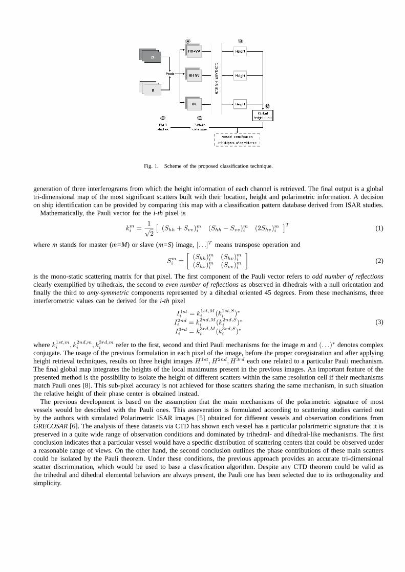
Fig. 1. Scheme of the proposed classification technique.
generation of three interferograms from which the height information of each channel is retrieved. The final output is a globaltri-dimensional map of the most significant scatters built with their location, height and polarimetric information. A decisionon ship identification can be provided by comparing this map with a classification pattern database derived from ISAR studies.
Mathematically, the Pauli vector for thei-th pixel is
kmi =
1√2
[(Shh + Svv)m
i (Shh − Svv)mi (2Shv)m
i
]T(1)
wherem stands for master (m=M) or slave (m=S) image,[. . .]T means transpose operation and
Smi =
[(Shh)m
i (Shv)mi
(Shv)mi (Svv)m
i
](2)
is the mono-static scattering matrix for that pixel. The first component of the Pauli vector refers toodd number of reflectionsclearly exemplified by trihedrals, the second toeven number of reflectionsas observed in dihedrals with a null orientation andfinally the third toanty-symmetriccomponents represented by a dihedral oriented 45 degrees. From these mechanisms, threeinterferometric values can be derived for thei-th pixel
I1sti = k1st,M
i (k1st,Si )∗
I2ndi = k2nd,M
i (k2nd,Si )∗
I3rdi = k3rd,M
i (k3rd,Si )∗
(3)
wherek1st,mi , k2nd,m
i , k3rd,mi refer to the first, second and third Pauli mechanisms for the imagem and(. . .)∗ denotes complex
conjugate. The usage of the previous formulation in each pixel of the image, before the proper coregistration and after applyingheight retrieval techniques, results on three height imagesH1st, H2nd,H3rd each one related to a particular Pauli mechanism.The final global map integrates the heights of the local maximums present in the previous images. An important feature of thepresented method is the possibility to isolate the height of different scatters within the same resolution cell if their mechanismsmatch Pauli ones [8]. This sub-pixel accuracy is not achieved for those scatters sharing the same mechanism, in such situationthe relative height of their phase center is obtained instead.
The previous development is based on the assumption that the main mechanisms of the polarimetric signature of mostvessels would be described with the Pauli ones. This asseveration is formulated according to scattering studies carried outby the authors with simulated Polarimetric ISAR images [5] obtained for different vessels and observation conditions fromGRECOSAR[6]. The analysis of these datasets via CTD has shown each vessel has a particular polarimetric signature that it ispreserved in a quite wide range of observation conditions and dominated by trihedral- and dihedral-like mechanisms. The firstconclusion indicates that a particular vessel would have a specific distribution of scattering centers that could be observed undera reasonable range of views. On the other hand, the second conclusion outlines the phase contributions of these main scatterscould be isolated by the Pauli theorem. Under these conditions, the previous approach provides an accurate tri-dimensionalscatter discrimination, which would be used to base a classification algorithm. Despite any CTD theorem could be valid asthe trihedral and dihedral elemental behaviors are always present, the Pauli one has been selected due to its orthogonality andsimplicity.

(a) (b) (c)
Fig. 2. RGB-coded Pauli images of two simulated polarimetric ISAR images (a), (b) for a Spanish fishing vessel model (b).
In order to illustrate the kind of data used in the previous study and give an idea about the structures that could mainlycontribute in the vessels’ response, two simulated polarimetric ISAR (POLISAR) image with centimetric resolution are presentedin Fig.2(a)and Fig.2(b). These images are the output of the Pauli’s decomposition coded in RGB format (red→ 1st mechanism,green→ 2nd mechanism, blue→ 3rd mechanism) for the vessel model shown in Fig.2(c). This model corresponds to a Spanishfishing vessel with a length and width of 27 and 10 meters respectively. As it can be observed, two main groups of scatters arehighlighted: the buttresses of the deck shape working as trihedrals and the base of the masts over the cabin with a dihedral-likebehavior. These scatters show those vessels’ areas that could have more significance in a SAR image obtained from a similarpoint of view. With this information the height map the Pauli-POLInSAR method would provide for such SAR image canbe predicted. If this analysis is extended to other views, it could be found a scatter distribution common to all height mapswithin a solid angle, which can be considered the classification pattern of the vessel. This process has been done for the shippresented in Fig.2(c) to test the decision rule at the final step of the algorithm. This rule is based on the similarity value,e,computed by the algorithm. For each pattern of the database, the algorithm measures the difference of the three coordinates ofeach reference point respect the values retrieved in the analyzed data and expresses the result relative to the cell dimensionsand a predefined height value (relative errors). This value is specific for each model and it fixes the maximum height errorallowed in order to preserve height pattern. The inverse of the mean value of the different relative errors is the parametereand the pattern with the highest similarity indicates the model identified.
III. S IMULATION ENVIRONMENT
The described classification technique has been preliminary validated withGRECOSAR[6]. This numerical tool generatesPOLInSAR and POLISAR data for complex targets with notable accuracy, high scenario flexibility and reduced computationalloads. The electromagnetic fields scattered by the input models are computed by the electromagnetic solverGRECOTM alsodeveloped at UPC [7]. This software works in the frequency domain with high-frequency methods, such as Physical Optics(PO) and the Physical Theory of Diffraction (PTD) that avoids the unrealistic computational requirements imposed by thediscretization of Maxwell’s equations when applied to large models. It uses an original graphical processing approach forwhich a bitmap of the model is generated to isolate the visible surfaces from the ’back-facing’ ones. This allows efficient andless consuming electromagnetic computations that reduce notably the hardware requirements of the simulator. Target modelsare defined via CAD packages with both parametric or facet-based surfaces. For instance, the model shown in Fig.2(c) hasaround of 275,000 triangular facets.
The simulated orbital acquisition geometry is presented in Fig.3. Besides the incidence angleϕ, sensor attitude and targetbearingδ, the simulator can also deal with the cruising speed, and the rotational and translational motions experimented by thevessel due to ocean waves. A simple wave model, which considers waves as sinusoids, is used to derive the angular velocitiesfrom the user-defined sea state.
The angular span of the ISAR data is highlighted in Fig.3 with a light grey shading. The simulator considers a kind ofcircular spotlight mode with the sensor at a constant the distance from the static target for a given incidence and angularaperture. This last parameter measures the angular excursion of the sensor (only the positions over the sea level are taken intoaccount) around the point with the highest height over the horizon, C. With this imagery mode, it is possible to measure thesame polarimetric information of simulated SAR datasets but with resolutions around centimeters. This results on extremelyaccurate scattering images that improve the interpretation of SAR images and allow the generation of the classification patterns.
All the data presented in this paper has been generated for the vessel model of Fig.2(c) and the hypothetic stripmap orbitalsingle-pass POLInSAR sensor summarized in TableI. This sensor is based on the TerraSAR-X configuration, but with aresolution of 2.3 meters in azimuth and 1.3 in range for an antenna dimensions of 4.3 meters length and 0.89 meters width.

Fig. 3. SAR acquisition geometry of GRECOSAR for ascending orbit. In spite of the simplified drawing, the simulator considers keplerian orbits andellipsoidal Earth.
TABLE I
THE X-BAND SENSOR USED IN THE SIMULATIONS PRESENTED INSECTION IV
∆ωg [km] 7 h [Km] 514 ϕ [o] 20
f [GHz] 9.65 PRF [Hz] 3630 La, Lr [m] 4.3, 0.89
BW [MHz] 135 FS [MHz] 150 τ [µs] 25
The effective perpendicular baseline is 30 meters (the real one is 60 meters as the ping-pong mode is used) leading to a heightsensitivity of
∂h =λ sin ϕr
4πB⊥∂φ = 0.2685∂φ (4)
where∂φ is the phase error expressed in degrees andr = 544293 m. the range to the center of the swath.
IV. DATA ANALYSIS
A first POLInSAR simulation (simulation 1) was done for a bearingδ = 295o and calm sea. The main results are summarizedin Fig. 4, jointly with a set of intermediate results that illustrate the steps of the classification method scheme presented inFig. 1. Figure ’A’ shows the magnitude of each Pauli interferogram with a dynamic range of 20 dB. Figure ’B’ presents theglobal height map by superimposing to a vessel snapshot the height values of the local maximums present in the images ofFigure ’A’. Red triangles stands for trihedrals, green squares for dihedrals0o and blue crosses for dihedrals45o. To simplifythe image, the threshold is fixed by the maximum value of all three interferograms minus the dynamic range and the point ofview corresponds to the SAR simulation one.
On the other hand, Figure ’D’ shows the RGB-Pauli image similar to that presented in Fig.2(a) of a POLISAR datasetobtained for the same point of view than the SAR simulation. As commented in SectionII , the analysis of this image jointlywith additional datasets obtained for diverse observation conditions has allowed the generation of a classification pattern forthis particular vessel. It gathers the locations, the heights and the polarimetric mechanisms of the scattering centers common inall the images. Figure ’E’ provides a representation where the blue circles locate the reference points which height is impressedin orange. For helping data interpretation, this pattern and the height map, Figure ’C’, are provided with the point of view ofthe ISAR simulation.
At a glance, it can be observed a correlation between the ISAR image and the height map as in both the same scatters arehighlighted with similar mechanisms. As in Fig.2(a), these scatters are the buttresses of deck shape and the base of the cabinmasts. By comparing the height map information with that included in the vessel’s pattern, a similarity valuee is provided.For this case,e = 72%, a value that it would allow the correct identification of the vessel.
In order to show the robustness of this method in front of the SAR image distortions induced by vessel motions [3] [4], thesame simulation has been done but for a rough sea state causing a pitching with an angular velocity of1.5o/s and a rolling of0.26o/s (simulation 2). The obtained results are shown in Fig.5. First of all, it can be noted the important azimuth distortionsdue to the non-uniform shifts of the different vessel’s scatters. These shifts are induced by the rotational motions that generateparticular radial velocities for each scatter according to its location respect the center of rotation. The main effects observed are

Fig. 4. Main results of simulation 1 with calm sea. The data is arranged to illustrate the classification method.
Fig. 5. Main results of simulation 2 with rough sea. The data is arranged to illustrate the classification method.
an enlargement of azimuth’s vessel length in the SAR image and azimuth location errors in the scattering centers of the heightmap. It can be shown these displacements agree reasonably the expected values according to the simulated geometry and thetheoretical formulas [4]. But despite of these distortions, the degree of similarity found is quite similar to the one retrievedwith calm sea as height information has been preserved. Even more, the value is a little better. This is possibly due to thespread of the overall vessel response in azimuth that allows a better scatter isolation in the SAR images. In this situation theaccuracy of height retrieving would increase. Therefore, it seems the azimuth distortions do not worsen the results provided bythe presented method, in contrast of what would happen with approaches dealing only with the CTD analysis over PolarimetricSAR data [2].
These two simulations have been repeated for two different bearings:δ = 315o and δ = 325o. With the first value, therough sea situation causes a pitching of1.3o/s and a rolling of0.76o/s whereas the other a pitching of1.2o/s and a rolling of0.9o/s. The obtained results are gathered in Fig.6 by means of the retrieved height map and the RGB-coded Pauli POLISARimage. The images of each pair of simulations with the same bearing are row-ordered via three columns. The central columncontains the POLISAR image. As observed, the obtained results are similar to those presented in the previous case as the

Fig. 6. Main results of the simulations presented in SectionIV. The POLISAR images are placed in the central column
buttresses and the masts of the cabin are also highlighted as main scatters. The similarity parametere for each case is highenough to allow a correct vessel identification even in presence of important azimuth distortions due to rough sea state (see theright column of Fig.6). These results show that with the Pauli-POLInSAR method important improvements could be obtainedrespect others techniques that does not use interferometric information.
V. CONCLUSION
This paper has described a new technique for vessel classification based on single-pass orbital Polarimetric SAR Inter-ferometry. The Pauli polarimetric data analysis has been combined with classical height retrieval techniques to generate atri-dimensional image with scattering mechanisms information of the observed ship’s geometry. A preliminary study donewith simulated images has shown the robustness of the proposed method even with rough sea states inducing importantazimuth distortions, making feasible the development of vessel classification algorithms based on this technique. Anywaymore work has to be carried out extending the study with more vessel models, considering the impact of the surroundingsea to the classification performances and evaluating the sensor requirements and limitations for the required polarimetric andinterferometric capabilities.
ACKNOWLEDGMENT
The authors would like to thank the shipyard ”Astillero Armon” for providing the blueprints of the vessel and the GiDTM
supporting team for the free licenses. This work was supported by the Spanish MCYT and EU FEDER funds under projectTIC2002-04451-C02-01 and the Spanish MECD grant AP2002-2313.
REFERENCES
[1] R. Touzi, R. K. Raney and F. Charbonneau,On the Use of Permanent Symmetric Scatterers for Ship Characterization, Transactions on Geoscience andRemote Sensing: Vol. 42, No 10, pp: 2039–2045, October 2004.
[2] G. Margarit, X. Fabregas, J. J. Mallorqui and T. Borquetas,Analysis of the limitations of coherent polarimetric decompositions on vessel classificationusing simulated images, Proceedings of Geoscience and Remote Sensing Symposium: Vol. 4, pp: 2483–2486,September 2004.
[3] G. Margarit, X. Fabregas and J. J. Mallorqui,Study of the vessel speed and sea swell effects on simulated polarimetric high resolution SAR images,Proceedings of European SAR Symposium, EUSAR: Vol. 2, pp: 603–606, May 2004.
[4] K. Ouchi, M. Ichara, K. Morimura, S. Kumano, I. Takami,Non uniform azimuth image shift observed in the Radarsat images of ships in motion,Proceedings of IEEE Transactions on Geoscience and Remote sensing: Vol. 40, No 10, October 2002, pp. 21882195.
[5] G. Margarit, X. Fabregas and J. J. Mallorqui,Study of the polarimetric mechanisms on simulated vessels with SAR and ISAR imaging, Proceedings ofEuropean SAR Symposium, EUSAR: Vol. 1, pp: 447–450, May 2004.
[6] G. Margarit, P. Blanco, J. Sanz, J. J. Mallorqui,Orbital SAR simulator of fishing vessel polarimetric signatures based on high frequency electromagneticcalculations, Proceedings of Geoscience and Remote Sensing Symposium: Vol. 7, pp: 4459-4461, July 2003.
[7] J. M. Rius et al.,GRECO: Graphical electromagnetic computing for RCS prediction in real time, IEEE Antennas and Propagation Magazine, Vol. 35,No. 2, April 1993, pp. 7-17.
[8] G. Margarit, X. Fabregas, J. J. Mallorqui, L. PipiaOrbital Polarimetric SAR Interferometry Simulator of complex targets, Proceedings of Geoscience andRemote Sensing Symposium: Vol. 3, pp: 2015-2019, July 2005.
Copyright © 2022 FDOKUMEN


![Active low pass filter design[1]](https://static.fdokumen.com/doc/165x107/631aaeddd43f4e1763048eee/active-low-pass-filter-design1.jpg)