
Neorealist director-architect critically observing the obvious
Upload
khangminh22Category
view
5download
0
Landscape Environment Advancement Foundation, LEAF
Observing the ground in the citySummer observations
No:4 ; 2010

Landscape Environment Advancement Foundation (LEAF), 2010
LEAF is engaged in research and publication in the area of landscape design and environmental planning. It supports research programs of varying durations every year.
Material produced by LEAF may be freely reproduced. LEAF and the author should be acknowledged while doing so.
LEAF invites applications for research positions.
For details please write to,
M/S. Prabhakar B. Bhagwat, 901-Panchtirth, Opp. Aristoville, S.M.Road, Ahmedabad-380 015. INDIA
T # 91 79 2692 3054
Observing the ground in a cityMrunmayee Pande
July 2010

Introduction
Base maps
01. City map: Ahmedabad
02. Elevation map
03. Ground water map
04. Soil map
05. Land use map
Grounds observed in the city
01. Ravines, Hansol
02. Woodland, Thaltej
03. Flower market, Jamalpur
04. Calico mill, Jamalpur
05. Chandola lake, Dani Limda road
06. Dumping ground, Pirana
07. Agriculture, Pirana
08. Industries, Vatva
Appendix
01. List of plants
02. Soil Observations
Bibliography
Contents02
05
06
07
08
09
11
19
27
35
43
51
59
67
75
79
81
01
10

Looking down.
The centre of the core of the earth is about 6700 kilometers away from it’s surface.
That is roughly four times the distance from here, Ahmedabad, to Kolkata in the East.
Billions of trees anchor their roots in this surface, and even those with the deepest roots thrive on a depth less than 60 mts. This is less than one percent of the depth of the earth.
But, it really is in the top 20 cms, that most life in the soil occurs. It is this precious layer that supports the life of 6,826,700,00 people and countless other life forms; it allows growth of plants and crops, and keeps life on this globe ticking.
The earth also allows absorption of much that is spilt on it; it is a rare quality - one that we do not appreciate much.
This top layer also denotes the datum; a reference that allows us to use the words “above” and “below” and its countless connotations so easily. It is then, rather surprising, that we don't look down at it often, and try and understand it.
Particularly in cities, where the earth is buried under vast quantities of concrete; dug up from time to time, defiled and in general ignored.
Our understanding is limited to its chemical or physical properties. We treat it with the exploitive intent of seeking only benefit.
But we don't observe it with any compassion; as perhaps one would watch carefully every nuance and move of a newborn.
But if we did, we would find that the earth has many stories to tell.
And we then, would be compelled to realise its worth, and would perhaps allow it to exist with dignity in our cities, and not consign it to be hidden, buried, or smothered with grass. We would be forced to acknowledge that without it, life, as we know will not exist.
Bare earth is a seminal and pure manifestation of life and its history.
We engaged Mrunmayee in this discussion. We asked her to go out and look at the earth in the city. To look at it carefully and map it; and bring back information that would allow us to appreciate it better, and learn from it.
She spent 10 weeks in summer, doing this, and this compilation is the result of her observations.
It is simple in nature. Direct, honest, and sometimes commonplace observations.
And yet they reveal a complex range of events, and processes that occur on the earth in the city.
Some because of the way its been dug, others because of the way litter falls on it, by the way it has eroded, the way in which animals have made shelters, things have grown on it, things have spilt on it, things degrade on it; all only finally pointing to the poetic generosity and the great value that earth has in our lives.
There are no conventional conclusions to be drawn in this study; but the study is replete with lots of small valuable lessons to be learnt and more importantly is a clear reminder that we should look down, a lot more often.
Aniket BhagwatJuly 2010
02

Idea of a ground in the city:
The ground is a surface that we traverse on everyday.
As city dwellers, we usually tend to pave it, clean it for walking and sitting, or cover it with grass and pretty shrubs if it's part of homes. We usually don't look at it closely to observe the various life forms it supports and the daily transformation it undergoes due to the way it gets occupied by people, animals and plants.
The most important part of this surface is the top layer called 'top soil'. Top soil is the uppermost layer of the soil which is usually 2 to 8 inches thick. This layer is rich in organic matter and minerals. This is the layer that we see when we look down.
For my study, I decided to look down, at the ground, in various parts of Ahmedabad city. The surface of Ahmedabad is a combination of a stratum of alluvial deposits and stabilised sand dunes. The city is also bifurcated by the Sabarmati river. On closer inspection of topography of the area, one can observe the river bed, ravines towards the north and 'tekras', which are actually the stabilised sand dunes. The city also has a varied land use: industry to agriculture which renders the ground differently in different areas. Based on these facts, I looked at the ground in eight locations:
01. Ravines in the north where the Sabarmati enters the city.
02. Woodland of the Sardar Patel Institute, where a closed, secure, campus keeps the ground below the trees undisturbed.
03. Flower market in Jamalpur, where there is a daily disposal of flowers and leaves on the bank of the river.
04. Calico mill, which is abandoned and the ground has been left to itself; as abandoned as the textile mill itself.
05. Chandola lake, which is a dried up lake in the southern part of the city.
06. Dumping ground at Pirana, where the city has been accumulating its waste since the last fourteen years.
07. Agriculture on the eastern fringes of Ahmedabad, where the city has not yet taken over completely.
08. Industrial area, Vatva; which discharges effluent continuously in both soil and water.
As a method, for each of these locations, I took photographs of the surface of the ground. I have also attempted to look at the underside of this surface, through sections of the top soil. All observations were made in the summer months of May and June. A few early monsoon showers, allowed me to observe the transformation of the ground due to the rains.
03


Base maps

04

Ahmedabad
Location - 23.03N 72.58EArea - 205 sq. kmClimate:
Source: Google earth
City map
1. Ahmedabad has semi-arid climate. 2. There are three distinct seasons: hot dry summers, cold dry winters and warm humid monsoons.3. Minimum temperature is 12 deg C and maximum temperature is 42 deg C.4. Major wind direction is from South - West in summer and monsoon, and North, North - East in winter.5. Average rainfall is 782 mm.
The Sabarmati river bifurcates the city into the Eastern and Western parts.
40 2 6 8 10 12 14 16 18 20km
05
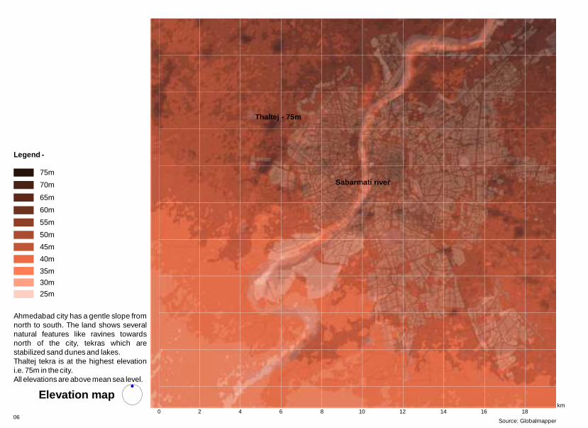
Ahmedabad city has a gentle slope from north to south. The land shows several natural features like ravines towards north of the city, tekras which are stabilized sand dunes and lakes.Thaltej tekra is at the highest elevation i.e. 75m in the city.All elevations are above mean sea level.
Legend -
25m
30m
35m
40m
45m
50m
55m
60m
65m
70m
75m
Source: Globalmapper
Elevation map
Thaltej - 75m
Sabarmati river
40 2 6 8 10 12 14 16 18km
06

Water quality:Industrial development and extensive use of fertilizers in agriculture affect the quality of percolating rainwater. As a result aquifers are found to be contaminated with nitrate in several parts of the city.
< 50m
50 - 70m
70 - 90m
90 - 120m
Legend -
Ground water levels
Source: Unpublished thesis - Role of natural resources in directing urban growth: Case of Ahmedabad region, by Sandip Patil, LA - 2007-08
Ground water level
40 2 6 8 10 12 14 16 18km
2007

Ahmedabad has established on and spread atop an alluvial plain, formed by years of deposition by the river.
The soil texture is mainly fine loamy and in some parts it is coarse loamy.
Coarse loamy
Fine
Fine loamy
Legend -
Soil texture
Fine textured
Coarse textured
Loamy textured
Source: Unpublished thesis - Role of natural resources in directing urban growth: Case of Ahmedabad region, by Sandip Patil, LA - 2007-08
Soil texture
40 km
2 6 8 10 12 14 16 18 20 2208

4
Village settlement
Industries
Open/ vacant land
Water bodies
Public area
Residential
Legend -
Land use map
0 2 6 8 10 12 14 16 18km
09Source: Unpublished map; Batch of 2008, Urban Design Dept., CEPT

Grounds observed in the city

Grounds observed:01. Ravines, Hansol
02. Woodland, Thaltej
03. Flower market, Jamalpur
04. Calico mill, Jamalpur
05. Chandola lake, Dani Limda road
06. Dumping ground, Pirana
07. Agriculture, Pirana
08. Industries, Vatva

0m
200m
100m
50m
01. Ravines, River bed, Depression, Fishing , Sabarmati river
11
View of the ravines on the bank of the river. The ravines are deepest at this point.
N.T.S.

Location:These ravines are located in the northern part of the city along the Sabarmati river.Description:The ravines and their immediate areas on the river bank are untouched by human activities. Ravines are formed due to
surface water run off. This process of erosion degrades the land next to the river bed by washing away the top soil. W here are exposed soil sections on the either side. These sections are highly eroded. The area is dominated by plant species like Prosopis julifera, Azadirachta indica, Euphorbia antiquorum, Capparis decidua.Human intervention:
The bank of the river is used for cremation. People fish in the river and grow crops like (tomato), Solanum tubersum (potato) and Citrullus lanatus (watermelon) on the river bed. The soil from the river bed is also excavated for construction.
soil erosion caused by
hile walking towards the river through a ravine, t
People live along the banks, but away from the ravines. Solanum lycopersicum
Location of the site
Ravines
River bed is used for agriculture. The edge of the river bed is covered by the growth of grass.
Ravines are found along the river bank. They are formed due to soil erosion.
Depressions are formed along the riverbed due to movement of surface water towards the river.
Fauna Casmerodius albus which is commonly called as Great Egret. It is a resident bird. They are carnivores and feed on fish and frog.
General characteristics
* Ravine is a small channel which is a result of stream cutting. It is larger in scale than gullies. 12

4. This irregular edge has been formed due to surface water movement during monsoon. Water moves towards the river due to which soft edges get eroded. Over a period of time this edge will become deeper.
5. Crevices are formed due to soilerosion. These are occupied by fauna like spiders.
1.These are green algae in combination with Mollugo plant. The algae has driedbecause of decrease in water level.
2.The edge between the river and land.These plants have been washed ashore and have remained on the bank while the water has receded.
3. The river edge shows the presence ofCynodon dactylon grass and Mollugo.
Key plan
Topography
Observations
1. 2. 3.
4.5.
N.T.S.

6.
7.7.8. 9. 10.
10. Ravines are formed due to soil erosion. In this case, a deep depression is formed due to surface water movement.
On the ground
6. The depression is covered with Solanum surattense which grows in wastelands. It is a thorny, shade loving, green perennial under shrub with a woody base. It is covered with sharp yellowish white prickles. It has high medicinal value.
7. These are marks made by the JCB trucks while excavating the soil. The excavation of the soil has led to the exposure of soft soil surface which will lead to further soil erosion.
8. Criver bank. Ashes are disposed off into the river.
remations are performed on the 9. These are exposed soil surfacesdue to soil erosion. The black holes arenests of bids like Parrots ( Psittacines).

1.
One can see dried algae at the edge where water meets the ground. This particular algae is a type of submerged algae. As mentioned before, it has dried up because the water level of the river has receded in summer. The green colour is due to the presence of chlorophyll. They grow up to photic zone i.e. till the sunlight reaches.
3.
The river edge is covered by Cyperus rotundus grass. It is a perennial grass. Leaves are numerous, narrowly linear and finely tapered.
15
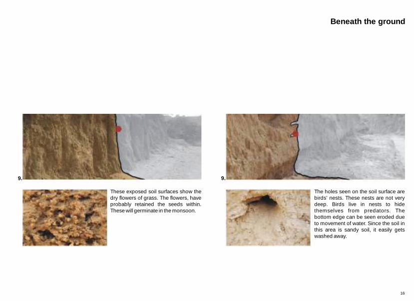
9.
These exposed soil surfaces show the dry flowers of grass. The flowers, have probably retained the seeds within. These will germinate in the monsoon.
9.
The holes seen on the soil surface are birds’ nests. These nests are not very deep. Birds live in nests to hide themselves from predators. The bottom edge can be seen eroded due to movement of water. Since the soil in this area is sandy soil, it easily gets washed away.
Beneath the ground
16

After the first showers of the monsoon, the moisture content in the soil increases which leads to fresh growth of plants like Mollugo, Alysicarpus creeper and Launea. These plants can grow with minimal moisture.
4.3.2.
1.
Key section
17

2. Launea procumbens - perennial plant1. Growth of green algae and Sida spinosa on moist soil.
3. Alysicarpus creeper which covers the ground during monsoon.
4. Mollugo
Seasonal transformation
18

02. Enclosed, Dense, Undulating, Protected, Sardar Patel Institute of Economic and Social Research
0m
100m
50m
25m
19
N.T.S.
The campus has Neem (Azadirachta indica) plantation in grid pattern. One can see the undulating profile of the ground and it is covered by litter.
trees

Location:This is one of the highest points in the city. It is a protected campus and thus, an independent green space in the middle of the city. It attracts various species of birds like kites ( Milvus migrans ), house crows ( Corvus splendens ), peacocks ( Pavo cristatus ), feral pigeons ( Columba livia ). Description:The area has mass plantation of Neem (Azadirachta indica) in a grid. Maximum area is covered by litter in summer as there are large trees. Apart from the Neem ( there are trees like Pongemia glabra, Ailanthus excelsa, Polyalthia longifolia and Grass is not found on the slopes but occurs on nearly flat ground. Human intervention:There are fixed number of people living in the campus. And additional number come in for walking in fixed hours during the day. Apart from human movement, litter is burnt regularly. Birds are also fed by the people.
treestrees Azadirachta indica)
Leucaena leucocephala. Some parts of the ground are covered with grass.
Location of the site
Thaltej - 75m
Dense litter remains on the surface of the ground for a long period.
Enclosed green space within the city. Undulating ground gives a unique character to this place.
This protected area has become habitat for fauna.
General characteristics
20

1. 2.
3.4.
5.
3. The small nodules seen in the image above are called 'Kankar'. These are nodules of calcium carbonate (CaCo3). The CaCO3 comes above the ground due to capillary action and segregates into small nodules. In this case, one can also see the upper layer of the soil broken down into particles because of weathering.
1. Aristida stricta grass forming the understory of the woodland.
2. Trail formed by constant movement of the people causes compaction of the soil.
4. Due to capillary action, the calcium in the soil moves upward and gets deposited in the upper layers of the soil. This makes these layers hard, while the soil below is soft. Due to the movement of surface water, the lower, soft soil gets washed out and what remains are the upper consolidated layers which are hard but brittle.
5. Litter collection due to wind action. Key plan
Topography
Observations
N.T.S.

6.
7.7.
8. 9. 10.
10. Accumulation of litter in the water channel increases the infiltration rate of the water.
On the ground
9. Casuarina equisetifolia is capable of growing in a wide range of soil conditions. Cones are nearly round to elongate, 1.2–2 cm in diameter.
6. Ant hill: Ants have the ability to move the soil more than any other organism. The worker ants dig out the colony's tunnel, they dispose off the displaced earth by carrying it back out of the colony and depositing soil near the entrance. Ants usually drop off the material at the top of the anthill, so it does not slide back down the hole into the colony. Ant hills are usually made of fine soil, sand or clay. The mound we see above the ground protects ants from inclement weather.
7. Litter burning: This process changes the physical properties of the soil such as it’s structure, texture, porosity, infiltration rates and water holding capacity. The effect of burning on the soil depends upon the intensity and frequency of the fire.
8.These are roots of Neem tree (Azadirachta indica). The alluvial soil is eroded because of rain and wind action. During a storm, this type of trees fall first as they are not anchored in the soil.

1.
Aristida stricta is a warm-season grass which occurs in calcareous soils. It dominates understory vegetation in sand hills. It is also known as wiregrass. This is a fast growing species. The grass continues to grow till November. Flowers set in, in the late monsoon. Once the flowers are set, seeds fall down and remain on the surface of the ground till the next monsoon arrives. The seeds remain exposed on the ground or get covered by litter.
2.
The trail is formed by constant human movement. This causes compaction of soil and it becomes impervious. The seeds in this compacted layer are less in number and even if these seeds come up on the ground, they die due to trampling. The seeds of grass usually lie up to 2 inches inside from the surface of the soil.
23

5.
Litter is carried by the wind and gets collected in the ditches. It acts as food for micro fauna.
10.
The movement of water in the soil is controlled by gravity and its absorption capacity. The absorption capacity of the soil depends on its texture, structure, and organic content. Coarse textured soils have larger pores. In this case, the surrounding area is completely wet due to continuous movement of water and hence there is no more absorption of water in the soil.
Beneath the ground
24
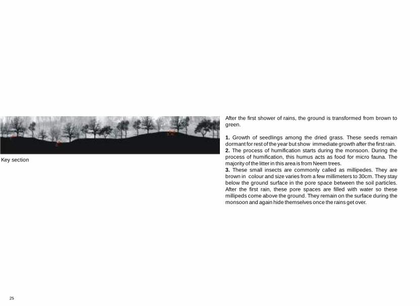
After the first shower of rains, the ground is transformed from brown to green.
1. Growth of seedlings among the dried grass. These seeds remain dormant for rest of the year but show immediate growth after the first rain.2.
3.
The process of humification starts during the monsoon. During the process of humification, this humus acts as food for micro fauna. The majority of the litter in this area is from Neem trees.
These small insects are commonly called as millipedes. They are brown in colour and size varies from a few millimeters to 30cm. They stay below the ground surface in the pore space between the soil particles. After the first rain, these pore spaces are filled with water so these millipeds come above the ground. They remain on the surface during the monsoon and again hide themselves once the rains get over.
Key section
25

Seasonal transformation
2. Process of humification starts in the monsoon
1. Growth of seedlings between the dried grass
3. The first showers forces millipede tocome up on the surface of ground.
4. Algae growth in the damp or shady locations.
26

03. Temporary, Fragrance, Colours, Waste, Flower market, Jamalpur
0m
50m
25m27
N.T.S.
Temporary market on the street which starts early in the morning.

General characteristics
FragranceTemporary market on the street Colours Waste
Location:The flower market is located on the eastern bank of the river in the area known as Jamalpur. Description:Florists start their work early in the morning. Varieties of flowers like Jasmine ( , Rose ( , Marigold( , Lilies ( and leaves of Asopalav ( Polyalthia longifolia ) are brought to the market for sale. There are two flower markets. One is constructed and remains open throughout the day. The other is outside which remains open only in the morning. The place is extremely crowded during the morning hours. The flower sellers leave the garbage at the places they occupy during morning hours or they throw it on the river bank. Animals like cows and dogs feed on this garbage. Garbage decomposes naturally till it is collected by the municipal authorities. The place is very unhygienic.
Jasminum officinale) Rosa multiflora )Calendula officinalis) Lilium candidum)
Location of the site
Flower market
28

Key plan
Topography
Observations
1. Flower waste is disposed on the sloping river bank
2. Unused flowers are dumped on the river bank which decompose naturally.
4. A range of flowers are sold on the street.
3. Fauna - Acridotheres ginginianus, commonly known as Bank Myna.
5.
1.
2.
3. 4. 5.
N.T.S.

10. On the ground
9. The leaves of Asopalav (Polyalthia longifolia) are used to make torana. Leaves are slim, long with wavy edges and extended pointy tips.
6. Flower waste left on the paved surface, keeps getting accumulated. It cannot decompose in the absence of soil.
7. Weighing flowers of Marigold (Calendula officinalis)
8. These are the petals of Jasmine
and Roses . They are sold in cane basket.
( ( Jasminum officinale) Rosa multiflora )
6. 7.7.8. 9. 10.

31

1.
This area is below Sardar Patel bridge. Flower waste is disposed on the river bank from where it moves down gradually towards the river. The waste accumulated on the upper part of bank remains till it is collected by the municipal truck while the oneon slope decomposes naturally.
4.
The ground here is paved, there is no earth. It gets occupied by the flower sellers temporarily for a part of the day. They choose different ways of appropriating the surface.
Beneath the ground
32

Waste accumulated on the river bank starts stinking in the rainy season. The number of insects increase due to the moisture. Process of humification takes place in waste on open land, due to increase in moisture level. The waste on the paved surface does not decompose at all.
4.3.2.1.
Key section
33

Seasonal transformation
1. Organic waste mixed with other types of waste: plastic and paper.
2. Decayed bunches of Lilies (Lilium candidum). The process of humification is accelerated in the monsoon.
34

04. Abandoned, Demolished, Old, Calico mill
0m
200m
100m
50m
35
N.T.S.
Ground shows the debris of fallen structures.

General characteristics
DemolishedAbandoned Identity Old
Location of the site
Calico mill Location:Calico mill is located on the eastern bank of the Sabarmati river. It Description:Dense plantation around the periphery keep the mill precint segregated from the city. The land is occupied by the debris of demolished structures of the mill except the chimney of the Calico mill. One can observe a number of flora here; A Banyan tree (
Sometimes the place appears to be left out of the city. Human intervention:In the day time this place is used by children as a play area.
was one of the city's earliest textile mills.
Ficus benghalensis ) has taken over an old demolished structure and there are number of plants growing through layer of debris.
36

Key plan
Topography
Observations
1. Vegetation in this area is dominated by Holoptelea integrifolia species.
2. Exposed brick walls which are now covered with debris. Debris containsconstruction materials like bricks, sand and concrete. This cover the ground, preventing any life to pierce through. Debris covers the surface of the ground.Flora can pierce through gaps in this.
3. Voids created due to the fallen structure, possibly give shelter to small fauna.
4. The debris has consolidated over the years changing the topography of the ground.
5. A drain channel now covered by debris.
1. 2.3.
4. 5.
N.T.S.

10. The unused road, covered by debris and soil.
On the ground
8. Salvadora persica has grown throughthe cracks of the P.C.C. slab. This plant has resistance to saline soils.
7. Dried algae on the structure6. These are roots of the Banyan tree . Due to demolition
of the structure, the plant roots lost their support and hence have fallen down on the surface to anchor themselves.
(Ficus benghalensis )9. The colour of the soil is white in colour due to presence of Calcium in the soil.
6.
7.7.8. 9. 10.

3.
The structure here collapses which has created voids in a number of places.
39

9.
The soil above the slab is rich in Calcium due to the presence of shells. Earlier this tank was used to store water. The plant growing here is a type of bamboo grass.
10.
The broken tar road in the mill land. The thick layer of tar is supported by the rubble masonry below it; through which growth of plants has now started.
Beneath the ground
40

Green patches give the indication of arrival of monsoon. Though this place is occupied by demolished structures, the growth of small plants in these structures show their instinct for survival and hardiness.
4.3.2.1.
Key section
41

Seasonal transformation
2. Growth of Panicum grass which is a seasonal grass.
1. Growth of the seedlings of Holoptelea integrifolia.
3. New shoots of Tamarind leaves 4. Growth of Blumea
42

05. Siltation, Aquatic plants, Shells, Grazing, Chandola lake
0m
200m
100m
50m
43
N.T.S.
Silt forms the base of the lake. Cracking occurs due to the loss of moisture content in the clay.

Location:Chandola lake is located in the south-east part of Ahmedabad and it is one of the largest lakes in the city. It is mainly used for irrigation.Description:The topography of the lake makes it interesting as there are depressions, and there is hillock located at the centre of the lake. The height of the hill is above the adjacent ground level. Vegetation is found along the periphery of the lake and plants like Prosopis julifera occur on the hill. The whole surface of the lake is covered by a layer of silt which is approximately 6 to 8 inches deep. Plants grow in this 6 inches of silt. This lake has been divided into canals for irrigation.Human intervention:The lake is surrounded by people living in slums, Hence, waste is disposed in the lake. People use the lake bed as apedestrian pathway it is dry. A small bund has been created at the bottom of the hill to store the water. People fish occasionally in the lake.
Location of the site
General characteristics
Siltation Aquatic plants Shells occur due to presence of oxygenand calcium carbonate
Retaining of water run off from the slope
Chandola lake
44

4. This is alluvial soil deposited at the base of the hill. The deposited soil is actually eroded from the higher areas and has been carried down by surfacerun off.
5. The soil has been erodeddue to water movement.
1. Growth of Limnophyton due topresence of water in the depressionof the lake .
2. Siltation takes place due to wind orwater which may bring a lot of dust.The clay is soft and becomes marshy.
3. This Limnophyton has dried completely due to loss of moisture.
Key plan
Topography
Observations
1.2. 3.
4.5.
N.T.S.

10.This canal is used for irrigationbut is dry in summer. It still shows some amount of moisture content in the soil and hence, we can see plants growing at the bottom of the soil.
On the ground
6. The brown exposed surface showsvertical joints which are formed at regular intervals. These joints areperpendicular to the cooling surface.These cracks and crevices are formeddue to dredging. The bottom dark,grey layer is formed due to siltation.
7. A combination of plants like Coldenia procumbens and Mollugo has grown on the top layer of the silt. These plants grow on dried silt clay and are resistant to dry summer weather.
8. Fauna - Corvus splendens Vieillot, House crow. It largely feeds on refuse around human habitations.
9. Limnophyton plant showsvariations at the same place due to difference in moisture level of soil
6.7.7.
8.9.
10.

1.
Limnophyton is an aquatic plant and floats on the surface water. It is a seasonal plant. In this image, plant shows differences in leaves which may be due to virus, insects or nutrient deficiency.
3.
Limnophyton plant is dried in this case due to loss of moisture. This plant forms a net on the surface of the silt layer. They usually grow up to 3 to 4 inches.
47

5.
Surface water movement is governed by the slope of the area. When the water moves on the soil surface, the soft soil is easily washed away and the adjacent layer of hard soil remains in place. This forms an eroded channel.
6.
Holes observed on the exposed surface are due to insects like termites and ants. These can also be formed due to compression of soil; squeezing out water and air and thus, forming these holes.
Beneath the ground
48

A light shower makes a remarkable difference on the ground. Little presence of moisture causes growth of various aquatic plants like Mollugo hirsuta, Cyperus grass and Limnophyton. These species are indicators of dried ponds. The seeds of the grass break their dormancy due to moisture. However, if the seed coat is hard because of the heat, gases or infection will also break the dormancy.
4.3.2.1.
Key section
49

2. Cynodon dactylon grass which is eaten by the animals.
1. Growth of Mollugo at a young stage 3. The green patch in the lake shows thedifference in moisture content.
4. Fauna Casmerodius albus which is commonly called as Great Egret. It is a resident bird. They are carnivores and feed on fish and frog.
Seasonal transformation
* Many of the aquatic plants grow perennially if water is available.50

0m
200m
100m
50m
06. Burning, Odour, Bare ground, Garbage, Dumping ground, Pirana
51
N.T.S.
Landfill sites contain various materials, self burning occurs due to heat.

General characteristics
Odour Burning Bare ground - There is no growth of vegetation due to infertility of soil
Layers of garbage
Location of the site
Location:Pirana is located in the southern part of the city. The area of this dumping ground is around 84 hectares. It is used for dumping garbage which is collected from the various parts of the city.Description:This site has been used to dispose garbage for 14 years now. The place itself suggests qualities like foul smell, animals like dogs, small flies and birds like kites, and crows. The place does not have any kind of vegetation but the place adjacent to the dumping ground has small trees. Since the dumping ground has a mixture of various materials, self burning occurs due to heat. Trucks carrying garbage from the city unload waste material on this site, twenty four hours a day. The dumped waste is compacted on site. The process of dumping is a continuous process. Hence, the actual ground level in this area is completely hidden. Today, the approximate height of this ground is 14 meters from the previous existing ground level.
Dumping ground
52

Topography
Observations
1.
2. 3.4.
5.
Key plan
3. After the burning of bio degradable substances, surfaces cave in forming voids in the waste. The non - degradable substances remain on the surface.
2. The landfill site contains solid waste from the city. There are biodegradable substances which decompose naturally. A substantial amount of heat is produced during decomposition which results in burning.
4. These layers are formed due to the continuous dumping of solid waste.
5. Marks are formed due to movement of JCB trucks.
N.T.S.
1. Leachate on the landfill site. Leachate is anyliquid that, in passing through matter, extracts solutes, suspended solids or any other component of the material through which it has passed.

6.
7.7.
8.9.
10.
On the ground
9. Insects - Flies. They find their food in the liquid part of the waste.
6. The ground has been compacted along with the layers of garbage. In places, where burning is occurring the hard, compact section has become brittle.
7.The soil after compaction. Compaction is done to suppress the dust particles which are present in the air due to vehicular movement and to enable further dumping of garbage.
8. Fauna - Corvus splendens Vieillot, House crow. It largely feeds on refuse around human habitations.
10. This trail of water is formed by the truck carrying water for the compaction of soil.

2.
Solid waste contains lot of bio degradable material which decomposes naturally. During this process, large amounts of heat is produced which releases Methane gas. Methane is highly flammable, which results in landfill fire.
3.
Materials like charred wood, jute, and plastic remain on the surface after burning.
55

5.
Beneath the ground
56

There are no remarkable changes on the site as it does not allow any vegetation growth. The place only becomes damp in the monsoon. 4.
3.2.1.
Key section
57

Seasonal transformation
2. Imprints of the truck tyre1. Leachate formation 3. Moisture level increases, but there isno growth of vegetation.
4. Impressions of fauna on the soil. Theonly fauna one sees here are dogs, crows.
58

07. Ploughing, Sowing, Growth, Harvesting, Agriculture
0m
100m
50m
25m
59
N.T.S.
Fields are ploighed just before the monsoon.

General characteristics
WeedsPloughing Grown crops Harvesting
Location of the site
Location:These fields are located on the southern edge of the city. The following study is based on combined observations of 3-4 agricultural fields which are used for growing a number of crops.Description:Some of the fields were being ploughed while cutting of Bajra ( Pennisetum glacecum ) crop was in progress. There were fields which are used to grow fodder grass. The waste water is channelized in these fields from the nearby areas for irrigation.
Agriculture
60

4. Harvested fodder grass
5. Ploughing is done at onset of monsoon. Key plan
Topography
Observations
1. Change in colour of soil is due to the use of fertilizers in the agricultural land.
2. Clumps of soil are formed due to loss of moisture. This is a channel used for irrigation.
3. These cracks are also formed due to loss of moisture.
1. 2. 3.4. 5.
N.T.S.

10. Canal is used for irrigating fields.
On the ground
6. Flies which are usually present near waste water.
7. Remains of the Bajra ( Pennisetum glacecum ) crop after harvesting. This is fed to animals.
8. Fully grown Bajra ( Pennisetum glacecum ) crop.
9. These fields are irrigated by waste water which contain various chemicals as well as suspended particles.
6.7.7.
8. 9. 10.

1.
The image shows soil adjacent to the field which is alluvial. The soil within the field become black due to the continuous use of fertilizers.
5.
The ploughed surface of the field.
63

8.
The Bajra ( Pennisetum glacecum ) is a Kharif crop. Once the seeds are sown in the field, it takes 2- 3 months for complete growth. Bajra can grow in places which have less rainfall. The roots of the crop extend to 30 cm deep into the soil.
10.
The edge of the dried channel shows growth of grass due to increased in moisture content.
Beneath the ground
64

The growth of the seedlings in the fields and green grass on it’s edges indicates the arrival of monsoon.
Key section
4.3.2.1.
65

Seasonal transformation
2. Growth of the seedlings in the field.1. Greenery around the field and presence of fauna gives the indication of the rainy season.
3.Fauna - Babulcus ibis which is commonly known as Cattle Egret
4. Growth of grass along the periphery of the dried clumps of soil.
66

08. Manufacturing, Effluents, Accumulation, Pollution, GIDC Vatva
0m
200m
100m
50m
67
N.T.S.
An effluent from the industrial area is discharged into Khari canal.

General characteristics
EffluentsManufacturing Accumulation Pollution
Location of the site
Location:The Gujarat Industrial Development Corporation estate is located at Vatva which is in the southern part of the city. Description:This is industrial estate. Species like Prosopis julifera, varieties of aquatic plants and Human intervention:Industries are the result of human intervention. The continuous process of manufacturing has resulted in the area being highly polluted. The effluents coming from the factories is directly drained into the Khari canal. The level of pollution has affected the flora.
Calotropis are found here.
GIDC, Vatva
68
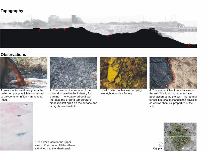
4. This crude oil has formed a layer onthe soil. The liquid ingredients have been absorbed by the soil. This harmful for soil bacteria. It changes the physical as well as chemical properties of the soil.
3. Soil covered with a layer of spray paint right outside a factory.
2. This coal on the surface of the ground is used in the industry for burning. The weathered coal can increase the ground temperature since it is left open on the surface and is highly combustible.
Key plan
Topography
Observations
2. 3.
4.
5.
1.
1. Waste water overflowing from the collection pump which is connectedto the Common Effluent Treatment Plant.
5. The white foam forms upper layer of Khari canal. All the effluent is drained into the Khari canal.
N.T.S.

6. This piece of ground contains a mixture of soil and crude oil. The soil texture is coarse. The oil does not mix with the soil.
9.The moisture level in the soil remains constant along the edges of the channel. Due to presence of moisture there is growth of Mollugo.
8. Some units discharge effluents with soil mixed in it. This soil is oftendisposed on the ground. This has formed a 6 inch thick, separate layer. These cracks are formed due to loss of moisture.
7. Dyes are used in industries for various purposes. The unused dyeform a thick layer on the soil surface.It has low biodegradibility and hence, it remains on the ground for a very long period of time.
On the ground 10.This channel is formed due to the continuous flow of waste water.
9.10.
6. 7.7.8.

1.
The untreated water from the collection pump goes to the channel which further drains into the Khari canal. This water has high level of toxins like Zinc, Lead, Carbon and Sulphur.
5.
Khari canal is the ultimate point of collection of untreated water. Apart from the chemicals, this water also contains dyes and paints. The solid particles in the water as well as continuous action of chemicals, has damaged the edges of the canal.
71

8.
The effluent soil shows cracks due to loss of moisture. Gaps in between the soil show growth of grass. This layer act as a impervious layer for smaller plants.
10.
The colour difference on the soil surface shows the regular change in the waste water level. The channel is next to the collection pump. The overflow waste water is collected in this channel.
Beneath the ground
72

A variety of plants grow in this area. However, these are plants that are indicators of wasteland. Species like Solanum surattense, Mollugo, Heliotropium and Panicum grass, are found growing in this place.
Key section
4.3.2.
1.
73

3. Heliotropium plant which grows in any wasteland.
2. The growth of Mollugo plant amongst the dried plants.
Seasonal transformation
1. Solanum surattense plant 4. This is a linear variety of a type of Panicum grass.
74


Appendix

Alysicarpus ovalifolius: These herbs are annual. Stem is erect or spreading, sometimes woody at base, 10-60 cm tall, puberulent, glabrescent. Leaflets usually dimorphic, elliptic or oblong in lower part and lanceolate in upper part, 1-10 × 0.6-3 cm. Inflorescences terminal or leaf-opposed, laxly flowered; bracteoles absent. Pedicel 1-2 mm, with spreading hooked hairs. Calyx glumaceous, scarious, persistent, 4-lobed, with minute spreading hooked hairs and sparsely ciliate straight hairs; lobes not imbricate, subequal, narrowly triangular-ovate, 3-4 mm, ciliate, apex acuminate. Petals pink or reddish purple, subequal with calyx at anthesis. Legume indehiscent, with dense minute hooked hairs, mostly without septa inside and with ridges at joint. Flowers in September – October. Fruits are from September to December.
Aristida stricta grass: The three-awns are indicators of the grass genus Aristida. It is distinguished by having three awns (bristles) on each lemma of each floret. Aristida stems are ascending to erect, with both basal and cauline leaves. The leaves may be flat or inrolled, and the basal leaves may be tufted. The inflorescences may be either panicle-like or raceme-like, with spiky branches. The glumes of a spikelet are narrow lanceolate, usually without any awns, while the lemmas are hard, three-veined, and have the three awns near the tip. Aristida stricta is a warm-season grass, native to North America, that dominates understory vegetation in sandhills.
Azadirachta indica:It is middle sized, semi ever green tree. Bark is dark; gray brown, rough, vertically furrowed. Leaves begin to fall in mid March, starting from the tops of trees; new pink leaves emerge quickly afterwards. Canopy renewed by early April. Flowers are seen in second week of April. Fruit follow quickly, ripening and drooping in july. It is credited with medicinal values.
Blumea: Genus Blumea is found in the tropical and sub-tropical zones of Asia, especially the Indian Subcontinent and Southeast Asia. The plants of this genus are mostly relatively small weeds. Some of them are ruderal species. Many species of genus Blumea are used in used in Traditional Chinese Medicine. Other uses include, being used as decorative dry plants.
Casuarina equisetifolia: It is a large evergreen tree with long green branches. Bark is dark brown. Leaves are, encircling each joint of the twig. It flowers from February to April and again briefly in the rains. Fruit cones are woody and 2 cm long. It remains on the tree for long periods.
75
01.
02.
03.
04.
05.
01.
02.
03.
04.
05.

Coldenia procumbens: These herbs are annual. Stems are branched from base; branches prostrate or ascending, 15-40 cm, densely spreading strigose. Lower stem leaves short petiolate, oblong to obovate, 1-2 × 0.5-1.5 cm, asymmetrical, scabrous, strigose, margin coarsely crenate-lobulate; lateral veins 4-6 pairs, prominent abaxially, concave adaxially; upper leaves sessile. Flowers are solitary, subsessile. Fruit is broadly triangular, 3-4 mm, glandular pubescent; mericarps wrinkled, spinescent-tuberculate. Flowering season is April while fruits appear in June. It is found in dry cultivated ground. Cynodon dactylon: It is commonly known as Durba. Most of the modern lawn grasses are hybrid versions of this grass. It is perennial, widely branching and narrow leaved with roots at every node of the slender stemmed grass. There are few varieties in this which grow all over India. Flowers are green and purplish in colour with slender terminal spikes. The whole plant is consumable and is sweet in taste and it is rich in the characteristics of cooling constituents. It has high medicinal value.
Cyperus rotundus: It is bitter, acrid, astringent and cooling weed that grows all over India, in waste lands, up to an elevation of about 5,800 ft. It is an ever growing herb with elongate thin runners bearing hard black/brown sweet smelling tubers. Leaves are numerous, narrowly linear and have finely tapered pointed tips. It is used as medicine.
Ficus benghalensis: It is a large spreading tree, nearly evergreen. Bark greyish, not rough, exudes milky sap when cut. Leaves are renewed in March – April. Figs ripen in April – May, but on some trees in late October. They are 2 cm in diameter.
Green algae: The term 'algae' is used for some lower/ low plants and many, often unrelated groups of microorganisms that are able to perform photosynthesis.
Heliotropium Indicum: This weed grows everywhere. It is coarse, succulent to some extent, fetid, herbaceous, naturally seasonal, emollient, vulnerary. It grows 60 cm in height with densely hirsute ascending branches. Flowers are pale blue in colour. It is used in medicines.
List of plants
76
06.
07.
08.
10.
11.
09.
11.
10.
09.
08.
07.
06.

Holoptelea integrifolia: It is a large deciduous tree. Bark is pale brown or greyish, rough in patches. Leaves are shed in March, renewed in April – May. Flowers appear in early March when the tree is completely bare. Fruit ripens quickly. It is a round, thin papery disc, yellow-brown when ripe.
Ipomea sepiaria: This climber grows almost everywhere in India. It is commonly found up to an elevation of 200m, climbing on other shrubs and bushes, mostly near waterways and around village tanks. It is twining, perennial with usually villous stems and slightly tuberous roots. Leaves are simple, alternate, petiolate, ovate-cordate with a wide sinus and rounded basal lobes. Flowers are pale pink or purple. Fruits are ovoid capsules, about 8mm long, 2 or 4 seeded, covered gray with silky pubescence. The plant is sweet and cooling in characteristic when eaten.
Launaea procumbens : It is commony known as Creeping launaea. Creeping launaea is a perennial herb, 30-60 cm tall. It has a smooth, branched stem. The whole plant secretes a yellow juice. Long leaves 5-25 cm, arise from the roots. Leaves have white margins and are spinous toothed. Flowering season is November-December. Flowers are yellow in colour.
Limnophyton plant: It is annual or perennial, succulent hydrophyte. Leaves are upright, sagittate or cuneate at the base, glabrous or pubescent. Inflorescence upright, scapigerous raceme of 4-7 whorls of 3-flowers each. Flowers are bisexual. Petals are white. Seed and embryo curved, testa membranous. These species are distributed in the old world tropics from tropical Africa and Indo-Pakistan subcontinent to Indo-China, Java and Timor.
Mollugo plant: These herbs are annual or perennial, glabrous. Stems diffuse, decumbent, or erect, branched or not, sometimes absent. Leaves are in a basal rosette, pseudoverticillate, opposite, or whorled. Inflorescences terminal or seemingly leaf-opposed cymes or umbels. Flowers are pedicellate. Seeds are numerous, reniform or D-shaped, smooth, sculptured, or raphe ribbed, without filiform arils or caruncles; embryo annular. There are about 35 species: mostly in tropical and subtropical regions, extending into warm-temperate regions of Europe, E Asia, and North America; four species in China. They are the indicator plants of a wet region.
77
12.
13.
14.
15.
16.
12.
13.
14.
15.
16.

List of plants
Panicum grass: Panicum is a large genus of about 450 species of grasses native throughout the tropical regions of the world, with a few species extending into the northern temperate zone. They are often large, annual or perennial grasses, growing to 1–3 m tall. The flowers are produced in a well-developed panicle often up to 60 cm in length with numerous seeds, which are 1–6 mm long and 1–2 mm broad. The fruits are developed from a two-flowered spikelet. Only the upper floret of each spikelet is fertile; the lower floret is sterile or staminate. Both glumes are present and well developed. It can grow and even thrive in many weather conditions, lengths of growing seasons, soil types, and land conditions.
Polyalthia longifolia: It is a medium sized evergreen tree. Leaves are slim, long with wavy edges and extended pointy tips and it is glossy on both sides. New leaves are seen in late March or early Apri. Flowers are in clusters with 6 long, narrow, pale green petals and seen in late March or early April. Fruit ripe between late June and early August.
Sida spinosa: Erect, annual or perennial, stellate pubescent, 30 cm to 1 m tall undershrub. Leaves are oblong or somewhat orbicular, rounded at base, acute or obtuse at apex, serrate, usually cinereous on both surfaces. Flowers axillary, solitary or 2-5 in cluster in terminal branches. Seeds 1.5 mm long, glabrous, brown to black.
Solanum surattense: It grows throughout India, mostly in dry situations on roadsides. It is bitter and acrid in taste, thorny shade loving green perennial shrub. It has woody base with zigzag climbing branches that spread a little above the ground level covered with sharp yellowish white prickles. Flowers are blue or purplish blue. Fruits are glabrous, globular drooping berri. Seeds are small, reniform, smooth and yellowish brown. It has high medicinal value as the root of this weed is an important ingredient of Ayurvedic medicine.
Tamarindus indica: It is also known as Tamarind. It is a deciduous tree. Bark is dark grey, rough with shallow fissures. Leaves shed early in February; new leaves are seen in early to mid March. They are light green at first, becomes darker later. It flowers in June or early july. Fruit ripen in winter.
78
20.
21.
19.
18.
17.
21.
20.
19.
18.
17.

Ravines, Hansol:
This soil is from the river bed. It is brown in colour and fine in texture. On dissolving in a glass of water, particles settle down slowly at the bottom. It has good water holding capacity.
Woodland, Thaltej:
Soil is from the sand hill which is brown in colour and fine in texture. On dissolving in a glass of water, particles settle down slowly at the bottom. A layer of litter is formed on the top of water.
Flower market, Jamalpur:
Soil contains humus. It is light brown in colour and it is coarse in texture. It has less water holding capacity.
Calico mill, Jamalpur:
Soil is slight grey in colour which is rich in calcium content. It is fine in texture and becomes loamy when mixed with water. Water holding capacity is good.
Chandola lake, lake bed, Dani Limda road :
Layer of soil is formed due to the process of siltation. The moisture content is high. It is fine in texture and black in colour. It has good water holding capacity.
79

Soil observations
Chandola lake, on the hillock, Dani Limda road:This soil is found on the hill is brown in colour and fine in texture. On dissolving in a glass of water, soil particles settle down slowly and becomes loamy when mixed with water.
Dumping ground, Pirana:
Mixture contains negligible amount of soil. It contains high amount of burnt materials. On dissolving in a glass of water, these materials do not settle at the bottom of glass and water becomes black in colour.
Agriculture, Pirana:
Soil is black in colour and fine in texture. It becomes clayey when mixed with water. It has good water holding capacity.
Industries, Vatva:
The soil has become dark brown in colour due to use of various chemicals. It is coarse in texture. Small dust layer is formed when mixed with water and water becomes brown due to its impurities.
Observation method:Soil was collected from each place I visited. Soil was mixed in a glass of 150 ml of water. Observations were done for 5 to 15 minutes. The study was done to understand the behavior of soil when mixed in water.
80

Bibliography
Descriptions of flora and soil characteristics are based on discussions with:Prof. Dr. Deepa Maheshwari, M. Sc. ( Botany ), M. L. Arch. ( SPA ), Ph. DProf. Dr. A. B. Vora, M. Sc. ( Botany ), Ph. DMr. Madhukara, M. Sc., Geology
Books and Periodicals:01. Handbook of Agriculture, Published by Indian Council of Agricultural Research, New Delhi, 200102. Rabindra Nath Das, Significant World of insignificant Weeds ( Part I ), Sagar Associates, Bangalore, 200603. Peter Tompkins & Christopher Bird, Secrets of the Soil, Penguin Books Ltd, England, 199204. Pradip Krishen, Trees of Delhi, Dorling Kindersley (India) Pvt. Limited, 2006
School of Architecture, CEPT University, Ahmedabad
Unpublished Thesis:05. Sandip Patil, Role of natural resources in directing urban growth: Case of Ahmedbad region, Landscape Architecture Thesis (2007-08),
06. www.agroforestry.net07. www.efloras.org08. www.ehow.com09. www.forestencyclopedia.net
11. www.googleearth.com12. www.indianexpress.com13. www.jeq.scijournals.org14. www.neemfoundation.org15. www.newton.dep.anl.gov16. www.sciencedirect.com17. www.soilerosion.net18. www.soil.scijournals.org19. www.springerlink.com20. www.tutorvista.com21. www.wikipedia.org
Websites:
10. www.globalmapper.com
81

Mrunmayee Pande is a studentof the post graduate program in Landscape Architecture at CEPT University, Ahmedabad. This study is part of her summer training of 10 weeks . She g radua ted i n architecture from Sir. J. J. college of architecture, University of Mumbai.

Landscape Environment Advancement Foundation
L E A F
INDIA
Copyright © 2022 FDOKUMEN