
Negishi 2007 FEM
11
UNCORRECTED PROOF + Models FORECO 9600 1–11 Ecological roles of roadside fern (Dicranopteris curranii) on logging road recovery in Peninsular Malaysia: Preliminary results J.N. Negishi a, * , R.C. Sidle b , S. Noguchi c , Abdul Rahim Nik d , R. Stanforth e a Department of Geography, National University of Singapore, Singapore b Disaster Prevention Research Institute, Geohazards Division, Kyoto University, Japan c Japan International Research Center for Agricultural Sciences, Japan d Forest Research Institute Malaysia, Malaysia e Department of Chemical and Biomolecular Engineering, National University of Singapore, Singapore Abstract The role of common roadside fern (Dicranopteris curranii) on the recovery of logging roads in headwater catchments of Peninsular Malaysia was examined. Hortonian overland flow from a 51.5 m road section was monitored during the 1-year study period along with sporadic measurements of sediment export before and during fern growth. Furthermore, the event-based influence of fern cover on rainfall input and flux of DOC, K, Mg, and Ca were estimated using bulk rainfall collectors (176 cm 2 ) and compared with those in the adjacent forest canopy for six storms. Air temperatures measured beneath fern cover and forest canopy were compared with those on the open road. Road-generated runoff was reduced by 4.8 mm after fern growth during storms with <30 mm rainfall; decreased sediment production rate from the road section (86%) also coincided with fern growth. Interception loss of fern cover (19%) was as high as that of the forest canopy; throughfall under fern cover was enriched with K to the similar levels as beneath the forest canopy. With the fern cover (57% of the road surface), net flux of K (+101%), Mg (+70%), and Ca (+26%) to the road increased significantly. Fern cover maintained daily maximum temperatures comparable to forested areas (<28 8C), whereas open road surfaces reached 40 8C. Our preliminary results suggest that roadside fern growth plays potentially important ecological roles in road recovery by reducing road runoff, mitigating splash and hydraulic surface erosion processes, trapping sediment where plant seeds can germinate, providing nutrient-enriched throughfall, and moderating harsh surface temperature environment. # 2005 Published by Elsevier B.V. Keywords: Element flux; Interception loss; Road runoff; Sediment production; Vegetation recovery 1. Introduction Widespread land use in mountainous forested terrain, such as mining, logging, recreation, and agricultural operations, inevitably require road networks. Previous studies have elucidated mechanisms by which unpaved roads alter catch- ment hydrology (i.e., time to peak flow and peak flow magnitude) by increasing Hortonian overland flow (HOF) (Reid and Dunne, 1984; Jones and Grant, 1996; Ziegler and Giambelluca, 1997), and intercepting subsurface flow (Mega- han, 1983; Megahan and Clayton, 1983; Sidle et al., in press). Such changes in road hydrology affect the sediment budget by increasing surface erosion (Reid and Dunne, 1984; Baharuddin et al., 1995; Ziegler et al., 2000; Sidle et al., 2004) and contributing to mass wasting processes (Montgomery, 1994; Sidle et al., in press). Furthermore, excessive fine sediment export may degrade downstream aquatic habitat (e.g., Camp- bell and Doeg, 1989; Iwata et al., 2003). Minimizing adverse effects of roads is, therefore, crucial to achieving long-term ecosystem sustainability in managed forest catchments. In addition to the importance for proper road design, knowledge of the interrelations of site hydrologic, geologic, and ecological characteristics is necessary in careful manage- ment of abandoned roads, including remediation techniques (Allison et al., 2004). Natural recovery of road surfaces typically begins with revegetation by grasses and shrubs, which often leads to a reduction of overland runoff and surface erosion (Beschta, 1978; Baharuddin et al., 1995; Luce and Black, 1999). The establishment of grasses and woody plants facilitates develop- ment of a less-compacted, organic-rich surface layer, which in turn further promotes colonization of woody species that are adapted to such relatively degraded soil conditions www.elsevier.com/locate/foreco Forest Ecology and Management xxx (2006) xxx–xxx 1 2 3 4 5 6 7 8 9 10 11 12 13 14 15 16 17 18 19 20 21 22 23 24 25 26 27 28 29 30 31 32 33 34 35 36 37 38 39 40 41 42 42 43 44 45 46 47 48 49 50 51 52 53 54 55 56 57 58 59 60 61 * Corresponding author at: Disaster Prevention Research Institute, Kyoto University, Geohazards Division, Uji, Kyoto 611-0011, Japan. ‘Tel.: +81 65 6874 4422; fax: +81 65 6777 3091. E-mail address: [email protected] (J.N. Negishi). 0378-1127/$ – see front matter # 2005 Published by Elsevier B.V. doi:10.1016/j.foreco.2005.12.017
-
Upload
independent -
Category
Documents
-
view
1 -
download
0
Transcript of Negishi 2007 FEM

+ Models
1
2
3
4
5
6
7
8
9101112
13
14
15
16
17
18
19
20
21
22
23
24
25
2627
28
29
30
31
32
33
34
35
36
37
38
39
40
41
42
D P
RO
OF
Ecological roles of roadside fern (Dicranopteris curranii) on logging
road recovery in Peninsular Malaysia: Preliminary results
J.N. Negishi a,*, R.C. Sidle b, S. Noguchi c, Abdul Rahim Nik d, R. Stanforth e
a Department of Geography, National University of Singapore, Singaporeb Disaster Prevention Research Institute, Geohazards Division, Kyoto University, Japan
c Japan International Research Center for Agricultural Sciences, Japand Forest Research Institute Malaysia, Malaysia
e Department of Chemical and Biomolecular Engineering, National University of Singapore, Singapore
Abstract
The role of common roadside fern (Dicranopteris curranii) on the recovery of logging roads in headwater catchments of Peninsular Malaysia
was examined. Hortonian overland flow from a 51.5 m road section was monitored during the 1-year study period along with sporadic
measurements of sediment export before and during fern growth. Furthermore, the event-based influence of fern cover on rainfall input and flux of
DOC, K, Mg, and Ca were estimated using bulk rainfall collectors (176 cm2) and compared with those in the adjacent forest canopy for six storms.
Air temperatures measured beneath fern cover and forest canopy were compared with those on the open road. Road-generated runoff was reduced
by 4.8 mm after fern growth during storms with <30 mm rainfall; decreased sediment production rate from the road section (�86%) also coincided
with fern growth. Interception loss of fern cover (19%) was as high as that of the forest canopy; throughfall under fern cover was enriched with K to
the similar levels as beneath the forest canopy. With the fern cover (�57% of the road surface), net flux of K (+101%), Mg (+70%), and Ca (+26%)
to the road increased significantly. Fern cover maintained daily maximum temperatures comparable to forested areas (<28 8C), whereas open road
surfaces reached 40 8C. Our preliminary results suggest that roadside fern growth plays potentially important ecological roles in road recovery by
reducing road runoff, mitigating splash and hydraulic surface erosion processes, trapping sediment where plant seeds can germinate, providing
nutrient-enriched throughfall, and moderating harsh surface temperature environment.
# 2005 Published by Elsevier B.V.
Keywords: Element flux; Interception loss; Road runoff; Sediment production; Vegetation recovery
www.elsevier.com/locate/foreco
Forest Ecology and Management xxx (2006) xxx–xxx
C
42
43
44
45
46
47
48
49
50
51
52
53
54
55
RR
E
1. Introduction
Widespread land use in mountainous forested terrain, such
as mining, logging, recreation, and agricultural operations,
inevitably require road networks. Previous studies have
elucidated mechanisms by which unpaved roads alter catch-
ment hydrology (i.e., time to peak flow and peak flow
magnitude) by increasing Hortonian overland flow (HOF)
(Reid and Dunne, 1984; Jones and Grant, 1996; Ziegler and
Giambelluca, 1997), and intercepting subsurface flow (Mega-
han, 1983; Megahan and Clayton, 1983; Sidle et al., in press).
Such changes in road hydrology affect the sediment budget by
increasing surface erosion (Reid and Dunne, 1984; Baharuddin
UN
CO 56
57
58
59
60
61
* Corresponding author at: Disaster Prevention Research Institute, Kyoto
University, Geohazards Division, Uji, Kyoto 611-0011, Japan.
‘Tel.: +81 65 6874 4422; fax: +81 65 6777 3091.
E-mail address: [email protected] (J.N. Negishi).
0378-1127/$ – see front matter # 2005 Published by Elsevier B.V.
doi:10.1016/j.foreco.2005.12.017
TEet al., 1995; Ziegler et al., 2000; Sidle et al., 2004) and
contributing to mass wasting processes (Montgomery, 1994;
Sidle et al., in press). Furthermore, excessive fine sediment
export may degrade downstream aquatic habitat (e.g., Camp-
bell and Doeg, 1989; Iwata et al., 2003). Minimizing adverse
effects of roads is, therefore, crucial to achieving long-term
ecosystem sustainability in managed forest catchments.
In addition to the importance for proper road design,
knowledge of the interrelations of site hydrologic, geologic,
and ecological characteristics is necessary in careful manage-
ment of abandoned roads, including remediation techniques
(Allison et al., 2004). Natural recovery of road surfaces typically
begins with revegetation by grasses and shrubs, which often leads
to a reduction of overland runoff and surface erosion (Beschta,
1978; Baharuddin et al., 1995; Luce and Black, 1999). The
establishment of grasses and woody plants facilitates develop-
ment of a less-compacted, organic-rich surface layer, which in
turn further promotes colonization of woody species that
are adapted to such relatively degraded soil conditions
FORECO 9600 1–11

J.N. Negishi et al. / Forest Ecology and Management xxx (2006) xxx–xxx2
+ Models
61
62
63
64
65
66
67
68
69
70
71
72
73
74
75
76
77
78
79
80
81
82
83
84
84
85
86
87
88
89
90
91
92
93
94
95
96
97
98
99
100
101
102
103
104
(Kamaruzaman, 1996; Guariguata and Dupuy, 1997; Pinard
et al., 2000). When compaction and displacement of surface soil
is severe – e.g., exacerbated by continuous surface erosion –
establishment of any type of vegetation is hindered (Pinard et al.,
1996), prolonging the effects of roads on catchment hydrology
and downstream habitat quality (e.g., Woo et al., 1997).
In our study area in Peninsular Malaysia and in surrounding
regions (e.g., Borneo, Singapore), the common fern Dicranop-
teris curranii Copel. is a pioneer species in open areas (Wee,
1984; Piggott, 1988). Similar to another well-documented
species from same genus, Dicranopteris linearis (Burm. f.)
(Russell et al., 1998), D. curranii is highly light-demanding and
commonly forms dense thickets along logging road cutslopes
and fillslopes. With increasing growth, this fern forms a canopy
(i.e., fern cover) over the road surface. We hypothesized that fern
cover had a similar influence as tree canopy in protecting the
surface, and thus road recovery, by moderating harsh environ-
mental conditions that generally limit plant growth (i.e.,
continuous surface erosion, absence of nutrient-rich permeable
soil, and exposure to heat). To test this hypothesis we: (1)
evaluated degree of interception loss and element (i.e., dissolved
organic carbon, K, Mg, and Ca) enrichment of fern cover relative
to that of forest canopy, (2) examined the net effects of fern cover
UN
CO
RR
E
Fig. 1. The location of Bukit Tarek Experimental Watershed (BTEW), experimental
of the ZOBC3; SB: slope boundary across which the road cuts down to the saprolit
weirs, ZOB weir, and the directions of Hortonian road runoff; the shaded area on the
drainage boundary; A and B: gullies where road runoff drained to downstream system
clear-felled and burnt with little alteration of pre-disturbance surface topography.
OF
on rainfall and element inputs to road surface, and (3) quantified
the influence of fern cover on road runoff, sediment production,
and air temperature. In particular, we focused on HOF-driven
road runoff and erosion processes because fern cover should be
most influential in moderating runoff caused by direct rainfall
onto the road surface.
2. Materials and Methods
2.1. Study site
This study was conducted between 24 November 2002 and
23 November 2003 in catchments C1 (32.8 ha) and C3
(14.4 ha) of Bukit Tarek Experimental Watershed (38310N,
1018350E), Peninsular Malaysia (Fig. 1). Average annual
precipitation for the period 1991–2000 was 2803 mm (Siti
et al., 2002); monthly rainfall pattern typically shows a bimodal
distribution with two peaks around May and November
(Noguchi et al., 1996). During the study period, a total of
3516 mm precipitation fell; median total storm precipitation
and median 10 min maximum rainfall intensity (Imax10) were
19 mm and 48 mm h�1, respectively, for 132 events that had
>5 mm of rainfall. Daily air temperature measured at a nearby
CTE
D P
RO
FORECO 9600 1–11
road section, hillslope plots (ZOBC1 and ZOBC3), and riparian plots. (a) View
e layer and (b) a schematic diagram of runoff monitoring system showing road
road denotes noticeable rills where flow tended to concentrate; LB: logging road
. Note that the picture in (a) was taken in January 2004 after the catchment was

CTE
D P
RO
OF
J.N. Negishi et al. / Forest Ecology and Management xxx (2006) xxx–xxx 3
+ Models
104
105
106
107
108
109
110
111
112
113
114
115
116
117
118
119
120
121
122
123
124
125
126
127
128
129
130
131
132
133
134
135
136
137
138
139
140
141
142
143
144
145
146
147
148
149
150
151
152
153
154
155
156
157
158
159
160
161
161
162
163
164
165
166
167
168
169
170
171
172
173
174
175
176
177
Fig. 2. (a) Rill erosion (30 cm wide and 3 cm deep) on road surface; area
corresponds to the dotted square shown in (b), (b) view of the road section in
February 2003, and (c) view of the same road section in November 2003. The
arrows in (a) and (b) indicate a common reference point.
NC
OR
RE
climate station ranged from 19 to 35 8C with little inter-annual
variation (Siti et al., 2002). Temperature typically rises rapidly
from the daily minimum at 6:00–7:00 to >30 8C by 10:00; it
then reaches a daily maximum at 13:00–15:00 followed by a
sharp decrease to <30 8C at 18:00–19:00.
Metamorphic rocks and argillaceous sediments, including
quartzite, quartz mica schist, schistose grit, phyllite, mica schist,
and indurated shale underlie the site. The bedrock is typically
overlain by a 0.3–0.7 m layer of weathered quartzite (Saifuddin
et al., 1991). Representative forest species include Koompassia
malaccencis, Canarium ssp., Santiria ssp., Eugenia spp.,
Dipterocarpus crinitus, Dipterocarpus kunstleri, Shorea lepro-
sula; non-commercial rattan and bamboo (e.g., Gigantuchloa
scortechinii) frequent on lower slopes and valleys.
In the 1960s, the entire C1 and C3 catchments were
selectively harvested for commercial timber. Afterwards C1
was left undisturbed, but the entire C3 catchment was again
selectively harvested with a logging road and skid trails
constructed in 1999–2000. The logging road and skid trails
constituted 3.2% and 6.5% of the C3 catchment; roads are
predominantly constructed by displacing surface soil down to at
least Bt/Bw horizon and sometimes cut into weathered bedrock
(see Sidle et al., 2004). The 1999–2000 harvesting was
designed to remove commercially valuable large trees from the
catchment and prepare road accesses to a subsequent sequence
of clearfelling, burning, and plantation of commercially
valuable trees, which eventually was implemented from late
November 2003 through January 2004.
This study focused on an experimental road section (length:
51.5 m; width: 3.6 m; running surface area: 183 m2; average
gradient: 0.11 mm�1) that constituted a portion of the entire
logging road network (length: 690 m; width: 4.3 m; average
gradient: 0.09 mm�1). Experiments were also conducted on
hillslope plots (ZOBC1: 0.20 ha and ZOBC3: 0.14 ha; average
gradient: 0.40–0.45 mm�1) within zero-order basins of C1 and
C3 (Fig. 1). Average saturated hydraulic conductivity of a road
surface in an adjacent catchment with similar biogeochemical
settings and management history was extremely low
(2.6 � 10�2 mm h�1) (Sidle et al., 2004). Saprolite and
bedrock was exposed on 15% and 8% of running surface of
the entire logging road, and on 21% and 9% of the running
surface in the experimental road section, respectively. Such
exposures were largely observed within the remnant tire tracks
of backhoes and research vehicles and at the base of the
cutslope where overland flow concentrates (Fig. 2). Bulk
density of exposed subsoil on road surface (>1.58 Mg m�3)
was greater than that of undisturbed subsoil (<1.35 Mg m�3),
indicating surface compaction (Negishi, unpublished data;
Noguchi et al., 2003). Consequently, HOF prevailed on the road
surface during most of small-to-moderate rainfall events (see
Sidle et al., in press). The road section intercepts shallow
subsurface flow from the hillslope (0.4 ha) and any flow from
ZOBC3 because the road cuts into bedrock (typical depth of
bedrock <1.5 m); the boundaries of these contribution areas
were delineated in the field based on subtle changes in surface
topography (Fig. 1a) which cannot be accurately depicted on
the topographic map (Fig. 1b). Such intercepted flow
Ucontributed to road runoff during larger events (Sidle et al.,
in press). Road runoff drained onto downslope areas through
two naturally occurring runoff nodes that formed extensive
gullies (Sidle et al., 2004; Fig. 1). ZOB hillslope surface soil
was generally highly permeable (saturated hydraulic con-
ductivity = 900–2400 mm h�1 at a depth of 2 cm; determined
by constant-head method (Klute and Dirksen, 1986)) and rarely
produced HOF. In ZOBC3, however, based on field observa-
tions, areas along the lower part of the zero-order basin valley
generated Hortonian and/or saturation overland flow due to
exposure of low-permeability subsoil and relatively shallow
soil (<0.7 m).
Until March 2003, after the 1999–2000 selective harvesting,
the running surfaceof the logging roadwas bareandfullyexposed
to raindrop impact. Starting in April 2003, however, roadside
ferns (D. curranii) grew from the cutslopes and fillslopes. In late
FORECO 9600 1–11

E
J.N. Negishi et al. / Forest Ecology and Management xxx (2006) xxx–xxx4
+ Models
177
178
179
180
181
182
183
184
185
186
187
188
189
190
191
192
193
194
195
196
197
198
199
200
201
202
203
204
205
206
207
208
209
210
211
212
213
214
214
215
216
217
218
219
220
221
222
223
224
225
226
227
228
229
230
231
232
233
234
235
236
237
238
239
240
241
242
243
244
245
246
247
248
Table 1
Total precipitation (PRT) and maximum 10 min rainfall intensity of storms (Imax10) for quantification of rainfall input and element flux at different monitoring sites
Date Total PRT (mm) Imax10 (mm h�1) RC EF NEF AF ZOBC3 ZOBC1
October 30 13.3 51.9 H, E H, E H, E
November 5 36.1 95.9 H, E H, E H, E
November 6 18.0 26.0 H, E H, E H, E
November 8 5.7 32.9 H, E H, E H, E H, E H, E
November 9 5.3 16.0 H, E H, E H, E H, E H, E
November 14 70.2 53.9 H, E H, E H, E
November 19 9.3 6.0 H, E H, E H, E H, E H, E H, E
November 20 7.7 14.0 H, E H, E H, E H, E H, E H, E
November 21 13.5 64.0 H, E H, E H, E H, E H, E H, E
November 23 23.8 38.0 H, E H, E H, E H, E H, E H, E
H and E indicate the events and monitoring sites for which quantifications were made for rainfall input and element concentrations, respectively. Refer to the Figs. 1
and 3 for the locations of abbreviated monitoring sites; RC: road center, EF: edge, NEF: non-edge, AF: above fern, and ZOBC3 and ZOBC1: hillslope plots within the
zero-order basins of C3 and C1.
NC
OR
ROctober 2003, an average of 54% of running surface of the entire
logging road (57% of the road section) was covered by fern
canopy (Negishi et al., 2004; Fig. 2). Tree canopies gradually
extended over the road section, but their extent was far less
compared to that of the fern cover; forest canopy covered <10%
of the running surface in late October 2003.
2.2. Road runoff
Two 608 v-notch weirs (road weirs: 0.6 m � 0.6 m � 0.9 m)
measured outflow from the road section where it discharges into
hillslope gullies A and B (Fig. 1b). Another 608 v-notch weir
(0.45 m � 0.5 m � 0.9 m) was installed to monitor discharge
onto the road from ZOBC3 (Fig. 1b). Galvanized zinc sheets
were cemented to exposed bedrock at the ZOBC3 outlet and
road runoff nodes, directing runoff to the respective weirs. Weir
flow rates were continuously monitored at 3 min intervals using
WT-HR water level sensors (TruTrack, NZ). Incident pre-
cipitation was continuously monitored by a tipping bucket rain
gauge with pulse logger (Onset, USA) in an open area
approximately 80 m from the road section (Fig. 1).
2.3. Interception loss and throughfall quality
Event-based rainfall inputs and element fluxes were
quantified for a various types of events (Table 1) using
polyethylene funnels (176 cm2) placed on the road section and
in hillslope plots. Three distinct rainfall input pathways were
measured within each of five evenly spaced transects across the
road section (Fig. 3): (1) road center (RC: 1 m above the ground
with no fern cover and open sky), (2) edge (EF: 0.5 m above the
ground at the edge of fern canopy), and (3) non-edge (NEF:
0.5 m above the ground with dense fern cover). During four
events, we also installed collectors above the fern cover in each
transect (AF: 2 m above the ground with no fern cover, but
below the edge of the forest canopy) to correct for the potential
influences of roadside forest canopy on rainfall and element
fluxes onto fern cover (Fig. 3). Eleven and nine funnels were
also placed at a height of 1 m below the forest canopies in
ZOBC1 and ZOBC3, respectively. Bulk incident rainwater was
collected using 176 cm2 polyethylene funnels at two open areas
UCTE
D P
RO
OF(Fig. 1). RC, EF, and NEF are hereafter referred to as ‘‘road
sites’’. After field volumetric measurements, water samples
were immediately returned to the field laboratory, filtered
through GF/F filter paper (pore size: 0.7 mm; Whatman, UK)
and refrigerated. Within two weeks the samples were analyzed
for dissolved organic carbon (DOC) (TOC 5000, Simadzu
Japan); K, Mg, and Ca were determined via ICP-OES (Perkin-
Elmer, USA). Solute concentrations were determined against
calibration curves established using a blank (Ultrapure Water;
Millipore, USA) and standards of four levels (i.e., 0.1, 0.5, 1,
and 5 mg L�1) without sample replicates.
2.4. Sediment export
The volume of the sediment deposited in all weirs was
occasionally measured by taking the average thickness of
deposits at six locations within the weirs. When sediment
accumulation became significant (usually >0.1 m depth), weirs
were cleaned. Sediment accumulation in the ZOB weir was
negligible, thus no sediment analysis was conducted.
2.5. Temperature
Using StowAway TidbiT temperature loggers (Onset, USA;
accuracy of �0.2 8C), air temperature was measured at 10 min
intervals for a 9-day period (6–14 October 2003) at five
locations: NEF (25 m from northeast end of the road section);
RC1 and RC2 (5 and 25 m from the northeast end of the
monitored road section), and riparian zones (RP) 1 and 2
(located 50 and 150 m upstream from the outlet of C3, 10 m
away from the stream channel) (Fig. 1). All temperature sensors
were covered by a PVC housing with horizontal vents to
minimize direct sunlight and installed 1 m above the ground
surface (NEF was installed 0.5 m above the ground surface).
3. Analyses
3.1. Road runoff separation
To examine the extent that fern growth affects road-generated
HOF, road runoff exclusive of any upslope contribution was
FORECO 9600 1–11

RE
C
J.N. Negishi et al. / Forest Ecology and Management xxx (2006) xxx–xxx 5
+ Models
248
249
250
251
252
253
254
255
256
257
257
258
259
260
261
262
263
264
265
266
267
268
269
270
271
272
273
274
275
276
277
278
279
280
281
282
283
284
285
286
287
288
289
290
291
292
293
294
295
296
297
298
299
300
301
302
303
304
305
306
307
308
309
310
311
312
Fig. 3. (a) Schematic diagram showing road cross-section and arrangement of
rainfall collectors and (b) schematic diagram showing how the influence of fern
cover and roadside forest canopy was separated; this particular figure exem-
plifies the case of rainfall input (HF). For example, net influence (flux) of entire
fern cover (HF-FERN) can be expressed as a summation of HF-FERN(NEF) and HF-
FERN(EF); HF-FERN(NEF) and HF-FERN(EF) can be obtained by subtracting HF-AF
from the summation of HF-NEF and HF-EF; thus, net effects of fern cover on road
surface (B) can be estimated by comparing C and A. The same conceptual
framework was applied when calculating element fluxes.
NC
OR
estimated using the following criteria. First we assumed that any
flow occurring 20 min after the cessation of precipitation on the
road section was subsurface flow. The 20 min criterion for
stormflow separation was determined by measuring time after
rainfall cessation until runoff cessation for several storms that
generated predominantly HOF; subsurface input was easily
detected by a sudden increase of specific conductance from <15
to >30 mS cm�1. This 20 min criterion was also applied to
quantify overland flow from ZOBC3 outlet. Flow separately
UTED
PR
OO
F
measured at both road weirs was combined to obtain the total
stormflow hydrographs at the road weirs (TOTAL) because these
two were hydrologically connected and thus inseparable. Then
we estimated storm-based HOF volume by subtracting surface
runoff at the outlet of ZOBC3 (BASIN) from TOTAL. Both
BASIN and TOTAL were estimated by calculating the areas
under their respective hydrographs partitioned by a straight line
connecting the initial rise of flow to a point on the recession limb
20 min after the cessation of rainfall. HOF was expressed as
depth using the road running surface area of 183 m2 as the
contributing area. Rainfall events were defined as a ‘storm’ if at
least 5 mm of total rain fell with no periods of unmeasured
rainfall for >60 min.
Relationships between storm precipitation and HOF depth
were firstly examined by univariate regression analysis
separately for the storms that occurred during two periods
(fern treatments): PRE-FERN (November 2002–March 2003)
and FERN (April 2003–November 2003). These two relation-
ships were then compared by analysis of covariance
(ANCOVA) with HOF depth as the dependent variable and
storm precipitation as the covariate.
3.2. Interception loss and element enrichment estimation
Rainfall inputs (HF, mm) and element concentrations (EC,
mg L�1) at each site were calculated by averaging intra-site
replicated samples during each event and expressed as a
percentage relative to that of incident precipitation values (HRF
and ERC). Furthermore, event-based element fluxes (EF, mg m�2)
for each site were calculated from HRF and ERC and expressed as
a percentage relative to that of incident precipitation (NRF).
To evaluate the net extent of interception loss and element
enrichment by fern cover relative to forest canopy on the
hillslopes (i.e., different vegetative covers), we removed any
influences of roadside trees using the following approach.
Firstly, fern cover was viewed as consisting of ‘‘non-edge’’ and
‘‘edge’’ components with the latter having an estimated width
of 0.2 m on both fern canopy edges (Fig. 3). Using running
surface width of 3.6 m, fern cover of 57% of road running
surface (i.e., 2.1 m), and ‘‘edge’’ width of 0.2 m on two sides,
total ‘‘non-edge’’ width across the road was estimated to be
1.7 m; thus fern cover consisted of 81% ‘‘non-edge’’ and 19%
‘‘edge’’ components, respectively. Secondly, we assumed that
the roadside forest canopy had an equal influence on rainfall to
entire fern cover (57% of the road surface), whereas the road
center (43% of the road surface) was not affected by the
roadside forest canopy (Fig. 3). Then, for six storms for which
hillslope data was available (see Table 1), net influence of fern
cover on rainfall input and element enrichment (HRF-FERN, ERC-
FERN, and ERF-FERN; see additional flux by fern cover (B) in
Fig. 3) were calculated after removing forest canopy influence
(i.e., HRF-AF, ERC-AF, and ERF-AF; see input above fern cover (A)
in Fig. 3) from area-weighted input measured on the road
surface (see (C) in Fig. 3). For two storms without AF field data
(8th and 9th, November 2003), we used the mean values of HRF,
ERC, and ERF for AF that were obtained from four storms in late
November (Table 1). Furthermore, by subtracting estimated
FORECO 9600 1–11

E
OF
J.N. Negishi et al. / Forest Ecology and Management xxx (2006) xxx–xxx6
+ Models
312
313
314
315
316
317
318
319
320
321
322
323
324
325
326
327
328
329
330
331
332
333
334
335
336
337
338
339
340
341
342
343
344
345
346
347
348
349
350
351
352
353
354
355
356
357
358
359
360
361
362
362
363
364
365
366
367
368
369
370
371
372
373
374
375
376
377
378
379
380
381
382
383
384
385
386
387
388
389
390
391
392
393
394
395
Fig. 4. Relationships between total precipitation and estimated surface runoff
from the 183 m2 road surface for PRE-FERN period (November 2002–March
2003: closed circles) and FERN periods (April 2003–November 2003: open
circles). The dashed line denotes the 100% runoff coefficient relationship
between runoff depth and total storm precipitation as a reference.
NC
OR
R
area-weighted net influence of fern cover on rainfall (see (B) in
Fig. 3) from area-weighted net input to the road surface (see (C)
in Fig. 3), we calculated net rainfall inputs and element fluxes
onto the road surface without fern cover for 10 storms; for six
storms without field AF data, we used the mean values of HRF,
ERC, and ERF for AF that were obtained from four storms in late
November (Table 1).
Repeated measures one-way analysis of variance (ANOVA)
with each event as a repeated factor, was used to test the
difference of HRF, ERC and ERF: (1) among the road sites, (2)
among the cover types (i.e., fern cover and forest canopy in
ZOBC3, and ZOBC1), and (3) between road surfaces that were
covered and not covered by ferns.
3.3. Sediment and air temperature data
Two sediment-monitoring periods were viewed as treat-
ments (fern-sediment treatments) with different levels of fern
cover over the running surface: PRE-FERN (0%; 6–25,
February 2003) and FERN (>40%; 23 August–19 November
2003). Relationships between cumulative sediment production
(m3 ha�1) from the road section (two road weirs combined) and
cumulative storm precipitation were first examined by
univariate regression for the two fern-sediment treatments.
This was followed by an examination of the differences of the
regression slopes between the two periods by ANCOVA with
cumulative sediment production as the dependent variable and
cumulative precipitation as the covariate. Daily maximum and
minimum temperatures were separately examined using
repeated measures ANOVA with locations as the main factor
and days as the repeated factor.
3.4. Further statistical considerations
To test for statistical assumptions of ANOVAs, the data were
first fit to the complete general linear model and residuals were
compared for deviations from a normal distribution using the
Shapiro–Wilks test. The dependent variables were log10(x + 1)-
transformed to improve normality of residual distributions
wherever appropriate. Tukey’s test was used for multiple
comparisons among main factors for ANOVAs. All the
statistical analyses were conducted using SPSS (version 11,
SPSS, USA) with a statistical significance (a) of 0.05.
4. Results
4.1. Road runoff estimation
The runoff separation procedure was only applicable to
storms with <30 mm total precipitation, because during larger
storms mixing of HOF with subsurface flow occurred during
and after rainfall (Sidle et al., in press). Therefore, we only
focused on storms that had total precipitation <30 mm
(n = 94), which accounted for 39% of total storm precipitation
during the study period. Among the 94-recorded storms, HOF
during 24 was separated for each PRE-FERN and FERN
treatment period; satisfactory separation was not achieved for
UCTE
D P
ROthe other 46 storms due to complex hydrographs (i.e.,
sequential rain events).
Road runoff was linearly predicted for both fern treatments
(i.e., PRE-FERN and FERN) (Fig. 4). Furthermore, a greater
volume of runoff was predicted for a given precipitation during
PRE-FERN compared with FERN period; ANCOVA showed
significant main effects (F1,44 = 4.81, p < 0.05) and covariate
effects (F1,44 = 205.20, p < 0.001), whereas the interaction
term was insignificant (F1,44 = 0.01, p = 0.91) (Fig. 4). The
relationship between runoff and total storm precipitation for
PRE-FERN period nearly coincided with a 100% runoff
coefficient line (Fig. 4). From regressions lines for FERN
period and 100% runoff coefficient line, on average, surface
runoff during the FERN period was reduced 4.8 mm for storms
ranging in depths of 5–30 mm.
4.2. Interception loss and element contents at road sites
Rainfall input was significantly different among the road
sites (Table 2). The greatest interception loss occurred at
NEF, whereas relative rainfall input at EF increased 34%.
Mean concentrations (mg L�1) (�S.E.) of DOC, K, Mg, and
Ca in incident precipitation were: 0.58 (0.12), 0.37 (0.07),
0.06 (0.004), and 0.11 (0.01). For all elements examined,
enrichment ratios were significantly different among the road
sites (Table 2). The NEF site had higher enrichment ratios for
all elements compared with the EF and RC sites (sig-
nificantly higher than RC for all the elements). Mean fluxes
(mg m�2) (�S.E.) of DOC, K, Mg, and Ca in incident
precipitation were: 11.32 (3.84), 10.96 (5.83), 0.97 (0.23),
and 1.94 (0.45). Element flux significantly differed among
the road sites for all elements examined (Table 2). Element
fluxes at RC were consistently the lowest relative to the other
two sites. The mean rainfall inputs, enrichment ratios, and
element fluxes measured above fern (AF) sites were greater
FORECO 9600 1–11

F
J.N. Negishi et al. / Forest Ecology and Management xxx (2006) xxx–xxx 7
+ Models
395
396
397
398
399
400
401
402
403
404
405
406
407
408
409
410
411
411
412
413
414
415
416
417
418
419
420
421
422
423
424
425
426
Table 2
(a) Rainfall input and element concentration and (b) element flux; these figures are presented as percentage (�S.E.) against that of incident precipitation
RC EF NEF AFa ANOVA resultsb
(a) Rainfall input and element concentration
Rainfall input 97 (2) b 134 (6) a 79 (4) c 108 (5) F2,18 = 44.6, p < 0.001
DOC enrichment 115 (6) b 290 (79) b 1008 (278) a 800 (362) F2,18 = 28.8, p < 0.001
K enrichment 102 (1) b 253 (87) a 340 (58) a 99 (4) F2,18 = 15.2, p < 0.001
Mg enrichment 108 (4) b 250 (33) a 320 (33) a 143 (23) F2,18 = 31.2, p < 0.001
Ca enrichment 109 (4) b 196 (24) a 233 (20) a 146 (19) F2,18 = 22.3, p < 0.001
(b) Element flux
DOC flux 113 (7) b 386 (111) a,b 760 (201) a 891 (432) F2,18 = 7.8, p < 0.05
K flux 100 (3) b 318 (100) a 256 (38) a,b 107 (6) F2,18 = 3.8, p < 0.05
Mg flux 106 (4) b 327 (42) a 246 (20) a 151 (17) F2,18 = 22.7, p < 0.05
Ca flux 107 (5) c 251 (27) a 181 (11) b 156 (16) F2,18 = 20.1, p < 0.05
Site abbreviations were the same as in Table 1.a AF was not statistically compared with three other sites but presented for reference.b Results of repeated measures ANOVAs were also shown; NS indicates that no statistical difference was found. Letters shown by the figures are the results of
Tukey’s multiple comparisons among the road sites; values with the same letters were not statistically different at a = 0.05.
than 100% (incident rainfall) and RC except for K
enrichment (Table 2).
4.3. Interception loss and element enrichment of fern cover
and forest canopy
In terms of rainfall input, both enrichment ratio and flux of K,
observed figures under fern cover was as high as that at two ZOB
plots with forest canopy (Table 3). For DOC, Mg, and Ca,
enrichment ratios were significantly different among the cover
types (Table 3). The ZOBC1 had significantly higher enrichment
ratios of DOC, Mg, and Ca compared with fern cover;
enrichment ratio did not differ between the two ZOB sites for
any elements. Fluxes of DOC and Mg significantly differed
among the cover types (Table 3). The ZOBC1 had significantly
higher element fluxes of DOC and Mg compared with the fern
cover. For both enrichment ratio and flux of DOC and Mg, the
figure under fern cover was as high as that at ZOBC3.
UN
CO
RR
ECTable 3
(a) Rainfall input and element concentration and (b) element flux under road fern c
(�S.E.) against that of incident precipitation
Fern covera ZOBC3
(a) Rainfall input and element concentration
Rainfall input 81 (7) a 72 (6) a
DOC enrichment 115 (5) b 2604 (1077)
K enrichment 402 (82) a 403 (69) a
Mg enrichment 265 (26) b 411 (36) a,b
Ca enrichment 169 (21) b 294 (21) a
(b) Element flux under road fern cover, and forested canopy of ZOBs
DOC flux 94 (11) b 1872 (844) a,
K flux 310 (53) a 289 (60) a
Mg flux 207 (9) b 304 (49) a,b
Ca flux 131 (7) a 213 (22) a
a Figures for fern coverage were calculated using 3.6 m (running surface with of the
width of 0.4 m after correcting for AF influences (see the text for the details of cob Results of repeated measures ANOVAs were also shown; NS indicates that no
Tukey’s multiple comparisons among the cover types; values with the same letters
ED
PR
OO4.4. Influences of fern cover on rainfall and element input
on road surface
Mean rainfall input to road surface with fern cover was
significantly less (�10.5%) than without fern cover (Table 4).
Event-based interception loss of rainfall inputs to the road
surface due to fern cover ranged between 4.5% and 25%, which
were equivalent to mean (�S.E.) of 1.2 (�0.1) mm, for eight
events excluding two events with precipitation of >30 mm. For
K, Mg, and Ca, enrichment ratios (+128%, +93%, and +45%) as
well as fluxes (+101%, +70%, and +26%) were significantly
higher on the road surface with fern cover than without it
(Table 4).
4.5. Sediment export
ANCOVA results showed a significant effect of fern-
sediment period treatment (F1,12 = 7.9, p < 0.01), covariate
TFORECO 9600 1–11
over, and forested canopy of ZOBs; these figures are presented as percentage
ZOBC1 ANOVA resultsb
67 (4) a NS
a,b 3425 (1260) a F2,10 = 6.2, p < 0.05
420 (84) a NS
505 (48) a F2,10 = 9.6, p < 0.05
269 (36) a F2,10 = 7.3, p < 0.05
b 2279 (824) a F2,10 = 5.5, p < 0.05
279 (56) a NS
332 (22) a F2,10 = 5.2, p < 0.05
179 (25) a NS
roads), fern cover of 57% of road running surface (i.e., 2.1 m) and ‘‘edge (EF)’’
rrection methods).
statistical difference was found. Letters shown by the figures are the results of
were not statistically different at a = 0.05.
E
J.N. Negishi et al. / Forest Ecology and Management xxx (2006) xxx–xxx8
+ Models
426
427
428
429
430
430
431
432
433
434
435
436
437
438
439
440
441
442
443
444
445
446
447
448
449
450
451
452
453
454
455
456
457
458
459
460
461
462
463
464
465
466
467
468
469
470
471
472
473
474
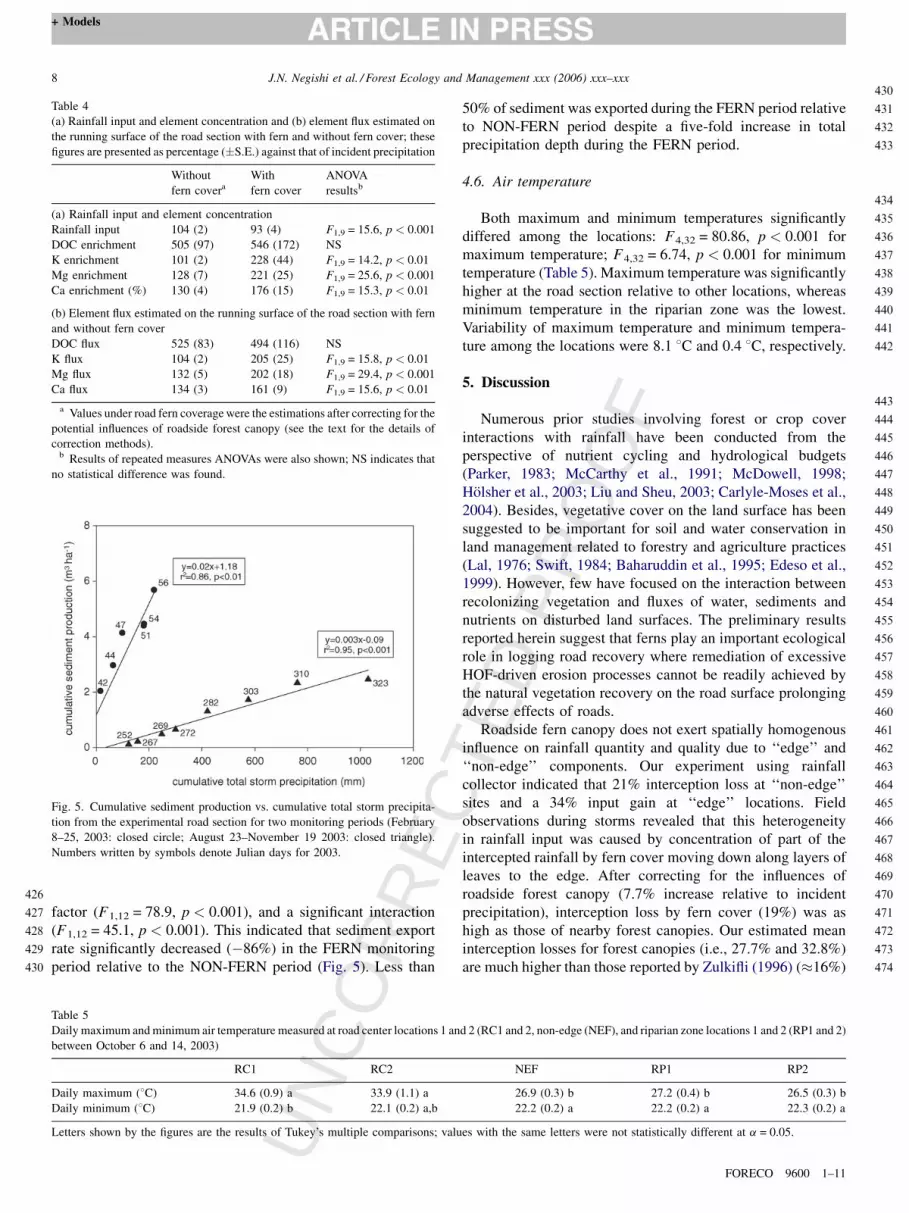
Fig. 5. Cumulative sediment production vs. cumulative total storm precipita-
tion from the experimental road section for two monitoring periods (February
8–25, 2003: closed circle; August 23–November 19 2003: closed triangle).
Numbers written by symbols denote Julian days for 2003.
Table 4
(a) Rainfall input and element concentration and (b) element flux estimated on
the running surface of the road section with fern and without fern cover; these
figures are presented as percentage (�S.E.) against that of incident precipitation
Without
fern covera
With
fern cover
ANOVA
resultsb
(a) Rainfall input and element concentration
Rainfall input 104 (2) 93 (4) F1,9 = 15.6, p < 0.001
DOC enrichment 505 (97) 546 (172) NS
K enrichment 101 (2) 228 (44) F1,9 = 14.2, p < 0.01
Mg enrichment 128 (7) 221 (25) F1,9 = 25.6, p < 0.001
Ca enrichment (%) 130 (4) 176 (15) F1,9 = 15.3, p < 0.01
(b) Element flux estimated on the running surface of the road section with fern
and without fern cover
DOC flux 525 (83) 494 (116) NS
K flux 104 (2) 205 (25) F1,9 = 15.8, p < 0.01
Mg flux 132 (5) 202 (18) F1,9 = 29.4, p < 0.001
Ca flux 134 (3) 161 (9) F1,9 = 15.6, p < 0.01
a Values under road fern coverage were the estimations after correcting for the
potential influences of roadside forest canopy (see the text for the details of
correction methods).b Results of repeated measures ANOVAs were also shown; NS indicates that
no statistical difference was found.
RRfactor (F1,12 = 78.9, p < 0.001), and a significant interaction
(F1,12 = 45.1, p < 0.001). This indicated that sediment export
rate significantly decreased (�86%) in the FERN monitoring
period relative to the NON-FERN period (Fig. 5). Less than
UN
COTable 5
Daily maximum and minimum air temperature measured at road center locations 1 an
between October 6 and 14, 2003)
RC1 RC2
Daily maximum (8C) 34.6 (0.9) a 33.9 (1.1) a
Daily minimum (8C) 21.9 (0.2) b 22.1 (0.2) a,b
Letters shown by the figures are the results of Tukey’s multiple comparisons; valu
CTE
D P
RO
OF
50% of sediment was exported during the FERN period relative
to NON-FERN period despite a five-fold increase in total
precipitation depth during the FERN period.
4.6. Air temperature
Both maximum and minimum temperatures significantly
differed among the locations: F4,32 = 80.86, p < 0.001 for
maximum temperature; F4,32 = 6.74, p < 0.001 for minimum
temperature (Table 5). Maximum temperature was significantly
higher at the road section relative to other locations, whereas
minimum temperature in the riparian zone was the lowest.
Variability of maximum temperature and minimum tempera-
ture among the locations were 8.1 8C and 0.4 8C, respectively.
5. Discussion
Numerous prior studies involving forest or crop cover
interactions with rainfall have been conducted from the
perspective of nutrient cycling and hydrological budgets
(Parker, 1983; McCarthy et al., 1991; McDowell, 1998;
Holsher et al., 2003; Liu and Sheu, 2003; Carlyle-Moses et al.,
2004). Besides, vegetative cover on the land surface has been
suggested to be important for soil and water conservation in
land management related to forestry and agriculture practices
(Lal, 1976; Swift, 1984; Baharuddin et al., 1995; Edeso et al.,
1999). However, few have focused on the interaction between
recolonizing vegetation and fluxes of water, sediments and
nutrients on disturbed land surfaces. The preliminary results
reported herein suggest that ferns play an important ecological
role in logging road recovery where remediation of excessive
HOF-driven erosion processes cannot be readily achieved by
the natural vegetation recovery on the road surface prolonging
adverse effects of roads.
Roadside fern canopy does not exert spatially homogenous
influence on rainfall quantity and quality due to ‘‘edge’’ and
‘‘non-edge’’ components. Our experiment using rainfall
collector indicated that 21% interception loss at ‘‘non-edge’’
sites and a 34% input gain at ‘‘edge’’ locations. Field
observations during storms revealed that this heterogeneity
in rainfall input was caused by concentration of part of the
intercepted rainfall by fern cover moving down along layers of
leaves to the edge. After correcting for the influences of
roadside forest canopy (7.7% increase relative to incident
precipitation), interception loss by fern cover (19%) was as
high as those of nearby forest canopies. Our estimated mean
interception losses for forest canopies (i.e., 27.7% and 32.8%)
are much higher than those reported by Zulkifli (1996) (�16%)
FORECO 9600 1–11
d 2 (RC1 and 2, non-edge (NEF), and riparian zone locations 1 and 2 (RP1 and 2)
NEF RP1 RP2
26.9 (0.3) b 27.2 (0.4) b 26.5 (0.3) b
22.2 (0.2) a 22.2 (0.2) a 22.3 (0.2) a
es with the same letters were not statistically different at a = 0.05.

C
J.N. Negishi et al. / Forest Ecology and Management xxx (2006) xxx–xxx 9
+ Models
474
475
476
477
478
479
480
481
482
483
484
485
486
487
488
489
490
491
492
493
494
495
496
497
498
499
500
501
502
503
504
505
506
507
508
509
510
511
512
513
514
515
516
517
518
519
520
521
522
523
524
525
526
527
528
529
530
531
531
532
533
534
535
536
537
538
539
540
541
542
543
544
545
546
547
548
549
550
551
552
553
554
555
556
557
558
559
560
561
562
563
564
565
566
567
568
569
570
571
572
573
574
575
576
577
578
579
580
581
582
583
584
585
586
587
588
NC
OR
RE
based on two years of continuous measurements in a forested
plot (300 m2) on a hillslope of BTEWC1. It is likely that the
small sample size (six storms) and short duration (2 weeks) of
our event-based monitoring together with the fixed rain gauge
locations overestimated interception losses of forest canopies,
most likely because we sampled few relatively large storms for
which interception losses are less important (e.g., Parker, 1983;
Sinun et al., 1992; Zulkifli, 1996). As similar evapotranspira-
tion processes likely account for interception losses in both tree
and fern canopies, long-term fern interception losses are also
expected to be lower.
Forest throughfall is often enriched with K, Ca, and Mg, with
K and Ca originating mostly from tissue leaching, and some Mg
coming from dry deposition (Parker, 1983). Our results are
generally consistent in that they show throughfall is enriched in
all four elements examined for both fern cover and forest
canopy. Reexamination of Zulkifli (1996) incident precipitation
and throughfall data produced higher (K: 859%), comparable
(Mg: 428%), and lower (Ca: 139%) average enrichment ratios
for respective nutrients relative to our figures. The deviation of
our results from Zulkifli (1996) figures is most likely due to the
small number of sampled storms in our wet season investigation
because concentration of throughfall solutes tends to decline
during a period of continuous high rainfall events (e.g.,
McDowell, 1998). Therefore, our figures should not be
considered as representative of long-term trends. Nevertheless,
our results at least suggest that forest canopy and fern cover
affect rainfall quality differently, despite similar interception
losses. For example, only K had a similarly high enrichment
ratio for fern cover relative to the forested plots. Enrichment
ratio variability may be attributable to the differences in surface
texture, nutrient contents, and surface–volume ratio of leaves
(e.g., Luxmoore et al., 1981). Another possible explanation for
such differences in enrichment ratios is the structural
characteristics of tree canopy and fern cover. For example,
tree canopy throughfall is subject to the effects of branches and
bark surface that tend to be rich in dissolved organic carbon in
the form of organic acid, whereas fern cover lacks such
structures (Carlisle et al., 1967; Parker, 1983; Liu and Sheu,
2003).
After correcting for roadside forest canopy input, presence
of fern cover significantly reduced (�10%) rainfall input and
increased flux of K (+101%), Mg (+70%), and Ca (+26%) onto
the road surface. DOC flux did not increase largely because fern
cover does not significantly enrich throughfall with DOC. Since
logging roads were primarily constructed by displacement of
fertile surface soil, the exposed road surface was similar to the
compacted mass of the original Bt/Bw subsoil horizon in the
study catchment. Such deeper horizons provide poor founda-
tions for plant growth due to limited nutrients (e.g., Gillman
et al., 1985; Pinard et al., 1996). In fact, total nitrogen and
carbon contents, and exchangeable forms of K, Mg, and Ca
within the clay-rich Bt/Bw horizon on the hillslope were <20%,
<20%, <20%, <20%, and <85% of the respective values
found within the surface organic-rich horizons of this study area
(Morisada et al., 2004). Unfortunately, our study did not
examine potentially the most important nutrients such as
UTED
PR
OO
F
nitrogen and phosphorous limiting, and thus our discussion is
limited to K, Mg, and Ca. Deficiency of K, Mg, and Ca in soil
could severely limit plant development (Tisdale et al., 1985).
For instance, K is of paramount importance as an activator of
enzymes crucial in various physiological processes; plants
deficient in K are also less able to withstand water stress, which
may frequently occur on the road surfaces during dry seasons.
Furthermore, shortages of Mg and Ca could suppress
photosynthetic activities and cell elongation and development.
Therefore, fern cover provides potentially important subsidies
of cations in dissolved forms to nutrient-poor road surfaces,
which may in turn facilitate plant recovery.
The estimated runoff reduction of 4.8 mm during the FERN
period was likely caused by combinations of two processes
related to fern cover: interception of rainfall input and improved
capacity of road surface to retain rainfall and impede runoff.
The latter process can be greatly facilitated by commonly
observed occurrence of organic debris (dead fern leaves) on the
road surface. Such debris provides physical roughness and a
foundation of porous organic matter on the road surface,
gradually improving moisture retention capacity of rather
smooth and bare road surface. Direct estimation of event-based
interception loss onto road surface only accounted for an
average of 25% of reduction predicted from road runoff
monitoring. These results suggest that fern cover was more
influential on road runoff through improved surface moisture
retention capacity compared to interception loss. Our findings
differ from previous studies in that road runoff volume
reduction was caused by revegetation from the roadside
(cutslope and fillslope; see Fig. 3) rather than the road surface
(e.g., Beschta, 1978; Baharuddin et al., 1995; Luce and Black,
1999). Thus, fern did not affect HOF volume directly by its
structure but indirectly though interception loss and its debris.
Frequent road surface wash hinders seeds’ settlements on the
road surface (Pinard et al., 1996); reduction of surface runoff
should increase probability of seedlings to successfully
establish on the surface. Nevertheless, net influence of fern
canopy on road runoff volume will be likely to be much less for
larger storms in particular with substantial subsurface flow
input.
Earlier studies have shown that reduced sediment loss from
disturbed surfaces coincided with vegetation recovery (e.g.,
Beschta, 1978; Baharuddin et al., 1995). Three causes of
erosion provided dominant sediment sources in our study site:
(1) raindrop impacts, (2) tractive force of surface runoff (HOF
and intercepted subsurface return flow), and (3) surface
disturbance by vehicles and motorcycles. Fern cover and
debris potentially reduced surface erosion by directly suppres-
sing the raindrop impacts and tractive force; interception of
raindrops near the ground surface by fern leaves should
substantially reduce raindrop impact whereas reduced runoff
volume and increased roughness should lower tractive forces
(see also Woo et al., 1997). We cannot reject the possibility that
the reduction in sediment export was partly related to depletion
of sediment sources as sporadic four-wheel vehicle traffic
(<once a week) ceased due to road failure in February 2003.
Even after that time, however, motorcycles occasionally
FORECO 9600 1–11

E
J.N. Negishi et al. / Forest Ecology and Management xxx (2006) xxx–xxx10
+ Models
588
589
590
591
592
593
594
595
596
597
598
599
600
601
602
603
604
605
606
607
608
609
610
611
612
613
614
615
616
617
618
619
620
621
622
623
624
625
626
627
628
629
630
631
632
633
634
635
636
637
638
639
640
641
642
643
643
644
645
646
647
648
649
650
651
652
653
654
655
656
657
658
659
660
661
662
663
664
665
666
667
668
669
670
671
672
673
674
675
676
677
678
679
680
681
682
683
684
685
686
687
688
689
690
691
692
693
694
695
696
697
698
699
700
701
NC
OR
R
traveled along the logging road, and tramping by cows and
humans continued to be common. More importantly, we
observed patches of sediment deposits apparently formed by
fern debris on the road surface during fern growth period. Thus,
at least part of reduced sediment export rate was attributed to
the retardation of rain splash erosion by fern cover, and also
increased surface roughness related to fern debris on the road
surface. Moreover, it is conceivable that patches of deposited
sediment mixed with fern debris would not only form a good
foundation for subsequent soil development, but also poten-
tially reduce surface erosion due to intercepted subsurface
runoff for which fern cover has a limited direct influence.
Soil with low porosity and drainage efficiency leads to high
seeding mortality (Lozlowski, 1999); poor nutrient levels
further exacerbate mortality. Remediation of forest road
surfaces that are degraded by compaction or/and soil
displacement may be greatly facilitated by the intrusion of
roots of pioneer plants and the activity of various decomposing
organisms (e.g., Aina, 1984). In particular, biota such as
termites and earthworms contribute to formation of fertile soils
and thus nutrient cycling of tropical ecosystems (e.g., Collins,
1981; Aina, 1984). However, harsh microclimate environments
can limit such biological processes that are important for
natural recovery of road surfaces. Temperature as one important
microclimate component reached 40 8C in the open road on one
occasion (14 October 2003); beneath fern cover temperatures
remained below 30 8C, similar to those of riparian zones where
temperature fluctuation was the lowest compared with other
parts of the catchment (Negishi, unpublished data). In fact, our
preliminary study suggest that decomposition rates of wood and
leaf detritus was lower in open areas such as roads and landing
areas relative to forested hillslopes partly due to absence of
termites (Noguchi et al., 2005). On-going studies examine
returning of ecological functioning (e.g., organic matter
decomposition) in relation with the recovery of physical
environments on the logging roads.
6. Conclusions
Our findings suggest that roadside fern growth plays an
important ecological role in road recovery through the
following processes: (1) reduction of HOF (�4.8 mm), (2)
reduction of sediment export rate (�84%), (3) enhanced fluxes
of selected nutrients (K: +101%, Mg: +70%, Ca: +26%), and
(4) suppression of maximum air temperature (�7 8C).
However, our results should be interpreted with several
limitations due to a relatively short monitoring period for
some variables and observations restricted over relatively small
storm events. For example, reduction of HOF and nutrient flux
was likely overestimated with absence of relatively large
events, requiring further studies with a long-term monitoring
period and site replicates.
D. curranii is often recognized as a ‘nuisance plant’ because
it prevents other plants from establishing underneath due to
heavy shading and formation of thickets (e.g., Wee, 1984;
Russell et al., 1998). Thus, the role of this fern needs to be
carefully evaluated before consideration in forest management.
UCTE
D P
RO
OF
In our study site, natural revegetation on the surface of logging
roads cannot be expected until the severely eroded and
compacted surface conditions are ameliorated. Without roadside
shrub growth, such a stage will not be reached until roadside trees
grow large enough to provide canopy cover that reduces incident
precipitation as well as raindrop impact, providing organic
detritus to the ground and microclimate suitable for biota. D.
curranii likely facilitates this process by providing cover and
conditioning soils prior to the establishment of trees along the
road, which may replace these functional roles. This fern species
is intolerant of shading and dies off in light-limited conditions
under forest canopy. We observed no growth of D. curranii along
a 40-year-old logging road in C1 where a well-developed forest
canopy exists. Instead, various types of tree species are currently
growing on the road surface. Therefore, we preliminarily
conclude that at least within an initial period of 40 years, road
surface revegetation and recovery is likely to benefit from
roadside fern growth.
Acknowledgements
This project is partially funded by National University of
Singapore (#R-109-000-031-112). FRIM staff and Mahmud
provided logistical support. Insightful discussion with Alan D.
Ziegler greatly enriched the quality of the manuscript. We also
thank the State Forestry Department of Selangor for giving
permission to use the Bukit Tarek Experimental Watershed.
References
Aina, P.O., 1984. Contribution of earthworms to porosity and water infiltration
in a tropical soil under forest and long-term cultivation. Pedbiologia 26,
131–136.
Allison, C., Sidle, R.C., Tait, D., 2004. Application of decision analysis to forest
road deactivation in unstable terrain. Environ. Manage. 33, 173–185.
Baharuddin, K., Mokhtaruddin, A.M., Nik Muhamad, M., 1995. Surface runoff
and soil loss from a skid trail and a logging road in a tropical forest. J. Trop.
Forest Sci. 7, 558–569.
Beschta, R.L., 1978. Long-term patterns of sediment production following road
construction and logging in the Oregon Coast range. Water Resour. Res. 14,
1011–1016.
Campbell, I.C., Doeg, T.J., 1989. Impacts of timber harvesting and production
of streams: a review. Aust. J. Mar. Fresh. Res. 40, 519–539.
Carlisle, A., Brown, A.H.F., White, E.J., 1967. The nutrient content of tree stem
flow and ground flora litter and leachates in a Sessile Oak (Quercus petraea)
woodland. J. Ecol. 55, 615–627.
Carlyle-Moses, D.E., Laureano, J.S.F., Price, A.G., 2004. Throughfall and
throughfall spatial variability in Madrean oak forest communities of north-
eastern Maxico. J. Hydrol. 297, 124–135.
Collins, N.M., 1981. The role of termites in the decomposition of wood and leaf
litter in the southern Guinea Savanna of Nigeria. Oecologia 51, 389–399.
Edeso, J.M., Merino, A., Gonzalez, M.J., Marauri, P., 1999. Soil erosion under
different harvesting managements in steep forestlands from northern Spain.
Land Degrad. Dev. 10, 79–88.
Gillman, G.P., Sinclair, D.F., Knowlton, R., Keys, M.G., 1985. The effect on
some soil chemical properties of the selective logging of a north Queensland
rainforest. Forest Ecol. Manage. 12, 195–214.
Guariguata, M.R., Dupuy, J.M., 1997. Forest regeneration in abandoned logging
roads in lowland Costa Rica. Biotropica 29, 15–28.
Holsher, D., Kohler, L., Leuschner, C., Kappelle, M., 2003. Nutrient fluxes in
stemflow, and throughfall in three successional stages of upper montane rain
forest in Costa Rica. J. Trop. Ecol. 19, 557–565.
FORECO 9600 1–11

C
J.N. Negishi et al. / Forest Ecology and Management xxx (2006) xxx–xxx 11
+ Models
701702
703
704
705
706
707
708
709
710
711
712
713
714
715
716
717
718
719
720
721
722
723
724
725
726
727
728
729
730
731
732
733
734
735
736
737
738
739
740
741
742
743
744
745
746
747
748
749
750
751
752
753
754
754
755
756
757
758
759
760
761
762
763
764
765
766
767
768
769
770
771
772
773
774
775
776
777
778
779
780
781
782
783
784
785
786
787
788
789
790
791
792
793
794
795
796
797
798
799
800
801
802
803
804
805
806
807807
E
Iwata, T., Nakano, S., Inoue, M., 2003. Impacts of past riparian deforestation on
stream communities in a tropical rainforest in Borneo. Ecol. Appl. 13, 461–
473.
Jones, J.A., Grant, G.E., 1996. Peak flow responses to clear-cutting and roads in
small and large basins, western Cascades, Oregon. Water Resour. Res. 32,
959–974.
Kamaruzaman, J., 1996. Estimation of rate of recovery of disturbed soils from
ground-based logging in Peninsular Malaysia. J. Trop. Forest Sci. 9, 88–100.
Klute, A., Dirksen, C., 1986. Hydraulic conductivity and diffusivity: laboratory
methods. In: Klute (Eds.), Methods of Soil Analysis. Part 1. Monograph 9.
American Society of Agronomy, Madison, WI, USA.
Lal, R., 1976. Soil erosion on alfisols in western Nigeria. 1. Effects of slope,
crop rotation and residue management. Geoderma 16, 363–375.
Liu, C.P., Sheu, B.H., 2003. Dissolved organic carbon in throughfall, stemflow,
soil solution, and stream water at the Guandaushi subtropical forest in
Taiwan. Forest Ecol. Manage. 172, 315–325.
Lozlowski, T.T., 1999. Soil compaction and growth of woody plants. Scand. J.
Forest Res. 14, 596–619.
Luce, C.H., Black, T., 1999. Sediment production from forest roads in western
Oregon. Water Resour. Res. 35, 2561–2570.
Luxmoore,R.J.,Grizzard,T.,Strand,R.H.,1981.Nutrient translocationintheouter
canopy and understory of an eastern deciduous forest. Forest Sci. 27, 505–518.
McCarthy, E.J., Skaggs, R.W., Farnum, P., 1991. Experimental determination of
the hydrologic components of a drained forest watershed. Trans. ASAE 34,
2031–2039.
McDowell, W.H., 1998. Internal nutrient fluxes in a Puerto Rican rain forest. J.
Trop. Ecol. 14, 521–536.
Megahan, W.F., 1983. Hydrologic effects of clearcutting and wildfire on steep
granitic slopes on Idaho. Water Resour. Res. 19, 811–819.
Megahan, W.F., Clayton, J.L., 1983. Tracing subsurface flow on roadcuts on
steep, forested slopes. Soil Sci. Soc. Am. J. 47, 1063–1067.
Montgomery, D.R., 1994. Road surface drainage, channel initiation, and slope
instability. Water Resour. Res. 30, 1925–1932.
Morisada, K., Ohnuki, Y., Noguchi, S., Wan Rashida, W.A.K., Zulkifli, Y.,
Ahmad, A.S., 2004. Impacts of selective logging on surface soil proper-
ties—a case study at Bukit Tarek Experimental Watershed, Peninsular
Malaysia. In: Matsumoto, Y., Ueda, E., Kobayashi, S. (Eds.), Proceed-
ings of the International Workshop on the Landscape Level Rehabilitation
of Degraded Tropical Forests, March 2 and 3. Forestry and Forest Product
Research Institute, Tsukuba, Japan, pp. 29–36.
Negishi, J.N., Noguchi, S., Sidle, R.C., Abdul Rahim, N., 2004. Some observa-
tions on logging road recovery: implications to road rehabilitations. In:
Matsumoto, Y., Ueda, E., Kobayashi, S. (Eds.), Proceedings of the Inter-
national Workshop on the Landscape Level Rehabilitation of Degraded
Tropical Forests, March 2 and 3. Forestry and Forest Product Research
Institute, Tsukuba, Japan, pp. 37–42.
Noguchi, S., Negishi, J.N., Abdul Rahim, N., 2005. Site effects on woody
materials and leaf litter decomposition in a tropical rain forest Peninsular
Malaysia: preliminary results. JIRCAS Working Report No. 39, pp. 28–31.
Noguchi, S., Abdul Rahim, N., Tani, M., Tsuboyama, Y., 1996. Rainfall
characteristics of tropical rain forest and temperate forest: comparison
between Bukit Tarek in Peninsular Malaysia and Hitachi Ohta in Japan.
J. Trop. Forest Sci. 9, 206–220.
UN
CO
RR
TED
PR
OO
F
Noguchi, S., Baharuddin, K., Zulkifli, Y., Tsuboyama, Y., Tani, M., 2003. Depth
and physical properties of soil in a forest and rubber plantation in Peninsular
Malaysia. J. Trop. Forest Sci. 15, 513–530.
Parker, G.G., 1983. Throughfall and stemflow in the forest nutrient cycle. Adv.
Ecol. Res. 13, 57–133.
Piggott, A.G., 1988. Ferns of Malaysia in color. Tropical press SDN BHD KL,
Malaysia.
Pinard, M., Howlett, B., Davidson, D., 1996. Site conditions limit pioneer tree
recruitment after logging of Dipterocarp forests in Sabah, Malaysia. Bio-
tropica 28, 2–12.
Pinard, M.A., Barker, M.G., Tay, J., 2000. Soil disturbance and post-logging
forest recovery on bulldozer paths in Sabah, Malaysia. Forest Ecol. Manage.
130, 213–225.
Reid, L.M., Dunne, T., 1984. Sediment production from forest road surfaces.
Water Resour. Res. 20, 1753–1761.
Russell, A.E., Raich, J.W., Vitousek, P.M., 1998. The ecology of the climbing
fern Dicranopteris linearis on windward Mauna Loa, Hawaii. J. Ecol. 86,
765–779.
Saifuddin, S., Abdul Rahim, N., Abudl Rasid, M.F., 1991. Watershed research
in forest plantation. 1. Establishment and physical characteristics of Bukit
Tarek watershed. Forest Research Institute Malaysia Research Pamphlet,
No. 110, FRIM, Kuala Lumpur, Malaysia.
Sidle, R.C., Sasaki, S., Otsuki, M., Noguchi, S., Abdul Rahim, N., 2004.
Sediment pathways in a tropical forest: effects of logging roads and skid
trails. Hydrol. Process. 18, 703–720.
Sidle, R.C., Ziegler, A.D., Negishi, J.N., Abdul Rahim, N., Siew, R., Turkel-
boom, F., in press. Erosion processes in steep terrain—truths, myths, and
uncertainties related to forest management in Southeast Asia. Forest Ecol.
Manage. (doi: 10.1016/j.foreco.2005.12.019).
Sinun, W., Meng, W.W., Douglas, I., Spencer, T., 1992. Throughfall, stemflow,
overland flow and throughflow in the Ulu Segama rain forest, Sabah,
Malaysia. Philos. T. Roy. Soc. B 335, 389–395.
Siti, A.S., Baharuddin, K., Ahmad, A.S., 2002. Climate variation during El-
Nino Episode, at Bukit Tarek Experimental Watershed (BTEW) Kerling,
Selangor. Research Report of the NIES/FRIM/UPM Joint Research Project.
National Institute for Environmental Studies, Japan.
Swift Jr., L.W., 1984. Gravel and grass surfacing reduces soil loss from
mountain roads. Forest Sci. 30, 657–670.
Tisdale, S.L., Nelson, W.L., Beaton, J.D., 1985. Soil Fertility and Fertilizers.
Macmillan Publishing Company, New York.
Wee, Y., 1984. Common Ferns and Fern-allies of Singapore. Malayan Nature
Society, Singapore Branch.
Woo, M., Fang, G., diCenzo, P.D., 1997. The role of vegetation in the
retardation of rill erosion. Catena 29, 145–159.
Ziegler, A.D., Giambelluca, T.W., 1997. Importance of rural roads as source
areas for runoff in mountainous areas of northern Thailand. J. Hydrol. 196,
204–229.
Ziegler, A.D., Sutherland, R.A., Giambelluca, T.W., 2000. Runoff genera-
tion and sediment production on unpaved roads, footpaths and agricul-
tural land surfaces in northern Thailand. Earth Surf. Proc. Land. 25, 519–
534.
Zulkifli Y., 1996. Nutrient cycling in secondary rainforest catchments of
Peninsular Malaysia. PhD thesis. University of Manchester, Manchester.
FORECO 9600 1–11