Monitoring of Street Investigations, Erie Canal Harbor
59
Panamerican Consultants, Inc. Buffalo Branch Office 2390 Clinton Street Buffalo, NY 14227 Tel: (716) 821-1650 Fax: (716) 821-1607 Corporate Headquarters 924 26th Avenue East Tuscaloosa, AL 35404 Tel: (205) 556-3096 Fax: (205) 556-1144 Memphis Branch Office 15 South Idlewild Memphis, TN 38104 Tel: (901) 274-4244 Fax: (901) 274-4525 Tampa Branch Office 5313 Johns Road Suite 205 Tampa, FL 33634 Tel: (813) 884-6351 Fax: (813) 884-5968 MONITORING OF STREET INVESTIGATIONS (COMMERCIAL, LLOYD, HANOVER, WEST PERRY AND PRIME STREETS) AND COMMERCIAL SLIP WALL EXPOSURE, ERIE CANAL HARBOR PROJECT, CITY OF BUFFALO, ERIE COUNTY, NEW YORK Prepared for: Parsons, Brinckerhoff, Quade & Douglas, Inc. 50 Lakefront Boulevard Suite 111 Buffalo, New York 14202 and The Empire State Development Corporation 420 Main Street Suite 717 Buffalo, New York 14202 Prepared by: PANAMERICAN CONSULTANTS, INC. Buffalo Branch Office 2390 Clinton Street Buffalo, New York 14227-1735 (716) 821-1650 October 2003
-
Upload
wisconsinhistory -
Category
Documents
-
view
3 -
download
0
Transcript of Monitoring of Street Investigations, Erie Canal Harbor
PanamericanConsultants, Inc.
Buffalo Branch Office 2390 Clinton Street Buffalo, NY 14227 Tel: (716) 821-1650Fax: (716) 821-1607
Corporate Headquarters924 26th Avenue East Tuscaloosa, AL 35404 Tel: (205) 556-3096Fax: (205) 556-1144
Memphis Branch Office15 South IdlewildMemphis, TN 38104 Tel: (901) 274-4244Fax: (901) 274-4525
Tampa Branch Office 5313 Johns Road Suite 205 Tampa, FL 33634 Tel: (813) 884-6351Fax: (813) 884-5968
MONITORING OF STREET INVESTIGATIONS
(COMMERCIAL, LLOYD, HANOVER, WEST PERRY AND
PRIME STREETS) AND COMMERCIAL SLIP
WALL EXPOSURE,
ERIE CANAL HARBOR PROJECT,
CITY OF BUFFALO, ERIE COUNTY, NEW YORK
Prepared for: Parsons, Brinckerhoff, Quade & Douglas, Inc. 50 Lakefront Boulevard Suite 111 Buffalo, New York 14202
and
The Empire State Development Corporation 420 Main Street Suite 717 Buffalo, New York 14202
Prepared by:
PANAMERICAN CONSULTANTS, INC. Buffalo Branch Office 2390 Clinton Street Buffalo, New York 14227-1735 (716) 821-1650
October 2003
MONITORING OF STREET INVESTIGATIONS(COMMERCIAL, LLOYD, HANOVER, WEST PERRY AND
PRIME STREETS) AND COMMERCIAL SLIP WALL EXPOSURE,ERIE CANAL HARBOR PROJECT,
CITY OF BUFFALO, ERIE COUNTY, NEW YORK
Prepared for: Parsons, Brinckerhoff, Quade & Douglas, Inc.
50 Lakefront Boulevard, Suite 111 Buffalo, New York 14202
and
The Empire State Development Corporation 420 Main Street, Ste. 717 Buffalo, New York 14202
Prepared by:
Rebecca J. Emans, M.A., Field DirectorFrank J. Schieppati, Ph.D., Principal Investigator
Robert J. Hanley, M.A., Senior Archaeologist Michael A. Cinquino, Ph.D., Project Director
PANAMERICAN CONSULTANTS, INC. Buffalo Branch Office
2390 Clinton Street Buffalo, New York 14227
(716) 821-1650
October 2003
Panamerican Consultants, Inc. ii Street Investigations Monitoring
Abstract
Panamerican Consultants, Inc. (PCI) was contracted by Parsons, Brinckerhoff, Quade & Douglas, Inc., of Buffalo, New York and The Empire State Development Corporation to monitor exploratory excavations for locating the former Commercial, Lloyd, Hanover, West Perry and Prime Streets. The purpose of this phase of the Erie Canal Harbor Project was to identify the depth, alignment and condition of these streets for later reconstruction and incorporation of these features in the architectural and landscape development of the Inner Harbor. In addition to this monitoring, further excavations of the Commercial Slip walls (along the west side of the slip) and foundation walls (along the east side of the slip) were conducted in order to identify the depth and condition of these walls for later reconstruction and, in the case of the slip walls, to alleviate pressure from overburden.
Panamerican monitored, documented and photo-documented the excavations conducted with a backhoe and trackhoe. Determination of trench locations was based on the superimposition of estimated street locations from historic maps onto a modern engineer’s map. This was done by Parsons, Brinckerhoff, Quade & Douglas.
The excavations conducted for this investigation revealed both intact and non-intact historic period and modern cultural remains present below the surface. Twenty-five trenches were excavated within the project area. Twenty-one of these trenches were excavated in the areas of the former Commercial, Lloyd, Hanover, West Perry and Prime streets. This was done to identify the depths of nineteenth century streets for future potential reconstruction and possible incorporation of these features in the architectural and landscape development of the Inner Harbor. The exploratory investigation identified street remnants in eight of the twenty-one trenches. In only three instances were street pavers articulated with a curb present (Hanover Trenches 2 and 5, West Perry Street Trench 1). Sandstone curbs were found in situ in two other trenches, (Hanover Trenches 1 and 4), although a much later curb was also found in one trench (Prime Street Trench 1). In two trenches (Lloyd Street Trench 3, West Perry Trench 2), only in situ pavers were found. In addition, Hanover Street Trench 3 contained a stone and brick wall and Commercial Street Trench 1 contained a stone foundation and floor. It is interesting to note that the gutters found were formed with pavers placed parallel to the curb. This is a different style of gutter than that found along Lloyd Street during previous investigations (Dean & Barbour Associates n.d.). The Lloyd Street gutter consisted of a series of fist-sized rocks placed in rows. Only small amounts of historic artifacts were found in the fill above the streets. An example is the neck from a milk bottle found in Lloyd Street Trench 3. In the majority of the trenches, the fill above the street remnants contained only modern materials (e.g., a styrofoam cup piece, cans, and pull-tabs).
In addition to this monitoring, further excavations of the Commercial Slip walls (along the west side of the slip) and foundation walls (along the east side of the slip) were conducted in order to identify the depths of these walls for later reconstruction and, in the case of the slip walls, to alleviate pressure from overburden. Four trenches were excavated for this purpose. Artifacts were found within the brick rubble of Commercial Slip Trench 1, and only a few isolated pieces of ceramics were found in Commercial Street Trench 2. No artifacts were found below the sand layer of Lloyd Street Trenches 2 and 3.
Panamerican also observed the remnants of Prime Street previously excavated in 2000 (U.S. Dept. of Transportation 2000; Dean & Barbour Associates n.d.). The Prime Street feature
Panamerican Consultants, Inc. iii Street Investigations Monitoring
remnant, located approximately 125 ft (38 m) south of Lloyd Street Trench 2 and 170 ft (52 m) southwest of Lloyd Street Trench 3, now shows evidence of damage due to exposure. This damage includes breakage and movement of the pavers due to weather conditions (freeze and thaw) as well as vegetation growing between the pavers. In a letter to Dr. Robert Kuhn, NYS OPRHP, dated June 29, 2000, Dean & Barbour (n.d.) describe this remnant of Prime Street as being “unlike Lloyd Street, which continually had upgraded utility services installed at least until the 1920s.” Because the remaining section of Prime Street was sealed by railroad construction in the late 1870s or the 1880s, “there is a possibility that remnants of an earlier Prime Street, including a plank road, may still exist” (Dean & Barbour n.d.). Since this feature now exhibits damage due to exposure, Panamerican suggests that the previously excavated remains of Prime Street be covered with a protective layer of clean sand in a similar fashion as Lloyd Street and its associated buildings.
Panamerican Consultants, Inc. iv Street Investigations Monitoring
Table of Contents
Abstract ......................................................................................................................................ii
List of Figures and Tables ..........................................................................................................v
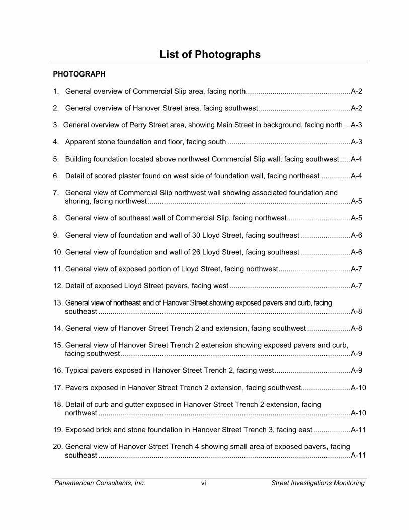
List of Photographs.....................................................................................................................vi
1.0 Introduction .....................................................................................................................1
2.0 Results of the Field Investigation....................................................................................3
3.0 Conclusions and Recommendations ........................................................................... 26
4.0 References .................................................................................................................. 27
Appendices
Appendix A: Photographs
Appendix B: Vitae of Project Principals
Panamerican Consultants, Inc. v Street Investigations Monitoring
List of Figures and Tables
FIGURE
1. Location of the project area in the City of Buffalo, Erie County, New York...........................2
2a. Location of trenches and photo angles in the northwest portion of the project area ............4
2b. Location of trenches and photo angles in the Hanover Street Area .....................................5
2c. Location of trenches and photo angles in the West Perry Street and Prime Street Areas ...6
3. Floor plan of stone floor and foundation in Commercial Street Trench 1 .............................7
4. East profile of stone floor and foundation in Commercial Street Trench 1 ...........................7
5. Northeast profile of Commercial Street Trench 2 .................................................................8
6. Floor plan of Commercial Slip Trench 1 showing stone foundation .................................. 10
7. Northwest profile of interior stone wall in Commercial Slip Trench 1................................. 11
8. Southwest profile of interior stone wall in Commercial Slip Trench 1 ................................ 11
9. Northwest Commercial Slip Trench 1 exterior stone wall. Note timber base of wall.......... 13
10. Northeast wall profile of trench at southwest end of Lloyd Street location ........................ 13
11. Profile of exterior rear wall of 30 Lloyd Street, exposed from sand, facing southeast ....... 14
12. Profile of exterior rear wall of 26 Lloyd Street, exposed from sand, facing southeast ....... 16
13. Floor plan of Lloyd Street Trench 3 ................................................................................... 16
14. Floor plan of Hanover Street Trench 1 showing pavers and curb ..................................... 17
15. Floor plan of Hanover Street Trench 2 and extension. Note variation in paver size and
delineation of possible patched area .................................................................................19
16. Floor plan of Hanover Street Trench 3 showing brick and stone foundation .....................20
17. Floor plan of Hanover Street Trench 4 showing area of pavers, gutter and curb ..............20
18. Floor plan of Hanover Street Trench 5 showing pavers, gutter and curb ..........................22
19. Floor plan of West Perry Street Trench 1 showing gutters, sidewalks, and pavers...........23
20. Partial floor plan of West Perry Street Trench 2 showing area of pavers ..........................23
21. Floor plan of Prime Street Trench 1 showing sandstone curb...........................................25
22. Partial south wall profile of Prime Street Trench 1.............................................................25
TABLE
1. Sample of artifacts found in rooms of Commercial Street Trench 1 .................................. 9
Panamerican Consultants, Inc. vi Street Investigations Monitoring
List of Photographs
PHOTOGRAPH
1. General overview of Commercial Slip area, facing north...................................................A-2
2. General overview of Hanover Street area, facing southwest.............................................A-2
3. General overview of Perry Street area, showing Main Street in background, facing north ...A-3
4. Apparent stone foundation and floor, facing south ............................................................A-3
5. Building foundation located above northwest Commercial Slip wall, facing southwest .....A-4
6. Detail of scored plaster found on west side of foundation wall, facing northeast ..............A-4
7. General view of Commercial Slip northwest wall showing associated foundation and shoring, facing northwest...................................................................................................A-5
8. General view of southeast wall of Commercial Slip, facing northwest...............................A-5
9. General view of foundation and wall of 30 Lloyd Street, facing southeast ........................A-6
10. General view of foundation and wall of 26 Lloyd Street, facing southeast ........................A-6
11. General view of exposed portion of Lloyd Street, facing northwest...................................A-7
12. Detail of exposed Lloyd Street pavers, facing west ...........................................................A-7
13. General view of northeast end of Hanover Street showing exposed pavers and curb, facing southeast ...........................................................................................................................A-8
14. General view of Hanover Street Trench 2 and extension, facing southwest .....................A-8
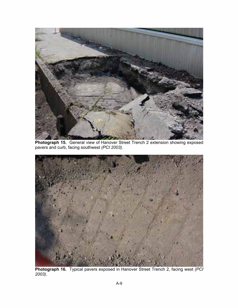
15. General view of Hanover Street Trench 2 extension showing exposed pavers and curb, facing southwest ................................................................................................................A-9
16. Typical pavers exposed in Hanover Street Trench 2, facing west.....................................A-9
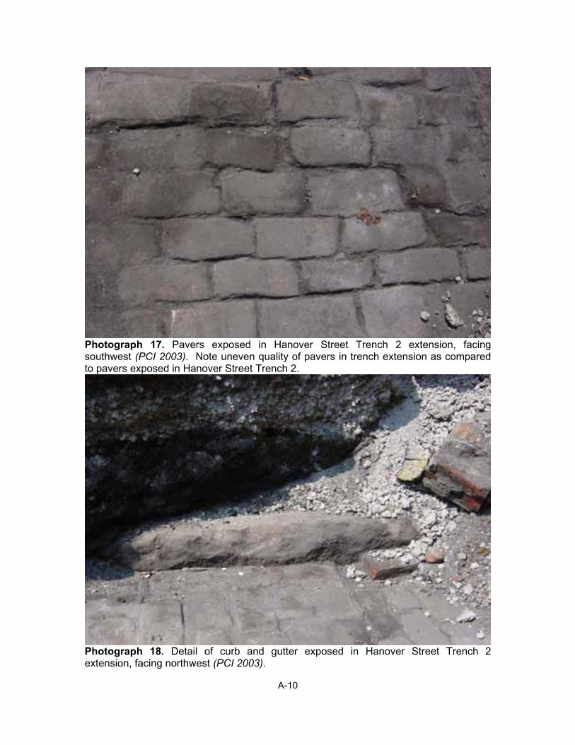
17. Pavers exposed in Hanover Street Trench 2 extension, facing southwest........................A-10
18. Detail of curb and gutter exposed in Hanover Street Trench 2 extension, facing northwest ...........................................................................................................................A-10
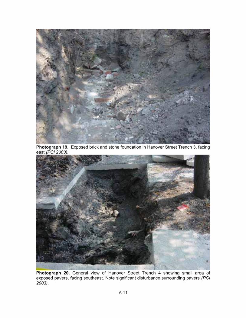
19. Exposed brick and stone foundation in Hanover Street Trench 3, facing east ..................A-11
20. General view of Hanover Street Trench 4 showing small area of exposed pavers, facing southeast ...........................................................................................................................A-11
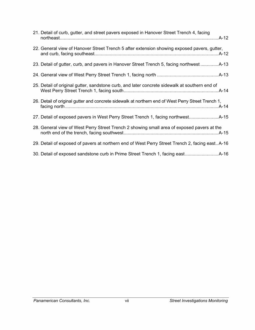
Panamerican Consultants, Inc. vii Street Investigations Monitoring
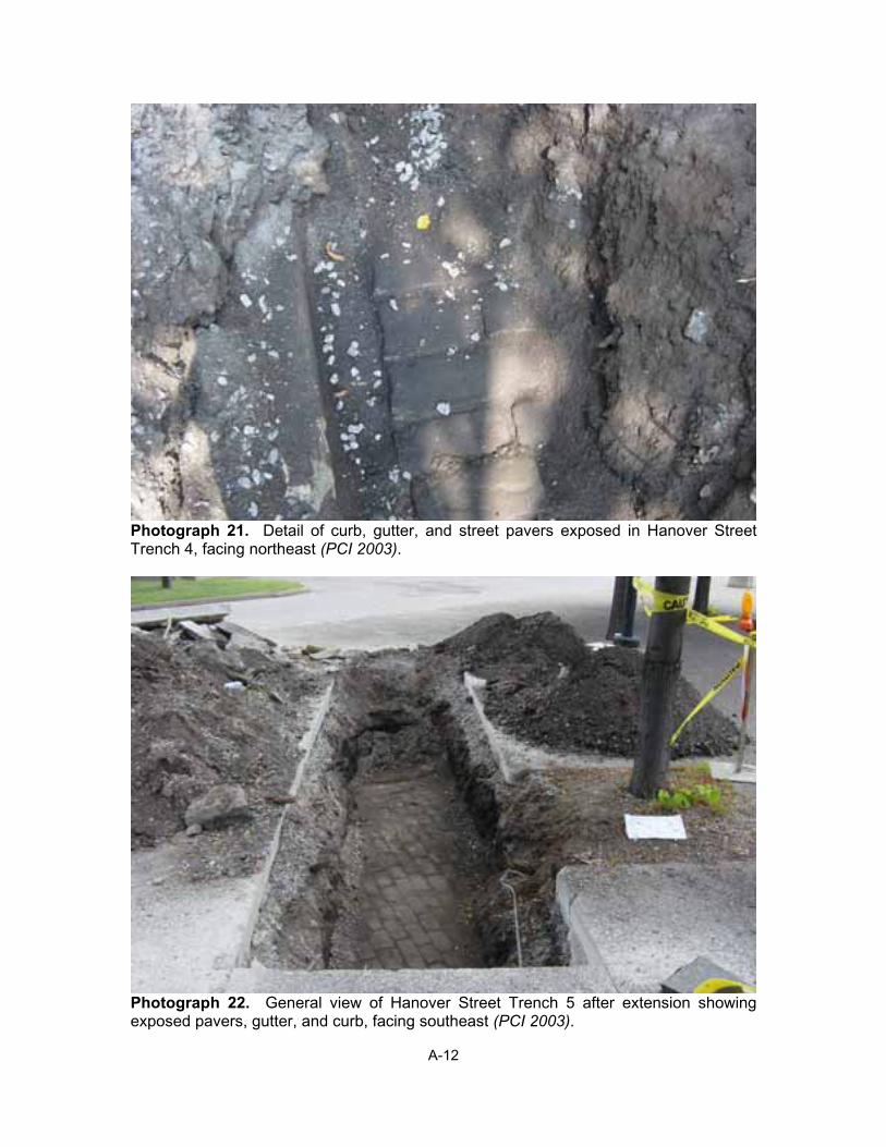
21. Detail of curb, gutter, and street pavers exposed in Hanover Street Trench 4, facing northeast............................................................................................................................A-12
22. General view of Hanover Street Trench 5 after extension showing exposed pavers, gutter, and curb, facing southeast.................................................................................................A-12
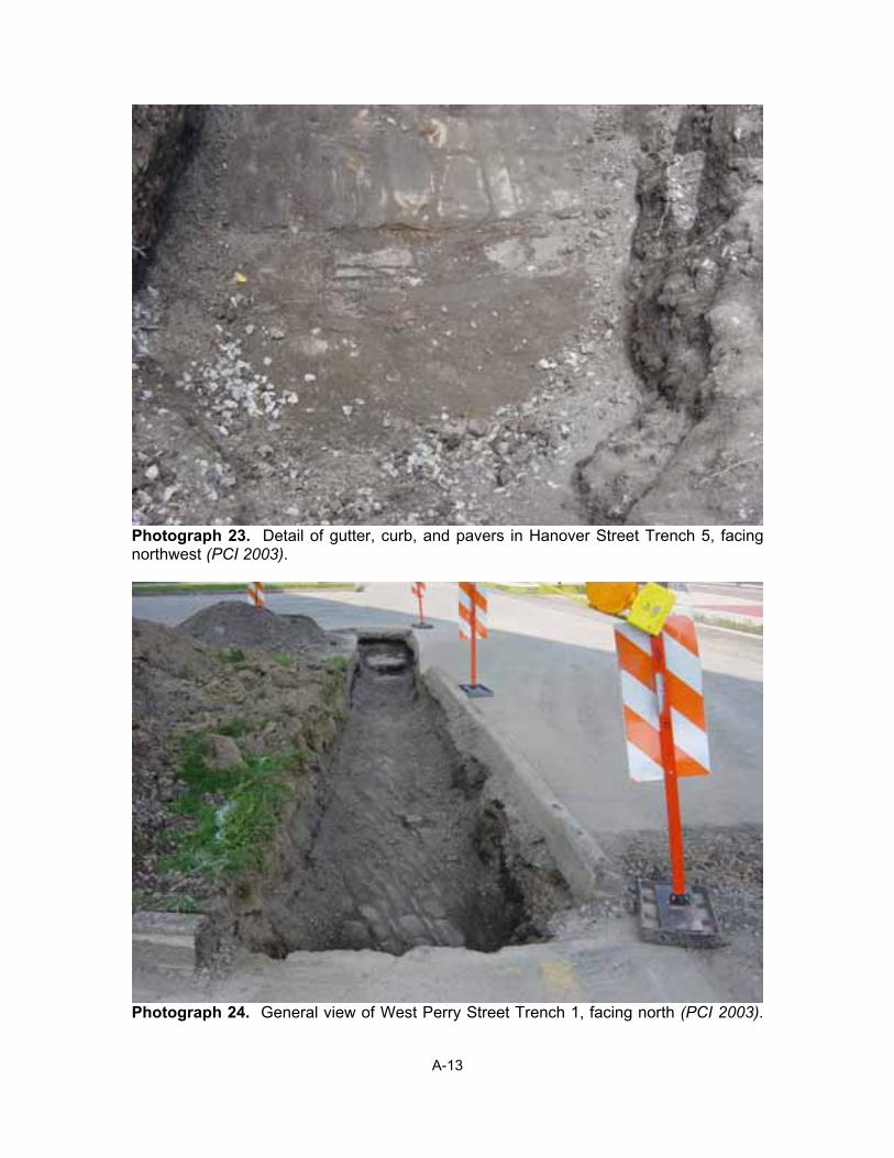
23. Detail of gutter, curb, and pavers in Hanover Street Trench 5, facing northwest ..............A-13
24. General view of West Perry Street Trench 1, facing north ................................................A-13
25. Detail of original gutter, sandstone curb, and later concrete sidewalk at southern end of West Perry Street Trench 1, facing south..........................................................................A-14
26. Detail of original gutter and concrete sidewalk at northern end of West Perry Street Trench 1, facing north ........................................................................................................................A-14
27. Detail of exposed pavers in West Perry Street Trench 1, facing northwest.......................A-15
28. General view of West Perry Street Trench 2 showing small area of exposed pavers at the north end of the trench, facing southwest..........................................................................A-15
29. Detail of exposed of pavers at northern end of West Perry Street Trench 2, facing east..A-16
30. Detail of exposed sandstone curb in Prime Street Trench 1, facing east ..........................A-16
Panamerican Consultants, Inc. 1 Street Investigations Monitoring
1.0 Introduction
Panamerican Consultants, Inc. (Panamerican) was contracted by Parsons, Brinckerhoff, Quade & Douglas, Inc., of Buffalo, New York and The Empire State Development Corporation to monitor exploratory excavations for locating the former Commercial, Lloyd, Hanover, West Perry and Prime Streets (Figure 1). The purpose of this phase of the Erie Canal Harbor Project was to identify the depth, alignment and condition of these streets for later reconstruction and incorporation of these features in the architectural and landscape development of the Inner Harbor. In addition to this monitoring, further excavations of the Commercial Slip walls (along the west side of the slip) and foundation walls (along the east side of the slip) were conducted in order to identify the depth and condition of these walls for later reconstruction and, in the case of the slip walls, to alleviate pressure from overburden.
Panamerican monitored, documented and photo-documented the excavations conducted with a backhoe and trackhoe (Appendix A: Photographs). Determination of trench locations were based on the superimposition of estimated street locations from historic maps onto a modern engineer’s map. This was done by Parsons, Brinckerhoff, Quade & Douglas.
The monitoring was conducted in compliance with the National Historic Preservation Act of 1966, as amended (16 U.S.C. 470 et. seq.) through 1992 (which includes Section 106 compliance); the Archeological and Historic Preservation Act of 1974; and the Advisory Council on Historic Preservation Guidelines for the Protection of Cultural and Historic Properties (36 CFR Part 800). The monitoring also complied with the New York Archaeological Council’s Standards for Archaeological Investigations.
The field-monitoring was conducted between August 20 and 27, 2003. Panamerican personnel involved with the project consisted of Dr. Frank J. Schieppati, Principal Investigator; Ms. Rebecca J. Emans, M.A., Field Director; Mr. Robert J. Hanley III, M.A., Senior Archaeologist, and Dr. Michael A. Cinquino, Project Director.
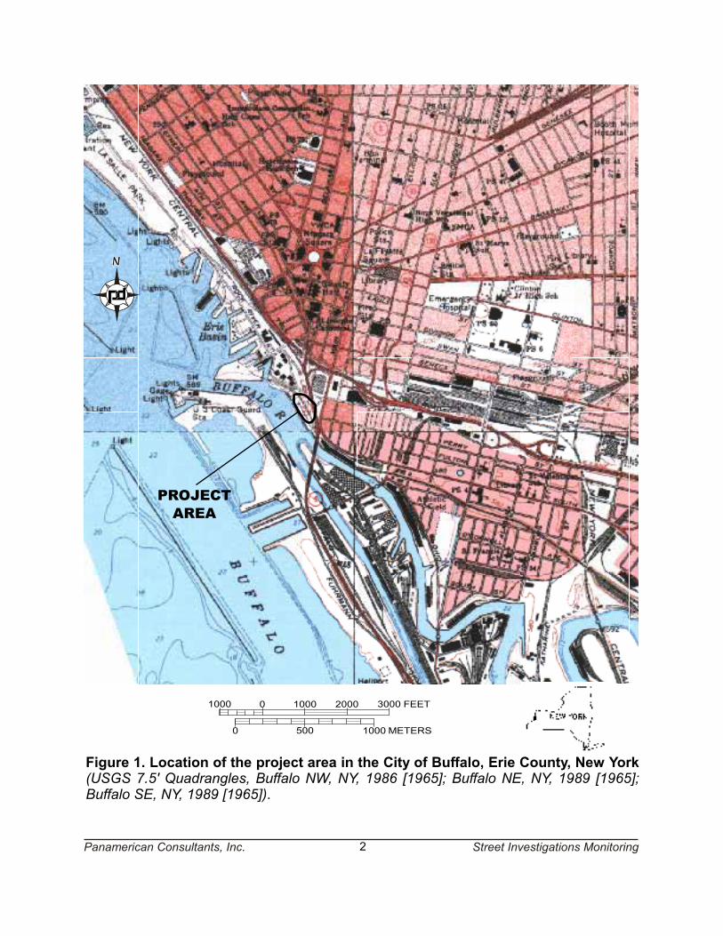
Figure 1. Location of the project area in the City of Buffalo, Erie County, New York(USGS 7.5' Quadrangles, Buffalo NW, NY, 1986 [1965]; Buffalo NE, NY, 1989 [1965];Buffalo SE, NY, 1989 [1965]).
Panamerican Consultants, Inc. 2 Street Investigations Monitoring
1000 0 1000 2000 3000 FEET
10000 500 METERS
PROJECTAREA
Panamerican Consultants, Inc. 3 Street Investigations Monitoring
2.0 Results of the Field Investigation
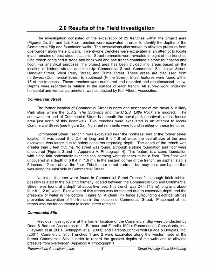
The investigation consisted of the excavation of 25 trenches within the project area (Figures 2a, 2b, and 2c). Four trenches were excavated in order to identify the depths of the Commercial Slip and foundation walls. The excavations also served to alleviate pressure from overburden along the slip walls. Twenty-one trenches were excavated in an attempt to locate intact remains of past street locations. Street remnants were revealed in eight of the trenches One trench contained a stone and brick wall and one trench contained a stone foundation and floor. For analytical purposes, the project area has been divided into areas based on the location of historic streets and the slip: Commercial Street, Commercial Slip, Lloyd Street, Hanover Street, West Perry Street, and Prime Street. These areas are discussed from northwest (Commercial Street) to southeast (Prime Street). Intact features were found within 15 of the trenches. These trenches were numbered and recorded and are discussed below. Depths were recorded in relation to the surface of each trench. All survey work, including horizontal and vertical parameters, was conducted by Foit-Albert, Associates.
Commercial Street
The former location of Commercial Street is north and northeast of the Naval & Military Park slips where the U.S.S. The Sullivans and the U.S.S. Little Rock are moored. The southwestern part of Commercial Street is beneath the naval park boardwalk and a fenced area just north of this boardwalk. Two trenches were excavated in an attempt to locate Commercial Street (see Figure 2a). No street remnants were found in either of these trenches.
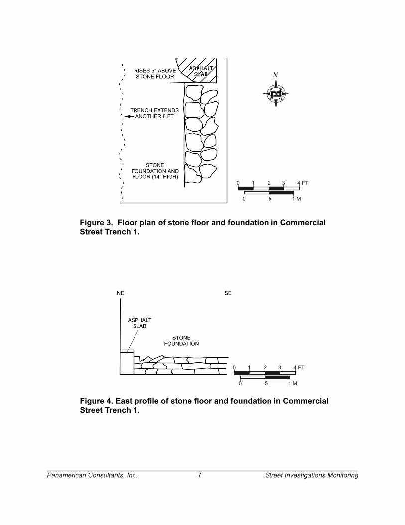
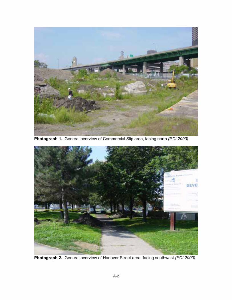
Commercial Street Trench 1 was excavated near the northeast end of the former street location. It was about 8 ft (2.4 m) long and 6 ft (1.8 m) wide; the overall size of the area excavated was larger due to safety concerns regarding depth. The depth of the trench was greater than 5 feet (1.5 m). No street was found, although a stone foundation and floor were uncovered (Figures 3 and 4; Appendix A: Photograph 4). This feature is a stone foundation with slabs lain horizontally over the top, forming what appears to be a floor. This floor was uncovered at a depth of 6 ft 4 in (1.9 m). In the eastern corner of the trench, an asphalt slab is 5 inches (12 cm) above the floor. This feature is not a street, but may be a porch/patio that was along the east side of Commercial Street.
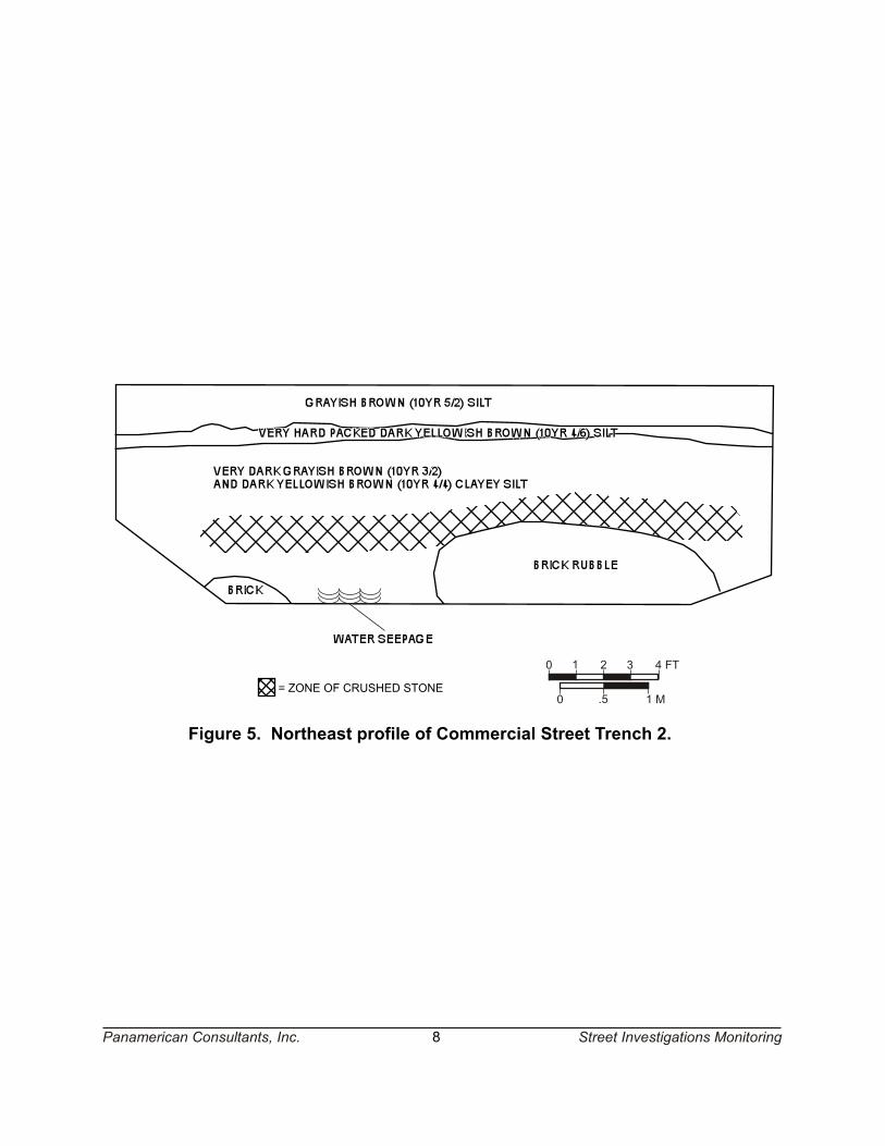
No intact features were found in Commercial Street Trench 2, although brick rubble, possibly related to the building formerly located between the Commercial Slip and Commercial Street, was found at a depth of about five feet. This trench was 24 ft (7.3 m) long and about four ft (1.2 m) wide. Excavation of this trench was terminated due to excessive depth and the presence of water in the bottom (Figure 5). A chain link fence surrounding electrical utilities prevented excavation of the trench in the location of Commercial Street. Placement of this trench was too far southeast to locate street remains.
Commercial Slip
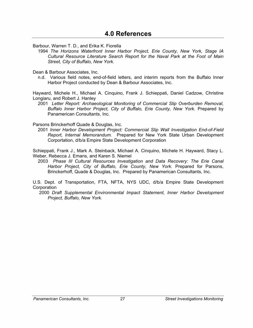
Previous investigations at the former location of the Commercial Slip were conducted by Dean & Barbour Associates (n.d.; Barbour and Fiorella 1994); Panamerican Consultants, Inc. (Hayward et al. 2001, Schieppati et al. 2003); and Parsons Brinckerhoff Quade & Douglas, Inc. (2001). Commercial Slip Trenches 1 and 2 were excavated along the western side of the former Commercial Slip in order to record the greatest depths of the walls and to alleviate pressure from overburden (Appendix A: Photograph 1).
NOTE - Items labelled ascobblestones are actuallysandstone pavers
= PHOTO ANGLE1
8
4
5
6 7
10
9
12
11
1
COMMERCIAL SLIP TRENCH 2
COMMERCIAL STREETTRENCH 2
PRIME STREET(PREVIOUSLY EXCAVATED)
LLOYD STREETTRENCH 2
LLOYD STREET TRENCH 3
LLOYD STREET TRENCH 1
COMMERCIAL SLIPTRENCH 1
COMMERCIAL STREET TRENCH 1
NEGATIVE TEST PIT
Panamerican Consultants, Inc. 4
Figure 2a. Location of trenches and photo angles in the northwest portion of theproject area.
0 50 100 FT
0 15 30 M
Street Investigations Monitoring
NOTE - Items labelled ascobblestones are actuallysandstone pavers
= PHOTOGRAPH ANGLE AND NUMBER13
13
14
16
17
18
20
21
19
23
22
15
2
Panamerican Consultants, Inc. 5
HANOVER STREET TRENCH 5
HANOVER STREET TRENCH 4
HANOVER STREET TRENCH 3
BRICK AND STONE FOUNDATION
HANOVER STREET TRENCH 2
HANOVER STREET TRENCH 1
Figure 2b. Location of trenches and photo angles in the Hanover Street Area.
0 50 100 FT
0 15 30 M
Street Investigations Monitoring
NOTE - Items labelled ascobblestones are actuallysandstone pavers
= PHOTOGRAPH ANGLE AND NUMBER24
29
30 25
26
2728
24
3
Panamerican Consultants, Inc. 6
Figure 2c. Location of trenches and photo angles in the West Perry Street andPrime Street areas. Note: Filled-in test pits had negative results.
PRIME STREET TRENCH 1
WEST PERRY STREETTRENCH 2
WEST PERRY STREET TRENCH 1
0 50 100 FT
0 15 30 M
Street Investigations Monitoring
TRENCH EXTENDSANOTHER 8 FT
STONEFOUNDATION ANDFLOOR (14" HIGH)
RISES 5" ABOVESTONE FLOOR
STONEFOUNDATION
ASPHALTSLAB
Figure 3. Floor plan of stone floor and foundation in CommercialStreet Trench 1.
Figure 4. East profile of stone floor and foundation in CommercialStreet Trench 1.
0 .5 1 M
0 1 2 3 4 FT
0 .5 1 M
0 1 2 3 4 FT
Panamerican Consultants, Inc. 7
NE SE
Street Investigations Monitoring
= ZONE OF CRUSHED STONE0 .5 1 M
0 1 2 3 4 FT
Figure 5. Northeast profile of Commercial Street Trench 2.
Panamerican Consultants, Inc. 8 Street Investigations Monitoring
Panamerican Consultants, Inc. 9 Street Investigations Monitoring
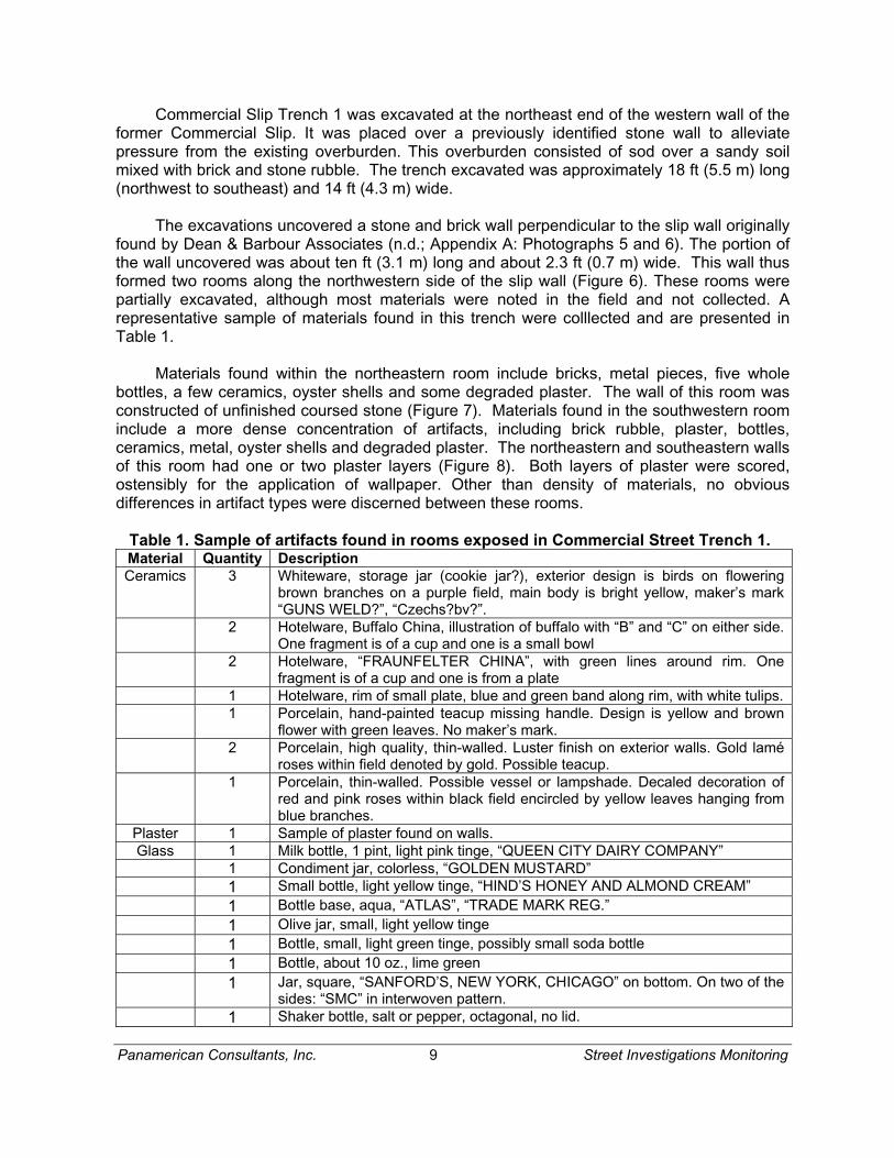
Commercial Slip Trench 1 was excavated at the northeast end of the western wall of the former Commercial Slip. It was placed over a previously identified stone wall to alleviate pressure from the existing overburden. This overburden consisted of sod over a sandy soil mixed with brick and stone rubble. The trench excavated was approximately 18 ft (5.5 m) long (northwest to southeast) and 14 ft (4.3 m) wide.
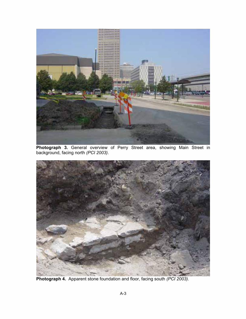
The excavations uncovered a stone and brick wall perpendicular to the slip wall originally found by Dean & Barbour Associates (n.d.; Appendix A: Photographs 5 and 6). The portion of the wall uncovered was about ten ft (3.1 m) long and about 2.3 ft (0.7 m) wide. This wall thus formed two rooms along the northwestern side of the slip wall (Figure 6). These rooms were partially excavated, although most materials were noted in the field and not collected. A representative sample of materials found in this trench were colllected and are presented in Table 1.
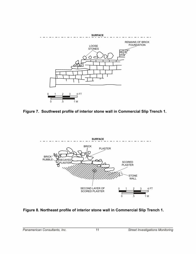
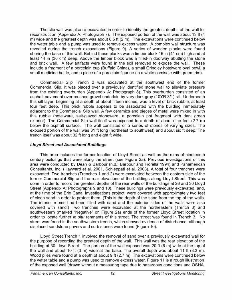
Materials found within the northeastern room include bricks, metal pieces, five whole bottles, a few ceramics, oyster shells and some degraded plaster. The wall of this room was constructed of unfinished coursed stone (Figure 7). Materials found in the southwestern room include a more dense concentration of artifacts, including brick rubble, plaster, bottles, ceramics, metal, oyster shells and degraded plaster. The northeastern and southeastern walls of this room had one or two plaster layers (Figure 8). Both layers of plaster were scored, ostensibly for the application of wallpaper. Other than density of materials, no obvious differences in artifact types were discerned between these rooms.
Table 1. Sample of artifacts found in rooms exposed in Commercial Street Trench 1. Material Quantity Description Ceramics 3 Whiteware, storage jar (cookie jar?), exterior design is birds on flowering
brown branches on a purple field, main body is bright yellow, maker’s mark “GUNS WELD?”, “Czechs?bv?”.
2 Hotelware, Buffalo China, illustration of buffalo with “B” and “C” on either side. One fragment is of a cup and one is a small bowl
2 Hotelware, “FRAUNFELTER CHINA”, with green lines around rim. One fragment is of a cup and one is from a plate
1 Hotelware, rim of small plate, blue and green band along rim, with white tulips. 1 Porcelain, hand-painted teacup missing handle. Design is yellow and brown
flower with green leaves. No maker’s mark. 2 Porcelain, high quality, thin-walled. Luster finish on exterior walls. Gold lamé
roses within field denoted by gold. Possible teacup. 1 Porcelain, thin-walled. Possible vessel or lampshade. Decaled decoration of
red and pink roses within black field encircled by yellow leaves hanging from blue branches.
Plaster 1 Sample of plaster found on walls. Glass 1 Milk bottle, 1 pint, light pink tinge, “QUEEN CITY DAIRY COMPANY”
1 Condiment jar, colorless, “GOLDEN MUSTARD” 1 Small bottle, light yellow tinge, “HIND’S HONEY AND ALMOND CREAM” 1 Bottle base, aqua, “ATLAS”, “TRADE MARK REG.” 1 Olive jar, small, light yellow tinge 1 Bottle, small, light green tinge, possibly small soda bottle 1 Bottle, about 10 oz., lime green 1 Jar, square, “SANFORD’S, NEW YORK, CHICAGO” on bottom. On two of the
sides: “SMC” in interwoven pattern. 1 Shaker bottle, salt or pepper, octagonal, no lid.
PLASTER
BRICK
DIRT WITH ROCKS, BRICKS,METAL PIECES, BOTTLES (5),SOME CERAMICS, PLASTER,
OYSTER SHELLS
GRASS
FILLED-IN
DOOR
0 .5 1 M
0 1 2 3 4 FT
Figure 6. Floor plan of Commercial Slip Trench 1 showing stone foundation.
Panamerican Consultants, Inc. 10 Street Investigations Monitoring
LOOSESTONES
REMAINS OF BRICKFOUNDATION
0 .5 1 M
0 1 2 3 4 FT
BRICKPLASTER
DECAYEDPLASTER
BRICKRUBBLE
SECOND LAYER OFSCORED PLASTER
SCOREDPLASTER
STONEWALL
0 .5 1 M
0 1 2 3 4 FT
Figure 7. Southwest profile of interior stone wall in Commercial Slip Trench 1.
Figure 8. Northeast profile of interior stone wall in Commercial Slip Trench 1.
Panamerican Consultants, Inc. 11
SURFACE
SURFACE
Street Investigations Monitoring
Panamerican Consultants, Inc. 12 Street Investigations Monitoring
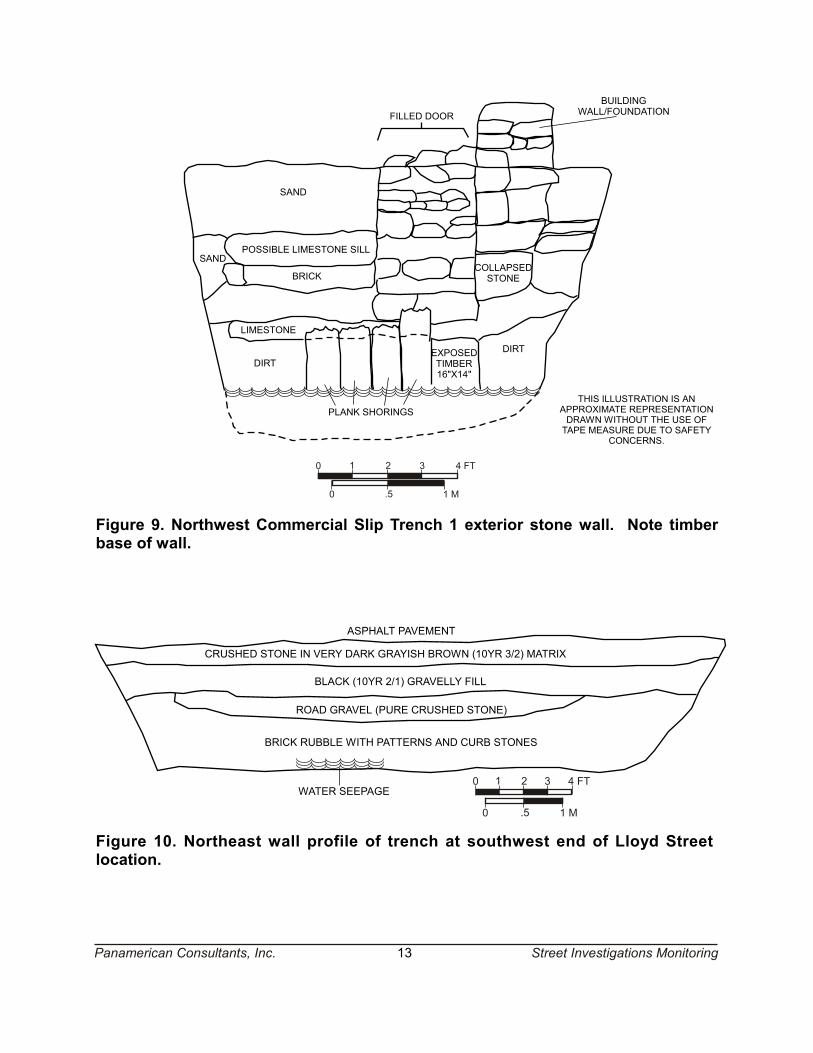
The slip wall was also re-excavated in order to identify the greatest depths of the wall for reconstruction (Appendix A: Photograph 7). The exposed portion of the wall was about 13 ft (4 m) wide and the greatest depth was about 6.5 ft (2 m). The excavations were continued below the water table and a pump was used to remove excess water. A complex wall structure was revealed during the trench excavations (Figure 9). A series of wooden planks were found shoring the base of this wall. Behind these planks was a timber block 16 in (41 cm) high and at least 14 in (36 cm) deep. Above the timber block was a filled-in doorway abutting the stone and brick wall. A few artifacts were found in the soil removed to expose the wall. These include a fragment of a porcelain cup (Buffalo China), a small Grindley hotelware oval bowl, a small medicine bottle, and a piece of a porcelain figurine (in a white camisole with green trim).
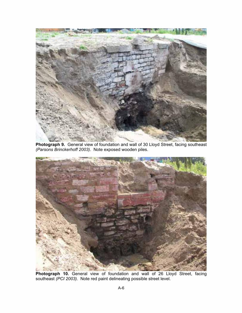
Commercial Slip Trench 2 was excavated at the southwest end of the former Commercial Slip. It was placed over a previously identified stone wall to alleviate pressure from the existing overburden (Appendix A: Photograph 8). This overburden consisted of an asphalt pavement over crushed gravel underlain by very dark gray (10YR 3/1) silt. Underneath this silt layer, beginning at a depth of about fifteen inches, was a level of brick rubble, at least four feet deep. This brick rubble appears to be associated with the building immediately adjacent to the Commercial Slip wall. A few ceramics and pieces of metal were mixed in with this rubble (hotelware, salt-glazed stoneware, a porcelain pot fragment with dark green exterior). The Commercial Slip wall itself was exposed to a depth of about nine feet (2.7 m) below the asphalt surface. The wall consisted of a series of stones of varying sizes. The exposed portion of the wall was 31 ft long (northeast to southwest) and about six ft deep. The trench itself was about 32 ft long and eight ft wide.
Lloyd Street and Associated Buildings
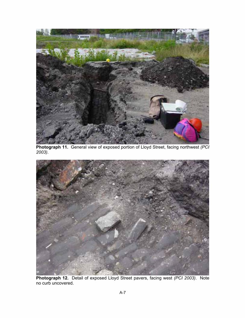
This area includes the former location of Lloyd Street as well as the ruins of nineteenth century buildings that were along the street (see Figure 2a). Previous investigations of this area were conducted by Dean & Barbour (n.d.; Barbour and Fiorella 1994) and Panamerican Consultants, Inc. (Hayward et al. 2001, Schieppati et al. 2003). A total of four trenches were excavated. Two trenches (Trenches 1 and 2) were excavated between the eastern side of the former Commercial Slip and the rear elevations of the buildings along Lloyd Street. This was done in order to record the greatest depths of the rear walls of the buildings at 26 and 30 Lloyd Street (Appendix A: Photographs 9 and 10). These buildings were previously excavated, and, at the time of the Erie Canal Investigations project, were covered with approximately two feet of clean sand in order to protect them. (This is the depth of the sand from the top of the walls. The interior rooms had been filled with sand and the exterior sides of the walls were also covered with sand.) Two trenches were excavated at the northeastern (Trench 3) and southwestern (marked “Negative” on Figure 2a) ends of the former Lloyd Street location in order to locate further in situ remnants of this street. The street was found in Trench 3. No street was found in the southwestern trench, which showed evidence of disturbance, although displaced sandstone pavers and curb stones were found (Figure 10).
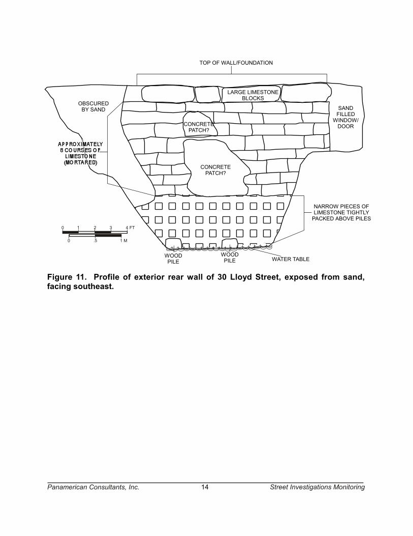
Lloyd Street Trench 1 involved the removal of sand over a previously excavated wall for the purpose of recording the greatest depth of the wall. This wall was the rear elevation of the building at 30 Lloyd Street. The portion of the wall exposed was 20 ft (6 m) wide at the top of the wall and about 10 ft (3 m) wide at the base. The overall depth was about 11 ft (3.3 m). Wood piles were found at a depth of about 9 ft (2.7 m). The excavations were continued below the water table and a pump was used to remove excess water. Figure 11 is a rough illustration of the exposed wall (drawn without a measuring tape due to hazardous conditions and OSHA
CRUSHED STONE IN VERY DARK GRAYISH BROWN (10YR 3/2) MATRIX
BLACK (10YR 2/1) GRAVELLY FILL
ROAD GRAVEL (PURE CRUSHED STONE)
BRICK RUBBLE WITH PATTERNS AND CURB STONES
WATER SEEPAGE
0 .5 1 M
0 1 2 3 4 FT
ASPHALT PAVEMENT
Figure 10. Northeast wall profile of trench at southwest end of Lloyd Streetlocation.
POSSIBLE LIMESTONE SILL
BRICK
SAND
SAND
LIMESTONE
DIRT
PLANK SHORINGS
EXPOSEDTIMBER16"X14"
DIRT
COLLAPSEDSTONE
BUILDINGWALL/FOUNDATIONFILLED DOOR
0 .5 1 M
0 1 2 3 4 FT
THIS ILLUSTRATION IS ANAPPROXIMATE REPRESENTATIONDRAWN WITHOUT THE USE OFTAPE MEASURE DUE TO SAFETY
CONCERNS.
Figure 9. Northwest Commercial Slip Trench 1 exterior stone wall. Note timberbase of wall.
Panamerican Consultants, Inc. 13 Street Investigations Monitoring
0 .5 1 M
0 1 2 3 4 FT
SANDFILLEDWINDOW/DOOR
OBSCUREDBY SAND
TOP OF WALL/FOUNDATION
NARROW PIECES OFLIMESTONE TIGHTLYPACKED ABOVE PILES
WATER TABLE
LARGE LIMESTONEBLOCKS
CONCRETEPATCH?
CONCRETEPATCH?
WOODPILE
WOODPILE
Figure 11. Profile of exterior rear wall of 30 Lloyd Street, exposed from sand,facing southeast.
Panamerican Consultants, Inc. 14 Street Investigations Monitoring
Panamerican Consultants, Inc. 15 Street Investigations Monitoring
regulations), and shows the wood piles, a concrete patch of the wall, and a filled-in doorway or window (Appendix A: Photograph 9). This doorway or window was approximately 3 ft square. Its foot sill was at apparent street level, possibly signifying that it was a small delivery portal.
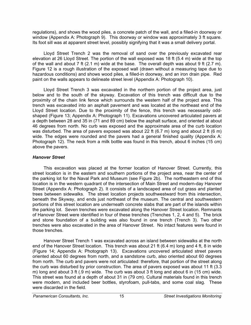
Lloyd Street Trench 2 was the removal of sand over the previously excavated rear elevation at 26 Lloyd Street. The portion of the wall exposed was 18 ft (5.4 m) wide at the top of the wall and about 7 ft (2.1 m) wide at the base. The overall depth was about 9 ft (2.7 m). Figure 12 is a rough illustration of the exposed wall (drawn without a measuring tape due to hazardous conditions) and shows wood piles, a filled-in doorway, and an iron drain pipe. Red paint on the walls appears to delineate street level (Appendix A: Photograph 10).
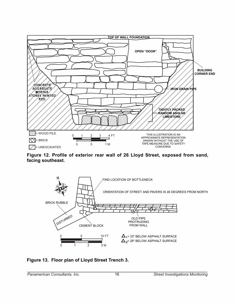
Lloyd Street Trench 3 was excavated in the northern portion of the project area, just below and to the south of the skyway. Excavation of this trench was difficult due to the proximity of the chain link fence which surrounds the western half of the project area. This trench was excavated into an asphalt pavement and was located at the northeast end of the Lloyd Street location. Due to the proximity of the fence, this trench was necessarily odd-shaped (Figure 13; Appendix A: Photograph 11). Excavations uncovered articulated pavers at a depth between 28 and 35 in (71 and 89 cm) below the asphalt surface, and oriented at about 46 degrees from north. No curb was exposed and the approximate area of the curb location was disturbed. The area of pavers exposed was about 22 ft (6.7 m) long and about 2 ft (6 m) wide. The edges were rounded and the pavers had a general finished quality (Appendix A: Photograph 12). The neck from a milk bottle was found in this trench, about 6 inches (15 cm) above the pavers.
Hanover Street
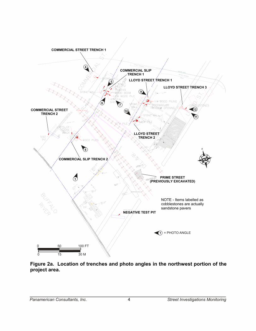
This excavation was placed at the former location of Hanover Street. Currently, this street location is in the eastern and southern portions of the project area, near the center of the parking lot for the Naval Park and Museum (see Figure 2b). The northeastern end of this location is in the western quadrant of the intersection of Main Street and modern-day Hanover Street (Appendix A: Photograph 2). It consists of a landscaped area of cut grass and planted trees between sidewalks. The street location projects southwestward from this intersection, beneath the Skyway, and ends just northeast of the museum. The central and southwestern portions of this street location are underneath concrete slabs that are part of the islands within the parking lot. Seven trenches were excavated along the Hanover Street location. Remnants of Hanover Street were identified in four of these trenches (Trenches 1, 2, 4 and 5). The brick and stone foundation of a building was also found in one trench (Trench 3). Two other trenches were also excavated in the area of Hanover Street. No intact features were found in those trenches.
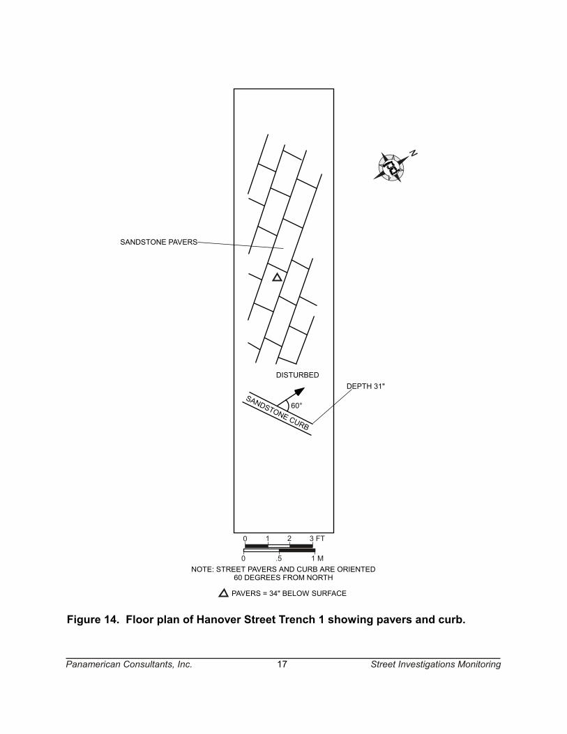
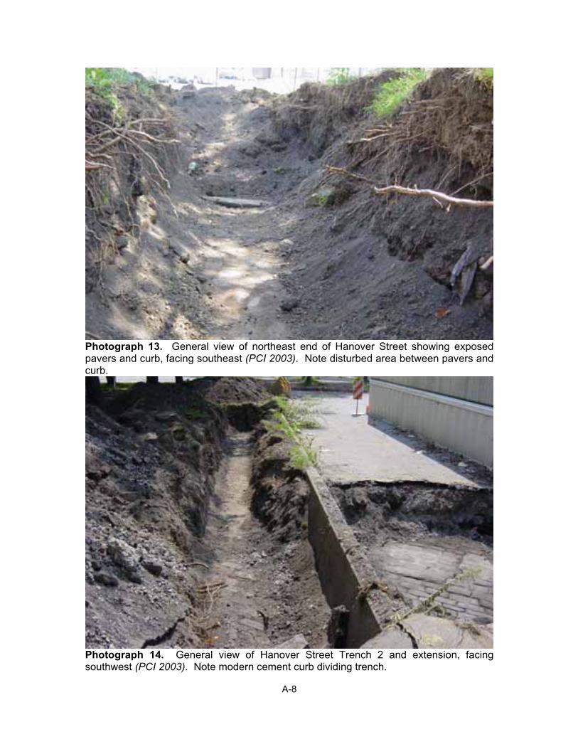
Hanover Street Trench 1 was excavated across an island between sidewalks at the north end of the Hanover Street location. This trench was about 21 ft (6.4 m) long and 4 ft, 8 in wide (Figure 14; Appendix A: Photograph 13). Excavations uncovered articulated street pavers oriented about 60 degrees from north, and a sandstone curb, also oriented about 60 degrees from north. The curb and pavers were not articulated: therefore, that portion of the street along the curb was disturbed by prior construction. The area of pavers exposed was about 11 ft (3.3 m) long and about 3 ft (.9 m) wide. The curb was about 3 ft long and about 6 in (15 cm) wide. This street was found at a depth of about 31 in (79 cm). Cultural materials found in this trench were modern, and included beer bottles, styrofoam, pull-tabs, and some coal slag. These were discarded in the field.
TOP OF WALL FOUNDATION
TIGHTLY PACKEDRANDOM ASHLAR
LIMESTONE
IRON DRAIN PIPE
BUILDINGCORNER END
OPEN “DOOR”
= WOOD PILE
= BRICK
= UNEXCAVATED0 .5 1 M
0 1 2 3 4 FT
Figure 12. Profile of exterior rear wall of 26 Lloyd Street, exposed from sand,facing southeast.
BRICK RUBBLE
DISTUR
BED
ORIENTATION OF STREET AND PAVERS IS 46 DEGREES FROM NORTH
0
1
5 10 FT
0 3 M2
OLD PIPEPROTRUDINGFROM WALL
FIND LOCATION OF BOTTLENECK
CEMENT BLOCK
= 33" BELOW ASPHALT SURFACE= 28" BELOW ASPHALT SURFACE
Figure 13. Floor plan of Lloyd Street Trench 3.
Panamerican Consultants, Inc. 16
THIS ILLUSTRATION IS ANAPPROXIMATE REPRESENTATIONDRAWN WITHOUT THE USE OFTAPE MEASURE DUE TO SAFETY
CONCERNS.
Street Investigations Monitoring
SANDSTONE CURB
60°
DISTURBEDDEPTH 31"
PAVERS = 34" BELOW SURFACE
NOTE: STREET PAVERS AND CURB ARE ORIENTED60 DEGREES FROM NORTH
Figure 14. Floor plan of Hanover Street Trench 1 showing pavers and curb.
SANDSTONE PAVERS
0 .5 1 M
0 1 2 3 FT
Panamerican Consultants, Inc. 17 Street Investigations Monitoring
Panamerican Consultants, Inc. 18 Street Investigations Monitoring
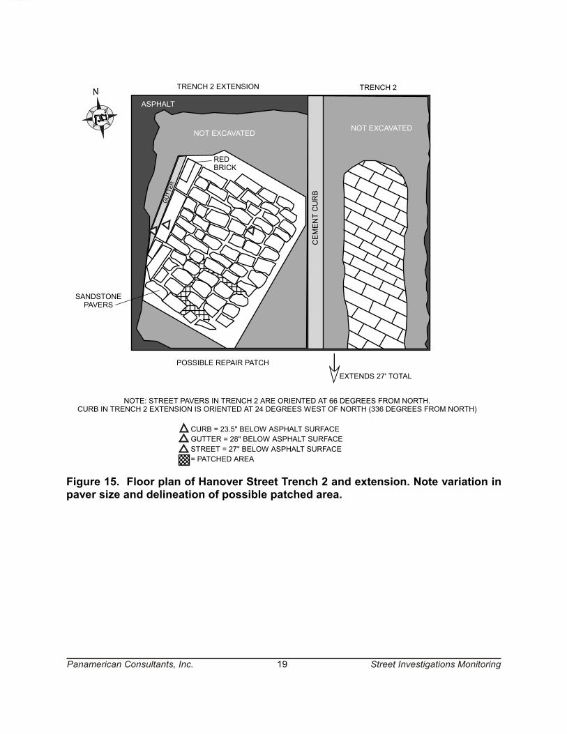
Hanover Street Trench 2 was excavated northward from the west end of Trench 3 (see below) along the east side of the cement curb of the existing parking lot (Figure 15; Appendix A: Photographs 14 and 15). Articulated pavers were exposed at a depth of about 28 inches (71 cm) below surface (b.s.) (Appendix A: Photograph 16). This trench was about 5 ft wide and 27 ft (8.2 m) long. Since no curb was found, the trench was extended on the west side of the cement curb (Appendix A: Photograph 15). This extension was about 12 ft (3.7 m) long (northeast to southwest) and 7 ft (2.1 m) wide. The horizontal excavation of this trench was terminated due to the presence of a large trailer (belonging to Ciminelli) immediately adjacent to the northwest side of the trench. Articulated pavers were uncovered at a depth of about 28 in (71 cm) b.s. (Appendix A: Photographs 14, 15 and 17). The sandstone curb was found about five ft (1.5 m) northwest of the modern cement curb. The top of the sandstone curb was about 23.5 in (60 cm) b.s. (Appendix A: Photograph 18) and articulated with a gutter and pavers. It was not possible to discern if the sidewalk parallel to the curb is still intact due to the presence of the trailer immediately adjacent to this trench. The gutter was formed by a series of pavers that were parallel to the curb. The pavers forming the gutter varied in length, with the longest one measuring about 2 ft (0.6 m). The street pavers within the main part of Trench 2 were about 9 inches (23 cm) long and about 5 inches (12.7 cm) wide (Appendix A: Photograph 16). The edges were rounded and the pavers had a general finished quality. The size and proportions of the pavers in the extended section of Trench 2 (Appendix A: Photograph 17) were different. While also being rounded and finished, these pavers were generally larger and more square (vs. rectangular) as compared to the main street pavers. A distinct line around these pavers forms a square. This may signify that this portion of Hanover Street had been repaired or that utilities may have been installed below the street in this area. Other evidence of repair is a red brick that was placed in-line with the gutter in the northern corner of this trench, possibly replacing a missing limestone paver.
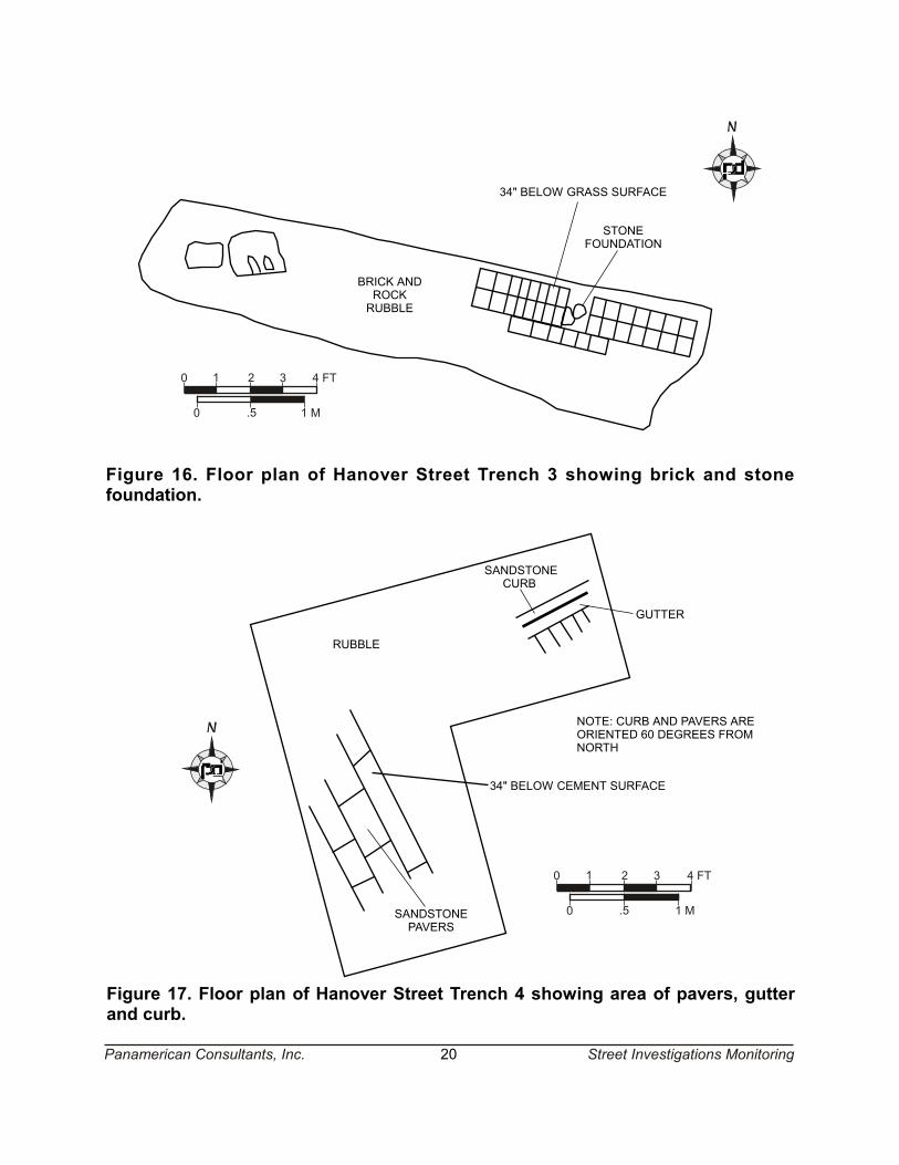
Hanover Street Trench 3 was excavated in an attempt to uncover Hanover Street. It was placed within a grass island between a sidewalk and the parking lot and was 17 ft (5.1 m) long and about 3.5 ft (1.1 m) wide. No street remains were found in this location, although a brick and stone foundation was uncovered at an approximate depth of 34 in (86 cm) below surface (Figure 16; Appendix A: Photograph 19). This foundation projected westward from the east end of the trench for about 7 ft (2.1 m). It consisted of two parallel rows of bricks with a perpendicular row of bricks along the southern side of this wall. Below the bricks was deteriorated limestone cement over foundation stones. The western end of the trench contained brick and rock rubble. One large rock appeared to have grooves ground into it and may have originally been an architectural feature.
Hanover Street Trench 4 was located near the Naval Museum building. It was excavated underneath the concrete parking lot island and was excavated after Hanover Street Trench 5, in order to locate the northwestern curb. This trench was approximately L-shaped: 10 ft, 10 in (3.3 m) long, 5 ft (1.5 m) wide at its southern end, 10 ft (3.1 m) wide at its northern end, and 4 ft, 4.5 in (133 cm) long at its northeastern end (Figure 17). Articulated in situ pavers were found in the southwestern corner of this trench at a depth of about 34 in (86 cm) b.s. (Appendix A: Photograph 20). In addition, in situ curb, gutter and pavers (Appendix A: Photograph 21) were found in the eastern corner. Between these in situ concentrations was a disturbed area without articulated pavers (Appendix A: Photograph 20). The pavers had rounded edges and had a general finished quality. The gutter was a series of pavers parallel to the curb.
TRENCH 2TRENCH 2 EXTENSION
ASPHALT
NOT EXCAVATEDNOT EXCAVATED
EXTENDS 27' TOTAL
POSSIBLE REPAIR PATCH
CEMENTCURB
REDBRICK
GUTTER
SANDSTONEPAVERS
NOTE: STREET PAVERS IN TRENCH 2 ARE ORIENTED AT 66 DEGREES FROM NORTH.CURB IN TRENCH 2 EXTENSION IS ORIENTED AT 24 DEGREES WEST OF NORTH (336 DEGREES FROM NORTH)
CURB = 23.5" BELOW ASPHALT SURFACEGUTTER = 28" BELOW ASPHALT SURFACESTREET = 27" BELOW ASPHALT SURFACE= PATCHED AREA
Figure 15. Floor plan of Hanover Street Trench 2 and extension. Note variation inpaver size and delineation of possible patched area.
Panamerican Consultants, Inc. 19 Street Investigations Monitoring
RUBBLE
SANDSTONECURB
0 .5 1 M
0 1 2 3 4 FT
GUTTER
SANDSTONEPAVERS
34" BELOW CEMENT SURFACE
NOTE: CURB AND PAVERS AREORIENTED 60 DEGREES FROMNORTH
Figure 17. Floor plan of Hanover Street Trench 4 showing area of pavers, gutterand curb.
BRICK ANDROCKRUBBLE
STONEFOUNDATION
34" BELOW GRASS SURFACE
0 .5 1 M
0 1 2 3 4 FT
Figure 16. Floor plan of Hanover Street Trench 3 showing brick and stonefoundation.
Panamerican Consultants, Inc. 20 Street Investigations Monitoring
Panamerican Consultants, Inc. 21 Street Investigations Monitoring
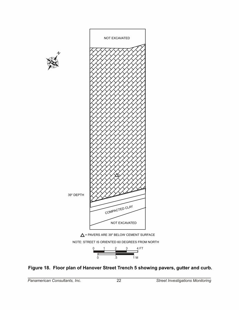
Hanover Street Trench 5 was also excavated underneath the concrete parking lot island. This trench was excavated before Hanover Street Trench 4. The initial trench was 5 ft (1.5 m) wide and 10 ft, 9 in (3.3 m) long, but was expanded to about 18 ft (5.5 m) long. This trench was initially excavated onto the intact Hanover Street (Figure 18; Appendix A: Photograph 22), consisting of articulated in situ pavers, at a depth of about 39 in (99 cm) below surface (Appendix A: Photograph 23). It was expanded southeastward until the curb was exposed. No sidewalk pavement (e.g., concrete slab) was found adjacent to the curb. In the place of the sidewalk only compacted clay was found. The gutter consisted of pavers parallel to the curb. The pavers had rounded edges and had a general finished quality.
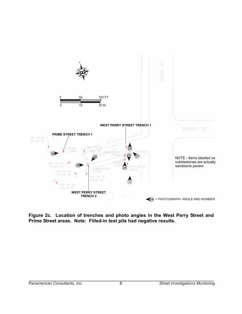
West Perry Street
This area is the former location of West Perry (a.k.a. Dayton) Street (see Figure 2c). Currently, this street location is in the southern portion of the Naval Museum parking lot, about 125 ft (38 m) southeast of the museum building. It is an area of asphalt pavement and cut grass islands. This street location is partially underneath the Skyway, at an almost 90 degree angle to the Skyway at this point. Because of the location of the Skyway, placement of trenches was limited to the eastern and western ends. Intact street remnants were found in two of the trenches excavated in this area. Another trench, excavated within the grass island west of the Skyway, did not reveal any intact features.
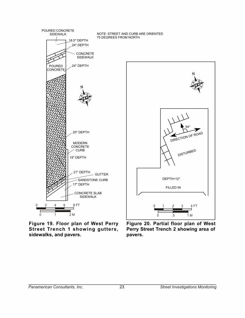
West Perry Street Trench 1 was excavated at the eastern end of the street location, just east of the Skyway right-of-way (Appendix A: Photograph 3). It was initially excavated within the grass island, and then extended northward below the asphalt pavement. This trench was about 4 ft 7 in (140 cm) wide and 37.5 ft (11.4 m) long. The excavation of this trench revealed an in situ section of West Perry Street, including the street pavers, gutters, curbs, and sidewalks. The street was found at a depth of between 19 and 24 in (48 and 81 cm) below surface (Figure 19; Appendix A: Photograph 24). At the southern end, a concrete slab sidewalk was found at a depth of about 17 in (43 cm) b.s. (Appendix A: Photograph 25). Parallel to this was a limestone curb and gutter. The gutter was at a depth of about 21 in (53 cm) below surface. The curb was oriented at about 70 degrees from north (ten degrees west). At the north end there was a poured concrete sidewalk and curb that was probably a repair to the prior sidewalk and curb. This sidewalk was at a depth of 18.5 in (47 cm) below surface. The concrete patch was poured in such a way as to replace the sidewalk and curb. This curb was oriented about 75 degrees from north. The gutter consisted of limestone pavers parallel to the curb, and was at a depth of about 26 in (66 cm) below surface. A poured concrete patch, about two ft (0.6 m) wide, was present at the north end of the trench, between the gutter and the remainder of the street. This patch was at a depth of about 24 in (61 cm) below surface (Appendix A: Photograph 26). The street itself consisted of pavers that were rough-cut as compared to the pavers of Hanover Street (Appendix A: Photograph 27).
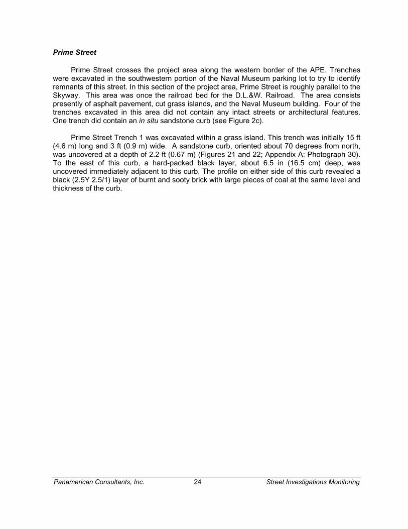
West Perry Street Trench 2 was excavated in the center of the street location, below the parking lot asphalt. This trench was initially about 5 ft (1.5 m) wide and 6 ft 10 in (2.1 m) long (Figure 20; Appendix A: Photograph 28). Articulated pavers were found in the northern and western portion of the trench, at a depth of one foot. This trench was extended to the south and west but no additional in situ pavers were found. The disturbed area consisted of rock rubble with disarticulated pavers. As in West Perry Street Trench 1, the pavers were rough-cut as compared to the pavers of Hanover Street (Appendix A: Photograph 29).
COMPACTED
CLAY
39" DEPTH
NOT EXCAVATED
NOT EXCAVATED
= PAVERS ARE 39" BELOW CEMENT SURFACE
NOTE: STREET IS ORIENTED 60 DEGREES FROM NORTH
0 .5 1 M
0 1 2 3 4 FT
Figure 18. Floor plan of Hanover Street Trench 5 showing pavers, gutter and curb.
Panamerican Consultants, Inc. 22 Street Investigations Monitoring
MODERNCONCRETECURB
CONCRETE SLABSIDEWALK
POUREDCONCRETE
POURED CONCRETESIDEWALK
SANDSTONE CURB90°
20" DEPTH
19" DEPTH
21" DEPTH
17" DEPTH
24" DEPTH
18.5" DEPTH24" DEPTH
GUTTER
CONCRETESIDEWALK
NOTE: STREET AND CURB ARE ORIENTED75 DEGREES FROM NORTH
Figure 19. Floor plan of West PerryStreet Trench 1 showing gutters,sidewalks, and pavers.
0 1 2 M
0 2 4 6 8 FT
94°
DIRECTION O
F ROAD
DISTURBED
FILLED IN
DEPTH=12"
0 .5 1 M
0 1 2 3 4 FT
Figure 20. Partial floor plan of WestPerry Street Trench 2 showing area ofpavers.
Panamerican Consultants, Inc. 23 Street Investigations Monitoring
Panamerican Consultants, Inc. 24 Street Investigations Monitoring
Prime Street
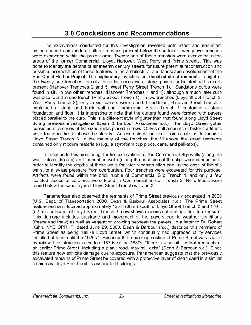
Prime Street crosses the project area along the western border of the APE. Trenches were excavated in the southwestern portion of the Naval Museum parking lot to try to identify remnants of this street. In this section of the project area, Prime Street is roughly parallel to the Skyway. This area was once the railroad bed for the D.L.&W. Railroad. The area consists presently of asphalt pavement, cut grass islands, and the Naval Museum building. Four of the trenches excavated in this area did not contain any intact streets or architectural features. One trench did contain an in situ sandstone curb (see Figure 2c).
Prime Street Trench 1 was excavated within a grass island. This trench was initially 15 ft (4.6 m) long and 3 ft (0.9 m) wide. A sandstone curb, oriented about 70 degrees from north, was uncovered at a depth of 2.2 ft (0.67 m) (Figures 21 and 22; Appendix A: Photograph 30). To the east of this curb, a hard-packed black layer, about 6.5 in (16.5 cm) deep, was uncovered immediately adjacent to this curb. The profile on either side of this curb revealed a black (2.5Y 2.5/1) layer of burnt and sooty brick with large pieces of coal at the same level and thickness of the curb.
3' 5"8"
DEPTH2' 2"
HARD COMPACT POSSIBLYDECAYED ASPHALT OR COAL
COAL, BURNT BRICK IN WALLCURB IS 2'2" BELOW SURFACE
NOTE: ORIENTATION IS 70 DEGREES FROM NORTH
0 1 2 M
0 2 4 6 8 FT
Figure 21. Floor plan of Prime Street Trench 1 showing sandstone curb.
SANDSTONECURB
UNEXCAVATEDBULK
PALE BROWN (10YR 6/3) SANDY LOAM
DARK GRAYISH BROWN (10YR 4/2) SANDY LOAM
BLACK (2.5Y 2.5/1) HARDCOMPACT POSSIBLY DECAYED
ASPHALT OR COAL
COALBRICK
0
300
1 2 ft
60 cm
Figure 22. Partial south wall profile of Prime Street Trench 1.
SURFACE`
Panamerican Consultants, Inc. 25 Street Investigations Monitoring
Panamerican Consultants, Inc. 26 Street Investigations Monitoring
3.0 Conclusions and Recommendations
The excavations conducted for this investigation revealed both intact and non-intact historic period and modern cultural remains present below the surface. Twenty-five trenches were excavated within the project area. Twenty-one of these trenches were excavated in the areas of the former Commercial, Lloyd, Hanover, West Perry and Prime streets. This was done to identify the depths of nineteenth century streets for future potential reconstruction and possible incorporation of these features in the architectural and landscape development of the Erie Canal Harbor Project. The exploratory investigation identified street remnants in eight of the twenty-one trenches. In only three instances were street pavers articulated with a curb present (Hanover Trenches 2 and 5, West Perry Street Trench 1). Sandstone curbs were found in situ in two other trenches, (Hanover Trenches 1 and 4), although a much later curb was also found in one trench (Prime Street Trench 1). In two trenches (Lloyd Street Trench 3, West Perry Trench 2), only in situ pavers were found. In addition, Hanover Street Trench 3 contained a stone and brick wall and Commercial Street Trench 1 contained a stone foundation and floor. It is interesting to note that the gutters found were formed with pavers placed parallel to the curb. This is a different style of gutter than that found along Lloyd Street during previous investigations (Dean & Barbour Associates n.d.). The Lloyd Street gutter consisted of a series of fist-sized rocks placed in rows. Only small amounts of historic artifacts were found in the fill above the streets. An example is the neck from a milk bottle found in Lloyd Street Trench 3. In the majority of the trenches, the fill above the street remnants contained only modern materials (e.g., a styrofoam cup piece, cans, and pull-tabs).
In addition to this monitoring, further excavations of the Commercial Slip walls (along the west side of the slip) and foundation walls (along the east side of the slip) were conducted in order to identify the depths of these walls for later reconstruction and, in the case of the slip walls, to alleviate pressure from overburden. Four trenches were excavated for this purpose. Artifacts were found within the brick rubble of Commercial Slip Trench 1, and only a few isolated pieces of ceramics were found in Commercial Street Trench 2. No artifacts were found below the sand layer of Lloyd Street Trenches 2 and 3.
Panamerican also observed the remnants of Prime Street previously excavated in 2000 (U.S. Dept. of Transportation 2000; Dean & Barbour Associates n.d.). The Prime Street feature remnant, located approximately 125 ft (38 m) south of Lloyd Street Trench 2 and 170 ft (52 m) southwest of Lloyd Street Trench 3, now shows evidence of damage due to exposure. This damage includes breakage and movement of the pavers due to weather conditions (freeze and thaw) as well as vegetation growing between the pavers. In a letter to Dr. Robert Kuhn, NYS OPRHP, dated June 29, 2000, Dean & Barbour (n.d.) describe this remnant of Prime Street as being “unlike Lloyd Street, which continually had upgraded utility services installed at least until the 1920s.” Because the remaining section of Prime Street was sealed by railroad construction in the late 1870s or the 1880s, “there is a possibility that remnants of an earlier Prime Street, including a plank road, may still exist” (Dean & Barbour n.d.). Since this feature now exhibits damage due to exposure, Panamerican suggests that the previously excavated remains of Prime Street be covered with a protective layer of clean sand in a similar fashion as Lloyd Street and its associated buildings.
Panamerican Consultants, Inc. 27 Street Investigations Monitoring
4.0 References
Barbour, Warren T. D., and Erika K. Fiorella 1994 The Horizons Waterfront Inner Harbor Project, Erie County, New York, Stage IA
Cultural Resource Literature Search Report for the Naval Park at the Foot of Main Street, City of Buffalo, New York.
Dean & Barbour Associates, Inc. n.d. Various field notes, end-of-field letters, and interim reports from the Buffalo Inner Harbor Project conducted by Dean & Barbour Associates, Inc.
Hayward, Michele H., Michael A. Cinquino, Frank J. Schieppati, Daniel Cadzow, Christine Longiaru, and Robert J. Hanley 2001 Letter Report: Archaeological Monitoring of Commercial Slip Overburden Removal,
Buffalo Inner Harbor Project, City of Buffalo, Erie County, New York. Prepared by Panamerican Consultants, Inc.
Parsons Brinckerhoff Quade & Douglas, Inc. 2001 Inner Harbor Development Project: Commercial Slip Wall Investigation End-of-Field
Report, Internal Memorandum. Prepared for New York State Urban Development Corportation, d/b/a Empire State Development Corporation
Schieppati, Frank J., Mark A. Steinback, Michael A. Cinquino, Michele H. Hayward, Stacy L. Weber, Rebecca J. Emans, and Karen S. Niemel 2003 Phase III Cultural Resources Investigation and Data Recovery: The Erie Canal
Harbor Project, City of Buffalo, Erie County, New York. Prepared for Parsons, Brinckerhoff, Quade & Douglas, Inc. Prepared by Panamerican Consultants, Inc.
U.S. Dept. of Transportation, FTA, NFTA, NYS UDC, d/b/a Empire State Development Corporation 2000 Draft Supplemental Environmental Impact Statement, Inner Harbor Development Project, Buffalo, New York.

Appendix A PHOTOGRAPHS
Photograph 1. General overview of Commercial Slip area, facing north (PCI 2003).
Photograph 2. General overview of Hanover Street area, facing southwest (PCI 2003).
A-2
Photograph 3. General overview of Perry Street area, showing Main Street inbackground, facing north (PCI 2003).
Photograph 4. Apparent stone foundation and floor, facing south (PCI 2003).
A-3
Photograph 5. Building foundation located above northwest Commercial Slip wall,facing southwest (PCI 2003).
Photograph 6. Detail of scored plaster found on west side of foundation wall, facingnortheast (PCI 2003).
A-4
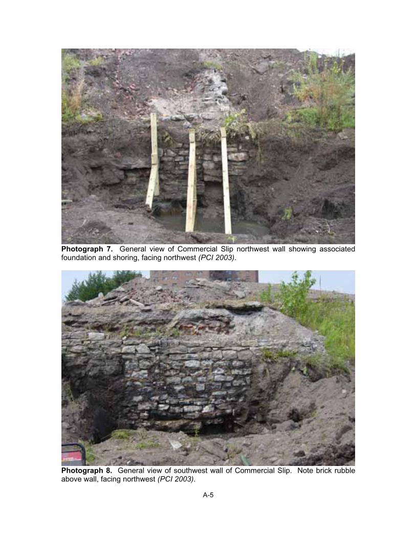
Photograph 7. General view of Commercial Slip northwest wall showing associatedfoundation and shoring, facing northwest (PCI 2003).
Photograph 8. General view of southwest wall of Commercial Slip. Note brick rubbleabove wall, facing northwest (PCI 2003).
A-5
Photograph 9. General view of foundation and wall of 30 Lloyd Street, facing southeast(Parsons Brinckerhoff 2003). Note exposed wooden piles.
Photograph 10. General view of foundation and wall of 26 Lloyd Street, facingsoutheast (PCI 2003). Note red paint delineating possible street level.
A-6
Photograph 11. General view of exposed portion of Lloyd Street, facing northwest (PCI2003).
Photograph 12. Detail of exposed Lloyd Street pavers, facing west (PCI 2003). Noteno curb uncovered.
A-7
Photograph 13. General view of northeast end of Hanover Street showing exposedpavers and curb, facing southeast (PCI 2003). Note disturbed area between pavers and curb.
Photograph 14. General view of Hanover Street Trench 2 and extension, facingsouthwest (PCI 2003). Note modern cement curb dividing trench.
A-8
Photograph 15. General view of Hanover Street Trench 2 extension showing exposedpavers and curb, facing southwest (PCI 2003).
Photograph 16. Typical pavers exposed in Hanover Street Trench 2, facing west (PCI2003).
A-9
Photograph 17. Pavers exposed in Hanover Street Trench 2 extension, facingsouthwest (PCI 2003). Note uneven quality of pavers in trench extension as comparedto pavers exposed in Hanover Street Trench 2.
Photograph 18. Detail of curb and gutter exposed in Hanover Street Trench 2extension, facing northwest (PCI 2003).
A-10
Photograph 19. Exposed brick and stone foundation in Hanover Street Trench 3, facingeast (PCI 2003).
Photograph 20. General view of Hanover Street Trench 4 showing small area of exposed pavers, facing southeast. Note significant disturbance surrounding pavers (PCI2003).
A-11
Photograph 21. Detail of curb, gutter, and street pavers exposed in Hanover StreetTrench 4, facing northeast (PCI 2003).
Photograph 22. General view of Hanover Street Trench 5 after extension showingexposed pavers, gutter, and curb, facing southeast (PCI 2003).
A-12
Photograph 23. Detail of gutter, curb, and pavers in Hanover Street Trench 5, facingnorthwest (PCI 2003).
Photograph 24. General view of West Perry Street Trench 1, facing north (PCI 2003).
A-13
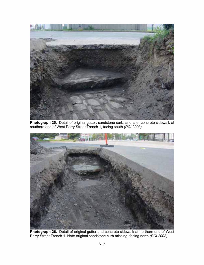
Photograph 25. Detail of original gutter, sandstone curb, and later concrete sidewalk at southern end of West Perry Street Trench 1, facing south (PCI 2003).
Photograph 26. Detail of original gutter and concrete sidewalk at northern end of WestPerry Street Trench 1. Note original sandstone curb missing, facing north (PCI 2003).
A-14
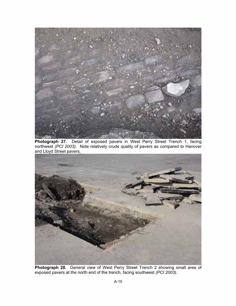
Photograph 27. Detail of exposed pavers in West Perry Street Trench 1, facingnorthwest (PCI 2003). Note relatively crude quality of pavers as compared to Hanoverand Lloyd Street pavers.
Photograph 28. General view of West Perry Street Trench 2 showing small area ofexposed pavers at the north end of the trench, facing southwest (PCI 2003).
A-15
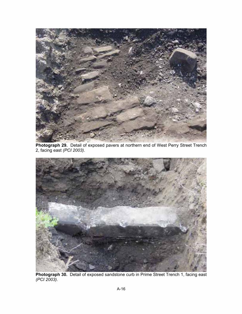
Photograph 29. Detail of exposed pavers at northern end of West Perry Street Trench 2, facing east (PCI 2003).
Photograph 30. Detail of exposed sandstone curb in Prime Street Trench 1, facing east(PCI 2003).
A-16

Appendix B VITAE OF PROJECT PRINCIPALS