Layer averaged Richard's equation with lateral flow
11
Layer averaged Richard’s equation with lateral flow Praveen Kumar Environmental Hydrology and Hydraulic Engineering, Department of Civil and Environmental Engineering, University of Illinois, Urbana, IL 61801, USA Received 29 October 2003; received in revised form 19 November 2003; accepted 5 February 2004 Available online 8 April 2004 Abstract In this paper a formulation for layer averaged sub-surface moisture transport, that models the lateral flow, is developed using the Richard’s equation. This formulation is consistent with the approach currently adopted in contemporary models used in land– atmosphere interaction studies. Explicit expressions are derived for layer averaged lateral transport contribution from diffusion, gravity, dispersion, and convergence due to land–surface curvature. It is argued that lateral contribution can be a significant component of the total soil-moisture flux. Ignoring these contributions can result in significant model error leading to inaccurate prediction or unrealistic calibration of parameters that compensate for these errors. Ó 2004 Elsevier Ltd. All rights reserved. Keywords: Land-surface parameterization; Richard’s equation; Lateral transport 1. Introduction Models of terrestrial soil-moisture transport are an integral part of SVAT (soil-vegetation-atmosphere- transfer) schemes [1,11,23,24,27,37,48,51,60] for the simulation of weather and climate. Although some re- cent models based on basin/catchment formulation uti- lizing the Topmodel framework [9] account for the lateral sub-surface moisture transport [15,38,52], most characterize them as an one-dimensional process in the vertical with little or no accounting of the lateral flow. This is due to the challenge of developing simplified models that incorporate both vertical and lateral trans- port while still being computationally manageable. Consequently heavy reliance has been developed with one-dimensional models which have seen various level of success in their ability to partition the incident radi- ation into sensible, latent and ground heat fluxes. However, with increasing emphasis on the use of these models for the assessment of the impact of climate on terrestrial hydrologic and ecologic systems, the required accuracy for the partitioning of the water budget into its various components (streamflow, and lateral and verti- cal sub-surface transport) is significantly higher. Fur- ther, satellite observation derived soil-moisture is needed for assimilation in land surface models to improve pre- dictability. This dictates the need to better incorporate the lateral flow for improved model prediction of near surface moisture (and temperature). Ability of the models to predict the moisture gradients well determines the success in the assimilation of near-surface soil- moisture. It seems unlikely that this will be a successful endeavor without the incorporation of lateral sub-sur- face transport in the models. In addition, there is an increasing trend in hydroclimatological and hydrome- teorological studies to model the land-surface at smaller scales going from several 10 s of kms to a few kms. This is facilitated by the increase in the resolution of regional climate and mesoscale atmospheric models supported by availability of increasing computational power. This necessitates the need to incorporate processes that manifest at the smaller scales, lateral sub-surface mois- ture flow being one of them. In this paper I develop a formulation using the Richard’s equation for layer averaged sub-surface moisture transport that incorporates the lateral flow. This formulation is consistent with the approach cur- rently adopted in contemporary models. In addition I provide an analysis using this formulation to illustrate that the lateral transport is not negligible. No specific numerical implementation is proposed with the hope that the formulation can be adapted in a variety of ways in existing models to improve their performance. E-mail address: [email protected] (P. Kumar). 0309-1708/$ - see front matter Ó 2004 Elsevier Ltd. All rights reserved. doi:10.1016/j.advwatres.2004.02.007 Advances in Water Resources 27 (2004) 521–531 www.elsevier.com/locate/advwatres
-
Upload
independent -
Category
Documents
-
view
2 -
download
0
Transcript of Layer averaged Richard's equation with lateral flow

Advances in Water Resources 27 (2004) 521ndash531
wwwelseviercomlocateadvwatres
Layer averaged Richardrsquos equation with lateral flow
Praveen Kumar
Environmental Hydrology and Hydraulic Engineering Department of Civil and Environmental Engineering
University of Illinois Urbana IL 61801 USA
Received 29 October 2003 received in revised form 19 November 2003 accepted 5 February 2004
Available online 8 April 2004
Abstract
In this paper a formulation for layer averaged sub-surface moisture transport that models the lateral flow is developed using the
Richardrsquos equation This formulation is consistent with the approach currently adopted in contemporary models used in landndash
atmosphere interaction studies Explicit expressions are derived for layer averaged lateral transport contribution from diffusion
gravity dispersion and convergence due to landndashsurface curvature It is argued that lateral contribution can be a significant
component of the total soil-moisture flux Ignoring these contributions can result in significant model error leading to inaccurate
prediction or unrealistic calibration of parameters that compensate for these errors
2004 Elsevier Ltd All rights reserved
Keywords Land-surface parameterization Richardrsquos equation Lateral transport
1 Introduction
Models of terrestrial soil-moisture transport are anintegral part of SVAT (soil-vegetation-atmosphere-
transfer) schemes [11123242737485160] for the
simulation of weather and climate Although some re-
cent models based on basincatchment formulation uti-
lizing the Topmodel framework [9] account for the
lateral sub-surface moisture transport [153852] most
characterize them as an one-dimensional process in the
vertical with little or no accounting of the lateral flowThis is due to the challenge of developing simplified
models that incorporate both vertical and lateral trans-
port while still being computationally manageable
Consequently heavy reliance has been developed with
one-dimensional models which have seen various level
of success in their ability to partition the incident radi-
ation into sensible latent and ground heat fluxes
However with increasing emphasis on the use of thesemodels for the assessment of the impact of climate on
terrestrial hydrologic and ecologic systems the required
accuracy for the partitioning of the water budget into its
various components (streamflow and lateral and verti-
cal sub-surface transport) is significantly higher Fur-
ther satellite observation derived soil-moisture is needed
E-mail address kumar1uiucedu (P Kumar)
0309-1708$ - see front matter 2004 Elsevier Ltd All rights reserved
doi101016jadvwatres200402007
for assimilation in land surface models to improve pre-
dictability This dictates the need to better incorporate
the lateral flow for improved model prediction of nearsurface moisture (and temperature) Ability of the
models to predict the moisture gradients well determines
the success in the assimilation of near-surface soil-
moisture It seems unlikely that this will be a successful
endeavor without the incorporation of lateral sub-sur-
face transport in the models In addition there is an
increasing trend in hydroclimatological and hydrome-
teorological studies to model the land-surface at smallerscales going from several 10 s of kms to a few kms This
is facilitated by the increase in the resolution of regional
climate and mesoscale atmospheric models supported by
availability of increasing computational power This
necessitates the need to incorporate processes that
manifest at the smaller scales lateral sub-surface mois-
ture flow being one of them
In this paper I develop a formulation using theRichardrsquos equation for layer averaged sub-surface
moisture transport that incorporates the lateral flow
This formulation is consistent with the approach cur-
rently adopted in contemporary models In addition I
provide an analysis using this formulation to illustrate
that the lateral transport is not negligible No specific
numerical implementation is proposed with the hope
that the formulation can be adapted in a variety of waysin existing models to improve their performance
522 P Kumar Advances in Water Resources 27 (2004) 521ndash531
2 Background
The present analysis takes advantage of the work of
Albertson and Montaldo [244] in using Reynolds
averaging rules to obtain soil-moisture content in adifferential volume We assume the validity of the
Richards equation for flow in the unsaturated zone and
use the BrooksndashCorey [12] approximation for soilndashwater
retention We write the Richardrsquos equation for the
evolution of the moisture content h in the form
ohot
frac14 o
oXiKiethwTHORN
ohoXi
L eth1THORN
where the summation over Xi 2 fX Y Zg is implied Z is
the vertical coordinate and XndashY represents the hori-
zontal plane Any sink such as evapotranpiration loss ischaracterized through the loss term L Using
h frac14 w thorn Z where w is the suction head the above may
be written as
ohot
frac14 o
oXiDiethhTHORN
ohoXi
thorn SiKiethhTHORN
L eth2THORN
where DiethhTHORN frac14 Kiowoh is the diffusivity and the local
slope Si 2 fSX SY SZg where SX frac14 oZoX SY frac14 oZ
oY SZ frac14oZoZ frac14 1 Let us write the soil-moisture h at any point as
hethx y z tTHORN frac14 hethx y z tTHORN thorn ~hethx y z tTHORN where the h repre-
sents a mean in the ensemble sense and the ~h representsperturbations from the mean with Efrac12~h frac14 0 The above
equation may then be written as
ohot
thorn o~hot
frac14 o
oXiDiethh
thorn ~hTHORN ohoXi
thorn o~hoXi
thornSiKiethhthorn ~hTHORN
L
eth3THORNUsing Taylor series expansion of D and K and neglecting
second and higher order terms we get
Diethh thorn ~hTHORN frac14 DiethhTHORN thornoDi
oh
h
~h eth4THORN
Kiethh thorn ~hTHORN frac14 KiethhTHORN thornoKi
oh
h
~h eth5THORN
Substituting these in Eq (3) and expanding we get
ohot
thorn o~hot
frac14 o
oXiDiethhTHORN
ohoXi
thornDiethhTHORN
o~hoXi
thornD0iethhTHORN~h
ohoXi
thornD0iethhTHORN~h
o~hoXi
thorn o
oXiSiKiethhTHORNh
thorn SiK 0iethhTHORN~h
iL
eth6THORN
where D0iethhTHORN oDi
oh jh and K 0iethhTHORN oKi
oh jh Taking expected
values and noting that
~ho~hoXi
frac14 1
2
o~h2
oXi
the above reduces to
ohot
frac14 o
oXiDiethhTHORN
ohoXi
thorn 1
2D0
iethhTHORNor2
h
oXithorn SiKiethhTHORN
L eth7THORN
where r2h Efrac12~h2
Noting that
or2h
oXifrac14 or2
h
ohohoXi
eth8THORN
we can write Eq (7) as
ohot
frac14 o
oXiDiethhTHORN
ohoXi
thorn 1
2D0
iethhTHORNor2
h
ohohoXi
thorn SiKiethhTHORNL
eth9THORN
We notice that on the RHS the first term is the diffusion
term the second represents dispersion due to the vari-ability and the third is the gravitational term Alterna-
tively we may also write the above as
ohot
frac14 o
oXiDiethhTHORN
ohoXi
thorn SiKiethhTHORN
thorn o
oXi
1
2D0
iethhTHORNor2
h
ohohoXi
L eth10THORN
In this form the first term on the RHS represents themoisture flux due to the mean profile while the second
corresponds to the flux due to the fluctuations
Land-surface parametrizations in climate models
typically use a layer averaged (in the vertical) equation
Consider a layer of thickness DZj between vertical
coordinates Zj and Zjthorn1 Following Wetzel and Boone
[55] and Boone and Wetzel [10] we multiply the above
equation by dZ and integrate over the layer thickness toget
Z Zjthorn1
Zj
ohot
dZ frac14Z Zjthorn1
Zj
o
oXiDiethhTHORN
ohoXi
dZ
thornZ Zjthorn1
Zj
SioKiethhTHORNoXi
dZ thornZ Zjthorn1
Zj
KiethhTHORNo2ZoX 2
idZ
thorn 1
2
Z Zjthorn1
Zj
o
oXiD0
iethhTHORNor2
h
ohohoXi
dZ
Z Zjthorn1
Zj
LdZ eth11THORN
Notice that we have used oXiethSiKiethhTHORNTHORN frac14 Si
oKiethhTHORNoXi
thornKiethhTHORN oSi
oXifrac14 Si
oKiethhTHORNoXi
thorn KiethhTHORN o2ZoX 2
ito arrive at the second and
third terms in the equation Separating the vertical (Z)
and implied summation over the lateral terms ethXi 2fX Y gTHORN and integrating we obtain
Table 1
Hydraulic decay constant obtained from published results (see also
[46])
c (m1) Sitesregions Refs
)235ndash915 Various sites [8]
151ndash517 FIFE Kansas [28]
326 Sleepers River Vermont [52]
70 Walnut Gulch Arizona [2634]
100 Creek Alaska [53]
80 Red Arkansas River [61]
18 North America [15]
20 Global [23]
20ndash60 Ovre Abiskojokk and
Ovre Landsjarv Sweden
[46]
Soil type
151 Alluvial land [28]
374 BenfieldndashFlorence complex
517 ClimendashSogn complex
222 DwightndashIrwin complex
211 Irwin silty clay loam
211 Irwin silty clay loam(eroded)
218 Ivan and Kennebec silt loams
218 Reading silt loam
491 Stony steep land
235 Tully silty clay loam
P Kumar Advances in Water Resources 27 (2004) 521ndash531 523
ohot
DZj frac14Z Zjthorn1
Zj
o
oZDZethhTHORN
ohoZ
dZ frac12Vertical diffusion
thornZ Zjthorn1
Zj
oKZethhTHORNoZ
dZ frac12Vertical gravitational
thorn 1
2
Z Zjthorn1
Zj
o
oZD0
ZethhTHORNor2
h
ohohoZ
dZ
frac12Vertical dispersion
thornZ Zjthorn1
Zj
o
oXiDiethhTHORN
ohoXi
dZ frac12Lateral diffusion
thornZ Zjthorn1
Zj
SioKiethhTHORNoXi
dZ frac12Lateral gravitational
thorn 1
2
Z Zjthorn1
Zj
o
oXiD0
iethhTHORNor2
h
ohohoXi
dZ
frac12Lateral dispersion
thornZ Zjthorn1
Zj
KiethhTHORNo2ZoX 2
idZ frac12Lateral convergence
Z Zjthorn1
Zj
LdZ
eth12THORN
where the average soil-moisture h within a layer is de-
fined as h frac14 1DZj
R Zjthorn1
Zjhdz Notice that as expected there
is no vertical convergence term since o2ZoZ2 frac14 0 Using one
dimensional approximations (as in climate models) is
tantamount to retaining the first two term in the RHS
(along with the sink term) and neglecting the othersThis results in an approximation of the form
DZjohot
frac14 DZethhTHORNohoZ
Zjthorn1
DZethhTHORNohoZ
Zj
thorn KZethhTHORNjZjthorn1 KZethhTHORNjZj L eth13THORN
where L is the total water loss from the layer The
above is usually written in the flux form [55]
DZjohot
frac14 Qjthorn1 Qj L eth14THORN
where Qj frac14 DZethhTHORN ohoZ jZj thorn KZethhTHORNjZj is the net flux through
the interface of the layer at Zj
No assessment is available in the literature regarding
the relative significance of the neglected terms (thatcorrespond to vertical dispersion as well as lateral dif-
fusive dispersive convergence and gravitational trans-
port) relative to the vertical transport and how that
changes with soil properties and topographic attri-
butes such as slope and curvature We explore this issue
next
3 Layer averaged model
To simplify other terms in Eq (12) we begin by
assuming that the saturated hydraulic conductivity KSi
in any direction Xi decreases with depth Z and is equal toK0i at some reference depth Z that is
KSi frac14 K0iecethZZTHORN eth15THORN
This formulation is consistent with the Topmodel for-
mulation [9] although other forms of the functional
dependence of hydraulic conductivity with depth havebeen studied [3] Table 1 provides a summary of some
published values of c which generally lie between 1 and
10 We further assume that the lateral saturated
hydraulic conductivity is larger than the vertical by a
factor f to account for anisotropy in the two directions
that is
K0X frac14 K0Y frac14 fK0Z eth16THORN
Table 2 provides a list of published values of the
anisotropic ratio f which are generally of the order of
10ndash100 Using the BrooksndashCorey [12] parameterization
of the form
wethhTHORN frac14 ws
hhs
13b
KiethhTHORN frac14 KSi
hhs
132bthorn3
eth17THORN
where b is an empirical constant and hs the saturated
soil-moisture content we can easily obtain the followingrelationships
Table 2
Anisotropic ratio obtained from published results
f Testmeasurement methods Aquifersoil types Aquifer thickness (b)
Core types
Test sitesreigions Refs
042ndash269 Laboratory test Mineral Cylinder core A frac14 26
cm2
Oyster Virginia [13]
26ndash69 Laboratory test Peat Cylinder core A frac14 23
cm2
Quebec Canada [50]
05ndash24 Laboratory test Limestone Cylinder core A frac14 57
cm2
Boliver Australia [58]
11ndash2363 Laboratory test Peat Cube core A frac14 56 cm2 Humberhead
Peatlands England
[56]
72ndash155 Pumping test Sand and gravel b frac14 824 m Saint Pardon de
Conques Gironde
France
[45]
33 Pumping test Borden Ontario
Canada
[47]
11ndash108 Tracer and permeameter Fluvial sand aquifer b frac14 02ndash3 m Twin Lake Ontario
Canada
[36]
2ndash350 Pumping test Alluvial aquifer Susquehanna River
New York USA
[59]
2ndash5 Tracer test Sand and gravel b frac14 30 m Cape Cod
Massachusetts USA
[39]
12 Flowmeter and permeameter Sand and gravel b frac14 30 m Cape Cod
Massachusetts USA
[32]
2 Pumping test Sand and gravel b frac14 30 m Cape Cod Massachu-
setts USA
[43]
9ndash63 Pumping test Alluvial aquifer Vekol Valley Arizona
USA
[41]
1ndash100 Pumping test Sand aquifer b frac14 15 m [49]
29ndash452 Pumping test Glacio fluvial sand b frac14 5 m Vejen Denmark [35]
384ndash918 Pumping test Phreatic aquifer b frac14 49 m Cosenza Italy [25]
11 Pumping test Alluvial aquifer b frac14 235 m Wood River Platte
River valley Nebraska
USA
[21]
155 Pumping test Alluvial aquifer b frac14 348 m Scottsbluff North
Platte River valley
Nebraska USA
[18]
597 Pumping test Alluvial aquifer b frac14 305 m Grand Island Platte
River valley Nebraska
USA
[16]
25ndash562 Pumping test Alluvial aquifer b frac14 135 m Shelton Platte River
valley Nebraska USA
[4]
91 and 20 Pumping test Alluvial aquifer b frac14 13 m MSEA Platte River
valley Nebraska USA
[42]
108 Pumping test Alluvial aquifer b frac14 146 m Palisade Frenchman
Creek Nebraska USA
[20]
69 Pumping test Alluvial aquifer b frac14 104 m Bloomington Republi-
can River Valley
Nebraska USA
[20]
33 Standpipe method Alluvial aquifer b frac14 32 cm Bloomington Republi-
can River Valley
Nebraska USA
[17]
228 Pumping test Alluvial aquifer b frac14 204 m McCook Republican
River Valley Nebraska
USA
[20]
49 Standpipe method Alluvial aquifer b frac14 255 cm McCook Republican
River Valley Nebraska
USA
[17]
2000 Land model calibration North America [15]
122 Land model calibration Ovre Abiskojokk and
Ovre Landsjarv
Sweden
[46]
Order of 100 or gt Large scale field studies [30]
1ndash100 Stream depletion analysis b frac14 305 m [19]
524 P Kumar Advances in Water Resources 27 (2004) 521ndash531
00 01 02 03 04 05
Mean
00
05
10
15
Coe
ffici
ento
fVar
iatio
n
01 03 05 07
Mean
00
02
04
06
08
10
Coe
ffici
ent o
f Var
iatio
n
Famiglietti et al(1999)
Hills amp Reynolds(1969)
Bells et al(1980)
Bells et al(1980)
Hawley et al(1983)
Chapentier amp Groffman(1992)
Loague(1992)
Western et al(1998)
Wilson et al(2003)
Fig 1 (Top) Plot of coefficient of variation (Cv) versus mean soil-
moisture ethhTHORN for the SGPrsquo97 experiment as published in Famiglietti et
al [29] The regression curve corresponds to Cv frac14 a=hb with a frac14 00362
and b frac14 127 and the coefficient of determination is 076 (Bottom) Plot
of coefficient of variation (Cv) versus mean soil-moisture from ob-
served data reported in the literature (see Table 3)
P Kumar Advances in Water Resources 27 (2004) 521ndash531 525
KiethhTHORN frac14 K0iecethZZTHORN h
hs
132bthorn3
eth18THORN
K 0i ethhTHORN frac14
eth2bthorn 3THORNK0i
hs
ecethZZTHORN hhs
132bthorn2
eth19THORN
DiethhTHORN frac14 bwsK0i
hs
ecethZZTHORN hhs
13bthorn2
eth20THORN
D0iethhTHORN frac14 bethbthorn 2THORNwsK0i
h2s
ecethZZTHORN hhs
13bthorn1
eth21THORN
We now study each of the remaining terms in Eq (12)
31 Vertical dispersion
Let us assume that V ethhTHORN or2
h
oh (see Eq (8)) can be
parametrized as a function of h To find the function
V ethhTHORN we first study the coefficient of variation Cv frac14 rhh as
a function of the mean moisture content h Intuitivelywe expect that Cv is a decreasing function of h to reflect
that moisture shows more relative variability when the
soil is drier Fig 1 shows the plot of Cv versus h for data
obtained from Southern Great Plains Experiment 1997
(SGP97) as published by Famiglietti et al [29] All the
data from Table 2 of Famiglietti et al [29] which reflects
a variety of soil properties and moisture conditions is
used without distinction of any kind (see also Fig 5 inFamiglietti et al [29]) As shown in Fig 1(Top) the
functional form
Cv frac14a
hb eth22THORN
fits the data quite well and the least squares estimates are
a frac14 00362 and b frac14 127 Table 3 provides a summary of
a and b obtained from published soil-moisture data
which are plotted in Fig 1(Bottom) Hence using the
definition of Cv
r2h frac14 a2h2eth1bTHORN eth23THORN
and consequently
V ethhTHORN or2
h
ohfrac14 2a2eth1 bTHORNh12b eth24THORN
Using this we may write the vertical dispersion term
(third term) in Eq (12) as
1
2
Z Zjthorn1
Zj
o
oZD0
ZethhTHORNor2
h
ohohoZ
dZ
frac14 1
2D0
ZethhTHORNV ethhTHORNohoZ
Zjthorn1
D0
ZethhTHORNV ethhTHORNohoZ
Zj
eth25THORN
Substituting for D0ZethhTHORN and V ethhTHORN from Eqs (21) and (24)
we obtain
1
2
Z Zjthorn1
Zj
o
oZD0
ZethhTHORNor2
h
ohohoZ
dZ
frac14 K0Z bethbthorn 2THORNa2eth1 bTHORNws
h3thornbs
ecethZZTHORNhb2bthorn2 ohoz
Zjthorn1
ecethZZTHORNhb2bthorn2 ohoz
Zj
eth26THORN
32 Lateral diffusion
Recognizing that
ohoXi
frac14 ohoZ
oZoXi
frac14 SiohoZ
eth27THORN
and using Eq (20) we can write the lateral diffusive term
in Eq (12) as
Table 3
Regression results for Cv versus mean soil-moisture for published data
a b No of
data
R2 Sampling
depths
Sitesregions Area No of
samples
Sampling dates Refs
0088 056 15 011 5ndash8 cm Chew Stroke
Bristol UK
24 m2ndash6 km2 60field June 21 1966 and
July 8 1966
Hills and Rey-
nolds [33] Fig 6
0119 028 60 035 0 cm April 1974ndashOctober
13 1976 (6 dates)
[7] Table 2a
0059 065 60 039 1ndash2 cm
0037 077 60 025 2ndash5 cm
0042 057 60 009 5ndash9 cm Phoenix
Arizona USA
16 ha
(1 field)
36
0058 028 60 002 9ndash15 cm
0042 066 300 051 All of above Jefferson
County
Kansas USA
16 ha
(29 fields)
19field
0113 029 59 035 0ndash1 cm [7] Table 2b
0076 049 59 048 0ndash2 cm Finney County
Kansas USA
16 ha
(24 fields)
9ndash35field
0032 083 59 056 0ndash5 cm
0030 078 59 039 0ndash9 cm
0041 053 59 015 0ndash15 cm
0041 065 295 062 All of above
0090 062 32 021 0ndash25 cm Chickasha
Oklahoma
USA
51ndash179 ha
(8 basins)
16ndash92basin May 1 10 12 and
30 1978 (4 dates)
[31] Table III
0099 032 32 007 0ndash15 cm
0085 055 64 014 All
0045 077 18 055 0ndash5 cm Manhattan
Kansas USA
4356 m2
(3 plots)
49plot June 28 1987ndash
August 4 1989
(6 dates)
[14] Table 3
0106 105 35 051 015 m Chickasha
Oklahoma
USA
01 km2
(34 sites)
8 depthssite January 1971ndashJune
1974 (84 dates)
[40] Table 3
0040 151 35 075 030 m
0024 176 35 057 045 m
0053 103 35 026 060 m
0094 046 35 005 075 m
0077 051 35 006 090 m
0058 060 35 006 105 m
0079 027 35 001 120 m
0011 241 140 057 015ndash060 m
0070 036 13 035 0ndash30 cm Tarrawarra
Australia
105 ha 500ndash2000 September 27 1995ndash
November 29 1996
(13 dates)
[54] Table 1
0003 393 18 076 0ndash30 cm Mahurangi
New Zealand
5ndash60 ha
(3 sites)
275ndash480site November 1998
May 1999
November 1999
[56] Table 2
526 P Kumar Advances in Water Resources 27 (2004) 521ndash531
Z Zjthorn1
Zj
o
oXiDiethhTHORN
ohoXi
dZ
frac14Z Zjthorn1
Zj
o
oXiSi DiethhTHORN
ohoZ
13 dZ
frac14 K0i bws
hbthorn3s
Z Zjthorn1
Zj
o
oXiSi hbthorn2 oh
oZecethZZTHORN
13 dZ
frac14 K0i Sibws
hbthorn3s ethbthorn 3THORN
o
oXi
thorn vi
Si
13Z Zjthorn1
Zj
ohbthorn3
oZecethZZTHORN dZ
eth28THORNwhere vi frac14 oSi
oXifrac14 o2Z
oX 2i
is the local curvature Recognizing
that the curvature vi is not a function of Z and inte-
grating by parts we obtain
Z Zjthorn1
Zj
o
oXiDiethhTHORN
ohoXi
dZ
frac14 K0i Sibws
hbthorn3s ethbthorn 3THORN
o
oXi
thorn vi
Si
13
ecethZZTHORNhbthorn3jZjthorn1
ecethZZTHORNhbthorn3jZj
thorn cZ Zjthorn1
Zj
hbthorn3ecethZZTHORN dZ
eth29THORN
Closed form solution for the integral on the RHS can be
obtained using the Mathematica package [57] as
P Kumar Advances in Water Resources 27 (2004) 521ndash531 527
I1 cZ Zjthorn1
Zj
hbthorn3ecethZZTHORN dZ
frac14 ch ecZ
Z4thornbhCeth4 thorn b cZTHORNethcZTHORNeth4thornbTHORNjZjthorn1
Zj
i eth30THORN
where C is the incomplete gamma function
33 Lateral gravitational
Similarly the lateral gravitational term in Eq (12)
can be obtained as
Z Zjthorn1
Zj
SioKiethhTHORNoXi
dZ frac14 Si
Z Zjthorn1
Zj
oKiethhTHORNoZ
oZoXi
dZ
frac14 S2i
Z Zjthorn1
Zj
oKiethhTHORN
frac14 S2i KiethhTHORNjZjthorn1
h KiethhTHORNjZj
i eth31THORN
Using the BrooksndashCorey representation (18) the above
simplifies to
Z Zjthorn1
Zj
SioKiethhTHORNoXi
dZ frac14 S2i K0i
h2bthorn3s
ecethZZTHORNh2bthorn3jZjthorn1
h
ecethZZTHORNh2bthorn3jZji eth32THORN
34 Lateral dispersion
Similarly the lateral dispersion term may be obtained
as
1
2
Z Zjthorn1
Zj
o
oXiD0
iethhTHORNor2
h
ohohoXi
dZ
frac14 1
2
Z Zjthorn1
Zj
o
oXiD0
iethhTHORNV ethhTHORNohoZ
oZoXi
dZ
frac14 1
2
Z Zjthorn1
Zj
o
oXiSi D0
iethhTHORNV ethhTHORNohoZ
13 dZ eth33THORN
Using Eqs (21) and (24) the above reduces to
frac14 K0i Sibethbthorn 2THORNwsa2eth1 bTHORN
hbthorn3s ethb 2b thorn 3THORN
o
oXi
thorn vi
Si
13
Z Zjthorn1
Zj
ohb2bthorn3
oZecethZZTHORN dZ eth34THORN
where we have used hb2bthorn2 ohoZ frac14 1
ethb2bthorn3THORNohb2bthorn3
oZ Inte-
grating we obtain
1
2
Z Zjthorn1
Zj
o
oXiD0
iethhTHORNor2
h
ohohoXi
dZ
frac14 K0i Sibethbthorn 2THORNwsa2eth1 bTHORN
hbthorn3s ethb 2b thorn 3THORN
o
oXi
thorn vi
Si
13
hb2bthorn3ecethZZTHORNjZjthorn1
hb2bthorn3ecethZZTHORNjZj
thorn cZ Zjthorn1
Zj
hb2bthorn3ecethZZTHORN dZ
eth35THORN
Closed form solution for the integral on the RHS can be
obtained using the Mathematica package as
I2 cZ Zjthorn1
Zj
hb2bthorn3ecethZZTHORN dZ
frac14 ch ecZ
Zb2bthorn4hCethb 2b thorn 4 cZTHORN
ethcZTHORNethb2bthorn4THORNjZjthorn1
Zj
i eth36THORN
35 Lateral convergence
This term can be computed as
Z Zjthorn1
Zj
KiethhTHORNo2ZoX 2
idZ frac14 vi
Z Zjthorn1
Zj
KiethhTHORNdZ
frac14 viK0i
h2bthorn3s
Z Zjthorn1
Zj
h2bthorn3ecethZZTHORN dZ
frac14 viK0i
h2bthorn3s
I3 eth37THORN
where
I3 Z Zjthorn1
Zj
h2bthorn3ecethZZTHORN dZ
frac14h ecZ
Z2bthorn4hCeth4 thorn 2b cZTHORNethcZTHORN2b4jZjthorn1
Zj
i eth38THORN
36 Layer averaged soil-moisture transport
Collecting all the relevant terms in Eq (12) from Eqs
(13) (26) (29) (32) (35) and (37) and algebraically
simplifying we can write the layer averaged form of Eq
(12) as
528 P Kumar Advances in Water Resources 27 (2004) 521ndash531
DZjohot
frac14 ecethZjthorn1ZTHORN (
A1 hbthorn2 ohoZ
Zjthorn1
ecDZjhbthorn2 oh
oZ
Zj
frac12Vertical diffusion
thorn A2 h2bthorn3jZjthorn1
h ecDZjh2bthorn3jZj
ifrac12Vertical gravitational
thorn A3 hb2bthorn2 ohoZ
Zjthorn1
ecDZjhb2bthorn2 oh
oZ
Zj
frac12Vertical dispersion
thorn A4
o
oXi
thorn vi
Si
13hbthorn3jZjthorn1
h ecDZjhbthorn3jZj thorn ecethZjthorn1ZTHORNI1
ifrac12Lateral diffusion
thorn A5 h2bthorn3jZjthorn1
h ecDZjh2bthorn3jZj
ifrac12Lateral gravitational
thorn A6
o
oXi
thorn vi
Si
13hb2bthorn3jZjthorn1
h ecDZjhb2bthorn3jZj thorn ecethZjthorn1ZTHORNI2
ifrac12Lateral dispersion
thorn A7ecethZjthorn1ZTHORNI3
)frac12Lateral convergence
L
eth39THORNwhere summation over Xi 2 fX Y g is implied and the
coefficients are given as
A1 frac14K0Z bws
hbthorn3s
ethDimension L2=T THORN
A2 frac14K0Z
h2bthorn3s
ethDimension L=T THORN
A3 frac14K0Z bethbthorn 2THORNwsa
2eth1 bTHORNhbthorn3
s
ethDimension L2=T THORN
A4 frac14K0Z fSibws
ethbthorn 3THORNhbthorn3s
ethDimension L2=T THORN
A5 frac14K0ZfS
2i
h2bthorn3s
ethDimension L=T THORN
A6 frac14K0Z fSibethbthorn 2THORNwsa
2eth1 bTHORNhbthorn3
s ethb 2b thorn 3THORNethDimension L2=T THORN
A7 frac14viK0Zf
h2bthorn3s
ethDimension L=T THORN
Notice that A1 A3 A4 and A6 have the dimensions of a
dispersion coefficient whereas A2 A5 and A7 have the
dimensions of velocity One may also consider Ai as
weights for each term in the evolutionary equation for
the mean moisture profile h
37 Relative contribution of lateral flow
To compare the lateral terms with the vertical we
examine ratios of the form
Aij frac14Ai
Aj eth40THORN
In particular the following dimensionally consistent
ratios shed light on the relative contributions
Vertical dispersion=Vertical diffusion
frac14 A31 frac14A3
A1
frac14 ethbthorn 2THORNa2eth1 bTHORN eth41THORN
Lateral diffusion=Vertical diffusion
frac14 A41 frac14A4
A1
frac14 fSibthorn 3
eth42THORN
Lateral gravitational=Vertical gravitational
frac14 A52 frac14A5
A2
frac14 fS2i eth43THORN
Lateral dispersion=Vertical diffusion
frac14 A61 frac14A6
A1
frac14 fSiethbthorn 2THORNa2eth1 bTHORNb 2b thorn 3
eth44THORN
Lateral dispersion=Vertical dispersion
frac14 A63 frac14A6
A3
frac14 fSib 2b thorn 3
eth45THORN
Lateral convergence=Vertical gravitational
frac14 A72 frac14A7
A2
frac14 vif eth46THORN
The BrooksndashCorey parameter b typically ranges in value
from about 4 for sand to about 11 for clay [22] How-
ever a2 is of the order of 104 (see Table 3) Conse-quently A31 is small reflecting that the vertical dispersion
term is significantly smaller than the vertical diffusion
The contribution of lateral diffusion relative to that of
vertical depends on the product of the anisotropic con-
stant f and slope Si Given that both these parameters
take on a range of values we study it by plotting the
product fSi as a function of f and Si Fig 2 shows the
plot of log10ethfSiTHORN for 0016 Si 6 1 and 16 f6 2000covering a wide range of realistic values (see Table 2)
Use of f as high as 2000 has been reported in land-
surface modeling studies [15] Recognizing that contour
values of )1 )03 and 1 for log10ethfSiTHORN corresponds to a
ratio of 10 50 and 100 respectively for A41 (ex-
cept for a factor of 1=ethbthorn 3THORN) we see that the lateral
diffusion can be quite significant as compared to the
100
101
102
103
10ndash2
10ndash1
Anisotropic Constant
Slo
pe
log10
(Anisotropic Constant Slope)
296562634623035
1972516415
13104
097937
064833
031729
ndash0013751
ndash034479
ndash067583
ndash10069
ndash13379ndash1669
Fig 2 Plot of log10ethfSiTHORN for different values of the anisotropic constant f and slope Si
P Kumar Advances in Water Resources 27 (2004) 521ndash531 529
vertical for a realistic range of combinations of slope
and anisotropic constant The term A52 varies as fS2i
Fig 3 shows the plot of log10ethfS2i THORN again for the same
range 0016 Si 6 1 and 16 f6 2000 Following an
argument similar to that for A41 we see that the lateralgravitational term can also be quite significant as com-
pared to the vertical for a wide and realistic range of Siand f Since A61 is dominated by a2 following the earlier
100
101
10ndash2
10ndash1
Anisotrop
Slo
pe
log10(anisotropic
010192
080
ndash12654
ndash17212
ndash21769
ndash26327
ndash 30885ndash
ndash
35442
Fig 3 Plot of log10ethfS2i THORN for different values o
argument for A31 we may say that this term is small
However unlike A31 different gradients are associated
with the terms A1 and A6 namely ooZ and eth o
oXithorn vi
SiTHORN
respectively and therefore the conclusion relates only to
the coefficients and not to the term for lateral dispersion(this issue also relates to A41) Similarly variation of A63
as a function of fSi showsthat the lateral dispersion can
be comparable to the vertical dispersion However the
102
103
ic Constant
constant slope2)
2836523808
1925
14692
10135
055769
035385
962 ndash
f the anisotropic constant f and slope Si
530 P Kumar Advances in Water Resources 27 (2004) 521ndash531
caveat regarding different gradients mentioned above for
A61 holds again The ratio A71 shows that the relative
contribution of flow convergence is determined by the
curvature and the rate of decay of the hydraulic con-
ductivity with depth
4 Summary
In this largely theoretical paper I use a small pertur-
bation approach along with Reynolds averaging using
the Richardrsquos equation to develop a formulation of layer
averaged soil-moisture transport This formulation ac-counts for lateral flow as well as dispersion due to var-
iability The analysis shows that the lateral flow can be
quite significant for certain ranges of slope and soil-
properties The dispersion terms are small but I con-
jecture that they can account for significant flux when
integrated over large areas particularly in regions with
heterogeneous soil properties We also see that the
curvature of the land-surface contributes to the lateralmoisture flux Ignoring these contributions can result in
significant model error leading to inaccurate prediction
or unrealistic calibration of parameters that compensate
for these errors It is quite likely that the lateral flux may
not have significant contribution for all physiographic
regions depending upon the model scale however the
formulation presented here can be used when they are
importantNumerical schemes can be developed for incorporat-
ing the formulation in existing land-surface schemes with
appropriate boundary conditions so that they are con-
sistent with other aspects of the model It is envisioned
that Eq (39) can be numerically implemented using a
time lagging scheme where the lateral moisture fluxes and
gradients from the previous time step may be used for
predictions at the current time step thereby eliminatingthe need for significant computational complexity arising
from the introduction of the new terms
Acknowledgements
This research has been supported by NASA Grant
NAG5-8555 and NSF Grant EAR02-08009 The authorwould like to thank Francina Dominguez and Hyun Il
Choi for carefully checking the derivation of the equa-
tions and generating the summary reported in the Ta-
bles
References
[1] Abramopoulos F Rosenzweig C Choudhary B Improved
ground hydrology calculations for global climate models (GCMs)
soil water movement and evapotranspiration J Climate
19881921ndash41
[2] Albertson JD Montaldo N Temporal dynamics of soil moisture
variability 1 Theoretical basis Water Resour Res
200339(10)1274 doi1010292002WR001616
[3] Ambroise B Beven K Freer J Toward a generalization of the
TOPMODEL concepts topographic indices of hydrological
similarity Water Resour Res 199632(7)2135ndash45
[4] Ayers JF Chen XH Gosselin D Behaviour of nitratenitrogen
movement around a pumping high-capacity well a felid example
Ground Water 199836(2)325ndash37
[5] Beckwith CW Baird AJ Heathwaite AL Anisotropy and depth-
related heterogeneity of hydraulic conductivity in a bog peat I
Laboratory measurements Hydrol Processes 20031789ndash101
[6] Beckwith CW Baird AJ Heathwaite AL Anisotropy and depth-
related heterogeneity of hydraulic conductivity in a bog peat II
Modelling the effects on groundwater flow Hydrol Processes
200317103ndash13
[7] Bell KR Blanchard BJ Schmugge TJ Witczak MW Analysis of
surface moisture variations within large field sites Water Resour
Res 198016(4)796ndash810
[8] Beven KJ On subsurface stromflow an analysis of response
times Hydrol Sci J 198227505ndash21
[9] Beven KJ Kirkby MJ A physically based variable contributing
area model of basin hydrology Hydrol Sci Bull 197924(1)43ndash69
[10] Boone A Wetzel PJ Issues related to low resolution modeling of
soil moisture experience with the PLACE model Global Planet
Changes 199613161ndash81
[11] Bonan GB A land surface model (LSM version 10) for
ecological hydrological and atmospheric studies technical
description and userrsquos guide NCAR Technical Note NCAR
TN_417+STR National Center for Atmospheric Research
Boulder Colorado 1996 Available from lthttpwwwcgducar
educmslsmindexhtmlgt
[12] Brooks RH Corey AT hydraulic properties in porous media
Fort Collins CO Colorado State University 1964 27 pp
[13] Burger RL Berlitz K Measurement of anisotropic hydraulic
conductivity in unconsolidated sands a case study from a
shoreface deposit Oyster Virginia Water Resour Res
199733(6)1515ndash22
[14] Charpentier MA Groffman PM Soil moisture variability within
remote sensing pixels J Geophys Res 19929718987ndash95
[15] Chen J Kumar P Topographic influence on the seasonal and
inter-annual variation of water and energy balance of basins in
North America J Climate 2001141989ndash2014
[16] Chen XH Assessment of hydraulic properties in an unconfined
alluvial aquifer near Grand Island Nebraska J Am Water Resour
Assoc 199824(3)603ndash16
[17] Chen XH Measurement of streambed hydraulic conductivity and
its anisotropy Environ Geol 200039(12)1317ndash24
[18] Chen XH Ayers J Utilization of the Hantush solution for the
simultaneous determination of aquifer parameters Ground Water
199735(5)751ndash6
[19] Chen XH Yin YF Evaluation of stream depletion for vertical
anisotropic aquifer J Environ Syst 199927(1)55ndash70
[20] Chen XH Goeke J Summerside S Hydraulic properties and
uncertainty analysis for an unconfined alluvial aquifer Ground
Water 199937(6)845ndash54
[21] Chen XH Goeke J Ayers J Summerside S Observation well
network design for pumping tests in unconfined aquifers J Am
Water Resour Assoc 200339(1)17ndash32
[22] Clapp RB Hornberger GM Empirical equations for some soil
hydraulic properties Water Resour Res 197814601ndash4
[23] Dai Y Zeng X Dickinson RE Baker I Bonan GB Bosilovich
MG et al The common land model (CLM) Bull Am Meteorol
Soc 200384(8)1013ndash23
P Kumar Advances in Water Resources 27 (2004) 521ndash531 531
[24] Dickinson RE Henderson-Sellers A Kennedy PJ Wilson MF
Biospherendashatmosphere transfer scheme (BATS) for the NCAR
community climate model Technical Note TN-275+STR Na-
tional Center for Atmospheric Research Boulder Colorado
1986 69 pp
[25] Fallico C Mazzuca R Troisi S Determination of confined
phreatic aquifer anisotropy Ground Water 200240(5)475ndash80
[26] Famiglietti JS Aggregation and scaling of spatially-variable
hydrological processes local catchment-scale and macroscale
models of water and energy balance Dissertation Department of
Civil Eng and Oper Res Princeton University Princeton New
Jersey 1992
[27] Famiglietti JS Wood EF Evapotranspiration and runoff from
large land areas land surface hydrology for atmospheric general
circulation models Surv Geophys 199112179ndash204
[28] Famiglietti JS Wood EF Sivapalan M Thongs DJ A catchment
scale water balance model for FIFE J Geophys Res
19929718997ndash9007
[29] Famiglietti JS Devereaux JA Laymon C Tsegaye T Houser PR
Jackson TJ et al Ground-based investigation of spatial-temporal
soil moisture variability within remote sensing footprints during
SGP97 Water Resour Res 199935(6)1839ndash51
[30] Freeze RA Cherry JA Groundwater Prentice-Hall 1979
[31] Hawley ME Jackson TJ McCuen RH Surface soil moisture
variation on small agricultural watersheds J Hydrol 198362179ndash
200
[32] Hess KM Wolf SH Celia MA Large-scale natural gradient
tracer test in sand and gravel Cape Cod Massachusetts 3
Hydraulic conductivity variability and calculated macrodispersiv-
ities Water Resour Res 199228(8)2011ndash27
[33] Hills TC Reynolds SG Illustrations of soil moisture variability in
selected areas and plots of different sizes J Hydrol 1969827ndash
47
[34] Houser PR Shuttleworth WJ Famiglietti JS Gupta HV Syed
KH Goodrich DC Integration of soil moisture remote sensing
and hydrologic modeling using data assimilation Water Resour
Res 199834(12)3405ndash20
[35] Hvilshoj S Jensen KH Barlebo HC Madsen B Analysis of
pumping tests of partially penetrating wells in an unconfined
aquifer using inverse numerical optimization Hydrol J
19997(4)365ndash79
[36] Killey RWD Moltyaner GL Twin Lake tracer tests setting
methodology and hydraulic conductivity distribution Water
Resour Res 198824(10)1585ndash612
[37] Koster RD Suarez MJ Modeling the land-surface boundary in
climate models as a composite of independent vegetation stands J
Geophys Res 1992972697ndash715
[38] Koster RD Suarez MJ Ducharne A Stieglitz M Kumar P A
catchment based approach for modeling land-surface processes in
a GCM part 1ndashndashmodel structure J Geophys Res
2000105(D20)24809ndash22
[39] LeBlanc DR Garabedian SP Quadri RD Morin RH Teasdale
WE Paillet FL Hydrogeologic controls on solute transport in a
plume of sewage-contaminated ground water In Ragone SP
editor US Geological Survey Program on Toxic Waste and
Ground Water Contamination Proceedings of the Second Tech-
nical Meeting Cape Cod Massachusetts US Geol Surv Open File
Rep 86-481 1988 p B7ndashB12
[40] Loague K Soil water content at R-5 Part 1 Spatial and temporal
variability J Hydrol 1992139233ndash51
[41] Marie JR Hollett KJ Determination of hydraulic characteristics
and yield of aquifers underlying Vekol Valley Arizona using
several classical and current methods US Geol Surv Water-
Supply Paper 2453 Menlo Park California 1996
[42] McGuire VL Kilpatrick JM Hydrogeology in the vicinity of the
Nebraska Management Systems Evaluation Area (MSEA) site
central Nebraska US Geol Surv Water-Resour Invest Rep 1998
p 97-4266
[43] Moench AF LeBlanc DR Garabedian SP Preliminary type-
curve analysis of an aquifer test in an unconfined sand and gravel
aquifer Cape Cod Massachusetts US Geol Surv Water-Resour
Invest Rep 1995 p 94-4015
[44] Montaldo N Albertson JD Temporal dynamics of soil moisture
variability at the landscape scale 2 Implications for land surface
models Water Resour Res 200339(10)1275 doi101029
2002WR001618
[45] Neuman SP Analysis of pumping test data from anisotropic
unconfined aquifer considering delayed gravity response Water
Resour Res 197511(2)329ndash42
[46] Niu G-Y Yang Z-L The versatile integrator of surface atmo-
spheric processes (VISA) Part 2 Evaluation of three topography-
based runoff schemes Global Planet Changes 200338191ndash208
[47] Nwankwor GI Cherry JA Giilham RW A comparative study of
specific yield determinations for a shallow sand aquifer Ground
Water 198422(6)764ndash72
[48] Pitman AJ Yang Z-L Gogley JG Henderson-Sellers A Descrip-
tion of bare essentials of surface transfer for the bureau of
meteorological research centre AGCM BMRC Australia
BMRC Research Report No 32 1991
[49] Schafer DC Determining vertical anisotropy ratio using a
graphical iterative procedure based on the Hantush equation
Ground Water 199836(2)293ndash304
[50] Schlotzhauer SM Price JS Soil water flow dynamics in a
managed cutover peat field Quebec field and laboratory inves-
tigations Water Resour Res 199935(12)3675ndash83
[51] Sellers PJ Mintz Y Sud YC Dalcher A A simple biosphere
model (SiB) for use within the general circulation models J Atmos
Sci 198643505ndash31
[52] Stigelitz M Rind D Famiglietti JS Rosenzweig C An efficient
approach to modeling the topographic control of surface hydrol-
ogy for regional global climate modeling J Climate 199710118ndash
37
[53] Stieglitz M Hobbie J Giblin A Kling G Hydrologic modeling of
an arctic tundra watershed toward Pan-Arctic predictions J
Geophys Res 1999104(D22)27507ndash18
[54] Western AW Grayson RB The Tarrawarra data set soil
moisture patterns soil characteristics and hydrological flux
measurements Water Resour Res 1998342765ndash8
[55] Wetzel PJ Boone A A parameterization for land-atmosphere-
cloud-exchange (PLACE) documentation and testing of a
detailed process model of the partly cloudy boundary layer over
heterogeneous land J Climate 199581810ndash37
[56] Wilson DJ Western AW Grayson RB Berg AA Lear MS
Rodell M et al Spatial distribution of soil moisture over 6 and 30
cm depth Mahurangi river catchment New Zealand J Hydrol
2003276254ndash74
[57] Wolfram S The mathematica book 5th ed Wolfram Media Inc
2003 1488 pp
[58] Wright M Dillon P Pavelic P Peter P Nefiodovas A Measure-
ment of 3-D hydraulic conductivity in aquifer cores at in situ
effective stresses Ground Water 200240(5)509ndash17
[59] Yager RM Estimation of hydraulic conductivity of a riverbed
and aquifer system on the Susquechanna River in Broome
County New York US Geol Surv Water-Supply Paper 2387
Menlo Park California 1993
[60] Yang Z-L Pitman AJ McAvaney B Henderson-Sellers A The
impact of implementing the bare essentials of surface transfer land
surface scheme into the BMRC GCM Climate Dyn 199511279ndash
97
[61] Yang Z-L Niu G-Y Dickinson RE Stieglitz M Parameterization
of runoff production in common land model EOS Trans Suppl
200081(19)S139
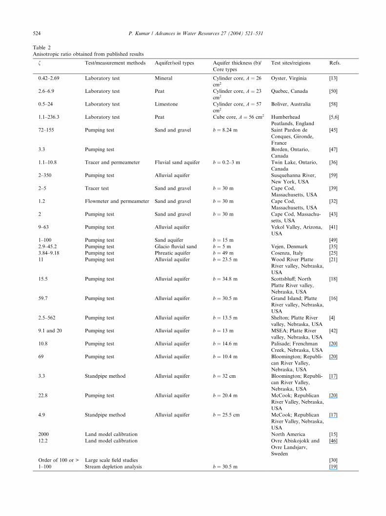
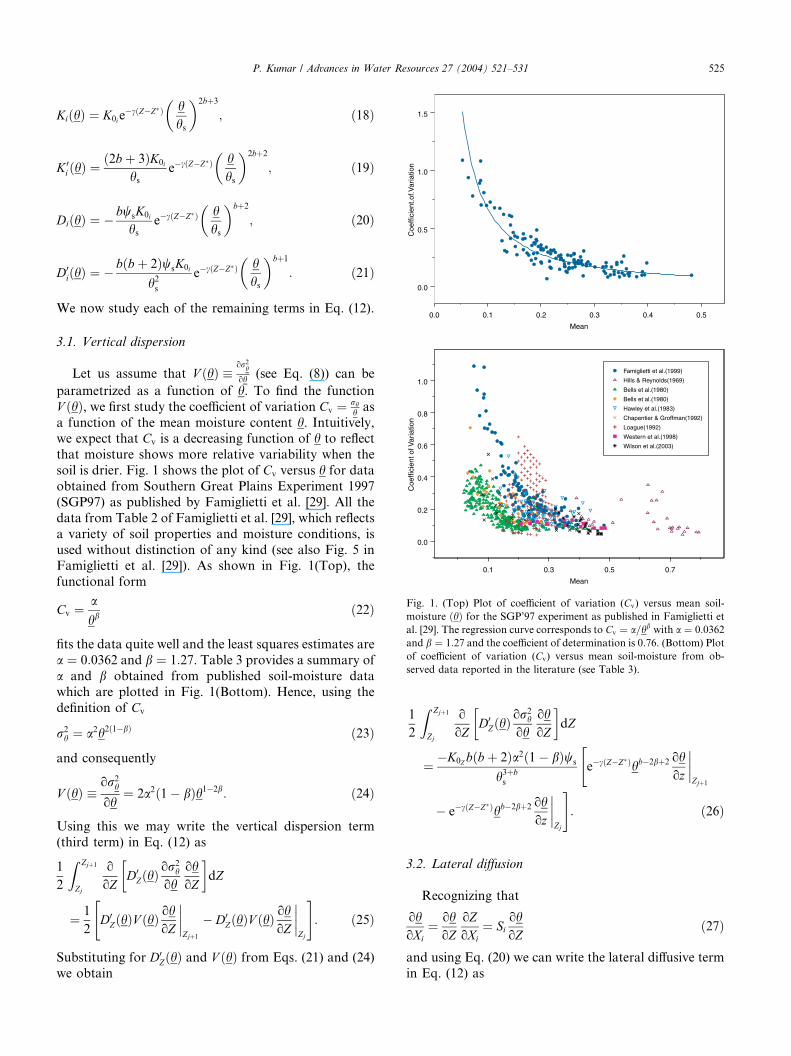
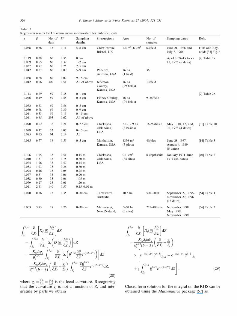

100
101
102
103
10ndash2
10ndash1
Anisotropic Constant
Slo
pe
log10
(Anisotropic Constant Slope)
296562634623035
1972516415
13104
097937
064833
031729
ndash0013751
ndash034479
ndash067583
ndash10069
ndash13379ndash1669
Fig 2 Plot of log10ethfSiTHORN for different values of the anisotropic constant f and slope Si
P Kumar Advances in Water Resources 27 (2004) 521ndash531 529
vertical for a realistic range of combinations of slope
and anisotropic constant The term A52 varies as fS2i
Fig 3 shows the plot of log10ethfS2i THORN again for the same
range 0016 Si 6 1 and 16 f6 2000 Following an
argument similar to that for A41 we see that the lateralgravitational term can also be quite significant as com-
pared to the vertical for a wide and realistic range of Siand f Since A61 is dominated by a2 following the earlier
100
101
10ndash2
10ndash1
Anisotrop
Slo
pe
log10(anisotropic
010192
080
ndash12654
ndash17212
ndash21769
ndash26327
ndash 30885ndash
ndash
35442
Fig 3 Plot of log10ethfS2i THORN for different values o
argument for A31 we may say that this term is small
However unlike A31 different gradients are associated
with the terms A1 and A6 namely ooZ and eth o
oXithorn vi
SiTHORN
respectively and therefore the conclusion relates only to
the coefficients and not to the term for lateral dispersion(this issue also relates to A41) Similarly variation of A63
as a function of fSi showsthat the lateral dispersion can
be comparable to the vertical dispersion However the
102
103
ic Constant
constant slope2)
2836523808
1925
14692
10135
055769
035385
962 ndash
f the anisotropic constant f and slope Si
530 P Kumar Advances in Water Resources 27 (2004) 521ndash531
caveat regarding different gradients mentioned above for
A61 holds again The ratio A71 shows that the relative
contribution of flow convergence is determined by the
curvature and the rate of decay of the hydraulic con-
ductivity with depth
4 Summary
In this largely theoretical paper I use a small pertur-
bation approach along with Reynolds averaging using
the Richardrsquos equation to develop a formulation of layer
averaged soil-moisture transport This formulation ac-counts for lateral flow as well as dispersion due to var-
iability The analysis shows that the lateral flow can be
quite significant for certain ranges of slope and soil-
properties The dispersion terms are small but I con-
jecture that they can account for significant flux when
integrated over large areas particularly in regions with
heterogeneous soil properties We also see that the
curvature of the land-surface contributes to the lateralmoisture flux Ignoring these contributions can result in
significant model error leading to inaccurate prediction
or unrealistic calibration of parameters that compensate
for these errors It is quite likely that the lateral flux may
not have significant contribution for all physiographic
regions depending upon the model scale however the
formulation presented here can be used when they are
importantNumerical schemes can be developed for incorporat-
ing the formulation in existing land-surface schemes with
appropriate boundary conditions so that they are con-
sistent with other aspects of the model It is envisioned
that Eq (39) can be numerically implemented using a
time lagging scheme where the lateral moisture fluxes and
gradients from the previous time step may be used for
predictions at the current time step thereby eliminatingthe need for significant computational complexity arising
from the introduction of the new terms
Acknowledgements
This research has been supported by NASA Grant
NAG5-8555 and NSF Grant EAR02-08009 The authorwould like to thank Francina Dominguez and Hyun Il
Choi for carefully checking the derivation of the equa-
tions and generating the summary reported in the Ta-
bles
References
[1] Abramopoulos F Rosenzweig C Choudhary B Improved
ground hydrology calculations for global climate models (GCMs)
soil water movement and evapotranspiration J Climate
19881921ndash41
[2] Albertson JD Montaldo N Temporal dynamics of soil moisture
variability 1 Theoretical basis Water Resour Res
200339(10)1274 doi1010292002WR001616
[3] Ambroise B Beven K Freer J Toward a generalization of the
TOPMODEL concepts topographic indices of hydrological
similarity Water Resour Res 199632(7)2135ndash45
[4] Ayers JF Chen XH Gosselin D Behaviour of nitratenitrogen
movement around a pumping high-capacity well a felid example
Ground Water 199836(2)325ndash37
[5] Beckwith CW Baird AJ Heathwaite AL Anisotropy and depth-
related heterogeneity of hydraulic conductivity in a bog peat I
Laboratory measurements Hydrol Processes 20031789ndash101
[6] Beckwith CW Baird AJ Heathwaite AL Anisotropy and depth-
related heterogeneity of hydraulic conductivity in a bog peat II
Modelling the effects on groundwater flow Hydrol Processes
200317103ndash13
[7] Bell KR Blanchard BJ Schmugge TJ Witczak MW Analysis of
surface moisture variations within large field sites Water Resour
Res 198016(4)796ndash810
[8] Beven KJ On subsurface stromflow an analysis of response
times Hydrol Sci J 198227505ndash21
[9] Beven KJ Kirkby MJ A physically based variable contributing
area model of basin hydrology Hydrol Sci Bull 197924(1)43ndash69
[10] Boone A Wetzel PJ Issues related to low resolution modeling of
soil moisture experience with the PLACE model Global Planet
Changes 199613161ndash81
[11] Bonan GB A land surface model (LSM version 10) for
ecological hydrological and atmospheric studies technical
description and userrsquos guide NCAR Technical Note NCAR
TN_417+STR National Center for Atmospheric Research
Boulder Colorado 1996 Available from lthttpwwwcgducar
educmslsmindexhtmlgt
[12] Brooks RH Corey AT hydraulic properties in porous media
Fort Collins CO Colorado State University 1964 27 pp
[13] Burger RL Berlitz K Measurement of anisotropic hydraulic
conductivity in unconsolidated sands a case study from a
shoreface deposit Oyster Virginia Water Resour Res
199733(6)1515ndash22
[14] Charpentier MA Groffman PM Soil moisture variability within
remote sensing pixels J Geophys Res 19929718987ndash95
[15] Chen J Kumar P Topographic influence on the seasonal and
inter-annual variation of water and energy balance of basins in
North America J Climate 2001141989ndash2014
[16] Chen XH Assessment of hydraulic properties in an unconfined
alluvial aquifer near Grand Island Nebraska J Am Water Resour
Assoc 199824(3)603ndash16
[17] Chen XH Measurement of streambed hydraulic conductivity and
its anisotropy Environ Geol 200039(12)1317ndash24
[18] Chen XH Ayers J Utilization of the Hantush solution for the
simultaneous determination of aquifer parameters Ground Water
199735(5)751ndash6
[19] Chen XH Yin YF Evaluation of stream depletion for vertical
anisotropic aquifer J Environ Syst 199927(1)55ndash70
[20] Chen XH Goeke J Summerside S Hydraulic properties and
uncertainty analysis for an unconfined alluvial aquifer Ground
Water 199937(6)845ndash54
[21] Chen XH Goeke J Ayers J Summerside S Observation well
network design for pumping tests in unconfined aquifers J Am
Water Resour Assoc 200339(1)17ndash32
[22] Clapp RB Hornberger GM Empirical equations for some soil
hydraulic properties Water Resour Res 197814601ndash4
[23] Dai Y Zeng X Dickinson RE Baker I Bonan GB Bosilovich
MG et al The common land model (CLM) Bull Am Meteorol
Soc 200384(8)1013ndash23
P Kumar Advances in Water Resources 27 (2004) 521ndash531 531
[24] Dickinson RE Henderson-Sellers A Kennedy PJ Wilson MF
Biospherendashatmosphere transfer scheme (BATS) for the NCAR
community climate model Technical Note TN-275+STR Na-
tional Center for Atmospheric Research Boulder Colorado
1986 69 pp
[25] Fallico C Mazzuca R Troisi S Determination of confined
phreatic aquifer anisotropy Ground Water 200240(5)475ndash80
[26] Famiglietti JS Aggregation and scaling of spatially-variable
hydrological processes local catchment-scale and macroscale
models of water and energy balance Dissertation Department of
Civil Eng and Oper Res Princeton University Princeton New
Jersey 1992
[27] Famiglietti JS Wood EF Evapotranspiration and runoff from
large land areas land surface hydrology for atmospheric general
circulation models Surv Geophys 199112179ndash204
[28] Famiglietti JS Wood EF Sivapalan M Thongs DJ A catchment
scale water balance model for FIFE J Geophys Res
19929718997ndash9007
[29] Famiglietti JS Devereaux JA Laymon C Tsegaye T Houser PR
Jackson TJ et al Ground-based investigation of spatial-temporal
soil moisture variability within remote sensing footprints during
SGP97 Water Resour Res 199935(6)1839ndash51
[30] Freeze RA Cherry JA Groundwater Prentice-Hall 1979
[31] Hawley ME Jackson TJ McCuen RH Surface soil moisture
variation on small agricultural watersheds J Hydrol 198362179ndash
200
[32] Hess KM Wolf SH Celia MA Large-scale natural gradient
tracer test in sand and gravel Cape Cod Massachusetts 3
Hydraulic conductivity variability and calculated macrodispersiv-
ities Water Resour Res 199228(8)2011ndash27
[33] Hills TC Reynolds SG Illustrations of soil moisture variability in
selected areas and plots of different sizes J Hydrol 1969827ndash
47
[34] Houser PR Shuttleworth WJ Famiglietti JS Gupta HV Syed
KH Goodrich DC Integration of soil moisture remote sensing
and hydrologic modeling using data assimilation Water Resour
Res 199834(12)3405ndash20
[35] Hvilshoj S Jensen KH Barlebo HC Madsen B Analysis of
pumping tests of partially penetrating wells in an unconfined
aquifer using inverse numerical optimization Hydrol J
19997(4)365ndash79
[36] Killey RWD Moltyaner GL Twin Lake tracer tests setting
methodology and hydraulic conductivity distribution Water
Resour Res 198824(10)1585ndash612
[37] Koster RD Suarez MJ Modeling the land-surface boundary in
climate models as a composite of independent vegetation stands J
Geophys Res 1992972697ndash715
[38] Koster RD Suarez MJ Ducharne A Stieglitz M Kumar P A
catchment based approach for modeling land-surface processes in
a GCM part 1ndashndashmodel structure J Geophys Res
2000105(D20)24809ndash22
[39] LeBlanc DR Garabedian SP Quadri RD Morin RH Teasdale
WE Paillet FL Hydrogeologic controls on solute transport in a
plume of sewage-contaminated ground water In Ragone SP
editor US Geological Survey Program on Toxic Waste and
Ground Water Contamination Proceedings of the Second Tech-
nical Meeting Cape Cod Massachusetts US Geol Surv Open File
Rep 86-481 1988 p B7ndashB12
[40] Loague K Soil water content at R-5 Part 1 Spatial and temporal
variability J Hydrol 1992139233ndash51
[41] Marie JR Hollett KJ Determination of hydraulic characteristics
and yield of aquifers underlying Vekol Valley Arizona using
several classical and current methods US Geol Surv Water-
Supply Paper 2453 Menlo Park California 1996
[42] McGuire VL Kilpatrick JM Hydrogeology in the vicinity of the
Nebraska Management Systems Evaluation Area (MSEA) site
central Nebraska US Geol Surv Water-Resour Invest Rep 1998
p 97-4266
[43] Moench AF LeBlanc DR Garabedian SP Preliminary type-
curve analysis of an aquifer test in an unconfined sand and gravel
aquifer Cape Cod Massachusetts US Geol Surv Water-Resour
Invest Rep 1995 p 94-4015
[44] Montaldo N Albertson JD Temporal dynamics of soil moisture
variability at the landscape scale 2 Implications for land surface
models Water Resour Res 200339(10)1275 doi101029
2002WR001618
[45] Neuman SP Analysis of pumping test data from anisotropic
unconfined aquifer considering delayed gravity response Water
Resour Res 197511(2)329ndash42
[46] Niu G-Y Yang Z-L The versatile integrator of surface atmo-
spheric processes (VISA) Part 2 Evaluation of three topography-
based runoff schemes Global Planet Changes 200338191ndash208
[47] Nwankwor GI Cherry JA Giilham RW A comparative study of
specific yield determinations for a shallow sand aquifer Ground
Water 198422(6)764ndash72
[48] Pitman AJ Yang Z-L Gogley JG Henderson-Sellers A Descrip-
tion of bare essentials of surface transfer for the bureau of
meteorological research centre AGCM BMRC Australia
BMRC Research Report No 32 1991
[49] Schafer DC Determining vertical anisotropy ratio using a
graphical iterative procedure based on the Hantush equation
Ground Water 199836(2)293ndash304
[50] Schlotzhauer SM Price JS Soil water flow dynamics in a
managed cutover peat field Quebec field and laboratory inves-
tigations Water Resour Res 199935(12)3675ndash83
[51] Sellers PJ Mintz Y Sud YC Dalcher A A simple biosphere
model (SiB) for use within the general circulation models J Atmos
Sci 198643505ndash31
[52] Stigelitz M Rind D Famiglietti JS Rosenzweig C An efficient
approach to modeling the topographic control of surface hydrol-
ogy for regional global climate modeling J Climate 199710118ndash
37
[53] Stieglitz M Hobbie J Giblin A Kling G Hydrologic modeling of
an arctic tundra watershed toward Pan-Arctic predictions J
Geophys Res 1999104(D22)27507ndash18
[54] Western AW Grayson RB The Tarrawarra data set soil
moisture patterns soil characteristics and hydrological flux
measurements Water Resour Res 1998342765ndash8
[55] Wetzel PJ Boone A A parameterization for land-atmosphere-
cloud-exchange (PLACE) documentation and testing of a
detailed process model of the partly cloudy boundary layer over
heterogeneous land J Climate 199581810ndash37
[56] Wilson DJ Western AW Grayson RB Berg AA Lear MS
Rodell M et al Spatial distribution of soil moisture over 6 and 30
cm depth Mahurangi river catchment New Zealand J Hydrol
2003276254ndash74
[57] Wolfram S The mathematica book 5th ed Wolfram Media Inc
2003 1488 pp
[58] Wright M Dillon P Pavelic P Peter P Nefiodovas A Measure-
ment of 3-D hydraulic conductivity in aquifer cores at in situ
effective stresses Ground Water 200240(5)509ndash17
[59] Yager RM Estimation of hydraulic conductivity of a riverbed
and aquifer system on the Susquechanna River in Broome
County New York US Geol Surv Water-Supply Paper 2387
Menlo Park California 1993
[60] Yang Z-L Pitman AJ McAvaney B Henderson-Sellers A The
impact of implementing the bare essentials of surface transfer land
surface scheme into the BMRC GCM Climate Dyn 199511279ndash
97
[61] Yang Z-L Niu G-Y Dickinson RE Stieglitz M Parameterization
of runoff production in common land model EOS Trans Suppl
200081(19)S139
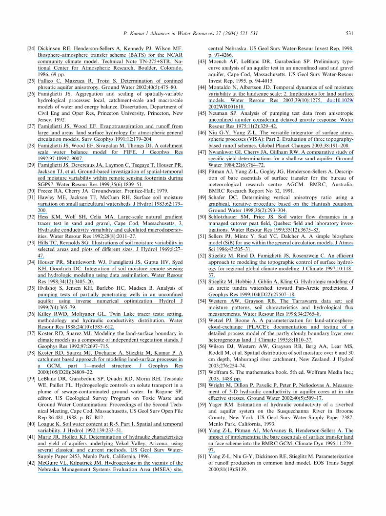