Karstological study of the new Kunming airport building area (Yunnan, China)
26
Editorial Manager(tm) for Environmental Earth Sciences Manuscript Draft Manuscript Number: Title: Karstological study of the new Kunming airport building area (Yunnan, China) Article Type: Original Manuscript Corresponding Author: Metka Petric, Ph.D. Corresponding Author's Institution: Scientific Research Centre SAZU First Author: Martin Knez, PhD Order of Authors: Martin Knez, PhD;Janja Kogovšek, PhD;Hong Liu;Janez Mulec, PhD;Metka Petric, Ph.D.;Nataša Ravbar, PhD;Tadej Slabe, PhD Abstract: In Kunming area (6.8 mio population) two big interventions are in progress: construction of a new airport, whose 23 km2 will extend across karst terrain northeast of the city, and extensive uptake of water from karst aquifers for drinking and agricultural use. In the study an interdisciplinary approach was utilized to demonstrate the need for holistic karstology studies prior to performing extensive interferences in karst environment. This study included survey of surface karst features and microscopic analyses of rock samples in the area of the new airport location, accompanied with hydrogeological studies and microbiological analyses of two karst drinking water sources in its vicinity (Qinglongdong, Huanglongdong). Results showed the specific characteristics of the subsoil stone forest that indicated a high level of karstification. The groundwater flow direction and velocity from the sinking Qiaotou stream at the margin of the new airport area toward the Huanglongdong spring was proved with a single tracer test. Individual measurements of selected chemical and bacteriological parameters were carried out and showed substantial pollution of both springs due to various types of human activities in the catchments. Spring water contained several dozen to several hundreds of viable heterotrophic and coliform bacteria in one milliliter and showed increased values of nitrates and o- phosphates. Huanglongdong spring additionally showed increased values of chlorides and sulfates. The results of the study pointed to the necessity of taking immediate measures for the springs' protection and show the importance of interdisciplinary research when planning anthropogenic activities in karst. Suggested Reviewers: Mario Parise National Research Council, IRPI [email protected] Expert in studies of human disturbances to karst environments Nico Goldscheider Department of Civil, Geo and Environmental Engineering, Technische Universitaet Muenchen [email protected] Expert in karst hydrogeology and environmental studies on karst Pat Kambesis Department of Geography & Geology, Western Kentucky University [email protected] Expert in karst geomorfology and hydrology, involved in karst research in China
-
Upload
independent -
Category
Documents
-
view
1 -
download
0
Transcript of Karstological study of the new Kunming airport building area (Yunnan, China)
Editorial Manager(tm) for Environmental Earth Sciences Manuscript Draft Manuscript Number: Title: Karstological study of the new Kunming airport building area (Yunnan, China) Article Type: Original Manuscript Corresponding Author: Metka Petric, Ph.D. Corresponding Author's Institution: Scientific Research Centre SAZU First Author: Martin Knez, PhD Order of Authors: Martin Knez, PhD;Janja Kogovšek, PhD;Hong Liu;Janez Mulec, PhD;Metka Petric, Ph.D.;Nataša Ravbar, PhD;Tadej Slabe, PhD Abstract: In Kunming area (6.8 mio population) two big interventions are in progress: construction of a new airport, whose 23 km2 will extend across karst terrain northeast of the city, and extensive uptake of water from karst aquifers for drinking and agricultural use. In the study an interdisciplinary approach was utilized to demonstrate the need for holistic karstology studies prior to performing extensive interferences in karst environment. This study included survey of surface karst features and microscopic analyses of rock samples in the area of the new airport location, accompanied with hydrogeological studies and microbiological analyses of two karst drinking water sources in its vicinity (Qinglongdong, Huanglongdong). Results showed the specific characteristics of the subsoil stone forest that indicated a high level of karstification. The groundwater flow direction and velocity from the sinking Qiaotou stream at the margin of the new airport area toward the Huanglongdong spring was proved with a single tracer test. Individual measurements of selected chemical and bacteriological parameters were carried out and showed substantial pollution of both springs due to various types of human activities in the catchments. Spring water contained several dozen to several hundreds of viable heterotrophic and coliform bacteria in one milliliter and showed increased values of nitrates and o-phosphates. Huanglongdong spring additionally showed increased values of chlorides and sulfates. The results of the study pointed to the necessity of taking immediate measures for the springs' protection and show the importance of interdisciplinary research when planning anthropogenic activities in karst. Suggested Reviewers: Mario Parise National Research Council, IRPI [email protected] Expert in studies of human disturbances to karst environments Nico Goldscheider Department of Civil, Geo and Environmental Engineering, Technische Universitaet Muenchen [email protected] Expert in karst hydrogeology and environmental studies on karst Pat Kambesis Department of Geography & Geology, Western Kentucky University [email protected] Expert in karst geomorfology and hydrology, involved in karst research in China


Cover Letter
1 2 3 4 5 6 7 8 9 10 11 12 13 14 15 16 17 18 19 20 21 22 23 24 25 26 27 28 29 30 31 32 33 34 35 36 37 38 39 40 41 42 43 44 45 46 47 48 49 50 51 52 53 54 55 56 57 58 59 60 61 62 63 64 65
1
Karstological study of the new Kunming airport building area (Yunnan, China)
Martin Knez1, Janja Kogovšek1, Liu Hong2, Janez Mulec1, Metka Petrič1, Nataša Ravbar1, Tadej Slabe1
1 Karst Research Institute ZRC SAZU, Titov trg 2, 6230 Postojna, Slovenia.
2 Yunnan Institute of Geography, Xiefu Rd. 20, 650223 Kunming, China.
Abstract
In Kunming area (6.8 mio population) two big interventions are in progress: construction of a new airport, whose
23 km2 will extend across karst terrain northeast of the city, and extensive uptake of water from karst aquifers for
drinking and agricultural use. In the study an interdisciplinary approach was utilized to demonstrate the need for
holistic karstology studies prior to performing extensive interferences in karst environment. This study included
survey of surface karst features and microscopic analyses of rock samples in the area of the new airport location,
accompanied with hydrogeological studies and microbiological analyses of two karst drinking water sources in
its vicinity (Qinglongdong, Huanglongdong). Results showed the specific characteristics of the subsoil stone
forest that indicated a high level of karstification. The groundwater flow direction and velocity from the sinking
Qiaotou stream at the margin of the new airport area toward the Huanglongdong spring was proved with a single
tracer test. Individual measurements of selected chemical and bacteriological parameters were carried out and
showed substantial pollution of both springs due to various types of human activities in the catchments. Spring
water contained several dozen to several hundreds of viable heterotrophic and coliform bacteria in one milliliter
and showed increased values of nitrates and o-phosphates. Huanglongdong spring additionally showed increased
values of chlorides and sulfates. The results of the study pointed to the necessity of taking immediate measures
for the springs’ protection and show the importance of interdisciplinary research when planning anthropogenic
activities in karst.
Keywords: building on karst, surface landforms, karst water sources, water quality, tracer test, China.
*ManuscriptClick here to download Manuscript: Knez et al_Kunming airport.doc Click here to view linked References
1 2 3 4 5 6 7 8 9 10 11 12 13 14 15 16 17 18 19 20 21 22 23 24 25 26 27 28 29 30 31 32 33 34 35 36 37 38 39 40 41 42 43 44 45 46 47 48 49 50 51 52 53 54 55 56 57 58 59 60 61 62 63 64 65
2
INTRODUCTION
The exceptional and diverse features of the Yunnan karst (SW China), from the tropical cone karst in the south
and the stone forests in the center to the mountain karst and high plateau karst of Tibet in the north, offer a
revelation of the basic characteristics of how karst is formed. The relatively dense settlement of the region and
urban expansion, growing industry and infrastructure development, intensified agriculture, growing tourism, and
the corresponding great need for clean water offer opportunities for research and even demand that karstologists
study the modern human impact on this vulnerable karst region (Chen et al. 1998, Guo & Jiang 2010, Guo et al.
2010, Jiang et al. 2008, Jiang et al. 2009, Knez et al. 2009, Knez et al. 2010a,b, Kogovšek 2010, Lu 2006, Shi et
al. 2009).
Kunming, the capital city of Yunnan, experiences such pressures, which have already taken its toll on the
environment and water supply resources, therefore the implementation of sustainable planning and management
practices is necessary. The city covers a total land area of 21,111 square kilometers and has at present total
population of 6.8 million. It serves as a gateway to neighboring countries Vietnam, Laos and Myanmar, and its
development strategy is centered on building itself up as a regional and international commercial and tourism
center. Because the location of the currently operating airport does not allow for further expansion, a new airport
is being built about twenty-one kilometers northeast of the city and is planned to be the air logistics center to link
with South and Southeast Asia. The first phase of the project was planned for the five-year period between 2006
and 2011, and the project should be finished and the airport built on an area of almost 23 km2 by 2020.
This very extensive project will have numerous consequences for its entire area of influence which is
predominantly karstic. In the framework of the bilateral Slovene-Chinese project titled The impact of airport
construction on karst aquifer behaviour and water quality - case study of Qinglongdong spring catchment,
Kunming, China, a number of studies on the geological, geomorphological, and hydrogeological characteristics of
the karst part of the area have been conducted since 2006. Field work in the following years when the earthworks
started allowed us to monitor the changes in the opened surfaces and study surface karst forms that revealed the
specific characteristics of the subsoil stone forest in this area.
Karst waters were monitored at selected points in ponors and springs. Physical properties were measured and
samples collected for chemical and bacteriological analysis. Based on the collected data, certain hydrogeological
problems were identified and studied in detail. Special interest was aroused by the Huanglongdong and
Qinglongdong springs located southwest of the location of the new airport. In the absence of any better
solutions, these two springs are potential water supply sources even though they are already quite polluted due to
various sources of pollution in their catchment areas. It is interesting that despite a distance of only five hundred
meters between them they display characteristic differences in their physical and chemical qualities. Further
studies were therefore oriented toward establishing the differences between the catchment areas of the two
springs and the characteristics of flow inside the catchment areas, an important basis for assessing the potential
impact of the construction of the new airport and planning their protection.
Basic research was augmented by a tracer test. Due to technical problems, the originally planned tracing of a
sinking stream in the central construction area of the new airport was rescheduled for a later period. In May 2009
we carried out a tracer test on a sinking stream one kilometer north of the Huanglongdong and Qinglongdong
springs. This paper presents the results of the research conducted so far.

1 2 3 4 5 6 7 8 9 10 11 12 13 14 15 16 17 18 19 20 21 22 23 24 25 26 27 28 29 30 31 32 33 34 35 36 37 38 39 40 41 42 43 44 45 46 47 48 49 50 51 52 53 54 55 56 57 58 59 60 61 62 63 64 65
3
BASIC CHARACTERISTICS OF THE AREA
Basic geological and hydrogeological characteristics from existing geological maps of the study area were
summarized and augmented with additional field surveys. Carbonate rock of Cambrian to Permian age
dominates in the area of the new airport and the Huanglongdong and Qinglongdong springs (Fig. 1). It is
composed largely of dolomite with slightly more limestone only in the Lower Permian beds. These beds display
the most karstification with developed characteristic karst forms. Hydrogeological barriers between beds of karst
rock are composed of very poorly permeable Cambrian, Carboniferous and Permian clastic rocks. Quaternary
alluvial sediments are deposited along surface water courses. The Qinglongdong and Huanglongdong springs are
located at the contact between the karst aquifer in carbonate rock and poorly permeable alluvial sediment. The
area between them is cut by a subvertical fault running northwest-southeast and a thinner belt of very poorly
permeable Permian clastic rocks. This belt continues in a northerly direction and presumably plays the role of a
hydrological barrier separating the catchment areas of the two springs. Inside the catchment areas there are
several sinking streams that collect water from different areas, and the direction of their underground courses has
not been reliably proven. The Qiaotou ponor, which lies about one kilometer north of the springs, was included
in the study.
Undulating karst landscape with the altitude differences of up to 50 m traverses from karst hills to shallow
depressions and dolines. The area is used as agricultural land with orchards or corn fields in the karst areas, and
vegetable and rice fields on Quaternary alluvial sediments.
KARST SURFACE DISSECTED INTO SUBSOIL STONE FOREST
The surface of the hilly area was dissected by low, up to one meter high or sometimes slightly higher, and
relatively sparse karren with pointed and stumpy rock peaks. They were separated by larger or smaller patches of
sediment covered by soil and shrubs or trees. The earthworks revealed a subsoil stone forest (Fig. 2) covering
almost the entire area of carbonate rock that boasts unique form characteristics dictated largely by the
composition of the rock. The karren that dissected the surface was the top of the subsoil stone forest.
The rock is fractured by subvertical faults five to ten meters apart. The faults generally run in the north-south and
east-west directions (Fig. 3). Karst processes have denuded the rock laterally along the faults many meters in
width and up to ten meters deep. Larger rock masses or stone pillars remain today only where the fault network
is less dense.
The dissection of the rock surface, dictated by the composition of rock with relatively large dolomite lenses,
gave a special stamp to the subsoil stone forest (Fig. 4a). The lenses are about twenty centimeters in diameter
and up to several cubic decimeters in volume. The textural characteristics of light brown to light grey solid and
homogenous limestone dominate the entire area.
The rocky surface of the pillars is defined by the characteristics of the rock’s composition and the conditions of
its formation. The frequency of dolomite lenses varies. In places where their frequency in the rock is high, they
project from the walls one next to another as a rule. Where there are only individual dolomite lenses in the rock,
single semicircular recesses occur frequently. The surface of rock with no lenses is smooth below the ground

1 2 3 4 5 6 7 8 9 10 11 12 13 14 15 16 17 18 19 20 21 22 23 24 25 26 27 28 29 30 31 32 33 34 35 36 37 38 39 40 41 42 43 44 45 46 47 48 49 50 51 52 53 54 55 56 57 58 59 60 61 62 63 64 65
4
while on the surface it is dissected by traces of rainwater and water creeping down the walls.
Due to their convex shape, greater roughness, and consequently heavier lichen cover, dolomite lenses on the
surface of the rock are a dark grey colour and are visible on the surface of the rock as dark grey to black patches
on a lighter coloured base (Fig. 4a). For the most part, the percentage of undolomitized limestone surface is only
a little less than the percentage of dolomitized sections. In spite of this, relative to all the studied rock columns
the proportion of dolomitized sections is not equally distributed and tends to change laterally, though never
completely disappearing in the studied area. Rock with such properties limits the development of smaller subsoil
rock forms as well as rock forms carved by rainwater.
Stratification in the solid and homogenous rock is almost never observed, but in individual places largely
horizontal contacts between rock segments can be seen. Bearing this in mind, rock samples were collected in the
vertical direction from one of the pillars.
An important general property of the rock is primarily strong diagenetic change in the limestone:
recrystallization, dolomitization, and in certain places considerable secondary porosity and a high percentage of
carbonate (Table 1).
Studies of microscopic thin sections showed that in the lower section of the karren some ten meters below the
recent surface, the original limestone is late diagenetically dolomitized. In the wackestone to packstone type of
limestone, poorly identifiable fragments of fossil remains can be observed, parts of which have often been
microscopically displaced along tiny fissures. Pellets and other lithic grains occur frequently. The rock is
crisscrossed by tiny calcite veins running in various directions with cross sections measuring from 0.5 to 2 mm.
Calcite fills mostly spherical fenestrae 2 to 10 mm in size.
In some places the frequency and size of dolomitized sections changes laterally as well as vertically. Due to the
mostly idiomorphic grains of dolomite around 0.25 mm in diameter, the rock can be labelled the grainstone type
of dolosparite. The grains of dolomite are poorly cemented, but to a great extent the grains remained in place on
the surface of rock in fissures widened by corrosion and filled by sediment. Secondary intergranular porosity
changes laterally, generally estimated at around 5% to 10%. The possibility of subsoil weathering of rock is
great, primarily due to the considerable porosity of the rock and the poorly cemented dolomite crystals. On the
lowest sections of the stone pillars where sediment has been recently removed, the thickness of weathered rock
can exceed five centimeters (Fig. 4b). Dolomite lenses protrude here most from the surface of the rock, and the
characteristic boxwork pattern can be observed on the surface.
The ratio between basic non-dolomitized rock and dolomite lenses does not change substantially in the central
part of the karren. However, numerous completely regular idiomorphic crystals of dolomite whose sharp edges
indent in various clasts (e.g., foraminifers up to 5 mm in size) appear in the limestone. The ratio of calcite to late
diagenetic idiomorphic dolomite is 1:1. Recrystallized corals as well as numerous fragmented foraminifers are
frequently found in this section. The rock is crisscrossed by microtectonic fissures filled with calcite. In some
places calcite veins are slightly dolomitized. Plasticlasts up to 1 cm in size are also encountered on rare occasion
in the rock.
The rock forming the tops of the rock pillars also changes strongly laterally. In part of the rock, calcite and
dolomite crystals (around 0.25 mm in diameter) appear in the same proportion. In another part the
pelmicrosparite type of limestone with numerous fenestrae filled with calcite sparite and individual calcite veins
up to 1 mm thick appears. The limestone contains numerous fragments of unidentifiable foraminifers and other
1 2 3 4 5 6 7 8 9 10 11 12 13 14 15 16 17 18 19 20 21 22 23 24 25 26 27 28 29 30 31 32 33 34 35 36 37 38 39 40 41 42 43 44 45 46 47 48 49 50 51 52 53 54 55 56 57 58 59 60 61 62 63 64 65
5
mollusks. Where dolomite crystal grains and calcite alternate in more or less equal proportions, the fossil
remains are no longer visible due to recrystallization. Tiny fissures up to 1 mm thick are filled with sparite
cement. Grains of dolomite in dolomite lenses are poorly cemented and are therefore easily washed from the
rock surface by various erosion processes.
Relatively large stone pillars dominate in the subsoil stone forest. Their lower sections are five or more meters in
diameter. As a rule, the pillars end in a number of conical peaks, and some pillars have wide tops dissected below
the ground. The pillars measure up to ten meters in height. The larger, often elliptical cross sections of the pillars
and differences in their size reflect the sparser and unsymmetrical network of fissures that vertically cut the
carbonate rock and widened below the ground between the pillars (Fig. 3).
The rock relief (Slabe 1998) clearly shows the subsoil formation (Slabe 2005) of the stone pillars below the soil
and sediment that cover the carbonate rock and the transformation of the denuded tops. The rock surface is quite
unique, dictated largely by the specific rock composition. The most distinct rock forms are subsoil channels
(Slabe & Liu 2009) that dissect the walls and tops of the pillars. The vertical channels frequently have extensive
funnel-like mouths at the top and measure one meter or more in diameter; however, smaller and more or less
horizontal channels wind only between the peaks. Subsoil cups also formed in the latter. From the surface, water
creeps through the channels along the contact of sediment and soil with the rock. The funnel-like mouths of
subsoil channels in connected semicircular notches wind and dissect extensive more or less horizontal tops of
pillars or wind between their conical peaks. Smaller subsoil shafts up to twenty centimeters in size are of similar
origin and vertically hollow the pillars and smaller tubes of the same size that crisscross them in various
directions, which in some places indicates porous rock. Shafts and cavities form at the contact with the sediment
that fills them. The walls of individual pillars are undercut or dissected by horizontal notches, the consequence of
accelerated corrosion caused by stagnant percolating water at the contact with sediment that is poorly permeable
in some places. Subsoil cups and only a few slightly slanting channels formed on the wider tops. Soil and
sediment only cover the rock in some places, which below them dissolves to form cups and channels.
Characteristic rock relief dissects the tops of pillars that were denuded and exposed to rain. The rock forms
include rain flutes, rain pits, solution pans, and scallops that formed due to the creeping of water down the
overhanging surface of the wall. The rain flutes (Slabe 2005) could only form on limestone rock between
nodules of dolomite. Solution pans developed as a rule from subsoil cups when the tops of the pillars were
denuded. Their dissected and jagged form was dictated by the composition of the rock as the rain transformed
denuded subsoil rock forms. The walls of funnel-like mouths of subsoil channels are dissected by flutes. Rain
pits are found on horizontal flat surfaces of the tops; conical tops are the consequence of quarrying activity.
Below the moss layer biocorrosion sculpts smaller pits and channels.
Relative to conditions, the formation of the rock surface can be divided into three characteristic parts. Nodules
on the surface exposed mostly to rain and corrosion are relatively angular, dissected by tiny notches and rain pits
that formed along tiny fissures due to the uneven composition of the rock. On larger limestone surfaces flutes
formed between the nodules on slanted rock and solution pans occurred on horizontal rock. Their edges are
dissected and jagged because their walls are often dolomite nodules. The surface of rock surrounded by soil is
similar since immediately below the ground where dissolution is most pronounced due to organic matter in the
soil, water erodes grains of dolomite rock at a faster rate along a permeable contact. The nodules protrude
semispherically most distinctly from walls that are deeper below the surface. The contact between the rock and
1 2 3 4 5 6 7 8 9 10 11 12 13 14 15 16 17 18 19 20 21 22 23 24 25 26 27 28 29 30 31 32 33 34 35 36 37 38 39 40 41 42 43 44 45 46 47 48 49 50 51 52 53 54 55 56 57 58 59 60 61 62 63 64 65
6
sediment is poorly permeable and therefore the saturated water drains away at a slower rate. This is also evident
in the weathered layer of the rock. Individual sparry calcite protrudes from all surfaces.
Below the stone forest there is a well-developed network of caves through which water courses flow and carry
away sediment washed from the surface by rainwater, enabling their growth despite the poor permeability of the
contact between the rock and the sediment.
HYDROGEOLOGICAL CHARACTERISTICS
The Qinglongdong spring (Fig. 5a) was part of the Kunming region water supply system but pumping stopped in
2002 due to pesticide pollution. In 2005 pumping resumed due to a shortage of suitable water sources. The
Huanglongdong spring (Fig. 5b) has also been captured for water supply purposes. However, no appropriate
measures for the protection of their catchment areas have been enacted. Based on the hydrogeological map we
can assume that the springs are supplied by the aquifer to the north and east of the springs but there have been no
more detailed studies. Well developed karst forms (sinkholes, karren, ponors, etc.) indicate good karstification of
the area. Despite the relative thickness (> 1m) of the soil layer the infiltration at the mentioned points is rapid
and followed by underground flow through well developed karst channels and fissures toward the springs
through which the water returns to the surface at the contact with poorly permeable rock. The thickness of the
vadose zone does not exceed one hundred meters and usually measures from forty to fifty meters.
The mean annual discharge of the Qinglongdong spring is 473 l/s, minimal discharges total a few liters per
second, and maximum discharges can reach up to 3 m3/s or more. In the Kunming area, the mean annual air
temperature for a 30-year period is 14.5º C and the mean annual precipitation is 1,035 mm (Zhang et al. 2005).
According to the Turc equation (Shaw 1994), the mean annual evapotranspiration can be estimated at about 650
mm. Taking this data and the mean annual discharge of the Qinglongdong spring into consideration, the
minimum extent of the catchment area can be estimated at about 39 km2.
WATER QUALITY ASSESSMENT USING PHYSICAL AND CHEMICAL PARAMETERS AND
BACTERIAL INDICATORS
Methods
A datalogger with probes for the continuous measurement of water level, temperature (T), electrical conductivity
(EC), and pH at 15-minute intervals was installed at the Qinglongdong spring in February 2007 and was active
until September 2007. The discharges of both springs were measured in July 2008 and May 2009 with an OTT
C20 Current Meter, and of the Qiaotou ponor in May 2008. At the time of other samplings the discharge was
estimated. It must be noted that we were only able to measure or estimate the discharge at the channel because
data on the amount pumped for the supply of the population with water was not available at every monitoring.
Between 2006 and 2009 we sampled the water from May to August for physical and chemical analyses, five
times at the Qinglongdong and Huanglongdong springs and three times at the Qiaotou ponor. Each time, T and
EC were measured. In 2006 and 2009 we used the WTW MultiLine P4, and in 2007 and 2008 the WTW 330i
conductometer. The two instruments were intercalibrated. Analyses on the content of nitrates, o-phosphates, and

1 2 3 4 5 6 7 8 9 10 11 12 13 14 15 16 17 18 19 20 21 22 23 24 25 26 27 28 29 30 31 32 33 34 35 36 37 38 39 40 41 42 43 44 45 46 47 48 49 50 51 52 53 54 55 56 57 58 59 60 61 62 63 64 65
7
ammonium using the corresponding Visicolor high sensitivity colorimetric tests were done in field laboratories.
Total hardness (Ca+Mg) and calcium content (Ca) were determined using the standard titrimetric method
(Standard Methods for the Examination of Water and Waste Water 1992).
The presence of enteric pathogens in drinking and recreational water is of great concern. It is estimated that ten
million people die every year in developing countries as a direct result of the consumption of contaminated
water. Several hundred different microbes have been shown to be involved in outbreaks of waterborne disease,
but it is quite impossible to look for every pathogen potentially present in water samples. Instead, environmental
microbiology uses indicator organisms as a criterion of water quality and as a warning of possible contamination.
The following microbial groups are used to determine the microbiological safety of water: total coliforms (these
bacteria are classically used as indicators of faecal contamination although some members of this group can
originate from nonenteric environments), faecal coliforms (thermotolerant coliforms, particularly Escherichia
coli), faecal streptococci and enterococci, sulphite-reducing clostridia, Pseudomonas spp., and heterotrophic
plate counts that indicate the overall microbiological status of the system (Toranzos and McFeters 1997). A high
number of faecal coliforms (> 200 colonies/100ml) in a river or stream indicates a high probability of the
presence of pathogenic microbes.
For bacteriological analysis, water samples from the Qinglongdong and Huanglongdong springs and the Qiaotou
ponor were collected in 50 ml sterile test tubes (May 6, 2009; dry, sunny weather). Since the tested water
appeared clear at the springs and the ponor, membrane filtration was not applied. Ridacount medium plates (R-
biopharm, Germany) were used for quantitative microbial detection. Ridacount plates are made of a base film
coated with a dry culture medium and covered with a fabric that allows perfect absorption of an applied sample
solution. At the site 1 ml samples of water were directly applied onto the plates to determine the total number of
aerobic heterotrophic bacteria (Ridacount Total) and coliform bacteria (Ridacount Coliform). The Ridacount
Coliform test is based on the β-galacotosidase activity of coliform bacteria. The plates were incubated twenty-
four hours at 35° C for coliforms and forty-eight hours at 35° C for total bacterial heterotrophic counts (R-
Biopharm). After the incubation was completed, bacterial colonies were enumerated and expressed as CFU
(colony-forming units) per ml.
Results
Water pumping has a characteristic and decisive impact on the measured levels of water in the Qinglongdong
spring. We have no data on the time distribution and volume of pumping so a comparison of the measured levels
with hydrological conditions is therefore not possible. During the operation of the datalogger between February
and September 2007, the water temperature was very constant, oscillating between 16.7º C and 16.9º C.
Similarly, pH values varied between 6.9 and 7.3. EC values oscillated between 369 and 480 µS/cm depending on
the hydrological conditions.
During manual sampling in the 2006–2009 period (Table 2), the measured temperatures of the Quinglongdong
spring oscillated minimally (16.6–16.8º C) while the Hunglongdong spring oscillated more distinctly (16.1–
19.5º C). The EC of the Qinglongdong spring oscillated between 404 and 483 µS/cm while the Huanglongdong
spring oscillated between 329 and 519 µS/cm. The lowest values were recorded during the highest discharges.
1 2 3 4 5 6 7 8 9 10 11 12 13 14 15 16 17 18 19 20 21 22 23 24 25 26 27 28 29 30 31 32 33 34 35 36 37 38 39 40 41 42 43 44 45 46 47 48 49 50 51 52 53 54 55 56 57 58 59 60 61 62 63 64 65
8
The larger oscillations of T and EC in the Huanglongdong spring compared to the Qinglongdong spring can be
explained by the inflow of surface water.
During the high water level in July 2008, the Ca/Mg ratio of the Hunglongdong spring was 1 or 1.5 (Fig. 6), and
the ratio of the water at the Qiaotou ponor was the same. This indicates a possible connection between the ponor
and this spring because the Qinglongdong spring had higher ratios: 3.8 at low discharge and 6 at high discharge
in July 2008. The ponor, and even more so the two springs, displayed increased content of nitrates (from 3 to 70
mg of NO3-/l) and o-phosphates (up to 0.7 mg of PO4
3-/l), and the Huanglongdong spring's concentrations of
chlorides and sulfates were even higher. It is obvious that the underground flow from the ponor to this spring
receives additional pollution from the vadose zone depending on the hydrological conditions.
For assessing the quality of drinking water, several ISO methods are applied to detect crucial microbiological
parameters (Escherichia coli, coliform bacteria, enterococci, Clostridium perfringens, number of colonies at
22° C, total number of colonies at 37° C). Ridacount test plates were successfully used to determine the water
quality of the Qinglongdong and Huanglongdong springs and the Qiaotou ponor and proved to be a reliable field
test to quickly determine the possible existence of water contamination dangerous to public health. To determine
water quality we measured total bacterial count and the number of coliforms (Fig. 7). Based on ISO standards for
drinking water, the number of coliforms must not exceed 0 CFU in a 100-ml sample of water (SIST EN ISO
9308-1) and the total number of mesophilic bacteria at 37° C must be under 100 CFU per ml (SIST EN ISO
6222). The total heterotrophic bacterial count takes into consideration the enumeration of all aerobic bacteria
capable of growing on nutrient-rich media. In the case of the water sample from the Qinglongdong spring, the
lower number of the total bacterial count (22 CFU/ml) compared to the coliform count (31 CFU/ml) is attributed
to the uneven distribution of water samples on the Ridacount Total test plates (Table 3). None of the water from
any of the tested sites matched the ISO criteria, and it is not suitable for direct public consumption without
downstream processing to remove bacteria. This issue is even more urgent since coliforms have been shown able
to grow in potable water distribution systems as a result of bacterial biofilms on pipe surfaces, and consequently
the total number of coliform bacteria reaching the end-users can be even higher (Toranzos and McFeters 1997).
TRACER TEST
Methods
A tracer test was employed to determine where the water from the Qiaotou ponor flows. At 18:00 on May 7,
2009, when its discharge was 16 l/s at a low water level, 50 g of uranine was injected at the ponor (Fig. 8).
Before the injection and thirty days after it, samples were taken at the Qinglongdong and Huanglongdong
springs. During the injection the discharge at the Qinglongdong spring was around 90 l/s and about three times
lower at the Huanglongdong spring. Hydrological conditions remained stable until May 14, 2009, when heavier
rains started. The samples were analyzed for the presence of uranine (Eex=491 nm, Eem=512 nm; detection limit
0.005 mg/m3) at the Karst Research Institute in Postojna, Slovenia, using a Perkin Elmer LS 30 fluorescent
spectrometer.
Results
1 2 3 4 5 6 7 8 9 10 11 12 13 14 15 16 17 18 19 20 21 22 23 24 25 26 27 28 29 30 31 32 33 34 35 36 37 38 39 40 41 42 43 44 45 46 47 48 49 50 51 52 53 54 55 56 57 58 59 60 61 62 63 64 65
9
In the existing hydrological conditions when the discharge was low, the first traces of the injected uranine were
observed at the Huanglongdong spring at 20:00 on May 10, 2009, three days and two hours after the injection
(Fig. 9). Over the next 26 hours the concentration of uranine increased to its maximum value of 2.9 mg/m3 and
then decreased, falling below the detection limit on May 16, 2009. In Qinglongdong no tracer was detected.
During the period of decreasing, the concentration oscillated twice (in the early morning hours on May 12 and
13), even though there was no rain. The cause might have been a changed pumping regime, but no measurements
of the discharge were made at the time that might explain the rises in the concentration. The first rain after the
injection fell on May 14, when very low concentrations of the tracer had already been observed at the spring.
Later, on May 26, 2009, when the estimated value of the discharge of the spring was 2.5 times higher than at the
injection, the concentration of the tracer recorded no rises and remained below the detection limit until the end of
sampling. Our conclusion is that the majority of the tracer was transferred during the observed tracer wave.
Given the surface distance between the ponor and the spring (1250 m), the apparent maximum velocity at low
water levels is 17 m/h, and the dominant velocity is 12.5 m/h. These values are more than two times smaller than
the underground flow in the Tianshengan area (region of Lunan, Yunnan) which we traced at low water levels in
1998 (Kogovšek and Liu 1999). However, we can also conclude that the velocities of flow at medium and high
water levels between the ponor and the Huanglongdong spring are probably considerably higher, similarly as it
was proved in the case of underground flow in the Tianshengan area (Kogovšek 2010).
At the Qinglongdong spring the concentration of uranine oscillated around the detection limit, and individual
higher values were only recorded twice (0.03 and 0.02 mg/m3). These minor oscillations probably reflect natural
fluorescence oscillations and lead to the conclusion that in the existing hydrological conditions there is no water
connection between the Qiaotou ponor and the Qinglongdong spring.
CONCLUSIONS
The study area is a typical example of karst surface transformed into a stone forest, and yet it is unique because
of the forms dictated by rock composition and permeability of the contact between rock and sediment and soil.
The dolomite nodules protruding from the rock and dissecting the surface of the stone pillars give it a special
stamp. The surface is slowly being denuded and the peaks of the stone forest have already been reshaped by
rainwater and biocorrosion.
Individual measurements of physical and chemical parameters taken under various hydrological conditions
indicated and a tracer test proved a direct connection between the Qiaotou ponor and the Huanglongdong spring.
The Qinglongdong spring is supplied largely by the karst aquifer located to the east of the intermediate
hydrological barrier, which is composed of very poorly permeable Permian clastic rocks. According to the
estimated extent of the Qinglongdong spring’s catchment area based on the water balance, it is possible that the
new airport is located inside the catchment area; however, further research will be required to reliably define the
relations.
There are several other potential sources of pollution in the catchment areas of both monitored springs such as
villages, a cement factory, a warehouse for oil products, roads and railway, agricultural activities, and quarries.
The poor water quality determined by chemical and bacteriological analyses is therefore not a surprise. In
1 2 3 4 5 6 7 8 9 10 11 12 13 14 15 16 17 18 19 20 21 22 23 24 25 26 27 28 29 30 31 32 33 34 35 36 37 38 39 40 41 42 43 44 45 46 47 48 49 50 51 52 53 54 55 56 57 58 59 60 61 62 63 64 65
10
addition to the increased content of mostly nitrates and o-phosphates exhibited by the Qinglongdong spring, the
Huanglongdong spring also showed increased values of chlorides and sulfates. Bacteriological analysis indicated
that the water is not suitable for direct public consumption without previous treatment to remove pollution. It is
interesting that both chemical and bacteriological analyses showed that the Huanglongdong spring has higher
concentrations than the Qiaotou ponor, which indicates additional pollution from the surface through vadose
zone in the catchment area.
The results of the conducted studies confirm that karstological planning of life in karst regions and monitoring of
major encroachments are necessary in addition to the contamination countermeasures proposed by Guo et al.
(2010) for the rational development and protection of these vulnerable regions.
Acknowledgement
The research was supported under bilateral project No. BI-CN/07-09-015 by the Slovenian Research Agency and
the Ministry of Science and Technology of the People's Republic of China (code: 2004DFA02200) in the
framework of Slovenia-China cooperation in science and technology, 2007-2009.
REFERENCES
Chen X et al. (1998): South China Karst 1. ZRC Publishing, Ljubljana
Guo F, Jiang G (2010) Problems of Flood and Drought in a Typical Peak Cluster Depression Karst Area (SW
China). Environmental Earth Sciences, Advances in Research in Karst Media, Part 1: 107-113
Guo F, Yuan DX, Qin ZJ (2010) Groundwater contamination in karst areas of Southwestern China and
recommended countermeasures. Acta carsologica 39/2: 389-399
Jiang, Y, Yuan D, Zhang C, Zhang G, He R (2008) Impact of land use change on groundwater quality in a typical
karst watershed of southwest China. Hydrogeology Journal 16 (4), 727–735.
Jiang Y, Wue Y, Groves C, Yuan D, Kambesis P (2009) Natural and anthropogenic factors affecting the
groundwater quality in the Nandong karst underground river system in Yunan, China. Journal of Contaminant
Hydrology 109: 49–61
Knez M, Kogovšek J, Kranjc A, Liu H, Petrič M, Slabe T (2009) The Shuilian cave in the upper region of the
Chang river (Karst of NW Yunnan, China). Acta carsologica 38/1: 97-106
Knez M, Liu H, Slabe T (2010a) High Mountain Karren in Northwestern Yunnan, China. Acta carsologica 39/1:
103-114
Knez M, Liu H, Slabe T (eds.) (2010b) South China Karst 2. ZRC Publishing, Ljubljana
Kogovšek J (2010) Characteristics of Underground Water Flow at Different Water Levels in Tianshengan Karst
Area, Yunnan, China. Acta geologica sinica, 84/1: 206-212
Kogovšek J, Liu H (1999) Water tracing test in Tianshengan region, China at low water level in November 1998.
Acta carsologica, 28/2: 241-253
Lu Y (2006) Karst water resources and geo-ecology in typical regions of China. Environmental Geology, 51/5:
695-699
Shaw E (1994) Hydrology in Practice. Chapman & Hall, London
1 2 3 4 5 6 7 8 9 10 11 12 13 14 15 16 17 18 19 20 21 22 23 24 25 26 27 28 29 30 31 32 33 34 35 36 37 38 39 40 41 42 43 44 45 46 47 48 49 50 51 52 53 54 55 56 57 58 59 60 61 62 63 64 65
11
Shi Z, Liu X, Liu Y, Huang Y, Peng H (2009) Catastrophic groundwater pollution in a karst environment: a study
of phosphorus sludge waste liquid pollution at the Penshuidong Cave in Yunnan, China. Environ Earth Sci
59:757–763
Slabe T (1998) Rock relief of pillars in the Lunan Stone Forest. In: Chen X et al. (eds) South China Karst I. ZRC
Publishing, Ljubljana, pp 51-67
Slabe T (2005) Two experimental modelings of karst rock relief in plaster: subcutaneous “rock teeth” and “rock
peaks” exposed to rain. Zeitschrift für Geomorphologie 49: 107-119
Slabe T, Liu H (2009): Significant subsoil rock forms. In: Ginés A, Knez M, Slabe T, Dreybrodt W (eds) Karst
Rock Features – Karren Sculpturing. ZRC Publishing, Postojna-Ljubljana, pp 123-137
Standard Methods for the Examination of Water and waste Water (1992), Washington
Toranzos GA, McFeters GA (1997) Detection of indicator microorganisms in environmental freshwaters and
drinking waters. In: Hurst CJ, Knudsen GR, McInerney MJ, Stetzenbach LD, Walter MV (eds) Manual of
environmental microbiology. ASM Press, Washington, pp 184-194
Zhang S, Hu H, Zhou Z, Xu K, Yan N, Li S (2005): Photosynthetic performances of transplanted Cypripedium
flavum. Bot. Bull. Acad. Sin. 46: 307-313

1 2 3 4 5 6 7 8 9 10 11 12 13 14 15 16 17 18 19 20 21 22 23 24 25 26 27 28 29 30 31 32 33 34 35 36 37 38 39 40 41 42 43 44 45 46 47 48 49 50 51 52 53 54 55 56 57 58 59 60 61 62 63 64 65
12
TABLES
Table 1 Results of calcimetric analyses of rock samples.
Rock sample CaO MgO Dolomite Total carbonate
(%)
Calcite CaO/MgO Insoluble
residue
10 m below
surface
47.94 7.18 32.82 100 67.18 6.67 0.00
10 m below
surface
46.43 8.16 37.81 100 62.19 5.68 0.00
8 m below surface 54.23 1.81 8.29 100 91.71 29.96 0.00
8 m below surface 54.22 1.57 7.19 100 92.81 34.53 0.00
5 m below surface 55.46 0.80 3.69 100 96.31 69.32 0.00
4 m below surface 55.97 0.52 4.79 100 55.21 107 0.00
2 m below surface 55.40 0.48 2.21 99.92 97.71 115 0.00
Surface 56.08 0.08 0.36 100 99.64 7.01 0.00
Dolomite lens 37.29 15.76 72.10 99.51 27.41 2.05 0.00
Weathered
rock surface
41.38 12.86 58.82 100 41.18 3.22 0.00
Table 2 Measurements of physical parameters of manually collected samples in the 2006–2009 period.
Place Date Q (l/s) T (ºC) EC (µs/cm)
Qiaotou ponor July 4, 2008 17.3 303
May 6, 2009 16 21.6 414
August 16, 2009 200 (est.) 20.7 364
Qinglongdong spring June 13, 2006 Low (est.) 16.6 463
May 24, 2007 16.8 433
July 4, 2008 2100 16.6 404
May 6, 2009 91 16.7 432
August 16, 2009 250 (est.) 16.8 483
Huanglongdong spring June 13, 2006 200 (est.) 18.7 472
May 24, 2007 200 (est.) 17.4 480
July 4, 2008 1800 17.2 329
May 6, 2009 30 (est.) 16.1 519
August 16, 2009 1000 (est.) 19.5 718
(est.) estimated

1 2 3 4 5 6 7 8 9 10 11 12 13 14 15 16 17 18 19 20 21 22 23 24 25 26 27 28 29 30 31 32 33 34 35 36 37 38 39 40 41 42 43 44 45 46 47 48 49 50 51 52 53 54 55 56 57 58 59 60 61 62 63 64 65
13
Table 3 Water quality assessment based on selected bacterial indicator groups and expressed as colony-forming
units (CFU) per ml.
Bacterial indicator group
Site Total bacterial count
(CFU/ml)
Coliform count
(CFU/ml)
Qinglongdong spring 22* 31
Huanglongdong spring 800 250
Qiaotou ponor 300 41
* - uneven distribution of sample
1 2 3 4 5 6 7 8 9 10 11 12 13 14 15 16 17 18 19 20 21 22 23 24 25 26 27 28 29 30 31 32 33 34 35 36 37 38 39 40 41 42 43 44 45 46 47 48 49 50 51 52 53 54 55 56 57 58 59 60 61 62 63 64 65
14
List of Figures
Fig. 1 Hydrogeological map of the study area.
Fig. 2 Subsoil stone forest.
Fig. 3 Ground plan of tops of stone pillars with drawn subvertical faults.
Fig. 4 In some places, lenses of dolomitized limestone (dark grey) measure up to several dm3 in volume (width
of view is 25 cm) (a). Weathered rock is more than 5 cm thick in places (width of view is 20 cm) (b).
Fig. 5 Qinglongdong (a) and Huanglongdong (b) springs.
Fig. 6 Chemical parameters of manually taken samples: Ca+Mg-total hardness, Ca-calcium, Cl-chlorides, NO-
nitrates, SO-sulfates.
Fig. 7 Counts of coliform bacteria based on β-galacotosidase activity used for determining water quality for
Qinglongdong spring (a), Huanglongdong spring (b), and Qiaotou ponor (c).
Fig. 8 Injection of uranine in Qiaotou ponor.
Fig. 9 Tracer breakthrough curves for Huanglongdong and Qinglongdong springs.
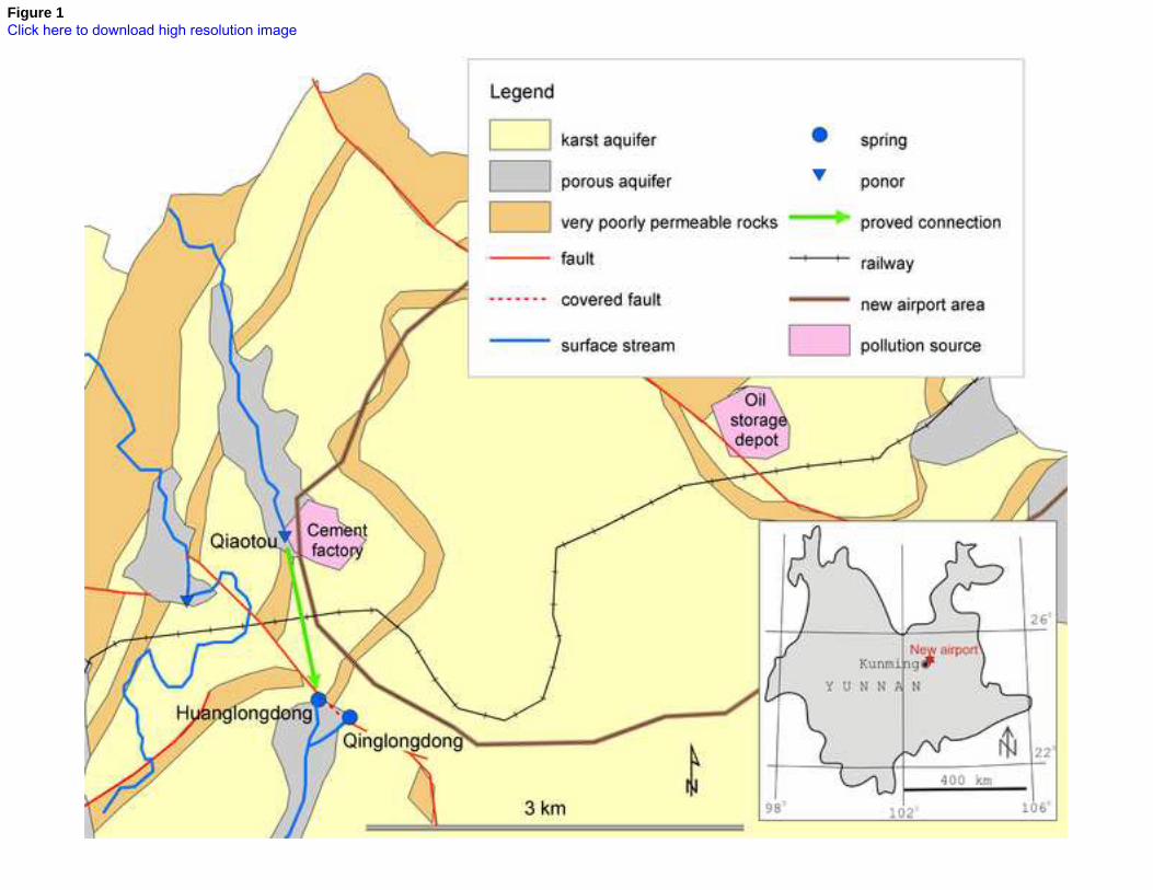
Figure 1Click here to download high resolution image
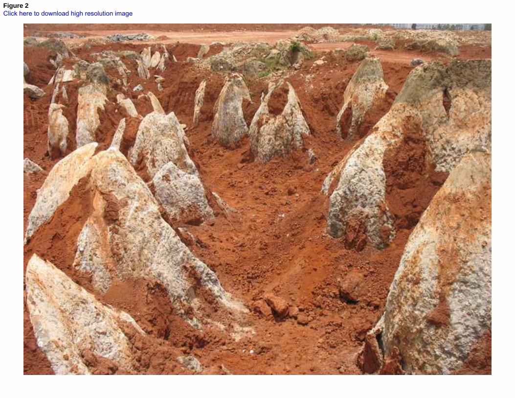
Figure 2Click here to download high resolution image
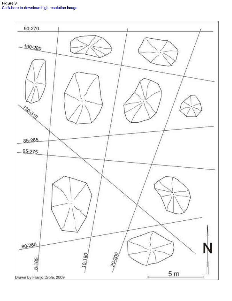
Figure 3Click here to download high resolution image

Figure 4Click here to download high resolution image

Figure 5Click here to download high resolution image
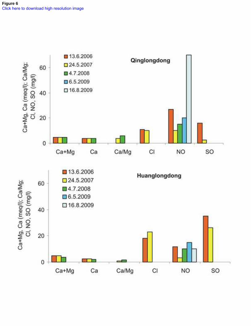
Figure 6Click here to download high resolution image
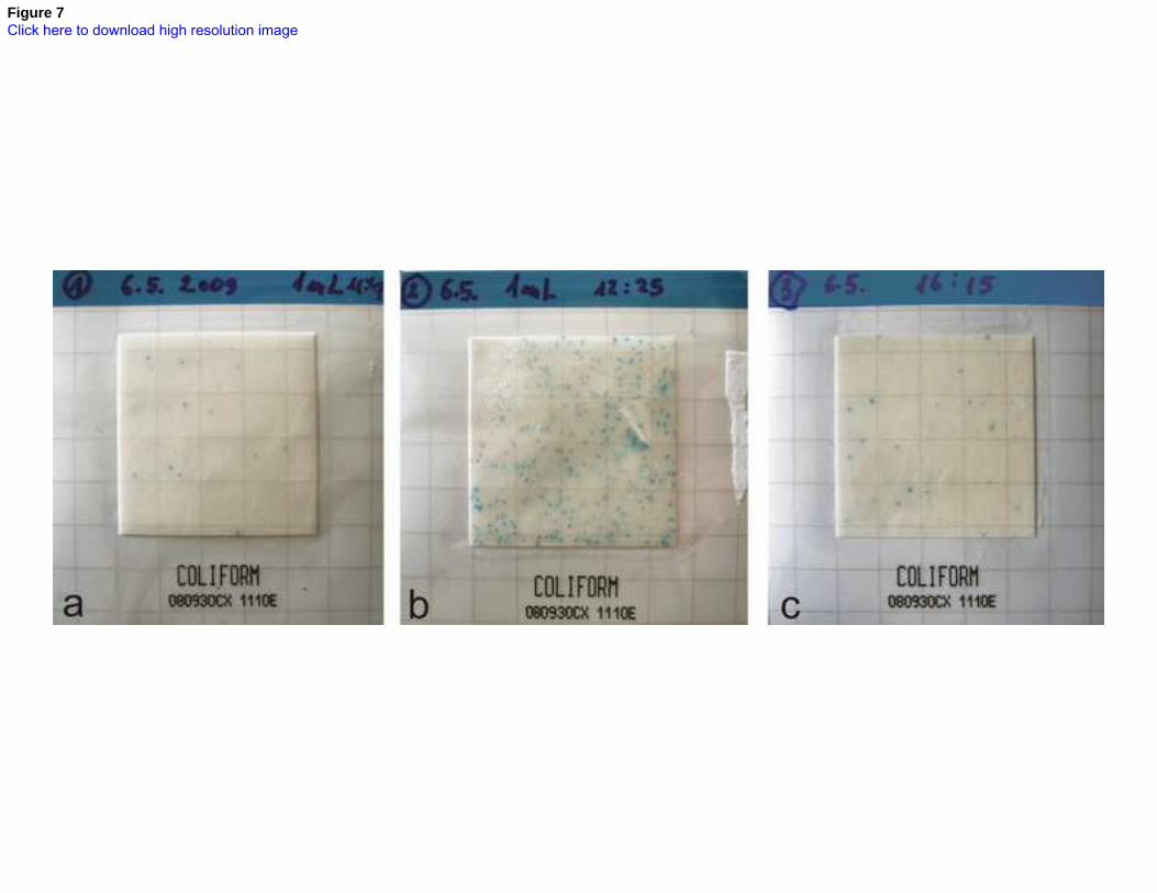
Figure 7Click here to download high resolution image
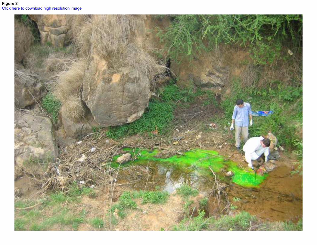
Figure 8Click here to download high resolution image
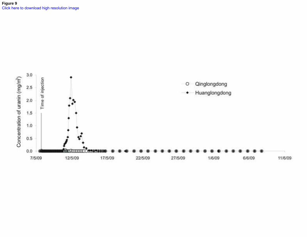
Figure 9Click here to download high resolution image