Mobile Soundings for the Verification of the Origins of Rotation in Tornadoes Experiment 2 (VORTEX2)
Upload
independentCategory
view
1download
0
INTERNAL STRUCTURE AND PERMAFROSTCHARACTERISTICS OF THE ROCK GLACIERS OF
SOUTHERN CARPATHIANS (ROMANIA) ASSESSED BYGEOELECTRICAL SOUNDINGS AND
THERMAL MONITORING
ALEXANDRU L. ONACA, PETRU URDEA and ADRIAN C. ARDELEAN
Department of Geography, West University of Timisoara, Timisoara, Romania
Onaca, A.L., Urdea, P. and Ardelean, A.C., 2013. Internalstructure and permafrost characteristics of the rock glaciersof Southern Carpathians (Romania) assessed by geoelectri-cal soundings and thermal monitoring. Geografiska Annaler:Series A, Physical Geography, 95, 249–266. doi:10.1111/geoa.12014
ABSTRACT. Six rock glaciers in the Southern Carpathianshave been investigated by means of geoelectrical soundingsin order to detect their internal stratigraphy and the existenceof frozen sediments. In the case of three relict rock glaciers,the electrical resistivity measurements indicated a typicalinternal structure. Low resistivity values (<10 kΩm) whichare typical of unfrozen fine-grained materials were obtained,but high resistivity values (25–240 kΩm) measured in thePietroasa, Iesu and Pietrele rock glaciers denote the presenceof sediments cemented by interstitial ice and ice lenses.Based on the moderate resistivity values, the ice content isprobably low to medium in the upper portion of these rockglaciers, that is, above 2040 m.
At two sites (Pietroasa and Vaiuga rock glaciers), groundsurface temperature (GST) evolution was monitored usingdigital dataloggers. Mean annual ground surface temperatureand GST regime throughout the winter were extracted fromthe recordings and confirmed the probability of permafrostoccurrence in Pietroasa rock glacier. In the Iesu and Pietrelerock glaciers, measurements of bottom temperatures of thewinter snow cover were performed in March 2012. Consid-ering the thick active layer, the reduced ice content and thepresence of scarce vegetation on their surface it could beassumed that the permafrost exists in marginal conditions inthe Southern Carpathians. The ground ice in permafrost isproduced by the groundwater freezing or by snow banksburied by coarse angular boulders following large rockfalls.
Key words: rock glaciers, permafrost, geoelectrical sound-ings, thermal measurements, Southern Carpathians
IntroductionOver the past 20 years there has been a growinginterest in mountain permafrost and its sensitivity
to climatic changes (Haeberli et al. 1993; Harris2005; Haeberli and Gruber 2009). Degradation ofthe mountain permafrost generates changes both inthe dynamics of the ecosystem and in the localhydrological system (Jorgenson et al. 2001).Moreover, it may compound the instability of theslopes (Hauck and Vonder Mühll 1999), which inturn, influences the occurrence of natural hazards(Haeberli 1992, Harris et al. 2001).
Characterized by their extreme spatial variabil-ity with respect to nearly all surface and near-surface characteristics and properties (Gruber andHaeberli 2009), mountain permafrost is often asso-ciated with permafrost creep landforms, such asrock glaciers (Haeberli 1985).
Very often, as a result of restricted drilling pos-sibilities, geophysical methods have been used toderive subsurface information on the distributionand the physical characteristics of the permafrost.Started during the last 30 years of the twentiethcentury (Haeberli 1985), but with expansion inrecent years, a wide range of geophysical tech-niques (electrical resistivity tomography, refractionseismic tomography, electromagnetic inductionsoundings, passive microwave radiometry) (Hauck2001) have successfully provided data on the inter-nal structure, mainly the ice content of rock gla-ciers (Vonder Mühll et al. 2002; Hausmann et al.2007; Kneisel and Hauck 2008; Leopold et al.2011).
In the particular case of Romania, studies ofcontemporary permafrost are scarce becauselimited scientific information exists that couldcertify the existence of permafrost conditions in theRomanian Carpathians. In the early 1990s, Urdea(1992) began to study the present day permafrost in
© 2013 Swedish Society for Anthropology and GeographyDOI:10.1111/geoa.12014
249

the Southern Carpathians. By conducting investi-gations on the bottom temperature of the snowcover (BTS) and by measuring the temperature ofspring water seeping from the base of the rockglaciers. Urdea (1993) concluded that there wassporadic permafrost in some rock glaciers from theRetezat Mountains. A similar approach combinedwith ground temperature monitoring of severalrock glaciers from the Retezat Mountains has sinceconfirmed the permafrost occurrence in some cases(Vespremeanu-Stroe et al. 2012).
Using the same methodology, Urdea and Vuia(2000) reinforced their theory on the existence ofpermafrost in the Parâng and Apuseni Mountains(Urdea 2000). More recently, using GIS-based per-mafrost models, Török-Oance (2004) and Szepesi(2007) suggested the presence of permafrost insome rock glaciers from the Retezat and IezerMountains.
Over the last few years, geoelectrical soundingshave been carried out in the Retezat Mountains(Urdea et al. 2008) and have revealed the occur-rence of ice-cemented materials and ice lenses insome rock glaciers. So far no scientific evidencehas been presented for permafrost occurrence inthe Fagaras Mountains.
Despite the weak interest shown for this particu-lar scientific issue, the authors started to map thepermafrost occurrence in the Southern Carpathiansand to establish its characteristics. In this paper, wepresent the results of the research conducted on sixrock glaciers from the Southern Carpathians. Two-dimensional DC resistivity tomography, groundsurface temperature (GST) monitoring and BTSmeasurements were carried out to investigate theinternal structure of the rock glaciers and detect thepresence of mountain permafrost.
In addition, investigating the occurrence of per-mafrost in several rock glaciers from the SouthernCarpathians, this study will also attempt to answerthe following questions:
1. What is the internal structure of the investigatedrock glaciers from the Southern Carpathians?
2. What are the ice content, permafrost thicknessand origin of the permafrost ice?
3. Which are the site characteristics that allow apersistence of the permafrost?
Study areaField investigations were undertaken in the South-ern Carpathians, the highest part of the RomanianCarpathians (Moldoveanu Peak: 2544 m a.s.l.).The mean 0°C isotherm for annual air temperatureoccurs between 2050 and 2150 m a.s.l. while thetree line lies at 1600–1800 m a.s.l. Meteorologicaldata from three high-altitude stations were used tohighlight the characteristics of regional climate(Table 1).
A wide variety of relict and active periglaciallandforms (rock glaciers, blockstreams, screeslopes, talus debris, solifluction lobes and terraces,earth hummocks etc.) occur in an elevation bandbetween the highest peaks and the tree line.
Six rock glaciers from three different sites werestudied for this paper (Fig. 1). The main study area(45° 36′ 13″ N; 24° 36′ 53″ E) is situated in thecentral part of the Fagaras Mountains, where fourrock glaciers (Bâlea, Capra, Pietroasa and Vaiuga)were investigated by means of geoelectrical sound-ings. The Fagaras Mountains are mainly composedof moderately weathered schist (micashist, sericiticschist, amphibolitic schist), but paragneiss, lime-stone and crystalline dolomite also occur in thearea. Two other sites from the Parâng (Iesu) (45°20′ 47″ N; 23° 33′ 28″ E) and Retezat Mountains(Pietrele) (45° 22′ 10″ N; 22° 52′ 18″ E) were alsochosen since high-altitude slopes and rock glaciersoccupy large areas in these mountains, thereforehinting at the possibility of active permafrost con-ditions. The predominant lithology is gneissicgranite in the case of the Parâng and granite and
Table 1. Climatic characteristics of Southern Carpathians’ high-altitude meteorological stations.
Meteorologicalstation
Elevation(m a.s.l.)
Coordinates(WGS84)
MAAT(°C)
MWAT(°C)
MSAT(°C)
Precipitations(mm)
Days withsnow cover
Days withT ≤ 0
Omu 2505 45° 26′ 45″ N25° 27′ 22″ E
−2.4 −9.8 4.9 969.8 222 256
Tarcu 2180 45° 16′ 50″ N25° 32′ 00″ E
−0.5 −7.6 7.1 959.4 190 221
Bâlea Lac 2038 45° 36′ 18″ N24° 36′ 58″ E
0.3 −7.1 8.2 1220.3 221 207
MAAT, mean annual air temperature; MSAT, mean summer air temperature; MWAT, mean winter air temperature.
ALEXANDRU L. ONACA ET AL.
© 2013 Swedish Society for Anthropology and Geography250

granodiorite in the central part of Retezat. Theserocks ensure the formation of large-sized debrisbelow rock walls and a higher density of rock gla-ciers and talus slopes than in the Fagaras Moun-tains (Urdea 1992).
To detect their internal structure and the pres-ence of permafrost, the six selected rock glacierswere investigated using electrical resistivitytomography (ERT) (Fig. 2, Table 2). These are
located in deglaciated cirques or valleys in connec-tion with talus cones, below weathered steep walls.Since Capra and Bâlea rock glaciers are vegetatedand covered by soils, especially in their frontalpart, it was possible to assume that these rock gla-ciers are relict.
The Bâlea rock glacier is a small tongue-shaped,227 m long rock glacier. It is located in Bâlea, anorth-facing side valley of the central sector of the
Fig. 1. Location of the sites and the investigated rock glaciers with the position of the thermistors and the location of ERT profiles:(a) Fagaras site, (b) Pietrele rock glacier, (c) Iesu rock glacier (based on SRTM DEM, X band, http://eoweb.dlr.de).
INTERNAL STRUCTURE AND PERMAFROST CHARACTERISTICS OF THE ROCK GLACIERS
© 2013 Swedish Society for Anthropology and Geography 251

Fagaras Mountains beneath a 100 m high rockwall. The presence of fine material, collapsedtopography features and vegetation on its roughsurface suggest its relict character.
On the opposite side of the main ridge, thesecond small relict rock glacier, Capra, belongs tothe talus-foot lobate type and shows well devel-oped transverse furrows and ridges. This rockglacier is almost totally covered by alpine vegeta-tion and presents a low gradient frontal slope.
The Vaiuga rock glacier occurs above the stadialmoraine situated around 2300 m a.s.l. and was fedfrom a debris cone located at the foot of the north-western wall of Vânatoarea lui Buteanu peak(2507 m a.s.l.). The rock glacier exhibits a succes-sion of small-sized transverse ridges and its lowestsection is overlapping a glacial step. Medium-sizedboulders prevail on the upper part of the rockglacier whereas coarse angular blocks and cobblespartly covered by vegetation occurs on its lower
Fig. 2. View of the studied rock glaciers: (a) Bâlea, (b) Capra, (c) Pietroasa, (d) Vaiuga, (e) Iesu, (f) Pietrele. Photo: Authors.
ALEXANDRU L. ONACA ET AL.
© 2013 Swedish Society for Anthropology and Geography252
part. Fine material and vegetation occur on thefrontal slope, also suggesting current inactivity forthis rock glacier.
The lengthy Pietroasa tongue-shaped rockglacier from Caldarea Pietroasa cirque has acomplex surface morphology. In the upper sectordominated by 150–200 m high rock walls, the rockglacier exhibits longitudinal flow features (mainlyridges and trenches). Fine material and vegetationare totally absent here and the decimeter to meter-sized boulders are predominant. Unlike the uppersection, the lower part presents a lobate aspect withtransverse ridges and remarkably deep troughs, butwith a dense coverage of vegetation patches andlarge thermokarstic depressions showing no evi-dence of movement. House-sized boulders alsooccur on its rough surface.
Iesu talus rock glacier has evolved from a debriscone located at the foot of the western rock wall ofIesu Peak (2375 m a.s.l.), in the Parâng Mountains.The surface of Iesu is characterized by well devel-oped transverse ridges and troughs. The frontal sideof the rock glacier is partly covered with shrubs(Pinus mugo). The Iesu rock glacier is bordered onits lateral parts by the Rosiile 1 talus rock glacier andthe Rosiile 2 tongue-shaped rock glacier.
Finally, the Pietrele rock glacier is located in thePietrele north-facing Pietrele valley in the RetezatMountains. It is a lengthy, tongue-shaped rockglacier containing blocks up to several meters indiameter near the surface and very deep funnels.Some of the ridges found on its lower part arecovered with sparse vegetation, indicating inactiv-ity for this rock glacier.
MethodsBecause drilling was impossible at the test sites,indirect investigations, such as geoelectricalsurveys, near-ground surface temperature andmeasurements of BTS were used to determine per-mafrost occurrence.
Electrical resistivity measurementsIn the past 15 years, the use of electrical resistivitytomography in investigating the periglacial envi-ronments has become widespread (Kneisel et al.2008). This geophysical technique has alreadybeen successfully employed for the detection ofpermafrost in rock glaciers (Fisch et al. 1977;Barsch and King 1989; Haeberli and Vonder Mühll1996; Evin et al. 1997; Berthling et al. 1998,Vonder Mühll et al. 2000; Ishikawa et al. 2001;Hauck and Vonder Mühll 2003), moraines (Haucket al. 2003; Kääb and Kneisel 2006) and talusslopes (Scapozza et al. 2011; Otto et al. 2012).Because the resistivity contrast between perma-frost and unfrozen sediments is extremely large,this method is suitable for permafrost and subsur-face ice detection.
The permafrost resistivity values, for ex-ample, may vary between 10 kΩm and severalhundred kΩm or more, depending on ice content,presence of impurities and temperature (Kneiseland Hauck 2008). Some authors have reported lowvalues for frozen sediments (10 or 20 kΩm)(Haeberli and Vonder Mühll 1996), but in mostcases the resistivity of permafrost exceeds 50 kΩm,which could be 1000 times greater than for unfrozen
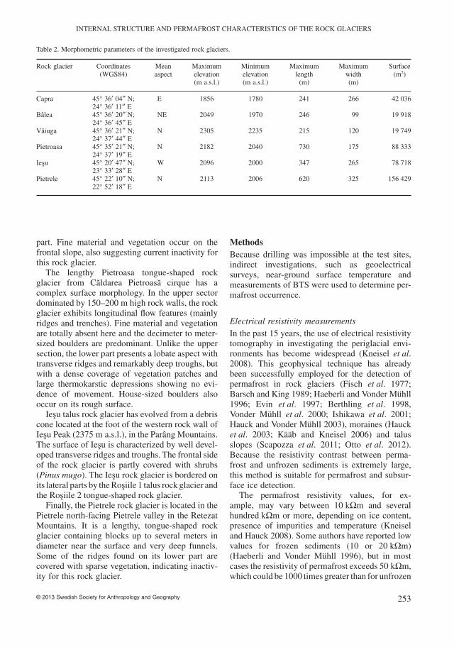
Table 2. Morphometric parameters of the investigated rock glaciers.
Rock glacier Coordinates(WGS84)
Meanaspect
Maximumelevation(m a.s.l.)
Minimumelevation(m a.s.l.)
Maximumlength
(m)
Maximumwidth(m)
Surface(m2)
Capra 45° 36′ 04″ N;24° 36′ 11″ E
E 1856 1780 241 266 42 036
Bâlea 45° 36′ 20″ N;24° 36′ 45″ E
NE 2049 1970 246 99 19 918
Vaiuga 45° 36′ 21″ N;24° 37′ 44″ E
N 2305 2235 215 120 19 749
Pietroasa 45° 35′ 21″ N;24° 37′ 19″ E
N 2182 2040 730 175 88 333
Iesu 45° 20′ 47″ N;23° 33′ 28″ E
W 2096 2000 347 265 78 718
Pietrele 45° 22′ 10″ N;22° 52′ 18″ E
N 2113 2006 620 325 156 429
INTERNAL STRUCTURE AND PERMAFROST CHARACTERISTICS OF THE ROCK GLACIERS
© 2013 Swedish Society for Anthropology and Geography 253

rock and debris (Evin et al. 1997). Based on thesecharacteristic values, it is possible to estimate thethickness of the active layer and detect permafrostand its subsurface ice content, as well as the depth tobedrock.
ERT is made by directly injecting current into theground using two current electrodes placed atground level and by measuring the voltage differ-ence at two potential electrodes (Kneisel and Hauck2008). Based on the resulting voltage difference(ΔV), the current (I) and a geometric factor (K),which depends on the arrangement of the fourelectrodes, the apparent resistivity is calculated:ρa = K(ΔV/I) (Kneisel and Hauck 2008). Sharplyanomalous data values are removed before dataprocessing.
The conversion from apparent resistivity to trueresistivity was done by applying a nonlinearsmoothness-constrained least-squares inver siontechnique to calculate the resistivity of the re-ctangular model blocks (deGroot-Hedlin andConstable 1990). This method, employed in theRes2DINV software (Loke and Barker 1996),attempts to minimize the difference between themeasured and calculated apparent resistivity. Themagnitude of this deviation is given by the root-mean-square (RMS) error. Applying the processiteratively the RMS error was minimized in a real-istic manner. Because the damping factor plays adecisive role in the inversion process, by controllingthe smoothing of the model and the RMS error,different values of this parameter were tested untilan optimal value was retained (trial and errormethod). In all the situations this parameter was setbetween 0.05 and 1 to obtain realistic models(Hauck et al. 2003; Kneisel et al. 2008). Theminimum damping factor was established toabout one-fifth of the initial damping factor(unpubl.) (Loke, ftp://geom.geometrics.com/pub/GeoElectric/Manuals/Res2dinv.pdf, 1-10-2012).
For this study, all the soundings were performedwith a PASI 16GS24N complex geophysicalsystem, with injection electrode spacing of3 and 5 m along 96–160 m profile lengths. Theprevalence of large boulders on the surface ofthe rock glaciers made electrode coupling difficultto establish on several occasions. Spongessoaked in salt water were attached to the electrodesto improve the electric contact with the surface.
All the geoelectrical soundings were performedbetween July and September, when the active layerwas thick enough and the topographic surface wasfree of snow.
Ground surface temperatureRecent studies made use of miniature temperaturedataloggers to monitor the GST and to delineatepermafrost from non-permafrost areas (Hoelzleet al. 1999; Ishikawa 2003). Two miniature ther-mistors (iButton Digital Thermometers DS 1922L)were installed in July 2010 at Pietroasa and Vaiugato automatically monitor for 1 year GST evolutionof these rock glaciers. Readings were recorded at4 h intervals with a resolution of 0.065°C and pre-cision of ±0.5°C. The thermistors were calibratedat 0°C using the zero curtain in spring when iso-thermal conditions occur at the ground surface dueto snow melt. The sensors were covered with 5 cmof clasts to avoid direct exposure to solar radiation(Ribolini and Fabre 2006) and to provide goodthermal contact with the ground (Ishikawa 2003).Both dataloggers were distributed in small depres-sions free of vegetation, soils and fine-grainedmaterials. Recorded GST data allowed us to deter-mine mean annual ground surface temperature(MAGST) and the GST evolution throughout thewinter for both rock glaciers. According to Ikeda(2006), MAGST could be used as a permafrostindicator, despite the fact that it is difficult toclearly separate permafrost from porous unfrozensediments.
Using daily air temperature from Bâlea mete-orological station (2038 m a.s.l.) and daily GSTdata, we were able to determine the timing of snowcover on both rock glaciers and the interval withoutshort-term variation throughout the winter. SinceGST evolution in late winter below a thick snowcover reflects the thermal conditions of the sub-strate, this parameter could be used as a permafrostindicator. Between the summers of 2010 and 2011another similar thermistor, recorded the rock wallnear-surface (at 5 cm depth) temperature of themain source of rockfalls from Caldarea Pietroasacirque.
BTS measurementsThe BTS measurements represent an efficientmethod for determining permafrost distribution inlow-latitude regions. The technique was describedfor the first time by Haeberli in 1973 and since thenit has been widely used in Europe (e.g. Alps, Scan-dinavia, Pyrenees, Carpathians). The method isreliable only if the snow cover is sufficiently thick(at least 80 cm) to insulate the ground surface fromshort-term energy fluxes (Vonder Mühll et al.2002). In this situation, the BTS values are con-
ALEXANDRU L. ONACA ET AL.
© 2013 Swedish Society for Anthropology and Geography254
trolled by thermal conditions within the ground.The BTS values suggest the absence (T > –2°C),possible presence (−2°C < T > −3°C) and probablepresence (T < −3°C) of permafrost (Haeberli 1973;Hoelzle 1992).
The BTS values were collected during March2012 on the Pietrele and Iesu rock glaciers over aperiod of 10–15 min for each measurement. Fifty-one BTS measurements were realized using a2.5 m BTS probe equipped with a digital thermom-eter (±0.1°C resolution and ±0.5°C precision). Inthe case of Pietroasa and Vaiuga rock glaciers, twominiature dataloggers were used to extract the tem-perature at the base of the snow pack in the BTSwindow.
Measurements and resultsElectrical resistivity tomographyIn the last five years we carried out several electri-cal resistivity soundings on different periglaciallandforms in the Southern Carpathians. Most of theelectrical resistivity profiles were obtained on relictlandforms affected by seasonal frost and repeatedfreeze–thaw cycles.
Capra and Bâlea rock glaciers The vast majorityof the 300 rock glaciers identified in the Southern
Carpathians are relict (Urdea 1992). In the FagarasMountains, nearly all the rock glaciers are coveredwith vegetation and soil, suggesting an absence ofsignificant movement. Despite their expressivemorphology with well developed furrows andridges, the Capra and Bâlea are also relict. Thepresence of vegetation and fine materials on morethan 50% of their surface denotes that permafrost isunlikely to occur within their body.
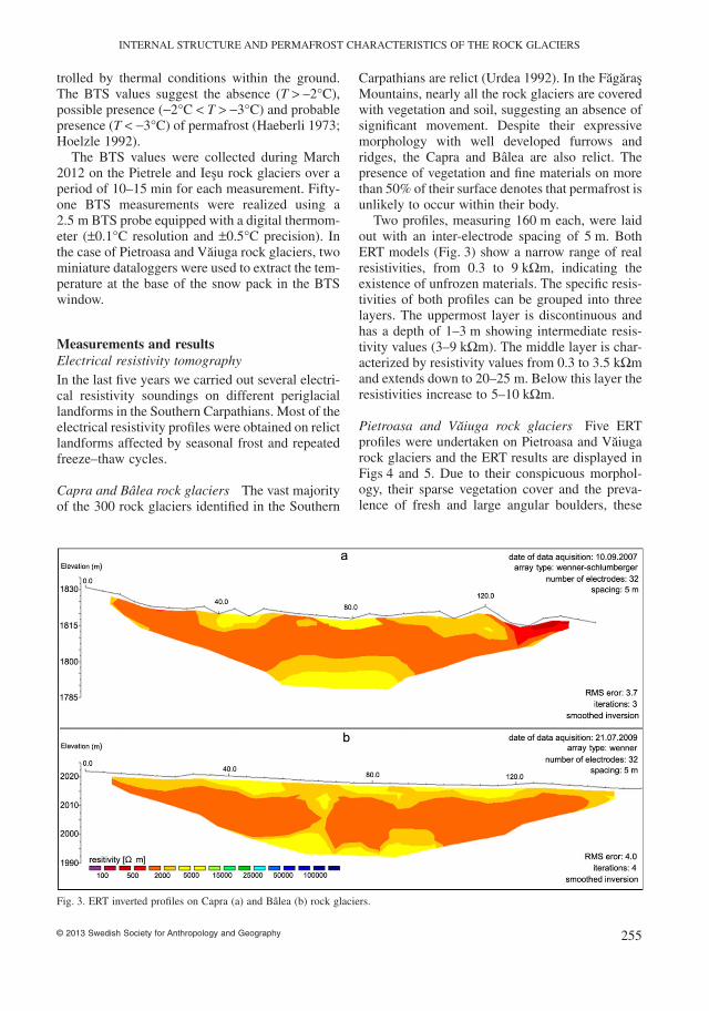
Two profiles, measuring 160 m each, were laidout with an inter-electrode spacing of 5 m. BothERT models (Fig. 3) show a narrow range of realresistivities, from 0.3 to 9 kΩm, indicating theexistence of unfrozen materials. The specific resis-tivities of both profiles can be grouped into threelayers. The uppermost layer is discontinuous andhas a depth of 1–3 m showing intermediate resis-tivity values (3–9 kΩm). The middle layer is char-acterized by resistivity values from 0.3 to 3.5 kΩmand extends down to 20–25 m. Below this layer theresistivities increase to 5–10 kΩm.
Pietroasa and Vaiuga rock glaciers Five ERTprofiles were undertaken on Pietroasa and Vaiugarock glaciers and the ERT results are displayed inFigs 4 and 5. Due to their conspicuous morphol-ogy, their sparse vegetation cover and the preva-lence of fresh and large angular boulders, these
Fig. 3. ERT inverted profiles on Capra (a) and Bâlea (b) rock glaciers.
INTERNAL STRUCTURE AND PERMAFROST CHARACTERISTICS OF THE ROCK GLACIERS
© 2013 Swedish Society for Anthropology and Geography 255

rock glaciers were initially hypothesized to beactive/inactive rock glaciers.
On the Pietroasa rock glacier three ERT profileswere obtained, two in the upper part (Fig. 4a, b)and one on its frontal slope (Fig. 4c). A transverseand a longitudinal profile on the upper part show awide range of specific resistivities, from 1 to140 kΩm. In both cases, the active layer exhibitsfairly high values (1–15 kΩm) extending to 3–5 mdepth.
The second layer, with a thickness of 7–10 m,reveals high resistivity values, ranging from 25 to110 kΩm on profile 4a, and from 30 kΩm to140 kΩm on profile 4b. Such results indicate an
occurrence of permafrost. This layer was found at3–5 m depth below the surface over almost theentire length of both profiles. The only areas withlow resistivity values in the substrate were thelateral talus slopes (0–30 m and 105–160 m alongthe line) in the case of profile 4a and the lower partof the profile 4b (between 120 and 160 along theline), with values ranging from 1 to 15 kΩm.Below this layer the resistivities decrease to lessthan 20 kΩm.
The lowest longitudinal profile (Fig. 4c) wasmade on the frontal slope of Pietroasa rock glacier,showing resistivity values ranging from 1 to45 kΩm. The uppermost layer with resistivity
Fig. 4. Cross-section (a) and longitudinal (b) ERT inverted profiles on the upper part and longitudinal (c) ERT inverted profile on thelower part of Pietroasa rock glacier.
ALEXANDRU L. ONACA ET AL.
© 2013 Swedish Society for Anthropology and Geography256

values of 5–20 kΩm and a thickness of 2–5 m ispresent only along the 0–85 m interval. Here, thebouldery mantle consists mainly of enormousblocks which provide a poor electrical contact.Smaller resistivity values are to be found below2–5 m, with the exception of two bodies of mate-rials with higher resistivities. The first, with resis-tivity values of 20–30 kΩm and a thickness ofabout 5 m, occurs between the 20 and 30 m posi-tions while the second anomaly with resistivitiesranging between 20 and 45 kΩm occurs in thecentral part (between 50 and 80 m). On thedownslope section of the profile, the resistivityvalues decrease to below 4 kΩm.
In the case of the Vaiuga rock glacier, a longi-tudinal and a transverse profile were carried out atan altitude of 2280–2310 m a.s.l. The profiles werelaid out with an electrode spacing of 3 m and theWenner configuration was used. The ERT modelsof the two profiles on the Vaiuga rock glacier aredisplayed in Fig. 5, revealing resistivity values of10–20 kΩm in the near-surface part, that is, atdepths between 1 and 4 m. Further down in thesubsurface the models show a range of specificresistivity values from 1 to 8 kΩm. Owing to thelimited length of the profile, the maximum depth ofpenetration was only 15 m, therefore the bedrockwas probably not reached.
Iesu and Pietrele rock glaciers Fig. 6a shows theresults of one longitudinal ERT profile obtained forthe Iesu rock glacier in the summer of 2012. Athorizontal distances of 15–100 m a distinct area ofhigh resistivities extends at a depth of 3–8 m. Theresistivity values of this body range between 30 and85 kΩm, probably corresponding to permafrost.Above and around it the resistivities are lower than15 kΩm. The thickness of the high-resistivityanomaly decreases downslope from 15 to 5 m. Atdepths of 25–30 m, the resistivities decrease to lessthan 5 kΩm.
The results of an ERT cross-section profile per-formed on the Pietrele rock glacier are displayed inFig. 6b. The tomogram reveals a notable differencein resistivities recorded above and below 10 m.In the first case, the resistivity values are low(< 10 kΩm). Further down into the subsurface, theresistivities increase above 25 kΩm (with maximalvalues of 240 kΩm), indicating permafrost occur-rence. This high-resistivity layer is nearly continu-ously along the entire length of the profile at10–12 m depth. Between the 85 and 100 m posi-tions, the layer with lower resistivities becomesthicker, extending to a depth of 15 m. Since aDipole–Dipole configuration was used in this case,the penetration depth was reduced, extending downto only 15 m.
Fig. 5. Cross-section (a) and longitudinal (b) ERT inverted profiles on Vaiuga rock glacier.
INTERNAL STRUCTURE AND PERMAFROST CHARACTERISTICS OF THE ROCK GLACIERS
© 2013 Swedish Society for Anthropology and Geography 257

Thermal conditions
Based on the data obtained from both data loggersand using the daily air temperature from Bâleameteorological station, we calculated MAGST, theapproximate duration of the snow cover interval andthe GST (average, maximum and minimum) regimethroughout the winter in the interval without short-term fluctuations (Table 3). Using the number ofconsecutive days with GST < 0°C with no short-term changes (Gadek and Lieszkiewicz 2010),the winter equilibrium temperature interval of theground surface could be determined (Table 3). Theinterval during which the snow cover was suffi-ciently thick to prevent any influence from airtemperature or possible heat exchange with the
atmosphere was thus extracted from the records fora 44–53-day window (February–April).
GST evolution at the Pietroasa and Vaiuga sitesare shown in Fig. 7. Short-term fluctuation in GSTvalues occurred at both sites during summer andautumn. GST values were constantly near 0°C atthe Vaiuga site from December to the end of June.From the beginning of December to the end ofJanuary, GST values at Pietroasa showed a gradualdecrease and short-term fluctuations within nega-tive temperatures. During February and March, thissite did not experience any daily fluctuations andthe temperatures remained constantly below −4°C.The near-surface thermal regimes throughout thewinter are strongly influenced by snow height andduration and surface material (Rödder and Kneisel
Fig. 6. Longitudinal ERT inverted profile on the upper part of Iesu rock glacier (a) and cross-section ERT inverted profile on Pietrelerock glacier (b).
Table 3. MAGST and characteristic GST values throughout the winter in the interval without short-term variations and the snow coverinterval from daily temperature sensor data.
Rock glacier –altitude(m)
MAGST(°C)
GST intervalwithout
short-termvariations
Average GST inthe interval without
short-termvariations
(°C)
Maximum GST inthe interval without
short-termvariations
(°C)
Minimum GST inthe interval without
short-termvariations
(°C)
Snowcover
interval
Pietroasa – 2150 0.0 12.02–28.03 −5.2 −4.8 −5.6 2.12–13.06Vaiuga – 2294 1.7 13.02–7.04 −0.3 −0.1 −0.5 22.11–7.07
GST, ground surface temperature; MAGST, mean annual ground surface temperature.
ALEXANDRU L. ONACA ET AL.
© 2013 Swedish Society for Anthropology and Geography258

2012). In April, a gradual increase in GST wasobserved at Pietroasa site. At both sites the surfaceis in general dry since only coarse material withoutsoil and vegetation occurs.
Since the Pietroasa rock glacier has been fedmainly by the north-exposed heavily weathered
rock wall, a datalogger was used to measure thethermal evolution at the rock surface (Fig. 7c).During one season (2010–2011) the mean annualrock surface temperature of the main source ofdebris from this valley was −0.7°C. From 20November 2010 to 2 June 2011 the temperatures
Fig. 7. Maximum and minimum daily near-surface temperatures of Vaiuga (a) and Pietroasa (b) rock glaciers and rock surfacetemperature of Pietroasa northern rock wall (c) (Bâlea air temperature data were provided by Romanian MeteorologicalAdministration).
INTERNAL STRUCTURE AND PERMAFROST CHARACTERISTICS OF THE ROCK GLACIERS
© 2013 Swedish Society for Anthropology and Geography 259

were permanently negative and the thermal evolu-tion was characterized by significant short-termfluctuations.
BTS resultsTwenty-seven BTS points were measured on thePietrele rock glacier and 24 on the Iesu rock glaciersurface or nearby (Fig. 8). The BTS values rangedfrom −8.2 to −0.5°C at Pietrele, and from −6.4 to−0.3°C at Iesu. In both cases, the distribution ofBTS points shows a concentration of low BTSvalues in the upper and central part of Iesu andPietrele rock glaciers while higher BTS valuesoccur in their lower parts. Up to 18 BTS pointsindicate the probable or possible occurrence of per-mafrost within Pietrele rock glacier and 13 BTSpoints from a total of 17 on the Iesu. The othereight BTS points collected in the vicinity of Iesuindicate the probable presence of permafrost on theRosiile 1 talus rock glacier (southern side). Snowdepth varied between 1 and 2.5 m at the probingpoints.
DiscussionInternal structure of relict rock glaciers, thermalregime and chronological implicationsThe electrical resistivity measurements revealedan apparent similar stratigraphy consisting of two
or three layers of unfrozen materials in the caseof Bâlea, Capra and Vaiuga. The upper layer(1–4 m) shows resistivity values slightly higher(5–20 kΩm) at Vaiuga rock glacier owing to unfro-zen medium- to large-sized boulders. These highvalues are characteristic of the dry bouldery upperlayer (King et al. 1987), although frozen materialscould have similar values in fine-grained deposits(Ikeda and Matsuoka 2006).
Lower resistivity values (3–9 kΩm) were foundin the uppermost layer of Bâlea and Capra corre-sponding to a region with mixed fine sediments(<2 mm) (Barsch 1996), cobbles and small deci-metric boulders. Below this layer resistivitiesdecrease to 0.3–3.5 kΩm (1–9 kΩm in the case ofVaiuga) due to a lower porosity of the unconsoli-dated deposits and probably an increasing of watercontent. Except for the Vaiuga rock glacier, theresistivities increase to 5–10 kΩm at 20–25 mdepth, probably indicating the presence of bedrock(Scapozza et al. 2011).
The absence of permafrost from Vaiuga rockglacier is supported by the GST evolution asrecorded with one miniature datalogger. ConstantGST values at about 0°C from 28 November 2010to 23 May 2011 indicate that the thick snow coverin early winter protects the ground from short-termfluctuations. According to Ishikawa (2003), perma-frost does not underlie sites where GST regimeshows roughly constant near-zero values through-
Fig. 8. Basal temperature of snow measurement locations on Pietrele (a) and Iesu (b) (based on SRTM DEM, X band, http://eoweb.dlr.de).
ALEXANDRU L. ONACA ET AL.
© 2013 Swedish Society for Anthropology and Geography260

out the winter. In some cases, permafrost wasdetected at sites experiencing constant 0°C tem-peratures, but mostly at the beginning of winter dueto warm air rising through inter-boulder voids(Ishikawa 2003). Due to the lack of published dataon the age of moraines in the area it is difficult toprovide absolute ages for the rock glaciers investi-gated. If we consider that the Last GlacialMaximum (LGM) occurred in the Retezat Moun-tains c. 17–16 ka BP (Reuther et al. 2007) and thata major late-glacial readvance coincided with theYounger Dryas (13.6–11.4 ka BP) (Reuther et al.2007), then the formation of the Capra and Bâlearock glaciers should have started after the LGM.Despite the 200 m altitude difference betweenthem, these rock glaciers probably formed betweenthe LGM and the Younger Dryas owing to theirsimilar aspect, dimensions, internal structure andtheir position in the glacial valleys. Taking intoaccount that in pollen diagrams of Holocenedeposits in the Fagaras Depression (400–450 m a.s.l.) the cooling effects of the Little IceAge are detected (LPAZ 10 and 11: 570–180 BP)(Tantau et al. 2011), it is possible that these rockglaciers were reactivated at that time.
According to Urdea (2004) the Capra was thelongest (10 km) outlet glacier of the FagarasMountains, descending down to 1130 m a.s.l. andbenefitting from the well developed preglacialvalley network. In the Retezat Mountains, duringthe LGM, or Capra-Judele major glacial advance,terminal moraines were deposited at an elevationof 1350 m (Reuther et al. 2007). Due to similarmorphological aspects it is expected that thelarge complex of moraines situated at 1300–1450 m a.s.l. on the Capra Valley has a similar agerange. Therefore, we believe that small, relict rockglaciers situated between 1500 and 2000 m a.s.l.(including Bâlea and Capra) and almost totallycovered by vegetation today may have formed justafter the LGM.
The Vaiuga rock glacier is a moraine-derivedrock glacier (according to Barsch 1996), probablydating back to the Younger Dryas. Abundant debrisfed the rock glacier during periods of high rockfallincidence producing a thick mantle of boulders onits uppermost part. Since the Vaiuga cirque is situ-ated above 2250 m a.s.l. at the foot of steep slopes,it seems likely that small glaciers persisted here fora longer period, probably to the end of the YoungerDryas, a cold period documented by pollen spectrafrom Avrig, Fagaras Depression (Tantau et al.2006).
Just after the deglaciation a paraglacial slopeadjustment phase occurred involving substantialdebris accumulation. Considering the small sizesof Capra, Bâlea and Vaiuga rock glaciers only afew thousand years were probably necessary fortheir formation. The presence of medium- to large-sized boulders indicate that the clasts mainly origi-nated from large rockfalls.
Due to evident higher input of debris from rock-falls and considerably lower temperature it isexpected that during the cold episodes of the Holo-cene (8, 7.2 and 4.2 ka BP; Constantin et al. 2007)and of the Little Ice Age (Tantau et al. 2011) theVaiuga was an active rock glacier. This hypothesis itis supported by the morphology of the rock glacier,the prevalence of unconsolidated debris at itssurface and the rare occurrence of vegetationpatches.
Permafrost characteristics and preservation inthe Pietroasa, Iesu and Pietrele rock glaciersThe results of the geoelectrical soundings, the BTSmeasurements and recorded GST regime provideevidence for an interpretation of permafrost char-acteristics and local site conditions in the investi-gated study areas.
Relatively high resistivities found at Pietroasa,Iesu and Pietrele (of the order of some tens of kΩmto 240 kΩm) are typical of rock glacier permafrost(Evin et al. 1997), indicating an ice-cementedmaterial with variable ice content (Kääb andKneisel 2006).
The ERT profiles performed on investigatedrock glaciers showed different resistivity valuesfor frozen sediment bodies. The resistivities indi-cating the presence of permafrost vary from30–85 kΩm at Iesu to 30–140 kΩm at Pietroasa,compared with 25–240 kΩm at Pietrele. Thesecomparatively low to moderate resistivity valuesare generally assigned to the occurrence of warmpermafrost (>−2°C) with a reduced ice content(less than 60%) (Barsch 1996; Arenson et al.2002; Ikeda 2006). Following the literature(Kneisel et al. 2000; Farbrot et al. 2005), sedi-ments cemented by interstitial ice and ice lensesare expected to be found within these rock gla-ciers. However, for resistivities between 20 and50 kΩm it is difficult to distinguish frozen sedi-ments with low ice content from unfrozen porousunconsolidated materials (Leopold et al. 2011;Scapozza et al. 2011). This is the case fortwo bodies with slightly higher resistivity values
INTERNAL STRUCTURE AND PERMAFROST CHARACTERISTICS OF THE ROCK GLACIERS
© 2013 Swedish Society for Anthropology and Geography 261

appearing at 2050–2060 m a.s.l. on the lower partof the Pietroasa rock glacier (Fig. 4c).
The relatively thick active layer (3–5 m atPietroasa, 3–7 m at Iesu and 9–12 m at Pietrele) isa function of local meteorological characteristics,thickness and duration of the winter snow cover,and the active layer’s textural characteristics(Humlum 1997). According to Kneisel (2010) anactive layer thicker than 5 m could suggest thepermafrost degradation. Despite this, the resistivityvalues corresponding to permafrost appear to behigher in the case of Pietrele than of the Pietroasaor Iesu rock glaciers. The reason could be the vari-ation in debris size between crystalline schists(Fagaras Mountains), granodiorites (Parâng Moun-tains) and granites (Retezat Mountains) and localtopographical parameters. The resistivities offrozen sediments from Iesu are generally lower(below 100 kΩm) due to its lower elevation andwestern aspect. In the case of Pietrele, the presenceof enormous boulders at the surface enhance thecooling effect of coarse blocks and allow the pres-ervation of permafrost at 9–12 m depth.
The longitudinal profiles performed on thePietroasa and Iesu rock glaciers show an evidentdecrease in resistivities and frozen sediment thick-nesses downslope, indicating a slow degradation ofpermafrost or a seasonally higher water contentwithin the permafrost body.
All the resistivities below 15 kΩm correspond tounfrozen sediments or bedrock. A sharp differen-tiation between the unfrozen sediments andbedrock is made difficult because dry fine-grainedsediments show resistivities similar to those of thebedrock (between 2 and 10 kΩm).
The occurrence of permafrost in the upper part ofthe Pietroasa rock glacier is supported by GSTpatterns. A significant ground cooling was observedbefore January, allowing the initiation of permafrostgrowth. Nearly constant temperatures below −4°Cfrom the end of January to the beginning of Aprilsuggest a minimal influence of atmospheric tem-perature on the thermal regime below the groundsurface. This GST trend was determined by theconcentration of cold air beneath a thick snow coverand an intense cooling of the active layer becausethe insulating snow cover had accumulated only bythe end of January. A similar trend in GST evolutionhas been observed in other cases in permafrost sitesfrom Europe (Hoelzle et al. 1999; Imhof et al.2000) and Japan (Ishikawa 2003).
According to the literature (Ikeda 2006) it isdifficult to place exactly the MAGST boundary
between the presence and absence of permafrostbecause of interannual variation in GST and pro-nounced influence of grain size in the substrate.Despite this uncertainty, a 0°C MAGST candescribe a site with permafrost occurrence (Rödderand Kneisel 2012).
As shown in previous studies (Hoelzle 1992;Lewkowicz and Ednie 2004), BTS values are reli-able indicators of the existence or absence of per-mafrost. Despite the differences of snow depth andduration and local site conditions (elevation, slope,aspect and microclimate) the BTS values varied ina predictable manner at Pietrele and Iesu. Thus, theareas with probable and possible presence of per-mafrost were located mostly in the upper parts ofboth the rock glaciers where ERT profiles revealedhigh resistivity values. Based on the BTS measure-ments almost all the points below 2030 m a.s.l.revealed the improbable existence of frozen sedi-ments. The distribution of permafrost as foundthrough BTS probing is supported by the concen-tration of vegetation and appearance of fine-grained sediments in the lower parts of both rockglaciers.
On the basis of their large extension, complextopography and internal structure, it is possible toassume that at least several thousands of years wereneeded in order to develop these rock glaciers.Their formation probably started during the parag-lacial phase following deglaciation, that is, whenthe rates of debris production were higher thantoday due to enhanced rockfall activity.
The ground ice in the rock glaciers originatesfrom snow banks buried by coarse debris duringperiods of large rockfalls respectively from refreez-ing of percolating water. The freezing of ground-water is unlikely to produce ice-supersaturated per-mafrost, whereas snow banks covered by rockfalldebris incorporated into permafrost can form ice-supersaturated layers in rock glaciers (Ikeda andMatsuoka 2006). Thereby, during Holocene coldperiods characterized by intense rockfall genera-tion, ice-supersaturated layers were likely incorpo-rated to the permafrost body. The resistivity valuesof 105 kΩm could be generated in this way, whilethe moderate values of resistivity specific to ice-cemented debris were probably produced byrefreezing of percolating water. However, freshfragments of bedrock transported by late-seasonsnow avalanches were identified during severalsummers on Pietroasa rock glacier surface. Eventhough the amounts of debris observed werelimited, it is possible to assume that in a few thou-
ALEXANDRU L. ONACA ET AL.
© 2013 Swedish Society for Anthropology and Geography262
sand years snow avalanches were capable of addingsignificant amounts of snow and incorporated rockfragments into the rock glacier body. This hypoth-esis could also explain the origin of ice in theinvestigated rock glaciers (Humlum et al. 2007),but further investigations are required to elucidatethis problem.
The preservation of permafrost at Pietroasa, Iesuand Pietrele is possible because particularly favora-ble conditions prevail. Thus, the occurrence of spo-radic permafrost within these rock glaciers iscontrolled by a number of factors. The mean annualair temperature is around 0°C at 2050 m a.s.l.,where all the investigated rock glaciers displayedhigh resistivity values corresponding to permafrost.Incoming solar radiation is very small because ofthe northern exposure of the valleys and the pro-nounced shadow effect of the ridges. The snowcover disappears completely in July–August, pre-venting the ground from heating up. Furthermore,the openwork structure of the active layer allowssignificant cooling beneath the bouldery mantle andthe storage of cold air in winter below a thick snowcover. These large air-filled voids determine acolder ground temperature regime than elsewherebecause cold air is trapped between the large boul-ders (Balch ventilation effect; Balch 1900). GSTevolution at the Pietroasa site suggests conditionsof enhanced preservation of permafrost mainlybecause of intense cooling in late autumn and earlywinter and of the existence of a thick snow layer inspring and early summer (Ishikawa 2003).
According to the geophysical results andcomplex morphology it is possible to conclude thatPietroasa, Iesu and Pietrele are multiunit forms,following the nomenclature of Barsch (1996).Their upper parts originate exclusively from rock-fall deposits and seem to be active today. In con-trast, their lower parts may originate partly fromlatero-frontal moraines and on the basis of morpho-logical evidence appear to be older. There are nosigns of movement in the lower sector of these rockglaciers, with lichen coatings, sparse vegetationand fine-grained deposits suggesting their presentinactivity.
The prevalence of fresh deposits in the upperparts of the investigated rock glaciers could be theresult of actual slope destabilization due to degra-dation of rock wall permafrost or intense weather-ing and repeated freeze–thaw cycles. As previouslypointed out (Nötzli et al. 2003) the mean annualsurface temperature < 0°C corresponds to a zone ofpermafrost. It could be, therefore, that the stability
of the north exposure rock wall at Pietroasa hasbeen diminished because ice-filled joints melt outduring the summer. According to Davies et al.(2001) the production of debris is maximal whenthe rock wall with ice-filled joints is at tempera-tures higher than −1°C. It has already been arguedthat the thermal response and the destabilization ofrock faces due to a rise in temperature tends to befaster than in the case of debris slopes (Gruberet al. 2004).
ConclusionsThe identification and documentation of new areaswith permafrost in the eastern mountains of Europeis a significant contribution since continentality ismore pronounced there (e.g. in the Carpathians)than in the Alps.
This study has investigated for the first time theinternal structure of rock glaciers and the existenceof permafrost in the Romanian Carpathians bymeans of shallow surface geophysics and thermalmeasurements. The results confirm the hypothesisthat isolated patches of permafrost could existin the Southern Carpathians at sites particularlyfavorable to permafrost conservation (e.g. north-facing bouldery rock glaciers). Patches of per-mafrost are expected above 2100 m a.s.l. onnorth-facing slopes in the central and eastern partof the Southern Carpathians (Fagaras Mountains)and 100 m lower in the western part (Retezat andParâng Mountains) because of greater amounts ofprecipitation and different lithologies (granite andgranodiorite). On south-facing slopes, permafrostis unlikely to occur. The lower limit of sporadicpermafrost in the Southern Carpathians corre-sponds to a mean annual air temperature (MAAT)of 1°C to −2.4°C.
The resistivity values (25–240 kΩm) indicate alow to medium ice content layer at Pietroasa, Iesuand Pietrele rock glaciers underneath a thick activelayer (3–12 m). The clear decrease in resistivitiesdownslope suggests that the permafrost is not inequilibrium with the present climate and the sub-surface frozen layer is reduced because of melting.Thus, the permafrost may originate from formercold periods (probably the Little Ice Age) andresult from the refreezing of percolating water aswell as from the burial of perennial snow patches.
Given the MAAT, the depth of the active layer,the ice content and the limited thickness of the layerof frozen materials in the rock glaciers investigated,permafrost in the Southern Carpathians exists in
INTERNAL STRUCTURE AND PERMAFROST CHARACTERISTICS OF THE ROCK GLACIERS
© 2013 Swedish Society for Anthropology and Geography 263

marginal conditions. This is why the preservation ofpermafrost is controlled by site-specific conditions.Of widespread importance are topographic param-eters (altitude, slope and exposure), climatic con-ditions (incoming solar radiation, snow coverdistribution and duration) but also surface and sub-surface characteristics and physical properties ofmaterials (bouldery mantle thickness, size of theclasts composing the rock glaciers and the porosityof the debris). The large air-filled voids from thePietroasa, Iesu and Pietrele rock glaciers comparedwith the others perform a strong insulating effect,preventing warming of the near-surface blockmantle. Consequently, the MAGST is significantlycooler on these rock glaciers and the GST regimeallows the preservation of the permafrost.
The results of the electrical resistivity measure-ments were used to build a stratigraphic model ofthe internal structure of the investigated relict rockglaciers. Thus, the bouldery top layer was 1–3 mdeep and was supplied mainly by rockfall debris.Finer-grained material occurs below this coarselayer. Based on their altitude, dimensions and inter-nal structure it is possible to conclude that forma-tion of Capra and Bâlea rock glaciers started afterthe LGM whereas the Vaiuga was produced duringthe Lateglacial.
AcknowledgementsWe would like to thank Jan Boelhouvers, MartinHoelzle, Ole Humlum and an anonymous reviewerfor their constructive comments on an earlierversion of this manuscript. Also, we are grateful toYanni Gunnell for improving the English of themanuscript. Finally, the authors are grateful tonumerous students from the Department of Geog-raphy, West University of Timisoara for their com-mitted help in carrying and installing the heavyequipment in the field.
Alexandru Lucian Onaca, Petru Urdea, Adrian CristianArdelean, Department of Geography, West University ofTimisoara, V. Pârvan 4, 300223 Timisoara, Timis, Romania.Email: [email protected], [email protected], [email protected]
ReferencesArenson, L., Hoelzle, M. and Springman, S., 2002. Borehole
deformation measurements and internal structure ofsome rock glaciers in Switzerland. Permafrost and Per-iglacial Processes, 13, 117–135. doi: 10.1002/ppp.414
Balch, E.S., 1990. Glaciers or Freezing Caverns. Allen,Lane and Scott, Philadelphia.
Barsch, D., 1996. Rock Glaciers: Indicators for the Presentand Former Geoecology in High Mountain Environ-ments. Springer, Berlin and New York.
Barsch, D. and King, L., 1989. Origin and geoelectricalresistivity of rock glaciers in semi-arid subtropical moun-tains (Andes of Mendoza). Zeitschrift für Geomorpholo-gie, 33 (2), 151–163.
Berthling, I., Etzelmüller, B., Eiken, T. and Sollid, J.L.,1998. The rock glaciers on Prins Karls Forland, Svalbard(I). Internal structure, flow velocity and morphometry.Permafrost and Periglacial Processes, 9, 135–145. doi:10.1080/00291950510020619
Constantin, S., Bojar, A.V., Lauritzen, S.E. and Lundberg, J.,2007. Holocene and Late Pleistocene climate in the sub-Mediterranean continental environment: a speleothemrecord from Poleva Cave (SouthernCarpathians,Romania). Paleogeography, Paleoclimatology, Paleoe-cology, 243 (3–4), 322–338. doi: 10.1016/j.palaeo.2006.08.001
Davies, M.C., Hamza, O. And Harris, C., 2001. The effect ofrise in mean annual temperature on the stability of rockslopes containing ice-filled discontinuities. Permafrostand Periglacial Processes, 12, 137–144. doi: 10.1002/ppp.378
deGroot-Hedlin C. and Constable S.C. 1990. Occam’s inver-sion to generate smooth, two dimensional models frommagnetotelluric data. Geophysics, 55, 1613–1624.
Evin, M., Fabre, D. and Johnson, P.G., 1997. Electrical resis-tivity measurements on the rock glaciers of GrizzlyCreek, St Elias Mountains, Yukon. Permafrost and Per-iglacial Processes, 8, 179–189. doi: 10.1002/(SICI)10991530(199732)8:2<179::AID-PPP247>3.0.CO;2-C
Farbrot, H., Isaksen, K., Eiken, T., Kääb, A. and Sollid, J.L.,2005. Composition and internal structures of a rockglacier on the strandflat of western Spitsbergen,Svalbard. Norsk Geografisk Tidsskrift–NorwegianJournal of Geography, 59, 139–148. doi: 10.1080/00291950510020619
Fisch, W. Sr, Fisch, W. Jr and Haeberli, W., 1977. ElectricalD.C. resistivity soundings with long profiles on rockglaciers and moraines in the Alps of Switzerland.Zeitschrift für Gletscherkunde und Glazialgeologie, 13,239–260.
Gadek, B. and Lieszkiewicz, J., 2010. Influence of snowcover on ground surface temperature in the zone of spo-radic permafrost, Tatra Mountains, Poland and Slovakia.Cold Region Science and Technology, 60, 205–211. doi:10.1016/j.coldregions.2009.10.004
Gruber, S. and Haeberli, W., 2009. Mountain permafrost. In:Permafrost Soils. Springer, Berlin. 33–44. doi: 10.1007/978-3-540-69371-0_3
Gruber, S., Hoelzle, M. and Haeberli, W., 2004. Permafrostthaw and destabilization of Alpine rock walls in the hotsummer of 2003. Geophysical Research Letters, 31,L13504. doi: 10.1029/2004GL020051
Haeberli, W., 1973. Die Basis Temperatur der winterlichenSchneedecke als möglicher Indikator für die Verbreitungvon Permafrost. Zeitschrift für Gletscherkunde undGlazialgeologie, 9, 221–227.
Haeberli, W., 1985. Creep of mountain permafrost: internalstructure and flow of alpine rock glaciers. Mitteilungender Versuchsanstalt für Wasserbau, Hydrologie undGlaziologie der ETH Zürich, 77, 5–142.
ALEXANDRU L. ONACA ET AL.
© 2013 Swedish Society for Anthropology and Geography264

Haeberli, W., 1992. Construction, environmental problemsand natural hazards in periglacial mountain belts. Per-mafrost and Periglacial Processes, 3, 111–124. doi:10.1002/ppp.3430030208
Haeberli, W. and Gruber, S., 2009. Global warming andmountain permafrost. In: Permafrost Soils. Springer,Berlin. 205–218. doi: 10.1007/978-3-540-69371-0_14
Haeberli, W. and Vonder Mühll, D., 1996. On the character-istics and possible origins of ice in rock glacier perma-frost. Zeitschrift für Geomorphologie, 104, 43–57.
Haeberli, W., Cheng, G., Gorbunov, A.P. and Harris, S.A.,1993. Mountain permafrost and climatic change. Perma-frost and Periglacial Processes, 4 (2), 165–174. doi:10.1002/ppp.3430040208
Harris, C., 2005. Climate change, mountain permafrost deg-radation and geotechnical hazard. In: Huber, U.M.,Bugmann, H.K.M. and Reasoner, M.A. (eds.), Advancesin Global Change Research. Global Change and Moun-tain Regions. An Overview of Current Knowledge.Springer, Dordrecht. 215–225.
Harris, C., Haeberli, W., Vonder Mühll, D. and King, L.,2001. Permafrost monitoring in the high mountains ofEurope: the PACE project in its global context. Perma-frost and Periglacial Processes, 12 (1), 3–11. doi:10.1002/ppp.377
Hauck, C., 2001. Geophysical methods for detecting perma-frost in high mountains. PhD diss., Versuchsanstalt fürWasserbau und Glaziologie, ETH, Mitteilungen, Zurich.171 p.
Hauck, C. and Vonder Mühll, D., 1999. Detecting alpinepermafrost using electro-magnetic methods. In:Advances in Cold-Region Thermal Engineering and Sci-ences. Lecture Notes in Physics. Springer, Berlin. 475–482.
Hauck, C. and Vonder Mühll, D., 2003. Inversion and inter-pretation of two-dimensional geoelectrical measure-ments for detecting permafrost in mountainous regions.Permafrost and Periglacial Processes, 14, 305–318. doi:10.1002/ppp.462
Hauck, C., Vonder Mühll, D. and Maurer, H., 2003. UsingDC resistivity tomography to detect and characterizemountain permafrost. Geophysical Prospecting, 51,273–284. doi: 10.1046/j.1365-2478.2003.00375.x
Hausmann, H., Krainier, K., Brückl, E. and Mostler, W.,2007. Internal structure and ice content of Reichenkarrock glacier (Stubai Alps, Austria) assessed by geophysi-cal investigations. Permafrost and Periglacial Processes,18 (4), 351–367. doi: 10.1002/ppp.601
Hoelzle, M., 1992. Permafrost occurrence from BTS meas-urements and climatic parameters in the Eastern SwissAlps. Permafrost and Periglacial Processes, 3, 143–147.doi: 10.1002/ppp.3430030212
Hoelzle, M., Wegmann, M. and Krummenacher, B., 1999.Miniature temperature dataloggers for mapping andmonitoring of permafrost in high mountain areas: firstexperience from the Swiss Alps. Permafrost and Perigla-cial Processes 10, 113–124.
Humlum, O., 1997. Active layer thermal regime at three rockglaciers in Greenland. Permafrost and PeriglacialProcesses, 8, 383–408. doi: 10.1002/(SICI)10991530(199710/12)8:4<383::AID-PPP265>3.0.CO;2-V
Humlum, O., Christiansen, H.H. and Juliussen, H., 2007.Avalanche-derived rock glaciers in Svalbard. Permafrost
and Periglacial Processes, 18, 75–88. doi: 10.1002/ppp.580
Ikeda, A., 2006. Combination of conventional geophysicalmethods for sounding the composition of rock glaciers inthe Swiss Alps. Permafrost and Periglacial Processes,17: 35–48. doi: 10.1002/ppp.550
Ikeda, A. and Matsuoka, N., 2006. Pebbly versus boulderyrock glaciers: morphology, structure and processes. Geo-morphology, 73, 279–296. doi: 10.1016/j.geomorph.2005.07.015
Imhof, M., Pierrehumbert, G., Haeberli, W. and Kieenholz,H., 2000. Permafrost investigation in the Schilthornmassif, Bernese Alps, Switzerland. Permafrost and Per-iglacial Processes, 11, 189–206.
Ishikawa, M., 2003. Thermal regime at the snow–groundinterface and their implications for permafrost investiga-tion. Geomorphology, 52, 105–120. doi: 10.1016/S0169-555X(02)00251-9
Ishikawa, M., Watanabe, T. and Nakamura, N., 2001.Genetic difference of rock glaciers and the discontinuousmountain permafrost zone in Kanchanjunga Himal,Eastern Nepal. Permafrost and Periglacial Processes,12, 243–253. doi: 10.1002/ppp.394
Jorgenson, M., Racine, C., Walters, J. and Osterkamp, T.,2001. Permafrost degradation and ecological changesassociated with a warming climate in centralAlaska. In: Climatic Change. Kluwer Academic Pub-lishers, The Netherlands. 551–571. doi: 10.1023/A:1005667424292
Kääb, A. and Kneisel, C., 2006. Permafrost creep within arecently deglaciated glacier forefield: Muragl, SwissAlps. Permafrost and Periglacial Processes, 17 (1),79–85. doi: 10.1002/ppp.540
King, L., Fisch, W., Haeberli, W. and Waechter, H.P., 1987.Comparison of resistivity and radio-echo soundings onrockglacier permafrost. Zeitschrift für Gletscherkundeund Glazialgeologie, 23 (1), 77–97.
Kneisel, C., 2010. Frozen ground conditions in a subarcticmountain environment, Northern Sweden. Geomorphol-ogy, 118, 80–92, doi: 10.1016/j.geomorph.2009.12.010
Kneisel, C. and Hauck, C., 2008. Electrical methods, In:Hauck, C. and Kneisel, C. (eds), Applied Geophysics inPeriglacial Environments. Cambridge University Press,Cambridge. 3–27.
Kneisel, C., Hauck, C. and Vonder Mühll, D., 2000. Perma-frost below the timberline confirmed and characterized bygeoelectrical resistivity measurements, Bever Valley,Eastern Swiss Alps. Permafrost and Periglacial Pro-cesses, 11, 295–305. doi: 10.1002/1099-1530(200012)11:4<295::AID-PPP353>3.0.CO;2-L
Kneisel, C., Hauck, C., Fortier, R. and Moorman, B., 2008.Advances in geophysical methods for permafrost inves-tigations. Permafrost and Periglacial Processes, 16,157–178. doi: 10.1002/ppp.616
Leopold, M., Williams, M.W., Caine, N., Völkel, J. andDethier, D., 2011. Internal structure of the Green Lake 5rock glacier, Colorado Front Range, USA. Permafrostand Periglacial Processes, 22 (2), 107–119. doi:10.1002/ppp.706
Lewkowicz, A. and Ednie, M., 2004. Probability mapping ofmountain permafrost using the BTS method, Wol Creek,Yukon Territory, Canada. Permafrost and PeriglacialProcesses, 15, 67–80. doi: 10.1002/ppp.480
INTERNAL STRUCTURE AND PERMAFROST CHARACTERISTICS OF THE ROCK GLACIERS
© 2013 Swedish Society for Anthropology and Geography 265

Loke, M.H. and Barker R.D., 1996. Rapid least-squaresinversion of apparent resistivity pseudosections using aquasi-Newton method. Geophysical Prospecting, 44,131–152. doi: 10.1111/j.1365-2478.1996.tb00142.x
Nötzli, J., Hoelzle, M. and Haeberli, W., 2003. Mountainpermafrost and recentAlpine rock fall events: a GIS-basedapproach. In: Phillips, M., Springman, S.M. and Arenson,L. (eds.), Proceedings of the 8th International Conferenceon Permafrost 2003. Glaciology and Geomorphodynam-ics Group Geography Department, University of ZurichSwitzerland, Zurich. 827–832.
Otto, J.C., Keuschnig, M., Götz, J., Marbach, M. andSchrott, L., 2012. Detection of mountain permafrost bycombining high resolution surface and subsurface infor-mation – an example from the Glatzbach catchment,Austrian Alps. Geografiska Annaler: Series A, PhysicalGeography, 94, 43–57. doi: 10.1111/j.1468-0459.2012.00455.x
Reuther, A., Urdea, P., Geiger, C., Ivy-Ochs, S., Niller, H.P.,Kubik, P. and Heine, K., 2007. Late Pleistocene glacialchronology of the Pietrele Valley, Retezat Mountains,Southern Carpathians, constrained by 10Be exposure agesand pedological investigations. Quaternary Interna-tional, 164–165, 151–159. doi: 10.1016/j.quaint.2006.10.011
Ribolini, A. and Fabre, D., 2006. Permafrost existence inrock glaciers of the Argentera Massif, Maritime Alps,Italy. Permafrost and Periglacial Processes, 17, 49–63.doi: 10.1002/ppp.548
Rödder, T. and Kneisel, C., 2012. Influence of snow cover andgrain size on the ground thermal regime in the discontinu-ous permafrost zone, Swiss Alps. Geomorphology, 175–176, 176–189. doi: 10.1016/j.geomorph.2012.07.008
Scapozza, C., Lambiel, C., Baron, L., Marescot, L. andReynard, E., 2011. Internal structure and permafrost dis-tribution in two alpine periglacial talus slopes Valais,Swiss Alps. Geomorphology, 132, 208–221. doi:10.1016/j.geomorph.2011.05.010
Szepesi, A., 2007. Masivul Iezer. Elemente de GeografieFizica [The Iezer Massif. Physical Geography Elements].Universitara, Bucuresti. [In Romanian]
Tantau, I., Farcas, S., Beldean, C., Geanta, A. andStefanescu, L., 2011. Late Holocene paleoenvironmentsand human impact in Fagaras Depression (SouthernTransylvania, Romania). Carpathian Journal of Earthand Environmental Sciences, 6 (1), 171–178.
Tantau, I., Reille, M., de Beaulieu, J.L. and Farcas, S., 2006.Late Glacial and Holocene vegetation history in the
southern part of Transylvania (Romania): pollen analysisof two sequences from Avrig. Journal of QuaternaryScience, 21, 49–61. doi: 10.1002/jqs.937
Török-Oance, M., 2004. Geographic information systems asa tool for permafrost investigation, a case study in thewest part of the Southern Carpathians (Romania). Geo-morphologia Slovaca, 4, 1, 68–71.
Urdea, P., 1992. Rock glaciers and periglacial phenomena inthe Romanian Carpathians. Permafrost and PeriglacialProcesses, 3, 267–273. doi: 10.1002/ppp.3430030317
Urdea, P., 1993. Permafrost and periglacial forms in theRomanian Carpathians. In: 6th International Conferenceon Permafrost, South China University of Technology,Beijing, China. 631–637.
Urdea, P., 2000. Un permafrost de altitudine joasa la Detu-nata Goala (Muntii Apuseni) [A low altitude permafrostin Detunata Goala]. Revista de Geomorfologie [Journalof Geomorphology], 2, 173–178. [In Romanian]
Urdea, P., 2004. The Pleistocene glaciation of the RomanianCarpathians. In: Ehlers, J. and Gibbard, P.L. (eds), Qua-ternary Glaciations – Extent and Chronology, vol. I.Elsevier, 301–308.
Urdea, P. and Vuia, F., 2000. Aspects of the periglacial reliefin the Parâng Mountains. Revista de Geomorfologie, 2,35–39.
Urdea, P., Ardelean, F., Onaca, A., Ardelean, M. andTörok-Oance, M., 2008. Application of DC resistivitytomography in the alpine area of Southern Carpathians(Romania). In: Kane, D.L. and Hinkel, K. (eds.), NinthInternational Conference on Permafrost Extendedabstracts, Institute of Northern Engineering, Universityof Alaska, Fairbanks, 323–333.
Vespremeanu-Stroe, A., Urdea, P., Popescu, R. and Vasile,M., 2012. Rock glacier activity in the Retezat Mountains,Southern Carpathians, Romania. Permafrost and Per-iglacial Processes, 23 (2), 127–137. doi: 10.1002/ppp.1736
Vonder Mühll, D., Hauck, C. and Gubler, H., 2002. Mappingof mountain permafrost using geophysical methods. Pro-gress in Physical Geography, 26 (4), 643–660. doi:10.1191/0309133302pp356ra
Vonder Mühll, D., Hauck, C. and Lehmann, F., 2000. Veri-fication of geophysical models in Alpine permafrostusing borehole information. Annals of Glaciology, 31,300–306. doi: 10.3189/172756400781820057
Manuscript Received 21 Oct., 2012, revised and accepted 5May, 2013
ALEXANDRU L. ONACA ET AL.
© 2013 Swedish Society for Anthropology and Geography266
Copyright © 2022 FDOKUMEN