A fossil record of colonization and response of lacustrine fish populations to climate change

PERMAFROST AND PERIGLACIAL PROCESSESPermafrost and Periglac. Process. (2014)Published online in Wiley Online Library(wileyonlinelibrary.com) DOI: 10.1002/ppp.1800
Cryostratigraphy and Permafrost Evolution in the Lacustrine Lowlands ofWest-Central Alaska
Mikhail Kanevskiy,a* Torre Jorgenson,a,b Yuri Shur,a Jonathan A. O’Donnell,c Jennifer W. Harden,dQianlai Zhuange and Daniel Fortiera,f
a Institute of Northern Engineering, University of Alaska Fairbanks, Fairbanks, AK, USAb Alaska Ecoscience, Fairbanks, AK, USAc National Park Service, Fairbanks, AK, USAd US Geological Survey, Menlo Park, CA, USAe Department of Earth, Atmospheric, and Planetary Sciences and Department of Agronomy, Purdue University, West Lafayette, IN, USAf Département de géographie, Université de Montréal, Montréal, QC, Canada
* CoUnivFairb
Copy
ABSTRACT
The influence of permafrost growth and thaw on the evolution of ice-rich lowland terrain in the Koyukuk-Innokoregion of interior Alaska is fundamental but poorly understood. To elucidate this influence, the cryostratigraphyand properties of perennially frozen sediments from three areas in this region are described and interpreted in termsof permafrost history. The upper part of the late Quaternary sediments at the Koyukuk and Innoko Flats comprisefrozen organic soils up to 4.5 m thick underlain by ice-rich silt characterised by layered and reticulate cryostructures.The volume of visible segregated ice in silt locally reaches 50 per cent, with ice lenses up to 10 cm thick.A conceptual model of terrain evolution from the Late Pleistocene to the present day identifies four stages of yedomadegradation and five stages of subsequent permafrost aggradation-degradation: (1) partial thawing of the upper icewedges and the formation of small shallow ponds in the troughs above the wedges; (2) formation of shallowthermokarst lakes above the polygons; (3) deepening of thermokarst lakes and yedoma degradation beneath the lakes;(4) complete thawing of yedoma beneath the lakes; (5) lake drainage; (6) peat accumulation; (7) permafrostaggradation in drained lake basins; (8) formation of permafrost plateaus; and (9) formation and expansion of anew generation of thermokarst features. These stages can occur in differing places and times, creating a highlycomplex mosaic of terrain conditions, complicating predictions of landscape response to future climatic changes orhuman impact. Copyright © 2014 John Wiley & Sons, Ltd.
KEY WORDS: permafrost; ground ice; thermokarst; Alaska; cryostratigraphy; Quaternary sediments
INTRODUCTION
Understanding permafrost history during the Late Pleistoceneand Holocene is essential in assessing the future of perma-frost and ecosystems under a changing climate. The patternsof permafrost transformation are highly variable across thediverse terrain of central Alaska (Jorgenson et al., 2013).Of particular interest are plains and lowlands, where fine-grained aeolian, alluvial and lacustrine deposits comprise asignificant part of the upper permafrost. Although fairly uni-form in soil composition, these materials vary from ice-poorto extremely ice-rich, depending on climate, topography,ecosystems and the history of permafrost development.
rrespondence to: M. Kanevskiy, Institute of Northern Engineering,ersity of Alaska Fairbanks, 237 Duckering Bldg., P.O. Box 755910anks, Alaska 99775-5910. E-mail: [email protected]
right © 2014 John Wiley & Sons, Ltd.
Studies of ice-rich permafrost are especially importantbecause the transformation of such deposits due to climatechanges or human activities has significant consequences(e.g. terrain collapse due to thermokarst or thermal erosionand the release of large amounts of organic carbon). Themost prominent example of ice-rich deposits in Alaska isyedoma – extremely ice-rich syngenetically frozen silt withhuge ice wedges up to 10 m wide and 50 m tall. Sections ofyedoma have been observed in many areas of Siberia andNorth America that were unglaciated during the LatePleistocene (Kanevskiy et al., 2011; Grosse et al., 2013;Schirrmeister et al., 2013, and citations therein). Numerousstudies on permafrost degradation and the evolution ofthermokarst lakes have been performed in Siberia(Soloviev, 1962; Czudek and Demek, 1973; Shur, 1977,1988a, 1988b; Romanovskii, 1993) and North America(Wallace, 1948; Burn and Smith, 1990; Osterkamp et al.,
Received 23 April 2013Revised 18 December 2013
Accepted 28 December 2013

M. Kanevskiy et al.
2000; Jorgenson et al., 2008, 2012, 2013; Shur et al., 2012;Kokelj and Jorgenson, 2013).Data on ground ice and permafrost dynamics in the
Koyukuk-Innoko region of interior Alaska are very limited,and the evolution of this permafrost-dominated landscapelacks a satisfactory explanation. The goal of this paper isto assess the origin of these interior plains in relation to per-mafrost evolution from the Late Pleistocene to the present,based on the results of our field research performed at threestudy areas during 2006–09 in the Koyukuk and InnokoFlats (Figure 1). The specific objectives are to: (1)delineate the extent of the lacustrine lowlands in theKoyukuk-Innoko region in relation to other lowlandlandscapes; (2) describe he cryostratigraphy of perenni-ally frozen sediments; (3) quantify ground ice contentsusing different methods; and (4) develop a conceptualmodel of the history of aggradation and degradation ofpermafrost and terrain development of the lacustrineplains. This study was part of an integrative effort toassess the effects of permafrost aggradation anddegradation on the water and carbon balance of borealecosystems (Jorgenson et al., 2010, 2013), soil carbondecomposition in previously frozen organic materialsand the accumulation of new organic material(O’Donnell et al., 2012; Harden et al., 2012), and therelease of trace gases associated with thermokarst features(Johnston et al., 2012).
STUDY AREA
The three study areas (Figure 1) are located in the Koyukukand Innoko National Wildlife Refuges within the YukonRiver basin. We conducted field sampling at Finger Lakeon the Koyukuk Flats (65°15’20"N, 157°2’10"W) in 2006,at Two Lakes on the Koyukuk Flats (65°11’50"N, 157°38’20"W) in 2008 and at Horseshoe Lake on the InnokoFlats (63°34’30"N, 157°43’30"W) in 2009.Elevations of the Koyukuk and Innoko Flats usually
do not exceed 100 m asl. The climate of the Koyukuk-Innoko region is continental, with a mean annual airtemperature of �4°C and mean annual precipitation ofabout 330 mm (according to the nearest meteorologicalstation at Galena, unpublished data, Alaska ClimateResearch Center).Quaternary deposits of the study area comprise Holocene
floodplain deposits and undivided Holocene and Pleistocenedeposits, including alluvial, colluvial, glacial and aeoliandeposits (Patton et al., 2009). Within the Yukon-Koyukuklowland, Weber and Péwé (1970) distinguished flood-plain alluvium, younger (low) and older (high) terracedeposits, aeolian sand dunes and loess deposits in thefoothills. Much of the area experienced aeolian siltdeposition during the Late Pleistocene (Muhs et al.,2003; Muhs and Budahn, 2006).Permafrost in the study area is discontinuous and its
thickness usually varies from 10 m to 130 m (Jorgenson
Copyright © 2014 John Wiley & Sons, Ltd.
et al., 2008). Permafrost occurs mainly within uplifted peatplateaus, interspersed with unfrozen bogs and fens(Jorgenson et al., 2012; O’Donnell et al., 2012). Meanannual soil temperature at the base of the active layer withinpermafrost plateaus at the Koyukuk Flats study area is closeto 0°C; vegetation on peat plateaus is typified by blackspruce and Sphagnum spp. moss (O’Donnell et al., 2012).Weber and Péwé (1961, 1970) reported the presence oflarge vertically and horizontally oriented ground ice massesin the Yukon-Koyukuk lowland and widespread polygonalground with ice wedges up to 1 m wide and 4.5 m tall,but information on ground ice is limited. In our study areas,no evidence for ice-wedge polygons within peat plateaushas been observed (O’Donnell et al., 2012).
METHODS
Landscape Mapping
We classified and mapped lowland landscapes of theKoyukuk and Innoko regions to better quantify the extentof lacustrine-affected terrain relative to other geomorphicunits in these central Alaska lowlands. We used an eco-logical mapping approach that differentiates ecosystemsat various levels of organisation (US Forest Service,1993) and differentiates landscapes at the subsectionlevel of mapping (Jorgenson and Grunblatt, 2012). Thelandscapes (i.e. repeating associations of geomorphic units,soils and vegetation) were differentiated by their physiogra-phy and dominant geomorphic units. Mapping was carriedout by interpreting Landsat imagery using ARCmap soft-ware (ESRI, Inc., 380 New York Street Redlands, CA92373-8100) at 1:250 000 scale. Existing geologic mapsand pertinent literature of the region (Fernald, 1960; Weberand Péwé, 1970; Koster et al., 1984; Patton et al., 2009)helped to differentiate surficial deposits.
Cryostratigraphy
The cryostratigraphy of frozen soils was described in eachof the three study areas. Along transects 300 m to 700 mlong, three to five plots were established for coring orsampling of exposures of collapsing banks. Ground surfaceelevations were surveyed by levelling along transects and atthe plots. A permafrost probe was used to measure theactive layer thicknesses and depths of closed taliks.Frozen cores were obtained with a SIPRE corer (Jon’sMachine Shop, Fairbanks, AK. http://www.jonsmachine.com/ (7.5-cm inner diameter)). Exposures and cores weredocumented by hundreds of photographs and numeroussketches. Cryostratigraphy methods and cryofacies analysis(Katasonov, 1978; French and Shur, 2010) were used todifferentiate patterns of syngenetic and epigenetic perma-frost formation. Cryostructures were described using aclassification system modified from several Russian and
Permafrost and Periglac. Process., (2014)

Cryostratigraphy and Permafrost Evolution in the Lacustrine Lowlands, Alaska
North American classification systems (Zhestkova, 1982;Murton and French, 1994; Shur and Jorgenson, 1998;Melnikov and Spesivtsev, 2000; French and Shur, 2010;Kanevskiy et al., 2013a) (Figure 2).
Ground Ice Content
The gravimetric and volumetric moisture contents offrozen soils were determined in 160 samples by oven-drying
Figure 1 Location of the three study areas within the Yukon River lowlands in reexposure in permafrost plateaus (red dots) and sampling points at unfrozen bogs a
three sites (right). This figure is available in colour
Copyright © 2014 John Wiley & Sons, Ltd.
(90°C, 72 h). The small size of the samples (typically250–500 ml) makes it problematic to estimate the mois-ture content of mineral soils in the study area due to theirregular distribution of ice lenses and inclusions. Tocheck the accuracy of laboratory analyses, we comparedgravimetric and volumetric moisture contents to thosecalculated from the volume of visible ice. To estimatethe total volumetric moisture content Wtv through thevolume of visible ice, we used the equation (Kanevskiy
lation to the dominant lowland landscapes (left). Locations of boreholes andnd fens (white dots) are shown in high-resolution aerial photographs of theonline at wileyonlinelibrary.com/journal/ppp
Permafrost and Periglac. Process., (2014)

Figure 2 Main types of cryostructures in mineral soils used in permafrostdescriptions (ice is black). Modified from several Russian and North
American classifications (Zhestkova, 1982; Murton and French, 1994; Shurand Jorgenson, 1998; Melnikov and Spesivtsev, 2000; French and Shur,
2010) (based on Kanevskiy et al., 2013a).
M. Kanevskiy et al.
et al., 2013b):
Wtv ¼ GsWs þ Vi
1þ GsWs¼ 2:7Ws þ Vi
1þ 2:7Ws(1)
where Vi is the visible ice content, unit fraction; GS = 2.7is the specific gravity of solids; and Ws is the gravimetricmoisture content due to pore ice, unit fraction. Vi wasestimated with ImageJ (Ferreira and Rasband, 2012), byprocessing binary (black for ice and white for sediments)images based on photographs of the cores or the naturalexposures. Ws was estimated from the processing ofsamples of frozen silt without visible ice.To estimate the total gravimetric moisture content Wt
through the volume of visible ice, we used the equation(Kanevskiy et al., 2013b):
Wt ¼γi
γwGsVi þ γi
γwViWs þWs � ViWs
1� Vi
¼ 0:33Vi þWs � 0:1ViWs
1� Vi
(2)
where γi= 0.9 is the unit weight of ice and γw = 1.0 is the unitweight of water; and GS= 2.7.
Radiocarbon Dating
Radiocarbon dating was performed on 30 samples of organicmaterial from depths of up to 405 cm below the ground
Copyright © 2014 John Wiley & Sons, Ltd.
surface. Samples from the Two Lakes site (Koyukuk Flats)were processed by theW.M. Keck C Cycle Accelerator MassSpectrometry (AMS) Laboratory at the University ofCalifornia, Irvine. Samples from the Finger Lake site(Koyukuk Flats) were processed by the National OceanSciences AMS Facility at the Woods Hole OceanographicInstitution (Woods Hole, MA). Samples from Innoko Flatswere sent to the United States Geological Survey (USGS) Ra-diocarbon Laboratory, Reston, Virginia for graphite prepara-tion and then to the Center for AMS, Lawrence LivermoreNational Laboratory (Livermore, CA) for AMSmeasurement.Ages are reported as uncalibrated radiocarbon dates.
RESULTS
Landscape Characterisation
We differentiated four main lowland landscapes within theKoyukuk-Innoko region that have different depositionalhistories and permafrost characteristics: fluvial-young,fluvial-old, aeolian sand and lacustrine-loess (Figure 1).
The fluvial-young landscape comprises floodplains withelevations ranging from 10 m to 50 m asl. Permafrosttypically is absent in early successional vegetation stagesand sporadic in spruce forest (Jorgenson et al., 2008). Theareal extent of this landscape was not quantified because thefloodplains extend beyond the study region (Figure 1).
The fluvial-old landscape consists of abandonedfloodplains and the terrace above the present floodplain.Elevations range from 20 m asl to 60 m asl. Oxbow lakesand meandering abandoned channels are abundant. Occa-sional round thermokarst lakes indicate moderately ice-richpermafrost. This landscape covers 2922 km2, or 20.5 per centof the total area of the lowlands, which includes fluvial-old,aeolian sand and lacustrine-loess landscapes.
The aeolian sand landscape comprises active and inactivesand dunes and sand sheets, and is limited to the KoyukukFlats region. Elevations range from 60 m asl to 220 m asl.The active Nogahabara sand dunes are the best studiedportion of this landscape (Koster et al., 1984). Permafrostexistence is unknown. This landscape covers 1888 km2
(13.3% of the lowlands).The lacustrine-loess landscape consists of forested
permafrost plateaus underlain by frozen peat and silt, raregentle hills (presumably yedoma remnants), and thermokarstbogs and fens with thick organic deposits, mostly unfrozen.Elevations range mostly from 25 m asl to 40 m asl but inthe areas adjacent to the uplands can reach 200 m asl.Thermokarst lakes are abundant. This landscape covers9422 km2 (66.2% of the lowlands). It was mapped asundivided Quaternary deposits by Patton et al. (2009).
Upland loess surrounds most of the lowland landscapes,but was not mapped and its extent is poorly known. Thereis often a broad transition zone between upland loess andlacustrine-loess landscapes. The upland loess occurs as lowrounded hills and on the lower slopes of large hills. The loess
Permafrost and Periglac. Process., (2014)

Cryostratigraphy and Permafrost Evolution in the Lacustrine Lowlands, Alaska
is probably widespread in areas with elevations from 100 m aslto 300 m asl, because most loess is deposited at elevationsbelow 300 m asl (Péwé, 1975). Based on the occurrenceof deep thermokarst lakes within this landscape, somesurrounded by tall conical thermokarst mounds(baydzherakhs), we presume that most of the upland loessis yedoma.
Permafrost Stratigraphy of the Lacustrine LoessLandscape
Koyukuk Flats, Two Lakes Area.The terrain at the Two Lakes study area consists of
perennially frozen forested peat plateaus and unfrozenthermokarst bogs and fens, with water at the surface in thelow-lying bogs and fens. Permafrost plateaus rise up to 4m above the surface of bogs and fens (Figure 3A) and haveactive layer thicknesses ranging from 0.3 m to 0.7 m.
Figure 3 (A)–(C): Topographic profiles of the three study areas showing surface esurface elevation and bo
Copyright © 2014 John Wiley & Sons, Ltd.
Three boreholes 4.3 m to 4.8 m deep were drilled at TwoLakes (Figures 1 and 4). In these sections, we distinguishedthree soil units: (1) surface terrestrial and semi-terrestrialpeat; (2) lacustrine organic silt with peat inclusions; and(3) silt with peat inclusions underlain by organic-poor siltwith rare small inclusions of organic material. Both organicand mineral soils contain excess ice (Figure 4; Table 1). Theaccumulation of terrestrial peat started in the early Holocene(Figure 4; Table 2).
The active layer comprised moss and woody sphagnumpeat. The moisture content of unfrozen peat from the activelayer was measured in 40 samples obtained from the threepermafrost boreholes (sample location is not shown inFigure 4). The mean volumetric moisture content was33 per cent and the mean gravimetric moisture content was795 per cent for all boreholes. In borehole KFUW-2, with athaw depth of 45 cm, unfrozen peat was also observed atdepths from 63 cm to 79 cm, beneath the 18-cm thick frozenlayer (Figure 4). The occurrence of this unfrozen layer
levation, the permafrost table, the maximum observed unfrozen depth, waterrehole locations.
Permafrost and Periglac. Process., (2014)
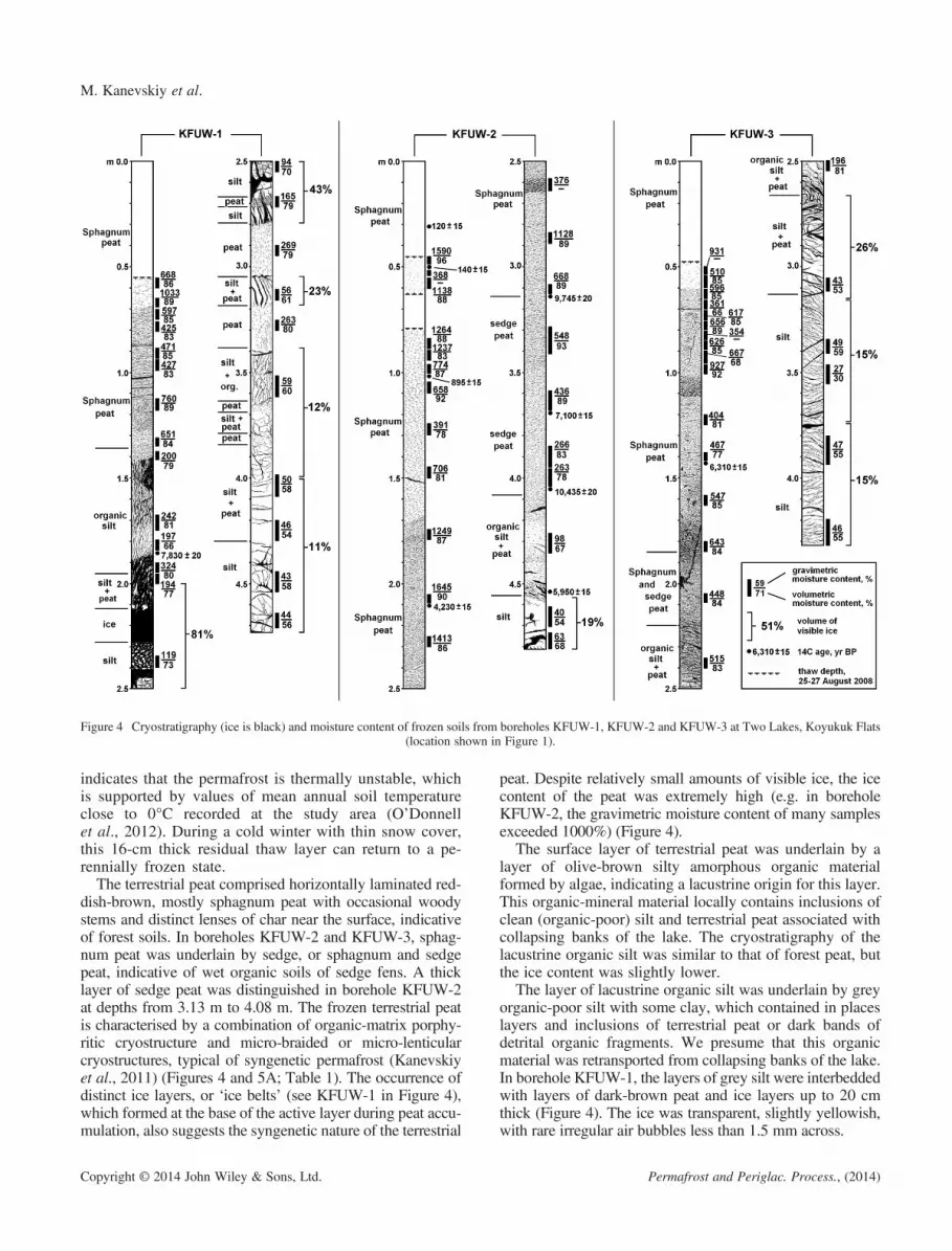
Figure 4 Cryostratigraphy (ice is black) and moisture content of frozen soils from boreholes KFUW-1, KFUW-2 and KFUW-3 at Two Lakes, Koyukuk Flats(location shown in Figure 1).
M. Kanevskiy et al.
indicates that the permafrost is thermally unstable, whichis supported by values of mean annual soil temperatureclose to 0°C recorded at the study area (O’Donnellet al., 2012). During a cold winter with thin snow cover,this 16-cm thick residual thaw layer can return to a pe-rennially frozen state.The terrestrial peat comprised horizontally laminated red-
dish-brown, mostly sphagnum peat with occasional woodystems and distinct lenses of char near the surface, indicativeof forest soils. In boreholes KFUW-2 and KFUW-3, sphag-num peat was underlain by sedge, or sphagnum and sedgepeat, indicative of wet organic soils of sedge fens. A thicklayer of sedge peat was distinguished in borehole KFUW-2at depths from 3.13 m to 4.08 m. The frozen terrestrial peatis characterised by a combination of organic-matrix porphy-ritic cryostructure and micro-braided or micro-lenticularcryostructures, typical of syngenetic permafrost (Kanevskiyet al., 2011) (Figures 4 and 5A; Table 1). The occurrence ofdistinct ice layers, or ‘ice belts’ (see KFUW-1 in Figure 4),which formed at the base of the active layer during peat accu-mulation, also suggests the syngenetic nature of the terrestrial
Copyright © 2014 John Wiley & Sons, Ltd.
peat. Despite relatively small amounts of visible ice, the icecontent of the peat was extremely high (e.g. in boreholeKFUW-2, the gravimetric moisture content of many samplesexceeded 1000%) (Figure 4).
The surface layer of terrestrial peat was underlain by alayer of olive-brown silty amorphous organic materialformed by algae, indicating a lacustrine origin for this layer.This organic-mineral material locally contains inclusions ofclean (organic-poor) silt and terrestrial peat associated withcollapsing banks of the lake. The cryostratigraphy of thelacustrine organic silt was similar to that of forest peat, butthe ice content was slightly lower.
The layer of lacustrine organic silt was underlain by greyorganic-poor silt with some clay, which contained in placeslayers and inclusions of terrestrial peat or dark bands ofdetrital organic fragments. We presume that this organicmaterial was retransported from collapsing banks of the lake.In borehole KFUW-1, the layers of grey silt were interbeddedwith layers of dark-brown peat and ice layers up to 20 cmthick (Figure 4). The ice was transparent, slightly yellowish,with rare irregular air bubbles less than 1.5 mm across.
Permafrost and Periglac. Process., (2014)

Table 1 Cryostructures and moisture content of frozen soils of permafrost plateaus, Koyukuk and Innoko Flats.
Moisture content of frozen soils
Soil unit Thickness, mThaw
depth, cmNumber ofsamples
Gravimetric, %(mean ± SDvalues)
Volumetric, %(mean ± SDvalues) Cryostructures
Koyukuk Flats, Two Lakes (KFUW-1, KFUW-2, KFUW3)
Terrestrialpeat
1.4–4.1 45–55 37 742 ± 363 85 ± 6 Organic-matrix porphyritic combined withmicro-braided and micro-lenticular; withoccasional ice ‘belts’
Organicsilt
0.5–0.6 — 9 268 ± 135 78 ± 7 Organic-matrix porphyritic combined withmicro-braided and micro-lenticular
Silt > 1.6 – 15 55 ± 23 58 ± 10 Layered, reticulate;45 ± 8* 57 ± 4* visible ice content 23% average
Koyukuk Flats, Finger Lake (KOFL-T1-126, KOFL-T1-242)
Terrestrialpeat
1.1–2.0 45–80 10 1061 ± 594 90 ± 3 Organic-matrix porphyritic combined withmicro-braided and micro-lenticular
Organicsilt
0.2–0.9 — 5 215 ± 82 79 ± 3 Micro-braided and micro-lenticular (KOFL-T1-242); organic-matrix porphyritic combinedwith layered and braided (KOFL-T1-126)
Silt > 1.5 — 8 92 ± 26 68 ± 6 Micro-braided and micro-lenticular(KOFL-T1-242); reticulate (KOFL-T1-126)
Innoko Flats (IFUW-1, IFUW-2, IFUW-3, IFEX-2)
Terrestrialpeat
0.7–1.1 55–65 4 470 ± 221 86 ± 5 Organic-matrix porphyritic combined withmicro-braided and micro-lenticular
Organicsilt
0.7–1.0 — 12 200 ± 71 77 ± 5 Micro-braided and micro-lenticular withoccasional ice ‘belts’ and veins
Silt > 3.4 — 28 98 ± 65 69 ± 11 Layered, reticulate and ataxitic;82 ± 19* 71 ± 4* visible ice content 48% average
Note: Moisture content values represent mean ± standard deviation (SD).*Calculated by Equations 1 and 2.
Cryostratigraphy and Permafrost Evolution in the Lacustrine Lowlands, Alaska
In borehole KFUW-3, peat inclusions were observed onlyin the upper part of this layer (2.66–3.12 m), and below itsilt was massive, uniform and contained only small occa-sional inclusions of organic detritus. The total thickness ofthis layer was not determined. The maximum thickness(1.6 m) of this unit was obtained in borehole KFUW-3, inwhich layered and reticulate cryostructures predominated.Most of the ice lenses were inclined, and their thicknessgenerally varied from 0.2 cm to 1 cm and occasionallyreached 3 cm. Such cryostructures are typical of epigeneticpermafrost formed from downward freezing of saturatedsoil. The mean visible ice content in silt was 23 per cent,and the mean volumetric and gravimetric moisturecontents calculated by Equations 1 and 2 were 57 per centand 45 per cent, respectively (Table 1).
Koyukuk Flats, Finger Lake Area.The structure of the upper permafrost at Finger Lake was
similar to that observed at Two Lakes. Permafrost plateausrise up to 1.5 m above the surface of thermokarst bogsand fens (Figure 3B). Additionally, rare remnants of highersurfaces are represented by gentle hills up to 10 m higherthan the surface of peat plateaus. The hills are composed
Copyright © 2014 John Wiley & Sons, Ltd.
of frozen silt locally overlain by peat. On the top of one hill,we observed thermokarst mounds up to 2 m high and 15–30m across forming a polygonal pattern. The moundscomprised mostly frozen silt and indicate degradation ofrelict ice wedges that presumably developed in the yedomadeposits during the Late Pleistocene. The hill also hadseveral small, deep thermokarst lakes indicative of extremelyhigh ice contents.
Similar to Two Lakes, three soil units were distinguished intwo boreholes (KOFL-T1-126 and KOFL-T1-242) drilled inpeat plateaus (Figures 1 and 3): (1) surface terrestrial andsemi-terrestrial peat (sphagnum peat underlain by sedge peat);(2) lacustrine organic silt and peat; and (3) organic-poor siltwith some peat inclusions on top (Figure 6; Tables 1 and 2).
In borehole KOFL-T-126, micro-cryostructures typical ofsyngenetic permafrost were observed only in terrestrial peat,while cryostructures of the lacustrine organic soils andunderlying silt were typical of epigenetic permafrost. Inborehole KOFL-T1-242, micro-cryostructures dominatedall soil units, including terrestrial peat, lacustrine organicsoils and silt (Figure 6; Table 1).
The drilling on top of the low hill located at the southernbank of Finger Lake (off the upper aerial photograph in
Permafrost and Periglac. Process., (2014)

Table 2 AMS radiocarbon dating of organic material, Koyukuk and Innoko Flats.
Borehole/exposure ID Depth, cm Lab ID
Radiocarbonage, yr BP δ13C, ‰
Fractionmodern Soil unit Dated material
Koyukuk Flats, Two Lakes (KFUW-1, KFUW-2, KFUW3)
KFUW-1 185 UCIT21038 7830 ± 20 �26.1 0.3773 Organic silt Detrital plant fragmentsKFUW-2 31 UCIT21018 120 ± 15 �25.7 0.9849 Peat Sphagnum leaves and stemsKFUW-2 50 UCIT21019 140 ± 15 �27.8 0.9828 Peat Chamaedaphne calyculata leaves,
few SphagnumKFUW-2 101 UCIT21020 895 ± 15 �26.1 0.8945 Peat Sphagnum leaves and stemsKFUW-2 210 UCIT21021 4230 ± 15 �26.9 0.5906 Peat Sphagnum leaves and stemsKFUW-2 313 UCIT21022 9745 ± 20 �27.5 0.2972 Peat Sedge roots, Calliergon spp., mossKFUW-2 369 UCIT21023 7100 ± 15 �27.2 0.4132 Peat Detrital peat fragmentsKFUW-2 405 UCIT21024 10435 ± 20 �28.4 0.2728 Peat Fen peat, sedge leaves, Scorpidum
scorpioides leaves and stemsKFUW-2 454 UCIT21025 5950 ± 15 — 0.4767 Organic silt Detrital plant fragmentsKFUW-3 143 UCIT21039 6310 ± 15 �23.8 0.4559 Organic silt Detrital plant fragments with coarse
sedge leaves (Carex rostrata?)
Koyukuk Flats, Finger Lake (KOFL-T1-126, KOFL-T1-242)
KOFL-T1-126 29 OS-67140 1240 ± 30 �24.1 0.8571 Peat Moat peat, fine sedgeKOFL-T1-126 203 OS-67298 3270 ± 35 �26.8 0.6659 Organic silt Sedge peat with willow stemsKOFL-T1-126 288 OS-67260 3580 ± 30 �25.0 0.6399 Organic silt Calliergon, Equisetum fluviataleKOFL-T1-242 21 OS-67142 85 ± 25 �25.1 0.9893 Peat Sphagnum fuscsumKOFL-T1-242 65 OS-67264 590 ± 30 �24.7 0.9291 Peat Sphagnum peatKOFL-T1-242 115 OS-67263 4720 ± 40 �26.9 0.5558 Organic silt Undifferentiated lacustrine peatKOFL-T1-242 167 OS-67262 9470 ± 45 �27.1 0.3075 Silt Undifferentiated terrestrial peat
Innoko Flats (IFUW-1, IFUW-2, IFUW-3, IFEX-2)
IFUW-1 36 WW7898 1120 ± 20 �25.4 0.8698 Peat Sphagnum sp. and forest peat(Picea mariana)
IFUW-2 60 WW7899 600 ± 30 �25.3 0.9281 Peat Spruce woodIFUW-2 90 WW7978 1935 ± 30 �26.2 0.7858 Peat Sphagnum peatIFUW-2 119 WW7979 3740 ± 25 �26.3 0.6278 Organic silt Undifferentiated lacustrine peatIFUW-2 146 WW7980 4935 ± 30 �27.1 0.5409 Organic silt Undifferentiated lacustrine peatIFUW-2 171 WW7900 4405 ± 30 �25.0 0.5780 Organic silt WoodIFUW-2 171 WW7982 5460 ± 40 �27.5 0.5068 Organic silt Undifferentiated lacustrine peatIFUW-2 198 WW7981 5860 ± 25 �27.5 0.4821 Organic silt Undifferentiated lacustrine peatIFUW-2 200 WW7901 4395 ± 25 �25.1 0.5787 Organic silt WoodIFUW-2 252 WW7902 4335 ± 25 �25.1 0.5830 Organic silt Sphagnum sp.IFUW-2 264 WW7903 4770 ± 30 �24.1 0.5523 Organic silt WoodIFUW-3 66 WW7904 125 ± 25 �26.1 0.9848 Peat Woody peatIFEX-2 175 WW7905 4455 ± 30 �28.4 0.5744 Organic silt Wood
M. Kanevskiy et al.
Figure 1) revealed a thick layer of sphagnum peat on thesurface. Peat thickness in borehole KOFL-S2 (Figure 7)exceeded 2.5 m and the boundary with mineral soilwas not reached. The ice content of the peat increasedbelow 2.08 m, and we consider this lower part of thepeat section to have been syngenetically frozen, asindicated by the presence of micro-cryostructures. Theupper part lacked distinct cryostructures, suggesting thatit had thawed and refrozen.Borehole KOFL-S1 (Figure 7) was drilled through frozen
silt at the bottom of a pit excavated in a collapsing bank(3 m below the top of the hill and ~ 100 m from boreholeKOFL-S2). Ice-poor silt in this section was generallyuniform, but contained peat layers and inclusions, and
Copyright © 2014 John Wiley & Sons, Ltd.
was oxidised along thin irregularly oriented ice veins andlenses (Figures 5B and 7). Peat layers were usually deformedor displaced along the cracks and lacked visible ice. These fea-tures are typical of thawed and refrozen sediments. Gravimet-ric moisture contents were 26–41 per cent for clean silt and53–74 per cent for silt with peat layers and inclusions(Figure 7). Ice-poor silt with similar features was alsoobserved in the pit excavated below borehole KOFL-S1, 7.5 mbelow the top of the hill and 3.5 m above the lake.
Innoko Flats.The terrain at the Innoko Flats is similar to that of the
other two study areas. The permafrost plateaus rise 2–3 mabove the surface of the thermokarst bogs and fens
Permafrost and Periglac. Process., (2014)

A B
DC
Figure 5 Permafrost cores with typical cryostructures of frozen soils. (A)Micro-braided cryostructure of syngenetically frozen peat (Koyukuk Flats,Two Lakes area, borehole KFUW-2). (B) Ice-poor epigenetically frozen silt(Koyukuk Flats, Finger Lake area, borehole KOFL-S1, depth 4.60 m to 4.83m). Note the distorted peat layers and oxidation along the ice lenses (markedwith arrows). (C) Layered cryostructure of epigenetically frozen silt (InnokoFlats, borehole IFUW-1). (D) Ataxitic (suspended) cryostructure of epigenet-ically frozen silt (Innoko Flats, borehole at the base of exposure IFEX-2). Thisfigure is available in colour online at wileyonlinelibrary.com/journal/ppp
Cryostratigraphy and Permafrost Evolution in the Lacustrine Lowlands, Alaska
(Figure 3C), and have an active layer thickness of typically0.5–0.8 m. Numerous newly developing thermokarst pits2–5 m across have thaw depths of 1.1 m to 2.1 m (Figure 3).The bogs surrounding the plateaus were unfrozen to depths3 m. Standing dead trees in the ‘moat’ along the margin ofpeat plateaus indicate active lateral permafrost degradation.Thaw probing along the margins revealed that a thaw bulbhad developed underneath the edge of the permafrostplateaus, indicating some subsurface thawing similar to thatdescribed by Wallace (1948).Similar to the study areas on the Koyukuk Flats, three soil
units were distinguished on permafrost plateaus in threeboreholes (IFUW-1, IFUW-2, IFUW-3) and one exposure(IFEX-2) (Figures 1 and 3): (1) surface terrestrial peat(mostly sphagnum); (2) lacustrine organic silt and peat;and (3) silt with peat inclusions underlain by organic-poorsilt (Figures 8 and 9; Tables 1 and 2).
Copyright © 2014 John Wiley & Sons, Ltd.
The active layer was formed entirely of forest peat. Themean volumetric moisture content of the active layer was24 per cent and mean gravimetric moisture content was62 per cent (n= 36). Increased depth of seasonal thaw (1.3m) on top of the exposure IFEX-2 (Figure 9) was related toa deeper seasonal thawing within the exposed bluff and didnot represent the normal thickness of the active layer in thisarea (Table 1). In this exposure, the frozen terrestrial peatcomprised dark- to light-brown, poorly decomposedsphagnum peat grading to moderately decomposed peat withsome buried wood, roots and char, with several silt lenses at1.3–1.6 m (Figure 9). A layer of lacustrine organic soilscomprised brown silty peat and organic silt with numerouswood inclusions and irregular layers of reworked, slightlydecomposed detrital organic matter. A layer of grey clean siltwith rare inclusions of organic matter formed the lowest unit(total thickness unknown).
In boreholes IFUW-1 and IFUW-2 and exposure IFEX-2,the soil in the upper 20–40 cm of this unit was brown-greysilt with numerous inclusions of organic matter (transitionalzone between lacustrine organic silt and clean silt). A combi-nation of layered, reticulate and ataxitic cryostructures withrelatively thick ice lenses divided by dense ice-poor soil ag-gregates (Figures 5C, D, 8 and 9) indicates epigeneticfreezing of the silt. The thickness of ice lenses generallyvaried from 1 cm to 5 cm and occasionally reached 10 cm.The ice was clear, colourless and contained air bubbles thatwere round (diameter< 2 mm) or vertically elongate.
DISCUSSION
Cryostratigraphic Units and Age of the Sediments
The frozen sediments within elevated peat plateaus at thethree study areas had similar cryostratigraphic patterns,indicating a similar landscape evolution. We distinguishthree main cryostratigraphic units:
1. Surface terrestrial and semi-terrestrial peat (STSP). Thisunit consists of three sub-units: (1a) forest peat (woodysphagnum peat with roots and char) (upper sub-unit);(1b) bog (sphagnum); and/or (1c) fen (sedge andsphagnum-sedge) peat (lower sub-units). The peat wasfrozen syngenetically and/or quasi-syngenetically(Shur, 1988a; Kanevskiy, 2003), as indicated by theprevalence of micro-cryostructures and the occurrenceof ice belts. In some sections, however, peat was frozenepigenetically as a result of thawing and refreezing ofpermafrost plateaus.
2. Lacustrine deposit (LD). This unit has an upper sub-unit(2a) of organic silt and sedimentary algal peat, and a lowersub-unit (2b) of organic silt with inclusions of silt and ter-restrial peat that likely originated from the collapse of lakebanks. Despite widespread micro-cryostructures typical ofsyngenetic permafrost, syngenetic freezing under shallowwater in the area of warm discontinuous permafrost ishighly unlikely. Instead, these sediments probably froze
Permafrost and Periglac. Process., (2014)

Figure 6 Cryostratigraphy (ice is black) and moisture content of frozen soils from boreholes KOFL-T1-126 and KOFL-T1-242 at Finger Lake, Koyukuk Flats(modified from Jorgenson et al., 2012).
M. Kanevskiy et al.
Copyright © 2014 John Wiley & Sons, Ltd. Permafrost and Periglac. Process., (2014)

Figure 7 Cryostratigraphy (ice is black) and gravimetric water contentof frozen soils from boreholes KOFL-S1 and KOFL-S2 at Finger Lake,
Koyukuk Flats.
Cryostratigraphy and Permafrost Evolution in the Lacustrine Lowlands, Alaska
quasi-syngenetically during the accumulation and subse-quent syngenetic freezing of the terrestrial peat, andoccasionally epigenetically (KOFL-T1-126).
3. Reworked yedoma (RY). This unit has an upper sub-unit(3a) of silt with inclusions of surface terrestrial peat andorganic material previously incorporated in yedoma,which originated from the collapse of lake banks, and alower sub-unit (3b) of silt with rare small organicinclusions and slightly disturbed organic-rich layers. Theupper sub-unit probably formed by reworking of yedomasoils within the lake, and the lower sub-unit by in-situthawing of yedoma soils beneath the lake. The boundary
Copyright © 2014 John Wiley & Sons, Ltd.
between the sub-units was not clearly detected in thestudied sections, although the organic content of thesilt decreased with depth. The lower sub-unit (thawedand refrozen yedoma) froze epigenetically, and theupper sub-unit (yedoma reworked by the lake) frozeepigenetically and occasionally quasi-syngenetically(KOFL-T1-242).
Radiocarbon ages of organic material in the cores (Table 2;Figures 4, 6, 8 and 9) reveal a complex pattern of ages of thestratigraphic units across the three sites. The syngeneticallyfrozen peat near the surface had ages mostly between 8514C yr BP and 1935 14C yr BP, but at Two Lakes, three sam-ples from the basal peat above the lacustrine organic silt hadages of between 7100 14C yr BP and 10 435 14C yr BP(Figure 4). At Innoko Flats, the age of peat sampled near itsbase was less than 2000 14C yr BP (Figure 8). Lacustrineorganic silt (15 samples) had ages between 7830 14C yrBP and 3270 14C yr BP. The ages of lacustrine organic siltat Two Lakes were older (7830 14C yr BP to 5950 14C yrBP) than those at Finger Lake (4720 14C yr BP to 32714C yr BP) and Innoko Flats (5860 14C yr BP to 374014C yr BP) (Table 2).
The differences in radiocarbon dates and thicknesses oflacustrine and forest peat among sites indicate a long-termhistory of lake development and drainage occurring atdifferent times over the landscape. At IFUW-2, eightages within lacustrine organic silt showed inconsistentage-depth trends, which we attribute to mixing of aquaticand eroded materials during lake development. AtKFUW-2, the inconsistent age of three samples nearthe base of the surface peat may be due to roots or otherbiotic mixing, cryoturbation, or other causes, but suchreversals have been noted in permafrost sectionselsewhere (Hamilton et al., 1988; Kanevskiy et al.,2011; O’Donnell et al., 2011).
Ice Content
The ice content of sediments differed substantially amongthe three cryostratigraphic units (STSP, LD and RY)(Table 1). The highest mean volumetric and gravimetric icecontents characterised syngenetically frozen terrestrial andsemi-terrestrial peat (STSP), particularly the gravimetric icecontent due to the low dry density of the peat. Ice contentsof the quasi-syngenetically frozen lacustrine organic silt(LD) were intermediate, but still very high. The mean ice con-tents of forest woody peat and lacustrine organic silt werehigher at Koyukuk Flats (both study areas) than at InnokoFlats. When comparing gravimetric and volumetric moisturecontents of silts (RY) obtained for Two Lakes and InnokoFlats by the ‘traditional’ method of sample processing (firstmethod) with values calculated by Equations 1 and 2 fromthe volumes of visible ice (second method), we found thatthe two methods gave similar results (Table 1). The meanice content of frozen silts was much higher at Innoko Flatsand Finger Lake than at Two Lakes. Despite similar ice
Permafrost and Periglac. Process., (2014)
Figure 8 Cryostratigraphy (ice is black) and ice content of frozen soils from boreholes IFUW-1, IFUW-2 and IFUW-3, Innoko Flats.
M. Kanevskiy et al.
contents at Innoko Flats and Finger Lake (Table 1), thecryostructures of silts at these two sites were different becausethe silts were mostly quasi-syngenetically frozen at FingerLake (Figure 6, borehole KOFL-T1-242) and epigeneticallyfrozen at Innoko Flats (Figures 8 and 9).
Copyright © 2014 John Wiley & Sons, Ltd.
The high content of visible ice in silt, especially atInnoko Flats (48%), indicates a high potential thawsettlement of permafrost plateaus. Such a high visibleice content was not unusual for frozen lacustrine andglacio-lacustrine sediments with similar cryostructures
Permafrost and Periglac. Process., (2014)

Figure 9 Cryostratigraphy (ice is black) and moisture content of frozen soils, Innoko Flats: exposure (left) and borehole IFEX-2 (right).
Cryostratigraphy and Permafrost Evolution in the Lacustrine Lowlands, Alaska
from different permafrost regions of Russia, Alaska andCanada (Kanevskiy et al., 2013b, and citations therein).A difference in the elevations of permafrost plateausand modern thermokarst bogs of up to 5 m (Figure 3)corresponds to a thaw settlement of the surface due tothawing of the ground ice (mainly within ice-rich silt)under the bogs.
Formation and PermafrostHistory of the Lacustrine Plains
Based on evidence from the three study areas and ourstudies of permafrost in other regions of Alaska, we havedeveloped a conceptual model with nine stages tosynthesise the depositional and permafrost processes that af-fected evolution of the lacustrine-loess landscape on the
Copyright © 2014 John Wiley & Sons, Ltd.
Koyukuk and Innoko Flats from the end of Pleistocene tothe present day (Figure 10).
Koyukuk-Innoko Region Prior to Formation of theLacustrine Plains.
By the end of the Pleistocene, the accumulation of silt inextremely cold periglacial environments had formedyedoma (Figure 10A). In Alaska, numerous sections ofyedoma have been observed in the vast areas which wereunglaciated in the Late Pleistocene (Kanevskiy et al.,2011, and citations therein). The volumetric content ofwedge ice in Alaskan yedoma has been estimated to be upto 70 per cent in the East Oumalik area, northern Alaska(Lawson, 1983), 57 per cent at the Itkillik River exposure,northern Alaska (Kanevskiy et al., 2011), 61 per cent in
Permafrost and Periglac. Process., (2014)

M. Kanevskiy et al.
the Devil Mountains area, Seward Peninsula (Shur et al.,2012), and 47 per cent in the Livengood area, interiorAlaska (Kanevskiy et al., 2012). Yedoma sections with avery high content of segregated ice and a relatively smallvolume of wedge ice have also been described(Kanevskiy et al., 2008, 2012). Thaw strain values ofyedoma silt in interior Alaska generally vary from 20 percent to 60 per cent (Kanevskiy et al., 2012). Completethawing of 30-m thick yedoma with a typical wedge-icecontent of 30 per cent to 50 per cent can result in a thawsettlement exceeding 20 m.In the Koyukuk and Innoko Flats, the existence of yedoma
in the Late Pleistocene is suggested by the widespreadoccurrence of wind-blown silt (Péwé, 1975; Muhs et al.,2003; Muhs and Budahn, 2006) and the absence of glaciation(Péwé, 1975; Hamilton, 1994). Bones of Pleistocenemammals (mammoth) typical of yedoma were discoveredin the Yukon-Koyukuk lowland (Weber and Péwé,1961). In adjacent regions, ice-rich silts with large icewedges occur on the Seward Peninsula (von Kotzebue,1821; Quackenbush, 1909; Taber, 1943; Hopkins, 1963;Hopkins and Kidd, 1988; Höfle and Ping, 1996; Shuret al., 2012), the lower Kobuk River (Cantwell, 1887)and the Palisades exposure in the central Yukon River val-ley (Maddren, 1905; Matheus et al., 2003; Reyes et al.,2010; Jensen et al., 2013). Within the Koyukuk Flats, atthe Finger Lake site and from aeroplane flights, wehave observed rare isolated hills that are remnants ofthe old surface and which occasionally containedthermokarst features indicative of yedoma, includingtall conical thermokarst mounds formed as a result ofice-wedge degradation and deep thermokarst lakes onthe tops of the hills. Thus, we conclude that yedomawas widespread in the Koyukuk and Innoko Flats dur-ing the Late Pleistocene.
Stages 1 to 3 – Thaw Lake Formation and YedomaDegradation.Since the end of the Pleistocene, a significant portion of
the yedoma, particularly in the discontinuous permafrostzone, has been lost by thermokarst and thermal erosion.The stages of formation of thermokarst lakes in yedomaterrain were described by Soloviev (1962) and Shur et al.(2012). Thaw lake development starts with partial thaw ofthe upper ice wedges and the formation of small shallowponds in the troughs above the ice wedges, especially attheir intersections (stage 1). Deepening and widening ofthe water-filled troughs results in the initial formation of ashallow thermokarst lake above the polygons (stage 2).When the lake water depth exceeds a critical value, whichcorresponds to the mean annual bottom temperature at thefreezing point (Kudryavtsev, 1959; Shur and Osterkamp,2007), thawing of yedoma beneath the lake accelerates(Figure 10B, stage 3). The early stages of lake developmentcan be interrupted by drainage, the development of floatingmats, or the accumulation of organic matter on the sinkingsoil surface (Shur et al., 2012).
Copyright © 2014 John Wiley & Sons, Ltd.
alternative scenario for these stages of terrain evolutioninfers that the formation of small ponds (stage 1) or shallowlakes (stage 2) was triggered by water accumulating in topo-graphic depressions (Katasonov, 1979; Jorgenson and Shur,2007) as a result of increasing atmospheric precipitationduring the transition from the Late Pleistocene to Holocene.Such wetter conditions were probably more important tothermokarst development than increasing air temperatures(Katasonov, 1979; Gravis, 1981; Shur, 1988a). Under thisscenario, thermokarst starts as a result of thawing of the ice-rich soils beneath small ponds or lakes only at stages 2 or 3.Yedoma thawing could also be triggered by thermal erosion,which increased substantially during the Pleistocene-Holocene transition (Mann et al., 2002).
Degradation of ice-rich yedoma occurs rapidly beneathdeep lakes. During this process, a layer of thawed siltaccumulates at the lake bottom. This layer completelyloses its original structure, and its thickness can be verysmall compared with the original thickness ofundisturbed yedoma because of the thaw settlement ofice-rich soils and melting of ice wedges (Shur et al.,2012). The layer of thawed silt is covered with lacustrinedeposits associated with thermal erosion of the lakeshores. The boundary between yedoma soils thawed insitu and retransported yedoma soils deposited at the lakebottom as a result of shore erosion, slope processes andcurrents is not always clear. Thus, in Figure 10 we com-bined these deposits into one type: ‘thawed and partiallyreworked yedoma’.
Thaw lake development in the region started before 10435 14C yr BP (KFUW-2), which is the oldest age for terres-trial peat overlying lacustrine organic silt. The age range of7830 14C yr BP to 3270 14C yr BP for lacustrine organic silt(Table 2) indicates that it took thousands of years for thethaw lakes to develop and reduce the yedoma to smallisolated hills within the flats. Kaplina (2009) analysed morethan 100 radiocarbon dates from thaw lake basins devel-oped in yedoma terrain in northern Yakutia, and concludedthat lake thermokarst began 13 000 14C yr BP to 12 000 14Cyr BP, and peat formation in drained lake basins began 11000 14C yr BP to 10 000 14C yr BP. Stabilisation ofthermokarst terrain started from 10 000 14C yr BP to 850014C yr BP. Similar dates were reported by Katasonov(1979) and Gravis (1981) for central and northern Yakutia,respectively. But there are few radiocarbon dates relatedto yedoma degradation in Alaska. Lawson (1983) sam-pled a peat layer from the bottom of a thaw lake basinin the Oumalik area (northern Alaska) and concludedthat the lake activity started before 7500 yr BP and con-tinued for at least 1500 years. Jones et al. (2012)reported that basal peat ages from thaw lake basins onthe northern Seward Peninsula were within the last4000 yr BP, and only one date exceeded 9000 cal. yrBP. These dates are consistent with an analysis of 1516radiocarbon dates in a circumarctic database that showedrapid peatland development between 12 000 yr BP and8000 yr BP, followed by lower rates of peatland
Permafrost and Periglac. Process., (2014)

Figure 10 (A)–(E) Conceptual model showing the stages of terrain development from the Late Pleistocene to the present (not to scale).
Cryostratigraphy and Permafrost Evolution in the Lacustrine Lowlands, Alaska
Copyright © 2014 John Wiley & Sons, Ltd. Permafrost and Periglac. Process., (2014)

M. Kanevskiy et al.
initiation during the middle Holocene (MacDonald et al.,2006). A high frequency of thermokarst lake formationin Beringia during the same period was also reportedby Brosius et al. (2012).
Stage 4 –Complete Thawing of Yedoma Beneath the Lakes.Under favourable conditions, the development of
thermokarst lakes results in their expansion due to thermalerosion, complete degradation of yedoma beneath the lakesand the formation of deep taliks (Figure 10C). In areas ofcold continuous permafrost, lake thermokarst usually leadsto the formation of closed taliks, but in areas with highertemperatures, thawing completely penetrates the permafrostand open taliks develop. During this stage, lacustrinesediments incorporate mixed colluvial material from theeroding banks, algal remains from the water column, andmixed silt and detrital organic fragments distributed bycurrents throughout the lake, forming heterogeneousorganic-mineral deposits (lacustrine organic silt). Thesecombined processes make dating of lacustrine depositsproblematic (Hopkins and Kidd, 1988).The surface of yedoma remnants also experienced
changes. The steppe grasslands typical of yedoma terrainduring the dry Late Pleistocene were replaced by forests withthick mosses and shallow bogs (Shur and Jorgenson, 2007),which favoured peat formation. For example, at Finger Lake,a layer of the ice-rich syngenetically frozen peat> 2.5 mthick was observed on the yedoma hill where the surface siltshad thawed (Figure 7). Formation of the thick peat resulted ina new cycle of permafrost aggradation. The climate coolingwhich followed the early Holocene climate optimum proba-bly contributed to this peat accumulation and permafrost ag-gradation. Permafrost aggraded in two directions: upwards(syngenetic freezing of organic soils accompanying moss ac-cumulation on the surface) and downwards (epigeneticrefreezing of previously thawed silt) (Figure 10C).Most isolated yedoma remnants that survived the Holocene
climate optimum probably contain relatively ice-poordeposits in which deep thawing did not result in a significantsubsidence (Figure 10B). Ice-rich yedoma survived at sitesthat were well drained before the beginning of the large-scaleyedoma degradation, usually adjacent to rivers or foothills.Generally, large areas in the discontinuous permafrost zoneof Alaska have been affected by deep thawing during the Ho-locene, as indicated by a layer of ice-poor reworked soils ontop of many yedoma sections (Péwé, 1975; Kanevskiyet al., 2012), but the development of thaw lake basins hasbeen strongly controlled by topography. As in all yedomaregions, drained lake basins in interior Alaska are abundanton the flat plains and relatively rare in the foothills. Formationof yedoma remnants eventually led to terrain stabilisation.The remaining yedoma hills within and surrounding the flatsbecame more stable because the well-drained, slopingsurfaces are less likely to impound water, and thus reducethe likelihood of positive feedback promoting the develop-ment of new thermokarst lakes (Shur, 1988a; Jorgensonet al., 2012; Shur et al., 2012).
Copyright © 2014 John Wiley & Sons, Ltd.
Stages 5 to 8 – Lake Drainage, Peat Accumulation andFormation of Permafrost Plateaus in Drained Lake Basins.
Lakes breach and drain (stage 5) when they expand andconnect to drainages (Walker, 1978). Drainage in yedomaterrain results in deep drained lake basins (alases), andbasins coalescing in areas of widespread lake thermokarstcan form alas valleys or even alas plains with rare remnantsof the original yedoma surface (Soloviev, 1962; Shur et al.,2012). We consider the Innoko and Koyukuk Flats to belarge thaw lake (alas) plains.
After drainage, the basins are complex environments withspatially heterogeneous hydrologic conditions. The lakebasins may be partially drained with a deeper central lake ormany remnant ponds, or completely drained while retainingmany wet depressions interspersed with better-drainedmounds. This mosaic of drainage conditions typically leadsto a mosaic of ecosystem types that include shallow ponds,marshes, wet meadows and better-drained areas that supporta successional sequence from grass meadows to shrublandsto forest. These differing ecological conditions set the stagefor differing successional development. Lake drainagegenerally creates optimal conditions for peat accumulation(stage 6), which starts in a semi-aquatic environment andleads eventually to terrestrialisation and the development offorested ecosystems.
Stage 7 is characterised by the initial freezing of talikswhich existed beneath thermokarst lakes before theydrained (Figure 10D). Under cold climatic conditions(usually in the continuous permafrost zone), freezing ofthe talik starts immediately after lake drainage or evenbefore it, when the water depth decreases below its crit-ical value. In the latter case, a fresh deposit that accumu-lated under shallow water (lacustrine peat or organic silt)freezes syngenetically. Formation of syngenetic per-mafrost starts simultaneously with freezing of the talik(Figure 11A), and stages 5 to 7 combine and proceedin a single stage.
In the discontinuous permafrost zone, where bogs withwater are usually permafrost-free, permafrost cannot formimmediately after lake drainage (Shur and Jorgenson,2007). Freezing of taliks starts with the development ofpalsas in areas of fast peat accumulation where mosssurfaces rise above the water level (Seppälä, 1986, 2011; Kuhry,2008; Shur et al., 2011). The main reason that permafrostforms under these conditions is the difference in thermalconductivity of peat in frozen and unfrozen states, whichcreates a thermal offset (Kudryavtsev, 1959; Burn and Smith,1988; Osterkamp and Romanovsky, 1999). As a result, themean annual temperature under the layer of peat can be sev-eral degrees (°C) less than that at the soil surface (Osterkampand Romanovsky, 1999). At the Koyukuk Flats study area, athermal offset within permafrost plateaus varies from�2.4°Cto �3.0°C (O’Donnell et al., 2012). Eventually, the depth ofseasonal freezing exceeds the depth of seasonal thawing,causing permafrost to form. Permafrost formation in drainedlake basins within the discontinuous or sporadic permafrostzones is a typical example of ecosystem-driven permafrost(Shur and Jorgenson, 2007).
Permafrost and Periglac. Process., (2014)

Figure 11 Mechanisms of permafrost formation triggered by lake drainage: freezing of the talik is accompanied by the formation of (A) syngenetically frozensediments or (B) an intermediate layer. The scheme of syngenetic freezing is based upon Popov (1967), and the scheme of quasi-syngenetic freezing is based
upon Kanevskiy (2004).
Cryostratigraphy and Permafrost Evolution in the Lacustrine Lowlands, Alaska
Individual palsas formed during stage 7 eventually mergeto form continuous permafrost plateaus (stage 8). Perma-frost aggradation in drained lake basins caused significantheave of the ground surface because of the freezing ofwater-saturated deposits in taliks. The resulting elevatedpermafrost plateaus, covered with black spruce forests,occupy large areas of the Innoko and Koyukuk Flats. Thesurface of forested permafrost plateaus is characterised byan uneven topography related to differential heaving andtheir complex history. In some situations, several levels(generations) of permafrost plateaus were distinguished.Such plateaus have different ages because lake drainageand peat formation started at different times in differentlocations. We attribute large-scale freezing of peatlands tocooling during the middle Holocene (Zoltai, 1993; Sanneland Kuhru, 2008; Fritz et al., 2012; Marcott et al., 2013).A significant decline in the initiation of new peatlands inthe entire circumarctic region has also occurred since themiddle Holocene (MacDonald et al., 2006).During stages 7 and 8, a quasi-syngenetically frozen
intermediate layer (Shur, 1988a, 1988b; French and Shur,2010) forms on top of epigenetic permafrost as the activelayer thins in response to vegetation growth and peataccumulation. Upward aggradation of quasi-syngenetic per-mafrost starts simultaneously with the downward freezingof the talik that forms epigenetic permafrost (Figure 11B).In many cases, quasi-syngenetically frozen lacustrine
Copyright © 2014 John Wiley & Sons, Ltd.
sediments are overlain by syngenetically frozen terrestrialpeat. Because the cryostructures of syngenetic and quasi-syngenetic permafrost are similar, the boundary betweenthem can be difficult to distinguish. Complex sequences ofepigenetic, syngenetic and quasi-syngenetic permafrost canform after lake drainage. The occurrence of residual pondswithin drained lake basins and the possibility of secondarythermokarst with subsequent freezing of taliks can signifi-cantly obscure an interpretation of the permafrost sequence.
Stage 9 – Formation and Expansion of a New Generationof Thermokarst Features.
The high ice content of soils of permafrost peat plateausmakes them vulnerable to thermokarst. At the present time,peat plateaus in the Koyukuk and Innoko Flats are subject towidespread thermokarst, which includes the initiation ofthermokarst pits and their transformation into shallowthermokarst bogs and fens. As a result, permafrost plateausare interspersed with growing bogs, ponds and fens invarious stages of development (Figure 10E).
Some new thermokarst pits have formed in areas wherethe organic soil is relatively thin, thus providing littlethermal protection for the ice-rich silt, while in adjacentareas with thick peat (up to 4 m) above ice-rich silt nothermokarst features were observed. Another factor is theuneven microtopography of the peat plateaus (Figure 3) thatallows water to impound in small depressions after snowmelt
Permafrost and Periglac. Process., (2014)

M. Kanevskiy et al.
and heavy rains. The change in albedo, heat gain and thermalproperties provides a strong positive feedback, whereincreased thaw creates deeper pits in which deeper waterenhances degradation (Shur, 1977; Jorgenson et al., 2010).Thaw of ice-rich soil with a high visible ice content can
cause surface settlement of up to 50 per cent of the originalthickness of frozen silt. Starting with small pits, thedevelopment of thermokarst bogs continues due to lateralenlargement of thaw bulbs and the collapse of peat plateaumargins. With further expansion, the bogs can coalesceand drainage becomes better integrated, contributing to theformation of more minerotrophic fens. The full sequenceof landscape evolution is reflected in an upward strati-graphic sequence of reworked yedoma silt, lacustrineorganic silt, bog peat, woody peat that accumulated underforests during the permafrost plateau stage and topped bysemi-aquatic sphagnum bog peat that accumulated aftercollapse. Radiocarbon dates for unfrozen semi-aquatic peatshow that the oldest collapse-scar bogs at the Koyukuk Flats(Two Lakes) started forming not later than 1200 14C yr BP(O’Donnell et al., 2012).Permafrost in the study area continues to evolve. Under
conditions of relatively warm discontinuous permafrost,the degradation of perennially frozen peat plateaus andaggradation of permafrost in palsas can occur simultaneously.
CONCLUSIONS
Perennially frozen organic and fine-grained mineral soils offorested peat plateaus containing abundant ground icecomprise a significant part of the upper permafrost of theKoyukuk and Innoko Flats. The volume of visible segre-gated ice in mineral soils locally reaches 50 per cent. Amethod for estimating the moisture content of frozen siltfrom the volume of visible ice corresponds well withlaboratory measurements and can reduce the need forsample processing.
Copyright © 2014 John Wiley & Sons, Ltd.
Permafrost dynamics have strongly affected terrain deve-lopment in the lacustrine-loess lowlands of west-centralAlaska from the Late Pleistocene to the present day.Through sediment and peat cryostratigraphy and radiocar-bon dating, the present patchy mosaic of ecosystem typescan be related to environmental changes indicative ofpermafrost degradation and aggradation. The fine-grainedand organic-rich soils are susceptible to an accumulationof excess ground ice and substantial heave during perma-frost formation that strongly affect ecosystem developmentand establish the conditions for 2–4.5 m of subsidence uponthawing. Thus, ground ice dynamics are fundamental to theevolution of the broader landscape.
We consider the Innoko and Koyukuk Flats to be largethaw lake (alas) plains. Nine stages of their formation areidentified, including four stages of yedoma degradationand five stages of subsequent permafrost aggradation-degradation. The complex spatial pattern of terrainconditions associated with alternating periods of permafrostaggradation and degradation in response to both climaticand ecological changes complicates predictions of land-scape response to future climatic changes or human impact.
ACKNOWLEDGEMENTS
Permafrost studies in theKoyukuk-Innoko area were supportedby National Science Foundation (NSF) grants EAR-0630249,EAR-0630319 and EAR-0630257. Studies of yedoma inAlaska were partly supported by NSF grants ARC-0454939,ARC-0454985, ARC-1023623 and ARC-1107798. We thankTrish Miller, Alaska Biological Research (ABR, Inc.), andKim Wickland, USGS, for participating in the fieldwork,Pedro Rodriguez-Mendez, USGS, for the processing ofsoil samples, and Jim Webster, Webster Flying Service,for logistical support. Valuable reviews and suggestionsby Julian Murton, Michael Fritz and Duane Froese aregreatly appreciated.
REFERENCES
Brosius LS, Walter Anthony KM, Grosse G,Chanton JP, Farquharson LM, Overduin PP,Meyer H. 2012. Using the deuterium isotopecomposition of permafrost meltwater toconstrain thermokarst lake contributionsto atmospheric CH4 during the last degla-ciation. Journal of Geophysical Research117: G01022. DOI: 10.1029/2011JG001810
Burn CR, Smith CAS. 1988. Observations ofthe “thermal offset” in the near-surfacemean annual ground temperature at sitesnear Mayo, Yukon Territory, Canada.Arctic 41(2): 99–104.
Burn CR, Smith MW. 1990. Development ofthermokarst lakes during the Holocene at sitesnear Mayo, Yukon Territory. Permafrost and
Periglacial Processes 1(2): 161–176. DOI:10.1002/ppp.3430010207
Cantwell JC. 1887. A narrative account of theexploration of the Kowak River, Alaska,under the direction of Capt. Michael A.Healy, commanding U.S. Revenue steamerCorwin. In Report of the Cruise of theRevenue Marine steamer Corwin in the Arc-tic Ocean in the Year 1885, Healy MA (ed.).Government Printing Office: Washington,DC; 21–52.
Czudek T, Demek J. 1973. Thermokarst inSiberia and its influence on the developmentof lowland relief. Quaternary Research 1:103–120.
Fernald AT. 1960. Geomorphology of theupper Kuskokwim region, Alaska. USGeological Survey Bulletin 1071-G; 191–279.
Ferreira T, Rasband WS. 2012. ImageJ UserGuide – IJ 1.46. imagej.nih.gov/ij/docs/guide/. http://rsbweb.nih.gov/ij/docs/guide/user-guide.pdf (accessed 2 October 2012)
French H, Shur Y. 2010. The principles ofcryostratigraphy. Earth-Science Reviews110: 190–206. DOI: 10.1016/j.earscirev.2010.04.002.
Fritz M, Wetterich S, Schirrmeister L, Meyer H,Lantuit H, Preusser F, Pollard WH. 2012.Eastern Beringia and beyond: LateWisconsinan andHolocene landscape dynam-ics along the Yukon Coastal Plain, Canada.Palaeogeography, Palaeoclimatology, Pa-laeoecology 319–320: 28–45.
Gravis GF. 1981. Nekotorye zakonomernostirazvitiya kriogennykh protsessov v svyazi sizmeneniyami paleogeograficheskoy obstanovki
Permafrost and Periglac. Process., (2014)
Cryostratigraphy and Permafrost Evolution in the Lacustrine Lowlands, Alaska
(verkhniy pleistotsen Yakutii, Zabaiklyai Mongolii) [Development of cryogenicprocesses related to changes in paleo-geographic situation (late Pleistoceneand Holocene of Yakutia, Baikal region,and Mongolia)]. In Istoriya razvitiyamnogoletnemyorzkykh porod Evrazii[History of development of permafrost inEurasia], Dubikov GI, Baulin VV (eds).Nauka: Moscow; 102–113 (in Russian).
Grosse G, Robinson JE, Bryant R, Taylor MD,Harper W, DeMasi A, Kyker-Snowman E,Veremeeva A, Schirrmeister L, Harden J.2013. Distribution of late Pleistocene ice-rich syngenetic permafrost of the YedomaSuite in East and Central Siberia, Russia.US Geological Survey Open-File Report2013-1078; 37 pp.
Hamilton TD. 1994. Late Cenozoic glaciation ofAlaska. In The Geology of Alaska, Plafker G,Berg HC (eds), The Geology of NorthAmerica, Vol. G-1. Geological Society ofAmerica: Boulder, Colorado; 813–844.
Hamilton TD, Craig JL, Sellmann PV.1988. The Fox permafrost tunnel: a lateQuaternary geologic record in centralAlaska. Geological Society of AmericaBulletin: Boulder, Colorado; 100(6):948–969.
Harden JW, Koven CD, Ping C-L, HugeliusG, McGuire AD, Camill P, Jorgenson T,Kuhry P, Michaelson GJ, O’Donnell JA,Schuur EAG, Tarnocai C, Johnson K,Grosse G. 2012. Field information linkspermafrost carbon to physical vulnerabil-ities of thawing. Geophysical ResearchLetters 39: L15704.
Höfle C, Ping CL. 1996. Properties and soildevelopment of late-Pleistocene paleosolsfrom Seward Peninsula, northwest Alaska.Geoderma 71: 219–243.
Hopkins DM. 1963. Geology of the ImurukLake area, Seward Peninsula, Alaska. USGeological Survey Bulletin 1141-c; 101 pp.
Hopkins DM, Kidd JG. 1988. Thaw lakesediments and sedimentary environments.In Proceedings of the Fifth InternationalConference on Permafrost, Senneset K(ed.). TAPIR Publishers: Trondheim, Nor-way; 790–795.
Jensen BJL, Reyes AV, Froese DG, Stone DB2013. The Palisades is a key reference sitefor the middle Pleistocene of easternBeringia: new evidence from paleomag-netics and regional tephrostratigraphy.Quaternary Science Reviews 63: 91–108.
Johnston CE, Ewing SA, Stoy PC, Harden JW,Jorgenson MT. 2012. The effect of perma-frost thaw on methane emissions in awestern Alaska peatland chronosequence.In Proceedings of the Tenth InternationalConference on Permafrost, Vol. 4 ExtendedAbstracts, June 25-29, 2012, Salekhard,
Copyright © 2014 John Wiley & Sons, Ltd.
Russia. The Northern Publisher: Salekhard,Russia; 241–242.
Jones MC, Grosse G, Jones BM, WalterAnthoney K. 2012. Peat accumulation indrained thermokarst lake basins in continu-ous, ice-rich permafrost, northern SewardPeninsula, Alaska. Journal of GeophysicalResearch 117: G00M07. DOI: 10.1029/2011JG001766
Jorgenson T, Grunblatt J. 2012. LandscapeEcological Mapping of Northern Alaska,2012. Alaska Ecoscience, Fairbanks,AK. Final Report prepared for ArcticLand Conservation Cooperative byAlaska Ecoscience, Fairbanks, AK andGeographic Information Network ofAlaska, University of Alaska Fairbanks;37 pp.
Jorgenson T, Shur Y. 2007. Evolution of lakesand basins in northern Alaska anddiscussion of the thaw lake cycle. Journalof Geophysical Research 112: F02S17.
Jorgenson T, Shur YL, Osterkamp TE. 2008.Thermokarst in Alaska. In Proceedingsof the Ninth International Conference onPermafrost, Vol. 1, June 29–July 3, 2008,Fairbanks, Alaska, Kane DL, Hinkel KM(eds). Institute of Northern Engineering, Uni-versity of Alaska Fairbanks; 869–876.
Jorgenson T, Romanovsky VE, Harden JW,Shur Y, O’Donnell JA, Schuur EAG,Kanevskiy MZ 2010. Resilience andVulnerability of Permafrost to ClimateChange. Canadian Journal of ForestResearch 40: 1219–1236.
Jorgenson T, Harden J, Kanevskiy M,O’Donnell J, Wickland K, Ewing S, ManiesK, Zhuang Q, Shur Y, Striegl R, Koch J.2013. Reorganization of vegetation,hydrology and soil carbon after permafrostdegradation across heterogeneous boreallandscapes. Environmental Research Let-ters 8: 035017. DOI: 10.1088/1748-9326/8/3/035017
Jorgenson T, Yoshikawa K, Kanevskiy M,Shur Y, Romanovsky V, Marchenko S,Grosse G, Brown J, Jones B. 2008. Perma-frost Characteristics of Alaska. In Proceed-ings of the Ninth International Conferenceon Permafrost, extended abstracts,June 29 –July 3, 2008, Fairbanks, Alaska, Kane, DLHinkel, KM (eds). Institute of NorthernEngineering, University of Alaska Fairbanks:Fairbanks, Alaska; 121–122.
Jorgenson T, Kanevskiy M, Shur Y,Osterkamp T, Fortier D, Cater T, Miller P.2012. Thermokarst lake and shore fendevelopment in boreal Alaska. In Proceed-ings of the Tenth International Conferenceon Permafrost, Vol. 1 International contribu-tions, June 25–29, 2012, Salekhard, Russia,Hinkel KM (ed.). The Northern Publisher:Salekhard, Russia; 179–184.
Kanevskiy MZ. 2003. Cryogenic structure ofmountain slope deposits, northeast Russia.In Proceedings of the Eighth InternationalConference on Permafrost, Vol. 1, 21–25July 2003, PhillipsM, Springman S, ArensonL (eds). Zurich, Switzerland, Swets &Zeitlinger B.V.: Lisse, The Netherlands;513–518.
Kanevskiy MZ, Fortier D, Shur Y, Bray M,Jorgenson T. 2008. Detailed cryo-stratigraphic studies of syngenetic perma-frost in the winze of the CRRELpermafrost tunnel, Fox, Alaska. In Proceed-ings of the Ninth International Conferenceon Permafrost, Vol. 1, June 29 – July 3,2008, Fairbanks, Alaska, Kane, DL,Hinkel KM (eds). Institute of NorthernEngineering, University of Alaska Fairbanks:Fairbanks, Alaska; 889–894.
KanevskiyMZ, ShurY, Fortier D, JorgensonMT,Stephani E. 2011. Cryostratigraphy of latePleistocene syngenetic permafrost (yedoma)in northern Alaska, Itkillik River exposure.Quaternary Research 75: 584–596.
Kanevskiy MZ, Shur Y, Connor B, Dillon M,Stephani E, O’Donnell J. 2012. Study ofthe ice-rich syngenetic permafrost for roaddesign (Interior Alaska). In Proceedings ofthe Tenth International Conference on Per-mafrost, Vol. 1 International contributions,June 25-29, 2012, Salekhard, Russia,Hinkel KM (ed.). The Northern Publisher,Salekhard, Russia; 191–196.
KanevskiyMZ, ShurY, JorgensonMT, PingC-L,Michaelson GJ, Fortier D, Stephani E,Dillon M, Tumskoy V. 2013a. Ground icein the upper permafrost of the BeaufortSea Coast of Alaska. Cold Regions Scienceand Technology 85: 56–70. DOI: 10.1016/j.coldregions.2012.08.002
Kanevskiy MZ, Shur Y, Krzewinski T,Dillon M. 2013b. Structure and propertiesof ice-rich permafrost near Anchorage,Alaska. Cold Regions Science andTechnology 93: 1–11. DOI: 10.1016/j.coldregions.2013.05.001
Kanevskiy MZ. 2004. Zakonomernostiformirovaniya kriogennogo stroeniyachetvertichnykh otlozheniy SevernoyYakutii[Formation of cryogenic structure of Quater-nary sediments of Northern Yakutia]. PhDthesis, Moscow State University; 179 pp(in Russian).
Kaplina TN. 2009. Alasnie kompleksySevernoy Yakutii [Alas (thaw-lake basin)complexes of northern Yakutia]. KriosferaZemli [Earth Cryosphere] XII(No. 4): 3–17(in Russian).
Katasonov EM. 1978. Permafrost-facies anal-ysis as the main method of cryolithology.In Proceedings of the Second InternationalConference on Permafrost, July 13-28, 1973.USSR Contribution. National Academy ofSciences: Washington; 171–176.
Permafrost and Periglac. Process., (2014)

M. Kanevskiy et al.
Katasonov EM (ed.). 1979. Stroyenie iabsolyutnaya geokhronologiya alasnykhotlozheniy Tsentral’noy Yakutii [Structureand geochronology of alas (thaw-lakebasin) sediments of central Yakutia].Nauka: Novosibirsk; 95 pp (in Russian).
Kokelj SV, Jorgenson MT. 2013. Advances inthermokarst research. Permafrost andPeriglacial Processes 24: 108–119. DOI:10.1002/ppp.1779
Koster EA, Galloway JP, Pronk T. 1984.Photo-interpretation map of surficialdeposits and landforms of the Nogahabarasand dunes and part of the KoyukukLowland, Alaska. US Geological Survey,Open-File Report 84-10.
von Kotzebue O. 1821. A Voyage of Discov-ery into the South Sea and Beering’s Straits,for the Purpose of Exploring a North-EastPassage, undertaken in the years 1815-1818,at the Expense of His Highness the Chancel-lor of the Empire, Count Romanzoff, in theship Rurick, under the Command of theLieutenant in the Russian Imperial Navy,Otto von Kotzebue, 3 vols. Longman, Hurst,Rees, Orme and Brown: London.
Kudryavtsev VA. 1959. Temperatura, mosh-chnost’ i preryvistost’ tolshch merzlykhporod [Temperature, thickness, anddiscontinuity of permafrost]. In Osnovygeokriologii (merzlotovedeniya) [Funda-mentals of Geocryology (PermafrostScience)], Part 1, Shvetsov PF, DostovalovBN (eds). USSR Academy of Sciences:Moscow; 219–273 (in Russian).
Kuhry P. 2008. Palsa and peat plateaudevelopment in the Hudson Bay Lowlands,Canada: timing, pathways and causes.Boreas 37(2): 316–327. DOI: 10.1111/j.1502-3885.2007.00022.x
Lawson DE. 1983. Ground ice in perenniallyfrozen sediments, northern Alaska. InProceedings of the Fourth International Con-ference on Permafrost. National AcademyPress: Washington, D.C.; 695–700.
MacDonald GM, Beilman DW, KremenetskiKV, Sheng Y, Smith LC, Velichko AA.2006. Rapid early development ofcircumarctic peatlands and atmospheric CH4and CO2 variations. Science 314: 285–288.
Maddren AG. 1905. Smithsonian explorationsin Alaska in 1904. Smithsonian Miscella-neous Collections 49: 1–117.
Mann DH, Peteet DM, Reanier RE, Kunz ML.2002. Responses of an arctic landscapeto Lateglacial and early Holocene cli-matic changes: the importance of mois-ture. Quaternary Science Reviews 21:997–1021.
Marcott SA, Shakun JD, Clark PU, Mix AC.2013. A reconstruction of regional andglobal temperature for the past 11,300years. Science 339: 1198–1201.
Copyright © 2014 John Wiley & Sons, Ltd.
Matheus P, Begét J, Mason O, Gelvin-ReymillerC. 2003. Late Pliocene to Late Pleistoceneenvironments preserved at the Palisades Site,central Yukon River, Alaska. QuaternaryResearch 60: 33–43.
Melnikov VP, Spesivtsev VI. 2000.Cryogenic Formations in the Earth’sLithosphere (graphic version). SiberianPublishing Center UIGGM, SiberianBranch of the RAS Publishing House:Novosibirsk; 343 pp.
Muhs DR, Budahn JR. 2006. Geochemical ev-idence for the origin of late Quaternaryloess in central Alaska. Canadian Journalof Earth Sciences 43: 323–337.
Muhs DR, Ager TA, Bettis EA, III, McGeehinJ, Been JM, Begét JE, Pavich MJ, StaffordTW Jr., Stevens DSP. 2003. Stratigraphyand palaeoclimatic significance of LateQuaternary loess–palaeosol sequences ofthe Last Interglacial–Glacial cycle in centralAlaska. Quaternary Science Reviews 22:1947–1986.
Murton JB, French HM. 1994. Cryostructuresin permafrost, Tuktoyaktuk coastlands,western Arctic Canada. Canadian Journalof Earth Sciences 31: 737–747.
O’Donnell JA, Harden JW, McGuire AD,Kanevskiy MZ, Jorgenson MT, Xu X.2011. The effect of fire and permafrostinteractions on soil carbon accumulation inan upland black spruce ecosystem ofinterior Alaska: implications for post-thawcarbon loss. Global Change Biology 17:1461–1474. DOI: 10.1111/j.1365-2486.2010.02358.x
O’Donnell JA, Jorgenson MT, Harden JW,McGuire AD, Kanevskiy MZ, WicklandKP. 2012. The effects of permafrost thawon soil hydrologic, thermal, and carbondynamics in an Alaska peatland. Ecosystems15(2): 213–229. DOI: 10.1007/s10021-011-9504-0
Osterkamp TE, Romanovsky VE. 1999.Evidence for warming and thawing of dis-continuous permafrost in Alaska. Permafrostand Periglacial Processes 10: 17–37. DOI:10.1002/(SICI)1099-1530(199901/03)10:1<17::AID-PPP303>3.0.CO;2-4
Osterkamp TE, Viereck L, Shur Y, JorgensonMT, Racine C, Doyle A, Boone RD. 2000.Observation of thermokarst and its impacton boreal forest in Alaska, U.S.A. Arctic,Antarctic, and Alpine Research 32(3):300–315.
Patton WW, Jr, Wilson FH, Labay KA, ShewN. 2009. Geologic map of the Yukon-Koyukuk Basin, Alaska. US GeologicalSurvey Scientific Investigations Map 2909,scale 1:500,000, 2 sheets.
Péwé TL. 1975. Quaternary geology ofAlaska. US Geological Survey ProfessionalPaper 835; 145 pp.
Popov AI. 1967. Merzlotnye yavleniya vzemnoy kore: Kriolitologiya [Cryogenic phe-nomena in the Earth crust (Cryolithology)].Moscow University Press: Moscow; 304 pp(in Russian).
Quackenbush LS. 1909. Notes on Alaskanmammoth expeditions. American Museumof Natural History Bulletin 26: 87–130.
Reyes AV, Froese DG, Jensen BJL. 2010.Permafrost response to last interglacialwarming: field evidence from non-glaciated Yukon and Alaska. QuaternaryScience Reviews 29: 3256–3274.
Romanovskii NN. 1993. Osnovy kriogenezalitosfery [Fundamentals of cryogenesis oflithosphere]. Moscow University Press:Moscow; 336pp (in Russian).
Sannel ABK, Kuhru P. 2008. Long-term sta-bility of permafrost in subarctic peat pla-teaus, west-central Canada. The Holocene18(4): 589–601.
Schirrmeister L, Froese D, Tumskoy V,Grosse G, Wetterich S. 2013. Yedoma:Late Pleistocene Ice-Rich SyngeneticPermafrost of Beringia. In Encyclopediaof Quaternary Science, Second Edition;542–552.
Seppälä M. 1986. The origin of palsas.Geografiska Annaler A68: 141–147.
Seppälä M. 2011 Synthesis of studies ofpalsa formation underlining the impor-tance of local environmental and physicalcharacteristics. Quaternary Research 75:366-370.
Shur Y, Jorgenson MT. 1998. Cryostructuredevelopment on the floodplain of theColville River Delta, northern Alaska. InProceedings of the Seventh InternationalConference on Permafrost, LewkowiczAG, Allard M (eds). Centre d’étudesnordiques, Université Laval, Québec:Yellowknife, Canada; 993–999.
Shur Y, Osterkamp T. 2007. Thermokarst.Report INE06.11. University of Alaska Fair-banks, Institute of Northern Engineering,Fairbanks, Alaska, 50 pp.
Shur Y, Jorgenson MT, Kanevskiy MZ. 2011.Permafrost. In Encyclopedia of EarthSciences Series, Encyclopedia of Snow,Ice and Glaciers, Singh VP, Singh P,Haritashya UK (eds) Springer: Dordrecht,The Nederlands; 841–848. DOI: 10.1007/978-90-481-2642-2
Shur Y, Kanevskiy M, Jorgenson T, Dillon M,Stephani E, Bray M. 2012. Permafrostdegradation and thaw settlement underlakes in yedoma environment. InProceedings of the Tenth InternationalConference on Permafrost, Vol. 1 Inter-national contributions, June 25-29, 2012,Salekhard, Russia, Hinkel KM (ed.). TheNorthern Publisher: Salekhard, Russia;383–388.
Permafrost and Periglac. Process., (2014)
Cryostratigraphy and Permafrost Evolution in the Lacustrine Lowlands, Alaska
Shur YL. 1977. Termokarst [Thermokarst],Shvetsov PF (ed.). Moscow, Nedra, 80 pp(in Russian).
Shur YL. 1988a. Verkhniy gorizont tolshchimerzlykh porod i thermokarst [Upper hori-zon of permafrost and thermokarst], PavlovAV (ed.). Nauka: Novosibirsk; 210 pp (inRussian).
ShurYL. 1988b. The upper horizon of permafrostsoils. In Proceedings of the Fifth InternationalConference on Permafrost, Vol. 1, Senneset K(ed.). Tapir Publishers: Trondheim, Norway;867–871.
Shur YL, Jorgenson MT. 2007. Patterns ofpermafrost formation and degradation inrelation to climate and ecosystems. Perma-frost and Periglacial Processes 18: 7-19.DOI: 10.1002/ppp.582
Soloviev PA. 1962. Alasniy reliefTsentral’noy Yakutii I ego proiskhozhdenie[Alas relief of Central Yakutia and its
Copyright © 2014 John Wiley & Sons, Ltd.
origin]. In Mnogoletnemyorzlye porody Isoputstvuyushchie im yavleniya na territiriiYakutskoy ASSR [Permafrost and relatedfeatures in Central Yakutia], Grave NA(ed.). The Academy of Sciences of theUSSR Press: Moscow; 38–54 (in Russian).
Taber S. 1943. Perennially frozen ground inAlaska: its origin and history. Bulletin ofthe Geological Society of America 54:1433–1548.
US Forest Service. 1993. ECOMAP: Nationalhierarchical framework of ecological units.US Forest Service: Washington, DC; 20 pp.
Walker HJ. 1978. Lake tapping in the ColvilleRiver Delta. In Proceedings of the ThirdInternational Conference on Permafrost,Vol. 1. National Research Council ofCanada: Edmonton, Alberta; 233–238.
Wallace RE. 1948. Cave-in lakes in the Nabesna,Chisana, and Tanana river valleys, easternAlaska. Journal of Geology 56: 171–181.
Weber FL, Péwé TL. 1961. Engineeringgeology problems in the Yukon-Koyukuk lowland, Alaska. In ShortPapers In The Geologic And HydrologicSciences, Articles 293-435. US Geologi-cal Survey Professional Paper 424-D;371–373.
Weber FL, Péwé TL. 1970. Surficial andengineering geology of the central partof the Yukon-Koyukuk lowland, Alaska.US Geological Survey MiscellaneousInvestigations Geologic Map I-590,2 sheets.
Zhestkova TN. 1982. Formirovanie kriogennogostroeniia gruntov [Formation of soil cryogenicstructure], Kudryavtsev VA (ed.). Nauka:Moscow; 216 pp (in Russian).
Zoltai SC. 1993. Cyclic development ofpermafrost in the peatlands of northwesternAlberta, Canada. Arctic and AlpineResearch 25(3): 240–246.
Permafrost and Periglac. Process., (2014)
Copyright © 2022 FDOKUMEN