Ice meltwater lakes of Northern Vidzeme and Middle Gauja lowlands during the Late Weichselian...
103
LATVIJAS UNIVERSITĀTE ĢEOGRĀFIJAS UN ZEMES ZINĀTŅU FAKULTĀTE Māris Nartišs LEDĀJKUŠANAS ŪDEŅU BASEINI ZIEMEĻVIDZEMES UN VIDUSGAUJAS ZEMIENĒS VĒLĀ VISLAS LEDUSLAIKMETA BEIGU POSMĀ PROMOCIJAS DARBA KOPSAVILKUMS Doktora zinātniskā grāda iegūšanai ģeogrāfijas nozarē Apakšnozare: dabas ģeogrāfija RĪGA, 2014
Transcript of Ice meltwater lakes of Northern Vidzeme and Middle Gauja lowlands during the Late Weichselian...
LATVIJAS UNIVERSITĀTEĢEOGRĀFIJAS UN ZEMES ZINĀTŅU FAKULTĀTE
Māris Nartišs
LEDĀJKUŠANAS ŪDEŅU BASEINI ZIEMEĻVIDZEMES UN VIDUSGAUJAS
ZEMIENĒS VĒLĀ VISLAS LEDUSLAIKMETA BEIGU POSMĀ
PROMOCIJAS DARBA KOPSAVILKUMS
Doktora zinātniskā grāda iegūšanai ģeogrāfijas nozarēApakšnozare: dabas ģeogrāfija
RĪGA, 2014
Promocijas darbs izstrādāts Latvijas Universitātes Ģeogrāfijas un Zemes zināt-ņu fakultātes Ģeogrāfijas nodaļas Ģeomorfoloģijas un ģeomātikas katedrā no 2005. gada līdz 2013. gadam.
IEGULDĪJUMS TAVĀ NĀKOTNĒ
Šis darbs izstrādāts ar Eiropas Sociālā fonda atbalstu projektā „Atbalsts doktora studijām Latvijas Universitātē”.
Darbs sastāv no ievada, 5 nodaļām, secinājumiem, literatūras saraksta.
Darba forma: disertācija ģeogrāfijas nozarē, dabas ģeogrāfijas apakšnozarē.
Promocijas darba vadītājs:profesors Dr. geol. Vitālijs Zelčs, Latvijas Universitāte
Darba recenzenti:Dr. geogr. Oļģerts Nikodemus, Latvijas UniversitāteDr. habil. geogr. Algimantas Česnulevičius, Faculty of Natural Sciences, Vilnius UniversityDr. geol. Ilze Vircava, Tartu Universitāte
Promocijas padomes sastāvs:profesore Dr. geogr. Agrita Briede, padomes priekšsēdētājaprofesors Dr. geogr. Oļģerts Nikodemusprofesore Dr. geogr. Zaiga Krišjāneasociētais profesors Dr. geol. Ivars Strautnieksasociētais profesors Dr. geogr. Pēteris Šķiņķisprofesors Dr. geol. Vitālijs Zelčs
Padomes sekretāre: docente Dr. geogr. Solvita Rūsiņa
Promocijas darba aizstāvēšana notiks 2014. gada 2. jūlijā plkst. 14.00 Rīgā, Alberta ielā 10, Latvijas Universitātes Ģeogrāfijas nozares promocijas padomes atklātajā sēdē.
Ar promocijas darbu var iepazīties LU Bibliotēkā Raiņa bulv. 19, 2. stāvā, 203. telpā.
Promocijas darbs pieņemts aizstāvēšanai ar LU Ģeogrāfijas nozares promocijas padomes 2014. gada 12. marta sēdes lēmumu Nr. 2/2014.
© Māris Nartišs, 2014© Latvijas Universitāte, 2014
ISBN 978-9984-45-858-8
3
Anotācija
Disertācija ir veltīta ledājkušanas ūdeņu baseiniem, kuri eksistēja Ziemeļvi-dzemes un Vidusgaujas zemienēs vēlā Vislas leduslaikmeta deglaciācijas laikā. Līdzšinējos pētījumos šie baseini ir aplūkoti no atsevišķu elementu – ūdens līmeņu, deltu, saistīto upju terašu – un sastopamo nogulumu īpašību skatījuma. Informācija par to laiktelpisko izplatību ir bijusi tikai shematiska. Šajā darbā pirmo reizi Latvijā iekšzemes ledājkušanas baseinu rekonstruēšanā ir ņemta vērā Zemes virsmas šķietamā pacelšanās, ko izraisīja pēdējā Fenoskandijas ledusvairoga izzušana, kā arī pašas rekonstrukcijas ir veiktas ĢIS vidē ar mode-lēšanas rīku palīdzību. Darbā ir veiktas Vidusgaujas, Smiltenes un Strenču ledāja sprostezeru rekonstrukcijas ūdens līmeņu kritumam no 125 līdz 46 m v.j.l. Tās parāda minēto sprostezeru izplatību, dziļumu, ūdens pieteces un noteces vietas, attīstību laikā un saistību ar citām tālaika ūdenstilpēm. Darbā ir aplūkots Zemes virsmas šķietamās vertikālās pacelšanās modelis Rīgas līcim un tā ietekme uz ledāja paleobaseinu rekonstrukcijām. Paleoģeogrāfiskās rekonstrukcijas ļauj precizēt daudz detalizētāk ledāja recesijas gaitu. Baseinus veidojošo un tiem sekojošo eolo procesu nogulumu datējumi ar OSL metodi norāda, ka aplūkoto paleobaseinu eksistences laiks ir bijis no 14 līdz 16 tūkstošiem gadu pirms mūs-dienām. Darbā aprakstītā metodika ir piemērota arī citās teritorijās esošo seno ledājkušanas ūdeņu baseinu rekonstrukciju veikšanai.
Raksturvārdi: Ziemeļlatvija, ledāja sprostezers, proglaciāls (pieledāja) ezers, modelēšana, Zemes virsmas šķietamā pacelšanās, deglaciācija.
Tekstā lietotie saīsinājumiDEM – digitālais augstuma modelis.ĢIS – ģeogrāfiskās informācijas sistēmas.ka – kiloannum – tūkstoši gadu pirms mūsdienām (parasti – pirms 2000. gada). Vecumi tekstā norādīti kalendārajos gados, ja vien nav atzīmēts citādāk.LĢIA – Latvijas Ģeotelpiskās informācijas aģentūra.OSL – optiski stimulētā luminiscence.v.j.l. – absolūtais augstums virs mūsdienu jūras līmeņa.VPT – virspalu terase.
4
SATuRS/CONTeNTS
Ievads ......................................................................................................... 61. Ledājkušanas ūdeņu baseini segledāju klātajās teritorijās ............. 112. Pētījumu teritorijas ģeomorfoloģiskais raksturojums un
attīstība vēlā Vislas leduslaikmeta beigu posmā ............................. 162.1. Mūsdienu Zemes virsmas morfoloģija ............................................. 162.2. Kvartāra nogulumu segas raksturojums .......................................... 172.3. Vēlā Vislas apledojuma izzušana ....................................................... 182.4. Ledājkušanas ūdeņu ezeru līdzšinējie pētījumi .............................. 19
3. Materiāli un metodes ......................................................................... 203.1. Zemes garozas vertikālo kustību kompensēšana ........................... 213.2. Ledāja malas stāvokļa konstruēšana ................................................. 233.3. Paleoezeru modelēšana ....................................................................... 233.4. Glaciālo ezeru izplatības un līmeņu indikatori .............................. 253.5. Nogulumu granulometriskā analīze un struktūranalīze .............. 253.6. Smilts nogulumu absolūtā vecuma noteikšana .............................. 26
4. Rezultāti un to interpretācija ............................................................ 274.1. Vidusgaujas ledāja sprostezers ........................................................... 274.2. Smiltenes ledāja sprostezers ................................................................ 304.3. Strenču proglaciālais ezers .................................................................. 314.4. Optiski stimulētās luminiscences rezultāti ..................................... 34
5. Diskusija ............................................................................................. 365.1. Ledājkušanas ūdeņu baseinu līmeņu rekonstrukcija ..................... 365.2. Ledājkušanas ūdeņu baseinu izplatība un sasaiste ar citiem paleohidroloģiskā tīkla elementiem .................................................. 395.3. Ledājkušanas ūdeņu baseinu eksistences laiks un ilgums ........... 42
Secinājumi ................................................................................................. 45Pateicības ................................................................................................... 48
Annotation ................................................................................................ 51Introduction .............................................................................................. 521. Ice sheet meltwater lakes ................................................................... 56
1.1. Landforms and sediments of glacial lakes ....................................... 571.2. The vertical movement of the earth’s surface ................................. 60
2. Geomorphological characteristic of the study area and its development at the end of the Late Weichselian ............................. 612.1. Morphology of the contemporary terrain ....................................... 612.2. The Quaternary sediments ................................................................. 62
5
2.3. Deglaciation of the Late Weichselian Ice Sheet .............................. 632.4. Previous investigations of ice meltwater lakes of the study area 64
3. Materials and methods ...................................................................... 653.1. Compensation of the earth’s surface apparent uplift .................... 663.2. Construction of the Ice marginal position ...................................... 683.3. Modelling of palaeolakes .................................................................... 683.4. Indicators of glacial lake levels and spatial distribution ............... 693.5. Textural analysis of sediments ........................................................... 693.6. Determination of the absolute age of sand sediments .................. 70
4. Results and interpretation ................................................................. 714.1. Middle Gauja ice-dammed lake ......................................................... 714.2. Smiltene ice-dammed lake ................................................................. 734.3. Strenči proglacial and remnant lake ................................................. 754.4. The results of optically stimulated luminescence dating .............. 77
5. Discussion ............................................................................................. 795.1. The reconstructions of ice meltwater lake water levels ................. 795.2. The spatial distribution of ice meltwater lakes and their position in the palaeohydrological network .................................... 825.3. The timing and duration of ice meltwater lake existence ............ 84
Conclusions ............................................................................................... 88Acknowledgements ................................................................................... 90Izmantotā literatūra / References ............................................................ 91Publikāciju saraksts / List of Publications ............................................. 102

6
IeVADS
Paleovides rekonstrukcijas sniedz ne tikai ieskatu Zemes attīstības vēsturē, bet arī ļauj spriest par ilgtermiņa globālām un reģionālām dabas apstākļu izmai-ņām, palīdz saskatīt to cēloņus (Williams et al., 2004). Mūsdienās, kad aizvien pieaug bažas par cilvēka darbības ietekmi uz klimatu (IPCC, 2007), vēl jo svarī-gāk iegūt precīzus datus par apstākļiem, kādi valdīja uz Zemes tālākā un nese-nākā pagātnē. Tas ļauj novērtēt, vai tiešām cilvēks ietekmē šī brīža klimatu, cik lielā mērā tas notiek un, pats galvenais, kas notiks tuvākajā nākotnē. Kā norādīts klimata pārmaiņu starpvaldību padomes (IPCC) ziņojumā (Jansen et al., 2007), neskatoties uz plašiem pētījumiem, joprojām nav pietiekami detalizēti izprasti seno kontinentālo apledojumu augšanas un izzušanas procesi un to ātrums, kas ir nepieciešams precīzai klimata modelēšanai.
Seno ezeru parametri ir nozīmīga komponente paleovides rekonstruēšanā un iegūto paleovides datu interpretēšanā (Machlus et al., 2000; Krinner et al., 2004). Atsevišķi paleoezeri ir atstājuši ievērojamu ietekmi uz to eksistences laika globālajiem klimatiskajiem apstākļiem, savukārt ledāja kontakta ezeri var būtiski iespaidot ledāja dinamiku, liekot tai atšķirties no tādas, kādu to varētu sagaidīt tikai no tiešas klimata ietekmes (Hostetler et al., 2000; Krinner et al., 2004; Peyaud et al., 2007; Carrivick, Tweed, 2013). Piemēram, vēlā Vislas apledojuma Laurentīdu ledusvairoga kušanas rezultātā gar tā malu uzkrājās liels saldūdens daudzums, kura noplūšana no Agasi ledāja sprostezera tiek uzskatīta par vēlā driasa (Teller et al., 2002; Clarke et al., 2003; Tarasov, Peltier, 2006), preboreāla oscilācijas (Fisher et al., 2002), kā arī 8200 gadu notikuma (Clarke et al., 2003; Clarke et al., 2004; Li et al., 2012; Lewis et al., 2012) cēloni. Literatūrā ir minēti vairāki gadījumi, kad lielo ledāja sprostezeru pēkšņa noplūšana ir radījusi, iespē-jams, lielākos plūdus uz Zemes (Rudoy, 2002; Clark et al., 2008; Clayton, Knox, 2008; Wiedmer et al., 2010; Margold et al., 2011; Hanson et al., 2012).
Latvijā ir plaši izplatītas teritorijas, kurās pēdējā leduslaikmeta beigu posmā atradās ledājkušanas ūdeņu veidoti ezeri (Straume, 1978; Straume, 1979). Šo ezeru krasta līnijas mēdz būt vāji izteiktas un fragmentāras, tādēļ senāku pētī-jumu autori (Raukas, Rjahni, 1970; Basalikas, 1970; Biske et al., 1974; Straume, 1978; Segliņa, 1990) norāda uz to, ka, neskatoties uz līdz tam brīdim paveikto, ir nepieciešams turpināt šo ezeru pētījumus, lai precizētu to morfoloģiju, veidoša-nos un to eksistences laikā valdošos apstākļus. Par ledājkušanas ūdeņu baseinu izplatību Latvijā informāciju var iegūt pēc to nogulumu izplatības (Juškevičs, 1999b; Juškevičs, Skrebels, 2002b), ir arī atsevišķu krasta līniju izplatības pētīju-mi (viens no plašākajiem apkopojumiem atrodams (Straume, 1978)) un pētījumi par tajos izgulsnēto slokšņu mālu īpašībām (Kuršs, Stelle, 1964; Kuršs, Stinkule, 1969). Nevienā no līdzšinējiem pētījumiem nav mēģināts izveidot šo ezeru dziļumu kartes, novērtēt to tilpumu, kā arī ņemt vērā Zemes garozas vertikālo
7
kustību ietekmi ezeru rekonstrukciju veidošanā. Jau 1974. gadā Biske ar līdzau-toriem (Biske et al., 1974) norāda, ka līdzšinējās ledājkušanas baseinu izplatības rekonstrukcijas nav ticamas, jo nav ņemta vērā Zemes garozas pacelšanās kopš to eksistences laika. Tā kā ledāja sprostezeru, pieledāja ezeru nogulumos trūka organogēnā materiāla, senākos pētījumos nav bijis iespējams lietot oglekļa izotopu datēšanas metodi to uzkrāšanās vecuma noteikšanai. Šo ezeru izplatība ir tikusi aplūkota, balstoties uz to morfoloģisko novietojumu tā brīža Latvijas te-ritorijas deglaciācijas gaitas izpratnē (Āboltiņš, 1971; Eberhards, 1975; Meirons, 1975; Meirons et al., 1976; Straume, 1979; Segliņa, 1990; Zelčs, Markots, 2004). Mūsdienās ir attīstījušās minerālo nogulumu datēšanas metodes un ir iespējams datēt kvarca graudus smilts frakcijas nogulumos, balstoties uz to luminiscences īpašībām (Murray, Wintle, 2000; Thrasher et al., 2009), taču šīs metodes vēl nav plaši izmantotas Latvijas iekšzemes ledāja sprostezeru nogulumu datēšanai ( Zelčs et al., 2011). Šajā pētījumā ir izmantota iepriekš lietotā morfoloģiskā vecuma noteikšanas metode. Tā tika papildināta ar smilts uzkrāšanās vecumu, kas noteikts ar optiski stimulētās luminiscences (OSL) metodi.
Pētījumā ir aplūkoti ledāja sprostezeri – tādi ezeri, kuriem vienu daļu krastu veido ledus (Ashley, 1995; Miller, 1996), kā arī pieledāja (proglaciālie) ezeri, kuru primārais ūdeņu avots ir ledāja (arī apraktā) ledus kušana (ibid.). Pētījumā nav aplūkoti zemledāja ezeri, jo tajos notiekošie procesi būtiski atšķiras no tiem procesiem, kas raksturīgi citiem ledāja ezeru tipiem, turklāt seno zemledāja ezeru identificēšana pēc nogulumiem u. c. pazīmēm mūsdienās vēl ir apgrūti-nāta (Ashley, 1995; Livingstone et al., 2012). Tāpat darbā nav aplūkoti īslaicīgie virsledāja ezeri, jo tie lielākoties ir bijuši nelieli pēc platības un visbiežāk nav atstājuši nekādus būtiskus pierādījumus par to eksistenci (Ashley, 1995). Lielākie virsledāja, kā arī ledāja caurkusumu ezeri ir rekonstruējami pēc to nogulumiem, taču to krasta līnijas nav saglabājušās, jo tās ir veidojis ledus, kā arī to konfigu-rācija ir bijusi ļoti mainīga, ko ir noteikusi tā ledus krastu kušana (Ashley, 1989; Ashley, 1995). Ar virsledāja un ledāja caurkusuma ezeriem Latvijā, kuri ir pētīti, balstoties uz to atstāto reljefa formu – plakanvirsas pauguru – īpašībām, ir ie-spējams iepazīties A. Markota veiktā pētījumā (Markots, 2010). Tāpat darbā nav aplūkoti nelielie ezeri, kas atrodas starp ledāja malu un reljefa paaugstinājumu, jo tie pēc savas platības ir bijuši nelieli, kā arī to attīstība visbiežāk ir bijusi cieši saistīta ar ledājkušanas ūdeņu drenāžu starp ledāju un no ledus brīvo teritoriju, ko mūsdienās marķē kēmu terases (Bennet, Glasser, 1998). Šajā darbā kēmu terašu nodalīšanai no darbā aplūkotajiem ledāja kontakta ezeriem ir izmantots kritērijs, ka ledāja kontakta ezeram ir jāaizņem plašāka teritorija nekā tikai tāda, kas ir tieši saistīta ar pozitīvo reljefa makroformu (augstieņu) vai mezoformu (pauguru) nogāzēm. Jaunākie Latvijas augstieņu kēmu terašu pētījumu rezul-tāti ir apkopoti M. Dauškana darbā „Kēmu terases Austrumlatvijas augstienēs” (Dauškans, 2013), kur ir aplūkotas arī pētījumu teritorijai piegulošās kēmu terases. Darbā ir lietoti vispārpieņemtie ledāja sprostezeru nosaukumi (Āboltiņš,
8
1971; Straume, 1978; Straume, 1979; Zelčs, Markots, 2004). Atsevišķu stadiju nodalīšanai nosaukumi ir papildināti ar to ūdens līmeņa augstumu virs jūras līmeņa mūsdienās, kas iegūts no literatūras avotiem vai modelēšanai izmantota-jām „atslēgas” vietām.
Pētījuma aktualitātePētījumam izvēlētā teritorija – Vidusgaujas zemiene un Ziemeļvidzemes
zemienes austrumu daļa – ir savdabīga ar to, ka tajā ir eksistējis nevis tikai viens ledāja sprostezers, bet gan secīgu sprostezeru sērija, kas veidojās, pakāpeniski pazeminoties to ūdens līmenim teritorijas deglaciācijas gaitā (Āboltiņš, 1971; Straume, 1978; Straume, 1979; Nartišs, Zelčs, 2006; Nartišs, Zelčs, 2007; Nartišs, Zelčs, 2011). To novietojumu mūsdienu reljefā ir ietekmējusi Zemes garozas cel-šanās kopš pēdējā Fenoskandijas segledāja atkāpšanās laika līdz pat mūsdienām, uz ko norāda Rosentau (Rosentau, 2006) pētījums par Zemes virsmas šķietamo pacelšanos Igaunijā un tai piegulošajā Latvijas teritorijā. Šo ezeru konfigurāciju un noteci pamatā ir kontrolējusi recesējošā ledāja mala, kas ir bloķējusi un pēcāk atbrīvojusi ezeru notecei pieejamos reljefa pazeminājumus, izskalojot tajos dažādas izcelsmes ūdeņu noteces ielejas. Pētījumu teritorijā jau ir tikušas veidotas ledāja sprostezeru rekonstrukcijas (Āboltiņš, 1971), taču tās tikai daļēji balstās uz faktiem, jo daļa no mūsdienās pieejamās informācijas, piemēram, detāla karte ar kvartāra nogulumu izplatību pētījuma teritorijā, šo rekonstruk-ciju veikšanas laikā nebija pieejama, un tādēļ šīs rekonstrukcijas reprezentē to autora izpratni un priekšstatus par šo ledāja sprostezeru konfigurāciju (Āboltiņš, personīgā komunikācija). Pētījumu metožu attīstība un plašāks pieejamo datu klāsts ļauj mūsdienās palūkoties vēlreiz uz šīm vairāk nekā 40 gadus vecajām rekonstrukcijām, lai izvērtētu to patiesumu, kā arī iegūt jaunu informāciju, ko nebija iespējams paveikt tolaik.
Pētījumu teritorija saskaras ar Igaunijas Republiku, kurā pēdējās desmitgades laikā ir veiktas plašas leduslaikmeta beigu posma ledāja sprostezeru rekonstruk-cijas, tajos akumulēto nogulumu pētījumi (Hang, 2001; Rosentau et al., 2004; Rosentau, 2006; Rosentau et al., 2007a; Rosentau et al., 2007b; Punning et al., 2008). Minētajos pētījumos visbiežāk ledāja sprostezeriem uz Latvijas–Igaunijas robežas ir novietoti mākslīgi dambji, tādējādi tos norobežojot no to iespējamām Latvijas daļām (piemērs aplūkojams (Rosentau, 2006)). Ar šī pētījuma palīdzību ir mēģināts aizpildīt šādus baltos plankumus pēdējā apledojuma deglaciācijas laikā. Uz robežas ar pētījumu teritoriju veiktās salīdzinoši jaunās rekonstrukcijas sniedz lielisku iespēju salīdzināt iegūtos rezultātus ar otrpus robežai – Igaunijas teritorijā – veikto pētījumu rezultātiem.
Detālu laiktelpisko ledājkušanas ūdeņu baseinu rekonstrukciju izveide ir noderīga citu reģionālo paleoģeogrāfisko rekonstrukciju veidošanai vai validē-šanai. Ledājkušanas ūdeņu baseini to eksistences laikā ir ietekmējuši reģionālo klimatu, ledāja dinamiku, kā arī no ledāja brīvajā teritorijā notiekošus procesus
9
(Carrivick, Tweed, 2013). Tas norāda uz precīzu ledājkušanas ūdeņu baseinu modeļu svarīgumu apledojuma deglaciācijas gaitas un apstākļu rekonstruēšanā. Uz nepieciešamību precizēt pēdējā apledojuma deglaciācijas gaitu un tās laikā valdo-šos apstākļus, lai varētu labāk izprast procesus, kas norisinās pārejā no glaciāla uz interglaciālu, ir norādīts arī IPCC klimata pārmaiņu ziņojumā (Jansen et al., 2007).
Darba novitāteŠajā darbā glaciālo ezeru pētījumi pamatojas uz ģeomorfoloģiskajiem indi-
katoriem, akumulēto nogulumu telpiskās izplatības un uzbūves pierādījumiem. Tā ir vispāratzīta seno ezeru pētniecības metodika (Veklich, 1975; Kvasov, 1975; LaRocque et al., 2003a; Carrivick, Tweed, 2013), kas ir saskaņā ar vispārpieņemtu ģeoloģijas un ģeomorfoloģijas pamatprincipu – rekonstruēt nenovērotus notiku-mus, balstoties uz atsevišķām to atstātajām pēdām (van Loon, 2004). Šādi iegūtie dati pētījuma gaitā ir izmantoti turpmākai to izplatības un morfoloģisko īpašību modelēšanai ar ģeogrāfisko informācijas sistēmu (ĢIS) palīdzību. Pirmo reizi Latvijā iekšzemes seno ezeru konfigurācijas rekonstrukciju veidošanai ir ņemta vērā Zemes virsmas šķietamā pacelšanās kopš to eksistences laika, to konfigurācija noteikta modelēšanas ceļā, kā arī ar relatīvi augstu precizitāti noteiktas glaciālo ezeru platības un tilpumi. Balstoties uz šo ezeru konfigurāciju, iespējamo drenāžu, nogulumu izplatību un īpašībām, ir iegūti arī jauni dati par deglaciācijas gaitu, šajos ezeros notikušajiem procesiem – nogulumu uzkrāšanos, to ūdens pieplūdes un noteces vietām. Ar OSL nogulumu absolūtā vecuma datējumu palīdzību ir no-teikts šo ledājkušanas ūdeņu baseinu eksistences laika intervāls. Pētījuma izstrādes gaitā ir uzlabotas datu apstrādes metodes, kā arī iegūtas jaunas atziņas par pasaulē plaši izmantotu pētniecības metožu lietojuma problemātiku Latvijas apstākļos.
Aizstāvēšanai izvirzītās tēzesLedāja sprostezeri, proglaciālie un paliku ezeri ir būtiski ietekmējuši mūsdie-
nu Latvijas zemieņu reljefu un kvartāra nogulumu segu. Pēdējā ledāja atkāpša-nās no Latvijas teritorijas ietekmēja šo baseinu morfoloģiju, eksistences ilgumu un nogulumu uzkrāšanos tajos, tādēļ aizstāvēšanai tiek izvirzītas šādas tēzes:
1. Ledājkušanas ūdeņu veidoto baseinu morfometrija un to noplūšana pē-tījuma teritorijā ir bijusi sarežģītāka, nekā uzrādīts līdzšinējos pētījumos (Āboltiņš, 1971; Straume, 1978; Straume, 1979; Zelčs, Markots, 2004).
2. Zemes virsmas pacelšanās kopš pēdējā apledojuma atkāpšanās ir būtiski izmainījusi pētījuma teritorijā eksistējušo ledājkušanas ūdeņu veidoto baseinu krasta līniju novietojuma absolūtos augstumus, tādēļ, rekon-struējot šādus senos baseinus, ir jāņem vērā šis pacelšanās apjoms katrā pētījumu vietā.
3. Ledāja sprostezeru rekonstrukcijas ļauj sīkāk precizēt ledāja atkāpšanos konkrētā teritorijā.
10
Darba mērķis un uzdevumiPētījuma mērķis ir ar ĢIS palīdzību rekonstruēt vēlā Vislas apledojuma
lielo ledājkušanas ūdeņu baseinu izplatību, morfoloģiskās īpašības un attīstību Vidusgaujas zemienē un Ziemeļvidzemes zemienes austrumu daļā.
Mērķa sasniegšanai tika izvirzīti šādi uzdevumi:1. Ledājkušanas ūdeņu veidoto glaciālo ezeru līdzšinējo pētījumu Latvijā,
pētījumu teritorijai blakus esošajā Igaunijas daļā, kā arī citos ziemeļu puslodes pleistocēna un mūsdienu segledāju klātajos apgabalos apzināša-na un analīze.
2. Rekonstrukciju veikšanai piemērota digitālā reljefa modeļa izveide un Zemes virsmas šķietamās vertikālās pacelšanās kompensēšana tam.
3. Pētījuma teritorijā eksistējušo baseinu līmeņu indikatoru, laiktelpiskās izplatības, nogulumu, noteces vietu un citu palīgindikatoru informācijas apkopošana no publicētās literatūras avotiem, fondu materiāliem, lauka ekspedīcijām un to materiālu kamerālās apstrādes.
4. Izvēlēto baseinu laiktelpiskās izplatības modelēšana un iegūto rezultātu validācija pēc lauka pētījumu rezultātiem, kartogrāfiskā materiāla, lauka un kamerālajiem ģeoloģiskajiem datiem.
5. Rezultātu interpretācija un rekonstruēto baseinu attīstības analīze kon-tekstā ar citu autoru veiktajiem pētījumiem.
Rezultātu aprobācijaDarbā paustās atziņas ir prezentētas vairākās starptautiskās konferencēs
Igaunijā, Latvijā, Lietuvā, Polijā, Slovākijā un Somijā. Darba izstrādes laikā iegū-tās jaunās atziņas par deglaciācijas gaitu, pāreju no glaciolimniskiem uz eoliem apstākļiem ir integrētas prezentācijās ASV, Krievijā un Latvijā, kā arī zinātniskās publikācijās. Pētījumi par Baltijas ledus ezera seno krasta līniju izplatību Rīgas līča piekrastē tiešā veidā neveido šī darba rezultātus, bet ir kritisks komponents, uz kuru balstās būtiska darbā iegūto rezultātu daļa un kurš ir aprobēts vairākās starptautiskās konferencēs.
11
1. LeDājKuŠANAS ūDeņu BASeINI SeGLeDāju KLāTAjāS TeRITORIjāS
Glaciālie ezeri ir plaši izplatīti visās pleistocēna un mūsdienu ledāju klātajās teritorijās, kā arī bieži ir sastopami pie mazākiem kalnu ledājiem (Ashley, 1995; Miller, 1996; Bennet, Glasser, 1998; Benn, Evans, 1998). To plašā aizņemtā teritorija kontinentālā apledojuma regresijas laikā pat ir bijusi par pamatu, lai šo laiku sauktu par ezeru laikmetu (Kropotkin, 1876). Lai sekmīgi spētu rekon-struēt mūsdienās izzudušos glaciālos ezerus, ir nepieciešams pārzināt to dažādos veidus, tajos notiekošās nogulumu uzkrāšanās īpatnības, to krastu un citu ar tiem saistīto reljefa formu morfoloģiju un attīstības dinamiku.
Laika gaitā daudzi autori ir piedāvājuši atšķirīgas glaciālo ezeru klasifikāci-jas, kuras balstās uz viņu izvēlētiem kritērijiem, izpratni un vispārējo zināšanu apjomu par glaciālajiem ezeriem un to veidošanos. Visi autori gan ir vienisprā-tis, ka galvenais faktors, kas ļauj atšķirt glaciālos ezerus no citiem ezeriem, ir lielā ledājkušanas ūdeņu loma šo ezeru ūdensguvē un dažādu procesu norisēs (Basalikas, 1970; Danilāns, 1973; Straume, 1978; Straume, 1979; Ashley, 1989; Ashley, 1995; Miller, 1996). Visbiežāk lietotā ir Ešlija (Ashley, 1995) piedāvātā klasifikācija, kuras pamatā ir atšķirīga ezeru barošanās no ledāja. Šie ezeri tiek iedalīti divās lielās grupās – ledāja kontakta un attālie (distālie, proglaciālie) ezeri. Ledāja kontakta ezeru grupa tālāk tiek dalīta subglaciālos, supraglaciālos un pieledāja ezeros. Ledāja vai reljefa sprostezeri šajā klasifikācijā pieskaitāmi pie pieledāja ezeriem. Kā norāda Bens un Evanss (Benn, Evans, 1998), zināt-niskajā literatūrā visai bieži ledāja sprostezeri (ledāja kontakta ezeri) nekorekti tiek dēvēti par proglaciālajiem (attālajiem, distālajiem) ezeriem, tādējādi radot pārpratumus ledāja baroto un ledāja kontakta ezeru nošķiršanā. Pamatojoties uz to, ka senie glaciālie ezeri tiek pētīti pēc tajos akumulētajiem nogulumiem, latviešu valodā, tāpat kā krievu valodā, seno glaciālo ezeru raksturošanai bieži vien tiek lietots termins „baseins” (iekšledāja baseins, pieledāja baseins u. tml.) (Danilāns, Gavena, 1995), tādējādi norādot uz šo ezeru kā specifiskas sedimen-tācijas vides nozīmi. Arī šajā darbā, ņemot vērā glaciālo ezeru nogulumu lielo nozīmi to rekonstruēšanā, ir saglabāta iepriekš minētā pieeja.
Ledāja kontakta ezeriem raksturīgākā pazīme ir tā, ka vismaz daļu no to krastiem veido ledus (Ashley, 1989; Ashley, 1995). Pēc ezeru platības lielākie ledāja kontakta ezeri Latvijā (Straume, 1979) un pasaulē (Mangerud et al., 2001; Leverington et al., 2002b; Clarke et al., 2003; Mangerud et al., 2004) ir tie, kuri veidojušies, ledājam atrodoties starp hipsometriski augstāk esošu no ledāja brīvo teritoriju un jūru, okeānu, uz kuru tek šīs teritorijas ūdensteces. Šādā gadījumā gan no ledāja brīvās teritorijas, gan no paša ledāja tekošais ūdens uzkrājas starp ledu un hipsometriski augstāk esošo teritoriju (Ashley, 1989; Ashley, 1995). Gadījumos, kad hipsometriski augstākā teritorija atrodas tuvu ledāja malai un

12
tai ir izteikta nogāze, veidosies šauri un gari ledājkušanas ūdeņu veidoti ezeri vai to noteces sistēmas – laterālās ielejas, kuras pēc ledāja atkāpšanās reljefā parādās kā kēmu terases (Bennet, Glasser, 1998). Savukārt, ja no ledāja brīvās teritorijas bija zemienes un līdzenumi, šie ezeri var būt ļoti plaši (Bennet, Glasser, 1998). Lai arī ledāja sprostezeri ir pazīstamākie un izplatītākie, var veidoties arī ledāja kontakta ezeri, kuru noplūšanu bloķē ledāja relatīvi agrāk izveidotās reljefa formas, piemēram, gala morēnas (Ashley, 1995). Proglaciāliem jeb attālajiem ledāja ezeriem neviens no krastiem nav tiešā kontaktā ar ledāju, taču ledājkuša-nas ūdeņi joprojām ir to galvenais ūdensguves avots (Ashley, 1995). Gadījumā, ja proglaciālā ezera ūdeņi nenoplūst pilnībā uzreiz pēc ledāja izkušanas, šādu ezeru sauc par paliku ezeru (Danilāns, 1973).
Visiem šiem ezeriem ir kopīgas īpašības, kas tos atšķir no parastiem, ledājku-šanas ūdeņu nekontrolētiem ezeriem. Piemēram, lielas un biežas ūdens līmeņa svārstības ir viena no raksturīgākajām glaciālo ezeru īpašībām (Ashley, 1989; Carrivick, Tweed, 2013). Šādas līmeņa svārstības ietekmē gan reljefa formu veidošanos, gan nogulumu uzkrāšanos un pat – ledāja kontakta ezeru gadīju-mā – ledāja dinamiku (Carrivick, Tweed, 2013).
Atšķirībā no jūrām, ezeros plašas un labi izteiktas pludmales ir daudz retāk sastopamas. Tas ir skaidrojams ar lēzenu krasta virsūdens un zemūdens daļu (Talbot, Allen, 1996). Pat ledāja kontakta ezeriem ar labi izteiktu un viegli izsekojamu nogulumu izplatību to krasta līnijas var būt grūti izsekojamas vai pat pilnībā neidentificējamas dabā (Clark et al., 2008), īpaši mežainos apvidos (Embleton, King, 1968). To veicina dažādi procesi – sākot ar vāji izteiktiem procesiem ezeru litorālajā daļā un beidzot ar nogāžu procesiem jau pēc šo ezeru beidzamās drenāžas (Embleton, King, 1968; LaRocque et al., 2003a; Syverson, 2008). Ar ledāju tiešā kontaktā esošos ezerus ilgstoši klāj ledus, kas limitē vēja izraisītās viļņošanās darbības laiku un atbilstoši neveicina izteiktu krasta līniju veidošanos (Embleton, King, 1968). Papildus tam seno krastu izsekošanu ap-grūtina krasta līniju, kas tos marķē, reljefa formu zemais saglabāšanās potenciāls (Collinson, 1978).
Par salīdzinoši drošu netiešo seno ezeru līmeņa indikatoru var uzskatīt akmeņu krāvumus (Clark et al., 2008) vai teritorijas ar paaugstinātu akmeņu koncentrāciju uz zemes virsmas (Grīnbergs, 1957). Šādus laukakmeņu krāvumus veido ezera ledus, ko pārvieto straumes vai vējš, un tas var izveidot vairāk nekā metru augstus laukakmeņu krāvumus (Embleton, King, 1968; Edwards, 1978). Ezeros šādas vietas veidojas to erozijas zonās (Håkanson, 1977), kur viļņošanās rezultātā ezera gultni veidojošiem nogulumiem tiek izskalotas smalkākās frakci-jas, un tikai rupjākās frakcijas – morēnas nogulumu gadījumā tie ir oļi un lauk-akmeņi – paliek to sākotnējās vietās. Kā norāda Embltons un Kings (Embleton, King, 1968), pludmales materiāls (akmeņi) var tikt pārvietoti vairākus simtus metru sauszemes virzienā un 7 līdz 10 m virs ūdens līmeņa, kas ir jāņem vērā, rekonstruējot ezera paleolīmeni. Paaugstināta akmeņu koncentrācija virs zemes
13
ir novērota arī Latvijas teritorijā eksistējošo bijušo paleoezeru teritorijās, kur morēnas nogulumi atsedzas to gultnē (Straume, 1978; Straume, 1979). Protams, ir jāņem vērā, ka paaugstinātu akmeņu koncentrāciju zemes virsējā slānī var izraisīt arī citi procesi, piemēram, erozija uz nogāzēm, dažādas izcelsmes tekošu ūdeņu straumes, vēja erozija u. c.
Atšķirībā no ledāja kontakta ezeru sauszemes krasta līnijām, to ledāja krasti parasti ir daudz nestabilāki un līdz ar to grūtāk izsekojami (Benn, Evans, 1998; Teller, 2005). Tellers (Teller, 2005) uzsver, ka morfoloģiski izteiktu gala morēnu veidošanās šādos apstākļos ir ļoti reta, tādēļ deglaciācijas gaita ir daudz nepre-cīzāka un nākas paļauties uz netiešiem indikatoriem – ledāja bloķētām noteces ielejām, izmaiņām baseina teritorijā esošajos nogulumos u. tml.
Atšķirībā no jūrām un okeāniem, ezeros nogulumu sadalījumu pēc daļiņu izmēra pamatā kontrolē vēja radīta viļņošanās (Håkanson, 1977; Håkanson, Jansson, 1983; Rowan et al., 1992). Ezerā ieplūstošajām upēm, kas veido deltas un suspensijas strūklas, ietekme uz nogulumu telpisko sadalījumu ir salīdzinoši niecīga, izņemot gadījumus, kad ieplūstošais ūdens ir ļoti bagāts ar transportēto terigēno materiālu (Håkanson, Jansson, 1983). Ja ezerā ieplūstošā ūdens blīvums ir lielāks par ezera ūdens blīvumu, tad ieplūstošais ūdens var veidot piegultnes plūsmu, kas upju ienestos nogulumus izkliedē pa visu ezera gultni (Collinson, 1978). Nogulumu uzkrāšanās glaciālos ezeros ir līdzīga procesiem parastos ezeros, taču vienlaikus pastāv vairāki faktori, kas atšķiras – nogulumus nesošie ūdeņi var ieplūst jebkurā dziļumā, var būt būtiskas blīvuma atšķirības starp ie-plūstošo ūdeni un ezera ūdeni (temperatūra, augsta daļiņu koncentrācija), ledus tieša mehāniska iedarbība var veikt materiāla un esošo nogulumu erodēšanu (Ashley, 1989). Tāpat ir jāņem vērā, ka lielāko gada daļu glaciālie ezeri pārsvarā ir aizsaluši (Raukas, Rjahni, 1970; Basalikas, 1970; Krinner et al., 2004). Tas samazina vēja ietekmi un atbilstoši palielina gravitācijas vai straumju izraisītu nogulumu pārvietošanās nozīmi (Ashley, 1989). Glaciālu ezeru nogulumu sa-dalījuma interpretāciju var apgrūtināt fakts, ka nogulumi var uzkrāties plašās teritorijās virs aprakta ledus, kura kušana izraisa ezera dziļuma izmaiņas, kā arī nogulumu hipsometriskā novietojuma atšķirības. Glaciālo ezeru nogulumu identificēšanu vēl vairāk var apgrūtināt nešķirotais drupu materiāls, kas tajā nonāk no ledāja un ko augstā koncentrācijā ezerā var izplatīt aisbergi, liekot ezera nogulumiem būt līdzīgiem morēnas nogulumiem (Dreimanis, 1979; Zelčs et al., 2009).
Ledāja kontakta ezeros tipiska ir atšķirība starp tajā ieplūstošā ūdens un ezera ūdens blīvumu. To izraisa temperatūras un transportēto daļiņu daudzums (Ashley, 1995; Benn, Evans, 1998). Blīva ūdens ieplūšana veido spēcīgas un ilgstošas piegultnes straumes, kā arī veicina nogulumu sadalīšanos pa ezera gultni, nevis to izgulsnēšanos tuvu ūdens ieplūdes avotam (Benn, Evans, 1998). Sekla un caurplūstoša glaciālā ezera gadījumā smalkākās transportētās daļiņas (māls, arī aleirīti) var tikt transportētas prom no ezera, tajos atstājot tikai
14
rupjākas frakcijas (smilti) (Embleton, King, 1968). Embltons un Kings (ibid.) tāpat uzsver, ka glaciālā ezera līmeņa krišanās un ar to saistītā transformācija no dziļa uz seklu ezeru kalpo par glaciālo ezeru nogulumos bieži novērojamo faciālo pāreju no smalkgraudainiem uz rupjgraudainiem nogulumiem to aug-šējā daļā.
Nogulumu sadalījums pēc to veidojošo daļiņu izmēra (Folk, Ward, 1957; Tanner, 1964; Visher, 1969; Swan et al., 1978; McLaren, Bowles, 1985; McManus, 1988; Anthony, Héquette, 2007; Wachecka-Kotkowska, Kotowski, 2011; Myciels-ka-Dowgiałło, Ludwikowska-Kędzia, 2011), kā arī tos veidojošo graudu forma un virsmas īpašības (piemēram, matējuma pakāpe) (Krinsley, Doornkamp, 1973; Mahaney, 2002; Mycielska-Dowgiałło, Woronko, 2004; Woronko, Hoch, 2011) ļauj spriest par nogulumus veidojošo graudu transporta mehānismu un vēstu-ri. Minētās nogulumu īpašības var tikt lietotas nogulumu ģenēzes noteikšanā (McManus, 1988; Mycielska-Dowgiałło, Woronko, 2004; Mycielska-Dowgiałło, Ludwikowska-Kędzia, 2011).
Nogulumus veidojošo daļiņu izmēra sadalījums raksturo to transporta vidi, taču ir jāpatur prātā, ka daļiņu sadalījums ir veidojies visu iepriekšējo transportēšanas notikumu rezultātā (Leeder, 1982). Asimetrijas koeficients ļauj salīdzinoši labi nodalīt dažas nogulumu uzkrāšanās vides (Leeder, 1982; Martins, 2003). Negatīvs asimetrijas koeficients uzrāda erozijas procesu domi-nanci, savukārt pozitīvs – akumulācijas (Martins, 2003). Ledāja kontakta ezeru nogulumi, kas veido pludmales, bieži vien ir vāji šķiroti. Tas izskaidrojams ar īso laiku, kad ezeru neklāj ledus un viļņi var iedarboties uz tā krastu, kā arī ar vēja dzīta ledus tiešu mehānisku iedarbību uz krasta zonā esošajiem nogulumiem (Teller, 2005). Tiesa, ir jāņem vērā, ka sadalījuma īpašības dažādām vidēm pārklājas un tādēļ informāciju par sadalījumu nevar lietot kā vienīgo, lai izdarītu secinājumus par nogulumu transportu (Leeder, 1982). Vēl vairāk – Fīlers un Flenlija (Fieller, Flenley, 1987) norāda, ka nogulumu granulometriskā sastāva vienkāršos rādītājus kā vidējo izmēru, šķirotību un asimetrijas koeficientu var izmantot nogulumu raksturošanai tikai vienkāršos gadījumos. Tam par iemeslu ir fakts, ka asimetriska vai multimodāla sadalījuma gadījumā vienkāršie rādītāji, kā, piemēram, vidējā vērtība, nereprezentē visu sadalījumu (Hajek et al., 2010).
Lindjes un Mičielskas-Dovgiallo (Lindé, Mycielska-Dowgiałło, 1980) veiktie eksperimenti ar dažāda ilguma smilts kvarca graudu transportēšanu laboratorijas apstākļos ir uzrādījuši, ka kvarca smilts graudu aso šķautņu noapaļošana ātrāk notiek eolos nekā fluviālos apstākļos. Mahanī un Kalma (Mahaney, Kalm, 2008) veiktā Igaunijas un Latvijas teritorijā esošu morēnas un glacioakvālo nogulumu kvarca smilts graudu struktūru īpašību izpēte uzrādīja, ka morēnas nogulumos nenoapaļoto graudu īpatsvars sasniedz 50–60%, savukārt līdz 15% morēnas nogulumos esošo graudu virsmas ledāja darbība nav skārusi. Balstoties uz Polijā veiktiem pētījumiem, Voronko (Woronko, 2001) norāda, ka glaciofluviāliem no-gulumiem ir raksturīgs relatīvi augsts sašķelto un nenoapaļoto graudu īpatsvars.
15
Kā atzīmē Bulls un Morgans (Bull, Morgan, 2007), nenoapaļoti graudi jau dažu desmitu metru garā īslaicīgi tekošu ūdeņu transportā var iegūt matējumu uz to malām. Savukārt Kaļinskas (Kalińska, 2010) veiktā pētījumā, kurā lietota metodika, kas ir identiska šajā darbā lietotajai, mūsdienu pludmalēs Rietumaus-trālijā, Lietuvā un Polijā ir konstatējusi, ka spīdīgo (nematēto) graudu īpatsvars var pat pārsniegt 80%, turklāt spīdīgo nenoapaļoto graudu īpatsvars ir 40%, bet labi noapaļotie spīdīgie graudi veido pat mazāku daļu nekā sašķeltie graudi. Lai arī parasti tiek uzskatīts, ka eoliem nogulumiem ir raksturīgs augsts noapaļoto matēto graudu īpatsvars, tomēr Latvijas un Igaunijas teritorijā esošajās kāpās ir konstatēts arī augsts spīdīgo, kā arī nenoapaļoto graudu īpatsvars (Kalińska et al., 2012; Kalińska, Nartišs, 2013a; Kalińska, Nartišs, 2013b), kas var apgrūtināt eolo un to izcelsmes avota nogulumu atšķiršanu.
Zemes garozas vertikālās kustības (glacioizostatiskā korekcija) seno konti-nentālo apledojumu klātajās teritorijās ir ļoti būtisks faktors, kas ir jāņem vērā, rekonstruējot senos ezerus (Leverington et al., 2002a). Kā savā darbā parāda Tellers un Līvringtons (Teller, Leverington, 2004), krasta līniju savstarpējo izvie-tojumu vienā baseinā kontrolē Zemes garozas nevienmērīgas celšanās un ezera noteces vietas atrašanās savstarpējās likumsakarības.
Fenoskandijas šķietamās pacelšanās modelis 100 gadiem, ko 1996. gadā publicēja Ekmans (Ekman, 1996), uzrāda vienmērīgu Zemes virsmas celšanos Latvijas teritorijā. Jaunāki satelītu un GPS novērojumi (Steffen et al., 2008; Steffen, Wu, 2011) un Zemes garozas vertikālo kustību modelēšana kopš pēdējā apledojuma maksimālās fāzes līdz pat mūsdienām, kura ir bāzēta uz jūras līme-ņa novērojumiem Skandināvijā (Påsse, Andersson, 2005), apstiprina vienmērīgu celšanos visā Latvijas teritorijā.
Latvijā visaptverošākais Zemes virsmas šķietamo vertikālo kustību pētījums ir E. Grīnberga (Grīnbergs, 1957) pētījums par seno Baltijas jūras krasta līniju morfoloģiju un iekšējo uzbūvi visā Latvijas piekrastē, sākot no Baltijas ledus ezera un beidzot ar Litorīnas jūras krasta veidojumiem. Jāņem vērā, ka šajā pētījumā iegūtie seno jūras krasta līniju augstumi parāda ne tikai Zemes garozas pacelšanos aplūkotajā teritorijā, bet arī jūras līmeņa izmaiņas. Gan senākajos (Grīnbergs, 1957; Veinbergs, 1986), gan mūsdienu pētījumos (Juškevičs et al., 2008; Nartišs et al., 2008; Nartišs et al., 2011; Rečs, Krievāns, 2013) nav konsta-tēti neapšaubāmi pierādījumi tam, ka Rīgas jūras līča teritorijā, kā arī Salacas ielejā (Eberhards, 1973) Zemes virsmas celšanās notiktu nevienmērīgi. Pastāv viedoklis, ka Burtnieka līdzenuma teritorijā Zemes virsmas celšanās nenotiek (Eberhards, 2006).
16
2. PēTījuMu TeRITORIjAS ģeOMORfOLOģISKAIS RAKSTuROjuMS uN ATTīSTīBA VēLā VISLAS
LeDuSLAIKMeTA BeIGu POSMā
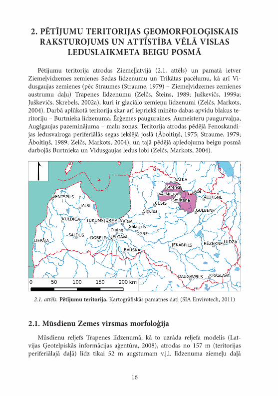
Pētījumu teritorija atrodas Ziemeļlatvijā (2.1. attēls) un pamatā ietver Ziemeļvidzemes zemienes Sedas līdzenumu un Trikātas pacēlumu, kā arī Vi-dusgaujas zemienes (pēc Straumes (Straume, 1979) – Ziemeļvidzemes zemienes austrumu daļu) Trapenes līdzenumu (Zelčs, Šteins, 1989; Juškevičs, 1999a; Juškevičs, Skrebels, 2002a), kuri ir glaciālo zemieņu līdzenumi (Zelčs, Markots, 2004). Darbā aplūkotā teritorija skar arī iepriekš minēto dabas apvidu blakus te-ritoriju – Burtnieka līdzenuma, Ērģemes pauguraines, Aumeisteru paugurvaļņa, Augšgaujas pazeminājuma – malu zonas. Teritorija atrodas pēdējā Fenoskandi-jas ledusvairoga periferiālās segas iekšējā joslā (Āboltiņš, 1975; Straume, 1979; Āboltiņš, 1989; Zelčs, Markots, 2004), un tajā pēdējā apledojuma beigu posmā darbojās Burtnieka un Vidusgaujas ledus lobi (Zelčs, Markots, 2004).
2.1. attēls. Pētījumu teritorija. Kartogrāfiskās pamatnes dati (SIA Envirotech, 2011)
2.1. Mūsdienu Zemes virsmas morfoloģija
Mūsdienu reljefs Trapenes līdzenumā, kā to uzrāda reljefa modelis (Lat-vijas Ģeotelpiskās informācijas aģentūra, 2008), atrodas no 157 m (teritorijas periferiālajā daļā) līdz tikai 52 m augstumam v.j.l. līdzenuma ziemeļu daļā
17
esošajā Gaujas ielejā. Lielā absolūtā augstuma starpība ir saistīta ar līdzenuma ziemeļu daļā esošo kāpli subkvartāro iežu virsmā (Juškevičs, Skrebels, 2002c), kas mūsdienu reljefā saistās ar apmēram 20 m lielu augstuma starpību, kā arī Gaujas iegrauzumu subkvartārās kāples apvidū, kas sasniedz pat 30 m dziļumu. Līdzenuma teritorijas rietumu pusē atrodas labi izsekojama, līdz 20 m augsta Velēnas gala morēna (Zelčs, Markots, 2004), kā arī ir plaši sastopamas iekšzemes kāpas (Āboltiņš, 1971; Danilāns, 1973; Straume, 1979).
Sedas līdzenumā mūsdienu reljefa absolūtie augstumi mainās no 107 m Vidzemes augstienes pakājē līdz 29 m Gaujas ielejā. Vidējais augstums ir 58 m v.j.l., un izteiktākās augstuma izmaiņas ir saistāmas ar līdzenuma teritorijā eso-šajām kāpām, kuru relatīvais augstums mēdz pārsniegt 20 m (Celiņš, Nartišs, 2011). Līdzenuma teritorijas centrālo daļu šķērso Gauja, taču tās ieleja ir relatīvi sekla – tikai apmēram 10 m. Teritorijā ir sastopamas divas – Salaiņa un Kokšu (Taču) – ezeru sistēmas, kuru veidošanās ir saistāma ar ledājkušanas ūdeņu darbību (Āboltiņš, 1971). Teritorijas rietumu, ziemeļrietumu daļā atrodas vairāk nekā 130 km2 plašais Sedas purvs.
Trikātas pacēluma dabas apvidus absolūtais augstums mainās no 130 m Vidzemes augstienes pakājē līdz 32 m pie Gaujas ielejas. Apvidus centrālo daļu virzienā no dienvidrietumiem uz ziemeļaustrumiem šķērso pacēluma zona, kuras augstums tās lielākajā daļā ir virs 80 m. Pacēluma ziemeļu un rietumu daļā ir plaši sastopami drumlini (Zelčs, 1992). Visu dabas apvidus teritoriju izvago ledājkušanas ūdeņu veidots ieleju tīkls.
2.2. Kvartāra nogulumu segas raksturojums
Vidusgaujas zemienes Trapenes līdzenuma kvartāra nogulumu segas augšējo daļu pamatā veido glaciolimniskie nogulumi, savukārt periferiālajā daļā augstie-ņu pakājēs atrodas glaciofluviālie nogulumi un morēnas nogulumi (Juškevičs, Skrebels, 2002b). Smilšaino glaciolimnisko nogulumu apgabalos līdzenuma centrālajā un dienvidrietumu daļā šie nogulumi ir pārpūsti, veidojot kāpas (eolie nogulumi) (ibid.). Atsevišķās vietās ir novērojams, ka hipsometriski augstākā lī-dzenuma daļā ir sastopami smalkāki nogulumi (aleirīti, māli) nekā hipsometris-ki zemākā daļā (smilts). Līdzenuma dienvidrietumu daļā līdzīgā hipsometriskā novietojumā ir atrodami gan glaciolimniski aleirīti un māli, gan glaciolimniska smilts un morēnas nogulumi. Atsevišķu līdzenuma teritorijā esošo nogulumu ģenēzes noteikšana ir apgrūtināta, uz ko norāda atšķirīgā interpretācija dažāda vecuma ģeoloģiskās kartēšanas materiālos.
Glaciolimniskie nogulumi, pamatā smilts, veido kvartāra nogulumu segu lielākajā Sedas līdzenuma daļā (Juškevičs, 1999b; Juškevičs, Skrebels, 2002b). Smilšainie glaciolimniskie nogulumi ir pārpūsti kāpās, kuras ir plaši izplatītas līdzenuma centrālajā un austrumu daļā, lai gan nelielākas kāpas ir sastopamas arī teritorijas rietumu daļā, pat līdzenuma ziemeļrietumos esošajā plašajā Sedas
18
purvā (ibid.). Atšķirībā no Vidusgaujas zemienes Trapenes līdzenuma, Sedas līdzenuma teritorijā glaciolimniskos nogulumus pamatā veido smilts, bet aleirīti un māli ir sastopami tikai nelielās teritorijās līdzenuma dienvidos, kā arī ziemeļu daļā uz robežas ar Ērģemes pauguraini, tās pakājē.
Atšķirībā no Trapenes līdzenuma, Trikātas pacēlumā glaciolimniskie no-gulumi atrodas tikai tā centrālajā daļā esošajā pazeminājumā, kur tos gandrīz pilnībā sedz kūdra (Juškevičs, 1999b; Juškevičs, Skrebels, 2002b). Reljefa pacēlu-mus veido morēnas un glaciofluviālie nogulumi, kuri ir sastopami galvenokārt gar Vidzemes augstienes pakāji (ibid.). Atšķirībā no Trapenes līdzenuma, šajā pacēlumā eolie nogulumi (kāpas) nav sastopami.
2.3. Vēlā Vislas apledojuma izzušana
Ledāja sprostezeru eksistence, tās ilgums, to vecums un izplatības konfigurā-cija ir tieši atkarīga no ledāja, kas atrodas kontaktā ar tiem. Pētījumu teritorijas deglaciācijas gaita līdzšinējos pētījumos vienmēr ir tikusi aplūkota reģionālā vai apkārtējo augstieņu veidošanās kontekstā (Nartišs, Zelčs, 2013). Lai varētu spriest par deglaciācijas gaitu, ir nepieciešams aplūkot reģionālās deglaciācijas rekonstrukcijas (Āboltiņš, 1971; Āboltiņš et al., 1974b; Meirons et al., 1976; Straume, 1979; Āboltiņš, 1989; Zelčs, Markots, 2004; Raukas, 2009; Zelčs et al., 2011; Kalm et al., 2011; Guobytė, R., Satkūnas, 2011; Kalm, 2012a; Kalm, 2012b; Lasberg, Kalm, 2013). Kā norāda Bitins un citi pētnieki (Bitinas et al., 2004), Lietuvas teritorijā nav pierādījumu pēdējā apledojuma deglaciācijas laikā noti-kušai ledāja transgresijai uz teritoriju, kas ir brīva no ledāja. Lietuvas teritorijā deglaciācijā ir dominējusi areālā ledāja kušana, nevis frontāla ledāja atkāpšanās ar atkārtotu tā uzvirzīšanos (Bitinas et al., 2004). Šāds viedoklis ir pretrunā ar citu autoru iepriekš atbalstīto deglaciācijas gaitu, kurā būtiska nozīme ir ledāja malas atkārtotai virzībai pāri iepriekš jau no ledāja brīvajām teritorijām (Mei-rons et al., 1976; Straume, 1979; Āboltiņš, 1989) vai ledāja lobu reaktivizācijai to ledus masu bilances uzlabošanās rezultātā, ko noteica ledāja aprimšana virs zemledāja virsmas pacēlumiem (Zelčs, 1993; Zelčs, Markots, 2004). Jaunākās rekonstrukcijas (Zelčs et al., 2011; Kalm et al., 2011; Kalm, 2012a; Nartišs, Zelčs, 2013) uzrāda, ka šajā teritorijā ledāja izzušanas laikā ir veidojušās vairākas ledāja malas veidojumu zonas, kuras marķē ledāja malas stabilizāciju vai reaktivizāciju.
Gulbenes malas veidojumu zonas, kas tiek saistīta ar Hānjas malas vei-dojumu zonu (Zelčs et al., 2011; Nartišs, Zelčs, 2013), minimālais vecums ir 14,5–15,5 ka. Alūksnes augstienē netālu no Māriņkalna ar 10Be metodi datētā laukakmens eksponēšanās virs zemes ir notikusi pirms 15 290 ± 980 gadiem (Rinterknecht et al., 2006), kas parāda minimālo vecumu, kad ledājs Alūksnes augstienes teritorijā atkāpās no Gulbenes malas veidojumu zonas. Uz līdzīgu vecumu norāda arī Sandgrena un citu pētnieku (Sandgren et al., 1997) slokšņu mālu pētījums Tamulas ezerā, kas atrodas Harglas zemienē starp Hānjas un
19
Otepē augstieni, kur slokšņu mālu uzkrāšanās ir ilgusi 1200 gadu un sākusies pirms 14 675 kalendārajiem gadiem (Kalm, 2006).
Otepē malas veidojumu zona, kura Latvijā tiek korelēta ar Linkuvas malas veidojumu zonu (Zelčs et al., 2011; Nartišs, Zelčs, 2013), ir veidojusies pirms 14,8 ka (Lasberg, Kalm, 2013). Kalms (Kalm, 2006) norāda, ka Harglas zemienē netālu no Tamulas ezera ir bijuši no ledāja brīvi apstākļi pirms 14,5–14,9 ka un atbilstoši Otepē malas veidojumu zonas vecumam ir jābūt 14,5–14,7 ka robežās.
Jaunākie pētījumi Igaunijas teritorijā uzrāda, ka ledājs Pandiveres malas zonas veidošanās laikā, kas sakrīt ar Baltijas ledus ezera A1 stadiju pirms 13 800–14 000 kalendārajiem gadiem (Vassiljev, Saarse, 2013), Latvijas teritorijā neatradās (Kalm et al., 2011; Vassiljev, Saarse, 2013; Lasberg, Kalm, 2013).
Sedas līdzenuma teritorijā virs glaciolimniskiem nogulumiem esošajās kāpās eolās smilts datējumi ar OSL metodi uzrāda, ka vecākās kāpas ir veidojušās pirms 11,9 ± 2,7 ka un 11,8 ± 2,4 ka (Nartišs et al., 2009), atbilstoši norādot uz minimālo vecumu, kad ledājam un tam sekojošajiem ledājkušanas ūdeņu baseiniem ir jau jābūt pārstājušiem eksistēt.
2.4. Ledājkušanas ūdeņu ezeru līdzšinējie pētījumi
Līdzšinējos pētījumos darbā aplūkotajā teritorijā tiek izšķirti vairāki ledāj-kušanas ūdeņu ezeri (Āboltiņš et al., 1974a; Straume, 1978; Straume, 1979), taču jāņem vērā, ka minētajos pētījumos autori ir aprobežojušies ar konkrēto ezeru aptuvenu līmeņu noteikšanu, kā arī aptuvenu to izplatības rekonstruēšanu (Āboltiņš, 1971), kam par iemeslu ir bijusi nepietiekami sīka informācija par paleoģeogrāfisko indikatoru – galvenokārt nogulumu – izplatību (Āboltiņš, personīgā komunikācija).
Saskaņā ar Āboltiņa un līdzautoru viedokli (Āboltiņš et al., 1974b) Vidusgau-jas un Smiltenes ledāja sprostezeros pa Pečoru–Viru (Harglas zemiene, Mustje-gi) ieleju ir ieplūduši ūdeņi no Pleskavas ledāja sprostezera. Pēc Smiltenes ledāja sprostezera līmeņa krituma ūdeņu pieplūde no Pleskavas ledāja sprostezera ir notikusi no Vertsjerva ezera pa Pedeles–Augšsedas pazeminājumu, kur Valgas līdzenuma teritorijā atradās pieledāja ezers (Āboltiņš et al., 1974b). Savukārt citi pētnieki (Moora et al., 2002) norāda, ka ūdeņu plūšana no Valgas līdzenumā esošā Lātres ledāja sprostezera un tam sekojošā agrīnā Vertsjerva baseina nav notikusi. Tam nepiekrīt Rosentau (Rosentau, 2006), kurš norāda uz savienojuma esamību ne vien starp Vertsjerva un Strenču baseinu, bet arī starp Vertsjerva un Peipusa baseinu, un tas pieļauj ūdeņu tecēšanu no Peipusa uz Strenču baseinu.
20
3. MATeRIāLI uN MeTODeS
Pētījums ir balstīts uz oriģināliem datiem, kas iegūti, 8 gadu laikā strā-dājot gan kamerāli, gan arī lauka ekspedīcijās. No speciālās literatūras, lauka ekspedīcijām, kartogrāfiskā materiāla, Latvijas Ģeoloģijas fonda avotiem iegūtie dati tika lietoti, lai sagatavotu un veiktu ledājkušanas ūdeņu ezeru modelēšanu, kā arī iegūto rezultātu validāciju. Pētījumā izmantotās metodes ir līdzīgas citos seno glaciālo ezeru pētījumos lietotajām metodēm, vienlai-kus tās ir modificētas un uzlabotas, lai atbilstu konkrētā pētījumā pieejamo datu formai un kvalitātei, tādējādi sekmīgāk ļaujot sasniegt nosprausto pētījuma mērķi.
Par darbā izmantoto vietvārdu avotu pamatā kalpoja Latvijas Satelītkarte (Latvijas Ģeotelpiskās informācijas aģentūra, 2000). Dabas apvidu kontūras un to nosaukumi tika iegūti no Valsts ģeoloģijas dienesta sagatavotās dabas apvidu kartes (Juškevičs, 1999a; Juškevičs, Skrebels, 2002a).
ĢIS analītiskās un modelēšanas darbības galvenokārt tika veiktas brīvajā programmā GRASS GIS 7 (GRASS Development Team, 2012). Dažāda kar-togrāfiskā materiāla pārlūkošanai, jaunu datu kopu manuālai izveidei, kā arī karšu sagatavošanai tika izmantota QGIS programmas tobrīd jaunākā versija (QGIS Development Team, 2013). Darbā ietvertais kartogrāfiskais materiāls ir sagatavots Latvijas 1992. gada ģeodēzisko koordinātu sistēmā, Merkatora transversālā projekcijā. Koordinātas ir sniegtas kā Merkatora transversālās projekcijas plaknes koordinātas (LKS-92 TM; EPSG:3059). Darbā izmantota Baltijas 1977. gada normālo augstumu sistēma (BAS-77), ja vien tekstā nav norādīts citādāk.
Lauka darbu laikā novērojumu vietu un dažādu objektu atrašanās vietas fiksēšanai tika izmantoti ikdienas lietošanai paredzēti GPS uztvērēji, un objektu augstums tika nolasīts no topogrāfiskās kartes mērogā 1 : 10 000 (TOPO 10K PSRS, 2009). Atsevišķās ekspedīcijās tika izmantots Magellan Promark 3 vienfrekvences GPS uztvērējs ar pēcapstrādes iespēju, ar kuru iegūtie re-zultāti tika apstrādāti Magellan Mobile Office 3.40a programmā, kur kā atbalsta tīkls tika lietotas LatPos (Latvijas Ģeotelpiskās informācijas aģentūra, 2013) sistēmas bāzes stacijas.
Telpiskās analīzes veikšanai Latvijas teritorijā tika izmantots LĢIA digitālais augstuma modelis (DEM) rastra formātā ar horizontālo izšķirt-spēju 20 m (Latvijas Ģeotelpiskās informācijas aģentūra, 2008). Veicot DEM mozaīkas vizuālu kontroli, tika konstatēts, ka starp atsevišķām tā lapām ir novērojamas atstarpes, kā arī lapu iekšienē ir redzamas izejas datu lapu robežas, kuras veido līdz 10 m augstas mākslīgas kāples. Tāpat augstuma modelī ir attēloti cilvēka veidoti objekti (tilti, uzbērumi, ceļa caurrakumi u. c.) un kļūdas. DEM izejas lapu salaidumu vietu ietekmes mazināšanai
21
tika nogludināta to atrašanās vieta 120 m platā joslā ar r.neighbours moduli 5×5 rastra šūnu lielā logā ar pielāgotu svaru matricu, rēķinot vidējo arit-mētisko vērtību. Cilvēka radīto objektu, kā arī rupjo kļūdu aizvākšanai no reljefa modeļa tika izgriezti tiem atbilstošie manuāli digitizētie laukumi, kuri tika aizpildīti interpolācijas ceļā (Nartišs, 2013).
Kāpas, kuras ir veidojušās jau pēc pētīto ezeru noplūšanas, tika noņemtas no reljefa modeļa tieši tāpat, kā tika aizvākti cilvēka radītie objekti. Kāpu izgriešanai par pamatu tika ņemts I. Celiņa sagatavotais kāpu pamatnes datu slānis (Celiņš, Nartišs, 2011). Sedas purva centrālajā un dienvidu daļā mūsdienu reljefs tika aizstāts ar minerālās grunts virsmas augstumu (No-mals, 1943), savukārt citu purvu teritorijās – ar interpolācijas ceļā iegūtiem augstumiem no purvu malām. Uzlabotajā DEM mūsdienu upju ielejās tika novietoti dabā neeksistējoši dambji, lai nodrošinātos pret modelēto baseinu brīvu noplūšanu pa upju ielejām, kuras ir izveidojušās jau pēc šo baseinu eksistences. Šādi sagatavotais un uzlabotais DEM tika papildināts ar NASA Shuttle Radar Topography Mission (SRTM) 2.1 digitālo augstuma modeli (Rabus, 2003) Igaunijas teritorijā, kā arī tām Latvijas teritorijas daļām, ku-rām LĢIA DEM dati nebija autora rīcībā.
3.1. Zemes garozas vertikālo kustību kompensēšana
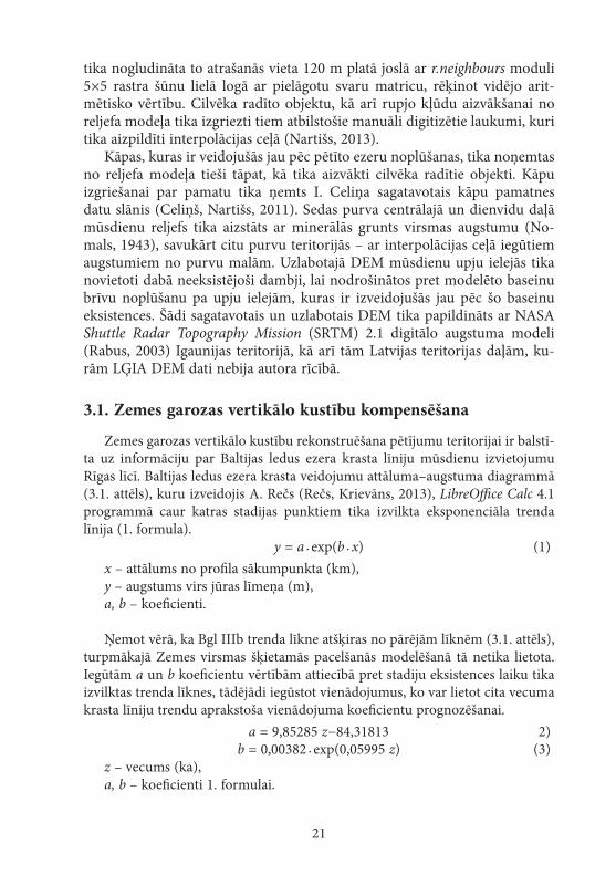
Zemes garozas vertikālo kustību rekonstruēšana pētījumu teritorijai ir balstī-ta uz informāciju par Baltijas ledus ezera krasta līniju mūsdienu izvietojumu Rīgas līcī. Baltijas ledus ezera krasta veidojumu attāluma–augstuma diagrammā (3.1. attēls), kuru izveidojis A. Rečs (Rečs, Krievāns, 2013), LibreOffice Calc 4.1 programmā caur katras stadijas punktiem tika izvilkta eksponenciāla trenda līnija (1. formula). y = a · exp(b · x) (1)
x – attālums no profila sākumpunkta (km),y – augstums virs jūras līmeņa (m),a, b – koeficienti.
Ņemot vērā, ka Bgl IIIb trenda līkne atšķiras no pārējām līknēm (3.1. attēls), turpmākajā Zemes virsmas šķietamās pacelšanās modelēšanā tā netika lietota. Iegūtām a un b koeficientu vērtībām attiecībā pret stadiju eksistences laiku tika izvilktas trenda līknes, tādējādi iegūstot vienādojumus, ko var lietot cita vecuma krasta līniju trendu aprakstoša vienādojuma koeficientu prognozēšanai. a = 9,85285 z−84,31813 2) b = 0,00382 · exp(0,05995 z) (3)
z – vecums (ka),a, b – koeficienti 1. formulai.
22
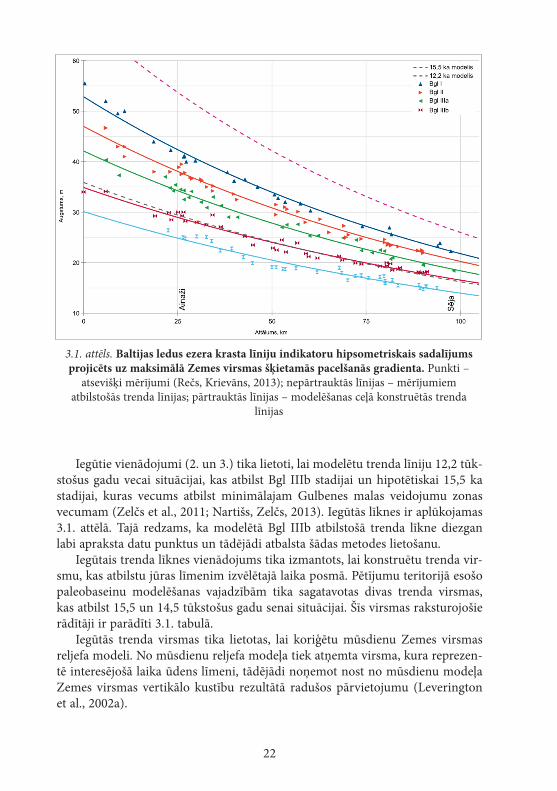
Iegūtie vienādojumi (2. un 3.) tika lietoti, lai modelētu trenda līniju 12,2 tūk-stošus gadu vecai situācijai, kas atbilst Bgl IIIb stadijai un hipotētiskai 15,5 ka stadijai, kuras vecums atbilst minimālajam Gulbenes malas veidojumu zonas vecumam (Zelčs et al., 2011; Nartišs, Zelčs, 2013). Iegūtās līknes ir aplūkojamas 3.1. attēlā. Tajā redzams, ka modelētā Bgl IIIb atbilstošā trenda līkne diezgan labi apraksta datu punktus un tādējādi atbalsta šādas metodes lietošanu.
Iegūtais trenda līknes vienādojums tika izmantots, lai konstruētu trenda vir-smu, kas atbilstu jūras līmenim izvēlētajā laika posmā. Pētījumu teritorijā esošo paleobaseinu modelēšanas vajadzībām tika sagatavotas divas trenda virsmas, kas atbilst 15,5 un 14,5 tūkstošus gadu senai situācijai. Šīs virsmas raksturojošie rādītāji ir parādīti 3.1. tabulā.
Iegūtās trenda virsmas tika lietotas, lai koriģētu mūsdienu Zemes virsmas reljefa modeli. No mūsdienu reljefa modeļa tiek atņemta virsma, kura reprezen-tē interesējošā laika ūdens līmeni, tādējādi noņemot nost no mūsdienu modeļa Zemes virsmas vertikālo kustību rezultātā radušos pārvietojumu (Leverington et al., 2002a).
3.1. attēls. Baltijas ledus ezera krasta līniju indikatoru hipsometriskais sadalījums projicēts uz maksimālā Zemes virsmas šķietamās pacelšanās gradienta. Punkti –
atsevišķi mērījumi (Rečs, Krievāns, 2013); nepārtrauktās līnijas – mērījumiem atbilstošās trenda līnijas; pārtrauktās līnijas – modelēšanas ceļā konstruētās trenda
līnijas
23
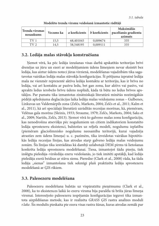
3.1. tabula
Modelēto trenda virsmu veidošanā izmantotie rādītāji
Trenda virsmas nosaukums Vecums ka a koeficients b koeficients
Maksimālās pacelšanās gradienta
azimutsTV 1 15,5 68,401045 0,009674 335TV 2 14,5 58,548195 0,009111 335
3.2. Ledāja malas stāvokļa konstruēšana
Ņemot vērā, ka pēc ledāja izzušanas visas darbā apskatītās teritorijas brīvi drenējas uz jūru un ezeri ar modelējamiem ūdens līmeņiem nevar eksistēt bez ledāja, kas aiztur ūdens noteci jūras virzienā, modelēšanas vajadzībām tika saga-tavotas vairākas ledāja malas stāvokļa konfigurācijas. Šī pētījuma izpratnē ledāja mala ne vienmēr reprezentē aktīva ledāja kontaktu ar teritoriju, kas ir brīva no ledāja, vai arī kontaktu ar pasīvu ledu, bet gan zonu, kur aktīvs vai pasīvs, vai aprakts ledus ierobežo brīvu ūdens noplūdi, kāda tā būtu no ledus brīvos aps-tākļos. Par pamatu tika izmantotas zinātniskajā literatūrā minētās nozīmīgākās pēdējā apledojuma deglaciācijas laika ledāja malas veidojumu zonas – Gulbenes, Linkuvas un Valdemārpils zona (Zelčs, Markots, 2004; Zelčs et al., 2011; Kalm et al., 2011), kā arī speciālajā literatūrā uzrādītās recesijas morēnas, kā, piemēram, Velēnas gala morēna (Sleinis, 1933; Straume, 1979; Zelčs, Markots, 2004; Saks et al., 2009; Nartišs, Zelčs, 2013). Ņemot vērā šo galveno malas zonu konfigurāciju, kas nenodrošina atsevišķu pēc nogulumiem un citiem indikatoriem konstatēto ledāja sprostezeru eksistenci, balstoties uz reljefa modeli, nogulumu izplatību (piemēram glaciolimnisko nogulumu neesamība teritorijā, kurai vajadzēja atrasties zem ūdens līmeņa) u. c. pazīmēm, tika izveidotas vairākas hipotētis-kās ledāja recesijas līnijas, kas atrodas starp galveno ledāja malas veidojumu zonām. Šīs līnijas tika iestrādātas kā dambji uzlabotajā DEM pirms tā lietošanas konkrēta ledāja sprostezera modelēšanai. Tiesa, izmantojot šādu pieeju, tiek izslēgta pieledāja–virsledāja ezeru veidošanās, jo tiek imitēti apstākļi, kad ledājs pieledāja ezerā beidzas ar stāvu sienu. Pieredze (Clark et al., 2008) rāda, ka šāda ledāja „sienas” izmantošana tiek sekmīgi plaši praktizēta ledāja sprostezeru modelēšanā ar ĢIS rīkiem.
3.3. Paleoezeru modelēšana
Paleoezeru modelēšana balstās uz vispāratzītu pieņēmumu (Clark et al., 2008), ka to eksistences laikā šo ezeru virsma bija paralēla tā brīža jūras līmeņa virsmai. Interesējošo paleoezeru iespējamās konfigurācijas ieguvei tika izman-tota aizpildīšanas metode, kas ir realizēta GRASS ĢIS rastra analīzes modulī r.lake. Šis modulis pieskaita pie ezera visas rastra šūnas, kuras atrodas zemāk par
24
iestatīto ūdens līmeni un vienlaikus ir savienotas ar doto sākumpunktu, kura piederība pie modelējamā ledus ezera ir zināma (Nartišs, 2006).
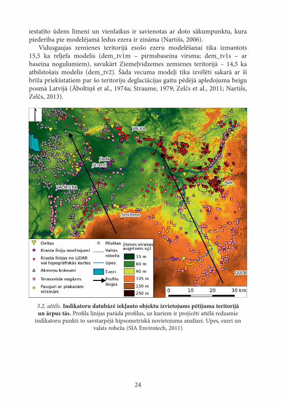
Vidusgaujas zemienes teritorijā esošo ezeru modelēšanai tika izmantots 15,5 ka reljefa modelis (dem_tv1m – pirmsbaseina virsma; dem_tv1s – ar baseina nogulumiem), savukārt Ziemeļvidzemes zemienes teritorijā – 14,5 ka atbilstošais modelis (dem_tv2). Šāda vecuma modeļi tika izvēlēti sakarā ar šī brīža priekšstatiem par šo teritoriju deglaciācijas gaitu pēdējā apledojuma beigu posmā Latvijā (Āboltiņš et al., 1974a; Straume, 1979; Zelčs et al., 2011; Nartišs, Zelčs, 2013).
3.2. attēls. Indikatoru datubāzē iekļauto objektu izvietojums pētījuma teritorijā un ārpus tās. Profila līnijas parāda profilus, uz kuriem ir projicēti attēlā redzamie
indikatoru punkti to savstarpējā hipsometriskā novietojuma analīzei. Upes, ezeri un valsts robeža (SIA Envirotech, 2011)
25
3.4. Glaciālo ezeru izplatības un līmeņu indikatori
Gan lauka darbu laikā, gan kamerālajos pētījumos tika meklētas dažādas pazīmes, kuras tieši vai netieši var norādīt uz to, ka konkrētajā vietā savulaik ir atradies ledus ezers, un, vēl labāk, ļautu spriest par tā ūdens līmeni. Līdzīgi kā citos paleoezeru pētījumos (LaRocque et al., 2003a), arī šajā uzmanība tika pievērsta ūdens ieplūdes vietām, akumulācijas un erozijas vietām krasta zonā un noteces ielejām.
Laukā konstatētie punkti tika fiksēti ar GPS uztvērēju, savukārt lauka ekspedīcijās iegūtie punkti tika papildināti ar punktiem, kas nolasīti no lielmē-roga topogrāfiskās kartes (TOPO 10K PSRS, 2009). Topogrāfiskā karte mērogā 1 : 10 000 ir uzskatāma par adekvātu informācijas avotu seno ezeru krasta līniju kartēšanai, lai arī detālāka kartogrāfiskā materiāla lietošana ļautu būtiski uzlabot indikatoru precizitāti un palielināt to skaitu (LaRocque et al., 2003a).
Kopumā indikatoru datubāzē ir apkopoti lauka ekspedīcijās identificētie un no kartēm nolasītie vairāk nekā 1100 iespējamie krasta līniju indikatori, 70 gla-ciāli pauguri ar plakanām virsmām, 330 terasveida nogāžu līmeņi, 13 deltas, 830 akmeņu krāvumi. Turklāt lauka ekspedīcijās konstatēti 120 punkti, kas saistīti ar seno ezeru krastiem. Datubāzē apkopoto indikatoru izvietojumu var aplūkot 3.2. attēlā. Jāņem vērā, ka lielākā daļa šo indikatoru ir tikai potenciāli saistīti ar darbā aplūkotajiem ledus ezeriem. Datubāzes izveides pamatā ir ideja, ka indikatoriem, kas ir saistīti ar kādu no paleoezeru līmeņiem, pēc Zemes garozas vertikālo kustību kompensēšanas vajadzētu atrasties vienā augstumā. Tādējādi paaugstināts indikatoru daudzums noteiktā augstumā var norādīt uz kādu no paleoezeru līmeņiem.
3.5. Nogulumu granulometriskā analīze un struktūranalīze
Nogulumu granulometrisko sastāvu raksturojošo rādītāju aprēķini tiek veikti pēc Folka un Vorda (Folk, Ward, 1957) izstrādātās metodikas, un tie ir realizēti šajā darbā izstrādātā granulometriskās analīzes modulī (Nartišs et al., 2012; Kalińska et al., 2013). Iegūtajos daļiņu izmēra procentuālā sadalījuma un kumulatīvā sadalījuma grafikos redzamās līknes tika salīdzinātas savā starpā, kā arī ar Mičielskas-Dovgiallo un Ludvikovskas-Kendžias (Mycielska-Dowgiałło, Ludwikowska-Kędzia, 2011), un Višera (Visher, 1969) pētījumos apkopotajām eolo vidi un citas vides raksturojošajām līknēm.
Papildus nogulumu granulometriskā sastāva īpašību noteikšanai daļai parau-gu tika noteikta arī smilts frakciju veidojošo kvarca smilts graudu noapaļotība un matējuma pakāpe saskaņā ar Kaijū (Cailleux, 1942) izstrādāto metodiku ar Mičielskas-Dovgiallo un Voronko papildinājumiem (Mycielska-Dowgiałło, Woronko, 1998).
26
3.6. Smilts nogulumu absolūtā vecuma noteikšana
Lai iegūtu informāciju par darbā aplūkoto paleoezeru eksistences laiku, lauka ekspedīcijās tika ievākti smilts paraugi, kuri tālāk tika analizēti ar OSL metodes palīdzību. Daļa paraugu tika analizēta Somijas Dabas vēstures muzeja Datēšanas laboratorijā Helsinkos, izmantojot viena alikvota reģeneratīvās dozas (SAR) protokolu (Murray, Wintle, 2000). Savukārt cita daļa paraugu tika ievākta kopīgos sadarbības projektos ar Ivaru Celiņu un Editu Kaļinsku-Nartišu, kuri šos paraugus analizēja Ziemeļu luminiscences datēšanas laboratorijā Risū (Risø) Dānijā. Šiem paraugiem arī tika lietots SAR protokols (Murray, Wintle, 2000; Wintle, Murray, 2006), papildus iegūto rezultātu kontrolei tika izmantots dozas atkārtojamības tests (Wallinga et al., 2000). Tā kā atsevišķi paraugi neatbilda laboratorijā noteiktajiem rezultātu kvalitātes kritērijiem, tie tika analizēti ar mo-dificētu SAR protokolu – pulsējošo OSL metodi (Thomsen et al., 2008), kā arī modificētu karsēšanas un ierosināšanas procedūru (Celiņš et al., 2013). Diemžēl darba rakstīšanas laikā lielākajai daļai paraugu, kas apstrādāti Risū laboratorijā, ir iegūti tikai to sākotnējie vecuma novērtējumi, un tādēļ tie nav uzskatāmi par galīgiem. Tāpat tika atzīts, ka vairākiem paraugiem iegūtie rezultāti neatbilst laboratorijas kvalitātes standartiem (Celiņš et al., 2013), tāpēc tie šajā darbā nav iekļauti, jo ir bez rezultāta.
27
4. ReZuLTāTI uN TO INTeRPReTāCIjA
Pētījuma izstrādes laikā tika iegūti rezultāti, kuri gan bija, gan arī nebija tieši saistīti ar pētījuma mērķi, taču bija nepieciešami sekmīgai nospraustā mērķa sasniegšanai. Pētījuma teritorijā eksistējušo lielo glaciālo ezeru rekonstrukcijas ir uzskatāmas par galveno šī pētījuma rezultātu. Tās parāda glaciālo ezeru tel-pisko izplatību un ļauj izsekot to attīstībai laikā. Glaciālie ezeri un to stadijas ir aplūkotas hronoloģiskā secībā no senākajām līdz pat jaunākajām stadijām. Šāda secība sakrīt arī ar to līmeņu hipsometrisku izkārtojumu, sākot no glaciālā ezera ar augstāko līmeni un beidzot ar glaciālo ezeru ar zemāko līmeni.
4.1. Vidusgaujas ledāja sprostezers
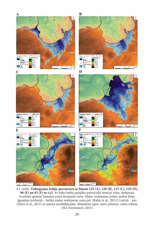
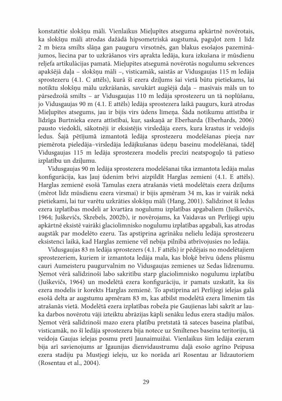
Modelēšanas ceļā tika iegūtas sešas Vidusgaujas ledāja sprostezera re-konstrukcijas (4.1. attēls). Atbilstoši izmantotajam Zemes virsmas šķietamās pacelšanās modelim un reljefa modelim, neskatoties uz modelētā Vidusgaujas ledāja sprostezera ar līmeni 125 m v.j.l. dziļo iestiepšanos Tirzas pazeminājumā (4.1. A attēls), ūdens līmeņa augstums bija nepietiekams, lai varētu izveidoties notece no modelētā ezera pa Apiņupītes ieleju uz Austrumlatvijas zemienes pusi, kuras augštecē ūdensšķirtne atrodas gandrīz 10 m virs modelētā ezera līmeņa. Apiņupītes ieleja ir vienīgā vieta, kur modelis norāda potenciālu noteci, taču modelēšana liecina, ka tā nevar notikt, un tādēļ Vidusgaujas ledāja sprostezers ar līmeni 125 m ir uzskatāms par beznoteces ezeru. Atsevišķi glaciolimnisko nogulumu izplatības laukumi, kuri atrodas augstāk par modelēto ezeru, norāda, ka pirms modelētā ledāja sprostezera ir eksistējuši mazāki lokāli ledus ezeri ar augstāku līmeni. Ja šo ezeru ūdens līmeņi ir pārsnieguši 130 m atzīmi, tad to ūdeņi varēja pārvarēt slieksni Apiņupītē un nodrošināt noteci uz Austrumlatvi-jas zemieni.
Vidusgaujas ledāja sprostezerā ar līmeni 125 m v.j.l. no Vidzemes augstienes puses ir ietecējusi Gauja, Tirza, savukārt no Alūksnes augstienes puses – Meln-upe, kā arī, visticamāk, ar to saistītās Silaktu (Rezaka–Zeltiņi) kēmu terases aug-šējais līmenis, kas, pēc M. Dauškana (Dauškans, 2013) datiem, atrodas apmēram 130 m augstumā. No ledāja brīvajām teritorijām ietekošais ūdens, visticamāk, ir bijis bagāts ar cietvielām, par ko liecina arī modelēšanai par pamatu ņemtās Gaujas Rankas spektra IIIa virspalu terases akumulatīvais raksturs (Āboltiņš, 1971). Ezera relatīvi nelielā platība, beznoteces apstākļi un lielais tajā ieplūsto-šais ūdeņu daudzums, visticamāk, tad arī ir iemesls tam, ka pat ezera dziļākajā daļā nogulumus veido smalka smilts, nevis māli un aleirīti.
Vidusgaujas 110 m v.j.l. ledāja sprostezera modelis (4.1. D attēls) uzrāda, ka Mieļupītes atseguma vietā tā dziļums ir bijis aptuveni 15 m, kas, saskaņā ar Hanga (Hang, 2001) pētījumu, nav pietiekami, lai varētu uzkrāties atsegumā
28
4.1. attēls. Vidusgaujas ledāja sprostezers ar līmeni 125 (A), 120 (B), 115 (C), 110 (D), 90 (e) un 83 (f) m v.j.l. Ar balto bultu parādīta potenciālā noteces vieta. Sarkanais kvadrāts apzīmē Tamulas ezera atrašanās vietu. Malas veidojumu joslas: melnā līnija
Igaunijas teritorijā – ledāja malas veidojumu zona pēc (Kalm et al., 2011); Latvijā – pēc (Zelčs et al., 2011) ar autora modifikācijām. Mūsdienu upes, ezeri, pilsētas, valsts robeža
(SIA Envirotech, 2011)
A B
C D
E F
29
konstatētie slokšņu māli. Vienlaikus Mieļupītes atseguma apkārtnē novērotais, ka slokšņu māli atrodas dažādā hipsometriskā augstumā, paguļot zem 1 līdz 2 m bieza smilts slāņa gan pauguru virsotnēs, gan blakus esošajos pazeminā-jumos, liecina par to uzkrāšanos virs aprakta ledāja, kura izkušana ir mūsdienu reljefa artikulācijas pamatā. Mieļupītes atsegumā novērotās nogulumu sekvences apakšējā daļa – slokšņu māli –, visticamāk, saistās ar Vidusgaujas 115 m ledāja sprostezeru (4.1. C attēls), kurā šī ezera dziļums šai vietā būtu pietiekams, lai notiktu slokšņu mālu uzkrāšanās, savukārt augšējā daļa – masīvais māls un to pārsedzošā smilts – ar Vidusgaujas 110 m ledāja sprostezeru un tā noplūšanu, jo Vidusgaujas 90 m (4.1. E attēls) ledāja sprostezera laikā paugurs, kurā atrodas Mieļupītes atsegums, jau ir bijis virs ūdens līmeņa. Šāda notikumu attīstība ir līdzīga Burtnieka ezera attīstībai, kur, saskaņā ar Eberharda (Eberhards, 2006) pausto viedokli, sākotnēji ir eksistējis virsledāja ezers, kura krastus ir veidojis ledus. Šajā pētījumā izmantotā ledāja sprostezeru modelēšanas pieeja nav piemērota pieledāja–virsledāja ledājkušanas ūdeņu baseinu modelēšanai, tādēļ Vidusgaujas 115 m ledāja sprostezera modelis precīzi neatspoguļo tā patieso izplatību un dziļumu.
Vidusgaujas 90 m ledāja sprostezera modelēšanai tika izmantota ledāja malas konfigurācija, kas ļauj ūdenim brīvi aizpildīt Harglas zemieni (4.1. E attēls). Harglas zemienē esošā Tamulas ezera atrašanās vietā modelētais ezera dziļums (mērot līdz mūsdienu ezera virsmai) ir bijis apmēram 34 m, kas ir vairāk nekā pietiekami, lai tur varētu uzkrāties slokšņu māli (Hang, 2001). Salīdzinot šī ledus ezera izplatības modeli ar kvartāra nogulumu izplatības apgabaliem (Juškevičs, 1964; Juškevičs, Skrebels, 2002b), ir novērojams, ka Vaidavas un Perlijegi upju apkārtnē eksistē vairāki glaciolimnisko nogulumu izplatības apgabali, kas atrodas augstāk par modelēto ezeru. Tas apstiprina agrīnāku nelielu ledāja sprostezeru eksistenci laikā, kad Harglas zemiene vēl nebija pilnībā atbrīvojusies no ledāja.
Vidusgaujas 83 m ledāja sprostezers (4.1. F attēls) ir pēdējais no modelētajiem sprostezeriem, kuriem ir izmantota ledāja mala, kas bloķē brīvu ūdens plūsmu cauri Aumeisteru paugurvalnim no Vidusgaujas zemienes uz Sedas līdzenumu. Ņemot vērā salīdzinoši labo sakritību starp glaciolimnisko nogulumu izplatību (Juškevičs, 1964) un modelētā ezera konfigurāciju, ir pamats uzskatīt, ka šis ezera modelis ir korekts Harglas zemienē. To apstiprina arī Perlijegi ielejas galā esošā delta ar augstumu apmēram 83 m, kas atbilst modelētā ezera līmenim tās atrašanās vietā. Modelētā ezera izplatības robeža pie Gaujienas labi sakrīt ar lau-ka darbos novērotu vāji izteiktu abrāzijas kāpli senāku ledus ezera stadiju mālos. Ņemot vērā salīdzinoši mazo ezera platību pretstatā tā sateces baseina platībai, visticamāk, no šī ledāja sprostezera bija notece uz Smiltenes baseina teritoriju, tā veidoja Gaujas ielejas posmu pretī Jaunaimuižai. Vienlaikus šim ledāja ezeram bija arī savienojums ar Igaunijas dienvidaustrumu daļā esošo agrīno Peipusa ezera stadiju pa Mustjegi ieleju, uz ko norāda arī Rosentau ar līdzautoriem (Rosentau et al., 2004).
30
4.2. Smiltenes ledāja sprostezers
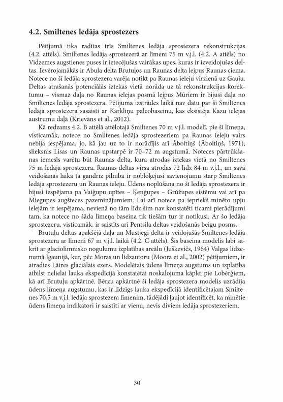
Pētījumā tika radītas trīs Smiltenes ledāja sprostezera rekonstrukcijas (4.2. attēls). Smiltenes ledāja sprostezerā ar līmeni 75 m v.j.l. (4.2. A attēls) no Vidzemes augstienes puses ir ietecējušas vairākas upes, kuras ir izveidojušas del-tas. Ievērojamākās ir Abula delta Brutuļos un Raunas delta lejpus Raunas ciema. Notece no šī ledāja sprostezera varēja notikt pa Raunas ieleju virzienā uz Gauju. Deltas atrašanās potenciālās iztekas vietā norāda uz tā rekonstrukcijas korek-tumu – vismaz daļa no Raunas ielejas posmā lejpus Mūriem ir bijusi daļa no Smiltenes ledāja sprostezera. Pētījuma izstrādes laikā nav datu par šī Smiltenes ledāja sprostezera sasaisti ar Kārkliņu paleobaseinu, kas eksistēja Kazu ielejas austrumu daļā (Krievāns et al., 2012).
Kā redzams 4.2. B attēlā attēlotajā Smiltenes 70 m v.j.l. modelī, pie šī līmeņa, visticamāk, notece no Smiltenes ledāja sprostezeriem pa Raunas ieleju vairs nebija iespējama, jo, kā jau uz to ir norādījis arī Āboltiņš (Āboltiņš, 1971), slieksnis Lisas un Raunas upstarpē ir 70–72 m augstumā. Noteces pārtrūkša-nas iemesls varētu būt Raunas delta, kura atrodas iztekas vietā no Smiltenes 75 m ledāja sprostezera. Raunas deltas virsa atrodas 72 līdz 84 m v.j.l., un savā veidošanās laikā tā gandrīz pilnībā ir nobloķējusi savienojumu starp Smiltenes ledāja sprostezeru un Raunas ieleju. Ūdens noplūšana no šī ledāja sprostezera ir bijusi iespējama pa Vaiģupu upītes – Ķeņģupes – Grūžupes sistēmu vai arī pa Miegupes augšteces pazeminājumiem. Lai arī notece pa iepriekš minēto upju ielejām ir iespējama, nevienā no tām līdz šim nav konstatēti ticami pierādījumi tam, ka notece no šāda līmeņa baseina tik tiešām tur ir notikusi. Ar šo ledāja sprostezeru, visticamāk, ir saistīts arī Pentsila deltas veidošanās beigu posms.
Brutuļu deltas apakšējā daļa un Mustjegi delta ir veidojušās Smiltenes ledāja sprostezera ar līmeni 67 m v.j.l. laikā (4.2. C attēls). Šis baseina modelis labi sa-krīt ar glaciolimnisko nogulumu izplatības areālu (Juškevičs, 1964) Valgas līdze-numā Igaunijā, kur, pēc Moras un līdzautoru (Moora et al., 2002) pētījumiem, ir atradies Lātres glaciālais ezers. Modelētais ūdens līmeņa augstums un izplatība atbilst nelielai lauka ekspedīcijā konstatētai noskalojuma kāplei pie Lobērģiem, kā arī Brutuļu apkārtnē. Bērzu apkārtnē šī ledāja sprostezera modelis uzrādīja ūdens līmeņa augstumu, kas ir līdzīgs lauka ekspedīcijā identificētajam Smilte-nes 70,5 m v.j.l. ledāja sprostezera līmenim, tādējādi ļaujot identificēt, ka minētie ūdens līmeņa indikatori ir saistīti ar vienu, nevis diviem ledāja sprostezeriem.
31
4.3. Strenču proglaciālais ezers
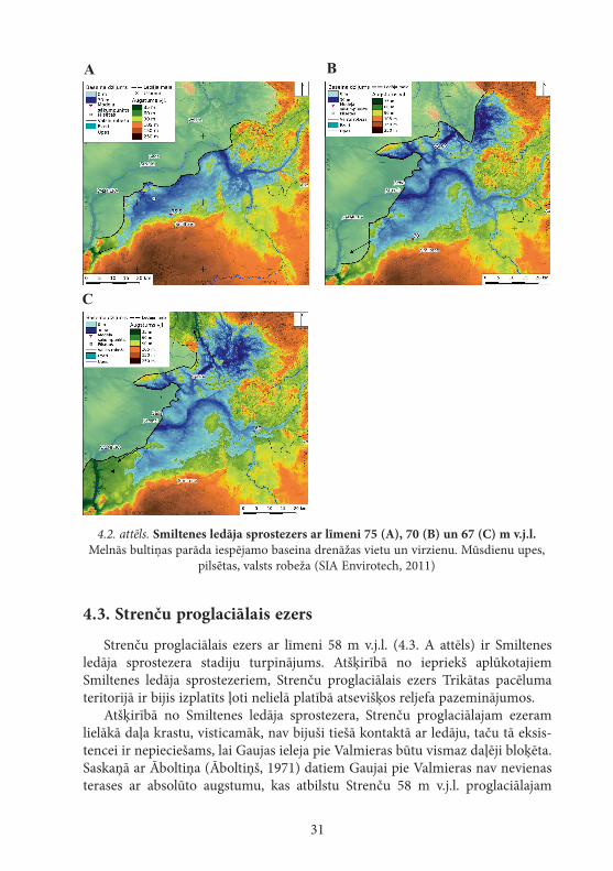
Strenču proglaciālais ezers ar līmeni 58 m v.j.l. (4.3. A attēls) ir Smiltenes ledāja sprostezera stadiju turpinājums. Atšķirībā no iepriekš aplūkotajiem Smiltenes ledāja sprostezeriem, Strenču proglaciālais ezers Trikātas pacēluma teritorijā ir bijis izplatīts ļoti nelielā platībā atsevišķos reljefa pazeminājumos.
Atšķirībā no Smiltenes ledāja sprostezera, Strenču proglaciālajam ezeram lielākā daļa krastu, visticamāk, nav bijuši tiešā kontaktā ar ledāju, taču tā eksis-tencei ir nepieciešams, lai Gaujas ieleja pie Valmieras būtu vismaz daļēji bloķēta. Saskaņā ar Āboltiņa (Āboltiņš, 1971) datiem Gaujai pie Valmieras nav nevienas terases ar absolūto augstumu, kas atbilstu Strenču 58 m v.j.l. proglaciālajam
4.2. attēls. Smiltenes ledāja sprostezers ar līmeni 75 (A), 70 (B) un 67 (C) m v.j.l. Melnās bultiņas parāda iespējamo baseina drenāžas vietu un virzienu. Mūsdienu upes,
pilsētas, valsts robeža (SIA Envirotech, 2011)
C
A B
32
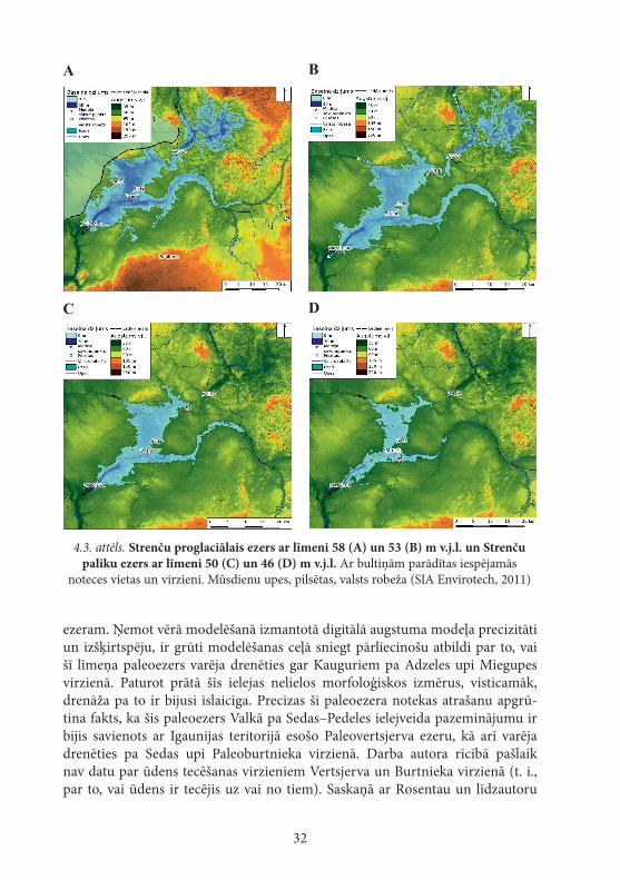
ezeram. Ņemot vērā modelēšanā izmantotā digitālā augstuma modeļa precizitāti un izšķirtspēju, ir grūti modelēšanas ceļā sniegt pārliecinošu atbildi par to, vai šī līmeņa paleoezers varēja drenēties gar Kauguriem pa Adzeles upi Miegupes virzienā. Paturot prātā šīs ielejas nelielos morfoloģiskos izmērus, visticamāk, drenāža pa to ir bijusi īslaicīga. Precīzas šī paleoezera notekas atrašanu apgrū-tina fakts, ka šis paleoezers Valkā pa Sedas–Pedeles ielejveida pazeminājumu ir bijis savienots ar Igaunijas teritorijā esošo Paleovertsjerva ezeru, kā arī varēja drenēties pa Sedas upi Paleoburtnieka virzienā. Darba autora rīcībā pašlaik nav datu par ūdens tecēšanas virzieniem Vertsjerva un Burtnieka virzienā (t. i., par to, vai ūdens ir tecējis uz vai no tiem). Saskaņā ar Rosentau un līdzautoru
4.3. attēls. Strenču proglaciālais ezers ar līmeni 58 (A) un 53 (B) m v.j.l. un Strenču paliku ezers ar līmeni 50 (C) un 46 (D) m v.j.l. Ar bultiņām parādītas iespējamās
noteces vietas un virzieni. Mūsdienu upes, pilsētas, valsts robeža (SIA Envirotech, 2011)
A B
C D
33
(Rosentau et al., 2007b) datiem, pie šī līmeņa ir bijis ielejveida savienojums starp Vertsjerva un Strenču paleoezeru. Šīs ezera stadijas vecumu Rosentau (ibid.) norāda kā 14,0 līdz 13,8 ka, taču šāds vecums ir pretrunā ar Vasiļjeva un Sārses (Vassiljev, Saarse, 2013) jaunākajiem datiem par Baltijas ledus ezera attīstību. Viņi uzskata, ka pirms aptuveni 14,0 tūkstošiem gadu Igaunijas teritorijā jau eksistēja Baltijas ledus ezera A1 stadija, kurai ūdens līmenis Vertsjerva ezera baseinā jau bija zemāks par Valkā esošā sliekšņa vērtību, kas atdala Vertsjerva un Strenču paleoezeru.
Lauka ekspedīciju laikā vairākās vietās (pie Jērcēnu pamatskolas, DA no Ķeižiem, DDR no Lugažiem, ZA no Oliņām u.c.) tika fiksēta abrāzijas kāple, kura saistāma ar Strenču proglaciālo ezeru ar līmeni 53 m v.l.j. Šai ezera stadijai vēl varēja būt savienojums ar Vertsjerva baseinu (4.3. B attēls), lai arī tā ūdens līmenis savienojuma vietā tikai minimāli pārsniedz sliekšņa augstumu. Šī ezera līmenis pie Abula ietekas Gaujā par aptuveni 2 m pārsniedz Āboltiņa (Āboltiņš, 1971) uzrādītās IV (augstākās) virspalu terases absolūto augstumu.
Strenču paliku ezera ar līmeni 50 m v.j.l. (4.3. C attēls) noskalojuma kāples, kas konstatētas lauka ekspedīcijās, ir daudz vājāk izteiktas nekā ar Strenču pali-ku ezeru ar līmeni 53 m v.j.l. saistītās. Paliku ezera krasta līnijas izsekošanu dabā gar tā austrumu krastu apgrūtina tās daļēja atrašanās zem Sedas purva kūdras nogulumu virsas līmeņa. Šī Strenču paliku ezera rekonstrukcija pie Abula ie-tekas Gaujā norāda uz ūdens līmeni 49,6–50,0 m v.j.l., kas ir nedaudz zemāks par tur esošās Gaujas IV virspalu terases līmeni, kas, saskaņā ar Āboltiņa (1971) datiem, ir 50,5–51,5 m v.j.l. Šis ir pirmais no modelētajiem ezeriem, kuram vairs nav savienojuma ar Igaunijas teritorijā eksistējušajiem ezeriem. Ņemot vērā, ka ledāja mala šajā laikā jau atradās ārpus Latvijas teritorijas (Vassiljev, Saarse, 2013; Lasberg, Kalm, 2013), šis paleoezers ir uzskatāms par paliku ezeru, kura galvenais ūdensguves avots vairs nav ledājs.
Strenču paleoezers ar līmeni 46 m v.j.l. (4.3. D attēls) ir pēdējais no mode-lētajiem ezeriem, un tas vairs nav bijis tieši saistīts ar ledāju. Šim paliku ezeram Sedas pilsētas apkārtnē un pie Turnas ir izsekojama neliela, bet labi izteikta noskalojuma kāple. Modelēšana uzrāda, ka šī paliku ezera krasta līnijas Sedas purva teritorijā atrodas zem mūsdienu kūdras virsmas, tāpēc precīzas paliku ezera rekonstrukcijas izveide tur ir apgrūtināta. Šī paliku ezera modelis pie Abula ietekas Gaujā uzrāda 45,5 m v.j.l. augstumu, kas ir mazāks par speciālajā literatūrā minēto Gaujas IV virspalu terases augstumu (50,5–51,5 m v.j.l.), kā arī lielāks par Gaujas III VPT augstumu (43–43,5 m v.j.l.) (Āboltiņš, 1971). Pagaidām minētajai nesakritībai starp modeļu uzrādītajiem ezeru augstumiem un Gaujas VPT augstumiem pamatots skaidrojums nav rasts.
34
4.4. Optiski stimulētās luminiscences rezultāti
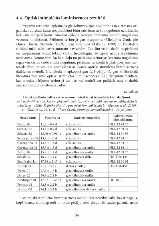
Pētījuma teritorijā izplatītajos glaciolimniskajos nogulumos nav atrastas or-ganiskas atliekas, kuras neapšaubāmi būtu saistāmas ar šo nogulumu uzkrāšanās laiku un tādējādi ļautu izmantot oglekļa izotopu datēšanas metodi nogulumu vecuma noteikšanai. Pētījumu teritorijā gan atsegumos (Mieļupīte; Gauja pie Dūres (Kuršs, Stinkule, 1969)), gan urbumos (Takčidi, 1999) ir konstatēti slokšņu māli, taču darba autoram nav zināmi līdz šim veikti detāli to pētījumi un mēģinājumi veidot lokālo varvju hronoloģiju. To izpēte nebija šī pētījuma uzdevums. Ņemot vērā, ka lielu daļu no pētījumu teritorijas kvartāra nogulumu segas virskārtas veido smilts nogulumi, pētījuma teritorijā ir plaši pieejams ma-teriāls absolūtā vecuma noteikšanai ar kvarca optiski stimulētās luminiscences datēšanas metodi. 4.1. tabulā ir apkopoti gan šajā pētījumā, gan zinātniskajā literatūrā pieejamie optiski stimulētās luminiscences (OSL) datējumu rezultāti, kas atrodas pētījumu teritorijā un tieši vai netieši var palīdzēt noteikt darbā aplūkoto ezeru eksistences laiku.
4.1. tabula
Darbā aplūkoto ledāja ezeru vecuma noteikšanai izmantotie OSL datējumi. Ar * apzīmēti vecumi, kuriem pieejami tikai sākotnējie rezultāti, kas var mainīties dažu % robežās. a – (Edita Kaļinska-Nartiša, personīgā komunikācija); b – (Raukas et al., 2010);
c – (Zelčs et al., 2011); d – (Ivars Celiņš, personīgā komunikācija); e – šis pētījums
Nosaukums Vecums ka Datētais materiāls Laboratorijas identifikators
Zeltiņi 03 11,3 ± 0,8 d eola smilts NLL-12 91 25Silezers 12 13,4 ± 0,9 d eola smilts NLL-12 91 34Silezers 5,1 13,66 ± 0,91 *a glaciolimniska smilts NLL-12 30 93Sedas purvs 03 13,7 ± 1,0 d eola smilts NLL-12 91 10Garengrīda 03 14,4 ± 1,3 d eola smilts NLL-12 91 13Garengrīda 04 15,7 ± 1,5 d glaciolimniska smilts NLL-12 91 14Zeltiņi 04 15,9 ± 1,1 d glaciofluviāla smilts NLL-12 91 26Silkalni 01 16,9 ± 3,1 c glaciofluviāla delta Hel-TL04145Smilškalni 4,4 17,36 ± 1,47 *a eola smilts NLL-12 30 91Brutuļi 01 21,2 ± 5,2 e deltas virsslāņi Hel-TL04151Dores-01 27,5 ± 1,7 b glaciofluviāla smilts -Dores-02 36,9 ± 2,8 b glaciofluviāla smilts -Niedrupīte 01 47,37 ± 5,48 *a glaciolimniska smilts HD 30 61Pentsils-01 52,5 ± 2,2 b glaciolimniska smilts -Pentsils-02 74,1 ± 3,2 b glaciofluviālas deltas virsslāņi -
Ar optiski stimulētās luminiscences metodi tiek noteikts laiks, kas ir pagājis, kopš kvarca smilts graudi ir tikuši pēdējo reizi eksponēti saules gaismā, nevis
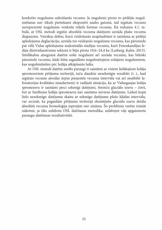
35
konkrēto nogulumu uzkrāšanās vecums. Ja nogulumi pirms to pēdējās nogul-snēšanas nav tikuši pietiekami eksponēti saules gaismā, tad iegūtais vecums nereprezentē nogulumu veidotās reljefa formas vecumu. Kā redzams 4.1. ta-bulā, ar OSL metodi iegūtie absolūtā vecuma datējumi uzrāda plašu vecuma diapazonu. Vairākas deltas, kuru veidošanās neapšaubāmi ir saistāma ar pēdējā apledojuma deglaciāciju, uzrāda tos veidojošo nogulumu vecumu, kas pārsniedz pat vēlā Vislas apledojuma maksimālās stadijas vecumu, kurš Fenoskandijas le-dāja dienvidaustrumu sektorā ir bijis pirms 19,6–24,4 ka (Lasberg, Kalm, 2013). Smilškalnu atsegumā datētie eolie nogulumi arī uzrāda vecumu, kas būtiski pārsniedz vecumu, kāds būtu sagaidāms nogulsnētajiem eolajiem nogulumiem, kas nogulsnējušies pēc ledāja atkāpšanās laika.
Ar OSL metodi datētie smilts paraugi ir saistāmi ar visiem lielākajiem ledāja sprostezeriem pētījuma teritorijā, taču daudzie nesekmīgie rezultāti (t. i., kad iegūtais vecums atrodas ārpus pieņemtā vecuma intervāla vai arī neatbilst la-boratorijas kvalitātes standartiem) ir radījuši situāciju, ka ar Vidusgaujas ledāja sprostezeru ir saistāmi pieci sekmīgi datējumi, Strenču glaciālo ezeru – četri, bet ar Smiltenes ledāja sprostezeru nav saistāms neviens datējums. Liekot kopā lielo nesekmīgo datējumu skaitu ar sekmīgo datējumu plašo kļūdas intervālu, var secināt, ka pagaidām pētījumu teritorijā eksistējušo glaciālo ezeru detāla absolūtā vecuma hronoloģija joprojām nav zināma. Šo problēmu varētu risināt nākotnē, ja tiks uzlabota OSL datēšanas metodika, uzlabojot vāji apgaismotu paraugu datēšanas rezultativitāti.

36
5. DISKuSIjA
Seno, īpaši ledājkušanas ūdeņu veidoto, baseinu rekonstruēšana ir sarežģīta, jo tās sekmīgai veikšanai ir jākombinē dažādas izpētes metodes, kas ne vienmēr dod gaidāmo rezultātu. Šī iemesla dēļ šādu rekonstrukciju izstrādes laikā var nākties pilnveidot pētījuma veikšanas metodes vai pat atteikties no kādu iegūto rezultātu lietošanas turpmākā pētījuma daļā.
5.1. Ledājkušanas ūdeņu baseinu līmeņu rekonstrukcija
Viena no vispārpieņemtām seno ūdenstilpju izpētes metodēm ir to indikato-ru, pamatā to krastu reljefa formu, attēlošana augstuma–attāluma diagrammās, kas ir orientētas Zemes virsmas šķietamās maksimālās pacelšanās virzienā (Rose, 1990). Kā redzams 5.1. un 5.2. attēlā, kur parādīts dažādu baseina indikatoru augstuma izvietojums, šiem indikatoriem ir salīdzinoši liela augstuma izkliede, kas neļauj nepārprotami identificēt konkrētus baseinu līmeņus tikai pēc šādiem grafikiem, kā tika sagaidīts, uzsākot pētījumu.
Baseinu līmeņu indikatoru augstuma izkliedes iemesli, visticamāk, ir vairāki. Lielākajai daļai šo punktveida objektu to augstumi ir noteikti, nolasot vērtības no lielmēroga topogrāfiskās kartes, kas joprojām ir pats detālākais plaši pieejamais reljefa informācijas avots plašā Latvijas teritorijas daļā, lai arī reljefa attēlojums šajās kartēs, īpaši mežainos apvidos, mēdz būt neprecīzs (Kursiša et al., 2007; Markots et al., 2010; Vēze, Markots, 2011). Kā norāda Markots ar līdzautoriem (Markots et al., 2010), atšķirības starp instrumentāli uzmērītu un no lielmēro-ga topogrāfiskās kartes iegūtu punkta augstumu var sasniegt pat 5 m. Lielākā daļa apkopoto krasta līniju novērojumu atrodas uz lēzenām vai vidēji lēzenām nogāzēm, kur baseina krasta līnijas ir tuvāk vidējam ūdens līmenim (Atwood, 2006), taču joprojām tā var būt vairākus metrus virs vidējā ūdens līmeņa (Rose, 1990; Adams, Wesnousky, 1998; Otvos, 1999). Akmeņu krāvumi vai teritorijas ar paaugstinātu akmeņu koncentrāciju uz zemes virsmas arī var atrasties līdz pat 10 m virs vidējā ūdens līmeņa (Embleton, King, 1968). Šo faktoru kopums ļauj pieņemt, ka indikatori, kuru hipsometriskais novietojums atšķiras no modelētā baseina līmeņa līdz 5 m un laukakmeņu krāvumiem – līdz pat 10 m, var būt saistāmi ar konkrēto baseinu.
Daļa indikatoru datubāzē apkopoto objektu pēc to ģenēzes var arī nebūt saistīti ar pēdējā apledojuma ledājkušanas ūdeņu baseiniem, kas eksistēja teri-torijā. Fiksējot objektus, lauka ekspedīciju laikā bija iespējams vieglāk novērtēt riskus iekļaut datubāzē citas ģenēzes objektus, kuri nav saistīti ar glaciāliem ezeriem, taču liela daļa objektu, kas apkopoti datubāzē, ir nolasīti no topogrāfis-kajām kartēm vai reljefa modeļiem, tāpēc to kontroles iespējas ir bijušas daudz mazākas. Kā glaciālo ezeru krastu marķējošas terases var būt iekļautas noaru
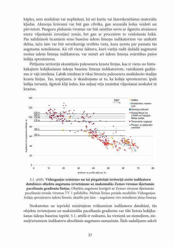
37
kāples, seni noslīdeņi vai noplūdeņi, kā arī karšu vai lāzerskenēšanas materiālu kļūdas. Akmeņu krāvumi var būt gan cilvēka, gan sezonālā ledus veidoti un pārvietoti. Pauguru plakanās virsmas var būt saistītas nevis ar ilgstošu atrašanos ezeru viļņošanās (erozijas) zonās, bet gan ar procesiem to veidošanās laikā. Par salīdzinoši ticamiem seno baseinu ūdens līmeņu indikatoriem var uzskatīt deltas, taču tām var būt neveiksmīgi izvēlēta vieta, kura ņemta par pamatu tās augstuma noteikšanai. Kā vēl vienu faktoru, kurš varēja radīt dažādā augstumā esošus ūdens līmeņa indikatorus, var minēt arī ūdens līmeņa svārstības pašos ledāja sprostezeros.
Pētījumu teritorijā eksistējušo paleoezeru krasta līnijas, kas ir viens no būtis-kākajiem ledājkušanas ūdeņu baseinu līmeņa indikatoriem, vairākumā gadīju-mu ir vāji izteiktas. Labāk izteiktas ir tikai Strenču paleoezera noslēdzošo stadiju krasta līnijas. Tas, iespējams, ir skaidrojams ar to, ka ledāja sprostezerus, īpaši ledāja tuvumā, ilgstoši klāj ledus, kas neļauj vēja izraisītai viļņošanai noskalot tā krastus.
5.1. attēls. Vidusgaujas zemienes un tai piegulošajā teritorijā esošo indikatoru datubāzes objektu augstuma izvietojums uz maksimālās Zemes virsmas šķietamās pacelšanās gradienta līnijas. Objektu augstumi koriģēti ar Zemes virsmas šķietamās
pacelšanās trenda virsmas TV 1 palīdzību. Melnās līnijas parāda modelēto Vidusgaujas ledāja sprostezeru ūdens līmeni, skaitlis pie tām – augstumu virs mūsdienu jūras līmeņa
Neskatoties uz iepriekš minētajiem trūkumiem indikatoru datubāzē, tās objektu izvietojums uz maksimālās pacelšanās gradienta var tikt lietots ledājku-šanas ūdeņu baseinu izpētē. 5.1. attēlā ir redzams, ka virzienā uz ziemeļiem, zie-meļrietumiem indikatoru absolūtais augstums samazinās. Šāds sadalījums sakrīt
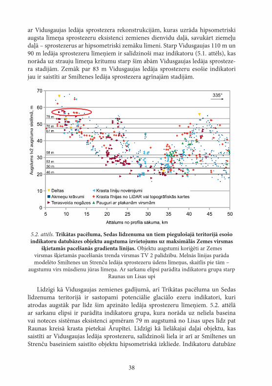
38
ar Vidusgaujas ledāja sprostezera rekonstrukcijām, kuras uzrāda hipsometriski augsta līmeņa sprostezeru eksistenci zemienes dienvidu daļā, savukārt ziemeļu daļā – sprostezerus ar hipsometriski zemāku līmeni. Starp Vidusgaujas 110 m un 90 m ledāja sprostezeru līmeņiem ir salīdzinoši maz indikatoru (5.1. attēls), kas norāda uz strauju līmeņa kritumu starp šīm abām Vidusgaujas ledāja sprosteze-ra stadijām. Zemāk par 83 m Vidusgaujas ledāja sprostezeru esošie indikatori jau ir saistīti ar Smiltenes ledāja sprostezera agrīnajām stadijām.
5.2. attēls. Trikātas pacēluma, Sedas līdzenuma un tiem piegulošajā teritorijā esošo indikatoru datubāzes objektu augstuma izvietojums uz maksimālās Zemes virsmas
šķietamās pacelšanās gradienta līnijas. Objektu augstumi koriģēti ar Zemes virsmas šķietamās pacelšanās trenda virsmas TV 2 palīdzību. Melnās līnijas parāda modelēto Smiltenes un Strenču ledāja sprostezeru ūdens līmeņus, skaitlis pie tām –
augstumu virs mūsdienu jūras līmeņa. Ar sarkanu elipsi parādīta indikatoru grupa starp Raunas un Lisas upi
Līdzīgi kā Vidusgaujas zemienes gadījumā, arī Trikātas pacēluma un Sedas līdzenuma teritorijā ir sastopami potenciālie glaciālo ezeru indikatori, kuri atrodas augstāk par līdz šim apzināto ledāja sprostezeru līmeņiem. 5.2. attēlā ar sarkanu elipsi ir parādīta indikatoru grupa, kura norāda uz neliela baseina vai noteces sistēmas eksistenci apmēram 79 m augstumā no Lisas upes līdz pat Raunas kreisā krasta pietekai Ārupītei. Līdzīgi kā lielākajai daļai objektu, kas saistīti ar Vidusgaujas ledāja sprostezeru, salīdzinoši liela ir arī ar Smiltenes un Strenču baseiniem saistīto objektu hipsometriskā izkliede. Indikatoru datubāze

39
satur salīdzinoši daudzus objektus, kuri hipsometriski atrodas starp Smiltenes 67 m ledāja sprostezera un Strenču 58 m ledāja sprostezera līmeņiem, taču hipsometriski tie ir izkliedēti un vienlaidus līmeni neveido. Tas norāda uz pakā-penisku ūdens līmeņa krišanos, kas nav ļāvusi izveidoties labi izteiktiem ūdens līmeņa marķieriem.
5.2. Ledājkušanas ūdeņu baseinu izplatība un sasaiste ar citiem paleohidroloģiskā tīkla elementiem
Ledāja kušanas ūdeņu baseini to eksistences laikā ir bijuši daļa no paleo-hidroloģiskā tīkla, kurš ledāja kušanas rezultātā ļoti strauji mainījās. Ledāja kušana atsedza aizvien jaunus reljefa pazeminājumus, kuri varēja kalpot par ledāja sprostezeru drenāžas vietām (Nartišs, Zelčs, 2011). Hidroloģiskā tīkla attīstība pētījuma teritorijā sākās Vidusgaujas zemienē, kur izveidojās pirmie ledāja sprostezeri, kā arī sāka veidoties ielejas tajos ietekošajām ūdenstecēm. Modelēšanas ceļā iegūto Vidusgaujas ledāja sprostezera stadiju konfigurācija neliecina, ka varētu veidoties virszemes notece cauri Gulbenes paugurvalnim. Tas ir pretrunā ar Kvasova (Kvasov, 1975) sniegtajām rekonstrukcijām. Pētījumi mūsdienu ledāja sprostezeros uzrāda, ka tie var eksistēt bez virszemes noteces, ja tā notiek zem ledāja vai ar pazemes ūdeņu palīdzību (Bennett et al., 2000), taču minētajā teritorijā nav konstatēti neapšaubāmi pierādījumi, ka notece no Vidusgaujas agrīno stadiju ledāja sprostezeriem būtu notikusi subglaciāli vai arī cauri Gulbenes paugurvalnim pazemes ūdens plūsmas veidā. Liela ūdens dau-dzuma infiltrācija dziļākos ūdensnesējslāņos leduslaikmeta beigu posmā nebija iespējama, jo, kā liecina šī laika pazemes ūdeņu modelēšana, pat subglaciālos apstākļos tikai neliela daļa ledājkušanas ūdeņu infiltrējās tā gultnē (Saks et al., 2012). Virszemes noteces trūkums no Vidusgaujas ledāja sprostezeriem ir pro-blemātisks, jo šādā gadījumā visam virszemes noteces un atmosfēras nokrišņu daudzumam, kas pieplūst no ledāja brīvās teritorijas, kā arī paša ledāja ķermeņa kušanas ūdenim būtu bijis nepieciešams iztvaikot. Te gan ir jāņem vērā, ka Vidusgaujas ledāja loba pakāpeniska kušanas rezultātā ezera platība pakāpeniski pieauga, tādējādi palielinot iztvaikošanu un mazinot līmeņa kāpuma efektu uz baseina platības pieauguma rēķina. Lai varētu izdarīt pamatotus secinājumus par to, vai Vidusgaujas ledāja sprostezeri varēja eksistēt bez noteces, līdzīgi kā tas tiek piedāvāts Agasi ledāja sprostezeram Mūrhedas fāzes laikā (Lowell et al., 2013), būtu nepieciešams veikt to klimatisko modelēšanu, kurā tiktu ņemta vērā nokrišņu, ledāja kušanas un iztvaikošanas ietekme.
Salīdzinot Vidusgaujas 115 un 110 m augsto ezeru modeļu izplatību ar glaciolimnisko nogulumu izplatību (Juškevičs, Skrebels, 2002b), ir redzams, ka atsevišķas starp tiem esošas glaciolimnisko nogulumu teritorijas nesedz neviens no šiem ezeru modeļiem. Šādas teritorijas ir atrodamas Velēnas gala
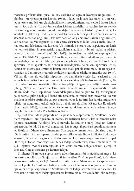
40
morēnas proksimālajā pusē, kā arī, saskaņā ar agrāku kvartāra nogulumu iz-platības interpretāciju (Juškevičs, 1964), līdzīga josla atrodas starp 110 m v.j.l. ledus ezera modeli un glaciofluviālajiem nogulumiem, kas veido Silaktu kēmu terasi. Saskaņā ar šīm pašām kartēm kādam modelim vajadzētu ietvert reljefa pacēluma glaciolimnisko nogulumu daļu Trapenes apkārtnē. Ņemot vērā, ka vienlaikus 110 m v.j.l. ledus ezera modelis pārklāj teritorijas, kur zemes virskārtā atsedzas morēnas nogulumi, kas nav pārklāti ar glaciolimniskiem nogulumiem, var secināt, ka Vidusgaujas 115 m ezera eksistences laikā ledāja mala, kas iz-mantota modelēšanai, nav korekta. Visticamāk, šis ezers un, iespējams, arī kāda no iepriekšējām, hipsometriski augstākām stadijām ir bijusi izplatīta plašāk, ietverot daļu no modelī uzrādītās ledāja teritorijas un veidojot supraglaciālu ezeru. Tādējādi Vidusgaujas 115 m līmeņa ezers būtu uzskatāms par pieledā-ja–virsledāja ezeru. Par labu pārejai no augstākiem līmeņiem uz 110 m līmeni aprimuša ledus apstākļos, kur ezeri ir izveidojušies daļēji virs aprimuša ledus, liecina arī atsevišķos urbumos konstatētie māli, pat slokšņu māli, lai arī šajās te-ritorijās 110 m modelis uzrāda seklūdens apstākļus (dziļums mazāks par 10 m). Vēl vairāk – netālu esošajās hipsometriski zemākajās vietās, kur, saskaņā ar no ledus brīvas teritorijas ezera modeli, tam vajadzētu būt ievērojami dziļākam, šie māli urbumos nav konstatēti. Kā liecina pētījumi Igaunijas ledāja sprostezeros (Hang, 2001), lai uzkrātos slokšņu māli, ezera dziļumam ir jāpārsniedz 15 līdz 20 m. Šāds mālu izplatības neviendabīgums liecina par to, ka Vidusgaujas paleoezeros gultne nebija līdzena un nesakrita ar mūsdienās novēroto, ko var skaidrot ar plašu aprimuša vai pat aprakta ledus klātbūtni, kas izraisa mūsdienu reljefa un nogulumu uzkrāšanās laika reljefa nesakritību. Kā norāda Eberhards (Eberhards, 2006), aprimuša ledāja ledus aprakšana zem ledājkušanas ūdeņu nogulumiem ir tipiska Peribaltijas reģionam.
Ņemot vērā ūdens pieplūdi no Peipusa ledāja sprostezera, Smiltenes basei-niem vajadzētu būt bijušiem ar noteci, lai uzturētu līmeni, kas ir zemāks nekā Peipusa baseinam. Āboltiņš (1971) norāda, ka sedliene starp Lisas un Raunas upi atrodas 70 līdz 72 m v.j.l. augstumā, kas ir augstāk par šajā apvidū zināmiem ledājkušanas ūdeņu ezeru līmeņiem. Šim apgalvojumam nevar piekrist, jo norā-dītajā teritorijā ir sastopami daudzi potenciālo krasta līniju indikatori (akmeņu krāvumi, terasētas nogāzes, noskalojuma kāples), kuru augstumi sasniedz pat 80 m v.j.l. Tāpat, modelējot Smiltenes ledāja sprostezeru, kura līmenis ir 75 m v.j.l., iegūtais modelis uzrādīja, ka šim ledus ezeram nebija nekādu šķēršļu tā drenāžai Gaujas virzienā pa Raunas ieleju.
Smiltenes 75 m ledāja sprostezera ūdens līmenis ir bijis pietiekami augsts, lai tas varētu noplūst uz Gauju pa vairākām ielejām Trikātas pacēlumā, taču vien-laikus nav pazīmju, ka šajā līmenī tur būtu tecējis ūdens no ledāja sprostezera. Paturot prātā, ka Smiltenes ledāja sprostezera – Gaujas savienojums par Raunas upi vairs nebija iespējams no Smiltenes 70 m ledāja sprostezera, var secināt, ka drenāžu no Smiltenes ledāja sprostezera kontrolēja Burtnieka ledus loba recesija,
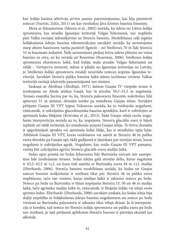
41
kur ledāja kušana atbrīvoja arvien jaunus pazeminājumus, kas bija piemēroti notecei (Nartišs, Zelčs, 2011) un kas vienlaikus ļāva kristies baseina līmenim.
Mora ar līdzautoriem (Moora et al., 2002) norāda, ka ūdens no Lātres ledāja sprostezera, kas atradās Igaunijas teritorijā Valgas līdzenumā, nav noplūdis pāri Valkā esošajai ūdensšķirtnei uz Strenču baseinu. Modelēšanas ceļā iegūtās ledājkušanas ūdeņu baseina rekonstrukcijas savukārt uzrāda, ka savienojums starp abiem baseiniem varēja pastāvēt ilgstoši – no Smiltenes 70 m līdz Strenču 53 m baseinam ieskaitot. Šāds savienojums pieļauj brīvu ūdens plūsmu no viena baseina uz otru, uz ko norāda arī Rosentau (Rosentau, 2006). Smiltenes ledāja sprostezera eksistences laikā, kad ledāja mala atradās Valgas līdzenumā un vēlāk – Vertsjerva zemienē, ūdens ir plūdis no Igaunijas teritorijas uz Latviju, jo Smiltenes ledāja sprostezera modeļi neuzrāda noteces iespējas Igaunijas te-ritorijā. Savukārt Strenču paliku baseina laikā ūdens tecēšanas virziens Valkas teritorijā esošajā ielejveida pazeminājumā nav zināms.
Saskaņā ar Āboltiņa (Āboltiņš, 1971) datiem Gaujas IV virspalu terase ir izsekojama no Abula ietekas Gaujā, kur tā atrodas 50,5–51,5 m augstumā. Terases esamība liecina par to, ka, Strenču paleoezera līmenim nokrītoties līdz aptuveni 51 m atzīmei, drenāža notika pa mūsdienu Gaujas ieleju. Savukārt pētījumi Gaujas III VPT lejpus Valmieras uzrāda, ka to veidojošie nogulumi, visticamāk, ir uzkrājušies glaciolimniska baseina apstākļos, kurš ir robežojies ar aprimušā ledus blāķiem (Krievāns et al., 2013). Šāda Gaujas ielejā esošu nogu-lumu interpretācija norāda uz to, ka, iespējams, Strenču glaciālie ezeri ir bijuši izplatīti arī tālāk teritorijā, ko mūsdienās aizņem Gaujas ieleja. To brīvu drenāžu ir apgrūtinājuši aprakta vai aprimuša ledus blāķi, kas ir atradušies upju lejās. Atbilstoši Gaujas III VPT, kuras veidošanos var saistīt ar Strenču 46 m paliku ezera drenāžu pa Gaujas upi, tādā gadījumā ir jāuzskata par erozijas terasi, kuras nogulumi ir uzkrājušies agrāk. Nogulumi, kas veido Gaujas III VPT pamatni, varētu būt uzkrājušies agrīno Strenču glaciālā ezera stadiju laikā.
Sedas upes posmā no Sedas līdzenuma līdz Burtnieka ezeram nav sastopa-mas labi izsekojamas terases. Sedas ielejas galā atrodas delta, kuras augstums ir 43,5–42,5 m v.j.l. un kura tiek saistīta ar Burtnieka ezera 44 m v.j.l. stadiju ( Eberhards, 2006). Strenču baseina modelēšana uzrāda, ka Sedas un Gaujas sateces baseinu nošķiršanās ir notikusi tikai pēc Strenču 46 m paliku ezera noplūšanas, taču nav zināms, kuras stadijas laikā ir sākusies notece pa Sedu. Notece pa Sedu uz Burtnieku ir bijusi iespējama Strenču 53, 50 un 46 m stadiju laikā, taču agrīnāku stadiju laikā to, visticamāk, ir bloķējis ledājs vai ielejā esošs aprimis ledus. Eberhards (Eberhards, 2006) savukārt uzskata, ka Sedas ieleja bija daļēji aizpildīta ar ledājkušanas ūdeņu baseina nogulumiem un notece pa Sedu virzienā uz Burtnieka paleoezeru ir sākusies tikai vēlajā driasā. Ja šī interpretā-cija ir korekta, tad notece no Strenču ledāja sprostezera un paliku ezera pa Sedu nav notikusi, jo šajā pētījumā aplūkotais Strenču baseins ir pārstājis eksistēt jau allerēdā.
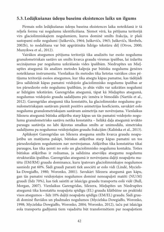
42
5.3. Ledājkušanas ūdeņu baseinu eksistences laiks un ilgums
Pirmais solis ledājkušanas ūdeņu baseina eksistences laika noteikšanā ir tā reljefa formu vai nogulumu identificēšana. Ņemot vērā, ka pētījuma teritorijā virs glaciolimniskajiem nogulumiem, kuros dominē smilts frakcija, ir plaši sastopami eolie nogulumi (Juškevičs, 1964; Juškevičs, 1965; Juškevičs, Skrebels, 2002b), to nodalīšana var būt apgrūtināta līdzīgo tekstūru dēļ (Otvos, 2000; Munyikwa et al., 2012).
Vairākos atsegumos pētījuma teritorijā tika analizēts tur esošo nogulumu granulometriskais sastāvs un smilts kvarca graudu virsmas īpašības, lai izdarītu secinājumus par nogulumu uzkrāšanās vides īpašībām. Niedrupītes un Mieļ-upītes atsegumā šīs analīzes metodes kalpoja par būtisku nogulumu ģenēzes noteikšanas instrumentu. Vienlaikus šīs metodes tika lietotas vairākos citos pē-tījuma teritorijā esošos atsegumos, kur tika atsegta kāpas pamatne, kas tādējādi ļāva salīdzināt kāpas pamatni veidojošo glaciolimnisko nogulumu īpašības ar tos pārsedzošo eolo nogulumu īpašībām, jo abās vidēs var uzkrāties nogulumi ar līdzīgām tekstūrām. Garengrīdas atsegumā, tāpat kā Mieļupītes atsegumā, nogulumus veidojošo graudu sadalījums pēc izmēra ir bimodāls (Nartišs et al., 2012). Garengrīdas atsegumā tika konstatēts, ka glaciolimnisko nogulumu gra-nulometriskajam sastāvam piemīt pozitīvs asimetrijas koeficients, savukārt eolo nogulumu granulometriskajam sastāvam asimetrija nav novērojama. Vienlaikus Silezera atsegumā būtiska atšķirība starp kāpas un tās pamatni veidojošo nogu-lumu granulometrisko sastāvu netika konstatēta – lielākā daļa atsegumā ievākto paraugu sastāvēja no labi šķirotas smalkas smilts ar unimodālu, simetrisku sadalījumu pa nogulumus veidojošajām graudu frakcijām (Kalińska et al., 2013).
Aplūkojot Garengrīdas un Silezera atseguma smilts kvarca graudu noapa-ļotību un matējuma pakāpi, būtiskas atšķirības starp kāpas pamatni un tos pārsedzošajiem nogulumiem nav novērojamas. Atšķirības tika konstatētas tikai paraugos, kas tika ņemti no eolo un glaciolimnisko nogulumu kontakta. Toties būtiskas atšķirības ir redzamas, ja salīdzina atsevišķu atsegumu nogulumu strukturālās īpašības. Garengrīdas atsegumā ir novērojama daļēji noapaļotu ma-tētu (EM/RM) graudu dominance, kuru īpatsvars glaciolimniskajos nogulumos sasniedz pat 60%. Šādi graudi parasti tiek asociēti ar eolo vidi (Lindé, Myciels-ka-Dowgiałło, 1980; Woronko, 2001). Savukārt Silezera atsegumā gan kāpu, gan tās pamatni veidojošajos nogulumos dominē nenoapaļoti matēti (NU/M) graudi (līdz 70%), kas tiek saistīti ar īslaicīgu graudu transportu eolā vidē (Bull, Morgan, 2007). Vienlaikus Garengrīdas, Silezera, Mieļupītes un Niedrupītes atsegumā tika konstatēta noapaļotu spīdīgu (EL) graudu klātbūtne un praktiski visos atsegumos – līdz 10% daļēji noapaļotu spīdīgu (EM/EL) graudu. Šādi grau-di dominē fluviālos un pludmales nogulumos (Mycielska-Dowgiałło, Woronko, 1998; Mycielska-Dowgiałło, Woronko, 2004; Woronko, 2012), taču pat īslaicīga eola transporta gadījumā tiem vajadzētu būt transformētiem par noapaļotiem
43
matētiem (RM) un daļēji noapaļotiem matētiem (EM/RM) graudiem (Lindé, Mycielska-Dowgiałło, 1980; Mycielska-Dowgiałło, Woronko, 1998; Bull, Morgan, 2007). Līdzīgas likumsakarības, ka eolie nogulumi saglabā to cilmes – glaciolim-nisko vai glaciofluviālo – nogulumu īpašības, ir novērotas arī citās iekšzemes kāpās, kas atrodas Latvijas un Igaunijas (Kalińska et al., 2012; Kalińska, Nartišs, 2013a; Kalińska, Nartišs, 2013b), kā arī Zviedrijas (Mycielska-Dowgiałło, 1993) teritorijā. Šādas atšķirības starp vienas ģenēzes nogulumiem un līdzība starp dažādas ģenēzes nogulumiem apgrūtina smilts kvarca graudu noapaļotības un matējuma pakāpes novērtēšanas metodes lietošanu glaciolimnisko un tos pārse-dzošo eolo nogulumu nošķiršanai.
Nelieliem glaciālajiem ezeriem noteikt to absolūto vecumu var būt pat neiespējami, jo dažādu absolūtā vecuma datēšanas metožu kļūdas ir vairākas reizes lielākas par to eksistences ilgumu, tādēļ ezeru hronoloģiju ir iespējams rekonstruēt tikai pastarpināti pēc ledāja atkāpšanās gaitas vai citu, saistītu reljefa formu veidošanās (LaRocque et al., 2003b). Pētījuma teritorijā vairākos atsegumos tika datēti glaciolimniskie vai glaciofluviālie un tos pārsedzošie eolie nogulumi. Baseina nogulumus pārsedzošo eolo nogulumu datējumi ļauj spriest par šo baseinu eksistences minimālo vecumu, t. i., par laiku, kad baseini vairs neeksistēja. Gan Zeltiņu, gan Garengrīdas datējumu uzrādītie vecumi ir līdzīgi un ļauj pieņemt, ka Vidusgaujas baseina stadijas 120 līdz 90 m ir eksistējušas apmēram pirms 15,7–15,9 tūkstošiem gadu. Datējums glaciofluviālā deltā Sil-kalnu karjerā uzrāda nogulumu uzkrāšanos pirms 16,9 ka, taču šim datējumam nenoteiktība ir 3,1 ka, kas pieļauj nogulumu uzkrāšanos vienlaikus ar Zeltiņu un Garengrīdas atsegumā paraugotajiem nogulumiem. Neviens no modelētajiem ledāja sprostezeriem neatbilst Silkalnu deltas līmenim, lai arī, pamatojoties uz deltas virsmas augstumu, tā varētu būt saistāma ar Vidusgaujas 115 m ledāja sprostezeru. Šādas sasaistes apstiprināšanai ir nepieciešama citādāka ledāja malas konfigurācija nekā tā, kas ir izmantota šajā pētījumā.
Garengrīdas atsegumā eolie nogulumi, kas pārsedz glaciolimniskos nogulu-mus, uzrāda, ka lielākajā Trapenes līdzenuma daļā ledājkušanas ūdeņu baseins bija izzudis jau pirms 14,4 ka (4.1. tabula). Atkarībā no ledāja malas konfigu-rācijas Tamulas ezera apkārtne ir atradusies zem ūdens Vidusgaujas 90 m un 83 m ledāja sprostezeros, iespējams, arī Vidusgaujas 110 m ledāja sprostezerā. Smiltenes 75 m ledāja sprostezera laikā Tamulas ezers vairs nav bijis daļa no Latvijas teritorijā eksistējušiem ledāja sprostezeriem. Tamulas ezera glaciolim-nisko nogulumu uzkrāšanās sākums pirms vairāk nekā 14,7 ka (Sandgren et al., 1997; Kalm, 2006) saskan ar Garengrīdas eolo nogulumu uzkrāšanās laiku, kas uzrādīja, ka Vidusgaujas 90 m ledāja sprostezeram ir jābūt vecākam par 14,4 ka.
Šobrīd nav neviena datējuma, kas ļautu tieši spriest par Smiltenes ledāja sprostezeru eksistences laiku. Pamatojoties uz šī ezera fāžu izplatības modeļiem, ir sagaidāms, ka Smiltenes ledāja sprostezers ir jaunāks par Vidusgaujas ledāja sprostezeriem, kuru beidzamās stadijas ir vismaz 14,7 ka senas. Atkarībā no
44
ledāja malas konfigurācijas Igaunijas teritorijā esošajā Valgas līdzenumā un Vertsjerva zemienē, iespējams, ka pēdējā Smiltenes ledāja sprostezera stadija (67 m v.j.l.) ir ietvērusi arī Nakri ezeru, kurā organiku saturošu nogulumu uzkrāšanās ir sākusies pirms 14,0 ka (Amon et al., 2012). Šis datējums nosaka minimālo Smiltenes ledāja sprostezeru vecumu. Mēģinājumi datēt deltas, kuras ir saistītas ar Smiltenes ledāja sprostezeru, ir bijuši nesekmīgi.
Viens OSL datējums ir tieši saistīts ar Strenču baseina eksistences beigu posmu – Silezera kāpas pamatnes apkārtne ir bijusi zem ūdens Strenču 58 m baseina eksistences laikā, savukārt Strenču 53 m baseina ūdeņi to vairs nav se-guši. Datējums no Silezera kāpas pamatnes uzrāda 13,7 ka (4.1. tabula) vecumu. Vienlaikus modelēšana liecina, ka Strenču baseini ar līmeņiem 53 un 58 m v.j.l. ir bijuši izplatīti līdz pat Nakri ezeram Igaunijā. Eolo nogulumu datējums no Se-das purvā esošās kāpas apakšējās daļas uzrāda, ka eolo nogulumu uzkrāšanās ir sākusies pirms 13,7 ka, savukārt Silezera kāpas pamatnē – pirms 13,4 ka. Stren-ču baseina modeļi apstiprina, ka Sedas purvā esošās kāpas apkārtne ir atradusies seklūdens un krasta virsūdens zonā Strenču 46 m baseina eksistences laikā. Atbilstoši var uzskatīt, ka Strenču baseins ir pastāvējis līdz apmēram 13,7 ka. Šajā laikā ledājs jau bija atkāpies ne tikai no Latvijas, bet arī no lielākās daļas Igaunijas teritorijas, jo šāds vecums ir mazāks par Pandiveres malas veidojumu zonas vecumu (Vassiljev, Saarse, 2013). Minētais Strenču baseina stadiju vecums norāda uz to, ka šiem ezeriem galvenais ūdens avots vairs nav bijis ledājs un tādēļ tie ir uzskatāmi par paliku ezeriem.
Fakts, ka septiņi no astoņpadsmit sekmīgajiem OSL datējumiem, kas veikti pētījuma teritorijā, nereprezentē to nogulumu veidotās reljefa formas sagaidā-mo vecumu, norāda uz problemātisku leduslaikmeta beigu posma notikumu vecuma rekonstruēšanu. Sekmīgo un atbilstošo datējumu ticamības intervāli ir plašāki par šo glaciālo ezeru sagaidāmo pastāvēšanas ilgumu un tāpēc liedz izmantot OSL metodi precīzas to hronoloģijas rekonstruēšanai. OSL metodes lielā kļūda liedz precīzi noteikt atsevišķu ledāja sprostezeru stadiju eksistences ilgumu. Vairumā aplūkoto glaciālo ezeru nav sastopami slokšņu māli, kas varētu kalpot par alternatīvu to eksistences ilguma noteikšanai. Ledāja sprostezeru stadijas Sādjerva drumlinu laukā eksistējušas 60–80 varvju gadus (Rosentau et al., 2007b). Strenču glaciālā ezera baseina gadījumā, visticamāk, atsevišķu tā stadiju eksistences ilgums bijis līdzīgs, par to liecina OSL datējumi, to izplatības modeļi un sasaiste ar citiem tālaika baseiniem. Savukārt Smiltenes un Vidus-gaujas ledāja sprostezeri ir pastāvējuši daudz ilgāku laika posmu. Vidusgaujas ledāja sprostezera visas stadijas kopumā ir eksistējušas aptuveni tūkstoti gadu. Ņemot vērā informāciju par modelēšanas ceļā iegūto Smiltenes un Vidusgaujas ledāja sprostezeru savstarpējo saistību, Smiltenes ledāja sprostezers varētu būt eksistējis mazāk nekā vienu tūkstoti gadu.
45
SeCINājuMI
Pētījumā izstrādātās ledājkušanas ūdeņu baseinu rekonstrukcijas Vidus-gaujas un Ziemeļvidzemes zemienes austrumu daļā atklāj kompleksu vēlā Vislas apledojuma deglaciācijas gaitu. Atšķirībā no trim galvenajām ledāja malas zonām, kas saistītas ar pētījuma teritoriju un parādītas zinātniskajā literatūrā (Zelčs, Markots, 2004; Zelčs et al., 2011), pētījumā konstatēto ledājkušanas ūdeņu baseinu līmeņu nodrošināšanai tika izmantotas septiņas recesējošā ledāja malas līnijas, kuras dabā fiksējas kā dažādu nogulumu ģenētisko tipu izplatības robežas vai recesijas morēnas. Ledāja kušana un jaunu ūdens notecei piemērotu pazeminājumu atsegšana ir rezultējusi ledāja sprostezeru sērijā, kur atsevišķi to veidojošie ezeri ir bijuši ar aizvien zemāku ūdens līmeni un atšķirīgu telpisko izplatību. Agrīnāko un hipsometriski augstāk novietoto ledāja sprostezeru ūdens līmenis bijis ļoti īslaicīgs, tāpēc to krasta līnijas ir grūti identificējamas un izsekojamas. Vidusgaujas zemienes teritorijā šīs ledāja sprostezeru stadijas ir attīstījušās daļēji virs apraktā ledus, kas apgrūtina to detālu rekonstruēšanu. Vēlīnāku un hipsometriski zemāk novietotu ledāja sprostezeru krasta līnijas ir labāk izsekojamas, un tas liecina par stabilākiem apstākļiem to veidošanās laikā, lai gan baseinu izplatības indikatori uzrāda potenciālas līmeņa svārstības arī šajos sprostezeros.
Izstrādātās paleoģeogrāfiskās rekonstrukcijas neuzrāda noteces iespējas no Vidusgaujas 125, 120 un 115 m v.j.l. ledāja sprostezeriem. Šajā pētījumā netika modelēts minēto ezeru hidroloģiskais režīms, tādēļ nav iespējams spriest par to, vai tie tiešām ilgstoši spētu eksistēt beznoteces apstākļos. Ledāja sprostezeriem un paliku ezeriem, kuru līmeņi ir bijuši zemāki par 110 m v.j.l., ir eksistēju-ši ielej veida sašaurināti savienojumi ar citiem tālaika baseiniem (Peipuss, Vertsjervs) vai to ūdens notecei piemēroti pazeminājumi. Bieži vien šādas potenciālās noteces vietas ir bijušas vairākas, tāpēc ir grūti iegūt neapšaubāmu paleoģeogrāfisko rekonstrukciju.
Modelēšana uzrāda, ka Vidusgaujas un Peipusa baseinu savienojums ir pa-stāvējis Vidusgaujas ledāja sprostezera 90 un 83 m v.j.l. stadiju laikā un pārtrūcis Strenču baseina 75 m v.j.l. stadijas laikā. Savukārt savienojums ar Vertsjerva ezeru ir eksistējis Strenču baseina 70 m v.j.l. un hipsometriski zemāku stadiju laikā līdz pat Strenču baseina 53 m v.j.l. stadijai ieskaitot. Sedas un Gaujas sa-teces baseinu nošķiršanās ir notikusi tikai pēc Strenču 46 m v.j.l. paliku ezera noplūšanas.
Nogulumu datējumi ar OSL metodi un iegūtās ledāja sprostezeru rekon-strukcijas ļauj secināt, ka lieli ledāja kušanas ūdeņu baseini pētījuma teritorijā sāka veidoties pirms aptuveni 15,8 ka Vidusgaujas zemienē un noslēdzās pirms 13,7 ka, kad noplūda Strenču paliku ezers. Precīzi noteikt atsevišķu ledāja sprostezeru eksistences laiku apgrūtina dažu mērījumu lielā kļūda, kā arī zemā
46
OSL datēšanas rezultativitāte, jo saules gaismā glaciolimnisko nogulumu ekspo-nēšana ir bijusi nepietiekama. Lai gan trūkst detālas absolūtā vecuma piesaistes, pētījumā ir iegūta jauna informācija par ledājkušanas ūdeņu baseinu izplatību, morfoloģiskajiem rādītājiem un attīstību pētījuma teritorijā visā to eksistences laikā. Tas arī bija šī darba mērķis.
Pētījuma izstrādes laikā uzlabotais reljefa modelis, kura augstumi ir koriģēti atbilstoši Zemes virsmas šķietamam pacelšanās apjomam pētījuma teritorijā kopš vēlā Vislas apledojuma beigu posma, ļāva secināt, ka vairāki ledāja sprost-ezeru līmeņu indikatori, kas konstatēti lauka ekspedīcijās un atrodas atšķirīgā hipsometriskā novietojumā, ir saistīti ar vienu un to pašu ledāja sprostezeru, nevis ar vairākiem atšķirīgiem līmeņiem, kā tika uzskatīts lauka ekspedīciju laikā. Šis secinājums vēlreiz apstiprina nepieciešamību ņemt vērā Zemes garozas glacioizostatisko pārvietojumu, rekonstruējot ledāja sprostezerus segledāju klātajās teritorijās.
Pētījumā lietotās nogulumu strukturālo īpašību analīzes metodes neļāva neapšaubāmi nodalīt glaciolimniskas ģenēzes nogulumus, kuros dominē smilts frakcija, no tos pārsedzošajiem eolas ģenēzes nogulumiem, pamatojoties tikai uz nogulumu strukturālajām īpašībām. Lai arī citās pasaules valstīs nogulumu strukturālo īpašību analīze tiek plaši izmantota dažādas ģenēzes smilts nošķir-šanai, šī pētījuma rezultāti liek apšaubīt šādas metodes efektivitāti leduslaikmeta beigu posma nogulumu ģenēzes noteikšanā Latvijā.
Pētījuma rezultāti liek secināt, ka ir ieteicams saglabāt Āboltiņa (Āboltiņš, 1971; Straume, 1978; Straume, 1979) izmantoto ledāja sprostezeru dalījumu Vidusgaujas, Smiltenes un Strenču baseinā, nevis lietot tikai vienu no šiem no-saukumiem attiecībā uz visiem šiem baseiniem (Kuršs, Stinkule, 1969; Kvasov, 1975; Zelčs, Markots, 2004). Minētie baseini, lai arī savā starpā ir saistīti, tomēr izteikti nodalās gan telpā, gan laikā. Par Vidusgaujas un Smiltenes baseina laika robežu uzskatāma savienojuma izveidošanās starp abiem baseiniem Aumeisteru paugurvaļņa teritorijā. Savukārt Smiltenes un Strenču baseina laika robeža ir novietojama brīdī, kad Smiltenes baseina ūdens līmenis bija nokrities līdz 60 m v.j.l. atzīmei, jo šādā augstumā lielākā Trikātas pacēluma daļa jau atrodas virs ūdens līmeņa. Ņemot vērā Smiltenes un Strenču baseina telpisko pārklāšanos, Smiltenes–Strenču baseina nosaukuma lietošana būtu pieļaujama.
Pētījumā ar ĢIS palīdzību iegūtās ledājkušanas ūdeņu baseinu rekonstrukci-jas, to laiktelpiskā piesaiste ar relatīvā un absolūtā vecuma noteikšanas metodēm un sniegtā informācija par šo baseinu sasaisti ar citiem tālaika baseiniem, ūdens pieplūdes un noteces vietām ļauj secināt, ka pētījuma sākumā izvirzītais mērķis ir sasniegts. Iegūtās paleoģeogrāfiskās rekonstrukcijas jau pētījuma izstrādes gaitā tika lietotas, lai iegūtu iekšzemes kāpu, kas atrodas pētījuma teritorijā, vei-došanās paleoģeogrāfiskās rekonstrukcijas. Pētījuma izstrādes laikā veiktie uzla-bojumi GRASS GIS programmatūrā ir iekļauti oficiālajā pirmkoda repozitorijā un būs pieejami GRASS GIS 7 laidienā. Pētījuma laikā sagatavotais nogulumu
47
granulometrisko rādītāju analīzes un vizualizācijas R vides modulis ir izmantots vairāku konferenču prezentāciju, viena maģistra darba, kā arī divu zinātnisko rakstu datu apstrādē un vizualizācijā. Pētījuma laikā uzlabotās ledājkušanas ūde-ņu baseinu pētīšanas metodes un iegūtās atziņas par nogulumu struktūranalīzes lietderību var būt noderīgas arī citu Baltijas ledājkušanas ūdeņu baseinu pētīša-nā, savukārt iegūtās rekonstrukcijas – paleoģeogrāfisko datu interpretēšanā.
48
PATeICīBAS
Vislielākā pateicība darba vadītājam Vitālijam Zelčam par izturību – viņš darba izstrādes laikā daudzu gadu garumā nenogurstoši uzturēja zinātnisko diskusiju un sniedza atbalstu gan lauka ekspedīcijās, gan ārpus tām. Liels paldies arī visiem draugiem, kolēģiem un atbalstītājiem, kuru atbalsts lauka darbos, daudzās diskusijās un zinātniskajos strīdos ir ļāvis autoram sekmīgi pabeigt šo darbu un sasniegt vēl vairāk. Paldies Ivaram Celiņam, Mārim Dauškanam , Mā-rim Krievānam, Aivaram Līcim, Aivaram Markotam, Agnim Rečam, Tomasam Sakam un citiem. Īpaša pateicība pienākas sievai Editai Kaļinskai-Nartišai par atbalstu gan zinātnē, gan ikdienā, liekot ne uz mirkli neapstāties. Sevišķi sirsnīgs paldies meitai Anetei par sapratni.
Šis darbs izstrādāts ar Eiropas Sociālā fonda atbalstu projektā „Atbalsts doktora studijām Latvijas Universitātē”.
Atsevišķas pētījuma daļas izstrādātas šādos projektos:• LZP tematisko pētījumu projekts Nr. 09.1568 „Ģeogrāfisko un ģeoloģisko
procesu un faktoru ietekme uz Latvijas dabas apstākļiem un sabiedrību”.• LZP granta Nr. Z-6198 apakštēma „Ledājkušanas ūdeņu radītā ledāja
gultnes modifikācija politermāla ledāja malas joslā Fenoskandijas ledus-vairoga dienvidaustrumu sektora Latvijas daļā”.
• LZP pētniecības grants Nr. 05.1498 (LU reģ. Nr. 832) „Proglaciālās un subglaciālās sedimentācijas un reljefa veidošanās apstākļu un procesu attīstība Latvijā Vislas apledojuma laikā”.
• LU pētniecības projekts Nr. 2007/ZP-87 „Skandināvijas ledusvairoga dienvidu malas iekšējās zonas vēlā Vislas posma deglaciācijas notikumu hronoloģijas pilnveidošana”.
UNIVERSITY OF LATVIAFACULTY OF GEOGRAPHY AND EARTH SCIENCES
Māris Nartišs
ICE MELTWATER LAKES OF NORTHERN VIDZEME AND MIDDLE GAUJA LOWLANDS DURING THE LATE WEICHSELIAN DEGLACIATION
SUMMARY OF DOCTORAL THESIS
In partial of the Requirements of the Doctor Degree in GeographySubdiscipline of Physical Geography
RĪGA, 2014

50
The doctoral thesis was carried out at the Chair of Geomorphology and Geo-matic of the Faculty of Geography and Earth Sciences, University of Latvia from 2005 to 2013.
IEGULDĪJUMS TAVĀ NĀKOTNĒ
This work has been supported by the European Social Fund within the project „Support for Doctoral Studies at University of Latvia”.
The thesis contains the introduction, 5 chapters, conclusions and reference list.
Form of the thesis: dissertation in Geography, subdiscipline of Physical Geography.
Supervisor:Vitālijs Zelčs, Professor, Dr. geol., University of Latvia
Reviewers:Oļģerts Nikodemus, Dr. geogr., University of LatviaAlgimantas Česnulevičius, Dr. hab. geogr., Faculty of Natural Sciences, Vilnius UniversityIlze Vircava, Dr. geol., University of Tartu
Doctoral committee:Agrita Briede, Professor, Dr. geogr. - council chairmanOļģerts Nikodemus, Professor, Dr. geogr.Zaiga Krišjāne, Professor, Dr. geogr.Ivars Strautnieks, Assoc. Professor, Dr. geol.Pēteris Šķiņķis, Assoc. Professor, Dr. geogr.Vitālijs Zelčs, Professor, Dr. geol.
Secretary: Solvita Rūsiņa, Docent, Dr. geogr.
The thesis will be defended at the public session of the Doctoral Committee of Geography, University of Latvia, at 2:00 pm on July 2, 2014, Alberta Street 10, Rīga.
The thesis is available at the Library of the University of Latvia at Raiņa blvd. 19, room 203.
This thesis is accepted for the commencement of the degree of Doctor of Geog-raphy on March 12, 2014, Protocol No. 2/2014, by the Doctoral Committee of Geography, at the University of Latvia.
© Māris Nartišs, 2014© University of Latvia, 2014
ISBN 978-9984-45-858-8
51
ANNOTATION
This thesis is devoted to ice melt water lakes existing during degradation of the Late Weichselian glaciation in the Northern Vidzeme and Middle Gauja lowlands. For the first time in Latvia an ice melt water lake reconstruction has been performed by GIS modeling. A succession of ice melt water lakes – Middle Gauja, Smiltene and Strenči – spatial distribution, depth, in- and out-flow maps are presented. The temporal development of lakes and their connection with other late glacial lakes is discussed. A new model of the apparent uplift of the earth’s surface of the Gulf of Riga is used to compensate the vertical displace-ment of the study area. Reconstructed development of the ice meltwater lakes reveal more complicate glacier retreat pattern in the territory of Middle Gauja and Northern Vidzeme lowlands during deglaciation of the Last Weichselian. The obtained data on time transgressive development of ice meltwater lakes can be used as a source for further palaeogeographical reconstructions of regional scale.
Keywords: North Latvia, ice-dammed lake, apparent uplift, deglaciation
List of abbreviationsDEM – digital elevation model.GIS – Geographical information system.ka – kiloannum – thousands of years before present (before year 2000). All ages are given in calendar years unless stated othervise.LGIA – Latvian Geospatial Information agency.OSL – optically stimulated luminescence.a.s.l. – above the mean sea level.
52
INTRODuCTIONThe palaeoenvironmental reconstructions reveal not only the history of the
Earth, but also allow to assess the long term environmental changes by revealing their causes and consequences (Williams et al., 2004). Due to increased concerns of the human influence on global climate (IPCC, 2007), it is even more necessary to obtain detail and precise data on ancient environments and their processes. The better understanding of the long term environmental change is the key to assess human impact on present time climate and to successfully build future prediction scenarios. As it has been stated in the Intergovernmental Panel on Climate Change (IPCC) report (Jansen et al., 2007), despite wide and ongoing re-search, the growth and decay speed and processes of past glaciations are not well understood. A good understanding of transitions between glacial and interglacial conditions are crucial for the high accuracy global climate modelling (ibid.).
Palaeolakes play an important role in successful reconstruction and inter-pretation of the palaeoenvironment (Machlus et al., 2000; Krinner et al., 2004). Large palaeolakes have had an impact on multilevel climatic conditions or have significantly altered glacier dynamics (Hostetler et al., 2000; Krinner et al., 2004; Peyaud et al., 2007; Carrivick, Tweed, 2013). For example, at the front of the Laurentide Ice Sheet of the Late Wisconsin glaciation a large volume of water was accumulating in ice-dammed lakes. Drainage of one of them – Agassiz – has been considered to be the potential cause or trigger of the Younger Dryas (Teller et al., 2002; Clarke et al., 2003; Tarasov, Peltier, 2006), the Preboreal oscillation (Fisher et al., 2002), and also the 8.2 kiloyear event (Clarke et al., 2003; Clarke et al., 2004; Li et al., 2012; Lewis et al., 2012). Several researchers have noted that the drainage of ice-dammed lakes have caused megafloods due to the rapid discharge of large volumes of water (Rudoy, 2002; Clark et al., 2008; Clayton, Knox, 2008; Wiedmer et al., 2010; Margold et al., 2011; Hanson et al., 2012).
Ice meltwater lakes of the Late Weichselian glaciation have covered vast parts of the territory of Latvia (Straume, 1978; Straume, 1979). Their shorelines are weakly and fragmentarily expressed and, thus authors of previously performed investigations (Raukas, Rjahni, 1970; Basalikas, 1970; Biske et al., 1974; Straume, 1978; Segliņa, 1990) have already pointed out to the necessity of continuation of studies of the last glaciation meltwater lakes to obtain a higher precision data on their morphology, development and environmental conditions of their existence time frame. It is possible to judge about the spatial distribution of ice meltwater lakes based on their sediment distribution (Juškevičs, 1999b; Juškevičs, Skrebels, 2002b), scarce studies of their shorelines (one of widest overviews can be found in (Straume, 1978)). Some assumptions on their existence time environmental conditions have been made based on the varved clay studies (Kuršs, Stelle, 1964; Kuršs, Stinkule, 1969). None of previous studies has made an attempt to create maps of ice meltwater lake depth, to estimate their volume and take
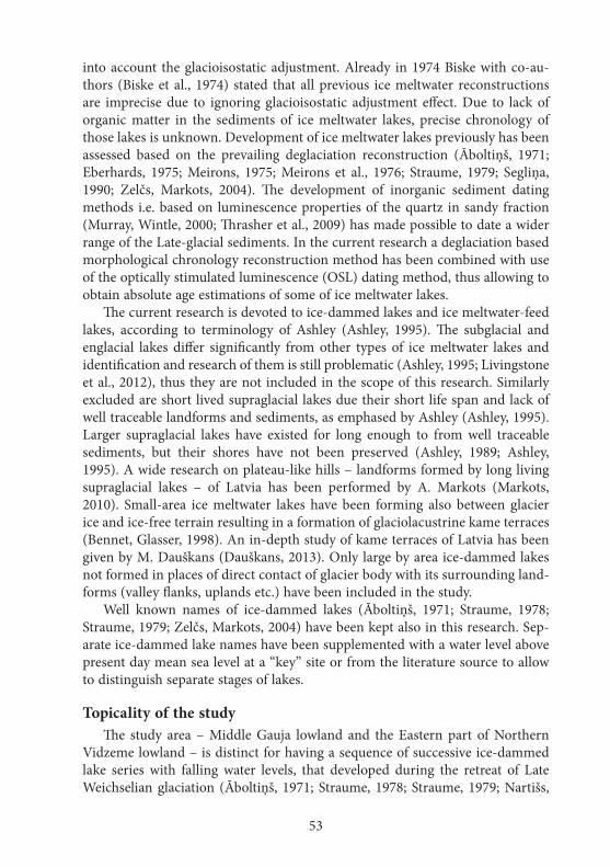
53
into account the glacioisostatic adjustment. Already in 1974 Biske with co-au-thors (Biske et al., 1974) stated that all previous ice meltwater reconstructions are imprecise due to ignoring glacioisostatic adjustment effect. Due to lack of organic matter in the sediments of ice meltwater lakes, precise chronology of those lakes is unknown. Development of ice meltwater lakes previously has been assessed based on the prevailing deglaciation reconstruction (Āboltiņš, 1971; Eberhards, 1975; Meirons, 1975; Meirons et al., 1976; Straume, 1979; Segliņa, 1990; Zelčs, Markots, 2004). The development of inorganic sediment dating methods i.e. based on luminescence properties of the quartz in sandy fraction (Murray, Wintle, 2000; Thrasher et al., 2009) has made possible to date a wider range of the Late-glacial sediments. In the current research a deglaciation based morphological chronology reconstruction method has been combined with use of the optically stimulated luminescence (OSL) dating method, thus allowing to obtain absolute age estimations of some of ice meltwater lakes.
The current research is devoted to ice-dammed lakes and ice meltwater-feed lakes, according to terminology of Ashley (Ashley, 1995). The subglacial and englacial lakes differ significantly from other types of ice meltwater lakes and identification and research of them is still problematic (Ashley, 1995; Livingstone et al., 2012), thus they are not included in the scope of this research. Similarly excluded are short lived supraglacial lakes due their short life span and lack of well traceable landforms and sediments, as emphased by Ashley (Ashley, 1995). Larger supraglacial lakes have existed for long enough to from well traceable sediments, but their shores have not been preserved (Ashley, 1989; Ashley, 1995). A wide research on plateau-like hills – landforms formed by long living supraglacial lakes – of Latvia has been performed by A. Markots (Markots, 2010). Small-area ice meltwater lakes have been forming also between glacier ice and ice-free terrain resulting in a formation of glaciolacustrine kame terraces (Bennet, Glasser, 1998). An in-depth study of kame terraces of Latvia has been given by M. Dauškans (Dauškans, 2013). Only large by area ice-dammed lakes not formed in places of direct contact of glacier body with its surrounding land-forms (valley flanks, uplands etc.) have been included in the study.
Well known names of ice-dammed lakes (Āboltiņš, 1971; Straume, 1978; Straume, 1979; Zelčs, Markots, 2004) have been kept also in this research. Sep-arate ice-dammed lake names have been supplemented with a water level above present day mean sea level at a “key” site or from the literature source to allow to distinguish separate stages of lakes.
Topicality of the studyThe study area – Middle Gauja lowland and the Eastern part of Northern
Vidzeme lowland – is distinct for having a sequence of successive ice-dammed lake series with falling water levels, that developed during the retreat of Late Weichselian glaciation (Āboltiņš, 1971; Straume, 1978; Straume, 1979; Nartišs,
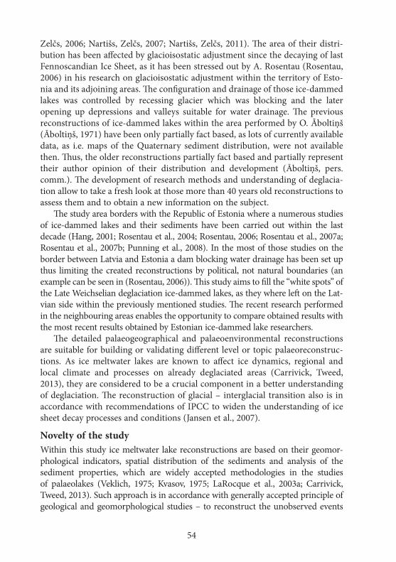
54
Zelčs, 2006; Nartišs, Zelčs, 2007; Nartišs, Zelčs, 2011). The area of their distri-bution has been affected by glacioisostatic adjustment since the decaying of last Fennoscandian Ice Sheet, as it has been stressed out by A. Rosentau (Rosentau, 2006) in his research on glacioisostatic adjustment within the territory of Esto-nia and its adjoining areas. The configuration and drainage of those ice-dammed lakes was controlled by recessing glacier which was blocking and the later opening up depressions and valleys suitable for water drainage. The previous reconstructions of ice-dammed lakes within the area performed by O. Āboltiņš (Āboltiņš, 1971) have been only partially fact based, as lots of currently available data, as i.e. maps of the Quaternary sediment distribution, were not available then. Thus, the older reconstructions partially fact based and partially represent their author opinion of their distribution and development (Āboltiņš, pers. comm.). The development of research methods and understanding of deglacia-tion allow to take a fresh look at those more than 40 years old reconstructions to assess them and to obtain a new information on the subject.
The study area borders with the Republic of Estonia where a numerous studies of ice-dammed lakes and their sediments have been carried out within the last decade (Hang, 2001; Rosentau et al., 2004; Rosentau, 2006; Rosentau et al., 2007a; Rosentau et al., 2007b; Punning et al., 2008). In the most of those studies on the border between Latvia and Estonia a dam blocking water drainage has been set up thus limiting the created reconstructions by political, not natural boundaries (an example can be seen in (Rosentau, 2006)). This study aims to fill the “white spots” of the Late Weichselian deglaciation ice-dammed lakes, as they where left on the Lat-vian side within the previously mentioned studies. The recent research performed in the neighbouring areas enables the opportunity to compare obtained results with the most recent results obtained by Estonian ice-dammed lake researchers.
The detailed palaeogeographical and palaeoenvironmental reconstructions are suitable for building or validating different level or topic palaeoreconstruc-tions. As ice meltwater lakes are known to affect ice dynamics, regional and local climate and processes on already deglaciated areas (Carrivick, Tweed, 2013), they are considered to be a crucial component in a better understanding of deglaciation. The reconstruction of glacial – interglacial transition also is in accordance with recommendations of IPCC to widen the understanding of ice sheet decay processes and conditions (Jansen et al., 2007).
Novelty of the studyWithin this study ice meltwater lake reconstructions are based on their geomor-phological indicators, spatial distribution of the sediments and analysis of the sediment properties, which are widely accepted methodologies in the studies of palaeolakes (Veklich, 1975; Kvasov, 1975; LaRocque et al., 2003a; Carrivick, Tweed, 2013). Such approach is in accordance with generally accepted principle of geological and geomorphological studies – to reconstruct the unobserved events
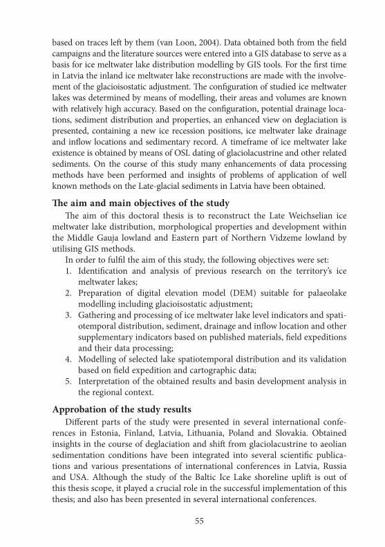
55
based on traces left by them (van Loon, 2004). Data obtained both from the field campaigns and the literature sources were entered into a GIS database to serve as a basis for ice meltwater lake distribution modelling by GIS tools. For the first time in Latvia the inland ice meltwater lake reconstructions are made with the involve-ment of the glacioisostatic adjustment. The configuration of studied ice meltwater lakes was determined by means of modelling, their areas and volumes are known with relatively high accuracy. Based on the configuration, potential drainage loca-tions, sediment distribution and properties, an enhanced view on deglaciation is presented, containing a new ice recession positions, ice meltwater lake drainage and inflow locations and sedimentary record. A timeframe of ice meltwater lake existence is obtained by means of OSL dating of glaciolacustrine and other related sediments. On the course of this study many enhancements of data processing methods have been performed and insights of problems of application of well known methods on the Late-glacial sediments in Latvia have been obtained.
The aim and main objectives of the studyThe aim of this doctoral thesis is to reconstruct the Late Weichselian ice
meltwater lake distribution, morphological properties and development within the Middle Gauja lowland and Eastern part of Northern Vidzeme lowland by utilising GIS methods.
In order to fulfil the aim of this study, the following objectives were set:1. Identification and analysis of previous research on the territory’s ice
meltwater lakes;2. Preparation of digital elevation model (DEM) suitable for palaeolake
modelling including glacioisostatic adjustment;3. Gathering and processing of ice meltwater lake level indicators and spati-
otemporal distribution, sediment, drainage and inflow location and other supplementary indicators based on published materials, field expeditions and their data processing;
4. Modelling of selected lake spatiotemporal distribution and its validation based on field expedition and cartographic data;
5. Interpretation of the obtained results and basin development analysis in the regional context.
Approbation of the study resultsDifferent parts of the study were presented in several international confe-
rences in Estonia, Finland, Latvia, Lithuania, Poland and Slovakia. Obtained insights in the course of deglaciation and shift from glaciolacustrine to aeolian sedimentation conditions have been integrated into several scientific publica-tions and various presentations of international conferences in Latvia, Russia and USA. Although the study of the Baltic Ice Lake shoreline uplift is out of this thesis scope, it played a crucial role in the successful implementation of this thesis; and also has been presented in several international conferences.
56
1. ICe SheeT MeLTWATeR LAKeS
Glacial lakes are widely distributed in all areas occupied by Pleistocene and modern ice sheets and are quite common at some smaller mountain glaciers (Ashley, 1995; Miller, 1996; Bennet, Glasser, 1998; Benn, Evans, 1998). The wide area of ice meltwater lakes during the retreat of the last glaciation has encouraged some researchers to even suggest to call it “the age of lakes” (Kropotkin, 1876). Successful reconstructions of ancient lakes depend on a good understanding of their types, sedimentation processes, coastal and other landform morphology and development dynamics.
Many authors have provided their own classification schemes of glacial lakes that are based on various criteria and their understanding on formation of glacial lakes. All authors agree on one thing – the main criterion allowing to separate glacial lakes from non-glacial lakes is the huge impact of ice meltwater as a water source and in the dynamic processes of the lake (Basalikas, 1970; Danilāns, 1973; Straume, 1978; Straume, 1979; Ashley, 1989; Ashley, 1995; Mill-er, 1996). The most common is the glacial lake classification system proposed by Ashley (Ashley, 1995). It is based on a difference in the glacier meltwater feeding of the lake. Aforementioned system puts lakes into two large groups – ice contact and distal (proglacial) lakes. Ice contact lake group is subdivided into subglacial, supraglacial and ice contact lakes. Ice or topography dammed lakes are a part of ice contact lake group. As it is pointed out by Benn and Evans (Benn, Evans, 1998), many literature sources incorrectly use the term “proglacial lake” to identify ice-dammed (ice contact) lakes, thus burdening the separation of ice contact and ice meltwater feed lakes.
The most characteristic trait of ice contact lakes is the fact, that some part of their shores is formed by ice (Ashley, 1989; Ashley, 1995). The largest-area ice-contact lakes in Latvia (Straume, 1979) and in other parts of the world (Mangerud et al., 2001; Leverington et al., 2002b; Clarke et al., 2003; Mangerud et al., 2004) are those that have been formed between hypsometrically low located ice sheet and elevated ice free territory, that drains into the direction of the ice sheet. Such configuration allows to accumulate water runoff from the ice free terrain and from the glacier itself (Ashley, 1989; Ashley, 1995). If the distance between ice and open terrain is small, elongated and narrow ice meltwater lakes or lateral drainage valleys will form, presented as accumulation or erosional kame terraces after the retreat of glacier (Bennet, Glasser, 1998). If the open terrain has been a lowland or a plain, the area of ice-dammed lakes can be significant (Bennet, Glasser, 1998). Although ice-dammed lakes are the most well known ice contact lakes, the terrain dammed ice contact lakes also exist (Ashley, 1995).
57
Distal or proglacial lakes do not have a direct contact with glacier, but ice meltwaters still are the most important source of water in such lakes (Ashley, 1995). Occasionally such lake continue to exist some time after complete retreat of a glacier, thus transforming into a remnant lake (Danilāns, 1973).
Despite being divided into different groups, all ice meltwater lakes share common properties that differ them from non-glacial lakes. One of such specific trait is large scale and frequent water level fluctuation (Ashley, 1989; Carrivick, Tweed, 2013). Such water level fluctuations affect the formation of landforms, sedimentation and, in the case of ice contact lakes, even the glacier dynamics (Carrivick, Tweed, 2013).
1.1. Landforms and sediments of glacial lakes
In contrast to the sea shorelines, on the coasts of glacial lakes well-developed beaches occur more seldom. It could be explained by more gentle underwater and shore slope (Talbot, Allen, 1996). Even for lakes with a well-traceable sed-iment distribution, their coastlines might be hard to trace or even locate in the nature (Clark et al., 2008), especially in forest covered areas (Embleton, King, 1968). It might be caused by multiple factors – starting from weakly expressed processes in the littoral part of lake to slope processes after their drainage (Em-bleton, King, 1968; LaRocque et al., 2003a; Syverson, 2008). It also should be noted that ice contact lakes are covered by seasonal ice cover for most of the year that weakens wind induced wave activity on their shores (Embleton, King, 1968). The preservation potential of the glacial lake shores is also known to be relatively low (Collinson, 1978).
The boulder piles (Clark et al., 2008) or territories with increased boulder concentration on the ground (Grīnbergs, 1957) can be considered as a relatively good palaeolake water level indicator. Such a few metres high boulder piles are formed by movement of seasonal ice in the littoral part of the lake (Embleton, King, 1968; Edwards, 1978). Increased boulder concentration or even piling up is connected with erosional zone of lakes (Håkanson, 1977), where wind by in-ducing the wave and stream actions is removing finer fraction from lake bottom sediments (most commonly – tills) leaving only the coarser fractions intact. As noted by Embleton and King (Embleton, King, 1968), seasonal ice can move beach sediments, including large size boulders, by large distances into inland di-rection and can redeposit them up to 10 m above the mean water level. It has to be kept in the mind, while performing reconstruction of mean water level based on backshore boulder piles. An increased concentration of boulders on the till covered areas of former palaeolake beds has been noted also in Latvia (Straume, 1978; Straume, 1979). It has to be taken into consideration, that boulder piles can be man made and boulders themselves raised above the ground from the till by fluvial, slope, soil or periglacial processes.
58
Coasts of ice contact lakes formed in a direct contact with glacier are more unstable and, thus more difficult to trace (Benn, Evans, 1998; Teller, 2005). Teller (Teller, 2005) emphasis the observation, that formation of well expressed terminal moraines in the contact of glacier with ice is rare and thus abilities to reconstruct precise deglaciation pattern are difficult. The distribution of glacier ice can be obtained by analysis of indirect indicators – blocked drainage valleys, changes in lake sediments etc.
The spatial distribution of sediments within lakes is controlled mainly by wind induced wave activity (Håkanson, 1977; Håkanson, Jansson, 1983; Rowan et al., 1992). Inflowing water streams, that are forming deltas and suspension currents, have relatively minuscule influence on sedimentation patterns unless they have high concentration of suspended terrigenous material (Håkanson, Jansson, 1983). Occasionally, when the density of inflowing water is higher than the density of lake water, it forms underflow that distributes sediments carried by the stream over the vast area of lake bottom (Collinson, 1978). There are only few differences between sedimentation in ice meltwater and ordinary lakes. Most significant ones are: (1) location of the inflow at any depth, (2) the common occurrence of the great density differences between lake and inflowing water, and (3) the common occurrence of a direct mechanical action of glacier or seasonal ice on landforms and sediments (Ashley, 1989). Glacial lakes also tend to be lengthy covered by seasonal ice (Raukas, Rjahni, 1970; Basalikas, 1970; Krinner et al., 2004), which decreases wind as an agent influence and increases importance of current or gravity induced sediment transport (Ashley, 1989). The interpretation of glacial lake sediments can be hindered by accumu-lation of particular sediments over buried ice, thus causing sediment relocation by dead ice melting. Identification of glacial lake sediments can be impended by presence of large volumes of unsorted sediment delivered by ice, thus making glaciolacustrine sediments similar to tills (Dreimanis, 1979; Zelčs et al., 2009).
In the ice contact lakes the high difference between inflowing and lake water is common due to water from the glacier body being cold and sediment rich (Ashley, 1995; Benn, Evans, 1998). Dense water is forming strong and sustained underflows, thus dissipating sediment along the whole glacial lake body (Benn, Evans, 1998). In the case of shallow lakes, suspended fine particles (silt, clay) can be transported out of the lake by outflow currents, thus leaving only more coarse sediment particles (sand) in the lake sediments (Embleton, King, 1968). Embleton and King (ibid.) also noted on formation of the common glacio-lacustrine sequence – fine grained sediments (silts, clays) overlain by coarser sediments (usually sands), that indicate the fall of lake level i.e. during its final drainage.
Textural features of sediments as the grain size distribution (Folk, Ward, 1957; Tanner, 1964; Visher, 1969; Swan et al., 1978; McLaren, Bowles, 1985; McManus, 1988; Anthony, Héquette, 2007; Wachecka-Kotkowska, Kotowski,
59
2011; Mycielska-Dowgiałło, Ludwikowska-Kędzia, 2011), their grain shape and surface properties as frosting (Krinsley, Doornkamp, 1973; Mahaney, 2002; Mycielska-Dowgiałło, Woronko, 2004; Woronko, Hoch, 2011) allow to make conclusions about the transport mechanism of particular sediment and their sedimentary history. The aforementioned properties can be used to identify the genesis of particular sediments (McManus, 1988; Mycielska-Dowgiałło, Woronko, 2004; Mycielska-Dowgiałło, Ludwikowska-Kędzia, 2011).
The grain size distribution of sediment is indicative of its transportation environment, but one has to keep in mind that it represents not only the last transportation, but has formed as a result of all its previous transportation events (Leeder, 1982). The skewness of distribution is one of best indicators of different sedimentary environments (Leeder, 1982; Martins, 2003) – negative skewness indicates dominance of erosional processes, positive – accumulation (Martins, 2003). Sediments of ice contact lake beaches tend to have poor sorting (high standard deviation values) due to insufficient reworking by waves and direct mechanical impact of icebergs or seasonal ice (Teller, 2005). Simultaneously, the various sedimentary environments tend to have similar grain size distribution characteristics, thus it can not be used to distinguish sedimentary environments excursively (Leeder, 1982). Fieller and Flenley (Fieller, Flenley, 1987) point to abuse of granulometric distribution indicators on sedimentary environ-ment identification, as they can be used only in the most simple cases with non-complex distribution patterns. In the case of more complex, multimodal distributions, simple grain size distribution descriptors as median size, sorting and skewness might not represent whole sample and thus, the granulometric patterns suffer from the low interpretative value (Hajek et al., 2010).
The experiments of the aeolian-fluvial transformation of sand grains in the various duration transport as performed by Lindé and Mycielska-Dowgiałło (Lindé, Mycielska-Dowgiałło, 1980) revealed much faster matting of quartz sand grains in aeolian than fluvial setting. Research of textural features of sand grains in the tills of Estonia and Latvia, as reported by Mahaney and Kalm (Mahaney, Kalm, 2008), indicates high proportion (50 to 60%) of angular (fresh) grains. Simultaneously up to 15% of all grains seem to be intact by glacial transporta-tion. Based on the multiple investigations in Poland, Woronko (Woronko, 2001) indicates similar composition of glaciofluvial sediments – with high proportion of angular and cracked grains. According to Bull and Morgan (Bull, Morgan, 2007), angular shiny sand grains can obtain matting on their edges after a short transportation by short lived streams. On modern beaches of Western Australia, Poland and Lithuania Kalińska (Kalińska, 2010) has observed a high proportion (sometimes over 80%) of shiny grains, with high levels (up to 40%) of shiny angular grains. Simultaneously, the perfectly rounded shiny grains were noted even below the number of cracked grains. It is widely stated that aeolian transportation environment produces high level of well rounded matt grains.
60
However, analysis of inland aeolian sediments of Latvia and Estonia has indicat-ed presence of relatively high proportion of shiny and angular grains (Kalińska et al., 2012; Kalińska, Nartišs, 2013a; Kalińska, Nartišs, 2013b), that might hamper separation of aeolian and their source (i.e. glaciolacustrine) sediments.
1.2. The vertical movement of the earth’s surface
Vertical movement of the earth’s surface in areas of the former ice sheets is an important factor influencing the accuracy of reconstructions of former ice lakes (Leverington et al., 2002a). As it has been show by Teller and Leverington (Teller, Leverington, 2004), arrangement of shorelines within a single glacial lake is controlled by interplay of glacioisostatic adjustment and location of the lake outflow point.
The model of Fennoscandian region earth’s surface apparent uplift, provided by Ekman (Ekman, 1996), displays even uplift of the territory of Latvia within last 100 years. More recent satellite and GPS based observations (Steffen et al., 2008; Steffen, Wu, 2011) and the computer modelling of the earth’s crust uplift since the maximal extent phase of last Fennoscandian Ice Sheet till present day based on the sea level observations (Påsse, Andersson, 2005) also indicates even uplift rate for the whole territory of Latvia.
The most comprehensive research of the earth’s surface apparent uplift in the territory of Latvia has been presented by E. Grīnbergs (Grīnbergs, 1957) in his monograph on morphology and internal structure of the ancient Baltic sea stage littoral landforms along the sea cost of Latvia. It has to be taken into account, that the present day height of ancient shorelines is a result of glacioisostatic ad-justment and other factors (change of eustatic sea level, gravitational field etc.). Both older (Grīnbergs, 1957; Veinbergs, 1986) and more recent (Juškevičs et al., 2008; Nartišs et al., 2008; Nartišs et al., 2011; Rečs, Krievāns, 2013) studies of vertical displacement of ancient Baltic sea shorelines around the Gulf of Riga do not indicate uneven earth’s surface uplift since the time of the Baltic Ice Lake stage I. Similarly even uplift have been reported for the valley of the River Salaca (Eberhards, 1973). It is worth to notice, that opinion about the lack of uplift within the Burtnieks plain since the Late-glacial exists (Eberhards, 2006).

61
2. GeOMORPhOLOGICAL ChARACTeRISTIC Of The STuDy AReA AND ITS DeVeLOPMeNT
AT The eND Of The LATe WeIChSeLIAN
The study area is located in the Vidzeme (Fig. 2.1.) and consists of two glacial lowlands (Zelčs, Markots, 2004) – Northern Vidzeme lowland (Seda plain and Trikāta rise) and Middle Gauja lowland (Trapene plain) (Zelčs, Šteins, 1989; Juškevičs, 1999a; Juškevičs, Skrebels, 2002a). To fulfil the aim of this investiga-tion, the study extends also into its surrounding natural regions border areas. The territory is located within the inner part of the last Fennoscandian Ice Sheet peripheral cover (Āboltiņš, 1975; Straume, 1979; Āboltiņš, 1989; Zelčs, Markots, 2004), shaped by activity of Burtnieks and Middle Gauja ice lobes (Zelčs, Markots, 2004).
Figure 2.1. The study area. Map base data (SIA Envirotech, 2011)
2.1. Morphology of the contemporary terrain
The contemporary terrain of the Trapene plain, as indicated by the terrain model (Latvijas Ģeotelpiskās informācijas aģentūra, 2008), is located between 157 m a.s.l. in the peripheral part of the plain to 52 m a.s.l. at the bottom of the River Gauja valley in its north. The height difference can be partially attributed to an escarpment on the sub-Quaternary sediment surface (Juškevičs, Skrebels, 2002c), that is expressed as 20 m height difference of both of its flanks in the
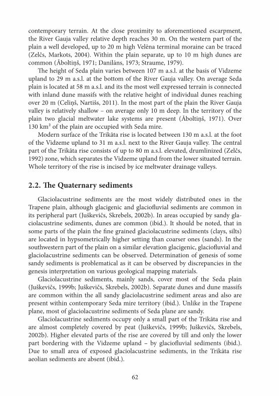
62
contemporary terrain. At the close proximity to aforementioned escarpment, the River Gauja valley relative depth reaches 30 m. On the western part of the plain a well developed, up to 20 m high Velēna terminal moraine can be traced (Zelčs, Markots, 2004). Within the plain separate, up to 10 m high dunes are common (Āboltiņš, 1971; Danilāns, 1973; Straume, 1979).
The height of Seda plain varies between 107 m a.s.l. at the basis of Vidzeme upland to 29 m a.s.l. at the bottom of the River Gauja valley. On average Seda plain is located at 58 m a.s.l. and its the most well expressed terrain is connected with inland dune massifs with the relative height of individual dunes reaching over 20 m (Celiņš, Nartišs, 2011). In the most part of the plain the River Gauja valley is relatively shallow – on average only 10 m deep. In the territory of the plain two glacial meltwater lake systems are present (Āboltiņš, 1971). Over 130 km² of the plain are occupied with Seda mire.
Modern surface of the Trikāta rise is located between 130 m a.s.l. at the foot of the Vidzeme upland to 31 m a.s.l. next to the River Gauja valley. The central part of the Trikāta rise consists of up to 80 m a.s.l. elevated, drumlinized (Zelčs, 1992) zone, which separates the Vidzeme upland from the lower situated terrain. Whole territory of the rise is incised by ice meltwater drainage valleys.
2.2. The Quaternary sediments
Glaciolacustrine sediments are the most widely distributed ones in the Trapene plain, although glacigenic and glaciofluvial sediments are common in its peripheral part (Juškevičs, Skrebels, 2002b). In areas occupied by sandy gla-ciolacustrine sediments, dunes are common (ibid.). It should be noted, that in some parts of the plain the fine grained glaciolacustrine sediments (clays, silts) are located in hypsometrically higher setting than coarser ones (sands). In the southwestern part of the plain on a similar elevation glacigenic, glaciofluvial and glaciolacustrine sediments can be observed. Determination of genesis of some sandy sediments is problematical as it can be observed by discrepancies in the genesis interpretation on various geological mapping materials.
Glaciolacustrine sediments, mainly sands, cover most of the Seda plain (Juškevičs, 1999b; Juškevičs, Skrebels, 2002b). Separate dunes and dune massifs are common within the all sandy glaciolacustrine sediment areas and also are present within contemporary Seda mire territory (ibid.). Unlike in the Trapene plane, most of glaciolacustrine sediments of Seda plane are sandy.
Glaciolacustrine sediments occupy only a small part of the Trikāta rise and are almost completely covered by peat (Juškevičs, 1999b; Juškevičs, Skrebels, 2002b). Higher elevated parts of the rise are covered by till and only the lower part bordering with the Vidzeme upland – by glaciofluvial sediments (ibid.). Due to small area of exposed glaciolacustrine sediments, in the Trikāta rise aeolian sediments are absent (ibid.).
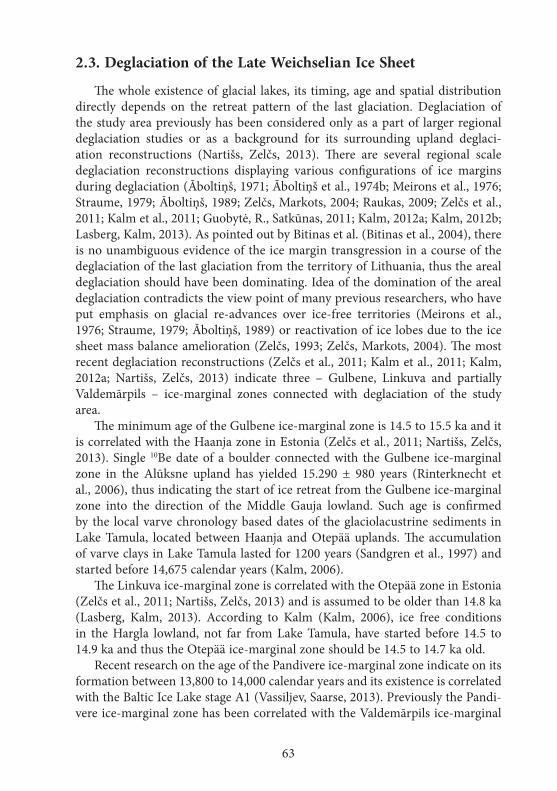
63
2.3. Deglaciation of the Late Weichselian Ice Sheet
The whole existence of glacial lakes, its timing, age and spatial distribution directly depends on the retreat pattern of the last glaciation. Deglaciation of the study area previously has been considered only as a part of larger regional deglaciation studies or as a background for its surrounding upland deglaci-ation reconstructions (Nartišs, Zelčs, 2013). There are several regional scale deglaciation reconstructions displaying various configurations of ice margins during deglaciation (Āboltiņš, 1971; Āboltiņš et al., 1974b; Meirons et al., 1976; Straume, 1979; Āboltiņš, 1989; Zelčs, Markots, 2004; Raukas, 2009; Zelčs et al., 2011; Kalm et al., 2011; Guobytė, R., Satkūnas, 2011; Kalm, 2012a; Kalm, 2012b; Lasberg, Kalm, 2013). As pointed out by Bitinas et al. (Bitinas et al., 2004), there is no unambiguous evidence of the ice margin transgression in a course of the deglaciation of the last glaciation from the territory of Lithuania, thus the areal deglaciation should have been dominating. Idea of the domination of the areal deglaciation contradicts the view point of many previous researchers, who have put emphasis on glacial re-advances over ice-free territories (Meirons et al., 1976; Straume, 1979; Āboltiņš, 1989) or reactivation of ice lobes due to the ice sheet mass balance amelioration (Zelčs, 1993; Zelčs, Markots, 2004). The most recent deglaciation reconstructions (Zelčs et al., 2011; Kalm et al., 2011; Kalm, 2012a; Nartišs, Zelčs, 2013) indicate three – Gulbene, Linkuva and partially Valdemārpils – ice-marginal zones connected with deglaciation of the study area.
The minimum age of the Gulbene ice-marginal zone is 14.5 to 15.5 ka and it is correlated with the Haanja zone in Estonia (Zelčs et al., 2011; Nartišs, Zelčs, 2013). Single 10Be date of a boulder connected with the Gulbene ice-marginal zone in the Alūksne upland has yielded 15.290 ± 980 years (Rinterknecht et al., 2006), thus indicating the start of ice retreat from the Gulbene ice-marginal zone into the direction of the Middle Gauja lowland. Such age is confirmed by the local varve chronology based dates of the glaciolacustrine sediments in Lake Tamula, located between Haanja and Otepää uplands. The accumulation of varve clays in Lake Tamula lasted for 1200 years (Sandgren et al., 1997) and started before 14,675 calendar years (Kalm, 2006).
The Linkuva ice-marginal zone is correlated with the Otepää zone in Estonia (Zelčs et al., 2011; Nartišs, Zelčs, 2013) and is assumed to be older than 14.8 ka (Lasberg, Kalm, 2013). According to Kalm (Kalm, 2006), ice free conditions in the Hargla lowland, not far from Lake Tamula, have started before 14.5 to 14.9 ka and thus the Otepää ice-marginal zone should be 14.5 to 14.7 ka old.
Recent research on the age of the Pandivere ice-marginal zone indicate on its formation between 13,800 to 14,000 calendar years and its existence is correlated with the Baltic Ice Lake stage A1 (Vassiljev, Saarse, 2013). Previously the Pandi-vere ice-marginal zone has been correlated with the Valdemārpils ice-marginal
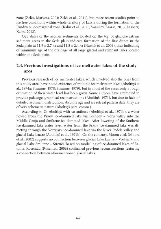
64
zone (Zelčs, Markots, 2004; Zelčs et al., 2011), but more recent studies point to ice free conditions within whole territory of Latvia during the formation of the Pandivere ice-marginal zone (Kalm et al., 2011; Vassiljev, Saarse, 2013; Lasberg, Kalm, 2013).
OSL dates of the aeolian sediments located on the top of glaciolacustrine sediment areas in the Seda plain indicate formation of the first dunes in the Seda plain at 11.9 ± 2.7 ka and 11.8 ± 2.4 ka (Nartišs et al., 2009), thus indicating of minimum age of the drainage of all large glacial and remnant lakes located within the Seda plain.
2.4. Previous investigations of ice meltwater lakes of the study area
Previous research of ice meltwater lakes, which involved also the ones from this study area, have noted existence of multiple ice meltwater lakes (Āboltiņš et al., 1974a; Straume, 1978; Straume, 1979), but in most of the cases only a rough estimation of their water level has been given. Some authors have attempted to provide palaeogeographical reconstructions (Āboltiņš, 1971), but due to lack of detailed sediment distribution, absolute age and ice retreat pattern data, they are of very schematic nature (Āboltiņš pers. comm.).
According to O. Āboltiņš with co-authors (Āboltiņš et al., 1974b), a water flowed from the Pskov ice-dammed lake via Pechory – Võru valley into the Middle Gauja and Smiltene ice-dammed lakes. After lowering of the Smiltene ice-dammed lake water level, water from the Pskov ice-dammed lake was di-recting through the Võrtsjärv ice-dammed lake via the River Pedele valley and glacial Lake Laatre (Āboltiņš et al., 1974b). On the contrary, Moora et al. (Moora et al., 2002) suggests no connection between glacial Lake Laatre – Võrtsjärv and glacial Lake Smiltene – Strenči. Based on modelling of ice-dammed lakes of Es-tonia, Rosentau (Rosentau, 2006) confirmed previous reconstructions featuring a connection between aforementioned glacial lakes.
65
3. MATeRIALS AND MeThODS
The study is based on original data obtained in the course of eight years of numerous field expeditions, map and literature source studies, GIS mo-delling. The data gathered from literature and map sources, field observa-tions and data interpretation was used for preparation of ice meltwater lake modelling and to perform validation and interpretation of obtained mo-delling results. Research methods reassemble those used for reconstruction of ice meltwater lakes in other parts of the Fennoscandian and Laurentide Ice Sheets. At the same time to successfully reach the aim of the study some of data processing methods and tools have been enhanced or customized to specific data formats, quality of available data.
The locality names have taken form the Satellite map of Latvia (Latvijas Ģeotelpiskās informācijas aģentūra, 2000). The borders of natural regions were taken from the State Geological survey data (Juškevičs, 1999a; Juškevičs, Skrebels, 2002a).
GIS analysis and modelling was mainly performed in the GRASS GIS 7 (GRASS Development Team, 2012) free software suite. For development of maps, manual processing and creation of a new data sets the most recent version of QGIS (QGIS Development Team, 2013) was used. All maps and data sets of the study are provided in the geodetic reference system of Latvia 1992, transverse Mercator projection (“LKS-92 TM”; EPSG:3059). The heights are given in the Baltic nominal heigh system (“BAS-77”) unless stated otherwise.
Fixation of the field study sites was performed with ordinary hand-held GPS units. Site heights were obtained from a large scale (1:10,000) topographical map (TOPO 10K PSRS, 2009). Separate sites were fixed with a single frequency GPS unit Magellan Promark 3 and post-processed with Magellan Mobile Office 3.40a program in LatPos network (Latvijas Ģeotelpiskās informācijas aģentūra, 2013).
The spatial analysis was performed on the basis of a digital elevation mo-del (DEM) of Latvia with cell size of 20 m as provided by Latvian Geospatial Information agency (Latvijas Ģeotelpiskās informācijas aģentūra, 2008). A visual inspection of DEM revealed inconsistencies and gaps on connections of separate data sheets and also up to 10 m high artificial escarpments on the connections of data source sheets. The DEM also contained man made objects (bridges, dams, road excavations etc.) and errors. DEM sheet and source sheet borders were smoothed in a 120 m wide strip with a 5×5 cell spatially oriented weighted average method. Man made objects and blun-ders were removed by the cookie-cutter method with manually digitized areas and afterwards filled by regularized spline with tension interpolation method (Nartišs, 2013).
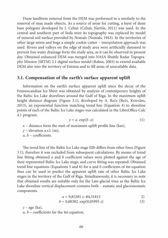
66
Dune landform removal from the DEM was performed in a similarly to the removal of man made objects. As a source of areas for cutting, a layer of dune base polygons developed by I. Celiņš (Celiņš, Nartišs, 2011) was used. In the central and southern part of Seda mire its topography was replaced by model of mineral soil surface provided by Nomals (Nomals, 1943). In the territories of other large mires and bogs a simple cookie-cutter – interpolation approach was used. Rivers and valleys on the edge of study area were artificially dammed to prevent free water drainage form the study area, as it can be observed in present day. Obtained enhanced DEM was merged into NASA Shuttle Radar Topogra-phy Mission (SRTM) 2.1 digital surface model (Rabus, 2003) to extend available DEM also into the territory of Estonia and to fill areas of unavailable data.
3.1. Compensation of the earth’s surface apparent uplift
Information on the earth’s surface apparent uplift since the decay of the Fennoscandian Ice Sheet was obtained by analysis of contemporary heights of the Baltic Ice Lake shorelines around the Gulf of Riga. In the maximum uplift height distance diagram (Figure 3.1), developed by A. Rečs (Rečs, Krievāns, 2013), an exponential function matching trend line (Equation 4) to shoreline points of each of the Baltic Ice Lake stages was calculated in the LibreOffice Calc 4.1 program. y = a · exp(b · x) (1)
x – distance form the start of maximum uplift profile line (km),y – elevation a.s.l. (m),a, b – coefficients.
The trend line of the Baltic Ice Lake stage IIIb differs from other lines (Figure 3.1), therefore it was excluded from subsequent calculations. By means of trend line fitting obtained a and b coefficient values were plotted against the age of their represented Baltic Ice Lake stage, and curve fitting was repeated. Obtained trend line equations (Equations 5 and 6) for a and b coefficients of 4st equation thus can be used to predict the apparent uplift rate of other Baltic Ice Lake stages in the territory of the Gulf of Riga. Simultaneously, it is necessary to note that obtained results are suitable only for the Late-glacial time as the Baltic Ice Lake shoreline vertical displacement contains both – eustatic and glacioisostatic components. a = 9,85285 z−84,31813 2) b = 0,00382 · exp(0,05995 z) (3)
z – age (ka),a, b – coefficients for the 4st equation.

67
Obtained equations 5 and 6 were used to construct trend lines matching 12.2 (age of the Baltic Ice Lake IIIb stage (Rosentau et al., 2009; Vassiljev, Saarse, 2013)) and 15.5 ka (maximum age of the Gulbene ice-marginal zone (Zelčs et al., 2011; Nartišs, Zelčs, 2013)). Both of predictions are displayed on the Figure 3.1. As shown, modelled trend line of the Baltic Ice Lake stage IIIb is in a quite good agreement with data points and, thus confirms validity of chosen mod-elling approach. Obtained trend line equations were used to construct a water level surface representing the sea level at a selected time point. Two surfaces representing 14.5 and 15.5 ka situations were constructed. Table 3.1 summarizes the parameters of constructed water level surfaces.
Table 3.1
Parameters used to construct water level surfaces representing the sea level.
Name of trend surface Age in ka a coefficient b coefficient Azimuth of
maximum upliftTV 1 15.5 68,401045 0,009674 335TV 2 14.5 58,548195 0,009111 335
Figure 3.1. hypsometric distribution of the Baltic Ice lake shoreline indicators being projected on the maximum uplift line. Dots – separate measurements (Rečs, Krievāns, 2013); solid lines – trend lines of different stages; dashed lines – trend lines obtained by
means of modelling
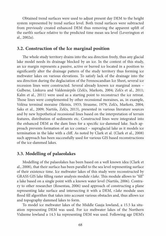
68
Obtained trend surfaces were used to adjust present day DEM to the height system represented by trend surface level. Both trend surfaces were subtracted from previously created enhanced DEM thus removing the apparent uplift of the earth’s surface relative to the predicted time mean sea level (Leverington et al., 2002a).
3.2. Construction of the Ice marginal position
The whole study territory drains into the sea direction freely, thus any glacial lake model needs its drainage blocked by an ice. In the context of this study, an ice margin represents a passive, active or burred ice located in a position to significantly alter the drainage pattern of the study territory thus forming ice meltwater lakes on various elevations. To satisfy lack of the drainage into the sea direction during the deglaciation of the Fennoscandian Ice Sheet, several ice recession lines were constructed. Several already known ice marginal zones – Gulbene, Linkuva and Valdemārpils (Zelčs, Markots, 2004; Zelčs et al., 2011; Kalm et al., 2011) were used as a starting point to reconstruct the ice retreat. Those lines were complemented by other recessional moraines, as, in example, Velēna terminal moraine (Sleinis, 1933; Straume, 1979; Zelčs, Markots, 2004; Saks et al., 2009; Nartišs, Zelčs, 2013), presented in various literature sources and by new hypothetical recessional lines based on the interpretation of terrain features, distribution of sediments etc. Constructed lines were integrated into the enhanced DEM as the dam lines for a specific ice-dammed lake. Such ap-proach prevents formation of an ice contact – supraglacial lake as it models ice termination in the lake with a cliff. As noted by Clark et al. (Clark et al., 2008) such approach has been successfully used for various GIS based reconstructions of the ice-dammed lakes.
3.3. Modelling of palaeolakes
Modelling of the palaeolakes has been based on a well known idea (Clark et al., 2008), that their surface has been parallel to the sea level representing surface of their existence time. Ice meltwater lakes of this study were reconstructed by GRASS GIS lake filling raster analysis module r.lake. This module allows to “fill” a lake based on a single point with a known water level (Nartišs, 2006). Contra-ry to other researcher (Rosentau, 2006) used approach of constructing a plane representing lake surface and intersecting it with a DEM, r.lake module uses flood fill algorithm that takes into account various obstacles and, thus allows ice and topography dammed lakes to form.
To model ice meltwater lakes of the Middle Gauja lowland, a 15.5 ka situ-ation representing DEM was used. For ice meltwater lakes of the Northern Vidzeme lowland a 14.5 ka representing DEM was used. Following age DEM’s
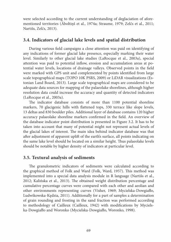
69
were selected according to the current understanding of deglaciation of afore-mentioned territories (Āboltiņš et al., 1974a; Straume, 1979; Zelčs et al., 2011; Nartišs, Zelčs, 2013).
3.4. Indicators of glacial lake levels and spatial distribution
During various field campaigns a close attention was paid on identifying of any indications of former glacial lake presence, especially marking their water level. Similarly to other glacial lake studies (LaRocque et al., 2003a), special attention was paid to potential inflow, erosion and accumulation areas at po-tential water levels, locations of drainage valleys. Observed points in the field were marked with GPS unit and complemented by points identified from large scale topographical maps (TOPO 10K PSRS, 2009) or LiDAR visualizations (Es-tonian Land Board, 2013). Large scale topographical maps are considered to be adequate data sources for mapping of the palaeolake shorelines, although higher resolution data could increase the accuracy and quantity of detected indicators (LaRocque et al., 2003a).
The indicator database consists of more than 1100 potential shoreline markers, 70 glacigenic hills with flattened tops, 330 terrace like slope levels, 13 deltas and 830 boulder piles. Additional layer of database contains 120 higher accuracy palaeolake shoreline markers confirmed in the field. An overview of the database indicator point distribution is presented in Figure 3.2. It has to be taken into account that many of potential might not represent actual levels of the glacial lakes of interest. The main idea behind indicator database was that after adjustment of apparent uplift of the earth’s surface, all points indicating on the same lake level should be located on a similar height. Thus palaeolake levels should be notable by higher density of indicators at particular level.
3.5. Textural analysis of sediments
The granulometric indicators of sediments were calculated according to the graphical method of Folk and Ward (Folk, Ward, 1957). This method was implemented into a special data analysis module in R language (Nartišs et al., 2012; Kalińska et al., 2013). The obtained weight distribution percentage and cumulative percentage curves were compared with each other and aeolian and other environments representing curves (Visher, 1969; Mycielska-Dowgiałło, Ludwikowska-Kędzia, 2011). Additionally for a part of samples a determination of grain rounding and frosting in the sand fraction was performed according to methodology of Cailleux (Cailleux, 1942) with modifications by Myciels-ka-Dowgiałło and Woronko (Mycielska-Dowgiałło, Woronko, 1998).
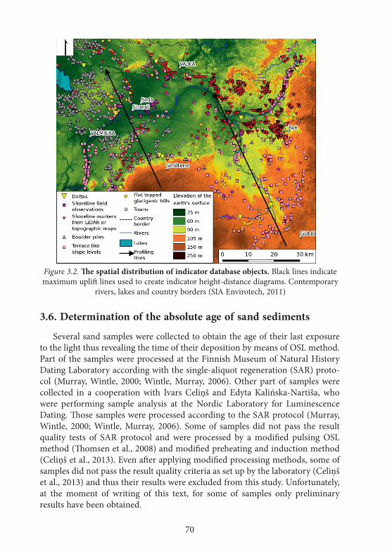
70
3.6. Determination of the absolute age of sand sediments
Several sand samples were collected to obtain the age of their last exposure to the light thus revealing the time of their deposition by means of OSL method. Part of the samples were processed at the Finnish Museum of Natural History Dating Laboratory according with the single-aliquot regeneration (SAR) proto-col (Murray, Wintle, 2000; Wintle, Murray, 2006). Other part of samples were collected in a cooperation with Ivars Celiņš and Edyta Kalińska-Nartiša, who were performing sample analysis at the Nordic Laboratory for Luminescence Dating. Those samples were processed according to the SAR protocol (Murray, Wintle, 2000; Wintle, Murray, 2006). Some of samples did not pass the result quality tests of SAR protocol and were processed by a modified pulsing OSL method (Thomsen et al., 2008) and modified preheating and induction method (Celiņš et al., 2013). Even after applying modified processing methods, some of samples did not pass the result quality criteria as set up by the laboratory (Celiņš et al., 2013) and thus their results were excluded from this study. Unfortunately, at the moment of writing of this text, for some of samples only preliminary results have been obtained.
Figure 3.2. The spatial distribution of indicator database objects. Black lines indicate maximum uplift lines used to create indicator height-distance diagrams. Contemporary
rivers, lakes and country borders (SIA Envirotech, 2011)
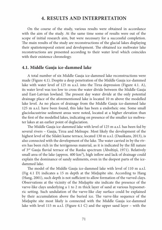
71
4. ReSuLTS AND INTeRPReTATION
On the course of the study, various results were obtained in accordance with the aim of the study. At the same time some of results were out of the scope of initial research aim, but were necessary for a successful completion. The main results of the study are reconstructions of the glacial lakes displaying their spatiotemporal extent and development. The obtained ice meltwater lake reconstructions are presented according to their water level which coincides with their existence chronology.
4.1. Middle Gauja ice-dammed lake
A total number of six Middle Gauja ice-dammed lake reconstructions were made (Figure 4.1). Despite a deep penetration of the Middle Gauja ice-dammed lake with water level of 125 m a.s.l. into the Tirza depression (Figure 4.1. A), its water level was too low to cross the water divide between the Middle Gauja and East-Latvian lowland. The present day water divide at the only potential drainage place of the aforementioned lake is located 10 m above the modelled lake level. As no places of drainage from the Middle Gauja ice-dammed lake 125 m a.s.l. have been found, this lake has been a endorheic one. Some small glaciolacustrine sediment areas were noted, located at a higher elevation than the first of the modelled lakes, indicating on presence of the smaller ice meltwa-ter lakes at an earlier point of deglaciation.
The Middle Gauja ice-dammed lake with level of 125 m a.s.l. has been fed by several rivers – Gauja, Tirza and Melnupe. Most likely the development of the highest level of the Silakti kame terrace, located 130 m a.s.l. (Dauškans, 2013), is also connected with the development of the lake. The water carried in by the riv-ers has been rich in the terrigenous material, as it is indicated by the fill nature of 3rd Gauja fluvial terrace of the Ranka spectrum (Āboltiņš, 1971). Relatively small area of the lake (approx. 400 km²), high inflow and lack of drainage could explain the dominance of sandy sediments, even in the deepest parts of the ice-dammed lake.
The model of the Middle Gauja ice-dammed lake with level of 110 m a.s.l. (Fig 4.1 D) indicates a 15 m depth at the Mieļupīte site. According to Hang (Hang, 2001), such depth is not sufficient to allow formation of the varved clays. Observations at the vicinity of the Mieļupīte site indicate the presence of the varve-like clays underlying a 1 to 2 m thick layer of sand at various hypsomet-ric setting. Such undulation of the varve-like clay surface could be explained by their accumulation above the buried ice. The varve-like sequence of the Mieļupīte site most likely is connected with the Middle Gauja ice-dammed lake with level 115 m a.s.l. (Figure 4.1 C) and the upper sand layer – with the

72
Figure 4.1. Middle Gauja ice-dammed lake with level of 125 (A), 120 (B), 115 (C), 110 (D), 90 (e) and 83 (f) m a.s.l. The white arrow points at a potential drainage
location. The red square points to the location of Tamula lake. The Ice-marginal zones in the territory of Estonia according to (Kalm et al., 2011); of Latvia - (Zelčs et al., 2011)
with author’s modifications. The contemporary rivers, lakes, towns, country border (SIA Envirotech, 2011)
A B
C D
E F

73
110 m a.s.l. lake and its subsequent drainage. At the time of the Middle Gauja ice-dammed lake with level of 90 m a.s.l. (Figure 4.1 E), the vicinity of the Mieļupīte site was already above the water level. The water depth of 115 m lake could sustain accumulation of the varved clays at the Mieļupīte site. The forma-tion of the ice-dammed lake partially above a dead ice is similar to observed in the development of Lake Burtnieks (Eberhards, 2006). The modelling approach of this study is not suitable to reconstruct an ice meltwater lake, that is partially located above the ice, thus the reconstruction of the Middle Gauja 115 m a.s.l. lake is not entirely correct as the lake has been extended also into the glaciated area of the reconstruction.
The ice-margin configuration of the Middle Gauja 90 m a.s.l. ice-dammed lake allows the lake to freely fill the Hargla lowland (Figure 4.1 E). The modelled lake at the location of Lake Tamula, the Hargla lowland, indicated depth of at least 34 m. Such depth is considered to be sufficient for the accumulation of the varved clays (Hang, 2001). The lake model also revealed areas of the glaciolacus-trine sediments on the western slope of Alūksne-Haanja upland being located higher than the modelled lake (Juškevičs, 1964; Juškevičs, Skrebels, 2002b), thus indicating on an existence of smaller ice-dammed lakes on the slope of the upland at an earlier point of deglaciation.
The Middle Gauja ice-dammed lake with level 83 m a.s.l. (Figure 4.1 F) is the last of modelled lake levels with an ice-margin configuration blocking free water flow through the Aumeisteri interlobate hilly area into the direction of the Seda plain. Taking into account the good agreement between the lake model and the glaciolacustrine sediment distribution (Juškevičs, 1964), it is safe to assume the correctness of the reconstruction. The shore of modelled lake coincides with a location of a weakly expressed erosional terrace cutting into the glaciolacustrine sediments of an earlier ice-dammed lake in the vicinity of Gaujiena village. Tak-ing into account the relatively small area of the lake versus its catchment area, it can be presumed that the drainage between the Middle Gauja ice-dammed lake and early stages of the Smiltene ice-dammed lakes was in the place. The Middle Gauja ice-dammed lake was connected with the Peipsi ice-dammed lake with a strait like connection, as indicated by modelling of Rosentau et al. (Rosentau et al., 2004).
4.2. Smiltene ice-dammed lake
In to the first of three modelled Smiltene ice-dammed lakes – one with water level of 75 m a.s.l. (Figure 4.2 A) – from the Vidzeme upland were flowing in several rivers forming deltas. The most prominent are the delta of the River Abuls at Brutuļi village and the delta of the River Rauna loacted downstream of Rauna village. The “U” shaped valley of the River Rauna below its palaeodelta could have been serving as a drainage valley, although the presence of the delta
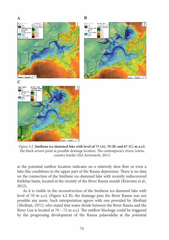
74
at the potential outflow location indicates on a relatively slow flow or even a lake-like conditions in the upper part of the Rauna depression. There is no data on the connection of the Smiltene ice-dammed lake with recently rediscovered Kārkliņi basin, located at the vicinity of the River Rauna mouth (Krievāns et al., 2012).
As it is visible in the reconstruction of the Smiltene ice-dammed lake with level of 70 m a.s.l. (Figure 4.2 B), the drainage pass the River Rauna was not possible any more. Such interpretation agrees with one provided by Āboltiņš (Āboltiņš, 1971), who stated that water divide between the River Rauna and the River Lisa is located at 70 – 72 m a.s.l. The outflow blockage could be triggered by the progressing development of the Rauna palaeodelta at the potential
Figure 4.2. Smiltene ice-dammed lake with level of 75 (A), 70 (B) and 67 (C) m a.s.l. The black arrows point at possible drainage location. The contemporary rivers, towns,
country border (SIA Envirotech, 2011)
A B
C
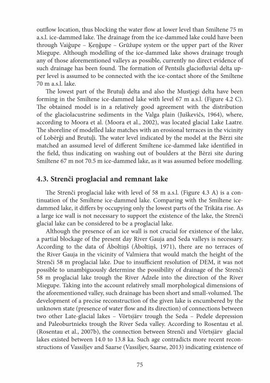
75
outflow location, thus blocking the water flow at lower level than Smiltene 75 m a.s.l. ice-dammed lake. The drainage from the ice-dammed lake could have been through Vaiģupe – Ķeņģupe – Grūžupe system or the upper part of the River Miegupe. Although modelling of the ice-dammed lake shows drainage trough any of those aforementioned valleys as possible, currently no direct evidence of such drainage has been found. The formation of Pentsils glaciofluvial delta up-per level is assumed to be connected with the ice-contact shore of the Smiltene 70 m a.s.l. lake.
The lowest part of the Brutuļi delta and also the Mustjegi delta have been forming in the Smiltene ice-dammed lake with level 67 m a.s.l. (Figure 4.2 C). The obtained model is in a relatively good agreement with the distribution of the glaciolacustrine sediments in the Valga plain (Juškevičs, 1964), where, according to Moora et al. (Moora et al., 2002), was located glacial Lake Laatre. The shoreline of modelled lake matches with an erosional terraces in the vicinity of Lobērģi and Brutuļi. The water level indicated by the model at the Bērzi site matched an assumed level of different Smiltene ice-dammed lake identified in the field, thus indicating on washing out of boulders at the Bērzi site during Smiltene 67 m not 70.5 m ice-dammed lake, as it was assumed before modelling.
4.3. Strenči proglacial and remnant lake
The Strenči proglacial lake with level of 58 m a.s.l. (Figure 4.3 A) is a con-tinuation of the Smiltene ice-dammed lake. Comparing with the Smiltene ice-dammed lake, it differs by occupying only the lowest parts of the Trikāta rise. As a large ice wall is not necessary to support the existence of the lake, the Strenči glacial lake can be considered to be a proglacial lake.
Although the presence of an ice wall is not crucial for existence of the lake, a partial blockage of the present day River Gauja and Seda valleys is necessary. According to the data of Āboltiņš (Āboltiņš, 1971), there are no terraces of the River Gauja in the vicinity of Valmiera that would match the height of the Strenči 58 m proglacial lake. Due to insufficient resolution of DEM, it was not possible to unambiguously determine the possibility of drainage of the Strenči 58 m proglacial lake trough the River Adzele into the direction of the River Miegupe. Taking into the account relatively small morphological dimensions of the aforementioned valley, such drainage has been short and small-volumed. The development of a precise reconstruction of the given lake is encumbered by the unknown state (presence of water flow and its direction) of connections between two other Late-glacial lakes – Võrtsjärv trough the Seda – Pedele depression and Paleoburtnieks trough the River Seda valley. According to Rosentau et al. (Rosentau et al., 2007b), the connection between Strenči and Võrtsjärv glacial lakes existed between 14.0 to 13.8 ka. Such age contradicts more recent recon-structions of Vassiljev and Saarse (Vassiljev, Saarse, 2013) indicating existence of

76
the Baltic Ice Lake stage A1 before 14.0 ka with a water level below the threshold between Võrtsjärv and Strenči palaeolakes.
During the field expeditions a small erosional terrace coinciding with the level of the Strenči proglacial lake with level 53 m a.s.l. had been noted at the vicinity of Jērcēni elementary school, SE of Ķeiži, SSW of Lugaži and NE of Oli-ņas. The water level of this proglacial lake was barely above the threshold level in the town of Valka, thus still allowing a water exchange between Võrtsjärv and Strenči glacial lakes (Figure 4.3 B). The model indicated water level at the mouth of the River Abuls is almost two meters higher than the height of the 4th (the highest) fluvial terrace of the River Gauja (Āboltiņš, 1971).
Figure 4.3. Strenči proglacial lake with level of 58 (A) and 53 (B) m a.s.l., and the Strenči remnant lake with level of 50 (C) and 46 (D) m a.s.l. The arrows point to the
potential drainage locations. The contemporary rivers, towns, country border (SIA Envirotech, 2011)
A B
C D
77
The erosional terraces matching the Strenči remnant lake with level of 50 m a.s.l. (Figure 4.3 C) are less expressed than of 53 m a.s.l. ones. The tracing of remnant lake shoreline is encumbered by its partial location below present day Seda mire peat layer. The model indicated water level at the mouth of the River Abuls is one metre below the 4th fluvial terrace of the River Gauja (Ābol-tiņš, 1971). The water level of this lake was below the threshold level between Võrtsjärv and Strenči lakes. At the time of separation of Võrtsjärv and Strenči lakes, the margin of Fennoscandian Ice Sheet was in the northern part of Esto-nia (Vassiljev, Saarse, 2013; Lasberg, Kalm, 2013), thus indicating on remnant nature of particular level of Lake Strenči.
The Strenči remnant lake with level 46 m a.s.l. (Figure 4.3 D) is the last one of modelled lakes. In the vicinity of Seda town and Turna village exists a small, but well traceable erosional terrace correlated with particular lake. According to the results of modelling, large parts of particular lake shorelines are located below the contemporary Seda mire peat layer, thus hindering their identification and tracing in the field. At the mouth of the River Abuls the model of Strenči 46 m remnant lake indicates its height below the 4th and above the 3rd fluvial terrace of the River Gauja (Āboltiņš, 1971). Currently the source of disagreement between heights of modelled lakes and river terraces is not known.
4.4. The results of optically stimulated luminescence dating
No suitable for dating organic matter has been found in glaciolacustrine sediments within the study area. Although in few outcrops (Mieļupīte; the bank of the River Gauja in vicinity of Dūre (Kuršs, Stinkule, 1969)), and boreholes (Takčidi, 1999) varve-like clays have been found, no attempts to create local varve chronology have been performed. The creation of varve chronology was out of the scope of this study and thus was not preformed. Due to wide distri-bution of sandy sediments, the OSL method is the most accessible absolute age dating method for the Late-glacial sediments of the study area. Table 4.1 con-tains results of OSL analysis performed within this study and also selected dates from the literature sources, that have been considered to be useful in the reconstruction of the chronology of studied lakes.
The OSL method gives the estimate of time span since the last sediment exposure (its burial) to light. In case of incomplete exposure, the obtained age might not represent the age of a landform built from the dated sediments. As it is observable in the table 4.1, obtained ages cover a wide time span. Several samples from deltas connected with the Late-glacial time, indicate their forma-tion before the Last Glacial maximum, that for the South-Eastern sector of the Fennoscandian Ice Sheet has been estimated to be in the range from 19.6 to 24.4 ka (Lasberg, Kalm, 2013). The age of aeolian sediments at the Smilškalni
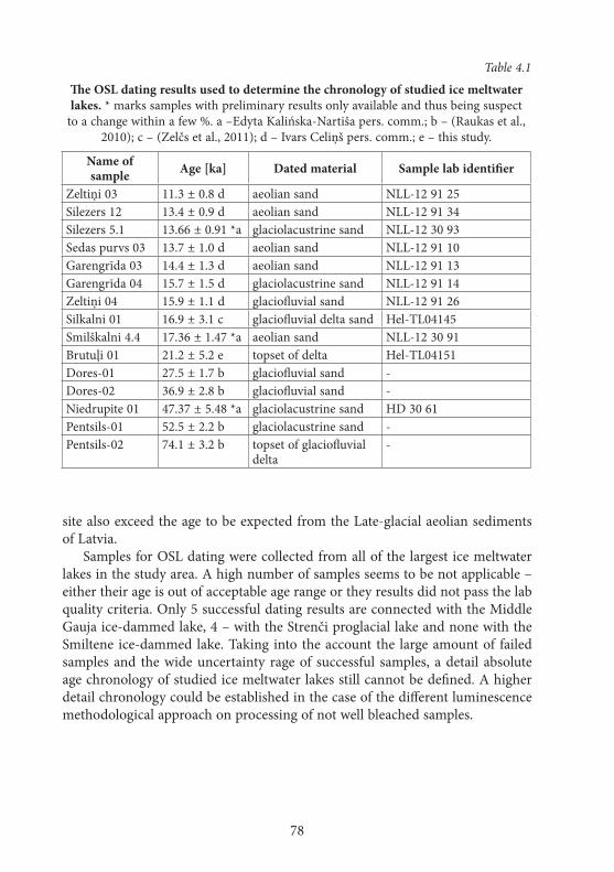
78
site also exceed the age to be expected from the Late-glacial aeolian sediments of Latvia.
Samples for OSL dating were collected from all of the largest ice meltwater lakes in the study area. A high number of samples seems to be not applicable – either their age is out of acceptable age range or they results did not pass the lab quality criteria. Only 5 successful dating results are connected with the Middle Gauja ice-dammed lake, 4 – with the Strenči proglacial lake and none with the Smiltene ice-dammed lake. Taking into the account the large amount of failed samples and the wide uncertainty rage of successful samples, a detail absolute age chronology of studied ice meltwater lakes still cannot be defined. A higher detail chronology could be established in the case of the different luminescence methodological approach on processing of not well bleached samples.
Table 4.1
The OSL dating results used to determine the chronology of studied ice meltwater lakes. * marks samples with preliminary results only available and thus being suspect
to a change within a few %. a –Edyta Kalińska-Nartiša pers. comm.; b – (Raukas et al., 2010); c – (Zelčs et al., 2011); d – Ivars Celiņš pers. comm.; e – this study.
Name of sample Age [ka] Dated material Sample lab identifier
Zeltiņi 03 11.3 ± 0.8 d aeolian sand NLL-12 91 25Silezers 12 13.4 ± 0.9 d aeolian sand NLL-12 91 34Silezers 5.1 13.66 ± 0.91 *a glaciolacustrine sand NLL-12 30 93Sedas purvs 03 13.7 ± 1.0 d aeolian sand NLL-12 91 10Garengrīda 03 14.4 ± 1.3 d aeolian sand NLL-12 91 13Garengrīda 04 15.7 ± 1.5 d glaciolacustrine sand NLL-12 91 14Zeltiņi 04 15.9 ± 1.1 d glaciofluvial sand NLL-12 91 26Silkalni 01 16.9 ± 3.1 c glaciofluvial delta sand Hel-TL04145Smilškalni 4.4 17.36 ± 1.47 *a aeolian sand NLL-12 30 91Brutuļi 01 21.2 ± 5.2 e topset of delta Hel-TL04151Dores-01 27.5 ± 1.7 b glaciofluvial sand -Dores-02 36.9 ± 2.8 b glaciofluvial sand -Niedrupite 01 47.37 ± 5.48 *a glaciolacustrine sand HD 30 61Pentsils-01 52.5 ± 2.2 b glaciolacustrine sand -Pentsils-02 74.1 ± 3.2 b topset of glaciofluvial
delta-
79
5. DISCuSSION
The reconstruction of ancient lakes, the ice meltwater ones in particular, is demanding due to application of wide range of research methods. During the course of this study it was necessary to enhance the used methods and discard some of obtained results as not suitable for achieving the aim of the study.
5.1. The reconstructions of ice meltwater lake water levels
One of the well known ice meltwater lake reconstruction techniques is charting the shoreline markers of the lake on a distance-height diagram oriented into the earth’s surface uplift maximum direction (Rose, 1990). As it is visible in the Figure 5.1 and 5.2, the spread of various potential shoreline markers is quite wide. Such a wide spread prevents the use of obtained charts alone to deduce the potential water levels of the ice meltwater lakes. Such result was contradicting the literature and previous experience-based expectations. The reasons for the high spread of the ice meltwater lake indicators could be multiple. For most of the charted indicators their height was read from a large scale topographical map, that still is the best widely available high resolution terrain information source for the study territory. It is known that the representation of terrain in the topographical maps, especially in forest covered areas, can be imprecise (Kursiša et al., 2007; Markots et al., 2010; Vēze, Markots, 2011). As it has been observed by Markots et al. (Markots et al., 2010), the difference between geo detically sur-veyed height and one obtained from the particular topographical map can reach even 5 m. Most of collected lake indicators are located on a gentle or medium gentle slopes, thus are expected to be located close to the average water level of particular lake (Atwood, 2006). Nevertheless, they could be located few metres above the mean water level (Rose, 1990; Adams, Wesnousky, 1998; Otvos, 1999). It is known, that boulder piles could be found up to 10 m above the mean water level of particular lake (Embleton, King, 1968). Taking into account all potential inaccuracy sources, it is safe to assume that various indicators can be up to 5–10 m above the mean water level of their formation.
A part of the presented ice meltwater lake indicators might not be connected with the ice meltwater lakes. Most of the database objects are obtained from topographical maps or terrain models and thus no extra validation, as it had been done with objects identified in the field, has been performed. As ice melt-water lake terraces could be marked pseudoterraces formed by landslides, solif-luction, ploughing or even errors in the maps or laser scanning materials. The boulder piles can be man- not seasonal ice-made. The flat toppings of glacigenic hills can be connected with the genesis of the landform not its flattening by the wave action. The delta surface height is the only reliable indicator of water level,
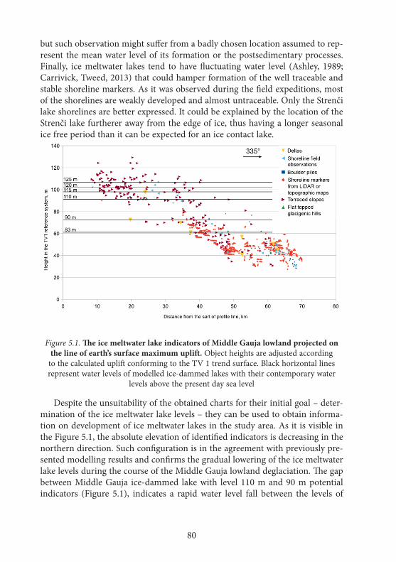
80
but such observation might suffer from a badly chosen location assumed to rep-resent the mean water level of its formation or the postsedimentary processes. Finally, ice meltwater lakes tend to have fluctuating water level (Ashley, 1989; Carrivick, Tweed, 2013) that could hamper formation of the well traceable and stable shoreline markers. As it was observed during the field expeditions, most of the shorelines are weakly developed and almost untraceable. Only the Strenči lake shorelines are better expressed. It could be explained by the location of the Strenči lake furtherer away from the edge of ice, thus having a longer seasonal ice free period than it can be expected for an ice contact lake.
Figure 5.1. The ice meltwater lake indicators of Middle Gauja lowland projected on the line of earth’s surface maximum uplift. Object heights are adjusted according
to the calculated uplift conforming to the TV 1 trend surface. Black horizontal lines represent water levels of modelled ice-dammed lakes with their contemporary water
levels above the present day sea level
Despite the unsuitability of the obtained charts for their initial goal – deter-mination of the ice meltwater lake levels – they can be used to obtain informa-tion on development of ice meltwater lakes in the study area. As it is visible in the Figure 5.1, the absolute elevation of identified indicators is decreasing in the northern direction. Such configuration is in the agreement with previously pre-sented modelling results and confirms the gradual lowering of the ice meltwater lake levels during the course of the Middle Gauja lowland deglaciation. The gap between Middle Gauja ice-dammed lake with level 110 m and 90 m potential indicators (Figure 5.1), indicates a rapid water level fall between the levels of
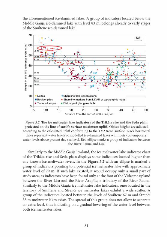
81
the aforementioned ice-dammed lakes. A group of indicators located below the Middle Gauja ice-dammed lake with level 83 m, belongs already to early stages of the Smiltene ice-dammed lake.
Figure 5.2. The ice meltwater lake indicators of the Trikāta rise and the Seda plain projected on the line of earth’s surface maximum uplift. Object heights are adjusted
according to the calculated uplift conforming to the TV2 trend surface. Black horizontal lines represent water levels of modelled ice-dammed lakes with their contemporary
water levels above present day sea level. Red ellipse marks a group of indicators between the River Rauna and Lisa
Similarly to the Middle Gauja lowland, the ice meltwater lake indicator chart of the Trikāta rise and Seda plain displays some indicators located higher than any known ice meltwater levels. In the Figure 5.2 with an ellipse is marked a group of indicators pointing to a potential ice meltwater lake with approximate water level of 79 m. If such lake existed, it would occupy only a small part of study area, as indicators have been found only at the foot of the Vidzeme upland between the River Lisa and the River Ārupīte, a tributary of the River Rauna. Similarly to the Middle Gauja ice meltwater lake indicators, ones located in the territory of Smiltene and Strenči ice meltwater lakes exhibit a wide scatter. A group of the indicators located between the levels of Smiltene 67 m and Strenči 58 m meltwater lakes exists. The spread of this group does not allow to separate an extra level, thus indicating on a gradual lowering of the water level between both ice meltwater lakes.
82
5.2. The spatial distribution of ice meltwater lakes and their position in the palaeohydrological network
In the course of deglaciation the hydrological network went trough rapid changes and ice meltwater lakes formed an important part of it. The develop-ment of the hydrological network of the study area started in the Middle Gauja lowland, where the first ice-dammed lakes formed and were accompanied by the development of their inflowing river valleys. The modelled ice-dammed lakes do not reveal any possible drainage routes from the Middle Gauja ice-dammed lake with levels between the 110 and 125 m. This is in contrary to the recon-structions provided by Kvasov (Kvasov, 1975), whose reconstruction contains a drainage trough the Gulbene interlobate high. Exploration of present day ice contact lakes indicates the possibility of their existence without overland drain-age (Bennett et al., 2000). Such lakes most likely have a subglacial drainage or drain trough ground waters (ibid.). In the territory of the Middle Gauja lowland no evidence of subglacial drainage or drainage with groundwater through the Gulbene interlobate high of aforementioned lakes has been found. Infiltration of large volumes of water at the Late-glacial time is questionable as the water bearing beds most likely were close to being saturated (Saks et al., 2012). The lack of the overland drainage from the Middle Gauja ice-dammed lakes is problematic as in such case evaporation from the lake surface should exceed the volume of run off from several inflowing rivers and the melting of ice. In the case of the Middle Gauja ice lobe being stagnant, an ice contact – supraglacial lake could form and thus accumulate larger volume of water at the expense of its area increase. The question of Middle Gauja ice-dammed lake being similar to Agassiz lake Moorhead phase and performing a water level drop at drainage-less conditions (Lowell et al., 2013) could be solved by performing a coupled ice-climate-lake modelling.
The comparison of the Middle Gauja ice-dammed lake with the reconstruc-tions of the 115 and 110 m levels indicates the occurrence of glaciolacustrine sediments in some areas (Juškevičs, Skrebels, 2002b) located in between both lakes but not covered by any of them. Such areas can be found on the proximal part of the Velēna end moraine and in the vicinity of Trapene. According to an older genetic interpretation of the Quaternary sediments (Juškevičs, 1964), similar belt is located between the area occupied by 110 m model and the Silakti kame terrace forming glaciofluvial sediments. At the same time there are some till covered areas located under the level of the Middle Gauja 110 m lake. Afore-mentioned facts indicate the incorrectness of the ice margin used in the recon-struction of the Middle Gauja 115 m lake. It is safe to assume, that the particular lake was extending more northwards than the reconstruction is indicating it. Some of borehole data indicate presence of clays and varved clays in the Middle Gauja lowland. The model of the Middle Gauja ice-dammed lake with the level
83
of 110 m indicates a shallow water (depth less than 10 m) conditions reflected in a such borehole. In the meantime, in other boreholes located in a hypsomet-rically lower position no clays have been found. The studies of the ice meltwater lakes in Estonia (Hang, 2001) indicate a minimum depth of 15 to 20 m for the formation of the varved clays. Such unconformity between the depth indicated by closely located sediments, existence of till and glaciolacustrine sediments at the same hypsometricall level both indicate on wider distribution of Middle Gauja ice meltwater lake on a top of the buried ice. Eberhards (Eberhards, 2006) stated that accumulation of glaciolacustrine sediments on the top of buried ice is a common feature for the Peribaltic region.
Taking into account water inflow from the Peipsi ice-dammed lake into the Smiltene ice-dammed lake, the latter should have an outflow to maintain a lower water level than in the Peipsi lake. Āboltiņš (Āboltiņš, 1971) indicates that the threshold between the River Lisa and Rauna is located at the 70 to 72 m a.s.l. and is above any known ice-dammed lake. Such claim contradicts with the existence of many potential shoreline indicators (boulder piles, erosional terraces) up to 80 m a.s.l. in the particular area. The reconstruction of Smiltene ice-dammed lake with level of 75 m a.s.l. indicates no obstacles to its drainage into the direc-tion of the River Rauna.
The water level of Smiltene 75 m ice-dammed lake was high enough to drain trough several depressions in the central part of the Trikāta rise, still no evi-dence of water flow at so high level has been found. The drainage of Smiltene 70 m ice-dammed lake trough the River Rauna was not possible due to threshold between the River Lisa and the River Rauna being located above the lake level. It indicates that the water level and drainage locations were controlled by the retreat of the Burtnieks ice lobe. Subsequent opening of depressions suitable for the drainage from the Smiltene ice-dammed lake, resulted in a level fall and abandonment of previous drainage locations (Nartišs, Zelčs, 2011).
Moora et al. (Moora et al., 2002) indicates the lack of the connection between Laatre and Strenči ice meltwater lakes. The reconstructions produced during this study indicate existence of connection between both lakes starting from Smiltene 70 m ice-dammed lake to Strenči 53 m proglacial lake. Such connection would allow a free water flow from one lake into another, as it has been previously indicated also by Rosentau (Rosentau, 2006). At the time of the Smiltene ice-dammed lake, the ice margin was located in the Valga plain and later – in the Võrtsjärv lowland. As the ice blocked the drainage to the present day drainage direction from the Laatre ice meltwater lake territory, it is safe to assume a water flowing into the direction of the Smiltene ice-dammed lake. The direction of water flow, if any, between Laatre and Strenči ice meltwater lakes is unknown.
According to the data of Āboltiņš (Āboltiņš, 1971), the 4th terrace of the River Gauja is traceable starting from the river mouth of the River Abuls. It is located at 50.5-51.5 m a.s.l. The presence of a river terrace indicates the drainage
84
through the River Gauja as soon as the water level of Strenči ice meltwater lake fells to this level. The study of the internal composition of the 3rd terrace of the River Gauja below the Valmiera town indicated sedimentation in a glaciolacus-trine lake bordering with a dead ice (Krievāns et al., 2013). Such interpretation of sediments indicates the potential of spreading of Strenči ice meltwater lakes further downstream into the present day Gauja valley. Drainage from the Strenči meltwater lake trough the River Gauja should have been hampered by presence of the dead ice in it. Accordingly the 3rd terrace of the River Gauja bears an erosional character and its sediments have been accumulated before Strenči 46 m remnant lake which drainage can be connected with the particular terrace.
There are no well traceable terraces present in the River Seda valley in be-tween the Seda plain and Lake Burtnieks. A palaeodelta with surface elevation of 43.5-42.5 m a.s.l. is located at the mouth of the contemporary River Seda (Eber-hards, 2006), which has been connected with the Palaeoburtnieks 44 m stage (ibid.). According to the results of modelling, the separation of rivers Seda and Gauja catchments happened only after the drainage of the Strenči 46 m remnant lake. It is not known at which point the drainage through the River Seda started. Drainage through the River Seda could be possible from the Strenči ice melt-water lakes with levels of the 53, 50 and 46 m, but most likely during the first one a dead ice has been blocking the valley. According to Eberhards (Eberhards, 2006), the River Seda valley was partially filled with glaciofluvial sediments and thus, the drainage into the direction of Lake Burtnieks started only during the Youngest Dryas. If such interpretation is correct, no drainage from Strenči lakes to Lake Burtnieks has existed as the last of the modelled Strenči remnant lakes ceased to exist already during the Allerød oscillation.
5.3. The timing and duration of ice meltwater lake existence
The first step in the determination of ice meltwater lake age is the identi-fication of their landforms or sediments. The large parts of the study area glaciolacustrine sediments are covered by aeolian sediments (Juškevičs, 1964; Juškevičs, 1965; Juškevičs, Skrebels, 2002b). Separation of aeolian and sandy gla-ciolacustrine sediments can be hindered by similarity of sedimentary structures (Otvos, 2000; Munyikwa et al., 2012).
Sediment samples from several outcrops were analysed by means of gran-ulometric and sand quartz grain surface rounding and frosting analysis to determine the sedimentary environment and its properties. In two of outcrops – Niedr upīte and Mieļupīte – those analysis methods were crucial in interpretation of the genesis of sediments. In several sites a dune and its base were sampled, thus allowing a comparison of aeolian and their substratum (glaciolacustrine) sediment textural properties. At the whole Garengrīda outcrop a similar to the Mieļupīte site bimodal grain size distribution was observed (Nartišs et al., 2012).
85
Glaciolacustrine sediments of the Garengrīda site revealed the positively skew-ness but aeolian – nearly symmetrical. At the same time in the Silezers site no significant differences in granulometric properties between glaciolacustrine and overlaying aeolian sediments were observed. Most of the Silezers site samples were found to consist of well sorted fine sand with unimodal, nearly symmetri-cal grain size distribution (Kalińska et al., 2013).
The rounding and frosting analysis of Garengrīda and Silezers outcrops do not show any significant differences between the glaciolacustrine and aeolian parts of profiles. The only samples exhibiting a difference are ones located on the contact between both sedimentary units. Significant differences of sediment textural properties can be observed when comparing them between different sites. At the Garengrīda site a dominance (up to 60 %) of partially rounded matt (EM/RM) grains is observable. This type of grains usually are associated with an aeolian environment (Lindé, Mycielska-Dowgiałło, 1980; Woronko, 2001). At the Silezers site in both parts of the profile the non-abraded matt (NU/M) grains dominate (up to 70%). Such grains are considered to indicate on a short transportation in an aeolian medium (Bull, Morgan, 2007). In Garengrīda, Silezers, Mieļupīte and Niedrupīte sites a presence of well-rounded shiny (EL) grains was noted and almost all of sites exhibited a strong presence (up to 10%) of partially-rounded shiny (EM/EL) grains. Aforementioned grain types are typical for fluvial and beach environments (Mycielska-Dowgiałło, Woronko, 1998; Mycielska-Dowgiałło, Woronko, 2004; Woronko, 2012). Even a short transportation in aeolian medium should result in a matting of their surface (transformation into RM or EM/RM grains) (Lindé, Mycielska-Dowgiałło, 1980; Mycielska-Dowgiałło, Woronko, 1998; Bull, Morgan, 2007). Similar preservation of source sediment textural features have been noted also in other areas of inland aeolian sediments of Latvia, Estonia (Kalińska et al., 2012; Kalińska, Nartišs, 2013a; Kalińska, Nartišs, 2013b) and Sweden (Mycielska-Dowgiałło, 1993). The lack of distinctness of sediment textural features both in the sediments of dif-ferent and the same origin hinders the use of sand grain rounding and frosting analysis method for separation of glaciolacustrine from their overlaying aeolian sediments.
An accurate determination of the absolute age of small ice meltwater lakes can be hard or even impossible as the length of their existence can be smaller than the uncertainty of applied dating method (LaRocque et al., 2003b). The chronology of such lakes can be reconstructed only indirectly by means of the regional deglaciation pattern or formation of the related landforms (ibid.). Within the study area few sites with glaciolacustrine, glaciofluvial or their cov-ering aeolian sediments have been dated. Dating of aeolian cover topping allows to establish the minimum age of their underlying ice meltwater lake sediments. The dating results of Zeltiņi and Garengrīda sites are similar and allow to pre-sume the age of the Middle Gauja ice-dammed lakes with levels from 120 m to
86
90 m a.s.l. to be 15.9 to 15.7 ka. Single date of glaciofluvial delta at the Silkalni site has revealed the sediment accumulation before 16.9 ka but the uncertainty of obtained age is 3.1 ka, thus overlapping with ages of Zeltiņi and Garengrīda sites. None of created Middle Gauja ice-dammed lake models reaches the sur-roundings of the Silkalni delta, although it can be hypsometrically correlated with the Middle Gauja 115 m a.s.l. ice-dammed lake, the ice margin used for modelling does not allow its expansion till the Silkalni delta site.
The date of aeolian sediments covering the glaciolacustrine sediments at the Garengrīda site indicates the minimum age of the water drainage from the most of the Trapene plain before 14.4 ka. Depending on the ice margin configuration, Lake Tamula has been a part of the Middle Gauja ice-dammed lake with level of 90, 83 m and, probably, 110 m a.s.l. At the time of Smiltene 75 m ice-dammed lake, Lake Tamula was not any more a part of modelled ice-dammed lakes. The accumulation of glaciolacustrine sediments in Lake Tamula has started before 14.7 ka (Sandgren et al., 1997; Kalm, 2006). Such age is in conformance with dating at the Garengrīda site indicating the minimum age of the Middle Gauja 90 m lake to be before 14.4 ka.
At the moment there are no direct absolute age datings of the Smiltene ice-dammed lake. According to the obtained palaeogeographical reconstructions, the Smiltene ice-dammed lake is younger than the Middle Gauja ice-dammed lake, thus setting the maximum age of the Smiltene lakes at 14.7 ka. According to the model of the Smiltene ice-dammed lake with level of 67 m a.s.l., it has extended to Lake Nakri site in the Valga plain. The accumulation of organic sediments within Lake Nakri has started before 14.0 (Amon et al., 2012) thus setting the minimum age of the Smiltene ice-dammed lake. All attempts to date the Smiltene ice-dammed lake based on deltas formed within this lake so far have been unsuccessful.
The basis of dune at the Silezers site has been submerged under the water of Strenči 58 m proglacial lake and has raised above the water after water fell down to form Strenči 53 m a.s.l. proglacial lake. The OSL dating of sediments located below the Silezers site dune has yielded age of 13.7 ka and from the dune itself – 13.4 ka. At the same time reconstructions of Strenči 58 and 53 m proglacial lakes have shown a connection with Lake Nakri, indicating them being younger than 14.0 ka (Amon et al., 2012). A single date of aeolian sediments from a dune within the Seda mire indicates on aeolian accumulation before 13.7 ka. The sampled dune has been located in the shallow water or coastal setting starting from Strenči 46 m lake. Thus it is possible to assume the final water level fall in Strenči palaeolake being around that time. This age matches the age of the Pandivere ice-marginal zone when the edge of the Fennoscandian Ice Sheet was located in the northern part of Estonia (Vassiljev, Saarse, 2013). Such age of Strenči palaeolakes confirm the idea of the ice meltwater not being the main water source and classification of them as a remnant lakes.
87
The fact that 7 of 18 successfully analysed OSL samples do not represent the expected age of the last deposition of sediments, indicates the complexity of OSL dating method use for reconstruction of the Late-glacial event chronology. The uncertainty of most of the successful samples is larger than the expected duration of existence of the dated ice meltwater lakes. Large uncertainty does not allow to make conclusions on duration of the separate ice meltwater lake stages. Most of the studied ice meltwater lakes lack varve clay sediments that would provide an alternative mean of determining the duration of their existence. A local varve chronology of two ice-dammed lakes from the Saadjärv drumlin field in Estonia has shown the duration of such lakes being from 60 to 80 varve years (Rosentau et al., 2007b). In the case of Strenči proglacial and remnant lakes, the duration of separate stages could be in a similar range, as it is indicated by the OSL dates and relation to other palaeolakes. Middle Gauja and Smiltene ice-dammed lakes have been existing for a longer time spans. According to the deglaciation model of the Middle Gauja lowland, the ice-dammed lakes should have been existing in its territory for at least one thousand years. This leaves a time gap of less than thousand years for existence of all three Smiltene ice-dammed lakes.

88
CONCLuSIONS
The obtained ice meltwater lake reconstructions of the Middle Gauja and eastern part of Northern Vidzeme lowlands indicate a complex retreat of the Late Weichselian glaciation. Literature sources contain only three main ice-mar-ginal zones related to the study area (Zelčs, Markots, 2004; Zelčs et al., 2011). To support modelling of the ice meltwater lakes, a total of seven new ice recession marking lines were constructed. As the basis for the construction of the extra lines the distribution of different genesis Quaternary sediments or recessional landforms was used. The melting of ice thus unlocking lower located potential drainage valleys has resulted in a sequence of the ice meltwater lakes with falling water level and changing spatial distribution. Hypsometrically higher located, early ice-dammed lakes had unstable water level and, most likely, prolonged seasonal ice cover, as it is indicated by the weakly developed shoreline markers. Some of the Middle Gauja ice-dammed lake levels have developed on the buried ice thus even further hindering their reconstruction. The shorelines of the latter, hypsometrically lower located ice meltwater lakes are better traceable and thus indicate more stable condition probably with a shorter seasonal ice covering. Although the scatter of elevations of the ice meltwater lake levels point on the water level fluctuations in all studied lakes.
Developed reconstructions of the Middle Gauja ice-dammed lakes with the 125, 120 and 115 m a.s.l. water levels do not indicate any potential drainage locations. As no coupled ice-climate-lake modelling was performed, it is hard to say if those lakes could actually exist without outflow. All of ice meltwater lakes with their water levels being lower than 110 m a.s.l. had connections with other palaeolakes of their existence time (Peipsi, Laatre – Võrtsjärv) or had depres-sions and valleys suitable for water drainage. Quite often a single ice meltwater lake had a multiple potential drainage locations, thus hindering creation of unambiguous palaeogeographical reconstructions.
The modelling indicates the existence of strait-like connection between Middle Gauja and Peipsi lakes during the Middle Gauja ice-dammed lakes with levels of 90 and 83 m a.s.l. At the time of the Smiltene ice-dammed lake with level of 75 m a.s.l., water from Peipsi direction was flowing into the direction of the Smiltene ice-dammed lake. The connection with Lake Võrtsjärv through the Laatre ice meltwater lake was operational since the formation of the Smiltene 70 m a.s.l. ice-dammed lake. Both lakes remained connected till the drainage of Strenči 53 m a.s.l. proglacial lake. The separation between the catchments of the River Gauja and Seda happened only after the drainage of last of the modelled lakes – Strenči remnant lake with level of 46 m a.s.l.
Obtained OSL dating results and ice meltwater reconstructions allow to set the start of the formation of the ice meltwater lakes at 15.8 ka in the Middle Gau-ja lowland and the end – before 13.7 ka – after the final drainage of the Strenči
89
remnant lake. The large uncertainty and low success rate of obtained OSL dates prevents establishing of the detailed absolute age chronology of the studied lakes. Nevertheless a new information on the spatiotemporal distribution, morphology and development of ice meltwater lakes within the study area was obtained.
The removal of the glacioisostatic adjustment from the enhanced DEM allowed to identify several separate field observations of the ice meltwater lake shorelines as belonging to the same ice meltwater lake. Such finding confirms the importance of evaluation of the glacioisostatic adjustment during the recon-struction of ice meltwater lakes within the areas covered by ice sheets.
The applied methods of analysis of the sediment textural features did not al-low to unambiguously separate the sandy glaciolacustrine sediments from their covering aeolian sediments. Although applied methods have been used in other parts of the world with a success, the results of this study indicate the problems of their application on identification of the sediment genesis of the Late-glacial sediments of Latvia.
The results of the study allow to conclude that the division of ice meltwater lakes into Middle Gauja, Smiltene and Strenči lakes as used by Āboltiņš (Ābolt-iņš, 1971; Straume, 1978; Straume, 1979) should be used instead of merging those lakes into a single, large ice meltwater lake, as it has been done by other authors (Kuršs, Stinkule, 1969; Kvasov, 1975; Zelčs, Markots, 2004). Although being a part of ice meltwater sequence, they are clearly separated in time and space. The transition from Middle Gauja in to Smiltene ice meltwater lake is connected with opening of the passage between Middle Gauja lowland and Seda plain in the Aumeisteri interlobate hilly area. The transition from Smiltene to Strenči ice meltwater lake is marked by lowering of the water below 60 m a.s.l. Such water level resulted into almost complete retreat of water from the Trikāta rise and part of the Seda plain located in the vicinity of the Smiltene town. Taking into account the spatial overlap of Smiltene and Strenči lakes, the use of Smiltene-Strenči lake could also be acceptable.
The fact of obtaining ice meltwater lake reconstructions, information on their relative and absolute age, position in the palaeohydrological network allow to conclude that the aim of research has been achieved. Obtained palaeogeo-graphical reconstructions have been used to interpret development of inland dunes of the study area. Enhancements of GRASS GIS analysis methods have been included in to the official source code repository and will be released as a part of GRASS GIS 7. The developed sediment granulometric analysis and visualization module has been used to process and visualize data for several conference presentations, one master thesis and two papers (in preparation). The enhancements and obtained insights of ice meltwater lake reconstruction methods can be applied on ice meltwater lake reconstructions of other parts of the Fennoscandian Ice Sheet. Obtained palaeogeographical reconstructions – for local and regional level Late-glacial environmental interpretations.

90
ACKNOWLeDGeMeNTS
My utmost gratitude to my supervisor, Professor, Dr. Geol. Vitālijs Zelčs for his endurance in keeping up a scientific discussion and generous support within all these long years. I’m thankful to my friends, colleges and all support-ers for their assistance in the field, fruitful discussions and scientific disputes thus allowing to reach the aim of this study and a lot more. Thanks to (in alphabetical order) Ivars Celiņš, Māris Dauškans , Māris Krievāns, Aivars Līcis, Aivars Markots, Agnis Rečs, Tomas Saks and others. I would like to express my gratitude to my wife Edyta Kalińska-Nartiša for constant support and encour-agement to aim for more. Sincere thanks to my daughter Anete for being so understanding.
This work has been supported by the European Social Fund within the pro-ject „Support for Doctoral Studies at University of Latvia”.
Parts of the work have been developed within following projects:• LatvianCouncilofSciencethematicresearchproject09.1568• LatvianCouncilofSciencegrantZ-6198• LatvianCouncilofScienceresearchgrant05.1498• UniversityofLatviaresearchproject2007/ZP-87
91
IZMANTOTā LITeRATūRA / RefeReNCeS
Āboltiņš, O.P., 1971. Razvitije dolini reki Gauja [Gaujas ielejas attīstība], Zinātne, Riga, p. 105.Āboltiņš, O.P., 1975. Glaciodynamic peculiarities of formation of Latvian elevations. Problems
of Quaternary geology, 8, pp. 5–23.Āboltiņš, O.P., 1989. Gliatsiastruktura lednikovy morfogenez [Glaciostruktūras un ledāja mor-
foģenēze], Zinātne, Rīga, p. 284.Āboltiņš, O.P., Veinbergs, I.G., Eberhards, G., 1974a. O formirovanii predfrontalnih vod-
no-lednikovih basseinov i dolinno-recnoi seti vo vremja degradacii lednika poslednego oledenenija na territorii Latviiskoi SSR [Pēdējā apledojuma degradācijas laika Latvijas PSR teritorijas ledājkušanas ūdeņu baseini un upju ieleju tīkla veidošanās]. In: G. Biske, A. Mi-kalauskas (eds.), Predfrontalnie kraevije lednikovie obrazovanija [Ledāja malas frontālie veidojumi], Mintis, Vilnius, pp. 60–85.
Āboltiņš, O.P., Mikalauskas, A., Raukas, A., 1974b. Osobennosti rasprostranenija predfron-talnih vodno-lednikovih obrazovanii poslednego oledenenija na territoriji Priblatiki i ne-kotorije voprosi ih formirovanija [Baltijas teritorijas pēdējā apledojuma frontālo veidojumu izplatības īpatnības un atsevišķas to veidošanās problēmas]. In: G. Biskje, A. Mikalauskas (eds.), Predfrontalnie kraevije lednikovie obrazovanija [Ledāja malas frontālie veidojumi], Mintis, Vilnius, pp. 36–43.
Adams, K., Wesnousky, S., 1998. Shoreline processes and the age of the Lake Lahontan high-stand in the Jessup embayment, Nevada. GSA Bulletin, 110, pp. 1318–1332.
Amon, L., Veski, S., Heinsalu, A., Saarse, L., 2012. Timing of Lateglacial vegetation dynamics and respective palaeoenvironmental conditions in southern Estonia: evidence from the sediment record of Lake Nakri. Journal of Quaternary Science, 27(2), pp. 169–180.
Anthony, E.J., Héquette, A., 2007. The grain-size characterisation of coastal sand from the Somme estuary to Belgium: Sediment sorting processes and mixing in a tide- and storm-dominated setting. Sedimentary Geology, 202(3), pp. 369–382.
Ashley, G.M., 1989. Classification of glaciolacustrine sediments. In: R. P. Goldthwait, C. L. Matsch (eds.), Genetic Classification of Glacigenic Deposits, Balkema, Rotterdam, pp. 243–260.
Ashley, G.M., 1995. Glaciolacustrine Environments. In: J. Menzies (ed.), Modern Glacial En-vironments: Processes, dynamic and sediments, Butterworth-Heinemann, Oxford, London, pp. 417–444.
Atwood, G., 2006. Shoreline Superelevation: Evidence of Coastal Processes of Great Salt Lake, Utah. The University of Utah, p. 231.
Basalikas, A., 1970. Problemi izuchenija pozdnelednikovih ozjernih vodoemov [Vēlā le-duslaikmeta ezerveida ūdenstilpju izpētes problēmas]. In: M.V. Kaibaliene, S.V. Kalesnik, D.D. Kvasov, V.J. Klane, I.N. Klimkaite, N.V. Korde, C.P. Kudaba, A.P. Kuderskii (eds.), Istorija ozer. Trudi Vsesojuznogo simpoziuma po osnovnim problemam presnovodnix ozer (25-29 maja 1970 g.) [Ezeru vēsture. Saldūdens ezeru galvenajām problēmām veltītā Vissav-ienības simpozija raksti (25-29 maijs, 1970. g.)], Vilnius, pp. 158–178.
Benn, D., Evans, D., 1998. Glaciers and glaciation, Arnold, London, p. 734.Bennet, M.R., Glasser, N.F., 1998. Glacial Geology. Ice Sheets and Landforms, John Wiley &
Sons, Chichester, New York, Brisbene,Toronto, Singapore, p. 364.Bennett, M.R., Huddart, D., McCormick, T., 2000. An integrated approach to the study of gla-
ciolacustrine landforms and sediments: a case study from Hagavatn, Iceland. Quaternary Science Reviews, 19(7), pp. 633–665.
92
Biske, G., Danilāns, I., Mikalauskas, A., Raukas, A., 1974. K istorii issledovanija i sostojaniju izucenosti predfrontalnih lednikovih obrazovanii Pribaltiki i Karelii [Baltijas un Karēlijas ledāja malas frontālo veidojumu izpētes pakāpe un pētījumu vēsture]. In: G. Biske, A. Mi-kalauskas (eds.), Predfrontalnie kraevije lednikovie obrazovanija [Ledāja malas frontālie veidojumi], Mintis, Vilnius, pp. 7–24.
Bitinas, A., Karmazienė, D., Jusienė, A., 2004. Glaciolacustrine kame terraces as an indicator of conditions of deglaciation in Lithuania during the Last Glaciation. Sedimentary Geology, 165(3-4), pp. 285–294.
Bull, P.A., Morgan, R.M., 2007. Sediment fingerprints: a forensic technique using quartz sand grains. Science & justice: journal of the Forensic Science Society, 46(2), pp. 107–124.
Cailleux, A., 1942. Les actions éoliennes périglaciaires en Europe, Société géologique, Paris, p. 176.
Carrivick, J.L., Tweed, F.S., 2013. Proglacial lakes: character, behaviour and geological impor-tance. Quaternary Science Reviews, 78, pp. 34–52.
Celiņš, I., Nartišs, M., 2011. Iekšzemes kāpas Sedas līdzenumā. Latvijas Universitātes Raksti. Zemes un vides zinātnes, 767, lpp. 6–16.
Celiņš, I., Buylaert, J.P., Murray, A.S., Nartišs, M., Thiel, C., Zelčs, V., 2013. Optiski stimulētās luminiscences datēšanas metodes problemātika iekšzemes eolo nogulumu vecuma no-teikšanai Latvijā. In: Ģeogrāfija. Ģeoloģija. Vides zinātne. Referātu tēzes. Latvijas Univer-sitāte, Rīga, lpp. 297–299.
Clayton, J.A., Knox, J.C., 2008. Catastrophic flooding from Glacial Lake Wisconsin. Geomor-phology, 93(3-4), pp. 384–397.
Clark, J.A., Befus, K.M., Hooyer, T.S., Stewart, P.W., Shipman, T.D., Gregory, C.T., Zylstra, D.J., 2008. Numerical simulation of the paleohydrology of glacial Lake Oshkosh, eastern Wis-consin, USA. Quaternary Research, 69(1), pp. 117–129.
Clarke, G., Leverington, D., Teller, J., Dyke, A., 2003. Paleoclimate. Superlakes, megafloods, and abrupt climate change. Science (New York, N.Y.), 301(5635), pp. 922–923.
Clarke, G.K.C., Leverington, D.W., Teller, J.T., Dyke, A.S., 2004. Paleohydraulics of the last outburst flood from glacial Lake Agassiz and the 8200BP cold event. Quaternary Science Reviews, 23(3-4), pp. 389–407.
Collinson, J.D., 1978. Lakes. In: Sedimentary Environments and Facies, Elsevier, New York, pp. 61–79.
Danilāns, I., 1973. Chetvetichnie otlozhenija Latvii [Latvijas kvartāra nogulumi], Zinatne, Riga, p. 312.
Danilāns, I., Gavena, I., 1995. Latviešu-krievu un krievu-latviešu ģeoloģisko terminu vārdnīca, Latvijas Universitāte, Rīga, lp. 278.
Dauškans, M., 2013. Kēmu terases Austrumlatvijas augstienēs, V. Segliņš (ed.), LU Akadēmi-skais apgāds, Rīga, lp. 126.
Dreimanis, A., 1979. The problems of waterlain tills. In: C. Schlüchter (ed.), Moraines and Varves; Origin, Genesis, Classification, Balkema, Rotterdam, pp. 167–177.
Eberhards, G., 1973. Morfogenez dolini r. Salaci [Salacas upes ielejas morfoģenēze]. Uchenie zapiski Latviiskogo gosudarstvennogo universiteta imeni Petra Stuchki, 186(II), pp. 21–29.
Eberhards, G., 1975. Rol prilednikovih i izolirovannih vodoemov v formirovanii rechnih do-lin (na premere Latvii) [Pieledāja un izolēto baseinu loma upju ieleju veidošanā (Latvijas piemērs)]. In: D. D. Kvasov (ed.), Istorija ozer v pleistocene. IV Vsesojuznii simpozium po istorii ozer [Ezeru vēsture pleistocēnā. IV Vissavienības ezeru vēstures simpozijs], Institut ozerovedenija Akademii Nauk SSSR, Leningrad, pp. 77–82.
Eberhards, G., 2006. Geology and development of the palaeolake Burtnieks during the Late Glacial and Holocene. Acta Archaeoligica Lundensia, 8(52), pp. 25–53.

93
Edwards, M.B., 1978. Glacial Environments. In: H. G. Reading (ed.), Sedimentary Environ-ments and Facies, Elsevier, New York, pp. 416–438.
Ekman, M., 1996. A consistent map of the postglacial uplift of Fennoscandia. Terra Nova, 8(2), pp. 158–165.
Embleton, C., King, C.A.M., 1968. Glacial and Periglacial Geomorphology, Edward Arnold, London, p. 608.
Estonian Land Board, 2013. Grayscale hillshading based on lidar elevation data. Webpage. Estonian Land Board. Pieejams: http://kaart.maaamet.ee/wms/fotokaart?
Fieller, N., Flenley, E., 1987. Statistical Analysis of Particle Sizes and Sediments. In: C.L.N. Rug-gles, S.P.Q. Rahtz (eds.), Computer and quantitative methods in archaeology, British Arch Reports, Oxford, pp. 79–94.
Fisher, T.G., Smith, D.G., Andrews, J.T., 2002. Preboreal oscillation caused by a glacial Lake Agassiz flood. Quaternary Science Reviews, 21(8-9), pp. 873–878.
Folk, R.L., Ward, W.C., 1957. Brazos River bar: a study in the significance of grain size param-eters. Journal of Sedimentary Petrology, 27(1), pp. 3–26.
GRASS Development Team, 2012. Geographic Resources Analysis Support System (GRASS GIS) Software.
Grīnbergs, E.F., 1957. Pozdnelednikovaja i poslelednikovaja istorija poberezhja Latviskoi SSR [Latvijas PSR piekrastes vēlā leduslaikmeta un pēcleduslaikmenta vēsture], Izdatelstvo akademii nauk Latviskoi SSR, Riga, p. 127.
Guobytė, R., Satkūnas, J., 2011. Pleistocene glaciations in Lithuania. In: J. Ehlers, P.L. Gibbard, P.D. Hughes (eds.), Developments in Quaternary Sciences, Elsevier, Amsterdam, pp. 231–246.
Hajek, E.A., Huzurbazar, S.V., Mohrig, D., Lynds, R.M., Heller, P.L., 2010. Statistical Charac-terization of Grain-Size Distributions in Sandy Fluvial Systems. Journal of Sedimentary Research, 80(2), pp. 184–192.
Håkanson, L., 1977. The influence of wind, fetch, and water depth on the distribution of sediments in Lake Vänern, Sweden. Canadian Journal of Earth Sciences, 14(3), pp. 397–412.
Håkanson, L., Jansson, M., 1983. Principles of Lake Sedimentology, Springer-Verlag, Berlin, p. 316.
Hang, T., 2001. Proglacial sedimentary environment, varve chronology and Late Weichselian de-velopment of Lake Peipsi, eastern Estonia, Academitryck AB, Stockholm, p. 44.
Hanson, M.A., Lian, O.B., Clague, J.J., 2012. The sequence and timing of large late Pleistocene floods from glacial Lake Missoula. Quaternary Science Reviews, 31, pp. 67–81.
Hostetler, S.W., Bartlein, P.J., Clark, P.U., Small, E.E., Solomon, A.M., 2000. Simulated influ-ences of Lake Agassiz on the climate of central North America 11,000 years ago. Nature, 405(May), pp. 1998–2001.
IPCC, 2007. Summary for Policymakers. In: S. Solomon, D. Quin, M. Manning, Z. Chen, M. Marquis, K.B. Averyt, M. Tignor, H.L. Miller (eds.), Climate Change 2007: The Physical Science Basis. Contribution of Working Group I to the Fourth Assessment Report of the Inter-governmental Panel on Climate Change, Cambridge University Press, Cambridge.
Jansen, E., Overpeck, J., Briffa, K.R., Duplessy, J.C., Joos, F., Masson-Delmotte, V., Olago, D., Otto-Bliesner, B., Peltier, W.R., Rahmstorf, S., Ramesh, R., Raynaud, D., Rind, D., Solomi-na, O., Villalba, R., Zhang, D., 2007. Palaeoclimate. In: S. Solomon, D. Quin, M. Manning, Z. Chen, M. Marquis, K.B. Averyt, M. Tignor, H.L. Miller (eds.), Climate Change 2007: The Physical Science Basis. Contribution of Working Group I to the Fourth Assessment Report of the Intergovernmental Panel on Climate Change, Cambridge University Press, Cambridge.
Juškevičs, V., 1964. Kvartāra nogulumu ģeoloģiskā karte. In: Ģeoloģiskās un hidroģeoloģiskās kartēšanas pārskats, O-35-XXI lapas dienviddaļa, Latvijas ģeoloģijas pārvalde, Rīga, p. 1.
94
Juškevičs, V., 1965. Kvartāra nogulumu ģeoloģiskā karte. In: Ģeoloģiskās un hidroģeoloģiskās kartēšanas pārskats, O-35-XX lapa, Latvijas ģeoloģijas pārvalde, Rīga, p. 1.
Juškevičs, V., 1999a. Dabas apvidu karte. Rīga-43.lapa un Ainaži-53.lapa. In: O. P. Āboltiņš (ed.), Latvijas ģeoloģiskā karte. M 1 : 200 000, Valsts ģeoloģijas dienests, Rīga, lp. 1.
Juškevičs, V., 1999b. Kvartāra nogulumi, Rīga-43.lapa un Ainaži-53.lapa. In: O. P. Āboltiņš (ed.), Latvijas ģeoloģiskā karte. M 1 : 200 000, Valsts ģeoloģijas dienests, Rīga, lp. 1.
Juškevičs, V., Skrebels, J., 2002a. Dabas apvidu karte. Alūksne, Viļaka, Valka 44., 45., 54. lapa. In: O. P. Āboltiņš, A. Brangulis (eds.), Latvijas ģeoloģiskā karte. M 1 : 200 000, Valsts ģeo-loģijas dienests, Rīga, lp. 1.
Juškevičs, V., Skrebels, J., 2002b. Kvartāra nogulumi. Alūksne, Viļaka, Valka 44., 45., 54. lapa. In: O. Āboltiņš, A.J. Brangulis (eds.), Latvijas ģeoloģiskā karte. M 1 : 200 000, Valsts ģeo-loģijas dienests, Rīga, lp. 1.
Juškevičs, V., Skrebels, J., 2002c. Zemkvartāra virsmas reljefa karte. Alūksne, Viļaka, Valka 44., 45., 54. lapa. In: O. P. Āboltiņš, A. Brangulis (eds.), Latvijas ģeoloģiskā karte. M 1 : 200 000, Valsts ģeoloģijas dienests, Rīga, lp. 1.
Juškevičs, V., Markots, A., Nartišs, M., Zelčs, V., 2008. Baltijas ledus ezera krasta veidojumi Vidzemes piekrastē. In: Ģeogrāfija. Ģeoloģija. Vides zinātne. Referātu tēzes. Latvijas Uni-versitāte, Rīga, lpp. 197–198.
Kalińska, E., 2010. Analiza porównawcza cech teksturalnych osadów plażowych różnych stref klimatycznych. In: Geo-Sympozjum Młodych Badaczy Silesia 2010, Wydział Nauk o Ziemi Uniwersytetu Śląskiego, Sosnowiec, pp. 74–85.
Kalińska, E., Nartišs, M., 2013a. Iekšzemes eolo nogulumu kvarca graudu teksturālās īpašības Latvijā. In: Ģeogrāfija. Ģeoloģija. Vides zinātne. Referātu tēzes. Latvijas Universitāte, Rīga, lpp. 314–315.
Kalińska, E., Nartišs, M., 2013b. Pleistocene and Holocene aeolian sediments of different lo-cation and geological history: A new insight from rounding and frosting of quartz grains. Quaternary International, 328–329, pp. 311–322.
Kalińska, E., Kalm, V., Nartišs, M., Celiņš, I., Gorlach, A., 2012. Textural variability of the selected coversand deposits in Latvia – preliminary results. In: A. Zhirov, V. Kuznetsov, D. Subetto, J. Thiede (eds.), Geomorphology and Palaeogeography of Polar Regions“: Pro-ceeding of the Joint Conference ”Geomorphology and Quaternary Palaeogeography of Po-lar Regions”, Symposium ”Leopoldina” and the INQUA Peribaltic working group Workshop, St.-Petersburg State University, St.-Petersburg, pp. 427–429.
Kalińska, E., Nartišs, M., Olo, S., Celiņš, I., Soms, J., 2013. Relationship between Folk and Ward (1957) indicators as a tool for analysing the aeolian sedimentary environments. In: Palaeolandscapes from Saalian to Weichselian, South Eastern Lithuania. Abstracts of Inter-national Field Symposium, Lithuanian Geological Survey, Vilnius-Traka, pp. 42–43.
Kalm, V., 2006. Pleistocene chronostratigraphy in Estonia, southeastern sector of the Scandi-navian glaciation. Quaternary Science Reviews, 25(9-10), pp. 960–975.
Kalm, V., 2012a. Ice-flow pattern and extent of the last Scandinavian Ice Sheet southeast of the Baltic Sea. Quaternary Science Reviews, 44(2012), pp. 51–59.
Kalm, V., 2012b. Last Scandinavian Glaciation southeast of the Baltic Sea: ice-flow pattern, ice marginal positions and thickness of the Quaternary deposits in the background of bed-rock topography. Quaternary International, 279-280(2012), p. 231.
Kalm, V., Raukas, A., Rattas, M., Lasberg, K., 2011. Pleistocene Glaciations in Estonia. In: J. Ehlers, P.L. Gibbard, P.D. Hughes (eds.), Quaternary Glaciations - Extent and Chronolo-gy, Elsevier Inc., Amsterdam, pp. 95–104.
Krievāns, M., Zelčs, V., Rečs, A., 2012. Kazu ielejas morfoloģijas un ģenēzes problēmas. In: Ģe-ogrāfija. Ģeoloģija. Vides zinātne. Referātu tēzes. Latvijas Universitāte, Rīga, lpp. 186–187.

95
Krievāns, M., Rečs, A., Nartišs, M., 2013. Gaujas trešās virspalu terases nogulumu sastāvs un sedimentācijas vides īpatnības sanatorijas „Līči” apkārtnē. In: Ģeogrāfija. Ģeoloģija. Vides zinātne. Referātu tēzes. Latvijas Universitāte, Rīga, lpp. 321–323.
Krinner, G., Mangerud, J., Jakobsson, M., Crucifix, M., Ritz, C., Svendsen, J.I., 2004. Enhanced ice sheet growth in Eurasia owing to adjacent ice-dammed lakes. Nature, 427(6973), pp. 429–432.
Krinsley, D., Doornkamp, J., 1973. Atlas of quartz sand surface textures, Cambridge University Press, Cambridge, p. 91.
Kropotkin, P.A., 1876. Issledovanija o lednikovom periode [Leduslaikmeta pētījumi]. Zapiski Russogo geograficjeskogo obschestva po obschej geografii [Krievijas ģeogrāfijas biedrības vispārīgās ģeogrāfijas raksti], 7(1).
Kursiša, A., Nartišs, M., Markots, A., 2007. Latvijas topogrāfisko karšu reljefa attēlošanas pre-cizitātes problēmas. In: Ģeogrāfija. Ģeoloģija. Vides zinātne. Referātu tēzes. Latvijas Univer-sitāte, Rīga, lpp. 60–61.
Kuršs, V., Stelle, V., 1964. Usloviya formirovaniya i vozrast limnogiatsialnyih glin Saldussko-go baseina [Saldus baseina limnoglaciālo mālu veidošanās apstākļi un vecums]. Izvestije Akademii Nauk Latviskoi SSR, 11(208), pp. 55–64.
Kuršs, V., Stinkule, A., 1969. On the varieties of varved bedding in lymnoglacial clays of the Latvian SSR. In: I. Danilāns (ed.), Questions of Quaternary Geology, Zinātne, Rīga, pp. 83–101.
Kvasov, D.D., 1975. Pozdnechetvertichnaja istorija krupnih ozer i vnutrennih morei vostochnoi Evropi [Austrumeiropas vēlā kvartāra lielo ezeru un iekšējo jūru vēsture], Nauka, Lenin-grad, p. 278.
LaRocque, A., Dubois, J.-M.M., Leblon, B., 2003a. A methodology to reconstruct small and short-lived ice-dammed lakes in the Appalachians of Southern Québec. Quaternary Inter-national, 100, pp. 59–71.
LaRocque, A., Dubois, J.M., Leblon, B., 2003b. Characteristics of late-glacial ice-dammed lakes reconstructed in the Appalachians of southern Quebec. Quaternary International, 100, pp. 73–88.
Lasberg, K., Kalm, V., 2013. Chronology of Late Weichselian glaciation in the western part of the East European Plain. Boreas, 42(4), pp. 995–1007.
Latvijas Ģeotelpiskās informācijas aģentūra, 2000. Latvijas Satelītkarte mērogā 1 : 50000, 1. izdevums.
Latvijas Ģeotelpiskās informācijas aģentūra, 2008. Digitālais reljefa modelis ar soli starp punk-tiem 20 metri. Webpage. Latvijas Ģeotelpiskās informācijas aģentūra. Pieejams: http://map.lgia.gov.lv/index.php?lang=0&cPath=5&txt_id=54
Latvijas Ģeotelpiskās informācijas aģentūra, 2013. LatPos. Webpage. Pieejams: http://map.lgia.gov.lv/index.php?lang=0&cPath=2&txt_id=13
Leeder, M.R., 1982. Sedimentology: process and product, George Allen & Unwin, London, p. 344.
Leverington, D.W., Teller, J.T., Mann, J.D., 2002a. A GIS method for reconstruction of late Quaternary landscapes from isobase data and modern topography. Computers & Geo-sciences, 28(5), pp. 631–639.
Leverington, D.W., Mann, J.D., Teller, J.T., 2002b. Changes in the Bathymetry and Volume of Glacial Lake Agassiz between 9200 and 7700 14C yr B.P. Quaternary Research, 57(2), pp. 244–252.
Lewis, C.F.M., Miller, A.A.L., Levac, E., Piper, D.J.W., Sonnichsen, G.V., 2012. Lake Agassiz outburst age and routing by Labrador Current and the 8.2 cal ka cold event. Quaternary International, 260, pp. 83–97.
96
Li, Y.-X., Törnqvist, T.E., Nevitt, J.M., Kohl, B., 2012. Synchronizing a sea-level jump, final Lake Agassiz drainage, and abrupt cooling 8200years ago. Earth and Planetary Science Let-ters, 315-316, pp. 41–50.
Lindé, K., Mycielska-Dowgiałło, E., 1980. Some experimentally produced microtextures on grain surfaces of quartz sand. Geografiska Annaler. Series A, Physical Geography, 62(3/4), pp. 171–184.
Livingstone, S.J., Clark, C.D., Piotrowski, J.A., Tranter, M., Bentley, M.J., Hodson, A., Swift, D.A., Woodward, J., 2012. Theoretical framework and diagnostic criteria for the identifica-tion of palaeo-subglacial lakes. Quaternary Science Reviews, 53, pp. 88–110.
Van Loon, A.J., 2004. From speculation to model: the challenge of launching new ideas in the earth sciences. Earth-Science Reviews, 65(3-4), pp. 305–313.
Lowell, T. V., Applegate, P.J., Fisher, T.G., Lepper, K., 2013. What caused the low-water phase of glacial Lake Agassiz? Quaternary Research, 80(3), pp. 370–382.
Machlus, M., Enzel, Y., Goldstein, S.L., Marco, S., Stein, M., 2000. Reconstructing low levels of Lake Lisan by correlating fan-delta and lacustrine deposits. Quaternary International, 73-74, pp. 137–144.
Mahaney, W.C., 2002. Atlas of sand grain surface textures and applications, Oxford University Press, p. 237.
Mahaney, W.C., Kalm, V., 2008. Comparative scanning electron microscopy study of oriented till blocks, glacial grains and Devonian sands in Estonia and Latvia. Boreas, 29(1), pp. 35–51.
Mangerud, J., Astakhov, V., Jakobsson, M., Svendsen, J.I., 2001. Huge Ice-age lakes in Russia. Journal of Quaternary Science, 16(8), pp. 773–777.
Mangerud, J., Jakobsson, M., Alexanderson, H., Astakhov, V., Clarke, G.K.C., Henriksen, M., Hjort, C., Lunkka, J.P., Möller, P., Murray, A.S., Nikolskaya, O., Saarnisto, M., Svendsen, J.I., 2004. Ice-dammed lakes and rerouting of the drainage of northern Eurasia during the Last Glaciation. Quaternary Science Reviews, 23(11-13), pp. 1313–1332.
Margold, M., Jansson, K.N., Stroeven, A.P., Jansen, J.D., 2011. Glacial Lake Vitim, a 3000-km³ outburst flood from Siberia to the Arctic Ocean. Quaternary Research, 76(3), pp. 393–396.
Markots, A., 2010. Plakanvirsas pauguru morfoloģija, uzbūve un veidošanās apstākļi salveida akumulatīvi glaciostrukturālajās augstienēs Latvijā. Latvijas Universitāte, Rīga, lp. 100.
Markots, A., Nartišs, M., Rečs, A., 2010. Topogrāfiskās kartes M 1 : 10 000 reljefa piemērotība Baltijas jūras stadiju pētniecībā. In: Ģeogrāfija. Ģeoloģija. Vides zinātne. Referātu tēzes. Lat-vijas Universitāte, Rīga, lpp. 164–166.
Martins, L., 2003. Recent sediments and grain-size analysis. Gravel, Janeiro(1), pp. 90–105.McLaren, P., Bowles, D., 1985. The Effects of Sediment Transport on Grain-size distributions.
Journal of Sedimentary Petrology, 55(4), pp. 0457–0470.McManus, J., 1988. Grain size determination and interpretation. In: M. Tucker (ed.), Tech-
niques in sedimentology, Blackwell Scientific Publications, Oxford, London, pp. 86–107.Meirons, Z., 1975. Ozerno-lednikovie basseini severo-vostochnoi Latvii [Ziemeļaustrumu
Latvijas ledājkušanas ūdeņu baseini]. In: D.D. Kvasov (ed.), Istorija ozer v pleistocene. IV Vsesojuznii simpozium po istorii ozer [Ezeru vēsture pleistocēnā. IV Vissavienības ezeru vēs-tures simpozijs], Institut ozerovedenija Akademii Nauk SSSR, Leningrad, pp. 82–90.
Meirons, Z., Straume, J., Juškevičs, V., 1976. Main varieties of the marginal formations and deglaciation of the last glaciation in the territory of Latvian SSR. Problems of Quaternary Geology, 9, pp. 50–73.
Mycielska-Dowgiałło, E., 1993. Estimates of Late Glacial and Holocene aeolian activity in Bel-gium, Poland and Sweden. Boreas, 22(2), pp. 165–170.
Mycielska-Dowgiałło, E., Woronko, B., 1998. Rounding and frosting analysis of quartz grains of sand fraction, and its interpretative value [Analiza obtoczenia i zmatowienia powier-
97
zchni ziarn kwarcowych frakcji piaszczystej i jej wartosc interpretacyjna]. Przeglad Geo-logiczny, 46(12), pp. 1275–1281.
Mycielska-Dowgiałło, E., Woronko, B., 2004. The degree of aeolization of Quaternary depo-sits in Poland as a tool for stratigraphic interpretation. Sedimentary Geology, 168(3-4), pp. 149–163.
Mycielska-Dowgiałło, E., Ludwikowska-Kędzia, M., 2011. Alternative interpretations of grain-size data from Quaternary deposits. Geologos, 17(4), pp. 189–203.
Miller, J.M.G., 1996. Glacial sediments. In: H. G. Reading (ed.), Sedimentary environments: processes, facies, and stratigraphy, Blackwell Publishing, pp. 454–484.
Moora, T., Raukas, A., Tavast, E., 2002. Geological history of Lake Võrtsjärv. Proceedings of the Estonian Academy of Sciences. Geology, 51(3), pp. 157–179.
Munyikwa, K., Brown, S., Kitabwalla, Z., 2012. Delineating stratigraphic breaks at the bases of postglacial eolian dunes in central Alberta, Canada using a portable OSL reader. Earth Surface Processes and Landforms, 37(15), pp. 1603–1614.
Murray, A., Wintle, A., 2000. Luminescence dating of quartz using an improved single-aliquot regenerative-dose protocol. Radiation measurements, 32(1), pp. 57–73.
Nartišs, M., 2006. Jaunas datu apstrādes metodes ieviešana atvērtā koda ĢIS programmā GRASS. In: Ģeogrāfija. Ģeoloģija. Vides zinātne. Referātu tēzes. Latvijas Universitāte, Rīga, lpp. 93–94.
Nartišs, M., 2013. Cilvēka radīto objektu aizvākšana no LĢIA augstuma modeļa. In: Ģeogrāfi-ja. Ģeoloģija. Vides zinātne. Referātu tēzes. Latvijas Universitāte, Rīga, lpp. 162–163.
Nartišs, M., Zelčs, V., 2006. Reconstruction of proglacial ice meltwater basins in Northern Vidzeme, Latvia. In: P. Johansson, J.P. Lunkka, P. Sarala (eds.), The International Field Sym-posium on Late Pleistocene Glacigenic Deposits in the Central Part of the Scandinavian Ice Sheet, September 11-15, 2006. Abstracts of papers and posters, Geological Survey of Fin-land, Northern Finland Office, Oulu, p. 28.
Nartišs, M., Zelčs, V., 2007. Development history of the glacial lakes in Northern Vidzeme, Latvia. In: R. Guobytė, M. Stančikaitė (eds.), Proceedings of the International Field Sympo-sium “The Quaternary of Western Lithuania: from the Pleistocene glaciations to evolution of the Baltic Sea”, Lithuanian Geological Survey, Vilnius, pp. 59–60.
Nartišs, M., Zelčs, V., 2011. A succession of Lateglacial ice-dammed lakes in north Vidzeme, Latvia. In: P. Johansson, J.-P. Lunkka, P. Sarala (eds.), Late Pleistocene glacigenic deposits from the central part of the Scandinavian Ice Sheet to Younger Dryas End Moraine Zone. Evcurcision guide and abstracts of the INQUA Peribaltic Working Group Meeting and Ex-cursion in Finland, 12-17 June 2011, Geological Survey of Finland, Rovaniemi, p. 122.
Nartišs, M., Zelčs, V., 2013. Was the Middle Gauja lowland ice free during Linkuva time? In: Palaeolandscapes from Saalian to Weichselian, South Eastern Lithuania. Abstracts of Inter-national Field Symposium., Lithuanian Geological Survey, Vilnius-Traka, pp. 71–72.
Nartišs, M., Markots, A., Zelčs, V., 2008. Late Weichselian and Holocene shoreline displace-ment in the Vidzeme costal plain, Latvia. In: S. Lisicki (ed.), Quaternary of the Gulf of Gdansk and Lower Vistula regions in northern Poland: sedimentary environments, stratigra-phy and palaeogeography, Polish Geological Institute, Warsawa, p. 39.
Nartišs, M., Celiņš, I., Zelčs, V., Dauškans, M., 2009. Stop 8: History of the development and palaeogeography of ice-dammed lakes and inland dunes at Seda sandy plain, north western Vidzeme, Latvia. In: V. Kalm, L. Laumets, T. Hang (eds.), Extent and timing of Weichselian glaciation southeast of the Baltic Sea: Abstracts and Guidebook. The INQUA Peribaltic Working Group Field Symposium in southern Estonia and northern Latvia, Sep-tember 13-17, 2009, Tartu Ülikooli Kirjastus, Tartu, pp. 79–81.
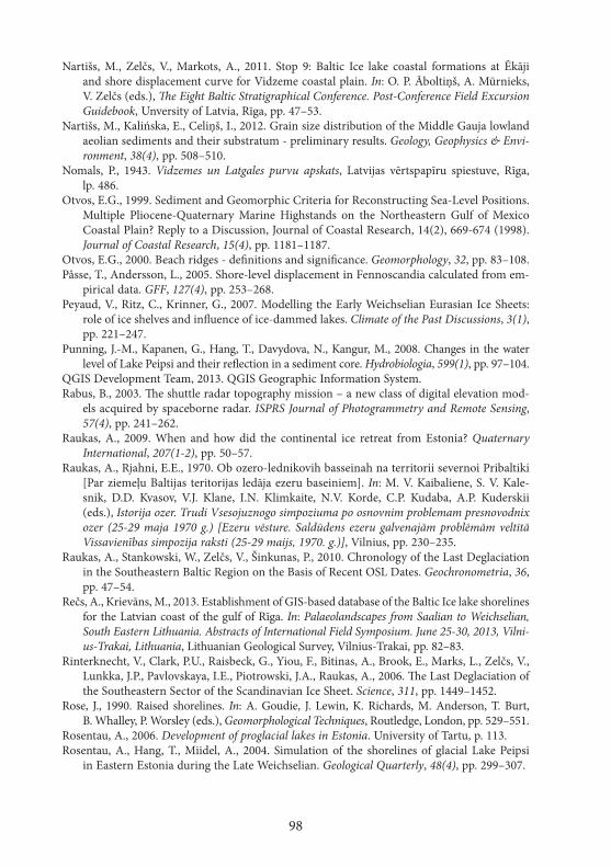
98
Nartišs, M., Zelčs, V., Markots, A., 2011. Stop 9: Baltic Ice lake coastal formations at Ēkāji and shore displacement curve for Vidzeme coastal plain. In: O. P. Āboltiņš, A. Mūrnieks, V. Zelčs (eds.), The Eight Baltic Stratigraphical Conference. Post-Conference Field Excursion Guidebook, Unversity of Latvia, Rīga, pp. 47–53.
Nartišs, M., Kalińska, E., Celiņš, I., 2012. Grain size distribution of the Middle Gauja lowland aeolian sediments and their substratum - preliminary results. Geology, Geophysics & Envi-ronment, 38(4), pp. 508–510.
Nomals, P., 1943. Vidzemes un Latgales purvu apskats, Latvijas vērtspapīru spiestuve, Rīga, lp. 486.
Otvos, E.G., 1999. Sediment and Geomorphic Criteria for Reconstructing Sea-Level Positions. Multiple Pliocene-Quaternary Marine Highstands on the Northeastern Gulf of Mexico Coastal Plain? Reply to a Discussion, Journal of Coastal Research, 14(2), 669-674 (1998). Journal of Coastal Research, 15(4), pp. 1181–1187.
Otvos, E.G., 2000. Beach ridges - definitions and significance. Geomorphology, 32, pp. 83–108.Påsse, T., Andersson, L., 2005. Shore-level displacement in Fennoscandia calculated from em-
pirical data. GFF, 127(4), pp. 253–268.Peyaud, V., Ritz, C., Krinner, G., 2007. Modelling the Early Weichselian Eurasian Ice Sheets:
role of ice shelves and influence of ice-dammed lakes. Climate of the Past Discussions, 3(1), pp. 221–247.
Punning, J.-M., Kapanen, G., Hang, T., Davydova, N., Kangur, M., 2008. Changes in the water level of Lake Peipsi and their reflection in a sediment core. Hydrobiologia, 599(1), pp. 97–104.
QGIS Development Team, 2013. QGIS Geographic Information System.Rabus, B., 2003. The shuttle radar topography mission – a new class of digital elevation mod-
els acquired by spaceborne radar. ISPRS Journal of Photogrammetry and Remote Sensing, 57(4), pp. 241–262.
Raukas, A., 2009. When and how did the continental ice retreat from Estonia? Quaternary International, 207(1-2), pp. 50–57.
Raukas, A., Rjahni, E.E., 1970. Ob ozero-lednikovih basseinah na territorii severnoi Pribaltiki [Par ziemeļu Baltijas teritorijas ledāja ezeru baseiniem]. In: M. V. Kaibaliene, S. V. Kale-snik, D.D. Kvasov, V.J. Klane, I.N. Klimkaite, N.V. Korde, C.P. Kudaba, A.P. Kuderskii (eds.), Istorija ozer. Trudi Vsesojuznogo simpoziuma po osnovnim problemam presnovodnix ozer (25-29 maja 1970 g.) [Ezeru vēsture. Saldūdens ezeru galvenajām problēmām veltītā Vissavienības simpozija raksti (25-29 maijs, 1970. g.)], Vilnius, pp. 230–235.
Raukas, A., Stankowski, W., Zelčs, V., Šinkunas, P., 2010. Chronology of the Last Deglaciation in the Southeastern Baltic Region on the Basis of Recent OSL Dates. Geochronometria, 36, pp. 47–54.
Rečs, A., Krievāns, M., 2013. Establishment of GIS-based database of the Baltic Ice lake shorelines for the Latvian coast of the gulf of Rīga. In: Palaeolandscapes from Saalian to Weichselian, South Eastern Lithuania. Abstracts of International Field Symposium. June 25-30, 2013, Vilni-us-Trakai, Lithuania, Lithuanian Geological Survey, Vilnius-Trakai, pp. 82–83.
Rinterknecht, V., Clark, P.U., Raisbeck, G., Yiou, F., Bitinas, A., Brook, E., Marks, L., Zelčs, V., Lunkka, J.P., Pavlovskaya, I.E., Piotrowski, J.A., Raukas, A., 2006. The Last Deglaciation of the Southeastern Sector of the Scandinavian Ice Sheet. Science, 311, pp. 1449–1452.
Rose, J., 1990. Raised shorelines. In: A. Goudie, J. Lewin, K. Richards, M. Anderson, T. Burt, B. Whalley, P. Worsley (eds.), Geomorphological Techniques, Routledge, London, pp. 529–551.
Rosentau, A., 2006. Development of proglacial lakes in Estonia. University of Tartu, p. 113.Rosentau, A., Hang, T., Miidel, A., 2004. Simulation of the shorelines of glacial Lake Peipsi
in Eastern Estonia during the Late Weichselian. Geological Quarterly, 48(4), pp. 299–307.
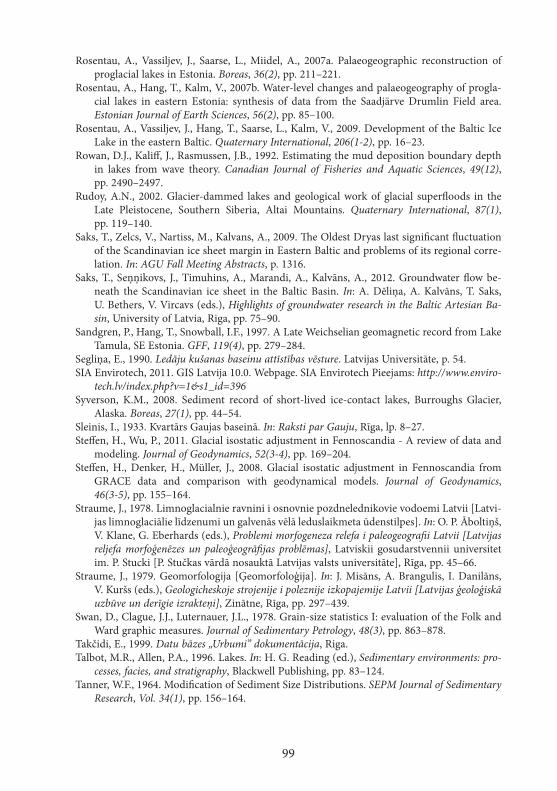
99
Rosentau, A., Vassiljev, J., Saarse, L., Miidel, A., 2007a. Palaeogeographic reconstruction of proglacial lakes in Estonia. Boreas, 36(2), pp. 211–221.
Rosentau, A., Hang, T., Kalm, V., 2007b. Water-level changes and palaeogeography of progla-cial lakes in eastern Estonia: synthesis of data from the Saadjärve Drumlin Field area. Estonian Journal of Earth Sciences, 56(2), pp. 85–100.
Rosentau, A., Vassiljev, J., Hang, T., Saarse, L., Kalm, V., 2009. Development of the Baltic Ice Lake in the eastern Baltic. Quaternary International, 206(1-2), pp. 16–23.
Rowan, D.J., Kaliff, J., Rasmussen, J.B., 1992. Estimating the mud deposition boundary depth in lakes from wave theory. Canadian Journal of Fisheries and Aquatic Sciences, 49(12), pp. 2490–2497.
Rudoy, A.N., 2002. Glacier-dammed lakes and geological work of glacial superfloods in the Late Pleistocene, Southern Siberia, Altai Mountains. Quaternary International, 87(1), pp. 119–140.
Saks, T., Zelcs, V., Nartiss, M., Kalvans, A., 2009. The Oldest Dryas last significant fluctuation of the Scandinavian ice sheet margin in Eastern Baltic and problems of its regional corre-lation. In: AGU Fall Meeting Abstracts, p. 1316.
Saks, T., Seņņikovs, J., Timuhins, A., Marandi, A., Kalvāns, A., 2012. Groundwater flow be-neath the Scandinavian ice sheet in the Baltic Basin. In: A. Dēliņa, A. Kalvāns, T. Saks, U. Bethers, V. Vircavs (eds.), Highlights of groundwater research in the Baltic Artesian Ba-sin, University of Latvia, Riga, pp. 75–90.
Sandgren, P., Hang, T., Snowball, I.F., 1997. A Late Weichselian geomagnetic record from Lake Tamula, SE Estonia. GFF, 119(4), pp. 279–284.
Segliņa, E., 1990. Ledāju kušanas baseinu attīstības vēsture. Latvijas Universitāte, p. 54.SIA Envirotech, 2011. GIS Latvija 10.0. Webpage. SIA Envirotech Pieejams: http://www.enviro-
tech.lv/index.php?v=1&s1_id=396Syverson, K.M., 2008. Sediment record of short-lived ice-contact lakes, Burroughs Glacier,
Alaska. Boreas, 27(1), pp. 44–54.Sleinis, I., 1933. Kvartārs Gaujas baseinā. In: Raksti par Gauju, Rīga, lp. 8–27.Steffen, H., Wu, P., 2011. Glacial isostatic adjustment in Fennoscandia - A review of data and
modeling. Journal of Geodynamics, 52(3-4), pp. 169–204.Steffen, H., Denker, H., Müller, J., 2008. Glacial isostatic adjustment in Fennoscandia from
GRACE data and comparison with geodynamical models. Journal of Geodynamics, 46(3-5), pp. 155–164.
Straume, J., 1978. Limnoglacialnie ravnini i osnovnie pozdnelednikovie vodoemi Latvii [Latvi-jas limnoglaciālie līdzenumi un galvenās vēlā leduslaikmeta ūdenstilpes]. In: O. P. Āboltiņš, V. Klane, G. Eberhards (eds.), Problemi morfogeneza relefa i paleogeografii Latvii [Latvijas reljefa morfoģenēzes un paleoģeogrāfijas problēmas], Latviskii gosudarstvennii universitet im. P. Stucki [P. Stučkas vārdā nosauktā Latvijas valsts universitāte], Rīga, pp. 45–66.
Straume, J., 1979. Geomorfologija [Ģeomorfoloģija]. In: J. Misāns, A. Brangulis, I. Danilāns, V. Kuršs (eds.), Geologicheskoje strojenije i poleznije izkopajemije Latvii [Latvijas ģeoloģiskā uzbūve un derīgie izrakteņi], Zinātne, Rīga, pp. 297–439.
Swan, D., Clague, J.J., Luternauer, J.L., 1978. Grain-size statistics I: evaluation of the Folk and Ward graphic measures. Journal of Sedimentary Petrology, 48(3), pp. 863–878.
Takčidi, E., 1999. Datu bāzes „Urbumi” dokumentācija, Riga.Talbot, M.R., Allen, P.A., 1996. Lakes. In: H. G. Reading (ed.), Sedimentary environments: pro-
cesses, facies, and stratigraphy, Blackwell Publishing, pp. 83–124.Tanner, W.F., 1964. Modification of Sediment Size Distributions. SEPM Journal of Sedimentary
Research, Vol. 34(1), pp. 156–164.
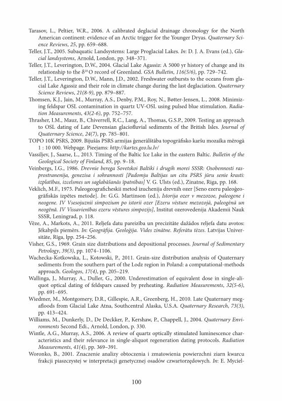
100
Tarasov, L., Peltier, W.R., 2006. A calibrated deglacial drainage chronology for the North American continent: evidence of an Arctic trigger for the Younger Dryas. Quaternary Sci-ence Reviews, 25, pp. 659–688.
Teller, J.T., 2005. Subaquatic Landsystems: Large Proglacial Lakes. In: D. J. A. Evans (ed.), Gla-cial landsystems, Arnold, London, pp. 348–371.
Teller, J.T., Leverington, D.W., 2004. Glacial Lake Agassiz: A 5000 yr history of change and its relationship to the δ18 O record of Greenland. GSA Bulletin, 116(5/6), pp. 729–742.
Teller, J.T., Leverington, D.W., Mann, J.D., 2002. Freshwater outbursts to the oceans from gla-cial Lake Agassiz and their role in climate change during the last deglaciation. Quaternary Science Reviews, 21(8-9), pp. 879–887.
Thomsen, K.J., Jain, M., Murray, A.S., Denby, P.M., Roy, N., Bøtter-Jensen, L., 2008. Minimiz-ing feldspar OSL contamination in quartz UV-OSL using pulsed blue stimulation. Radia-tion Measurements, 43(2-6), pp. 752–757.
Thrasher, I.M., Mauz, B., Chiverrell, R.C., Lang, A., Thomas, G.S.P., 2009. Testing an approach to OSL dating of Late Devensian glaciofluvial sediments of the British Isles. Journal of Quaternary Science, 24(7), pp. 785–801.
TOPO 10K PSRS, 2009. Bijušās PSRS armijas ģenerālštāba topogrāfisko karšu mozaīka mērogā 1 : 10 000. Webpage. Pieejams: http://kartes.geo.lu.lv/
Vassiljev, J., Saarse, L., 2013. Timing of the Baltic Ice Lake in the eastern Baltic. Bulletin of the Geological Society of Finland, 85, pp. 9–18.
Veinbergs, I.G., 1986. Drevnie berega Sovetskoi Baltiki i drugih morei SSSR: Osobennosti ras-prostranenija, genezisa i sohrannosti [Padomju Baltijas un citu PSRS jūru senie krasti: izplatības, izcelsmes un saglabāšanās īpatnības] V. G. Ulsts (ed.), Zinatne, Riga, pp. 168.
Veklich, M.F., 1975. Paleogeograficheskii metod izuchenija drevnih ozer [Seno ezeru paleoģeo-grāfiskās izpētes metode]. In: G.G. Martinson (ed.), Istorija ozer v mezozoe, paleogene i neogene. IV Vsesojuznii simpozium po istorii ozer [Ezeru vēsture mezozojā, paleogēnā un neogēnā. IV Vissavienības ezeru vēstures simpozijs], Institut ozerovedenija Akademii Nauk SSSR, Leningrad, p. 118.
Vēze, A., Markots, A., 2011. Reljefa datu pareizība un precizitāte dažādos reljefa datu avotos: Jēkabpils piemērs. In: Ģeogrāfija. Ģeoloģija. Vides zinātne. Referātu tēzes. Latvijas Univer-sitāte, Rīga, lpp. 254–256.
Visher, G.S., 1969. Grain size distributions and depositional processes. Journal of Sedimentary Petrology, 39(3), pp. 1074–1106.
Wachecka-Kotkowska, L., Kotowski, P., 2011. Grain-size distribution analysis of Quaternary sediments from the southern part of the Lodz region in Poland: a computational-methods approach. Geologos, 17(4), pp. 205–219.
Wallinga, J., Murray, A., Duller, G., 2000. Underestimation of equivalent dose in single-ali-quot optical dating of feldspars caused by preheating. Radiation Measurements, 32(5-6), pp. 691–695.
Wiedmer, M., Montgomery, D.R., Gillespie, A.R., Greenberg, H., 2010. Late Quaternary meg-afloods from Glacial Lake Atna, Southcentral Alaska, U.S.A. Quaternary Research, 73(3), pp. 413–424.
Williams, M., Dunkerly, D., De Deckker, P., Kershaw, P., Chappell, J., 2004. Quaternary Envi-ronments Second Edi., Arnold, London, p. 330.
Wintle, A.G., Murray, A.S., 2006. A review of quartz optically stimulated luminescence char-acteristics and their relevance in single-aliquot regeneration dating protocols. Radiation Measurements, 41(4), pp. 369–391.
Woronko, B., 2001. Znaczenie analizy obtoczenia i zmatowienia powierzchni ziarn kwarcu frakcji piaszczystej w interpretacji genetycznej osadów czwartorzędowych. In: E. Myciel-
101
ska-Dowgiałło (ed.), Aeolization of sediments as an indicator of Quaternary stratigraphy, Uniwersytet Warszawski, Warsawa, pp. 33–38.
Woronko, B., 2012. Zapis procesów eolicznych w osadach piaszczystych plejstocenu na wy-branych obszarach Polski środkowej i północno-wschodniej, Wydział Geografii i Studiów Regionalnych, Uniwersytet Warszawski, Warsawa, p. 130.
Woronko, B., Hoch, M., 2011. The Development of Frost-weathering Microstructures on Sand-sized Quartz Grains: Examples from Poland and Mongolia. Permafrost and Perigla-cial Processes, 22(3), pp. 214–227.
Zelčs, V., 1992. The Trikata drumlin area. In: Glaciotectonic processes, sediments, landforms and their influence on the present geological situation, Faculty of Geography, University of Lat-via, Riga, pp. 36–47.
Zelčs, V., 1993. Diverģentā tipa glaciodepresiju zemieņu glaciotektoniskās reljefa formas. Latvijas Universitāte, Rīga, lp. 39.
Zelčs, V., Šteins, V., 1989. Latvijas daba un fizioģeogrāfiskie rajoni. Zinātne un Tehnika, 7.Zelčs, V., Markots, A., 2004. Deglaciation history of Latvia. In: J. Ehlers, P.L. Gibbard (eds.),
Quaternary Glaciations Extent and Chronology Part I: Europe, Elsevier, Amsterdam, pp. 225–243.
Zelčs, V., Nartišs, M., Dauškans, M., Celiņš, I., 2009. Stop 7: Altered ice-marginal formations of Haanja (Linkuva, North Lithuania) stage at Dores, North Vidzeme Lowland, Latvia. In: V. Kalm, L. Laumets, T. Hang (eds.), Extent and timing of Weichselian glaciation southeast of the Baltic Sea: Abstracts and Guidebook. The INQUA Peribaltic Working Group Field Symposium in southern Estonia and northern Latvia, September 13-17, 2009, Tartu Ülikoo-li Kirjastus, Tartu, pp. 77–78.
Zelčs, V., Markots, A., Nartišs, M., Saks, T., 2011. Pleistocene Glaciations in Latvia. In: J. Ehlers, P.L. Gibbard, P.D. Hughes (eds.), Quaternary Glaciations – Extent and Chrono logy, Else-vier, Amsterdam, pp. 221–229.
102
PuBLIKāCIju SARAKSTS / LIST Of PuBLICATIONS
Raksti zinātniskos žurnālos / Publications in scientific journals 1. Kalińska, E., Nartišs, M. 2013. Pleistocene and Holocene aeolian sediments of different lo-
cation and geological history: A new insight from rounding and frosting of quartz grains. Quaternary International, 328–329, pp. 311–322.
Nodaļas indeksētās zinātniskās grāmatās / Chapters of indexed scientific books 2. Zelčs, V., Markots, A., Nartišs, M., Saks, T. 2011. Chapter 18 - Pleistocene Glaciations in
Latvia. In: Jürgen Ehlers, Philip L. Gibbard and Philip D. Hughes (eds). Developments in Quaternary Sciences, Elsevier, Vol. 15, pp. 221–229.
Raksti rediģētās grāmatās / Publications in edited books 3. Nartišs, M., Zelčs, V., Markots, A. 2011. Stop 9: Baltic Ice lake coastal formations at Ēkāji
and shore displacement curve for Vidzeme coastal plain. In: Āboltiņš O.P., Mūrnieks A., Zelčs V. (eds). The Eight Baltic Stratigraphical Conference. Post-Conference Field Excursion Guidebook. University of Latvia, Riga, pp. 47–53.
4. Nartišs, M., Celiņš, I., Zelčs, V., Dauškans, M. 2009. Stop 8: History of the development and palaeogeography of ice-dammed lakes and inland dunes at Seda sandy plain, north western Vidzeme, Latvia. In: Kalm V., Laumets L., Hang T. (eds.), Extent and timing of Weichselian glaciation southeast of the Baltic Sea: Abstracts and Guidebook. The INQUA Peribaltic Working Group Field Symposium in southern Estonia and northern Latvia, Sep-tember 13-17, 2009. Tartu Ülikooli Kirjastus, Tartu, pp. 79–81.
5. Zelčs, V., Nartišs, M., Dauškans, M., Celiņš, I. 2009. Stop 7: Altered ice-marginal forma-tions of Haanja (Linkuva, North Lithuania) stage at Dores, North Vidzeme Lowland, Lat-via. In: Kalm V., Laumets L., Hang T. (eds.), Extent and timing of Weichselian glaciation southeast of the Baltic Sea: Abstracts and Guidebook. The INQUA Peribaltic Working Group Field Symposium in southern Estonia and northern Latvia, September 13-17, 2009. Tartu Ülikooli Kirjastus, Tartu, pp. 77–78.
Publikācijas konferenču ziņojumu izdevumos / Conference proceedings 6. Nartišs, M., Kalińska, E., Celiņš, I. 2012. Grain size distribution of the Middle Gauja low-
land aeolian sediments and their substratum - preliminary results. In: Geology, Geophysics & Environment. Vol. 38, No. 4, Wydawnictwa AGH, Kraków, pp. 508–510.
7. Kalińska, E., Kalm, V., Nartišs, M., Celiņš, I., Gorlach, A. 2012. Textural variability of the selected coversand deposits in Latvia – preliminary results. In: Zhirov A., Kuznetsov V., Subetto D., Thiede J.(eds), „Geomorphology and Palaeogeography of Polar Regions”: Pro-ceeding of the Joint Conference „Geomorphology and Quaternary Palaeogeography of Po-lar Regions”, Symposium „Leopoldina” and the INQUA Peribaltic working group Workshop. St.-Petersburg State University, Russia, 2012, pp. 427–429.
8. Nartišs, M. and Zelčs, V. 2007. Development history of the glacial lakes in Northern Vidzeme, Latvia. In: Guobytė R., Stančikaitė M. (eds), Proceedings of the International Field Symposium „The Quaternary of Western Lithuania: from the Pleistocene glaciations to evolution of the Baltic Sea”. Lithuanian Geological Survey, Vilnius, pp. 59–60.
103
Starptautisku konferenču materiāli / Abstracts of international conferences 9. Nartišs, M., Zelčs, V. 2013. Was the Middle Gauja lowland ice free during Linkuva time?
In: Palaeolandscapes from Saalian to Weichselian, South Eastern Lithuania. Abstracts of In-ternational Field Symposium. Lithuanian Geological Survey, Vilnius-Traka, pp. 71–72.
10. Kalińska, E., Nartišs, M., Olo, S., Celiņš, I., Soms, J. 2013. Relationship between Folk and Ward (1957) indicators as a tool for analysing the aeolian sedimentary environments. In: Palaeolandscapes from Saalian to Weichselian, South Eastern Lithuania. Abstracts of Inter-national Field Symposium. Lithuanian Geological Survey, Vilnius-Traka, pp. 42–43.
11. Nartišs, M., Zelčs, V. 2011. A succession of Lateglacial ice-dammed lakes in north Vidzeme, Latvia. In: Johansson P., Lunkka J.-P., Sarala P. (eds), Late Pleistocene glacigenic deposits from the central part of the Scandinavian Ice Sheet to Younger Dryas End Moraine Zone. Evcurcision guide and abstracts of the INQUA Peribaltic Working Group Meeting and Excursion in Finland, 12-17 June 2011. Geological Survey of Finland, Rovaniemi, p. 122.
12. Saks, T., Zelcs, V., Nartiss, M., Kalvans, A. 2009. The Oldest Dryas last significant fluctu-ation of the Scandinavian ice sheet margin in Eastern Baltic and problems of its regional correlation. „Eos Trans. AGU”, 90(52), Fall Meet. Suppl., Abstract #PP21A-1316.
13. Nartišs, M., Markots, A., Zelčs, V. 2008. Late Weichselian and Holocene shoreline dis-placement in the Vidzeme costal plain, Latvia. In: Lisicki S. (ed.) „Quaternary of the Gulf of Gdansk and Lower Vistula regions in northern Poland: sedimentary environments, stratigra-phy and palaeogeography”. Polish Geological Institute, Warszawa, p. 39.
14. Nartišs, M. and Zelčs, V. 2006. Reconstruction of proglacial ice meltwater basins in North-ern Vidzeme, Latvia. In: Johansson P., Lunkka J.-P., Sarala P. (eds), The International Field Symposium on Late Pleistocene Glacigenic Deposits in the Central Part of the Scandinavian Ice Sheet, September 11-15, 2006. Abstracts of papers and posters. Geological Survey of Fin-land, Northern Finland Office, Oulu, p. 28.
Latvijas konferenču materiāli / Abstracts of local scientific conferences15. Nartišs, M. 2013. Cilvēka radīto objektu aizvākšana no LĢIA augstuma modeļa. Krāj.: Ģeo-
grāfija. Ģeoloģija. Vides zinātne. Referātu tēzes. Latvijas Universitāte, Rīga, lpp. 162–163.16. Nartišs, M. 2013. Zembaseina nogulumu virsmas rekonstruēšana ĢIS vidē. Vidusgaujas
un Ziemeļlatvijas zemieņu piemērs. Krāj.: Ģeogrāfija. Ģeoloģija. Vides zinātne. Referātu tēzes. Latvijas Universitāte, Rīga, lpp. 342–344.
17. Kalińska, E., Nartišs, M. 2013. Iekšzemes eolo nogulumu kvarca graudu teksturālās īpašības Latvijā. Krāj.: Ģeogrāfija. Ģeoloģija. Vides zinātne. Referātu tēzes. Latvijas Univer-sitāte, Rīga, lpp. 314–315.
18. Krievāns, M., Rečs, A., Nartišs, M. 2013. Gaujas trešās virspalu terases nogulumu sastāvs un sedimentācijas vides īpatnības sanatorijas „Līči” apkārtnē. Krāj.: Ģeogrāfija. Ģeoloģija. Vides zinātne. Referātu tēzes. Latvijas Universitāte, Rīga, lpp. 321–323.
19. Juškevičs, V., Markots, A., Nartišs, M., Zelčs, V. 2008. Baltijas ledus ezera krasta veidojumi Vidzemes piekrastē. Krāj.: Ģeogrāfija. Ģeoloģija. Vides zinātne. Referātu tēzes. Latvijas Uni-versitāte, Rīga, lpp. 197–198.
20. Nartišs, M. 2006. Jaunas datu apstrādes metodes ieviešana atvērtā koda ĢIS programmā GRASS. Krāj.: Ģeogrāfija. Ģeoloģija. Vides zinātne. Referātu tēzes. Latvijas Universitāte, Rīga, lpp. 93–94.
21. Nartišs, M., Līcis, A., Zelčs, V. 2006. Ledājkušanas ūdeņu paleostraumju virzieni Zie-meļvidzemes teritorijā. Krāj.: Ģeogrāfija. Ģeoloģija. Vides zinātne. Referātu tēzes. Latvijas Universitāte, Rīga, lpp. 191–192.