Productivity-Diversity Relationships from Chemolithoautotrophically Based Sulfidic Karst Systems

Geomorphology 101 (2008) 308–331
Contents lists available at ScienceDirect
Geomorphology
j ourna l homepage: www.e lsev ie r.com/ locate /geomorph
Human and natural impacts on fluvial and karst depressions of the Maya Lowlands
Timothy Beach a,⁎, Sheryl Luzzadder-Beach b, Nicholas Dunning c, Duncan Cook d
a Georgetown University, United Statesb George Mason University, United Statesc University of Cincinnati, United Statesd University of Glasgow, United Kingdom
⁎ Corresponding author.E-mail address: [email protected] (T. Beach).
0169-555X/$ – see front matter © 2008 Elsevier B.V. Aldoi:10.1016/j.geomorph.2008.05.019
A B S T R A C T
A R T I C L E I N F OArticle history:
This paper begins to differe Accepted 13 March 2008Available online 25 May 2008Keywords:ErosionAggradationMaya LowlandsFluvialKarstSoils
ntiate the major drivers and chronology of erosion and aggradation in the fluvialand fluviokarst landscapes of the southern and central Maya Lowlands. We synthesize past research onerosion and aggradation and add new data from water, soils, radiocarbon dating, and archaeology to studythe quantity, timing, and causes of aggradation in regional landscape depressions. Geomorphic findings comefrom many excavations across a landscape gradient from upland valleys, karst sinks, and fans into the coastalplain floodplains and depressions. Findings fromwater chemistry show that sources in the uplands have lowquantities of dissolved ions but water in the coastal plains has high amounts of dissolved ions, often nearlysaturated in calcium and sulfate. We found significant geomorphic complexity in the general trends inupland karst sinks. In a few instances, sediments preserve Late Pleistocene paleosols, buried 2–3 m, thoughmany more have distinct middle to late Holocene paleosols, buried 1–2 m, after c. 2300 BP (Maya Early toLate Preclassic). From 2300–1100 BP (Late Preclassic to Classic Periods), the landscape aggraded from fivemain mechanisms: river flooding, climatic instability, accelerated erosion, ancient Maya landscapemanipulation, and gypsum precipitation from a rise in a water table nearly saturated in calcium and sulfateions. Evidence exists for two or three high magnitude floods, possibly driven by hurricanes. Moreover, lake-core and geophysical studies from the Petén Lakes region have shown high rates of deposition of silicate clays(‘Maya Clays’) starting and peaking during the Maya Preclassic and continuing to be high through the LateClassic. The main driver on upland karst depressions, the Petén lakes, upland valleys, and fans wasaccelerated soil erosion, but water table rise, probably driven by sea-level rise, was the main driver on thewetlands of the coastal plain because the aggraded sediments here are dominantly composed of gypsum,precipitated from the groundwater. This latter mechanism represents a little recognized mechanism ofaggradation over a large region. These large scale environmental changes occurred during periods ofintensive ancient Maya land use and climatic instability, both of which may have contributed to erosion byincreasing runoff. Despite these geomorphic changes, ancient Maya farmers adapted in several key cases.
© 2008 Elsevier B.V. All rights reserved.
1. Introduction
Much of the literature on human impacts in geomorphology hasfocused on relatively modern changes (Hooke, 2000; Ehlen et al.,2006; James and Marcus, 2006), but a diverse and growing literaturereveals significant human influence on ancient environments (Butzer,1992; Denevan, 1992; Redman, 1999; Montgomery, 2007; Beach et al.,2008, in press). The most obvious example is the Mediterranean,where the literature has attempted to differentiate millennia ofpotential human impacts on geomorphic systems (Butzer, 2005;Beach and Luzzadder-Beach, in press). Parallel to the Mediterraneanhas been Mesoamerica, which has also experienced millennia ofhuman impacts through its starkly different landscapes, climates, andecosystems (Beach et al., 2006a). The Maya Lowlands of Mesoamerica
l rights reserved.
lies at the heart of the question of human impacts on geomorphologybecause this region holds such a long history of human land use in itsfluvial and karst environments (Beach et al., 2006b). Geoarchaeolo-gical research in this region (and other well studied areas like SouthAmerica and the Mediterranean) is beginning to differentiate theanthropogenic versus natural mechanisms, chronology, and timing ofgeomorphic change in the context of history and prehistory.
Differentiating the mechanisms for fluvial and karst change in theMaya World is a particular challenge, because of the hidden sinks inkarst systems, the complicated influence of groundwater, and the lackof published data. Few data exist for water chemistry, sediment load,and the pathways of sediments through these drainage basins. Wealso have only a broad sketch of the population and land use historyfor the Precolumbian period, based mainly on spatially limitedarchaeological surveys that represent only a few Maya sites datingfrom the ancient Maya period, usually focused on 3000 to 1000 BP.Nonetheless, we do have a growing opus of geoarchaeological survey,

309T. Beach et al. / Geomorphology 101 (2008) 308–331
an expanding resource of scholarship on the long history of the region,a concomitant increase in paleoecological and climatological research,a small but growing soils literature, but still very little research on
Fig. 1. Location map of t
geomorphology except for karst studies (Day, 2007). The few studieswe do have point to increasing evidence for geomorphic change in avariety of sinks in this region, ranging from aggradation behind
he Maya Lowlands.
310 T. Beach et al. / Geomorphology 101 (2008) 308–331
ancient Maya terraces and dams on backslopes and footslopes (Beachet al., 2002), to small upland dolines (Beach and Dunning, 1995), tokarst and structural lakes (Wahl et al., 2006; Anselmetti et al., 2007;Dunning and Beach, 2008) to upland valleys, to alluvial fans,floodplains, and to the coastal plain (Pope et al., 1996; Luzzadder-Beach and Beach, in press).
In this paper, we synthesize and add new findings on soil erosionand aggradation for each of the main geomorphic sinks in the regionand provide a new series of data on regional water chemistry, which isone of the major drivers of geomorphic change. Most of our evidencefor soil erosion comes from sedimentation studies. We use thecharacteristics of these aggraded sediments and local and regionalwater chemistry to differentiate at least five main and two contribut-ing processes of human induced and natural environmental changeacross this surprisingly diverse landscape.
2. Environments
We focus mainly on the Maya Lowlands (Fig. 1) of Mesoamerica,though the Maya Highlands provides an equally interesting andimportant region because of the role of steep slopes on volcanic andmetamorphic bedrock and abrupt climatic and vegetation differences(Dull, 2007). Elsewhere we have described the regional geomorphol-ogy of the Maya Lowlands (Dunning et al., 1998), a region that is morecomplicated in geology, geomorphology, hydrology, and waterchemistry than most overviews present. Descriptions often lump the
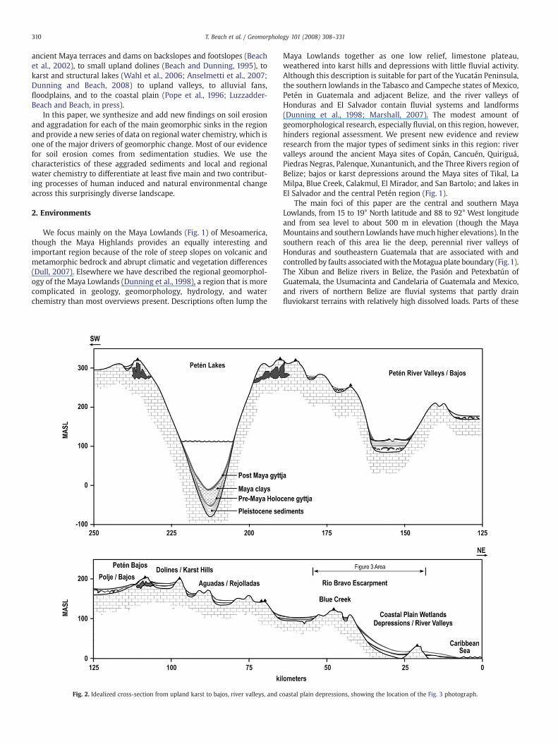
Fig. 2. Idealized cross-section from upland karst to bajos, river valleys, and c
Maya Lowlands together as one low relief, limestone plateau,weathered into karst hills and depressions with little fluvial activity.Although this description is suitable for part of the Yucatán Peninsula,the southern lowlands in the Tabasco and Campeche states of Mexico,Petén in Guatemala and adjacent Belize, and the river valleys ofHonduras and El Salvador contain fluvial systems and landforms(Dunning et al., 1998; Marshall, 2007). The modest amount ofgeomorphological research, especially fluvial, on this region, however,hinders regional assessment. We present new evidence and reviewresearch from the major types of sediment sinks in this region: rivervalleys around the ancient Maya sites of Copán, Cancuén, Quiriguá,Piedras Negras, Palenque, Xunantunich, and the Three Rivers region ofBelize; bajos or karst depressions around the Maya sites of Tikal, LaMilpa, Blue Creek, Calakmul, El Mirador, and San Bartolo; and lakes inEl Salvador and the central Petén region (Fig. 1).
The main foci of this paper are the central and southern MayaLowlands, from 15 to 19° North latitude and 88 to 92° West longitudeand from sea level to about 500 m in elevation (though the MayaMountains and southern Lowlands havemuch higher elevations). In thesouthern reach of this area lie the deep, perennial river valleys ofHonduras and southeastern Guatemala that are associated with andcontrolled by faults associatedwith theMotagua plate boundary (Fig.1).The Xibun and Belize rivers in Belize, the Pasión and Petexbatún ofGuatemala, the Usumacinta and Candelaria of Guatemala and Mexico,and rivers of northern Belize are fluvial systems that partly drainfluviokarst terrains with relatively high dissolved loads. Parts of these
oastal plain depressions, showing the location of the Fig. 3 photograph.

311T. Beach et al. / Geomorphology 101 (2008) 308–331
watersheds drain from the central Petén carbonate platform, wheresome of the studies reviewed here took place on limestone slopes andkarst sinks. Several studies have examined the geomorphology of thesekarst terrains (Siemens,1978; Day,1993, 2003, 2007; Reeder et al., 1996;Miller, 1996; Veni, 1996), but this paper focuses on erosion evidence inregional sinks: floodplains, coastal plains, and the seasonally wet ‘bajo’sinks that cover c. 40% of this landscape (Dunning et al., 2002). Thesesinks, often 100 m or more above the water table, tend be desiccatedduring the dry season and drain slowly into seasonalfluvial systems andgroundwater in the wet season.
The 100–500 m elevation of the karst plateau descends along aseries of normal faults northeast and eastward toward the coast,creating a series of escarpments and intervening valleys (Figs. 1, 2).From the central karst uplands river systems initially occupy structuralvalleys, gathering intermittent upland runoff and perennial ground-waters. From the uplands, rivers descend onto broad floodplains of thecoastal plain, gathering other sources of groundwater as theymeandernorth and eastwards to the Caribbean. The Rio Bravo Escarpment(Fig. 3) divides the interior karst uplands from the coastal plain, whichspans 100 km across low elevation floodplains, between higher sandridges, and occasional bedrock outliers.
This region lies seasonally under the influence of the IntertropicalConvergence Zone and the Bermuda High, which spawn distinctly wetseasons fromMay toNovember and dry seasons fromDecember toMay.Because of latitude, elevation, and rainshadow, precipitation across theregion varies significantly from regionswith 5000mmof annual rainfallin the Highlands andMayaMountains to those of 500mm in northwestYucatán. But most of the region has a much narrower range of about1200 and 2000 mm of yearly rainfall, and soil moisture regimes aretypically Ustic or Udic. All of the soil temperature regimes (except for asmall area of higher elevations) are isohyperthermic (mean annual soiltemperature is above 22 °C, Van Wambeke, 1987) or isomegathermic(mean soil temperatures above 29 °C).
The region also lies sandwiched between two opposite teleconnec-tions of El Niño/Southern Oscillation (ENSO). To the north, El Niño isanomalously wet fromOctober toMarch, and to the south, anomalouslydry from July to March (Ropelewski and Halpert, 1987). These
Fig. 3. Aerial photograph of the coastal plain and Rio Br
complications mean the ENSO pattern is variable but significant, as inthe extreme aridity and fires of the 1997–1998 El Niño that gave way totorrential rainfall (Golicher et al., 2006). ENSO also influences thetropical storm activity of the region (Boose et al., 2003), with El Niñoscorrelated with decreased magnitudes and frequencies and La Niñaswith increases in both (Pielke and Landsea, 1999). Moreover, theHolocene periodicity of ENSO has varied significantly, from little El Niñoimpact in the early Holocene to an increase after 5–6000 BP (Haug et al.,2001; Koutavas et al., 2002; Magilligan et al., 2008-this volume). TheseENSO teleconnectionsandother teleconnections fromtheNorthAtlanticOscillation drive large interannual rainfall variability.
Many factors contribute to ecosystem variability of the Mayalowlands, including soils, the quantity and quality of water, fireregimes, precipitation, and frequency and intensity of tropical storms.Most of the region was covered by tropical forest, includingbiologically diverse, well drained, high tropical forests, and low anddry, thorny forests. Smaller areas of pine and palmetto savannas alsooccur in the central Petén and on the sandy coastal plains,interspersed with forested and herbaceous, perennial wetlands(Greller, 2000). Over the last decades settlers have converted muchof the area into pasture and other crops (Fig. 3).
2.1. Sea level and water table change
In the transition from the Pleistocene to Holocene, fluvial and karstsystems changed significantly as sea level climbed 125 m. Blum andTornqvist (2000) argued that theMississippi River incised inland 300–400 km during the Late Glacial Maximum, and the river valleys of theMaya Lowlands would have also incised far inland and to great depths.Ground water tables and river systems then adjusted to these risingHolocene base levels. In the low lying coastal plain, water transgressedfar inland, inundating previously active floodplain and cave networks,lifting lighter freshwater tables, and creating a large area of wetlands.Sea levels and water tables continued to rise through the lateHolocene at sites at least 40–50 km inland along the Rio Hondo andother Belize coastal plain rivers (Antonie et al., 1982; Bloom et al.,1983; Jacob, 1995; Jacob and Hallmark, 1996; Pohl et al., 1996; Pope
avo escarpment at which the karst uplands starts.

312 T. Beach et al. / Geomorphology 101 (2008) 308–331
et al., 1996). Some research from the Gulf of Mexico also suggests 1–2 m sea level high stands in the mid Holocene (Blum et al., 2002;Otvos, 2001), and Pohl et al. (1996) suggested a possible slight drop insea level from 5000 to 3000 BP. Studies from northern Belize estimategroundwater tables at about 1 m lower at 3000 BP, about 0.6 m lowerby 2000 BP, and about 0.25m lower by 1000 BP (High,1975; Pohl et al.,1996; Toscano and Macintyre, 2003; Gischler and Hudson, 2004). Sealevel rise also inundated some ancient Maya settlements, includingMaya salt production sites by 1 m or more (McKillop, 2005). Some ofthis submergence of Maya sites is caused by the long-term subsidenceof the carbonate platform, which Gischler and Hudson (2004)estimate as 39 to 119 mm ka-1 for the Belize shoreline.
An often overlooked part of the physical environment ingeomorphology and geoarchaeology is groundwater chemistry(LaFleur, 1984), but in the tropical karst and wetland environmentsof the Maya Lowlands, we ignore water chemistry at our peril.Luzzadder-Beach and Beach (in press) provide extensive waterchemistry analyses to connect sea level, water chemistry, andlandscape aggradation in the coastal plain near Blue Creek, Belize,which extends similar, earlier findings (Pohl et al., 1996).
3. Cultural history
Cultural history is relevant to geomorphology in a region defined bya cultural stream that has persisted formore than 3000 years. Scholarshave divided the pre-Hispanic period into a complex historicalsequence (Table 1), which we simplify here to the Archaic (9000–4200 BP), the Early Preclassic (4200–3000 BP), the Middle Preclassic(3000–2400 BP), the Late Preclassic (2400–1700 BP), the Early Classic(1700–1300 BP), the Late and Terminal Classic (1300–1100 BP), the PostClassic (1100–500 BP), and the Post Conquest period thereafter.
Portions of this chronology are artifacts of an outdated literature,particularly the definition of a “Classic” period defined by the erectionof stelae with dated hieroglyphic inscriptions, because we now havestelae and inscriptions for the Preclassic and Postclassic. Similarly,early scholars often referred to population levels and culturalaccomplishments as having peaked throughout the Maya Lowlandsin the Late Classic, followed by population collapse and culturaldecline (Turner, 1990). We now consider the course of Mayacivilization to have been much more complex. Major populationapogees and ensuing collapses occurred in the Terminal Preclassic(1900–1700 BP) and Terminal Classic (1100–1200 BP), with lesserdisruptions at the end of the Middle Preclassic and Early Classic. Therise and fall of the Maya, however, was not uniform across thelowlands. Some sites and regions experienced greater growth or morecomplete abandonment at different times. Some regions were
Table 1Maya historical periods
Years BP(AD 1950)
Era Erosion Factors
Pre-9000 PaleoIndian Pleistocene/Holocene climate transition9000–4200 Archaic Tropical Forest, first agriculture4200–3000 Early Preclassic Agriculture, decreased forest3000–2400 Middle Preclassic Agriculture, decreased forest, Maya clays
start to deposit2400–1850 Late Preclassic Agriculture, decreased forest, population
increase, Maya Clays peak1850–1700 Terminal Preclassic Maya Clays continue1700–1350 Early Classic Soil Conservation, population increase1350–1180 Late Classic Soil Conservation, population peak,
Maya Clays decrease1180–1050 Terminal Classic Soil Conservation, Maya Clays decrease1050–700 Early Postclassic Maya Clays diminish, Reforestation in
many places700–450 Late Postclassic Reforestation in many places450 to present Post Conquest, Colonial Reforestation
abandoned for centuries at a time, whereas others were neverabandoned.
4. Soils and soil erosion
Small scale, often dated, government soil surveys exist for the fivecountries we cover, which describe numerous factors of soil formationacross these landscapes (e.g., King et al., 1992). One typical sequenceincludes Rendoll soils across the relatively low gradient backslopes ofkarst hills and escarpments. These Rendoll catenas often have simpleprofiles with 20–50 cm of A horizon over C or Ck horizons, over sascab,often a soft calcrete with an indurated or case-hardened surface(Darch, 1981). Variations in the Ck horizon may influence infiltration,percolation, runoff, and erosion, and may represent evidence of past,deeper soil profiles and or Pleistocene aridity.
A small number of studies have examined soils across the interiorkarst plateau region, usually describing relatively thin Mollisols,Alfisols, and Inceptisols on upland slopes and Vertisols or Histosols indepressions and inter grade soils in between (Beach, 1998b;Fernandez et al., 2005; Webb et al., 2007; Johnson et al., 2007a,b).Some Ultisols and Oxisols have formed on older landscapes in thesouthern Maya Lowlands (Lietzke and Whiteside, 1981; CarlosDonado, 1996; Coultas et al., 1997; Farrell, 2003; Bullard, 2004), butto the south of the Yucatán, where geology becomes much morediverse, soils are too complex to describe in brief.
Soil erosion research on the Maya World has not progressed far,despite a long history of scholarly speculation on the relationship ofsoil erosion and environmental degradation to the ebbs and flows ofMaya History and as an explanation for the thin, young Rendoll soils ofthe region (Beach, 1998b, 2006a,b). Indeed, several early writingsascribed theMaya Collapse of c.1100 BP to soil erosion ormore broadlyto environmental degradation (Bennett, 1926; Thompson, 1954;Morley, 1956). Another early hypothesis suggested that degradationby anthropogenic burning formed the Oxisol soils of the central Petén(Stevens, 1964, p. 299). A few researchers have tested these erosionhypotheses with catena studies and some erosion modeling and havefound evidence for rapid soil truncation in short time scales (Furley,1987; Beach and Dunning, 1995; Beach, 1998a; Beach et al., 2006a).
Several factors of Rendoll soils make them more erodible in thisregion. First, the largely clay textures often aggregate into moreerodible sizes. Second, the well formed granular structure, which ishighly porous, often overlies layers that act like aquitards toinfiltration. These layers may be Ck, denser clay horizons, or marlyor saprolitic subsoils that are clay-rich and massively structured.Although infiltration starts out high in these soils, even with hightropical rainfall intensity, saturated overland flow and throughflowcan perch above these soil aquitards. When other factors of erosion(e.g., deforestation) align, soil losses are very high through sheeting,rilling, and gullying. Indeed, we have observed entire soil profileserode over several years, though rates of erosion decline as the gulliesdissect into the clayey saprolite (sascab) and marl and the Ck horizonscleave off into cobbles and boulders (Beach et al., 2006a).
The ancient Maya also had a large range of responses togeomorphic changes in the forms of soil erosion, runoff, and rivermigration. The Maya started building soil conservation features asearly as c. 2500 BP (Preclassic), but most of these systems date to1700–1100 BP (Classic). They range widely in size, exist in many slopepositions, and often contain evidence for intensive cultivation on thesoils that have formed behind them (Beach, 1998a; Beach et al., 2002,2003). Another ancient Maya adaptation was in urban geomorphol-ogy, which involved aqueducts and causeways that channelized anddiverted water around, away, and under their sites from theGuatemalan Highlands to Copán, Honduras and to Palenque, Mexico.Remarkable stone walled channels at Palenque reflect Maya attemptsto counter bank erosion and stream migration (French et al., 2006).Evidence also exists for ancient dams in many places across the Maya

313T. Beach et al. / Geomorphology 101 (2008) 308–331
Lowlands (Siemens et al., 2002). The Maya also built features tocapture and funnel water into storage reservoirs (Lucero and Fash,2006), and we present evidence below for ancient Maya dredging of areservoir. Although evidence exists for localized Maya dredging, otherevidence suggests that sedimentation degraded large bajo depres-sions and contributed to regional abandonment in the Late Preclassic(Dunning et al., 2002).
Accelerated erosion has earned it pejorative connotation, thoughsoil and architectural erosion have deposited beneficial alluvial andcolluvial sediments in the footslope and terraces of bajo margins.Indeed, several studies have interpreted the Classic Maya terracingand field wall systems as indicative of intensive agriculture on theseformerly degraded zones (Dunning et al., 2002; Beach et al., 2003).Gunn et al. (2002a) study of soil chemistry suggested that Preclassicerosion also delivered more fertile sediments to the massive BajoLaberinto in southern Campeche,Mexico around the largeMaya site ofCalakmul, Mexico.
5. Climatic change and erosion
Most information on regional climatic change comes from lake andmarine sediments, one drainage basin flow study, and speleothem-based reconstructions. Studies of lake sediments from the northernYucatán have provided the main record of climate change in thisregion based on two main proxies: sediment geochemistry, in theabundance of gypsum (measured as sulfur) to calcite (CaCO3)precipitation, and oxygen isotope ratios (δ18O) in gastropod andostracod shells. Hodell et al. (1995, 2000, 2001, 2005) have providedimportant evidence of the general climate tends of northern Yucatánand possibly the broader Maya Region. The cores from LakeChichancanab (Fig. 1) have provided a proxy record of climate throughmost of the Holocene, with the following general trends: thelowermost sample is from a terrestrial paleosol, just above this is asulfur-rich lake with high δ18O ratios from 8200 to 720014C yr BP,followed by low sulfur (S) conditions and δ18O ratios until about5000 BP, followed by high variability between S and CaCO3
precipitation until c. 2200 BP, followed by two sharp peaks in sulfurin the Late Preclassic and Late Classic that the δ 18O ratios partlyparallel in the Preclassic and fully parallel in the Late Classic, andfollowed by a return to Preclassic levels of δ18O and S and CaCO3 ratios(Brenner et al., 2003). Lake Punta Laguna produced similar results forδ18C ratios for the last 3500 yr, but indicated only broadly drierconditions through the Maya Classic period (highest populationdensities and land-use intensities as well as the depopulation of thePetén to the south). More broadly, the Haitian site of Lake Miragoaneshowed a similar sulfur to CaCO3 record, though it included one longperiod of high sulfur through the Maya Preclassic and Classic. Afurther study using Gamma ray attenuation bulk density as a proxy forthe S proxy revealed Late Preclassic S peaks and two later peaks indrought in the Late Classic (AD 770–850) to Post Classic peaks (AD920–1100) (Hodell et al., 2005).
A new study from the Petén region suggests higher lake levels andprecipitation from 2400 to 1800 BP (Preclassic), with lower moistureavailability through the Classic period until the present (Rosenmeieret al., in press). Rosenmeier et al. (in press) also show that higher lakelevels could have resulted from deforestation or increased rainfall, butthe lower lake levels of the Late Classic correlate with strong evidencefor the lowest forest cover and increasing aridity.
Precisely dated, laminated sediments from the Cariaco Basin,although 2000 km southeast of the Maya Lowlands, provide anothermarine line of proxy evidence based on variations in sedimentarytitanium and iron (Haug et al., 2001, 2003). These sediments aredominated by dark, terrigenous laminae laid down in the wet seasonand light, organic laminae laid down in the dry season. Theyinterpreted titanium and iron at 2 mm spacing (with a time resolutionof 2–4 years) as a proxy of rainfall over the watersheds draining
northern South America. These proxies are low in the Younger Dryas,but rise through the Preboreal to Holocene thermal maximum anddecrease through the late Holocene. Three trends particularly standout in the Late Holocene: high variability from c. 3800 to c. 2000 BP,and stability from 2000 to 1300 BP, low quantities from 1300 to1000 BP, and the lowest quantities during the Little Ice Age (500–200 BP). Haug et al. (2001) ascribe the high Ti and Fe in the midHolocene to high rainfall and runoff, though forest cover would alsohave been at maximum. They ascribe the 3700 to 2000 BP period ofhigh-amplitude variation to increased ENSO variability. Haug et al.(2003) focus in on the Maya Period and especially the so-called ‘MayaCollapse’, which appears to be a minor event in the data of their earlyresearch (Haug et al., 2001) when compared with either the Preclassicinstability or the Little Ice Age. Nonetheless, low Ti concentrations,possibly reflecting reduced precipitation, correspond to c. AD 760, 810,860, and 910, and the Maya Terminal Classic Period.
Another approach to understand climatic trends in the MayaLowlands was linking global insolation, atmospheric patterns, andvolcanic emissions with the discharge of the Rio Candelaria, Mexico(Gunn et al., 2002b). The Candelaria tracts these global trends, thoughthe adjacent Champoton follows El Niño patterns. Gunn et al. (2002b)retrodicted these correlations of global temperatures with Candelariadischarges back in time based on solar insolation and volcanic activity.They suggested that forcings correlate with a prolonged period ofhigher rainfall in the Classic period and dryer conditions in theTerminal Classic.
Two paleoclimate records exist for the central Maya Lowlands thatmaycorrespond to theCariaco andnorthernYucatán records, the centralPetén lakes record and a recent cave speleothem record from adjacentcentral Belize. For cores from two lakes, Yaeger and Hodell (2008)reported that δ18O declines in the Classic and increases in the TerminalClassic. This implies lower evaporation to precipitation in the Classic andhigher evaporation to precipitation (or drought) in the Terminal Classic.But these could have climatic or anthropogenic causes becausereforestation also occurred in the Terminal Classic, which, like drought,would possibly increase evapotranspiration and lower lake levels.
For a speleothem study from a Belize cave, Webster et al. (2007)used color, luminescence, δ13C, and δ18O as climate proxies. Theyfound climate fluctuation in the Preclassic from drought to pluvial andsevere droughts in the Late Preclassic (5 BC and AD 141), then wetterconditions in the Classic Period sandwiching a drought in the MiddleClassic (AD 517), and the most severe droughts falling in the Latethrough Post Classic (AD 780, 910, 1074, 1139). This record may alsoreveal a drought in the 15th C. AD approximately coincident with adrought in the Mayan books of Chilam Balam of Chumayel and Mani(Folan and Hyde, 1985) and the other core evidence for Little Ice Agedroughts. Clearly, more high-resolution paleoclimate studies from thisregion will help us decipher the spatial and chronological dimensionsof climate change and the impact of short-lived, high-magnitudeevents such as hurricanes. Speleothem studies may also provide moreaccurate dating correlations between large scale events like hurricaneswith episodes of erosion and sedimentation (Frappier et al., 2007).
Paleotempestology is new to the Maya world, but one study ofhistorical hurricanes gauged the return period for hurricanes as 1 in2.4 years and 75 to more than 150 years for Fujita scale 3 events(Saffir–Simpson scale 5 events), wherein most trees are toppled in theaffected area (Boose et al., 2003, p. 503). Another recent study on theBelize coast estimated 1 to 1.2 catastrophic storms per 100 years(McCloskey and Keller, in press). The frequency and destructive forceof hurricanes led the Maya to perceive these mega storms as themythological equivalent of chaos (manifest as a writhing, malevolentcosmic serpent) (Dunning and Houston, in press). A more extensivestudy of Gulf of Mexico sites suggests a return period of 300 years for 4and 5 Saffir-Simpson scale hurricanes (Liu, 2004). The impacts ongeomorphic processes from Hurricane Mitch, especially in Honduras,is an example of how one large scale event could affect theMayaworld

Table 2Soil characteristics of Bajo Majunche, Petén Guatemala
Horizon Dates BP pH Total P Exch Ca2+ Exch Mg2+ Exch K+ Exch Na+ Organic matter Carbonate Clay fine+coarse Texture
Depth cm mg kg−1 mg kg−1 mg kg−1 mg kg−1 mg kg−1 % (LOI) % (LOI) % (2 µ−b1 µ)
A1 6.5 153 8110 1133 106 74 2.8 63 75 CA2 6.6 113 7852 979 88 79 2 77 80 CAC 6.4 86 7469 835 83 65 0.8 77 79 CC 6 64 6873 699 68 63 0.6 67 80 CAb 2850–2770 5.5 88 7414 748 71 71 7.2 67 83 C2C 6.2 35 6911 572 63 68 0.4 66 77 C
Table 3Soil characteristics of Blue Creek: karst doline sink
Horizon Dates pH Total P Exch Ca2+ Exch Mg2+ Exch K+ Exch Na+ Gypsum Organic matter Carbonate Clay fine+coarse Texture
Depth cm mg kg−1 mg kg−1 mg kg−1 mg kg−1 mg kg−1 CaSO4·2H2O %⁎ % (LOI) % (LOI) % (2 µ−b1 µ)
A, 0–43 Mixed Classic 7.4 531 7578 449 1474 30 15 11.3 63 29 LBw, 43–74 7.9 – 6330 171 433 40 9 3.8 77 25 SCLC, 74–95 7.9 289 6593 117 151 64 9 3.8 77 27 SCLAb1, 95–130 Mixed Classic 7.9 470 7860 144 130 45 13 4.1 67 36 CLACb1, 130–190 8.0 – 7733 119 125 36 12 3.9 67 35 CL2C, 190–224 8.0 171 7553 143 123 55 12 4.1 66 33 SCLAb2, 224–244 Preclassic 7.9 222 8183 163 141 53 14 3.9 61 39 CL3C, 244–290 8.0 – 6913 136 104 65 11 3.7 69 29 SCLAb3, 290–350 14C AMS BC 2140–1940 8.0 44 8488 275 163 80 14 4.0 56 41 CACb3, 350 8.1 – 9275 348 140 92 20 4.2 45 52 C4C, 350–370 14C AMS BC 2475–2195 8.1 39 7435 242 132 184 12 3.5 64 35 CL
⁎ Crystal-water loss.
314 T. Beach et al. / Geomorphology 101 (2008) 308–331
and just how much influence land use can have on high magnitude,low frequency events. Indeed, perhaps parallelingMaya history duringthe Preclassic, decades of deforestation certainly exacerbated theimpacts of Mitch on erosion and mass wasting. Also paralleling Mayahistory in the Late Classic, the types of conservation the Classic Mayapracticed in many places, terracing and silvicultural systems, held 20–40% more topsoil than adjacent areas without these techniques afterHurricane Mitch's impacts (Krajick, 2001).
Devegetation on a large scale has important implications for soilerosion especially when coupled with increased fire in the dry seasonafter hurricanes in this region (Whigham et al., 2003, p. 208). Weexpect that erosion should increase with drought and hurricanesbecause of the increased likelihood of fire and its removal ofvegetative cover. Several other natural and anthropogenic factorsmay also affect fire-accelerated erosion, such as the intensity andduration of fire, soil and rainfall characteristics, and land use practices.
The relevance of the paleoenvironmental records discussed here toerosion in this region is far from clear because of the inexactconnections between climate and erosion, differences in the time-scales of these studies, and the extent of applicability of the Cariacorecord to the Maya Lowlands, given its distance and the indirectinfluence of ENSO on the region. If we take these records as possiblefactors for erosion, soil loss would have been high in the Pleistocenewith its sparser vegetation, lower during the full forest conditions ofthe Holocene Thermal Maximum until c. 3700 BP, higher during the
Table 4Soil characteristics of Blue Creek (Unit 66E): spring escarpment wetland
Horizon pH Avail P Exch Ca2+ Exch Mg2+ Exch K+ Exch Na+
Depth cm mg kg−1 mg kg−1 mg kg−1 mg kg−1 mg kg−1
A, 0–30 7.8 15 26580 630 21 83Cy, 30–50 7.8 15 26360 228 25 30Ab/Cy 50–90 7.7 15 26800 214 22 282C1, 90–100 7.8 18 17632 208 28 272C2, 100–110 7.9 12 – – – –
Ab2, 135–170 7.7 22 14812 1014 200 63
⁎ Crystal-water loss.
climatic instability of the Late Archaic and Maya Preclassic from 3700to 2000 BP, lower again in the Maya Classic until the Late Classic Mayadroughts returned sparser vegetation, lower in thewetter Post Classic,but higher again in the Little Ice Age.
6. Soil methods
From 1991–2007 we sampled and analyzed water and soilchemistry and excavated scores of trenches in transects across themajor sinks of the Maya Lowlands, from upland natural karst andanthropogenic depressions to footslopes, to alluvial fans, to flood-plains, and to the wetlands of the coastal plain of northern Belize. Wesynthesize the findings of other regional studies and from our ownunits and we present new soil data on soil profiles that arerepresentative of these main types of geomorphologic sinks acrossthis landscape (Tables 2–6).
The evidence for geomorphic change in each sink includes abruptshifts in rates of deposition above buried paleosols or increases insedimentation recorded in sediment cores. In each case, some datablebaseline allows us to determine the chronology and quantity ofdeposition at an area or point. Paleosols provide a useful (butcomplicated) geomorphic baseline because they represent somemeasure of stability long enough for pedogenesis to occur andinstability in the sedimentation above paleosols. Paleosols, of course,may be unique features that do not represent the history of the
Gypsum Organic matter Carbonate Clay fine+coarse Texture
CaSO4·2H2O %⁎ % (LOI) % (LOI) % (2 µ−b1 µ)
65 3.4 28 27 CL77 2.1 21 27 SCL73 2.8 23 27 CL9 1.7 83 15 L2 1.3 93 13 L
19 4.2 41 64 C
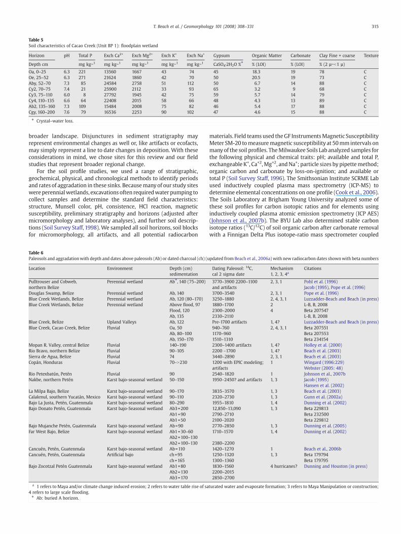
Table 5Soil characteristics of Cacao Creek (Unit BP 1): floodplain wetland
Horizon pH Total P Exch Ca2+ Exch Mg2+ Exch K+ Exch Na+ Gypsum Organic Matter Carbonate Clay Fine + coarse Texture
Depth cm mg kg−1 mg kg−1 mg kg−1 mg kg−1 mg kg−1 CaSO4·2H2O %⁎ % (LOI) % (LOI) % (2 µ−b1 µ)
Oa, 0–25 6.3 221 13560 1667 43 74 45 18.3 19 78 COe, 25–52 6.3 271 21624 1860 42 70 50 20.5 19 73 CAby, 52–70 7.3 85 24584 2758 51 112 50 6.7 14 88 CCy2, 70–75 7.4 21 25900 2112 33 93 65 3.2 9 68 CCy3, 75–110 6.0 8 27792 1945 42 75 59 5.7 14 79 CCy4, 110–135 6.6 64 22408 2015 58 66 48 4.3 13 89 CAb2, 135–160 7.3 109 15484 2008 75 82 46 5.4 17 88 CCgy, 160–200 7.6 79 16536 2253 90 102 47 4.6 15 88 C
⁎ Crystal–water loss.
315T. Beach et al. / Geomorphology 101 (2008) 308–331
broader landscape. Disjunctures in sediment stratigraphy mayrepresent environmental changes as well or, like artifacts or ecofacts,may simply represent a line to date changes in deposition. With theseconsiderations in mind, we chose sites for this review and our fieldstudies that represent broader regional change.
For the soil profile studies, we used a range of stratigraphic,geochemical, physical, and chronological methods to identify periodsand rates of aggradation in these sinks. Becausemanyof our study siteswereperennialwetlands, excavations often requiredwater pumping tocollect samples and determine the standard field characteristics:structure, Munsell color, pH, consistence, HCl reaction, magneticsusceptibility, preliminary stratigraphy and horizons (adjusted aftermicromorphology and laboratory analyses), and further soil descrip-tions (Soil Survey Staff, 1998). We sampled all soil horizons, soil blocksfor micromorphology, all artifacts, and all potential radiocarbon
Table 6Paleosols and aggradationwith depth and dates above paleosols (Ab) or dated charcoal (ch) (u
Location Environment Depth (cm)sedimentation
Pulltrouser and Cobweb,northern Belize
Perennial wetland Ab⁎, 140 (75–200)
Douglas Swamp, Belize Perennial wetland Ab, 140Blue Creek Wetlands, Belize Perennial wetland Ab, 120 (80–170)Blue Creek Wetlands, Belize Perennial wetland Above flood, 97
Flood, 120Ab, 135
Blue Creek, Belize Upland Valleys Ab, 122Blue Creek, Cacao Creek, Belize Fluvial Oa, 50
Ab, 80–100Ab, 150–170
Mopan R. Valley, central Belize Fluvial 140–190Rio Bravo, northern Belize Fluvial 90–105Sierra de Agua, Belize Fluvial 74Copán, Honduras Fluvial 70–N230
Rio Petexbatún, Petén Fluvial 90Nakbe, northern Petén Karst bajo-seasonal wetland 50–150
La Milpa Bajo, Belize Karst bajo-seasonal wetland 90–170Calakmul, southern Yucatán, Mexico Karst bajo-seasonal wetland 90–110Bajo La Justa, Petén, Guatenmala Karst bajo-seasonal wetland 80–290Bajo Donato Petén, Guatenmala Karst bajo-Seasonal wetland Ab3=200
Ab1=90Ab1=50
Bajo Mujanche Petén, Guatenmala Karst bajo-seasonal wetland Ab=90Far West Bajo, Belize Karst bajo-seasonal wetland Ab1=30–60
Ab2=100–130Ab2=100–130
Cancuén, Petén, Guatenmala Karst bajo-seasonal wetland Ab=110Cancuén, Petén, Guatenmala Artificial bajo ch=95
ch=165Bajo Zocotzal Petén Guatenmala Karst bajo-seasonal wetland Ab1=80
Ab2=130Ab3=170
a 1 refers to Maya and/or climate change induced erosion; 2 refers to water table rise of sa4 refers to large scale flooding.⁎ Ab: buried A horizon.
materials. Field teams used theGF InstrumentsMagnetic SusceptibilityMeter SM-20 tomeasuremagnetic susceptibility at 50mm intervals onmanyof the soil profiles. TheMilwaukee Soils Lab analyzed samples forthe following physical and chemical traits: pH; available and total P,exchangeable K+, Ca+2,Mg+2, andNa+; particle sizes by pipettemethod;organic carbon and carbonate by loss-on-ignition; and available ortotal P (Soil Survey Staff, 1996). The Smithsonian Institute SCRME Labused inductively coupled plasma mass spectrometry (ICP-MS) todetermine elemental concentrations on one profile (Cook et al., 2006).The Soils Laboratory at Brigham Young University analyzed some ofthese soil profiles for carbon isotopic ratios and for elements usinginductively coupled plasma atomic emission spectrometry (ICP AES)(Johnson et al., 2007b). The BYU Lab also determined stable carbonisotope ratios (13C/12C) of soil organic carbon after carbonate removalwith a Finnigan Delta Plus isotope-ratio mass spectrometer coupled
pdated from Beach et al., 2006a) with new radiocarbon dates shownwith beta numbers
Dating Paleosol: 14C,cal 2 sigma date
Mechanism1, 2, 3, 4a
Citations
3770–3900 2200–1100and artifacts
2, 3, 1 Pohl et al. (1996)Jacob (1995), Pope et al. (1996)
3700–3540 2, 3, 1 Pope et al. (1996)3250–1880 2, 4, 3, 1 Luzzadder-Beach and Beach (in press)1880–1700 2 L-B, B, 20082300–2000 4 Beta 2075472330–2110 L-B, B, 2008Pre-1700 artifacts 1, 4? Luzzadder-Beach and Beach (in press)940–760 2, 4, 3, 1 Beta 2075511170–960 Beta 2075531510–1310 Beta 2341542300–1400 artifacts 1, 4? Holley et al. (2000)2200 –1700 1, 4? Beach et al. (2003)3440–2890 2, 3, 1 Beach et al. (2003)1200 with EPIC modeling;artifacts
1 Wingard (1996:229)Webster (2005: 48)
2540–1820 1 Johnson et al., 2007b1950–2450? and artifacts 1, 3 Jacob (1995)
Hansen et al. (2002)3835–3570 1, 3 Beach et al. (2003)2320–2730 1, 3 Gunn et al. (2002a)1955–1810 1, 4 Dunning et al. (2002)12,850–13,090 1, 3 Beta 2298132790–2710 Beta 2325002100–2020 Beta 2298122770–2850 1, 3 Dunning et al. (2005)1710–1570 1, 4 Dunning et al. (2002)
2380–22001420–1270 1 Beach et al., 2006b1250–1320 1, 3 Beta 1797941300–1360 Beta 1797951830–1560 4 hurricanes? Dunning and Houston (in press)2200–20152850–2700
turated water and evaporate formation; 3 refers to Maya Manipulation or construction;

316 T. Beach et al. / Geomorphology 101 (2008) 308–331
with a Costech Elemental Analyzer. Several archaeological expertsidentified artifacts, including Drs. Kerry Sagabiel, Lauren Sullivan,Jason Barrett, Jon Lohse, and Collen Hanratty. Beta Analytic assayed allradiocarbon samples using AMS and a few standard radiometricprocedures, and we report two sigma (95% probability) dates ascalibrated by INTCAL98 Radiocarbon Age Calibration (Stuiver et al.,1998) (Table 6). To counter the problems of dating soils (frombioturbation, old carbon, and carbonmixing), our radiocarbon samplesmainly derive from young wood, peat, or charcoal recovered in situ indistinct layers in depositional sequences. We used micromorphologyof photomicrographs of soil thin sections to study microstructure andmineralogy.
6.1. Water chemistry methods
During the 2006 and 2007 field seasons, we collected 18 watersamples at 16 stations across northern Belize. Locations ranged fromChan Chich Creek on the far western border with Guatemala to FourMile Lagoon on the northeast coast of Belize, and south as far as HectorCreek in the Belize River Valley (Fig. 1). Both field seasons were at theend of the dry season, for temporal consistency with our continuingwater quality monitoring program in the region over the last 15 years(Luzzadder-Beach and Beach, in press). We collected our samples intriple-rinsed plastic containers, conducted field measurements ofelectrical conductivity (EC), total dissolved solids (TDS), pH, salinity,and temperature, then transported the samples to the George MasonUniversity Water Quality Laboratory for analysis. All samples werefiltered through 0.45 μm/47mmGelman ScientificMetricelmembranefilters prior to chemical analysis. Mineral analyses included totalhardness (as CaCO3), calcium (Ca+2),magnesium (Mg+2), sulfate (SO4
2−),alkalinity (total as CaCO3), nitrate (NO3
−), and sodium (Na+). Table 7 liststhe methods and instruments that we used for the water analysis.
7. Results: sediment sinks
7.1. Maya clays
The earliest evidence for long-term human impacts on the Mayalowlands came from sedimentary studies of tectonic and karst lakes inthe central Petén region of Guatemala (Deevey et al., 1979; Rice, 1996;
Table 7Laboratory methods for water chemistry
Test Unit Instrument Method number,if applicable
EC µS HACH CO150 EC Meter 50150 n/aTDS mg L−1 HACH CO150 EC Meter 50150 n/aSalinity 0/00 HACH CO150 EC Meter 50150 n/aNO3–N mg L−1 HACH DR850 Colorimeter 8039a
NO3–N, cont'd mg L−1 LaMotte Smart2 Colorimeter 3649-01-SCb
Hardness mg L−1 LaMotte Direct Read Titrater 4824-DR-01b
Ca2+ mg L−1 LaMotte Direct Read Titrater 4824-DR-01b
Mg2+ mg L−1 LaMotte Direct Read Titrater 4824-DR-01b
Alkalinity mg L−1 LaMotte Direct Read Titrater 4824-DR-01b
SO42− mg L−1 LaMotte Smart2 Colorimeter 3654-01-SCb
Cl− mg L−1 LaMotte Direct Read Titrater 4824-DR-01b
Cl−, cont'd mg L−1 Calculated from salinity readings 8113b,c
Na++K+ mg L−1 Derived from mass balance,K+ is negligible
n/ac,d
a Hach Company, 1998. DR/850 Colorimeter Procedures Manual. Edition 1. LovelandCO: Hach Company USA.
b Lamotte Company, 2005. Operator's Manual. Version 2.3. ChestertownMD: LamotteCompany.
c Hach Company,1996. Digital Titrator Model 16900 LabManual. Edition 21. LovelandCO: Hach Company USA.
d Quality control was ensured by calibrating with standard solutions and testingblank samples prepared with deionized water, and also by calculating a mass balance ofcations and anions (Lamotte Company, 2005; Hounslow, 1995; Luzzadder-Beach andBeach, in press).
Rosenmeier et al., 2002; Brenner et al., 2003; Wahl et al., 2006). Atypical sequence from these sediment cores included early to middleHolocene organic gyttja with pollen from high forest taxa and lowquantities of charcoal followed by declines in forest taxa and the firstZea mays by about 4600 BP, a dense layer of silicate clays dating fromabout 3000 to 1000 BP (Preclassic through the Classic Maya period)with taxa indicative of diminished high forest, increased disturbanceand economic species, and increased phosphorous and charcoal.These sediment sequences then returned to gyttja deposition after1000 to 500 BP (the Post Classic to modern periods) and also include areturn of forest pollen taxa, less phosphorous, and decreased charcoal.
A site in the southern margins of the Maya region in El Salvadorprovides evidence of a similar environmental history but withsignificant volcanic impacts. Here, near the Ilopango Volcano, Dull(2007) found high rates of sedimentation accompanied with highquantities of Zea mays and disturbance pollen taxa and charcoal in thePreclassic and Early Classic and Late Classic. A hiatus from this trendoccurred with (and interestingly before) a large eruption of Ilopangotephra, dated to AD 408–536. The 2000 years of intensive humandisturbance (c. 3700 to 1600 cal yr BP) in this region, indicated inmultiple lines of evidence, correlates well with the cultural record ofanthropogenic disturbance. Human disturbance here also paralleledthe Petén records with decline by about 1000 cal yr BP and especiallyafter 500 cal yr BP.
Recent research in lake coring coupledwith geophysics at the smallkarst Lake Salpetén in the Petén Lakes Region Guatemala (Figs. 1, 2) isthe most detailed and complete lake sediment study thus far toquantify sedimentation chronology through the Maya period (Ansel-metti et al., 2007). Because this lake was the main sediment sink inthis watershed, the authors could reconstruct the near total flux oferoded soils into the basin through time, and, thus, provide robustestimates of rates of erosion. Based on dating sediment cores from thelake and estimating sediment volumes deposited through time usingseismology, Anselmetti et al. (2007) calculated that erosion rose froma background level of 0.25 t ha−1 to 2.7, 8.9, and 12 through thePreclassic period decreasing to 6 t ha−1 during the Classic period.These represent counter intuitive rates of erosion because they werehighest during the Preclassic when estimated human populationdensities were low (7–48 people km−2) and rates of erosion declinedduring the period of highest estimated population density (up to 248persons km−2). The high rates of erosion of the Late Preclassic droppedoff by 2.4 times during this time and transition to the Classic Period,but erosion was still 20 times higher than background rates.
Other sediment studies from this region, such as Tamarindito in thesouthern Petén of Guatemala, provide further evidence for Maya Claysand phosphorous enrichment, though not to the extent recorded sodramatically as in the central Petén. Phosphorous concentrations andsedimentation increased 25 times from the Preclassic to Classic periods,and like Lake Salpetén, sedimentation (and by extension, erosion)decreased after about 2000 BP. Also, at Tamarindito charcoal increasedsignificantly in the Late Classic, showinghuman activitywas intensive inspite of lowered sedimentation (Dunning and Beach, 2008). At LagunaLas Pozas, 10 km south of Tamarindito, Johnston et al. (2001) found abrief but significant surge of erosion and sedimentation in the PostClassic around 800–1050 BP. They based their findings on increased inmetal elements, magnetic susceptibility, and disturbance pollen.
7.2. Upland seasonal, wetlands: bajos
The elevated, interior area of the Yucatán Platform surrounding thecentral Petén Lakes contains numerous depressions, ranging fromsmall (1–2 km2) karst solution features to large (50–200 km2)structural valleys, all of which are known simply as bajos (Figs. 1and 2). Drainage is largely internal, but seasonal surface streams,fueled by heavy wet season runoff and perched by dense clay layers,interlink many basins. Today, local variations in hydrologic and

317T. Beach et al. / Geomorphology 101 (2008) 308–331
edaphic conditions support a variety of ecosystems includingperennial, herbaceous wetlands and various types of palm forests.The most prevalent ecosystem is the tintal bajo: seasonally inundatedswamps characterized by Vertisols and stunted, woody vegetationdominated by logwood, or palo de tinto (Haemotoxylum campechia-num). Many writers label the “Tintal Bajos” as barren, resource poorenvironments, although many of the largest and earliest Maya sites inthe interior lowlands lie paradoxically along their margins.
Several lines of research over the past three decades haveattempted to solve this ‘bajo paradox’. Bajos certainly contain clay,seasonal water, and lithic resources, and some scholars in the 1970sused a variety of techniques to suggest that bajos might have been focifor intensive ancient agriculture. For example, previous research hasdetected ancient Maya wetland field systems and canals in the BajoMorocoy (Fig. 1) in southern Quintana Roo (e.g., Gliessman et al.,1983). But, further work has demonstrated that canals and fieldpatterns are rare in these elevated bajos, except in this restricted areaof Quintana Roo (Pope and Dahlin, 1989; Foster and Turner, 2004;Dunning et al., 2006) and to amuchmore limited extent in a few otherbajos such as the southernmargin of the huge Bajo de Azúcar near SanBartolo in the Petén (Dunning et al., in press-a). It is becoming clear,however, that bajos contain a variety of ecosystems and soilassociations that are more compatible with traditional Maya agricul-ture, and that many farmers use them today (Culbert et al., 1989,1996;Kunen et al., 2000). Indeed, significant ancient Maya manipulationoccurred, especially focused on the ecotonal bajo-margins, which areelevated, have accumulating sediments, and hold evidence for waterand soil management (Scarborough and Gallopin, 1991; Beach et al.,2002; Dunning et al., 2002; Gunn et al., 2002a).
Overall, bajos have surprisingly complex physical, biological, andcultural histories (Dunning et al., 2006). Interdisciplinary research inseveral bajos in northwestern Belize and northern Guatemala, forinstance, have revealed varied environmental histories, at timesholding shallow lakes or perennial wetlands that would have heldrich resources for the ancient Maya (Castañeda Salguero, 1995; Jacob,1995; Dunning et al., 1999, 2002, 2006; Beach et al., 2003, 2006b;Hansen et al., 2002). Several examples of bajo geomorphic historyserve as examples (Dunning et al., 2005, in press-a).
Many bajo sinks experienced ecological and geomorphic changes.One aspect of this is aggradation above buried paleosols (Table 6).Evidence, however, is complicated and variable because of such factorsas ancient land use intensity, climatic changes, Vertisol churning of soilprofiles, loss of melanization in buried paleosols, and distance,gradients, and flow directions from upland sediment sources. Someof the bajos (Figs. 1, 2) in the upland karst region, such as La Justa andthose near the Maya site of Nakbe in the Petén of Guatemala, andGuijarral and the Far West Bajo, near La Milpa in adjacent Belize,provide pollen and carbon isotopic evidence for a shift from perennialwetlands before 2100 BP to drier conditions thereafter as theyaggraded from surrounding slope erosion and as the climate becamedrier (Jacob, 1995; Dunning et al., 2002; Beach et al., 2003; Dunninget al., in press-b). These environmental shifts appear to be synchronouswith those experienced along the margins of the Petén lakes thatindicate higher lake levels before 2100 BP (Rosenmeier et al., in press).
The region around the ancient Maya site of Tikal forms a transitionfrom the karst ridges to bajos. Themain source for understanding soilsand erosion at Tikal is Olson's survey (1977, p.16), inwhich hemappedthe soils in the region and estimated 30 to 60 cm (1–2 ft) of coarsersediments buried the pre-Maya, clayey soils of footslopes anddepressions. A more recent study has measured c. 1 m sedimentationabove paleosols from the Late Preclassic (2500–1700 BP) in parts ofthe Bajo Laberinto in southern Campeche, Mexico around the majorMaya site of Calakmul (Gunn et al., 2002a). In these bajos, buried soilsdid not have a highly melanized appearance, but the team estimatedthem by other morphological evidence and an abrupt increase inelemental concentrations using ICP-AES.
In summary, many excavations in the central and southern Mayalowlands display paleosols buried by 0.5 to 2 m, especially adjacent tothe surrounding escarpments, where Maya cities and other intensivelanduses occurred. Many others examples of early sedimentation existfor the Preclassic such as at the Aguada Catolino, a dissolution dolinein the Petexbatún (Dunning and Beach, 2008). Nevertheless, somebajos have little evidence of geomorphic change during the ancientMaya Period, such as the Dumbbell Bajo, parts of the sprawling Bajo deSanta Fe, and larger parts of the Bajo la Justa (Dunning et al., 2006). Butthose studied thus far represent only a small sample of these large,hydrologically and ecologically complicated karst sinks (Table 6).
7.3. Carbon isotopic ratio examples from depression soil profiles
Additional evidence of anthropogenic impacts on erosion comesfrom soil carbon isotopic studies and an ancient Maya reservoir.Research in the upper Usumacinta River region, near the sites ofPiedras Negras and Yaxchilán has examined carbon isotope ratios(δ13C) in soil profiles as evidence for possible ancient Maya use anddisturbance (Johnson et al., 2007a). They reasoned that some tropicalgrasses like maize have a C4 photosynthetic pathway that is bothmoreefficient and less discriminatory toward the heavier 13C isotope thanthe C3 photosynthetic pathways of forest trees and broadleaf ever-greens. Thus soil layers with C4 enrichment reflect inputs from thesegrasses when these layers were topsoils. Although Johnson et al.(2007a) report few buried paleosols, they did find strong to moderateC4 enrichment in many soils through the top 1–2 m. The horizons ofenrichment may coincide with ancient soil surfaces, which may nothave been apparent because melanization fades as organic matterdecomposes in many soil environments. Two of the bajo soils becamemore C4 enriched to depths of about 1 m and decreased to becomemore like a C3 signature below this. A third bajo soil simply increasedits C4 signature to the excavations limit at 1.8 m. Other depositionalsoils also provided similar or even stronger patterns, and one with aburied paleosol at 0.75 m produced the most C4 enriched signature.These isotopic signatures of ancient C4 plant growth occur against abackground of earlier C3 forest vegetation, and a subsequent return toforest vegetation after the Maya Terminal Classic, developed in theseprofiles as a result of rhizodeposition in the root zone, bioturbation,and soil aggradation. Buried soils and the deeply buried C4 carbonisotopic ratios of these depositional soils probably indicate aggradationby c. 1 m by the Maya Classic, but Johnson et al. (2007b) had no datingevidence other than a few sherds from these profiles.
We present a new reservoir sedimentation record and five new soilprofiles of carbon isotopic ratios from sediment sequences as evidenceof the environmental change involved with aggradation (Fig. 4A–C).First, two areas with aguadas (small dissolution dolines) have verysimilar records despite being located at opposite ends of the Peténwith contrasting land covers: recent milpa farming at Cancuén,Guatemala and high tropical forest at Mahogany Ridge, near La Milpa,Belize. We studied two aguadas in low relief areas of the site ofCancuén, an artificial one built in the Maya Late Classic and the seconda natural sink. The artificial aguada has infilled to a depth of nearly 2msince its construction in the early eight century AD. Radiocarbon(Table 6), artifacts (Ohnstad et al., 2004), and geochemistry indicatethat 1.3 m of minerogenic sediment was deposited in the ceremonialwater feature during at most 110 years of Maya land use, giving aminimal sedimentation rate of 11.8 mm yr−1. In contrast, post-abandonment aggradation during the last c. 1250 years is representedby just 0.70 m of organic-rich sediment, giving a sedimentation rate of0.56 mm yr−1. Another aguada at Cancuén was buried by 1.1 m ofsediment above an AMS 14C date of 1420–1270 BP on the top of anorganic paleosol (Beach et al., 2006b). New carbon isotopic data fromthis soil sequence (Fig. 4A) is telling: increasing from a mixed tropicalforest and recent milpa δ13C signature (−25.05) at the surface to asignature that shows considerable input of C4 species in the Late

Fig. 4. Carbon isotopic ratios (δ13C) of four depression soil profiles. A. Upper left, soil profile from a karst sink at Cancuen; B. upper right, soil profile from Mahogany Ridge, Belize;C. lower left, three soils profiles from near the site of La Milpa, Belize, D. lower right, soil profile from the Cacao Creek, Belize floodplain in the coastal plain.
318 T. Beach et al. / Geomorphology 101 (2008) 308–331
Classic period (−17.75), but then a significant decline (−25.83) in theearlier subsoils. Thus, the bulk of sedimentation at Cancuén occurredwhen the landscape had a much larger presence of C4 species duringthe Maya Late Classic. These examples from Cancuén aguadas indicatea minimum decline from the Late Classic to Post Classic in thesedimentation rate by 21 times, which is a comparable magnitude toSalpetén's 24 times decrease over the same time period.
Aguadas from near the site of La Milpa, Belize provide contrastinghistories. The first at Mahogany Ridge (Fig. 4B) had a similar record toCancuén, with a paleosol buried by 0.92 m in the Classical period(dated by artifacts) and a steady increase in the δ13C from the moderntopsoil to the buried soil, increasing from a typical tropical forestsignature (−27.33) to a signature that shows high input of C4 species inthe Classic period (−21.67), but then a significant decline (increase inC3 species organic matter) in the earlier subsoils (−24.61 at MahoganyRidge). Apparently, the Cancuén and Mahogany Ridge soils experi-enced Classic period aggradation, during which time significantlymore C4 vegetation (such as Maize) was contributing to the soilorganic matter. Less apparent were three other depression profilesaround La Milpa (Figs. 1, 4C). Here two paleosols buried at depths ofabout 1 m and dating to the Preclasssic at the La Milpa Aguada (3180–
2980 BP) and bajo (3695–3400 BP) display increases in the δ13C fromthe topsoils to the Preclassic paleosols by 3.23 and 3.54 respectively,which is a magnitude within the range of natural fractionation downsoil profiles (Johnson et al., 2007b). In both cases, nonetheless, δ13Cdecreased again into the subsoils to nearly the topsoil signature. Theleast compelling was a profile with a Classic paleosol (radiocarbondated to 1585–1295 BP) buried 0.62 m behind an ancient Mayaterrace. The δ13C increased by only about 2 ppt, a quantity well withinthe range of natural fractionation and indicative of continuous C3
plant inputs over time.
7.4. Geoarchaeological example of the Bajo Donato
The Bajo Donato is a small (c. 2 km2) depression perched in therolling uplands seven km northeast from the site of San Bartolo,Guatemala (Fig. 1; Table 6). The site of San Bartolo includesmonumental architecture dating to at least 2800 BP and the earliestknown examples of Maya writing and mural painting, dating to thefirst century BC (Saturno et al., 2006). Bajo Donato has surfacedrainage via a shallow arroyo into the Bajo de Azucar to the north.Modern ecosystems include palo de tinto, low scrub forest vegetation,

319T. Beach et al. / Geomorphology 101 (2008) 308–331
which is flanked by mixed palm forest or an abrupt transition toupland forest on karst ridges. Ancient Maya terraces cover thesouthern and eastern slopes above the bajo.
The Aguada Tintal (a small, human-modified pond) lies in thenorthwest portion of the Bajo Donato. A sediment core extracted fromthe aguada in 2005 found agricultural pollen (Zea mays, manioc(Manihot esculenta), and cotton (Gossypium hirsutum) and evidence offorest clearance in sediment with a calibrated age range of 2730–2360 BP (Dunning et al., 2005). Sediment from about 2100 to 1200 BPwas absent and perhaps removed by ancient Maya dredging.Excavations in 2007 revealed that the Maya had begun deepeningthe aguada and constructing a stone-lined berm on its margins in theMiddle Preclassic, burying an adjacent soil surface that produced acalibrated bulk humate radiocarbon date of 2840–2730 BP (Dunninget al., in press-a). Nearby low, rubble berms andmodified surfacesmayhave been used for local drainage modification and agriculture.
Another excavation (Fig. 5A) in 2007 near the southern end of thebajo revealed multiple episodes of pedogenesis and aggradation(Dunning et al., in press-a). At a depth of nearly 2 m lies a highlycompressed organic Ab2 (or histic) horizon that produced a calibratedradiocarbon range of 12,850–13,090 BP. Although this buried materialdid not preserve pollen or phytoliths, it did retain some ephemeralimpressions of leaves and grasses and organic matter here produced aδ13C value of −24.8 (a middle range carbon isotopic ratio indicating
Fig. 5. Illustrations of three Bajo soil profiles from the Petén, Guatemala. A. BajoDonato 1 shows aV(redrafted fromDunningetal., inpress-a). C. BajoZocotzalnear Tikal, Petén,Guatemala, illustrating
either a mix of woody and herbaceous vegetation or seasonal wetland(Johnson et al., 2007b). We interpret this to be a relict organic surfaceburied rapidly (to preserve leaf imprints), then further buried bycontinued aggradation later in the Holocene. Cowgill and Hutchinson(1963) reported a similar Late Pleistocene (11,500–11,860 BP) blackhorizon at a depth of 3.5 m in the Bajo de Santa Fe near Tikal.
More representative of bajo profiles was another highly com-pressed organic layer at a depth of 0.9 m in the small Bajo Majunche,southwest of San Bartolo in 2005 (Table 2; Fig. 6). Bulk organic mattersampled from here dated to 2770–2850 BP, and preserved pollenindicative of a shallow lake or perennial wetland at that time(Dunning et al., 2005). Analogous buried histic deposits withperennial wetland pollen have also been found in the Bajo de laJusta in northern Guatemala and the Far West Bajo in northwesternBelize, but dating to 1800–2000 BP (Dunning et al., 2002). In contrast,the buried Pleistocene horizons in the Bajo Donato and Bajo de SantaFewere unlikely from perennial wetlands, since these Late Pleistoceneenvironments were much more arid (Leyden, 1984; Brenner et al.,2002). Although bajos have notoriously variable hydrologies, at leastsome were also well drained, judging by the presence of a buried latePleistocene Oxisol in the Dumbbell Bajo in northwestern Belize(Dunning et al., 2006).
Lying above the Ab2 horizon in the Bajo Donato was clayeymineralsediment and another buried organic rich paleosol. This paleosol is
ertisolwith twoburied paleosols. B. BajoDonato 2 shows a Rendollwith one buried paleosoltwohighenergyevents and threepaleosols (Re-drafted fromDunningandHouston, inpress).

Fig. 6. Bajo Majanche soil profile and photograph, Petén, Guatemala (redrafted from Dunning et al. in press-b).
320 T. Beach et al. / Geomorphology 101 (2008) 308–331
topped by the Ab1 horizon, with a calibrated radiocarbon range of2950–2750 BP. This surface was in turn buried again by clayeymineralsediments of the upper horizons. Subsequent hydrologic conditionswithin the bajo and the uneven distribution of accumulatingmasses ofsediment combined to induce substantial argilloturbation, clearlyseen in the breakage of horizons, heaving, and slickensides developedthroughout the soil profile (Fig. 5). Several studies have documentedVertisol development in aggraded clay sediments of many bajos in theMaya Lowlands (Jacob, 1995; Dunning et al., 2002, in press-b; Beachet al., 2003, 2006a). Further excavation of the base of the ridge formingthe southern margin of the Bajo Donato exposed another Ab horizonat c. 0.5 m depth (Fig. 5B; Donato 2). Bulk carbon from the upper Abproduced a calibrated radiocarbon range from 2150–2250 BP (Table 6).Colluvial deposition with numerous, coarse limestone clasts probablyburied this horizon from upslope erosion after around 2000 BP (laterLate Preclassic) (Dunning et al., in press-a).
The ridge upslope from this unit has a slope of 5–8°, and the Mayamodified the slope with a series of contour agricultural terraces.Excavations of these terraces revealed a single low wall of stackedstones backed by a wide berm of rubble. A carbonized maize kernel,recovered from c. 0.6 m behind one of the terraces, produced acalibrated radiocarbon range of 1860–2000 BP (Table 6), similar in ageto another Ab horizon (1930–2130 BP) behind a buried ancient Mayaterrace in another Arroyo at Xultun, 8 km south of San Bartolo. Theselines of evidence suggest that the terrace construction was alsosometime around 2000 BP, possibly connected to slope erosion(Dunning et al., in press-a).
The data from the bajo, aguada, and southern flank suggest thefollowing sequence of development. At the end of the Pleistocene theBajo Donato had a mixed forest vegetation or was a wetland with athick O horizon. During the early to mid-Holocene, the depressionaggraded rapidly with clayey sediments, followed by a period ofgeomorphic stability. By 3000 BP, the bajo included mixed forest andwetland vegetation. Shortly thereafter, Maya settlers arrived in thearea and began clearing forest— probably for swidden cultivation. TheMaya began mining a chert-rich stratum exposed near the surface of
the Bajo Donato during the Middle Preclassic (c. 2700 BP) and after2600 BP they adapted the former quarry to enhance its water-retention capacity, thus creating the Aguada Tintal. Middle and LatePreclassic farmers in the area were cultivating maize, manioc, andcotton among other crops. Accelerated erosion ensued on thesurrounding uplands inducing renewed aggradation in the bajo. Bythe first century AD, Maya farmers sought to stabilize soils on thesouthern flank of the bajo using agricultural terracing. The area(including the center of San Bartolo) was apparently abandonedaround 1850 BP for unknown reasons, but was reoccupied by a smalleragricultural population in the Late Classic (c. 1250 BP) for over acentury, during which time dredging occurred, perhaps to enhance itswater-holding capacity.
Several anthropogenic factors drove bajo aggradation in theinterior southern and central lowlands including urban construction,deforestation for lime mining, agricultural erosion, and ancientcauseway construction. In general bajos aggraded from 1–2 mbetween the Preclassic through Classic Maya times near Tikal andMirador (Beach et al., 2003, 2006b). But erosion here was also natural(perhaps accelerated by humans) such as the middle Holoceneaggradation of paleosols and twohigh energy deposits (highmagnitude,low frequency events). In the Maya Lowlands, at least during the lateHolocene, highmagnitude events aremost likely to arrive in the form oftropical storms, which are common in the region and the ancient Mayarecognized in their writing (Dunning and Houston, in press). Twoseparate deposits in different bajos (the Far West Bajo near La Milpa,Belize, and the Bajo Zocotzal near Tikal (Fig. 5C) stand out because of thethick, high energy (coarse grained) facies within mostly fine grainedfacies. These high energy deposits account for about half of all LateHolocene sediments in these excavations. The example at Bajo Zocotzaldisplayed two high energy strata, 0.8–0.9 m thick, bracketed with threepaleosols formed in low energy clays. The upper paleosol dated to theEarly Classic (1830–1560 BP), themiddle paleosol that separates the twohigh energy deposits dated to the Late Preclassic (2200–2015 BP), andthe lowest paleosol dated to the Early Preclassic (2850–2700 BP)(Dunning and Houston, in press).

321T. Beach et al. / Geomorphology 101 (2008) 308–331
7.5. Fluvial environments
Along its peripheries, the Maya Lowlands has many fluvial andfluviokarst watersheds such as the Pasión, Belize River, Candelaria,Motagua, Polochic, and Usumacinta (Fig. 1), but scant fluvialgeomorphological research exists for these watersheds. Mostregional river systems have low gradients, wide seasonal flowvariability, and carry high dissolved loads. Flows tend to be highestfrom June to December, when they often back up and reverse streamdirections. Dry season flows are from base flow or from highelevation runoff and, thus, stream loads are highly seasonal.Archaeological reports from the region provide some evidence ofpast fluvial activity. For example, early research on the Belize Riverfound that Preclassic structures in the upper river terraces near thesite of Barton Ramie were built into or on top of a 0.70 m thickpaleosol, which in turnwas buried by c.1 m of brown, and then black,clay-rich topsoil (Willey et al., 1965). Furthermore, subsequentstructures from the Classic period are founded within the uppersediments; thus, sedimentation occurred in the Preclassic and in orafter the Classic period. Willey et al. (1965) ascribed this aggradationof the upper terrace (which previously could not be reached byfloods) to increased flood levels caused by accelerated runoff fromwatershed deforestation (Olson, 1981). They also noted a tendencyfor sites to be farther uphill after the Preclassic. Holley et al. (2000)also found evidence for preclassic alluviation near the Maya site ofXunantunich with an electromagnetic conductivity survey and sixexcavations. Generally, they found well formed topsoils and 1.4 to1.9 m of high energy sediments (cobble, gravel, and sand) buryingclayey palesols. They also used artifacts to date the paleosol and theaggradation to the Preclassic and ascribed it to large-scale, humaninduced flooding in the watershed (Holley et al., 2000, p.122). Thesehigh energy events could have been one or multiple events, but thesesediments provided no evidence for periods of stability.
One study of the Xibun River in Belize found buried soils along twoof its Holocene terraces, identifying an upper terrace paleosol buriedby c.1 m of alluvium sometime in the middle Holocene and a lowerterrace paleosol buried by about 0.60 m of alluvium. These terraceshave truncated paleosols with Bt horizons covered by 0.60 m of sandand silt with weak pedogenesis. This deposit also buried Late Classicarchitecture (1120–1000 BP) that is 5–6 m above the modern surfaceof the river, which dates this sedimentation to sometime afterabandonment, c. 1000 BP (Bullard, 2004, p. 319). Lietzke andWhiteside (1981) report a similar but undated Ab sequence buried69–86 cm from the Swazi River floodplain in southern Belize.
The footslopes and river valleys around the Maya site of Copánprovide an example of long-term sediment sinks. Though no study hasexpressly investigated the sediment budget of these valleys, Turneret al. (1983) did study the Holocene history of the river. Theirinvestigations indicate that remnant Late Pleistocene valley fills arepreserved in a set of upper alluvial terraces, carved by early to mid-Holocene entrenchment, upon which have developed Oxic Ustro-pepts. A more extensive, lower terrace represents the pre-Maya valleyfloor. Gully exposures and pits in this terrace often revealed twoburied soils: an upper paleosol that was buried by historic or modernalluviation, and a lower paleosol (typically at a depth of 0.8–1 m),which is the actual pre-Maya or Preclassic soil (a Mollic Ustifluvent),artifact-dated to c. 3000–2000 BP (see Turner et al., 1983, Fig. T-23).This surface was variously buried and destroyed by frequent flooding,channel migration, and floodplain sedimentation in the period from3000 to 1500 BP, probably attributable to land clearance andagriculture as population expanded within the valley. The CopánMaya responded to the increasingly erratic river by diverting itsometime after 1300 BP, though the system apparently fell intodisrepair after the site declined after 1200 BP. From 1000 to 500 BP,the Copán River started to incise into the previously aggradedfloodplain and formed the second lower terrace. Eventually, the
river also began incising into the Copán Acropolis, necessitating thediversion of the river again by archaeologists of the CarnegieInstitution ofWashingtonworking at the site in the early 20th century.
Wingard (1996) also studied soil sequences around Copán, focusingmainly on the top 1 m. One of his soils pits unveiled a clay and clayloam-textured paleosol buried by 0.7 m of sandy loam sediments inthe Copán Pocket. Olson (1981, pp.113–114) also reported a buried Asoil horizon in alluviumwithMaya artifacts at 1.07m in the nearby RioAmarillo and at the Valle de Naco region in Honduras. Moreover,Wingard (1996) concluded that some Late Classic housemound groupswere covered by at least 2 m of sediment in footslopes and floodplainsaround themain site of Copán,whichWebster (2005, p. 48) provides ina diagram. BothWingard andWebster suggest that accelerated erosionand deposition resulted from the expansion of Maya agriculture ontosurrounding hills and the cultivation of steeply sloping Rendolls andvarious types of shallow Inceptisols. This general scenario of LateClassic accelerated erosion and sedimentation is also supported by acoring study of the Aguada Petapilla, a pond within a tributary valley(Abrams and Rue, 1988).
The main research on the Motagua River (Fig. 1), Guatemala hasfocused around the ancient Maya site of Quiriguá (Ashmore, 2007). Amodern irrigation project exhumed several 2 m deep canals across thefloodplain here, which provided windows into regional archaeologyand geomorphology. The floodplain revealed that 1–2 m or more ofalluvium enveloped all but the major architecture of the site (builtfrom c. 1550 to 1200 BP). Ashmore (2007, p. 23) estimated the highestrates of alluviation were 0.22–0.29 mm yr−1 from 1400 to 1100 BP.Estimated alluviation declined after this to 0.05–0.06 mm yr−1 atgreater distances away from the river channel and to 0.18–0.2mmyr−1
near the channel. Excavations did not extend below to earlier levels.Soil studies across the Rio Petexbatún (Fig. 1) have found some
evidence for aggradation associated with Maya land use in karst sinks,floodplains, and footslopes (Beach, 1998a; Dunning and Beach, 2008).Sediment profiles of the Rio Petexbatún floodplain include buriedanthropogenic soils at depths of 1.1 and 0.9 m. The latter paleosol nearAguateca, dated to 2540 to 1820 BP, demonstrated strong C4 carbonenrichment down the profile to the paleosol (Johnson et al., 2007b).
Scatena and Golden (2003) studied the general geomorphologyand environment of the Usumacinta River in the northwestern Peten.Initial geoarchaeological investigations around La Joyanca along theRio San Pedro Matir, a major tributary of the Usumacinta in thenorthwestern Petén (Fig. 1), have uncovered evidence for dynamicenvironmental changes associated with the Pleistocene–Holocenetransition and with the ancient Maya occupation of the region(Métailié et al., 2003). In this region of muted ridge and valley terrain,late Pleistocene stream channel draining ridges were aggraded,probably as the result of base-level changes in the Holocene. In alake core study, Carozzal et al. (2007) found evidence for Zea maysagriculture at the bottom of their core, dated to 2600 BP, evidence ofsporadic erosion in increased magnetic susceptibility and claydeposition spikes in the Preclassic, decreased evidence in the LatePreclassic, but the highest erosion rates in the Early Classic. They alsofound evidence for increased erosion in the Post Classic about 800 BPin colluvial and lacustrine deposition.
Hence, the handful of studies that have assessed fluvial geomor-phology in the Maya Lowlands have found evidence for erosion andsedimentation coinciding with Preclassic and Classic periods, butfluvial research is in its infancy in this region and often centeredaround major archaeological sites, which may make this research nonrepresentative.
7.6. Three rivers region and the coastal plain wetlands
We consider the Three Rivers Region around the sites of BlueCreek, Chan Cahal, and La Milpa (Figs. 1, 3) as a microcosm of thesouthern and central Maya Lowlands. It forms an ecotonal transition

322 T. Beach et al. / Geomorphology 101 (2008) 308–331
from the karst upland ridges and valleys of the interior, the confluenceof three main river valleys, and the confluence of groundwateraquifers at the last major escarpment between the mostly karstinterior uplands and the fluvial and karst coastal plain. This region hasallowed us to study sediment sources alongside water chemistry andcompare these with the depositional record in a series of sedimentsinks from upland depressions, alluvial fans, floodplains, and perchedcoastal plain depressions (Luzzadder-Beach and Beach, in press).
The bajos discussed earlier extend to near the edge of the Rio Bravoescarpment (Fig. 3). Along the escarpment are karst ridges, dry karstvalleys, dolines, and alluvial fans. Excavations and exposures acrossupland karst valleys near Blue Creek display rapid, recent gully erosionthat reaches up the backslopes. One modern gully formed sinceEuropean settlement in 1958 has incised by as much as 3 m in depthand over 125 m in length through the sediments of a non-channeledvalley (Luzzadder-Beach and Beach, in press). The gully exposes a deep,modernRendoll topsoil (0.2–0.3m thick, black, and granular structured)and an even thicker and darker paleosol buried at 1.22 m, whichsandwich high energy colluvium and alluvium (Fig. 7, photo). Thesequence was dated with artifacts: Late Classic and mixed ceramics inthe upper 0.98 m and strictly Late Preclassic ceramics through the next0.24 m of more melanized colluvium into the upper paleosol (Fig. 8A).
Luzzadder-Beach and Beach (in press: e.g., see unit 66W) demon-strated that some alluvial fans at the contact between the escarpmentof the upland karst region and the coastal plain produced a sequencethat parallels this karst valley because they also had alluvial andcolluvial sediments sandwiched by a well formed topsoil and apaleosol dated to the Preclassic by artifacts and radiocarbon dates(Fig. 8B). Webb et al. (2007) described similar aggradation over twofootslope paleosols in northern Guatemala, although without chron-ology. These soils also have significant delta carbon enrichment downto the paleosols. Another fan (66S), however, supplied amore complexpicturewith a series of paleosols from3.1 to 1.47mdated to theArchaicand Preclassic and the sediments above 1.4mdating only to the Classicand later periods (Fig. 8C). Artifacts and radiocarbon dates showsurprising fan instability before the Classic Period, but also Classicinstability capped by cumulic A horizons. An upland doline excavationat 66M (Table 3) provided a similarly complicated environmentalhistory to the alluvial fan at 66S (Beach et al., 2006a). This nearly 4 mdeep unit had a paleosol near the bottom at 3.5 m that yielded an AMSdate of 4425–4145 BP on charcoal. Charcoal from a paleosol at 2.9 m
Fig. 7. Photograph of gully, showing soil profil
depth yielded an AMS date of 4090–3890 BP, and Preclassic artifactsdominate the sequence below a paleosol at 1.30 m, which in turn liesbelow alluvial and colluvial sediments that have mixed, dominantlyClassic period artifacts through the well formed, cumulic topsoil.Hence, this complex sink had high deposition in the Archaic andPreclassic periods, and further deposition largely in the Classic periodjudging by the ceramic chronologyand the degree of topsoil formation.
The coastal plain wetlands (c. 7–12 masl) are another geomorphicsink that provides clear evidence of widespread aggradation (Luzzad-der-Beach and Beach, in press). These wetlands and rivers flow towardthe Rio Hondo and on to Chetumal Bay, 80 km from Blue Creek with aregional landscape gradient of about 0.1 mm km−1. We have excavatedmany soil units through these wetlands to understand the chronologyand processes of formation. Unit 66E was a representative excavation(10 m long, 2 m deep) of the soils, sediments, and timing ofaggradation in this area (Table 4; Fig. 8D). As with all other units inthese depressions, Unit 66E preserved the following profile (Fig. 8D): athick, well developed paleosol (Eklu'um Paleosol) buried by 1.3 m ofsediment. The paleosol had a thick, clayey Abss horizon topped inplaces by a 0.1–0.2 m thick O horizon and topped here and in all of ourexcavations by 0.09 m of carbonate sand. This sequence is in turnburied by about 1 m of sediment that is generally about 75% gypsumparticles (clay and silt sized).
The soil profiles of the upland sites (Figs. 5–7, 8A) look similar tothese coastal plain sites (Figs. 8D–F, 9), but the uplands are aggradedby dominantly carbonate rich sediments and the coastal plains areaggraded by dominantly gypsum rich sediments. Four additional linesof evidence differentiate the formation of these coastal plain se-quences: the profiles of magnetic susceptibility (Fig. 10 A, C), generalsoil characteristics, elemental analysis of the soil horizons (Fig. 10B),and micromorphology. In all excavations, magnetic susceptibility isrelatively high in the modern topsoils, decreases through gypsic andcarbonate sediments that overlie the paleosol, and increase by a factorof 4 or 5 through the paleosol (Table 4). In all excavations the surfacesoils are clay loams but the gypsum and carbonate layers are coarser intexture, often loam or silt loams. Elemental analysis by ICP-MS from anexcavation adjacent to 66E provides further evidence. Here we usedthe same techniques as discussed in Cook et al. (2006) and displayelements logarithmically to present them on one graph (Fig. 10B). Thecontent of iron, for example, tracks the magnetic susceptibilitypatterns, with a three fold increase in iron in the topsoil and Eklu'um
e with paleosols, northern Belize uplands.

Fig. 8. Generalized buried soil sequences across the Three Rivers Region, northern Belize.
323T.Beach
etal./
Geom
orphology101
(2008)308
–331

Fig. 9. Photograph of excavation unit 66E, showing soil profile with paleosols, northernBelize coastal plain wetland.
324 T. Beach et al. / Geomorphology 101 (2008) 308–331
Paleosol over the gypsic and carbonate layers (Fig. 10B). The samepattern holds for most elements, such as zinc and lead, though bariumand rubidium also increase, along with magnetic susceptibility, by
Fig. 10. Graphs of magnetic susceptibility (A) and ICP-MS elemental analysis (B) at the coastasoil profile, Cacao Creek, Belize.
about two times through the transient Ab horizon at about 0.7 m.Strontium is the only element that has an opposite pattern through theprofile: 3.5 times higher in the topsoil and gypsic layers than thepaleosol. Micromorphology of these horizons corroborates the soilchemistry: clays and carbonates dominate the paleosol, carbonate alsodominates the flood horizons, gypsum comes to dominate the upper1 m, but calcite increases into the modern topsoil (Table 4).
The lower sequence of the paleosol and the carbonate sandsrepresented a carbonate and clay rich environment that was buried bygypsum-rich sediments. Luzzadder-Beach and Beach (in press)present numerous radiocarbon dates from similar soil sequencesrevealing that the Eklu'um Paleosol is Preclassic in age, ranging from3250 BP to 2110 BP through the Abss (Figs. 8, 9). Three lines ofevidence indicate the Abss paleosol was stable for a long period oftime: vertical thickness, high clay and metal elemental content,elevated magnetic susceptibility, slickenside formation, and the soilspreservation of archaeological evidence of human activity (copiouscharcoal, economic pollen, and artifacts). With a new AMS date andother previously published dates from an adjacent trench with thesame stratigraphy, charcoal from the Ab horizon just beneath thecarbonate sand layer dates to 2330 to 2110 BP, charcoal from the sandlayer dates to 2300–2000 BP, and charcoal just above the sand layer inthe gypsum rich layer dates to 1880 to 1700 BP (Fig. 8E). Hence, thepaleosol became buried by the sand layer sometime from 2300 to2000 BP at the 95% probability (Late Preclassic). This sand layerrepresents the highest energy event in the last three millennia andmakes up about 7% of total aggradation (Luzzadder-Beach and Beach,in press). The upper gypsum rich horizons started to form between1880 to 1700 BP (latest Preclassic), the lowest date from these fields,through about 1290 BP, during the Late Classic, when the Maya weredigging a large number of ditches in this environment and piling up
l plainwetland soil profiles (66 E and C) and magnetic susceptibility (C) at the floodplain

325T. Beach et al. / Geomorphology 101 (2008) 308–331
the ditched sediments. Within the gypsum layers in most profiles is afaint paleosol at 0.5–0.8 m, a zone that has two radiocarbon assays:1300–1490 BP and 440–50 BP and pollen indicative of agriculture(Zea mays and Persea americana) (Beach et al., 2008). The moderntopsoils are generally cumulic, highly melanized, and have an elevatedconcentration of metals on a par with the buried paleosols, indicativeof long stable formation after the abandonment of these fields, likelyin the Maya Terminal Classic (c. 1100 BP).
The Rio Bravo provides an example of a perennial stream withwidely fluctuating flows occupying a structural valley within the karstuplands of Belize (Fig. 1). In the only work on these systems, Beachet al. (2003) described four soil pits across the floodplain in thevicinity of the site of Dos Hombres. Two of the sites near the Rio Bravohad thin topsoils and deep, calcareous clay alluvium with occasionalsand lenses to a depth greater than 2 m. Two other soil profiles atgreater distance from the Rio Bravo displayed paleosols buried bycalcareous sediments and well formed topsoils at 0.85 to 0.9 and at1.9 m depths, which were datable by ceramics and one radiocarbondate (2155–1710 BP) from charcoal in the top of the paleosol nearunidentifiable ceramics. Hence, this thick paleosol was the upperhorizon of a Vertisol in the Late Preclassic that was aggraded after thispoint, though slope instability has declined with the development ofthe present, thick and clay-rich topsoil (Beach et al., 2003).
Ten km downstream in the Rio Bravo floodplain lies the next set ofexcavations at Cacao Creek, eight km to the south and downstreamfrom the coastal plain sites at Blue Creek (Fig. 1). We excavated eightunits in this area to study soil profiles and evidence for the chronologyof aggradation in this fluvial environment (Table 5). These soils haveclay textures (68–89% fine and coarse clay), topped by thick Oahorizons of 0.3–0.5 m, and nearly as gypsum-rich as the coastal plaindepression soils, with gypsum ranging from 45–65%. Profiles here(Fig. 8F) have occasional flood deposits of calcareous sands andpaleosols, buried at 0.9–1.15 m and 1.55 m, which lack most thedistinct melanization that marks paleosols at Coastal Plain sites. Threenew radiocarbon dates from these aggrading wetlands have helped usdefine rates of landscape aggradation. A date on charred organicmatter at 0.5 m is 760–940 BP, another on a paleosol at 0.9–1.1 m is960–1170 BP, while the deepest paleosol (at 1.55 m) dated to 1310–1510 BP. These faintly melanized paleosols were short-term surfaces,but several lines of evidence point to them as paleosols, includingincreases in magnetic susceptibility, organic matter, artifacts, andphosphorous (Fig. 8F; Table 5).
Evidence from a carbon isotopic ratio (δ13C) profile for Cacao Creekalso suggests large scale change in these wetlands and provides acomparison of this well dated profile with the other carbon isotopicratios discussed above. At Cacao Creek, δ13C ranges from little input ofC4 species at 0.45 m under recent tropical forest and herbaceouswetland vegetation to significantly increased inputs from C4 vegeta-tion into soil organic matter in the Maya Classic layers. The δ13Cincreases by more than 7 ppt through this profile from −29.61 at0.45 m to −22.5 in Classic era sediments at 1.2 m (Fig. 4D).
Not surprisingly, sedimentation has been faster in these flood-plains than the coastal plain sites. The depression wetlands hadaverage rates of aggradation of about 0.5 mm year−1 compared with1 mm year−1 on this active floodplain, based on radiocarbon dates ofthe profiles. For comparison, another study of wetland formation innorthern Belize estimated Histosol formation of about 1 mm year−1
(Kim and Rejmánková, 2002). The floodplain sediments, comparedwith those of the depressions, are more carbonate rich than gypsumrich, are finer textured, more alkaline, and have 2 to 4 times lessmagnesium. These differences reflect that the floodplain sites receivemore varied water sources from amuchwider area. Micromorphologyof these soils reveals the floodplain sediments aggraded frommore ofan even mix of fluvial clays and silts deposited during overbank flowand groundwater precipitation of gypsum. In contrast, sediments innearby karst depressions are more uniformly gypsic.
7.7. Northern coastal plain, Belize
The initial research that recognized regional paleosols as evidencefor aggradation in relation to Holocene sea level rise focused on Mayaarchaeology and the questions of ancient Maya agriculture (Turnerand Harrison, 1983; Pohl, 1990; Furley et al., 1995; Pohl et al., 1996).These research teams studied wetland agriculture in northern Belize,and found buried soils under the rectilinear surface expression ofwetlands. The sites studied in the northern coastal plain of Belize lie40–50 km north of the Blue Creek wetlands along the Rio Hondo andthe New River (Fig. 1) and tributaries and at about 2 masl. These sitesat Douglas, Cobweb, and Pulltrouser swamps all had paleosol surfacescomposed of mineral and organic soils that dated to the Archaic andPreclassic, and have since been buried by 1–2 m of sediment (Pohlet al., 1996) (Table 6). In most cases ancient Maya canals extendedthrough the paleosols, and Pohl et al. (1996) argued that Preclassicancient Maya farmers used this soil surface during a regression or stillstand of sea level rise around 3500 BP. These paleosols were buried byalluvial carbonate rich and evaporitic gypsum rich deposits of MayaClay from slope erosion after this time period through about 1100 BP(Pohl et al., 1996; Pope et al., 1996). Another wetland field site, Sierrade Agua, 40 km south of Blue Creek along a tributary of the New Riverproduced a similar record of aggradation (Beach et al., 2003). Here anequally well developed paleosol was buried by fluvial deposition andgypsum precipitation, and charcoal from the Ab horizon parallels thedating of the Chan Cahal buried soils (3440–2890 BP, Table 6).Moreover, most of these coastal plain wetland sites have comparablesoil profiles to those at Blue Creek. Most dated paleosols haveabundant evidence of Preclassic Maya use and are broadly of the sameage (formed by 3000 BP), have since been buried by up to 2 m ofalluvial and evaporitic sediments around 3000–1000 BP, and mostrecently been capped by thick organic and mineral topsoils. The soilsin the northern coastal plain, however, started to aggrade earlier,which may be related to lower elevation and sensitivity to the impactof sea level rise.
8. Mechanisms of aggradation
Numerous studies exist on the rates and processes of aggradingwatersheds and most of the evidence comes from sediment deposi-tion from a dated sequence and often above a baseline paleosol(Beach, 1994; Knox, 2006). A paleosol represents a relatively steadysurface for pedogenosis to occur and the overlying sediments indicatechange from this equilibrium that is too fast for cumulic soil formationor another episode of pedogenesis. The proximate mechanisms thatcould cause this are an increase in watershed erosion and depositionor an increase simply in deposition over conveyance of sedimentselsewhere. The ultimate causes for increased erosion over time couldbe changes in parent material (through erosion or weathering),vegetation changes driven by human or natural agency, climatechanges, base level changes, stream capture, and high magnitude andlow frequency events. The main causes for increased deposition in abasin are elevated base level (rising sea levels), rising water tables,change of a water source to one with high dissolved loads, humanmanipulation of sinks, and stream capture. Volcanic ejecta and masswasting are certainly important in the Highlands (for example in ElSalvador, Dull, 2007), but little scientific literature suggests significantquantities from these agents, although these, as well as aeoliandeposition, contribute small amounts to regional sediments (Gunnet al., 2002a; Muhs et al., 2007).
Differentiating human induced from climatic and other naturalprocesses is always challenging. For example, at Lake Patzcuaro,Mexico in the Mesoamerican Highlands, two studies came to differ-ent conclusions about the timing and drivers of erosion. Based onestimates of lake sedimentation, O'Hara et al. (1993) arguedthat human-induced soil erosion was extremely high in three

326 T. Beach et al. / Geomorphology 101 (2008) 308–331
Precolumbian surges, the last with high populations and in spite of theancient soil conservation. Fisher et al. (2003), however, argued fromsoil cores, exposures, and trenches that most erosion occurred in twostages:first during the initial stages of disturbance for site construction(1200–1800 BP) and second in the Colonial period with populationdesertion.
For ancient Maya lowlands landscapes, the erosion record thus farhas two main phases of accelerated erosion: a Preclassic pulse (3500–1700 BP) and Classic pulse (1700–1100 BP). Multiple records of aPreclassic pulse occur in a wide swath from El Salvador to the bajosand lakes of the central Petén and to far northern Belize. Two lines ofreasoning buttress natural processes as factors for increased erosion:the Archaic and Preclassic had the highest climatic instability based onthe Cariaco cores (Haug et al., 2001) and the Preclassic populationswere small and had only meager, stone tools. But three other lines ofevidence support human causes. First, populations and land uses wereincreasing in the Preclassic. Second, agriculture was spreading duringthis time into new lands andwe have sparse evidence for conservationat this time. Third, rates of erosion in the study by Anselmetti et al.(2007) were highest in the Late Preclassic but remained twenty timeshigher than pre-Maya rates during the Classic period, coinciding withthe highest intensification of land use.
The decline in rates of sedimentation in the Classic period runscounter to a Malthusian explanation for erosion that ties populationdirectly to degradation, but not an explanation that recognizes thatmore intensive landuse is not mutually exclusive of soil conservation(Beach et al., 2006b; Dunning et al., in press). Indeed, the Classicperiod decline of rates of sedimentation comes with increasedconservation over most the region and source reduction as the thinRendoll soils became more truncated and gullied, which may havelimited sediment-supply for sedimentation. Moreover, sedimentsdeposited in the El Salvador and Petén lakes and bajos from thisperiod comes with greater quantities of charcoal, economic anddisturbance pollen, influxes of phosphorus and some artifacts. Theevidence is, thus, stronger for human induced erosion in manyenvironments, especially at sites such as Cancuén and Copán whereerosion increased later and coincidedwith themost intensive land useand little evidence for local soil conservation (Beach et al., 2003,2006a). At several sites, such as Cancuén and the Petexbatún, ancienterosion and aggradation were significant even with gentle slopes.Sedimentation declined sharply in most sites with the diminution ofthe Terminal Classic, but then increased with intensified land use inrecent times (Beach et al., 2006b).
Table 8Selected water quality results 2006–2007, northern Belize stations
Sample location and site EC µS NO3−-N−
mg L−1Ca2+
mg L−1Mg2+
mg L−1Cl− mg L−1 SO4
2
Upland sites1. R. Azul/Blue Cr. at Rapids 634 0.4 76.8 32.6 170.7 22. Upper Little Chan Chich Cr. 496 0.3 65.6 21.6 113.83. Chan Chich Cr. at Susp.Br. 579 0.8 59.2 39.4 170.74. R. Bravo at Cedar Crossing 647 1.3 60.8 51.4 170.75. Aguada at Rosita 216 1.0 40.0 3.8 56.9Upland means 514 0.8 60.5 29.8 136.6 1
Lowland sites6. New River at Lamani 682 0.2 132.8 13.4 170.7 267. Laguna Verde, 7 m 2560 0.0 528 288 739.7 1238. Birds of Paradise I Canal 2050 1.2 492.8 208.3 569 1029. R. Bravo below Cacao Cr. 2130 0.0 655.2 30.2 625.9 7910. Cacao Cr. at BP Trailhead 1071 0.5 201.6 377.3 284.5 2511. Lagoon SW of BP 1043 0.0 176 196.8 284.5 2912. Rio Hondo at S. Antonio 1851 0.0 336 221.7 512.1 8113. Cenote at Albion Isl. Quarry 1010 1.4 201.6 262.1 284.5 3114. Four Mile Lagoon nr. Chetumal 3310 0.0 387.2 282.2 1024.2 8115. Hector Cr. nr. Belize City 2840 0.3 201.6 201.6 853.5 14Lowland means 1855 0.3 331.3 208.2 534.9 59
Evidence for large floods comes from two bajos and one large areaof coastal plain wetlands, and all date between 2300 and 1600 BP.These two events made up about half the Late Holocene sediment inthe two bajos (Fig. 5C), and these dates overlap the coastal plain eventthat makes up about 7% of Late Holocene sediment here. Recenthurricanes have left severe impacts, and we need more studies of thelong-term recurrence intervals. Many basins in the coastal plain andbajos also had significant human soil manipulation for agriculture,transportation, and defense. Most of this anthropogenic manipulationdid not contribute to aggradation but occurred in previously aggradedsediments.
The evidence we have discussed thus far explains the aggradedsediments that are carbonate and silicate clay rich and, thus, similar tosediments of the upland slopes. But sediments from the Belize (andadjacent Mexico) northern coastal plain are distinctly gypsic. A widerange of environments in the Rio Hondo, the New River, and othernorthern river systems, separated by at least 50 km, aggraded by c. 1–2 m with gypsic sediments above paleosols sometime between 3000and 1300 BP. Evidence thus far shows several factors contributed tothis aggradation, including ancient Maya manipulation of the land-scape, soil erosion, and gypsum evaporate formation. Throughextensive water chemical analysis, Luzzadder-Beach and Beach (inpress) linked the Blue Creek depressions with gypsum aggradationfrom risingwater tables and suggests a model similar to that Pohl et al.(1996) hypothesized for the northern coastal plain sites. Thisrepresents a rare geomorphic agent of aggradation, which alsooccurred on a Pleistocene land surface near Lake Eyre, South Australia(Twidale, 1984).
9. Results of water chemistry
This section presents 10 new physical and mineral analyses of 18regional water samples from 2006 and 2007 to compare sites acrossthe northern coastal plain and test the model of gypsum precipitationacross this broader landscape. These revealed significant regionaldifferences between upland and lowland sites, adding to andconfirming fifteen years of prior water quality studies in the region(Luzzadder-Beach and Beach, in press) (Table 8).
We present these findings south to north from the upland karstbasins down through the coastal plain. Electrical Conductivity (EC)ranged from a low of 189.5 μS in the uplands (Chan Chich Creek atSuspension Bridge), to a high of 3310 μS in the lowlands (Four MileLagoon), with an average for the uplands of 514 μS and the lowlands of
− mg L−1 TDS mg L−1 Sal 0/00 Na+ mg L−1 Alkalinity mg L−1 Total hardnessmg L−1 as CaCO3
7 304 0.3 124.2 328 3286 235 0.2 70.7 240 2547 277 0.3 114.9 312 3126 309 0.3 112 360 3666 101 0.1 38 112 1160.4 245 0.2 92 270 275
0 325 0.3 127.2 156 3889 1240 1.3 0 166 25207 1810 1.0 7.8 248 21008 1070 1.1 132.8 348 17642 518 0.5 0 388 20764 508 0.5 0 380 12600 896 0.9 14 228 17645 484 0.5 0 156 15969 1690 1.8 155 180 21447 1430 1.5 52.1 92 13446.1 997.1 0.94 48.9 234 118

327T. Beach et al. / Geomorphology 101 (2008) 308–331
1855 μS. This parameter is a measure of total minerals, and is closelyrelated to TDS (for more details see Luzzadder-Beach 1997 and 2000).TDS ranged from101 to 309mg L−1 in the uplands (mean=245mg L−1),and 325 to 1810 mg L−1 in the lowlands (mean=997.1 mg L−1). Salinityranged from0.1 to 0.3 ppt in the uplands (mean=0.2 ppt), and from0.3to 1.8 in the lowlands (mean=0.94 ppt).
Although we studied nitrate (NO3− as N) for another paper onwater
quality (Luzzadder-Beach and Beach, in press), it was not relevant toaggradation. Sulfate (SO4
−2) ranged from very low values in the uplandwater sources (6 to 27mg L−1; mean of 10.4mg L−1) to very high valuesin the lowland sites (147 to 1239 mg L−1, mean value of 596.1 mg L−1)(Table 8). This reflects very different characters of the upland versuslowland waters and the water sources. When combined with calcium(Ca2+), sulfate becomes gypsum (CaSO4·2H2O), which we haveobserved precipitating in some environments (Luzzadder-Beach andBeach, in press). The threshold saturation value of SO4
−2 is 1600mg L−1,(Hounslow, 1995, p. 53), and only one sample from 2007 approachedsaturation: Laguna Verde at 1239mg L−1 in thisWet Season field work(Table 8).
Calcium andmagnesium are components of total hardness, and theproportional presence varies with hydrogeologic sources. Like sulfate,concentrations of calcium (Ca2+) and magnesium (Mg2+) were five toseven times higher on average in lowland waters compared withupland waters (Table 8). Calcium in upland waters ranged from 40 to76.8 mg L−1, with a mean concentration of 60.5 mg L−1. Calcium levelsof the lowland waters ran from 132.8 to 655.2 mg L−1, with a meanconcentration of 331.2 mg L−1. One site, the Rio Bravo below CacaoCreek (655.2 mg L−1), was above the calcium saturation threshold of636 mg L−1 (Hounslow, 1995, p. 53; Luzzadder-Beach and Beach, inpress). Magnesium ranged from 3.8 to 51.4 mg L−1 in the uplands(mean=29.8 mg L−1), to between 13.4 and 377.3 mg L−1 in thelowlands (mean=208.2 mg L−1). These are very common ions incarbonate or evaporite systems, often deriving from dolomite andlimestone dissolution (Langmuir, 1997), and together they form thedominant ions of total hardness in these waters. Mean total hardness(measured as CaCO3, mg L−1) was 275 mg L−1 in the uplands, and1186 mg L−1 in the lowlands.
Chloride (Cl−) levels were fairly high in the lowland sites (rangingfrom 170.7 to 1024.2 mg L−1, mean=534.9 mg L−1; nine samplesexceeded the 250 mg L−1 standard) and were fairly low in the uplandsites (ranging from 56.9 to 170.7 mg L−1, mean=136.6 mg L−1). Overall,sodium (Na+) levels were fairly low in this region. Upland waters had amean value of 92 mg L−1, and lowland waters had a mean value of48.9 mg L−1, and are, therefore, not a factor for sedimentation.
9.1. Water chemistry: discussion
The presence of sulfate and calcium as dominant ions, especially inthe lowland waters, indicates an aquifer source rich in gypsum(CaSO4·2H2O). This corroborates fifteen years of prior findings of thelowland waters in the region being dominated by, and in some casesnearly saturated with, these ions in many coastal plain locales(Luzzadder-Beach and Beach, in press). Based on comparing therelative amounts of SO4
−2 to Ca+2and Mg2+, we can also interpretdifferent sources for these minerals in the upland and lowland waters.In the upland waters, distinctly more Ca+2 (mean=60.5 mg L−1) andMg+2 (mean=29.8 mg L−1) occurs than SO4
−2 (mean=10.4 mg L−1);therefore, the likely geologic sources are from a calcite or dolomite,and not likely a gypsum source (Hounslow,1995). In the lowlands, lessCa+2 (mean 331.3 mg L−1) andMg+2 (mean=208.2mg L−1) occurs thanSO4
−2 (mean=534.9 mg L−1), meaning that, as the amounts becomemore equal a gypsum source exists, or as the sulfate becomes moredominant the calcium is being removed, likely by calcite precipitationin this environment (Hounslow,1995). Because this entire region hasmedium alkalinities (upland mean=270 mg L−1, the lowland mean is234 mg L−1), it is less likely that the process of pyrite oxidation or
natural softening are removing calcium (Hounslow, 1995). In somecases, sulfate and calcium are precipitating out from saturation assurface water evaporates, observed in the field and in samples bymicroscopy (Luzzadder-Beach and Beach, in press).
In addition to the high concentrations of minerals discussed above,the proportions of ions (in percent, mass balance of cations and anionsequivalents per million (epm)) were also analyzed to characterize thewaters, their sources, and possible mixing of these waters. The uplandand lowland waters grouped separately. Lowland waters weregenerally strongly calcium, magnesium, and sulfate in nature, andare considered in the area of permanent hardness (Fetter, 1994, p. 423,and Hounslow, 1995, p. 89). Upland waters were characterized asmore balanced in nature, and on the side of temporary hardness(Fetter, 1994, p. 423; Hounslow, 1995, p. 89) as calcium, magnesium,and carbonate/bicarbonate (medium alkalinities) with lower chlorides(mean=136.6 mg L−1). Minimal mixing of these two groups occurs,but within each respective group mixing appears to happen. One ofthe more interesting findings provides an exception to the lowlandwater chemistry: despite its high ion concentrations, the New River atLamanai exhibits an overall character (proportional distribution ofions) that is closest to all of the upland sources where its headwatersreside, rather than to the other lowland water sources, indicating littlemixing of lowland waters with the New River system at this location.Hector Creek, in the lower Belize River Valley of central Belize, wasincluded as a spot check in this study, and its character was muchmore like the other lowland sources (on the coastal plain) rather thanthe upland sources.
Three water sources of the 18 samples were outliers: the cenote atAlbion Island, the Lagoon near Cacao Creek, and another arm of CacaoCreek. All three sources showed some imbalance or error in the massbalance of cations and anions. Even after we repeated thesemeasurements, they displayed higher proportions of Ca+2 and Mg+2
than expected based on the comparison with the known, opposinganion mass (alkalinity, sulfate, and chloride as epm). Ultimately thesewaters characterized closely with the other lowland water sources.The imbalance may result from evaporation or super saturation ofcarbonate minerals (Langmuir, 1997) or from the presence of an as yetunknown anion beyond the scope of this study. In short, waterchemistry across this region clearly indicates the large and abruptgeographic divide between upland waters, with low ionic contents,and lowland waters, with high sulfate and calcium concentrations.
10. Conclusions
Evidence of geomorphic change across the centralMaya Lowlands aswell as the broader Maya realm is patchy. We have a growing opus ofkarst studies and studies of soils and paleoecology of the karst sinks andwetlands of the region, but we still know little about the geomorphichistory of most river systems. We also know particularly little aboutseveral important sub-regions within this broader region, such as theMaya Mountains of Belize, the Rio Motagua of Guatemala, and theUsumacinta watershed of Petén, Guatemala and Chiapas, Mexico.
The available evidence for slope erosion is still limited to a fewobservations and localized measurements, often from sites that haveexperienced long histories of human disturbance. Several local reportsexist for Belize and the Petén of Guatemala of high soil losses in recentdecades, which provide a modern analog to compare with ancienterosion on these moderately sloping landscapes. The landscape todaymay still preserve its history of erosion in situ: many soil profiles fromthe slopes of the region display thin Rendoll soils. But we have too fewstudies of the age of soils along a variety of slopes or buried erosionfeatures that might adequately identify the timing and processes oferosion. Thus, we still cannot fully judge hypotheses that the thin,young soils of the Petén are legacies of ancient Maya erosion.
The main evidence for erosion during the Maya period isaggradation above some baseline: paleosols, stratigraphy, artifacts,

328 T. Beach et al. / Geomorphology 101 (2008) 308–331
or structures. The other lines of evidence are the clues that comewashed in with the sediments: artifacts, ecofacts, dateable materials,and sediment chemistry. Because sediments can deposit from thesuspended or bedload or precipitate from dissolved load, thechemistry of source water is another important line of evidence thatis often overlooked.
The best studied environments thus far are the Petén Lakes andadjacent bajo sinks. The original model of aggradation of ‘Maya Clays’during the Maya Period from 3000 to 1000 BP still holds in most of theregion, but we are refining this sequence in lakes and bajos. In thePetén lakes soil erosion accelerated early (by 3000 BP) and reached apeak around 2000 BP in the Maya Late Preclassic, after which itdeclined by half (still 20 times higher than background rates) duringthe Maya Classic up to 1100 BP before dropping back to backgroundlevels until recent times. The history of erosion from bajos is morecomplicated, because of post-depositional disturbance and to varia-tions in proximal–distal deposition. Although several bajos haveburied paleosols and paleochannels that date from the Pleistocene,many more have Archaic to Preclassic paleosols buried by 1–2 m. Inaddition, those sequences we have investigated often display evidenceof pedogenesis between these Preclassic paleosols and the moderntopsoil. Evidence here suggests earlier aggradation (Preclassic) as wellas the expected Classic aggradation. Some karst sinks, such as atCancuén, like some river valleys, havemainly experienced aggradationin the Late Classic; others like the bajos around San Bartolo havemainly Preclassic aggradation; and yet still other sites like theDumbell Bajo show little evidence of aggradation.
Most of these sinks remained stable or depositional until the latermid Holocene. The alluvial fans sequences in our excavations, forexample, were largely stable environments in the mid Holocene, andthen begun to aggrade through to around 1000 BP, with either stableor slow sediment accumulation in the last millennium. One alluvialfan and a nearby karst sink at Blue Creek exemplify this pattern:repeated instability in the Archaic through Classic Period but stablepedogenesis over the last 1000 years.
Research todate indicates that river valleyswere largely stable untilthe Late Holocene. River systems would have had to adjust to higherbase levels and transgressing seas into the Middle Holocene, afterwhich sea level rise became more stable. Aggradation in the rivervalleys started at about 3000 BP (Maya Preclassic) in many floodplainsites and continued through the Classic period, though research hasfocused on the Classic period mainly in several areas, such as theMotagua River area near theMaya site of Quiriguá. In the Rio Bravo, onthe other hand, Preclassic paleosols are buried by Preclassic and Classicperiod sediments with only sporadic sand lenses and covered withthick topsoils, showing recent pedogenesis and relative stability. TheCopán River was a rare example of incision creating a new floodplainand terrace after the major Maya abandonment from 1000–500 BP. If,after large scale abandonment and reforestation, suspended sedimentloads decreased with reforestation, then we may expect to find moreevidence of incision in river valleys from this region, but the continuedslow rise of sea level and lowered runoff could have compensated forthis. Several sites, Copán, Quiriguá, and the Xibun, experienced higherenergy, sand and gravel, depositional events but the dating has beeninexact. Too little research exists to comparemagnitude and frequencyof geomorphic events and processes in the Holocene.
The wetland depressions and floodplain sites of the coastal plainregion have, like the broader regional floodplains and bajos, 1–2 m ofaggradation, but with distinct Preclassic and Late Classic phases, andquite different chemical natures. The first phase occurred as wetlandand floodplain sites in the far northern coastal Plain of Belize started toaggrade soon after 3500 BP with sea level rise induced inundation andorganic soils formation. The second phase started later, from thePreclassic through the Late Classic as ‘Maya Clays’ and gypsicevaporites buried the landscape. This model supports our findingsfrom the Blue Creek wetlands on the southern end of Belize's northern
coastal plain. Here Archaic and Preclassic paleosols also becameburied by Preclassic through Late Classic organic matter, clay, andevaporite accumulation.
We have identified five main mechanisms that may be responsiblefor the aggradation events of the late Holocene: accelerated erosion byextreme climatic instability and human land use change, extremefloods, human manipulation of depression soils, and sea level riseinduced uplift of nearly saturated water tables. Another possiblecontributor to erosion and aggradation was accelerated runoff fromwidespread deforestation, which may have hastened all of the otherfactors. The evidence for significant climatic instability precedes thestart of and declines before the end of Preclassic aggradation. Periodsof climatic instability also overlap the millennia of human inducedlanduse changes, but the aggradation evidence more preciselyparallels intensive land uses than the climate evidence. For example,aggradation continues for 1000 years beyond climatic instability,tracking the Preclassic through to the Classic Maya periods, thoughaggradation declines by half through the Late Classic period whenland use intensities would have been highest. Several lines of evidencemay explain this decreased aggradation: the decrease is still muchhigher than background rates, reduction of sediment supply fromupland slopes truncated by more than a millennium of land uses,periods of reduced urban growth, less climatic instability, and thewidespread growth of conservation, preserved partially in stoneterraces dating mostly to the Classic period.
A third factor in two bajos and a region of the coastal plain werehigh energy events that occurred between 2200 and 1600 BP in thebajos and between 2300 and 2000 BP in the coastal plain wetlands.The high magnitude events made up about half the Holocenesediment in these two bajos but only about 7% in the coastal plainarea. Ample evidence also exists for ancient Maya burying landscapesconsciously to reclaim wetlands and build terraces and channels, butthis led to only a small magnitude of aggradation.
The majority of evidence, reconstructed from sediment chemistry,artifacts, ecofacts, and from modern analogs, shows that humaninduced deforestation and erosion was the main cause of acceleratederosion and aggradation in all sinks except those located on thecoastal plain floodplains and depressions. Here the aggradedsediments are dominantly gypsum rich sediments with thin Histosolsand short-term paleosols, rather than the carbonate and silicate claysthat we found in the upland sediments and slope soils. This fourthmechanism of aggradation corresponds to sea level rise inducingwetland and peat formation and forcing up water tables nearlysaturated with sulfate and calcium. The sediment chemistry parallelsthe groundwater chemistry over a 100 km expanse across the coastalplain to the sea. Eroded sediment and human manipulationcontributed to this aggradation but because gypsum, which comesfrom ground water, overshadows the mineralogy, evaporite formationfrom rising water tables is the probable explanation for coastal plainaggradation. Thus, aggradation has several causes in this region, butthe two main drivers are different ones for adjacent geomorphiclandscapes, though they are deceptively similar to the naked eye.
Acknowledgements
We thank the following organizations for funding and support:Georgetown University's School of Foreign Service and GraduateSchool; The National Geographic Society's Committee for Researchand Exploration (Grant Nos. CRE-7506-03, CRE-7861-0s5; T. Beachand S. Luzzadder-Beach PIs), The National Science Foundation (GrantNo. SBR-963-1024, V. Scarborough and N. Dunning PIs; Grant Nos.BCS-0241757 and BCS-0650393, N. Dunning PI); George MasonUniversity's Center for Global Studies and Provost's Office; TheSmithsonian Center for Materials Research and Education (SCMRE);and The University of Cincinnati. We recovered data from Belize aspart of the Maya Research Program, directed by Jon Lohse and Tom

329T. Beach et al. / Geomorphology 101 (2008) 308–331
Guderjan, and the Programme for Belize Archaeological Project,directed by Fred Valdez Jr., and with the gracious cooperation of theDepartment of Archaeology, Ministry of Tourism and the Environ-ment, and the Programme for Belize. Data from the Bajo Zocotzal nearTikal and the Bajo La Justa near Yaxha derives from the SubproyectoIntersitios, directed by Vilma Fialko, as part of the larger ProyectoTriangulo of the Instituto de Antropología e Historia (Guatemala),directed by Oscar Quintana. Funding for Dunning's work was providedby a grant fromNASA to Tom Sever, Pat Culbert, and Vilma Fialko. RosaMaria Chan directed excavations at the Bajo Zocotzal. Dunning's worknear San Bartolo, Guatemala was part of the Proyecto San Bartolo,directed byWilliam Saturno andMònica Urquizu. These investigationsalso included three University of Cincinnati geoarachaeology fieldcourses, and their participants are thanked for producing some of thedata reported here. David Klemm, Georgetown University MedicalSchool, helped develop and draft many of our graphics. We wish tothank the following individuals for their contributions to theseinvestigations: Drs. John Jones, Steve Bozarth, Tom Garrison, RobGriffin, Paul Hughbanks, Laura Kozikowski, Julie Kunen, Kevin Pope,Vernon Scarborough, Kerry Sagebiel, Steve Houston, Richard Terry,and Kim Cox, Esq.; and fifty Georgetown, George Mason, andCincinnati graduate and undergraduate students. The communitiesof Blue Creek and San Felipe have been gracious hosts and field workpartners for our research teams over the years and deserve manythanks. Michael Day and several anonymous reviewers have ourgratitude for their excellent suggestions to improve this manuscript.The views expressed herein and any errors or omissions are oursalone.
References
Abrams, E.M., Rue, D.J., 1988. The causes and consequences of deforestation among theprehistoric Maya. Human Ecology 16, 377–395.
Anselmetti, F.S., Ariztegui, D., Brenner, M., Hodell, D., Rosenmeier, M.F., 2007.Quantification of soil erosion rates related to ancient Maya deforestation. Geology35, 915–918.
Antonie, P., Skarie, R.L., Bloom, P.R., 1982. The origin of raised fields near San Antonio,Belize: an alternative hypothesis. In: Flannery, K. (Ed.), Maya subsistence: Studies inmemory of Dennis E. Puleston. Academic Press, NY, pp. 227–238.
Ashmore, W., 2007. Settlement Archaeology at Quiriguá, Guatemala. University ofPennsylvania Museum of Archaeology and Anthropology, Philadelphia.
Beach, T.,1994. The fate of eroded soil: sediment sinks and sediment budgets of agrarianlandscapes in southern Minnesota, 1851–1988. Annals of the Association ofAmerican Geographers 84, 5–28.
Beach, T., 1998a. Soil catenas, tropical deforestation, and ancient and contemporary soilerosion in the Petén, Guatemala. Physical Geography 19, 378–405.
Beach, T., 1998b. Soil constraints on Northwest Yucatán, Mexico: pedoarchaeology andMaya subsistence at Chunchucmil. Geoarchaeology 13 (8), 759–791.
Beach, T., Dunning, N.P., 1995. Ancient Maya terracing and modern conservation in thePetén Rain Forest of Guatemala. Journal of Soil andWater Conservation 50,138–145.
Beach, T., Luzzadder-Beach, S., (in press). Geoarchaeology and plain aggradation nearKinet Höyük, Eastern Mediterranean, Turkey. Geomorphology. doi:10.1016/j.geomorph.2008.03.006.
Beach, T., Luzzadder-Beach, S., Dunning, N., Hageman, J., Lohse, J., 2002. Uplandagriculture in the Maya Lowlands: ancient Maya soil conservation in northwesternBelize. The Geographical Review 92, 372–397.
Beach, T., Luzzadder-Beach, S., Dunning, N., Scarborough, V., 2003. Depression soils inthe lowland tropics of northwestern Belize. In: Gómez-Pompa, A., Allen, M., Fedick,S.L., Jiménez-Osornio, J.J. (Eds.), Lowland Maya area: three millennia at the human-wildland interface. Haworth Press, Binghamton, NY, pp. 139–173.
Beach, T., Luzzadder-Beach, S., Dunning, N., 2006a. A soils history of mesoamerica and theCaribbean Islands. In:McNeill, J.R.,Winiwarter, V. (Eds.), Soils and Societies: Perspectivesfrom Environmental History. White Horse Press, United Kingdom, pp. 51–90.
Beach, T., Dunning, N., Luzzadder-Beach, S., Cook, D.E., Lohse, J., 2006b. Impacts of theancientMayaon soils andsoil erosion in the centralMaya lowlands. Catena65,166–178.
Beach, T., Luzzadder-Beach, S., Lohse, J., 2008a. Landscape formation and agriculture inthe wetlands of northwestern Belize. In: Lohse, J. (Ed.), Classic Maya PoliticalEcology. The University Press Of Colorado, Boulder.
Beach, T., Dunning, N., Doyle, M. (in press). Geoarchaeology and geomorphology: soils,sediments, and societies. Geomorphology. doi:10.1016/j.geomorph.2008.03.006.
Bennett, H.H., 1926. Agriculture in Central America. Annals of the Association ofAmerican Geographers 16, 63–84.
Bloom, P.R., Pohl, M., Buttleman, C., Wiseman, F., Covich, A., Micksicek, C., Ball, J., Stein, J.,1983. Prehistoric Maya wetland agriculture and the alluvial soils near San AntonioRio Hondo, Belize. Nature 301, 417–419.
Blum, M.D., Tornqvist, T.E., 2000. Fluvial response to climate and sea-level change: areview and look forward. Sedimentology 47 (Supplement), 1–48.
Blum, M.D., Carter, A., Zayac, T., Goble, R., 2002. Middle Holocene sea-level andevolution of the Gulf of Mexico coast (USA). Journal of Coastal Research SpecialIssue 36, 65–80.
Boose, E.R., Foster, D., Barker Plotkin, A., Hall, B., 2003. Geographical and historicalvariation in hurricanes across the Yucatan Peninsula. In: Gómez-Pompa, A., Allen,M., Fedick, S., Jiménez-Osornio, J. (Eds.), The LowlandMaya Area: ThreeMillennia atthe Human-Wildland Interface. Haworth Press, Binghamton, NY, pp. 495–516.
Brenner, M., Rosenmeier, M., Hodell, D., Curtis, J., 2002. Paleolimnology of the MayaLowlands. Ancient Mesoamerica 13, 141–157.
Brenner, M., Hodell, D., Curtis, J.H., Rosenmeier, M., Anselmetti, F., Ariztegui, D., 2003.Paleolimnological approaches for inferring past climate in the Maya region: recentadvances andmethodological limitations. In: Gómez-Pompa, A., Allen, M., Fedick, S.L.,Jiménez-Osornio, J.J. (Eds.), Lowland Maya Area: Three Millennia at the Human-Wildland Interface. Haworth Press, Binghamton, NY, pp. 45–76.
Bullard, T.F., 2004. Fluvial geomorphologyof the upper Xibundrainage. In:McAnany, P.F.,Harrison-Buck, E.,Morandi, S. (Eds.), XibunValley fromLate Classic through ColonialTimes: Investigations of the 2003 Season of the Xibun Archaeological ResearchProject. Boston University, Department of Archeology, Boston, pp. 313–328.
Butzer, K., 1992. The Americas before and after 1492: an introduction to currentgeographical research. Annals of the Association of American Geographers 82,345–368.
Butzer, K., 2005. Environmental history in the Mediterranean world: cross-disciplinaryinvestigation of cause-and-effect for degradation and soil erosion. Journal ofArchaeological Science 3, 1773–1800.
Carlos Donado, L., 1996. Characteristics and potentials of selected soils in the PetenRegion of Guatemala. Masters Thesis, Plant and Soil Science Department, Universityof Tennessee, Knoxville, TN.
Carozza1, J.-M., Galop, D., Metailie, J.-P., Vanniere, B., Bossuet, G., Monna, F., Lopez-Saez,J.A., Arnauld, M.-C., Breuil, V., Forne, M., Lemonnier, E., 2007. Landuse and soildegradation in the southern Maya lowlands, from Pre-Classic to Post-Classic times:the case of La Joyanca (Petén, Guatemala). Geodinamica Acta 20 (4), 195–207.
Castañeda Salguero, C., 1995. Sistemas Lacustres de Guatemala: Recursos que Mueren.Editorial Universitaria, Universidad de San Carlos, Guatemala.
Cook, D.E., Kovacevich, B., Beach, T., Bishop, R., 2006. Deciphering the inorganic chemicalrecord of ancient human activity using ICP-MS: a reconnaissance study of late Classicsoil floors at Cancuén, Guatemala. Journal of Archaeological Science 33, 628–640.
Coultas, C.L., Hsieh, Y., Post, T., 1997. A toposequence of soils in northern Belize, CentralAmerica. Soil and Crop Science of Florida 56, 117–124.
Cowgill, U.M., Hutchinson, G.E., 1963. El Bajo de Santa Fe. Transactions of the AmericanPhilosophical Society 53 (7), 3–44.
Culbert, T.P., Levi, L., Cruz, L., 1989. The Rio Azul agronomy program: the 1986 season. In:Adams, R.E. (Ed.), Rio Azul reports No. 4: The 1986 Season. University of Texas at SanAntonio, pp. 189–214.
Culbert, T.P., Fialko, V., McKee, B., Grazioso, L., Kunen, J., 1996. Investigación arqueológicaen el Bajo La Justa: la temporada de 1996. In: Laporte, J.P., Escobedo, H. (Eds.), XSimposio de Investigaciones Arqueológicas en Guatemala. Museo Nacional deArqueología y Etnología de Guatemala, Guatemala City, pp. 367–371.
Darch, J., 1981. The characteristics and origins of Sascab in Northern Belize, CentralAmerica. Zeitschrift fur Geomorphology 25 (4), 400–419.
Day, M.J., 1993. Human impacts on Caribbean and Central American Karst. CatenaSupplement 25, 109–125.
Day, M.J., 2003. Some observations on karst landscape ecology and conservation inBelize. Journal of Belizean Affairs 5 (1), 31–45.
Day, M.J., 2007. Karst landscapes. In: Bundschuh, J., Alvarado, G.E. (Eds.), CentralAmerica: Geology, Resources, Hazards, Vol. 1. Taylor and Francis, 155–170.
Deevey, E.S., Rice, D.S., Rice, P.M., Vaughan, H.H., Brenner, M., Flannery, M.S., 1979.Mayan Urbanism: impact on a tropical karst environment. Science 206, 298–306.
Denevan, W., 1992. The pristine myth: the landscape of the Americas in 1492. Annals ofthe Association of American Geographers, 82 (3), 369–385.
Dull, R.A., 2007. Evidence for forest clearance, agriculture, and human-induced erosionin precolumbian El Salvador. Annals of the Association of American Geographers 97(1), 127–141.
Dunning, N.P., Beach, T., 2008. An Ancient Maya Tropical Landscape: The EnvironmentalArchaeology and Paleoecology of the Petexbatún Regional Archaeology Project.Vanderbilt University Press, Nashville, TN.
Dunning, N.P., Houston, S., in press. Chan Ik: hurricanes as a disruptive force in theMayaLowlands. In: Persson, B.L., Isendahl, S. (eds), Ecology, Power, and Religion in MayaLandscapes: Proccedings of the 10th Conference of the European Association ofMayanists. Berlin: Verlag Anton Saurwein.
Dunning, N.P., Beach, T., Farrell, P., Luzzadder-Beach, S., 1998. Prehispanic agrosystemsand adaptive regions in the Maya Lowlands. Culture and Agriculture 20, 87–100.
Dunning, N.P., Scarborough, V., Valdez Jr., F., Luzzadder-Beach, S., Beach, T., Jones, J.,1999. Temple mountains, sacred lakes, and fertile fields: ancient Maya Landscapesin Northwestern Belize. Antiquity 73, 650–660.
Dunning, N.P., Luzzadder-Beach, S., Beach, T., Jones, J., Scarborough, V., Culbert, P., 2002.Arising from the bajos: the evolution of a neotropical landscape and the rise ofMaya civilization. Annals of the Association of American Geographers 92, 267–283.
Dunning, N.P., Chmilar, J., Blevins, M., Jones, J., 2005. Investigaciones Geoarqueológicas ydel Medioambiente en los Alrededores de San Bartolo, Petén: 2005. In: Urquizú, M.,Saturno, W. (Eds.), Proyecto Arqueológico San Bartolo: Informe Preliminar No. 4,Cuarta Temporada 2005. Report submitted to the Dirección de Patrimonio Culturaly Natural de Guatemala, Guatemala City, pp. 610–624.
Dunning, N.P., Beach, T., Luzzadder-Beach, S., 2006. Environmental variability amongbajos in the southern Maya Lowlands and its implications for ancient Mayacivilization and archaeology. In: Lucero, L., Fash, B. (Eds.), Precolumbian WaterManagement. University of Arizona Press, Tucson, pp. 81–99.

330 T. Beach et al. / Geomorphology 101 (2008) 308–331
Dunning, N.P., Akpinar, E., Carr, C., Chmlar, J., Griffin, R., Jones, J. G., Miller, A., Prater, J., inpress-a. Paleoenvironments and ancient land use around San Bartolo, Peten,Guatemala. In: Craig, J. H., Runggaldier, A. Saturno,W. (Eds.), The Art of the State andthe State of the Art: Investigations at San Bartolo, Guatemala. University Press ofColorado, Boulder.
Dunning, N.P., Beach, T., Luzzadder-Beach, S. in press-b. Creating a stable landscape: soilconservation among the ancient Maya. In Fisher, C., Hill, B., Feinman, G. (Eds), TheSocio-Natural Connection: Integrating Archaeology And Environmental Studies For21st Century Conservation. University of Arizona Press, Tucson.
Ehlen, J., Haneberg, W., Larson, R. (Eds.), 2006. Humans as Geologic Agents: GeologicalSociety of America Reviews in Engineering Geology, v. 16. 158 pp.
Farrell, P., 2003. Soils and ancient settlement in the Xibun River Valley, Belize:environmental variability in the Maya Lowlands. Caribbean Geography 13 (1), 51–68.
Fetter, C.W., 1994. Applied Hydrogeology. Prentice Hall, Upper Saddle River, NJ.Fernandez, F., Johnson, K., Terry, R., Nelson, S., Webster, D., 2005. Soil resources of the
Ancient Maya at Piedras Negras, Guatemala. Soil Science Society of America Journal69, 2020–2032.
Fisher, C., Pollard, H., Israde, I., Garduno, V., Banerjee, S., 2003. Reexamination of humaninduced environmental change within the Lake Pátzcuaro Basin, Michoacán,Mexico. Proceedings of the National Academy of Sciences 100 (8), 4957–4962.
Folan, W.J., Hyde, B.H., 1985. Climatic forecasting and recording among the ancient andhistoric Maya: an ethnohistoric approach to epistemological and paleoclimatologicalpatterning. In: Folan, W.J. (Ed.), Contributions to the Archaeology and Ethnohistory ofGreater Mesoamerica. Southern Illinois University Press, Carbondale, pp. 15–48.
Foster, D.R., Turner II, B.L., 2004. The long view: human-environment relationships inthe region, 1000 BC–AD 1900. In: TurnerII II, B.L., Geoghegan, J., Foster, D. (Eds.),Integrated Land-Change Science and Tropical Deforestation in the SouthernYucatán. Oxford University Press, New York, pp. 23–37.
Frappier, A.B., Sahagian, D., Carpenter, S., González, L., Frappier, B., 2007. A stalagmiteproxy record of recent tropical cyclone events. Geology 7 (2), 111–114.
French, K.D., Stuart, D., Morales, A., 2006. Archaeological and epigraphic evidence forwater management and ritual space at Palenque. In: Fash, B., Lucero, L. (Eds.),PrecolombianWaterManagement. University of Arizona Press, Tucson, pp.144–152.
Furley, P.A., 1987. Impact of forest clearance on the soils of tropical cone karst. EarthSurface Processes and Landforms 12, 523–529.
Furley, P., Murno, D., Darch, J., Randall, R.,1995. Human impact on thewetlands of Belize,Central America. In: Roberts, N., Butlin, R. (Eds.), Ecological Relations in HistoricalTimes: Human Impact and Adaptation. Blackwell, Cambridge, US, pp. 280–307.
Gischler, E., Hudson, J.H., 2004. Holocene development of the Belize Barrier Reef.Sedimentary Geology 164, 223–236.
Gliessman, S.R., Turner II, B.L., Rosado May, F.J., Amador, M.F., 1983. Ancient raised fieldagriculture in the Maya Lowlands of Southeastern Mexico. In: Darch, J. (Ed.),Drained Field Agriculture in Central and South America. BAR International SeriesNo. 189. British Archaeological Reports, Oxford, pp. 91–110.
Golicher, J.D., Ramírez-Marcial, N., Levy-Tacher, S.I., 2006. Correlations betweenprecipitation patterns in Southern Mexico and the El Niño sea surface temperatureindex. Interciencia 31 (2), 80–86.
Greller, A., 2000. Vegetation and floristic regions of North and Central America. In:Lentz, D. (Ed.), An Imperfect Balance: Landscape Transformations in thePrecolumbian Americas. Columbia University Press, New York, pp. 39–88.
Gunn, J.D., Foss, J., Folan,W., del Rosario Domínguez, M., Faust, B., 2002a. Bajo sedimentsand the hydraulic system of Calakmul, Campeche, Mexico. Ancient Mesoamerica 13,297–315.
Gunn, J., Matheny, R., Folan, W., 2002b. Climate-change studies in the Maya area: adiachronic analysis. Ancient Mesoamerica 13, 79–84.
Hach Company, 1996. Digital Titrator Model 16900 Lab Manual. Edition 21. HachCompany USA, Loveland CO.
Hach Company,1998. DR/850 Colorimeter ProceduresManual. Edition 1. Hach CompanyUSA, Loveland CO.
Hansen, R., Bosarth, S., Jacob, J., Wahl, D., Schreiner, T., 2002. Climatic andenvironmental variability in the rise of Maya civilization: a preliminary perspectivefrom the northern Petén. Ancient Mesoamerica 13, 273–295.
Haug, G.H., Hughen, K.A., Sigman, D.M., Peterson, L.C., Röhl, U., 2001. Southwardmigration of the intertropical convergence zone through the Holocene. Science 293,1304–1308.
Haug, G., Gunther, D., Peterson, L., Sigman, D., Hughen, K., Aeshlimman, B., 2003.Climate and collapse of Maya civilization. Science 299 (5613), 1731–1735.
High, L.R., 1975. Geomorphology and sedimentology of Holocene coastal deposits,Belize. In: Wantland, K.W., PusseyIII III, W.C. (Eds.), Belize Shelf-CarbonateSediments, Clastic Sediments, and Ecology. American Association of PetroleumGeologists, Tulsa, OK, pp. 53–96.
Hodell, D., Curtis, J., Brenner, M., 1995. Possible role of climate in the collapse of ClassicMaya civilization. Nature 375, 391–394.
Hodell, D., Brenner, M., Curtis, J., 2000. Climate change in the North American tropicsand subtropics since the last ice age: implications for environment and culture. In:Lentz, D. (Ed.), Imperfect Balance: Landscape Transformations in the PrecolumbianAmericas. Columbia University Press, NY, pp. 13–38.
Hodell, D., Brenner, M., Curtis, J., Guilderson, T., 2001. Solar forcing of drought frequencyin the Maya Lowlands. Science 292, 1367–1370.
Hodell, D.A., Brenner, M., Curtis, J., 2005. Terminal Classic drought in the northern MayaLowlands inferred from multiple sediment cores in Lake Chichancanab (Mexico).Quaternary Science Reviews, 24, 1413–1427.
Holley, G.R., Dalan, R., Woods, W., Watters, H., 2000. Implications of a buried preclassicsite in Western Belize. In: Ahler, S.R. (Ed.), Mounds, Modoc, and Mesoamerica:Paper in Honor of Melvin L. Fowler. Illinois State Museum Scientific Papers, vol. 28,pp. 111–124. Springfield, IL.
Hooke, R.LeB., 2000. On the history of humans as geomorphic agents. Geology 28,843–846.
Hounslow, A.W., 1995. Water Quality Data Analysis and Interpretation. CRC LewisPublishers, Boca Raton FL.
Jacob, J., 1995. Archaeological pedology in the Maya Lowlands. Pedological Perspectivesin Archaeological Research. Soil Science Society of America Special Publication No.44. Soil Science Society of America, Madison, WI, pp. 51–80.
Jacob, J., Hallmark, C., 1996. Holocene stratigraphy of Cobweb Swamp, a Maya wetlandin northern Belize. GSA Bulletin 108, 883–891.
James, L.A., Marcus, W.A. (Eds.), 2006. Special issue: 37th Binghamton gemorphol-ogy symposium: the human role in changing fluvial systems. Geomorphology,79, pp. 143–506.
Johnson, K.D., Terry, R., Jackson, M., Golden, C., 2007a. Ancient soil resources of theUsumacinta River Region, Guatemala. Journal of Archaeological Science 34,1117–1129.
Johnson, K.D., Wright, D.R., Terry, R., 2007b. Application of carbon isotope analysis toancient maize agriculture in the Petexbatún Region of Guatemala. Geoarchaeology:An International Journal 22, 313–336.
Johnston, K.J., Breckenridge, A., Hansen, B., 2001. Paleoecological evidence of an EarlyPostclassic occupation in the southwestern Maya Lowlands: Laguna Las Pozas,Guatemala. Latin American Antiquity 12 (2), 149–166.
Kim, J.G., Rejmánková, E., 2002. Recent history of sediment deposition in marl- andsand-based marshes of Belize, Central America. Catena 48, 267–291.
King, R.B., Baillie, I.C., Abell, T., Dunsmore, J., Gray, D., Pratt, J., Versey, H., Wright, A.C.S.,Zisman, S., 1992. Land Resource Assessment of Northern Belize. OverseasDevelopment Administration Bulletin, 43 (I). Natural Resources Institute, South-ampton U.K.
Knox, J.C., 2006. Floodplain sedimentation in the Upper Mississippi Valley: naturalversus human accelerated. Geomorphology 79, 286–310.
Koutavas, A., Lynch-Stieglitz, J., Marchitto Jr., T.M., Sachs, J.P., 2002. El Niño-like patternin Ice Age tropical Pacific sea surface temperature. Science 297, 226–230.
Krajick, K., 2001. Holding Their Ground: A study of hurricane damage demonstrates thevalue of soil conservation. Ford Foundation Report. Retrieved 12 June 2007 fromhttp://www.fordfound.org/publications/ff_report/view_ff_report_detail.cfm?report_index=310.
Kunen, J.L., Culbert, T., Fialko, V., McKee, R., Grazioso, L., 2000. Bajo communities: a casestudy from the central Petén. Culture & Agriculture 22 (3), 15–31.
Lamotte Company, 2005. Operator's Manual. Version 2.3. Lamotte Company, Chester-town MD.
Langmuir, D., 1997. Aqueous Environmental Geochemistry. Prentice Hall, Upper SaddleRiver NJ.
Groundwater as a geomorphic agent. In: LaFleur, R.G. (Ed.), The Binghamton Symposiain Geomorphology, Number 13. Allen and Unwin, Inc., Boston.
Leyden, B.W.,1984. Guatemalan forest synthesis after Pleistocene aridity. Proceedings ofthe National Academy of Sciences 81, 4856–4859.
Lietzke, D., Whiteside, E., 1981. Characterization and classification of some Belize soils.Soils Science Society of America Journal 45, 378–385.
Liu, K.-b., 2004. Paleotempestology: principles, methods, and examples from Gulf Coastlake sediments. In: Murnane, R.J., Liu, K.-b. (Eds.), Hurricanes and Typhoons: Past,Present, and Future. Columbia University Press, New York, pp. 13–57.
Lucero, L., Fash, B. (Eds.), 2006. PrecolumbianWaterManagement. University of ArizonaPress, Tuscon, AZ.
Luzzadder-Beach, S.,1997. Spatial sampling strategies fordetecting avolcanic groundwaterplume in Sierra Valley, California. The Professional Geographer 49 (2), 179–192.
Luzzadder-Beach, S., 2000. Water resources of the Chunchucmil Maya. The Geographi-cal Review 90 (4), 493–510.
Luzzadder-Beach, S., Beach, T., in press. Arising from the wetlands: mechanisms andchronology of landscape aggradation in the northern coastal plain of Belize. Annalsof the Association of American Geographers.
Magilligan, F.J., Goldstein, P.B., Fisher, G.B., Bostick, B.C., Manners, R.B., 2008-this volume.Late Quaternary hydroclimatology of a hyper-arid Andean watershed: Climatechange, floods, and hydrologic responses to the El Niño-Southern Oscillation in theAtacama Desert. Geomorphology. doi:10.1016/j.geomorph.2008.05.025.
Marshall, J.S., 2007. Geomorphology and physiographic provinces of Central America.In: Bundschuh, J., Alvarado, G.E. (Eds.), Central America: Geology, Resources andHazards. Taylor & Francis Group, London, pp. 75–122.
McCloskey, T.A., Keller, G., in press. 5000 year sedimentary record of hurricane strikes onthe central coast of Belize. Quaternary International. doi:10.1016/j.quaint.2008.03.003.
McKillop, H., 2005. Finds in Belize document Late Classic Maya salt making and canoetransport. Proceedings of the National Academy of Sciences 102 (15), 5630–5634.
Montgomery, D.R., 2007. Dirt: The Erosion of Civilizations. University of California Press,Berkeley. 285 pp.
Métailié, J.-P., Corozza, J.-M., Galup, D., Arnauld, M.-C., 2003. Lagos, bajos y paleo-paisajes en el Petén noroccidental: el inicio de una investigación geográfica yarqueológica (La Joyanca). In: Breton, A., Monod-Becquelin, A., Ruz, M. (Eds.),Espacios Mayas: Representaciones, Usos, Creencias. Universidad Áutonoma deMéxico, Mexico City, pp. 23–48.
Miller, T., 1996. Geologic and hydrologic controls on karst and cave development inBelize. J. Cave Karst Stud. 58, 100–120.
Morley, S.G., 1956. The Ancient Maya. 3rd Edition, revised by Brainard, G.M. StanfordUniversity Press, Palo Alto, CA.
Muhs, D.R., Budahn, J., Prospero, J., Carey, S., 2007. Geochemical evidence for Africandust inputs to soils of western Atlantic islands: Barbados, the Bahamas, and Florida.Journal of Geophysical Research 112 (f2), F02009.
O'Hara, S., Street-Perrott, F., Burt, T., 1993. Accelerated soil erosion around a MexicanHighland lake caused by prehispanic agriculture. Nature 362, 48–51.

331T. Beach et al. / Geomorphology 101 (2008) 308–331
Ohnstad, A., Burgos, W., Arriaza, C., 2004. Operación 39A: excavaciones en el CuadranteK9 “Los Patos”. In: Demarest, A., Barrientos, T., Kovacevich, B., Callaghan, M.,Woodfill, B., Luin, L. (Eds.), Proyecto Arqueológico Cancuen: Informe Temporada2003. Informe entregado al Instituto de Antropología e Historia, pp. 211–250.
Olson, G.W., 1977. The Soil Survey of Tikal. Agronomy Mimeo. 77-13. Cornell Univ.,Ithaca, N.Y. 82 pp.
Olson, G.W., 1981. Archaeology: lessons on future soil use. Journal of Soil and WaterConservation 36, 261–264.
Otvos, E.G., 2001. Assumed Holocene highstands, Gulf of Mexico: basic issues ofsedimentary and landform criteria-discussion. Journal of Sedimentary Research 71,645–647.
Pielke, R.A., Landsea, C.W., 1999. La Niña, El Niño, and Atlantic hurricane damages in theUnited States. Bull. Am. Meteorol. Soc. 80, 2027–2033.
Pohl, M.D. (Ed.), 1990. Ancient MayaWetland Agriculture: Excavations on Albion Island,Northern Belize. Westview Press, Boulder.
Pohl, M., Pope, K., Jones, J., Jacob, J., Piperno, D., deFrance, S., Lentz, D., Gifford, J.,Danforth, M., Josserand, J., 1996. Early agriculture in the Maya Lowlands. LatinAmerican Antiquity 74 (4), 355–372.
Pope, K., Dahlin, B., 1989. Ancient Maya wetland agriculture: new insights fromecological and remote sensing research. Journal of Field Archaeology 16, 87–106.
Pope, K., Pohl, M., Jacob, J., 1996. Formation of ancient Maya wetland fields: natural andanthropogenic processes. In: Fedick, S.L. (Ed.), The Managed Mosaic: Ancient MayaAgriculture and Resource Use. University of Utah Press, Salt Lake City, pp. 165–176.
Redman, C., 1999. Human Impact on Ancient Environments. University of Arizona Press,Tucson.
Reeder, P., Brinkmann, R., Alt, E., 1996. Karstification on the northern Vaca Plateau,Belize. Journal of Cave and Karst Studies 58 (2), 121–130.
Rice, D.S., 1996. Paleolimnological analysis in the central Petén. In: Fedick, S.L. (Ed.), TheManaged Mosaic: Ancient Maya Agriculture and Resource Use. The University ofUtah Press, Salt Lake City, pp. 193–206.
Ropelewski, C., Halpert, M., 1987. Global and regional scale precipitation patternsassociated with El Niño/Southern Oscillation. Monthly Weather Review 115,1606–1626.
Rosenmeier, M., Hodell, D., Brenner, M., Curtis, J., Guilderson, T., 2002. A 4000-yearlacustrine record of environmental change in the southern Maya Lowlands, Petén,Guatemala. Quaternary Research 57, 183–190.
Rosenmeier, M., Brenner, M., Hodell, D., Martin, J.B., Binford, M., in press. Quantitativeassessments of Holocene environmental change in Petén, Guatemala: predictivemodels of catchment hydrology and lake water δ18O values. Quaternary Research.
Saturno,W.A., Stuart, D., Beltrán, B., 2006. Early Mayawriting at San Bartolo, Guatemala.Science 311 (5765), 1281–1283.
Scarborough, V.L., Gallopin, G., 1991. A water storage adaptation in the Maya lowlands.Science 251, 658–662.
Scatena, F.N., Golden, C., 2003. The assessment of hydropower development on the RioUsumacinta of Mexico and Guatemala. Report to World Monument Fund, April 28,2003. 40 pp.
Siemens, A.H., 1978. Karst and the Pre-Hispanic Maya in the southern Lowlands. In:Harrison, P., TurnerII II, B.L. (Eds.), Pre-Hispanic Maya Agriculture. University of NewMexico Press, Albuquerque, pp. 117–144.
Siemens, A., Soler Graham, J., Hebda, R., Heimo, M., 2002. Dams on the Candelaria.Ancient Mesoamerica 13, 115–123.
Soil Survey Staff, 1996. Soil survey laboratory methods manual. Soil Survey Investiga-tions Report 42. U.S. Department of Agriculture. U.S. Government Printing Office,Washington, DC.
Soil Survey Staff, 1998. Keys to soil taxonomy. 8th ed. U.S. Department of Agriculture,Natural Resources Conservation Service. U.S. Government Printing Office, Washing-ton, DC.
Stevens, R.L., 1964. The soils of Middle America and their relation to Indian peoples andcultures. In: West, R.C. (Ed.), Natural Environment and Early Cultures, Handbook ofMiddle American Indians, vol. 1. University of Texas Press, Austin, pp. 265–315.
Stuiver, M., Reimer, P.J., Braziunas, T.F., 1998. High-precision radiocarbon age calibrationfor terrestrial and marine samples. Radiocarbon 40 (3), 1127–1151.
Thompson, J.E., 1954. The Rise and Fall of Maya Civilization. University of OklahomaPress, Norman, OK.
Toscano, M., Macintyre, I., 2003. CorrectedWestern Atlantic sea-level curves for the last11,000 years based on calibrated 14C dates from Acropora palmata framework andintertidal mangrove peat. Coral Reefs 22, 257–270.
Turner II, B.L., 1990. The rise and fall of population and agriculture in the central Mayalowlands: 300 BC to present. In: Newman, L.F. (Ed.), Hunger in History. BasilBlackwell, Cambridge, MA, pp. 178–212.
Turner II, B.L., Harrison, P.D., 1983. Pulltrouser Swamp: Ancient Maya Habitat,Agriculture, and Settlement in Northern Belize. University of Texas Press, Austin.
Turner II, B.L., Johnson, W.C., Mahood, G., Wiseman, F.M., Poole, J., 1983. In: Baudez, C.(Ed.), Habitat and Agriculture in the Copán Region: in Introduction to theArchaeology of Copán. The National Institute of Anthropology and History,Tegucigalpa, Honduras, pp. 35–142.
Twidale, C.R., 1984. Role of subterraneanwater in landform development in tropical andsubtropical regions. In: LaFleur, R.G. (Ed.), Groundwater as a Geomorphic Agent. TheBinghamton Symposia in Geomorphology, Number 13. Allen and Unwin, Boston,pp. 91–134.
VanWambeke, A., 1987. Soil moisture and temperature andmoisture regimes of CentralAmerica, Caribbean, Mexico. USDA Soil Management Support Services TechnicalReport.
Veni, G. (Ed.), 1996. Special theme issue on Belize. Journal of Cave and Karst Studies, 58(2), pp. 67–151.
Wahl, D., Byrne, R., Schreiner, T., Hansen, R., 2006. Holocene vegetation change in thenorthern Petén and its implications for Maya prehistory. Quaternary Research 65(3), 380–389.
Webb, E., Schwarcz, R., Jensen, C., Terry, R., Moriarty, M., Emery, K., 2007. Stable carbonisotopes signature of ancient maize agriculture in the soils of Motul De San José,Guatemala. Geoarchaeology: An International Journal 22, 291–312.
Webster, D., 2005. Cultural ecology and culture history of resource management atCopán, Honduras. In: Andrews, E.W., Fash, W.L. (Eds.), Copan: The History of andAncient Maya Kingdom. School of American Research, Albuquerque, pp. 33–72.
Webster, J., Brook, G., Railsback, L., Cheng, H., Edwards, R., Alexander, C., Reeder, P., 2007.Stalagmite evidence from Belize indicating significant droughts at the time ofPreclassic abandonment, the Maya hiatus, and the Classic Maya Collapse.Palaeogeography, Palaeoclimatology, Palaeoecology 250, 1–17.
Whigham, D.F., Olmsted, I., Cabrera Cano, E., Curtis, A.B., 2003. Impacts of hurricanes onthe forests of Quintana Roo, Yucatán Península, México. Pp.193-213. In: Gomez-Pompa, A., Allen, M.E., Fedick, S.L., Jimenez-Osornio, J.J. (Eds.), Lowland Maya Area:Three Millennia at the Human-Wildland Interface. Haworth Press, Binghamton, NY.
Willey, G.R., Bullard Jr., W., Glass, J., Gifford, J., 1965. Prehistoric Maya settlements in theBelize Valley. Papers of the PeabodyMuseum of Archaeology and Ethnology, vol. 54.Harvard University, Cambridge, MA. 589 pp.
Wingard, J.D.,1996. Interactions between demographic processes and soil resources in theCopán Valley, Honduras. In: Fedick, S. (Ed.), The Managed Mosaic: Ancient MayaAgriculture andResourceUse. TheUniversity ofUtahPress, Salt Lake City, pp. 207–235.
Yaeger, J., Hodell, D., 2008. The Collapse of Maya Civilization: Assessing the Interactionof Culture, Climate, and Environment. In: Sandweiss, D., Quilter, J. (Eds.), El Niño,Catastrophism, and Culture Change in Ancient America. Dumbarton Oaks,Washington, D.C., pp. 187–242.
Copyright © 2022 FDOKUMEN