Puerto Rican Karst - A Vital Resource
108
United States Department of Agriculture Forest Service Gen. Tech. Report WO-65 August 2001 Puerto Rican Karst—A Vital Resource Ariel E. Lugo 1 , Leopoldo Miranda Castro 2 , Abel Vale 3 , Tania del Mar López 1 , Enrique Hernández Prieto 4 , Andrés García Martinó 1 , Alberto R. Puente Rolón 5 , Adrianne G. Tossas 6 , Donald A. McFarlane 7 , Tom Miller 8 , Armando Rodríguez 9 , Joyce Lundberg 10 , John Thomlinson 11 , José Colón 3 , Johannes H. Schellekens 8 , Olga Ramos 1 , and Eileen Helmer 1
-
Upload
independent -
Category
Documents
-
view
1 -
download
0
Transcript of Puerto Rican Karst - A Vital Resource

United States
Department of
Agriculture
Forest Service
Gen. Tech.Report WO-65
August 2001
Puerto Rican
Karst—A Vital
Resource
Ariel E. Lugo1, Leopoldo Miranda Castro2, Abel Vale3, Tania del Mar López1, Enrique
Hernández Prieto4, Andrés García Martinó1, Alberto R. Puente Rolón5, Adrianne G.
Tossas6, Donald A. McFarlane7, Tom Miller8, Armando Rodríguez9, Joyce Lundberg10, John
Thomlinson11, José Colón3, Johannes H. Schellekens8, Olga Ramos1, and Eileen Helmer1

COVER: A portion of the
karst belt in northwestern
Puerto Rico as seen in a
Landsat Thematic Mapper
image dated 1992 with
TM bands 7, 5, 2, in RGB
color space. The area
extends between the Río
Grande de Arecibo and
Dos Bocas reservoir in the
east and the Río
Guajataca and Guajataca
reservoir in the west. The
Río Camuy river in the
center, along with the
other rivers, flows through
canyons with dramat-
ically steep sides that
create visible shadows in
the image. Both
reservoirs, appearing
black in the image, are
critical to water resources
for the entire island.
Representing a portion of
the proposed conservation
area, the forest appears as
a dark green cover that
steeply dissects the karst
hills. Urban areas,
including the coastal city
of Arecibo that is visible in
the upper right quadrant
of the image, are light
pink to white in color.
Agriculture and pasture
lands are bright yellow to
light green.

1. International Institute of Tropical Forestry USDA Forest ServiceP.O. Box 25000, Río Piedras, PR. 00928-5000
2. U.S. Fish and Wildlife ServiceCaribbean Field OfficeP.O. Box 491Boquerón, PR. 00622-0491
3. Ciudadanos del Karso497 Ave. E. Pol, Box 230San Juan, PR. 00926-5636
4. Department of BiologyColegio Universitario de Humacao, University of Puerto Rico,Estación Postal CUH,Humacao, PR. 00791-4300
5. P.O. Box 1112, Ciales, PR. 00638
6. Department of BiologyUniversity of Puerto RicoRío Piedras, PR.
7. W.M. Keck Science CenterThe Claremont Colleges925 North Mills AveClaremont, CA. 91711
8. Department of GeologyUniversity of Puerto Rico at MayagüezP.O. Box 9017Mayagüez, PR. 00681-9017
9. Department of BiologyInterAmerican UniversityBayamón, PR.
10. Department of Geography and Environmental StudiesCarleton UniversityOttawa, Ontario, K1S5B6, Canada.
11. Institute for Tropical Ecosystem StudiesUniversity of Puerto RicoP.O. Box 363682, San Juan, PR. 00936-3682
Puerto Rican Karst—A Vital Resource
General Technical Report WO-65August 2001
Ariel E. Lugo1, Leopoldo Miranda Castro2, Abel Vale3, Tania del Mar López1, Enrique
Hernández Prieto4, Andrés García Martinó1, Alberto R. Puente Rolón5, Adrianne G.
Tossas6, Donald A. McFarlane7, Tom Miller8, Armando Rodríguez9, Joyce Lundberg10, John
Thomlinson11, José Colón3, Johannes H. Schellekens8, Olga Ramos1, and Eileen Helmer1


i
Abstract . . . . . . . . . . . . . . . . . . . . . . . . . . . . . 1Introduction . . . . . . . . . . . . . . . . . . . . . . . . . . . 2Geography of Puerto Rico’s Limestone Region . . . 3The Karst Belt Is Spectacular . . . . . . . . . . . . . . . 8
Wilderness . . . . . . . . . . . . . . . . . . . . . . . . . . 8Diversity of Landforms. . . . . . . . . . . . . . . . . 10Rugged Topography . . . . . . . . . . . . . . . . . . 11Unusual Landscapes . . . . . . . . . . . . . . . . . . 12Contrasting Vistas . . . . . . . . . . . . . . . . . . . . 12
The Karst Belt Has Limestone of Many Ages . . . 13Classification of Limestone Strata . . . . . . . . . 16Origin of the Karst . . . . . . . . . . . . . . . . . . . 18Development of the Karst Topography . . . . . 18
The Karst Belt Is Diverse . . . . . . . . . . . . . . . . . 20Geomorphological Diversity . . . . . . . . . . . . . 20
Valley Features . . . . . . . . . . . . . . . . . . . . 20Dry Valleys . . . . . . . . . . . . . . . . . . . . 20Closed Depressions. . . . . . . . . . . . . . . 21Filled Sinks . . . . . . . . . . . . . . . . . . . . 22Blinded Valleys. . . . . . . . . . . . . . . . . . 22
Hill Features. . . . . . . . . . . . . . . . . . . . . . 22Mogote Karst . . . . . . . . . . . . . . . . . . . 22Cone Karst . . . . . . . . . . . . . . . . . . . . . 24
River and Coastal Ramparts . . . . . . . . . . . 24Zanjones . . . . . . . . . . . . . . . . . . . . . . . . 24Caves . . . . . . . . . . . . . . . . . . . . . . . . . 24
Hydrological Diversity . . . . . . . . . . . . . . . . . 26Rivers and Streams . . . . . . . . . . . . . . . . . 26
Río Culebrinas . . . . . . . . . . . . . . . . . . 28Río Guajataca . . . . . . . . . . . . . . . . . . . 28Río Camuy . . . . . . . . . . . . . . . . . . . . . 28Río Grande de Arecibo . . . . . . . . . . . . 28Río Grande de Manatí . . . . . . . . . . . . . 29Río Cibuco. . . . . . . . . . . . . . . . . . . . . 29Río de La Plata . . . . . . . . . . . . . . . . . . 29
Aquifers . . . . . . . . . . . . . . . . . . . . . . . . . 30Artificial Lakes, Lagoons, Natural Ponds,
and Wetlands . . . . . . . . . . . . . . . . . . . 34Springs and Waterfalls . . . . . . . . . . . . . . . 36
Ecological Diversity . . . . . . . . . . . . . . . . . . . 38Terrestrial Vegetation. . . . . . . . . . . . . . . . 38Wetlands . . . . . . . . . . . . . . . . . . . . . . . . 43Estuaries . . . . . . . . . . . . . . . . . . . . . . . . 43
The Karst Belt Harbors Valuable Natural Resources . . . . . . . . . . . . . . . . . . . . . . . . . 43
Fossil Flora and Fauna. . . . . . . . . . . . . . . . . 43Flora . . . . . . . . . . . . . . . . . . . . . . . . . 45Fauna . . . . . . . . . . . . . . . . . . . . . . . . . 46Aquatic Macrofauna . . . . . . . . . . . . . . . . 46Cave Invertebrates . . . . . . . . . . . . . . . . . 46Reptiles and Amphibians . . . . . . . . . . . . . 48Birds . . . . . . . . . . . . . . . . . . . . . . . . . . . 52Mammals . . . . . . . . . . . . . . . . . . . . . . . . 58
Endemic and Endangered Species. . . . . . . . . 59Flora . . . . . . . . . . . . . . . . . . . . . . . . . 60Fauna . . . . . . . . . . . . . . . . . . . . . . . . . 62
The Karst Belt Is Economically Important . . . . . 64Water . . . . . . . . . . . . . . . . . . . . . . . . . 67Other Minerals . . . . . . . . . . . . . . . . . . . . . . 69Agriculture . . . . . . . . . . . . . . . . . . . . . . . . . 70Forestry . . . . . . . . . . . . . . . . . . . . . . . . . 73Environmental Disturbances . . . . . . . . . . . . . 73
Landslides and Subsidence . . . . . . . . . . . 74Floods, Hurricanes, and Drought . . . . . . . 75
Río Culebrinas . . . . . . . . . . . . . . . . . . 75Río Guajataca . . . . . . . . . . . . . . . . . . . 75Río Camuy. . . . . . . . . . . . . . . . . . . . . 75Río Grande de Arecibo . . . . . . . . . . . . 75Río Grande de Manatí . . . . . . . . . . . . . 76Río Cibuco and Río Indio . . . . . . . . . . 76Río de La Plata . . . . . . . . . . . . . . . . . . 76
The Karst Belt Has a History of Intensive Use . . 76The Karst Belt Is Vulnerable to Human Activity . 77
Cutting vs. Paving Over Forests . . . . . . . . . . 78Draining vs. Filling Wetlands . . . . . . . . . . . . 78Conversion vs. Transformation of Land Uses . 78Pumping vs. Overdrafting Aquifers . . . . . . . . 79Contaminating vs. Poisoning Ground Water . . 80Surface Water Pollution . . . . . . . . . . . . . . . . 81
The Karst Belt Is Vital to Puerto Rico and Needs To Be Conserved . . . . . . . . . . . . . . . . . 82
Importance of the Karst Belt . . . . . . . . . . . . 82Conservation of the Karst Belt . . . . . . . . . . . 84Proposal for Transferring a Portion of the
Karst Belt to the Public Domain . . . . . . . . 86Acknowledgments. . . . . . . . . . . . . . . . . . . . . . 87Literature Cited . . . . . . . . . . . . . . . . . . . . . . . . 87Terminology . . . . . . . . . . . . . . . . . . . . . . . . . 97
Puerto Rican Karst—A Vital Resource
Table of Contents


1
Abstract
The limestone region ofPuerto Rico covers about27.5 percent of the island’ssurface and is subdividedinto the northern,southern, and dispersedlimestone areas. Alllimestone areas have karst1
features. The karst belt isthat part of the northernlimestone with the mostspectacular surficial karstlandforms. It covers142,544 ha or 65 percentof the northern limestone.The karst belt is the focusof this publication,although reference is madeto all limestone regions.The northern limestonecontains Puerto Rico’s mostextensive freshwateraquifer, largest continuousexpanse of mature forest,and largest coastalwetland, estuary, andunderground cave systems.The karst belt is extremelydiverse, and its multiplelandforms, concentrated insuch a small area, make itunique in the world.Puerto Rico’s karstforests—whether dry,moist, or wet—sharecommon physiognomicand structural character-istics. Karst forests containthe largest reportednumber of tree species perunit area in Puerto Rico.Both fauna and flora arerich in taxa; and manyrare, threatened,endangered, and migratoryspecies find refuge in thekarst belt. Almost all fossilrecords of Puerto Rico’sextinct flora and faunacome from the karst belt.
Twenty-two percent of theisland’s population usesground water. Thenorthern limestonesupplies 22 percent of theisland’s public facilitiesfreshwater withdrawals.Seventy-nine percent ofthe water withdrawn in thenorthern limestone isground water, and 340,000people use this water.Construction in karst isdifficult, expensive, andhazardous. Because of itsrugged terrain and poorsoils for agriculture, thekarst belt has a lowpopulation density andamong the lowest humanimpacts on the landscape.The karst belt isconsidered a wilderness ofecological and subter-ranean systems and ofkarst landforms. Fewhuman dwellings, acontinuous forest cover,few or no roads, and nocommercial agriculturecharacterize a portion ofthe karst belt. In fact, thekarst belt of Puerto Riconow represents some ofthe least disturbed karsthabitat remaining in theCaribbean. Nevertheless,the limestone region as awhole is vulnerable tohuman activities, includingcutting vegetation, pavingforests, draining and fillingwetlands, conversion andtransformation of landuses, aquifer overdraft, andcontaminating andpoisoning ground water. Inthe northern limestone,rural populations disposeall sewage directly into thenatural environment. Thekarst is vital to Puerto Rico
because its naturalresources and environ-mental conditions provideessential services to therest of the island, includingsustaining quality of lifeand a prosperouseconomy. Water,recreation, open space,scenery, biodiversity,wilderness, ecologicalfunctions, and abundantnatural resources areproducts and services thatthe karst terrain offers. Thekarst needs to beconserved so that theisland can continue toreceive the full benefits itprovides. We proposesetting aside 39,064 ha (27percent) of the karst belt.These lands should betransferred into the publicdomain to ensure theconservation of a core ofnatural karst for futuregenerations.
“The North Coast
Limestone area, outside of
the San Juan area, is one
of the few sparsely
populated areas in Puerto
Rico, and it possesses
unique esthetic and
geologic qualities in
addition to being the last
large and undeveloped
source of ground water on
the island.”
Giusti and
Bennett (1976 p ii).
Puerto Rican Karst—A Vital Resource
1 Technical terms shown in bold in this report are defined at the end of the document under Terminology.

2
Introduction
Remote sensing imagesof Puerto Rico show acontinuous east-to-westoriented narrow band ofclosed forest from thenorthwestern corner of theisland almost to San Juan(see cover). This belt ofclosed forest is onlyinterrupted by the canyonsand valleys of severalrivers—such as the RíoGuajataca, Río Camuy, RíoGrande de Arecibo, RíoGrande de Manatí, RíoCibuco, and Río de LaPlata. These rivers flownorthward to the AtlanticOcean, creating blocks of forest lands that arenoteworthy for the scarcityof surface drainage (figure 1) and theprevalence of undergrounddrainage. These landsconstitute the karst belt ofthe northern limestone. Aswe will show in thispublication, the karst belthas been, and continues tobe, a critical natural area inPuerto Rico. Its vast naturalresources nurtured PuertoRicans when the island had an agrarian economy.However, the region was deforested. With the abandonment ofagricultural activities and arapid shift in the economyof the island during thesecond half of the 20th
century, forests recoveredand the region’s waterresources powered industri-alization. Unfortunately,pollution degraded surfaceand ground water. Today,Puerto Rico is poised foranother economic transfor-mation and the karst belt isavailable to support thehigher level of environ-
Puerto Rican Karst—A Vital Resource
Figure 1. A map of Puerto Rico showing rivers, streams, and channels (U.S. Geological Survey database). The areawithout an appreciable network of rivers and streams on the northwest coast corresponds to the sector of the karst beltwhere the dominant drainage pattern is underground. Some of the channels in the northwest are not natural and belong tothe Isabela Irrigation District.
Figure 2. Map of Puerto Rico showing the principal physiographic divisions (Monroe 1976). The karst belt is where karstfeatures are most common. Limestones underlie some of the discontinuous coastal plains, such as those on the north coast.
Figure 3. The limestone region of Puerto Rico according to Monroe (1976). The northern limestone includes the karstbelt. Vertical lines with letters identify the location of geologic cross sections presented elsewhere in this publication.

3
mental health and qualityof life needed in the 21st
century. Our objective is toreview the availableliterature on the karst belt,with the purpose ofjustifying a conservationethic for its valuablenatural resources and forsuggesting that a portionof the karst belt betransferred to the publicdomain.
Geography of
Puerto Rico’s
Limestone
Region
Picó (1950) subdividedPuerto Rico into 11geographic regions, one of which was thehumid northern foothills(table 1). This geographicregion included the inlandlimestone belt and AtalayaHills, but Picó recognizedno other limestone region.Monroe (1976) dividedPuerto Rico into threephysiographic regions: thekarst belt, the mountainousarea, and the discontinuouscoastal plains (figure 2).Monroe’s discontinuouscoastal plains includedburied karst with no visiblesolution features. Therefore,the extent of karst in PuertoRico is much broader thanimplied by the area ofMonroe’s karst belt becausekarst features occur outsidethe karst belt.
For this review, wedigitized Monroe’s (1976)map of limestone areas andkarst landforms of PuertoRico. The map did notinclude adjacent islands—Mona, Monito, Desecheo,Caja de Muertos, andVieques2. Of these, Mona is
the most important in termsof its limestone formationand biodiversity (box 1).Using Monroe’s map, weclassified various regions of the island (figure 3)and estimated their areas(table 2).
We use the followingterminology when referring
to the various limestoneareas of Puerto Rico:limestone region refers toall the limestone areas inPuerto Rico including areaswhere the limestone isburied under alluvial soilsor blanket sands. Thelimestone region issubdivided into three
areas—northern, southern,and dispersed limestone.Northern limestonecorresponds to the northcoast limestone areaincluding limestonescovered by blanket sandsand alluvial soils. Thenorthern limestone
Puerto Rican Karst—A Vital Resource
Box 1. Mona Island: The Galápagos of the Caribbean.
Table 1. Area of geographic regions in Puerto Rico. This table was prepared by Fernando GómezGómez based on Picó et al. (1975). Totals may not add due to rounding.
Geographic Region Area (ha) Percent of Total Area1. Northern Coastal Plain 119,395 13.3
A. Subhumid western area 33,377 3.7B. Humid alluvial area 86,018 9.6
2. Humid Valleys of the East Coast 27,800 3.1A. Fajardo area 9,864 1.1B. Naguabo-Humacao valleys 11,365 1.3C. Yabucoa valley 4,939 0.6D. Maunabo valley 1,632 0.2
3. Caguas Valley 12,868 1.44. Valleys of the West Coast 23,208 2.6
A. Culebrinas-Culebras valley 4,217 0.5B. Córsega area 462 0.1C. Añasco valley 4,665 0.5D. Guanajibo valley 13,864 1.6
5. South Coastal Plain 87,779 9.8A. Ponce-Patillas coastal plain 47,067 5.3B. Tallaboa valley 2,210 0.2C. Guayanilla-Guánica area 6,080 0.7D. Lajas valley 13,763 1.5E. Southwest mountain belt 18,659 2.1
6. Semiarid Southern Foothills 88,270 9.97. Humid Northern Foothills 185,956 20.9
A. Cretaceous northeast area 66,549 7.5B. Interior limestone belt 95,852 10.7C. Atalaya hills 23,555 2.6
8. Humid Mountains of the East 133,561 15.09. Rainy Mountains of the West 171,168 19.2
10. Sierra de Luquillo 21,331 2.411. Vieques, Culebra, and Mona 21,400 2.4
A. Vieques 13,200 1.5B. Culebra 3,000 0.3C. Mona 5,420 0.6
Total 892,736 100
Mona is a 5,500 ha tectonically upliftedcarbonate island located between theDominican Republic and Puerto Rico (Aron1973, Frank et al. 1998a). The island forms ameseta with a gentle tilt to the south,bounded by vertical cliffs on all sides. Cliffsrise from 20 m above the sea on the southto 80 m above sea level on the north. Themeseta consists of two Miocene-Pliocenecarbonate units: the lower Isla de Mona
Dolomite and the upper Lirio Limestone.Along the southwestern and western side ofthe island, a 3- to 6-meter-high Pleistocenefossil reef abuts the base of the cliff to forma narrow coastal plain (Frank et al. 1998a).Frank et al. (1998b) considered Mona Island“one of the most cavernous localities onEarth” (p 82). Tarhule-Lips and Ford (1998)suggested that condensation corrosion
continue to next page
continued on page 5
2 Two maps (figures 2 and 16) contain the most important geographic locations mentioned in this publication.

4
Puerto Rican Karst—A Vital Resource
occured at the entrance of some caves in Mona. Karst featuresinclude (Frank et al. 1998a):• A series of flank margin caves developed at the contact
between the Lirio Limestone and Isla de Mona Dolomiteliterally ring the periphery of the island
• A series of large nested sinkholes known as Cuevas delCentro
• A dissolutional valley formed along a fracture known as LosCorrales de los Indios
• Camino de los Cerezos, a pit area containing a largenumber of vertical shafts, and
• The surface of the meseta which has been etched bydissolution into small-scale pits
Mona is subject to the easterly trade winds year round.However, its westerly position relative to the main island,permits the passage of more cold fronts and this probablyaccounts for the higher rainfall during winter, compared toPuerto Rico (Calvesbert 1973). The life zone of the island issubtropical dry forest sensu Holdridge (1967).
It is believed that Mona never had a connection to otherlandmasses. For this reason, all nine taxons of Mona’sherpetofauna are endemic. They are Eleutherodactylus monensis—Mona Tree Frog, Monachelys monensis—an extinct turtle,Sphaerodactylus monensis—Mona Gekko, Anolis monensis—MonaAnole, Cyclura cornuta stejnegeri—the endangered Mona IslandIguana, Ameiva exsul alboguttata—Siguana de la Mona, Typhlopsmonensis, Epicates monensis monensis—Mona Island Boa, andAlsophis portoricensis variegatus. The macroscopic invertebratefauna of Mona caves includes: 46 nonaccidental species, 25species known by species name, 2 endemic troglobites, 1additional troglobite, 3 endemic troglophiles, 34 troglophiles,and 16 guanophile mites (Peck and Kukalova Peck 1981).Mona contains more endemic animal species than all PuertoRico’s other offshore islands combined, including Vieques andCulebra (Raffaele 1973). Birds are also an importantcomponent of Mona’s ecology. Thousand of seabirds, such as the White-tailed Tropicbird, boobies, and the MagnificentFrigatebird, nest on Mona (Raffaele 1973). Mona Island is awildlife refuge administered by the Puerto Rico Department of Natural and Environmental Resources.
The vegetation of Mona resembles that of other subtropicaldry forests in Puerto Rico and the Dominican Republic(Calvesbert 1973, Woodbury 1973). A short open canopy forestdominated by small trees and shrubs covers most of theisland. Despite its dry climate and small size, Mona showsconsiderable diversity of plant communities. In mapping thevegetation of the island, Cintrón and Rogers (1991) recognized10 distinct plant associations. Where natural conditions ordisturbance are severe, a cactus forest develops. On thedeeper soils in sinkholes and depressions, large and highforest trees are present (Cintrón 1979). The best-developedforests in Mona are at the foot of the west-facing cliffs, wheremoister and deeper soils are protected from wind and saltspray (Rogers 1974). Approximately 11 percent of Mona’s florais either rare or endangered (Woodbury 1973). This vegetationis heavily impacted by the presence of introduced pigs andgoats. Most of the damage to vegetation caused by these alienspecies are by root and bark consumption (Cintrón 1979). Pigsand goats are also having an effect on wildlife, such as the
endangered Mona Island Iguana and the Mona Boa (Epicratesmonensis) (Ruiz and Chabert 1989).
The caves of Mona are numerous and have been historicallyused by the Amerindians. A Taino site in Mona was dated tobe 360 ± 60 years before present, a date that coincides to thefirst contact between Taino populations and Europeans (Frank1998a). The island was exploited for its rich deposits ofphosphorite, a granular material derived from bat guano andcomposed largely of calcium phosphate (Aron 1973). Thisguano was used as a phosphate fertilizer. For decades, battleswere fought for the control of Mona’s guano deposits (AranaSoto 1969). The first official concession to extract guano fromMona was made in 1871 to an Englishman named JacksonHuighes (Wadsworth 1973). Guano was extracted from theisland until the mid- 1920’s, when the Mona Island PhosphateCompany sold the franchise to the Chatham Coal & CokeCompany of Savannah, Georgia, but this company apparentlynever extracted guano from Mona (Wadsworth 1973). Today,the history of mining in the island can be reconstructed fromrelics present in caves (Frank 1998b).
Remoteness and difficult access are the main reason whyMona has survived human pressure. Sandy beaches are verylimited and at the present time access to the island is restrictedto two beaches: Sardinera and Pájaros. Mona Island does nothave any surface water and freshwater resources are limited toa few water wells and rainwater. The island has a freshwaterlens that reaches up to 20 m in thickness on the southern endof the island (Richards et al. 1998). Because of differences inhydraulic conductivity, the freshwater lens is not radiallysymmetrical over the geography of the island. Ground waterranges from sulfide-rich and brackish to oxygenated andbrackish (Wicks and Troester 1998). Cintrón et al. (1978)found that an inland mangrove forest in Mona Island wastaller than expected because it tapped the freshwater lensbelow its substrate.
The island is an important nesting site for endangeredmarine turtles. Leatherback (Dermochelys coriacea), Loggerhead(Caretta caretta), Hawksbill (Eretmochelys imbricata), and GreenTurtles (Chelonia mydas) commonly nest in the pristine watersof this beautiful island. The nesting beaches of Mona areamong the few good sea turtle nesting areas remaining in theworld (Wiewand 1973). With the change to Americansovereignty in 1898, Mona was publicized in the continentalnewspapers as follows: “Mona, a fine tropical island of 10,000acres”, “Pearl of the Antilles”, “a nesting site of thousands ofgreen turtles, and surrounded by waters teeming with thefinest varieties of fish” (Boston Globe on Monday, March 13,1899, cited in Wadsworth 1973). However, the heavyexploitation of guano resources and the small but constanthuman settlement on Mona resulted in the introduction ofmany alien species, which negatively affected wildlife. Goats,cats, pigs, and rats are among the most destructive alienanimals on Mona. The Mona Iguana has also been affected bythe introduction of alien trees such as Australian pine(Casuarina equisetifolia) and mahogany (Swietenia mahagoni)(Wiewand 1973). In spite of these obvious human effects, thenatural resources of Mona Island are among the bestconserved in the Caribbean. Its natural wonders and uniqueflora and fauna have resulted in many people calling MonaIsland “the Galápagos of the Caribbean.”
Box 1. continued from previous page

5
constitutes a well-definedsubterranean aquifer.Southern limestonecorresponds to thelimestone areas on thesouth coast as defined byMonroe’s map. Dispersedlimestone includes alllimestone lenses in thecentral zone of the islandand those not included inthe northern and southernlimestone. The karst beltexhibits surficial karstfeatures and is locatedwithin the northernlimestone (photo 1).
Karst landscapes includeall landforms produced bythe solution process—dissolving bedrock bychemical reaction—whichdominates the mechanismsof landform sculpturing inkarst regions (White 1988).Karst landscapes areclassified according to avariety of criteria (box 2).Puerto Rico has examplesof most of the types ofkarst landscapes illustratedin box 2. We recognize thatkarst features occur outsidethe karst belt as defined inthis publication. In fact,karst features can developat any time even if thelimestone is buried,because of the possibility ofsubterranean solution onlands where the presenceof limestone is not
apparent. Some 50 millionkm2 of land on Earth—20percent of its surface—isconsidered karstifiable, andabout 15 percent of thecontiguous United Stateshave temperate karst (Peck
et al. 1988). In Puerto Rico,the limestone region covers244,258 ha or 28 percent ofthe island (table 2).
The main differencebetween the northern andsouthern limestone is
climate. Wet and moist lifezones (sensu Holdridge1967) characterize northernand much of the dispersedlimestone, while dry lifezone characterizes southern
Puerto Rican Karst—A Vital Resource
Photo 1. Aerial view of the karstbelt near Arecibo, Puerto Rico. Photoby J. Colón.
Table 2. Area (ha) of the limestone region of Puerto Rico, subdivided by geographical, climatic,geoclimatic, land cover, urban cover, and soil suitability. Areas correspond to the maps in figures3 to 5, 32, and 33. Empty spaces mean that the unit is not found in the particular region.‘Proposal’ refers to lands recommended for public domain. For comparison, the area of mainlandPuerto Rico is 871,336 ha (table 1).
Units Karst Northern Southern Dispersed Limestone ProposalBelt Limestone Limestone Limestone Region
Total Area 142544 218692 21022 4571 244285 39064Subtropical Life Zone
Dry forest 16763 388 17151Moist forest 135820 206271 4258 3766 214295 36198Wet forest 6660 10748 398 11146 2864Lower montane wet forest 19 19
Geoclimatic ZoneDry alluvial 670 28 698Moist alluvial 31233 85174 38 179 85391 1616Wet alluvial 143 626 1 627 71Dry limestone 14764 14764Moist limestone 102967 107025 2973 163 110161 34371Wet limestone 6120 6384 6384 2465Noncarbonate dry forest 66 66Noncarbonate moist forest 1254 7462 3 7465 115Noncarbonate wet forest 228 2034 55 2089 187Dry extrusive volcanic-clastic 1029 360 1389Moist extrusive volcanic-clastic 366 5229 1238 3302 9769 95Wet extrusive volcanic-clastic 168 1084 337 1421 129Lower montane wet extrusive
volcanic-clastic 19 19Dry intrusive 203 203Moist intrusive 1381 9 119 1509 Wet intrusive 1 620 5 625 12Dry ultramafic 31 31Water 64 1673 1 1674 2
Land Cover—1977-78Agriculture 11570 29078 525 774 30377 772Pasture 45662 64313 2650 1455 68418 3819Highly dense canopy forest 845 1042 12 64 1118 436Dense canopy forest 59273 63277 12050 1068 76395 31734Low density canopy forest 98 121 201 7 329 6Shrub 9337 12880 4037 687 17604 1630Mangrove 41 2911 58 2969Wetlands and salt flats 88 2622 10 2632 3Rocky areas 55 98 4 102Water bodies 480 3030 72 35 3137 171Development, nonproductive 15095 38773 1403 481 40657 493*Unclassified 547 547
Urban Cover—1977-78 14556 36085 1362 402 37849 493*Urban Cover—1994 19272 43881 2176 509 46566 597*
SoilsSuitable for agriculture 39830 65411 1837 390 67638 3038Unsuitable for agriculture 102714 153281 19185 4181 176647 36026
*These lands are within the proposed area, but would be excluded from acquisition plans.
continued on next page
continued from page 3

limestone (figure 4). Wefound 4 life zonesrepresented in thelimestone region, but 88percent of the region is inthe moist forest life zone(table 2). About 7 percentof the limestone region isin the dry forest life zone,and 4.6 percent is in wetforest life zone. A smallarea of dispersed limestoneis in the lower montanewet forest life zone.Climatic differences lead todifferent rates of karstifi-cation (box 3) and thus, todifferent landscapefeatures. In addition, thenature of the substrate, thedepositional environmentand diagenesis alsocontribute to differencesbetween northern andsouthern limestonelandscapes. Our focus is onthe northern limestone andthe karst belt in particular.However, references aremade to southernlimestone (box 1 and 4) ordispersed limestone whereappropriate.
6
Puerto Rican Karst—A Vital Resource
Common Types
Doline karst—landscape dotted withsinkholes.
Cockpit karst—high doline to area ratiosbut lower depression densities thandoline karst.
Cone and tower karst—a type of karsttopography, common in the tropics,characterized by many steep-sided cone-shaped hills surrounded by more orless star-shaped depressions (figure B2-1).
Fluviokarst—a landscape of derangeddrainage, blind valleys, swallow holes,large springs, closed depressions, andcaves.
Pavement karst—areas of bare limestone,usually sculpted into karren of varioustypes.
Polje karst—a landscape of poljesalternating with intermediate mountainranges.
Labyrinth karst—landscape dominated byintersecting solution corridors andsolution canyons.
Cave karst—where there are caves and welldeveloped underground drainage withlittle expression in the form of closeddepressions or other karst landforms.
Classification by Cover
Covered karst—dissolved bedrock surface iscovered with some sort of material, soil,or rock.Subsoil karst—covered with soil.Mantled karst—covered with allocthonousrock or sediments. Part of the contemporary landscape and older thanits cover.Buried karst—covered with allocthonousrock or sediments. Not part of the contemporary landscape and older thanits cover.Interstratal karst—covered withallocthonous rock or sediments. May ornot be part of the contemporarylandscape and younger than its cover.Subaqueous karst—covered by sea levelrise: subfluvial karst, beneath a river; submarine karst, beneath tidal zone.
Exposed karst—bare rock surface isexposed.Naked karst—developed and maintainedwithout any cover or beneath a temporary cover of snow or water.Denuded karst—subsoil karst orinterstratal karst that has been exposedby erosion of its cover.Exhumed karst—mantled karst or buriedkarst that has been divested of its coverby erosion.Relict karst—the topographic or physicalremains of a karst that has not beencovered and which most of the karstedrock has been removed by subsequenterosion.
Box 2. Classification of karst landscapes (White 1988).
Figure B2-1. An idealized view of the distinction between cone andtower karst and cockpit karst, basedon the curvature of the slopes. LF is the spacing between fractures(White 1988).
Figure 4. Geoclimatic map of the limestone region of Puerto Rico. The northern limestone is mostly on the moist forestlife zone (sensu Holdridge 1967) with a small representation of wet forest life zone. The southern limestone is mostly ondry forest life zone with some representation of moist forest life zone.
continued from previous page

7
The northern limestoneextends for a distance of140 km in an east-westdirection along the northcoast with a maximumwidth of about 22 km nearArecibo (Monroe 1976). It comprises an area of218,692 ha or 90 percent of the limestone region(table 2). The totalthickness of theselimestone formations isabout 1,400 m (Giusti1978). Most of thelimestone of theeasternmost 25 km of theregion is buried underalluvial deposits and only afew outcrops occur, so thekarst landscape is mostconspicuous west of SanJuan and south of thecoastal plain (figure 3). The area of the karst belt isabout 142,544 ha (table 2),or 65 percent of thenorthern limestone. Thehighest elevation in thekarst belt is 530 m abovesea level and escarpmentson the southern edge ofthe belt commonly reach400 m in elevation.
Puerto Rican Karst—A Vital Resource
Box 3. Karstification of limestone (Monroe 1966, 1976; Román Más and Lee 1987).
Karstification is the process of forming atype of terrain in soluble rocks with surfaceand subterranean phenomena that are theresult of solution. Of the four chemicalequations shown here, the one with gypsumis not documented for the karst belt. Giusti(1978) mapped the degree of karstdevelopment in the north coast.
CO2 + H2O�--�H2CO3
CaCO3 + H2CO3�--� Ca++ + 2HCO3-
(calcite)
CaMg(CO3)2 + 2H2CO3�--� Ca++ + Mg++ +4HCO-(dolomite)
CaSO4.2H2O�--�Ca++ + SO4= + 2H2O
(gypsum)
This process will dissolve limestone whenit shifts to the right and will deposit(precipitate) limestone when it shifts to theleft. The equation will shift to:• The right in the presence of acid water
(due to CO2 or NO3 or SO4)—known asaggressive water
• The left in the presence of alkaline water
• The left if the temperature increases,causing CO2 to escape
• The left if the water evaporates, causingCO2 to escape.
Karstification starts with the dissolution ofthe original limestone—composed mainly ofmarine organisms. The original limestone canbe replaced by limestone that has beendissolved and reprecipitated by the action ofunderground water. Reprecipitated limestoneinto calcite, for example, can fill the shells oforganisms and form a cast of their inside andoutside after the shells dissolve away. Plant-derived carbon occupies the place of marinederived carbon in altered limestone. Afteralteration or replacement, karstificationproceeds by both solution and reprecipitation.
Solution is most active underground whereacidic water comes in contact with andleaches buried limestone. Solution is moreprevalent in moist and wet life zones andless in dry life zones, which favor reprecipi-tation. Surface plant cover acceleratessolution processes because they produceacid water due to respiration of organicmatter (figure B3-1). Closed depressionsappear as products of solution processes.Small closed depressions increase in depth
Figure B3-1.Schematic drawing of the physicalmodel for calcite speleothemdeposition (White 1988).
continued on the next page
The Karst Belt
Is Spectacular
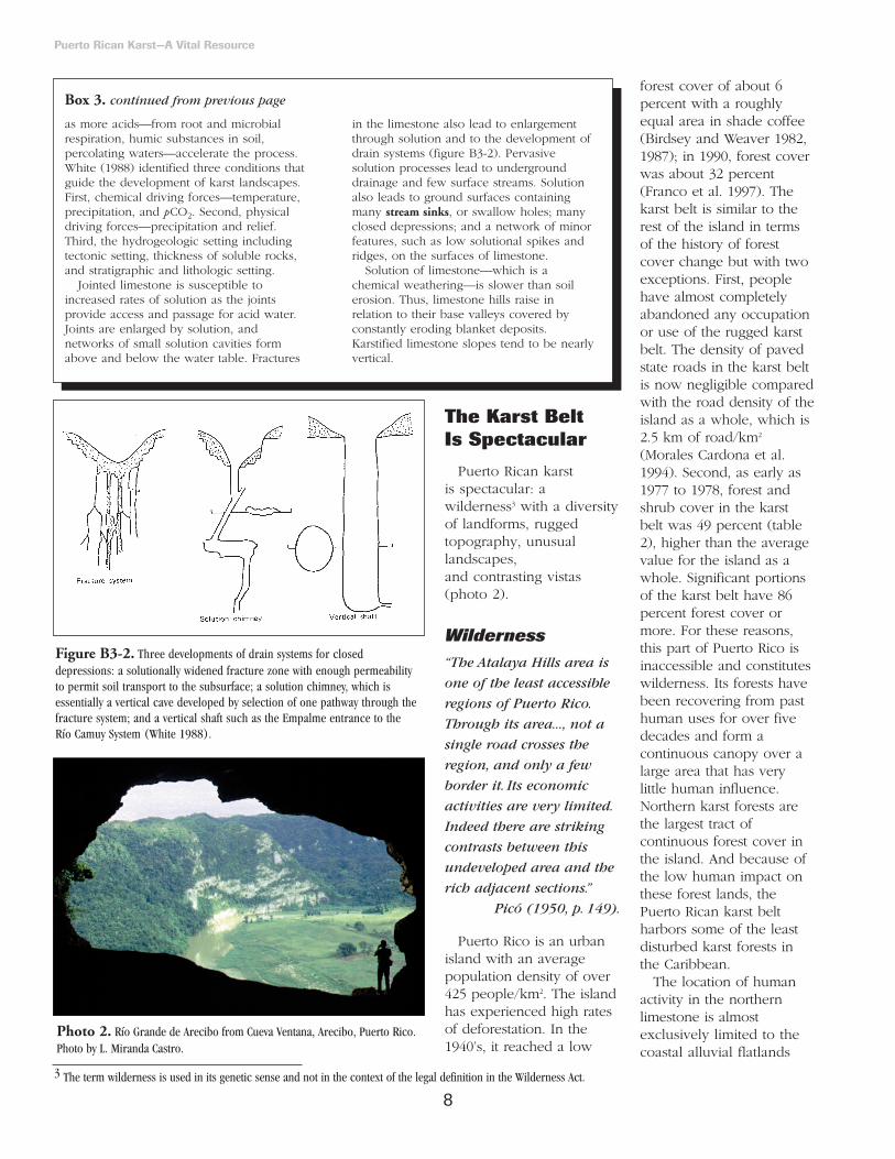
Puerto Rican karst is spectacular: awilderness3 with a diversityof landforms, ruggedtopography, unusuallandscapes, and contrasting vistas(photo 2).
Wilderness“The Atalaya Hills area is
one of the least accessible
regions of Puerto Rico.
Through its area..., not a
single road crosses the
region, and only a few
border it. Its economic
activities are very limited.
Indeed there are striking
contrasts between this
undeveloped area and the
rich adjacent sections.”
Picó (1950, p. 149).
Puerto Rico is an urbanisland with an averagepopulation density of over425 people/km2. The islandhas experienced high ratesof deforestation. In the1940’s, it reached a low
forest cover of about 6percent with a roughlyequal area in shade coffee(Birdsey and Weaver 1982,1987); in 1990, forest coverwas about 32 percent(Franco et al. 1997). Thekarst belt is similar to therest of the island in termsof the history of forestcover change but with twoexceptions. First, peoplehave almost completelyabandoned any occupationor use of the rugged karstbelt. The density of pavedstate roads in the karst beltis now negligible comparedwith the road density of theisland as a whole, which is2.5 km of road/km2
(Morales Cardona et al.1994). Second, as early as1977 to 1978, forest andshrub cover in the karstbelt was 49 percent (table2), higher than the averagevalue for the island as awhole. Significant portionsof the karst belt have 86percent forest cover ormore. For these reasons,this part of Puerto Rico isinaccessible and constituteswilderness. Its forests havebeen recovering from pasthuman uses for over fivedecades and form acontinuous canopy over alarge area that has verylittle human influence.Northern karst forests arethe largest tract ofcontinuous forest cover inthe island. And because ofthe low human impact onthese forest lands, thePuerto Rican karst beltharbors some of the leastdisturbed karst forests inthe Caribbean.
The location of humanactivity in the northernlimestone is almostexclusively limited to thecoastal alluvial flatlands
8
Puerto Rican Karst—A Vital Resource
as more acids—from root and microbialrespiration, humic substances in soil,percolating waters—accelerate the process.White (1988) identified three conditions thatguide the development of karst landscapes.First, chemical driving forces—temperature,precipitation, and pCO2. Second, physicaldriving forces—precipitation and relief.Third, the hydrogeologic setting includingtectonic setting, thickness of soluble rocks,and stratigraphic and lithologic setting.
Jointed limestone is susceptible toincreased rates of solution as the jointsprovide access and passage for acid water.Joints are enlarged by solution, andnetworks of small solution cavities formabove and below the water table. Fractures
in the limestone also lead to enlargementthrough solution and to the development ofdrain systems (figure B3-2). Pervasivesolution processes lead to undergrounddrainage and few surface streams. Solutionalso leads to ground surfaces containingmany stream sinks, or swallow holes; manyclosed depressions; and a network of minorfeatures, such as low solutional spikes andridges, on the surfaces of limestone.
Solution of limestone—which is achemical weathering—is slower than soilerosion. Thus, limestone hills raise inrelation to their base valleys covered byconstantly eroding blanket deposits.Karstified limestone slopes tend to be nearlyvertical.
Box 3. continued from previous page
Figure B3-2. Three developments of drain systems for closeddepressions: a solutionally widened fracture zone with enough permeabilityto permit soil transport to the subsurface; a solution chimney, which isessentially a vertical cave developed by selection of one pathway through thefracture system; and a vertical shaft such as the Empalme entrance to the Río Camuy System (White 1988).
Photo 2. Río Grande de Arecibo from Cueva Ventana, Arecibo, Puerto Rico.Photo by L. Miranda Castro.
3 The term wilderness is used in its genetic sense and not in the context of the legal definition in the Wilderness Act.

between Loíza and Areciboand nonalluvial betweenArecibo and Aguadilla(photo 3). As a result ofland-use patterns, karstlands south of the coastalplain are over 86 percentcovered by forests(figure 5). Until the 1980’s there was not asingle town located on awest-to-east line overrugged karst topographyfrom Aguadilla to Toa Alta,a distance of about 100
km. With the exception ofthe small town of Florida,settlements are just northor south of the karst beltlimits. Moreover, many ofthe inhabitants of towns onthe southern limit of thekarst belt served as asource of labor foreconomic activities outsidethe karst belt (Picó 1950).
The diversity and typesof landforms in the karstbelt, led Monroe (1976) todeclare the region as a “wilderness of karstforms.” This idea wasexpanded by White (1988)who made the case forcaves and undergrounddrainage as wilderness ofthe same scale as traditionalwilderness landscapes.Even in urban areas, cavescan be as much wilderness as remoteexpanses of mountains andforests far from humancivilization. Theunderground landscape,with its total darkness andunusual forms and shapesof rock and mineraldeposits, is alien to peoplein comparison with familiar surface landscapes
9
Puerto Rican Karst—A Vital Resource
Box 4. The southern limestone (Monroe 1976, 1980).
Deposition of rocks in southern Puerto Rico began earlierand ended earlier than in the north. Rocks in southernPuerto Rico are intensively faulted while those in the northare cut by very few faults. Strata dip in a southerly directionsome 10o to 30o. The karstification of limestone in dry lifezones is not as common as in wet life zones because thelow rainfall inhibits the rate of solution. Moreover, much ofthe southern limestones are buried under deep alluvialdeposits—as deep as 900 m in Santa Isabel.
The Limestone Formations of the southern region are:• Juana Díaz Formation—Oligocene and Miocene age.
Coral reef origin. Basal beds of sand, pebbles, andcobbles overlain by calcareous sandy to silty clay ormudstone. Overlays the volcanic complex of centralPuerto Rico. Contains several large caves and closeddepressions. Caliche is formed on soil surfaces.
• Ponce Limestone—Miocene age. Coral reef origin. Highlyfossiliferous. Contains rock shelter caves on vertical cliffs,and a few caves. Caliche is formed.
• Guanajibo Formation—Late Miocene, possibly Pliocene.Small outcrops of fossiliferous yellow limestone, mostlyweathered to compact silt, sand, and gravel.
• Parguera Limestone—Early Cretaceous.
The Limestone Formations of adjacent islands include:• Isla de Mona Limestone—middle Tertiary age. Contains
many caves.
• Lirio Limestone—Pale and, finely crystalline limestone. Itsage is late Miocene to early Pliocene. Maximum thicknessof 40 m near Playa Sardinera, Mona Island. Moderatelyfossiliferous with accumulations of large coral heads andpatch reefs near Cueva del Capitan and Cueva Centro.Extensively karstified with caves, karren, sinkholes, pits,and enlarged joints across the plateau surface (Frank etal. 1998a).
Figure 5. Map of the limestone region showing land cover types for the year 1977 to 1978 (modified from Ramos andLugo 1994). Notice the high proportion of dense canopy forest in the proposed area of the karst belt and the Guánica areain the southern limestone.
Photo 3. Human activity near the karst belt is concentrated on the flatalluvial lands. Photo by J. Colón.

10
(photo 4). Caving is agenuine wildernessexperience that requiressolitude, a leisurely pace, and a sense ofabsorption in theenvironment, just as thewilderness experience on amountain or in a forest(White 1988).
In summary, the karstbelt is consideredwilderness from threepoints of view. First, thelow level of humaninfluence and vast—forCaribbean island scales—expanse of closed canopymature forests. Second, itincludes karst landforms ofsuch diversity andmagnitude that few placesin the world match it.Third, it contains a vastexpanse of undergroundrivers, aquifers, and cavesof unusual size and beauty.
Diversity ofLandforms“The land forms, developed
on the North Coast
Limestones of Puerto Rico,
constitute one of the finest
examples of tropical karst
in the world. ”
Giusti and Bennett (1976, p. 4).
Holokarst is a term used todescribe landforms withcomplete karstic drainageand landforms. Suchlandforms are rare and thefew regions in the worldwith holokarst include theAdriatic and the Caribbean(White 1988). If there ismixture of karst landformsand fluvial characteristics,the region is termedfluviokarst. The karst belt ofPuerto Rico has both typesof landforms within shortdistances of each other.
The variety of landformsin the karst belt is notableand a product of rock typeand climate. The moist andwet northern karst belt—forexample—is divided intoseveral lenticular bodies oftopography correspondingclosely to the lithology ofthe underlying rocks(Monroe 1976). These rocksvary in susceptibility toerosion, and dip generallynorthward between 1o nearthe Atlantic Ocean and 5o
on their southern border.Cuestas are landforms thatresult from the dipping ofthe underlying rocks andtheir differential suscepti-bility to erosion. They arecharacterized by a south-facing scarp (box 5) and along, gently slopingnortherly dip slope,commonly obscured andinterrupted by a wild arrayof solution features, such asclosed depressions—alsoknown as sinkholes or“dolines” (Monroe 1976).
The Aguada cuesta hasthe most extensive scarp inthe karst belt (Monroe1976). It extends contin-uously—with breaks at rivervalleys—from the westernpart of San Juan to the west
coast at Aguadilla. Remnantsof the scarp can be seentowards the east to Loíza onboth sides of Río Grande deLoíza. In the southern partof the Camuy quadrangle,the scarp forms a wall about50 m high on the upland,both east and west of thevalley of Río Camuy.
Río Guajataca containsspectacular ramparts—limestone walls skirting theriver canyons—that on thewest bank of the river, 3km from its mouth, reachan altitude of 165 m (figure6, photo 5). The river flows155 m below the top of therampart. The west side ofthe rampart slopes down toa body of blanket sand 15to 30 m below its top,
Puerto Rican Karst—A Vital Resource
Photo 4. Caving in the karst belt is a unique wilderness experience. Theseexplorers are inside the Río Camuy cave system. Photo by K. Downy.
Box 5. The Lares Cuesta Scarp as described by Monroe(1976, p 19).
“The most prominent single feature of the [Puerto Rican]karst area is the Lares cuesta scarp, which extends contin-uously from San Sebastián to Corozal, interrupted only by thealluvial valleys of the major rivers that cross the belt. Thescarp is the result primarily of differential erosion of theeasily weathered and eroded San Sebastián Formation andvolcanic rocks below and to the south and the much moreresistant limestone above and to the north; secondarily, it isthe result of great landslides which have created a steep cliffby the breaking away of blocks of limestone by diminishingsupport below as the underlying material is eroded bygullying and sheetwash, and as the clay from the SanSebastián Formation becomes water soaked and forms agliding surface.
The altitude above sea level of the top of the scarp rangesfrom a maximum of about 530 m near Caguana between RíoTanamá and the Río Grande de Arecibo to a minimum ofabout 200 m near Corozal to the east and near Moca and SanSebastián to the west. The relative altitude of the scarpvaries, however, with the depth to which a bordering streamhas cut its channel. Thus, the steepest and relatively highestpart of the scarp is the part just west of Lago Dos Bocas,where the water level of the lake is about 90 m and the topof the scarp is about 430 m, a difference in altitude of 340 m.In contrast, in the area just to the west near Caguana, wherethe San Sebastián Formation crops out on an only slightlyeroded flat at an altitude of about 430 m, the top of the scarprises to only about 480 m, a difference of only 50 m. Thelatter represents what might be considered the normal differ-ential erosion, uncomplicated by landsliding induced bynearby rapidly incising streams.”

11
making in effect a wallbetween the generally flatfield to the west and theriver canyon to the east(Monroe 1976).
Sumidero Tres Pueblos(photo 6) is the largestcollapse feature in PuertoRico (Monroe 1976). Itconsists of a sheer-walledpit more than 120 m deepand about 140 m indiameter. Río Camuy flowsinto and out of thisdepression. Otherremarkable geomorphicfeatures of the karst belt—some of which will bedescribed below—includecockpits, conical hills orcone karst, dry valleys,caves and subterraneanrivers, rock bridges, towersor mogotes, mogote ortower karst, cuesta karst,broad valleys, zanjones,and many other minorkarst features such askarren spikes. Naturalwindows occur in thesouthern karst. Southwestof Mayagüez there is anexcellent example oftropical pinnacle karrenwith peak heights of 2 to 3 m. This type of karren isthe least understood of thekarren forms (White 1988).
RuggedTopography“The ruggedness of
these belts is such that
many areas are entirely
uninhabited, without
even roads or trails
crossing them; an
exception indeed, for
densely peopled
Puerto Rico.”
Picó (1950, p. 147).
Karstification in PuertoRico’s climate and rocktypes causes slopes tobecome nearly vertical,
creating a steeptopography. The denseconcentration of mogotes,cockpits, and cone hills—all characterized by steepslopes—gives the karstlandscape the appearanceof being a corrugatedsurface. Traversing thekarst is only feasiblethrough valleys betweenhills, but even these might lead to dead ends.Many times, steep slopesare made of caps ofindurated limestone oversofter material, whichgives way when weight isplaced on it, making travelthrough this terrain verydifficult.
The ruggedness of asector of the karst beltwas described by Monroe(1976, p 21):
“North of [the Aguada]scarp, the cuesta is an
extremely rugged karsttopography characterizedby a variety of karsttypes, especially dolinekarst in the Manatíquadrangle and byabundant polje–likevalleys and uvalas inother areas. In a fewareas, the karst is conekarst, much like thatformed on the LaresLimestone, but morecharacteristically thesurface is pitted by deep solution dolinesseparated by roundedridges, which form arough irregular slopenorthward to the broken wall of theAymamón scarp. Thenorthern part of the area,which is characterized bydeep solution andcollapse dolines in theAguada Limestone
Puerto Rican Karst—A Vital Resource
Photo 5. Río Guajataca canyon. Photo by L. Miranda Castro.
Figure 6. Map and profile showing relation of the Río Guajataca rampart tothe canyon and the plain covered by blanket sand (Monroe 1976).
Photo 6. Sumidero de TresPueblos. Photo by A. E. Lugo.

12
separated by high towerscapped by the AymamónLimestone, is theroughest area in theentire karst belt; in theQuebradillas quadrangle,many of the dolines aremore than 70 m deeperthan the lowest point intheir rims, and theadjacent towers cappedby Aymamón Limestonerise some 50 m higher.This area is traversed bysparse horse trails andfootpaths, but nearlyvertical cliffs make itextremely difficult topass through. Thethrough highways in thepast have followed thelarger system valleys, butthe Puerto RicanHighway Authority isnow beginning to buildwinding highwaysthrough the roughestparts of the karst,generally following thelarger horse trails.”
UnusualLandscapes
In Puerto Rico and in afew other places in the world, one findslandscapes such as theseformed by cuestas andcone, tower, and dolinekarst (figure 7). Landscapesdominated by zanjones—groups of parallel longtrenches several metersdeep—are unique to thekarst belt of Puerto Rico(Monroe 1976). The gorgesof rivers in the karst belt are spectacular. Oneexample is that of the RíoGrande de Arecibo (photo 7), which cutsthrough the karst with agorge 800 to 1,200 m wideand nearly vertical walls ashigh as 200 m (Monroe1976). This river hasdeposited over 70 m ofalluvial soil over thelimestone rock. RíoGuajataca has gorges withnearly vertical walls 150 m
high. The coastal plain inthe vicinity of Río Grandede Manatí is notablebecause the meanders ofthe river are extremelywell developed. At thecoastline, sea cliffs, sanddunes, and extensiveriverine and basinwetlands—some of thelargest in the island—dominate the landscape.
Contrasting VistasThe vistas of the karst
belt exemplify why PuertoRico is an island ofcontrasts. The regioncontains an incredible arrayof topographic features andlandforms in a very smallarea. In less than 1 hour oftravel by automobile, anobserver can experience anenormous array of contrastin the vistas available forenjoyment.
The observer can focuson the high density of
Puerto Rican Karst—A Vital Resource
Figure 7. Topographic and geologic north-south sections of the karst belt (Monroe 1976). The sections highlightlandscape features—both anthropogenic and natural—supporting geologic formations, and show brackets that classifythe overall landscape feature along the sections. The location of the sections is shown in figure 3.
Photo 7. The gorge of Río Grande de Arecibo. Photo by L. Miranda Castro.

13
rugged hills that disappearinto the distance or focuson the gigantic riverramparts cutting throughthe landscape. On thecoastline, the observer canenjoy sea cliffs or watchrough seas crash againsthuge sand dunes. Extensiveriver valleys, with largeexpanses of green pastureland and the meanderingRío Grande de Manatí orRío Grande de Arecibo,provide an alternative viewfor enjoyment (photo 8).These rivers lead the
observer to extensiveriverine estuaries or tocoastal swamps andlagoons. Alternatively, theobserver can peek intodeep depressions in theground with disappearingrivers, walk into spectacularcaves, or float through oneof three knownunderground rivers. Most ofthe drainage in this regionis subterranean—althoughthousands of springs andseeps flow out of rockfissures and fall as beautifulwaterfalls. Some of the
world’s most spectacularcaves are available forexploration (photo 9).These include the RíoCamuy river cave systemwith over 17 km of mappedcaves and 16 km ofunderground river, and theRío Encantado System—thelongest continuouslytraversable undergroundriver in the world (Courbonet al. 1989).
The Karst Belt
Has Limestone
of Many Ages
Limestone formations inPuerto Rico range in agefrom the early Cretaceousto the Quaternary—spanning some 146 millionyears (table 3). The oldestlimestone is exposed in theeastern part of the island,west of Caguas throughCidra and Cayey (Monroe1976). This limestoneappears to have originatedfrom fringing coral reefs onthe flanks of the volcanicisland (photo 10).
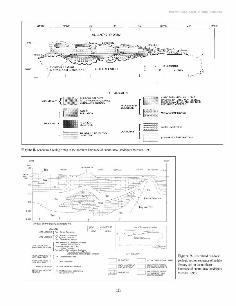
Early Cretaceouslimestone—PargueraLimestone—is also foundon the southwestern coastof the island, particularlybetween Guánica and thewest coast. Limestone inPuerto Rico is of marineorigin and has undergonelittle post-depositionalchange (Giusti 1978). Afteremerging above sea level,some of this originalmarine limestoneunderwent karstification(box 3) and wastransformed to thelimestone now on theEarth’s surface. The originalnorthern marine limestonehas been seen in a core ofLares Limestone taken from1,129 to 1,136 m below theground surface betweenArecibo and Barceloneta.In the southern limestone,the original marinelimestone can be seen inchalk outcrops in the JuanaDíaz Formation near Ponce(Monroe 1976).
The limestone region hasrock outcrops with smallamounts of chalk anddolomite, as well as gravel,sand, and clay derivedfrom volcanic rocks of themountains (Monroe 1976).The main limestonedevelopment in northernPuerto Rico dates from theOligocene (some 34 to23.5 Ma—million yearsago) and Miocene (some23.5 to 5.2 Ma) (figure 8).The sequence of limestoneformations of late tomiddle Tertiary age of thenorth coast limestone(figure 9) is the product ofseveral minor and majorregressions andtransgressions of the sea that occurred
Puerto Rican Karst—A Vital Resource
Photo 8. Río Grande de Arecibo delta. Photo by J. Colón. Photo 9. Cueva Larga. Photo byFundación de InvestigacionesEspeleológicas del KarsoPuertorriqueño.
Photo 10. Puerto Rican limestone originated from ancient coral reefs,similar to this one in modern day Puerto Rico. Photo by L. Miranda Castro. continues on page 16

14
Puerto Rican Karst—A Vital Resource
Table 3. Phanerozoic geologic timescale (Behrensmeyer et al. 1992) with reference to events in Puerto Rico and elsewhere in the world.Million years ago is Ma and represent the estimated time when the Period, Epoch, or Era started. The duration of any period, epoch, or era canbe estimated by subtracting the time it started from the time when the next Period, Epoch, or Era started. L = late, M = middle, and E = early.
15
Puerto Rican Karst—A Vital Resource
Figure 8. Generalized geologic map of the northern limestone of Puerto Rico (Rodríguez Martínez 1995).
Figure 9. Generalized east-westgeologic section sequence of middleTertiary age on the northernlimestone of Puerto Rico (RodríguezMartínez 1995).

16
between Oligocene andMiocene time (Seiglie andMoussa 1984).
Classification ofLimestone Strata
The limestones of thenorth coast appear uniform,and to a nonspecialist it ishard to tell one formationfrom another. However,they are separated on thebasis of paleontologicaldifferences (Giusti andBennett 1976). Each type oflimestone interacts withlocal conditions to produceparticular types of karstfeatures in the landscape(box 6). Monroe (1976,1980) developed thenomenclature for thelimestone sequences basedon stratigraphy, and Seiglie
and Moussa (1984)modified it with paleon-tologic and lithologic datacollected from two waterwells in the Manatí area(Rodríguez Martínez 1995).We use the descriptions ofMonroe (table 4) but showthe modifications of Seiglieand Moussa (1984) andRodríguez Martínez (figure 10).
Monroe (1976, 1980)categorized limestonestrata into six formationsranging in age from themiddle Oligocene to lateMiocene (table 4). These formations rest on the San SebastiánFormation, which is not alimestone rock nor does itshow karst features, butforms an impermeableconfining bed below theLares Limestone andoverlies the volcanic base
of the island. In ascendingorder, the limestoneformations are (figure 10)Lares Limestone,Mucarabones Sand, CibaoFormation, AguadaLimestone, AymamónLimestone, and the CamuyFormation. TheMucarabones sand is not included in table 4. The Mucarabones Sandconsists primarily of cross-bedded grayish-orange andyellow fine-to medium-grained sand. Its maximumthickness in the Bayamónquadrangle is 120 m. Thetotal depth of all the stratais about 1,700 m, includingmore than 300 m of clay,silt, and gravel, mostly atthe bottom of thesequence (Monroe 1966).
Puerto Rican Karst—A Vital Resource
Box 6. General pattern of correspondence of karst features with limestone formations ofnorthern Puerto Rico (Monroe 1976). The San Sebastián Formation does not develop karstfeatures.
Lares Limestone Distinctive cone karst—round pointed cones and, at places, jagged.Sawtooth cones and ridgesLarge caves
Cibao Formation RidgesCuesta scarpsCliffed cone karstZanjonesSwallow holesBlind valleys
Aguada Limestone High south-facing escarpment from San Juan to Aguadilla- up to 100 mSolution dolines— up to 30 m deep— separated by rounded ridge crestsTypical tropical cone karstSteeped-walled solution doline
depressions formed by collapse— up to 70 m deep Short cavesNatural archesSmall polje-like depressionsSteep-walled towers connected by knife-edged ridges— when adjacent to Aymamón Limestone.
Aymamón Limestone MogotesTower karstCuesta scarpWell-like vertical shaftsFew cavesSharp-pointed spikesSolution pans
Camuy Formation Cylindrical shafts—up to 30 m deepCuesta scarp Solution holes as wide as 20 cm in diameter inthe middle member
continued from page 13
continue on page 18

17
Puerto Rican Karst—A Vital Resource
Figure 10. Stratigraphic nomenclature sequence of middle Tertiary age on the northern limestone of Puerto Rico (Rodríguez Martínez 1995).“This study” refers to the study of Rodriquez Martinez.
Table 4. Strata of middle Tertiary age in northern Puerto Rico (Monroe 1976, 1980). The maximum thickness of strata is inparenthesis (Giusti 1978). Million years ago is Ma.
Miocene—From 23.5 to 5.2 Ma
Camuy Formation—sandstone, limestone and sandy, ferruginous chalk (200 m).
Unconformity.Aymamón Limestone—very pure chalk indurated on surface to
hard limestone; slightly ferruginous chalk in upper part, northwestern Puerto Rico (300 m).
Aguada Limestone—hard stratified limestone grading downward into chalk; locally sandy (90 m).
Cibao Formation—(230 m)Upper member; chalk and soft limestoneGuajataca member; (in western area only) fossiliferous
calcareous clay and limestone containing lenses of sand and gravel as much as 15 m thick.
Miranda Sand Member; (in eastern area only) sand and gravel, sand and sandy clay.
Montebello Limestone Member; (in center area only) friable pure calcarenite, indurated on exposure to an erosion-resistant limestone.
Quebrada Arenas Limestone Member; (in eastern area only) finely crystalline stratified limestone
Oligocene—From 34 to 23.5 Ma
Río Indio Limestone Member; (in eastern area only) compact, chalky yellowish-orange weakly bedded limestone.
Typical chalk or marl; (in eastern and western areas) sandy and silty clayey chalk.
Lares Limestone—thin to thick-bedded fairly pure limestone, lower part locally contains grains of quartz and limonite sand, intertongues to west with sand and gravel, mapped with San Sebastián Formation (300 m).
San Sebastián Formation—mostly thin-bedded sand and clay, some sandy limestone, locally, especially in west, sand andgravel (300 m).
Unconformity (angular).
Cretaceous to Eocene—From 146 to 34 Ma
Volcanic, sedimentary, and intrusive rocks.

18
Origin of the KarstKarst originates when
limestone rock is upliftedand the combined effectsof climate and the watertable modify its features.Puerto Rican karst wasinfluenced by the tropicalclimate, including the tradewinds, and secondly bythe various limestoneformations in the island(Monroe 1976). Climateand trade winds functionas physical and chemicalagents of erosion, solution,redeposition, andreshaping of limestone(box 7). Monroe (1976)summarized the role ofclimate and winds (p 1):
“The warm humid air of
the trade wind belt
promotes the rapid and
intense weathering of all
intrusive and volcanic
rocks, producing thick
soils.The torrential rains
cause rapid erosion
of the soil, and when
the soil contains abrasive
mineral grains, the erosion
rapidly deepens valleys.The
rains also lead to the
casehardening of
limestone, for when the
water enters the porous
limestone it immediately
dissolves the surfaces of the
grains and crystals of
calcite.As these rains
usually last only a short
time and are followed by
brilliant sunshine, the wet
rock is warmed, carbon
dioxide is driven off, and
calcium carbonate is
reprecipitated essentially in
place.The streams
containing sand, gravel,
and cobbles derived from
soil on igneous rocks have
eroded deep canyons
through the limestone and
have greatly enlarged the
passages on the river caves
of Puerto Rico.
The nearly constant wind
direction has resulted in
asymmetry of many of
the limestone hills at
places where the hills
are sufficiently isolated
to allow full play of
the wind.”
It follows that the legacyembodied in the karstlandscape contains arecord of past climaticevents, if we could findways for “reading” theclimatic signals. Box 8shows how scientists arefinding and interpretingclimatic signals in PuertoRican caves.
Development of the KarstTopography
Giusti (1978) consideredmogote karst as a stage ofkarst development. Firstthe landscape is pitted byshallow closeddepressions. Then, therugged cockpit karstdevelops, followed bymogote karst and fluvialdrainage over blanketsands. By this scheme, thenortheastern karst is olderthan the northwesternkarst. An alternativehypothesis is that thefluvial network—flowingfrom the interior—
Puerto Rican Karst—A Vital Resource
Box 7. Climate facilitates the solution redeposition, recrystallization, and casehardening oflimestone (Monroe 1966, 1976).
The climate in Puerto Rico is tropical, but moderated by trade winds that maintain meanannual temperatures within a narrow range—between 21oC at high elevations and 30oC along thesouth coast lowlands. Measured temperature extremes are 6o and 40oC (Monroe 1976). Tradewinds usually blow from the north or southeast. They average 18 km/hr—gusting to 24 km/hrless than 5 percent of the time, and 38 km/hr less than 1 percent of the time—with maxima of250 km/hr during category 5 hurricanes in the Saffir/Simpson scale. Rainfall is evenly distributedseasonally. Generally, a dry period begins in December and usually ends in March or April.There is a spring rainfall period in April and May, an erratic, semidry period in June and July,and a wet season from August through November. Greatest monthly rainfall is in September(Giusti 1978). There is also year to year variability with distinct wet and dry periods that may lasta decade or so but generally with sufficient rain to account for evapotranspiration. Actualevaporation is higher than rainfall in most stations. Rainfall events have sharp boundaries, occursuddenly, and are of short duration (15 to 30 minutes) but intense. Forty of 100 climate stationsfor Puerto Rico record 30 to 50 days a year with > 12.7 mm of rain. All-day events are rare.Hurricanes can produce up to 400 mm of rainfall in a day.
These climatic characteristics have several effects on the development of the landscape.
• Prevailing temperatures facilitate chemical reactions that dissolve, erode, redeposit, andcaseharden limestone.
• Rainfall patterns facilitate solution of limestone and transport of erosive waters.
• Evaporative processes contribute to casehardening and recrystallization.
• Winds shape the landscape by differentially blowing rain into crevices in the rocks on theeastern and northeastern sides of hills, thus soaking those sides more than the western sides.
Climates in dry life zones produce caliche, as evaporating water raises to the surface throughcapillary action and precipitates pure calcium carbonate.
continues on page 20
continued from page 16

19
Puerto Rican Karst—A Vital Resource
Box 8. Cave calcites as records of climate. Climate change cannot be detected in all cave calcites but carefully chosen ones canreveal a very detailed history of past climates using some of the methods explained below.
Stalagmites and stalactites in caves are usually made of calcite(CaCO3), which form where waters drip from the ceiling—thestalactites hanging from the ceiling and the stalagmites sittingon the floor. This water begins as rainfall; it then tricklesthrough the soil, dissolving carbon dioxide gas (CO2) from thesoil organisms, thus becoming dilute carbonic acid (H2CO3).This dilute acid then travels through the layers of limestoneabove the cave dissolving calcite (CaCO3) from the rock. Whenthe water emerges from a crack in the cave ceiling it contains alot of dissolved CO2 and CaCO3. When the drip meets the caveair, the CO2 comes out of the water and diffuses into the caveair. When this happens, the CaCO3 must also come out ofsolution and so the drip deposits a tiny layer of CaCO3 orcalcite. Eventually, if the drip remains in the same place formany centuries, the layers of calcite build up to a sizabledeposit, some hanging from the ceiling drip point and somegrowing up from the drip point on the floor (figure B8-1).
These stalagmites and stalactites are of great aestheticbeauty, but they are also of great scientific value because thelayers building up over centuries and millennia showvariations as climate changed. In some cases the formerclimate—paleoclimate—can be reconstructed by studying thelayers of calcite crystals. This is important because if weunderstand how and why climate changed in the past, wehave a good chance of understanding what is happening tomodern climates. In some places, like Puerto Rico, there maybe no record of paleoclimate change other than that from thecave calcite—hence their scientific value.
Changing climate is expressed as changing temperatureand/or changing humidity. In Puerto Rico, the major changeshave been in humidity. Caves are usually quite damp and thecalcite builds up slowly layer upon layer by the loss of CO2, asexplained above. However, if the cave becomes dry the
dripwaters start to evaporate; calcite is then deposited muchmore quickly and in a more lumpy form. The calcite formedduring wet times will show fine, elongate crystals packed indense compact layers; however, the calcite formed during drytimes is often quite porous with holes between crystals, andthe crystals are often quite small and chunky in shape. So, thealternation of dense layers with porous layers shows thealternation of wet with dry climates; thus a study of thechanging porosity of a stalagmite over time will show changinghumidity levels in the cave. Figure B8-2 shows a Puerto Ricanstalagmite cut open to reveal porous and dense layers.
Sometimes the different layers may only be apparent at amicroscopic scale; for example, some stalagmites from tropicalregions with obvious seasonality show a double layer for everysingle year and the thickness and chemistry of the layers varywith the strength of the El Niño Southern Oscillation. In otherexamples, the layers are expressed as fluorescent bands thatcan be detected only with ultra-violet or laser light. Here, thebands usually indicate changing biological activity in the soilabove the cave, which is in turn related to changing climate.
Changing climate affects the chemistry in cave calcites.Some common elements, such as oxygen and carbon, exist intwo or more different forms—isotopes—where the rare formis slightly heavier than the common form. The balance of thenormal, light isotope and the rare, heavy isotope will changeunder different conditions; for example, the CO2 from drytropical grasses has a little more heavy carbon than the CO2from wet tropical trees. A vegetation change from grasses totrees causes a shift from more to less of the heavy carbon inthe CaCO3 crystals of the stalagmite. Another example is ofthe effect of different temperatures on oxygen: if the cavegets colder, the CaCO3 of the calcite has more heavy oxygenthan in warm times.
Figure B8-1. A selection ofstalagmites in Cueva de la Luz, RíoCamuy Cave System.
Figure B8-2. A stalagmite sample cut open along its long axis (a), thedetailed photo (b) reveals alternate bands of porous, dark colored crystals anddense, light colored crystals.

20
developed on the karstsurface prior todevelopment of sufficientsolutional porosity to divertthese streams underground.Depressions and sinkholesthen concentrated in thethalwegs ultimatelydisaggregating into theapparently chaotic surfaceof today. There are stilltraces of surface channelsat the southern fringes ofthe karst, as well as insome of the larger sinkingstreams. For example, theRío Tanamá has evidenceof caves that formed belowthe level of now-abandoned surfacechannels. In this scenario,the largest streams such asRío Grande de Arecibo andRío Grande de Manatínever flowed undergroundbut were always ofsufficient size to maintainsurface courses to the sea.
Such initial fluvial phasesin karst are common inother places such as Belize,Guatemala, and New Guinea (Miller 1987).
Giusti (1978) estimatedthe rate of karstdenudation of the karstbelt. He reconstructed theoriginal profile of theregion (figure 11) andobserved that the originalsurface had a mean altitudeof 500 m compared to 230m today—thus, 320 m oflimestone thickness hasbeen dissolved overgeologic time. Giustiestimated that thelimestone belt emergedfrom the ocean some 4 Ma.Denudation rates averagedabout 0.070 mm/yr—avalue that could be 40percent higher in locationswhere abrasion was afactor to be considered.
The Karst Belt Is
Diverse
The karst features ofPuerto Rico have beenformed entirely incarbonate rocks andmostly in limestone. Thesalient aspect of thediversity of the karst belt isthe large number offeatures that result fromthe modification oflimestone. In this section,we discuss thegeomorphic, hydrologic,and ecological features ofthe karst belt and thenorthern limestone.
GeomorphologicalDiversity
To describe the geomor-phological diversity of thekarst belt we follow theorder established byMonroe (1976) who
focused on valley and hillfeatures, river and coastalramparts, zanjones, andcaves. Most of the featuresof the karst belt areillustrated in the two north-south cross sections of theregion in figure 7. Box 6relates the karst features tothe particular limestoneformation where they aremost common.
Valley Features
Dry Valleys—Dry valleysmight contain intermittentstreams and carry waterduring heavy rains, but ingeneral they remain dry andare scattered throughout thekarst belt. Monroe (1976)described the 10 km-longvalley of QuebradaCimarrona in the southernedge of the Barcelonetaquadrangle, which stoppedflowing between 1960 and
Puerto Rican Karst—A Vital Resource
Figure 11. North to south sections through the karst belt with projected original surface of the Camuy Formation(Giusti 1978). The location of sections is shown in figure 3.

21
1965 and since then hasbeen a dry valley. Heshowed that dry valleys inthe Lares Limestone have adendritic pattern and trendnortheastward from theLares scarp to abandonedmeanders of the Río Grandede Manatí (figure 12).Closed depressions drainedby swallow holes interruptthe valley, so that today’srunoff quickly becomessubterranean. It appearsthat the dry valleys hadtheir course determined bya drainage network erodedon clastic material that oncecovered the limestone.Continued erosion of theblanket material andcapture of the drainage
system by adjacent riverchannels or undergrounddrainage left the olderdrainage system exposed inits current dry valley config-uration. The hydrologicalconditions that lead to thedry valleys are illustrated infigure 13. As the process oflimestone solution proceedsin a given location, ahydroperiod that initiallysupported superficialdrainage evolves into anunderground system with adry valley above the subter-ranean water flow.
Closed Depressions—These form as a result of solution of underlyingrocks, collapse of largeunderground cavities,
landslides, or by windexcavation of blanketsands. Closed depressionsare also known as dolinesor sinkholes. There arethousands of these in thekarst belt. Closeddepressions can be circular,oval, or irregular, and canbe as deep as 120 m. Theyare a surface expression ofone of the stages of karsterosion and can varywidely in their hydrology.The deepest depressionsare in the AguadaLimestone, near theexposed contact with the
Puerto Rican Karst—A Vital Resource
Figure 12. Topographic map of the northwestern part of Ciales quadrangle,showing entrenched dry valleys having a dendritic pattern. Long dashes showabandoned meanders of Río Grande de Manatí, short dashes trace dry valleys(Monroe 1976).
Figure 13. Top—Schematic drawing of annual hydrograph of a surfacestream basin. The dashed lines indicate the carrying capacity of the evolvingunderground drainage system. Bottom—The evolving underground drainagesystem in a karst region. (Q1) from an underdrained valley, (Q2) through a drychannel during low flows with well drained swallow hole, (Q3) through thedevelopment of an incised upstream channel and swallow hole, and (Q4) to thecomplete loss of the surface channel with concurrent development of a blindvalley upstream and a breakup of the valley profile through the dolinedevelopment downstream (White 1988). Limestone is represented by blocks andnoncarbonate area is stippled.
22
Aymamón Limestone, andthe Lares Limestone nearthe exposed contact withthe Cibao Formation(Monroe 1976). Five of thenine natural bridges orshort tunnels throughwhich the Río Tanamáflows are collapse featuresin which the original rockremains. The other fourtunnels developed byaccretion from the sidesdue to calcium carbonatefrom springs that enter atthe sides of the canyon.
The most typical dolinekarst in Puerto Rico isfound in the AguadaLimestone in the southernpart of the Manatíquadrangle (Monroe 1976).Doline karst merges intomogote karst characteristicof the Aymamón Limestone(photo 11). Giusti (1978)demonstrated that thedistribution of dolines onthe landscape is random.This suggests that there isno preferential path to theinfiltration of water.
The percentage of thearea covered by sinkholesis used as an indicator ofthe degree of developmentof karst features on a
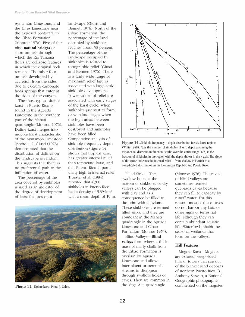
landscape (Giusti andBennett 1976). North of theCibao Formation, thepercentage of the landoccupied by sinkholesreaches about 50 percent.The percentage of thelandscape occupied bysinkholes is related totopographic relief (Giustiand Bennett 1976). Thereis a fairly wide range ofmaximum relief figuresassociated with large-scalesinkhole development.Lower values of relief areassociated with early stagesof the karst cycle, whensinkholes just start to form,or with late stages whenthe high areas betweensinkholes have beendestroyed and sinkholeshave been filled.Comparative analysis ofsinkhole frequency-depthdistribution (figure 14)shows that tropical karsthas greater internal reliefthan temperate karst, andthat Puerto Rico is partic-ularly high in internal relief.Troester et al. (1984)reported that 4,308sinkholes in Puerto Ricohad a density of 5.39/km2
with a mean depth of 19 m.
Filled Sinks—Theswallow holes at thebottom of sinkholes or dryvalleys can be pluggedwith clay and as aconsequence be filled tothe brim with alluvium.These sinkholes are termedfilled sinks, and they areabundant in the Manatíquadrangle in the AguadaLimestone and CibaoFormation (Monroe 1976).
Blind Valleys—Blindvalleys form where a thickmass of marly chalk fromthe Cibao Formation isoverlain by AguadaLimestone and allowintermittent or perennialstreams to disappearthrough swallow holes orcaves. They are common inthe Vega Alta quadrangle
(Monroe 1976). The cavesof blind valleys aresometimes termedquebrada caves becausethey can fill to capacity byrunoff water. For thisreason, most of these cavesdo not harbor any bats orother signs of terrestriallife, although they cancontain abundant aquaticlife. Waterfowl inhabit theseasonal wetlands thatform on the valleys.
Hill Features
Mogote Karst—Mogotesare isolated, steep-sidedhills or towers that rise outof the blanket sand depositsof northern Puerto Rico. B.Anthony Stewart, a NationalGeographic photographer,commented on the mogotes
Puerto Rican Karst—A Vital Resource
Photo 11. Doline karst. Photo J. Colón.
Figure 14. Sinkhole frequency—depth distribution for six karst regions(White 1988). No is the number of sinkholes of zero depth assuming theexponential distribution function is valid over the entire range. n/No is thefraction of sinkholes in the region with the depth shown in the x axis. The slopeof the curve indicates the internal relief—from shallow in Florida to acomplicated distribution in the Dominican Republic and Puerto Rico.

23
of Puerto Rico: “From theair, the mounds remindedme of dyed eggs sitting onend in an Easter Basket”(McDowell 1962, p 783).Most mogotes are about 30m high, but some reachover 50 m, while otherscan be as small as a meteror so (Monroe 1976). Inparts of the northerncoastal area, mogotes maybe aligned in ridges alongwhich they form a seriesof sawteeth. Solution cavesare visible on the sides ofthe mogotes, but theydon’t usually pass throughthe hill. Most mogotesform in the AymamónLimestone and a few formin Aguada Limestone, with
Aymamón caps. Mogotesare residual limestone hills(photo 12) composed ofmaterial that is probablyidentical to that beneath theblanket sand, except that ithas been indurated byprecipitation resulting inslight solution of chalkylimestone and recemen-tation as water and carbondioxide are driven out byevaporation (box 9).
Mogotes have a roundedor pointed hard cap,generally 5 to 10 m thick.This cap is formed byrepeating soaking by rainfollowed by almostcomplete evaporation ofthe water. The caprock is generally thicker on theeastern side where rain andexposure are moreprevalent. On the westernside it tends to form arimrock that overhangs thesofter material. Caprockprotects the inside of the hill from erosion. Thisappears paradoxical, giventhe propensity of limestoneto dissolution. Limestone is resistant to erosion whilebeing susceptible todissolution.
Reprecipitated limestoneon slopes tends to formnearly vertical slopes(photo 13). Because theseprocesses occur at differ-ential rates around themogote—they are
dependent on climaticfactors which are notuniform around the hill—the mogote tends tobecome asymmetric, with asteep slope on the westernlee side and a gentler slope
Puerto Rican Karst—A Vital Resource
Photo 12. Mogotes are residuallimestone hills. Photo by L. MirandaCastro.
Photo 13. Vertical walls on theside of mogotes. Photo by J. Colón.
Box 9. Significant features of a mogote described by Monroe(1966) from a road cut along Highway PR 2, km 34.6between Vega Baja and Vega Alta (figure B9-1).
This mogote is known as Monroe’s Mogote, a popular stop ingeology field trips (Troester and Rodríguez Martínez 1990).The salient features are:• unconsolidated but solution perforated limestone
containing molds of mollusks near the northwest end;
• indurations of the same bed at the ends of the cut;
• absence of dripstone in solution perforations in thenorthwestern two-thirds of the cut, except in the outer rinditself;
• abundance of dripstone in the southeastern third of thecut;
• very steep sides; and
• thick cap of very hard, solution-pitted limestone.
Figure B9-1. Diagram showing the characteristic features of an asymmetricmogote (Monroe 1976)

24
on the eastern windwardside (figure B9-1). Thesteep slope invariably hasan overhanging cap rockor visor of very hardreprecipitated limestoneover a weaker, more orless solution-perforatedcliff face (Monroe 1976).
Cone Karst—Cone karstis formed by conical hills inthe Lares Limestone (figureB2-1). The hills aregrouped linearly withintervening sinks. Conekarst occurs also in Cuba,Java, and Jamaica—where itis known as cockpit karst.Its formation, which is stilldebated, is attributed tosolution along joints in thelimestone, or to the notionthat the cones are residualsafter the collapse of cavernsof underground rivers.Ciales is a typical area forcone karst. The bestdeveloped cone karst inPuerto Rico occurs nearthe Arecibo Observatorywhere many of the conesare sharp, pointed, nearlycircular or oval, 200 to 300m in diameter at the base,and rise 50 to 75 m fromthe bottom of adjacentdepressions. In the Floridaand Utuado quadrangles,vertical cliffs form towersthat cap cones. Monroe(1976) called this “cliffedcone karst.”
River and CoastalRamparts
These are natural walls oflimestone at the tops ofcanyon walls, fault scarps,and around sinks. Theyform as a result ofsecondary cementation anddifferential erosion. Theyare common along the topof river canyons and at thetops of limestone sea cliffs.
Earlier, we discussed thesize of the Río Guajatacacanyon’s ramparts (figure6), which are the bestexamples in Puerto Rico(photo 14). The formationof this rampart is attributedto casehardening by precip-itation of calcite, probablyin a joint and on the wallof the canyon (Monroe1976). Coastal ramparts canbe observed at the top ofsea cliffs composed ofAymamón Limestone inQuebradillas and Isabela.
Zanjones
Zanjones are paralleltrenches resulting fromsolution of limestone alongjoints (figure 15). Thetrenches can be 100 m longor more, with vertical sidesranging in width from a fewcm to about 3 m and indepth from about 1 to 4 m.Zanjones are oriented in thesame direction with asmany as 8 per 100 m(Monroe 1976). Firstdescribed for Morovis andFlorida, the best examplesof zanjones are in Lareswhere individual trenchescan be more than 1,800 mlong, and 20 m wide, andzanjones are present in abelt 1 km wide. Here,zanjones partially coalescedand formed a particulareast-west topography inwhich individual zanjonescut longitudinal hills(Monroe 1976). Zanjonesare an exclusive feature ofPuerto Rican karst. The onlycommon feature of theareas of zanjón karst is thatall are in terrain withstrongly stratified limestonein the lower part of thestratigraphic succession ofOligocene limestone(Monroe 1976). Giusti
(1978) noted that zanjonesform where the limestone isthin bedded and brittle.
Caves4
The caves of Puerto Ricoare primarily developedthrough solution processes,with additional modificationfrom the abrasion of clastic
sediments. They form inareas of alternating beds ofhard and soft limestone(Giusti 1978). The majorcaves of the karst areas areof two basic types—thosecaves formed by through-flowing rivers of the interiorhighlands, and thoseformed by rainfall that has
Puerto Rican Karst—A Vital Resource
Figure 15. Map of an area north-northwest of Lares showing a landscapedominated by zanjones and the course of Río Guajataca (Monroe 1976).
Photo 14. Ramparts of the Río Grande de Manatí, near Ciales, Puerto Rico.Photo by J. Colón.
4 Based on Miller 2000

25
fallen directly on the karstarea, then percolateddownward through thelimestone. Sedimenttransported through thelarger caves by highlandrivers is responsible foradditional enlargementthrough abrasion. Inaddition, there are small“cliff-foot” caves that formin the limestone at the sidesof river and stream valleysand “sea caves,” or “littoralcaves,” formed through themechanical action of surfupon rock at the coast.Because of tectonic uplift inthe geologic past, some sea-caves now are found tensof meters above theiroriginal elevation. Most aregenerally of small size.
Most of the solutionalactivity creating andmodifying Puerto Ricancaves is due to the chemicalcombination of carbondioxide—produced in soil—with percolating water. Theweak acid that forms candissolve limestone andcarbonate rock overthousands of years.Conversely, percolatingwater that enters air-filledcaves can emit carbondioxide into the caveatmosphere andsubsequently precipitate themineral calcite—this precip-itation produces speleothemor formations such asstalactites, stalagmites, andtravertine decorations(photo 15) that are often ofconsiderable beauty andattraction (box 8). Becausethese features exist in adelicate balance with thechemical composition of thepercolating ground water,any alteration of theoverlying vegetation andsoils may dramatically affecttheir growth due to
disruption of the carbondioxide produced in theoverlying soils.
Caves that form bypercolating rainwater of thekarst belt are generally lessthan a few meters indimension, because thiswater is generally quicklysaturated with the mineralcalcite. The water maymove downward as diffuseflow through joints andbedding openings, orsometimes as small surfacestreams that collect in thedepressions betweenmogotes or hills and entersmall sinkholes. Eventually,these waters move laterallyat the water table surface toemerge as springs in thelarger river caves or in thevalleys of the through-flowing rivers from theinterior highlands.
The caves with the largestknown cross sectionaldimensions are thoseformed by streams andrivers that collect on thenonlimestone rocks prior toentering the karst. Typicallyriver caves start off as anetwork of solutionpassages. As streams startflowing through the smallinterconnected solutionpassages, they introducesuch scouring elements asquartz and other hardminerals derived fromweathering of the volcanicrocks, and especially theintrusive rocks of themountains of the island.These grains, and alsogravel and silicifiedsiltstone, cut the relativelysofter limestone and enlargestream channels intothrough-flowing passages,which eventually becomelarge passages. Sand, gravel,and even cobbles ofvolcanic and intrusive origin
have been found in theCamuy system. Not only dothe streams and rivers carryabrasive sediment, but theirwaters are not saturatedwith respect to the mineralcalcite. In addition, theirflows are much greater thanthe many diverse flows thatpercolate down through thelimestone from rainfall. Forthese reasons, thedimensions of these cavesmay occasionally exceed 30m in diameter.
Puerto Rico has some ofthe world’s largest caves inthe Río Camuy and RíoEncantado systems. This isdue not only to the largesizes of the rivers that formthem, but also due to theirlocation in the tropics—tropical caves have neversuffered the disruption orphysical destruction thatmay occur at higherlatitudes due to glaciation.Some caves are smoothpassages without decorationbecause water flowingthrough them is so rapidthat deposition is notpossible.
The caves of Puerto Ricoalso record the pastlocations of the water table
surface in the karst. All ofthe major caves containmore than one levelformed either through acombination of tectonicuplift of the karst surface,and/or erosionaldowncutting by rivers(photo 16). The resultingchanges in the surface ofthe karst aquifers isreflected in the productionof several vertically stackedgalleries, each a record ofthe water table’s position
Puerto Rican Karst—A Vital Resource
Photo 15. Stalagmites and stalactites in this cave show the results of solutionand precipitation processes in caves. Photo by Fundación de InvestigacionesEspeleológicas del Karso Puertorriqueño.
Photo 16. A waterfall in the RíoEncantado cave system, an example ofa two-level cave. Photo by Fundaciónde Investigaciones Espeleológicas delKarso Puertorriqueño.

26
thousands of years ago.Actual ages can beassigned to these levelsthrough radiometric datingof speleothem, orpaleomagnetic dating ofcave sediments. This isextremely valuableinformation that can beused to predict locations ofground water resources orearthquake susceptibility byanalyzing rates of caveuplift. Unfortunately,careless destruction of cavespeleothem or disturbanceof sediments can ruin suchinformation before it canbe studied.
Narrow vertical cavesalso occur in the karst belt.Their origin is unknownbut some may be collapse
features and others arebelieved to be formed bysolution (Monroe 1976).Most are a few meters—upto 10 m—in diameter andas deep as 30 m. Monroe(1976) describes manyother types of depressionsin northern limestone.
HydrologicalDiversity
The karst belt includesseveral subterranean riversand streams, aquifers,springs, waterfalls, artificiallakes or reservoirs,lagoons, natural ponds,and wetlands of variouskinds (figure 16). Thesesystems are importantcomponents of the water
cycle (figure 17). Theconfiguration of the watercycle in the region showsdistinct patterns dependingon whether the terrain isvolcanic, limestone, orcoastal limestone wetlands.The presence of limestoneresults in alternativeunderground routes forwater movement andstorage, which are notpresent in volcanic zones(figure 17). Because ofhow the aquifer flows inthis region, it is apparentthat limestone is moreeffective in routing waterto the coastal zone thanrouting water to rivers andstreams during droughtconditions (Giusti andBennett 1976, Giusti 1978).
Rivers and StreamsThe eight main through-
flowing subaerial rivers ofthe karst belt are—fromwest to east—RíoGuajataca, Río Camuy, RíoTanamá, Río Grande deArecibo, Río Grande deManatí, Río Indio, RíoCibuco, and Río de LaPlata. The AguadaLimestone underlies thesurficial geology east of RíoCibuco, which is of themudstone type. Buriedlimestone occurs from RíoCibuco as far as RíoGrande de Loíza andcovers small reaches of Ríode La Plata, Río Hondo,Río Bayamón, and RíoPiedras. Río Culebrinas tothe west, and Río de La
Puerto Rican Karst—A Vital Resource
Figure 16. Aquatic systems—principal rivers, springs, artificial lakes, lagoons, and wetlands of Puerto Rico’s karst belt. These features are mostly driven byrainfall routing through the underground drainage of the karst belt. Lowland wetlands are directly dependent on rainfall and runoff from the limestone hills. LagoDos Bocas intercepts runoff from the volcanic zone south of the karst belt (Giusti 1978).

27
Plata to the east, delimit thekarst belt. Numerous damslocated mostly in thevolcanic sectors of thewatersheds influence thefrequency and magnitudeof discharge5 events onthese rivers. The result isthat low and high flows arereduced with consequencesto reducing channelforming events during high-flow periods and loweringthe capacity of rivers tosupport migratory aquaticspecies during droughtperiods. Sediment transportis also reduced by thepresence of multiple damsin these rivers.
The headwaters of theeight main rivers of thekarst belt are overvolcanic/plutonic bedrock.For most of them, theirsurface drainage density isgreater over the volcanic/plutonic bedrock than overthe limestone substrate
(figure 1). Most of thedrainage in the karst belt issubterranean through largeor tube-like caves with orwithout smooth walls, orthrough a huge network ofinterconnected passagewaysonly a few centimeters indiameter. Monroe (1976)described this network as a“spongework of intercon-nected passageways.” RíoGrande de Manatí and RíoGrande de Arecibo havealso incised through thesurficial limestone formingthree large polygons withareas of 902, 287, and 305km2, from west to east.
Several of the through-flowing rivers have past orpresent subterraneanreaches. These are RíoTanamá, which flowsthrough nine tunnels; RíoCamuy, which flowsunderground through theLares and CibaoFormations; and and Río
Guajataca, which flowthrough deep narrowgorges that may bederoofed caves (Monroe1976) or collapsedsinkholes (Giusti 1978).
The discharge of somerivers changes as they crossthe karst belt (Monroe1976). Río Camuy increasesin flow by a factor of 4.5when entering the karstbelt. Springs and tributariesincrease the flow of RíoGuajataca as it crosses thekarst belt (Monroe 1976). In some instances, flow candecrease if it is captured bysubterranean drainage.Giusti and Bennett (1976)observed that the base flowper unit area of watershedin limestone rivers andstreams was lower than involcanic rivers and streams.Thus, the ratio of base flow to total flow is higherin volcanic rivers andstreams than those in
Puerto Rican Karst—A Vital Resource
Figure 17. Estimated average annual hydrologic conditions and theoretical flow patterns for stream basins in volcanic and limestone terraces (Giusti andBennett 1976).
5 The term discharge is used interchangeably with flow.

28
limestone (figure 18). Thismeans that flood flow isproportionally higher inlimestone than in volcanicbasins.
The reason is the contri-bution of shallowunderground water duringperiods of high rainfall andstream flow (Giusti and Bennett 1976).
Río Culebrinas—This is ahighly meandering riverapproximately 54 km long.Its headwaters originateabove 400 m elevation, andthe river discharges to thewest coast. The urbancenters for the munici-palities of Aguada, Moca,and San Sebastián arelocated within the RíoCulebrinas watershed. RíoCulebrinas flows almostparallel to the limestone-volcanic division, that is, itserves as a south dividerfor the northern limestone.
All major tributariesdraining to Río Culebrinasfrom the north bring watermostly from the SanSebastián Formation, butalso from as far north asthe Lares Formation andeven the Cibao Formation.In fact, several northerntributaries to Río Culebrinasoriginate as springs. Alltributaries draining to RíoCulebrinas from the southbring water from volcanicsubstrates. The SanSebastián municipality filterplant, operated by thePuerto Rico Aqueduct andSewer Authority, has twointakes, one over limestonesubstrate, the other overvolcanic substrate. The SanSebastián Formation ischaracterized by relativelylow hydraulic conductivityvalues and the proportionof surface watercontributing to ground
voids is lower compared towatersheds where thelimestone is of the Aguadaor Aymamón Formations.Río Culebrinas flows at thesouthern border of thenorthern limestone andattracts ground water to itswatershed from thelimestone belt due toground water leveldifferences.
Río Guajataca—Theheadwaters of Río Guajatacaare over volcanic andplutonic substrates. Its mainchannel initiates a southernpath of approximately 40km from above 400 melevation. It flows throughall the major limestoneformations of the karst belt.Of all the northern rivers,Río Guajataca and RíoCamuy present the greatestdifficulty for outlining theirwatersheds. Río Guajatacahas over 90 percent of its
watershed over limestonesubstrate, almost equallydivided between Aymamón,Cibao, and LaresFormations with a minorproportion over the AguadaFormation. The munici-palities of Lares andQuebradillas are within theRío Guajataca watershed.
Río Camuy—This riveroriginates as threetributaries—Río Piedras, Río Angeles, and RíoCriminales—over volcanicsubstrate and travelsapproximately 2.7 km to thenorth from about 600 melevation. After a shortsurface reach overlimestone, it becomes asubterranean river at theLares Limestone contact andreappears about 2.8 kmdownstream—measured ina straight line—at the CibaoFormation, then maintains anorthern flow for about22.3 km to the ocean. The urban centers of themunicipalities of Camuyand Hatillo are within itssurface watershed.
Río Grande de Arecibo—This river meanders widelywithin its valley and showsmany abandoned channelsthroughout. According tosome, the river is believedto have been a subter-ranean river flowing intoCaño Tiburones. RíoGrande de Arecibo hasclose to one third of itspear-shaped watershed overlimestone substrate andtravels about 60 km to theAtlantic Ocean from itsorigin at over 800 m inelevation. Twenty-three kmof its length is overlimestone and receives thewaters from Río Tanamá,which also travels about19.6 km over limestone.
Puerto Rican Karst—A Vital Resource
Figure 18. Comparison of the ratio of base flow to total flow against total annual stream flow for basins in volcanic andlimestone geology (Giusti and Bennett 1976). To convert to millimeters, multiply inches by 25.4.

29
The urban centers of themunicipalities of Adjuntas,Jayuya, Utuado, andArecibo are within itswatershed. The majortributaries to Río Grande deArecibo, such as RíoTanamá, drain waters from1,000 m above sea level.Río Grande de Areciboexperiences an abruptchange in substrate fromvolcanic/plutonic tolimestone just downstreamfrom Dos Bocas Reservoir(photo 17).
Río Grande de Arecibo is the main source of water to its alluvial valley(photo 18) (QuiñonesAponte 1986). The valleycontains an unconfinedaquifer hydraulicallyconnected with thebordering limestoneformations so that if wateris withdrawn excessivelyfrom the river during lowflows, aquifer recharge isdiminished. The valley iscomplex hydrologically—Río Tanamá also drains intothe valley—and geolog-ically—it is composed oftwo sub-basins based onunderlying geology(Quiñones Aponte 1986).Río Grande de Arecibo andRío Tanamá lose flow to theaquifer during most of theyear (Quiñones Aponte1986). The average loss ofwater to the alluviumbetween U.S. GeologicalSurvey (USGS) stations27750 and 0290 is about60,560 m3/d (16 mgd[million gallons per day])plus 43,906 m3/d (11.6mgd) to the Aguada andAymamón aquifers.
Río Grande de Manatí—This river has a pear-shapedwatershed defined by ahigh surface drainage
density over volcanicsubstrate and a lowdrainage density overlimestone substrate. Theurban centers of the munici-palities of Orocovis, Ciales,Manatí, and Barceloneta arewithin its watershed. Theriver originates at 800 mabove sea level but receiveswaters from 1,000 m abovesea level, and travelsapproximately 80 km to theocean, including approxi-mately 33 km overlimestone. Most of itssurface path is overvolcanic substrate. Overlimestone, surface watersconcentrate at the mainchannel and drain to thenorth over all majorlimestone formations. Theextent of alluvial depositsthroughout this river’s floodplain, the shape of itswatershed, and the distri-bution of its drainagedensities are very similar toRío Grande de Arecibo’s.
Río Cibuco—From itsorigin over volcanicsubstrates at 700 melevation, this river travelsapproximately 36.5 km tothe ocean—10 km overlimestone. The urbancenters of the municipalitiesof Corozal, Morovis, andVega Baja are within itswatershed, which is over 50 percent limestone.Unconsolidated depositscover most of the Aguadaand Aymamón Formationsat the Río Cibuco floodplain. The alluvial depositswithin the river’s valleyreach a maximum depth of85.3 m. Measured transmis-sivity values reach 7,620m2/d close to theconfluence of Río Indiowith Río Cibuco and over150,000 m2/d at the Río
Cibuco to Río de La Platadivide, just north of VegaAlta aquifer.
Río de La Plata—Thelongest river in PuertoRico—approximately 97.4km long—and travelsthrough an elevation rangeof 900 m to the ocean. Lessthan 25 percent of itswatershed is overlimestone substrate. Thewatershed includes themunicipalities of Dorado,Toa Baja, Toa Alta,Naranjito, Comerío,Barranquitas, Cidra,Aibonito, and Cayey.
The lower reaches ofnorth coast rivers becomeestuaries before they reach
the ocean. Sea waterpenetrates upstream as asaltwater wedge. Forexample, the saltwaterwedge was detected 2.8km upstream from themouth of Río Cibuco and4.8 river km upstream fromthe mouth of Río de LaPlata (Torres González andDíaz 1984). At Río Grandede Manatí, the saltwater wedge can penetrate 10.9km at zero discharge(Gómez Gómez 1984). Thedistance of the saltwaterwedge’s penetration isproportional to sea leveland inversely proportionalto the freshwater dischargeof the rivers.
Puerto Rican Karst—A Vital Resource
Photo 17. Dos Bocas Reservoir at the interface between volcanic andlimestone areas. Notice the surrounding karst. Photo by A. García Martinó.
Photo 18. Río Grande de Arecibo and its valley confined by limestone hills.Photo by L. Miranda Castro.

30
Aquifers
The northern limestonecontains two of the mostproductive aquifers of theisland. The upper aquifer iswithin the Aymamón andAguada Limestones andalluvial deposits along thecoast. The lower aquiferoccurs within variousmembers of the CibaoFormation and the LaresLimestone. The loweraquifer is confined near thecoast. The confining unit islocally leaky in the SanJuan metropolitan area. Thelowest aquifer is thickestand most transmissive in
the northcentral part of theisland in the Barcelonetaregion (figure 19). West ofRío Grande de Arecibo, theextent of the lower aquiferis uncertain (RodríguezMartínez 1995). These twoaquifers cover an area of1,761 km2 or 19.7 percentof the area of Puerto Rico,and they represent 64percent of the total aquiferarea of the island (MolinaRivera 1997). The surface toground water relation ofthe southern limestone withits alluvial deposits is not aswell defined as in thenorthern limestone.
The north coast aquiferis characterized by largevariations of hydraulicconductivity, both laterallyand vertically (table 5).Values as high as 2,042m/d and as low as 0.04m/d have been estimatedfor the north coast aquifer(Giusti and Bennett 1976).However, the averagehydraulic conductivity ofthe hydrogeologic unitdecreases with depth (table 5).
Transmissivity is alsohighly variable in the karstbelt (table 6). An aquifersuitable for water supplies
Puerto Rican Karst—A Vital Resource
Figure 19. Hydrogeologic section of the north coast aquifer between Isabela and Loíza (Rodríguez Martínez 1995). Toconvert elevation to meters, multiply feet by 0.3048.

31
should have a transmis-sivity of 1,296 m2/d orhigher (White 1988). In theAymamón aquifer, transmis-sivity values in excess of185,800 m2/d have beenreported where localizedcavernous conditions exist(Torres González 1985).Upper aquifer transmis-sivity values range from18.6 to over 26,012 m2/dand are generally higher inthe area between Río de LaPlata and Río Grande de Arecibo, where valueshave exceeded 9,290 m2/din six locations (RodríguezMartínez 1995).Transmissivity estimates forthe lower aquifer arehighest in northcentralPuerto Rico where theLares Limestone and theMontebello LimestoneMember of the CibaoFormation have values as high as 46.5 and 334 m2/d, respectively(Rodríguez Martínez 1995).
The north coast aquifer isrecharged by infiltrationfrom direct precipitationand losing streams. Inmogote areas, recharge bydirect infiltration throughthe relatively impermeableblanket sand deposits orthe case-hardenedlimestone surface of themogotes is very limited.The majority of therecharge is from runoffduring large rainfall events(Troester 1999). Runofffrom the mogote surfacequickly flows into holesand solution channelsaround the base of themogote and recharges theaquifer. Runoff fromstreams in the valleysbetween mogotes can also
Puerto Rican Karst—A Vital Resource
Table 5. Hydraulic conductivity and discharge of north coast limestones (adapted from Giusti andBennett 1976). Limestone Formations are arranged in increasing stratigraphic depth order.Discharge is reported in million cubic meters per day (Mm3/d) and million gallons per day (mgd).
Aquifer Width Hydraulic Conductivity Discharge (km) (m/d) (Mm3/d) (mgd) (% of total/km ) (% of total)
12.9 Dorado – Vega Baja 0.073 19.2 18.2 15.5 Aymamón 82.3 Aguada 20.4 Cibao 1.2 Lares 0.4
16.1 Vega Baja – Manatí 0.077 20.4 16.3 16.4
Aymamón 82.3 Aguada 4.1 Cibao 0.4 Lares 0.2
17.7 Caño Tiburones 0.250 66.1 48.0 53.2
Aymamón 163.1 Aguada 26.5 Cibao 2.9 Lares 0.2
12.9 Arecibo – Camuy 0.032 8.4 8.4 6.8
Aymamón 24.3 Aguada 1.6 Cibao 0.8 Lares 0.2
12.9 Camuy – Guajataca 0.016 4.1 4.1 3.3
Aymamón 16.5 Aguada 1.2 Cibao 0.4 Lares 0.2
19.3 Guajataca - West Coast 0.023 6.0 4.0 4.8 Aymamón 20.4 Aguada 2.0 Cibao 0.4 Total 0.470 124.2 100 100
Table 6. Transmissivity values for selected units of the north coast limestone aquifer (TorresGonzález and Wolansky 1984). The San Sebastián Formation does not form aquifers.
Geologic Units Associated Aquifers Transmissivity (m2/d)
Alluvial deposits Unconfined 93 to 4645 Camuy Formation Unconfined 93 to 279 Aymamón Limestone Unconfined 465 to 4645 Aguada Limestone Unconfined 186 to 1858 Cibao Formation Unconfined at outcrop areas,
confined at low-dip areas 279 Lares Limestone Unconfined at outcrop areas,
confined at low-dip areas 929 San Sebastián Formation Not an aquifer —

32
flow into sinkholes andrecharge the aquifer. Waterlevels in wells in themogote region respondimmediately to rainfallevents (figure 20). Netrecharge estimates rangefrom 0 to 495 mm/yr andaverage about 150 mm/yracross the entire aquiferarea (Troester 1999). Formogote areas with internaldrainage, these valuesrange from 250 to 495mm/yr.
The north coast aquiferwas subdivided into sixmain regions defined bythe major subaerial rivers.Total ground water flowfor the whole north coastaquifer was estimatedusing hydraulic conduc-tivity values, aquiferthickness, and headgradients through eachregion (table 5). Adischarge of 0.47 Mm3/d[million m3/d] or 124 mgdwas estimated. This flowoccurs throughout thelimestone formations, butparticularly through baseflow of rivers and streams,
springs, and seepage tothe sea or swampy areas.The Caño Tiburonesregion provides more than50 percent of the totaldischarge through thenorth coast aquiferfollowed by the VegaBaja–Manatí region. Themain condition for thedominance of the CañoTiburones region is therelatively high averagehydraulic conductivity—163 m/d—of its upperAymamón aquifer. TheDorado–Vega Baja regionincreases in relativeimportance when flowvalues are expressed onthe basis of the width ofthe aquifer (table 5).
Giusti (1978) revisedthese numbers andlowered the estimate ofaquifer discharge to 0.40Mm3/d or 105 mgd. Thereduction was due to thesmaller hydraulic conduc-tivity values usedcompared to thosereported in table 5. Theaverage water budget forthe karst belt given by
Giusti (1978) was 1,550mm in rainfall, 1,100 mmin evapotranspiration, and650 mm in discharge tothe ocean. This budget hasa 200 mm deficit which ismade up by runoff fromthe uplands. Variationwithin the region is shownin the three budgets offigure 17. Budget valuesare best estimates and willchange with long-termresearch. Giusti andBennett (1976) alsocompared water budgetsfor basins with volcanicsubstrate with those with limestone substrate(table 7). Sites overlimestone substrate tendedto show greater groundwater storage and greaterriver base flow than sitesover volcanic substrates.The apparently anomalousvalues for Caño Tiburonesare due to the artificialmodifications to itsdrainage by reclamationprojects. Lowering of thewater table to below sealevel has forced seawaterinto the freshwater aquifer.
The least developedsector of the north coastaquifer in terms ofpumpage is the westernreach between Río Camuyand Aguadilla (Tucci andMartínez 1995). In thisregion, ground water isdeep and water usefocuses instead on LagoGuajataca (box 10), anartificial lake. The loweraquifer in the region isfragmented and not highlyproductive. The upperaquifer is more accessible,although not usedextensively. Ground watermovement in the region isfrom the highlands in thesouth towards the northand west, and locally tostreams. A major groundwater divide extends fromthe southeast to thenorthwest of the region,and separates flow into thekarst belt from flow to RíoCulebrinas to thesouthwest.
Within the north coastaquifer is the region—delimited by Río Indio onthe west and Río de La
Puerto Rican Karst—A Vital Resource
Figure 20. Response of ground water level in the Dorado area to rainfall events (Troester 1999).

33
Plata on the east (some13.7 km)—commonlyknown as the Vega Altaaquifer. Sepúlveda (1999)divided the aquifer into fivephysiographic regions: thesouthern karst uplands, thekarst upland plateau, thealluvial valleys, the karstvalley covered by blanketsand deposits, and thecoastal plains. The marsh ofCiénaga Prieta is an integralpart of the aquifer and isthe main surface waterbody formed by the VegaAlta aquifer. Approximately15 m3/s of ground waterdrained to the marsh before1930 but the flow in 1995was 4 m3/s. During thesame time interval, thepotentiometric surface ofthe coast decreased byabout a meter (GómezGómez and Torres Sierra1988). Part of the Vega Alta aquifer—underlyingthe Vega Alta karst valley—was declared a Superfundsite by the U.S.Environmental ProtectionAgency due to the presence
of volatile compounds—mainly trichloroethylene, a suspected humancarcinogen.
Román Más and Lee
(1987) analyzed thegeochemical evolution ofwaters within the northcoast limestone aquifer(box 3). Dissolved sulfate
and magnesium, pH, and carbon-13 isotopesgenerally increaseddowngradient. Totalinorganic carbon and
Puerto Rican Karst—A Vital Resource
Table 7. Ground water storage, base flow, and drainage area of stream basins in volcanic andlimestone terrain (Giusti and Bennett 1976). Empty cells = no data available.
Stream Basin Ground water Storage Base Flow Drainage Area(cm) (m3/s.km2) (km2)
Volcanic TerrainUpper Río Guajataca 10.2 0.012 8.3 Upper Río Camuy 0 0.016 19.7 Río Criminales -15.2 0.021 11.7 Upper Río Tanamá 5.1 0.019 47.7 Río Grande de Arecibo below Dos Bocas 5.1 429.3 Río Cialitos 12.7 0.012 44.0 Upper Río Grande de Manatí 12.7 0.010 331.5 Río Unibón -20.3 0.016 13.7 Upper Río Cibuco 12.7 0.012 39.1 Río Mavilla -45.7 0.023 24.6
Limestone TerrainQuebrada Los Cedros 53.3 37.8 Río Guajataca to Lago Guajataca 22.9 78.7 Río Guajataca to ocean 25.4 0.007 76.4 Lower Río Camuy 2.54 0.008 169.9 Lower Río Tanamá 28.0 101.5 Lower Río Grande de Arecibo 63.5 76.1 South Canal (two sites) 22.9 <0.0001 53.4 Caño Tiburones Outlet -182.9 0.051 46.4 Lower Río Grande de Manatí -20.3 0.011 173.5 Laguna Tortuguero Outlet 5.1 0.016 43.5 Lower Río Cibuco -7.6 0.006 170.2 Río Lajas -22.9 0.008 21.8
Box 10. Isabela Irrigation District.
Río Guajataca was dammed in 1928 with an earth dam toform a reservoir—Guajataca Reservoir—a part of the IsabelaIrrigation District (figure B10-1). The Guajataca Reservoir,with an original storage capacity of 45.2 million m3, is theonly major dam built over limestone substrate and has thelowest loss of storage among island dams due to sedimen-tation—0.1 percent per year (Morris and Fan 1997). Theirrigation district was designed and built to irrigate land usedfor sugar cane production but it failed due to excessive lossof water by infiltration (see example 1, box 14). Today, thereservoir and its associated channels are used as a supply fordrinking water. Water is transferred to six filtration plantswith a total filtration capacity of 84,400 m3 per day. However,in 1938, 213,700 m3/d were extracted from the reservoir.Water loss due to infiltration through the porous limestonecontinues today as it has since its construction. In May 1998,the reservoir reached a critical low level creating watershortages for 250,000 people in the municipalities of SanSebastián, Isabela, Aguadilla, Aguada, Moca, and Rincón.
Figure B10- 1. The Isabela Irrigation District constructed over limestone substrate in 1928. See BOX 14 for a narrative of its failure as anirrigation district.

34
Puerto Rican Karst—A Vital Resource
calcium were lower withinthe freshwater parts of theaquifer. Carbon dioxidegas dissolves in, and reactswith, water as it infiltratesthrough soil. This processis followed by calcitedissolution as waterrecharges the aquifer(figure B3-1). As a result ofcalcite precipitation anddissolution of gypsum anddolomite, carbon dioxidemay degas as the watermoves downgradient in theartesian aquifer. In theupper aquifer, continuousrecharge of waters rich incarbonic acid maintains thedissolution of thecarbonate minerals. Mixing of seawater withfresh ground waterdominates the chemistrynear the coast.
Water in the loweraquifer is fresh throughoutmuch of its area, but isbrackish in some areas
near San Juan andGuaynabo. The quality ofwater of the two northcoast aquifers is fairlysimilar (Zack et al. 1986).Concentrations of dissolvedsolids increase along thehydraulic gradient. Ingeneral, concentrations arebelow 500 mg/L, but theyapproach this value inareas of saltwater intrusion,at which point suitabilityfor irrigation and publicwater supply is affected.The concentrations ofnitrate are smaller than thedetection limit. Sulfateconcentrations are low incomparison to otheraquifers in the island.Giusti and Bennett (1976)observed that the qualityof river water is similar tothat of the aquifer, partic-ularly during base flowconditions.
Piper diagrams showthat as ground water flows
from the upper aquifer tothe Atlantic Ocean,chemical reactionsbetween the water and theminerals in the aquiferchange the chemicalcomposition of water. Thisresults in an increase inthe concentration ofdissolved solids. Groundwater in the aquiferchanges from a calciumbicarbonate solution in therecharge areas to a sodiumchloride solution near thecoast (figure 21). This iscaused by mixing with seawater (figure 22). Thechanges in the height ofthe water table along theaquifer cross section infigure 22 reflect thechanging hydraulicconductivity of the variouslimestone elements(Troester 1999). As thehydraulic conductivitychanges, the mixing ofwater with the chemical
components of limestonealso changes resulting inchanges of its quality.
Artificial Lakes, Lagoons, Natural Ponds,and Wetlands
The northern limestonehas many types of artificiallakes, lagoons, ponds, andwetlands (figure 23). Theyrange in size from CañoTiburones and LagoGuajataca—respectively thelargest wetland andartificial lake in theregion—to micro wetlandson the bottom of mogotesor small ponds in thevalleys between mogotes.These systems also rangewidely in salinity fromsaltwater mangroves tomixed seawater andfreshwater riverineestuaries, and a freshwatercoastal lagoon—LagunaTortuguero. In the past,
Figure 21. Piper diagram showing general trend in ground water chemistry ofsampled water in the Dorado area (Troester 1999).
Figure 22. Cross section of the aquifer in the Dorado area highlighting themixing of salt- and freshwater, as well as the variation in height of the water tableas it passes through different limestone strata (Troester 1999).
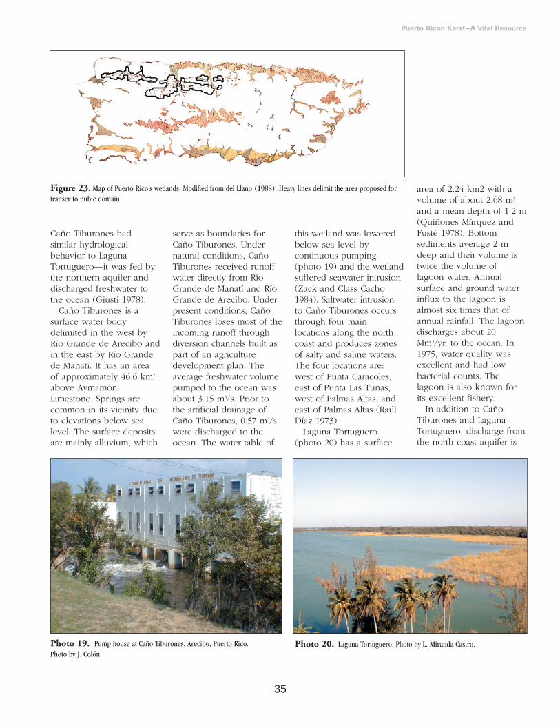
35
Caño Tiburones hadsimilar hydrologicalbehavior to LagunaTortuguero—it was fed bythe northern aquifer anddischarged freshwater tothe ocean (Giusti 1978).
Caño Tiburones is asurface water bodydelimited in the west byRío Grande de Arecibo andin the east by Río Grandede Manatí. It has an areaof approximately 46.6 km2
above AymamónLimestone. Springs arecommon in its vicinity dueto elevations below sealevel. The surface depositsare mainly alluvium, which
serve as boundaries forCaño Tiburones. Undernatural conditions, CañoTiburones received runoffwater directly from RíoGrande de Manatí and RíoGrande de Arecibo. Underpresent conditions, CañoTiburones loses most of theincoming runoff throughdiversion channels built aspart of an agriculturedevelopment plan. Theaverage freshwater volumepumped to the ocean wasabout 3.15 m3/s. Prior tothe artificial drainage ofCaño Tiburones, 0.57 m3/swere discharged to theocean. The water table of
this wetland was loweredbelow sea level bycontinuous pumping(photo 19) and the wetlandsuffered seawater intrusion(Zack and Class Cacho1984). Saltwater intrusionto Caño Tiburones occursthrough four mainlocations along the northcoast and produces zonesof salty and saline waters.The four locations are:west of Punta Caracoles,east of Punta Las Tunas,west of Palmas Altas, andeast of Palmas Altas (Raúl Díaz 1973).
Laguna Tortuguero(photo 20) has a surface
area of 2.24 km2 with avolume of about 2.68 m3
and a mean depth of 1.2 m(Quiñones Márquez andFusté 1978). Bottomsediments average 2 mdeep and their volume istwice the volume oflagoon water. Annualsurface and ground waterinflux to the lagoon isalmost six times that ofannual rainfall. The lagoondischarges about 20Mm3/yr. to the ocean. In1975, water quality wasexcellent and had lowbacterial counts. Thelagoon is also known forits excellent fishery.
In addition to CañoTiburones and LagunaTortuguero, discharge fromthe north coast aquifer is
Puerto Rican Karst—A Vital Resource
Figure 23. Map of Puerto Rico’s wetlands. Modified from del Llano (1988). Heavy lines delimit the area proposed fortranser to pubic domain.
Photo 19. Pump house at Caño Tiburones, Arecibo, Puerto Rico. Photo by J. Colón.
Photo 20. Laguna Tortuguero. Photo by L. Miranda Castro.

36
responsible for many moreof the region’s wetlands(photo 21), such as theswampy coastal regionbetween Arecibo andDorado (Giusti andBennett 1976). Theregion’s swampy landsinclude the white sandwetlands around TortugeroLagoon, which harbor anunusual concentration ofendemic wetland plantspecies—including manyrare carnivorous plants.The discharge to thesefeatures occurs both asspringflow and as seepage.Giusti (1978) estimated that75 percent of the aquiferdischarge occurred inlandfrom the wetlands andfrom there it flowed to theocean via LagunaTortuguero and CañoTiburones. The other 25percent of the aquiferdischarge was direct flowto the ocean floor in azone a few hundredmeters wide. The coastalwetlands themselves arecharacterized by aparticular water budgetshown in figure 17c.
Springs and Waterfalls
Springs occur throughoutthe karst belt (figure 16) inmany forms, and manyflow over cliffs and rocksas waterfalls (photo 22).These waterfalls are sites ofintensive recreation, partic-ularly along roadsides.Springs have beenclassified as to their origin,rock structure, discharge,temperature, andvariability— that is,volcanic, fissure,depression, contact,artesian, tubular, or fracturetypes (Guzmán Ríos 1983).Puerto Rico has examplesof most types. RodríguezMartínez (1997) classified67 springs into 2 groupsaccording to their responseto rainfall—diffuse typesprings, which have little orno response to rainfall andconduit type springs, whichexhibit a strong responseto rainfall. Ojo de Agua inVega Baja, Mameyes inManatí, and Mackovic inVega Alta, are diffusesprings. Maguayo inDorado, Ojo de Guillo in Manatí, and San Pedroin Arecibo, are conduit-type springs.
There are no first orsecond order springs in thekarst belt—those with baseflows exceeding 2.8320 and0.2832 m3/s respectively.However, discharges ashigh as 1.7295 m3/s weremeasured after rainfallevents (Rodríguez Martínez1997). Rodríguez Martínez(1997) found 10 third order(base flow 0.028 to 0.2832m3/s), 4 fourth order(0.0062 to 0.0282 m3/s), 14fifth order (0.0006 to 0.0062m3/s), 19 sixth order(0.00005 to 0.0006 m3/s), 6seventh order (0.00001 to0.00005 m3/s), and 14eighth order (base flow ofa few drops per second)springs. Some of the eighthorder springs could be dryand only flow after arainfall event; otherwise,they stand as nearly circularstagnant pools.
Most of the principalsprings in Puerto Rico arein the limestone region.They are associated with allthe carbonate units in themiddle Tertiary sequence ofthe karst belt, except theCamuy and San SebastiánFormations (RodríguezMartínez 1997). Springs
drain the unconfined partsof both the upper andlower aquifers. Springs thatdrain the unconfined part ofthe lower aquifer normallyissue from the outcropareas of the Lares Limestoneand the MontebelloLimestone Member of theCibao Formation. Thosethat drain the unconfinedpart of the upper aquiferissue from both the outcropand coastal subsurface areasof the Aguada andAymamón Limestones. Nospring is known to issuefrom the confined part ofthe lower aquifer(Rodríguez Martínez 1997).
Permeability contrastbetween successivegeologic units appears tobe the main factorcontrolling the occurrenceof springs in the karst belt.Ground water flow in theoutcrop areas of the upperand lower aquifers appearsto be highly controlled byfractures, and consequentlymost of the springs inthese areas appear to be ofthe conduit type. Groundwater flow in the midvalleys and more coastalareas of the upper aquifer
Puerto Rican Karst—A Vital Resource
Photo 21. The north coast aquifer discharges through coastal wetlands suchas this Toa Baja lagoon at Highway PR 165. Photo by L. Miranda Castro.
Photo 22. A waterfall formed bySonadora spring, Ciales, Puerto Rico.Photo by L. Miranda Castro.

37
appear to occur alongvertically and laterallydiscontinuous permeablezones that may beconnected by fracturesand, as a result, springflowis mostly of the diffusetype (Rodríguez Martínez1997). The complexity ofthe underground drainagesystem that feeds springs isillustrated in figure 24.
Thousands of springs inthe northern limestonedischarge near the coast. Inthe western region of thenorthern limestone—Río
Camuy to Aguadilla—threeoffshore springs have beenreported plus many othersthat discharge on the coast(Tucci and Martínez 1995).The estimated dischargeinto the sea is from 0.11 to1.02 m3/s—a value greaterthan water use by pumpage(0.08 m3/s) and close to theleakage to streams (1.22 to1.76 m3/s). The totaldischarge of some of theprincipal springs in thekarst belt can be as high as0.08 Mm3/d—20 mgd(Rodríguez Martínez 1997).
Springs discharging intorivers issue from cliffs—sometimes as waterfalls—or emerge through thealluvium, and mostdischarge on the west sideof river valleys, suggestingthat the pattern is due tothe eastern tilt of theformations (Giusti andBennett 1976). However,some springs are known todischarge into the eastbank of the riversindicating that the easterntilt is not the sole factor indetermining the discharge
direction of springs on thenorth coast (RodríguezMartínez 1997). Theexplanation is related tothe orientation of karstconduits as they passthrough various levels ofwater saturation in thegeologic strata. Springs inthe Río Grande de Areciboalluvial plain supplementthe water discharge of theriver. One of them, SanPedro Spring contributes32,551 m3/d—8.6 mgd(Quiñones Aponte 1986).
The water qualityparameters of spring waterstend to reflect the valuesobserved in undergroundwaters. Rodríguez Martínez(1997) found water qualitydifferences between conduitand diffuse type springs.These differences wererelated to the hydrologicalbehavior of the springs.Conduit-type springsbehave like surface streamsin response to rainfallevents. As a result, theirwater quality also exhibitsshort-term variations. Thedischarge of diffuse springschanges very little afterrainfall events and theirwater quality reflected thatof the aquifers they drained.Water temperature rangesfrom 22.5 to 28.0 oC.Specific conductance rangesfrom 289 to 4,000microsiemens per cmincreasing coastward, andpH ranged from 6.9 to 7.8.Calcium, sodium,bicarbonate, and chlorideare the main ionic speciesin spring waters. The mainwater type is calciumbicarbonate and secondarywater types are calcium-bicarbonate-chloride andsodium-bicarbonate-chloride. With the exception
Puerto Rican Karst—A Vital Resource
Figure 24. Schematic diagram showing the complexity of the San Pedro spring conduit network (Rodríguez Martínez1997). This cave system is located in the Río Grande de Arecibo watershed.

38
of Ojo de Guillo spring,water quality as measuredby bacterial counts hasremained stationary in thekarst belt since 1983. AtLuis Pérez in Arecibo,bacterial counts havereached values as high as35,000 and 27,000 coloniesof fecal coliform and fecalstreptococci, respectively,per 100 mL (RodríguezMartínez 1997).
EcologicalDiversity
The variety of landformsand hydrologic conditionsof the limestone regioninfluences the variety ofecological systems that itcontains. Moreover, thereare 18 geoclimatic zonesrepresented in thelimestone region (figure 4,table 2) that areresponsible for the diversityof ecosystems. Ecosystemtypes range from marine toestuarine, terrestrial, andfreshwater systems. A highenergy coastline with rockyand sandy beaches, cliffs,marine caves, sand dunes,and coastal marine watersrepresents the marinecoastal environment.Riverine estuaries, lowsalinity basin mangrovesbehind sand dunes, andthe largest herbaceouswetland in the island—Caño Tiburones, representthe estuarine environment.Freshwater systems includeLaguna Tortugero, locateda few meters from theocean; springs, some ofwhich discharge into theocean; ponds (photo 23);artificial lakes; and smallwetlands, some withmagnificent royal palms,that appear at the base of
mogotes and along seepsfrom the undergroundaquifer. A diversevegetation that grows onthe white sands of thecoast, karst forests with thehighest tree diversity in theisland, and the ecologicalsystems associated withcaves and sinkholesrepresent the terrestrialcomponent.
Terrestrial Vegetation
Gleason and Cook (1926)constructed a successionalscheme for the vegetationof the north coast of PuertoRico (figure 25). Althoughthe interactions in thescheme have not beendemonstrated to occur, theframework remains as auseful overview of theprincipal vegetation types
of the region. We givegreater attention to the hillforests but end this sectionwith a short statement onthe other vegetation typesidentified by Gleason andCook (1926).
Puerto Rican karst forests,regardless of rainfallconditions, share commoncharacteristics includingphysiognomy and leafcharacteristics. Karst forestsare characterized by trees ofsmall diameter, high treedensity, and leaf sclero-morphy. Stands have atendency to show signs ofbeing exposed to frequentdrought conditions. Even inthe moist and wet karstbelt, forests have a highproportion of deciduoustree species and show ahigh degree of sclero-morphism (Chinea 1980).This is probably due to therapid rate of runoff andinfiltration of rainwater, lowwater storage in shallowsoils, and high sunlight
Puerto Rican Karst—A Vital Resource
Photo 23. Charca Las Tiguas, a wetland near Arecibo, Puerto Rico. Photo by L. Miranda Castro.
Figure 25. The principal plant associations of the northern coastal plain of Puerto Rico and their assumed successionalrelations (Gleason and Cook 1926). The diagram is organized as four succession pathways converging on the climax PlayaLand Forest in the center. Successions originating in open water are hydrarch, in sea water are halarch, in moist forests aremesarch, and in beach and dune are xerarch.

39
and wind acting onvegetation. In the drysouthern karst, thesetendencies are even moreprevalent because rainfallinput is lower and moreseasonally variable.
Karst forests share manycharacteristics with otherforests in the island. Theyall have smooth canopieswith few emergent trees.This is a response to windsculpturing and periodicwind storms that prune thecanopy and any emergentbranches that mightdevelop between events.All of the island’s forestsalso share a high speciesdominance (figure 26).Usually no more than fivetree species dominatestands by accounting forabout 50 percent of thestand’s basal area and treedensity, combined as theImportance Value ofspecies. The result is that afew dominant species anda large number of rarespecies characterize foreststands. Lugo (1991)attributed this highdominance to infrequentand large-scale disturbancessuch as hurricanes.
The number of speciesper number of stems(figure 27) and number ofspecies per unit area (figure 28) are alsorelatively uniform in PuertoRican forests. For all foreststands studied, 44 treespecies are encounteredper 1,000 individuals. Therelationship between treespecies richness and stemdensity in karst forests isrelatively weak (r2 = 0.37)because of the highvariability of tree speciesrichness in karst forests.However, the highest count of tree species per
Puerto Rican Karst—A Vital Resource
Figure 26. Importance value curves for forest stands in wet volcanic (ElVerde), wet and moist karst (Río Abajo, Cambalache), and dry karst (Guánica,Mona) geoclimatic zones of Puerto Rico. Data can be obtained from A.E. Lugo.
Figure 27. Graph of the number of tree species per plot and the tree densityin the plot. Dry forests are from the southern limestone, while moist and wetforests are from the northern limestone. Wet volcanic forests are from theLuquillo Mountains. The relation between number of tree species in a stand (y)and tree density (x) and the number of tree species per thousand individuals(y’) is described by, or obtained from, regressions. For wet forests on volcanicrock—y = -43.78 + 30.89*LOG(x) with r2 = 0.84, n = 19, and y’ = 49. Formoist and wet forests on karst—y = -13.79 + 20.01*LOG(x) with r2 = 0.37, n= 39, and y’ = 46. For dry forests on karst—y = -30.27 + 24.95*LOG(x) withr2 = 0.52, n = 26, and y’ = 45. For other forests in Puerto Rico—y = -20.75 +20.46*LOG(x) with r2 = 0.46, n = 40, and y’ = 41. For all forests combined—y= -21.85 + 22.16*LOG(x) with r2 = 0.50, n = 124, and y’ = 44. The regressionline is for all forests. Regression lines for individual forest types have a slightlysteeper slope. Data can be obtained from A.E. Lugo.

40
0.1 ha was on a northernkarst forest, while southernkarst forests exhibit thesame pattern of species-area curve as wet forestson volcaniclastic geology(figure 28).
Karst forests are alsocharacterized by theirclumped tree distribution,which is due to the natureof the terrain where theygrow. Trees grow bestwhere the soil is deep, butsuch sites are scarce andabundant rock outcropslimit the locations foradequate treeestablishment. In fact,seeds of species likePlumeria alba 6—in thesouthern limestone—cangerminate over rocksurfaces, which suggestsan extreme adaptation toshallow rocky soilsubstrates (photo 24). Tree growth in crevicesand deep soils provides anadvantage during periodsof high winds andhurricanes. Well-rootedtrees survive strong windsand may only lose theirleaves or branches. Fewuprooted trees are
observed in karst forestsafter the passage of ahurricane. The exception isthose trees that establishedover rocks or in shallowsoils. Because of soillimitation, trees in karstforests are generally shorterthan trees in volcanicforests with the samerainfall but deeper soil.
The most salient charac-teristic of karst forests isperhaps the most difficultto detect. Karst forestsexhibit numerous gradientsin vegetation structure,physiognomy, andcomposition as a result ofthe many environmentaland topographic gradientsin the region. Chinea(1980) described an east-west and north-southrainfall gradient due to the trade winds decreasingrain from east to west—and topography—increasing rain from northto south with elevation.Wind exposure alsoestablishes two gradientswithin mogotes: greaterexposure on the northeastslopes and less on thesouthwest slopes, and
greater wind on topscompared to bottoms ofmogotes. Soil character-istics result in deep fertilesoils in valleys andshallow, rocky, andinfertile soils on tops ofmogotes. Slopes exhibitintermediate edaphicconditions.
Vegetation response toenvironmental gradients iscomplex in part because ofthe effects of past landuse, age, elevation, andsize of forest stands (Riveraand Aide 1998). However,Chinea (1980) conductedordination studies at thelevel of a single mogote aswell as various mogoteswhile holding some ofthese variables relativelyconstant. He found that thebasal area of individualspecies varied according toa normal distribution alonghumidity gradients fromxeric to mesic. Somespecies peaked in basalarea under mesicconditions while others didunder xeric conditions andat any moisture level he
could find a speciesreaching its optimal basalarea. At both single andmultiple mogote levels,Chinea found that asconditions became moremesic, there was a linearreduction in theimportance of species withsclerophyllous leaves.Values ranged from over60 percent of species withsclerophyllous leaves inxeric conditions, to almostzero percent under mesicconditions. In contrast, treeheight increased along thesame gradient from lessthan 10 m to over 25 m.
Studies of forests in thekarst belt have focused onmogotes, where standshave been classified bynumerous criteria. Forexample, Alvarez Ruiz etal. (1997) used age,physiognomy, and landuse to classify foreststands. Beard (1949, 1955)used only physiognomy,and Dugger et al. (1979)used topographic positionvalley, slopes, and tops.The forests of the karst
Puerto Rican Karst—A Vital Resource
Photo 24. Trees such as this almácigo (Bursera simaruba) can grow increvices and develop strong root systems that help them survive hurricanes anddroughts. Notice how roots penetrate into the crevices. Photo by L. Miranda Castro.
Figure 28. Species-area curve for trees of Puerto Rican forests (Lugo in press).
6 We maintain the scientific name given in the original sources reviewed.

41
belt are diverse in speciescomposition andphysiognomy. Ordinationtechniques led Chinea(1980) to identify threetypes of forests in the karstbelt—mesic forest, drywoodland, and mixedwoodland (figure 29).Chinea also identified cliffforests as a topographicvegetation unit at the edgeof cliffs.
The mesic forest is foundon the base of mogotes(photo 25). It has a heightof 25 to 30 m, a closedcanopy, evergreen specieswith mesophyll leaves, asecond tree layer with largeleaves at 15 to 20 m height,a 5 to 10 m height shrublayer, and a herbaceousand tree seedling layer onthe forest floor. Commonspecies in this forest typeare Dendropanax arboreus(palo de pollo) andQuararibea turbinata(garrocho).
The dry woodland occurson slopes and exposed tops(photos 26 and 27). Thecanopy of this forest is
deciduous and trees reachheights of 16 to 18 m.Leaves are sclerophyllousand range in size frommicrophyll to mesophyll.The forest understorycontains shrubs and smalltrees with evergreen leaves.Leaf size ranges fromnanophyll to macrophylland most are sclero-phyllous. Common speciesare Coccoloba diversifolia(uvilla) and Bursera simaruba
(almácigo). The mixedwoodland is a combinationof the previous two and isfound in intermediate sitesbetween those protectedand those exposed. It canoccur in lower slopes or onhill tops, depending on theaspect.
The cliff woodland occursat the edge of cliffs inlocations with abruptchanges in elevation.Strangler trees—intolerantof shade and evergreen—dominate this forest type.These trees have specialized
roots that allow them toobtain water and nutrientsfrom long distances. Thedominant species are in thegenus Clusia and includeClusia rosea (cupey). Thisassociation is conspicuousby the falling root systemson the sides of cliffs andcan be seen when drivingold roads that pass throughthe valleys of mogotes.Modern highwayconstruction cuts themogotes in half and thusthis vegetation is no longervisible from expressways.
Puerto Rican Karst—A Vital Resource
Figure 29. Ordination of main hill forest types in the karst belt (Chinea 1980).
Photo 26. Dry woodlands on the slopes of mogotes in Arecibo, Puerto Rico.Photo by J. Colón.
Photo 25. A mesophytic forest atthe base of a mogote in Ciales, PuertoRico. Photo by J. Colón.
Photo 27. Dry woodlands on the tops of mogotes and mesophytic forestswith an even canopy on the base of the mogotes in Ciales, Puerto Rico. Photo byL. Miranda Castro.

42
The forests of theflatlands were converted toagricultural uses early inthe colonization of PuertoRico, and it is difficult toreconstruct their originalcomposition and structure.It is believed, however,that forests on the richalluvial soils of the northcoast must have beenamong the most majestic inthe island (photo 28). Aforest type that survived inthe lowlands is the foreston white sands, initiallydescribed by Gleason andCook (1926). A 1980 studyof the stands visited byGleason and Cook(Figueroa et al. 1984)illustrated the complexityof vegetation structure andcomposition resulting frompast land uses andvariations in topographyand soil types. Figueroa etal. (1984) studied an areaof 39.5 ha and identifiedsix vegetation types basedon physiognomy and age(table 8). Of these, the oldsecondary forest was thestand most closely
resembling the originalvegetation of the region.Species such as Manilkarabidentata (ausubo),Lonchocarpus latifolius, andPisonia subcordata (corchoblanco) were presentforming stands as tall as19.7 m with a tree speciesrichness of 32 species/0.1ha. Two endangeredspecies were observed in1980: Cassia mirabilis—anendemic herbaceousspecies—and Ficus stahlii(jaguey)—a tree.
Lugo (in press) foundthat karst forests had highprimary productivity, fastgrowing trees, and fastregeneration andsuccession after distur-bances. Rivera (1998)studied succession in thekarst belt and found thatlanduse history affectedthe pattern of regenerationand stand dynamics formany years. Forests inabandoned pastures had agreater woody speciesdiversity in comparisonwith abandoned coffeesites. They also had ahigher tree density butsimilar basal area (Riveraand Aide 1998). Speciescomposition anddominance was alsodifferent in forests
regenerating in abandonedpasture sites compared tothose regenerating inabandoned coffeeplantations. Guarea guidoniawas the dominant speciesin abandoned coffeeplantations. This species isused for coffee shade.Spathodea campanulata, analien species, dominatedforests regenerating inabandoned pastures. Therate of succession was fastand similar among foreststands. It was acceleratedby seed dispersal by bats.
Complex coastaldune/beach vegetationoccurs all along the northcoast of Puerto Rico(photo 29). This vegetationis controlled by the harshconditions of the coastal
zone which include sandysoils, low soil moisturelevels, constant salt spray,and high frequency of highvelocity winds. As a result,the vegetation is generallyscleromorphic, of lowstature, and wind sculpted.On the most exposedbeach sand, the vegetationis postrate—for examplePhiloxerus vermicularis—orroots high in the beachand creeps towards theocean as do Ipomeapescaprae and Sporolobusvirginicus. These give wayto dune-forming plantssuch as Chamaesyce buxifolia,Diodia maritima, and others.Plant thickets developbehind the dune-formingplants. These aredominated by Coccoloba
Puerto Rican Karst—A Vital Resource
Photo 28. Large tree in deepfertile soils in Arecibo, Puerto Rico.Photo by J. Colón.
Table 8. Structure of the vegetation on the moist coastal white sands of Dorado, Puerto Rico(modified from Figueroa et al. 1984). Data are for trees with diameter at breast height > 2.5 cm.The complexity index is calculated for an area of 0.1 ha and is the product of height, basal area,tree density, number of species, and 10-3.
Forest Type Species Tree Density Basal Area Height Complexity (no./0.1ha) (no./ha) (m2/ha) (m) Index
Old secondary 32 1880 41.6 19.7 493 Young secondary 19 1833 29.0 19.3 194 Clusia-Zyzygium 11 3200 25.6 20.7 187 Pterocarpus 7 1680 44.6 19.0 100 Disturbed and open 9 1000 21.8 17.0 33 Abandoned palm grove 5 1600 32.6 12.3 32
Photo 29. Vegetation of coastal dunes. These dunes show human impact.Photo by J. Colón.

43
uvifera, which can grow totree size when on theleeward slope of stabilizedsand dunes. As thepresence of vegetation orthe protection of the sanddune itself reduces windforce, plant size increasesand eventually forms aclosed canopy forestbehind the sand dunes.
Wetlands
Freshwater wetlands ofthe karst belt includemarshes at the base ofmogotes, forested wetlandsin riparian zones includingthe boils of springs andalluvial valleys, and eitherforested or nonforestedwetlands on valleysbetween mogotes. Thedeterminant factor on thetype of wetland is thehydroperiod. A longerhydroperiod favorsmarshes while shorter onesfavor forested wetlands.Ferns and emergentaquatic macrophytes suchas Typha are the dominantspecies in the nonforestedwetlands. Pterocarpusofficinalis (palo de pollo),Roystonea borinquena (royalpalm), Calophyllum brasiliense(maría), Bucida buceras(úcar), and Prestoea montana(sierra palm) predominatein forested wetlands. Theendemic epiphytic orchidEpidendrum kraenzliniioccurs in the Pterocarpusforest as well as theendangered shrub Sabiceacinerea.
On upland valleys and atthe base of mogotes,springs and seeps dictatethe hydroperiod. On thecoastal zone, high aquiferdischarge is responsible forthe formation of wetlands,such as Caño Tiburones
and wetlands surroundingLaguna Tortuguero. Inthese coastal wetlands, thehydroperiod is generallylonger than in the mogotevalleys and as a result aredominated by marshes—the largest extensions ofsuch systems in PuertoRico. Gleason and Cook(1926) listed the aquaticmacrophytes that arecommon in these wetlandsincluding Typha angustifolia,Mariscus jamaicensis,Phragmites phragmites, andmany other emergent,floating, and submergedaquatic plants. Because ofthe abundant number ofsprings and seeps, the mapof the wetlands of thenorthern karst showshundreds of smallwetlands scattered amongmogotes and other hillfeatures, as well as thelarger wetland areas of thecoastal zone and alluvialvalleys of major rivers(figure 23).
Estuaries
Estuaries form inlocations where seawaterand freshwater mix.Mangrove forestsdominated by Rhizophoramangle (mangle rojo) followsaltwater wedges thatpenetrate upstream underfreshwater discharge(photo 30). These forestsare found on the riparianzone of rivers severalkilometers inland, usuallyas far as the saltwaterwedge penetrates the riverchannel (Lugo and Cintrón1975). These mangroves,known as riverinemangroves, are among themost productive of allmangroves on the island.In addition to R. mangle,
these forests contain otherspecies, more notablyLaguncularia racemosa(mangle blanco) andAvicennia germinans (manglenegro). Abundantfreshwater plus nutrientscarried by riverine waterscontribute to the highproductivity of thesesystems.
Because of the highwave energy of theAtlantic Ocean, mangrovesdo not grow on theseashore of the north coastas they do on the southcoast—that is, fringemangrove forests do notoccur on the north coastnor do overwashmangrove islands. Instead,mangroves grow behindsand dunes at the mixturezone between seawaterand freshwater. Thesemangroves are known asbasin mangroves. Unlikebasin mangroves in aridcoastlines, the basinmangroves of the northcoast have low salinity andthus develop a highbiomass and tall heightstructure.
Mangroves behind sanddunes only occur on thenorth coast of Puerto Rico.
All four mangrove speciescan be found in or nearbasin mangrove forests—R. mangle, A. germinans, L.racemosa, and Conocarpuserecta (mangle botón). Inthe rear of these forests,the ecological systemtransitions from estuarineto freshwater. Along thetransition one can findthickets of the mangrovefern Acrostichum aureum andtree species such asAnnona glabra (pond apple)and P. officinalis. Forested ornonforested wetlands withor without tidal influencedevelop behind themangroves in response tohydroperiod.
The Karst Belt
Harbors Valuable
Natural Resources
Fossil Flora and Fauna
The karst belt provides abonanza to students ofpaleontology in PuertoRico and the Caribbeanregion. The area hasprovided significant fossilrecords since the early1920’s when B. Hubbard(1923) produced a list offossil plants collected fromRío Guajataca near Lares.Charles Arthur Hollickconfirmed and added tothese reports in his 1924and 1926 papers. Hesummed all these, as wellas an additional list ofTertiary microfossil plantsfrom the Lares-SanSebastián region, in hisvolume on Paleobotany ofPuerto Rico of theScientific Survey of PuertoRico and the Virgin Islands(Hollick 1928). The 88
Puerto Rican Karst—A Vital Resource
Photo 30. Mangrove forest in ToaBaja, Puerto Rico. Photo by L.Miranda Castro.

44
plant taxa listed for thiskarst area are recognized asthe largest list of macrofossilflora ever produced for theTertiary of any Neotropicalregion (Graham 1996).More recent studies on pastvegetation of Puerto Ricocenter on paleopaly-nology—the study of fossilpollen. Graham (1996)provides a detailed reviewof both macropaleofloraand micropaleoflora of theregion. These data areimportant for keeping inperspective the evolution ofthe original flora in thekarst, given the significantdestruction of vegetationfrom the early pre-Hispanicperiod (DomínguezCristóbal 1989a,b) and theconstant human alterationof the region (TorresGonzález and Wolansky1984, Dopazo and MolinaRivera 1995).
The animal life of modernPuerto Rico is not the sameanimal community thatroamed the many plantcommunities of Puerto Ricothousands of years ago. Ourunderstanding of this faunais largely dependent on thefossils recovered from cavesor from exposed rocks thatabound in the karst belt.When animals die intropical forests, their bonesare quickly destroyed byscavengers and weathering,leaving no fossil evidenceof their existence. Fossils ofmarine animals such assharks and Dugongs havebeen preserved in the karstbelt. The extinct Great-toothShark, Carcharodon(Carcharocles) megalodon(Nieves Rivera 1999) thatwas previously recordedfrom the Miocene of theNeartic region was
preserved in Isabela andother karst areas. Thisfinding highlights theimportance of Puerto Ricankarst to understanding thenatural history of thisspecies. Sketches on wallshave been seen andsamples of Dugong(Caribosirenia tumeri andHalitherium antillensis)—extinct relatives of recentmanatees—have beencollected in three differentsites at the Río Encantadocave system. Collectionsare deposited at theSmithsonian Institute inWashington, DC. They willprobably allow thereconstruction of acomplete Dugong skull(Halton 1996).
Fossils of amphibians andreptiles are scarce. Pregill(1981) and Pregill andOlson (1981) discussed thepresence and significance ofherpetofaunal remains inthe Caribbean karst and inparticular in Puerto Rico.Most remains foundassociated with cavedeposits are probably theleftovers of either birds,mammals, or naturalphenomena. Evidence ofthe endemic Puerto RicanCrested Toad, Peltophrynelemur (photo 31), and ofextinct racers of the genusLeiocephalus (L. etheridge andL. oartitus) was found insuch karst deposits (Pregill1981). Fossil material yet tobe described has been housed in the U.S. NationalMuseum and in theAmerican Museum (Storrs Olson, personalcommunication).
Records of many extinctland vertebrates werepreserved in caves, wherebones are often protected
from the destructive effectsof sunlight and rain. Cavescan act as natural tombs,which can preserve bonesfor tens or even hundredsof thousands of years.Animal remains arrive incaves by several processes.Some caves have deepshafts, which can act asnatural—and very lethal—traps for unwary animals.Other caves may serve asanimal dens and preservetheir occupants after theirdeaths. The remains of theendemic dog-sized GroundSloth (Acratocnusodontrigonus, Anthony1916a) and the Giant Hutía(Elasmodontomys obliquus,Anthony 1916a) probablyused caves this way.
Fossil remains in cavesmay be leftovers of foodtaken into caves by owls;sometimes these owl-pelletdeposits may consist ofthousands of small bones.Extinct endemic birdspreserved in Puerto Ricancaves in this way include awoodcock (Scolopaxanthonyi, Olson 1976), aquail dove (Geotrygon larva,Wetmore 1920), a barn owl(Tyto cavatica, Wetmore1920), a swift (Tachornisuranoceles, Olson 1982), a
caracara (Polyborus latebrosus,Wetmore 1920) a crow(Corvus pumilis, Wetmore1920), and a finch(Pedinorhis stirpsarcana,Olson and McKitrick 1981).Small endemic mammalswere also eaten by cave-roosting owls (Anthony1916b); the island-shrew(Nesophonthes edithae,Anthony 1916a) is the onlyPuerto Rican representativeof the monogeneric familyNesophontidae, currentlybelieved to comprise 11species (McFarlane1999a,b). The Puerto RicanSpiny Rats, Puertoricomyscorozalus (originally calledProechimys corozalus,Williams and Koopman1951) and Heteropsomysinsulans (which includesHomopsomys antillensis asdescribed by Anthony1917) were also prime owlprey before the arrival ofship rats in the historic era.
Finally, bones in cavesmay be the remains ofhuman meals. The firstevidence of the extinctFlightless Rail (Nesotrochisdebooyi, Wetmore 1922) andthe rabbit-sized Hutía(Isolobodon portoricencis,Allen 1916)—which despiteits name was apparently
Puerto Rican Karst—A Vital Resource
Photo 31. The endemic Puerto Rican Crested Toad. Photo by J. Colón.
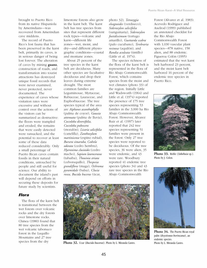
45
brought to Puerto Ricofrom its native Hispaniolaby Amerindians—wasrecovered from Amerindiancave middens.
The record of PuertoRico’s lost fauna that hasbeen preserved in the karstbelt, primarily its caves, isin serious danger of beinglost forever. The alterationof caves by mining guano,construction of roads, andtransformation into touristattractions has destroyedunique fossil records thatwere never examined,never protected, neverdocumented. Theexperience of caves whosevisitation rates wereexcessive and withoutcontrol over the actions ofthe visitors can besummarized as destructive:the floors were trampledand eroded, the remainsthat were easily detectedwere ransacked, and thepotential to recover at leastsome of these datareduced considerably. Onlya small percentage ofPuerto Rican caves containfossils in their naturalconditions, untouched bypeople and still useful forscience. Our ability todocument the island’s pastwill depend on efforts insecuring these deposits forfuture study by scientists.
FloraThe flora of the karst belt
is transitional between thewet forests over volcanicrocks and the dry forestsover limestone rocks.Chinea (1980) found that80 tree species from thewet volcanic tabonucoforest in the LuquilloMountains and 27 treespecies from the dry
limestone forests also growin the karst belt. The karstbelt has tree species fromsites that represent differentrock types—volcanic andkarst—different lifezones—wet, moist, anddry—and different physio-graphic conditions—coastaland montane zones.
About 25 percent of thetree species in the karstbelt are deciduous. Manyother species are facultativedeciduous and drop theirleaves during extremedrought. The mostcommon families areLeguminosae, Myrtaceae,Rubiaceae, Lauraceae, andEuphorbiaceae. The treespecies typical of the areaare Aiphanes acanthophylla(palma de coyor), Gaussiaattenuata (palma de lluvia),Coccoloba diversifolia,Coccoloba pubescens(moralón), Licaria salicifolia(canelilla), Zanthoxylummartinicense (espino rubial),Bursera simaruba, Cedrelaodorata (cedro hembra),Hyeronima clusioides (cedromacho), Sapium laurocerasus(tabaiba), Thouinia striata(ceboruquillo), Thespesiagrandiflora (maga), Ochromapyramidale (balsa), Clusiarosea, Bucida buceras (úcar,
photo 32), Tetrazygiaeleagnoides (verdiseco),Sideroxylon salicifolia(sanguinaria), Sideroxylonfoetidissimum (tortugoamarillo), Guettarda scabra(palo cucubano), Terebrariaresinosa (aquilón), andRandia aculeata (tintillo)(Little et al. 1974).
The species richness ofthe flora of the karst belt isrepresented in the flora ofRío Abajo CommonwealthForest, which containsspecies from the moist andwet climates (photo 33) ofthe region. Initially Littleand Wadsworth (1964) andLittle et al. (1974) reportedthe presence of 175 treespecies representing 53families in the 3,000 ha RíoAbajo CommonwealthForest. However, AlvarezRuiz et al. (1997) laterreported that 242 treespecies representing 51families were present inthe forest. Only 27 treespecies were reported tobe deciduous. Of the treespecies, 36 were alien, 35were endemic, and 43were rare. Woodburyreported 41 endemic treespecies (photo 34) and 43rare tree species in the RíoAbajo Commonwealth
Forest (Alvarez et al. 1983).Acevedo Rodríguez andAxelrod (1999) publishedan annotated checklist forthe Río AbajoCommonwealth Forest with 1,030 vascular plantspecies—878 native, 158alien, and 88 endemic.Figueroa Colón (1995)estimated that the wet karstbelt harbored 23 percent,and the moist karst beltharbored 16 percent of theendemic tree species inPuerto Rico.
Puerto Rican Karst—A Vital Resource
Photo 32. Ucar (Bucida buceras). Photo by L. Miranda Castro.
Photo 33. Roble (Tabebuia sp.).Photo by J. Colon.
Photo 34. The Puerto Rican royalpalm (Roystonea borincana), anendemic species. Photo by L. Miranda Castro.
46
FaunaDifferent phyla of
invertebrate animals formthe major portion of thefauna of any area. Ourfocus is on vertebrates withshort statements on aquaticmacrofauna and caveinvertebrates. There is nocomprehensive study of theinvertebrates of thelimestone region, but werecommend consultingVélez (1979a, b, c) for ageneral overview of theisland invertebrates. Forinformation on particularanimal groups, werecommend the followingworks: spiders—Petrunkevitch (1929, 1930a,b), insects—Martorell(1945) and Wolcott (1948),terrestrial mollusks—Vander Schalie (1948), aquaticmollusks—Aguayo (1966),decapods—Vélez (1967a),millipedes—Vélez (1967b),centipedes—Santiago deRohena (1974), scorpions—Santiago Blay (1984), andearthworms—Borges andMoreno (1990, 1992).
Aquatic Macrofauna
Most of the nativefreshwater macrofauna ofPuerto Rico is present inthe karst belt, in spite ofthe low density of subaerialdrainage. Compared tocontinents, the island has asmall number of freshwateranimal species. Theoceanic barrier to dispersalof freshwater speciesseverely limits the numberof species in freshwaterecosystems (Covich andMcDowell 1996). Most ofthe freshwater species mustmigrate between fresh andsaltwater systems tocomplete their life cycles.
We know of over 100species of anadromous andcathadromous fish residingin Puerto Rico (Erdman1972, 1984; Grana Raffucci1993). River mouths,estuaries, and mangrovesare of particular importancefor fish survival. Whileincomplete, tables 9 and 10lists 99 fish species in 33families. Most species aremarine and/or ofcommercial value, and 25are introduced species tofreshwater systems, all ofcommercial or sportingvalues (table 10). Thelargest families of naturallyoccurring fishes in thekarst belt are the Gobiidae(eight species), Gerreidae,and Haemulidae (sixspecies each). The familieswith the most introducedspecies are Centrarchiidae,Cichlidae, and Poecillidae(six species each).
Native fish speciesinclude Mountain Mullet—locally known asDajao—American Eel,River Goby, BigmouthSleeper, and Sirajo Goby(table 9). These arecommonly fished for sportand human consumption.Dajao is a popularfreshwater game fish,which can grow up to 30cm and weight 250 g(Erdman 1967). Thisspecies enters the riverswhen they are approxi-mately 2.5 cm in lengthand develop to adulthood.The Dajao has disappearedfrom many river systemsdue to the construction ofhigh dams that prevent thespecies from reachingheadwater habitats(Erdman 1967).
We also list 24 species ofcrustaceans belonging to 8
families. Among these,freshwater shrimp can bemore abundant than fish inmany rivers (Erdman1967). There are at leastfive species that areregularly fished for sportor sale. One of these—Macrobrachium carcinus—isreported to weigh up to0.5 kg and reach 45 cm inlength (Erdman 1967, B.Yoshioka personalcommunication 2000).Some of the largestspecimens of this specieshave come from RíoGrande de Arecibo and RíoGrande de Manatí. This,and other species, areknown to move throughunderground rivers.Another importantcrustacean, which inhabitsthe karst belt, is the PuertoRican freshwater crab—Epilobocera sinuatifrons—locally known as“buruquena.” This speciesis endemic to Puerto Ricoand is heavily harvested bylocal people as a fooditem. It can grow over 7.5cm in width of carapace(Erdman 1967). Theirpopulations are apparentlydiminishing island-wide.Excessive harvesting,deforestation, and pesticideuse near water bodies areamong the most importantthreats to this crab species(Rivera 1994).
While none of thespecies are listed asthreatened or endangered,many native populations ofaquatic macrofauna havedeclined in Puerto Ricodue to reservoirconstruction, other riveralterations, excessive waterextraction, illegal fishingpractices, and water qualityproblems.
Cave Invertebrates
Peck (1974) studied thecave invertebrate fauna of14 caves in Puerto Ricoand found 78 free-livingspecies. Of these, 52 wereknown by precise speciesname. The distribution ofthese 52 taxa included 23from the Americanmainland, 6 West Indian,and 23 endemic to PuertoRico. Sixteen of theendemics are known fromnoncave habitats, while thenonendemics are usuallyassociated with caves inother parts of their range.Ninety percent of the totalfauna is troglophilic, withonly two troglobitic. Fifty-five percent of the fauna isguano scavengers,detritivores, andherbivores, while 45percent were predators.Peck (1974) listed all the78 taxa that he found andprovided details of thelocation where thespecimens were found andof their natural history.
In subsequent trips toPuerto Rico, Peck studied5 additional caves andadded 73 species to the1974 list (Peck 1981). Theadditional work added 6triglobitic species andreported a new total of 151cave invertebrate speciesfor Puerto Rico. Moreover,Peck found that the cavefauna of the northernlimestone had a 43 percentsimilarity with the cavefauna of the southernlimestone. The similaritywas mostly due to speciesrequiring moistenvironments. Hehighlighted Cueva LosChorros—15 km south of
Puerto Rican Karst—A Vital Resource
Continue to page 48

47
Puerto Rican Karst—A Vital Resource
Table 9. Native fish and crustaceans found in waters of the northern limestone of Puerto Rico. Families are presented mainly followingthe order in García Ríos (1998). Species accounts include personal observations and the literature including Vélez (1967a), Erdman(1967, 1984), Aranda et al. (1979), Nevárez and Villamil (1981), Negrón González (1986), González Azar (1992), Grana Raffucci (1993),and Bunkley Williams and Williams (1994).
FAMILY/ Scientific Name Common Name (English)
FISH—OSTEICHTHYES ELOPIDAE
Elops saurus LadyfishMEGALOPIDAE
Megalops atlantica Tarpon ANGUILLIDAE
Anguilla rostrata American EelOPHICHTHIDAE
Aplatophis chauliodus Toothy EelCLUPEIDAE
Harengula clupeola Scaled SardineOpisthonema oglinum Atlantic Thread Herring
ENGRAULIDAEAnchoa lamprotaenia Longnose Anchovy Anchoviella perfasciata Flat AnchovyCentragraulis edentulus Whalebone Anchovy
EXOCOETIDAEParexocoetus brachypterus Shortfin Flyingfish
HEMIRAMPHIDAEHyporhamphus unifasciatus Halfbeak
BELONIDAEBelone raphidoma HoundfishStrongylura marina Atlantic Needlefish
POECILLIDAEvivipara Top Minnow
SYNGNATHIDAECosmocampus brachycephalus Crested Pipefish Oostethus brachyurus Oppossum Pipefish Sygnathus dunckersi Pugnose Pipefish
CENTROPOMIDAECentropomus ensiferus Swordspine Snook Centropomus parallelus Little SnookCentropomus pectinatus Tarpon Snook Centropomus undecimallis Snook
SERRANIDAEEpinephelus itajara Jewfish
CARANGIDAECaranx latus Horse-eyed JackCaranx hippos Crevalle JackOligoplites saurus Leather JacketTrachinotus falcatus PermitTrachinotus glaucus Palometa
LUTJANIDAELutjanus apodus SchoolmasterLutjanus cyanopterus Cubera snapperLutjanus griseus Gray SnapperLutjanus jocu Dog SnapperLutjanus synagris Lane Snapper
GERREIDAEDiapterus plumieri Stripped MojarraDiapterus rhombeus Rhomboid Mojarra Eucinostomus gula Silver JennyEucinostomus melanopterus Flagfin Jenny Eucinostomus jonesii Slender MojarraGerres cinereus Yellowfin Mojarra
HAEMULIDAEConodon nobilis Barred GruntHaemulon aurolineatum TomtateHaemulon chrysargyreum Smallmouth GruntHaemulon sciurus Bluestriped Grunt
FAMILY/ Scientific Name Common Name (English)
Pomadasys corvinaeformis GruntPomadasys croco Burro Grunt
SCIAENIDAEOphioscion adustus West Indian CroakerStellifer stellifer Small Drum
EPHIPPIDAEChaetodipterus faber Atlantic Spadefish
MUGILIDAEAgonostomus monticola Mountain MulletJoturus pichardi Hognose MulletMugil curema White MulletMugil liza LizaMugil tricodon Fantail Mullet
SPHYRAENIDAESphyraena barracuda Great Barracuda
POLYNEMIDAEPolydactylus virginicus Threadfin
ELEOTRIDAEDormitator maculatus Fat SleeperEleotris pisonis Spinycheek SleeperGobiomorus dormitor Bigmouth Sleeper
GOBIIDAEAwaous taiasica River GobiBathygobius soporator Frillfin GobyEvorthodus lyricus Lyre GobyGobiomorus dormitator Bigmouth SleeperGobionellus boleosoma Darter GobyGobionellus oceanicus Highfin GobyGuavina guavina GobyLophogobius cyprinoides Crested GobySicydium plumieri Sirajo Goby
TRICHIURIDAETrichiurus lepturus Atlantic Cuttlassfish
BOTHIDAECitharichthys spilopterus Bay Whiff
TETRAODONTIDAECanthigaster rostratus Sharpnose PufferSphaeroides greeleyi Caribbean PufferSphaeroides spengleri Bandtail PufferSphaeroides testudineus Checkered Puffer
SOLEIDAEAchirus lineatus Lined SoleTrinectes inscriptus Scrawled Sole
CRUSTACEANSCOENOBITIDAE
Coenobita clypeata Hermit CrabATYIDAE
Atya innocous ShrimpAtya lanipes Sinuous-faced ShrimpAtya scabra Jonga serrei ShrimpMicratya poeyi Compressed-faced ShrimpXiphocaris elongata Long-faced Shrimp
PALAEMONIDAEMacrobrachium carcinus Giant hand ShrimpMacrobrachium crenulatum Pubescent-hand ShrimpMacrobrachium faustinum Pubescent-hand ShrimpMacrobrachium heterochirus Teeth-faced Shrimp
continue to next page

48
Arecibo on PR 10—ashaving a particularly richfaunal community and,thus, deserving specialprotection, even frombiology students and othercasual visitors. This cave issmall but harbors atroglobitic milliped andcockroach. Guano samplescontained cydnid bugs,nitidulid beetles, terrestrialisopods, ants, centipedes,millipedes, 17 species ofmites, and abundant flylarvae, ptiliid beetles, andcollembola.
The lists of cave invertebrates in Peck (1974,1981) do not include
organisms from Mona Island (box 1). Peck andKukalova Peck (1981)published an additional listwith 46 species from MonaIsland. We summarize some highlights of that listin box 1.
Reptiles and Amphibians
The herpetofauna ofPuerto Rico consists of atleast 70 species of terrestrialamphibians and reptiles,including introducedspecies. We recorded 51species (17 families) ofamphibians and reptiles forthe northern limestone(table 11). Seven families—
Puerto Rican Karst—A Vital Resource
Table 10. Freshwater fish introduced to waters of the northern limestone of Puerto Rico. The list is based on Erdman (1967, 1984), Nevárez and Villamil (1981), González Azar (1992), GranaRaffucci (1993), and Bunkley Williams and Williams (1994). The order of species follows GarcíaRíos (1998).
FAMILY/Scientific name Common Name Date Introduced Geographic Origin
CLUPEIDAE Dorasoma petenense Threadfin Shad 1963 Georgia, U.S.A. CYPRINIDAECarassius aratus Goldfish 1900? China Pimephales promelas Fathead Minnow 1957 North America ICTALURIDAEAmeirus catus White Catfish 1938 North America Ameirus nebulosus Brown Bullhead 1916 North AmericaIctalarus marmoratus Marbled Bullhead 1946 North AmericaIctalarus punctatus Channel Catfish 1938 North America APLOCHEILIDAERivulus marmoratus Rivulus 1935 Cuba? POECILLIDAEGambusia affinis Mosquitofish 1914 North AmericaPoecilia reticulata Guppy 1935? South America Xiphophorus helleri Swordstail 1935 Mexico Xiphophorus maculatus Southern Platyfish 1935 Mexico Xiphophorus variatus Variable Platyfish CENTRARCHIDAELepomis auritus Redbreast Sunfish 1957 North America Lepomis gulosus WarmouthLepomis macrochirus Bluegill Sunfish 1916 North America Lepomis microlopus Redear Sunfish 1957 North AmericaMicropteris coosae Redeye Bass 1958 Southeastern U.S. Micropteris salmoides Largemouth Bass 1946 North America CICHLIDAEAstronotus ocellatus OscarCichla ocellaris Peacock BassTilapia aurea Golden TilapiaTilapia urolepis Redeyed TilapiaTilapia mossambica Tilapia 1958 Mozambique, AfricaTilapia rendalli BlueTilapia
continue to page 50
Table 9. continued from page 51
FAMILY/ Scientific Name Common Name (English)
GRAPSIDAEAratus pisonii Small Elongated CrabGoniopsis cruentata Pentagonal-bodied CrabSesarma sp. Square-bodied Crab
OCYPODIDAEOcypode albicans Ghost CrabOcypode quadrata Ghost CrabUca burgersi Fiddler CrabUca rapax Fiddler Crab
PORTUNIDAECallinectes danae Long-spined Blue Crab Callinectes ornatus Wide-chested Blue CrabCallinectes sapidus Bidentate-faced Blue Crab
GECARCINIDAECardiosoma guanhumi Common Land CrabUcides cordatus Land Crab
PSEODOTHELPHUSIDEAEpilobocera sinuatifrons Freshwater
Crab/Buruquena
Continued from page 46

49
Puerto Rican Karst—A Vital Resource
Table 11. List of amphibians and reptiles of the northern and southern limestone areas. Familyorder is given according to taxonomic closeness. The occurrence of species (O) is (1) if fromnorthern limestone, (2) if from southern limestone, or (3) if from both limestone areas. Frequencydescriptions for species in the northern limestone are based on observations by Puente Rolónsince 1994. Common = seen or heard in all visits, occasional = could be heard or seen in at leastfive visits per year, and rare = seen less than five visits per year. For species in the southernlimestone, the frequency is based on our general understanding of their status.
FAMILY/Species O Common Name Frequency
AMPHIBIANSBUFONIDAEPeltophryne lemur 3 Puerto Rican Crested Toad RareBufo marinus 3 Cane toad, Marine Toad Common LEPTODACTYLIDAELeptodactylus albilabris 3 White-lipped Frog CommonEleutherodactylus antillensis 3 Field Coqui CommonEleutherodactylus brittoni 3 Grass Coqui OccasionalEleutherodactylus cochranae 3 Cochran’s Coqui CommonEleutherodactylus coqui 3 Common Coqui CommonEleutherodactylus richmondi 1 Richmond’s Coqui OccasionalEleutherodactylus wightmanae 1 Melodious Coqui Rare HYLIDAEHyla cinerea 1 Green Tree Frog OccasionalOsteopilus septentrionalis 1 Cuban Tree Frog OccasionalScinax rubra 1 Scinax Rare RANIDAERana catesbeiana 1 Bullfrog Occasional
REPTILESEMYDIDAETrachemys stejnegeri 3 Puerto Rican Freshwater Turtle OccasionalDERMOCHELIDAEDermochelys coriacea 3 Leatherback Turtle Rare CHELONIDAEChelonia mydas 3 Green Turtle RareEretmochelys imbricata 3 Hawksbill Turtle Rare CROCODYLIDAECaiman crocodylus 1 North American Cayman Rare AMPHISBAENIDAEAmphisbaena caeca 3 Common Legless Lizard OccasionalAmphisbaena schmidti 3 Schmidt’s Legless Lizard OccasionalAmphisbaena xera 2 Xeric Legless Lizard ANGUIIDAEDiplopglossus pleii 3 Puerto Rican Galliwasp Occasional GEKKONIDAEHemidactylus haitianus 3 Greater Antillian Gecko CommonHemidactylus mabouia 3 African Gecko OccasionalPhyllodactylus wirshingi 2 Flower-pot Gecko Sphaerodactylus klauberi 1 Klauber’s Gecko Common Sphaerodactylus macrolepis 3 Common Coastal Gecko CommonSphaerodactylus nicholsi 3 Nichol’s Gecko CommonSphaerodactylus roosevelti 2 Roosevelt’s Gecko Sphaerodactylus towsendi 2 Towsend’s Gecko IGUANIDAEAnolis cooki 2 Dry-forest AnoleAnolis cristatellus 3 Common Anole CommonAnolis couvieri 3 Giant Green Anole Common Anolis evermanni 3 Small Green Anole OccasionalAnolis gundlachi 1 Banded Anole CommonAnolis krugi 3 Orange-dewlap Anole OccasionalAnolis occultus 1 Dwarf Anole Occasional
(continued on next page)

50
41 percent—arerepresented by only 1species, 4 families—24percent—are representedby 2 species, twofamilies—12 percent—arerepresented by 3 species,and 3 families—6 percenteach—are represented by4, 8, and 11 species,respectively. Reptiles arethe dominant group with38 species (67 percent) in13 families (photo 35). Interms of abundance, 38percent of the species areconsidered common, 48percent as occasional, and
15 percent as rare species.We found six more
species and two morefamilies of amphibians inthe northern limestone thanin the southern limestonebut all those present in thesouthern limestone werealso present in the northernlimestone (table 11).Reptilian fauna has one lessfamily (Crocodylidae) in thesouthern limestone. Fourspecies appear only in thenorthern limestone, whileeight species appear onlyin the southern limestone.Thirty-two (63 percent) ofthe herpetofauna we list
appear both in the northernand southern limestone,while four (8 percent)appear only in the southernlimestone.
The endemic Peltophrynelemur is restricted to thecoastal limestone region(U.S. Fish and WildlifeService 1992b, Rivero1998) and is the onlyamphibian species listed asendangered both atCommonwealth andFederal levels. In the northcoast, the center of distri-bution of this species isQuebradillas, while in thesouth coast it is theGuánica CommonwealthForest. The breeding siteof the southern populationis protected by patrollingand kept off limits to thepublic (Miller 1985,Moreno 1991). Thenorthern population isscattered throughout manylocations, mostly privatelands (García Díaz 1967,Rivero et al. 1980, Riveroand Seguí Crespo 1992,Hernández Prieto 2001),and is not protected. A 2-year effort to find adults of
the species in and aroundQuebradillas provedunsuccessful, althoughsinging males were heardtwice and bufonid tadpoleswere observed on aregular basis (HernándezPrieto 2001). Securing thispopulation is critical sinceone study suggests thatthere are sufficient geneticdifferences between thenorthern and southernpopulations to reevaluatetheir taxonomic status(Goebel 1996).
The distribution of one ofthe most terrestrial speciesof Eleutherodactylus, theGround Coquí—E.richmondi—includes severalmunicipalities inside thekarst belt (Rivero 1998,Joglar 1998). This specieshas been in decline in thewet volcanic regions ofPuerto Rico (Joglar andBurrowes 1996). Our recentsurvey of amphibians andreptiles led to the discoveryof new populations inArecibo and Ciales (photo36). The MelodiousCoquí—E. wightmanae—is acommon species in thevolcanic region (Rivero1998) but it is also believedto be declining (Joglar and
Puerto Rican Karst—A Vital Resource
Table 11. (continued from previous page)
Anolis poncensis 2 Southern Anole CommonAnolis pulchellus 3 Grass Anole CommonAnolis stratulus 3 Dark-marked Anole CommonIguana iguana 3 Green Iguana Occasional SCINCIDAEMabuya mabuya sloani 3 Skink Rare TEIIDAEAmeiva exsul 3 Common Ground Lizard RareAmeiva wetmorei 2 Blue-tailed Ground Lizard Rare BOIDAEEpicrates inornatus 3 Puerto Rican Boa Occasional COLUBRIDAE Alsophis portoricensis 3 Puerto Rican Racer Common Arrhyton exiguum 3 Puerto Rican Ground Snake Occasional TYPHLOPIDAE Typhlops granti 2 Southern Blind SnakeTyphlops hypomethes 1 University’s Blind Snake Occasional Typhlops richardi 3 Richard’s Blind Snake Occasional Typhlops rostellatus 3 Common Blind Snake Occasional
continued from page 48
Photo 35. Anolis krugi. Photo by L. Miranda Castro.
Photo 36. The Ground Coquí(Eleutherodactylus richmondi).Photo by A. Puente Rolón.

51
Burrowes 1996). Apopulation of E. wightmanaewas found in the Río AbajoCommonwealth Forest and another betweenArecibo and Utuado. These represent firstrecords for this species inthe karst belt.
One of the rarest speciesof reptiles in the northernlimestone is Mabuya mabuyasloanei, which is the onlyskink known for PuertoRico (Rivero 1998), and islegally protected at theCommonwealth level.About 10 individuals of thisspecies were observed inIsabela in 1991 (M.González, personalcommunication). Anotherspecies present is the GiantAnole (Anolis cuvieri) and ithas two color phases. Inthe most common phase,the body, tail, andextremities are emeraldgreen or yellowish green(photo 37). The lesscommon phase is gray orgreenish gray with darkbrown mottles and dots(Rivero 1998). Both phasesare present in the northernlimestone and reproductionbetween individuals ofdifferent phases has beenobserved. The only
endemic turtle, Trachemysstejnegeri, was common buthas now dwindled innumbers and is consideredoccasional.
Three sea turtles, theLeatherback (Dermochelyscoriacea), the Green Turtle(Chelonia mydas), and theHawksbill Turtle(Eretmochelys imbricata) neston a regular basis on karstshores and beaches such asTortuguero, Arecibo,Quebradillas, Isabela,Aguadilla, Guánica, andLajas (Rivero 1998). Allthese species are listed asendangered at bothCommonwealth and Federallevels and are protected byinternational treaties.
The only endemicreptilian species listed asendangered at bothCommonwealth and Federallevels is the Puerto RicanBoa (Epicrates inornatus) (box 11, Photo 38).Although the species maybe found through a widevariety of habitats, from wetmontane forests tosubtropical dry forests, itcan be more easily found inthe karst belt (Rivero 1998).The reduction of the boa’spopulation has beenattributed predominantly to
human impact. The majorfactors affecting the speciesare habitat loss, mongoosepredation, poaching for it’soil, and killing due to fearof snakes created by eitherreligious or culturalprejudices (Reagan andZucca 1982, U.S. Fish andWildlife Service 1986).
The Dry-forest Anole(Anolis cooki) and the Blue-tailed Ground Lizard(Ameiva wetmorei) are two species of concern at Federal andCommonwealth levels butnot yet protected by theEndangered Species Act.The reasons for concern are
Puerto Rican Karst—A Vital Resource
Photo 37. Anolis cuvieri in itsgreen phase. Photo by L. MirandaCastro.
Photo 38. Puerto Rican Boa(Epicrates inornatus). Photo by L.Miranda Castro.
Box 11. The Puerto Rican Boa.
Boid snakes within the genus Epicrates occur in theNeotropics from Costa Rica to Argentina and the West Indies.The Puerto Rican Boa, Epicrates inornatus, is the largest nativesnake of the island. Grant (1933) made the first reference tothe apparent scarcity of the boa in Puerto Rico. The secretivehabits and cryptic coloration of this species, and the roughterrain with dense canopy forest where the species inhabits,makes it difficult to study individuals for extended periods.For this reason, radiotelemetry was chosen as a technique tostudy the boa at the Mata de Plátano Reserve.
The reserve is located 7 km southwest of Arecibo, PuertoRico. Cueva los Culebrones is located within the reserve.Observations of foraging behavior of the boa were performedat the cave entrance beginning 1 hour before sunset until 1hour after sunrise. Capture hours ranged from 1745 to 0600,but main capture activities were between 1900 and 2400. Theaverage handling time was 12.53 minutes. Radiotelemetry wasused to determine the home range, activity, and movementpatterns of the boa. Eleven snakes (six females and fivemales) were fitted with transmitters. The minimum convexpolygon method was used to estimate home range areas.
Average home range area for females was 7,800 m2,whereas for males it was 5,000 m2. The mean area usedduring nonreproductive period by females was 22,119 m2 and1,326 m2 for males. During the reproductive period, all radio-tracked females used a mean area of 16,940 m2 and all malesused 18,500 m2. Ten of the radio-tracked snakes returned atleast twice to the cave. Females were active 29 percent of theobservations, whereas males were active during 36 percent ofthe observations. Significant sexual differences in home rangewere absent from the boa, although a tendency for females tohave larger home ranges was observed.

52
similar. Habitat destructionand apparent competitionor displacement in areaswhere they are sympatricwith congeners—with Anoliscristatellus in the case of A.cooki (Hertz 1992; Ortiz1979, 1985; Ortiz andJenssen 1982), and withAmeiva exsul in the case ofA. wetmorei (RodríguezRamírez 1991, 1994).
Birds
We list 223 avian speciesin 46 families for thenorthern and southernlimestone (table 12). Onehundred and ninety-eightspecies occur in both areas,17 occur only in thenorthern limestone, and 8occur only in the southernlimestone.
The northern limestonegenerally has greaterdiversity since more datahave been recorded in thearea and information onintroduced and migrantspecies is available.However, the number ofavian species in thesouthern limestone is closeto that of the northernlimestone. Six endangeredspecies are found in thenorthern limestone, whileseven are found in thesouthern limestone. Therichest families in numberof species are theScolopacidae (25 species),Parulidae (22 species), andLaridae (18 species).Seventeen families arerepresented by only onespecies. Recorded speciesare almost equally dividedbetween resident (112species) and migratory (111species). We include 29alien species—many withunknown breeding habits—
Puerto Rican Karst—A Vital Resource
Table 12. List of inland and coastal bird species recorded in the northern and southernlimestone areas. The occurrence (O) is (1) if from the northern limestone, (2) if from thesouthern limestone, and (3) if from both limestone areas. The status of the species is described asEND = endemic, BR = breeding resident, BM = breeding migrant, NBM = nonbreeding migrant,ES = endangered species (or endemic subspecies), EX = extirpated, and IN = introduced.Uncertainty is indicated with a “?”. The list is arranged according to the American OrnithologicalUnion 1998 check list of North American Birds.
FAMILY/Species Common Name O Status
PODICIPEDIDAETachybaptus dominicus Least Grebe 3 BRPodilymbus podiceps Pied Billed Grebe 3 BR
PHAETONTIDAEPhaeton lepturus White-tailed Tropicbird 3 BM
SULIDAESula leucogaster Brown Booby 3 BR
PELECANIDAEPelecanus occidentalis Brown Pelican 3 BR
PHALACROCORACIDAEPhalacrocorax olivaceus Double-crested Cormorant 3 NBM
FREGATIDAEFregata magnificens Magnificient Frigatebird 3 BR
ARDEIDAEArdea alba Great Egret 3 BRArdea herodias Great Blue Heron 3 NBMBubulcus ibis Cattle Egret 3 BRButorides striatus Green-backed Heron 3 BMEgretta caerulea Little Blue Heron 3 BREgretta garzetta Little Egret 3 NBMEgretta thula Snowy Egret 3 BREgretta tricolor Tricolored Heron 3 BRIxobrychus exilis Least Bittern 3 BRNycticorax nycticorax Black-crowned Night Heron 3 BRNycticorax violaceus Yellow-crowned Night Heron 3 BR
THRESKIORNITHIDAEPlegadis falcinellus Glossy Ibis 3 NBM
CATHARTIDAECathartes aura Turkey Vulture 2 BR, IN
ANATIDAEBranta canadensis Canada Goose 1 NBMAnas acuta Northern Pintail 1 NBMAnas americana American Wigeon 3 NBMAnas bahamensis White-cheeked Pintail 3 BRAnas discors Blue-winged Teal 3 NBMAnas platyrhynchos Mallard 3 NBMAnas rubripes American Black Duck 3 NBMAnas strepera Gadwall 1 NBM Aythia affinis Lesser Scaup 3 NBMAythia collaris Ring-necked Duck 1 NBMAythia valisineria Canvasback 1 NBMDendrocygna arborea West Indian Whistling Duck 3 BRDendrocygna autumnalis Fulvous Tree Duck 2 BRLophodytes cucullatus Hooded Merganser 2 NBMOxyura dominica Masked Duck 3 BROxyura jamaicensis Ruddy Duck 3 BR
ACCIPITRIDAEPandion haliaetus Osprey 3 NBMAccipiter striatus venator Puerto Rican Sharp-shinned Hawk 3 BR, ESButeo jamaicensis Red-tailed Hawk 3 BRButeo platypterus brunnescens Puerto Rican broad-winged Hawk 3 BR, ES
continued on next page
continue on page 56

53
Puerto Rican Karst—A Vital Resource
FAMILY/Species Common Name O Status
Circus cyaneus Northern Harrier 1 NBMFALCONIDAE
Falco columbarius Merlin 3 NBMFalco peregrinus Peregrine Falcon 3 NBM, ESFalco sparverius American Kestrel 3 BR
PHASIANIDAEGallus gallus Red Junglefowl 3 BR, INNumida meleagris Helmeted Guineafowl 3 BR, IN
RALLIDAEGallinula chloropus Common Moorhen 3 BRFulica americana American Coot 3 NBMFullica caribaea Caribbean Coot 3 BMPorphyrula martinica Purple Gallinule 3 BRPorzana carolina Sora Rail 3 BRPorzana flaviventer Yellow-breasted Crake 3 NBMRallus longirostris Clapper Rail 3 BR
ARAMIDAEAramus guarauna Limpkin 3 BR, E
CHARADRIIDAECharadrius alexandrinus Snowy Plover 2 BMCharadrius melodus Pipping Plover 3 NBMCharadrius semipalmatus Semipalmated Plover 3 NBMCharadrius vociferus Killdeer 3 BRCharadrius wilsonia Wilson’s Plover 3 BRPluvialis dominica American Golden Plover 1 NBMPluvialis squatarola Black-bellied Plover 3 NBM
HAEMATOPODIDAEHaematopus palliatus American Oystercatcher 3 NBM
RECURVIROSTRIDAEHypomatopus mexicanus Black-necked Stilt 3 BM
SCOLOPACIDAEActitis macularia Spotted Sandpiper 3 NBMArenaria interpres Ruddy Turnstone 3 NBMBartramia longicauda Upland Sandpiper 3 NBMCalidris alba Sanderling 3 NBMCalidris alpina Dunlin 3 NBMCalidris canutus Red Knot 3 NBMCalidris ferruginea Curlew Sandpiper 3 NBMCalidris fuscicollis White-rumped Sandpiper 3 NBMCalidris himantopus Stilt Sandpiper 1 NBMCalidris mauri Western Sandpiper 3 NBMCalidris melanotos Pectoral Sandpiper 3 NBMCalidris minutilla Least Sandpiper 3 NBMCalidris pusilla Semipalmated Sandpiper 3 NBMCatoptrophorus semipalmatus Willet 3 NBMGallinago gallinago Wilson’s Snipe 3 NBMLimnodromus griseus Short-billed Dowitcher 3 NBMLimosa fedoa Marbled Godwit 3 NBMMicropalama himantopus Stilt Sandpiper 2 NBMNumenius phaeopus Ruddy Turnstone 3 NBMPhalaropus lobatus Red-necked Phalarope 3 NBMPhalaropus tricolor Wilson’s Phalarope 3 NBMTringa flavipes Lesser Yellowlegs 3 NBMTringa melanoleuca Greater Yellowlegs 3 NBMTringa solitaria Solitary Sandpiper 3 NBMTryngites subruficollis Buff-breasted Sandpiper 3 NBM
LARIDAEStercorarius pomarinus Pomarine Jaeger 1 NBMAnous stolidus Brown Noody 3 BMChlidonias niger Black Tern 3 NBM
continued on next page

54
Puerto Rican Karst—A Vital Resource
FAMILY/Species Common Name O Status
Larus argentatus Herring Gull 3 NBMLarus atricilla Laughing Gull 3 NBMLarus delawarensis Ring-billed Gull 3 NBMLarus marinus Great Black-backed Gull 3 NBMLarus rudibundus Common Black-headed Gull 3 NBMRhynchops niger Black Skimmer 3 NBM Sterna anaethetus Bridled Tern 3 BRSterna antillarum Least Tern 3 NBM Sterna caspia Caspian Tern 3 NBMSterna dougallii Roseate Tern 3 BR Sterna fuscata Sooty Tern 3 NBM Sterna hirundo Common Tern 3 NBM Sterna maxima Royal Tern 3 BR Sterna nilotica Gull-billed Tern 3 NBM Sterna sandwichensis Sandwich Tern 3 NBM
COLUMBIDAE Columba inornata wetmorei Puerto Rican Plain Pigeon 3 BR, ES Columba leucocephala White-crowned Pigeon 3 BR Columba livia Rock Dove 3 BR, IN Columba squamosa Scaly-naped Pigeon 3 BR Columbina passerina Common Ground Dove 3 BR Zenaida asiatica White-winged Dove 3 BR Zenaida aurita Zenaida Dove 3 BR Zenaida macroura Mourning Dove 3 NBM Streptopelia risoria Ringed Turtle Dove 3 BR, IN Geotrygon chrysia Key West Quail Dove 3 BR Geotrygon montana Ruddy Quail Dove 3 BR Geotrygon mystacea Bridled Quail Dove 3 BR
PSITTACIDAE Amazona amazonica Orange-winged Parrot 1 BR, IN Amazona ocrocephala Yellow-crowned Parrot 1 BR, IN Amazona vittata Puerto Rican Parrot 3 BR, END, ES, EX Amazona ventralis Hispaniolan Parrot 3 BR, IN Amazona viridigenalis Red-crowned Parrot 3 BR, IN Aratinga canicularis Orange-fronted Conure 1 BR, IN Aratinga chloroptera Hispaniolan Conure 3 BR, IN Aratinga erythrogenys Cherrry Head Conure 3 BR, IN Brotogeris versicolorus White-winged Parakeet 1 BR, IN Myopsitta monachus Monk Parakeet 3 BR, IN Nandayus nenday Black-hooded Parakeet 3 BR, IN
CUCULIDAE Coccyzus americanus Yellow Billed Cuckoo 3 BR Coccyzus minor Mangrove Cuckoo 3 BR Saurothera vieilloti Puerto Rican Lizard Cuckoo 3 BR, END Crotophaga ani Smooth-billed Ani 3 BR
STRIGIDAE Asio flammaeus Short-eared Owl 3 BR Otus nudipes Puerto Rican Screech Owl 3 BR, END
CAPRIMULGIDAE Chordeiles gundlachi Antillean Nighthawk 3 BM Caprimulgus carolinensis Chuck Will’s Widow 3 NBM Caprimulgus noctitherus Puerto Rican Nightjar 2 BR, END, ES
APODIDAE Cypseloides niger Black Swift 3 BM
TROCHILIDAE Anthracothorax dominicus Antillean Mango 3 BR Anthracothorax viridis Puerto Rican Mango 3 BR, END Archilochus colubris Ruby-throated Hummingbird 3 NBM Chlorostilbon maugaeus Puerto Rican Mango 3 BR, END Eulampis holocericeus Green-throated Carib 3 BR
continued on next page
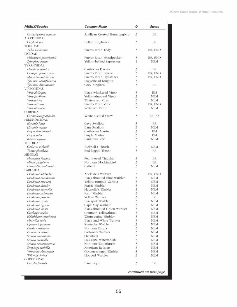
55
Puerto Rican Karst—A Vital Resource
FAMILY/Species Common Name O Status
Orthorhynchus cristatus Antillean Crested Hummingbird 3 BR ALCEDINIDAE
Ceryle alcyon Belted Kingfisher 3 BR TODIDAE
Todus mexicanus Puerto Rican Tody 3 BR, END PICIDAE
Melanerpes portoricensis Puerto Rican Woodpecker 3 BR, ENDSpirapicus varius Yellow-bellied Sapsucker 1 NBM
TYRANNIDAEElaenia martinica Caribbean Elaenia 3 BRContopus portoricensis Puerto Rican Pewee 3 BR, ENDMyiarchus antillarum Puerto Rican Flycatcher 3 BR, ENDTyrannus caudifasciatus Loggerhead Kingbird 3 Tyrannus dominicensis Grey Kingbird 3 BR
VIREONIDAEVireo altiloquus Black-whiskered Vireo 3 BMVireo flavifrons Yellow-throated Vireo 3 NBMVireo griseus White-eyed Vireo 3 NBMVireo latimeri Puerto Rican Vireo 3 BR, ENDVireo olivaceus Red-eyed Vireo 3 NBM
CORVIDAECorvus leucognaphalus White-necked Crow 3 BR, EX
HIRUNDINIDAEHirundo fulva Cave Swallow 3 BRHirundo rustica Barn Swallow 3 NBMProgne dominicensis Caribbean Martin 3 BMProgne subis Purple Martin 3 BMRiparia riparia Bank Swallow 3 NBM
TURDIDAECatharus bicknelli Bicknell’s Thrush 3 NBMTurdus plumbeus Red-legged Thrush 3 BR
MIMIDAEMargarops fuscatus Pearly-eyed Thrasher 3 BRMimus polyglottos Northern Mockingbird 3 BRDumetella carolinensis Catbird 3 NBM
PARULIDAEDendroica adelaidae Adelaide’s Warbler 3 BR, ENDDendroica caerulescens Black-throated Blue Warbler 3 NBMDendroica coronata Yellow-rumped Warbler 3 NBMDendroica discolor Prairie Warbler 3 NBMDendroica magnolia Magnolia’s Warbler 3 NBMDendroica palmarum Palm Warbler 3 NBMDendroica petechia Yellow Warbler 3 BRDendroica striata Blackpoll Warbler 3 NBMDendroica tigrina Cape May warbler 3 NBMDendroica virens Black-throated Green Warbler 3 NBMGeothlypis trichas Common Yellowthroat 3 NBMHelmitheros vermivorus Worm-eating Warbler 3 NBMMniotilta varia Black and White Warbler 3 NBMOporornis formosus Kentucky Warbler 3 NBMParula americana Northern Parula 3 NBMProtonaria citrea Protonary Warbler 3 NBMSeiurus aurocapillus Ovenbird 3 NBMSeiurus motacilla Louisiana Waterthrush 3 NBMSeiurus noveborascensis Northern Waterthrush 3 NBMSetophaga ruticilla American Redstart 3 NBMVermivora chrysoptera Golden-winged Warbler 3 NBMWilsonia citrina Hooded Warbler 3 NBM
COEREBIDAECoereba flaveola Bananaquit 3 BR
continued on next page

56
mainly estrildid finches(Estrildidae) and parrotsand parakeets (Psittacidae).
The karst region harbors16 of the 17 endemic avianspecies of Puerto Rico. Theonly one not recorded inthe karst belt is the Elfin-woods Warbler (Dendroicaangelae). This species isrestricted to mid to highelevation volcanic andultramaphic forests in themountains of Puerto Rico.The most common birds inboth northern and southernlimestone are native orendemic species. These
include the Puerto RicanGround Dove, ZenaidaDove, Puerto Rican Tody(Todus mexicanus), GreyKingbird (Tyrannus domini-censis), Pearly-eyed Thrasher(Margarops fuscatus), PuertoRican Vireo (Vireo latimeri),Bananaquit (photo 39),Black-faced Grassquit (Tiarisbicolor), Greater AntilleanGrackle (Quiscalus niger),and Puerto Rican Bullfinch(Loxigilla portoricensis).
Nine endangered speciesare reported from the karstregion, including the PuertoRican Parrot (photo 40) orIguaca (Amazona vittata) thatwas extremely abundant in
both northern and southernlimestone forests and hasbeen extirpated from both
(Snyder et al. 1987). The“José A. Vivaldi Aviary” islocated at the Río AbajoCommonwealth Forestwithin the karst belt andhouses about 60 Iguacas. Acaptive-breeding programfor the Puerto Rican Parrotsis in progress at this aviary.The species appears toreproduce well in captivityin the conditions of thekarst, suggesting that thisenvironment is favorablefor the eventual reestab-lishment of a second wildflock. The conservation ofthe Puerto Rican Parrot hasspecial importance, sincemost other Amazona speciesendemic to the West Indies
Puerto Rican Karst—A Vital Resource
FAMILY/Species Common Name O Status
Euphonia musica Blue-hooded Euphonia 3 BRSpindalis portoricensis Puerto Rico Stripe-headed Tanager 3 BR, ENDNesospingus speculiferus Puerto Rican Tanager 3 BR, ENDPiranga rubra Scarlet Tanager 3 NBM
EMBERIZIDAEAmmodramus savannarum Grasshopper Sparrow 3 BRSicalis flaveola Saffron Finch 1 BR, INTiaris bicolor Black-faced Grassquit 3 BRTiaris olivacea Yellow-faced Grassquit 3 BR
CARDINALIDAELoxigilla portoricensis Puerto Rican Bullfinch 3 BR, ENDPasserina cyanea Indigo Bunting 3 NBM
ICTERIDAEAgelaius xanthomus Yellow-shouldered Blackbird 3 BR, END, ESDolichornyx oryzivorus Bobolink 2 NBMMolothrus bonariensis Shiny Cowbird 3 BR, IN?Quiscalus niger Greater Antillean Grackle 3 BRIcterus dominicensis Black-cowled Oriole 3 BRIcterus galbula Northern Oriole 3 NBMIcterus icterus Troupial 3 BR, IN
FRINGILLIDAECarduelis cucullata Red Siskin 3 NBR?, INSerinus mozambicus Yellow-fronted Canary 1 NBR?, IN
PASSERIDAEPasser domesticus House Sparrow 3 BR, IN
PLOCEIDAEEuplectes afer Yellow-crowned Bishop 2 NBR?, INEuplectes franciscanus Red Bishop 3 BR, IN
ESTRILDIDAEAmandava amandava Red Amandavat 1 BR?, INEstrilda melpoda Orange-cheeked Waxbill 3 BR, INEstrilda troglodytes Red-eared Waxbill 3 BR, INLonchura cucullata Bronze Mannikin 3 BR, INLonchura malabarica Warbling Silverbill 3 BR, INLonchura malacca Chestnut Mannikin 3 BR, INLonchura punctulata Nutmeg Mannikin 3 BR, INVidua macroura Pin-tailed Widah 3 BR, IN
continued from page 52
Photo 39. The Bananaquit (Coereba flaveola), a honey creeper. Photo by L. Miranda Castro.
Photo 40. The Puerto RicanParrot (Amazona vittata). Photo by T. Carlo.

57
are likewise threatenedwith extinction (U.S. Fishand Wildlife Service 1999).Whatever is learned fromthe experience with thePuerto Rican Parrot may beapplied to the conservationefforts of other species inthe West Indies, the UnitedStates, the Neotropics, andworldwide.
The diversity andabundance of wildlife in thekarst belt is a result of thediversity of ecosystems,which provide abundantfood and shelter—includingnesting sites—to birdpopulations. Karsttopography, with its valleys,canyons, hills, sinkholes,caves, and abundantcrevices provides a diversehabitat to support wildlife.The abundance of birdspecies, in turn, acceleratesthe dispersal andregeneration of trees andshrubs whose flowers,fruits, and seeds constitutepart of their diets. Thissynergy between wildlifeand plants accelerated therecovery of forestsfollowing the deforestationevent that took place inPuerto Rico at the turn of the century (Ricart
Morales 1999, Rivera andAide 1998).
Raptors belong to agroup of prominent birds inthe karst belt. They occupythe top of the food weband are thus vulnerable toenvironmental changes.Two raptor species of theseven inhabiting PuertoRico are endangered. Theyare the Puerto Rican Broad-winged Hawk (Buteoplatypterus) and the PuertoRican Sharp-shinned Hawk(Accipiter striatus) (photo 41).The healthiest populationfor the Broad-winged Hawkis in the Río AbajoCommonwealth Forest,where 52 individuals havebeen estimated (Delannoy1992, 1997; U.S. Fish andWildlife Service 1997a).Although no nesting siteshave been found,individuals of these twospecies of raptors havebeen observed at the RíoEncantado sector of thekarst belt, between Cialesand Florida, east of the RíoAbajo CommonwealthForest. The Sharp-shinnedHawk was once widespreadthroughout the karst belt(Wetmore 1927). However,habitat alteration—such as
the five nesting sites andmore than 80 ha lost to theconstruction of Highway PR10—have caused significantreductions of this species.The American Kestrel (Falcosparverius) and the PuertoRican Screech Owl (Otusnudipes) are probably themost common raptorspecies in the karst belt(photo 42). They feed onsmall reptiles, large insects,and mammals such as miceand bats (Wetmore 1916,1927).
Migratory raptors such asthe Peregrine Falcon (Falcoperegrinus) occur in the karstbetween October and April.It is particularly abundantalong the coast and alongriver courses such as theRío Grande de Manatí andRío Grande de Arecibo.Here, extensive open areasallow the falcon to flyunimpeded to capture itsprey. Another migratoryfalcon is the Merlin (Falcocolumbarius) that also visitsthe island between Octoberand April (Raffaele 1992,Biaggi 1997). While thisspecies is more common onthe south coast, it alsooccurs in the northernlimestone.
Besides raptors, the karstbelt is visited annually bythousands of Neotropicalmigrant birds representingwell over 40 land birdspecies and 45 shorebirdsand seabirds species(Raffaele 1992, table 12).The majority of the landbirds are wood warblersthat come from as far asCanada and Alaska throughthe Atlantic Flyway, butEurasian migrants havebeen recorded (photo 43).The diet of these migratorysongbirds overlaps consid-erably with the diet ofresident species—mainlyinsects—but sometimestaking large amounts offruits and seeds.
Another important groupof birds of the karst regionis the insectivorous guild,which includes endemicspecies. For example, thePuerto Rican Nightjar orWhip-poor-will (Caprimulgusnoctitherus), the Puerto RicanTody, the Puerto RicanWoodpecker (Melanerpesportoricensis), and the PuertoRican Vireo. Also includedin this group are othernative species, such as theGrey Kingbird and the
Puerto Rican Karst—A Vital Resource
Photo 41. The Sharp-shinnedHawk (Accipiter striatus). Photo by C. Delannoy.
Photo 42. The endemic PuertoRican Screech Owl (Otus nudipes).Photo by L. Miranda Castro.
Photo 43. The migratoryNorthern Parula (Parula americana).Photo by J. Colón.
Photo 44. The endemic PuertoRican Tody (Todus mexicanus).Photo by L. Miranda Castro.

58
Adelaide’s Warbler(Dendroica adelaidae). Thesebirds are common and welldistributed through bothnorthern and southernlimestone (HernándezPrieto 1993), preferringdense vegetation in the topof mogotes. The PuertoRican Tody is one of themost abundant species,particularly in both the aridsouth and the humid north(photo 44). It is a groundnesting bird, which usuallyexcavates its nestingburrows in riverbanks,landslides, roadcuts, andcave entrances. Ofparticular interest is theendemic Puerto RicanNightjar, once distributedin northern and southernlimestone and nowrestricted to patches of dryforest in the southernlimestone. The PuertoRican Woodpecker has awide distribution. It has anample diet that includesfruits of several species,invertebrates in deadstanding wood and treebranches, and coquí frogsand lizards found insidebromeliads and otherepiphytes.
Nectarivorous birds feedon nectar, but dependsignificantly on other foodsources such asarthropods, particularlyduring the breeding seasonwhen the metabolicdemand for proteinincreases. Thehummingbird family(Trochilidae) is endemic toNorth and South Americaand is an example of thiskind of feeding. All fiveresident species ofhummingbirds (includingtwo endemics) occur in thekarst belt. The Puerto
Rican Emerald(Chlorostilbon maugaeus) isvery common, nesting inthe forest understory about2 m aboveground (photo45). The other endemichummer, the Green Mango(Anthracothorax viridis), isless common than itscongener the AntilleanMango (A. dominicus). TheAntillean Mango is morecommon in drier areas,and usually nests 7 maboveground. The Ruby-throated Hummingbird(Archilocus colubris) has beenobserved in Arecibo andGuánica, while a purple-throated hummingbird,possibly the Purple-throated Carib (Eulampisjugularis) has beenphotographed in Guánicaand videotaped in Ciales.In 1998, the nectarivorousbird populations starved asa result of the effectHurricane Georges had onthe nectar supply in mostforests. However, manyforest stands in protectedvalleys of the karst beltwere unaffected byhurricane winds andbecame refugia for birds.
Frugivores representanother guild in the karstbelt. This guild is the most
diverse and abundant andincludes pigeons anddoves (Columbiformes),parrots (Psittaciformes),and a large diversity ofsongbirds (Passeriformes).Songbirds include theendemic Puerto RicanBullfinch, the Puerto RicanStripe-headed Tanager(Spindalis portoricensis), andthe Puerto Rican Tanager(Nesospingus speculiferus),which constitutes theisland’s only endemicavian genus. Thesesongbirds feed consistentlyon fruits and seeds ofspecies such as moral(Cordia sulcata) (photo 46),yagrumo macho (Sheffleramorototoni), yagrumohembra (Cecropiaschreberiana), cupey, andguaraguao (Guareaguidonia). Some frugivorousbirds are highly specializedin their diet. For example,the Antillean Euphonia(Euphonia musica) feedsmostly on mistletoes andother parasitic epiphytes(Families Loranthaceae andViscaceae) that arecommon in the protectedvalleys where this speciescongregated afterHurricane Georges. ThePearly-eyed Thrasher and
the Scaly-naped Pigeon(Columba squamosa) weredetected more often inkarst forests than in thoseof volcanic rock base(Rivera Milán 1993).
Carlo Joglar (1999) foundsignificant diet preferencesamong nine commonfrugivores he studied.Eighty percent of hisfeeding observations weremade on 17.6 percent ofthe available fruitingspecies. The size of thebird was associated withdiet dissimilarity pattern.Thus, larger birds couldtake larger fruits and hadsimilar diets. All birdspecies showed localpreferences for a fruitingplant. Karst forests hadlower fruit densities thanshaded coffee plantationsor moist forests outside ofthe karst belt.
Mammals
Bats are the onlyremaining native mammalsof Puerto Rico (photo 47).They are extremelycommon in the caves of thekarst belt. Fossil recordsfrom the karst belt indicatethat at least 15 species ofbats and 5 terrestrialmammal genera werepresent in the island. All
Puerto Rican Karst—A Vital Resource
Photo 45. The endemic PuertoRican Emerald (Chlorostilbonmaugaeus). Photo by L. Miranda Castro.
Photo 46. Fruits of moral(Cordia sulcata) are important foodsource for birds in karst forests.Photo by L. Miranda Castro.
Photo 47. Bats are the onlyremaining native mammals in PuertoRico and are common in the karstbelt. Photo by A. Puente Rolón.

59
other terrestrial species arenow extinct. The 13 extantspecies of bats in PuertoRico are distributed in 5families. About half of the 13 species are WestIndian endemics, and 4 genera—Monophyllus,Erophylla, Stenoderma, andBrachyphylla—are not foundoutside the West Indies.
The karst belt is home toall 13 species of batsknown to the island, 10 ofwhich use caves aspreferred roosting sites(Rodríguez Durán 1998).Among these species arenectar-feeding bats thatpollinate flowers at night.Frugivorous bats dispersemillions of seeds, some ofwhich are too big to becarried by any other animalin Puerto Rico. The rapidre-establishment of forestson abandoned agriculturallands in the karst belt andthroughout Puerto Rico wasassisted by the dispersaland pollination function of bats.
One species that capturesthe imagination is the Fish-eating Bat (Noctilio leporinus).This bat does not dive intothe water, but picks up fishfrom just beneath thesurface. It is the largest andmost majestic of all batspecies on the island.However, the greatesteffects of bats onecosystems are probablythe result of insect-eatingbats. A single colony ofthese small bats mayconsume over 20 tons ofinsects every month(Rodríguez Durán andLewis 1987). Such rate ofinsect consumption isbeneficial to agriculture and
humans for insect pest control.
Only about one-third ofthe caves in Puerto Ricoharbor bats. Twohypotheses may helpexplain this observation:either most caves do notmeet the biologicalrequirements of bats orroosting associations ofmixed species arenecessary. The twohypotheses are notmutually exclusive becauseone advantage of amultispecific assemblage islikely to be a modificationof the cave’s microclimate.Microclimatic differences at a roost site, due to a variety of microstructuressuch as stalactites andsolutional cavities, maycontribute to patterns ofassociation of bats(Rodríguez Durán 1998).
In Puerto Rico, hot cavesare used year-round byseveral species of bats. Asingle reduced entrance,minimum circulation of air,high density of bats, airtemperature ranging from28 oC to 40 oC, and relativehumidity exceeding 90percent characterize thesehot caves. About 11percent of all caves usedby bats are hot caves andthese are found mostly inthe karst belt.
Antillean bats using hotcaves exhibit a high degreeof gregariousness and roostfidelity. At least onespecies—probably two—isknown to occur exclusivelyin these caves and at leastfive species rely exclusivelyon hot caves to reproduce.Although up to sevenspecies may occupy a
single cave in Puerto Rico,different species oftenmaintain spatial separationwithin the roost. It has beensuggested that interspecificcompetition regulatespopulation sizes in thesecaves. When several speciesoccupy the same cave, theymay compete for roostingsites and access to the exit.Narrow cave mouths mayphysically restrict the flowof bats during periods ofactivity and limit thenumber of individuals inthe cave. For example, atCucaracha cave in westernPuerto Rico, three speciesof bats with a totalpopulation of 700,000individuals share a hot cavewith a 1.5 m2 opening.
Many species of batsinhabiting hot caves areprone to dehydration.These species may roost inlarge groups because of thebenefits derived from athermoneutralenvironment—one with anambient temperature atwhich energy expenditureis minimal—and reduceddehydration. Also, thedevelopment of largecolonies may increase bothforaging success—byfunctioning as informationcenters and reproductivesuccess—by reducing theexposure of newborns topredation and weather.These benefits are opposedby costs associated withpermanent use of caves.For example, large numbersof exiting bats attractconcentrations of predatorsto the cave mouth(Rodríguez Durán andLewis 1985, RodríguezDurán 1996).
Interspecific differencesin diet and foragingpatterns result in spacing ofpeak exit times. Suchspacing may allow largernumbers of cave-warmingbodies to be present thanwould be likely in either asingle-species colony or arandom assemblage ofspecies, in which peak exittimes might coincide.Multispecies colonies ofcave-dwelling bats presentopportunities for studyingmany patterns of behavior,and the importance of suchlarge assemblages in termsof flux of energy in theecosystem is likely to beunparalleled. The mythicalstories that often areassociated with bats haveresulted in a poor andunwarranted image.However, ecologicalresearch in the karst belt isyielding information thatallows us to appreciate thepositive role that thesemagnificent animals play in the functioning ofterrestrial ecosystems.
Endemic andEndangered 7
SpeciesThe degree of endemism
for trees in the karst belt is16 and 23 percent of thetotal for the island in moist and wet forests,respectively (FigueroaColon 1995). For birdspecies, the degree ofendemism is 7 percent forthe northern and southernlimestone areas. The faunaof caves deserves specialattention in this sectionmainly because so little is
Puerto Rican Karst—A Vital Resource
7Our focus is on species listed through the Federal Endangered Species Act, however, table 13 also shows species listed as endangered by the Commonwealth.

60
known about it. Culver etal. (1999) assembled a listof obligate cave-dwellingspecies and subspecies forthe contiguous UnitedStates and found 927species, 46 additionalsubspecies, and 96 families.The list had highendemism with 54 percentof the species known froma single country. Less than4 percent were formallylisted in accordance to theEndangered Species Act.Caves in Puerto Rico havenot been studied in anydetail and probably harbormany endemic andendangered species thathave yet to be catalogued.For invertebrates alone,Peck (1974) reported 29percent endemism. Box 1summarizes the degree ofspecies in Mona Island.
The karst region harborsknown populations ofmore than 30 endangeredor threatened species (table13). Most of theendangered species presentat the karst belt are plantswith a restricted distri-bution that are vulnerableto habitat alteration anddestruction by improperland use practices.
Flora
Chupacallos (Pleodendronmacranthum) is anendangered tree that onlyexists in the LuquilloMountains and in thenorthern karst forests ofPuerto Rico. This is anevergreen aromatic tree thatreaches up to 10 m inheight and produces aheavy hardwood (Little etal. 1974). The presentendangered status ofchupacallos is a result ofhabitat alteration and
Puerto Rican Karst—A Vital Resource
Table 13. Plants and animals that inhabit the northern and southern limestone areas and areconsidered endangered or vulnerable by Commonwealth and Federal agencies. Common namesappear if available. Status are endangered (E) or vulnerable (V); levels (L) are Commonwealth (C)or Federal (F).
FAMILY/Species Common Name Status (L) PLANTS
ADIANTACEAEAdiantum vivesii E (C, F)
ARECACEAECalyptronoma rivaris palma de manaca E (C)
ASPLENIACEAETectaria estremerana E (C, F)
BORAGINACEAECordia bellonis E (C, F)
BUXACEAEBuxus vahlii diablito de tres cuernos E (C, F)
CACTACEAEHarrisia portoricensis V(C, F)
CANELLACEAEPhloeodendron macranthum chupacallos E (C)
FABACEAECassia mirabilis E (C, F)Chamaecrista grandulosa var. mirabilis E (C, F)Stahlia monosperma cóbana negra E (C)
FLACOURTIACEAEBanara vanderbiltii palo de Ramón E (C)
ICACINACEAEOttoschulzia rhodoxylon palo de rosa E (C, F)
MELIACEAETrichilia triacantha bariaco E (C, F)
MYRTACEAEMyrcia paganii E (C)
OLACACEAESchoepfia arenaria E (C, F)
PIPERACEAEPeperomia wheeleri E (C, F)
RHAMNACEAEAuerodendron paucifolium E (C, F)
RUBIACEAECatesbea melanocarpa V (C)
RUTACEAEZanthoxylum thomasianum St. Thomas prickly ash E (C, F)
SOLANACEAEGoetzea elegans matabuey E (C)Solanum drymophylum E (C)
THELYPTERIDACEAEThelypteris verecunda E (C, F)
THYMELAEACEAEDaphnosis helleriana E (C)
VERBENACEAECornutia obovata palo de nigua E (C)
ANIMALSBUFONIDAE
Peltophryne lemur Puerto Rican Crested Toad E (C, F)DERMOCHELIDAE
Dermochelys coriacea Leatherback Turtle E (C, F) CHELONIDAE
Chelonia mydas Green Turtle E (C, F)Eretmochelys imbricata Hawksbill Turtle E (C, F)
IGUANIDAEAnolis cooki Dry Forest Anole V (C)
SCINCIDAEMabuya mabuya sloanei Puerto Rican Skink V (C)
continue to next page

61
destruction due todeforestation for urban and agricultural uses andpoor forest management(U.S. Fish and WildlifeService 1997b).
Myrcia paganii andAuerodendron pauciflorum aretwo small evergreen treesthat only exist in the moistkarst belt. Their status asendangered species is dueto their rarity and restricteddistribution as a result ofrural, urban, andagricultural developments.Auerodendron pauciflorum isrestricted to a smallpopulation of 19 individualsin the limestone cliffs ofIsabela. A second
population in the Río AbajoCommonwealth Forest wasdestroyed as a result of theconstruction of Highway PR
10 (U.S. Fish and WildlifeService 1996a).
Beautiful goetzea (Goetzeaelegans) is a small evergreentree endemic in thenorthern karst forest (photo 48). Approximately50 individuals survive inthree different populations.One of the major concernsfor this species is the over-collection for scientific andornamental uses. Thelargest known populationsof this species are inQuebrada Bellaca inQuebradillas. All but one ofthe known populations inthe Guajataca/Quebradillasarea has been extirpatedsince their discovery. The
remaining populations ofbeautiful goetzea are at riskdue to road constructionthrough the karst belt (U.S. Fish and WildlifeService 1987a).
Chamaecrista glandulosa var.mirabilis is a small shrubrestricted to the white silicasands in the northernlimestone. This species isscattered along the southernshore of Laguna Tortugueroand in one location each inDorado and Vega Alta.Urban, industrial, andagricultural expansion, aswell as sand extraction, mayhave eliminated otherpopulations. Although fewareas of silica sands havenot been explored, it ispossible that otherpopulations may remain(U.S. Fish and WildlifeService 1994a). The areaencompassing CañoTiburones is rich in silicasand deposits and has not been searched for this species.
Palma de manaca(Calyptronoma rivalis) islisted as threatened (photo 49). Only 3 knownpopulations of this endemicpalm, consisting of approxi-mately 275 individuals,
Puerto Rican Karst—A Vital Resource
Table 13. continued from previous page
FAMILY/Species Common Name Status (L)
BOIDAEEpicrates inornatus Puerto Rican Boa E (C, F)
PELECANIDAEPelecanus occidentalis Brown Pelican E (C, F)
PODICIPEDIDAETachybaptus dominicus Least Grebe V (C)
ANATIDAEDendrocygna arborea West Indian Whistling Duck V (C) Oxyura dominica Masked Duck V (C)Oxyura jamaicensis Ruddy Duck V (C)
ACCIPITRIDAEAccipiterstriatus venator Puerto Rican Sharp-shinned Hawk E (C, F)Buteo platypterus brunnescens Puerto Rican Broad-winged Hawk E (C, F)
RALLIDAEFulica caribaea Caribbean Coot V (C)Porzana flaviventer Yellow-breasted Crake V (C)
CHARADRIIDAECharadrius alexandrinus Snowy Plover V (C)Charadrius melodus Pipping Plover V (C, F)
LARIDAESterna antillarum Least Tern E (C, F)Sterna dougallii Roseate Tern V (C, F)
COLUMBIDAEColumba inornata wetmorei Puerto Rican Plain Pigeon E (C, F)
PSITTACIDAEAmazona vittata Puerto Rican Parrot E (C,
CAPRIMULGIDAECaprimulgus noctitherus Puerto Rican Nightjar E (C, F)
CORVIDAECorvus leucognaphalus White-necked Crow E (C, F)
ICTERIDAEAgelaius xanthomus Yellow-shouldered Blackbird E (C, F)
TRICHECHIDAETrichechus manatus manatus Antillean Manatee E (C, F)
Photo 48. Mata buey (Goetzeaelegans), an endangered and endemicspecies. Photo by E. Santiago.
Photo 49. Palma de manaca(Calyptronoma rivalis), an endemicspecies. Photo by A. Puente Rolón.

62
occur in the northernlimestone. These naturalpopulations occur in SanSebastián along the Camuyand Guajataca rivers. Twonew populations have beenreestablished in the RíoAbajo CommonwealthForest and aroundGuajataca reservoir. Palmade manaca populationsdeclined due todeforestation foragriculture, grazing,charcoal production, andurbanization. A seriousthreat to these populationsis the elimination of habitatby the extraction ofconstruction material(limestone). A large part of the Camuy river palmade manaca population wasdestroyed during theconstruction of a road inthe area. Most of theremaining population could be affected byflooding resulting from the deforestation ofsurrounding areas (U.S. Fish and Wildlife Service 1992a).
Diablito de trescuernos—Vahl’s boxwood(Buxus vahlii)—is a smallevergreen tree endemic toPuerto Rico. The reasonsfor its rarity are obscure butattributed to extensivedeforestation and urbandevelopment in lowlandareas of the island. Thisspecies is restricted to twopopulations, one in Rincónand one in Hato Tejas Wardin Bayamón. Moresystematic searches of thenorthern limestone mayturn up additionalpopulations (U.S. Fish andWildlife Service 1987b).
Palo de Ramón (Banaravanderlbiltii) is anendangered evergreen tree
that occurs in the karst belt.The factors limiting thedistribution of the specieshave been deforestation,selective cutting foragriculture, grazing,charcoal production, andcutting for constructionmaterials. Today, the mostserious threats are theurban and industrialexpansion that encroachesupon the karst—forexample, the Río Lajaspopulation west ofBayamón. The cultivationof yams was responsible forthe destruction of twomature individuals, anabandoned dump site islocated in the area, andpower line rights-of-wayare located at a shortdistance from thepopulation (U.S. Fish andWildlife Service 1991a).
Three endangered fernsoccur in the karst belt—Adiatum vivesii, Tectariaestremerana, and Thelypterisverecunda. These ferns arerestricted in distribution andvulnerable to habitatdestruction and modifi-cation. Thelypteris verecundaand A. vivesii are knownfrom only one populationeach. A population of T. estremerana (23individuals) is located 200m south of the Areciboradio telescope. Thisspecies has also beenreported for the Río AbajoCommonwealth Forest.Forest managementpractices and thedevelopment of thefacilities for a radiotelescope could adverselyaffect the species (U.S. Fishand Wildlife Service 1996b).
Bariaco (Trichiliatriacantha) is an endangeredtree endemic to Puerto
Rico. It is only found intwo areas of the southernlimestone, where onlyabout 40 individuals exist.The most important factorslimiting the distribution ofthis species have beendeforestation, selectivecutting for urban andindustrial development,agriculture, charcoalproduction, and cuttingwood for fenceposts.Today, residential andindustrial developments, aswell as poor forestmanagement, threaten thisspecies (U.S. Fish andWildlife Service 1991b).
Palo de rosa (Ottoschulziarhodoxylon) is an evergreentree, which may reach upto 15 m in height and 41cm in diameter. It isendemic to Puerto Rico andHispaniola, where it is rare.About 191 individuals areknown from 13 populationsin the island. This specieswas used intensively forposts and for its valuablereddish colored wood.These factors, together withdeforestation, severelyreduced the populations ofpalo de rosa. Studies on theecology of this specieshave been ongoing since1991; as a result, newpopulations have beendiscovered in the northernlimestone, flowers havebeen described, andgermination studies havebeen initiated (U.S. Fishand Wildlife Service 1994b).
Fauna
The Puerto Rican CrestedToad is the only bufonidnative to Puerto Rico. Thespecies is apparently extinctin Virgin Gorda and theBritish Virgin Islands,making Puerto Rico the
only place where it stillsurvives. Breeding issporadic and highlydependent on occasionalheavy rains concentrated ina very short period. Toadsnormally burrow a meter ormore in the soil andemerge to breed when soilsare saturated after heavyrains that can accumulate atleast 5 cm of water intemporary ponds. Thedestruction or alteration ofa particular breeding pondmay result in theelimination of a populationof this endangered species.Only two ponds are knownto function as breedinggrounds for the toad in theGuánica CommonwealthForest. Historically,breeding sites were filled ordrained for construction,agriculture, and mosquitocontrol. Overcollection ofthe species may also haveresulted in the eliminationof certain populations. Theonly known populations ofthis species are located inthe southern limestone inthe GuánicaCommonwealth Forest andin the northern limestone inQuebradillas (U.S. Fish andWildlife Service 1992b).
The Puerto Rican Boa isPuerto Rico’s largest nativesnake. This species isdistributed island-wide butis more common in thekarst belt. Historical datasuggest a decline in theboa’s population numbers,but data on populationestimates are scarce.
The Puerto RicanNightjar (photo 50) is anocturnal bird, which ismainly restricted to thesouthern limestone forests(U.S. Fish and WildlifeService 1984). It also
Puerto Rican Karst—A Vital Resource

63
occurs at the SusúaCommonwealth Forest,which is a moist serpentine(ultramaphic) forest wherethe vegetation is similar inphysiognomy to that of thedry limestone forest. In thepast, this species wasdistributed through mostkarst forests in the island(Wetmore 1916). Althoughhabitat loss is the primecause of endangerment,the mongoose (Herpestesauropunctatus)—anintroduced mammal—isregarded as one of themajor threats to the PuertoRican Nightjar.
The Yellow-shoulderedBlackbird (Agelaiusxanthomus)—is anendangered speciesendemic to Puerto Rico.There are two recognizedsubspecies—A. x. xanthomusand A. x. monensis. Theformer occurs on theisland of Puerto Rico andthe later occurs in MonaIsland. This species wasabundant in the San Juanarea (Taylor 1864) anddistributed throughoutPuerto Rico (Wetmore
1916, U.S. Fish andWildlife Service 1996c). Itsendangered status is dueto habitat destruction andalteration, predation byalien mammals, and broodparasitism by the ShinyCowbird—Molothrusbonariensis—(Post andWiley 1976, U.S. Fish andWildlife Service 1996c).
The Broad-winged Hawk(Buteo platypterus brunnescens)is an endemic raptorsubspecies on Puerto Rico.It is highly threatened byfragmentation anddisappearance of forestedareas. Few individualsremain, mainly in themontane forest reserves ofLuquillo, Carite, and RíoAbajo in the interior of theisland (Pérez Rivera andCotte Santana 1977, Snyderet al. 1987, Raffaele 1992,Delannoy 1992).
In Puerto Rico, theBroad-winged Hawkcoexists with the Red-tailedHawk (Buteo jamaicensis).The Broad-winged Hawkhas horizontal black andwhite bars in the tail, issmaller, and prefers densely
forested habitats (Raffaele1992). The Red-tailed Hawkis commonly observedflying both in the interiorforests of the island, as wellas on the coastal plains.Red-tails take advantage ofthe thermal air currents tomaintain flight whilesearching for prey. TheBroad-winged Hawkmonitors and waits silentlyin a branch for its prey.However, it is also possible to observe it flyingabove the canopy incourtship flights during the breeding season.
The Broad-winged Hawkis considered a rarespecies in Puerto Ricosince the last decades ofthe 1800’s. Differentornithologists who studiedthe island’s avifaunabetween 1902 and 1935did not report it, thus, thespecies was thought to beextinct (Bowdish 1902,1903; Wetmore 1916, 1927;Struthers 1923; Danford1931). In 1935, the specieswas rediscovered in theLuquillo Mountains(Danforth and Smyth1935). The first nests werefound in Luquillo in 1976(Snyder et al. 1987), wherethe species was observedmainly in the eastern partsaround El Yunque Peak(American Ornithologist’sUnion 1976, Snyder et al.1987). Their chicks werefed centipedes, tree frogs,lizards, rats, and birds. Thehawk’s population inCarite was not reporteduntil 1980 (HernándezPrieto 1980).
The first status survey ofthe Broad-winged Hawk inthe island (Delannoy 1992)revealed that 124individuals remained in the
three populations(Luquillo, 22; Carite, 50;Río Abajo, 52). Followingthese findings, a study ofthe nesting habitat of thisspecies was conducted inRío Abajo from 1993 to1994. The habitat of ninepairs was describedaccording to conditionsaround the nest tree and toforest type (plantation andsecondary forest) structuralcharacteristics (Tossas1995). Broad-wingedHawks chose nestingranges according to thevegetation physiognomyrather than forest type.
Broad-winged Hawknests were found in treeswith an average height of23 m and a diameter of 55cm. The surrounding treesin the nesting habitat hadan average height of 16 m.The hawks chose nesttrees taller than the canopywith a large diameter andcrown. These character-istics allow them toimprove the monitoring oftheir territories and havebetter access to their nests.Broad-winged Hawknesting areas consisted ofvalleys delimited bymogotes. Nesting rangeswere aggressivelydefended against othermembers of its ownspecies, resulting inseparated territories withlittle or no overlap. Theterritories averaged 41 haand the mean distance tothe nearest neighbor was714 m (Tossas 1995).
Since October 11, 1994,the U. S. Fish and WildlifeService included thespecies in the EndangeredSpecies List. However, thePuerto Rican Broad-wingedHawk still faces serious
Puerto Rican Karst—A Vital Resource
Photo 50. The Puerto Rican Nightjar (Caprimulgus noctitherus). Photo by J. Colón.

64
problems as its habitat isthreatened. The PuertoRican Broad-winged Hawkpopulation in Río Abajo ispresently underdevelopment pressure ofthe forest and adjacentlands in the karst belt. Theprincipal threat is thedestruction of its habitatcaused by urbandevelopment and roadconstruction.
The Puerto Rican Nightjar,the Plain Pigeon (Columbainornata wetmorei), and thePuerto Rican Parrot areendangered birds that werecommon at one time in thekarst belt. The Limpkin(Aramus guarauna) and theWhite-necked Crow (Corvusleucognaphalus) were alsocommon in the karst butare now consideredextirpated. Past land usesare responsible for theseevents. Today, conditionsare different and the karstbelt is an ideal habitat torestore these species. Inmany places, humanpresence has dwindled andhas been substituted byabundant habitat and foodresources and lowpredatory pressure.Throughout the Americas,the primary threat to birdsis the destruction anddisturbance of habitats onwhich their existencedepends (Wege and Long1995). The presence oflarge unfragmented forestreduces the risk of invasionby alien species, thus
reducing interaction ofendangered species withalien species. Moreover, thediversity of karst featuresand topography allow forample protection againstnatural catastrophes, suchas hurricanes, because—during and in the aftermathof the storms—variousprotected places areavailable as refugia foranimals with highlyspecialized diets.
The Karst Belt
Is Economically
Important
The northern limestoneis the site for many typesof economic activities,including water supply,mining, agriculture,construction, and manufac-turing (box 12). The mainindustry in the northernlimestone is the pharma-ceutical industry, which
relies upon the use of thenorth coast aquifer. In theprocess of utilizing thiswater supply, the pharma-ceutical industry hascontaminated portions ofthe aquifer. The region isalso subject to naturaldisturbances of economicimportance such aslandslides, land subsidence,floods, droughts, andhurricanes. Water, other
Puerto Rican Karst—A Vital Resource
Box 12. Industries located on the municipalities of northern limestone. Portions of some ofthe municipalities may be outside the limestone area.
The northern limestone supports the largest industrial sector of Puerto Rico. As shown in thelisting below, more than 200 enterprises are established in this region (Office of EconomicResearch 1996). Food, textile, agriculture, wood, paper, glass, metal, chemical, andconstruction industries are the most common manufacturing plants in the region. Among these,the pharmaceutical and technological industries are the most important economic sector. Firmssuch as Pfizer Pharmaceuticals, Abbot Chemical and Health Products, Bristol-Myers Squibb,Pharmacia & Upjohn, Merck Sharp & Dohme, and Du Pont export their products to supplyU.S. markets. Most of these manufacturing companies depend on the high quality water fromthe north coast aquifer (Cortés Burgos 1990).
AguadillaAguadilla Shoe Corp. Atlantic Telecom Inc. Avon Mirabella Inc. Brewster Hasting Corp. Café Sanders Cemi Muebles Inc. Disposable Safety Wear Inc. DSC of Puerto Rico Inc. Elaboración Felo Erie Scientific Co. of PR Faulding Puerto Rico Inc. Flexible Packaging Co. Fogel Caribbean Corp. Hewlett-Packard Puerto Rico Co. Lifestyle Footwear Corp. Mo-Ka Shoe Co. Namic Caribe Inc. PR Safety Phoenix Cable Ltd. Inc. Polyagro Plastics Inc. Productos La Aguadillana Inc. Tradewings Caribbean Air Services West Electronic Industry Co. Western Aviation Services Corp.
Arecibo Altistra Unimark Inc. American International Commercial Inc. American Metal & Electrical Equipment Arecibo Die Cast Inc. Arecibo Lingerie Inc. Battery Recycling Co. Inc. (The) Best Foods Caribbean Inc. Candy Rosado Fashion Design Caribe Carton & Partition Specialties Inc. Caribe Carton & Partition Specialties Inc. Caribe General Electric Products Inc. Cutler-Hammer de PR Inc. Dulceria Arecibeña Inc. Dulces Tainos Inc. Dynacast PR Inc. Ganaderos Alvarado Inc. Global Fibers Inc. Homeline Furniture Mfg. Co. Jugos Alneed Kayser Roth Corp. Las Mesetas Mini Factory Living Design Furniture Mfg. Inc. M/A-Com Inc. PR Operation Merck Sharp & Dohme Miramar Architectural Products Mfg. Inc. Pasteleria Los Cidrines Performance Manufacturing Operations Inc.
Continued on next pageContinued on next page
Continued on page 67

65
Puerto Rican Karst—A Vital Resource
Pharmacia & UpJohn Resident Mfg. (C.A.R.A.) Safetech Inc. Sharellee Mfg. Inc. Smart Modular Technologies (PR) Inc. Superior Ind. International P.R. Inc. Systems bio Industries Inc. Thermo King of Puerto Rico Inc.
Barceloneta
Abbott Chemicals Inc. Abbott Health Products Inc. Agro-Ochoa Inc. Bristol-Myers Squibb Co. Frito Lay Snack Caribbean General Instruments (P.R.) Inc. Merck Sharp & Dohme Nycomed P.R. Inc. Ochoa Poultry Farm Inc. Pfizer Pharmaceutical Inc. Playtex Barceloneta Corp. Technofiber Inc.
CamuyEbanistería Rosa Empresas Cruz Inc. Hanes Menswear Inc. Pan-Am Shoe Co. Inc.
Ciales Artesanía en Muebles La Cialeña Ciales Div. of Cf. Hathaway Jack Packaging Inc. Thermo King Caribbean Inc. Thermosol de Puerto Rico Inc.
Corozal Cape Red Textile Inc. Corozal Industries Inc. Corozal Meat Processing Inc. Empacadora La Montaña Inc. General Fashions Corp. José Luis Fabrics Inc. Playtex Corozal Corp. Proenco Corp.
Dorado All Steel Manufacturing Benckiser Puerto Rico Inc. Best Quality Top Mfg. Inc. C.P.I. del Caribe Ltd. Cantera Dorado Inc. Dorado Carton Co. Inc. Ecolab Manufacturing Inc. Emerson Electric Co. Div. #5 Emerson Puerto Rico Inc. Div. #4 Emerson Puerto Rico Inc. Div. #6 Emulex Caribe Inc. Engineered Parts & Services Inc. Fortiflex Inc. Mc Neil Pharmaceuticals Corp. Metal Machining Co. Inc. Playtex Dorado Corp.
Ramírez Brothers San Juan Cement Co. Tool Makers Inc.
FloridaInternational Custom Molders of P.R. Inc. Treesweet of Puerto Rico Inc.
HatilloAlicia Plastics Inc. Borínquen Container Corp. Emblems Inc. Empresas Nolla y Amado Master Mix de P.R. Inc. Pan-Am Shoe Co. Inc. Productos Eli Quality Hardware Mfg. Inc. Quesos del Reycito Tropical Pole Inc.
IsabelaAdriano Aluminum Extrusion Awning Windows Inc. Elite Vertical Blinds Isabela Printing Inc. Isabela Shoe Corp. Kent Meters of P.R. Inc. Master Aggregates Toa Baja Corp. Outdoor Footwear Co. (The) Power Electronics Inc. Terrazos Cofresi Inc. Tropical Candy
LaresAserradero Ramón Vélez Coach International Kiddies Manufacturing Inc. Productos La Torre
Manatí Cyanamid Agricultural de P.R. Inc. Davis & Geck Inc. Du Pont Agrichemicals Caribe Inc. Du Pont Electronic Materials Inc. Du Pont Merck PharmaG.H. Bass Caribbean Inc. Monte Bello Meat Processing Inc. N.A.W. Corp. Ortho Biologics Inc. Ortho Pharmaceuticals Corp. Playtex Apparel Corp. Procter & Gamble Pharmaceuticals P.R. Inc. Rhone-Poulenc Rorer Puerto Rico Roche Products Inc. Safety-Kleen Envirosystems Co. P.R. Inc. Schering Plough Products Inc. Tri-Line Co. (The)
MorovisAir Master Awning Inc. Eastpak Mfg. Inc. Grand Master Sales Co. Inc.
Continued on next page

66
Puerto Rican Karst—A Vital Resource
Jardines Bakery La Campesina Food Products Inc. Laminados Modernos de P.R. Inc. Provimi de P.R. Inc. Rebmar Inc. Rico Chef Food Products Inc. Rolon Manufacturing Corp. Sweet Fashions Inc.
QuebradillasCartonera Quebradillana Cooperativa de Empresas Industriales De Jesús Millwork Empresas del Guajataca Inc. Glamourette Fashion Mill Inc. Sebastian Designers Mfg. Inc.
San Sebastián Asociación para un Mundo Mejor Avon-Lomalinda Inc. Cajas Mayorfes Caribe Tropical Danzeny Manufacturing Inc. Eric’s Industries Inc. Hanes Menswear Inc. La Procesadora Food Corp. Manufacturera Ramos Inc. Natufruit Conservas Inc. New Actino Inc. Pepino Concrete Poles Productos Doña Yiya Torrefacción Café El Coquí Inc. Universal Door & Window Manufacture Inc.
Toa Alta Bayamón Tobacco Corp. Caribe Furniture Mfg. Corp. Central Carton Corp. El Borincano Feed Mills Inc. Hygienics Products International Inc. J.R. Quality Metals Corp. Jasem Inc. Muebles Torres Ortho-Tain Enterprises Plastimex Inc. Rockvale Inc. T.I.I. Industries Inc.
Toa Baja Agregados Monteclaro Alfa Casting Corp. Bayamón Bumpers Bayamón Can Inc. Bell Air Industries of P.R. Boricua Wood Processing Inc. Chain Link Fence & Wire Products of P.R. Challenger Brass & Cooper Co. Inc. Coco Lopez U.S.A Inc. Cuttler-Hammer de P.R. Inc. Delogar Food Inc. Easton Inc. Ebanistería Rodríguez Empresas La Famosa Fuentes Concrete Pile
Gran Master Holsum Bakers of P.R. Industrial Stainless Corp. Jor-Nel Steel Works Kane Export Services Inc. Legend International Corp. Macaribe #2 Marcus & Alexis Sportwear Inc. Master Concrete Corp. Master Products Corp. Master-Lite Products Inc. Metropolitan Marble Corp. Mitsubishi Motors Sales of Caribbean Inc. Pescadería Atlántica Pocholo Machine Shop Precision Plastic Products Corp. Rico Plastics Sand & Gravel Export Corp. Scorpio Recycling Inc. Seaboard Bakeries Inc. Simmons Caribbean Bedding Inc. Taini Marble Tooling & Stamping Inc. Trigo Corp. Tropical Fertilizer Corp.
Vega Alta Able Manufacturing Corp. Caribe General Electric Control Inc. Caribe General Electric Fabrication Inc. El Morro Corrugated Box Corp. Inland Paper Corp. Margo Farms del Caribe Inc. Mark Trece of P.R. Olimpic Playground Mfg. Co. Inc. Owens-Illinois de P.R. P.H. Guex Tooling & Fastening Sys. America Pharmagraphics Puerto Rico Inc. Teledyne Packaging P.R. Inc. Terraza Aggregates Inc. West Co. De Puerto Rico Inc.
Vega Baja Aerospace Systems-Power Div. Blue Ribbon Tags & Labels of P.R. Inc. Caribe General Electric Power Breakers Dac Industries Inc. Fábrica de Bloques Vega Baja-Div.Adoquines Fábrica Amionys Rodríguez Fábrica de Bloques Vega Baja Filete Foods Harvey Hubbell Caribe Inc. Maxi Prints Co. Medtech Plastics Puerto Rico Inc. Motorola Electrónica de P.R. Muebles La Ponderosa Rodríguez y Armaiz Inc. Running Manufacturing Thomas & Betts Caribe Inc. Thomas & Betts P.R. Corp. V’Soske Inc. Warner-Lambert Inc V.B. Operations

67
Puerto Rican Karst—A Vital Resource
minerals, agriculture,forestry, and environmentaldisturbances within the karst belt are discussed next.
WaterThe water resources of
the karst belt are vast andbest described by the waterbalance for the region(figure 17). The north coastaquifer contains the bulk ofthe water resources in thekarst belt. The rivers thatflow through the regioncarry waters from thenorthern volcanic formationof the central mountainrange. Some of theserivers—Río Guajataca, RíoGrande de Arecibo, Río deLa Plata, and Río Cibuco—contain dams that are usedfor water supply or the
generation of electricity. Ofthe rainfall on the karstbelt, some 650 mm or 37percent flows through riversand aquifers to the coastalzone and eventually to theocean. Over 0.37 Mm3/d(100 mgd) of freshwaterflows through the northcoast aquifer alone anddischarges in the coastalzone and the ocean. The region contains thelargest water reserves inPuerto Rico and manycommunities depend on this water for their well being.
Ground waterwithdrawals by publicsupply facilities in PuertoRico increased from 0.28Mm3/d (75 mgd) to 0.34Mm3/d (95 mgd) between1980 and 1995 (figure 30).This is equivalent to 22percent of the total
freshwater withdrawals topublic supply facilities inthe island. The pattern ofwithdrawal shows a steadyupward trend except forthe period of 1989 to 1990when the island suffered asevere drought. Groundwater withdrawal by publicsupply facilities in munici-palities within the karstbelt follows the same trendas island-wide groundwater withdrawals. Forcomparison, ground waterwithdrawals in 1960 were0.02 Mm3/d (4 mgd)between San Juan andCataño, 0.05 Mm3/d (13mgd) between Bayamónand Arecibo, and 0.02Mm3/d (6 mgd) betweenArecibo and Aguadilla(McGuiness 1963).
Total ground waterwithdrawals for domestic,commercial, industrial,
Figure 30. Trends in annual ground water withdrawals by public supply facilities in Puerto Rico and in 13 munici-palities in the karst belt. Municipalities are listed in table 14. Data are from Gómez Gómez et al. (1984), Torres Sierra andAvilés (1986), Dopazo and Molina Rivera (1995), Molina Rivera and Dopazo (1995), and Molina Rivera (1997, 1998).
Continued from page 64

68
mining, thermoelectricpower, livestock, andirrigation averaged inPuerto Rico 0.55 Mm3/d(146 mgd) during 1995(Molina Rivera 1998). Thiswas 25.8 percent of thetotal freshwaterwithdrawals for that year.For the United States inthat same year, thecorresponding proportionwas 19.3 percent (Solley etal. 1998). Ground water isa more important watersupply source in PuertoRico than it is in theUnited States (photo 51).
Of the ground wateraquifers in Puerto Rico, thenorth coast limestoneaquifer is the mostimportant, followed by thealluvial aquifer on thesouth coast. The northcoast limestone aquiferaccounts for 33 to 35percent of all ground waterwithdrawals in Puerto Rico.Pharmaceutical andelectronic industries in theisland use water from the
north coast limestoneaquifer. For 1990, the totaluse of north coast aquiferwater was 0.20 Mm3/d (52mgd) (Molina Rivera 1997).This use was distributed asfollows: 0.14 Mm3/d (38mgd) for public supply—the largest among all islandaquifers; 0.03 Mm3/d (9mgd) for domestic andindustrial use—61 percentof the island use in this
category; 0.010 Mm3/d (2 mgd) for mining andthermoelectric use—40percent of the use for thispurpose in the island; and0.011 Mm3/d (3 mgd) forirrigation and livestock—5percent of the island usefor this purpose.
We summarized groundwater withdrawals bypublic supply facilities(table 14) and ground
water use (table 15) for 13municipalities in the karstbelt that used groundwater in 1995 (MolinaRivera 1998). The datashow that 79 percent ofthe water withdrawals inthese municipalities isground water as opposedto a 22-percent island-wideaverage. Some 340,000people—9.6 percent of theisland population—in thesemunicipalities depend onground water, equivalentto 41 percent of the island-wide population thatdepends on ground waterfor their water supply—atotal of 827,000 people.
Self-supplied groundwater in these munici-palities totaled 0.05 Mm3/d(12.5 mgd) or 61 percentof the island-wide total inthis category of groundwater use. The use of self-supplied ground water inthe industrial sector wasparticularly high in thekarst belt—81 percent ofthe island-wide total.
Puerto Rican Karst—A Vital Resource
Photo 51. The Puerto Rico Water Company’s ground water pumps inDorado, Puerto Rico. Photo by L. Miranda Castro.
Table 14. Ground water withdrawals by public supply facilities and people served by ground water in municipalities of the karstbelt. We did not include Aguadilla, Isabela, and Toa Alta because they only withdraw surface water. Data are from Molina Rivera(1998) and correspond to 1995. To convert million gallons per day to m3/d, multiply by 3,785.
Municipality Ground Water Surface Water Total Ground Water People Served (million gallons per day) (% of total)
Aguada 0.15 0.00 0.15 100 1640 Arecibo 13.76 2.28 16.04 86 76710 Barceloneta 2.94 0.00 2.94 100 22000 Camuy 0.57 1.03 1.60 36 13990 Dorado 8.18 0.00 8.18 100 32120 Florida 1.60 0.00 1.60 100 8740 Hatillo 1.15 3.76 4.91 23 12190 Manatí 7.92 0.00 7.92 100 39460 Moca 0.49 0.36 0.85 58 4500 Quebradillas 0.36 3.14 3.50 10 3090 Toa Baja 3.63 0.00 3.63 100 91140 Vega Alta 1.78 0.15 1.93 92 30220 Vega Baja 5.52 1.84 7.36 75 3340
Total Karst Belt 48.05 12.56 60.61 79 339140 Total Island Wide 95.08 335.78 430.86 22 827000

69
The treatment ofwastewater in thesemunicipalities was 11percent of the island-widetotal—a disproportionatelow quantity for the overallwater use and populationdensity (photo 52). Therural population is notconnected to wastetreatment facilities.Therefore, considerableamounts of wastewater areflowing into aquifers andsurface waters of the karstbelt, relying on natural
systems to absorb anddilute the nutrient loads.
Other MineralsThe main mineral
resources of the karst beltare dolomite, calcitedolomite, rock dolomite,siliceous sands, and sandswith magnetite (Picó et al.1975). Lead, zinc, silver,and lignite have beenfound at the southernecotone with the volcanicrocks. Limestone rock and
marble—southernlimestone—are also usedcommercially in the region.
Monroe (1967, 1971)discussed the economicand engineering geology ofthe karst. The calciumcarbonate in limestone canbe used as agriculturallimestone—from quarriesin the Lares Limestone—as
raw material for cement, asa source of manufacturedsand, and as “marble” forterrazzo chips. Portlandcement is manufacturedfrom quarries in theAguada, Aymamón, andJuana Díaz Limestones(photo 53). Silica andalumina deficiencies inlimestone are made up
Puerto Rican Karst—A Vital Resource
Table 15. Public supply delivers (surface and ground water), self-supplied ground water, ground water use by livestock, andwastewater treatment by public facilities for the municipalities of the karst belt. We did not include Aguadilla, Isabela, and Toa Altabecause they only withdraw surface water. All data are in million gallons per day (mgd) (Molina Rivera 1998) and correspond to1995. To convert mgd to m3/s, multiply by 3,785. Empty cells = no data.
Municipality Public Supply Deliveries Self-supplied Ground Water Animals+ No. Animals WastewaterDomestic Commercial Industrial Domestic Industrial Mining Treatment
Aguada 2.42 0.22 0.04 0.01 0.00 0.00 0.01 5873 3.53 Arecibo 4.72 1.69 0.10 0.38 1.16 0.00 0.69 235811 6.66 Barceloneta 1.02 0.36 0.01 0.44 3.02 0.00 0.05 2567 4.85 Camuy 1.35 0.37 0.02 0.06 0.00 0.00 0.37 23217 1.22 Dorado 1.70 0.33 0.33 0.00 0.00 0.00 0.00 1.35 Florida 0.41 0.07 0.01 0.00 0.00 0.00 0.03 2355 0** Hatillo 1.39 0.39 0.04 0.19 0.00 0.00 0.92 71064 0 Manatí 2.07 1.09 0.08 0.06 1.49 0.67 0.18 10714 0 Moca 1.08 0.18 0.01 0.00 0.00 0.00 0.00 3891 0 Quebradillas 1.11 0.24 0.01 0.03 0.00 0.00 0.15 9735 0 Toa Baja 4.82 0.68 0.21 0.00 0.00 0.18 0.06 3270 0 Vega Alta 1.90 0.39 0.25 0.08 0.00 0.03 0.01 2087 0.94 Vega Baja 2.86 0.56 0.06 1.51 0.00 0.68 0.09 7949 1.84 Total Karst Belt 26.85 6.57 1.17 2.76 5.67 1.75* 2.56 378533 20.39 Total Island Wide 171.19 60.91 14.09 6.37 6.89 2.82 4.45 12042485 184.75
+ Ground water used for livestock, includes dairy cows, cattle, poultry, hogs, pigs, sheep, and goats. Excludes horses and rabbits.* Includes 0.19 mgd for Isabela.** Municipalities with “0” are connected regionally.
Photo 52. Cordillera potable water treatment plant in Ciales, Puerto Rico.Photo by L. Miranda Castro.
Photo 53. A limestone quarry in Ciales, Puerto Rico. Photo by L. Miranda Castro.

70
during the manufacturingprocess with addition ofvolcanic rocks to thelimestone (Monroe 1980).Limestone is also quarriedfor use as fill material.Large quantities of thismaterial are available in theAymamón and AguadaLimestones. The purity ofparts of the AymamónLimestone is sufficient forchemical grade limestone.Calcitic dolomite,recognizable by its sugarytexture, is present in theAymamón Limestone nearthe coast at 18.5-percentMgO. Caves in Mona Islandwere exploited commer-cially for guano.
S.S. Goldich identified themineral boehmite(γAlO.OH)—one of thegroup of minerals thatconstitute bauxite, theprincipal ore ofaluminum—in several soilsamples collected fromsinkholes in the LaresFormation (Nelson andMonroe 1966). Thepresence of bauxitic clay inthe karst belt was ofpossible great economicimportance, because of thecomparison with thebauxite deposits in thekarst areas of Jamaica andHispaniola (Hill and Ostojic1982, Lafalaise 1980,Hernández 1978). In 1998,Jamaica produced morethan 12 million Mg ofbauxite and ranked third inthe world in bauxiteproduction. Hildebrand(1960) confirmed thepresence of boehmite andpublished eight chemicalanalyses of the bohemitebearing clays indicatingcontents of up to 40-percent Al2O3. Thesefavorable results lead to
extensive commercialdrilling, however, withoutfinding economic bauxitedeposits (Nelson andMonroe 1966).
The soils with bauxiticclays were identified southof Florida (Hildebrand1960, Cruzado Torres 1996).In this area the bauxiticclays are apparently limitedto the soils occurring indepressions within theoutcrop area of the LaresLimestone. The soilscollected in the zone northof Florida and the CibaoFormation outcrop zone,contained kaolinite and/orhallosysite (Al2Si2O5 (OH)4)as dominant constituents(Hildebrand 1960, CruzadoTorres 1996). The bauxitedeposits in Jamaicaoccurred in depressions inthe Tertiary WhiteLimestone. Because thislimestone is remarkablypure, a residual origin isconsidered unlikely. Thebauxite occurrence isexplained as having beenderived, through intenseweathering and leaching,from volcanic detrituswashed into thedepressions from the olderCretaceous and Eocenevolcanic rocks (Zans 1959,Chubb 1963) or from ashblown from CentralAmerican volcanoes(Comer 1974).
The bauxitic clay depositsoccurring in depressions inthe Lares Limestone mostprobably formed by intenseweathering and leaching ofthe blanket sand deposits(Briggs 1966). In the LaresLimestone outcrop zone the conditions for intenseleaching, removal of SiO2,were met, whereas in thezones more to the north
kaolinite and halloysiteremained stable and were not altered to bauxitie clays.
The dunes on the northcoast can provide a smallquantity of calcite beachsand, suitable for concrete.Silica sands are extractedfrom shallow pits in part ofthe Manatí quadrangle andused in the manufacture ofglass. Sand and gravel arealso available in theGuajataca member of theCibao Formation inQuebradillas. Structuresrecommended for testingfor oil and natural gasoccur in the Quebradillasquadrangle, north ofQuebradillas. Thesesequences occur at 1,200 to1,850 m in sedimentaryrocks in the north—between Quebradillas andIsabela and west of VegaBaja—and the south—between Ponce and themouth of Río Tallaboa—ofPuerto Rico (Monroe 1980).
Agriculture“The steep, rocky,
unproductive haystack
hills are certainly best
utilized by growing timber
adapted to their shallow
soils than by trying to
cultivate them and thus
ruin the thin soils.”
Picó (1950, p. 148).
The agricultural uses ofthe northern limestone arewell documented (Picó1950). Topography is acontrolling factor ofagricultural activity in this part of Puerto Rico(photo 54). Only 28percent of the area issuitable for agriculturalactivity in the limestoneregion (table 2).Economically importantuses are limited to thealluvial soils (Picó 1950).In the past, however, eventhe rocky limestone soilson the Lares Cuesta and inthe bottoms of sinkholesreceived agriculturalattention. Tobacco, sugarcane, coffee, and othercrops were planted inthese locations with somesuccess at the subsistencelevel. Pool and Morris(1979) described thistraditional agricultural
Puerto Rican Karst—A Vital Resource
Photo 54. Pineapple field in Vega Baja, Puerto Rico. Photo by L. Miranda Castro

71
setting: “Citrus crops,bananas, plantains,avocados, and tobacco arecultivated. The family laborforce (father and two sons)does all clearing, weeding,planting, and harvesting byhand. Horses are used tocarry the produce to theroad (approximately 1.5km). Livestock, raisedmostly for domesticconsumption, includes 8cows, 3 pigs, 25 lyinghens, 3 horses, and 10fighting cocks.”
The alluvial soils thatblanket the limestones ofthe northern limestoneconstitute some of thefinest soils of Puerto Rico(Abruña et al. 1977). Theyprovide prime agriculturalland, which is thatagricultural land best suitedto producing food, feed,forage, fiber, and oil seedcrops. Prime agriculturalland has the soil quality,growing season, andmoisture supply needed toeconomically produce asustained high yield ofcrops when treated andmanaged using acceptablemeasures. Slope is 0 to 12percent and is notexcessively erodible orsaturated with water duringthe growing season(Acevido 1982). In theArecibo area, 16 percent ofthe land—some 162,786 habetween Camuy and VegaAlta—is prime agriculturalland. The Río Grande deArecibo has beenintensively used foragriculture—for example,sugar cane, improvedpastures for dairy and beefcattle, and rice—and wasonce proposed forincreased rice production(Quiñones Aponte 1986).
In Barceloneta, Manatí, andVega Baja, large acreage isdedicated to pineapplecultivation (Conde Costasand Gómez Gómez 1999)(photo 55). Othertraditional agricultural usesof alluvial soils includeplantains, grapefruits—halfof the island’s production—sweet potatoes, taniers,sea-island cotton, coconuts,and vegetables (Picó 1950,Acevido 1982). Many ofthese crops were producedfor export to U.S. wintermarkets (photo 56).
Subsistence food cropsincluded root crops such asyams and maniocs,bananas, plantains, beans,and others.
The nonprime agriculturalsoils and nonalluvial soilsinclude blanket sands thatoriginate outside of thelimestone region, but aretransported to the limestoneregion and cover limestonedeposits. These blanketsands were grouped intofour types (box 13). Othersoils—nonblanket sandsand nonsalluvial soils—
Puerto Rican Karst—A Vital Resource
Photo 55. Pineapple harvest. Photo by L. Miranda-Castro.
Photo 56. Agricultural products from alluvial valleys are for export. Photo by J. Saliva.

72
belong to four main soilsseries on the north coast:Coto, Bayamón, Soller, andTanamá; and one in thesouthern limestone—Aguilita (Picó et al. 1975).The Coto series occurs inthe Quebradillas lowlandswhile the Bayamón seriesoccurs east of theselowlands. Soller soils areshallow, black soils withhigh organic matter andhigh clay content. Tanamásoils occur on mogotes.The Aguilita soils areanalogous to Tanamá in thesouthern limestone hills.
Outside the alluvial soils,agricultural activity waslimited by ruggedtopography, shallow soilswith low capacity formoisture retention, and lowfertility (Ríos Lavienna 1933,Picó 1950). Soils unsuitablefor agriculture predominateon the limestone hills of
the karst belt. They add upto 78,750 ha and aredescribed in table 16.Shallow soils on mogotehillsides are generally too steep and rocky tocultivate or even grazelivestock (Pool and Morris1979). Cultivation waspossible on the sinkholes
and solution valleysbetween mogotes(photo 57). In theseregions, pockets of deepfertile soils occur, but theirextension is limited. On themogotes themselves, soil
occurs in small pockets thatare very difficult tocultivate, and it has to bedone with hand tools andon very small areas. Inspite of the limitations,sugar cane, coffee, tobacco,and food crops—forexampe, manioc, cassava,yams, beans, oranges, corn,sweet potatoes, andbananas—were cultivatedfor local consumption atone time or another (RíosLavienna 1933). Localconsumption of food cropswas always high, and in1938 a plan to establish acorn mill in Isabela wascanceled when it wasrealized that local cornconsumption was so highthat insufficient corn wasleft for processing at themill (Picó 1950).
Puerto Rican Karst—A Vital Resource
Box 13. Blanket sands of the northern limestone (Monroe1976, based on Roberts 1942).
Blanket sands that cover limestone and fill the spacesbetween mogotes and the ridges are not derived fromlimestone. They do not contain calcareous material, have theirorigin outside the karst belt in the volcanic interior, and weretransported by rivers to the coast and subsequently raisedabove sea level by tectonic forces. After deposition, thismaterial—which is also interspersed with partially karstifiedsurfaces—was weathered to lateritic earth. These sandsrepresent the deposits of the first rivers when the island hadrecently risen from the ocean. The presence of these sandsinfluences the process of karstification of limestone becausethey represent a source of acidified water that acts on theunderlining limestone. They are also aquifer recharge areas(Giusti 1978). Roberts (1942) subdivided the soils of the karstbelt into four groups:
1. Compact—generally clay soil, medium depth, red oryellow, resting on limestone. Acid soil, 90 percent clay.
2. Friable—clay and loamy soil, medium to deep depth, red or yellow, resting on limestone. Acid soil, 74 to 93percent clay.
3. Very friable—loamy sand and sand, medium deep todepth, red or yellow, resting on limestone. Acid soil, 76 to92 percent sand.
4. Loose—medium depth, light-colored sand. Acid.
Table 16. Soil types in the region proposed for designationas public lands. All are classified as not suitable foragricultural use (Gierbolini 1975, Acevido 1982). Pockets ofsoils can be farmed by hand. Approximate area (ha) of thissoil in the karst belt is given in parenthesis. The total area ofthese unsuitable soils for agriculture is 78,750 ha betweenAguadilla and Vega Baja.
RsF—Rock outcrop- San Germán complex. Twenty to 60-percent slopes, exposed limestone bedrock, and shallowwell-drained soils on hills. Used for pastures (1,087).
Ro—Rock outcrop limestone. Steep to very steep hills whereexposed limestone covers 95 percent of the surface (225).
RtF—Tanamá rock outcrop (22,698).
SmF—San Sebastián gravelly clay. Twenty- to 60-percentslopes. Soil is deep, steep to very steep, and well drained.Hilltops and hillsides are well suited for pasture plants andforestry (9,098).
San Sebastián limestone outcrop and limestone rock—limestone outcrops and moderately deep, steep and verysteep, porous, gravelly, and clay soils. Soils characterized bymany outcrops and by rocks, cobblestones, and gravel on thesurface (21,949).
SrF—Soller rock outcrop complex. Five- to 60-percent slopes.Sloping to very steep, well-drained soils, and areas ofexposed limestone bedrock (18,410).
Colinas Association—Sloping to steep soils on low rolling andsteep hills that have rounded tops. Shallow and moderatelydeep, porous, loamy and clay soils, and numerous limestoneoutcrops (5,283).
Photo 57. Subsistence agriculture on valleys between the mogotes. Photo by J. Colón.

73
Hurricanes and changingeconomic conditions in theisland led to the demise ofagricultural activity in thenorthern limestone region.The hurricane of 1928—SanFelipe—was responsible forthe demise of coffeeproduction on marginalsoils. Increased attention tosugar cane also contributedto the demise of coffee andtobacco. The shift to anindustrial economy after the1940’s eventually eliminatedthe cultivation of sugarcane. The expansion of riceproduction suffered by thelack of freshwater, becausesaline intrusion in thesaltwater wedges of riverestuaries limited the volumeof fresh water available forrice cultivation near thecoast. The abandonment of agricultural activity leadto fundamental changes in land cover as discussed in the section on land-use change.
ForestryThe most extensive use of
the hilly areas of the karstbelt was brush and forest.Mogotes furnished most ofthe wood for charcoal usedfor fuel throughout theisland. They also producedother forest products, suchas fence posts and handlesfor broom sticks. Coffeewas grown under the shadeof timber tree species,which themselves wereuseful as a local source oflumber and other forestproducts (photo 58). Leavesof the yarey palm—sombrero (Sabalcausiarum)—were harvestedfor the production ofbrooms, hats, baskets, androofs for huts. By 1936, thelocal industry based on this
palm tree produced a grossannual income of $38,000, asignificant fraction of thearea’s economy (Picó 1950).
Woods from karst forestsmade life possible for theTaino and early settlers.These forests accumulatedand held the soil adequatefor subsistence agriculturethat supported inhabitantsof the region for centuries.Many of Puerto Rico’s mostimportant plants come fromkarst forests. Examples arethe woods of maga,satinwood or aceitillo—Zanthoxylum flavum, andmoralón; medicinal plantssuch as gumbo-limbo oralmácigo; and palms, suchas coyor, lluvia, andsombrero.
Today, karst forest landsharbor some of the besttree plantations on theisland (Francis 1995). Of anestimated 3,992 ha oftimber tree plantations inPuerto Rico,Commonwealth forests inthe karst belt account for1,210 ha or 30 percent of
the total. The largestextension of timber treeplantations in the karst beltoccurs in the GuajatacaCommonwealth Forest with627 ha. Mahogany—Swietenia macrophylla and S. mahagoni, mahoe—Hibiscus elatus, maría, andteak—Tectona grandis, areamong the tree speciesmost commonly planted fortimber production in thekarst belt (photo 59).
Large portions of thekarst belt are over 85percent forested (table 2).These forests hold a key forthe future environmentalquality of the region. Soundforest stewardship will berequired to assure theirecological functions in thenew millennium.
EnvironmentalDisturbances
Drought and hurricanesare the climatic extremesin the limestone regionand in Puerto Rico as awhole. While a drought or
a hurricane can occur atanytime, short-durationdroughts usually occur inthe first 4 months of theyear while hurricanes peakin the months of August toOctober. Also, long-termrecords of rainfall show adecadal pattern ofalternating years withabove and below averagerainfall (Lugo and GarcíaMartinó 1996). Low rainfallintensities of 76 mm/dhave a recurrence intervalof 1 year while highrainfall intensities of >305mm/d are possible duringhurricane conditions orwhen low-pressure systemsbecome stationary. Theseevents have a recurrenceinterval of 100 years(Gómez Gómez 1984).
Hurricanes are instru-mental in ending marginalland uses such asagricultural activities insectors of the karst belt.For example, thetermination of coffeeproduction in this regionwas attributed to
Puerto Rican Karst—A Vital Resource
Photo 58. Wood and other forest products used in a local furniturefactory—Muebles Villalobos, Ciales, Puerto Rico. Photo by L. Miranda Castro.
Photo 59. Wood production froma tree plantation in the Rio AbajoCommonwealthy Forest, Arecibo,Puerto Rico. Photo by J. Colón.

74
hurricanes that destroyedplantings in shallow soils.A hurricane or othernatural catastrophe canalso tilt the economicbalance against certaincrops that are marginallyprofitable in the karst belt(Picó 1950). Hurricanes areusually accompanied byflooding events and alsocause large-scale landslides.Both floods and landslidesare costly to theinfrastructure, human life,and property. Forests andother natural ecosystems ofthe limestone regionrecover quickly fromhurricanes and storms(Wadsworth and Englerth1959, Lugo in press).Moreover, these eventstransport vast amounts offreshwater to the island andtrigger many ecologicallybeneficial functions such asthe reproduction of karstforest plants and animals.
In Puerto Rico, as in theUnited States, increasedinvestments in structuralflood control measures—canalization and dikes—have led to increasinglosses and damages due tofloods (Lugo and GarcíaMartinó 1996). Thesestructures protect for eventsof certain magnitude andfrequency and create thefalse sense of security thatthey protect against allpossible events.Consequently, constructionin flood areas increases.These constructions resultin even higher flood levelsdue to increased runoff.When the meteorologicalevent exceeds the designcapacity of the structure,huge areas are flooded anddamages can be consid-erable. As an example,recent flood events
associated with HurricaneHortense caused severeflooding and large propertydamages in reaches of RíoBayamón that werecanalized to protect fromsuch floods.
The deposition ofalluvium and renewal ofsoils on the coastal plainsduring floods is a geologicprocess vital for themaintenance of the fertilityand stability of the coastalzone. Moreover, theprocess cleansesfloodwaters and marinecoastal systems areprotected. Canalizationprevents this process. Itincreases the loss of terrainon the coast and stressmarine systems bydischarging large sedimentloads directly into marinewaters. Moreover, structuralsolutions to floodsaccelerate the loss offreshwater to the ocean—therefore aggravating theseverity of droughts.
Droughts are reflected inlow river and stream flows.Seven-day minimum flowvalues are used as planningcriteria for prolongeddrought conditions. Aminimum amount of wateris required in the stream tomaintain aquifer recharge,prevent salinization,assimilate domestic andindustrial waste, maintainaquatic life, and providewater supplies for humanand industrial consumption.
Landslides andSubsidence
Landslides occur in thecanyons of the RíoGuajataca and in Corozal,where large masses ofAguada Limestone haveslipped downslope on the
clay top of the CibaoFormation. In the RíoGrande de Manatí and RíoIndio, landslides consistmainly of blocks ofAguada Limestone thathave broken from cliffsand have slid downhill onclay of the upper memberof the Cibao Formation.Landslides have partic-
ularly affected modernroads. For example,Highway PR 111 betweenLares and San Sebastiánand Highway PR 10 in thevicinity of Utuado havebeen closed for long timeperiods as a result ofrecurrent landslides (box 14). In theseexamples, the landslides
Puerto Rican Karst—A Vital Resource
Box 14. Humans take risks by underestimating the challengeof karst, and the public must pay for the consequences.
Example 1. In 1928, the government decided to improveagricultural productivity and irrigate the Aguadilla-Isabelaregion using gravity water flow from the Guajataca reservoir.The investment was $4 million and the objective was toirrigate 5,909 ha. The reservoir was built in the Cibaodepression just as the Río Guajataca enters the AymamónLimestone, 8 km south-southwest of Quebradillas. From thatpoint, the water diversion canal passed 3.2 km west of the Río Guajataca channel and about 4.8 km to the receivinglands, which had sandy soils. At its peak of effectiveness, thesystem irrigated 2,364 ha, but usually it irrigated about 788ha. The contribution of farmers never exceeded $30 to $40thousand in annual payments for water, when theexpectation was $100,000 per year. The government had tosubsidize the operation and levy a tax on the whole island tofinance the subsidy.
Example 2. The realignment and expansion of Highway PR 10through the rugged karst belt resulted in the most expensiveroad—per kilometer—ever constructed in Puerto Rico. Theroad was first proposed in 1972, projected to cost about $10million, and expected to be ready for operation within adecade. However, just the 4 kilometers through the Río AbajoCommonwealth Forest costed $10 million per kilometer.Because of the technical challenge of construction in karst, acolor video was produced—titled “Defying nature”—highlighting the technical challenges and proposed solutionsusing engineering technology imported from Europe. Morethan 20 years later and behind the expected schedule, theroad was opened to traffic with great fanfare. However, a fewmonths later it had to be closed due to landslides. Every timerainfall exceeds a certain limit, landslides occur along HighwayPR 10 and crews constantly maintain the road from chronicsliding. With the arrival of the new millennium, crews stillwork full time on Highway PR 10. The cost after constructionto stabilize landslides and address other geologic andhydrologic problems has inflated the cost of the road to over$30 million—and counting. One engineering journalhighlighted a sector of the project as among the mostexpensive road kilometers in the world. All costs are borne bytaxpayers. These include unaccounted losses such as habitatdestruction and fragmentation of karst forests, effects on floraand fauna, reduced availability of freshwater and contami-nation of the aquifer, and population sprawl along the roadcorridor. Developments include increased reliance on septictanks that further contribute to aquifer contamination.

75
are not due to karstprocesses but to theinstability of the SanSebastián Formation andpoor highway alignment.
Subsidence processesresult in the formation ofcollapse sinkholes in thenorthern limestone (Sotoand Morales 1984). Thesegenerally occur on blanketsands during or shortlyafter heavy rains.Percolating rainwaterenlarges the network ofdrainage passages in theunderlying limestone.Blanket sands sag on thesurface when undergroundpassages are of smalldiameter and nearby sandsare drawn into them. Overtime, a cavity begins toform above the bedrockcontact. As drainagepassages increase indiameter and more waterpercolates through them,the cavity increases in sizebecause more sand isremoved from above thecontact zone. Collapse ofthe blanket sand layerresults in the formation ofa collapse sinkhole. Thewater table, which isusually deep in theseblanket sands, does notappear to have an effect onthe formation of collapsesinkholes. Analysis of airphotography suggests thatthe region where collapsesinkholes form has beenfairly stable since 1936 andappears to be understructural control—mostsinkholes form on anortheast orientation (Sotoand Morales 1984).Collapsed sinkholes can bedry or filled with water. Itall depends on whether thedrainage passages in thelimestone are open or
plugged with debris.Because subsidence eventsoccur suddenly, they cancause devastating loss ofproperty (discussed in box16, p. 83).
Floods, Hurricanes, and Drought
As recurrent phenomenain Puerto Rico, the effectsof floods, hurricanes, anddrought are noticeable inboth human dominatedand natural ecosystems.River discharge, aquiferrecharge, and water supplyavailability are all propor-tional to rainfall intensityin the limestone region.The behavior and state ofthe region’s hydraulicsystems are all highlysensitive to rainfallintensity. However, rainfallintensity varies inmagnitude and dependingon the seasonal recurrenceinterval of phenomena,such as hurricanes, storms,low depressions, anddroughts. In this section,we focus attention on thefrequency, magnitude, andseasonal patterns of rainfallevents associated withHurricane Hortense(September 9-10, 1996)and Hurricane Georges 2years later, as well as the1994 low rainfall year andthe historic records of riverflow from the northernlimestone.
Río Culebrinas—Thenormal minimum monthlyaverage discharge of thisriver occurs in March, whilethe normal maximumaverage monthly dischargeoccurs in October. Themaximum and minimumhistoric monthly meandischarge occurred duringMay 1996 and April 1970,
respectively. Using the 32years of record for USGSstation 1478, we estimated amean annual discharge of11.3 m3/s near its mouth.The highest instantaneousdischarge was 1953 m3/s inSeptember 16, 1975.Hurricane Georges causedthe highest mean dailydischarge of 481 m3/s forSeptember 22, 1998.Hurricane Georges’discharge was of sufficientquantity to be equivalent tofilling Loiza Reservoir 1.5times that day. This flowwas greater than the 1-percent exceedenceprobability discharge by594 percent based on aflow duration analysisthrough 1994 (Atkins et al. 1999).
Río Guajataca—Theannual mean discharge ofthis river, above theGuajataca Reservoir, is 0.19m3/s and the highesthistoric daily meandischarge of 14.3 m3/soccurred on September 22,1998, due to HurricaneGeorges. Historicmaximum and minimummonthly flow averagesoccur during October andMarch, respectively.
Río Camuy—At USGSstation 0148, this river hasa mean annual flow of 3m3/s. Historic maximumand minimum monthlyaverage flows occur duringSeptember and March,respectively. HurricaneGeorges produced ahistoric instantaneous peakflow and historic dailymean flow of 328 and 225m3/s, respectively.
Río Grande de Arecibo—This river has the highestmean annual discharge ofany river in Puerto Rico:
14.2 m3/s based on a 23year record (USGS station0290). Maximum andminimum monthlystreamflow averages occurduring October andFebruary, respectively.During September of 1998,the daily mean flow washigher than the 10-percentexceedence probabilityflow for 21 days. Rainfall intwo watershed stations(Jayuya and Orocovis)during Hurricane Georgeswas 559 and 592 mm,respectively, over a 24-hourperiod, and the daily meanflow above the confluencewith Río Tanamá (USGSstation 27750) was greaterthan the 1-percentexceedence probabilityflow. Río Tanamá has anannual mean flow of 2.5m3/s. During HurricaneGeorges, instantaneouspeak flows at Río TanamáUSGS station 0284 and RíoGrande de Arecibo USGSstation 0290 below theconfluence with theTanamá were at an historichigh. However, Río Grandede Arecibo upstream fromthe confluence with RíoTanamá was not at itshistoric peak flow. Thisshows the influence of Río Tanamá over the Río Grande de Arecibofloodplain.
The Río Grande deArecibo experienced aflood in 1899 when thepeak discharge wasestimated at 6,853 m3/s(Quiñones Aponte 1986).As of 1986, the largestdischarge of this river, sinceit has been regulated, wasin October 13, 1954, when1,473 m3/s were measuredbelow Dos Bocas dam. Thehistoric peak discharge for
Puerto Rican Karst—A Vital Resource
76
USGS station 27750occurred in May 1985 when1,297 m3/s was measured.The lower alluvial valleyfloods completely to anaverage depth of 1.2 m,which can occur every 7years when the dischargereaches 481 m3/s.
During HurricaneHortense, Río Tanamáreached its highest dailymean discharge of 38.5m3/s (USGS station 0284)—a value higher than the1-percent exceedenceprobability flow. DuringHurricane Georges, thissame station had a dailymean discharge of 181m3/s. At Río Grande deArecibo (USGS station27750), a daily meandischarge of 348.2 m3/swas reached duringHurricane Hortense, higherthan the 206.4 m3/s duringHurricane Georges. RíoGrande de Arecibotransported historic highmaximum daily averagesediment loads of 85 Mgduring Hurricane Georges.
During 1994, the dailymean discharge at RíoGrande de Arecibo,upstream from itsconfluence with RíoTanamá (USGS station27750), reached a historiclow of 0.45 m3/s. Elevenhistoric monthly minimumaverage discharges occurredbetween May 1994 andApril 1995. At Río Tanamá(USGS station 0284), meandaily discharges reachedvalues of 0.57 m3/s, farabove the historic lows of0.12 m3/s of May 1989. The7-day, 10-year minimumflows for this station wasestimated at 0.75 m3/s(Quiñones Aponte 1986).
Río Grande de Manatí—This river has a mean
annual flow of 329 millionm3 or 10.4 m3/s (GómezGómez 1984). It overflowsits banks every 2 years andmajor floods can occuronce every 7 years. Thewhole alluvial valley issubject to flooding to atleast 1.8 m deep duringpeak events. The dramaticextent of these floods isapparent from the map byHickenlooper (1967). Atthe bridge on Highway PR2, the main channel of theriver was observed in 1928at 10.06 m above mean sealevel. At this stage, the levelof the main channel of theriver is above the bridge.This event has a returnfrequency of 39 years.Instantaneous peak stage atUSGS station 0381 duringHurricane Hortense was ahistoric high—11.1 m—butthe flow could not beestimated. HurricaneGeorges produced a historichigh daily mean dischargeof 2,276 m3/s, 2,365 percentabove the 1-percentexceedence probabilityflow. Río Grande de Manatíhas minimum historicflows—based on a 9-yearrecord—of 1.44 m3/s(Gómez Gómez 1984). The7-day minimum flows occurin July. The river hadhistoric low flows for 6months in 1994. Daily meanflow at USGS station 0381was 0.91 m3/s down from a mean of 10.5 m3/s.Maximum and minimumaverage discharges occurduring October and March,respectively.
Río Cibuco and RíoIndio—Flooding is severeand occurs frequently forRío Cibuco (TorresGonzález and Díaz 1984).Large tracts of land (>46.6km2) are inundated by this
river and Río de La Plata toaverage depths of 1.8 to 2.4m. A peak discharge of 793m3/s in 1965 for Río Cibucohad a recurrence interval of25 years. Daily meanstreamflow reached 100.8m3/s at USGS station 0395during Hurricane Georges.The discharge was 312.6m3/s lower than the historicmaximum. Historic monthlyaverages of dailystreamflow values showmaximum peaks during themonth of May andNovember, and minimumpeaks during March andJuly. Flows as low as 0.18m3/s have been reportedfor Río Cibuco (TorresGonzález and Díaz 1984).During the 1994 drought,Río Cibuco was at historiclow flows for 5 months.Base flow downstreamfrom the confluence withRío Indio, was belowground water and the riverwas discharging the aquifer(Sepúlveda 1999).
The U.S. Army Corps ofEngineers described indetail the floodingproblems of Río Cibucoand Río Indio—majorfloods in 1915, 1965, 1966,and 1973—as part of theirjustification for improvingland-use planning (COE1973). They anticipatedflooding to becomeincreasingly more severedue to developments inthe floodplains of theserivers. The Corps ofEngineers report can beconsulted for dramaticphotographs of predictedflood levels relative tostructures now in placethroughout the region.
Río de La Plata—A peakdischarge of 3,398 m3/s forRío de La Plata in 1928was considered the second
largest flood in the river’shistory. The 1899 floodwas probably larger. Adischarge of 2,705 m3/s in1960 had a recurrenceinterval of 32 years (TorresGonzález and Díaz 1984).Hurricane Georges did notproduce historic dischargesat USGS station 0460 (atPR 2). However, HurricaneHortense produced ahistoric instant peak stageof 8.3 m at the samestation, but the flow couldnot be estimated, and anhistoric daily mean flow of1,928 m3/s. This flow wasmuch higher than the 1-percent exceedenceprobability event of 80.7m3/s based on a flowduration analysis through1994 (Atkins et al. 1999).Discharges of 0.21 m3/s aretypical minimum flows(Torres González and Díaz1984). Maximum andminimum average monthlydischarges occur inOctober and March,respectively. Because Ríode La Plata is regulated byreservoirs upstream, its lowflows have been reducedby 60 percent.
The Karst Belt
Has a History of
Intensive Use
The land uses of thelimestone region of PuertoRico were dominated byagricultural activities duringthe first half of the 20th
century. Fundamental andrapid changes in land useand land cover occurredafter the decline ofagricultural activities beganin the 1950’s. The RíoAbajo CommonwealthForest is a case study for
Puerto Rican Karst—A Vital Resource

77
the karst belt as a whole(table 17). In 1936, the areaof deforested andagricultural land was at itspeak extension; it declineddramatically by 1950 and1963 and almostdisappeared by 1983.Simultaneously, the area ofsecondary and densecanopy cover forest haveincreased rapidly. Treeplantations wereestablished for timberproduction between 1936and 1950 and recreationareas have increased sincethe 1950’s. Throughout thisperiod, the wetlands areahave remained constant.
Land cover for the wholelimestone region is shownfor 1977 to 1978 in figure5. At the time, the overalllandscape of Puerto Ricowas in transition from apredominant agriculturalcover to mixed land usesincluding pastures, forests,and urban uses (Ramosand Lugo 1994). Evenwhen pastures were thedominant cover types inthe island, the limestoneregion had a predominanceof forest cover (table 2).Dense forest cover was 31percent on the limestoneregion. Southern limestonehad 57 percent denseforest coverage and thekarst belt had 42 percentdense forest cover. If allshrub and forest cover are combined, theircoverage in the limestoneregion, karst belt, andsouthern limestone was,respectively, 40, 49, and 78 percent (table 2). For the island as a whole, forest coverapproached 30 percent inthe 1980’s (Birdsey andWeaver 1982).
Developed land coveredabout 16 percent in thelimestone region in 1977and 1978 and was as low as6.7 percent in the southernlimestone and 11 percent inthe karst belt (table 2).Urban land cover in 1994 inthe limestone region was 19percent (photo 60), 13.5percent in the karst belt,and 10.4 percent insouthern limestone (table2). For comparison, by 1994the area of urban land hadincreased islandwide by27.4 percent from a 1977value of 11.3 percent (984km2) to a 1994 value of 14.4percent—1252 km—(Lópezet al. 2001). The increase inurban land cover was fasterislandwide than in thelimestone region. However,a larger fraction of thelimestone region wasurban. This is due to thepresence of the San Juanmetropolitan area and otherurban centers on the northcoast. The urban cover onthe southern limestoneregion increased at a fasterrate than the urban landcover islandwide. The karstbelt had the lowest growthrate in urban cover. Most urban cover in the karstbelt and southern limestonecorrespond to coastallowlands.
The Karst Belt Is
Vulnerable to
Human Activity
“All solutions to
foundation engineering
problems in karst are
expensive.”
“Those [reservoirs]
constructed in karst
terrain have exhibited a
distressing inability to
hold water.”
White (1988, p.362, 369).
Limestone rock presentsat least three problems toconstruction projects:differential compaction dueto the irregular bedrocksurface, soil piping, andcollapse of subterranean
Puerto Rican Karst—A Vital Resource
Photo 60. Urban sprawl in the coastal zone of the northern limestone. Photo by J. Colón.
Table 17. Land cover—in ha—between 1936 and 1983 in the Río Abajo Commonwealth Forest(Modified from Alvarez Ruiz et al. 1997). Columns may not add up due to rounding.
Land Cover 1936 1950 1963 1983
Deforested/agriculture 1130 692 151 12 Wetlands 59 59 59 59 Young secondary forest 902 1196 1360 1335 Dense crown forest 127 322 692 855 Recreation areas 0 6 13 34 Plantations 0 811 662 692 Total 2219 3087 2936 2988

78
cavities. As a result, theengineering requirementsfor construction andmaintenance of structuresin the karst belt areexpensive (photo 61).Nevertheless, humanactivity in the karst belt hasalways changed itsecosystems and character,but not as fundamentally asat the present. The regionis now vulnerable toirreversible damage causedby the dramatic changes inthe way people use thekarst landscape. Thefunctions and services ofthe karst belt areendangered by humanaction, thus the sustain-ability of human activity isplaced in jeopardy. As anexample, the USGSidentified land use as themain cause for thedegradation of groundwater quality (Zack et al.1986). Specifically, theyidentified industrial wastedisposal and accidentalspills, municipal landfills,agricultural pesticideapplication, large groundwater withdrawals forurban centers and
irrigation, and barnyardwaste or septic drainage. If the quality of groundwater is allowed todeteriorate, the islandstands to lose over 20percent of its freshwatersupply. For illustrativepurposes, we contrast thenature and intensity ofanthropogenically inducedpast and present changes in the karst belt.
Cutting vs. PavingOver Forests
Traditional forest usesrequire cutting trees forlumber, charcoal, posts, andmany other purposes.Sometimes, forest lands areeven transformed to otheruses, such as foragricultural or built-up land.These conversions havebeen documented anddescribed in the previoussection for the karst belt.Fortunately, forests are ableto return on abandonedagricultural and low-intensity, built-up land,either naturally or throughplanting (Alvarez Ruiz et al.1997, Rivera 1998, Rivera
and Aide 1998). Today,however, powerfulmachines not only removeforests but the substrate onwhich trees grow as well (photo 62). Humans arerapidly transforming thekarst landscape byremoving mogotes, fillingsinkholes and caves, fillingwetlands, and generallypaving over surfaces tofacilitate very intensive uses of the land. Underthese conditions, the rehabilitation of forest landsor of the originaltopography is extremelyexpensive and difficult,perhaps impossible.
Draining vs. FillingWetlands
In the past, wetlandswere drained foragricultural use—forexample, the drainage ofCaño Tiburones (Zack andClass Cacho 1984). Thesedrainage projects werereversible because thehydrologic conditions
could be reversed(photo 63). Both CañoTiburones—northernlimestone—and Laguna deGuánica—southernlimestone—were drainedfor agricultural use and arenow being restored forconservation purposes.Today, however, wetlandsare simply filled withmaterial from mogotes.This eliminates the wetlandand makes it very difficultto restore them. Filledmangroves in the Camuyregion have led tobankruptcies when thejudicial courts ordered thefill removed. In spite ofcourt orders, themangroves remain buriedby several meters ofmaterial.
Conversion vs.Transformation ofLand Uses
Humans have alwaysconverted the landscape tosuit their needs. Forests areconverted to agricultural
Puerto Rican Karst—A Vital Resource
Photo 61. Maintenance activities in Highway PR 10. The road had alreadybeen officially opened when this picture was taken. Continuous landslides makeit unlikely that this level of maintenance will ever abate in this road segment.Photo by L. Miranda Castro.
Photo 62. The transformation ofthe karst belt by the construction ofHighway PR 10 through the Río AbajoCommonwealth Forest. The section ofroad in the foreground is consideredamong the most expensive roadconstructions—per kilometer—inthe world. Photo by J. Colón.
Photo 63. Wetland underrestoration in the northern limestone.Photo by L. Miranda Castro.

79
and pasture lands, pasturesand agricultural lands areconverted to urban or built-up lands, and so on. In thekarst belt, the challenges ofthe unique geologicalformations initiallyrestricted human transfor-mation activities to the flatareas and the throughvalleys of the rugged cone,tower, and doline karst.Today, however, geologyand topography are nomatch for modern machinesand the karst belt is beingtransformed (photo 64).Modern machinery allowsfor the extirpation ofmogotes so that terrain canbe leveled and wetlandsfilled. Highways aredesigned to traverse theregion in straight lines asopposed to the wavy roadsof the past (box 14).Sinkholes and caves arefilled with concrete or fillobtained from mogotes.Meandering rivers areencased in straight concretechannels or converted intolakes by damming. At CañoTiburones, the water tablewas lowered several meters by continuouspumping to the ocean andbuilding structures tocontain water (Zack andClass Cacho 1984).
Pumping vs.Overdraft ofAquifers
Historically in thenorthern limestone,pumping allowed people touse the vast aquiferresource. Today, however,pumps are so powerful andused so indiscriminatelythat the result is overdraftof aquifers—their potentio-metric surface is reduced tolower and lower levels.Between 1970 and 1989,heads in the artesianaquifer declined as much as49 m near the coast whereindustrial withdrawals areconcentrated and anaverage of 23 m in theunconfined aquifer inlandof the industrial complex(Gómez Gómez 1991).Aquifer overdraft results insalinization of coastalaquifers. Saltwater intrusioninto the aquifer has been a concern in Puerto Rico as early as 1947(McGuiness 1963).
Salinization makes theaquifer useless for humans.The USGS documented thesalinization of the northcoast upper aquifer (Zacket al. 1986). The outcomeof this salinization is thatthe interface between
seawater and freshwaterhas moved landward,affecting the water qualityof the public water supplywells near the coast. Duringperiods of heavy pumping,these wells draw saltwaterand become unusable.
Numerous studies showthe vulnerability of northcoast limestone tosalinization as a result ofexcessive pumping of wells(Gómez Gómez 1984,Gómez Gómez and TorresSierra 1988, QuiñonesAponte 1986, TorresGonzález 1985, TorresGonzález and Díaz 1984).At Río Grande de Manatí,saline water can be foundanywhere in the valley,which limits future waterdevelopment to the southof Highway PR 2 (GómezGómez 1984). Wells in theVega Baja to Sabana Secaarea experienced waterlevel declines of about 2.1m over a period of 8 years(Torres González and Díaz1984). Torres González andDíaz (1984) attributed thisdecline to excessivepumpage. Expandingurbanization, which coversground water rechargeareas with fill or cement,reduces freshwaterrecharge of the aquifer thusexacerbating the situation.There are knownprocedures for preventingthe salinization of theaquifer; for example, TorresGonzález (1985) estimatedthe maximum pumpingrate at which salinizationcould be avoided in theBarceloneta area. The wellscould produce a maximumof 6 mgd (0.263 m3/s) andpumping at any higher rate would reduce the water level and promotesalinization.
Puerto Rican Karst—A Vital Resource
Photo 64. Machines operating near Highway PR 22 km 39.2 destroy twocaves. Photo by L. Miranda Castro.

80
Contaminating vs. PoisoningGround Water
Because of its highpermeability, the northcoast aquifer is vulnerableto pollution. Its highpermeability is good forextracting water fromwells; however, it favorsthe lateral spread ofpollutants that might enterthe system (Giusti andBennett 1976). Humanscontaminated surface andground water in the past,but human activity in theregion was of lowintensity. Any use of wateradds substances andreduces the volume ofwater, the net result ischemical contamination.Traditionally, runoff fromagricultural and urbansystems contaminatedwater with such pollutantsas organic matter,nutrients, and sediments.This type of pollutioncontinues in the limestoneregion. An example isnitrate pollution fromagriculture runoff, illegaland legal dump sites(photo 65), livestockfacilities, and septic tankdischarges in the Manatí -
Vega Baja area are thecontributing factors (CondeCostas and Gómez Gómez1999). The nitrate concen-tration of upper aquiferwaters in the LagunaTortuguero region exceedsthe safe limits of 10 mg/Lestablished by the PuertoRico Health Department.Several wells used forpublic water supply havebeen closed as a result ofthis pollution. Theseclosures represent a loss ofwater production in theorder of 5,800 m3/d.
Today, powerful andhazardous chemicals arebeing used in homes andindustry and must beadded to the traditionalpollutants when evaluatingwater quality. As thesenew chemicals find theirway into surface andground water, the pollutionlevel is raised fromcontamination topoisoning. These chemicalsoriginate with pesticidesused in agriculture andexotic chemicals used inpharmaceutical and othermanufacturing processes.Although their injection isnow prohibited, examplesof materials that have beeninjected into waste
disposal wells in bothnorth coast aquifers aresewage, oil, neutralizedacid, organic compounds,dyes, pickling liquors,pineapple cannery wastes,and brewery wastes. TheUSGS documented thepresence of these poisonsin the north coast aquifer.Guzmán Ríos andQuiñones Márquez (1985)found widespread groundwater contamination withvolatile, synthetic organicchemicals that impairs thesuitability of the watersupplies for humanconsumption. By 1986, theU.S. EnvironmentalProtection Agency hadpermitted 362 generatorsof hazardous waste: 8 hadbeen included in theNational Priorities List ofHazardous Waste Sitesdesignated as SuperfundSites (Zack et al. 1986).These sites occur in themunicipalities of San Juan,Arecibo, and Manatí in thenorthern karst andGuayanilla and Tallaboa inthe southern karst.
The long-term aspects ofrecovering aquifers fromcontamination byhazardous materials weredescribed in a study of theVega Alta water tableaquifer that was contam-inated with volatile organiccompounds (Sepúlveda1999). The aquifer was firstdetected as contaminatedin 1983 when 17 of 90wells surveyed in PuertoRico were found to havemethylene chlorideextractable organiccompounds (Guzmán Ríosand Quiñones Márquez1985). A well in Vega Altawas particularly high in itsconcentration of
Puerto Rican Karst—A Vital Resource
Photo 65. The Arecibo garbage dump. Notice how close it is from thecoastal wetlands. Photo by J. Colón.

81
trichloroethylene andtetrachloroethylene—twohalogenated volatiles usedas degreasing solvents inthe metal and electronicindustries and as solventsin the dry cleaningindustry. The Vega Altalandfill and an industrialpark were consideredpotential sources of thesecontaminants. In 1990 and1992, the aquifer wasestimated to contain 5.9 Mg and 5.8 Mg, respec-tively, of trichloroethylene(figure 31). Solute influxinto the aquifer wasestimated at 10 kg/yr underlong-term net recharge
rates. Simulation of variousremedial actions resulted inan estimated 1.7 to 2.6Mg—depending on theremedial action—stillremaining in the aquifer bythe year 2022. Remedialactions were less effectivein the deeper layers of theaquifer where hydraulicgradients were smaller thanat shallower layers.
Surface WaterPollution
The dearth of sewagetreatment, coupled withdischarges of point andnonpoint pollutants to
surface waters, causeswater pollution problemsthroughout Puerto Rico.For the karst, this can beillustrated by counts offecal coliforms and fecalstreptococcal bacteria inthe waters of Río Grandede Arecibo and RíoTanamá (Quiñones Aponte1986). Values exceed theU.S. EnvironmentalProtection Agencystandards and tend toincrease during high runoffevents, particularly in May.Waters of Río Cibuco, Ríode La Plata, and RíoGrande de Manatíexperience the same water
Puerto Rican Karst—A Vital Resource
Figure 31. Approximate extent of the plume of trichloroethylene (TCE) in the water table aquifer of Vega Baja. Plumesare shown for elevations of (a) -3.0 m, (b) -3 to -22.9 m, (c) -22.9 to -38.1 m, (d) -38.1 to -53.2 m, (e) -53.2 to -68.6 m,and (f) -68.6 to -86.0 m in the aquifer. The lines represent equal concentration of TCE (Sepúlveda 1999).

82
quality trends (TorresGonzález and Díaz 1984,Gómez Gómez 1984). Asmany as 200,000 fecalcoliform colonies per 100mL have been recorded atRío Grande de Manatí.Regulation of river flow byreservoirs has probablydecreased the amount ofsuspended sediments inthese rivers (TorresGonzález and Díaz 1984).
The Karst Belt Is
Vital to Puerto
Rico and Needs
To Be Conserved
“As landscapes to be
modified and adapted to
human purposes,
karstlands present
formidable challenges.As
landscapes offering an
intensely satisfying
human experience,
karstlands are valuable.
The unsolved problem...is
to balance the essentially
economic focus of land
use and land development
against the essentially
noneconomic focus of the
wilderness experience.”
White (1988, p 379).
Importance of theKarst Belt
The karst belt of PuertoRico is not only asignificant portion of thetotal land area of the island,but it is a particularlyimportant area in terms ofits environmental assets(box 15). The karst belt isspectacular in terms of itslandscapes and environ-mental contrasts. It containsa large variety of both
subterranean and subaeriallandforms. The ecologicalsystems of the karst belt arediverse, reflecting a rangeof climate conditions: dryto wet forests; physio-graphic settings—coastalestuarine to terrestrialmontane; as well as variedphysiognomic conditions—forests, wetlands, aquaticsystems, and human-dominated systems. Thehydrological systems of thekarst belt are dominated bya gigantic ground wateraquifer system thatdischarges millions ofgallons of water into thecoastal zone daily.
The northern limestoneof Puerto Rico also containsvaluable natural resources.The aquifer contains one ofthe largest freshwatersupplies of the island. Thesand dunes of the coasthave supplied enormousamounts of sand for theconstruction industry inPuerto Rico. Riverineestuaries sustained thepopulations of marine andestuarine fisheries, as wellas crustaceans. In riverssuch as Río Grande deManatí and Río Grande deArecibo, the incredible setiruns are commemorated inpublic festivals. These runsare composed of millionsof postlarvae of the gobiidfish Sicydium plumieri thatmigrate from the oceanupstream between July andJanuary and feed humansand wild animals (Erdman1961). Limestone depositsconstitute a major source offill material in constructionand agricultural activities.Numerous quarries in theregion take advantage ofsiliceous sands, and otherchemical-grade products oflimestone formations.
Biologically, the karst beltis rich in species of plantsand animals. Almost allfossil records of extinctflora and fauna come fromthis region. Rare andendemic species occurthroughout the region.Federally endangeredspecies find refuge in thekarst belt. Restoration ofendangered populationsappear feasible in thisregion, which providesunusually large areas ofwilderness in an island
known for the predom-inance of urban andbuilt-up land conditions.The protection of such animportant habitat, in manycases the only habitat, inthe karst belt for 34 knownthreatened and endangeredspecies, could potentiallyrepresent the down-listingand eventual removal ofmany of these species fromthe Federal endangeredspecies list. The regionprovides high-quality openspace for recreation and
Puerto Rican Karst—A Vital Resource
Box 15. Environmental assets of the karst region.
Sixty-four percent of the aquifer area of Puerto Rico extendsthrough the northern limestone region. The aquifer dischargessome 0.45 Mm3/d (120 mgd of which 0.20 Mm3/d (52 mgd)are consumed. The karst belt also contains:
• The longest river—the Río de La Plata
• The only river that forms a delta—the Río Grande deArecibo
• The largest riverine discharge—the Río Grande de Arecibo
• The lowest surface drainage density
• The largest riverine estuaries
• The largest coastal wetlands
• The only underground rivers of the island
• The largest caves and cave systems
• The largest sand dunes
• A globally unique landform—the zanjones
• The highest tree species richness per unit land area
• Over 220 species of birds
• Sixteen of 17 endemic island birds
• Thirty-four endangered species—10 avian species, 1 reptile,1 frog, 22 plants
• Two plant and nine bird species listed as vulnerable
• The only populations of the endangered Crested Toad andof two vulnerable reptiles
• Breeding beaches for three endangered sea turtles
• Over 110 migratory bird species—at least 11 of thembreeding here
• Over 90 species of fish associated with the area’s bodies ofwater
• The most important fossil middens for both Paleobotanyand paleofauna
• The only paleontological deposits in the island
• Spectacular landscapes
• A true wilderness

83
tourism, as well as vastreaches of surface andunderground rivers withhigh water quality.
Human habitation entailsproblems in this region(box 16). The topographyis extremely rugged; soilsare unsuitable forcultivation on the karst belt;and construction through orover the karst is particularlyhazardous, very costly, andrequires constant highlevels of maintenance.Traditional urbansettlements have beenlocated outside the karstbelt, usually on flatlandswith alluvial or blanketsands and soil. The karstbelt is an area of PuertoRico where people can findspace and natural resources
to sustain and enhancetheir quality of life. It is anarea whose best use is theconservation of its naturalresources so that the densepopulations outside thekarst belt can benefit fromthe use and services of itsnatural resources.
The view of the karst beltas a source of products andservices for the rest ofPuerto Rico is alreadytested in the construction ofthe super aqueduct, whichtransfers water from thenorthern karst region to theSan Juan metropolitan area.Another example would bethe use of the region forrecreation and tourism,using public lands as thedestination for recreationistsand tourists. Other
examples of locationswithin the karst that attractusers from throughout theisland and the world arethe following: Las CavernasRío Camuy National Park(photo 66), Río Abajo
Puerto Rican Karst—A Vital Resource
Monroe (1976) reports that duringHurricane San Felipe in 1928, there wereso many floating logs down the CamuyRiver that a gigantic log jam was formedat the entrance of Blue Hole, blockingthe flow of the river and causing waterto back up for a kilometer and overflowonto Highway PR 129—today PR 134.Even today, logs from this event still canbe found in the caves of the CamuyRiver, and the entrance to Blue Hole isstill jammed with logs preventing its useas an entry.
Subsidence can occur in regions withdeep karst overlain by noncalcareousmaterial—coastal deposits, alluvialdeposits, or blanket deposits—thatnevertheless can leach acid waters thatdissolve the limestone and causesubsidence.
Alluvial deposits can cover limestonesunder thick blankets of alluvium.Coalescing valleys can cover most of thelimestone, and limestone formationsbelow are only evidenced by isolatedhills. Large caves can also fill withalluvium.
Much of the beach sand in Puerto Ricocontains many shell fragments. The sandis cemented into beach rock, which is acoarse calcarenite. Cementation may berelated to precipitation of calciumcarbonate when shells are exposed toacid waters.
Quebrada de los Cedros in Moca contains aconcrete dam built for agriculturalirrigation against the advice of geologists.Because it is a dry valley, the dam hasnever retained any water, not evenduring heavy rains.
People build homes in doline landscapes,only to see them fall into collapseddepressions. These depressions are alsoused to deposit garbage. Vertical cavesare also used for garbage disposal.Wegrzyn et al. (1984) documentexamples. For example, a drainage pitwas located at the entrance of H.R.Robins Pharmaceutical at km 63 ofHighway PR 2. During December 13 to15, 1981, a 740 mm storm filled the pit tocapacity. In 45 seconds, 5,500 m3 (1.2million gallons) of water drained into theground with a roaring sound as fourlarge sinkhole openings (one with adiameter of 12 m) developed at thebottom of the pit (Wegrzyn et al. 1984).
Box 16. Karst happenings. This is a collection of curious events or facts from the karst region.
Photo 66. Las Cavernas de Camuy National Park. Photo by A.E. Lugo.

84
Commonwealth Forest,Guajataca CommonwealthForest, the estuaries of RíoGrande de Manatí and RíoGrande de Arecibo, LagunaTortugero, Caño Tiburones,and the Encantado, Camuy,and Tanamá rivers.
Conservation ofthe Karst Belt
The karst belt needs tobe conserved for a varietyof reasons:
• its biodiversity (photo 67),
• for recovery ofendangered species,
• its wilderness natureand spectacularscenery (photo 68),
• the scientific andeducational opportu-nities in the region(photo 69),
• its open space andrecreation potential,and
• its many environmentalfunctions, such asproviding vast amountsof freshwater for naturaland human dominatedsystems, absorbingreasonable amounts ofwaste, and bufferinghumans from distur-bances (photo 70).
There are also somepowerful self-survivalreasons for conserving allkarst, and indeed, allnatural resources (box 17).Yet, three reasons towerabove the rest: uniqueness,value, and its vulnerablecondition.
Nowhere in the UnitedStates is there tropical karstcomparable to that foundin Puerto Rico. Nowhere inthe world would one findlandscapes of zanjones
Puerto Rican Karst—A Vital Resource
Photo 67. Santa Lucia (Sphaerodactilus sp.). Photo by J. Colón.
Photo 68. Steep-walled mogote in Ciales, Puerto Rico. Photo by L. Miranda Castro.
Photo 69. Participants of an educational activity in a Laguna Tortuguero,Vega Baja, Puerto Rico. Photo by L. Miranda Castro.
Photo 70. A young consumer ofpure water from the karst belt. PhotoL. Miranda Castro.

85
within a short distance ofother landscapes of towerkarst, cone karst, dolinekarst, zanjones karst, andworld class undergroundcave river systems, such asthe Río Encantado and RíoCamuy. The karst belt ofPuerto Rico is simply aunique place in the worldand should be conserved.
The value of the northernkarst is beyondmeasurement. Its wateryield alone makes it one ofthe richest in theCaribbean. The sustain-ability of economicdevelopment in Puerto Ricoand the quality of life forfuture generations of PuertoRicans will be assured if thewater resources of the karst
belt are protected.Maintaining the naturalforest and undergroundwilderness that now coverand underly the karst beltis a sure way of achievingthis goal.
Conserving the karst beltof Puerto Rico requiresaction. We have shownthat current trends of landuse in this region aremaking the karstvulnerable to irreversibledamage. Conservation doesnot mean preserving theregion and disallowinghuman activity. Many ofthe desired activities ofpeople can continue, butthey must be directed andorganized in such a way asto minimize irreversible
harm to the karstlandscape (box 18). Someactivities, such as thewholesale removal ofmogotes from thelandscape, might beunacceptable. Conservationis the only approachavailable to balanceeconomic developmentwith the wildernessexperience.
Puerto Rican Karst—A Vital Resource
Box 17. Why conserve?
The environmental assets of the karst belt are the result ofa web of biotic and abiotic factors that are interconnectedand interrelated in complex ways and are the result of eonsof geologic and biologic evolution.
The way human activity has been obliterating Puerto Ricankarst makes it almost impossible to restore what took naturemillions of years to develop. We are unknowingly destroyingour life support system. Destruction of sand dunes, wetlands,caves, unique landforms, and riverine estuaries—done for thesake of human development for the short-term—ends upthreatening ourselves in the long-term because we arecreating environmental problems with known consequences.
In this human voyage into the future, we have decidedwhich species survive, sentencing to extinction many specieswithout noticing that their extinctions are an early and urgentwarning to humans of what will happen to us unless weconserve the karst as well as the rest of the island.
• In summary, conservation is essential; it is our bestapproach to resource use that will:
• sustain advances that have been achieved,
• allow us to keep a natural and public patrimony,
• protect us from nature’s catastrophic events,
• guarantee sufficient supplies of quality air and water,
• reduce development costs, and
• improve the quality of life.
Box 18. Alternative development for Puerto Rico and thekarst belt
Human activity should be organized to recognize theecological footprint of humans. For future generations tohave the ability to meet their needs, changes are requiredtoday. People’s quality of life can only be maintained if thebiosphere, of which Puerto Rico is part, can meet their needswithout being eroded. We have to recognize that today welive on an island with more consumption, more waste, morepeople, but with less available fresh water, less soil, and lessagricultural land than anytime in its history. Today’s islandbiodiversity is different from yesterdays. The internationallyaccepted system of national economic accounting calculatesthe gross domestic product (GDP) but neglects thedepreciation of natural capital, such as the loss of topsoil,destruction of forests, and loss of many other servicesprovided by the biosphere. Therefore, the use of GDP greatlyoverstates progress and in failing to reflect reality, generatesdestructive economic policies. An expanding economy basedon an incomplete accounting system slowly undermines itselfuntil it collapses through the destruction of its supportsystems.
Human activity in the karst belt has to be carefully plannedbecause of the particular geologic makeup and because itsnorthern sector contains the largest freshwater aquifer of theisland, which already is partially contaminated.
Freshwater is vital for the survival of life, including humanlife. Therefore, it is imperative to curtail any activity that canfurther threaten the quality and quantity of water in theaquifer. Aquifer contamination, as already explainedelsewhere, is very difficult or impossible to clean and, wherefeasible, can take decades.
The development scenarios for the karst belt require thaturban sprawl be contained and that existing urban centersgrow vertically to reduce demand for land. In cities likeCuritiba in Brazil and Portland, Oregon, services are providedmore efficiently and at a lower cost; and collectivetransportation is a necessary alternative. Quality of life hasimproved, and both cities have dynamic economies based ona smaller use per capita of natural resources and reducedwaste. Puerto Rico deserves no less.

86
Proposal forTransferring aPortion of theKarst Belt to thePublic Domain
We advocate a conser-vation ethic to all land usesin Puerto Rico, includingthe limestone region. Wealso advocate that a greaterfraction of the island’s landbase be set aside for
preservation. Theadvantage of preservednatural areas is that theyprovide a buffer around,and ecological services to,lands under heavierintensity of use. Thepresence of bats in thecaves of the karst belt, forexample, contributed to therapid reforestation ofabandoned agriculturallands in Puerto Rico.
Preserved karst areas cancontribute significantly tothe sustainability ofdeveloped lands in Puerto Rico.
We propose that theforest cover of the karstbelt be protected under thepublic domain. Such actionwould assure the protectionof significant recharge areasof the north coast aquiferand thus the water supply
of this aquifer. The waterfrom the aquifer will in turnmaintain coastal wetlands,river and stream flows, andwater supplies to sustainhuman activity. As anadditional benefit, thisaction will conservebiodiversity, protectendemic and endangeredspecies, and provide opennatural space for the ever-increasing humanpopulation on the island.
This proposal does notdetract from any significantpresent use of these lands.The rugged portions of thekarst belt do not containsoils that are useful forcommercial agriculture(figure 32) nor spacesuitable for construction ofhouses or roadinfrastructure. In fact, suchuses are very sparse in theregion. In spite of all thegrowth of urban and builtup land in Puerto Rico, thispart of the island hasremained forested anddemonstrates that naturalforest cover is the mostsensible use of the region.Uses of the region wouldinclude freshwaterproduction and protection,wilderness, restoration ofwildlife populations,conservation of biodiversity,passive recreation,ecological tourism, forestproducts and services,education, and research.Research in the karst regionhas relevance to its ownconservation and also tothe karst problems in theUnited States (Peck et al.1988) and the rest of theworld (White 1988).
We propose that aportion of the karst belt(figure 33) be acquired andtransferred to the publicdomain. This proposal
Puerto Rican Karst—A Vital Resource
Figure 32. Map of soil types in the karst belt proposed to be transferred to the public domain.
Figure 33. Map of land cover types in the area of the karst belt proposed to be transferred to the public domain.
87
focuses on a band of karstcovering 39,064 ha—mainly on Aguada andLares limestones. At thistime, this region hasessentially no humanhabitation (only 1.5percent of the land wasdeveloped in 1994, table 2)but has continuous forestcover (86 percent) on soilsthat are unsuitable foragricultural or othereconomic uses (figure 32).Soil maps (Gierbolini 1975,Acevido 1982) show that92 percent of these landsare classified as capabilityVII. These are soils andmiscellaneous areas thathave very severelimitations—due to erosionpotential, poor soilcondition, or too muchmoisture—that make themunsuitable for cultivation(tables 2 and 16).
Referring to soils in theSan Sebastián association,which covers over 24,282ha in the northern karstregion, Gierbolini (1975)wrote (p. 7):
“Most of the soils havelittle or no farming valuebecause they are steepand shallow to bedrock.Most areas areinaccessible, and thosethat do have foot trailsalso have large amountsof rocks that makewalking difficult. The soilson the footslopes and inthe narrow valleys
between the steep hillsare more useful thanthose in other areas.Rainfall is generally highthroughout the area and iswell distributedthroughout the year. Fewhighways and few farmroads cross thisassociation. Laying outand constructing highwaysand roads are costly.”The proposed designation
of public lands focuses on27 percent of the karst beltor 16 percent of thelimestone region (table 2),as well as a small fractionof lands unsuitable forcultivation. Protection ofthese lands will contributeto aquifer recharge for theregion and assure theavailability of the largestwilderness on the island tosustain all the compatiblehuman uses necessary forhigh-quality life styles. Thelandscapes to be protectedare not found anywhereelse in the United States,and the services that it willprovide Puerto Ricanscannot be duplicatedelsewhere in the highlyurbanized island. Protectionof the karst belt assureshigh-quality ground watersupplies; conservation ofbiodiversity; open space forrecreation and ecotourism;and mature ecosystems foreducation, researchactivities, and forestproducts and services.
Puerto Rican Karst—A Vital Resource
Literature Cited
Abruña, F., M.A. LugoLópez, and R. PérezEscobar. 1977. Los suelosde Puerto Rico. In Geovisiónde Puerto Rico. M.T.B. deGaliñanes, ed. Río Piedras,PR: Editorial Universitaria.120-157 p.
Acevedo Rodríguez, P. andF.S. Axelrod. 1999.Annotated checklist for thetracheophytes of Río Abajoforest reserve, Puerto Rico.Caribbean Journal of Science.35:265-285.
Acevido, G. 1982. Soilsurvey of Arecibo area ofnorthern Puerto Rico.Washington, DC: USDA SoilConservation Service. 169p. + maps.
Aguayo, C.G. 1966. Unalista de los moluscosterrestres y fluviales dePuerto Rico. Stahlia. 5:1-17.
Allen, J.A. 1916. An extinctOctodont from the islandof Porto Rico, West Indies.Annals of the New YorkAcademy of Sciences27:17-22.
Alvarez. M., P. AcevedoRodríguez, and M. VázquezOtero. 1983. Quantitativedescription of the structureand diversity of thevegetation in the limestoneforest of Río Abajo Forest.Progress Report, Project W-10. San Juan, PR: PuertoRico Department of NaturalResources.
Alvarez Ruiz, M., P. AcevedoRodríguez, and M. Vázquez.1997. Quantitativedescription of the structureand diversity of thevegetation in the limestoneforest of Río Abajo, Arecibo-Utuado, Puerto Rico. ActaCientífica. 11:21-66.
American Ornithologist’sUnion. 1976. Report of thecommittee on conservation.Auk. 93(4, supplement):1DD-19DD.
Anthony, H.E. 1916a.Preliminary diagnosis of anapparently new family ofinsectivores. BulletinAmerican Museum NaturalHistory. 35:725-728.
Acknowledgments
This report was done incooperation with theUniversity of Puerto Rico.We thank Hilda DíazSoltero, Jack Craven, JamesP. Oland, and GriselleSánchez for their contri-butions to making thispublication possible.Mildred Alayón contributedto manuscript editing,translating, and production.We also thank S. Colón
López, B. Yoshioka, S.B.Peck, and G. Ruiz Hue forproviding suggestions andinformation for improvingthe manuscript. Thefollowing people reviewedthe manuscript: J. Collazo,C. Delannoy, J. Francis, R. García, F. GómezGómez, A. Handler Ruiz,M. Keller, J. Miller, I. RuizBernard, F.N. Scatena, A. Silva, J. Torres, S.I. Vega, F. Wadsworth, and J. Wunderle.

88
Anthony, H.E. 1916b.Preliminary report of fossilmammals from Porto Rico,with descriptions of a newgenus of Hystricomorphrodents. Annals New YorkAcademy of Sciences. 27:193-203.
Anthony, H.E. 1917. Newfossil rodents from PortoRico, with additional noteson Elasmodontomys obliquusAnthony and Heteropsomysinsulans Anthony. BulletinAmerican Museum of NaturalHistory. 37:183-189.
Arana Soto, S. 1969.Nuestra Isla Mona.Barcelona, Spain: Minguza.82 p.
Aron, J.M. 1973. Geologyand mineral resources ofIsla de Mona. In Mona andMonito Islands: anassessment of their naturaland historical resources.Puerto Rico San Juan, PR:Environmental QualityBoard. 2: B1-B7.
Atkins, J.B., F. Pérez Blair,and J.L. Parman. 1999.Analysis of flow durationsfor selected streams inPuerto Rico through 1994.Water ResourcesInvestigations Report 98-4189. San Juan, PR: U.S.Geological Survey. 32 p.
Beard, J.S. 1949. Naturalvegetation of thewindward and leewardislands. Oxford ForestryMemoirs. 21:1-192.
Beard, J.S. 1955. The classi-fication of tropicalAmerican vegetation types.Ecology. 36:89-100.
Behrensmeyer, A.K., J.D.Damuth, W.A. DiMichele,R. Pots, H.D. Sues, and S.L.Wing, editors. 1992.Terrestrial ecosystems throughtime. Chicago, IL: TheUniversity of ChicagoPress. 568 p.
Biaggi, V. 1997. Las aves dePuerto Rico. Río Piedras, PR:Editorial Universitaria,University of Puerto Rico.5th edition.
Birdsey, R.A. and P.L.Weaver. 1982. The forestresources of Puerto Rico.Resource Bulletin SO-85.New Orleans, LA: USDAForest Service, SouthernForest Experiment Station.
Birdsey, R.A. and P.L.Weaver. 1987. Forest areatrends in Puerto Rico.Research Note SO-331.New Orleans, LA: USDAForest Service, SouthernForest Experiment Station.
Borges, S. and A.G.Moreno. 1990.Contribución alconocimiento de losoligoquetos terrestres dePuerto Rico: Las“pheretimas.” CaribbeanJournal of Science. 26(3-4):141-151.
Borges, S. and A.G.Moreno. 1992.Redescripción de Trigasterrufa (Gates 1962)(Oligochaeta:Octochaetidae). CaribbeanJournal of Science. 28(1-2):47-50.
Bowdish, B.S. 1902. Birdsof Porto Rico. Auk. 19: 357-366.
Bowdish, B.S. 1903. Birdsof Porto Rico. Auk. 20: 10-23.
Briggs, R.P. 1966.Theblanket sands of northernPuerto Rico. Transactionsof the third Caribbeangeological conference.Robinson, E. ed. Kingston,Jamaica: Geological SurveyDepartment of Jamaica. pp. 60-69.
Bunkley Williams, L. andE.H. Williams Jr. 1994.Parasites of Puerto Ricanfreshwater sport fishes.Sportfish disease project.Lajas, PR: Department ofMarine Sciences, Universityof Puerto Rico. 164 p.
Carlo Joglar, T.A. 1999.Diet, Fruit Preference andSeed Dispersal Capabilitiesof Fruit-eating Birds inNorth-central Puerto Rico.Raleigh, NC: Departmentof Zoology, North CarolinaState University. 109 p.Thesis.
Calvesbert, R.J. 1973. Theclimate of Mona Island. InMona and Monito Islands:an assessment of theirnatural and historicalresources. San Juan, PR:Puerto Rico EnvironmentalQuality Board. 2: A1-A11.
Chinea, J.D. 1980. TheForest Vegetation of theLimestone Hills of NorthernPuerto Rico. Ithaca, NY:Cornell University. 70 p.Thesis.
Chubb, L.J. 1963. Bauxitegenesis of Jamaica.Economic Geology. 58: 286-289.
Cintrón, B.B. 1979. Effectson introduced animals onthe vegetation of MonaIsland. In Memorias deltercer simposio de losrecursos naturales. SanJuan, PR: Departamentode Recursos Naturales. pp.88-99.
Cintrón, B. and L. Rogers.1991. Plant communities ofMona Island. Acta Científica.5(1-3): 10-64.
Cintrón, G., A.E. Lugo, D.J.Pool, and G. Morris. 1978.Mangroves of aridenvironments in PuertoRico and adjacent islands.Biotropica. 10(2): 110-121.
Comer, J.B. 1974. Genesisof Jamaican Bauxite.Economic Geology. 69(8):1251-1264.
COE. 1973. Flood plaininformation Río Cibuco,and Río Indio, Vega Bajaand Vega Alta, Puerto Rico.Jacksonville, FL: U.S. ArmyCorps of Engineers. 37 p. +14 plates.
Conde Costas, C. and F.Gómez Gómez. 1999.Assessment of nitratecontamination of the upperaquifer in the Manatí -VegaBaja area, Puerto Rico.Water ResourcesInvestigations Report 99-4040. San Juan, PR: U.S.Geological Survey. 43 p.
Cortés Burgos, S. 1990.Estudio de la transferenciade agua del acuíferoartesiano al acuífero llanoen la costa norte. InMemorias del decimosextosimposio de los recursosnaturales. San Juan, PR:Departamento de RecursosNaturales. pp. 93-96.
Puerto Rican Karst—A Vital Resource

89
Courbon, P., C. Chabert, P.Bosted, and K. Lindsley.1989. Puerto Rico. Atlas ofthe great caves of theworld. In Cave Book. St.Louis, MO. pp. 84-86.
Covich, A.P. and W.H.McDowell. 1996. Thestream community. In Thefood web of a tropical rainforest. D.P. Reagan andR.B. Waide, editors.Chicago, IL: University ofChicago Press. pp. 433-459.
Cruzado Torres, D.G. 1996.Preliminary investigation ofbauxite deposits in theFlorida area, Puerto Rico.Mayagüez, PR: Departmentof Geology, University ofPuerto Rico. 37 p.Undergraduate ResearchReport.
Culver, D.C., L.L. Master,M.C. Christman, and H.H.Hobbs. 1999. Obligate cavefauna of the 48 contiguousUnited States. ConservationBiology. 14: 386-401.
Danforth, S.T. 1931. PuertoRican ornithologicalrecords. Journal ofAgriculture University ofPuerto Rico. 15: 33-106.
Danford, S.T. and J.A.Smyth. 1935. The PuertoRican form of the broad-winged hawk. Journal ofAgriculture University ofPuerto Rico. 19: 485-486.
Delannoy, C.A. 1992.Status surveys of thePuerto Rican broad-wingedhawk (Buteo platypterusbrunnescens). Final statusreport submitted to theU.S. Fish and WildlifeService, contract no. 14-16-0004-82-047. 66 p.
Delannoy, C.A. 1997.Status of the Broad-wingedHawk and Sharp-shinnedHawk in Puerto Rico.Caribbean Journal of Science.33: 21-33.
del Llano, M. 1988. Map ofthe wetlands of PuertoRico. Acta Científica. 2:cover.
Domínguez Cristóbal,C.M. 1989a. La situaciónforestal pre- hispánica dePuerto Rico. Acta Científica.3: 63-66.
Domínguez Cristóbal, C.M.1989b. La situación forestalde Puerto Rico durante elsiglo XVI. Acta Científica. 3: 67-70.
Dopazo, T. and W.L.Molina Rivera. 1995.Estimated water use inPuerto Rico, 1988-89. OpenFile Report 95-380. SanJuan, PR: U.S. GeologicalSurvey. 31 p.
Dugger, K.R., J.E. Cardona,J. González Liboy, and D.J.Pool. 1979. Habitatevaluation in the wet limestoneforest of Río Abajo. FinalReport, Project W-8. SanJuan, PR: U.S. Fish andWildlife Service and PuertoRico Department of NaturalResources. 186 p.
Erdman, D.S. 1961. Noteson the biology of thegobiid fish Sicydiumplumieri in Puerto Rico.Bulletin of Marine Science ofthe Gulf and Caribbean. 3:448-456.
Erdman, D.S. 1967. Inlandgame fishes of Puerto Rico.Department of Agriculture,Federal Aid Project F-1-R.San Juan, PR:Commonwealth of Puerto Rico.
Erdman, D.S. 1972. Inlandgame fishes of Puerto Rico.2nd edition. San Juan, PR:Department of Agriculture,Commonwealth of PuertoRico. 96 p.
Erdman, D.S. 1984. Exoticfishes in Puerto Rico. InDistribution, Biology andManagement of Exotic Fishes.W.R. Courtenay Jr. and J.R.Stauffer, Jr., eds. Baltimore, MD: JohnHopkins University Press,430 p.
Field, M.S. 1999. A lexiconof cave and karst terminologywith special reference toenvironmental karst hydrology.Washington, DC: U.S.Environmental ProtectionAgency, Office of Researchand Development.EPA/600/R-99/006. 195 p.
Figueroa Colón, J. 1995.Phytogeographical trends,centers of high speciesrichness and endemism,and the question of speciesextinctions in the nativeflora of Puerto Rico. InThe scientific survey ofPuerto Rico and the VirginIslands: an eighty yearreassessment of the islands’natural history. J. FigueroaColón, ed. Annals of the NewYork Academy of Sciences.New York.
Figueroa, J.C., L. Totti, A.E.Lugo, and R. Woodbury.1984. Structure andcomposition of moist coastalforests in Dorado, Puerto Rico.New Orleans, LA: USDAForest Service, SouthernForest Experiment Station.Research Paper SO-202. 11 p.
Francis, J.K. 1995. Forestplantations in Puerto Rico.In Tropical forests:management and ecology. A.E.Lugo and C. Lowe, eds.New York, NY: SpringerVerlag. 210-223 p.
Franco, P.A., P.L. Weaver,and S. Eggen-McIntosh.1997. Forest resources ofPuerto Rico, 1990. USDAForest Service SouthernResearch Station. ResourceBulletin SRS-22. 45 p.
Frank, E.F. 1998a. Aradiocarbon date of 380 +60 BP for a Taino site,Cueva Negra, Isla deMona, Puerto Rico. Journalof Cave and Karst Studies.60(2): 101-102.
Frank, E.F. 1998b. Historyof the guano miningindustry, Isla de Mona,Puerto Rico. Journal ofCave and Karst Studies.60(2): 121-125.
Frank, E.F., C. Wicks, J.Mylroie, J. Troester, E.C.Alexander Jr., and J.Carew. (1998a. Geology ofIsla de Mona, Puerto Rico.Journal of Cave and KarstStudies. 60(2): 69-72.
Puerto Rican Karst—A Vital Resource

90
Frank, E.F., J. Mylroie, J.Troester, E.C. Alexander Jr.,and J. Carew. 1998b. Karstdevelopment and speleo-genesis, Isla de Mona,Puerto Rico. Journal of Caveand Karst Studies. 60(2): 69-72.
García Díaz, J. 1967.Rediscovery of Bufo lemur(Cope) and additionalrecords of reptiles fromPuerto Rico. Stahlia. 10: 1-6.
García Ríos, C.I. 1998.Listado de los peces que vivenen aguas territoriales de PuertoRico. Humacao, PR:Departamento de Biología,Colegio Universitario deHumacao, Mimeo. 38 p.
Gierbolini, R.E. 1975. Soilsurvey of Mayagüez area ofwestern Puerto Rico.Washington, DC: USDASoil Conservation Service.296 p. + maps.
Giusti, E.V. 1978.Hydrogeology of the karst ofPuerto Rico. GeologicalSurvey Professional Paper1012. Washington, DC: U.S.Government PrintingOffice. 68 p. + map.
Giusti, E.V. and G.D.Bennett. 1976. Waterresources of the north coastlimestone area, Puerto Rico.Water-ResourcesInvestigations 42-75. SanJuan, PR: U.S. GeologicalSurvey Water ResourcesDivision. 42 p.
Gleason, H.A. and M.T.Cook. 1926. Plant ecologyof Porto Rico. ScientificSurvey of Porto Rico and theVirgin Islands 7: 1-173. NewYork, NY: New YorkAcademy of Sciences.
Goebel, A.M. 1996.Systematics and conservation ofBufonids in North Americaand in the Bufo boreas speciesgroup. Boulder, CO:University of Colorado.Dissertation
Gómez Gómez, F. 1984.Water resources of the lower Río Grande de Manatí valley,Puerto Rico. WaterResources InvestigationsReport 83-4199. San Juan,PR: U.S. Geological Survey.42 p.
Gómez Gómez, F. 1991.Ground waterdevelopment in theartesian aquifer in north-central Puerto Rico andpossible effects of futurewithdrawals. In 23rd
International Congress ofthe InternationalAssociation ofHydrogeologists. Tenerife,Canary Islands. 221-225 p.
Gómez Gómez, F. and H.Torres Sierra 1988.Hydrology and effects ofdevelopment on the water-tableaquifer in the Vega Altaquadrangle, Puerto Rico. SanJuan, PR: U.S. GeologicalSurvey. Water ResourcesInvestigations Report 87-4105. 54 p.
Gómez Gómez, F., F.Quiñones, and M. López.1984. Public water supplies inPuerto Rico, 1983. Open FileReport 84-126. San Juan,PR: U.S. Geological Survey.102 p.
González Azar, J. 1992.Guía para la pesca recreativaen los embalses de Puerto Rico.Programa de educación derecursos acuáticos. SanJuan, PR: Departamento deRecursos Naturales y
Ambientales, Estado LibreAsociado de PR. 201 p.
Graham, A. 1996.Paleobotany of PuertoRico—from ArthurHollick’s (1928) scientificsurvey paper to thepresent. In The scientificsurvey of Puerto Rico andthe Virgin Islands: aneighty year reassessment ofthe Islands’ natural history.J.C. Figueroa Colón, ed.Annals of the New YorkAcademy of Sciences 776. NewYork, NY. 103-114 p.
Grana Raffucci, F.A. 1993.Catálogo de nomenclatura delos peces de Puerto Rico y lasIslas Vírgenes. 2nd edition.San Juan, PR: Departmentof Natural and Environmental Resources,Commonwealth of PuertoRico. 201 p.
Grant, C. 1933. Notes onEpicratres inornatus. Copeia.1933: 224-225.
Guzmán Ríos, S. 1983.Reconnaissance of the principalsprings of Puerto Rico, 1982-83. Open File Data Report83-683. San Juan, PR: U.S.Geological Survey.
Guzmán Ríos, S. andQuiñones Márquez, F.1985. Reconnaissance of trace-organic compounds in groundwater throughout Puerto Rico,October 1983. Open-FileData Report 84-810. SanJuan, PR: U.S. GeologicalSurvey.
Halton, P. 1996. Cavephoto course and the RíoEncantado expedition.National Speleological SurveyNews. September: 233-243.
Hernández, B. 1978.Geología de losyacimientos de bauxita dePedranales. In Memoriaprimer seminario sobre elsector minero. R.A. Llinásand A.V. Malagón, eds.Santo Domingo, RepúblicaDominicana. pp. 133-138.
Hernández Prieto, E. 1980.Estudio de aves, reptiles yanfibios en la reservaforestal de Carite. RíoPiedras, PR: Programa deMantenimiento Ambiental,Facultad de CienciasNaturales, Universidad dePuerto Rico.
Hernández Prieto, E.N.1993. Ecological comparisonof the land bird fauna of twosubtropical dry forests in theWest Indies. Boulder, CO:Department ofEnvironmental, Populationand Organismic Biology,University of Colorado-Boulder. Dissertation.
Hernández Prieto, E. 2001.Status review of the PuertoRican Crested Toad(Peltophryne lemur) on thenorthwestern coast Puerto Rico.Final Report to the U.S.Fish and Wildlife Service.Humacao, PR: University ofPuerto Rico. 25 p.
Hertz, P.E. 1992. Evaluatingthermal resourcepartitioning by sympatriclizards Anolis cooki andAnolis cristatellus: A field testusing null hypotheses.Oecologia. 90(1): 127-136.Hickenlooper, I.J. 1967.Floods at Barceloneta andManatí, Puerto Rico.Hydrologic InvestigationsAtlas HA-262. Washington,DC: U.S. GeologicalSurvey.
Puerto Rican Karst—A Vital Resource

91
Hildebrand, F.A. 1960.Occurrences of bauxitic clay inthe karst area of north centralPuerto Rico. In Short papersin the geological sciences.Geological SurveyResearch 1960. U.S.Geological SurveyProfessional Paper 400B.pp. B360 - B371.
Hill, R.T. 1899. Porto Rico.National Geographic. 10: 93-112.
Hill, V.G. and S. Ostojic.1982. The bauxite depositsof Jamaica. A.A. Lyew, ed.A distinctive karstic type.In Proceedings of thebauxite symposium no. 5.Journal of the GeologicalSociety of Jamaica. Kingston,Jamaica. pp. 9-18.
Holdridge, L.R. 1967. Lifezone ecology. San José, CostaRica: Tropical ScienceCenter. 206 p.
Hollick, A. 1924. A reviewof the fossil flora of theWest Indies, withdescriptions of newspecies. Bulletin New YorkBotanical Gardens. 27: 223-227.
Hollick, A. 1926. Fossilwalnuts and lignite fromPorto Rico. Journal of theNew York Botanical Gardens.27: 97-102.
Hollick, A. 1928.Paleobotany of Puerto Rico.Scientific Survey of PuertoRico and the Virgin Islands7(3). New York, NY: NewYork Academy of Sciences.
Hubbard, B. 1923. Thegeology of the Lares district,Puerto Rico. New YorkAcademy of SciencesScientific Survey of PuertoRico and the Virgin Islands2(1): 1-115.
Jennings, J.N. 1971. Karst.Cambridge, MA: MIT Press.241 p.
Joglar, R.L. 1998. LosCoquíes de Puerto Rico: suhistoria natural y conservación.Río Piedras, PR: EditorialUniversitaria, University ofPuerto Rico. 232 p.
Joglar, R.L. and P.A.Burrowes. 1996. Decliningamphibian populations inPuerto Rico. InContributions to West IndianHerpetology: A tribute toAlbert Schwartz. R. Powell,and R. W. Henderson, eds.Ithaca, New York: Societyfor the Study ofAmphibians and Reptiles.pp. 371-380.
Lafalaise, B. 1980. Labauxite de la Républiqued’Haiti. In Presentations ettransactions du 1ercolloque sur la geologiesd’Haiti. F.J.M.R., ed. Portau Prince. pp. 112-115.
Little, E.L. and F.H.Wadsworth. 1964. Commontrees of Puerto Rico and theVirgin Islands. AgricultureHandbook No. 249.Washington, DC: USDAForest Service. 548 p.Little, E.L., R.O. Woodbury,and F.H. Wadsworth. 1974.Trees of Puerto Rico and theVirgin Islands. Washington,DC: USDA Forest ServiceAgriculture Handbook 449.1024 p.
López, T. del Mar, T.M.Aide, and J.R. Thomlinson.2001. Urban expansion andthe loss of primeagricultural lands in PuertoRico. Ambio. 30: 49-54
Lugo, A.E. 1991.Dominancia y diversidadde plantas en isla deMona. Acta Científica. 5: 65-71.
Lugo, A.E. In press.Bosques húmedos y muyhúmedos sobre lomas deroca caliza. In A.E. Lugo,Los bosques de PuertoRico. Río Piedras, PR:Editorial Universidad.
Lugo, A.E. and A.R. GarcíaMartinó. 1996. Cartilla delagua para Puerto Rico.Acta Científica. 10(1-3): 1-89 .
Lugo, A.E. and G. Cintrón.1975. The mangroveforests of Puerto Rico andtheir management. InProceedings of interna-tional symposium onbiology and managementof mangroves. G. Walsh, S. Snedaker, and H. Teas,eds. Gainesville, FL:Institute of Food andAgricultural Sciences,University of Florida. pp.825-846.
McDowell, B. 1962. PuertoRico’s seven-leaguebootstraps. NationalGeographic. 122: 755-793.
McFarlane, D.A. 1999a.Late Quaternary fossilmammals and lastoccurrence dates fromcaves at Barahona, PuertoRico. Caribbean Journal ofScience. 35: 238-248.
McFarlane, D.A. 1999b. Anote on dimorphism inNesophontes edithae(Mammalia: Insectivora),an extinct island-shrewfrom Puerto Rico.Caribbean Journal of Science.35: 142-143.
McGuiness, C.L. 1963. Therole of ground water in thenational water situation. U.S.Geological Survey WaterSupply Paper 1800.Washington, DC:U.S. Government PrintingOffice.
Martin, F.D. and J.W. Patus.1988. Clave para los pecesteleósteos de Puerto Rico.In Compendioenciclopédico de losrecursos naturales dePuerto Rico. J.L. Vivaldi andC. Paniagua, eds. San Juan,PR: Department of NaturalResources. 3: 1-191.
Martorell, L.F. 1945. Asurvey of the forest insectsof Puerto Rico. Journal ofAgriculture of the University ofPuerto Rico. 29(1-2).
Miller, T.E. 1987. Fluvialand collapse influences oncockpit karst of Belize andeastern Guatemala. In B.Beck and W. Wilson,editors. Karst hydrogeology:engineering and environ-mental applications.Orlando, FL: FloridaSinkhole Research Institute,University of CentralFlorida. pp. 53-57.
Miller, T.E. 2000. Karstprocesses in Puerto Rico.Nineteenth annualsymposium of CaribbeanGeology. February 23-26,Mayagüez, PR: University ofPuerto Rico.
Puerto Rican Karst—A Vital Resource

92
Miller, T.J. 1985.Husbandry and breedingof the Puerto Rican Toad(Peltophryne lemur) withcomments on its naturalhistory. Zoo Biology. 4: 281-286.
Molina Rivera, W.L. 1997.Ground water use from theprincipal aquifers in PuertoRico during calendar year1990. Fact Sheet FS-188-96.San Juan, PR: U.S.Geological Survey,Caribbean District. 3 p.
Molina Rivera, W.L. 1998.Estimated water use in PuertoRico, 1995. Open FileReport 98-276. San Juan,PR: U.S. Geological survey.28 p.
Molina Rivera, W.L. and T.Dopazo. 1995. Estimatedwater use in Puerto Rico,1986-87. Open File Report95-358. San Juan, PR: U.S.Geological Survey. 31 p.
Monroe, W.H. 1966.Formation of tropical karsttopography by limestonesolution and reprecipi-tation. Caribbean Journal ofScience. 6: 1-7.
Monroe, W.H. 1967.Geologic map of theQuebradillas quadrangle,Puerto Rico. MiscellaneousGeologic Investigations(Map I-498). Washington,DC: Department of theInterior, U.S. GeologicalSurvey.
Monroe, W.H. 1971.Geologic map of the Manatíquadrangle, Puerto Rico.Miscellaneous GeologicInvestigations Map I-671.Washington, DC:Department of the Interior,U.S. Geological Survey.
Monroe, W.H. 1976. Thekarst landforms of Puerto Rico.U.S. Geological SurveyProfessional Paper 899.Washington, DC: U. S.Government PrintingOffice. 69 p. + map.
Monroe, W.M. 1980.Geology of the middle TertiaryFormations of Puerto Rico.U.S. Geological SurveyProfessional Paper 953.Washington, DC: :Department of the Interior,U.S. Geological Survey. 93p. + map.
Morales Cardona, T., B.Ruiz, A.E. Lugo, and G.Morris. 1994. Un llamado ala acción para salvaguardarel patrimonio natural y lacalidad de vida en PuertoRico. Acta Científica. 8: 67-70.
Moreno, J.A. 1991.Accounts of those speciesconsidered to be concern.In Status y distribución delos reptiles y anfibios de laregión de Puerto Rico. J.A.Moreno, editor. San Juan,PR: Publicación Misceláneadel Departamento deRecursos Naturales dePuerto Rico. pp. 9-10.
Morris, G.L. and J. Fan.1997. Reservoir sedimentationhandbook: design andmanagement of dams,reservoirs, and watersheds forsustainable use. New York,NY: McGraw Hill.
Negrón González, L. 1986.Las lagunas de PuertoRico. Compendioenciclopédico de losrecursos naturales dePuerto Rico 9: 1-248. SanJuan, PR: Area deInvestigaciones Científicas,Departamento de RecursosNaturales.
Nelson, A.E. and W.H.Monroe. 1966. Geology of theFlorida quadrangle PuertoRico. Bulletin 1221-C.Reston, VA: U.S. GeologicalSurvey. 22 p.
Neváres, R. and J. Villamil.1980. Laguna deTortuguero: recopilacióncomprensiva de datossobre la estructura,funcionamiento yutilización de este recursonatural. CEER T-068. RíoPiedras, PR: Center forEnergy and EnvironmentalResearch, University ofPuerto Rico. 116 p.
Nieves Rivera, A.M. 1999.El mar prehistórico dePuerto Rico. Ancestro deltiburón blanco. BoletínMarino Sea Grant. 20(1-3): 1-6.
Office of EconomicResearch. 1999. PuertoRico directory of manufac-turers. San Juan, PR:Economic DevelopmentAdministrationCommonwealth of PuertoRico. 300 p.
Olson, S.L. 1976. Fossilwoodcocks: an extinctspecies from Puerto Ricoand an invalid speciesfrom Malta (Aves:Scolopacidae: Scolopax).Proceedings of BiologicalSociety. Washington, DC.89: 265-274.
Olson, S.L. 1982. A newspecies of palm swift(Tachornis: Apodidae)from the Pleistocene ofPuerto Rico. Auk. 99: 230-235.
Olson, S.L. and M.C.McKitrick. 1981. A newgenus and species ofEmberizine finch from
Pleistocene cave depositsin Puerto Rico (Aves:Passeriformes). Journal ofVertebrate Paleontology 1:279-283.
Ortiz, P.R. 1979. Behavioralcomparison of anolinecompetitors: Anolis cooki andAnolis cristatellus (Reptilia:Iguanidae). Blacksburg, VA:Virginia PolytechnicInstitute and StateUniversity. Thesis.
Ortiz, P.R. 1985.Distribution of the lizardAnolis cooki, with commentson its possible futureextinction. HerpetologicalReview. 16(4): 99-102.
Ortiz, P.R. and T.A. Jenssen1982. Interspecificaggression between lizardcompetitors, Anolis cookiand Anolis cristatellus.Zietschraft für Tierpsychology.60: 227-238.
Peck, S.B. 1974. Theinvertebrate fauna oftropical American caves,Part II: Puerto Rico, anecological and zoogeo-graphic analysis. Biotropica.6: 14-31.
Peck, S.B. 1981.Zoogeography ofinvertebrate cave faunas insouthwestern Puerto Rico.National Speleological SocietyBulletin. 43: 70-79.
Peck, S.B. and J. KukalovaPeck. 1981. The subter-ranean fauna andconservation of MonaIsland (Puerto Rico): aCaribbean karstenvironment. NationalSpeleological Society Bulletin.43: 59-68.
Puerto Rican Karst—A Vital Resource

93
Peck, D.L., J.W. Troester,and J.E. Moore. 1988. Karsthydrogeology in the UnitedStates of America. Open FileReport 88-476. San Juan,PR: U.S. Geological Survey.19 p.
Pérez Rivera, R.A. and R.Cotté Santana. 1977.Algunas notas sobre losfalconiformes residentes enPuerto Rico. Science-Ciencia.4: 89-95.
Petrunkevitch, A. 1929. Thespiders of Puerto Rico, PartI. Transactions of theConnecticut Academy ofArts and Sciences. 30: 1-158.
Petrunkevitch, A. 1930a.The spiders of Puerto Rico,Part II. Transactions of theConnecticut Academy ofArts and Sciences. 30: 159-355.
Petrunkevitch, A. 1930b.The spiders of Puerto Rico,Part III. Transactions of theConnecticut Academy of Arts and Sciences.31: 1-191.
Picó, R. 1950. TheGeographic Regions of PuertoRico. Río Piedras, PR:University of Puerto RicoPress. 256 p.
Picó, R., Z. Buitrago deSantiago, and H.H. Berrios.1975. Nueva geografía dePuerto Rico. Río Piedras,PR: Editorial Universidad,University of Puerto Rico.460 p.
Pool, D.J. and G. Morris.1979. Land use in themogotes. In Memorias deltercer simposio de losrecursos naturales. SanJuan, PR: Departamento deRecursos Naturales. 124-132 p.
Post, W. and J.M. Wiley.1976. The Yellow-Shouldered Blackbird:present and future.American Birds. 30: 13-20.
Pregill, G.K. 1981. LatePleistocene herpetofaunasfrom Puerto Rico.Miscellaneous Publications,University of KansasMuseum of NaturalHistory. 71: 1-72.
Pregill, G.K. and S.L.Olson. 1981.Zoogeography of WestIndian vertebrates inrelation to Pleistoceneclimatic cycles. AnnualReview of Ecology andSystematics. 12: 75-98.
Quiñones Aponte V. 1986.Water resources of the lowerRío Grande de Arecibo alluvialvalley, Puerto Rico. WaterResources InvestigationsReport 85-4160. San Juan,PR: U.S. Geological Survey.38 p.
Quiñones Márquez, F. andL.A. Fusté. 1978. Limnologyof Laguna Tortuguero. WaterResources Investigations77-122. San Juan, PR: U.S.Geological Survey. 86 p.
Raffaele, H. 1973.Assessment of Mona Islandavifauna. In Mona andMonito Islands: anassessment of their naturaland historical resources.San Juan, PR: Puerto RicoEnvironmental QualityBoard. 2: K1-K32.
Raffaele, H. 1992. A Guideto the Birds of Puerto Rico andthe Virgin Islands. Princeton,NJ: Princeton UniversityPress. 254 p.
Ramos, O.M. and A.E.Lugo. 1994. Mapa de lavegetación de Puerto Rico.Acta Científica. 8(1-2): 63-66.
Raúl Díaz, J. 1973.Chemical quality of water inCaño Tiburones, Puerto Rico.U.S. Geological SurveyOpen File Report MapSeries No. 2. San Juan, PR.2 Plates.
Reagan, D.P. and C.P.Zucca. 1982. Inventory ofthe Puerto Rican Boa(Epicrates inornatus) in theCaribbean National Forest.CEER T-136. San Juan, PR:Center for Energy andEnvironment Research,University of Puerto Rico.42 p.
Ricart Morales, C.M. 1999.Frugivory by birds in twosubtropical dry forest treespecies (almácigo, Burserasimaruba and guayacán,Guaiacum officinale) inGuánica, Puerto Rico.Boulder, CO: Departmentof Environmental,Population and OrganismicBiology, University ofColorado. Dissertation.
Richard, R.T., J.W. Troester,and M.I. Martínez. 1998.An electromagneticgeophysical survey of thefreshwater lens of Isla deMona, Puerto Rico. Journalof Cave and Karst Studies.60(2): 115-120.
Ríos Lavienna, G. 1933.Guía del agricultor isla dePuerto Rico. Arecibo, PR:Editorial Pozo. 372 p.
Rivera, L.W. 1998. Secondarysuccession in Caribbean karstforests. Río Piedras, PR:University of Puerto Rico.153 p. Dissertation.Rivera, L.W. and T.M. Aide.
1998. Forest recovery inthe karst region of PuertoRico. Forest Ecology andManagement. 108: 63-75.
Rivera, M. 1994. Aspectossobre la biología delcangrejo de agua dulceEpilobocera sinuatifrons(BURUQUENA) en PuertoRico. In Memorias delDecimotercer simposio dela flora y fauna del Caribe.Humacao, PR: Universidadde Puerto Rico, RecintoUniversitario de Humacao.7-10 p.
Rivera Milán, F.F. 1993.Standardization of roadsidecounts of columbids inPuerto Rico and ViequesIsland. USDI NationalBiological Survey ResourcePublication. 197: 1-26.
Rivero, J.A. 1998. Losanfibios y reptiles dePuerto Rico. San Juan, PR:Universidad de PuertoRico. EditorialUniversitaria. 510 p.
Rivero, J.A., H. Mayorga, E.Estremera, and I.Izquierdo. 1980. Sobre elBufo lemur (Cope)(Amphibia, Bufonidae).Caribbean Journal of Sciences.15(3-4): 33-40.
Rivero, J.A. and D. SeguíCrespo. 1992. Anfibios yreptiles en nuestrofolklore. Imprenta SanRafael, Quebradillas.
Roberts, R.C. 1942. Soilsurvey of Puerto Rico. USDASoil Survey Report No. 8,Series 1936. Washington,DC. 503 p.
Puerto Rican Karst—A Vital Resource

94
Rodríguez Durán, A. 1996.Foraging ecology of thePuerto Rican Boa (Epicratesinornatus): bat predation,carrion feeding, andpiracy. Journal ofHerpetology. 30: 533-536.
Rodríguez Durán, A. 1998.Distribution and non-random aggregations ofthe cave bats of PuertoRico. Journal of Mammalogy.79: 141-146.
Rodríguez Durán, A. andA.R. Lewis. 1985. Seasonalpredation by merlins onsoothy mustached bats inwestern Puerto Rico.Biotropica. 17: 71-74.
Rodríguez Durán, A. andA.R. Lewis. 1987. Patternsof population size, diet,and activity for amultispecies assemblage ofbats. Caribbean Journal ofScience. 23: 352-360.
Rodríguez Martínez, J.1995. Hydrogeology of thenorth coast limestone aquifersystem of Puerto Rico. WaterResources InvestigationsReport 94-4249. San Juan,PR: U.S. Geological Survey.22 p.
Rodríguez Martínez, J.1997. Characterization ofspringflow in the north coastlimestone of Puerto Rico usingphysical, chemical, and stableisotopic methods. WaterResources InvestigationsReport 97-4122. San Juan,PR: U.S. Geological Survey.53 p.
Rodríguez Ramírez, J.G.1991. Reproducción en losteidos de Puerto RicoAmeiva exsul y Ameivawetmorei. Herpetologica.47(4): 395-403.
Rodríguez Ramírez, J.G.1994. Status survey of Ameivawetmorei. Report to the U.S.Fish and Wildlife Service.Ponce, PR: University ofPuerto Rico.
Rogers, L. 1974. Thevegetation of Mona island.In Memorias del primersimposio de los recursosnaturales. San Juan, PR:Departamento de RecursosNaturales. 41-46 p.
Román Más A. and R.W.Lee. 1987. Geochemicalevolution of waters withinthe north coast limestoneaquifers of Puerto Rico: aconceptualization based ona flow path in theBarceloneta area. WaterResources InvestigationsReport 86-4080. San Juan,PR: U.S. Geological Survey.28 p.
Ruiz, C. and J.L. Chabert.1989. Notas sobre elcomportamiento y ecologíade los cabros en Isla deMona. In Memorias deldecimoquinto simposio delos recursos naturales. SanJuan, PR: Departamento deRecursos Naturales. 1-46 p.
Santiago de Rohena, E.1974. Taxonomy andgeographic distribution of theChilopoda of Puerto Rico. RíoPiedras, PR: Department ofBiology, University ofPuerto Rico. Thesis.
Santiago Blay, J. 1984. Thescorpions of Puerto Rico. RíoPiedras, PR: Department ofBiology, University ofPuerto Rico. Thesis.
Seiglie, G.A. and M.T.Moussa. 1984. LateOligocene-Pliocenetransgressive-regressivecycles of sedimentation innorthwestern Puerto Rico.In Interregional unconfor-mities and hydrocarbonaccumulation. J.S. Schlee,editor. AmericanAssociation of PetroleumGeologists Memoir 36. pp.89-98.
Sepúlveda, N. 1999.Ground-water flow, solutetransport, and simulation ofremedial alternatives for thewater-table aquifer in VegaAlta, Puerto Rico. WaterResources InvestigationsReport 97-4170. San Juan,PR: U.S. Geological Survey.96 p.
Snyder, N.F.R., J.W. Wiley,and C.B. Kepler. 1987. Theparrots of Luquillo: naturalhistory and conservation of thePuerto Rican Parrot. LosAngeles, CA: WesternFoundation of VertebrateZoology. 384 p.
Solley, W.B., R.R. Pierce,and H.A. Perlman. 1998.Estimated use of water in theUnited States in 1995.Circular 1200. Denver, CO:U.S. Geological Survey. 71 p.
Soto, A.E. and W. Morales.1984. Collapse sinkholes inthe blanket sands of thePuerto Rico karst belt.Proceedings of the firstmultidisciplinaryconference on sinkholes.Orlando, FL. 143-146 p.
Struthers, P.H. 1923.Observations on the birdlife of Puerto Rico. Auk. 40:469-478.
Tarhule-Lipps, R.F.A. and J.Carew. 1998. Condensationcorrosion in caves onCayman Brac and Isla deMona. Journal of Cave andKarst Studies. 60(2): 84-95.
Taylor, E.C. 1864. Fivemonths in the West Indies.II. Martinique, Dominica,and Puerto Rico. Ibis. 3:157-173.
Torres González, A. 1985.Simulation of ground-waterflow in the water-table aquifernear Barceloneta, Puerto Rico.Water ResourcesInvestigations Report 84-4113. San Juan, PR: U.S.Geological Survey. 39 p.
Torres González, A. andJ.R. Díaz. 1984. Waterresources of Sabana Seca toVega Baja Area, Puerto Rico.Water ResourcesInvestigations Report 82-4115. San Juan, PR: U.S.Geological Survey. 53 p.
Torres González, A. andR.M. Wolansky. 1984.Planning report for thecomprehensive appraisal of theground-water resources of thenorth coast limestone area ofPuerto Rico. Open-File DataReport 84-427. San Juan,PR: U.S. Geological Survey.32 p.
Torres Sierra, H. and A.Avilés. 1986. Estimatedwater use in Puerto Rico,1980-82. Open File DataReport 85-557. San Juan,PR: U.S. Geological Survey.77 p.
Puerto Rican Karst—A Vital Resource

95
Tossas, A.G. 1995. Nestingsite habitat description andspace requirements of thePuerto Rican broad-wingedhawk. Mayagüez, PR:University of Puerto Rico.59 p. Thesis.
Troester, J.W. 1999.Geochemistry and hydroge-ologic framework of thesaline-freshwater interface andthe calculation of net rechargein the Dorado Area, North-Central Puerto Rico. WaterResources InvestigationsReport 98-4030. San Juan,PR: U.S. Geological Survey.36 p.
Troester, J.W., E.L. White,and W.B. White. 1984. Acomparison of sinkholedepth frequency distri-butions in temperate andtropical karst regions. InSinkholes: their geology,engineering, and environ-mental impact. B.F. Beck,editor. A.A. Balkema,Rotterdam, TheNetherlands. 65-73 p.
Troester, J.W. and J.Rodríguez Martínez. 1990.Field trip guide. InternationalSymposium on TropicalHydrology and FourthCaribbean Island WaterResources Congress. San Juan,PR: American WaterResources Association. 40 p.
Tucci, P. and M.I. Martínez.1995. Hydrology andsimulation of ground-waterflow in the Aguadilla to RíoCamuy Area, Puerto Rico.Water ResourcesInvestigations Report 95-4028. San Juan, PR: U.S.Geological Survey. 39 p.
U.S. Fish and WildlifeService. 1984. Puerto RicanWhip-poor-will Recovery Plan.Atlanta, GA. 16 p.
U.S. Fish and WildlifeService. 1986. Puerto RicanBoa Recovery Plan. Atlanta,GA. 21 p.
U.S. Fish and WildlifeService. 1987a. BeautifulGoetzea Recovery Plan.Atlanta, GA. 35 p.
U.S. Fish and WildlifeService. 1987b. Vahl’sBoxwood Recovery Plan. U.S. Atlanta, GA. 34 p.
U.S. Fish and WildlifeService. 1991a. BanaraVanderbiltii Recovery Plan.Atlanta, GA. 22 p.
U.S. Fish and WildlifeService. 1991b. Bariaco(Trichilia triacantha)Recovery Plan. Atlanta, GA.21 p.
U.S. Fish and WildlifeService. 1992a.Calyptronoma rivalis(palma de manaca) RecoveryPlan. Atlanta, GA. 18 p.
U.S. Fish and WildlifeService. 1992b. RecoveryPlan for the Puerto RicanCrested Toad (Peltophrynelemur). Atlanta, GA. 19 p.
U.S. Fish and WildlifeService. 1994a.Chamaecrista glandulosavar. mirabilis Recovery Plan.Atlanta, GA. 18 p.
U.S. Fish and WildlifeService. 1994b.Ottoschulzia rhodoxylon(palo de rosa) Recovery Plan.Atlanta, GA. 27 p.
U.S. Fish and WildlifeService. 1996a. Myrciapaganii and Auerodendronpauciflorum Recovery Plan.Atlanta, GA. 17 p.
U.S. Fish and WildlifeService. 1996b. Puerto RicanEndangered Ferns RecoveryPlan. Atlanta, GA. 23 p.
U.S. Fish and WildlifeService. 1996c. Yellow-Shouldered blackbird(Agelaius xanthomus)Revised Recovery Plan.Atlanta, GA. 77 p.
U.S. Fish and WildlifeService. 1997a. Puerto RicanBroad-winged Hawk andPuerto Rican Sharp-shinnedHawk Recovery Plan. Atlanta,GA. 30 p.
U.S. Fish and WildlifeService. 1997b.Technical/Agency DraftRecovery Plan forPleodendron macranthumand Eugenia haematocarpa.Atlanta, GA. 36 p.
U.S. Fish and WildlifeService. 1999.Technical/Agency Draft RevisedRecovery Plan for the PuertoRican Parrot (Amazonavittata). Atlanta, GA. 77 p.
Van der Schalie, H. 1948.The Land and FreshwaterMollusks of Puerto Rico. AnnArbor, MI: University ofMichigan Press.
Vélez, M.J. 1967a. Checklistof the terrestrial andfreshwater decapoda ofPuerto Rico. CaribbeanJournal of Science. 7: 41-44.
Vélez, M.J. 1967b. Newrecords of Puerto RicanDiplopoda with notes ontheir geographic distri-bution. Stahlia. 8: 1-11.
Vélez, M.J. 1979a.Bibliografía selecta de lafauna y de lascomunidades naturales dePuerto Rico. Science-Ciencia.6(3): 106-126.
Vélez, M.J. 1979b.Bibliografía selecta de lafauna y de lascomunidades naturales dePuerto Rico, segundaparte. Science-Ciencia. 6(4): 145-166.
Vélez, M.J. 1979c.Bibliografía selecta de lafauna y de lascomunidades naturales dePuerto Rico, tercera parte.Science-Ciencia. 6(5): 189-218.
Wadsworth, F.H. 1973. Thehistorical resources ofMona Island. In Mona andMonito Islands: anassessment of their naturaland historical resources.San Juan, PR: Puerto RicoEnvironmental QualityBoard. 2: N1-N37.
Wadsworth, F.H. and G.H.Englerth. 1959. Effects ofthe 1956 hurricane onforests in Puerto Rico.Caribbean Forester. 20: 38-51.
Wege, D.C. and A.J. Long.1995. Key areas for threatenedbirds in the Neotropics.Birdlife ConservationSeries, No. 5. Washington,DC: Birdlife International,Smithsonian InstitutionPress. 311 p.
Puerto Rican Karst—A Vital Resource

96
Puerto Rican Karst—A Vital Resource
Wegrzyn, M.J., A.E. Soto,and J.A. Perez. 1984Sinkhole development innorth-central Puerto Rico.Pages 137-142 inProceedings of the firstmultidiscplinary conferenceon sinkholes. Orlando, FL.
Wetmore, A. 1916. Birds ofPuerto Rico. Washington,DC: U.S. Department ofAgriculture. Bulletin. 326. 59 p.
Wetmore, A. 1920. Five NewSpecies of Bird from CaveDeposits in Porto Rico.Proceedings BiologicalSociety of Washington. 33:77-78.
Wetmore, A. 1922. Birdremains from the caves ofPorto Rico. BulletinAmerican Museum of NaturalHistory. 46: 297-333.
Wetmore, A. 1927. Thebirds of Puerto Rico andthe Virgin Islands. ScientificSurvey of Puerto Rico andthe Virgin Islands. NewYork, NY: New YorkAcademy of Sciences. Vol.IX: 322-323.
White, W.W. 1988.Geomorphology and Hydrologyof Karst Terrains. New York,NY: Oxford UniversityPress. 464 p.
Wicks, C.M. and J.W.Troester. 1998. Groundwater geochemistry of Islade Mona, Puerto Rico.Journal of Cave and KarstStudies. 60(2): 107-114.
Wiewand, T.A. 1973. Monaamphibians, reptiles, andmammals. In Mona andMonito Islands: anassessment of their naturaland historical resources.San Juan, PR: Puerto RicoEnvironmental QualityBoard. 2: L1-L13.
Williams, E.E. and K.F.Koopman. 1951. A newfossil rodent from PuertoRico. American Museum ofNatural History Novitates.1515: 1-9.
Wolcott, G.N. 1948. Theinsects of Puerto Rico.Journal of Agriculture of theUniversity of Puerto Rico.32(1-4).
Woodbury, R.O. 1973. Thevegetation of Mona Island.In Mona and MonitoIslands: an assessment oftheir natural and historicalresources. San Juan, PR:Puerto Rico EnvironmentalQuality Board. 2: G1-G2.
Zack, A.L. and A. ClassCacho. 1984. Restoration ofFreshwater in the CañoTiburones area, Puerto Rico.U.S. Geological SurveyWater ResourcesInvestigations Report 83-4071. San Juan, PR. 33 p + map.
Zack, A., T. RodríguezAlonzo, and A. RomanMás. 1986. Puerto Rico.Ground-water quality. InNational water summary1986. U.S. GeologicalSurvey Water-Supply Paper2325. Washington, DC. 437-442 p.
Zans, V.A. 1959. Review,bauxites, their mineralogyand genesis. EconomicGeology 54: 957-965.

97
Terminology
The geologic definitionshave been taken mainlyfrom Monroe (1976).Consult Field (1999) for acomprehensive lexicon ofcave, karst, and karsthydrology terminology.
allochthonous: Said ofmaterial originating from adifferent locality than theone in which it has beendeposited.
aggressive water: Waterhaving the ability todissolve rocks. In thecontext of limestone anddolomite, this term refersespecially to watercontaining dissolvedcarbon dioxide.
anadromous: Aquaticorganisms that migrate upa river or stream from anocean or lake to spawn.
beachrock: A friable toindurated rock consistingof sand grains of variousminerals cemented bycalcium carbonate;naturally cemented beachsand.
bicarbonate: A saltcontaining the radicalHCO3
- 1, such asCa(HCO3)2.
blind valley: A valley thatends suddenlydownstream at an upwardslope or rock face; anystream in the valley thatdisappears undergroundin swallow holes or in acave.
bogaz: A solution-enlargedjoint 2 to 4 m wide andextending linearly forsome tens of meters.
caliche: Mantle of chalkand chalky limestone ofsecondary origin.
casehardening: In thecontext of karstterminology, theinduration of the surfaceof limestone by solutionand reprecipitation ofcalcium carbonate.
cathadromous: Aquaticorganisms that migratedown a river or stream tospawn in a lake or ocean.
cave breakdown: (a)Enlargement of parts ofcave system by falling rockmasses from walls andceiling. (b) Rock that hascollapsed from the wallsand ceiling of a cave.
cave system: Anunderground network ofconnected cavities.
clastic: Pertaining to a rockor sediment composedprincipally of brokenfragments that are derivedfrom pre-existing rocks orminerals and that havebeen transported somedistance from their placeor origin.
cliffed cone karst: Conekarst in which a verticallywalled tower surmountseach cone.
cliff-foot cave: A caveformed at the foot of acliff by solution bystanding water in a lakeor a swamp; cliff-footcaves are common at sealevel or former stillstandsof sea level. Commonlycalled Fussohöhl.
closed depression: Ageneral term for anyenclosed topographicbasin having no externaldrainage, regardless oforigin or size.
cockpit: (a) Any closeddepression having steepsides. (b) More exactly,the irregularly shapeddepressions surroundingconical hills in cone karst.
collapsed doline, collapsedsink: A closed depressionformed by the collapse ofthe roof of a cave.
condensation corrosion:Where water condensingonto cave walls in solublerock is undersaturatedwith respect to themineral—calcite,dolomite, gypsum, etc.—the potential exists fordissolution to occur.
cone karst: A type of karsttopography, common inthe tropics, characterizedby many steep-sidedcone-shaped hillssurrounded by more orless star-shapeddepressions; equivalent toKegelkarst or lapiés.
congeners: Of the samegenus.
corridor: Open or closedvalley, commonly straight,cut in soluble rock,having steep oroverhanging sidewalls.Mostly located on jointsor zones of weakness.
cuesta: A hill or ridge witha gentle slope on oneside and a steep slope onthe other; the gentle slopegenerally conforms withthe dip of resistant bedsthat form it, and the steepslope or scarp is formedby the outcrop of theresistant strata.
cuesta karst: A type ofkarst formed on a cuesta,characterized by a steepslope or scarp at one sideof an area and sinks andtowers on the gentleslope.
detritivores: Organisms thatfeed on waste, such asguano, or dead organicmatter, such as wood andleaves.
diagenesis:Postdepositional physicaland chemical changes insediments.
doline: A simple closedkarst depression withsubterranean drainage,having a shape like adish, a funnel, or acauldron. Its diameternormally exceeds itsdepth. Dolines may haveasymmetric longitudinal orcross sections. They aresubdivided according totheir shapes or supposedorigin.
doline karst: A type ofkarst topography charac-terized mainly by dolines.
dome pit: A verticaloverhead cavity in a cave,generally with an archedceiling and underlain by avertical shaft.
drip line: A line at theentrance to a cave that isdirectly below the top ofthe entrance.
dripstone: Hanging orstanding concretion ofcalcium carbonate formedby dripping water;collective term for suchfeatures as stalactites,stalagmites, columns,drapery, and so forth.
dry valley: A valley that atpresent lacks a surfacestream or river because ofunderground drainage.
eccentric: European termfor a speleothem havingan abnormal shape; in theUnited States eccentricsare generally calledhelictites.
emergence: Karst springsgenerally flowing with alarge quantity of water.These springs areclassified, where possible,into exsurgences andresurgences.
Puerto Rican Karst—A Vital Resource

98
Puerto Rican Karst—A Vital Resource
estuary: A place in thecoastal zone whereseawater and freshwatermix.
exceedence probability: Ahigher stream flow ordischarge than measuredat a percent of the time ata particular location. Forexample, if a river orstream reach experiencesa flow or discharge of 1m3/s 99 percent of thetime, the 1 percentexceed probability of flowwould have to be > than1 m3/s.
exsurgence: An emergencewith no known surfaceheadwaters.
guano: A phosphorus-richfertilizer product of batand/or bird dung.
haystack hill: Mogote.helictite: A curved orangular twig-likeprojection from the sideor bottom of a stalactite.
herbivores: An organismthat obtains energy byfeeding on primaryproducers, usually greenplants.
herpetofauna: Amphibianand reptile species withina given area.
hydraulic conductivity: Theresponse of the aquifer tohydraulic gradients. It isthe rate of water flowthrough a 1-m2 section ofaquifer measured inm3/day under a gradientof 1 m per m—units arecanceled and results arereported in m/d.
hydraulic gradient: Ameasure of the slope of awater surface betweentwo points along a streamchannel or aquifer flow.
hydrograph: A plot of thestage—water level—of ariver or stream over time.
hydroperiod: Describes thedepth, length, andfrequency of inundationin a wetland or waterbody.
impermeable confiningbed: A nearly imperviousstratum above or belowan aquifer; formerly calledaquaclude.
impounded karst: Akarstified body oflimestone of limited areacompletely surrounded byrocks of low permeability.A term proposed byJennings (1971) for theFrench karst barré.
importance value: Anindex of a speciesimportance in a plantcommunity. It includesthe relative density,relative frequency andrelative basal area of thespecies. Values rangefrom 0 to 300 or can beexpressed in percent.
karren: The surface andsubterranean minorsolution features of thekarst landscape, consistingof channels, furrows, orbasins dissolved onsurfaces of limestone.
karst, karst landscape: Aterrain in which subter-ranean drainage followscavities in readily solublerocks (karstifiable rocks)and in which characteristicsurface and undergroundfeatures appear (karstphenomena). Readilysoluble rocks are chieflylimestone, but includedolomite, other carbonaterocks, gypsum, salt, and so forth.
karst denudation: Theremoval of carbonaterocks by solution. Theterm is generally used indetermining the rate oflowering of the surface bysolution.
karstifiable rocks:Collective term for allthose rocks in which,owing to their solubility inwater, karst phenomenacan develop.
karstification: The processof forming a type ofterrain in soluble rockswith surface and subter-ranean phenomena thatare the result of solution.
karstify: To form karstphenomena by solution.karst spring: Any overflowor point of escape of karstwater to the surface orinto a cave.
karst type: A karstlandscape whose surfaceis characterized by theoccurrence of a singledominant karst feature ora group of features. Thenames of the types ofkarst depend on dominantgeographical, geological,hydrological, climatic, andgenetic aspects. Examplesare tropical karst, andtower karst.
kegelkarst: German termfor cone karst. lapiés:French term for karren;commonly also used inEnglish-speaking areas.
life form: The characteristicform or appearance of aspecies at maturity, e.g.,tree, herb, worm, fish, etc.
macrophyll: Leaves withsurface area >164,025mm2.
mesic: Of intermediatemoisture content. Moisthabitat.
mesophyll: Leaves withsurface area between18,225 mm2 and 164,025mm2.
microphyll: Leaves withsurface area from 2,025mm2 to 18,225 mm2.
mogote: A steep-sided hillof limestone generallysurrounded by nearly flatalluviated plains; karstinselberg. See tower karst.
nanophyll: Leaves withsurface area from 225mm2 to 2,025 mm2.
natural arch: A rock archor very short naturaltunnel.
natural bridge: A rockbridge spanning a ravineand not yet eroded away.
natural tunnel: A nearlyhorizontal cave open atboth ends, generally fairlystraight in direction andfairly uniform in crosssection.
pepino: Name used by Hill(1899) and Hubbard(1923) for mogote.
phanerozoic: Designatingor of a geologic eon thatincludes the Paleozoic,Mesozoic, and Cenozoiceras.
physiognomy: Theappearance of vegetationas determined by lifeforms and the plantspecies dominance.
piper diagrams: Multipletri-lineal diagramscontaining a plot of theconcentration ofchemicals in waterssampled along their flowpathway. The diagramshows trends in the data.
polje: Extensive depressionin karst terrain closed onall sides, having a flatbottom and steep walls.In many places the wallsform a sharp angle withthe floor. There is nooutflowing surface stream.A polje may becompletely dry, have asurface stream originatingand ending within it, orbe inundated all the yearround or temporarily.

99
Puerto Rican Karst—A Vital Resource
potentiometric surface:Water level of aquifers.
resurgence: Reemergenceof a stream that hasearlier sunk underground;the term is alsocommonly but incorrectlyused for any emergence.
rillenkarren: Shallowchannels eroded bysolution in limestone,separated by sharp ridges2-3 cm apart.
rinnenkarren: Flat-bottomed grooves severalcentimeters apartseparated by sharp ridges.
river cave: A cave in whicha stream flows. Thestream may be perennialor intermittent.
rock shelter: A naturalshallow cave, generallyunder an overhangingledge and having a moreor less flat bottom.
salinization: The intrusionof seawater into theaquifer.
sclerophyll: A tough orleathery, usuallyevergreen, leaf adapted toresist water loss.
sclerophyllous: Vegetationwith leaves possessingsclerophylls.
shaft: A vertical cave onthe surface or a verticalpassage in a cave.
shelter cave: A small cavein which the maximumhorizontal extensionseldom exceeds the widthof its mouth.
sink, sinkhole: Term usedgenerally for closeddepressions, especiallyreferring to dolines,vertical caves, andswallow holes.
sinter: Calcareous concre-tionary material, generallycrystalline, deposited fromflowing water both on thesurface and in caves.
siphon: Place where theceiling of a cave dipsbeneath either quiet orrunning water; thisimmersion separates partsof the cave whichotherwise belongtogether.
solution: The change froma solid or gaseous state toa liquid state bycombination with a liquid.In the scientific study ofkarst phenomena, theerosion of karstifiablerocks by chemical meanswith the aid of acids,especially carbon dioxidein water.
solution pan: Shallowsolution basin formed onbare limestone, generallycharacterized by flatbottom and overhangingsides. Synonyms:Kamenitza, Opferkessel,panhole, and tinajita.
species dominance: Refersto the percentage of astand’s basal areaaccounted by a treespecies. Species with highdominance have thelargest fraction of thebasal area.
speleologist: A scientistengaged in the study andexploration of caves, theirenvironment, and theirbiota.
speleothem: A secondarymineral deposit formed incaves, such as stalactite orstalagmite.
spitzkarren: Vertical spear-like or steeple-like spikesof limestone left bysolution; from a fewcentimeters to more than1 m long.
stalactite: A cylindrical orconical deposit ofminerals, generally calcite,formed by dripping water,and hanging from theroof of a cave or at thebottom of a cliff. Moststalactites have a hollowtube at the center.
stalagmite: A deposit ofmineral matter, commonlycalcite, rising from thefloor of a cave, formed byprecipitation of mineralsfrom solutions droppingfrom above.
stream sink: Point at whicha surface stream sinks intothe ground; swallow hole.
struga: A corridor ortrench formed by solutionalong a bedding plane insteeply inclined strata oflimestone.
subsidence: Gradualsinking or settling to alower level, as the slowdescent of the roof of acave or of the surface ofthe ground above acavity.
swallow hole: The placewhere a surface streamdisappears underground;a stream sink.
sympatric: Refers to theorigin or area ofoccupation of two ormore closely relatedspecies in the samegeographic area.
thalweg: A line ofmaximum depth of streamcross-section.
tower: A steep-sided hill ina karst terrain.
tower karst: General termfor a karst terraindominated by steep-sidedhills, such as cone karstand mogote karst.
transmissivity of water byan aquifer: The volume ofwater that flows per daythrough a section of theaquifer (the hydraulicconductivity) multipliedby its thickness—[(m3/d)/m2]m; units arecanceled and the resultsreported in m2/d.
travertine: Limestoneprecipitated from aflowing stream, generallymore tightly cementedand stronger thancalcareous tufa.
troglobitic: or troglobite.An animal livingpermanenty undergroundin the dark zone of cavesand ony accidentalyleaving it. A creature thatis fuly adapted to life intotal darkness and canonly complete its lifecycle underground.
troglophilic: or troglophile.An animal that entersbeyond the daylight zoneof a cave intentionaly andhabitually spends part ofits life in undergroundenvirnoments, forexample, bats.
uvala: A large, dish-shapedor elongate karstdepression having anuneven bottom,commonly containingscattered dolines.
vertical cave: A naturalcavity that is vertical, ornearly so, on the surfaceor in a cave; in which thedepth exceeds the width.Also known as a shaft,natural well, a pit, orpothole.
wilderness: Uncultivated,uninhabited area wherenatural conditionspredominate over anthro-pogenic ones.

100
Puerto Rican Karst—A Vital Resource
xeric. Dry habitat.zanjón: A solutional trenchin limestone, generallyranging from a fewcentimeters to severalmeters in width, fromabout 1 to 4 m deep, andfrom a few tens to morethan a thousand meterslong. Puerto Rican termfor corridor.
zanjón karst: A karstterrain dominated byzanjones.

101
Puerto Rican Karst—A Vital Resource
The U.S. Department of Agriculture (USDA) prohibits discrimination in all its programs and activities on the basis of race,color, national origin, sex, religion, age, disability, political beliefs, sexual orientation, or marital or family status. (Not allprohibited bases apply to all programs.) Persons with disabilities who require alternative means for communication ofprogram information (Braille, large print, audiotape, etc.) should contact USDA’s TARGET Center at (202) 720-2600 (voice and TDD).
To file a complaint of discrimination, write USDA, Director, Office of Civil Rights, Room 326-W, Whitten Building, 1400Independence Avenue, SW, Washington, D.C. 20250-9410 or call (202) 720-5964 (voice and TDD). USDA is an equalopportunity provider and employer.