A review on natural and human-induced hazards and impacts in karst
28
A review on natural and human-induced geohazards and impacts in karst F. Gutiérrez a , M. Parise b, ⁎, J. De Waele c , H. Jourde d a University of Zaragoza, Zaragoza, Spain b National Research Council, IRPI, Bari, Italy c Department of Biological, Geological and Environmental Sciences, Italian Institute of Speleology, University of Bologna, Italy d University of Montpellier II, France abstract article info Article history: Received 17 December 2013 Accepted 7 August 2014 Available online 17 August 2014 Keywords: Karst Hazards Risk Sinkholes Flooding Management Karst environments are characterized by distinctive landforms related to dissolution and a dominant subsurface drainage. The direct connection between the surface and the underlying high permeability aquifers makes karst aquifers extremely vulnerable to pollution. A high percentage of the world population depends on these water resources. Moreover, karst terrains, frequently underlain by cavernous carbonate and/or evaporite rocks, may be affected by severe ground instability problems. Impacts and hazards associated with karst are rapidly increas- ing as development expands upon these areas without proper planning taking into account the peculiarities of these environments. This has led to an escalation of karst-related environmental and engineering problems such as sinkholes, floods involving highly transmissive aquifers, and landslides developed on rocks weakened by karstification. The environmental fragility of karst settings, together with their endemic hazardous processes, have received an increasing attention from the scientific community in the last decades. Concurrently, the inter- est of planners and decision-makers on a safe and sustainable management of karst lands is also growing. This work reviews the main natural and human-induced hazards characteristic of karst environments, with specific focus on sinkholes, floods and slope movements, and summarizes the main outcomes reached by karst scientists regarding the assessment of environmental impacts and their mitigation. © 2014 Elsevier B.V. All rights reserved. Contents 1. Introduction . . . . . . . . . . . . . . . . . . . . . . . . . . . . . . . . . . . . . . . . . . . . . . . . . . . . . . . . . . . . . . . 62 2. The karst environment . . . . . . . . . . . . . . . . . . . . . . . . . . . . . . . . . . . . . . . . . . . . . . . . . . . . . . . . . . 62 3. The different types of hazards in karst . . . . . . . . . . . . . . . . . . . . . . . . . . . . . . . . . . . . . . . . . . . . . . . . . . . 64 3.1. Sinkholes . . . . . . . . . . . . . . . . . . . . . . . . . . . . . . . . . . . . . . . . . . . . . . . . . . . . . . . . . . . . . 64 3.1.1. Genetic processes and resulting surface and subsurface features . . . . . . . . . . . . . . . . . . . . . . . . . . . . . . . . 64 3.1.2. Controlling and triggering natural and anthropogenic factors . . . . . . . . . . . . . . . . . . . . . . . . . . . . . . . . . 66 3.1.3. Sinkhole inventory and investigation . . . . . . . . . . . . . . . . . . . . . . . . . . . . . . . . . . . . . . . . . . . . 68 3.1.4. Sinkhole hazard and risk assessment . . . . . . . . . . . . . . . . . . . . . . . . . . . . . . . . . . . . . . . . . . . . 68 3.1.5. Sinkhole risk mitigation . . . . . . . . . . . . . . . . . . . . . . . . . . . . . . . . . . . . . . . . . . . . . . . . . . 72 3.2. Floods . . . . . . . . . . . . . . . . . . . . . . . . . . . . . . . . . . . . . . . . . . . . . . . . . . . . . . . . . . . . . . 73 3.2.1. Karst terrain flooding . . . . . . . . . . . . . . . . . . . . . . . . . . . . . . . . . . . . . . . . . . . . . . . . . . . 75 3.2.2. River flooding in karst watersheds . . . . . . . . . . . . . . . . . . . . . . . . . . . . . . . . . . . . . . . . . . . . . 75 3.3. Slope movements . . . . . . . . . . . . . . . . . . . . . . . . . . . . . . . . . . . . . . . . . . . . . . . . . . . . . . . . . 77 4. Assessing human impacts on the karst environment . . . . . . . . . . . . . . . . . . . . . . . . . . . . . . . . . . . . . . . . . . . . . 80 5. Final considerations and future prospects . . . . . . . . . . . . . . . . . . . . . . . . . . . . . . . . . . . . . . . . . . . . . . . . . . 81 Acknowledgments . . . . . . . . . . . . . . . . . . . . . . . . . . . . . . . . . . . . . . . . . . . . . . . . . . . . . . . . . . . . . . . 83 References . . . . . . . . . . . . . . . . . . . . . . . . . . . . . . . . . . . . . . . . . . . . . . . . . . . . . . . . . . . . . . . . . . 83 Earth-Science Reviews 138 (2014) 61–88 ⁎ Corresponding author. E-mail addresses: [email protected] (F. Gutiérrez), [email protected] (M. Parise), [email protected] (J. De Waele), [email protected] (H. Jourde). http://dx.doi.org/10.1016/j.earscirev.2014.08.002 0012-8252/© 2014 Elsevier B.V. All rights reserved. Contents lists available at ScienceDirect Earth-Science Reviews journal homepage: www.elsevier.com/locate/earscirev
Transcript of A review on natural and human-induced hazards and impacts in karst
Earth-Science Reviews 138 (2014) 61–88
Contents lists available at ScienceDirect
Earth-Science Reviews
j ourna l homepage: www.e lsev ie r .com/ locate /earsc i rev
A review on natural and human-induced geohazards and impacts in karst
F. Gutiérrez a, M. Parise b,⁎, J. De Waele c, H. Jourde d
a University of Zaragoza, Zaragoza, Spainb National Research Council, IRPI, Bari, Italyc Department of Biological, Geological and Environmental Sciences, Italian Institute of Speleology, University of Bologna, Italyd University of Montpellier II, France
⁎ Corresponding author.E-mail addresses: [email protected] (F. Gutiérrez), m.p
http://dx.doi.org/10.1016/j.earscirev.2014.08.0020012-8252/© 2014 Elsevier B.V. All rights reserved.
a b s t r a c t
a r t i c l e i n f oArticle history:Received 17 December 2013Accepted 7 August 2014Available online 17 August 2014
Keywords:KarstHazardsRiskSinkholesFloodingManagement
Karst environments are characterized by distinctive landforms related to dissolution and a dominant subsurfacedrainage. The direct connection between the surface and the underlying high permeability aquifers makes karstaquifers extremely vulnerable to pollution. A high percentage of the world population depends on these waterresources. Moreover, karst terrains, frequently underlain by cavernous carbonate and/or evaporite rocks, maybe affected by severe ground instability problems. Impacts and hazards associatedwith karst are rapidly increas-ing as development expands upon these areas without proper planning taking into account the peculiarities ofthese environments. This has led to an escalation of karst-related environmental and engineering problemssuch as sinkholes, floods involving highly transmissive aquifers, and landslides developed on rocks weakenedby karstification. The environmental fragility of karst settings, together with their endemic hazardous processes,have received an increasing attention from the scientific community in the last decades. Concurrently, the inter-est of planners and decision-makers on a safe and sustainable management of karst lands is also growing. Thiswork reviews the main natural and human-induced hazards characteristic of karst environments, with specificfocus on sinkholes, floods and slopemovements, and summarizes themain outcomes reached by karst scientistsregarding the assessment of environmental impacts and their mitigation.
© 2014 Elsevier B.V. All rights reserved.
Contents
1. Introduction . . . . . . . . . . . . . . . . . . . . . . . . . . . . . . . . . . . . . . . . . . . . . . . . . . . . . . . . . . . . . . . 622. The karst environment . . . . . . . . . . . . . . . . . . . . . . . . . . . . . . . . . . . . . . . . . . . . . . . . . . . . . . . . . . 623. The different types of hazards in karst . . . . . . . . . . . . . . . . . . . . . . . . . . . . . . . . . . . . . . . . . . . . . . . . . . . 64
3.1. Sinkholes . . . . . . . . . . . . . . . . . . . . . . . . . . . . . . . . . . . . . . . . . . . . . . . . . . . . . . . . . . . . . 643.1.1. Genetic processes and resulting surface and subsurface features . . . . . . . . . . . . . . . . . . . . . . . . . . . . . . . . 643.1.2. Controlling and triggering natural and anthropogenic factors . . . . . . . . . . . . . . . . . . . . . . . . . . . . . . . . . 663.1.3. Sinkhole inventory and investigation . . . . . . . . . . . . . . . . . . . . . . . . . . . . . . . . . . . . . . . . . . . . 683.1.4. Sinkhole hazard and risk assessment . . . . . . . . . . . . . . . . . . . . . . . . . . . . . . . . . . . . . . . . . . . . 683.1.5. Sinkhole risk mitigation . . . . . . . . . . . . . . . . . . . . . . . . . . . . . . . . . . . . . . . . . . . . . . . . . . 72
3.2. Floods . . . . . . . . . . . . . . . . . . . . . . . . . . . . . . . . . . . . . . . . . . . . . . . . . . . . . . . . . . . . . . 733.2.1. Karst terrain flooding . . . . . . . . . . . . . . . . . . . . . . . . . . . . . . . . . . . . . . . . . . . . . . . . . . . 753.2.2. River flooding in karst watersheds . . . . . . . . . . . . . . . . . . . . . . . . . . . . . . . . . . . . . . . . . . . . . 75
3.3. Slope movements . . . . . . . . . . . . . . . . . . . . . . . . . . . . . . . . . . . . . . . . . . . . . . . . . . . . . . . . . 774. Assessing human impacts on the karst environment . . . . . . . . . . . . . . . . . . . . . . . . . . . . . . . . . . . . . . . . . . . . . 805. Final considerations and future prospects . . . . . . . . . . . . . . . . . . . . . . . . . . . . . . . . . . . . . . . . . . . . . . . . . . 81Acknowledgments . . . . . . . . . . . . . . . . . . . . . . . . . . . . . . . . . . . . . . . . . . . . . . . . . . . . . . . . . . . . . . . 83References . . . . . . . . . . . . . . . . . . . . . . . . . . . . . . . . . . . . . . . . . . . . . . . . . . . . . . . . . . . . . . . . . . 83
[email protected] (M. Parise), [email protected] (J. De Waele), [email protected] (H. Jourde).
62 F. Gutiérrez et al. / Earth-Science Reviews 138 (2014) 61–88
1. Introduction
In the past two centuries theworld's population has increased expo-nentially, reaching over 7 billion people in 2011. The larger number ofpeople has resulted in rapid urban expansion and increasing occupationof land, together with a rising demand of primary resources (water,building materials, food, electricity, etc.), with the consequent increas-ing anthropogenic impact on the environment (industries, wastes, pol-lution, traffic, etc.) (Goudie, 2013).
Humans are slowly learning how to deal with environmental issues,trying to find a sustainable balance between the use of resources andthe need of preserving and recovering the natural assets (Middleton,2013). Humans are also learning how to live in a changing environment,understanding the response of natural systems to both human and nat-ural modifications (e.g. floods, landslides, and climate change), andbuilding a societal resilience to natural disasters (Djalante, 2012).
Some areas in the world are intrinsically more vulnerable thanothers, depending on a series of factors like geology, geomorphology,hydrogeology, biodiversity, climate and so forth. If we only consider sur-face and subsurface geological factors, the most vulnerable areas arethose with a direct relationship between surface morphology and sub-surface hydrology, widely known as “karst”. The increase in populationand resource demand is resulting in a progressive occupation of karstterrains. In order to minimize the impacts and hazards on these vulner-able and complex areas, man is head for learning how to “live withkarst”.
This paper presents a review on hazards and impacts typical of karst,including sinkholes, floods, and slope failures, as well as anthropogenicimpacts like pollution of karst aquifers. It deals with their genesis andcontrolling factors, their inventorying, investigation and assessment,as well as alternatives for their possible mitigation and remediation.
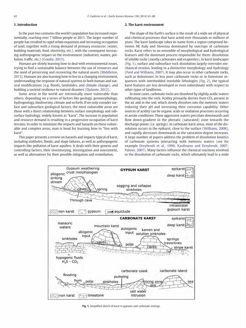
Fig. 1. Simplified sketch of karst in g
2. The karst environment
The shape of the Earth's surface is the result of a wide set of physicaland chemical processes that have acted over thousands or millions ofyears. The karst landscape takes its name from a region comprised be-tween NE Italy and Slovenia dominated by outcrops of carbonaterocks. Karst refers to an ensemble of morphological and hydrologicalfeatures and the dominant process responsible for them: dissolutionof soluble rocks (mostly carbonates and evaporites). In karst landscapes(Fig. 1), surface and subsurface rock dissolution largely overrules me-chanical erosion, leading to a distinctive morphology and hydrology(Ford and Williams, 2007). It may also occur in other carbonate rocks,such as dolostones. In less pure carbonate rocks or in limestone se-quences with interbedded insoluble lithologies (Fig. 2), the typicalkarst features are less developed or even subordinate with respect toother types of landforms.
Inmost cases, carbonate rocks are dissolved by slightly acidic watersinfiltrating into the rock. Acidity primarily derives from CO2 present inthe air and in the soil, which slowly dissolves into the meteoric watersreducing their pH and increasing their corrosion capability. Othersources of acidity can be organic acids or oxidation processes occurringin aerate conditions. These aggressive waters percolate downwards andflow down-gradient in the phreatic (saturated) zone towards thedischarge points (i.e. springs). In carbonate karst areas, most of the dis-solution occurs in the epikarst, close to the surface (Williams, 2008),and rapidly decreases downwards as the saturation degree increases.A large number of papers address the problem of dissolution kineticsof carbonate systems interacting with meteoric waters (see forexample Dreybrodt et al., 1996; Kaufmann and Dreybrodt, 2007;Palmer, 2007). Many factors influence the chemical reactions involvedin the dissolution of carbonate rocks, which ultimately lead to a wide
ypsum and carbonate settings.
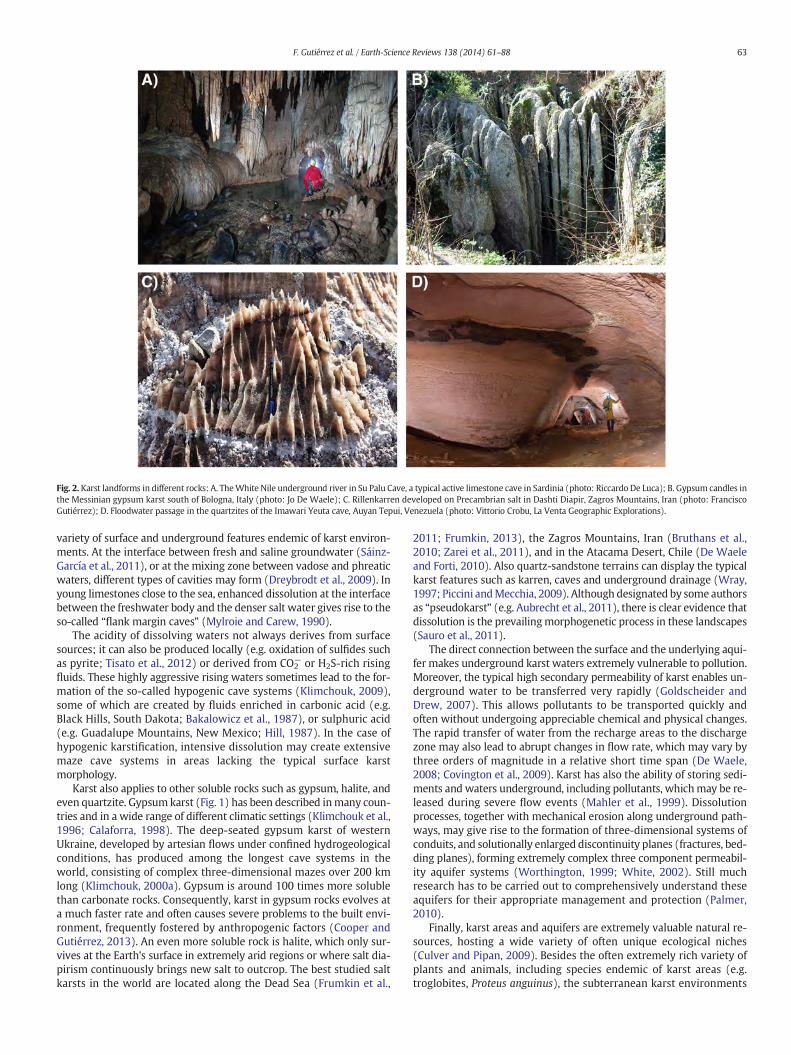
Fig. 2. Karst landforms in different rocks: A. TheWhite Nile underground river in Su Palu Cave, a typical active limestone cave in Sardinia (photo: Riccardo De Luca); B. Gypsum candles inthe Messinian gypsum karst south of Bologna, Italy (photo: Jo De Waele); C. Rillenkarren developed on Precambrian salt in Dashti Diapir, Zagros Mountains, Iran (photo: FranciscoGutiérrez); D. Floodwater passage in the quartzites of the Imawari Yeuta cave, Auyan Tepui, Venezuela (photo: Vittorio Crobu, La Venta Geographic Explorations).
63F. Gutiérrez et al. / Earth-Science Reviews 138 (2014) 61–88
variety of surface and underground features endemic of karst environ-ments. At the interface between fresh and saline groundwater (Sáinz-García et al., 2011), or at the mixing zone between vadose and phreaticwaters, different types of cavities may form (Dreybrodt et al., 2009). Inyoung limestones close to the sea, enhanced dissolution at the interfacebetween the freshwater body and the denser salt water gives rise to theso-called “flank margin caves” (Mylroie and Carew, 1990).
The acidity of dissolving waters not always derives from surfacesources; it can also be produced locally (e.g. oxidation of sulfides suchas pyrite; Tisato et al., 2012) or derived from CO2
− or H2S-rich risingfluids. These highly aggressive rising waters sometimes lead to the for-mation of the so-called hypogenic cave systems (Klimchouk, 2009),some of which are created by fluids enriched in carbonic acid (e.g.Black Hills, South Dakota; Bakalowicz et al., 1987), or sulphuric acid(e.g. Guadalupe Mountains, New Mexico; Hill, 1987). In the case ofhypogenic karstification, intensive dissolution may create extensivemaze cave systems in areas lacking the typical surface karstmorphology.
Karst also applies to other soluble rocks such as gypsum, halite, andeven quartzite. Gypsumkarst (Fig. 1) has been described inmany coun-tries and in a wide range of different climatic settings (Klimchouk et al.,1996; Calaforra, 1998). The deep-seated gypsum karst of westernUkraine, developed by artesian flows under confined hydrogeologicalconditions, has produced among the longest cave systems in theworld, consisting of complex three-dimensional mazes over 200 kmlong (Klimchouk, 2000a). Gypsum is around 100 times more solublethan carbonate rocks. Consequently, karst in gypsum rocks evolves ata much faster rate and often causes severe problems to the built envi-ronment, frequently fostered by anthropogenic factors (Cooper andGutiérrez, 2013). An even more soluble rock is halite, which only sur-vives at the Earth's surface in extremely arid regions or where salt dia-pirism continuously brings new salt to outcrop. The best studied saltkarsts in the world are located along the Dead Sea (Frumkin et al.,
2011; Frumkin, 2013), the Zagros Mountains, Iran (Bruthans et al.,2010; Zarei et al., 2011), and in the Atacama Desert, Chile (De Waeleand Forti, 2010). Also quartz-sandstone terrains can display the typicalkarst features such as karren, caves and underground drainage (Wray,1997; Piccini andMecchia, 2009). Although designated by some authorsas “pseudokarst” (e.g. Aubrecht et al., 2011), there is clear evidence thatdissolution is the prevailingmorphogenetic process in these landscapes(Sauro et al., 2011).
The direct connection between the surface and the underlying aqui-fer makes underground karst waters extremely vulnerable to pollution.Moreover, the typical high secondary permeability of karst enables un-derground water to be transferred very rapidly (Goldscheider andDrew, 2007). This allows pollutants to be transported quickly andoften without undergoing appreciable chemical and physical changes.The rapid transfer of water from the recharge areas to the dischargezone may also lead to abrupt changes in flow rate, which may vary bythree orders of magnitude in a relative short time span (De Waele,2008; Covington et al., 2009). Karst has also the ability of storing sedi-ments and waters underground, including pollutants, whichmay be re-leased during severe flow events (Mahler et al., 1999). Dissolutionprocesses, together with mechanical erosion along underground path-ways, may give rise to the formation of three-dimensional systems ofconduits, and solutionally enlarged discontinuity planes (fractures, bed-ding planes), forming extremely complex three component permeabil-ity aquifer systems (Worthington, 1999; White, 2002). Still muchresearch has to be carried out to comprehensively understand theseaquifers for their appropriate management and protection (Palmer,2010).
Finally, karst areas and aquifers are extremely valuable natural re-sources, hosting a wide variety of often unique ecological niches(Culver and Pipan, 2009). Besides the often extremely rich variety ofplants and animals, including species endemic of karst areas (e.g.troglobites, Proteus anguinus), the subterranean karst environments
64 F. Gutiérrez et al. / Earth-Science Reviews 138 (2014) 61–88
are also unique microbiological habitats. This biodiversity is worth pro-tection and ongoing research on new cave dwelling species and micro-biological communities might allow the discovery of new substancesuseful for medical purposes (Barton and Northup, 2007).
3. The different types of hazards in karst
3.1. Sinkholes
3.1.1. Genetic processes and resulting surface and subsurface featuresSinkholes or dolines are closed depressions with internal drainage,
widely regarded as one of the main diagnostic landforms of karst(Ford and Williams, 2007). The term doline, derived from the Slavicword dolina, is used mainly by European geomorphologists (Gams,2000; Sauro, 2003), whereas sinkhole is the most common term inNorth America and in the international literature dealingwith engineer-ing and environmental issues (Beck, 1984, 1988). Sinkholes display awide range of morphologies (cylindrical, conical, bowl- or pan-shaped), varying in size up to hundreds of meters across and typicallyfrom a few to tens of meters deep. Compound depressions resultingfrom the coalescence of several sinkholes have been traditionally desig-nated as uvalas (e.g. Sweeting, 1972). However, the term uvala, fre-quently applied with a loose meaning, is falling into disuse (Ćalić,2011 and references therein).
Sinkholes are often related to the dissolution of carbonate and/orevaporite rocks. There are some important differences between carbon-ate and evaporite karst systems with significant influence on sinkholedevelopment and the associated hazards (Martínez et al., 1998;Gutiérrez et al., 2008a; Frumkin, 2013; Gutiérrez and Cooper, 2013):(1) Evaporites dissolve much more rapidly than carbonates(Dreybrodt, 2004). The equilibrium solubilities of gypsum (CaSO4·2H2-
O) and halite (NaCl), the most common evaporite minerals, in distilledwater are 2.4 g L−1 and 360 g L−1, respectively. By comparison, the sol-ubilities of calcite (CaCO3) and dolomite (MgCa[CO3]2) in normal mete-oric waters are generally lower than 0.1 g L−1. This fact explains why inevaporite karst cavities form and developmuchmore rapidly, sinkholesgenerally show a higher probability of occurrence, and subsidence ratesmay reach much higher values. (2) Gypsum and halite have a signifi-cantly lower mechanical strength and a more ductile rheology thanmost carbonate rocks. Moreover, evaporite rock masses may weakensubstantially at a human time-scale by rapid dissolution, frequentlyguided by discontinuity planes. These circumstances explain why sink-holes in evaporite karst areas may be formed by a broader diversity ofsubsidence mechanisms, including ductile sagging, and why collapseprocesses generally operate at higher rates. (3) Many evaporite se-quences include hypersoluble facies (halite, glauberite, K-chlorides)rarely exposed at the surface. These contexts are particularly prone tothe development of sinkholes and large subsidence depressions relatedto interstratal dissolution of salts, frequently misleadingly attributed togypsum solution due to the lack of adequate subsurface data (e.g. Galveet al., 2009a; Guerrero et al., 2013).
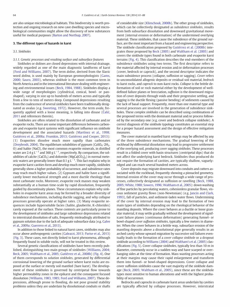
In addition to those linked to natural karst caves, sinkholes may alsooccur above anthropogenic cavities (Galeazzi, 2013; Parise et al., 2013)(Fig. 3). These cases, not directly linked to karst phenomena, althoughfrequently found in soluble rocks, will not be treated in this review.
Several genetic classifications of sinkholes have been recently pub-lished, distinguishing two main groups of sinkholes (Williams, 2004;Beck, 2005; Waltham et al., 2005; Gutiérrez et al., 2008b) (Fig. 4). Oneof them corresponds to solution sinkholes, generated by differentialcorrosional lowering of the ground surface where karst rocks are ex-posed at the surface or merely soil mantled (bare karst). The develop-ment of these sinkholes is governed by centripetal flow towardshigher permeability zones in the epikarst and the consequent focuseddissolution (Williams, 1983, 1985; Ford andWilliams, 2007). These de-pressions, although prone to flooding, do not pose ground stabilityproblems unless they are underlain by dissolutional conduits or shafts
of considerable size (Klimchouk, 2000b). The other group of sinkholes,which can be collectively designated as subsidence sinkholes, resultsfrom both subsurface dissolution and downward gravitational move-ment (internal erosion or deformation) of the undermined overlyingmaterial. These sinkholes, that cause the subsidence of the ground sur-face, are themost important from a hazard and engineering perspective.The sinkhole classification proposed by Gutiérrez et al. (2008b) inte-grates those proposed by Beck (2005) and Waltham et al. (2005) andcovers the sinkhole types found in both carbonate and evaporite karstterrains (Fig. 4). This classification describes the end-members of thesubsidence sinkholes using two terms. The first descriptor refers tothe material affected by internal erosion and/or deformation processes(cover, bedrock or caprock), and the second descriptor indicates themain subsidence process (collapse, suffosion or sagging). Cover refersto unconsolidated allogenic deposits or residual soil material, bedrockto karst rocks, and caprock to non-karst rocks. Collapse is the brittle de-formation of soil or rock material either by the development of well-defined failure planes or brecciation, suffosion is the downward migra-tion of cover deposits through voids and their progressive settling, andsagging is the ductile flexing (passive bending) of sediments caused bythe lack of basal support. Frequently, more than one material type andseveral processes are involved in the generation of subsidence sink-holes. These complex sinkholes can be described using combinations ofthe proposed terms with the dominant material and/or process follow-ed by the secondary one (e.g. cover and bedrock collapse sinkhole). Acorrect diagnosis of the sinkhole typology constitutes an essential stepfor a proper hazard assessment and the design of effective mitigationmeasures.
The cover material in mantled karst settings may be affected by anyof the three subsidence mechanisms. The gradual lowering of therockhead by differential dissolution may lead to progressive settlementof the overlying soil, producing cover sagging sinkholes. These processesresult in a folded cover with basin structures (centripetal dips) that donot affect the underlying karst bedrock. Sinkholes thus produced donot require the formation of cavities, are typically shallow, vaguely-edged and can reach several hundred meters across.
Cover depositsmaymigrate downward into conduits and cutters as-sociated with the rockhead, frequently showing a pinnacled geometry.Internal erosion of the cover may occur through a wide range of pro-cesses, collectively designated as suffosion or ravelling (Beck, 1988,2005;White, 1988; Sowers, 1996;Walthamet al., 2005): downwashingof fine particles by percolating waters, cohesionless granular flows, vis-cous sediment gravity flows (non-Newtonian) (e.g. Jancin and Clark,1993), fall of particles, and sediment-laden water flows. Underminingof the cover by internal erosion may lead to the formation of twomain types of sinkholes depending on the rheological behavior of themantling deposits. Where the cover behaves as a ductile or loose gran-ularmaterial, it may settle gradually without the development of signif-icant failure planes (continuous deformation) generating funnel- orbowl-shaped cover suffosion sinkholes, typically a few meters in diame-ter. When the cover behaves in a brittle way, subsurface erosion of themantling deposits above a dissolutional pipe generally results in anarched cavity whose upward migration by successive soil failures even-tually leads to the formation of a cover collapse sinkhole or a dropoutsinkhole according toWilliams (2004) andWaltham's et al. (2005) clas-sifications (Fig. 5). Cover collapse sinkholes, typically less than 10 m indiameter, commonly occur in a sudden way and have scarped or over-hanging sides at the time of formation. Mass wasting processes actingat their margins may cause their rapid enlargement and transformthem into funnel- or bowl-shaped depressions. Cover collapse andcover suffosion sinkholes cause the vast majority of the sinkhole dam-age (Beck, 2005; Waltham et al., 2005), since these are the sinkholetypes most sensitive to human alterations and with the highest proba-bility of occurrence.
Bedrocks and caprocks in carbonate karst areas underlain by cavitiesare typically affected by collapse processes. However, interstratal
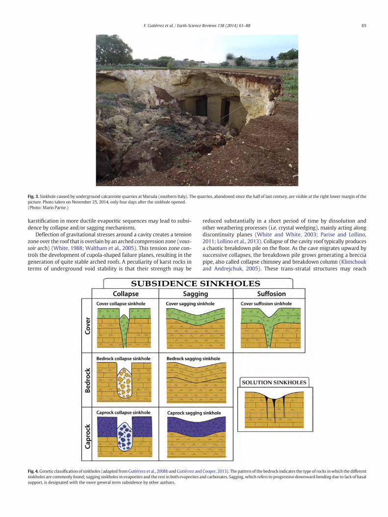
Fig. 3. Sinkhole caused by underground calcarenite quarries at Marsala (southern Italy). The quarries, abandoned since the half of last century, are visible at the right lowermargin of thepicture. Photo taken on November 25, 2014, only four days after the sinkhole opened.(Photo: Mario Parise.)
65F. Gutiérrez et al. / Earth-Science Reviews 138 (2014) 61–88
karstification in more ductile evaporitic sequences may lead to subsi-dence by collapse and/or sagging mechanisms.
Deflection of gravitational stresses around a cavity creates a tensionzoneover the roof that is overlain by an arched compression zone (vous-soir arch) (White, 1988; Waltham et al., 2005). This tension zone con-trols the development of cupola-shaped failure planes, resulting in thegeneration of quite stable arched roofs. A peculiarity of karst rocks interms of underground void stability is that their strength may be
Fig. 4.Genetic classification of sinkholes (adapted fromGutiérrez et al., 2008b andGutiérrez andsinkholes are commonly found; sagging sinkholes in evaporites and the rest in both evaporites asupport, is designated with the more general term subsidence by other authors.
reduced substantially in a short period of time by dissolution andother weathering processes (i.e. crystal wedging), mainly acting alongdiscontinuity planes (White and White, 2003; Parise and Lollino,2011; Lollino et al., 2013). Collapse of the cavity roof typically producesa chaotic breakdown pile on the floor. As the cave migrates upward bysuccessive collapses, the breakdown pile grows generating a brecciapipe, also called collapse chimney and breakdown column (Klimchoukand Andrejchuk, 2005). These trans-stratal structures may reach
Cooper, 2013). Thepattern of the bedrock indicates the type of rocks inwhich the differentnd carbonates. Sagging,which refers to progressive downward bending due to lack of basal
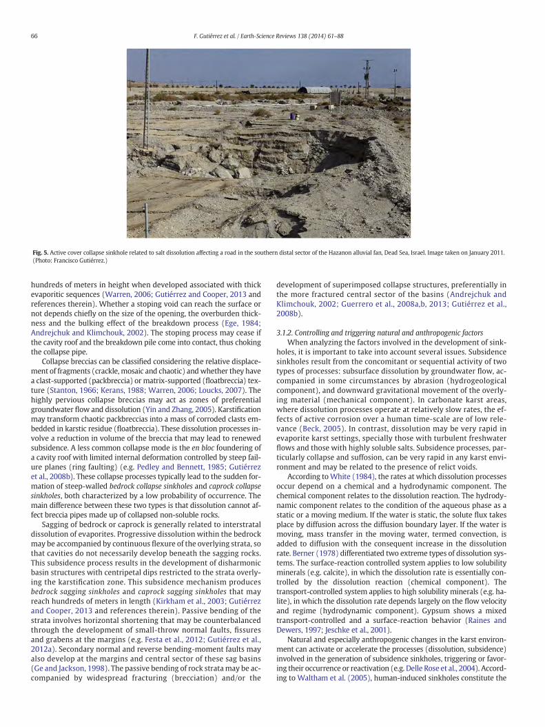
Fig. 5. Active cover collapse sinkhole related to salt dissolution affecting a road in the southern distal sector of the Hazanon alluvial fan, Dead Sea, Israel. Image taken on January 2011.(Photo: Francisco Gutiérrez.)
66 F. Gutiérrez et al. / Earth-Science Reviews 138 (2014) 61–88
hundreds of meters in height when developed associated with thickevaporitic sequences (Warren, 2006; Gutiérrez and Cooper, 2013 andreferences therein). Whether a stoping void can reach the surface ornot depends chiefly on the size of the opening, the overburden thick-ness and the bulking effect of the breakdown process (Ege, 1984;Andrejchuk and Klimchouk, 2002). The stoping process may cease ifthe cavity roof and the breakdown pile come into contact, thus chokingthe collapse pipe.
Collapse breccias can be classified considering the relative displace-ment of fragments (crackle, mosaic and chaotic) andwhether they havea clast-supported (packbreccia) or matrix-supported (floatbreccia) tex-ture (Stanton, 1966; Kerans, 1988; Warren, 2006; Loucks, 2007). Thehighly pervious collapse breccias may act as zones of preferentialgroundwater flow and dissolution (Yin and Zhang, 2005). Karstificationmay transform chaotic packbreccias into a mass of corroded clasts em-bedded in karstic residue (floatbreccia). These dissolution processes in-volve a reduction in volume of the breccia that may lead to renewedsubsidence. A less common collapse mode is the en bloc foundering ofa cavity roof with limited internal deformation controlled by steep fail-ure planes (ring faulting) (e.g. Pedley and Bennett, 1985; Gutiérrezet al., 2008b). These collapse processes typically lead to the sudden for-mation of steep-walled bedrock collapse sinkholes and caprock collapsesinkholes, both characterized by a low probability of occurrence. Themain difference between these two types is that dissolution cannot af-fect breccia pipes made up of collapsed non-soluble rocks.
Sagging of bedrock or caprock is generally related to interstrataldissolution of evaporites. Progressive dissolution within the bedrockmay be accompanied by continuous flexure of the overlying strata, sothat cavities do not necessarily develop beneath the sagging rocks.This subsidence process results in the development of disharmonicbasin structures with centripetal dips restricted to the strata overly-ing the karstification zone. This subsidence mechanism producesbedrock sagging sinkholes and caprock sagging sinkholes that mayreach hundreds of meters in length (Kirkham et al., 2003; Gutiérrezand Cooper, 2013 and references therein). Passive bending of thestrata involves horizontal shortening that may be counterbalancedthrough the development of small-throw normal faults, fissuresand grabens at the margins (e.g. Festa et al., 2012; Gutiérrez et al.,2012a). Secondary normal and reverse bending-moment faults mayalso develop at the margins and central sector of these sag basins(Ge and Jackson, 1998). The passive bending of rock stratamay be ac-companied by widespread fracturing (brecciation) and/or the
development of superimposed collapse structures, preferentially inthe more fractured central sector of the basins (Andrejchuk andKlimchouk, 2002; Guerrero et al., 2008a,b, 2013; Gutiérrez et al.,2008b).
3.1.2. Controlling and triggering natural and anthropogenic factorsWhen analyzing the factors involved in the development of sink-
holes, it is important to take into account several issues. Subsidencesinkholes result from the concomitant or sequential activity of twotypes of processes: subsurface dissolution by groundwater flow, ac-companied in some circumstances by abrasion (hydrogeologicalcomponent), and downward gravitational movement of the overly-ing material (mechanical component). In carbonate karst areas,where dissolution processes operate at relatively slow rates, the ef-fects of active corrosion over a human time-scale are of low rele-vance (Beck, 2005). In contrast, dissolution may be very rapid inevaporite karst settings, specially those with turbulent freshwaterflows and those with highly soluble salts. Subsidence processes, par-ticularly collapse and suffosion, can be very rapid in any karst envi-ronment and may be related to the presence of relict voids.
According toWhite (1984), the rates at which dissolution processesoccur depend on a chemical and a hydrodynamic component. Thechemical component relates to the dissolution reaction. The hydrody-namic component relates to the condition of the aqueous phase as astatic or a moving medium. If the water is static, the solute flux takesplace by diffusion across the diffusion boundary layer. If the water ismoving, mass transfer in the moving water, termed convection, isadded to diffusion with the consequent increase in the dissolutionrate. Berner (1978) differentiated two extreme types of dissolution sys-tems. The surface-reaction controlled system applies to low solubilityminerals (e.g. calcite), in which the dissolution rate is essentially con-trolled by the dissolution reaction (chemical component). Thetransport-controlled system applies to high solubility minerals (e.g. ha-lite), in which the dissolution rate depends largely on the flow velocityand regime (hydrodynamic component). Gypsum shows a mixedtransport-controlled and a surface-reaction behavior (Raines andDewers, 1997; Jeschke et al., 2001).
Natural and especially anthropogenic changes in the karst environ-ment can activate or accelerate the processes (dissolution, subsidence)involved in the generation of subsidence sinkholes, triggering or favor-ing their occurrence or reactivation (e.g. Delle Rose et al., 2004). Accord-ing to Waltham et al. (2005), human-induced sinkholes constitute the
67F. Gutiérrez et al. / Earth-Science Reviews 138 (2014) 61–88
vast majority of new subsidence depressions. Table 1 presents themainnatural or artificial changes that may induce the formation of sinkholes,together with their potential effects. This table, including key referencesof illustrative cases, is conceived as a checklist that can be used to eluci-date and understand the factors that may have contributed to the gen-eration of sinkholes. In agreement with several authors, our literaturereview reveals that increased water input to the ground and watertable decline, either related to aquifer exploitation or mining-relateddewatering, constitute the main sinkhole-inducing anthropogenic fac-tors. The negative impact of these activities on sinkhole hazard is ex-pected to increase in the future in many areas due to the growingdemand in resources.
Increased water input to the ground enhances internal erosion pro-cesses andmay adverselymodify themechanical strength andweight ofsediments. Moreover, water infiltration may reduce dramatically the
Table 1Changes in the karst systems and their potential effects that may accelerate or trigger the deve
Type of change Effects
Increased water input tothe ground (cover andbedrock)
Increases percolation accelerating suffosion.
Favors dissolution.Increases the weight of sediments.May reduce the mechanical strength and bearing capacity ofsediments.
Water table decline Increases the effective weight of the sediments (loss of buoyansupport).
Slow phreatic flow replaced by more rapid downward percolafavoring suffosion, especially when the water table is loweredbelow the rockhead.Accelerates groundwater flow in areas affected by cones ofdepression.May reduce the mechanical strength by desiccation andcrystallization of salts.Hydrofracturing of poorly drained deposits surrounding cavitieSuction effect.Loose fine-grained deposits may be dragged with the pumpedwater causing internal erosion.
Impoundment of water May create extremely high hydraulic gradients leading to rapidturbulent flows favoring internal erosion and dissolution.The base level rise may change groundwater flow paths andlocation of discharge zones.Major and continuous changes in the water table causing repeaflooding and drainage of karst conduits.Imposes a load.
Erosion or excavation Reduces the thickness and mechanical strength of cavity roofsMay concentrate runoff.May create a new base level changing the path and rate ofgroundwater flows.May create an outlet for internally eroded deposits.
Undergroundexcavations
Disturbs groundwater flows.May intercept phreatic conduits and distort groundwater flowpaths.May cause sudden inrushes of water and flooding in undergroopenings involving accelerated internal erosion and karstificatMay weaken sediments over voids.
Static loads Favors the failure of cavity roofs and compaction processes.
Unloading favors the formation of fractures and dilation of preexisting ones.
Dynamic loads Favors the failure of cavity roofs and may cause liquefaction–fluidization processes involving a sharp reduction in the strengof soils.
Vegetation removal Reduces mechanical strength of cover deposits (root cohesion)Increases infiltration.
Thawing of frozenground
Favors dissolution.Significant reduction in the strength of the sediments.
strength and bearing capacity of sabkha deposits due to rapid dissolu-tion of salts (Abdulali and Sobhi, 2002; Youssef et al., 2012).
Themain potential effects of lowering the groundwater level includethe loss of buoyant support of sediments, the increased groundwatervelocity and the replacement of phreatic flows by downward vadoseflows with a greater capability to induce suffosion. The latter effect isparticularly important when the water table declines below therockhead (Waltham et al., 2005). A peculiar and dramatic example ofhuman-induced catastrophic subsidence related to water table lower-ing corresponds to the hundreds of sinkholes formed over the last30 years in the Dead Sea shores in Israel and Jordan (Yechieli et al.,2006; Closson et al., 2007; Frumkin et al., 2011) (Fig. 5).
The impoundment of water in reservoirs is a common cause of sink-hole generation. The infill of a reservoir involves imposing a load andcreating unnaturally high hydraulic gradients that may lead to rapid
lopment of sinkholes.
(1) Natural processes; (2) human activities
(1) Rainfall (Zhao et al., 2010; Youssef et al., 2012), floods (Hyatt and Jacobs,1996), snow melting, thawing of frozen ground (Satkunas et al., 2006).(2) Irrigation (Atapour and Aftabi, 2002; Kirkham et al., 2003; Gutiérrez et al.,2007), leakages from pipes (Shaqour, 1994; McDowell and Poulsom, 1996;Jassim et al., 1997; Gutiérrez and Cooper, 2002; Dougherty, 2005; McDowell,2005; Fleury, 2009; Buttrick et al., 2011), canals (Swan, 1978; Lucha et al.,2008b) or ditches (Gutiérrez et al., 2007), impoundment of water (Milanovic,2000), runoff concentration (urbanization, soak-aways, drainage wells) or di-version (Knight, 1971; White et al., 1986), vegetation removal, drilling opera-tions, unsealed wells and boreholes (Johnson et al., 2003; Johnson, 2005;Lambrecht and Miller, 2006; Liguori et al., 2008), injection of fluids, solutionmining (Ege, 1984).
t (1) Climate change, sea level decline (Cooper and Keller, 2001), entrenchmentof drainage network (Ortega et al., 2013), tectonic uplift, isostatic rebound,halokinetic uplift (Closson et al., 2007; Closson and Karaki, 2009; Zarei et al., 2011).
tion (2) Water abstraction (Kemmerly, 1980; Newton, 1984; LaMoreaux andNewton, 1986; Chen, 1988; Waltham and Smart, 1988; Shaquor, 1994;Tihansky, 1999; Kaufmann and Quinif, 2002; He et al., 2003; Keqiang et al.,2004; Waltham, 2008; Dogan and Yilmaz, 2011; García-Moreno and Mateos,2011), de-watering for mining and excavation operations (Foose, 1953;LaMoreaux and Newton, 1986; Chen, 1988; Xu and Zhao, 1988; Zhou, 1997; Liand Zhou, 1999; De Bruyn and Bell, 2001; Klimchouk and Andrejchuk, 2005;Sprynskyy et al., 2009; Pando et al., 2013), decline of water level in lakes(Yechieli et al., 2006; Frumkin et al., 2011), excavations acting as drainages(Fidelibus et al., 2011).
s
(1) Natural lakes.(2) Reservoirs (Milanovic, 2000 and references therein; Uromeihy, 2000;Dogan and Cicek, 2002; Romanov et al., 2003; Bonacci and Roje-Bonacci, 2008;Johnson, 2008; Bonacci and Rubinić, 2009; Cooper and Gutiérrez, 2013 andreferences therein), ponds (Calò and Parise, 2009), sewage lagoons (Davis andRahn, 1997).
ted
. (1) Erosion processes.(2) Excavations (Walker and Matzat, 1999; Lolcama et al., 2002; Guerreroet al., 2008b; Fidelibus et al., 2011).
(1) Biogenic pipes.(2) Conventional and solution mining (Ege, 1984; Xu and Zhao, 1988; Gongyuand Wanfang, 1999; Li and Zhou, 1999; Andrejchuk, 2002; Autin, 2002; Sharpe,2003; Yin and Zhang, 2005; Warren, 2006; Bonetto et al., 2008; Lucha et al.,2008a; Wang et al., 2008; He et al., 2009; Mesescu, 2011; Parise, 2012),tunneling (Milanovic, 2000; Song et al., 2012).
undion.
(1) Aggradation processes. Glacial loading and unloading (Anderson and Hinds,1997).
- (2) Engineered structures (Waltham, 2008), dumping (Parise and Pascali,2003), heavy vehicles (Davis and Rahn, 1997; Waltham et al., 2005).
th(1) Earthquakes (Nicoletti and Parise, 2002; Closson et al., 2010; Del Preteet al., 2010a, b; Kawashima et al., 2010), explosive volcanic eruptions.(2) Artificial vibrations (blasting, explosions).
. (1) Wild fires.(2) Vegetation clearance.(1) Climate change (Satkunas et al., 2006).(2) Development, deforestation, water storage.
68 F. Gutiérrez et al. / Earth-Science Reviews 138 (2014) 61–88
turbulent flows with a high capability to flush out sediments fromconduits and enlarge them by dissolution (Milanovic, 2000;Romanov et al., 2003). On the other hand, continuous changes inthe reservoir level are accompanied by flooding and drainage cyclesin the karst system, which favor both mechanical and chemical sub-surface erosion. Pre-existing and newly created sinkholes in reser-voirs and in the foundation of dams may result in severe waterleakages and stability problems, compromising the operation andsafety of the hydraulic structure. Milanovic (2000) reviewed a num-ber of dam projects severely impacted or abandoned due to waterlosses through sinkholes functioning as ponors.
The excavation of tunnels andmine galleries, apart from dewateringby pumping, may cause dramatic changes in the local hydrogeology,leading to the formation of sinkholes (Milanovic, 2000; Bonetto et al.,2008; Wang et al., 2008; Vigna et al., 2010b). The interception of con-duits and cavernous rock by excavations performed below the watertable may result in dangerous inrushes of water under pressure. Thedrainage of the aquifer towards underground artificial openings maylead to uncontrolled flooding of the excavation, rapid lowering of thewater table, suspension of water supply from wells, enhanced internalerosion and development of sinkholes (Vigna et al., 2010a).
Sinkhole hazard may be particularly severe when fresh water flowsinto salt mines from an adjacent or overlying aquifer (Andrejchuk,2002), or from a surface water body (Autin, 2002; Lucha et al., 2008a).The highly aggressive water may cause massive dissolution of salt anduncontrollable sinkhole occurrence, leading to the abandonment ofthe mine (e.g. Lucha et al., 2008a).
Sinkholes may also be caused by the formation of large cavities insalt formations by solution mining, which involves the injection offresh water and the recovery of brine (Ege, 1984; Johnson, 1997;Andrejchuk, 2002; Warren, 2006; Mancini et al., 2009; Mesescu,2011). These cavities may propagate upward several hundred metersthrough overlying formations in a few decades, eventually leading tothe sudden occurrence of large sinkholes (Ege, 1984; Johnson, 1997).
Natural and human-induced static and dynamic loadings may trig-ger the collapse of pre-existing cavities under marginal stability condi-tions. The load imposed by heavy vehicles, drilling rigs, dumpedmaterial and engineered structures may cause dangerous sinkholeevents. A similar effect may be expected from ground shaking relatedto explosions and earthquakes, as documented by several authors inItaly (Del Prete et al., 2010b; Kawashima et al., 2010; Parise et al.,2010; Santo et al., 2011).
3.1.3. Sinkhole inventory and investigationGenerally, themost important step in sinkhole hazard analysis is the
construction of a comprehensive cartographic sinkhole inventory. Thereliability of sinkhole susceptibility and hazard maps and the effective-ness of the mitigation measures largely rely on the completeness, accu-racy and representativeness of the sinkhole inventories on which theyare based. Sinkhole databases should preferably include informationon the following aspects: (1) Precise location of the limits of the sink-holes and the underlying subsidence structures. This is essential to de-fine accurately the unstable areas, including a setback distance aroundthe sinkholes (Zhou and Beck, 2008). (2) Morphometric parameters.These data constitute the basis on which to analyze magnitude and fre-quency relationships of sinkholes. (3) Genetic type, that is subsidencemechanisms and material affected by subsidence (Williams, 2004;Beck, 2005; Waltham et al., 2005; Gutiérrez et al., 2008b). This is a cru-cial aspect, since the subsidence mechanisms determine the applicabil-ity and effectiveness of differentmitigationmeasures and the capabilityof the sinkholes to cause damage. (4) Chronology, either relative or nu-merical ages. The latter is indispensable to calculate rates of sinkhole oc-currence and hazard estimates in terms of spatial and temporalprobability values (Galve et al., 2011; Parise and Vennari, 2013). (5) Ac-tivity, including subsidence rates, kinematical behavior (gradual, epi-sodic or mixed), and age of the most recent deformation episode.
(6) Relationship with conditioning and triggering factors. The analysisof the sinkhole hazard also requires as much information as possibleon other karst features (e.g. caves, springs, ponors), the geology and hy-drogeology of the area, and human activities thatmay influence dissolu-tion and subsidence processes (Parise et al., 2008). Since somepioneering initiatives like that of the Florida Sinkhole Research Institute,a number of institutions and associations have developed sinkhole andkarst databasesmostly integrated in a Geographical Information System(Florea, 2005; Cooper et al., 2011; Parise and Vennari, 2013). The sink-hole and karst databases together with the datasets and maps derivedfrom them (e.g. sinkhole hazard models) are an extremely useful plan-ning tool that may help decision-makers to manage karst areas mini-mizing environmental problems. It may also be a valuable source ofinformation for private companies (insurance, geotechnical) and thegeneral public, as well as an excellent platform for researchers.
The identification and precise mapping of sinkholes, subsidencestructures and dissolution features is a difficult task. The geomorphicexpression of sinkholes may be masked by anthropogenic activities(filling, construction) and natural processes (aggradation, erosion).Moreover, shallow cavities and active subsidence structures that maylead to the generation of sinkholes in the near future may not haveany surface manifestation. For these reasons, it is highly advisable toapply asmany surface and subsurface investigationmethods as possibleto identify and characterize sinkholes and potentially unstable ground(Fig. 6). Table 2 presents a list of investigation methods indicating themain type of data related to sinkhole hazard that may be obtainedthrough their application. Additional information may be obtained inthe quoted references and in publications dealing with the differenttechniques.
3.1.4. Sinkhole hazard and risk assessmentOnce the pre-existing sinkholes and areas affected by subsidence
have beenmapped and characterized, the next step in the sinkhole haz-ard analysis is to predict the spatial and temporal distribution of futuresinkholes and their characteristics. Ideally, it would be desirable to as-sess, with a reasonable level of reliability, the probability of occurrenceof sinkholes of each type and with different diameters in every location.In areas with different sinkhole types, it is advisable to analyze themseparately since they are most likely controlled by different factorsand have different spatial and temporal distribution patterns (e.g.Galve et al., 2009b). Depending on the information available, twotypes of models can be produced to predict the occurrence of futuresinkholes: susceptibility models and hazard models. The susceptibilitymodels represent the likelihood of a sinkhole occurring in any specificplace in terms of relative probability. These models do not providequantitative probability values and consequently cannot be used asthebasis for quantitative risk analyses. This is the type ofmodel present-ed inmost publishedworks (e.g. Buttrick et al., 2001; Yilmaz, 2007). Thehazard models provide an estimation of the spatial–temporal probabil-ity values of future sinkholes, that is, the probability for a given zone andtime interval of being affected by a sinkhole event (Fig. 7A). Chronolog-ical information on the analyzed sinkholes, either a precise age or an ageinterval, is indispensable to calculate temporal frequency values (Galveet al., 2009c, 2011; Parise and Vennari, 2013). In most cases, the calcu-lated spatial–temporal probability values correspond to minimum oroptimistic hazard estimates, since they are commonly derived from in-complete sinkhole inventories. Preferably, hazard models should incor-porate magnitude and frequency scaling relationships accounting forthe probability of occurrence of sinkholes with different diameters(Galve et al., 2011). Quantitative hazard estimates are essential for riskassessments, cost–benefit analyses of mitigation strategies, evaluationof insurance policies or pre-purchase appraisal of land.
Severalmethodologiesmay be applied to construct sinkhole suscep-tibility maps. (1) Direct mapping of susceptibility zonations based onexpert criteria (Edmonds et al., 1987; Ardau et al., 2007). These mapshave a significant subjective component related to the expert
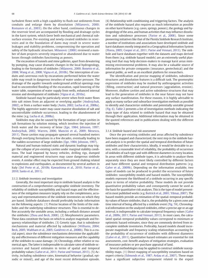
Fig. 6. Cover collapse sinkhole in the Ebro Valley, NE Spain, investigated applying several invasive and non-invasive subsurface techniques. A: Log of backhoe trench 3.2m deep showing a10mwide collapse structure bounded bywell-defined subvertical failure planes. The geometrical relationships together with chronological data, including radiocarbon dates, reveal threecollapse events that occurred after 1477 AD. Note the presence of three anthropogenic deposits (R1 to R3) with different degree of deformation. B: ERT section obtained with a Dipole–Dipole configuration, showing a sharp contrast between the low resistivity clayey deposits of the sinkhole fill and the less conductive surrounding alluvium. C: GPR profile acquired with180 MHz shielded antennas. The boundaries of the collapse structure are imaged by the apex of small diffraction hyperbolas and conspicuous changes in the reflection pattern.(Modified from Carbonel et al. (2014).)
69F. Gutiérrez et al. / Earth-Science Reviews 138 (2014) 61–88
judgements, are not reproducible, and may lack an objective basis forsubstantiating the distribution and boundaries of the susceptibilityzones. (2) The deterministic models are based on stability analysesthat take into account a number of parameters involved in the subsi-dence processes (Koutepov et al., 2008). These models considerablysimplify the complexity of the subsidence processes, incorporate geo-metrical suppositions and require a large amount of geotechnical datadifficult and expensive to obtain, especially when analyzing large andheterogeneous areas. (3) Susceptibilitymodelsmay be derived frompa-rameters related to the spatial distribution of the inventoried sinkholes,like sinkhole density, distance to the nearest sinkhole or preferred align-ment and elongation directions. Generally, the underlying assumptionof the susceptibility models based on sinkhole density, either numberof sinkholes per unit area or percentage area affected by sinkholes, isthat the likelihood of sinkhole occurrence is higher in the areas withhigher sinkhole density (Angel et al., 2004; Galve et al., 2009b). The dis-tance of each point to the nearest sinkhole may be used to assess sus-ceptibility assuming that the likelihood of sinkhole occurrenceincreases with the proximity to existing sinkholes (Zhou et al., 2003;Gao et al., 2005; Kemmerly, 2006; Galve et al., 2009b,c). In areaswhere the sinkholes are structurally controlled, showing statisticallysignificant preferred orientations and alignments, the belts of land de-fined by two or more aligned sinkholes following a prevalent trendmay be classified as more susceptible. An alternative group of methodsof susceptibility assessment incorporate data on variables that controlsinkhole development. (4) The heuristic approach involves establishingsusceptibility classes by judging the contribution of a number of vari-ables on sinkhole formation. Some authors differentiate susceptibilityclasses establishing threshold values for specific variables and using de-cision tree models (Kaufmann and Quinif, 2002; Bruno et al., 2008). An-otherwidely used approach is to apply aweighing or scoring system to agroup of conditioning factors (Buttrick and van Schalkwyk, 1998;Zisman, 2001; Tolmachev and Leonenko, 2005). Themain disadvantageof the heuristic methods is the subjective component of the susceptibil-ity assessments. (5) The probabilistic methods allow the construction of
susceptibilitymodels analyzing the statistical relationships between thespatial distribution of known sinkholes and that of a set of controllingfactors. Several papers present bivariate analyses quantifying the spatialrelationships between sinkholes, or parameters derived from this datalayer (e.g. sinkhole density, distance to the nearest sinkhole), and spe-cific variables governing their distribution (Whitman et al., 1999;Orndorff et al., 2000). These analyses were aimed at assessing the con-tribution of variables to the development of sinkholes, rather than toproduce susceptibility models. More recent publications present sus-ceptibility models based on the statistical relationships between thesinkholes and groups of highly diverse controlling factors applying dif-ferent mathematical frameworks; favorability functions (Galve et al.,2009b,c, 2011, 2012a), logistic regression (Lamelas et al., 2008), and fre-quency ratios (Yilmaz, 2007). Themain advantages of thesemethods in-clude their objective statistical basis, reproducibility, ability foranalyzing quantitatively the contribution of factors to sinkhole develop-ment and potential for continuous updating. These statistical tech-niques have been applied satisfactorily to landslides because data onthemain conditioning factors (e.g. slope, lithology, land use) can be eas-ily gathered (Remondo et al., 2005). Conversely, in the case of sinkholes,the generation of sound probabilistic and heuristic models is more chal-lenging due to the limited availability of information on the variablesthat control the subsidence phenomena, some of which are difficultand expensive to obtain due to their subsurface nature.
Regardless of the methodology used to construct sinkhole suscepti-bility models, the predictions on the future spatial distribution of sink-holes should be considered as un-tested hypotheses, howeverreasonable they might be. A susceptibility model developed through acomplex and sophisticated methodology, but with a limited prognosticcapability, may lead to inadequate planning, the application of ineffec-tivemitigation measures and severe losses. Therefore, it is highly advis-able to evaluate quantitatively and independently the predictioncapability of themodels. Few of the sinkhole susceptibility models pub-lished so far have been validated independently (Lamelas et al., 2008;Galve et al., 2009b,c, 2011; Buttrick et al., 2011). Model evaluation
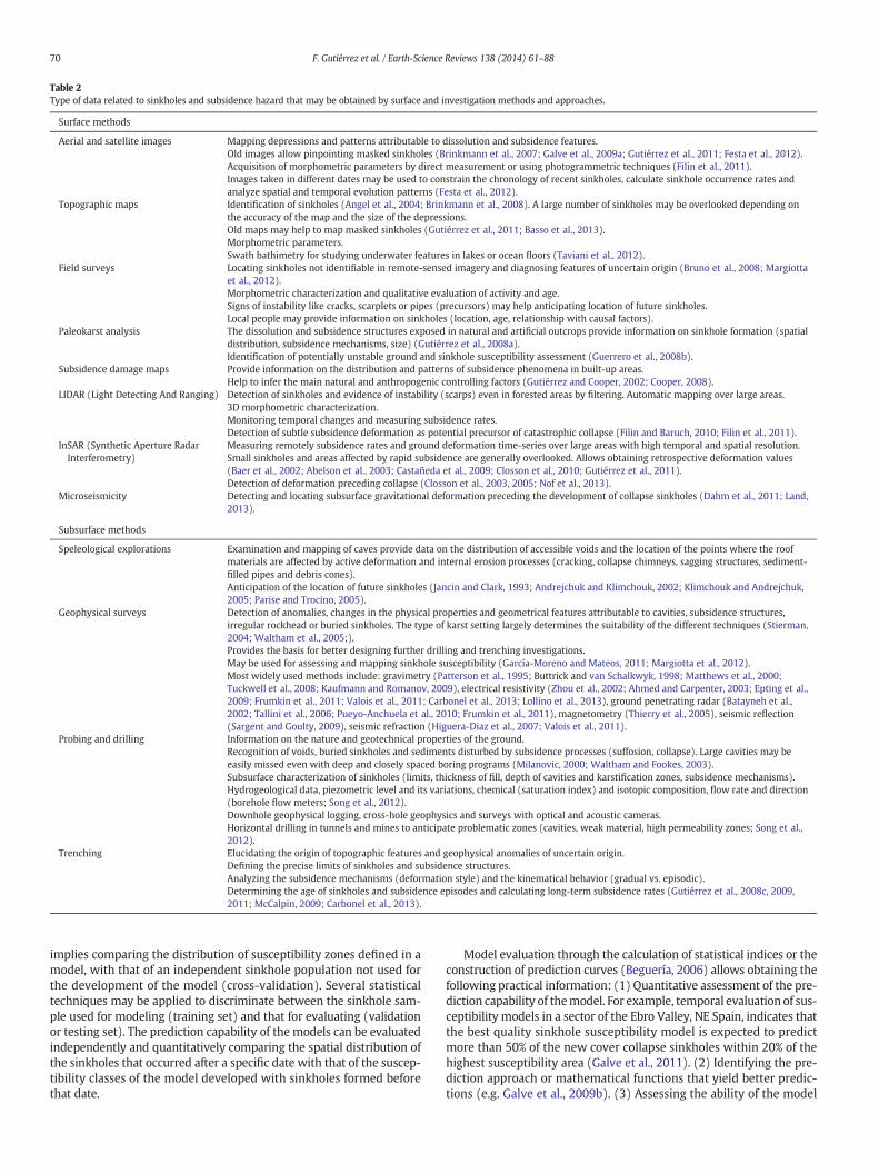
Table 2Type of data related to sinkholes and subsidence hazard that may be obtained by surface and investigation methods and approaches.
Surface methods
Aerial and satellite images Mapping depressions and patterns attributable to dissolution and subsidence features.Old images allow pinpointing masked sinkholes (Brinkmann et al., 2007; Galve et al., 2009a; Gutiérrez et al., 2011; Festa et al., 2012).Acquisition of morphometric parameters by direct measurement or using photogrammetric techniques (Filin et al., 2011).Images taken in different dates may be used to constrain the chronology of recent sinkholes, calculate sinkhole occurrence rates andanalyze spatial and temporal evolution patterns (Festa et al., 2012).
Topographic maps Identification of sinkholes (Angel et al., 2004; Brinkmann et al., 2008). A large number of sinkholes may be overlooked depending onthe accuracy of the map and the size of the depressions.Old maps may help to map masked sinkholes (Gutiérrez et al., 2011; Basso et al., 2013).Morphometric parameters.Swath bathimetry for studying underwater features in lakes or ocean floors (Taviani et al., 2012).
Field surveys Locating sinkholes not identifiable in remote-sensed imagery and diagnosing features of uncertain origin (Bruno et al., 2008; Margiottaet al., 2012).Morphometric characterization and qualitative evaluation of activity and age.Signs of instability like cracks, scarplets or pipes (precursors) may help anticipating location of future sinkholes.Local people may provide information on sinkholes (location, age, relationship with causal factors).
Paleokarst analysis The dissolution and subsidence structures exposed in natural and artificial outcrops provide information on sinkhole formation (spatialdistribution, subsidence mechanisms, size) (Gutiérrez et al., 2008a).Identification of potentially unstable ground and sinkhole susceptibility assessment (Guerrero et al., 2008b).
Subsidence damage maps Provide information on the distribution and patterns of subsidence phenomena in built-up areas.Help to infer the main natural and anthropogenic controlling factors (Gutiérrez and Cooper, 2002; Cooper, 2008).
LIDAR (Light Detecting And Ranging) Detection of sinkholes and evidence of instability (scarps) even in forested areas by filtering. Automatic mapping over large areas.3D morphometric characterization.Monitoring temporal changes and measuring subsidence rates.Detection of subtle subsidence deformation as potential precursor of catastrophic collapse (Filin and Baruch, 2010; Filin et al., 2011).
InSAR (Synthetic Aperture RadarInterferometry)
Measuring remotely subsidence rates and ground deformation time-series over large areas with high temporal and spatial resolution.Small sinkholes and areas affected by rapid subsidence are generally overlooked. Allows obtaining retrospective deformation values(Baer et al., 2002; Abelson et al., 2003; Castañeda et al., 2009; Closson et al., 2010; Gutiérrez et al., 2011).Detection of deformation preceding collapse (Closson et al., 2003, 2005; Nof et al., 2013).
Microseismicity Detecting and locating subsurface gravitational deformation preceding the development of collapse sinkholes (Dahm et al., 2011; Land,2013).
Subsurface methods
Speleological explorations Examination and mapping of caves provide data on the distribution of accessible voids and the location of the points where the roofmaterials are affected by active deformation and internal erosion processes (cracking, collapse chimneys, sagging structures, sediment-filled pipes and debris cones).Anticipation of the location of future sinkholes (Jancin and Clark, 1993; Andrejchuk and Klimchouk, 2002; Klimchouk and Andrejchuk,2005; Parise and Trocino, 2005).
Geophysical surveys Detection of anomalies, changes in the physical properties and geometrical features attributable to cavities, subsidence structures,irregular rockhead or buried sinkholes. The type of karst setting largely determines the suitability of the different techniques (Stierman,2004; Waltham et al., 2005;).Provides the basis for better designing further drilling and trenching investigations.May be used for assessing and mapping sinkhole susceptibility (García-Moreno and Mateos, 2011; Margiotta et al., 2012).Most widely used methods include: gravimetry (Patterson et al., 1995; Buttrick and van Schalkwyk, 1998; Matthews et al., 2000;Tuckwell et al., 2008; Kaufmann and Romanov, 2009), electrical resistivity (Zhou et al., 2002; Ahmed and Carpenter, 2003; Epting et al.,2009; Frumkin et al., 2011; Valois et al., 2011; Carbonel et al., 2013; Lollino et al., 2013), ground penetrating radar (Batayneh et al.,2002; Tallini et al., 2006; Pueyo-Anchuela et al., 2010; Frumkin et al., 2011), magnetometry (Thierry et al., 2005), seismic reflection(Sargent and Goulty, 2009), seismic refraction (Higuera-Diaz et al., 2007; Valois et al., 2011).
Probing and drilling Information on the nature and geotechnical properties of the ground.Recognition of voids, buried sinkholes and sediments disturbed by subsidence processes (suffosion, collapse). Large cavities may beeasily missed even with deep and closely spaced boring programs (Milanovic, 2000; Waltham and Fookes, 2003).Subsurface characterization of sinkholes (limits, thickness of fill, depth of cavities and karstification zones, subsidence mechanisms).Hydrogeological data, piezometric level and its variations, chemical (saturation index) and isotopic composition, flow rate and direction(borehole flow meters; Song et al., 2012).Downhole geophysical logging, cross-hole geophysics and surveys with optical and acoustic cameras.Horizontal drilling in tunnels and mines to anticipate problematic zones (cavities, weak material, high permeability zones; Song et al.,2012).
Trenching Elucidating the origin of topographic features and geophysical anomalies of uncertain origin.Defining the precise limits of sinkholes and subsidence structures.Analyzing the subsidence mechanisms (deformation style) and the kinematical behavior (gradual vs. episodic).Determining the age of sinkholes and subsidence episodes and calculating long-term subsidence rates (Gutiérrez et al., 2008c, 2009,2011; McCalpin, 2009; Carbonel et al., 2013).
70 F. Gutiérrez et al. / Earth-Science Reviews 138 (2014) 61–88
implies comparing the distribution of susceptibility zones defined in amodel, with that of an independent sinkhole population not used forthe development of the model (cross-validation). Several statisticaltechniques may be applied to discriminate between the sinkhole sam-ple used for modeling (training set) and that for evaluating (validationor testing set). The prediction capability of themodels can be evaluatedindependently and quantitatively comparing the spatial distribution ofthe sinkholes that occurred after a specific date with that of the suscep-tibility classes of the model developed with sinkholes formed beforethat date.
Model evaluation through the calculation of statistical indices or theconstruction of prediction curves (Beguería, 2006) allows obtaining thefollowing practical information: (1) Quantitative assessment of the pre-diction capability of themodel. For example, temporal evaluation of sus-ceptibility models in a sector of the Ebro Valley, NE Spain, indicates thatthe best quality sinkhole susceptibility model is expected to predictmore than 50% of the new cover collapse sinkholes within 20% of thehighest susceptibility area (Galve et al., 2011). (2) Identifying the pre-diction approach or mathematical functions that yield better predic-tions (e.g. Galve et al., 2009b). (3) Assessing the ability of the model
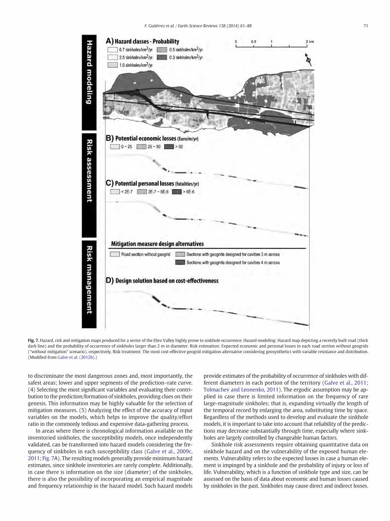
Fig. 7.Hazard, risk andmitigation maps produced for a sector of the Ebro Valley highly prone to sinkhole occurrence. Hazardmodeling: Hazardmap depicting a recently built road (thickdark line) and the probability of occurrence of sinkholes larger than 2 m in diameter. Risk estimation: Expected economic and personal losses in each road section without geogrids(“without mitigation” scenario), respectively. Risk treatment: The most cost-effective geogrid mitigation alternative considering geosynthetics with variable resistance and distribution.(Modified from Galve et al. (2012b).)
71F. Gutiérrez et al. / Earth-Science Reviews 138 (2014) 61–88
to discriminate the most dangerous zones and, most importantly, thesafest areas; lower and upper segments of the prediction–rate curve.(4) Selecting the most significant variables and evaluating their contri-bution to the prediction/formation of sinkholes, providing clues on theirgenesis. This information may be highly valuable for the selection ofmitigation measures. (5) Analyzing the effect of the accuracy of inputvariables on the models, which helps to improve the quality/effortratio in the commonly tedious and expensive data-gathering process.
In areas where there is chronological information available on theinventoried sinkholes, the susceptibility models, once independentlyvalidated, can be transformed into hazard models considering the fre-quency of sinkholes in each susceptibility class (Galve et al., 2009c,2011; Fig. 7A). The resultingmodels generally provideminimumhazardestimates, since sinkhole inventories are rarely complete. Additionally,in case there is information on the size (diameter) of the sinkholes,there is also the possibility of incorporating an empirical magnitudeand frequency relationship in the hazard model. Such hazard models
provide estimates of the probability of occurrence of sinkholes with dif-ferent diameters in each portion of the territory (Galve et al., 2011;Tolmachev and Leonenko, 2011). The ergodic assumption may be ap-plied in case there is limited information on the frequency of rarelarge-magnitude sinkholes; that is, expanding virtually the length ofthe temporal record by enlarging the area, substituting time by space.Regardless of the methods used to develop and evaluate the sinkholemodels, it is important to take into account that reliability of the predic-tions may decrease substantially through time, especially where sink-holes are largely controlled by changeable human factors.
Sinkhole risk assessments require obtaining quantitative data onsinkhole hazard and on the vulnerability of the exposed human ele-ments. Vulnerability refers to the expected losses in case a human ele-ment is impinged by a sinkhole and the probability of injury or loss oflife. Vulnerability, which is a function of sinkhole type and size, can beassessed on the basis of data about economic and human losses causedby sinkholes in the past. Sinkholes may cause direct and indirect losses.
72 F. Gutiérrez et al. / Earth-Science Reviews 138 (2014) 61–88
For instance, in case a road is affected by a collapse, the direct risk cor-responds to the cost of repairing or reconstructing the structure andthe injuries or fatalities caused by the subsidence event. The impact onthe economic productivity caused by the temporal loss in serviceabilityand the resulting delays in the transportation of people and goods ac-count for the indirect risk. Indirect losses, although difficult to identifyand estimate, are frequently higher than the direct damage. Riskmodelspreferably should indicate the expected economic and human lossesdue to sinkhole activity in each portion of the territory (Fig. 7B, C).These models allow identifying the areas where sinkhole-related dam-age is expected to reach higher values andwhere the application ofmit-igation measures might yield higher benefit/effort ratios.
Cost–benefit analyses can be performed to identify the optimummitigation strategies from the economic perspective and its expectedcost-effectiveness (Galve et al., 2012a). Cost–benefit analyses involvecomparing the sinkhole-related costs generated over the lifetime ofthe project for the “without mitigation” scenario and multiple “withmitigation” scenarios. Different mitigation strategies and engineeringsolutions may be considered in the latter. The costs computed in the“without mitigation” scenario correspond to the direct and indirectlosses caused by sinkholes. The expenditures considered in the “withmitigation” scenarios are the extra investment onmitigation plus the di-rect and indirect damage caused by sinkholes that cannot be preventedwith the appliedmeasures (residual risk). For the estimation of the eco-nomic losses in future years a discount factor is applied considering thetime value of the money. The cost-effectiveness of a particular mitiga-tion measure can be assessed calculating the financial index called NetPresent Value, which is the amount of money the investment on themitigation measure is worth, taking into account its cost, losses saved,and the time value of the money. By means of a cost–benefit analysis,Galve et al. (2012a,b) identify the most profitable geosynthetic designfor a road built in a sinkhole-prone area and assess its costs-effectiveness (Fig. 7D). This cost–benefit analysis considers: (1) Theprobability of occurrence of sinkholes with different diameters in eachroad section; (2) the stability of the road sectionswithout geosyntheticsand protected with geosynthetics of different resistances; (3) the ex-pected direct and indirect economic losses for the different scenarios.
3.1.5. Sinkhole risk mitigationThe subsidence of the ground related to the development of
sinkholes may severely affect the integrity of any human structureincluding buildings, linear infrastructure (roads, railways, pipe-lines, canals), dams, and even nuclear power stations (e.g.Neckarwestheim, Germany, built upon karstified Triassic evapo-rites; Prof. Hermann Behmel, pers. comm.). Gutiérrez et al. (2009)present a compilation of building destruction cases related to sink-hole activity. Reviews on sinkhole-related accidents and damage inrailways and roads can be found in Guerrero et al. (2008b) andGalve et al. (2012a, Electronic Annex 1), respectively. Milanovic(2000) has produced an extensive compilation on karst-relatedproblems on dams, including the development of sinkholes. Fur-thermore, collapse sinkholes occurring in a sudden way may causethe loss of human lives. In the Far West Rand of South Africa, cata-strophic sinkholes induced by dewatering of dolomite aquifers forgold mining have caused a total of 38 fatalities (Buttrick et al.,2001; De Bruyn and Bell, 2001). A considerable number of peoplehave died in road and railway accidents associated with sinkholes(Guerrero et al., 2008b; Galve et al., 2012a). Consequently, the de-sign and application of effective risk mitigation measures, either ofpreventive or corrective nature, should be in many cases indispens-able. Sinkhole risk management needs to be tackled through thesynergic integration of multidisciplinary teams.
Several strategies may be adopted to eliminate or reduce the eco-nomic and social risk related to sinkhole activity. The safest option isthe avoidance of the subsidence features and the areas susceptible tosinkholes (Fig. 8). Frequently, a setback distance is established around
the sinkhole edges (Zhou and Beck, 2008). This preventive measuremay be applied prohibiting or limitingdevelopment in themost hazard-ous areas through land use planning and regulations based on sinkholesusceptibility and hazard maps (Paukstys et al., 1999; Buttrick et al.,2001). However, in many cases hazard avoidance measures such asprohibiting development in potentially hazardous areas is not practical-ly feasible. For instance, between 4 and 5million South Africans current-ly reside or work on sinkhole-susceptible dolomite land (Buttrick et al.,2011). When subsidence-prone areas are occupied by people or engi-neering structures, the risk should be mitigated by reducing the activityof the processes (hazard), the vulnerability of the human elements, orboth. Frequently, controlling subsurface dissolution and subsidenceprocesses involved in the generation of sinkholes is a difficult and un-certain task, and consequently effective mitigation may require carefullocal planning and the application of subsidence-resistant engineeringdesigns. Some countries and regions have developed regulations andguidelines related to unstable ground in karst areas establishing investi-gation requirements, recommendations or constraints on the type ofdevelopment and indications related to engineering designs, precau-tionary measures and monitoring programs (van Schalkwyk, 1998;Paukstys et al., 1999; Buttrick et al., 2001; Cooper et al., 2011). Risk as-sessments and cost–benefit analyses based on sinkhole hazard modelsmay be used for estimating the cost-effectiveness of differentmitigationmeasures and selecting the most economically and socially adequatealternative.
Some corrective measures aimed at diminishing the activity ofthe processes include: (1) Preventing or controlling water with-drawal and the decline of the water table (magnitude and numberof fluctuations), especially when situated close to or above therockhead. (2) Controlling irrigation to reduce the extra input ofwater into the ground. (3) Installation of soak-aways and rechargewells cased below rockhead to prevent artificial water circulationthrough cover deposits and suffosion (Waltham and Fookes,2003). (4) Lining of canals and ditches with impervious material.(5) Using flexible pipes with telescopic joints. (6) Using efficientdrainage systems and diverting surface drainage (Zhou, 2007).(7) Reducing infiltration by blanketing the surface and rock out-crops with geosynthetics or shotcrete. (8) Filling cavities in therock or soil by grouting (Kannan, 1999) or sealing the coveredrockhead by cap grouting (Fig. 9). Large cavities may be filledwith rock fills through shafts or large diameter boreholes(Milanovic, 2000) (Fig. 9). (9) Improving the ground by compac-tion grouting to increase the strength and bearing capacity of thesoils (Fig. 9). (10) Preventing the inlet of water in swallow holes(ponors) and sinkholes by clogging them, constructing annulardikes or installing concrete plugs, which may be equipped withone-way valves in the case of estavelles (swallow holes that mayfunction as springs during high water table periods). (11) Dynamiccompaction in order to collapse shallow cavities and detect softmaterial associated with karst features (Fischer et al., 1993)(Fig. 9). (12) Remediating sinkholes. Zhou and Beck (2008, 2011)propose several sinkhole remediation methods. The alternativesfor the treatment of the sinkhole throat in shallow sinkholes(b5 m; depth reachable by a backhoe or trackhoe) include:(a) Excavating the throat and plugging it with large blocks and con-crete or grout, and (b) excavating and filling the fractures by dentalfilling with grout. The throat of sinkholes too deep for excavationequipment may be treated by: (a) compaction grouting, (b) jetgrouting or (c) cap grouting. The next step is to fill the sinkhole de-pression. Initially, the bottom and walls may be lined with ageotextile filter fabric and a drainage structure is constructed ifnecessary. The sinkhole may be filled with compacted clay or gran-ular material with layers forming a fining upward sequence follow-ing the inverted filter concept. The filled sinkhole is commonlycapped by a layer of compacted clay or a rubber membrane,which may have a convex geometry with centrifugal slope.
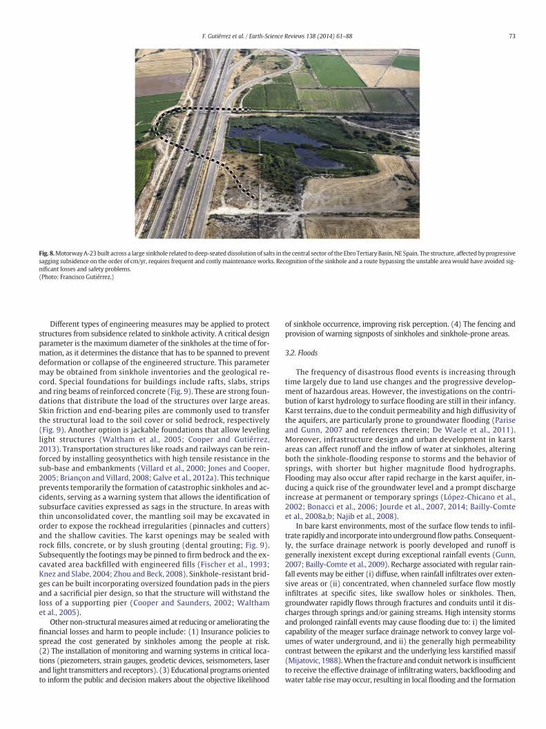
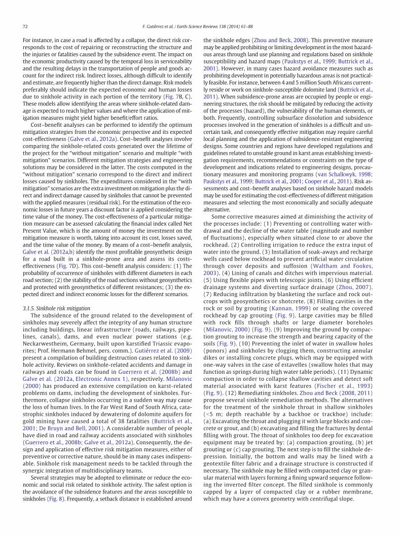
Fig. 8.MotorwayA-23 built across a large sinkhole related to deep-seated dissolution of salts in the central sector of the Ebro Tertiary Basin, NE Spain. The structure, affected by progressivesagging subsidence on the order of cm/yr, requires frequent and costly maintenance works. Recognition of the sinkhole and a route bypassing the unstable area would have avoided sig-nificant losses and safety problems.(Photo: Francisco Gutiérrez.)
73F. Gutiérrez et al. / Earth-Science Reviews 138 (2014) 61–88
Different types of engineering measures may be applied to protectstructures from subsidence related to sinkhole activity. A critical designparameter is themaximum diameter of the sinkholes at the time of for-mation, as it determines the distance that has to be spanned to preventdeformation or collapse of the engineered structure. This parametermay be obtained from sinkhole inventories and the geological re-cord. Special foundations for buildings include rafts, slabs, stripsand ring beams of reinforced concrete (Fig. 9). These are strong foun-dations that distribute the load of the structures over large areas.Skin friction and end-bearing piles are commonly used to transferthe structural load to the soil cover or solid bedrock, respectively(Fig. 9). Another option is jackable foundations that allow levelinglight structures (Waltham et al., 2005; Cooper and Gutiérrez,2013). Transportation structures like roads and railways can be rein-forced by installing geosynthetics with high tensile resistance in thesub-base and embankments (Villard et al., 2000; Jones and Cooper,2005; Briançon and Villard, 2008; Galve et al., 2012a). This techniqueprevents temporarily the formation of catastrophic sinkholes and ac-cidents, serving as a warning system that allows the identification ofsubsurface cavities expressed as sags in the structure. In areas withthin unconsolidated cover, the mantling soil may be excavated inorder to expose the rockhead irregularities (pinnacles and cutters)and the shallow cavities. The karst openings may be sealed withrock fills, concrete, or by slush grouting (dental grouting; Fig. 9).Subsequently the footingsmay be pinned to firm bedrock and the ex-cavated area backfilled with engineered fills (Fischer et al., 1993;Knez and Slabe, 2004; Zhou and Beck, 2008). Sinkhole-resistant brid-ges can be built incorporating oversized foundation pads in the piersand a sacrificial pier design, so that the structure will withstand theloss of a supporting pier (Cooper and Saunders, 2002; Walthamet al., 2005).
Other non-structuralmeasures aimed at reducing or ameliorating thefinancial losses and harm to people include: (1) Insurance policies tospread the cost generated by sinkholes among the people at risk.(2) The installation of monitoring and warning systems in critical loca-tions (piezometers, strain gauges, geodetic devices, seismometers, laserand light transmitters and receptors). (3) Educational programs orientedto inform the public and decision makers about the objective likelihood
of sinkhole occurrence, improving risk perception. (4) The fencing andprovision of warning signposts of sinkholes and sinkhole-prone areas.
3.2. Floods
The frequency of disastrous flood events is increasing throughtime largely due to land use changes and the progressive develop-ment of hazardous areas. However, the investigations on the contri-bution of karst hydrology to surface flooding are still in their infancy.Karst terrains, due to the conduit permeability and high diffusivity ofthe aquifers, are particularly prone to groundwater flooding (Pariseand Gunn, 2007 and references therein; De Waele et al., 2011).Moreover, infrastructure design and urban development in karstareas can affect runoff and the inflow of water at sinkholes, alteringboth the sinkhole-flooding response to storms and the behavior ofsprings, with shorter but higher magnitude flood hydrographs.Flooding may also occur after rapid recharge in the karst aquifer, in-ducing a quick rise of the groundwater level and a prompt dischargeincrease at permanent or temporary springs (López-Chicano et al.,2002; Bonacci et al., 2006; Jourde et al., 2007, 2014; Bailly-Comteet al., 2008a,b; Najib et al., 2008).
In bare karst environments, most of the surface flow tends to infil-trate rapidly and incorporate into undergroundflowpaths. Consequent-ly, the surface drainage network is poorly developed and runoff isgenerally inexistent except during exceptional rainfall events (Gunn,2007; Bailly-Comte et al., 2009). Recharge associated with regular rain-fall events may be either (i) diffuse, when rainfall infiltrates over exten-sive areas or (ii) concentrated, when channeled surface flow mostlyinfiltrates at specific sites, like swallow holes or sinkholes. Then,groundwater rapidly flows through fractures and conduits until it dis-charges through springs and/or gaining streams. High intensity stormsand prolonged rainfall events may cause flooding due to: i) the limitedcapability of the meager surface drainage network to convey large vol-umes of water underground, and ii) the generally high permeabilitycontrast between the epikarst and the underlying less karstified massif(Mijatovic, 1988).When the fracture and conduit network is insufficientto receive the effective drainage of infiltrating waters, backflooding andwater table risemay occur, resulting in local flooding and the formation
Fig. 9. Engineering measures that may be applied to reduce sinkholes hazard and prevent subsidence on constructions.
74 F. Gutiérrez et al. / Earth-Science Reviews 138 (2014) 61–88
of temporary lakes (White and Reich, 1970; White and White, 1984;Mijatovic, 1988; Lopez et al., 2009). Damages are common in these sit-uations, since man-made structures and human activities tend to beconcentrated on the flat and fertile bottom of the depressions.
In karst environments the understanding of floods requires the con-sideration of a conceptual model accounting for different components(i.e., matrix, fracture and conduit) that exhibit distinct hydrodynamicresponse to rainfall events (Worthington, 1999; White, 2002) orpumping (Jazayeri et al., 2011). These components play different rolesin the hydrology of karst systems due to their different size, distribution
and associated flow kinematics (White and White, 2005). Primary po-rosity is associated with intragranular permeability of the bulk rock, aswell as small solution voids and microfissures (Motyka, 1998). Second-ary porosity is related to discontinuity planes, including joints, faultsand bedding plane partings. Tertiary porosity consists of enlargedpipe- and fissure-like dissolution pathways, commonly related tosolutionally enlarged discontinuity planes (Ford and Williams, 2007).
Floods in karst environments thus depend on the spatial distributionand characteristics of the aforementioned features, and can be attribut-ed to one or both of two reasons: i) flow into the karst from allogenic
75F. Gutiérrez et al. / Earth-Science Reviews 138 (2014) 61–88
sources exceeds the capacity of epikarst and ponors to absorb it;ii) the recharge of the aquifer exceeds its capacity to dischargethrough the springs, and water backs up underground to spill overand flood the surface. In both cases, water table rise may occur, inturn, in two different ways: fast and high groundwater level rise inzones of high hydraulic diffusivity, and slow water table rise inzones with low hydraulic diffusivity. Whatever the dominant pro-cesses involved in flooding, two different cases can be differentiated:1) Karst terrain flooding and 2) river flooding in karst watersheds.
3.2.1. Karst terrain floodingAlthough references to flooding from groundwater are rather limit-
ed, this special kind of phenomenon has recently been described in sev-eral karst areas (e.g., López-Chicano et al., 2002; Pinault et al., 2005;Bonacci et al., 2006; Najib et al., 2008). When groundwater levels risesignificantly due to extreme rainfall events, the water table can reachthe topographic surface generating floods (Price et al., 2000; Négreland Petelet-Giraud, 2005). Water table changes can affect the wholeaquifer or part of it, particularly in karst reservoirs that are partitionedinto compartments with distinct hydrodynamic properties. In thesecontexts, water table changes can be spatially and temporarily hetero-geneous and the rise of groundwater levels can cause the activation ofnumerous temporary springs at unexpected sites, resulting in signifi-cant damage.
Groundwater level fluctuations are linked to the recharge potentialand the hydrodynamic response of the underground reservoir. The re-charge potential largely depends on factors like the precipitation attri-butes and the surface infiltration capability, which in turn isconditioned by antecedent conditions. The hydrodynamic response de-pends on the hydraulic diffusivity parameter which controls the pres-sure transfer processes. Rapid and significant water table rises occur inkarst aquifers with high diffusivity coefficient, with rates as high as30 mh−1 (Bonacci, 1987, 1995) and magnitudes higher than 100 m.
The catastrophic flood of February 1986 in Cetinje Polje, with nopre-cedent over the 500-year long written history of the old Montenegrincapital, offered an excellent opportunity to examine some features ofthe complex hydrogeologic behavior of karst (Mijatovic, 1988). Theflood was caused by the exceptional coincidence of three hydro-meteorological factors: severe precipitation, warm winds, and snowmelting. A total rainfall of around 670 mm fell in the polje drainagearea between 16 and 20 February 1986, with destructive effects on thetown of Cetinje, where tens of houses were flooded. The simultaneoussudden temperature rise, caused by warm southerly wind, transformedthe snowfall into rainfall, which in turn caused the fast melting of a 0.7–1 m thick snow cover. This superposed water input, almost instantlypercolating through the epikarst, could not be conveyed by the deeperendokarst drainage system. Moreover, rapid recharge in the aquiferled to an almost simultaneous rise of more than 20 m in the watertable, showing (i) the limited storage capacity and high diffusivity ofthe endokarst drainage system and (ii) the higher hydraulic conductiv-ity of the epikarst than that of the underlying underground drainagesystem. After this catastrophic flood event, a tunnel was excavated forthe diversion of runoff towards an adjacent valley to prevent flooding.
Similar phenomena involving engineeringworks to preventfloodingwere reported by Parise (2003) at Castellana-Grotte, southern Italy. Thetown is located at the lowest part of a catchment, where surface runoffaccumulated on the occasion of themajor rainstorms, following the net-work of slightly-incised karst valleys, locally called “lame”. After repeat-ed damaging floods, including the severe 9 November 1896 event,engineering works were performed to enhance water infiltration. Fourdeep natural shaftswere connected through tunnels to create an under-ground system able to absorb large amounts of infiltration to preventsurface flooding during heavy rainstorms. After completion of these en-gineering works in 1911, only minor floods were recorded.
At scales smaller than the single catchment, water table rises canalso result in local groundwater ponding, particularly in low-lying
areas such as closed karst depressions and blind valleys. There, tempo-rary ponds may appear due to water table rises above the topographicsurface, or be formed because of changes in the behavior of swallowholes when surface water flow exceeds their absorption capacity(Fig. 10). As a result, the water level increases abruptly giving rise to alake and backfloodingwith only surfacewater contribution. This behav-ior is common in blind valleys and closed depressions, such as poljes ofthe Classical Karst (Kovačič and Ravbar, 2010) or turloughs, mainlyknown in the Republic of Ireland. Turloughs are transient karst lakes re-currently affected by floods that result from high groundwater levels intopographic depressions, plus, in some cases, lateral inflow from adja-cent catchments (Naughton et al., 2012). They are intermittently inun-dated on an annual basis, mainly from groundwater, and have asubstrate and/or ecological communities characteristic of wetlands.When excess recharge cannot be accommodated by the karst aquiferdue to insufficient aquifer storage or flow capacity, groundwater levelsrise and surface runoff inundate poljes or turlough basins.
The hydrological functioning of turloughs can be described as a func-tion of two general conceptual models (Naughton et al., 2012): theflow-through system and the surcharged tank (Fig. 11), both potentiallyreceiving inflows from proximal and distal catchment areas. The princi-pal difference between the twomodels is the timing and interaction be-tween inflow and outflow. In the flow-through model (Fig. 11A) bothinflow and outflow occur simultaneously and largely independentlywithin the turlough basin. In the surcharged tank model (Fig. 11B),the turlough acts as an overflow storage for the underlying karst flownetwork, essentially accumulating excess groundwater that cannot beaccommodated by the karst due to insufficient capacity. In this case,there is nooutflowduringfilling periods, while during recession periodsonly inflow derived from the proximal catchment still enters theturlough.
Depressions with hydrological behavior similar to turloughs havebeen reported in Wales, Slovenia, Spain and Canada (Blackstock et al.,1993; Goodwillie and Reynolds, 2003; Sheehy-Skeffington and Scott,2008). From a hydrogeological standpoint, turloughs have been com-pared to poljes, as both display periodic inundation and lacustrine depo-sition, with the same difficulty of measuring inflows and outflows, andthe associated water budget (Bonacci, 1987). However, they differgeomorphologically: turloughs are small basins with gentle sides,whereas poljes are characterized by extremely flat floors andstructurally-controlledmargins (Gunn, 2006; Ford andWilliams, 2007).
3.2.2. River flooding in karst watershedsThe hydrological behavior of lowland karst areas is largely con-
trolled by complex interactions between underground and surfacewaters (White and White, 1984; Gunn, 2007). Water is lost to andgained from groundwater sources via diffuse infiltration, swallowholes, estavelles and springs, depending on the prevailing hydrolog-ical conditions. Underground and surface processes must be consid-ered as a whole to better assess the dynamics of floods at the scale ofa karst system traversed by a river that may feed the aquifer with al-logenic recharge. Such hydrologic systems are particularly prone togroundwater/surface water (GW/SW) interactions during floods.
Due to the variable interconnections between streams and the dif-ferent permeability components of karst aquifers, GW/SW interactionsare particularly complex. In order to explain these hydrodynamic inter-actions at different spatial scales, various classifications of GW/SW ex-changes have been proposed (Dahl et al., 2007; Bailly-Comte et al.,2009). In these classifications river reaches are described according to(i) the type of hydraulic connection and (ii) the flow direction of thesurface water and the groundwater (Fig. 12). In theory, perched-losingand connected-losing reaches of a river occur in the upstream part ofthe watershed, and are separated by a hypothetical hinge line fromthe downstream connected-gaining reaches (Sophocleous, 2002). Inpractice, river reaches gain or lose water according to the variable
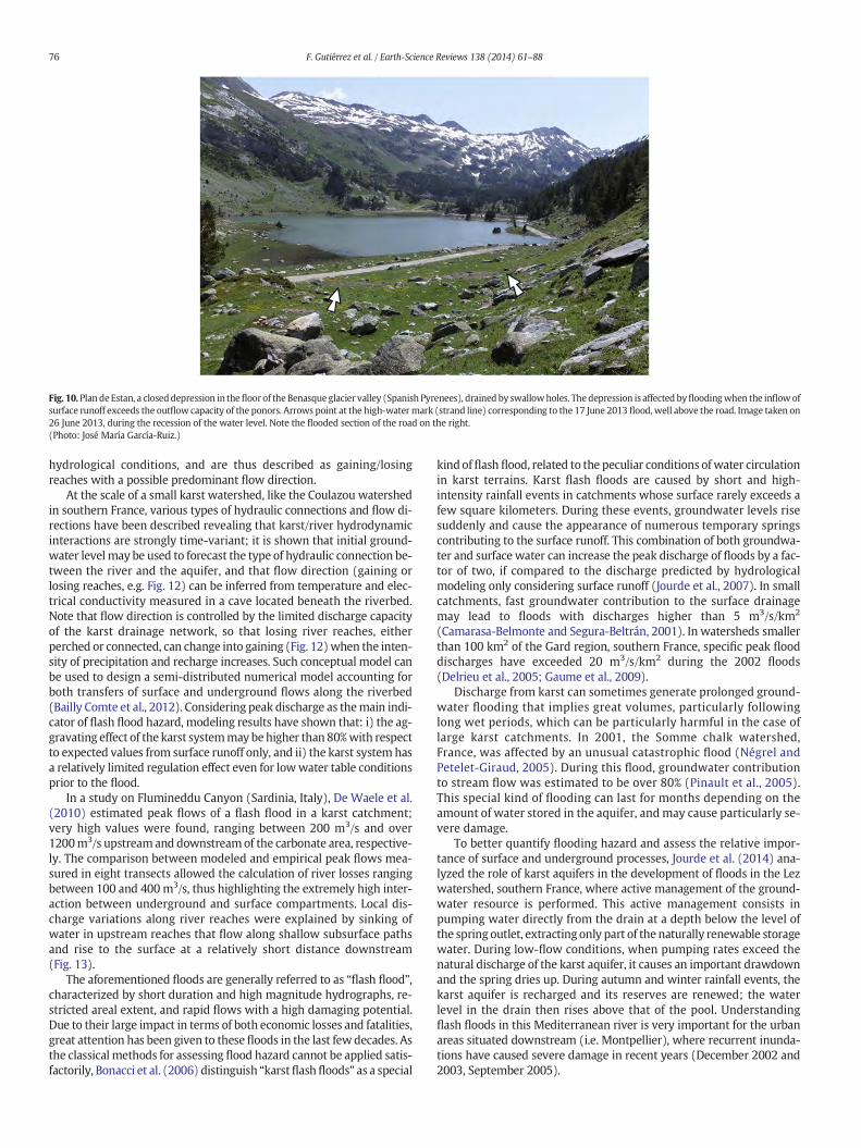
Fig. 10. Plan deEstan, a closeddepression in thefloor of theBenasqueglacier valley (Spanish Pyrenees), drained by swallowholes. Thedepression is affected byfloodingwhen the inflowofsurface runoff exceeds the outflow capacity of the ponors. Arrows point at the high-watermark (strand line) corresponding to the 17 June 2013 flood,well above the road. Image taken on26 June 2013, during the recession of the water level. Note the flooded section of the road on the right.(Photo: José María García-Ruiz.)
76 F. Gutiérrez et al. / Earth-Science Reviews 138 (2014) 61–88
hydrological conditions, and are thus described as gaining/losingreaches with a possible predominant flow direction.
At the scale of a small karst watershed, like the Coulazou watershedin southern France, various types of hydraulic connections and flow di-rections have been described revealing that karst/river hydrodynamicinteractions are strongly time-variant; it is shown that initial ground-water level may be used to forecast the type of hydraulic connection be-tween the river and the aquifer, and that flow direction (gaining orlosing reaches, e.g. Fig. 12) can be inferred from temperature and elec-trical conductivity measured in a cave located beneath the riverbed.Note that flow direction is controlled by the limited discharge capacityof the karst drainage network, so that losing river reaches, eitherperched or connected, can change into gaining (Fig. 12)when the inten-sity of precipitation and recharge increases. Such conceptual model canbe used to design a semi-distributed numerical model accounting forboth transfers of surface and underground flows along the riverbed(Bailly Comte et al., 2012). Considering peak discharge as themain indi-cator of flash flood hazard, modeling results have shown that: i) the ag-gravating effect of the karst systemmay behigher than 80%with respectto expected values from surface runoff only, and ii) the karst system hasa relatively limited regulation effect even for lowwater table conditionsprior to the flood.
In a study on Flumineddu Canyon (Sardinia, Italy), De Waele et al.(2010) estimated peak flows of a flash flood in a karst catchment;very high values were found, ranging between 200 m3/s and over1200m3/s upstreamand downstreamof the carbonate area, respective-ly. The comparison between modeled and empirical peak flows mea-sured in eight transects allowed the calculation of river losses rangingbetween 100 and 400m3/s, thus highlighting the extremely high inter-action between underground and surface compartments. Local dis-charge variations along river reaches were explained by sinking ofwater in upstream reaches that flow along shallow subsurface pathsand rise to the surface at a relatively short distance downstream(Fig. 13).
The aforementioned floods are generally referred to as “flash flood”,characterized by short duration and high magnitude hydrographs, re-stricted areal extent, and rapid flows with a high damaging potential.Due to their large impact in terms of both economic losses and fatalities,great attention has been given to thesefloods in the last fewdecades. Asthe classical methods for assessing flood hazard cannot be applied satis-factorily, Bonacci et al. (2006) distinguish “karstflashfloods” as a special
kind offlash flood, related to the peculiar conditions ofwater circulationin karst terrains. Karst flash floods are caused by short and high-intensity rainfall events in catchments whose surface rarely exceeds afew square kilometers. During these events, groundwater levels risesuddenly and cause the appearance of numerous temporary springscontributing to the surface runoff. This combination of both groundwa-ter and surfacewater can increase the peak discharge of floods by a fac-tor of two, if compared to the discharge predicted by hydrologicalmodeling only considering surface runoff (Jourde et al., 2007). In smallcatchments, fast groundwater contribution to the surface drainagemay lead to floods with discharges higher than 5 m3/s/km2
(Camarasa-Belmonte and Segura-Beltrán, 2001). In watersheds smallerthan 100 km2 of the Gard region, southern France, specific peak flooddischarges have exceeded 20 m3/s/km2 during the 2002 floods(Delrieu et al., 2005; Gaume et al., 2009).
Discharge from karst can sometimes generate prolonged ground-water flooding that implies great volumes, particularly followinglong wet periods, which can be particularly harmful in the case oflarge karst catchments. In 2001, the Somme chalk watershed,France, was affected by an unusual catastrophic flood (Négrel andPetelet-Giraud, 2005). During this flood, groundwater contributionto stream flow was estimated to be over 80% (Pinault et al., 2005).This special kind of flooding can last for months depending on theamount of water stored in the aquifer, andmay cause particularly se-vere damage.
To better quantify flooding hazard and assess the relative impor-tance of surface and underground processes, Jourde et al. (2014) ana-lyzed the role of karst aquifers in the development of floods in the Lezwatershed, southern France, where active management of the ground-water resource is performed. This active management consists inpumping water directly from the drain at a depth below the level ofthe spring outlet, extracting only part of the naturally renewable storagewater. During low-flow conditions, when pumping rates exceed thenatural discharge of the karst aquifer, it causes an important drawdownand the spring dries up. During autumn and winter rainfall events, thekarst aquifer is recharged and its reserves are renewed; the waterlevel in the drain then rises above that of the pool. Understandingflash floods in this Mediterranean river is very important for the urbanareas situated downstream (i.e. Montpellier), where recurrent inunda-tions have caused severe damage in recent years (December 2002 and2003, September 2005).
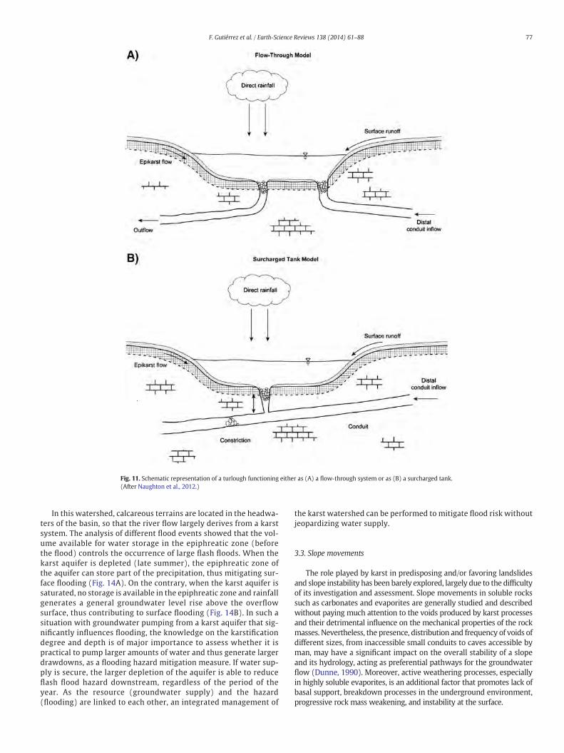
Fig. 11. Schematic representation of a turlough functioning either as (A) a flow-through system or as (B) a surcharged tank.(After Naughton et al., 2012.)
77F. Gutiérrez et al. / Earth-Science Reviews 138 (2014) 61–88
In this watershed, calcareous terrains are located in the headwa-ters of the basin, so that the river flow largely derives from a karstsystem. The analysis of different flood events showed that the vol-ume available for water storage in the epiphreatic zone (beforethe flood) controls the occurrence of large flash floods. When thekarst aquifer is depleted (late summer), the epiphreatic zone ofthe aquifer can store part of the precipitation, thus mitigating sur-face flooding (Fig. 14A). On the contrary, when the karst aquifer issaturated, no storage is available in the epiphreatic zone and rainfallgenerates a general groundwater level rise above the overflowsurface, thus contributing to surface flooding (Fig. 14B). In such asituation with groundwater pumping from a karst aquifer that sig-nificantly influences flooding, the knowledge on the karstificationdegree and depth is of major importance to assess whether it ispractical to pump larger amounts of water and thus generate largerdrawdowns, as a flooding hazard mitigation measure. If water sup-ply is secure, the larger depletion of the aquifer is able to reduceflash flood hazard downstream, regardless of the period of theyear. As the resource (groundwater supply) and the hazard(flooding) are linked to each other, an integrated management of
the karst watershed can be performed to mitigate flood risk withoutjeopardizing water supply.
3.3. Slope movements
The role played by karst in predisposing and/or favoring landslidesand slope instability has been barely explored, largely due to the difficultyof its investigation and assessment. Slope movements in soluble rockssuch as carbonates and evaporites are generally studied and describedwithout paying much attention to the voids produced by karst processesand their detrimental influence on the mechanical properties of the rockmasses. Nevertheless, the presence, distribution and frequency of voids ofdifferent sizes, from inaccessible small conduits to caves accessible byman, may have a significant impact on the overall stability of a slopeand its hydrology, acting as preferential pathways for the groundwaterflow (Dunne, 1990). Moreover, active weathering processes, especiallyin highly soluble evaporites, is an additional factor that promotes lack ofbasal support, breakdown processes in the underground environment,progressive rock mass weakening, and instability at the surface.
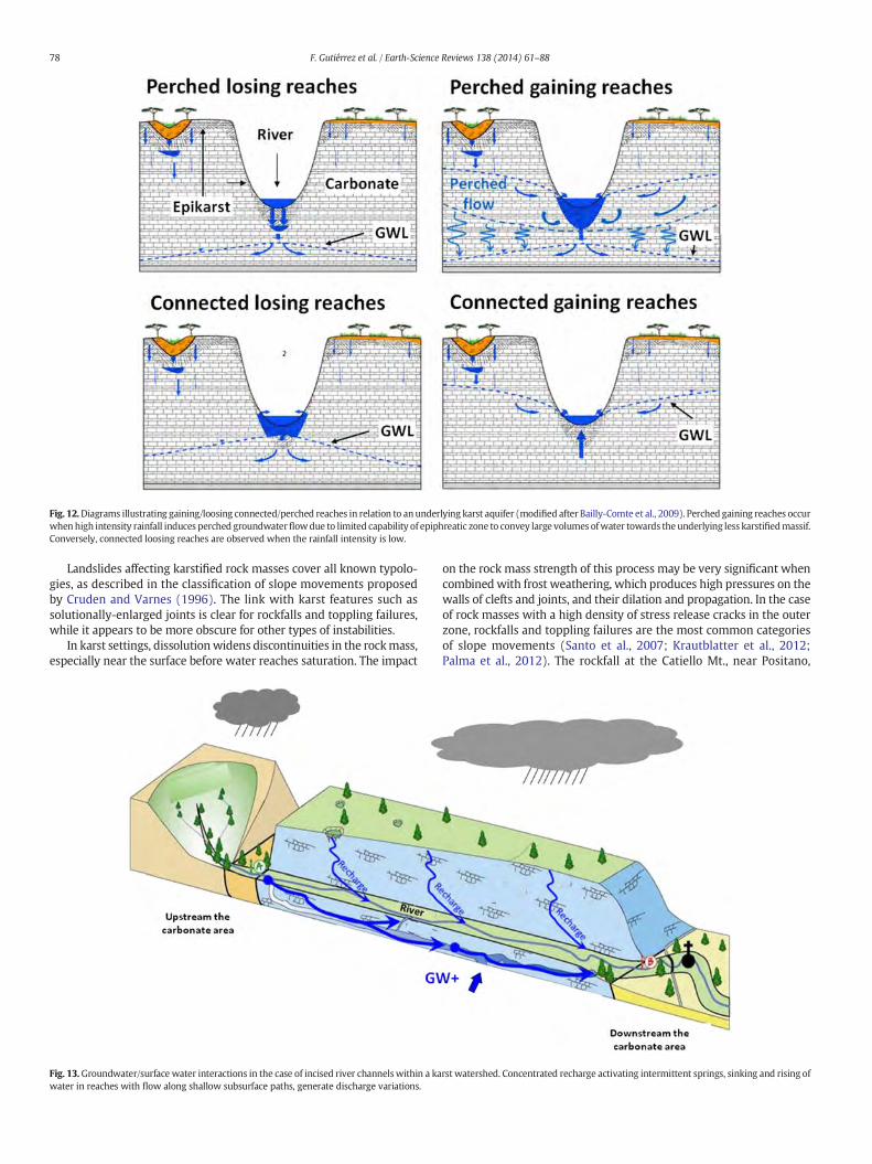
Fig. 12.Diagrams illustrating gaining/loosing connected/perched reaches in relation to anunderlying karst aquifer (modified after Bailly-Comte et al., 2009). Perched gaining reaches occurwhenhigh intensity rainfall induces perched groundwaterflowdue to limited capability of epiphreatic zone to convey large volumes ofwater towards theunderlying less karstifiedmassif.Conversely, connected loosing reaches are observed when the rainfall intensity is low.
78 F. Gutiérrez et al. / Earth-Science Reviews 138 (2014) 61–88
Landslides affecting karstified rock masses cover all known typolo-gies, as described in the classification of slope movements proposedby Cruden and Varnes (1996). The link with karst features such assolutionally-enlarged joints is clear for rockfalls and toppling failures,while it appears to be more obscure for other types of instabilities.
In karst settings, dissolutionwidens discontinuities in the rockmass,especially near the surface before water reaches saturation. The impact
Fig. 13.Groundwater/surface water interactions in the case of incised river channelswithin a kawater in reaches with flow along shallow subsurface paths, generate discharge variations.
on the rock mass strength of this process may be very significant whencombinedwith frost weathering, which produces high pressures on thewalls of clefts and joints, and their dilation and propagation. In the caseof rock masses with a high density of stress release cracks in the outerzone, rockfalls and toppling failures are the most common categoriesof slope movements (Santo et al., 2007; Krautblatter et al., 2012;Palma et al., 2012). The rockfall at the Catiello Mt., near Positano,
rst watershed. Concentrated recharge activating intermittent springs, sinking and rising of
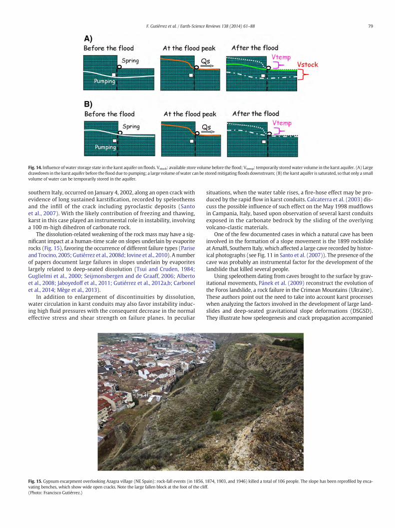
Fig. 14. Influence ofwater storage state in the karst aquifer on floods. Vstock: available store volume before the flood; Vtemp: temporarily storedwater volume in the karst aquifer. (A) Largedrawdown in the karst aquifer before theflood due to pumping; a large volume ofwater can be storedmitigating floods downstream; (B) the karst aquifer is saturated, so that only a smallvolume of water can be temporarily stored in the aquifer.
79F. Gutiérrez et al. / Earth-Science Reviews 138 (2014) 61–88
southern Italy, occurred on January 4, 2002, along an open crack withevidence of long sustained karstification, recorded by speleothemsand the infill of the crack including pyroclastic deposits (Santoet al., 2007). With the likely contribution of freezing and thawing,karst in this case played an instrumental role in instability, involvinga 100 m-high dihedron of carbonate rock.
The dissolution-related weakening of the rock mass may have a sig-nificant impact at a human-time scale on slopes underlain by evaporiterocks (Fig. 15), favoring the occurrence of different failure types (Pariseand Trocino, 2005; Gutiérrez et al., 2008d; Iovine et al., 2010). A numberof papers document large failures in slopes underlain by evaporiteslargely related to deep-seated dissolution (Tsui and Cruden, 1984;Guglielmi et al., 2000; Seijmonsbergen and de Graaff, 2006; Albertoet al., 2008; Jaboyedoff et al., 2011; Gutiérrez et al., 2012a,b; Carbonelet al., 2014; Mège et al., 2013).
In addition to enlargement of discontinuities by dissolution,water circulation in karst conduits may also favor instability induc-ing high fluid pressures with the consequent decrease in the normaleffective stress and shear strength on failure planes. In peculiar
Fig. 15. Gypsum escarpment overlooking Azagra village (NE Spain): rock-fall events (in 1856,vating benches, which show wide open cracks. Note the large fallen block at the foot of the cli(Photo: Francisco Gutiérrez.)
situations, when the water table rises, a fire-hose effect may be pro-duced by the rapid flow in karst conduits. Calcaterra et al. (2003) dis-cuss the possible influence of such effect on the May 1998 mudflowsin Campania, Italy, based upon observation of several karst conduitsexposed in the carbonate bedrock by the sliding of the overlyingvolcano-clastic materials.
One of the few documented cases in which a natural cave has beeninvolved in the formation of a slope movement is the 1899 rockslideat Amalfi, Southern Italy, which affected a large cave recorded by histor-ical photographs (see Fig. 11 in Santo et al. (2007)). The presence of thecave was probably an instrumental factor for the development of thelandslide that killed several people.
Using speleothem dating from caves brought to the surface by grav-itational movements, Pánek et al. (2009) reconstruct the evolution ofthe Foros landslide, a rock failure in the Crimean Mountains (Ukraine).These authors point out the need to take into account karst processeswhen analyzing the factors involved in the development of large land-slides and deep-seated gravitational slope deformations (DSGSD).They illustrate how speleogenesis and crack propagation accompanied
1874, 1903, and 1946) killed a total of 106 people. The slope has been reprofiled by exca-ff.
80 F. Gutiérrez et al. / Earth-Science Reviews 138 (2014) 61–88
by dissolution may create favorable conditions for the development oflarge rock slope failures in carbonate massifs.
In long-lasting landslides like DSGSD, karstification and the conse-quent weakening of the rock massif may act as a predisposing factorsince the onset of the slope movement. As Pánek et al. (2009, p. 180)propose, the role played by “karstification as a preparatory factor ofthe development of catastrophic slope failures in mountainous settingsshould be the objective of future studies”. In fact, some of the largestsubaerial landslides in the world affected carbonate and/or evaporitebedrock (Muller, 1964, 1968; McGill and Stromquist, 1979; Prageret al., 2008; Ivy-Ochs et al., 2009; Gutiérrez et al., 2012b). The develop-ment of large and catastrophic translational landslides in carbonate suc-cessions is typically favored by the presence of laterally extensive andextremely planar bedding planes. One of the most famous examples isthe 36.5 hm3 Frank rockslide-avalanche, which destroyed the southernend of the town of Frank in southwestern Alberta, Canada (Cruden andKrahn, 1978; Jaboyedoff et al., 2009). Even more disastrous was the1963 Vajont translational slide in northeastern Italy, that fell into a res-ervoir generating a huge impulse water wave. The tsunami overtoppedthe concrete dam leading to a sudden catastrophicflood that completelydestroyed some villages in the Piave Valley killing over 2000 people(Muller, 1964, 1968; Hendron and Patton, 1985; Semenza andGhirotti, 2000; Kilburn and Petley, 2003). In both cases, karstified lime-stones were involved in the movement, but the role played by dissolu-tion processes and karst features on slope stability and the kinematicsof the landslides remains unresolved.
In cases where deep-seated dissolution involves large rock masses,the effects are felt at the slope scale, as shown in several Alpine orogens(Tognini and Bini, 2001; Alberto et al., 2008; Gutiérrez et al., 2012b;Carbonel et al., 2014). These instability phenomena typically show aparticularly high vertical displacement component related to subsi-dence above the karstified zone, in addition to the outward displace-ment typical of landslides.
Another situation in which karst features are described or at leasthypothesized as likely factors predisposing to slope movements isrock failures in coastal cliffs, due to deepening of coastal caves and/ornotches (Vallejo, 2012).
4. Assessing human impacts on the karst environment
Earth's landscapes are the result of a series of processes that may actcontinuously or during discrete events occurring with different tempo-ral frequencies. Landscapes have been shaped, destroyed, and rebuiltagain over geological times, in a natural cycle. In recent times, besidesthe complex suite of natural processes, the human factor has startedplaying an important role interfering directly (e.g. urban development)and indirectly (e.g. global warming) with the environment. The assess-ment of natural and anthropogenic impacts on the environment is ofcrucial importance for reducing the negative effects and promoting sus-tainable development. These assessments are common practice and aregenerally based on a set of biological and physical-chemical indicators(Bain et al., 2000).
In the past, notwithstanding the rugged topography and the paucityof surface water, humans tended to live close to karst areas, where themajority of springs are located. The increase in human population hasprogressively led people to occupy more karst areas and build new set-tlements and infrastructures (Parise et al., 2009).
Karst environments and the groundwaters associated with them arehighly vulnerable and sensitive to human alterations. The FAO (Foodand Agriculture Organization of the United Nations) forecasts that be-fore 2025 at least 80% of the demand of drinkable water in theMediter-ranean Basin will be derived from karst aquifers. This highlights theurgent need of adequately protecting this resource from actions thatmay have adverse effects on its quality and availability (White, 1988,2002; Bakalowicz, 2005). Protection of karst environments is a manda-tory step to maintain, safeguard and transmit its extreme richness and
biodiversity to future generations. This is a challenging task due to theincreasing impact posed by human activities on the karst environments(Table 3).
Especially in lowland karst, due to the scarce relief and the subduedfeatures, many landforms may be lost due to anthropogenic activitiessuch as intense quarrying, stone clearing and crushing practices(Gunn, 1993; Parise and Pascali, 2003; Delle Rose et al., 2007; Canoraet al., 2008). Land use changes also results in degradation of the epikarst(Williams, 1983, 2008), which, even in areas where it has a reducedthickness, provides a vital function for karst ecosystems (Pipan andCulver, 2013), controlling runoff infiltration.
Further, the expansion of urban areas (including communicationroutes and industrial facilities) in karst is leading to an increasing num-ber of pollution events, with severe consequences on the karst ecosys-tems and the quality of groundwater (De Waele and Follesa, 2004).The situation is evenmore exacerbated in post-conflict scenarios, as ex-perienced for instance in karst areas in the Balkans (Calò and Parise,2009). Actions must therefore be undertaken to assess the negative im-pacts of the increasing pressure on the fragile karst environment andminimize them.
Tourist exploitation in karst may have high impact if not reachedthrough a careful evaluation of the deriving effects. Opening of showcaves, for instance, must consider and respect the “visitor capacity”,that is “that flowof visitors into a defined cave that confines the changesin itsmain environmental parameters within the natural ranges of theirfluctuation” (Cigna and Forti, 1988).
Environmental Impact Assessments (EIA) of anthropogenic activi-ties have become a mandatory requisite during the pre-approval stageof projects not only in Europe and America, but also in many other de-veloped countries. These EIAs are often based on general indices thattake into account the environmental, social and economic impacts,without taking into consideration thepeculiarities of specific landscapeslike those of karst terrains.
The protection of the karst environments, due to their intrinsic vul-nerability, unique hydrological behavior, and exceptional subterraneanecosystems, requires specific approaches andmeasures (Veni, 1999). Inkarst, it is preferable to undertake vulnerability assessments startingwith a hydrogeological EIA, given the direct relationships between thesurface and subsurface environments and the peculiar hydrologic re-gime. Subsequently, other fields of research should be investigated, de-pending on the study area.
The intrinsic vulnerability of karst aquifers to pollution may beassessed through the hydrogeological and geological parametersthat determine the sensitivity of groundwater to contamination byhuman activities (Molerio-León and Parise, 2009; Farfán-Gonzálezet al., 2010), and is independent of the nature of the contaminantsand how these are introduced into the system (Dörfliger et al.,1999; Zwahlen, 2004). A number of methods have been proposedto evaluate the vulnerability of karst aquifers, mostly based on GISmethodologies. Some of these methods have been developed for po-rous and fissured aquifers, such as DRASTIC (Aller et al., 1987), AVI(van Stempoort et al., 1993), SINTACS (Civita and De Maio, 1997),and PI (Goldscheider et al., 2000). Other methods were specificallydesigned for karst aquifer vulnerability mapping: EPIK (Dörfligeret al., 1999), COP (Vìas et al., 2006), the Slovene approach (Ravbarand Goldscheider, 2007), and PaPRIKa (Kavouri et al., 2011). Theuse of multiple methods in a specific karst area commonly resultsin different vulnerability maps (Gogu and Dassargues, 2000;Neukum et al., 2008; Ravbar and Goldscheider, 2009), in which reli-ability is strongly dependent upon quantity, quality, and interpreta-tion of the available data. Despite these differences, these mapsshould be used as a basis for protection zoning and land-use plan-ning, searching for an acceptable compromise between water pro-tection and economic interests.
Alongside the specific vulnerability assessments, the complexityof karst environments requires a more holistic approach to
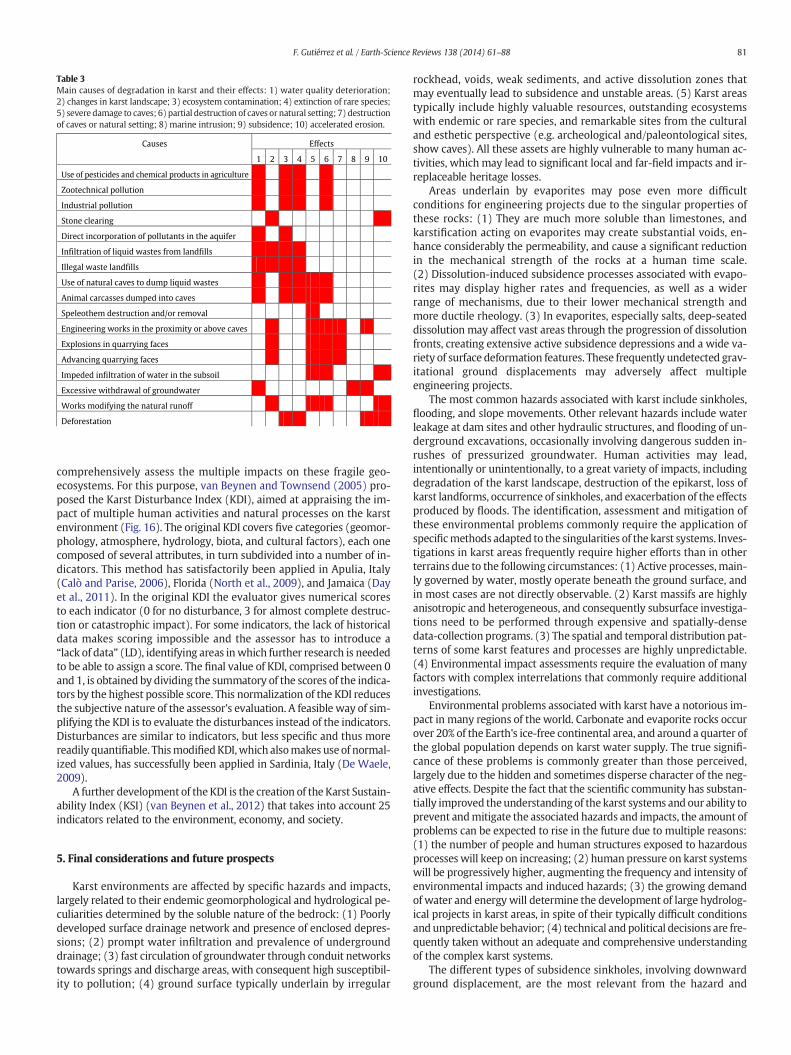
Table 3Main causes of degradation in karst and their effects: 1) water quality deterioration;2) changes in karst landscape; 3) ecosystem contamination; 4) extinction of rare species;5) severe damage to caves; 6) partial destruction of caves or natural setting; 7) destructionof caves or natural setting; 8) marine intrusion; 9) subsidence; 10) accelerated erosion.
Causes Effects
1 2 3 4 5 6 7 8 9 10
Zootechnical pollution
Industrial pollution
Stone clearing
Direct incorporation of pollutants in the aquifer
Infiltration of liquid wastes from landfills
Illegal waste landfills
Use of natural caves to dump liquid wastes
Animal carcasses dumped into caves
Speleothem destruction and/or removal
Engineering works in the proximity or above caves
Explosions in quarrying faces
Advancing quarrying faces
Impeded infiltration of water in the subsoil
Excessive withdrawal of groundwater
Works modifying the natural runoff
Deforestation
Use of pesticides and chemical products in agriculture
81F. Gutiérrez et al. / Earth-Science Reviews 138 (2014) 61–88
comprehensively assess the multiple impacts on these fragile geo-ecosystems. For this purpose, van Beynen and Townsend (2005) pro-posed the Karst Disturbance Index (KDI), aimed at appraising the im-pact of multiple human activities and natural processes on the karstenvironment (Fig. 16). The original KDI covers five categories (geomor-phology, atmosphere, hydrology, biota, and cultural factors), each onecomposed of several attributes, in turn subdivided into a number of in-dicators. This method has satisfactorily been applied in Apulia, Italy(Calò and Parise, 2006), Florida (North et al., 2009), and Jamaica (Dayet al., 2011). In the original KDI the evaluator gives numerical scoresto each indicator (0 for no disturbance, 3 for almost complete destruc-tion or catastrophic impact). For some indicators, the lack of historicaldata makes scoring impossible and the assessor has to introduce a“lack of data” (LD), identifying areas inwhich further research is neededto be able to assign a score. The final value of KDI, comprised between 0and 1, is obtained by dividing the summatory of the scores of the indica-tors by the highest possible score. This normalization of the KDI reducesthe subjective nature of the assessor's evaluation. A feasible way of sim-plifying the KDI is to evaluate the disturbances instead of the indicators.Disturbances are similar to indicators, but less specific and thus morereadily quantifiable. ThismodifiedKDI,which alsomakes use of normal-ized values, has successfully been applied in Sardinia, Italy (De Waele,2009).
A further development of the KDI is the creation of the Karst Sustain-ability Index (KSI) (van Beynen et al., 2012) that takes into account 25indicators related to the environment, economy, and society.
5. Final considerations and future prospects
Karst environments are affected by specific hazards and impacts,largely related to their endemic geomorphological and hydrological pe-culiarities determined by the soluble nature of the bedrock: (1) Poorlydeveloped surface drainage network and presence of enclosed depres-sions; (2) prompt water infiltration and prevalence of undergrounddrainage; (3) fast circulation of groundwater through conduit networkstowards springs and discharge areas, with consequent high susceptibil-ity to pollution; (4) ground surface typically underlain by irregular
rockhead, voids, weak sediments, and active dissolution zones thatmay eventually lead to subsidence and unstable areas. (5) Karst areastypically include highly valuable resources, outstanding ecosystemswith endemic or rare species, and remarkable sites from the culturaland esthetic perspective (e.g. archeological and/paleontological sites,show caves). All these assets are highly vulnerable to many human ac-tivities, which may lead to significant local and far-field impacts and ir-replaceable heritage losses.
Areas underlain by evaporites may pose even more difficultconditions for engineering projects due to the singular properties ofthese rocks: (1) They are much more soluble than limestones, andkarstification acting on evaporites may create substantial voids, en-hance considerably the permeability, and cause a significant reductionin the mechanical strength of the rocks at a human time scale.(2) Dissolution-induced subsidence processes associated with evapo-rites may display higher rates and frequencies, as well as a widerrange of mechanisms, due to their lower mechanical strength andmore ductile rheology. (3) In evaporites, especially salts, deep-seateddissolution may affect vast areas through the progression of dissolutionfronts, creating extensive active subsidence depressions and a wide va-riety of surface deformation features. These frequently undetected grav-itational ground displacements may adversely affect multipleengineering projects.
The most common hazards associated with karst include sinkholes,flooding, and slope movements. Other relevant hazards include waterleakage at dam sites and other hydraulic structures, and flooding of un-derground excavations, occasionally involving dangerous sudden in-rushes of pressurized groundwater. Human activities may lead,intentionally or unintentionally, to a great variety of impacts, includingdegradation of the karst landscape, destruction of the epikarst, loss ofkarst landforms, occurrence of sinkholes, and exacerbation of the effectsproduced by floods. The identification, assessment and mitigation ofthese environmental problems commonly require the application ofspecificmethods adapted to the singularities of the karst systems. Inves-tigations in karst areas frequently require higher efforts than in otherterrains due to the following circumstances: (1) Active processes,main-ly governed by water, mostly operate beneath the ground surface, andin most cases are not directly observable. (2) Karst massifs are highlyanisotropic and heterogeneous, and consequently subsurface investiga-tions need to be performed through expensive and spatially-densedata-collection programs. (3) The spatial and temporal distribution pat-terns of some karst features and processes are highly unpredictable.(4) Environmental impact assessments require the evaluation of manyfactors with complex interrelations that commonly require additionalinvestigations.
Environmental problems associated with karst have a notorious im-pact in many regions of the world. Carbonate and evaporite rocks occurover 20% of the Earth's ice-free continental area, and around a quarter ofthe global population depends on karst water supply. The true signifi-cance of these problems is commonly greater than those perceived,largely due to the hidden and sometimes disperse character of the neg-ative effects. Despite the fact that the scientific community has substan-tially improved theunderstanding of the karst systems and our ability toprevent andmitigate the associated hazards and impacts, the amount ofproblems can be expected to rise in the future due to multiple reasons:(1) the number of people and human structures exposed to hazardousprocesses will keep on increasing; (2) humanpressure on karst systemswill be progressively higher, augmenting the frequency and intensity ofenvironmental impacts and induced hazards; (3) the growing demandof water and energy will determine the development of large hydrolog-ical projects in karst areas, in spite of their typically difficult conditionsand unpredictable behavior; (4) technical and political decisions are fre-quently taken without an adequate and comprehensive understandingof the complex karst systems.
The different types of subsidence sinkholes, involving downwardground displacement, are the most relevant from the hazard and
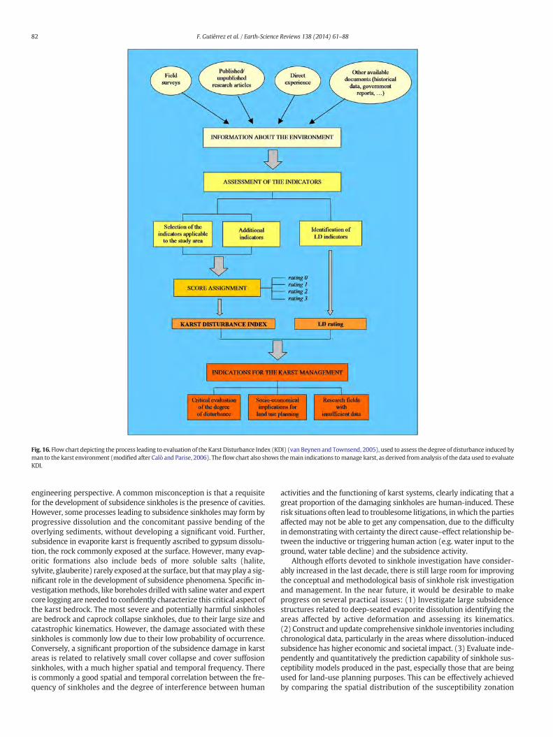
Fig. 16. Flow chart depicting the process leading to evaluation of the Karst Disturbance Index (KDI) (van Beynen and Townsend, 2005), used to assess the degree of disturbance induced byman to the karst environment (modified after Calò and Parise, 2006). The flow chart also shows themain indications tomanage karst, as derived from analysis of the data used to evaluateKDI.
82 F. Gutiérrez et al. / Earth-Science Reviews 138 (2014) 61–88
engineering perspective. A common misconception is that a requisitefor the development of subsidence sinkholes is the presence of cavities.However, some processes leading to subsidence sinkholes may form byprogressive dissolution and the concomitant passive bending of theoverlying sediments, without developing a significant void. Further,subsidence in evaporite karst is frequently ascribed to gypsum dissolu-tion, the rock commonly exposed at the surface. However, many evap-oritic formations also include beds of more soluble salts (halite,sylvite, glauberite) rarely exposed at the surface, but thatmayplay a sig-nificant role in the development of subsidence phenomena. Specific in-vestigationmethods, like boreholes drilledwith salinewater and expertcore logging are needed to confidently characterize this critical aspect ofthe karst bedrock. The most severe and potentially harmful sinkholesare bedrock and caprock collapse sinkholes, due to their large size andcatastrophic kinematics. However, the damage associated with thesesinkholes is commonly low due to their low probability of occurrence.Conversely, a significant proportion of the subsidence damage in karstareas is related to relatively small cover collapse and cover suffosionsinkholes, with a much higher spatial and temporal frequency. Thereis commonly a good spatial and temporal correlation between the fre-quency of sinkholes and the degree of interference between human
activities and the functioning of karst systems, clearly indicating that agreat proportion of the damaging sinkholes are human-induced. Theserisk situations often lead to troublesome litigations, in which the partiesaffected may not be able to get any compensation, due to the difficultyin demonstratingwith certainty the direct cause–effect relationship be-tween the inductive or triggering human action (e.g. water input to theground, water table decline) and the subsidence activity.
Although efforts devoted to sinkhole investigation have consider-ably increased in the last decade, there is still large room for improvingthe conceptual and methodological basis of sinkhole risk investigationand management. In the near future, it would be desirable to makeprogress on several practical issues: (1) Investigate large subsidencestructures related to deep-seated evaporite dissolution identifying theareas affected by active deformation and assessing its kinematics.(2) Construct and update comprehensive sinkhole inventories includingchronological data, particularly in the areas where dissolution-inducedsubsidence has higher economic and societal impact. (3) Evaluate inde-pendently and quantitatively the prediction capability of sinkhole sus-ceptibility models produced in the past, especially those that are beingused for land-use planning purposes. This can be effectively achievedby comparing the spatial distribution of the susceptibility zonation
83F. Gutiérrez et al. / Earth-Science Reviews 138 (2014) 61–88
and the sinkholes formed after development of themodels. Itmay comeout that in some areas relevant decisions are being taken on the basisof unreliable predictions. (4) Produce hazard models providing esti-mates on the spatial–temporal probability of occurrence of sinkholeswith different diameters, incorporating magnitude and frequencyscaling relationships. (6) Assess quantitatively indirect losses relatedto sinkholes, in addition to direct damage, in order to weight the trueeconomic dimension of these hazardous processes. (5) Investigatedifferent types of sinkholes in diverse contexts applying multiplegeophysical techniques. (6) Expand our experience on active sink-hole monitoring, by using techniques as high spatial and temporalresolution InSAR data, photogrammetry, air- and ground-basedLIDAR, leveling, extensometers, fiber optic strain sensors, andmicro-seismicity. Effective monitoring systems might be used to anticipatecatastrophic collapse sinkholes through precursory deformation asthe basis for early warning systems. (7) Appraise the performanceof mitigation measures applied in the past, to check whether theyhave fulfilled the expectations related to the design parameters,and refine the calculation methods.
Slopemovements in soluble rocks have been rarely studiedwith aspecific focus on karst processes, and their likely influence on the de-velopment of instabilities. The main reasons are the logistic difficul-ties and temporal constraints for assessing the effective role playedby dissolution and the presence of natural caves in the degradationof the mechanical properties of the rocks. Karst caves may decisivelycontrol the occurrence of slope instabilities, since they representweakness zones in the rock mass, further acting as preferential path-ways for the groundwater flow, and favoring weathering processes.This issue should merit greater attention by the scientific communi-ty, in the attempt to understand the main karst-related factors con-trolling both the development and triggering of different types ofslope instabilities.
Among the hazards dealt with in this review, floods are probablythose for which greater mitigation efforts may be performed. Once thesurface and groundwater circulation is understood, such informationand the potential hazardous situations should be considered for land-use planning and development, as well as in the design and implemen-tation of engineering projects and works. If such actions are carried outwithout producing significant alterations in the karst system maintain-ing the main absorption points to allow water to find its way under-ground, and avoiding it to occupy the flood-prone areas, the impactsfromflooding eventsmay bemanagedwithout causing frequent and se-vere losses to society. These efforts should be accompanied by educa-tional activities involving population residing in karst in order toencourage good practices.
Acknowledgments
The work carried out by FG has been supported by the research pro-jects CGL2010-16775 (Spanish Ministry of Science and Innovation andFEDER), 2012/GA-LC-021 (DGA-La Caixa) and CGL2013-40867-P(Minsterio de Economía y Competitividad).
References
Abdulali, M.S., Sobhi, J.N., 2002. Middle Pleistocene karst evolution in the State of Qatar,Arabian Gulf. J. Cave Karst Stud. 64, 132–139.
Abelson, M., Baer, G., Shtivelman, V., Wachs, D., Raz, E., Crouvi, O., Kurzon, I., Yechieli, Y.,2003. Collapse-sinkholes and radar interferometry reveal neotectonics concealedwithin the Dead Sea basin. Geophys. Res. Lett. 30, 1545.
Ahmed, S., Carpenter, P.J., 2003. Geophysical response of filled sinkholes, soil pipes andassociated bedrock fractures in thinly mantled karst, east-central Illinois. Environ.Geol. 44, 705–716.
Alberto, W., Giardino, M., Martinotti, G., Tiranti, D., 2008. Geomorphological hazardsrelated to deep dissolution phenomena in the Western Italian Alps: distribution,assessment and interaction with human activities. Eng. Geol. 99, 147–159.
Aller, L., Bennett, T., Lehr, J.H., Petty, R.H., Hackett, G., 1987. DRASTIC: A Standardised Sys-tem for Evaluating Groundwater Pollution Potential Using Hydrogeologic Settings. USEnvironmental Protection Agency, Oklahoma City, Oklahoma, (622 pp.).
Anderson, N.L., Hinds, R.C., 1997. Glacial loading and unloading: a possible cause of rocksalt dissolution in the western Canada basin. Carbonates Evaporites 12, 43–52.
Andrejchuk, V., 2002. Collapse above the world's largest potash mine (Ural, Russia). Int. J.Speleol. 31, 137–158.
Andrejchuk, V., Klimchouk, A., 2002. Mechanisms of karst breakdown formation in thegypsum karst of the Fore-Ural region, Russia (from observations in the KungurskajaCave). Implication of speleological studies for karst subsidence hazard assessment.Int. J. Speleol. 31, 89–114.
Angel, J.C., Nelson, D.O., Panno, S.V., 2004. Comparison of a new GIS-based technique anda manual method for determining sinkhole density: an example from Illinois' sink-hole plain. J. Cave Karst Stud. 66, 9–17.
Ardau, F., Balia, R., Bianco, M., De Waele, J., 2007. Assessment of cover-collapse sinkholesin SW Sardinia (Italy). In: Parise, M., Gunn, J. (Eds.), Natural and Anthropogenic Haz-ards in Karst Areas: Recognition, Analysis and Mitigation. Geological Society, London,Special Publication. 279, pp. 47–57.
Atapour, H., Aftabi, A., 2002. Geomorphological, geochemical and geo-environmental as-pects of karstification in the urban areas of Kerman city, southeastern Iran. Environ.Geol. 42, 783–792.
Aubrecht, R., Lánczos, T., Gregor, M., Schlögl, J., Smída, B., Brewer-Carías, Ch., Vlcek, L.,2011. Sandstone caves on Venezuelan tepuis: return to pseudokarst? Geomorpholo-gy 132, 351–365.
Autin, W.J., 2002. Landscape evolution of the Five Islands of south Louisiana: scientificpolicy and salt dome utilization and management. Geomorphology 47, 227–244.
Baer, G., Schattner, U., Wachs, D., Sandwell, D., Wdonwinski, S., Frydman, S., 2002. Thelowest place on Earth is subsiding; an InSAR Interferometric Synthetic ApertureRadar perspective. Geol. Soc. Am. Bull. 114, 12–23.
Bailly-Comte, V., Jourde, H., Roesch, A., Pistre, S., 2008a. Mediterranean flash flood transferthrough karstic area. Environ. Geol. 54 (3), 605–614.
Bailly-Comte, V., Jourde, H., Roesch, A., Pistre, S., Batiot-Guilhe, C., 2008b. Time seriesanalyses for karst/river interactions assessment: case of the Coulazou river(southern France). J. Hydrol. 349 (1–2), 98–114.
Bailly-Comte, V., Jourde, H., Pistre, S., 2009. Conceptualization and classification ofgroundwater–surface water hydrodynamic interactions in karst watersheds. J.Hydrol. 376, 456–462.
Bailly-Comte, V., Borrell, V., Jourde, H., Pistre, S., 2012. A conceptual semidistributedmodel of the Coulazou River as a tool for assessing surface water–karst groundwaterinteractions during flood in Mediterranean ephemeral rivers. Water Resour. Res. 48,W09534.
Bain, M.B., Harig, A.L., Loucks, D.P., Goforth, R.R., Mills, K.E., 2000. Aquatic ecosystem pro-tection and restoration: advances inmethods for assessment and evaluation. Environ.Sci. Pol. 3, 889–898.
Bakalowicz, M., 2005. Karst groundwater: a challenge for new resources. Hydrogeol. J. 13,148–160.
Bakalowicz, M.J., Ford, D.C., Miller, T.E., Palmer, A.N., Palmer, M.V., 1987. Thermal genesisof dissolution caves in the Black Hills, South Dakota. Geol. Soc. Am. Bull. 99, 729–738.
Barton, H.A., Northup, D.E., 2007. Geomicrobiology in cave environments: past, currentand future perspectives. J. Cave Karst Stud. 69 (1), 163–178.
Basso, A., Bruno, E., Parise, M., Pepe, M., 2013. Morphometric analysis of sinkholes ina karst coastal area of southern Apulia (Italy). Environ. Earth Sci. 70 (6),2545–2559.
Batayneh, A.T., Abueladas, A.A., Moumani, K.A., 2002. Use of ground-penetrating radar forassessment of potential sinkhole conditions: an example from Ghor al Haditha area,Jordan. Environ. Geol. 41, 977–983.
Beck, B.F., 1984. Sinkholes: their geology, engineering and environmental impact. 1stInternational Conference on Sinkholes, Orlando, Florida. A.A. Balkema (429 pp.).
Beck, B.F., 1988. Environmental and engineering effects of sinkholes. The processesbehind the problems. Environ. Geol. Water Sci. 12, 71–78.
Beck, B.F., 2005. Soil piping and sinkhole failures. In: Culver, D.C., White, W.B. (Eds.),Encyclopedia of Caves. Elsevier, New York, pp. 523–528.
Beguería, S., 2006. Validation and evaluation of predictive models in hazard and riskassessment. Nat. Hazards 37, 315–329.
Berner, R.A., 1978. Rate control of mineral dissolution under Earth surface conditions. Am.J. Sci. 278, 1235–1252.
Blackstock, T.H., Duigan, C.A., Stevens, D.P., Yeo, M.J.M., 1993. Vegetation zonation and in-vertebrate fauna in Pant-y-Llyn, an unusual seasonal lake in South Wales, UK. Aquat.Conserv. Mar. Freshwat. Ecosyst. 3, 253–268.
Bonacci, O., 1987. Karst Hydrology, With Special Reference to the Dinaric Karst. Springer-Verlag, Berlin, (184 pp.).
Bonacci, O., 1995. Ground water behaviour in karst: example of the Ombla Spring(Croatia). J. Hydrol. 165, 113–134.
Bonacci, O., Roje-Bonacci, T., 2008. Water losses from the Ričice reservoir in the Dinarickarst. Eng. Geol. 99, 121–127.
Bonacci, O., Rubinić, J., 2009. Water losses from a reservoir built in karst: the example ofthe Boljuncica reservoir (Istria, Croatia). Environ. Geol. 58, 339–345.
Bonacci, O., Ljubenkov, I., Roje-Bonacci, T., 2006. Karst flash floods: an example from theDinaric karst Croatia. Nat. Hazards Earth Syst. Sci. 6, 195–203.
Bonetto, S., Fiorucci, A., Fornaro, M., Vigna, B., 2008. Subsidence hazards connected toquarrying activities in a karst area: the case of the Moncalvo sinkhole event(Piedmont, NW Italy). Estonian J. Earth Sci. 57, 125–134.
Briançon, L., Villard, P., 2008. Design of geosynthetic-reinforced platforms spanninglocalized sinkholes. Geotext. Geomembr. 26, 416–428.
Brinkmann, R., Wilson, K., Elko, N., Seale, L.D., Florea, L., Vacher, H.L., 2007. Sinkhole distri-bution based on pre-development mapping in urbanized Pinellas County, Florida,USA. In: Parise, M., Gunn, J. (Eds.), Natural and Anthropogenic Hazards in KarstAreas: Recognition, Analysis and Mitigation. Geological Society, London, SpecialPublication. 279, pp. 5–11.
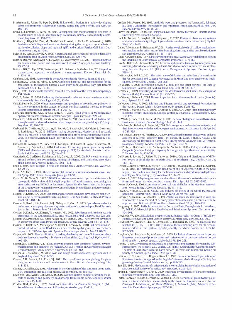
84 F. Gutiérrez et al. / Earth-Science Reviews 138 (2014) 61–88
Brinkmann, R., Parise, M., Dye, D., 2008. Sinkhole distribution in a rapidly developingurban environment: Hillsborough County, Tampa Bay area, Florida. Eng. Geol. 99,169–184.
Bruno, E., Calcaterra, D., Parise, M., 2008. Development and morphometry of sinkholes incoastal plains of Apulia, southern Italy. Preliminary sinkhole susceptibility assess-ment. Eng. Geol. 99, 198–209.
Bruthans, J., Filippi, M., Zare, M., Churácková, Z., Asadi, N., Fuchs, M., Adamovic, J., 2010.Evolution of salt diapir and karst morphology during the last glacial cycle: effects ofsea-level oscillation, diapir and regional uplift, and erosion (Persian Gulf, Iran). Geo-morphology 121, 291–304.
Buttrick, D., van Schalkwyk, A., 1998. Hazard and risk assessment for sinkhole formationon dolomite land in South Africa. Environ. Geol. 36, 170–178.
Buttrick, D.B., van Schalkwyk, A., Kleywegt, R.J., Watermeyer, R.B., 2001. Proposedmethodfor dolomite land hazard and risk assessment in South Africa. J. S. Afr. Inst. Civil Eng.43, 27–36.
Buttrick, D.B., Trollip, N.Y.G., Watermeyer, R.B., Pieterse, N.D., Gerber, A.A., 2011. A perfor-mance based approach to dolomite risk management. Environ. Earth Sci. 64,1127–1138.
Calaforra, J.M., 1998. Karstología de yesos. Universidad de Almería, Spain, (389 pp.).Calcaterra, D., Parise, M., Palma, B., 2003. Combining historical and geological data for the
assessment of the landslide hazard: a case study from Campania, Italy. Nat. HazardsEarth Syst. Sci. 3 (1/2), 3–16.
Ćalić, J., 2011. Karstic uvala revisited: toward a redefinition of the term. Geomorphology134, 32–42.
Calò, F., Parise, M., 2006. Evaluating the human disturbance to karst environments insouthern Italy. Acta Carsologica 35 (2), 47–56.
Calò, F., Parise, M., 2009. Waste management and problems of groundwater pollution inkarst environments in the context of a post-conflict scenario: the case of Mostar(Bosnia Herzegovina). Habitat Int. 33 (1), 63–72.
Camarasa-Belmonte, A.M., Segura-Beltrán, F., 2001. Flood events in Mediterraneanephemeral streams (ramblas) in Valencia region, Spain. Catena 45, 229–249.
Canora, F., Fidelibus, M.D., Sciortino, A., Spilotro, G., 2008. Variation of infiltration ratethrough karstic surfaces due to land use changes: a case study in Murgia (SE Italy).Eng. Geol. 99, 210–227.
Carbonel, D., Gutiérrez, F., Linares, R., Roqué, C., Zarroca, M., McCalpin, J., Guerrero,J., Rodriguez, V., 2013. Differentiating between gravitational and tectonicfaults by means of geomorphological mapping, trenching and geophysical sur-veys. The case of Zenzano Fault (Iberian Chain, N Spain). Geomorphology 189,93–108.
Carbonel, D., Rodríguez, V., Gutiérrez, F., McCalpin, J.P., Linares, R., Roqué, C., Zarroca, M.,Guerrero, J., Sasowsky, I., 2014. Evaluation of trenching, ground penetrating radar(GPR) and electrical resistivity tomography (ERT) for sinkhole characterization.Earth Surf. Process. Landf. 39 (2), 214–227.
Castañeda, C., Gutiérrez, F., Manunta, M., Galve, J.P., 2009. DInSAR measurements ofground deformation by sinkholes, mining subsidence, and landslides, Ebro River,Spain. Earth Surf. Process. Landf. 34, 1562–1574.
Chen, J., 1988. Karst collapse in cities and mining areas, China. Environ. Geol. Water Sci.12, 29–35.
Cigna, A.A., Forti, P., 1988. The environmental impact assessment of a tourist cave. Proc.Int. Symp. 170th Anniv. Postojnska Jama, pp. 29–38.
Civita, M., De Maio, M., 1997. SINTACS: un sistema parametrico per la valutazione e lacartografia della vulnerabilità degli acquiferi all'inquinamento: metodologia eautomatizzazione (SINTACS: A Parametric System for the Assessment and Mappingof the Groundwater Vulnerability to Contamination: Methodology and Automation).Pitagora, Bologna, (208 pp.).
Closson, D., Karaki, N.A., 2009. Salt karst and tectonics: sinkholes development along ten-sion cracks between parallel strike-slip faults, Dead Sea, Jordan. Earth Surf. Process.Landf. 34, 1408–1421.
Closson, D., Karaki, N.A., Hussein, M.J., Al-Fugha, H., Ozer, A., 2003. Space-borne radar in-terferometric mapping of precursory deformations of a dyke collapse, Dead Sea area,Jordan. Int. J. Remote Sens. 24, 843–849.
Closson, D., Karaki, N.A., Klinger, Y., Hussein, M.J., 2005. Subsidence and sinkhole hazardsassessment in the southern Dead Sea area, Jordan. Pure Appl. Geophys. 162, 221–248.
Closson, D., LaMoreaux, P.E., Abou-Karaki, N., al-Fugha, H., 2007. Karst system developedin salt layers of the Lisan Peninsula, Dead Sea, Jordan. Environ. Geol. 52, 155–172.
Closson, D., Karaki, N.A., Milisavljevic, N., Hallot, F., Acheroy, M., 2010. Salt-dissolution-in-duced subsidence in the Dead Sea area detected by applying interferometric tech-niques to ALOS Palsar Synthetic Aperture Radar images. Geodin. Acta 23, 65–78.
Cooper, A.H., 2008. The classification, recording, databasing and use of information aboutbuilding damage caused by subsidence and landslides. Q. J. Eng. Geol. Hydrogeol. 41,409–424.
Cooper, A.H., Gutiérrez, F., 2013. Dealing with gypsum karst problems: hazards, environ-mental issues and planning. In: Frumkin, A. (Ed.), Treatise on GeomorphologyKarstGeomorphology. vol. 6. Elsevier, Amsterdam, pp. 451–462.
Cooper, A.H., Saunders, J.M., 2002. Road and bridge construction across gypsum karst inEngland. Eng. Geol. 65, 217–223.
Cooper, A.H., Farrant, A.R., Price, S.J., 2011. The use of karst geomorphology for plan-ning, hazard avoidance and development in Great Britain. Geomorphology 134,118–131.
Cooper, J.D., Keller, M., 2001. Paleokarst in the Ordovician of the southern Great Basin,USA: implications for sea-level history. Sedimentology 48, 855–873.
Covington, M.D., Wicks, C.M., Saar, M.O., 2009. A dimensionless number describing the ef-fects of recharge and geometry on discharge from simple karstic aquifers. WaterResour. Res. 45, 1–16.
Cruden, D.M., Krahn, J., 1978. Frank rockslide, Alberta, Canada. In: Voight, B. (Ed.),Rockslides and Avalanches vol. 1. Elsevier, Amsterdam, pp. 97–112.
Cruden, D.M., Varnes, D.J., 1996. Landslide types and processes. In: Turner, A.K., Schuster,R.L. (Eds.), Landslides: Investigation and MitigationTransp. Res. Board Sp. Rep. 247.Nat. Acad. Press, WA, pp. 36–75.
Culver, D.C., Pipan, T., 2009. The Biology of Caves and Other Subterranean Habitats. OxfordUniversity Press, Oxford, (272 pp.).
Dahl, M., Nilsson, B., Langhoff, J.H., Refsgaard, J.C., 2007. Review of classification systemsand new multi-scale typology of groundwater–surface water interaction. J. Hydrol.344 (1–2), 1–16.
Dahm, T., Heimann, S., Bialowons, W., 2011. A seismological study of shallowweakmicro-earthquakes in the urban area of Hamburg city, Germany, and its possible relation tosalt dissolution. Nat. Hazards 58, 1111–1134.
Davis, A.D., Rahn, P.H., 1997. Karstic gypsumproblems atwaste water stabilization sites inthe Black Hills of South Dakota. Carbonates Evaporites 12, 73–80.
Day, M., Halfen, A., Chenoweth, S., 2011. The cockpit country, Jamaica: boundary issues inassessing disturbance and using a karst disturbance index in protected areas plan-ning. In: Van Beynen, P.E. (Ed.), Karst Management. Springer, Dordrecht, pp.399–414.
De Bruyn, I.A., Bell, F.G., 2001. The occurrence of sinkholes and subsidence depressions inthe Far West Rand and Gauteng Province, South Africa, and their engineering impli-cations. Environ. Eng. Geosci. 7, 281–295.
De Waele, J., 2008. Interaction between a dam site and karst springs: the case ofSupramonte (Central-East Sardinia, Italy). Eng. Geol. 99, 128–137.
De Waele, J., 2009. Evaluating disturbance on Mediterranean karst areas: the example ofSardinia (Italy). Environ. Geol. 58 (2), 239–255.
De Waele, J., Follesa, R., 2004. Human impact on karst: the example of Lusaka (Zambia).Int. J. Speleol. 32, 71–84.
De Waele, J., Forti, P., 2010. Salt rims and blisters: peculiar and ephemeral formations inthe Atacama Desert (Chile). Z. Geomorphol. 54 (Suppl. 2), 51–67.
De Waele, J., Martina, M.L.V., Sanna, L., Cabras, S., Cossu, Q.A., 2010. Flash flood hydrologyin karstic terrain: Flumineddu Canyon, central-east Sardinia. Geomorphology 120,162–173.
DeWaele, J., Gutiérrez, F., Parise, M., Plan, L., 2011. Geomorphology and natural hazards inkarst areas: a review. Geomorphology 134 (1–2), 1–8.
Delle Rose, M., Federico, A., Parise, M., 2004. Sinkhole genesis and evolution in Apulia, andtheir interrelationswith the anthropogenic environment. Nat. Hazards Earth Syst. Sci.4, 747–755.
Delle Rose, M., Parise, M., Andriani, G.F., 2007. Evaluating the impact of quarrying on karstaquifers of Salento (southern Italy). In: Parise, M., Gunn, J. (Eds.), Natural andAnthropogenic Hazards in Karst Areas: Recognition, Analysis and Mitigation.Geological Society, London, Sp. Publ.. 279, pp. 153–171
Del Prete, S., Di Crescenzo, G., Santangelo, N., Santo, A., 2010a. Collapse sinkholes inCampania (southern Italy): predisposing factors, genetic hypothesis and susceptibility.Z. Geomorphol. 54, 259–284.
Del Prete, S., Iovine, G., Parise, M., Santo, A., 2010b. Origin and distribution of diffe-rent types of sinkholes in the plain areas of Southern Italy. Geodin. Acta 23,113–127.
Delrieu, G., Nicol, J., Yates, E., Kirstetter, P.-E., Creutin, J.-D., Anquetin, S., Obled, C., Saulnier,G.-M., 2005. The catastrophic flash-flood event of 8–9 September 2002 in the Gardregion, France: a first case study for the Cévennes–Vivarais Mediterranean Hydrome-teorological Observatory. J. Hydrometeorol. 6, 34–52.
Djalante, R., 2012. Adaptive governance and resilience: the role of multi-stakeholder plat-forms in disaster risk reduction. Nat. Hazards Earth Syst. Sci. 12, 2923–2942.
Dogan, U., Cicek, I., 2002. Occurrence of cover-collapse sinkholes in the May Dam reservoirarea (Konya, Turkey). Cave and Karst Sci. 29, 111–116.
Dogan, U., Yilmaz, M., 2011. Natural and induced sinkholes of the Obruk Plateau andKarapinar–Hotamis Plain, Turkey. J. Asian Earth Sci. 40, 496–508.
Dörfliger, N., Jeannin, P.Y., Zwahlen, F., 1999. Water vulnerability assessment in karst en-vironments: a new method of defining protection areas using a multi-attributeapproach and GIS tools (EPIK method). Environ. Geol. 39 (2), 165–176.
Dougherty, P., 2005. Sinkhole destruction of Corporate Plaza, Pennsylvania. In: Waltham,T., Bell, F., Culshaw, M. (Eds.), Sinkholes and Subsidence. Springer, Chichester, pp.304–308.
Dreybrodt, W., 2004. Dissolution: evaporite and carbonate rocks. In: Gunn, J. (Ed.), Ency-clopedia of Caves and Karst Science. Fitzroy Dearborn, New York, pp. 295–300.
Dreybrodt, W., Lauckner, J., Liu, Z.H., Svensson, U., Buhmann, D., 1996. The kinetics of thereaction CO2 + H2O − N H++HCO3
− as one of the rate limiting steps for the dissolu-tion of calcite in the system H2O–CO2–CaCO3. Geochim. Cosmochim. Acta 60,3375–3381.
Dreybrodt, W., Romanov, D., Kaufmann, G., 2009. Evolution of isolated caves in porouslimestone bymixing of phreatic water and surface water at the water table of uncon-fined aquifers: a model approach. J. Hydrol. 376, 200–208.
Dunne, T., 1990. Hydrology, mechanics, and geomorphic implications of erosion by sub-surface flow. In: Higgins, C.G., Coates, D.R. (Eds.), Groundwater Geomorphology:The Role of Subsurface Water in Earth-surface Processes and Landforms. GeologicalSociety of America Special Paper. 252, pp. 1–28.
Edmonds, C.N., Green, C.P., Higginbottom, I.E., 1987. Subsidence hazard prediction forlimestone terrains, as applied to the English Cretaceous chalk. Geological Society En-gineering Geology Special Publication. 4, pp. 283–293.
Ege, J.R., 1984. Mechanisms of surface subsidence resulting from solution extraction ofsalt. Geological Society of America. Rev. Eng. Geol. 6, 203–221.
Epting, J., Huggenberger, P., Glur, L., 2009. Integrated investigations of karst phenomenain urban environments. Eng. Geol. 109, 273–289.
Farfán-González, H., Dias, C., Parise, M., Aldana, C., 2010. Scenarios of groundwater pollu-tion in a karst watershed: a case study in the Pinar del Rio province at Cuba. In:Carrasco, F., La Moreaux, J.W., Durán-Valsero, J.J., Andreo, B. (Eds.), Advances in Re-search in Karst Media. Springer, pp. 287–292.
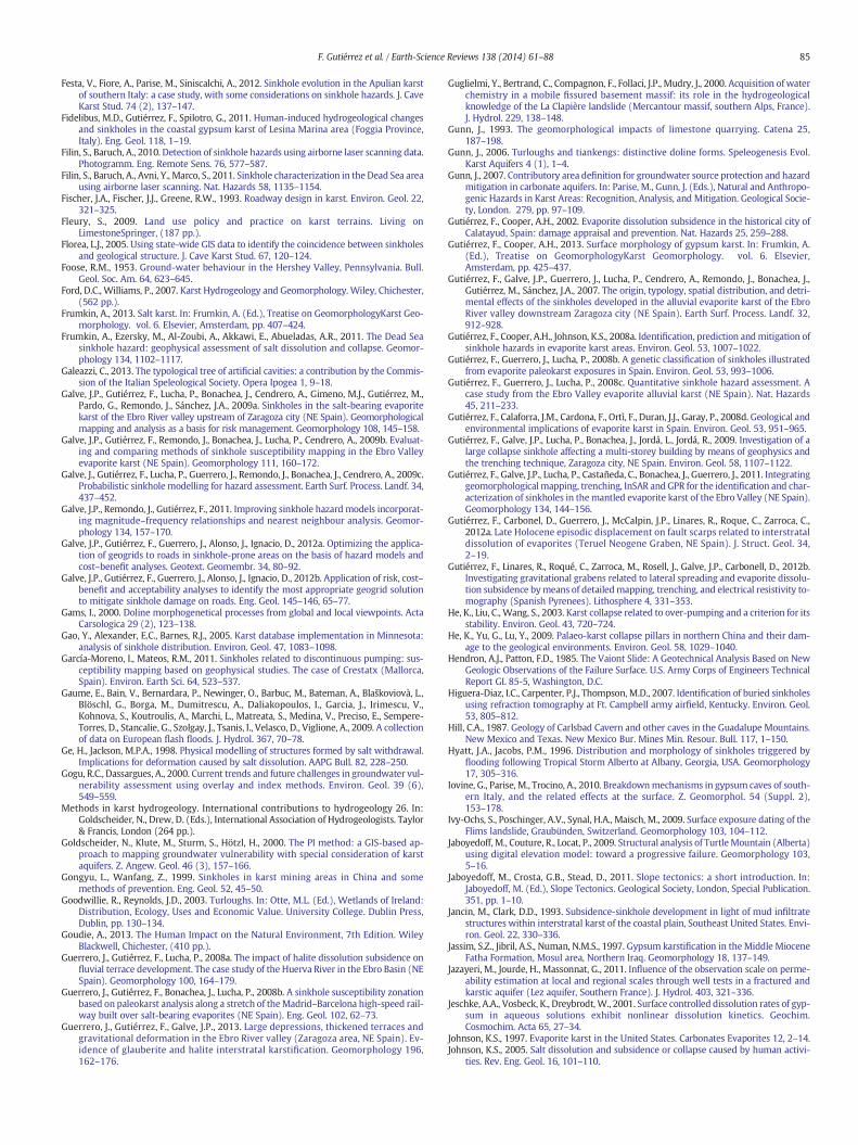
85F. Gutiérrez et al. / Earth-Science Reviews 138 (2014) 61–88
Festa, V., Fiore, A., Parise, M., Siniscalchi, A., 2012. Sinkhole evolution in the Apulian karstof southern Italy: a case study, with some considerations on sinkhole hazards. J. CaveKarst Stud. 74 (2), 137–147.
Fidelibus, M.D., Gutiérrez, F., Spilotro, G., 2011. Human-induced hydrogeological changesand sinkholes in the coastal gypsum karst of Lesina Marina area (Foggia Province,Italy). Eng. Geol. 118, 1–19.
Filin, S., Baruch, A., 2010. Detection of sinkhole hazards using airborne laser scanning data.Photogramm. Eng. Remote Sens. 76, 577–587.
Filin, S., Baruch, A., Avni, Y., Marco, S., 2011. Sinkhole characterization in the Dead Sea areausing airborne laser scanning. Nat. Hazards 58, 1135–1154.
Fischer, J.A., Fischer, J.J., Greene, R.W., 1993. Roadway design in karst. Environ. Geol. 22,321–325.
Fleury, S., 2009. Land use policy and practice on karst terrains. Living onLimestoneSpringer, (187 pp.).
Florea, L.J., 2005. Using state-wide GIS data to identify the coincidence between sinkholesand geological structure. J. Cave Karst Stud. 67, 120–124.
Foose, R.M., 1953. Ground-water behaviour in the Hershey Valley, Pennsylvania. Bull.Geol. Soc. Am. 64, 623–645.
Ford, D.C., Williams, P., 2007. Karst Hydrogeology and Geomorphology. Wiley, Chichester,(562 pp.).
Frumkin, A., 2013. Salt karst. In: Frumkin, A. (Ed.), Treatise on GeomorphologyKarst Geo-morphology. vol. 6. Elsevier, Amsterdam, pp. 407–424.
Frumkin, A., Ezersky, M., Al-Zoubi, A., Akkawi, E., Abueladas, A.R., 2011. The Dead Seasinkhole hazard: geophysical assessment of salt dissolution and collapse. Geomor-phology 134, 1102–1117.
Galeazzi, C., 2013. The typological tree of artificial cavities: a contribution by the Commis-sion of the Italian Speleological Society. Opera Ipogea 1, 9–18.
Galve, J.P., Gutiérrez, F., Lucha, P., Bonachea, J., Cendrero, A., Gimeno, M.J., Gutiérrez, M.,Pardo, G., Remondo, J., Sánchez, J.A., 2009a. Sinkholes in the salt-bearing evaporitekarst of the Ebro River valley upstream of Zaragoza city (NE Spain). Geomorphologicalmapping and analysis as a basis for risk management. Geomorphology 108, 145–158.
Galve, J.P., Gutiérrez, F., Remondo, J., Bonachea, J., Lucha, P., Cendrero, A., 2009b. Evaluat-ing and comparing methods of sinkhole susceptibility mapping in the Ebro Valleyevaporite karst (NE Spain). Geomorphology 111, 160–172.
Galve, J., Gutiérrez, F., Lucha, P., Guerrero, J., Remondo, J., Bonachea, J., Cendrero, A., 2009c.Probabilistic sinkhole modelling for hazard assessment. Earth Surf. Process. Landf. 34,437–452.
Galve, J.P., Remondo, J., Gutiérrez, F., 2011. Improving sinkhole hazard models incorporat-ing magnitude–frequency relationships and nearest neighbour analysis. Geomor-phology 134, 157–170.
Galve, J.P., Gutiérrez, F., Guerrero, J., Alonso, J., Ignacio, D., 2012a. Optimizing the applica-tion of geogrids to roads in sinkhole-prone areas on the basis of hazard models andcost–benefit analyses. Geotext. Geomembr. 34, 80–92.
Galve, J.P., Gutiérrez, F., Guerrero, J., Alonso, J., Ignacio, D., 2012b. Application of risk, cost–benefit and acceptability analyses to identify the most appropriate geogrid solutionto mitigate sinkhole damage on roads. Eng. Geol. 145–146, 65–77.
Gams, I., 2000. Doline morphogenetical processes from global and local viewpoints. ActaCarsologica 29 (2), 123–138.
Gao, Y., Alexander, E.C., Barnes, R.J., 2005. Karst database implementation in Minnesota:analysis of sinkhole distribution. Environ. Geol. 47, 1083–1098.
García-Moreno, I., Mateos, R.M., 2011. Sinkholes related to discontinuous pumping: sus-ceptibility mapping based on geophysical studies. The case of Crestatx (Mallorca,Spain). Environ. Earth Sci. 64, 523–537.
Gaume, E., Bain, V., Bernardara, P., Newinger, O., Barbuc, M., Bateman, A., Blaškoviovà, L.,Blöschl, G., Borga, M., Dumitrescu, A., Daliakopoulos, I., Garcia, J., Irimescu, V.,Kohnova, S., Koutroulis, A., Marchi, L., Matreata, S., Medina, V., Preciso, E., Sempere-Torres, D., Stancalie, G., Szolgay, J., Tsanis, I., Velasco, D., Viglione, A., 2009. A collectionof data on European flash floods. J. Hydrol. 367, 70–78.
Ge, H., Jackson, M.P.A., 1998. Physical modelling of structures formed by salt withdrawal.Implications for deformation caused by salt dissolution. AAPG Bull. 82, 228–250.
Gogu, R.C., Dassargues, A., 2000. Current trends and future challenges in groundwater vul-nerability assessment using overlay and index methods. Environ. Geol. 39 (6),549–559.
Methods in karst hydrogeology. International contributions to hydrogeology 26. In:Goldscheider, N., Drew, D. (Eds.), International Association of Hydrogeologists. Taylor& Francis, London (264 pp.).
Goldscheider, N., Klute, M., Sturm, S., Hötzl, H., 2000. The PI method: a GIS-based ap-proach to mapping groundwater vulnerability with special consideration of karstaquifers. Z. Angew. Geol. 46 (3), 157–166.
Gongyu, L., Wanfang, Z., 1999. Sinkholes in karst mining areas in China and somemethods of prevention. Eng. Geol. 52, 45–50.
Goodwillie, R., Reynolds, J.D., 2003. Turloughs. In: Otte, M.L. (Ed.), Wetlands of Ireland:Distribution, Ecology, Uses and Economic Value. University College. Dublin Press,Dublin, pp. 130–134.
Goudie, A., 2013. The Human Impact on the Natural Environment, 7th Edition. WileyBlackwell, Chichester, (410 pp.).
Guerrero, J., Gutiérrez, F., Lucha, P., 2008a. The impact of halite dissolution subsidence onfluvial terrace development. The case study of the Huerva River in the Ebro Basin (NESpain). Geomorphology 100, 164–179.
Guerrero, J., Gutiérrez, F., Bonachea, J., Lucha, P., 2008b. A sinkhole susceptibility zonationbased on paleokarst analysis along a stretch of theMadrid–Barcelona high-speed rail-way built over salt-bearing evaporites (NE Spain). Eng. Geol. 102, 62–73.
Guerrero, J., Gutiérrez, F., Galve, J.P., 2013. Large depressions, thickened terraces andgravitational deformation in the Ebro River valley (Zaragoza area, NE Spain). Ev-idence of glauberite and halite interstratal karstification. Geomorphology 196,162–176.
Guglielmi, Y., Bertrand, C., Compagnon, F., Follaci, J.P., Mudry, J., 2000. Acquisition of waterchemistry in a mobile fissured basement massif: its role in the hydrogeologicalknowledge of the La Clapière landslide (Mercantour massif, southern Alps, France).J. Hydrol. 229, 138–148.
Gunn, J., 1993. The geomorphological impacts of limestone quarrying. Catena 25,187–198.
Gunn, J., 2006. Turloughs and tiankengs: distinctive doline forms. Speleogenesis Evol.Karst Aquifers 4 (1), 1–4.
Gunn, J., 2007. Contributory area definition for groundwater source protection and hazardmitigation in carbonate aquifers. In: Parise, M., Gunn, J. (Eds.), Natural and Anthropo-genic Hazards in Karst Areas: Recognition, Analysis, and Mitigation. Geological Socie-ty, London. 279, pp. 97–109.
Gutiérrez, F., Cooper, A.H., 2002. Evaporite dissolution subsidence in the historical city ofCalatayud, Spain: damage appraisal and prevention. Nat. Hazards 25, 259–288.
Gutiérrez, F., Cooper, A.H., 2013. Surface morphology of gypsum karst. In: Frumkin, A.(Ed.), Treatise on GeomorphologyKarst Geomorphology. vol. 6. Elsevier,Amsterdam, pp. 425–437.
Gutiérrez, F., Galve, J.P., Guerrero, J., Lucha, P., Cendrero, A., Remondo, J., Bonachea, J.,Gutiérrez, M., Sánchez, J.A., 2007. The origin, typology, spatial distribution, and detri-mental effects of the sinkholes developed in the alluvial evaporite karst of the EbroRiver valley downstream Zaragoza city (NE Spain). Earth Surf. Process. Landf. 32,912–928.
Gutiérrez, F., Cooper, A.H., Johnson, K.S., 2008a. Identification, prediction andmitigation ofsinkhole hazards in evaporite karst areas. Environ. Geol. 53, 1007–1022.
Gutiérrez, F., Guerrero, J., Lucha, P., 2008b. A genetic classification of sinkholes illustratedfrom evaporite paleokarst exposures in Spain. Environ. Geol. 53, 993–1006.
Gutiérrez, F., Guerrero, J., Lucha, P., 2008c. Quantitative sinkhole hazard assessment. Acase study from the Ebro Valley evaporite alluvial karst (NE Spain). Nat. Hazards45, 211–233.
Gutiérrez, F., Calaforra, J.M., Cardona, F., Ortì, F., Duran, J.J., Garay, P., 2008d. Geological andenvironmental implications of evaporite karst in Spain. Environ. Geol. 53, 951–965.
Gutiérrez, F., Galve, J.P., Lucha, P., Bonachea, J., Jordá, L., Jordá, R., 2009. Investigation of alarge collapse sinkhole affecting a multi-storey building by means of geophysics andthe trenching technique, Zaragoza city, NE Spain. Environ. Geol. 58, 1107–1122.
Gutiérrez, F., Galve, J.P., Lucha, P., Castañeda, C., Bonachea, J., Guerrero, J., 2011. Integratinggeomorphological mapping, trenching, InSAR and GPR for the identification and char-acterization of sinkholes in themantled evaporite karst of the Ebro Valley (NE Spain).Geomorphology 134, 144–156.
Gutiérrez, F., Carbonel, D., Guerrero, J., McCalpin, J.P., Linares, R., Roque, C., Zarroca, C.,2012a. Late Holocene episodic displacement on fault scarps related to interstrataldissolution of evaporites (Teruel Neogene Graben, NE Spain). J. Struct. Geol. 34,2–19.
Gutiérrez, F., Linares, R., Roqué, C., Zarroca, M., Rosell, J., Galve, J.P., Carbonell, D., 2012b.Investigating gravitational grabens related to lateral spreading and evaporite dissolu-tion subsidence bymeans of detailedmapping, trenching, and electrical resistivity to-mography (Spanish Pyrenees). Lithosphere 4, 331–353.
He, K., Liu, C., Wang, S., 2003. Karst collapse related to over-pumping and a criterion for itsstability. Environ. Geol. 43, 720–724.
He, K., Yu, G., Lu, Y., 2009. Palaeo-karst collapse pillars in northern China and their dam-age to the geological environments. Environ. Geol. 58, 1029–1040.
Hendron, A.J., Patton, F.D., 1985. The Vaiont Slide: A Geotechnical Analysis Based on NewGeologic Observations of the Failure Surface. U.S. Army Corps of Engineers TechnicalReport GL 85-5, Washington, D.C.
Higuera-Diaz, I.C., Carpenter, P.J., Thompson, M.D., 2007. Identification of buried sinkholesusing refraction tomography at Ft. Campbell army airfield, Kentucky. Environ. Geol.53, 805–812.
Hill, C.A., 1987. Geology of Carlsbad Cavern and other caves in the Guadalupe Mountains.New Mexico and Texas. New Mexico Bur. Mines Min. Resour. Bull. 117, 1–150.
Hyatt, J.A., Jacobs, P.M., 1996. Distribution and morphology of sinkholes triggered byflooding following Tropical Storm Alberto at Albany, Georgia, USA. Geomorphology17, 305–316.
Iovine, G., Parise, M., Trocino, A., 2010. Breakdownmechanisms in gypsum caves of south-ern Italy, and the related effects at the surface. Z. Geomorphol. 54 (Suppl. 2),153–178.
Ivy-Ochs, S., Poschinger, A.V., Synal, H.A., Maisch, M., 2009. Surface exposure dating of theFlims landslide, Graubünden, Switzerland. Geomorphology 103, 104–112.
Jaboyedoff, M., Couture, R., Locat, P., 2009. Structural analysis of TurtleMountain (Alberta)using digital elevation model: toward a progressive failure. Geomorphology 103,5–16.
Jaboyedoff, M., Crosta, G.B., Stead, D., 2011. Slope tectonics: a short introduction. In:Jaboyedoff, M. (Ed.), Slope Tectonics. Geological Society, London, Special Publication.351, pp. 1–10.
Jancin, M., Clark, D.D., 1993. Subsidence-sinkhole development in light of mud infiltratestructures within interstratal karst of the coastal plain, Southeast United States. Envi-ron. Geol. 22, 330–336.
Jassim, S.Z., Jibril, A.S., Numan, N.M.S., 1997. Gypsum karstification in the Middle MioceneFatha Formation, Mosul area, Northern Iraq. Geomorphology 18, 137–149.
Jazayeri, M., Jourde, H., Massonnat, G., 2011. Influence of the observation scale on perme-ability estimation at local and regional scales through well tests in a fractured andkarstic aquifer (Lez aquifer, Southern France). J. Hydrol. 403, 321–336.
Jeschke, A.A., Vosbeck, K., Dreybrodt, W., 2001. Surface controlled dissolution rates of gyp-sum in aqueous solutions exhibit nonlinear dissolution kinetics. Geochim.Cosmochim. Acta 65, 27–34.
Johnson, K.S., 1997. Evaporite karst in the United States. Carbonates Evaporites 12, 2–14.Johnson, K.S., 2005. Salt dissolution and subsidence or collapse caused by human activi-
ties. Rev. Eng. Geol. 16, 101–110.
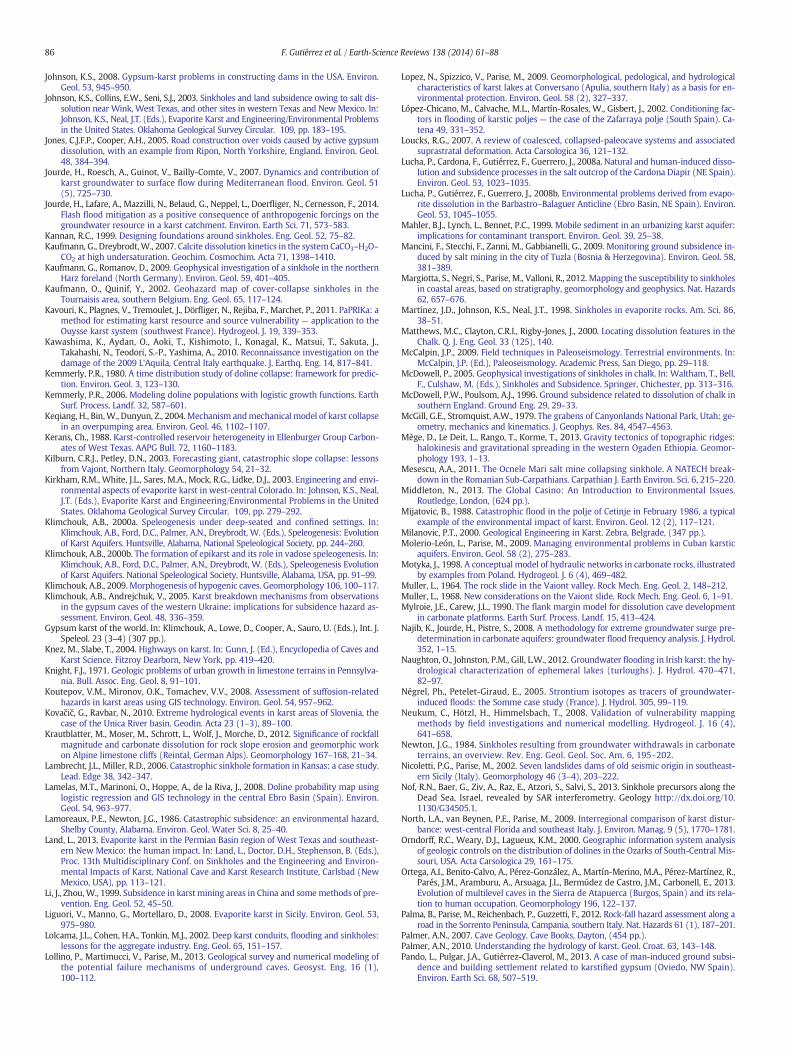
86 F. Gutiérrez et al. / Earth-Science Reviews 138 (2014) 61–88
Johnson, K.S., 2008. Gypsum-karst problems in constructing dams in the USA. Environ.Geol. 53, 945–950.
Johnson, K.S., Collins, E.W., Seni, S.J., 2003. Sinkholes and land subsidence owing to salt dis-solution near Wink, West Texas, and other sites in western Texas and New Mexico. In:Johnson, K.S., Neal, J.T. (Eds.), Evaporite Karst and Engineering/Environmental Problemsin the United States. Oklahoma Geological Survey Circular. 109, pp. 183–195.
Jones, C.J.F.P., Cooper, A.H., 2005. Road construction over voids caused by active gypsumdissolution, with an example from Ripon, North Yorkshire, England. Environ. Geol.48, 384–394.
Jourde, H., Roesch, A., Guinot, V., Bailly-Comte, V., 2007. Dynamics and contribution ofkarst groundwater to surface flow during Mediterranean flood. Environ. Geol. 51(5), 725–730.
Jourde, H., Lafare, A., Mazzilli, N., Belaud, G., Neppel, L., Doerfliger, N., Cernesson, F., 2014.Flash flood mitigation as a positive consequence of anthropogenic forcings on thegroundwater resource in a karst catchment. Environ. Earth Sci. 71, 573–583.
Kannan, R.C., 1999. Designing foundations around sinkholes. Eng. Geol. 52, 75–82.Kaufmann, G., Dreybrodt,W., 2007. Calcite dissolution kinetics in the system CaCO3–H2O–
CO2 at high undersaturation. Geochim. Cosmochim. Acta 71, 1398–1410.Kaufmann, G., Romanov, D., 2009. Geophysical investigation of a sinkhole in the northern
Harz foreland (North Germany). Environ. Geol. 59, 401–405.Kaufmann, O., Quinif, Y., 2002. Geohazard map of cover-collapse sinkholes in the
Tournaisis area, southern Belgium. Eng. Geol. 65, 117–124.Kavouri, K., Plagnes, V., Tremoulet, J., Dörfliger, N., Rejiba, F., Marchet, P., 2011. PaPRIKa: a
method for estimating karst resource and source vulnerability — application to theOuysse karst system (southwest France). Hydrogeol. J. 19, 339–353.
Kawashima, K., Aydan, O., Aoki, T., Kishimoto, I., Konagal, K., Matsui, T., Sakuta, J.,Takahashi, N., Teodori, S.-P., Yashima, A., 2010. Reconnaissance investigation on thedamage of the 2009 L'Aquila, Central Italy earthquake. J. Earthq. Eng. 14, 817–841.
Kemmerly, P.R., 1980. A time distribution study of doline collapse: framework for predic-tion. Environ. Geol. 3, 123–130.
Kemmerly, P.R., 2006. Modeling doline populations with logistic growth functions. EarthSurf. Process. Landf. 32, 587–601.
Keqiang, H., Bin,W., Dunyun, Z., 2004.Mechanism andmechanical model of karst collapsein an overpumping area. Environ. Geol. 46, 1102–1107.
Kerans, Ch., 1988. Karst-controlled reservoir heterogeneity in Ellenburger Group Carbon-ates of West Texas. AAPG Bull. 72, 1160–1183.
Kilburn, C.R.J., Petley, D.N., 2003. Forecasting giant, catastrophic slope collapse: lessonsfrom Vajont, Northern Italy. Geomorphology 54, 21–32.
Kirkham, R.M., White, J.L., Sares, M.A., Mock, R.G., Lidke, D.J., 2003. Engineering and envi-ronmental aspects of evaporite karst in west-central Colorado. In: Johnson, K.S., Neal,J.T. (Eds.), Evaporite Karst and Engineering/Environmental Problems in the UnitedStates. Oklahoma Geological Survey Circular. 109, pp. 279–292.
Klimchouk, A.B., 2000a. Speleogenesis under deep-seated and confined settings. In:Klimchouk, A.B., Ford, D.C., Palmer, A.N., Dreybrodt, W. (Eds.), Speleogenesis: Evolutionof Karst Aquifers. Huntsville, Alabama, National Speleological Society, pp. 244–260.
Klimchouk, A.B., 2000b. The formation of epikarst and its role in vadose speleogenesis. In:Klimchouk, A.B., Ford, D.C., Palmer, A.N., Dreybrodt, W. (Eds.), Speleogenesis Evolutionof Karst Aquifers. National Speleological Society, Huntsville, Alabama, USA, pp. 91–99.
Klimchouk, A.B., 2009.Morphogenesis of hypogenic caves. Geomorphology 106, 100–117.Klimchouk, A.B., Andrejchuk, V., 2005. Karst breakdown mechanisms from observations
in the gypsum caves of the western Ukraine: implications for subsidence hazard as-sessment. Environ. Geol. 48, 336–359.
Gypsum karst of the world. In: Klimchouk, A., Lowe, D., Cooper, A., Sauro, U. (Eds.), Int. J.Speleol. 23 (3–4) (307 pp.).
Knez, M., Slabe, T., 2004. Highways on karst. In: Gunn, J. (Ed.), Encyclopedia of Caves andKarst Science. Fitzroy Dearborn, New York, pp. 419–420.
Knight, F.J., 1971. Geologic problems of urban growth in limestone terrains in Pennsylva-nia. Bull. Assoc. Eng. Geol. 8, 91–101.
Koutepov, V.M., Mironov, O.K., Tomachev, V.V., 2008. Assessment of suffosion-relatedhazards in karst areas using GIS technology. Environ. Geol. 54, 957–962.
Kovačič, G., Ravbar, N., 2010. Extreme hydrological events in karst areas of Slovenia, thecase of the Unica River basin. Geodin. Acta 23 (1–3), 89–100.
Krautblatter, M., Moser, M., Schrott, L., Wolf, J., Morche, D., 2012. Significance of rockfallmagnitude and carbonate dissolution for rock slope erosion and geomorphic workon Alpine limestone cliffs (Reintal, German Alps). Geomorphology 167–168, 21–34.
Lambrecht, J.L., Miller, R.D., 2006. Catastrophic sinkhole formation in Kansas: a case study.Lead. Edge 38, 342–347.
Lamelas, M.T., Marinoni, O., Hoppe, A., de la Riva, J., 2008. Doline probability map usinglogistic regression and GIS technology in the central Ebro Basin (Spain). Environ.Geol. 54, 963–977.
Lamoreaux, P.E., Newton, J.G., 1986. Catastrophic subsidence: an environmental hazard,Shelby County, Alabama. Environ. Geol. Water Sci. 8, 25–40.
Land, L., 2013. Evaporite karst in the Permian Basin region of West Texas and southeast-ern New Mexico: the human impact. In: Land, L., Doctor, D.H., Stephenson, B. (Eds.),Proc. 13th Multidisciplinary Conf. on Sinkholes and the Engineering and Environ-mental Impacts of Karst. National Cave and Karst Research Institute, Carlsbad (NewMexico, USA), pp. 113–121.
Li, J., Zhou,W., 1999. Subsidence in karst mining areas in China and somemethods of pre-vention. Eng. Geol. 52, 45–50.
Liguori, V., Manno, G., Mortellaro, D., 2008. Evaporite karst in Sicily. Environ. Geol. 53,975–980.
Lolcama, J.L., Cohen, H.A., Tonkin, M.J., 2002. Deep karst conduits, flooding and sinkholes:lessons for the aggregate industry. Eng. Geol. 65, 151–157.
Lollino, P., Martimucci, V., Parise, M., 2013. Geological survey and numerical modeling ofthe potential failure mechanisms of underground caves. Geosyst. Eng. 16 (1),100–112.
Lopez, N., Spizzico, V., Parise, M., 2009. Geomorphological, pedological, and hydrologicalcharacteristics of karst lakes at Conversano (Apulia, southern Italy) as a basis for en-vironmental protection. Environ. Geol. 58 (2), 327–337.
López-Chicano, M., Calvache, M.L., Martín-Rosales, W., Gisbert, J., 2002. Conditioning fac-tors in flooding of karstic poljes — the case of the Zafarraya polje (South Spain). Ca-tena 49, 331–352.
Loucks, R.G., 2007. A review of coalesced, collapsed-paleocave systems and associatedsuprastratal deformation. Acta Carsologica 36, 121–132.
Lucha, P., Cardona, F., Gutiérrez, F., Guerrero, J., 2008a. Natural and human-induced disso-lution and subsidence processes in the salt outcrop of the Cardona Diapir (NE Spain).Environ. Geol. 53, 1023–1035.
Lucha, P., Gutiérrez, F., Guerrero, J., 2008b. Environmental problems derived from evapo-rite dissolution in the Barbastro–Balaguer Anticline (Ebro Basin, NE Spain). Environ.Geol. 53, 1045–1055.
Mahler, B.J., Lynch, L., Bennet, P.C., 1999. Mobile sediment in an urbanizing karst aquifer:implications for contaminant transport. Environ. Geol. 39, 25–38.
Mancini, F., Stecchi, F., Zanni, M., Gabbianelli, G., 2009. Monitoring ground subsidence in-duced by salt mining in the city of Tuzla (Bosnia & Herzegovina). Environ. Geol. 58,381–389.
Margiotta, S., Negri, S., Parise, M., Valloni, R., 2012. Mapping the susceptibility to sinkholesin coastal areas, based on stratigraphy, geomorphology and geophysics. Nat. Hazards62, 657–676.
Martínez, J.D., Johnson, K.S., Neal, J.T., 1998. Sinkholes in evaporite rocks. Am. Sci. 86,38–51.
Matthews, M.C., Clayton, C.R.I., Rigby-Jones, J., 2000. Locating dissolution features in theChalk. Q. J. Eng. Geol. 33 (125), 140.
McCalpin, J.P., 2009. Field techniques in Paleoseismology. Terrestrial environments. In:McCalpin, J.P. (Ed.), Paleoseismology. Academic Press, San Diego, pp. 29–118.
McDowell, P., 2005. Geophysical investigations of sinkholes in chalk. In: Waltham, T., Bell,F., Culshaw, M. (Eds.), Sinkholes and Subsidence. Springer, Chichester, pp. 313–316.
McDowell, P.W., Poulsom, A.J., 1996. Ground subsidence related to dissolution of chalk insouthern England. Ground Eng. 29, 29–33.
McGill, G.E., Stromquist, A.W., 1979. The grabens of Canyonlands National Park, Utah: ge-ometry, mechanics and kinematics. J. Geophys. Res. 84, 4547–4563.
Mège, D., Le Deit, L., Rango, T., Korme, T., 2013. Gravity tectonics of topographic ridges:halokinesis and gravitational spreading in the western Ogaden Ethiopia. Geomor-phology 193, 1–13.
Mesescu, A.A., 2011. The Ocnele Mari salt mine collapsing sinkhole. A NATECH break-down in the Romanian Sub-Carpathians. Carpathian J. Earth Environ. Sci. 6, 215–220.
Middleton, N., 2013. The Global Casino: An Introduction to Environmental Issues.Routledge, London, (624 pp.).
Mijatovic, B., 1988. Catastrophic flood in the polje of Cetinje in February 1986, a typicalexample of the environmental impact of karst. Environ. Geol. 12 (2), 117–121.
Milanovic, P.T., 2000. Geological Engineering in Karst. Zebra, Belgrade, (347 pp.).Molerio-León, L., Parise, M., 2009. Managing environmental problems in Cuban karstic
aquifers. Environ. Geol. 58 (2), 275–283.Motyka, J., 1998. A conceptual model of hydraulic networks in carbonate rocks, illustrated
by examples from Poland. Hydrogeol. J. 6 (4), 469–482.Muller, L., 1964. The rock slide in the Vaiont valley. Rock Mech. Eng. Geol. 2, 148–212.Muller, L., 1968. New considerations on the Vaiont slide. Rock Mech. Eng. Geol. 6, 1–91.Mylroie, J.E., Carew, J.L., 1990. The flank margin model for dissolution cave development
in carbonate platforms. Earth Surf. Process. Landf. 15, 413–424.Najib, K., Jourde, H., Pistre, S., 2008. A methodology for extreme groundwater surge pre-
determination in carbonate aquifers: groundwater flood frequency analysis. J. Hydrol.352, 1–15.
Naughton, O., Johnston, P.M., Gill, L.W., 2012. Groundwater flooding in Irish karst: the hy-drological characterization of ephemeral lakes (turloughs). J. Hydrol. 470–471,82–97.
Négrel, Ph., Petelet-Giraud, E., 2005. Strontium isotopes as tracers of groundwater-induced floods: the Somme case study (France). J. Hydrol. 305, 99–119.
Neukum, C., Hötzl, H., Himmelsbach, T., 2008. Validation of vulnerability mappingmethods by field investigations and numerical modelling. Hydrogeol. J. 16 (4),641–658.
Newton, J.G., 1984. Sinkholes resulting from groundwater withdrawals in carbonateterrains, an overview. Rev. Eng. Geol. Geol. Soc. Am. 6, 195–202.
Nicoletti, P.G., Parise, M., 2002. Seven landslides dams of old seismic origin in southeast-ern Sicily (Italy). Geomorphology 46 (3–4), 203–222.
Nof, R.N., Baer, G., Ziv, A., Raz, E., Atzori, S., Salvi, S., 2013. Sinkhole precursors along theDead Sea, Israel, revealed by SAR interferometry. Geology http://dx.doi.org/10.1130/G34505.1.
North, L.A., van Beynen, P.E., Parise, M., 2009. Interregional comparison of karst distur-bance: west-central Florida and southeast Italy. J. Environ. Manag. 9 (5), 1770–1781.
Orndorff, R.C., Weary, D.J., Lagueux, K.M., 2000. Geographic information system analysisof geologic controls on the distribution of dolines in the Ozarks of South-Central Mis-souri, USA. Acta Carsologica 29, 161–175.
Ortega, A.I., Benito-Calvo, A., Pérez-González, A., Martín-Merino, M.A., Pérez-Martínez, R.,Parés, J.M., Aramburu, A., Arsuaga, J.L., Bermúdez de Castro, J.M., Carbonell, E., 2013.Evolution of multilevel caves in the Sierra de Atapuerca (Burgos, Spain) and its rela-tion to human occupation. Geomorphology 196, 122–137.
Palma, B., Parise, M., Reichenbach, P., Guzzetti, F., 2012. Rock-fall hazard assessment along aroad in the Sorrento Peninsula, Campania, southern Italy. Nat. Hazards 61 (1), 187–201.
Palmer, A.N., 2007. Cave Geology. Cave Books, Dayton, (454 pp.).Palmer, A.N., 2010. Understanding the hydrology of karst. Geol. Croat. 63, 143–148.Pando, L., Pulgar, J.A., Gutiérrez-Claverol, M., 2013. A case of man-induced ground subsi-
dence and building settlement related to karstified gypsum (Oviedo, NW Spain).Environ. Earth Sci. 68, 507–519.
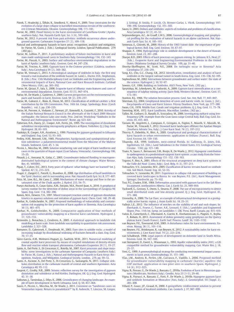
87F. Gutiérrez et al. / Earth-Science Reviews 138 (2014) 61–88
Pánek, T., Hradecký, J., Šilhán, K., Smolková, V., Altová, V., 2009. Time constraints for theevolution of a large slope collapse in karstifiedmountainous terrain of the southwest-ern Crimean Mountains, Ukraine. Geomorphology 108, 171–181.
Parise, M., 2003. Flood history in the karst environment of Castellana-Grotte (Apulia,southern Italy). Nat. Hazards Earth Syst. Sci. 3 (6), 593–604.
Parise, M., 2012. A present risk from past activities: sinkhole occurrence above under-ground quarries. Carbonates Evaporites 27 (2), 109–118.
Natural and anthropogenic hazards in karst areas: recognition, analysis and mitigation.In: Parise, M., Gunn, J. (Eds.), Geological Society, London, Special Publications. 279(202 pp.).
Parise, M., Lollino, P., 2011. A preliminary analysis of failure mechanisms in karst andman-made underground caves in Southern Italy. Geomorphology 134, 132–143.
Parise, M., Pascali, V., 2003. Surface and subsurface environmental degradation in thekarst of Apulia (southern Italy). Environ. Geol. 44, 247–256.
Parise, M., Trocino, A., 2005. Gypsum karst in the Crotone province (Calabria, southernItaly). Acta Carsologica 34 (2), 369–382.
Parise, M., Vennari, C., 2013. A chronological catalogue of sinkholes in Italy: the first steptoward a real evaluation of the sinkhole hazard. In: Land, L., Doctor, D.H., Stephenson,B. (Eds.), Proc. 13th Multidisciplinary Conf. on Sinkholes and the Engineering and En-vironmental Impacts of Karst. National Cave and Karst Research Institute, Carlsbad(New Mexico, USA), pp. 383–392.
Parise, M., Qiriazi, P., Sala, S., 2008. Evaporite karst of Albania: main features and cases ofenvironmental degradation. Environ. Geol. 53 (5), 967–974.
Parise, M., DeWaele, J., Gutiérrez, F., 2009. Current perspectives on the environmental im-pacts and hazards in karst. Environ. Geol. 58 (2), 235–237.
Parise, M., Galeazzi, C., Bixio, R., Dixon, M., 2013. Classification of artificial cavities: a firstcontribution by the UIS Commission. Proc. 16th Int. Congr. Speleology, Brno (CzechRepublic). vol. 2, pp. 230–235.
Parise, M., Perrone, A., Violante, C., Stewart, J.P., Simonelli, A., Guzzetti, F., 2010. Activity ofthe Italian National Research Council in the aftermath of the 6 April 2009 Abruzzoearthquake: the Sinizzo Lake case study. Proc. 2nd Int. Workshop “Sinkholes in theNatural and Anthropogenic Environment”, Rome, pp. 623–641.
Patterson, D.A., Davey, J.C., Cooper, A.H., Ferris, J.K., 1995. The investigation of dissolutionsubsidence incorporating microgravity geophysics at Ripon, Yorkshire. Q. J. Eng. Geol.Hydrogeol. 28, 83–103.
Paukstys, B., Cooper, A.H., Arustiene, J., 1999. Planning for gypsum geohazard in Lithuaniaand England. Eng. Geol. 52, 93–103.
Pedley, H.M., Bennett, S.M., 1985. Phosphorites, hardgrounds and syndepositional solu-tion subsidence: a palaeoenvironmental model from the Miocene of the MalteseIslands. Sediment. Geol. 45, 1–34.
Piccini, L., Mecchia, M., 2009. Solution weathering rate and origin of karst landforms andcaves in the quartzite of Auyan-tepui (Gran Sabana, Venezuela). Geomorphology 106,15–25.
Pinault, J.-L., Amraoui, N., Golaz, C., 2005. Groundwater-induced flooding in macropore-dominated hydrological system in the context of climate changes. Water Resour.Res. 41, W05001.
Pipan, T., Culver, D.C., 2013. Forty years of epikarst: what biology have we learned? Int. J.Speleol. 42 (3), 215–223.
Prager, C., Zangerl, C., Patzelt, G., Brandner, R., 2008. Age distribution of fossil landslides inthe Tyrol (Austria) and its surrounding areas. Nat. Hazards Earth Syst. Sci. 8, 377–407.
Price, M., Low, R.G., Mc Cann, C., 2000. Mechanisms of water storage and flow in the un-saturated zone of the Chalk aquifer. J. Hydrol. 233, 54–71.
Pueyo-Anchuela, O., Casas-Sainz, A.M., Soriano, M.A., Pocoví-Juan, A., 2010. A geophysicalsurvey routine for the detection of doline areas in the surroundings of Zaragoza NESpain. Eng. Geol. 114, 382–396.
Raines, M.A., Dewers, T.A., 1997. Mixed transport/reaction control of gypsum dissolutionkinetics in aqueous solutions and initiation of gypsum karst. Chem. Geol. 140, 29–48.
Ravbar, N., Goldscheider, N., 2007. Proposed methodology of vulnerability and contami-nation risk mapping for the protection of karst aquifers in Slovenia. Acta Carsologica36 (3), 461–475.
Ravbar, N., Goldscheider, N., 2009. Comparative application of four methods ofgroundwater vulnerability mapping in a Slovene karst catchment. Hydrogeol. J.17, 725–733.
Remondo, J., Bonachea, J., Cendrero, A., 2005. A statistical approach to landslide riskmodelling at basin scale: from landslide susceptibility to quantitative risk assessment.Landslides 2, 321–328.
Romanov, D., Gabrovsek, F., Dreybrodt, W., 2003. Dam sites in soluble rocks: a model ofincreasing leakage by dissolutional widening of fractures beneath a dam. Eng. Geol.70, 17–35.
Sáinz-García, A.M., Molinero-Huguet, J.J., Saaltink, M.W., 2011. Numerical modeling ofcoastal aquifer karst processes by means of coupled simulations of density-drivenflow and reactive solute transport phenomena. Carbonates Evaporites 26 (1), 19–27.
Santo, A., Del Prete, S., Di Crescenzo, G., Rotella, M., 2007. Karst processes and slope insta-bility: some investigations in the carbonate Apennine of Campania (southern Italy).In: Parise, M., Gunn, J. (Eds.), Natural and Anthropogenic Hazards in Karst Areas: Rec-ognition, Analysis, and Mitigation. Geological Society, London. 279, pp. 59–72.
Santo, A., Ascione, A., Del Prete, S., Di Crescenzo, G., Santangelo, N., 2011. Collapse sink-holes distribution in the carbonate massifs of central and southern Apennines. ActaCarsologica 40, 95–112.
Sargent, C., Goulty, N.R., 2009. Seismic reflection survey for the investigation of gypsumdissolution and subsidence at Hell Kettles, Darlington, UK. Q. J. Eng. Geol. Hydrogeol.42, 31–38.
Satkunas, J., Taminskas, J., Dilys, K., 2006. Geoindicators of changing landscape. An exam-ple of karst development in North Lithuania. Geol. Q. 50, 457–464.
Sauro, F., Piccini, L., Mecchia, M., De Waele, J., 2011. Comment on “Sandstone caves onVenezuelan tepuis: Return to pseudokarst?” by R. Aubrecht, T. Lánczos, M. Gregor,
J. Schlögl, B. Smída, P. Liscák, Ch. Brewer-Carías, L. Vlcek, Geomorphology 197:190–196. Geomorphology 132, 351–365.
Sauro, U., 2003. Dolines and sinkholes: aspects of evolution and problems of classification.Acta Carsologica 32 (2), 41–52.
Seijmonsbergen, A.C., de Graaff, L.W.S., 2006. Geomorphological mapping and geophysi-cal profiling for the evaluation of natural hazards in an alpine catchment. Nat. Haz-ards Earth Syst. Sci. 6, 185–193.
Semenza, E., Ghirotti, M., 2000. History of the 1963 Vaiont slide: the importance of geo-logical factors. Bull. Eng. Geol. Environ. 59, 87–97.
Shaquor, F., 1994. Hydrogeologic role in sinkhole development in the desert of Kuwait.Environ. Geol. 23, 201–208.
Sharpe, R.D., 2003. Effects of karst processes on gypsummining. In: Johnson, K.S., Neal, J.T.(Eds.), Evaporite Karst and Engineering/Environmental Problems in the UnitedStates. Oklahoma Geological Survey Circular. 109, pp. 31–40.
Sheehy-Skeffington, M., Scott, N.E., 2008. Do turloughs occur in Slovenia? ActaCarsologica 37, 236–291.
Song, K.I., Cho, G.C., Chang, S.B., 2012. Identification, remediation and analysis of karstsinkholes in the longest railroad tunnel in South Korea. Eng. Geol. 135–136, 92–105.
Sophocleous, M., 2002. Interactions between groundwater and surface water: the state ofthe science. Hydrogeol. J. 10, 52–67.
Sowers, G.F., 1996. Building on Sinkholes. ASCE Press, New York, (202 pp.).Sprynskyy, M., Lebedynets, M., Sadurski, A., 2009. Gypsum karst intensification as a con-
sequence of sulphur mining activity (Jaziv field, Western Ukraine). Environ. Geol. 57,173–181.
Stanton, R.J., 1966. The solution brecciation process. Geol. Soc. Am. Bull. 77, 843–847.Stierman, D.J., 2004. Geophysical detection of caves and karstic voids. In: Gunn, J. (Ed.),
Encyclopedia of Caves and Karst Science. Fitzroy Dearborn, New York, pp. 377–380.Swan, C.H., 1978. Middle East. Canals and irrigation problems. Q. J. Eng. Geol. 11, 75–78.Sweeting, M.M., 1972. Karst Landforms. Macmillan, London, (362 pp.).Tallini, M., Gasbarri, D., Ranalli, D., Scozzafava, M., 2006. Investigating epikarst using low-
frequency GPR: example from the Gran Sasso range Central Italy. Bull. Eng. Geol. En-viron. 65, 435–443.
Taviani, M., Angeletti, L., Campiani, E., Ceregato, A., Foglini, F., Maselli, V., Morsilli, M.,Parise, M., Trincardi, F., 2012. Drowned karst landscapes offshore the Apulian Margin(Southern Adriatic Sea, Italy). J. Cave Karst Stud. 74 (2), 197–212.
Thierry, P., Debeblia, N., Bitri, A., 2005. Geophysical and geological characterization ofkarst hazards in urban environments: application to Orléans (France). Bull. Eng.Geol. Environ. 64, 139–150.
Tihansky, A.B., 1999. Sinkholes, west-central Florida. In: Galloway, D., Jones, D.R.,Ingebritsen, S.E. (Eds.), Land Subsidence in the United States. U.S. Geological SurveyCircular. 1182, pp. 121–140.
Tisato, N., Sauro, F., Bernasconi, S.M., Bruijn, R., DeWaele, J., 2012. Hypogenic contributionto speleogenesis in a predominant epigenic karst system: a case study from the Vene-tian Alps, Italy. Geomorphology 151–152, 156–163.
Tognini, P., Bini, A., 2001. Effects of the structural arrangement on deep karst systems inthe Valle del Nosé (Como, Italy). Geol. Belg. 4 (3), 197–211.
Tolmachev, V.V., Leonenko, M.V., 2005. Classification of karstic terrains based on sinkholerisk. Soil Mech. Found. Eng. 42, 52–55.
Tolmachev, V., Leonenko, M., 2011. Experience in collapse risk assessment of building oncovered karst landscapes in Russia. In: van Beynen, P.E. (Ed.), Karst Management.Springer, Dordrecht, pp. 75–102.
Tsui, P.C., Cruden, D.M., 1984. Deformation associated with gypsum karst in the Salt RiverEscarpment, northeastern Alberta. Can. J. Earth Sci. 21, 949–959.
Tuckwell, G., Grossey, T., Owen, S., Stearns, P., 2008. The use of microgravimetry to detectsmall distributed voids and low-density ground. Q. J. Eng. Geol. Hydrogeol. 41,371–380.
Uromeihy, A., 2000. The Lar Dam; an example of infrastructural development in a geolog-ically active karstic region. J. Asian Earth Sci. 18, 25–31.
Vallejo, L.E., 2012. The influence of notches on the stability of soil and rock slopes. In:Eberhardt, E., Froese, C., Turner, A.K., Leroueil, S. (Eds.), Landslides and EngineeredSlopes. Proc. 11th Int. Symp. on Landslides 1. CRC Press, Banff, Canada, pp. 415–419.
Valois, R., Camerlynck, C., Dhemaied, A., Guerin, R., Hovhannissian, G., Plagnes, V., Rejiba,F., Robain, H., 2011. Assessment of doline geometry using geophysics on the Quercyplateau karst (South France). Earth Surf. Process. Landf. 36, 1183–1192.
van Beynen, P.E., Townsend, K.M., 2005. A disturbance index for karst environments. En-viron. Manag. 36 (1), 101–116.
van Beynen, P.E., Brinkmann, R., van Beynen, K., 2012. A sustainability index for karst en-vironments. J. Cave Karst Stud. 74 (2), 221–234.
van Schalkwyk, 1998. Legal aspects of development on dolomite land in South Africa.Environ. Geol. 36, 167–169.
van Stempoort, D., Ewert, L., Wassenaar, L., 1993. Aquifer vulnerability index (AVI): a GIScompatible method for groundwater vulnerability mapping. Can. Water Res. J. 18,25–37.
Veni, G., 1999. A geomorphological strategy for conducting environmental impact assess-ments in karst areas. Geomorphology 31, 151–180.
Vìas, J.M., Andreo, B., Perles, J.M., Carrasco, F., Vadillo, I., 2006. Proposed methodfor groundwater vulnerability mapping in carbonate (karstic) aquifers: theCOP method: application in two pilot sites in southern Spain. Hydrogeol. J.14 (6), 912–925.
Vigna, B., Fioraso, G., DeWaele, J., Banzato, C., 2010a. Evolution of karst in Messinian gyp-sum (Monferrato, Northern Italy). Geodin. Acta 23 (1–3), 29–40.
Vigna, B., Fiorucci, A., Banzato, C., Forti, P., De Waele, J., 2010b. Hypogene gypsum karstand sinkhole formation at Moncalvo (Asti, Italy). Z. Geomorphol. 54 (Suppl. 2),285–308.
Villard, P., Gourc, J.P., Giraud, H., 2000. A geosynthetic reinforcement solution to preventthe formation of localized sinkholes. Can. Geotech. J. 37, 987–999.
88 F. Gutiérrez et al. / Earth-Science Reviews 138 (2014) 61–88
Walker, S.E., Matzat, J.W., 1999. Planning the replacement of the Beards Creek Bridge. Eng.Geol. 52, 35–43.
Waltham, T., 2008. Sinkhole hazard case histories in karst terrains. Q. J. Eng. Geol.Hydrogeol. 41, 291–300.
Waltham, A.C., Fookes, P.G., 2003. Engineering classification of karst ground conditions. Q.J. Eng. Geol. Hydrogeol. 36, 101–118.
Waltham, A.C., Smart, P.L., 1988. Civil engineering difficulties in the karst of China. Q. J.Eng. Geol. 21, 2–6.
Waltham, T., Bell, F., Culshaw, M., 2005. Sinkholes and Subsidence. Springer, Chichester,(382 pp.).
Wang, G., You, G., Xu, Y., 2008. Investigation on the Nanjing gypsum mine flooding. In:Liu, H., Deng, A., Chu, J. (Eds.), Geotechnical Engineering for Disaster Mitigation andRehabilitation. Springer-Verlag, Berlin, pp. 920–930.
Warren, J.K., 2006. Evaporites. Sediments, Resources and Hydrocarbons. Springer, Berlin,(1035 pp.).
White, E.L., Reich, B.M., 1970. Behaviour of annual floods in limestone basins in Pennsyl-vania. J. Hydrol. 10, 193–198.
White, E.L., White, W.B., 1984. Flood hazards in karst terrains: lessons from the HurricaneAgnes storm. In: Burger, A., Dubertret, L. (Eds.), Hydrogeology of Karst Terrains. 1,pp. 261–264.
White, E.L., Aron, G., White, W.B., 1986. The influence of urbanization on sinkholes devel-opment in Central Pennsylvania. Environ. Geol. Water Sci. 8, 91–97.
White,W.B., 1984. Rate processes: chemical kinetics and karst landform development. In:Lafleur, R.G. (Ed.), Groundwater as a Geomorphic Agent. Allen & Unwin, pp. 227–248.
White, W.B., 1988. Geomorphology and Hydrology of Karst Terrains. Oxford UniversityPress, Oxford, (464 pp.).
White, W.B., 2002. Karst hydrology: recent developments and open questions. Eng. Geol.65, 85–105.
White, W.B., White, E.L., 2003. Gypsum wedging and cavern breakdown: studies in theMammoth Cave system, Kentucky. J. Cave Karst Stud. 65, 43–52.
White, W.B., White, E.L., 2005. Ground water flux distribution between matrix,fractures, and conduits: constraints on modeling. Speleogenesis Evol. KarstAquifers 3 (2) (6 pp.).
Whitman, D., Gubbels, T., Powell, L., 1999. Spatial interrelationships between lake eleva-tions, water tables, and sinkhole occurrence in central Florida; a GIS approach.Photogramm. Eng. Remote. Sens. 65, 1169–1178.
Williams, P.W., 1983. The role of the subcutaneous zone in karst hydrology. J. Hydrol. 61,45–67.
Williams, P.W., 1985. Subcutaneous hydrology and the development of doline and cockpitkarst. Z. Geomorphol. 29, 463–482.
Williams, P., 2004. Dolines. In: Gunn, J. (Ed.), Encyclopedia of Caves and Karst Science.Fitzroy Dearborn, New York, pp. 304–310.
Williams, P.W., 2008. The role of the epikarst in karst and cave hydrogeology: a review.Int. J. Speleol. 37, 1–10.
Worthington, S.R.H., 1999. A comprehensive strategy for understanding flow in carbonateaquifers. In: Palmer, A.N., Palmer, M.V., Sasowsky, I.D. (Eds.), Karst Modeling. KarstWater Institute, Special Publication. 5, pp. 30–37.
Wray, R.A.L., 1997. A global review of solutional weathering forms on quartz sandstones.Earth Sci. Rev. 42, 137–160.
Xu, W., Zhao, G., 1988. Mechanism and prevention of karst collapse near mine areas inChina. Environ. Geol. Water Sci. 12, 37–42.
Yechieli, Y., Abelson, M., Bein, A., Crouvi, O., Shtivelman, V., 2006. Sinkhole “swarms”along the Dead Sea coast: reflection of disturbance of lake and adjacent groundwatersystems. Geol. Soc. Am. Bull. 118, 1075–1087.
Yilmaz, I., 2007. GIS based susceptibility mapping of karst depressions in gypsum: a casestudy from Sivas basin (Turkey). Eng. Geol. 90, 89–103.
Yin, S.X., Zhang, J.C., 2005. Impacts of karst paleo-sinkholes onmining and environment innorthern China. Environ. Geol. 48, 1077–1083.
Youssef, A.M., Pradhan, B., Sabtan, A.A., El-Harbi, H.M., 2012. Coupling of remote sensingdata aided with field investigations for geological hazards assessment in Jazan area,Kingdom of Saudi Arabia. Environ. Earth Sci. 65, 120–130.
Zarei, M., Raeisi, E., Talbot, Ch., 2011. Karst development on a mobile substrate: Konarsiahsalt extrusion, Iran. Geol. Mag. 149, 412–422.
Zhao, H.J., Ma, F.S., Guo, J., 2010. Regularity and formation mechanism of large-scaleabrupt large collapse in southern China in the first half of 2010. Nat. Hazards 60,1037–1054.
Zhou, W.F., 1997. The formation of sinkholes in karst mining areas in China and somemethods of prevention. Environ. Geol. 31, 50–58.
Zhou, W., 2007. Drainage and flooding in karst terranes. Environ. Geol. 51, 963–973.Zhou, W., Beck, B.F., 2008. Management and mitigation of sinkholes on karst lands: an
overview of practical applications. Environ. Geol. 55, 837–851.Zhou,W., Beck, B.F., 2011. Engineering issues on karst. In: van Beynen, P. (Ed.), KarstMan-
agement. Springer, Dordrecht, pp. 9–45.Zhou, W.F., Beck, B.F., Adams, A.L., 2002. Effective electrode array in mapping karst haz-
ards with electrical resistivity tomography. Environ. Geol. 42, 922–928.Zhou, W., Beck, B.F., Adams, A., 2003. Application of matrix analysis in delineating sink-
hole risk areas along highway (I-70 near Frederick, Maryland). Environ. Geol. 44,834–842.
Zisman, E.D., 2001. A standard method for sinkhole detection in the Tampa, Florida, area.Environ. Eng. Geosci. 7, 31–50.
Vulnerability and risk mapping for the protection of carbonate (Karstic) aquifers. In:Zwahlen, F. (Ed.), Final Report COST Action 620. European Commission,Directorate-General for Research, Brussels (297 pp.).