Does California's Statutory Lis Pendens Violate Procedural ...
Upload
khangminh22Category
view
3download
0
U.S. Department of the InteriorU.S. Geological Survey
Scientific Investigations Report 2018–5159Version 1.1, December 2019
Prepared in cooperation with the California Governor’s Office of Emergency Services and the California Geological Survey
California’s Exposure to Volcanic Hazards
MARIPOSA
ALPINE
INYO
FRESNO
SISKIYOU
LASSEN
MODOC
MONO
SHASTA
IMPERIAL
TRINITY
TEHAMAPLUMAS
BUTTE
LAKE
MADERA
TUOLUMNE

Cover. California map showing the location of volcanoes ranked as moderate to very high threat according to the U.S. Geological Survey’s (USGS) 2018 national volcanic threat assessment. California’s volcanic hazard zones extend into 17 counties. Photographs show eight “watch list” volcanoes: (clockwise from top left) Mount Shasta, Lassen Volcanic Center, Medicine Lake volcano, Long Valley volcanic region, Salton Buttes, Coso volcanic field, Ubehebe Craters, and Clear Lake volcanic field. Photographs by A. Calvert (USGS), E. Montgomery-Brown (USGS), M. Poland (USGS), S. Harangi (Eötvös Loránd University), M. Mangan (USGS), S. Burgess (USGS), J. Fierstein (USGS), and ©iStock.com/CoolPhotography, respectively.

California’s Exposure to Volcanic Hazards
By Margaret Mangan, Jessica Ball, Nathan Wood, Jamie L. Jones, Jeff Peters, Nina Abdollahian, Laura Dinitz, Sharon Blankenheim, Johanna Fenton, and Cynthia Pridmore
Prepared in cooperation with the California Governor’s Office of Emergency Services and the California Geological Survey
Scientific Investigations Report 2018–5159 Version 1.1, December 2019
U.S. Department of the InteriorU.S. Geological Survey
U.S. Department of the InteriorDAVID BERNHARDT, Secretary
U.S. Geological SurveyJames F. Reilly II, Director
U.S. Geological Survey, Reston, Virginia: First release: 2019, online and in printRevised: December 2019 (ver. 1.1), online
For more information on the USGS—the Federal source for science about the Earth, its natural and living resources, natural hazards, and the environment—visit https://www.usgs.gov or call 1–888–ASK–USGS.
For an overview of USGS information products, including maps, imagery, and publications, visit https://store.usgs.gov.
Any use of trade, firm, or product names is for descriptive purposes only and does not imply endorsement by the U.S. Government.
Although this information product, for the most part, is in the public domain, it also may contain copyrighted materials as noted in the text. Permission to reproduce copyrighted items must be secured from the copyright owner.
Suggested citation:Mangan, M., Ball, J., Wood, N., Jones, J.L., Peters, J., Abdollahian, N., Dinitz, L., Blankenheim, S., Fenton, J., and Pridmore, C., 2019, California’s exposure to volcanic hazards (ver. 1.1, December 2019): U.S. Geological Survey Scientific Investigations Report 2018–5159, 49 p., https://doi.org/10.3133/sir20185159.
ISSN 2328-031X (print) ISSN 2328-0328 (online)

iii
ContentsIntroduction ............................................................................................................................................................1Hazards and Impacts ............................................................................................................................................3
What are Volcanic Hazards? .....................................................................................................................3What are the Impacts of Volcanic Hazards? .........................................................................................5
“Watch List” Volcanoes and Hazard Zones ..................................................................................................12California’s Young and Potentially Active Volcanoes .........................................................................12California’s Volcanic Hazard Zones .......................................................................................................18
Societal Exposure to Volcanic Hazards ..........................................................................................................18Land Cover, Ownership, and Jurisdiction .............................................................................................20
Land Cover .........................................................................................................................................20Ownership and Jurisdiction ...........................................................................................................20
Populations Exposed to Volcanic Hazards ...........................................................................................24Lifeline Utilities Exposed to Volcanic Hazards .....................................................................................24
High-Voltage Power Lines and Telecommunications ...............................................................24Hydroelectric Power Generation ..................................................................................................28Geothermal Power Generation ......................................................................................................28Natural Gas Transport ....................................................................................................................29Water Supply, Storage, and Conveyance ...................................................................................30Transportation Corridors .................................................................................................................32
Agriculture and Forestry ..........................................................................................................................36Crops and Livestock .........................................................................................................................36Timber Harvest ..................................................................................................................................37
Community Services and Facilities ........................................................................................................37Summary and Next Steps ..................................................................................................................................38Acknowledgments ..............................................................................................................................................38References ...........................................................................................................................................................40Glossary ................................................................................................................................................................43Appendix 1. Geospatial Databases and Data Reports .................................................................................45Appendix 2. Compiled Exposure Data by County ..........................................................................................48Appendix 3. Compiled Exposure Data by Volcano ........................................................................................49

iv
Figures
1. Map of California showing volcanoes that are determined by Ewert and others (2005; 2018) to be high or very high threat and moderate threat ...........................................................2
2. Photographs of volcano-monitoring sensors examples in the Long Valley volcanic region .....................................................................................................................................................3
3. Diagram depicting the anatomy of a volcano and the many kinds of hazards that can put people, property, and resources at risk ..........................................................................................4
4. Photographs showing the two types of eruptions—explosive and effusive ..........................5 5. Types of hazards—A photo glossary ..............................................................................................6 6. Plot showing the distances and timescales at which different volcanic hazards may be
felt during a moderate to large explosive eruption ....................................................................12 7. Brief overview of eight “watch list” volcanic areas in California ...........................................14 8. Generalized volcanic hazard maps for very high, high, and moderate threat volcanoes ..19 9. Plots of land cover types .................................................................................................................20 10. Maps showing the classification of land cover around Mount Shasta, Medicine Lake
volcano, and Lassen Volcanic Center; Clear Lake volcanic field; Long Valley volcanic region; and Salton Buttes ................................................................................................................21
11. Map of California showing counties and California Governor’s Office of Emergency Services administrative regions and mutual aid regions I–VI that could be directly affected by volcanic hazards ..........................................................................................................22
12. Pie diagram showing land ownership as a percentage of the total area in volcanic hazard zones ......................................................................................................................................23
13. Pie diagrams showing land ownership in hazard zones by volcanic center ........................23 14. Maps of 2010 population density in and near Mount Shasta, Medicine Lake volcano,
and Lassen Volcanic Center; Clear Lake volcanic field; Long Valley volcanic region; and Salton Buttes ..............................................................................................................................25
15. Infographic showing the number of people within California volcanic hazard zones by volcano and by county .....................................................................................................................26
16. Map of California showing high-voltage electric transmission lines in relation to volcanic hazard zones ......................................................................................................................27
17. Plot showing the number of antennas and transmitting towers in hazard zones by volcano in California .........................................................................................................................28
18. Photograph of a turbine at the Agoyan hydroelectric plant abraded by ash and other volcanic debris produced during eruptions of Tungurahua volcano, Ecuador ....................29
19. Map showing the location of identified moderate- and high-temperature geothermal resources in California .....................................................................................................................29
20. Map of natural gas pipelines and substations in northern California ....................................30 21. Photograph of an underground pipeline that was excavated and crushed by a lahar
during the 2002 eruption of Reventador volcano in Ecuador ...................................................30

v
Tables
1. General measures that can reduce the adverse impact of volcanic hazards......................13 2. Aspects of volcanic activity to anticipate when assessing potential impact .......................13 3. List of Federal, state, county, tribal, city, and special district authorities with land
holdings in volcanic hazard zones in California ..........................................................................24 4. 2010 annual visitation for state parks, national parks, and national forests within
California volcanic hazard zones ...................................................................................................26 5. High-voltage transmission lines and substations in volcanic hazard zones in California ........26 6. Number of hydroelectric-power-generating facilities with capacity >1 megawatt that
are located in California volcanic hazard zones .........................................................................28 7. Livestock inventory per county with land classified in the 2011 National Land Cover
Database as pasture, hay, and (or) livestock in volcanic hazard zones ................................37 8. Major timber-producing counties with forested land in a near-vent volcanic hazard zone....37 9. Number of community facilities within near-vent volcanic hazard zones by county .........37 10. Summary of the size, location, and managing authorities of California’s eight watch-list
volcanic hazard zones ......................................................................................................................39 11. Summary of ambient population, recreational visitation, vehicle traffic, air traffic, and
community service facilities potentially exposed to volcanic hazards in California ...........39 12. Summary of California’s water, power, and agricultural resources potentially exposed to
volcanic hazards ...........................................................................................................................39
22. Map of California showing Federal, state, and local water storage and distribution centers in relation to moderate, high, and very high threat volcanoes .................................31
23. Map of key water resources and infrastructure of the Shasta-Trinity River Division of the Central Valley Project in northern California ..................................................................................32
24. Photograph of U.S. Army Corps of Engineers dredging the Toutle River after the 1980 eruption of Mount St. Helens, Washington ..................................................................................32
25. Map showing representative yearly traffic counts on principal road segments in the vicinity of Mount Shasta, Medicine Lake volcano, and Lassen Volcanic Center; Clear Lake volcanic field; Long Valley volcanic region; and Salton Buttes .....................................33
26. Map of railways through hazard zones of Mount Shasta, Medicine Lake volcano, and Lassen Volcanic Center in northern California ...........................................................................34
27. Photograph of flights that were cancelled during the 2010 eruption of Eyjafjallajökull volcano in southern Iceland ...........................................................................................................34
28. Map of sketched jet flight paths at >18,000 feet altitude above California ............................35 29. Bar graphs showing the number of acres of crops in volcanic hazard zones per county
and percentages of each crop type within hazard zones per county ....................................36 30. Photograph of slow-moving lava flow erupted from Kīlauea volcano in 2015 ......................38

vi
Abbreviations and Acronyms
AC alternating current
AM amplitude modulation
BLM Bureau of Land Management
Cal OES California Governor’s Office of Emergency Services
CalVO California Volcano Observatory
CDFA California Department of Food and Agriculture
CDPR California Department of Parks and Recreation
CGS California Geological Survey
CVP Central Valley Project
DC direct current
DOD Department of Defense
FAA Federal Aviation Administration
FM frequency modulation
GIS geographic information system
GPS Global Positioning System
kHz kilohertz
kV kilovolt
MAR mutual aid region
MBF thousand board feet
MMcf/d million standard cubic feet per day
MW megawatt
NPS National Park Service
USDA U.S. Department of Agriculture
USFS U.S. Forest Service
USFW U.S. Fish and Wildlife Service
USGS U.S. Geological Survey
IntroductionThe potential for damaging earthquakes, landslides, floods,
tsunamis, and wildfires is widely recognized in California. The same cannot be said for volcanic eruptions, despite the fact that they occur in the state about as frequently as the largest earthquakes on the San Andreas Fault. At least ten eruptions have taken place in the past 1,000 years—most recently, the Lassen Peak eruption of 1914–17 in northern California—and future volcanic eruptions are inevitable.
Based on the record of volcanic activity over the last five millennia, the probability of another small- to moderate-sized eruption in California in the next 30 years is estimated to be about 16 percent4. This is similar to the forecast for a magnitude 6.7 or greater earthquake specific to the San Andreas Fault in the San Francisco Bay region, which is estimated to be about a 22 percent probability in 30 years, starting from 2014 (Aagaard and others, 2016).
The U.S. Geological Survey’s (USGS) national volcanic threat assessment (Ewert and others, 2005; 2018) identifies eight young volcanic areas, designated as moderate, high, or very high threat, dispersed throughout the state—from the Oregon border southward to Mexico. Threat, as defined by Ewert (2007), is the qualitative risk posed by a volcano, when active, to people and property independent of any mitigation efforts or actions. Many hazard factors were considered in determining threat ranking, including volcano type, occurrence of unrest, the general frequency of past eruptions, and the tendency toward violent eruption. Ten societal factors were considered in tandem, including aspects of population (both permanent and intermittent), aviation, and lifeline utilities. Of the eight volcanic areas that exist in California, molten
4Present estimate uses the methodology of Nathenson and others (2007, 2012) for eruption age data obtained from Mastin and Pollard (1988), Donnelly-Nolan and others (2007), Clynne and others (2012), Bursik and Sieh (2013), Calvert and others (2013), Wright and others (2015), Bevilacqua and others (2018), and Champion and others (2018).
California’s Exposure to Volcanic Hazards
1U.S. Geological Survey.2California Governor’s Office of Emergency Services (*retired).3California Geological Survey.
By Margaret Mangan1, Jessica Ball1, Nathan Wood1, Jamie L. Jones1, Jeff Peters1, Nina Abdollahian1, Laura Dinitz1, Sharon Blankenheim2, Johanna Fenton2*, Cynthia Pridmore3
rock (magma) resides beneath at least seven of these—Medicine Lake volcano, Mount Shasta, Lassen Volcanic Center, Clear Lake volcanic field, the Long Valley volcanic region5, Coso volcanic field, and Salton Buttes—and are therefore considered “active” volcanoes producing volcanic earthquakes (seismicity), toxic gas emissions, hot springs, geothermal systems, and (or) ground movement (deformation). Figure 1 provides a map of moderate to very high threat volcanoes.
The USGS California Volcano Observatory (CalVO) in Menlo Park, California, monitors these potentially hazardous volcanoes to help communities and government authorities understand, prepare for, and respond to volcanic activity. The observatory deploys sensors such as Global Positioning System (GPS) receivers, seismometers, and multi-gas spectrometers (fig. 2) to detect ground deformation, seismicity, and gas emissions at volcanoes. An uptick in any of these phenomena may be the first sign that a volcano is heading toward eruption.
Early detection of eruption precursors via a reliable volcano-monitoring network helps short-term forecasting and provides time to issue alerts and take mitigative actions. Although volcanic activity can sometimes be forecast, eruptions, like earthquakes or tsunamis, cannot be prevented. Understanding the hazards and identifying what and who is in harm’s way is the first step in mitigating volcanic risk and building community resilience to volcanic hazards.
This report, which was prepared in collaboration with the California Governor’s Office of Emergency Services (Cal OES) and the California Geological Survey (CGS), provides a broad perspective on the state’s exposure to volcanic hazards by integrating volcanic hazard information with geospatial data on at-risk populations, infrastructure, and resources. This information is intended to prompt site- and sector-specific vulnerability analyses and preparation of hazard mitigation and response plans. In the context of this report, vulnerability identifies those elements, sociological or environmental, that could be adversely impacted through exposure to a volcanic hazard.
5 The Long Valley volcanic region is a collective term comprising four separate volcanic systems: Long Valley Caldera, Mammoth Mountain, Mono Craters, and Mono Lake.
California is the most geologically diverse state in the nation. We are known for our earthquakes, landslides, and flood hazards. But our nearly forgotten hazard is our volcanoes. —John Parrish, former State Geologist of California, June 1, 2018

2 California’s Exposure to Volcanic Hazards
AAXXXX_fig 01
High to very high
Volcano—By threat rank
Volcano that erupted within the last 3,000 years
Moderate
EXPLANATION
116°120°124°
42°
38°
34°
0 50 KILOMETERS
0 5025
25
MILES
Base from 2012 U.S. Geological Survey 100-meter digital dataPolitical boundaries from 2015 U.S. Census Bureau TIGER line data
Cosovolcanic field
Cosovolcanic field
SaltonButtesSaltonButtes
MountShastaMountShasta
LassenVolcanic
Center
LassenVolcanic
Center
MedicineLake volcano
MedicineLake volcano
Clear Lakevolcanic field
Long Valleyvolcanic region
Long Valleyvolcanic region
UbehebeCraters
Fresno
Los Angeles
San Diego
San Francisco
Sacramento
Redding
USGSCalVO
O R E G O N
N E V A D A
AR
IZ
ON
AU
TA
H
I D A H O
C A L I F O R N I A
PACIFIC OCEAN
M E X I C O
Figure 1. Map of California showing volcanoes that are determined by Ewert and others (2005; 2018) to be high or very high threat (red triangles) and moderate threat (yellow triangles). Long Valley volcanic region is composed of 4 volcanic centers ranging from moderate to very high threat (half red/half yellow triangle). USGS CalVO, U.S. Geological Survey California Volcano Observatory.

Hazards and Impacts 3
Figure 2. Photographs of volcano-monitoring sensors in the Long Valley volcanic region. Each sensor sends real-time data to scientists at the U.S. Geological Survey (USGS) California Volcano Observatory (CalVO). A, Global Positioning System (GPS) receiver for ground deformation monitoring (left) colocated with a seismometer (right). Photograph by S. Wilkinson, USGS. B, Sensors that monitor volcanic gas emissions. Photograph by P. Kelly, USGS.
A
B
Hazards and Impacts
What are Volcanic Hazards?
As diagrammed schematically in figure 3, a variety of hazard types accompany volcanic eruptions. Explosive eruptions blast lava fragments, or tephra, and gas into the air with tremendous force from a volcanic vent. The finest particles, called volcanic ash, billow upward, forming an eruption column that can attain stratospheric heights in minutes. Simultaneously, searing volcanic gas laden with ash and coarse chunks of lava may sweep down the flanks of the volcano as a pyroclastic flow, and ballistics, chunks of solid rock or partly molten lava, may come crashing down as far as several miles from the vent. Ash in the eruption cloud, carried by the prevailing winds, may remain suspended for hundreds of miles before settling to the ground as ash fall. During less energetic effusive eruptions, hot, fluid lava may spew from the volcano as lava flows that can cover many miles in a single day. Alternatively, a sluggish plug of partly solidified lava may push up through the vent during an effusive eruption, creating a lava dome. Growing lava domes often become so steep that they collapse explosively, releasing pyroclastic flows potentially as hazardous as those produced during explosive eruptions. Figure 4 shows photographs of explosive and effusive eruptions.
During and after an explosive or effusive eruption, loose volcanic debris on the flanks of the volcano can be mobilized by heavy rainfall or melting snow and ice, forming powerful floods of mud, ash, and rock called lahars. Lahars resemble rivers of watery concrete. They can rush down valleys and stream channels, destroying roads and bridges, even carrying away entire buildings.
Effusive eruptions are destructive, but generally not life threatening. Explosive eruptions are both destructive and life threatening. Additionally, volcanic areas can be hazardous even when the volcano is not erupting, and may contain unstable ground producing landslides, toxic gas emissions, intense heat, fumaroles (steam vents), hot springs, and geothermal systems (subsurface reservoirs of hot groundwater).
When a dormant volcano reawakens, a series of hazardous events unfold as the volcano progresses to eruption. Steam blasts, noxious gas emissions, and landslides may occur as magma (subsurface molten rock) ascends into the volcanic edifice. Typically, the intensity of an eruption accelerates to a climactic phase and then gradually subsides. The 1914–17 eruption of Lassen Peak in Shasta County, for example, produced a yearlong series of minor steam blasts before a larger explosion sent an eruption column 30,000 feet high and unleashed destructive pyroclastic flows and lahars. Although considered a “small” eruption by volcanologists, windborne ash drifted 275 miles eastward and fell as far away as Elko, Nevada. The most energetic part of the eruption was over in a matter of days, but recurring steam blasts and lahars created hazardous conditions for several years afterwards. This is why, unlike other natural disasters, eruptions and their associated hazards can persist for months, years, or even decades before an “all clear” can be sounded. A

4 California’s Exposure to Volcanic Hazards
Ballistics
Lahar
Geothermalsystem
Volcanic gasesand hot springs
Pyroclastic flow
Lava flow
Pyroclastic flow
Dome collapse
Lava dome
Prevailing wind
Eruption cloud
Tephra (ash) fall
Acid rain
Eruption column
LandslideVent
Conduit
Crack
Magma
Figure 3. Diagram depicting the anatomy of a volcano and the many kinds of hazards that can put people, property, and resources at risk. Some hazards, such as lahars and landslides, can occur even when a volcano is not erupting. Modified from Myers and others (2008).

Hazards and Impacts 5
A B
C
Figure 4. Photographs showing the two types of eruptions—explosive and effusive. Views of an explosive eruption and two types of effusive eruptions are shown. A, Explosive eruption of Pavlof Volcano, Alaska, in 2016. A column of hot volcanic ash jetted up 20,000 feet from the summit of the volcano and drifted eastward with the wind. Photograph by N. Almandmoss, U.S. Coast Guard. B, Effusive eruption of Kīlauea volcano, Island of Hawaiʻi, in 2018. Molten lava bubbling up from a vent on the volcano flank feeds a channelized lava flow. Photograph by C. Parchetta, U.S. Geological Survey (USGS). C, Effusive eruption from Mount St. Helens volcano created a lava dome in 2004–06. A sticky, nearly solid slab of hot lava slowly extrudes from the vent. Photograph by D. Dzurisin, USGS.
photograph glossary of the primary volcanic hazards is shown in figure 5. A more detailed version can be found at https://volcanoes.usgs.gov/vhp/hazards.html.
What are the Impacts of Volcanic Hazards?
Hazards are most severe within a few miles of the eruptive site (vent), where life-threatening and (or) highly destructive phenomena evolve rapidly, often within seconds to minutes, leaving little time to mount evasive actions. Generally, hazard severity declines, and the time available to issue warnings increases, with distance from the vent. Timely warnings reduce the risk of fatalities, but depending on hazard type, destruction and (or) societal disruption can extend many tens of miles from the volcano (fig. 6). The duration of an eruption and attendant hazards can also be protracted. Globally, eruptive activity has a median duration of about seven weeks (Simkin and Siebert, 2000). In addition, some hazards endure well beyond the
timescale of the eruption. Post eruption hazards—rain-triggered lahars, resuspended ash, and increased flood hazards in disturbed watersheds—may impair human activities or cause impacts for years, even decades, after an eruption has stopped.
Overall, the consequences of volcanic hazards vary depending on the type, intensity, and duration of exposure and on the capacity of populations and assets to tolerate hazardous conditions. Although eruptions cannot be stopped, measures to limit exposure and enhance tolerance can make society less vulnerable to their effects (table 1). Limiting exposure requires informed long-term land use planning, and avoiding, rerouting, removing, and limiting operations in hazard zones during volcanic events. Immobile infrastructure can be made more hazard tolerant by strengthening failure points, shielding components, and reducing performance requirements. Aggressive clean-up and maintenance schedules are imperative during and after events.Reducing vulnerability also requires anticipating aspects particular to volcanic hazards (table 2).

6 California’s Exposure to Volcanic Hazards
Figure 5. Types of hazards—A photo glossary.
Pyroclastic Flows
Top, Pyroclastic flows from Soufriere Hills volcano entering a coastal village on the Island of Montserrat, British West Indies, in 1997. Photograph by P. Cole, University of Plymouth. Bottom, Aftermath of the 1997 pyroclastic flow showing a desolate landscape of damaged dwellings and scorched vegetation. Photograph by M. Mangan, U.S. Geological Survey (USGS).
Characteristics—Hot (400–1,300 °F), gas-pressurized flows of ash and lava fragments rush outward from the volcano with great force at ground speeds greater than 50 miles per hour. Pyroclastic flows typically follow valleys but can overtop ridges and travel 30 miles or more from the volcano. They form during explosive eruptions or lava dome collapses. Pyroclastic flows are often triggered spontaneously, without detectable warning, and multiple flow paths can be spawned simultaneously.
Impact —Pyroclastic flows are a main cause of eruption-related fatalities. They are forceful—obliterating, burying, or carrying away nearly all objects and buildings in their paths. Their high temperatures cause combustible material to ignite, especially plastics and other petroleum products, wood structures, and vegetation. Because of their immediate threat to life and potential for destruction, minutes matter in responding to pyroclastic flows. Preplanning for their occurrence is essential, and judgments about closures and evacuations must be made conservatively where these phenomena are concerned.

Hazards and Impacts 7
Figure 5.—Continued
Lava Flows
A slow moving lava flow from Kīlauea volcano, Island of Hawaiʻi, set a wooden house ablaze in 1990 (top) and inundated a community park in a picturesque town located about 12 miles downslope of the erupting vent (bottom). Photographs by J.B. Stokes, USGS.
Characteristics—Sustained effusive eruptions cause gradual inundation by flowing, molten rock at temperatures of 2,000 °F or higher. Lava can spread across the landscape for many miles, generally at speeds of 30 miles per hour or less. Flow pathways are controlled by topography, commonly moving riverlike in the downhill direction and fanning out on flat land.
Impact—Lava flows are destructive and disruptive, but generally not life threatening. Everything in the path of a lava flow will be knocked down, buried, or burned. Flows generally travel slowly enough that people, possessions, and transportable infrastructure can be moved out of the way. Lava flows can bury the landscape with 10 feet or more of hardened rock, making it virtually impossible to rebuild or reclaim lands. Lava flows often ignite wildfires, which may pose a threat to infrastructure even if the flows themselves do not reach it. Engineering efforts to reroute advancing lava flows have been met with only limited success.

8 California’s Exposure to Volcanic Hazards
Lahars and Floods
Top, Lahars from Chile’s Villarrica volcano inundated, clogged, and cut drainage pipelines during an eruption in 2015. Photograph by M. Mangan, USGS. Middle, Lahars from the 2008–09 eruption of Redoubt Volcano (Alaska) buried the Drift River oil terminal with 3 feet of mud. Photograph by C. Read, USGS. Bottom, During the 2008 eruption of Chaitén volcano in Chile, volcanic debris filled the main channel of the Chaitén River causing the river to overflow its banks and flood a coastal town downslope of the volcano. Photograph by J. Major, USGS.
Characteristics—Lahars are slurry-like flows of volcanic ash, rock, and water with the consistency of wet concrete. They gain volume and momentum by collecting water, soil, and loose rock debris as they move downslope. Large lahars may carry boulders 30 feet across and travel through valleys and stream channels at speeds of 20 to 40 miles per hour. Lahars start with little warning (for example, flash melting of snow or ice by volcanic heat) and can retain volcanic heat and may reach boiling temperatures. In addition to lahars, sudden melting of snow and ice by volcanic heat, sudden release of crater lakes or impounded water, and (or) diversion of water by blocked drainages or breached embankments can cause volcanic floods, with characteristics similar to nonvolcanic flooding.
Impact—Fast, destructive, and far-reaching, volcanic lahars cause more fatalities than any other type of volcanic hazard. Large lahars will destroy buildings, roads, and bridges. As the lahar comes to rest, vast areas are left armored in thick, semi-liquid layers of mud and rock that may be too deep, soft, or hot for vehicles or people to cross. This can disrupt important transportation routes on land and in shipping channels. Lahars can occur both during an eruption and much later, when material left behind by a previous eruption is remobilized by precipitation or snowmelt. The impact of volcanic floods is similar to those of nonvolcanic floods, but the onset is usually sudden.
Figure 5.—Continued

Hazards and Impacts 9
Volcanic Ash
Characteristics—Ash consists of fine fragments of pulverized lava, sand size and smaller, deposited from drifting ash clouds during explosive eruptions. Ash is hard, abrasive, mildly corrosive, conducts electricity when wet, and does not dissolve in water. Ash particles are coated with soluble compounds of volcanic sulfur, chlorine, and fluorine.
Impact —Although generally nonlethal to humans, volcanic ash is the most widespread and disruptive volcanic hazard. People temporarily exposed to volcanic ash experience eye, nose, and throat irritation, but severe health effects owing to chronic exposure are not well documented. Falling ash obscures sunlight, reducing visibility to near zero, and when wet, can make paved surfaces slippery and impassable. Volcanic ash is not like soot from a fire, but is more like sand, and can scratch surfaces and abrade machinery, vehicles, and aircraft. Close to the eruption site, heavy ash fall may collapse roofs, clog wastewater systems, and cause electrical flashovers that shut down power systems and hamper telecommunications. Newly fallen ash may reduce water quality, and in agricultural areas, ash can damage crops and sicken livestock. Resuspension of ash by human activity and wind can cause long-term disruptions to daily life long after the eruption is over.
Top, Ash from the 1991 Mount Pinatubo eruption in the Philippines upended a DC10. Photograph by R. Rieger, U.S. Navy. Bottom, The 2011 eruption of Chile’s Puyehue volcano required massive clean-up efforts 55 miles away in San Carlos de Bariloche, Argentina. Photograph by A. Rodriguez, Municipality of Ingeniero Jacobacci, Argentina.
Figure 5.—Continued

10 California’s Exposure to Volcanic Hazards
Ballistics
Characteristics—Whereas ash is a major component of explosive eruptions, near the vent, large fragments of rock, referred to as ballistics because of their cannonball-like trajectory, are a life-threatening and destructive hazard. Ballistics can range from a few inches to multiple feet in diameter, and typically land within a few miles of the vent.
Impact —Large ballistics crashing down with great force can be deadly for people caught too close to an eruption. Structures may be damaged by accumulation of falling lava fragments or burnt by their high heat. Wildfires may be ignited.
Top, Ballistics ejected during the 1650 eruption of Cinder Cone volcano in Lassen Volcanic National Park. Photograph by D. Cordero, Lower Columbia College. Bottom, Ballistics smashed a visitor overlook at Halemaʻumaʻu crater in Hawaiʻi Volcanoes National Park during the 2014 eruption of Kīlauea volcano. Photograph by D. Swanson, USGS.
Figure 5.—Continued
Hazards and Impacts 11
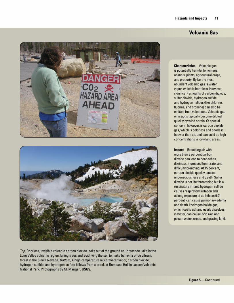
Volcanic Gas
Characteristics—Volcanic gas is potentially harmful to humans, animals, plants, agricultural crops, and property. By far the most abundant volcanic gas is water vapor, which is harmless. However, significant amounts of carbon dioxide, sulfur dioxide, hydrogen sulfide, and hydrogen halides (like chlorine, fluorine, and bromine) can also be emitted from volcanoes. Volcanic gas emissions typically become diluted quickly by wind or rain. Of special concern, however, is carbon dioxide gas, which is colorless and odorless, heavier than air, and can build up high concentrations in low-lying areas.
Impact —Breathing air with more than 3 percent carbon dioxide can lead to headaches, dizziness, increased heart rate, and difficulty breathing. At 15 percent, carbon dioxide quickly causes unconsciousness and death. Sulfur dioxide is not life threatening but is a respiratory irritant; hydrogen sulfide causes respiratory irritation and, at long exposure of as little as 0.01 percent, can cause pulmonary edema and death. Hydrogen halide gas, which coats ash and easily dissolves in water, can cause acid rain and poison water, crops, and grazing land.
Top, Odorless, invisible volcanic carbon dioxide leaks out of the ground at Horseshoe Lake in the Long Valley volcanic region, killing trees and acidifying the soil to make barren a once vibrant forest in the Sierra Nevada. Bottom, A high-temperature mix of water vapor, carbon dioxide, hydrogen sulfide, and hydrogen sulfate billows from a crack at Bumpass Hell in Lassen Volcanic National Park. Photographs by M. Mangan, USGS.
Figure 5.—Continued
12 California’s Exposure to Volcanic Hazards
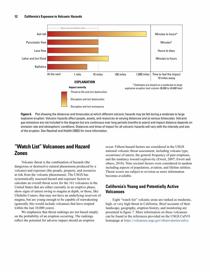
Figure 6. Plot showing the distances and timescales at which different volcanic hazards may be felt during a moderate to large explosive eruption. Volcanic hazards affect people, assets, and resources at varying distances and at various timescales. Volcanic gas emissions are not included in the diagram but are continuous over long periods (months to years) and impact distance depends on emission rate and atmospheric conditions. Distances and times of impact for all volcanic hazards will vary with the intensity and size of the eruption. See Newhall and Hoblitt (2002) for more information.
Threat to life and (or) destruction
Disruption and (or) destruction
Disruption and (or) annoyance
EXPLANATIONImpact severity
* Estimates are based on a moderate to large explosive eruption (ash column 30,000 to 45,000 feet)
Near-source hazard zone
Ash fall
Pyroclastic flow
Lava flow
Ballistics
Lahar and (or) flood
At the vent 1 mile 10 miles 100 miles 1,000 miles Time to feel the impact 10 miles away
Minutes*
Minutes to hours*
Hours to days
Minutes to hours
“Watch List” Volcanoes and Hazard Zones
Volcanic threat is the combination of hazards (the dangerous or destructive natural phenomena produced by a volcano) and exposure (the people, property, and resources at risk from the volcanic phenomena). The USGS has systematically assessed hazard and exposure factors to calculate an overall threat score for the 161 volcanoes in the United States that are either currently in an eruptive phase, show signs of unrest owing to magma at depth, or those, like Ubehebe Craters, that may not have an underlying reservoir of magma, but are young enough to be capable of reawakening (generally this would include volcanoes that have erupted within the last 10,000 years).
We emphasize that threat rankings are not based simply on the probability of an eruption occurring. The rankings reflect the potential for adverse impact should an eruption
occur. Fifteen hazard factors are considered in the USGS national volcanic threat assessment, including volcano type, occurrence of unrest, the general frequency of past eruptions, and the tendency toward explosivity (Ewert, 2007; Ewert and others, 2018). Nine societal factors were considered in tandem including aspects of population, aviation, and lifeline utilities. Threat scores are subject to revision as more information becomes available.
California’s Young and Potentially Active Volcanoes
Eight “watch list” volcanic areas are ranked as moderate, high, or very high threat in California. Brief accounts of their landscape, geography, eruption history, and monitoring are presented in figure 7. More information on these volcanoes can be found in the references provided on the USGS CalVO homepage at https://volcanoes.usgs.gov/observatories/calvo.

“Watch List” Volcanoes and Hazard Zones 13
Table 1. General measures that can reduce the adverse impact of volcanic hazards.
[See also https://volcanoes.usgs.gov/vhp/preparedness.html.]
Table 2. Aspects of volcanic activity to anticipate when assessing potential impact.
Anticipate Causes
Potential for false alarms Monitoring networks may help forecast an impending eruption, but many episodes of volcanic un-rest do not culminate in an eruption, adding uncertainty and stress to decision-making processes.
Long duration, variable intensity Volcanic eruptions can last for months, years, even decades, and often undergo many cycles of increasing and decreasing intensity. Some hazards, like lahars, flooding, and gas emissions, can persist long beyond the end of the eruption.
Large footprint Lahars can impact downstream areas many tens of miles from the volcano. Volcanic ash can impact ground and airspace activity tens to hundreds of miles away from the eruption column.
Difficult recovery Impacted land may not be recoverable for years, if not decades, owing to burial of vast tracts of land by lava flows, pyroclastic flows, or lahar mud, any of which may reach several tens of feet in thickness.
Hazard Steps to limit exposure Steps to enhance tolerance
Pyroclastic flows Evacuate people and remove portable infrastructure prior to onset
Too sudden, unpredictable, and intense for people and infrastructure to tolerate
Ballistics Evacuate people and remove portable infrastructure prior to onset
Shield stationary infrastructure; designate sturdy emergency shelter-in-place locations
Lava flows Evacuate people and remove portable equipment as flow nears
Lava diversion or containment measures have had limited success; remove combustible materials from flow path; prepare for wildfires
Lahars Avoid river valleys; move to higher ground Utilize lahar detection and downstream warning systems; utilize containment/diversion structures (sediment traps, dams, channels)
Ash fall Curtail human activities and wear particle masks (especially those with compromised respiratory systems); shelter in place and avoid wide-span roof structures; avoid driving and reroute traffic patterns; cover vehicles, machinery, and electronics; seal off buildings and close air intakes; move or shelter livestock and supply with untainted feed and water
Close water intakes and install water filtration equipment; reduce performance requirements; inspect and replace contaminated parts frequently; change air flow patterns
Volcanic gas Leave the vicinity, especially low-lying areas; wear masks/respirators designated for toxic gas (especially those with compromised respiratory systems); seal off buildings, close air intakes, and instate access control
Wash down materials prone to rusting or etching from dilute acids; inspect and replace corroded parts frequently; change air flow patterns

14 California’s Exposure to Volcanic Hazards
Medicine Lake Volcano, Siskiyou and Modoc Counties Mount Shasta, Siskiyou County
USGS national volcanic threat ranking: High USGS national volcanic threat ranking: Very high
Photograph of the east flank of Medicine Lake volcano, centered on the gray, unforested obsidian flow from the 950-year-old Glass Mountain eruption. Photograph by M. Poland, U.S. Geological Survey (USGS).
Medicine Lake volcano is a large, broad volcano (shield volcano) located in northern California, about 50 miles northwest of Alturas, the seat of Modoc County, and about 35 miles south of Klamath Falls, Oregon. Lava Beds National Monument lies on the north side of the volcano. Located at the summit of the volcano is a water-filled collapse basin, or caldera, formed by withdrawal of magma during eruptions. The caldera is 8 miles wide and 14 miles across. The intermittent, mostly effusive (nonexplosive) eruptions over the last half million years produced expansive lava flows, some covering as much as 100 square miles. The volcano has erupted nine times during the past 5,200 years, and seven of those eruptions began with an explosive phase. The two youngest eruptions produced ash clouds that drifted tens of miles downwind before explosions ceased and thick, glassy lava flows (obsidian) began oozing from the vents forming Little Glass Mountain (1,000 years ago) and Glass Mountain (950 years ago).
Overall, the pattern of eruptions over the past 12,500 years suggest the likelihood of a future eruption from Medicine Lake volcano is 1 in 3,600 annually, which corresponds to about a 1.0 percent chance of eruption within the next 30 years.
USGS seismometers and UNAVCO Global Positioning System (GPS) receivers provide a modest volcano monitoring network at Medicine Lake volcano. Volcanic gas emissions suggest that partly molten rock lies beneath the volcano, which provides heat for a robust geothermal system underlying the caldera. Sporadic earthquake swarms are detected by the monitoring network as well as ground subsidence owing to motions on regional faults and “sagging” of rock softened by volcanic heat.
Mount Shasta is a steep-sided volcano (stratovolcano) located about 60 miles north of Redding, California, along the Interstate 5 corridor. The towns of Weed, Mount Shasta City, and McCloud lie at the base of this 14,162-foot-high snow- and ice-clad volcano. Mount Shasta began forming on the remnants of an older volcano that collapsed sometime between 500,000 to 300,000 years ago. The collapse created one of the largest landslides known on Earth, covering more than 170 square miles of Shasta Valley to the northeast. Since then, Mount Shasta has had long lulls in eruptive activity punctuated by brief periods of many eruptions. Eruptions around 11,000 years ago built the conspicuous Black Butte and Shastina dome on the west flank of the volcano. In the last few millennia, eruptions have broken out at the volcano’s summit and from vents on its upper east flank. The youngest, well-documented eruption was about 3,000 years ago. Small, short-lived blasts of steam and ash may have occurred more recently, perhaps as recently as 1,800 to 200 years ago, but these events need additional field verification.
Research published to date suggest that Mount Shasta may have erupted about every 800 years over the last 10,000 years, which corresponds to a 3.5 percent chance of eruption within the next 30 years.
USGS seismometers and GPS receivers operated by UNAVCO form the monitoring network for Mount Shasta. The volcano has been relatively quiet for at least the past 15 years, with only a handful of small-magnitude earthquakes and no demonstrable ground deformation. Although geophysically quiet, periodic geochemical surveys indicate that volcanic gas emanates from a fumarole at the summit of Mount Shasta from a deep-seated reservoir of partly molten rock.
Photograph of Mount Shasta (left) with Shastina dome (right) on the west flank of the volcano. Photograph by A. Calvert, USGS.
Figure 7. Brief overview of eight “watch list” volcanic areas in California. Estimates of eruption probability are rounded to the nearest 0.5 percent.

“Watch List” Volcanoes and Hazard Zones 15
Lassen Volcanic Center, Shasta County Clear Lake Volcanic Field, Lake County
USGS national volcanic threat ranking: Very high USGS national volcanic threat ranking: High
Photograph of Chaos Crags (left) and Lassen Peak (right) in the Lassen Volcanic Center. Photograph by E. Montgomery-Brown, USGS.
Lassen Volcanic Center is located about 55 miles east of Redding, California, in Lassen Volcanic National Park. Within the past 825,000 years, hundreds of explosive eruptions came from vents scattered over 200 square miles. The volcanic center has been quiet for the last 25,000 years, with three notable exceptions—the Chaos Crags eruption (1,100 years ago), the Cinder Cone eruption (345 years ago), and the 20th-century eruption of Lassen Peak (1914–17). Although considered a “small” eruption, the Lassen Peak eruption produced a 3-year-long series of ash-laden steam blasts, punctuated by an episode in 1915 that produced an ash column 30,000 feet high, devastating pyroclastic flows, lahars, and drifting ash clouds that deposited ash 280 miles to the east. Today, a vigorous geothermal system, numerous hot springs, fumaroles, hot ground, and boiling mud pots attest to the youthful nature of the Lassen Volcanic Center.
Periodic geochemical sampling of gas and water indicates that a deep-seated zone of partly molten rock resides under Lassen Volcanic Center. A volcano monitoring network operated by the USGS (seismometers) and UNAVCO (GPS receivers) reveals occasional episodes of heightened earthquake activity coupled with gradual subsidence of the ground surface owing to motion on regional faults and complemented by “sagging” of thermally softened rock. Based on the record of past eruptions, the likelihood of a future eruption within the Lassen Volcanic Center is about 1 chance in 7,150 annually, which corresponds to a 0.5 percent probability of eruption within the next 30 years.
Also noteworthy is the regional volcanic field surrounding the Lassen Volcanic Center comprising more than 55 scattered vents from eruptions occurring 100,000 to 15,000 years ago. Most of these vents are within 10 miles of Lassen Peak and represent short-lived eruptions that produced cinder cones, lava flows, and (or) ash deposits of limited extent. The likelihood of a minor eruption within the regional vent field is about 1 chance in 1,550, corresponding to a 2.0 percent probability of eruption in the next 30 years. The threat level for the regional vent field is not ranked.
Photograph of the twin peaks of the Mount Konocti lava domes perched on the southwestern shore of Clear Lake within the Clear Lake volcanic field. Photograph from ©iStock.com/CoolPhotography.
Clear Lake volcanic field is located about 90 miles north of San Francisco, California. The town of Clear Lake lies within the field, as does the 43,000-acre fresh water lake of its namesake. The most prominent volcanic feature in the field is 300,000-year-old Mount Konocti, rising about 3,200 feet above the south shore of the lake. The 2-million-year history of Clear Lake volcanic field consists mostly of nonexplosive eruptions. However, the most recent eruptions, which occurred through the lake about 11,000 years ago, were explosive owing to flash vaporization of water as magma ascended toward the surface. These events produced craters and cinder cones along the shoreline near Mount Konocti. Clear Lake volcanic field is well known for steam vents and hot springs. The Geysers steam field sits along the southwest margin of the volcanic field, and hosts one of the world’s most productive geothermal power facilities. Currently there are 18 plants in operation generating about 835 megawatts (MW) of electricity.
Additional research is needed to determine the likelihood of a future eruption in the Clear Lake volcanic field, but recent geophysical and geochemical surveys suggest that a reservoir of partly molten rock underlies the volcanic field, and another body of magma underlies The Geysers steam field.
Monitoring in the Clear Lake volcanic region by the USGS, and by a collaborative USGS-Calpine Corporation effort in The Geysers steam field, provides real-time tracking of earthquake activity. Seismicity under the Clear Lake volcanic field is mostly concentrated near the southern arm of the lake and is limited to a few dozen events per year. The geothermal system under The Geysers steam field, in contrast, produces thousands of earthquakes yearly. The USGS periodically analyzes volcanic gas emissions in the region.
Figure 7.—Continued.

16 California’s Exposure to Volcanic Hazards
Long Valley Volcanic Region, Mono County
USGS national volcanic threat ranking: Moderate to very high
Left, View of the Mono Craters lava domes looking southward across Mono Lake. Photograph by S. Harangi, Eötvös Loránd University. Right, View looking across Long Valley Caldera westward to Mammoth Mountain. Photograph by M. Mangan, USGS.
The Long Valley volcanic region is a broad area straddling Highway 395 near the eastern border of Yosemite National Park. Hundreds of eruptions have shaped this picturesque landscape over the last 4 million years, including a cataclysmic eruption about 767,000 years ago that created a 20×10-mile collapsed basin known as Long Valley Caldera. Although the last eruption within Long Valley Caldera was about 100,000 years ago, magmatic heat fuels a robust geothermal system, hot springs, and fumaroles.
Mammoth Mountain, a 100,000 to 50,000-year-old cluster of overlap-ping lava domes, sits on the western rim of Long Valley Caldera, partly within the town of Mammoth Lakes. Springs, fumaroles, and diffuse emissions of volcanic gas are common to Mammoth Mountain. Several young cinder cones and lava flows are dispersed around the base of the mountain. The youngest, Red Cones, was created during an eruption that occurred about 8,000 years ago.
The most recent eruptions in the Long Valley volcanic region were not from Long Valley Caldera or Mammoth Mountain, but along a curved chain of volcanic vents extending about 23 miles northward
from Mammoth Mountain to Mono Lake. These eruptions produced Mono Craters, which erupted about 680 years ago, and the Mono Lake volcanic field to the north, which was last active about 300 years ago.
The pattern of eruptions over the last 180,000 years suggests the likelihood of future eruptions in the Long Valley volcanic region is about 2.5 percent in the next 10 years and about 22.5 percent in the next 100 years (Bevilacqua and others, 2018). The most likely location is along Mono Craters. Specific threat rankings for the Long Valley volcanic region are: very high for Long Valley Caldera, high for Mono Craters, moderate for Mono Lake volcanic field, and moderate for Mammoth Mountain.
An extensive monitoring network operated by the USGS has documented sporadic unrest under Long Valley Caldera and Mammoth Mountain over the last three decades. Unrest includes periods of heightened seismicity, ground deformation and uplift, changes to the geothermal system, and intense emission of volcanic gas (most notably, carbon dioxide).
Figure 7.—Continued.
“Watch List” Volcanoes and Hazard Zones 17
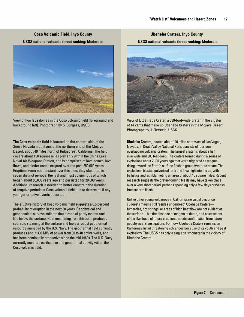
Coso Volcanic Field, Inyo County Ubehebe Craters, Inyo County
USGS national volcanic threat ranking: Moderate USGS national volcanic threat ranking: Moderate
View of two lava domes in the Coso volcanic field (foreground and background left). Photograph by S. Burgess, USGS.
View of Little Hebe Crater, a 330-foot-wide crater in the cluster of 14 vents that make up Ubehebe Craters in the Mojave Desert. Photograph by J. Fierstein, USGS.
The Coso volcanic field is located on the eastern side of the Sierra Nevada mountains at the northern end of the Mojave Desert, about 40 miles north of Ridgecrest, California. The field covers about 150 square miles primarily within the China Lake Naval Air Weapons Station, and is comprised of lava domes, lava flows, and cinder cones erupted over the past 250,000 years. Eruptions were not constant over this time; they clustered in seven distinct periods, the last and most voluminous of which began about 80,000 years ago and persisted for 20,000 years. Additional research is needed to better constrain the duration of eruptive periods at Coso volcanic field and to determine if any younger eruptive events occurred.
The eruptive history of Coso volcanic field suggests a 0.5 percent probability of eruption in the next 30 years. Geophysical and geochemical surveys indicate that a zone of partly molten rock lies below the surface. Heat emanating from this zone produces sporadic steaming at the surface and fuels a robust geothermal resource managed by the U.S. Navy. The geothermal field currently produces about 300 MW of power from 30 to 40 active wells, and has been continually productive since the mid 1980s. The U.S. Navy currently monitors earthquake and geothermal activity within the Coso volcanic field.
Ubehebe Craters, located about 140 miles northwest of Las Vegas, Nevada, in Death Valley National Park, consists of fourteen overlapping volcanic craters. The largest crater is about a half mile wide and 800 feet deep. The craters formed during a series of explosions about 2,100 years ago that were triggered as magma rising toward the Earth’s surface flashed groundwater to steam. The explosions blasted pulverized rock and lava high into the air, with ballistics and ash blanketing an area of about 15 square miles. Recent research suggests the crater-forming blasts may have taken place over a very short period, perhaps spanning only a few days or weeks from start to finish.
Unlike other young volcanoes in California, no visual evidence suggests magma still resides underneath Ubehebe Craters—fumaroles, hot springs, or areas of high heat flow are not evident at the surface—but the absence of magma at depth, and assessment of the likelihood of future eruptions, needs confirmation from future geophysical investigations. For now, Ubehebe Craters remains on California’s list of threatening volcanoes because of its youth and past explosivity. The USGS has only a single seismometer in the vicinity of Ubehebe Craters.
Figure 7.—Continued.

18 California’s Exposure to Volcanic Hazards
Salton Buttes, Imperial County
USGS national volcanic threat ranking: High
View of one of the five small lava domes that compose Salton Buttes on the southeast margin of the Salton Sea. Photograph by M. Mangan, USGS.
The Salton Buttes are composed of five small lava domes that are perched along the southeast shore of the Salton Sea, about 90 miles southeast of Palm Springs, California, in the agricultural heart of Imperial Valley. At least four of these domes formed between 2,300 and 1,800 years ago, each starting with a short explosive phase that then gave way to an effusive eruption of viscous lava oozing from vents to create glassy mounds of black obsidian. The fifth dome may be somewhat older than the others, with an eruption age of about 5,000 years ago. Although small—all are less than 230 feet high—these domes overlie the 8-square-mile zone of high heat flow and magma influx that created the Salton Sea geothermal resource area, the largest and hottest geothermal system in the continental United States. The geothermal field currently has a combined capacity of about 327 MW of power from 10 generating plants.
The available data are insufficient to establish the pattern of volcanic activity needed for long-term forecasting, but the high heat flow and relatively young age of Salton Buttes attest to the potential for future eruptions.
A modest seismic network operated by the USGS and the California Institute of Technology (Caltech) detects a persistent pattern of small to moderate earthquakes, most of which are related to the geothermal system and to movement along regional faults. Periodic geochemical sampling from fumaroles, hot springs, and mud pots indicates that gas from an underlying magma reservoir is being released at the surface.
California’s Volcanic Hazard Zones
Geologists produce hazard zone maps to convey the types of hazards that may occur during future eruptions and to identify the areas of potential impact. The specific hazards to people and property (pyroclastic flows, lava flows, lahars, floods, and ash fall) depend on the eruption style (effusive or explosive), the volume of lava erupted, the location of the eruptive vent, the eruption duration, and local hydrologic conditions. The USGS has published specific volcanic hazard zone maps for some, but not all, moderate to very high threat volcanoes in the state. Hazard zone maps are critical for planning long-term land use, and effective emergency-response measures, especially when a volcano begins to show signs of unrest.
Figure 8 shows a simplified compilation of volcanic hazard zones adapted from those published by Miller (1980, 1989), Miller and others (1982), Donnelly-Nolan and others (2007), White and others (2011), Clynne and others (2012), and Robinson and others (2012). It is important to recognize that hazard zone maps are dynamic—as geologic research progresses, maps are updated and created. Hazard zone maps for Medicine Lake volcano and Lassen Volcanic Center are the most recent and comprehensive. The published maps for Mount Shasta and Long Valley volcanic region are in the process of being updated by the USGS, but significant field research is needed to augment maps that are incomplete (Clear Lake volcanic field, Ubehebe Craters, Salton Buttes) or do not yet exist (Coso volcanic field).
Societal Exposure to Volcanic Hazards
In this section, sociological and environmental elements are identified that, by virtue of being situated in the volcanic hazard zone of a moderate, high, or very high threat volcano, may be adversely impacted by a future eruption. We used geographic information system (GIS) analysis of statewide data to identify the populations, assets, and resources within a few miles of an eruption site where life threatening, highly destructive, and (or) disruptive conditions are possible from pyroclastic flows, lahars, lava flows, ballistics, volcanic floods, and heavy ash fall (2 inches or more).
The analysis covers five themes: (1) land cover, ownership, and jurisdictions; (2) daily and intermittent populations; (3) lifeline utilities; (4) agriculture and forestry; and (5) community services and facilities. Key results are visualized in maps and charts. The published data sources and data reports used in this study are provided in appendix 1 and composite data tables are provided in appendix 2 and 3. Data generated in this study are also independently available in GIS format by Abdollahian and others (2018).Figure 7.—Continued.

Societal Exposure to Volcanic Hazards 19
Figure 8. Generalized volcanic hazard maps for very high, high, and moderate threat volcanoes compiled and simplified from Miller (1980, 1989), Miller and others (1982), Donnelly-Nolan and others (2007), Clynne and others (2012), White and others (2011), and Robinson and others (2012). Shaded areas enclose potential vent areas where many types of hazards are possible (pink) and more distant areas where lahars (brown), lava flows (orange), or floods (dark blue) may occur. Dashed lines enclose areas where 2 inches or more of ash fall are possible. Coso volcanic field has not yet been zoned for hazards. Note that hazard maps are dynamic and are updated periodically as research adds new information.
FloodsLaharsLava flowsNear-vent hazards (pyroclastic
flows, lava flows, ballistics, lahars, and [or] floods)
AshVolcanic hazard zones
EXPLANATION
50 KILOMETERS
15 KILOMETERS
0 50 KILOMETERS
0 5025
25
MILESN
Shaded relief from 2012 U.S. Geological Survey 100-meter digital dataPolitical boundaries from 2015 U.S. Census Bureau TIGER line data
Cosovolcanic field
Cosovolcanic field
SaltonButtesSaltonButtes
MountShastaMountShasta
LassenVolcanic
Center
LassenVolcanic
Center
MedicineLake volcano
Clear Lakevolcanic field
Long Valleyvolcanic region
Long Valleyvolcanic region
UbehebeCraters
Mono Lakevolcanic field
MonoCraters
Long ValleyCaldera
MammothMountain
20 California’s Exposure to Volcanic Hazards
Land Cover, Ownership, and Jurisdiction
Land CoverThe term “land cover” is used to classify the physical
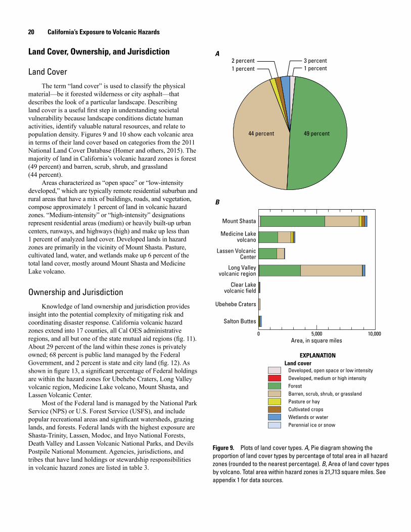
material—be it forested wilderness or city asphalt—that describes the look of a particular landscape. Describing land cover is a useful first step in understanding societal vulnerability because landscape conditions dictate human activities, identify valuable natural resources, and relate to population density. Figures 9 and 10 show each volcanic area in terms of their land cover based on categories from the 2011 National Land Cover Database (Homer and others, 2015). The majority of land in California’s volcanic hazard zones is forest (49 percent) and barren, scrub, shrub, and grassland (44 percent).
Areas characterized as “open space” or “low-intensity developed,” which are typically remote residential suburban and rural areas that have a mix of buildings, roads, and vegetation, compose approximately 1 percent of land in volcanic hazard zones. “Medium-intensity” or “high-intensity” designations represent residential areas (medium) or heavily built-up urban centers, runways, and highways (high) and make up less than 1 percent of analyzed land cover. Developed lands in hazard zones are primarily in the vicinity of Mount Shasta. Pasture, cultivated land, water, and wetlands make up 6 percent of the total land cover, mostly around Mount Shasta and Medicine Lake volcano.
Ownership and JurisdictionKnowledge of land ownership and jurisdiction provides
insight into the potential complexity of mitigating risk and coordinating disaster response. California volcanic hazard zones extend into 17 counties, all Cal OES administrative regions, and all but one of the state mutual aid regions (fig. 11). About 29 percent of the land within these zones is privately owned; 68 percent is public land managed by the Federal Government, and 2 percent is state and city land (fig. 12). As shown in figure 13, a significant percentage of Federal holdings are within the hazard zones for Ubehebe Craters, Long Valley volcanic region, Medicine Lake volcano, Mount Shasta, and Lassen Volcanic Center.
Most of the Federal land is managed by the National Park Service (NPS) or U.S. Forest Service (USFS), and include popular recreational areas and significant watersheds, grazing lands, and forests. Federal lands with the highest exposure are Shasta-Trinity, Lassen, Modoc, and Inyo National Forests, Death Valley and Lassen Volcanic National Parks, and Devils Postpile National Monument. Agencies, jurisdictions, and tribes that have land holdings or stewardship responsibilities in volcanic hazard zones are listed in table 3.
Figure 9. Plots of land cover types. A, Pie diagram showing the proportion of land cover types by percentage of total area in all hazard zones (rounded to the nearest percentage). B, Area of land cover types by volcano. Total area within hazard zones is 21,713 square miles. See appendix 1 for data sources.
EXPLANATIONLand cover
Wetlands or waterPerennial ice or snow
Developed, open space or low intensityDeveloped, medium or high intensityForestBarren, scrub, shrub, or grasslandPasture or hayCultivated crops
10,000Area, in square miles
0 5,000
Mount Shasta
Medicine Lakevolcano
Lassen VolcanicCenter
Long Valleyvolcanic region
Clear Lakevolcanic field
Ubehebe Craters
Salton Buttes
A
B
1 percent
44 percent
2 percent 3 percent1 percent
49 percent

Societal Exposure to Volcanic Hazards 21
Figure 10. Maps showing the classification of land cover around (A) Mount Shasta, Medicine Lake volcano, and Lassen Volcanic Center; (B) Clear Lake volcanic field; (C ) Long Valley volcanic region and Ubehebe Craters; and (D) Salton Buttes. See appendix 1 for data sources.
FloodsLaharsLava flowsNear-vent hazards (pyroclastic
flows, lava flows, ballistics, lahars, and [or] floods)
Ash
EXPLANATION
Land cover Volcanic hazard zones
Wetlands or waterPerennial ice or snow
Developed, open space or low intensityDeveloped, medium or high intensityForestBarren, scrub, shrub, or grasslandPasture or hayCultivated crops
CALIFORNIAOREGON
ClearLake
CALIFORNIA
NEVADA
MountShasta
MedicineLake
volcano
LassenVolcanic
Center
Clear Lakevolcanic field
Salton Sea
SaltonButtes
10
8
5
99
101
Mono Lakevolcanic field Mono
Craters
Long ValleyCalderaMammoth
Mountain
UbehebeCraters
A B
C D
N
Base modified from 2011 National Land Cover DatasetPolitical boundaries from 2015 U.S. Census Bureau TIGER line data
A
B
C
D
CALIFORNIA
50 KILOMETERS 25 KILOMETERS
50 KILOMETERS 25 KILOMETERS
N
N N

22 California’s Exposure to Volcanic Hazards
MARIPOSA
ALPINE
INYO
FRESNO
SISKIYOU
LASSEN
MODOC
MONO
SHASTA
IMPERIAL
TRINITY
TEHAMAPLUMAS
BUTTE
LAKE
MADERA
TUOLUMNE
Cosovolcanic field
Cosovolcanic field
SaltonButtesSaltonButtes
MountShastaMountShasta
LassenVolcanic
Center
LassenVolcanic
Center
MedicineLake volcano
MedicineLake volcano
Clear Lakevolcanic
field
Long Valleyvolcanic region
Long Valleyvolcanic region
UbehebeCraters
MAR V
MAR IV
MAR VI
MAR II
MAR III
Cal OES southern region
Cal OES inland region
Cal OEScoastal region
MAR I
0 50 KILOMETERS
0 5025
25
MILESN
Base from 2015 U.S Census Bureau TIGER line data
With land in a volcanic hazard zone
Without land in a volcanic hazard zone
Moderate to Very High Threat Volcano
Cal OES mutual aid regions (MAR)
EXPLANATION
Cal OES administrative regions
California county
Figure 11. Map of California showing counties and California Governor’s Office of Emergency Services (Cal OES) administrative regions (coastal, inland, and southern) and mutual aid regions (MARs) I–VI that could be directly affected by volcanic hazards.

Societal Exposure to Volcanic Hazards 23
Figure 12. Pie diagram showing land ownership as a percentage of the total area (21,713 square miles) in volcanic hazard zones. Percentages are rounded to the nearest 1 percent. County, special district, and tribal lands are all less than 1 percent. See appendix 1 for data sources.
Figure 13. Pie diagrams showing land ownership in hazard zones by volcanic center. Values rounded to the nearest 1 percent. See appendix 1 for data sources.
City1 percent
State1 percent
Private29 percent
Federal68 percent
Clear Lake volcanic field140 mi2
95 percent
4 percent1 percent
Ubehebe Craters131 mi2
100 percent
Lassen Volcanic Center2,504 mi2
52 percent
2 percent
46 percent
Salton Buttes188 mi2
6 percent
51 percent
16 percent
27 percent
Long Valley volcanic region9,161 mi2
Land ownership within volcanic hazard zones—By area
EXPLANATION
Federal
State
City
Special district
Private
Mount Shasta9,248 mi2
54 percent
1 percent
45 percent
Medicine Lake volcano 3,159 mi2
86 percent
3 percent
1 percent10 percent
68 percent
32 percent

24 California’s Exposure to Volcanic Hazards
Populations Exposed to Volcanic Hazards
Estimating the daily average population within volcanic hazard zones is challenging. A common approach, and one that accounts for the mobility of society in the 21st century, is to use the Oak Ridge National Laboratory LandScan population model (Bright and others, 2010; see appendix 1 for reference). The model provides population counts by integrating U.S. Census Bureau data with statistical population predictions (30” × 30” latitude-longitude grid) based on road density, land cover, topography, and nighttime illumination obtained from high-resolution imagery.
Based on modeling of 2010 LandScan population data, an average of 199,235 people live, work, or pass through a California volcanic hazard zone on a daily basis (fig. 14, 15). The largest populations are around Mount Shasta (103,885), the four volcanoes in the Long Valley volcanic region (63,523), Clear Lake volcanic field (17,910), and the Lassen Volcanic Center (9,888). Smaller populations fall within Medicine Lake volcano (5,209), Salton Buttes (2,518) and Ubehebe Craters (111) hazard zones. At the county level, Shasta and Siskiyou counties contain the largest daily populations in hazard zones (approximately 61,425 and 42,163, respectively). The daily average population in all near-vent hazard zones is 45,601.
The 2010 LandScan model of daily population does not account for all types of intermittent populations. Popular recreational areas, including 9 state parks, 8 national forests, and 6 national parks, fall within, or partly within, hazard zones. Usage statistics suggest over 20 million people visit these sites annually (table 4), with the highest numbers in the Long Valley volcanic region (Inyo National Forest, Yosemite National Park, and Sierra and Stanislaus National Forests).
Table 3. List of Federal, state, county, tribal, city, and special district authorities with land holdings in volcanic hazard zones in California.
[See appendix 1 for data sources]
Governance AuthoritiesFederal Bureau of Indian Affairs, Bureau of Land Management, Department of Defense, National Park Service, U.S.
Bureau of Reclamation, U.S. Forest Service, U.S. Fish and Wildlife Service, U.S. Army Corps of EngineersState California Department of Fish and Wildlife, California Department of Forestry and Fire Protection, State Lands
Commission, California Department of Parks and RecreationCounty Alpine, Butte, Fresno, Imperial, Inyo, Lake, Lassen, Madera, Mariposa, Mono, Modoc, Plumas, Siskiyou, Shasta,
Tehama, Trinity, TuolomneTribal Benton Paiute Reservation, Big Bend Rancheria, Big Pine Reservation, Big Sandy Rancheria, Big Valley
Rancheria, Bishop Reservation, Bridgeport Colony, Cold Springs Rancheria, Karuk Reservation, Montgomery Creek Rancheria, North Fork Rancheria, Picayune Rancheria, Quartz Valley Reservation, Roaring Creek Rancheria, Sulphur Bank Rancheria, XL Ranch Reservation
Incorporated cities Bishop, Calipatria, Clearlake, Dorris, Dunsmuir, Etna, Fort Jones, Mammoth Lakes, Montague, Mount Shasta, Shasta Lake, Tulelake, Weed, Yreka
Special districts Dunsmuir Recreation and Park District, Imperial Irrigation District, Lake Shastina Community Services District, McCloud Community Services District, Mountain Gate Community Special District, Mount Shasta Recreation and Parks District
Lifeline Utilities Exposed to Volcanic Hazards
High-Voltage Power Lines and Telecommunications
Data available from the California Energy Commission (2016; see appendix 1 for reference) suggest that overhead electric transmission lines (33–500 kilovolt [kV]) of three of California’s major utilities pass through volcanic hazard zones, as well as about 178 associated substations (table 5). Additionally, the high-voltage Pacific alternating current (4,800 megawatt [MW] capacity) and direct current (3,100 MW capacity) interties, which bring hydroelectric power from the Columbia River (Oregon and Washington) and Canada to the equivalent of about 8 million California households, enter the state through the hazard zones of Mount Shasta, Medicine Lake volcano, and the Long Valley volcanic region (fig. 16).
Even a fine dusting of volcanic ash can cause widespread disruption to power lines. For example, although the 2011 Cordón Caulle eruption in Chile was relatively small, an area some 150 miles away from the vent was affected by ash fall. In multiple towns, blackouts owing to damage to the electrical infrastructure began within days of the start of the eruption and persisted for weeks. Ash fall caused flashovers (electrical discharges) on insulators and ash accumulation caused poles to collapse. Lightning strikes spawned in the ash clouds damaged substations.
In addition to high-voltage transmission lines, aerial telecommunication lifelines (fig. 17), including 1,400 microwave and cellular transmitters, 219 broadcast radio and television antennas, and 53 paging transmitters, are located within volcanic

Societal Exposure to Volcanic Hazards 25
FloodsLaharsLava flowsNear-vent hazards (pyroclastic flows, lava flows, ballistics, lahars, and [or] floods)
Ash
EXPLANATIONPopulation density, in people
per square kilometer (from Bright and others, 2015)
Volcanic hazard zones
2,501 to 5,0005,001 to 10,000
1 to 56 to 2526 to 50
51 to 100101 to 500
501 to 2,500
Shaded relief from 2012 U.S. Geological Survey 100-meter digital dataPolitical boundaries from 2015 U.S. Census Bureau TIGER line data
CALIFORNIAOREGON
ClearLake
CALIFORNIA
NEVADA
Yreka
Alturas
SusanvilleRedding
Red Bluff
Lakeport
Clearlake
Cloverdale
Sonora
Bishop
El Centro
Brawley
Coachella
Indio
Fresno
South Lake Tahoe
MountShasta
Medicine Lakevolcano
LassenVolcanic
Center
Clear Lakevolcanic field
Salton Sea
SaltonButtes
10
8
5
99
101
Mono Lakevolcanic field Mono
Craters
Long ValleyCaldera
MammothMountain
UbehebeCraters
A
B
C
D
CALIFORNIA
50 KILOMETERS 25 KILOMETERS
50 KILOMETERS 25 KILOMETERS
A B
C D
N N
N N
Figure 14. Maps of 2010 population density in and near (A) Mount Shasta, Medicine Lake volcano, and Lassen Volcanic Center; (B ) Clear Lake volcanic field; (C ) Long Valley volcanic region and Ubehebe Craters; and (D ) Salton Buttes. See appendix 1 for data sources.

26 California’s Exposure to Volcanic Hazards
Figure 15. Infographic showing the number of people within California volcanic hazard zones (A) by volcano and (B) by county. See appendix 1 for data sources.
B. Daily population in hazard zones per county
Alpine County
Butte County
Fresno County
Imperial County
Inyo County
Lake County
Lassen County
Madera County
Mariposa County
Modoc County
Mono County
Plumas County
Shasta County
Siskiyou County
Tehama County
Trinity County
Tuolumne County
A. Daily population in hazard zones per volcano
Ubehebe Craters
Mount Shasta
Long Valley volcanic region
Clear Lake volcanic field
Lassen Volcanic Center
Salton Buttes
5,000 people
Medicine Lake volcano
EXPLANATION
Table 4. 2010 annual visitation for state parks, national parks, and national forests within California volcanic hazard zones.
[See appendix 1 for data sources.]
State parks, national parks, and national forestsVisits in
2010Mount Shasta, Medicine Lake volcano, and Lassen Volcanic CenterAhjumawi Lava Springs State Park 5,174Castle Crags State Park 39,803Klamath National Forest 336,458Lassen National Forest 420,898Lassen Volcanic National Park 427,413Lava Beds National Monument 106,166McArthur-Burney Falls Memorial State Park 183,767Modoc National Forest 154,675Shasta State Historic Park 26,709Shasta-Trinity National Forest 2,170,791Whiskeytown-Shasta-Trinity National Recreation
Area885,683
Long Valley volcanic regionBodie State Historic Park 129,481California Mining and Mineral Museum 9,260Devils Postpile National Monument 91,796Inyo National Forest 5,494,965Kings Canyon National Park 587,277Millerton Lake State Recreation Area 473,578Mono Lake Tufa State Reserve 299,557Sierra National Forest 1,312,027Stanislaus National Forest 1,570,661Toiyabe National Forest 2,315,732Wassama Round House State Historic Park 370Yosemite National Park 3,829,361
Clear Lake volcanic fieldClear Lake State Park 70,808
Ubehebe CratersDeath Valley National Park 987,391
Table 5. High-voltage transmission lines and substations in volcanic hazard zones in California.
[See appendix 1 for data sources]
VolcanoLength, in
milesNumber of substations
Mount Shasta 1,223 86Medicine Lake Volcano 342 7Lassen Volcanic Center 191 15Long Valley volcanic region 724 57Clear Lake volcanic field 23 2Salton Buttes 58 11

Societal Exposure to Volcanic Hazards 27
men18-7308_fig16
MountShasta
LassenVolcanic
Center
MedicineLake volcano
Clear Lakevolcanic field
Clear Lakevolcanic field
Long Valleyvolcanic region
UbehebeCraters
Cosovolcanic field
SaltonButtes
Pacific AC Intertie
Pacific DC Intertie
Electrical transmission lines—By owner
San Diego Gas and ElectricSacramento Municipal Utility DistrictPacifiCorpWestern Area Power Administration
Pacific Gas and Electric CompanySouthern California EdisonImperial Irrigation DistrictLos Angeles Department of Water and Power
Outer boundary of mapped hazard zone
EXPLANATION
Other
Mount Shasta
Long Valley volcanic region
Clear Lake volcanic field
Lassen Volcanic Center
Medicine Lake volcano
Salton Buttes
100 miles oftransmission lines
Length of transmission lines per volcanic hazard zone
EXPLANATION
Ubehebe Craters
0 50 KILOMETERS
0 25
25
50 MILESN
Figure 16. Map of California showing high-voltage electric transmission lines in relation to volcanic hazard zones. The Pacific direct current (DC) and alternating current (AC) interties, which bring power from Washington, Oregon, and Canada, enter California in volcanic hazard zones. Transmission lines are especially vulnerable to flashover owing to the high conductance of wet volcanic ash fall. See appendix 1 for data sources. An infographic pictorially shows the miles of electric transmission lines in each volcanic hazard zone.

28 California’s Exposure to Volcanic Hazards
Figure 17. Plot showing the number of antennas and transmitters in hazard zones by volcano in California. See appendix 1 for data sources. NTSC, National Television System Committee; FM, frequency modulation; AM, amplitude modulation.
800
600
400
0
Num
ber o
f ant
enna
s or
tran
smitt
ers
200
1,000
MountShasta
Medicine Lake volcano
LassenVolcanic Center
Long Valleyvolcanic region
Clear Lakevolcanic field
UbehebeCraters
SaltonButtes
AM radio antennaFM radio antennaDigital television antennaNTSC television antennaPaging transmitterMicrowave transmitterCellular transmitter
EXPLANATION
Table 6. Number of hydroelectric-power-generating facilities with capacity >1 megawatt (MW) that are located in California volcanic hazard zones.
[Five facilities in northern California are located within overlapping hazard zones of Mount Shasta and Lassen Volcanic Center. See appendix 1 for data source]
Volcano Number of hydroelectric facilities
Mount Shasta 29Lassen Volcanic Center 17Long Valley volcanic region 35
hazard zones. Most of these are found within the Mount Shasta and Long Valley volcanic region (Homeland Infrastructure Foundation-Level Data Subcommittee, 2013).
The large concentration of electrically charged particles in volcanic ash columns may attenuate some telecommunications signals, and interference with signal transmission may also be caused by volcanic lightning. In the 1991 eruption of Mount Pinatubo in the Philippines, very high frequency telemetry from monitoring instruments was interrupted while voice communication was still possible through a commercial cell phone network. Recent analyses by New Zealand-based telecommunications engineers concluded that disruption of electromagnetic transmissions is most likely for low frequency services in the 30–300 kilohertz (kHz) range (Wilson and others, 2009). Ash infiltration is a larger concern because modern telecommunication systems require usage of heating, ventilation, and air conditioning systems that are vulnerable to blockage and abrasion at air intake sites.
Hydroelectric Power GenerationIn-state hydroelectric power generation constitutes nearly 7
percent of California’s energy portfolio. Data from the California Energy Commission (2016) indicates several hydroelectric plants are located in volcanic hazard zones. Some are found along the state’s most important hydroelectric rivers: the upper Sacramento River (Shasta Dam hydroelectric plant with capacity of 714 MW), the Pit River (total capacity of 507 MW from 6 powerhouses), and the Tuolumne River (two Hetch Hetchy Reservoir powerhouses with combined capacity of 283 MW). Altogether, 76 hydroelectric facilities with 1 MW or greater capacity are located in designated volcanic hazard zones (table 6); 26 of these are classified as “large” with 30 MW or more generation capacity.
Water laden with volcanic debris can pit and scour the metallic components of hydroelectric power facilities. Tungurahua volcano in Ecuador offers a prime example of the detrimental impact of ashfall and lahars on power generation (Sword-Daniels and others, 2011; Wardman and others, 2012). Eruptions in 1999 and 2006 caused the Agoyan hydroelectric plant, Ecuador’s second most important power generation facility, to temporarily close because suspended solids accumulated in the catchment of the dam. Despite precautionary closures, four turbines had to be replaced owing to accelerated deterioration and a protective floodgate system installed to divert turbid water downstream of generation components during eruptive events (fig. 18).
Geothermal Power GenerationA national assessment of moderate- and high-temperature
geothermal resources of the United States indicates a combined 9,057 MW power generation potential from conventional geothermal fields located on accessible public lands in 13 western states (Williams and others, 2008). California’s 45 identified

Societal Exposure to Volcanic Hazards 29
Figure 18. Photograph of a turbine at the Agoyan hydroelectric plant abraded by ash and other volcanic debris produced during eruptions of Tungurahua volcano, Ecuador. Inset photograph shows orange floodgates used to divert turbid water away from intake mechanisms. Photograph by J. Wardman, University of Canterbury.
EXPLANATION
Moderate to very high threat volcano
Moderate- and high-temperaturegeothermal resources
N
0 50 KILOMETERS
0 5025
25
MILES
Shaded relief from 2012 U.S. Geological Survey 100-meter digital dataPolitical boundaries from 2015 U.S. Census Bureau TIGER line data
The Geysers Casa Diablo
Coso
Salton Sea
Figure 19. Map showing the location of identified moderate- and high-temperature geothermal resources in California. Producing resources include The Geysers, Casa Diablo, Coso, and Salton Sea power plants, which are all located near moderate to very high threat volcanoes. Modified from Williams and others (2008).
resources account for about 60 percent of the total (fig. 19). Several of these are fueled by heat emanating from magma reservoirs deep in the roots of young volcanoes, including The Geysers, Casa Diablo, Coso, and Salton Sea geothermal plants, which have a combined capacity of 2,166 MW (California Energy Commission, 2016).
Volcanic unrest can create hazardous geothermal disturbances. A steam-driven eruption can be caused by flash vaporization when groundwater suddenly comes into contact with magma or hot rock. A well-known example occurred in 1977 in the volcanic Námafjall geothermal field at Krafla volcano in Iceland, when, over a period of only 20 minutes, 3 tons of magma and steam exploded from a 3,733-foot-deep borehole (Larsen and others, 1979). These types of events pose a danger both to geothermal resource operators and infrastructure.
Natural Gas Transport The California Energy Commission natural gas infrastructure
report (Wood, 2009) lists California as one of the largest natural gas consumers in the United States. About 30 percent of California’s total natural gas, including residential, commercial, and industrial markets, is supplied by out-of-state resources in the Western Canadian Sedimentary and Rocky Mountain basins.

30 California’s Exposure to Volcanic Hazards
Interstate gas pipelines converge at the Malin, Oregon, hub near the Oregon-California border to feed Pacific Gas and Electric’s (PG&E) Redwood Path (440-401 lines). As shown in figure 20, the Redwood Path pipeline (and 15 above-ground substations) runs through the Medicine Lake volcano lava flow hazard zone and the overlapping ash fall hazard zones of Medicine Lake volcano, Mount Shasta, and Lassen Volcanic Center. The Redwood Path has a capacity of 2,023 million standard cubic feet per day (MMcf/d), supporting 4.2 million residential customers and over 229,000 businesses in 37 counties, from north of Redding to south of Bakersfield.
Surface and buried gas pipelines and substations are vulnerable to bulldozing by lava flows, pyroclastic flows, lahars, and volcanic floods. Pyroclastic flows in the 2002 eruption of Reventador volcano in Ecuador, bulldozed important oil and gas
FloodsLaharsLava flowsNear-vent hazards
(pyroclastic flows, lava flows, ballistics, lahars, and [or] floods)
Ash
EXPLANATIONVolcanic hazard zones
Natural gas pipeline
Natural gas substation"
Shaded relief from 2012 U.S. Geological Survey 100-meter digital dataPolitical boundaries from 2015 U.S. Census Bureau TIGER line data
50 KILOMETERS
N
CALIFORNIAOREGON
"
"
"
"
""
"
"
"
"
"
"
"
" "
"
"
"
"
"
"
"
"
"
"
"
""
"
"
"
"
"
""
"""
"
"
Yreka
Malin
Redding
Red Bluff
MountShasta
Medicine Lakevolcano
LassenVolcanic
Center
5
Area of map
CALIFORNIA
Figure 21. Photograph of an underground pipeline (buried 12 feet deep) that was excavated and crushed by a lahar during the 2002 eruption of Reventador volcano in Ecuador. Photograph by P. Ramon, Instituto Geofísico, Ecuador.
Figure 20. Map of natural gas pipelines and substations in northern California. Segments emanating from the Malin, Oregon, natural gas pipeline hub pass through the Mount Shasta, Medicine Lake volcano, and Lassen Volcanic Center hazard zones. See appendix 1 for data source.
pipelines, pushing some segments 65 feet off kilter. Later, in 2003, a subsurface segment of pipeline was crushed, and in places, severed by a lahar that eroded a 13- to 20-foot-deep channel (fig. 21).
Water Supply, Storage, and Conveyance
Volcanic eruptions can substantially disrupt hydrologic systems, most notably by altering streamflow and choking waterways with ash and volcanic debris. Because California relies on an integrated water system comprising major Federal and state water projects and hundreds of local water districts (fig. 22), disruptions in one locality owing to a volcanic eruption can send ripples across the entire state. California’s complex water systems are designed to mitigate the regional mismatch between supply and demand—roughly 75 percent of the precipitation falls north of Sacramento, whereas about 75 percent of the demand lies to the south of the capital city—so that disruption in the northern part of the state can affect water supplies far to the south. Of the seven key water projects in the state, three have important assets within designated volcanic hazard zones; the Central Valley Project (delivering 7 million acre-feet per year), San Francisco’s Hetch Hetchy Project (delivering 330,000 acre-feet per year), and the Los Angeles Aqueduct (delivering 200,000 acre-feet per year).
An important consideration for the state is exposure of the Shasta-Trinity River Division of the Central Valley Project. It transports water from Trinity River basin and Sacramento River basin through the Sacramento-San Joaquin River Delta (San Francisco Bay Delta) to agricultural end users in the San Joaquin Valley, and to roughly 20 million households in the San Francisco Bay area and southern California (fig. 23). Combined, approximately 4.5 million acres of the Trinity-Sacramento watershed basin lie within the ash fall hazard zones for Mount Shasta, Lassen Volcanic Center, and Medicine Lake volcano,

Societal Exposure to Volcanic Hazards 31
"""
""
"""
"""
""
""""
" "
""
"""
"
"
"
" "
"
"
"
" """" "" " """" " "
"" """
"" "
"" """" " "" """ " ""
"" " """""""""" "
" """ "
" """ "
"
"
" ""
""" "
""
""" "" """ " " "" "
" " "" """ "
""
""
""" ""
"
""""
""
" "
"
"
"
"
"""
"
"
"
"
"
" Cosovolcanic field
SaltonButtes
MountShasta
LassenVolcanic
Center
MedicineLake volcano
Clear Lakevolcanic field
Long Valleyvolcanic region
UbehebeCraters
Cosovolcanic field
Cosovolcanic field
Cosovolcanic field
SaltonButtesSaltonButtesSaltonButtes
MountShastaMountShastaMountShasta
LassenVolcanic
Center
LassenVolcanic
Center
LassenVolcanic
Center
MedicineLake volcano
MedicineLake volcano
MedicineLake volcano
Clear Lakevolcanic field
Long Valleyvolcanic region
Long Valleyvolcanic region
Long Valleyvolcanic region
UbehebeCraters
CoachellaCanal
Los AngelesAqueduct
Hetch HetchyReservoir
Indian ValleyReservoir
Shasta Lake
Trinity Lake
Storage reservoir, in acre feet—Bystorage capacity
Federal
State
Local
>2 million
1 to 2 million
250,000 to 1 million
<250,000
Water storage and distributionfeature—By ownership
Outer boundary of mapped hazard zone
EXPLANATION
Canal or aqueduct
Storagereservoir
0 50 KILOMETERS
0 5025
25
MILESN
Figure 22. Map of California showing Federal, state, and local water storage and distribution centers in relation to moderate, high, and very high threat volcanoes. Modified from California Department of Water Resources State Water Project map; see appendix 1 for data source.
with about 27 percent (1.2 million acres) in zones potentially impacted by lahars, pyroclastic flows, lava flows, or volcanic floods.
Waters from Shasta Lake and the two other reservoirs in the Shasta-Trinity Division are critical for municipal water
supplies, flood control, and reducing seawater incursions into the San Francisco Bay Delta. According to the Bureau of Reclamation, Shasta Lake, the largest reservoir in the state, accounts for about 17 percent of California’s total water storage capacity.

32 California’s Exposure to Volcanic Hazards
The 1980 eruption of Mount St. Helens, Washington, illustrates the adverse impacts eruptions can have on waterways. The eruption deposited more than 7 billion tons of volcanic debris in the drainage basin of the Toutle River and virtually obliterated the drainage network of the upper North Fork Toutle River by burying it to an average depth of 150 feet (fig. 24). The magnitude and frequency of flooding and hillslope erosion in the Toutle River basin increased for several years after the eruption. Mitigating the impacts of increased sedimentation and flooding to communities downstream of Mount St. Helens since 1980 has surpassed $1 billion, and the costs are ongoing (Major and others, 2009). The eruption itself virtually destroyed all existing animal life in the valley of the North Fork Toutle River, including natural fish runs and millions of fish hatcheries. Spawning and rearing habitats took several years to recover.
Transportation Corridors
Volcanic events can severely impact ground transportation on roads and railways, disrupting daily activities, commerce, and response capabilities. Combined, approximately 2,852 miles of California’s primary and secondary road surfaces traverse volcanic hazard zones, with 572 miles located in near-vent hazard zones where pyroclastic flows, lava flows, or lahars could cause long-term rerouting
of traffic. The 2015 California Department of Transportation traffic census indicates annual traffic counts in the millions through volcanic hazard zones (fig. 25). Of particular concern is a section of Interstate 5 between the town of Redding and the
Figure 23. Map of key water resources and infrastructure of the Shasta-Trinity River Division of the Central Valley Project (CVP) in northern California. Hydroelectric dams and stations and CVP reservoirs and canals lie within the ash and lahar hazard zones of Mount Shasta.
TT
TT
T
TT
TTTTTTTTTTTTTTT
TT
TT
TT
TT
TT
T
T
T
T
T
T
T
T
T
T
T
T
T
T
T
Trinity Lake
LewistonLake
WhiskeytownLake
KeswickReservoir
Shasta Lake
Pit R
iverM
cClou
d River
Sacr
amen
to Riv
er
Clea
r Cre
ek
Trinity River
TRINITY
SHASTASISKIYOU
Weaverville
Redding
Clear Creektunnel
Spring Creektunnel
EXPLANATION
Central Valley Project tunnel
Central Valley Project reservoir
Dam
Ash hazard zone—2 inches or more;ticks point inward
Lahar hazard zone
Hydroelectric station
T T
Shaded relief from 2012 U.S. Geological Survey 100-meter digital dataPolitical boudaries from 2015 U.S. Census Bureau TIGER line data
0 10 KILOMETERS
0 10 MILES5
5
N
Maparea
CALIFORNIA
Figure 24. Photograph of U.S. Army Corps of Engineers dredging the Toutle River after the 1980 eruption of Mount St. Helens, Washington. Dredging was also necessary in the Cowlitz and Columbia Rivers. By 1987, enough volcanic debris to pave a 12-lane highway from New York City to San Francisco had been removed from these three rivers. Photograph by L. Topinka, U.S. Geological Survey.

Societal Exposure to Volcanic Hazards 33
Figure 25. Map showing representative yearly traffic counts on principal road segments in the vicinity of (A) Mount Shasta, Medicine Lake volcano, and Lassen Volcanic Center; (B) Clear Lake volcanic field; (C ) Long Valley volcanic region and Ubehebe Craters; and (D) Salton Buttes. Traffic counts are one-way maximums. See appendix 1 for data sources.
FloodsLaharsLava flowsNear-vent hazards (pyroclastic flows, lava flows, ballistics, lahars, and [or] floods)
Ash
EXPLANATIONYearly traffic count Volcanic hazard zones
" < 1,000,000
" 1,000,000 to 3,000,000
" 3,000,000 to 5,000,000
" > 5,000,000
Shaded relief from 2012 U.S. Geological Survey 100-meter digital dataPolitical boundaries from 2015 U.S. Census Bureau TIGER line data
""
"""
"
"
"
"
"
"
"""
"""
CALIFORNIAOREGON
ClearLake
"
"
"
"
"
"
"""
"" "
"
"""
"
"
CALIFORNIA
NEVADA
"
"
Yreka
Alturas
Susanville
Redding
Red Bluff
Lakeport
Clearlake
Cloverdale
Sonora
Bishop
El Centro
Brawley
CoachellaIndio
Fresno
MountShasta
Medicine Lakevolcano
LassenVolcanic
Center
Clear Lakevolcanic field
Salton Sea
SaltonButtes
10
8
5
99
168
95
4
16841
49
198
101
Mono Lakevolcanic field
MonoCraters
Long ValleyCaldera
MammothMountain
UbehebeCraters
96
3
36
299
44
89
39
97
66
139
32
20
20175
29
175
111
86
115395
395
120
108
6
95
A B
C D
A
B
C
D
CALIFORNIA
50 KILOMETERS 25 KILOMETERS
50 KILOMETERS 25 KILOMETERS

34 California’s Exposure to Volcanic Hazards
California-Oregon border. Annually, about 36 million vehicles travel this stretch of the interstate.
Volcanic ash (wet or dry) reduces traction on paved surfaces and reduces visibility in the same manner as snow fall. During the 1980 eruption of Mount St. Helens, many roads and highways around the volcano were closed for days because of ash fall. Most severe was the impact on traffic along Interstate 90 between Seattle and Spokane, Washington, which was closed for a week.
There are no class 1 rail yards within hazard zones, but disruptions to lesser lines may hamper the delivery of goods and disrupt commuter travel. In northern California, for example, the Coast Starlight route (daily between Los Angeles, Oakland, and Seattle) runs through volcanic hazard
zones in the Mount Shasta area, as do 5–15 freight trains daily (fig. 26). In the southern part of the state, 25–50 freight trains pass through the Salton Buttes hazard zone each day. In the 1980 Mount St. Helens eruption, the effects of ash fall on rail systems were minor compared to road and air travel, but slowdowns were enforced owing to possible abrasion of moving parts and short circuiting of signal equipment from wet ash.
Air traffic routes over California volcanoes (D. Rollins, Federal Aviation Administration [FAA], written commun., 2012) provide additional information on potential impacts to transportation. Seasonally sampled FAA data from 2015 (D. Parkinson, FAA, written commun., 2015) suggest the typical number of aircraft in high-altitude jet routes (>18,000 feet in altitude) range from about 800 flights per day over the combined Medicine Lake, Mount Shasta, and Lassen Volcanic Center area in northern California to about 1,200 per day over the Long Valley volcanic region in southern California (fig. 28).
One of the most notable examples of ash-induced transportation challenges occurred in 2010, with the eruption of Iceland’s Eyjafjallajökull volcano (Gudmundsson and others, 2012). In the most dramatic phase of the 39-day-long eruption, an ash column shot upwards some 32,800 feet above the vent. Northwesterly winds transported ash across the Atlantic Ocean to northern and western Europe, reaching as far as eastern Germany before dissipating. European aviation authorities closed airspace for 5 full days, and issued subsequent partial closings (fig. 27). Approximately 100,000 flights were cancelled over the course of the eruption, affecting millions of travelers and producing economic losses in the billions (USD).
FloodsLaharsLava flowsNear-vent hazards (pyroclastic flows, lava flows, ballistics, lahars, and [or] floods)
Ash
EXPLANATIONVolcanic hazard zones
Railroad
CALIFORNIAOREGON
Yreka
Malin
Redding
Red Bluff
MountShasta
Medicine Lakevolcano
LassenVolcanic
Center
5
Central Oregon andPacific Railway
Union PacificRailway
Mc CloudRiver Railway
Union PacificRailway
BurlingtonNorthernSanta FeRailway
Union PacificRailway
Shaded relief from 2012 U.S. Geological Survey 100-meter digital dataPolitical boundaries from 2015 U.S. Census Bureau TIGER line data 50 KILOMETERS
N
Maparea
CALIFORNIA
Figure 26. Map of railways through hazard zones of Mount Shasta, Medicine Lake volcano, and Lassen Volcanic Center in northern California. See appendix 1 for data sources.
Figure 27. Over 100,000 flights were cancelled because of volcanic ash drifting across European airspace during the 2010 eruption of Eyjafjallajökull volcano in southern Iceland. Photograph from ©iStock.com/Edin.

Societal Exposure to Volcanic Hazards 35
!
!
!
!
!
!
!
!
!
!
!!
!
!
!
!
!
!!
!
!
!
!
!
!
!
!
LassenVolcanic
Center
Medicine Lakevolcano
MountShasta
Long Valleyvolcanic region
UbehebeCraters
Cosovolcanic field
SaltonButtes
LAX
OAK
ONT
SAN
BUR
SMF
SNA
SJCSFO
LGB
RNOClear Lakevolcanic field
LassenVolcanic
Center
Medicine Lakevolcano
MountShasta
Long Valleyvolcanic region
UbehebeCraters
Cosovolcanic field
SaltonButtes
LassenVolcanic
Center
Medicine Lakevolcano
MountShasta
Long Valleyvolcanic region
UbehebeCraters
Cosovolcanic field
SaltonButtes
LassenVolcanic
Center
Medicine Lakevolcano
MountShasta
Long Valleyvolcanic region
UbehebeCraters
Cosovolcanic field
SaltonButtes
LAX
OAK
ONT
SAN
BUR
SMF
SNA
SJCSFO
LGB
RNOClear Lakevolcanic field
0 50 KILOMETERS
0 5025
25
MILES
! > 1 million enplanements per year
< 1 million enplanements per year
Approximate flight path
Outer boundary of hazard zone
EXPLANATION
Primary commercial service airport
!
N
Mount Shasta
Long Valleyvolcanic region
Lassen Volcanic Center
Medicine Lake volcano
Ubehebe Craters, Clear Lake volcanic field, Coso volcanic field, and Salton Buttes
omitted (data not available)
100 flights
Average daily flights through volcanic hazard zones
EXPLANATION
Figure 28. Map of sketched jet flight paths at >18,000 feet altitude above California (D. Rollins, Federal Aviation Administration [FAA], written commun., 2012). Seasonally averaged number of daily jet airline flights on paths over the Lassen-Shasta-Medicine Lake area in northern California and Long Valley volcanic region in southern California are shown schematically for 2015 (D. Parkinson, FAA, written commun., 2015). Abbreviations: BUR, Bob Hope Airport; LAX, Los Angeles International Airport; LGB, Long Beach Airport; OAK, Oakland International Airport; ONT, Ontario International Airport; RNO, Reno International Airport; SAN, San Diego International Airport; SFO, San Francisco International Airport; SJC, San Jose International Airport; SMF, Sacramento International Airport; SNA, John Wayne Airport.

36 California’s Exposure to Volcanic Hazards
Agriculture and Forestry
Crops and LivestockAnalysis of the U.S. Department of Agriculture (USDA)
2016 cropland data layer indicates that a total of 332,620 acres of cropland fall within hazard zones (fig. 29). Most exposed to potential hazards are leguminous crops, including alfalfa and other types of hay grown in parts of Siskiyou (136,337 acres), Shasta (23,386 acres), Modoc (23,388 acres) and Imperial (21,982 acres) counties. Alfalfa and hay production are particularly important to the state’s dairy industry, which is valued 11th overall in the pool of 400 Californian commodities. Imperial County is ranked second in total production according to the California Department of Food and Agriculture’s (CDFA) Agricultural Statistics Review (2014–15), and nearly 22,000 acres of leguminous cropland is within the Salton Buttes near-vent hazard zone.
The potential exposure of the livestock industry to volcanic hazards is difficult to estimate. Unlike cropland data, both the
Figure 29. Bar graphs showing (A) the number of acres of crops in volcanic hazard zones per county and (B) percentages of each crop type within hazard zones per county. For comparison, the average farm size in California is 334 acres. See appendix 1 for data sources.
0
100
150
200
Crop
-rel
ated
are
a in
vol
cani
c ha
zard
zone
s, in
thou
sand
s of
acr
es
50
0
20
40
60
80
100
Crop
type
, in
perc
ent o
f tot
al a
cres
in v
olca
nic
haza
rd zo
ne
Fresno
Maripo
saMon
o
Plumas
Trinit
y
Tuolum
ne
Impe
rial
Inyo
Lake
Lassen
Madera
Modoc
Shasta
Siskiyo
u
Teham
a
County
Vegetables and melonsSugar cropsRoot or tuber crops
Leguminous cropsFruit and nutsFallow or idle croplandCerealBeverage and spice crops
Oilseed crops
Aquaculture
EXPLANATIONA
B
USDA and CDFA report livestock inventory on a county-wide basis. Livestock data for counties that have land within hazard zones classified as pasture, hay, or livestock in the 2011 National Land Cover Database are compiled in table 7, but the percentage of the county-wide inventory located within the hazard zones is unknown. Mono County, because it is entirely within the hazard zones for the Long Valley volcanic region, is the one exception. Overall, the data in table 7 suggest that the strongest impact to livestock may be felt in the cattle and sheep industry.
Exposure of agricultural crops, pastures, and livestock to volcanic ash fall can be serious, even for a light dusting. Ash fall on forage most commonly results in digestive tract problems in livestock, including gastrointestinal tract obstruction, and it is common for dairy production to drop significantly owing to cows off feed. In some instances, the impact on livestock can be severe. In the 1995–96 eruption of Mount Ruapehu in New Zealand, several thin but widespread ash falls occurred, collectively covering at least 9,600 square miles of pastoral land with ash a few tenths of an inch thick. In some of these areas, fluorosis—acute fluoride exposure, which causes corrosive damage to tissue

Societal Exposure to Volcanic Hazards 37
Table 7. Livestock inventory per county with land classified in the 2011 National Land Cover Database as pasture, hay, and (or) livestock in volcanic hazard zones.
[Inventory reported for the entire county; percentage of the total within hazard zones is unknown. –; no data. See appendix 1 for data sources]
CountyAcres of pasture, hay, and (or) livestock land in hazard zone
Number of cattle and (or) calves
Number of hogs and (or) pigs
Number of sheep and (or) lambs
Number of layer poultry
Imperial 19,490 375,000 – 56,723 196Inyo 10,750 12,600 19 220 292Modoc 21,220 46,500 – 13,462 923Mono 9,340 4,300 – 378 72Shasta 30,020 31,500 231 1,689 6,453Siskiyou 103,910 48,500 918 3,494 3,672
Table 8. Major timber-producing counties with forested land in a near-vent volcanic hazard zone.
[Data from the 2011 National Land Cover Database]
CountyArea of timber-producing forested
land, in square miles
Lassen 56Plumas 86Shasta 304Siskiyou 403
and bone—killed more than 2,000 animals (mostly sheep and some cattle) that had grazed on pastures covered by ash. Despite heavy rains during and following the eruption, fluorine leached from the ash-penetrated soil and plants. Fluorosis symptoms have been known to occur in grazing animals for weeks or even years following eruptions. At Mount Ruapehu, the first animal deaths occurred 9 days after the ash fall; deaths continued for another 7–10 days, and dental damage was noted in surviving animals 6 months after the eruptions.
Timber HarvestThe California timber industry ranked third in the nation in
2012, surpassed only by Oregon and Washington, and although the revenues from California’s timber industry have fallen over the past decade, annual sales still surpass $1 billion (McIver and others, 2015). The California State Board of Equalization reports that 41 percent of the state’s 2016 yield (619,386 thousand board feet [MBF]) was harvested in Lassen, Modoc, Shasta, Siskiyou, Trinity, and Plumas counties, with Siskiyou County providing the largest proportion. Within these six counties, over 7,007 square miles of forest are located within the overlapping ash fall hazard zones of Mount Shasta, Lassen Volcanic Center, and Medicine Lake volcano. Ash fall can impede activities related to timber production, but of greater consequence is the potential for forest destruction in the near-vent hazard zones where the potential for lava flows, pyroclastic flows, and (or) lahar hazards are greatest. Table 8 tallies forest lands in the main timber-producing counties that could be exposed to near-vent hazards.
Community Services and Facilities
Volcanic eruptions can cause significant disruption to activities in schools, hospitals, police stations, and fire departments. A total of 162 primary and secondary schools are located within volcanic hazard zones, as well as 45 police stations, 179 fire stations, and 95 medical facilities offering hospital, clinic, or ambulance services. A subset of these are in near-vent hazard zones where evacuations and long-term shuttering may be necessary (table 9).
Table 9. Number of community facilities within near-vent volcanic hazard zones by county.
[See appendix 1 for data sources]
County
Number of primary and secondary
schools
Number of hospitals,
clinics, and ambulance
services
Number of police stations
Number of fire
stations
Imperial 2 1 1 1Lake 8 4 2 10Mono 2 4 2 9Plumas 1 0 0 0Shasta 0 0 0 2Siskiyou 16 13 7 14Tehama 0 0 0 3
The potential loss of critical and essential services in a community can lead to considerable disruption and stress. Such was the case in October 2014 when the Keonepoko Elementary School in the town of Pāhoa, Island of Hawaiʻi, closed its doors in response to a slow, but relentless advance of lava flowing from a vent that opened more than 10 miles away on the slopes of Kīlauea volcano. Fortunately, the lava flow stalled about 165 feet from Pāhoa’s main street (fig. 30) and the school reopened the following fall. The prolonged impending disaster left plenty of

38 California’s Exposure to Volcanic Hazards
Figure 30. In 2015, a slow-moving lava flow from Kīlauea volcano stalled shy of the town of Pāhoa on the Island of Hawaiʻi, threatening the elementary school, police and fire stations, and the local marketplace. Photograph by T. Orr, U.S. Geological Survey.
time to evacuate and relocate, but as one resident voiced “stress [was] building and building and building” as the flow edged closer and closer (New York Times, March 23, 2015; West Hawaii Today, April 6, 2015). Stress and uncertainty take a toll, even when the feared outcome does not materialize.
Summary and Next StepsCalifornia’s volcanic history over the past 5,000 years
suggests a 16 percent probability of another small- to moderate-sized eruption in the next 30 years. Threat rankings issued by the U.S. Geological Survey (USGS) identify eight potentially active volcanic areas ranked as moderate, high, or very high threat. Seven on this “watch list”—Medicine Lake volcano, Mount Shasta, Lassen Volcanic Center, Clear Lake volcanic field, Long Valley volcanic region, Coso volcanic field, and Salton Buttes—have magma deep within their roots, producing persistent, low-level seismicity, gas emissions, elevated temperatures, hot springs, geothermal systems, boiling mud pots, and (or) ground deformation. The USGS California Volcano Observatory studies and monitors these volcanoes in order to provide civil authorities and the public with the information needed to plan, mitigate, and respond effectively to future volcanic activity.
Populations, resources, and assets potentially exposed to volcanic hazards in the next California eruption are the subject of this report. Characterizing exposure—the who and what is in harm’s way—is the first step in mitigating volcanic risk. The results, which are summarized in tables 10–12, show that volcanic hazards are likely to be more than a local problem, confined to a single county or region. A future eruption in northern California, for example, could adversely impact natural resources and infrastructure important to our statewide water, power, and transportation systems, and will certainly require a multi-jurisdictional response effort. The next step in reducing
volcanic risk involves assessing site- and sector-specific vulnerabilities and developing mitigation strategies. This will require the collective efforts of scientists, land managers, civil authorities, lifeline operators, and communities. Only together can California successfully manage volcanic risk and continue to enjoy the beauty and benefits of a geologically dynamic state.
AcknowledgmentsThis study was supported by the Volcano Hazards Program
and Land Change Science Program of the U.S. Geological Survey (USGS), the California Governor’s Office of Emergency Services, and the California Geological Survey. We thank the following representatives of various agencies for their participation in reviewing information presented in this report and offering suggestions: Ron Martin, Lassen Volcanic National Park; Carolyn Napper, Shasta-Trinity National Forest; Margie DeRose, Inyo National Forest; and Deanna Dulen, Devils Postpile National Monument.
We benefited greatly from scientific reviews by John Ewert of the USGS Cascade Volcano Observatory and Sarah McBride of the USGS Earthquake Science Center. Manny Nathenson of the USGS provided careful technical reviews of parts of the data tabulated in this report. Various portrayals of geospatial data were improved with the help of Dave Ramsey and Joel Robinson of the USGS. We appreciate the insights shared with us by several USGS volcanologists conducting research in California, including Charlie Bacon, Seth Burgess, Andrew Calvert, Duane Champion, Michael Clynne, Julie Donnelly-Nolan, Judy Fierstein, Wes Hildreth, Mae Marcaida, Manny Nathenson, Joel Robinson, and Jorge Vazquez.
The authors are indebted to Carolyn Donlin, Monica Erdman, JoJo Mangano, and Cory Hurd of the USGS Menlo Park Publishing Service Center for editing, illustrating, and formatting this report.

Acknowledgments 39
Table 10. Summary of the size, location, and managing authorities of California’s eight watch-list volcanic hazard zones.[BLM, Bureau of Land Management; Cal OES, California Governor’s Office of Emergency Services; CDPR, California Department of Parks and Recreation; DOD, Department of Defense; NPS, National Park Service; USFS, U.S. Forest Service; USFW, U.S. Fish and Wildlife Service; mi2, square miles]
VolcanoLand in hazard
zone (mi2)Counties in hazard zone
Cal OES administrative region
State mutual aid region
Federal and state stewardship
Mount Shasta 9,248 Modoc, Lassen, Siskiyou, Shasta, Trinity
Inland III USFS, NPS, BLM, CDPR
Medicine Lake volcano
3,159 Modoc, Siskiyou, Shasta Inland III USFS, NPS, BLM, USFW, CDPR
Lassen Volcanic Center
2,504 Butte, Lassen, Plumas, Shasta, Tehama
Inland III USFS, NPS, BLM, CDPR
Long Valley volcanic region
9,161 Alpine, Fresno, Inyo, Madera, Mariposa, Mono, Tuolomne
Southern IV, V, VI USFS, NPS, CDPR
Clear Lake volcanic field
140 Lake Coastal II CDPR
Ubehebe Craters 131 Inyo Southern VI NPSCoso volcanic field Not yet determined Inyo Southern VI DOD, BLMSalton Buttes 188 Imperial Southern VI BLM, USFW
VolcanoDaily
populationAnnual
vehicle trafficDaily aviation
traffic1 Recreation sites with annual visits of 50,000 or moreNumber of schools and
emergency facilitiesMount Shasta 103,885 37,315,000 410 Klamath and Shasta-Trinity National Forests (USFS);
Whiskeytown-Shasta-Trinity National Recreation Areas and Lava Beds National Monument (NPS); McArthur-Burney Falls Memorial State Park (CDPR)
242
Medicine Lake volcano
5,209 1,898,000 290 Modoc National Forest (USFS); Lava Beds National Monument (NPS)
20
Lassen Volcanic Center
9,888 2,775,000 180 Lassen National Forest (USFS); Lassen Volcanic National Park (NPS)
47
Long Valley volcanic region
63,523 16,455,000 1,220 Inyo, Sierra, Stanislaus, and Toiyabe National Forests (USFS); Devils Postpile, Kings Canyon, and Yosemite National Parks (NPS); Bodie Historic Park, Millerton Lake State Recreation Area, and Mono Lake Tufa State Natural Reserve (CDPR)
162
Clear Lake volcanic field
17,910 25,843,000 – Clear Lake State Park (CDPR) 24
Ubehebe Craters 111 329,000 – Death Valley National Park (NPS) 0Coso volcanic field – – – – –Salton Buttes 2,518 5,366,000 – None 5
Resource Exposed componentWater Three key water projects—the Central Valley Project, San Francisco’s Hetch Hetchy Project, and the Los Angeles Aqueduct—have assets in
volcanic hazard zones.About 7.8 million acres of the Trinity, Sacramento, San Joaquin, and Tulare watersheds lie within volcanic hazard zones.The Klamath, Upper Sacramento, Pit, San Joaquin, and Owens Rivers flow through volcanic hazard zones.
Power About 75 hydroelectric power plants are located in volcanic hazard zones, including Shasta Dam, Pit River, and Hetch Hetchy powerhouses.The high voltage Pacific DC and AC interties enter California though volcanic hazard zones.Natural gas supplies entering the state from Oregon’s Malin hub pass through volcano hazard zones in Modoc, Shasta, and Siskiyou counties.
Agriculture Over 330,000 acres of cropland fall within volcanic hazard zones; mostly in Siskiyou, Imperial, Modoc, and Shasta counties.Livestock inventories most likely to be exposed to volcanic hazards are in Imperial, Inyo, Modoc, Mono, Shasta, and Siskiyou counties.About 40 percent of California timber harvest comes from areas within volcanic hazard zones in Lassen, Modoc, Shasta, Siskiyou, and
Trinity counties.
Table 11. Summary of ambient population, recreational visitation, vehicle traffic, air traffic (at greater than 18,000 feet altitude), and community service facilities potentially exposed to volcanic hazards in California.
[CDPR, California Department of Parks and Recreation; NPS, National Park Service; USFS, U.S. Forest Service; –, not determined]
1 Numbers are seasonal averages and have been rounded to the nearest ten flights.
Table 12. Summary of California’s water, power, and agricultural resources potentially exposed to volcanic hazards.
40 California’s Exposure to Volcanic Hazards
References
Aagaard, B.T., Blair, J.L., Boatwright, J., Garcia, S.H., Harris, R.A., Michael, A.J., Schwartz, D.P., and DiLeo, J.S., 2016, Earthquake outlook for the San Francisco Bay region 2014–2043 (ver. 1.1, August 2016): U.S. Geological Survey Fact Sheet 2016–3020, 6 p., http://doi.org/10.3133/fs20163020.
Abdollahian, N., Jones, J.L., Ball, J.L., Wood, N.J., and Mangan, M.T., 2018, Data release for results of societal exposure to California’s volcanic hazards (ver. 2.0, September 2018): U.S. Geological Survey data release, https://doi.org/10.5066/F7W66JRH.
Bevilacqua, A., Bursik, M., Patra, A., Pitman, E.B., Yang, Q., Sangani, R., Kobs-Nawotniak, S., 2018, Late Quaternary eruption record and probability of future volcanic eruptions in the Long Valley volcanic region (CA, USA): Journal of Geophysical Research; Solid Earth, v. 123, p. 5466–5494, https://doi.org/10.1029/2018JB015644.
Bursik, M.I., and Sieh, K., 2013, Digital database of the Holocene tephras of the Mono-Inyo Craters, California: U.S. Geological Survey Data Series 758. [Available at https://pubs.usgs.gov/ds/758.]
Calvert, A.T., and Christiansen, R.L., 2013, Long-lived structural control of Mt. Shasta’s plumbing system illuminated by 40Ar/39Ar geochronology [abs.]: AGU Fall Meeting Abstracts V13G–2704.
Champion, D.E., Cyr, A., Fierstein, J., and Hildreth, W., 2018, Monogenetic origin of Ubehebe Crater maar volcano, Death Valley, California: Paleomagnetic and stratigraphic evidence: Journal of Geothermal Research, v. 354, p. 67–73.
Clynne, M.A., Robinson, J.E., Nathenson, M., and Muffler, L.J.P., 2012, Volcano hazards assessment for the Lassen region, northern California: U.S. Geological Survey Scientific Investigations Report 2012–5176–A, 47 p., 1 plate, scale 1:200,000. [Available at https://pubs.usgs.gov/sir/2012/5176/a/.]
Donnelly-Nolan, J.M., Nathenson, M., Champion, D.E., Ramsey, D.W., Lowenstern, J.B., and Ewert, J.W., 2007, Volcano hazards assessment for Medicine Lake Volcano, northern California: U.S. Geological Survey Scientific Investigations Report 2007–5174–A, 26 p., 1 plate. [Available at https://pubs.usgs.gov/sir/2007/5174/a/.]
Ewert, J.W., 2007, A system for ranking relative threats of U.S. volcanoes: Natural Hazards Review, v. 8, no. 3, p. 112–124.
Ewert, J., Diefenbach, A., Ramsey, D., 2018, 2018 update to the U.S. Geological Survey national volcanic threat assessment: U.S. Geological Survey Open-File Report 2018–5140, 40 p., https://doi.org/10.3133/sir20185140.
Ewert, J.W., Guffanti, M., and Murray, T.L., 2005, An assessment of volcanic threat and monitoring capabilities in the United States—Framework for a National Volcano Early Warning System (NVEWS): U.S. Geological Survey Open-File Report 2005–1164, 62 p., https://doi.org/10.3133/ofr20051164.
Gudmundsson, M.T., Thordarson, T., Höskuldsson, A., Larsen, G., Björnsson, H., Prata, F.J., Oddsson, B., Magnússon, E., Högnadóttir, T., Petersen G.N., Hayward, C.L., Stevenson, J.A., and Jónsdóttir, I., 2012, Ash generation and distribution from the April–May 2010 eruption of Eyjafjallajökull, Iceland: Scientific Reports, v. 2, no. 252, http://dx.doi.org/10.1038/srep00572.
Homer, C.G., Dewitz, J.A., Yang, L., Jin, S., Danielson, P., Xian, G., Coulston, J., Herold, N.D., Wickham, J.D., and Megown, K., 2015, Completion of the 2011 National Land Cover Database for the conterminous United States—Representing a decade of land cover change information: Photogrammetric Engineering and Remote Sensing, v. 81, no. 5, p. 345–354.
Larsen G., K. Grönvold, and Thorarinsson, S., 1979, Volcanic eruption through a geothermal borehole at Námafjall, Iceland: Nature, v. 278, p. 707–711.
Major, J.J., Crisafulli, C.M., Frenzen, P., and Bishop, J., 2009, After the disaster—The hydrogeomorphic, ecological, and biological responses to the 1980 eruption of Mount St. Helens, Washington, in O’Connor, J.E., Dorsey, R.J., and Madin, I.P., eds., Volcanoes to Vineyards—Geologic Field Trips through the Dynamic Landscape of the Pacific Northwest: Geological Society of America Field Guide 15, p. 111–134, https://doi.org/10.1130/2009.fld015(06).
Mastin, L.G., and Pollard, D.D., 1988, Surface deformation and shallow dike intrusion processes at Inyo Craters, Long Valley, California: Journal of Geophysical Research, v. 93, no. B11, p. 13,221–13,235.
McIver, C.P., Meek, J.P., Scudder, M.G., Sorenson, C.B., Morgan, T.A., and Christensen, G.A., 2015, California’s forest products industry and timber harvest, 2012: U.S. Department of Agriculture, Forest Service, Pacific Northwest Research Station, General Technical Report PNW–GTR–908, 49 p.
Miller, C.D., 1980, Potential hazards from future eruptions in the vicinity of Mount Shasta volcano, northern California: U.S. Geological Survey Bulletin 1503, 43 p., 2 tables, 3 plates, scale 1:62,500. [Available at https://doi.org/10.3133/b1503.]
Miller, C.D., 1989, Potential hazards from future volcanic eruptions in California: U.S. Geological Survey Bulletin 1847, 17 p., 2 tables, 1 plate, scale 1:500,000. [Available at https://pubs.usgs.gov/bul/1847.]

References 41
Miller, C.D., Mullineaux, D.R., Crandell, D.R., and Bailey, R.A., 1982, Potential hazards from future volcanic eruptions in the Long Valley-Mono Lake area, east-central California and southwest Nevada—A preliminary assessment: U.S. Geological Survey Circular 877, 10 p. [Available at https://pubs.er.usgs.gov/publication/cir877.]
Myers, B., and Driedger, C., 2008, Geologic hazards at volcanoes: U.S. Geological Survey General Information Product 64, 1 sheet. [Available at http://pubs.usgs.gov/gip/64.]
Nathenson, M., Donnelly-Nolan, J.M., Champion, D.E., and Lowenstern, J.B., 2007, Chronology of postglacial eruptive activity and calculation of eruption probabilities for Medicine Lake volcano, northern California: U.S. Geological Survey Scientific Investigations Report 2007–5174–B, 10 p., https://pubs.usgs.gov/sir/2007/5174/b.
Nathenson, M., Clynne, M.A., and Muffler, L.J.P., 2012, Eruption probabilities for the Lassen Volcanic center and regional volcanism, northern California, and probabilities for large explosive eruptions in the Cascade Range: U.S. Geological Survey Scientific Investigations Report 2012–5176–B, 23 p., https://pubs.usgs.gov/sir/2012/5176/b.
Newhall, C., and Hoblitt, R., 2002, Constructing event trees for volcanic crises: Bulletin of Volcanology, v. 64, no. 3, p. 3–20, https://doi.org/10.1007/s004450100173.
Robinson, J.E., and Clynne, M.A., 2012, Lahar hazard zones for eruption-generated lahars in the Lassen Volcanic Center, California: U.S. Geological Survey Scientific Investigations Report 2012–5176–C, https://pubs.usgs.gov/sir/2012/5176/c.
Simkin, T., and Siebert, L., 2000, Earth’s volcanoes and eruptions—An overview, in Sigurdsson, H., ed., Encyclopedia of Volcanoes: San Diego, Academic Press, p. 249–261.
Sword-Daniels, V., Wardman, J., Stewart, C., Wilson, T., Johnston, D., and Rossetto, T., 2011, Infrastructure impacts, management and adaptations to eruptions at Vocan Tungurahua, Ecuador, 1999–2010: Institute of Geological and Nuclear Sciences report 2011/24, 73 p., http://shop.gns.cri.nz/sr_2011-024-pdf/.
Wardman, J., Wilson, T., Bodger, P., Cole, J., and Stewart, C., 2012, Potential impacts from tephra fall to electric power systems—A review and mitigation strategies: Bulletin of Volcanology, v. 74, https://doi.org/10.1007/s00445-012-0664-3.
White, M.N., Ramsey, D.W., and Miller, C.D., 2011, Database for potential hazards from future volcanic eruptions in California: U.S. Geological Survey Data Series 661 (database for Bulletin 1847), available at https://pubs.usgs.gov/ds/661.
Williams, C.F., Reed, M.J., Mariner, R.H., DeAngelo, J., Galanis, S.P., Jr., 2008, Assessment of moderate- and high-temperature geothermal resources of the United States: U.S. Geological Survey Fact Sheet 2008–3082, 4 p. [Available at http://pubs.usgs.gov/fs/2008/3082.]
Wilson, T.A.J., Daly, M., and Johnston, D.M., 2009, Review of impacts of volcanic ash on electricity distribution systems, broadcasting and communication networks: Auckland Regional Technical Publication 051, 79 p.
Wood, W.W., Jr., 2009, Natural Gas Infrastructure: California Energy Commission report CEC–200–2009–004–SD, 30 p., https://www.energy.ca.gov/2009publications/CEC-200-2009-004/CEC-200-2009-004-SD.pdf.
Wright, H.M., Vazquez, J.A., Champion, D.E., Calvert, A.T., Mangan, M.T., Stelten, M., Cooper, K.M., Herzig, C., and Schriener, Jr., A., 2015, Episodic Holocene eruption of the Salton Buttes rhyolites, California, from paleomagnetic, U-Th, and Ar/Ar dating: Geochemistry, Geophysics, Geosystems, v. 16, no. 4, p. 1198–1210.

Glossary and Appendixes

Ash Fine fragments (size of a sand grain or smaller) of volcanic rock formed by a volcanic explosion or ejection from a volcanic vent.
Ballistic Rock or blobs of molten lava larger in size than volcanic ash that are hurled from the vent like cannonballs during an eruption; usually land within a few miles of the vent.
Caldera A large basin-shaped volcanic depression with a diameter many times larger than included volcanic vents; may range from 1 to 30 miles across. Commonly formed when magma is withdrawn or erupted from a shallow underground magma reservoir.
Effusive eruption An eruption dominated by the outpouring or oozing of lava onto the ground (as opposed to the violent fragmentation of magma by explosive eruptions). Lava flows generated by effusive eruptions vary in shape, thickness, length, and width depending on the type of lava erupted, discharge, slope of the ground over which the lava travels, and duration of eruption.
Eruption cloud A cloud of volcanic ash that is transported by wind during an explosive volcanic eruption. Eruption clouds may drift for tens to hundreds of miles downwind and become increasingly larger and more diffuse with increasing distance from an erupting vent. Also known as an ash cloud.
Eruption column The vertical pillar of tephra and gases rising directly above a vent during an explosive eruption. Also known as an ash column.
Explosive eruption An energetic eruption that produces mainly ash, pumice, and ballistic debris (as opposed to an effusive eruption).
Exposure The inventory of elements in an area in which hazardous events may occur. Exposure is a necessary, but not sufficient, determinant of vulnerability.
Fumarole A vent from which volcanic gas escapes into the atmosphere. Fumaroles may occur along tiny cracks or long fissures, in chaotic clusters or fields, and on the surfaces of lava flows and thick deposits of pyroclastic flows.
Geothermal system Naturally occurring reservoir of hot groundwater and (or) steam generated by the Earth’s internal heat flow, including heat released from magma.
Hazard mitigation Any action taken to reduce or eliminate risk to human life and property from natural hazards.
Hot spring A thermal spring whose temperature is above that of the human body. Some hot springs discharge at boiling temperatures.
Lahar A mixture of water and volcanic debris that moves rapidly downstream. Consistency can range from that of muddy dishwater to that of wet cement, depending on the ratio of water to debris. Also called a volcanic mudflow or debris flow.
Lava General term for molten or partly molten rock (magma) that has been erupted onto the surface of the Earth.
Lava dome A steep-sided mass of viscous and often blocky lava extruded from a vent; typically has a rounded top and covers a nearly circular area.
Lava flow Lava flows are masses of molten rock that pour onto the Earth’s surface during an effusive eruption. Both moving lava and the resulting solidified deposit are referred to as lava flows.
Magma Molten or partly molten rock generated below the Earth’s surface. Once magma erupts from a volcanic vent it is called lava.
Mudpot A type of hot spring containing boiling mud, usually sulfur rich. Mud pots are commonly associated with geysers and other hot springs in volcanic areas.
Glossary
Glossary 43

44 California’s Exposure to Volcanic Hazards
Pyroclastic flow A hot, typically >800 °C (or 1,500 °F), chaotic mixture of rock fragments, gas, and ash that travels rapidly (tens of meters per second) away from a volcanic vent or collapsing lava dome. Also referred to as pyroclastic density current, surge, ignimbrite, or block and ash flow.
Shield volcano A broad shield-shaped volcano that is built up by successive, mostly effusive, eruptions of fluid lava.
Stratovolcano Steep, conical volcanoes built by the eruption of viscous lava flows, tephra, and pyroclastic flows.
Tephra Any type and size of rock fragment that is forcibly ejected from the volcano and travels an airborne path during an eruption (including ash and ballistics).
Vent Any opening at the Earth’s surface through which magma erupts or volcanic gases are emitted.
Vulnerability The propensity of exposed elements such as human beings, their livelihoods, and assets to suffer adverse effects when exposed to hazardous events. Vulnerability is related to predisposition, susceptibilities, fragilities, weaknesses, deficiencies, or lack of capacities that favor adverse effects on the exposed elements.

Volcanic Hazard Zones
Clynne, M.A., Robinson, J.E., Nathenson, M., and Muffler, L.J.P., 2012, Volcano hazards assessment for the Lassen region, northern California: U.S. Geological Survey Scientific Investigations Report 2012–5176–A, 47 p., 1 plate, scale 1:200,000, http://pubs.usgs.gov/sir/2012/5176/a/.
Donnelly-Nolan, J.M, Nathenson, M., Champion, D.E., Ramsey, D.W., Lowenstern, J.B., and Ewert, J.W., 2007, Volcano hazards assessment for Medicine Lake volcano, northern California: U.S. Geological Scientific Investigations Report 2007–5174–A, 33 p., 1 plate, https://pubs.usgs.gov/sir/2007/5174/a/.
Miller, C.D., 1980, Potential hazards from future eruptions in the vicinity of Mount Shasta volcano, northern California, U.S. Geological Survey Bulletin 1503, 43 p., 2 tables, 3 plates, scale 1:62,500. [Available at https://doi.org/10.3133/b1503.]
Miller, C.D., 1989, Potential hazards from future volcanic eruptions in California: U.S. Geological Survey Bulletin 1847, 17 p., 2 tables, 1 plate, scale 1:500,000. [Available at https://pubs.usgs.gov/bul/1847.]
Miller, C.D., Mullineaux, D.R., Crandell, D.R., and Bailey, R.A., 1982, Potential hazards from future volcanic eruptions in the Long Valley-Mono Lake area, east-central California and southwest Nevada—A preliminary assessment: U.S. Geological Survey Circular 877, 10 p. [Available at https://pubs.usgs.gov/circ/1982/0877/report.pdf].
Robinson, J.E., Clynne, M.A., 2012, Lahar hazard zones for eruption-generated lahars in the Lassen Volcanic Center, California: U.S. Geological Survey Scientific Investigations Report 2012–5176–C, http://pubs.usgs.gov/sir/2012/5176/c/.
White, M.N., Ramsey, D.W., and Miller, C.D., 2011, Database for potential hazards from future volcanic eruptions in California: U.S. Geological Survey Data Series 661 (database for Bulletin 1847), available at http://pubs.usgs.gov/ds/661/.
Shaded Reliefs
U.S. Geological Survey, 2012, USGS small-scale dataset—100-meter resolution elevation of the conterminous United States 2012 TIFF: U.S. Geological Survey, accessed October 31, 2018, at https://www.sciencebase.gov/catalog/item/581d0539e4b08da350d52552.
Major Roads
Bureau of Transportation Statistics, 2006, U.S. National Transportation Atlas—National Highway Planning Network, accessed March 3, 2015, at https://www.bts.gov/maps.
Jurisdictional Boundaries
Sacramento Area Council of Governments Data Center, 2010, California 2010 Census Designated Places and Incorporated Cities, accessed January 27, 2014, at http://portal.gis.ca.gov/geoportal/catalog/search/resource/details.page?uuid=%7B87FE0FF0-FBD4-42D0-B9BC-D5471E139590%7D.
U.S. Census Bureau, 2010, TIGER/Line Counties (and equivalent) shapefile, accessed January 29, 2014 at https://www.census.gov/cgi-bin/geo/shapefiles2010/main.
Water Bodies and Watersheds
Esri and its licensors, 2014, California watershed and major rivers, accessed November 1, 2018, at https://www.arcgis.com/home/item.html?id=879b9236b43a454aaff099f16be9539f.
U.S. Geological Survey, 2016, Watershed boundary dataset, accessed March 17, 2017, at https://nhd.usgs.gov/wbd.html.
U.S. Geological Survey, 2014, Canals and aqueducts—Global map shapefile, accessed November 7, 2018, at https://nationalmap.gov/small_scale/atlasftp.html?openChapters=chpwater#chpwater.
U.S. Geological Survey, 2006, Dams shapefile, accessed November 7, 2018, at https://nationalmap.gov/small_scale/atlasftp.html?openChapters=chpwater#chpwater.
The Metropolitan Water District of Southern California, 2012, Major water conveyance facilities in California, accessed November 7, 2018, at http://www.mwdh2o.com/Who%20We%20Are%20%20Fact%20Sheets/6.4.2_Maps_Major_Water_Conveyance.pdf.
Land Cover
Multi-Resolution Land Characteristics Consortium, 2011, National Land Cover Dataset by State, accessed December 12, 2014, at http://datagateway.nrcs.usda.gov/GDGOrder.aspx?order=QuickState.
Appendix 1. Geospatial Databases and Data Reports
Appendix 1 45

46 California’s Exposure to Volcanic Hazards
Homer, C.G., Dewitz, J.A., Yang, L., Jin, S., Danielson, P., Xian, G., Coulston, J., Herold, N.D., Wickham, J.D., and Megown, K., 2015, Completion of the 2011 National Land Cover Database for the conterminous United States—Representing a decade of land cover change information: Photogrammetric Engineering and Remote Sensing, v. 81, no. 5, p. 345–354, http://www.mrlc.gov/nlcd2011.php.
Land Ownership
GreenInfo Network, 2014, California Protected Areas database, accessed March 28, 2014, at www.calands.org/data.
GreenInfo Network, 2014, California Protected Areas database manual, ver. 2014a, 19 p., accessed March 28, 2014, at http://www.calands.org/data.
GreenInfo Network, 2010, California Protected Areas database—Military lands, accessed July 10, 2014, at http://www.calands.org/data/related.
Bureau of Indian Affairs, 2012, Pacific Region—Reservation GIS files, accessed January 30, 2015, at http://bia.gov/WhoWeAre/RegionalOffices/Pacific/index.htm.
Ambient Population and Recreational Visitation
Bright, E.A., Coleman, P.R., Rose, A.N., Urban, M.L., 2011, LandScan 2010: Oak Ridge National Laboratory, accessed February 2, 2015, at http://web.ornl.gov/sci/landscan.
California State Parks Planning Division, 2011, Statistical report—2011/12 fiscal year: California State Park System, 80 p., accessed June 2, 2014, at http://www.parks.ca.gov/pages/795/files/11-12%20statistical%20report%20internet.pdf.
Marketing and Business Development Office, 2011, Statistical report—2011/12 fiscal year: California Department of Parks and Recreation, accessed June 2, 2014 at http://www.parks.ca.gov/pages/795/files/11-12%20statistical%20report%20internet.pdf.
National Park Service, 2013, National Park Service visitor use statistics, accessed May 28, 2014, at https://irma.nps.gov/Stats/.
National Visitor Use Monitoring Program, 2012, Natural Resource Manager: U.S. Forest Service, accessed on June 2, 2014, at http://www.fs.fed.us/recreation/programs/nvum.
Traffic Volume
California Department of Transportation, 2015, Traffic volumes—Annual average daily traffic, accessed June 11, 2014, at http://www.dot.ca.gov/hq/tsip/gis/datalibrary/Meta-data/AADT.html.
K-12 Schools
California Department of Education, 2015, Public schools and districts data files, accessed April 6, 2015, at http://www.cde.ca.gov/ds/si/ds/pubschls.asp.
Infogroup Government Division, 2011, Employer database, accessed May 24, 2014, at http://referenceusagov.com/Static/Home.
Hospitals and Clinics
California Department of Public Health, 2014, Facilities and services, accessed February 4, 2015, at https://cdph.data.ca.gov/category?c=Facilities%20and%20Services.
Homeland Infrastructure Foundation-Level Data Subcommittee, 2013, Emergency medical services (EMS) [feature classes]: Department of Homeland Security Homeland Security Infrastructure Program database, accessed May 13, 2014, at https://www.fgdc.gov/organization/working-groups-subcommittees/hifld/index_html.
California Office of Statewide Health Planning and Development, 2013, Rural clinics, California, 2013: California Office of Statewide Health Planning and Development, accessed February 4, 2015, at https://purl.stanford.edu/jk311kt1550.
Emergency Services
U.S. Geological Survey, 2014, The National Map viewer; Fire stations shapefile, accessed September 10, 2014, at https://viewer.nationalmap.gov/advanced-viewer/#.
California Highway Patrol, 2014, Find an office search engine, accessed October 3, 2014, at https://www.chp.ca.gov/find-an-office.
California Department of Forestry and Fire Protection, 2013, Fire and Resource Assessment Program facilities, accessed November 18, 2014, at http://frap.fire.ca.gov/data/frapgisdata-sw-facilities_download.php.
Homeland Infrastructure Foundation-Level Data Subcommittee, 2013, Emergency medical services (EMS) [feature classes]: Department of Homeland Security Homeland Security Infrastrucure Program database, accessed May 13, 2014, at https://www.fgdc.gov/organization/working-groups-subcommittees/hifld/index_html.
Infogroup Government Division, 2011, Employer database, accessed May 24, 2014, at http://referenceusagov.com/Static/Home.

Roads and Railways
U.S. Census Bureau, 2013, TIGER/Line shapefiles, accessed July 15, 2014, at https://www.census.gov/cgi-bin/geo/shape-files2013/main.
California Department of Transportation, 2018, Draft 2018 California State Rail Plan—Connecting California: California Department of Transportation, 230 p., accessed April 26, 2018, at http://www.dot.ca.gov/californiarail/docs/CSRP_PublicRe-leaseDraft_10112017.pdf.
Airports
California Department of Transportation Division of Aeronau-tics, 2012, California airports, accessed August 7, 2014, at http://portal.gis.ca.gov/geoportal/catalog/search/resource/details.page?uuid=%7B2399406F-D01F-47F4-9534-99A2FE75ABAF%7D.
California Department of Transportation, 2012, California public use airports (2016) dataset, accessed November 7, 2018, at http://www.dot.ca.gov/hq/tsip/gis/datalibrary/Metadata/Air-ports.html.
Federal Aviation Administration, 2016, Passenger boarding (enplanement) and all-cargo data for U.S. airports—Previous years, accessed on November 7, 2018, at https://www.faa.gov/airports/planning_capacity/passenger_allcargo_stats/passenger/previous_years/#2016.
Utilities
Homeland Infrastructure Foundation-Level Data Subcommittee, 2013, AM antennas, cellular towers, FM antennas, microwave service towers, paging service towers, TV digital station transmitters, and TV NTSC station transmitters [feature classes]: Department of Homeland Security Homeland Security Infrastructure Program database, accessed May 13, 2014, at https://www.fgdc.gov/organization/working-groups-subcommittees/hifld/index_html.
California Energy Commission, 2016, California transmission lines and substations; natural gas pipelines in California; and hydro power plants in California [geospatial files], accessed on June 29, 2017, at https://www.energy.ca.gov/maps/.
Agriculture and Forestry
California Department of Food and Agriculture, 2015, California Agricultural Statistics Review 2014–2015: California Department of Food and Agriculture, 126 p., accessed June 8, 2017, at https://www.cdfa.ca.gov/statistics/PDFs/2015Report.pdf.
California Department of Food and Agriculture, 2016, California Agricultural Statistics Review 2015–2016, 124 p., accessed May 13, 2017, at https://www.cdfa.ca.gov/statistics/PDFs/2016Report.pdf.
McIver, C.P, Meek, J.P., Scudder, M.G, Sorenson, C.B., Morgan, T.A., and Christensen, G.A., 2015, California’s forest products industry and timber harvest, 2012: U.S. Forest Service General Technical Report PNW-GTR-908, 52 p., https://www.fs.usda.gov/pnw-beta/publications/californias-forest-products-industry-and-timber-harvest-2012.
California State Board of Equalization, 2017, California timber harvest by county—year 2016, accessed June 13, 2017, at https://www.boe.ca.gov/proptaxes/pdf/ytr36_2016.pdf.
U.S. Department of Agriculture, 2012, 2012 Census Ag Atlas Maps—Livestock and animals, accessed June 23, 2017, at www.agcensus.usda.gov/Publications/2012/Online_Resources/Ag_Atlas_Maps/Livestock_and_Animals/.
U.S. Department of Agriculture, 2016, Cropland data layer [raster dataset]: U.S. Department of Agriculture National Agriculture Statistics Service, accessed June 29, 2017, at https://gdg.sc.egov.usda.gov/.
Appendix 1 47

48 California’s Exposure to Volcanic Hazards
Appendix 2 is a tabulation of the exposure data used in this report on a county-by-county basis. Data is compiled for each hazard zone type. The “near vent” columns give estimates of populations, resources, and assets potentially at risk from pyroclastic flows, heavy ash fall, ballistics, lahars, lava flows, and (or) volcanic floods occurring in close proximity to the erupting vent. The “lava flow”, “lahar”, and “flood” columns give estimates of populations, resources, and assets potentially at risk from lava flows, lahars, and floods far from the erupting vent (that is, outside the limits of the near-vent hazard zone). The “ash fall” column gives estimates of all populations, resources, and assets potentially at risk from heavy ash fall of 2 inches or more (near vent, lava flow, lahar, and flood columns are included in this estimate).
Appendix 2 is available as an Excel table and may be downloaded from https://doi.org/10.3133/sir20185159.
Appendix 2. Compiled Exposure Data by County
Appendix 3 is available as an Excel table and may be downloaded from https://doi.org/10.3133/sir20185159.
Appendix 3. Compiled Exposure Data by Volcano
Appendix 3 is a tabulation of the exposure data used in this report on a volcano-by-volcano basis. Data is compiled for each hazard zone type. The “near vent” columns give estimates of populations, resources, and assets potentially at risk from pyroclastic flows, heavy ash fall, ballistics, lahars, lava flows, and (or) volcanic floods occurring in close proximity to the erupting vent. The “lava flow”, “lahar”, and “flood” columns give estimates of populations, resources, and assets potentially at risk from lava flows, lahars, and floods far from the erupting vent (that is, outside the limits of the near-vent hazard zone). The “ash fall” column gives estimates of all populations, resources, and assets potentially at risk from heavy ash fall of 2 inches or more (near vent, lava flow, lahar, and flood columns are included in this estimate).
Appendix 3 49


Menlo Park Publishing Service Center, CaliforniaManuscript approved November 20, 2018Edited by Monica ErdmanLayout and design by Cory Hurd

Mangan and others—
California’s Exposure to Volcanic Hazards—
Scientific Investigations Report 2018–5159, ver. 1.1
ISSN 2328-031X (print)ISSN 2328-0328 (online)https://doi.org/10.3133/sir20185159
Copyright © 2022 FDOKUMEN