
Seasonality of volcanic eruptions
12
Seasonality of volcanic eruptions B. G. Mason and D. M. Pyle Department of Earth Sciences, Cambridge University, Cambridge, UK W. B. Dade 1 Institute of Theoretical Geophysics, Cambridge University, Cambridge, UK T. Jupp 2 BP Institute for Multiphase Flow, Cambridge University, Cambridge, UK Received 5 November 2002; revised 10 March 2004; accepted 16 March 2004; published 27 April 2004. [1] An analysis of volcanic activity during the last three hundred years reveals that volcanic eruptions exhibit seasonality to a statistically significant degree. This remarkable pattern is observed primarily along the Pacific ‘‘Ring of Fire’’ and locally at some individual volcanoes. Globally, seasonal fluctuations amount to 18% of the historical average monthly eruption rate. In some regions, seasonal fluctuations amount to as much as 50% of the average eruption rate. Seasonality principally reflects the temporal distribution of the smaller, dated eruptions (volcanic explosivity index of 0–2) that dominate the eruption catalog. We suggest that the pattern of seasonality correlates with the annual Earth surface deformation that accompanies the movement of surface water mass during the annual hydrological cycle and illustrate this with respect to global models of surface deformation and regional measurements of annual sea level change. For example, seasonal peaks in the eruption rate of volcanoes in Central America, the Alaskan Peninsula, and Kamchatka coincide with periods of falling regional sea level. In Melanesia, in contrast, peak numbers of volcanic eruptions occur during months of maximal regional sea level and falling regional atmospheric pressure. We suggest that the well-documented slow deformation of Earth’s surface that accompanies the annual movements of water mass from oceans to continents acts to impose a fluctuating boundary condition on volcanoes, such that volcanic eruptions tend to be concentrated during periods of local or regional surface change rather than simply being distributed randomly throughout the year. Our findings have important ramifications for volcanic risk assessment and volcanoclimate feedback mechanisms. INDEX TERMS: 5480 Planetology: Solid Surface Planets: Volcanism (8450); 5499 Planetology: Solid Surface Planets: General or miscellaneous; 7299 Seismology: General or miscellaneous; KEYWORDS: periodicity volcano, Earth’s shape, mass redistribution Citation: Mason, B. G., D. M. Pyle, W. B. Dade, and T. Jupp (2004), Seasonality of volcanic eruptions, J. Geophys. Res., 109, B04206, doi:10.1029/2002JB002293. 1. Introduction [2] Volcanism is a key process role at Earth’s surface, with tens of new eruptions starting every year. Despite the environmental significance of volcanic eruptions, the fac- tors that influence the onset of eruptions remain poorly understood. One hypothesis that has been proposed is that seasonal changes in the eruption rate of volcanoes may result from annual fluctuations in crustal load associated with changes in sea level, or atmospheric pressure, driven by the hydrologic cycle [McNutt and Beavan, 1987; Neuberg, 2000]. Such a pattern has been proposed for the volcano Pavlof on the Alaskan Peninsula, North America [McNutt, 1999]. [3] If correct, such links between climate and tectonics would not only contribute to an improved understanding of volcanic hazards, but would also provide support for ideas regarding enhanced volcanic activity during periods of global sea level change in the geologic past. Increased rates of volcanism have been correlated with, for example, the onset of glaciations and attendant rapid drops in sea level [Rampino et al., 1979], deglaciation and ice removal from Iceland [Jull and McKenzie, 1996] and eastern California [Glazner et al., 1999], and rates of sea level change in the Mediterranean [McGuire et al., 1997]. The modulation of JOURNAL OF GEOPHYSICAL RESEARCH, VOL. 109, B04206, doi:10.1029/2002JB002293, 2004 1 Now at Department of Earth Sciences, Dartmouth College, Hanover, New Hampshire, USA. 2 Now at Centre for Ecology and Hydrology, Natural Environment Research Council, Monks Wood, Huntingdon, UK. Copyright 2004 by the American Geophysical Union. 0148-0227/04/2002JB002293$09.00 B04206 1 of 12
-
Upload
independent -
Category
Documents
-
view
1 -
download
0
Transcript of Seasonality of volcanic eruptions

Seasonality of volcanic eruptions
B. G. Mason and D. M. PyleDepartment of Earth Sciences, Cambridge University, Cambridge, UK
W. B. Dade1
Institute of Theoretical Geophysics, Cambridge University, Cambridge, UK
T. Jupp2
BP Institute for Multiphase Flow, Cambridge University, Cambridge, UK
Received 5 November 2002; revised 10 March 2004; accepted 16 March 2004; published 27 April 2004.
[1] An analysis of volcanic activity during the last three hundred years reveals thatvolcanic eruptions exhibit seasonality to a statistically significant degree. This remarkablepattern is observed primarily along the Pacific ‘‘Ring of Fire’’ and locally at someindividual volcanoes. Globally, seasonal fluctuations amount to 18% of the historicalaverage monthly eruption rate. In some regions, seasonal fluctuations amount to as muchas 50% of the average eruption rate. Seasonality principally reflects the temporaldistribution of the smaller, dated eruptions (volcanic explosivity index of 0–2) thatdominate the eruption catalog. We suggest that the pattern of seasonality correlates withthe annual Earth surface deformation that accompanies the movement of surface watermass during the annual hydrological cycle and illustrate this with respect to global modelsof surface deformation and regional measurements of annual sea level change. Forexample, seasonal peaks in the eruption rate of volcanoes in Central America, the AlaskanPeninsula, and Kamchatka coincide with periods of falling regional sea level. InMelanesia, in contrast, peak numbers of volcanic eruptions occur during months ofmaximal regional sea level and falling regional atmospheric pressure. We suggest that thewell-documented slow deformation of Earth’s surface that accompanies the annualmovements of water mass from oceans to continents acts to impose a fluctuating boundarycondition on volcanoes, such that volcanic eruptions tend to be concentrated duringperiods of local or regional surface change rather than simply being distributed randomlythroughout the year. Our findings have important ramifications for volcanic riskassessment and volcanoclimate feedback mechanisms. INDEX TERMS: 5480 Planetology:
Solid Surface Planets: Volcanism (8450); 5499 Planetology: Solid Surface Planets: General or miscellaneous;
7299 Seismology: General or miscellaneous; KEYWORDS: periodicity volcano, Earth’s shape, mass
redistribution
Citation: Mason, B. G., D. M. Pyle, W. B. Dade, and T. Jupp (2004), Seasonality of volcanic eruptions, J. Geophys. Res., 109,
B04206, doi:10.1029/2002JB002293.
1. Introduction
[2] Volcanism is a key process role at Earth’s surface,with tens of new eruptions starting every year. Despite theenvironmental significance of volcanic eruptions, the fac-tors that influence the onset of eruptions remain poorlyunderstood. One hypothesis that has been proposed is thatseasonal changes in the eruption rate of volcanoes mayresult from annual fluctuations in crustal load associated
with changes in sea level, or atmospheric pressure, drivenby the hydrologic cycle [McNutt and Beavan, 1987;Neuberg, 2000]. Such a pattern has been proposed for thevolcano Pavlof on the Alaskan Peninsula, North America[McNutt, 1999].[3] If correct, such links between climate and tectonics
would not only contribute to an improved understanding ofvolcanic hazards, but would also provide support for ideasregarding enhanced volcanic activity during periods ofglobal sea level change in the geologic past. Increased ratesof volcanism have been correlated with, for example, theonset of glaciations and attendant rapid drops in sea level[Rampino et al., 1979], deglaciation and ice removal fromIceland [Jull and McKenzie, 1996] and eastern California[Glazner et al., 1999], and rates of sea level change in theMediterranean [McGuire et al., 1997]. The modulation of
JOURNAL OF GEOPHYSICAL RESEARCH, VOL. 109, B04206, doi:10.1029/2002JB002293, 2004
1Now at Department of Earth Sciences, Dartmouth College, Hanover,New Hampshire, USA.
2Now at Centre for Ecology and Hydrology, Natural EnvironmentResearch Council, Monks Wood, Huntingdon, UK.
Copyright 2004 by the American Geophysical Union.0148-0227/04/2002JB002293$09.00
B04206 1 of 12

volcanic activity on seasonal timescales in the modern erawould indicate that ongoing processes may serve as a real-time analogue for phenomena previously assumed to occuronly over geologic time. Seasonal patterns in eruption ratewould also suggest that observed correlations betweenseismic or eruptive activity and meteorological parameterson local scales (e.g., storms at Mount St Helens [Mastin,1994], pressure fluctuations at Stromboli, Italy [Neuberg,2000], or rainfall events on Montserrat, West Indies[Matthews et al., 2002]) are but components of a larger-scale relationship between volcanic activity and globalclimate.[4] With these ideas in mind, we analyzed the Smithso-
nian catalogue of volcanic eruptions [Simkin and Siebert,1994] for temporal patterns in eruption rates on global andregional scales. The Smithsonian catalogue includes thestart dates of more than 3200 subaerial eruptions anderuption sequences recorded during the last 300 years. Itis the most comprehensive compilation of worldwide vol-canic activity currently available.[5] A review of earlier studies of temporal patterns of
eruption rates is given by McNutt [1999]. We simply notehere that earlier analyses were based on older, incompletedata or relied on observations of very small numbers ofevents at only one or two volcanoes. As a result, thesignificance of temporal patterns of eruption rates (or theirabsence) proposed in the literature has remained in question[e.g., Hamilton, 1973; Stothers, 1989]. In considering theSmithsonian catalogue here, we adopt a global perspectiveusing eruptions of all sizes. This perspective distinguishesour study from previous efforts. In Figure 1 we presentthe data on which our subsequent analysis is based. AsFigure 1a shows, there is a clear variation in the monthlystart rate of eruptions from the past 300 years, whichpersists whether we use a coarser data set (using alleruptions where at least the start month is known), or ourpreferred data set, using eruptions with a precisely knownstart date. A clear seasonal pattern is evident, with moreeruptions reported as starting between November and April,than between April and October. This global pattern ofvolcanic seasonality has not been recognized previously,principally because earlier analyses of similar data werefocused primarily on the ‘‘large’’ eruptions [e.g., Stothers,1989]. As Figure 1b shows, smaller or nonexplosive erup-tions (with a volcanic explosivity index of 0–2) dominatethe data set: most of the eruptions whose start dates definethe seasonal volcanic pattern are small explosive events. Wereturn to the full statistical treatment of this pattern, and itsimplications, in the next section.[6] Among the global-scale mechanisms once considered
likely to trigger volcanic eruptions are the diurnal andfortnightly tidal forces in the Earth’s crust [Mauk andJohnston, 1973; Dzurisin, 1980; Emter, 1997]. To assessthe potential effects of such forces, we initially analyzed thedates of volcanic eruptions recorded by Simkin and Siebert[1994] with respect to the lunar phase of historical tides[Wenzel and Hartmann, 1994] using the statistical methodsdescribed below. We found no conclusive evidence for ageneral correlation between volcanic activity and lunar tidalphase. This result is consistent with recent work whichindicates that diurnal and fortnightly tidal stresses may betoo short-lived and strain rates too high to effect a significant
viscous response in partially molten regions of the Earth’ssubsurface [Rydelek et al., 1992; Neuberg, 2000].[7] We tentatively relate the findings of our analysis
instead to annual harmonics of crustal motion as assessedby Mangiarotti et al. [2001], which are associated primarilywith seasonal changes in snowpack thickness and soilmoisture [e.g., van Dam et al., 1997]. This is one of anumber of recent publications that describe the global-scalecrustal displacements that are associated with the annualinterhemispheric movements of water mass (�1016 kg[Blewitt et al., 2001]), and ocean-continent water massexchange (�3 � 1015 kg [Blewitt and Clarke, 2003]). Thesedisplacements may have amplitudes of order 10 mm, andhave been detected both in satellite laser ranging data [e.g.,Cheng and Tapley, 1999; Bouille et al., 2000;Mangiarotti etal., 2001] and by inversion of terrestrial GPS data [e.g., vanDam et al., 2001; Wu et al., 2003; Blewitt and Clarke,2003]. At the present time, these inversions and models arestill converging, but they produce grossly consistent first-order results. The general pattern [Blewitt et al., 2001] isthat over the course of a year, the Northern Hemispherefirstly compresses (peaking in February and March), and
Figure 1. Histograms of raw data from the Smithsonianeruption catalogue, plotted to show the nature of the volcaniceruption data on which the analysis is based. (a) Monthlypattern of eruption rates for 1700 AD to 1999 AD, foreruptions with known start dates (month and day); and foreruptions with known start months. (b) Histogram oferuption rates for eruptions with known start dates, groupedby eruption size (volcanic explosivity index (VEI) [Newhalland Self, 1982]). Eruptions of VEI 2 (smaller explosiveeruptions) dominate the data set.
B04206 MASON ET AL.: SEASONALITY OF VOLCANIC ERUPTIONS
2 of 12
B04206

then expands (August, September), while the SouthernHemisphere behaves conversely, while the ocean massreaches a maximum in late August. In our analysis, wehave chosen to compare our results with the model ofMangiarotti et al. [2001] simply because this was the modelmost readily available at the time that we completed thiswork. The resolution of these models is still, however, verycoarse. For example, the existence of tectonic plates, andplate boundaries, cannot be seen in the models – eventhough plate boundaries may have a substantial influence onlocal deformation patterns (for example, at subductionzones where a continental plate is juxtaposed against anoceanic plate). For this reason, we do not attempt to drawanything other than general conclusions from the pattern ofEarth surface deformation.[8] To show the regional patterns, we illustrate the
potential significance of seasonal fluctuations in sea levelas assessed remotely with geodetic data by Minster et al.[1999], directly using coastal tide gauge data by Tsimplisand Woodworth [1994], and fluctuations in regional atmo-spheric pressure as reported by Landsberg [1984].[9] Motivated by the results of our analysis of the
catalogue data, we undertook independent tests of season-ality in two additional time series. These records are ofsmall, ongoing, open-vent eruptions which include (1) morethan 7100 instrumentally recorded events during the period1956–1997 at volcano Sakura-jima, Japan (K. Ishihara,personal communication, 2001) and (2) more than 96,000explosive events, recognized on local seismographs, duringthe period 1997–2000 at volcano Semeru, Indonesia (Vol-canological Survey of Indonesia, personal communication,2001). These events are each distinct explosions (‘‘Vulca-nian’’ explosions) that are generally thought to originate atshallow levels in a volcanic conduit.[10] Since these time series represent smaller-scale,
higher-frequency (hourly to daily), phenomena than thediscrete eruptions that are typically recorded by Simkin
and Siebert [1994], their consideration provides an impor-tant complement to the perspectives, which emerge from theanalysis of the larger catalogue. It is possible, however, thatthere may be fundamental differences between the factorsthat influence the onset of a discrete eruption at a previouslyquiet volcano, and those that influence the onset of oneexplosion that is part of a persistent sequence of activity.[11] The methods used to delineate seasonality in erup-
tion rates and environmental forcing, are described in thefollowing section. We then present the results of an analysisof the data described above using these methods, anddiscuss key findings.
2. Methods
2.1. Statistical Analysis
[12] Recorded observations of the start date of singleeruptions and significant eruption sequences reported bySimkin and Siebert [1994] were grouped according to timeof year for (1) phenomena observed worldwide during theoverlapping periods 1700–2000, 1700–1899, and 1900–2000; and (2) phenomena observed during the period1700–2000 in the major geographic regions identified bySimkin and Siebert for which the average total number oferuptions in a month equaled or exceeded 5. This thresholdnumber represents a conservative criterion for the applica-bility of the statistical tests employed in our analysis anddescribed below [Conover, 1980]. The observed start dateswere then grouped into twelve bins, each corresponding toexactly 1/12 part of the year, which correspond approxi-mately with the months of the year. The correspondence isnot exact because of the varying number of days in eachmonth but for simplicity we use the names of the months aslabels for the bins. We summarize the full set of data onwhich our analysis was based in Table 1.[13] In our analysis we have not employed any filters to
the Smithsonian data set, other than to focus on eruptions
Table 1. Raw Eruption Rate Data for All Regions Described in Texta
Observations January February March April May June July August September October November December
Global1700–1999 325 328 295 297 261 264 253 250 288 242 302 2751700–1899 102 106 87 85 79 83 66 89 95 74 88 921900–1999 223 222 208 212 182 181 187 161 193 168 214 183
Regional, 1700–1999South America 30 29 14 18 13 12 17 17 16 21 18 21Central America 21 23 26 12 20 10 11 13 24 22 16 20Alaskan Peninsular 1 2 10 3 3 7 10 6 6 1 6 1Kamchatka 13 14 18 15 11 12 10 7 11 9 7 10Kyushu and Ryuku 15 18 9 22 9 9 9 5 16 8 17 13Melanesia 14 8 11 11 11 7 5 5 6 11 13 10Kurile Islands 5 8 3 7 5 6 8 4 5 5 8 3Honshu and Hokkaido 24 24 19 26 20 23 28 24 21 16 25 16Philippines 9 8 6 4 6 9 10 5 11 9 7 7Indonesia 60 68 62 69 73 59 47 68 60 49 67 54Mediterranean 20 18 16 15 10 18 19 21 14 15 22 17Iceland 8 4 4 7 7 6 4 8 7 7 4 6Hawaii 13 13 7 8 9 5 7 12 9 2 12 8Reunion 9 14 10 7 8 12 10 8 7 3 13 13
Individual volcanoesSakura-jima, Japan (1956–1997) 683 544 596 495 533 598 481 533 624 620 651 771Semeru, Indonesiab (1997–2000) 85 77 73 77 73 76 65 79 85 95 88 94aColumns indicate the numbers of eruptions known to have started within each ‘‘month’’ (1/12 of a year), globally and regionally. Data are from Simkin
and Siebert [1994].bThe Semeru data are reported as mean eruptions per day in each given ‘‘month,’’ based on the days for which data are available.
B04206 MASON ET AL.: SEASONALITY OF VOLCANIC ERUPTIONS
3 of 12
B04206

with known start dates. It is also worth noting that ouranalysis focuses on the starting point of eruptions, and noton the main, or climactic, phase of the event. In some casesthere may be periods of weeks or months between the startdate of an eruption, and the main eruptive event [Simkin andSiebert, 1994]. Furthermore, we have made no correctionsto the data to allow for the changing rate of reporting oferuptions over the past 300 years. As we show below, wesee the same statistically significant pattern of seasonality indata from 18th, 19th and 20th centuries; this gives usconfidence that low reporting rates of smaller eruptionsearly in the catalogue do not lead to any detectable inbuiltseasonal bias (for example, due to possible underreportingof tropical eruptions during local wet seasons). Finally, thecatalogue on which the analysis is based is principally arecord of visually observed eruptions. Volcanospecific in-strumental catalogues of eruptions (for example of eventsdetected by seismicity) provide an independent test of theseasonal patterns of the main catalogue. For this reason, weexamined two long instrumental eruption records, for erup-tions of Sakura-jima (Japan) and Semeru (Java, Indonesia).For these examples, we assessed the number of smallexplosions detected by local seismic stations that occurredin each month during the period 1956–1997 and 1997–2000, respectively.[14] For each data set, two tests were undertaken of a null
hypothesis of uniform eruption frequency. The first was atest for general nonuniformity based on the Chi-squarestatistic Y defined in terms of expected monthly numberof eruptions m and the observed number n for each of k = 12‘‘months’’. The Chi-square statistic is given by
Y ¼ mXki¼1
E2i ; ð1Þ
where Ei � (ni � m)/m, the expected monthly average m �N/k, and the total number of eruptions N is given by
N ¼Xki¼1
ni: ð2Þ
Significant deviations from uniform occurrence are asso-ciated with Y values that exceed critical values for k � 1degrees of freedom. Critical values and relevant levels ofconfidence a are given by Fisher [1993].[15] The second test was a Rayleigh test based on the
mean resultant length R given by
R2 ¼ C2 þ S2; ð3Þ
Table 2. Sea Level Cycles Calculated From Satellite Altimetry and Coastal Tide Gauge Dataa
Region/Station Longitude Latitude
Annual Semiannual
Amplitude Phase Amplitude Phase
Global 9.5 �3.5SW South America
Tumaco (25) 78�440W 01�500N 41.02 �4.01 36.79 �0.86La Libertad (31) 80�540W 02�120S 18.11 2.29 11.59 �0.91Antofagasta (39) 70�240W 23�390S 36.20 2.31 13.21 0.25Talcahuano (33) 73�060W 36�410S 40.03 4.60 29.96 0.22
West Central AmericaAcapulco (33) 99�540W 16�500N 76.01 �4.01 28.58 0.52Acajutla (24) 89�500W 13�340N 50.81 �4.11 17.53 �0.39Quepos (32) 84�090W 09�240N 38.02 �3.56 34.53 �0.47
Alaskan PeninsulaUnalaska (21) 166�320W 53�530N 71.14 �0.49 22.96 0.08Kodiak (19) 152�310W 57�430N 80.79 �0.92 7.44 �1.45Kamchatka (34) 158�390E 52�590N 86.91 0.42 40.30 0.61
Sakura-jima, JapanHoso-jima (90) 131�400E 32�260N 139.40 �4.28 15.02 2.80Aburatsu (31) 131�250E 31�340N 138.15 �4.15 17.57 2.67
Semeru, IndonesiaPacitan (4) 111�050E 08�120S 82.82 1.65 43.85 �1.44Surabaya (7) 112�360E 07�120S 64.19 �1.70 32.52 1.78Semarang (7) 110�240E 07�000S 35.76 5.27 35.34 �1.22Melanesia (13) 152�110E 4�120S 44.48 1.85 20.10 �2.33aAmplitudes are given in millimeters. Phase indicates date of maximal sea level in months from start of year. Number in parentheses after regional
stations indicates number of years in tide gauge record. Functional descriptions of global and regional sea level patterns taken from Minster et al. [1999]and Tsimplis and Woodworth [1994], respectively.
Table 3. Predicted Annual Harmonics of Crustal Motion
Associated With Observed Changes in Soil Moisture and/or
Snowpacka
Location Longitude Latitude
Annual
Amplitude Phase
Andes 76�150W 8�450S 1.4 �2.8Andes 73�450W 11�150S 1.3 �3.1Andes 66�150W 18�450S 3.0 �2.9Andes 66�150W 23�450S 2.3 �2.7Andes 68�450W 28�450S 0.9 �2.7Central America 91�150W 13�450N 2.4 3.2Alaskan Peninsula 162�450W 56�150N 0.2 �1.4Kamchatka 158�450E 56�150N 0.7 �4.4Kyushu 128�450E 31�150N 0.5 1.7Java, Indonesia 111�150E 8�450S 0.3 �3.4Melanesia 158�450E 8�450S 0.7 9.5
aAmplitudes are given in millimeters. Phase indicates date of maximalcrustal elevation in months from start of year. Regional harmoniccoefficients provided by S. Mangiarotti and are derived from the modeldescribed by Mangiarotti et al. [2001].
B04206 MASON ET AL.: SEASONALITY OF VOLCANIC ERUPTIONS
4 of 12
B04206

where
C ¼ 1
N
Xki¼1
ni cos qið Þ and S ¼ 1
N
Xki¼1
ni sin qið Þ; ð4Þ
and qi represents the date at the center of each monthly bini expressed as a radian angle in the range {0, 2p}. Thistest is well suited for detecting a single, modal directionin a sample of vectors. In this particular application,the null hypothesis of uniformity is rejected if Rexceeds a critical value. The confidence level P associatedwith the mean resultant length R in a single Rayleigh testis given by
P ¼ exp �Zð Þ 1þ 2Z � Z2� �
=4N�
� 24Z � 132Z2 þ 76Z3 � 9Z4� �
=288N 2�; ð5Þ
where Z � NR2 [Fisher, 1993]. For an eruption record forwhich P < 0.05, the mean month of eruption occurrence M
was evaluated in terms of the record’s trigonometricmoment [Fisher, 1993], where
M ¼
tan1 S=Cð Þ if S > 0;C > 0
tan�1 S=Cð Þ þ p if C < 0
tan�1 S=Cð Þ þ 2p if S < 0;C > 0
:
8>>>><>>>>:
ð6Þ
[16] The Chi-square and Rayleigh tests are conventionalstatistical tools. They should be familiar to all Earthscientists who have evaluated the statistical properties ofdirectional data pertaining to, for example, current velocitiesin the atmosphere and ocean, or the orientations ofsedimentary bed forms or elongate grains in rocks. TheRayleigh test is a more rigorous discriminator of spatial orsequential nonuniformity than the Chi-square test, andis better suited to detect patterns that are unimodal orequivalently, in this case, clearly annual in recurrence. Sincemost of the data that we have examined show annual, rather
Table 4. Annual and Semiannual Harmonics of Global and Regional Atmospheric Pressurea
Region Longitude Latitude
Annual Semiannual
Amplitude Phase Amplitude Phase
Global 0.6 �4.5SW South America
Antofagasta 70�240W 23�390S 22.3 �4.9 8.6 3.4Santiago 70�420W 33�270S 21.2 �5.1 2.3 3.3Concepcion 73�030W 36�400S 20.6 �4.4 5.9 3.2
Central AmericaAcapulco 96�560W 16�500N 8 0.5 6.5 0.5San Jose 84�080W 9�560N 10 0.1 6.2 0.45
Alaskan Peninsula 166�320W 53�530N 60.1 5.7 18.8 �4.6Kamchatka 158�450E 52�580N 46.2 �6.4 18.4 3.4Kyushu 129�520E 32�440N 7.3 0.34 0.9 4.33Java, Indonesia
Djakarta 106�390E 6�100S 5.2 �3.3 1.9 1.3Surabaya 112�360E 07�120S 9.0 �3.9 3.6 1.1
Melanesia 152�110E 04�120S 17.1 �5.0 3.5 3.42aAmplitudes are given in millibars. Phase indicates date of maximal crustal elevation in months from start of year. Global
coefficients are from Minster et al. [1999] and pertain to average pressures over oceanic areas from NCEP/NCAR observations.Regional harmonics generated by least squares regression analysis of long-term monthly means reported by Landsberg [1984].
Table 5. Summary of Statistical Analysis of Seasonality of Volcanic Eruptionsa
Observations N m Y a R P M
Global1700–1999 3386 0.9 32.2 <0.001 0.054 <0.001 Jan.1700–1899 1052 0.4 15.8 0.15 0.060 0.02 Jan.1900–1999 2334 1.9 24.6 0.01 0.053 0.002 Jan.–Feb.
Regional, 1700–1999South America 227 0.06 19.0 0.06 0.16 0.004 Jan.Central America 220 0.06 18.5 0.07 0.13 0.02 Jan.Alaskan Peninsula 56 0.02 25.9 0.01 0.28 0.01 June–JulyKamchatka 137 0.04 10.1 >0.2 0.16 0.03 MarchKyushu & Ryukyu Is. 150 0.04 22.8 0.02 0.14 0.04 Jan.–Feb.Melanesia 112 0.03 11.0 >0.2 0.17 0.04 Jan.
Individual volcanoesSakura-jima, Japan (1956–1997) 7123 14.1 128.5 <0.001 0.073 <0.001 Nov.Semeru, Indonesia (1997–2000) 96,011 2000 33.0 <0.001 0.107 <0.001 Nov.aN indicates total number of eruptions; m indicates mean monthly number of eruptions; Y and a are the Chi-squared statistic and the related significance
level of a nonuniform annual pattern in eruption rate, respectively; R and P are the Rayleigh statistic and the related significance level of a seasonal peak ineruption rate; M indicates modal month of eruption.
B04206 MASON ET AL.: SEASONALITY OF VOLCANIC ERUPTIONS
5 of 12
B04206

than semiannual, patterns of behavior, we have not used anyof the other statistical tests that might be better suited tobimodal data sets; our emphasis here is simply to demon-strate that there is significance to the annual seasonal patternof eruption start dates.[17] The analysis of data from the Smithsonian catalogue
is not confirmatory. That is, the probabilities of statisticalsignificance emerging from our analysis of the datacatalogued by Simkin and Siebert [1994] are nominal valuesuncorrected for the multiple, exploratory comparisons un-dertaken here. In contrast, our analyses of the time seriesfrom volcanoes Sakura-jima and Semeru represent a prioritests of the perspectives that emerged from our analysis ofthe Smithsonian catalogue.
2.2. Assessment of Seasonal CrustalMotion and Climatology
[18] The analysis of eruption occurrence described abovewas undertaken in the context of (1) annual fluctuations insea level measured remotely on the global scale andsummarized by Minster et al. [1999] and by tidal gauge atselected locations as reported by Tsimplis and Woodworth[1994], (2) inferred annual fluctuations of crustal elevationrelated to changes in snowpack and soil moisture as reportedby Mangiarotti et al. [2001] (also S. Mangiarotti, personalcommunication, 2002), and (3) long-term average monthlyvalues of atmospheric pressure at representative locations ineach region as summarized by Landsberg [1984]. Global sealevels pertain to changes in total water mass in the worldocean associated with the annual hydrologic cycle, andcorrected for steric changes in density. Annual and semian-nual cycles in sea level measured directly at coastal tidegauges reflect changes in air pressure, steric density, andregional runoff [Chen et al., 1998; Cazenave et al., 1999].
The functional forms of the annual and semiannual har-monics of each of these parameters, used to calculate thecurves shown in various figures introduced below, are givenin Tables 2–4.
3. Results
[19] The results of our statistical analysis of the seasonaloccurrence of volcanic eruptions are presented in Table 5,which includes only those subsets of the data (from Table 1)that reveal statistically significant evidence for seasonality.Levels of statistical significance for the Chi-square andRayleigh tests are indicated by the reported vales of aand P, respectively.[20] Seasonality of the eruptions catalogued by Simkin
and Siebert [1994] is clearly indicated on a global scale. Interms of the Rayleigh test, the levels of significance ofseasonality in eruption rates are, in general, less than 10%.That is, if eruptions do occur uniformly in time, then there isonly a 10% chance of obtaining the supercritical values ofthe mean resultant length reported here. This finding doesnot depend on the century considered. Seasonality ineruption rate is also indicated regionally during the period1700–1999 at volcanoes in the Andes, Central America, theAlaskan Peninsula, Kamchatka, on the Kyushu and RyukyuIslands of Japan, and in Melanesia (Figure 2). Each of thesearc segments comprises records of eruptions at tensof volcanoes, but with a smaller number of volcanoescontributing substantially to the data set. For example, forKyushu-Ryuku, five volcanoes (Suwanose-Jima, Kuchi-noerabu-Jima, Sakura-jima, Kirishima and Aso) dominatethe data set; while in the Aleutians - Alaskan Peninsula,most of the data derive from 20th century eruptions of ninevolcanoes (of which one is Pavlof ).
Figure 2. Global map of the locations of active volcanoes, annotated to show some of the key regionsand volcanoes mentioned in the text. Small triangles show the locations of all known volcanoes, andletters denote regions and volcanoes mentioned as follows: A, South American Andes; B, CentralAmerica; C, Alaskan Peninsula; D, Kamchatka; E, Kyushu and Ryuku; F, Melanesia; SAK, Sakurajimavolcano; SEM, Semeru volcano. Figure adapted from the Smithsonian Institution global volcano map athttp://www.volcano.si.edu/gvp/world/location.cfm.
B04206 MASON ET AL.: SEASONALITY OF VOLCANIC ERUPTIONS
6 of 12
B04206
[21] Average months of peak eruption rate for all signif-icant seasonal patterns correspond to boreal winter monthsJanuary–March, with the exception of the Alaskan penin-sula where historic eruptions, at least those recorded in theSmithsonian catalogue, have preferentially occurred, onaverage, during boreal summer. Seasonal patterns in re-gional eruption rate could not be identified with confidencein the Kurile Islands, the Japanese islands of Honshu andHokkaido, the Philippines, Indonesia, the Mediterranean, orat several oceanic islands associated with hot spot activityincluding, individually, Iceland, Hawaii, and Reunion (seeTable 1 for the raw data).[22] Statistically significant patterns of seasonality are
observed in the sequence of nearly continuous eruptions atSakura-jima during the period 1956–1997, and at Semeruduring the period 1997–2000. At both volcanoes, theseasonal eruption rate exhibits a maximum during the monthof November, although the Semeru record shows generallyenhanced activity from September–January, rather than asingle defined peak. An interesting feature of the activity atSakura-jima, in common with the instrumental records from
Pavlof volcano, Alaska [McNutt, 1999], is that the activitypeaks in November recognized in the instrumental recordsdo not coincide with the regionally averaged peak of activityshown by the relevant volcanic arc segment (Kyushu, in thecase of Sakura-jima; Alaska, in the case of Pavlof). Further
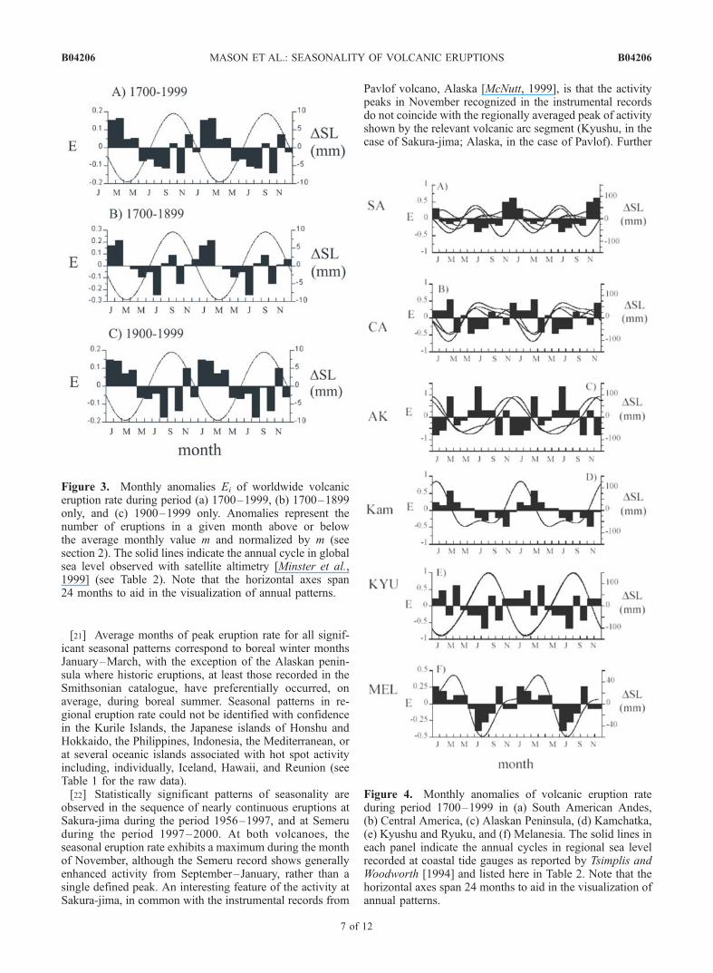
Figure 3. Monthly anomalies Ei of worldwide volcaniceruption rate during period (a) 1700–1999, (b) 1700–1899only, and (c) 1900–1999 only. Anomalies represent thenumber of eruptions in a given month above or belowthe average monthly value m and normalized by m (seesection 2). The solid lines indicate the annual cycle in globalsea level observed with satellite altimetry [Minster et al.,1999] (see Table 2). Note that the horizontal axes span24 months to aid in the visualization of annual patterns.
Figure 4. Monthly anomalies of volcanic eruption rateduring period 1700–1999 in (a) South American Andes,(b) Central America, (c) Alaskan Peninsula, (d) Kamchatka,(e) Kyushu and Ryuku, and (f) Melanesia. The solid lines ineach panel indicate the annual cycles in regional sea levelrecorded at coastal tide gauges as reported by Tsimplis andWoodworth [1994] and listed here in Table 2. Note that thehorizontal axes span 24 months to aid in the visualization ofannual patterns.
B04206 MASON ET AL.: SEASONALITY OF VOLCANIC ERUPTIONS
7 of 12
B04206

analysis of instrumental records of recently active volcanoesis needed to establish the extent to which local, regional andglobal patterns converge, or diverge, and to discover theextent to which individual volcanoes that are spatially closeto one another show similar patterns of seasonality. Onefurther point to note from Figure 3 is that the November-December peak of activity at Sakura-jima corresponds withthe maximal rate of sea level fall. We return to this pointlater.[23] Normalized monthly deviations E from the expected,
long-term average monthly eruption rate for records exhib-iting seasonal patterns, for which P < 0.05 listed in Table 5,are shown in Figures 3–6 Note that the horizontal axes ofFigures 3–6 span 2 years to aid in the visualization of theproposed seasonal patterns. Annual fluctuations amount to18% of the global monthly mean eruption rate (Figure 3),and can amount to in excess of 50% of some regionalmonthly mean eruption rates (Figure 4). At individualvolcanoes Sakura-jima and Semeru, seasonal fluctuationsamount to approximately 25–30% of the monthly meaneruption rate (Figures 5 and 6, respectively).[24] Also shown in each of Figures 3–6 are the devia-
tions from long-term mean sea level assessed globally usingsatellite altimetry [Minster et al., 1999], and assessedregionally using tide gauge data from representative loca-tions with relatively long records and as reported byTsimplis and Woodworth [1994]. The annual and semian-nual components of the seasonal sea level changes depictedin Figures 3–6 are summarized in Table 2. We note that, forthe cases shown here and for which seasonality is observed,annual peaks in eruption rates generally occur duringintervals of falling or lowest annual sea levels. Suchcorrelations are observed whether eruptions and sea levelchanges are considered globally (Figure 3), regionally(Figure 4) or at an individual volcano with a substantialrecord (Figure 5). Exceptions to this correlative patterninclude (1) the Andes of SW South America (Figure 4),(2) Melanesia, and (3) at the volcano Semeru, Indonesia(Figure 6). The lack of correlation between seasonal erup-tion rates and sea level in South America and at Semerumainly reflects the absence of a regional pattern in seasonalsea level changes. In Melanesia, seasonal peaks in eruptionrate coincide with an annual maximum in sea level.[25] Shown in Figure 7 is a plot of the lag of eruption rate
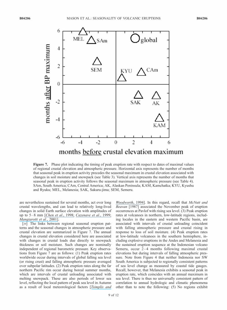
maximum (M, see equation (6) and Table 5) for selectedregions and volcanoes preceding an annual peak in inferredelevation of regional crust (varying in response to changes
in soil moisture and snowpack) or following an annualmaximum in the long-term, regional atmospheric pressure.Those regions noted above that exhibit seasonal maxima ineruption rate which correspond to falling regional sea level,also exhibit seasonal maxima in eruption rate which pre-cedes, by no more than a few months, times of indepen-dently estimated maxima in regional crustal elevation. InSW South America and at Semeru, sea level changes haverelatively strong semiannual components or exhibit littleregional coherence. Instead, enhanced rates of eruptions atthese localities, and in Melanesia, occur during seasonaldrops in atmospheric pressure.
4. Discussion
[26] In the time series shown in Figures 3–6 the vari-ability between successive months amounts to as much astwice the standard deviation of the average monthly erup-tion rates. This temporal pattern in relative variability isassociated with greater occurrence of eruptions worldwidein boreal winter months. On the global scale, the nullhypothesis of uniform occurrence in time is rejected at the5% significance level using the well-known Rayleigh testand as summarized in Table 5. For sufficiently long records,seasonality in worldwide eruption rate seems to be inde-pendent of the time interval considered.[27] Key contributors to the seasonal pattern include
volcanic provinces of the Pacific ‘‘Ring of Fire’’, includingCentral and South America, Kamchatka, and selectedislands of Japan, and Melanesia. On local scales, even someindividual volcanoes in these provinces for which detailedhistories are known consistently exhibit seasonal peaklevels in eruption activity. In each of these cases, individ-ually considered, the null hypothesis of uniform occurrenceof eruptions in time can be rejected at the 5% significancelevel using the Rayleigh test.[28] Also indicated in Figures 3–6 are inferred global
fluctuations and directly observed regional fluctuations insea level. Seasonal cycles in sea level measured at coastaltide gauges reflect changes in air pressure, steric density,and regional runoff [Chen et al., 1998; Cazenave et al.,1999]. In some locations the resulting, annual change in sealevel is comparable to the daily tide range. Unlike diurnaltides, however, climate-driven fluctuations in sea levelcorrespond to changes in regional load on the marginalcrust of continents and islands which are small, but which
Figure 5. Monthly anomalies of volcanic eruption rate atSakura-jima (Kyushu, Japan) during years 1956–1997.Otherwise as in Figure 2. Note that the horizontal axes span24 months to aid in the visualization of annual patterns.
Figure 6. Monthly anomalies of volcanic eruption rate atSemuru (Java, Indonesia) during years 1997–2000. Other-wise as in Figure 2. Note that the horizontal axes span24 months to aid in the visualization of annual patterns.
B04206 MASON ET AL.: SEASONALITY OF VOLCANIC ERUPTIONS
8 of 12
B04206
are nevertheless sustained for several months, act over longcrustal wavelengths, and can lead to relatively long-livedchanges in solid Earth surface elevation with amplitudes ofup to 5–8 mm [Chen et al., 1998; Cazenave et al., 1999;Mangiarotti et al., 2001].[29] The links between regional seasonal eruption pat-
terns and the seasonal changes in atmospheric pressure andcrustal elevation are summarized in Figure 7. The annualchanges in crustal elevation considered here are associatedwith changes in crustal loads due directly to snowpackthickness or soil moisture. Such changes are nominallyindependent of regional barometric pressure. Key observa-tions from Figure 7 are as follows: (1) Peak eruption ratesworldwide occur during intervals of global falling sea level(or rising crust) and falling atmospheric pressure averagedover subpolar latitudes. (2) Peak eruption rates along the farnorthern Pacific rim occur during boreal summer months,which are intervals of crustal unloading associated withmelting snowpack. These are also periods of lower sealevel, reflecting the local pattern of peak sea level in Autumnas a result of local meteorological factors [Tsimplis and
Woodworth, 1994]. In this regard, recall that McNutt andBeavan [1987] associated the November peak of eruptionoccurrences at Pavlof with rising sea level. (3) Peak eruptionrates at volcanoes in northern, low-latitude regions, includ-ing locales in the eastern and western Pacific basin, areassociated with intervals of crustal unloading coincidentwith falling atmospheric pressure and crustal rising inresponse to loss of soil moisture. (4) Peak eruption ratesat low-latitude volcanoes in the southern hemisphere, in-cluding explosive eruptions in the Andes and Melanesia andthe sustained eruption sequence at the Indonesian volcanoSemeru, occur 2–4 months following maximal crustalelevations but during intervals of falling atmospheric pres-sure. Note from Figure 4 that neither Indonesia nor SWSouth America is subjected to regionally consistent patternsof sea level change as measured by coastal tide gauges.Recall, however, that Melanesia exhibits a seasonal peak ineruption rate, which coincides with an annual maximum insea level. There is thus no universally consistent pattern ofcorrelation to annual hydrologic and climatic phenomenaother than to note the following: (5) No regions exhibit
Figure 7. Phase plot indicating the timing of peak eruption rate with respect to dates of maximal valuesof regional crustal elevation and atmospheric pressure. Horizontal axis represents the number of monthsthat seasonal peak in eruption activity precedes the seasonal maximum in crustal elevation associated withchanges in soil moisture and snowpack (see Table 3). Vertical axis represents the number of months thatseasonal peak in eruption activity follows the seasonal maximum in atmospheric pressure (see Table 4).SAm, South America; CAm, Central America; AK, Alaskan Peninsula; KAM, Kamchatka; KYU, Kyushuand Ryuku; MEL, Melanesia; SAK, Sakuru-jima; SEM, Semeru.
B04206 MASON ET AL.: SEASONALITY OF VOLCANIC ERUPTIONS
9 of 12
B04206

significant seasonal peaks in eruption rate during intervalsof rising sea level and rising atmospheric pressure. This isindicated by an absence of points in the lower left quadrantof Figure 7.[30] Having demonstrated that both global and regional
patterns of volcanic seasonality exist, the logical next step isto consider what it is that is forcing this seasonal pattern ofactivity? If there is a single, underlying process behind theeruption seasonality, then it is not necessarily the case thatthe mechanism needs only to act at shallow levels in thecrust (e.g., in areas susceptible to infiltration of rainwater; orsusceptible to passing pressure anomalies), although suchmodels have been proposed to explain, for example, asso-ciations between storms and small explosions at Mt StHelens [e.g., Mastin, 1994]. For example, in crustal rockswith an elastic modulus of order 1011 Pa, annual millimeter-scale deformations of, say, the uppermost 10 km of theEarth’s crust, would give rise to crustal strain rates of theorder of 10�15 s�1. Such values are comparable to geolog-ical strain rates in deforming continental crust associatedwith other, better understood processes such as basinsubsidence [Turcotte and Schubert, 1982], or continentalplate deformation [e.g., Shen-Tu et al., 1999]. Importantly,such long-period changes in crustal stress, unlike thoseassociated with diurnal Earth tides, would elicit creep inregions of the Earth’s crust and mantle with viscosities oforder 1018 Pa s and Maxwell relaxation times of order 106–107 s [Kohlstedt and Zimmerman, 1996; Vigneresse et al.,1996], and could therefore influence partially moltenregions within the Earth’s crust.[31] However, at this point, we do not consider that there
is a single physical mechanism that can be thought of as‘‘driving’’ or ‘‘triggering’’ eruptions. Instead, we suggestthat a more profitable way to think about the process is thatthere are a host of periodic processes, which are ultimately
forced by the seasonal stress imposed by the hydrologicalcycle. We propose that the fluctuating conditions associatedwith the annual movement of water mass at the Earth’ssurface effectively imposes a moving boundary conditionon an otherwise randomly distributed [in the time sense] setof volcanic systems. This naturally results in statisticallyenhanced volcanic activity during annually recurring inter-vals of falling global sea level and atmospheric pressure.This idea is illustrated schematically in Figure 8. We havedeveloped a full statistical model to explain this clusteringof activity, which we have presented elsewhere [Jupp et al.,2004].[32] Regions that do not exhibit obvious seasonal patterns
in eruption rate include the Mediterranean (although evi-dence for seasonality has been reported from Etna alone[Casetti et al., 1981]), and some oceanic islands. While alack of annual pattern may simply be due to incompletenessof records, it may also reflect the lack of a dominant annualphase in the crustal deformation or meteorological forcingin these locations. The absence of a seasonal signal at oceanislands (e.g., Hawaii) that we have noted here is consistentwith the asymmetry in the annual variations of sea leveldetermined by Blewitt and Clarke [2003]. They reportseasonal peak variations in sea level ranging from 3 mmto 19 mm, with the smallest variations in the northernmidlatitude Pacific, and the largest variations in polarregions. Geographical asymmetry, in terms of peak ampli-tude, is due to the competing effects of gravitationalattraction due to land water mass that tends to draw sealevel higher (this is at a peak in the Northern Hemisphere inwinter) with the seasonal reduction in sea level. In theArctic, for example, sea level peaks at 9 mm in March,while in the Antarctic, where the winter land water massis considerably smaller, sea level peaks at 18 mm inmid-August.
Figure 8. Schematic diagram to show how eruptions could cluster in time as the result of evolving,external loads. A series of volcanic systems (indicated by trails of dots) start off at a ‘‘pressure’’ below thethreshold at which the system will erupt. Each volcanic system approaches the threshold at more or lessthe same rate, owing to magma buildup. The rate of approach to threshold conditions may be influencedby temporal changes in external loads and, in particular, by the mechanisms discussed in the main text. Inthe interpretation shown here the relationship between rates of change of magma pressure and confiningexternal load lead to enhanced numbers of eruptions during intervals of diminishing external load. Thispattern is consistent with the historical behavior of volcanoes overall, but other regional-specificrelationships could apply locally owing to volcano geometry and crustal properties. A statisticaldescription of this model and the consequent clustering of eruptions is presented by Jupp et al. [2004].
B04206 MASON ET AL.: SEASONALITY OF VOLCANIC ERUPTIONS
10 of 12
B04206

[33] In summary, the recognition of seasonality in erup-tion rates lends qualitative support to existing ideas regard-ing enhanced volcanic activity during periods of global sealevel change in the geologic past. If eruptive activity doesindeed increase during periods of global cooling, in whichice volume increases and sea level falls, then the resultingenhanced rates of volcanogenic aerosol injection into theatmosphere may further accelerate cooling processes [cf.Rampino et al., 1979; Rampino and Self, 1994], constitutingan important feedback between global climate and volcanicactivity.[34] On shorter timescales, seasonality in eruption rate
may interact with the temporal variability in the structureand circulation of the atmosphere. The altitude of theextratropical tropopause varies seasonally, and, in theNorthern Hemisphere, is at a minimum during wintermonths [e.g., Wong and Wang, 2000]. Thus proportionatelymore northern hemisphere eruptions will inject material intothe stratosphere during boreal winter [e.g., Halmer andSchmincke, 2003; Mather et al., 2003], potentially resultingin reduced insolation and additional surface cooling. Mate-rial transport from the stratosphere to the troposphere is alsoseasonal, reaching a maximum in local spring [e.g., Holtonet al., 1995]. Seasonality in eruption rates will furtheramplify these effects, and may play an important role indetermining the sensitivity of the climate system to thoseeruptions that may have widespread climatic and environ-mental impacts.[35] This is but one example to illustrate that the links,
and potential for feedback, between volcanic processes andthe climate system may act over a range of timescales andmay be both more significant and more sensitive thanpreviously thought. If the seasonality of volcanic eruptionsis indeed associated with subtle environmental changesduring the annual hydrologic cycle, then active volcanicsystems must be very near the critical state required foreruption. That this should be so for active volcanoes isperhaps not surprising, but nevertheless suggests furtherreflection upon the human capacity to alter the environmenton a global scale.
5. Conclusion
[36] Volcanic activity in the last three hundred yearsexhibits seasonality to a statistically significant degree. Thistemporal pattern is observed globally; regionally along thePacific ‘‘Ring of Fire’’ and locally at some individualvolcanoes. Seasonality in eruptions is correlated with envi-ronmental fluctuations associated with the deformation ofthe Earth in response to the annual hydrological cycle,including falls in sea level, millimeter-scale motion of theEarth’s crust, and falls in regional atmospheric pressure. Theresolution of seasonal triggers of eruptions in some regionsand the reasons for nonseasonality of eruptions in otherregions are important challenges for the continued study ofvolcanoes and the mitigation of volcanic hazards.
[37] Acknowledgments. L. Siebert generously provided the Smithso-nian eruption catalogue in digital form. Prof. Ishihara and the Volcanolog-ical Survey of Indonesia provided data from Sakura-jima and Semeru.S. Mangiorotti provided the summary of crustal motion harmonics given inTable 3. We thank C. Oppenheimer, S. Sparks, D. Nowell and T. Mather forhelpful discussion and encouragement, and several anonymous individuals
for critical reviews of earlier versions of the text. We thank L. Mastin,M. Jull and S. McNutt for their thorough and perceptive reviews. This workwas supported by the Natural Environmental Research Council, UK (BGM,WBD), and the Newton Trust (TJ). This work formed a part of BGM’s finalyear dissertation at the University of Cambridge.
ReferencesBlewitt, G., and P. Clarke (2003), Inversion of Earth’s changing shape toweigh sea level in static equilibrium with surface mass distribution,J. Geophys. Res., 108(B6), 2311, doi:10.1029/2002JB002290.
Blewitt, G., D. Lavallee, P. Clarke, and K. Nurutdinov (2001), A newglobal mode of Earth deformation: Seasonal cycle detected, Science,294, 2342–2345.
Bouille, F., A. Cazenave, J. M. Lemoine, and J. F. Cretaux (2000), Geo-centre motion from the DORIS space system and laser data to the Lageossatellites: Comparison with surface loading data, Geophys. J. Int., 143,71–82.
Casetti, G., G. Frazzetta, and R. Romano (1981), A statistical analysis intime of the eruptive events of Mount Etna (Italy) from 1323 to 1980, Bull.Volcanol., 44, 283–294.
Cazenave, A., F. Mercier, F. Bouille, and J. M. Lemoine (1999), Global-scale interactions between the solid Earth and its fluid envelopes at theseasonal time scale, Earth Planet Sci. Lett., 171, 549–559.
Chen, J. L., C. R. Wilson, D. P. Chambers, R. S. Nerem, and B. D. Tapley(1998), Seasonal global water mass budget and mean sea level variations,Geophys. Res. Lett., 25, 3555–3558.
Cheng, M. K., and B. D. Tapley (1999), Seasonal variations in low degreezonal harmonics of the Earth’s gravity field from satellite laser rangingobservations, J. Geophys. Res., 104, 2667–2681.
Conover, W. J. (1980), Practical Nonparametric Statistics, 2nd ed., 493pp., John Wiley, Hoboken, N. J.
Dzurisin, D. (1980), Influence of fortnightly Earth tides at Kilauea volcano,Hawaii, Geophys. Res. Lett., 7, 925–928.
Emter, D. (1997), Tidal triggering of earthquakes and volcanic events, inTidal Phenomena, Lect. Notes Earth Sci., vol. 66, edited by H. Wilhelmet al., pp. 293–309, Springer-Verlag, New York.
Fisher, N. I. (1993), Statistical Analysis of Circular Data, 277 pp., Cam-bridge Univ. Press, New York.
Glazner, A. F., C. R. Manley, J. S. Marron, and S. Rojstaczer (1999), Fire orice: Anticorrelation of volcanism and glaciation in California over thepast 800,000 years, Geophys. Res. Lett., 26, 1759–1792.
Halmer, M. M., and H-U. Schmincke (2003), The impact of moderate-scaleexplosive eruptions on stratospheric gas injections, Bull. Volcanol., 65,433–440.
Hamilton, W. L. (1973), Tidal cycles of volcanic eruptions: fortnightly to19 yearly periods, J. Geophys. Res., 78, 3363–3375.
Holton, J. R., P. H. Haynes, M. E. McIntyre, A. R. Douglass, R. B. Rood,and L. Pfister (1995), Stratosphere-troposphere exchange, Rev. Geophys.,33, 403–439.
Jull, M., and D. McKenzie (1996), The effect of deglaciation on mantlemelting beneath Iceland, J. Geophys. Res., 101, 21,815–21,828.
Jupp, T., D. M. Pyle, B. G. Mason, and W. B. Dade (2004), A statisticalmodel for the timing of earthquakes and volcanic eruptions influenced byperiodic processes, J. Geophys. Res., 109, B02206, doi:10.1029/2003JB002584.
Kohlstedt, D. L., and M. E. Zimmerman (1996), Rheology of partiallymolten rocks, Ann. Rev. Earth Planet Sci., 24, 41–62.
Landsberg, H. E. (1984), World Survey of Climatology, 15 vols., ElsevierSci., New York.
Mangiarotti, S., A. Cazenave, L. Soudarain, and J. F. Cretaux (2001),Annual vertical motions predicted from surface mass redistribution andobserved by space geodesy, J. Geophys. Res., 106, 4277–4291.
Mastin, L. G. (1994), Explosive tephra emissions at Mount St Helens,1989–1991: The violent escape of magmatic gas following storms?,Geol. Soc. Am. Bull., 106, 175–185.
Mather, T. A., D. M. Pyle and C. Oppenheimer (2003), Troposphericvolcanic aerosol, in Volcanism and the Earth’s Atmosphere, Geophys.Monogr. Ser., vol. 139, edited by A. Robock and C. Oppenheimer,pp. 189–212, AGU, Washington, D. C.
Matthews, A. J., J. Barclay, S. Carn, G. Thompson, and J. Alexander(2002), Rainfall-induced volcanic activity on Montserrat, Geophys. Res.Lett., 29(13), 1644, doi:10.1029/2002GL014863.
Mauk, F. J., and M. J. S. Johnston (1973), On the triggering of volcaniceruptions by Earth tides, J. Geophys. Res., 78, 3356–3362.
McGuire, W. J., R. J. Howarth, C. R. Firth, A. R. Solow, A. D. Pullen, S. J.Saunders, I. S. Stewart, and C. VitaFinzi (1997), Correlation between rateof sea-level change and frequency of explosive volcanism in the Medi-terranean, Nature, 389, 473–476.
McNutt, S. R. (1999), Eruptions of Pavlof volcano, Alaska, and theirpossible modulation by ocean load and tectonic stresses: Re-evaluation
B04206 MASON ET AL.: SEASONALITY OF VOLCANIC ERUPTIONS
11 of 12
B04206

of the hypothesis based on new data from 1984–1998, Pure Appl. Geo-phys., 155, 701–712.
McNutt, S. R., and R. J. Beavan (1987), Eruptions of Pavlof volcano andtheir possible modulation by ocean load and tectonic stresses, J. Geophys.Res., 92, 11,509–11,523.
Minster, J. F., A. Cazenave, Y. V. Serafini, F. Mercier, M. C. Gennero,and P. Rogel (1999), Annual cycle in mean sea level from TOPEX-POSEIDON and ERS-1: Inference on the global hydrological cycle,Global Planet. Change, 20, 57–66.
Neuberg, J. (2000), External modulation of volcanic activity, Geophys.J. Int., 142, 232–240.
Newhall, C. G., and S. Self (1982), The volcanic explosivity index (VEI):An estimate of explosive magnitude for historical volcanism, J. Geophys.Res., 87, 1231–1238.
Rampino, M. R., and S. Self (1994), Climatic-volcanic feedback and theToba eruption of �74,000 years ago, Quat. Res., 40, 69–80.
Rampino, M. R., S. Self, and R. W. Fairbridge (1979), Can rapid climaticchange cause volcanic eruptions?, Science, 206, 826–829.
Rydelek, P. A., I. S. Sacks, and R. Scarpa (1992), On tidal triggering ofearthquakes at Campi Flegrei, Italy, Geophys. J. Int., 109, 125–137.
Shen-Tu, B., W. E. Holt, and A. J. Haines (1999), Deformation kinematicsin the western United States determined from Quaternary fault slip ratesand recent geodetic data, J. Geophys. Res., 104, 28,927–28,955.
Simkin, T., and L. Siebert (1994), Volcanoes of the World, 2nd ed., 349 pp.,Geoscience, Tucson, Ariz.
Stothers, R. B. (1989), Seasonal variations of volcanic eruption frequency,Geophys. Res. Lett., 16, 453–455.
Tsimplis, M. N., and P. L. Woodworth (1994), The global distribution of theseasonal sea level cycle calculated from coastal tide gauge data, J. Geo-phys. Res., 99, 16,031–16,039.
Turcotte, D. L., and G. Schubert (1982), Geodynamics, pp. 450., JohnWiley & Sons, New York.
van Dam, T. M., J. Wahr, Y. Chao, and E. Leuliette (1997), Predictions ofcrustal deformation and of geoid and sea-level variability caused byoceanic and atmospheric loading, Geophys. J. Int., 129, 507–517.
van Dam, T., J. Wahr, P. C. D. Milly, A. B. Shmankin, G. Blewitt,D. Lavallee, and K. M. Larson (2001), Crustal displacements due tocontinental water loading, Geophys. Res. Lett., 28, 651–654.
Vigneresse, J. L., P. Barbey, and M. Cuner (1996), Rheological transitionsduring partial melting and crystallisation with application to felsic magmasegregation and transfer, J. Petrol., 37, 1579–1600.
Wenzel, G., and T. Hartmann (1994), The harmonic development of theearth tide generating potential due to the direct effects of the planets,Geophys. Res. Lett., 21, 1991–1993.
Wong, S., and W-C. Wang (2000), Inter-hemispheric asymmetry in theseasonal variation of the zonal mean tropopause, J. Geophys. Res.,105, 26,645–26,659.
Wu, X., M. B. Heflin, E. R. Ivins, D. F. Argus, and F. H. Webb (2003),Large-scale global surface mass variations inferred from GPS measure-ments of load-induced deformation, Geophys. Res. Lett., 30(14), 1742,doi:10.1029/2003GL017546.
�����������������������W. B. Dade, Department of Earth Sciences, Dartmouth College, Hanover,
NH 03755, USA.T. Jupp, Centre for Ecology and Hydrology, Natural Environment
Research Council, Monks Wood, Huntingdon PE28 2LS, UK.B. G. Mason and D. M. Pyle, Department of Earth Sciences, Cambridge
University, Cambridge CB2 3EQ, UK. ([email protected])
B04206 MASON ET AL.: SEASONALITY OF VOLCANIC ERUPTIONS
12 of 12
B04206