Styles of volcanism and volcanic hazards on Furnas volcano, São Miguel, Azores
15
Ž . Journal of Volcanology and Geothermal Research 92 1999 39–53 www.elsevier.comrlocaterjvolgeores Styles of volcanism and volcanic hazards on Furnas volcano, Sao ˜ Miguel, Azores P.D. Cole a,b, ) , J.E. Guest b , G. Queiroz c , N. Wallenstein c , J.M. Pacheco c , J.L. Gaspar c , T. Ferreira c , A.M. Duncan a a Centre for Volcanic Studies, UniÕersity of Luton, Park Square, Luton, Bedfordshire, LU1 3JU, UK b UniÕersity of London ObserÕatory, 33-35 Daws Lane, Mil Hill, London NW7 4SD, UK c Dep. Geociencias, UniÕersity of Azores, Ponta Delgada, Portugal Accepted 21 April 1999 Abstract Explosive volcanic activity has been dominant throughout the history of Furnas volcano. Eruptions that switched between magmatic and phreatomagmatic activity have become typical in the more recent history of the volcano with 70% of the eruptions in the last 5000 years being of this style. It is thus likely that future eruptions will be of this type. Magmatic activity gives rise to lapilli-fall whereas phreatomagmatic activity produces tephra-fall, pyroclastic surges, and flows. Strong winds, rainstorms, andror strongly heterogeneous fallout may have contributed to locally variable internal stratigraphy of tephra from single eruptions. Proximal exposures indicate reworking and erosion of lapilli layers by pyroclastic surges and possible contemporaneity of surge and lapilli fall. Evidence indicates that pulsatory magma supply may play an important Ž role in the switching between magmatic and phreatomagmatic activity. Hazard mapping for two end member eruptions 1630 . AD and Furnas ‘C’ ;2000 BP using a technique with a moving vent location has provided worst case scenario tephra thicknesses in the region around Furnas volcano. Anywhere inside the caldera of Furnas volcano is under serious threat, in the event of an explosive eruption, from destruction by pyroclastic surges. The effect of pyroclastic surges outside the caldera, such as for the villages of Ponta Garc ¸a and Povoac ¸ao, is likely to depend largely on vent location. The considerable ˜ topographic relief of the region will control areas affected by pyroclastic flows and also lahars. Towns located at the mouths of rivers, e.g., Ribeira Quente and Povoac ¸ao, are particularly vulnerable. Lahars present a major hazard at Furnas Volcano. ˜ q 1999 Elsevier Science B.V. All rights reserved. Keywords: Azores; Furnas volcano; hazard mapping; subplinian; magmatic; phreatomagmatic; lahars 1. Introduction Furnas volcano, on the island of Sao Miguel, has ˜ Ž . a significant population ; 3000 living within the ) Corresponding author. Centre for Volcanic Studies, Univer- sity of Luton, Park Square, Luton, Bedfordshire, LU1 3JU, UK; E-mail: [email protected] caldera and also several thousand people in towns Ž . and villages in the immediate vicinity Fig. 1 . In the past 5000 years at least 10 explosive eruptions have Ž . occurred from Furnas volcano Booth et al., 1978 . The probable style and magnitude of the next erup- tion of Furnas is clearly of great importance in assessing the likely hazards. Although 14 C dating indicates that eruptions in the past 5000 years at Furnas were not equally spaced in 0377-0273r99r$ - see front matter q 1999 Elsevier Science B.V. All rights reserved. Ž . PII: S0377-0273 99 00066-9
-
Upload
independent -
Category
Documents
-
view
4 -
download
0
Transcript of Styles of volcanism and volcanic hazards on Furnas volcano, São Miguel, Azores

Ž .Journal of Volcanology and Geothermal Research 92 1999 39–53www.elsevier.comrlocaterjvolgeores
Styles of volcanism and volcanic hazards on Furnas volcano, Sao˜Miguel, Azores
P.D. Cole a,b,), J.E. Guest b, G. Queiroz c, N. Wallenstein c, J.M. Pacheco c,J.L. Gaspar c, T. Ferreira c, A.M. Duncan a
a Centre for Volcanic Studies, UniÕersity of Luton, Park Square, Luton, Bedfordshire, LU1 3JU, UKb UniÕersity of London ObserÕatory, 33-35 Daws Lane, Mil Hill, London NW7 4SD, UK
c Dep. Geociencias, UniÕersity of Azores, Ponta Delgada, Portugal
Accepted 21 April 1999
Abstract
Explosive volcanic activity has been dominant throughout the history of Furnas volcano. Eruptions that switched betweenmagmatic and phreatomagmatic activity have become typical in the more recent history of the volcano with 70% of theeruptions in the last 5000 years being of this style. It is thus likely that future eruptions will be of this type. Magmaticactivity gives rise to lapilli-fall whereas phreatomagmatic activity produces tephra-fall, pyroclastic surges, and flows. Strongwinds, rainstorms, andror strongly heterogeneous fallout may have contributed to locally variable internal stratigraphy oftephra from single eruptions. Proximal exposures indicate reworking and erosion of lapilli layers by pyroclastic surges andpossible contemporaneity of surge and lapilli fall. Evidence indicates that pulsatory magma supply may play an important
Žrole in the switching between magmatic and phreatomagmatic activity. Hazard mapping for two end member eruptions 1630.AD and Furnas ‘C’ ;2000 BP using a technique with a moving vent location has provided worst case scenario tephra
thicknesses in the region around Furnas volcano. Anywhere inside the caldera of Furnas volcano is under serious threat, inthe event of an explosive eruption, from destruction by pyroclastic surges. The effect of pyroclastic surges outside thecaldera, such as for the villages of Ponta Garca and Povoacao, is likely to depend largely on vent location. The considerable˜topographic relief of the region will control areas affected by pyroclastic flows and also lahars. Towns located at the mouthsof rivers, e.g., Ribeira Quente and Povoacao, are particularly vulnerable. Lahars present a major hazard at Furnas Volcano.˜q 1999 Elsevier Science B.V. All rights reserved.
Keywords: Azores; Furnas volcano; hazard mapping; subplinian; magmatic; phreatomagmatic; lahars
1. Introduction
Furnas volcano, on the island of Sao Miguel, has˜Ž .a significant population ;3000 living within the
) Corresponding author. Centre for Volcanic Studies, Univer-sity of Luton, Park Square, Luton, Bedfordshire, LU1 3JU, UK;E-mail: [email protected]
caldera and also several thousand people in townsŽ .and villages in the immediate vicinity Fig. 1 . In the
past 5000 years at least 10 explosive eruptions haveŽ .occurred from Furnas volcano Booth et al., 1978 .
The probable style and magnitude of the next erup-tion of Furnas is clearly of great importance inassessing the likely hazards.
Although 14C dating indicates that eruptions in thepast 5000 years at Furnas were not equally spaced in
0377-0273r99r$ - see front matter q 1999 Elsevier Science B.V. All rights reserved.Ž .PII: S0377-0273 99 00066-9

( )P.D. Cole et al.rJournal of Volcanology and Geothermal Research 92 1999 39–5340
Ž .time Fig. 2 , it appears that there are common stylesor trends of volcanic activity that have taken placeseveral times during the recent history of the vol-cano. Thus, although it may be extremely difficult topredict when the next eruption will take place, it isperhaps less problematical to comment on the likelynature and magnitude of future events.
This paper describes and interprets the depositsthat are a result of the typical styles of activity anddiscusses the possible eruptive and emplacementprocesses. The likely hazards from future activityconfronting the towns and villages are consideredand hazard maps for two eruptions, one at the smallend and the other at the large end of this spectrum oferuptive styles, are presented.
2. Stratigraphy and styles of eruptive activity atFurnas volcano
Furnas volcano is probably about 100,000 yearsŽ .old as Moore 1990, 1991 KrAr dated a lava at the
Žbase of the Furnas sequence at 90,000 BP Moore,.1990, 1991 . Stratigraphic studies of the volcanic
Ž .products of Furnas Guest et al., 1999-this isuuehave revealed that eruptive activity throughout itshistory has been largely explosive, with pyroclasticdeposits forming )90% of the exposed volcanicproducts. Furthermore, almost all known styles ofexplosive activity are recorded within the deposits.Large caldera-forming eruptions have probably oc-curred at least twice in the history of the volcano
Ž .Fig. 1. Map showing Furnas volcano and surrounding environment modified from Guest et al. 1999-this issue . Numbers correspond to thelocation of sections shown in Figs. 4 and 5b. Letters refer to the vent locations of eruptions. Cross-hatched areas are towns and villages.

( )P.D. Cole et al.rJournal of Volcanology and Geothermal Research 92 1999 39–53 41
Fig. 2. The chronology of the last 5000 years of Furnas volcano.Ž .Based on data from Moore and Rubin 1991 ; Shotten and Williams
Ž . Ž .1971 and Guest et al. 1999-this issue . Arrows indicate depositswith 14C dates.
Ž . 14Guest et al., 1999-this issue and C dating indi-cates that the oldest of these eruptions occurredabout 30,000 BP and was associated with emplace-ment of the Povoacao Ignimbrite. This ignimbrite is˜considered to be related to the formation of the olderŽ . Ž .outer caldera Fig. 1 . The younger, or inner, calderamay have been formed by an eruption that occurredaround 12,000 BP. Typically the volcanic successionis composed of various types of tephra fall depositwith more subordinate small volume ignimbrites andpyroclastic surge deposits restricted to valley bases.
Stratigraphically, the volcano can be subdividedinto a number of units using dated marker horizonsŽ .Fig. 3 . These units were defined by Guest et al.Ž .1999 . An important marker horizon is the distinc-tive Fogo A deposit that was formed by a plinianeruption from Fogo volcano. The Fogo A deposit can
Žbe found over most of Sao Miguel Walker and˜. 14Croasdale, 1971 and has been C dated at about
Ž5000 BP Shotten and Williams, 1971; Moore and.Rubin, 1991 . Below Fogo A a sequence of un-
welded ignimbrites that crop out near Ponta Garca14 Žhave been C dated at about 17,000 BP Guest et
.al., 1999-this issue . The tephra fall deposits foundin the Ponta Garca region between the Ponta Garcaignimbrite and the Fogo A deposit are termed theMiddle Furnas Group. The Ponta Garca ignimbrite isonly exposed in the SW region of the volcano.Lower in the sequence the Povoacao Ignimbrite has˜
Ža date of about 30,000 BP Guest et al., 1999-this.issue . In the Povoacao region, between the Fogo A˜
deposit and the Povoacao Ignimbrite, tephra fall˜deposits comprise the Middle Furnas Group. Belowthe Povoacao Ignimbrite, the oldest marker horizon˜recognised, are the deposits of numerous eruptions ofthe Cavaliero Formation.
To provide a semi-quantitative classification ofthe styles of activity that have taken place on thevolcano, the proportion of different types of tephrafall deposits occurring in the various stratigraphicperiods have been calculated. The tephra fall de-posits are classified into four types: deposits com-posed of both ash and lapilli layers representingeruptions that involved alternating magmatic andphreatomagmatic activity; pumice lapilli depositsrepresenting solely magmatic activity; ash depositsrepresenting mainly phreatomagmatic activity; andbasaltic lapilli deposits representing strombolian ac-tivity. The products of each eruptive phase are delim-ited by the presence of palaeosols.
The proportions of different tephra fall depositsthrough the stratigraphic sequence of Furnas volcanoare shown in Fig. 3. There were, however, certainlymore eruptions than those represented by the pre-served deposits as some have undoubtedly been re-moved by erosion. Other eruptions may not haveformed deposits in a particular sequence due to thewind direction at the time. In addition, apart from thetwo units used as marker horizons, ignimbrites and

( )P.D. Cole et al.rJournal of Volcanology and Geothermal Research 92 1999 39–5342
Fig. 3. The proportion of different tephra fall deposits within the various stratigraphic periods at Furnas, volcano. Stratigraphic groups are asŽ .defined in Guest et al. 1999-this issue .
( )P.D. Cole et al.rJournal of Volcanology and Geothermal Research 92 1999 39–53 43
pyroclastic surge deposits are not taken into consid-eration for two reasons. First they are relativelysubordinate within the sequence and secondly theirlocalised distribution, dictated by strong topographiccontrol, makes correlation difficult.
Within the Lower Furnas Group, the first strati-Ž .graphic period )30,000 BP , pumice lapilli beds
Žare the most common type of deposit 50% of de-.posits in the east and 54% in the southwest . In the
Žlower part of the Middle Furnas Group from 30,000.to 17,000 BP in the southwest, basaltic lapilli are
Ž .the most common type of deposit 66% of deposits ,probably produced by localised strombolian activity.To the Southeast the lower part of the Middle FurnasGroup is made up predominantly of pumice lapilli.Thus in the earliest part of the volcano’s history,until ;17,000 BP, pumice lapilli form the mostcommon deposit type indicating that magmatic erup-tions were dominant. The upper part of the Middle
Ž .Furnas Group approximately 17,000 to 5000 BP ,both in the southwest and in the east, are dominated
Žby deposits of alternating ash and lapilli 55% and.71% of deposits, respectively . In the Upper Furnas
Ž .Group between 5000 BP and 1630 AD deposits ofalternating ash and lapilli are also typical. This evi-dence indicates that from ;17,000 BP until 1630AD eruptions that alternated between phreatomag-matic and magmatic activity were the typical style ofactivity. The trend therefore is for predominantlymagmatic eruptions, forming pumice and basalticlapilli, becoming less common and eruptions whichfluctuated between phreatomagmatic and magmaticactivity becoming more numerous within the morerecent history of the volcano.
( )3. Post 5000 years Fogo A eruptions
3.1. Chronology, Õent locations and eruptiÕe styles
The eruptive history of the past 5000 years onFurnas is well documented and many of the pyro-clastic deposits that formed during this time have
Ž . Žbeen dated Fig. 2 . Prior to this time below Fogo.A , owing to poor exposure, the succession is less
well constrained. Consequently, establishing the pe-riodicity of eruptions and assessing the style andmagnitude of events for hazard purposes has been
restricted to consideration of events which have oc-Žcurred in the past 5000 years Jones et al., 1999-this
.issue .Ž .Booth et al. 1978 defined the 10 deposits origi-
nating from Furnas which overlie the Fogo A de-posit, from Furnas ‘A’ to ‘I’ and the last eruption,the 1630 AD event. All of these eruptions are in-ferred to have occurred from vents within the calderaŽ .Fig. 1 . The 1630 AD eruption occurred near the
Ž .southern margin of the caldera Cole et al., 1995 .Prior to this, the penultimate eruption, Furnas ‘I’,occurred from the Pico do Gaspar region and formedthe current tuffrpumice ring and trachyte dome.
Ž .Booth et al. 1978 also relate the Furnas ‘F’ event tothe Gaspar crater. The Furnas ‘H’ deposits are lo-cally separated from the overlying Furnas ‘I’ de-
Ž .posits by a patchy, thin -3 cm weathered horizonindicating only a very short period of time betweenthe two events. The absence of a soil, and 14C datingŽ .Guest et al., 1999-this issue , indicate that the timeperiod between Furnas ‘H’ and ‘I’ maybe as little as
Ž .25 years. Isopach maps of Booth et al. 1978 indi-cate that the vent location for the Furnas ‘H’ erup-
Ž .tion was Pico Marconas Fig. 1 . The eastern part ofŽ .the lake cuts the Gaspar crater rim Fig. 1 . The
Gaspar crater is considered to have first formed fromŽ .the Furnas ‘F’ event Booth et al., 1978 . Therefore,
we propose that the Furnas ‘G’ eruption originatedfrom the southern part of the Furnas lake and wasresponsible for the formation of the lake crater. Picodas Caldeiras is inferred to be the lava dome of theFurnas ‘E’ eruption as the deposits of Furnas ‘G’directly overlie that dome. The Furnas ‘C’ eruptionis considered to have taken place from a crater
Ž .centred on Furnas village Fig. 1 . Lack of fieldevidence prevents determination of the vent locationsof Furnas ‘A’, ‘B’, and ‘D’.
The deposits of the Furnas ‘H’ eruption areanomalous relative to others formed in the past 5000years in that they are entirely composed of coarsegrained, well vesiculated pumice. All other eruptionsshow evidence of extensive phreatomagmatic activ-ity. The Furnas ‘H’ eruption is therefore interpretedto be purely magmatic, with no evidence ofmagma–water interaction.
At least three eruptions in the past 5000 yearsinvolved the extrusion of a trachyte lava dome in thefinal phases of the eruption. These were 1630 AD,

( )P.D. Cole et al.rJournal of Volcanology and Geothermal Research 92 1999 39–5344

( )P.D. Cole et al.rJournal of Volcanology and Geothermal Research 92 1999 39–53 45
Ž .Furnas ‘I’ Pico do Gaspar , and probably Furnas ‘E’Ž . Ž .Pico das Caldeiras see Figs. 1 and 5 .
As already shown the eruptions of the more recenthistory of Furnas volcano are typified by eventswhich alternated between magmatic and phreatomag-matic activity giving rise to alternating ash andlapilli deposits.
3.2. Alternating ash and lapilli deposits
Eruptions that formed deposits of alternating ashand lapilli layers in the past 5000 years include:
Ž .1630 AD, ‘I’ ;1445 AD , ‘G’, ‘F’, ‘E’, ‘C’ and‘B’, and sections through some of these deposits areshown in Fig. 4. The lapilli layers are typically wellsorted, comprising pumice and lithic fragments thatgenerally mantle the topography. They are consid-ered to represent fallout of material from an eruptioncolumn generated by magmatic activity. The ashlayers, on the other hand, have more diverse fieldrelations. In more distal exposures, )4 km from thevent, the ash layers occur as massive layers thatmantle topography suggesting a fallout origin. Inmore proximal locations, -4 km from the vent,stratification and discontinuous trains of roundedpumice occur within the finer ash layers and distinct
Žsandwave structures are present e.g., Furnas ‘C’,.‘F’, and 1630 AD indicating emplacement from
dilute, turbulent flows, i.e., pyroclastic surges. Mas-sive pyroclastic flow deposits fill some topographicdepressions between lapilli layers, although there isonly unequivocal examples for the 1630 AD depositsŽ .Cole et al., 1995 . Pyroclastic flows, however, em-placed in the deep valleys of Furnas, are likely tohave only a low preservation potential. The largedegree of comminution of the ash layers coupledwith the presence of abundant accretionary lapilliand vesicular ash textures is evidence to suggest thatthey are the result of phreatomagmatic activity.
Detailed stratigraphic documentation of the Fur-nas ‘C’ deposit has revealed that in some regionsonly the most distinctive lapilli layers can be corre-lated over a significant distance of outcrop at scales
Ž .of tens of metres Pacheco, 1995 . Thin ash and
lapilli layers change markedly in character betweenexposures over only a few hundred metres. On asingle outcrop level these layers mantle topographyand retain constant thicknesses suggesting a falloutorigin. Within the 1630 AD deposits vesicular ashlayers are also extremely localised and are difficult ifnot almost impossible to correlate between expo-sures. Similar local variability in detailed stratigra-phy also occurs in the Furnas ‘E’ deposit.
These features might be related to heterogeneitywithin the convecting plume and in consequent fall-out. Local winds associated with the considerablerelief of the region may also have caused heteroge-neous fallout. Local rainstorms may also have playeda role in causing this heterogeneity. Similar hetero-geneous fallout processes have been invoked to ex-plain variability in internal stratigraphy for other
Ž .phreatoplinian eruptions Branney, 1991 .Ž .Furnas ‘I’ ;1445 AD was the penultimate
explosive eruption at Furnas volcano and followed asimilar pattern to the 1630 AD event. Similarities inthe deposits include the alternating lapilli and ashlayers and a final thick pumice-rich lapilli layerwhich grades upwards into a deposit of limited dis-persal composed of dense, poorly vesicular juvenilefragments. As was the case in 1630 AD, a trachyticlava dome was also extruded during the final phasesof the eruption. Within proximal exposures of thelower part of the Furnas ‘I’ deposit distinct localvariations in thickness in angular pumice lapilli lay-ers can be observed. This type of pinch and swellthickness variation is especially clear at two rela-tively proximal exposures of the Furnas ‘I’ depositsŽ .Fig. 4, FL 8 and Fig. 5b, FL 4 . At FL 8, within thelower part of the deposit, lapilli layers are interbed-ded with more ash-rich beds. Many lapilli layersoccur, some of which are discontinuous althoughpumice within the lapilli layers is completely angu-lar. At FL 4, a sequence 3–4 m thick of interbeddedlapilli and ash layers is exposed. Here some of thelapilli layers, with angular pumice, are observed tovary from 10 to 5 cm in thickness over 1–2 mhorizontally. In more distal exposures the lapillilayers mantle the topography and retain constant
Fig. 4. Selected measured sections through Furnas ‘I’, ‘G’, ‘E’, and ‘B’. Pumice clasts are depicted as open symbols; lithics are solidsymbols; Ash is unornamented. For location of sections see Fig. 1.

( )P.D. Cole et al.rJournal of Volcanology and Geothermal Research 92 1999 39–5346
Ž .Fig. 5. a View looking south east across the Furnas calderas from the Pico do Ferro domes on the western inner caldera rim, showing thePico do Gaspar dome and its surrounding tephra apron formed during the Furnas ‘I’ eruption ;1439–1445 AD. The dark ridge in the
Ž . Ž . Žbackground centre is the south-eastern rim of the older caldera. b Proximal Furnas ‘I’ deposits at site 4, 1 km east of the vent see Fig. 1.for location . Note variable thickness of both lapilli and ash layers. The outcrop face is oriented approximately north–south. Spade
highlighted for scale is 55 cm long.

( )P.D. Cole et al.rJournal of Volcanology and Geothermal Research 92 1999 39–53 47
thicknesses. They are thus considered to be of aŽ .fallout origin Fig. 4, Sec. FL145 or 10 .
As the activity switched between phreatomag-matic and magmatic activity numerous times duringthis style of eruption it seems quite probable thatonset of the phreatomagmatic phases occurred rapidlyafter a magmatic phase. In such a situation lapillimight still have been falling from a convecting cloudwhen the first pyroclastic surges were produced.Such surges could easily have reworked loose lapilliresulting in layers which show the thickness varia-tions observed. Second, near the vent, pyroclasticsurges could have occurred contemporaneously withfallout of lapilli from a convecting column. Such amechanism was proposed for unusual features ofsome lapilli layers on Roccamonfina volcano, Italy,
Ž .by Valentine and Giannetti 1995 . A similar mecha-nism could cause the discontinuous layers or thevariation in thickness of more continuous lapilli lay-ers seen in proximal regions of these deposits.
3.3. Column heights of explosiÕe eruptions in thepast 5000 years
Ž .The isopleth data of Booth et al. 1978 presentmaximum clast sizes for the ‘C’, ‘E’, ‘G’, ‘H’, ‘I’and 1630 AD deposits. These data provide maximumclast sizes for the whole deposit. Many of the de-posits are stratified, consisting of alternating pumiceand ash layers representing several distinct phases insingle eruptions. These various phases are likely tohave been dispersed in different directions, as has
Žbeen demonstrated for the 1630 AD eruption Cole.et al., 1995 . Thus, using maximum clast size data
for a single deposit composed of several phases islikely to yield artificially large column height estima-
tions. Only where clast size data are given for singlelayers is it possible to make accurate calculations of
Ž .column height. Cole et al. 1995 calculated columnheights for the 1630 AD eruption using the model of
Ž .Carey and Sparks 1986 which yielded values of 9to 13 km. Column heights, calculated during thisstudy, for Furnas ‘H’, a single lapilli bed, and for theupper lapilli layer of the Furnas ‘I’ deposit, both
Žyielded column heights between 9 and 13 km see.Table 1 , similar to that of the 1630 AD eruption
Žwhich is subplinian in magnitude Pyle, 1989; Cole.et al., 1995 . Estimates for a magmatic phase of the
Furnas ‘C’ deposit using the same technique indicateŽ .column heights of ;16 km Table 1 . Thus column
heights for these four eruptions are of a similarsubplinian magnitude.
It is interesting to note that calculated columnheights of many of the eruptions on the island of
ŽFaial are also subplinian Walker and Croasdale. Žunpublished data as are several on Terceira Self,
.1976 . It may be that moderate subplinian activity isa common style of explosive activity in the Azoresislands as a whole.
3.4. Eruption mechanisms
Eruptions that switched between magmatic andphreatomagmatic activity numerous times are typicalof explosive activity at Furnas volcano. Clearly suchphreatomagmatic activity requires an abundant watersource. The most obvious water sources in this caseare caldera lakes. There is clear evidence that lakes
Žwere involved in the 1630 AD eruption Cole et al.,.1995 and it seems likely that similar lakes were
involved in many eruptions prior to that. Interest-ingly, Furnas ‘H’ which shows no evidence of
Table 1Column heights and wind speeds for four of the explosive eruptions in the last 5000 years. Although the data sources are indicated all the
Ž .calculations were made during this study except that for the 1630 AD eruption, which is from Cole et al. 1995 . The calculations use theŽ .model of Carey and Sparks 1986
Eruption Column heights Wind speed Source dataŽ . Ž .km mrs
Ž . Ž .1630 AD 5 phases 9–13 5–35 Cole et al. 1995Ž . Ž .Furnas ‘I’ upper pt ;9–10 5 Booth et al. 1978
Ž .Furnas ‘H’ ;9–11 15 New data and Booth et al. 1978Ž . Ž .Furnas ‘C’ Unit 2 — lapilli ;16–17 15 Pacheco 1995
( )P.D. Cole et al.rJournal of Volcanology and Geothermal Research 92 1999 39–5348
magma–water interaction is considered to come froma vent on Pico Marconas on relatively high groundand may have been isolated from any caldera lake.
The exact cause of switching between magmaticand phreatomagmatic activity is unclear. Variablesupply rate of magma has been suggested as playingan important role for other subplinian eruptionsŽ .Scandone and Malone, 1984; Bursik, 1993 . AtFurnas, however, where eruptions have taken place
Ž .without water–magma interaction e.g., Furnas ‘H’there is little evidence for variable magma supply.The Furnas ‘H’ eruption, which was entirely mag-matic formed a deposit that is relatively massive andhomogeneous except for a slightly finer central sec-tion indicating only minor fluctuations in magmasupply. In addition the uppermost parts of the Furnas‘I’ and 1630 AD deposits are formed by relativelythick and massive lapilli layers with little evidencefor variable magma supply.
Variations in magma supply allowing phrea-tomagmatic activity to take place is one possibleexplanation. A consistent magma supply rate mayinhibit interaction of magma and water. For example,
although the initial phase of the 1630 AD eruptiveevent was magmatic, abundant water, in the form ofcaldera lakes, was present, magma–water interactiondid not occur. A fluctuating magma supply mayallow groundwater to play an important role in inter-action with the magma. Similar mechanisms havebeen used to explain phreatomagmatic activity inseveral other eruptions, such as Hawaiian explosive
Ž .eruptions Decker and Christiansen, 1984 and Vesu-Ž .vius Mastrolorenzo et al., 1993 . A similar mecha-
nism may also have operated at Furnas volcano andwe suggest that the variable magma supply, possiblywith brief pauses in the eruption, has allowedmagma–water interaction to occur.
The extrusion of lava domes in the final stages ofseveral of the eruptions in the past 5000 years indi-cates that degassed magma reached the surface. Theuppermost lapilli layers of both the Furnas ‘I’ andthe 1630 AD eruptions are, in proximal situations,finer grained, but not ash-rich, deposits indicate agradual lowering of the eruption column towards the
Žend of the explosive phase e.g., in the 1630 AD.event, Cole et al., 1995 .
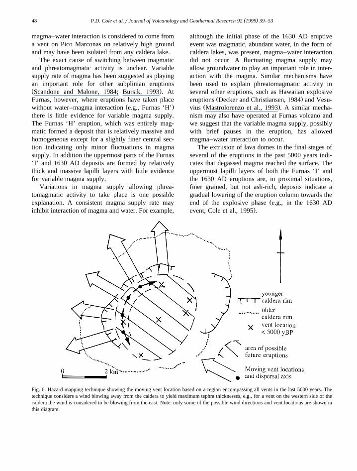
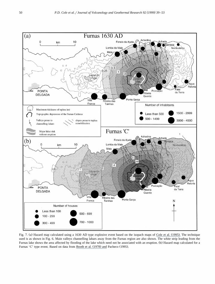
Fig. 6. Hazard mapping technique showing the moving vent location based on a region encompassing all vents in the last 5000 years. Thetechnique considers a wind blowing away from the caldera to yield maximum tephra thicknesses, e.g., for a vent on the western side of thecaldera the wind is considered to be blowing from the east. Note: only some of the possible wind directions and vent locations are shown inthis diagram.

( )P.D. Cole et al.rJournal of Volcanology and Geothermal Research 92 1999 39–53 49
4. Hazards from future volcanic events
4.1. Hazard mapping based on the Furnas C and1630 AD eÕents
In the last 5000 years the largest eruption to haveoccurred on Furnas volcano is the Furnas ‘C’ eventand one of the smallest is the 1630 AD eruption.Both of these two events are of the typical styleexhibited at Furnas volcano of alternating ash andlapilli layers. We therefore consider the 1630 ADand Furnas ‘C’ events to be end members of themost likely range of magnitudes of future activity.
Ž .Booth et al. 1983 considered the volcanic haz-ards for the island of Sao Miguel of which Furnas˜was just one part. They considered three types ofexplosive eruption: one trachytic, and two basalticfor Sao Miguel as a whole. We consider only tra-˜chytic eruptions in this hazard assessment as nobasaltic eruptive activity has occurred in the past
Ž .5000 years at Furnas Guest et al., 1999-this issueand basaltic eruptions within the caldera are thoughtto be unlikely. Hazard mapping was undertaken for
Ž .both the Furnas ‘C’ example of a large eruptionŽ .and 1630 AD example of a small eruption events to
predict the maximum possible thicknesses of tephraat any location around the volcano. The hazardmapping involved using a moveable vent locationwithin a region of the inner caldera from which allthe previous eruptions in the last 5000 years have
Ž .taken place see Fig. 6 . The total tephra thicknessŽisopach maps for the two events used Furnas ‘C’
.and 1630 AD were then superimposed on the rangeof vent locations. To obtain a maximum possibletephra thickness at any one place the wind directionis assumed to be blowing radially away from thecaldera, and the vent is positioned at the edge of thecaldera. For example if the vent location was at theeastern margin of the caldera then the dispersaldirection was considered to be due east, yielding the
Ž .maximum likely tephra thickness Fig. 6 . This tech-nique was developed for two reasons. First, there isno strongly dominant prevailing wind direction onSao Miguel. Secondly, during the course of a typical˜eruption on Furnas, it is known that the wind direc-
Ž .tion can shift a number of times Cole et al., 1995 .The results of this hazard mapping are shown in Fig.
7a and b and the various hazards are summarised forselected towns in Table 2.
Section 4.2 analyses the different hazards that arelikely to occur from a future eruption based on thedetailed field studies and hazard maps.
4.2. Tephra fall
Tephra fall is the most widespread hazard andwould occur with an explosive eruption of almostany size. As most eruptions in the past 5000 yearshave been, at least partly, phreatomagmatic, the ashinvolved in the tephra fall is likely to be wet. Thisobviously increases the likelihood of roof collapseowing to the higher density of the tephra. With anevent of the magnitude of the 1630 AD eruption, ourhazard mapping indicates that towns and villages onthe northern coast will receive -50 cm of tephra,
Ž .but some may receive )25 cm Fig. 7a . The studyŽ .by Pomonis et al. 1999 indicates that 80% of even
the strongest roof types in the Furnas region wouldfail under a wet tephra load of 25 cm. Towns such asPonta Garca and Povoacao could suffer up to 2 m of˜total tephra under which total roof collapse is in-evitable. This indicates that roof collapse from a1630 AD type eruption would be a problem for thewhole of the Furnas region as far as the villages onthe northern coast of Sao Miguel.˜
The situation is potentially far worse for an erup-tion of Furnas ‘C’ magnitude. Our calculations sug-gest that towns such as Ponta Garca might receive asmuch as 16 m of tephra fall if the wind wereblowing to the southwest. Towns such as Povoacao˜
Ž .could receive between 3 and 8 m of tephra Fig. 7b .The city of Ponta Delgada could also be under threatfrom roof collapse due to loading by wet tephra.
4.3. Pyroclastic surges and pyroclastic flows
Ž .The study of Booth et al. 1983 did not considerpyroclastic flows or surges to be a hazard at Furnasvolcano, probably due to the fact that these depositswere not identified within the eruptive products ofthe past 5000 years. Our field studies of the erup-tions of the past 5000 years indicate that deposits ofpyroclastic surges are abundant within the caldera. Itis therefore considered that anywhere inside thecaldera of Furnas volcano is under serious threat, in
( )P.D. Cole et al.rJournal of Volcanology and Geothermal Research 92 1999 39–5350
Ž . Ž .Fig. 7. a Hazard map calculated using a 1630 AD type explosive event based on the isopach maps of Cole et al. 1995 . The techniqueused is as shown in Fig. 6. Main valleys channelling lahars away from the Furnas region are also shown. The white strip leading from the
Ž .Furnas lake shows the area affected by flooding of the lake which need not be associated with an eruption. b Hazard map calculated for aŽ . Ž .Furnas ‘C’ type event. Based on data from Booth et al. 1978 and Pacheco 1995 .

( )P.D. Cole et al.rJournal of Volcanology and Geothermal Research 92 1999 39–53 51
Table 2Summary of the likelihood of various hazards in selected towns in the Furnas environs. Tephra thicknesses are taken from the Hazard mapsFig. 7a and Fig. 7b. The terms high, mod and low for hazard likelihoods are defined as follows: Highs likely irrespective of vent location;Modsstrongly dependent on vent location; Lowsunlikely, irrespective of vent location
Ž .Townsrvillages Max tephra fall thickness m Pyroclastic Pyroclastic Laharrflood Laharrfloodsurge flow destruction cutting road‘1630’ ‘C’
Furnas )3 )16 High High High HighRibeira Quente )3 ;16 High High High HighPonta Garca 1–3 ;4–8 Mod Mod Low HighPovoacao 0.5–3 8–4 Mod–Low Mod High High˜Faial da Terra )0.25 1–2 Low Low Mod ModVilla Franca )0.25 1–2 Low Low Low LowSalga 0.25–0.5 ;2 Low Low Low HighAchadinha 0.25 1–2 Low Low Low HighAchada 0.25 1–2 Low Low Low High
Ž .Fenais da Ajuda 0.25 1–2 Low Low High pt of HighŽ .Lomba da Maia 0.25–0.5 2–4 Low Low High pt of High
Maia )0.25 ;2 Low Low Low Low
the event of any eruption, from destruction by pyro-clastic surges.
Geological field evidence indicates that pyroclas-tic surges were associated with at least the 1630 ADŽ . Ž .Cole et al., 1995 Furnas ‘I’ ;1445 AD and
Ž .Furnas ‘C’ eruptions Pacheco, 1995 . It is importantto note, however, that pyroclastic surges may leaveonly a thin deposit that would be difficult to recog-nise in the geological record. For example althoughhistorical records provide strong evidence that pyro-clastic surges associated with the 1630 AD eruptionkilled numerous people in the Ponta Garca region,there is little geological evidence for surge deposits
Ž .in that area Cole et al., 1995 . Thus it seems likelythat pyroclastic surges are more widespread thansuggested by geological evidence.
Destruction by pyroclastic surges associated withthe phreatomagmatic phases of a 1630 AD magni-tude eruption occurring from a vent in the centralpart of the caldera would probably be containedwithin the caldera depression. The pyroclastic surgesthat reached Ponta Garca during the 1630 AD erup-tion are considered to be a function of the closeproximity of the vent to the southern margin of thecaldera. Either this permitted pyroclastic surges toovertop the caldera rim to the south, or the eruptivecolumn actually collapsed outside the caldera rimallowing pyroclastic surges to travel directly to PontaGarca. It therefore seems likely that, apart from
Furnas village and Ribeira Quente, the hazards posedby pyroclastic surges to areas outside the caldera arestrongly controlled by the location of the vent of afuture eruption.
Geological evidence indicates that pyroclasticflows occurred contemporaneously with pyroclastic
Žsurges during the 1630 AD eruption Cole et al.,.1995 . Although there is only evidence for pyroclas-
tic surges associated with most of the eruptions ofthe past 5000 years, it is possible that dense pyro-clastic flows also occurred during these events. Thedistribution of pyroclastic flow deposits at the mouthsof deep valleys confirms the strong topographic con-trol exerted on these flows. It appears that densehigh-particle concentration pyroclastic flows werechannelled down steep sided valleys, which areabundant in this area. The town of Furnas wouldcertainly be at risk and the village of Ribeira Quenteis especially prone to destruction from pyroclasticflows as it lies at the end of a valley leading directlyfrom the caldera.
4.4. Tephra remobilisation and lahars
The position of the present lake within the calderaat Furnas makes the likelihood of a torrent or flooddue to breaching of the lake wall a distinct possibil-ity. Such an event may occur even without an erup-

( )P.D. Cole et al.rJournal of Volcanology and Geothermal Research 92 1999 39–5352
tion and could be triggered by a large earthquakealone. The resulting flood is capable of destroying atleast part of the town of Furnas and also much of
Ž .Ribeira Quente Fig. 7 .Both during and after an explosive eruption tephra
remobilisation is likely, with ash being washed fromsteep slopes, forming lahars which will be chan-nelled into and travel down valleys. Settlementswithin valleys or at valley mouths are particularlyvulnerable to damage from this type of event, e.g.,Ribeira Quente and parts of Fenais da Ajuda andLomba da Maia on the northern coast. Furthermore,the topography within the Povoacao region is such˜that the town sits centrally within an old calderadepression at the confluence of several river valleysmaking it particularly exposed to lahars and floods.Indeed, in December 1996 and again in September1997 much damage was caused in Povoacao by˜flooding related to exceptionally heavy rain. Severalvillages radiate away from Povoacao along elevated˜ridges, e.g., Lomba de Cavaliero and Lomba deCarro. Many of these ‘Lomba’ villages may be safefrom lahars owing to their location on distinct topo-graphic highs. Several of the towns on the northerncoast of the island are also relatively safe due to theirelevated position although it should be noted thatmany of the towns and villages around Furnas wouldquickly become cut off if bridges were destroyed bylahars.
Ž .Finally, historical evidence Correa, 1924 indi-ˆcates that during the 1630 AD eruption the village ofFaial da Terra, 10 km east of the town, experienced asevere flood which caused widespread destruction.Indications are that remobilised ash caused tempo-rary damming of the river which subsequently burst.Future explosive activity is likely to cause similarphenomena.
4.5. Landslides
Landslides present a significant hazard in theFurnas region. Part of the village of Ribeira Quenteis built on a landslide deposit considered to haveformed immediately prior to the 1630 AD eruptionŽ .Cole et al., 1995 possibly associated with precur-sory seismicity. Indeed landslides will be a seriousproblem not just in an eruption but also duringintense earthquake activity.
In April 1996 slope failure occurred from theinner caldera wall immediately west of the town ofFurnas producing a landslide which reached thewestern edge of the village. Moreover, in October1997, following an extended period of high rainfall,hundreds of small landslides occurred on and aroundFurnas Volcano. Two of these landslides impactedthe village of Ribeira Quente, causing 30 fatalities.Mudflows associated with this landsliding occurredextensively in the Ribeira Quente valley between thevillage and Furnas town cutting the road in a numberof places. Access by boat to Ribeira Quente was alsohampered due to floating trees washed into the seaand the village was essentially cut off and rescuemissions were only possible by foot or helicopter.This highlights hazards associated with even dor-
Ž .mant inactive periods of the volcano.
5. Discussion and conclusions
Geological studies on Furnas volcano have shownthat explosive eruptions which involved numerousmagmatic and phreatomagmatic phases have becomemore abundant with time during the volcanoes his-tory. In the last 17,000, and particularly in the last5000 years, it has been the typical style of activity. Itis therefore considered that future eruptive events arelikely to be of this style. Such explosive eruptiveactivity will involve fallout of both lapilli and ash,and also highly destructive pyroclastic surges andpyroclastic flows. Geological evidence indicates thatsome pyroclastic surges occurred contemporaneouswith fallout of lapilli and that fallout of lapilli islikely to be heterogeneous due to strong localisedwinds and rain storms that are typical ofphreatomagmatic activity. We suggest that thesources of water for this phreatomagmatic activityare the caldera lakes and that once this water isexhausted the eruptive activity becomes purely mag-matic until the magma supply wanes.
We consider that anywhere within the caldera isunder serious threat from destruction by pyroclasticsurges and flows during the next eruption. The vil-lage of Ribeira Quente is also particularly hazardousas it lies at the mouth of the only valley to drain thecaldera and is thus likely to channel pyroclasticflows, lahars and other floods. Hazard mapping has
( )P.D. Cole et al.rJournal of Volcanology and Geothermal Research 92 1999 39–53 53
indicated possible maximum tephra thicknesses forsettlements in and around Furnas. The area affectedby pyroclastic surges will be closely related to thelocation of the vent of the next eruption.
Acknowledgements
The comments of R.B. Moore and an anonymousreviewer improved the paper.
References
Booth, B., Walker, G.P.L., Croasdale, R., 1978. A quantitativestudy of five thousand years of volcanism on Sao Miguel,˜Azores. Philos. Trans. R. Soc. London Ser A 228, 271–319.
Booth, B., Croasdale, R., Walker, G.P.L., 1983. Volcanic hazardŽ .on Sao Miguel, Azores. In: Sabroux, J.C., Tazieff, H. Eds. ,˜
Forecasting Volcanic Events. Chap. 9. Elsevier, Amsterdam.Branney, M.J., 1991. Eruption and depositional facies of the
Whorneyside Tuff Formation, English Lake District: an excep-tionally large magnitude phreatoplinian eruption. Geol. Soc.Am. Bull. 103, 886–897.
Bursik, M., 1993. Subplinian eruption mechanisms inferred fromvolatile and clast dispersal data. J. Volcanol. Geotherm. Res.57, 57–70.
Carey, S., Sparks, R.S.J., 1986. Quantitative models of the falloutand dispersal of tephra from volcanic eruption columns. Bull.Volcanol. 48, 109–125.
Cole, P.D., Queiroz, G., Wallenstein, N., Gaspar, J.L., Duncan,A.M., Guest, J.E., 1995. An historic subplinian to phreatomag-matic eruption: the 1630 eruption of Furnas volcano, Sao˜Miguel, Azores. J. Volcanol. Geotherm. Res. 69, 117–135.
Correa, J., 1924. Leituras sobre a Historia do Valle das Furnas.ˆ ´Oficina de Artes Graficas, S. Miguel, Acores, 217 pp.
Decker, R.W., Christiansen, R.L., 1984. Explosive eruptions of
Kilauea volcano, Hawaii. In: Explosive Volcanism. Natl. Acad.Press, Washington, DC, pp. 122–132.
Guest, J.E., Gaspar, J.L., Cole, P.D., Queiroz, G., Wallenstein, N.,Ferreira, T., Pacheco, J.-M., Duncan, A.M., 1999. The vol-canic geology of Furnas volcano. Sao Miguel, Azores. J.˜Volcanol. Geotherm. Res. 92, 1–29.
Jones, G., Chester, D.K., Shooshtarian, C., 1999. Statistical analy-sis of the frequency of eruptions at Furnas Volcano, Sao˜Miguel, Azores. J. Volcanol. Geotherm. Res. 92, 31–38.
Mastrolorenzo, G., Munno, R., Rolandi, G., 1993. Vesuvius 1906:a case study of a paroxysmal eruption and its relation toeruption cycles. J. Volcanol. Geotherm. Res. 58, 217–237.
Moore, R.B., 1990. Volcanic Geology and eruption frequency,Sao Miguel, Azores. Bull. Volcanol. 52, 602–614.˜
Moore, R.B., 1991. Geology of three late Quaternary Stratovolca-noes on Sao Miguel, Azores. U.S. Geol. Surv. Bull., p. 1900.˜
Moore, R.B., Rubin, M., 1991. Radiocarbon dates for lava flowsand pyroclastic deposits on Sao Miguel, Azores. Radiocarbon˜33, 151–164.
Pacheco, J.M., 1995. Caraterizacao do deposito Vulcanico Furnas-˜C e seu contributo para a analise do hazard associado aactividade do vulcao das Furnas. Masters Thesis. Universidade˜dos Acores.
Pomonis, A., Spence, R., Baxter, P., 1999. Risk assessment ofresidential buildings for an eruption in Furnas Volcano, SaoMiguel, the Azores. J. Volcanol. Geotherm. Res. 92, 107–131.
Pyle, D.M., 1989. The thickness, volume and grainsize of tephrafall deposits. Bull. Volcanol. 51, 1–15.
Scandone, R., Malone, S.D., 1984. Magma supply, magma dis-charge and readjustment to the feeding system of Mount St.Helens during 1980. J. Volcanol. Geotherm. Res. 23, 239–262.
Self, S., 1976. The Recent volcanology of Terceira, Azores. J.Geol. Soc. London 132, 645–666.
Shotten, F.W., Williams, R.E.G., 1971. Birmingham Universityradiocarbon dates. V. Radiocarbon 15, 451–468.
Valentine, G.A., Giannetti, B., 1995. Single beds deposited bysimultaneous fallout and surge processes: Roccamonfina vol-cano, Italy. J. Volcanol. Geotherm. Res. 64, 129–137.
Walker, G.P.L., Croasdale, R., 1971. Two plinian-type eruptionsin the Azores. J. Geol. Soc. London 127, 17–55.