Chapter 10: Hazards, Hazardous Materials, and Wildfire
84
MTP/SCS 2020 Sacramento Area Council of Governments Draft Environmental Impact Report Hazards, Hazardous Materials, and Wildfire – Page 10–1 Chapter 10—Hazards, Hazardous Materials, and Wildfire 10.1 Introduction This chapter describes the existing conditions (environmental and regulatory) and assesses the potential impacts that may result from implementation of the 2020 Metropolitan Transportation Plan/Sustainable Communities Strategy (proposed MTP/SCS). Where necessary and feasible, mitigation measures are identified to reduce these impacts. The information presented in this chapter is based on a review of existing and available information and is regional in scope. This chapter evaluates noise impacts to people residing or working within an airport land use plan or within two miles of a public or public use airport. Other noise issues are addressed in Chapter 13 – Noise and Vibration. In response to the Notice of Preparation (NOP), SACOG received one comment regarding the need to address fire hazards at the wild land-urban interface from Placer County Sierra Club. The CEQA Guidelines note that comments received during the NOP scoping process can be helpful in “identifying the range of actions, alternatives, mitigation measures, and significant effects to be analyzed in depth in an EIR and in eliminating from detailed study issues found not to be important.” (CEQA Guidelines Section 15083.) Neither the CEQA Guidelines or Statutes require a lead agency to respond directly to comments received in response to the NOP, but they do require they be considered. Consistent with these requirements, this comment has been carefully reviewed and considered by SACOG and is reflected in the analysis of impacts in this chapter. Appendix PD- 1 includes all NOP comments received. 10.2 Environmental Setting 10.2.1 Hazardous Materials Hazardous materials exist in many forms such as liquids, solids, or contained gases, and can be man- made or naturally occurring. These materials can be found in many places such as in groundwater, construction materials, and rocks (asbestos). The land use concerns associated with hazardous materials and the transportation of hazardous materials and wastes are discussed in this chapter. Worker health and safety, administered by the U.S. Occupational Safety and Health Administration (OSHA), and public safety are key issues when dealing with hazardous materials that may affect human health and the environment. If hazardous material is disturbed during the construction of projects in the plan area of the proposed MTP/SCS, proper disposal is vital to avoid impacts to health and safety. LEAD, ASBESTOS, AND OTHER HAZARDOUS MATERIALS IN EXISTING BUILDINGS Hazardous materials are commonly found in building materials. Before 1978, lead compounds were used in interior and exterior paints. Before the 1980s, building materials often contained asbestos
-
Upload
khangminh22 -
Category
Documents
-
view
4 -
download
0
Transcript of Chapter 10: Hazards, Hazardous Materials, and Wildfire
MTP/SCS 2020 Sacramento Area Council of Governments Draft Environmental Impact Report Hazards, Hazardous Materials, and Wildfire – Page 10–1
Chapter 10—Hazards, Hazardous Materials, and Wildfire
10.1 Introduction
This chapter describes the existing conditions (environmental and regulatory) and assesses the potential impacts that may result from implementation of the 2020 Metropolitan Transportation Plan/Sustainable Communities Strategy (proposed MTP/SCS). Where necessary and feasible, mitigation measures are identified to reduce these impacts.
The information presented in this chapter is based on a review of existing and available information and is regional in scope. This chapter evaluates noise impacts to people residing or working within an airport land use plan or within two miles of a public or public use airport. Other noise issues are addressed in Chapter 13 – Noise and Vibration.
In response to the Notice of Preparation (NOP), SACOG received one comment regarding the need to address fire hazards at the wild land-urban interface from Placer County Sierra Club.
The CEQA Guidelines note that comments received during the NOP scoping process can be helpful in “identifying the range of actions, alternatives, mitigation measures, and significant effects to be analyzed in depth in an EIR and in eliminating from detailed study issues found not to be important.” (CEQA Guidelines Section 15083.) Neither the CEQA Guidelines or Statutes require a lead agency to respond directly to comments received in response to the NOP, but they do require they be considered. Consistent with these requirements, this comment has been carefully reviewed and considered by SACOG and is reflected in the analysis of impacts in this chapter. Appendix PD-1 includes all NOP comments received.
10.2 Environmental Setting
10.2.1 Hazardous Materials
Hazardous materials exist in many forms such as liquids, solids, or contained gases, and can be man-made or naturally occurring. These materials can be found in many places such as in groundwater, construction materials, and rocks (asbestos). The land use concerns associated with hazardous materials and the transportation of hazardous materials and wastes are discussed in this chapter. Worker health and safety, administered by the U.S. Occupational Safety and Health Administration (OSHA), and public safety are key issues when dealing with hazardous materials that may affect human health and the environment. If hazardous material is disturbed during the construction of projects in the plan area of the proposed MTP/SCS, proper disposal is vital to avoid impacts to health and safety.
LEAD, ASBESTOS, AND OTHER HAZARDOUS MATERIALS IN EXISTING BUILDINGS
Hazardous materials are commonly found in building materials. Before 1978, lead compounds were used in interior and exterior paints. Before the 1980s, building materials often contained asbestos

MTP/SCS 2020 Sacramento Area Council of Governments Draft Environmental Impact Report Hazards, Hazardous Materials, and Wildfire – Page 10–2
fibers, which were used to provide strength and fire resistance. In addition, other common items present in buildings, such as electrical transformers, fluorescent lighting, electrical switches, heating/cooling equipment, and thermostats, can contain hazardous materials that may pose a health risk if not handled and disposed of properly. These include polychlorinated biphenyls (PCBs), which were used in hundreds of industrial and commercial applications because of their non-flammability, chemical stability, high boiling point, and electrical insulating properties. Equipment in the plan area that might contain PCBs includes electrical equipment and thermal insulation material (e.g., fiberglass, felt, foam, or cork). Older, pole-mounted electrical transformers can also contain PCBs.
NATURALLY OCCURRING ASBESTOS
Asbestos is the common name for a group of naturally occurring fibrous silicate minerals that can separate into thin, but strong and durable fibers. Naturally occurring asbestos (NOA) is commonly associated with ultramafic rocks forming in high-temperature environments well below the surface of the earth. Once exposed at the earth’s surface by geologic uplift and erosion, ultramafic rocks may be partially to completely altered into a type of metamorphic rock called serpentinite. Sometimes the metamorphic conditions are right for the formation of chrysotile asbestos or tremolite-actinolite asbestos in the bodies of these rocks or along their boundaries (Churchill and Hill 2000).
People exposed to low levels of asbestos may be at elevated risk (i.e., above background rates) of lung cancer and mesothelioma. The risk is proportional to the cumulative inhaled dose (i.e., quantity of fibers) and increases with the time since first exposure. Although there are a number of factors that influence the disease-causing potency of any given type or form of asbestos (e.g., fiber length and width, fiber type, and fiber chemistry), all forms are carcinogens.
In general, asbestos fibers do not pose a threat unless they are disturbed or introduced into the air as fugitive dust. Airborne exposure in areas containing NOA could arise from such activities as children playing in the dirt, dust raised from unpaved roads and driveways covered with crushed serpentine, grading and earth disturbance associated with construction activity, rock blasting, quarrying, or gardening. Asbestos can be tracked indoors or enter a home along with outdoor air, where normal household activities such as vacuuming can prolong airborne exposure.
NOA can be found in rock formations in 45 of California’s 58 counties. Additionally, 51 counties include areas of exposed ultramafic rocks or serpentinite, which are common host rocks for asbestos. In the SACOG region, NOA is primarily found in western El Dorado County, with most concentrations located within and near El Dorado Hills. NOA can also be found in a few scattered parts of western Placer County and a small number of sites in eastern Sacramento County. Small amounts of ultramafic rock and asbestos occurrences have also been reported at the edge of western Yolo County and northern Yuba County (Van Gosen and Clinkenbeard, U.S. Geological Survey 2011). Known and likely occurrences of NOA are shown in Figure 10-1. The California Air Resources Board (CARB) and all five counties containing or potentially containing NOA have adopted measures to limit public exposure to NOA.

MTP/SCS 2020 Sacramento Area Council of Governments Draft Environmental Impact Report Hazards, Hazardous Materials, and Wildfire – Page 10–3
Figure 10-1
Naturally Occurring Asbestos in the Plan Area of the Proposed MTP/SCS

MTP/SCS 2020 Sacramento Area Council of Governments Draft Environmental Impact Report Hazards, Hazardous Materials, and Wildfire – Page 10–4
HAZARDOUS WASTE GENERATION AND MANAGEMENT
The generation and handling of hazardous waste in the region is monitored by the U.S. Environmental Protection Agency (EPA); Central Valley Regional Water Quality Control Board (RWQCB); Sacramento Metropolitan Air Quality Management District (SMAQMD); and the Environmental Health and Hazardous Materials Control divisions of the six counties within the plan area of the proposed MTP/SCS. Industrial, commercial, and agricultural land uses are of particular concern because they may include areas where the concentrated use of hazardous materials and the generation of hazardous wastes have occurred over long periods of time. Businesses that generate hazardous waste are either large-quantity generators (e.g., heavy industrial or commercial facilities) or small-quantity generators (e.g., dry cleaners, automotive repair shops, etc.), both requiring an EPA identification number used to monitor and track hazardous waste activities.
AGRICULTURAL USE OF POTENTIALLY HAZARDOUS MATERIALS AND GENERATION OF WASTE
Agricultural enterprises have historically stored, handled, and applied pesticides and herbicides within the plan area. Agricultural chemicals used before the 1970s often included highly persistent compounds such as DDT (dichlorodiphenyltrichloroethane). Inorganic compounds containing heavy metals such as arsenic, lead, and mercury were commonly used before the 1950s. Chemicals commonly used in the past have the potential to leave residual inorganic or organic components in shallow soils that could persist for many decades. If present in elevated concentrations, these residues could pose a potential health risk to future construction workers, residents, and other persons who may come in direct contact with surface soils.
Chemicals currently used in agriculture are generally less-persistent, organic compounds. Because of today’s stricter regulatory standards and product testing by EPA before commercial use, routine application of these materials does not generally result in accumulation to levels sufficient to cause health risk concern. However, there are other aspects of pesticide management that may result in impacts, including: pesticide-handling areas that lack concrete pads, berms, or cribs to contain spills or leaks during handling and storage; rinse water from washout facilities for pesticide-application equipment that has not been properly collected and treated before discharge; And equipment-repair and petroleum-storage areas.
TRANSPORT OF HAZARDOUS MATERIALS
Major transportation corridors are used to transport goods throughout the region, state, and the country. Hazardous substances are often associated with the freight transported within these corridors, as well as within the soil surrounding them. The potential harm that hazardous waste can cause to people and the environment has resulted in scrutiny by national, state, and local governments, particularly as related to the safe transport of hazardous materials. Since hazardous materials are transported primarily on facilities shared by the public such as highways, rail lines and local roads, there is greater public exposure to these materials.
POTENTIAL FOR EXISTING CONTAMINATION OF TRANSPORTATION CORRIDORS
Leaded gasoline was used as a vehicle fuel in the U.S. from the 1920s until the late 1980s. Although lead is no longer used in gasoline formulations, lead emissions from automobiles are a recognized source of contamination in soils along roadways (i.e., aerially-deposited lead). Surface and near-

MTP/SCS 2020 Sacramento Area Council of Governments Draft Environmental Impact Report Hazards, Hazardous Materials, and Wildfire – Page 10–5
surface soils along and underneath heavily-used roadways have the potential to contain elevated concentrations of lead. Generally, soils within 10 feet of the edge of the pavement and within the top 6 inches of the soil have the highest lead concentrations (DTSC 2016).
Contaminants common in railway corridors include wood preservatives (e.g., creosote and arsenic) and heavy metals in ballast rock. Ballast rock and soils associated with railroad tracks may also contain NOA. In addition, soils in and adjacent to these corridors might contain herbicide residues because of historical and ongoing weed-abatement practices.
ACCIDENTAL RELEASE OF HAZARDOUS MATERIALS
As with the movement of goods and people in general, movement of hazardous materials can be defined by trips and modes. Any given “trip” from an origin to a destination can involve one or more “modes.” In other words, a shipment may begin on a truck, be transferred to a train, and then be transferred again to another truck, before reaching its final destination. Table 10-1 describes a rough estimate of the volume of hazardous materials shipped in the region and the mode of transportation used.
Table 10-1 2012 Shipment Characteristics by Mode of Transportation for the Sacramento-Roseville, CA
Community Flow Survey Area
Mode of Transportation Tons All Freight
2007 (thousands)
Tons (percent of Total)
Hazardous Materials Estimate
by Mode (thousands)
Percent Share of All Freight
All modes 40,564 100 9,661 24 Single modes 39,940 98 9,559 24 Truck (For-hire/Private) 39,504 97 5,673 14 Rail 423 1.0 244 58 Multiple modes 624 1.5 3 0 Parcel, U.S.P.S. or courier 261 0.6 0 0 Other multiple modes 360 0.9 0 0 Other and unknown modes 0 0 0 -
Hazardous Materials Estimate by Mode is based upon the percentage of Hazardous Material Shipment Characteristics by Mode of Transportation: 2007 & Shipment Characteristics by Mode of Transportation for the United States: 2007. Because of rounding, estimates may not be additive. Source: U.S. Department of Transportation, Research and Innovative Technology Administration, Bureau of Transportation Statistics and U.S. Department of Commerce, U.S. Census Bureau, 2012 Economic Census: Transportation Commodity Flow Survey, Issued February 2015.
Three agencies maintain searchable databases that track hazardous material releases in reportable quantities due to accidents during routine transport: EPA maintains the Hazardous Materials Incident Report System that contains data on hazardous material spill incidents reported to the U.S. Department of Transportation (DOT); California Office of Emergency Services (Cal OES) maintains the California Hazardous Materials Incident Report System that contains information on reported hazardous material accidental releases or spills; and State Water Resources Control Board’s (SWRCB’s) Site Cleanup Program maintains information on reported hazardous material accidental releases or spills. Although these databases include all reportable spills, hazardous materials spills

MTP/SCS 2020 Sacramento Area Council of Governments Draft Environmental Impact Report Hazards, Hazardous Materials, and Wildfire – Page 10–6
and accidental releases that are cleaned up immediately are not considered sites of potential environmental concern that would affect future land use.
DOT regulates the transportation of hazardous materials by truck and rail (49 Code Federal Regulations [CFR]), and the California Department of Public Health (CDPH) regulates the haulers of hazardous waste (Health & Safety Code, Section 20, Chapter 6.5). DOT also provides grants to local agencies for preparation and training relating to hazardous materials incidents through its Hazardous Materials Emergency Preparedness Program administered by Cal OES). As shown in Table 10-2, there are nine classes and many further subclasses of hazardous materials reflected on corresponding placards for display on vehicles hauling hazardous waste as defined by DOT.
Table 10-2 Classes of Hazardous Materials Regulated by DOT for Transport1
Class Description Class 1 Explosives
Division 1.1 Mass Explosive Hazard A substance with an explosion hazard that affects the entire load virtually instantaneously.
Division 1.2 Projection Hazard A substance with an explosion hazard that has enough force to be propelled for some distance.
Division 1.3 Mass Fire Hazard A substance with a fire, minor blast, or projection hazard producing considerable radiant heat or multiple fires.
Division 1.4 Minor Explosion Hazard A substance that has, in the event of ignition, only a small explosion hazard anticipated to be largely contained within the package.
Division 1.5 Very Insensitive Explosives A substance that is very insensitive to detonation with a mass explosive hazard.
Division 1.6 Extremely Insensitive Explosives
A substance that is extremely insensitive to detonation with a hazard below that of a mass explosion.
Class 2 Gases
Division 2.1 Flammable Gases A gas flammable with oxygen at 20 °C and a standard pressure of 101.3 kPa.
Division 2.2 Non-Flammable Gases A gas contributing to the combustion of other material by providing more oxygen than air.
Division 2.3 Poisonous or Toxic Gases A gas liable to cause either death, serious injury, or harm to human health if swallowed or inhaled, or by coming into contact with skin.
Class 3 Flammable Liquid A liquid with a flash point of not more than 93 °C. Class 4 Flammable Solids
Division 4.1 Flammable Solid A solid which is readily combustible or may cause or contribute to fire through friction.
Division 4.2 Spontaneously Combustible Material
A thermally unstable substance liable to ignite upon contact with oxygen or undergo a strongly exothermic decomposition without oxygen.
Division 4.3 Dangerous When Wet A substance that by interaction with water is liable to become spontaneously flammable or to give off flammable gases in dangerous quantities.
Class 5 Oxidizing Substances; Organic Peroxides
Division 5.1 Oxidizer A substance that can cause or contribute to the combustion of other material, generally by yielding oxygen.

MTP/SCS 2020 Sacramento Area Council of Governments Draft Environmental Impact Report Hazards, Hazardous Materials, and Wildfire – Page 10–7
Class Description
Division 5.2 Organic Peroxide A thermally unstable organic substance derived from hydrogen peroxide, which may undergo exothermic self-accelerating decomposition.
Class 6 Poisonous (Toxic) and Infectious Substances
Division 6.1 Poisonous (Toxic Material) A substance liable to cause either death, serious injury, or harm to human health if swallowed or inhaled, or by coming into contact with skin.
Division 6.2 Infectious Substance A substance known or reasonably expected to contain pathogens such as microorganisms, bacteria, viruses, rickettsiae, parasites, fungi, or other agents which can cause disease.
Class 7 Radioactive Material A material containing radionuclides (atoms with an unstable nuclei subject to radioactive decay) where both the activity concentration and the total activity exceed certain pre-defined values.
Class 8 Corrosives A material that can destroy human skin or corrode steel at a rate of 0.25 inches per year.
Class 9 Miscellaneous Dangerous Goods
A material that presents a hazard during shipment but does not meet the definition of the other classes.
1 Descriptions reflect a generalized summary definition of Classes of Hazardous Materials regulated by DOT. For a full legal description of class definitions, exceptions, divisions, specifications, etc., view the Electronic Code of Federal Regulations Title 49, Subtitle B, Chapter I, Subchapter C, Part 173. Source: U.S. Government Publishing Office, Electronic Code of Regulations, 2019. https://www.ecfr.gov/cgi-bin/text-idx?node=pt49.2.173&rgn=div5#se49.2.173_150 Accessed May 17, 2019. https://www.ilo.org/legacy/english/protection/safework/ghs/ghsfinal/ghsc1528.pdf Accessed May 17, 2019. https://www.ecfr.gov/cgi-bin/text-idx?node=pt49.2.173&rgn=div5#se49.2.173_1115
Crude Oil Transport
Crude oil is the basic petroleum feedstock processed at refineries into the products propane, butane, gasoline, jet fuel, and diesel. As a natural material, crude oil characteristics vary depending mostly on the well from which it was obtained and its origin. Crude oils contain sulfur and may contain various other organic compounds, including nitrogen, metals, or inorganic materials such as salts or water.
Crude oil is transported to and from California via marine tanker, pipeline, and rail. The Pipeline and Hazardous Materials Safety Administration (PHMSA) regulations classify hazardous materials based on the material’s hazardous characteristics. Crude oil is assigned to hazard Class 3 based on specified characteristics of flammability and combustibility (49 CFR 173.120). Under PHMSA regulations, all crude oil must be shipped in tank cars built to the DOT-111 specification. The Bakken Formation is one of the largest contiguous deposits of oil and natural gas in the U.S., located underneath northwestern North Dakota, northeastern Montana, and southern Canada. Data gathered by PHMSA and Federal Railroad Administration (FRA) confirms that the Bakken crude oil currently being shipped across the country is more volatile than traditional Class 3 crude oil because it has unusually high vapor pressure. The average Bakken shipment travels over 1,000 miles to refineries in California and other locations. In 2018, California imported 5,291,377 barrels of oil (of which 56 percent came from Canada, 17 percent from Wyoming, and 27 percent from New Mexico) (CEC 2019).

MTP/SCS 2020 Sacramento Area Council of Governments Draft Environmental Impact Report Hazards, Hazardous Materials, and Wildfire – Page 10–8
The transportation of hazardous substances poses a potential risk of fires, explosions, and hazardous materials release. Crude oil tanks could spill and ignite, creating thermal radiation impacts that could cause injury up to 220 feet away (San Luis Obispo County 2014). The greatest concern is the risk of a train accident, which can be caused by malfunction, derailment, or impact because of human or equipment error. The potential consequences of an accident are related to the size of the release (the volume of hazardous substance plus the failure type), the population density at the location of the accident, the specific release scenario, adjacent land uses, time of day, the physical and chemical properties of the hazardous material, and local weather conditions.
In general, the greater the miles traveled the greater the potential for a train accident. In 2018, there were two accidents in the plan area involving cars carrying hazardous materials: one on yard track in Yolo County and one on mainline track in Placer County (FRA 2019).
Trains transporting crude oil to refineries, including those in Benicia and unincorporated San Luis Obispo County, could enter California through five different locations. Three of these locations pass through the MTP/SCS plan area: one entering at the north end of the state from Oregon and two entering from the northeast from Nevada. Figure 10-2 shows the Union Pacific Railroad (UPRR) lines with the potential for crude oil transport. In California, there were 182 total petroleum spills (crude oil and other) associated with rail transport in 2013. Most reported incidents document a relatively small volume of oil released (Interagency Rail Safety Working Group 2014).
More than 500,000 people live and work within one-half mile of freight rail lines within the greater Sacramento region. Most of the track along the UPRR that could be used for crude oil transport in the plan area of the proposed MTP/SCS is designated as mainline tracks and long-haul freight service, which typically have lower accident rates than branch and spur tracks. The California Public Utilities Commission (CPUC) identified a number of local safety hazard sites (LSHS; Pub. Utilities Code Section 752d(1)) in 1997. LSHS were identified where derailments had occurred in clusters, not because of random chance, but due to local characteristics and terrain more difficult to traverse or rendering greater consequences as a result of derailment or where the operating railroad had determined that stricter operating practices were required. One such site follows 10 miles of track in Placer County (UPRR Roseville Subdivision), which had one derailment from 2013 to 2017 (CPUC 2018).
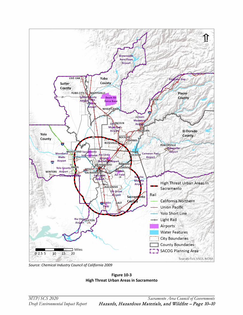
The U.S. Department of Homeland Security established high-threat urban areas (HTUAs) to reduce potential risk from an accident as shown in figure 10-3. An HTUA is an area “comprising one or more cities and surrounding areas including a 10-mile buffer zone” (49 CFR Section 1580). Trains transporting crude oil within these areas must adhere to 40 mile per hour speed limits and abide by additional security regulations. The HTUA in Sacramento covers a 10-mile radius around the cities of Elk Grove, Rancho Cordova, Roseville, and Sacramento that extends to include the southern edge of Rocklin to the north, the western edge of Folsom to the east, the city of Galt to the south, and the eastern half of Davis and the easternmost portion of Woodland to the west.

MTP/SCS 2020 Sacramento Area Council of Governments Draft Environmental Impact Report Hazards, Hazardous Materials, and Wildfire – Page 10–9
Figure 10-2
Union Pacific Railroad Lines with Potential Crude Oil Transport in the Plan Area of the Proposed MTP/SCS
MTP/SCS 2020 Sacramento Area Council of Governments Draft Environmental Impact Report Hazards, Hazardous Materials, and Wildfire – Page 10–10
Source: Chemical Industry Council of California 2009
Figure 10-3 High Threat Urban Areas in Sacramento

MTP/SCS 2020 Sacramento Area Council of Governments Draft Environmental Impact Report Hazards, Hazardous Materials, and Wildfire – Page 10–11
California General Hazardous Materials Routing Requirements
The Federal Motor Carrier Safety Administration (FMCSA) maintains a Hazmat Route Registry that describes the highway routes that must be utilized for the transport of certain classes of hazardous materials. In California, this is monitored and regulated by the California Highway Patrol (CHP) and the California FMCSA Field Office. These routes are listed in Table 10-3 and shown in Figure 10-4.
Table 10-3 Designated Routes for Hazardous Materials Transport
Radioactive Hazmat Preferred Routes
Interstate 5 (all segments within the region) Interstate 80 (all segments within the region)
Non-Radioactive Hazmat Designated Routes1
Interstate 5 (all segments within the region) State Route 49 from State Route 70 to State Route 140
Interstate 80 (all segments within the region) State 65 from State 70 [Olivehurst] to Interstate 80 [Roseville]
Interstate Business 80 from Interstate 80 [west of Sacramento] to US 50/State 99/Interstate Business 80 [east of Sacramento]
State Route 70 (all segments within region)
Interstate Business 80 from US 50/State 99 [east of Sacramento] to Interstate 80 [north of Sacramento]
State 16 from State 20 [Williams] to CR E7/County Road 98/Pedrick Rd. [Woodland]
Old Highway 65 / Lincoln Blvd from State 65 [Lincoln] to Riosa Rd. [Sheridan] State Route 99 from US 50 to Interstate 5
CR E7/Pedrick Rd. from Interstate 80 [Dixon] to Interstate 5 [Woodland] State Route 113 from State Route 99 to CR E8/Road 102
US 50 from US 50/State 99/Interstate Business 80 [east of Sacramento] to Prairie City Rd [Folsom]
State 193 from State 65 [Lincoln] to Interstate 80 [Newcastle]
Riosa Rd. from State 65 to Old Highway 65/Lincoln Blvd.
Twin Cities Rd./ E13 from State 99 [Galt] To Interstate 5 [MP 497- Elk Grove]
Road 102 from Interstate 5 to State Route 113 US 50 from Interstate 80 to Nevada
State Route 16 from US 50 to State Route 49 and from State 20 to County Road 98/Pedrick Road W. El Camino Ave. from Interstate 80 to El Centro Rd.
State 20 from Meridian Road to Mooney Flat Road State Highway 12 from Rio Vista to the Mokelumne River Bridge
Interstate 505 from Interstate 5 [Zamora] to Highway 128 State 89 from W. River Street to Alpine Meadows Rd.
1 Includes Non-Radioactive Hazardous Material (NRHM) Routes designated for the transport of Class 1- Explosive materials, the transport of Poisonous Inhalation Hazard (PIH) materials, and routes designated for transport of both sub-categories. Source: National Hazardous Materials Route Registry- California, Federal Motor Carrier Safety Administration Hazmat Route Registry, Updated February 19, 2019. Accessed May 22, 2019.

MTP/SCS 2020 Sacramento Area Council of Governments Draft Environmental Impact Report Hazards, Hazardous Materials, and Wildfire – Page 10–12
Figure 10-2
CHP Designated Routes for Hazardous Material Transport in the Plan Area of the Proposed MTP/SCS

MTP/SCS 2020 Sacramento Area Council of Governments Draft Environmental Impact Report Hazards, Hazardous Materials, and Wildfire – Page 10–13
Additionally, the Hazardous Materials Regulations prohibit parking of vehicles carrying Division 1.1, 1.2, or 1.3 explosives within five feet of the traveled part of the road. Except for short periods of time needed for vehicle operation necessities (e.g., fueling), parking is prohibited within 300 feet of a bridge, tunnel, or building; a place where people gather; or an open fire. Vehicles may be parked unattended in a safe haven. A safe haven is a government-approved place for parking unattended vehicles loaded with explosives. Authorized safe havens are usually designated by local authorities. In California, safe havens are designated by CHP and referred to as “safe parking places.” As shown in Table 10-4, CHP has identified several routes as safe stopping places and safe parking places on the state highway system within or near the plan area of the proposed MTP/SCS.
Table 10-4 Safe Stops and Parking Places for Explosive Materials Transporters and Inhalation Hazard Shipments
Routes Location Type Explosive Materials Transporters I-5 Dunnigan Pilot Travel Center, at County Road 8
I-80 Sacramento County
Inspection Stop (both directions) - State of California platform scales, 0.8 miles west of Antelope Road. May be a safe parking place when the driver is given specific instruction by a member of the California Highway Patrol.
I-80 City of Sacramento 49er Auto/Truck Plaza, 2828 El Centro Road
I-80 Donner Summit Rest Area Required inspection stop
I-80 Blue Canyon (westbound vehicles) Required inspection stop
I-80 Cisco Grove Chevron Safe Stopping Place, 90 Cisco Road, Cisco Grove I-80 Nyack Shell, LLC Safe Stopping Place, 41965 Nyack Road, Emigrant Gap State Route 50 Echo Summit Required inspection stop Inhalation-Hazard Shipments
I-5 Dunnigan Rest Area I-5 north of County Road 6 (Inspection Stop, both directions)
I-5 Dunnigan Pilot Truck Center, 30035 County Road 8 (Safe Stopping Place)
I-5 Sacramento (southbound only)
Elkhorn Rest Area near Sacramento International Airport (Inspection Stop)
I-80 Sacramento 49er Auto/Truck Plaza, 2828 El Centro Road (Safe Stopping Place) California Highway Patrol, Transportation of Inhalation Hazards, Excerpts from Title 13 of the California Code of Regulations (Updated March 22, 2018), Accessed May 2019.
USE OF HAZARDOUS MATERIALS IN CONSTRUCTION
A variety of hazardous materials are used in the construction and maintenance of both the land use and transportation system, such as solvents and architectural coatings (paints). The use and storage of these materials is governed by the California Division of OSHA (Cal OSHA) and by local fire departments and disposal of these materials is regulated by the Department of Toxic Substances and Control (DTSC).

MTP/SCS 2020 Sacramento Area Council of Governments Draft Environmental Impact Report Hazards, Hazardous Materials, and Wildfire – Page 10–14
SITES CONTAMINATED BY HAZARDOUS MATERIALS
The plan area of the proposed MTP/SCS contains sites that were historically contaminated but have been remediated and sites that are known, or believed to be, contaminated that are currently being characterized or cleaned-up, as well as sites which are regulated because they use or store hazardous materials and wastes. Numerous sites throughout the SACOG region have become contaminated over the years by the operations of certain land uses and by improper disposal of hazardous waste, both legally and illegally. These wastes have affected groundwater and soils throughout the area. Until the 1980s, disposal of most chemical wastes on land was unregulated. As a result, many landfills and industrial sites became contaminated with toxic wastes. The largest and most contaminated of these are designated by the federal government as “Superfund” sites.
EPA maintains the list of national Superfund sites. In California, DTSC maintains a list of contaminated sites and provides a number of tools for tracking and monitoring the generation, transportation, and disposal of hazardous waste.
Several other agencies maintain lists of contaminated sites, including:
EPA: Comprehensive Environmental Response, Compensation, and Liability Information System (CERCLIS); National Priorities List; Resource Conservation and Recovery Act (RCRA) Information; and the U.S. Brownfields Database;
California Department of Resources, Recycling, and Recovery (CalRecycle): Solid Waste Facilities and Landfills Database; and
SWRCB: Cease and Desist Orders, Cleanup and Abatement Orders, Site Cleanup Program, and Toxic Pits Database.
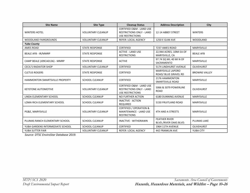
In addition to information about investigations, evaluations, and permitted sites, DTSC’s database, EnviroStor, lists Federal Superfund sites (which require state response) and voluntary and school cleanup sites. Overall, there are roughly 200 sites listed for the plan area of the proposed MTP/SCS, including 11 Superfund sites (over half of which are associated with McClellan Air Force Base), 19 active sites requiring state response, and 33 voluntary cleanup sites that are active or require action. The majority of contaminated sites (105) are located in Sacramento County. Table 10-5 shows a listing of sites in the SACOG region from EnviroStor. Sites appear on the database where DTSC has identified a concern that requires investigation. Sites remain in the database following remediation and closure. Contemporary listings can be prompted by investigations conducted as part of development proposals. Although not a comprehensive listing of all potentially hazardous site in the region, this list informs characterization of the plan area of the proposed MTP/SCS.
In the eastern portion of the plan area of the proposed MTP/SCS, sites of identified contamination tend to be associated with historical use of the properties that include timber processing and mining. In Placer County, sites are distributed throughout the county and occur primarily in the established communities of Auburn, Loomis, and Roseville. Sites in El Dorado County are generally near El Dorado Hills. On the eastern side of the plan area of the proposed MTP/SCS, sites represent a mix of former land uses, including industrial use, a manufactured gas plant, landfill, and airport. In Yolo County, sites are concentrated in the cities of Davis and West Sacramento. In Sutter and Yuba counties in the northern portion of the plan area of the proposed MTP/SCS, hazardous materials sites are primarily identified in Yuba City and Marysville.

MTP/SCS 2020 Sacramento Area Council of Governments Draft Environmental Impact Report Hazards, Hazardous Materials, and Wildfire – Page 10–15
Table 10-5 EnviroStor Sites in the Plan Area of the Proposed MTP/SCS
Site Name Site Type Cleanup Status Address Description City El Dorado County
HIGH SCHOOL NO. 5 SCHOOL CLEANUP INACTIVE - NEEDS EVALUATION
GREEN VALLEY/BASS LAKE ROAD RESCUE
LAKEVIEW ELEMENTARY SCHOOL SCHOOL CLEANUP CERTIFIED / OPERATION & MAINTENANCE 3371 BRITTANY WAY EL DORADO HILLS
OAK RIDGE HIGH SCHOOL SCHOOL CLEANUP CERTIFIED / OPERATION & MAINTENANCE 1120 HARVARD WAY EL DORADO HILLS
VALLEY VIEW ELEMENTARY SCHOOL (AKA VALLEY VIEW CHARTER MONTESSORI) SCHOOL CLEANUP CERTIFIED / OPERATION &
MAINTENANCE 1665 BLACKSTONE PARKWAY EL DORADO HILLS
WETSEL-OVIATT LUMBER COMPANY VOLUNTARY CLEANUP INACTIVE - ACTION REQUIRED 6000 LATROBE ROAD EL DORADO HILLS
Placer County
AMERICAN FOREST PRODUCTS - FORESTHILL VOLUNTARY CLEANUP CERTIFIED 23801 AUBURN-FORESTHILL ROAD FORESTHILL
AMERICAN OLEAN TILE COMPANY VOLUNTARY CLEANUP CERTIFIED O&M - LAND USE RESTRICTIONS ONLY - LAND USE RESTRICTIONS
8250 INDUSTRIAL AVENUE ROSEVILLE
BICKFORD RANCH PROPERTY VOLUNTARY CLEANUP CERTIFIED O&M - LAND USE RESTRICTIONS ONLY - LAND USE RESTRICTIONS
E. OF SIERRA COLLEGE BLVD & S. OF HWY 193 PENRYN
BOHEMIA SUBDIVISION VOLUNTARY CLEANUP INACTIVE - NEEDS EVALUATION
CANAL STREET - NORTH OF LUTHER ROAD AUBURN
BRENNAN'S POINT VOLUNTARY CLEANUP ACTIVE 2360 BRENNAN ROAD NEWCASTLE
BUNCH CREEK VOLUNTARY CLEANUP INACTIVE - NEEDS EVALUATION
APPROXIMATELY 2 MILES EAST OF HWY 80 BETWEEN THE TOWNS OF WEIMER AND COLFAX
COLFAX
COOPER PROPERTY STATE RESPONSE CERTIFIED 3025 VISTA WAY MEADOW VISTA
ENGLISH COLONY ESTATES VOLUNTARY CLEANUP REFER: OTHER AGENCY 1797 ENGLISH COLONY WAY APN(S) 032-051-004 AND 032-051-005
PENRYN
FERRARI LEAVELL AND GREY PROPERTY VOLUNTARY CLEANUP NO FURTHER ACTION ONE-FOURTH MILE SOUTHEAST OF LINCOLN LINCOLN
FOREST PRODUCTS MANUFACTURING, PARCEL 5 STATE RESPONSE CERTIFIED ANTHONY COURT ROCKLIN

MTP/SCS 2020 Sacramento Area Council of Governments Draft Environmental Impact Report Hazards, Hazardous Materials, and Wildfire – Page 10–16
Site Name Site Type Cleanup Status Address Description City FORESTHILL - ROBINSON PROPERTY VOLUNTARY CLEANUP CERTIFIED 22990 FORESTHILL ROAD FORESTHILL
FOX HILL LANE VOLUNTARY CLEANUP ACTIVE - LAND USE RESTRICTIONS
APN #S: 031-161-006-000, 031-161-007-000, 031-470-020-000
NEW CASTLE
FREED PROPERTY VOLUNTARY CLEANUP NO FURTHER ACTION 223 TAYLOR ROAD NEWCASTLE
FRENCH MEADOWS POWERHOUSE VOLUNTARY CLEANUP NO FURTHER ACTION 1 MILE NORTH OF HELL HOLE DAM HELL HOLE
GROVE SUBDIVISION VOLUNTARY CLEANUP ACTIVE 3342 HUMPHREY ROAD LOOMIS GRUBER MOUNTAIN ESTATES VOLUNTARY CLEANUP NO FURTHER ACTION 450 UNCLE JOE'S LANE NEWCASTLE HAAG PROPERTY STATE RESPONSE NO FURTHER ACTION 9232 BARTON ROAD GRANITE BAY
KEMPER OAKS #2 VOLUNTARY CLEANUP NO FURTHER ACTION
ALONG THE SOUTH SIDE OF KEMPER ROAD BETWEEN PEAR ROAD AND BEAN ROAD
AUBURN
KEMPER WOODS PROPERTY VOLUNTARY CLEANUP INACTIVE - ACTION REQUIRED
PROPERTY IS LOCATED AT THE INTERSECTION OF KEMPER ROAD AND BEAN ROAD
AUBURN
LAIRD PROPERTY VOLUNTARY CLEANUP CERTIFIED O&M - LAND USE RESTRICTIONS ONLY - LAND USE RESTRICTIONS
6287 LAIRD ROAD LOOMIS
LAKE AT GRANITE BAY VOLUNTARY CLEANUP NO FURTHER ACTION 5867 EUREKA ROAD GRANITE BAY
LIFEHOUSE CHURCH VOLUNTARY CLEANUP NO FURTHER ACTION 3055 AND 3131 DELMAR AVENUE LOOMIS
LINCOLN AUXILIARY FIELD (J09CA0852) STATE RESPONSE NO FURTHER ACTION 1420 FLIGHTLINE DRIVE LINCOLN LOOMIS HILL ESTATES VOLUNTARY CLEANUP CERTIFIED 5337 LONE PINE LAND LOOMIS
MAGGI ESTATES VOLUNTARY CLEANUP NO FURTHER ACTION 3918 AUBURN FOLSOM BLVD. LOOMIS
MG PENRYN PROPERTY VOLUNTARY CLEANUP NO FURTHER ACTION 2851 & 2881 TAYLOR ROAD PENRYN
MICHERRA PLACE VOLUNTARY CLEANUP NO FURTHER ACTION SOUTHWESTCORNER OF EUREKA ROAD AND AUBURN FOLSOM ROAD
GRANITE BAY
MID SIERRA TOWING VOLUNTARY CLEANUP ACTIVE 841 NEVADA STREET AUBURN
MORGAN'S ORCHARD VOLUNTARY CLEANUP NO FURTHER ACTION
SOUTH OF INTERSTATE HWY 80, APPROXIMATELY 1 MILE NORTHEAST OF THE CENTRAL BUSINESS DISTRICT
LOOMIS

MTP/SCS 2020 Sacramento Area Council of Governments Draft Environmental Impact Report Hazards, Hazardous Materials, and Wildfire – Page 10–17
Site Name Site Type Cleanup Status Address Description City NELLIE JO RANCH VOLUNTARY CLEANUP NO FURTHER ACTION SPRING GARDEN ROAD FORESTHILL
NORTH RAVINE ESTATES VOLUNTARY CLEANUP NO FURTHER ACTION KEMPER ROAD AND BEAN ROAD AUBURN
OLIVE RANCH VOLUNTARY CLEANUP NO FURTHER ACTION 4977 OLIVE RANCH ROAD GRANITE BAY
ORCHARD PLACE SUBDIVISION VOLUNTARY CLEANUP INACTIVE - NEEDS EVALUATION
3241 AND 3239 TAYLOR ROAD LOOMIS
PENRYN DEVELOPMENT VOLUNTARY CLEANUP INACTIVE - ACTION REQUIRED
APN 043-060-052, 043-060-053 / IT IS BORDER BY PENRYN ROAD AND TAYLOR ROAD
LOOMIS
PLACER COUNTY WATER AGENCY - WARNER ROAD PROPERTY VOLUNTARY CLEANUP INACTIVE - NEEDS
EVALUATION
10420 OPHIR ROAD, WEST OF THE INTERSECTION OF WERNER ROAD
AUBURN
QUALL RESIDENCE VOLUNTARY CLEANUP NO FURTHER ACTION 6303 EMERALD DRIVE ROCKLIN
RANCHO DEL ORO VOLUNTARY CLEANUP NO FURTHER ACTION OLIVE RANCH ROAD APN 046-090-012 GRANITE BAY
RIOLO VINEYARD SPECIFIC PLAN VOLUNTARY CLEANUP NO FURTHER ACTION 5280 PFE ROAD ROSEVILLE ROCKLIN FORMICA VOLUNTARY CLEANUP NO FURTHER ACTION 3500 CINCINNATI AVENUE ROCKLIN ROLLING GREENS GOLF COURSE VOLUNTARY CLEANUP NO FURTHER ACTION 5572 EUREKA ROAD GRANITE BAY
SIERRA CENTER IMPROVEMENTS PROJECT VOLUNTARY CLEANUP CERTIFIED / OPERATION & MAINTENANCE - LAND USE RESTRICTIONS
240 FERGUSON ROAD, NORTHEAST AUBURN AUBURN
SIERRA COLLEGE SURPLUS SITES EAST AND SOUTH VOLUNTARY CLEANUP ACTIVE
INTERSECTION OF SIERRA COLLEGE BLVD AND ROCKLIN ROAD
ROCKLIN
SILVER CREEK VOLUNTARY CLEANUP NO FURTHER ACTION 4300 PFE ROAD AND 9245 WALERGA ROAD (ADJOINING PROPERTIES)
ROSEVILLE
SNOW RANCH VOLUNTARY CLEANUP CERTIFIED 11600 EDGEWOOD ROAD AURBURN
SP-ROSEVILLE: AREA A STATE RESPONSE CERTIFIED O&M - LAND USE RESTRICTIONS ONLY - LAND USE RESTRICTIONS
SP ROSEVILLE RAILYARD ROSEVILLE
SP-ROSEVILLE: NORTH YARD STATE RESPONSE ACTIVE SP ROSEVILLE RAILYARD ROSEVILLE SP-ROSEVILLE-SOUTH YARD STATE RESPONSE ACTIVE SP ROSEVILLE RAILYARD ROSEVILLE
TURTON PARCEL VOLUNTARY CLEANUP CERTIFIED 2631 SHIRLAND TRACT ROAD AUBURN
TWELVE BRIDGES GOLF CLUB VOLUNTARY CLEANUP CERTIFIED TOWNSHIP 12N, RANGE 7E, SECT 30 AND 31 LINCOLN

MTP/SCS 2020 Sacramento Area Council of Governments Draft Environmental Impact Report Hazards, Hazardous Materials, and Wildfire – Page 10–18
Site Name Site Type Cleanup Status Address Description City UAIC TRIBAL SCHOOL AKA THE GATHERING PLACE VOLUNTARY CLEANUP ACTIVE 3141 TAYLOR ROAD LOOMIS
VACANT AGRICULTURAL LAND CLEANUP / PROPOSED COSTCO WHOLESALE WAREHOUSE AND FUEL FACILITY
VOLUNTARY CLEANUP ACTIVE SOUTHEAST CORNER OF BRACE ROAD AND SIERRA COLLEGE BOULEVARD
LOOMIS
VILLAGE AT GREEN HILL VOLUNTARY CLEANUP CERTIFIED O&M - LAND USE RESTRICTIONS ONLY - LAND USE RESTRICTIONS
ADJACENT TO: 3105 NEWCASTLE ROAD NEWCASTLE
WHISPER CREEK SUBDIVISION VOLUNTARY CLEANUP NO FURTHER ACTION 3289 PFE ROAD AND OLY LANE ROSEVILLE
WHITEBRIDGE SUBDIVISION VOLUNTARY CLEANUP CERTIFIED / OPERATION & MAINTENANCE - LAND USE RESTRICTIONS
8231 KING ROAD LOOMIS
WINCHESTER ESTATES - PHASE 4 VOLUNTARY CLEANUP NO FURTHER ACTION SUGAR PINE ROAD MEADOW VISTA
YAMASHIRO PROPERTY VOLUNTARY CLEANUP INACTIVE - NEEDS EVALUATION TAYLOR ROAD PENRYN
Sacramento County 1031 ARDEN WAY VOLUNTARY CLEANUP REFER: RWQCB 1031 ARDEN WAY SACRAMENTO 16TH STREET PLATING STATE RESPONSE CERTIFIED 1826 16TH STREET SACRAMENTO
7UP BOTTLING FACILITY VOLUNTARY CLEANUP CERTIFIED O&M - LAND USE RESTRICTIONS ONLY - LAND USE RESTRICTIONS
2670 LAND AVE SACRAMENTO
A SCHOOL TEST PROJECT SCHOOL CLEANUP ACTIVE 1001 I STREET SACRAMENTO
A-1 PLATING COMPANY STATE RESPONSE CERTIFIED O&M - LAND USE RESTRICTIONS ONLY - LAND USE RESTRICTIONS
2170 ACOMA ST SACRAMENTO
ACE OIL COMPANY STATE RESPONSE CERTIFIED 323 A STREET GALT
AEROJET GENERAL CORPORATION FEDERAL SUPERFUND - LISTED
ACTIVE - LAND USE RESTRICTIONS
HIGHWAY 50 AND AEROJET ROAD RANCHO CORDOVA
B & J MANUFACTURING STATE RESPONSE CERTIFIED 11390 AMALGAM WAY RANCHO CORDOVA CADA WAREHOUSE REDEVELOPMENT PROJECT VOLUNTARY CLEANUP CERTIFIED 1108 R STREET SACRAMENTO
CALIFORNIA ARMY NATIONAL GUARD STATE RESPONSE ACTIVE
CALIFORNIA JOINT FORCES HEADQUARTERS 10620 MATHER BLVD. (VARIOUS LOCATIONS-SEE COMMUNITY INVOLVEMENT SCREEN)
MATHER

MTP/SCS 2020 Sacramento Area Council of Governments Draft Environmental Impact Report Hazards, Hazardous Materials, and Wildfire – Page 10–19
Site Name Site Type Cleanup Status Address Description City
CALTRANS, I-5 Q STREET OFF-RAMP STATE RESPONSE CERTIFIED O&M - LAND USE RESTRICTIONS ONLY - LAND USE RESTRICTIONS
I-5 Q STREET OFF-RAMP SACRAMENTO
CHROMALLOY/GENERAL RADIATOR STATE RESPONSE CERTIFIED O&M - LAND USE RESTRICTIONS ONLY - LAND USE RESTRICTIONS
7609 WILBUR WAY SACRAMENTO
CITY OF FOLSOM CORPORATE YARD LANDFILL VOLUNTARY CLEANUP NO FURTHER ACTION 1300 LEIDERSDORFF STREET FOLSOM CIWMB-BURN DUMP AGREEMENT STATE RESPONSE NO FURTHER ACTION NOT A SITE CLEANUP NONE DILLARD ELEMENTARY SCHOOL SCHOOL CLEANUP CERTIFIED 9721 DILLARD ROAD WILTON
DOWNTOWN RAILYARD VENTURE, LLC VOLUNTARY CLEANUP ACTIVE - LAND USE RESTRICTIONS
PORTIONS OF THE FORMER SPTCO LOCOMOTIVE WORKS (AKA SACRAMENTO RAILYARDS). PORTIONS OF LAGOON, NORTHERN SHOPS, CENTRAL CORRIDOR, CAR SHOP NINE AND SACRAMENTO STATION STUDY AREAS (APN: 002-0010-049, -052, -056, AND -058).
SACRAMENTO
ESS LABORATORY STATE RESPONSE CERTIFIED 9613 OATES DR SACRAMENTO
FEDERAL COURTHOUSE - SACRAMENTO VOLUNTARY CLEANUP CERTIFIED O&M - LAND USE RESTRICTIONS ONLY - LAND USE RESTRICTIONS
5TH AND I STREETS SACRAMENTO
FOLSOM GUN CLUB STATE RESPONSE CERTIFIED SIBLEY STREET AND GLENN DRIVE FOLSOM
FOLSOM PRISON STATE RESPONSE CERTIFIED / OPERATION & MAINTENANCE - LAND USE RESTRICTIONS
N OF FOLSOM CITY; ADJ TO AMERICAN RIVER REPRESA
FONTS PROPERTY STATE RESPONSE CERTIFIED 1822 16TH STREET SACRAMENTO FORMER GENUINE PARTS STORE VOLUNTARY CLEANUP CERTIFIED 4914 AUBURN BLVD. SACRAMENTO FORMER SUTTER MEMORIAL HOSPITAL VOLUNTARY CLEANUP NO FURTHER ACTION 5105 F STREET SACRAMENTO FUTURE SACRED HEART SCHOOL VOLUNTARY CLEANUP NO FURTHER ACTION 39TH STREET AND H STREET SACRAMENTO GEORGIA-PACIFIC CHEMICALS VOLUNTARY CLEANUP NO FURTHER ACTION 10399 E. STOCKTON BLVD. ELK GROVE
GOLDEN WEST HOMES (GPM) STATE RESPONSE CERTIFIED 9998 OLD PLACERVILLE ROAD SACRAMENTO
HARRIS AVENUE PCB SITE STATE RESPONSE CERTIFIED 627 HARRIS AVE SACRAMENTO

MTP/SCS 2020 Sacramento Area Council of Governments Draft Environmental Impact Report Hazards, Hazardous Materials, and Wildfire – Page 10–20
Site Name Site Type Cleanup Status Address Description City
HAZEL AVENUE PONDS STATE RESPONSE NO FURTHER ACTION HAZEL AVENUE AT NIMBUS FISH HATCHERY RANCHO CORDOVA
INTERSTATE BATTERY STATE RESPONSE CERTIFIED 451 ANTELOPE ST ELVERTA JENSEN FLYING SERVICES STATE RESPONSE CERTIFIED 2080 BLAIR AVENUE SACRAMENTO
JIBBOOM BUILDING VOLUNTARY CLEANUP CERTIFIED / OPERATION & MAINTENANCE - LAND USE RESTRICTIONS
240 JIBBOOM STREET SACRAMENTO
JIBBOOM JUNKYARD FEDERAL SUPERFUND - DELISTED CERTIFIED 240-260 JIBBOOM STREET SACRAMENTO
JOHNSON CONTROL STATE RESPONSE CERTIFIED AREA WEST OF FRANKLIN ON SIMMS SACRAMENTO
KALWANI PROPERTY VOLUNTARY CLEANUP NO FURTHER ACTION 8151 SHELDON ROAD ELK GROVE KEN'S BUFF AND PLATING STATE RESPONSE ACTIVE 1816 21ST STREET SACRAMENTO
MATHER AIR FORCE BASE FEDERAL SUPERFUND - LISTED
ACTIVE - LAND USE RESTRICTIONS
5,485 ACRES; 12 MI EA OF SACRAMENTO, CA SACRAMENTO
MCCLELLAN AFB P. A5 SAC. CO. RECOVERY (VCA)
FEDERAL SUPERFUND - LISTED
CERTIFIED / OPERATION & MAINTENANCE - LAND USE RESTRICTIONS
4450 ROSEVILLE ROAD NORTH HIGHLANDS
MCCLELLAN AIR FORCE BASE FEDERAL SUPERFUND - LISTED
ACTIVE - LAND USE RESTRICTIONS APPROX 5200 WATT AVE SACRAMENTO
MCCLELLAN AIR FORCE BASE - BUILDING 7 FEDERAL SUPERFUND - LISTED NO FURTHER ACTION 5200 WATT AVENUE SACRAMENTO
MCCLELLAN BUSINESS PARK FEDERAL SUPERFUND - LISTED
ACTIVE - LAND USE RESTRICTIONS APPROX 5200 WATT AVE MCCLELLAN AFB
MCCLELLAN PARCEL C6 FEDERAL SUPERFUND - LISTED
CERTIFIED O&M - LAND USE RESTRICTIONS ONLY - LAND USE RESTRICTIONS
MCCLELLAN AFB MCCLELLAN
MCCLELLAN PARK MOA FEDERAL SUPERFUND - LISTED
ACTIVE - LAND USE RESTRICTIONS
CORNER OF BELL AVE AND PARKER STREET SACRAMENTO
MCDONNELL DOUGLAS - INACTIVE TEST SITE STATE RESPONSE ACTIVE - LAND USE RESTRICTIONS 11505 DOUGLAS RD RANCHO CORDOVA
MERCY HOUSING CALIFORNIA VOLUNTARY CLEANUP CERTIFIED 3421 EAST COUNTRY CLUB LANE SACRAMENTO
METALLOY STEEL FOUNDRY VOLUNTARY CLEANUP NO FURTHER ACTION 8588 THYS COURT SACRAMENTO
MIXED USE TOWER AND CITY PARKING VOLUNTARY CLEANUP NO FURTHER ACTION SE CORNER OF 5TH AND J STREETS SACRAMENTO
NATOMAS AIRPORT VOLUNTARY CLEANUP REFER: EPA 3801 AIRPORT ROAD SACRAMENTO

MTP/SCS 2020 Sacramento Area Council of Governments Draft Environmental Impact Report Hazards, Hazardous Materials, and Wildfire – Page 10–21
Site Name Site Type Cleanup Status Address Description City
NORTH HIGHLANDS AIR NATIONAL GUARD STATE RESPONSE NO FURTHER ACTION 8 ACRES;6 MI NORTHEAST OF SACRAMENTO, CA SACRAMENTO
OBIE'S DUMP VOLUNTARY CLEANUP INACTIVE - NEEDS EVALUATION 8437 SHELDON ROAD ELK GROVE
ORCHARD SUPPLY COMPANY STATE RESPONSE CERTIFIED O&M - LAND USE RESTRICTIONS ONLY - LAND USE RESTRICTIONS
1731 17TH STREET SACRAMENTO
ORCHARD SUPPLY COMPANY/WORLD OF GOOD TASTE VOLUNTARY CLEANUP NO FURTHER ACTION
THE BUILDING AT THE ORCHARD SUPPLY COMPANY SITE, 1731 17TH STREET
SACRAMENTO
PALM IRON WORKS STATE RESPONSE CERTIFIED 1515 S STREET SACRAMENTO
PELL DRIVE VOLUNTARY CLEANUP INACTIVE - NEEDS EVALUATION 4220 PELL DRIVE SACRAMENTO
PG&E - SACRAMENTO SITE STATE RESPONSE ACTIVE - LAND USE RESTRICTIONS 2000 FRONT STREET SACRAMENTO
PITTSBURG DES MOINES STEEL STATE RESPONSE REFER: OTHER AGENCY 9605 BUTTERFIELD SACRAMENTO
PLEASANT GROVE HI/KATHERINE ALBIANI MID SCHOOL CLEANUP CERTIFIED BOND ROAD/BRADSHAW ROAD ELK GROVE
PROPOSED MANGINI RANCH ELEMENTARY SCHOOL SCHOOL CLEANUP ACTIVE 14640 SPARROW DRIVE FOLSOM
PROPOSED RAILYARDS HOSPITAL VOLUNTARY CLEANUP ACTIVE LOTS 2, 3, 5, AND 6 AT THE NW PORTION OF THE RAILYARDS
SACRAMENTO
PURITY OIL SALES - DELTA GUNITE STATE RESPONSE CERTIFIED / OPERATION & MAINTENANCE - LAND USE RESTRICTIONS
WHITE ROCK ROAD & KILGORE ROAD RANCHO CORDOVA
RETREAT AT SACRAMENTO, LLC VOLUNTARY CLEANUP ACTIVE 2601 REDDING AVENUE SACRAMENTO
RUSSELL RANCH ELEMENTARY SCHOOL SCHOOL CLEANUP CERTIFIED / OPERATION & MAINTENANCE 375 DRY CREEK ROAD FOLSOM
SACRAMENTO ARMY DEPOT FEDERAL SUPERFUND - LISTED
CERTIFIED / OPERATION & MAINTENANCE - LAND USE RESTRICTIONS
8350 FRUITRIDGE ROAD SACRAMENTO
SACRAMENTO ARMY DEPOT - AREA I STATE RESPONSE CERTIFIED 8350 FRUITRIDGE ROAD SACRAMENTO SACRAMENTO ARMY DEPOT - AREA II STATE RESPONSE CERTIFIED 8350 FRUITRIDGE ROAD SACRAMENTO SACRAMENTO ARMY DEPOT (SUBSITE) STATE RESPONSE CERTIFIED 8350 FRUITRIDGE ROAD SACRAMENTO

MTP/SCS 2020 Sacramento Area Council of Governments Draft Environmental Impact Report Hazards, Hazardous Materials, and Wildfire – Page 10–22
Site Name Site Type Cleanup Status Address Description City
SACRAMENTO CABLE STATE RESPONSE CERTIFIED O&M - LAND USE RESTRICTIONS ONLY - LAND USE RESTRICTIONS
2175 PERKINS WAY SACRAMENTO
SACRAMENTO COUNTY EXECUTIVE AIRPORT STATE RESPONSE CERTIFIED 6151 FREEPORT BLVD SACRAMENTO
SACRAMENTO DOWNTOWN ARENA VOLUNTARY CLEANUP NO FURTHER ACTION AREA BOUNDED BY 3RD, 7TH, J AND L STREETS SACRAMENTO
SACRAMENTO HOUSING & REDEVELOP. AGENCY STATE RESPONSE
CERTIFIED O&M - LAND USE RESTRICTIONS ONLY - LAND USE RESTRICTIONS
1920 FRONT STREET SACRAMENTO
SACRAMENTO PLATING INC. STATE RESPONSE ACTIVE 2809 S STREET SACRAMENTO
SETZER FOREST PRODUCTS, INC. VOLUNTARY CLEANUP NO FURTHER ACTION 2570 3RD STREET AND 2630 5TH STREET SACRAMENTO
SIERRA BATTERY SALES STATE RESPONSE CERTIFIED O&M - LAND USE RESTRICTIONS ONLY - LAND USE RESTRICTIONS
977 LOCHBRAE ROAD SACRAMENTO
SIMS METAL SITE STATE RESPONSE ACTIVE 130 NORTH 12 STREET; AT INTERSECTION OF NORTH B STREETS
SACRAMENTO
SMUD AT THE RAILYARDS VOLUNTARY CLEANUP ACTIVE
LOT 42 (GOVERNMENT ALLEY AND 6TH, 7TH, G STS) AND INTERSECTION OF 7TH ST AND RAILYARDS BLVD
SACRAMENTO
SMUD STATION E SUBSTATION VOLUNTARY CLEANUP REFER: IWMB AT THE NORTHERN END OF 20TH STREET SACRAMENTO
SMUD THORNTON AVENUE SITE VOLUNTARY CLEANUP ACTIVE 1610 THORNTON AVENUE SACRAMENTO
SMUD, FRONT & T STREETS STATE RESPONSE CERTIFIED O&M - LAND USE RESTRICTIONS ONLY - LAND USE RESTRICTIONS
FRONT & T STREETS SACRAMENTO
SOCCER STADIUM VOLUNTARY CLEANUP INACTIVE - ACTION REQUIRED
AREA BOUNDED BY 8TH ST, NORTH B ST, 10TH ST, AND RAILYARDS BLVD
SACRAMENTO
SONOMA AVENUE SITE STATE RESPONSE CERTIFIED 1035 SONOMA AVENUE SACRAMENTO SOUTHERN PACIFIC SACTO DRUMS STORAGE STATE RESPONSE NO ACTION REQUIRED NONE NONE SP-PURITY OIL VOLUNTARY CLEANUP CERTIFIED 1324 A STREET SACRAMENTO STRAWBERRY MANOR PCB SITE STATE RESPONSE CERTIFIED 188 OLMSTEAD DR SACRAMENTO
SUNRISE RIVER INDUSTRIAL PARK STATE RESPONSE CERTIFIED O&M - LAND USE RESTRICTIONS ONLY - LAND USE RESTRICTIONS
GOLD RIVER ROAD AND U.S. HIGHWAY 50 RANCHO CORDOVA

MTP/SCS 2020 Sacramento Area Council of Governments Draft Environmental Impact Report Hazards, Hazardous Materials, and Wildfire – Page 10–23
Site Name Site Type Cleanup Status Address Description City
THE DOCKS AREA SACRAMENTO EOA VOLUNTARY CLEANUP NO FURTHER ACTION CITY OF SACRAMENTO RIVERFRONT SACRAMENTO
U.S. COLD STORAGE VOLUNTARY CLEANUP INACTIVE - NEEDS EVALUATION 2338 9TH AVENUE SACRAMENTO
UNION PACIFIC BANNON STREET PARCEL VOLUNTARY CLEANUP INACTIVE - ACTION REQUIRED
NORTH B STREET AND SEVENTH STREET SACRAMENTO
UNION PACIFIC RAILROAD UNDERGROUND VAULT PROGRAM VOLUNTARY CLEANUP INACTIVE - NEEDS
EVALUATION
28 SUSPECTED LOCATIONS THROUGHOUT THE STATE OF CALIFORNIA
SACRAMENTO
UNION PACIFIC RAILROAD, CURTIS PARK STATE RESPONSE ACTIVE - LAND USE RESTRICTIONS
3675 WESTERN PACIFIC AVENUE SACRAMENTO
UP, DOWNTOWN SAC - CAR SHOP NINE STATE RESPONSE CERTIFIED O&M - LAND USE RESTRICTIONS ONLY - LAND USE RESTRICTIONS
401 I STREET SACRAMENTO
UP, DOWNTOWN SAC - CENTRAL CORRIDOR STATE RESPONSE CERTIFIED O&M - LAND USE RESTRICTIONS ONLY - LAND USE RESTRICTIONS
401 I STREET SACRAMENTO
UP, DOWNTOWN SAC - CENTRAL SHOPS STATE RESPONSE ACTIVE 401 I STREET SACRAMENTO UP, DOWNTOWN SAC - INLAND VOLUNTARY CLEANUP NO FURTHER ACTION 401 I STREET SACRAMENTO
UP, DOWNTOWN SAC - LAGOON STATE RESPONSE ACTIVE - LAND USE RESTRICTIONS 401 I STREET SACRAMENTO
UP, DOWNTOWN SAC - MANUFACTURED GAS PLANT STATE RESPONSE ACTIVE 400 I STREET SACRAMENTO
UP, DOWNTOWN SAC - NORTHERN SHOPS/DRUM S STATE RESPONSE
CERTIFIED O&M - LAND USE RESTRICTIONS ONLY - LAND USE RESTRICTIONS
401 I STREET SACRAMENTO
UP, DOWNTOWN SAC - PONDS AND DITCH STATE RESPONSE CERTIFIED / OPERATION & MAINTENANCE - LAND USE RESTRICTIONS
401 I STREET SACRAMENTO
UP, DOWNTOWN SAC - REDEVELOPMENT VOLUNTARY CLEANUP INACTIVE - ACTION REQUIRED 401 I STREET SACRAMENTO
UP, DOWNTOWN SAC - SHOPS ABATEMENT STATE RESPONSE NO FURTHER ACTION 401 I STREET SACRAMENTO UP, DOWNTOWN SAC - SITE-WIDE STATE RESPONSE ACTIVE 401 I STREET SACRAMENTO UP, DOWNTOWN SAC - TRACK RELOCATION STATE RESPONSE NO FURTHER ACTION 401 I STREET SACRAMENTO
UP, SAC - BATTERY SHOP YARD STATE RESPONSE CERTIFIED O&M - LAND USE RESTRICTIONS ONLY - LAND USE RESTRICTIONS
401 I STREET SACRAMENTO

MTP/SCS 2020 Sacramento Area Council of Governments Draft Environmental Impact Report Hazards, Hazardous Materials, and Wildfire – Page 10–24
Site Name Site Type Cleanup Status Address Description City
UP, SAC - SACRAMENTO STATION STATE RESPONSE CERTIFIED O&M - LAND USE RESTRICTIONS ONLY - LAND USE RESTRICTIONS
401 I STREET SACRAMENTO
UP, SAC - SAND PILES STATE RESPONSE CERTIFIED 401 I STREET SACRAMENTO VILLAGE OF ZINFINDEL VOLUNTARY CLEANUP NO FURTHER ACTION 3145 KILGORE ROAD RANCHO CORDOVA
VISTA DEL LAGO HIGH SCHOOL SCHOOL CLEANUP CERTIFIED / OPERATION & MAINTENANCE
1970 BROADSTONE PARKWAY FOLSOM
WHITE ROCK DUMPS 1 AND 2 STATE RESPONSE ACTIVE
WHITE ROCK DUMPS (WRD) 1 AND 2 ARE LOCATED ON AEROJET PROPERTY. WRD 1, SOUTH OF WHITE ROCK ROAD ON THE INACTIVE RANCHO CORDOVA TEST SITE (IRCTS). WRD 2, NORTH SIDE OF WHITE ROCK ROAD.
RANCHO CORDOVA
Sutter County CUSTOM CHROME AND BUMPER STATE RESPONSE ACTIVE 335 GARDEN HIGHWAY YUBA CITY
BEALE TITAN SITE 1B STATE RESPONSE REFER: RWQCB 46.7 ACRES; NO SIDE OF THE SUTTER BUTTES YUBA CITY
GOLDEN GATE HOP RANCH STATE RESPONSE CERTIFIED 12035 GARDEN HIGHWAY YUBA CITY H & B MACHINERY (1) VOLUNTARY CLEANUP NO FURTHER ACTION 1781 COLUSA HWY YUBA CITY
HELENA CHEMICAL STATE RESPONSE CERTIFIED 921 N GEORGE WASHINGTON BLVD YUBA CITY
LOMO AIRSTRIP STATE RESPONSE CERTIFIED O&M - LAND USE RESTRICTIONS ONLY - LAND USE RESTRICTIONS
1111 KOCH LANE LIVE OAK
SUTTER-BY-PASS STATE RESPONSE CERTIFIED NEAR JUNCTION OF TISDALE & SUTTER BYPASS SUTTER
UNION PACIFIC RAILROAD RIGHT-OF-WAY YUBA CITY VOLUNTARY CLEANUP ACTIVE
RAILROAD RIGHT-OF-WAY FROM FEATHER RIVER EAST TO HARTER PARKWAY (A DISTANCE OF 2.8 MILES), INCLUDING A FORMER SWITCHING YARD AND RAILROAD SPUR LINES IN THE BLOCK BOUNDED BY COOPER AVENUE TO THE WEST, REEVES AVENUE TO
YUBA CITY

MTP/SCS 2020 Sacramento Area Council of Governments Draft Environmental Impact Report Hazards, Hazardous Materials, and Wildfire – Page 10–25
Site Name Site Type Cleanup Status Address Description City THE NORTH, AND BRIDGE STREET TO THE SOUTHEAST
YUBA CITY STEEL PRODUCTS COMPANY STATE RESPONSE REFER: RWQCB 526 STEVENS AVE YUBA CITY Yolo County
BORGES CLARKSBURG AIRPORT VOLUNTARY CLEANUP INACTIVE - ACTION REQUIRED 54254 SOUTH RIVER ROAD CLARKSBURG
BRIDGEWAY LAKES NORTH - PHASE I B VOLUNTARY CLEANUP CERTIFIED 3695 MARSHALL ROAD WEST SACRAMENTO
CAPITOL PLATING CORPORATION STATE RESPONSE INACTIVE - ACTION REQUIRED 319 3RD STREET WEST SACRAMENTO
COTTONWOOD CLEANERS VOLUNTARY CLEANUP INACTIVE - NEEDS EVALUATION 628 COTTONWOOD STREET WOODLAND
COURT GALVANIZING STATE RESPONSE REFER: RWQCB SW OF DAVIS OFF COUNTY ROAD 32A DAVIS
DAVIS TRANSMITTER SITE STATE RESPONSE REFER: RWQCB INTERSECTION OF MACE BLVD AND ROAD 35 DAVIS
DELTA TRUCKING STATE RESPONSE CERTIFIED 1201 E KENTUCKY AVE WOODLAND DUNNIGAN GROUNDWATER STATE RESPONSE ACTIVE 29082 MAIN STREET DUNNIGAN ESPARTO HIGH SCHOOL SCHOOL CLEANUP CERTIFIED HIGHWAY 85B ESPARTO
FRONTIER FERTILIZER FEDERAL SUPERFUND - LISTED
ACTIVE - LAND USE RESTRICTIONS
SECOND STREET/BTWN PENA & MACE BLVD. DAVIS
GAS'N'SAVE STATE RESPONSE REFER: RWQCB 504 L STREET DAVIS
MOLLER CORPORATION VOLUNTARY CLEANUP CERTIFIED O&M - LAND USE RESTRICTIONS ONLY - LAND USE RESTRICTIONS
1222 RESEARCH PARK DRIVE DAVIS
OLD BRYTE LANDFILL VOLUNTARY CLEANUP ACTIVE 50035 COUNTY ROAD 126 WEST SACRAMENTO
PG & E FORMER WOODLAND MGP VOLUNTARY CLEANUP ACTIVE 904-906 MAIN STREET AND 419-421 4TH STREET WOODLAND
SAC ENGR AREA-WEIR AREA (J09CA0798) STATE RESPONSE NO FURTHER ACTION STATE OLD RIVER/NORTH HARBOR ROAD WEST SACRAMENTO
TARGET PROPERTY VOLUNTARY CLEANUP NO FURTHER ACTION INTERSECTION OF SECOND STREET AND FARADAY AVENUE
DAVIS
THE RIVERS PHASE II PROPOSED SCHOOL SCHOOL CLEANUP ACTIVE LIGHTHOUSE AND FOUNTAIN DRIVES WEST SACRAMENTO
TOWER COURT VOLUNTARY CLEANUP ACTIVE 815 WEST CAPITOL AVENUE WEST SACRAMENTO UNION CHEMICAL STATE RESPONSE CERTIFIED 3961 CHANNEL DRIVE WEST SACRAMENTO WILBUR ELLIS STATE RESPONSE CERTIFIED 1962 HAYS LN WOODLAND
MTP/SCS 2020 Sacramento Area Council of Governments Draft Environmental Impact Report Hazards, Hazardous Materials, and Wildfire – Page 10–26
Site Name Site Type Cleanup Status Address Description City
WINTERS HOTEL VOLUNTARY CLEANUP CERTIFIED O&M - LAND USE RESTRICTIONS ONLY - LAND USE RESTRICTIONS
12-14 ABBEY STREET WINTERS
WOODLAND FAIRGROUNDS VOLUNTARY CLEANUP REFER: LOCAL AGENCY 1250 E GUM AVE WOODLAND Yuba County AMES ROAD STATE RESPONSE CERTIFIED 7237 AMES ROAD MARYSVILLE
BEALE AFB - IR/MMRP STATE RESPONSE ACTIVE - LAND USE RESTRICTIONS
22,944 ACRES; 10MI EA OF MARYSVILLE, CA BEALE AFB
CAMP BEALE (J09CA0136) - MMRP STATE RESPONSE ACTIVE 97.74 SQ MI; 40 MI N OF SACRAMENTO MARYSVILLE
CECIL'S RADIATOR SHOP VOLUNTARY CLEANUP CERTIFIED 5174 LINDHURST AVENUE OLIVEHURST
CLETUS ROGERS STATE RESPONSE CERTIFIED MARYSVILLE LAPORO ROAD/ BLUE GRAVEL RD BROWNS VALLEY
HAMMONTON SMARTSVILLE PROPERTY SCHOOL CLEANUP CERTIFIED 2176 HAMMONTON SMARTSVILLE ROAD MARYSVILLE
KEYSTONE AUTOMOTIVE VOLUNTARY CLEANUP CERTIFIED O&M - LAND USE RESTRICTIONS ONLY - LAND USE RESTRICTIONS
5066 & 5079 POWERLINE ROAD OLIVEHURST
LINDA ELEMENTARY SCHOOL SCHOOL CLEANUP NO FURTHER ACTION 6180 DUNNING AVENUE MARYSVILLE
LOMA RICA ELEMENTARY SCHOOL SCHOOL CLEANUP INACTIVE - ACTION REQUIRED 5150 FRUITLAND ROAD MARYSVILLE
PG&E, MARYSVILLE VOLUNTARY CLEANUP CERTIFIED / OPERATION & MAINTENANCE - LAND USE RESTRICTIONS
4TH AND A STREETS MARYSVILLE
PLUMAS RANCH ELEMENTARY SCHOOL SCHOOL CLEANUP INACTIVE - WITHDRAWN FEATHER RIVER BLVD./RIVER OAKS BLVD. PLUMAS LAKE
YUBA GARDENS INTERMEDIATE SCHOOL SCHOOL CLEANUP CERTIFIED 1964 11TH AVENUE OLIVEHURST YUBA SUTTER FAIR VOLUNTARY CLEANUP REFER: LOCAL AGENCY 442 FRANKLIN AVE YUBA CITY Source: DTSC EnviroStar Database 2019.

MTP/SCS 2020 Sacramento Area Council of Governments Draft Environmental Impact Report Hazards, Hazardous Materials, and Wildfire – Page 10–27
In Sacramento County, hazardous materials sites are primarily identified in the City of Sacramento and are associated with industrial and manufacturing uses. Two of the largest and most well-known contaminated sites in the region are the downtown Sacramento railyards and the GenCorp (Aerojet) property south of the intersection of Folsom Boulevard and Hazel Avenue. Both of these sites, as well as other Superfund sites, are being remediated. The railyards site is in the process of reuse in the form of a major redevelopment project adhering to the safety statutes in place to protect public health and safety. Other key areas of concern in the county are Mather and McClellan Air Force Bases.
SCHOOLS
Children are particularly susceptible to long-term impacts from exposure to hazardous materials. The State CEQA Guidelines require EIRs to assess whether a project would emit hazardous air emissions or involve the handling of extremely hazardous materials, substances, or waste within one-quarter mile of an existing or proposed school (see Pub. Resources Code [PRC] Section 21151.4; Appendix G of the CEQA Guidelines). Figure 10-5 shows the 0.25-mile public school buffer zones in the SACOG region. In addition, state regulations require investigation of all sites proposed for development as public schools to determine if site soils are contaminated. These school cleanup sites are overseen by DTSC.
AIRPORTS
Potential hazards related to airport operations are generally regulated by the Federal Aviation Administration (FAA). Airport Land Use Commissions (ALUCs) have been established for all counties in California with public use airports for the purpose of local planning and evaluation of proposed projects’ compatibility with air and ground operations and the safety of the public. The ALUC is responsible for preparing Airport Land Use Compatibility Plans (ALUCPs) for public use airports.
ALUCs establish airport influence areas (AIAs) through an ALUCP, which are usually defined as the area in which current or future airport-related noise, over flight, safety, and/or airspace protection factors may significantly affect land uses or necessitate restrictions on those land uses. An ALUC establishes its jurisdictional authority by designating one or more AIAs. SACOG is the ALUC for Sacramento, Sutter, Yolo, and Yuba counties, with the exception of the UC Davis airport, which is self-regulated by the University of California. The El Dorado County Transportation Commission (EDCTC) and Placer County Transportation Planning Agency (PCPTA) are the ALUCs for El Dorado and Placer counties, respectively. There are 22 public or public-serving airports in addition to the many private airports in the SACOG region. All of the public airports in region have AIAs defined in their ALUCPs (EDCTC 2019).

MTP/SCS 2020 Sacramento Area Council of Governments Draft Environmental Impact Report Hazards, Hazardous Materials, and Wildfire – Page 10–28
Figure 10-3
School Buffer Zones in the Plan Area of the Proposed MTP/SCS

MTP/SCS 2020 Sacramento Area Council of Governments Draft Environmental Impact Report Hazards, Hazardous Materials, and Wildfire – Page 10–29
Table 10-6 lists the public airports located within the SACOG region and Figure 10-6 illustrates the AIAs for the public airports in the SACOG region.
Table 10-6 Airports in the Plan Area of the Proposed MTP/SCS
ALUC ALUCP Adoption Date
El Dorado County Transportation Commission ALUC
Cameron Park Airport 2012
Georgetown Airport 2012
Placerville Airport 2012
Placer County Transportation Planning Agency ALUC
Auburn Municipal Airport 2014
Blue Canyon Airport 2014
Lincoln Regional Airport 2014
Truckee-Tahoe Airport (primarily in Nevada County, with a small portion in Placer County; represented by both counties through a special ALUC) 2014
SACOG ALUC
Sacramento County
Franklin Field 1992
Mather Airport 1997
McClellan Airpark 1992
Rio Linda Airport 1992
Sacramento Executive Airport 1999
Sacramento International Airport 2013
Sunset Skyranch 1992
Sutter County
Sutter County Airport 1994
Yolo County
Borges-Clarksburg Airport 1994
Watts-Woodland Airport 1993
Yolo County Airport 1999
Yuba County
Beale Air Force Base 2011
Brownsville Airport 1992
Yuba County Airport 2011
University of California
UC Davis Airport (self-regulated) N/A Source: Source: El Dorado County Transportation Commission, 2019; Placer County Transportation Planning Agency, 2014; SACOG, 2019.

MTP/SCS 2020 Sacramento Area Council of Governments Draft Environmental Impact Report Hazards, Hazardous Materials, and Wildfire – Page 10–30
Figure 10-4
Airport Influence Areas in the Plan Area of the Proposed MTP/SCS

MTP/SCS 2020 Sacramento Area Council of Governments Draft Environmental Impact Report Hazards, Hazardous Materials, and Wildfire – Page 10–31
10.2.2 Emergency Services
This section provides information on emergency preparedness, existing emergency response services, disaster response services, and emergency plans in the plan area of the proposed MTP/SCS. The region potentially faces a number of emergency situations caused by events such as forest fires, flooding, and earthquakes. The programs listed below relate to planning for and responding to such emergencies. For a discussion of services related to other types of emergencies (i.e., police protection, fire protection, emergency medical services) see Chapter 15 – Public Services and Recreation.
Table 10-7 Acute Care and Hospital Facilities in the Plan Area of the Proposed MTP/SCS
El Dorado County City Barton Memorial Hospital South Lake Tahoe Marshall Medical Center Placerville Placer County City Kaiser Foundation Hospital - Roseville Roseville Sutter Auburn Faith Hospital Auburn Sutter Roseville Medical Center Roseville Sacramento County City Kaiser Foundation Hospital - Sacramento Sacramento Kaiser Foundation Hospital - South Sacramento Sacramento Mercy General Hospital Sacramento Mercy Hospital of Folsom Folsom Mercy San Juan Hospital Carmichael Methodist Hospital of Sacramento Sacramento Shriners Hospitals for Children Northern Calif. Sacramento Sutter Medical Center, Sacramento Sacramento University of California Davis Medical Center Sacramento Vibra Hospital of Sacramento Folsom Sutter County City Sutter Surgical Hospital-North Valley Yuba City Yolo County City Sutter Davis Hospital Davis Woodland Memorial Hospital Woodland Yuba County City Adventist Health and Rideout Marysville
Source: Office of Statewide Health Planning and Development, Licensed Healthcare Facility Listing, California Health and Human Services Open Data (updated December 31, 2018), accessed May 2019.
EMERGENCY RESPONSE AND EVACUATION PLANS
Natural disasters, events resulting in the release of hazardous materials into the environment, or an accident resulting from a hazard, all necessitate an emergency response or evacuation plan. These plans facilitate coordination between government agencies to provide central management for effective response in an emergency situation within a given area. Various levels of government are responsible for applying resources and emergency relief to those in the emergency area to minimize the effects of the hazards or hazardous materials. These incidents can occur almost anywhere hazards or hazardous materials exist or are transported. However, certain areas of the state with large industrial areas

MTP/SCS 2020 Sacramento Area Council of Governments Draft Environmental Impact Report Hazards, Hazardous Materials, and Wildfire – Page 10–32
containing large quantities of hazardous materials such as anhydrous ammonia, aqua ammonia, and chlorine are at higher risk. The local OES for each county in the SACOG region designs the emergency plan to coordinate the available resources and to effectively respond to natural and other types of disasters. Emergency plans outline the critical factors necessary during an emergency, including communications, transportation, a command station, control, and shelter. Emergency plans also often identify designated evacuation routes and procedures. Table 10-8 lists designated emergency roadways and evacuation routes within the plan area of the proposed MTP/SCS.
Table 10-8 Jurisdiction-Designated Emergency Roadways/Evacuation Routes in the Plan Area of the Proposed
MTP/SCS El Dorado County Sacramento County (cont.) Sacramento County (cont.)
US 50 Elk Grove Blvd Truxel Rd Hwy 49 Elvas Avenue Watt Avenue Hwy 89 Florin Perkins Road West El Camino Avenue Hwy 193 Florin Road Sutter County County Road E-16 Folsom Boulevard Bogue Rd.
Placer County Franklin Blvd Butte House Rd. Interstate 80 Freeport Boulevard Franklin Ave. US 50 Fruitridge Road Garden Hwy. State Route 89 Garden Highway George Washington Blvd. State Route 267 Gateway Oaks Drive Highway 113
Sacramento County H Street Highway 20 Roadways (County-Identified) Howe Avenue Highway 70
Interstate 5 I Street Highway 99 Interstate 80 I-5 Interstate 5 US 50 I-80 Lincoln Rd. Business 80 J Street Pease Rd. Highway 99 La Riviera Drive Township Rd. Highway 16 Mack Road Tudor Rd. Highway 160 Main Avenue Yolo County
Roadways (City-Identified)2 Marysville Blvd. Cacheville Rd. 14th Avenue Meadowview Road Coil Ln. 15th Street Moddison Ave. County Road 1 16th Street North 12th Street County Road 101 24th Street Northgate Boulevard County Road 102 47th Avenue Norwood Avenue County Road 105 65th Street Pocket Road County Road 12 Arcade - Marconi Ave. Power Inn Road County Road 12A Arden Way Raley Blvd County Road 13 Bannon Street Richards Boulevard County Road 14 Broadway Rio Linda Blvd County Road 17 Center Parkway Riverside Boulevard County Road 18 Del Paso Blvd San Juan Road County Road 18C Del Paso Road Southland Park County Road 19 El Camino Avenue Stockton Blvd County Road 2 Elder Creek Road Sutterville Road County Road 20

MTP/SCS 2020 Sacramento Area Council of Governments Draft Environmental Impact Report Hazards, Hazardous Materials, and Wildfire – Page 10–33
Yolo County (cont.) Yolo County (cont.) Yuba County (cont.) County Road 22 E Kentucky Ave. Eleventh Ave County Road 23 E Main St. Erle Rd County Road 24 East St. Feather River Blvd County Road 25 Gibson Rd. Forty Mile Rd County Road 25A Grant Ave. Grand Ave County Road 27 Harry Lorenzo Ave. Griffith Ave County Road 28H Highway 128 Hammonton-Smartville Rd County Road 29 Highway 16 Jack Slough Rd County Road 29A Highway 45 La Porte Rd County Road 31 Hutchinson Dr. Linda Ave County Road 4 Interstate 5 Lindhurst Ave County Road 6 Interstate 505 Loma Rica Rd County Road 8 Interstate 80 Los Verjeles Rd County Road 85 Kentucky Ave. Marysville Rd County Road 85B Main St. Mathews Ln County Road 86 N East St. Mcgowan Pky County Road 87 N Pioneer Ave. N Beale Rd County Road 89 N West St. Plumas Arboga Rd County Road 89B Pioneer Powerline Rd County Road 92 Pleasants Valley Rd. Ramirez Rd County Road 92E Railroad Ave. Ridge Rd County Road 93 Russell Blvd. Riverbank Dr County Road 93A W Grant Ave. Rupert Ave County Road 94B W Kentucky Ave. S Beale Rd County Road 95 W Main St. Seventh Ave County Road 95A West St. Simpson Ln County Road 96 Woodland Ave. Smartsville Rd County Road 97 Yolo Ave. State Hwy 20 County Road 98 Yuba County State Hwy 49 County Road 98B Alicia Ave State Hwy 65 County Road 99 Arboga Rd State Hwy 70 County Road 99E Avondale Ave Willow Glen Rd County Road 99W Challenge Cutoff Rd Woodruff Ln E Gibson Rd. Cottonwood Ave E Grant Ave. Edgewater Cir
1 These are potential evacuation routes. Effective evacuation routes will be determined at the time of the emergency, based on the situation. 2 Evacuation routes identified by the City of Sacramento include those listed for Sacramento County above. Source: City of Sacramento Emergency Operations Plan, 2005; El Dorado County Sheriff's Office, 2019; Placer County, 2016; Sacramento County Evacuation Plan, 2018; Sutter County Evacuation Route Map, 2019; Yolo County Office of Emergency Services, 2019; Yuba County Public Works Department, 2019.
MUTUAL AID AGREEMENTS
California’s mutual aid system is designed to ensure that adequate resources, facilities, and other support are provided to jurisdictions whenever their own resources prove to be inadequate to cope with a given situation. Mutual aid coordination is addressed in the emergency response or evacuation

MTP/SCS 2020 Sacramento Area Council of Governments Draft Environmental Impact Report Hazards, Hazardous Materials, and Wildfire – Page 10–34
plan. Each jurisdiction retains control of its own personnel and facilities, but can give and receive help whenever it is needed. State government, on the other hand, is obligated to provide available resources to assist local jurisdictions in emergencies.
To facilitate the coordination and flow of mutual aid, the state has been divided into six OES Mutual Aid Regions (and three administrative regions). Sutter and Yuba counties, and the jurisdictions therein, are in Region III. El Dorado, Placer, Sacramento, and Yolo counties, and the jurisdictions therein, are in Region IV. Through this mutual aid system, Cal OES can receive a constant flow of information from every geographic and organizational area of the state. This includes direct notification that a disaster exists or is imminent. In some cases, it also includes information that makes it possible to anticipate an emergency and mitigate its effects by accelerating preparations, or perhaps preventing a situation from developing to disaster proportions (California Emergency Management Agency 2011).
To further facilitate the mutual aid process, particularly during day-to-day emergencies involving public safety agencies, Fire and Rescue Law Enforcement Coordinators have been selected and function at the Operational Area (countywide), Mutual Aid Region (two or more counties), and at the Cal OES level.
Fire Threat
The region faces a number of fire threats, especially from wildfires in the oak and conifer forest areas in the east and the chaparral of the intercoastal range in the west. Table 10-9, below, identifies wildfire incidents responded to by the California Department of Forestry and Fire Protection (CAL FIRE) personnel and resources in the plan area of the proposed MTP/SCS. In 2016, El Dorado and Placer counties experienced the most fires, while Placer and Yolo counties had the most acreage affected by wildfire (CAL FIRE 2016). For a discussion of fire protection services, see Chapter 15 – Public Services and Recreation.
Table 10-9 Wildfires in the in the Plan Area of the Proposed MTP/SCS, 2016
County Total Fires Acres Burned El Dorado 169 371
Placer 133 5,722 Sacramento 21 542
Sutter 0 0 Yolo 22 6,105 Yuba 61 602
Source: CAL FIRE 2016
WILDFIRES
While, typically the wildfire season has lasted from early spring to late fall, increasingly the wildlife season is starting earlier and ending later. Wildlife hazards derive primarily from a combination of hot weather, accumulation of dried vegetation, and low moisture content in the air. These conditions, if coupled with high winds and drought, can compound the risk and potential impact of a fire. In accordance with Public Resources Code Sections 4201-4204 and Government Code Sections 51175-51189, the California

MTP/SCS 2020 Sacramento Area Council of Governments Draft Environmental Impact Report Hazards, Hazardous Materials, and Wildfire – Page 10–35
Department of Forestry and Fire Protection (CAL FIRE) has mapped areas of significant wildfire hazards based on fuels, terrain, weather, and other relevant factors. These areas, referred to as Fire Hazard Severity Zones, represent the risks associated with wildland fires. Figure 10-7 shows the Fire Severity Zones in the SACOG region. The eastern and far western portions of the SACOG region are generally more rural and are more prone to wildfire hazards compared to the rest of the region.
Wildfire prevention and suppression is a shared responsibility among federal, state, and local agencies (Figure 10-8). Federal lands in Federal Responsibility Areas are the responsibility of federal agencies. Non-federal lands in unincorporated areas with watershed value are of statewide interest and are classified as State Responsibility Areas (SRAs), managed by CAL FIRE. All incorporated areas and other unincorporated lands are classified as Local Responsibility Areas (LRAs).
The combustion of wildfire results in emissions of particulates of various sizes (i.e., respirable, fine, and ultrafine) in addition to other pollutants that are precursors to ground-level ozone (i.e., reactive organic gases and oxides of nitrogen). These pollutants disperse regionally and may degrade air quality throughout an air basin depending on local meteorology and topography. Inhalation and exposure to air pollutants associated with wildfire can cause acute and chronic health impacts ranging from short-term coughing and throat and eye irritation to long-term immunological, cardiovascular, and respiratory impairment and cancer. Additional information related to health impacts related to exposure to high concentrations of air pollutants is discussed in Chapter 5 – Air Quality. Wildfire and its relation to global climate change is also discussed in Chapter 8 – Energy and Global Climate Change.
Wildfires also cause physical disruptions to electrical, transportation, and hydroelectric infrastructure. Wildfires directly and indirectly damage transmission lines from heat, smoke, and particulate matter. Additionally, firefighting activities can adversely affect transmission operation by aircraft dumping of fire retardant or through preventative shutdowns for safety measures. Erosion caused by heavy rain events following a wildfire event may also affect the production of hydropower systems as wildfire soot and residue collects in waterways that feed hydroelectric systems (Sacramento Municipal Utility District 2016). Wildfires also cause rutting and softening of roadways, block railways, weaken bridge infrastructure, clog drainage systems, and contribute to increased traffic through reducing visibility and causing power outages at intersections (SACOG 2015).
WILDLAND-URBAN FIRES
Fires are usually classified as either urban fires or wildland fires. However, growth into rural areas has increased the number of people living in heavily-vegetated areas where wildlands meet urban development, also referred to as the wildland-urban interface (WUI) (Figure 10-9). Certain areas in and surrounding the region are extremely vulnerable to fires as a result of dense, grassy vegetation combined with a growing number of structures being built near and within rural areas. The 2014 King Fire near Pollock Pines in El Dorado County and 2018 Camp Fire in Butte County are examples of fires in the WUI. A fire along the WUI can result in major losses of property and structures.
Wildland-Urban Interface Zones, areas within very-high fire hazard risk zones, must comply with specific building and vegetation management requirements intended to reduce potential property damage, loss of life, and resources within these areas. These requirements are contained in the California Building Code (CBC), Fire, Government, and PRC. Southwest Placer County and western El Dorado County include large areas of Wildland-Urban Interface Zones at risk for fires. Fire-threatened wildland-urban interface zones in the plan area of the proposed MTP/SCS are shown in Figure 10-9.

MTP/SCS 2020 Sacramento Area Council of Governments Draft Environmental Impact Report Hazards, Hazardous Materials, and Wildfire – Page 10–36
Source: CAL FIRE 2007
Figure 10-5 Fire Threats in the Plan Area of the Proposed MTP/SCS

MTP/SCS 2020 Sacramento Area Council of Governments Draft Environmental Impact Report Hazards, Hazardous Materials, and Wildfire – Page 10–37
Source: CAL FIRE 2007
Figure 10-6 New Fire Hazard Severity Zones in the Plan Area of the Proposed MTP/SCS

MTP/SCS 2020 Sacramento Area Council of Governments Draft Environmental Impact Report Hazards, Hazardous Materials, and Wildfire – Page 10–38
Figure 10-7
New Fire-Threatened Wildland-Urban Interface Zones in the Plan Area of the Proposed MTP/SCS
MTP/SCS 2020 Sacramento Area Council of Governments Draft Environmental Impact Report Hazards, Hazardous Materials, and Wildfire – Page 10–39
Additionally, urban areas may be affected by wildfires that occur in open space areas or on vacant land. For example, fires can occur in riparian areas adjacent to development, such as along the American River Parkway.
10.3 Regulatory Setting
10.3.1 Federal Regulations
OCCUPATIONAL SAFETY AND HEALTH ACT OF 1970
The Occupational Safety and Health Act (OSHA) (29 U.S. Code Section 15) establishes regulations for employers that provide employees with an environment free from recognized hazards, such as exposure to toxic chemicals, excessive noise levels, mechanical dangers, heat or cold stress, or unsanitary conditions. OSHA established regulations for asbestos abatement. Regulations for lead-based paint are contained in the Lead-Based Paint Elimination Final Rule (24 CFR Section 33), governed by the U.S. Department of Housing and Urban Development (HUD).
HAZARDOUS MATERIALS TRANSPORT ACT OF 1975
The Hazardous Material Transport Act (HMTA) (49 CFR Section 101 et seq.) regulates the transport of hazardous materials. DOT regulates the transportation of hazardous materials by truck and rail and governs every aspect of the movement of hazardous materials from packaging and labeling to shipping.
RESOURCE CONSERVATION AND RECOVERY ACT OF 1976
The RCRA (42 U.S. Code Section 6901 et seq.) establishes a comprehensive program for identifying and managing hazardous waste, including reporting and record-keeping requirements of generators, a manifest system for transport of hazardous waste shipments, and standards for treatment and disposal facilities. Amendments in 1984 and 1986 established additional reporting requirements, restriction of landfill disposal, and a program regulating underground storage tanks (USTs). The RCRA regulates active facilities and does not address abandoned or historical sites.
TOXIC SUBSTANCES CONTROL ACT OF 1976
The Toxic Substances Control Act (TSCA) (15 U.S. Code Section 2601 et seq.) grants EPA the authority to develop reporting, record-keeping, and testing requirements for, as well as restrictions on, the manufacture, use, and sale of chemical substances.
COMPREHENSIVE ENVIRONMENTAL RESPONSE, COMPENSATION, AND LIABILITY ACT OF 1980
The Comprehensive Environmental Response, Compensation, and Liability Act (CERCLA) provides a federal “Superfund” designation to clean up uncontrolled or abandoned sites contaminated by releases of hazardous substances, as well as accidents, spills, and other releases of pollutants and contaminants into the environment. The CERCLA, as amended by the Superfund Amendments and Reauthorization Act (SARA) of 1986 (42 U.S. Code Section 9601 et seq.), authorizes EPA to order the parties responsible for a release to take action to remediate the contaminated site or to conduct remediation itself and recover the costs from responsible parties.

MTP/SCS 2020 Sacramento Area Council of Governments Draft Environmental Impact Report Hazards, Hazardous Materials, and Wildfire – Page 10–40
Title III of SARA also authorized the Emergency Planning and Community Right-to-Know Act, which requires facility operators to undertake emergency planning and report on hazardous chemical inventories and toxic releases, to make this information available to local communities. Suspected hazardous waste sites throughout the U.S. are listed in the CERCLIS. This federal database contains information on preliminary assessments, potential and actual hazardous waste sites, site inspections, and cleanup activities. CERCLIS sites are candidates for addition to the federal and state Superfund lists. The database is updated periodically as new sites are discovered.
ASBESTOS BAN AND PHASE-OUT RULE OF 1989
EPA issued a final rule to phase out and ultimately ban the use and production of asbestos-containing products in 1989 (40 CFR Section 763), most of which was overturned in 1991. However, certain asbestos-containing products are still banned from use in the U.S. under the TSCA, including flooring felt, rollboard, and corrugated, commercial, or specialty paper. Additionally, products that have not historically contained asbestos cannot be reformulated to include asbestos. The Clean Air Act (CAA) also restricts the use of asbestos insulation and spray-applied surfacing and the Asbestos Hazard Emergency Response Act requires local educational agencies to prevent or reduce asbestos hazards and prepare asbestos management plans for schools.
COMMUNITY ENVIRONMENTAL RESPONSE FACILITATION ACT OF 1992
The Community Environmental Response Facilitation Act (CERFA) (42 U.S. Code Section 9601) requires that the U.S. government identify which portions of the land are not contaminated by hazardous waste or petroleum products when terminating its operations on federal property.
DISASTER MITIGATION ACT OF 2000
In 2000, the Disaster Mitigation Act of 2000 (42 U.S. Code Section 5121) was signed into law to amend the Robert T. Stafford Disaster Relief Act of 1988 (42 U.S. Code Sections 5121-5207). Among other things, this new legislation reinforces the importance of pre-disaster infrastructure mitigation planning to reduce disaster losses nationwide, and is aimed primarily at the control and streamlining of the administration of federal disaster relief and programs to promote mitigation activities. Some of the major provisions of the Disaster Mitigation Act include:
funding pre-disaster mitigation activities;
developing experimental multi-hazard maps to better understand risk;
establishing state and local government infrastructure mitigation planning requirements;
defining how states can assume more responsibility in managing the Hazard Mitigation Grant Program (HMGP); and
adjusting ways in which management costs for major disaster, emergency, or disaster preparedness projects are funded.
The mitigation planning provisions outlined in Section 322 of the Disaster Mitigation Act establish performance-based standards for mitigation plans and requires states to have a public assistance program (Advance Infrastructure Mitigation) to develop county government plans. The consequence for counties that fail to develop an infrastructure mitigation plan is the chance of a reduction in the federal share of damage assistance from the minimum federal share of 75 percent to

MTP/SCS 2020 Sacramento Area Council of Governments Draft Environmental Impact Report Hazards, Hazardous Materials, and Wildfire – Page 10–41
the reduced federal share of 25 percent, if the facility has been damaged on more than one occasion in the preceding ten-year period by the same type of event.
FEDERAL COMPLIANCE WITH POLLUTION CONTROL OF 1978 (EXECUTIVE ORDER 12088)
Executive Order 12088 mandates that necessary actions be taken to prevent and control environmental pollution when federal activities or federal facilities are involved.
EXECUTIVE ORDER 12148, 1979−FEDERAL EMERGENCY MANAGEMENT AGENCY
The Federal Emergency Management Agency (FEMA) was created by Executive Order 12148 in 1979 and became part of the U.S. Department of Homeland Security when it was established in 2003. FEMA’s continuing mission within the department is to lead the effort to prepare the nation for all hazards and effectively manage federal response and recovery efforts following any national incident. FEMA also initiates proactive mitigation activities, trains first responders, and manages the National Flood Insurance Program and the U.S. Fire Administration.
EMERGENCY ORDER 28, 2013
Emergency Order No. 28 establishes additional requirements for certain freight trains on mainline track or mainline siding outside of a yard or terminal (FRA 2013). Railroads must ensure that:
no vehicle transporting hazardous materials is left unattended on a mainline track or mainline siding outside of a yard or terminal, until the railroad adopts and complies with a plan that identifies specific locations and circumstances where such trains or vehicles may be left unattended;
if parking of vehicles transporting hazardous materials is permitted, processes are developed for the securement of unattended vehicles transporting hazardous materials on a mainline track or mainline siding outside of a yard or terminal as subject to additional safety requirements;
existing procedures and processes related to the number of hand brakes are set on all unattended vehicles and are appropriately reviewed and verified;
operating rules and practices are implemented that require the discussion of securement for any job that will impact the securement of any vehicle; and
procedures are developed to ensure that a qualified railroad employee inspects all equipment that any emergency responder has been on, under, or between for proper securement before the train or vehicle is left unattended.
In addition, the Association of American Railroads (AAR) made an agreement with the DOT that by 2014 railroads would also do the following:
comply with CFR Title 49, Section 172.820(c) - (f) and (i);
adhere to a speed restriction of 40 miles per hour for any crude oil train with at least one DOT-111 tank car loaded with crude oil or one non-DOT specification tank car loaded with crude oil while traveling within the limits of any high-threat urban area;

MTP/SCS 2020 Sacramento Area Council of Governments Draft Environmental Impact Report Hazards, Hazardous Materials, and Wildfire – Page 10–42
equip all crude oil trains operating on main track with either distributed power locomotives or an operative two-way telemetry end of train device;
perform at least one additional internal rail inspection than is required by Code Fed. Regs. Title 49, Section 213.237 (c) and at least two track geometry inspections each calendar year on main line routes over which crude oil trains are operated;
install wayside defective bearing detectors at least every 40 miles along main line routes over which crude oil trains are operated, unless track configuration or other safety considerations dictate otherwise;
develop an inventory of emergency response resources along routes over which crude oil trains operate for responding to the release of large amounts of petroleum crude oil in the event of an incident;
provide a hazardous material transportation training curriculum applicable to petroleum crude oil transport for emergency responders and to fund a portion of the cost of this training through the end of 2014; and
continue to work with communities through which crude oil trains move to address on a location-specific basis concerns that the communities may raise regarding the transportation of petroleum crude oil (AAR 2014).
FEDERAL RAILROAD ADMINISTRATION REGULATION OF OIL TRANSPORTATION BY RAIL
FRA (CFR Title 49), which is part of DOT, is responsible for regulating the safety of the nation’s railroad system. FRA promulgates railroad safety regulations and orders and enforces those regulations and orders, thus conducting a comprehensive railroad safety program. FRA inspects rail facilities throughout the country to ensure compliance with its own regulations, and those adopted by the PHMSA. The PHMSA regulations classify hazardous materials based on each material’s hazardous characteristics. Crude oil is assigned to hazard Class 3, based on specified characteristics of flammability and combustibility (49 CFR Section 173.120). The key PHMSA regulations governing rail transport are summarized below:
CFR Title 49, Section 172: Hazardous Materials Table, Special Provisions, Hazardous Materials Communications, Emergency Response Information, Training Requirements, and Security Plans, addresses numerous aspects of safe rail transport, including requirements pertaining to the hazardous materials classification of crude oil.
CFR Title 49, Section 173: General Requirements for Shipments and Packages, specifies requirements for bulk packaging including the type of tank car a hazardous material must be transported in based on its assigned Packing Group.
CFR Title 49, Section 174: Carriage by Rail, specifies handling, loading, and unloading requirements for the safe transport and shipping of hazardous materials, which must be performed by qualified personnel. This part also addresses correct placarding of rail cars to indicate the hazard classifications of the materials, and segregation of incompatible materials.
CFR Title 49, Section 176: Carriage by Vessel, provides further details on vessel carriage requirements for different classes of hazardous materials.

MTP/SCS 2020 Sacramento Area Council of Governments Draft Environmental Impact Report Hazards, Hazardous Materials, and Wildfire – Page 10–43
CFR Title 49, Section 179: Specifications for Tank Cars, provides design standards and construction requirements for rail tank cars including tank wall thickness, tank mounting, welding certification, pressure relief devices, protection of fittings, loading/unloading valve requirements, coupler vertical restraints systems, tank-head puncture-resistance systems, and thermal protection systems.
Under PHMSA regulations, all crude oil must be shipped in tank cars built to DOT-111 specifications. DOT-111 tank cars are used to transport a variety of hazardous materials, including crude oil and ethanol. PHMSA regulations assign hazardous materials to “Packing Groups” based on the risks posed by the transport of each hazardous material: Packing Group I indicates great danger, Packing Group II indicates medium danger, and Packing Group III indicates minor danger (49 CFR Section 171.8).
DOT PROPOSED REVISION TO THE HAZARDOUS MATERIALS REGULATIONS FOR HIGH-HAZARD FLAMMABLE TRAINS
CFR Title 49 requires that DOT regulates the design standards for rail cars. All new DOT-111 tank cars for ethanol and crude oil service are required to have:
increased head and shell thickness,
normalized steel,
½-inch thick ½-height head shields, and
top fitting protection.
On May 8, 2015, DOT issued a final rule covering enhanced tank car standards and operational controls for high-hazard flammable trains (HHFTs), which includes crude oil trains (49 CFR Section 130; 49 CFR Section 147). As part of the rulemaking, effective July 7, 2015, PHMSA, in coordination with FRA, adopted new operational requirements for certain trains transporting a large volume of Class 3 flammable liquids, improvements in tank car standards, and changes to the general requirements that ensure proper classification and characterization of mined gases and liquids. In addition, these code revisions establish additional testing requirements, routing risk assessment, state notification, reduced operating speeds, and enhanced breaking and safety features on crude oil tank cars. The rule is designed to lessen the frequency and consequences of train accidents transporting a large volume of flammable liquids.
FEDERAL AVIATION ADMINISTRATION – FEDERAL AVIATION REGULATION, PART 77
The Federal Aviation Regulation Part 77 establishes standards for determining obstructions in navigable airspace and requires notice of proposed construction or alteration at an airport to the FAA Administrator. Federal Aviation Regulation Part 77 applies to alteration of any permanent or temporary existing structure by a change in its height (including appurtenances), or later dimensions, including equipment or materials used for construction.
UNIFORM FIRE CODE
The Uniform Fire Code (UFC) contains regulations relating to construction, maintenance, and use of buildings. Topics addressed in the code include fire department access, fire hydrants, automatic sprinkler systems, fire alarm systems, fire and explosion hazards safety, hazardous materials storage

MTP/SCS 2020 Sacramento Area Council of Governments Draft Environmental Impact Report Hazards, Hazardous Materials, and Wildfire – Page 10–44
and use, provisions intended to protect and assist fire responders, industrial processes, and many other general and specialized fire safety requirements for new and existing buildings and the surrounding premises.
U.S. DEPARTMENT OF DEFENSE AIR INSTALLATION COMPATIBLE USE ZONE PROGRAM
The Department of Defense administers the U.S. Department of Defense Air Installation Compatible Use Zone (AICUZ) Program to evaluate the safety and compatibility for land adjacent to military airfields by working with local, state, and federal agencies. In addition, the AICUZ Program defines height and land use restrictions, procedures, and policies to protect the operations of military airfields.
10.3.2 State Regulations
SENATE CONSTITUTIONAL AMENDMENT NO. 13, 1945
Senate Constitutional Amendment No. 13 (Cal. Stats. 1945, Res. Ch. 145) established CPUC. CPUC, through the Railroad Operations and Safety Branch (ROSB), is a state agency that ensures the safety of freight railroads, inter-city and commuter railroads, and highway-railroad crossings in California. ROSB personnel investigate rail accidents and safety related complaints, and recommend safety improvements to CPUC, railroad operators, and the federal government. CPUC is responsible for enforcing federal and state railroad safety requirements, including those governing railroad tracks, facilities, bridges, rail crossings, motive power and equipment, operating practices, and hazardous material shipping requirements. Public Utilities Code (PUC) Section 765.6 requires CPUC to report on all agency railroad-funded actions taken to ensure the safe operations of the railroads.
CALIFORNIA STATE AERONAUTICS ACT OF 1951
At the state level, the California Department of Transportation (Caltrans) Division of Aeronautics administers FAA regulations (Stats. 1951, Ch. 764; PUC Section 21001 et seq.). The Division issues permits for hospital heliports and public-use airports, reviews potential and future school sites proposed within two miles of an airport, and authorizes helicopter landing sites at or near schools. In addition, the Division of Aeronautics administers noise regulation and land use planning laws, which regulate the operational activities and provides for the integration of aviation planning on a regional basis.
FAA regulations outline the statutory requirements for ALUCPs, including referencing the Division of Aeronautics ALUP Handbook. The California ALUP Handbook was most recently updated in 2011. Lead agencies utilize the ALUP Handbook as a technical resource with respect to airport noise and safety compatibility issues. The California ALUP Handbook provides examples of safety zones for five types of general aviation runways, an air carrier runway, and a military runway. The shapes and sizes of the zones are largely based on the spatial distribution of potential aircraft accidents. The handbook provides a qualitative description of the land use characteristics considered acceptable or unacceptable within each of the basic safety zones.

MTP/SCS 2020 Sacramento Area Council of Governments Draft Environmental Impact Report Hazards, Hazardous Materials, and Wildfire – Page 10–45
THE HAZARDOUS WASTE CONTROL ACT OF 1972
The Hazardous Waste Control Act (Health & Safety Code Section 25100 et seq.) is the seminal hazardous waste control law in California. It establishes standards for regulating the generation, handling, processing, storage, transportation, and disposal of hazardous wastes. The hazardous waste control program is administered by DTSC and local CUPAs.
THE HAZARDOUS MATERIALS RELEASE RESPONSE PLANS AND INVENTORY LAW OF 1986
The Hazardous Materials Release Response Plans and Inventory Law (Health & Safety Code Section 25500 et seq.) governs hazardous materials handling, reporting requirements, and local agency oversight programs.
HAZARDOUS WASTE AND SUBSTANCES SITES LIST
Government Code Section 65962.5 is commonly referred to as the "Cortese List" (after the Legislator who authored the legislation that enacted it). The list, or a site's presence on the list, has bearing on the local permitting process, as well as on compliance with CEQA. However, because this statute was enacted over twenty years ago, some of the provisions refer to agency activities that are no longer being implemented and, in some cases, the information to be included in the Cortese List does not exist. Further, while Government Code Section 65962.5 makes reference to the preparation of a “list,” many changes have occurred related to web-based information access since 1992 and this information is now largely available on the internet sites of the responsible organizations. A centralized list is no longer compiled.
THE LEMPERT-KEENE-SEASTRAND OIL SPILL PREVENTION AND RESPONSE ACT OF 1990
The Lempert-Keene-Seastrand Oil Spill Prevention and Response Act (Gov. Code Section 8670 et seq.) granted the Office of Spill Prevention and Response (OSPR) the authority to direct prevention, removal, abatement, response, containment, and cleanup efforts with regard to all aspects of any oil spill in marine waters of California. OSPR implements the California Oil Spill Contingency Plan, consistent with the National Contingency Plan, which pays special attention to marine oil spills and impacts to environmentally- and ecologically-sensitive areas. Various criminal and administrative civil penalties may be imposed on those violating specified provisions of the act related to an oil spill.
Oil spill planning and response must be coordinated with local, state, and federal governments, along with industry and non-governmental organizations. OSPR provides training and certification for a local spill response manager within any jurisdiction directly adjacent to waters of the state. Additionally, OSPR maintains the Oil Spill Prevention Administration Fund (OSPA) fee charged for each barrel received at marine terminals. The fee provides funding for oil spill prevention and response by the State.
Senate Bill (SB) 861 of 2014 (Gov. Code Section 12351) expanded OSPR’s authority to cover all statewide surface waters at risk of oil spills from any source, including pipelines and the increasing shipments of oil transported by railroads, and also provided additional statutory and regulatory authority in new inland areas of responsibility. OSPR must amend the California Oil Spill Contingency Plan to provide for the best achievable protection of all state waters by January 1, 2017. Under the new regulations, violators will be subject to the same penalties for both marine or inland

MTP/SCS 2020 Sacramento Area Council of Governments Draft Environmental Impact Report Hazards, Hazardous Materials, and Wildfire – Page 10–46
oil spills, and OSPA fees are already charged for each barrel received in California refineries or marine terminals by any mode of transportation, as of July 1, 2014.
Railroads, pipelines, and oil production facilities transporting crude oil are required to prepare oil spill contingency plans. Further, the legislation also requires announced and unannounced drills to test response and cleanup operations, equipment, contingency plans, and procedures. Facility operators must be able to demonstrate sufficient financial resources to pay for spill response and damages, based upon a reasonable worst-case spill volume, by obtaining a certificate of financial responsibility from the state.
CALIFORNIA ENVIRONMENTAL PROTECTION AGENCY
Executive Order W-5-91 established the California Environmental Protection Agency (CalEPA) in 1991 to oversee state environmental research and regulations. CalEPA designates specific local agencies as CUPAs, typically at the county level. Each designated CUPA is responsible for the implementation of six statewide programs within its jurisdiction. These programs include:
underground storage of hazardous substances;
Hazardous Materials Business Plan (HMBP) requirements;
Hazardous Waste Generator requirements;
California Accidental Release Prevention (CalARP) program;
UFC hazardous materials management plan; and
Above Ground Storage Tanks (Spill Prevention Control and Countermeasures Plan only).
Implementation of these programs involves:
permitting and inspection of regulated facilities;
providing educational guidance and notice of changing requirements stipulated in state or federal laws and regulations;
investigations of complaints regarding spills or unauthorized releases; and
administrative enforcement actions levied against facilities that have violated applicable laws and regulations.
The CalEPA designated CUPAs for the six-county SACOG region are:
El Dorado County – Environmental Management Department;
Placer County – Environmental Health Services Department;
City of Roseville – Fire Department;
Sacramento County – Environmental Management Department;
Sutter County – Environmental Health Services Department;
Yolo County – Environmental Health Department; and
Yuba County – Environmental Health Department.

MTP/SCS 2020 Sacramento Area Council of Governments Draft Environmental Impact Report Hazards, Hazardous Materials, and Wildfire – Page 10–47
ASSEMBLY BILL 380 OF 2014
Assembly Bill (AB) 380 of 2014 (Gov. Code Section 11552) requires rail carriers to report specified information regarding the transportation of hazardous materials, including area traveled and estimated volume, to the Cal OES beginning January 31, 2015. Rail carriers are required to notify Cal OES if there will be more than a 25 percent increase in the estimated volume of Bakken oil transported. Each rail carrier is required to maintain a response management communications center and prepare an emergency response plan with guidance provided by Cal OES. Cal OES is required to provide confidential copies of the emergency response plan to the appropriate CUPA impacted by an oil or hazardous material spill.
CALIFORNIA CODE OF REGULATIONS
Title 8 of the California Code of Regulations
Title 8 contains Construction Safety Orders pertaining to hazardous materials, including, but not limited to, lead. In addition to Construction Safety Order 1532.1 from Title 8 of the California Code of Regulations (CCR), lead-based paint exposure guidelines are provided by the Department of Housing and Urban Development. In California, lead-based paint abatement must be performed and monitored by contractors with appropriate certification from the California Department of Health Services.
Cal OSHA has established minimum standards for fire suppression and emergency medical services in accordance with CCR Title 8, Sections 1270, “Fire Prevention,” and Section 6773 “Fire Protection and Fire Equipment.” The standards include, but are not limited to, guidelines on the handling of highly combustible materials, fire hosing sizing requirements, restrictions on the use of compressed air, access roads, and the testing, maintenance, and use of all firefighting and emergency medical equipment.
Title 14 of the California Code of Regulations
Title 14 of the CCR, Division 1.5 establishes regulations for CAL FIRE, in areas where CAL FIRE is responsible for wildfire protection. Development in areas under CAL FIRE’s responsibility must comply with the regulations in Division 1.5. CAL FIRE adopts fire hazard severity zone maps designating state responsibility areas (PRC Sections 4201–4204 et seq.) and establishes zones reflecting degree of hazard severity. The CBC includes specific standards for construction materials and methods for new buildings located in Fire Hazard Severity Zones within SRAs, Local Agency Very-High Fire Hazard Severity Zones, or Wildland-Urban Interface Fire Areas mapped by CAL FIRE or the local enforcing agency.
These regulations constitute the basic wildland fire protection standards of CAL FIRE. They have been prepared and adopted for the purpose of establishing minimum wildfire protection standards in conjunction with building, construction, and development in state responsibility areas. Title 14 regulates that the future design and construction of structures, subdivisions, and developments in a state responsibility area shall provide for basic emergency access and perimeter wildfire protection measures. Additionally, Title 14 sets forth the minimum standards for emergency access, fuel modification, setback, signage, and water supply.

MTP/SCS 2020 Sacramento Area Council of Governments Draft Environmental Impact Report Hazards, Hazardous Materials, and Wildfire – Page 10–48
Title 17 of the California Code of Regulations
Title 17 of the CCR, Section 93105 establishes the Asbestos Airborne Toxic Control Measure (ATCM) for construction, grading, quarrying, and surface mining operation. The regulations require preparation and implementation of an Asbestos Dust Mitigation Plan for construction or grading activities on sites greater than one acre in size with known NOA soils. The air districts in all five counties with geographic ultramafic rock units enforce this regulation.
Title 19 of the California Code of Regulations
The CalARP (CCR Title 19, Division 2, Chapter 4.5) covers certain businesses that store or handle more than a specified volume of regulated substances at their facilities.
Title 19 of the CCR, Division 2 established the California Emergency Management Agency (Cal EMA) and authorizes the agency to prepare a Standard Emergency Management System (SEMS) program, which sets forth measures by which a jurisdiction should handle emergency disasters. Non-compliance with a SEMS could result in the state withholding disaster relief from the non-complying jurisdiction in the event of an emergency disaster.
Cal EMA serves as the lead agency for emergency management in the state. Cal EMA coordinates state response to major emergencies in support of local government. The primary responsibility for emergency management resides with local government. Local jurisdictions first use their own resources and, as these resources are exhausted, obtain additional resources from neighboring cities and special districts, the county in which they are located, and other counties throughout the state through the statewide mutual aid system. In California, the SEMS provides the mechanism by which local government requests assistance. Cal EMA serves as the lead agency for mobilizing the state’s resources and obtaining federal resources and also maintains oversight of the state’s mutual aid system. During an emergency, Cal EMA coordinates the state’s response efforts. The agency is also responsible for collecting, verifying, and evaluating information about the emergency, facilitating communication with local government, and providing affected jurisdictions with additional resources when necessary. Cal EMA may task state agencies to perform work outside their day-to-day and statutory responsibilities.
Title 22 of the California Code of Regulations
DTSC regulates hazardous waste under the authority of the Federal RCRA and the California Health and Safety Code. California has enacted legislation pertaining to the management of hazardous waste that is equivalent to, and in some cases more stringent than, corresponding federal laws and regulations. DTSC, a department of CalEPA, is responsible for the enforcement and implementation of hazardous waste laws and regulations. The state’s hazardous waste regulations are codified in Title 22 of the CCR, which addresses hazardous materials and wastes. A valid registration issued by DTSC is required (22 CCR Division 4.5), unless specifically exempted, to transport hazardous wastes.
Title 24 of the California Code of Regulations
The 2019 California Building Standards Code (Cal. Code Regs., Title 24) was published July 1, 2019, with an effective date of January 1, 2020. Part 9 is the California Fire Code, which is based on the 2018 International Fire Code and is designed to establish minimum requirements to safeguard public

MTP/SCS 2020 Sacramento Area Council of Governments Draft Environmental Impact Report Hazards, Hazardous Materials, and Wildfire – Page 10–49
health, safety, and general welfare from fire hazards. The code requires permits for certain activities within wild fire risk areas.
Title 26 of the California Code of Regulations
In California, transportation of hazardous materials and wastes is regulated by Caltrans (26 CCR). CHP and Caltrans enforce both federal and state regulations and respond with the county fire department to hazardous materials transportation emergencies. Emergency responses are coordinated as necessary between federal, state, and local governmental authorities and private persons through the state-mandated Emergency Response Plan.
Title 27 of the California Code of Regulations
Along with DTSC, the RWQCB is responsible for implementing regulations pertaining to management of soil and groundwater investigation and cleanup. RWQCB regulations are contained in Title 27 of the CCR.
Title 49 of the California Code of Regulations
The Hazardous Materials (HAZMAT) Regulations (49 CCR) advise shippers on safe handling and identification of potential risk through the classification of hazardous materials, packaging (including manufacture, continuing qualification, and maintenance), hazard communication (e.g., package marking, labeling, placarding, and shipping documentation), transportation, handling, HAZMAT employee training, and incident reporting.
WORKER AND WORKPLACE HAZARDOUS MATERIALS SAFETY
Cal OSHA is responsible for developing and enforcing workplace safety standards and assuring worker safety in the handling and use of hazardous materials. California standards for workers dealing with hazardous materials are contained in Title 8 of the CCR and include practices for all industries (General Industrial Safety Orders), and specific practices for construction and other industries. Workers at hazardous waste sites (or working with hazardous wastes as might be encountered during excavation of contaminated soil) must receive specialized training and medical supervision according to the Hazardous Waste Operations and Emergency Response (HAZWOPER) regulations. Additional regulations have been developed for construction workers potentially exposed to lead and asbestos. Cal OSHA enforcement units conduct on-site evaluations and issue notices of violation to enforce necessary improvements to health and safety practices. Among other requirements, Cal OSHA obligates many businesses to prepare Injury and Illness Prevention Plans and Chemical Hygiene Plans. The Hazard Communication Standard requires that workers be informed of the hazards associated with the materials they handle. For example, manufacturers are to appropriately label containers, material safety data sheets are to be available in the workplace, and employers are to properly train workers.
CALIFORNIA BUSINESS AND PROFESSION CODE
California statutes (Bus. and Profession Code Section 11010 and Civil Code Section 1103 and 1353) now require disclosure for most residential real estate transactions, including new subdivisions, within two miles of an airport or within an ALUCP-defined AIA.
MTP/SCS 2020 Sacramento Area Council of Governments Draft Environmental Impact Report Hazards, Hazardous Materials, and Wildfire – Page 10–50
CALIFORNIA EDUCATION CODE
The environmental review process for the proposed acquisition and construction of public education facilities that use state funding must involve DTSC per the Education Code. Environmental review includes a Phase 1 Environmental Site Assessment (ESA) before acquisition of the site and, pending the outcome, a Phase II ESA may be necessary. The Phase II ESA may require soil and groundwater testing and remediation before construction, if necessary.
For new schools, the state school-siting process requires that emissions of hazardous materials, substances, or waste within one-quarter mile of an existing or proposed school be addressed (PRC Section 21151.2; Edu. Code Section 17210 et seq.). Additionally, individual hazardous materials emitters or handlers must adhere to permitting requirements regarding construction or alteration of a facility within one quarter-mile of an existing school (PRC Section 21151.4).
The Caltrans Division of Aeronautics is required to review proposals for acquisition of a school site situated within two miles of an existing or planned airport runway (Edu. Code Section 17215 and 81033).
CALIFORNIA HEALTH AND SAFETY CODE
CalEPA oversees the regulation and management of hazardous materials on a statewide level through the DTSC. In 1995, legislation went into effect that required CalEPA to consolidate permitting, inspection, and enforcement activities in several hazardous material and hazardous waste program areas. Additionally, Section 65962.5 of the Government Code directs DTSC to compile a list of all hazardous-waste facilities subject to corrective action pursuant to Section 25187.5 of the Health and Safety Code.
CalARP (Health and Safety Code Sections 25531–25543.3) is implemented by CalEPA and the state CUPAs. CalARP applies to a wide variety of facilities that contain regulated substances, which are chemicals that pose a threat to public health and safety or the environment because they are highly toxic, flammable, or explosive, and to mitigate the effects of an accidental release. The CalARP Program is the federal “Risk Management Program” or “Federal Accidental Release Prevention Program” established in regulation by EPA, with additional requirements specific to the State of California, in accordance with the Health and Safety Code.
Section 19827.5 of the Health and Safety Code requires that local agencies not issue demolition or alteration permits until an applicant has demonstrated compliance with notification requirements under applicable federal regulations regarding hazardous air pollutants, including asbestos.
State fire regulations are set forth in Health and Safety Code Section 13000 et seq., which include regulations for building standards (as set forth in the California Building Code), fire protection and notification systems, fire protection devices, and fire suppression training.
CALIFORNIA VEHICLE CODE
The California Department of Motor Vehicles (DMV) requires all hazardous materials transporters to possess a commercial driver’s license with a hazardous materials endorsement under the following circumstances:

MTP/SCS 2020 Sacramento Area Council of Governments Draft Environmental Impact Report Hazards, Hazardous Materials, and Wildfire – Page 10–51
Hazardous materials shipments (unless specifically exempted) for which the display of placards is required (Vehicle Code Section 27903); and
Hazardous materials shipments in excess of 500 lbs., transported for a fee, which would require placarding if shipped in greater amounts in the same manner.
In addition, the following general routing and parking restrictions (Vehicle Code Section 31303) apply to hazardous material and hazardous waste shipments for which the display of vehicle placards and/or markings is required (Vehicle Code Section 27903), except for those shipments subject to, and in conformance with, special routing and related requirements:
unless specifically restricted or prohibited, use state or interstate highways which offer the least transit time whenever possible (Vehicle Code Section 31304).
avoid, whenever practicable, congested highways, places where crowds are assembled, and residential districts (Vehicle Code Section 515).
deviation from designated routes is not excusable on the basis of operating convenience.
a loaded vehicle is not to be left unattended or parked overnight in a residential district.
except for specifically restricted or prohibited highways, other highways may be used that provide necessary access for pickup or delivery consistent with safe vehicle operation.
highways that provide reasonable access to fuel, repairs, rest, or food facilities that are designed to and intended for commercial vehicle parking may be used, when that access is safe and when the facility is within one-half mile of the points of exit and/or entry to the designated route.
restricted or prohibited routes may only be used when no other lawful alternative exists. CHP also publishes a list of restricted or prohibited highways (Vehicle Code Section 31304).
STATE OF CALIFORNIA EMERGENCY PLAN
The Cal OES Emergency Plan outlines a state-level strategy to support local government efforts during a large-scale emergency (OES 2017). In accordance with the California Emergency Services Act, the State Emergency Plan describes methods for carrying out emergency operations, mutual aid processes, emergency services of governmental agencies, resource mobilization, emergency public information, and continuity of government.
California also has a Master Mutual Aid Agreement between all state departments, established in 1950, and a separate Law Enforcement Mutual Aid Plan and California Fire Service and Rescue Emergency Mutual Aid Plan, both published in 2014 by Cal OES.
GOVERNMENT CODE SECTION 66474.02
Before approving a tentative map (or a parcel map where a tentative map is not required) for an area located in a SRA or a very high fire hazard severity zone, the legislative body of the county must: find that the design and location of each lot in the subdivision, and the subdivision as a whole, are consistent with applicable regulations adopted by CAL FIRE pursuant to PRC Sections 4290 and 4291; ensure that structural fire protection and suppression services will be developed; and find that points of ingress and egress meet the road standards for fire equipment access adopted pursuant to PRC Section 4290 and any applicable local ordinance.

MTP/SCS 2020 Sacramento Area Council of Governments Draft Environmental Impact Report Hazards, Hazardous Materials, and Wildfire – Page 10–52
10.3.3 Local Regulations
CITY AND COUNTY GENERAL PLANS
Local planning policies related to hazards and hazardous materials are established in each jurisdiction’s general plan, generally in the Safety Element or equivalent chapter. Safety Elements are required to address geologic hazards, fire hazards, dam failure, evacuation routes, flooding, and emergency response among other issues (see Chapter 9 – Geology, Soils, and Seismicity for more information on geologic hazards and see Chapter 11 – Hydrology and Water Quality for more information on dam failure and flooding).
For emergency services, some of the relevant policies may include coordinating with other agencies that are responsible for planning medical facilities to meet the health care needs of residents in the region, retaining hospitals, evaluating medical facility proposals, providing emergency response services, and participating in mutual-aid agreements.
As of January 1, 2014, SB 1241 (Statutes of 2012) requires that, upon the next revision of the housing element, jurisdictions review and update the Safety Element as necessary to address the risk of fire in state responsibility areas and very-high fire hazard severity zones. These revisions must take into account specified considerations, including the provisions outlined in “Fire Hazard Planning” by the Office of Planning and Research (OPR).
ALUCS AND ALUCPS
An ALUC is an agency that is required by state law in counties where there is an airport operated for the benefit of the general public. The purpose of an ALUC is to protect public health, safety, and welfare by ensuring the orderly development of airports and the adoption of land use measures that minimize the public’s exposure to excessive noise and safety hazards within areas around public airports to the extent that these areas are not already devoted to incompatible uses. An ALUC is responsible for developing and maintaining ALUCPs for areas around each airport.
ALUCs may request that all or selected land use actions (e.g., General Plan, Specific Plan, Zoning Ordinance, building regulation, land acquisition, annexation, large development project) within an AIA be submitted for review for consistency with the ALUCP. An AIA is the area in which current or future airport-related noise, over flight, safety, and/or airspace protection factors may significantly affect land uses or necessitate restrictions on those uses. The ALUC establishes its jurisdictional authority by designating one or more AIAs. If the ALUC has not designated an AIA, then a boundary within two miles of a public airport must be used instead (Public Utilities Code Section 21675.1(b)). City and county zoning and planning are required to conform to the ALUCP unless the city or county governing body specifically overrides the ALUCP by supermajority vote.
EMERGENCY OPERATIONS PLANS
Local jurisdictions maintain emergency operations plans that detail how emergency and disaster situations are to be handled within that jurisdiction. Jurisdictions may also have Multi-Hazard Emergency Plans that address various threats to the jurisdiction.

MTP/SCS 2020 Sacramento Area Council of Governments Draft Environmental Impact Report Hazards, Hazardous Materials, and Wildfire – Page 10–53
FIRE DISTRICT MASTER PLANS
Many jurisdictions and fire districts in the region have adopted or are planning to adopt Fire District Master Plans. A master plan addresses staffing needs, facility needs, and service goals for the service area and serves as a guiding document for the organization and daily functions of the department.
10.4 Impacts and Mitigation Measures
10.4.1 Methods and Assumptions
This program-level impact analysis generally evaluates how implementation of the proposed MTP/SCS, including changes to the land use pattern and transportation network, may produce adverse impacts related to hazards, hazardous materials, and wildfire.
By 2040, implementation of the proposed MTP/SCS would result in a land use pattern and transportation network that is different from existing conditions. Unless otherwise stated, “existing conditions,” in the proposed MTP/SCS refers to conditions in the baseline year of 2016. The proposed MTP/SCS uses 2016 because it is the most recent year for which comprehensive land use, demographic, traffic count, and vehicle miles traveled data are available for the SACOG region. Chapter 1 – Introduction includes a more detailed discussion of the baseline for the proposed MTP/SCS. An exception to the 2016 baseline is the list of sites with potential contamination, which uses the most current information available from DTSC’s database to most accurately describe current conditions. This data is dynamic as sites are remediated and new sites of concern develop or are discovered.
For each impact, implementation of the proposed MTP/SCS is assessed on three levels. First, impacts are assessed at the regional level for the entire plan area. Second, impacts are assessed for the plan area’s five Community Types: Center and Corridor Communities, Established Communities, Developing Communities, Rural Residential Communities, and Lands Not Identified for Development. And third, implementation of the proposed MTP/SCS is assessed in terms of its impacts to the region’s High Frequency Transit Areas (HFTAs). Refer to Chapter 2 – Project Description for a full description of the Community Types and HFTAs and the projected land use pattern and planned transportation improvements within these areas.
For most of the impacts below, the land use and transportation improvements analysis is based on an assessment of the amount of growth (i.e., population, housing, and employment) and types of transportation projects projected for the region, in each Community Type and in the HFTAs by 2040, and an analysis of how that growth will impact hazards and hazardous materials. Although the proposed project sites within the plan area of the proposed MTP/SCS were not physically surveyed, a brief description of the types of typical hazards and hazardous materials issues found within the region is given above in the settings section.
For Impacts HAZ-8 and HAZ-9, the footprints of the projected land use pattern and planned transportation improvements anticipated in the proposed MTP/SCS were overlaid with very high fire risk areas. Road widenings, new roads, new or expanded interchanges were analyzed by calculating a 100-foot buffer area around the center line of the proposed projects and measuring the area overlapping various farmland and forestry data because details about the planned transportation improvements identified in the proposed MTP/SCS, such as precise alignment, width, and location

MTP/SCS 2020 Sacramento Area Council of Governments Draft Environmental Impact Report Hazards, Hazardous Materials, and Wildfire – Page 10–54
in relation to agricultural and forestry resources, are not known at this time. Only road widenings, new roads, new or expanded interchanges were spatially analyzed this way, and the analysis overestimates potential impacts because many planned transportation improvements, such as road widenings, would not use the entire buffer area. Planned transportation improvements that would be constructed within the footprint of existing roadways (e.g. re-paving; new transit service; bicycle lanes added within existing developed right-of-way) and projects without physical characteristics (e.g. programs) are not analyzed because they would not contribute to adverse effects. New transit infrastructure, Class II (bike lanes) and Class III (bike routes) bicycle projects were included in the roadway buffer analysis because such projects are part of the roadway right-of-way. A buffer analysis was not performed for Class I (separate, multi-use trails) projects. Because Class I trails are much narrower than roadways, performing a programmatic buffer analysis with meaningful results is not feasible, as even small shifts in alignment can result in varying outcomes. However, a majority of new Class I trails in the plan area of the MTP/SCS run parallel to new, expanded, or existing roadways or along waterways and levees. Class I trails that run parallel to new or expanded roadways would be captured by the 100-foot buffer around new or expanded roadway and light rail projects that was used to calculate potential impacts on agricultural lands. Class I trails not covered by the 100-foot buffer are addressed qualitatively in the impact analysis.
The analysis assumes implementing agencies will ensure hazards, hazardous materials, and wildfires are treated in accordance with applicable federal, state, and local laws and regulations as part of project planning, design, and engineering.
10.4.2 Criteria for Determining Significance
For the purposes of this EIR, SACOG has determined that adoption and/or implementation of the proposed MTP/SCS would result in a significant impact under CEQA, if one or more of the following would occur:
HAZ-1 Create a significant hazard to the public or the environment through the routine transport, use, or disposal of hazardous materials.
HAZ-2a Create a significant hazard to the public or the environment through reasonably foreseeable upset and accident conditions involving the release of hazardous materials into the environment.
HAZ-2b Create a significant hazard to the public or the environment through reasonably foreseeable upset and accident conditions involving the release of asbestos into the environment.
HAZ-3 Emit hazardous emissions or handle hazardous or acutely hazardous materials, substances, or waste within one-quarter mile of an existing or proposed school.
HAZ-4 Be located on a site which is included on a list of hazardous materials sites compiled pursuant to Government Code Section 65962.5 and, as a result, create a significant hazard to the public or environment.
HAZ-5 For a project located within an airport land use plan or, where such a plan has not been adopted, within two miles of a public airport or public use airport, result in a safety hazard or excessive noise for people residing or working in the project area.

MTP/SCS 2020 Sacramento Area Council of Governments Draft Environmental Impact Report Hazards, Hazardous Materials, and Wildfire – Page 10–55
HAZ-6 Impair implementation of, or physically interfere with, an adopted emergency response plan or emergency evacuation plan.
HAZ-7 Result in construction impacts that would cause a hazard to the public or the environment.
HAZ-8 Expose people or structures, either directly or indirectly, to a significant risk of loss, injury, or death involving wildland fires.
HAZ-9 Result in the following if located in or near state responsibility areas or lands classified as very high fire hazard severity zones:
a. Substantially impair an adopted emergency response plan or emergency evacuation plan;
b. Exacerbate wildfire risk due to slope, prevailing winds, and other factors, and thereby expose project occupants to pollutant concentrations from a wildfire or the uncontrolled spread of a wildfire;
c. Require the installation or maintenance of associated infrastructure that may exacerbate fire risk or that may result in temporary or ongoing impacts to the environment; or
d. Expose people or structures to significant risk, including downslope or downstream flooding or landslides, as a result of runoff, post-fire slope instability, or drainage changes.
Impacts related to noise are discussed in Chapter 13 – Noise and Vibration.
10.4.3 Impacts and Mitigation Measures
IMPACT HAZ-1: CREATE A SIGNIFICANT HAZARD TO THE PUBLIC OR THE ENVIRONMENT THROUGH THE ROUTINE TRANSPORT, USE, OR DISPOSAL OF HAZARDOUS MATERIALS.
Regional Impacts
Regional development would increase density and population, and it would include a variety of land uses ranging from residential areas to commercial or industrial areas. New developments could include uses such as residential, dry cleaners, gas stations, service stations, industrial uses, and agricultural uses that could require additional routine transport, use, and disposal of hazardous materials like household hazardous waste from cleaning supplies, solvents, and commercial and industrial hazardous waste. Proposed land uses are identified in general terms, as the specific, parcel-level land uses are unknown. Routine transportation, use, or disposal of hazardous materials poses a risk to residents within the project area by using trucks, rail, and other modes that are shared with the public and have the potential to be involved in an accident.
The operation of businesses that use, create, or dispose of hazardous materials is regulated and monitored by federal, state, and local regulations and policies that provide a high level of protection to the public and the environment from the hazardous materials manufactured within, transported to, and disposed within the SACOG region. Hazardous materials transported by truck use many of the same freeways, arterials, and local streets as other traffic. This creates a risk of accidents and associated release of hazardous materials for other drivers and for people along these routes. Although the transport of hazardous materials could result in accidental spills, leaks, toxic releases, fire, or

MTP/SCS 2020 Sacramento Area Council of Governments Draft Environmental Impact Report Hazards, Hazardous Materials, and Wildfire – Page 10–56
explosion, the DOT Office of Hazardous Materials Safety prescribes strict regulations for the safe transportation of hazardous materials, as described in Title 49 of the CFR.
DOTDPH regulates the haulers of hazardous waste (20 Health & Safety Code, Chapter 6.5). A valid registration issued by DTSC is required (22 CCR Division 4.5), unless specifically exempted, to transport hazardous wastes and DMV requires all hazardous materials transporters to possess a commercial driver’s license with a hazardous materials endorsement. These standard accident and hazardous materials recovery requirements and procedures are enforced by the state and followed by private state-licensed, certified, and bonded transportation companies and contractors.
Vehicle Code Section 31303 outlines general routing and parking restrictions for hazardous material and hazardous waste shipments and CHP publishes a list of restricted or prohibited highways. FMCSA also maintains a Hazmat Route Registry that describes the highway routes that must be used for the transport of certain classes of hazardous waste that is monitored and regulated by the FMCSA field office and CHP (see Table 10.3).The generation and handling of hazardous waste in the region is monitored by EPA; Central Valley RWQCB; SMAQMD; and the Environmental Health and Hazardous Materials Control divisions of the six counties in the plan area. CalEPA oversees the regulation and management of hazardous materials at a statewide level through DTSC. Use of hazardous materials on-site requires permits and monitoring to avoid hazardous waste release through the local CUPA. DTSC is responsible for the enforcement and implementation of hazardous waste laws and regulations, codified in Title 22 of the CCR. EPA maintains the list of national Superfund sites and, in the state of California, DTSC maintains a list of contaminated sites, and provides a number of tools for tracking and monitoring the generation, transportation, and disposal of hazardous waste.
Additionally, businesses that generate hazardous waste are required to have an EPA identification number to monitor and track hazardous waste activities.
The operation of businesses that use, create, or dispose of hazardous materials is regulated and monitored by federal, state, and local regulations that provide a high level of protection to the public and the environment from the hazardous materials manufactured within, transported to, and disposed within the region. As an example, many uses in the plan area of the proposed MTP/SCS, including commercial and industrial operations, must prepare and implement hazardous materials plans, such as the following, to avoid occurrences, and minimize the effects of, hazardous materials spills and releases:
California hazardous materials business plan (pursuant to HSC Section 25500), which specifies requirements for material inventory management, inspections, training, recordkeeping, and reporting.
Spill prevention, containment, and countermeasures plan (pursuant to 40 CFR 112) or, for smaller quantities, a spill prevention and response plan, which identifies best management practices for spill and release prevention and provides procedures and responsibilities for rapidly, effectively, and safely cleaning up and disposing of any spills or releases.
Implementation of federal, state, and local requirements such as CalARP, the RECP, DOT, and Caltrans regulations would minimize potential exposure to the public and the environment from accidental releases. Therefore, although projected land use pattern would occur in proximity to major

MTP/SCS 2020 Sacramento Area Council of Governments Draft Environmental Impact Report Hazards, Hazardous Materials, and Wildfire – Page 10–57
transportation corridors that are used to transport hazardous and flammable materials, construction and operation of these projects would not increase the hazard associated with their operation.
Because of the above-described regulation and oversight, the hazardous materials impacts related to projected land use pattern from implementation of the proposed MTP/SCS at the regional level are considered less than significant (LS) for Impact HAZ-1. No mitigation is required.
Planned transportation improvements planned as a part of the proposed MTP/SCS, include new HOV lanes, auxiliary lanes, roadway widening, bicycle and pedestrian infrastructure improvements, transit facilities, increased transit service, and roadway maintenance and rehabilitation projects. Roadway improvements in the proposed MTP/SCS would also improve road safety, as well as pedestrian and bicycle safety, thereby reducing the potential for transportation related hazardous materials risks. Based on the requirements of Title 49 of the CFR Parts 171–180, construction and operation of transportation projects would provide for the safe transport and disposal of hazardous waste.
Planned transportation improvements projects planned as a part of the proposed MTP/SCS involve the expansion or extension of the transportation system, which may increase the capacity to transport hazardous materials. For example, gas or oil spilling from vehicle accidents or a tanker overturning on a highway could release hazardous materials. Transportation improvements that expand the transportation system and extend it to new areas expose more adjoining land uses to risks associated with upset on the roadway, highway, or railroad. These impacts are addressed through CalARP, which manages risks associated with accidental release. To prevent or minimize the accidental release of hazardous materials into the environment, precautions, such as proper securing of the materials and proper container design, are required by CalARP. California Vehicle Code Section 31303 outlines general routing and parking restrictions (Table 10-3) for hazardous material and hazardous waste shipments and CHP publishes a list of restricted or prohibited highways. FMCSA also maintains a Hazmat Route Registry that describes the highway routes that must be used for the transport of certain classes of hazardous waste that is monitored and regulated by the FMCSA field office and CHP. Roadway improvements in the proposed MTP/SCS will improve road safety, thereby reducing the potential for accidents related to hazardous materials.
Where hazardous materials are transported by rail, rupture of train cars is a safety hazard because the spilled material could explode if exposed to an ignition source. Future development associated with the proposed MTP/SCS would include development in existing urban locations and near existing rail infrastructure and would likely add people to the initial evacuation zone adjacent to operating rail lines. Standard safety procedures would result in evacuation of these individuals immediately following derailment of a railcar carrying flammable liquid or gas, while standard response to release of other potentially hazardous materials (e.g., organophosphates, fertilizers) is to shelter in place. Contemporary building standards require construction of residences that are sufficiently contained (e.g., with doors and windows that seal) to allow sheltering in place to occur without substantial potential for harm to residents.
The projected land use pattern is not anticipated to increase the potential for train accidents because they would not affect the alignment of the tracks and would not change sight lines or visibility. New or improved rail crossings would be subject to review by the affected railroads. Further, regulations are in place through which the railroads would address the potential hazards associated with unauthorized use or pedestrian crossing of the track, changes to volume of train transport that may

MTP/SCS 2020 Sacramento Area Council of Governments Draft Environmental Impact Report Hazards, Hazardous Materials, and Wildfire – Page 10–58
indirectly result from the proposed MTP/SCS, and necessary changes to the speed of travel on segments of track adjacent to areas where changes in land use occur.
In addition, as noted above, FRA and PHMSA closely regulate the rail transport of crude oil and other hazardous materials. The transport of hazardous materials by rail is subject to requirements for handling, loading and unloading, and the placement of placards to alert emergency response teams as to the contents of each car. FRA routinely inspects the facilities of shippers and railroads to ensure that all regulatory requirements are being met. The DOT Office of Hazardous Materials Safety prescribes strict regulations for the safe transportation of hazardous materials, as described in Title 49 of the CFR.
Based on the increasing number of shipments and general volatility of Bakken crude oil, the greatest concern is the risk of a train accident, which can be caused by malfunction, derailment, or impact because of human or equipment error. Accidents create the potential for a release of hazardous materials into the environment with the added potential risk for fires and explosions. The potential consequences of an accident are related to the size of the release (the volume of hazardous substance plus the failure type), the population density at the location of the accident, the specific release scenario, the physical and chemical properties of the hazardous material, and local weather conditions. While a HTUA is defined for Sacramento and Elk Grove, the other urban and suburban areas in the region did not receive this designation and may therefore be subject to greater potential risk from a crude oil train accident.
In California, SB 861 expanded OSPR’s authority to cover all statewide surface waters at risk of oil spills from any source, including pipelines and railroads, and provided additional statutory and regulatory authority in new inland areas of responsibility. Railroads, pipelines, and oil production facilities involved in the transport of crude oil are required to prepare oil spill contingency plans. Announced and unannounced drills are required to test these contingency plans, as well as implementation of response and cleanup operations, equipment, and procedures. Further, facility operators must be able to demonstrate sufficient financial resources to pay for spill response and damages by obtaining a “certificate of financial responsibility” from the state based on a reasonable worst case spill volume.
Additionally, AB 380 requires rail carriers to report specified information regarding the transportation of hazardous materials, including area traveled and estimated volume, to Cal OES beginning January 31, 2015. Rail carriers are required to notify Cal OES if there will be more than a 25 percent increase in the estimated volume of Bakken oil transported. Each rail carrier is required to maintain a response management communications center and prepare an emergency response plan with guidance provided by OES. OES is required to provide confidential copies of the emergency response plan to the appropriate CUPA impacted by an oil or hazardous material spill.
Because of the above-described regulation and oversight, regional impacts associated with the routine transport, use, or disposal of hazardous materials related to the projected land use pattern and planned transportation improvements from implementation of the proposed MTP/SCS are considered less than significant (LS) for Impact HAZ-1. No mitigation is required.

MTP/SCS 2020 Sacramento Area Council of Governments Draft Environmental Impact Report Hazards, Hazardous Materials, and Wildfire – Page 10–59
Localized Impacts
Center and Corridor Communities, Established Communities, Developing Communities, Rural Residential Communities, and Lands Not Identified for Development in the Proposed MTP/SCS The localized impacts associated with implementation of the proposed MTP/SCS are generally the same in each of the Community Types as described in the discussion of regional impacts above. However, where there is a greater concentration of people and development, such as Center and Corridor Communities, Established Communities, and to some extent Developing Communities, there would be more people and land uses potentially exposed to impacts associated with the routine transport, use, or disposal of hazardous materials than in Rural Residential Communities or Lands Not Identified for Development in the proposed MTP/SCS.
The projected land use patterns and planned transportation improvements in Center and Corridor Communities, Established Communities, Developing Communities, Rural Residential Communities, and Lands Not Identified for Development are regulated by the various state and federal regulations discussed in the regional analysis. Because of the above-described regulation and oversight, the local impacts associated with the routine transport, use, or disposal of hazardous materials related to the projected land use pattern and planned transportation improvements from implementation of the proposed MTP/SCS in the Community Types are considered less than significant (LS) for Impact HAZ-1. No mitigation is required.
High Frequency Transit Area Impacts
Placer County, Sacramento County, and Yolo County High Frequency Transit Areas Impacts associated with implementation of the proposed MTP/SCS would be the same in each of the HFTAs as described in the regional impacts discussion. However, there may be a greater concentration of people and development in HFTAs, so there would be more people and land uses potentially exposed to impacts associated with the routine transport, use, or disposal of hazardous materials than in less populated areas in the proposed MTP/SCS.
Because of the above-described regulation and oversight, the impacts associated with the routine transport, use, or disposal of hazardous materials in HFTAs related to the projected land use pattern and planned transportation improvements from implementation of the proposed MTP/SCS are considered less than significant (LS) for Impact HAZ-1. No mitigation is required.
MITIGATION MEASURES
None required.
IMPACT HAZ-2A: CREATE A SIGNIFICANT HAZARD TO THE PUBLIC OR THE ENVIRONMENT THROUGH REASONABLY FORESEEABLE UPSET AND ACCIDENT CONDITIONS INVOLVING THE RELEASE OF HAZARDOUS MATERIALS INTO THE ENVIRONMENT.
Regional Impacts
Regional development would increase density and population, and it would include a variety of land uses, ranging from residential to commercial or industrial, that could increase the potential for upset or accident conditions involving the release of hazardous materials into the environment. Specific,

MTP/SCS 2020 Sacramento Area Council of Governments Draft Environmental Impact Report Hazards, Hazardous Materials, and Wildfire – Page 10–60
parcel-level land uses are unknown, but regional development would generally increase the number of land uses that require the use, storage, and transport of hazardous materials. Such land uses could include residential, dry cleaners, gas stations, service stations, and industrial uses. Businesses that store large quantities of hazardous materials (e.g., gas storage facility or chemical warehouse), and accidents that result from transporting, pumping, pouring, emptying, injecting, spilling, and dumping or disposing, could release hazardous materials into the environment. The severity of potential effects varies with the activity conducted and the concentration and type of waste present. However, as discussed in Impact HAZ-1, above, the effects of routinely handling and transporting hazardous materials in compliance with existing regulations is not anticipated to result in a significant hazard.
During operation, businesses that store hazardous materials could potentially experience accidents or upset conditions that result from their routine use. These businesses are required to prepare spill prevention, containment, and countermeasures plans (pursuant to 40 CFR 112) or, for smaller quantities, a spill prevention and response plan, that identify best management practices for spill and release prevention and provide procedures and responsibilities for rapidly, effectively, and safely cleaning up and disposing of any spills or releases. Oversight is provided by the CUPA. As discussed above, the severity of potential effects varies with the activity conducted and the concentration and type of hazardous materials involved; however, most minor spills associated with vehicle maintenance would be remediated immediately pursuant to the requirements and liabilities of applicable regulations and would not pose a substantial hazard to the public or the environment. The possible adverse effects on the public or environment from these and other activities would more likely be acute (immediate, or of short-term severity) as a result of short-term exposure.
Because of the above-described regulation and oversight, regional impacts associated with the foreseeable upset and accident conditions involving the release of hazardous materials into the environment related to the projected land use pattern and planned transportation improvements from implementation of the proposed MTP/SCS are considered less than significant (LS) for Impact HAZ-2a. No mitigation is required.
Localized Impacts
Center and Corridor Communities, Established Communities, Developing Communities, Rural Residential Communities, and Lands Not Identified for Development in the Proposed MTP/SCS The localized impacts associated with implementation of the proposed MTP/SCS would be the same in each of the Community Types as described in the regional impact discussion above. However, where there is a greater concentration of people and development, such as Center and Corridor Communities, Established Communities, and to some extent Developing Communities, there would be more people and land uses potentially exposed to impacts associated with the reasonably foreseeable upset and accident conditions involving the release of hazardous materials into the environment than in Rural Residential Communities or Lands Not Identified for Development in the proposed MTP/SCS. The proposed MTP/SCS would not create conditions that would be anticipated to result in hazardous materials upset or accident. Although the SCS proposes accommodating anticipated growth within dense communities, such development would not create conditions that increase the potential for hazards. Moreover, the transportation improvements are anticipated to improve the flow of traffic and reduce the potential for traffic accidents.

MTP/SCS 2020 Sacramento Area Council of Governments Draft Environmental Impact Report Hazards, Hazardous Materials, and Wildfire – Page 10–61
Therefore, local impacts associated with the foreseeable upset and accident conditions involving the release of hazardous materials into the environment in the Community Types related to the projected land use pattern and planned transportation improvements from the implementation of the proposed MTP/SCS are less than significant (LS) for Impact HAZ-2a. No mitigation is required.
High Frequency Transit Area Impacts
Placer County, Sacramento County, and Yolo County High Frequency Transit Areas As with the localized impacts discussed above, the HFTA impacts associated with implementation of the proposed MTP/SCS would be the same in each of the HFTAs as described in the regional impacts discussion above.
Development of the HFTAs could result in increased urbanization along transportation corridors. Construction and operation of land use projects adjacent to new roadway segments would not increase the hazard associated with operation of highways and railroads, but could increase the number of people potentially exposed to hazardous conditions. To be declared a sustainable communities project under PRC Section 21155.1, projects in HFTAs must demonstrate that there would not be an “unusually high” risk of fire or explosion from materials stored or used on or near the property and the project would not result in a risk of exposure to a potentially hazardous material at levels that exceed state and federal standards. This would occur on a project-specific basis, and would not affect the other streamlining strategies and statutes under the Sustainable Communities Act.
Therefore, impacts associated with the foreseeable upset and accident conditions involving the release of hazardous materials into the environment in HFTAs related to the projected land use pattern and planned transportation improvements from the implementation of the proposed MTP/SCS would be a less-than-significant impact (LS) for Impact HAZ-2a. No mitigation is required.
MITIGATION MEASURES
None required.
IMPACT HAZ-2B: CREATE A SIGNIFICANT HAZARD TO THE PUBLIC OR THE ENVIRONMENT THROUGH REASONABLY FORESEEABLE UPSET AND ACCIDENT CONDITIONS INVOLVING THE RELEASE OF ASBESTOS INTO THE ENVIRONMENT.
Regional Impacts
As described in the Environmental Setting section of this chapter, NOA is a carcinogen. People exposed to low levels of asbestos may be at elevated risk of lung cancer and mesothelioma. The risk is proportional to the cumulative inhaled dose (i.e., quantity and characteristics of fibers) and increases with the time since first exposure. Airborne exposure to soil dust containing asbestos can occur under a variety of scenarios, including children playing in the dirt, dust raised from unpaved roads and driveways covered with crushed serpentine, grading and earth disturbance associated with construction activity, rock blasting, quarrying, gardening, and other human activities.

MTP/SCS 2020 Sacramento Area Council of Governments Draft Environmental Impact Report Hazards, Hazardous Materials, and Wildfire – Page 10–62
The California Geological Survey (CGS) has prepared reports on the relative likelihood for the presence of NOA in California. As shown in Figure 10-1, NOA can be found in El Dorado, Placer, Sacramento, Yolo, and Yuba counties. With the amount and general location of regional growth, the implementation of the land use and transportation projects in the proposed MTP/SCS could disturb the NOA in the plan area, and release asbestos into the environment.
The state Asbestos ATCM requires preparation and implementation of an asbestos dust mitigation plan for construction or grading activities on sites greater than 1 acre in size with known NOA soils, as determined through the geotechnical investigations discussed in Chapter 9 – Geology, Soils, Seismicity, and Mineral Resources the asbestos dust mitigation plan would incorporate the recommendations of the geotechnical investigation to avoid effects to nearby populations. Typical aspects of the plan would include provisions for sampling soils exported to the project site during construction, prohibition of rock crushing where materials may contain asbestos, standard track-out control measures, and limits on fugitive dust. In addition, HSC Section 19827.5 requires that local agencies not issue demolition or alteration permits until an applicant has demonstrated compliance with notification requirements under applicable federal regulations regarding hazardous air pollutants, including asbestos.
NOA is less of a concern during operation because soil with 0.25 to less than 1 percent asbestos cannot be used for surfacing in California. Soils containing 1 percent or more asbestos are considered to be asbestos containing material and, if disposed of offsite, must be managed as a hazardous waste with transport subject to Caltrans regulations. Compliance with CARB regulations and local policies for control of NOA would reduce the exposure of sensitive receptors during operation.
Therefore, based on the above-described regulation and oversight, regional asbestos impacts related to the projected land use pattern and planned transportation improvements from implementation of the proposed MTP/SCS are considered less than significant (LS) for Impact HAZ-2b. No mitigation is required.
Localized Impacts
Center and Corridor Communities, Established Communities, Developing Communities, Rural Residential Communities, and Lands Not Identified for Development in the Proposed MTP/SCS
Land use projects in Center and Corridor Communities, Established Communities, Developing Communities, and Rural Residential Communities, and transportation improvement projects in all of the Community Types, would be regulated by the various state and federal regulations discussed in the regional analysis. Most of the identified NOA occurs in Rural Residential Communities that would undergo limited growth under the proposed MTP/SCS. The exception is the area around El Dorado Hills, which is a Developing Community in an area where NOA has been found. However, based on the above-described regulation and oversight, the local asbestos impacts in the Community Types related to the projected land use pattern and planned transportation improvements from implementation of the proposed MTP/SCS at the localized level are considered less than significant (LS) for Impact HAZ-2b. No mitigation is required.

MTP/SCS 2020 Sacramento Area Council of Governments Draft Environmental Impact Report Hazards, Hazardous Materials, and Wildfire – Page 10–63
High Frequency Transit Area Impacts
Placer County, Sacramento County, and Yolo County High Frequency Transit Areas Land use and transportation projects in the HFTAs would be regulated by the various state and federal regulations discussed in the regional analysis. In addition, with the exception of the HFTA in the Auburn area, the HFTAs are not located in areas where NOA is a concern. Therefore, based on the above-described regulation and oversight, the asbestos impacts in HFTAs related to land use and transportation improvements from implementation of the proposed MTP/SCS are considered less than significant (LS) for Impact HAZ-2b. No mitigation is required.
MITIGATION MEASURES
None required.
IMPACT HAZ-3: EMIT HAZARDOUS EMISSIONS OR HANDLE HAZARDOUS OR ACUTELY HAZARDOUS MATERIALS, SUBSTANCES, OR WASTE WITHIN 0.25 MILE OF AN EXISTING OR PROPOSED SCHOOL.
Regional Impacts
Regional development would increase density and population, and it would include a variety of land uses, ranging from residential to commercial or industrial, that will increase the potential for hazardous emissions or handling of hazardous or acutely hazardous materials, substances, or waste within 0.25 mile of an existing or proposed school. Specific, parcel-level land uses are unknown, but regional development will generally increase the number of land uses that require the use, storage, and transport of hazardous materials (e.g., gas, chemical) by truck or rail. Such land uses could include residential, dry cleaners, gas stations, service stations, industrial uses, and agricultural uses. Businesses that store large quantities of hazardous materials (e.g., gas storage facility or chemical warehouse), and accidents that result from transporting, pumping, pouring, emptying, injecting, spilling, and dumping or disposing, could release hazardous materials into the environment near schools.
There are approximately 810 existing schools within the proposed MTP/SCS land use area (Figure 10-5) and a variety of land uses are assumed in proximity to those schools. Impacts HAZ-1, HAZ-2a, and HAZ 2b above document an extensive set of existing federal and state regulations controlling emissions and the handling of hazardous materials. In addition, the potential effects on sensitive land uses, including schools, associated with potentially hazardous emissions from stationary sources and exposure to air contamination related to roadways is addressed in Chapter 5 – Air Quality.
Any new commercial or industrial operations in proximity to existing schools would be required to comply with regulations related to the routine use, storage, and transport of hazardous materials. Proposed projects that would generate emissions or involve the handling of extremely hazardous materials, substances, or waste within 0.25 mile of an existing school would notify the affected school district (pursuant to PRC Section 21151.4). As discussed in detail above, compliance with existing regulations would reduce the exposure to potential hazards associated with these land uses.
Roadway improvements in the proposed MTP/SCS would improve road safety, thereby reducing the potential for accidents in proximity of schools related to hazardous materials. For new schools, that

MTP/SCS 2020 Sacramento Area Council of Governments Draft Environmental Impact Report Hazards, Hazardous Materials, and Wildfire – Page 10–64
may be developed to serve the projected land use pattern that result from implementation of the proposed MTP/SCS, the California Education Code, including Education Code Section 17213(b), establishes requirements for assessments and approvals that address the potential for existing contamination on the site, and whether nearby land uses might reasonably be anticipated to emit hazardous air emissions or handle hazardous materials. Assessment of existing contamination is conducted in coordination with DTSC’s School Property Evaluation and Cleanup Division, which is responsible for assessing, investigating, and cleaning up proposed school sites. This Division ensures that selected properties are free of contamination or, if the properties were previously contaminated, that they have been cleaned up to a level that protects the students and staff who will occupy a new school.
All proposed school sites that will receive state funding for acquisition or construction are required to go through a rigorous environmental review and cleanup process under DTSC's oversight. The state school siting process requires that emissions of hazardous materials, substances, or waste within 0.25 mile of an existing or proposed school be addressed (PRC Section 21151.2; Edu. Code Section 17210 et seq.). Additionally, individual hazardous materials emitters or handlers must adhere to permitting requirements (PRC Section 21151.4) that require evaluation and notification of where potential materials handling and emissions could occur within 0.25-mile proximity of existing or proposed schools.
The planned transportation improvements under the proposed MTP/SCS could include transportation system expansions or extensions near schools; this is addressed through California PRC Section 21151.4. These transportation improvements may increase the capacity to transport hazardous materials. These impacts are addressed through CalARP, which manages risks associated with accidental release. To prevent or minimize the accidental release of hazardous materials into the environment, precautions such as proper securing of the materials and container design are required by CalARP. California Vehicle Code Section 31303 outlines general routing and parking restrictions (Table 10.3) for hazardous material and hazardous waste shipments and CHP publishes a list of restricted or prohibited highways. FMCSA also maintains a Hazmat Route Registry that describes the highway routes that must be utilized for the transport of certain classes of hazardous waste that is monitored and regulated by the California field office and CHP. Additionally, roadway improvements in the proposed MTP/SCS will improve road safety, thereby reducing the potential for accidents in proximity of schools related to hazardous materials.
Therefore, the regional impacts of hazardous materials within 0.25 miles of an existing school related to the projected land use pattern or planned transportation improvements from implementation of the proposed MTP/SCS are considered less than significant (LS) for Impact HAZ-3. No mitigation is required.
Localized Impacts
Center and Corridor Communities, Established Communities, Developing Communities, Rural Residential Communities, and Lands Not Identified for Development in the Proposed MTP/SCS The localized impacts associated with implementation of the proposed MTP/SCS are the same in each of the Community Types as described in the regional impacts discussion above (except land use development in Lands Not Identified for Development, which is not expected to have impacts because the proposed MTP/SCS does not forecast any development in these areas by 2040). Land use and transportation projects in Center and Corridor Communities, Established Communities,

MTP/SCS 2020 Sacramento Area Council of Governments Draft Environmental Impact Report Hazards, Hazardous Materials, and Wildfire – Page 10–65
Developing Communities, Rural Residential Communities, and transportation projects in Lands Not Identified for Development are regulated by the various state and federal regulations discussed in the regional analysis.
Therefore, based on the above-described regulation and oversight, localized impacts of hazardous materials affecting schools in the Community Types related to the projected land use pattern and planned transportation improvements from implementation of the proposed MTP/SCS are considered less than significant (LS) for Impact HAZ-3. No mitigation is required.
High Frequency Transit Area Impacts
Placer County, Sacramento County, and Yolo County High Frequency Transit Areas Impacts associated with implementation of the proposed MTP/SCS would be the same in each of the HFTAs as described in the regional impacts discussion above. Therefore, based on the above-described regulation and oversight, impacts of hazardous materials affecting schools in HFTAs related to the projected land use pattern and planned transportation improvements from implementation of the proposed MTP/SCS are considered less than significant (LS) for Impact HAZ-3. No mitigation is required.
Mitigation Measures
None required.
IMPACT HAZ-4: RESULT IN DEVELOPMENT ON A SITE WHICH IS INCLUDED ON A LIST OF HAZARDOUS MATERIALS SITES COMPILED PURSUANT TO GOVERNMENT CODE SECTION 65962.5 AND, AS A RESULT, CREATE A SIGNIFICANT HAZARD TO THE PUBLIC OR ENVIRONMENT.
Regional Impacts
The projected land use pattern and planned transportation improvements under the proposed MTP/SCS that are located on sites within the region where hazardous materials could potentially be present and could, therefore, result in a s hazard to the public or the environment. As indicated above, there are approximately 200 documented sites of contamination in some stage of DTSC oversight in the plan area. These sites range from small releases that have had localized effects on private property and have already been remediated to large scale releases from long-term historical industrial practices that have had wider ranging effects on groundwater. Specific sites of documented contamination are not evaluated in this analysis because this is a programmatic level document. Further, because the precise locations of future land use projects are unknown, an evaluation of the potential for specific sites of known contamination within the plan area to be affected by project activities cannot be conducted at this time.
However, it is possible to generally characterize the potential for release of hazardous materials based on land use information (i.e., hazardous materials releases are more likely to have occurred in areas that currently or historically supported industrial uses).
For those sites that are included on a state or local hazardous materials list and/or have a historic land use that might suggest the site should or could be included on such a list, common practice is for a Phase I ESA to be prepared to research and disclose the prior uses of the site and the

MTP/SCS 2020 Sacramento Area Council of Governments Draft Environmental Impact Report Hazards, Hazardous Materials, and Wildfire – Page 10–66
likelihood that residual hazardous materials and/or waste would be present. This may be required by lending institutions when properties change hands. In many instances, implementing agencies also require submittal of a Phase I ESA before approval or implementation of a project.
Preparation of Phase I ESAs involves research of a variety of government databases to determine whether the site has had prior underground tanks or other industrial uses that could result in hazardous materials on or below the ground surface. The American Society for Testing and Materials (ASTM) has developed widely-accepted practice standards for the preparation of Phase I ESAs. These include an on-site visit to determine current conditions; an evaluation of possible risks posed by neighboring properties; interviews with persons knowledgeable about the site’s history; an examination of local planning files to check prior land uses and permits granted; file searches with appropriate agencies having oversight authority relative to water quality and/or soil contamination; examination of historic aerial photography of the site and adjacent properties; a review of current topographic maps to determine drainage patterns; and an examination of chain-of-title for environmental lines and/or activity and land use limitations. Preparation of and compliance with a Phase I ESA for properties at risk of potential hazardous materials and/or waste contamination will avoid adverse impacts associated with build-out of land uses and transportation improvements in the proposed MTP/SCS. If a Phase I ESA indicates the presence, or potential presence of contamination, a site-specific Phase II ESA could be required to test soil and/or groundwater. Based on the outcome of a Phase II ESA, remediation of contaminated sites under federal and state regulations, administered at the local level, could be required before development.
However, because not all proposed MTP/SCS projects will necessarily include a Phase I ESA or Phase II ESA, the potential for the projected land use pattern and planned transportation investments from the implementation of the proposed MTP/SCS at the regional level to result in hazards due to development on a site with known contamination is considered potentially significant (PS) for Impact HAZ-4. Mitigation is required. See Mitigation Measure HAZ-1 below.
Localized Impacts
Center and Corridor Communities, Established Communities, Developing Communities, Rural Residential Communities, and Lands Not Identified for Development in the Proposed MTP/SCS The localized impacts associated with implementation of the proposed MTP/SCS are the same in each of these Community Types as described in the regional impact discussion above. Where there is a greater concentration of people and development, such as Center and Corridor Communities, Established Communities, and to some extent Developing Communities, there would be a greater potential for implementation of the project to result in development on a known hazardous materials site.
Existing development in Lands Not Identified for Development in the proposed MTP/SCS consists primarily of farm homes, agricultural-related uses, forestry, mining, public lands (such as waste water treatment facilities), and other rural uses. Although some housing and employment growth may occur in this Community Type within the proposed MTP/SCS planning period, the proposed MTP/SCS does not forecast any development in these areas by 2040. With respect to planned transportation improvements in Lands Not Identified for Development, there would be limited planned transportation improvements in this community type by 2040. The focus for investments in these areas is on road maintenance, safety enhancements, other roadway operational improvements, and targeted capacity improvements to existing facilities that accommodate increased travel between

MTP/SCS 2020 Sacramento Area Council of Governments Draft Environmental Impact Report Hazards, Hazardous Materials, and Wildfire – Page 10–67
urban areas. Planned transportation improvements in Lands Not Identified for Development have the potential to result in development on a site that could create a significant hazard to the public or environment.
Land use projects in Center and Corridor Communities, Established Communities, Developing Communities, and Rural Residential Communities and transportation projects in all Community Types have the potential to result in development on a site which is included on a list of hazardous materials sites. Therefore, localized impacts associated with the potential to cause a public hazard in the Community Types related to the projected land use pattern and planned transportation impacts from implementation of the proposed MTP/SCS is considered potentially significant (PS) for Impact HAZ-4. Mitigation is required. See Mitigation Measure HAZ-1 below.
High Frequency Transit Area Impacts
Placer County, Sacramento County, and Yolo County High Frequency Transit Areas Impacts associated with implementation of the proposed MTP/SCS are the same in each of the HFTAs, as described in the regional impact discussion above. Because HFTAs are generally located in urban areas, they may disturb sites that were previously developed for industrial or urban uses commonly associated with use and disposal of hazardous materials. There may also be a greater concentration of people and development in HFTAs, so there would be more people and land uses potentially exposed to impacts associated with the disturbance of these sites.
To be declared a sustainable communities project under PRC Section 21155.1(a)(3), projects in HFTAs must demonstrate that they are not located on any list of facilities and sites compiled pursuant to Section 65962.5 of the Government Code. State law also requires the preparation of a Preliminary Endangerment Assessment (PEA) to characterize existing and future risk exposure. A PEA is a type of environmental document typically prepared for sites with DTSC oversight. Overall, PEA requirements are more comprehensive than the requirements for Phase I ESAs. Although they require similar background information, they also include site-specific human health and ecological screening evaluations, public participation requirements, data collection, and scoping activities. The PEA requirement is only applicable to potential exemptions under the sustainable communities strategy provisions of CEQA and does not affect the other streamlining strategies under SB 375.
Land use and transportation projects in HFTAs have the potential to result in development on a site which is included on a list of hazardous materials sites. Therefore, impacts associated with the potential to cause a public hazard in HFTAs related to the projected land use pattern and planned transportation impacts from implementation of the proposed MTP/SCS at the localized level is considered potentially significant (PS) for Impact HAZ-4. Mitigation is required. See Mitigation Measure HAZ-1 below.
MITIGATION MEASURES
SACOG does not have authority to require the implementing agencies to adopt the identified mitigation measures; the mitigation measures are within the responsibility and jurisdiction of another public agency. However, implementation of the following measure(s) at a project-level would reduce the impacts related to development on a site included on a list of hazardous materials sites, and agencies with jurisdiction to adopt these measures can and should do so (PRC Section 21081).

MTP/SCS 2020 Sacramento Area Council of Governments Draft Environmental Impact Report Hazards, Hazardous Materials, and Wildfire – Page 10–68
Mitigation Measure HAZ-1: Conduct site-specific investigation to characterize the potential presence of hazardous wastes.
The project proponent shall perform a records review to determine whether there is existing, permitted use of hazardous materials or documented evidence of hazardous waste contamination on the project site and provide the results of this investigation to the implementing agency.
For any listed sites or sites that have the potential for residual hazardous materials as a result of historic land uses, project proponents shall prepare a Phase I ESA that meets ASTM standards.
For any sites that are not listed and do not have the potential for residual hazardous materials as a result of historic land uses, no action is required unless unknown hazards are discovered during development. In that case, the implementing agency shall discontinue development until DTSC, RWQCB, local air district, and/or other responsible agency issues a determination, which would likely require a Phase I ESA as part of the assessment.
Projects preparing a Phase I ESA, where required, shall fully implement the recommendations contained in the report. If a Phase I ESA indicates the presence or likely presence of contamination, the project proponent shall prepare a Phase II ESA, and recommendations of the Phase II ESA shall be fully implemented.
SIGNIFICANCE AFTER MITIGATION
If an implementing agency adopts this mitigation measure, Impact HAZ-4 would be reduced to less than significant (LS). Projects taking advantage of CEQA streamlining provisions of SB 375 (PRC Sections 21155.1, 21155.2, and 21159.28) must apply the mitigation measure described above to address site-specific conditions, resulting in impacts that are less than significant (LS). However, because SACOG cannot require an implementing agency to adopt this mitigation measure, and it is ultimately the responsibility of a lead agency to determine and adopt project-specific mitigation, Impact HAZ-4 remains significant and unavoidable (SU).
IMPACT HAZ-5: FOR A PROJECT LOCATED WITHIN AN AIRPORT LAND USE PLAN, OR WHERE SUCH A PLAN HAS NOT BEEN ADOPTED, WITHIN TWO MILES OF A PUBLIC AIRPORT OR PUBLIC USE AIRPORT, RESULT IN A SAFETY HAZARD EXCESSIVE NOISE FOR PEOPLE RESIDING OR WORKING IN THE PROJECT AREA.
Regional Impacts
Regional development could include a variety of land uses, ranging from residential to commercial or industrial, to provide increased goods and services to the region. The proposed land uses are identified in general terms, but specific, parcel-level land uses are unknown. As a result, it is unknown whether specific land uses would create a safety hazard within an AIA. Additionally, on the transportation side, a variety of improvements are included in the proposed MTP/SCS, such as new HOV lanes, auxiliary lanes, roadway widening, bicycle and pedestrian infrastructure improvements, transit facilities, increased transit service, and roadway maintenance and rehabilitation projects. Regional development could increase the number of new developments within an AIA and within airport hazard zones, creating hazards from tall structures, glare-producing objects, bird and wildlife attractants, radio waves from communication centers, or other features that have the potential to interfere with take-off or landing procedures or impact safety.

MTP/SCS 2020 Sacramento Area Council of Governments Draft Environmental Impact Report Hazards, Hazardous Materials, and Wildfire – Page 10–69
The projected land use pattern associated with implementation of the proposed MTP/SCS would predominately occur in existing urban areas and may result in the development of residential and non-residential land uses in and near airport flight corridors and within areas subject to policies contained in an ALUCP. Development that is not compatible with aviation activity (e.g., tall structures, land uses that produce light/glare, land uses that attract wildlife that can be hazardous to aircraft, noise sensitive land uses) may lead to conflict between an airport operator and surrounding communities, as well as create long-term operational problems for the airport. To prevent incompatible uses in areas of higher aircraft hazard potential, the ALUC has adopted ALUCPs with land use policies and criteria. The policies identify what types of land uses are allowed around airports and are intended to protect the safety of people, property, and aircraft on the ground and in the air in the vicinity of the airport. The policies also protect airports from encroachment by new incompatible land uses that could restrict their operations. Structure replacement and infill development are generally permitted under ALUCPs. Implementing agencies are responsible for analyzing compliance with ALUCPs as a part of their land use approval authority.
ALUCs may request that all or selected land use actions (e.g., General Plan, Specific Plan, Zoning Ordinance, Building Regulation, land acquisition, annexation, large development project) within the AIA be submitted for review for consistency with the ALUCP. City and county zoning and planning are required to conform to the ALUCP unless the city or county governing body specifically overrides the ALUCP by supermajority vote. Additionally, California statutes (Bus. and Profession Code Section 11010; Civ. Code Sections 1103 and 1353) now require disclosure for most residential real estate transactions, including new subdivisions, within two miles of an airport or within an ALUCP-defined AIA. The Caltrans Division of Aeronautics is also required to review proposals for acquisition of a school site by school districts that are situated within two miles of an existing or planned airport runway (Edu. Code Sections 17215 and 81033). FAA evaluates projects located within two miles of a public use airport, and other projects that may pose a potential hazard or excessive noise for people residing or working in the project area, due to height, visual hazard, or the attraction of wildlife.
Public Utilities Code, Section 21001 outlines the statutory requirements for ALUCPs including referencing the Division of Aeronautics ALUP Handbook. The 1994 ALUP Handbook requires that when preparing an environmental impact report for any project situated within an AIA as defined in an ALUC compatibility plan (or, if a compatibility plan has not been adopted, a boundary within two miles of a public-use airport is used), lead agencies shall utilize the California ALUP Handbook as a technical resource with respect to airport noise and safety compatibility issues. The California ALUP Handbook was most recently updated in 2011. Military airfields, such as Beale Air Force Base, are required to adopt AICUZ studies to evaluate compatible land uses in the vicinity of military airfields. Hazards associated with development in the proximity of military airports would be reduced through California Public Resources Code, Section 21098.
The public airports and air bases in the region are listed by ALUC in Table 10.6. Figure 10.9 depicts the airport AIAs overlaid on the proposed MTP/SCS community type map. SACOG is the ALUC for Sacramento, Sutter, Yolo, and Yuba counties, with the exception of the UC Davis airport. The UC Davis Airport is self-regulated by the University of California, which also controls the surrounding land uses on University-owned land. Most SACOG ALUCPs use self-defined safety zones, runway boundary height restrictions (FAR Part 77), and noise boundary restrictions (Cal. Admin. Code, Title 21, Chapter 6) to define the AIA. FAR Part 77 defines specific boundaries in certain safety zones with a minimum approach surface of 5,000 feet for utility and visual

MTP/SCS 2020 Sacramento Area Council of Governments Draft Environmental Impact Report Hazards, Hazardous Materials, and Wildfire – Page 10–70
runways,10,000 feet for non-precision instrument runways other than utility or visual runways, and 16,000 feet for precision instrument runways. Safety zones generally cover the majority of the AIA, although noise contours do extend beyond the safety zone boundaries for some airports (for more information about noise contours see Chapter 13 – Noise).
Airports with a safety overflight zone extending 5,000 feet from the runway include Borges-Clarksburg Airport, Brownsville Aero Pines Airport, Rancho Murieta Airport, Rio Linda Airport, Sunset Skyranch Airport, Sutter County Airport, and Watts-Woodland Airport. Airports with a safety overflight zone extending 10,000 feet from the runway include Franklin Field Airport, Mather Airport, and Yolo County Airport. Additionally, the McClellan Air Force Base AIA extends 14,000 feet from the runway to the west and 4,000 feet from the runway to the east. The Sacramento Executive Airport AIA generally extends one mile from the runway with a second approach/departure reaching about 2,500 feet past the southwest overflight boundary.
The Yuba County Airport AIA and Beale Air Force Base AIA include two review areas, one including the noise contours and safety zones and the other including the recorded overflight notification area. The Yuba County AIA generally extends two miles from the runway with additional area in the north. The Beale Air Force Base AIA extends to the north and south edges of Yuba County, to the west edge of the Yuba County Airport AIA, and to the east edge of the base itself. The SMF AIA is much larger than two miles. With the exception of a small area in Placer County, SMF aircraft regularly fly at heights above those requiring recorded overflight notification outside of the AIA (below 3,000 feet). FAA has determined that overflight exposure is not significant where aircraft are flying at an altitude of 3,000 feet or more above ground level.
EDCTC is the ALUC for El Dorado County. The Cameron Park Airport AIA extends 900 feet from the runway and the Georgetown Airport and Placerville Airport AIAs extend 9,000 feet from the runway. Similarly, PCPTA is the ALUC for Placer County. The Auburn Municipal Airport AIA and Blue Canyon Airport extend 9,000 feet from the runway and the Lincoln Regional Airport extends 14,000 feet from the runway.
There are also several military airfields in the Bay Area, which support planes whose air travel may affect residents of the plan area of the proposed MTP/SCS. The Department of Defense requires military airfields to adopt Air Installation Compatibility Use Zone studies, which assess compatible land uses in the vicinity of a military air station in a way equivalent to ALUCPs. PRC Section 21098 reduces hazards associated with development near military airports by requiring lead agencies to submit a notice to the military service that would be affected by a proposed general plan amendment or significant project located within specific boundaries of a low-level flight path, military impact zone, or special use airspace.
The proposed MTP/SCS land uses and transportation projects that fall within AIA and ALUCP boundaries could potentially result in adverse safety hazard impacts. For example, new electric bus service connecting downtown Sacramento to the Sacramento International Airport is part of the proposed MTP/SCS. However, airport regulations are not intended to preclude access to and from the airport and are therefore not applicable to the transportation improvements included in the proposed MTP/SCS. Additionally, the improvements included in the proposed MTP/SCS are more likely to improve safety through improvements to the roadway network and decrease trips through improvements to public transportation than cause hazards or interfere with airport operations.

MTP/SCS 2020 Sacramento Area Council of Governments Draft Environmental Impact Report Hazards, Hazardous Materials, and Wildfire – Page 10–71
Implementing agencies are responsible for analyzing compliance with ALUCPs as a part of their land use approval authority. Upon acceptance of completed applications for development within the plan area, the implementing agency would send the project information to the ALUC for consistency review. ALUC staff would identify the land use compatibility standards that apply to the project and determine whether the project is compatible, compatible subject to specific conditions, or incompatible. A formal consistency review would be subsequently transmitted to the implementing agency. If the project is determined to be incompatible with the CLUP, it cannot be approved by the implementing agency unless action is taken to overrule the ALUC determination. This review process would ensure that development would not interfere with the safe and efficient use of navigable air space.
Therefore, in reliance on that regulatory environment, regional hazard impacts associated with airports related to the projected land use pattern or planned transportation improvements from implementation of the proposed MTP/SCS are considered less than significant (LS) for Impact HAZ-5. No mitigation is required.
Localized Impacts
Center and Corridor Communities, Established Communities, Developing Communities, Rural Residential Communities, and Lands Not Identified for Development in the Proposed MTP/SCS The localized impacts associated with implementation of the proposed MTP/SCS would be the same in each of the Community Types as described in the regional impacts discussion above. Land use and transportation projects in Center and Corridor Communities, Established Communities, Developing Communities, Rural Residential Communities, and Lands Not Identified for Development are regulated by the various state and federal regulations discussed in the regional analysis. Therefore, localized hazard impacts associated with airports in the Community Types related to the projected land use pattern and planned transportation improvements from implementation of the proposed MTP/SCS are considered less than significant (LS) for Impact HAZ-5. No mitigation is required.
High Frequency Transit Area Impacts
Placer County, Sacramento County, and Yolo County High Frequency Transit Areas Impacts associated with implementation of the proposed MTP/SCS would be the same in each of the HFTAs as described in the regional impacts discussion above. Land use and transportation projects in the HFTAs are regulated by the various state and federal regulations discussed in the regional analysis. Therefore, hazard impacts in HFTAs associated with airports related to the projected land use pattern and planned transportation improvements from implementation of the proposed MTP/SCS are considered less than significant (LS) for Impact HAZ-5. No mitigation is required.
MITIGATION MEASURES
None required.

MTP/SCS 2020 Sacramento Area Council of Governments Draft Environmental Impact Report Hazards, Hazardous Materials, and Wildfire – Page 10–72
IMPACT HAZ-6: IMPAIR IMPLEMENTATION OF, OR PHYSICALLY INTERFERE WITH, AN ADOPTED EMERGENCY RESPONSE PLAN OR EMERGENCY EVACUATION PLAN.
Regional Impacts
Emergency response and emergency evacuation plans are designed by the OES for each county in the SACOG region for the purpose of responding to potential emergency situations (e.g., fires, floods, or earthquakes). OES plans encompass the entire plan area of the proposed MTP/SCS, including incorporated and unincorporated areas, special districts, and university and tribal lands. These plans provide a process for evacuating people from danger, therefore preventing or minimizing loss of life and property. Implementation of the proposed MTP/SCS does not include any changes to the policies or requirements within any of the established emergency plans discussed above in Section 10.2.2 Emergency Services. In addition, although increased projected development and changes in land use are proposed, emergency response plans are regularly updated to reflect changing conditions. However, depending on growth and housing patterns from implementation of the proposed MTP/SCS (see Chapter 2 – Project Description for more information on the projected land use pattern in the proposed MTP/SCS), implementation of the proposed MTP/SCS could impair implementation of an adopted emergency response or emergency evacuation plan.
The projected land use pattern and subsequent development activities in the proposed MTP/SCS may occur in areas where existing emergency response and evacuation plans may not have accounted for the same level of growth. Development that proposes large concentrations of people or special needs individuals (such as stadiums or hospitals) in an area with increased hazards (such as a dam inundation area) could cause adverse effects related to the implementation of countywide and jurisdictional emergency plans and could overburden adopted evacuation routes and other emergency response resources. Certain tall structures can physically interfere with the implementation of emergency response if the height of the structure or tower interferes with the ability of emergency air support services to carry out missions associated with an emergency response. Additional impacts could occur if the authorities are not properly notified, or if multiple projects are constructed at the same time, and therefore result in concurrent blockage of multiple roadways used for emergency routes. Failure to provide reasonable access for emergency equipment and evacuation of civilians can result in the major loss of life, property, and natural resources.
SACOG has no land use authority to adopt local land use plans or approve local land use projects and, therefore, the projected land use pattern included in the proposed MTP/SCS serve as local land use plans and are a foundation for its land use forecast in consultation with local jurisdictions. As required by OES, emergency and evacuation plans are revisited for frequent updates to adequately plan for growth within the region and ensure consistency with general plans. The projected land use pattern under the proposed MTP/SCS would increase population and residential densities, which would be reflected in updated emergency and evacuation plans. Emergency plans and programs are in place on a state, regional, countywide, individual jurisdiction, and special district level that contain measures to reduce impacts associated with conflicts with emergency response and evacuation plans. The proposed MTP/SCS land use forecast assumes an increase in emergency service needs as the population increases, which the jurisdiction provides for through the OES and these local regulations and procedures.

MTP/SCS 2020 Sacramento Area Council of Governments Draft Environmental Impact Report Hazards, Hazardous Materials, and Wildfire – Page 10–73
However, it is possible that the projected land use pattern in the proposed MTP/SCS occur where existing emergency response and evacuation plans may not have accounted for the same level of growth. Therefore, the potential for adverse emergency evacuation plan impacts related to the projected land use pattern from the implementation of the proposed MTP/SCS at the regional level are considered potentially significant (PS) for Impact HAZ-6. Mitigation is required. See Mitigation measures HAZ-2 and HAZ-3 below.
Planned transportation improvements in the proposed MTP/SCS include projects planned for many of the roadways and highways designated as evacuation routes or potential evacuation routes in the emergency plans identified in Table 10-8 above (see Chapter 2 – Project Description for more information on transportation changes in the proposed MTP/SCS). Implementation of the transportation network improvements in and of themselves would not impair or physically interfere with the implementation of any adopted emergency response plan or emergency evacuation plan. However, there is the potential for traffic delays and roadway blockages during construction of individual improvements. Expansion of transit infrastructure may also cause traffic congestion during construction activities, which would temporarily hinder emergency vehicle response or evacuation in the event of an emergency. Projects requiring encroachment permits for temporary construction activities in public roadways that could be used for emergency response or evacuation are generally required to prepare traffic mitigation plans that address traffic control during the period the project is occurring within public right of way. To address any temporary road closures that would be required during construction, standard construction mitigation includes notification of emergency responders.
In addition, as described above and in Section 10.2.2 Emergency Services, emergency plans and programs are in place on a state, regional, countywide, individual jurisdiction, and special district level that contain measures to reduce impacts associated with conflicts with emergency response and evacuation plans. These existing measures ensure transportation network improvement projects would not impair implementation of or physically interfere with an emergency response or evacuation plan.
Although the projected land use pattern and planned transportation improvements from implementation of the proposed MTP/SCS could interfere with emergency response and evacuation during construction, implementing agencies would require compliance with state and local requirements regarding evacuation planning. Therefore, regional emergency evacuation plan impacts related to the projected land use pattern and planned transportation improvements from the implementation of the proposed MTP/SCS are considered less than significant (LS) for Impact HAZ-6. No mitigation is required.
Localized Impacts
Center and Corridor Communities, Established Communities, Developing Communities, Rural Residential Communities, and Lands Not Identified for Development in the Proposed MTP/SCS The localized impacts associated with implementation of the proposed MTP/SCS would be the same in Center and Corridor Communities, Established Communities, Developing Communities, and Rural Residential Communities as described in the regional impact discussion above. Land use and transportation projects in these Community Types have the potential to impair implementation of or physically interfere with an emergency response or evacuation plan. Transportation investments in Lands Not Identified for Development may also temporarily impair the

MTP/SCS 2020 Sacramento Area Council of Governments Draft Environmental Impact Report Hazards, Hazardous Materials, and Wildfire – Page 10–74
implementation of these plans during construction. There would be no effect on emergency evacuation plans in Lands Not Identified for Development, because no projected land use pattern is forecasted for these areas under the proposed MTP/SCS.
Development would be completed in compliance with established state and local regulations, which would address potential effects associated with the development patterns different than those assumed in the emergency plan and notifying emergency service providers where construction could substantially limit a potential evacuation route. Therefore, local emergency evacuation plan impacts in the Community Types related to the projected land use pattern and planned transportation improvements from implementation of the proposed MTP/SCS are considered less than significant (LS) for Impact HAZ-6. No mitigation is required.
High Frequency Transit Area Impacts
Placer County, Sacramento County, and Yolo County High Frequency Transit Areas Impacts associated with implementation of the MTP/SCS would be the same in each of the HFTAs as described in the regional impact discussion above. The projected land use pattern and planned transportation improvements in the HFTAs have the potential to impair implementation of or physically interfere with an emergency response or evacuation plan. However, this potential would be adequately addressed through compliance with existing regulations. Therefore, emergency evacuation plan impacts in HFTAs related to the projected land use pattern and planned transportation improvements from implementation of the proposed MTP/SCS are considered less than significant (LS) for Impact HAZ-6. No mitigation is required.
MITIGATION MEASURES
SACOG does not have authority to require the implementing agencies to adopt the identified mitigation measures; the mitigation measures are within the responsibility and jurisdiction of another public agency. However, implementation of the following mitigation measures at a project-level would reduce the impacts on emergency response and evacuation plans, and agencies with jurisdiction to adopt these measures can and should do so (PRC Section 21081).
Mitigation Measure HAZ-2: Implement Mitigation Measure HAZ-4
Mitigation Measure HAZ-3: Implement Mitigation Measure HAZ-6
SIGNIFICANCE AFTER MITIGATION
If the implementing agency adopts these mitigation measures, Impact HAZ-6 would be reduced to a less than significant level (LS). Projects taking advantage of CEQA Streamlining provisions of SB 375 (PRC Section 21155.1, 21155.2, and 21159.28) must apply the mitigation measure described above to address site-specific conditions, resulting in impacts that are less than significant (LS). However, because SACOG cannot require the implementing agency to adopt this mitigation measure, and it is ultimately the responsibility of a lead agency to determine and adopt project-specific mitigation, this impact remains significant and unavoidable (SU). Therefore, Impact HAZ-6 remains significant and unavoidable (SU) for purposes of this program-level review.

MTP/SCS 2020 Sacramento Area Council of Governments Draft Environmental Impact Report Hazards, Hazardous Materials, and Wildfire – Page 10–75
IMPACT HAZ-7: RESULT IN CONSTRUCTION IMPACTS THAT WOULD CAUSE A HAZARD TO THE PUBLIC OR THE ENVIRONMENT.
Regional Impacts
Regional development could include a variety of land uses, ranging from residential to commercial or industrial uses, to provide increased goods and services to the region. Short-term construction related impacts could cause hazards to the public or the environment from transportation improvements and other transportation projects, as well as from urban infill and redevelopment to the new construction of structures and buildings.
Development of the projected land use patterns and planned transportation improvements in the proposed MTP/SCS would likely involve a variety of hazardous materials and potential hazards from construction activities. Construction-related activities would require the use of construction equipment and materials that include hazardous substances that could increase hazards to the public or environment. Common hazardous materials used in construction include fuels, solvents, caulking, tar, concrete curing compounds, asphalt products, paints, asbestos-containing building materials, architectural coatings, light bulbs, mercury switches, and batteries. Construction-related activities such as pumping, pouring, emptying, injecting, spilling, and dumping could also release hazardous materials into the environment. The severity of potential effects varies with the activity conducted, and the concentration and type of waste present. Additionally, while many hazardous construction materials remaining after project construction can likely be reused on other projects, those materials that cannot be or are not reused would require disposal. Hazardous waste generated during construction may consist of welding materials, fuel and lubricant containers, paint and solvent containers, and cement products containing strong basic or acidic chemicals.
Generally, incidents involving construction-related hazardous materials are small fuel or oil spills that would have a negligible impact on public health. All hazardous materials would be stored, handled, and disposed of according to the manufacturers’ recommendations, and spills would be cleaned up in accordance with applicable regulations. Hazardous materials spills or releases, including petroleum products such as gasoline, diesel, and hydraulic fluid, regardless of quantity spilled, must be immediately reported if the spill has entered or threatens to enter a water of the State, including a stream, lake, wetland, or storm drain, or has caused injury to a person or threatens injury to public health. Immediate notification must be made to the local emergency response agency, or 911, and the Governor’s Office of Emergency Services Warning Center. For non-petroleum products, additional reporting may be required if the release exceeds federal reportable quantity thresholds over a release period of 24 hours as detailed in HSC Section 25359.4 and Title 40, Section 302.4 of the CFR.
In addition, grading and excavation activities may expose construction workers and the public to hazardous substances present in the soil or groundwater, but which may not have been anticipated based on information about existing conditions. Potential hazards to human health include ignition of flammable liquids or vapors, inhalation of toxic vapors in confined spaces such as trenches, and skin contact with contaminated soil or water. Land adjacent to roadways may also contain elevated concentrations of lead in exposed surface soils, which could pose a health hazard to construction workers and users of the properties. Lead is a state-recognized carcinogen and reproductive toxicant. Exposure of construction workers or future site occupants to lead in soil could result in adverse health effects, depending on the duration and extent of exposure. Substantial quantities of aerially-

MTP/SCS 2020 Sacramento Area Council of Governments Draft Environmental Impact Report Hazards, Hazardous Materials, and Wildfire – Page 10–76
deposited lead are understood to be generally confined to within 30 feet of a roadway. Other potential contaminants, including herbicides associated with weed abatement and contaminated ballast rock, are generally confined to the immediate transportation right-of-way. As with land use projects and development, exposure to these hazardous materials and wastes from construction of transportation projects could cause adverse effects to construction workers, the public, or the environment.
As discussed above, the routine transport, use, and disposal of hazardous materials during construction (Impact HAZ-1); potential for accidents during construction that result in hazardous materials release (Impact HAZ-2a); and effects of disturbing asbestos (Impact HAZ-2b) would be a less-than-significant impacts.
Therefore, based on the above-described regulation and oversight, the potential for regional adverse construction impacts related to the projected land use pattern and planned transportation improvements from implementation of the proposed MTP/SCS are considered less than significant (LS) for Impact HAZ-7. No mitigation is required.
Localized Impacts
Center and Corridor Communities, Established Communities, Developing Communities, Rural Residential Communities, and Lands Not Identified for Development in the Proposed MTP/SCS The localized impacts associated with implementation of the proposed MTP/SCS would be the same in each of the Community Types as described in the regional impact discussion above.
The construction of land use and transportation projects in Center and Corridor Communities, Established Communities, Developing Communities, Rural Residential Communities, and Lands Not Identified for Development would be regulated by the various federal and state regulations discussed above and detailed in Impacts HAZ-1 through HAZ-6. Therefore, implementation of the proposed MTP/SCS would not result in construction impacts that would cause a hazard to the public or the environment. The potential for local adverse construction impacts in the Community Types related to the projected land use pattern and planned transportation improvements from implementation of the proposed MTP/SCS are considered less than significant (LS) for Impact HAZ-7. No mitigation is required.
High Frequency Transit Area Impacts
Placer County, Sacramento County, and Yolo County High Frequency Transit Areas Impacts associated with implementation of the proposed MTP/SCS would be the same in each of the HFTAs as described in the regional impact discussion above.
The construction of the projected land use pattern and planned transportation improvements in the HFTAs would be regulated by the various federal and state regulations discussed above and detailed in Impacts HAZ-1 through HAZ-6. Therefore, implementation of the proposed MTP/SCS would not result in construction impacts that would cause a hazard to the public or the environment. The potential for adverse construction impacts in HFTAs related to the projected land use pattern and planned transportation improvements from implementation of the proposed MTP/SCS are considered less than significant (LS) for Impact HAZ-7. No mitigation is required.

MTP/SCS 2020 Sacramento Area Council of Governments Draft Environmental Impact Report Hazards, Hazardous Materials, and Wildfire – Page 10–77
MITIGATION MEASURES
None required.
IMPACT HAZ-8: EXPOSE PEOPLE OR STRUCTURES TO A SIGNIFICANT RISK OF LOSS, INJURY, OR DEATH INVOLVING WILDLAND FIRES.
Regional Impacts
The proposed MTP/SCS could pose a hazard if it results in the loss, injury, or death and damage to property adjacent to wildlands where residences are intermixed with wildlands or are in areas with high fire risk. Regional development could include a variety of land uses, ranging from residential to commercial or industrial uses, to provide increased goods and services to the region. Specific, parcel-level land uses are unknown, but regional development could increase the number of structures adjacent to wildlands. For this analysis, areas within the State Responsibility Areas (SRA) or Local Responsibility Areas (LRA) zoned as Very High Risk that overlaps with the projected land use pattern and planned transportation improvements of the proposed MTP/SCS are considered. The potential overlap of the proposed MTP/SCS projected land use pattern and planned transportation improvements in Very High Fire Risk zones is shown below in Table 10-10. For this analysis, new housing units and employees are a better representation of the projected land use pattern than acres developed since this impact considers exposure of people or structures to significant risk. Planned transportation improvements were analyzed by calculating a 100-foot buffer area around the center line of the planned transportation improvements for new roads, road widenings, and interchange improvements.
The proposed MTP/SCS encourages compact growth within established communities and away from this wildfire-prone open space. For these reasons, the proposed MTP/SCS limits exposure to wildfire. New construction would be subject to Title 24 of the CCR, which includes safety measures to minimize the threat of fire. In addition, Title 14 of the CCR sets forth the minimum development standards for emergency access, fuel modification, setback, signage, and water supply, which help prevent damage to structures or people by reducing wildfire hazards within SRAs. Local jurisdictions’ general plan policies and building codes enforce and expand on these requirements at the local level. Projects would not be approved by local agencies until project design plans demonstrate compliance with applicable fire safety requirements.
Additionally, on the transportation side, a variety of improvements are included in the proposed MTP/SCS, such as new HOV lanes, auxiliary lanes, roadway widening, bicycle and pedestrian infrastructure improvements, transit facilities, increased transit service, and roadway maintenance and rehabilitation projects. These transportation improvements would not affect fuel loading or defensible space and would not include habitable structures. Although there could be an elevated risk of accidental ignition of a wildland fire during construction in forested areas, the potential for standard construction practices to result in wildland fire would not be substantially increased because of the planned transportation investments of the proposed MTP/SCS. Projects that involve the expansion or extension of the transportation system may expose more land uses to risks associated with wildland fires, particularly at the urban edge. However, transportation improvements, especially capacity improvements, also generally improve the transportation network to move people more efficiently, which is beneficial for emergency access and evacuation due to a wildfire.

MTP/SCS 2020 Sacramento Area Council of Governments Draft Environmental Impact Report Hazards, Hazardous Materials, and Wildfire – Page 10–78
Table 10-10 Potential Impacts in State and Local Responsibility Areas with Very High Fire Hazard Severity Zone by Community Type
Center and Corridor Communities Established Communities Developing Communities Rural Residential
Communities Lands Not Identified for
Development
Land Use Impacts Transp. Impacts Land Use Impacts Transp.
Impacts Land Use Impacts Transp. Impacts Land Use Impacts Transp.
Impacts Land Use Impacts Transp. Impacts
HU Emp. Acres HU Emp. Acres HU Emp. Acres HU Emp. Acres HU Emp. Acres
State Responsibly Areas with Very High Hazard Severity Zone
0 0 0 728 1,264 94 0 0 0 481 426 0 0 0 0
Local Responsibly Areas with Very High Hazard Severity Zone
34 644 0 571 247 8 0 0 0 0 0 0 0 0 0
Total 34 644 0 1,299 1,511 102 0 0 0 481 426 0 0 0 0
Notes: HU = Housing Units, Emp. = Employees
Sources: CAL FIRE adopted Fire Hazard Severity Zone maps for State Responsibility Areas, November 2007. CAL FIRE Recommended maps for Very High Fire Hazard Severity Zones in Local Responsibility Areas, June to Sept 2008. CAL FIRE has determined that Yuba County has no Very High Hazard Severity Zones in Local Responsibility Areas.
MTP/SCS 2020 Sacramento Area Council of Governments Draft Environmental Impact Report Hazards, Hazardous Materials, and Wildfire – Page 10–79
By 2040, the projected land use pattern of the proposed MTP/SCS includes 1,814 new homes, 2,581 new employees, and 102 acres of transportation improvements in SRAs and LRAs zoned as Very High Risk. In total, this impact amount represents less than 0.01 percent of new housing and employment growth and acres of planned transportation improvements. While these impacts appear relatively small and there are existing federal, state, and local regulations that would substantially lessen the inherent wildfire hazard risk, due to the importance of wildfire risk at the state and regional level, the projected land use pattern and planned transportation improvements from implementation of the proposed MTP/SCS at the regional level are considered potentially significant (PS) for Impact HAZ-8. Mitigation is required. Mitigation Measure HAZ-4 is described below.
Localized Impacts
Center and Corridor Communities, Established Communities, Developing Communities, Rural Residential Communities, and Lands Not Identified for Development in the Proposed MTP/SCS Table 10-10 above shows the risk within Center and Corridor Communities, Established Communities, and Rural Residential Communities. However, most of the plan area identified as high or very high fire hazard covers the Rural Residential Communities and Lands not Identified for Development. Some Developing Communities, particularly in El Dorado County near El Dorado Hills and Placer County near Lincoln have elevated risk of wildfire. Therefore, even though the spatial analysis does not show a potential impact, there is a potential risk from wild land fires in these communities.
Therefore, the potential for local adverse wild land fires hazard impacts in the Community Types related to projected land use pattern and planned transportation improvements from implementation of the proposed MTP/SCS are considered potentially significant (PS) for Impact HAZ-8. Mitigation is required. Mitigation Measure HAZ-4 is described below.
High Frequency Transit Area Impacts
Placer County, Sacramento County, and Yolo County High Frequency Transit Areas HFTAs are located within established communities and are not generally in areas subject to wildland fires. Furthermore, when the projected land use pattern and proposed transportation investments within HFTAs was analyzed against the SRA and LRA Very High Fire Risk zones, no impacts where identified. As described in the regional impact discussion above, land use and transportation projects in the HFTAs are regulated by Title 14 of the California Code of Regulations, Division 1.5 discussed in the regional analysis. Therefore, implementation of the proposed MTP/SCS would not expose people or structures to a significant risk of loss, injury, or death involving wild land fires, including where wildlands are adjacent to urbanized areas or where residences are intermixed with wildlands.
Therefore, the potential for adverse wild land fires hazard impacts in HFTAs related to the projected land use pattern and planned transportation improvements from implementation of the proposed MTP/SCS are considered less than significant (LS) for Impact HAZ-8. No mitigation is required.
MITIGATION MEASURES
SACOG does not have authority to require the implementing agencies to adopt the identified mitigation measures; the mitigation measures are within the responsibility and jurisdiction of another public agency. However, implementation of the following mitigation measure(s) at a project-level

MTP/SCS 2020 Sacramento Area Council of Governments Draft Environmental Impact Report Hazards, Hazardous Materials, and Wildfire – Page 10–80
would reduce the impacts of fire hazard risk, and agencies with jurisdiction to adopt these measures can and should do so.
Mitigation Measure HAZ-4: Minimize the risk of loss, injury, or death to people or structures as a result of wildland fires.
The implementing agency shall mitigate for impact resulting from wildland fires by adopting measures that include but are not limited to:
Ensure structures in high fire risk areas are built to current state and federal standards which serve to greatly increase the chances the structure will survive a wild fire and also allow for people to shelter-in-place.
Improve road access for emergency response and evacuation so people can evacuate safely and timely when necessary.
Improve, and educate regarding, local emergency communications and notifications with residents and businesses.
Enforce defensible space regulations to keep overgrown and unmanaged vegetation, accumulations of trash and other flammable material away from structures.
Provide public education about wildfire risk and fire prevention measures, and safety procedures and practices to allow for safe evacuation and/or options to shelter-in-place.
SIGNIFICANCE AFTER MITIGATION
If the implementing agency adopts this mitigation measure, Impact HAZ-8 would be reduced to a less than significant level (LS). Projects taking advantage of CEQA streamlining provisions of SB 375 (PRC Sections 21155.1, 21155.2, and 21159.28) must apply the mitigation measure described above to address site-specific conditions, resulting in impacts that are less than significant (LS). However, because SACOG cannot require an implementing agency to adopt this mitigation measure, and it is ultimately the responsibility of a lead agency to determine and adopt project-specific mitigation. Therefore, Impact HAZ-8 remains significant and unavoidable (SU) for purposes of this program-level review.
IMPACT HAZ-9: RESULT IN PROJECTS LOCATED IN OR NEAR STATE RESPONSIBILITY AREAS OR LANDS CLASSIFIED AS VERY HIGH FIRE HAZARD SEVERITY ZONES THAT COULD SUBSTANTIALLY IMPAIR AN ADOPTED EMERGENCY RESPONSE PLAN OR EMERGENCY EVACUATION PLAN, EXACERBATE WILDFIRE RISK, OR POST-FIRE CREATE FLOODING OR LANDSLIDE HAZARDS.
Regional Impacts
As discussed under Impact HAZ-8, the proposed MTP/SCS would focus the projected land use pattern in established communities and away from SRAs and LRAs with very high fire hazard severity zones. As shown in Table 10-10 above, by 2040, the projected land use pattern of the proposed MTP/SCS includes 1,814 new homes, 2,581 new employees, and 102 acres of transportation improvements in SRAs and LRAs zoned as Very High Risk. In total, this impact amount represents less than 0.01 percent of new housing and employment growth and acres of planned transportation improvements. A primary objective of the proposed MTP/SCS is to increase

MTP/SCS 2020 Sacramento Area Council of Governments Draft Environmental Impact Report Hazards, Hazardous Materials, and Wildfire – Page 10–81
the density and intensity of land uses in primarily existing communities through infill development, which would occur outside of these areas.
Because of the limited instances where the proposed land use pattern and planned transportation investments of the proposed MTP/SCS may result in growth in or near these areas, substantial wildfire-related effects are unlikely to result. Furthermore, for the limited plan areas that are in an SRA or WUI area, the CBC includes specific standards for construction materials and methods for new buildings located in Fire Hazard Severity Zones within SRAs, Local Agency Very-High Fire Hazard Severity Zones, or Wildland-Urban Interface Fire Areas mapped by CAL FIRE or the local enforcing agency. These regulations have been prepared and adopted for the purpose of establishing minimum wildfire protection standards in conjunction with building, construction, and development in SRA. Title 14 sets forth the minimum development standards for emergency access, fuel modification, setback, signage, and water supply, which are intended to result in development that avoids or minimizes the hazards associated with development in wildfire-prone areas. For these reasons, the proposed MTP/SCS limits exposure to wildfire and is not anticipated to exacerbate wildlife risk.
Wildfire risk in California has been exacerbated in recent years due to the physical effects of anthropogenic climate change. On average, global temperatures have increased. This, combined with changes in precipitation in the state and historical fire suppression methods, has produced conditions that support wildfire within rural communities in the state, including those located in the plan area of the proposed MTP/SCS. As discussed in Chapter 2 – Project Description, a primary objective of the proposed MTP/SCS is to reduce greenhouse gas (GHG) emissions associated with passenger vehicles through focusing development in denser, more urban environments. The projected land use pattern under the proposed MTP/SCS would result in fewer emissions of GHGs as compared to baseline conditions, which would ultimately serve to minimize the impacts of global climate change and its relation to increase wildfire risk. For a more detailed discussion regarding the proposed MTP/SCS’s relationship to climate change, see Chapter 8 – Energy and Global Climate Change.
Additionally, as discussed under Impacts HAZ-6 and HAZ-8, the planned transportation improvements proposed under the MTP/SCS would enhance the capacity of communities within the plan area to evacuate in cases of emergency through roadway widening and investments in infrastructure that would improve transportation performance. These transportation improvements would further enhance evacuation speed and efficiency in portions of those less developed Community Types in the plan area where projected land use pattern do occur. For these reasons, the proposed MTP/SCS is not anticipated to substantially impair an adopted emergency response plan or emergency evacuation plan.
When hillsides are denuded of their surface vegetation and soil cover following a fire, resulting increases in runoff and erosion may occur. Mulch or other surface cover can be applied to help protect soil from rainfall, but mulching over large areas may not be feasible. Debris basins can be constructed to capture runoff and sediment but finding locations and adequately sizing capacity in advance of an event is highly speculative. Burned areas generally regenerate naturally within a few (2 to 4) years, and these post-fire risks are significantly reduced as the bare soil revegetates. For these reasons, secondary effects related to post-fire flooding and landslide hazard could occur. However, this risk exists currently and determining whether the proposed land use pattern and planned transportation improvements would worsen this possible post-fire condition would be speculative.

MTP/SCS 2020 Sacramento Area Council of Governments Draft Environmental Impact Report Hazards, Hazardous Materials, and Wildfire – Page 10–82
The proposed MTP/SCS is not anticipated to substantially impair emergency response or evacuation plans, exacerbate wildfire risk, or result in secondary effects related to post-fire flooding and landslides. Please also see discussion in Impact HYDRO-4. Nevertheless, in light of the uncertainty, and due to the importance of wildfire risk in the state and regional level, the projected land use pattern and planned transportation improvements from implementation of the proposed MTP/SCS at the regional level are considered potentially significant (PS) for Impact HAZ-9. Mitigation is required. Mitigation Measures HAZ-5 and HAZ-6 are described below.
Localized Impacts
Center and Corridor Communities, Established Communities, Developing Communities, Rural Residential Communities, and Lands Not Identified for Development in the Proposed MTP/SCS The localized impacts associated with implementation of the proposed MTP/SCS would be the same in each of the Community Types as described in the regional impact discussion above. Therefore, the potential for local adverse wild land fires hazard impacts in the Center and Corridor Communities, Established Communities, Developing Communities, Rural Residential Communities, and Lands Not Identified for Development Community Types related to the projected land use pattern and planned transportation improvements from implementation of the proposed MTP/SCS to potentially contribute to secondary effects during or following a wildfire would be (PS) for Impact HAZ-9 Mitigation is required. Mitigation Measures HAZ-5 and HAZ-6 are described below.
High Frequency Transit Area Impacts
Placer County, Sacramento County, and Yolo County High Frequency Transit Areas The projected land use pattern and proposed transportation investments within HFTAs was analyzed against the SRA and LRA Very High Fire Risk zones and no impacts where identified. Land use and transportation projects in the HFTAs would be regulated by Title 14 of the California Code of Regulations, Division 1.5 discussed in the regional analysis. Therefore, the potential for adverse wildland fires hazard impacts in HFTAs related to the projected land use pattern and planned transportation improvements from implementation of the proposed MTP/SCS are considered less than significant (LS) for Impact HAZ-9. No mitigation is required.
MITIGATION MEASURES
SACOG does not have authority to require the implementing agencies to adopt the identified mitigation measures; the mitigation measures are within the responsibility and jurisdiction of another public agency. However, implementation of the following mitigation measure(s) at a project-level would reduce the potential for impacts from impacts related to substantially impaired emergency response or evacuation plans, exacerbated wildfire risk, or secondary effects related to post-fire flooding and landslides of fire hazard risk; agencies with jurisdiction to adopt these measures can and should do so (PRC Section 21081).

MTP/SCS 2020 Sacramento Area Council of Governments Draft Environmental Impact Report Hazards, Hazardous Materials, and Wildfire – Page 10–83
Mitigation Measure HAZ-5: Implementation Mitigation Measure HAZ-4
Mitigation Measure HAZ-6: Minimize the risk of impairing an adopted emergency response plan or evacuation plan, exacerbating wildfire risk, or post-fire hazards.
The implementing agency shall mitigate for these impacts by adopting measures that include but are not limited to:
Plan for and promote rapid revegetation of burned areas to help prevent erosion and protect bare soils.
Prepare a Community Wildfire Protection plan for development in very high risk fire zones.
Ensure through the planning and approval process that new land use or transportation projects do not impair emergency response plans or evacuation plans.
Proactively plan for alternative evacuation routes in very high risk fire zones.
Develop a regulatory mechanism for permitting an aggressive hazardous fuels management program.
SIGNIFICANCE AFTER MITIGATION
If the implementing agency adopts this mitigation measure, Impact HAZ-9 would be reduced to a less than significant level (LS). Projects taking advantage of CEQA streamlining provisions of SB 375 (PRC Sections 21155.1, 21155.2, and 21159.28) must apply the mitigation measure described above to address site-specific conditions, resulting in impacts that are less than significant (LS). However, SACOG cannot require the implementing agency to adopt this mitigation measure, and it is ultimately the responsibility of the implementing agency to determine and adopt project-specific mitigation. Therefore, Impact HAZ-9 remains significant and unavoidable (SU) for purposes of this program-level review.

MTP/SCS 2020 Sacramento Area Council of Governments Draft Environmental Impact Report Hazards, Hazardous Materials, and Wildfire – Page 10–84
This page intentionally left blank.