Information T echnology Laboratory
29
ERDC/ITL TR-01-5 Development of Geodetic Conversion Routines Vaiyapuri Danushkodi September 2001 Information Technology Laboratory Approved for public release; distribution is unlimited.
-
Upload
khangminh22 -
Category
Documents
-
view
5 -
download
0
Transcript of Information T echnology Laboratory

ER
DC
/ITL
TR
-01-
5
Development of Geodetic Conversion Routines
Vaiyapuri Danushkodi September 2001
Info
rma
tio
n T
ec
hn
olo
gy
La
bo
rato
ry
Approved for public release; distribution is unlimited.

PRINTED ON RECYCLED PAPER
The contents of this report are not to be used for advertising, pub-lication, or promotional purposes. Citation of trade names does not constitute an official endorsement or approval of the use of such commercial products. The findings of this report are not to be construed as an official Department of the Army position, unless so designated by other authorized documents.

ERDC/ITL TR-01-5 September 2001
Development of Geodetic Conversion Routines
by Vaiyapuri Danushkodi
Information Technology Laboratory U.S. Army Engineer Research and Development Center 3909 Halls Ferry Road Vicksburg, MS 39180-6199 Final report Approved for public release; distribution is unlimited

Contents
Preface . . . . . . . . . . . . . . . . . . . . . . . . . . . . . . . . . . . . . . iv
1—Introduction . . . . . . . . . . . . . . . . . . . . . . . . . . . . . . . . . . 1
2—Data Requirements for the DLL . . . . . . . . . . . . . . . . . . . . . . 2
3—Content of SEMMSCON.DLL . . . . . . . . . . . . . . . . . . . . . . . 3
Requirements to Use the DLL Functions . . . . . . . . . . . . . . . . . 7Example Geodetic Conversion Problems . . . . . . . . . . . . . . . . . 7Comparison of Results . . . . . . . . . . . . . . . . . . . . . . . . . . . 7
4—Summary of Results . . . . . . . . . . . . . . . . . . . . . . . . . . . . 10
Appendix A: Using SEMMSCON.DLL in Visual Basic . . . . . . . . . A1
Appendix B: Examples in C Platform . . . . . . . . . . . . . . . . . . . B1
Appendix C: Example Problems in C++ Platform . . . . . . . . . . . . . C1
SF 298
iii

Preface
The Geodetic Conversion Routines Report is a product of the Computer-Aided Design and Drafting/Geographic Information Systems (CADD/GIS)Technology Center for Facilities, Infrastructure, and Environment (Cen-ter), Information Technology Laboratory (ITL), U.S. Army Engineer Re-search and Development Center (ERDC) Project 01.008. The project wasfunded and executed by the Center. The Center was chartered in 1992 topromote the use of CADD and GIS technologies for life-cycle facilitiesmanagement within the U.S. Army Corps of Engineers (CE), Navy, andAir Force. The Center operates under the guidance of Mr. Timothy D.Ables, Acting Director, ITL, and Mr. Harold Smith, Chief, CADD/GISTechnology Center. The Center functions under the guidance of severaloversight committees including the Board of Directors, Corporate Staff,and several Field User Groups (FUG). The Civil Works FUG served as theproject sponsor and provided technical guidance for the project. Membersof these groups are listed below.
Board of Directors
Name Membership Affiliation1
Gary Erickson Chair DoD/Air Force
William Patrick Layne Member Coast Guard
John Nerger Member DoD/Army
Dwight Beranek Member DoD/CE
Dr. Lewis “Ed” Link Member DoD/CE
Paul Hubbell Member DoD/Marines
Dr. Get Moy Member DoD/Navy
Dr. John G. Lyon Member EPA
Kay McNew Member GSA
David Harris Member NIBS
Joseph Toussaint Member State
Harold Smith Advisor Center
1 DoD = Department of Defense; EPA = Environmental Protection Agency; GSA = GeneralServices Administration; NIBS = National Institute of Building Sciences.
iv

Corporate Staff Membership
Name Membership Affiliation1
Jean McGinn Chair DoD/CE
Harold Smith Member Center
Paul Herold Member Coast Guard
Ronald S. (Stan) Gross Member DoD/Air Force
William A. Myers Member DoD/Air Force
Vicki Williams Member DoD/Air Force
Roderick Chisholm Member DoD/Army
Stan Shelton Member DoD/Army
Thomas Hart Member DoD/CE
Joseph Jaccobbazzi Member DoD/CE
M. K. Miles Member DoD/CE
Tony Vajda Member DoD/CE
Thomas M. Karst Member DoD/DCMA
Daniel McLaughlin Member DoD/DLA
Paul Bouley Member DoD/Marines
Bobby Bean Member DoD/Navy
Jim Carberry Member DoD/Navy
Chrisopher Kyburg Member DoD/Navy
Carolyn Wilber Member DoD/Navy
Wanda Hobart Member GSA
Earle Kennett Member NIBS
Jim Whittaker Member OSD
Robert E. Clarke Member State
Albert Johnson Member NASA
Stan Shelton Member DoD/Army
Linda Smith Alternate DoD/Army
Fredrik (Rik) Wiant Alternate DoD/CE
Steven Coppedge Alternate DoD/Navy
Francois Grobler Advisor DoD/CE
Richard A Hermann Advisor DoD/CE
Brian T. Tracy Advisor DoD/CE
Wade West Advisor DoD/CE
Gary Biggers Advisor DoD/Navy
Richard Herrmann Advisor DoD/CE
Andrew Brucewicz Former Advisor DoD/CE
1 DCMA = Defense Contract Management Agency; DLA = Defense Logistics Agency; OSD =Office of the Secretary of Defense; NASA = National Aeronautics and Space Administration.
v

The Topographic Engineering Center, ERDC, provided a copyof the source code for CORPSCON, which helped the Center to build theSEMMSCON.DLL library. Dr. Barry McCleave of ITL provided program-ming consultations. Mike Grounds of Beacon Resources provided aSEMMSCON.LIB file, header information for function calls, and threeexample problems for use. Mr. Grounds also provided a non-CORPSCONroutine for geodetic conversion and source code for a Visual Basicprogram that can be used in a Palm Pilot. The non-CORPSCON routinewas beyond the scope of the current study and not included in this report.Mr. Grounds may be contacted at [email protected] for more information.
At the time of publication of this report, Director of ERDC was Dr. JamesR. Houston. Commander and Executive Director was COL John W. MorrisIII, EN.
The contents of this report are not to be used for advertising, publication,or promotional purposes. Citation of trade names does not constitute anofficial endorsement or approval for the use of such commercial products.
Civil Works Field Users Group
Name Membership Affiliation
Doug Wall Chair DoD/CE
Randall Mayne Vice-Chair DoD/CE
Eugene Batty Member DoD/CE
Gerald Bowles Member DoD/CE
Terry Dawson Member DoD/CE
Blaise Grden Member DoD/CE
David Hawley Member DoD/CE
Tony Hill Member DoD/CE
Paul Murawsky Member DoD/CE
Ron Santos Member DoD/CE
Ralph Scheid Member DoD/CE
Mike Watson Member DoD/CE
Dr. V. Danushkodi Facilitator Center
Nancy Towne Facilitator Center
vi

1 Introduction
Several horizontal control datums exist for monument data, e.g., NorthAmerican Datum (NAD) of 1927, NAD of 1983, State Plane CoordinateSystem (SPCS) of 1927, SPCS of 1983, Universal Tranverse Mercator(UTM) of 1927, and UTM of 1983. Vertical controls may be in NorthAmerican Vertical Datum (NAVD) of 1988 or National Geodetic VerticalDatum (NGVD) of 1929. The National Geodetic Survey (NGS) developedalgorithms for geodetic data conversions from one NAD to another NADby a FORTRAN software known as NADCON. NGS also developed algo-rithms to convert elevation data between vertical datums in North Americaby another FORTRAN software, VERTCON. The U.S. Army Engineer Re-search and Development Center’s Topographic Engineering Center (TEC)incorporated the NGS FORTRAN programs, NADCON, VERTCON, andGEOID, into a C software known as CORPSCON and expanded the conver-sion capabilities to SPCS and UTM. CORPSCON facilitates conversions ofdata in survey feet, international feet, meters, or decimal degrees. A Dy-namic Link Library (DLL) was generated from CORPSCON’s C code dur-ing the development of the Survey Engineering Monumentation Manage-ment System (SEMMS) software development. The primary objective ofthe current project is to make the DLL available to Government softwaredevelopers with example codes using the DLL in Visual Basic, C, and C++platforms.
Chapter 1 Introduction1

2 Data Requirements for theDLL
SEMMSCON.DLL requires an environment file, C:\semms.env, point-ing to the directory location of the geodetic conversion data files. The en-vironment file should contain the directory path of the data files. The fol-lowing data files are required to be in the directory pointed to bysemms.env:
Latitude shift data files:
• Alaska.las
• Conus.las
• Hawaii.las
• Prvi.las
Longitude shift data files:
• Alaska.los
• Conus.los
• Hawaii.los
• Prvi.los
Vertical datum shift data files
• Vertconc.94
• Vertcone.94
• Vertconw.94
The DLL is generally installed to the Windows System32 directory sothat it is available for all Windows programs.
2Chapter 2 Data Requirements for the DLL

3 Contents of SEMMSCON.DLL
The export table of the DLL contains 35 public functions available forgeodetic conversions (Table 1). Available units of measure for conversionsby the DLL are given in Table 2. Tables 3 and 4 provide zone numbers foruse to facilitate datum conversions in UTM and SPCS, respectively.
Table 1Function Names and Use
Ordinal # Function Name Description
0000 geo27_to_geo83 Convert lat, long from NAD27 to lat, long in NAD83
0001 geo27_to_sp27 Convert lat, long from NAD27 to State Plane 27
0002 geo27_to_sp83 Convert lat, long from NAD27 to State Plane 83
0003 geo27_to_utm27 Convert lat, long from NAD27 to UTM27 East & North
0004 geo27_to_utm83 Convert lat, long from NAD27 to UTM83 East & North
0005 geo83_to_geo27 Convert lat, long from NAD83 to lat, long in NAD83
0006 geo83_to_sp27 Convert lat, long from NAD83 to State Plane 27 East & North
0007 geo83_to_sp83 Convert lat, long from NAD83 to State Plane 83 East & North
0008 geo83_to_utm27 Convert lat, long from NAD83 to UTM27 East & North
0009 geo83_to_utm83 Convert lat, long from NAD83 to UTM83 East & North
000a init_geoid9396 Initialize Geoid in memory
000b init_nadcon Read NADCON datum shift files to memory
000c init_vertcon Read VERTCON datum shift files to memory
000d navd88_to_ngvd29 Convert NAVD88 elevation to NGVD29 elevation
000e ngvd29_to_navd88 Convert NGVD29 elevation to NAVD88 elevation
000f p27_to_geo27 Convert State Plane 27 East & North to lat & long in NAD27
0010 sp27_to_geo83 Convert State Plane 27 East & North to lat & long in NAD83
0011 sp27_to_sp83 Convert State Plane 27 East & North to East & North in StatePlane 83
0012 sp27_to_utm27 Convert State Plane 27 East & North to UTM83 East & North
0013 sp27_to_utm83 Convert State Plane East & North to UTM 83 East & North
0014 sp83_to_geo27 Convert State Plane 83 East & North to lat & long in NAD27
(Continued)
Chapter 3 Contents of SEMMSCON.DLL3

Table 1 (Concluded)
Ordinal # Function Name Description
0015 sp83_to_geo83 Convert State Plane 83 East & North to lat & long in NAD83
0016 sp83_to_sp27 Convert State Plane 83 East & North to State Plane 27 East &North
0017 sp83_to_utm27 Convert State Plane 83 East & North to UTM27 East & North
0018 sp83_to_utm83 Convert State Plane 83 East & North to UTM83 East & North
0019 utm27_to_geo27 Convert UTM27 East & North to lat & long in NAD27
001a utm27_to_geo83 Convert UTM27 East & North to lat & long in NAD83
001b utm27_to_sp27 Convert UTM27 East & North to State Plane 27 East & North
001c utm27_to_sp83 Convert UTM27 East & North to State Plane 83 East & North
001d utm27_to_utm83 Convert UTM27 East & North to UTM83 East & North
001e utm83_to_geo27 Convert UTM83 East & North to lat & long in NAD27
001f utm83_to_geo83 Convert UTM83 East & North to lat & long in NAD83
0020 utm83_to_sp27 Convert UTM83 East & North to State Plane 27 East & North
0021 utm83_to_sp83 Convert UTM83 East & North to State Plane 83 East & North
0022 utm83_to_utm27 Convert UTM83 East & North to UTM27 East & North
Table 2Units of Measure
Number used in Function Units of Measure
1 Survey feet
2 International feet
3 Meters
Table 3UTM Zones
Range of LongitudeDegrees Zone
Range of LongitudeDegrees Zone
66W to 72W 19 120W to 126W 10
72W to 78W 18 126W to 132W 9
78W to 84W 17 132W to 138W 8
84W to 90W 16 138W to 144W 7
90W to 96W 15 144W to 150W 6
96W to 102W 14 150W to 156W 5
102W to 108W 13 156W to 162W 4
108W to 114W 12 162W to 168W 3
114W to 120W 11
4Chapter 3 Contents of SEMMSCON.DLL

Table 4SPCS Zones
State Plane Zone Zone Number State Plane Zone Zone Number
Alabama East 101 Idaho Central 1102
Alabama West 102 Idaho East 1101
Alaska Zone 1 5001 Idaho West 1103
Alaska Zone 2 5002 Illinois East 1201
Alaska Zone 3 5003 Illinois West 1202
Alaska Zone 4 5004 Indiana East 1301
Alaska Zone 5 5005 Indiana West 1302
Alaska Zone 6 5006 Iowa North 1401
Alaska Zone 7 5007 Iowa South 1402
Alaska Zone 8 5008 Kansas North 1501
Alaska Zone 9 5009 Kansas South 1502
Alaska Zone 10 5010 Kentucky North 1601
Arizona Central 202 Kentucky South 1602
Arizona East 201 Louisiana North 1701
Arizona West 203 Louisiana South 1702
Arkansas North 301 Lousiana Offshore 1703
Arkansas South 302 Maine East 1801
California I 401 Maine West 1802
California II 402 Maryland 1900
California III 403 Massachusetts Island 2002
California IV 404 Massachusetts Mainland 2001
California V 405 Michigan Central (L) 2112
California VI 406 Michigan East 2101
California VII 407 Michigan North 2111
Colorado Central 502 Michigan South 2113
Colorado North 501 Michigan West 2103
Colorado South 503 Michigan Central (TM) 2102
Connecticut 600 Minnesota Central 2202
Delaware 700 Minnesota North 2201
Florida East 901 Minnesota South 2203
Florida West 902 Mississippi East 2301
Florida North 903 Mississippi West 2302
Georgia East 1001 Missouri Central 2402
Georgia West 1002 Missouri East 2401
Hawaii 1 5101 Missouri West 2403
Hawaii 2 5102 Montana Central (NAD27) 2502
Hawaii 3 5103 Montana North (NAD27) 2501
Hawaii 4 5104 Montana South (NAD27) 2503
Hawaii 5 5105 Nebraska North (NAD27) 2601
(Continued)
Chapter 3 Contents of SEMMSCON.DLL5

Table 4 (Concluded)
State Plane Zone Zone Number State Plane Zone Zone Number
Nebraska South (NAD27) 2602 South Dakota South 4002
Nevada East 2701 St. Croix 5201
Nevada Central 2702 Tennessee 4100
Nevada West 2703 Texas North 4201
New Hampshire 2800 Texas North Central 4202
New Jersey 2900 Texas Central 4203
New Mexico East 3001 Texas South Central 4204
New Mexico Central 3002 Texas South 4205
New Mexico West 3003 Utah North 4301
New York Central 3102 Utah Central 4302
New York East 3101 Utah South 4303
New York West 3103 Vermont 4400
North Carolina 3200 Virginia North 4501
North Dakota North 3301 Virginia South 4502
North Dakota South 3302 Washington North 4601
Ohio North 3401 Washington South 4602
Ohio South 3402 West Virginia North 4701
Oklahoma North 3501 West Virginia South 4702
Oklahoma South 3502 Wisconsin North 4801
Oregon North 3601 Wisconsin Central 4802
Oregon South 3602 Wisconsin South 4803
Pennsylvania North 3701 Wyoming East 4901
Pennsylvania South 3702 Wyoming East Central 4902
Puerto Rico & Virgin Islands 5201 Wyoming West Central 4903
Rhode Island 3800 Wyoming West 4904
South Carolina North (NAD27) 3901 Montana (NAD83) 2500
South Carolina South (NAD27) 3902 Nebraska (NAD83) 2600
South Dakota North 4001 South Carolina (NAD83) 3900
6Chapter 3 Contents of SEMMSCON.DLL

Requirements to Use the DLL Functions
In any programming environment, the user should know the function us-age basics, e.g., the function name, parameter names, and types of vari-ables. It is also important to know whether variable values are directlyused or only referenced.
Specific requirements and details for a Visual Basic application are pro-vided in Appendix A. Similar details for C and C++ platforms are given inAppendices B and C, respectively.
Example Geodetic Conversion Problems
Example problelms are listed below:
• Problem 1: Convert given latitude and longitude in NAD83 toNAD27 State Plane coordinates, Easting and Northing.Input data: latitude = 33.520639, longitude = 91.204101,SPZone = 2302, output units survey feet.
• Problem 2: Convert elevation of a point in NAVD88 to NGVD29.Input data: The elevation of the point in Problem 1 is 100.00 surveyfeet (NAVD88).
• Problem 3: Convert NAD27 State Plane coordinates to NAD83UTM coordinates.Input data: East SP = 564472.06, NorthSP = 972600.12 survey feetunits, SPZone = 2401.
The source code in Visual Basic, input data, and output results are pro-vided in Appendix A. Similar items are included for C and C++ platformsin Appendices B and C, respectively.
Comparison of Results
The example problems were solved first by using CORPSCON, whichproduced the output shown in Figures 1-3.
Chapter 3 Contents of SEMMSCON.DLL7

Figure 1. Example Problem 1 in CORPSCON
Figure 2. Example Problem 2 in CORPSCON
8Chapter 3 Contents of SEMMSCON.DLL

Figure 3. Example Problem 3 in CORPSCON
Chapter 3 Contents of SEMMSCON.DLL9

4 Summary of Results
Table 5 compares the results obtained from the Visual Basic, C, andC++ applications with those obtained from CORPSCON. The comparisonshows that the DLL applications are working as expected. Additional infor-mation verifying the accuracy of CORPSCON may be obtained fromhttp://www.tec.army.mil .
Table 5Comparison of Example Problem Results with CORPSCON
Problem Variable CORPSCON Visual Basic C C++
1 Northing 1099886.82 1099886.82 1099886.82 1099886.82
Easting 234637.36 234637.36 234637.36 234637.36
2 Elevation(NGVD29)
100.29 100.29 100.29 100.29
3 UTM83 North 13993809.96 13993809.96 13993809.96 13993809.96
UTM83 East 2420058.33 2420058.33 2420058.33 2420058.33
10Chapter 4 Summary of Results

Appendix AUsing SEMMSCON.DLL in VisualBasic
The following code should be placed on top of a global module, prior todefining global variables or structures.
Public Declare Function init_nadcon Lib “semmscon.dll” () As IntegerPublic Declare Function init_vertcon Lib “semmscon.dll” () As IntegerPublic Declare Function init_geoid9396 Lib “semmscon.dll” () As IntegerPublic Declare Sub geo83_to_utm83 Lib “semmscon.dll” (ByVal lat83 As Double, ByVal lon83As Double, ByRef utm83x As Double, ByRef utm83y As Double, ByVal utm83_zone As Integer,ByVal utm83_units As Integer)Public Declare Sub geo27_to_geo83 Lib “semmscon.dll” (ByVal lat27 As Double, ByVal lon27As Double, ByRef lat83 As Double, ByRef lon83 As Double)Public Declare Sub geo83_to_geo27 Lib “semmscon.dll” (ByVal lat83 As Double, ByVal lon83As Double, ByRef lat27 As Double, ByRef lon27 As Double)Public Declare Sub geo27_to_utm83 Lib “semmscon.dll” (ByVal lat27 As Double, ByVal lon27As Double, ByRef utm83x As Double, ByRef utm83y As Double, ByVal utm83_zone As Integer,ByVal utm83_units As Integer)Public Declare Sub geo83_to_utm27 Lib “semmscon.dll” (ByVal lat83 As Double, ByVal lon83As Double, ByRef utm27x As Double, ByRef utm27y As Double, ByVal utm27_zone As Integer,ByVal utm27_units As Integer)Public Declare Sub geo83_to_sp83 Lib “semmscon.dll” (ByVal lat83 As Double, ByVal lon83 AsDouble, ByRef utm27x As Double, ByRef utm27y As Double, ByVal utm27_zone As Integer, ByValutm27_units As Integer)Public Declare Sub geo83_to_sp27 Lib “semmscon.dll” (ByVal lat83 As Double, ByVal lon83 AsDouble, ByRef utm27x As Double, ByRef utm27y As Double, ByVal utm27_zone As Integer, ByValutm27_units As Integer)Public Declare Sub navd88_to_ngvd29 Lib “semmscon.dll” (ByVal lat83 As Double, ByVal lon83As Double, ByVal navd88z As Double, ByVal navd88_units As Integer, ByRef ngvd29z AsDouble, ByVal ngvd29_units As Integer)Public Declare Sub sp83_to_geo83 Lib “semmscon.dll” (ByVal sp83x As Double, ByVal sp83y AsDouble, ByVal sp83zone As Integer, ByVal sp83units As Integer, ByRef lat83 As Double,ByRef lon83 As Double)Public Declare Sub sp27_to_geo83 Lib “semmscon.dll” (ByVal sp27x As Double, ByVal sp27y AsDouble, ByVal sp27zone As Integer, ByVal sp27units As Integer, ByRef lat83 As Double,ByRef lon83 As Double)Public Declare Sub utm83_to_geo83 Lib “semmscon.dll” (ByVal utm83x As Double, ByVal utm83yAs Double, ByVal utm83zone As Integer, ByVal utm83units As Integer, ByRef lat83 As Double,ByRef lon83 As Double)Public Declare Sub utm27_to_geo83 Lib “semmscon.dll” (ByVal utm27x As Double, ByVal utm27yAs Double, ByVal utm83zone As Integer, ByVal utm83units As Integer, ByRef lat83 As Double,ByRef lon83 As Double)Public Declare Sub sp27_to_geo27 Lib “semmscon.dll” (ByVal sp27x As Double, ByVal sp27y AsDouble, ByVal sp27zone As Integer, ByRef lat83 As Double, ByRef lon83 As Double)
Appendix A Using SEMMSCON.DLL in Visual BasicA1

The following source code should be copied to a form file attaching to adefault command object:
Public Declare Sub utm27_to_geo27 Lib “semmscon.dll” (ByVal utm27x As Double, ByVal utm27yAs Double, ByVal utm83zone As Integer, ByVal utm83units As Integer, ByRef lat83 As Double,ByRef lon83 As Double)Public Declare Sub ngvd29_to_navd88 Lib “semmscon.dll” (ByVal lat83 As Double, lon83 AsDouble, ByVal navd88z As Double, ByVal navdunits As Integer, ByRef ngvd29z As Double,ByVal ngvd29_units As Integer)Public Declare Sub sp27_to_utm83 Lib “semmscon.dll” (ByVal sp27x As Double, ByVal sp27y AsDouble, ByVal sp27_zone As Integer, ByVal sp27_units As Integer, ByRef utm83x As Double,ByRef utm83y As Double, ByVal utm83_zone As Integer, ByVal utm83_units As Integer)
Source Code to solve the three example problems:
Private Sub Command1_Click()‘ Example 1: Convert from NAD83 lat/lon to SP27,Mississippi West, Survey ft.Open “out.txt” For Output Access Write As #3Dim Latitude As DoubleDim Longitude As DoubleDim Easting As DoubleDim Northing As DoubleDim ZoneNumber As IntegerDim Units As IntegerDim MsgSt1 As StringOn Error Resume NextLatitude = 33.520639Longitude = 91.204101ZoneNumber = 2302Units = 1‘ Initialize semmscon libraryDim i As Integeri = init_nadcon()i = init_vertcon()i = init_geoid9396()‘ Invoke conversion function for Example 1Call geo83_to_sp27(Latitude, Longitude, Easting, Northing, ZoneNumber, Units)Print #3, “Example problem 1: Convert lat/lon to SP27"Print #3, “Input Lat=”, Latitude, “,Lon=”, Longitude, “Zone=”, ZoneNumber, “Units=”, UnitsPrint #3, “OutputNorthing=”, Northing, “Easting=”, EastingMsgSt1 = “Example problem 1: Convert lat/lon to SP27" & vbCrLfMsgSt1 = MsgSt1 & “Latitude=” & Latitude & vbCrLfMsgSt1 = MsgSt1 & “Longitude=” & Longitude & vbCrLfMsgSt1 = MsgSt1 & “ZoneNumber=” & ZoneNumber & vbCrLfMsgSt1 = MsgSt1 & “Units=” & Units & vbCrLfMsgSt1 = MsgSt1 & “Output Northing=” & Northing & vbCrLfMsgSt1 = MsgSt1 & “Output Easting=” & EastingMsgBox MsgSt1‘ Example 2: Convert elevation from navd88 to ngvd29 datumDim Elev88 As DoubleDim Elev29 As DoubleDim UnitsIn As IntegerDim UnitsOut As IntegerElev88 = 100#UnitsIn = 1UnitsOut = 1
A2Appendix A Using SEMMSCON.DLL in Visual Basic

Execution of the VisualBasic application producesthe solution screens shownin Figures A1-A5:
‘ Invoke elevation conversion functionCall navd88_to_ngvd29(Latitude, Longitude, Elev88, UnitsIn, Elev29, UnitsOut)Print #3, “Problem 2: Convert Elevation from NAVD88 to NGVD29"Print #3, “Input elev=”, Elev88, “Elev29 = ”, Elev29; “”MsgSt1 = “Problem 2: Convert Elevation from NAVD88 to NGVD29" & vbCrLfMsgSt1 = MsgSt1 & “Input Elev88=” & Elev88 & vbCrLfMsgSt1 = MsgSt1 & “Output Elev29=” & Elev29MsgBox MsgSt1‘ Example 3:Convert from sp27 to utm83.Dim EastSP As DoubleDim NorthSP As DoubleDim EastUTM As DoubleDim NorthUTM As DoubleDim Zone As Integer
EastSP = 564472.06NorthSP = 972600.12Zone = 2401Units = 1UTMZone = 15Call sp27_to_utm83(EastSP, NorthSP, Zone, Units, EastUTM, NorthUTM, UTMZone, Units)Print #3, “Problem 3: Convert from SP27 to UTM83"Print #3, “Input EastSP=”, EastSP, “NorthSP”, NorthSPPrint #3, “OutputEastUTM=”, EastUTM, “NorthUTM=”, NorthUTMMsgSt1 = “Problem 3: Convert from SP27 to UTM83" & vbCrLfMsgSt1 = MsgSt1 & “Input EastSP=” & EastSP & vbCrLfMsgSt1 = MsgSt1 & “Input NorthSP=” & NorthSP & vbCrLfMsgSt1 = MsgSt1 & “Output EastUTM=” & EastUTM & vbCrLfMsgSt1 = MsgSt1 & “Output NorthUTM=” & NorthUTMMsgBox MsgSt1Close #3MsgSt1 = “Results of all examples are in file Out.txt”MsgBox MsgSt1End Sub
Figure A1. Output main screen. Click on the Start buttonto continue
Appendix A Using SEMMSCON.DLL in Visual BasicA3

Figure A2. Solution screen forProblem 1. ClickOK button tocontinue
Figure A4. Solution screen forProblem 3. ClickOK button tocontinue
Figure A3. Solution screenfor Problem 2.Click OK buttonto continue
Figure A5. Contents of Out.txt file showing solution for all three example problems are provided
A4Appendix A Using SEMMSCON.DLL in Visual Basic

Appendix BExamples in C Platform
Source Code
The following source code solves the same three geodetic conversionproblems in C. The source code is compiled and linked with an additionallibrary SEMMSCON.LIB to provide linkages to the DLL functions. Still,the compiled program cannot function without the existence of the DLL.
Function prototypes are provided only for needed functions to solve theexample problems. Usually, a header file specifying the prototypes for allpublic functions in the DLL and a corresponding LIB file should be pro-vided by the owner of the DLL.
/Geodetic Conversion Examples in C#include <iostream.h>#include <stdio.h>#include <windows.h>#include <conio.h>// Function protypesint init_geoid9396( );int init_nadcon( );int init_vertcon( );void geo83_to_sp27(double lat83, double lon83,
double *sp27x, double *sp27y,short int sp27_zone, short int sp27_units);
void navd88_to_ngvd29(double lat83, double lon83,double navd88z, short int navd88_units,double *ngvd29z, short int ngvd29_units);
void sp27_to_utm83(double sp27x, double sp27y,short int sp27_zone, short int sp27_units,double *utm83x, double *utm83y,short int utm83_zone, short int utm83_units);
void Example_Problem_1();void Example_Problem_2();void Example_Problem_3();
Appendix B Examples in C PlatformB1

void main() {// Run the three example problemsExample_Problem_1();Example_Problem_2();Example_Problem_3();getch();
};
// Example problem definitionsvoid Example_Problem_1(){
int i,j,k;double lat, lon, Easting, Northing;short int ZoneNumber, Units;i = init_nadcon();j = init_vertcon();k = init_geoid9396();lon = 91.204101;lat = 33.520639;ZoneNumber = 2302;Units = 1;Easting =0;Northing =0;geo83_to_sp27(lat, lon,
&Easting,&Northing,ZoneNumber, Units);
printf( “** Example Problem 1: ** \n”);printf( “Input Data: Latitude & Longitude = %#10.6f, %#10.6f\n”, lat,lon);printf( “Zone & Units = %d, %d\n”, ZoneNumber, Units);printf( “Output: Easting & Northing = %#9.2f, %#9.2f\n”, Easting, Northing);
};void Example_Problem_2(){
double lat, lon, Easting, Northing, navd88z, ngvd29z;short int ZoneNumber, Units;lon = 91.204101;lat = 33.520639;ZoneNumber = 2302;Units = 1;navd88z= 100.00;Easting =0;Northing =0;navd88_to_ngvd29(lat, lon, navd88z, Units, &ngvd29z, Units);printf( “**Example Problem 2** \n”);printf( “Input Data: Longitude & Latitude = %#5.2f, %#5.2f\n”, lon, lat);printf( “SPCS Zone & Unit of Measure = %d, %d\n”, ZoneNumber, Units);printf( “NAVD88 Elevation= %#7.3f”, navd88z);printf( “Output NGVD29 Elevation= %#7.3f\n”, ngvd29z);
};void Example_Problem_3(){
double EastSP, NorthSP, sp27x,sp27y, utm83x, utm83y;short int sp27_zone, sp27_units, utm83_units, utm83_zone;EastSP= 564472.06;sp27x= EastSP;NorthSP= 972600.12;sp27y= NorthSP;sp27_zone= 2401;sp27_units= 1;
B2Appendix B Examples in C Platform
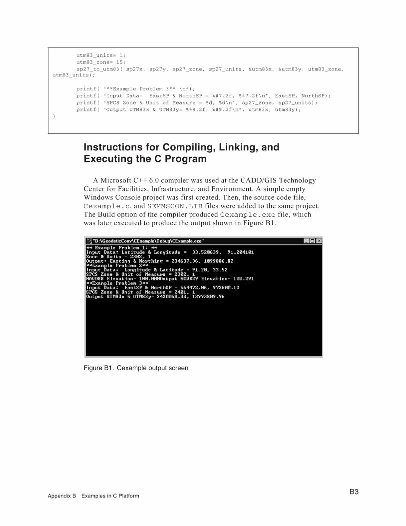
Instructions for Compiling, Linking, andExecuting the C Program
A Microsoft C++ 6.0 compiler was used at the CADD/GIS TechnologyCenter for Facilities, Infrastructure, and Environment. A simple emptyWindows Console project was first created. Then, the source code file,Cexample.c, and SEMMSCON.LIB files were added to the same project.The Build option of the compiler produced Cexample.exe file, whichwas later executed to produce the output shown in Figure B1.
utm83_units= 1;utm83_zone= 15;sp27_to_utm83( sp27x, sp27y, sp27_zone, sp27_units, &utm83x, &utm83y, utm83_zone,
utm83_units);
printf( “**Example Problem 3** \n”);printf( “Input Data: EastSP & NorthSP = %#7.2f, %#7.2f\n”, EastSP, NorthSP);printf( “SPCS Zone & Unit of Measure = %d, %d\n”, sp27_zone, sp27_units);printf( “Output UTM83x & UTM83y= %#9.2f, %#9.2f\n”, utm83x, utm83y);
}
Figure B1. Cexample output screen
Appendix B Examples in C PlatformB3

Appendix CExample Problems in C++Platform
The three example problems are solved using C++ code in this appendix.An empty Console Project was created in Microsoft Visual C++ 6.0 compiler.After adding the source code file, CPPExample.cpp, and SEMMSCON.LIBto the project, the Build option of the compiler was used to generate theCPPExample.exe file. The source code file contains the following:
//Geodetic Conversion Examples in C++
#include <iostream.h>#include <stdio.h>#include <windows.h>#include <conio.h>extern “C” _declspec( dllimport) int init_geoid9396( );extern “C” _declspec( dllimport) int init_nadcon( );extern “C” _declspec( dllimport) int init_vertcon( );extern “C” _declspec( dllimport) void geo83_to_sp27(double , double ,
double *, double *,short int , short int );
extern “C” _declspec( dllimport) void navd88_to_ngvd29(double, double,double, short int,double *, short int);
extern “C” _declspec( dllimport) void sp27_to_utm83(double, double,short int, short,
double *, double *, short int, short int);
void Example_Problem_1 ();void Example_Problem_2 ();void Example_Problem_3 ();void main() {
// Read nadcon data files into memoryint i = init_nadcon();
Appendix C Example Problems in C++ PlatformC1

// Read vertcon data files into memoryint j = init_vertcon();// Initialize Geoid in memoryint k = init_geoid9396();// Run three example problemsExample_Problem_1 ();Example_Problem_2 ();Example_Problem_3 ();// Terminate program by a carriage returngetch();
}
// Example Problem 1: Convert from NAD83 lat & lon to NAD27 StatePlane,Zone 2302 in Survey Feetvoid Example_Problem_1 (){
double lon = 91.204101;double lat = 33.520639;short int UtmZone =15;short int ZoneNumber = 2302;short int Units = 1;double Easting =0;double Northing =0;
geo83_to_sp27(lat, lon,&Easting,&Northing,ZoneNumber, Units);
char buf1[300] = “ ”;char s1[10] = “ ”;int j=0;j = sprintf( buf1, “ Input Data: %s\n”, s1);j += sprintf( buf1 +j, “\tLatitude: %s”,s1 );j += sprintf( buf1 +j, “%#9.2f”, lat);j += sprintf( buf1 +j, “ Longitude: %s”,s1);j += sprintf( buf1 +j, “%#9.2f\n”, lon);j += sprintf( buf1 +j, “ UTMzone: %s”,s1);j += sprintf( buf1 +j, “%d”, UtmZone);j += sprintf( buf1 +j, “ InUnits: %s”, s1);j += sprintf( buf1 +j, “%d\n”, Units);j += sprintf( buf1 +j, “Output Results: %s”, s1);j += sprintf( buf1 +j, “East: %s”, s1);j += sprintf( buf1 +j, “%#9.2f”, Easting);j += sprintf( buf1 +j, “ North: %s”, s1);j += sprintf( buf1 +j, “%#9.2f”, Northing);printf(“***Example Problem 1***: \n%s\n”, buf1);
};
C2Appendix C Example Problems in C++ Platform

// Example Problem 2: Convert NAVD88 elev 100 ft to NGVD29 ft.void Example_Problem_2 (){
double lon = 91.204101;double lat = 33.520639;double navd88z =100.;double ngvd29z =0.0 ;short int Units = 1;navd88_to_ngvd29(lat, lon,
navd88z, Units,&ngvd29z, Units);
char buf2[300] = “ ”;char s2[10] = “ ”;int j=0;j = sprintf( buf2, “ Input Data: %s\n”, s2);j += sprintf( buf2 +j, “\tLatitude: %s”,s2 );j += sprintf( buf2 +j, “%#9.2f”, lat);j += sprintf( buf2 +j, “ Longitude: %s”,s2);j += sprintf( buf2 +j, “%#9.2f\n”, lon);j += sprintf( buf2 +j, “ Elevation (NAVD88): %s”,s2);j += sprintf( buf2 +j, “%#9.3f”, navd88z);j += sprintf( buf2 +j, “ InUnits: %s”, s2);j += sprintf( buf2 +j, “%d\n”, Units);j += sprintf( buf2 +j, “Output Results: %s”, s2);j += sprintf( buf2 +j, “Elevation(NGVD29): %s”, s2);j += sprintf( buf2 +j, “%#9.3f”, ngvd29z);j += sprintf( buf2 +j, “ Units: %s”, s2);j += sprintf( buf2 +j, “%d”, Units);
//Geprintf(“***Example Problem 2***: \n%s\n”, buf2);
};
// Example Problem 3:Convert NAD27 State Plane to NAD83 UTM Survey Feet.void Example_Problem_3 (){
double EastSP = 564472.06;double NorthSP = 972600.12;short int Zone = 2401;
double lat83 = 0;double lon83 =0;short int Units = 1;
short int utm83_zone = 15;double utm83x;double utm83y;double sp27x = 564472.06;
Appendix C Example Problems in C++ PlatformC3

Execution of the CPPExample.exe file generates the solutions forthe three example problems shown in Figure C1.
double sp27y = 972600.12;short int sp27_zone =2401;short int sp27_units =1;short int utm83_units =1;sp27_to_utm83(sp27x, sp27y, sp27_zone, sp27_units,
&utm83x, &utm83y, utm83_zone, utm83_units);
char buf3[300] = “ ”;char s[10] = “ ”;int j=0;j = sprintf( buf3, “ Input Data: %s\n”, s);j += sprintf( buf3 +j, “\tInEastSP: %s”,s );j += sprintf( buf3 +j, “%#9.2f”, sp27x);j += sprintf( buf3 +j, “ InNorthSP: %s”,s);j += sprintf( buf3 +j, “%#9.2f\n”, sp27y);j += sprintf( buf3 +j, “ Insp_zone: %s”,s);j += sprintf( buf3 +j, “%d”, sp27_zone);j += sprintf( buf3 +j, “ InUnits: %s”, s);j += sprintf( buf3 +j, “%d\n”, sp27_units);j += sprintf( buf3 +j, “Output Results: %s”, s);j += sprintf( buf3 +j, “UTM83x: %s”, s);j += sprintf( buf3 +j, “%#9.2f”, utm83x);j += sprintf( buf3 +j, “ UTM83y: %s”, s);j += sprintf( buf3 +j, “%#9.2f”, utm83y);printf(“***Example Problem 3***: \n%s”, buf3);
};
Figure C1. Output screen from C++ examples
C4Appendix C Example Problems in C++ Platform

REPORT DOCUMENTATION PAGE Form Approved
OMB No. 0704-0188 Public reporting burden for this collection of information is estimated to average 1 hour per response, including the time for reviewing instructions, searching existing data sources, gathering and maintaining the data needed, and completing and reviewing this collection of information. Send comments regarding this burden estimate or any other aspect of this collection of information, including suggestions for reducing this burden to Department of Defense, Washington Headquarters Services, Directorate for Information Operations and Reports (0704-0188), 1215 Jefferson Davis Highway, Suite 1204, Arlington, VA 22202-4302. Respondents should be aware that notwithstanding any other provision of law, no person shall be subject to any penalty for failing to comply with a collection of information if it does not display a currently valid OMB control number. PLEASE DO NOT RETURN YOUR FORM TO THE ABOVE ADDRESS.
1. REPORT DATE (DD-MM-YYYY) September 2001
2. REPORT TYPE Final report
3. DATES COVERED (From - To)
5a. CONTRACT NUMBER
5b. GRANT NUMBER
4. TITLE AND SUBTITLE
Development of Geodetic Conversion Routines
5c. PROGRAM ELEMENT NUMBER
5d. PROJECT NUMBER
5e. TASK NUMBER
6. AUTHOR(S)
Vaiyapuri Danushkodi
5f. WORK UNIT NUMBER
7. PERFORMING ORGANIZATION NAME(S) AND ADDRESS(ES) 8. PERFORMING ORGANIZATION REPORT NUMBER
U.S. Army Engineer Research and Development Center Information Technology Laboratory 3909 Halls Ferry Road Vicksburg, MS 39180-6199
ERDC/ITL TR-01-5
9. SPONSORING / MONITORING AGENCY NAME(S) AND ADDRESS(ES) 10. SPONSOR/MONITOR’S ACRONYM(S)
11. SPONSOR/MONITOR’S REPORT NUMBER(S)
12. DISTRIBUTION / AVAILABILITY STATEMENT
Approved for public release; distribution is unlimited.
13. SUPPLEMENTARY NOTES
14. ABSTRACT
The Geodetic Conversion Routines Report is the final report of the Center Project 01.008. The report facilitates data conversion between various horizontal and vertical datums in the United States. It provides examples to invoke the Dynamic Link Library and use conversion functions in various programming languages, such as Visual Basic, C, and C++.
15. SUBJECT TERMS
Datum Data conversion NAD27 NAD83 NGVD29 NAVD DLL
16. SECURITY CLASSIFICATION OF: 17. LIMITATION OF ABSTRACT
18. NUMBER OF PAGES
19a. NAME OF RESPONSIBLE PERSON
a. REPORT
UNCLASSIFIED
b. ABSTRACT
UNCLASSIFIED
c. THIS PAGE
UNCLASSIFIED 2819b. TELEPHONE NUMBER (include area code)
Standard Form 298 (Rev. 8-98) Prescribed by ANSI Std. 239.18