In Partial Ful fillment of - MSpace
251
THT LONG SAULT SITE: CULTURAL DYNAMICS IN THT RAINY RIVER VALLEY OF NORTHWESTERN ONTARIO A Thesis Presented To THE FACULTY OF GRADUATE STUDIES THE UNIVERSITY OF MANITOBA In Partial Ful fillment of the Requirements for the Degree Master of Arts Department of Anthropol ogy by DAVID l^llLLIAM 1982 ARTHURS
-
Upload
khangminh22 -
Category
Documents
-
view
0 -
download
0
Transcript of In Partial Ful fillment of - MSpace

THT LONG SAULT SITE:
CULTURAL DYNAMICS IN THT RAINY RIVER VALLEY
OF NORTHWESTERN ONTARIO
A Thesis Presented To
THE FACULTY OF GRADUATE STUDIES
THE UNIVERSITY OF MANITOBA
In Partial Ful fillment ofthe Requirements for the Degree
Master of ArtsDepartment of Anthropol ogy
by
DAVID l^llLLIAM
1982
ARTHURS

THE LONG SAULT SITE:
CULTUML DYNA}íICS IN THE RAINY RIVER VALI,EY
OF NORTHhESTERIV ONTARIO
BY
DAVID WILLIA}I ARTHURS
A thesis submitted to the Facuity of Graduate Studies ofthe university of Manitoba irr partial fulfillment of the requirenients
of the degree of
}fASTER OF ARTS
o 1982
Permission has been granted to the LIBRAIìY OF THE UNIVEIì-
SITY OF MANITOBA to lend or scll co¡rics of tl"ris thesis. to
the NATIONAL LIBRARY OF CAi"\ADA to microfilm this
thesis and to lend or sell copies of'the film, and UNIVERSITY
MICROI:ILMS to publish an absrract of tliis thesis.
Tlte author reserves other publication rights, and neither tlre
thesis ¡ror extensìve extracts from it niay be printed or other-
wise reproduced withoitt the author's wrirten permissiotr.

ABSTRACT
The Long Sault site, DdKm-1, is a multi-component habitation site andburial station on the north bank of the Rainy RÍver, in northwestern 0ntario.An immense site, approximateìy 12 hectares in size, the Long Sault sitecontains, in addition to what'is be'lieved to be the largest extant complexof burial mounds in Canada, the ìongest, most comp.lete archaeologicalsequence yet Ídentified in the Rainy River area. present are at leastfive stratÍfi'ed components, spanning some 3000 years. These incrude apossible Lanter phase late Archaic component, a McKinstry phase Laureroccupati'on, a middìe period Brackduck component, a rate prehistoric, orperhaps proto-hÍstoric occupation containing seìkirk and sandy Lake ceramics,and a late historic Ojibway component. The size and complexity of the sitemay be seen to reflect its unìque situation adjacent a major sturgeon-spawning ground in a biotic ecotone with a high concentration of diverseÌ"esources' It lies at the hub of a radiating network of major wateruaysallow'ing access to and interchange with other areas across mid-continentalNorth America.
whereas previous investigations in the Rainy River valìey have con_centrated on buriar mound excavations, thÍs paper investigates the moremundane, but in many ways more important aspects of resource expìoitationand cultural classification. Interpretations are based on nearìy 16,000artifacts, recovered from primary context during excavatÍons Ín the habi-tation area adjacent the mounds in 1975. sty'listÍc and functional anaìysisof the chipped stone tools from the five components, and correlation withthe faunal material , suggest that far from being so.le.ly a spring fishingcamp throughout its 3000 year existence, the Long sau'rt was occupied atdifferent sêâso'S of the year' for different purposes. Anaìysis of thediagnostìc lithics' ceramics, and historÍc artifacts allow the occupationto be pìaced into a temporaì and cultural framework. comparison of theartifacts among the components suggests that while certain continuities
iii

iv
exist, there were dramatic changes in the utilizatÍon of different resourceseand Ín settlement that may be related to changing patterns of resourceavailability, and of the distributions of cultural groups through tíme.These have some interesting imp'lications for the interpretation of mid-continental prehistory and earjy fur trade history.

PRE FACE
In the one hundred years sr''nce George Bryce and other late nineteenthcentury antiquari.ans fi'rst thrust their spades lnto the burial mounds on
the banks of the RaÌny River Í'n northwestern Ontarfo and adjacentMinnesota, the regi.on has been the focal point of archaeological inves-tigations west of the Upper Great Lakes. The area has made severalcontri'butions to mfd-continental archaeology. Most notab'le, perhaps, has
been the recognition of two major archaeological cultures, Laurel and
Blackduck. Burial mound excavations, conducted between the late 1800s
and early 1970s, have provided a wealth of information concerning l.lood-
land mortuary practi'ces, of inestimabte importance in the interpretationof prehistoric customs of burial, ôrìd ín palaeo-biological research (cf.l{ilford 1955; Stoltman 1974;0ssenberg 1974). The Rainy River area has
been the hub of a lÍvely debate among archaeologists, linguists, and
physÍcal anthropoìogists, concerning the ethnic identification of lateprehistorjc and ear]y historic Woodland cultures, a controversy that has
raged for over three decades (Vickers 1948; Evans 1961b; Bishop and Smith
-1975; Siebert L967; Ossenberg 7974:' Dawson 7977a; I977b). The earìyìnterpretations generated through Rainy River area research have stronglyinfluenced the orientation and conclusions of investigations in Manitoba,
Minnesota, northern 0ntario, l,lisconsin, and northern MÍchi gan. Such majorstudies as Wright's (1967) "The Laurel Tradítion and the Middle Woodland
Period", the ceramic studies of Evans (1961a), and Stoltman (1973), and
the s'ite reports of Janzen (1968), McPherron (1967), and Brose (1970), as
well as the works of several other researchers since, have al'l been pre-dicated on, or d'irectly influenced by, the invesiigations in the Rainy
Ri ver val 'l ey.
Despite the central role p'layed by the area in the interpretation ofmid-continental prehistory, there are some serious deficencies in ourknowledge of the archaeology of the Rainy River itself. 0ver the past
v'¡
century, archaeo'logìcal investlgations have been confined, almost
exclusively, to the excavati'on of burlal mounds. As a result, researchÍn the val'ley has focused prt*marl'ly on the archaeoìogy of the Woodland
period, and spec'ifically on the mound bullding Laure'l and Blackduck cul-tures. [^ll'th the exception of the skeletal remains themselves, most ofthe archaeo'logÌcal material upon which interpretations have been based,
i.s deri.'yed from secondary context ln the fill of the burial mounds. The
arti.facts recovered from the mounds, then, are often of uncertain age,
association, and proventìence. They may have been scraped up along with themound fi'll from the vtlìage floor to construct the mound, from midden
deposi.ts contemporaneous with, or earlier than the mound builders. They
rnay aìso represent refuse dumped on the mound'at a later date, oF, insome instances, offerings or caches of select artifacts intentional'lydeposited in the mounds. The mixture of artifacts or different ages and
contexts Ín the mound fill creates serÍous dîfficulties when they are used
as the basis of chronologtcaì reconstructions, Vêt this has been the prin-cipal use of those artifacts recoyered from the Rainy River mounds (cf.l{ilford 1955; Evans 1961a; 196lb; Stoltman 1973;1974; t,lright 1967).
A'lthough there is considerable lnformation available regarding buriaìmound construction, little is known about Woodland settlement patterns.l'lhile i.t has been possible to reconstruct prehistoric bÍologicaì populationsfrom the anaìysÍs of the skeletal remains in the mounds, what little jsknown concerning the patterns of subsistence of prehistoric peoples in thearea has come from the analysis of faunal material recovered, probabìy inmixed associ'ations, from the mound ffll (cf. Lukens 1973). Whereas inareas to the east and west settlement studies have long been under way,emphasi's in the RaÍny RÍver vaìley has continued to focus, untiì recently,on site suryey and burilal mound excavation. The number of habitatÍonsi.tes excayated remains surprisingly small, and those which have been
explored were either excavated usÍng techniques considered primitive by
present standards, or were found to be disturbed, often multi-componentsttes uhich yielded incomp'lete information (cf. l,lÍlford 1971; 1955; Evans
1961a; t.lrÍght 1967).
The lack of data from prfnary context on habitation sites may be
seen as the single most important problem in the archaeology of the

. vll
Rainy River area. The 1975 excavations at the Long Sault site, a strati-fied, multi-component habitation and burial mound sÍte on the banks ofthe Rainy River, were designed to rectify this problem.
This thesjs represents only a portíon of a far more comprehensive sitereport and analysis of the Long Sault sfte artÍfacts (nrtfrurs n.d.a). For
the sake of brevity, it has been necessary to exclude much informationf¡"om this report. Researchers wishing to exanÍne more fuì1y the data upon
whÍch this thesis js based wÍl'l find ft filed with the Archaeology and
Heri'tage PìannÍng Branch, Ontario Mlnistry of Citizenship and Culture(formenly Cuìture and Recreation) offices in Toronto, Kenora, and ThunderBay.
As'wi'th so many projects of this magnitude, this study would notha've been possible wÍthout the encouragement and co-operation of a number
of indivi'duals. The assTstance of alI of these people is great'lyapprecfated. The wrÍter would like to express thanks to the fol1owíng:
My advisor, Dr. Louis Allaire, Department of Anthropology, Universityof I'lanitoba, for his understanding and guidance in the preparation of thisthesiìs, and to the members of my defence conrnittee, Dr. E. Leigh Syms, Dr.J. Teller, and Dr. l.J. Koolage, for their valued critique of this paper.
I would also like to give special thanks to the following for theirassistance in the successful comp'letion of the Long Sault site excavatÍonproject: C. S. Reid, Northwestern Regional Archaeologist, and Grace
Rainovich, FÍeld Archaeologist, Ontario Minístry of citizenship and
Culture, for theÍr many assistances during the excavation and ana'lysis ofthe Long sault site materiaì; ny creur, which included at various times,John Wood, Brian Ross, Leigh Hambty, Sheryl Smíth, Rosemary Vyvyan, and
Neil Canpling, one of the most congenial groups with whom I have ever had
the pìeas.ure of working; Fish and li{ildlife Supervisor Ted Swift, and thes.taff of the Fort Frances District 0ffice, Ontario Mínistry of NaturalResources, for thejr logistÍcaì support of the project in its many stages;George Armstrong, of Fort Frances, owner of the property, who gave thewriter permission to excayate on his land; Robin Dods, Department ofAnthropology, University of Toronto, who prepared the faunal analysis forthi s report ; North Central Regiona'l Archaeol ogi st l,l . A. Ross , for outti ng
at my disposal the facÍlÍties of the Regionaì Archaeological Laboratory

viiÍ
in Thunder Bay; Southwestern Regional ArchaeologÍst hl. A. Fox, for per-
mission to incorporate his survey maps of the Federal Mounds Reserve intothe contour map of the Long Sau'lt site prepared for this report; Ms. Janice
Fitzpatrick, for her masterful production of this paper, and for her
editorial advice; my wife, Janet Î'lorrl'son, who gave me inspiratÍon and
advice (and put up with me), during the long and often frustrating years
spent putting work into fts final form; and most of all, to Mr. AlbertHunter, Jr., the Albert Hunter, Sr. famiìy, Mr. lllillie Ì..lilson, Mr. Rupert
Hunter, the Hortons, the Bombays, and all the people of Manitou Rapids
Reserve, who gave me theír trust and friendship throughout my years at theLong Sauìt. It is to them, and to the spìrits of the Manitou Mounds, thatthis study Ís respectfully dedicated.
The Long Sault excavations were a component of the Manitou Mounds
Archaeologîcal Survey, conducted by the writer under ArchaeologicalLicence 75-A-0018 (held by C.S. Reld), while under contract to theOntario Minist¡ry of Culture and Recreation in 7975.

TABLE OF CONTINTS
i
PREFACE I
i
;I. THE REGIONAL ENVIRONMENTAL SETTING . 1 i
Physioìogy of the Research Area iGeoì ogyCl imateVegetatÍonFaunaSummary
i
II. THE LONG SAULT SITE . nDesc.ni ptitonThe Long Sau'lt Burial MoundsConditi.on of the SitePreyi'ous Investi gatr'o nsThe 1975 Excavatì'onsStratìgnaphy of the SiteThe Stratî graphl'c Assemb'lages
PART I
THE TECHNOLOGICAL DYNAMICS
Continuity and Change in Lithic Technology
Introduction to Part I .44
III" THE AROHAIC CHIPPED ST0NE ASSEMBLAGE .4S
Raw MaterialsDescription of the ArtffactsFunctiona'l Analysis of the InitÍal l^loodland Chipped
Stone Tool s
IV. THE INITIAL lllOODLAND CHIPPED STONE ASSEMBLAGE .77
Raw Material sDescription of the Arti'factsFunctiona'l Ana'lysis of the Initial l,loodland Chipped
Stone Tool s
ix
V. THE TEMINAL I¡{OODLAND CHIPPED STONE ÃSSEMBLAGE
Raw' l"lateri.al sDescrtpti.on of the Artt'factsFuncti onal Analysl's of the Te'rmi na'l Woodl and Chf pped
Stone Tool sStratigraphtc Analysi's of the TermÍnal Ïlloodland ChÍpped
Stone Tool s
VI. THE HISTORIC CHIPPED STONE ASSEMBLAGE
Raw Material sDescri'ption of the ArtitfactsFunctìona'l Ana'lysi's of the l-ltstortc Chipped Stone Tools
PART IITHE ETHNTC DYNAMICS
Fopulation Moyenents an9. Culture Grgl¡p Formationln Northwestern Ontario
Introduction to Pant IIVII. THE EARLIEST INHABITANTS OF THE LONG SAULT SITE
Late Archaic Hunters ì'n the Rainy River ValleyThe Initial tloodland Fishi'ng Vi'llage
VIII. THE II'IERGENCE OF THE HISTORIC NATIVE GROUPS. . 133
The Terminal Woodland OccupatfonsThe Rainy River Valìey Ín the Contact and
Hllstori c Peri ods
IX. SUMMARY AND CONCLUSIONS
IntroductionEcology of the Long Sault SiteThe Long Sault Site fn Rainy River Prehistory
83
96
107
108
168
APPENDIX A
APPENDIX B
APPENDIX C
APPENDIX D
PLATES
RI FTBENCES
ta.ataat 173
190
196
200
202
?20
l.

1.
4.
TabulatÍon of artifactssite excavations
Distri buti on of I ithi c
Relatìve rank of lithic
LIST OF TABLES
:':'l':': :':,'.':'.t:': :':t:raw materials by occupation
raw materials in each occupation
.38
.462.
3.by x2 val ues 48
Distnibution of lÍthìc rawln the Archai c occupatr'on
DistrÍbution of lithic raw
.':t:'l'l'.uT:nmaterìals among
flakes and cores
tool classes in
51
52
53
53
54
55
56
57
59
5.
6.
7.
B.
o
10.
11.
72.
13.
the Archaic occupation
Lîthfc arti fEdge uti.ììza
Edge confîgu
Utr'llzed fla
tdge retouch
Edge confÌguocc upati on
act class by occupation
tr'on on utllf zed flakes tn the Archaic Occupation
ratÌon on utiìized flakes in the Archaic 0ccupation
ke scraper classlficatfon
on retouched ftakes in the Archaic occupation
ration on retouched flakes in the Archaic
Retouched flake scraper classification
Student t-test - relationship between edge angles andartìfact ciasses , .
74. tdge wear by lithic arti'fact class in each occupatìon
15. l'latntx of Pearson Product I'lsment correlatÍon coefficientsfor the correlati'on of tool classes with faunal groups
16. Di.stributton of lithic raw materÍals among flakes andcores Ín the Initial Woodland occupation
77 , Di:stri'butlon of I ithic raw materia'ls among tool classes inthe Inttial Woodland occupation
18. Edge utiì fzation on util Ízed flakes Ín the Initiall¡loodl and occupation .
19. Edge confi guration on uti l i zed fl akes i n the Ini ti alWood'land occupati on
61
63
70
73
75
76
x1'
77

x] r
LIST 0F TABLES - (continued)
20. Edge retouch on retouched flakes ln the Initiall{oodl and occupatÍon
27. Edge configuration on retouched flakes in the InitialÞloodl and occupation
22. Dlstribution of lithic raw materiaìs among flakes andcores in the Terminal l.Iood'land occupations
23. Dlstrlbutlon of lithic raw matertals among tool classesÌn the Termtnal Þloodiand occupations
24. Edge util f zation on utÌl ized flakes l'n the Termina'tWoodland occupations
25. Edge confrìguration on util l'zed flakes Ìn the TerminalÞIoodl and occupatl'ons
26, Edge retouch on retouched flakes Ìn the TermÍnalÌtloodl and occupations
27, Edge configuration on retouched flakes in the Terminall.loodland occupatlons
78
79
84
86
87
88
89
90
94
28,
29_.
Strati gr.aphi c di stri'buti on ofTermi'nal l¡loodl and occupatl'ons
chipped stone tools Ín the
Dlstnibution of lithfc raw materials among flakes and coresin the Historic occupatÍon
30. Distribution of lithic raw materials among tooì classestn the Histori'c occupatÍon
31. Edge uti'lìzation on utilized flakes in the Historic occupation
32, EdEe conft'gunation on utilized flakes fn theHi.storic occupatr'on
33. Edge retouch on retouched flakes in the Historic occupation
34. Edge configuration on retouched flakes in theHìstoric occupation
97
99
100
100
101
w11935.
36.
Typological ana'lysts of Initia'l t^loodland ceramics
Typolog'i.cal ¡nalysis of Termfnal l,loodland ceramics- cord marked group 13S
37, Typological anaìysis of Intermediate ceramÍcs 136,

38.
xiií
LIST 0F TABLES - (continued)
Typoìogicaì analysis of Terminal Woodland ceramics - fabricimpressed group (l'lacNeish classlfication) 136
Typological analysfs of Termlnal Woodland ceramics - fabricinpressed group (Lugenbeal classification)
39.
40.
41.
42.
43.
44.
45.
46.
Masten ceramic chart - Inittal Woodland (Ihl) ceramics
Master ceramr'c chart - Intermediate (TW-3) ceramÍcs
Master ceramic chart - Termînal Woodland (Thl-l) ceramics
Master ceramic chart - Terminal Woodland (Tl.l-z) ceramics
Master ceramic chart - Terminal tloodland (T1,1-4) ceramics
Classiftcation of Initial Þ.loodland (Il.l) vessels .
Cl assi fi'cation of Intemediate (fW-S1 vessel s
137
776
181
782
187
189
i91
191
792
193
193
194
198
20I
47. Classification of Termînal l¡loodland (Tll-1) vesseìs
48. Cl assîfication of Termt'nal l,loodland (Tli{-2) vesse'ls
49. Classi fication of Termlnal [^loodland (TT,l-4) vessels .
50. Attribute profiles for the Terminal Woodland ceramics
51. Distnihution of fauna by occupation
52, Abbreylations - lithic raw materials

1.
2.
J.
4.
5.
6.
7.
0.
9.
10.
11.
L2.
13.
r4.
15.
17,
18.
19..
Map of mid-continentalof the Long Sau'lt site
Geol ogtcal subdivÌsions
LIST OF FIGURES
*:":n .Ameri:'.':'it:n.'f' .t :':tl':
of the research area
SurficÍaj geology of the research area
VegetatÍon of the research area
Map of the Long Sauìt site
Plan of the 1975 excayations uni'ts
SchematÍc diagram of the Long Sault site stratigraphy
Correlatton of the stratigraphic units
Conrelation between artifacts classes (combined edge angìes)and functiorlal categories l'n each occupation
Edge wean - edge angle correlation - utilized flakes
Edge wear - edge angìe correlation - retouched flakes
Edge wear - edge angìe correlation - bifaces
Edge wean - edge angìe correlation - projectile points 69
Location of sÍtes mentioned in the text 110
Se'rtation of nîne Initial [.lsod'land components usÍng theStoltnan typology . 72I
16. Se¡"tatÍon of seven Initial tloodland components using theLugenbeaì typoìogy t22
25
31
36
65
66
67
68
2
5
12
18
1.46
747
Seriation of nÍneteen Termina'l t¡{ood'land cornponents
Seni:ation of Selkirk and Selkirk-like components
Fur trade posts and datable historic artifacts 159
xIv

I.
II.
III.
IV.
V.
VI.
IX.
X.
XI.
XIi.
XIII.
XIV.
xy,
XYT.
XVX I.
LIST OF PLATES
Aerial photograph of the Long Sault site
The Long Saul t site
Reserve Period occupatlon of the Long Sauìt site
The 1975 excavations - maîn trench
The 1975 excavations - north block
Representative stratigraphic profite
203
204
205
206
207
208
VII . Representative uti I i zed fl ake tool s . 209
VI I I . Representati ve Archai'c and InÍtÍal !,loodl andretouched flake too'ls . 2lO
Representative TermÍnal Woodland and Historicretouched fl ake tool s
Repnesentative bÍ faces
Representative projectile points Zt3
Representatîye Initial tloodland ceramics - IW vessejs . Zl4
Representatjve Intermedr'ate ceramìcs - T}J-3 vessels . ZLs
Representative Termi'nal tloodìand ceramícs - T1^l-1 vessels . . 216
Representati've Terminal Þ{oodland ceramics - Tl.l-Z vessels . 217
Representative Terminal Woodland ceramt'cs - TW-4 vessels 218
Repnesentati've Histori'c artifacts . 2lg
27I
?12
XV

CHAPTTR I
THE REGIONAL ENYIRONMENTAL SETTING
The Long Sault site, DdKm-l, is an immense and extremeìy richarchaeologica'l site, ìying adJacent the Long Sault Rapids, on the northbank of the Rainy River, in northwestern Ontario. The size and complexityof the site, which exceeds that of any other known site in the area, is a
reflection of the interaction of a number of variables - its locatÍon, theavai'labiìÍty of various types of resources, and its accessibility withrespect to other areas of mid-csnti'nental North America. In order tounderstand this compìexÍty, Ít't's necessary fìrst to examine the physical
and biological settÍng of the sfte, and to place it within a regiona'lenyironmental context (C]eland 1.966: 1).
Physiogr.aphy of the Research Area
The Long Sault site lies at the centre of the Rainy River valìey, an
area of approximately J.6,000 square kilometres, drained by the Rainy RÍver
and its tributaries [Fig. 1). The Rainy River is a major west-flowingwaterway, connecting Rainy Lake and the Lake of the Woods, It forms, forits enti're 1^13 km length, the Ìnternational boundary between Canada and
the Uni.ted States.The valley of the Rainy River lfes near the centre of the Rainy Lake-
Lake of the Woods drainage basin, a major watershed area of some 70,000
square km, which includes a'large part of northwestern Ontario and northern
Minnesota, and adjacent portions of southeastern lvlanitoba. This watershed
may be yisualized as a shallow basfn, rough'ly oval in shape, tiltedslightly to the west and south. The height of land separating the At'lanticand Arctic watersheds, a broken, rocky upland at an elevation of 500 metres
aboye sea leyel, forms the eastern rim of this basîn. The northern edge
is defined by the Eagle- F'inlayson moraine, a prominent landform feature,

Fi gure 1. Map of Mi d-contj nentalShowing the Location of the Long
North Ameri caSault Site

3
which may be traced for some 240 km in a northwester'ly direction from itsintersection with the height of land. 0n the south, the research area Ísdefined by the divide between the rÌvers flowing eastward to the Atìantic,and those flowing south through the Mississippf River system, to the Gulfof Mexico. To the west and north, the Rainy Lake - Lake of the Woods
drainage basÍn'is separated from that of 'lakes Winnipeg, Manitoba and
l,linnipegosÍs by a high upland area, through which flows the Hinnipeg River.The Rainy Riven vaììey fonns a nanrow corridor across the study area,
and seryes as the major waten route lÍnkÍng the two ìarge lakes in the
region. ExÍting fron the western end of Rainy Lake at Fort Frances, theriver fo'rmenly descended a set of rapids at Pfthers Point. These have been
flooded by the Boise Cascade Paper and Power Company dam at the Chaudiere
Falls, a short distance downstream. Here the river flows over a structuralunconformi'ty, descendt'ng some seven metres (cf. Delafield 1943; 422; Hind
1971:81). The riyer channel below the fa'lls is deep'ly entrenched, havingcut its way dottn through a thl'ck mantle of lacustríne and till deposits toi.ts present bed. Through lateral erosion, two, and in places, threeterraces haye been cut i.nto the river bank. In the upper reaches of theval'ley these terraces occur as bluffs, reaching 20 m or more in height.Flowing west, then'north for a short dístance, then v,rest again, the riverayerages 200 m in width, and from three to seven metres in depth, and
encounters on'ly two impediments to navr'gation below the falls. The firstis a bedrock si'll that Ìntersects the river channel at Manitou Rapids; thesecond, the Long sau'lt Raplds, that appear to be contro]led by Ìargeboulders in the river bed. The fall at the Manitou Rapids is only one-half to three-quarters of a metre, while the river descends one to 1.7 m
through the Long Sault Rapids. The stream gradÍent is 3.95 centimetresper km, ayeraged over the river's 113 km'length (cf. Johnston 1915: 25-27;Hind 1971:82). Although widespread flooding in the past may account forthe anci'ent al I uvlìal deposits (-Beechey and Bardecki 1.972; 17) , the Rainy
seldom leaves its banks today. The flood p1aÍn is unusual'ly narrow for a
river of this magnitude, in p'laces measuring only a few metres in width.Aboye the ri'yerÍ'ne terraces, the river banks are fìat and featureless,and rise gentìy toward the i:nterior. The height of the banks decreases
as one noves westward, ôrìd at its exit below the town of Rainy River on

4
southeastern Lake of the tloodso the Rat'ny is deep and wide, and the bankslow and marshy. The rÎver has seyeral snall trÍbutaries enterÍng from thenorth, the largest of whi:ch are the Stungeon and the Ptnewood. These giveaccess only a few kÍlomet'res ints the bog ìands north of the river. Therivers entering from the south, though fewer l'n number, are much larger.Foremost among these are the Lfttle and Big Fork rivers, that arise in themarshlands of nonth central Minnesota, not far from the headwaters of theMissÍssippi River.
Geol ogy
The Rainy River valley lÍes in the tlabigoon Subprovince of precambrianaged rocks, cìose to the western edge of the Superior Province, the largeststructural regìon of the Canadîan Shìeld (Fig. 2). nlthough consisting pre*-dominantly of granites and gneisses, in certain areas of this subprovince,especia'lìy in the northern Lake of the Woods area, are outcrops of metavol-canics and metasediments inc'luding quartz, greywacke, and rhyolite, suit-able for the manufacture of chipped stone tools (Rye 196g:3,6; Reid lg77a:s-g; RaSnovich 1980a z 37,44; Davies et al. 1966). In the English RiverSubprovince to the north, are present rhyoìites, volcanic tuff, breccia, andsome sedimentary materials in prt'nary deposits, while in the Quetico Subprov-ince, east of Rainy Lake, are extensive beds of greywackes, siltstones, andrelated metasediments. Beyond the research area, in the Southern provinceof the ShÍèld, 'lies the Gunfìint Formation, source of several high gradesilÍcious raw materials, while the sedímentary formations of the Interior.Platform, west of the Shield in Manftoba, contain several varieties of chert(stockwell et al , 19762 66-67).
Aìthough the irnmediate area is rÍch in sÍlîcious materiaìs, access tothese is governed ìar^ge'ly by the surficial geology of the region (rig. 3).Pri'mary deposits outcrop onìy along the northern periphery of the RainyLake--l-ake of the Woods basin. Bedrock in the central area is a relative]yflat and featureless plain, buried beneath tÍll and lacustrine clay up toten metres in depth (Johnston l915: ì8). Apart from isolated qùartz diabasedikes that protrude through the dediments, and the low strand lines of LakeAgassiz, the trench cut through the sediments by the Rainy River and itstributari.es provides the onìy local relief.

Fi gure 2 Geologìcal Subdivísjons of the Research Area
Canadi an Shield
ØEffiffiHN
Interior Platform
L-J Sedimentary Formations
edge of Canadian Shield ,oo boundary between prov.inces
À Long Sault Site
Source: Stockwel I et al . 1976: 46
Superior Province
Cat Lake Belt
tngì i sh Ri ver Bel t
Nipigon Pìate
Quetì co Beì tl,lab i goon Be ì tWawa Bel t
Southern Provi nce
ffi tu*. Superior Basin
EI P.nok.un Fold Belr
EI Port Arthur Homoct ine
\

6
The mantle of s.edi.nents does not reflect the li.thoìogy of the under-lying bedrock, â situatilon that has impìications for the local ayaflabiìityof raw materials for stone tool manufacture. The tilì deposi'ts in the valleyrepresent at I east three gl aci'aì events, one of rnid-Wlsconsi'nan age, theothers in the late Wisconsinan. The filrst, which orÍginated to the north-west, is poorìy known. The second was an adyance from the Laurentian icecentre to the northeast, and the third, from the Keewatin centre to thenorthwest. Aìthough lÍmestone cobbles in the till matrlx of the ìatter may
have ori'ginated in the Red River valley (Johnston l9l5: l8), or the HudsonBay Lowlands (Hills and Morwíck 1944: l8), they may also have derived fromdeposjts in the interlake region of Manitoba (Te11er and Fenton l9B0). A
fourth ice fìow, from the northeast, advanced only as far as the Lake ofthe l^Joods--Rainy Lake moraine, and affected the area onìy indirec¡y, as itformed the northeast margin of Lake Agassiz (Johnston l9l5; Elson 1967;Saarni sto I 974 : 333; Tel I er and Fenton I 980: Zg-Zg, 32-33) .
These data suggest the possibiìÍty that pebble cherts imported fromdistant sources to the northwest by glacial actjon, ffiây be available locaìly,in exposures of cal careous til 1 s. Material s from primary deposits, however,are available only on the periphery of the area, beyond a radius of approx-imately .l00 km. Other pebble cherts, specificalìy Hudson Bay Lowìand chert,are like'ly present in the end moraines that border the area. Aìthough thesesource areas are some di stance from the si te , they are eas'i 'ly accessi bl ethrough the many lakes and rivers that cross the research region.
Certain of the c'lays that cover the area have been found to have pot-,ential economic apþlications (Johnston l9l5: 76-78). Aìthough yet to be ex-amined or tested, Ít is likely that these locally available c'lays provideda source of readiìy accessible raw material for local potters in prehistory.
Cl i mate
The climate of the area is continental, characterized by short summers,'long winters, and extremes in mean seasonal temperatures. During the summer,
the area is influenced by systems crossing the continent to the south. Temp-
eratures for June, July, and August average l8 degrees celsjus, and, though

Fì gu
re 3
. S
urfi
cial
Geo
l og
y of
the
Res
earc
h A
rea

I
Legend;
ffi
ffi-lt-tF.Sll: å2il
ilm
,:¡:r,rrr-
rlFtl.iiiT
ffiffi
Conposlti on
water washed bed,rock, silty to sandy tillcl ay ti I I , rhythnical'ly deposi'ted cl ay and sf I t I acustri nedeposi ts
sflty to sandy tiììc'layey ti'I1
rhythmica'l1y deposited lacustrine clay and silt,sllty to sandy or clayey tilìfine lacustrine sand, sflty to sandy till'l acustri ne sand, s t'l ty to sandy ti t I
sand and graveì outwash deposit
sand, gravel, êrd boulder end moraîne
a Long Sault site
Source: modified from Zoltai 1965

9
noderated somewhat by the pnoxl'nilty of Bainy Lake and Lake of the tr^toods,
temperatures closer to 30 degrees C are not unconmqn ln sumDer, HumidÍtyis very ht'gh. Durrìng the w'inter, ttre cold dr"y polar front descends out ofthe arctt'c, bri'nging wìlth ltt cold, dry aÍ'r. Dti.nter temperatures for Dec_
ember th.rough Februany average -14 degrees C, representing an annual rangeof 32 degrees c (Hills and t4onwick 1944; zz^23). The majon bodies ofwater that moderate temperature duri'ng the warm months are frozen overhetween December and April (Hutton and Black 1975: map 3).
Despite the impression given by its name, annual precípitation jn theRainy Rîver area is on'ly 61 to 66 cm, a value lower than that of areas tothe ssuth and east. Most of the precipftation falls in the warm months,brought Ín fron the east and northeast as showers during the spring, andfrom the south, southwest, and west, by storms of some magnitude and vi-olence, that travel up the valley at regu'lar intervals during the summerand autumn (Johnston l9'15: 1'l). nlthough snow accumulates to an averagedepto of 5'l to 64 cm annually, this represents only about lg percent ofthe annua'l precipitation. The snow does come early, however, and remaÍnson the ground until well into Aprll (Johnston l9l5: ll; Hutton and BlackI 975: map 5) .
The growîng season în the Rainy River va'l'ley is approximately ì80 days,fnom Apnil to September. There are, on an average,'120 frost free days -inthe lowen Rainy RÍver--Lake of the Woods area; in the vicinity of RainyLake, however, the season is ten to z0 days shorter. Light frost is com-non in all nonths of the year (Johnston l9l5: l4; Hutton and Black l97S:nap 4); however,the growfng season "is suffÍcient, when other conditionsôre f¿vetJrable, for the gnowth and maturing of most of the ordínary farmcrops colrlmon to the temperate zone" (Johnston l9l5: l5). This raíses theinteresting possi'biìÍty that limited agriculture or horticulture mighthave been practised in the RaÍny River valley in prehistoric tímes. Itappears, however, that the mini'mum frost free period for prehistoricagrr:culture i's about
.l40 days (Yarnell '1964 : 127-133), placing the Rainy
River area just beyond the practfcä1 li'mits of agricultural actÍvity, atleast at times when clí'matt'c patterns approximated those of the areatoday. It shqu'ld be noted that an extens'ive cornpêndl'ùm of fl,oral resources

10
on and adjacent the site (Beechey and Bardecki Ig72), revealed a high
frequency of plants, particularìy those on the flood p'lain, which are
known to have been coìlected as food by Upper Great Lakes Native groups.
Some have been Ídentlfied archaeo'logica'l1y in other areas. Aboriginalhorticulture is reported for the Lake of the Woods area, and at the Long
Sault site.itselfo in historic accounts of the nineteenth century (James
1956: 204-205; Hind 79772 89), and though there¡ire no data available forthe study area, the possibilr'ty that flood p'laîn hortlculture was pract'icedby the prehistortc inhabitants of the site, as appears to have been done inthe late historlc period, should not be ruled out.
Veqetati on
The Rainy Lake - Lake of the l,loods drainage basin overlaps fourvegetatlon zones, each of which may be broken down into several forestsections w'ith differÍng composttion. As may be observed in Figure 4, theRainy Ri'ver valley lles wl'thi:n a radtus of 200 km of three vegetation zones
which contain eight vegetation types " Vr'rtual'ly al'l vegetation types pre-sent ln the mi'd-continental area are within a 400 km radius of the Rainy
Riyer, I'lost of these are directly accessÍble via the network of water-ways that dnain 1'nto, or are otherryise connected with, the Rainy Lake -Lake of the lfoods dralnage basln.
The study'anea'li:es on the extrene western frfnge of the Great Lakes-St, Lawrence Forest region, which extends from the eastern seaboard alongthe St. Lawrence watepway, thnough the lower Great Lakes basin, and southof the upper Great Lak.es. West of Lake SupeÉior, it forms a wedge between
the Boreal Forest zone to the north, and prairie areas to the west and
southuest (Rowe 1,97?z 11; Shay 1971: 6). The Great Lakes - St. Lawrence
Forest I's a conifer. hanwood forest type. It is characterized throughoutnqst of i'ts nange by such conÌferous species as eastern whíte and red pine,eBstern henlock, and yeìlow birch, in associatÍon with deciduous trees such
as sugar naple,. red maple, basswood, and white elrn. The vegetation of theBAlny Bi.yen area reflects the fnfluences of the Boreal Forest zone, whichlies irrnediately north of the Lake of the Woods, the Aspen Parkland zone
to the west in southeastern Manttoba and northwestern Minnesota, and the
Pnainie grasslands to the southwest in Minnesota and North Dakota (Rowe

11
79722 11J.; Shqy 7917;6; Syms 1977at 77\, Th¡eughout nqst of the sectionbetween ff¿i:ny Lqke and Lake of. the l,{oods, poop draìnage and low relief haye
led to the deve'lopment of swanp lands, ln whÍ'ch black spruce, tarnarack,
eastern whtte cedqr, wf llowr ôrìd alder predomr'nate. In better dra jned
locations are stands of ba'lsam, popìarn and ft'r, white spruce, and
tamarack. BoFdering the nÍyers, whene soils are of finer texture and
drat'nage good, lr¡hîte eln, basswood, ManÍtoba maple, and bur oak occur
ßowe 7972: 111).
The bur oak often occurs în grassy clearings, ín a savanna type
association. These isolated areas of oak sayanna are belÍeved to rep-resent relict ass'ociations of an eastward expansion of the prairie grass-
lands between 7500 and 6000,years ago (Hills and Morwick 1944:37; Tellerand Last 1981:110). At fts maxt'mum, about 7000 8.P., the prairie-forestborder 1ay 120 km north and east of Íts present position. This would have
p'laced it w"îthtn 100 km south of the Rainy River, and within 50 km to the
west in the Lake of the Woods area (Wright 1974: L0; Wright lg76a: b81;
Shay 1.971: 6, Fig. 3). The eastward expansion of the pra'irie appears tohave influenced vegetatÍon patterns as far east as Lake Superior (Fries7962: 30i).
There have been seyeral fluctuations in vegetation patterns in theresea'rch regi'on over the past 7000 years as wel 1 , brought on by shortterm changes in temperature and humidity conditions. After the with-drawal of the grass lands about 7000 8.P., the area was invaded by white
Pine until about 4000 to 3000 B.P. (Wright i976bz 729). l.lith fncreased
moisturecondítions carne a reduction in the pine forests, and an increasein b'lack spruce about 2000 B.P. According to some researchers, therefollowed a series of f'luctuations to warmer or drier conditions about 1500
8.P., to warm moìst conditions about 1250 8.P., to cool, moist conditionsabout 850 8.P., and to warm or dry condÍtions about 700 B.P. At about
550 8.P., began the cooling trend referred to as the "Little Ice Age"
[gaenris et a'|. 1976). AmonE the more noticeab]e changes ín the past hundred
years have been the replacenent oyer much of the area of eastern white and
red pfne hy Borea'l Forest specles such as jack pÍne, trembling aspen, largetoothed aspen, white bÍrch, baìsam fir, and whîte and black spruce, the

I2
Figure 4. Vegetation of the Research Area

13
Legend:
Boreal Forest Zone
ffi muskeg; open black spruce & tamarack woodland
á closed black spruce, tamarack, & jack pine woodland
VZ bìack spruce, with white spruce, balsam poplar, white birch,(z¿ trembìing aspen, & balsam fir
E jack pine, black spruce, with white spruce & trembling aspen
m bìack spruce forest
F bìack spruce & jack pine with trembìing aspen, baìsam poplar, &r white spruce
ffi white spruce, baìsam fir, & white birch
H black spruce & tamarack, with intervening st^¡amps & meadows
Aspen Parkìand Zone
ffi trembling aspen & balsam popìar in mixed associations
N aspen grove, with birch, white spruce, & baìsam f.ir
ßill closed aspen oak forest, with trembling aspen, balsam poplar, &¡ .'.'.¡
bu r oak
Great Lakes--St, Lawrence Forest Zone
f.,t eastern white & red pine, with jack pine, trembìing & ìarget! toothed aspen, white birch, balsam fir, white & black spruce
E*t jack pine, rep'l acìng white & red pine, with extensive sr,ramps, blackLÆr spruce, & oak savanna ìn the river vaììeys
m conifer hardwood mixed forest
Deciduous Forest Zone
H mixed maple basswood forest
ffi beech mapìe forest
ffi oak hickory forest
Ñ oak hickory forest & prairie
Ë oak savanna
Prairie Zone
I talì grass prairie
r Long Sault Site
Sources: Shay l97l; Rowe ì972

I4
result of logging and forest fÍres associated with intensive settlementof the area (Rowe 1972: 110).
Along the banks of the RaÍny Riyer are a number of p'lants of potentiaìuse as food to Natiye peoples. These include nuts, fruits, and berriessuch as bur oak, hazel , p'lum, choke cherry, gooseberry, raspberry, and
b]ueberry, as well as a variety of tubers and herbs. l,lîld-rice, an'im-portant stapìe of hìstorlc l{ative populations în the Upper Great Lakes
area, is present on Rainy Lake, Rainy River, and Lake of the Woods, and
in suitable hahitats on small lakes and rivers throughout the study area(Dore 7975;79.,20,27,35). It is abundant in the lakes of north centralMinnesota as well. Although archaeologicaì evidence of wild-rice expìoita-tion before Terminal Woodland tr'mes is lacking (Johnson 1969), palynologica'l
studies Índicate that this valuable grain was present Ín the area as ìongas 2500 B.P. (McAndrews 1969).
Fa una
The Rallny River val'ley t's as diverse in its fauna as it is ín itsfJoral resources. Marrnals, bl'rds, and físh at home Ín the boreal , transi-tional forest, and prairie ecozones are represented in the area, often jnfrequencies higher than in surroundi'ng areas.
Mammals" 0f the 76 manrnals Índigenous to 0ntario, 51 are presentlyrepresented în the Rainy River area (Dagg 1974). These jnclude fur bearinganinals such as beaver, muskrat, otter and rabbit, and ìarge game an'imaìs,mos.t lmportant of whi.ch ane white tailed deer, bear, and moose. Many ofthese resources are concentrated t'n the narrow forest zone borderìng theRa'iny River. Deer, for examp'le, are present in high density in the Lakeqf the Woods and lower Rainy River area, whereas to the north and east theyoccur in only medium density. The density of moose in the area, though
relatively low at fÍve per square mÍle, is over twice that of the boreal
fores.t zone a short distance to the north (Hutton and Black 1975: map 18).The Rainy River va'lley represents the eastern edge of the major density ofbeayer in eastern North America (Ray and Freeman 19782 4I,42).
Fish. Ftfty-fi've of the 85 indi'genous species offish are representedi.n the study qrea, including pickerel, sauger, northern pike, yellow perch,
lake sturgeon, lake whitefish, and lake trout. These comprise seven of

15
the ten major conunercial fresh water fish in Canada (Scott and Crossman
1973). 0f potential interest as well, as they are known to have been
utilized by prehistoric peoples i'n the Upper Great Lakes area, are sucker,perch, bass, and other "sport" fish.
Birds. The Rainy River area falls within the breeding range of 159
species of ayian fauna, and many more breed just beyond the local area(eodfrey 1966). Present in the area today are 17 waterfow'|, 20 birds ofPfêV, and 722 meadow or woodland specÍes. A'lthough some distance from theMississi'ppÍ f'lyway, the area attracts a 'large number of migratory birds,notably ducks, whÍch yisit the area r'n the fall of the year to feed on the
ri. penîng wÍl d-ri ce .
Surnmary
The Raí.ny River val'ley and the surrounding area can be seen to be
parti.cular]y rrich in natural resources of potential use to man. Withina radlìus of 100 km of the Long Sau'lt site are available a broad range oflÍthlc resources for manufacturing stone too'ls. Cìays for pottery making
could be mined from the rlìyer banks.,Floral resources of various kjnds,sone apparently far north or east of their home range, were available inthe narrow zone bordering the Rainy River, and the important food resource,vitild-ricê, wâS abundant a'long the river, and in the lake country of northcentral Minnesota. A number of important animal resources, particularlyrr)oose and beaver, were concentrated local'ly, and the rapids at the Long
Sault are stîll claimed by local Native fishermen to be among the beststurgeon fishing grounds in northwestern Ontario. Access to these re-sources was facilitated by a network of river systems, including the
Rai'ny'River and Íts tri'butary streams, through which access could be
gained to the main mi'd-continental river systems running north, south,east, qnd west.
These factors have not remained constant through time, however.
C]Í.matic fl uctuations over the past 8000 years have affected drainage,vegetation, and the distribution. of fauna appreciably. Events such as
the shift from praîrie frlnge to pl'ne forest, the first appearance ofwild-rice in the area, and the moist conditions stimulating the formationof bog lands i.n the past 2000 yeans, like'ly had signîficant effects on
the relationship between the localresponses to these changes in the
abl e degree i n the archaeol ogi ca'l
i6
inhabi tants and the envi ronment. Thei renvironment are recorded to a consider-
record of the Long Sault site.

CHAPTER I i
THE LONG SAULT SITT
Dgscri pti on
The Long Sault s'ite, DdKm-l, occupies a large grassy clearing on the
north bank of the RaÍny River, i'n northwestern Ontario. It is located atthe geographic centre of the L13 km long Rainy R'iver valley, 55 km west ofthe town of Fort Frances, l'n the south halves of lots 26 and 27, Roseberry
Township, Rainy River District. Its geographic co-ordinates, as determjned
for Internatl'onal Boundary Con¡nÍssion Reference Monument 153, situated on
the site near its eastenn margin, are 40o 38r 38.53" north latitude, and
94o 03+ 37.30t' west longitude (InternatÍonal Boundary Commission 193i:256, 372).
The site takes its name from the Long Sault Rapids, the westernmost
of faun impediments to navr'gation on the Rainy River. It extends some
300 m westward fnom the head of the rapids, and as far as 350 m inland
from the riverts edge. At one time the site covered approx'imately 12
hectares (FÍg, 5; Plate I, II).The Long Sault site occupies two of the three riverine terraces
adjacent and below the Long Sault rapíds. The first terrace, on the
flood plain of the river, is not presently considered part of the sjteproper, although photographs taken of the site in the early 1900s jndicate
that this area was heavily uti'lized historically (Rìate IIi). Adjacent
the rapids the flood p'lain is present as a narrow, boulder strewn zone a
few metres in width, and elevated on'ly a few metres above the water. At
the foot of the rapids, the flood plain ín considerably more extensìve,
occupying an area 150 by 300 m, in what appears to have been, at one time,
an embayment of the river.The second, or intermediate temace, on which the main port'ion of
the site is located, is a broad flat terrace which slopes gent'ly toward
17

1B
'l,,,,t
....-.. \¡/'-\\'Mounct 3 \L))
.oro,o
--- /--je.3 Mound 6 i
6.1â.ot.5
6.4
5.5
5.O tt,tI
<;>.":%''Z
'-/^'ot o'i./."-p
ai
------- Federa I ¡HoundsÂeserge
Lower Terrace
"r_-.-_______..
¡.o
2.o
r.3
v4.t4
4n''ll,fl ln4n7
ta '',t11,n 4 'l
., .rt,',/l ' I
/1 11 ,r ,j.1 il' t'l
r ',zl h'!t'j't',,)6n'l'!'i '-a //1
LoNc sAULT srrE r e.LUN(¡ 5AULI Þll j 91DdKm-1 .t t glLEGENoTEE¡c¿vaiionsJj
* rñ, Bouñdar) M¡,'e, 'l f4 1e aese've M¿rke' ..) i
"è.. '
'.--'Mound Peri.erer 't ' uO ,' '
Ë eu, oar ¡o esr ) f) .1
El ..00,". ^ V ' "
nLs-
-- Rainy Biverlt<'-r /ai-
¿
¿¿
Fi.gur.e 5, The Long Saul t Slte, DdKm-l

19
the rfver. At the foot of the rapids Ít forms a steep gradÍent, some ten
metres Ín height. Farther to the west the edge of the terrace turns
abruptly north, and des'crÍbes an arc around the edge of the flood p1ain.
Here the slope Ís still qufte steep, but does not form a bluff. Ïhe
area of the intermediate terrace occupied by the slte measures approx'i-
mate'ly 200 by 350 m. East of the second terrace is a shallow depression
that slopes toward the s'outh, and divides the main site area from that
occupying the third, or upper rfverine terrace. The upper terrace js a
high flat plateau, the area occupied by the sÍte measuring about 200 by
300 m. To the east of this terrace the slope is relative'ly gentìe,
a1low'ing access to the rt'ver above the rapids. The bank immediately over-
looking the rapids forms a steep s'lope, that falls abruptly away to the
narrow boulder-strewn flood p'lain 13 m below.
Despi'te the rugged topography of the north bank of the river, it isthe more likely choice for a portage around the rapids than Ís the south
bank. The opposite bank of the river adJacent the rapids has a flood plaín
backed by steep bluffs that rise to the level of the upper terrace - the
intermediate terrace, if present at a1'1, is only poorly developed. Because
the south bank of the riyer'lies ln northernmost Minnesota, it cou'ld not
be inyestlgated by'the author, and ît is not known whether a site ispresent there or not. It is suspected, however, that, due to the less
hospitable topography of the south bank, the major occupation area is on
the Canadian side of the river.The Long Sault site and the surrounding area may be divided ínto
fi.ye vegetation complexes. Occupying the narrow flood plaÍn along the
riyerrs edge is an associlation of ta'll grasses, sedge, and wíllow (Beechey
and Bardecki 7972:27,38-40). BehÍnd thfs, in a 100 m wide zone aìong
the r.iys¡ terraces, is a discontÍnuous hardwood forest, dominated by bur
gAk. To the west of the site this forest Ís closed and dense; adjacent
the site it assumes a nore open, park-'like character. It is the beljefof bi'ologi.sts that this forest was formerly a "galìery association" along
much of the river corridor, before disruption by agricu'ltural settlement
at the turn of the century (Beechey and BardeckÍ 79722 24, 26-28) . 0n
the poorly drained land north of the river Ís a closed forest of trembling
aspen, w.ith occasi'onal stands of b'lack ash. Farther inl and thÍs is repl aced

20
by black spruce associations and swamp lands (Beechey and Bardeck'i 19722
?7,32-35). The site itself occupfes a large clearing classified as a
meadow'/fonbiand. It is dominated by Kentucky blue grass, timothy, and
couch grass, and contains a yariety of lesser spec'ies. Isolated stands
of bur oak and thickets sf'hazelnut and wiid p'lum occur on the edge ofthe clearing. It has been suggested (Beechey and Bardecki 79722 37-38),
that this clearing 1s not natural, but represents an artificial clearingÍn the bur oak gal'lery forest, perhaps created by continuous burning,bt"ushÍng, cuìti:yation, or intensÍye utÍlizatÍon. The area was heavilyutìlized t'n the late 1800s,and there is amp'le historical evÍdence thatthe cleantng, and others lÍke it along the river bank, has been present
for at'least 200 years. There ls evidence also, that the forest is once
again beginning to encroach on the clearing, in the absence of intensivecultural activity at the site. It has been determined through systematic
shoyel testfng that the edges of the clearing are roughly co-terminuous
with the eastern and western limits of the site. The clearing extends much
farther inland than does the northern edge of the archaeologica'l deposit;howeyer the a.rea north of the site has been heaviìy disturbed by cutt'ingand gravel extraction operations in the past few years, and this may account
for the discontÍnuity between the clearing and the archaeoiogicai depositalong the north edge of the site (Arthurs 1976).
Jhe Lelo.9au:lt, Burial Mounds
Perhaps the most striki'ng features of the Long Sault site, and theones that have elicited the most interest over the past 100 years, are
the burial mounds. There are six mounds on the site. Two, on the basis
of their ìarge size, are generalìy believed to be Initial Woodland Laurel
structures, and four, smaller mounds, are thought to be Terminal Woodland
Blackduck structures. The two large mounds dominate the site. They
stand on the edge of the i'ntermedtate terrace, one adjacent the foot ofthe raplds, the other 200 m to the north and west overlooking the floodplai:n area, Mound One, over'looking the rapids, is 3.5 m hÍgh, and
apptsxinately 27 rn in diameter, according to a p'lan prepared in 1973 by
l{. A. Fox. The second of the'large mounds, designated Mound Six, ís by
far the larger. of the two. It is i.nteresting in that ît has been built

27
against the edge of the intermediate ternace which serves to accentuate
Íts heíght. Whlle on the north side the mound is only 3.5 m in height'
on the south face ît ri's:es an rìmpressi ve ei ght metres above the f I ood
plain (plate tt). Fox measured the average diameter of this mound as
32 n; Kenyon (1966 | 2\, r.eponted it to be 113 feet (34.4 m) în d'iameter,
and 24 ft (7.3 rn) in height. A'lthough dwarfed by the truìy monumental
prqportions of the Grand Mound at the Smith site, on the left bank ofthe RaÍny RÍver, 36 km upstream (Lugenbeal 1976:2,4), Long Sau'lt Mound
Six i's believed to be the largest prehistonic structure in Canada (Kenyon
1966: 2).Lying between Mounds One and Six, in an arc that generalìy follows
the edge of the întermedi'ate riverine terrace are four smaller burial
inounds. Mound Two, situated Just north of Mound One, is an oval structure,14.6 by 9.1 m in size, and 0.5 m r'n height. To the north, across a shallow
depression i.n the terrace; is Mound Three, also somewhat ovoid in shape,
and 11.5 by 9.1 m in size. It is less than 0.5 m high. Northwest of thismound is the third small structure, Mound Four. Cjrcular in plan, it is
15.2 m i.n dÍameter, and stands 1.25 m above the temace. The last of the
small rnounds is lvlound Five, located northeast of Mound Six. It is 9.4 m
in di'ametre, and 0.5 m in heíght.
{lthough most of the mounds on the site have been scarred by the
shoyels of relic hunters aTl but Mounds Six and Four have escaped serious
damage. None has been systematically excavated.
Two other features of the site are of note. These are two depressions
i)n the edge of the ìntermediate terrace, just east of Mound Six. The
larnger" of the two defines the eastern edge of the mound. It is 54.5 m
long, 18 m in width, and a maximum of three metres deep. The depression
farther to the east measures 30 m by 18 m by 1.5 m in size. Both have
slopi.ng floors, ârd there is no indication of the considerable quantity
of soil nemoved during their excavation. These Cepressfons are evjdent
in photographs taken ìn about 1913 (Plate IiI), suggesting that they are
not of recent origin. They may represent ramps cut into the steep face
of the intermediate terrace to allow more ready access to the flood pìain
in the histori.c period, It is strongly suspected, however, that they may
represent borrolr pits, from which the fill used to construct the large

22
mound was extnacted. An estimate of the yolume of fi:ll in Mound Six, cal-culated using a forrnula for calcu'lati.ng the volume of a truncated elìÍpsoid(Syms 19792 49), indicates that the mound contains about 1,876.28 m3 offill. The volume of fill removed from the ìarger of the two depressions
i's about 1,47I.50 m3, and from the smaller,405.0 m3. That the comb'ined
vo'lune of these two depressions, 1,876.5 m3, approximates so closely theyolume of soì'l in the mound, suggests that they may have been the source
of the fi'11. This ls of particular interest, as 'it has 'long been assumed
that the Rainy River mounds were constructed by scrapîng up refuse fromthe surface of the adjacent vi'l'lage area, and not through concentratedexcayation. No borrow pit was found near Mound One, which containsL,335.85 m3 of fi'|l; however the area to the east of that mound has been
heal¡i'ly disturbed, a sÍtuati'on which may have erased all traces of such
a pit. Only one other possible borrow pit associated with a Laurel mound
has heen recognized, at the MacGíl'lÍvray site on l,lhitefish Lake, west ofLqke Superior (.Dawson 1980: 46).
Condi:tion of the Site
As with many sites, erosion Ís taking its toll. It is most seriouson the face of the high and tnterrnediate terraces adjacent the rapids, buteyen there Ìs progressÍng onìy s'lowly, as rain water and gravity transportrnater''Ìal down the steep slope. The river bank at the site is quite stab'le,and the mailn fluvial process beìow the rapids is not erosíon, but deposition.Potnt ba'r deposits have silted in the ìarge embayment south of Mound Síx,and created an extensive flood p'lain area (p. Kor, pers. comm.).
lfost damage to the site has been through human agent. Relic huntingactivities have damaged the mounds, although not to any great extent. The
site has undergone considerable disturbance în recent years, related tothe extraction of the fine gravels that underlie the habitation area.Grayel was removed from the low lying area east of Mound One, apparent'lyin the ear'ly years of the century, and more recently, a'local contractorhas opened a series of granular pi'ts on the property, including a ìargepit north of the upper tenrace that had destroyed an estÍmated 3.6 hectares
sf the site as of L975. Considerably more has been removed since then(Rerì¿, peps. comm. ). These actl'vities have also taken their toll on the
23
burial mounds. In the late L950s or early 1960s, a bulldozer operator
removed a'large portion of Mound SÍx, supposed'ly to see if the structurewas composed of grayel. The construction access roads to the gravel p'its,and to a dock structure on the flood plain below the rapids, and a series
of smal'l granu'lar exp'loration pt'ts, excavated with a buj I dozer, have al so
caused localÍzed disturbance to the site. Bulldozer activity'is evidenti n the vicînrlty of the excavati.ons on the upper terrace , but appears not tohave dîsturbed even the late historí'c stratum.
Preyious InvestÍ gati ons
Interest i:n the archaeological resources of the Rainy River val1ey
has spanned more than a century. Some of the earliest references are tothe Long Sault site itself (cf. Hind 1971: 89; Huyshe 1871: 159). The
period of actíye interest in the archaeology of the area began in the
late 1800s, when GeorEe Bryce, an energetic man of letters from the
Historical and Scientifil'c Society of Manîtoba, mounted a series of cam-
paigns on the buria'l mounds of the Red and Rainy River valleys (Bryce 1904).
Compa'red w'ith othen nound sÍtes a'long the Rainy River, the Long Sault sitedid not suffer greatly from these expeditions. This may be attributed,perhaps,to the fact that it was occupiedas an IndÍan Reserve between 1873
and 1919 (.Mountafn 7972), the period of most active antiquarian activitiesi.n the Rai'ny River district. Most of the mounds do sport "pot ho'les", but
none has. the cratered appearance of nany of the mounds at the Smith and
McKinstry sites on the other side of the river (cf. Stoltman 1973; 1974).
The expansíon of settlement into the Raíny River valley at the turn
.of the century brought many artifacts to light, and stimulated considerable
interest ìn the area by archaeologists and lay peopìe alike (Boyle 1898:
69,; 1900: 51; 1903: 88-89; 0rr 79272 34), it was common at the turn ofthe century for steamers p'lying the rÍver between Fort Frances and Lake
of the hlbods to stop at the mouth of the Big Fork River to alìow passen-
gers to dig for relics in the mounds there (l,liltor¿ 1950a:163; Sto'ltman
1973: 8). Intenesti:n9lJ, despite the flurry of activity along the rjveri:n this period, there is only one reference to the recovery of archaeological
naterial from the Long Sault site i'tself: "About forty pieces of Indian
potter.y collected by Mr. A. Boyen at the foot of the Long Sault Rapids, on

?4
the Canadian side" (Dawson 1901:1904). These were entered into the
coilections of the Geo'logical Survey of Canada as fragment of "Algonquianpottery" (Dawson 1901:1558). I,lhiIe în adjacent Minnesota research made
the transition from antiquarlanism to archaeology (Jenks 1932; I^lilford1941; 1944; 1945; 1950a; 1950b; 1955; 1970; t^líìford et al. 1970), no
formal investÍgations would be carrted out by Canadian archaeo'logists forover half a centuny.
During the Roya'l Ontario Museum's Rainy River Project in the late1950s, several mounds were excavated. The major excavations were at theArmstrong Mound, below the Long Sault Rapids (Kenyon 1966; 1970a). These
uJere augmented by surface collections along the rapids area by J. V. l^lrightof the National Museum of Man 1n 1961 (Wrig¡rt 1961; 1967), brief investi-gations by Lakehead University (K. Dawson, pers. cornm.), and an unsuccessfulattempt by Parks Canada archaeologlsts to locate the remaÍns of Rainy RiverHouse'I (7797-1795), belieyed to be at either the Long Sauìt or Manitou
Rapids Csmythe and Chism 1969: 10).The Archaeo'logy and Heritage P'lanning Branch, OntarÍo Ministry of
CitÍzensh'ip and Culture" (then under Lands and Forests), began its studiesat the Long Sault in the earìy 1970s, with the intention of developing thearea as an historical park (.Fox 7972; Mountain 797?). Initiated in 7973,partly at the request of the peop'le of nearby Manítou Rapids Reserve, who
wefe concenned about recent damage to the mounds by a'loca'l gravel operator,the Manttou Mounds Archaeological Survey was a three year cu'ltural resource
inyentory of the Manitou Mounds ProvÍncial Park Reserve, in a two kilo-netre stretch below the Long Sault Rapids. Within and adjacent the park
reserve, 30 discrete sites were located, confirming Kenyon's suspicionthat the area, though dense in cultural remains, was not one large site,but many. Test excavations were conducted on five of them. Six prev'iously
unreported burîal mounds vlere recorded, bringing the total in the vicinityof the Long Sault Rapids to 17. The project culminated with the testexca'yations conducted on the Long Sault site in the field seasons of 1975
and 19-76 (Yanborough and Arthurs 7973; McFee 1975; Arthurs 1976).
The 1975 Excavations
The excayations conducted by the writer were the first controlled

25
excavation to be undertaken on the Long Sault site. They were opened'inthe centre of the high terrace overlooking the rapids. This area was the
least líkely to have been disturbed by the removal of materia'l for burialmound construction by the sfte's prehistoric inhabitants, and, on the basís
of earlier tests (¡lrignt 1961), was known to contain a deep, stratifiedcul tural deposit.
The excavatl'ons consìsted of 14 units, each one metre square (Fig. 6).Eight units were laÍd out along a base-lîne running from east to west
across the tenrace, and the renalnr'ng six to the north of these. Inter-national Boundary Commisslon Reference Monument 153, a square metal post
set in cono'ete, situated a short distance to the southeast of the exca-
vati:ons, serves as a permanent datum for the excavation units.
Lil
met re
Figure 6. Plan of the 1975 excavation units

26
Orig'inalìy, the research design called for only a small number ofunits to be excavated, due to contraints of time and manpower. Seven
one-metre unÍt,s were lain out along the east-west base 1ine, and alternateunits L, 3, 5, and 7 were opened. Duríng excavation ît became clear thatthe deposit thinned toward the west, and that there were a number offeatures present in the eastern units which, if more fully expìored mightyiel d val uable data concern'r'ng settlement patterns at the site. Accordingly,Units 2,4, and 6 were excayated, completing the east-west trench, and
allowing for the preparation of a continuous wall profiìe, seven metres inlength, for the north wall of the trench. Unjt I was then opened, northof UnÌt 3, in an attempt to trace a possible feature composed of rock
fragments thought at the time to represent the wall of a dwelljng (Plate
Iy). The welcome addÍtion of a crew of experienced excavators from theUniversíty of Manitoba later i'n the season allowed the excavations to be
expanded by six units. These were opened north of the main trench, and
adjacent l'ts east end. Units L0 through 14 were excavated to subso'iì ,
doubling the antifact yìeld, and providing valuable information concerningthe stratÍgraphy and internal structure of the site not present in the
fnconpletely stratified area toward the west end of the main trench (plateV). Unit 9 could not be comp'leted due to constraínts of time and manpower,
and the few artifacts recovered are omitted from this report.The excavation methodology differs ín many respects from previous
methods. employed in the excavation of local sites. Each unit was
excavated entirely by hand, using a pointing trowel, grapefruit knìfe,paint brush, root clippers, and dust pan. Prior examination of the pro-
file w.alls of 25-centimetre square trowel excavated test pits dug duringthe survey portion of the project, showed that the sojl on the terracetended to be a uniform black colour, and unljkely to show signs of vjsiblestratification when freshìy exposed. A series of arbitrary levels, threecentimetres thick, was employed in the excavations, so that, in the event
that visible stratification could not be detected, whether through itsabsence, soil conditions, or observer error, there would be sufficientcqntrol over the vertical distribution of artifacts and features to allowfor their alìignment among the different units. The levels were determined
by measuring down from ground surface at the four corner stakes of each one-
metre unit, the north east stake serving as the reference point for each

27
unit. Additional control was maintained by bagging artifacts that came
from visibly separable soÍl strata within the same excavation level inseparate bags. ThÍs allowed for the reconstructjon of separate strataeven when they crosscut the arbitrary three centimetre levels.
Each unÍt was excavated to sterÍle "subso'i1", r,rhich in most cases
consisted of an impenetrable bed of large rounded cobbles and boulders ofglaciaì, or perhaps fluvial orÍgin. Unit 1 was the deepest of the unitsexcavated, reaching the cobbles at a depth of 42 cm. Attempts were made
inÍtia1'ly to screen the fill from each level through 1/16 inch hardware
cloth. It was found that the black organic loam which constitutes much
of the cultural deposit was too "sticky" to allow for efficient screening.Although it would pass with less difficulty through 7/4 jn screens, so wouldseed beads, fish spines, and other artifacts. In víew of the situation,the screening of soil from each unit was discontinued. In retrospect,this was. unfortunate, as Ít has been demonstrated that artifacts normal'lyoverlooked during excavation may be recovered jn the screens. lllhile jtcannot be denied that artifacts were probably lost through the decisjonnot to screen, the degree of success of the excavation method is demonstratedby the recovery of almost 200 minute g'lass seed beads, as well as fishscales, and nícro flakes from the excavations.
l^lith the exception of the numerous micro flakes, the precise locationsof all cultural materials recovered from each unit were recorded on griddedlevel sheets speciaìly prepared for use on sites in the Ministry of Citjzen-ship and Cultureìs Northwestern Region by C. S. Reid. A set of symboìs was
developed so that lithic artifacts could be identifíed as to raw material,faunal material as to whether it was burnt or unburnt, and ceramic body
sherds as to whether they were plain surfaced, textí1e Ímpressed, ordes.troyed. Each artl'fact was measured in from two adjacent walls ofthe unit, and its location p'lotted on the level sheet using the appropriatesynbol. Unmodified and fire-cracked rocks, whjch were abundant in many
leyels, were measured in and drawn as accurate'ly as possibìe.The research deslgn necessitated the accurate reconstruction of the
spati al rel ati onshi ps among dì fferent arti facts . Fol 1 owi ng a system
developed by Reid, formal or diagnostÍc artifacts in each unit, includingrim sherds, necks, and decorated potsherds, stone tools, and historjc

2B
artifacts (the most abundant of which were g'lass seed beads), were assigned
sequentia'l identification numbers as they were recovered. These numbers
were, wherever possíble, written directly on the artjfact using a chjna
marker. Where this was not possible, the number was written on a paper
tag, and bagged wi'th the artifact. The number was entered in the appro-priate locati'on on the leve'l sheet,and each artifact briefly described inthe accompanyfng fiejd notes. Using this method, it was possible toidentify the precise locati'on of any diagnostic artifact recovered from
the sÍte, provi)di'ng that it was recognized as such jn the field. Because
each ar^tifact was examined as it was removed from the ground onìy a few
utllized flakes and other simÍlar artifacts escaped identification in the
fiel d.
Thi'rty-ni'ne cultural features were Ídentified during the course ofthe exca'vations. [.lhen a feature was recognized, its limits were defined,and it !{as neasured ìn and p'lotted on the Ievel sheet. The feature was
photographed and a section taken, usually across the point of maxímum
width. This section was excavated to the base of the next three centi-metre level, and the floor plan graphed. This proceeded until the entirevertícal profile of the feature had been exposed, at whÍch time a drawing
of the section profile was prepared, and photographs taken. The remainder
of the unit was then excavated to the base of the next level. All artifactsfound within the feature were bagged separate'ly from the other material inthe leve'|, and samples of soÍl from the fill of each feature were retained
for flotation analysÍs. Small soÍ1 samples were retained from each of the
fourteen levels of Unit 1 to serve as control samp'les for the excavations.During excavatÍon, notes were kept on soil colours, changes in texture
and compaction, stratigraphy, descriptions of features, and interpretationof the fi'nds. All of this data was of considerable importance in the
lnterpretatr'on of the complex depositional history of the site.Upon completion of excayation, profÌles were prepared for the walls
of each unÍt. Due to tempora'l considerations, only the north wall profi'leand select east, west, and south wall profiles were prepared for Units ito 7. A reevaluation of this strategy lndicated that much potent'ial'lyi'mportant data was being lost, and all walls were graphed in subsequent
units excayated. Profi'les were prepared from freshly trÍnrned faces, using

29
a I r'ne I evel and tapes , and were accurately sca'led . Each was a'lso photo-
graphed in colour and black and white. Great care was taken to correlatedescri pti ons of soi'l hori'zons among the uni ts , and though di f feri ng soi'ì
and weathen conditÍons created differences in perception, these were
relatively minor. The one maJor draw-back was that the soiì, when moist,tended to be rather homogeneous în colour and texture. When dry, texturebecame more readtlly apparent, but the colour even more unlform. Many dif-ferences in the soÌ1, parti'cu1ar1y the thfn compacted layers which representthe habitation f'loors, were not visible l'n the wall profi'les. Perhaps had
the recent'ly-deveìoped techni'ques of microsedimentology been at our djsposaìthese mi'ght have been more readììy recognlzable. Any future excavations on
the site should take into account the nature and complexÍty of the strati-graphy.
Upon cornplettlon of the excavations, the units were backfilled. The
wooden corner stakes of the units were left in the ground to facilitaterelocation of the units should further work be necessary. Short'ly thedisturbed soÍl of the excavations was covered with lush vegetation, which
stabilized and protected the excavated area from erosion.
Stratigraphy gj the Site
During his investri'gations on the site, J. V. l^lright (1961) indjcatedthat the ht'gh terrace east of the mound compìex contained a deeply strati-fi'ed series'of components, and the 1973 test excavations produced evidenceto support this (Yarborough and Arthurs 1973). The true extent and
compìex'ity of the stratification on the site was onìy realized during theexca'vation of the 14 unjts on the high terrace in 1975. Excavation
l"evea'led the presence of 13 soi I strata , separabl e on the bas Í s of s ubtl e
changes Ín texture and colour, of which four represented habitation layersthat might be interpreted as floors. The depth and complexity of thisstratigraphic sequence is unrivalìed anywhere Ín the Rainy River area.It i. unusual, in that it has developed in an area, not of rapid soildeposi'tion, but of relatfvely stable and constant soil conditions. The
natural soil adjacent the site fs a grey luvisol, whích has developed on
the fi:ne clay and sand deposits of the bed of gìacÍal Lake Agassiz. Ittends to be a rather heayy, compact 1oam, relatively rich in organic
30
material Ín its upper horÍzons, and becoming sandier and finer with depth.
Due to its proxrìmi:ty to the river it i.s well drained. The cultural soilwhich has deyeloped on this natural soil is more comp'lex fn structure. Itconsists of a seri'es of strata, separable on the basis of their texture and
colour, and degree of compaction. The density of artifacts in the depositcorrelates closely with these changes in the soil matrix.
During the excavations notes on colour and textural changes in thesoil were kept by each excavator, ôrìd keyed to those in Unit 1, the referenceunit fon the excayations (.plate Vt). Although minor dÍfferences were re-corded between units, most of these reflect the variety of dÍfferentconditions (from bli:stening heat to drfving snow), under which theobservations were made, and have been adjusted for. The strata were
found to vary s'light'ly in thickness, but were continuous, with theexception of one, across the excavated area. A standardized stratigraphìccolumn, based prÍmarily on unit 1, is presented in Figure 7. The indj-vidual strata, organized into six zones, are described in detajl below.
Zone A
Layer l. Extending to three centimetres below surface ín most units,this constitutes the sod zone. It is composed of a dark brown to blackorgani'c loam, compacted, and containing a dense concentration of roots.The few artifacts vthich were recovered are either modern refuse, such as
fragments: of glass, nai'ls, and bottle caps, or obviously intnusjve fromlower levels. The latter includes a heavi'ly eroded piece of Injtial Wood-
land pottery. For all intents and purposes this ís a sterile, non-culturalI ayer,
Layer 2. This is a dark brown loam, slightly ìighter in colour, resscompacted, and less rooty than the layer above. It extends from three tonine centimetres deep in most units. In many units this layer is virtuallysterile toward the top, but artifacts increase in frequency with depth.Historic artifacts such as glass seed beads begin to appear in greaterfrequency at a depth of about sÌx centimetres below the surface.
Zsne B-L
t-"ayer 3. The third stratum, constitutes the uppermost of four strati-

a1J1
AB1
B2
Zone
Fì gure 7. SchematÍc Diagram of Long Sault Sjte Stratigraphy
dark brown to black organic rooty compacted loam
dark brown non-rooty less compacted loam
mottled yellow brown or dark brown organic compacted ìayer
yellow brown to grey brown ìoosely compacted sandy ìoam
brown loosely compacted sandy ìoam
ìight to medium brown loosely compacted sandy ìoam
'I i ght ye1 I ow brown I ooseìy compacted 'l oam
fine light brown sand and graveì
ìarge rounded cobbles
\
K
Layer**1-æ2æ3*4@5
@8
@-lo@ 1'l
*13
cD
Legend:
mffiE
a=çlkùltEtÈ...':{li¡:l
mÆSma
32
fied habitation'layers or floors. It Ís a mottled dark brown, compacted
surface of vari'able thickness of from a few millimetres to about a centi-metre. It lÍes at a depth of 8.15 x2.03 cm below the surface. 0n and
beneath this floor are many artifacts, all but a few of which may be
assigned to a late prehÍstoric, or early historic occupation. Ceramics ìnthis layer are predominantly fabric impressed, and hístoric artifacts otherthan the occasl'onal seed bead, probab'ly intrusÍve from above, are rare.This Ís the uppen Terminal Woodland living floor.
Layen 4. Below the Layer 3 living fìoor there occurs a dramatjcchange in soll colour and texture to a yellow^brown or grey-brown loose'ìycompacted sandy loam. Artífacts tend to decrease toward the bottom ofthis layer, at about 12 cm. Together with Layer 3, this constitutes theupper Terminaj Woodland cultural component
Zone B-2
Layer 5. At 72 cm, an abrupt soi'l change and an increase in the
frequency of artlìfacts i'ndicates the presence of a second habitationfloor. This Ís a mottled dark-brown compacted layer, in places over a
centimetre fn thickness, it lies at a depth of 12.69t2.53 cm below thes-urface. Fire-cracked rock fragnents are strewn over its surface, and
allow it to be traced thr"ough each of the 13 completed excavation units.This strong'ly deveìoped floor is the most dramatic horizon marker en-countered in the excayations. Most of the ceramics recovered from th'isfloor and inrmediately below it are cord malleated and laminated. it has
been designated the lower Termìnal Dloodland floor. A number of featuresorigfnate on this surface and extend down into underlyíng levels.
Layer .6. A brown, sandy, loosely compacted loam, this stratum extendsfrom the bottom of the compacted floor to a depth of some 21 cm. In .itsupper reaches arti'facts are very frequent; however in most units artifactsbecome yery sparse below about 18 cm. Together with ìayer 5, this con-stitutes the lower Terminal Woodland component. 0f particular interest,and significant to this study, are the presence in this component ofdistincti've "coiled and cordedil ceramics, which many researchers considerto be "transitional" between Initial Woodland and Terminal Woodland forms.These occur at the base of the lower Terminal l,Joodìand component.

??JJ
Zone C
Layer 7, Marked by a mottled yellow-brown compacted layer and a
dramatic increase and change fn artifacts, this is identÍfied as theInÍtial woodland living floor. Lyfng at a depth of 18.69t 1.80 cm, it iswell developed, though stightly less so than the lower Terminal Woodland
floor above it. Ceramics on and below this floor are virtualiy a'll coiled;there is little evidence of downward displacement of later materjals intothis layer. A number of features, including hearths, and ash pits, origi-nate on the Ini'ti'al Bloodland floor.
La.ver B. The soll beneath the Initial Woodland floor is a light tomedium brown sandy 1oam, loosely compacted, and with isolated inclusionsof gravel towards the base of the ìayer at about 22 cm. Artifacts aredensely concentrated in the upper few centimetres of the 1ayer, just belowthe living floor. Toward the bottom of the layer they rapidly decrease.A]ong with Layer 7, this defines the InitÍal Woodland component. A]thoughover most of the anea excavated no internal differentiation was noted, thereis some evidence for two earlier Initial l,loodland floors.
Zsne D
Layer 9. ThÍs layer, approximately three to ten centÍmetres thick,is light yellow-brown sand which is virtual'ly steri'le. It constitutes a
very definite hiatus between the Initial Woodland component and the aceramiccomponent which lÍes beneath. The nature of this h'iatus, and its formatìon,have not been fully detenmined.
Zone E
Layer L0" At 28.89!2.09 cm below the surface is a medium to darkhrown mottled and compactedsandy loam layer., which identifies yet anotherhabîtation floor. This is an aceramic stratum, containing ìithic materialsmarkedly different from those fn the upper'layers. It is designated theArchai c habi tation fl oor, and contai ns four features . Thi s fl oor j s di s -continuous across the excavations, and can only be traced through the unitsin the southeast area.
Layer 11. A loose'ly compacted, light to medium brown sandy loam,
34
containing sma'll numhers of Iîthics, and with an increasing grave'l content
toward the base, extends helor¡nthe Archaic floor to a depth of about 36 cm.
The two'layers make up the Ar"chaic component on the site.
Zone F
Layer 12. Between absut 36 and 42 cn i's a sterile or near sterjle'l ayer of fi'ne grave'l and I ight brown sand. Thi s appears to have been'largely unmodified by cujtural activities. it may have been lain down by
fluvial processes, and if so may date either to the late stages of Lake
Agassiz, ot perhaps may represent material laid down in the flooding ofthe early stages of the Rainy River.
Layer 13. The base of the excayations, and of the soil deposit,rests on a bed of large rounded cobbles and boulders, deposÍted in g'lacialtill. These boulders interlock to form an impenetrable barrier to exca-
vation. Below them, as evidenced in the geo'logical section in the nearbygravel pit, Ís an unmodified tilì rego'lith. Many of the boulders arequite large, and protrude as high as Layer 7. In the Archaic stratum,the features are found'lying among large rocks. When the site was firstoccupied, it probably had the appearance of a boulder field, a situatjonprobab'ly quite similar to that occurring at the Whitefish Island site atSault Ste. Marie (Conway 7977).
The stratigraphic sequence described here is, by necessity, highlysimplified. Although it may give the impression the site consists of a
seri'es of well stratified and clearly defined occupation layers (Fig. B),the situation is actual'ly far more complex. It is unlike'ly that theentire surface of this large site was in use at any given tíme, but thatsettlement would tend to occur in localized areas, and shift back and
forth across the clearing, influenced, perhaps, by the size of the group
in residence, the season of use, the types of activities being conducted,
and the areas in use fol. refuse disposal at the time. The cumulativeeffect of this behaviour, expressed archaeologically, wouìd be a comp'lex
series of ìayers of occupation refuse, of varying thícknesses, which
would be díscontilnuous across the sîte, and would overlap to varyingdegrees. Excayati'on in any one area of the site would not necessarily

J5
intersect the most representattye portion of each layer, nor even all ofthem. In the 1975 excayati.ons, fsr examp'le, whereas the Initial and
Terminal Woodland components appear to be spec'ific areas of concentrated
occupation, the Archaic component appea'rs to represent the edge of an
occupat'ion area extending farther to the east. The Historic component
appears as a thÍn rnÍdden deposit, devoi'd of habitation features, pre-
sumably reiated to a more heayily utilized occupation area in the vicinity.The small number of so-called "lntermediate" sherds on the interface be-
tween the Inftial Woodland and Terminal tJoodland strata, which were not
associated with any Ídentifiable occupation layer, appear to reflect a
s i mi.l ar s ituati on .
What have been referred to here as "occupation floors" probably do
not reflect only a single seasonrs occupation, but represent areas ofparticular'ly concentrated activity over a considerable period of time.This is confi'rmed by the superposition of several features assocjateC
with the Archaic and the l¡loodland occupation ìayers (Arthurs n.d.a) .
The less compacted strata between these "floors" probabìy represent the
accumulation of soil and small amounts of cultural refuse at times when
the focus of activÍty shÍfted to another area of the site, or perhaps
when the site was uninhabited for a period of time. 0ccupation of thjsarea of the terrace appears to have been periodic. Between the Archaicand Initial Woodland occupations is a layer of vjrtual'ly sterile sojlconstituttìng a definîte hiatus between the two, and probably representingan abandonment of the upper terrace, and perhaps of the whole site, forseveral centuries, The other occupations are not so well separated, and
this has created some problems with mixing of artifacts among components.
Thjs is particularly true of the two Terminal Woodland occupat'ions, where
the ranges of the depth of the habitation floors over'lap by 0.02 cm.
Hhile it is difficult to separate out the non-diagnostic artÍfacts jn such
circumstances, an examination of the distribution of InitÍal and Terminal
Woodland ceramics suggests a strong correlation between the frequencies
of the sherds and thelr respectÍve occupation layers. This was supported
by a Chi-2 test, Upward transport of pot sherds was more prevalentdownward
disp'lacement. l,.lhile Initial Ï^loodland sherds, many of them severe'ly
eroded, were recoyered from the upper'leveìs, few Terminal l,'loodland

1[ril
+
Un¡
t
10
@
t2
ffiE
Nor
th W
all
No¡
thW
all
Lege
nd:
El
4.ç¡
¿i.
Ñ\l
Initi
ul t
tood
tand
E
t Lo
nu"
Ter
min
al ç
oodt
and
ÍJIII
Hjs
toric
- flo
or
ffil u
ur"
or d
epos
it
Fi g
ure
B.
Cor
rel at
ion
of S
trat
j gra
phic
Uni
ts a
ndi n
the
Exc
avat
ions
( v
erti
ca'l
scal
e e
xagg
erat
ed 2
3
t3
¡@
I
-¡-r
f=:=
'':*t
ii:..:
:.r'¡!
:-:7
'.i1
1.-.
; -.
r.
-...
Nor
th ì
/al
l
Ø
Upp
", T
erm
inaì
ttoo
dìan
d
]i]
: cm
leve
t
Com
pone
n ts
times
)
I x
-
lx \
Eas
t tr
yall
UJ
O)

37
sherds occurred i'n the I ow.er I evel s. The d jlstri bution of histori c g'lass
seed beads: indicates the srnall amount of downward transport of artifacts.0f the beads recovered, 74 percent occur between three and nine centjmetres
below the surface, and on'ly four percent (etgl'rt beads), below 12 cm. Mìxing
of artifacts among components may be attributed to natural causes such as
erosion and frost heavingi to the burrowing activ'iti'es of the Frankljnground squirrels that make the sÍte and mounds their home; and to distur-bance hy the occupants of the site themselves, while diggjng hearths and
pits, whi I e gatheri ng fi'l 'l to construct the buri al mounds , and through
compaction of the ground surface associated wjth concentrated occupat'ion.
Becaus:e the stratigraphy of the site is so comp'lex, and the area ofthe excayations so smalì, the cultural sequence as presented here, whjlethe order i's correct, should be considered neither complete, nor necessari'lyrepresentative of the entire site, or even of the upper terrace itself.The occupatt'on layers should be viewed, not as the products of unique
eyents, but as the cumulative expressions of repeated occupations over
varyÍng perÍods of time. A]though in most cases these were likely produced
by the same group, ft is possible that successive occupations of the siteby different cultures oyer a brief span of time would produce what archaeo-
logical1y might be ìnterpreted as the contemporaneous occupatjon of the
site by dÍfferent groups of people. Thís possibility wiìl be examined indepth in Chapter VIII.
The Strati graphic Assembl ages
Some 15,738 stone, bone, ceramic, and metal artifacts were recovered
from the Long Sault excayations. Tabulations of the artifacts recovered,
and a breakdown of their distribution by occupation, are presented inTable 1. Fiye occupations, one ArchaÍc, one Initial Woodland, two Terminal
Woodland, and one Historic, were identified. Following is a brief des-
scription of each of these. In the chapters to foì'low, data on the chipped
stone tools and ceramics from the site will be presented. Data on features,and non-subsistence related artifacts, too extensive to be reported upon
here, may be found in the manuscript version of this record (Arthurs n.d.a).

3B
Tabìe l. Tabuìðtion of Artlfacts Recovered from the Long Sauìt Site
0.. rÞ.ai -Artl fact Cì ass Archarc _'å11:î. Hällå] Historic Unassigned Total
Li thi cs
fl akes
co res
utillzed flakesretouched fì akes
bi faces
projectile polnts
other stone
Ceraml c s
rl ms
ne cks
shoul ders
decorated sherds
body sherds
bas e
una n a ì yza bl e/dest roye d
wastage
Fa una
bone
bone tool s
Co p Þer
Hl stori c Artl facts
Pi qmen t
flota l
729
25
l027
9
5
3
861
19
3t45
15
6
7
140
l0it7
262
I 751
10
45
I 042
I
3
997
24
16
37
i36
l0
2?3a
287
32
84
3 676
I
233
6
3
l42
4
4
2 820 17.92
74 0.47
60 0. 38
t23 0. i839 0.2s
2t 0.13
?4 0. 15
394 2 .50
403 2.56
49 0.31
346 2.20
5 494 34.91
11 0.07
I 669 10.60
77 0.49
3 675 23.35
9 0.06
3l21
i,
I 669
3l
I73334 2 126
I
I
330 330
0.03
2.t0
385720 n6 0.74
I 162
7 .38
4 413
28.04
7 604
48 .32
771
4 .90
I 788
11.36
l5 738 100.00
100.00
*incìuding I pipe fragnent

39
The Archaic 0ccupation
The Archaic occupation, the earliest for which there is any eyidence
at the Long Sault site, is represented by a shallow, discontjnuous cultural'layer. it could be traced through the deeply stratified units in the
eastern area of the excavations, but was not detected in Units 5 through 8
(fig. B). Although not as productive as the overlying layers, the Archaicoccupation di'd yield a quanti'ty of lithic debitage, much of ît exotjc Swan
River chert, and two Larter Tanged proJectile poínts. Four small oval
hearths were recorded, lying at slightly different depths in the culturalìayer. The lithic assemblage Ís characterized by 'large numbers of side
retouched tools, and the faunal assemblage by mammalian species, prin-cipally moose and beaver, with very few fish. The evidence suggests thatthis component represents a hunting camp, which saw'light but repeated
use by I ate Archaic peop'les o probab'ly from areas to the west, perhaps as
late as 500 B.C.
The Initial Woodland Occupation
The Initial Woodland occupation is the richest of the five components.
i:t is continuous across the excavated area, although it thins somewhat
toward the west end of the trench. In most areas it is well stratÍfied,separated from the underlying Archaic component by a'layer of nearlysteri'le'light sandy soil between three and ten centjmetres thick. In itsupper leyels, the Initial Woodland component contacts the over'lyingTerminal Woodland occupation'layer, which has resulted'in some d'isturbance
and displacement of artifacts.The InitÍal Woodland occupation is identified as a middle period
Laurel component of the McKinstry phase. It may date ca.4.D.750. The
earliest identified cerami'c component at the site, it contains thjn-wa11ed,smooth surfaced vessels, constructed using the coi'ling method. They have
s'lightìy everted lr'ps, straight rims, and poorly developed necks and
shqulders:. The bases nay be conical. Decoration occurs only on the upper
area of the vessel . Typoì ogica'l'ly, most are of the Laurel Pseudo Scaì I op
Shell Type, whÍle Laurel Bossed yessels are second. Bosses and punctates
are frequent on both types, suggesting their late middle period Laurel

40
provenjence (Stoltman 19J32 841, Lugenheal 7976:538-543). There is a wide
range of yariatisn in ceramÍc design present i'n the vessels from theoccupat'ion.
The chipped stone assenblage inc]udes high frequencies of sjdeutflized and retouched unifacial tools, many made from local'ly ava'ilablemateria'ls, but several of exotic KnÍfe River Flínt from North Dakota.
Twenty-two cultural features were recorded, includl'ng 12 cjrcular and
oyal hearths, fiye ash fi1led pÍts, three ash lenses, and two rock con-structions. Two heanths are rock lined, and a third is surrounded by postmoulds. From one, whÍch appears to have served a secondary functìon as a
storage pit, were recovered two flakes and a tool wjth a chisel-ljke edge,all of native copper. In another was a flaking tooì fashioned from a
moose antler tine, and in yet another, a small tabular grind stone. Qtherinteresting artifacts include a steatite pipe fragment, and a small adze
made from soft stone.The extremely high frequency of sturgeon bone, far exceeding that in
the other components, suggests that this occupation was a fishing v'i11age,occupied at the time of the spring sturgeon spawning run at the Long SaultRapids. The high density of features, many of which are superimposed and
occur at three distinct levels within the cultural layer, suggest repeatedoccupation by'large groups of people. The large numbers of exotic materiaìs,including Knife River Flint and native copper, attest to far flung con-nections to the east and west. A high level of group co-operatìon and a
highly developed mortuary complex are ímp'lied by the presence of the twolarge burial mounds on the sfte, one of which is the largest such structurein Canada. As neíther has been excavated, their association with th.isoccupation cannot be demonstrated.
The Termi nal l^Joodl and 0ccupations
l.lithin the Terminal Woodland cultural zone are two stratifiedhabitation 'layers. They are close'ly bedded, rendering separation ofartifacts belonging to each quite dÍfficult. Statistical ana'lysis dem-
onstrates, however, that the lower occupation is a "pure,,Blackduckcomponent, dated ca. A.D. 1100 to 1200. Its globuìar, cord marked vesselsare constructed by the laminated or "shÍn91e-coil" construction tech-nique. The main types represented are Nett Lake verticar cord,

47
0sufsen Cord and Punctate, and l,laskish Vertical Cord and Punctate.
The upper occupation contains ceramics representing a broad range oflate prehistoric ceramic complexes, including fabric ímpressed Selkjrk and
Clearwater Lake or Duck Bay vessels, and cord marked SandyLake vessels.The majority are as yet undefined variants of Winnipeg Fabric impressed
Ware. A date of A.D. 1400 to 1600 is suggested for this occupation, and
is supported by a radiocarbon date from the top layer of A.D. 1750t100.This was previous'ly reported, on the basís of preliminary analysis, todate a late Blackduck stratum (Arthurs 1978a). It is possible that the
occupati'on may extend into the ear'ly historîc period.0n the interface between the Initial and Terminal Woodland occupat'ions,
but not associated with an occupation 1ayer, were recovered a few crudelyconstructed, coiled and textile impressed vessels, similar to the Laure'ì
or Lockport Cord l,Jrapped Stick type, beljeved by many researchers to be
transjtional or hybrids between Laurel and Blackduck.ThÍrteen features were recorded, of whjch two hearths, two pits, and
a possible post mould were associated with the lower occupation, and fourhearths, two pits, and two ash lenses with the upper
Artifacts include side utilized and side and end retouched tooìs,several bifaces, and a higher frequency of projecti'le points than inearlîer components. Most are fashioned from locally available stone.Bone tools, including needles, a unilaterally barbed harpoon, and a smallnative copper awl were associated with the lower occupation. A notched
stone net weight (?), several small hammerstones, and two anvils were alsorecovered. Although no direct evidence was recovered, participation by
one or both components in an elaborate mortuary complex is impl'ied by thefour small burial mounds on the site.
The faunal assemblage reflects a broad range of species, includingbirds, reptiles, and shell fish. Also present are domestic dog, firstrecovered from the Initial Woodland component, a bison femur fragment,and two fragments of human bone, the last found in the sheet midden de-
posit, and not representing intentional burial. The relative frequenciesof mammal to fish change dnamaticaì1y, due to the sudden increase in smalj
and medium sized fur bearing animals, particularly beaver. This shjft jn
ecsnomic orÍ.entation appears most pronounced in the upper occupation.

42
Several lines of evidence suggest the exciting possibìf ity that thesechanges ìn resource exploitation reflect incipÍent participation in a
European-based fur trade system.
The Hfstoric Occupation
The prehÌstorfc occupations are capped wl'th a thin deposit of historicrefuse. No living floor could be detected; rather the Historic component
appears to represent a sheet midden deposit, perhaps associated with a
nearby histonic habitation. In the Hfstoric levels were found a few
artffacts of aborigina'l manufacture, Íncl udîng thÍn-wal I ed fabric impressedceramics with a variety of lip decorations, small triangular projectiìepoints, and utilized and retouched cutting and scraping tools. l,lith theexcepti'on of three ìarge sphericaì glass beads, which may date to the lateseyenteenth or ear'ly eighteenth centurÍes, however, most of the European-made artifacts, such as metal fish hooks, ceramics, cut or drawn naÍls,and g'lass bottle fragments, date to the late nineteenth and ear'ly twentiethcenturfes, and may be attributed ts the occupatjon of the Long Sault Reserves
hy the Saulteur 0jihway between 1873 and 1919. The aboriginaì artifactsoccur above the later Terminal Woodland floor, and while pr.obably notassociated with the majority of the historic artifacts, ftây representeyi.dence of an ear'ly historic occupation of the site.
Among the fauna in this component are medium and large mammal, includ'ingmoose and domestic cow. Very few fish or fur bearing anima'ls, apart fromsnow shoe hare, are present. The artifacts and fauna suggest a cold-seasonoccupat'ion, or perhaps year-round residence, by people who had adapted many
of the accoutrements of [.lestern civilÍzation to their way of life, and were
engaged in a European-based, post-fur trade economy.

PART I
THE TECHNOLOGICAL DYNAMICS
43

Introducti on
Just as the styìîstjc attributes of ceramics may often be used to
determÍ ne the spati a'l and tempora'l rel ati onshi ps of a si te or component ,
a detajìed typo'logical and functional analysis of chìpped stone tools
might allow the reconstruction of prehistoric activities at the site re-
lated to raw material acquisftÌon and subsistence orientation. The Long
Sault excavations yielded a ìarge collection of stone tools and líthjcdebitage from primary context. l,'lhile there are surprisingìy few "d'iag-
nostic" artifacts such as projecti1e points present in the samp'le, the
numerous unifacially flaked tools provide a great deal of informationconcerning the nature of subsistence-related activities conducted at the
site. An examination of the types of raw materials used provìdes jnsights
into the way Ín which the inhabitants of the site utilized the lithicresource potential of the area, and how these patterns changed through
time. At first g'lance, the large numbers of utjlized flakes and end
scrapers recovered might suggest that the inhabitants of the site were
solely engaged'in fishing activitìes, as has been suggested for other
sites whi'ch have yielded high frequencies of these kinds of tools (Janzen
19,68). An examÌnation of the functional rather the sty'ìistic characterist'icsof these tools, the correlations between the ang'les of the working edges
and the patterns of wear exhibited by the different classes, and between
the tools and the faunal remains recovered from the site, suggests thatthe emphasjs toward subsistence related activit'ies was quite varjed among
the different components. In previous studies conducted in the research
area, which have concerned themselves mainly w'ith the tempora'l p'lacement
of the sites and components (often employing data derived from mixed ccn-
texts), this type of information has been large'ly over'looked.
Hopeful'ly this preliminary step toward determin'ing patterîsof pre-
historjc behayioural systems will spur other researchers'in the area toexamine these more mundane, but most interesting aspects of the local
archaeol ogi cal record
44
CHAPTER III
THE ARCHAIC CHIPPED STONE ASSEMBLAGE
Raw Materi al s
The sample of lithic artifacts from the Archaic component consists of807 items, jncluding debitage, cores, and a variety of unifacial and bi-facial tools. The tools and debitage reflect the use of a broad range ofraw materials (tanle 2), the most preva'lent of which is a white to pink
chert with blue and orange variagations that resembles a fjne gra'ined
quartzfte in appearance. Comparison of this material with samp'les oflithic raw materials in the collections of the Department of Anthropology,University of Manitoba and of the Archaeologicaì Survey of Canada 'indicate
that most of thjs materia'l may be jdentified as Swan River chert. Swan
River chert is found in nodular form in till deposits in south centralManitoba and Saskatchewan, where it was frequently utilized in prehistorictlmes (Syms I977a: 27, 28), A'lthough no bedrock deposits have yet been
identified, jt has been suggested that it derived from limestone beds inthe Red River va'lìey (Johnston i915), or more 'lìkeìy, from sources inwestern Manitoba (Syms 7977a2 28). As yet no secondary or primary depos'its
have been jdentified in northwestern Ontario, however the limestone cobbles
noted in the bed of the Rainy River by nìneteenth century explorers (Hin¿
79.1I;91; Delafield 1943:426), *oA indicate the presence of Swan Riverchert i n the I ocal area, carri ed i n duri ng the gì ac'ia'l advance from the
northwestern ice centre that deposited a grey calcareous till over much
of the area (Johnston 1915: 18; Teller and Fenton 1980).
The second major category of lithic raw material in the Archaic com-
ponent includes the rhyolites, felsjtes, and cherts of Archean age, from
primary deposits in the northern Lake of the Woods area. These are probably
avajlable locally in secondary deposits in glacjal till. Quartz, ìocallyavailable in secondary context, was heavily used in the Archaic component.
45

46
fable 2. Distrìbution of Lithic R¿w Materiaìs by 0ccup¿tion
Occupation
Ràw Materiaì Archai cInitial
l,lood l and
fl
Termi na ltloodì and
H i stori c
f%
Iotaì
Swan River Chert
La ke o f the l.loods Fm
rhyoì i teLllc
felsite
Hudson Bay Lowland Chert
HBL
red banded
Gunflint Fm
GFS
JÏhLL
AIJT
Kni fe Ri ver Fl i nt
Qua rtz
Grey Chert
Recrystal I ìzed Chert
Uni denti fi ed
c he rtsother
Total
233 28.87 r20 t2.28
157 19.45 241 24.67
130
14
13
97 t2.02
97
104 12.89
7l
:,
60 7.Ã3
127 75.74
204
i126
97 9 .93
96
I
712 11.46
78
tÊ,
8
I
18.22
19.45
0 .20
0.31
3.48
126 n.52
238 ?t.76207
10
2l
109 9 .96
109
E t1
J5
l55
1
I
37 14.51
32 i2.55
4
36 14.12
36
15 5 .88
9
4
1
I
7 .45
39.61
0.39
0.78
4 .11
5 t6 16 .47
668 21.3?
I0.82
338
I
288 9. 19
193
l4I2
I
385 t?.29
813 25 .95
7 0.22
23 0.73
94 3.00
J¿
62
569
J5
64
210
19
101
t
2
12
5
7
t28
395
4
I
29
t1
t8
178
190
2
3
34
72
22
l0
19
4
15
L23
2.35
11.70
36.11
0.37
0.73
2.65
f 807 99.98 977* 100.00 1 094 100.01 255 100.00
% 25.16 3i.i8 34.92 8.14
3 133* 99.99100 .00
* steatite pipe bowl omitted
Also popular as a raw material were silicious materials from the Gunflint
Formation, a major formation lying along the northwest Lake Superior
shore, the closest known outcrops of which occur some djstance to the
east in the Quetico area. The majority of the artifacts jn the Archaic
component are of Gunfllnt silîca; a translucent m'iìky white chert wjthhlack ool ÍtÍ'c incl usions from the upper Gunfl int Formatjon. Less frequentis jasper taconìte, a dis:tinct'ive stone, red to maroon in colour, wjth
aolitic inclusions. That recovered from the site js not the dense, opaque

47
material characteristic of the main deposjts on the northwest shore ofLake Superior, but has the hígher silica content, and greenish cast
characteristic of the deposits along the edge of the Gunfljnt Formation
east of Quetico Provincial Park. Hudson Bay Lowìand chert, a high grade
material with a waxy lustre, available as cobbles in till deposits across
northwestern 0ntarj o, appears sl i ghtly 1 ess popul ar, a1 though j f the ' uni -
dentifiedr cherts are grouped with ît, it becomes more popuìar than the
Gunfl ìnt Formation taconites and sil icas.The two remar'ning types of raw materjal jn the samp'le are of particuìar
interest. One is a dark brown to ljght brown chalcedony wjth ìight-coloured,fibrous inclusions. This material has been identified as Knife River Flint,whose source area is restricted to western North Dakota (Clayton
et al . 1970 ) . As the source area I i es south and west of the Ra'iny Rì ver
valley, Ít is highly unlikely that thjs material could have been transportedlnto the study area by natural processes, and it is inferred that Knife
Rjver Flint was imported to the Long Sault site through human agent. The
1ow frequency of decortication flakes of Knife River Flint and the high
ratio of thinning and micro flakes to finished tools made of this materialsuggest that dressed blocks or preforms were being intentional'ly'importedto the site during the Archaic occupatjon, and were reduced to useable toolson the site. None of these blocks of raw material were, however, found
duri ng the excavati on .
The final non-local raw materjal present 'is recrystalljzed chert, a
transparent material with the appearance of quartz, but with bright green
strand-like inclusions. Its source area is apparently to the north ofLake of the Woods, in the Eng'lish River geological subprovìnce. Recrys-
tallized chert appears to have been a popular raw material on late Palaeo
Indian and early Archaic sites in the area north of Lake of the Woods (ct.Wheeler 1978; Reid i980a). Though occurring most frequentìy in the Archaic
component at Long Sault, this stone type was present only as debjtage, and
ìt could not be determined whether it derived from primary or secondary
deposits (faOle 3; Appendix D, Table 52).

4B
Table 3. Relative Rank of Llthic Raw Haterialstn Each Occupation, by x2 Values
0ccupati on
Raw I'later'i al Archa i c Initial Terminalwoodland l,loodl and Histori c
Swan River Chert
rankassociation
Lake of the Woods Fm
rankassociation
Hudson Bay Lowland Chert
ran kassociation
Gunfl int Fm
rankassociation
Kni fe Ri ver Fl i nt
rankassociation
Quützrankassociation
Grey Chert
ra nkassociation
Recrystalìized Chert
rankassociation
Uni denti fi ed
rankassociation
,:
a
,:
l8+
¿t+
11
26
13+
28
,?
l7+
t:
t:
32+
25
14+
2?+
10+
31
34
20
?7+
29+
,:
30
36+
33+
19+
p=0.05 df=24 x!=lZt.t+ sJs.

49
Description of the Artifacts
Core s
Raw Material, Twenty-five cores were recovered from the Archaic com-
ponent. Swan River chert and quartzare the most popular raw material used,
fol I owed by Hudson Bay Low'land chert, rhyol Íte, and Lake of the l,loods chert(Tabl e 4) .
Descriptjon" The cores are all made on cobbìes, reflecting the
exploitation of secondary sources of lithic raw material. Sixteen are
randomly flaked po'lyhedral cores, from which flakes have been struck from
convenient projections over the entire surface of the cobble. One of these
bears evidence of bipoìar crushing, ìmplying the use.of an anvil. Seven
cores may be classified as "prismatic", jn which flakes have been detached
around the core from a common p'latform area. These should not be confused
with blade cores, a'lso commonly termed prismat'ic. There is no indicat jon
of a blade core technology at the Long Sault site. One of the artifactsin this group js an oval quartz cobble with flakes removed from one end.
Although classed as a core, it could perhaps have functioned as a crude
chopping too'I. Two of the prismatic cores are bipoìar, displaying distaìcrushing, and suggest'ing the use of an anvil jn core reductjon. The re-
maining two cores are fragments which could not be classifjed.The average 'length of i8 complete cores js 2.82t 1.37 cm, the width
3.29t 1.55 cm, and the thickness 1.64t 0.60 cm. The cores often had to
be oriented somwhat arbitrarily for measurement. "Length" was defì'ned as
the maxjmum dimension perpendicular to the area of the core with the most
platforms, and "width" and "thickness" measurements were taken at ang'les
of 90 degrees to this.
Raw Material s. Seven
Debitage
hundred twenty-nìne flakes were recovered from
the Archai'c component. The majority are Swan River chert, while Lake ofthe Woods formation material are second in frequency, and quartz third.Other raw material types are represented by on'ly a small number of flakes(raule 4).
Description. Ninety-four flakes bear cortex on their dorsal surfaces

50
and are cl assi fi ed as d.ecoy,tícati.on fLakes . An addi t j onal 17 cortex-bea ri ng
specimens were classified as coz,e^y,eduetion fLakes due to their large size.
This category is, in retrospect, probably unnecessary, as the criterja for
separat'ion from decortication flakes is only that of size. They wiìl there-
fore be considered together. A sampìe of 88 unbroken decortication flakes
have a mean length of 1.92x0,77 cn. Mean wjdth is 1.84 t 0.66 cm, and mean
thi ckness 0.58 t 0.30 cm. The core-reducti on fl akes avera ge 2.48 t 0.76 cm
ìn length,2.50r1.10 cm in width, and 1.02t0.32 cm in thickness.
Three hundred forty-five flakes were classed as thinning flakes, the
product of thinning and shaping of the core or tool. A 20 percent random
sample of thinning flakes average 1.4810.57 cm ìn ìength, 1.43t 0.49 cm in
wi dth , and 0.03 t 0 . 18 cm i n thi ckness .
Two hundred sixty-three flakes measurjng less than a centimetre square
were classified as nrLcto flakes. This category includes those small flakes
struck from the core during platform preparat'ion, and produced durjng re-
duction and retouching of working edges of tools. Aìthough no detailed
studies were made, they are genera'lly assumed to have been produced by pres-
sure flak'ing as opposed to percussjon. Due to thejr small sjze, these flakes
were not subjected to measurement. They tend to be less than a centimetre
in size, and are genera'ì1y aìrnost flat in longitudina'l cross sect'ion.
Frequent'ly these flakes are wider than they are 'long.
There are ten shattev, fragments in the samp'le. They do not exhìb'it
the formal characteristics of flakes, and represent the products of reduction
of flawed pieces of raw material.Many lithÍc assemblages in the Upper Great Lakes area are characterized
by the reduction of lithjc materials using the bípoLaz, techníque. This tech-
nique, which is believed to represent the most efficjent method of processing
small pebbìe cores, has as one of jts products, bipo'ìar flakes, with a plat-form and bulb of force at either end. Only two flakes in the Archaic com-
ponent possess these characteristics, jndicating that thjs technjque was
not commonly utilized during the ear'ly occupation of the site.Thi rty-n'i'ne fl akes show signs of thermaL aLtev,ation. Al though con-
trolled heat js known to have been used, especìally during Palaeo Indian t'imes
to make certain kinds of stone easier to work, this was clearly not the case
with the Archaic l'ithics at Long Sault. The therma'l'ly a'ltered flakes in the
sampìe are burnt, cracked, disco'loured and shattered, with pot lid fractures

51
on their surfaces. This indicates that they were unintentionally heated,
perhaps when accidentiy thrown into a hearth, or durÍng a forest fire.
Uti I ized Fl akes
Raw Materi al . Ten uttl Ízed fl ake tool s , aì I but one compl ete spec'i mens ,
were made from th.e following materÍals: Hudson Bay Low'ìand chert, rhyolite,KnÍfe Rìyer FlÍnt, Lake of the Woods chert, Gunflint Sjlica, and Swan Riverchert (Table 5).
Descni'ption. The edge most frequently utiljzed on these tools is theleft lateral edge (that on the left when the tool js viewed from the dorsalsurface with the platform pointing up). On'ly two flakes are utjlized on theright lateral edge. Three flakes possess distal util ization and one flakehas scars of utÍl'izati'on on the proximal end (Tabl e 7) . The uti I i zed edges
on most of the flakes are irregular, as these tools represent flakes whose
retouch derives from use, and not from purposeful shap'ing. Convex edges aresecond in frequency, straight edges third, and concave edges fourth (taUle8), All but one tool are utÍlized on the dorsal surface. The exception'isa tool possessing ventral utilization on one edge, and dorsal utjlizat'ion on
the opposite edge. None of the utilized flake tools display the effects ofthermal al terati on .
Tòbìe 4. 0lstributlon of Llthlc Rðy tl¿teri¿ls À@n9 Flòte5 ònd Cores in the Arch¡lc occup¿tlon
Àrtl f¡ct Clòss
RàY llåtÞrlàì 0ecortlcðtlonFì Àke
îi
Core ReductionFlåke
fl
lllnnlngFl àke
fz
ÈllcroFlàke
(i
ShàtterFrÀ9æn t
flfCorc lotòl
Sr¿n RlYer Chert
L¡ke of the lloods Fh
.hyoì I teLtcfeìslte
Hudson B¿y LoYìànd Chert
H8L
Gunfl fnt tm
6fsJT
xni fe Rlver Fllnt
Quàrtz
Recryst¿ììl¡ed Chert
Uni dentl fi ed
cherti
fotôì f7
94 t00.0l12.47
263 100.00
34.88
100.00 754 I00.0¡100 .0 I
4t 43.62
3 3. t9
:
23 24.47
23
7 1.45
6
I
2 2.t3
t5 15.96
3 l.l93
I 47.06
2 1t.76
:
2 tt.762
I 5.88
l
4 23.53
79
63
7
9
4?
42
43
28
t5
28
44
9
5
5
10
58
53
3
2
l0l0
43
32
II
2S
48
I
I8
21 .54
22 .90
12.46
8.12
t2.75
2.6t
t.{5
26.62
22 .O5
1.80
16.35
9.5t
t8.25
0. 38
3.04
30.00
28.00
20.00
u 4.00
29.3i
t9.89
t2 .47
7.43
t6.t8
1.33
2 ,39
221
t50
t26
t2
t?
8l8l
94
67
2l
56
t22
Ì0
l8l8
10.00
¡0.00
20.00
?8.00
l7 99.99 345 100.00
2 .25 15.76
l0 100.00
1.33
25
3.32

Raw
Mat
eria
l
Sw
ân R
iver
Che
rt
Lake
of
the
Ì,loo
ds F
m
rhyo
l i t
eLl
l c feìs
ite
Hud
son
8ay
Lol{ì
and
Che
rt
HB
L
Gun
fl i n
t F
m
GF
S
JT Kni
fe R
i ver
Fì
i nt
Qua
rtz
Uni
den
ti fi
ed
no n
-c h
e rt
s
Tot
al
Tab
ìe 5
. D
istr
ibut
ion
of L
ithic
R
aw M
ater
ials
Ano
ng T
ooì
Cìa
sses
in t
he A
rcha
ic o
ccuP
atjo
n
Util
ized
R
etou
ched
Þ
i ¡5
^ô
Pro
iect
ile
Pec
ked/
Gro
und
Fìa
ke
Fla
ke
Poi
nt
Sto
nef%
f%fl,
frff"
10.0
0
30.
003 2 I
30.0
0
10.
00
29.6
3
3.70
I I
Art
i fac
t C
lass
20.
00
25 .
93
29.6
3
11.1
1
22.?
.22 I I
I 3 5
fl0
10
0.00
19.2
3
3.70
7 .4
1
11.1
1
11.1
1
40.0
0
20 .0
0I I
I I
27
100.
00
51.9
2
2 2
11.1
1
33.3
3
40.0
0
Tot
aì
9 99
.99
t7.3
1
1223
.08
13.4
61 4 2 I
5 10
0.00
9.62
t3 t3 l0 4 6
25 .
00
19 -
23
100
.00
I I0
0 .0
0
I .9
2
7 .6
9
9.62
1 .9
2
52
100.
00
i00
.00
(tl
f\)

53
Table 6. Lithic Artifact Class by 0ccupation
0ccupation
cr ass Archaic ,,tJJotLl, ililii:Îl Historic Total
f%f%fr"f%f%
Unifaces 37 71.15 76 76.00 53 65.43 77 65.38 183 70.66
utiì ized 10 31 16 3 60
retouched 27 45 37 14 I?3
Bifaces 14 26.92 21 21.00 19 23.46 6 23.08 60 23.17
bifaces 9 15 13 2 39
proJectiìepoints 5 6 6 4 21
Pecked Stone 2 2.OO 6 7.4I 1 3.85 g 3.47
hammer-1416anvìl 2 - ?
adze-11
Ground Stone r 1.92 I 1.00 2 2.47 I 3.85 5 1.93
NotchedStone 1 1.23 - 3.85 2 0.77
Tcta lf 52 99.99 100 100.00 81 100.00 26 100.01 259 i00.00
% 20.08 38.61 3r.27 10.04 100.00
Table 7. Edge Utilization on Utilized Flakesin the Archaic 0ccupation
tdge Utiìized
I eft I ateral 5 16.13
ri ght I ateral B 25.81
distal 8 25.81
I eft I ateral - rl ght I ateral 4 12 .90
I eft lateral - dlstal 1 3.23
rlght ìateral - distal 3 9.68
'Ieft lateral-rlght lateral-dlstal 2 6.45
Tota ì 31 100.01

54
Table 8. Edge Configuration on Utilìzed Flakesin the Archaic Occupation
Edge UtllizedEdgeConfi guration TotalLeft Lateral Right Lateral Distal
strai ght
I rre gul ar
conve x
c0nca ve
spokeshave
Tota l
17 39.53
6 13.95
14 32.s6
s 11.63
| 2.33
3
2
4
2
10
3
2
1
I
4
1
R
I
f 14 43 100.00
32.56 100.00
The mean length, width, and thickness of these flake tools are 2.25t0.83 cm, I.82 t 0.49 cm, and 0.53t 0.21 cm, respectively. The average
weight of these tools is 1.38t 1.30 grams. The average edge angle, measured
with a pocket composìtor and a pÌece of pìasticine, is 48.93t 17.56 degrees.
Use wear was noted on five of the fourteen utjlized edges. Two possess
light polish, two medium polish, and one light wear resulting in damage tothe workÍng edge. There appear to be some interesting correlations between
edge ang'le and type of wear. These will be exp'lored in the sectjon deaì ing
with the functional analysis of the chipped stone tools from the Archaiccomponent.
The utjlized flake tools may be classifiedaccording to type, tofaci l itate comparison with other assembl ages (Tabl e 9) . Most frequent are
side scrapers, while sîde-end scrapers are half as numerous. 0n1y one
utilized flake could be classífied as an end scraper (plate VII).
72
27 .9t17
39.53
Retouched Fl akes
Raw Material. Twenty-seven retouched flakethe Archaic component. These are made from Swan
Lowland chert, jasper taconite, Gunflint silica,chert, and Knife River Flint (Table 5).
DescriptÍon. As may be seen from Table 10,
touched edge in the sample of tools is the left
tools were recovered from
R'iver chert, Hudson Bay
quartz, Lake of the l^loods
the most frequent'ly re-I ateral edge. The ri ght

55
Table 9. Utilized Flake Scraper Cìassification
occupati on
TyPe Archa 1 c
f%
Inltlaltloodl a n d
rl
Termi naìVlood'ìand
fi
Historic
r%
Tot¿ l
s'i de 6 60.00
10 .00
3 30.00
t7 54.87
I 25.81
6 t9.35
I I 68.75
3 18.75
2 12.50
2 66.67 60 .00
2L6l
i8.33
End
Si de-tnd
lotaì
33.33 13
u
10 100.00 31 100 .00 16 100 .00 3 100 .00
lateral edge is second in frequency, and the distal edge third. There isonly a single tool worked on the proximal end. The most frequent edge
configuration js convex. Straîght edges are second ìn frequency, and
irregular and concave edges third and fourth respectively. A s'ing'le
specimen possesses a rspokeshave' type of retouched edge. The frequencies
reflect the degree to which the retouched tools were purposeful'ly modifÍed
for use (raUle 11).Three of the tool s possess retouch on ventral and dorsa'l faces ; a'l ì
of the others Ín the sample are retouched only on the dorsal face. Two
tools have a utilized edge as well as one formally retouched, and threetools possess polÌshed graver spurs (Plate VIII c, f, g). This indicatesthe multipìe functions of some of the stone tools in the samp'le. One re-touched tool was manufactured on a biface trimming f'lake. The discoloura-tion of this tool indi cates that it has been uni ntentional ly therma'l'ly
altered, the only tool displaying this kind of damage (Plate VIII b).The lengths of the retouched flake tools average 2.25t0.83 cm, the
widths 1.82t 0.49 cm, the thickness 0.53t 0.21 cm, and the wei ghlu 2.23t1.52 gm. The di'mensions, which are ìarger than those of the average
flake, suggest a conscious selection on the part of the artisan forlarger flakes on which to make these tools. Edge angles fall at 72.26t17.01 degrees suggesting a fairly broad range ìn the ang'le of the working
edge.
Eighteen edges show no signs of wear. Six are I ight'ly pol'ished,
seyen have medi'um polish, two light wear resu'lting in edge damage, and

56
Table 10. Edge Retouch on Retouched Flakestn the Archal'c Occupatlon
Edge Retouched
proxina'l
left latena'l
ri ght I ateral
di stal
proximal - ìeft latera'l
Proximal - distal'ìeft lateraì - right lateral
I eft I atera ì - di stal
left lateral - right lateral - distal
night ìateral - distal
Tota ì
1
6
6
7
I
1
1l
3
7
L
?.22
13.33
13. 33
15 .56
2.22
2.22
24.44
6.67
15.56
4.44
45 99.99
14 heavy edge wear resulting in hinge fracturing along the working edge.
These frequencies are qufte different from those of the utilized flakes,suggesting that the retouched flakes were used for much heavier work, on
harder materi al s.
Table 12 presents a classification of the retouched flake tools intoscraper types. Sìde scrapers are most nurnerous in the Archaic component,
followed by side-end, and end scrapers. Only one tooì could be classifiedas a continuous retouch scraper (plate VIII).
Bi faces
Raw'l'Jaterial. Nine bifaces, of which six are complete, comprise thesanple from the Archaic component (Plate X u-g). The raw materials from
whÍch they were fashioned ìnclude quartz, Swan River chert, Knife RiverFl'int, rhyol ite, felsite, Hudson Bay Lowìand chert, and jasper taconjte(ra¡le b).
Description, Four of the tools are trianguiar in shape, three oval,and one rectangu'lar. The forrn of one specimen îs indeterminate, due tobreakage.

57
Ïable 11. tdge Configuration on Retouched Fìàkesln the Archalc occupation
Edge Retouched
Ed 9eConfi guration Proximaì Left Lateral Rì 9ht Lateral 0istal
straight
i rregul a r
convex
c0ncave
spokeshave
Total
23 29 .87
7 9.09
37 48 .05
8 10.39
2 2.60
2
I
9
6
8
3
i
11
I
t2
3
3
lc
I
I
3
3. 90
27
35 .06 35.06
20
25.97
77 100 .00
99 .99
Tab'le 12. Retouched Flake Scraper Cìassification
0ccupation
Type Archai c
f%
Init'iaìl,loodì and
Termi na ll.,loodland
f1,
Hi stori c
f%
ïotaì
Si de
End
Si de-End
Continuous Retouch
ïota'ì
12 44.44
7 25.93
7 25.93
I 3.70
23 51.11
9 20.00
L2 26.67
I 2.22
16 43.24
l0 21 .03
9 24.32
2 5.41
I 57.14
3 21.43
2 14.29
I 7.t4
59 41 .97
29 23.58
30 24.39
5 4.07
27 100.00 45 100.00 37 100 .00 14 100.00

ÃoJ ()
The six complete tools average 3.20t 0.97 cm in 'length, 2.25 t 0.53
in width, and 0.82t 0.24 cm in thickness. l,'feight averaÇes 20.601 37.53
Edge ang'l es average 75 . 00 t 17.15 degrees .
l'!ost. of the bifaces exhibit no vis'ible wear. 0ne edge is lightlypof ished, two have medium polish, and one shows heavy wear. Most appear
from their morphology to have been blanks or preforms, or perhaps genera'l
purpose cutting tools. One may represent an unfjnished projectíle point.The specimen with heavy wear on the working edge may have functioned as an
end scraper, possibly reworked from the base of a side-notched projectilepoint (plate X a). Tools such as this are fairly common in Archaic con-
text (w . n. Fox , pers . comrn. ) .
Projectile Points
Raw I'laterial. Five refined bifaces were ciassified as projectilepoints. Only two of these were complete enough to perm'it full description.The remajning specimens include two tips and a mid-section fragment. Raw
materials used in the manufacture of these tools are Hudson Bay Lowland
chert, Swan River chert, and rhyolite (Tab'le 5).Description. One of the two near-complete specimens (plate XI b),
is a small corner-notched projectiìe point made of light grey rhyolite.The lateral edges of thìs artifact are straight and sharpìy dìvergent,the notches deep and oblique to the long'itud'inal axis, creating pronounced
lateral barbs at the distal end of the blade on either side. The base
has been damaged, and it is not possible to determjne its form, however
the portion remaining suggests that it was narrow, and flared out slightìybelow the notches. In cross section, the artifact is bjconvex. The
flake on which the point was made has been retouched only margina'lly,except at the base. The steepness of retouch along the lateral edges
j.ndi'cates that the tool was repeated'ly resharpened.
The length of this tool is 2.33+ cm, the maximum width 1.80 cm, and
the thickness 0.32 cm. The blade is 1.57 cm long, and the distance between
the notches 0.68 cm. Breakage has prevented the accurate measurement ofbase height or width, which are 0.66+ and 0.76+ cm respect'ive1y. The
weight is 1.00+ gm.
The second near-complete specimen (plate XI a), was found lyÍng
cm
gm

59
directly beìow the first during excavatÍon. It is a corner notched point,with a triangular shaped blade and slightly convex lateral edges. The
notches are rather poorly defined, the base wide and convex in basa'l con-
fi guration. It may have been ground proximal ìy. In cross section , thj s
point is biconvex, and asymmetrica'l. It is made of what appears to be
swan River chert, possîbìy thermally altered. unljke the specimen pre-
viously descnibed, this one has been flaked over jts entjre surface. Ittoo appears to have seen considerable resharpening, and may have functionedsecondarily as a drill. This would explain the apparent thermal alterationon the specimen. The tìp of this tool has been damaged, resulting in an
incomplete length measurement of 3.79+ cm. The width is Z.I7 cm, thethickness 0.74 cm. Blade length is 2.59+, and base height 1.20 cm. The
base is 1.56 cm wide, and the distance between the notches !.22 cn. Th'is
arti fact wei ghts 4.90+ gm.
In terms of the'ir general morphology, the two near'complete projectilepoints resemble most closely two western point types, Larter Tanged, and
Pelican Lake, A comparison of the metric attributes of these two toolswith those of the Larter and Pelican Lake Ïype specimens (MacNeish i958;Kehoe r974), indicates that their proportions are quite similar. Intheir flaking characteristics, the Long sault spec'imens more closelyresemble Larter Tanged poÍnts, that tend to be rather poorly fìaked, thanthe more artfully executed Pelican Lake artifacts.
Two projectile point tips were recovered, one made from unintentjonallythermally a'ltered Swan River chert, the other from Hudson Bay Lowland chert.Both appear to have been from points with convex lateral edges. The mid-section fragment is of Hudson Bay Lowland chert as well. It js too frag-mentary to be measured.
Average edge angles for the projectile points fall at 77.s0t 16.37degrees. All but two are unmodified. The two comp'lete specimens exhibitlight polish near the tip. The one that may have served as a drill has
heavy wear, exhibited as hinge fractures along the lateral edges. Thismay have resulted through use, or from resharpening the tool.

60
Functional Anajysis of the Archaic Chipped Stone Tools
In an attempt to identify possible functions for the different classesof tools, from which could be derived inferences concerning patterns ofresource exploitation at the site during the Archaic occupation, fourvari abl es were examj'ned. These were the typoì ogi ca'l cl asses of too'ls , thetypes of raw materials emp'loyed ín the product'ion of tools, the angìes ofretouch or ut'ilization present on the tool edges, and the types of wearpresent' Although there are clearly observable differences in the flak'ingcharacteristics and durability of the different stone types in the assem-
blage, statistical analysis indicated no apparent preference on the partof the Archaic occupants of the sÍte in the selection of specific types ofraw matenial for particular types of tools.
As reported above, the tools were subjectively grouped into classeson the basi s of general morpho'logy and rel ati ve degree of fj n'ishi ng. Inorder to test the validity of the different classes, mean values for theedge ang'les of tools within each class of tools were calculated, and allPairs of tool classes subjected to a Student t-test (Thomas 1976 234,240).These tests support in all cases but one the likelihood that different edge
angles are in fact related to different tool classes. Qnly retouchedflakes and projectíle points could have come from the same statist'icalpopulati'on. As their primary functions would appear to be very different,it may be assumed that this represents a spurious assocÍation (la¡le i3).
An analysis of edge wear indÍcated a similar sjtuation. In thjsanalysis, two attributes were defined to represent edge wear, polish, andedge damage or wear. Each had three states, 'light, medium, and heavy(.fa¡le 14). There was a clear relationshíp between edge angle and patternof wear. Utilized flakes, with the lowest mean edge angìe values, tendedto exhibi't no observable wear (other than the retouch of utilization, injtsel f actually a pattern of wear) , while those with s'light'ly steeperangles exhibited light to medium poìish. Onìy one example of light edge
damage, on a tool with a steep utilized edge ang'le of 75 degrees was
noted. It is I ikely that this tool was mfsclassified. Retouched flakes,with si gni fi cantly greater edge ang'l e val ues , al so di spì ayed heavi er wear.
Fourteen steeply retouched tool edges exhibited heavy damage, ìn the formof hi'nge fracturing. The bÍfaces were most'ly unmodified, probably due to

61
Tabì e 13. Student T-Test - Rel ationshi p BetweenEdge Angles and Artifact Classes
Uti I i zed Retouched Proiecti I eFlake Flake óIÏace päint
Uti ìizedFl ake
RctouchedFl ake
Bi face
Projectì 1 e
Point
Uti I i zedFl ake
Reto uchedFl ake
Bi face
ProjectilePoint
!cõ
!oo
6
c
o
LoP
-
4 .4154 dfSig RF> UF
-4.5536 dfSig B>UF
-4.0422 dfSig PP > UF
oo
õ!oo
€cELo
F
-3.68118 dfSig RF> UF
-3.7666 dfSig B > RF
-0.8850 dfNo PP+RF
2.2372 dfSig B>UF
-15.84102 dfSig B>RF
-2.5634 dfSi9 PP>B
-1,5250 dfNo PPIUF
0 .2584 dfNo RF+ PP
0.9839 dfNo UF+ PP
-? .4183 dfSig RF> UF
-0.7151 dfNo B+UF
13.7931 dfSig UF> PP
r.7232 dfSig UF> RF
1.5188 dfNo RF+ B
2.5?68 dfSig RF> PP
3. 309dfSig UF>B
2.3635 dfSig RF> B
1.1736 dfNo B+PP
3.239 dfSig UF> PP
2.4435 dfSig RF> PP
0. t0L? dfNo B+PP

62
their high ang'le of retouch, which would distribute the load more
effectjvely a'long the edge. With the exception of the one possibìy used
as a dri'11, the projectile points also tended to display little or no
edge modification. This probably re'lates to their function as piercing
impìements, and to their brlef period of use.
The hi gh corne'lat'ion between edge wear and edge ang'le 'in the
different classes of tools, imp'lies that these impìements were used fordifferent tasks (assuming that angle of retouch and the type of wear can
be related to the functìon of the tool - see Jelinek 7976: 29). In hisstudy of the Ljndenmeier site lîthics, Wilmsen (I974: 89-93), proposed a
model relating the angle of retouch on stone tools wjth the type offunction they most likeìy performed. This was based on an appra'isaì ofthe shear strength of chert under different types of load. Wilmsen found
thattools with edge angles of less than 20 degrees broke under moderate
pressure, while those over 35 degrees survjved without major damage.
Edges of 35 degrees to 45 degrees were found to be efficient for cutt'ingsoft tissue, while those between 50 degrees and 75 degrees were bettersuited to working harder matenials without breaking. Those angles
closer to 50 degrees were more appropriate for cuttjng wood and bone,
while those approaching 75 degrees were probab'ìy used in the scrapingand shapìng of wood and bone. A'lthough the inferences drawn from an
earljer vers'ion of this model have been criticjsed (Fritz I974; Jelinek7916:28,29.), the model itself appears to have general utility as a
preliminary step in functional anaìysÍs. Comparìson of the mean edge
angle values in the Long Sault lithics with the l^lilmsen model jndjcates
that his categories should be adjusted upwards by about five degrees,presumably to compensate for the different characteristics of the types
of raw materials in the different study areas. Comparison of the adjusted
model values with the mean values of the different Archaic tool classes
correlates well with the anaìysis of wear patterns for the unifacial tooìs,though less well with the bi'facial tools. Utilized tools, characterjzedby unmodified or po'lished edges, fall within the range of tools used tocut soft tissue. Retouched flake tools fall within the hard materialscategory. The spread of angìe values suggest that two types of functionaloperations might be present; cuttÍng wood and bone, and scraping and

Edg
el.l
e¿ r
Linm
odi fie
d f
7
r 58
. 33
o!F
!o.F
Þoc
soN
OO
Oñ
--A
50
O
O
P
.FO
-t
oJ
ó .-
c -x
'-@
pO
ç O
.-
.Fõ
P-
A-
L O
pF
ÞL
dL
ó dè
=
u
Arc
haic
Pol
ish
f q
ìight
pol
ish
med
i um
poì
i s
h
heav
y po
l ish
19
tl I
40.4
3
68 .
75
80.
00
Tab
le 1
4. E
dge
t{ea
r by
Lith
ic A
rti fa
ct C
ìass
in E
ach
0ccu
pðtio
n
312
25.0
0 25
.53
16 ,1l,l
ea r
f
ì i g
ht w
ear
med
iurn
wea
r
heav
y w
ear
Tot
a l
lnitì o J o o d
4225
.00
20.0
0
-¿ 9-
a ì
!{oo
dl a
nd
216
I
16.6
7 34
.04
6.?5
¿¿
- t;
;
26
60.4
7
ïe
.FE
po UN
o9
.Fo
'-C
-YO
.-
.F
óL
o P
._À
c =
L
3023
439
.47
85. l8
44
-44
f
20
20
23.2
6 26
.32
-8 l0
12
T2
L4.1
2
47
t6
t0
55.2
9 18
.82
11.7
6
rmì
n
! fo
45
14.8
1 55
.55
l-
al t
{ood
l and
7
16 .2
8
l3
54.t7
oo -E!o
po¡p
ooN
ooo
u oP
.-
o
r o
u op
6 '-C
F
Y
OJ
o '-C
ç O
'- .F
õ
s o'
-'-
L O
Ð
- O
F
.F
L O
ó È
À
=L
du
ó dd
26
34.2
1 7 t9
t2
13
2
20.0
0 54
.17
22.2
2
514
20.8
3 2
3. 3
3
26 33 634
25.0
0 s6
.67
s 11
120
43
27.7
4
1627
949
.03
17.4
2 5.
81
36
t2 .5
0 66
.67
Jb
Hi st
ori
c
2
40 .
00
426
20 .0
0 50
.00
60 .
00
3460
.00
20 .
00
24 t-
I33
. 33 2 6
24
20.5
1
I
I1.1
1
6024
95t
.28
20.5
1 7.
69
122
60 . 00
s0
.00
q-
a
8-
5
12 .
82
4
40.0
0 4
204i
051
.28
t0.2
6 2s
.64
Ot
(lJ

64
shaping hard materials, and is reflected by the patterns of wear observed
on the tool s . These i ncl ude various degrees of po'ì 'ish , and heavy wear
resulting in hinge fracturing. The mean ang'le values for the bjfaces falltoward the upper end of the hard materials range, indicating that scrap'ing
and shaping bone and wood were their primary functions. Few dìsp'layed the
heavy wear expected, however: possib'ly because many bifaces appear torepresent'preforms'or blanks, which had not jn fact been used. Projec-ti'le poi nts al so fel I toward the upper end of the hard materia'l s range ,
yet bore little evidence of heavy wear. It is likely that sharpen'ing ofthe lateral edges of the tools contributed to the high edge ang'le values,
of the projectile points in the sample, and one specimen showed ev'idence
of secondary use as a drill, which would also tend to increase its edge
angl e val ue ( fi g. 9-13) .
Further support for the differentiation of functional classes oftools was obtained through a statistical anaìysis of the association oftools and the mamralian and fish remains from the site (see Faunal
Analysis, Appendix C, Table 51). It was assumed that, as tooìs representthrough theÍr functional characteristics the artjculat'ions of cultura'land physical environments (collins 1975: 16), tools associated jn some
way with the procurement and processing of various foods would co-varywith the appropriate faunal remains. It should be noted, however, thatmany tools may have had uses other than those djrectly related to foodprocurement. This might be expected to lower the correlatjon. The testempìoyed was the Pearson Correlation Coefficient, a bivariate techniqueused extensively in archaeo'logical research (Thomas 7976: 387; Janzen
1968). In the tests performed, the mammal and fish bone jn each
archaeological component was correlated with the unifacial and bifacialtool classes, and with the variet'ies jn each class. Two of the resultingproduct moment correlation coefficients were statistically significant;the correlation between fish bone and unifacjal tools in generaì, and
between fish bone and utjlized flakes specificaì'ly. The coefficient forretouched flakes and fish bone was also quite high. The calculation ofthe correlatjon of mammalÍan bone and unifacial tools produced the
lowest value of the matrix (lable 15).
Bifacial tools showed some correlation with fish rema'ins, sr.rggesting

100
95 90 85 80
T75
I I
70
I
6s
Il t-60
I
ól ol5s
E1 r
508
T4s
I I I
40
I?c 30
T?0
I
l5
scra
pe &
sha
pew
ood
& b
one
cut
woo
d &
bone
cut
soft
ti ss
ue
ll I
brea
k un
der
mod
e ra
te
pres
sure
l,
i
Ot
(tr
Fun
ctio
n¿l
Cat
egor
y
Cl a
s se
s (
Com
bi n
edin
Eac
h O
ccup
atÍo
n
I I '.i ll I
lw
I
llrr
IIIï
proj
ectiì
e po
int
H sb
Fi g
ure
9.
Cor
rel a
tion
betw
een
Art
i fac
ttd
ge A
ngie
s) a
nd F
unct
iona
l C
ateg
orie
s
ä
reto
uche
d fla
ke
bifa
ce
Art
i fa
ct C
ì as
s
utili
zed
flake

scra
pe &
sha
pew
ood
& b
one
cut
vroo
d &
bone
cut
soft
tissu
e
i00 95 90 85 80 75 70 65 60 s5
Ë os0
345 40 35 30 25 20 'ì5
I
I
brea
k un
der
mod
e ra
tepr
essu
re
Oì
Ol
I
Fun
ctjo
naì
Cat
egor
y
ll, i i
iirI tt
I l:l 2 I
Fi g
ure
10.
Edg
e l,l
ear-
Edg
e A
ngì e
corr
el a
tion
- ut
i I i
zed
Fr
akes
I ; 'rr äi I I
unm
odifi
ed ì
ight
pol
ish
med
ìum
pol
ìsh
heav
y po
ììsh
ìight
wea
r he
avy
wea
r
Edg
e W
ear
litä
å

r00 95 90 or 80 7q 70 65 60 qq
o øs0
g45 40 30 ¿
5
20 l5
scra
pe &
sha
pew
ood
& b
one
cut
woo
d &
bo n
e
cut
soft
ti ss
ue
ll Ill
T
brea
k un
der
I m
oder
ate
I or
essu
re
Ot
\j
Fun
ctio
nal C
ateg
ory
,l"r
ii,ll ill
l, i
Fig
ure
11.
Edg
e w
ear-
Edg
e A
ngle
cor
rela
tion
- R
etou
ched
Fra
kes
unm
odifi
ed
ìight
poì
ish
med
ium
pol
ish
heav
y po
ìish
light
wea
r m
edìu
m w
ear
heav
y w
ea
Edg
e l,l
ear

ì00 95 90 85 80
T75
I I
70
1
TI
6s
ll I
60
I
-t ol55
EI
509
T45
I
40
I35 30 25
T20
I *
l5
scra
pe &
sha
pew
ood
& b
one
cut
woo
d &
bone
cut
soft
ti ss
ue
3
brea
k un
der
mod
erat
epr
es s
ure
Oì
co
Fun
ctio
na'ì
Cat
egor
y
- B
i fac
es
I
I
îill
I'v l2 il I I ll i I
1
med
ium
w
ear
heav
y w
ear
I 12 2
2 I
IL
I
Ang
l e C
orre
l at
ion
unm
odifi
ed l
ight
pol
ish
nrrld
ìum
pol
jsh
heav
y po
ììsh
Edg
e H
ear
Fig
ure
12.
Edg
e W
ear-
Edg
e
H 2

tw
^l 'l ï I
I,! li
,*l 'l TW l
I H 2 I
unm
odjfi
ed ì
ight
poì
ish
med
ìum
po
lish
heav
y po
ìish
light
wea
r
Edg
e H
ear
Fi g
ure
13.
Edg
e l,J
ear-
Edg
e A
ngl e
Cor
rel a
tion
100 95 90 85 80 t5 70 65 bU 5s
g o o50
!
45 40 35 30 25 20 l5
scra
pe &
sha
pew
ood
& b
one
cut
woo
d &
bone
'|
T c
ut's
ort
I tis
sue
T
brea
k un
der
I nr
oder
ate
pre
ss u
re
Fun
ctio
nal
Cat
egor
y
- P
roje
ctíle
Poi
nts
Oì
\o

70
perhaps their use in the manufacturing of fÍshing impìements. Interestingìy,the correlation between mammal bone and bifacial tools was only moderately
strong. This suggests that bi'facial tools, other than projectile points,were probably more closely associated with genera'l manufacturing than withspecific resource procurement activÍties such as hunting or butchering.
The inyerse rel ationship lìn the coefficients for fish and for mamma'ì
in the correlation matrix further confÍrms the relative importance of uni-facial tools i'n fishing and bjfacial tools in hunting and other activities.lilith larger samples it should be possible to express this jn statist'icalìysignificant yalues. The results of these separate analyses aì'l point to a
basic relationship between tool type and funct1on in the lithics from thesi.te, in the Archaic component, the emphasis appears to be on tools used
for butchering and manufacturing activities, and perhaps for hunting(IaUle 15). From these, and a study of the faunal remains, it is suggested
that the Archaic people at the Long Sau'lt site had a somewhat d'iffuseeconomic orientatjon, one not as strong'ly oriented toward the procurement
of fish than would be the case with some of the later cultures at the site.
Tab'le 15. Matrix of Pearson Product lloment CorrelationCoefflcients for Correjat{on of Tool Classes to Faunal Groups
Faunaì Group
Tool C1 ass Fi sh ManmalSmal l -Hedi um Hedi um-Large
Manrnal Hammal
Unifaclal tooìs +0.967*
Blfacial tools +0.717
Uti l i zed fl akes +0.974*
Retouched flakes +0.937
B i faces +0.878
ProJecti:le points +0.863
+0.00001
+0 .586
+0 .290
+0.519
+0.566
+0.695
+0.301
+0.502
+0.171
+0 .409
+0.463
+0 .602
+0.331
+0.503
+0.207
+0 .433
+0.480
+0.618
* yalues of r statisticalìy slgnlficant at p>0.05
CHAPTER IV
THE INITIAL IllOODLAND CHIPPID STONE ASSEMBLAGT
Raw l4ateri'aI s
The range of raw materÍals used in the production of the chipped stone
tools in the Initial hloodland occupation is similar to that jn the preceed'ing
occupat'ion, however the proportions vary markedly (faUle 2). The most pre-
valent group of raw materials are the cherts, rhyoìjtes, and fels'ites from
the northern Lake of the Woods area, followed by quartz, also available inbedrock sources north of the site, or as cobbles jn the tjll beneath the
site. Knife River Flint, present in the Archajc component jn smalleramounts, attains its highest frequencies in the Initial Woodland component.
Swan River chert, the stone type most frequent jn the Archaic occupation,ranks fourth, whjle the silicas, carbonate cherts, and jasper taconite ofthe Gunflint Formation rank fifth in frequency. ttidson Bay Lowland chertis sixth, and a variety of other materials are present in onìy low frequen-
c'ies. A x2 test of the relatjonship between raw material and component
indicated that the materials from the Lake of the l,Joods formation, and
Knife River Flint are significant'ly assocjated with the Initial l^loodland
component (Table 3).Most of the raw materials appear to have been brought to the site as
cobbles. This appears to be the case for quartz, Swan River chert, and
yarious unclassified cherts which have high ratios of decortication flakes
to finished tools. Some artifacts, particularly those made from Knife
Ri.ver F'l 'in g, Hudson Bay Lowl and chert , and Lake of the Woods bl ack chert ,
and perhaps recrystallized chert, ffiây have been transported to the siteas finjshed tools. These all have very low flake to tool ratios, wh'ich
implies that lÍttle manufacturing or resharpenìng occurred on the site.
71

72
Description of the Artifacts
Co res
Raw Material. Nineteen cores and fragments of cores were assìgned
Initial Woodland provenÍence. The raw materials are quartz, Gunfljntcarbonate chert, Swan River chert, Gunfljnt sil'ica, and jasper or jasper
taconi te (faUi e 16. ) .
Descri ption . I''lost of the cores i n the sampl e appear to have deri ved
from cobble cherts from secondary sources. The majority may be classifiedas random poìyhedral, Thirteen are of this type. Four are prismatic,having had flakes remoyed from a platform on the 'top' of the core only.Two of these cores display evidence of bÍpolar crushiñ9, suggested thatthey were placed on an anvil during the reductìon process. The two re-maining cores are block or plate fragments. They appear to have derived
from primary deposits of lithic material. Due to their fragmentary nature,they cou'ld not be classified as to form.
As wíth the Archaic cores, those in the Initial Woodland assemblage
often had to be oriented somewhat arbitrariìy for measurement. The average'length of the comp'lete cores is 2.37t 0.98 cm, the average width 2.72t0.93 cm, and the ayerage th'ickness 1.59 t 0.52 cm. The average we'ight ofthe Initial l,loodìand component cores js 12.18t 16.59 gm. The 'large
standard deviation results from the presence of a large core we'ighing
nearly 60 gm.
Debi tage
Raw J4ateriaì. The recoveries from the Initjal l^loodland component
ìnclude 861 non-utilized flakes of stone. Most frequent in terms of raw
naterjals are rhyo'lites, felsites, and cherts of the Lake of the Woods
formation, foìlowed by quartz, Knìfe'River Flint, Swan River chert, and
Gunfljnt Formation siljcas, taconites, and cherts. Hudson Bay Lowland
chert i s si xth, and uni denti fi ed cherts , and recrystal I i zed chert seventh
and eighth ìn popu'larity. In terms of specific stone types, rhyolìteflakes are most frequent, followed by quartz, Knife River Flint, and
Swan Riyer chert. The others occur jn lesser quantitìes (Table 16).

Raw
Mat
eria
l
Sw
an R
iver
Che
rt
Lake
of
the
tlood
s F
m
rhyo
l i t
eLt
,tc feìs
ite
Hud
son
8ay
Low
land
Che
rt
HB
L
Gun
fl in
t F
m
GF
5
JT GC
C
J Kni
fe R
iver
Fl i
nt
Qua
rtz
Rec
ryst
alìiz
ed C
hert
Uni
dent
i fie
dc
he rt
s
Tab
le 1
6. D
istr
ibut
ion
of L
ithic
Raw
Mat
eria
ìs A
nnng
Fìa
kes
and
Cor
es in
the
Ini
ti¿l
tlood
'ìand
0c
cupa
tion
Dec
ortic
atio
nF
l ake
f"ø
20 l5 1l 4 I I 5 3 : 5 2t
25.0
0
18.7
5
Cor
e R
educ
tion
Fì
ake
fL I I I t I I I
10.0
0
6.25
9.09
9 .0
9
Thi
nnìn
gF
l ak
efl
Tot
al
52 101 87
6
38 38 44 28 14
z
Art
i fac
t C
ìôss
I3.4
0
26.0
3
9.09
9 .0
9
Mic
roF
lake
fT,
6.25
26 .
25
7 .5
06 6
32 98 ó¿
3 I3 29 29 46 34
7 5
65 8?
9.78
11.3
4
8.91
27 .3
0
80
t00
.00
9.13
Shð
tter
Fra
gm
ent
f%
54.5
5
9 .0
9
2 1 I 3 3 2 2
8.08
12.8
1
8 9 2 4 4
I I
100.
00
t.26
Co
re
8. 7
0
20.1
0
15.2
1
0.52
3.61
26.6
7
13.0
4
8. 7
0
Tot
a I
1T
388
100
.00
44.2
9
18.1
t
22.8
4
1.95
109
217
182 9
26 79 79 t02 70 23
I 1
1s2
t87 z
28 28
7 7
4 26
.67
2 I I
t2 .
44
24.7
7
4 17
.39
12 s
2.r7
359
100.
00
40 .9
8
9.02
11.6
4
23
100.
00
2 .6
3
46.6
7
17.3
5
21.3
5
0.23
3 .2
0
15
100.
01
876
100.
00
I .7
t t0
0.00

74
Descriptîon. The 80 d.econtieation fLak¿s constitutes 9.29 percent ofthe samp'le. They average 1.6510.60 cm in length, 7.67 i 0.68 cm in width,and 0.52t 0.28 cm i'n thickness. The 11 large decortjcation flakes classj-fíed as coz,e z,eduction flakes average 2,27 t 0.70, 2,20t 1,03, and 1.01r0.32 cm |n length, width, and thickness, respectively.
Three hundred eÍghty-ei:ght thônndng flakes were recovered. A 20 per-cent random sample of these measure 1.43t0.46 cm in length, 1.36t0.46 cm
in width, and 0.31t0.19 cm in thickness. Two flakes in the total samp'le
of thinning f'lakes were produced by a bipolar flaking techn'ique, and 48
show signs of thermal alteration. This takes the form of charring, and
seyere damage to the flake surface, suggesting 'it was unintentional, and
not related to controlled heating to improve the flaking characteristicsof the stone.
As jn the analysis of the Archaic lithics, all flakes smaller than a
centimetre square were regarded as micyo flakes and were not measured.
There are 359 of these Ín the Inftial Woodland assemb'lage. Micro flakesinclude smalI flakes struck from the core during platform preparation,and ¡¡er the edges of artí'facts during shaping and resharpening.
Twenty-three shattez, fragments were recovered from the Initial blood-
I and occupation.
UtîI ized Fl akes
Raw materia'I, Thírty-one utilized flakes were recovered from thiscomponent (piate Vtt f-l). They embrace a number of raw material categories,lncludíng rhyo'lite, Knife River Flint, Hudson Bay Lowland chert, Swan Riverchert, Gunflint silica, and several lesser types, jncluding Lake of theWoods black chert, recrystallized chert, jasper taconite, grey chert, and
a second chert unidentified as to its source (Table 17).Description. The most frequentìy utilized edge on these informal
tools is the left lateral edge, worked on 11 tools. Second in frequencyi.s the ríght lateral edge, and third the distal end, worked on nine and
four tools respecti'vely. The configurations of the utílized edges are
straÍght, convex, i'rregular, concave, and spokeshave and indeterminate
[ra¡l e 18, 19) .

Raw
Mat
eria
l
Sw
an R
iver
Che
rt
Lake
of
the
tlood
s F
m
rhyo
ì ì te
LHC
Hud
son
Bay
Low
land
Che
rt
HB
L
red
band
ed
Gun
fl in
t F
m
GF
S
JT Knì
fe R
i ver
Fl in
t
Qua
rtz
Gre
y C
hert
Rec
ryst
alliz
ed
Che
rt
Uni
den
tl fi
ed
c he
rts
othe
r
Tab
le 1
7. D
istr
ibut
ion
of L
ithìc
Raw
Mat
erja
ls A
nong
Too
l Cla
sses
in t
he In
itjal
l,lo
odla
nd 0
ccup
atio
n
Util
ized
Fla
kef% 2 I ö I 6 6 2 I 0
6.45
29.0
3
Re
to u
c he
dF
l ak
efl
t9.3
5
6 6 6 9 1 5 4 t l4 3 I
t3.
33
t3 .
33
9 .6
8
Tot
al
Bi f
ace
f%
Art
i fac
t C
làss
20.0
0
25.8
1
3.23
a )1
) a)
I 7 6 I 2
I I I I
6.67
46.6
7
Pro
ject
i I
eP
oi n
tf%
20.0
0
31.1
1
6.67
,t) 2.22
3 1 l
31
100.
01
30.6
9
50.0
0
16 .
67
6 .6
7
Pec
ked
/ G
ro u
ndS
tone
fr
20 .
00
45
99.9
9
44.5
5
25 .0
0
Tot
al
t2 24 22
¿ l8 l7 I 9 7 L
26
3 2 I 6 3 3
16.6
7
16.6
7
15
100.
01
14.8
5
t1.8
8
23.7
6
t7 .
82
6 10
0.01
5 .9
4
8 .9
i
3 3
i5.0
0
25.7
4
2.97
1.98
0.99
5 .9
4
4 10
0.00
3.96
l0l
99.9
9
99.9
9
! (Jr

76
Tabl e 18. Edge Utilization onln the Inf ti al l,loodl and
Utl I i zed Fl akes0ccupa t ton
Edge Utiìtzed
proxi ma l
'I eft I ateral
right Iateraì
distal
left lateral - rlght lateral
left lateral - distaì
Ieft Iateral - right Iateral - distal
Tota I
5 .88
11.76
?9.4L
11.76
?9.41
5 .88
5 .88
l7 99 .98
Utilization flake scars occur primarily on the dorsal face, aìthough
three flakes are ventrally utilized. One flake, which comes to a sharp
point, poss'esses flake scars on the dorsa'l surface of one edge, and on
the yentral surface of the other. This may have functioned as a perforator.One of the tools with a concave edge mtght be classed as a spokeshave, as
the uti:li'zed edge i's rathen steep. A third utilized flake possesses graver
sPurôs on both Iateral edges, suggesting Íts use in scoring bone. Aìthough
nost ane thi'nnÍng flakes, a bl'face trin¡ming flake was used in one jnstance
as an informal cutttng too'|. Three specimens show signs of unintentionalheating, which must have occurred after they were discarded, as they have
heen damaged to the extent that they coul d not have been used.
The ayerage iength of the utilized flake tool is 2.0510.68 cm, the
width 7.7Lt 0.61 cm, and the thickness 0.30t 0.11 cm. The mean weight ofthese informal tools is 1.25t 1.16 gm. The average ang'le of utilizationis 53 .07! 2?.26 degrees.
An analysis of wear patterns indicates that most of the tools show
no edge modÍlfication other than the flake scars resulting from theiri'ni.tial use. l'1edium polish ltas noted on ten edges, 'light wear resuìt'ingt'n edge damage on sl'x, and heayy wear producing hinge fractures along the
utilized edge in one instance. This indicates that these informal tools
were used pri.ncÍpally for I ight tasks, and were probab'ly arbitrarily

77
Tabìe 19.ln
Edge Conflguratlon on Uti l ized Flakesthe Inltial l,lood'land Occupatlon
Edqe Utilizedtd 9eCon fi gura ti on
ïota IPro x I ma'ì Left Lateraì Rl ght Latera'l Dl stal
stralght
lrreguìar
c0nvex
c0ncaye
s po kesha ve
i ndete rml n a te
Tota ì
I 34.78
5 2t.74
6 26 .09
2 8.70
I 4.35
I 4.35
I 4
3
t
I
3
I4.35
o
34, 78
10
43.48
4
L7 .39
23 100.01
100 .00
selected flakes used for a single purpose and djscarded. More will be
s.aid concerning the probable function of these tools in a later section.The uti'lized flakes may be classifed as to scraper type (Table 9).
The majorr'ty are side scrapers, while end scrapers are second in popularity,and side-end scrapers third.
Retouched Fl akes
Bau llaterÍal. Forty-ft've specimens' 38 of them complete, constitutethe samp'le of retouched flake tools from the Initial Woodland component
(plate VIII l-y). Even when the raw materials are grouped by the forma-
tion f¡'sm wtrtcn they deriyed, Knife River FlÍnt, an exotic material, isthe pneferred material for retouched uniface flake tools. Second inpreference îs Hudson Bay Lowland chert; rhyolite and Swan Ríver chert are
third; follow.ed by Gunflint silica; quartz; and jasper taconite, grey chert,and unclassffied chert (Table 17).
Descri'ption. The retouched flakes are formal tools, deliberate'lyflaked to specifi'c shapes, apparent'ly for specific purposes. The majonityof tools in this category may be classified as side, end, and s'ide-end
scrapers (faUle 12). The 'left and right lateral edges are most common'ìy
the edges wonked on these tools (27 edges each). The distal end is re-touched sn 20 speci'mens, and the proxima'l end on three. Most common'ly
the toois possess two retouched'lateral edges, while tools wíth djstalretouch, and tools bearing retouch on both lateral edges and the distal

7B
edge are second in frequency. Tools with either right or'left lateraledge retouch share third place (faOle 20).
These tools are purposefully shaped. The majorÍty of edges are convex,
while straight edges rank second, concave edges third, and irregular edges
fourth (Table 27). Most of the tools are retouched on the dorsal surfaceon'ly, however six possess both ventral and dorsal retouch (plate Vtll r).Two of these are retouched dorsa'l'ly a'long a portion of one lateral edge,
and ventraììy aìong the remaînder. This suggests that different areas ofthe tool edge were used for different purposes. Two tools have steeplyflaked concave working edges, and might be classified as spokeshave
scrapers (plate VIII '1, m). one tool has a graver spur, and five have
utilized edges as well as one or more formally retouched edge. These
suggest that some tools performed multiple functions. Two tools have
evÍdence of lateral crushing or incipient notching, indicating that theymay have been inserted fnto a handle (plate vIII s). while most are
retouched decorti.cation or thinning flakes, one tool has been manufacturedon a biface tri'nrning flake. Eyidence of unintentional thermal alterationwas noted on four specÍmens in the samp'le.
Tab'le 20. Edge Retouch on Retouched Fìakes{n the tnttial l{ogdland OccupatlÕn
Edge Retouched
proxtmaì
'l eft I ateral
rl'ght lateral
di.sta l
proximal - right latera'l
prox{¡nal - dlstal'|eft Iateral -rfght lateral'I eft I atera'l - distal'I eft Iateral - rfght lateral - dlstal
right lateral - distal
Tota l
I
6
6
7
1
1
11
J
2.20
13.33
13.33
15.56
?.22
)r)
24.44
4.47
15.56
4 .44
7
z
45 99 .99

79
Tab'ì e 2l.in
Edge Conflguratlon on Retouched Flakesthe Inltfôl l'loodìand occupatlon
Edge Retouched
E dgeConfl guratfon TotalProxi ma l Left Lateral Right Lateraì
strð { ght
i rreguì a r
convex
concave
s po kes ha ve
ïotaì
23
7
37
8
2
2
I
9
6
ð
2
i
1t
it2
3
3
i5
I
I
29.81
9.09
48 .05
10.39
2.60
3
3. 90
27
35.06
27
35 .06
20
25.97
77 I00.00
99.99
The retouched flake too'ls are quite unîform in their dimensions.They average 2.16t 0.58 cm r'n 'length, 1.82r 0.41 cm in wìdth, and 0.49 t0.23 cm in thickness. Average wei ght Ís 1.77 t 7.11 gm. The edge angl es
average 66.56 !77,51 degrees. ProxÍmal and dista'l edges tend to be steeper,while the lateral edges are s'ltghtly]ess so. Most of the edges are un-modiìfled, aìthough a large proportion bear heavy wear resulting in hinge
fracturi'ng along the edge. Edges with medium polish are third in frequency,those with light polish fourth, and those with light wear fifth. These
values suggest that unlike the utllized flakes, the retouched unifaces were
nailnly used iln heavy v'lork. The types of use engaged in will be discussed
at greater length below.
Bî faces
Raw naterial, The raw material used in the manufacture of the 15
bi'faces recovered include rhyoli'te; Hudson Bay Lowland chert, and KnifeRiver Flint¡ and Swan RÌver chert, Gunflint silica, and Lake of the Woods
black chert. By formation, Lake of the Woods material is most popular,fo'llowed by Hudson Bay Lowland and Knîfe Rîver, while Swan River and Gun-
fl lnt Formatt'on material s are 'last Ín popul arity (Tabl e i7) .
Descri'pti:on. There are seven trtangular, three rectanguìar, and two
oyal bifaces in the assemblage, Three additional specimens are unclassifieddue to breakage.
The four complete bifaces average 2,43x 0.21 cm in length , 2.26 t 0.19 cm

80
jn width, and 0.88t0.65 cm in thickness. Mean weight is 3.30t0.61 gm.
The edge angles on these tools average 71.88t79.I2 degrees. Their steep-
ness may be explained by the nature of the bifaces, many of which appear
to represent blanks or preforms rather than fin'ished tools. Thjs js
reflected on the absense of wear on 20 of 23 edges. Two edges show med'ium
polish, and one heavy polr'sh, suggesting perhaps that some bifaces served
as cutting tools (Plate X h-k).
Projectil e Poi nts
Raw Material. Six refined bifaces that could be identified as pro-jecti'le points were recovered. it should be noted that four of the biface
fragments may represent projectile point fragments as well. 0n1y one
projectile point (plate XI c) is compìete. It is a small notched point
made on a flake of grey rhyolìte. The lateral edges are excurvate, the
base straight. 0n one side the point is corner notched, while on the
other side it possesses what appears to be a reworked side notch. It is2.31 cm 1ong, 1.40 cm wide, and 0.32 cm thick, and weîghs 1.00 gm. The
hlade'is approximately 1,70 cm long, and the base 0.50 cm h'igh. The widthof the stem between the notches js 1.12 cm. This specimen could not be
classified with any existing typology for mid-contínental project'i1epoints.
Two specimens are basal fragments, apparentìy from straight-basedpoints. One is made from thermally altered Knife River Flint; the other,from Feature I't,l-VIII, is of an untdentified materjal.
One of the two mi'd-sections recovered (Plate XI d), is made from a
grey rhyolite. This artifact, found in Feature IW-XVIII, appears torepresent a notched, or perhaps a tanged projectiìe point. It appears tohaye had straight or slightiy convex lateral edges, and pronounced barbs
at the shoul der. There is a sl rlght po'lish on the barbs, suggesting thatthey were ground for haftîng. The fragment is 1.89+ cm in'length, and
has a maxi'mum width of 1.93 cm at the barbs. The thickness is 0.45 cm.
In cross section this point is plano-convex. Although incomplete, th'isartifact appears most simi'lar to the PelÍcan Lake or Larter type points
from the Archaic component. The ratio of width to thickness of 4.29 fallswithin the range of the other points. As most projectile points from

B1
initial Woodland components in the area tend to be sjde notched, withoutpronounced barbs such as are present on this specìmen, it js jikely that
it was Íntroduced into the ini'tîal hloodland stratum during the excavation
of Feature Il^I-XVIiI from the underìying Archaic component.
The second mid-secti'on fragment 't's made of thermal'ly altered Swan
River chert. It has convex'lateral edges and measures 2.56+ cm in length,1.63 cm in width, and 0.31 cm tn thickness.
The last proJectile point in the sample is a small tip fragment. Itis made of thermal'ly aìtered Swan River chert. It is not a fragment from
the same artifact as the mid-section described above.
Functionaì Analysis of the initiaj l,loodland Ch'ipped Stone Tools
As with the Archaic chipped stone tool assemblage, the Initjal Wood-
land chipped stone lvas examined to identify possible functions for the
various tools that could suggest the nature of the major economic
activities engaged i'n by the siters inhabítants during this occupation.
As with the Archaic samþlê, ô X2 test indicated that there was no statis-ti cal 1y s i gni ficant as'soci ati'on of any rau, mater j al type with di f ferenttypes of tools, a'lthough Knife River Flint was the most frequently used
material. A t-test was performed to determine if the mean edge angle
values of the different types of tools, utilized flakes, retouched flakes,bifaces, and projectile points belonged to djfferent popu'lations, thereby
supporting their morphological classi fications. Comparison of the edge
ang'le and wear patterns of the various tool categonies wi th the l^li I msen
model, it appeared that the Initia'l Woodland utilized flakes were used tocut soft tissue, and harder materials such as wood and bone (Figure 10).
The majority of the retouched flakes fall within the upper range of the
wood and bone cutting category, and many were probably used to scrape
harder material (Figure 11). The frequency of heaviìy battered steeply
retouched distal edges in the retouched flake samp'le would seem to support
this. The bifaces fall withîn the upper range of hard material processing,
as might be expected on the basis of their edge angles (Figure 12). The
absence of wear on many specimens, and the light polish exhibited by the
rest would suggest that most were blanks, and the rest used in cuttÍngsofter materÍ'als. The mean yalues for projectjle points fall at the upper

B2
end of the range of cutting harder tissue such as wood and bone, but, as
noted above, the resul ts are not stati sti cal'ly si gni fi cant.
Compared with the other components, the relative frequency of utjljzedflakes i's very high in the Initial $loodland component. As the Pearson Cor-
relation Coefficient indicated a positive relat'ionship between these toolsand fÍsh remains, it Ís likely that fîshing was the major occupation ofthe InÍtlal Þloodland peopje livÍng at the site.

CHAPTER V
THE TER}IINAL l¡lOODLAND CHTPPID STONE ASSTMBLAGE
Raw [aterîa,l s
The 1094 pieces of chtpped stone fall Ínto nine raw material categories
Quartz predoml'nates 1n the component, and its presence in the Terminal l¡lood-
land is statisticaì1y significant compared to that ìn the other components'
Second ì.n populari:ty are the rhyolites, felsites, and cherts of the Lake
of the bloods formatlon, while Knife River Flint, and Swan River chert rank
thÍnd and fourth. Hudson Bay Lowland chert Ís fifth, and lithic materjals
from the Gunfli.nt Formation is a low sixth. The remaining stone types' uñ-
i:dentified cherts, recrystatllzed chert, and grey chert' are present in
on'ly small quantities. The relative frequencies of these raw materjals
j.n the Terminal l¡loodland component suggest a heavy reliance on'locaì'ly
ayai:l ab.l e stone [taul e 2 , 3) .
Description of the Artifacts
Cores
Raw Material. 0f the 24 cores and fragments of cores recovered from
the Termj:nal t^loodland occupatr'on' seven are quartz, six Swan Rjver chert'
six rhyo'lite, four Hudson Bay Lowland chert, and one an unidentified
sil i.cÍous rnaterial (Tabl e 22) .
Description, Fourteen cores may be classified as random polyhedral '
and nine as prlsmatic. Qne core fragment was too small to classify' The
mean measurernents of the complete specimens are, length ' 2'93t0'65 cm' width
2.88t 0.95 cm,; thickness 1,64t 0,53 cm; and weíght ' 16'92 r 13'04 gm'
Three of the prismati'c, and one of the random polyhedral cores dis-
play di:stal crushi'ng, indicatÍng reduction by the bipo]ar technique'
Unintentional thermal atteratilon is apparent on four specimens'
83

Raw
I'la
teria
l
Sw
an R
iver
Che
rt
Lake
of
the
l{ood
s F
m
rhyo
l i t
eLt
{c fels
ite
Hud
son
8ay
Low
land
Che
rtH
BL
Gun
fì in
t F
m
GF
S
JT GC
C
Kni
fe R
i ve
r F
l i n
t
Quà
rt
z
Rec
ryst
alìiz
ed C
hert
Uñi
dent
i fie
dch
ert
Tab
ìe 2
2. D
lstr
ibut
ìon
of L
ithic
RaH
Hat
eria
ls A
mon
g F
ìake
s an
d C
ores
in th
e T
erm
inaì
t,lo
odìa
nd 0c
cupa
tions
Dec
ortic
atio
nF
l ake
îl 19
16.5
2
20
I 7.
39
l6 4 15
I 3.
04
l5 3 2.
6l2 I 3
2.6t
49
42.6
1
Cor
e R
educ
tion
Fì
ake
f% 2 3 3 I t
16.6
7
25 .0
0
Thi
nnin
gF
ì ak
e
Tot
al
56
109
96
3 l0 33 aâ 24 77 6 I
4b 717 5 7 7
Art
ifact
Cìa
ss
14.
1t
27 .4
6
8.33
Mic
roF
lake
f%
î
35 76 66
4 6
43 43 l7 l0 5 2
68 18I 2 2 t
6 6
5.22
r15
100.
00
11.3
3
8.25
t7 .
92
8 .3
1
6 .0
5
4t.6
7
8. 3
3
Sha
t te
rF
ra g
men
tf1
1 I
2 10 9 I 2 2 I I I
¿ó I 4 4
12
100.
00
1.18
4 .0
8
20.4
1
10.1
4
4 .0
1
11 .5
9
29.4
7
1.26
1.76
Cor
e 33.
33
397
100
.01
39.1
1
4 q 6 2
4 .0
8
2.04
16.0
4
42.6
9
0.47
0.47
Tot
a I
120
218
190 I
20 98 98 45 30 ll 4
118
386 I
22 22
il .8
2
2r.4
8
4?4
99.9
9
47 .
77
22.2
2
2 .0
4
57.1
4
2.04
8.16
9.66
4.43
49
99.9
9
4 .8
3
33.
33
11.I1
l81.
77
11 .6
3
38.0
3
0.79
2.t7
99.9
9 I
015
100.
01
99 .
99
æ Þ
B5
Debi tage
Raw Material. The samp'le of unworked flakes from the Termjnal Wood-
land component consists of 997 artifacts. Quartz ís the most popular raw
materÍal in the samp'le, followed by Lake of the Woods formation materials,Knife Rjver Flint, Swan River chert, Hudson Bay Low'land chert, GunflintFormation materials, unidentl'fied cherts, and recrystaìlized chert (Table22).
Descril'ption, One hundred fifteen flakes were classifjed as deeorti-cati.on fLakes. An additional 12 were identified as core teduction fLakeson the basis of theÍr larger size. A 20 percent random samp'le of 23 de-cortication flakes average 1.78t 0.75 cm in 'length, l.7or 0.55 cm in width,and 0.69t 0.30 cm in th'ickness. The core reduction flakes are somewhat
larger, averaging 2.31t 0,63 cm in 'length, 2.13r 0.90 cm in width, and
0.94t 0.22 cn in thickness.The measurements of a 20 percent random sampìe of the 397 thinntng
fLakes in the Termínal Woodland occupation average 1.3510.41 cm 'in 'length,
1.43t 0.69 cm in width, and 0.34t 0.18 cm in thickness.Four hundred twenty-four rricno fLakes less than a centimetre square
were recovered, The dimensions of these were not recorded.The shatter fz,agments of flawed silicious materials total 49 jn this
component.
Despite the relat.ive'ly'large number of cores with bipo'lar crushing,only three flakes in the samp'le possess the bulb of refraction characteristjcof btpoLar reduetion technology. This suggests that while core reductionmay have involved the use of an anvi'|, there is ljttle evidence for a truebipoìar industry at the site.
As Ín the other components, there is no evidence that the lithícmaterials were heat treated to improve the quality of their flaking charac-teristics. The 67 flakes in the TermÍnal t,loodland occupation d'isplayìngthe effects of heating are cracked and burnt, or othen¡lise damaged, cìear1ydemonstrating unintentional thermal al teration .
Uti I Í zed Fl akes
Sixteen utilized flake tools were found (plate ViI m-s)Raw material

Raw
Hat
eria
l
Sw
an R
iver
Che
rt
Lake
of
the
Woo
ds F
m
rhyo
l i t
e
Lllc fels
ite
Hud
son
Bay
Low
land
Che
rt
HB
L
Gun
fl i
nt Fm
GF
S
JT GC
C
AIJ
T Knì
fe R
i ve
r F
ì i n
t
Quð
rtz
Gre
y C
hert
Uni
den
ti fi
ed
cher
ts
othe
r
Tot
a l
Tab
ìe 2
3. D
istr
ibut
ion
of L
ithic
Raw
Mat
eria
ì A
mon
g T
ooì
Cìa
sses
in
the
Ter
mln
al W
oodl
and
Occ
updt
ions
Util
ized
Fla
kef% t a 3 3 3 5 3 2 4
6.25
18.
75
Ret
o uc
hed
Fl ak
efx 2
5.41
I 21
.62
7 1
18.
75
3I.2
5
B i
face
fl
Art
lfact
Cla
ss
7 7 6 2 ¿ I t 6 ( 3
2 6 4 I I I I l i
18.9
2
16.2
2
15.3
8
45.1
5
25 .0
0
Pro
ject
l l e
Poi
nt
f% I 16
.67
3 50
.00
3
7.69
7 .6
9
16
100.
00
20.2
5
16.2
2
I3.
51
8.11
Pec
ked
/Gro
un
dS
tone
f%
3t
100.
0 I
46 .
48
23.0
8
Tot
a ì
f,T 6 U 7 2 I I I ¿ 5 4 I I t 0 o 4 o I 7
t3
99.9
9
t6 .
46
7 .5
9
2s 3
;2
I 1 1
16.6
7
16.6
7
I I I 1
13.9
2
15.1
9
6
7 .5
9
7 7
100
.00
7 10
0 .0
0
8.86
12.6
6
10.1
3
5 .0
6
10. l3
79
100.
00
100
.00
@ O)

87
Four of these are of Knr'fe Riyer Flint. Three each are rhyoìite, Hudson
Bay Low'land chert or Gunf'li:nt sili'ca, while two are jasper taconite and one
Swan Rîver chert (Table 23).Descrìpti'on. Ten of the tools are complete, the other six fragmentary.
The most frequently uti'1ized edge Í's the right lateral edge. The leftlatenal edge ranks second, fol'lowed by the dîstal edge, and the proximal
edge. The rnost frequently occurni'ng states are tools with onìy the rightlatera'l edge utìlized, and those with evidence of utilization on bothI ateral edges (fa¡l e 24) ,
Table 24. Edge Utlllzation on Utilized Flakestn the Tenmtnal l,loodland Occupations
Edge Utl I tzed
proximal 1 6.25
left lateral 2 12.50
right lateral 4 25.00
distal 2 \Z.SO
left latenal - right lateral 5 31.25
left lateral - distal 1 6.25
Ieft ìateral - rlght |ateral - distal 1 6.25
Total 100 .00
The maiorlty'of edge configurations are straight, second are convex,thind irregu'lar, fourth concaye, and fifth indeterminate due to fragmentarycondr:ti on (Tabl e 25 ) .
The average'length of the Terminal tloodland utilized flakes is 1.90t0"73 cm. The average width is 1,7?t0.57 cm, and the thickness 0.38t0.18 cm.
They average 1.32t1.07 gm in weìght. The mean ang'le of utilization is53.93 t 19.28 degrees i
With the exceptl'on of one specimen which has flake scars of utilizationon the ventra'l face, all are dorsa'lly utilized. The concave edge of one
specimen has a rather steep edge ang'le, suggesting its possible function
16
8B
Table 25. Edge Configuration on Utflized Fìakesin the Terninal tloodland occupðtlons
Edge UtlllzedEdgeConflguratlon Proximal Left Lateraì Rl ght Later¿ì Distal - Total
-tx
straight
irreguìar
convex
c0 nca ye
spokeshave
I ndetermi nate
Total
I 34.78
5 2t.74
6 26 .09
2 8.70
I 4.35
I 4.35
4
J
I
I
J
I4. 35
I34.78
l043.48
4
17.39
23 100.0t
100 .00
as a spokeshave. The edge wear on these tools is rather variable. Thir-teen have no sign of wear other than the flake scars of utilization. Heavypolish occurs on four tools, as does light wear causing edge damage.
Medium polish fs present on two artifacts, and heavy wear on one. Aìthoughit would appear that some were used for heavier tasks, most of the utilizedf'lake tools seem to have been used fn the processing of soft materials(Table 14). Unintentional thermal alteration is present on one tool inthe sampl e.
Classified as scnapers, the side scrapers far out class the othertypes in the Terminal Wood'land utîlized flake sample. End scrapers aresecond, and side-end scrapers third (fa¡le 9).
Retouched Fl akes
Raw Materials. Thr'rty-seven retouched flake tools are present(Plate IX a-m). The most popular raw materials in their manufacture arethe Lake of the tdoods formation rhyolites and cherts, followed by Hudson
Bay Lowland chert, Gunflint Formation materiajs, and Knife River Fljnt.Quartz and grey chert ti'e for fifth place, and Swan River chert is sixth(-Table 23).
Descripti'on. The retouched edges of these tools fall into thefollowing onder: the dista'l edge and right lateral edge are most
frequently worked, followed by the left lateral, and occasionaìly the

89
the proximal edge. Most frequent'ly on'ly a retouched right lateral edge,or a distal edge occur on a sÍngle tool, however, various combinationsoccur on some tools (faUle 26).
Table 26. Edge fietquch on Retouched Flakesln the Termtnal Hoodland Occupafions
Edge Retouched
'l eft ìateral 4 10.81
rilght lateral 9 24.32
distal g 24.32
]eft lateraì - rtght |ateraì 4 lO.Bl
Ieft lateral - distal Z Z.7O
left lateral - right lateral - dlstal 4 10.81
proxlmal - left ìatera'l - rlght lateral - dfstal Z S.4L
Tota l 99.99
The majority of edges are convex. Tools with straight edges are insecond place, and concave edges third. Irregular edges are last (Table27). A few tools have concave bits, and one may have functioned as a
drill (elate IX 9-i). Three tools possess ventral retouch, whÍle the restare retouched on the dorsal surface. Six show sjgns of unintentionalthermal a'l terati on .
In length these tools average 2.20t 0.60 cm; in width 1.99 t 0.50 cm;
and in thickness 0.44t0.17 cm. The average weight is 2.11t 1.zz gn.The mean edge angle measurement is 64.10t 16.26 degrees.
The retouched tools show general'ly heavy patterns of wear. Twentyedges are heavi'ly worn, resultîng in hinge fractures along the bit. Thir_teen are unmodified, nine possess'light wear, seven ìight po]ish, sixmedfum po]ish, and three heavy polish. Three edges show medium wear.This suggests that whi'le nost 60ls were used for scrapÍng hard materìa'ls,many were probably used to cut softer materials as well (ra¡le 14).
Classffi'ed according to type, side scrapers are most popuìar, fo'llowedby end scrapers. Side-end scrapers are thírd, and continuous retouch
37

90
Table 27. Edge Configuration on Retouched Fìakesin the Termlnal l.loodland occupatìons
Edge Retouched
Ed ge
Confìguration Left Lateral Ri ght Lateraì Di sta ITota l
strai9ht
i rreguì ar
c0nvex
c0ncàve
s poke s ha ve
Tota l
13 21 .67
6 10.00
28 46.67
l0 16.67
3 5.00
3
1
l0
4
6
3
7
4
2
2
I1
)
3
¿
3. 33
18
30 .00
20 20aa ta
60 100 .0 1
99.99
scrapers a distant fourth. Interestingly, the Terminal Woodland scrapertypes compare more closely with the Archaic in their frequencies thanwith the initial Woodland tools. As will be seen, this may reflect thenore simÍlaro subststence patterns of the Archaic and Terminal Woodlandcomponents (Iable 12).
Bi faces
Raw lfateri.al. The 13 bifaces recoyered were manufactured from thefo'l'lowing ravv naterilals: Lake of the Woods formation materia'l ; quartz;Swan River chert; Hudson Bay Low'land chert; and Gunflint Formation jaspertaconi.te (faOl e 5) .
Descripti.on. Five bifaces are trîangular in shape, three ova'l , tworectangular, and three unclassÍfied due to breakage.
The di.mensions of these artifacts vary markedly. Length averages4.95 t 4.7r cn, width 3.93t 3.08 cm, and thickness 0.gs t 0.43 cm. we.ightaverages 31.99148.43 gm, the ìarge standard deviation created by one veryheavy tool. The combÍned edge angles of these tools average 57.931 20.81degrees.
The type of use wear on the edges of the tools varies. tleven edges
have no observable wear, suggesting that the tools served as blanks orpreforms. Fourn have heavy polísh, three medium polish, and three heavy
wear resulti.ng i'n fracturing of the edge. One tool edge has medium wear.Thtls suggests that the tools performed a variety of tasks. One tool(plate X n), exhl'bits heavy battering on the concave distal end, suggesting

91
a possible function as a gouge. A large triangu'lar biface fragment (platex m), may have served as a knife, and a'large rectangular tool of softfelsjte or schist which bears heavy poìish on the end may be a ,chitho,,used in the preparation of hides (raule 14). Two small specimens, a'lthoughclassified onìy as biface fragments, fiêV represent the tips of projecti.lepoints.
ProjectÍ'le points
One complete projectire poÌnt, a base fragment, a mid-section, andthnee tip fragments constîtute the sample of refined bifaces in theTerminal Woodland component.
The complete speci'men (plate xI e), is a side notched point made ona flake of coanse dark grey rhyolite. It has been only marginally retouched.The area at the tip is more carefully finished than the rest of the artj-fact, and suggests posslble function as a drill or perforator. The lateraledges of this tool are convex Ín configuration, as is the base. Thenotches are oval in shape. The point is 2.77 cm 'long, 1.91 cm wide, and0.33 cm thick. Blade length is 2.06 cm, base height 0.71 cm, and thedistances between the notches 1.3g cm. It weighs 2.20 gn.
The base fragment, flom an eared or perhaps a corner notched point(plate xt f), is made of cream coloured Hudson Bay Lowìand chert. Thesurviving latera'l edge is markedly convex, and the base concave. Thenotch is a shallow indentation which creates an 'ear, at the juncti'on ofthe base and the lateral edge. 0n one face, the point has been retouchedover the entire surface, while on the opposite face it has been retouchedon]y marginaìly. The only measurenent possible on this artÍfact is itsthickness of 0'28 cn- This fragment cannot be matched wjth known TerminalWoodland projectile point styles from the area.
The poÍnt mid-section (plate xi g), is a heavily worked, perhapsw'ater-rolled artifact made of rhyoìite. The lateral edges are straightand divergent, the cross section bÍconvex. The thickness of this incom-p'l ete artí'fact i s 0 .59+ s¡.
0f the three ti'p fragments, one (prate xI h) made of rhyoìite, .is ofnote , as ]'t possesses denti cul ate 'lateral edges . The others are ma de from

92
thermally altered Swan Riyer chert, and of an unidentified grey material,perhaps Hudson Bay Lowiand chert.
FunctÍonal Anal.vsfs of the Terminal Woodland Chipped Stone Tools
As with the other components, although there were differing frequenciesof raw material used for different types of tools, none was statist.icaìlysigni:ft'cant. In terms of edge angles, a t-test jndicated that the mean
edge angle values for utill'zed flakes, retouched flake tools, and projec-ttlle points were sufficiently dissimilar to suggest that they be'longedto di'fferent statlistical popuìations. From this it may be inferred thatthe tools performed basi'cal1y different functions. The bifaces did notdiffer statistfcally from the other groups, however, suggesting either thatthey were used for a variety of tasks, oF, as previously suggested, thatsome were blanks, and not finíshed tools. The combined edge angle valuesfor the utilized flakes and retouched flakes approximate those of theInitial Woodland tools, suggesting that they performed similar functions,in processing softer tissue, and in scraping and shaping bone and wood.ltlear on the utilized flakes, however, indicates greater use in cuttinghard ti'ssue than in the earlíer component. The mean edge angle valuesfor the bifaces fall well wíthfn the category identified as associatedwÍth cuttr'ng bone and wood, a'lthough they encompass a broad range ofactivities. Values are far lower than those for either the Archaic orinîtial tiloodland bifaces, impìyÍng a dÍfferent use of biface tools. Simi-lar'ly, the projecti'le poÍnts are far below those of the earlier components,fal I ing wi'thi'n the cutti'ng soft tissue range. This probab'ly refl ects thedi.fferences in manufacturÍng techniques used to produce Terminal l,loodlandpoints, rather than any change tn function. Late points are made by
retouching a flake rnarginal'ly, rather than by flakjng the blank over itsenti're surface. The steepness of retouch observed on the artifacts in theearlier components results fron resharpenìng, which does not characterjzethe later specimens.
The evi'dence suggests s'lightly'less emphasis on processing softti.ssues, and more on working harder tissues and materÍals. The greaterrelative frequency of retouched flake too'ls to utilized flakes, and thehearti'er wear on the latter, fiay indicate a greater use of tools in butchering

93
small animals, or at least the cutting of sinew and bone, than in processing
fish. This would certainìy tie Ín with the faunal evjdence, which indicatesa dramatic increase in the frequency of small mammal in the Terminaì
Woodland component. Thus the evidence from the Term'inal Woodland component
points to an economÍc shift toward utilîzation of small game late jn pre-history.
Stratigraphic Analysîs of the Terminal l,loo.dland Chipped Stone Tools
Due to the general'ly non-diagnostic nature of the lithÍcs, and theshallowness of the Terminal l,loodland component, it was not possible toful1y separate those belongi'ng to the lower habitation floor from thoseof the upper occupation. It was possÍble, however, to tentatively separatethe formal tools and cores on the basis of theÍr distríbution through thelevels of the Terminal Woodland component. 0f the 95 cores and ch'ipped
stone tools i'n the component,44 could be assigned to the lower habitation,whi:le 36 appear to have been associated with the upper. The provenience
of the remaining J.5 artifacts is uncertain, but they may have been associatedwith the lower occupation.
There are many more cores associated with the lower f]oor than w'iththe upper occupation (Table 28). The frequencies of utilized flakes,retouched flake tools, and bifaces are comparable in both habitations.Proiectile points are present in much higher frequencÍes in the upperhabitation. If the artifacts of uncertain provenience are included withthose in the lower layer, it serves to increase the frequency of cores,retouched flakes, and bifaces in that component. The relative frequenciesof utilized flakes remains the same, and the frequency of projectiìe pointsin the uppen occupatíon remains high.
The distri'butíon of raw materials is of interest as well. Lake ofth.e Woods cherts and rhyolites, the most preva'lent type of stone, decrease
fron the lower hab'itation to the upper, as do quartz, and Knife RiverFlint. Swan River chert and Hudson Bay Lowland chert are present in sjmilarfrequencies in both occupations. Gunflìnt Formation materials increasedsharp'ly in the upper occupation. The addìtion of the uncertain artifactsto the lower habitation serves to emphasize these relationships.
Thi's analys't:'s, a'lthough rêcêssâr"ily tentative, does suggest some

Raw
Hat
erla
ì
Gun
fl in
t S
il lc
a
Jasp
er T
acon
ite
Knl
fe R
i ver
Fl l
nt
Sw
an R
lver
Che
rt
Hud
son
8ay
Low
ìand
Che
rt
Rhy
ol i
te
Qua
rt
z
funf
lint
For
mat
ion
Che
rt
Aì 9a
ì Ja
sper
Unl
den
ti fi
ed
Lake
of
the
Hoo
ds C
hert
Tot
a l
Tab
ìe 2
8. S
trat
lgra
phlc
Dls
trlb
utlo
n of
Chl
pped
Sto
ne T
ools
, T
erm
inal
l{o
odla
nd Q
ccup
atlo
ns
Cor
esL?
UU
tlllz
ed F
lake
s R
etou
ched
Fla
kes
Blfa
ces
Pro
Ject
lle p
oint
sL?
UL?
UL?
UL?
U
Lege
nd:
L-Lo
wer
Flo
or?
- In
dete
rmln
ðte
U -
Upp
er F
loor
Tot
alL?
U 1536
\o Þ

95
interesting things. The simi'lar frequencies of tools in upper and loweroccupations suggest a similar subsistence orientation, which is general 1y
borne out Ín the faunal ana]ysis. The high frequency of cores in thelower habitation may suggest that more on-site production of tools, orperhaps a different reduction technology, occurs in the earlier occupat'ionas compared to the later. The sharp increase in the frequency of projectilePoilnts in the late occupation mirrors the sÍtuation in the Historic com-
ponent. This may reflect an increasing emphasis on the expìoitation oflarge game ani'mals, although it is tempt'ing, given the political climatein the Rainy RÍver va'lìey during the early historic period, to interpretit as evidence for increased warfare. That, at this state, is, however,highly specu'lative.
CHAPTER VI
ÏHE HISTORTC CHIPPED STONE ASSEMBLAGE
Raw' Materi:a'ls
Aìthough relati'velV few in number, the 255 stone artifacts from theHl'.storic component i'ndicate some rather interesting things. One is thedecline l'n the use of non-local raw materials, another the changes in therelative frequencies of di fferent types of tool s. Al I reflect the 'increasÍng
abandonment of traditional Native technology with the influx of turopeancommodities in the eighteenth and nineteenth centurjes.
The 255 pieces of stone ana'lyzed fal1 into nine categories of raw
materials (Table 2). Most frequently utilized by the Historic occupantsof the site is quartz. Second is Swan River chert. ThÍrd in frequencyis Hudson Bay Lowland chert, its presence stati sti cal ìy s'i gni fi cant accor-ding to a x2 test. Fourth, and also statistical'ly significant, are thematerials from the Lake of the Woods formation, which include rhyolite,and felsite. Knife River Flint is fifth, Gunflint Formation materjalssixth, unídenti'fi ed rock seventh , recrystal I i zed chert (al so stati stí -callY signifi'cant in its presence), eighth, and grey chert in last pìacã.
Description of the Artifacts
Cores
Raw I'laterial. The six cores from the Historic component are made
from rhyolite, Swan Rîver chert, quartz, and grey chert (Tables 4,29).Descnipti'on. Two are random polyhedral cores, three prismatic, and
one, a fragment, indeterminate. One core has been thermally altered,apparently unr'ntentiona'l'ly. The cores average 2.79 t 1.51 cm in length,3.71.t2.99 cn in vridth, and 1.85 t 1.21 cm in thickness. Average weightof the specirnens is 30.36 t 43.92 gm. The 'large standard deviation isdue to one extremely large and heavy specÍmen.
96

Raw
Hat
eria
l
Sw
an R
iver
Che
rt
Lake
of
the
l{ood
s F
m
rhyo
l I te
fels
ite
Hud
son
Bay
Low
land
Che
rt
HB
L
Gun
fllnt
Fm
GF
S
JT GC
C
Kni
fe R
iver
Fìln
t
Qúa
rt z
Rec
ryst
alllz
ed C
hert
Uni
den
ti fl
ed
cher
t
Tab
le 2
9. D
lstr
lbut
lon
of L
lthlc
RaH
I'la
terla
ìs A
nnng
Fla
kes
and
Cor
es ln
the
Hls
torlc
(kcu
pat.l
on
Dec
ortlc
atlo
nF
]ake
fx 5 2 I 8 a I I I
13
16.1
3
9 .6
8
Cor
e R
educ
tlon
Fl ak
efl I
16.6
7
3 50
.00
2 I
25. 8t
3.23
Tot
al
Thi
nnln
gF
ìake
f1 13 15 l3 2
12 12
5 2 2 I 7
26
5 5
Art
lfact
Cla
ss
I aa
41.9
4
15.6
6
18.0
7
2
l.li c
roF
lake
î%
f
13
3 3 6 6 7 6 I ö
49
, 4 4
31
100.
02
t3.5
4
14.4
6
6.02
14.1
3
3.26
??
?2
Sha
tte!
Fra
gm
ent
1l I 9.
09
t
6 10
0.00
2.62
6.5?
7 .6
1
8.43
31.3
3
6.02
Cor
e
3 2 :
83
99.9
9
36.2
4
50 .0
0
33.
33
8. 7
0
53.2
6
2 -7
7
4 .3
5
Tot
a I
fl 35 27 23
4
26 26 l3 9 3 I l6
100 2
10 IO
l5 .
28
11.7
9
92
100.
00
40.
t7
81.8
2
9 .0
9I I
11 .3
5
5 .6
8
I I
100.
00
4 .8
0
t6.6
7
6.99
43.6
7
0.87
4.37
6
2.62
100.
00
?29
100.
00
99.9
9
(.o !

9B
Debitage
Raw Material. In the Historic component are 233 flakes. These jnclude
a variety of raw'material types (Table 4). Quartz is the most common,
followed by Swan Ri'ver chert, Hudson Bay Lowìand chert, Lake of the Woods
formation rhyolites and felsites, Kn't'fe Rîver F'ìint, Gunflint Formationchents and siltcas, unidentified cherts, and recrysta'llized chert.
There are 31 decorticatíon flakes in the samp'le. These have a mean
length of 1.50t 0.52 cm, a mean wi'dth of 1.74t0.48 cm, and a mean thick-ness of 0.62 t 0,26 cm. The sÍx eoz,e z,edttction flakes average z.Z7 t 1.06 cm
in 'length, 2.97 t 1.56 cm in wÍdth, and 0.82 r 0.50 cm in thickness.The Historic component produced 83 thdnning flakes. These average
L.40t 0.41 cm i:n 'length, 1.48t 0.46 cm Ín width, and 0.37 t 0.17 cm inthi ckness.
The 92 r¡rtcro fLakes necovered are all less than a centimetre squarei.n size. They were not measured.
Eleyen shatter fragments were recovered. These were not measured.0n1y one bí-poLan fI-ake was noted in the Historic lithic sample, sug-
gestting that the bipolar technique was not in the flint knapper's repertojre.Flakes displaying evidence of unintentional thermal alteration number 1b.
Util ized Flakes
Three utilized flakes were recovered in the Historic levels of theLong sault sr'te (plate vII t, u). Two are rhyolite, and the third Hudson
Bay Lowland chert (Table 5,30). One has been utilized a'long the rightlateral edge, one along the distal margin, and the third on the rightlateral edge and the distal edge (Tab1e 31). Edge configurations of thefour ut'il ized edges are strai'ght, irregu'lar, convex, and concave (Tabl e 32) .
The three tools average 2.24 !0.76 cm Ín 'length, 1.95 t0.66 cm in width,and 0.35 t0.13 cm in thickness. The average weight is 1.64t1.42 gn.
Average edge angle is a surprÍsing'ly steep 75.00r 16.82 degrees. One edge
does not appear to possess any wear other than the flakes of utiljzationthemselves, whîle two have medium polish, and one has heavy polish. Thjswould tend to suggest that these tools were used in cutting softer materialssuch as skin or flesh.

Raw
Hat
eria
l
Sw
an R
iver
Che
rt
Lake
of
the
llood
s F
m
rhyo
l I te
Hud
son
Bay
Low
ìand
Che
rt
HB
L
Tab
le 3
0. 0
istr
lbut
ion
of L
lthlc
Raw
H¿
teria
ls Á
mon
g T
ool
Cla
sses
ln
the
Hls
torlc
Occ
upat
lon
Gun
fl in
t F
m
JT AìJ
Kni
fe R
l ver
F'l
i nt
Utl
I I ze
dF
l ak
efl 2 2 t I
66.6
7
33.3
3
oua
r tz
Gre
y C
hert
Unl
den
tl fl
ed
non-
che
rt
Tot
aì
*'lii
;!"d
8l ra
ce
Pro
Ject
l l e
îxfx
lt
3 3 6 6 2 I I 2 I
?t.4
3
Art
l fa
ct C
ì as
s
42.8
6
74.2
9
f3
100.
00
11.5
4
74.2
9
7 .1
4
? 2 2
1
50 .0
0
50.0
0
Pec
ked
/Gro
un
dS
tone
ff
l4
100.
01
53.8
5
50 .
00
50 .0
0
Tot
al
rT
2
7 .6
9
100
.00
¿ 5 5 9 9 2 I I I l I 3 3
7.69
I9 .
23
34.6
2
7 .6
9
4 10
0.00
15.3
8
3 3
I00
.00
3 10
0.00
11.5
4
1t .
54
3. 8
5
3 .8
5
n .5
4
26
100.
01
I00
.00
(o r.o

100
Tab'l e 31. Edge Utiì l zatlon on Utl l i zed Fl akesin the Hlstortc Occupatton
Edge Utlì'ized
I eft 'lateral
di stal
ri'ght ìateral - distal
Tota ì
1
1
I
99.99
Table 32. tdg:. Conflgurailon on Utilized Flakesln the Hlstoric Occupatlon
Edge Utl IlzedEdgeConfi guration Right Lateraì Di sta l
a2 aa
33.33
33 .33
Tota l
stra I ght
i rregul ar
c0nyex
c0ncaye
Total
1 25.00
1 2s.00
I 25.00
1 25.00
2
50.00
2
50 .00
4 100.00
100 .00

l0l
Two of the utilized flakes could be classified as side scrapers, and
the third as an end scraper. Despite the small number of art'ifacts, uti-l'ized sjde scrapers are the most frequent type in this component, as inthe earlier occupations (faUle g).
Retouched Fl akes
Fourteen retouched flake tools were recovered from this component(plate IX n-v). Most are made of Hudson Bay Lowland chert, followed by
rhyolÍte and KnÍlfe Ri'ver Flint. There is one tool each manufactured fromalgal jasper, and grey chert (Table 5).
The di:stal end of the flake Ìs the most frequently retouched edge inthe sampìe. The left and right lateral edges are second in frequenty, and
the proximal end third (fante 33). Most frequent in the samp'le are toolswith retouch only on the distal end, or on the left lateral edge. Convex
edge configuratlon îs nost popular, followed by straight or concave, and
irregu'lar edges (fa¡le 34).
Average length of these tools îs 2.30 0.81 cm, width is 2.11 0.91 cm,
and thickness 0.45 0.14 cm. The avenage weight is 2.33 1.80 gm. The
combined edge angle values average 59.17 1,7.07 degrees.Þ'lear patterns on the tools gÍve an indication of theír probab'le function.
The majorîty of edges (seven), show heavy wear, resu'lting in hingefracturing.
Table 33. Edge Retouch on Retouched Flakestn the Htstorlc Qccupatlon
Edge Retouched
'I eft I ateral
rlght ì ateral
di stal
left ìateral - rlght lateral
rfght Iateral - distal
proximal - ìeft Iateraì - right 'lateral - distal
4
2
4
1
2
1
28.57
t4.29
28.57
7 .14
t4.29
7 .14
ïota l 14 100.00

102
Table 34. Edge Conflguration on Retouched Flakesln the Hlstoric occupatlon
Edge Retouched
EdgeConfl guratlon Left Låterâl Rl ght Lateral
st rô I ght
I rreguì a r
c0nyex
concayeo
s pokes ha ve
Tota I
25.00
5 .00
40 .00
20 .00
10.00
2
3
1
I
1
4
I
2
4
I
5
I
I4
2
I5 .00
6
30.00
6
30 .00
7
35.00
20 100.00
100 .00
Light wear l's pnesent on'four specimens, and medium wear on one. Two
exhÍbit medîum po'lish, and three shot', no signs of wear. The majority oftoo'ls, then, appear to have preformed tasks related to the processing ofharder materials (Fig. 9).
The majoritty of the retouched tools could be classified as sjdescrapers. SÍde scrapers are far more prevalent in the historic component
than i'n earli'er components. End scrapers are a low second in frequency,and slde-end scrapers third. A sing'le scraper with continuous retouchwas recovered fnom the HÍstonic component (Table 12; P'late IX s).
Bi faces
Two bÍfaces may be attributed to the Historic component at the s'ite.One îs- a large ova'l quartz biface, rough'ly flaked. It measures 4.84 cm
in ìength, 3,23 cm în wldth, and 1.50 cm Ín thickness, and weighs 25.70 gm
(plate X p). The second is a small triangular biface of Knife R'iver Flint,that probably funstÌoned as an end scraper. The distal end is bifaciallyflaked, the 'lateral edges blunted. It r's 2.12 x 1.79 x 0.54 cm ín size,and weÍghs 2,00 grn. The combined edge ang'les of these tools average 42.86113.18 degrees. Two edges display pol l'sh (b'lunting), two are unmodi fied,and one displays light po'lish.
Prqjectil e Polnts
Fqur pì.ojectile poÍ¡nts were recovered from the HÍstonic component.
t03
Three are triangular, and the fourth fs a minute sìde-notched poÍnt.The first of the thnee tri:angular projecti'le po'ints (plate XI j),
was made on a thinning flake of Hudson Bay Lowland chert. One lateraledge is convex, the other strai'ght. The base is straÍght as well.Retouch is marElnal, and the base has been blunted. This point is 1.82 cm
1ong, 1.48 cm wr'de, and 0.30 cm thl'ck, and weighs 0.60 gm. The second
specirnen (Pìate xI k), is simÍlar to the first in many respects. Made on
a flake of Swan River chert, Ít has sìightly convex lateral edges, and a
concave base. Flaking covers the entire surface of one face, but appears
narg'inal on the reverse. The base of this specimen, like the first, has
been lightly ground. The dinensions of this point are,'length, 1.70 cm,
wídth,7.57 cm, and thickness,0.40 cm. It weighs 0.90 gm. The thirdspecímen (plate Xt i), is unfortunately onìy a fragment from the base ofa small point made from Swan River chert. The lateral edge is convex,and the base markedly concave, seemlng to form a shallow'v'. This point,like the others, was made on a flake. It has been retouched only marginaììy.There is no evidence of basal grinding. The length measurement for thjsbroken specimen is 1.12+ qn, the width 1..15+ cm, thickness 0.29+ cm, and
weight 0.40+ 9m.
The fourth arttfact in the group (plate XI l), is a minute side-notched projectiìe point, only 1.35 cm'long, 0.60 cm wide, and 0.15 cm
thick. It is made on a flake of Hudson Bay Lowìand chert, and weighs
0.10 gm. ThÍs artifact is marginally retouched, and would appear to rep-resent a toy, or perhaps a charm, as it appears to be too small to be
funct'ional as a real projectiìe point.The combined edge angle values for the Historic projectile points is
42.14t 14.39 degrees. The majority of edges show no evidence of wear;however the bases of the two trianguìar points bear heavy polìsh orgrindi ng, p) obably to faci l jtate hafting.
Functional Analysl's of the Historic Chipped Stone Tools
In the Historic component again therefor speci.fic stone types in the productionas welì, most of the classes of tools were
functi'ons, as i'ndícated by the results of a
was no statistjcal preference
of chìpped stone tool s . Agai n
distincìy different in theirt-test of edge angle values

104
(Table 13). Unlike the other components, the utjlized flakes in the Historjccomponent have a higher mean edge angle yalue than the retouched flakes.This is attributed more to the small sample size (four edges), than todifferences in the functÌon of utî]fzed fjakes. Wear on the utilized flakeedges suggest use Ín butcherlng rather than processing softer materialssuch as fÍ'sh, however, contÍnuing the trend noted in the Terminal Woodland
component. Bi'facial tools and projectile points have símilar edge ang'le
values, falling at the lower end of the category dealing with cutting softtissue. Again, small sample sìze throws some suspicion on the validity ofthese interpretations.
The i'nterpretation of the economy of the latest occupatÍon on the sitei:s also hampered by the small sample sÍze. It would appear that the toolsfef'lect actiyîti'es such as processing of game more than fjsh, and thisinference is supported by the fauna'l assemblage.
In the preceeding chapters, the chipped stone assemblages of the fiveLong Sau'lt occupatlons have been examîned in some detail. Although thereare few diagnosti'c artifacts, the many utîlized and retouched flakes may
be used to determÍne the types of economfc activities conducted at the sitethroughout Íts histony. The functional analysÍs, while pre'liminary innature, does suggest a relationshìp between edge angle, patterns of wear,and tool type frequencies, and some ínterestîng statistical correlatjonswere drawn wi'th the faunal material from the site. This has permìtted thedelineation of the probable major economic emphases of each component. The
Archaic component appears to have had a diffuse economy, based on huntingand fi'shing. By contras:t, the InîtÍal t.loodland occupation seems to have
functioned almost exclusÍvely as a fishing vi'l'lage. In the Terminal Wood-
land occupati'ons, there appears to be evidence to suggest an explojtationof a more diverse resource base, with reduced emphasis on fishjng, and
more attention to mammalfan fauna. This carried through jnto the Historìcoccupatrlon.
In their formal characterÍstics, there are few clear trends'in thelithic assemblages; rather the dÍfferences observed appear to relate more
to the spectlfic functions of the various occupations. Among the utjlizedflake tools, side-end uti'lized tools are most prevalent in the Archaiccomponent, and decline thereafter, while side utilized tools increase in

105
the Termina'l Þloodland occupations, End utÍlÍzed tools occur in highfrequencr'es tn the lnitial hloodland occupation, but are most strong'lyrepnesented in the l-listorilc occupati.on , The retouched fl akes have a
diffenent distribution. Stde-end scrapîng tools occur Ín hr'gh frequenciesin the Initr.al Woodland component, and then decrease. End retouched toolsare most prevalent in the Terminal wood'land occupatÍons, and sÍde, andconti'nuous retouched tools în the Hfstoric. The edge angìes of theutilized flakes increase oven time, whi'le those of retouched flakes andbifaces decrease, suggesting, perhaps, an overall decline in specìalizedtool use through tÍme. The tools in the Historíc occupation appear to havebeen the nos:t crudely made, while the Initial Woodland tools are generallythe smallest and rnost finely manufactured. InterestÌngly, in al'l componentsthe utÍlized and retouched flake tools are considerably longer and widerthan the debitage, Ímplying a conscious selection on the part of the too'lmakens for specifllc flakes suÍtable for use as tools. The bifaces in theTerrnÍ'nal Woodland occupations appear to be the longest and widest, followedby those i'n the HÍstoric component, refìecting, perhaps, the shift in sub-sistence orientation toward mammalian fauna in the later stages of theLong Saul t siters existence.
There are some i'nterestÍng trends Ín raw material frequencies throughtime as well. One is the near-exclusive dependence on Swan River chert.inthe Archaic occupation, another the strong preference for Knife River Flint,also an exotic raw natenía'|, in the Initial Woodland occupation. The rawmaterials in use often deri've from bedrock formations located some distancefrom the site, but all areas, with the exception of the Knífe River valleyof North Dakota' are easily accessible along the Raíny River and adjoinìngrÍver systems. lllhile in the earlier occupations large quantities of rawmaterials from distant sources are used, the percentages of these dropsharply r'n the'late components, and are replaced by materials, often offar lower quality, available in deposits ln the local area. The possiblesignfi.cance of these trends wfll be exp'lored in Part II of thís paper.

PART I I
ÏHE TTHNIC DYNAMICS
Population Movements and Culture Group Formatjonin Northwestern 0ntario
106

I ntroducti on
In the fÍrst part of this paper, aspects of the economic orientationof the Long Sault site occupations were explored, through the analysisof the ch'ipped stone tools. Through correlation with the faunal remains,it was determined that although the site was occupìed as a spring fishingsite for much of its 3000 year existence, at various times the site Ìadbeen a hunting camp as well. Evidence was also presented for the changingpatterns of lithíc resource acquîsÍtion. A trend may be seen that begins
with the almost exclusive use of exotic raw materials in stone tool manu-
facture, to the increasi^ng utilization of local'ly available types of stone.This has Ímplications for the determínation of the origins and changes
in the ethnlc compositíon of the inhabitants of the site.in Part II, the five components of the Long Sauit site will be con-
sidered against the broad panorama of mid-continental prehistory and
hÍstory. An attempt will be made to place the occupations within a regionalchronologÌca] sequence, and to determine their relationships with one
another, and wr'th other sites in the area. This will be accomplishedp¡încipally through a typo'logr'ca'l analysis and seriation of the Long
Sault cerami'cs, and compari'sons based on other diagnostÍc artifacts.Aga{n, only the "highlíghts" of the anaìysis are presented in this paper;
for more detailed analysis of the wide range of artifacts and featuresrecoyered from the site excavations, the researcher is directed to themanuscript report (Arthurs n.d.a)
107
CHAPTER VII
THE EARLIEST TNHABITANTS OF THE LONG SAULT SITE
Late Archartc Hunters ln the Rainy River Valley
Introduction
The Archaic component at the Long Sault site is represented'in the
area of the excavatlons by a thin and dlscontinuous occupation ìayer,whîch produced only a few artifacts relative to the other components atthe site. Neyertheless, Ít has yielded valuable data concerning the
earli'est îdenti'fied habltatlon component on the banks of the Rainy
Ri ver.The Archaic I iving floor occurred as a th'in , di scontinuous 'layer of
mottled ssil toward the eastern edge of the excavations. it 1ay on
sterile waterlain gravels and clays and through it protruded a number oflarge rounded cobbles and boulders, making the surface extremely rugged.
Although there was no evidence of dweliings in the area of the excavations,a cluster of four small shallow hearths, oval in shape, were recorded.
These were in faÍrly close proximity to one another, and'lay at slightìydifferent depths below the surface, suggesting the repeated occupation
of the si'te over a span of years.
l¡lith the paucity of artifacts recovered, and in the absence ofradiocarbon dates, it is difficult to date the occupation, or establishits cultural affiliatÍon. It is an aceramic component, lying on about
eight centimetres of sterile sands and grave'ì, and stratigraphicaì1yseparated from the overlying Laurel component by a continuous 'layer
of 'light ye'llow brown sandy 'loam. As the earl jest known ceramjc bearing
cultures are believed to appear i'n the Rainy River area between about 200
and 100 8.C., a termi'nal date for this component js suggested somewhere
.l08

109
prior to that. Given the slow rate of soill depositjon in the area, the
three to ten centimetres of yÍrtua11y sterile sojl separat'ing the Archaic
and Laurel components may have taken several centurjes to accumulate.
Age and Affiliation of the Component
The pr.ojectjle points, which bear strong similarities to the PelicanLake and Larter types, provi'de a clue as to the more precise dating ofthe component. The Pelican Lake phase of southern Saskatchewan and
Manitoba is a late maniféstation of the Plains Archajc. Reeves (.l970: l58)suggests a begÍnning date of .l200 B.C. for PelÍcan Lake, but believes itmlght date as late as 500 B.C. on the eastern periphery of its range.
[hile Kehoe (1974) concurs, Buchner (19792 107) places it between 1200
and 800 B.C. l.lithin the Pelican Lake phase are two roughìy contemporaneous
regional yariants, Mort'latch, in the western area, and Larter, ìn the east.Reeves consilders these to be subphases; Buchner assigns them phase status.'Com-ponents assigned to the more easterly Larter phase include the Larter siteon the Red River (MacNeish 1958;32-39; Buchner 1980), two sites in the
l\/lanigotagan Lake area of east central ManÍtoba, and the Archa'ic component
at theBjorkland site at the mouth of the Þlhitemouth River on the bjinnÍpeg
River system (fig. t+¡ [Buchner 19792 42, !OO, 101). These components,
for the most part, appear to represent cold season occupatÍons jn shelteredva'lleys along the margins of the aspen parkìand, where firewood and waterwere readîly available (Reeves 1970:161,162; Buchner 1979:99, i00). The
western sites on the prairies are primarily bison hunting camps (Reeves
79.70;161), as is the Larter site, which, while presentiy in the aspen park-land vegetation zone, was apparently in a prairie environment at the tjmeof settlement (MacNeish 1958; 38; Buchner 1979: 99).
The evidence from the Long Sau'lt Archaic component would appear tosupport an identification with the Larter phase components in the aspen
parkland area.
Resource Uti I ization
The supenposition of small hearth features in the component, and the

ll0
24 23
Lakeof the,
As8lnlbo¡ no
Rlver
o.:IE
!øc(
t
I
I
roo 200
km
RslnyRlYor 2 3t1
l?I
6
c6.9
.9ãoilq
J
Figure 14. Locations of Some Sites Refemed to in the Text

lil
Legend:
1. Long Sau'lt2. Smith3. McKinstry4. Pi thers PoÍnt5. 0ak Poi nt Isl and6. t,Ihi te Oak Poi nt7. Pike Bay8. Nett Lake9. 0sufsen
i0. Scott11. Waski sh72. Schocker13. Armstrong Mound14. Mound PoÍnt15. Hungry Ha1 1
16. Sandmoen17. Meeki8. Rush Bay Road19. Rushing River Park20 . Bal 'lysadare2I. Fisk22. Swan Lake23. Cemetery Point
24. B jork'land25. Lockport26. ML-827. M-128. Trailrace Bay29 . Aschki bokahn30. Pel i can Fal I s31. Martin Bird32. l,lasp Sting33. Long Lac Post34. N.L.R. Wolfe35. Heron Bay/Pi c Ri ver36. Mi chi pi coten37. Nyman/Morrison38. Duck Bay39. Sand Ri ver40. l^lhitefish island/Ermatínger41. Naomi kong Poi nt.42. Summer Isl and43. Juntunen44. Lady Rapids45. Larter46. Spruce Point

112
pauci'ty of arti facts, suggests that the site Was occupi.ed repeated'ly overa span of time, probably by srna'll groups- of people. Wester.n affi,nities,and probably u'lti'mately, a westenn ori:gin for the si'tets inhabitants, issuggested hy the almsst exclusÍ:ye use of Swan Rjver chert in stone toolmanufacture. Lake of the l{oods anea cherts and rhyo'lites and quartz arepresent in hÍgh frequency, and recrystallized chert, though present in lowfrequencies', is stati:stica'lìy signi'fr'cant in this component, also suggestingconnecti'ons to the north and west. Interestingly though, Gunflint Formationcherts, the sources of which lie aìong the Boundary l^laters route to theeast, are also relati'vely common, and statisticalìy significant, suggestingcontacts for this component to the east as well. The low representatjonof Knife River Flint, the raw material type most frequent on pelican Lakecomponents farther to the west (Reeves 1970:161), further strengthens theinterpretation that the Long Sau'lt component's strongest tÍes were withthe Larter components of east central and southeastern Manitoba.
A'l though there i's some evr'dence that about 5500 B . C. the area was
invaded by praÍrie grasslands for a period of roughly 1500 years and sub-sequently by pine until 1000 B.c. (snay 1971:10,11, l,lríght 1974: 10, 11),by the tÍme of the Larter phase, a more modern mixed forest vegetation tlpe(possibly with relict oak savanna clearings), and its attendant fauna, hadbeen established in the Rainy River valley. The fauna assemblage and toolkit both suggest that the economic orientation of the Long Sault Archaiccomponent was nearly equaìly ba'lanced between fishing and hunting, w.ith a
sìight emphasis on the latter. A x2 test of the relationships betweenn¡ammal and fÍsh bone in the components at the site suggest that small andmedium mammal and fish were moderately highly preferred by the Archaicoccupants, while both large and small fish were avoided, reìative to theother components. A]though this may reflect a diffuse warm-season sub-sistence pattern, it could also be Ínterpreted as representing a winteroccupation, during which hunting was the major activity, and a continuationof residence into the sprÍng; to take advantage of the sturgeon spawningruns' perhaps before movi'ng farther to the west to participate jn bisonhuntÍng acti.vÍltf es on the eastern prai ri es, 'rater i n the year.
The presence of projecti'le points, rare Ín the other components, andthe high frequency of tools apparently used in the processing of harder

il3
materials, tend to reinforce the importance of hunting in the economy. Thefrequency of utilized flakes, which appear strongly correlated with f-ishingacti vi tÍes 'in al I components , are sì i ght'ly 'less
we1 'l represented. gne
interesting aspect of the lithic assemblage is the presence of graver spurson some of the retouched flake tools. Genera'l1y consjdered an early trait,these suggest the shaping of bone, a'lthough no bone tools were recovered.On'ly one spokeshave bit nras found, although this type of tool edge wasrelatiyely common in the 'later components.
Reduction technoìogy is based on the reduction of cobble cherts. Themajority of cores are random polyhedral Ín form, although about half asmany are prlsmatic' suggestìng that some attempt was made to control thesize and shape of the flakes being detached from the cores. Although thereis a slight suggestion of bÌpolar technology, jn the cores and detritus,this is not well developed. None of the stone artifacts appears to havebeen intentionalìy heat treated to Ímprove its flaking characteristics.
EarlÍer 0ccupations in the Rainy River Va.lley
The simi'lanities in terms of stratigraphic positÍon, size, and typesof artl'facts, inc]uding the use of what may probabìy be identified as SwanRiver chert, suggests that the aceramic component at the Smith site, up-river from the Long sault, which unfortunately did not yield any diag-nostics, may also be a Larter component (cf. Lugenbeal 1916:11g, 119, 339).Although the data frorn these two sítes suggests that the utÍlization ofthe Rainy River valley by Archaic peoples was both late and limited, thereis some evidence for an earlier occupation. The prehistoric occupation ofthe Rainy River vaì1ey appears to have begun during the early post-glacia'¡,with the influx of late Palaeo IndÍan peoples into the area. The evidencefor the earliest occupation of the area is restricted at present to a smallnumber of artifacts recovered from the surface at a number of locationsalong the lower Campbe'll beach of glacial Lake Agassiz, a rather prominentìandscape feature that follows the 350 m (ii50 ft) contour on the otherwiseflat and featurejess plain north of the Rainy River (Mayer gakes 19702 362,363; storck 1971: 24; l.lright lgTzb: 73;.Reid 1980a). Most represent iso_lated finds, and are poorly documented. At least one site, the sandmoen

ll4
site, has been identifíed, however (Reid 19g0a).The majorÍt¡r of tools recovered to date have been lanceolate pro-
jecti'le points di'splaying genera'l Agate Basin affinities, wjth ratherpoorly executed collateral flaking, and grinding on the base and lowerlateral edges. With the excepti'on of one made from brown Knife River Fiint,and another of an unidentified grey stone, all have been manufactured fromlocal'ly avallable rhyoìites or cherts (W. A. Ross, pers. comm.; Rejd 19gga).These arti'facts show strong similaritÍes with isolated surface finds fromManitoba (pettipas 1975), and with those of the late palaeo Indian LakeheadComplex' a Plano-like manifestatîon on the northwestern shore of LakeSupeni'or (Fox 1976; 1980; Ross 1980). The habitation and quarry workshopsites of the Lakehead Cornplex are associated with the middle and laterstrand lines'of gìacÍal Lake Minong, that filled the Lake Super.ior basinbetween 10,300 and 9500 years ago (Fox 1976:2g). Lake Minong was roughlycontemporaneous in its later stages with Lake Agassiz to the west. TheI ate Campbeì'l phase beaches sf Lake Agassi z have tentati ve'ly been datedbetween about 9500 B.P. and 9200 B.P. (Elson 7967: 83; Saarnisto i974: 333),suggesting that the ear'liest occupation of the Rainy River area dates to thatperi od.
ln the absence of systematic survey or excavated sites, ljttle can besqid regardìng the Late Palaeo IndÍan occupation of the valley. 0n thebasis of general sty'listic similaritÍes wÍth projectile points on the HighPlains, it may be speculated that the earliest people were nomadic big gamehunters, explolting resources concentrated in the area between the íce frontand the glaciaì lakes. It Ís generalìy assumed (on no firm evÍdence), thatthe Palaeo Indian people in the area were caribou hunters. The discoveryof the remains of ät Jeästr two bison on the banks of the Rainy River,near the town of Pl'newood, and in a peat bog near the north end of theLake of the woods (Dawson 1901: III, 172 F; Rajnovich 19g0b) raises theinteres.ting possibility that these large game animals may have beenpresent i'n the area at an early date. if this is the case, it may bespeculated that an economy based primari'ly on bison hunting was practicedÍn the Rainy River area by its first post-glaciaì inhabitants.
At the time of the Palaeo Indian occupation, the Long Sauìt site laybeneath some 15 m of water. It probab'ly became exposed and available forsettlement about 7000 B.C.

ll5
Although the Long Sault site appears to have been occupied rather'late,there i's some eyidence, unfol'tunately rnai'nly i'n the forn of surface finds,for an earlier Archa'ic presence Í.n the aï,ea. Among the more interestìngfinds are a large flake tool, probably made from Lake of the Woods rhyolite,and a worked antler fragment, recovered from water-laîd sand and graveì ina gravel pi't nean Msrson, Ontario. The antler, identified as ALees aLces(moose), or possi'b'l y Cez'uaLees, an extinct el k-moose, has been dates 7861t423 years before 19.63, or 5898 B.c. (Kenyon and churcher 196b). Althoughsuggested by the authors to be contemporaneous with late Lake Agassiz,-rtprobabìy post dates the demise of the gìacial lake. Small side notchedprojecti'le points conformîng to the 0xbow type descriptíon have been foundin scattered localities l'n east central Manitoba, along the shores of Lakeof the l.loods, and on the Rainy River (wrtgnt 7967 z g9; l97zb: 81; Kenyon7977a:68; Reid 1977a;1977b; Buchner 1979:31). An Oxbow point was
recovered, unfontunately fron disturbed context, in Reíd's 1976 excavationson the upper terrace at the Long sault site, only a few metres from theauthorìs excavations (C. S. Reìd, pers. comm). These represent, unfortunate'ly,isolated finds, and no 0xbow habitation has yet been identified. It islikely that the Presence of Oxbow in the Rainy River valley was only marg-inal.It may reflect penetration of the pine forest margins by way of the relictoak savanna clearings along the river corridor by grassland hunters about2000 B.C. or later (cf. Buchner 1979).
It Ís interesting that the Archaic cultures represented ín the RainyRiver vaì'ley appear to be predominantly western. 0n1y a few sítes fallwithin the parametres of the Shield Archaic. Probable Shield Archaicartifacts have been recovered during survey on Lake of the Woods (Rei¿7977a:27), and one site identified as Shield Archaic has been excavated(Hlady and Kucera i971). The distribution of Shield Archaic sites, iñ-cluding, interesting]y, this site on Rush Bay, northern Lake of the Woods,ís pri'nci pa'lly in the borea'l forest (cf . I,lri ght 1972b) , suggesting thatthis culture was adapted to that ecological zone, and did not establish jt-self in the transitional forest zone to the south. The temporal relation-ship between the Shield and P'lains Archaic in the research region is

ll6
presentiy unknown, but it ìs probab'le that the two represent partly con-temporaneous complexes, exploiting different ecozones. The recovery ofartifacts attributable to both cultures suggests some degree of culturalinteraction along the Great Lakes - St, Lawrence and Boreal forest inter-face (cf. Reid 1977a: 21).
Introduction
The InÍtÍal woodland occupation at the Long sauìt site is a lateMcKinstry phase component, dating to late mid-Laurel times, betweenapproxÍmately A.D. 500, and A.D. 900. its date of occupation was probab'ìyaround A,D. 750. Its closest relationships appear to be with the earlíerficKt'nstry Mound 1-C construction phase, and the roughly contemporaneousfî'll of McKinstry Mound 2 at the McKfnstry site, a few kilometres upstreamon the south bank of the Rainy River, and with the slíghtly later NettLake site, some 90 km to the southeast in the wild-rice district of north-east.ern Minnesota. 0f the four components, onìy Nett Lake and the LongSault are habitatíons, and of the two, only the Long Sault ís undisturbed.It represents the first intact McKinstry phase occupation on the RainyRiver to be excavated.
The Long Sault Laurel component may have as many as three stratifíedoccupatÍon levels. These are very closely bedded, with l'ittle evidence ofsoil accumulati'on or separation between layers. There Ís no ev.idence tosuggest any changes in the ceramics among the layers, indicating that theyrepresent successive occupations by the same or related groups, close'lyfollowing one upon the other, as opposed to collapsed stratignaphy. No
evidence was found to suggest the presence of dwel'lings, however thereare 22 features, i'ncluding a number of hearths and pits. The former takethe form of oval or circular basi'ns, some lined with rocks. Both formstend to be rather'large. Many of the hearths and pits may have seen secon-dq¡y use as refuse disposa'l features, although some may have been used forstorage. One ci'rcular feature is surrounded by post moulds, and conta'inedli:ttle i'n the way of artifact material. The function of thjs feature isunknQwn.

117
Resource Util ization
The faunal assemblage clearly points to the more intens'ive expìojtatjonof fÌsh resources relative to the other components at the site. Mammalian
fauna is strongly represented (in gross terms there are more mammal bonesthan fish; probably in part a reflection of samp'ling error, though perhapsÍndîcating the presence of dÍfferent processing locations at the site);however the rati'o of fish bone to mammal bone is significantly higher inthfs component than in any other.
The chÍpped stone assemblage aìso suggests an emphasis on fishing andon the processing of fish. The Laurel component contains the highestfrequency of unifacial tools, particularly utilized flakes, at the site,and an analysis of wear patterns and edge angles suggest that these probablyfunctioned to cut softer tissues. Unifacial tools correlated strongly withfish remai'ns in the Pearson Product Moment Correlation, independentìy sup-porting this association. Despite the quantitÍes of manmal bone recovered,the near absense of projectile poÍnts and the relative scarcity of bífacjalcutting too'ls against hunting as a major concern of the site's InitialWoodl and i nhabitants.
The lithic naw materials reflect, for the most part, procurement oflocaJly available materials. The reduction technoìogy is based on thereduction sf random polyhedral cores. There is littje evidence of thebipolar technique, and none for intentional heatjng of the various typesof stone to i:mprove theÍr flaking characteristics.
Cerami c Re'latÍonshi ps
The ceramics from the conponent appear to fit relatively comfortab'lywithin a late middle Laurel context. The vessels are well constructed,using coÍls rhomboidal in cross sectîon, and are thinly potted. Mostappear to have taken the form of jars, with relatively straight rims,poorlv defi'ned necks, and shoulders, and conical bases. A few, however,appear to have been miniature vessels, similar to those sometimes referredtq as lmortuary vesselsr, often found fn burîal contexts. 0n the vesselsfrom this conponent, pseudo scallop shell and boss and punctate rÍm deco-ratÍ'on pnedominates. Although many of the vessels display minor varjations
ltB
in decoration, for the most part they fa]l withjn the range of the Laureltypo'logy, and do not reflect external fnfluences to any appreciable extent(Table 35; Appendix A, Table 40).
In an effort to establish the temporaì and spatía'l relationships of theLong Sauì t Initl'al l,loodl and component with others Ín the area , a cerami c
seniation was conducted. The technique used was the Coefficíent of Simiìarity,a sÍmple techni'que that reduces the differences between pairs of artifactfrequencÍes from two sites to a single statístic. Although criticised bysome' this technique has been successfully used to seriate collections inmany parts of the world, and has been used by Lugenbeal in his analysis ofLaurel relationships (cf. Robinson 1951; Emerson 1968; Lugenbeal 1976). Inthis procedure, the frequencies of artifact types (jn this case potterytypes)' are calculated, for pairs of assemblages A and B, and each typepair subtracted from Íts equivarent (eg. A1-87; AZ-82... An-Bn). Theresulting total is summed, and subtracted from 200 to arrive at the Co-effÍcient of Similarity. In this analysis, two mjnor modifications havebeen introduced. As suggested by Emerson (196g:43), the frequencies ofmi'scellaneous vessels or rims are added together rather than subtractedfrom each other, and the total of the differences is subtracted from thetotal of the frequencies of columns A and B, taken to two decimal pìaces,rather than merely from the number 2OO. These minor modifications haveres'ulted i'n s'light differences in the magnitude (although not in the pro-portrlon) of the coefficients calculated for this paper, compared to thosecomputed by Stoltman, and Lugenbea'l .
The second step in the seriation procedure was to order the sites. A
natrix of coeffÍcients was constructed, and the double-link clustering pro-cedure (cf. Renfrew and Streud 1969), employed to seriate the collections.In this technÍque, the two highest coefficients in each column of the matrixare found by inspection, and the pairs of sites linked together accordingto the rnagnitude and strength of their mutual bonds of association. Thistechnique is particular]y approprìate for the purpose, as it does not forcethe sites into a linear arrangement, but allows for branching, an jndjcationof differences Ín the ceramic assemblages which might be attributable tospati al and/or tempora'l yari ation.

ll9
Table 35. Typoìogtcaì Anaìysis of Inlilar woodrand ceramrcs*
? Vartety , totut,ïype Core
Laurel Punctate 4
Laurel Pl aln 16
Laurel Dentate ?
Laurel Pseudo Scalìop Shelt 1
suötype bossed z
subtype bossed and punctated z
Laure'l Bossgd
subtype bossed zsubtype bossed and punctated 7
Laurel Dragged 0bliquesubtype toothedsubtype untoothed
Lau.rel Dnaqoed Obl,lque
subtype toothed
subtype untoothed z
I'll.s.ce l I aneou-s
Tota l f38Í 41.30
2
I2
I6
I
7 7.6t
t7 18.48
I 8.70
4 4.3s
9 9.78
12 13.04
5 5.43
14 I5.2?
2 2.t7I 1.09
II
4
3
6
1
3 i n.,,
4 4.35
24
26.09
30
32.61
92 100.00
100 .00* Lugenbeaì typology- lote that.the type_Laurel Cord llrapped Silck,ls onitted from thls analysls
recognized by Lugenbeaì,

120
Seriation of Laurel ceramics. Two cluster ana'lyses were preformed,one using Stoltman's typo'logy; the other with Lugenbeal's refined typology.Lugenbea'l 's frequencies were recal cul ated to omit his 'unj denti fiabl e, casesfor the purposes of this analysis. As is shown diagramat'ica'l1y'in Figure 15,using Stoltman's data, the Long Sauìt site seriates between McKinstry Mound
2, and the Nett Lake site, Ín a sequence that runs from the pike Bay Mound
to the Lockport site. Uslng Lugenbea'l 's refined typo'logy, wh'ich unfortunatelyonly includes the later Laurel sites, the Long Sault assemblage seriatesbetween the early component at Cemetery Poínt, and the Nett Lake site (Fjg.16).
The work of Stoltman and Lugenbeal have resulted jn the definition ofa series of phases for the Laure'l ceramic tradítion in the area west of theUpper Great Lakes. These phases, to an extent corroborated by radiocarbondates, are roughly sequential. The earliest is the pike Bay phase (ca.100 B.C. - A.D- 300), which includes the PÍke Bay Mound in northeasternMinnesota, construction levels A and B at McKÍnstry Mound 1, and the ceramicsfrom the fìll of the Armstrong Mound. It may a'lso include the Summer Islandsite in northern Lake MîchÍgan (stoltman 1974: 89). The McKinstry phasehas been defined on the basis of construction I evel C at McKÍnstry l,lound 1,and McKi'nstry Mound 2. Stoltman lists comparab'le assemblages as the Longsault site Ithe surface collectfon from the',Armstrong,'locale), whichlikely i'ncludes material fron seueraL discrete sites), pelican Falls, HeronBay, and possibly Naomikong Point and Tailrace Bay (Stoltman 1974: g9).It is estimated to date ca. A.D. 300 to A.D. 900. The Smith phase, ufl_fortunately not yet carbon dated, but probabiy falling after A.D. 900, jsknown from the habitation area and Mound 4 on the Smith site. Lugenbea'lhas suggested two provisiona'l phases, the Hungry Hal'l phase, includingthe Hungry Haìl site and the Mound Point site on the lower Rainy Rfver,and the Anderson phase, comprising the Lockport and Anderson site occupationsin southeastern Manltoba. These may be partly contemporaneous regiona'lYôri'ants related to the slight'ly earlier SmÍth phase (Lugenbeal Ig76: 57g-581), and appear to mark the terminal stages of the Laurel ceramic tradjtjon.
The sertation of the Long Sault Laurel component places it betweenllcKin5¡¡y Mound 2 and Nett Lake. An examination of the coefficients ofsimi'larity linking the components ín the cluster indicates that those
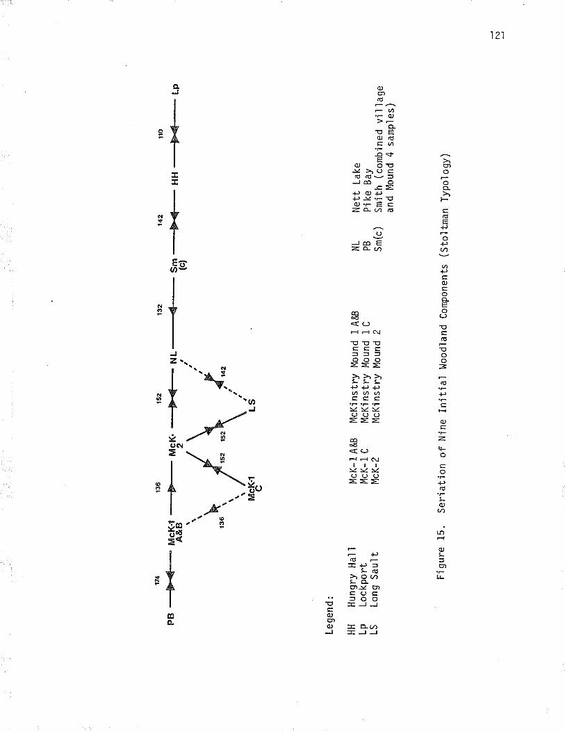
174
PB
--þ{
-
Lege
nd:
HH
Hun
gry
Ha1
'lLp
Loc
kpor
tLS
Lon
g S
au'lt
t32
NL_
_4__
t
Fi g
ure
15.
Ser
íatio
n
McK
-1 A
&B
McK
- 1
C
McK
-2
Sm (c)-Þ
<_
McK
inst
ry M
ound
1 A
&B
McK
inst
ry M
ound
1 C
McK
inst
ry M
ound
2
lto
HH
-MLp
of N
ine
Initi
al l
,lood
land
Com
pone
nts
NL
PB
Sm
(c )
Net
t La
keP
Í ke
Bay
Sm
ith (
com
bine
d vi
llage
and
Mou
nd 4
sam
p'le
s)
(sto
ltman
Typ
olog
y)
f\)

44.0
2 .
13B
.BB
cP-þ
-_LS
_&È
4-
Lege
nd:
CP
Cen
eter
y P
oint
HH
Hun
gry
Hal
ILp
Loc
kpor
t
136.
99
NL
-þ_
FÍg
ure
16.
Ser
iatio
n
Sm V
1315
8 70
7.42
12
556
"n -8
"4-
Lp --
---F
M
dP
t
LS Md
NL
Long
Sau
ltP
t M
ound
Poi
ntN
ett
Lake
of S
even
Inití
al W
oodl
and
Com
pone
nts
Sm
V S
mi th
Ví
1 ì
age
( Lu
genb
ea'l
Typ
o'l og
y)
f\) f\)

123
components within the defined phases tend to bond together more strongìy(with coefficients of 140 or greater usÍng the stoltman typology, or 13g
or greater using the Lugenbeal typology), that do those between phases.
This indicates that the Long Sault assemblage and Nett Lake are both latecomponents in the McKinstry phase. Interestingly, if McKjnstry Mound 2
is removed from the seriation using the stoltman typology, the Long Sauìtand Nett Lake assembìages are more strongìy lÍnked with one another thanthe Long Sault site i's with McKlnstry Mound 1-c, or Nett Lake wjth theSmith vîl'lage. The sample from McKinstry Mound z, it should be noted,was excavated by l.lilford in the late 1930s, using early techniques, and
may represent more than one component. The mound has been disturbed byploughing and pot hunting activities, which could have mixed the depositas well. In addition, the í'ntegrity of the samp'le could be questionedmerely on the fact that t't represents mound fill in secondary context.stoltman indicates that he belÍeves, however, that it is a s.ingleconponent.
The strong c'lusterlng tendency of the Long Sault and Nett Lake com-
ponents suggests that yet another ceramic phase could be defined in thearea, transitionaj between McKinstry and Smith phases, and dating afterMcKinstry Mound 1-c, (ca. A.D. 600), and before Smith (ca. A.D. 900). As
nany of the cerarnic attributes appear 'transitional' between McKinstryand Sml'th' it is likely that this phase represents only a very detailedsegment i'n a continuum as yet poorly known. Until more sites have been
excavated, it i's not possi'ble to establish this suggested phase. Untjlthat time, the Long Sault Initial Woodland component will be consjderedas a late component in the McKinstny phase.
Stoltman characterizes sites of the McKinstry phase as possess'inga h'igher incidence of Laurel Pseudo Scallop She'|1 type (greater than 21
percent, and often approaching 33 to 38 percent), and Laurel Bossed (22to 25 percent), than other Minnesota sites, and a lower incidence ofLaurel 0bìiq¡s (.20 to 23 percent). Together these three types constitute75 percent of l'lcKinstry phase rims. He also notes an increase jn thebossed and punctated subtype of Laurel Bossed, more Laurel Dentate, and
fewer Residual Plain rims în McKînstry Mound 2. These are also thegeneral characteristics of the Long Sau'lt Laurel ceramíc assemblage,

124
suggesting again that it s:hould be assigned a late McKinstry phase position.
Archaic - Initial Woodland Relationships
The Laure'l component has few apparent relationshfps with the under-lylng Archaic occupation, Although the range of ljthic raw materjalsexpìoited in the two components is simi'lar, the frequencÍes of differenttypes of stone dl'ffers considerabìy. This suggests different patterns ofI ithic resource procurement, possi b1y refl ecti ng di fferent preferences i n ,or know:ledge of stone types. liJhereas the fauna and chipped stone assemblagesi.n the Initial Woodland component ref'lect a focal economy.baseð on fish'ing,the Archaic economy seems geared toward a more even balance between huntingand fishing. There is no simÌlarity in settlement patterns, no¡in therelatíye frequencies of tool classes.
The jaik of correlation between the two components probabìy ref'lectsin part the length of tl'me that separates them. Whereas the Archajc com-ponent dates, at the latest, to about 500 8.C., the Initial Woodland com-ponent is per"haps some 1200 years later. The two components are separatedby a layer of virtual]y steriìe, fine light yellow brown sandy soiì,between three and ten centímetres thick. That this does not representmerely an isolated occurrence is indîcated by a strikingly similar occur-rence at the Snith habitation site, where
rrln almost all excavatr'on uníts a 'lighter, s'light'ry sandierstratum underlíes the black, c]ayey Laurel level. At thebottom of the sequence ís a rather thick layer whose con-sistency ls somewhat "heavÍer" and darker than the preceedinglevel, but not nearly as heavy or dark as the Laurei level"(Lugenbeal 7976: 118).
This hiatus probably coincides with the latter stages of a shÍft from dryconditions to cooler, moister conditÍons, and an'increase in black spruceforest cover which occurred between about 1500 B.C. and 440 B.C. (Reeves
7970:153, 155; Baerris et al. 1976), and may, Ín part, document thewestward withdrawal of Larter peop'les from the Rainy River area (cf.Buchner 7979; 724).
The Appearance of Laurel in the Rainy River Va'l'ley
The a¡ea of the excavations at the smith site, and the upper terrace

125
at Long Sau'lt, were not resettled untÍl middle Laurel times. l^lhile some
period of abandonment is possible, this is not to suggest that the Ra.inyRiver val'ley was totalìy uninhabited for the intervenjng centuries.Pottery representing the ear'ly Initìal l,loodland pjke Bay phase, oncebelieved restricted to eastern Minnesota, has been recovered from the fjllof the Armstrong Mound, a short distance downstream from the Long SaultsÍte (Kenyon 1970a), from Mound 1 at the McKÍnstry site, upstream from theLong Sau'lt site (stoltman 1974:86), and from several small sites recordeddurîng the Manitou Mounds Archaeological Survey (Arthurs 1976), demonstratingthat early ceramic components are well represented in the Long Sau'lt Rapidsarea. Although the beginnfngs of Laurel were once estimated to be between700 and 500 B.c. (t'lacNef sh 19sg: s5; t,lríght r97za: 59), stoltman (rg74: B9) ,has suggested that the pr'ke Bay phase may be dated ca. 100 B.c. to A.D. 300.A recently published radiricarbon date from a probable pÍke Bay componentat the exit of Lake of the Woods on the Winnipeg River suggests that thephase may begin slightly earlier than that in the area, perhaps ca. i50 to200 B.C. (RaJnoyich 1980a: 54-56).
Ptke Bay components díscovered to date appear to be small campsites,contnasting with the much more extensíve components of the later McKinstryand Smfth phases. They seldom appear to occupy the same locations as thelater components, nor does there appear to be continuity, in terms ofsettlement location, or artifacts, with earlier Archaic occupations (cf.Buchner 7979:107). This evÍdence seeas to suggest that pike Bay sitesrepresent the initial appearance of Laure'l in the area. One ínterestinghypqthesis has Laurej first entering the area west of the Upper Great LakesÍn conJunctÍon with the spread of wild-rÍce (Stoltman 1973: 6). ¡4ild-ricepo'l'len has been recovered from pollen cores in the transÍtional forest zonein northwestern l'linnesota, indicatÍng that this important graín appeared inthe area about 2500 years ago (McAndrews 1969 : r67J,), a date that woul dcorrespond with the first appearance of Pike Bay phase Laurel componentsÍn the Rainy River area. There is as yet, unfortunately, no directevidence to indícate that wild-rice was harvested by Initial lioodlandpeople in the area west of the Upper Great Lakes.
Another interestr'ng hypothesis attrÍbutes the appearance of theLaurel culture i'n the research area to a northward disp'lacement of popu-

126
lation out of central Minnesota. This Ís attributed to pressures createdby the florescence of the Hopewellian conrnunÍtîes, which arose in themajor rîver val'leys south of the Great Lakes in about the last centuryB. C. (Syms 7977a: 81, 83) . The Hopewel I Íans were fl ood pl aÍn hori ti cul -turalÍsts, who established large regiona'l centres and developed extensivetrade networks that brought in exotl'c items such as obsidian, copper, andshell, from widespread sources acnoss the contfnent. These exotic itemswere redistributed over an extensive area, and many consumed in an elaboratemortuary complex, which Íncluded burials Ínterred with a wealth of status-related grave goods, and the construction of ceremonial enclosures, and'l
a rge buri al mounds .
some researchers (l)lilford 1955: 135; Brose 1970: 93; stojtman r973:722), see the ultimate derivation of Laurel in the Hopewellian complexesof IllÍnois,0hio, and Michígan, citing the presence in Laurel of burialmounds, dentate stamped and bossed ceramícs, and exotic items such as
obsidian and native copper as evidence of this connection. Most currentresearchers, whÍle admittÍng to some kind of influence on Laurel from theHopewellian cor¡luni'ties to the south, view Laurel not merely as a northernextension of Hopewell, but as a separate entity in the transitional andsouthern Boreal Forest zones (cf. Griffin 1971 z 244; Fitting 1979: 109,112; Mason 1970; syms 1977a: g1). There is no evidence in Laurel forperrnanent settþnent nor for advanced social stratification, or thei.ntensive uti I ization of pl ant resources that characteri ze Hopewe'l'l .
whereas the early Hopewe'llian Havana phase pottery is dentate stamped,the earliest Laurel ceramics are dragged stamped. Dentate stamp does notappear in Laure'l untl'l the latter stages of its development. Exoticlithics such as obsidian ane quite rare on Laurel sites, and copper occursmainlY in the form of small utilìtarian tools (Webster 1973:104, i05).Burial mounds are a trait shared by Laurel , Hopewel I , and many otherlni.tial and Middle Woodland complexes in the Great Lakes area. l^lhile Laurelnound construction does suggest a relatively high level of social cohesion,it does not approach that observed in Hopewellian structures. Laurel burialsoccur as eÍther primary or secondary interments, often cremated or par_tlìa'lly charredr ôrd usualìy'lacking Ín grave goods. prepared burial pìat-forms of clay, and enc'losures or cribs of cut logs and brush, often partially

127
incinerated, are common attrÍbutes. The larger Laurel mounds appear tohave been constructed ln stages, over a considerable period to time.l.lhile these data do suggest the presence of a highìy developed mortuarycomplex fn the Rainy River area during Laurel times, this bears on'ly themost general similarities to the elaborate Hopewellian burial compìex.As Syms has suggested for the later Southern Cult manifestations in themÍd-continental area, the practice of mound burjal, and its attendantattributes, might better be viewed as "socÍo-religíous symbo'ls whichpermeated the value systems of many groups", than evÍdence for a djrectcultural connection between Laurel and Hopewe1l. it has been suggestedthat through the Malmo complex of north centra'l Minnesota (syms lg77a: 82)these traits and values were transmitted to Laurel.
It shou'ld be noted that burial mounds are not a universal Laureltrait, but occu¡4 principally in the Boundary Waters area, from WhitefishLake on the east (Dawson 1980), to southeastern Manìtoba on the west.The greatest density of mounds are on sites along the Rainy River, wherethey occur at the mouths of the major tributaries, and on the three setsof rapt'ds. Theîr presence may be explained Ín terms of the concentratjonof food resources avallable at these locations, which would permit theseasonal congregation of 'large groups of peop'le in the spring, and woul dfoster the reaffirmation of group ties through ceremonial and mortuary-related activÍties. The strategic 'location of the Rainy River, andparticularly the ìargest of the mound sÍtes at the mouth of the Big ForkRiver, and along the Long Sault RapÍds, on a major water route, wouìd be
a focal point for the coalescence of people, goods, and socio-religiousconcepts.
Laurel and the Hopewellian Interaction Sphere
Given that the RaÍny Rîver area appears to be a focaì point in thenetwork of major water routes, the degree to wh'ich Laurel participated inthe Hopewe'll ian Interaction Sphere shoul d be discussed. The Hopewe'l'ìianlnteraction Sphere was a logrlstics network, ín which'large quantíties ofspectfic Ítems¡ Fôw materials, and probabìy perishable commodities suchas food stuffs noved across much of eastern and centra'l llorth America.A nurnber of regionaìly distinct cultural systems, at many different levels

128
of complexity, were involved in it, to varying degrees (Struever 1973: 303,304). In restricted areas bordering the IllinoÍs,0hio, and Missjssippirivers, and in western MÍchÍgan, cu'ltures at a high'level of sophisticationparticipated in the exchange network, while in other areas, particu'lar1ynorth of the deciduous forest zone, there appears to have been only marginaìpartic'ipation on the part of the local cultures, if any at alì (Struever7973: 3i4). in these areas, evÍdence of Hopewel I ian infl uence is strongestalong the routes ieading to the source areas of the various materjalsincorporated into the Hopewellìan mortuary complex.
The strongest evidence of Hopewelllan Ínfluence jn 0ntario occurs atthe mound sites in the Rice Lake and upper St. Lawrence River area jn thesoutheastern part of the province, and in the southwest, on the shore of LakeHuron. Even here, in relatively close proxímity to the Michigan and ghiocentres , Hopeweì I ian i nfl uence appears restri cted I argely to the sel ecti veadoption of certar'n exotic items, such as silver and copper pan pípe covers,ear spoo'ls, and other apparent'ly status-related artifacts, and their in-corporation into local social and mortuary contexts. participation in theHopewe'llian Interaction Sphere ín these areas appears to have been ofrather brief duration (Spence et al. 1979).
In the transitional forest zone of the Upper Great Lakes area, Hope-wel'lian influences appear to have been at all strong on'ly in the earìystages of the development, and in areas closest to the sources of Hope-wellian trade items. This was the case especia'lly in northern Michiganand l.lisconsin, wherein were located the principaì sources of native copper,on the Keewenaw peninsula, and at Isle Roya'le (ritting 1979:109, IIz).Forming as it does an integra] link in a primary water route to the west,and to the source areas of two important Interaction Sphere commodites,obsidian and Knife River Flint, and lying in close proxÍmity to majorfaunal and floral resource areas which courd provide meat, furs, cedarwood and birch bark, and other perishable items not available farthersouth, a fair degree of Hopewel'lian influence would be expected in theLaurel sites of the Rainy River area. Discounting the burial mounds, whichmay ref'lect partÍcipation i'n a broader socio-religious framework, there issurprlsingly'little evidence for an Hopewellian trade connection. Interes-ting'ly, what little evidence there is comes from the area of the Long SaultRapi ds,

129
The three best known artifacts in the argument for an Hopewellianconnection are a projectile point, a cylindrical carved stone objectreferred to as a tubular plpe or a tsuckl'ng tube', and a monjtor stylepipe, a]'l recovered from the Armstrong Mound. The projectile point,whÍch is probably manufactured from Knife River Flint, is reminiscent ofthe Hopewellian snyders point type. The tubular pipe and the monjtorPipe, both of which are made of unÌdentified, non-indigenous raw materiaìs,possibly from Ohio, were also suggested to have had an Hopewellian o¡igin(Kenyon 1970a: 74, 76-78). These artifacts were recovered from the fjllof the mound, as was a large quantity of Laurel 0bìique (dragged subtype)pottery. As this pottery is believed to be typologîcalìy early, and a
radíocarbon date, run on carbon from the charred logs that made up theburial crib or enclosure at the base of the mound, índicated that it hacl
been constructed late 1n the Laurel sequence, about 4.0.940, the ceramicsand the artifacts identifÍed as Hopewellian were assumed to be contem-poraneous, unintentional inclus't'ons in the mound fill, scraped up fromthe floor of an eanìy Laurel vîl'lage (Kenyon 1970a: 82, 83). Unfortunately,Terminal Woodland artifacts and an Íntrusive burial were also present.inthe mound fill. As caches of later material which appear to representintentl'onal deposits have heen recovered from other Rainy River Laurelmounds (cf. l.lÍlford 1950a: 170; stoltman 1973; 12,13), the associationof the possÍb1e HopeweìlÍan artifacts with the earìy Laurel ceramics,though'likely, is necessarl]y tenous. As the rnound fill was removed withshoyels on the assumption that it would contain only village debrjs, thepossîhi'ltity that the artifacts represented an íntentional cache cannot be
inyestîgated.0bsi:dian is a major Interaction Sphere item, which has been found in
sma'll quanti'ties on sites across the upper Great Lakes area. Throughtrace elernent anaìysis, the source of this material has been narrowed down
to two bedrock outcroppings in the Yel'lowstone Nationa'l Park area of Wyoming(g)"ifftn et al. 1969). Most of the obsidian art.ifacts recovered are un-modifi:ed flakes, or at best, smalI retouched flake scraping too'ls. Most,unfortunately, were found either on the surface, orin disturbed context,often on nultl-component sites (cf. wilford 1950a:165; wright 1967:32Janzen 1968: 102; webster 1973: l0z; syms r977az z9). At least fíve

130
flakes of obsidian have been recovered from the Long Sault Rapids area,three from the surface, and two from a trowel-excavated test pit on theupper terrace at the Long sault site (Grttrtn et a1.1969; yarborough
and Arthurs 7973; Arthurs 1,976; Archaeological Survey of Canada Co'lìectÍons)One of the flakes recovered from the surface has been posìtively'identifiedas havi'ng come from Obsfdian ClÍff in Yellowstone Park (Griffin et al. 1969:13). unfortunate'ly, although those from the test pits are in probableLaure'l context, the association of none of these artifacts can be con-cl usfyely demonstrated.
The scarclty of obsidian, and the near absense of formal artjfacts ofthe materilal on Rainy River area sÍtes, argues against this as the majorroute by which thÍs material arrived in the area south of the Great Lakes.Reeves (19702 772,173) has suggested that the obsidian route'lay to thesouth, perhaps a'long the Missouri River. It is possibje that the smallquantities of obslldian on sites in the research area reflects a morelocallzed trade network, or perhaps the redistribution of this item fromthe Hopewellian centres to the south into the upper Great Lakes area.Internal exchange may also exp'lain the small quantities of copper foundon Laurel sites in the research area.
A more likely indicator of participation in the HopewellÍan Inter-action Sphere may be found in the distribution of Knife River Fljnt on
si'tes. in the anea. I{hile quite scarce farther to the east, and occurringin that area as an occasional scraper or projectile point, Knife RiverFlint appears to be fairly corrunon on Laurel components in the Rainy Riverarea. InterestÍngly, on the earliest of the Pike Bay components so faridentified, it appears to be absent (Ra¡novich 19g0a); however, 26 percentof the tools recovered from the fill of the Armstrong Mound were made fromthl's materilal, suggesting (although this must be tenuous as the material isfron secondar"y context), that Knife River Flint became an'important rawmaterial soon after the arrival of Laurel ínto the Rainy River area. About18 percent of the lithic raw material in the McKinstry phase Long Saultcomponent is Knife River Flint. The presence of this material relatjveto other stone types was found to be statistically significant, indicatìngthat it dld not occut' on-sí'te by chance. There is a continued decreasein the frequency of this raw materia'l in the Smith phase habitation at the

t3t
Smith site. InterestinglY, both of these components post-date the declineof Hopewel'1, which occurred between about A.D. 300 and S00 (Lugenbeal 1976:395). The evidence from the Armstrong Mound, though tentative, does suggestthat KnÍfe River Flint became an i'mportant raw material sometime in thePike Bay phase, but that the demand tapered off through time. This could per-haps reflect participatlon în the Hopewe'llian InteractÍon Sphere, which wasin operation at the time of the later stages of the pÍke Bay phase, betweenca. A.D. 200 and A.D. S00.
Reeves (1970:170,173), has made the intriguing suggestion that theBesant culture of the northern p1aÍns may have supp'lied obsidian and KnifeRiver Flint, and perhaps such períshables as bison hides and dried meat,to Hopewell and other eastern cultures in the first two centuries A.D.,perhaps in return for copper, antler pins, o1ive]1a, conch, and othershell ornaments. Laurel ceramics have been found, in apparent associationwith Besant artifacts, in south central Manitoba, implying that there waslikely some contact between the two cultures. l,lhile there is litile evi-dence for the obsidian trade Ín the Rainy River area, Knife River Flint Ísfairly co't"tnlqn. Interestingly, Reeves sees the disintegration of theHopewe'lì exchange network as responsible for the fragmentation of the Besantcu]tureal system into two regiona'l expressions about A.D. 300 to 500 (Reeves7970:159, 1974). This may correlate with the gradual decline in the pop-ularity sf Knife River Flint on sites of the McKinstry and Smith phases.
The presence of Knife River Flint on Rainy River Laurel sites night,the¡,be interpreted as evidence for Laureì participation in the HopewellíanInteraction Sphere. Considering its persistence long after the Hopewel'liandeclirìê, and the popuìarity of the material in Manitoba throughout prehistory,tìt may also refiect more localized systems of exchange. A study of therelati've distributions of this interestÍng raw material type with respectto others used on sites in the ml'd-continental area may well ÍndÍcatewhethen it occur s on'ly along the water corridor leading to the Hopewel'liancentres, or whether it has a broader temporal and spatía'l distribution inthe area west of the Upper Great Lakes. It is suspected that the lattermay have been the case, and that it wil'l , with detaiìed study, be poss.ib'leto demonstrate the presence of a number of widespread, Ínterrelated exchangesysterns, which were active not on'ly during the InÌtial l,loodland, but through-out prehistory (cf. Spence et al. 1979: 119).

132
Laurel Cultural Dynamics in the Research Area
l.lith the increasíng Ínterest i.n Laurel în all area.s west of the Upper
Great Lakes, there is now a great deal of information available as to thedating and distribution of Laure'l Ín the research region. The limÍts ofdistributîon of Laurel and related sÍtes corresponds closely with theecozone between the Great Lakes - St. Lawrence Forest, and the southernBoreal Forest. Throughout its hîstory, however, the boundaries of theLaurel culture appear to have shîfted several times. There appears fairìygood evidence for a northward expanslon of Laurel from an area somewhereto the south, to the edge of the Borea'l Forest, in early Laurel times.sites wîth typo'logÍca'lly early Laurel Oblique pottery, and with many ofthe earlier radiocarbon dates, occur for the main part in the southerlyportion of its range, in Minnesota, and ìn the easterly area of LakeSuperÍor. Laurel sÍtes have been reported in the southern Boreal Forestl'n both northwestern and northeastern 0ntarí0, as far north as the edgeof the Hudson Bay Lowlands (llright 1.967; Reid 1980b; Reid and Ross i981;Dawson 7976a; Po'llock 1975:14). These tend to be small components, whìchha've alnost Ínvarr'.ab1y yie'lded pseduo scallop shell decorated pottery, thehall mark of mÍddle period Laurel. There is good evidence that thesesites date to the beginnîng of the eight century A.D. (l^lilmeth 197g: 131;Ridd]e 1980:180). Late period dentate stamped and punctated potteryoccurs in the greatest frequencies on sites in the western and northwesternareas (Buchner 1979:51, 108; stoltman 1973; rg74; Hlady i970a: 106; MacNeish1958). It is interesting to note that the Notigi Lake site in northernManitoba, which has produced late coiìed pottery with cord wrapped stickdecoration, has also yielded one of the latest Laurel dates (Wiersum andTisdale 79.77). Thîs evidence appears to reflect, as Stoltman (lglq: g0)
and syms (tglla: 81) have suggested, an expansion out of transitionalforest zone into the Boreal Forest in ear'ly and middle Laurel tímes. Thereappears to have been a withdrawal from the northeast into the transitionalforest zone, and a displacement to the west in late Laurel times. The
temporal dynamics of these changes are not yet clearly understood.

CHAPTER VIIT
THT EMIRGENCE OF THE HISTORIC NATIVE GROUPS
The TerrnÍnal Noodland 0ccupations
Introductl^on
Due in part to probìems of stratigraphic separation, but also to thenature of the occupati.ons, the TermÍnal l.loodland occupations representthe most complex of the síters components. Present are two occupations,each probably spanning a number of years, the second following closeìy intÍme behind the first. In the absense of clearly defÍned stratigraphicseparation i.t was necessary to poo'l many of the artifacts for analysis,unfortunate because the occupations in all likelihood represent the presenceof different groups of peop'le. The ceramÍcs could be separated out withsome confidence; however such was not the case for much of the ljthic orfaunal materi'al. [.lÍth nore refined analysis of the less diagnostic artj-facts, it may be possÍble to more fully isolate the two TermÍnal Woodlandcomponents.
The Terminal woodland occupations are very rich, containing many
artifacts. The lower of the two appears to be the richer, and may be
dated to about A.D. 1000 - 1200 on the basis of stylistic similaritieswÍth other dated sites. The upper component Ís less rich in artifacts,but just as interesting in terms of its interpretation. It Ís very late,probab'ly between A.D. 1400 and 1600, and provides evidence of sjgnificantchanges in social and ethfc patterns in the Rainy River area during thelate prehistoric period.
Thirteen features are associated with the component, consistìng ofhearths, pits, and ash features. Although there were many more artifacts inthe lower occupation layer, there were nearly twice as many features in theupper occupation, suggesting utilization gf the upper terrace area of the sjte.
Among the artffacts recovered were a small awl-lÍke object of native
133

134
copper' several fragments from slender bone need'les, a modified beaverincisor too1, and a fragmentary unÌlateral'ly barbed bone harpoon. Mostof these appear to have been associated wÍth the Blackduck occupat-ionìayer. Also notable is the presence of a bison femur fragment, found inthe upper component. Bison ane not found in the faunal repertoire of thelocal area, suggesting that this specimen was procured elsewhere, andtransported to the site,
Resource Util ization
The Terminaì Woodland occupations see a dramatic shíft frorn a sub-sistence pattern heavily oriented toward the exploitation of fish resources,whích was the pattern in the InÍtial Woodland occupation, to one in whichmamrnals take precedence. The nange of specÍes present is much broader thanin the earlier conponents, and there is a striking trend toward the ex_
Ploitation of small and medium sÍzed fur bearing animals, particuìarlybeaver. An analysis of the frequency of beaver bone in the levels of theTerminal Woodland occupations indicates an increase Ín frequency towardthe upper component. A similar increase may be detected in the faunalassemblage at the smith site (Lugenbeal 1976:359,369,373), suggestingthat this was not an isolated occurrence. The appearance of beaver inthe assemb'lage at Long Sault, and of snow shoe hare, indicates that thesite was not occupied solery in the spring at the time of the sturgeonruns, but in the cold weathen months as well. This cold'weather occupationagain probab'ly occurs in the upper component. It is suggested that thisdata may ref'lect the shìft by late precontact groups away from strictìysubsistence oriented activities, toward the exp'loitation of fur bear.inganl'mals, the principal commodity of exchange in the European fur trade.
The lower Termînal woodland occupation appears to have seen thedecli'ne of the western connections which had provided large quantities ofKnife River Flint to the Initîal Woodland component, and the increasingutilization of low gnade quartz, and local rhyolites, cherts, and felsitesin lithic manufacture. In both occupations pebble cores are present, andalthough there is some indication of the bipo]ar technique, it.is by noneans as prevalent as on TermÍ'nal Woodland s'ites farther to the east(l'lcpherron 1967). There are interesting differences in the frequencies

.l35
of tool types, including a marked increase in the proportion of retouchedto utilized unifacÍal tools, and a gneater number of bifaces relative tothe earlier components at the site. This supports the faunal data insuggesting a shift away from a focal exp'loitatîon of ftsh resources, towardone based on a varfety of aquattc and land-based manrnals, and finally toone centening on the exploitation of medium and small sized fur bearinganlmal s.
Cenamic ßelationshÍps
unlike the Laurel cerami'c assemblage, whích appears to represent ahotnogeneous unf t, the Termtnal t¡toodland vessels represent several ceramiccomplexes. A strati:graphic analysis of the dÍstribution of vessels indicatedthat while the cord marked pottery (¡vÍth a few exceptions), was associatedwith the lowen occupation, the fabric împressed ceramics were associatedwi'th the upper component. Thl.s was supported by a y2 test, which indicateda signi'frìcant associatlon between the cord marked and fabric impressedpottery, and the lower and upper occupations, respectively.
A tyPologlical analysls demonstrated that the lower component is a
vintually pure Blackduck component, while the upper occupation ceramicsre]ate to several late prehistoric pottery compìexes, including selkirk andSandy Lake (Tabtes 36-39).
Table 36. Typoìogical Analysis of Terninal l{oodland Ceramfcs,Cord Èiarked Group
EvansType
L u genbea ìType -
cl uster core ? Varlety Tot¿ ìfx
Osufsen Cord & PunctateNett Lake Cord & PunctateSchocker Cord Impressed
l.laskish Vertlcal Cord & punctate
Nett Lake Vertlcal Cord
Nett Lake Plaln
Unk nol{n
Totaì
Banded la 6
lbIlc6
Non-banded 3a 5
3b
Plain 4a 3
4b
Unknown varlant
6
I2
13 18.57
9 l?.869 12 .86
12 17.14
I 11.43
16 22.86
I 1.43
2 2.86
II
6
o
5
2t30.00
14 35
20 .00 50 . 00
70 100.01
I00 .00

136
Tabìe 37, Typoìogtcal Analysis of Intermediate Cer:amfcs
Type Core ? Varlety Iotal
0sufsen Boss and Cord
Laurel Cord Hrapped SHck*
St. Croix Stamped/Onamla Series
Un known
Tota'l f
1 11.11
2 22.22
I 11.11
5 55 .56
t71r.11 77 .78
9 100.00
100.00
I11 .11
Table 38.. Typological .Analysis of Terminal Woodland Ceramics- Fabric rmpressed GroLp (HacNetsn Ciusiiii¿;;t;i,-",,
Type Core ? Variety ,tot.tJSturgeon Falìs FabricInpress ed
Sturgeon Punctate (one row)
Duck Bay pr¡nctate(multÍple row)
Hinnipeg Fabrfc ImpressedHare (undefined)
Un known
o
I
o
1
77
1-l
I
t7
28.57
3.57
3.57
60.71
3.57
Total ¡ L273.57 96.43
28 99.99
100.00
ttto unanalyzable specÍmens omitted from analysis

137
Tabì e 39. Typo'l ogical- Fabrlc Impressed
Analysls of Termlna'l l,loodland CeramlcsGroup (Lugenõeal Classf ficatlon)
Type Cl uster Co re Vari ety Ìotal *
Non-ban ded
Platn
Puncta te d
Unk¡ovrn
Tota I
3a
3b
4a
4b
6b
514 17.86
10.71
64.29
3.57
3.57
1
5
?
l33
18
1
I
f11 1
% 39.,29 3.57
28 100.00
100 .00
16
57.14
* two unanalyzable speclmens omltted from analysis
Intermedi'gte Ceramics. Fresent in the lowermost levels, lying belowthe Blackduck component, apparently on the interface between the Initialand Termlnal Woodland occupations, is a group of vessels which have beeninterpreted by many researchers as nepresenting the transition betweenInitial and Terminal l¡{oodland ceramics (Table 37; Appendix A, Table 41).Technoìogr'cal aspects of nany rtransítional' ceramícs, however, argueaga'[nst a dlrect'evol ution of Blackduck out of Laure'l . whereas bothLaurel and Blackduck vessels are well constructed, though differing con-siderably in paste characteristics, construction, shape, and decoration,manyintermedfate ceramics are crudely constructed, have poorly consolidated,blocky past' and large particles of tempering material. Whereas constructionshould, if they represent a stage Ín the deve'lopment of Blackduck potteryout of Laurel, be intermediate between rhomboÍdal coils and slabs, thesevessels are csnstructed of thick rounded coils, often wÍth a thick slip onthe surfaces to strengthen the fabric of the vessel. Decoration does notsuggest direct derÍvation from the fl'nely decorated Laurel vessels. Innorthwestern 0ntarìo and south eastern Manitoba, intermediate vessels arechatoactenized by decoration that is careless'ly app'lied, often using a toolcomprising a two-element cord, loosely twisted around a cylindrical core.Exterion bosses occur, as does textured surface finish.. Rim designs tendto be horizontal, ônd both I'tacNeish's and the present analysis have noted

138
the presence of rocker stamping on the bodies of some vessels, a designrelativeiy common on early Midd]e Woodland ceramics farther to the southand east, but unknown in the Initial Woodland ceramics of the researcharea (MacNejsh 1958: 155; Buchner 7979: 52),
It seem clear that this group of pottery does not represent an inter-mediate stage in the direct evolution of Blackduck ceramics out of Laurel.Technologically, they appear reminiscent of the Ear]y Woodland and earìyMidd]e Woodland pottery of southern Ontario. The crudeness of the.ir con-struction may reflect a lack of famÍliarty on the part of the potters wjththe characteristics of local c1ays. Reid (pers. comm.) has suggested thatthe intermediate ceramics represent the product of the co-mingling of twoestablished ceranl'c traditions. A'lthough thjs likely explains the presenceof Initial lrloodland technique e'lements on otherwjse Terminal Woodlandceramics occurring Ín later contexts farther to the north (cf. Koezur andwright 7976:16-18; Dawson 1976a;9s-97), this does not appear to be thecase in this i'nstance. An alternative argument, and one which appearsto be supported by the technological and stylistic crudeness of the inter-mediate potteny, is that they represent the earlìest adoption of ceramicmanufacturtlng technÍques by a previous'ly aceramíc peopl e. 0n the basis ofcurrent distributional evidence, it appears that the intermedÍate ceramicsare present in small numÞers main'ly on the ìarger sites in the Rainy River-Lake of the Woods drainage area. They may represent the earliest maní-festatr'ons of Blackduck, or perhaps Selkirk pottery (although the latteris less likely). It may be that the concepts of ceramic manufacture wereacquired by a hypothetical "aceramic Blackduck" group through contact withLaurel peop'ìe. Interestinglv, bossiDg, a common technique on the inter-mediate vessels, is a mid-Laurel characteristic, which gives way to exteriorpunctates in late Laurel. This might suggest that the early intermediatevesselS, ôfld those like the Osufsen Boss and Cord Type, which is recognizedas an early Blackduck type, may have imitated Laurel, or diverged from a
mid'Laurel base in the Rainy River area somewhere about A.D. 500 or 600.Recent radiocarbon dates, a'lthough they do not suggest such an earìy datefor Blackduck, do indicate the likelihood that the culture possessedsubstantially greater time depth in the research area than was previousìysuspected. There is also evidence for the apparent co-existence of Laureland Blackduck in more northerly areas, perhaps as late as the eleventh

139
or twelfth century A.D.
Following thÍs mode'l through, the Hungry Hall and contemporaneousAnderson ceramic phases of the lower Rainy River vaì'ley and southeasternManitoba areas, classified as late Laurel by Lugenbeal, and possessìng coììed,cord wrapped stick decorated ceramics, would likely bê, in thÍs ana1ysis,classified as early developments of Blackduck. As the hypothetícal "aceramicBlackduck" has yet to be identifÍed, this argument is not totally satisfactory.Also, it remains to be seen whether continuity may be established in the non-ceramic artifacts between Laurel and Blackduck. Buchner has presented a
convincing argument for contÍnuity in east central Manitoba, which mightwell argue against the present hypothesis.
Anaìysis of osteologica'l remains also argues against th'is hypothesjs.0ssenbergrs analysis of discrete cranial traits (Ossenber g lg74) indicatedthat her'rsouthern Blackduck" skeletal group was related to her Laurel series,Provfding substantÍal weight to the argument in favour of a Laurel-Blackduckcontinuum in north centra'l Minnesota. It is clear that the problem is morecomplex than most researchers have assumed, and requires considerable in-vestÍgation (particularly ín the non-ceramic aspects of the ,,late Laurel,,assemblages), before an adequate explanation may be advanced. There is,unfortunately, insuffÍcient data from the Long Sault sÍte to test thisspecul ati on .
Blackduck ceramics. Stylistical'ly, the ceramics from the lower com-ponent fall within the range of Blackduck. They include vessels with splayedlips, flaring rims, constricted necks, and globular cord marked bodies.Cord wrapped stick decoration predominates, in banded designs. Typologícal1y,the majorîty of the vessels may be classified as Nett Lake Vertical Cord,while 0sufsen Cord and Punctate and t,,laskish Vertical Cord and punctate Typesare also frequent (Table 36; AppendÍx A, Table 42, plate xIV). These cor-respond with Lugenbeal's plal'n, Non-banded, and Banded Types. It should benoted that the single coiled and corded vessel recovered, class'ifjed as0sufsen Boss and cor"d Type, was not included with the other Blackduck vessels,as ft aPpears to be associated with the Íntermediate ceramics, on the Inítjal -TermÍ.nal l.lood'land interface, and not with the main occupation layer.
In the absence of carbon dates from the component, and the lack of goodcomparative data from other sites, its dating is difficult. perhaps the

140
best ind'icator of the age of the lo'r¿er occupation is its relationship withthe Terminal Woodland occupations at the Smith sjte. The lower component
at Smith contains high frequencies of typologìca'lìy ear'ly bossed and corded
vessels, and of 0sufsen Cord and Punctate Type. Waskish Vertical Cord and
Punctate Type is also strongly represented (Lugenbeaì 19762 313). A singleradiocarbon date was obtained, of 1020t 65 B.P. (Lugenbeal 19762 602),yíelding an uncorrected date of A.D. 930. The upper Terminal Wood'land
occupation at Smith contains both cord and fabric impressed vessels, which
Lugenbeaì (7976; 1978), considers to be "late Blackduck". The fabric im-pressed pottery may also be classified as Selkirk. A series of carbon
dates were obtained from the late component at Smith, suggesting that thesite dates to the twelfth century A.D. These gíve a weighted average
of 807t39 8.P., or A.D. 1143 (uncorrected; cf. Lugenbeal 79762 602). A
comparison of type frequencies suggest that the Long Sault ceramics fallin an intermediate position between the lower and upper Smith assemblages.
The percentages suggest that it resembles the late component more close'ly,suggesting a date ín the vicinity of A.D. 1050 to 1100. The position ofthe Long Sault would appear to confirm the apparent trends in Blackduck
stylistics, which tend to become ìess complex through time, ranging from
obiique above horizontal banded cord wrapped stick motifs (the ear'liest ofwhich are bossed, while later ones possess punctates), to less elaboratemotifs consisting of cord wrapped stick ob]ique motifs, with widely spaced
punctates (Lugenbeal 1978). The attribute of vertical combing, which isquite common among the Long Sault ceramics, appears to be characteristicof the middle range of Blackduck.
Selkirk-ìike ceramics. Hhereas the lower occupations at Long Saultmay be considered a "pure" Blackduck component, the upper occupation isfar more cornplex. Present in this component are Selkirk ceramics, a few
Sandy Lake ware rims, a vessel .identified.as be'ing Duck Bay Punctate type,and a group of fabric impressed vessels which do not appear to fit intoexisting typologies (Table 38; Appendix A, Table 43). A x2 test indicatedthat Blackduck ceranics occurred in this occupation on'ly by chance.
A number of vessels may be classified as Sturgeon Falls Fabric Impressed,
a late prehistoric Selkirk type. ldhile most possess obìique cord wrapped
stick decoratÍon on the lip and exterior, one (plate XV b), has broad

l4i
cord wrapped stick impressions on]y on the lip. The fabric impressedexterior is undecorated except for shal'low, widely spaced punctates. Thjswas identified by G. RajnovÍch as Alexander Fabrjc impressed, be1ieved tobe a late prehÍstoric - early historic type descended from Sturgeon FallsFabric Impressed. It is generally undecorated, suggesting that the LongSault vessel falls in an întermediate position between the two types (MacNeish1958: i66-167 ) .
One vessel in the samp'le (plate XV c), which has several rows of punc-tates on the exterior, lras classified as a Duck Bay punctate vessel. Knownsites of the Duck Bay Complex (Snortland-Coles 1979), are concentrated inthe lowland area of central ManÍtoba. A late Termjnal l.loodland manifestation,Duck Bay has been dated between the twelfth and mid-thirteenth centuries A.D.(Snortland-Co]es 1979: 49,134). At the Aschkibokahn sÍte at the mouth ofthe Duck River on Lake Wl'nnipegosis, the only site at whÍch the pottery hasbeen found in any concentnation, it ap¡lears to occur in con.iunction withan extensive Termi,nal l^Joodland period , Blackduck occupation (cf. snor¡and-Coles 7979; Badertscher 1.978). The dÍstinctive punctated Duck Bay ceramicshaye been found Ín low frequencies on sites across the research area, usuaììyin contexts that apPear relatively late (Gíbson 7976: 17,1g; Badertscher1978: 68). Comparison wíth Blackduck ceramics show Duck Bay pottery to bedistinctly different, and it is likely that it Ís more closely related toSelkirk and Clearwater Lake, particular'ly in such attributes as unspìayedI i ps, sharply angl ed necks and shour ders , and '.i¡g -. presencò of fabri cimpressed sunface treatment. The recently defined Duck Bay punctate Typel{as' in fact, formerly classified as aberrant Sturgeon punctate, or asWinnipeg Fabric Impressed ware (cf. MacNeish 1958; Mayer 0akes 1970; Meyer1978b; Snortland-Coles 1979: ZZ).
Ceramics similar to Duck Bay pottery were recovered from the upperTerminal woodland occupation at Smith as well (Lugenbeal i976:299, pl.25,312). InterestinglY, a vessel a'lmost identical to these was found inFlound 4 at the Smith site, associated with a primary buríal. This wasidentified as Blackduck (stoltman 1973 z IZ, 126, pl. 5). Another vesselfron the mound, also identified as Blackduck, shows strikÍng sty1jsticsiinilariti.es to Duck Bay in îts rows of rectilÍnear stamp impressions, andcarinated shoulder. This vessel is a minÍature, recovered from a cache.

142
As stoltman notes, it is virtually identìca'l to one recovered b¡,Brycefrom the Grand Mound, iìiustrated in hÍs 1904 report, and is similar torecoverÍes made by wilford in McKinstry Mound 2 (stoltman 1973: IZ, 27,Fig. 10, 727, P1. 7; Bryce 1904:23). The sign'ificance of these will be
discussed below.
Several vessels in the component, classífied as Winnipeg Fabric Im-pressed ware variants (plate XV d-g), resemble Clearwater Lake ceramicsin that they are very thin, fabric impressed, and are generaì.ly undecoratedexcept for exteri'or punctates and a varíety of fip treatments; however,they do not fit comfortably into the Hlady (rg7r) typo'logy. The ratherstraight rim profile and interior lip notching on some of the Long Sauìtspecimens míght suggest similarities with Sandy Lake ware from farther tothe south, however it is becoming clear that fabric impressed surfacetreatment is a distinctively northern trait, rarely found in collectionssouth of the Rainy River (Lugenbear r978:49). pottery sjmilar to thjshas been recovered from the Ìllanipigow Lake area of east central Manitoba(Saylor 1977:24,44, pl. 19), and occasional sherds have been noted incollections from the Lake of the !.Joods area including, apparently, theSpruce Point site, a Selkirk sfte on western Lake of the Woods (Rajnovìch,pers" comm.). An interesting rim from the Rushing River park site is fabricimpressed, with cord wrapped stick impressions on the interíor edge of the'lip that produce a scalloped effect. The presence of historic materìalsuggests the site dates ca. A.D. 1600 to i650 (Reid and MacLeod 1980: 136-137) ' An examination of the extensive collections from Quetico provincíalPark revealed none of these fabric impressed lip decorated sherds. Nonewould appear to have been found in the Lake Nipigon area (Dawson 1976b;Filteau C.978)' A fabric impressed rim with interior lip edge notching wasrecovered from a site on the Albany River (Riddle 1980: 16g), and fartherto the east, Pollock (tgzs:22), reports smoothed over cord malleatedpottery, reminiscent of Clearwater Lake phase material, from the Duck Baysite jn the Nagagami River area. It is possible, then, that the late fabricimpressed pottery from the Long Sault site has affinitjes to the north andwest, or' more tentativeìy, to the north and east. It should be noted thatsome of the material from the Long Sauìt resembles material classified byMacNeish as Alexander Fabric Impressed (MacNeish 1958: 165, pl. XVIII 7),although other researchers viewing the material did not recogn'ize it as such.

I43
Interestingly, the material at Long sau'rt appears to be in the upperlevels of the Termjnal Woodland occupat'ion, and may postdate the Selk.irkpottery. Clearwater Lake pottery occurs in association with trade goods
on several sites in the northern and western area (Kehoe 7978:28-Zg; Meyer1978a : 37- 38; Hl ady 1970a: 111 ; I97I: 18, ZZ, 42, 47) .
sandy Lake ceramics. The last group of ceramjcs in the upper com-ponent may be classified as Sandy Lake ware. Representatjve of the recentìydefined Wanikan culture, the core area of whjch appears to be in the lakesregion of central Minnesota (Birk r977a; rg77b), sandy Lake pottery appearsin smal I quantities on sites along the Boundary l^laters from Lake Super.iorinto southeastern and eastern Manitoba. It occurs onìy sporadica'l ly on
sites farther to the north. Although maìnìy from surface co'llections, theindjcations are that it occurs quite late in prehistory, and perhaps in thehjstoric period along the northern fringe of its distrjbution (Arthurs 1978b).Recently a radiocarbon date of 470 t 250 8.p., or A.D. 1480, was obtajnedfrom carbonized wood in a pit contain'ing Blackduck, Sandy Lake and intrusiveLaurel ceramics on the Lady Rapids site, east of Rainy Lake. probable
French artìf¿6¡5 were recovered in association with Sandy Lake ceramics else-where on the site, suggesting that the Wanikan presence in the area spansthe sjxteenth and seventeenth centurjes (Callaghan n.d.a; Reid, pers. comm).
Lonq Sault and Smith. There appear to be several similarit'ies in theceramics between the upper Long Sauìt occupation and the ìate component atSmith. They include the presence of fabric impressed ceram'ics, some decoratedwith cord wrapped stick, and some of which are undecorated. Another simi-larity is the presence in both of the pottery simi'lar to Duck Bay punctate.As Lugenbeal has classified his fabric impressed material (which other re-searchers woul d des'ignate as sel ki rk) , as "l ate B'lackduck,, , typol ogi caìc0mpari sons are di ffj cul t. Compari sons on the bas i s of attri butes w.i I I beexarni ned bel ow.
There are several sìgn'ificant differences between the two components.0f note are the presence of Blackduck ceramics in the Smith sampìe, andtheir apparent absence at Long Sault, and the presence of Sandy Lake potteryat Long Sau'lt, whereas it is absent from the Smith collection. These djf-ferences suggest that the Long Sault occupation postdates that at Smith.The presence of ceramics, such as the Sandy Lake ware and the unclassjfied
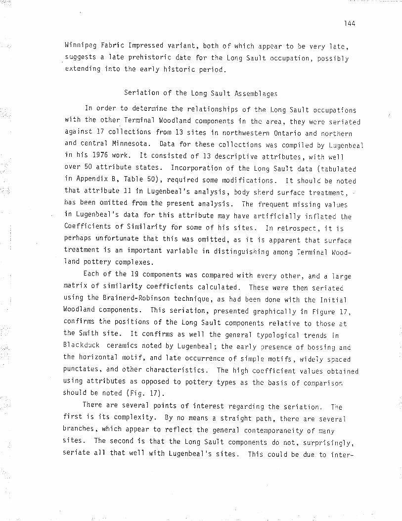
144
l'ljnnipeg Fabric Impressed variant, both of which appear to be very ìate,suggests a Iate preh'istoric date for the Long Sault occupation, possìbìyextend'ing into the ear'ly historic period.
rn .rder,:'::::::;,:'i:":;ï, :::l;,:':;':;:'::.s sauì, .ccupa,i .nswith the other Terminal Woodland components in the area, they were seriatedaga'inst 17 collections from 13 sites in northwestern 0ntario and northernand central Mjnnesota. Data for these collectjons was compi'led by Lugenbeaìin his 1976 work. It consjsted of 13 descriptive attrjbutes, with weììover 50 attribute states. incorporatìon of the Long Sault data (tabulated'in Appendix B, Table 50), requ'ired some modifications. It should be notedthat attribute 11 in Lugenbeal's analysis, body sherd surface treatment,has been omitted from the present ana'lysis. The frequent missing valuesin Lugenbeal's data for this attribute may have artificially infìated thecoefficients of s'imÍlarity for some of his sites. In retrospect, it isperhaps unfortunate that this was omitted, as it'is apparent that surfacetreatment is an ìmportant varíable in distjnguish'ing among Terminal 14ood-
l and pottery comp'lexes.
Each of the 19 components was compared with every other, and a ìargematri x of s imi I ari ty coeffi cj ents cal cul ated . These were then seri atedusing the Brainerd-Robinson technique, as had been done wjth the in.itialwoodland components. rhis seriat jon, presented graphicaì ìy .in F.igure 17 ,confirms the positions of the Long Sauit components relative to those atthe Smith site- It confirms as well the genera'l typoìog'ica'l trends inBlackduck ceramics noted by Lugenbeaì; the ear'ly presence of bossing andthe horizontal motif, and late occurrence of simpìe motifs, wideìy spacedpunctates, and other characteri sti cs . The hÍ gh coeffj cj ent val ues obta.i nedusing attributes as opposed to pottery types as the basis of compar.isonshoul d be noted ( Fi g. It) .
There are several poi nts of i nterest regardi ng the seri ati on. The
fjrst is its compìexity. By no means a straight path, there are severalbranches, which appear to reflect the genera'l contemporaneity of many
sites. The second is that the Long Sault components do not, surprisi'ngly,serjate all that well with Lugenbeal's sjtes. Ihis could be due to inter-

145
observer error, or to the fact that the Long Sauìt collections representstati sti ca'l1y der"j'ved sampl es, whereas a number of the others are surfacecollections, or from contexts such as mounds, which are l.ikeìy to be mixed.Third is the rank and geographÍca'l dÍstributjon of the sites. The earliestsites, w'ith the exception of Nett Lake (ball park sample) and the samplefrom Hungry Haìl Mound 1, tend to cluster in central Mjnnesota, and nearthe headwaters of the Mississippi River. Components in the midd'le rangeof the seriation include those farther to the east, in the upper RainyRiver - Rainy Lake area, while the latest sites are jn the western RaìnyRiver area and in the Red RÍver drainage. The lower Long Sauìt occupationseriates in the middle part of the sequence, between McKìnstry Mound 2 andthe collectjon from Pithers Point. The lower component at the Smith siteìs far "earlier" than the Long sault, while the upper occupation at Smjthis slight'ly "later" in the seriation. The. positíon of the lower Long Sauìtcomponent suggests a date of perhaps A.D. 1050 to 1100.
The seriation also confirms the late positfon of the upper Long Sauìtoccupation, which falls after the Smith component, and is most closely re-lated to the sawmill sample from the Nett Lake site. Its coefficients,which are relatively 1ow, suggest that Ít is only marginally related tothe components ín the ceramic sequence, perhaps to be explained by thepresence of the Sandy Lake and unÍdentified fabric impressed pottery atLong sauìt. It Ís 'interestíng to note that Lugenbea'l found his ,,lateBlackduck" component to differ in its ceramjc attributes from the earljeroccupation as wel I (Lugenbeal 1979: 4g_49). A.l though this suggests thatboth components might be Selkr'rk, a seriation calculated of the se'lkirk potterytypes between the upper Long Sault ceramics and sjtes in the Lake of thewoods area (rig.18), fared poorìy. Again, thfs may probabìy be attributedto the cosmopo'litan nature of the component.
Termi nal Woodl and Cul tural Dynami cs
Blackduck ceramics. The results of the Long Sau'lt ceramic ana'lysisadds some interesting new data to the interpretation of Terminal Woodlandcultural dynamics across the Upper Great Lakes area. Blackduck ceramics,like Laure], are found over a broad area north, east, and west of theupper Great Lakes. The broad distribution of Blackduck pottery has
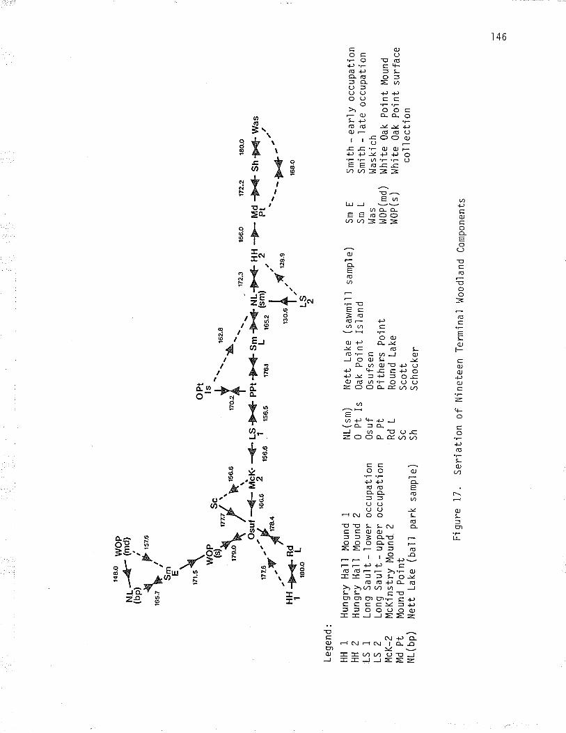
r48.
O
{ro
s.z þ
iS
m E
w(
'9 Þt,
\rz
r.s\ w
oP "':'s
h'/"
tu**
osur
-{-
rut'c
x.
.":'w
"þo'
uou
2
!H -
ø-a
- 10
r80.
o
157.
6
Lege
nd:
HH
1H
H2
LS1
LS2
McK
-2M
d P
tN
L ( bp
)
Hun
gry
Hal
1 M
ound
1H
ungr
y H
al ì
Mou
nd 2
Long
Sau
lt -
low
er o
ccup
atio
nLo
ng S
auì t -
upp
er o
ccup
atio
nM
cKin
stry
Mou
nd 2
Mou
nd P
oÍnt
Net
t La
ke (
ball
park
sam
ple)
oPt
ls *,r
o.?
-41-
s#4
ppt
156.
6 1
'ua.
,
--
162.
8')4
. \
3>{þ
Sm
176r
L
NL (s
m)
Net
t La
ke (
saw
mi I
I sa
mp'
l e
)0
Pt I
s 0a
k P
oint
Isl
and
0s u
f 0s
ufs
enP
Pt
Pith
ers
Poi
ntR
d L
Rou
nd L
ake
Sc
Sco
ttS
h S
choc
ker
---
.172
.3
+€
NL-
þ-@
¡1¡
-¡
,uu.
(*)
' 2
,"o.
u $
.,,ø
' ,ru.
"
LS 2
Fig
ure
17.
seria
tion
of N
inet
een
Ter
min
al w
oodl
and
com
pone
nts
166.
0
--Þ
- M
dP
t
172.
2 18
0.0
-Þ4
Sh@
was
a:2--
-þ4.
-'
168.
O
Sm
ES
mL
l^la
sI^
JOP
(md)
I^JO
P(
s )
Sm
ith -
ear
ly o
ccup
atío
nS
mi th
- I
ate
occu
pat'i
onW
aski
chl^
lhi te
0ak
Poi
nt
l'1ou
ndl,J
hite
0ak
Poi
nt s
urfa
ceco
l I e
cti
on
è O)
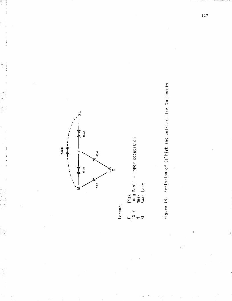
¿-
/\ ,,\M
----
Þe-
F
---*
!4._
sL
\/
147.
8
----
Þ<
4
Lege
nd:
F
Fis
kLS
2
Long
Sau
lt -
uppe
r oc
cupa
tion
M
Mee
kS
L S
wan
Lak
e
LS 2
Fig
ure
18.
Ser
iatio
n of
Sel
kirk
and
ser
kirk
-'lik
e co
mpo
nent
s
Þ !

l48
indicated to many researchers that Blackduck is the pre-emínent ceramiccomplex in the woodlands of northern 0ntario. An examination of theevidence now available, however, indicates that, far from be.ing homo_geneous, the spatìa'l and temporal distribution of Blackduck is quitevariable across this vast area. This does not suggest contemporeousoccupation of the entire re'þion by Bìackduck peopres, but a situat.ionmuch more compiex, involving, in al'l probabi'lity, seasonar expìoitationof wi deìy separated resource areas , trade, and popuì ation movements acrossthe transitíonal, borear forest, and praìrie ecozones.
In the Rainy River area, Blackduck culture persisted from at leasttheejghth century 4.D., to the late prehistoric períod. To the south, .in
central Minnesota, where some of the typolog'ica'lìy earliest Blackduckceramics are found, there appears to have been a complete rep'lacement ofBlackduck by the wanikan culture, represented by sandy Lake ceramìcs,about A'D' 1100 to 1200 (Cooper and Johnson 1964; Rackerby IglS; Lugenbeaì7976: 4rB; 7978:4s, 50, 51; Birk r977a; rg77b; Anfinson r979:175). Thissuggests a northward contraction of the southern limits of the Blackduckdistribution at that time. At the smith site, and at the Long Saurt, theBlackduck occupations were repìaced by seikjrk or Selkirk-like occupatìons.The series of carbon dates from the smith site, and the presence of Black-duck andSelkjrk ceramics in the same component, suggest that this may havebeen a graduaì process, which occurred in the earìy thirteenth century(Lugenbeal 1976: 602). The absense of Blackduck pottery in the upper com-ponent at Long Sault indfcates that the Blackduck culture had left thesite by about A.D. 1400. The presence of sandy Lake pottery at Long sauìt,and on other sites along the Boundary waters, suggests that penetration ofthe area by the ldanikan curture foilowed, natherr than being dr.rectìyresponsjble for the withdrawal of Blackduck from the Rainy River vaììey.
l'Jhjle Blackduck occupations are repìaced by Se'lkirk at sites on theRainy River' in areas to the west and north this does not appear to happen.Blackduck ceramics occur on several selkirk sites in the Lake of the woodsand winnipeg Rjver areas (Rajnovich and Reid 197g; Reid 1980b:225,226),and there are Blackduck sites, the dates of whÍch appear to extend into theearìy fifteenth century, to the north and west aìong the ecotone on thesouthern edge of the Boreal Forest in Manitoba. There is no firm documentation

149
as to whether these occupations extend into the historic per.iod (Lugenbeaì1976: BB; Hlady 1970b:280; Syms 1977a:101, 136; snortland-coles 1979:49).A small number of Blackduck sites ¿¡s reported in the aspen parkìand, on theprairie fringe farther to the west (Joyes 1969; Syms r977a: 136). The pre_sence of bossed and cord marked pottery, and radiocarbon dates as earìy asA'D. 800 (Tjsdale 1g78: 100, pl 17a), suggest utjl ization of the prar-r.iefringe by Bìackduck people, possibiy on a seasonal basis on bison huntingexpeditions, throughout much of the culture,s existence.
Blackduck sites are distributed across the transitional forest zonebetween Lake of the Woods and the northwestern shore of Lake Superìor.They appear to have substantial tÍme depth throughout this area, extendìngto at least one site, the Martin Bjrd site on whitefish Lake, into thehistoric period (Dawson r977bz 73; r9r4 r97s:34). North of thìs area,Blackduck occurs in small quantities on severaj sjtes, usualiy in con-junction with fabric impressed ceramics (Dawson 1975 : 36; r976a: 7B;Riddle 1980; 1981). Although this fabric impressed pottery is general'lydescríbed as "Selkírk", it is likely that'it represents one or more reìated,yet regional 1y di sti nctj ve compì exes . Both Bl ackduck components , and Bl ack -duck ceramics on sites in apparent assocjation with other ceramjc compìexes,occur on Lake Nipigon (Dawson 1976b; Filteau 1979). East of Lake Nipigon,however, the distribution of Blackduck pottery js largely restricted to anarrow corridor along the north shore of Lake Superior (Syms 1977a: 98).Extensive survey in the area immediately to the north, while quite pro_ductive in sites, has yielded very few with Blackduck components or ceramjcs(Newton et al . 1976; Hems 19g1; Riddle and Smith 1981; Hill n.d.; Hiìt andHems n. d. ) .
Blackduck ceramics have been found on several sites on the north shoreof Lake superior. These incrude the N.L.R. wolfe sÍte, near the mouth ofthe Little Pic Ríver, the PÍc River s'ite, the Nyman and Morríson sÍtes atthe mouth of the Michipícoten, and at several sjtes at the east end of thelake, inc'luding Sand River, and whitefish Island (wright 1966; 1967:76;1968a; Dawson r976c; Newton et ar. 1976:190; conway r97l; pers. comm.).To the northeast, Blackduck ceramics have been recovered from sites onMissinaibi Lake, and on the Missinaibi River (pollock 1975; Arthurs n.d.b),and to the east at the Juntunen site in northern Lake Míchigan (Mcpherron 1967)

150
from sites on the north shore of Lake Huron, and along the Mattawa and0ttawa rivers into Quebec (Ridley 1954; Dawson r979; t,lright ig65; p. l,Jright,pers' comm.). 0n these sites, the Blackduck pottery is found, usuaììy insmal I amounts, in association with representatíves of several other cerami ccomp'lexes and traditions, íncìuding Mackinac, Juntunen, and Iroquoian, incontexts that often appear to be either late prehistorìc, or early historic.The apparent contemporaneity of ceramics of several traditions has beeninterpreted by some researchers to reflect participation by the inhabitantsof the sjtes in several ceram'ic traditíons, either through intermarriage,or diffusion or imitation (wrigrrt 1g65; 1968b: 50; Dawson 7979: 14, 17,27). These interpretations are based in part on the assumptíon thatpotttery resembling Iroquoian ceramics found on sites beyond the normalrange of the Iroquoian ceramic tradition represent imitatÍons, made by thelocal populace. An examination of many of these vessels has jndicated thatwhile styìistically most are'indistinguishable from those found on sites jnsouthern Ontario, the paste is often very crude (conway 1980:18). Ifthese vessels were locally made imitations of foreign wares, it wouìd beexpected that the reverse would be true. It stands to reason, therefore,that the majoríty of these vessels represent the work of Iroquoian peoples,working with clays the properties of which they were not famjliar. t,Jhilethis may reflect the acquisition of Iroquoian brides by patr.ilocal A1gonk.ianhunters, as has been suggested by some researchers, such an involved ex-pì anation j s unnecessary. An examination of- the I ocatjonal data demonstratesthat the sites upon which the various exotic ceramic trad.itions, incìudìngBlackduck, ârê represented, lie at strategic locations along the main routesof the early fur trade. Most of them have earìy historic components. Thisevidence strongìy suggests that these sites served as rendezvous sjtesassoci ated wì th the European fur trade. Brose (1970 : 216) , has sim.i'la11yinterpreted the presence of representatives of several ceramic tradjtionsjn the protohistorfc component at the Summer Island site on Lake Mjchigan.
Ïhe radiocarbon dates and ceramic associations for the sites on easternLake Superior suggest that many of these components may predate the periodof contact lìn the Upper Great Lakes area, and that utjlization of theselocations as trade rendezvous may extend far back into prehistory. Thepresence of Blackduck and Pickering ceramics, in apparent associatjon, at

I sl
a few sites, jncluding the Frank Bay site on Lake Nipiss'ing, and the pjc
River site on the north shore of Lake Superior (Rid'ley 1954; l,Jright 1966),suggests contact as early as the eleventh centurJ, A.D. possib'ly Blackduckwas suppìying furs, dried fish, or other items to iroquoian peopìes fromsouthern Ontario, perhaps in exchange for corn or other produce from these earìysouthern 0ntario agriculturalists" There is, interestingìy enough, ethno-graphic evidence for such a pattern of exchange between the Huron andAìgonkian groups on Lake Huron in the earìy hjstoric pe¡iod (Hejdenreich1971: 277; Trigger 1979 : ZZ0) .
While Blackduck pottery occurs on several early components in the area,it is absent from later historic components in the eastern Lake Super.iorbasin, such as the uppermost component at the Michip.icoten sjte. Thjssuggests that the Blackduck culture had withdrawn, prior to about A.D.,l600, to the region west of Lake Superior. There are some apparentìy'latesites just west of the lake. Though fjrm evidence is'lacking, it might be
speculated that in its latest stages, B'lackduck was disp'laced to theextreme western portÍon of jts distrjbutjon, on Lake of the l¡loods and beyond.
Sel k j rk dynami cs . The Se'l ki rk cerami cs o f the upper Termi na l l,loodl andcomponent at t'he Long Sault site be]ong to a major Terminal Woodland com-plex, the distribution of which centres on the I^linnipeg R'iver - Lake of theWoods area of eastern Manitoba and northwestern 0ntario. Selkirk and B'lack-duck ceramics, which share several decorative elements, notably the use ofcord wrapped stick decoration,are frequentìy found together on sites in thisarea. Selkjrk ceramjcs occur on only a few sites in northern M'innesota,where they have been identified as late Blackduck ceramics (Evans 1961c:56; Lugenbeal 1976:476;1978). In areas farther to the north, however,Selkirk pottery'is found in pure components, indjcating that a convergence,and not an evolution, ìs represented in the relationship between Selkirkand Bl ackduck - Interesti ngìy, though once bel i eved to be a I ate preh i stori c
and early hìstoric ceramjc complex, selkirk ís now known to have been
contemporaneous with Blackduck throughout much of prehìstory (Rajnovich and
Reid 1978:46; Reid r977b: 33, 34). Many Seìkirk sites are, however, 'late
prehistoric or historic in date. Although its core area appears quiterestrjcted, Selkirk material has been recovered in small quantities fromsites in the Lake superior area (wright 1966; Dawson r976c), indicat.ing

)52
that, like Blackduck, this culture briefly extended its range eastward jnthe I ate prehistoric and earìy historic periods, probabìy refl ecting ítspartîcipation in the earìy stages of the fur trade.
The heterogeneous character of the upper Terminal Woodland component atLong Sau'lt, which contrasts markedly with the Blackduck component beneath it,appears quite similar to the situation on several major sjtes jn the easternLake Superior basin, and on sjtes farther to the north and east, at comparabletimes Ín the past. Together, they represent a major phenomenon jn míd-con-tinental cultural history. In the eastern area, the hypothesis has beenadvanced that this represents the coalescence of related and unrelated groupsat common base camps, or at rendezvous sites for groups engaged in a
European-stimulated fur trade. The presence of several ceramjc groups atLong Sau'lt may be interpreted'in a sjmilar manner, espec'ia'liy cons.ideringthe late date of the component and the substantial shift that occurred inthe economic ori'entation of the upper Terminal Woodland component, towardthe jntensive expìoitatjon of fur bearing animals. It could also be inter-preted, however, to represent the rapid replacement of one cultural groupby another, during competition for control of the Rainy River corridor, andaccess to the fur lands of the mid-continent, at, and in the decades priorto, the arrival of European fur traders in the interior. There js a co¡-siderable body of historical data on the djstribution and movements of nativegroups through northwestern Ontario and adjacent areas during the early furtrade period, which may be offered in support of this hypothesis. Th.isevidence will be presented in the sectjon dealing with the interpretatìonof the historic component at the Long Sault s'ite, and evaluated at that time.
Terminal [.loodl and Mortuary pract.ices
Before turning to the Historic component, a word should be said con-cerning Terminal Woodland burial practices in the Raìny River va'lley, whichhave long been a source of confusion. Several researchers (cf. l,lilford1950b; Stoltman 1973), have'interpreted the elaborate mortuary comp'lex, thetraits of which include both primary and bundle burials in mounds, the per-foratjon of long bones and crania, application of cìay to the apertures ofthe skul'1, the liberal use of red ochre, and jnclusjon with the burials of a
wide range of grave goods, most notably miniature "mortuary" vessels, to be
Blackduck traits, derived from Laurel. A re-examinatìon of the evidence

153
(Arthurs 1974), suggested that several of these features did not occur jnLaurel , but were excl usively Terminal Woodland. This was particular'lythe case with the perforation of long bones and crania, and treatment ofthe skull w'ith clay. Comparison with other Terminal l,loodland assemblagesindjcated broad similarjtjes across the Upper Great Lakes area. ThesecharacteristÍcs, it was suggested, represent a distinctive mortuary compìex,associ ated wi th the Bl ackduck cul ture.
New evjdence, and the identjfjcation of a major, ìate prehìstoric,Selkirk presence in the research area, indicates that a refjnement ofTerminal l{oodland burial practices is now necessary. This was foreshadowedby 0ssenberg's (I974) milestone study of upper Great Lakes skeletal popu-lations, which, at the tjme of its publicat'ion, created several interpreta-tjonal probìems for archaeologists. In comparing d'iscrete cranial traitsof skeletal samples from burial mounds across the research area, she de-termined that there were two distínct popuiatjons associated wjth thematerjal cul ture bel ieved to be Bl ackduck. Her "southern Bl ackduck,, group,comprising crania from the 0sufsen and Schocker mounds in north centralMinnesota, though relatively close'ly re'lated to the Laurel skeleta'l sample,was d'istinctly different from her "northern Blackduck,' group. The Iatterwas derived from the burials in McKinstry Mound 2, and Mound 2 at the HungryHall site, both on the Rainy River. This group showed no relationshipswith Laurel. This led 0ssenberg to suggest that the northern group rep-resented an intrusive population with Al gonkian affjnitjes, whjch hadentered the northern Minnesota area about A.D. 800. This intrusion wasseen as a possible cause for the divergence of the "southern Blackduck"and "Manitoba phase" skeletar groups, which, though not highly sÍmilar toone another, both appeared to have their bio'ìogicaì ancestry in Laurel.Interestjngly, 0ssenberg found that the southern Blackduck group was veryclosely related to the historic Dakota skeletaì group in its discretecranÌal traits (0ssenberg 7974: 35, 37, 3g).
The possÍbility that more than one ethnic group was responsibìe forthe Blackduck material culture has created some serjous interpretationaldifficulties. An examinat'ion of the archaeological data, however, suggeststhat it is the identification of the material culture, rather than thebioìog'ica1 material, that is in error. The evjdence suggests that Hungry

154
Hall and McKinstry Mound 2, the sources of the "northern Blackduck" samples'
are sjmilar to one another archaeologicaily, yet quite distinct from the
mounds in the ',southern Blackduck" group. McKinstry 2 iS an accretionary
mound whi ch contai ns an apparent I n'it j al l¡loodl and component i n the I ower
mound level, over which a second' larger structure was built' The burjals
in the upper mound levels, many of whjch were primary'interments' included
skulls with clay packed orbits, and with clay "maskettes", wh'ich' although
smooth on the exterior, bore the impressions of teeth and fabric or cord
on the interior. severar skuils arso exhibited perforation of the occip'itaì
bone. l^lilford, who excavated the mound, noted that these traits were
unusual for Blackduck, and suggested that they had originated'in Laurej
(ì^lilford 1950b:235). Although it js unclear from the descrjption' one of
the burial features in the upper mound appears to be a deep p'it, dug down
through the lower mound into the subsoil '
Several small mortuary vessels \¡rere interred wjth the remains' It is
interesting that Lugenbeal (1978: 49,51), has noted that the majority of
these vessels, which are smooth surfaced, ffiäY be attributed to middle' or
to hiS "late Blackduck" phaSeS. As has been discussed above' "late Black-
duck" i s primari I y Se'lk'irk, and simi I ari ti es have been drawn between the
yessels at McKìnstry Mound 2, smith MOund 4, and the Grand Mound' These
vessels all may be classjfied as Selkjrk, or punctated Duck Bay pottery
(cf. Stoltman 1973:19). 0f possible significance too is that Bryce' during
his d'iggings in the summit of the Grand Mound in 1884' recovered two crania
with clay filled orbjts. Both were covered wìth red ochre (Bryce 1904: !7,
23). These might have been assocjated wjth the linear stamped mortuary
yessel recovered during the same exped'itjon'
Hungry Hal'l Mound 2 Wasremjniscent in its construction of the upper
mound level at the McKinstry s'ite. It was a small mound, on'ly ten metres
in diameter, and less than a metre in height' it consjsted of an un-
stratjfied heap of black earth contajnìng viì'lage debris, overiying a deep
burial pìt sunk deep ìnto the subsojl ' The charred remains of pine poles
whjch had fallen'into the pit suggested that the chamber had been void
when roofed w.ith the beams, and that fi res had been i gn'ited on the ground
surface prìor to the construction of the mound (Kenyon' pers' comm')'
!¡|'jthin the pit were the disartjculated remajns of approximately 11 juveniles

l5s
and nine adults (cameron n.d.: 1). These bore n.icks, scrapes, and cutmarks, indicatjve of dismemberment, and some appeared eroded, suggestingthat they had been exposed, perhaps on scaffolds, prior to.interment.
Lying in two clusters on top of the mass grave, were seven skuì'ls,the orbits, nasa'l apertures, and paìate, and occasionalìy the temporalarea packed with clay. l.lhite discoidal shel I beads had been placed ìnthe clay of the orbits, and the entire cranium th'ickìy encrusted with redhaematite pigment (Kenyon J97I:38). A portion of the occipita.l bone hadbeen removed from three skulls, simjlar to those from McKinstry and Sm.ithMound 4- As with the other burials, fires which had been built on thesurface had oxidized the earth, and charred some of the remajns. Two smallmortuary vessels were recovered from the pit, but other grave furnishingswere scarce (Rrtnurs 1974: 6),
The other mound at Hungry Halì, Mound 1, was a more compìex structure.Like McKjnstry 2, Ít consisted of two construction stages. A lower moundcovered a shallow pit scooped from the subsoil, wh'ich was found to contajnbundle burials. At a later date, a circular shaft, two metres in diameter,had been sunk down through the orjgìna'l mound, and the bones encounteredduring its excavation scattered over the surface. The pít, which was ljnedwith birch bark and roofed with poìes which had been charred by fires bujlton the surface of the lower mound, contained a mass grave of perhaps 42disartjculated individuals. Although cleaning has destroyed a'l I trace ofthi's' some of the individuals had clay packed cranial apertures (Kenyon,pers' comm.), l1 of 24 skulls exhibited occ'ipita'l performation. Several'long bones had also been perforated. Interred wjth the burials were a
tubular stone pipe, cut shell gorgets, and 13 mjn.iature vessels.The two Hungry Ha11 pit burials are very close in age. Materjal from
the pit in Mound i is dated A.D. 1130t 65, while material from the Mound 2pi't dates A.D. 1190t 60 (l.lilmeth 1978: 124). Ihese dates are both withinthe range of the "late Blackduck" component at Smith, which range betweenA.D. 1065t 60 and 1280t 50, with a weighted mean date of A.D. 1i43t 39(uncorrected dates; cf. Lugenbea'l I976: 602).
There are several other references to non-Blackduck artifacts and burialsin the Rainy Ri'ver mounds. A cache from smÍth Mound 4, for instance,contained a number of artifacts, includìng a tubular stone pipe and a

156
fabric impressed vessel which may be classified as Sturgeon Falls FabricImpressed, or Alexander Fabric Impressed, both Selkirk types. A clamshell in the cache yie'lded a date of A.D. 1350t i20 (Stoltman 1973: 13,726, Pl. 6). A primary flexed burial, also in the mound, was interredwith several grave goods, and a fabric Ímpressed vessel whjch, althoughclassified as Blackduck by stoltman, is selkìrk, or poss.ib.ly Duck Bay(cf. stoltman 1973:72, 126, pr. s). The presence of late ïermjnal wood-land SelkÍrk or Selkirk-like burl'als and caches, then, in the Ra.iny Rivermounds is wel'l establÍshed. Correlating the archaeoìogicaì and osteoìogicaldata' it would appear that certain traits, such as the perforat.ion of longbones and crania, appiication of clay to the orbits and other cranialapertures' presence of clam shells, tubular stone pipes, and mjniature andfull sized vessels, may be characteristic of selkirk rather than Blackduckinterments. Interesti ngly, these burials incl ude both primary and dis-articulated burjals, which may be intrusive jnto earljer mounds, in moundlayers over]ying earìier structures, or mass graves or ossuarjes ìn deepcircular pits over which mounds have been constructed.
There Ís one more tantaìizing bit of informatjon jn this regard. Atthe Meek site, a rich selkirk habitation station on the Lake of the woods, aunique burial feature was discovered. It was found to consist of a deepcircular shaft, almost four metres in diameter, and over a metre in depth.The pit was surrounded by an earthen embankment with an outer diameter ofabout seven metres, withÍn which, at jnterva'ls, had been p'laced large rocks.An immense post mould was discovered at the edge of the feature. Severalburials were uncovered more than one metre below ground level, in the baseof the shaft. These did not appear to be articulated and may have rep_resented a mass burial . Unfortunateìy, po1 ì tÍcaì compì jcations necessitatedthat excavations be termjnated before the burial structure was fuììy expìored(Rajnovi ch and Rei d, pers . comm. ) .
Although there were a few Blackduck sherds recovered, the majorìty ofthe cerami cs from the vi 1
'lage area ad jacent the buri al p-it , and from thefill that capped the burials, were Selkirk. Three carbon dates have beenobtained; one of A.D. 930t135, from the edge of the feature, a second, ofA.D. 1410t 140, from within it (Rajnovich and Reid 19782 45), and a thirddate, from bark associated with the Þurials, of A.D. 1350t s5 (Rajnovich,

157
pers. comm. ). A1 though there was no mound, the characterjstj cs of thjsburial feature are stri'kì'ngly similar to those of the burial shafts jn theHungry Hall mounds (and perhaps as welì at McKjnstry Mound 2), suggestìngthat this is a late feature of the same burial pattern.
If the findings of Ossenberg can be found to correlate wjth Selkirkas oPposed to Blackduck, as this analysis suggests, it has several impli-cations. One is that Ít will be necessary to reinvestigate, and redefine,Bl ackduck mortuary patterns. No 'longer is it possÍbl e to speak of ',Laurel ,,
mounds and "Blackduck" mounds, and the burial practices assocjated wjth each.The situation can now be seen as extremely comp'lex, with several groups,dÍstÍnct bio'logically and culturally, emp'loying the same mounds for burjalpurposes. There is some suggestion that certajn tra'its, such as the per-foration of long bones, might be shared by Blackduck and Selkirk. It willbe necessary to re-ana'lyze both the archaeologica'l and osteological evidence,rnakÍng the necessary distinction between the two popuìations and the.irattendant material comp'lexes. As difficult as this will be, ít does serveto expl''ajn the discrepancy between 0ssenbergts "southern" and',northern,'populations, which, up to this point, had been diffjcult to reconcilearchaeologically as multiple ethnic aroups participating in the same materjajculture pattern. The identification of the McKinstry Mound 2 and HungryHall Mound 2 indivÍduals with the Selkjrk culture, lends further supportto 0ssenberg's interpretation that they are representatives of an Algonkianpopulation intrusive into Minnesota from the north. It also allows unam-bi guous ì nterpretation of 0ssenberÇ's fi ndi ngs that her "scjuthern B I ack-duck" skeletal population, and its attendant materjal culture, is a Siouangroup. That she should find it ancestral to the Dakota is interesting, anda topîc worthy of further investigation in both archaeolog'ical and osteo-'l
o gi ca I f rameworks ( Ossenber g 197 4: 38 ) .
The Rainy River vallgv in the contact and Historic perjods
Introducti on
The Histo¡^ic component at the Long sault site is represented by a
sheet midden deposit. Although meagre in terms of artjfacts, it does pro-vide a glimpse of late histori'c period aboriginal life in the Rainy River

l58
va]iey, which may be compared and contrasted with that of earljer t'imes.The majority of the artifacts may be dated securely to the late njne-
teenth and early twentieth centurÍes. On'ly in a few instances could some
artifacts be attributed to the second quarter of the eighteenth century(nlg. 19). This js somewhat surprfsìng, consjdering the jnterest, andthe relatively early presence of European fur traders aìong the Rainy Riverwater route. Through an examìnation of the historical documents relating tothe earìy hÍstoric exp'loratjon of the area, a possibìe explanation for theapparent absense of early and middle historic material at the site may be
advanced.
Rich Ín fur-bearjng anima'ls, the Rainy River val'ley was a major focusof European fur trade expìoitation in the late seventeenth century. The
historical records provide considerable insight into the djstrjbution ofthe numerous Nat'ive gnoups that j nhabi ted and uti I i zed the Rai ny R.iverva]ley, from the seventeenth through the twentieth centuries, theìr methodsof resource exploitation, and patterns of settlement. partly in responsets the disruptive influences of the fur trade on traditional life styìes,but also, it appears, because of the peculjar and attractjve character.isticsof the area, with its wealth of resources, accessibility, and importanceas a transportation link between east and west, the d'istrjbutíon of thesegroups, and their patterns of resource expìojtation and settlement under-went dramatic changes between the period of contact in the late seventeenthcentury, and the period sf intensive Euro-Canadian immigration in the earlytwentieth century.
When the French first penetrated the Rainy River va1'ley, about 1688,the area was occupied by two main Native groups. The',cree,', perhapsthe Al'imbegouek, previousìy believed to have resided around Lake Nipigon,or the Monsoni, who frequented the vast area north toward James Bay, wereencountered in the area near Rainy Lake. Also present'in the area werethe Assiniboine, whose territory lay a short djstance to the west aroundLake of the Woods, where they appear to have resided s'ince at least themid-seventeenth century (cf . Burpee 1968: 6; Ba'in 1969: 227, Nute 1970: 6;Ray 1974: 11-12; wedel 7974:165). Both groups had long been known to theFrench, having repìaced the 0jÍbway and thtì 0ttawa as fur trade middlemenas the Europeans pushed farther west into the Upper Great Lakes area (Ray
and Freeman I97B: 42),

159
Da te
Fur Trade Posts:Inltial Contact (Fr--De Noyan)De La Noue's Post (Fr)Fort St. Pierre (Fr)Fort St. Charles (Fr)Ralny Rlver House ILac La Plule Post (NHC)Fort Frances (HBC)Hungry Haìt Post (HBC)
Long Sauìt Reserves
Long Sauìt C-14 Date (uncorrected)
Long Sauìt Hlstorlc Artlfacts:
Beads--wound spheri caì 5
Ceram'f cs--pearìware 3--refl ned earthenware 2
9:.gt.rono6oÈoNtNõöõ63S3 -;Õ6o66No@@N
Pl pe--effi gy
Glass--vlaì (from test plt)--case bottle--turn mold- -ma ngane s e--selenl um
Buttons--91ass painted--2 piece--spun-back
Arms--frlzzen--cartrl dge
Fl sh hooks
Safety pi n
Tobacco markers
Nai ìs--generaì cut--opposed cut--comrcn cut--drawn
Totaì databìe artlfacts
Percentage representatlon(25 yr. movlng lncrement)
2
Il2
I¿
7
l
J
932
¿J
71
4.22
4.222.82
I.4t
L4lt.4ìr.4ì2.82t at
I .411.4ì2.82
ì.412.82
9 .86
ì.41
4.22
I 2.684.222.82
32.39
'ì00.0ì
¡l
OOoooo
ç!s!ç6N6@o6@NN@o-o-ñFiõçqúN@4@Oó6
NNNÈ@9
Fi gure 19-. Fur Trade Posts and Datable Historic Artifacts
t60
A thjrd group of primary importance durjng the contact period in theRainy RÍver val'ley were the Dakota Sjoux, from whom, accordjng to oraltradit'ion, the Assinjboine had separated at some time jn the past. Around1690' the core area of Dakota settlement ìay on the Minnesota River in theupper Mississippi drainage of southern Minnesota. By 1697, however, vil ìageshad been established in the Mille Lacs area of central Minnesota (we¿el1974:158-159)- This shift was probably made to gajn access to the Ra1ny
River fur lands and the transportatîon routes to the English fur tradeposts newly established on Hudson Bay.
Aìthough the Cree maintained control over Raìny Lake throughout thecontact perìod, the expansion of the Dakota into central Minnesota appearsto have disrupted Assiniboîne settlement of the area. By 1697, the centreof Assinjboine territory'lay near the mouth of the l^ljnnjpeg River (1¡edel
7974: 167). By 1717, the Dakota had advanced north jnto the lower Lake ofthe Woods area. The object of the'ir conquest of the Assiniboine was togain controì of the upper end of the transportat'ion route encompassìng theRainy and Kaministikwia Rivers. By now in control of most of the RainyRiver valley they had achieved that end, and were trading as far east asFort Kaministi kwia on Lake Superior (Ray 1974: 14) .
With the increased danger created by the presence of Dakota war partjesin the lakes and rivers west of Lake Superior, the French withdrew to thenortheast. By the 1720s, "the river had become essentjally a no-man'sland, where battles were frequently fought between the Assjniboine - Cree -Ojibway and the Sioux" (Ray and Freeman 197g:44).
This situation obtained until 1731, when La Jemerayê, ô nephew ofP'ierre Gaultier,sieur de la Verendrye, established Fort St. pierre on presentday Pithers Point, at the rapids marking the outlet of Rainy Lake. in thevicinity was a large encampment of Monsoni, who had entered the area some-tjme prjor to the 1730s (Burpee 1968: 59-60, 93; Nute 1969: 6; 1970: 1Ba).The Cree (probably including the Monsoni), aìso controlled the area northand east of the lower Rainy River, the Lake of the Woods, and the WjnnipegRiver. The Dakota held the area to the west ancl south of the Rainy River,and the Assinibo'ine the area west of Lake of the Woods. By 1739, however,the Assiniboine had shifted their range farther west, out along the AssjniboineRiver, into southwestern Manitoba. The Dakota, meanwhile, expanded into

l6l
southeastern Manìtoba, effective'ly cutting off the Assjniboíne from theeastern fur trade centres (Ray 1974:16,18). The Dakota expansìon appearsnot to have had'long term effects on the Monsoni or Cree, who contjnued tooccupy the southern Lake of the Woods area until at least as late as 1749(Burpee 1968: 484).
In the mid-eighteenth century, the 0j.ibway, who had previous'ly p.layedonly a minor role in the strugg'le, took up residence near the Monsoni atthe outlet of Rainy Lake. They had been advancing westward around the southshone of Lake Superior from their heartland jn the Sault Ste. Marie areasince the late 1600s. Between 7740 and 1780, the 0jibway, in accompan.imentwith the Cree, had forced the Sioux out of most of the forested area westof Lake Superìor, gaining exclusive access to Rainy Lake and the Kaministi-kwia and Pigeon River transportation routes, and, therefore, to the westernfur trade (Hickerson 19702 7r; Nute 1970: b9; Ray 1974: 1g). During the1780s, the 0jÍbway expanded into central Minnesota, northern Wjsconsìn, andthe boundary waters of northwestern Ontario (Bain 1969:239; Hickerson 1970:72)- The Cree, by this time, had withdrawn to the north, and the Sjoux tothe area west of the Mississippi below the Falls of St. Anthony, where theyremained until their removal to the far west by the Government of the UnitedStates in 1862 (tttute 1970:59). The 0jibway occupation of the Rainy Rivervaìley has continued unbroken to the present.
The century between the 1690s and the 1780s, then, ffiây be seen as a
period of considerable disruption in terms of settlement. In the lateeighteenth and nineteenth ce¡turies, after hostilít'ies had abated, thereare several references to tfie occupation of spring-summer fishing campsat the rapÍds on the Rainy River (Deìafield 1943: 433; wallace 1968: IZ4,306: Nute 1969: 42-43; Hind 1971: 91, gB-91), near the stands of wild-riceon shallow, sheltered bays on Rainy Lake and the Lake of the Woods in theearly faìl (Hino 7977:96; Bain 1969: 247-242; De'tafield 1943: 442), andnorth of the Raîny River around Lake of the Woods and Rainy Lake, wheremoose and caribou were numerous, and where whitefish could be netted throughthe i'ce (Carver 7974; ii4-115). In contrast, the few references to setile-ment locations in the earlier historical wrjt'ings suggest that they werestrategical'ly located at points such as the portage around Tecamamiouen(now chaudiere) rails at the ouilet of Rainy Lake, at the mouth of the

162
Rainy River, and the embouchure of the Big Fork River, whích communjcatedwjth the headwaters of the Misslssippi. From these points, access to theriver vaìley, and to jts fur resources, could be controlled (Bain 1969:240; Burpee 1968: 166-167), It is of interest to note that the 0jibwayat the outl et of Ra'iny Lake effecti ve'ly thwarted the attempts of theEng'lish traders to reach Lake ['linnÍ peg from the early 1760s to 1767 (Nute1978:16), attesting once again to the strategic importance of the RainyRiver in the control of the western fur trade. The establjshment of French,and later, tngìish and Canadian fur trade posts at either end of the rjvercorr]'dor ís further demonstration of this. In order to maintain controlover the vaìley, it was necessary to occupy these key locations. The in_creased emphasÍs on the expl oi tati on of fur beari ng mammal s. r^¡hi bh m_ay havebegun as early as the late sixteenth or ear'ly seventeenth centuries (Trigger7979) probably led to a temporary distruption of the tradit'ional seasonalround of subsistence related activities. Sites such as the Long Sauìt,where the beaver popul ation was probab'ly not h.igh, were probably not asheavi'ly utilized during this period as they had been in previous times.Certainly there are few references to the presence of settlements or camp-sites along the river corridor untÍl the m'id-1700s. It js reported thatthe river corridor was a "no-mants land" during the early eighteenth cen-tury. The paucity of early historic artifacts from the Long Sault exca-vatìons (if not the result of sampling error), would tend to support thisinter"pretatj on ( fi g. i9; pl ate XVI I ) .
l.Iith the arrival of the British traders in the 1760s, the Ojibwaybecame the principal native resjdents of the va11ey, â sjtuation whjch hascontinued to the present. There is ample historjcal documentatjon for theoccupation of the Long sault rapids area by the Oj.ibway, at least on a
seasonal basis, through the nineteenth century. l,lith the establishment ofthe Long Sault Indian Reserve in 1g73, thjs occupatìon became, for aìlintents and purposes, permanent. After the removal of the people upriverto Manitou Rapids Reserve between 1916 and 1919, the importance of theLong sault as a major settlement area rapidly decììned, although it isstill visited seasonally at the time of the sturgeon runs.

163
The Historic Occupation of the Site
Ïhe Hístoric component, in the area excavated, represents only a shallowsheet mÍdden depos'it. The presence of nails, fragments of window pane, andpieces of brick, suggest proximi'ty to a cabin, perhaps that noted on theGuillon map of 1915, located a few metres east of the excavations. No fea-tures wene recorded within the excavated area.
The artifact assemb'lage represents the response of the Native jnhabi-tants to the anea to European technologicaì developments, primarily Ín thenineteenth century (plate xvII; Fig. 19). Represented is the transitjon inweaponry from stone projectile points to flintlock muskets, to rifles wjthearìy'internal'ly primed cartridges; the adoption of metal fish hooks, re-pìacing bone harpoons; the adoption of building hardware, the shift fromcut to drawn nails; and, Ín storage technology, the adoption of Europeanceramics and g1ass, and the disappearance of traditional ..ru*i. technology.The numerous beads recovered, in such a variety of colours, reflect to someextent the richness of l'lative decorative art, and the adoption of differentmedl'a i'n which to express it.
The fauna'l assembì age, I i ke the technol ogi cal assembì age, refl ects anadaptatÍon to, and participation Ín, a modified European economy. Themajority of the faunal remains consist of medium and large sized game animals.The presence of domestic cow shows direct links with the European basedeconomy. Fish, long the subsistence mainstay at the s.ite, is present inonly ìow frequency, and in contrast to the late prehistoríc or proto-historic component'lying be'low it, few fur bearing an.imals are representedin the Historic occupatíon. This wourd suggest, and is confirmed by thedating of the majority of the artifacts, that the component is engaged .inwhat is essentially a post-fur trade economjc system.
Ethnicity and the Archaeoìogical Assemblages
The seemi.ng'ly late prehistoric, or perhaps proto-historic age of theupper Terminal Woodland occupation at the Long Sault site, and the presencein it of representatives of several ceramic traditions, suggests that itmíght be possible to correlate the archaeological complexes with historicaì 1yidentífied native groups known to have inhabited the area. Thjs has been,

164
in fact, one of the major thrusts of research in the Rainy River area forthe past three decades. Several authors, for a varjety of reasonso haveattrîbuted the Blackduck pottery complex to the late prehistorjc and ear'lyhistoric woodland Assiniboine (V'ickers 1948; l^lil ford 195b; Ray 1974; Bishopand smith i975). Others have argued just as strongly for an Algonkiancorrelation (tvans 1961b; hlright l96s; Dawson r974; l97s;1976b; r9l7a;I977b). The main point in the argument against the Assinjboine was theapparent widespread distribution of Blackduck pottery, and by inference,the Bl ackduck cul ture, acros s northern 0ntario, far beyond the hi stori ca1 ìydocumented lÍmits of the Assiniboine homeland.
Attempts to link archaeologicaì cultures with hjstoricaìly .identifjedethnic aroups are fraught with difficulties, especiaìly'in an area like theRainy River valìey, where early records are scarce and often vague, andwhere so many different groups vied for control of the area over such a
brjef period. It has been noted above that during the historic period,all groups tended to occupy the same strateg'ic locations. Attempts there-fore, to trace one specific group from the historic period back throughtjme at any given sÍte would therefore probabìy be futile. By the sametoken, the rapid replacement of one ethnic group by another on a given sitewould probably not be detectable archaeologically, except under unusualcircunstances' as smal1, perhaps widely scattered groups of people, probablyspecialized task groups of 'toccupation forces" would likely be Ínvo'lved,and as the tìrne interval between successive occupatjons would not be suf-ficjent to allow for any stratigraphic separation of materjals. Archaeo-'logica11y, these events might appear to represent contemporaneous occupatìon0f the sÍte by several distinct groups of people.
While the direct historical approach is unl'ikely to be productive jnsuch a case' Mason (7976), has suggested that it mìght be possible to tracepatterns of dÍstribution of archaeological materìaìs, upon which a casemi.ght be made for territorial correlation with a known ethnjc group. Inessence, the task would be to establish whether the presence of a particularculture at a gÍven site presents íts core area of habitatjon, or.itssecondary or tertiary areas of exploitatjon (see Syms I977a). This patternmÍght then be correlated w'ith the distributions of historica]ìy documentedethnlìc groups, and the best correspondence between the two determined.

t 65
Thf s is by necess'ity a very tenuous process, especiaì 1y g'iyen the broadarea of seasonal exp'loÍtation and sweepi'ng population moyements thatcharacterize hr'storic Native groups, and thejr prehìstoric predecessors,in the Upper Great Lakes and mid-continental area. It requires approachesto the examination of archaeologicaì data, including strict control ofchronology, identification of resource explojtation patterns, of seasonaland large scale popuìatjon movements, and several other factors seldomattempted in the past, and diffÍcult to determ'ine given the present stateof the art Ín ìhe region. As Mason (ßla: 358) notes, however, it makesfor very challenging and exciting archaeoìogy. It is far beyond the scopeof this paper to delve deeply into the ethnic correlations of the late pre-hÍstorÍc and early historic archaeoìogical cultures of the mid-continentalarea; however, with the above cautionary note in mind, and with the under-standing that this represents a highly speculative endeavour, some preìiminarycomments may be advanced concerning the possible identifjcatíon of the lateprehistoric cutlures of the Long Sault sjte.
Selkirk and the Cree. It is generalìy accepted by most researchersthat Selkirk and Clearwater Lake may be attributed to the prehistoric andhistoric Cree of the Boreal Forest zone. The sudden appearance of Selkirkor Selkirk-like components at Smith, Long Sault, Nett Lake, and other sitesin the Rainy River va]iey area, may be taken to represent the southwardmovement of the Cree, perhaps to occupy the strategic Rainy River vailey onthe eve of European contact. It is also possible, especiaììy g.iven thetemporal depth of Selkirk i'n the area, that this expansion is rejated tonore extensive wil d-rice util ization, perhaps as early as A. D. rzo0. Theindividuals in the Hungry Ha'l'l burials exploited wild-rice heaviìy, as notedin their dental pathology (J. E. Molto, pers. comm.), and it is perhapssignificant in thjs regard that the distrfbution of the fabrjc impressedNett Lake Plain pottery type (suggested by Rajnovich and Reid to be AlexanderFabric Impressed, â late Selkirk type), occurs in any frequency on sitesin ¡línnesota only in the wtld-rice d'istrict. interestingly, Evans (1961c:143-144), noting its distrjbution jn the area, suggested that this typemay have been reserved for use only in conjunction with the processing ofwild-rjce. It mjght be specuìated that the presence of this type reflectsthe límited penetration of northern Minnesota by Selkirk or related groups,

166
on lvild-rice harvesting expeditions. Interestingly, conditions in thearea became coo'ler and more moist, and more suitable fon the expansion
of wild-rice stands, about A.D. 1100, very close in time to the radio-carbon dates of the pit graves of Hungry Hall Mounds 1 and 2, and of theSmith "late Blackduck" component.
Sandy Lake and the Dakota. Recent investigations to the south have
suggested that Sandy Lake ware may be assigned to the Dakota (Rackerby
7975). The limited distrÍbution of this distinctive pottery in the Boundary
Waters sf northwestern 0ntario, and Íts apparent late occurrence in the area,appearing after the Smith sÍte "late Blackduck" occupation, and in contextsdated between ca. A.D. 1480 and the mid-seventeenth century at the Lady
Rapids site east of Rainy Lake, and just prior to A.D. 1750 at Long sault,close'ly approxi'mates that of the Dakota in the area (cf . Syms 7977a: 48).The presence of the as yet unidentified l^linnipeg FabrÍc Impressed wareyariant at Long Sault, where it occurs above the upper Terminal Woodland
floor, could represent the limited resettlement of the area by the Cree(perhaps the Monsoni), or possibly the 0jibway, in the mid-eighteenthcentury.
B'lackduck correlatîons. Several researchers haye identifîed the '
Blackduck culture with the Assini'boine (Wiltord 1945; VÌckers l94B; Mac-
Neish 1958; Ráy 1974' Bishop and Smîth 1975). Evans (l96lb), suggested a
Cree affiliation, arguing that the traits advanced as evidence of theBlackduck--Assiniboine correlation were not exclusive to either. 0thershave obJected to the Assiníboíne correlation mainly on the basis that theAssiniboine did not Ínhabit, as their core area, the broad expanse ofnorthern Ontario over which Blackduck ceramics have been found (Dawson
1977b:72). Assuming that the large sites on eastern Lake Superior repre-sented the tradÍtional habitation sites of the resident 0jibway historicpopulation, t.Iright (1965), and Dawson (1975;1977a) have supported an 0jib-way, and more recently a'less specific Algonkian affiliation for Blackduck.
Although cord marked pottery generaì'ly similar to Blackduck occurs through-out the Great Lakes region, in areas known to have been inhabited by A1g-
onkian-speaking peoples hl'storically, excavations at the hlhitefish Islandsite, a documented hÍstoric Saulteur 0jibway fishing site at Sault Ste.Marie,have produced only four Blackduck rims, although Juntunen, BoÍs B1anc,and Mackinac rims, which have qujte different roots, are common (conway 1977

167
1980). Blackduck in the east appears restricted to a few strategicallysituated sites. The centre of dfstribution lies in northwestern Ontarioand surrounding areaso and overlaps the area historical'ly occupied by theSiouan-speaking Assiniboine. In this context the co-ming'ling of ceramicattributes between Blackduck and Selkirk ceramics in the Rainy River--t{innipeg Riyer area, ârìd the apparent contemporaneity of the two compìexes
on late si'tes in the area may reflect the Assinîboine--Cree alliance ofthe contact peri'od. The dr'sappearance of Blackduck from north central Min-nesota, and its replacement by Sandy Lake, may be interpreted as the pre-historic separation of the Assiniboine and the Dakota, which was eventua'lìyto dri've the former out of the transitional forest area onto the plains[see Bishop and Smith 1975:59). ThÍs is congruent with Ossenberg,s (19741
findings that her "southern Blackduck" individuals were of Siouan affit-i'ati'on.
If the Eenera'l Aìgonkian affiliatÍon îs correct, however, it suggeststhat north central Minnesota was inhabfted by Algonkians prÍor to A.D. 1200,at whÍch tìme they were displaced northward by SÍouan popuìations. In thisloeconstructl'on, the lntriguing possibility is presented that Sandy Lake pot-teny, and not Blackduck, is the work of the Assiniboine. The distributionand dates for Sandy Lake pottery în the Boundary Waters does approximate thepresence of the Assiniboine in the area; however evidence for the contempor-anei.ty of Sandy Lake and Selkirk, which would be expected in view of thehis.toric contemporaneity of AssiniboÍne and Cree, is uncertaín, and Sandy
Lake pottery Ís lac'king on the eastern and western límits of Assiniboinedistri bution .
It is perhaps premature to attempt to correlate the often poorly datedand poorly understood archaeoìogicaì comp'lexes of the research area withspeci'fic historic groups, references to which are themselves often vague,hiased, or Íncorrect. Although archaeologists and historians have focusedtheír attention mainly on the Assiniboine and Ojibway, there are likeìyseveral other possîb1e candidates for Blackduck ethnic correlates, whichhave Eenerally not been considered. Far more painstaklng work is necessaryto establ i sh the dl'stributt'on , dati ng , and re'lati onshî ps of the many I atearchaeological compìexes Ín the mid-continental area, and of the numerous
historic groups, before ethnic correlations rnay be advanced with any certainty.
CHAPTER IX
S UMMARY AN D CON CL US I.ONS
Introduction
In the preceeding chapters, archaeoiogicaì eyidence has been presentedto docurnent the three thousand year occupational history of the Long Sauìtsite. Fi've separate components are present, representÍng late Archaic,Woodland, and Historic period occupation. These appear to represent re-peated occupati'ons of the site over differing periods of time, by differentgroups of people.
Unlike the majority of previous studies, which have been concernedprimariìy with the studies of mortuary practices and with spatiaì andtemporal aspects of cerami'c design, the present work has attempted toi'nvestigate the site in a broader context. For each of the five components,aspects of subsistence and settlement have been examined, contributing toour understanding of the more mundane, but most jmportant aspects of pre-histori'c life in the area:
Ecology of the Lonq Sault Site
The size and compiexity of the Long sauìt site, and its repeatedoccupation over such a long period of time, may be best understood withinthe context of the ecology of the Rainy River area. The research regÍonis an area rich in a varÍety of resources. Its situation on the southernmargin of the Canadi'an Shield places it in close proximity to a variety ofhigh quality'lithlc raw materials for the production of stone tools. Theactions of a series of glaciat'ions haye transported some of these jnto thearea from other regions, while others are'in primary context on the peripheryof the research area. Its boundaries touch upon three major ecozones; theBoreal Forest to the north, the deciduous forest to the south, and the aspen
t68
'ì69
parkland to the west, whjle the site itself ll'es in the western extensjonof the Great Lakes - St. Lawrence mixed forest zone, which in the RaÌnyRiver val'ley forms an ecotone, or transition zone between the other foresttypes. As a result, the Rainy RÍver valley enjoys a concentration ofdiverse floral and faunal resources, many of which are not found togetheri n adjacent bl'otic zones . These j ncl ude smal I and I arge mamma'l s uch asbeaver' moose, ôñd caribour SêTêrâl varieties of fish, and wiìd plantresources such as wil d-ri.ce, fruits , berries , and nuts.
Access to these resources, and to areas beyond the research region,is readi'ly available through the interconnectÍng network of lakes and riversthat cross the area, The Rainy River forms an integra'l link in a systemof waterways that sPans the continent. Short portages connect the Ra.inyLake - Rainy Ri'ver area with Lake Superior and the Great Lakes - St. Law-rence River system to the east; Lake of the Woods and the Wjnnipeg RÍverwjth the Saskatchewan River to the west, and with the A]bany and NelsonRjvers to the north. The MÍssissippi River, which has its source jn LakeÏtasca, a few kílometres southwest of the Long Sault site,'is accessibleby way of the Big Fork River, the major tributary of the Rainy River.A'long these water corridors, ìong before their importance was recognizedby the European fur traders, goods and peoples could move back and forthacross the continent with surprising ease and efficìency. It was thiscornbination of factors which appear to have made the Long Sault site, atthe centre of the Rainy River vaììey, in proximity to a bount'iful seasonaììyavailable resource, sturgeon, so attractive a place to setile for nearlythree millennia.
The Lonq Sault Site Ín Rain.v Rjver prehistory
The Long Sault site excavatjons represent the fjrst explorations of a
habitatjon site associated with a major burial mound complex on the Cana-dian side of the Rainy River, and the fjrst in-depth examinatjon of thecultural sequence of the area. Particular attention has been paid topatterns of resource acquisition particularly as they relate to subsìstence,as well as to the relationshi'ps of the various components with one another,and wjthin the broader context of mid-continental prehÍstory and history.An attempt has been made to show how the ecological setting of the site,
'l 70
its location near the nexus: of a radi.ating network of major waterways,and proxÍnÍty to a vari;ety of resources, contributed to the repeatedoccupation of thi:s site.
The earliest occupation of the site occurs in the late Archaìc, possibìyas early as 1200 8.C., but more likely about 500 B.C. The culture whichÍnhabited the site appears to bear strong sìmjlaritjes with the Larter phase
of Pelican Lake. The fauna from the occupation suggest that it was a
wl'nter camp, occupied until the time of the sturgeon spawn'ing run in thesprìng, in the protected forest fringes of the prairies. It would appearthat the RaÍny River va1ìey represents the eastern limits of Larter phasepenetration of the forest region.
At the end of the Archaic, the upper terrace of the site was abandoned,probably for several centuries. A]though this portion of the site was notreoccup'ied until about A.D. 750, there is evidence that a new cultureentered the Rainy Ri'ver area between about 200 and 100 B.C. There is a
possÍb'le correlation with a period of environmental change, and wìth thewithdrawal or displacement of the Larter people farther to the west. The
ori'gi'ns of the Laurel culture appear to have been to the south and east ofthe Rainy RÍver. The earliest groups to arrive in the area may have beendisplaced by the growth of Hopewellian communities in the val'leys of theIllinojs and Ohio Rivers. þ{hile there may have been a degree of influencefrom Hopewe'l'l l'n early Laurel development in the area, partícìpation inthe Hopewellian Interaction Sphere, as wjth other transjtional forest cul-tures, appears to have been ljmited. It is possible that Knìfe Rjver Fììnt,an important Interaction Sphere commodity, was acquired by way of a routethrough the Rainy River valley and connecting waterways between the Hope-wellian centres and its source Ín North Dakota; however it does not appearto have been accorded any special use or status by Laure'l peoples. The
exchange network by which Knlfe River Flint entered the Rainy River areapersÍsted long after the Hopewell decline, suggestjng that a more localizedtrade network was in operation, probab'ly restrìcted to the area encompass.ingthe Rainy Lake - Lake of the Woods drainage area, and jts connections tothe west. Interesting'ìy, âl though copper and obsj di an, two other importantInteractl'on Sphere articles, the sources of which lie to the east and westof the Rainy River area, respectively, are present, they occur in such low

171
frequenct'es as to negate the pnesence of a major trade connection along theRai ny Ri ver or i ts tri'butari.es.
The Long Sault component fs: a mildd]e period McKÍnstry phase occupatìon,the fÍrst habjtation site of thisr phase to be excavated. The econom'icori entati'on of thi s component, I iìke so many of the other I ni ti al Wood.land
coinponentsexplored across the upper Great Lakes area, was a focal adap-tation, centering on the exploÍtation of fish. A sprÍng - summer occupationis suggested by this evi:dence. The remainder of the seasonal cycle of theLaurel culture in the area has yet to be defjned.
The Termfnal t¡Joodland occupations at the s'ite'include a middle per.iodBlackduck component, and a non-Blackduck component which is probabìy ìateprehistoric or proto-historic in age, There js some evidence, too, forthe derivation of the Blackduck ceramic complex, which js hypothesized tohave developed as an offshoot of Laurel, though not necessarily out ofLaurel, perhaps as early as A.D. 500 or 600.
The Blackduck component reflects a subsjstence orientation in which,aìthough fishing stil'l appears to predominate, hunt'ing'is becomjng morei-nportant. In the upper component, which appears to shift to a cold seasonoccupation, the acquisition of small and medium sjzed fur bearÍng animaìsincreases markedly, reflecting, in al'l probability, the far reach.ing effectsof the demand for furs by the Europeans in eastern Canada, during the latepre*contact period. The presence in this component of representatives ofseveral ceramic traditl'ons mirrors the situation across the Upper GreatLakes area' and is ìnterpreted to reflect the changing distribution patternsof Native groups as they competed with one another to position themselvesin strategic locations along the major water routes, ênd .in proxim-ity tothe major fur resources, on the eve of European contact. The presenceof the different ceramic groups in this component may reflect the use ofthe site as a rendezvous and exchange centre, or the rapid replacement ofcertai n ttlati ve groups by others as d j stri butj on patterns changed.
The correlation of archaeological complexes with hjstoricaììy ident.ifjedNative groups has been a major focus of jnterest Ín the research area.The evj-dence from the Long Sault excavations, in conjunctjon wjth data fromother sites in the mid-continental area, and with the distrjbution ofNative groups in the early fur trade period as indicated in historical

172
documents, suggests some tentative correlations. Aìthough Selkirk may be
confidently identifi'ed as Cree, and Sandy Lake is likely Siouan, the ethnicidentificati'on of Blackduck, as Algonkian or Siouan, remains elusive.These are stated as hypotheses, to be tested when further data is available.
The Historic component at the site, for the most part, post-dates thefur trade era, and dept'cts the late historic occupation of the site by theSaulteur 0jibway in the nineteenth and twentiety centuries. The apparenthiatus may resu'lt from the relocation of settlement away from the centre ofthe river yal'ley to the strategic'location at the outlet of Rainy Lake,
where seyeral fur trading establishments were established during the seven-
teenth, eighteenth, and nineteenth centuries. The hiatus may also reflectthe evacuation of the Rainy Rìver valley durr'ng the second quarter of theeighteenth century, at the time of the Dakota raids.
I'n residence at the síte year round, the late nineteenth century0Jibway adopted several accoutrements of western technology, and incorporatedthen Ínto their lifesty'le. This, the latest component on the site, provides
an interesting g'limpse of a post-fur trade Native economy.
Between 1916 and 1919, the Sauìteur 0jibway of the Long Sauìt Reserves,
who had been residents in the area since at least the mid-1700s, were
removed to the Manitou Rapíds, a short distance upriver, the result ofpressune by entrepeneurs who saw the Long Sault Rapids area as of potentia'lin the settlement boom encouraged by the 0ntario and Dominion governments
in the first quarter of this century (Mountain 7972;44,45). The land grab
was only partia'l1y successful, and while the land along the river was
surveyed, divided into parcels, and soìd, it was never fully developed.
Apart from lumbering activities, the use of the ancient clearings forgrazing land for dairy catt'le, and the recent gravel extraction activitÍesof a maJor northwestern Ontario construction company, which have unfortunatelydestroyed a'large portion of the site, it has lain unoccupied for more than
half a century. It is pnesently utilized mainly by the Native people from
Manitou Rapids Reserve, who still gather below the rapids to fish for sturgeoni'n the spring of the year, as their predecessors have done for the past
three millennia.

APPTNDT X A
173

Master Ceramic Charts
The Master Ceramic Charts, adapted for use jn northern 0ntario ceramicanalysis by c. s. Reid (Rejd 1980b; Reid and Ross i9B1: 325-327), presentthe fol'lowing attributes visualìy for each vessel : profiìe (exterjor tothe I eft); exterior, f ip, and interior decoratjve technique (eg. pseudoscallop she1l, or cord wrapped stick); design (eg. horizontal, or rightoblique); and motif (the combination of technique and design attributes).Presence and location of punctatìons and bosses is also recorded, as jsthe type of surface treatment (eg. prain, cord malleated, or fabrjc jm-pressed), the location of neck inflectjon, and the extent of damage throughexfoliation or breakage. Each vessel is indÍcated by the number adjacentthe block diagram, and the number of rim sherds attributed to each vesselare entered under the appropriate profile diagram, for those researcherspreferring to work with rim tallies rather than vessel counts. In thesetables, exfo'liated rims for which no profile could be determined areenumerated in the totals column (marked with a star), but not in thetotals row at the bottom of the table. The format of the charts has beennodifjed slight'ly for use in the Long Sauit ceramjc analysis.
174

175
Legend:Bìock
l'lip
Surface
Di ag rams
interior point of necki nfì ecti on
Trea tment
vertical combed
fabric impressed
destroyed/exfol iated
Decorati on
Profi I e
Æwwg
exterior toI eftr
r,l,JN¿
m
plain
scari fì ed
co rdmal I eated
@ &l I punctate
O 0 boss
@ @ @ dentate@ @ @ stamp
^^ ^^., Pseudo scaì ìop/w\r\ t Sheìì Stamp
O O O ìinear0 o 0 stamp
Þþeee push-puìì
æ draqoedftt'=|=' stamp
/ f /f incised
exte ri or
mffiM
6 "reed" punctate
(O corded punctate
.C i./ twisted cord/loose twisted4 F ¿' cord wrapped stick
f$il* cord wrapped stìck
net impressed
I i p notch

Tab
le 4
0, M
aste
r C
eram
llc C
hart
- In
îtÍal
Woo
dlan
d (I
W)
Cer
amic
s
! Ol

EIE
Ë
H[E
Î'
,wnn
Tab
le 4
0. (
cont
inue
d)
1ffi[
r
\j \l

Tab
le 4
0. (
cont
inue
d)
! æ

Tab
le 4
0. (
cont
inue
d)
\J (j3

Tab
le 4
0. (
cont
inue
d)
Co O

ffiffi
r¡
Tab
l e
4l
ffiN
rÉ
Mas
ter
cera
mfc
cha
rt -
Inte
rmed
ìate
(rw
-s)
cera
mic
s
ffiM
gÉ
rErf
Mffi
[Érm
Ë@
H[Ë
ÐN
ET
ffiN
r¿
Efit
r
co

Tab
le 4
2, M
aste
r C
eram
ic C
hart
mN
!É,m
ø[Ê
mffi
ilfm
wní
- T
erm
Ínal
l,lo
odla
nd (
Tl¡t
-l) C
eram
ics
ffiffi
rËffi
Nr'Ê
r,ffi
Ør
{8ffi
lffi
Nr
åffi,
ffiil
co ¡\)

TW
'1
ffiffi
rî'
Tab
l e
42.
(con
tinue
d)
,mØ
E
Co

TW
.1
Tab
l e
42.
(con
tÍnue
d)
.m.ff
ini
co .Þ

Tab
le 4
2. (
cont
inue
d)
Co (tì

Tab
le 4
2. (
cont
inue
d)
co Ct'r
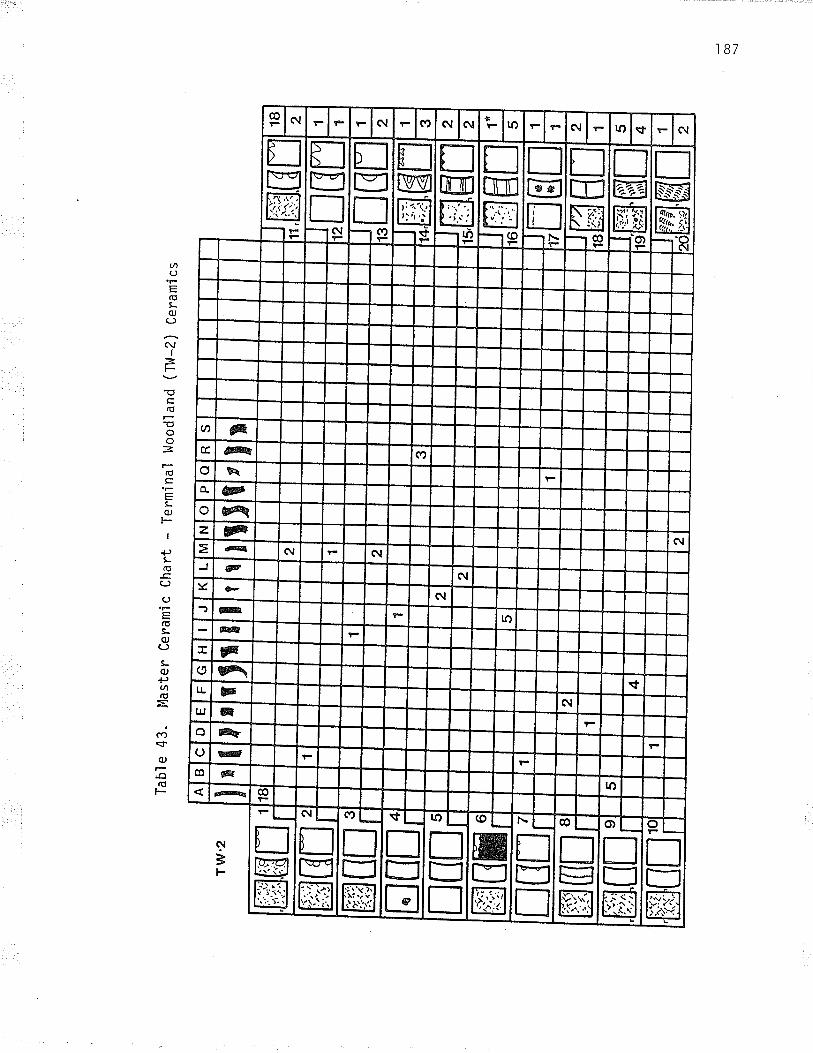
Tab
le 4
3. M
aste
r C
eram
ìc C
hart
ffiß
nÉffi
firÉ
EIT
É
ïabl
e 43
. (c
ontin
ued)
Co
co

Woo
dlan
d (T
H-4
) C
eram
ics
rm rffi
rru
Tab
le 4
4. M
aste
r C
eram
fc C
hart
- T
erm
inal
I[r
co \o
rffi
ET
H
,M,il
rffi
ffir
rffi

APPENDIX B
'l90

l9l
làble 45. CìassificatÍon of Initiaì ttoodl¿nd (lk) Vesseìs
Variety TotalLaureì Punctate
Laurel Plain
Laurel Dentate
Laurel Pseudo Scal lop Shel lsubtype bossed
subtype boss and punctate
Laureì Bossed
subtype possed
subtype boss and punctate
Laurel Draqqed 0bl iquesubtype toothedsubtype untoothed
Laurel Undraqqed 0bliquesubtype untoothed
Hiscel laneous
un typed
2, 5,6,88
r, (4s), s0, sl, s2, s3.66, 67, 68, 69, 70, 7t,74, 75, 76, 95
40,85
3t
23, 24
27,77
3, 57
i, 8, 9, 10, 11, 12, 55
13, 82
63,72, 73
65
83, 84
79, 80
44, 78
56, 58, 64
59,60,61, 62,92, 93
34
87, e0, (48)
57, 86, 9l
14, 26, 37 , 8r
J¿
16, 17, 18, 34, 36,4319 , 20, 2t, 22, 2s, 2s,30, 35
4
39
¿ó
ls, (41), (4e), (s4)
(45) , (47) , 8e, e4
7
t7
8
4
9
T2
14
2
I
9
4
3
- Lugenbeaì Typoìo9y- ( ).mlniature vessel
Iabì e 46 Cìassification of Intermedi¿te (Tt.t_3) VesselsType
Co reVa rÍ ety lo ta'l
0sufsen Boss and Cord
Laurel Cord Hrapped Stick
St. Croix Stamped/onamìa
Untyped Variant
I
2, 3, 4,5, 6, 7, 8, 9t0. 12
l3
lt, t3

Eva
ns T
ype
0suf
sen
Cor
d an
d pu
ncta
te g
ande
d T
ype
la
Net
t La
ke C
ord
and
punc
tate
Ban
ded
Typ
e lb
Sch
ocke
r C
ord
Irnp
ress
ed
Ban
ded
Typ
e lc
l,fas
kish
Cor
d an
d pu
ncta
te l
ton
Ban
ded
Typ
e 3a
l.las
kish
Cor
d an
d pu
ncta
te N
on g
ande
d T
ype
3b
Luge
nbea
ì ly
pe
Net
t La
ke V
ertic
al C
ord
Net
t La
ke V
ertìc
aì C
ord
Unk
now
n V
aria
nt
Unt
yped
labì
e 47
Cla
ssi fic
atio
n of
Ter
nrin
al H
oodì
and
(-lì.
1_l)
Ves
sels
19,
37,
39,
40,
41,4
2
?3 34,
36, 4
, 49
, 70
, 7l
17, s2
,53,
5s,7
3
Co
re
Pla
in T
ype
4a
P'ì ai
n T
ype
4b
l, 2,
58
bv 74 4, 5
7, 6
2, 6
3, 6
6, i
5,78
,80
76
Va ri
ety
47,7
2
28,4
4,45
, 59
, 60
, 61
,64
, 67
, 68
, 77
, 79
, 8t
Tot
a ì
l3 9 9
1) I
16
I 2
(O N)

't o?
Table 48. Cìassification of Terminal t{oodìand (TH-Z) Vessels
ïyPe Co re Variônt Tota I
Sturgeon Falls Fabric Impressed
Sturgeon Punctate (1 row)
Duck Bay Punctate(muìtipe row)
l.l'innipeg Fabric Impressed Variant
Untyped
19,
4
26
27, 22, 23, 24
1, 2,5,6, 7,8, 9, t0,1 1 , 1 2 , 1 3 , 1 4 , 1 s , 1 6 ,
17 , 18, 29
20,28
T1
25*,30
- based on MacNeish (1958) classification- see aìso Hìady (1971) and t4eyers (1978a)* vesseì 25 omitted from Tables 38 and 39
Table 49. Classific¿tion on Icrminal l,toodland (n/-4) Vessels
Iype Varient Iotðl
Sandy Lake Corded
Sandy Lake l,,làre Variant
l,5,6, 7
A

'l 94
ïable 50. Attrlbute profiles for the Terminaì Hoodland Ceramics*
0ccupationAtt ri b ute
Lowe rnll T1,13 Total
Uppe rTl¡2 'f!,l4 Totaì
Interiqr Decoratlons t.ampedhori zontal brushednon-decorated
totaì
Li p Decoration
-
s tampedpunctatedmi scel I aneousno decoration (plain exterior)no. decoration [decorated exteni or)
tota l
Li o Hoti fñ-s--hTìlT.ioueìeft obìiqueverticaì (transverse)hori zontal (enci rc1 i ng)herri ng bonecross hatchother zi g- zag
tota l
102744
'l
I tl¿ ¿J9 53
87
1141S6-6
11 3 1435
10 1 111-1a^J-J
15520112
37
1-424-
314617
11
3
1
8
B4
1
B
93
q
2
4
3
i15
29130438240?27342-2_8_831-l-1-11
B5
c
6q
2õ36
I6
4
l
19
47
i
625223502t-1
BO
11 I 1272 I 1324327-2?
54
15116294331-1
60
4t425-stamp and punctate
stamp and bossno decoration
tota I
Punctate and Boss placementsuperimposedpart of motifbelow motifabove moti f
total
Punctate Shaoeannular (clrcular)non-annuìarcombination
total
i I
l1
Exterior Decorations tampedpu nc ta ted

195
Tabl e 50. (cont.inued )
0ccupatr'on
Aítri bute Lowe rTl,l1 TW3 Total
Uppe rIll2 TV4 Total
Punctate Spacinqs pacednot spacedcombi ned
total
Exterior l4otifohl i ques above horl zonta ì sobl iques or verticalshori zontal scompl ex bandedherring bone (chevron)ìnterrupted obl ique over horizontaìobl i ques (mul ti pl e rows )
tota I
Wtwi sted cordcombination
tota l
Rim- Neck Surface Treatmentsmoothedcord-ma rkednon- co rd-ma rked?
tota l
Li p Sha pebevel I ed outbevel Ied Insyrrnetri caì
tota l
Brushinopres en tabsent
total
29?3t23730-33J-JB-B1-lJ-J
79
16420819?92311121-1-
52 lt
9 1 101-1
41748_119 6 t5 _ 5 5-30_3032-32
95 36
12 1 13614657tB
86
l0
ri
10
10
7 6 13 9 1 to493527_7204?4146?O
89 37
32-32-1149136230535
94 36
* adapted from Lugenbeal 1976: 779-7g0.

APPTNDIX C
196

Fa una 1 Ana'lys i s
The writer is indebted to Ms. Robin Dods, Department of Anthropology,Unìversity of Toronto, who volunteered her expert services to perform theana'lysis of the Long Sault faunal material . The results of her anaìysis(on file with the Min'istry of citÍzenship and cuìture), have been organìzedby component in this appendix. They represent the fjrst faunal datareported for a habitation site on the Canadian banks of the Rainy River.For a detailed discussion and interpretation of the faunal material thereader is directed to the Long sault site report (Arthurs n.d.a).
191

Cl ¿
ss
l4am
m¿
l -
sp.
Mar
nnnl
- ì
arge
larg
e un
iden
tifie
dc
olt
bi s
on
cerv
I d
a e
moo
Se
Ham
mal
-m
ediu
m-
larq
e
Ham
nal -
med
ium
nEdi
um
uni
den
ti fie
dca
nis
sp
dog
bea
ver
I'lam
rnal
- sm
¿ll
- m
ediu
m
|'lam
maì
- s
maì
ì
porc
upl
ne
snow
shoe
har
e
mus
kra
tm
arte
n
mi
nk
Arc
haic
fT 176
52.6
9
I 0.
30
Tab
le 5
1. D
istr
ibut
ion
of F
auna
by
0ccu
patio
n
Ini t
i¿l
llood
l an
dîx
465
44.5
8
I .6
317 9
2.10
Ter
mi
nal
l.loo
dl a
nd
ft
0ccu
patlo
n
2 6 t8 29
7
1 37
4
97 58 2 IO 81
64.3
9
4 .5
5
1.73
2.18
l
Hi st
ori
c
ft
6t.2
7
4.62
170 32
I 2
l3s
5 t I 2 1
I 3 4
0.48
3. 8
0
7 .9
7
Tot
al
2 tz
r 57
.57
21
5 2 6 7 I
123
70 4 2 l2 35 99
213
45
I 3
164
0.14
0.98
7
4.05
4 .0
5
3.34
2 .6
9
5. 7
8
33
6 l0 8 I I
0 .0
8
0.90
(o co

Cl a
ss
Hum
an
Fis
h -
sp.
Fis
h -
larq
eìa
rge
unfd
entif
ied
pi k
e
s t
u rg
eon
-81ú
---s
èfl
wal
'l ey
e ( pi
cker
el )
s uc
ker
Bird
avia
n un
iden
tifie
dm
ediu
m -
larg
e8ì
ack
Ouc
k
Rep
ti ì
e
turt
le (
com
mon
or
l,les
tern
pai
nted
)
Arc
haic 7
.49
1.50
Tab
le 5
1, (
cont
lnue
d)
Inltl
¿l
Hoo
dì a
ndfr
lhì
I us
c
claD
(U
nlon
idae
)
Un
knov
rn
Tot
a I
3 2 1
t49
14.2
9
73
7.00
0. 9
0
Ter
mi
na I
llood
l an
df%
I
2 0.
09
96
4 .5
0
25
2.40
2 )a
117
35.0
3
35 2
7 7
Hi st
ori
c
ft
0.67
334
9.n7
6 3.
47
3 1.
73
t 2 4 2.
3I
4
l3 3 t0
100.
01
4 0.
19
2 l I
?55
24 _
45
I 04
3
28 .
31
Tot
à I
_ 0.
05
276
7.49
116
3. 1
5
¿ 2
172
100.
01
0 .0
5
2t
0.98
21 276
10.1
2
2 13
4
57.9
3
45
7
ao u 9 I I
12
6.94
t2 20
11.5
6
I 73
10
0.00
4.70
33 33
0.03
0 .9
0
t6.5
060
8
3 68
4
I00.
01I 00
.00
(o (o

APPENDIX D
200

201
Tabl e 52. AbbrevÍations - Lithi c Raw Material s
Abbrevi atjon Raw MaterÍal
AIJ
GCC
GFS
HBL
J
JT
KRF
Ll,lC
a
RC
Rhyo
SRC
T
Aì ga1 jasper
Gunfl int carbonate chert
Gunflint silica
Hudson Bay Lowland chert
j as per
jasper taconite
Knife River Fl int
Lake of the Woods chert
qua rtz
recrystallized chert
rhyo'l i te
Swan River chert
taconite

PLATES
202

203
Plate I. Aerial Photograph of the Long Sault SiteA portion of an aerial photograph showing the Long Sault site. Note
the Long Sault Rapids and the extensive flood plain area. The two ìargeburial mounds are clearly visible on the edge of the intermediate terrace.The 1975 excavatîons took place on the high terrace adjacent the head ofthe rapids. The gravel pit is now four times the size shown in th'is i965photograph.

Pl ate II. The Long Saul t SiteA view west from the intermediate terrace
Mound 6 líes in the centre of the photograph.and the bur oak forest around the periphery.
204
across the flood pìain area.Note the extensi ve cl eari ng ,

205
Plate III. Reserye Period Occupatìon of the Long Sau'lt SiteA photograph taken by northwestern 0ntario photographer Linde, ca.
1913. Note the log cabins on the intermediate terrace behind Mound 6,and utilization of the lower terrace (flood p]ain). One of the twodepnessions east of the large mound j's visible in the photograph. Thetwo po]es on the extreme left of the photograph may mark the limits ofthe Federal Mounds Reserve. compare the size of the trees growing outof Mound 6 with their sìze 'in the 1974 photograph (plate Il). View north-east. Courtesy of Thunder Bay Historical Society Museuni

206
Plate lV. The 1975 Excavations - Main Trench.
View of completed excavation units 1 to 8, on the upper terrace towardthe east edge of the site. Note the depth of the cultural deposjt, whichincreases markedly toward the east end of the trench, and the base of'largerounded cobbles upon which Ít has developed. View north-east.

207
Plate V. The 1975 Excavations - North Block.
A vÍew south-east across the north block of excayat'ion units (units10 to 13), and unit 14, upon comp'letion in 1976. Note the stratígraphyvisÍble in the east wall profi'les of units 72 and 13. Units t,2, and 3,on the ritght side of the photograph, have been backfilled.

208
Plate VI. Representative StratÍgraphic Profile.The north wall profÍ1e of excayation unit l. Note the depth of the
cultural deposit, wh.ich in this unjt js over 40 cm thíck. Although somechanges jn colour and texture are visÍble in thÍs profiìe, the sor'1 js arelatively homogeneous sandy loam with high organic content. Note thebase of rounded cobbles at the base of the uni't. Scale is in centimetresand i nches .

209
l'ìNt t'
b
:€l
Ì&:fllri::t::'l:.;.ìli.*sì,::jsìq,
p
o12345rrlttlcentimel res
Plate VlI. Representatiye Utill.zed Flake Tools
Archaic 0ccupatÍona. síde util't'zed, Kni.fe River Flintb. side-end utili.zed, Hudson Bay Lowland chertg. side uti'l i.zed, Gunfl int sil Ìãad. si de utÍl t'zed, La ke of the W.oods cherte. stde-end utl'l ized, rhyoì tteInitial Woodjand Occupationf . side-poi'nt utilîzed, Lake of the l,.loods chertg. side-end uti'l l'zed, Hudson Bay Low'land chert - from Feat. IW_IIIh. side-end util.l'zed with gravei, Hudson Bay Lowìand cherti. Side utiIized, Swan Rivãr chertj. side util ized, rhyol i.te!. side utllized, rhyolîteI . si de uti I îzed, Kni'fe Ri ver Fl Ínt - bi face tr.immi ng f.l akeïerminal Woodland 0ccupationsm. side utilized, Gunflint silican. end uti I ized, rhyol iteo. si'de-end uti.l lzed, jasper taconi.tep . s i'de uti I ized , rhyol rìteq. slde util ized, rhyol iter. sÍde uti l ized, rhyol ites. side-end utilîzed, Hudson Bay Lowland chertHr.stqrj c 0ccupati¡ont . si:de utlll i zed, rhyo'l ì teu. si. de utÍl i.zed, Hudson Bay Lowl and chertNote: all tools are i'n flake orientation, with bulb of force at top.
ffie
ffik
ffiÍ
wd
Æ¡
Wq
Wu
ffih
wo
wt
$iìi!'
I
&n
&Í
ñm
wa
.w.
#*Ì::'
I

210
:i,ì.ì,å.
',w.:5
a
Pl ate VII I. Representatiye Anchai'c and I nl'ti.al l^loodl and Retouched Fl ake Tool s
Archaí'c 0ccupati.ona. sÍde-point retouched, Swan River chert - from Feat. A-II - drill(?)b. sÍde retouched, Swan Riyer chert - b.lfaÒe trimming flakec. side retouched with graver, Swan River che.rtd. conti'nuous retouch, Jasper taconitee. side retouched and utilized, Swan Ri'ver chertf. side retouched wtth gr"aver, jasper taconite.9. si'de retouched wÍth graver, jasper taconiteh. end retouched, Gunfl tnt sil ica - from Feat . A-i I Ii. side-end retouched, Hudson Bay Lowland chertj. side-end netouched, Knife Rjver Fljntk, si:de-end retouched, Hudson Bay Low'land chertIni ti al l^loodl and 0ccupati onI . end retouched (spokeshave) , rhyo'l item. s i'de retouched (s po kes have ) , rhyo'l i ten. si de retouched, quartzo. sìde retouched, Hudson Bay Low'land chertp. side retouched, rhyo'liteq. sjde retouched, red-b'lack banded (HBL?) chertr . si de retouched , Kn'i'fe Ri ver Fl i nt - dorsal and ventrals. end retouched (walsted), Hudson Bay Lowland chertt. si'de-end retouched, Hudson Bay Lowland chertu. sì de-end retouched, Knl'fe River Fl i nty. side-end retouched, Swan River chert - from Feat. I!^J-XIIw. end retouched, Gunfl int sil icax. side-end retouched, Hudson Bay Lowìand cherty. conti'nuous retouch r QUâptZ
Note: all tools are ìn flake orientation, with bulb of force at top.
ñãññì:tsgì+-ììÈ,s
cð
b
ñj
&p
ffiw
#d
,wi
ño
ffiv
we
#r
ffik
Cq
&x
ws¡
dnffilm
wffist
ffih
wf
ffiu

2il
ffiw&bce
ww&¡¡k
Wffit w'o
ffi&ry
wa
@h
&f
ffi-, -i-WSisìs'
o
@wlm
o12345trlttlcontlñGlrê3
Plate IX. Representatiye Terminal Woodland and Historic Retouched Flake Tools
Terminal Woodland Occupationa. sîde retouched, Lake of the Woods chertb. end retouched, quartzc. sÍde netouched, Gunflint Formation chertd. end retouched, Hudson Bqy.Lolv,'land chert - thermally alterede. side-end retouched, jaspen taconîtef . si de retouched, Kni fe River Fl j ntg. side-end retouched (spokeshave), rhyoliteh. end retouched, Gunfl lnt sil fca - dril I (?)i. continuous retouch [spokeshave), rhyol itej. side-end retouched, Hudson Bay Lowland chert (l) - ventralk. side-end retouched, rhyolítel. sideend retouched, Gunf'lint Formation chert - From Feat. T'l^l-IIIm. side-end retouched, jasper taconite - from Feat. T1,l-IiIHistoric Occupationn. end retouched, Hudson Bay Lowiand chert - strjke-a-light (?)o" sÍde retouched, rhyolitep. side retouched, rhyoliteq. side retouched, Hudson Bay Lowland chertr. side-end retouched, Hudson Bay Lowìand cherts. continuous retouch (spokeshave), rhyol itet. side retouched (spokeshave), jasper taconiteu. end retouched, KnÍfe River Flintv. end retouched, Kn'i fe Rîver Fl i ntNote: all tools are in flake orientation, with bulb of force at top.
Wn
ffi"EdÞ
Íñq
&v

212
. .i.l
c
,n
Plate X. Representatiye Bitfaces
Archaic Occupationa. waisted bfface, Knife River Flint * bifaclal scraper reworked from
pnojectil e poi nt ( ?)b. triangular biface, quartz - projectile point (?)c. oyai potnted biface, quaptzd. oval bÍface, Swan River cherte. oyal bi.face, Hudson Bay Lowland chert - thermally aìteredf , b'lface fragment, fe'lsî'teg. trîangu'lar bi'face, nhyol I'teInitial W'oodland Occupati'onh., rectanguìar biface fragment, Hudson Bay Lowland chert, projectile point (?)'i . triangulan biface, rhyoli'tei . tri angul ar bj face fragment, rhyoì itek. trianguiar (?) biface fnagment, Hudson Bay Lowland chert (?)
Termi nal Ì.loodl and gccuPatÍ onl. oyal biface, quartzm. trt'angu'lar biface, rhyoliten. oyal biface, Hudson Bay Lowland chert - gouge (?)o, oyal biface or core, quartzHi'stonilc Occupationp. oval bi face , quartz
Wa @
s
ffiÍ
,&-ffiW
e
&¡
Wn
ffiI
@m
Wh

213
ot2345trltrtcentimet¡es
Pl ate XI . Representati ve Projecti I e Points
Archai c Occupat'iona. corner notched poi:nt, Swan Ri.vel" chert - thermal 1y al tered - Larter Tangedb. corner notched point, rhyoli'te - Larter Tanged
lni:tial l^loodl and Occupationc. si de notched point, rhyo'lited, cornen notched mfd-secti'on, rhyolite - Archaic Larter Tanged pojnt (?)
Ternînal Woodland Occupatîonse. si'de notched point, rhyolitef . notched bas.e fr"agment, Hudson Bay Lowland chertg. mrd-secti'on, rhyoliteh. serrated tip fragment, rhyoìiteHistoric 0ccupationi. trìangular poi'nt base fragment, Swan River chertj. triangular point, Hudson Bay Lowland chertk. triangular point, Swan River chertl. small side notched point, Hudson Bay Lowland chert
&c
WI
iæù:ì:ì
k
@b
.wt
,:ù:ôiN."N.
f
@a
&e
ffi¡
&d
&h
NwI

214
Wb
Wa
We
Wm
Wd
wh
ìñìs îryiw
RepresentatÍye InÌtilal l^loodl and Ceramics - IW Vessel s
I'l^1.-69, Launel Pì ain TypeIt,l-?, Laurel Punctate TypeIltl:3, Laurel Boss'ed Type (subtype bossed)Il,{-11, Laurel Bossed Type [subtype boss and punctate)Il,l-39, Laurel Dragged 0b1îque Type (subtype toothed)JW.J9, Laurel Undragged Obf ique Type (su-btype untoothed)Il^l-15 , Laurel UndraEged Ob'l r'que Type ( s ubtype untoothed )ï,W.-16, Laurel Dentate TypeI:W-37, Laurel Dentate Type (horizontal variant)il,l-40, Laurel Dentate TypeIl.l*18, Laurei Pseudo sca'l I op she'l I Type (subtype bossed)IW-42 , Laure'l Pseudo Scal I op Shel 'l Type (s ubtype bossed ( ? ) )IÞl-25, Laurel Pseudo Scallop she11 Type (subtype boss and punctate,scal I op shel i ldentate variant)ll.l-28, Laure'l Pseudo scallop she]1 Type (subtype boss and punctate,stamp variant)
IÞl*19, Launel Pseudo scallop Shel'l Type (subtype boss and punctate)
Wc
Wf
il$llìSI r"-:'- tI {;.''. "\
ffik
WI
Wn W
o012345ltlltl
canl¡melres
Pl ate XI i.a. Vesselb" Vesselc. Vesseld. Vessele. Vesself. Vesselg. Vesselh. Vesseli. Vesselj, Vesselk. VesselI , Vesselm. Vessel
pseudon, Vessel
dra ggedo. Vessei
s. _i

215
,Mi-*i,'' l:l:: :.
.,ìw,.*1.ìÞi
.þç"1-w,.r¡&
Wt,iWbW
a
.t{fltuñ
d
Wg
::::.:-::-. --'. ----............
t ìt--.. ,\
IltEl rã'"Ëlfl,,\".,*,,.'*
Wh
012345
cent¡mctres
Plate XIII. Representative Internediate Ceram'ics - Tll-3 Vessels
a. Vessel Tl^l3-2, Laurel/Lockport Cord t.lrapped Stick Typeb. Vessel Tttl3-3, LaurellLockport Cor"d Wrapped Stick Typec. Vessel T't^j3-7, untyped corded and punctated yariantd. Vessel Tt,l3-11, Laurel/Lockport Cord l.lnapped Stfck Typee. Vessel T1Â13-4, untyped corded and bossed variantf. coil constructed body sherd with joose cord wrapped stick decorationg. Vessel T1¡13-13, Qsufsen Boss and Cord Typeh. Vessel TlÀ13-1, St. Crolx Stamped Type or Onamla Series vessel
WÌIM::I

216
WWWb-"
bWW iMWW WW
Wt
ffiWIW:qì
o12345lttttt
Plate XiV. Representatíye Terminal Woodland Ceramics - TI^l-1 Vessel
a. Vessel Tt,.l1-37, Osufsen Cord and Punctate Typeb. Ves,sel IU7-22, Nett Lake Cord and Punctate Typec. Ves.sel Tl^11-17, l{askllsh Cord and punctate Typed. Vessel Ti,l1-34, Schocker Cord lmpressed Typee. lessel TW1-3, Nett Lake Vertical Cord Typef . Vessel T1^11-82 , Schocker Cord Impressed Type vari antg . Vessel T'1,11-47, untyped variant

217
o12345irltrl
Plate XV. Representative TermÍnal l^loodland Ceramics - Tl^l-2 Vessels
a. Vessel I1¡l?-23, Sturgeon Fal I s Fabri c Impressed Typeb. Vessel TH2-.19, Sturgeon Falls Fabric Impressed/Alexander Fabric Impressed
Type ( "transitional't?)c. Vessel TW2-.?6, Duck Bay Punctate Typed. Vessel Tt.lz-1, l,lìnnìpeg Fah'nic Impressed l¡lare variante. Vessel Tl^Iz-11, Ì^linnipeg Fabric Impres.sed Ware variantf. Vessel T1,12-14, þ{innipeg Fabric Impressed Ware variantg. Vessel Tl^lz-15 , Wi nnì'peg Fabri c Impressed l^lare vari ant
ffiWWa
WWc
ffie
ffid
WffiwWW

219
$s\, \\¡
def
s' )t
l_vÅ!N
WW,%wo
tJ
Wc
Wo
Wa
Wç,
wh
iii¡.P.*\.i.:t:¡r¡
m
. -.. + lt!:.ii$*irìiiq;:
èì"
n
wåwffiWt ffiufffi
g
w
w
ffi"Hö
o12345ttllll
centimetros
w
I
å#'Pl ate XVI I . Representati ye Histori c Arti facts
green tool -fi ni shed gl ass bettl e I i ptransparent tool-.finished glqss. bottle lip (.manganese glass)green case bottle fnagmentlarge amber glqss bead, wine woundlarge transparent glass head, wi'r'e wound, heavily patinatedlarge blue glass bead, wire woundbras's spun-hack buttonembossed brass two^piece buttonwhite glass four-hole button with green painted rimstraight pinpin wìth ornamental blue g'lass paste head, heavily patinatedsa fety pi n , e1 ectropl ated ni ckel - s i I verrefined white earthenware sherd, royal blue underg'laze transfer printc'lay pipe bowì, "organ gninderrs monkey" effigyheart-shaped tobacco grade marker, electroplated nickel - silver,..l,{. C. I'|ACDONALD / BRIER / MONTRTAL''
p. frizzen from flintlock musketq. brass cartni'dge, "D. C. Co. / 44-40'r, small iron fish hook with loop eye and barbs. cut nai It. bradu. drawn wire nail

RE FE RENCES
220

221
Anfinson, S. F. (ed.)1979 A Handbook of Minnesota..pnehistonic cez,amics, 0ccas'ional papers'in Minnesota Anthropology, Nò. b. Mjnnesota Historical soðiety',Fort Snel ì i ng, Mj nnesotã.
Arthurs, D.n'd'a Av'ehaeoLogical inuestígatíons at the Lo_ng sault site. Manuscripton fi le' Archaeology and He"r'itage Planning Bränch, 0ntarìo Ministryof Citizensh.ip and-Cujture, Thuñder B;t."n'd'b The Archaeo'logy of the Missìnaibi River vaì'ley. In spiz*its
?Í. tTu p.ictuz'ed uate,s; the .his.toz,y and. az.ehneoLoga of the uoose-Missinaíbi Rt uer, -u1?.Lna., edited by"o. s. Nál vin. "Árcha.óloiicat
Research Report T6lHeriiasà pranning s!,10y-i,'på.t"i;',"À;¿h;eolosyand Heritage PlannÍng Brañch,0ntario Nin"istry of cjtizensh.ip andCul ture, Toronto, (in press ) .
1974 A fu'ehistot"ic mortuaz,y cornpLeæ in the northuestez,n uood.Land.sanea (a reínterpretation o¡_nLackduck moz,tuaz,y p,acti-ces ) .'lulanuscri pt on fì I e , Archaeäl9gy and H.¡ìüõ Þlãnni ng- Brunil., ,Ontarjo Minístry of Citizenshiþ and Culturõ, Toronto] rhunãer say.
1976 Manitou Mounds Arehaeolog¿e?! suz:uey - j,gz|. lslanuscript onfilg, Archaeology and Herita"ge plannìng'eranch, 0ntarjo Nïnistryof Citizenship and Culture, ioronto. "
1978 a An Early historìc date from the Long Sauìt site. Az,eh Notes78-3:5-6.
1978 b Sandy Lake ware in northwestern Ontario: a distrìbutional study.Anehae-Facts 5(2,3) : 57-64.
Badertscher, P. M.1978 Blackduck-pottery at the Aschkibokahn site. MASCA: JournaLof the Manítoba AnthnopoLogy studentts Association, +,og:gô.
Baerris, D., R. Bryson, and J. Kutzbach1976 Cl'imate and cuiture in the western Great Lakes reg'ion . Mid3ontinentaT.
Jow,naL of ArehaeoLogy, I (l ): 3g-Sl .
Bain, J. (ed.)1969 TraueLs and aduenh,rres in canadn and. the rndían tery,Ltoriesbetueen the yea,s Lz60 and i-226, by Aleæand.ez. Henz,y, fuz,tnader.M. G. Hurtig"Ltd., EOmoñión.
Beechey, T. J., and M. Bardecki1972. Long sauLt Mounds paz,k Rese'ue: a btief inuentory of eatthscienee and Life,seience -features. r4anuscriþt on file, pärii anoRecreation Branch, Ontariô Mìnistry òi llátrial Resources, Thunder Bay.

222
Birk, D. A.1977 a The Norway Lake site: a multicomponent woodland compìexjn north central Minnesota . Minnesota Àz,chaeoLogisi 36(j ) : l6-45.
1977 b rwo Sandy Lake ware vessels from.Onigum po.int, cass county,M'innesota . Mùrznesota AtchaeoLogist 36 (l ) .
-
Bishop, C. and M. E. Smith1975 . Ea¡ìy historic_popuìations in northwestern 0ntario: archaeologìcaì
and ethnohistoríca.I interpretations . Amenican Antiquity 40(l i' s[:oãlBoyìe, D.
1886 speech on the status of 0ntarjo archaeology, November 2'1, lgg5.Pz'oceedíngs of the canadían rnstdtute, sessjoñ-Íaas-lgg6, pp . j-7.
i898 AnntnL archaeoLogie,aL repont^for ontaz,io. Appendix of the Reportto the Minister of-Educatj-on, 0ntario. Toronto.
1900 Annual az,chaeoLogie.aL z,e.port^fon O.ntario. Appendix of the Reportto the Min'ister of Education, Ontario. Toronto.
1903 AnnuaL az,chaeo\ogic.aL re.port_foz, ontanio. Appendix of the Reportto the Minister of Educati-on, Ontario. Toronto.
Brose, D. S.1970 The Az'eLneoLogy. of swnmex rsland.: changing settLement systemsùn noz,thern Lake .Michigan Anthropo'logy Raþeri, No. 41 . Museum ofAnthropoTogy, Universiiy of Michìgän, Ãi,n À"n0..
Bryce, G.1991 Among_the Mound Builders' Remains. Tz,ansactíon No. 66, pp. l-33.
Historical and Scientjfic Society of Manitoba, Wìnn.ipeg.
Buchner, A. P.1979 The L97B caribou Lake pz,oject, incLuding a. sunùnalv of the
pnehistoz'y of east-centraL Manitoba. Final- Report No-. 8-, papersin Manitoba Archaeo'logy. H'istorìc Resources Branch, ManitobaDepartment of cultural Affairs and Historic Resources, winnipeg.
Buchner, A. P.1980 An update on the Larter site (ralg-l). rn studies in Eastez,rt
Manitoba az,ehaeoLogy, edited by L. Pettipas, pp. 37-70. papers inin Manitoba Archaeology, Misceìlaneous papers No. ì0, Deparimentof CuIturaI Affairs and Historical Resources, H'istoric ResourcesBranch, l,linnipeg.
Burpee, L.J. (ed.)1968 Jouznals ond Lettez,s of Pieyz,e Gaultíer de Vanennes de La
Venendtye and. his sons. Greenwood Press, New York.

¿¿J
Caì I aghan, R. Tn.d] rást eæ)auations at the Lady Rapid.s site (DcKc-7): a muLti-
c-omponent site in the Boundaz,y Flatez,s area of northuestern OntarLo.Manuscript-on file, Archaeoioþy and Heritage Planning Branch, gntario.Ministry of Citizenship and Cuiture, Kenorã.
1979 The L979 eæcauations at the Lady Rapid.s síte (ncxc-j.) - apz'eliminazn¿ z,epoz,t. Manuscript on iilg-, Archaeology and HeritagePlanning Branch,Ontario Ministry of Citizenship añä Culture, Kãnora.
Cameron, N. S.n.d. skeLetaL
-temains flom tu4gy, HaLL Motmd rr. Manuscript on f.i1e,Department of Anthropô.Iogy, Uñiiers.ity oi Íoronto.
Carver, J.1974 Tz'aueLs thz'-ouqh the_intevLor^parts ^of Notth Anez,Lca in the aea.rcs1z66, r?62, and t7oa. Toronto, c'o'les cahaãiunu Coll.óiión.
CIayton, 1.,,lnl. Bickley Jr., and W. StoneI970 Kni fe Ri ver f'l i nt. pLains Anthz,opologist. l5 (50 ) : z}z-zg0 .
C'leìand, C. E.1966 The prehistonic animal ecoLogy -and ethnozooLogy of the uppez,
Great Lakes z'egion. Anthropology papers, No. 29,"ilusäum ofAnthropology, úniversity of Mjcñigan', Ann Arbor.
Colf i ns, M. B.1975 Lìthic technology as a means of processua'l inference. In røthic
technoLogy -..making^and using stone tooLs, edited by E. Swanson,pp. 15-34. Mouton press, thé Hague
Conway, T. A.1977 Whitefish island - a remarkabJe archaeologicaì site at Sault Ste.Marie, 0ntarí0. Data Boæ No. 3L0. Historjcai planning ánd-ResearchBranch,Ontario Ministry of culture and Recreation, rôioñið.
1980 Heartland^of..the.0jibway. rn colLected. arehaeologieaL pape,s,9!ited bv D. l.^Y.luin, pp. t-zB. Archaeo'togica't ResËarcrr heport13, Hjstorical Planning and Research Branch, Ontario Ministry ofCulture and Recreation, Toronto
Cooper, L. R., and E. Johnson199!. sandy Lake ware and jts d'istribution. Amerícan Antíquity
29(4): 474-4Te.
Dagg, A. I.197 4 MøTmaLs of trttarLo . Otter press , I{aterl oo .

Davìes, J. C., A. Pryslak, F. Dawson, and D. l,l. Robeson1966 Kenoz,a-Foz.t Fnanees sheet., Geologi ca'l compi I at j on series , Map
2115, Ontario Department of Mines, Tõronto.
Dawson, G.199] sutnnaz,y report on_the openations of the Geological suz,uey forthe.yeaz, 189B.._ Annual Report, Geologiða'l Survey óf canada. NewSeries Vol. XI,0ttawa.
Dawson, K. C. A.1973 Blackduek cez'amíe tradition cornputez..analysis program, Manuscr.ipton f i'le , Department of Anthropo'logy,' Lakehead Úni veis iiv, Ìfrunder Bay.
1974 ?he MccLuskey site. Mercury Serjes No. 25, Archaeoìogica1 Surveyof Canada, National Museum of Mán, 0ttawa.
1975 The western area.A'lgonkia.ns. Tn papez,s of the sirth Algonquianconfez,enee, L9?4., edited by l.l. cowan, pþ. 30-41 . canadian ÉÛrnologyl.fyice, Paper No. 23, Merðufv serieé,'ñat'ionaì Museum of Man,Natjonal Museums of Canada, 0ttawa.
197_6 a A.I bany Ri ver survey, patrici a D.istri ct, Ontari o. Mez,curys,ez'ies, _pape, No. -5L., pp. 52-r06. Archaeo'logica'l survey ól-ôa"naoa,National Museum of Man, National Museums of õanada, Ottäwa.
19|9.^1...!Lq7n(ians ^of
Lake Nipígo-n : . an _anchaeoLogicaL sun)eA.lvlercury series, Paper No. 48, Archaeo'logica'l su"rvey of canäda,National Museum of Man, National Museumð oi canada, ottu*à.
-
1976 c. The Nyman site. A seventeenth century Aìgonkian camp on thenorth shore of Lake Superior. canadian ¿.z.chaeoiogicaL AssàciationBuLLetin No. B, pp. l-S9.
1977 a . {n app'lication of the D'irect Historjcal Approach to the
Algonk'ians of northern Ontario. canadian JouzmaL of Az,chaeoLogyl: 151-.l81.
1977 b Northwestern 0ntarjo historic popuìatjons.I3: 67-77.
)tALL+
Man in the Northeast,
1979 Algonkian Huron - Petun ceramjcs in northern Ontario. Man in theNoz.theast, l8 : l4-31 .
i980 The MacGillivray site: a Laure'l Tradition s'ite in northwestern0ntario. 2ntario Az,chaeoLogy 34: 45-69.
DelafieJd, J.1943 The unfortified boundaz,y, New york.

225
Dore, W.
1975 tiild-z"ice. Publjcatjon 1393, Research Department, canadaDepartment of Agriculture, Ottawa
E'lson , J .
1967 Geo_iogy of glacia] Lake Agassiz. In Li.fe, T,and qnd. uatez,:pz'oceedings of the -L966 òonfeienee on enuirbrunental studies of theg,LaciaL .Lake Ag,ass.í,z,reg_ion, edited by W. Mayer-0akes, pp. 36_95.Uni versi ty of Man'itoba Þres-s , Winnì pe"g.
Emerson, J. N.1968 understaná'Lng rz.oquois .potteng ín ontaz'ío - a nethinking.special Publ jcation, Ontari-o Archäeologjcal soc.ietv, ioronió.
Evans , G. E.i96l a Ceramic analysis of the Blackduck ware and'its genera'l culturaJrelationships. Jow,naL of the Minnesota Acad.emy or såiniå,29: 33-54.
l96l b Prehistoric Blackduck - historic Assiniboine: a reassessment.PLains Anthz,opologist 6(14) : 271-275.
'196,1 c, A RTappz'aisaL o_f the BLackduck focus or Headuqters Lakes aspect.Masters thesis, Facu'rty of the Graduate school, unìu."iìtv--otMinnesota, Minneapolis.
Fi'l teau , P.1978 . Lake .Nipigon az'cv¿aeologa: _ a funtven study. Report on f i I e,0ntario Heritãge Foundatioñ, Toroñto.
Fítting, J. E.1979 Middle Woodland cuJtural development in the straits of Mackinacrggi9l: beyond _the Hopewelì Frontiär. rn HopeueLL anehaeoLogy: thechitlicothe confer,?neer edited by D. Brose and I't. Grebe;; pp. 109-112.Kent State University press, Keni, 0h.io.
Fox, l^l. A.197^?- Long sauLt Mounds z,econna,issance, NoD. 22, 1gzz. Manuscrjpt onfìTe, Archaeology .and_Heritage planning Branch, 0ntarìo ¡,1ìnirt.vof Citizenship and Culture, Toronto. -
1976 The Palaeo - Indian Lakehead comp'lex. papers contz,íbuted. to thecanadicn ArchaeoLogieaL Associatíon'øtnuaL *Ztirg, aareih lg'zs,pp. 28-49, Research.Report 6, Historícaj planning"ánd ReseãrchBranch, 0ntario Ministry of culture and Recreatiõn, Toronio.
'1980 The Lakehead Complex; new insights, In colLeeted anchaeologicaLpapers, edited by D. s. Melvin, pp-. l27-1sj. Archaeologìcaì ResearchReport i3, Historjcal Planning anä Research Branch,0ntãrio ¡linisiryof Culture and Recreation, Toronto.

¿¿ô
Fries, M.1962 Pollen profiles of late pìeistocene and recent sed'iments from
weber Lake, northwestern Minnesota. Ecology 43(z): 295-308.
Fritz, J.n.d. Review of: Lithic ana.Iysis and culturaJ inference: a palaeo-
Indian case, bv E. wilmsen. Amev"ica" Ántiqittu, ágeil'¡ei-¡grGibson, T. H.
1976 The tlinnipegosis síte. Preliminary report No. 2, papers inMan'itoba Archaeology, Department of Tourism, Recreation änd CulturalAffairs, Historic Resources Branch, Winnipeg.
Godfrey, E.1966 The Binds of canada. Byiletin 203, Bioìogica'l series No. 73,
Nati onal Museum of Canada, Ottawa
Griffih, J.B.1971 The Northeast l,loodiands Area. rn pvehistoz,ic nan ín the Neu
Y.oTLd'edited Þv J. D. Jennîngs and E. Norbeck, pp. zz3-zs}.Un j vers'ity of Chi cago press , Õhi cago.
Grjffin,_J. 8.,.A. A. Gordus, and G. A. Wrighti969 ldentification of the sources of Ho[ewellian obsjdian ìn themiddle west . Atnertcan Antiquity, 34(l )': I -14.
Guillon, D.l9l5 ontaz"Lo Land swnsea mq_of rndian Resenues j,2 and. Ls, RaingRiuen. Photocopy map on file, Fort Frances District OffÍce, O"ntario
Min'istry of Natura.l Resources, Fort Frances.
Hei denrei ch , C .
1971 Hutonia - a hístoz'y and geogz,aphg of the Huyon Indians. McClellandand Stewart, Toronto.
Hems, W. D.1981 Archaeoiogical survey of the Burrows Lake area, Geraidton district.In studies ín west patv"ieía ay,ehaeoLogu, No. z: j.gzg-LgB0, edìted byC. S . Re j d and. W: 4.. Ross ,_ pp. 170-206"." I^lest patri ci a Hs¡i 1¿g.
Resource Report 2, Archaeoìogical Research Report .|6,
Histor.icalPlanning and Research Branch, 0ntario Ministry of cuÍture andRecreation, Toronto.
Hi ckerson , H. q
r 919 lhe chíppeya and theiz, n,eighb.ours: a study i.n ethnohistony.studies in Anthropolog'ica'l Method, Ho'lt, Rjnehärt, and l.linston,New York.
Hill, c. G.n.d. Az'ch.a.eoLogieaL s?ÆÐe.A of the South Gez,aLd.ton dùstz.ict. Manuscript
on !11e, Archaeo'logy and Heritage Planning Branch, 0ntario Mjnistryof Citizenship and Culture, Thuñder Bay.

227
Hill, C. G. and l^l. D. Hemsn.d. Az,ehaeoLogy. east of.Nipigon. Manuscript on file, Archaeology and
Heritage_Planning Branch, Ontario l'linjstry of Citizehshìp and Cúiture,Thunder Bay.
Hì 11 s , G. and F . l4orwj ck1944 Reeonnaissanee soiL surueA of paz'ts of nont?u,testeyyt OntaTio.
0ntario Soí1 survey, Report Nó. -8.-
Experimenta.I Farms serv'ice,Domìnion Department of Agriculture and'the 0ntario Ag¡iculturalCo1l ege, Gue'lph.
Hi nd, H. Y.1971 Natnatiue of the canad\an Red. Riuez, eæploz"Lng erpeditzon of
L8^57 ard of the Assiniboõne and Saskatcheio, e*pioring erpe&Lt\onof L85B, 2 vols. M. G. Hurtjg Ltd., Edmonton.
Hìady, W.
1970 a Manitoba: the northern woodlands, rn Ten thousand. aears:az'chaeol_ow. iry Manítoba, edited by tr^l. H'lady, pp. g3-]tzz. "ManjtobaArchaeological Society, D. [.l. Friesen and sons', Altona.
1970 b southeastern Manitoba resurveyed, In ren thousand, years:anchaeoLoga. ¿ry Manitoba, edited by w. Hlady, pp. 269-281". ManjtobaArchaeologica.l Society, D. l.l. Friesen anA 3óni', Altona.
1971 An Introduction to the archaeo'logy of the woodland area ofnorthern Man'itoba . Manitoba Az,chaeologícaL NeusLetter,, vol . III(2-3).
H'lady , W. and G. Kucera1971 The Rush Bay Road shield Archaic site, Ontario. plains
Anthz.opologùst I 6 (53 ) : 204-Z0g
Hutton, C. and l.l. Black1975 )ntaz,io Az,ctic untez,shed. Map folio No. 2, Lands Directorate,
Environment Canada, 0ttawa.
Huyshe, G. L.1871 The Red Riuer erpedition" London, Toronto, New york.
international Boundary Commission1931 Joint z,epoz,t upon the surlea qnd demaz,katíon of the boundaty
fz'om the nonthuestem-most poínt of rnke of the wood.s to LakeSuper"Lor. United States Government printiirg Office, I,lashington, D.C.
James, E.1956 A Narratiue of the eaptiuity and aduentuyes of John Tannez, (u.s.
intez'pnetev, at the sauLt de ste-. Maz,íe) during th\rfu aearls z,esidenceTong the Indians in the íntez,íoz,of Nor,th Amáriea. -Róss
and HainesInc., MinneapoTis.

228
Janzen, D. E.1968 The Naornikong .point _.site and the dimensions of Laurel in the
lakT Supgz.io'regíon, Anthropology paper No. 36,'Museum ofAnthropology, University of Michigân, Ãnn Arbor.
Jelinek, A. J.1976 Form, function, and sty're in lithic analysis, Tn culktz,al
eh.qnge. and -eonti'ryy¿la_ - esêays _in -honouz, of James Bennett GrLfftn,
edited by c. E. cleliand, pp. I9-33. Academic press, ñ.* iãrr.Jenks, A. E.
1932 The Problem of the curture from the Arvi'l'la graveì pìt.Amez,iean AntropoLogist, 34 :455-466 .
Johnson, E.1969 Archaeologìcal evidence for the utilizatjon of wild rìce.Scienee 163: 276-277.
Johnston, W. A.19-1.5 |"iryu^ Riuev' .dí's_tz'ùct, 7ntarLo,. suz,ficiaL geology and. soiLs.
Memoir BZ, canada Department of Mines, "GeoìogìËa] s"uivôvl óitu*u.Joyes, D. C.
1969 Blackduck jn the west: the d'istribution and stylistic changesof Biackduck ware on-the prairies. Canadian ArehaeblogicaL AssocíationBuLLetin No. L. p. 20.
Kehoe, A. B.1978 F?ancois| Hotrse: an eaz,Ly fuz, ttad.e post on the saskatcheaanRíuer. Pastlog, Manuscript säries in Archaeologv in¿-riì;î;;y,No. 2, Saskatchewan Culture and youth, Regina.
Kehoe, T. F.1974 , Th,g large corner-notched point system of the northern plains
and adjacent woodlands. rn asp_ec-tt b.¡ uppez. Gz,eat Lakes anthz,opoLogy,ed'ited by E.-Johnson, PP. 103-114. Minnãiota-Prehisioric -Ârcr¡a'eoloöí'
Series No. ll, Minnesota Historical soc'iety, St. paur.
Kenyon, l.l. A.1966 L.s.M.-7., AnchaeoLogicaL NewsLetter N.s. l5: l-4. Royal 0ntarìo
Museum, Toronto
1970 a The Armstrong Mound on Rainy River, Ontario. canadian Histonicsùtes: )ccasíonal^pøpez,s^ in.Arehaeology and nistoz,y- io.-ã, "pp.
6s-g4.National Historic Sites Service, 0ttawäl
1970 b- Hungry Ha.Il, Mound I or Toxicondendron radicans. Az,chaeologicalNewsLetten N.s. 58:6-9, Royal 0ntario Museum, Toronto

229
Kenyon, !^1. A.1971 The sands of time . Rotund.a 4(.3):30-39. Royal 0ntario rvluseum,
Toronto.
Kenyon, l^l. 4., and C. S. Churcher1965 A Flake tool and a worked antTer fragment from late Lake Agassiz.
Can¿dian JouzmaT of Earth Sciences 2: 23T-246.
Kidd, K. E., and M. A. Kidd1970 A classification system for glass beads for the use of fjeld
archaeolog'ists . ccnadian Histov,ie sites: occasíonnl papers inArehaeoLogy and Histoz.y - No. L, pp. 45-89. National Hiitoric5ites Servìce, Nationaì and Historic parks Branch, Department ofIndian Affairs and Northern Development, Ottawa.
Kog4qr, P., and J. V. l^lright1976 The Potato Island-site, District of Kenora, Ontario. Mez,cyz,y
!,n?.n"' -Pøper No, -s1-, pp . I -51 . Archaeo'logy Survey of canada , "Nationa'I Museum of lvlan, Nationar Museums of-banada,"0ttawà.
Lugenbeal, E. N.1976 The ArehaeoLogy of the snrtth site: a study of the cetawLcs and
euLku'e hòstony of uinnesota LaureL and. BLackiuek, unpubliitre¿ pfrOdissertation, Departnent of Anthropoìogy, uniuðriitt ;i piiconsjn,Madi son .
1978 The Blackduck ceramics of the smith site (zlrcg) and theirìmplications for the history of the Blackduck'ceramics and culturein northern Minnesota . Mid,âontinentaL JouznaL of Az,chaeoLogy,3(l ): 45-68.
Lukeus, P. l.l., Jr.1973 The vertebrate fauna from pike Bay Mound, smith Mound 4, and
McKinstry_Mound l. In The Lau.yeL euitztye ín Minnesota, eoíteo uyJ. B. Stoltman, PPl 37-45. Minnesota Prehistoríc Archaáo'logy Seriesl.lo. 8, Minnesota Hjstorical Society, St. paul .
McAndrews, J. H.1969 Palaeobotany of a wild rice lake in Minnesota, canadian JournaLof Botany, 47 (11): 1671-1679.
McFee, R. D.1975 Manítou Mounds archaeoLogieaL report - lgzs. Manuscrìpt on fì'le,
Archaeo'l.ogy_and Heritage PIa"nning erãniñ, 0ntario NiñiÀtrv-ot Citjzen-shìp and CuIture, Toronto.
MacNeish, R. S.1958 An rnfu,oducti.on to the az,cvneoLoga of southeast Manitoba.
Bul.Ietin 157, National Museunr of Canääa," 0tiawa.

f'lcPherron , A.1967 The Juntunen sí'te and the Late IloodLand pz,ehistoz'y of the upper
Gz,eat Lakes ayea.. Anthropo'logícai Papers, No. 30, Muieum ofAnthropoiogy, University of Michigan, Ann Arbor.
Mason, R. J.1970 Hopewell, Middle woodiand, and the Laurel culture: a probìemjn archaeological classifjcation. Amenican AnthropoLogist', 72: 802-815.
1976 Ethnicity and archaeology in the upper Great Lakes. In CulturaLc\a1øe. and_contiTy¿la - es;saas in honouz. of Jønes Bennett Gz,iffín,edited by c. E. clelland, pp. 349-361, stuâies in Archaeorogy,Academic Press, New York.
230
Mayer-Oakes, I,l. J.1970 Az,ehaeoLogi.caL inuestigations
resez,uoir, L96L-L962, 0ccasjonalPress, Winn'ipeg.
Meyer, D..I97B a The clearwater Lake phase: a saskatchewan perspect'ive.Anchae-Faets 5(2,3) : 27-42.
1978 b Prehistoric pottery from northern Saskatchewan. Na pãoB(l-2): 5-30.
Mountai n, J. A.1972 .A Bz,ief outLLne .of Manítou Moz¿nds histoty. Manuscript on fì1e,
Archaeology and Heritage Planning Branch, Oniario Mínistiy ofCitizenship and Cu.Iture, Toronto:
Newton, 8., D. Arthurs and P. Eugelbert1976 Noz'th centraL Region az,ehaeoLogdcaL surDea: i-g74. Manuscrìpt
on fi'le, ArchaeoTogy and Heritage Þlanning Bránch, Ontario Mìnisiryof Citizenship and Culture, Toronto.
Nute, G. L.1969 Rainy Riuer countz.y. Minnesota Historjcar society, st. paul.
1970 The voyage?.tTts highuag. Minnesota Hj storical society, st. paul .
1978 Caesaz's of the uLldezness. M'innesota H'istorjcal Soc'iety, St. Paul.
0rr, R. B. (ed.)1927 AnnuaL arehaeoLogícaL repont foz, ontaz"io. Ontario Minjstry of
Education, Toronto.
0ssenberg, N. S.1974 Origins and relationships of Woodland peoples: the evidence of
craniaì morphology. In Aspeets of upper Gz.eat Lakes ttúhropoLogy,edited by E. Johnson, pp. '15-39. Minnesota Prehistoric ArchaeolôgySeries No. 1'1, Minnesota Historical Society, St. Paul.
in the Grand Rapids, Manítoba,Paper No. 3, Universìty of Manitoba

231
Petti pas , L.1975 The Palaeo-Indians of Manjtoba. Manitoba Az'chaeoLogical Neas-' Lettez., XII(3-4) 3-24.
Pollock, J.1975 Algonqu'ian culture development and archaeologìcaì sequences ìn
northeastern Ontario. Canadian Az,ehaeoLogicaL Assoeiation BuLLetinNo. 7, pp. l-53.
Pye, E. G.1968
_GeoLogy _and scenez.a - Rainy Lake and east to Lake supez,ior,Geo'logi cal Gui debook No. 'l , Ontari o Department of M j nes , Toronto.
Rackerby, F.1975 current research: the northwest . Amenican Antiquity, a0 (a ) :
479-485.
Rajnovìch, M. G. N.1980 a Bailysadare (Dffp-tO): a Laurel-Blackduck site at the source
of the lllinnipeg R'iver. }ntarto AnchaeoLogy 33: 37-58.
1980 b Extinct bison bones dug up near Kenora. Az,ch Notes g0*3:21 -25 .
Rajnovìch, M. G. N., and C. S. Reid1978 selkirk and c'learwater Lake ceramics on Lake of the woods:
an overvi ew. Archtae-Faets S (2-3 ) : 43-48.
Ray, A. J.1974 rndians in the Fuz, rnade: theír' z'ole as hunters, trappez,s, and.
middLemen in the Lands southuest of Hudson Bay, L660-L8Z0.'Universityof Toronto Press, Toronto.
Ray, A. J., and D. Freeman1978 tGíue tLs Good Measunet: An Eeonomíe anaLysis of z,eLations
beh¡een the rndíqns and the Hudsonts Bay corrcpâny befoz,e j-?6s.Un'iversi ty of Toronto Press, Toronto.
Reeves, B.1970 cuTtura'l Dynamics in the Manitoba grasslands, j000 B.c. - A.D. 700.
rn Ten thousand aears --apehaeoLogy ín Manitoba, ed'ited by w. H'lady,pp. 153'174. Manitoba ArchaeologìðaI Society,-D. l,J. Frieien andSons Ltd., Altona.
Reid, C. J.1977 a E?tuiz,onment, men and maymayguegshi: the dimensions_of past
human cuLtw,al irnpaet on L,ake of the rloods a,Tea. part r. 'Daia'box 3ll.Historical PJanning and Research Branch, Ontarìo M'inìstry of Cultureand Recreation, Toronto.
1977 b Enuiz'onment, man and. maymqgueyshi: the &Lmensions of pasthuman cuLtt'æaL irnpaet on the Lake of the I'ioods ay,ea. patú'If . Databox312. Historical Planning and Reseaich Branch, 0ntario Min'istry ofCulture and Recreation, Toronto.

232
Re'id, C. S..l980 a Early man 'in northwestern Ontario: new prano evjdence.2ntatio AnehaeoLogg 33: 33-36.
1980 b studies in tiest patz,icia az,chaeoLoga No. 1-: L9zB-1g29,West Patrjcia Heritage Resource Report i",-Archaeologìca1 ResearchReport 15, Historjcal Plannjng and Research Branch,-0nta¡io Ministryof Culture and Recreation, Toronto.
Reid, C. S., and D. G. Macleod1980 Rushing River park (otrn-l): an earìy contact site.in the Lakeof the woods area. rn Noz,thery orytqnio fLr tz.ad.e archneoloqy:
z'ecent neseanch,_edited by c.-s. Reid, pþ. 132-138. nicrraãóiogìcaìResearch Report 12, Historical Planning and Research Branch,0ñtarjoMlnistry of Culture and Recreation, Toionto.
Reid, C. S., ônd lll. A. Ross (ed.)l98l studies in trtrest patnieia az.ehaeoLogy, No. z: 1929-j.980. west
Patric'ia Heritage Resourse Report ?, Aiähaeologica'l Research Report16, Historical Planning and Research Branch, Oñtario Mjnjstry ofCulture and Recreation, Toronto
Renfrew, C. and G. Streud1969
, close-proximity anaìysis: a rapìd method for the order.ing ofarchaeologica'l materials. Amerícan Antíquity 34(3) : 265-2771
Riddlê, D. K.1980 Archaeological survey of the upper Aìbany Rjver. In studiesin llest Patz"Lc.ia.Az,chaeoLogy No. i-: lgzï-lgVg, edited by c. s. Reid,pp. 152-213, West Patricia-Heritage Resource Rãport '1, Aichaeologicaí
Research Report 15, Historical Plãnning and Resäarch éranch, 0ntãrìolvli ni stry of Cul ture and Recreat j on, Toionto .
1981 Archaeologica] survey of the Aìbany R'iver year 2: TrjanguìarLake to washi Lake. In stu&Les in tlest paty:i,bia a.z,chaeoLogy No. 2:1979-19.80. e9ited by c. s. Reid and I,'l. A. Ross, pp. 207-219".- westPatricia Heritage Resource Report Z, Archaeologicät Research Report16, Historical Planning and Research Branch,0ñtarjo M.in.istry oiCulture and Recreation, Toronto
Riddl€, D. K., and S. A. Smithl98l Initial archaeoìogicaì survey of the south Gera.Idton district.rn studies in l,lest Patz,ieia arehaeoLoga No. 2: Lgzg-j.g\0, ed.ited byC. S. Reid and W, 4.. Ross,_pp. l3l_-'l69. West patricia HeijtageResource Report 2, Archaeoìogical Research Report 16, HjstoricalPïanning and Research Branch, Ontario Ministry of cuÍture andRecreation, Toronto.
Ridley, F. \1954 The Frank Bay site, Lake Nipissing, Ontario. Amez,i,can Antiquity,
20(l ): 40-50.

¿JJ
Rob'inson, I^l. S.i95l A Method for chronolog'ically ordering archaeologicaì deposits.
Amez"Lcan Antiquity xvI(a) : 293-301 .
Ross, l,l. A.1980 Additional Pa'leo-Indian biface variabif ity in northwestern
Ontario. OntarLo AnchaeoLoay 32: 21-25.
Rowe, J . S.1972 Forest Regíons of Carndn. Publication No. 1300, Canadian Forestry
Service, Department of the Environment, 0ttawa.
Saarnisto, M.197!. The Degiaciation hjstory of the Lake superior region and jts
climatic'imp'l ications. Quatezmary Research 4: 316:339.
Sayior, S.1977 The L976 eæeauations at EgKr-l, wanipiøoa Lake. papers jn
Manjtoba Archaeology, Prelimìñary -tteport
#4, Department of rourìsm,Recreatìon, and culturai Affairs, Historic Resources Branch,l^Iinnipeg.
Scott, W. 8., and E. J. Crossman1973 Freshuaten fishes of Canada. Bulletin 184, Fjsheries Research
Board of Canada, Ottawa.
Shay, C. T.1971 The rtasca bison kiLL síte: qn ecoLogicaL arøLysis, Minnesota
Preh'istoric Archaeology Series, Minnesota Historical Society, St. Paul
Siebert, F. T., Jr.1967. The Original home of the Proto-A'lgonquian peop'le. rn contribu-
tions to anthncpoLogy - Linguisties r (ALgonquian), Bulletin 214,AnthropoÏogica'l Series No. 78, National Múseúm of Canada, Departméntof the Secretary of State, Ottawa.
Smythe, T., and J. V. Chismì969 Fur trade survey. MisceLLaneous archaeoLogicaL repoz,ts: the
fun tz,ade. pp. l-93. Manuscript Report No. 159, parks Canada,Department of Ind'ian and Northern Affairs, 0ttawa.
Snortland-Coles, J. S.1979 The Duek RLuer oz, Asehkíbokahn site of uest-centz.aL Manitoba:
the ToLe of .the northevm mav,sh in the suþsistence of Late llood.Land.peopLes,. Final Report No. 7, Papers in Manitoba Archaeology,Historic Resources Branch, Manitoba Department of Tourism ãnO CulturalAffa j rs , l,li nn'ipeg.
Spence, M., W. Fin'layson, and R. Pjhl1979 Hopewellian influences on Middle l,loodiand cultures in southern
0ntario. rn HopeueLL arehaeoLogy: the chilLicothe confez,ence,edited by D.Brose and N. Grebei, pp. 115-121. Kent Stâte UniversityPress, Kent, 0hio.

234
Stockwell, C., J. McGlynn, R. Emsìie, B. Sanford, A. I,lorris,l,J. Fahrig and K. Currie
1976 Geoìogy of the Canad'ian Sh jeld. In Geology and ecoi.:-.. _. ,,,,. ...:ralsof canada, edited by J. l.l. DougìâS, pp. 43-150. Departmenr of Energy,M'ines and Resources , 0ttawa.
Stol tman, J. B.1973 The Lazpel cuLture in Minneeota, Mìnnesota Prehi stor j c Archaeol ogy
Serì es No. B, M'innesota Hi stor j cal Soci ety, St. paul .
1974 l.lithjn - Laurel cultural varjabiììty ìn northern M'innesota. inAspects _o-f upper Great Lakes anthropology, ed'ited by E. Johnson,Pp. 74-89. Minnesota Prehjstorjc Archaéólogy Series, t{0. I I ,M'innesota Hjstorjcal Socjety, St. paul .
Storch, P. L.1971 The search for earìy man in Ontario. Rotund,a. a(a): lB-27.
Roya'l 0ntarjo Museum, Toronto
Struever, S.1973 The Hopeweìl Interaction Sphere jn riverine-western Great Lakes
cul tune h'istory. In .Çontgrypoy!.Ta_ archaeoLogy: a cuii,e to theoy.and contributions, edjted by M. p. Leone, pÞ-. 303-3.l5. southernIllinoìs university Press, carbondare aná Edwardsville.
Syms , E. L.1977 a CuLtu.r'al ecoLogy and. ecoLogícal dynamics of xite Cet"anic per;ci
in southn¡estern Manitoba. pl ai ni Anthrópol ogi st, l"1emo j r lz.1977 b Pottery ìn_prehistoric Manjtoba. The Beauer, 0utfìt 3oB: I,
Summer, pp. 34-37 .
1979 The Synder Dam site (DhMg-37). Canadían Journal of A:,cheeoZc:t,3: 41 -67
Tel'ler, J, and Þl. FentonI 980 Late Wisconsi'nan glaci'al strati graphy and history of southeastern
Manitoba , Canadian JornaL of Eanth Sciences, I 7(l ) : I 9-35.
Tel I er, J. and l,{.M, Last1 981 Late Qya-ternary history of Lake l'4an j toba , canada Quatemtenr:
Reseanch, l6(l ) : 97-116.
Tisda'le, M.19lB^._rryu_e_s_tigations at the stott site: a neuiea of research fron1947-1922. Final Report No.. 5, papers in Manitobä Archaeoìogy.
H'i s tori c Resources Branch , Mani toba Department of rour.ism andCultur al Affairs, Winnìpeg.

235
Tri gger, B.1979 sjxteenth century 0ntarjo,^^!istory, ethnohìstory, and archaeo'logy.ùztario History LXXI(a): ZO5_ZZ3
Vickers, C.l94B cultural affin'ity in the Minnesota-1,'lanjtoba reg.ion. tlinneso.caArchaeologist 14(Z): 3g_41.
Voorh'is, E.1930 ilistoric forts artd trading posts oi the Ft,encit reginie ar:.i ;.' -,
Englùsh fur trading cornpaníes-. - Naturai Resources lntélìigen-e '
Service, Department of the Interjor, 0ttawa.
Wa1'lace, I.l. S.1968 John MeLeqn's notes of a taenty-fi1)e aears, se,t)ice in tiieHudeon'e Bay Terz"itory. Greenwood-press, New york.
l,Jebster, D. L.1973 Nonceram'ic artifacts from Laurel culture sjtes excavated priorto 1961. In The Law,eL Qultwe in Minnesota, edjted by J. B. stoltman,pp. 94-111. Minnesota prehisto'ic Archaeoìogy series ñ0. B,Minnesota Hjstor.ical Society, St. paul
.
Wedel, M.1974 LeSeur and the Dakota sjoux. In Aspects of upper Gz,eat Lai:es
?:^t?:op?Logv, edited by E. Johnson, pp. 157-lzi. 'i,rinnesota prehistoricHrchaeology Series No. lJ, Minnesota Historìcal society, Si. paul.
þlheel er, C. J.1978 rhe caz-ibou Inke pnojeet, i.gzz. prel.imìnary Report No. 5, papersj n Mani toba _Archaeol ogy, Department of rour.ism,- Recreati on andCultural Affa'irs, i^l.inñipeg.
l{jersum, W., and I,l. A. Tisdale1977 Ereauationl at LINR-zs, the Notigi Laxe site. publ.icat j ons j nArchaeol ogy, Hì storj c Resóurces Brañch , Dãpartment of Tourì sm,Recreati on and cul turar Affai rs , and Máni toba l,luseum of Man andNature, l.lìnnjpeg.
Wilford, L.A.l94l A Tentative classificat'ion of the preh.istorìc cultures of
Mi nnesota . Ameriean Anti-quity 6: Z3j'_24g.
1944 The Prehistoric Indians of Minnesota: the Mìlle Lacs aspect,Minnesota Histony 25: 329-341.
1945 The Prehistorjc Indians of Minnesota: the Headwaters Lakes aspect.Minnesota Histoz,y 26: 3lt2-329.

C JU
Wilford, L. A.1950 a The Prehi stonic Ind'ians of M'innesota : some mounds of the Ra'inv
Rj ver a spect . ttinnesota Hístorg 3l : I 63-l 7l .
1950 b The Prehjstoric Indjans of Minnesota: the McKinstry mounds ofthe Rainy River aspect. Minnesota Hisiory 3l: 231-?37.
.l955 A Revjsed class'ification of the prehìstorjc cultures of Minnesota.Amerieqn Antiquitg 21: 130-142.
1970 BurLaL mounds of the Red Riuer headtmters. Minnesota PrehjstoricArchaeol ogy Series No. 5 , l'li nnesota H'i stori cal soc'iety , st . paul
.
l,ii I ford, L. , E. Johnson, and J . Vì cì nus1969 Bur"iaL mounds of centz,aL Mínnesota: ercauation teoorts.
M'innesota Prehjstorjc Archaeology Series No. l, Mjnnet'ota HìstoricalSociety, St. Paul.
Wìlmeth, R.I 978 Canadian archaeoLogical radiocarbon d.ntes (reuised uereion) .
Anchaeological survey of canada, paper No. 71, Natjonal Museums ofCanada, Ottawa.
Wì ìmsen, E. N.1974 Lindenmeiez,: a pLeistocene hunting society. Harper and Row,
New York.
Wrì ght, H. E. , Jr.1974 The Envjronment of ear'ly man in the Great Lakes regìon. In
Aspeets of upper Ç1eat Lakes _anthnopoLoga, ed'ited by E. Johnson, pp.8-ì4. Mihnei'ota Historical Socìety', s11"Þaul .
1976a The Dynamic nature of Holocene vegetatìon: a problemcl'imatology, b'iogeography and stratigraphic nomenclature.Reseaz.eh, 6: 5Bl -596.
'in pal eo-Qu-atentary
1976b Ice retreat and revegetation jn the western Great Lakes area. In%qt?Try*y stnatigz,aphy of Noz,th America, edited by W"C. Mahaney, pp.'ll9-132. Dowden, Hutchinson, and Ross Inc. Stroudsburg, Pennsylvanìà.
l,Jrì ght, J. V.l96l Field notes fot, 1961 northem ontaz,io surleA, ltiationaL tluseun o!
Canada., )ttaaa, xeroxed copy on fì'le, Archaeology and HeritagePlanning Branch, Ontario Mjnìstry of C'it'izenship and Cul ture, ThunderBay.
l9qq .A Regìonaì examination of 0jibwa culture history. Anti'tropoLcgícc,7 (2): 1Be-227 .

237
Wrjqht, J. V.
1966 The Pic R'iver s jte. NatLonaL rûuseum of canada, BuLletin 206,Contri but'i ons to Anthropol ogy, I 963-l 964, Part I , pp. 54-99 iDepartment of the Secretary of State, Ottawa.
1967 The LaureL tradition and the Middle woodLand.period.. Bulletin217, Anthropological Series 79, Natjonal Museum of Canada, Departmentof the Secretary of State, Ottawa.
l96B a cree culture h'istory in the southern indjan Lake region.Contributions to artthz,opology Vff: archaeoLogy, pp. I-31. NatìonaIMuseum of Canada, Bulletin 232, Department of the Secretary of State,0ttawa.
1968 b The Mìchìpicoten sjte, Ontario. Contributions to anthropologAvr: az'chaeoLogy, pp. l-85, National Museum of canada, Buìretin ?24-,0ttawa.
1972 a Orztario prehistory: an eLet)en-thousand. year arcizaeclooicai.outTíne. Archaeoìogical survey of canada, Natjónal Museums oiCanada, Ottawa.
1972 b rhe lnieLd AreLnie. publicat'ions in Archaeology No. 3,National Museums of Canada, 0ttawa.
Yarborough, M., and D. Arthurs1973 Manitou Mounde archaeoLogicaL EuxueA, 1g73. Manuscript on fììe,
Archaeology and Heritage Plann'ing Brancñ,Ontario Ministry ofC j t'izenshi p and Cul ture, Toronto.
Yarnell, R. A.1970 Aboriginal,reLationships betueen cuLtu-re and plant Life in xrie
lPper G,eat Lakes regLon. Anthropoìogy papers No. 23, Muieum ofAnthropology, University of Mjchigan,-Ánn Àrbor
Zoltai , S.1965 Kenora--Raing Ríuez,, s¿uficial geology. Map S 165, Ontarjo Depart_
ment of Lands and Forests, Torcnto. -