High speed/high capacity railway and regional development - evaluation of effects on spatial...
11
42 nd ERSA CONGRESS August 27 th -31 st , 2002 - Dortmund HIGH SPEED/HIGH CAPACITY RAILWAY AND REGIONAL DEVELOPMENT: EVALUATION OF EFFECTS ON SPATIAL ACCESSIBILITY Prof. Maurizio TIRA , Full Professor at the University of Brescia Department of Civil Engineering, Via Branze, 38 – 25123 Brescia (Italy) Tel. ++390303715519 fax. ++390303715503 [email protected] Eng. Michela TIBONI, Phd , Researcher at the University of Brescia Department of Civil Engineering, Via Branze, 38 – 25123 Brescia (Italy) Tel. ++390303715584 fax. ++390303715503 [email protected] Eng. Barbara BADIANI , Phd Student at the University of Brescia Department of Civil Engineering, Via Branze, 38 – 25123 Brescia (Italy) Tel. ++390303715519 fax. ++390303715503 [email protected] In the last decade the theme of high speed infrastructure in Italy has been deeply debated, with different political and technical opinions, which have expanded the time for projects and constructions. As a consequence of this long debate, a redefinition of the whole system, moving from high speed to high speed/high capacity railway system (HS/HC) has been agreed. This new model can be considered more suitable especially for the northern Italy corridor, which is highly populated and densely urbanised. Moreover, while the environmental effects of transportation facilities and of high speed infrastructure are relatively well known in literature since the Environmental Impact Assessment (EIA) procedure has been applied to several study cases, the effects on economical and geographical structure are less studied and so quite often misunderstood or underestimated.
Transcript of High speed/high capacity railway and regional development - evaluation of effects on spatial...

42nd ERSA CONGRESS
August 27th-31st, 2002 - Dortmund
HIGH SPEED/HIGH CAPACITY RAILWAY AND REGIONAL
DEVELOPMENT: EVALUATION OF EFFECTS ON SPATIAL
ACCESSIBILITY
Prof. Maurizio TIRA, Full Professor at the University of Brescia
Department of Civil Engineering, Via Branze, 38 – 25123 Brescia (Italy)
Tel. ++390303715519 fax. ++390303715503 [email protected]
Eng. Michela TIBONI, Phd, Researcher at the University of Brescia
Department of Civil Engineering, Via Branze, 38 – 25123 Brescia (Italy)
Tel. ++390303715584 fax. ++390303715503 [email protected]
Eng. Barbara BADIANI, Phd Student at the University of Brescia
Department of Civil Engineering, Via Branze, 38 – 25123 Brescia (Italy)
Tel. ++390303715519 fax. ++390303715503 [email protected]
In the last decade the theme of high speed infrastructure in Italy has been deeply
debated, with different political and technical opinions, which have expanded the time
for projects and constructions.
As a consequence of this long debate, a redefinition of the whole system, moving from
high speed to high speed/high capacity railway system (HS/HC) has been agreed. This
new model can be considered more suitable especially for the northern Italy corridor,
which is highly populated and densely urbanised.
Moreover, while the environmental effects of transportation facilities and of high speed
infrastructure are relatively well known in literature since the Environmental Impact
Assessment (EIA) procedure has been applied to several study cases, the effects on
economical and geographical structure are less studied and so quite often misunderstood
or underestimated.
According to a demand-side approach, infrastructure investments will follow mobility
needs by the economical system, while from a supply-side approach infrastructure are a
crucial means of regional growth.
This paper presents a study case in northern Italy (the Milan-Verona track, of about 140
km of lenght), and it shows how spatial effect of a transport network can spread off far
from the line, determining a new regional hierarchy and new location opportunity in a
wide and highly populated area.
A comparison has been made between the original high speed model and the most
recent high speed/high capacity model. In the two cases the work investigates what is
the area where the new infrastructure shows effects, at short and long term.
With a spatial interaction model, used to represent residential location in relation to the
distribution of workplaces, HS/HC line efficiency by accessibility calculus has been
measured, showing several important results.
Those results may be of interest even in similar European context where the HS
programme is developing.
The Italian High Speed/High Capacity Network
The Italian H.S. railway system started in the ‘80s, following the pressing need of
doubling the most important railway connections, that is along the east-west and north-
south directions, where since a long time traffic capacity is close to saturation (the
Milan-Naples and the Turin-Venice line are underdimensioned to face and increase in
freight and passengers traffic).
Another important reasons is the necessity of adapting the Italian railway system to the
European standard, as the Turin-Venice line plays a strategic role in the Italian and
International roadway and railway network.
While a common project of H.S. railway network at European level is on going,
technical and management solutions are far from being unified. At least three different
H.S. railway systems can be detected in Europe:
• the French system, for passengers only, based on new lines at 300km/h speed
standard and non-stop relationship among main metropolitan areas;
• the German system, for freight and passengers, developed to serve middle-sized
towns with trains at different speed, being the highest value at 250km/h: this
system is mainly based on the existing railway network;
• the English system, which provides more inter-city fast train service (hourly
links with each destinations are provided), being the max speed 200÷250km/h.
The Italian Government opted for a mixed system (both freights and passengers
services), as the German Government did.
The two countries show similar territorial patterns, with a broad presence of urban and
industrial nucleuses, while in France the economic and territorial system is based on a
small number of very important poles.
The Italian project will tend to provide the 300km/h speed standard for new
infrastructures, while the most important aspect of the Italian H.S. project lies in the
strong interconnection with the historic railway network and, as a consequence, with
existing urban areas.
In the last decade the theme of high speed infrastructure in Italy has been deeply
debated, with different political and technical opinions, which have expanded the time
for projects and constructions.
As a consequence of this long debate, a redefinition of the whole system, moving from
high speed to high speed/high capacity railway system (HS/HC) has been agreed. This
new model can be considered more suitable especially for the northern Italy corridor,
which is highly populated and densely urbanised.
H.S./H.C. infrastructures and regional development: a measure of impact with
accessibility index
While the environmental effects of transportation facilities and of high speed
infrastructures are relatively well known in literature, since the Environmental Impact
Assessment (EIA) procedure has been applied to several study cases, the effects on
economical and geographical structure has been applied to several study cases, the
effects on economical and geographical structure are less studied and so quite often
misunderstood or underestimated.
This paper presents a study case in northern Italy, which shows how spatial effects of a
transport network can spread far from the line, determining a new regional hierarchy
and new location opportunity in a wide and highly populated area.
In fact time saving is one of the benefits of a new transport infrastructure and at long
term it can cause diverging effects, in terms of more or less employment for example,
that implies broader consequences on housing demand, services, etc.
So, if we agree that transportation facilities are a fundamental precondition to
economical development, the key issues is the role the regional distribution of costs and
benefits plays in the new equilibrium.
The analysis of H.S./H.C. effects has been done by using the accessibility index
deriving from spatial interaction models, which have often been used to represent
residential location in relation to the distribution of workspaces.
The analysis focuses on travel time reduction in every existing connection, aiming to
identify the area of influence of the new transportation service. It is a short term analysis
to let area wide plans taking into account the new transportation network, and as a
consequence the different growing potentials.
At short time, the effects in the territorial system are shown by assuming only changes
in the values of the impedance function, whereas at long term, analysis should take into
account that this change involves a redistribution of economical activities and housing,
and consequently a change of the degrees of interest of the areas.
We used the accessibility index that could be said as “potential of the opportunities in
the interaction” (Hansen, 1959), deriving from double-constrained gravity model, which
formulation is:
( )ij
jijiij df
DOBAT =
where
Tij = interaction between zone i and zone j;
( )∑=
=N
j ij
jji
df
DBA
1
1
( )∑=
= N
i ij
iij
dfOA
B
1
1
= factors of proportionality of the model;
Oi, Dj = total interaction flow respectively originated and attracted from zone i and j;
f(dij) = travel time function with dij=distance from zone I to zone j;
The accessibility of a zone i is proportional to the weighting masses of the j zones (so
that attractiveness) grows when activities in zone j increase) and proportional to the
inverse of distance from zone I to zone j, therefore the longer the distance between i and
j is, the smaller the number of trips will be. The mathematical form of accessibility
index is:
( )∑≠=
=N
jij ij
ji df
MX
1
Through the impedance function f(dij) it is possible to catch the influence of those
quantitative but also qualitative elements, linked to the organisation of transportation
supply, and also to the different problematic aspects and typologies of inter-city
mobility.
The multimodal trip
The accessibility of a zone is function of the different means of transport when
considered separately, but also of the so called multimodal transport. The more realistic
hypothesis is to consider the least travel time, depending on the comparison among
different means of transport.
The multimodal matrix contains the least travel time by comparing private vehicular
trip, railway travels and vehicular+railway journeys (multimodal). So in a multimodal
trip both the means of transport are used, when the correspondent length is the shortest.

The travel time is obtained by summing times for each mode. Two different matrixes
have been calculated: one for the current situation and one for the future situation, on
the hypothesis that the H.S./H.C. system will be realised.
The Milan-Verona H.S./H.C. stretch
The Turin-Venice line constitutes a
strategic element of the Italian and
International roadway network. This
work focuses on the Milan-Verona
stretch, which can reasonably be
studied independently from the other
portion of the line.
Because of the remarkable impact of
the commuting traffic, the line is
already underdimensioned and the FS
programs foresee some short term
improvement interventions, mainly
consisting in doubling nearly half of the
section from Milan to the west.
Figure 1 – The Italian system in the Trans-
European system network
At the beginning three alternative project solutions were considered and evaluated by
FS. A first alternative hypothesis (doubling and speed increasing of the historic line)
consisted of two new tracks parallel to the existing ones, so increasing the capability of
the line, with the same stations of the historic line. A second alternative hypothesis
(H.S. line with interconnection to medium-sized cities) consisted in a new H.S. standard
infrastructure, with a totally new layout, so that a 300km/h speed could be allowed, with
the interconnection of Milan, Brescia, Verona (and then Vicenza, Padua and Mestre).
The third alternative hypothesis (line with less interconnections) consisted in a new H.S.
standard infrastructure, with a totally new layout far from the historic and mainly long
runs train, for a strong national and international demand, while short-link services
would remain on the historic line.
After a long debate, in order to reduce territorial impact of the new infrastructure, they
decided for a line which will be closed to already existing or projected infrastructures.
Moreover interconnections with medium-sized cities will be realised.
The choice has been taken according to the character of the area: to the north, the
Alpine chain and the Subalpine arc show very low population density and a prevalence
of agricultural and tourist activities, while in the central-southern wide lowland a higher
population density and intense agricultural activities coexist with the greatest industrial
concentration in the country. Wide systems of economical activities and urban and
metropolitan areas have grown in the area: the Milan metropolitan area (being the
largest in Italy) at west and the urban systems of Bergamo, Brescia and Verona at east.
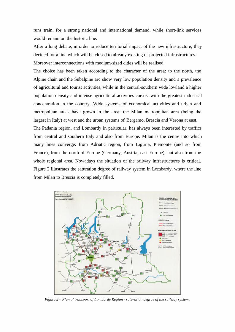
The Padania region, and Lombardy in particular, has always been interested by traffics
from central and southern Italy and also from Europe. Milan is the centre into which
many lines converge: from Adriatic region, from Liguria, Piemonte (and so from
France), from the north of Europe (Germany, Austria, east Europe), but also from the
whole regional area. Nowadays the situation of the railway infrastructures is critical.
Figure 2 illustrates the saturation degree of railway system in Lombardy, where the line
from Milan to Brescia is completely filled.
Figure 2 – Plan of transport of Lombardy Region - saturation degree of the railway system,

EVALUATION OF EFFECTS ON SPATIAL ACCESSIBILITY
The H.S./H.C. plan have been assessed versus the situation at the present, measuring the
accessibility index for study area, which has been divided into zones, following general
criterion like dimensional homogeneity (in terms of population and surface);
homogeneity in terms of accessibility to the communication network and administrative
subdivision (Municipality, Mountain Community, metropolitan area).
Torino
Aosta
Genova
Milano
Bologna
Firenze
Brescia
Trento
TriesteVenezia
Verona
H.S. line (with interconnection)
historic line
Figure 3 - The study area: Turin-
Venice line and the H.S./H.C.
project
The accessibility index values of each zone, with the hypothesis of H.S./H.C. line with
interconnections to middle-sized towns, is remarkably higher with respect to the current
situation, where a high accessibility band extends from Milan to the east, while the
marginal zones are those of the mountain valleys (north of the chart) and of the lowland
south-east Provinces.
The most accessible zones (west part of the region; figure 3) show none or slight
improvements by the realisation of the H.S./H.C. plan.
It is also important to emphasise how many zones even not directly served by the
Milan-Verona line show an important increase of accessibility. The most improved zone
is Verona.
According to the simulation hereby described, the presence of many important medium-
sized towns with a short-run traffic level is still one of the prominent question of the
impact assessment of the east-west H.S./H.C. infrastructure in northern Italy.
The analysis is based on the multimodal travel time, that is combined trip with the
quickest mode for each section.
Following our assumption, we are far from estimating modal split, but the time matrixes
allow a simple estimation of the means of transport (private car, railway or combined

transportation) which assure the least time for each relation, by comparing the travel
time before and after the new H.S./H.C. line is on service.
The matrix of travel time in the present situation has been built by calculating the least
path both considering the shortest connection and the most efficient mode. In most
cases car is the best means of transport, but several situations change, both because of
speed increase in some tracks and the higher service frequency, when H.S. is
considered:
• car sections moves from 86.5 to 79.4% of cases;
• railway rate from13.1 to 17.4%;
• multimodal trip rate from 0.4 to 3.2 %.
Figure 4 Classes of accessibility index (Xi) in the present
situation
Figure 5 Variations [%] of accessibility index ( Xi) after the
introduction of H.S./H.C. with respect to the present
situation
SOME CONCLUSIVE REMARKS
The present work analyses only passenger transportation service, according to studies
that focused on the considerably increasing business mobility, which involves growing
number of activities (Gorla et al., 1993).
Based on a very simple interaction model, the measure of a H.S./H.C. line efficiency by
accessibility calculus, has shown several important aspects. In the environmental impact
analysis (CEPAV2, 1992) these aspects are mostly neglected, while one of the main
concern of the local authorities confronting with the project is the rail travel supply
improvement, even and foremost for local services.
In particular, H.S./H.C. convenience in the east-west corridor shows less evidence than
the main north-south direction in the Italian H.S. system, but no less importance from an
European point of view and due to the overcoming congestion.
What can be shown is the impact of the new line in a much larger area than the narrow
band across the line: relevant effects are felt also in the zones where a secondary level
railway system is present (i.e. the south-east Provinces).
So, even in far distant areas, the new railway system can split the private vehicular
mode to railway, mainly because of the higher number of trains per day, rather than for
the higher speed. This is a prominent result confirming the new trim of the entire
railway system the Italian H.S./H.C. program aims to be.
A further step should be to assess, at the same territorial scale, the influence of travel
costs in order to obtain a more precise information about the foreseen modal split,
which is - both for passenger and overall for freight services - a main concern for the
most dense and highly congested urban area in Italy. That could be done even by
running a very simple interaction model, since land-use and transportation are two
interrelated major concerns of urban planners.
REFERENCES
Bach L. (1981), The problem of aggregation and distance for analyses of accessibility and access
opportunity in location-allocation models, Environment and Planning A, vol. 13.
Batty M. (1971), Exploratory calibration of a retail location model using search by golden section,
Environment and Planning A, vol. 4.
Ben-Akiva M, Lerman S.R. (1978), Disaggregate travel and mobility choice models and measure of
accessibility, in Hensher D.A., Stopher P.R., Behaviour Travel Modelling, Croom Helm, London.
Bettini V., Cancelli C., Galantini R., Rabitti P., Tartaglia A., Zambrini M. (1996), Valutazione del
progetto Alta Velocità in Italia.
Busi R. (1994 ed.), Metropoli e mobilità, il caso di Brescia. Analisi e indirizzi, Sintesi, Brescia.
CEPAV 2 (ed.) (1992), Linea Torino-Venezia, tratta Milano-Verona: Studio di impatto ambientale.
Sintesi tecnica.
Davidson K.B. (1977), Accessibility in transport land use modelling and assessment, Environment and
Planning A, vol.9.
Ente Fs (1988), Valutazione economico-finanziaria della linea ferroviaria ad A.V. Torino-Venezia, Rome.
Ente Fs (1990), Sistema ferroviario ad A.V., direttrice Torino-Milano-Venezia. Sintesi del rapporto
finale, Rome.
Ente Fs (1994), Studio di fattibilità della linea Torino-Venezia. Sintesi finale, Rome.
Evans A.W. (1971), The calibration of trip distribution models with exponential or similar functions,
Transportation Research, vol 11, Pergamon Press, GB.

Gerardine B. (1991), Investment in Transport Infrastructure and Regional Development, in Vickermann
R.W. (ed.), Infrastructure and regional development, Pion, London
Gorla G., Lampugnani G., Senn L. (1993), Gli effetti attesi dell’Alta velocità ferroviaria. Primi elementi
di valutazione dell’impatto territoriale del sistema Alta velocità in Italia, Capri, 1993
Moretti A., Reggiani R. (1984), Sperimentazioni e analisi comparate riferite alla misura di accessibilità,
Clup, Milan.
Nijkamp P. (1986), Infrastructure and regional development: a multidimensional policy analysis,
Empirical Economics, vol.11.
Sen A., Smith T. (1995), Gravity models of spatial interaction behaviour, Springer-Verlag Berlin,
Heidelberg.
Tiboni M., Tira M., Expected effects on spatial accessibility of a high speed railway: the case study of
Northern Italy, Studies in Regional & Urban Planning, Athens, 1997
Tira M. (1994), Il progetto di Alta Velocità ferroviaria nella Lombardia orientale: alcuni elementi per la
valutazione dell'impatto territoriale della tratta Milano-Verona, Proc. of the XV Italian Conference of
Regional Sciences AISRe (Matera).
Tira M. (1996 ed.), Metropoli e mobilità: sostenibilità territoriale delle tecnologie ferroviarie innovative
(Vol. IV), Sintesi, Brescia.
Wilson A.G. (1974), Urban and regional models in geography and planning , John Wiley, London.