DESIGN OF A RECONFIGURABLE ANTENNA FOR GROUND PENETRATING RADAR APPLICATIONS
Ground Penetrating Radar:
Overview and Applications in Archaeology
and Forensic Science with a Focus on
Florida
Kevin Gidusko
University of Central Florida
Anthropology Department
ANG 6918
Dr. John J. Schultz
July 25, 2014
ABSTRACT
Ground Penetrating Radar (GPR) is a geological prospection tool appropriated from
fields in the natural sciences into anthropological research that provides a relatively quick and
nondestructive method of investigating the near subsurface of a site. Originally utilized for
archaeological investigations, including the location and delimitation of historic cemeteries, GPR
has recently begun to play a larger role in forensic science. Ground Penetrating Radar can
provide the forensic investigator with a noninvasive method of locating clandestine burials. This
paper provides an overview of GPR and applications in the fields of archaeology and forensic
investigations. Special attention is paid to the utilization of GPR in the detection of cemetery
graves and further possible research in this area.
Key Words: Ground Penetrating Radar, Clandestine Burials, Geophysical Applications in
Anthropology, Historic Cemeteries
INTRODUCTION AND PURPOSE
Ground Penetrating Radar (GPR) is increasingly important to archaeological and forensic
investigations (Isaacson et al., 1999; Leckebusch, 2003; Ruffell and McKinley, 2005; Morgan
and Bull, 2007; Schultz, 2007; Schultz and Dupras, 2008; Wardlaw, 2009; Conyers and
Leckebusch, 2010; Pringle et al., 2012). Ground Penetrating Radar, as with other geophysical
applications in archaeology and forensic sciences, provides researchers with a relatively quick,
noninvasive, and increasingly more precise representation of anomalies at the near subsurface at
a given site. Relative to the manpower required to survey a site utilizing invasive methods such
as shovel surveys, GPR is more cost effective in terms of both the number of individuals and the
time required to carry out a site investigation (Johnson and Haley, 2006). Ground Penetrating
Radar has been used in a wide variety of archaeological sites and contexts; from investigations
into Roman era burial tombs in Egypt (Shaaban et al., 2009), to mass graves in North West
Ireland (Ruffell et al., 2009), to the remains of a Middle Archaic shell monument along the St.
Johns River in Florida (Sassaman et al., 2011). More recently, GPR has become an important
tool for forensic investigations as well, utilized often to detect clandestine burials (Unterberger,
1992; Mellett, 1992a; Miller, 1996; Nobes, 2000; Davenport, 2001; Ruffell and McKinley, 2004;
Morgan and Bull, 2007; Schultz, 2007; Schultz and Dupras, 2008; Billinger, 2009; Novo et al.
2011; Conklin et al.; Pringle et al., 2012). Because of the aforementioned factors and its
persistent integration into current research we may expect that GPR will continue to be an
integral aspect of archaeological and forensic investigations for the foreseeable future. As such,
it is worthwhile to become more aware of this technology and to determine what future avenues
of research this important tool will provide researchers. The purpose of this paper is to provide
an overview of GPR principles and methods. This will include overviews of GPR use in
archaeological and forensic contexts with a case study presented for illustration. A special focus
is paid to previous and possible future research in the state of Florida.
GPR HISTORY
Ground Penetrating Radar, as we know it today, has its inception in the radar technology
developed during WWII and was used largely for the detection of aircraft. As Conyers (2004)
notes, this technology was reevaluated in the 1950s as U.S. Air Force radar technicians noticed
that radar pulses penetrated glacial ice when flying over Greenland, suggesting its use for
subsurface prospection. An early GPR system was developed for use by NASA in 1972 and was
dispatched with the Apollo 17 mission in order to better understand the geology of the moon
(Conyers, 2006). The 1970s saw the growth of GPR as a geotechnical tool when researchers in
the fields of geophysics, geology and physics began to incorporate GPR into their investigations
(Leckebusch, 2003; Conyers, 2004; Conyers and Leckebusch, 2010).
The field of archaeology was quick to adapt GPR to site surveying with some initial,
albeit slow success. Early GPR units provided little in the way of immediate readability and data
storage; for example, in some models oscilloscopes provided a signal readout which had to be
photographed in order to be stored (Leckebusch, 2003). However, in 1975 one of the first GPR
applications to an archaeological investigation was conducted at Chaco Canyon, New Mexico.
Vickers and Dolphin (1975) demonstrated the utility of GPR for identifying anomalies at about
1m below surface. These anomalies, when ground-truthed, were found to be mud brick walls.
Early utilization of GPR in the field offered little more than the location of anomalies in the
subsurface which were often hard to distinguish between anthropogenic or archaeological
features and that of naturally occurring soil change (Leckebusch, 2003; Conyers 2004; Conyers
2006). Succeeding decades saw a refinement of GPR use within archaeology as researchers
focused on the functionality of this tool in a variety of conditions and locales (Sheets, 1985; Imai
et al., 1987; Goodman and Nishimura 1993; Conyers, 2004). Certainly a great impetus to the
increased use of GPR in archaeological surveys can be attributed to advancement of digital
technology over the last several decades which allowed for the manufacture of GPR components
providing real-time data displays as well as digital data collection (Leckebusch 2003; Conyers
2004). Advancements continue to be made in GPR processing and visualization, driven largely
by its increasing acceptance in the field of archaeology and especially due to its utilization in
cultural resource management (CRM) firms who take advantage of its relatively low cost (Table
1) and data collection speed (Grasmueck et al., 2004; Johnson and Haley, 2006; Lockhart and
Green, 2006; Conyers and Leckebusch, 2010; Conyers, 2012).
Present research in GPR continues to focus on the advancement of processing techniques
and the testing of GPR in areas previously deemed unlikely to produce valid results
(Leckebusch, 2003; Schultz, 2008; Schultz et al, 2006; Schultz and Martin, 2011; Lualdi and
Lombardi, 2014; Teixidó et al., 2014). The ability to render subsurface data collected with GPR
in 3D models, while not new, continues to be a focal point of archaeological and forensic
investigations as digital processing technology advances. Increasingly, data collected by GPR
can be readily integrated into various other mapping and visualization software packages that
provide access to global positioning systems (GPS) information of the site and accurate
subsurface 3D models of anomalies that can be transferred into geographic information systems
(GIS). These applications allow for a noninvasive manner in which to effectively study sites as
well as a method of long-term digital preservation (Lualdi and Lombardi, 2014; Teixidó et al.,
2014; Catapano, et al., 2014).
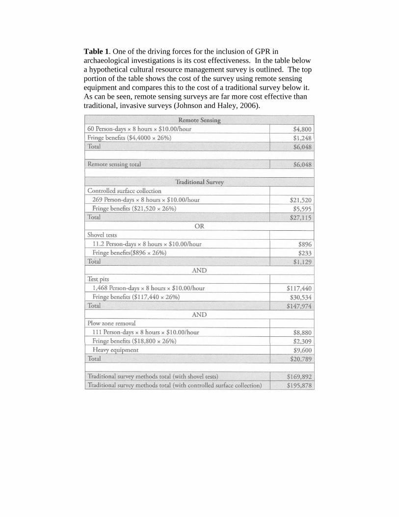
Table 1. One of the driving forces for the inclusion of GPR in
archaeological investigations is its cost effectiveness. In the table below
a hypothetical cultural resource management survey is outlined. The top
portion of the table shows the cost of the survey using remote sensing
equipment and compares this to the cost of a traditional survey below it.
As can be seen, remote sensing surveys are far more cost effective than
traditional, invasive surveys (Johnson and Haley, 2006).
Operation of GPR
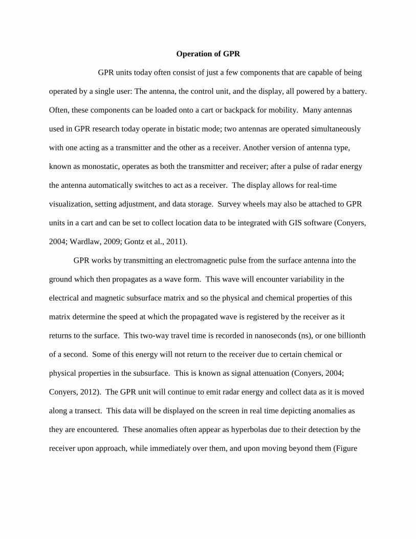
GPR units today often consist of just a few components that are capable of being
operated by a single user: The antenna, the control unit, and the display, all powered by a battery.
Often, these components can be loaded onto a cart or backpack for mobility. Many antennas
used in GPR research today operate in bistatic mode; two antennas are operated simultaneously
with one acting as a transmitter and the other as a receiver. Another version of antenna type,
known as monostatic, operates as both the transmitter and receiver; after a pulse of radar energy
the antenna automatically switches to act as a receiver. The display allows for real-time
visualization, setting adjustment, and data storage. Survey wheels may also be attached to GPR
units in a cart and can be set to collect location data to be integrated with GIS software (Conyers,
2004; Wardlaw, 2009; Gontz et al., 2011).
GPR works by transmitting an electromagnetic pulse from the surface antenna into the
ground which then propagates as a wave form. This wave will encounter variability in the
electrical and magnetic subsurface matrix and so the physical and chemical properties of this
matrix determine the speed at which the propagated wave is registered by the receiver as it
returns to the surface. This two-way travel time is recorded in nanoseconds (ns), or one billionth
of a second. Some of this energy will not return to the receiver due to certain chemical or
physical properties in the subsurface. This is known as signal attenuation (Conyers, 2004;
Conyers, 2012). The GPR unit will continue to emit radar energy and collect data as it is moved
along a transect. This data will be displayed on the screen in real time depicting anomalies as
they are encountered. These anomalies often appear as hyperbolas due to their detection by the
receiver upon approach, while immediately over them, and upon moving beyond them (Figure
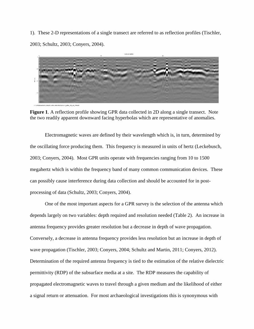
1). These 2-D representations of a single transect are referred to as reflection profiles (Tischler,
2003; Schultz, 2003; Conyers, 2004).
Figure 1. A reflection profile showing GPR data collected in 2D along a single transect. Note
the two readily apparent downward facing hyperbolas which are representative of anomalies.
Electromagnetic waves are defined by their wavelength which is, in turn, determined by
the oscillating force producing them. This frequency is measured in units of hertz (Leckebusch,
2003; Conyers, 2004). Most GPR units operate with frequencies ranging from 10 to 1500
megahertz which is within the frequency band of many common communication devices. These
can possibly cause interference during data collection and should be accounted for in post-
processing of data (Schultz, 2003; Conyers, 2004).
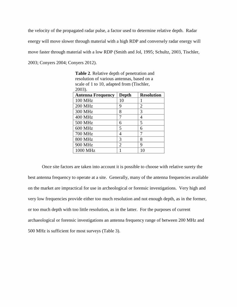
One of the most important aspects for a GPR survey is the selection of the antenna which
depends largely on two variables: depth required and resolution needed (Table 2). An increase in
antenna frequency provides greater resolution but a decrease in depth of wave propagation.
Conversely, a decrease in antenna frequency provides less resolution but an increase in depth of
wave propagation (Tischler, 2003; Conyers, 2004; Schultz and Martin, 2011; Conyers, 2012).
Determination of the required antenna frequency is tied to the estimation of the relative dielectric
permittivity (RDP) of the subsurface media at a site. The RDP measures the capability of
propagated electromagnetic waves to travel through a given medium and the likelihood of either
a signal return or attenuation. For most archaeological investigations this is synonymous with
the velocity of the propagated radar pulse, a factor used to determine relative depth. Radar
energy will move slower through material with a high RDP and conversely radar energy will
move faster through material with a low RDP (Smith and Jol, 1995; Schultz, 2003, Tischler,
2003; Conyers 2004; Conyers 2012).
Table 2. Relative depth of penetration and
resolution of various antennas, based on a
scale of 1 to 10, adapted from (Tischler,
2003).
Antenna Frequency Depth Resolution
100 MHz 10 1
200 MHz 9 2
300 MHz 8 3
400 MHz 7 4
500 MHz 6 5
600 MHz 5 6
700 MHz 4 7
800 MHz 3 8
900 MHz 2 9
1000 MHz 1 10
Once site factors are taken into account it is possible to choose with relative surety the
best antenna frequency to operate at a site. Generally, many of the antenna frequencies available
on the market are impractical for use in archeological or forensic investigations. Very high and
very low frequencies provide either too much resolution and not enough depth, as in the former,
or too much depth with too little resolution, as in the latter. For the purposes of current
archaeological or forensic investigations an antenna frequency range of between 200 MHz and
500 MHz is sufficient for most surveys (Table 3).
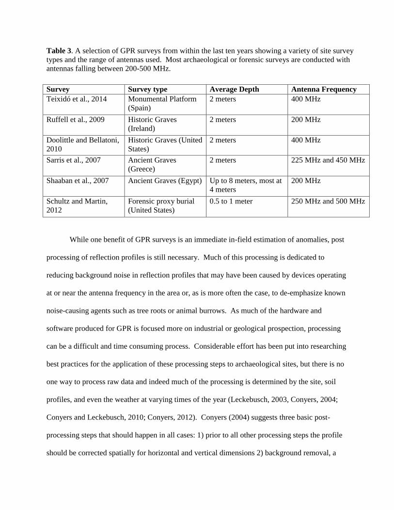
Table 3. A selection of GPR surveys from within the last ten years showing a variety of site survey
types and the range of antennas used. Most archaeological or forensic surveys are conducted with
antennas falling between 200-500 MHz.
Survey Survey type Average Depth Antenna Frequency
Teixidó et al., 2014 Monumental Platform
(Spain)
2 meters 400 MHz
Ruffell et al., 2009 Historic Graves
(Ireland)
2 meters 200 MHz
Doolittle and Bellatoni,
2010
Historic Graves (United
States)
2 meters 400 MHz
Sarris et al., 2007 Ancient Graves
(Greece)
2 meters 225 MHz and 450 MHz
Shaaban et al., 2007 Ancient Graves (Egypt) Up to 8 meters, most at
4 meters
200 MHz
Schultz and Martin,
2012
Forensic proxy burial
(United States)
0.5 to 1 meter 250 MHz and 500 MHz
While one benefit of GPR surveys is an immediate in-field estimation of anomalies, post
processing of reflection profiles is still necessary. Much of this processing is dedicated to
reducing background noise in reflection profiles that may have been caused by devices operating
at or near the antenna frequency in the area or, as is more often the case, to de-emphasize known
noise-causing agents such as tree roots or animal burrows. As much of the hardware and
software produced for GPR is focused more on industrial or geological prospection, processing
can be a difficult and time consuming process. Considerable effort has been put into researching
best practices for the application of these processing steps to archaeological sites, but there is no
one way to process raw data and indeed much of the processing is determined by the site, soil
profiles, and even the weather at varying times of the year (Leckebusch, 2003, Conyers, 2004;
Conyers and Leckebusch, 2010; Conyers, 2012). Conyers (2004) suggests three basic post-
processing steps that should happen in all cases: 1) prior to all other processing steps the profile
should be corrected spatially for horizontal and vertical dimensions 2) background removal, a
noise filtering process and 3) range gaining to enhance important reflections. As each site and
survey is unique, post processing steps beyond these basics may change, but once a system of
processing is established for a site it is recommended to maintain that processing order.
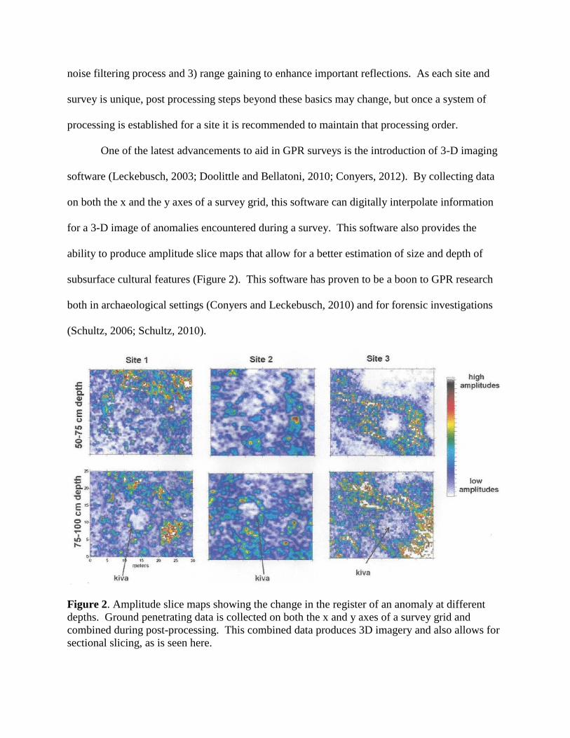
One of the latest advancements to aid in GPR surveys is the introduction of 3-D imaging
software (Leckebusch, 2003; Doolittle and Bellatoni, 2010; Conyers, 2012). By collecting data
on both the x and the y axes of a survey grid, this software can digitally interpolate information
for a 3-D image of anomalies encountered during a survey. This software also provides the
ability to produce amplitude slice maps that allow for a better estimation of size and depth of
subsurface cultural features (Figure 2). This software has proven to be a boon to GPR research
both in archaeological settings (Conyers and Leckebusch, 2010) and for forensic investigations
(Schultz, 2006; Schultz, 2010).
Figure 2. Amplitude slice maps showing the change in the register of an anomaly at different
depths. Ground penetrating data is collected on both the x and y axes of a survey grid and
combined during post-processing. This combined data produces 3D imagery and also allows for
sectional slicing, as is seen here.
Soil and GPR
Soils and the different properties of soils are important to understand in order to benefit
from a GPR survey. Soils encompass the mineral, organic, gaseous, and liquid material that
encompasses most surface land on earth. The type and distribution of soils is dependent on a
number of geological and environmental factors which change over time. Soils are characterized
by their chemical composition as well as their horizons, or layers. Horizons are formed by the
accumulation, transformation, or loss of material at a given location. Soil horizons, or layers of
soil, do not have homogenous electrical or chemical properties with layers above or below.
These differing properties register as differing amplitudes by the antenna’s receiver during a
GPR survey. It is this function of GPR that allows for the location of anomalies; given a site
with a known soil profile, the GPR registers that which is outside the norm for the profile (Soil
Survey Staff, 1999; Doolittle and Butnor, 2009; Soil Survey Staff, 2010).
One of the greatest hindrances to the feasibility of a GPR survey is the type and condition
of soil at the site (Doolittle and Collins, 1995; Conyers, 2004; Schultz et al., 2006; Schultz et al,
2008; Conyers, 2012). The electromagnetic pulses from GPR antennas are susceptible to signal
attenuation in certain soil and weather conditions. As anomalies are the representation of
electrical or chemical differences detected in the soil matrix, signal attenuation due to soil
characteristics renders GPR surveying difficult or even unviable at certain sites and at certain
times of the year. As such, a basic knowledge of soil characteristics and limiting factors should
be taken into account prior to a GPR field survey. In the United States this can usually be
ascertained through an examination of soil taxonomy information provided by the USDA (Soil
Survey Staff, 2010) or state and local soil surveys which are largely generated and refined
utilizing GPR (Doolittle and Collins, 1995).
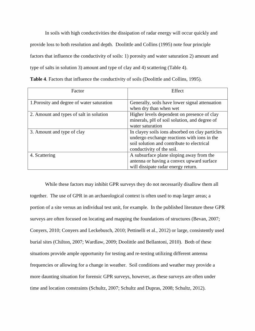
In soils with high conductivities the dissipation of radar energy will occur quickly and
provide loss to both resolution and depth. Doolittle and Collins (1995) note four principle
factors that influence the conductivity of soils: 1) porosity and water saturation 2) amount and
type of salts in solution 3) amount and type of clay and 4) scattering (Table 4).
Table 4. Factors that influence the conductivity of soils (Doolittle and Collins, 1995).
Factor Effect
1.Porosity and degree of water saturation Generally, soils have lower signal attenuation
when dry than when wet
2. Amount and types of salt in solution Higher levels dependent on presence of clay
minerals, pH of soil solution, and degree of
water saturation
3. Amount and type of clay In clayey soils ions absorbed on clay particles
undergo exchange reactions with ions in the
soil solution and contribute to electrical
conductivity of the soil.
4. Scattering A subsurface plane sloping away from the
antenna or having a convex upward surface
will dissipate radar energy return.
While these factors may inhibit GPR surveys they do not necessarily disallow them all
together. The use of GPR in an archaeological context is often used to map larger areas; a
portion of a site versus an individual test unit, for example. In the published literature these GPR
surveys are often focused on locating and mapping the foundations of structures (Bevan, 2007;
Conyers, 2010; Conyers and Leckebusch, 2010; Pettinelli et al., 2012) or large, consistently used
burial sites (Chilton, 2007; Wardlaw, 2009; Doolittle and Bellantoni, 2010). Both of these
situations provide ample opportunity for testing and re-testing utilizing different antenna
frequencies or allowing for a change in weather. Soil conditions and weather may provide a
more daunting situation for forensic GPR surveys, however, as these surveys are often under
time and location constraints (Schultz, 2007; Schultz and Dupras, 2008; Schultz, 2012).
Soils are classified in the United States according to the United States Department
of Agriculture (USDA). The USDA’s Soil Taxonomy (1999) provides information on the twelve
recognized soil orders found in the United States: Alfisols, Andisols, Aridisols, Entisols,
Gelisols, Histosols, Inceptisols, Mollisols, Oxisols, Spodosols, Ultisols, and Vertisols. This soil
information provides some of the most basic data necessary to determine the efficacy of a GPR
survey at a given location. In 1954 (Fine) an early map outlining the relative soil conductivity of
the United States was produced. This map provided general information based on state soil
surveys, but had issues with its scale (the scale was far too small to effectively differentiate GPR
applicability at the local level) and its sample size was far too few to be truly effective (Doolittle,
2012). More recently, a more precise GPR soil suitability map was produced by the USDA with
the aid of state soil surveys and a far more defined delineation of soil orders at the local level
(Doolittle and Butnor, 2009; Doolittle, 2012).
Soil in Florida (Figure 3) falls into seven of the twelve soil orders as outlined by the
USDA’s Soil Taxonomy (1999). The soil order is the highest hierarchical level for soil
definition. Collins (1985) states that soil orders, “are distinguished in relation to the five soil-
forming factors: (1) climate and (2) living organisms acting on (3) parent materials over (4) time
as conditioned by (5) relief.” Soil orders are broken down into more defined sub-units dependent
on formation processes, presence or absence of minerals, and even utilization by humans. For
the purposes of this paper, however, it suffices to contain the discussion to the seven soil orders
found in Florida, their overarching characteristics, and what effects these characteristics have on
the potential use of GPR in a field survey.
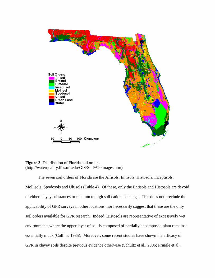
Figure 3. Distribution of Florida soil orders
(http://waterquality.ifas.ufl.edu/GIS/Soil%20images.htm)
The seven soil orders of Florida are the Alfisols, Entisols, Histosols, Inceptisols,
Mollisols, Spodosols and Ultisols (Table 4). Of these, only the Entisols and Histosols are devoid
of either clayey substances or medium to high soil cation exchange. This does not preclude the
applicability of GPR surveys in other locations, nor necessarily suggest that these are the only
soil orders available for GPR research. Indeed, Histosols are representative of excessively wet
environments where the upper layer of soil is composed of partially decomposed plant remains;
essentially muck (Collins, 1985). Moreover, some recent studies have shown the efficacy of
GPR in clayey soils despite previous evidence otherwise (Schultz et al., 2006; Pringle et al.,
2013; Lowe et al., 2013) as will be discussed later. The important factor for GPR surveying
appears to be a sound knowledge of both the equipment and the environment as well as an
understanding of proper post-processing procedures.
A basic understanding of soil science is necessary to the proper use of GPR in a field
survey. Failing to note properties in soil that may cause a rapid attenuation of radar energy has
the ability to make a survey fruitless. By garnering as much information of a site’s formational
processes and understanding the capabilities of the GPR equipment and post-processing
procedures, it may be possible to expand the role of GPR in future surveys.
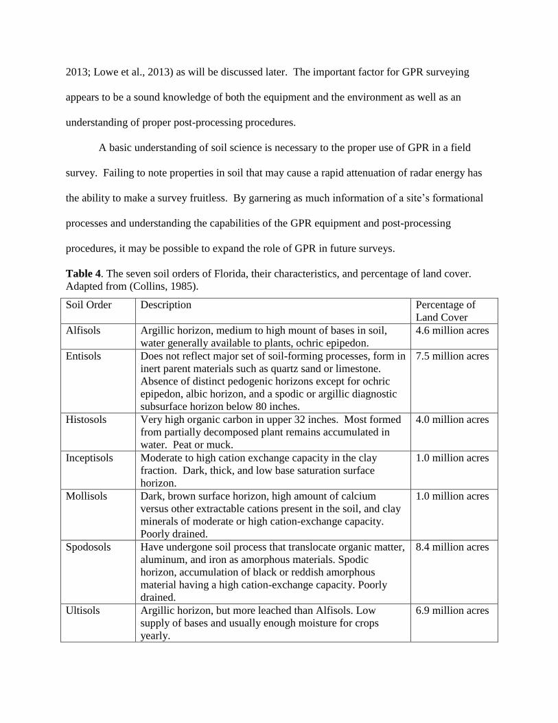
Table 4. The seven soil orders of Florida, their characteristics, and percentage of land cover.
Adapted from (Collins, 1985).
Soil Order Description Percentage of
Land Cover
Alfisols Argillic horizon, medium to high mount of bases in soil,
water generally available to plants, ochric epipedon.
4.6 million acres
Entisols Does not reflect major set of soil-forming processes, form in
inert parent materials such as quartz sand or limestone.
Absence of distinct pedogenic horizons except for ochric
epipedon, albic horizon, and a spodic or argillic diagnostic
subsurface horizon below 80 inches.
7.5 million acres
Histosols Very high organic carbon in upper 32 inches. Most formed
from partially decomposed plant remains accumulated in
water. Peat or muck.
4.0 million acres
Inceptisols Moderate to high cation exchange capacity in the clay
fraction. Dark, thick, and low base saturation surface
horizon.
1.0 million acres
Mollisols Dark, brown surface horizon, high amount of calcium
versus other extractable cations present in the soil, and clay
minerals of moderate or high cation-exchange capacity.
Poorly drained.
1.0 million acres
Spodosols Have undergone soil process that translocate organic matter,
aluminum, and iron as amorphous materials. Spodic
horizon, accumulation of black or reddish amorphous
material having a high cation-exchange capacity. Poorly
drained.
8.4 million acres
Ultisols Argillic horizon, but more leached than Alfisols. Low
supply of bases and usually enough moisture for crops
yearly.
6.9 million acres
GPR Survey, an Overview
The basic format of a GPR survey is fundamentally similar across the wide variety of
situations it may be used in. While post-processing, as discussed above, is an integral aspect of
the GPR survey, it is meaningless without the successful detection of anomalies in the field in a
manner that provides the best possible information on subsurface anomalies. For the purposes of
presenting the process of a GPR survey, an example of a recent survey undertaken in part by the
author will be used (Schultz and Gidusko, 2014).
This survey was conducted at the Fountain of Youth Archaeological Park in St.
Augustine, Florida (FOY). The park is operated as a tourist destination and sits alongside the
Matanzas River, which periodically floods the park grounds. The site has been the location of
extensive archaeological work and, in fact, this survey was initiated to attempt to locate previous
excavation units from the middle of the last century. The location of past test units were sought
in order to better map in previous work conducted at the site to an updated grid system that had
been emplaced which was tied into GPS and GIS data. A GPR survey could thus inform future
excavation at the site and save valuable field hours.
Choice of antenna is largely affected by desired depth and resolution needed. These are
factors of the soil type and condition as well as the type of feature being investigated. That is, a
building foundation will require a different approach from an historic grave site; one is large and
requires relatively little resolution and the other is small and requires higher resolution. As this
survey sought large (several meters long), but relatively shallow (>1 m) archaeological test units,
there was little need for extreme depth or resolution. A 250 MHz antenna was decided on for the
survey.
Ground Penetrating Radar surveys should occur on a grid system that is either placed by
the surveyors or works within an existing grid system put in place by a site’s principal
investigator. This allows for a careful control of data collection. Within the grid system
individual transects for the GPR survey can and should be adjusted dependent on subsurface
resolution desired (Goodman et al., 2009). As the GPR unit pulses radar energy into the ground
the wave is propagated in a roughly conical shape that spreads wider as it travels away from the
antenna. For a large subsurface feature, such as a building foundation, a wider spacing will
provide reasonable results but would miss smaller-scaled anomalies. For this reason, it is best to
keep data collection to shorter transect intervals in order to provide enough radar energy overlap.
This provides a clearer depiction of subsurface anomalies, limits the possibility of missing these
anomalies, and provides better data for 3D modeling software. For the survey here, intervals
were set at .50 m. Grid lines should also be set in such a way that the GPR is kept away from
noise-inducing items such as metal demarcation nails or pin flags (Goodman et al., 2009; Annan,
2009).
Before a survey can commence at a site it is also necessary to set the GPR’s velocity,
which in newer GPR models is synonymous with depth. Velocity refers to the propagation of
the radar energy from the antenna and is changed on a site to site basis according to several
factors such as clay content of the soils, moisture in the soil, salinity in the moisture, and the
relative dielectric permittivity of a known soil order. An excellent method of attuning the GPR
unit to the velocity needed at a site is to either 1) collect data over a known subsurface feature
that can be probed for precise depth or 2) bury a highly reflective, conductive material (rebar
posts were used in this survey) at a set depth, then collect data over this area (Figure 4). This
allows for a far more precise method of setting a GPR’s velocity at a given site than to apply
preset relative dielectric permittivity settings.
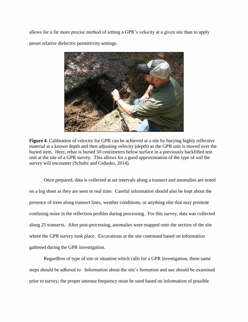
Figure 4. Calibration of velocity for GPR can be achieved at a site by burying highly reflective
material at a known depth and then adjusting velocity (depth) as the GPR unit is moved over the
buried item. Here, rebar is buried 50 centimeters below surface in a previously backfilled test
unit at the site of a GPR survey. This allows for a good approximation of the type of soil the
survey will encounter (Schultz and Gidusko, 2014).
Once prepared, data is collected at set intervals along a transect and anomalies are noted
on a log sheet as they are seen in real time. Careful information should also be kept about the
presence of trees along transect lines, weather conditions, or anything else that may promote
confusing noise in the reflection profiles during processing. For this survey, data was collected
along 25 transects. After post-processing, anomalies were mapped onto the section of the site
where the GPR survey took place. Excavations at the site continued based on information
gathered during the GPR investigation.
Regardless of type of site or situation which calls for a GPR investigation, these same
steps should be adhered to: Information about the site’s formation and use should be examined
prior to survey; the proper antenna frequency must be used based on information of possible
anomaly types to be encountered; the survey should be conducted on a grid system with transect
intervals kept close; information about possible noise-inducing agents should be recorded; and
finally, data must be processed.
GPR in Archaeology with a Focus on Florida
It was not long after initial attempts to utilize GPR for archaeological surveys began that
its worth became apparent to researchers in the archaeological community, though perhaps ease
of operability lagged behind utility by a few decades (Vickers and Dolphin, 1975; Imai et al.,
1987; Conyers, 2004). Much of this intervening time has seen the creation of new, more readily
accessible GPR units with a wider array of antenna frequencies, visualization capabilities, data
storage, and post-processing options. These advances in the technology associated with GPR
helped secure its role in future archaeological investigations for the foreseeable future; becoming
a mainstay of research agendas, conference presentations, and peer-reviewed journal articles.
Ground Penetrating Radar, along with other archaeogeophysical technologies, is now
regularly used in the CRM industry (Lockhart and Green, 2006; Johnson and Haley, 2006). This
is likely due to its cost-effectiveness and consistently reliable results. Such extensive use in the
realm of CRM, however, exposes both benefits to the continued use of GPR as well as some
research deficits. Most archaeological research in the United States today, as it has for the past
three decades, occurs in the CRM sector. This is due to several legislative acts, but especially
due to the National Historic Preservation Act of 1966 and the Archaeological and Historic
Preservation Act of 1974. This legislation was largely due to a growing recognition of cultural
resources as finite and necessitating active preservation. Currently, more than two-thirds of the
archaeologists conducting work in the United States represent CRM entities (Weymouth, 1986;
Green and Doershuk, 1998; Lockhart and Green, 2006). The growth of CRM firms and the use
of GPR are concurrent and highly intertwined. While this has meant the abundant collection of
data utilizing GPR it also creates the unique situation in which much of this data is represented
only in grey literature, not easily accessible or perhaps even often utilized after the completion of
a project. While it is important to note the presence of this accumulated data and its obvious
potential worth, this paper focuses primarily on research-driven and/or published examples of
GPR use.
The following examples provide a look at GPR applications in archaeology. The first
example (Imai et al., 1987) provides a look at the early application of GPR; its efficiency and
capability at a variety of sites in Japan are described as is a basic overview of the operation of
GPR. The next two articles (Thompson and Pluckhahn, 2010; Thompson et al., 2014) show
current applications of GPR to archaeological research. Contrasted with Imai’s research, these
examples show the growth of GPR and its integration into the wider field methods used during
field investigations.
GPR in Archaeology, an Early Example
An early and excellent example of the use of GPR in an archaeological context can be
found in the work conducted by Tsuneo Imai and others in1987 in Japan (Imai et al., 1987).
Imai notes that geophysical methods are regularly used at archaeological sites in Japan both
before excavation or construction and as a form of cultural resource documentation. Imai and
colleagues used a combination of GPR and resistivity surveys to investigate four sites, the first
three buried under successive layers of volcanic ash. Imai’s first three sites were located in the
Gumma Prefecture of the Kanto region. The first site was surveyed using a bistatic GPR antenna
and sought to discover foundation walls and dwelling floors located up to 70 centimeters below
surface. The second site was far more complex in size and variability. At this site Imai sought
to map and delimit the remains of a small town buried under up to 2m of pumice deposits from
an eruption in the sixth century A. D. Most notable at this location was the determination of a
large burial mound with a diameter of nearly 15m. Imai noticed a unique reflection profile from
within the mound that suggested an inner stone tomb, later confirmed through excavation. The
third site was used by Imai to test the ability of GPR to differentiate between what he terms
“culture layers,” essentially noting the cultural continuity associated with differing stratigraphic
layers (Imai, 1987). Imai noted that these layers were distinctive in detection up to nearly 3m
below surface and that GPR was thus fit to adequately map the distribution of culturally
significant stratigraphic layers in relation to each other. Imai’s fourth site showed the utilization
of resistivity and GPR surveys to detect a stone-lined waterway in a Nara-period town, which
was mapped and confirmed through excavation.
Imai and others conducting early archaeological work using geophysical methods set the
stage for further analyses and refinements of methods. This early paper on GPR prospecting in
an archaeological context illustrates the utility and purpose of future research into this field of
study.
GPR in Florida, Two Examples
Two recent examples from Florida will show the use of GPR in current archaeological
research. Both examples examine the prehistoric cultural landscape of two sites on Florida’s
west coast and demonstrate the utilization of GPR not only as a viable mapping and visualization
tool, but a capable addition to the methods of cultural interpretation at an archaeological site
(Thompson and Pluckhahn, 2010; Thompson et al., 2014).
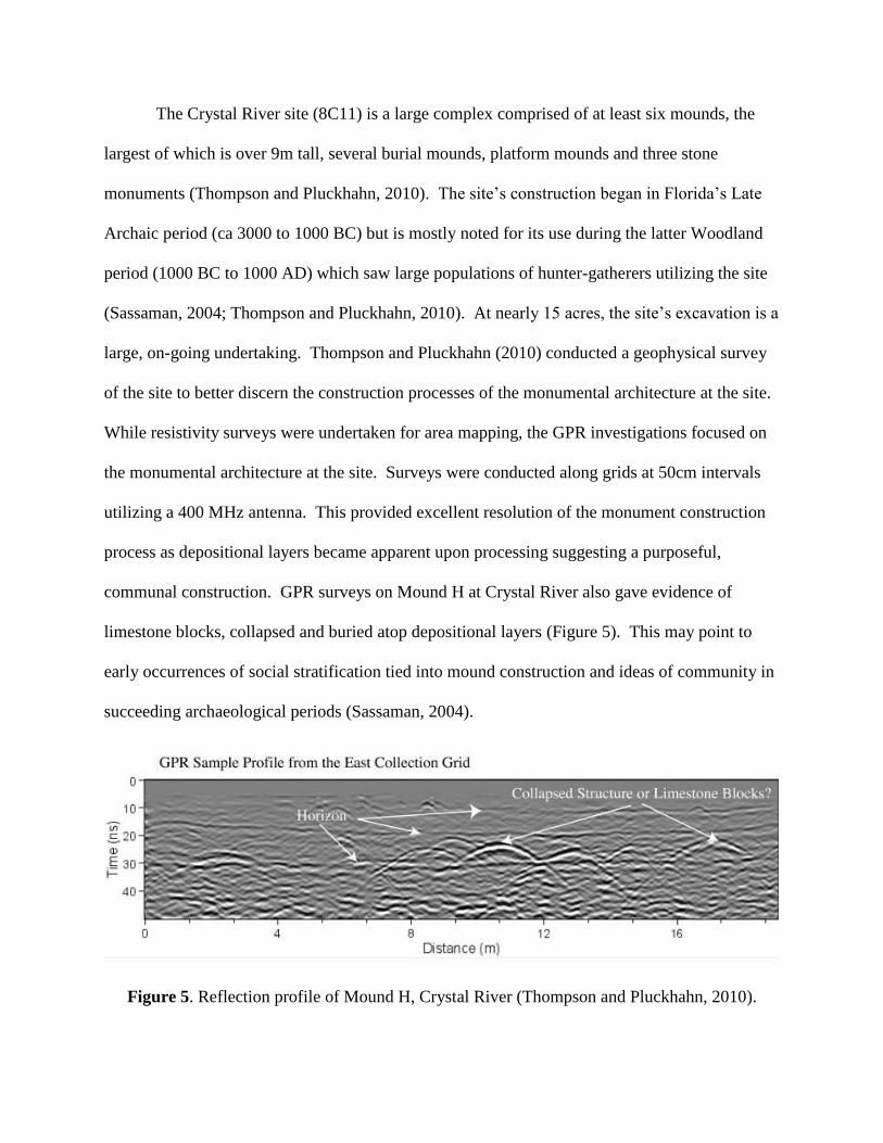
The Crystal River site (8C11) is a large complex comprised of at least six mounds, the
largest of which is over 9m tall, several burial mounds, platform mounds and three stone
monuments (Thompson and Pluckhahn, 2010). The site’s construction began in Florida’s Late
Archaic period (ca 3000 to 1000 BC) but is mostly noted for its use during the latter Woodland
period (1000 BC to 1000 AD) which saw large populations of hunter-gatherers utilizing the site
(Sassaman, 2004; Thompson and Pluckhahn, 2010). At nearly 15 acres, the site’s excavation is a
large, on-going undertaking. Thompson and Pluckhahn (2010) conducted a geophysical survey
of the site to better discern the construction processes of the monumental architecture at the site.
While resistivity surveys were undertaken for area mapping, the GPR investigations focused on
the monumental architecture at the site. Surveys were conducted along grids at 50cm intervals
utilizing a 400 MHz antenna. This provided excellent resolution of the monument construction
process as depositional layers became apparent upon processing suggesting a purposeful,
communal construction. GPR surveys on Mound H at Crystal River also gave evidence of
limestone blocks, collapsed and buried atop depositional layers (Figure 5). This may point to
early occurrences of social stratification tied into mound construction and ideas of community in
succeeding archaeological periods (Sassaman, 2004).
Figure 5. Reflection profile of Mound H, Crystal River (Thompson and Pluckhahn, 2010).
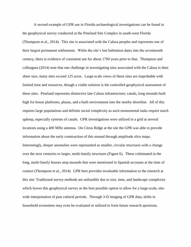
A second example of GPR use in Florida archaeological investigations can be found in
the geophysical survey conducted at the Pineland Site Complex in south-west Florida
(Thompson et al., 2014). This site is associated with the Calusa peoples and represents one of
their largest permanent settlements. While the site’s last habitation dates into the seventeenth
century, there is evidence of consistent use for about 1700 years prior to that. Thompson and
colleagues (2014) note that one challenge in investigating sites associated with the Calusa is their
sheer size; many sites exceed 125 acres. Large-scale views of these sites are improbable with
limited time and resources, though a viable solution is the controlled geophysical assessment of
these sites. Pineland represents distinctive late Calusa infrastructure; canals, long mounds built
high for house platforms, plazas, and a built environment into the nearby shoreline. All of this
requires large populations and definite social complexity as such monumental tasks require much
upkeep, especially systems of canals. GPR investigations were utilized in a grid at several
locations using a 400 MHz antenna. On Citrus Ridge at the site the GPR was able to provide
information about the early construction of this mound through amplitude slice maps.
Interestingly, deeper anomalies were represented as smaller, circular structures with a change
over the next centuries to larger, multi-family structures (Figure 6). These culminated in the
long, multi-family houses atop mounds that were mentioned in Spanish accounts at the time of
contact (Thompson et al., 2014). GPR here provides invaluable information to the research at
this site: Traditional survey methods are unfeasible due to size, time, and landscape complexity
which leaves this geophysical survey as the best possible option to allow for a large-scale, site-
wide interpretation of past cultural periods. Through 3-D imaging of GPR data, shifts in
household economies may even be evaluated or utilized to form future research questions.
GPR and Clandestine Burials
The search for clandestine burials, whether in the context of an historic cemetery or a
forensic case, is an increasing part of current GPR research (Bevan, 1991; Unterberger, 1992;
Ruffell and McKinley, 2005; Conyers, 2006; Schultz and Dupras, 2008; Ruffell et al., 2009;
Schultz, 2012). The utility of several GPR antenna frequencies to noninvasively detect
anomalies 1-2m below the surface, while providing information on depth, and with quality
resolution makes this geophysical survey method preferable to most others.
In general, GPR does not detect the burial itself, but more so is detecting the change in
soil composition as a result of burial. Large burial vaults or even intact caskets may be detected
due to the void created by their structure which may be recognized as an anomaly.
Figure 6. GPR amplitude slice depicting initial Calusa settlement patterns of small, circular
structures. Note that the GPR survey is now tied into GPS and topographic data
(Thompson et al., 2014).
As with other GPR surveys, it is important to conduct a GPR survey of a clandestine
burial on a grid with transect intervals remaining under 1 meter (Bevan, 1991; Conyers, 2006).
Some more recent research suggests that best practices for a clandestine burial survey should
even stay below a half meter (Wardlaw, 2009). The grid should attempt to traverse the possible
burial at a right angle in order to best visualize the anomaly (Bevan, 1991).
GPR in Historic U.S. Cemeteries and an Example from Florida
There are a number of reasons that an historic cemetery may require a geophysical
search: written documentation about these sites may be missing or incorrect, thus providing
inaccurate information as to the site-limits; markers may have gone missing or have been moved;
encroachment from development threatens possible interments; the location may be lost due to
the overgrowth of the environment; human remains may need to be removed due to imminent
construction projects (Conyers, 2006b). Information on historic cemeteries also provides an
invaluable insight into community practices at known points in history; burial practices,
orientation of graves, gravestone iconography, and associated grave goods all provide a rich
depth of data to the investigation of community practices. GPR surveys thus provide an
excellent additional source of information to research questions associated with historic
cemeteries.
The ability of GPR to detect a burial in an historic cemetery is largely dependent on the
materials used in burial, the preservation of the body or coffin, and the condition of the soil
(Conyers, 2006b). Differing interment practices are associated with different time periods in
U.S. history. Early settlers often wrapped the dead in shrouds and buried them in wooden
caskets, which were most commonly used into the latter half of the 19th
century. This may prove
difficult for GPR surveys to detect as caskets collapse and deterioration over time, along with a
settling of grave shaft soil, may not provide enough of an amplitude difference for the GPR unit
to detect an anomaly. Metallic coffins became more widely available after mass production
began just prior to the Civil War and, if they are relatively intact, will produce high amplitude
signatures during a GPR survey. Currently, many burials in cemeteries are encased within a
liner or cement vault that is designed to preserve the ground stability. These provide large,
distinct targets for radar energy during a survey (Doolittle and Bellatoni, 2010). There are
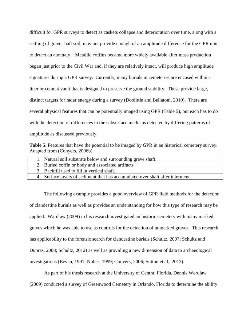
several physical features that can be potentially imaged using GPR (Table 5), but each has to do
with the detection of differences in the subsurface media as detected by differing patterns of
amplitude as discussed previously.
Table 5. Features that have the potential to be imaged by GPR in an historical cemetery survey.
Adapted from (Conyers, 2006b).
1. Natural soil substrate below and surrounding grave shaft.
2. Buried coffin or body and associated artifacts.
3. Backfill used to fill in vertical shaft.
4. Surface layers of sediment that has accumulated over shaft after interment.
The following example provides a good overview of GPR field methods for the detection
of clandestine burials as well as provides an understanding for how this type of research may be
applied. Wardlaw (2009) in his research investigated an historic cemetery with many marked
graves which he was able to use as controls for the detection of unmarked graves. This research
has applicability to the forensic search for clandestine burials (Schultz, 2007; Schultz and
Dupras, 2008; Schultz, 2012) as well as providing a new dimension of data to archaeological
investigations (Bevan, 1991; Nobes, 1999; Conyers, 2006; Sutton et al., 2013).
As part of his thesis research at the University of Central Florida, Dennis Wardlaw
(2009) conducted a survey of Greenwood Cemetery in Orlando, Florida to determine the ability
of GPR surveys to detect burials at different points of interment. This granted an opportunity to
test the utility of GPR at an historic cemetery site that provided a wide range of burial dates that
may also be tested against current burials, as the cemetery is still in operation.
The Greenwood cemetery was incorporated in 1880 and purchased by the city of Orlando
in 1892. A local ordinance then required the removal of smaller cemeteries interspersed
throughout the Orlando area with the remains reinterred at Greenwood, which became the only
authorized burial site within city limits from this point forward. Greenwood is large, 68.7 acres,
and due to its size and age has a wide variety of interment types from different historical periods
represented (Wardlaw, 2009).
The survey was conducted on 29 out of 36 sections at Greenwood utilizing a 500 MHz
antenna. Transects crossed graves at a perpendicular angle at 50 cm intervals. As anomalies
associated with burials were encountered they were marked and noted for depth. This research
also compared the detection of anomalies with T-bar probe ground-truthing. The comparison of
these methods showed that utilizing the T-bar probe proved to be an effective method of
confirmation for GPR data collection in the field.
This GPR survey depicted the difficulty in detecting earlier graves by solely using GPR,
though the use of the T-bar probe in conjunction with a GPR survey was shown to be
worthwhile. Earlier graves likely proved harder to detect due to deterioration of the casket and
body, lack or loss of casket hardware that may have provided a significant amplitude signature,
and the settling of soil in the grave shaft over time. As GPR detects the difference in the
electrical or chemical properties of soil, compaction of the soil and weathering over time may
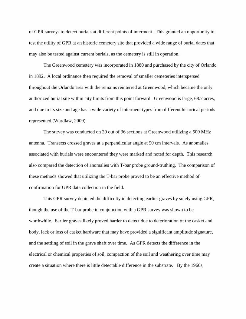
create a situation where there is little detectable difference in the substrate. By the 1960s,
however (Figure 7), the GPR unit readily detects both homogenized soils owing to the digging of
a grave shaft as well as the coffin or burial vault (Wardlaw, 2009).
This survey provided a worthwhile initial investigation of the relationship between time
and GPR detection capabilities. Further research in this vein may provide a refinement of burial
detection abilities, especially for burials dating before the middle part of the last century. This,
in turn, may prove worthwhile for historic cemetery location in other locations that have a
relatively high pH level in their soils as does Florida.
Figure 7. Bar graph showing total graves comparison from
Greenwood cemetery survey. Note the efficacy of GPR as tested
against the probe (Wardlaw, 2009).
GPR Applications in Forensic Investigations
One of the latest applications of GPR is in the field of forensic investigations (Bevan,
1991; Mellet, 1992; Unterberger, 1992; Ruffell and McKinley, 2005; Schultz, 2007; Schultz and
Dupras, 2008; Schultz, 2012). Both forensic anthropologists and forensic archaeologists
(Schultz and Dupras, 2008) often assist law enforcement agencies with the investigation of
homicide victims. For forensic archaeologists this assistance may take the form of participating
in the location and recovery of the victim. Schultz (2012) suggests a multidisciplinary approach
and that for certain locations GPR may be the most useful tool to apply to these searches.
Noninvasive forms of search should be attempted first and certain questions should be
considered before a GPR survey is instituted (Table 6). Much of the success of a GPR survey in
a forensic setting can be attributed to the nature of the soil matrix in which the body was buried
along with the time elapsed since burial. Factors that will limit the utility of a GPR survey are
soils that may attenuate the radar energy, a long time period between burial and survey, and
excessive vegetation growth. Current research seeks to refine the ability of GPR to detect burials
in soils that generally attenuate radar energy and to note the change though time of anomaly
detection of a given burial.
Table 6. Questions to ask prior to performing a GPR survey for a forensic investigation (Schultz
2012).
1. When did event occur?
2. How deep is body buried?
3. Was body wrapped in anything?
4. Was anything placed in grave, especially anything metallic?
5. Was anything placed over body to aid in concealment?
6. What are characteristics of site: topography, vegetation, soil, etc.?
7. How has area changed since burial of body?
Three studies from Florida display the current research conducted to better apply GPR to
the detection of buried homicide victims. These studies utilized pig cadavers in a variety of
burial scenarios to test the varying degree of GPR to detect anomalies in these situations through
time, at differing depths, and with different antenna frequencies. This information may serve as
a proxy for various types of burials associated with forensic investigations.
The first study discussed here, by Schultz et al. (2006), sought to test the applicability of
using GPR in a controlled setting to monitor the ability to assess anomalies in a proxy burial
situation over a length of time. The study also attempted to note to what extent depth or time of
burial affected the ability of GPR detection. A total of 12 graves were monitored, each
containing a fully grown pig as a proxy for the relative weight of a fully grown human. The
surveys were conducted with a 500 MHz antenna throughout the process and blank control
graves were included in the survey to account for a distinction between radar energy detecting
soil homogenization or an actual buried body.
This study found that soil had the greatest effect on GPR’s ability to detect burials over
time. For the full period of the study those cadavers buried in sandy, well-drained soils were
able to be detected even at the point of complete skeletonization. This could be detected in the
field and did not require significant post-processing. Alternatively, those bodies buried in clayey
soils became increasingly difficult to detect over time.
Adding to previous research, Schultz (2008) attempted a similar investigation as
previously discussed. 12 small pig carcasses were buried in sandy soil, six at a shallow depth
and six deeper. This study examined the burials over a 21 month period using a 500 MHz
antenna. As in the previous investigation, control units were dug to determine whether the GPR
detected an actual burial or simply the disruption of soil from burial. At the shallow depth, all
carcasses were detected at the end of the first year but became more difficult to detect towards
the last two months. Moreover, these burials were largely visible with minimal post-processing.
Smaller carcasses buried at a shallow depth were harder to detect due to skeletonization after a
period of time and the inability of the GPR to detect an anomaly in the soil matrix. Carcasses
buried deeper, however, tended to preserve longer and were thus able to be detected by GPR
survey. These also required minimal post-processing (Schultz, 2008).
A third example of research into the applicability of GPR in a forensic setting is found in
Schultz and Martin’s (2010) comparison of antenna frequencies in a mock burial survey
situation. A large pig carcass was recorded after six months of interment using both the 500
MHz and 250 MHz antennas. It was found that the 500 MHz provided more detail of the burial,
including soil disturbance than that of the 250 MHz antenna, but that both proved capable of
detecting the burial anomaly (Schultz and Martin, 2010).
These studies allow for the refinement of techniques used by forensic archaeologists
when conducting a GPR survey in support of law enforcement agencies. Any survey undertaken
has a number of conditions that may disallow the use of GPR and a sound knowledge of these
limitations is necessary in order to provide proper assistance. In Florida, the use of GPR may be
hindered by excessive soil saturation, soils high in clay content, and especially vegetation.
Future research may work to better off-set these limitations by refining the capabilities of GPR
surveys.
Conclusion
GPR is a powerful geophysical tool that has been increasingly incorporated into
archaeological research. More recently it has become a useful addition to the survey and
recovery methods of forensic archaeologists when providing support to law enforcement. GPR
works be emitting pulses of electromagnetic energy into the ground and by registering the
amplitude of the propagated waves as they interact with the chemical and physical subsurface
matrix. By understanding the basic media in which radar energy is to be propagated it is thus
possible to detect anomalies within that media. This capability makes GPR one of the most
important noninvasive survey tools available. Research over the last several decades has seen a
refinement of GPR applications in archaeological and forensic research that has been concurrent

with technological advances making GPR increasingly cost-effective and approachable. Current
research continues to test the applicability of GPR in a variety of settings and conditions. These
surveys are critical to the future integration of this powerful tool in cultural resource protection
and for forensic investigations.
Bibliography
Annan AP. 2009. Electromagnetic principles of ground penetrating radar. In: Jol HM, editor. Ground
penetrating radar: theory and applications. Oxford, UK: Elsevier Science. 1st ed. p 3-40.
Bevan BW. 1991. The search for graves. Geophysics 56(9):1310-1319.
Bigman DP. 2012. The use of electromagnetic induction in locating graves and mapping cemeteries: An
example from native North America. Archaeological Prospection 19(1):31-39.
Bigman DP. 2014. Mapping social relationships: Geophysical survey of a nineteenth-century American
slave cemetery. Archaeological and Anthropological Sciences (1):17.
Billinger MS. 2009 Utilizing ground penetrating radar for the location of a potential human burial under
concrete. J of Forensic Sciences 42(3):200-209.
Bladon P, Moffat I, Guilfoyle D, Beale A, and Milani J. 2011. Mapping anthropogenic fill with GPR for
unmarked grave detection: a case study from a possible location of Mokare's grave, Albany, Western
Australia. Exploration Geophysics 42(4):249-257.
BÖNiger U, and Tronicke J. 2010. Improving the interpretability of 3D GPR data using target-specific
attributes: application to tomb detection. J of Archaeological Science 37(4):672-679.
Bradford JH. 2012. The search for the lost graves of the Chinese miners in Hailey, Idaho, USA. 2012
14th
International Conference on Ground Penetrating Radar (GPR):13.
Buck SC. 2003. Searching for graves using geophysical technology: Field tests with ground penetrating
radar, magnetometry, and electrical resistivity. J of Forensic Sciences 48(1):5-11.
Buyuksarac A, Yalciner CC, Ekinci YL, Demirci A, and Yucel MA. 2014. Geophysical investigations at
Agadere Cemetery, Gallipoli Peninsular, NW Turkey. Australian Journal Of Forensic Sciences
46(1):111-123.
Catapano I, Affinito A, Gennarelli G, Maio F, Loperte A, and Soldovieri F. 2014. Full three-dimensional
imaging via ground penetrating radar: assessment in controlled conditions and on field for
archaeological prospecting. Applied Physics A: Materials Science & Processing (3):1415.
Clay RB. 2013. Conyers, Lawrence B.: Interpreting ground-penetrating radar for archaeology. American
Library Association Choice. p 1671.
Conyers LB. 2004. Ground-penetrating radar for archaeology: Walnut Creek, Calif: AltaMira Press.
Conyers LB. 2006. Ground-penetrating radar techniques to discover and map historic graves. Historical
Archaeology 40(3):64-73.
Conyers LB. 2006. Ground[penetrating radar. In: Johnson JK, editor. Remote sensing in archaeology:
An explicitly North American perspective: Tuscaloosa: University of Alabama Press.
Conyers LB. 2010. Ground-penetrating radar for anthropological research. Antiquity 84(323):175-184.
Conyers LB, and Leckebusch J. 2010. Geophysical archaeology research agendas for the future: Some
ground-penetrating radar examples. Archaeological Prospection 17(2):117-123.
Dalan RA, De Vore SL, and Clay RB. 2010. Geophysical identification of unmarked historic graves.
Geoarchaeology-An International Journal 25(5):572-601.
Damiata BN, Steinberg JM, Bolender DJ, and Zoega G. 2013. Imaging skeletal remains with ground-
penetrating radar: Comparative results over two graves from Viking Age and Medieval churchyards
on the Stora-Seyla farm, northern Iceland. J of Archaeological Science 40(1):268-278.
Davenport GC. 2001. Remote sensing applications in forensic investigations. Historical Archaeology
35(1):87.
Davis JL, Heginbottom JA, Annan AP, Daniels RS, Berdal BP, Bergan T, Duncan KE, Lewin PK,
Oxford JS, Roberts N et al. . 2000. Ground penetrating radar surveys to locate 1918 Spanish Flu
victims in permafrost. J of Forensic Sciences 45(1):68-76.
De Vore SL, and Nickel RK. 2003. Geophysical investigations of four suspected pioneer grave locations
along the Oregon and California National Historic Trails, Marshall and Pottawatomie counties,
Kansas Lincoln, Neb: U.S. Dept. of the Interior, National Park Service, Midwest Archeological
Center, 2003.
Doolittle JA, and Butnor JR. 2009. Soils, peatlands, and biomonitoring. In: Jol HM, editor. Ground
penetrating radar: theory and applications: Oxford, UK: Elsevier Science.179-202.
Doolittle JA, and Bellantoni NF. 2010. The search for graves with ground-penetrating radar in
Connecticut. J of Archaeological Science 37(5):941-949.
Doolittle JA, and E. CM. 1995. Use of soil information to determine application of ground penetrating
radar. J of Applied Geophysics 33(1-3):101.
Fiedler S, Illich B, Berger J, and Graw M. 2009. The effectiveness of ground-penetrating radar surveys
in the location of unmarked burial sites in modern cemeteries. J of Applied Geophysics(3):380.
Fletcher JM. 2011. Monitoring shallow controlled graves containing small cadavers using ground
penetrating radar: Orlando, Fla. : University of Central Florida, 2011.
Gaffney C. 2008. Detecting trends in the prediction of the buried past: A review of geophysical
techniques in archaeology. Archaeometry 50(2):313.
Gontz AM, Maio CV, Wagenknecht EK, and Berkland EP. 2011. Assessing threatened coastal sites:
Applications of ground-penetrating radar and geographic information systems. J of Cultural Heritage
(4):451.
Gonzalez-Jorge H, Solla M, Martinez-Sanchez J, and Arias P. 2012. Comparison between laser
scanning, single-image rectification and ground-penetrating radar technologies in forensic science.
Measurement (5):836.
Goodman D, Priro S, Nishimura Y, Schneider K, Hongo H, Higashi N, Steinberg JM, and Damiata BN.
2009. In: Jol HM, editor. Ground penetrating radar: theory and applications. Oxford, UK: Elsevier
Science. 479-508.
Hansen JD, Pringle JK, and Goodwin J. 2014. GPR and bulk ground resistivity surveys in graveyards:
Locating unmarked burials in contrasting soil types. Forensic Science International 237:E14-E29.
Hawkins WT. 2011. Monitoring long-term controlled grave scenarios using ground penetrating radar:
Orlando, FL: University of Central Florida, 2011.
Isaacson J, Hollinger RE, Gundrum D, and Baird J. 1999. A controlled archaeological test site facility in
illinois: Training and research in archaeogeophysics. Boston University for the Association of Field
Archaeology. p 227.
Johnson JK. 2006. Remote sensing in archaeology: An explicitly North American perspective:
Tuscaloosa: University of Alabama Press.
Johnson JK and Haley BS. 2006. A cost-benefit analysis of remote sensing application in cultural
resource management archaeology. In: Johnson JK, editor. Remote sensing in archaeology: An
explicitly North American perspective: Tuscaloosa: University of Alabama Press.
Jol HM. 2009. Ground penetrating radar: theory and applications. Oxford, UK: Elsevier Science
Jones G. 2008. Geophysical mapping of historic cemeteries. Technicl Briefs in Historical Archaeology
(3):25-38.
King JA, Bevan BW, and Hurry RJ. 1993. The Reliability of Geophysical Surveys at Historic-Period
Cemeteries: An Example from the Plains Cemetery, Mechanicsville, Maryland. Society for Historical
Archaeology. p 4.
Lualdi M, and Lombardi F. 2014. Effects of antenna orientation on 3-D ground penetrating radar
surveys: an archaeological perspective. Geophysical Journal International 196(2):818-827.
Leckebusch J. 2003. Ground-penetrating radar: A modern three-dimensional prospection method.
Archaeological Prospection 10(4):213-240.
Lockhart JJ and Green TJ. 2006. The current and potential role of archaeogeophysics in cultural
resource management in the United States. In: Johnson JK, editor. Remote sensing in archaeology:
An explicitly North American perspective: Tuscaloosa: University of Alabama Press.
Lowe AC, Beresford DV, Carter DO, Gaspari F, O’Brien RC, and Forbes SL. 2013. Ground penetrating
radar use in three contrasting soil textures in southern Ontario. Geological Society, London, Special
Publications 384(1):221.
Martin MM. 2010. Detecting various burial scenarios in a controlled setting using ground-penetrating
radar and conductivity: Orlando, FL: University of Central Florida, 2010.
Mauz B, Fanelli F, Elmejdoub N, and Barbieri R. 2012. Coastal response to climate change:
Mediterranean shorelines during the Last Interglacial (MIS 5). Quaternary Science Reviews 54:89-98.
Mellett JS. 1992. Location of human remains with ground penetrating radar. Fourth international
conference on ground penetrating radar. Geological Survey of Finland Special Papers (16) 359-365.
Miller PS. 1996. Disturbances in the soil: Finding buried bodies and other evidence using ground
penetrating radar. J of Forensic Sciences 41(4):648-652.
Morgan RM and Bull PA. 2007. Forensic geoscience and crime detection: Identification, interpretation
and presentation in forensic geosciences. Minerva Med Leg 127:73-89
Nobes DC. 1999. Geophysical surveys of burial sites: A case study of the Oaro Urupa. Geophysics
64(2):357-367.
Nobes DC. 2000. The search for "Yvonne": A case example of the delineation of a grave using near-
surface geophysical methods. J of Forensic Sciences 45(3):715-721.
Novo A, Lorenzo H, Rial FI, and Solla M. 2011. 3D GPR in forensics: Finding a clandestine grave in a
mountainous environment. Forensic Science International 204(1-3):134-138.
Nuzzo L, Leucci G, Negri S, Carrozzo MT, and Quarta T. 2002. Application of 3D visualization
techniques in the analysis of GPR data for archaeology. Annals Of Geophysics 45(2):321-337.
Papadopoulos NG, Yi M-J, Kim J-H, Tsourlos P, and Tsokas GN. 2010. Geophysical investigation of
tumuli by means of surface 3D electrical resistivity tomography. J of Applied Geophysics (3):192.
Pringle JK, Holland C, Szkornik K, and Harrison M. 2012. Establishing forensic search methodologies
and geophysical surveying for the detection of clandestine graves in coastal beach environments.
Forensic Science International 219(1-3):E29-E36.
Pringle JK, Jervis J, Cassella JP, and Cassidy NJ. 2008. Time-lapse geophysical investigations over a
simulated urban clandestine grave. J of Forensic Sciences 53(6):1405-1416.
Pringle JK, and Jervis JR. 2010. Electrical resistivity survey to search for a recent clandestine burial of a
homicide victim, UK. Forensic Science International 202(1-3):E1-E7.
Pringle JK, Jervis JR, Hansen JD, Jones GM, Cassidy NJ, and Cassella JP. 2012. Geophysical
monitoring of simulated clandestine graves using electrical and ground-penetrating radar methods: 0-
3 years after burial. J of Forensic Sciences 57(6):1467-1486.
Pringle JK, Ruffell A, Jervis JR, Donnelly L, McKinley J, Hansen J, Morgan R, Pirrie D, and Harrison
M. 2012. The use of geoscience methods for terrestrial forensic searches. Earth-Science Reviews (1-
2):108.
Radzevicius SJ, Guy ED, and Daniels JJ. 2000. Pitfalls in GPR data interpretation: Differentiating
stratigraphy and buried objects from periodic antenna and target effects. Geophysical Research
Letters 27(20):3393-3396.
Ruffell A, and McKinley J. 2005. Forensic geoscience: Applicationsof geology, geomorphology and
geophysics t criminal investigations. Earth-Science Reviews (69):235-247.
Ruffell A. 2005. Searching for the IRA "disappeared": Ground-penetrating radar investigation of a
churchyard burial site, Northern Ireland. J of Forensic Sciences 50(6):1430-1435.
Ruffell A, Donnelly C, Carver N, Murphy E, Murray E, and McCambridge J. 2009. Suspect burial
excavation procedure: A cautionary tale. Forensic Science International 183(1-3):11-16.
Ruffell A, McCabe A, Donnelly C, and Sloan B. 2009. Location and assessment of an historic (150-160
years old) mass grave using geographic and ground penetrating radar investigation, nw ireland. Wiley
Subscription Services, Inc. p 382.
Ruffell A, Pringle JK, and Forbes S. 2014. Search protocols for hidden forensic objects beneath floors
and within walls. Forensic Science International 237:137-148.
Sarris A, Dunn RK, Rife JL, Papadopoulos N, Kokkinou E, and Mundigler C. 2007. Geological and
geophysical investigations in the Roman cemetery at Kenchreai (Korinthia), Greece. Archaeological
Prospection 14(1):1-23.
Schellentrager GW, Doolittle JA, Calhoun TE, and Wettstein CA. 1988. Using ground-penetrating radar
to update soil survey information. Soil Science Society of America J 52(3):746-752.
Schultz JJ. 2007. Using ground-penetrating radar to locate clandestine graves of homicide victims.
Homicide Studies 11(1):15-29.
Schultz JJ. 2008. Sequential monitoring of burials containing small pig cadavers using ground
penetrating radar. J of Forensic Sciences: Wiley Subscription Services, Inc. p 279.
Schultz JJ. 2012. The application of ground-penetrating radar for forensic grave detection. In: A
companion to forensic anthropology: Malden, MA : Wiley-Blackwell, c2012.
Schultz JJ, Collins ME, and Falsetti AB. 2006. Sequential monitoring of burials containing large pig
cadavers using ground-penetrating radar. J of Forensic Sciences 51(3):607-616.
Schultz JJ, and Dupras TL. 2008. The contribution of forensic archaeology to homicide investigations.
Homicide Studies 12(4):399-413.
Schultz JJ, Falsetti AB, Collins M, Koppenjan S, and Warren MW. 2002. Detection of forensic burials
in Florida using GPR. Proceedings of SPIE(1):443.
Schultz JJ, and Martin MM. 2011. Controlled GPR grave research: comparison of reflection profiles
between 500 and 250MHz antennae. Forensic Science International(1-3):64.
Schultz JJ, and Martin MM. 2012. Monitoring controlled graves representing common burial scenarios
with ground penetrating radar. Journal of Applied Geophysics 83:74-89.
Shaaban FA, Abbas AM, Atya MA, and Hafez MA. 2009. Ground-penetrating radar exploration for
ancient monuments at the Valley of Mummies -Kilo 6, Bahariya Oasis, Egypt. Journal of Applied
Geophysics(2):194.
Solla M, Riveiro B, Alvarez MX, and Arias P. 2012. Experimental forensic scenes for the
characterization of ground-penetrating radar wave response. Forensic Science International 220(1-
3):50-58.
Sutton M-J, and Conyers LB. 2013. Understanding cultural history using ground-penetrating radar
mapping of unmarked graves in the mapoon mission cemetery, western Cape York, Queensland,
Australia. International Journal of Historical Archaeology (4):782.
Teixido T, Pena JA, Fernandez G, Burillo F, Mostaza T, and Zancajo J. 2014. Ultradense Topographic
Correction by 3D-Laser Scanning in Pseudo-3D Ground-penetrating Radar Data: Application to the
Constructive Pattern of the Monumental Platform at the Segeda I Site (Spain). Archaeological
Prospection 21(2):113-123.
Thompson VD, and Andrus CFT. 2011. Evaluating mobility, monumentality, and feasting at the sapelo
island shell ring complex. Society for American Archaeology. p 315.
Tsourlos P, Papadopoulos N, Yi M-J, Kim J-H, and Tsokas G. 2014. Comparison of measuring
strategies for the 3-D electrical resistivity imaging of tumuli. J of Applied Geophysics 101:77-85.
Unterberger RR. 1992. Ground penetrating radar finds disturbed earth over burials. Fourth international
conference on ground penetrating radar. Geological Survey of Finland Special Papers (16) 341-357.
Walter BS, and Schultz JJ. 2013. Mapping simulated scenes with skeletal remains using differential GPS
in open environments: An assessment of accuracy and practicality. Forensic Science International
228(1-3):E33-E46.
Wardlaw D. 2009. Geophysical survey of Greenwood Cemetery, Orlando, Florida: Orlando, Fl:
University of Central Florida, 2009.
Waters MR. 1992. Principles of geoarchaeology : a North American perspective: Tucson : University of
Arizona Press, c1992.
Whiting BM, and Hackenberger S. 2004. Using 3D GPR to determine the extent of possible 17th and
18th century graves beneath a concrete driveway: Bridgetown Synagogue, Bridgetown, Barbados.
Proceedings of the Tenth International Conference on Grounds Penetrating Radar, 2004 (GPR
2004):475.
Wiseman J, and El-Baz F. 2007. Remote sensing in archaeology. New York: Springer.
Copyright © 2022 FDOKUMEN