Studies into the suitability of the cell-penetrating peptide
Upload
independentCategory
view
2download
0
Facies and ground-penetrating radar characteristics ofcoarse-grained beach deposits of the uppermost Pleistoceneglacial Lake Algonquin, Ontario, Canada
VINCENZO PASCUCCI*1, I . PETER MARTINI� and ANTHONY L. ENDRES�*Istituto di Scienze Geologico-Mineralogiche, University of Sassari, Corso Angioy 10, 07100 Sassari, Italy(E-mail: [email protected])�Department of Land Resource Science, University of Guelph, Ontario, N1G 2W1, Canada�Department of Earth and Environmental Sciences, University of Waterloo, Waterloo, Ontario, N2L 3G1,Canada
Associate Editor: Stephen Lokier
ABSTRACT
The lithofacies of the uppermost Pleistocene (ca 11 800 to 10 400 14C yr bp),
cold-temperate, coarse-grained beach deposits of Lake Algonquin, the
precursor of the present Lake Huron of North America, have been studied
and interpreted based on analogous features of modern beaches from the same
region. Ice foot and ice-cementation develop during winter but, unlike Arctic
beaches, ice-related sedimentary features are seldom, if ever, preserved in the
Pleistocene and recent deposits of the Great Lakes. Instead, the deposits retain
the typical characteristics of wave-dominated, pure gravel and mixed sand and
gravel beaches, there including the classical subdivision of infill zone, swash
zone/sand run, imbricated zone, coarse flat-clast zone and coastal dunes.
These zones form a regular succession on the surface of many modern beaches;
however, they seldom occur as quasi-complete vertical successions in older
deposits. In the studied uppermost Pleistocene deposits, the various
components are separated vertically by erosional contacts (bounding
surfaces) readily recognizable on working faces of large sand and gravel pits
and mappable in the subsurface by ground-penetrating radar. The lithofacies
are sufficiently diagnostic to allow recognition of depositional settings, and the
lithofacies architecture allows the deciphering of important geological events,
such as: (i) local input of fluvial material onto the shoreface, where it was
partially reworked by waves and moved onto the beachface; (ii) occurrence of
major storm events; and (iii) repeated rapid transgressions and regressions
typical of the glacial-lake precursors of the modern Great Lakes.
Keywords Facies analysis, gravelly beach, Great Lakes, ground-penetratingradar, paraglacial barrier, Pleistocene.
INTRODUCTION
Objectives
Since early deglaciation times, sand, gravel andmixed sand and gravel beaches have been formingalong the shores of the Great Lakes of North
America, under cold to cold-temperate climaticconditions. These areas have undergone signifi-cant post-glacial isostatic rebound and the upper-most Pleistocene–lower Holocene beaches havebeen uplifted; their deposits are well-exposed in afew sand and gravel pits. This location offers theopportunity to study the internal structures of
1Present address: Department of Botany, Ecology and Geology, University of Sassari, Sassari, Italy.
Sedimentology (2008) doi: 10.1111/j.1365-3091.2008.00984.x
� 2008 The Authors. Journal compilation � 2008 International Association of Sedimentologists 1

gravelly beaches and to establish the environ-mental conditions of the ancient glacial lakes.Therefore, this paper has two main objectives:(i) to analyse the sedimentary facies of exposed,ancient coarse-grained deposits, to interpret themthrough analogy with those of presently activelake beaches and to establish similarities anddifferences with marine systems; and (ii) toestablish the internal stratigraphy (lithostrati-graphic units – architectural elements) of anuppermost Pleistocene body (beach/barrier) andreconstruct the possible events that occurred inthe glacial lake.
Much is known about sandy beach and shore-face environments and, to a lesser extent, aboutgravel and mixed sand and gravel beaches (Kirk,1980; Carter, 1988; Trenhaile, 1997). Bluck (1967)recognized two main types of wave-dominatedgravelly beaches: Sker type (shingle beach – puregravel beach) and Newton type (shingle and sandbeach – mixed sand and gravel beach). Orford(1975) and Carter & Orford (1993) concurred withsuch a subdivision, but they noted that both typescould occur at the same location at differenttimes. The change from gravel-dominated tosand-dominated beach is not only related to theenergy of the system, but also to the type andamount of sediment transported into the area(FitzGerald et al., 1992). Jennings & Shulmeister(2002) presented a field classification that re-tained the ‘pure gravel’ and ‘mixed sand andgravel’ beach of the previous authors, and added athird ‘composite sand and gravel’ beach thatdevelops in areas with large tide excursions, suchas in the Bay of Fundy, Canada (Forbes & Taylor,
1987). In the latter type, a sand zone is sharplyseparated laterally from the gravel-dominatedshoreline rampart. ‘Pure gravel’ and ‘mixed sandand gravel’ beaches are well-developed along thepresent coasts of the Great Lakes, and are well-represented in uplifted (due to post-glacial iso-static rebound) uppermost Pleistocene–lowerHolocene coasts. True ‘composite sand andgravel’ beaches do not occur in the tideless GreatLakes.
Study area
The uppermost Pleistocene deposits of the glacialLake Algonquin, the precursor of the present LakeHuron, were studied in large sand and gravel pitsat Port Elgin, and two analogue modern beacheswere analysed at Dyer Bay in Georgian Bay and atHamilton in Lake Ontario, Canada (Fig. 1). Flat-lying to slightly westward dipping (< 5�) Palaeo-zoic carbonates and clastic units underlie thearea. Streams have incised the land since the latePalaeozoic, forming large valleys with an overallnorth-eastward orientation. During the Pleisto-cene, continental ice sheets funnelled into theseriver valleys and moulded them into the presentGreat Lakes basins. The last ice sheet (LaurentideIce Sheet) reached its maximum extent ca 18 000to 20 000 14C yr bp. Deglaciation started in thebasins region ca 14 000 14C yr bp and large glaciallakes, precursors of the Great Lakes, were formed(Fig. 2A; Prest, 1970; Barnett, 1992). Interplay ofsubsidence due to the weight of the glacier,subsequent differential isostatic rebound as theglacier thinned and retreated northward, and
Fig. 1. Distribution of Pleistoceneend moraines of south-westernOntario and location of the studysites (Dyer Bay, Hamilton Beach andPort Elgin).
2 V. Pascucci et al.
� 2008 The Authors. Journal compilation � 2008 International Association of Sedimentologists, Sedimentology

sequential opening and closing of outlets for-merly dammed by ice led to large, rapid, water-level fluctuations (regressions and transgres-sions). Wave-cut terraces and coastal depositsdeveloped and delimited several variously namedlake stages. Lake Algonquin is one of these stages(Fig. 2B; Hough, 1958). The uppermost Pleisto-cene deposits studied at Port Elgin are related tothe main (highest) Lake Algonquin stage of theLake Huron basin of ca 11 800 to10 400 14C yr bp, as inferred from dates of theadjacent backshore lagoon (Anderson, 1979;Eschman & Karrow, 1985; Karrow et al., 1995)and from the elevation compared to that of othersurveyed and dated raised shorelines of theregion (Karrow, 1988; Lewis & Anderson, 1989).
The beach deposits studied at Port Elgin devel-oped as part of a baymouth barrier that extendsnorthward from a till-bluff (Fig. 3A and B; Ander-son, 1979; Karrow, 1988). The barrier is delimitedby uplifted wave-cut terraces on its western,lakeward flank and by a drained lagoon area tothe back, crossed by the Saugeen River, and has athin cap of aeolian sand dunes. The geologicalsetting and hydrologic conditions of the modernand uppermost Pleistocene lakes are consideredto be similar, allowing for a slightly colderclimate and the stronger katabatic winds of ca11 000 years ago. At present, long fetch andstrong winds lead to the development of steep,medium-height waves (up to 3 m during storms),which can rework beach deposits during ice-freetimes. The analogue modern Dyer Bay beach is apure gravel beach with carbonate pebbles andcobbles, and very little sand, developed on acarbonate platform (Fig. 4A and B). The modernHamilton Beach is a mixed sand and gravel beachwith abundant sand and numerous carbonate andfew crystalline clasts, developed on a large bay-mouth barrier anchored by a glacial moraine(Fig. 4C and D; Coakley & Karrow, 1994). Bothtypes of beach may develop thick, extensive icefoots during particularly cold winters (Fig. 4Cand D).
METHODS
The morphology and the surficial sedimentaryfacies of the modern beaches of Dyer Bay andHamilton were documented in detail duringdifferent seasons and storm conditions. Twocomplementary approaches were used to analysethe uppermost Pleistocene deposits of Port Elgin;one sedimentological and the other geophysical.
1 The sedimentary deposits were describedrepeatedly and photographed along the 150 to200 m long, 8 m high working face of a pit as thematerial was extracted over several years. Theprincipal lithofacies consist of gravel, sand and amixture of the two; they were subdividedaccording to grain-size, fabric (mainly imbrica-tion) and sedimentary structures. Clast composi-tion was not used as a discriminator because mostclasts are of carbonates (limestone and dolostone)derived from local bedrock, with a few meta-morphic and igneous rocks transported into thearea by glaciers. The lithofacies were labelled forease of plotting, and interpreted by comparisonwith analogous features of the recent beach
A
B
Fig. 2. Great Lakes region: (A) Palaeogeography ofglacial precursors of the Great Lakes and Lake Agassizwith some major outlets (arrows) indicated(ca 11 500 14C yr bp; after Prest, 1970). (B) Variation inelevation of beaches of various lake stages in the LakeHuron basin (after Eschman & Karrow, 1985) (PE, PortElgin).
Facies and ground-penetrating radar characteristics of coarse-grained beach deposits 3
� 2008 The Authors. Journal compilation � 2008 International Association of Sedimentologists, Sedimentology

sediments of Dyer Bay and Hamilton (Fig. 5;Table 1). The lithofacies were then groupedaccording to their most frequent occurrence into
lithofacies associations, and these were, in turn,grouped into lithostratigraphic units (equivalentto architectural elements) separated by clearly
A
B
C
Fig. 3. Port Elgin area: (A) Schematic map showing the uplifted shoreline and barrier of Lake Algonquin andlocation of the studied pits at Port Elgin proximal to the ancient mouth of the Sougeen River. (B) Glacial geology anddistribution of uppermost Pleistocene–Holocene costal bluffs and beaches (N, Nipissing; Al, Algonquin; afterChapman & Putnam, 1984). (C) Schematic map showing locations of the ground-penetrating radar profiles (L1, L2) inrelation to the working pit faces (shadowed boxes).
4 V. Pascucci et al.
� 2008 The Authors. Journal compilation � 2008 International Association of Sedimentologists, Sedimentology

definable, major erosional unconformities(bounding surfaces) as seen in outcrop and inground-penetrating radar (GPR) profiles.
2 The GPR profiles were acquired both adjacentto a working pit face and ca 200 m away (Fig. 3C)to establish the gross geometry of the deposits ofPort Elgin in the subsurface. The instrument usedwas a pulseEKKO IV radar system (Sensors &Software Inc., Mississauga, ON, Canada) with a1000 V transmitter and 50 MHz (for maximumpenetration) and 100 MHz (for higher resolution)antennas (Sensors & Software Inc., Toronto, ON,Canada). Antenna separations were 1 m for the100 MHz antennas and 2 m for the 50 MHzantennas. The profiling was acquired with 25 cmincremental steps between station locations. Post-acquisition data processing involved zero-timeadjustment, corrections for elevation, low-pass
time filtering, horizontal trace to trace averaging(three traces) and the application of variousautomatic gain control functions (Davis & Annan,1988; Jol et al., 1996). Common midpoint (CMP)surveys were carried out to determine subsurfaceelectromagnetic wave velocity. Analysis of theCMP data revealed average velocities ranging from0Æ096 to 0Æ104 m ns)1, and these were used forboth elevation correction and depth estimation.
A GPR profile (L2-50) taken with 50 MHzantennas close and parallel to the pit face wascalibrated with lithofacies exposed along the pitface. This GPR profile was, in turn, used tocalibrate profile (L1-50) acquired ca 200 m fromthe pit face (Fig. 3C). Profile L1-50 was then usedto calibrate the overall geometry of the variousreflections observable on a 100 MHz profile (L1-100) acquired along the same transect. Finally,
A B
C D
Fig. 4. Modern beaches studied: (A) ‘Pure gravel’ beach of Dyer Bay showing a series of gravel berms – the beach isca 10 m wide and 4 m high. (B) ‘Mixed sand and gravel’ beach at Hamilton showing a wide sand-trap zone and anincipient, low fairweather berm – the beach is ca 20 m wide and 2 to 3 m high. (C) Winter scene of Dyer Bay coveredby snow. (D) Large ice foot covering the beach and nearshore area of Hamilton. V and X symbols indicate the sameapproximate positions on the summer and winter scenes, respectively.
Facies and ground-penetrating radar characteristics of coarse-grained beach deposits 5
� 2008 The Authors. Journal compilation � 2008 International Association of Sedimentologists, Sedimentology

this 100 MHz profile was used to establish ingreater detail the subsurface geometry of thesedimentary body away from the working pit face.
RESULTS – THE SURFICIAL DEPOSITS
Lithofacies
The lithofacies are described as observed on therecent beaches at Dyer Bay and Hamilton and inthe uppermost Pleistocene strata of Port Elgin.
Gravel (G)Gravels have been subdivided according to theirpredominant clast size, imbrication and amount
of matrix (Table 1); they present the followinglithofacies.
1 Boulder gravels (Gb) may contain some cob-bles and have interstices partially filled withpebbles (Gbd), minor granules and a sandy matrix(Fig. 6A). The large clasts are subangular anddisc-shaped, as they derive from breakage ofthinly bedded, carbonate bedrock. These clastsoccur in the upper shoreface of Dyer Bay but arenot recognized in the uppermost Pleistocenedeposits of Port Elgin; they are slightly reworkedby waves and are equivalent to the subaqueousouterframe of Bluck (1967).
2 Cobble (Gc), pebble (Gd) and granule (Gn)gravels may have an open framework (o) or apebbly (d) and sandy (s) matrix.
(a) Open framework (openwork) gravels (suchas Gco, Gdo and Gno) generally are moderately towell-sorted, with subrounded to well-rounded,disc-shaped to rod-shaped clasts; they have thefollowing occurrences: (i) cobble and pebbleopenwork gravels (such as Gdo) are well-repre-sented in the gravelly storm berms at Dyer Bay(Fig. 6B and C) and in layers at Port Elgin(Fig. 6D). Occasionally, in the highest berm of themodern beach, they contain disseminated large(outsized), subrounded, flat clasts that representthe ‘large disc zone’ of Bluck (1967). The ‘largedisc zone’ is not readily recognizable in cross-section at Port Elgin. (ii) Pebble (predominant) tocobble openwork gravels composed of disc-shaped clasts that locally have a very well-
Fig. 5. Schematic representation of a beach profile (notto scale) and approximate location of principal litho-facies (FWL, fairweather water level). The Massari &Parea (1988) beachface subdivision for microtidal totideless water bodies, and the beach zones of Bluck(1967) are used. Trough cross-bedded sandy conglo-merates (Gt/St) and diamicton (Dm) occur predo-minantly in the subsurface. See Table 1 and text forexplanation of labels.
Table 1. Lithofacies labels.
Mainlithotype
Principal particlesize
Secondaryparticlesize/Matrix Fabric/Structure Lithofacies labels
G = gravel b = boulderc = cobbled = pebblen = granule
d = pebblys = sandy
i = good imbricationo = openworkt = cross-bedded
Gb, Gbd;Gc, Gcs, Gco, Gcoi;Gd, Gds, Gdo, Gdoi;Gn, Gno;Gt
S = sand e = coarse-grained tovery coarse-grainedf = fine-grained tomedium-grained
d = pebblyg = gravelly
l = laminatedt = cross-beddedm = apparently massive
Se, Sel, Sed;StSfl
Soil; Alfisol Sand; sand andgravel
– Variously weatheredmaterial
W
Diamicton Clay to pebbles,poorly sorted
– m = apparently massive Dm
Examples: Gdoi stands for a pebbly (d) gravel (G) with openwork structure (o) and preferred imbrication (i); St standsfor a trough cross-bedded (t) sand (S); Gcs stands for a cobble (c) sandy(s) gravel (G).
6 V. Pascucci et al.
� 2008 The Authors. Journal compilation � 2008 International Association of Sedimentologists, Sedimentology

developed, pervasive, imbrication (Gdoi, Gcoi)form the intermediate storm berms along thebeachface at Dyer Bay (Figs 4A, 6B and C) anddistinct layers at Port Elgin (Fig. 6D). (iii) Finepebble (Gdo) to granule (Gno) openwork gravelshave a predominance of rod-shaped to sub-spherical clasts with few discs. These gravelsform distinct fairweather gravelly berms in thelower part of the modern beachfaces and occur inlenticular beds at Port Elgin in association withother openwork gravels (Fig. 6B to D).
(b) Sandy gravels (such as Gcs and Gds) can ei-ther be poorly sorted, having coarse, subroundedclast framework with interstices filled with smallerclasts and coarse-grained sand, or show a bimodalparticle-size distribution characterized by moder-ately well-sorted, coarse clasts with interstices fil-led with moderately well-sorted, coarse tomedium-grained sand. Sandy gravels with flatpebbles (Gds) form poorly developed, low-lying,fairweather berms at Hamilton (Fig. 7A) and arepresent in beds at Port Elgin (Fig. 7C).Sandy gravels (Gcs and Gds) with sub-sphericalclasts occur in lenses and cross-beds at Port
Elgin (Fig. 8A and B). Sandy gravel cross-bedsare rare (Gt; Fig. 8A). A few show bipartite(recurrence of thin foresets of massive sandygravel and openwork gravels), or tripartitestructure (quasi regular alternations of thinforesets of massive, poorly sorted, sandy gravel,openwork gravel, and bimodal-textured sedi-ment of well-sorted sand and fairly well-sortedgravels). Cross-bedded deposits with bipartite totripartite structures have not been observed inactive beaches of the Great Lakes but, instead,they are fairly common in glaciofluvial depositsof the region.
Sand (S)Sand has three main lithofacies.
1 Coarse-grained to medium-grained sands aremoderately sorted, platykurtic, strongly fineskewed and can either be massive (Se) or lami-nated (Sel), locally with disseminated disc-shaped pebbles (Sed) and fine cobbles. Thesesands occur locally in the lowermost part of theDyer Bay beach and are extensively developed on
A B D
C
Fig. 6. Gravel beach deposits: (A) Deposits of Dyer Bay beach just below and above fairweather lake level, rangingfrom bouldery (Gbd) to cobbly (Gcs) outerframe to sandy infill (Sed) zone (shovel is 1 m long and its blade marks thewater level; a stranded small piece of ice is shown as well). (B) Deposits of Dyer Bay ranging from bouldery gravels(Gbd) of the outerframe to openwork gravel of the lower berms (Gdo, Gdoi; stick is 1 m long). (C) Small verticalexposure cut by waves in the middle-lower frozen (winter) part of the gravelly beach of Dyer Bay, showing depositsrepresenting granule (Gno) berm and openwork pebbly (Gdo, Gdoi) berms (exposure parallel to shoreline).(D) Vertical section exposed in a pit face at Port Elgin showing a succession of uppermost Pleistocene gravelly bermdeposits. Labels are explained in the text and Table 1. Lake to the left.
Facies and ground-penetrating radar characteristics of coarse-grained beach deposits 7
� 2008 The Authors. Journal compilation � 2008 International Association of Sedimentologists, Sedimentology

the Hamilton Beach (Figs 6A, 7A and B); theyform distinct beds in Port Elgin (Fig. 7C). Thepebbly sands (Sed) are the result of a shape-sort-
ing process, and represent the ‘sand run’ of Bluck(1967) and the ‘sand trap’ of Dobkins & Folk(1970).
A
B
C
Fig. 7. Mixed sand and gravelbeach deposits: (A) Deposits of theHamilton Beach near fairweatherlake level showing the sand run(Sel, ca 2 m wide) and an incipient,thin gravelly berm (Gds). (B) De-tailed view of the sand-trap zone(Sed) of the Hamilton Beach (penis 15 cm long). (C) Vertical sectionexposed in a pit face at Port Elginshowing an uppermost Pleistocenesuccession of apparently massive(Se) and plane-bedded (Sel) sandsrepresenting the sand-run zone, andsand with disseminated flat pebbles(Sed) representing the sand-trapzone (scale is 1 m long). Lake tothe left.
A B
C D
Fig. 8. Uppermost Pleistocene deposits of Port Elgin: (A) Poorly sorted gravel at the base (Gcs-Gds, Gt), possiblyformed in fluvial/shoreface settings, overlain by well-structured beachface sand (Sel) and gravel layers. (B) Detail ofthe above: poorly sorted sandy gravels (Gcs, Gds) and cross-bedded sands (St) typical of fluvial (outwash) deposits asseen in other parts of southern Ontario (scale is 1 m long). (C) Association of cross-bedded gravel (Gt) and sand (St)possibly indicating an upper shoreface zone. (D) Well-sorted, plane-bedded sand (Sfl) with local, small cut-and-fillstructures, overlain by soil (W), and cut through by solution tongues; this represents a vegetated coastal dune deposit.Lake to the left.
8 V. Pascucci et al.
� 2008 The Authors. Journal compilation � 2008 International Association of Sedimentologists, Sedimentology

2 Coarse-grained to medium-grained cross-bedded sands (St), locally with pebbles in iso-lated small clusters or lining the troughs, occur inparts of the uppermost Pleistocene deposits ofPort Elgin (Fig. 8B and C). These sands have notbeen observed in the modern exposed beachfacesof Dyer Bay and Hamilton.
3 Medium-grained sands are well-sorted, mes-okurtic, near symmetrical and laminated (Sfl),and occur primarily in costal dunes at Port Elgin(Fig. 8D).
Soil (W)Alfisol has developed on the top deposits at PortElgin. The soil has distinct solution tongues inthe B-horizon associated with tree roots (Fig. 8D).The solution tongues are best developed in dunesand but also penetrate into underlying calcare-ous gravelly beach deposits. The solution tonguesare quasi-regularly spaced, observable both incross-section and in plan view, reflecting theoriginal tree spacing. Another major pedogenicfeature is the development of calcareous rhizo-concretions of shrubs and grasses, which pene-trate the dune sand.
Lithofacies associations at Port Elgin
The lithofacies observed in outcrops at Port Elginare grouped into six lithofacies associations. Mostof these lithofacies associations can be recognizedin the subsurface, particularly on the 100 MHzGPR profiles, as ‘radar facies’ with ‘‘…distinctiveconfigurations, continuity, frequency, amplitude,velocity characteristics, and external form’’ anddip of the reflections (Neal et al., 2002; Fig. 9,Table 2).
Association 1 (fluvial and shoreface)Association 1 is characterized by a locallyexposed, up to 3 m thick, basal body of fairlypoorly sorted pebble-to-cobble, sandy gravel (Gcs,Gds). This association is characterized by a few30 cm thick cuts-and-fill with coarse sand (Se)and lenses of sandy gravel with bimodal particlesize distribution (Fig. 8A lower part and B). Therealso are a few cross-bedded sandy gravels (Gt) andcross-bedded sand lenses (St). This depositgrades landward and upwards into fairly well-sorted beach sand (including Sel) and sandygravel with beds gently dipping lakeward(Fig. 8A upper part). On the GPR profiles, these
A
B
Fig. 9. Ground-penetrating radar (GPR) profile GPR L1-100 acquired ca 200 m north of a working pit face (seeFig. 3C): (A) Original profile and (B) Interpreted profile. Coloured areas indicate selected radar packages interpretedas equivalent to lithofacies assemblages observed on the pit face (Table 2); WT, water table; Dm, diamicton. Colouredlines: full red lines = major erosional (bounding) surfaces (AA, A, B, C, D); dashed red and mauve lines = secondarybounding surfaces between selected radar packages (CC). Scale to the right of the GPR profiles indicates depth. Laketo the left.
Facies and ground-penetrating radar characteristics of coarse-grained beach deposits 9
� 2008 The Authors. Journal compilation � 2008 International Association of Sedimentologists, Sedimentology
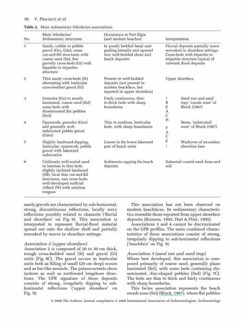
sandy gravels are characterized by sub-horizontal,strong, discontinuous reflections, locally wavyreflections possibly related to channels (‘fluvialand shoreface’ on Fig. 9). This association isinterpreted to represent fluvial-flood materialspread out onto the shallow shelf and partiallyreworked by waves in shoreface settings.
Association 2 (upper shoreface)Association 2 is composed of 20 to 30 cm thick,trough cross-bedded sand (St) and gravel (Gt)units (Fig. 8C). The gravel occurs in lenticularunits both as filling of small (20 cm deep) scoursand as bar-like mounds. The palaeocurrents showinshore as well as northward longshore direc-tions. The GPR signature of these depositsconsists of strong, irregularly dipping to sub-horizontal reflections (‘upper shoreface’ onFig. 9).
This association has not been observed onmodern beachfaces. Its sedimentary characteris-tics resemble those reported from upper shorefacedeposits (Reinson, 1992; Hart & Plint, 1995).
Associations 3 and 4 cannot be discriminatedon the GPR profiles. The main combined charac-teristics of these associations consist of strong,irregularly dipping to sub-horizontal reflections(‘beachface’ on Fig. 9).
Association 3 (sand run and sand trap)Where best developed, this association is com-posed primarily of coarse sand, generally planelaminated (Sel), with some beds containing dis-seminated, disc-shaped pebbles (Sed) (Fig. 7C).The beds are thin to thick and fairly continuouswith sharp boundaries.
This facies association represents the beachswash zone (Sel) (Bluck, 1967), where flat pebbles
Table 2. Main sedimentary lithofacies associations.
No.Main lithofacies/Sedimentary structures
Occurrence at Port Elgin(and modern beaches) Interpretation
1 Sandy, cobble to pebblegravel (Gcs, Gds), somecut-and-fill structures withcoarse sand (Se), fewgravelly cross-beds (Gt) withbipartite to tripartitestructure
In poorly bedded basal unitgrading laterally and upwardinto well-bedded shore andbeach deposits
Fluvial deposits partially wave-reworked in shoreface settings.Cross-beds with bipartite totripartite structure typical ofoutwash flood deposits
2 Thin sandy cross-beds (St)alternating with lenticularcross-bedded gravel (Gt)
Present in well-beddeddeposits (not present inmodern beachface, butreported in upper shoreface)
Upper shoreface
3 Granules (Gn) to mostlylaminated, coarse sand (Sel)some beds withdisseminated flat pebbles(Sed)
Fairly continuous, thin-to-thick beds with sharpboundaries
"BEACH
FACE#
Sand run and sandtrap: ‘swash zone’ ofBluck (1967)
4 Openwork, granules (Gno)and generally well-imbricated pebble gravel(Gdoi)
Thin to medium, lenticularbeds, with sharp boundaries
Berm; ‘imbricatedzone’ of Bluck (1967)
5 Slightly landward-dipping,lenticular, openwork, pebblegravel with lakewardimbrication
Lenses in the lower lakewardpart of beach units
Washover of secondaryshoreline bars
6 Uniformly well-sorted sandin laminae to thin bedsslightly inclined landward(Sfl); local thin cut-and-fillstructures, rare cross-beds;well-developed surficialAlfisol (W) with solutiontongues
Sediments capping the beachdeposits
Subaerial coastal sand dune andsoil
10 V. Pascucci et al.
� 2008 The Authors. Journal compilation � 2008 International Association of Sedimentologists, Sedimentology

may become trapped (Sed) (Dobkins & Folk,1970). Differences between Sel and Sed layersmay be related to availability of flat pebbles and/or it may reflect zonation within the swash zone.Indeed, on the Hamilton Beach a zonation isobserved frequently with parts of the swash zonedevoid of, or with few, pebbles (Sel) and otherparts with a higher concentration of scattereddisc-shaped clasts (Sed) (Fig. 7A and B).
Association 4 (berm)Association 4 is characterized by openwork grav-els with disc-shaped pebbles generally well-imbricated (Gdoi) (Fig. 6D). The gravels are mod-erately well-sorted, each layer showing differentsize pebbles (Gdo) and granules (Gno). The layershave sharp boundaries, ranging in thickness from5 to 25 cm with a few up to 50 cm. These layerslens-out laterally within 10 to 15 m.
This association represents intermediate-energy and low-energy storm berms (‘imbricatedzone’ of Bluck, 1967). Associations 4 and 3 arerelated closely, locally alternating in a quasi-regular fashion, indicating a shift from sand run/sand trap to pebble berms.
Association 5 (washover)This association is characterized by ca 2 m thickand up to 10 m long, gently landward-dipping,lenticular beds of pebble gravels (Gdo, Gdoi) andpebbly sands (Fig. 10; Table 2). The gravellylayers have disc-shaped pebbles imbricated lake-ward. The layers have flat boundaries. Thesedeposits are not readily recognizable on GPRprofiles having similar reflections to thebeachface units with, however, shallower dips
(‘washover’ on Fig. 9). This association is inter-preted to represent washover deposits of second-ary shoreline bars prograding landward.
Association 6 (dune and soil)This association consists of well-sorted sandmainly showing thin, lenticular, sub-horizontalto slightly landward-inclined laminae (Sfl;Fig. 8D), with local, shallow cut-and-fill struc-tures. Few, isolated, 0Æ5 m thick cross-beds arepresent, steeply inclined landward. The sanddeposit contains a variety of plant root features,some as calcite rhyzholiths, and others as deep,reddish soil solution tongues. A reddish Alfisoilcaps the aeolian sand (W; Fig. 8D). This topdeposit either does not register on the GPRprofiles or appears quasi-transparent (reflectionfree) (‘dune’ on Fig. 9).
The rarity of cross-beds indicates that the dunesdid not develop marked precipitation slopes, andthey were probably affected by winds of variousstrength and orientation, fluctuating water tableand vegetation cover. The presence of clay-richdeposits (Dm) below the sand and gravel depositsis indicated by the rapid loss of signal penetrationat depth in the GPR profiles (Fig. 9); this can beused to estimate the thickness of the sand andgravel resource.
Geometry
The internal geometry of the deposits is charac-terized by ‘lithostratigraphic units’ definable inoutcrop by ‘assemblages of lithofacies associa-tions’ and attitude of beds in outcrop. In thesubsurface, the lithostratigraphic units are equiv-alent to GPR ‘radar (reflection) packages’ definedby reflection type and dip. The lithostratigraphicunits and the equivalent radar packages arebounded by major erosional surfaces directlyobservable in outcrop (Brookfield, 1977; Miall,2000; Møller & Anthony, 2003) and by equivalentGPR ‘radar surfaces’ in the subsurface (van Het-eren et al., 1998; Neal et al., 2002).
Five principal lithostratigraphic units/radarpackages have been observed at Port Elgin (PE1to PE5 in Table 3; Figs 11 to 13). PE1 is a complexunit composed of gravel-dominated fluvial andshoreface association 1 in the lower part (PE1a),grading upward and landward (PE1b) into grav-elly-dominated beachface units. PE2 and PE3 arebeachface units composed of sand run and trapassociation 3 and berm association 4 separated byan erosional (bounding) surface (B). PE4 is themost lakeward unit and is composed of shoreface
Fig. 10. Uppermost Pleistocene deposits of Port Elgin:Gently landward inclined, plane-laminated sand (Sel)and gravel with pebbles imbricated lakeward (Gdoi),interpreted as accretion layers of a shoreline-barrierwashover.
Facies and ground-penetrating radar characteristics of coarse-grained beach deposits 11
� 2008 The Authors. Journal compilation � 2008 International Association of Sedimentologists, Sedimentology

association 2 in the lower part and washoverassociation 5 alternating with associations 3 and 4in the upper landward part. PE5 caps the otherunits and is composed of dune and soil associa-tion 6.
In sections parallel to the palaeoshoreline, thelithostratigraphic units lay sub-horizontally oneover the other and show an overall upward fining
trend (Fig. 11). Outcrop and GPR data indicatethat in sections perpendicular to the palaeoshore-line, units PE1b, PE2, PE3 and most of PE4 form alakeward-prograding succession. The majorbounding surfaces that separate the lithostrati-graphic units are slightly concave-upward andgently slope lakeward. The bounding surface Aseparates the coarser gravel-dominated, more
Table 3. Main Pleistocene lithostratigraphic units (PE1 to PE5) and bounding surfaces (A to D, Figs 12 and 13) atPort Elgin.
Unit Sedimentary associationsGPR characters and boundingsurfaces Occurrence/Interpretation
PE1 Gravel-dominated fluvial andshoreface association 1 in lowerpart, grading up into beachfaceassociations 3 and 4
Complex unit with (i) sub-horizontal discontinuousreflections, grading up into(ii) continuous, slightlylakeward-inclined, reflections
Exposed only in the lowermiddle part of the section. GPRprofiles indicate that it could befurther subdivided into at leasttwo units by an additional, notoutcropping, bounding surface(AA) (Fig. 13B)
PE2 Sand-dominated beachfaceassociations 3 and 4
Well-defined reflections withvarying lakeward dipsBounding surface A
Omnipresent, well-beddedlakeward-prograding beachfaceunits with locally steep shortconcave upward erosionalsurfaces (Z on Fig. 12B)
PE3 Similar to PE2 Similar to PE2Bounding surface B
Similar to PE2
PE4 Very gently lakeward-dippingbeachface units with landward-dipping washover association 5in the lower part (X on Fig. 12B)
Complex unit with lenticularpackages of various dippingreflections. Packages areseparated by secondaryunconformities.Bounding surface C
Most lakeward unit marking thetransition between shorefaceand beachface
PE5 Sand dune and soil association6 with numerous plant roots
Large lenses, semi-transparentor with sub-horizontal tolandward-dipping continuousreflections (Dune in Figs 9and 13)Bounding surface D
Erosionally overlies thebeachface units
GPR, ground-penetrating radar.
A
B
Fig. 11. Section of the Port Elgin pitsub-parallel to the ancient shore-line: (A) Photographic section: noteoverall fining-upward trend. (B)Interpreted line drawing; a majorunconformity (bounding surface A)occurs halfway up the section sep-arating the PE1b and PE2 units. Notehorizontality of layers indicating theabsence of major shore-diagonal,dipping accretion surfaces thatwould be expected in a variouslyprograding spit.
12 V. Pascucci et al.
� 2008 The Authors. Journal compilation � 2008 International Association of Sedimentologists, Sedimentology

A
B
C
Fig. 12. Section of the Port Elgin pit perpendicular to the ancient shoreline: (A) Photographic section and(B) Interpreted line drawing. PE1 to PE4 are lithostratigraphic units separated by major unconformities (boundingsurfaces A to D). X = isolated landward dipping strata; Z = steep, lakeward-dipping, erosional surfaces. The cappingdune (PE5) is not shown. (C) Ground-penetrating radar (GPR) L2-50 profile acquired near the rim of the working pitface (see Fig. 3C for location). The major GPR bounding surfaces (A to D) and a few of the intermediate ones havebeen calibrated to the photograph image; WT, water table; scale to the right of the GPR profile indicates depth.
A
B
Fig. 13. Ground-penetrating radar (GPR) profile L1-50 acquired ca 200 m north of the pit face, perpendicular to theancient shoreline [lake to the left (see Fig. 3C for location)]: (A) Original profile and (B) interpreted profile. The majorbounding surfaces (A to D) have been calibrated to the GPR L2-50 profile, bounding surface AA is not present inoutcrop and GPR L1-50 profile; Dm, diamicton.
Facies and ground-penetrating radar characteristics of coarse-grained beach deposits 13
� 2008 The Authors. Journal compilation � 2008 International Association of Sedimentologists, Sedimentology

steeply lakeward-dipping layers of unit PE1bfrom the finer-grained, more gently inclinedlayers of unit PE2 (Figs 12 and 13; Table 3).Bounding surface B between units PE2 and PE3 issteeper and less regular than bounding surface A.Bounding surface C separates unit PE3 from thecomplex unit PE4 that represents the final growthstages and abandonment of the Port Elgin barriercomplex. Bounding surface D planes off theunderlying beachface units and separates themfrom the overlying sand dunes. In analogy withother barrier systems of the lower Great Lakes(Martini, 1975, 1982), the dunes probably devel-oped later than the main body of the barrier,when the lake level dropped and extensive sandybeach surfaces were exposed to wind erosion.
DISCUSSION
The exposures at Port Elgin and modern beachsettings of the Great Lakes provide extensive,well-exposed cross-sections and good surficialdata, respectively, allowing recognition andunderstanding of coarse-grained lacustrine bea-ches. Two questions are addressed here:(i) whether these lacustrine deposits differ signif-icantly from those formed in equivalent cold-climate marine settings; and (ii) whether and howthe overall internal geometry of the deposits canprovide information on events that may haveoccurred in the ancient proglacial lakes?
• Coarse-grained beaches are wave-dominatedenvironments and they show overall similarity infacies associations independently of where theywere formed along large lake or sea coasts. Fur-thermore, similar to other cold-climate beaches,those of the Great Lakes develop an ice foot thatmay be extensive in some years (Fig. 4B and D).The ice formation protects the deposits duringwinter and, upon melting and breakup in thespring, may lead to local preferential scouring byice floes and to the release of ice-rafted, unsortedmaterial (Barnes et al., 1994). However, post-breakup storms rework the beach deposits to suchan extent that there is very little to no record ofice influence (Taylor & McCann, 1976; Martini,1980).The coarse-grained beaches of the Great Lakesstudied at Port Elgin and elsewhere (Martini,1975) show some differences to equivalent para-glacial (developed on formerly glaciated terrains),wave-dominated, marine beaches (Forbes et al.,1995). The coarse-grained beach deposits of the
Great Lakes may occasionally contain freshwaterfossils, and also differ from the sub-Arctic andArctic marine deposits because they do not de-velop any significant amount of frost-shatteredand edge-sharpened clasts (due to preferentialsolution of carbonates under cold-climate condi-tions).
• Coarse-grained beachface deposits have beenpreserved in the geological record but are not ascommon in pre-Pleistocene successions as othercoastal materials (Clifton, 1973; Massari & Parea,1988; Postma & Nemec, 1990). This effect occursdespite the fact that coarse-grained beach depos-its may resist erosion better than sandy depositsbecause they are more permeable and, in places,they are well-imbricated, thus the pivotabily ofthe clasts is reduced and the erodibility thresholdis increased (Carter & Orford, 1984; Trenhaile,1997).
Extensive deposits such as those of Port Elginallow the reconstruction of palaeolake settings.The bounding surfaces (radar surfaces) and asso-ciated lithostratigraphic units (radar reflectionpackages) provide information on storm events.The surfaces bounding the facies associationsindicate secondary storms, major erosional scarsrecord large storm events, and major boundary/planation surfaces separating lithostratigraphicunits/radar reflection packages are the result ofextreme events. The major boundary/planationsurfaces could develop because of: (i) majorchanges in the direction of progradation of thebeaches (geomorphic unconformities); (ii) excep-tionally intense storms associated with seiches(tilting of the lake water-level due to differentialatmospheric pressure and strong winds); and/or(iii) major water-level fluctuations in the basindue to extrabasinal causes.
• Geomorphic unconformities are a commonoccurrence during the development of spits (Or-ford et al., 2002). In such cases, changes inlithofacies characteristics should be noted incross-section, which are related to differentexposure of the depositional surface to waves andcurrents. Usually, the analysis of dip and strike ofthe strata and of the imbrication of the clasts candetermine whether this is the main cause of majorbounding surfaces. There is no evidence thatmajor geomorphic unconformities occur at PortElgin. In fact, every exposed palaeoshoreline-parallel section shows consistent, sub-parallellayers (Fig. 11) rather than the variable inclinedlayers expected for a laterally prograding spit.
14 V. Pascucci et al.
� 2008 The Authors. Journal compilation � 2008 International Association of Sedimentologists, Sedimentology

• The present Great Lakes experience water-level fluctuations of the order of 1 to 2 m due toclimate changes (seasonal and multiyear). Otherchanges are related to seiches (ca 1 m), and tostorm waves (up to ca 3 m). It is possible thatduring the time of glacial Lake Algonquin similar,but more frequent, more intense summer stormsoccurred stoked by strong katabatic winds blow-ing down the terminus of the Laurentide Ice Sheet(Fig. 2A). Some of the erosional features seen atPort Elgin, such as the local concave upwardsurfaces (Z on Fig. 12B), may be ascribed to suchlarge storm events.
• The above processes, however, would notreadily provide for the accommodation space forthe deposition of the 8 m thick, 150 to 200 mwide barrier of Port Elgin. The barrier was an-chored by a glacial diamicton (Dm) high (Figs 3B,9 and 13) lying on Palaeozoic carbonate bedrockgently dipping westward. Furthermore, this areawas experiencing active post-glacial isostatic up-lift. Therefore, the accommodation space for thebarrier complex had to be related to an overall,although fluctuating, rising lake level. The pre-cursors of the Great Lakes have, in fact, experi-enced numerous changes in water level(transgressions and regressions) that, togetherwith post-glacial isostatic uplift of coastal fea-tures, have led to the definition of various lakestages (Fig. 2B; Hough, 1958; Eschman & Karrow,1985; Clark et al., 1994). Even during a single lakestage, such as the Lake Algonquin maximumwhen the Port Elgin barrier system developed,significant water-level changes may have oc-curred that impacted on the internal geometry ofthe beach deposits. Among others, a somewhatintriguing but contentious possibility is that therise of lake level may have been related to thespillover of glacial waters from Lake Agassiz intothe Great Lakes region (Fig. 2B). Some of theseLake Agassiz floods have been proposed to occurca 10 900 14C yr bp (12 100 cal yr bp), and severalauthors have reported some evidence for them(Teller & Thorleifson, 1983; Anderson & Lewis,1985; Teller, 1985, 1995, 2001, 2004; Lewis &Anderson, 1989; Lewis et al., 1994; Teller et al.,2002). Recent studies suggest that such floodsmay not have been catastrophic (Lowell et al.,2005). Nonetheless floods from Lake Agassiz orother glacial sources during a climatically vari-able deglaciation period may have lasted andaffected the water level of Lake Algonquin fordecades. Such flood-affected, water-level changesmay explain at Port Elgin the planation ofbeachface deposits during the relatively rapid
(geologically instantaneous) transgressions, andthe subsequent regressive lakeward build-up ofnew beachface successions (lithofacies units).
CONCLUSIONS
Well-developed, coarse-grained, recent beachesand well-exposed sections of an uppermost Pleis-tocene, raised barrier system have allowed adetailed analysis of coastal lacustrine depositsof the southern Great Lakes. Great similarityexists between these lacustrine beaches andparaglacial, cold-temperate marine beaches. Onedifference is that, whereas in the tideless GreatLakes only the ‘pure gravel’ and ‘mixed sand andgravel’ beach types develop, in a marine settingaffected by large tidal excursions, such as in theBay of Fundy, a third type (‘composite sand andgravel beach’) may occur as well. The recent cold-temperate climate beaches of the Great Lakes alsodiffer from the Arctic and sub-Arctic marinebeaches with similar clast lithology, because theydo not develop numerous frost-shattered clasts, oredge-sharpened carbonate clasts.
Pure gravel and mixed sand and gravel beachesmay resist erosion during storms better than sandybeaches because they are more porous and theirimbricated pebbles have lower pivotability, none-theless they are not as frequently preserved orrecognized in the pre-Pleistocene deposits. Thosepebbles found on paraglacial Quaternary land-scapes such as in the Great Lakes region arepreserved because they have been stranded as theland underwent post-glacial isostatic uplift.
The internal architecture of the uppermostPleistocene Lake Algonquin beach/barrier depos-its of Port Elgin indicates that four major condi-tions/stages were required for the development ofthe barrier complex. (i) The study area is locatedmarginal to the central part of south-westernOntario that was never occupied by lakes duringthe last deglaciation (Ontario island; Hough,1958; Prest, 1970) and outwash sediments anddiamicton underlay the studied costal deposits.Therefore, major transgressive events had tooccur in the study area to generate more than8 m (thickness of exposed upper shoreface–beachface deposits) accommodation space overan uplifting substrate; that is, the water level hadto rise faster than the isostatically reboundingland. (ii) Most beachface deposits (PE1b, PE2,PE3) were formed during a highstand [highest(main) Lake Algonquin stage]. However, as indi-cated by the major bounding surfaces, this stage
Facies and ground-penetrating radar characteristics of coarse-grained beach deposits 15
� 2008 The Authors. Journal compilation � 2008 International Association of Sedimentologists, Sedimentology

experienced fluctuating water levels due to majorstorms, and/or large, not necessarily catastrophic,floods from the adjacent glacial Lake Agassiz ofcentral Canada or from other parts of the meltingLaurentide Ice Sheet. (iii) The most lakewardlithostratigraphic unit (PE4) shows developmentduring receding water stages of the main LakeAlgonquin, as more depressed outlets became ice-free further to the north. (iv) Finally, the cappingsand dunes (PE5 unit) developed later duringfurther recession of the lake as sandy materialwas exposed to wind erosion.
ACKNOWLEDGEMENTS
We are grateful to the late R. Protz who intro-duced us to the deposits of Port Elgin, toB. Bluck, M. Brookfield, P. Carling, M. Gibling,F. Massari and G.B. Parea, who read and criti-cized constructively previous versions of thepaper, and to I. V. Buynevich and an unknownsecond reviewer for comments that helped in thefinalization of the manuscript. We would like toacknowledge the assistance of E. Gilson, G. Parkinand G. Wong in the acquisition of the GPR data,and of W. Clement in the processing and displaythe GPR data. S. Sadura and M. Hawke helped inimproving the readability of an initial version ofthe paper. Financial support was provided by theConvenzione Progemisa, Italy, to V. P., and byNSERC (Natural Science and Engineering Re-search Council (Canada) grants to I. P. M. and A.E. L. The Environmental Geophysics Group of theUniversity of Waterloo provided the necessaryequipment for GPR work and interpretation.
REFERENCES
Anderson, T.W. (1979) Stratigraphy, age, and environment of
a Lake Algonquin embayment site at Kinkardine, Ontario.
Curr. Res., Part B., Geol. Surv. Can., Paper 79-1B, 147–152.
Anderson, T.W. and Lewis, C.F.M. (1985) Postglacial water-
level history of the Ontario basin. In: Quaternary Evolution
of the Great Lakes (Eds P.F. Karrow and P.E. Calkin), Geol.Assoc. Can., Spec. Paper, 30, 231–253.
Barnes, P.W., Kempema, E.W., Reimnitz, E. and
McCormick, M. (1994) Influence of ice on southern Lake
Michigan coastal erosion. J. Great Lakes Res., 20, 179–195.
Barnett, P.J. (1992) Quaternary geology of Ontario. In: Geology
of Ontario (Eds P.C. Thurston, H.R. Williams, R.H. Sutcliffe
and G.M. Stott), Ontario Geol. Surv., Special Volume, 4,1011–1088. Ontario Ministry of Northern Development and
Mines, Toronto.
Bluck, B.J. (1967) Sedimentation of beach gravels: examples
from South Wales. J. Sed. Petrol., 37, 128–156.
Brookfield, M.E. (1977) The origin of bounding surfaces in
ancient aeolian sandstones. Sedimentology, 24, 303–332.
Carter, R.W.G. (1988) Coastal Environments. Academic Press,
London, 617 pp.
Carter, R.G. and Orford, J.D. (1984) Coarse clastic barrier
beaches: a discussion of the distinctive dynamic and mor-
phosedimentary characteristics. Mar. Geol., 60, 377–389.
Carter, R.G. and Orford, J.D. (1993) The morphodynamic of
coarse clastic beaches and barriers: a short- and long-term
perspective. J. Coastal Res., Spec. Issue, 15, 158–179.
Chapman, L.J. and Putnam, D.F. (1984) The Physiography ofSouthern Ontario, 3rd edn, Ontario Geol. Surv., Special
Volume, 2, Ontario Ministry of Natural Resources, Toronto,
270 pp.
Clark, J.A., Hendriks, M., Timmermans, T.J., Struck, C. and
Hilverda, K.J. (1994) Glacial isostatic deformation of the
Great Lakes region. Geol. Soc. Am. Bull., 106, 19–31.
Clifton, H.E. (1973) Pebble segregation and bed lenticularity in
wave-worked versus alluvial gravel. Sedimentology, 20,173–187.
Coakley, J.P. and Karrow, P.F. (1994) Reconstruction of post-
Iroquois shoreline evolution in western Lake Ontario, Can-
ada. Can. J. Earth Sci., 31, 1618–1629.
Davis, J.L. and Annan, A.P. (1988) Ground-penetrating radar
for high resolution mapping of soil and rock stratigraphy.
Geophys. Prospect., 37, 531–551.
Dobkins, J.E. and Folk, R.L. (1970) Shape development on
Tahiti-Nui. J. Sed. Petrol., 40, 1167–1203.
Eschman, D.F. and Karrow, P.F. (1985) Huron basin glacial
lakes: a review. In: Quaternary Evolution of the Great Lakes(Eds P.F. Karrow and P.E. Calkin), Geol. Assoc. Can., Spec.
Paper, 30, 79–93.
FitzGerald, D.M., Baldwin, D.T., Ibrahim, N.A. and Humph-ries, S.M. (1992) Sedimentologic and morphologic evolu-
tion of a beach-ridge along an indented coast: Buzzards Bay,
Massachusetts. In: Quaternary Coasts of the United States:
Marine and Lacustrine Systems (Eds C.H. Fletcher III and
J.F. Wehmiller), SEPM Spec. Publ., 48, 65–75.
Forbes, D.L. and Taylor, R.B. (1987) Coarse-grained beach
sedimentation under paraglacial conditions, Canadian
Atlantic coast. In: Glaciated Coasts (Eds D.M. Fitzgerald and
P.S. Rosen), pp. 51–86. Academic Press, San Diego, CA.
Forbes, D.L., Orford, J.D., Carter, R.W.G., Shaw, J. and Jen-nings, S.C. (1995) Morphodynamic evolution, self-organi-
zation, and instability of coarse-clastic barriers on
paraglacial coasts. Mar. Geol., 126, 63–85.
Hart, B.S. and Plint, A.G. (1995) Gravelly shoreface and
beachface deposits. In: Sedimentary Facies Analysis(Ed. A.G. Plint). IAS, Spec. Publ., 22, 75–99.
van Heteren, S., FitzGerald, D.M., McKinlay, P.A. and Buy-nevich, I.V. (1998) Radar traces of paraglacial barrier sys-
tems; coastal New England, USA. Sedimetology, 45, 181–
200.
Hough, J.L. (1958) Geology of the Great Lakes. University of
Illinois Press, Urbana, 313 Pp.
Jennings, R. and Shulmeister, J. (2002) A field based classifi-
cation scheme for gravel beaches. Mar. Geol., 186, 211–228.
Jol, H.M., Smith, D.G. and Meyers, R.A. (1996) Digital Ground
Penetrating Radar (GPR): a new geophysical tool for coastal
barrier research (Examples from the Atlantic, Gulf and
Pacific Coasts, U.S.A.). J. Coastal Res., 12, 960–968.
Karrow, P.F. (1988) The Algonquin shoreline, Kinkardine-Port
Elgin, Ontario. Can. J. Earth Sci., 25, 157–162.
Karrow, P.F., Anderson, T.W., Delorme, L.D., Miller, B.B. and
Chapman, L.J. (1995) Late-glacial paleoenvironment of lake
16 V. Pascucci et al.
� 2008 The Authors. Journal compilation � 2008 International Association of Sedimentologists, Sedimentology

Algonquin sediments near Clarcksburg, Ontario. J. Paleo-
limnol., 14, 297–309.
Kirk, R.M. (1980) Mixed sand and gravel beaches: morphology,
processes and sediments. Prog. Phys. Geogr., 4, 189–210.
Lewis, C.F.M. and Anderson, T.W. (1989) Oscillations of lev-
els and cool phases of the Laurentian Great lakes caused by
inflows from lakes Agassiz and Barlow-Ojibway. J. Paleo-
limnol., 2, 99–146.
Lewis, C.F.M., Moore, T.C. Jr, Rea, D.K., Dettman, D.L., Smith,A.J. and Mayer, L.A. (1994) Lakes of the Huron basin: their
runoff from the Laurentide Ice Sheet. Quat. Sci. Rev., 13,891–922.
Lowell, T.V., Fisher, T.G., Comer, G.C., Hajdas, I.,Waterson, N., Glover, K., Loope, H.M., Schaefer, J.M.,Rinterknecht, V., Broecker, W., Denton, G. and Teller, J.T.(2005) Testing the Lake Agassiz meltwater trigger for the
Younger Dryas. EOS Trans. Am. Geophys. Union, 86, 365–
373.
Martini, I.P. (1975) Sedimentology of a lacustrine barrier
system at Wasaga Beach, Ontario Canada. Sed. Geol., 14,169–190.
Martini, I.P. (1980) Sea ice generated features of coastal sedi-
ments of James Bay, Ont. In: Proceedings Canadian Coastal
Conferences 1980, pp. 93–102. N.R.C., C.C.I.W., Burlington,
ON.
Martini, I.P. (1982) Coastal dunes of Ontario: Distribution and
geomorphology. Geog. Phys. Quatern., XXXV, 219–229.
Massari, F. and Parea, G.C. (1988) Progradation of gravel
beach sequences in a moderate- to high-energy, microtidal
marine environment. Sedimentology, 35, 881–913.
Miall, A.D. (2000) Principles of Sedimentary Analysis.
Springer-Verlag, Berlin, 616 pp.
Møller, L. and Anthony, D. (2003) A GPR study of sedimentary
structures within a transgressive coastal barrier along the
Danish North sea coast. In: Ground Penetrating Radar in
Sediments (Eds C.S. Bristow and H.M. Jol), Geol. Soc. Spec.
Publ., 211, 55–65.
Neal, A., Pontee, N.I., Pye, K. and Richards, J. (2002) Internal
structure of mixed-sand-and-gravel beach deposits revealed
using ground-penetrating radar. Sedimentology, 49, 789–804.
Orford, J.D. (1975) Discrimination of particle zonation on a
pebble beach. Sedimentology, 22, 441–463.
Orford, J.D., Forbes, D.L. and Jennings, S.C. (2002) Organiza-
tion controls, typologies and time scales of paraglacial
gravel-dominated coastal systems. Geomorphology, 48, 51–
85.
Postma, G. and Nemec, W. (1990) Regressive and transgressive
sequences in raised Holocene gravelly beach, southwestern
Crete. Sedimentology, 37, 907–920.
Prest, V.K. (1970) Quaternary geology of Canada. In: Geology
and Economic Minerals of Canada. Economic Geology Re-
port No. 1 (Ed. R.J.W. Douglas), pp. 677–764. Department of
Energy, Mines and Resources, Ottawa, Canada.
Reinson, G.E. (1992) Transgressive barrier island and estua-
rine systems. In: Facies Models (Eds R.G. Walker and
N.P. James), Geol. Assoc. Can., 179–194.
Taylor, R.B. and McCann, S.B. (1976) The effect of sea and
nearshore ice on coastal processes in Canadian Arctic
Archipelago. Rev. Geogr. Montreal, 123–132.
Teller, J.T. (1985) Glacial Lake Agassiz and its influence on the
Great Lakes. In: Quaternary Evolution of the Great lakes
(Eds P.F. Karrow and P.E. Calkin), Geol. Assoc. Can., Spec.
Paper, 30, 1–16.
Teller, J.T. (1995) History and drainage of large ice-dammed
lakes along the Laurentide Ice Sheet. Quatern. Int., 28, 83–
92.
Teller, J.T. (2001) Formation of large beaches in an area of
rapid differential isostatic rebound: the three-outlet control
of Lake Agassiz. Quat. Sci. Rev., 20, 1649–1659.
Teller, J.T. (2004) Controls, history, outbursts, and impact of
large late-Quaternary proglacial lakes in North America. In:
The Quaternary Period in the United States (Eds A.R. Gil-
lespie, S.C. Potter and B.F. Atwater), pp. 45–76. Elsevier,
Amsterdam.
Teller, J.T. and Thorleifson, L.H. (1983) The Lake Agassiz–
Lake Superior connection. In: Glacial Lake Agassiz (Eds J.T.
Teller and L. Clayton). Geol. Assoc. Can., Spec. Paper, 26,261–290.
Teller, J.T., Leverington, D.W. and Mann, J.D. (2002) Fresh-
water outbursts to the oceans from glacial Lake Agassiz and
their role in climate change during the last deglaciation.
Quat. Sci. Rev., 21, 879–887.
Trenhaile, A.S. (1997) Coastal Dynamics and Landforms.
Clarendon Press, Oxford, 366 pp.
Manuscript received 19 June 2007; revision accepted 1May 2008
Facies and ground-penetrating radar characteristics of coarse-grained beach deposits 17
� 2008 The Authors. Journal compilation � 2008 International Association of Sedimentologists, Sedimentology
Copyright © 2022 FDOKUMEN