The structure and development of foredunes on a locally prograding coast: insights from...
22
The structure and development of foredunes on a locally prograding coast: insights from ground-penetrating radar surveys, Norfolk, UK CHARLIE S. BRISTOW*, P. NEIL CHROSTON and SIMON D. BAILEY* *Research School of Geological and Geophysical Sciences, Birkbeck College and University College London, Gower Street, London WC1E 6BT, UK (E-mail: [email protected]) School of Environmental Sciences, University of East Anglia, Norwich NR4 7TJ, UK ABSTRACT The internal structure of coastal foredunes from three sites along the north Norfolk coast has been investigated using ground-penetrating radar (GPR), which provides a unique insight into the internal structure of these dunes that cannot be achieved by any other non-destructive or geophysical technique. Combining geomorphological and geophysical investigations into the structure and morphology of these coastal foredunes has enabled a more accurate determination of their development and evolution. The radar profiles show the internal structures, which include foreslope accretion, trough cut and fill, roll- over and beach deposits. Foredune ridges contain large sets of low-angle cross- stratification from dune foreslope accretion with trough-shaped structures from cut and fill on the crest and rearslope. Foreslope accretion indicates sand supply from the beach to the foreslope, while troughs on the dune crest and rearslope are attributed to reworking by offshore winds. Bounding surfaces between dunes are clearly resolved and reveal the relative chronology of dune emplacement. Radar sequence boundaries within dunes have been traced below the water-table passing into beach erosion surfaces. These are believed to result from storm activity, which erodes the upper beach and dunes. In one example, at Brancaster, a dune scarp and erosion surface may be correlated with erosion in the 1950s, possibly the 1953 storm. Results suggest that dune ridge development is intimately linked to changes in the shoreline, with dune development associated with coastal progradation while dunes are eroded during storms and, where beaches are eroding, a stable coast provides more time for dune development, resulting in higher foredune ridges. A model for coastal dune evolution is presented, which illustrates stages of dune development in response to beach evolution and sand supply. In contrast to many other coastal dune fields where the prevailing wind is onshore, on the north Norfolk coast, the prevailing wind is directed along the coast and offshore, which reduces the landward migration of sand dunes. Keywords Accretion, beach, erosion, foredunes, ground-penetrating radar (GPR), Norfolk, sedimentary structures. INTRODUCTION Foredunes are shore-parallel dunes formed by aeolian deposition within vegetation (Hesp, 1988). They are usually formed at the upper limit of wave action on prograding beach platforms, where plant colonization helps to trap wind- blown sand providing a nucleus for dune forma- tion (Olson & van der Maarel, 1989). The elongate ridge form is straightened, or curved, by wave Sedimentology (2000) 47, 923–944 Ó 2000 International Association of Sedimentologists 923
Transcript of The structure and development of foredunes on a locally prograding coast: insights from...

The structure and development of foredunes on a locallyprograding coast: insights from ground-penetrating radarsurveys, Norfolk, UK
CHARLIE S. BRISTOW*, P. NEIL CHROSTON and SIMON D. BAILEY**Research School of Geological and Geophysical Sciences, Birkbeck College and University CollegeLondon, Gower Street, London WC1E 6BT, UK (E-mail: [email protected]) School of Environmental Sciences, University of East Anglia, Norwich NR4 7TJ, UK
ABSTRACT
The internal structure of coastal foredunes from three sites along the north
Norfolk coast has been investigated using ground-penetrating radar (GPR),
which provides a unique insight into the internal structure of these dunes that
cannot be achieved by any other non-destructive or geophysical technique.
Combining geomorphological and geophysical investigations into the structure
and morphology of these coastal foredunes has enabled a more accurate
determination of their development and evolution. The radar pro®les show the
internal structures, which include foreslope accretion, trough cut and ®ll, roll-
over and beach deposits. Foredune ridges contain large sets of low-angle cross-
strati®cation from dune foreslope accretion with trough-shaped structures from
cut and ®ll on the crest and rearslope. Foreslope accretion indicates sand
supply from the beach to the foreslope, while troughs on the dune crest and
rearslope are attributed to reworking by offshore winds. Bounding surfaces
between dunes are clearly resolved and reveal the relative chronology of dune
emplacement. Radar sequence boundaries within dunes have been traced
below the water-table passing into beach erosion surfaces. These are believed to
result from storm activity, which erodes the upper beach and dunes. In one
example, at Brancaster, a dune scarp and erosion surface may be correlated
with erosion in the 1950s, possibly the 1953 storm. Results suggest that dune
ridge development is intimately linked to changes in the shoreline, with dune
development associated with coastal progradation while dunes are eroded
during storms and, where beaches are eroding, a stable coast provides more
time for dune development, resulting in higher foredune ridges. A model for
coastal dune evolution is presented, which illustrates stages of dune
development in response to beach evolution and sand supply. In contrast to
many other coastal dune ®elds where the prevailing wind is onshore, on the
north Norfolk coast, the prevailing wind is directed along the coast and
offshore, which reduces the landward migration of sand dunes.
Keywords Accretion, beach, erosion, foredunes, ground-penetrating radar(GPR), Norfolk, sedimentary structures.
INTRODUCTION
Foredunes are shore-parallel dunes formed byaeolian deposition within vegetation (Hesp,1988). They are usually formed at the upper limit
of wave action on prograding beach platforms,where plant colonization helps to trap wind-blown sand providing a nucleus for dune forma-tion (Olson & van der Maarel, 1989). The elongateridge form is straightened, or curved, by wave
Sedimentology (2000) 47, 923±944
Ó 2000 International Association of Sedimentologists 923

erosion during spring tides or storm surges, sothat the foredune orientation mirrors the shore-line. Foredunes form an important naturaldefence against marine ¯ooding and are valuedas a recreational and ecological resource. In ageological context, foredune preservation may befavoured where the coastline is prograding (Hesp,1988). The foredunes of the north Norfolk coastdescribed in this paper are located on a locallyprograding coast, where they play an importantrole in protecting back-barrier environments.Recent research using ground-penetrating radar(GPR) in dunes (Schenk et al., 1993; Bristowet al., 1996; Clemmensen et al., 1996; Harari,1996) has shown that GPR can image cross-strati®cation and erosion surfaces. The aims ofthis study are to use GPR to investigate theinternal structure of foredunes along the northNorfolk coast and to use the structures, combinedwith observations of geomorphology, to interpretthe processes of foredune formation. GPR over-comes the restrictions of poor exposure, allowingthe investigation of sedimentary structures inareas where there is extensive vegetation coverand few natural sections. A model of foreduneevolution along the Norfolk coast is comparedwith models for foredune development proposedby Hesp (1988) and Psuty (1992).
The structure of coastal dunes
Descriptions of the internal structure of coastaldunes show that sedimentary structures dependupon dune type, vegetation, orientation withrespect to the prevailing wind and orientationwith respect to the coastline. Early work byMcBride & Hayes (1962) described bimodal dipsfrom pyramid dunes, while Land (1964), Bigarellaet al. (1969) and Yaalon & Laronne (1971) recordedhigh-angle and low-angle landward dips in duneridges with a prevailing onshore wind. In studiesof vegetated coast-parallel dune ridges, Gold-smith (1973, 1978) described low-angle (10±15°)cross-strati®cation formed as sand accumulatesaround dune vegetation, which acts as a baf¯etrapping the wind-blown sand. Goldsmith (1973)described seaward dips within dunes on Mono-moy Island and the coincident growth of vegeta-tion and vertical accretion of dunes. Byrne &McCann (1990) provided detailed descriptions ofsedimentary structures in vegetated coastal duneson Sable Island and emphasized the role ofvegetation in dune deposition. The most compre-hensive study to date is that of Hesp (1988), whorecognized ®ve morphological stages of foredune
development, each of which is characterized by aset of erosional and depositional processes thatproduce generally distinctive sets of cross-strata.Stage 1 and 2 foredunes are dominated by broad,convex-up, low-angle sets of cross-strati®cation,while stages 3 and 4 include more landward-dipping, high-angle sets of cross-strati®cation.Carter & Wilson (1990) described the accretionof foredunes and dune ridges in terms ofwindward±leeward deposition and foreslope±rearslope deposition. The foreslope/rearslopeterminology is used here, where the foreslope isthat facing the sea and the rearslope is towardsthe land. This is more suitable than the wind-ward/stoss and leeslope terminology for duneridges that do not show a signi®cant asymmetryand have a variable wind regime. Previous studiesof coast-parallel dune ridges and foredunes (King,1972; Carter & Wilson, 1990; Davidson-Arnott &Law, 1990; Ritchie & Penland, 1990) have shownthat vertical accretion and seaward building inforedunes is common. Individual dune ridgesdevelop from foredune ridges, the foredunesthemselves develop on top of beach ridges, andthe prograding dune ridges occur where theshoreline is accreting and prograding.
The north Norfolk coast
The north Norfolk coast between Hunstanton andBlakeney is an east±west trending coast in thesouthern part of the North Sea. It is a low coast ofHolocene sediments that accumulated during theFlandrian transgression, underlain by discontinu-ous glacial sediments on a Cretaceous chalkbedrock (Andrews et al., 2000). Hinterland reliefis low with chalk hills rising to 60 m aboveOrdnance Datum (OD) 4 km inland. The coasthas a meso- to macrotidal regime with dominantwaves from the NNE and a prevailing SW wind(Fig. 1). The coastline is dominated by barrierbeaches, a barrier island (Scolt Head Island) anda large spit (Blakeney Spit), separated by tidalinlets with tidal deltas. Back-barrier environmentsinclude tidal creeks, mud¯ats and saltmarshes,parts of which have been enclosed by seawalls anddrained for agriculture. Along the north Norfolkcoast, a spatially variable pattern of erosion andaccretion exists. Seaward progradation or long-shore extension of dune-capped barrier beaches,spits and a barrier island occurs at Thornham,Brancaster, Scolt Head Island, Holkham andBlakeney Spit. Progradation at Blakeney Spit andScolt Head Island results from the accretion ofrecurves at the western end of a spit (Blakeney)
924 C. S. Bristow et al.
Ó 2000 International Association of Sedimentologists, Sedimentology, 47, 923±944

and barrier island (Scolt). The accretion resultsfrom wave-driven longshore drift from east towest. Progradation at Brancaster results from alocal reversal in longshore drift as a result of wavediffraction around the western end of Scolt HeadIsland and refraction over the tidal delta at theentrance to Brancaster Harbour. There is addition-al eastward accretion at the entrance to ThornhamHarbour and on the eastern end of Scolt HeadIsland. Intervening and adjacent areas of the coastwhere dunes are less well developed are eroding.
The prevailing wind is from the SW and partlydirected offshore, and the wind and sand roses(Fig. 1) show that wind direction is quite variable.The resultant drift direction calculated accordingto the method of Fryberger (1980) is 52°. However,
the greatest fetch is from the north and NNE, andwinds from this quarter generate waves that havea signi®cant impact on the coast. Northerly windsblow sand from the beach and dune cliff over thedune crest with accretion on the top of the duneresulting in roll-over of the coastal dunes. Thedunes themselves are the most signi®canttopographical feature on the coastal plain, andsome leeside de¯ection along dunes orientedoblique to the prevailing wind should be expected(Lancaster, 1995).
Dunes of the north Norfolk coast
Coastal dunes occur along most of the northNorfolk coast and form a narrow strip along the
North Sea
BlakeneyBrancaster
Holkham
Norton Hills
Wells-next-the-Sea
BrancasterGolf course
Scolt Head Island Blakeney Spit
0 5km
A B C
Thornham
Burnham Overy
14.4 - 17.0 ms–1
8.7 - 13.9 ms–1
5.7 - 8.2 ms–1
<5.7 ms–1
20%40%
0.0 - 1.0m1.0 - 2.0m2.0 - 3.0m
3.0 - 4.0mGreater than 4.0m
Wave height (m)RDD
DP = 365RDP = 192RDD = 052o
RDD/DP = 0.52
Fig. 1. Map showing the location of coastal dunes studied along the north Norfolk coast with a wind rose (A) fromMarham, an air®eld 35 km inland, a sand rose (B) calculated by the method of Fryberger (1980) from data obtained atWest Beckham, 8 km ESE from Wells-next-the-Sea, and a wave rose (C) from a wave rider buoy off Wells-next-the-Seabased on 1 year's data (1996±97). The wind rose shows that the winds are mainly from the south-west; the sand roseshows a resultant drift direction (RDD) of 52°, while the wave rose indicates dominant waves from the NNE.
Structure and development of foredunes 925
Ó 2000 International Association of Sedimentologists, Sedimentology, 47, 923±944
coastline, about 200 m wide, but do not extendinland more than 1 km. They form elongateridges with the dune crestline following thecoastline, which is generally east±west orientedbut locally bends around to accommodate tidalinlets. The Norfolk dunes are vegetated and,according to the de®nition of Hesp (1988), theyare foredunes. They have been classed as beach-foredunes on a barrier coast by Olson & van derMaarel (1989) although, in parts, they are alsoclassi®ed as spit dunes in the classi®cationschemes of Ranwell & Boar (1986) and Doody(1989), and the dunes at Scolt Head Island arethe type locality for offshore island/barrier dunesin the UK (Doody, 1989). At Scolt Head Islandand Blakeney Spit, where the dune ridgesoverlie old recurves, the foredune ridges are ata high angle to the coast, up to 150° in the caseof Butchers Beach on Scolt Head Island. The oldrecurves mark former positions of the shorelineand, at the time the foredune ridges wereformed, the dunes were almost certainly parallelto the contemporary shoreline. The age of thedunes has been determined by Knight et al.(1998), who found that the dunes are less than600 years old. Knight et al. (1998) found thatdune ages cluster around 350 BP and suggest thatthis results from higher sea levels or increasedstorminess associated with the Little Ice Age.
The dune crestlines generally undulatebetween 5 and 10 m OD, locally reaching 20 mOD on the highest dunes. Variations in foreduneheight broadly follow the model of Psuty (1992).Foredunes are very low along parts of Scolt HeadIsland and the middle of Brancaster Bay, wherethe coast is eroding at around 1±2 m year)1. Lowforedune ridges are also found where the coast isprograding at Holkham, Brancaster Golf Courseand Far Point on the western end of Scolt HeadIsland, where rates of progradation are of theorder of 1±3á5 m year)1. The foredunes are high-est where the coastline is generally stable orslightly erosive, which provides increased timefor sediment transport from the beach to theforedune. The seaward edge of the dunes atHolme-next-the-Sea, Scolt Head Island and thewestern part of Brancaster Golf Course is markedby an erosion scarp. These sites have recentlysuffered erosion by storm waves during severewinter storms, most notably in February 1993 andFebruary 1996. The base of the erosional scarps isusually partly covered by an apron of wind-ripplelaminated sand deposited by winds blowingalong the beach (Fig. 2). With the exception oferoding dune scarps, the dunes have almost
100% vegetation cover dominated by marramgrass (Ammophila arenaria), although the veget-ation changes across the dunes (Woodell, 1989;White, 1989).
Study sites
GPR pro®les were collected at three sites alongthe Norfolk coast: Holkham, which has thegreatest area of dunes and the highest dunesalong the Norfolk coast; Scolt Head Island, whichis the type locality for offshore island/barrierdunes in the UK (Doody, 1989); and BrancasterGolf Course, which shows excellent beach andforedune accretion topography.
Norton Hills, Scolt Head Island
Scolt Head Island is a 6á5-km-long barrier islandwith 30 recurves enclosing salt marshes along itssouthern landward margin. The recurves recordthe progressive westward migration of the islandover the past 2000 years. Dunes have developedon top of the recurves at Bight Hills, Wire Hills,Long Hills, Butchers Beach, Privet Hill, HouseHills and Norton Hills (for locality details, seeSteers, 1960, 1989). With the exception of NortonHills at the eastern end of Scolt, all the dunesoverlie recurves that mark the former position ofthe western end of the island. The island prob-ably started as a spit extending west from theHolkham area and was converted into an islandby a breach in the spit where the River Burn now¯ows out through the Overy Channel. The breachappears to have formed around 1500 AD, but itsorigins are uncertain. It is not clear whether it wasformed naturally or engineered to maintain anentrance to Burnham Overy Harbour. The dunesat Norton Hills curve around the end of the islandforming a series of subparallel ridges, whichswing around from NW±SE to N±S, runningparallel to the shoreline along the beach and intothe tidal channel (Fig. 3). The landward side ofthe dunes is marked by a strip of ¯otsam andshrubby sea blight (Sueda vera) along the highspring tide line at around 3á4 m OD. The north-ern, seaward ends of the older ridges are beingeroded, while a new dune ridge is currentlyforming at the eastern end of the island. Geomor-phology and vegetation indicate that the dunesyoung towards the east, in response to accretionon the eastern end of Scolt Head Island. Thisaccretion may result from narrowing of theentrance of the Overy Channel following marshenclosure from the seventeenth century onwards.
926 C. S. Bristow et al.
Ó 2000 International Association of Sedimentologists, Sedimentology, 47, 923±944

Knight et al. (1998) gave an age of 326 � 39 yearsBP for the base of the main dune ridge. Three GPRpro®les were collected in a fan across the strike ofthe dunes, two of which, line OD and line OV, aredescribed and interpreted in this paper.
Holkham Dunes
The dunes at Holkham extend for 6á6 km alongthe coast between the Wells and Burnham Overytidal channels. They are the most extensive of thedune systems along the north Norfolk coast (121hectares) and were largely stabilized by treeplanting in the latter half of the nineteenthcentury (Ranwell & Boar, 1986). The dunes forma series of coast-parallel ridges that decrease inelevation towards the beach.
Brancaster Golf Course
Brancaster Golf Course is a links course developedon coastal foredunes that overlie recurved beach
ridges. The foredunes and beach ridges are beingeroded at the western end nearest to the clubhouse, and are accreting at the eastern end nearBrancaster Harbour and Scolt Head Island, where12 recurves record easterly accretion (Fig. 4).Changes in foredune elevation re¯ect alongshorechanges in beach erosion and accretion in accord-ance with the foredune sediment budget model ofPsuty (1992). Maximum foredune elevationoccurs where the beach is slightly erosional, withforedune elevation decreasing in either directionas rates of accretion increase towards the east anderosion increases towards the west. Evidence forthe age of the beach ridge system can be derivedfrom a variety of sources. The establishment of aRoman harbour and town at Branodunumsuggests that the barrier beach was extant around34±100 AD in order to provide a sheltered anchor-age for the Roman harbour. A peat outcropping onthe foreshore at Brancaster has been dated at3470 � 50±2790 � 40 BP (Funnell & Pearson,1989), indicating that the barrier beach was
Fig. 2. Holkham GPR pro®le across coastal foredunes stepping down onto a beach. The water-table forms a stronghorizontal re¯ector at the level of the high tide mark at 3 m OD. Conductive saline groundwaters increase attenu-ation, and GPR pro®les extended onto the beach show attenuation at the beach water-table. Deeper re¯ections aremultiples of the air and ground waves at the top of the pro®le.
Structure and development of foredunes 927
Ó 2000 International Association of Sedimentologists, Sedimentology, 47, 923±944

located seawards of its present position at thattime. Figure 4 shows a map of the recurves at theeastern end of Brancaster Golf Course drawn fromaerial photographs. Some indications of thetiming of formation of the recurves can beobtained from Ordnance Survey maps; the datesshown on Fig. 4b are the publication dates ofmaps showing the shoreline in the positionindicated. This does not indicate that the recurveswere formed at that time, but is simply the datewhen those features were mapped, giving aminimum age for the features surveyed. Infraredstimulated luminescence (IRSL) ages from thebase of the dunes at Brancaster in Knight et al.(1998) are 361 � 44 and 300 � 34 years BP.
GROUND-PENETRATING RADAR
Ground-penetrating radar (GPR) emits short pulsesof electromagnetic energy, which propagate intothe ground from a transmitting antenna. Whenthe radiating energy encounters abrupt changes indielectric properties in the ground, some of theenergy is re¯ected back to the receiving antenna.The re¯ected signal is ampli®ed, recorded andthen processed and displayed. The times betweenthe transmission and reception of signals are afunction of the velocity of electromagnetic wavepropagation through the sediments and the depthto the re¯ecting horizon. Propagation velocitiesand penetration depths depend on the complex
Fig. 3. (a) Composite vertical aerialphotograph of the eastern end ofScolt Head Island from Allison &Morley (1989). Norton Hills duneridges curve around the end of theisland running parallel to theshoreline and the tidal channel atthe entrance to Burnham OveryHarbour. The northern ends of thedune ridges are truncated by aneroding dune cliff, swash bars canbe seen on the beach, and there is awash-over in the top left corner ofthe photograph. (b) Inset, sketchmap drawn from 1992 aerial photo-graphs, showing the location of GPRpro®les OV and OD (Figs 6 and 7).
928 C. S. Bristow et al.
Ó 2000 International Association of Sedimentologists, Sedimentology, 47, 923±944

dielectric properties of the sediments (Davis &Annan, 1989) and, for dry sand, the propagationvelocity is 0á15±0á2 m ns)1 (McCann et al., 1988).Changes in dielectric properties in coastal dunesresult largely from changes in water saturation
and salinity. For dry dunes, or dunes with afreshwater aquifer, water content is controlled bythe depth to the water-table and also the porosityand permeability of the sands. Mineralogicalchanges, including concentrations of heavy min-
Fig. 4. (a) Composite vertical aerial photograph of the eastern end of Brancaster Golf Course from Allison & Morley(1989). (b) Map of Brancaster Golf Course, drawn from aerial photographs, showing location of GPR pro®le (Fig. 9)(the dashed section is not illustrated), and accretion history of recurved beach ridges. The dates shown are thepublication dates of Ordnance Survey maps on which the beach ridges ®rst appear. This is not the true date offormation for each ridge, but it does give an indication of the time involved.
Structure and development of foredunes 929
Ó 2000 International Association of Sedimentologists, Sedimentology, 47, 923±944

erals, or layers of silt, clay or organics can alsoaffect the dielectric properties of the sediment.Changes in porosity and changes in mineralogywithin coastal dunes are caused primarily bychanges in sedimentary structures or soil forma-tion so, with the exception of the water-table, themajority of re¯ections can be interpreted as theproduct of primary depositional fabric and sedi-mentary structures. Saline waters have a highconductivity, which leads to high attenuationand, hence, low depth of penetration.
One advantage of GPR is that it is non-destruc-tive and can be used to identify subsurfacestructure without the use of trenches. GPR canalso overcome the restrictions of limited out-crops. On the other hand, there are restrictionsresulting from occlusion of the shallowest sectionby the direct air and ground waves, and resolu-tion is dependent on wavelength, velocity anddepth of penetration.
Survey details
The GPR pro®les were made using Sensors andSoftware Pulse Ekko PE100 with 200 MHz anten-nae. In the ®eld, the equipment was deployedfrom a plastic wheelbarrow. The GPR antennaewere oriented parallel to each other and perpen-dicular to the direction of travel, with a spacing of0á5 m. Data were collected at 0á2-m intervals witha stack of 32 measurements at each point. Thedistance along the pro®les was measured using atape measure with topography recorded usinga Sokkia Set 5 total station. Data were recorded ona Toshiba laptop computer and processed using aSensors and Software Pulse Ekko program. Wherepossible, the GPR pro®les were collected perpen-dicular to the orientation of dune ridges, althoughslight detours were made to avoid obstacles.Subsequent to the ®eld survey, the GPR pro®leswere migrated in the data processing.
Depth of penetration
In selecting antennae frequency for a GPR survey,there is a compromise to be made betweenresolution and depth of penetration, the `range±resolution trade-off' (Davis & Annan, 1989). Theshorter wavelength antennae give greater resolu-tion but less penetration. In coastal dunes, pen-etration of around 15 m was achieved with both200- and 100-MHz antennae. This is less than thepotential depth of penetration, which could be 18and 23 m, respectively, with a 400-volt transmit-ter (Smith & Jol, 1995). The depth of penetration
is controlled by the attenuation, and this isparticularly affected by the water-table. Attenua-tion increases markedly with conductive, salinegroundwaters, and pro®les that extended onto abeach or to the high water mark show highattenuation at the beach water-table (Fig. 2).
Resolution
The vertical resolution is determined by thewavelength of the antennae and the velocity ofthe wave through the ground. In this study,velocities have been determined using commonmid-point gathers and by calculating the depth tothe water-table, where this can be identi®ed onGPR pro®les. The calculated velocities range from0á1 to 0á15 m ns)1 and are usually nearer to 0á12±0á13 m ns)1, which is a typical range for slightlydamp sand. Commonly quoted velocities for drysand are 0á15 m ns)1 (Sensors and Software,1993) or 0á15±0á2 (McCann et al., 1988), whilethe velocity for saturated sand is given as 0á05±0á06 m ns)1 (McCann et al., 1988; Sensors &Software, 1993). The antennae used in thesesurveys have a nominal central frequency of200 MHz. Assuming the resolution to be one-quarter of the wavelength, the resolution isestimated at between 12á5 and 19 cm for veloci-ties of 0á1 and 0á15 m ns)1 respectively. However,frequency amplitude plots of the received signalindicate a peak return frequency of around120 MHz for the 200-MHz antennae. With avelocity of 0á12 m ns)1, the vertical resolutionwill be around 25 cm. This means that individuallaminae or foresets are beneath the resolution ofthe GPR, but packages or sets of cross-strati®ca-tion of >0á25 m thickness may be resolved.Individual surfaces may, however, be recognizednot by individual re¯ections, but where re¯ectorsterminate, or where there is a change in dipbetween re¯ectors. Surfaces picked at re¯ectorterminations are termed radar sequence bound-aries (Gawthorpe et al., 1993). Bedding planes orlaminae in aeolian sands are usually laterallycontinuous for a metre or more, and a step size of0á2 m between measurements was found to besuf®cient to resolve most sedimentary structures.
Radar facies
Following seismic interpretation techniques, twomethodologies have been proposed for the inter-pretation of GPR pro®les, radar facies analysisand radar sequence analysis (Beres & Haeni, 1991;Gawthorpe et al., 1993). A combination of these
930 C. S. Bristow et al.
Ó 2000 International Association of Sedimentologists, Sedimentology, 47, 923±944

two approaches is adopted here following Bri-stow (1995). Radar facies have repeated packagesof re¯ections with similar character and geom-etry, while radar sequence boundaries can bepicked at re¯ector terminations. Because of thelarge number of re¯ector terminations associatedwith small-scale sedimentary structures, only themore extensive surfaces where re¯ectors termin-ate are picked as radar sequence boundaries.Radar facies identi®ed in this study are shown inFig. 5 and are outlined below.
Radar facies 1 (RF1) ± the water-table
A laterally continuous, high-amplitude, subhori-zontal, paired re¯ection at around 2±3 m OD isrecognized on all the GPR pro®les. This re¯ectorappears to cut across other re¯ectors, some ofwhich can be traced passing through it. Thisre¯ector is interpreted as the water-table, whichforms a strong re¯ector because of the contrast indielectric properties between wet and dry sand.
The water-table is important because its altitude,around 3 m OD, is very close to mean high waterand can be used as a proxy for sea level. Withinthis study, the effects of relative changes in sealevel can be ignored because the dunes are lessthan 600 years old (Knight et al., 1998). Rates ofHolocene sea-level rise along the north Norfolkcoast are around 1 m per thousand years (An-drews et al., 2000). As a consequence, sea levelmay have risen by about 60 cm since the earliestdunes were formed, and 35 cm since most of thedunes were formed around 350 years BP. Almostall sediment below the water-table can beassumed to be marine in origin, whereas thatabove the water-table will include a small thick-ness of upper beach, backshore platform andstorm deposits overlain by coastal dunes.
Radar facies 2 (RF2) ± troughs
Above the water-table are weaker, gently dippingre¯ectors, which are interpreted as sedimentary
Fig. 5. Radar facies on GPR pro®lesacross coastal dunes on the northNorfolk coast. Seven different radarfacies are recognized on the basis ofre¯ection character and geometry.The water-table re¯ector (RF1) is alaterally continuous, strong,subhorizontal, paired re¯ector ataround 2±3 m OD, which forms astrong re¯ector because of thecontrast in dielectric propertiesbetween wet and dry sand. Thewater-table is important because itsaltitude, around 3 m OD, is veryclose to mean high water, and it canbe used as a proxy for sea level.Other usually lower amplitudere¯ectors are attributed to a varietyof sedimentary structures. Thoseabove the water-table (RF2±RF5) areinterpreted as aeolian, while thosebelow the water-table (RF6 and RF7)are interpreted as marine deposits.
Structure and development of foredunes 931
Ó 2000 International Association of Sedimentologists, Sedimentology, 47, 923±944

structures within the dunes. The low amplitudeof the re¯ections is indicative of small re¯ectioncoef®cients, possibly implying re¯ections fromtexturally similar sediments (van Heteren et al.,1998). Two types of dipping re¯ector or radarfacies are common. Facies 2, discontinuouscurved, concave-up re¯ectors within 5- to 15-m-wide and 1- to 2-m-deep, trough-shaped packages(Fig. 5) are interpreted as sets of trough cross-strati®cation from scour and ®ll. The width:depthratio of troughs varies, with some troughs beingshallower saucer-shaped features. Radar facies 2is usually found on the dune crest and rearslope,which are exposed to the prevailing SW wind.Scour and ®ll structures on the crest and rear-slope probably indicate reworking by the prevail-ing wind, possibly during periods of reducedvegetation cover, which would increase sandmobility.
Radar facies 3 (RF3) ± foreslope accretion
The second common type of radar facies withinthe dunes comprises low-angle, seaward-dip-ping, subplanar or gently undulating or complexclinoform re¯ectors, which are laterally continu-ous, extending for 10 or more metres downdip.Radar facies 3 is found on GPR pro®les at NortonHills, Holkham and Brancaster. These re¯ectorsdip towards the sea at up to 19° and areinterpreted as foreslope accretion units. Sandtrapped in dunes and foredunes by vegetation onthe seaward side results in low-angle, offshore-inclined, sedimentary dips within the dunes(Goldsmith, 1973). The coincident growth ofvegetation and vertical accretion of dunes, whichresults in low-angle, seaward-dipping cross-stra-ti®cation, has been described by Goldsmith(1973) and Hesp (1988). This is consistent withobservations of dune morphology and dunevegetation in Norfolk and other areas, wherevertical accretion and seaward building in fored-unes is common (King, 1972; Carter & Wilson,1990; Davidson-Arnot & Law, 1990; Ritchie &Penland, 1990).
Radar facies 4 (RF4) ± roll-over
Packages of subhorizontal, gently dipping andshingled re¯ectors with dips towards the southform radar facies 4, which is found at thenorthern seaward end of GPR pro®les at NortonHills. Radar facies 4 is interpreted as roll-overdeposits formed when sand is blown from aneroding dune cliff and from a beach on to thedune top.
Radar facies 5 (RF5) ± biotopographicaccumulation
The foredune ridges contain low-amplitude andlow-angle, discontinuous, concave and convex-up re¯ectors, which extend laterally for 5 m orless and have a relief of 0á5 m or less. The concavetrough forms are signi®cantly smaller than thetroughs of radar facies 2. The convex-up forms areinterpreted as accretionary mounds aroundclumps of vegetation. The concave re¯ectors areinterpreted as small erosion scours betweenhummocks or simply areas of reduced accumula-tion between accreting mounds. The term bio-topographic variation has been used by Hesp(1988) and Ranwell (1972) to describe a variety ofaccretionary mounds and erosional hummocksaround vegetation. In Australia, Hesp (1988)described hummocks around grasses such asspinifex, while Ranwell (1972) described salixhedgehogs formed around dwarf willow shrubs(Salix repens). Byrne & McCann (1990) indicatedthat horizontal, parallel and wavy laminated bedsformed by grainfall deposition through densevegetation is the dominant mode of depositionon Sable Island dunes where the principal veget-ation is Ammophila breviligulata. On the coastaldunes of Norfolk, the main vegetation is marramgrass (Ammophila arenaria).
Radar facies 6 (RF6) ± beach deposits
This radar facies comprises low-angle (<10°),seaward-dipping re¯ectors, which are laterallycontinuous for more than 10 m and are usuallyfound beneath the water-table. The location ofRF6 beneath the water-table and its gentle sea-ward dip are indicative of upper shoreface beachdeposits, which may extend into backshoredeposits. Some of the low-angle dipping re¯ectorscan be traced from beneath the water-table pass-ing up into dune deposits (RF2 and RF3) abovethe water-table. RF6 re¯ectors, which can betraced through the water-table, often truncateunderlying RF2 and RF3 re¯ectors and can beonlapped by overlying RF3 re¯ectors. These RF6re¯ectors are interpreted as erosion surfaces,probably formed during storms that erode thebeach and coastal dunes (see radar sequenceboundaries below).
Radar facies 7 (RF7) ± swash bar
Radar facies 7 comprises packages of short, steep,landward-dipping re¯ectors beneath the water-
932 C. S. Bristow et al.
Ó 2000 International Association of Sedimentologists, Sedimentology, 47, 923±944
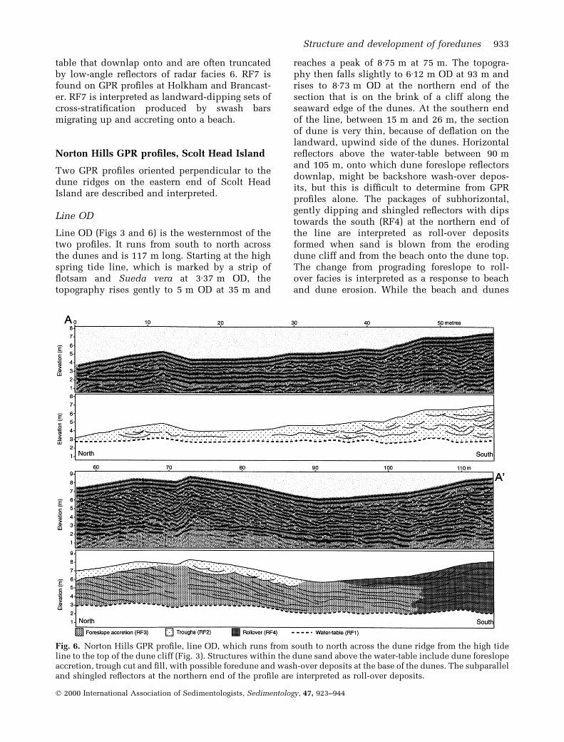
table that downlap onto and are often truncatedby low-angle re¯ectors of radar facies 6. RF7 isfound on GPR pro®les at Holkham and Brancast-er. RF7 is interpreted as landward-dipping sets ofcross-strati®cation produced by swash barsmigrating up and accreting onto a beach.
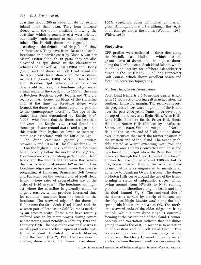
Norton Hills GPR pro®les, Scolt Head Island
Two GPR pro®les oriented perpendicular to thedune ridges on the eastern end of Scolt HeadIsland are described and interpreted.
Line OD
Line OD (Figs 3 and 6) is the westernmost of thetwo pro®les. It runs from south to north acrossthe dunes and is 117 m long. Starting at the highspring tide line, which is marked by a strip of¯otsam and Sueda vera at 3á37 m OD, thetopography rises gently to 5 m OD at 35 m and
reaches a peak of 8á75 m at 75 m. The topogra-phy then falls slightly to 6á12 m OD at 93 m andrises to 8á73 m OD at the northern end of thesection that is on the brink of a cliff along theseaward edge of the dunes. At the southern endof the line, between 15 m and 26 m, the sectionof dune is very thin, because of de¯ation on thelandward, upwind side of the dunes. Horizontalre¯ectors above the water-table between 90 mand 105 m, onto which dune foreslope re¯ectorsdownlap, might be backshore wash-over depos-its, but this is dif®cult to determine from GPRpro®les alone. The packages of subhorizontal,gently dipping and shingled re¯ectors with dipstowards the south (RF4) at the northern end ofthe line are interpreted as roll-over depositsformed when sand is blown from the erodingdune cliff and from the beach onto the dune top.The change from prograding foreslope to roll-over facies is interpreted as a response to beachand dune erosion. While the beach and dunes
Fig. 6. Norton Hills GPR pro®le, line OD, which runs from south to north across the dune ridge from the high tideline to the top of the dune cliff (Fig. 3). Structures within the dune sand above the water-table include dune foreslopeaccretion, trough cut and ®ll, with possible foredune and wash-over deposits at the base of the dunes. The subparalleland shingled re¯ectors at the northern end of the pro®le are interpreted as roll-over deposits.
Structure and development of foredunes 933
Ó 2000 International Association of Sedimentologists, Sedimentology, 47, 923±944
are accreting at the eastern end of the island, thenorth-facing beach and northern end of the duneridges are being eroded (Fig. 3). The shoreline haslocally changed from accretionary to erosional,re¯ecting a gradual change in the island'smorphology with erosion in the middle of theisland and deposition at either end movingtowards a `drum-stick' morphology (Hayes, 1979).
Line OV
Line OV (Figs 3 and 7) is oriented SSE to NNE; itis 139 m long and runs from south to north. Thepro®le rises from 3á73 m OD at the southern endto a peak at 7á98 m OD on top of a dune ridge,which is part of the main ridge on line OD. Theline descends to 5á47 m OD in an interdunehollow and rises again to 7á27 m on a seconddune ridge. The line ends at 6á41 m OD at the topof a dune cliff (Fig. 3), where the dunes are beingeroded. In general, the topography is lower thanthat of line OD, and the extra length of the line
includes additional dune ridges. The water-table(RF1) can be traced along the pro®le as a strongsubhorizontal, undulating re¯ector, which is at2á3 m OD at the landward end and at 2á1 m at thenorthern end. Some of the undulations may resultfrom a reinforcement of re¯ectors where thewater-table coincides with subdune, backshore,beach-top topography.
The distribution of radar facies is similar tothose in line OD with troughs (RF 2) on the dunebackslope and foreslope accretion (RF3) on thenorthern side of the dune ridges. Two wedge-shaped packages of foreslope accretion re¯ectors(RF3) are identi®ed and are interpreted as phasesof dune progradation, possibly from two separateforedune ridges formed when the shoreline wasprograding. Dune erosion at the northern end ofline OV is not as severe as the erosion at thenorthern end of line OD. The dune cliff is lowerand, until recently, the dunes have been pro-grading so there are fewer (RF 4) roll-overdeposits.
Fig. 7. Norton Hills GPR pro®le, line OV (Fig. 3), shows foreslope accretion with troughs on the rearslope and dunecrest. Sand is trapped in dunes and foredunes by vegetation on the seaward side, resulting in low-angle, offshore,sedimentary dips within the dunes; the coincident growth of vegetation and vertical accretion of dunes results inlow-angle foreslope accretion. Sets of trough cross-strati®cation on the rearslope were probably formed by theprevailing offshore wind at times of increased sand mobility.
934 C. S. Bristow et al.
Ó 2000 International Association of Sedimentologists, Sedimentology, 47, 923±944

Holkham GPR pro®le
The GPR pro®le at Holkham is 375 m longrunning from TF 866 454 to TF 866 458, southto north perpendicular to the coastline crossing aseries of dune ridges. The topography rises fromaround 6 m OD at the southern end of the pro®leto 19 m OD at 92 m along the pro®le, which is thecrest of the highest and oldest dune ridge on thistransect (Fig. 8). From there, the topographydescends in gentle steps over younger and lowerforedune ridges and ®nishes on the beach at 3 mOD (Fig. 2). Reproduction of the whole GPRpro®le is not practical, but short sections (Figs 2,8 and 9) serve to illustrate the main features. Aprominent subhorizontal re¯ection around 3 mOD is interpreted as the water-table (RF1). Abovethe water-table, the southern end of the pro®le
contains planar low-angle re¯ections dippingtowards the north. These re¯ectors dip at anangle of around 13° and are interpreted asforeslope accretion surfaces (RF3) formed as adune ridge built up and accreted north towardsthe coast. The planar low-angle re¯ectors areerosively overlain by low-angle re¯ectors withconcave bounding surfaces, which are interpretedas sets of trough cross-strati®cation (RF2). Eachset is around 5±10 m wide and 2 m thick, but thisis only a preserved width and thickness; each setis erosively overlain by another, and the troughswould originally have been wider and thicker.The cross-cutting relationships between sets ofcross-strati®cation indicate a progressive young-ing towards the north. The troughs may indicate aphase of higher dune mobility, possibly caused bya reduction in vegetation cover or an increase in
Fig. 8. GPR pro®le through the oldest, southern section of dunes at Holkham (0±55 m) showing low-angle re¯ectorsdipping north, which are interpreted as foreslope accretion surfaces. The northerly dips indicate that the dunesaccreted and prograded north towards the North Sea, probably at a time of beach accretion. The foreslope accretionunits are erosively overlain by sets of trough cross-strati®cation on the rearslope formed at a time of increased sandmobility. Inset ®gure shows topographic pro®le across the Holkham dunes with the locations of GPR pro®les shownin Figs 2, 8 and 9; south is on the left, which is the landward end, north is on the right, which is the seaward end.
Structure and development of foredunes 935
Ó 2000 International Association of Sedimentologists, Sedimentology, 47, 923±944
wind. Both the low-angle re¯ectors and thetrough-shaped re¯ectors are truncated at thesurface, indicating that, although the vegetatedsurface of the dunes is relatively stable at thepresent day, it has been an erosive de¯ationsurface in the past.
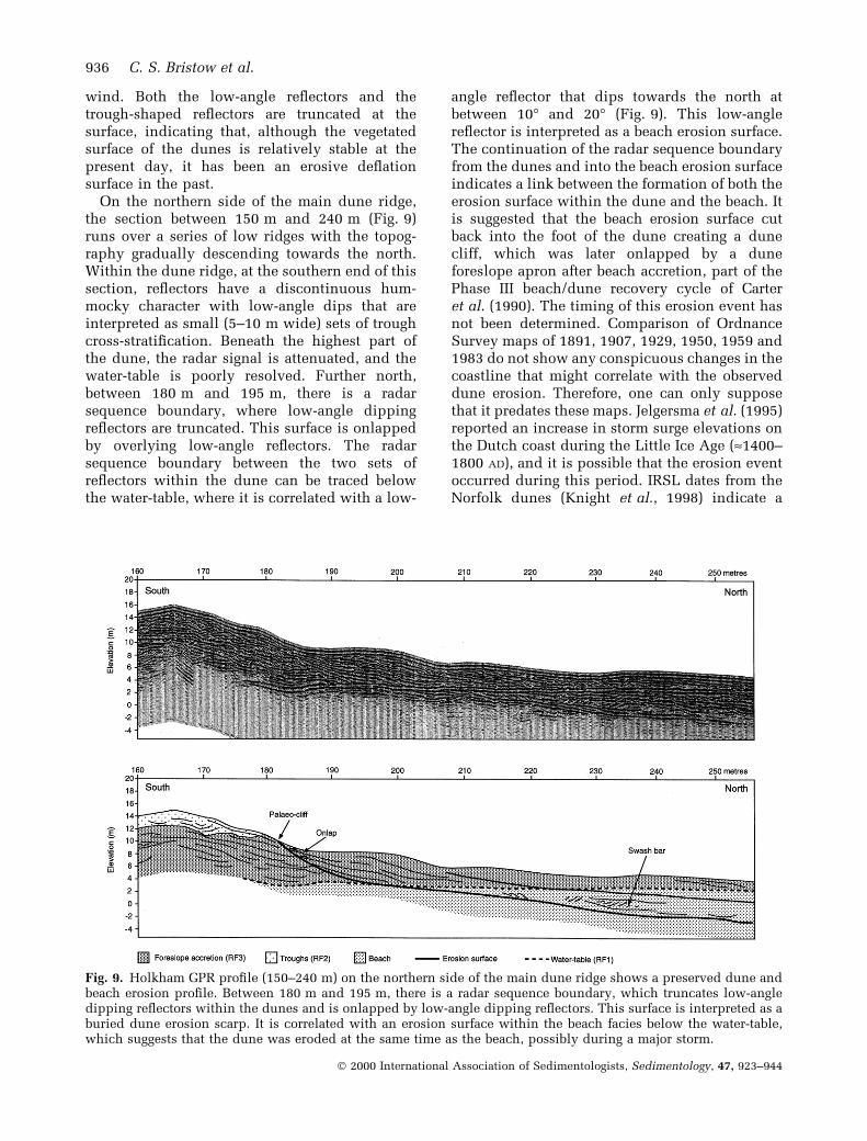
On the northern side of the main dune ridge,the section between 150 m and 240 m (Fig. 9)runs over a series of low ridges with the topog-raphy gradually descending towards the north.Within the dune ridge, at the southern end of thissection, re¯ectors have a discontinuous hum-mocky character with low-angle dips that areinterpreted as small (5±10 m wide) sets of troughcross-strati®cation. Beneath the highest part ofthe dune, the radar signal is attenuated, and thewater-table is poorly resolved. Further north,between 180 m and 195 m, there is a radarsequence boundary, where low-angle dippingre¯ectors are truncated. This surface is onlappedby overlying low-angle re¯ectors. The radarsequence boundary between the two sets ofre¯ectors within the dune can be traced belowthe water-table, where it is correlated with a low-
angle re¯ector that dips towards the north atbetween 10° and 20° (Fig. 9). This low-anglere¯ector is interpreted as a beach erosion surface.The continuation of the radar sequence boundaryfrom the dunes and into the beach erosion surfaceindicates a link between the formation of both theerosion surface within the dune and the beach. Itis suggested that the beach erosion surface cutback into the foot of the dune creating a dunecliff, which was later onlapped by a duneforeslope apron after beach accretion, part of thePhase III beach/dune recovery cycle of Carteret al. (1990). The timing of this erosion event hasnot been determined. Comparison of OrdnanceSurvey maps of 1891, 1907, 1929, 1950, 1959 and1983 do not show any conspicuous changes in thecoastline that might correlate with the observeddune erosion. Therefore, one can only supposethat it predates these maps. Jelgersma et al. (1995)reported an increase in storm surge elevations onthe Dutch coast during the Little Ice Age (»1400±1800 AD), and it is possible that the erosion eventoccurred during this period. IRSL dates from theNorfolk dunes (Knight et al., 1998) indicate a
Fig. 9. Holkham GPR pro®le (150±240 m) on the northern side of the main dune ridge shows a preserved dune andbeach erosion pro®le. Between 180 m and 195 m, there is a radar sequence boundary, which truncates low-angledipping re¯ectors within the dunes and is onlapped by low-angle dipping re¯ectors. This surface is interpreted as aburied dune erosion scarp. It is correlated with an erosion surface within the beach facies below the water-table,which suggests that the dune was eroded at the same time as the beach, possibly during a major storm.
936 C. S. Bristow et al.
Ó 2000 International Association of Sedimentologists, Sedimentology, 47, 923±944

maximum age of around 600 years and give agesof 474 � 67 and 392 � 43 from the base of thedunes at Holkham, which are consistent with theabove interpretation.
The GPR pro®le was continued down onto thebeach where a clear horizontal re¯ector from thewater-table (RF1) can be tied to the high-watermark at 3 m OD on the foreshore (Fig. 2). Theforedune ridges contain low, discontinuous,trough- and mound-shaped re¯ectors, which areinterpreted as biotopographic variation wheresand has accumulated around clumps of marramgrass. The re¯ections from beneath the water-table are multiples of the ground and air waves atthe top of the pro®le.
Brancaster GPR pro®le
The GPR pro®le at Brancaster (Fig. 10) is roughlyperpendicular to the beach ridges (Fig. 4), althoughthe line location was partially constrained by
bunkers and putting greens on the golf course.The pro®le crosses a series of dune ridges, whichyoung and decrease in relief towards the north(Fig. 10). The southern end of the pro®le illus-trated (Fig. 10) starts at 130 m at 4á99 m OD,rising to a peak of 9á4 m at the crest of the maindune ridge. From there, the topography drops to5á5 m and then undulates between 6 and 8 m tothe end of the line on the edge of a tidal creek at3á25 m OD.
An important feature of the GPR pro®le inFig. 10 is a prominent subhorizontal re¯ector ataround 3 m OD, which is interpreted as the water-table (RF1). GPR re¯ections in the dune depositsabove the water-table include prominent hyper-bolas at 145 m where the pro®le crosses a wirefence on the edge of the golf course. The maindune ridge between 150 m and 180 m containsdiscontinuous trough-shaped re¯ectors on therearslope (RF2) and clinoform re¯ectors on theforeslope (RF3), which are interpreted as sets of
Fig. 10. Brancaster Golf Course GPR pro®le. The section illustrated between 130 m and 280 m crosses the fence onthe edge of the golf course and continues over the dune ridges to the edge of a small embayment. The pro®le showsstructures within the dunes and below the water-table, which is taken as a proxy for sea level. Beach facies below thewater-table include bar accretion and beach erosion surfaces that can be traced through the water-table passing intodune bounding surfaces.
Structure and development of foredunes 937
Ó 2000 International Association of Sedimentologists, Sedimentology, 47, 923±944

trough cross-strati®cation and foreslope accretionrespectively. The lower dune ridges also showsmall troughs and low-angle foreslope accretionre¯ectors with bounding surfaces, which can betraced beneath the water-table into beach erosionsurfaces (as seen at Holkham). The foredune ridgebetween 220 m and 255 m contains small trough-shaped re¯ectors and low-angle re¯ectorsinterpreted as sets of trough cross-strati®cationand foreslope deposition units respectively. Thestructures are very similar to those described fromforedunes by Carter & Wilson (1990). The GPRpro®le ends at 278 m, where the line stopped atthe edge of a tidal creek in a small embayment thatwas ¯ooded at high tide. Comparison betweenaerial photographs taken in 1972 and 1979 showsthat this embayment was formed in the mid-1970s,since when more than 100 m of beach withforedunes has accreted.
The Brancaster pro®le shows particularly goodresolution beneath the water-table (Fig. 10), withre¯ectors between 3 m OD and )3 m OD in theintertidal zone, where re¯ections could comefrom tidal channel, beach or spit deposits. Thereare two main types of re¯ector below the water-table: ®rst, long low-angle (7±10°), seaward-dipping re¯ectors (RF6, Fig. 5); and, secondly,packages of short landward-dipping re¯ectorsthat downlap onto the low-angle re¯ectors andare truncated by the low-angle re¯ectors (RF7,Fig. 5). The long low-angle, seaward-dippingre¯ectors are interpreted as beach horizons. Theytruncate underlying re¯ectors and are thereforeerosive, and are interpreted as storm beachpro®les, some of which can be correlated with
dune scarps (Fig. 10). The packages of landward-dipping re¯ectors are interpreted as the depositsof swash bars, which migrated up the beach.Mobile beach ridges or swash bars are a commonfeature of the Norfolk coast (Pearson et al., 1990)and have been recorded migrating up the beach atHolkham (Kay, 1989). The swash bar depositsprobably represent beach accretion during fair-weather conditions.
Correlation with cartographic evidence showsthat the main dune ridge was present in 1886, asecond recurve had been emplaced by 1904 and athird by 1933 (Fig. 4). Furthermore, Steers (1938)showed that the marsh enclosed by the recurve onthe 1904 map was a vegetated salt marsh in 1935,which he called Golf Links Marsh. By 1959, thewestern ends of the recurves had been eroded,possibly by the 1953 storm, which caused wide-spread ¯ooding along the east coast (Steers, 1953).Steers (1953) reported 8±10 yards of erosion at thefoot of dunes on Scolt Head Island, which areabout 2 km west of the study site. A map made in1951 (Steers, 1960) showed that the bulk oferosion predated the 1953 storm event. However,there is a prominent erosion scarp within thedunes (Fig. 11), attributed to the 1953 storm,which can be traced along the dunes and iscrossed by the GPR pro®le at 209 m. The dunescarp can be correlated with a truncation of low-angle dune re¯ectors and traced through thewater-table to a prominent low-angle beachre¯ector, which is interpreted as the 1950s beachpro®le. Since the 1950s, the beach and duneshave prograded by around 200 m. Using maps,aerial photographs and storm records, additional
Fig. 11. Erosion scarp in the duneridges at Brancaster Golf Course (at209 m on Fig. 10), which is attrib-uted to the 1953 storm event. Thissurface is correlated with a re¯ectorthat dips below the water-table(Fig. 10), interpreted as a beacherosion surface.
938 C. S. Bristow et al.
Ó 2000 International Association of Sedimentologists, Sedimentology, 47, 923±944

dates are suggested for other erosion surfaces(Fig. 10).
The recent accretion of beach ridges at Bran-caster is a result of waves diffracted around theend of Scolt Head Island, combined with waverefraction over the Brancaster tidal delta, whichhave resulted in sediment transport along theeastern end of Brancaster Beach from west to eastby longshore drift (Fig. 1). The presence of FarPoint, the western end of Scolt Head Island,immediately north of this section of BrancasterBeach has provided protection from wave erosionand assisted beach accretion. At the western endof Brancaster Beach, longshore drift towards thewest is dominant, resulting in an area of divergentlongshore drift, where erosion is occurring in themiddle of Brancaster Bay. Where the coast iseroding, there are no signi®cant coastal dunes.There appears to be a very strong link betweendune development and shoreline movement:where the coastline is accreting, dunes are form-ing; and where the coastline is eroding, dunes areeroding, or are absent.
Overview
In many respects, the structures observed in largedune ridges, up to 19 m OD, in Norfolk resemblethose recorded in smaller foredune ridges byCarter (1990) and Carter & Wilson (1990). TheGPR pro®les show that dune bounding surfacescan be traced below the water-table passing intobeach erosion or accretion surfaces, therebycon®rming the direct link between beach andcoastal dune dynamics.
Initially, the dune ridges are elongate, linearridges, but they break up into discontinuoushummocks with ridge crest accumulation. Fol-lowing the classi®cation of Short & Hesp (1982),the change from linear ridge to ridge crestaccumulation may be caused by an increase insand mobility either because of increased wind ora decrease in vegetation cover. It is possible thatthe introduction of rabbits and the presence ofbrowsing animals, including sheep, during his-toric times may have reduced vegetation coverand increased sand mobility. Thus, while duneridge formation is largely a response to beachmorphodynamics, later modi®cations in duneform may result from vegetation changes causedby grazing pressure.
Along the north Norfolk coast, the prevailingwind is from the south-west, which is partlydirected offshore (Fig. 1). Dune orientation variesalong the coast in sympathy with the coastline,
and the prevailing wind direction appears to havelittle effect on dune crest orientation. However,the offshore wind may have an impact on thestyle of dune accretion and sedimentary struc-tures. Bigarella et al. (1969) described the struc-tures found in vegetated coastal dune ridgeswhere the prevailing wind was onshore. Theyfound that the dominant sedimentary structureswere sets of cross-strati®cation directed onshore,in line with the prevailing wind. High-angleonshore dips, often with a bimodal azimuthdistribution, are described in coastal dunes fromBrazil, Israel and the USA (McBride & Hayes,1962; Bigarella et al., 1969; Yaalon & Laronne,1971). Steep sets of landward-dipping cross-strati®cation have not been recorded in theNorfolk dunes. Rearslope deposits, characterizedby sets of trough cross-strati®cation, are probablyformed by cut and ®ll resulting from the prevail-ing offshore wind.
RADAR SEQUENCE BOUNDARIES ANDDUNE BOUNDING SURFACES
The GPR pro®les clearly show the internalstructure of the foredune ridges, with re¯ectionsinterpreted as the product of sedimentary struc-tures and the water-table. In addition, re¯ectionterminations have been picked at unconformitysurfaces that de®ne genetically related packagesof strata separated by radar sequence boundaries.These radar sequence boundaries are linked tomarine erosion surfaces within the upper shore-face and backshore beach platform. The erosionsurfaces are most likely to result from stormevents, but could be caused by changes insediment supply or the migration of tidal chan-nels. In exceptional storm events, such as that of1953, coastal dunes may be eroded. In Holland,sections of dune were eroded by between 60 and150 m3 m)1 (Vellinga, 1982), while Steers (1953)reported 8±10 yards of dune erosion on Scolt.Leatherman (1979) described dune erosion of7á1 m3 m)1 and 36 m3 m)1, with dune recessionof 4á6 m and 9 m, respectively, from storm eventson the Atlantic coast of North America. Betweenstorm events, if the beach accretes, foredunes maybe established on top of the beach platform and, ifthe beach continues to accrete, foredunes candevelop into dune ridges.
Bounding surface terminology for aeolian sandswas reviewed by Fryberger (1993). Boundingsurfaces within aeolian sands that have beenproduced by the interaction of dunes and other
Structure and development of foredunes 939
Ó 2000 International Association of Sedimentologists, Sedimentology, 47, 923±944

environments, such as ¯ash ¯oods in interdunedeposits, have been termed ¯ood surfaces (Lang-ford & Chan, 1988, 1989). Fryberger (1993) arguedthat the term ¯ood surface need not be restrictedto ¯uvial settings and suggested that it can beapplied to lacustrine, marine or tidal ¯oodsurfaces. He went on to suggest that marine¯ooding surfaces can be tied directly into upperboundaries of parasequences, the marine ¯oodingsurfaces of Van Wagoner et al. (1990). The radarsequence boundaries described here cannot betied to sea-level rise and, in both a spatial and atemporal sense, they are at least an order ofmagnitude smaller than the marine ¯oodingsurfaces of Van Wagoner et al. (1990). Thebounding surfaces within foredunes that can betraced laterally into beach deposits and are mostlikely to have been formed by erosion duringstorm events are termed storm surfaces. Oneerosion surface at Brancaster is closely linked toa major storm event that occurred in 1953, andthere is a strong link between storms and duneerosion in other areas (Leatherman, 1979). Theterm storm surface is proposed to distinguishmajor bounding surfaces in coastal dunes from
either higher order marine ¯ooding surfaces or¯uvial ¯ood surfaces.
DUNE EVOLUTION MODEL
Along the Norfolk coast, sources of sand for duneformation occur in the intertidal zone, on tidaldeltas, along the beaches, sand¯ats and tidalinlets, and other sand sources include backshorebeach and spit platforms and eroding dunes. Thearea of available sand increases where beaches arebroader, commonly adjacent to tidal inlets andtidal deltas that dry out at low tide. Local increasesin sand supply to the beach result in beachprogradation, which in turn creates space in theback-beach and enables foredune accumulation.Dune accumulation sites are usually stable, back-shore, beach-top platforms. New beach platformsare formed where the coast is prograding, on theends of spits (Blakeney Spit), barrier islands (ScoltHead Island) and prograding barrier beaches(Holkham). At Brancaster, it appears that beachaccretion results from swash bars migrating up-beach (Fig. 12a). Once a stable backshore platform
Fig. 12. Model of coastal dune evolution on the north Norfolk coast based on ®eld observations and GPR pro®les.
940 C. S. Bristow et al.
Ó 2000 International Association of Sedimentologists, Sedimentology, 47, 923±944

has formed, dune initiation is usually accompan-ied by the growth of vegetation (White, 1989) toestablish a foredune ridge (Fig. 12b and c). Fored-unes at Brancaster show foreslope accretion andrearslope troughs and, at Holkham, the foredunesshow low troughs and mounds attributed tobiotopographic variation. The Norfolk dunes havevery limited mobility: once they have formed, theyremain quite static, responding to changes insediment supply or storminess by erosion oraccretion, but are ®xed in place by vegetation.
If the shoreline remains stable, there is addi-tional time for the transfer of sand from beach todunes. Dune aggradation by foreslope accretionoccurs where wind-blown sand is deposited onthe vegetated seaward side of the dunes. Therearslope and dune crest may be reworked byoffshore winds, producing sets of trough cross-strati®cation by cut and ®ll, as seen at Brancaster,Holkham and Scolt (Fig. 12d). Continued beachaccretion may lead to the initiation of a newforedune ridge. As foredunes develop, they maycut off the supply of sand to existing ridges. Areduction in sand supply effectively halts fore-slope accretion. Dune ridges may stabilize,accompanied by a change in dune ¯ora (Fig. 12e),or degrade by de¯ation (Fig. 12f).
Should the coastline change from accreting toeroding, then the dune ridges will be eroded(Fig. 12g). Erosion of the dune foreslope may beaccompanied by slumping and the removal ofvegetation, creating a scarp or slipface of unvege-tated sand. If the vegetation is removed, the dunesand is then subject to wind erosion and rework-ing, which can result in roll-over. Roll-over hasbeen seen at Norton Hills and Brancaster and mayhelp to maintain the dune ridge. Erosion during astorm event may be short term and, if the beach isable to rebuild, then there is potential for thedune ridge to rebuild through the development ofa dune apron, as seen at Holkham (Fig. 12h).However, where the coast continues to erode,along the eastern half of Scolt Head Island and atBrancaster Bay, the coastline is eroding fasterthan the dunes are rebuilt. This has resulted in aloss of dunes along these sections of the coast.Roll-over appears to be a localized feature anddoes not appear to be a signi®cant component ofdune construction.
DISCUSSION
In Norfolk, the wind is variable, and the prevail-ing south-westerlies, northerly and easterly
winds all reach suf®cient velocity to entrain andtransport sand. This contrasts with many othercoastal dune ®elds in which the prevailing windis onshore (Pye, 1983). Dune crestline orientationis not in¯uenced by the prevailing wind, butappears to follow the shoreline on account of acombination of limited local sand source alongthe beach and the limiting effects of wave erosion.However, the occurrence of trough cut and ®llfacies on the dune crest and rearslope indicatesthat the prevailing wind does appear to havesome in¯uence, de¯ating or reshaping the rear-slope of dune ridges. Dune ridges on older spitsand recurves at Brancaster and Scolt that havehad their sand supply from the beach cut off afterthe emplacement of younger spits have beenextensively de¯ated. The development of mud-¯ats and saltmarshes over intertidal sands inembayments enclosed by spits is another factorthat will cut off potential sand supply from tidalpumping. Coastal dunes on Scolt Head Island andBrancaster Beach are highest where the beach isslightly erosive, and decrease in elevation wherethe beach is eroding and accreting in accordancewith the model of Psuty (1992).
The internal structure of the dunes, withtroughs on the rearslope and foreslope accretion,are similar to those described in foredune ridgesby Carter & Wilson (1990). The structures differfrom other coastal dunes (McBride & Hayes, 1962;Land, 1964; Bigarella et al., 1969; Yaalon &Laronne, 1971; Goldsmith, 1973, 1978) wherethe prevailing wind is onshore. In particular,parabolic dunes with steep landward dips areabsent from the north Norfolk coast, and this isalmost certainly attributable to the prevailingoffshore wind, which reduces the potential foronshore movement of transgressive sand sheetsand parabolic dunes.
GPR provides a non-invasive method of deter-mining the structure of coastal dunes, whichallows comparison with the foredune morpholo-gical stages of Hesp (1988). The foredunes atBrancaster contain structures similar to stages 1and 2 of Hesp (1988). GPR pro®les at Norton Hillsshow structures typical of stage 2, while the pro®leat Holkham includes an erosion surface typical ofstage 3. High-angle landward dips typical of stage4 are not recorded, and this is attributed to a lack ofblowouts and a lack of landward dune migrationresulting from the low frequency of onshorewinds. Hesp (1988) suggested that foredune stageand morphology are primarily controlled by thepercentage of vegetation cover. At present, Norfolkcoastal foredunes show almost 100% vegetation
Structure and development of foredunes 941
Ó 2000 International Association of Sedimentologists, Sedimentology, 47, 923±944

cover, although the presence of structures indica-tive of stages 2 and 3 may indicate periods ofreduced vegetation cover (90±45%) and increaseddune activity in the past. Luminescence ages fromNorfolk dunes indicate dune initiation concen-trated between 1500 and 1750 AD, and this isattributed to increased sea level or storminessduring the Little Ice Age (Knight et al., 1998).While storms are clearly important in determiningthe structure of dunes along the north Norfolkcoast, especially through beach erosion, reductionin vegetation cover as a result of past changes inland use and grazing should also be considered.
CONCLUSIONS
GPR provides a non-invasive method of determin-ing the structure of coastal dunes, and the internalstructure and strati®cation of the dunes are usedto interpret their modes of emplacement. Thestructures imaged by GPR pro®les include cross-strati®cation and erosion surfaces as well as therelative chronology of dune deposits. Seven dif-ferent radar facies have been identi®ed: (RF1) thewater-table; (RF2) trough cut and ®ll; (RF3)foreslope accretion; (RF4) roll-over; (RF5) bioto-pographic variation; (RF6) beach deposits; (RF7)swash bars. Two types of structure dominate thedune ridges, seaward dips from foreslope accre-tion (RF3) and troughs from cut and ®ll (RF2).Dune foreslope accretion is interpreted as theresult of dune vegetation trapping sand blownonshore from the beach. The trough cut and ®ll onthe rearslope and dune crest is probably caused byreworking by the prevailing offshore wind at timesof greater sand mobility, possibly resulting fromchanges in vegetation. Roll-over is found wherethe seaward side of dunes is marked by an erodingcliff, which provides a local source of readilyavailable dry sand that can be blown onshore.Biotopographic variation is characteristic of veg-etated foredunes where sand accumulates aroundclumps of veget- ation such as marram grass.Beach deposits are identi®ed beneath the water-table, which coincides with the level of high waterspring tides. Some beach platform and backshoredeposits will extend above the water-table, butthese are dif®cult to identify on the basis of GPRpro®les alone. Swash bars form landward-dippingsets of cross-strati®cation within the beach sedi-ments below the water-table. Steep landward dipsreported in other coastal dunes have not beenrecorded on the Norfolk coast. Norfolk foredunestructure resembles the structure of stages 1, 2 and
3 of Hesp (1988), possibly indicating reducedvegetation cover (90±45%) and increased sanddune activity in the past, which may have beendue in part to land-use changes and grazing.
In Norfolk, the prevailing offshore wind direc-tion does not appear to be signi®cant in deter-mining dune orientation. Although less frequent,winds from offshore and along the coast aresuf®cient to supply sand from the beach to thedunes. Foredune orientation varies along thecoast in parallel with the shoreline, which iscontrolled by waves and tidal inlets. Dune heightvaries along the coast in accordance with themodel of Psuty (1992), with low dunes where thecoast is rapidly eroding or accreting. The dunesare highest at Brancaster and parts of Scolt HeadIsland where the coast is more stable or slightlyerosive. This study has concentrated on areaswhere the coast is prograding, although each siteshows some evidence of erosion. Erosion atBrancaster and Holkham is attributed to stormevents, although other processes that result inbeach erosion cannot be ruled out.
The formation of dune ridges along the northNorfolk coast appears to be linked to shorelineevolution and sediment supply. Erosion andaccretion surfaces within the dunes can be linkedto beach accretion and erosion resulting frommajor storm events, e.g. 1953. There appears to bea deterministic link between beach and dune:when the beach accretes, so do the dunes and,when the beach is eroded, so are the dunes. Thisis shown by erosion surfaces, which can be tracedpassing from the dunes down beneath the water-table into beach sediments. These are interpretedas storm surfaces formed when storm eventseroded the upper beach and the dune ridges.Beach progradation results in successive episodesof dune building. If the beach is reformed, then adune apron can accumulate and the dune ridgereform. Continued beach accretion provides aplatform for foredune development and subse-quent dune ridge formation, allowing duneaggradation and progradation when there is spaceavailable and suf®cient sediment supplied. Thelow height of many of the Norfolk foredune ridgessuggests that they are supply limited.
ACKNOWLEDGEMENTS
This work was undertaken as part of the LOEPSSpecial Topic on sedimentary evolution of thenorth Norfolk barrier island coastline, NERC grantGST/02/0737 to Harwood et al. GPR equipment
942 C. S. Bristow et al.
Ó 2000 International Association of Sedimentologists, Sedimentology, 47, 923±944

was on loan from the NERC Geophysical Equip-ment Pool. Simon Bailey is in receipt of a NERCstudentship GT04/97/189/ES. We would like tothank English Nature and the wardens of ScoltHead Island, Michael Rooney, and Holkham, RonHarold, for their co-operation, and BrancasterGolf Club for permission to undertake the GPRsurveys. The manuscript has bene®ted fromcomments by Julian Orford and Ian Boomer. LarsClemmensen and Chris Fielding are thanked fortheir review, which has greatly improved thispaper. LOIS publication number 604.
REFERENCES
Allison, H. and Morley, J. (eds) (1989) Blakeney Point andScolt Head Island. The National Trust. Gallpen Press,Norfolk, 116 pp.
Andrews, J.E., Boomer, I., Bailiff, I., Balson, P., Bristow, C.S.,Chroston, P.N., Funnell, B.M., Harwood, G.M., Jones, R.,Maher, B. and Shimmield, G.B. (2000) Sedimentary evolu-tion of the North Norfolk barrier island coastline in the
context of Holocene sea-level change. In: Holocene Land±
Ocean Interaction and Environmental Change around the
North Sea. (Eds G.B. Shimmield and J.E. Andrews), Geol.Soc. London Spec. Publ., 166, 219±251.
Beres, M. and Haeni, F.P. (1991) Application of ground-pen-
etrating-radar methods in hydrogeologic studies. GroundWater, 29, 375±386.
Bigarella, J.J., Becker, R.D. and Duarte, G.M. (1969) Coastal
dune structures from Parana, Brazil. Mar. Geol., 7, 5±55.
Bristow, C.S. (1995) Facies analysis in the Lower Greensandusing ground-penetrating radar. J. Geol. Soc. London, 152,591±598.
Bristow, C.S., Pugh, J. and Goodall, T. (1996) Internal struc-
ture of aeolian dunes in Abu Dhabi determined usingground-penetrating radar. Sedimentology, 43, 995±1003.
Byrne, M.L. and McCann, S.B. (1990) Strati®cation and sedi-
mentation in complex vegetated coastal dunes, Sable Island,Nova Scotia. Sedim. Geol., 66, 165±179.
Carter, R.W.G. (1990) The geomorphology of coastal dunes in
Ireland. Catena Suppl., 18, 31±40.
Carter, R.G.W. and Wilson, P. (1990) The geomorphological,ecological and pedological development of coastal fore-
dunes at Magilligan Point, Northern Ireland. In: CoastalDunes: Form and Process (Eds K.F. Nordstrom, N.P. Psuty
and R.W.G. Carter), pp. 105±127. John Wiley & Sons, Chi-chester.
Carter, R.G.W., Hesp, P.A. and Nordstrom, K.F. (1990) Ero-
sional landforms in coastal dunes. In: Coastal Dunes: Formand Process (Eds K.F. Nordstrom, N.P. Psuty and R.W.G.
Carter), pp. 217±250. John Wiley & Sons, Chichester.
Clemmensen, L.B., Andreasen, F., Nielsen, S.T. and Sten, E.(1996) The late Holocene coastal dune®eld at Vejers,Denmark: characteristics, sand budget and depositional
dynamics. Geomorphology, 17, 79±98.
Davidson-Arnott, R.G.D. and Law, M.N. (1990) Seasonal pat-
terns and controls on sediment supply to coastal foredunes,Long Point, Lake Erie. In: Coastal Dunes: Form and Process(Eds K.F. Nordstrom, N.P. Psuty and R.W.G. Carter), pp.
177±200. John Wiley & Sons, Chichester.
Davis, J.L. and Annan, A.P. (1989) Ground penetrating radar
for high resolution mapping of soil and rock stratigraphy.
Geophys. Prospect., 37, 531±551.
Doody, P. (1989) Conservation and development of the coastaldunes in Great Britain. In: Perspectives in Coastal DuneManagement (Eds F. van der Meulen, P.D. Jungerius and
J.H. Visser), pp. 53±67. SPB Academic Publishing, The
Hague, NetherlandsFryberger, S.G. (1980) Dune forms and wind regime. In: A
Study of Global Sand Seas (Ed. E.D. McKee), Prof. Paper USGeol. Surv., 1052, 137±169.
Fryberger, S.G. (1993) A review of aeolian bounding surfaces,
with examples from the Permian Minnelusa Formation,
USA. In: Characterisation of Fluvial and Aeolian Reservoirs(Eds C.P. North and D.J. Prosser), Geol. Soc. London Spec.Publ., 73, 167±197.
Funnell, B.M. and Pearson, I. (1989) Holocene sedimentation
on the North Norfolk barrier coast in relation to relative sea-
level change. J. Quatern. Sci., 4, 25±36.Gawthorpe, R.L., Collier, R.E.Ll., Alexander, J., Leeder, M. and
Bridge, J.S. (1993) Ground penetrating radar: application to
sandbody geometry and heterogeneity studies. In: Charac-terisation of Fluvial and Aeolian Reservoirs (Eds C.P. North
and D.J. Prosser), Geol. Soc. London Spec. Publ., 73, 421±432.
Goldsmith, V. (1973) Internal geometry and origin of vegetated
coastal sand dunes. J. Sedim. Petrol., 43, 1128±1143.Goldsmith, V. (1978) Coastal dunes. In: Coastal Sedimentary
Environments (Ed. R.A. Davis), pp. 171±235. Springer-Ver-
lag, New York.
Harari, Z. (1996) Ground-penetrating radar (GPR) for imagingstratigraphic features and groundwater in sand dunes. Appl.Geophys., 36, 43±52.
Hayes, M.O. (1979) Barrier island morphology as a function oftidal and wave regime. In: Barrier Islands from the Gulf of StLawrence to the Gulf of Mexico (Ed. S.P. Leatherman), pp.
1±27. Academic Press, New York.
Hesp, P. (1988) Morphology, dynamics and internal strati®-cation of some established foredunes in southeast Australia.
Sedim. Geol., 55, 17±41.
van Heteren, S., Fitzgerald, D.M., McKinley, P.A. and Buyne-vich, I.V. (1998) Radar facies of paraglacial barrier systems:coastal New England, USA. Sedimentology, 45, 181±200.
Jelgersma, S., Stive, M.J.F. and van der Valk, L. (1995)
Holocene storm surge signatures in the coastal dunes of the
western Netherlands. Mar. Geol., 125, 95±110.Kay, R.C. (1989) An Integrated Approach to Modern and
Ancient Wave Ripple Morphology and Ridge and RunnelDynamics. Unpubl. PhD Thesis, University of East Anglia.
King, C.A.M. (1972). Beaches and Coasts, 2nd edn. Arnold,
London.
Knight, J., Orford, J.D., Wilson, P., Wintle, A.G. and Braley, S.(1998) Facies, age and controls on recent coastal sand duneevolution in North Norfolk, eastern England. J. Coastal Res.,26, 154±161.
Lancaster, N. (1995) Geomorphology of Desert Dunes. Routl-
edge, London and New York, 290 pp.Land, L.S. (1964) Eolian cross-bedding in the beach dune
environment, Sapelo Island Georgia. J. Sedim. Petrol., 34,289±394.
Langford, R.P. and Chan, M.A. (1988) Flood surfaces and
de¯ation surfaces within the Cutler Formation and Cedar
Mesa Sandstone (Permian), southeastern Utah. Bull. Geol.Soc. Am., 100, 1541±1549.
Langford, R.P. and Chan, M.A. (1989) Fluvial±aeolian interac-
tions: Part II, ancient systems. Sedimentology, 36, 1037±1051.
Structure and development of foredunes 943
Ó 2000 International Association of Sedimentologists, Sedimentology, 47, 923±944
Leatherman, S.P. (1979) Beach and dune interactions during
storm conditions. Q. J. Eng. Geol., 12, 281±290.
McBride, E.F. and Hayes, M.O. (1962) Dune cross-bedding on
Mustang Island Texas. AAPG Bull., 64, 546±551.McCann, D.M., Jackson, P.D. and Fenning, P.J. (1988) Com-
parison of the seismic and ground probing radar methods in
geological surveying. Proc. Inst. Elec. Eng., 135, part F, no.
4, 380±390.Olson, J.S. and van der Maarel, E. (1989) Coastal dunes in
Europe: a global view. In: Perspectives in Coastal DuneManagement (Eds F. van der Meulen, P.D. Jungerius andJ.H. Visser), pp. 3±32. SPB Academic Publishing, The
Hague, Netherlands.
Pearson, I., Funnell, B.M. and McCave, I.N. (1990) Sedimen-
tary environments of the sandy barrier/tidal marsh coastlineof north Norfolk. Bull. Geol. Soc. Norfolk, 39, 3±44.
Psuty, N.P. (1992) Spatial variation in coastal foredune
development. In: Coastal Dunes (Eds R.G.W. Carter, T.G.F.
Curtis and M.J. Sheehy-Skef®ngton), pp. 3±13. Balkema,Rotterdam.
Pye, K. (1983) Coastal dunes. Prog. Phys. Geog. 7, 531±557.
Ranwell, D.S. (1972) Ecology of Saltmarshes and Sand Dunes.Chapman & Hall, London, 258 pp.
Ranwell, D.S. and Boar, R. (1986) Coastal Dune ManagementGuide. Institute of Terrestrial Ecology, NERC, Monkswood,
Huntingdon, 105 pp.Ritchie, W. and Penland, S. (1990) Aeolian sand bodies of the
south Louisiana coast. In: Coastal Dunes: Form and Process(Eds K.F. Nordstrom, N.P. Psuty and R.W.G. Carter), pp.
105±127. John Wiley & Sons, Chichester.Schenk, C.J., Gautier, D.L., Olhoeft, G.R. and Lucius, J.E.
(1993) Internal structure of an aeolian dune using ground-
penetrating radar. In: Aeolian Sediments Ancient andModern (Eds K. Pye and N. Lancaster), Spec. Publ. Int. As-soc. Sediment., 16, 61±69.
Sensors and Software (1993) Ekko_Tools User's Guide, Version1.1, Technical Manual 22. Sensors and Software, Mis-sissauga, Canada, 138 pp.
Short, A.D. and Hesp, P.A. (1982) Wave beach and dune inter-
actions in southeastern Australia. Mar. Geol., 48, 259±284.
Smith, D.G. and Jol, H.M. (1995) Ground penetrating radar:
antenna frequencies and maximum probable depths ofpenetration in Quaternary sediments. J. Appl. Geophys., 33,93±100.
Steers, J.A. (1938) The rate of sedimentation on saltmarshes on
Scolt Head Island, Norfolk. Geol. Mag., 75, 26±38.Steers, J.A. (1953) The East coast ¯oods, January 31±February
1, 1953. Geog. J., 119, 280±295.
Steers, J.A. (1960) The physiography and evolution of ScoltHead Island. In: Scolt Head Island, 2nd edn (Ed. J.A. Steers),
pp. 12±66. W. Heffer, Cambridge.
Steers, J.A. (1989) The physical features of Scolt Head Island
and Blakeney Point. In: Blakeney Point and Scolt HeadIsland (Eds H. Allison and J.P. Morley), pp. 14±27. The
National Trust Norfolk. The Gallpen Press, Norwich.
Vellinga, P. (1982) Beach and dune erosion during storm
surges. Coastal Eng., 6, 361±387.Van Wagoner, J.C., Mitchum, R.M., Campion, K.M. and
Rahmanian, V.D. (1990) Siliciclastic Sequence Stratigraphyin Well Logs, Cores, and Outcrops. AAPG Methods inExploration Series, no. 7. AAPG, Tulsa, OK, 55 pp.
White, D.J.B. (1989) The botany and plant ecology of Blakeney
Point. In: Blakeney Point and Scolt Head Island (Eds H.
Allison and J.P. Morley), pp. 33±48. The National TrustNorfolk. The Gallpen Press, Norwich.
Woodell, S.R.J. (1989) Vegetation and plants of Scolt Head
Island. In: Blakeney Point and Scolt Head Island (Eds H.
Allison and J.P. Morley), pp. 49±58. The National TrustNorfolk. The Gallpen Press, Norwich.
Yaalon, D.H. and Laronne, J. (1971) Internal structures in
eolianites and palaeowinds, Mediterranean Coast, Israel.J. Sedim. Petrol., 41, 1059±1064.
Manuscript received 7 July 1998;revision accepted 10 January 2000.
944 C. S. Bristow et al.
Ó 2000 International Association of Sedimentologists, Sedimentology, 47, 923±944