Gravitational deformations and fillings of aging caves: The example of Qesem karst system, Israel
12
This article appeared in a journal published by Elsevier. The attached copy is furnished to the author for internal non-commercial research and education use, including for instruction at the authors institution and sharing with colleagues. Other uses, including reproduction and distribution, or selling or licensing copies, or posting to personal, institutional or third party websites are prohibited. In most cases authors are permitted to post their version of the article (e.g. in Word or Tex form) to their personal website or institutional repository. Authors requiring further information regarding Elsevier’s archiving and manuscript policies are encouraged to visit: http://www.elsevier.com/copyright
Transcript of Gravitational deformations and fillings of aging caves: The example of Qesem karst system, Israel
This article appeared in a journal published by Elsevier. The attachedcopy is furnished to the author for internal non-commercial researchand education use, including for instruction at the authors institution
and sharing with colleagues.
Other uses, including reproduction and distribution, or selling orlicensing copies, or posting to personal, institutional or third party
websites are prohibited.
In most cases authors are permitted to post their version of thearticle (e.g. in Word or Tex form) to their personal website orinstitutional repository. Authors requiring further information
regarding Elsevier’s archiving and manuscript policies areencouraged to visit:
http://www.elsevier.com/copyright

Author's personal copy
Gravitational deformations and fillings of aging caves: The example of Qesem karstsystem, Israel
Amos Frumkin a,⁎, Panagiotis Karkanas b, Miryam Bar-Matthews c, Ran Barkai d, Avi Gopher d,Ruth Shahack-Gross e, Anton Vaks c
a Department of Geography, The Hebrew University of Jerusalem, Jerusalem, 91905, Israelb Ephoreia of Palaeoanthropology–Speleology of Southern Greece, Ardittou 34b, 11636 Athens, Greecec Geological Survey of Israel, 30 Malchei Israel St., Jerusalem 95501, Israeld Institute of Archaeology, Tel-Aviv University, Tel-Aviv 69978, Israele Institute of Archaeology, Bar-Ilan University, and Kimmel Center for Archaeological Science, Weizmann Institute of Science, Rehovot 76100, Israel
a b s t r a c ta r t i c l e i n f o
Article history:Accepted 18 September 2008Available online 7 October 2008
Keywords:Cave fillSpeleothemCave archaeologyKarst subsidenceU–Th datingChamber cave
The Qesem karst system may serve as an example for aging chamber caves. It includes two caves which haveundergone several stages of natural and human-induced deposition, as well as subsidence and collapse.Natural deposits include calcite speleothems, bedrock collapse debris, and clay fill. Karst dissolution andassociated sagging and decomposition have operated since the initial cave formation. Inclined sediments areattributed to several processes, mostly dominated by gravitational sagging into underlying dissolution voids,affecting cave deposits and sometimes the host-rock. U–Th dating shows that speleothem deposition hasbeen common during the mid-late Quaternary, but deposition sites shifted according to local conditions. Theaging of caves occurs when they become totally filled by sediments and ultimately consumed by surfacedenudation, as documented in Qesem Cave.
© 2008 Elsevier B.V. All rights reserved.
1. Introduction
Deposits in prehistoric caves are often inclined or deformed(Garrod and Bate, 1937; Jelinek et al., 1973; Rapp and Hill, 1998).Understanding the deformation process is essential for interpretingarchaeological finds and site-formation processes. The mechanisms ofdeformation often remain open questions, because of insufficientexposure or access. Low-energy sites, such as the southern Levantcaves, commonly lack high-energy physical mechanisms, such asunderground river flow. Gravity fall and colluvium for larger particles,sheetwash andwind for silt- and clay-size particles, are often themainagents inserting allochthonous sediments into the cave (Macphail andGoldberg, 1995; Gillieson, 2004; Goldberg and Sherwood, 2006).Under low-energy conditions, the deformation processes are oftenrelatively slow. In order to elucidate the causes of observed structures,and their association with anthropogenic remains, close examination
of the deformed site is needed, preferably using well-exposed fieldsections.
The Qesem karst system is a unique site in which natural andanthropogenic effects combine, with various types of deformation(Fig. 1). These are well exposed along natural outcrops, undergroundvoids, and a roadcut which intersects the sediment-filled Qesem Cave(Barkai et al., 2003). This cave has a well-preserved archaeologicalsequence, dated to the end of the Lower Paleolithic period, whichsheds light on the unique Acheulo–Yabrudian cultural complex in theLevant. Its rich anthropogenic deposits allow for a long-term fieldproject, carried on since the cave was discovered in the year 2000(Barkai et al., 2005; Gopher et al., 2005, Karkanas et al., 2007).Speleological processes are mostly inactive at Qesem Cave today, butare still active in the neighboring Kafr Qasem Cave where they havebeen documented for the last 25 years (Gasic, 2002). This allows for adetailed geomorphological study of the system, supported by datedspeleothems, archaeological finds, speleological exploration anddrilled cores.
In this paper the processes of cave filling and gravitationaldeformation are discussed according to the evidence of the surround-ing karst system, including the active Kafr Qasem Cave and theinactive Qesem Cave, as well as other relevant sites in the region. Thisgeomorphological study may help interpreting the anthropogenic
Geomorphology 106 (2009) 154–164
⁎ Corresponding author.E-mail addresses: [email protected] (A. Frumkin), [email protected]
(P. Karkanas), [email protected] (M. Bar-Matthews), [email protected](R. Barkai), [email protected] (A. Gopher), [email protected](R. Shahack-Gross), [email protected] (A. Vaks).
0169-555X/$ – see front matter © 2008 Elsevier B.V. All rights reserved.doi:10.1016/j.geomorph.2008.09.018
Contents lists available at ScienceDirect
Geomorphology
j ourna l homepage: www.e lsev ie r.com/ locate /geomorph
Author's personal copy
remains and human use in the cave (cfr. Karkanas et al., 2007), andpossibly in other sites too.
1.1. Regional setting
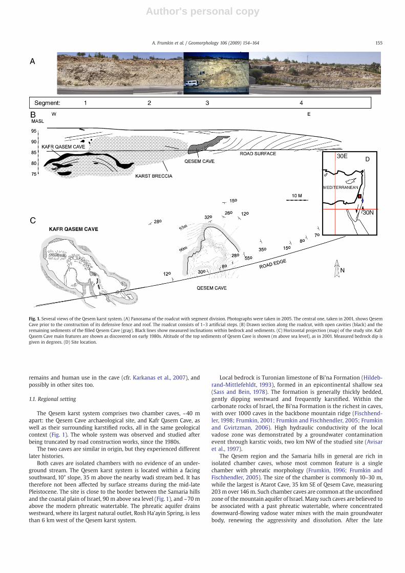
The Qesem karst system comprises two chamber caves, ~40 mapart: the Qesem Cave archaeological site, and Kafr Qasem Cave, aswell as their surrounding karstified rocks, all in the same geologicalcontext (Fig. 1). The whole system was observed and studied afterbeing truncated by road construction works, since the 1980s.
The two caves are similar in origin, but they experienced differentlater histories.
Both caves are isolated chambers with no evidence of an under-ground stream. The Qesem karst system is located within a facingsouthward, 10° slope, 35 m above the nearby wadi stream bed. It hastherefore not been affected by surface streams during the mid-latePleistocene. The site is close to the border between the Samaria hillsand the coastal plain of Israel, 90 m above sea level (Fig. 1), and ~70 mabove the modern phreatic watertable. The phreatic aquifer drainswestward, where its largest natural outlet, Rosh Ha'ayin Spring, is lessthan 6 km west of the Qesem karst system.
Local bedrock is Turonian limestone of Bi'na Formation (Hildeb-rand-Mittlefehldt, 1993), formed in an epicontinental shallow sea(Sass and Bein, 1978). The formation is generally thickly bedded,gently dipping westward and frequently karstified. Within thecarbonate rocks of Israel, the Bi'na Formation is the richest in caves,with over 1000 caves in the backbone mountain ridge (Fischhend-ler, 1998; Frumkin, 2001; Frumkin and Fischhendler, 2005; Frumkinand Gvirtzman, 2006). High hydraulic conductivity of the localvadose zone was demonstrated by a groundwater contaminationevent through karstic voids, two km NW of the studied site (Avisaret al., 1997).
The Qesem region and the Samaria hills in general are rich inisolated chamber caves, whose most common feature is a singlechamber with phreatic morphology (Frumkin, 1996; Frumkin andFischhendler, 2005). The size of the chamber is commonly 10–30 m,while the largest is Atarot Cave, 35 km SE of Qesem Cave, measuring203m over 146m. Such chamber caves are common at the unconfinedzone of themountain aquifer of Israel. Many such caves are believed tobe associated with a past phreatic watertable, where concentrateddownward-flowing vadose water mixes with the main groundwaterbody, renewing the aggressivity and dissolution. After the late
Fig. 1. Several views of the Qesem karst system. (A) Panorama of the roadcut with segment division. Photographs were taken in 2005. The central one, taken in 2001, shows QesemCave prior to the construction of its defensive fence and roof. The roadcut consists of 1–3 artificial steps. (B) Drawn section along the roadcut, with open cavities (black) and theremaining sediments of the filled Qesem Cave (gray). Black lines show measured inclinations within bedrock and sediments. (C) Horizontal projection (map) of the study site. KafrQasem Cave main features are shown as discovered on early 1980s. Altitude of the top sediments of Qesem Cave is shown (m above sea level), as in 2001. Measured bedrock dip isgiven in degrees. (D) Site location.
155A. Frumkin et al. / Geomorphology 106 (2009) 154–164
Author's personal copy
Cenozoic regional uplift the caves were dewatered, initiating vadoseprocesses. Ultimately, the exposed caves were truncated by subaerialerosion or human activity, while others probably remain hiddenunderground.
While caves appear in some localities, wide scale karstification isnormally mostly effective at the epikarst — the upper few meters ofthe bedrock–soil interface. On the surface of the Qesem karst system,shallow pockets of terra rossa soil appear among massive residualblocks of karstified rocks. The terra rossa is composed mainly of clayminerals and quartz grains with lower content of calcite and dolomite.The mineralogy and isotopic composition indicates a high contribu-tion of desert dust particles, rather than bedrock insoluble residue(Yaalon and Ganor, 1973).
2. Methods
The three-dimensional structure of the cave system is observedand measured in several views: (1) The natural truncation surface,particularly the Qesem Cave at the eastern part of the system;(2) Recent artificial roadcut of Israel route no. 5, transecting the karstsystem from east to west; (3) A series of five boreholes penetratingdown to 11 m below road surface; (4) Speleological survey of the KafrQasem Cave; (5) Archaeological excavation uncovering the filling ofQesem Cave.
The macromorphology was measured using ‘Disto’ laser distancemeter, inclinometer, compass, and horizontal photography. Thesewere utilized both on the surface and inside the cave.
Bedrock and sediments were carefully measured and described inthe field. Sediment and soil micromorphology was studied in thinsections using a stereomicroscope and a polarized light microscope(Karkanas et al., 2007).
The time frame of deposition, subsidence, and cave filling duringthe last 400 kyr is based on standard U–Th dating of speleothems.Preliminary dates by alpha spectrometry were performed at the IsraelGeological Survey (Table 1). The preliminary chronologyof QesemCaveis based on TIMS dates, performed at the University of Bergen, andpublished earlier (Barkai et al., 2003). The chronology is furthersupported by the rich archaeological remains excavated in QesemCaveattributed to the Acheulo–Yabrudian cultural complex of the terminalLower Paleolithic period (Barkai et al., 2005; Gopher et al., 2005).
3. Results: Bedrock, karst and sediments
Bedrock in the study area is thickly bedded, hard biomicritelimestone, with high secondary porosity along fractures, beddingplanes and cavities.
For a detailed description, the study area is crudely divided belowinto four segments along the road transect from west to east (Fig. 1).The segments reflect the division to the main caves (Qesem and KafrQasem) and the neighboring roadcut outcrops.
3.1. Segment 1 — Kafr Qasem Cave
Kafr Qasem Cave, the largest void in the Qesem karst system,dominates this segment. It consists of an up to 3 m high vaulted
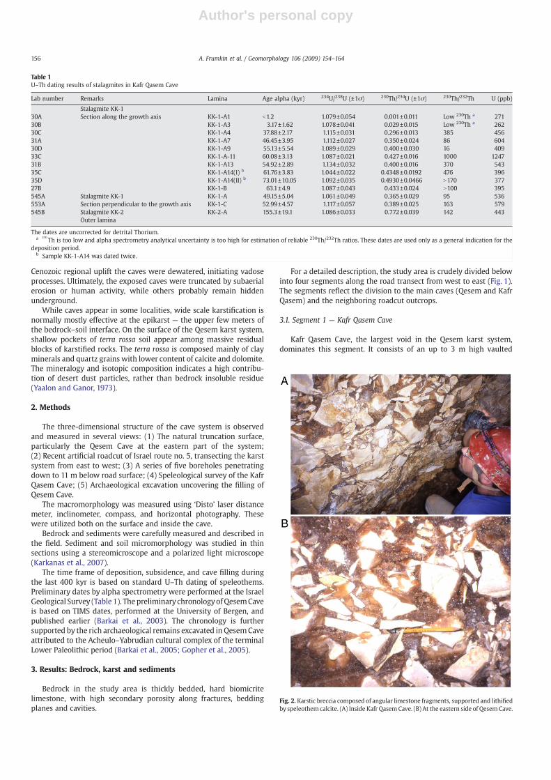
Table 1U–Th dating results of stalagmites in Kafr Qasem Cave
Lab number Remarks Lamina Age alpha (kyr) 234U/238U (±1σ) 230Th/234U (±1σ) 230Th/232Th U (ppb)
Stalagmite KK-130A Section along the growth axis KK-1-A1 b1.2 1.079±0.054 0.001±0.011 Low 230Th a 27130B KK-1-A3 3.17±1.62 1.078±0.041 0.029±0.015 Low 230Th a 26230C KK-1-A4 37.88±2.17 1.115±0.031 0.296±0.013 385 45631A KK-1-A7 46.45±3.95 1.112±0.027 0.350±0.024 86 60430D KK-1-A9 55.13±5.54 1.089±0.029 0.400±0.030 16 40933C KK-1-A-11 60.08±3.13 1.087±0.021 0.427±0.016 1000 124731B KK-1-A13 54.92±2.89 1.134±0.032 0.400±0.016 370 54335C KK-1-A14(I) b 61.76±3.83 1.044±0.022 0.4348±0.0192 476 39635D KK-1-A14(II) b 73.01±10.05 1.092±0.035 0.4930±0.0466 N170 37727B KK-1-B 63.1±4.9 1.087±0.043 0.433±0.024 N100 395545A Stalagmite KK-1 KK-1-A 49.15±5.04 1.061±0.049 0.365±0.029 95 536553A Section perpendicular to the growth axis KK-1-C 52.99±4.57 1.117±0.057 0.389±0.025 163 579545B Stalagmite KK-2 KK-2-A 155.3±19.1 1.086±0.033 0.772±0.039 142 443
Outer lamina
The dates are uncorrected for detrital Thorium.a 230
Th is too low and alpha spectrometry analytical uncertainty is too high for estimation of reliable 230Th/232Th ratios. These dates are used only as a general indication for thedeposition period.
b Sample KK-1-A14 was dated twice.
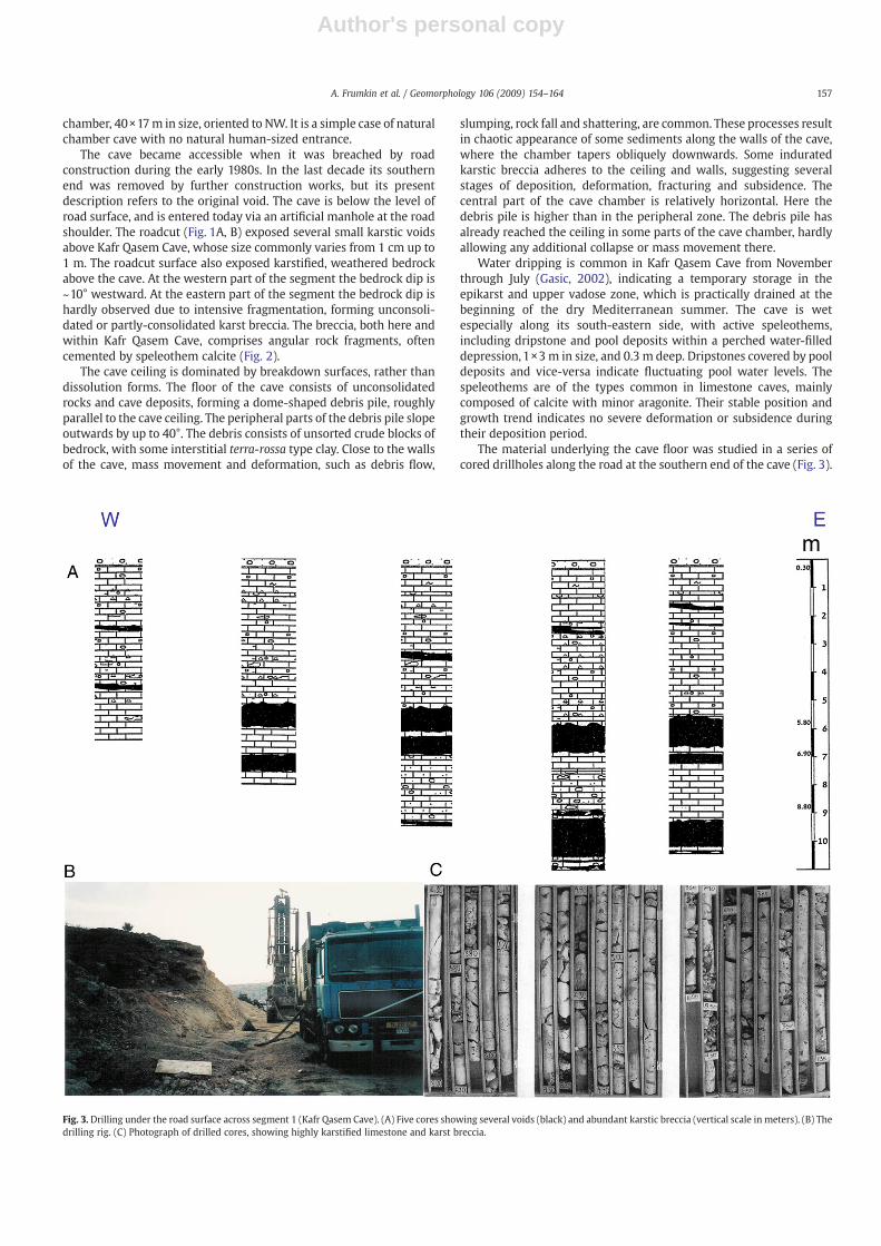
Fig. 2. Karstic breccia composed of angular limestone fragments, supported and lithifiedby speleothem calcite. (A) Inside Kafr Qasem Cave. (B) At the eastern side of Qesem Cave.
156 A. Frumkin et al. / Geomorphology 106 (2009) 154–164
Author's personal copy
chamber, 40×17m in size, oriented to NW. It is a simple case of naturalchamber cave with no natural human-sized entrance.
The cave became accessible when it was breached by roadconstruction during the early 1980s. In the last decade its southernend was removed by further construction works, but its presentdescription refers to the original void. The cave is below the level ofroad surface, and is entered today via an artificial manhole at the roadshoulder. The roadcut (Fig. 1A, B) exposed several small karstic voidsabove Kafr Qasem Cave, whose size commonly varies from 1 cm up to1 m. The roadcut surface also exposed karstified, weathered bedrockabove the cave. At the western part of the segment the bedrock dip is~10° westward. At the eastern part of the segment the bedrock dip ishardly observed due to intensive fragmentation, forming unconsoli-dated or partly-consolidated karst breccia. The breccia, both here andwithin Kafr Qasem Cave, comprises angular rock fragments, oftencemented by speleothem calcite (Fig. 2).
The cave ceiling is dominated by breakdown surfaces, rather thandissolution forms. The floor of the cave consists of unconsolidatedrocks and cave deposits, forming a dome-shaped debris pile, roughlyparallel to the cave ceiling. The peripheral parts of the debris pile slopeoutwards by up to 40°. The debris consists of unsorted crude blocks ofbedrock, with some interstitial terra-rossa type clay. Close to the wallsof the cave, mass movement and deformation, such as debris flow,
slumping, rock fall and shattering, are common. These processes resultin chaotic appearance of some sediments along the walls of the cave,where the chamber tapers obliquely downwards. Some induratedkarstic breccia adheres to the ceiling and walls, suggesting severalstages of deposition, deformation, fracturing and subsidence. Thecentral part of the cave chamber is relatively horizontal. Here thedebris pile is higher than in the peripheral zone. The debris pile hasalready reached the ceiling in some parts of the cave chamber, hardlyallowing any additional collapse or mass movement there.
Water dripping is common in Kafr Qasem Cave from Novemberthrough July (Gasic, 2002), indicating a temporary storage in theepikarst and upper vadose zone, which is practically drained at thebeginning of the dry Mediterranean summer. The cave is wetespecially along its south-eastern side, with active speleothems,including dripstone and pool deposits within a perched water-filleddepression,1×3 m in size, and 0.3 m deep. Dripstones covered by pooldeposits and vice-versa indicate fluctuating pool water levels. Thespeleothems are of the types common in limestone caves, mainlycomposed of calcite with minor aragonite. Their stable position andgrowth trend indicates no severe deformation or subsidence duringtheir deposition period.
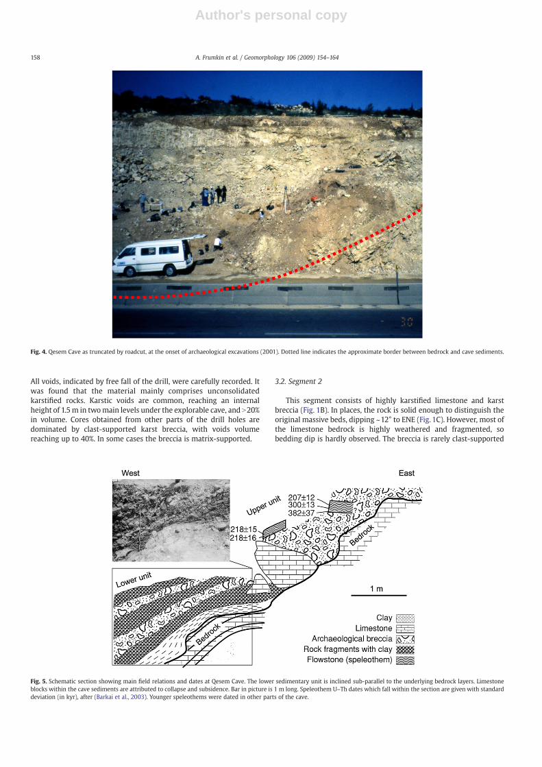
The material underlying the cave floor was studied in a series ofcored drillholes along the road at the southern end of the cave (Fig. 3).
Fig. 3. Drilling under the road surface across segment 1 (Kafr Qasem Cave). (A) Five cores showing several voids (black) and abundant karstic breccia (vertical scale in meters). (B) Thedrilling rig. (C) Photograph of drilled cores, showing highly karstified limestone and karst breccia.
157A. Frumkin et al. / Geomorphology 106 (2009) 154–164
Author's personal copy
All voids, indicated by free fall of the drill, were carefully recorded. Itwas found that the material mainly comprises unconsolidatedkarstified rocks. Karstic voids are common, reaching an internalheight of 1.5m in twomain levels under the explorable cave, and N20%in volume. Cores obtained from other parts of the drill holes aredominated by clast-supported karst breccia, with voids volumereaching up to 40%. In some cases the breccia is matrix-supported.
3.2. Segment 2
This segment consists of highly karstified limestone and karstbreccia (Fig. 1B). In places, the rock is solid enough to distinguish theoriginal massive beds, dipping ~12° to ENE (Fig. 1C). However, most ofthe limestone bedrock is highly weathered and fragmented, sobedding dip is hardly observed. The breccia is rarely clast-supported
Fig. 4. Qesem Cave as truncated by roadcut, at the onset of archaeological excavations (2001). Dotted line indicates the approximate border between bedrock and cave sediments.
Fig. 5. Schematic section showing main field relations and dates at Qesem Cave. The lower sedimentary unit is inclined sub-parallel to the underlying bedrock layers. Limestoneblocks within the cave sediments are attributed to collapse and subsidence. Bar in picture is 1 m long. Speleothem U–Th dates which fall within the section are given with standarddeviation (in kyr), after (Barkai et al., 2003). Younger speleothems were dated in other parts of the cave.
158 A. Frumkin et al. / Geomorphology 106 (2009) 154–164
Author's personal copy
and comprises heterogenic angular limestone fragments, from ~1mmto 1 m in size. The fragments are partly cemented by a matrix ofspeleothemic micrite to sparite calcite, (Fig. 2). Red iron-rich stainingis common, associated with intruding terra rossa type clays from thesurface, along fractures and karst voids.
3.3. Segment 3 — Qesem Cave
Qesem Cave is a sediment-filled chamber cave, discovered in 2000when road construction works cut through its southern and upperparts (Fig. 4). The chamber is ~20×15 m in size and ~10 m high,although the exact dimensions of the cave awaits further fieldinvestigations. Massive limestone bedrock is exposed west, northand east of the cave, while on the south side the roadcut has removedthe bedrock wall, and exposed a major part of the stratigraphicsequence of both cave sediments and surrounding bedrock. Archae-ological excavation has exposed ~8 m thick archaeological depositscontaining rich faunal and lithic assemblages.
The lithic industrial sequence of the cave is blade-dominated(Barkai et al., 2005; Gopher et al., 2005) and attributed to the Amudianindustry of the Acheulo–Yabrudian complex at the terminal LowerPaleolithic period (late Middle Pleistocene). The Acheulo–Yabrudiancultural complex postdates the Acheulian culture of the LowerPalaeolithic period and predates the Mousterian culture of the MiddlePalaeolithic period, and it correlates with Jelinek's “MugharanTradition” (Jelinek, 1990).
A distinct feature of the surrounding bedrock is its centripetal diptowards the cave chamber. The bedding dip increases towards the
cave void, reaching up to 55° (westward) at the eastern wall of thecave (Fig. 1C). The dip reaches 32° (to SSE) at the northern side of thecave, and 12° (eastward) at the western wall of the cave. Consideringthe general westward dip in the region, the deformation at thewestern side is in the same order of magnitude as at the northern andeastern sides. The deformed bedrock is associated with ubiquitousfracturing and brecciation. The breccia on the western side of the cavewall is often cemented by secondary calcite spar matrix, while on theeastern side the fragmented bedrock is crumbling. The bedrock at thenorthern side of the cave is less commonly fractured, but it showsdissolution weathering along the few fractures, with some spe-leothems in widened fractures which became small voids.
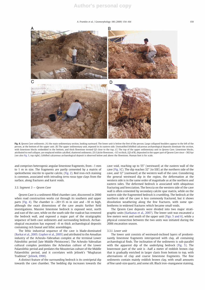
The Qesem Cave deposits were divided into two major strati-graphic units (Karkanas et al., 2007). The lower unit was excavated afew meters west and south of the upper unit (Figs. 5 and 6), while aphysical connection between the two units was initiated during the2006 excavation season.
3.3.1. Lower unitThe lower unit consists of westward-inclined layers of predomi-
nantly limestone fragments interspersed with clay, all containingarchaeological finds. The inclination of the sediments is sub-parallelwith the apparent dip of the underlying bedrock (Fig. 5). Thelowermost part of the unit is ~half a meter of reddish brown claythat is gradually enriched in larger clasts from bottom to top, withalternations of clay and coarse limestone fragments. The finesediments contain mainly reddish brown clay, with small amountsof fine sand-size quartz, and some silt. Black iron–manganese staining,
Fig. 6. Qesem Cave sediments. (A) the main sedimentary section, looking eastward. The lower unit is below the feet of the person. Large collapsed boulders appear to the left of theperson, at the bottom of the upper unit. (B) The upper sedimentary unit, exposed in its eastern side. Unstratified lithified calcareous archaeological deposits dominate the section,with limestone blocks embedded in the bottom, and thick flowstone termed Q3 close to the top. (C) The top of the upper sedimentary unit in Qesem Cave. Limestone blocks,attributed to roof collapse, are emplaced within calcified, shattered sediments. (D) Calcite flowstone, ~0.5 m thick, (Q3 of B), deposited in the upper part of Qesem Cave since ~382 kyr(see also Fig. 5, top right). Lithified calcareous archaeological deposit is observed below and above the flowstone. Human foot is for scale.
159A. Frumkin et al. / Geomorphology 106 (2009) 154–164
Author's personal copy
as well as black layers are common. Some small open voids have beenobserved at the lowermost excavated level, below the bottom layers ofQesem cave.
In the lower unit anthropogenic remains are commonly observed.Small bone fragmentswithin the clayare subangular to subrounded, andsand to silt sized. The uppermost meter of the lower unit consists ofclast-supported limestone fragments; someare 20–30 cm longand evenlarger, with some interstitial clay. The limestone blocks indicate physicaldecomposition of the cave roof or walls. The limestone fragments aresub-rounded and form inclined horizons. The inclination graduallydecreases upward within the lower unit. The clastic layers containgravel-sized bone fragments. Black crust-like surfaces andweak sorting,possibly by water or slumping, enhance the stratification.
3.3.2. Upper unitThe stratification of this unit is less clear, and it is less inclined than
the lower one. It has been deposited mostly after the lower unit hadstabilized, as attested by the upward-decreasing inclination of thelower unit. The upper unit is mostly exposed as an artificialescarpment on the eastern side of the cave. Its lower part is rich inlimestone blocks embedded in lithified calcareous deposit, lightreddish brown in color (Fig. 6A). Some of the limestone blocks arevery large ~1–1.5 m long, mostly at the contact area between thelower and upper units. These blocks indicate a large collapse eventthat significantly transformed the cave structure and probablyenlarged its entrance.
The sediment was intensively fractured after cementation in mostparts of the upper unit, mainly along the cave walls. These fractureshave been filled later by debris. Some original stratification is stillvisible locally. Secondary calcite cementation of the deposits, as wellas speleothems, is common close to the eastern wall of the cave.Sediment type differs with its proximity to the bedrock walls of thecave, as described below.
Away from thewalls, the upper unit is composed of a small fractionof limestone clasts cemented calcareous matrix, mostly horizontallybedded. The coarse material consists predominantly of gravel sizedsub-rounded limestone and angular bone fragments. The matrixconsists of micritic to microsparitic calcite, dotted with oxidized redaggregated or dispersed clay. Wood ash and burning remnants arecommon (Karkanas et al., 2007). Calcified rootlets are commonlyobserved in this unit, in the form of numerous small bifurcatingchannels cemented with calcite.
The deposits closest to the walls are relatively less stratified. Closeto the former north wall of the cave the sediment is more shatteredthan in areas close to the former south wall. Bedding is less clearlydefined and the sediments contain relatively large amounts ofinfiltrated clay in the form of moderately cemented patches oforange–red calcareous clay. The sediment is heterogeneous, disturbedand cemented bymassive micritic calcite. Several generations of veinsof the same massive micrite cross-cut the matrix. Erosional surfacesare common, as are sheared contacts lined with striated clay onalready consolidated material. More recent non-cemented shatteredareas are also found.Within the lower part of the upper unit, in at leastone area, is a one-meter thick archaeological layer with very softsediments which is very rich in finds. This layer is trapped betweentwo cemented layers and was covered by a 20 cm thick cementedcrust. As the crust was removed during the excavation, a rich layerwith very soft sediments was reached. Within this layer somehorizontal finds concentrations are of note.
Some large bone fragments have almost vertical or inclinedorientations. Shattering was a common process, which continuouslymodified the sediments. Calcified rootlets are also observed, con-temporaneous with the main cementation and fissuring processes.Limestone fragments become more abundant at the top of the upperunit (Fig. 6B–C), probably associated with additional collapse of thecave roof.
Several bedrock fragments found in several locations at thetopmost part of the upper sequence have been analyzed usinginfrared spectrometry and their mineralogy was determined. Fourout of ca. 10 rock fragments are composed of dolomite, eitherexclusively or together with calcite. The rock fragments are notretouched/shaped, i.e., they can be regarded as natural “fieldstones”.Therefore, they may have been either brought to the cave by itsinhabitants or entered through the entrance by gravitational and/orwater action from above.
Some large (~1 m size) limestone blocks are also found, not verydifferent than the ones at the contact area between the lower/upperunits (Fig. 6C, lower left corner). These indicate another large collapseevent, possibly associatedwith the terminal existence of the cave void.
Much of the Qesem Cave sediments consist of lithified ash remains,sometimes preserving intact hearths (Karkanas et al., 2007). Thisindicated that physical deformation is rather local. A large part of thesediments are generally still in situ or only slightly displaced. Themostcommon deformation in Qesem Cave is physical, produced bymechanical movement and shattering of some sediments. Chemicalalteration and diagenesis in acidic conditions are relatively rarecompared to other prehistoric caves in the region, allowing for goodpreservation of ash and bones (Karkanas et al., 2000; Shahack-Grosset al., 2004). On the other hand, siliceous materials such as basaltfragments are severely damaged chemically due to the highly alkalineconditions in the cave (Karkanas et al., 2007).
Speleothems in Qesem Cave are less common than in Kafr QasemCave. They are observed mainly in the upper unit close to the easternwall of the cave. They comprise a thick (~0.5 m) flowstone layer (Q3,Fig. 6D), calcite crusts, and small dripstone deposits. Speleothemcalcite also comprises the matrix of most karst breccia around thecave. The speleothems are coarsely crystalline to micritic, indicatingdeposition within a sheltered cave, rather than close to a caveentrance. Most of the speleothems and veins are also fragmented andsecondarily cemented. Clay-supported rounded speleothem granuleswere incorporated into younger generation speleothems.
3.4. Segment 4
This segment, particularly at its eastern side, is less-affected bykarstification and deformation processes compared to the othersegments. Therefore it can serve as a ‘control group’ for comparisonwith the other, more deformed segments.
East of Qesem Cave the deformation and karstic features are fadingacross some fifty m. Bedrock is well bedded to massively bedded.Bedrock generally dips to thewest; the inclinations decrease graduallyfromwest to east, from 55° near Qesem Cave, to 7° in the eastern sideof the segment (Fig. 1B–C). Bedrock fracturing and karstification isvery intense close to Qesem Cave, rapidly decreasing eastward. Thefractures and small karstic voids are commonly filled with brown-reddish clay, and partly with speleothem calcite. In the eastern portionof segment 4, karst weathering becomes restricted to the epikarst —the uppermost 1–2 m of the bedrock mass. In general, bedrockfeatures in the eastern part of the segment are similar to the regionalunkarstified areas in dip, fracturing and karstification.
3.5. Dating
U–Th dating of speleothems (Table 1) was performed in the largercave voids of segment 1 (Kafr Qasem Cave) and segment 3 (QesemCave). The relative stratigraphic position of the dated sedimentsprovides the general chronology of the karst system, albeit within thedating limit of ~400,000 years. Correction for detrital thoriumwas notperformed for the present study, because only the general chron-ological framework is considered here.
Kafr Qasem Cave dates range from ~155,000 years to today(Table 1). In spite of the sampling bias (particularly towards relatively
160 A. Frumkin et al. / Geomorphology 106 (2009) 154–164
Author's personal copy
recent deposits), the available dates fall in the previous glacial, lastglacial, and present interglacial periods. Most of the dated samples fallduring marine isotopic stages 4 and 2 of the last glacial period, butfurther sampling may show additional deposition periods, inparticular older dates, as observed in stalagmite KK2 whose outerlamina is 155,000 years old. The speleothems are still active withinseveral parts of the cave, particularly in the eastern side. Most of theobserved deposition took place within the present form of the cavevoid, after most of the collapse occurred. Older speleothems aremainly observed within the sediments and karstic breccia. The datedQesem Cave speleothems have been deposited mostly from ~400,000to ~150,000 years ago, with only slight later depositionwhich was notstudied here (unlike Kafr Qasem Cave, where deposition has beenactive later). The bottom- to middle layers of the thick flowstone (Q3)located at the upper part of the upper sequence (Fig. 6D) datesbetween ~382 and 207 kyr (Fig. 5; Barkai et al., 2003). Micromor-phological analysis of the upper layer of Q3 shows clear signs ofdissolution and re-precipitation of calcite, so it could not be dated. Theuppermost 0.5–1.0 mm includes clay and also possibly phosphates. Inthe 2–3 cm below, the calcite crystals appear in a vertical, dendritic-like form, and many microscopic dissolution voids are present in thiscalcitic mass. Only the middle and lower calcitic bands below seemintact and do not include dissolution voids, so they could be dated.
Acheulo–Yabrudian sediments have been calcified, fractured andthen covered by a thin speleothem crust dated to 152,000 years. TheAcheulo–Yabrudian occupation in Qesem Cave ceased long before thatdate, probably around ~200,000 years ago (Barkai et al., 2003). Onlyslight deposition occurred during the last glacial period, andapparently no deposition during the Holocene. Speleothem dateslater than 200,000 years seem not to be directly associated withanthropogenic activity, but rather with later karstic deposition.
4. Discussion
The Qesem karst system displays several modes of developmentassociated with different spatial conditions and history of eachsegment. The local conditions affected the deformation geometry ofeach segment.
4.1. Subsidence associated with weathering zones
Deep weathering zones and “archaeological breccia” are dominantfeatures in Qesem karst system. Scattered voids induce an overallgravitational subsidence and compaction. The dip of the fragmented,weathered rock is controlled by local variations in weathering,associated with solution rates and fracture pattern. The originalstructure of the bedrock is retained in some places, but in others thebrecciated rock becomes chaotic in appearance. These processes arevery common in the segments 1–3 of the Qesem karst system. Thedetails of each segment are discussed below.
4.2. Collapse dome — Kafr Qasem Cave
Kafr QasemCave demonstrates a convex-upward cross section (Fig.1B) with breakdown debris on the floor, punctuated by relativelysmall voids. This form is a consequence of a long term mechanicalfailure of the cave roof. The collapsed void developed a tension domein its roof. The dome shape is the most efficient in distributing thestress of the remaining bedrock (White and White, 2000). There is nounderground stream which could remove the talus pile. Thepreviously tightly-packed bedrock accumulated as a pile on the cavefloor in a less compact order, causing the remaining void to migrateupwards and diminish in volume [a process termed stoping (Ford andWilliams, 2007)]. The weight of the remaining roof is transferred tothe cave walls surrounding the tension dome. Speleothems depositedin the void in its present form indicate that the collapse process may
have stabilized during the last glacial cycle. However, this is onlyquasi-equilibrium, as collapse may continue due to surface denuda-tion, earthquakes and dissolution along fractures or bedding planes,until the void is eliminated. Further collapse would destroy or coverthe existing speleothems, which would later be replaced by newdeposition in the future quasi-equilibrated void. The debris pile on thecave floor attained a shape of a convex-upward dome, similar to theform of the roof stress dome. The debris material on the floor ishorizontally bedded in the center of the void, becoming more inclinedoutwards close to the walls, around the perimeter of the void. At theextreme boundary of the chamber, the void tapers to widened,inclined fractures, where sagging of the floor has been relatively small.
Two processes tend tofill the cave chamber, before it is breached bysurface denudation: (1) volumetric decrease of the remaining void dueto collapse and reorientation of blocks in the debris pile; (2) depositionof speleothems and clay sediments. When the chamber is smallenough, like in Kafr Qasem Cave it would ultimately reach the surfaceas a breccia pipe rather than an open void (Ford and Williams, 2007).
4.3. Gravitational sagging of bedrock and sediments
Qesem Cave combines several gravitational effects which deformvarious kinds of sediments during a lengthy period under changingconditions. The question arises, if the inclination of the lower unit bedsis original (tectonic) or secondary, associated with a later deformation.
The following observations are relevant to this question:
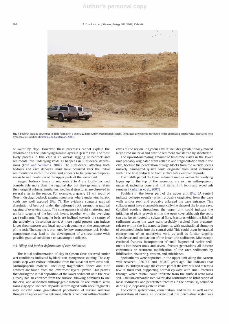
(1) The bedrock in the vicinity of Qesem Cave dips towards thecenter of the cave (Fig. 1B–C).(2) The bedrock dips are largest at the eastern wall of Qesem Cavereaching 55°. The dip becomes smaller with increasing distance fromthe cavewall. The largerdips are associatedwith increasing shatteringof the rock, without chaotic displacement of rock fragments.(3) As one moves eastward of Qesem Cave, the bedrock regains itsoriginal bedding and structure.(4) The measured dips are not associated with any known tectonicstress field in the region (Bahat et al., 2006). They rather varylocally, and are generally directed in a centripetal way aroundQesem Cave (Fig. 1B–C).(5) The local bedrock dips cannot be attributed to a tectonic fault orfold, because these are not observed at the outcrops around the cave.(6) The lower sedimentary unit in the cave is well-bedded, withoutchaotic appearance (Fig. 5).(7) The inclined lower Qesem Cave deposits are sub-parallel withthe underlying bedrock layers. Both are inclined considerablymorethan the regional bedrock dip.(8) Steep inclinations of lower cave deposits are common inprehistoric caves, such as Tabun, where the inclined sediments lieon a funnel shaped bedrock surface (Garrod and Bate, 1937; Jelineket al., 1973; Ronen and Tsatskin, 1995; Zviely and Ronen, 2004) andKebara (Goldberg and Bar-Yosef, 1998). As in Qesem, the Kebaraand Tabun deposits are mostly inclined in the lowermostsedimentary units (Tabun layers F and G).(9) Similar bedrock deformation of short (~20 m) wavelength iscommon in Bi'na Formation between the Samaria hills and thecoastal plain of Israel (Fig. 7). At least some of them can beattributed to underlying, hypogene dissolution below the water-table (Frumkin and Gvirtzman, 2006).
Several processes may contribute to the dip of cave sediments:initial dip of sediments deposited on an inclined bedrock floor of thecave; differential dissolution or other diagenetic modification of cavesediments; compaction of unconsolidated sediments; preferentialdewatering of sediments, or volumetric expansion due to absorption
161A. Frumkin et al. / Geomorphology 106 (2009) 154–164
Author's personal copy
of water by clays. However, these processes cannot explain thedeformation of the underlying bedrock layers in Qesem Cave. Themostlikely process in this case is an overall sagging of bedrock andsediments into underlying voids as happens in subsidence depres-sions (Ford and Williams, 2007). The subsidence, affecting bothbedrock and cave deposits, must have occurred after the initialsedimentation within the cave and appears to be penecontempora-neous to sedimentation of the upper parts of the lower unit.
Sagged bedrock layers in segments 2 to 4 are locally inclinedconsiderably more than the regional dip, but they generally retaintheir original volume. Similar inclined local structures are observed inseveral sites in the region. For example, a quarry 22 km south ofQesem displays bedrock sagging structures where underlying karsticvoids are well exposed (Fig. 7). The evidence suggests gradualdissolution of bedrock under the deformed rock, promoting gradualsagging of overlying strata. The consequence is slight shattering anduniform sagging of the bedrock layers, together with the overlyingcave sediments. The sagging beds are inclined towards the center ofthe underlying dissolution zone. A more rapid process can inducelarger shear stresses and local rupture depending on the competenceof the rock. The sagging is promoted by low-competence rock. Highercompetence may lead to the development of a stress dome withpossible gradual subsidence or catastrophic collapse.
4.4. Filling and further deformation of cave sediments
The initial sedimentation of clay in Qesem Cave occurred underwet conditions, indicated by black iron–manganese staining. The claycould seep with vadose infiltration from the subaerial terra rossa soil.Anthropogenic material, including fragmented bones and flintartifacts are found from the lowermost layers upward. This provesthat during the initial deposition of the lower sediment unit, the cavealready had an entrance from the surface, allowing hominids to usethe cave, and associated anthropogenic material to accumulate. Terrarossa clay-type inclined deposits intermingled with rock fragmentsmay indicate some gravitational penetration of surface materialthrough an upper narrow entrance, which is commonwithin chamber
caves of the region. In Qesem Cave it includes gravitationally-movedlarge sized material and detritic sediment transferred by sheetwash.
The upward-increasing amount of limestone clasts in the lowerunit probably originated from collapse and fragmentation within thecave, because the penetration of large blocks from the outside seemsunlikely. Sand-sized quartz could originate from sand inclusionswithin the host bedrock or from surface late Cenozoic deposits.
Themiddle part of the lower sediment unit, as well as the overlyinglayers up to the top of the sequence, are rich in anthropogenicmaterial, including bone and flint items, flint tools and wood ashremains (Karkanas et al., 2007).
Boulders in the lower part of the upper unit (Fig. 6A center)indicate collapse event(s) which probably originated from the cavewalls and/or roof, and probably enlarged the cave entrance. Thiscollapsemust have changed dramatically the shape of the former cave.Calcified rootlets throughout the upper unit could indicate theinitiation of plant growth within the open cave, although the rootscan also be attributed to subaerial flora. Fractures within the lithifiedsediments along the cave walls probably resulted from pressure-release within the indurated sediments, with gravitational slumpingof cemented blocks into the central void. This could occur by gradualenlargement of an underlying void, as well as further sagging,subsidence and compaction of the lower unit sediments. Microscopicerosional features, incorporation of small fragmented earlier sedi-ments into newer ones, and several fracture generations, all indicatecontinuous or recurrent modification of the cave sediments bylithification, shattering, erosion, and subsidence.
Speleothems were deposited in the upper unit along the easternwall between ~380,000 and 150,000 years ago. This indicates thatuntil ~150,000 years ago the eastern part of the cave still had at least afew m thick roof, supporting normal epikarst with small fracturesthrough which rainfall could infiltrate from the surficial terra rossasoil. Calcium-carbonate rich water also contributed to lithification ofloose sediments, and penetrated fractures in the previously solidifieddebris pile, depositing calcite veins.
The calcite speleothems, cementation, and veins, as well as thepreservation of bones, all indicate that the percolating water was
Fig. 7. Bedrock sagging structures in Bi'na Formation a quarry 22 km south of Qesem karst system. The sagging syncline is attributed to the underlying karstic voids, associated withhypogenic dissolution (Frumkin and Gvirtzman, 2006).
162 A. Frumkin et al. / Geomorphology 106 (2009) 154–164
Author's personal copy
typically oversaturated with respect to calcite. This precludedintensive dissolution of the sediments.
It seems that the uppermost centimeters of the thick flowstone(Q3) have been subject to dissolution in antiquity, associated withpossible re-opening of the U system, following its deposition. Thisdissolution might have resulted from a change in the chemistry ofwater, becoming undersaturated to calcite and thus aggressive. Thechange, in turn, can be a result of the removal of the soil cover, aclimatic change (related to the soil cover status), open fractures that letthe water flow without much interaction with the limestone, smallerthickness of the overhanging rock, or lack of a cave roof. Thesealternatives are classified to two possible scenarios: regional environ-mental change associated with erosion of the soil cover, or localchanges in the configuration of Qesem Cave. The fact that depositioncontinued in the nearby Kafr Qasem Cave as well as other caves in theregion (e.g. Frumkin et al.,1999) indicates that local changes controlledthe deposition and dissolution in Qesem Cave. Dead speleothems nowbeing dissolved are frequently found in caves of Israel, and they are notnecessarily associated with regional environmental change. On thecontrary, condensation corrosion of speleothems occurs in most cavesof the region following the cessation of deposition.
The dating results show that ~150,000 years ago speleothemdeposition diminished further in Qesem cave, and its final evolutionalstage started. The cave probably became unroofed by collapse andsurface denudation (for other examples see Klimchouk, 2006; Mihevcet al., 1998). Regional subaerial denudation rate is estimated ~15–40 m/Myr (Gerson, 1975; Haviv et al., 2006), so at least 10 m ofdenudation could occur since deposition started within the cave. Thevoid became completely filled with sediments up to the hill surfaceand it ceased functioning as an active depositional site. Following therich Acheulo–Yabrudian complex of the terminal Lower Paleolithic, noanthropogenic usage of the cave is observed during the last~200,000 years. Speleothem deposition became limited to smallvoids and fractures (e.g. some small coralloid crusts).
5. Conclusions
Inclined and deformed cave sediments may be associated withdepositional dip, subsidence and sagging into deeper voids, stopingand doming of cave roof, introduction of subaerial materials throughan upper entrance, internal irregular accumulation and deformationprocesses, tectonic deformation, seismic tilting and collapse, diage-netic chemical processes, or gravitational compaction of loosesediments and dissolved material. Many of these processes arecontrolled by gravity. Some affect only the internal cave sediments,while some gravitational deformations affect the bedrock skeleton ofthe karst system as well. These processes usually affect the geometry,distribution and interpretation of archaeological finds, so theymust beseriously analyzed. Allochthonous sediments are rare in the discussedregion, and are mostly associated with wind, biological or anthro-pogenic agents when the cave has an entrance. These are wellrepresented in the Qesem karst system which combines both naturalkarst processes and anthropogenic-modified sediments.
The Qesem Cave deposits are the most complex within the studiedkarst system. They contain a combination of natural and anthropo-genic sediments, such as flint and bone fragments as well as ash-richmaterial. Subsidence, erosion, fracturing, deposition of varioussediments and cementation were continuous or recurrent withinQesem cave, at least during the mid-Pleistocene. Qesem cave is a goodexample of the way karstic caves are filled and ultimately obliteratedby surface denudation and roof collapse. These processes areconsidered as “aging” of a karstic cave.
The Qesem karst system has been an active depositional site forspeleothems during the last glacial cycles, including both glacial andinterglacial periods. In particular, the termination of speleothemdeposition in Qesem Cave is not a regional trend, but a local effect,
related to the aging of this particular cave. The continuous recentdeposition is well documented in Kafr Qasem Cave and also in othercaves of the region. Speleothemdeposition at any particular sitewithinthe system depended on the supply of Ca-carbonate water whichgained its solutes in the epikarst zone, above the deposition site.
About 150,000 years ago the epikarst layer was probably degradedor totally removed from the top of Qesem cave, so the cave voidapparently ceased to operate as an active vadose zone depositionalenvironment. This removal is associated with the denudation andcollapse of the cave roof. This particular cave has ceased to operate as adepositional site, and is being actively consumed by surface erosion aswell as anthropogenic impact. The cave aging processes discussedhere are ubiquitous and relevant to most karstic systems.
It may be concluded that intrinsic, local causation of caveprocesses, such as deformation and speleothem deposition, may bemore important than extrinsic, regional causation within the sameclimatic zone. This should not be overlooked by geoarchaeologistswanting to establish regional patterns.
Acknowledgements
Aaron Kaufman has initiated U–Th dating in Kafr Qasem Cave. Theteam of the Cave Research Unit at The Hebrew University of Jerusalemsurveyed Kafr Qasem Cave. The study was supported by the WaterAuthority of Israel, the Israel Science Foundation (Grant No. 256/05),the L.S.B. Leakey Foundation (2003–2006), and the Irene Levi SalaCARE Archaeological Foundation (2003–2006).
References
Avisar, D., Kronfeld, J., Isa, A., 1997. The influence of cesspools in Arabs villages upondrinking water quality. The Ecoadvocate, Israel Union for Environmental Defence,1997(winter), pp. 4–9.
Bahat, D., Frid, V., Rabinovich, A., 2006. Paleostress clockwise rotation in the Sinai–Israelsub-plate and the initiation of the Dead Sea Rift. Israel Journal of Earth Sciences 55,159–171.
Barkai, R., Gopher, A., Lauritzen, S.E., Frumkin, A., 2003. Uranium series dates fromQesem Cave, Israel, and the end of the Lower Palaeolithic. Nature 423, 977–979.
Barkai, R., Gopher, A., Shimelmitz, R., 2005. Middle Pleistocene Blade Production in theLevant: An Amudian Assemblage from Qesem Cave, Israel. Eurasian Prehistory 3,39–74.
Fischhendler, I., 1998. Factors Controlling the Karst Pattern in Southern Samaria (inHebrew). MA Thesis, The Hebrew University, Jerusalem, 64 pp.
Ford, D.C., Williams, P.W., 2007. Karst Hydrogeology and Geomorphology. Wiley,Chichester. 562 pp.
Frumkin, A., 1996. Geology and speleology of Nahal Qanah Cave System. In: Gopher, A.(Ed.), The Nahal Qanah Cave. Institute of Archaeology Monograph Series. Tel AvivUniversity, Tel Aviv, pp. 139–146.
Frumkin, A., 2001. The Cave of the Letters sediments — indication of an early phase ofthe Dead Sea depression? The Journal of Geology 109, 79–90.
Frumkin, A., Fischhendler, I., 2005. Morphometry and distribution of isolated caves as aguide for phreatic and confined paleohydrological conditions. Geomorphology 67,457–471.
Frumkin, A., Gvirtzman, H., 2006. Cross-formational rising groundwater at an artesiankarstic basin: the Ayalon Saline Anomaly, Israel. Journal of Hydrology 318, 216–333.
Frumkin, A., Carmi, I., Gopher, A., Tsuk, T., Ford, D.C., Schwarcz, H.P., 1999. Holocenemillenial-scale climatic cycle from Nahal Qanah Cave speleothem, Israel. TheHolocene 9, 677–682.
Garrod, D.A.E., Bate, D.M.A., 1937. The Stone Age of Mount Carmel. Clarendon Press,Oxford.
Gasic, T., 2002. The Influence of Road Construction on Karst Systems. MA Thesis,Hebrew University, Jerusalem, 82 pp.
Gerson, R., 1975. Karst and fluvial denudation of carbonate terrains under sub-humid-Mediterranean and arid climates— principles, evaluation and rates (examples fromIsrael). In: Gams, I. (Ed.), Karst Processes and Relevant Landforms. University ofLjubljana, Ljubljana, pp. 71–79.
Gillieson, D., 2004. Sediments: allochthonous clastic. In: Gunn, J. (Ed.), Encyclopedia ofCave and Karst Science. Fitzroy Dearborn, New York, pp. 633–634.
Goldberg, P., Bar-Yosef, O., 1998. Site formation processes in Kebara and HayonimCaves and their significance in Levantine prehistoric caves. In: Akazawa, T., Aoki,K., Bar-Yosef, O. (Eds.), Neandertals andModern Humans inWestern Asia. Plenum,New York, pp. 107–125.
Goldberg, P., Sherwood, S.C., 2006. Deciphering human prehistory through thegeoarcheological study of cave sediments. Evolutionary Anthropology 15, 20–36.
Gopher, A., Barkai, R., Stiner, M.C., Shimelmitzi, R., Khalaily, M., Lemorini, C.,Hershkovitz, I., 2005. Qesem Cave: an Amudian Site in Central Israel. Journal ofThe Israel Prehistoric Society 35, 69–92.
163A. Frumkin et al. / Geomorphology 106 (2009) 154–164

Author's personal copy
Haviv, I., Stone, J., Enzel, Y., Zilberman, E., Whipple, K., Matmon, A., Fifield, K., 2006.Climatic control on erosion rates of dolo-limestone hilltops. In: Kessel, R.,Kagan, E., Porat, N. (Eds.), Annual Meeting. Israel Geological Society, Bet-Shean,p. 54.
Hildebrand-Mittlefehldt, N., 1993. Kefar-Sava. The Geological Survey of Israel,Jerusalem, p. 1.
Jelinek, A.J., 1990. The Amudian in the context of the Mugharan Tradition at the TabunCave (Mount Carmel), Israel. In: Mellars, P. (Ed.), The Emergence of ModernHumans. Cornell University Press, Ithaca.
Jelinek, A.J., Farrand, W.R., Haas, G., Horowitz, A., Goldberg, P., 1973. New excavations atthe Tabun Cave, Mount Carmel, Israel, 1967–1972: a preliminary report. Paleorient1, 151–181.
Karkanas, P., Bar-Yosef, O., Goldberg, P., Weiner, S., 2000. Diagenesis in prehistoric caves:the use of minerals that form in situ to assess the completeness of thearchaeological record. Journal of Archaeological Science 27, 915–929.
Karkanas, P., Shahack-Gross, R., Ayalon, A., Bar-Matthews, M., Barkai, R., Frumkin, A.,Gopher, A., Stiner, M.C., 2007. Evidence for habitual use of fire at the end of theLower Paleolithic: site formation processes at Qesem Cave, Israel. Journal of HumanEvolution 53, 197–212.
Klimchouk, A., 2006. Cave un-roofing as a large-scale geomorphic process. Speleogen-esis and evolution of karst aquifers 4 (1), 11 www.speleogenesis.info.
Macphail, R.I., Goldberg, P., 1995. Recent advances in micromorphological interpreta-tions of soils and sediments from archaeological sites. In: Barham, A.J., Macphail, R.I.
(Eds.), Archaeological Sediments and Soils: Analysis, Interpretation, and Manage-ment. Institute of Archaeology, University College London, London, pp. 1–24.
Mihevc, A., Slabe, T., Sebela, S., 1998. Denuded caves— an inherited element in the karstmorphology; the case from Kras. Acta Carsologica 27, 165–174.
Rapp, G.J., Hill, C.H., 1998. Geoarchaeology. Yale University Press, New Haven. 274 pp.Ronen, A., Tsatskin, A., 1995. New interpretation of the oldest part of the Tabun Cave
sequence, Mount Carmel, Israel. In: Ulrich, H. (Ed.), Man and Environment in thePalaeolithic. E.R.A.U.L, vol. 62, pp. 265–281.
Sass, E., Bein, A., 1978. Platform carbonates and reefs in the Judean Hills, Carmel andGalilee. Tenth International Congress on Sedimentology. International Associationof sedimentologists, Jerusalem, pp. 239–274.
Shahack-Gross, R., Berna, F., Karkanas, P., Weiner, S., 2004. Bat guano and preservation ofarchaeological remains in cave sites. Journal of Archaeological Science 31,1259–1272.
White, W.B., White, E.L., 2000. Breakdown morphology. In: Klimchouk, A., Ford, D.C.,Palmer, A.N., Dreybrodt, W. (Eds.), Speleogenesis Evolution of Karst Aquifers.National Speleological Society, Huntsville, USA, pp. 427–429.
Yaalon, D.H., Ganor, E., 1973. The influence of dust on soils during the Quaternary. SoilScience 116, 146–155.
Zviely, D., Ronen, A., 2004. Garrod's spring in Tabun Cave, Mt. Carmel (Israel): 70 yearslater. In: Maos, J.O., Inbar, M., Shmueli, D.F. (Eds.), Contemporary IsraeliGeography, Special Issue of Horizons in Geography 60–61. University of Haifa,Haifa, pp. 247–254.
164 A. Frumkin et al. / Geomorphology 106 (2009) 154–164