William Boyd Dawkins’s Llandegla caves re-assessed - Part B - Photos
Upload
independentCategory
view
0download
0
LAND SNAILS OF THE LUCILE CAVES ACEC
Terrence J. Frest Edward J. Johannes
Deixis Consultants 2517 NE 65th Street Seattle, WA 981 15-7125
September 15, 1995

Oreohelix idahoensis idahoensis .... is one of our prettiest land shells. H. A. Pilsbry (1939)
. . . . . a deliberate conspiracy of silence has kept most subsequent records, and description of a new species, from publication. Unlike most species of Oreohelix, those of the Salmon River Valley are highly restricted in distribution, capable of being wiped out by zealous collectors, and often known from less than four colonies.
G. Alan Solem, in Solem & Clarke (1 974)

ABSTRACT
A land snail survey was conducted on the Lucile Caves ACEC and vicinity in 1993-1994 as part of a larger survey of the Lower Salmon River valley land snail fauna (Frest & Johannes, 1995). Information gathered from earlier collections in 1989-1993 was also included. The area was known to include at least one population, possibly discovered in the 1860s, of the federal C2 candidate species Oreohelix idahoensis idahoensis (Newcomb, 1866). We collected at a total of 16 sites, 12 of which were wholly or mostly on the Lucile Caves ACEC.
There are at least 8 land snail species in this vicinity, including colonies of three taxa regarded as Sensitive by Frest & Johannes (1995a). One of these, Oreohelix idahoensis idahoensis, was historically generally distributed over much of the Lucile Caves ACEC. It now appears to be much reduced in numbers or exterpated in most places, with large populations limited mostly to small areas in the western and southwestern portions of the ACEC. Clypfomastix n. sp. 5 is found only in a small seepy area below Lucile Cave. Oreohelix n. sp. 20 occurs in nearby Sheep Gulch and may be found in scattered areas at high elevations on or just east of the ACEC.
Ecology of sensitive species on the ACEC is described; and recommendations for their management are made. The greatest single human impact in this area stems from grazing of domestic animals.
... Ill

TABLE OF CONTENTS
TABLE 1. LUCILE CAVES ACEC SITE FAUNAL LISTS
FIGURES ................................................................................................. F1-8 1. MAP OF LUCILE CAVES ACEC AND VICINITY ------------------ ----- ..- ----------------- F2
2. LAND SNAIL SITES IN LUCILE CAVES ACEC AND VICINITY .............................. F4 3. DISTRIBUTION OF OREOHELIX IDAHOENSIS IDAHOENSIS -------------------------- F6 4. ILLUSTRATIONS OF OREOHELIX IDAHOENSIS IDAHOENSIS ........................... F8

LAND SNAILS OF THE LUCILE CAVES ACEC
INTRODUCTION
The Lucile Caves area comprises roughly 440 acres of ELM land just east of the Salmon
River and southeast of Lucile, Idaho Co., ID (Figure 1). A main attraction of this land parcel is the
limestone cave and associated springs and seeps in the north central portion of sec. 11. This
feature and the surrounding ELM holdings were designated as both a Research Natural Area and
Area of Critical Environmental Concern in 1989. Most of the ACEC occurs in portions of sections
2,11, and 12, T 25 N R 1 E, between Sheep Gulch and Crawford Creek.
The area has long been known to harbor unique floral and faunal elements. Results of
floristic and vegetation survey were published in 1991 (Moseley & Bematas, 1991). This work
reviews the physical environment, flora, and plant communities in some detail; and should be
referred to for background. A highlight of Moseley and Bematas (1991) was the confirmation of
the survival of a study population of Mirabilis macfarlanei, as well as populations of four additional
rare vascular plant species.
As might be predicted from the presence of so many rare plant species, there are unique
or unusual animal elements as well. One land snail taxon, currently known as the costate
mountainsnail [Oreohelix idahoensis idahoensis (Newcomb, 1866)], is believed to have first
been collected from the Lucile area in the early 1860s (Solem, 1975; Frest & Johannes, 1995a).
This taxon, well known to shell collectors and termed "one of our prettiest land shells" by Pilsbry
(1939), was first found by the early private collector Henry Hemphill. Hemphill, an itinerant stone
mason, also collected and sold shells. He was particularly active in the period from 1860-1 920,
and is known to have visited this region in the 19860s and in the 1890s. Many other professional
malacologists and private collectors have since also collected here. Among these were H. 6.
Baker, H. E. Ashmun, A. G. Smith, M. L. Walton, W. M. Miller, and G. A. Solem (Frest & Johannes,
1995a).
Specimens from Hemphill's original collection were distributed widely, and are found in
major natural history collections throughout the worid. The exact site at which he obtained the
original lot is somewhat conjectural. Pilsbty (1939) noted that "Hemphill was a good collector but
weak at labeling his shells"; this might have been as much to control supply as for other reasons
(Coan & Roth, 1987). The original locality was cited as 'between Idaho City and the Coeur d'Alene

mining district"; other labels with Hemphill specimens are similarly vague, e.g. "Salmon River
Mountains"; fortunately, at least one fixes the site somewhat more precisely as "Lucile" (Pilsbry,
1939). Other old collections, e.g. H. B. Baker, 1930, "below cave about 1 112 miles south of
Lucile", are clearly from the Lucile Caves area. It is quite likely that the specimens collected by
Hemphill came from the Lucile Caves area, as this is the largest known colony, and along the older
main road through the Lower Salmon River valley just as it is today. Hence, it is probable that this is
the type locality of Oreohelix idahoensis idahoensis. Some possibility remains, however, that the
specimens came from the colony at Lucile (see Solem, 1975; Frest & Johannes 1995a).
SCOPE AND METHODS
Methods used for this survey were a combination of hand and litter sampling, as detailed
in Frest & Johannes (1995a, b). We visited a total of 16 sites either on the Lucile Caves ACEC or
in the immediate vicinity (see Table 1 and Figure 2). Twelve localities were wholly or partly on the
ACEC; a few others were added to establish colony boundaries for Oreohelix idahoensis
idahoensis. Some other sites collected during the Lower Salmon River survey are also close by:
for these, see Frest & Johannes (1995a). Most sites were hand collected, since there is very little
adequate litter on the ACEC. Still, one site (74) was litter sampled.
The area was intensively surveyed between October 15-21, 1993. We had earlier
examined some of the same sites on August 10, 1989 and October 1, 1990. Details of site
location, flora, and legal descriptions are included in Appendix A; sites are mapped on Figure 2.
Faunal lists constitute Table 1.
RESULTS
We noted a total of eight land snail species at our sites (Table 1). This is rather low for
continental areas, but more typical for semiarid regions, and in line with diversities noted
elsewhere in the Lower Salmon River area (for local background, see Frest & Johannes, 1995a;
for regional (Interior Columbia Basin) generally, consult Frest & Johannes (1995b). The litter

sampled site, as would be expected, had the greatest diversity. Generally, as is regionally
characteristic, a single species was locally dominant at each locality; and many sites had just one or
two taxa. Most land snails collected were comparatively large, that is over 1 cm in diameter. This is
not necessarily typical of semiarid regions; but quite in line with results from the broader survey.
Diversity in general had little to do with substrate; but abundances may show regolith
influence. Much of the central part of the ACEC is underlain by a single large exotic limestone
block, most likely Triassic Martin Bridge Limestone. The northern portion of the ACEC i.e. the
acreage in section 2 and the adjoining areas south of Crawford Creek have Lucile Slate bedrock
and outcrops. In general, limestone areas in this region, as elsewhere in North America, have
more diverse land snail faunas, in part because many snails are calciphiles and all need such
elements as calcium for [calcite] shell formation. Limestone, dolomite, or marble are among the
best rock units for producing calcium-rich soils. Slates are generally less acceptable. However, the
Lucile Slate seems to be unusually calcareous, providing more than sufficient material for shell
formation; and shells from both regoliths (for example of the rather thick-shelled Oreohelix
idahoensis idahoensis) appear equally robust.
Near the Salmon River proper, boulder piles, of mixed Iithologies but including limestone,
predominate. Locally, there are extensive sandy areas, notably near the center of section 11.
Both represent Pleistocene and Holocene terrace deposits. Outcrops of both slate and slightly
metamorphosed limestone are common, as are small-scale limestone talus piles.
Springs and seeps are mostly confined to a 15 acre area near and below Lucile Cave.
Secondary travertine deposition is common in this area. The limestone has local cave and adii
development elsewhere in the area. Much of the ACEC has west-facing, moderately dissected
slopes. It is mostly comparatively dry and open. Mining prospects and small-scale operations have
occurred sporadically, mostly some time ago. This is most evident in the slate outcrop area in
section 2; but other prospects and adits occur, such as that at site 208. Limestonelslate contact
mining, as occurs commonly elsewhere in this district, is not evident here, with the closest
example being the old McKinley Mine in Sheep Gulch.
Former homestead and other buildings have mostly been removed, and traces of impacts
from these are most notable within afew hundred feet of the current US 95 right-of-way. The
former highway alignment is very evident in the north and central parts of the western border of
the ACEC. All of these activities have impacted snails, and most of the areas so impacted still lack
live colonies, even though very old dead shells are evident. Former sites for some species, such
as that of Smith (1943) for Oreohelix idahoensis idahoensis, appear to have been extirpated.
However, the most significant impact over most of the ACEC is cattle and horse grazing. Portions
of the area have been fenced, notably near the spring and seep area; but fencing is not

particularly effective over most of the ACEC, and we have observed varying numbers of cattle or
horses on each visit.
Short species discussions for each land snail taxon noted during this survey follow; for
further background, including ecology, regional and local occurrence, plant associates, and
substrate preferences, see the companion report (Frest & Johannes, 1995a) or the recent
regional synthesis (Frest & Johannes ,1995b).
Allogona ptychophora ptychophora (Brown, 1870) dry land forestsnail
This subspecies was the most common taxon encountered during the Lower Salmon
River survey (Frest & Johannes, 1995a) and is common in this area and elsewhere in the Interior
Columbia Basin (Frest & Johannes, 1995b). We classified it as a nonsensitive species in this area.
The dry land forestsnail was found in the ACEC and vicinity at the following six sites: 51, 52, 54,
75, 76, 207. Ecology here was similar to that noted for the region. This large land snail occurs
most often in talus and boulder piles, in xeric to somewhat mesic settings. It is most common in the
vicinity of Lucile Cave and the wet areas immediately below; but occurs to the slope base.
Catinella avara (Say, 1819) suboval ambersnail
Snails in the Lower Salmon River area are only tentatively assigned to this species, as
discussed by Frest & Johannes (1995a: there designated a species of uncertain status). Material
was inadequate; and ecology (many succineids, including this species elsewhere, prefer moist
environments) indicates that this succineid may be an undescribed local endemic. If so, it is
probably a strict local endemic and quite rare. This taxon was noted at two sites: 27 and 74.
Notable is the fact that live specimens were found at one site. The local sites are typical; one is a
dry and open rocky talus, in this case limestone; the second is a schist slope. Further work needs
to be done to establish ecology and identity of this species. Site 27 is very significant, in that it is
one of the few sites yet known with live specimens; this site is outside the present ACEC borders.
Cryptomastix (Cryptomastix) n. sp. 5 Lucile oregonian
The Lucile oregonian is a Sensitive species strictly endemic to a portion of the Lower
Salmon River valley between Riggins and the mouth of White Bird Creek (Frest & Johannes,
1995a). It is known from a total of 40 sites. Here, it was collected at four: 52,54, 75, and 207. Only
one site, 75, which is the partly fenced shaded and seepy area with travertine deposition at the
base of the slope below Lucile Cave, had a substantial population. Dead shells in other areas may

indicate former widespread distribution, as is frequently the case in the less impacted areas in the
Lower Salmon River valley.
Helicodlscus salmoneus Binney, 1886 Salmon coil
This small species is a regional endemic particularly characteristic of the Washingtonian
molluscan Province. Despite its somewhat restricted distribution, it is locally common in the Lower
Salmon River area and was regarded as a nonsensitive species by Frest & Johannes (1995a).
Helicodiscus salmoneus was noted in the ACEC area at only one site (74), and as dead
specimens only. It likely occurs locally elsewhere on the ACEC.
Oreohelix idahoensis idahoensis (Newcomb, 1866) costate mountainsnail
The costate mountainsnail was noted at a total of fifteen sites (27, 51,52, 53, 54, 55, 72,
73, 74, 75, 76, 77, 202, 207, 208. Of these, it seems likely extirpated at three; and is possibly so
at 208 as well. This species is a C2 federal candidate for listing under the Endangered Species
Act and was regarded as a Sensitive species by Frest & Johannes (1995a, b). We (op. cff.)
recommended listing as Threatened if the Lucile Caves ACEC population can be safeguarded;
but Endangered otherwise (see discussion below).
It seems likely that all of our sites here were once parts of a single colony, now somewhat
reduced and fragmented due to human impacts. We attempted to map out distribution of this
taxon in some detail (Figure 3). The costate mountainsnail appears to have been extirpated from
perhaps 40% of the original area occupied (red portions of Figure 3). Judging from the number
and condition of dead shells, it is possible that much of the range reduction has taken place rather
recently, and is due to grazing. Some areas along US 95, especially in the central portions of
section 11, may have been extirpated much earlier; and some very recent local extinction seems
to have occurred in the areas west of the present highway alignment and east of the river high
water mark. Very old local extirpation may have occurred due to mining prospects. In one case,
there is little sign of recovery while in the second the old adit provides protection to a very local
colony.
Over perhaps an additional 40% of the area (yellow in Figure 3), live snails are very sparse
and local. Often, literally millions of dead shells can be found in these areas, in varying condition
but with some comparatively fresh. In mostly scattered areas (green in Figure 3), relatively dense
live colonies remain, with one large example occurring in the NW 114 SE114 section 11 (Figure 3).
Most of these subpopulations represent survival due to fortuitous protection. Examples are the
mine adiicave at site 208 and the isolated talus pile at site 53. Other colonies survive in areas too

steep to graze thoroughly, such as the NW side of the small ravine on the lower end of site 54 and
the east side of the ravine at the base of site 52. A similar case is the colony at site 207, which
persists at the base of a steep limestone cliff just east of the old road alignment. The most natural
site occupies portions of localities 55 and 73. This colony occurs in Shrubland community with
exceptionally large Arternisia and Celtus. Even here, dead shells far outnumber living [three
counts were : 1) live: 6ldead: 123; live: lldead: 63; and live: 4/dead 78. Dead snails may
outnumber live in relatively unimpacted sites also; but not, in our experience, by such large ratios.
These are more characteristic of sites under considerable stress from one or mnre causes. Live
sites are most generally talus or the base of small rock outcrops: occasionally, bases of large
Artemisia or Balsarnorhiza may perform similar functions for very local Colonies.
This subspecies was noted from a few other sites in the immediate vicinity (Frest &
Johannes, 1995a), none of which are as large as this occurrence. It is a strict local endemic
occurring only from the mouth of Race Creek to Lucile, with most sites being on the east side of
the Salmon River (Frest & Johannes, 1995a; see especially Appendix C30). Some of these sites
may represent subfossil colonies. This taxon is a strong xerophile and may be a calciphile as well.
Ecology and plant associates have recently been discussed in Frest & Johannes (1995a).
Distribution of this species may be controlled locally by avariety of factors. The species seems to
be essentially limited to one exotic terrain block and surrounding slate. Even here, it seems to be
restricted to lower elevations. Higher on the same block in Sheep Gulch, the species is replaced
by Oreohelix n. sp. 20 [see below for further discussion]. This species may occur in the areas east
of the ACEC also. A similar phenomenon was noted with Oreohelix haydeni perplexa nearby
(Frest & Johannes, 1995a).
This subspecies is illustrated on Figure 4.
Oreohelix n. sp. 20 Frest & Johannes, 1995b Sheep Gulch mountainsnail
The total present range of this Lower Salmon River strict endemic was estimated as about
15 square miles by Frest & Johannes (1995a). This species occurs at seven of our Lower Salmon
River survey sites, including one here (site 202, which is not on ACEC lands). It may also be found
just east of the present boundary of the ACEC, at similar elevations to those noted in Sheep
Gulch, that is above 2400' and here perhaps higher than 2800'. The known geographic range is
extremely limited (Frest & Johannes, 1995a, Appendix C39); and we recommended Sensitive
status and federal listing of it as Endangered. Like Oreohelix idahoensis idahoensis, this species
is a strong xerophile whose range has been impacted heavily by grazing.

Papilla hebes (Ancey, 1881) crestless column
A diminutive taxon, this species is typical of parts of the Washingtonian and Rocky
Mountain provinces. In the Lower Salmon region as a whole, it is rather uncommon (nine sites) but
fairly widely distributed (Frest & Johannes, 1995a, Appendix C55). In our more complete survey,
we treated this taxon as a Watch List species, presently not in need of protection in the Lower
Columbia Basin as a whole but possibly a candidate for special consideration in the future; and in
any case only possibly needing protection locally. In the ACEC area, it was noted at two sites (27,
74), one outside present ACEC borders.
Vallonia cyclophorella Sterki, 1892 silky vallonia
The silky vallonia is a very small taxon quite widespread in some of the Western Division
mollusk provinces (see Frest & Johannes, 1995b for discussion of western U.S. mollusk
biogeography). We found this species at fourteen sites in the Lower Salmon River survey and did
not recommend it as needing either regional or local protection. There is one known ACEC site
(74); and the species may occur locally elsewhere on the property. This taxon is more of an
environmental generalist than are many Lower Salmon River species, and was treated as a
nonsensitive species in the regional report (Frest & Johannes, 1995a).
RECOMMENDATIONS
The effects of various management practices on mollusks have been described by us
recently (Frest & Johannes, 1995a, b) and need not be reiterated in detail here. Most pertinent
here is additional control on grazing, particularly in portions of the ACEC with shrubland
vegetation and large Oreohelix idahoensis idahoensis colonies. It seems that this taxon could be
abundant over nearly the whole of the tract with proper protection; but shrublands between 1800
and 2400' elevations, especially in steeper areas, may perhaps be easiest to protect and maintain.
The area with seep and spring drainage, as well as travertine deposition, is especially diverse and
has the only currently definitely viable ACEC population of Cryptornastix (Cryptomastix) n. sp. 5.
This portion of the ACEC is partly protected by recent and well-placed fencing at present.

One significant snail site (27), with a reasonable population of Oreohelix idahoensis
idahoensis and "Catinella avara" and Pupilla hebes as well, lies just Outside ACEC borders. On
the other hand, portions of the ACEC, notably the southeastern area, currently have no viable
populations of Sensitive species. Perhaps consideration should be given to some local land
swapping to make a more secure, coherent, and more readily defensible ACEC border.
Particularly worthwhile in this regard (additional to areas already mentioned) would be
incorporation of the SW 114 NE 114 section 11 into the ACEC, conceivably in exchange for an
area such as the SE 114 SW 114 section 12 or NW 114 SW114 section 1 2 (see Figure 1).
We believe that Oreohelix idahoensis idahoensis can tolerate light grazing, such as
resultsfrom elk and deer populations generally. However, sustained heavy grazing by domestic
animals is definitely inimical. Sheep grazing near Lucile, for example, seems to have been the
primary oronly factor for extirpation since 1990 of one of the two historic sites for the C2 federal
candidate Oreohelix waltonk cattle grazing has much reduced this species at the other historic
site, the type locality (Frest & Johannes, 1995a). Some measures should be taken to decrease
grazing pressure on at least critical portions of the ACEC; and exclusion of domestic animals
entirely from some areas should be considered. Measures that serve to expand or restore the
shrubland plant community should also enhance snail populations as well.
REFERENCES
Coan, E. & B. Roth 1987. The malacological taxa of Henry Hemphill. The Veliger 29: 322-339
Frest, T. J. & E. J. Johannes. 1995a. Land Snail Survey of the Lower Salmon River Drainage, Idaho. Deixis Consultants, Seattle, Washington. vii + 360 pp.
. 1995b. Interior Columbia Basin Mollusk Species of Special Concern. Report ot Interior Columbia Basin Ecosystem Management Project. Deixis Consultants, Seattle, Washington, xi + 362 pp.
Moseley, R. K. & S. Bernatas. 1991. A Floristic and Vegetation Survey of Lucile Caves Area of Critical Environmental Concern, Coeur d'Alene District. BLM. Bureau of Land Management, Idaho State Office, Technical Bulletin 91 -3, v + 41 pp. appendices.
Pilsbry, H. A. 1939. Land Mollusca of North America (North of Mexico), vol. 1 pt. 1. Academy of Natural Sciences of Philadelphia Monograph 3 (1): 1-574.
Smith, A. G. 1943. Mollusks of the Clearwater Mountains, Idaho. Proceedings, California Academy of Sciences, series 4: 23: 537-554.
Solem, A. 1975. Notes on Salmon River oreohelicid land snails, with description of Oreohelix

waltoni. Veliger 18: 16-30
, & A . H. Clarke. 1974. Report on status survey for Salmon River Valley land snails. Office Endangered Species, Washington, DC. 12 pp. [unpub. letter dated August 23, 19741


TABLE 1. LUCILE CAVES ACEC SITE FAUNAL LISTS.
Allogona (A.) ptychophora ptychophora I - 1 - 1 t 1 + x 1 - 1 + x 0 1 - 1 - Catlnella avara l + x o l - I - I - I - 1 - 1 - 1 -
+ = live collection x = recently dead o = long-dead [ I = not collected * - - colony may now be extirpated bold face site numbers are entirely or partially inside Lucile Caves ACEC taxa in bold face occur in Lucile Caves ACEC

TABLE 1. LUCILE CAVES ACEC SITE FAUNAL LISTS. (cont.)
+ = live collection x = recently dead o = long-dead [ ] not collected = - - colony may be extirpated bold face site numbers are entirely or partially inside Lucile Caves ACEC taxa in bold face occur in Lucile Caves ACEC

APPENDIX A. LUCILE CAVES ACEC SITES.
Legal coordinates for all localities are taken from the most current USGS 7.5' series topographic map. Number in parentheses following locality name refers to locality number in Deixis MolluscDBTM database.
Collector name abbreviations are as follows:
TF- Terrence Frest, Deixis Consultants, Seattle, Washington EJ- Edward Johannes, Deixis Consultants, Seattle, Washington MF- Margaret Frest, Seattle, Washington GH- George Holm, Vancouver, British Columbia
27. Slope east of Lucile (1324). Projected from NW corner; SE% N W to SE% SE% SW% SE% NW% sec. 2. T24N RlE, Lucile 1963 quad., Idaho Co. Grassy W.-facing slope above (E. of) US95 across from Lucile and S. of Sheep Gulch, E. of the Salmon River at RM 77.0-77.1, BLM lands. Elev. 1720-1800'. Scattered schist boulders and mixed cobbles, small talus piles; moderately steep grassy slope with scattered Celtus, common Opuntia, rare Rhus diversiloba; sandy soil. Common but sporadic Oreohelix idahoensis idahoensis (full ontogeny); rare succineid. Colony about 0.2 mile long; extends at least 80' above road. Land snails hand collected. 1011511993 TF, EJ!
50. Opposite Squaw Bar (1347). NE% NE% sec. 14 to Wb SW% NW% NW% sec. 13, T25N RlE, Lucile 1963 quad., Idaho Co. High, steep W.-facing slope, above (NE of) US95; E. side of Salmon River at ca. RM 78.9-79.1, opposite Squaw Bar, BLM lands. Elev. 1800-2000'. Steep slope; mostly grasses, scattered schist cobbles. No land snails seen, area heavily grazed. 1011811993 TF, EJ!
51. Crawford Creek 1 (1 348). ME% SW% SE% SE% SE% sec. 11 to SE% SW^a SE% SW% SW% sec. 12, T25N R1 E, Lucile 1963 quad., Idaho Co. N. and S.-facing slopes along Crawford Creek above (E. of) access road, beginning ca. 0.3 road mile E. of US95 Elev. 1960-2360'. Steep slopes and stream bed; range from dry and open (grasses, Celtus, Opuntia, Balsamorhiza) to moist mossy cliff faces and shrubby slope (still mostly grasses); very common Rhus diversiloba. Very scattered Allogona ptychophora ptychophora (live); long- dead Oreohelix idahoensis idahoensis; heavy grazing damage. Snails hand collected. 1011 811 993 TF, EJ!
52. Lucile Caves ACEC-Crawford Creek 2 (1349). SE% SW% NW%, SW% SE% NW%, NW% SW%, & NW% NE% SW% of SW% sec. 12, T25N RlE, Lucile 1963 quad., Idaho Co. NW and SW-facing slopes along tributary gully on N. side of Crawford Creek, beginning ca. 0.4 road mile E. of US95 along access road, BLM lands (Lucile Caves ACEC). Elev. 2200-2600'. Relatively dry and open grassy steep slopes in tributary gully; grasses, Opuntia, Balsamorhiza, Celtus, common Rhus diversiloba; scattered schist boulders and small rock piles. Heavily grazed area. Scattered colonies of Oreohelix idahoensis idahoensis, especially on SW side; locally common where protected from grazing (very steep areas); Cryptomastix n. sp. 5. Hand collected. 1011 811 993 TF, EJ!
53. Crawford Creek 3 (1350). Center NE% SW% SE% of SE% sec. 11, T25N RlE, Lucile 1963 quad., Idaho Co. Small S.-facing talus on N. side of Crawford Creek ca. 0.25 road mile E. of US95, between two major gullies on N. side of Crawford Creek Elev. 2020'. Small (ca. 15'

length) limestone talus on N.-side of small gully; very open; grasses, clematis, Celtus. Uncommon Oreohelix idahoensis idahoensis hand collected. 1011 8/1993 TF, EJ!
54. Lucile Caves ACEC-Crawford Creek 4 (1351). SVWt NW% SE%, NEH Nw% SEn, SE% SWt< NEki, SW% SE% NE%, NW% SE% NE% of SE% sec. 11, T25N RlE, Lucile 1963 quad., Idaho Co. E. and W.-facing slopes in a large gully on N. side of Crawford Creek, beginning ca. 0.25 road mile NE of US95 (E. of Salmon River), partly on BLM lands (Lucile Caves ACEC). Elev. 2000-2400'. Dry open slope along dry gully; schist boulder talus at base; grasses; Opuntia; Celtus; common Rhus diversiloba. Rare live Cryptomastix n. sp. 5, Allogona ptychophora ptychophora; scattered Oreohelix idahoensis idahoensis (some live, but most dead); hand collected. 1011811 993 TF, EJ!
55. Artemisia slope on south end of Lucile Caves ACEC (1352). NWh, NW% NEn NW%, SE% NW%, SW%, NW%, NWis SW%, NE% SW% of SE% sec. 11, T25N R l E , Lucile 1963 quad., Idaho Co. Extensive steep SW-facing slope above grassy bench, S. part of BLM Lucile Caves ACEC, E. of US95 and Salmon River; length ca. 0.3 mile; width ca. 0.2 mile. Elev. 2000-2400'. Steep slope with limestone bedrock, scattered talus and boulders; grassy soil with Celtus, common large Artemisia, Opuntia, Balsamorhiza; rather dry and open. Very abundant dead Oreohelix idahoensis idahoensis; relatively common scattered live. Hand collected. Area formerly grazed; some grazing continuing. 1011 811 9 9 3 TF, EJ!
72. Lucile Caves ACEC-second site south of Sheep Gulch (1369). SE% SE% NE% SW% to SE% NW% SW% SE% sec. 2, T25N RlE, Lucile 1963 quad., Idaho Co. Shallow-moderately steep W.-facing slope in Lucile Caves ACEC (BLM lands), ca. 0.3 mi. S. of Lucile turnoff, above US95 (E. side). Elev. 1800-2600'. Moderately steep-shallow weathered schist slope with scattered limestone cobbles and boulders; mostly dry and open; grasses, scattered Celtus, Artemisa, Balsamorhiza, Opuntia. Very sparse live and dead Oreohelix idahoensis idahoensis hand collected; rather heavily grazed. Live material very local. 10121/1993 TF, EJ!
73. Lucile Caves ACEC-south of Lucile Caves (1370). NE% NE% SE% NW% to NEks NEis NEks SW% to SW% SE% SW% NE% to NW% NEH SW% NE% sec. 11, T25N RlE, Lucile 1963 quad., Idaho Co. Large W.-facing slope partly in Lucile Caves ACEC (BLM lands), ca. 0.7-1.1 mi. S. of Lucile turnoff and E. of US95, and S. of Lucile Caves. Elev. 1800-2600'. Steep-moderately steep slope, open, dry, and grassy, in weathered limestone; scattered outcrops and blocks. Very sparse Oreohelix idahoensis idahoensis live; common long-dead; moderately grazed. Hand collected. 1012111993 TF, EJ!
74. Lucile Caves ACEC-north site along roadbed (1371). NWis NE% SE% NEks NWks sec. 11, T25N RlE, Lucile 1963 quad., Idaho Co. W.-facing schist slope near N. end of old roadbed of US95, ca. 0.6 mi. S. of Lucile turnoff, Lucile Caves ACEC (BLM lands), near old mine prospect. Elev. 1720-1800'. Dry and open slope, with weathered schist outcrops; common grasses, Celtus; locally shaded, with Rubrus, Salix, etc. Oreohelix idahoensis idahoensis hand collected. 811011989 TF, MF, EJ! Local but common Oreohelix idahoensis idahoensis hand collected. Litter sampled. 10/21/1993 TF, EJ!
75. Lucile Caves ACEC-second site from north on old roadbed (1372). SWH NE% SE% NEks NE% sec 11, T25N R1E. Lucile 1963 quad., Idaho Co. W.-facing springy area below Lucile Caves and ca. 0.65 mi. S. of Lucile turnoff, Lucile Caves ACEC (BLM lands), ca. 0.1 mi. S. of N. end of old US95 roadbed. Elev. 1720-1760'. Shaded, moist slope with spring runs, travertine deposition; Salix, Populus, Physocarpus, Cornus stolonifera, Sambucus. Uncommon Cryptomastix n. sp. 5 live; Oreohelix idahoensis idahoensis long-dead (not retained); Allogona ptychophora ptychophora dead only. Hand collected. 811011989 TF, MF, EJ!
76. Lucile Caves ACEC-near Lucile Caves (1373). Center SW% SW% NW% NE% sec. 11, T25N R1E Lucile 1963 quad., Idaho Co. Steep W.-facing travertine-covered area in vicinity of Lucile Caves and below largest spring source, ca. 0.2 mi. E. of US95 and 0.7 mi. S. of

Lucile turnoff, BLM lands (Lucile Caves ACEC). Elev. 1960-2020'. Very steep, travertine- covered; open, mostly very moist; grasses, scattered bryophytes, local shrubs. Uncommon Allogona ptychophora ptychophora live; rare long-dead Oreohelix idahoensis idahoensis. Hand collected. 8/10/1989 TF, MF, EJ!
77. Lucile Caves ACEC-cave 1.25 miles south of Lucile (1374). SE% NE% SW% SE% NW% sec. 11, T25N R1 E, Lucile 1963 quad., Idaho Co. Small cave opening to E. of US95, Lucile Caves ACEC (BLM lands), ca. 1.25 mi. S. of Lucile turnoff. Elev. 1680'. Small cave (former mine prospect?) in short limestone cliff; bare rock, grasses, scattered limestone cobbles and boulders, very limited talus. Oreohelix idahoensis idahoensis extremely local, common where found. Hand collected. 811011989 TF, MF, EJ!
202. Sheep Gulch-lowermost 1.0 mile (2163). Projected from SE corner; N% NE% SW% to NW% NE% SE% NE% SE% sec. 2, T25N RIE, Lucile 1963 quad., Idaho Co. N.-facing steep limestone slope on S. side of Sheep Gulch, ca. 0.7-1.0 mi. E. from US95. Elev. 2120-2200'. Steep limestone slope and slope base; mostly open, dry, with grasses; weathered blue schist below; limestone outcrops above. Rare live and dead Oreohelix idahoensis idahoensis in 0.7- 0.9 mi. from US95; Oreohelix n. sp. 20 in next 0.1 mi. All hand collected. 10/1/1990 TF, GH!
207. Lucile Caves ACEC-North of mouth of Crawford Creek (2168). NE% SE% SW% to NWn SE% SEn SW% SE% sec. 11, T25N R1 E, Lucile 1963 quad., Idaho Co. Just E. of US95 and 0.1 mi. NW of Crawford Creek, beginning near cliff base and extending 0.2 mi. E., Lucile Caves ACEC (BLM lands). Elev. 1680-1800'. Limestone cliff base (W.-facing), partly shaded and wooded, to shallow, rather open and dry limestone outcrop with Sorbus; Artemesia, and grasses. Common but very local Oreohelix idahoensis idahoensis. Hand collected. 10/1/1990 TF, GH!
208. Lucile Caves ACEC-1.4 miles south of Lucile (2169). Els SE% NW% NE% SWn sec. 11, T25N R1 E, Lucile 1963 quad., Idaho Co. Short limestone cliff E. of US95 and 1.4 mi. S. of Lucile turnoff, Lucile Caves ACEC (BLM lands). Elev. 1720-1760'. Short limestone cliff with minor talus; mostly bedrock, dry, grassy, open; some Sorbus, Rubus, Rhus diversiloba. Common long-dead and recently dead Oreohelix idahoensis idahoensis. 811011989 TF, MF, EJ!


FIGURE 1. MAP OF LUCILE CAVES ACEC AND VICINITY
Map of Lucile Caves Area of Critical Environmental Concern [ACEC] and immediate
vicinity. Base map derived from Lucile 1963 7.5' USES topographic map. Each complete section
[e.g., section 1 I ] is one mile in width and height. Heavy black line indicates ACEC border. Note
location of Salmon River [blue], US 95 on west side of ACEC [red], and location of Lucile Caves
proper. Scale for Figures 2 & 3 is the same; contour interval is 40'. Most buildings shown on map
are no longer extant.
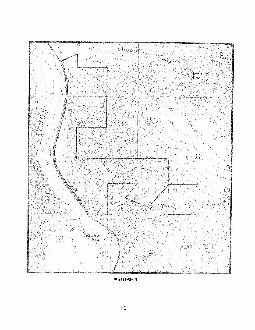
FIGURE 1

FIGURE 2. LAND SNAIL SITES IN LUCILE CAVES ACEC AND VICINITY
Map of Lucile Caves Area of Critical Environmental Concern [ACEC] and immediate
vicinity; scale and base as for previous figure. Numbered black circles are site numbers; for
description, see Appendix A. Areas with black fill were collected in detail and often were visited
more than once. Most of intervening and surrounding area was walked once, but not collected;
and hence is not numbered herein. For regional perspective, see Frest & Johannes (1995a. b);
see also Frest & Johannes (1995a, Appendix B17).

FIGURE 2
F4

FIGURE 3. DISTRIBUTION OF OREOHELIX IDAHOENSIS IDAHOENSIS (NEWCOMB, 1866) ON LUCILE CAVES ACEC AND IM EDIATE VICINITY
Map of Lucile Caves Area of Critical Environmental Concern [ACEC] and immediate
vicinity, showing distribution of the C2 candidate land snail Oreohelix idahoensis idahoensis
(Newcomb, 1866). Scale and base as for previous two figures. Areas in red appear to have dead
shells only, but no live specimens; and may mark the former colony boundary. Yellow regions
have sparse occurrences of live Oreohelix idahoensis idahoensis. Green denotes areas
presently [I9941 with common live Oreohelix idahoensis idahoensis. Note occurrence of green
area surrounded not only by yellow, but red; possibly indicating former large population in
intervening or other areas currently with few or no live specimens. For regional perspective, see
Frest & Johannes (1995a).

FIGURE 3
F6

FIGURE 4. ILLUSTRATIONS OF OREOHELIX IDAHOENSIS IDAHOENSIS (NEWCOMB, 1866)
Illustrations of the federal C2 candidate species Oreohelix idahoensis idahoensis
(Nerwcomb, 1866). Upper figure is side (apertural) view by E. Johannes, x6. Lower figures are
respectively basal, two side (apertural), another basal, and top views, x2. Lower specimens from
Lucile Caves ACEC, after Pilsbry (1 939).

FIGURE 4

Copyright © 2022 FDOKUMEN