2014 - The process of ghost-rock karstification and its role in the formation of caves
133
The process of ghost-rock karstification and its role in the formation of cave systems C. Dubois, Y. Quinif, J.-M. Baele, L. Barriquand, A. Bini, L. Bruxelles, G. Dandurand, C. Havron, O. Kaufmann, B. Lans, R. Maire, J. Martin, J. Rodet, M.D. Rowberry, P. Tognini, A. Vergari PII: S0012-8252(14)00015-4 DOI: doi: 10.1016/j.earscirev.2014.01.006 Reference: EARTH 1949 To appear in: Earth Science Reviews Received date: 3 July 2013 Accepted date: 21 January 2014 Please cite this article as: Dubois, C., Quinif, Y., Baele, J.-M., Barriquand, L., Bini, A., Bruxelles, L., Dandurand, G., Havron, C., Kaufmann, O., Lans, B., Maire, R., Martin, J., Rodet, J., Rowberry, M.D., Tognini, P., Vergari, A., The process of ghost- rock karstification and its role in the formation of cave systems, Earth Science Reviews (2014), doi: 10.1016/j.earscirev.2014.01.006 This is a PDF file of an unedited manuscript that has been accepted for publication. As a service to our customers we are providing this early version of the manuscript. The manuscript will undergo copyediting, typesetting, and review of the resulting proof before it is published in its final form. Please note that during the production process errors may be discovered which could affect the content, and all legal disclaimers that apply to the journal pertain.
Transcript of 2014 - The process of ghost-rock karstification and its role in the formation of caves
�������� ����� ��
The process of ghost-rock karstification and its role in the formation of cavesystems
C. Dubois, Y. Quinif, J.-M. Baele, L. Barriquand, A. Bini, L. Bruxelles,G. Dandurand, C. Havron, O. Kaufmann, B. Lans, R. Maire, J. Martin, J.Rodet, M.D. Rowberry, P. Tognini, A. Vergari
PII: S0012-8252(14)00015-4DOI: doi: 10.1016/j.earscirev.2014.01.006Reference: EARTH 1949
To appear in: Earth Science Reviews
Received date: 3 July 2013Accepted date: 21 January 2014
Please cite this article as: Dubois, C., Quinif, Y., Baele, J.-M., Barriquand, L., Bini,A., Bruxelles, L., Dandurand, G., Havron, C., Kaufmann, O., Lans, B., Maire, R.,Martin, J., Rodet, J., Rowberry, M.D., Tognini, P., Vergari, A., The process of ghost-rock karstification and its role in the formation of cave systems, Earth Science Reviews(2014), doi: 10.1016/j.earscirev.2014.01.006
This is a PDF file of an unedited manuscript that has been accepted for publication.As a service to our customers we are providing this early version of the manuscript.The manuscript will undergo copyediting, typesetting, and review of the resulting proofbefore it is published in its final form. Please note that during the production processerrors may be discovered which could affect the content, and all legal disclaimers thatapply to the journal pertain.
ACC
EPTE
D M
ANU
SCR
IPT
ACCEPTED MANUSCRIPT
1
The process of ghost-rock karstification and its role in the formation of cave systems
C. Dubois1,2, Y. Quinif1, J.-M. Baele1, L. Barriquand3, A. Bini4, L. Bruxelles5,6,7, G. Dandurand8,
C. Havron9, O. Kaufmann1, B. Lans8, R. Maire8, J. Martin3, J. Rodet10, M.D. Rowberry11, P.
Tognini4, A. Vergari12.
1 Department of Geology and Applied Geology, Faculty of Engineering, University of Mons,
rue de Houdain 9, B-7000 Mons, Belgium ([email protected],
[email protected], [email protected], [email protected]);
2 Fond National de la Recherche Scientifique (FNRS), rue d’Egmont 5, B-1000 Brussels,
Belgium;
3 Association de Recherche Paléoécologique en Archéologie (ARPA), Department of Earth
Science, University Claude Bernard, Lyon I, rue Dubois 2, F-69622 Villeurbanne, France
4 Department of Earth Science, University of Milan, via Mangiagalli 34, 20133 Milan, Italy
5 Institut National de Recherches Archéologiques Préventives (INRAP), rue Etienne Lenoir
561, F-30900 Nimes, France ([email protected]);
6 Travaux et Recherches Archéologiques sur les Cultures, les Espaces et les Sociétés
(TRACES), UMR 5608, Centre national de la recherche scientifique (CNRS), University of
Toulouse le Mirail, Allée Antonio Machado 5, 31058 Toulouse, France;
7 School of Geography, Archaeology and Environmental Studies (GAES), University of the
Witwatersrand, Jan Smuts Avenue 1, 2000 Johannesburg, South Africa;
8 Laboratoire de l’Aménagement, Développement, Environnement, Santé et Sociétés
ACC
EPTE
D M
ANU
SCR
IPT
ACCEPTED MANUSCRIPT
2
(ADES), UMR 5185, Centre national de la recherche scientifique (CNRS), University of
Bordeaux III, Esplanade des Antilles 12, 33607 Pessac, France
([email protected], [email protected], [email protected]);
9 Institut Interuniversitaire des Silicates, Sols et Matériaux (INISMa), Avenue Gouverneur
Cornez 4, B-7000 Mons, Belgium;
10 Laboratory of Continental and Coastal Morphodynamics, UMR 6143, Centre national de la
recherche scientifique (CNRS), University of Rouen, Place Emile Blondel, 76821Mont Saint
Aignan, France ([email protected]);
11 Department of Engineering Geology, Institute of Rock Structure and Mechanics, Academy
of Sciences of the Czech Republic, V Holešovičkách 41, 182 09 Prague 8, Czech Republic
12 SAGREX, Heidelberg Cement Group, Chaussée de la Hulpe 185, B-1170 Bruxelles, Belgium.
Corresponding author: Caroline DUBOIS, Department of Geology and Applied Geology,
Faculty of Engineering, University of Mons, 9 rue de Houdain, 7000 Mons, Belgium.
Telephone: + 3265374613; Fax: + 3265374610.
ACC
EPTE
D M
ANU
SCR
IPT
ACCEPTED MANUSCRIPT
3
Abstract: This paper presents an extensive review of the process of ghost-rock karstification
and highlights its role in the formation of cave systems. The process integrates chemical
weathering and mechanical erosion and extends a number of existing theories pertaining to
continental landscape development. It is a two stage process that differs in many respects from
the traditional single-stage process of karstification by total removal. The first stage is
characterised by chemical dissolution and removal of the soluble species. It requires low
hydrodynamic energy and creates a ghost-rock feature filled with residual alterite. The
second stage is characterised by mechanical erosion of the undissolved particles. It requires
high hydrodynamic energy and it is only then that open galleries are created. The transition
from the first stage to the second is driven by the amount of energy within the
thermodynamic system. The process is illustrated by detailed field observations and the
results of the laboratory analyses of samples taken from the karstotype area around
Soignies in southern Belgium. Thereafter, a series of case studies provide a synthesis of field
observations and laboratory analyses from across western Europe. These studies come from
geologically distinct parts of Belgium, France, Italy, and United Kingdom. The process of
ghost-rock karstification challenges a number of axioms associated the process of
karstification by total removal. On the basis of the evidence presented it is argued that it is
no longer acceptable to use karst morphologies as a basis with which to infer specific
karstogenetic processes and it is no longer necessary for a karst system to relate to base
level as ghost-rock karstification proceeds along transmissive pathways in the rock. There is
also some evidence to suggest that ghost-rock karstification may be superseded by
karstification by total removal, and vice versa, according to the amount of energy within the
thermodynamic system. The proposed chemical weathering and subsequent mechanical
erosion of limestone suggests that the development of karst terrain is related far more closely

ACC
EPTE
D M
ANU
SCR
IPT
ACCEPTED MANUSCRIPT
4
to the geomorphological development of aluminosilicate and siliceous terrains than is
generally supposed. It is now necessary to reconsider the origin of many karst systems in
light of the outlined process of ghost-rock karstification.
Keywords: Karstification; limestone dissolution; chemical weathering; ghost-rock;
speleogenesis; western Europe.
ACC
EPTE
D M
ANU
SCR
IPT
ACCEPTED MANUSCRIPT
5
Table of Contents
1. Introduction
2. Background
2.1 The traditional theory of karstification by total removal
2.1.1 Two simultaneous stages: chemical dissolution and mechanical erosion
2.1.2 The thermodynamic regime
2.1.3 The structure and feature geometry of the karst network
2.2 The recently proposed process of ghost-rock karstification
2.2.1 Process of ghost-rock karstification
2.2.2.1 Stage one: chemical dissolution
2.2.2.2 Intermediate stage: vadose evolution
2.2.2.3 Stage two: mechanical erosion
2.2.2 The thermodynamic regime
2.2.3 The structure and feature geometry of the karst network
3. The karstotype for ghost-rock karstification: Soignies, southern Belgium
3.1 The geological setting of the area
3.2 Field observations of ghost-rock features
3.3 Analytical investigations of the alterite
3.4 Subsequent erosion of the ghost rock features
3.5 A summary of the results in terms of ghost-rock karstification
4. Ghost-rock karstification in other geological settings
4.1 Belgium
4.1.1 The Tournaisian siliceous limestone of Tournai
4.1.2 The Dinantian oolitic limestone of Engis
ACC
EPTE
D M
ANU
SCR
IPT
ACCEPTED MANUSCRIPT
6
4.2 France
4.2.1 The Rupelian bioclastic limestone of Aquitaine
4.2.2 The Mid-Jurassic limestone of Burgundy
4.2.3 The Kimmeridgian oolitic limestone of Charente
4.2.4 The Jurassic dolomite of Les Grand Causses
4.2.5 The Cenomanian chalky limestone of Normandy
4.3 Italy
4.3.1 The Liassic silico-clay limestone of Lombardy
4.4 Great Britain
4.4.1 The Carboniferous argillaceous limestone of Pembrokeshire
5. Discussion
6. Conclusions
Acknowledgements
ACC
EPTE
D M
ANU
SCR
IPT
ACCEPTED MANUSCRIPT
7
1. Introduction
This manuscript presents the first comprehensive review of the process of ghost-rock
karstification and highlights its role in the formation of cave systems. It is a process that has
been investigated intensively by researchers from the Francophone karstological community
since the mid-1990s. However, as most of the studies have been published in French, this
review also enables the process of ghost-rock karstification to be presented to the wider the
karstological and geological communities for the first time. The process of ghost-rock
karstification offers an alternative to the traditional paradigm that exists within karstological
research, that of karstification by total removal, by separating chemical dissolution and
mechanical erosion into two very distinct stages. It has long been known that chemical
weathering of crystalline rocks leaves the less soluble materials - this process is commonly
recognised at or near the surface to form, for example, sandy regoliths or lateritic soils
(Bisdom, 1967; Meunier, 1977). This paper aims to demonstrate that the same fundamental
process also occurs in karst regions and that this process may extend to great depths.
It is well known that dissolution phenomena occur when calcium carbonate comes into
contact with water catalysed acid (Bögli, 1964; Caro, 1965; Roques, 1967; Thraikill, 1968;
Bakalowicz, 1975; Morse, 1983; Dreybrodt, 1987). Moreover, any type of acid can enhance
the rate of chemical dissolution, and this may come from the surface (e.g. soil and air), from
depth (e.g. hydrothermal), or from within the rock itself (e.g. bacterial oxidation). The in situ
weathering of limestone produces a residual material called alterite and this process is
called ghost-rock karstification due to the fact the rock retains the same physical
appearance despite having been greatly altered. Ghost-rock features have been found in
limestone (Schmidt, 1974; Martini, 1985; Quinif et al., 1993), dolomite (Bini, 2002; Bruxelles,
ACC
EPTE
D M
ANU
SCR
IPT
ACCEPTED MANUSCRIPT
8
2002a, 2002b) and chalk (Rodet, 1996). There was no direct evidence to link ghost-rock
karstification to the formation of cave systems until ten years ago despite strong
observational support (Rodet, 1999; Bruxelles, 2001; Bruxelles & Bruxelles, 2002; Rodet,
2002, 2003, 2004; Quinif et al., 2006). It was finally demonstrated experimentally following
the discovery of Quentin Cave in southern Belgium (Quinif & Maire, 2007; Quinif et al,
2014).
The first part of this manuscript describes the processes of karstification by total removal
and ghost-rock karstification then, for each, outlines their thermodynamic regime and their
structure and feature geometry. The second part details the ghost-rock features and
analytical properties of the alterite found around Soignies in southern Belgium. The third
part illustrates the process of ghost-rock karstification in geologically distinct parts of
western Europe: Belgium (the siliceous limestone of Tournai and the oolitic limestone of
Engis); France (the bioclastic limestone of Aquitaine; the limestone of Burgundy; the oolitic
limestone of Charente; the dolomite of Les Grand Causses; and the chalky limestone of
Normandy); Italy (the silico-clay limestone of Lombardy); and the United Kingdom (the
argillaceous limestone of Pembrokeshire). The manuscript concludes with a discussion of
some of the implications of this process. It is, in particular, suggested that there are far
greater similarities between the processes operating on karst and non-karst terrain than is
generally appreciated.
2. Background
2.1 The traditional process of karstification by total removal
The pioneering cave explorations carried out by the father of modern speleology, Édouard-

ACC
EPTE
D M
ANU
SCR
IPT
ACCEPTED MANUSCRIPT
9
Alfred Martel (e.g. Martel, 1894, 1900, 1928), have led to the study of innumerable karst
systems around the world (e.g. Van Den Broek et al., 1910; Courbon & Chabert, 1986; White
& Culver, 2012). The enduring paradigm in karstogenesis asserts that a karst network
develops as a result of the flow of chemically aggressive waters along an open discontinuity
in the bedrock. This occurs within certain hydrogeological contexts: vadose, epiphreatic, and
phreatic karstification (e.g. Gründ, 1914; Davis, 1930; Swinnerton, 1932; Rhodes & Sinacori,
1941; Bretz, 1942; Bögli, 1964; Caro, 1965; Renault, 1967; Roques, 1967; Thraikill, 1968;
Jennings, 1971; Herak & Stringfield, 1972; Nicod, 1972; Bakalowicz, 1975; Grillot & Guerin,
1975; Ford & Cullingford, 1976; Jakucs, 1977; Bögli, 1980; Morse, 1983; Bonacci, 1987;
Dreybrodt, 1987; Lohmann, 1988; White, 1989; Palmer, 1991; Salomon, 2006; Ford &
Williams, 2007; Gilli, 2011).
2.1.1 Two simultaneous stages: chemical dissolution and mechanical erosion
An acid-base reaction decomposes calcium carbonate into calcium and carbonate ions when
acidified water comes into contact with limestone. As the source of the acid must be
renewed, this reaction can only occur when there is flowing water, otherwise the solution
saturates in ions and the dissolution process is inhibited. Therefore, the karst system
develops along more permeable zones within the bedrock, such as along discontinuities - the
soluble parts of the discontinuity walls are gradually dissolved during this acid-base reaction.
Laboratory experiments have demonstrated that limestone dissolves progressively:
dissolution begins with the micritic constituent of the carbonate before later affecting the
bulkier particles such as sparitic crystals and fossils (Roques & Ek, 1973). In that
experimental study, the insoluble minerals, such as clays and quartz, and the as yet
undissolved particles fall to the bottom of the apparatus. During karstification by total
ACC
EPTE
D M
ANU
SCR
IPT
ACCEPTED MANUSCRIPT
10
removal, when the rock is partly dissolved, the flow of water simultaneously removes both
the dissolved species and insoluble particles. This leads to the creation of an open void - no
material remains as a product of the karstification phenomenon. The open void may then
develop in different way according to the flow conditions: it may continue to expand, it may
become filled with sediments, or it may simply become inactive. In summary, the process of
karstification by total removal is characterised by: (i) chemical dissolution of the soluble
elements of the rock; (ii) simultaneous removal of the dissolved species and mechanical
erosion of the undissolved particles; and (iii) the creation of open voids.
2.1.2 The thermodynamic regime
From a thermodynamic perspective, karst is a dissipative system (Prigogine, 1962; Glansdorff &
Prigogine, 1971). The initial conditions of the system are essential as these determine
whether water is able to flow through the rock. It is necessary to have open discontinuities
such as bedding planes, joints, or faults in extension. The energies dissipated are chemical
and hydrodynamic (Quinif, 1999). The chemical energy is obtained from the presence of an
acid in the water and it enables dissolution of the rock while the hydrodynamic energy is
obtained from either a potential difference in the water pathway or from hydrothermalism.
The hydrodynamic energy must be sufficiently high for the water to both remove the dissolved
species and to erode the undissolved particles. It has been shown that, in contrast to
preconceived ideas, these energies must be dissipated simultaneously to form a karst network
(Quinif, 1998). The subsequent development of galleries also relates to the energy of the
water: if the stream still has high energy, it will continue to erode the rock and the gallery will
widen while, conversely, if the stream has low energy, any transported particles will be
deposited and the gallery will seal (Renault, 1967). Finally, if the flow stops or if the gallery is
ACC
EPTE
D M
ANU
SCR
IPT
ACCEPTED MANUSCRIPT
11
dewatered, it becomes inactive. Initially, laminar flow passes through a fractured aquifer. The
first phase of karstification by total removal consists of widening the discontinuities and
mechanical relaxation of the relief - this corresponds to the “protocave” phase of Ford &
Williams (2007). However, as the subterranean pathway widens, the behaviour of the aquifer
becomes nonlinear: Darcy’s law is no longer applicable. From that moment, the aquifer
becomes structured by individualising two features: the main drains, with high transmissivity
but low capacity, and annex systems, with low transmissivity and high capacity (Mangin, 1975,
1982). This represents the transition from the joint lattice system to a karst network.
2.1.3 The structure and feature geometry of the karst network
The first factor that determines the structure of the karst network is the possibility that water
is able to access to the bedrock. This geometry, therefore, depends on the interaction between
the joint lattice and the tectonics stress (Quinif et al., 1997). The second factor depends on the
geometric constraint as it is this that imposes the direction of water flow between the input
and the output within the system - this direction is imposed by the relief. During the
development of the karst system, the second factor becomes more dominant: the system is
hydraulically structured (Havron et al., 2004). Therefore, under these conditions, caves systems
found at several levels are commonly related to deepening piezometric levels or glacial stages
(Ek, 1961; Quinif, 1989b; Audra, 1994; Jolivet & Martin, 2008). Karst networks comprise
combinations of galleries, shafts, and chambers while those parts of the karst system beneath
the surface are called endokarst. These galleries, shafts, and chambers may be empty or filled
with fluvial sediments or concretions. A fossilised karst is a karst that is disconnected from
active flow and erosional processes while a fossilised karst that has been sealed by a
transgression and covered by sediments is termed a palaeokarst (Bates & Jackson, 1980;
ACC
EPTE
D M
ANU
SCR
IPT
ACCEPTED MANUSCRIPT
12
James & Choquette, 2012). Furthermore, the galleries themselves may have several types of
morphologies including cupolas, overdeepings, side benches, or potholes while their walls
may present different microforms such as anastomosis, channels, floots, or swage (Bretz,
1942; Renault, 1967). These networks are accessible to humans and can be explored in
speleology.
2.2 The recently proposed theory of ghost-rock karstification
The study of weathered limestone features has intensified following their discovery in the
Carboniferous limestone of southern Belgium (Quinif et al., 1993; Vergari & Quinif, 1997;
Vergari, 1998; Kaufmann et al., 1999; Kaufmann & Quinif, 1999; Quinif, 1999; Kaufmann,
2000; Havron et al., 2007; Quinif et al., 2011; Quinif et al., 2012; Dubois et al., 2014;
Kaufmann & Deceuster, 2014; Quinif et al., 2014). These features and their associated
residual alterite have now been investigated in many parts of western Europe (Fig. 1):
France – Alps (Audra et al., 2007), Aquitaine (Lans et al., 2006; Dubois et al., 2011;
Courreges-Blanc & Maire, 2014), Burgundy (Barriquand et al., 2011a, 2012), Charente
(Dandurand, 2011; Dandurand & Maire, 2011; Dandurand et al., 2014), Languedoc
(Bruxelles, 2001; Bruxelles & Bruxelles, 2002; Bruxelles & Wienin, 2010), Normandy (Rodet,
1996, 1999, 2014); Great Britain – Pembrokeshire (Rowberry et al., 2014); Italy – Alps
(Audra et al., 2007), Lombardy (Tognini, 1999a, 1999b; Bini, 2002; Bini et al., 2012);
Netherlands – Limburg (Willems et al., 2007); Switzerland – Alps (Audra et al., 2007; Cailhol
& Meury, 2012). Furthermore, instances of ghost-rock karstification are now known in South
Africa (Maire et al., 2013) and Brazil (Hardt et al., 2013).
2.2.1 The process of ghost-rock karstification

ACC
EPTE
D M
ANU
SCR
IPT
ACCEPTED MANUSCRIPT
13
2.2.1.1 Stage one: chemical dissolution
The process of ghost-rock karstification, as with karstification by total removal, begins with the
fundamental phenomenon of calcium carbonate dissolution by acidified water. This dissolution
requires a flow of water in order to renew the acid solution and, therefore, a weathering
network develops from more permeable zones within the rock. The kinetics of carbonate
dissolution are the same as they are for karstification by total removal: dissolution begins with
the micritic constituent of the carbonate before later affecting the bulkier particles while
leaving the insoluble elements intact. As the rock weathers, the seeping water removes the
dissolved species but, unlike the process of karstification by total removal, the undissolved
materials are not eroded simultaneously - they remain in place within the rock matrix.
Therefore, during this stage of ghost-rock karstification, no open voids form but instead the
ghost-rock features contain a residual material termed ‘alterite’ (Fig. 2) (cf. Section 3.2).
2.2.1.2 Intermediate stage: vadose evolution
For as long as the ghost-rock feature remains below the piezometric surface, the water
present in the alterite applies an interstitial pore pressure on the particles of the material
and, therefore, the structure of the alterite is preserved in its original state. However, if the
groundwater level drops below the ghost-rock feature, the interstitial water drains away
from the alterite and causes its collapse due to the effect of gravity - the ghost-rock feature
is settled and a macroscopic void appears at the top of the ghost-rock feature. This occurs
when the piezometric level is deepening (cf. Section 4.1.1 - Tournai, Belgium) or when there is
a fluctuating piezometric level (cf. Section 4.2.3 - Charente, France). In contrast, if the ghost-
rock feature is close to the ground surface, it immediately swallows the overburden and
generates a doline or a collapse sinkhole. Moreover, if the ghost-rock feature is fully
ACC
EPTE
D M
ANU
SCR
IPT
ACCEPTED MANUSCRIPT
14
encapsulated within bedrock, compaction of the alterite may weaken the rock at the top of the
feature and this is able to cause the roof to collapse (Dandurand, 2011).
2.2.1.3 Stage two: mechanical erosion
During the subsequent geological evolution of area the alterite is emptied from the ghost-rock
feature by regressive mechanical erosion (Fig. 3) (cf. Section 4.2.1 - Aquitaine, France). Upon
completion the new void has the same form as a classical gallery. It may then continue to
develop in one of the various ways outlined for karstification by total removal: it may
continue to expand, it may become filled with sediments, or it may simply become inactive
(cf. Section 4.2.2 - Burgundy, France and Section 4.3.1 - Lombardy, Italy). In summary, the
process of ghost-rock karstification is characterised by: (i) chemical dissolution of the
soluble elements of the rock; (ii) removal of the dissolved species; (iii) creation of a
weathered feature filled with the remaining alterite. Subsequently, when the appropriate
conditions are met, there may be (iv) mechanical erosion of the undissolved particles and (v)
the creation of an open gallery.
2.2.2 The thermodynamic regime
From a thermodynamic perspective, it is possible to differentiate between karstification by
total removal and ghost-rock karstification due to the prevailing environmental conditions
(Quinif, 1998, 2010). As with karstification by total removal, the ghost-rock karst system
may be considered as a thermodynamic system with initial conditions which then exchanges
energy and matter with the outside world (Fig. 4). The initial conditions of the system are
the same - they enable water to flow through the rock via permeable pathways such as
bedding planes, joints, faults in extension, and also porous heterogeneities within the rock.
ACC
EPTE
D M
ANU
SCR
IPT
ACCEPTED MANUSCRIPT
15
For ghost-rock karstification to occur there needs to be chemical energy to convert the
bedrock into a dissolved phase (ions such as Ca2+, HCO3-) and a non-dissolved phase (sparitic
calcite, clay minerals, fossils, insoluble minerals) and enough hydrodynamic energy to
ensure the circulation of fluids within the system. However, the hydrodynamic energy must
be very weak to ensure that there is no mechanical erosion of the residual alterite. It is only
during later geological evolution, when there is sufficient hydrodynamic energy, that there
can be mechanical erosion of the undissolved particles and the creation of an open karst
gallery. Therefore, to initiate the process of karstification, it is no longer necessary to invoke
the “protocave” phase of Ford (Ford & Williams, 2007). The link between the input and the
output of the system is ensured by the matrix porosity and discontinuities within the rock. In
ghost-rock karstification, as water flows through the porous matrix of the alterite, the flow
remains laminar and Darcy’s law is applicable. A ghost-rock karst system can also be thought of
as a system comprising main drains (well-connected zones in which the alterite presents high
permeability) and annex systems (more isolated zones of alterite).
2.2.3 The structure and feature geometry of the karst network
The structure of karst network created by ghost-rock karstification is dictated by the initial
flow pathways within the rock. The geometry may depend on the combination of the joint
lattice and the tectonic stresses, as with karst networks created by total removal, or on the
distribution of highly permeable zones within the rock. However, the direction between the
input and output of the water in the system does not affect the weathering. Therefore, many
emptied ghost-rock systems present a labyrinthine-type network (Fig. 5) with dead-end
galleries and no hierarchy to the network organisation (Bruxelles & Bruxelles, 2002).
Moreover, as the weathering propagates through highly permeable hydraulic pathways, the
ACC
EPTE
D M
ANU
SCR
IPT
ACCEPTED MANUSCRIPT
16
network may be spread over a number of different levels and the emptied caves from such
networks bare no relation to the water table or with glacial phases (cf. Section 3.1.1 -
Lombardy, Italy). The isovolumetric material is an alterite defined as “a weathering product
with slight or no change in rock volume and remnant rock structure” (Delvigne, 1998). This
material, comprising the less soluble elements of the rock, is very different from its parent.
The weathering affects the rock matrix in several ways: as the calcium carbonate is dissolved
there is a change in the overall composition of the material and its structure, while removal
of the dissolved species creates a secondary porosity within the matrix, altering the
hydrological properties of the rock and weakening. However, the alterite keeps the original
structure of the bedrock and insoluble elements remain distinguishable (e.g. fossils, chert,
calcite veining). The ghost-rock karst network may ramify through the bedrock (Fig. 6).
A nomenclature of ghost-rock features can be established to highlight their characteristic
geometries: (i) wide weathered areas: these are situated beneath the overburden and they
are often affected by compaction due to their dimensions which draws down the overlying
cover (Fig. 7a); (ii) weathered corridors: these are vertical pipes which are here seen to cross
the quarry for several tens of meters (Fig. 7b); (iii) weathered galleries: these are longitudinal
branches of the weathering network with no apparent connection to the surface; (iv) ghost-
endokarst: these are cross-sectional branches of the weathering network with no apparent
connection to the surface (Fig. 7c). These features are all filled with alterite and can be seen to
preserve the overall structure of the parent rock. A fossilised ghost-rock feature sealed by
sediments, is designated a ghost-palaeokarst, following the terminology of Bates & Jackson
(1980). It is important to note that some morphologies that have commonly been related to
karstification by total removal, such as cupolas and anastomosis, are also found in ghost-
ACC
EPTE
D M
ANU
SCR
IPT
ACCEPTED MANUSCRIPT
17
rock features still containing their alterite (Fig. 8). It is possible to observe ghost-rock
features in quarries where the bedrock is exposed but their passages can only be explored
by speleologists once they have been emptied. However, once emptied of their alterite, the
ghost-rock features will develop as classical galleries and present the same profiles.
3. The karstotype for ghost-rock karstification: Soignies, southern Belgium
3.1 The geological setting of the area
The karstotype defines the area in which a specific karst feature or process is most
representative and, for ghost-rock karstification, this area is found around Soignies in
southern Belgium (Doremus & Hennebert, 1995). It is recognised in the Carboniferous
bedrock and it appears that the Upper Tournaisian limestones are particularly susceptible to
this karstification process. These are very compact pure fossiliferous limestones with low
bulk porosity and a dark blue-grey colour. The Palaeozoic strata in hereabouts have a
monoclinal structure oriented North 100° and dipping 12° to the South (Fig. 9). Individual
beds are from 0.7 m to 2 m thick while the total thickness of the unit in this area is about
125 metres. The strata are unconformably overlain by Cenozoic overburden. These units are
affected by intensive fracturing that follows three main directions: N60°E, N100°E, and
N120°E (Quinif et al., 1997). Due to its quality, a large number of quarries around Soignies
continue to exploit the limestone as an ornamental stone, and these quarries represent
exceptional places in which to observe karst phenomena.
3.2 Field observations of ghost-rock features
In this area it is possible to study ghost-rock features as soon as they appear in fresh quarry
faces (Quinif et al., 2006; Havron et al., 2007; Quinif, 2010a; Quinif & Maire, 2010; Quinif et

ACC
EPTE
D M
ANU
SCR
IPT
ACCEPTED MANUSCRIPT
18
al., 2012; Dubois et al., 2014; Quinif et al., 2014). The ghost-rock features spread vertically
along the permeable pathways such as joints and fractures in the bedrock. It is common for
joints, in particular, to be affected by the weathering process and it is possible to see numerous
weathered corridors beneath the overburden and ghost-endokarsts at several tens of meters
below the surface (Fig. 7). The weathered corridors and ghost-endokarsts may have widths
from centimetres to decametres and they can deepen to several tens of metres. These
features are often highly concentrated and, due to the fact that the weathering affects each
of the three different joint systems, they coalesce to form a three-dimensional maze.
However, in this region, perhaps the most important observations regarding the process of
ghost-rock karstification have been made at Nocarcentre Quarry and Gauthier-Wincqz
Quarry.
3.3 Analytical investigations of the alterite
The weathered alterite from Clypot Quarry has been subjected to mineralogical and
petrophysical analyses in order to understand the development of the alterite properties
during the weathering process (Dubois et al., 2014). In that study, samples were obtained
from a ghost-rock endokarst, and were selected to represent a wide range of weathering
intensities (Fig. 13). The samples followed a stratigraphic continuity to ensure the
homogeneity of the original bedrock. Its measured properties demonstrate that it is a
compact limestone (density of ~ 2.65 g/cm³ and porosity of less than 2 %), very pure (mass
content of the CaCO3 is ~ 98 %), impermeable (permeability of less than 0.6 mD), and it has
a high resistance (a representation of the mechanical strength of the samples is given by
resistance force to drilling - here it is more than 1000 N) (Fig. 14). However, the
petrophysical and mechanical properties of the limestone are greatly modified by the
ACC
EPTE
D M
ANU
SCR
IPT
ACCEPTED MANUSCRIPT
19
weathering. The grades I to V correspond to degrees of weathering that can only result from
dissolution of the calcium carbonate - the resulting alterite is light (density is about 1.5
g/cm³), highly porous (porosity of more than 45 %), permeable (permeability of about 10 D),
and it has almost no mechanical strength (resistance force ~ 0 N). It does, however, still
consist mainly of CaCO3 (~ 85 %). In contrast, the CaCO3 content drops dramatically, to 40 %,
at the centre of this weathering feature (grade VI). This zone appears to collect material
inputs such as clay and organic matter although the reasons for this are not entirely clear.
XRD analyses on crystallised minerals have shown a limestone mainly composed of calcite
and, as the weathering proceeds, it decreases the calcite content and highlights secondary
minerals (mainly quartz but also dolomite, gypsum, pyrite, and clays). XRD analyses on
oriented aggregates have enabled the clay minerals to be determined. The fresh rock
contains illite and trace kaolinite whereas smectite is detected in the weathered rocks and
its concentration increases with increasing weathering intensity.
Furthermore, polished thin-sections of resin-impregnated samples were made to examine
the effects of the weathering on the microstructure of the rock. They were analysed under
optical and cathodoluminescence (CL) microscopy (Fig. 15). In fresh rock (#130) the
limestone matrix exhibits a dull brownish luminescence under CL and the crinoids show a
dark CL. Diagenetic dolomite also occurs as bright red-luminescing rhombs scattered in the
matrix of the rock and many of these rhombs exhibit bright yellow-luminescing spots
concentrated along their outer rim. These spots constitute calcite replacing dolomite
(dedolomite), which typically results from the exposure of dolomite to fluids with a low
Mg/Ca ratio such as meteoric water (Ayora et al., 1998). The porosity of the fresh rock
cannot be resolved with this observation method. In moderately-weathered rock (#20) the
ACC
EPTE
D M
ANU
SCR
IPT
ACCEPTED MANUSCRIPT
20
CL analysis reveals that all the dolomite rhombs have been dedolomitised, as demonstrated
by their conspicuous bright yellow luminescence. It is not yet possible to recognise pores in
the thin-section, due to their very small size, despite the fact that the petrophysical analyses
indicate that the porosity of the sample should be about 30 %. In contrast, the highly-
weathered rock (#08) shows a network of very fine pores under optical microscopy. Most
crinoids, about 90 %, present cracks that are influenced by cleavage planes and
dedolomitisation affects the dolomite inclusions that are located along these cracks. The
numerous dolomite inclusions scattered in crinoids result from diagenetic stabilisation of
the magnesian calcite produced by echinoderms (Blake et al., 1984). The completely
weathered rock (#04 and #02a-b) has a crumbly appearance due to the fact that a large part
of the matrix has been dissolved and its fossils corroded. It is very obviously associated with
a high porosity. Sample #02b presents the transition from the completely weathered grade
to the residual soil grade, during which the matrix calcite suddenly disappears. In the
residual soil (#02b-c and #00) the matrix is no longer luminescent and the only remaining
calcite is found in relic crinoids while gypsum crystals are observed as radiating needles
(#02c). There are also many quartz grains and kaolinite patches as indicated by a deep blue
luminescence. However, in the very centre of the weathered zone (#00), extraneous mineral
deposits flank the pore and crack walls. These are mainly quartz with some zircons. Detrital
grains and kaolinite are major components of the Lower Cretaceous clayey sands overlying
the weathered limestone and it is, therefore, likely that they progressed down open
fractures in the limestone and were subsequently incorporated into the residual soil
material. The gypsum is of secondary origin and forms as a result of the reaction between
carbonate and the sulphuric acid produced by pyrite oxidation which is a common mineral
in the Tournaisian limestone. Finally, scanning electron microscope analyses on samples
ACC
EPTE
D M
ANU
SCR
IPT
ACCEPTED MANUSCRIPT
21
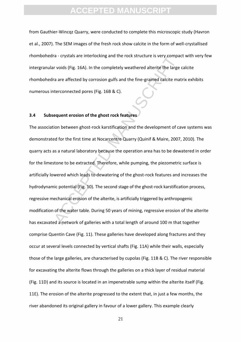
from Gauthier-Wincqz Quarry, were conducted to complete this microscopic study (Havron
et al., 2007). The SEM images of the fresh rock show calcite in the form of well-crystallised
rhombohedra - crystals are interlocking and the rock structure is very compact with very few
intergranular voids (Fig. 16A). In the completely weathered alterite the large calcite
rhombohedra are affected by corrosion gulfs and the fine-grained calcite matrix exhibits
numerous interconnected pores (Fig. 16B & C).
3.4 Subsequent erosion of the ghost rock features
The association between ghost-rock karstification and the development of cave systems was
demonstrated for the first time at Nocarcentre Quarry (Quinif & Maire, 2007, 2010). The
quarry acts as a natural laboratory because the operation area has to be dewatered in order
for the limestone to be extracted. Therefore, while pumping, the piezometric surface is
artificially lowered which leads to dewatering of the ghost-rock features and increases the
hydrodynamic potential (Fig. 10). The second stage of the ghost-rock karstification process,
regressive mechanical erosion of the alterite, is artificially triggered by anthropogenic
modification of the water table. During 50 years of mining, regressive erosion of the alterite
has excavated a network of galleries with a total length of around 100 m that together
comprise Quentin Cave (Fig. 11). These galleries have developed along fractures and they
occur at several levels connected by vertical shafts (Fig. 11A) while their walls, especially
those of the large galleries, are characterised by cupolas (Fig. 11B & C). The river responsible
for excavating the alterite flows through the galleries on a thick layer of residual material
(Fig. 11D) and its source is located in an impenetrable sump within the alterite itself (Fig.
11E). The erosion of the alterite progressed to the extent that, in just a few months, the
river abandoned its original gallery in favour of a lower gallery. This example clearly
ACC
EPTE
D M
ANU
SCR
IPT
ACCEPTED MANUSCRIPT
22
illustrates that cave systems are able to develop over several levels without needing a
corresponding change in base level.
In Gauthier-Wincqz Quarry, a more complicated type of ghost-rock endokarst feature can be
observed. This has the morphology of a keyhole (Fig. 12) and the filling material is
characterised by three distinct units (Quinif et al., 1993; Quinif et al, 2012). The uppermost
unit comprises stratified silts which unconformably overlie the underlying deposits, the
middle unit comprises fluvial deposits in which large weathered quartz pebbles are found
within a finer matrix, and the lowermost unit comprises the remaining alterite derived from
the weathering of the surrounding limestone. It has been compacted due to the weight of
the overlying sediments. The analysis of the material encased within this ghost-rock
endokarst feature demonstrates that it was, at one time, an empty gallery through which
water flowed. It is not possible to say with certainty how this gallery formed. The flow must
have had sufficient hydrodynamic energy to carry the pebbles and, therefore, it is
reasonable to assume that any residual alterite had already been excavated. However, the
pebbles are now highly weathered and they could not have been transported in this state by
the stream. Therefore, it appears that both weathering of the pebbles and weathering of
the underlying limestone occurred after the creation of an open gallery. This example
suggests that, if the right hydrodynamic conditions are met, alterite can be produced after
the creation of an open void irrespective of whether the void formed as a result of
karstification by total removal or by ghost-rock karstification.
3.5 A summary of the results in terms of ghost-rock karstification
Lithology: limestone and dolomitic limestone from the Upper Tournaisian.

ACC
EPTE
D M
ANU
SCR
IPT
ACCEPTED MANUSCRIPT
23
Initial conditions: the initial permeability of the bedrock was conditioned by a phase
of tectonic extension between the Upper Jurassic and Lower Cretaceous (Vandycke
& Bergerat, 1989; Vandycke, 2002). This created open vertical joint sets: N60°E,
N150°E and N110°E.
Timing of ghost-rock karstification: during emergence in the Upper Jurassic and
Lower Cretaceous.
Chemical energy: there was abundant chemical energy due to the hot and wet
climate.
Hydrodynamic energy: there was only low hydrodynamic potential due the subdued
relief.
Subsequent development:
o Thanetian: marine transgressions during which the karst becomes a
palaeokarst;
o Danian: a disturbance, probably tectonic, generated underground flow. Some
of the pseudoendokarsts were emptied of their alterite and replaced by a
fluvial detrital series (Quinif et al., 2006). Caves with cupolas of metric
dimensions formed and were then fossilised by transgressions during the
Thanetian and Ypresian;
o Present: quarrying and pumping has lowered the piezometric level and
created new hydrodynamic potential so that, in the quarries, the ghost-rock
features are emptied to become speleological caves. In other places, the
alterite compacts, leading to the formation of sinkholes.
4. Ghost-rock karstification in other geological settings
ACC
EPTE
D M
ANU
SCR
IPT
ACCEPTED MANUSCRIPT
24
This section presents a series of case studies that have investigated ghost-rock features
across western Europe. These case studies come from geologically distinct parts of Belgium,
France, Italy, and United Kingdom. Each offers an outline of the regional geology, a
description of the ghost-rock features, and a summary of the available analytical results. It is
clear that ghost-rock karstification affects several lithologies and that the weathering
process may produce a range of karst features. In addition, the structure and organisation of
ghost-rock networks are emphasised.
4.1 Belgium
4.1.1 The Tournaisian siliceous limestone of Tournai
The city of Tournai is located in southwest Belgium close to the border with France (Fig. 17).
The bedrock in this region consists of Lower Carboniferous Tournaisian limestone overlain
unconformably by deposits from the Mesozoic and Cenozoic (Hennebert & Doremus, 1997a,
1997b). This dark micritic limestone includes many chert beds. It also incorporates a three-
dimensional interstitial network that comprises 12 % microcrystalline silica and 8 % clay. It
has long been known that this argillaceous-sand network remains intact as calcium
carbonate dissolution proceeds during weathering (Camerman, 1947). The bedrock
structure results from oblique dextral compression during the late-Hercynian and the
central part of the region comprises the faulted anticline of Melantois-Tournaisis. In this
region the formations dip sub-horizontally while major right-lateral strike-slip faults trend
from east to west. These limestones form part of the great Carboniferous aquifer of
Wallonia.
The ghost-rock karst features in this region are represented by weathered corridors and
ACC
EPTE
D M
ANU
SCR
IPT
ACCEPTED MANUSCRIPT
25
ghost-palaeokarsts filled with their alterite. The corridors are aligned according to the
fracture directions and they may attain widths of up to ten metres along with depths and
lengths of several tens of metres. The ghost-palaeokarst encountered at “Pic-à-glace Cave”,
discovered during quarrying, represents the historical karstotype for ghost-rock
karstification (Fig. 18). It has a height of seven metres and a variable width from one to three
metres (Vergari, 1996, 1998). The residual alterite still remains in the ghost-palaeokarst
although it has been deformed slightly due to compaction under its own weight caused by
dewatering of the quarry. This has led to the formation of a void at the top of the ghost-
palaeokarst. It is clear that specific levels, in particular the chert beds, can be traced from
the fresh rock through the alterite while the initial fracture is still recognisable in the centre
of the feature. The walls of this ghost-palaeokarst are shaped with cupolas.
The fresh rock and the alterite at the centre of Pic-à-glace Cave have been subjected to
petrophysical analyses (Kaufmann et al., 1999; Kaufmann, 2000). The density of the fresh
rock is about 2.8 g/cm³ while its porosity is almost zero. In contrast, the density of the
alterite drops to 0.9 g/cm³ while its porosity increases to 65 %. The ratio of Ca/Si is 2.2 for
the fresh rock and 0.05 for the alterite while the ratio of Al/Si goes from 0.15 in the fresh
rock to 0.1 in the alterite. These results reflect carbonate dissolution leaving a siliceous
skeleton. The SEM analyses on a sample of fresh rock and a sample of alterite (Fig. 19)
shows an almost complete loss of calcite (Kaufmann et al., 1999). The weathering process
induces high interconnected porosity while leaving a framework of silica grains that ensures
the mechanical stability of the alterite.
4.1.2 The Dinantian oolitic limestone of Engis
ACC
EPTE
D M
ANU
SCR
IPT
ACCEPTED MANUSCRIPT
26
The town of Engis is located near the city of Liège in eastern Belgium. The bedrock consists
of a tectonised lens of Dinantian limestone (Fig. 20) wedged between the Eifelian Fault to
the south and the Yvoz-Ramet Fault to the north (Quinif et al., 2011). The limestone beds
are massive with sub-vertical dips while it is cut by two main joint sets: N110°N and N25°W.
In this region the formations affected by ghost-rock karstification are very pure oolitic and
bioclastic limestones. The weathering is represented by a maze of weathered strips that
follow both the stratification and the two joint sets (Fig. 21). These strips have widths
ranging from few decimetres to several meters and they are filled with a macroscopically
powdery, loose, and friable residual alterite. A series of six samples were obtained from a
ghost-rock feature that has developed from a stratification bed (Fig. 21). Due to the fact that
the weathering spread from the bedding plane into the stratum, the samples taken to
represent different weathering states are not in stratigraphic continuity, but are instead
perpendicular to it.
The mineralogical and petrophysical properties of these samples have been analysed in
order to assess their development according to the weathering intensity (Fig. 22). The fresh
rock is represented by the following values, given by the quarry: density = 2.55 g/cm³;
porosity = 0.5 %; and mass content in CaCO3 = 99 %. In contrast, analyses of the alterite
shows that these values have decrease to: density = 1.4 g/cm³; porosity = c. 50 %; and mass
content in CaCO3 = 79 %. These results reflect an intermediate weathering state in which the
weathering process stopped before the carbonates were completely dissolved and before
the arrival of exogenous material. In contrast to that described from Pic-à-glace Cave there
has been no compaction of the alterite at this site. XRD analyses of crystallised minerals
show a limestone essentially composed by calcite and in which the calcite content decreases

ACC
EPTE
D M
ANU
SCR
IPT
ACCEPTED MANUSCRIPT
27
as a result of weathering. These analyses highlight that quartz represents the only impurity
while analyses on oriented aggregates highlight that illite represents the only clay mineral
found in each weathering state.
Thin sections of samples were prepared and analysed under cathodoluminescence
microscopy (Fig. 23). The slightly weathered rock (# 150) has a very complicated structure. It
is composed of a very thin and heterogeneous calcareous matrix while the disc-shaped
components are oolites. Drying forms are visible around the oolites, which probably date
from sedimentation or diagenesis of the limestone, while calcite has subsequently
crystallised in these open pores. The fractures developed later and affect the whole rock.
The moderately weathered rock (# 50) is less luminescent. The duller areas correspond to
the development of porosity as a result of dissolution of the matrix while the clastic quartz
crystals, shown in dark blue, are cemented to the carbonate matrix by diagenetic quartz.
The completely weathered rock (# 0) is mainly non-luminescent. The well crystallised calcite
is brighter while the matrix shows dissolution features that reveal secondary porosity.
4.2 France
4.2.1 The Rupelian bioclastic limestone of Aquitaine
Entre-deux-Mers is located in the Aquitaine region of southwest France (Fig. 24). The region
comprises a limestone plateau dating from the early Oligocene (Rupelian) whose formations
reflect repetitive emergence and submergence of the carbonate shelf. They are sub-
horizontally stratified and present numerous lateral facies variations along with a large
number of sedimentary structures (Lans et al., 2006). The karst phenomena affect the
“Calcaire à Asteries” limestone formation, which is situated between two impervious
ACC
EPTE
D M
ANU
SCR
IPT
ACCEPTED MANUSCRIPT
28
formations, the underlying late Eocene “Fronsadais Molasse” (Priabonian) and the overlying
late Oligocene “Agenais Molasse” (Chattian). The composition and texture of this highly
fossiliferous rock varies greatly although, in general, it is friable and porous due to its weak
diagenesis. The karst phenomena are reflected by two features: speleological caves and
ghost-rock features filled their alterite, visible in the quarries of the region.
The cave galleries are horizontal and comprise loss-resurgence systems crossed by an
underground river. The karst network “Trou de la Barrique” presents galleries whose
morphology helps to show the transition from ghost-rock feature to speleological cave (Fig.
25). The upper part of the gallery is characterised by a lens shape whose horizontal
extension follows a weathered stratum while the lower part is characterised by lateral
lateral banquettes and potholes. It is proposed that part of the alterite from the weathered
stratum was initially removed by mechanical erosion, thereby creating a pipe, whose
subsequent development can be regarded in classic fluvial terms - the pipe was
overdeepened by a subsurface flow of water. The ghost-rock features seen in the quarries of
the region are represented by horizontal galleries, connected by vertical joints, with heights
from one to several metres and lengths of sometimes more than one hundred metres
(Dubois et al., 2011). In cross-section they bare a striking morphological similarity to
speleological cave galleries (Fig. 26). These features initially developed from more porous
zones within the rock.
A series of three samples were taken from a ghost-rock feature in Piquepoche Quarry. The
mineralogical and petrophysical analyses show an increase in porosity which implies a
decrease in the density and proportion of CaCO3 (Fig. 27). The composition of the “Calcaire à
ACC
EPTE
D M
ANU
SCR
IPT
ACCEPTED MANUSCRIPT
29
Astéries” limestone was obtained by XRD. For all weathering intensities, the limestone only
comprises calcite and quartz while it can be seen that the weathering leads to a relative
increase in the quartz content. Furthermore, the clay-XRD spectrum shows that each sample
contains illite, kaolinite, and smectite. Thin sections of samples were prepared and analysed
under optical microscopy (Fig. 28). The slightly weathered Sample #1 shows a considerable
number of fossils and rolled grains composed of calcite, poorly cemented by a calcareous
micrite. There is significant primary porosity between the grains as a result of the weak rock
diagenesis while the voids are lined with sparitic calcite crystals. The weathered Sample #3
shows an increase in the porosity both by the number and size of voids and by the
appearance of small voids in the fossils and matrix - these voids are connected to form
microkarsts. The microscopic structure of both the rock and the fossils has also been erased
in this sample while the majority of pores are bordered by ocher clays (clay coatings). These
clays locally impregnate the micrite and underlie the fossils.
4.2.2 The Mid-Jurassic limestone of Burgundy
Macon and Cluny are located at the northeastern boundary between the Massif Central and
the plain of the Saone (Barusseau, 1966; Perthuisot, 1966; Rat, 2006; Dechamps, 2011). The
region comprises Palaeozoic basement consisting of granitoids and sedimentary rocks
overlain unconformably by sediments from the Mesozoic which are then, in turn, overlain
unconformably by fluviolacustrine sediments from the Cenozoic (Fig. 29). It has been
subjected to two extensional stages during or after the Mesozoic (Quesne et al., 2000). The
first occurred from the Aalenian to the Bajocian in association with rifting of the Piemont-
Liguria Ocean and is characterised by normal microfaults with metre-scale slip and shallow
dips (40-60°). The second occurred in the Oligocene and corresponds to the establishment
ACC
EPTE
D M
ANU
SCR
IPT
ACCEPTED MANUSCRIPT
30
of the Bressan Graben - this period represents a general phase of extension across certain
parts of western Europe during which a number of grabens formed (i.e. the Rhine Graben
and the Forez Graben). This phase of east-west extension is responsible for the current
structure in which tilted blocks dip towards the Saone in Macon. This tilting was
accommodated along unconformable normal faults that generally trend in a north-south
direction (N10-20°E). These steeply dipping faults (70-80°) are predominately Hercynian
structures reactivated by new contemporary stress fields in the Cenozoic. The karst
phenomena affect the carbonates dating from the Middle Jurassic while the ghost-rock
features are observed in relation to both tectonic episodes.
In the quarry of La Salle (Fig. 30A) ghost-endokarst features are found in Upper Aalenian to
Bajocian crinoidal limestones and these are associated with joints developed in the Jurassic.
The transition from fresh rock through slightly weathered rock and on to completely
weathered limestone has been observed in several places. The alterite comprises 49 % silt
and 41 % sand while the coarsest fractions consist only of fossil debris. It is thought that the
tectonic block movements during the Oligocene caused some of the ghost-rock features to
be emptied of their alterite including that which created the “well with ribs” of Macon (e.g.
Donzy Perthuis (Fig. 30B)).
The endokarst of Azé represents the downstream part of a loss-resurgence system oriented
north-south following the direction of the main geological structures (Guillot et al., 2005). It
comprises two parallel galleries that exit onto a valley slope (Fig. 31). The shorter of these,
Dry Cave, runs for 436 m in Upper Bajocian to Lower Bathonian limestone. In many parts of
the Dry Cave there are significant fluvial deposits and cave formations that almost
ACC
EPTE
D M
ANU
SCR
IPT
ACCEPTED MANUSCRIPT
31
completely obstruct the galleries which are rich in paleontological and prehistoric remains
(Barriquand et al., 2011a). The most common underground forms are metre-size parietal
cupolas that have often merged together to give a characteristic ‘cloche vault’ morphology.
In several places differential chemical corrosion has released fossils that are chemically
stronger than the surrounding rock. The main gallery in the prehistoric cave is terminated by
fluvial deposits. However, as the cave is particularly valuable for paleontological and
prehistoric remains, cavers decided to dig a gallery parallel to the fluvial deposits. This ran
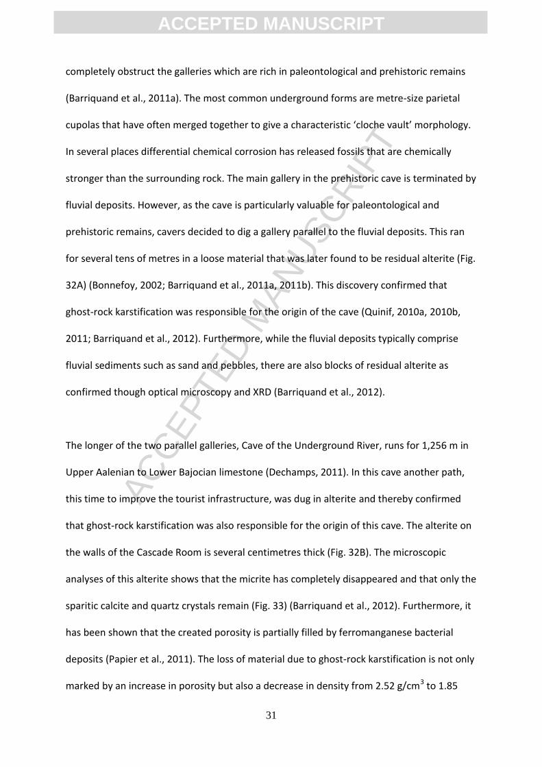
for several tens of metres in a loose material that was later found to be residual alterite (Fig.
32A) (Bonnefoy, 2002; Barriquand et al., 2011a, 2011b). This discovery confirmed that
ghost-rock karstification was responsible for the origin of the cave (Quinif, 2010a, 2010b,
2011; Barriquand et al., 2012). Furthermore, while the fluvial deposits typically comprise
fluvial sediments such as sand and pebbles, there are also blocks of residual alterite as
confirmed though optical microscopy and XRD (Barriquand et al., 2012).
The longer of the two parallel galleries, Cave of the Underground River, runs for 1,256 m in
Upper Aalenian to Lower Bajocian limestone (Dechamps, 2011). In this cave another path,
this time to improve the tourist infrastructure, was dug in alterite and thereby confirmed
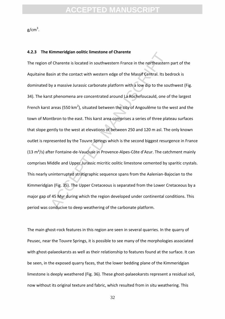
that ghost-rock karstification was also responsible for the origin of this cave. The alterite on
the walls of the Cascade Room is several centimetres thick (Fig. 32B). The microscopic
analyses of this alterite shows that the micrite has completely disappeared and that only the
sparitic calcite and quartz crystals remain (Fig. 33) (Barriquand et al., 2012). Furthermore, it
has been shown that the created porosity is partially filled by ferromanganese bacterial
deposits (Papier et al., 2011). The loss of material due to ghost-rock karstification is not only
marked by an increase in porosity but also a decrease in density from 2.52 g/cm3 to 1.85
ACC
EPTE
D M
ANU
SCR
IPT
ACCEPTED MANUSCRIPT
32
g/cm3.
4.2.3 The Kimmeridgian oolitic limestone of Charente
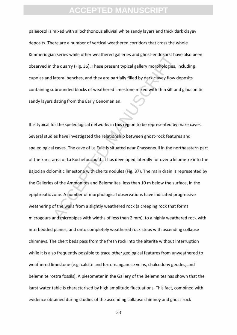
The region of Charente is located in southwestern France in the northeastern part of the
Aquitaine Basin at the contact with western edge of the Massif Central. Its bedrock is
dominated by a massive Jurassic carbonate platform with a low dip to the southwest (Fig.
34). The karst phenomena are concentrated around La Rochefoucauld, one of the largest
French karst areas (550 km2), situated between the city of Angoulême to the west and the
town of Montbron to the east. This karst area comprises a series of three plateau surfaces
that slope gently to the west at elevations of between 250 and 120 m asl. The only known
outlet is represented by the Touvre Springs which is the second biggest resurgence in France
(13 m³/s) after Fontaine-de-Vaucluse in Provence-Alpes-Côte d’Azur. The catchment mainly
comprises Middle and Upper Jurassic micritic oolitic limestone cemented by sparitic crystals.
This nearly uninterrupted stratigraphic sequence spans from the Aalenian-Bajocian to the
Kimmeridgian (Fig. 35). The Upper Cretaceous is separated from the Lower Cretaceous by a
major gap of 45 Myr during which the region developed under continental conditions. This
period was conducive to deep weathering of the carbonate platform.
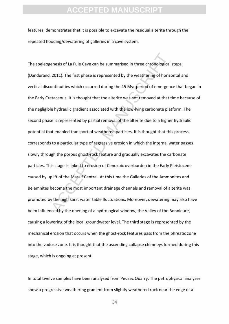
The main ghost-rock features in this region are seen in several quarries. In the quarry of
Peusec, near the Touvre Springs, it is possible to see many of the morphologies associated
with ghost-palaeokarsts as well as their relationship to features found at the surface. It can
be seen, in the exposed quarry faces, that the lower bedding plane of the Kimmeridgian
limestone is deeply weathered (Fig. 36). These ghost-palaeokarsts represent a residual soil,
now without its original texture and fabric, which resulted from in situ weathering. This
ACC
EPTE
D M
ANU
SCR
IPT
ACCEPTED MANUSCRIPT
33
palaeosol is mixed with allochthonous alluvial white sandy layers and thick dark clayey
deposits. There are a number of vertical weathered corridors that cross the whole
Kimmeridgian series while other weathered galleries and ghost-endokarst have also been
observed in the quarry (Fig. 36). These present typical gallery morphologies, including
cupolas and lateral benches, and they are partially filled by dark clayey flow deposits
containing subrounded blocks of weathered limestone mixed with thin silt and glauconitic
sandy layers dating from the Early Cenomanian.
It is typical for the speleological networks in this region to be represented by maze caves.
Several studies have investigated the relationship between ghost-rock features and
speleological caves. The cave of La Fuie is situated near Chasseneuil in the northeastern part
of the karst area of La Rochefoucauld. It has developed laterally for over a kilometre into the
Bajocian dolomitic limestone with cherts nodules (Fig. 37). The main drain is represented by
the Galleries of the Ammonites and Belemnites, less than 10 m below the surface, in the
epiphreatic zone. A number of morphological observations have indicated progressive
weathering of the walls from a slightly weathered rock (a creeping rock that forms
microgours and micropipes with widths of less than 2 mm), to a highly weathered rock with
interbedded planes, and onto completely weathered rock steps with ascending collapse
chimneys. The chert beds pass from the fresh rock into the alterite without interruption
while it is also frequently possible to trace other geological features from unweathered to
weathered limestone (e.g. calcite and ferromanganese veins, chalcedony geodes, and
belemnite rostra fossils). A piezometer in the Gallery of the Belemnites has shown that the
karst water table is characterised by high amplitude fluctuations. This fact, combined with
evidence obtained during studies of the ascending collapse chimney and ghost-rock
ACC
EPTE
D M
ANU
SCR
IPT
ACCEPTED MANUSCRIPT
34
features, demonstrates that it is possible to excavate the residual alterite through the
repeated flooding/dewatering of galleries in a cave system.
The speleogenesis of La Fuie Cave can be summarised in three chronological steps
(Dandurand, 2011). The first phase is represented by the weathering of horizontal and
vertical discontinuities which occurred during the 45 Myr period of emergence that began in
the Early Cretaceous. It is thought that the alterite was not removed at that time because of
the negligible hydraulic gradient associated with the low-lying carbonate platform. The
second phase is represented by partial removal of the alterite due to a higher hydraulic
potential that enabled transport of weathered particles. It is thought that this process
corresponds to a particular type of regressive erosion in which the internal water passes
slowly through the porous ghost-rock feature and gradually excavates the carbonate
particles. This stage is linked to erosion of Cenozoic overburden in the Early Pleistocene
caused by uplift of the Massif Central. At this time the Galleries of the Ammonites and
Belemnites become the most important drainage channels and removal of alterite was
promoted by the high karst water table fluctuations. Moreover, dewatering may also have
been influenced by the opening of a hydrological window, the Valley of the Bonnieure,
causing a lowering of the local groundwater level. The third stage is represented by the
mechanical erosion that occurs when the ghost-rock features pass from the phreatic zone
into the vadose zone. It is thought that the ascending collapse chimneys formed during this
stage, which is ongoing at present.
In total twelve samples have been analysed from Peusec Quarry. The petrophysical analyses
show a progressive weathering gradient from slightly weathered rock near the edge of a
ACC
EPTE
D M
ANU
SCR
IPT
ACCEPTED MANUSCRIPT
35
gallery in the quarry face to completely weathered rock at the centre of the feature. The
fresh and slightly weathered samples are characterised by densities of about 2.65 g/cm³,
average porosities of about 15 ± 0.5 %, and the material is comprised entirely of carbonate
(100 %). At the centre of the feature the density is reduced to < 2 g/cm³, the porosity is
increased by about 40 %, and the CaCO3 mass content drops drastically to less than 60 %.
From the study of thin-sections it is seen that the increase in porosity initially results from
dissolution of the inter-oolite sparitic and microsparitic structures before progressing to the
micritic oolites. There are also concentrations of iron oxides on the edges of oolites and
sometimes even within the oolites themselves (Fig. 38). The origin of this ferruginisation is
not yet clear although, as bacterial activity appears to be conducive to oxidation, bacteria
may well play a role in the formation of ferric microspheres on, in particular, the edges of
the oolites.
4.2.4 The Jurassic limestone and dolomite of Les Grands Causses
The Grands Causses are located in the southern part of the Massif Central (Fig. 39). Its
bedrock is dominated by Jurassic limestone and dolomite while the landscape is
characterised by huge limestone plateaux cut by deep canyons. At the end of the late
Jurassic the sea retreated and this area was affected by the first stages of karstification as
represented by bauxite formations and also some karst morphologies such as poljes. These
landscapes were fossilised during the Upper Cretaceous transgression which covered the
entire southern margin of the Massif Central. The tectonic framework of the region during
the Cenozoic resulted from Pyrenean uplift in the Eocene. However, from the Oligocene to
the beginning of the Miocene, a succession of flat karst surfaces developed in association
with the poljes. From the beginning of the Miocene, due to uplift of the Massif Central, the

ACC
EPTE
D M
ANU
SCR
IPT
ACCEPTED MANUSCRIPT
36
Jurassic platform has been dissected by incising rivers and the plateaux have become
increasingly isolated. The higher hydrogeological gradient lead to the partial destruction of
flat morphologies and the emptying of ghost-endokarst. These processes are continuing at
present as illustrated by karst drainage reorganisation, the stripping of surficial deposits,
and excavation of the karst systems.
This area is characterised by several types of ghost-rock feature which have developed in
two different formations (Bruxelles, 2001). First, the Bajocian limestones and dolomites with
cherts appear mainly at the edge of the plateaux or along major faults. This formation is
deeply decomposed and has innumerable pockets of clay or sand with cherts (Fig. 40). The
calcite has been dissolved to leave siliceous pockets partially filled with neogenetic
smectites. These pockets can be distinguished from cryptokarst due to the fact that it is
possible to recognise chert horizons, warped due to post-dissolution compaction, running
through the alterite (Fig. 41). The clays with flints that result from this weathering are very
important in the subsequent development of the karst topography. From the edges of the
plateaux, the clays with flints are reworked toward the central parts, where they constitute
a thick cover - many karst features including cryptocorrosion surfaces, corrosion borders,
and poljes have developed as a result of this clayey cover. Second, the Bathonian dolomite
outcrops over a very large part of the Grands Causses. This has a thickness of about 150 m
and most of its discontinuities are weathered from the surface to the base of the formation.
These weathered faults, cracks, and joints create a network of high corridors filled with
dolomitic sand - this sand comprises dolomitic rhombohedra while only the calcitic cement
has been removed by dissolution. However, following a drop in base level, surface erosion is
able to remove the sand easily leaving a series of dolomitic pinnacles with heights of up to

ACC
EPTE
D M
ANU
SCR
IPT
ACCEPTED MANUSCRIPT
37
30 m - these are mega-lapiaz and they constitute the most famous characteristic landforms
in the Grands Causses (Fig. 41). The removal of this alterite leads to the development of
underground rivers, pits, and speleological caves. It is an ongoing active process and it is
known that huge amounts of dolomitic sand are excavated during each flood event.
While the formation of ghost-rock has had an important impact on the development of the
karst landscape of the Grands Causses, it also plays a major role in defining the location and
organisation of the karst aquifers. The local geological history suggests that ghost-rock was
able to develop from the end of the Jurassic to the beginning of the Miocene due to the fact
that there was an insufficient hydrogeological gradient to remove the alterite during this
long period. However, as soon as canyon dissection enabled the development a number of
powerful karst springs, the alterite began to be removed. Headward erosion in the
weathered limestones and dolomites exported the dolomitic sand and emptied the highest
discontinuities. In this way, the catchment areas of the springs grew rapidly within the
plateau while, at the surface, many sinkholes appeared as a consequence of alterite
excavation by underground streams. It is common to find new sinkholes regularly appearing
while the largest springs, benefiting from favourable geological structure and close
connection to a ghost-rock network, often capture the catchment areas of their adjacent
springs (Bruxelles, 2001).
4.2.5 The Cenomanian chalky limestone of Normandy
The hills of Perche in the south of Normandy, near the eastern margin of the Armorican
Massif, represent the interfluve separating the catchments of the Seine and Loire Rivers. Its
Cretaceous bedrock is dominated by chalky limestone from Lower and Middle Cenomanian,
ACC
EPTE
D M
ANU
SCR
IPT
ACCEPTED MANUSCRIPT
38
overlain by an almost always impermeable clay-sand formation, the Upper Cenomanian
‘Sands of the Perche’. In the north, a long glacis extending across the Sands of the Perche
has promoted the development of a dense network of streams that feed the tributaries of
the Seine. In the south, around the Huisne River in the Loire Basin, the surface drainage is
associated with a large depression in the Cenomanian cover which follows the edge of a
cuesta. In this region there are a number of quarries that intersect the karstified tectonic
axis. The most notable site is the Mansonnière in Bellou sur Huisne, Orne, which has
developed beneath a plateau between two meridian dextral strike-slip faults at around 150
m asl (Fig. 42). This has generated an extremely tight cluster of faults that extends and
connects discontinuities to form a plurimetric meshed network which fully incorporates the
karst maze. More than 1,000 m of natural corridors, almost entirely filled with chalky sand
and particularly fine swelling clays (smectite), have been investigated after digging (Fig. 43).
This network is found a few meters below the surface in a freestone facies known as the
‘Chalk of Rouen’. The surrounding rock presents a very thin layer of weathered clayey
limestone with a thickness of less than 0.20 m (Rodet, 1996).
From studying the loose material in these galleries it is known that: (i) vertical bedding
dominates and this is characteristically almost symmetrical around a near vertical clayey
centreline that represents the initial discontinuity from which the weathered feature has
developed; (ii) there is an absence of horizontal sedimentation resulting from flow
processes. Therefore, since their formation, these features have not hosted fluvial drainage.
Furthermore, geochemical analyses (Tab. 1) show that the mineral composition is very
monotonous and that the unconsolidated material is derived entirely from the host rock
(Rodet, 2014). These features result from chemical weathering processes in which water
ACC
EPTE
D M
ANU
SCR
IPT
ACCEPTED MANUSCRIPT
39
from the surface infiltrates along the discontinuities until it encounters a stratigraphic or
piezometric obstacle. The percolating water is also diffused horizontally thereby expanding
the lateral influence of the weathering (Rodet, 2003). The weathered features vary greatly
in width from a few centimetres to as much as six metres over very short distances (> 1 m).
The wider areas reflect points at which different weathering features intersect and coalesce.
It, therefore, appears that the width a specific weathered feature directly reflects the
amount of water that is able to infiltrates into it (Fig. 44). In the context of progressive
weathering of the bedrock this example corresponds to a late stage of weathering during
which the weathering is not simply confined to tectonic joints but can also develop locally
along bedding planes. In the terminology of chalk weathering, these features are
‘primoforms’ from an ‘introduction karst’, in which no connection has yet been made
between the input and output of the system (Rodet, 2002).
4.3 Italy
4.3.1 The Liassic silico-clay limestone of Lombardy
Monte Bisbino is located along the western side of the western branch of Lake Como and
represents the last mountain to the south of the Italian Alpine foothills (Fig. 45). The
western side of the lake is entirely composed of Moltrasio limestone from the Lower Lias
and this is a well stratified dark grey limestone with flint nodules or beds interbedded with
clays and marls. The CaCO3 content of the limestone varies from 45 % to 60 % while the
remainder is dominated by silica from sponge spicules. From a structural perspective the
area is almost monoclinal with dips to the W-SW. It has been affected by strong brittle
deformation and eight fracture systems can be recognised - the main ones are oriented E-
W, N-S, and NE-SW. Many of these fractures were reactivated as normal faults during the
ACC
EPTE
D M
ANU
SCR
IPT
ACCEPTED MANUSCRIPT
40
Cenozoic, especially those orientated N-S, sometimes accompanied by an E-W strike-slip
component. The process of ghost-rock karstification systematically affects the N-S and E-W
vertical joints and this has generated a lattice network of weathered discontinuities
(Tognini, 1999a, 1999b). These discontinuities guide the spatial distribution of subterranean
cave galleries as well as ghost-rock features at the surface. The N-S system is very dense but
mainly comprises short fractures while those of the E-W system are usually longer. As a
result the N-S system is associated with widespread short shallow ghost-rock features while
the E-W system is associated with far longer features.
The surficial weathering forms are represented by corridors that can attain depths of more
than 10 m and which are organised as an orthogonal network with constant spacing (Fig.
46). The precise nature of the rectangular pinnacles and towers depends upon the extent to
which the alterite has been removed. It is possible to find local screes composed of
rectangular blocks that, from a conceptual point of view, are identical to those that result
from the arenisation of granite (Fig. 47). Furthermore, these fractures are slowly forced
open by gravitational slope deformations so that slope processes are, in turn, partly
responsible for enlarging the weathered joints and excavating the alterite. The presence of
deeply weathered fractures, exhibiting unstable mechanical behaviour, has clearly
conditioned the distribution and geometry of deep seated gravitational slope deformations.
These phenomena are interconnected and each has the ability to enhance the other.
Instances of ghost-rock karstification are evenly distributed from the top of Monte Bisbino
at 1,325 m asl down to almost 600 m asl. The spatial distribution of the weathered network
suggests that the weathering process becomes increasingly ineffectual with depth from the
surface.

ACC
EPTE
D M
ANU
SCR
IPT
ACCEPTED MANUSCRIPT
41
The excavation of subterranean ghost-rock features by mechanical erosion has created a
number of karst systems. There are twenty five known caves on Monte Bisbino, of which the
main ones are: Buco della Volpe, Grotta dell’Alpe Madrona, and Zocca d'Ass (Fig. 48) (Bini &
Cappa, 1977). Despite the fact that the karst potential exceeds 1,100 m there are only a
small number of caves below the limit of ghost-rock karstification. It is clear that karst is
strictly linked to the process of ghost-rock karstification. The cave morphologies are
characterised by: (i) a lattice network of galleries that often intersect at right angles; (ii)
galleries whose walls are made of alterite and exhibit diverse cross-sectional forms (i.e. sub-
circular, elliptical, and rectangular); (iii) irregular galleries with ⟙-forms, ⟘-forms, +-forms,
or L-forms developed at the intersection of several ghost-rock features; (iv) disconnected
shallow-holes; and (v) galleries terminating in ending in dead-ends. These criteria are all
symptomatic of galleries that result from the excavation of ghost-rock features.
It is known from microscopic analyses that the micritic limestone matrix disappears as a
result of weathering and the new open pores become partially filled with iron oxides and
clays. The CaCO3 content decreases from around 60 % to 45 % in the fresh rock to around 7
% to 0.5 % in the completely weathered rock while SEM analysis shows dissolution marks on
the sponge spicule silica as well as on quartz crystals filling the extension joints (Fig. 49). XRD
analysis of the completely weathered rock indicates that the clay fraction below < 2 μm
comprises quartz. The weathering front is characterised by reddening and this is often
emphasised by a very porous thin crust, with a thickness of no more than a few millimetres,
rich in iron nodules, of around a millimetre, not found in the fresh rock. The process of
ghost-rock karstification in the Moltrasio limestone results in the dissolution of the micritic
ACC
EPTE
D M
ANU
SCR
IPT
ACCEPTED MANUSCRIPT
42
calcite, partial dissolution of the silica, and increases the porosity of the rock.
4.4 Great Britain
4.4.1 The Carboniferous limestone of southern Pembrokeshire
Bullslaughter Bay is located along the coast of southern Pembrokeshire in southwest Wales
(Rowberry et al., 2014) (Fig. 50). This area lies close to the northern limit of the strong
Variscan deformation that affected Britain during the late Carboniferous. The Carboniferous
limestone bedrock belongs to the Pembroke Limestone Group and crops out in three major
synclines trending W-E: the St Florence, Pembroke, and Bullslaughter Bay Synclines. These
folds are cut by two conjugate sets of later strike-slip faults striking NNW and NNE. The
structural geology at Bullslaughter Bay is complicated: the bay is cut by the axis of the
Bullslaughter Bay Syncline while in the eastern part of the bay a series of tight fold
structures lie to the south of the main syncline. Furthermore, two large breccia masses are
located at either end of the bay (Walsh et al., 2008). The cliffs are built predominately from
the Oystermouth Formation, of Viséan age, which comprises thin to medium bedded dark
grey argillaceous limestones and mudstones with chert nodules or beds (Waters et al.,
2009). This formation is both unweathered and weathered. A comparatively small section of
the cliffs are built from the mudstones and thin bedded radiolarian cherts of the Aberkenfig
Formation, of Serpukhovian age, but this formation is not discussed here.
The Oystermouth Formation was deposited in shallow marine waters and it is characterised
by numerous facies changes. In such a heterogeneous formation the specific characteristics
of the unweathered rock determines the result of the weathering. The weathered rocks
occur as wide weathered areas that extend down the entire cliff section while the
ACC
EPTE
D M
ANU
SCR
IPT
ACCEPTED MANUSCRIPT
43
weathering profiles are not characterised by vertical gradients (Fig. 51 a-f). In some places
the weathered limestone appears as isolated decalcified blocks while in others it appears as
banded ochreous and slightly calcareous sands and silts. The banded sands and silts were
previously thought to represent a sedimentary deposit but this interpretation does not take
account of the fact that the isovolumetric nature of the weathering is readily recognisable. It
is frequently possible to trace calcite veins, bedding planes, cracks, or cleavage from the
unweathered limestone and into its weathered counterpart and from there into loose
material. The banded sands and silts also incorporate highly angular “corestones” whose
angularity is not indicative of whether or not they are decalcified. Schmidt Hammer Tests
have shown that the weathering has caused a loss of compressive strength without
necessarily changing in the physical appearance of the limestone. In the main cove of the
bay a weathered laminated alterite derived from shale and siltstone has preserved a
residual Brigantian conodont assemblage (Błażejowski & Walsh, 2013) and revealed crinoid
remains (Rowberry et al., 2014).
The samples subjected to laboratory analyses were obtained from sheltered sites at the
base of the cliffs (Rowberry et al., 2014). The analyses comprised calcimetry, granulometry,
x-ray diffraction, and exoscopy. The calcimetric analysis provides information regarding the
loss of calcium from an impure parent limestone. It has been found that the calcium
carbonate content ranges between 3.5 % and 97 % (Fig. 52 a, b). There may be an abrupt
transition from an unweathered limestone to decalcified clays. The granulometric analysis is
able to differentiate between collapse material and isovolumetrically weathered material. It
was found that the obtained curves are dominated by fine silt with low or very low
quantities of clay and sand - the paucity of sand and clay suggests inheritance from the
ACC
EPTE
D M
ANU
SCR
IPT
ACCEPTED MANUSCRIPT
44
parent rock and reflects in situ weathering process (Fig. 52 c, d). The XRD provides
information regarding secondary clay formation. The primary minerals in the weathered
samples have all been preserved so it is clear that the parent rocks were either impure
limestone or shale rich in quartz, illite, and goethite. There is little evidence for secondary
clay formation. The exoscopy of individual quartz grains provides information about the
initial sedimentary environment and the effects of weathering. The two analysed samples
show surface morphologies typical of marine and fluvial grains, respectively, and it has been
hypothesised that these morphologies are inherited from transportation prior to diagenesis
(Fig. 52 e, f) (Rowberry et al., 2014).
5. Discussion
The process of karstification by total removal is a single stage process in which chemical
dissolution and removal of the soluble species occurs at the same time as mechanical
erosion of the undissolved particles. This process is driven by high hydrodynamic energy and
creates open voids in the host rock. The process of ghost-rock karstification is, in contrast, a
two stage process. The first stage is characterised by chemical dissolution and removal of
the soluble species. This stage requires low hydrodynamic energy and creates a ghost-rock
feature filled with residual alterite. The second stage, when there is sufficient hydrodynamic
conditions are met, is characterised by mechanical erosion of the undissolved particles. It is
only during this stage that open voids are created. This two stage model has similarities to
the biorhexistasy theory of Erhart (1967). The first stage of ghost-rock karstification reflects
the biostasy stage during which there is weathering of the bedrock under a vegetation cover
- after chemical weathering the soluble part of the rock is taken underground while the
insoluble part remains to constitute the soils. This situation occurs as the vegetation
ACC
EPTE
D M
ANU
SCR
IPT
ACCEPTED MANUSCRIPT
45
provides large amounts of acid while protecting the residual material from mechanical
erosion. The second stage of ghost-rock karstification reflects the rhexistasy stage during
which there is mechanical erosion of the residual alterite. Table 2 provides a summary of the
presented case studies and highlights the range of lithologies affected by ghost-rock
karstification, the timing of the ghost-rock weathering, and the subsequent geological
history of each region.
The ‘two-cycle’ theory of cave formation proposed by Davis (1930) suggests that most caves
develop deep in the phreatic zone and that they are exposed as fully formed features
following a cycle of erosion. This hypothesis has been used to account for cave systems
with irregular three-dimensional networks and no conspicuous horizontal control. In light of
the evidence presented in this review it seems more probable that such systems result from
the process of ghost-rock karstification. In geomorphological research there has long been
much debate as to whether certain landforms associated with crystalline rocks owe their
existence to periods of chemical weathering alternating with periods of mechanical erosion
or whether these processes occur simultaneously. The former, for example, has been
proposed for the formation of tors in southwest England (Linton, 1955) and inselbergs in
Uganda (Ollier, 1960). The latter, for example, has been proposed for the formation of
bornhardts in Nigeria (Thomas, 1965). The seminal ‘two-stage’ model of tor formation first
came to prominence following the work of Linton (1955). It was suggested that weathering
at the surface proceeded to create a basal platform which then became the ground surface,
complete with tors, following removal of the weathered material. Linton (1955) noted that,
“This possibility that the weathering implied by the upland tor is late Tertiary is attractive
because of the known warmth of our Pliocene climate. To admit such a possibility, however,
ACC
EPTE
D M
ANU
SCR
IPT
ACCEPTED MANUSCRIPT
46
emphasises the distinction between the two phases of tor formation; exhumation may be
much later than decomposition”. However, even in southwest England, the ‘two-stage’
model of tor formation is never been unequivocally accepted (e.g. Palmer & Neilson, 1962;
Eden & Green, 1971). It is, nonetheless, clear that certain hypotheses used to explain the
development of landforms associated with crystalline rocks may have greater applicability in
carbonate terrains than has been hitherto appreciated. In this regard it should be
unsurprising that certain karst features may owe their existence to periods of chemical
weathering alternating with periods of mechanical erosion, as in ghost-rock karstification, or
to simultaneous weathering and erosion, rather than in karstification by total removal.
The association between certain karst morphologies and specific karstogenetic processes is
often accepted unequivocally. However, if the process of ghost-rock karstification is able to
produce caves with the same morphological features to those produced by the process of
karstification by total removal, it follows that the processes which are normally assigned to
specific cave morphologies may not be constrained accurately (Dubois et al., 2011). It is, for
example, commonly accepted that parietal forms within a cave reflect the flow conditions
that lead to their formation, such as is the case for both cupolas and vault anastomoses. The
hemispherical to ellipsoidal cupola forms often seen in gallery walls and vaults are usually
thought to result from chemical corrosion by slowing flowing waters in the flooded phreatic
zone. However, these forms have also been found in association with ghost-rock features, at
the boundary between the fresh rock and the alterite (Fig. 8A). Likewise, vault anastomoses
are generally thought to result from the flow of water in an open channel between the vault
and the detritic filling, or in a horizontal joint between the calcareous vault and the clayed
interstratum. Again, these forms have also been found in association with ghost-rock

ACC
EPTE
D M
ANU
SCR
IPT
ACCEPTED MANUSCRIPT
47
features, at the boundary between the fresh rock and the alterite (Fig. 8B). Both the cupolas
and vault anastomosis remain after mechanical removal of the alterite and they are very
similar to, or possibly indistinguishable from, the same forms that are supposed to have
resulted from karstification by total removal. These examples demonstrate that the same
karst morphologies may result from different processes - they are examples of
geomorphological equifinality. The authors argue that it is no longer acceptable to use karst
morphologies in order to infer specific karstogenetic processes.
It has also been shown that cave systems in which the galleries are arranged on different
levels do not necessarily reflect changes in base level. Therefore, it may be futile to attempt
to link these galleries with, for example, fluvial terraces or glacial stages. However, the
process of ghost-rock karstification offers a new explanation for the organisation of such
galleries. The weathered network created during the first stage of ghost-rock karstification
reflects the fact that the weathering develops along highly transmissive pathways in the
host rock - its precise characteristics depend far more on the location of discontinuities such
as faults, joints, and bedding planes. Therefore, the weathered network is often
characterised by a three-dimensional maze structure which, once emptied of its alterite,
creates a cave system with same three-dimensional maze structure. This serves to explain
how galleries can be arranged on many different levels without needing to invoke base level
changes as a cause. It is clear that, over time, one type of karstification process may
supersede the other. Karstification by total removal is perhaps more likely to supplant
ghost-rock karstification given that the second stage of the latter process requires
mechanical erosion excavate the alterite. Therefore, if an erosive stream continues to flow
after excavation of the alterite, subsequent enlargement of the gallery will reflect the

ACC
EPTE
D M
ANU
SCR
IPT
ACCEPTED MANUSCRIPT
48
process of karstification by total removal. However, the reverse can also occur if the
hydrodynamic energy is lost, and it has been shown that an excavated gallery partly filled
with fluvial sediments once again started to develop through ghost-rock karstogenesis.
It is increasingly accepted that karst systems are not solely confined to carbonate rocks and
that many such systems are found in siliceous and alumino-siliceous (Galan & Lagarde,
1988; Vicat et al., 2002; Willems et al., 2002a, 2002b, Hard et al., 2013). These present the
same characteristics as karst systems in carbonate rocks (i.e. surface morphologies,
underground morphologies, and non-linear hydrodynamics) but they cannot be explained
satisfactorily by the traditional single-stage process of karstification by total removal.
However, the two stage process of ghost-rock karstification is able to explain the occurrence
of karst in supposedly insoluble rocks. During the first stage there is deep chemical
weathering of the rock leaving a residual material such as granitic arena - this residual phase
incorporates neoformed minerals such as clays which are incompatible with the process of
karstification by total removal. During the second stage the mechanical erosion of the
alterite excavates galleries, in the case of underground features, or creates karst relief, in
the case of surface features (e.g. granitic blockfields).
6. Conclusions
This manuscript has reviewed the recently proposed process of ghost-rock karstification. The
process integrates chemical weathering and mechanical erosion and fits into the general
framework of continental landscape development. The process of ghost-rock karstification
differs from the traditional process of karstification by total removal in that it is a two stage
process. The first stage is characterised by chemical dissolution and removal of the soluble
ACC
EPTE
D M
ANU
SCR
IPT
ACCEPTED MANUSCRIPT
49
species to create a ghost-rock feature filled with residual alterite while the second is
characterised by mechanical erosion of the undissolved particles to create open galleries.
The two karstification processes have been considered from a thermodynamic point of view.
Both need a flow of water to provide the chemical energy to dissolve the calcium carbonate.
However, karstification by total removal requires a far higher amount of hydrodynamic energy
to simultaneously remove the dissolved species and undissolved particles. The process of
ghost-rock karstification has been illustrated by a number of case studies taken from across
western Europe. It is suggested that the origins of many karst systems should now be
reconsidered in light of this process and that many commonly accepted ideas in
karstogenesis must now be revised.
Acknowledgments
The authors wish to express their gratitude to all the quarrying companies that have granted
permission for us to access and work at their sites - so many of the presented case studies
would not have been possible without that permission. We would also like to thank Henry
Neimark, the General Council of Saône-et-Loire, the members of the Cultural Association of
Azé Cave, and Spéléo-Club Argilon for the support they have provided during studies of the
karst of Burgundy.
Bibliography
Audra, P., 1994. Karsts Alpins: Genèse de Grands Réseaux Souterrains. Karstologia
Mémoires 5.
Audra, P., Bini, A., Gabrovšek, F., Häuselmann, P., Hobléa, F., Jeannin, P.-Y., Kunaver, J.,
Monbaron, M., Šušteršič, F., Tognini, P., Trimmel, H., Wildberger, A., 2007. Cave and karst
ACC
EPTE
D M
ANU
SCR
IPT
ACCEPTED MANUSCRIPT
50
evolution in the Alps and their relation to paleoclimate and paleotopography. Acta
Carsologica, 36, 53-68.
Ayora, C., Taberner, C., Saaltinka, M.W., Carrera, J., 1998. The genesis of dedolomites: a
discussion based on reactive transport modeling. Journal of Hydrology, 209, 346-365.
Bakalowicz, M., 1975. Géochimie des eaux karstiques et karstification. Annales de
Spéléologie, 30, 581-589.
Błażejowski, B., Walsh, P.T., 2013. A Viséan (Brigantian) conodont assemblage
preserved in the dissolution residue of a breccia matrix at Bullslaughter Bay,
Pembrokeshire, South Wales. Neues Jahrbuch für Geologie und Paläontologie -
Abhandlungen, 267, 239-254.
Barriquand, J., Barriquand, L., Argant, A., Floss, H., Gallay, A., Guerin, C., Guillot, L.,
Jeannet, M., Nykiel, C., Quinif, Y., 2011a. Le site des Grottes d’Azé. Quaternaire, Special
Issue 4, 15-25.
Barriquand, J., Barriquand, L., Guillot, L., Nykiel, C., 2011b. Le site des grottes d'Azé. Le
fruit de 60 ans de recherches dans le karst du massif de Rochebin (Saône-et-Loire).
Spelunca, 123, 7-16.
Barriquand, L., Barriquand, J., Baele, J.-M., Dechamps, S., Guillot, L., Maire, R., Nykiel, C.,
Papier, S., Quinif, Y., 2012. Les grottes d’Azé (Saône-et-Loire, France): de la roche altérée
aux sédiments. Karstologia, 59, 19-32.
Barusseau, M., 1967. Les Changements de Facies du Jurassique Moyen dans les Monts du
Ma connais. Laboratoire de Ge ologie de l’ cole ormale Supe rieure, Paris, 97 pp.
Bates, R.L., Jackson, J.A., 1980. Glossary of Geology (2nd Edition). American Geological
Institute, Falls Church VA, 749 pp.
Bini, A., 2002. Grotte in Provincia di Como. Edlin, Milan, 158 pp.
Bini, A., Cappa, G., 1977. Some considerations on the applicability of speleogenetic and
ACC
EPTE
D M
ANU
SCR
IPT
ACCEPTED MANUSCRIPT
51
morphogenetical theories. Proceedings of the 7th International Congress of Speleology,
Sheffield, 45-47.
Bini, A., Zuccoli, L., Quinif, Y., 2012. Karst et fantômisation dans la dolomie de la Valle
Imagna (Bergamo, Italie). Karstologia, 60, in press.
Bisdom, E.B.A., 1967. Micromorphology of a weathered granite near the Ria de Arosa
(NW Spain). Leidse Geologische Mededelingen, 37, 33-67.
Blake, D.F., Peacor, D.R., Allard, L.F., 1984. Ultrastructural and microanalytical results
from echinoderm calcite: implications for biomineralization and diagenesis of skeletal
material. Micron and Microscopica Acta, 15, 85-90.
Bögli, A., 1964. Corrosion par mélange des eaux. International Journal of Speleology, 1,
11-23.
Bögli, A., 1980. Karst Hydrology and Physical Speleology. Springer-Verlag, Berlin, 284
pp.
Bonacci, O., 1987. Karst Hydrology. Springer-Verlag, Berlin, 184 pp.
Bonnefoy, M., 2002. A 300 pieds sous les Vignes de Rochebin. L’exploration et les
travaux d’aménagements des Grottes d’Azé. Association Culturelle des Grottes d’Azé et
Conseil Général de Saône-et-Loire.
Bretz, J.H., 1942. Vadose and phreatic features of limestone caves. Journal of Geology,
50, 675-811.
Bruxelles, L., 1998. Karsts et paléokarsts du Bassin de Mialet (Bordure Cévenole, Gard):
formation et évolution d'un karst démantelé. Karstologia, 30, 15-24.
Bruxelles, L. 2001. Dépôts et altérites des plateaux du Larzac central: Causses de
l'Hospitalet et de Campestre (Aveyron, Gard, Hérault): evolution morphogénétiques,
conséquences géologiques et implications pour l’aménagement. Ph.D. Thesis, University
of Provence, Aix-en-Provence.

ACC
EPTE
D M
ANU
SCR
IPT
ACCEPTED MANUSCRIPT
52
Bruxelles, L., 2002a. Ghost structures in the Bajocian limestones of the Causse du Larzac
(France). Proceedings of the 1st Geologica Belgica International Meeting, Leuven, 149-
152.
Bruxelles L., 2002b. Reconstitution morphologique du Causse du Larzac: rôle des
formations superficielles dans la morphogenèse karstique. Karstologia, 38, 15-28.
Bruxelles, L., Bruxelles, S., 2002. La chasse aux fantômes dans les Grands Causses:
utilisation d'un nouveau concept de spéléogenèse dans la recherche de cavités.
Spelunca, 88, 14-20.
Bruxelles, L., Wienin, M., 2010. Les fantômes de roche de la mine de la Grande
Vernissière (Fressac, Gard). Premières observations sur l’origine de certains karsts de la
bordure cénévole. Karstologia Mémoires, 17, 192-200.
Cailhol, D., Meury, P., 2012. Processus de fantômisation dans les calcaires du Jurassique
Supérieur du Jura tabulaire. Karstologia, 59, 15-28.
Camerman, C., 1947. Le calcaire du Tournaisis. Congrès du centenaire de l’AiLg, section
Géologie, 349-353.
Caro, P., 1965. La chimie du gaz carbonique et des carbonates, et les phénomènes
hydrogéologiques karstiques. Chronique d’ Hydrogeologie, 7, 51-77.
Cellule Cartographie/SIG, 2008. Atlas de l’Aquitaine, Les Caractéristiques Physiques.
Conseil régional d’Aquitaine.
Courbon, P., Chabert, C., 198 . Atlas des Grandes Cavite s Mondiales. Union
Internationale de Spe le ologie, Paris, 255 pp.
Courreges-Blanc, M., Maire, R., 2014. Altération de type fantôme de roche dans les
calcaires oligocènes du Médoc (France): étude pétrographique et micromorphologique.
Geologica Belgica, 17, 9-16.
Dandurand, G., 2011. Cavités et remplissages de la nappe karstique de Charente (bassin
ACC
EPTE
D M
ANU
SCR
IPT
ACCEPTED MANUSCRIPT
53
de la Touvre, La Rochefoucauld): spéléogenèse par fantômisation, archives pléistocène
et holocène, rôle de l’effet de site. Ph.D. Thesis, University of Bordeaux.
Dandurand, G., Maire, R., 2011. Essai de typologie des cavités du karst de la
Rochefoucauld (Charente): rôle de la « fantômisation » crétacée, du battement de la
nappe et de l’effet de site. Dynamiques Environnementales, 27, 11-28.
Dandurand, G., Maire, R., Dubois, C., Quinif, Y., 2014. The Charente karst basin of the
Touvre: alteration of the Jurassic series and speleogenesis by ghost-rock process.
Geologica Belgica, 17, 27-32.
Davis, W.M., 1930. Origin of limestone caverns. Geological Society of America Bulletin, 4,
475-628.
Dechamps, S., 2011. Sédimentologie du Bajocien et du Bathonien des grottes d’Azé
(France), et comparaison avec le Luxembourg. MSc. Thesis, University of Liège.
Delvigne, J.E., 1998. Atlas of Micromorphology of Mineral Alteration and Weathering.
Canadian Mineralogist Special Publication 3, Ottawa, 494 pp.
Doremus, P., Hennebert, M., 1995. Carte géologique de Wallonie 1:25.000. Planche Lens-
Soignies (plus notice explicative). Ministère de la Région Wallonne.
Dreybrodt, W., 1987. The kinetics of calcite dissolution and its consequence to karst
evolution from the initial to the mature state. NSS Bulletin, 49, 31-49.
Dubois, C., Lans, B., Kaufmann, O., Maire, R., Quinif, Y., 2011. Karstification de type
fantômes de roche en Entre-deux-Mers (Gironde, France). Karstologia, 57, 19-27.
Dubois, C., Quinif, Y., Baele, J.-M., Dagrain, F., Deceuster, J., Kaufmann, O., 2014. The
evolution of the mineralogical and petrophysical properties of a weathered limestone in
southern Belgium. Geologica Belgica, 17, 1-8.
Dubreuilh, J., 197 . Contribution à l’étude sédimentologique du système fluviatile
Dordogne – Garonne dans la région bordelaise. Les ressources en matériaux
ACC
EPTE
D M
ANU
SCR
IPT
ACCEPTED MANUSCRIPT
54
alluvionnaires du département de la Gironde. University Thesis, University of Bordeaux
1.
Eden M.J., Green C.P., 1971. Some aspects of granite weathering and tor formation on
Dartmoor, England, Geografiska Annaler, 53A, 92-98.
Ek, C., 1961. Conduits souterrains en relation avec les terrasses fluviales. Annales de la
Société Géologique de Belgique, LXXXIV, 313-340.
rhart, H., 1955. “Biostasie” et “rhexistasie”: esquisse d’une théorie sur le rôle de la
pédogenèse en tant que phénomène géologique. Comptes Rendus de l’Académie des
Sciences, 241, 1218-1220.
Erhart, H., 1967. La genèse des sols en tant que phénomène géologique. Colloquium on
the Evolution of Science, Paris, 165 pp.
Ford, T.D., Cullingford, C.H.D., 1976. The Science of Speleology. Academic Press, London,
593 pp.
Ford, D.C., Williams, P., 1989. Karst Hydrogeology and Geomorphology. John Wiley &
Sons, Chichester, 562 pp.
Galan, C., Lagarde, J., 1988. Morphologie et évolution des cavernes et formes
superficielles dans les quartzites du Roraima (Vénézuela). Karstologia, 11-12, 49-60.
Gilli, E., 2011. Karstologie - Karsts, Grottes et Sources. Dunod, Paris, 244 pp.
Glansdorff, P., Prigogine, I., 1971. Thermodynamic Theory of Structure, Stability and
Fluctuations. Wiley-Interscience, London, 306 pp.
Godfriaux, I., 1994. La géologie hennuyère: synthèse. In: Godfriaux, I., Quinif, Y., (eds)
Craies et Calcaires en Hainaut, Faculté Polytechnique de Mons, 35-36.
Grillot, J.C., Guerin, R., 1975. Tectonique, microtectonique et directions des écoulements
souterrains: exemples de relations dans le bassin karstique du Haut-Vidourle Gard,
France. Revue Géographie Physique et Géologie Dynamique, XVII, 45-60.
ACC
EPTE
D M
ANU
SCR
IPT
ACCEPTED MANUSCRIPT
55
Gründ, A., 1914. Der Geographische Zyklus im Karst. Gesellschaft für Erdkunde, 52: 621-
640.
Guillot, L., Morel, J., Simonnot, G., 2005. Gouffres et cavernes des Monts du Mâconnais.
Bulletin des Ligues Spéléologiques de Bourgogne et de Franche-Comté, 34-41.
Hardt, R., Rodet, J., Pinto, S.d.A.F., 2013. Complex karst evolution in sandstone: The
Chapada dos Guimarães Site, Brazil. Proceedings of the 16th International Congress of
Speleology, Brno (Rép. Tchèque), 3, 264-267.
Havron, C., Quinif, Y., Vandycke, S., 2004. Tectonique et karstification: le cas de la région
de Han-sur-Lesse (Belgique). Karstologia, 43, 19-26.
Havron, C., Baele, J.-M., Quinif, Y., 2007. Pétrographie d’une altérite résiduelle de type
« fantôme de roche ». Karstologia, 49, 25-32.
Hennebert, M., Doremus, P., 1997a. Carte Geologique De Wallonie 1:25.000. Planche
Antoing-Leuze (plus notice explicative). Ministère de la Région Wallonne.
Hennebert, M., Doremus, P., 1997b. Carte Geologique De Wallonie 1:25.000. Planche
Hertain-Tournai (plus notice explicative). Ministère de la Région Wallonne.
Herak M., Stringfield V.T., 1972. Karst, Important Karst Regions of the Northern
Hemisphere. Elsevier, Amsterdam, 551 pp.
Jakucs, L., 1977. Morphogenetics of Karst Regions - Variants of Karst Evolution. Adam
Hilger Ltd., Bristol, 284 pp.
James, N.P., Choquette, P.W., 2012. Paleokarst. Springer-Verlag, New York, 416 pp.
Jennings, J.N., 1971. Karst. Massachusetts Institute of Technology Press, Cambridge MA,
252 pp.
Jolivet, J., Martin, C., 2008. La morphologie karstique dans le canyon de la Cèze et sur le
plateau de Méjannes-le-Clap (Garrigues nord, Gard, France) – Rapports avec l'évolution
paléogéographique mio-pliocène. Physio-Géo, 2, 53-75.
ACC
EPTE
D M
ANU
SCR
IPT
ACCEPTED MANUSCRIPT
56
Kaufmann, O., Quinif, Y., 1999. Cover-collapse sinkholes in the "Tournaisis" area,
southern Belgium. Engineering Geology, 52, 15-22.
Kaufmann, O., 2000. Les effondrements karstiques du Tournaisis. Genèse, évolution,
localisation, prévention. Ph.D. Thesis, Faculté Polytechnique de Mons.
Kaufmann, O., Bini, A., Tognini, P. & Quinif, Y., 1999. tude microscopique d’une altérite
de type fantôme de roche. Karstologia, Actes du Colloquium, Karst-99.
Kaufmann, O., Deceuster, J., 2014. Detection and mapping of ghost-rock features in the
Tournaisis area through geophysical methods – an overview. Geologica Belgica, 17, 17-
26.
Klingebiel, A., Gayet, J., Maire, R., 1993. Facteurs faciologiques et tectoniques contrôlant
la karstification sur la marge nord-Aquitaine (France): exemple de l’Oligocène nord
Aquitaine. Comptes Rendus de l’Académie des Sciences, Series II, 317, 523-529.
Lans, B., Maire, R., Ortega, R., Deves, G., Bacquart, T. Plaisir, C., Quinif, Y., Perette, Y.,
200 . Les stalagmites du réseau du trou oir (Gironde): rôle de l’effet de site dans
l’enregistrement du signal climatique et environnemental. Karstologia, 48, 1-22.
Linton, D.L., 1955. The problem of tors. The Geographical Journal, 121, 470-481.
Lohmann, K.C., 1988. Geochemical patterns of meteoric diagenetic systems and their
application to studies of paleokarst. In: James, N.P., Choquette, P.W., (eds) Paleokarst.
Springer-Verlag, New York, 58-80.
Maire, R., Bruxelles, L., Ortega, R., Roudeau, S., Stratford, D., Braga, J., 2013. Cave genesis
in the Cradle of Humankind (South Africa), role of the « ghost-rock » process.
Association of Southern African Professional Archaeologists Biennial Conference,
Gaborone, 7-13 July 2013.
Mangin, A., 1975. Contribution à l’étude hydrodynamique des aquifères karstiques.
Annales de Spéléologie, 29, 3: 283-332; 29, 4: 495-601; 30, 1: 21-214.
ACC
EPTE
D M
ANU
SCR
IPT
ACCEPTED MANUSCRIPT
57
Mangin, A., 1982. L’approche systémique du karst, conséquences conceptuelles et
méthodologiques. Reunion Monografia sobre el Karst, Larra, 141-157.
Martel, E.-A., 1894. Les Abîmes: les Eaux Souterraines, les Cavernes, les Sources, la
Spéléologie: Explorations Souterraines Effectuées de 1888 à 1893 en France, Belgique,
Autriche et Grèce. Delagrave, Paris, 578 pp.
Martel, E.-A., 1900. La Spéléologie ou Science des Cavernes. Carré et Nord, Paris, 126 pp.
Martel, E.-A., 1928. Le Nouveau Traité des Eaux Souterraines. Librairie Octave Doin -
Gaston Doin, Paris, 838 pp.
Martini, J., 1985. Caves of South Africa. Karstologia, 5, 39-44.
Meunier, A., 1977. Les mécanismes de l’alteration des granites et le rôle des
microsystèmes: etudes des arènes du massif granitique de Parthenay (Deux-Sèvres).
Ph.D. Thesis, University of Poitiers.
Morse, J.W., 1983. The kinetics of calcium carbonate dissolution and precipitation. In:
Reeder, R.J., (ed) Carbonates: Mineralogy and Chemistry. Mineralogical Society of
America, Washington D.C., 227-264.
Nicod, J., 1972. Pays et Paysages du Calcaire. Presses Universitaires de France, Paris,
242 pp.
Ollier, C.D., 1960. The inselbergs of Uganda. Zeitschrift für Geomorphologie, 4, 43-52.
Papier, S., Baele, J.-M., Gillan, D., Barriquand, J., Barriquand, L., 2011. Manganese
geomicrobiology of the black deposits from the Azé Cave, Saône-et-Loire, France.
Quaternaire, Special Issue 4, 297-305.
Palmer, A.N., 1991. Origin and morphology of limestone caves. Geological Society of
America Bulletin, 103, 1-21.
Palmer, J.A., Neilson, R.A., 1962. The origin of granite tors on Dartmoor, Devonshire.
Proceedings of the Yorkshire Geological Society, 33, 315-339.
ACC
EPTE
D M
ANU
SCR
IPT
ACCEPTED MANUSCRIPT
58
Perthuisot, J.-P., 19 . Contribution a l’e tude ge ologique des Monts du Ma connais
(feuilles Tournus n 5 et Tournus n ). Laboratoire de Ge ologie de l’ cole ormale
Supe rieure, Paris, 111 pp.
Prigogine, I., 1962. Non-Equilibrium Statistical Mechanics. Interscience Publishers, New-
York, 319 pp.
Price, D.G., 2009. Engineering Geology: Principles and Practice. Springer, Berlin, 472 pp.
Quesne, D., Guiraud, M., Garcia, J.-P., Thierry, J., Lathuillere, B., Audebert, N., 2000.
Marqueurs d’une structuration extensive jurassique en arrière de la marge nord-
téthysienne (Monts de Mâconnais, Bourgogne, France). Comptes Rendus de l’Académie
des Sciences, Series II A, 330, 623-629.
Quinif, Y., 1989a. Paleokarsts in Belgium. In: Bosák P., Ford D.C., Glazek J., Horacek I.,
(eds) Paleokarst. Academia, Prague, 35-50.
Quinif, Y., 1989b. La notion d’étages de grottes dans le karst belge. Karstologia, 13, 41-
49.
Quinif, Y., 1998. Dissipation d’énergie et adaptabilité dans les systèmes karstiques.
Karstologia, 31, 1-11.
Quinif, Y., 1999. Fantômisation, cryptoaltération et altération sur roche nue, le triptyque
de la karstification. Etudes de géographie physique, Travaux 1999 - Supplement 18,
University of Provence, 159-164.
Quinif, Y., 2010a. Fantômes de Roche et Fantômisation - Essai sur un Nouveau
Paradigme en Karstogenèse. Karstologia Mémoires 18.
Quinif, Y., 2010b. Ghost rock structures and the nature of Azé and the Mâconnais. Field-
trip of the 16th Cave Bear and Lion Symposium. Imprimerie Conseil Général de Saône-et-
Loire, 27-39.
Quinif Y., 2011. Ghost rock structures and the nature of Azé Caves. Quaternaire, Special
ACC
EPTE
D M
ANU
SCR
IPT
ACCEPTED MANUSCRIPT
59
Issue 4, 7-14.
Quinif, Y., Vergari, A., Doremus, P., Hennebert, M., Charlet, J.-M., 1993. Phénomènes
karstiques affectant le calcaire du Hainaut. Bulletin de la Société Belge de Géologie, 102,
379-394.
Quinif, Y., Vandycke, S., Vergari, A., 1997. Chronologie et causalité entre tectonique et
karstification. L’exemple des paléokarsts crétacés du Hainaut (Belgique). Bulletin de la
Société Géologique de France, 168, 463-472.
Quinif, Y., Meon, H., Yans, J., 2006. Nature and dating of karst filling in the Hainaut
Province (Belgium). Karst, geodynamic and paleogeographic implications. Geodinamica
Acta, 19, 73-85.
Quinif, Y., Maire, R., 2007. La grotte Quentin (Hainaut, Belgique): un modèle d'évolution
des fantômes de roche. Colloque International de Karstologie organisé par l’Association
Française de Karstologie et ARSIP, Arette, 6-8 September 2007.
Quinif, Y., Maire, R., 2010. La grotte Quentin (Hainaut, Belgique): un modèle d’évolution
des fantômes de roche. Karstologia Mémoires, 17, 214-218.
Quinif, Y., Camelbeeck, T., Delaby, S., Tshibangu, K., Vandycke, S., Van Ruymbeke, M.,
2011. Considérations karstogénétiques sur le système de Ramioul. Bulletin de la Société
Royale Belge d’ tudes Géologiques et Archéologiques “Les Chercheurs de Wallonie”, 3,
79-96.
Quinif, Y., Baele, J.-M., Deschuyteneer, D., Gline, S., 2012. Fantômisation d’une galerie à
remplissage fluviatile (Carrière de Gauthier-Wincqz, Soignies, Belgique). Karstologia,
59, 15-28.
Quinif, Y., Baele, J.-M., Dubois, C., Havron, C., Kaufmann, O., Vergari, A., 2014.
Fantômisation: un nouveau paradigme entre la théorie des deux phases de Davis et la
théorie de la biorhexistasie d’ rhard. Geologica Belgica, 17, -74.
ACC
EPTE
D M
ANU
SCR
IPT
ACCEPTED MANUSCRIPT
60
Rat, P., 2006. Guide Géologique Bourgogne Morvan. Dunod, Paris, 216 pp.
Renault, P., 1967. Contribution à l'étude des actions mécaniques et sédimentologiques
dans la spéléogenèse. Annales de Spéléologie, 22, 5-17 & 209-267.
Rhoades, R., Sinacori, N.M., 1941. Patterns of groundwater flow and solution. Journal of
Geology, 49: 785-794.
Rodet, J., 1996. Une nouvelle organisation géométrique du drainage karstique des
craies: le labyrinthe d'altération, l'exemple de la grotte de la Mansionnière (Bellou-sur-
Huisne, Orne, France). Comptes Rendus de l’Académie des Sciences, Series II A, 322,
1039-1045.
Rodet, J., 1999. Le réseau de fracturation, facteur initial de la karstification des craies
dans les collines du Perche: l’exemple du site de la Mansonnière (Bellou-sur-Huisne,
Orne, France). Geodinamica Acta, 12, 259-265.
Rodet, J., 2002. Le karst, milieu conservateur. In: Miskovsky, J.-C., (ed) Géologie de la
préhistoire - méthodes, techniques, application. Association pour l'étude de
l'environnement géologique de la pre histoire, Paris, 167-187.
Rodet, J., 2003. La ormandie souterraine. In: Gue rin, A., (ed) La ormandie: la Ge ologie,
les Milieux, la Faune, la Flore, les Hommes. Delachaux et Niestlé, Lausanne, 52-63.
Rodet, J., 2004. Karst and chalk in Normandy: a geographical approach. Proceedings of
the 2003 European Meeting of the French Association of Karstology, Rouen, 16-31.
Rodet, J., 2014. The primokarst, former stages of karstification, or how solution caves
are born. Geologica Belgica, 17, 58-65.
Roques, H., 1967. Chimie des carbonates et hydrogéologie karstique. Mémoires et
Documents du CNRS, New Series 4, 113-141.
Roques, H., Ek, C., 1973. Etude expérimentale de la dissolution des calcaires par une eau
chargée de CO2. Annales de Spéléologie, 28, 549-553.
ACC
EPTE
D M
ANU
SCR
IPT
ACCEPTED MANUSCRIPT
61
Rowberry, M.D., Battiau-Queney, Y., Walsh, P., Błażejowski, B., Bout-Roumazeilles, V.,
Trentesaux, A., Křížová, L., Griffiths, H., 2014. The weathered Carboniferous limestone at
Bullslaughter Bay, South Wales: the first example of ghost-rock recorded in the British
Isles. Geologica Belgica, 17, 33-42.
Salomon, J.-N., 2006. Précis de Karstologie. Presses Universitaires de Bordeaux, Pessac,
288 pp.
Schmidt, V.A., 1974. The paleohydrology of Laurel Caverns, Pennsylvania. Proceedings
of the 4th Conference on Karst Geology and Hydrology, Morgantown, 123-128.
Stainier, M.X., 1899. Carte Géologique de la Belgique (1:40 000). Planche 133 Jehay-
Bodegnée-Saint-Georges. Commission Géologique de Belgique, Institut Cartographique
Millitaire.
Swinnerton, A.C., 1932. Origin of limestone caverns. Bulletin Of The Geological Society
Of America, 43: 662-693.
Thomas, M.F., 1965. An approach to some problems of landform analysis in tropical
environments. In: Whittow, J.B., Wood, P.D., (eds) Essays in Geography for Austin Miller.
University of Reading, Reading, 118-143.
Thraikill, J., 1968. Chemical and hydrologic factors in the excavation of limestones caves.
Geological Society of America Bulletin, 79, 17-46.
Tognini, P., 1999a. Individuazione in un nuovo processo speleogenetico: il carsismo del
M. Bisbino (Lago di Como). Ph.D. Thesis, University of Milan.
Tognini, P., 1999b. The Mt. Bisbino (Northern Italy) karst: a new speleogenetic process.
Etudes de Géographie Physique, XXVIII, 185-190.
Van Den Broeck, E., Martel, E.-A., Rahir, E., 1910. Les Cavernes et les Rivières
Souterraines de la Belgique. Lamertin, Brussels, 2 Volumes.
Vandycke, S., 2002. Paleostress records in Cretaceous formations in NW Europe:

ACC
EPTE
D M
ANU
SCR
IPT
ACCEPTED MANUSCRIPT
62
extensional and strike-slip events in relationships with Cretaceous-Tertiary inversion
tectonics. Tectonophysics, 357, 119-136.
Vandycke, S., Bergerat, F., 1989. Analyse microtectonique des déformations cassantes
dans le Bassin de Mons. Reconstitution des paléo-champs de contraintes au Crétacé-
Tertiaire. Annales de la Société Géologique de Belgique, 112, 479-487.
Vergari, A., 199 . Contraintes paléokarstiques dans l’exploitation du calcaire
carbonifère sur le bord nord du synclinorium de Namur en Hainaut occidental. Ph.D.
Thesis, Faculté Polytechnique de Mons.
Vergari, A., 1998. Nouveau regard sur la spéléogenèse: le pseudo-endokarst du
Tournaisis (Hainaut, Belgique). Karstologia, 31, 12-18.
Vergari, A., Quinif, Y., 1997. Les paléokarsts du Hainaut. Geodinamica Acta, 10, 175-187.
Vicat, J.-P., Mvondoc, H., Willems, L., Pouclet, A., 2002. Phénomènes karstiques fossiles et
actuels au sein des formations métamorphiques silico-alumineuses de la nappe pan-
africaine de Yaoundé (Sud-Cameroun). Comptes Rendus de l’Académie des Sciences,
Series II A, 334, 545-550.
Walsh, P.T., Battiau-Queney, Y., Howells, S.E., Ollier, C.D., Rowberry, M.D., 2008. The
Gash Breccias of the Pembrokeshire Peninsula, SW Wales. Geology Today, 24, 137-145.
Waters, C.N., Waters, R.A., Barclay, W.J., Davies, J.R., 2009. A lithostratigraphical
framework for the Carboniferous successions of southern Britain (onshore). British
Geological Survey Research Report RR/09/01.
White, W.B., 1989. Geomorphology and Hydrology of Karst Terrains. Oxford University
Press, Oxford, 464 pp.
White, W.B., Culver, D.C., 2012. Encyclopedia of Caves. Elsevier, Amsterdam, 654 pp.
Willems, L., Compère, P., Hatert, F., Pouclet, A., Vicat, J.-P., Ek, C., Boulvain, F., 2002a.
Karst in granitic rocks, South Cameroon: cave genesis and silica and taranakite
ACC
EPTE
D M
ANU
SCR
IPT
ACCEPTED MANUSCRIPT
63
speleothems. Terra Nova, 14, 355-362.
Willems, L., Pouclet, A., Vicat, J.-P., 2002b. Existence de karsts en roches cristallines
silicatées non carbonatées en Afrique sahélienne et équatoriale, implications
hydrogéologiques. Bulletin de la Société Géologique de France, 173, 337-345.
Willems, L., Rodet, J., Fournier, M., Laignel, B., Dusar, M., Lagrou, D., Pouclet, A., Massei,
N., Dussart-Baptista, L., Compere, P., Ek, C., 2007. Polyphase karst system in Cretaceous
chalk and calcarenite of the Belgian-Dutch border. Zeitschrift für Geomorphologie, 51,
361-376.
List of Figures
Figure 1. The locations in which ghost-rock karstification phenomena have been studied
in Europe. (A) Belgium: 1 – Wallonia; (B) France: 2 – Aquitaine; 3 – Burgundy; 4 – Charente; 5 –
Languedoc; 6 – Normandy; (C) Great Britain: 7 – Pembrokeshire; (D) Italy: 8 – Lombardy; (E)
Netherlands: 9 – Limburg; (F) Switzerland: 10 – Canton of Bern.
Figure 2. A schematic diagram showing the main features of a limestone bedrock
affected by the process of ghost-rock karstification (Quinif, 2010a, 2010b): (1) limestone with
bedding planes; (2) marker horizons such as chert beds, calcite veins, stylolites; (3) joints; (4)
ghost-rock features containing their residual alterite - the different shades of grey represent
different weathering intensities; (5-6) different types of overburden. This diagram is based on
examples seen in quarries in the Tournai region of western Belgium.
Figure 3. The regressive mechanical erosion of a ghost-rock feature containing its residual
alterite: (A) a weathered gallery (1) within a host limestone bedrock (2) sealed by an
ACC
EPTE
D M
ANU
SCR
IPT
ACCEPTED MANUSCRIPT
64
impermeable overburden (3); (B) incision into the bedrock creates relief which both increases
the hydrodynamic potential of the system (4) and enables water to infiltrate into the
weathered gallery (5) - this flow progressively empties the weathered gallery of its alterite from
the downstream end towards the upstream end; (C) complete removal of the alterite reveals a
gallery between the loss (6) and resurgence (7) of the system. This diagram is based on an
example from the Entre-deux-Mers area in the Aquitaine region of southwestern France
(Dubois et al., 2011).
Figure 4. The thermodynamic concept of karstification: (A) karstification by total removal
requires a considerable amount of chemical energy to dissolve the calcium carbonate together
with a considerable amount of hydrodynamic energy to remove both the dissolved species and
undissolved particles. Water must be able to flow through the rock for karstification to occur
and preferential pathways are provided by opened joints or empty galleries resulting from
previous karstogenesis; (B) ghost-rock karstification requires a considerable amount of
chemical energy to dissolve the calcium carbonate but only a small amount of hydrodynamic
energy to remove the dissolved species while leaving the undissolved particles in place.
Preferential pathways are provided by opened joints or more transmissive zones within the
rock. The undissolved particles will be removed by flowing water if the hydrodynamic energy
increases sufficiently.
Figure 5. Examples of labyrinthine cave networks in which the residual alterite has been
observed: (A) Trabuc Cave in Languedoc, France, is located at the contact between the
Hettangian dolostone and Sinemurian limestone. This network comprises c. 10 km of galleries
with denivelation of c. 200 m (Bruxelles, 1998); (B) Fayt Cave in Ardennes, Belgium, is located in
ACC
EPTE
D M
ANU
SCR
IPT
ACCEPTED MANUSCRIPT
65
Devonian limestone. This network comprises c. 2 km of galleries with denivelation of c. 50 m;
(C) Felix-Mazauric network of Bramabiau Cave in Languedoc, France, is located in the Grands
Causses. This network comprises c. 11 km of galleries with denivelation of c. 100 m (Bruxelles &
Bruxelles, 2002).
Figure 6. A schematic diagram showing typical ghost-rock features (modified from
Kaufmann, 2000): (A) fresh unweathered limestone; (B) large weathered features; (C)
weathered corridors; (D) ghost-endokarst; (E) weathered galleries.
Figure 7. Examples of ghost-rock features in the Carboniferous limestone around Soignies
in southern Belgium: (A) a large weathered corridor situated beneath the overburden. As the
alterite has undergone compaction the overburden has been drawn down into the weathered
corridor; (B) a weathered corridor still containing its residual alterite; (C) an example of a ghost-
endokarst.
Figure 8. Examples of parietal morphologies resulting from ghost-rock karstification
around Soignies in southern Belgium (A) and Aquitaine in southwestern France (B) (Dubois et
al., 2011): (A1) a weathered corridor containing its residual alterite presents cupolas on its
walls; (A2) a weathered gallery with cupolas seen after removal of the alterite; (B1) a ghost-
rock feature containing its residual alterite presents vault anastomoses; (B2) vault anastomoses
resulting from ghost-rock karstification seen after removal of the alterite.
Figure 9. A simplified geological map of the area around Soignies in southern Belgium
(modified from Doremus & Hennebert, 1995). Overburden: 1 – Quaternary; 2 – Cenozoic (pre-
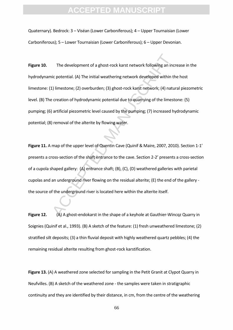
ACC
EPTE
D M
ANU
SCR
IPT
ACCEPTED MANUSCRIPT
66
Quaternary). Bedrock: 3 – Viséan (Lower Carboniferous); 4 – Upper Tournaisian (Lower
Carboniferous); 5 – Lower Tournaisian (Lower Carboniferous); 6 – Upper Devonian.
Figure 10. The development of a ghost-rock karst network following an increase in the
hydrodynamic potential. (A) The initial weathering network developed within the host
limestone: (1) limestone; (2) overburden; (3) ghost-rock karst network; (4) natural piezometric
level. (B) The creation of hydrodynamic potential due to quarrying of the limestone: (5)
pumping; (6) artificial piezometric level caused by the pumping; (7) increased hydrodynamic
potential; (8) removal of the alterite by flowing water.
Figure 11. A map of the upper level of Quentin Cave (Quinif & Maire, 2007, 2010). Section 1-1’
presents a cross-section of the shaft entrance to the cave. Section 2-2’ presents a cross-section
of a cupola shaped gallery: (A) entrance shaft; (B), (C), (D) weathered galleries with parietal
cupolas and an underground river flowing on the residual alterite; (E) the end of the gallery -
the source of the underground river is located here within the alterite itself.
Figure 12. (A) A ghost-endokarst in the shape of a keyhole at Gauthier-Wincqz Quarry in
Soignies (Quinif et al., 1993). (B) A sketch of the feature: (1) fresh unweathered limestone; (2)
stratified silt deposits; (3) a thin fluvial deposit with highly weathered quartz pebbles; (4) the
remaining residual alterite resulting from ghost-rock karstification.
Figure 13. (A) A weathered zone selected for sampling in the Petit Granit at Clypot Quarry in
Neufvilles. (B) A sketch of the weathered zone - the samples were taken in stratigraphic
continuity and they are identified by their distance, in cm, from the centre of the weathering
ACC
EPTE
D M
ANU
SCR
IPT
ACCEPTED MANUSCRIPT
67
(Dubois et al., 2014). The zone comprises five distinct constituents as defined by the standard
terminology of Price (2009): I – fresh rock with no recognisable signs of weathering; II ¬–
slightly weathered rock with slight changes in colour and slight weakening; III – moderately
weathered rock with conspicuous changes in colour and noticeable weakening but which
cannot yet be broken by hand; V – completely weathered rock with its original texture still
apparent but considerably weakened and which disintegrates in water (= alterite); VI – residual
soil derived from in situ weathering which has lost the original texture and fabric of the fresh
rock. It should be noted that Grade IV, highly weathered rock, is not present in this weathered
feature.
Figure 14. The development of the properties of the Petit Granit according to the weathering
intensity from I, fresh rock, to VI, residual soil (Dubois et al., 2014): (A) density in g/cm3; (B)
CaCO3 mass content; (C) porosity in %; (D) nitrogen permeability in mD; (E) resistance force to
drilling in N.
Figure 15. Thin-sections of the Carboniferous limestone Petit Granit in various stages of
weathering under cathodoluminescence. The number of the thin-section refers to the position
of the sample, in cm, relative to the centre of the weathered feature: (#130) – fresh
unweathered rock; (#20) – moderately weathered rock; (#08) to (#02) – completely weathered
rock; (#02) to (#00) – residual soil. The transition from Grade V to Grade VI is clear in thin-
section (#02). It is possible to see, for example, a notable change in the composition and
texture of the alterite in (#02b).
Figure 16. SEM images of the limestone from Gauthier-Wincqz Quarry in Soignies (Havron
ACC
EPTE
D M
ANU
SCR
IPT
ACCEPTED MANUSCRIPT
68
et al., 2007). The samples were taken along the same stratigraphic level though a weathered
feature: (A) fresh unweathered limestone - the grains are interlocking and no voids or signs of
weathering are visible; (B) weathered limestone - the grains are disconnected by a continuous
pore network; (C) detail of a weathered sparitic crystal affected by corrosion gulfs.
Figure 17. A geological map showing the Palaeozoic bedrock units and structure in the
area around Tournai: 1 – Namurian; 2 – Viséan; 3 – Tournaisian; 4 – Devonian; 5 – syncline; 6 –
anticline; 7 – fault; 8 – national boundary.
Figure 18. (A) Weathered corridors at Hainaut quarry in Soignies. (B) “Pic-à-glace” Cave at
Milieu Quarry in Tournai (modified from Vergari, 1998). This ghost-rock feature is surrounded
by fresh unweathered limestone and there is an abrupt transition from the fresh rock to the
alterite - specific markers can be followed from the fresh rock through the alterite. A void has
been created at the top of the feature due to compaction of the alterite under the influence of
its own weight. The trace of the original vertical joint (marked V.F.) is visible in the centre of the
feature.
Figure 19. SEM images of the Tournaisian siliceous limestone from Tournai: (A) the fresh
unweathered rock presents amorphous silica grains interlocked in a carbonate matrix. The
grains, mainly calcite, may range from a few microns to several tens of microns while the pores
are small and very thin (µm) which creates inter-crystalline porosity; (B) the residual alterite
has a less dense texture than that of the fresh rock. The grains, mainly silica, may range from a
micron to ten microns and their edges have been dulled by weathering. However, their
structure ensures the mechanical stability of the alterite, despite the fact that the calcite has

ACC
EPTE
D M
ANU
SCR
IPT
ACCEPTED MANUSCRIPT
69
almost completely disappeared. There are many pores, from a micron to tens of microns,
forming a connected network.
Figure 20. A simplified geological map of the area around Engis in eastern Belgium
(modified from Stainier, 1899): 1 – Quaternary; 2 – Cenozoic (pre-Quaternary); 3 – Namurian
(Lower Carboniferous); 4 – Viséan (Lower Carboniferous); 5 – Tournaisian (Lower
Carboniferous); 6 – Upper Devonian; 7 – Middle Devonian; 8 – Lower Devonian; 9 – Silurian.
Figure 21. The weathered zone selected for sampling in the Dinantian limestone at Engis
Quarry. The six samples were taken to represent different weathering states and they are
identified by their distance, in cm, from the centre of the weathering feature: (#150) slightly
weathered rock; (#50) moderately weathered rock; (#40) and (#-70) highly weathered rock;
(#20) and (#0) completely weathered rock.
Figure 22. The development of the properties of the Dinantian limestone at Engis Quarry
according to the weathering intensity from I, fresh rock, to VI, residual soil: (A) density in g/cm3;
(B) porosity in %; (C) CaCO3 mass content.
Figure 23. Thin-sections of the Dinantian limestone at Engis Quarry in various stages of
weathering under cathodoluminescence. The number of the thin-section refers to the position
of the sample, in cm, relative to the centre of the weathered feature: (#150) slightly weathered
rock; (#50) moderately weathered rock; (#0) completely weathered rock.
Figure 24. A simplified geological map of the area around Entre-deux-Mers in the
ACC
EPTE
D M
ANU
SCR
IPT
ACCEPTED MANUSCRIPT
70
Aquitaine region of southwestern France (modified from Cellule Cartographie, 2008): 1 –
Holocene; 2 – Pleistocene; 3 – Chattian (Upper Oligocene); 4 – Rupelian (Lower Oligocene); 5 –
Upper Eocene.
Figure 25. A gallery in the cave “Trou de la Barrique”: (1) the widening at the top of the
section has developed along stratum affected by chemical dissolution; (2) the overdeepened
part of the section, and its banquettes, result from subsequent fluvial evolution.
Figure 26. Weathering of the “Calcaire à Astéries” limestone at Piquepoche Quarry in the
Aquitaine region of southwestern France. (A) A weathered gallery containing its residual
alterite. Three samples were taken to represent different weathering states: (#1) slightly
weathered rock; (#2) moderately weathered rock; (#3) completely weathered rock. (B)
Mechanical erosion of the alterite results in a feature that looks like a speleological gallery.
Figure 27. The development of the properties of the “Calcaire à Astéries” limestone at
Piquepoche Quarry: (#1) slightly weathered rock; (#2) moderately weathered rock; (#3)
completely weathered rock; (A) density in g/cm3; (B) porosity in %; (C) CaCO3 mass content.
Figure 28. Thin-sections of the “Calcaire à Astéries” limestone at Piquepoche Quarry in
various stages of weathering under optical microscopy: (#1) slightly weathered rock; (#3)
completely weathered rock.
Figure 29. A simplified geological map of Mâcon and Cluny (Quesne et al, 2000): 1 –
Alluvium; 2 – Cenozoic; 3 – Late Jurassic; 4 – Middle Jurassic; 5 – Early Jurassic; 6 – Triassic; 7 –
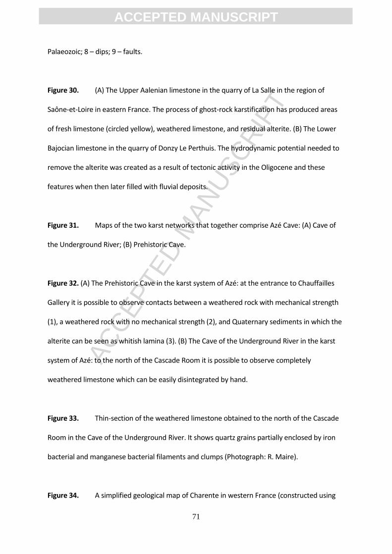
ACC
EPTE
D M
ANU
SCR
IPT
ACCEPTED MANUSCRIPT
71
Palaeozoic; 8 – dips; 9 – faults.
Figure 30. (A) The Upper Aalenian limestone in the quarry of La Salle in the region of
Saône-et-Loire in eastern France. The process of ghost-rock karstification has produced areas
of fresh limestone (circled yellow), weathered limestone, and residual alterite. (B) The Lower
Bajocian limestone in the quarry of Donzy Le Perthuis. The hydrodynamic potential needed to
remove the alterite was created as a result of tectonic activity in the Oligocene and these
features when then later filled with fluvial deposits.
Figure 31. Maps of the two karst networks that together comprise Azé Cave: (A) Cave of
the Underground River; (B) Prehistoric Cave.
Figure 32. (A) The Prehistoric Cave in the karst system of Azé: at the entrance to Chauffailles
Gallery it is possible to observe contacts between a weathered rock with mechanical strength
(1), a weathered rock with no mechanical strength (2), and Quaternary sediments in which the
alterite can be seen as whitish lamina (3). (B) The Cave of the Underground River in the karst
system of Azé: to the north of the Cascade Room it is possible to observe completely
weathered limestone which can be easily disintegrated by hand.
Figure 33. Thin-section of the weathered limestone obtained to the north of the Cascade
Room in the Cave of the Underground River. It shows quartz grains partially enclosed by iron
bacterial and manganese bacterial filaments and clumps (Photograph: R. Maire).
Figure 34. A simplified geological map of Charente in western France (constructed using
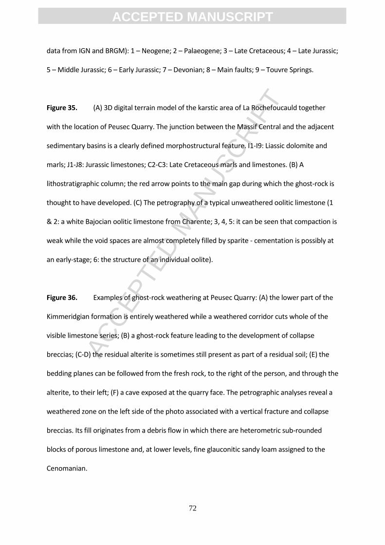
ACC
EPTE
D M
ANU
SCR
IPT
ACCEPTED MANUSCRIPT
72
data from IGN and BRGM): 1 – Neogene; 2 – Palaeogene; 3 – Late Cretaceous; 4 – Late Jurassic;
5 – Middle Jurassic; 6 – Early Jurassic; 7 – Devonian; 8 – Main faults; 9 – Touvre Springs.
Figure 35. (A) 3D digital terrain model of the karstic area of La Rochefoucauld together
with the location of Peusec Quarry. The junction between the Massif Central and the adjacent
sedimentary basins is a clearly defined morphostructural feature. I1-I9: Liassic dolomite and
marls; J1-J8: Jurassic limestones; C2-C3: Late Cretaceous marls and limestones. (B) A
lithostratigraphic column; the red arrow points to the main gap during which the ghost-rock is
thought to have developed. (C) The petrography of a typical unweathered oolitic limestone (1
& 2: a white Bajocian oolitic limestone from Charente; 3, 4, 5: it can be seen that compaction is
weak while the void spaces are almost completely filled by sparite - cementation is possibly at
an early-stage; 6: the structure of an individual oolite).
Figure 36. Examples of ghost-rock weathering at Peusec Quarry: (A) the lower part of the
Kimmeridgian formation is entirely weathered while a weathered corridor cuts whole of the
visible limestone series; (B) a ghost-rock feature leading to the development of collapse
breccias; (C-D) the residual alterite is sometimes still present as part of a residual soil; (E) the
bedding planes can be followed from the fresh rock, to the right of the person, and through the
alterite, to their left; (F) a cave exposed at the quarry face. The petrographic analyses reveal a
weathered zone on the left side of the photo associated with a vertical fracture and collapse
breccias. Its fill originates from a debris flow in which there are heterometric sub-rounded
blocks of porous limestone and, at lower levels, fine glauconitic sandy loam assigned to the
Cenomanian.
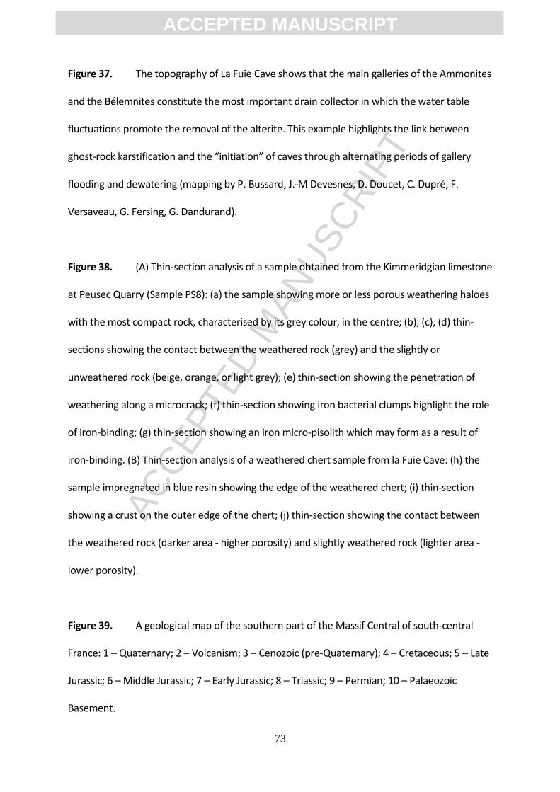
ACC
EPTE
D M
ANU
SCR
IPT
ACCEPTED MANUSCRIPT
73
Figure 37. The topography of La Fuie Cave shows that the main galleries of the Ammonites
and the Bélemnites constitute the most important drain collector in which the water table
fluctuations promote the removal of the alterite. This example highlights the link between
ghost-rock karstification and the “initiation” of caves through alternating periods of gallery
flooding and dewatering (mapping by P. Bussard, J.-M Devesnes, D. Doucet, C. Dupré, F.
Versaveau, G. Fersing, G. Dandurand).
Figure 38. (A) Thin-section analysis of a sample obtained from the Kimmeridgian limestone
at Peusec Quarry (Sample PS8): (a) the sample showing more or less porous weathering haloes
with the most compact rock, characterised by its grey colour, in the centre; (b), (c), (d) thin-
sections showing the contact between the weathered rock (grey) and the slightly or
unweathered rock (beige, orange, or light grey); (e) thin-section showing the penetration of
weathering along a microcrack; (f) thin-section showing iron bacterial clumps highlight the role
of iron-binding; (g) thin-section showing an iron micro-pisolith which may form as a result of
iron-binding. (B) Thin-section analysis of a weathered chert sample from la Fuie Cave: (h) the
sample impregnated in blue resin showing the edge of the weathered chert; (i) thin-section
showing a crust on the outer edge of the chert; (j) thin-section showing the contact between
the weathered rock (darker area - higher porosity) and slightly weathered rock (lighter area -
lower porosity).
Figure 39. A geological map of the southern part of the Massif Central of south-central
France: 1 – Quaternary; 2 – Volcanism; 3 – Cenozoic (pre-Quaternary); 4 – Cretaceous; 5 – Late
Jurassic; 6 – Middle Jurassic; 7 – Early Jurassic; 8 – Triassic; 9 – Permian; 10 – Palaeozoic
Basement.

ACC
EPTE
D M
ANU
SCR
IPT
ACCEPTED MANUSCRIPT
74
Figure 40. A cutting along the D 999 road which demonstrates the high degree of
weathering within the Bajocian Formation (limestones and dolomites with flint).
Figure 41. (A) A section of ghost rock in the Bajocian Formation. It is possible to follow
cherts beds in the limestone into the middle of the pockets although the layers have sagged
slightly due to compaction and the lost of matter (calcite). (B) The northern edge of the Causse
Méjean. Mechanical erosion of the dolomitic sand reveals the extent to which the Jurassic
dolomites are affected by deep weathering as it exhumes these tower-like mega-lapiaz.
Figure 42. A geological map showing the area around La Mansonnière: 1 – river terraces; 2
– Cretaceous; 3 – thalwegs; 4 – faults; 5 – the location of caves and mines. The karst network
has developed in one of these mines.
Figure 43. The karst network of La Mansonnière: 1 – penetrable gallery; 2 – impenetrable
gallery; 3 – gallery cut during mining; 4 – gallery drilled at the mine face.
Figure 44. (A) Section of a weathering feature completely filled by in-situ alterite - the two lines
emphasise where samples were taken. (B) Section in an enlarged crack - in the upper part,
weathering haloes surround a vein of black smectite whereas, in the lower part, small horizons
emphasise the weathering of blocks loosened from the wall. (C) Section of a vault showing two
joints abutting against a mini strike-slip - the area weathered within the rock is discontinuous
due to infiltration from the surface (scale provided by the little mouse-eared bat). (D) Section
of the Gallery of the Banc at La Mansonnière located on oblique cracks - the void at the top of
ACC
EPTE
D M
ANU
SCR
IPT
ACCEPTED MANUSCRIPT
75
the section formed as a result of compaction of the alterite.
Figure 45. A geological map of the area around the western part of Lake Como in the
Lombardy region of northern Italy: 1 – Quaternary; 2 – Cenozoic (pre-Quaternary); 3 –
Cretaceous; 4 – Jurassic; 5 – fault; 6 – national boundary. Monte Bisbino attains an elevation of
1,325 m asl.
Figure 46. Examples of ghost-rock features on the slope of Monte Bisbino: (A) ghost-
endokarst; (B) weathered strata; (C) fresh rock blocks within the residual alterite; (D)
weathered corridor.
Figure 47. A series of schematic sketches showing the ghost-rock features on Monte
Bisbino: (A-B) an orthogonal network of weathered corridors with constant spacing; (C-D)
removal of the residual alterite leads to the formation of rectangular pinnacles and towers that
collapse to form screes comprising fresh rock blocks within the residual alterite.
Figure 48. A cross-section through Monte Bisbino showing the three main cave systems:
(A) Zocca d'Ass; (B) Grotta dell'Alpe Madrona; (C) Buco della Volpe. The karst systems have
developed above the limit of ghost-rock weathering as depicted by the dotted line.
Figure 49. SEM images of the Moltrasio limestone from Monte Bisbino: (A) fresh
unweathered rock in which sponge spicules are embedded in the micritic calcite while there is
ACC
EPTE
D M
ANU
SCR
IPT
ACCEPTED MANUSCRIPT
76
almost no porosity; (B) weathered rock in which the micritic calcite has been entirely dissolved
while the network of spicules remains in place; (C) weathered rock in which there has been an
increase in porosity; (D) weathered rock in which the clay crystals are structured as a rolled
sheet; (E) weathered rock in which there are silica dissolution marks on the sponge spicules; (F)
weathered rock in which there are silica dissolution marks on the quartz crystals filling the
extension joints.
Figure 50. A simplified geological map of
Bullslaughter Bay in southern Pembrokeshire, Great Britain: 1 – Serpukhovian (Pendleian); 2 –
Viséan (Brigantian); 3 – Viséan (Asbian-Brigantian); 4 – faults; 5 – anticlines; 6 – synclines. A
detailed geological cross-section through the eastern part of the bay was recently presented by
Błażejowski & Walsh, 2013.
Figure 51. An overview of Bullslaughter Bay and
its weathering features. The cliffs around the bay attain a maximum height of approximately 40
m: (A) deep weathering and brecciation in the Western Cove; (B) deep weathering in the
southern part of the Main Cove; (C) deep weathering in the Eastern Cove; (D) an example of
deep weathering in the Western Cove; (E) an example of deep weathering in the Main Cove;
(F) an example of deep weathering in the Eastern Cove. In some places the weathered
limestone appears as isolated decalcified blocks while in others it appears as banded ochreous
and slightly calcareous sands and silts.
Figure 52. (A-B) Representative results of
calcimetric analysis, presented in their original field setting, for six samples obtained from the
ACC
EPTE
D M
ANU
SCR
IPT
ACCEPTED MANUSCRIPT
77
Western Cove. (C-D) Representative granulometric particle size distribution graphs showing
well sorted grains indicating an in situ weathering process. (E-F) Representative exoscopic
images present a generally rounded low relief quartz grain (E) and a sub-rounded medium
relief quartz grain (F). These morphologies are thought to have been etched prior to diagenesis
and rather than reflecting more recent transport.
List of Tables
Table 1. The results of geochemical analyses of samples from Grasteau Gallery in La
Mansonnière, Bellou sur Huisne, Normandy. Weathering grades: I – fresh unweathered
rock; II – slightly weathered rock; III – moderately weathered rock; IV – highly weathered
rock; V – completely weathered rock. Analyses by A.-V. Walter, Besançon.
Table 2. A summary of the presented case studies highlighting the range of lithologies
affected by ghost-rock karstification, the timing of the ghost-rock weathering, and the
subsequent geological history of each region.
ACC
EPTE
D M
ANU
SCR
IPT
ACCEPTED MANUSCRIPT
78
Figure 1
ACC
EPTE
D M
ANU
SCR
IPT
ACCEPTED MANUSCRIPT
79
Figure 2
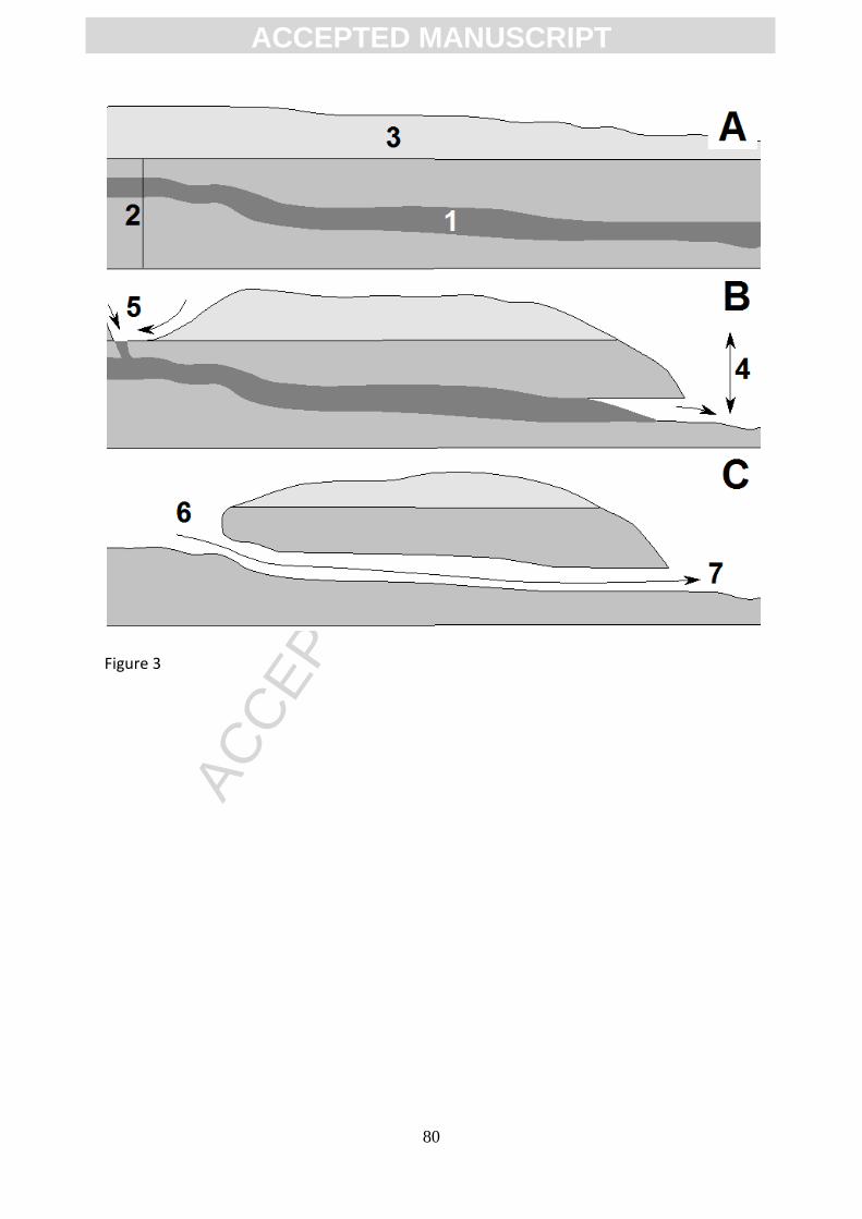
ACC
EPTE
D M
ANU
SCR
IPT
ACCEPTED MANUSCRIPT
80
Figure 3

ACC
EPTE
D M
ANU
SCR
IPT
ACCEPTED MANUSCRIPT
81
Figure 4

ACC
EPTE
D M
ANU
SCR
IPT
ACCEPTED MANUSCRIPT
82
Figure 5
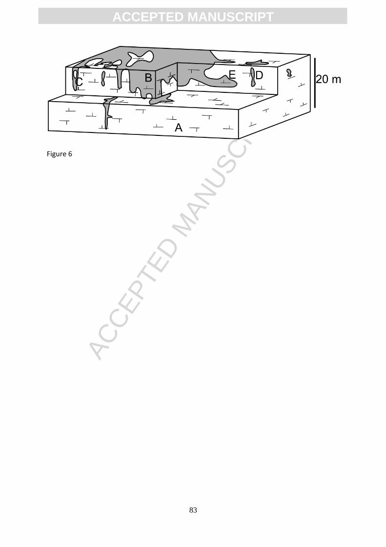
ACC
EPTE
D M
ANU
SCR
IPT
ACCEPTED MANUSCRIPT
83
Figure 6
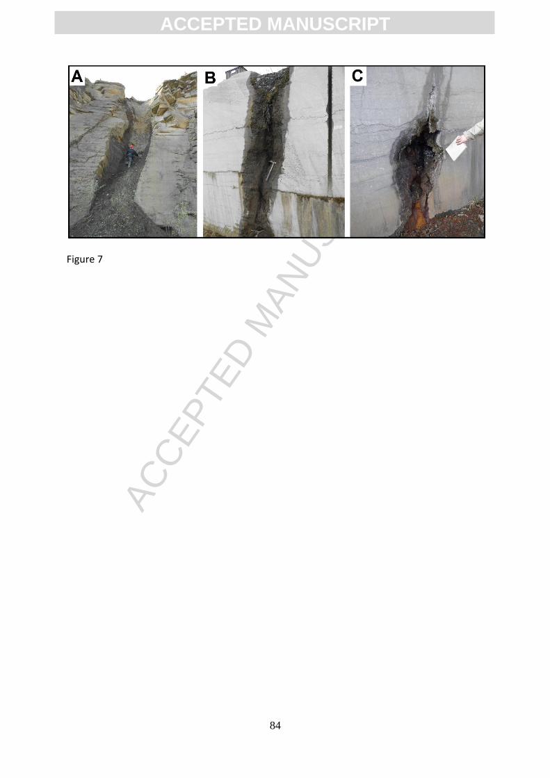
ACC
EPTE
D M
ANU
SCR
IPT
ACCEPTED MANUSCRIPT
84
Figure 7

ACC
EPTE
D M
ANU
SCR
IPT
ACCEPTED MANUSCRIPT
85
Figure 8
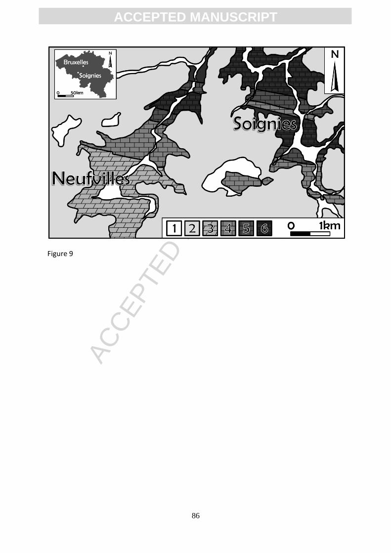
ACC
EPTE
D M
ANU
SCR
IPT
ACCEPTED MANUSCRIPT
86
Figure 9
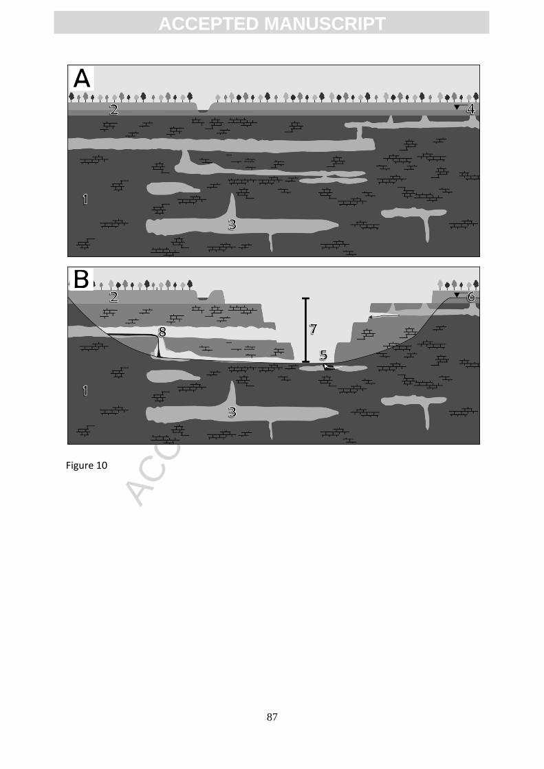
ACC
EPTE
D M
ANU
SCR
IPT
ACCEPTED MANUSCRIPT
87
Figure 10
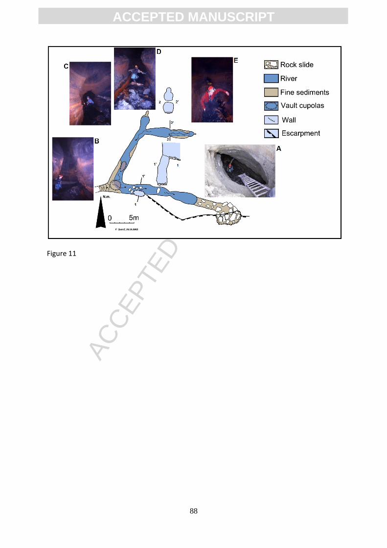
ACC
EPTE
D M
ANU
SCR
IPT
ACCEPTED MANUSCRIPT
88
Figure 11
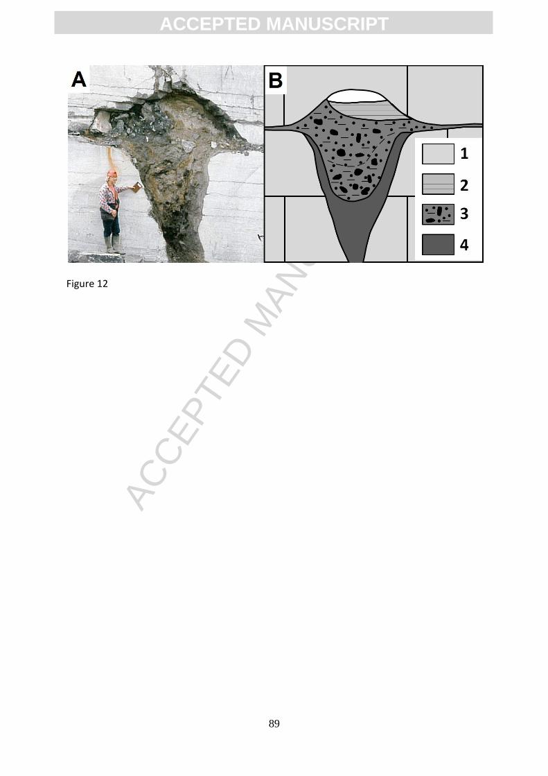
ACC
EPTE
D M
ANU
SCR
IPT
ACCEPTED MANUSCRIPT
89
Figure 12
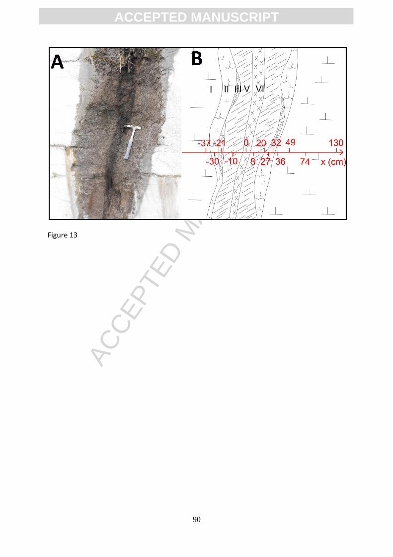
ACC
EPTE
D M
ANU
SCR
IPT
ACCEPTED MANUSCRIPT
90
Figure 13

ACC
EPTE
D M
ANU
SCR
IPT
ACCEPTED MANUSCRIPT
91
Figure 14
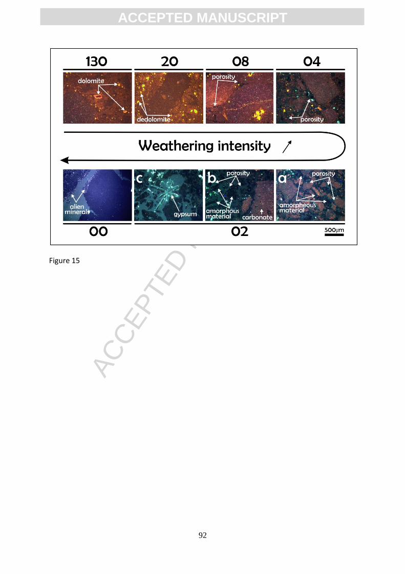
ACC
EPTE
D M
ANU
SCR
IPT
ACCEPTED MANUSCRIPT
92
Figure 15
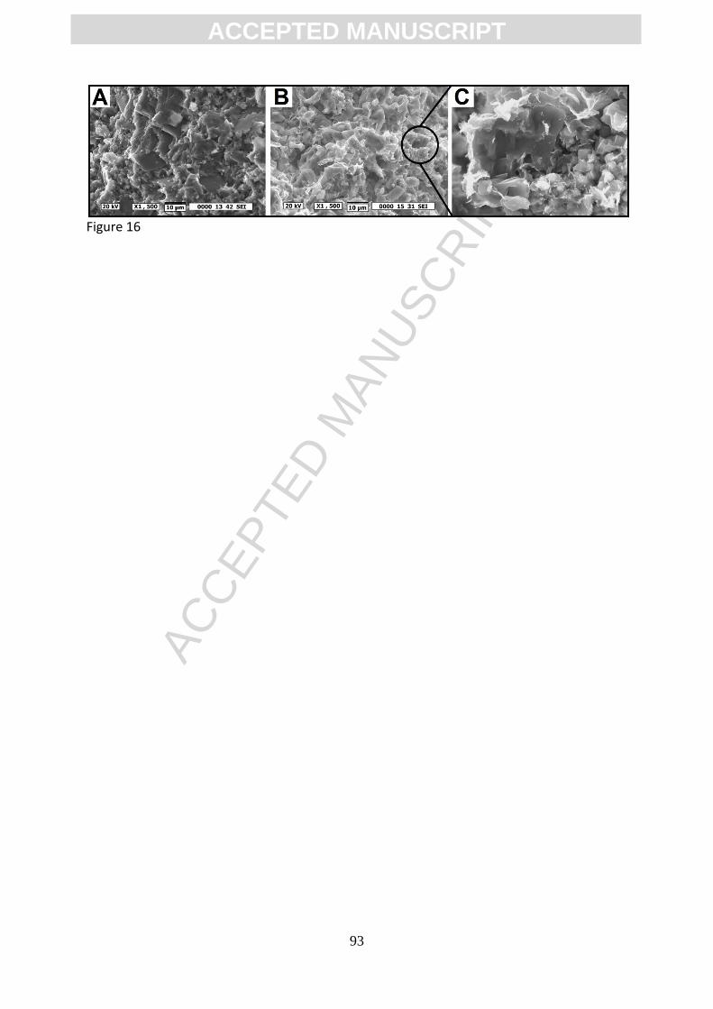
ACC
EPTE
D M
ANU
SCR
IPT
ACCEPTED MANUSCRIPT
93
Figure 16
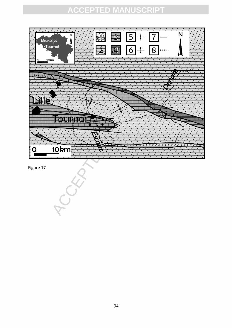
ACC
EPTE
D M
ANU
SCR
IPT
ACCEPTED MANUSCRIPT
94
Figure 17
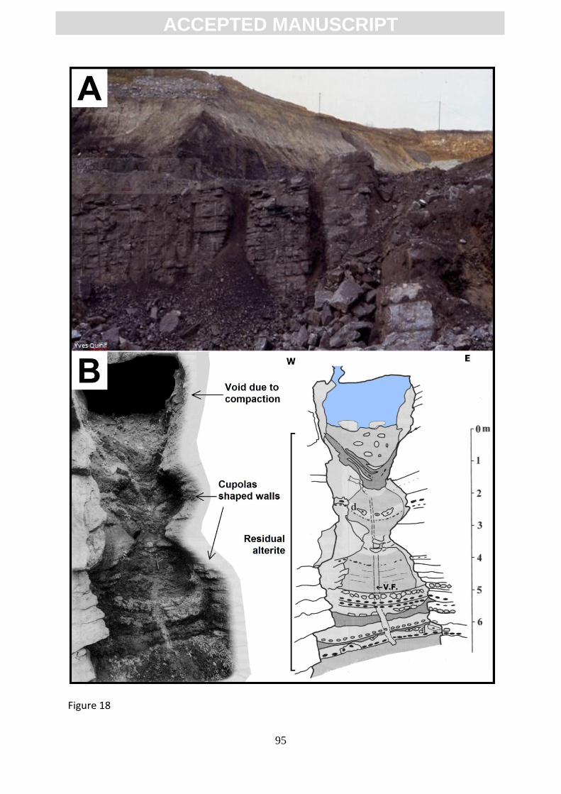
ACC
EPTE
D M
ANU
SCR
IPT
ACCEPTED MANUSCRIPT
95
Figure 18
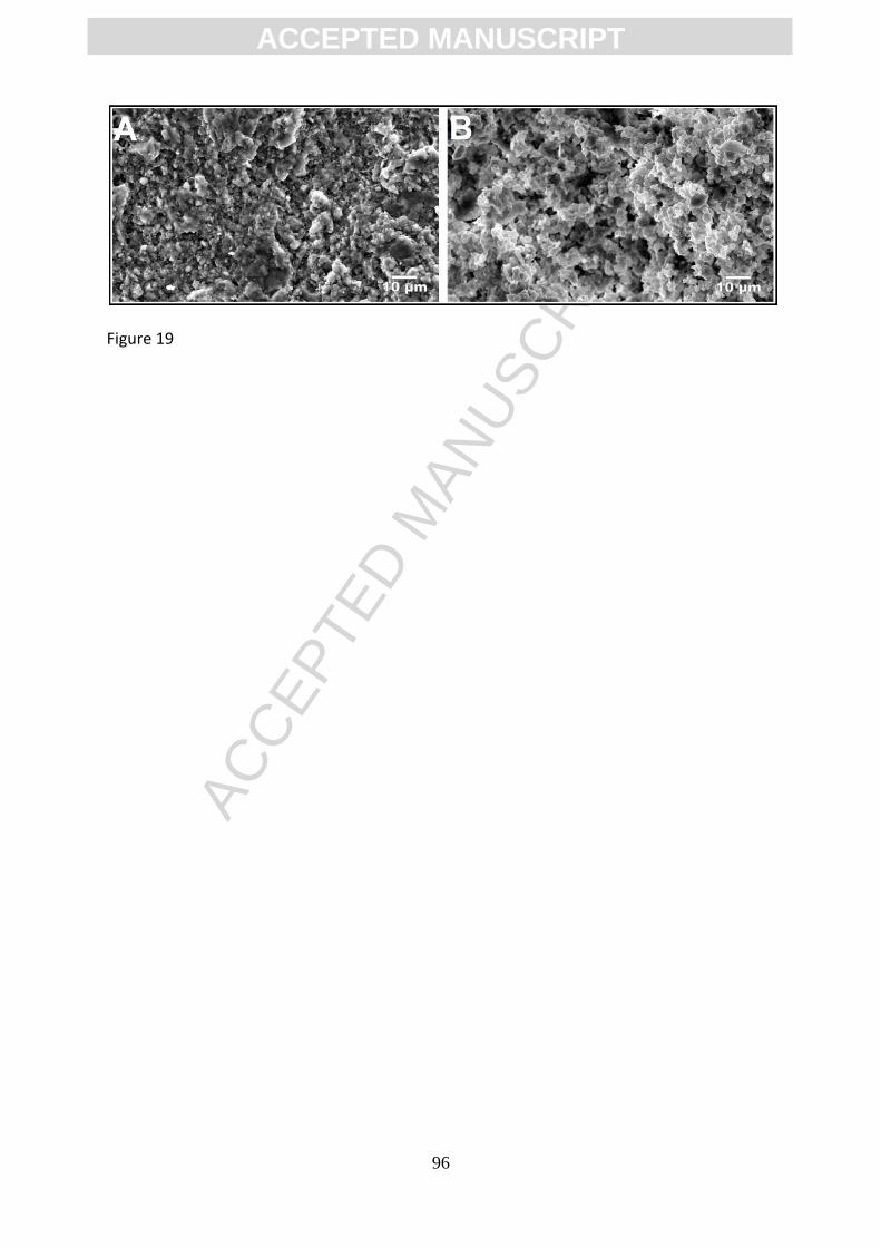
ACC
EPTE
D M
ANU
SCR
IPT
ACCEPTED MANUSCRIPT
96
Figure 19
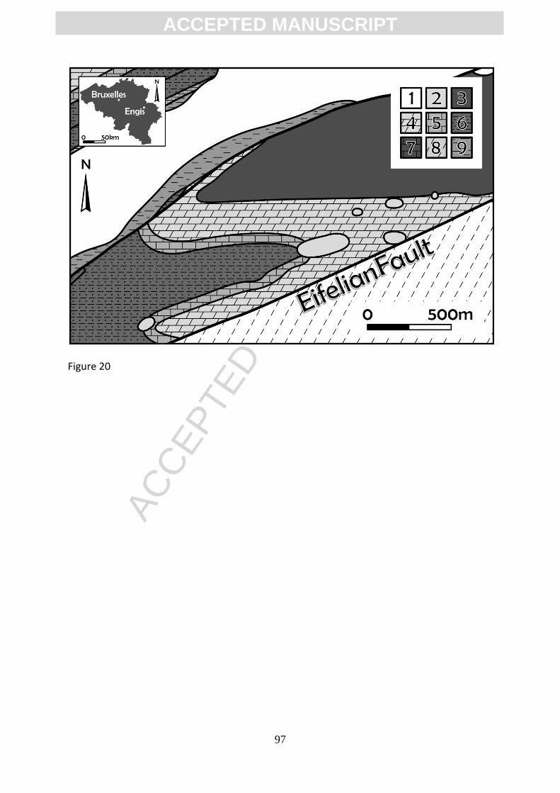
ACC
EPTE
D M
ANU
SCR
IPT
ACCEPTED MANUSCRIPT
97
Figure 20
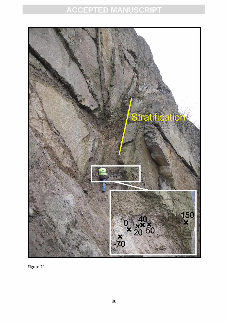
ACC
EPTE
D M
ANU
SCR
IPT
ACCEPTED MANUSCRIPT
98
Figure 21
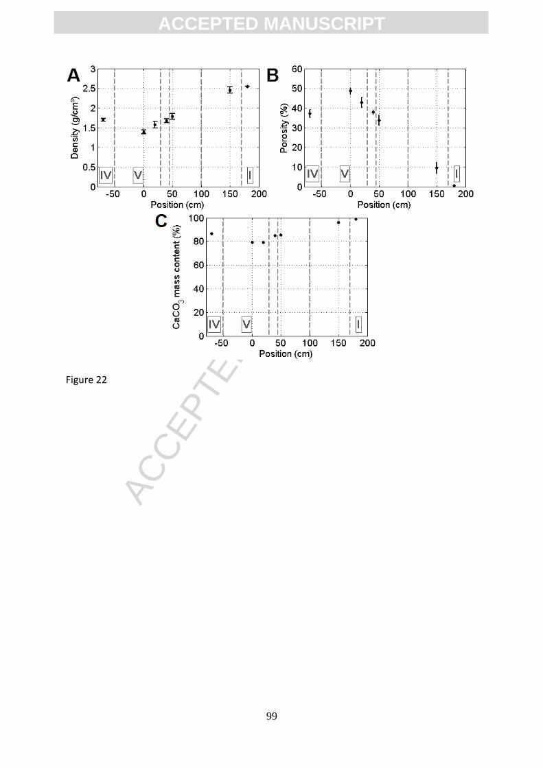
ACC
EPTE
D M
ANU
SCR
IPT
ACCEPTED MANUSCRIPT
99
Figure 22
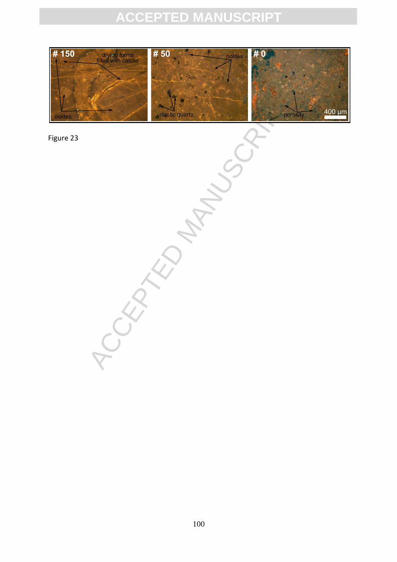
ACC
EPTE
D M
ANU
SCR
IPT
ACCEPTED MANUSCRIPT
100
Figure 23
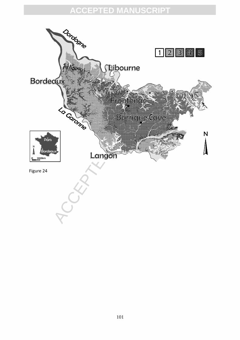
ACC
EPTE
D M
ANU
SCR
IPT
ACCEPTED MANUSCRIPT
101
Figure 24
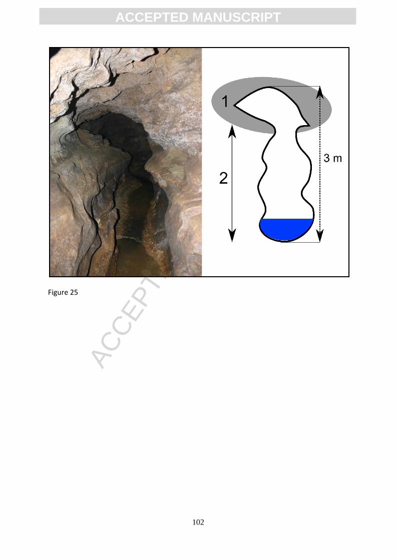
ACC
EPTE
D M
ANU
SCR
IPT
ACCEPTED MANUSCRIPT
102
Figure 25
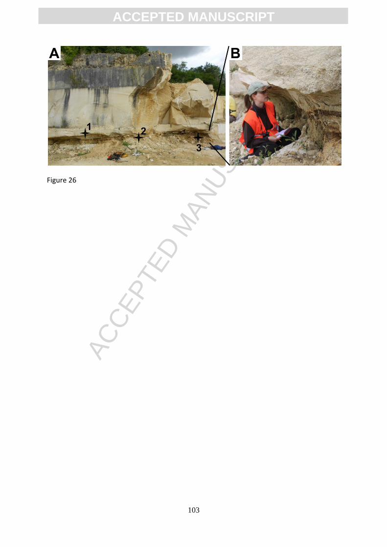
ACC
EPTE
D M
ANU
SCR
IPT
ACCEPTED MANUSCRIPT
103
Figure 26
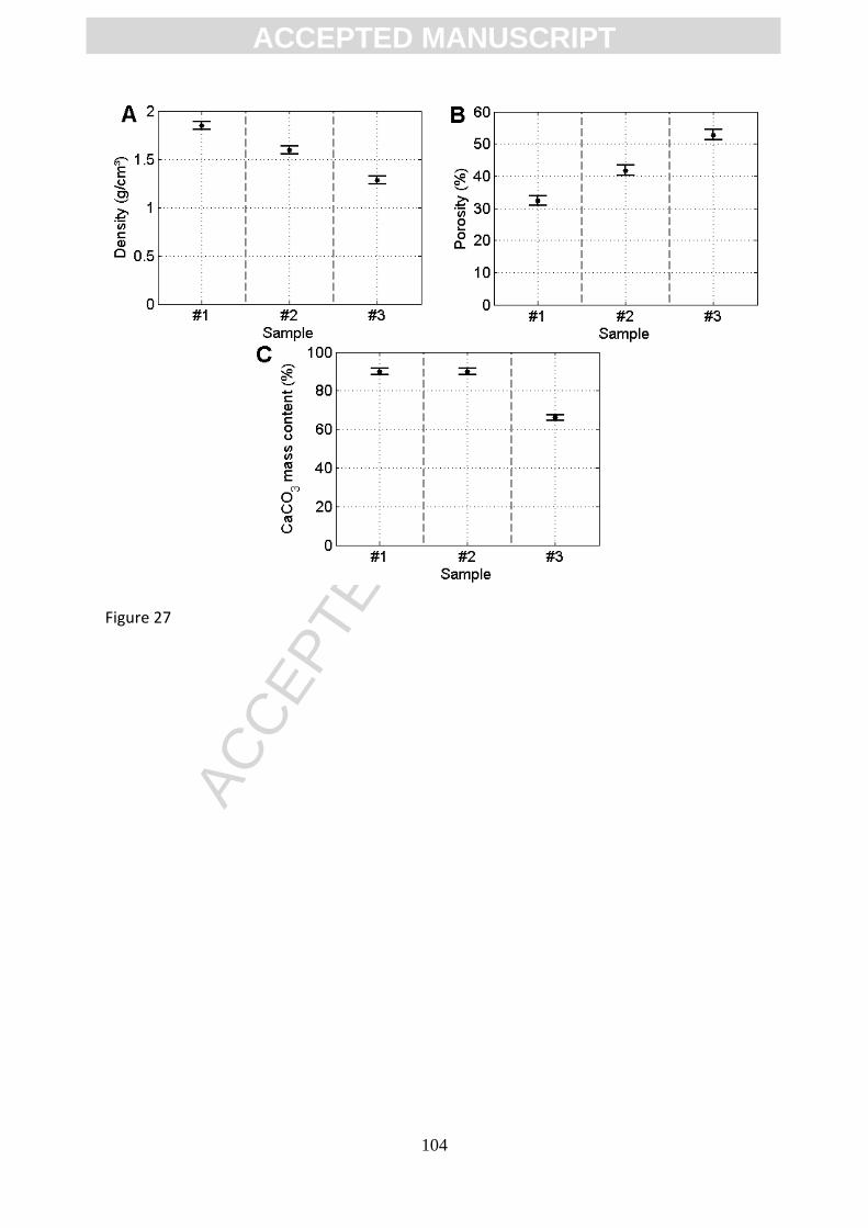
ACC
EPTE
D M
ANU
SCR
IPT
ACCEPTED MANUSCRIPT
104
Figure 27
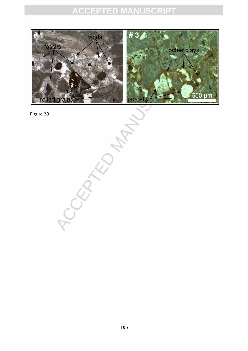
ACC
EPTE
D M
ANU
SCR
IPT
ACCEPTED MANUSCRIPT
105
Figure 28
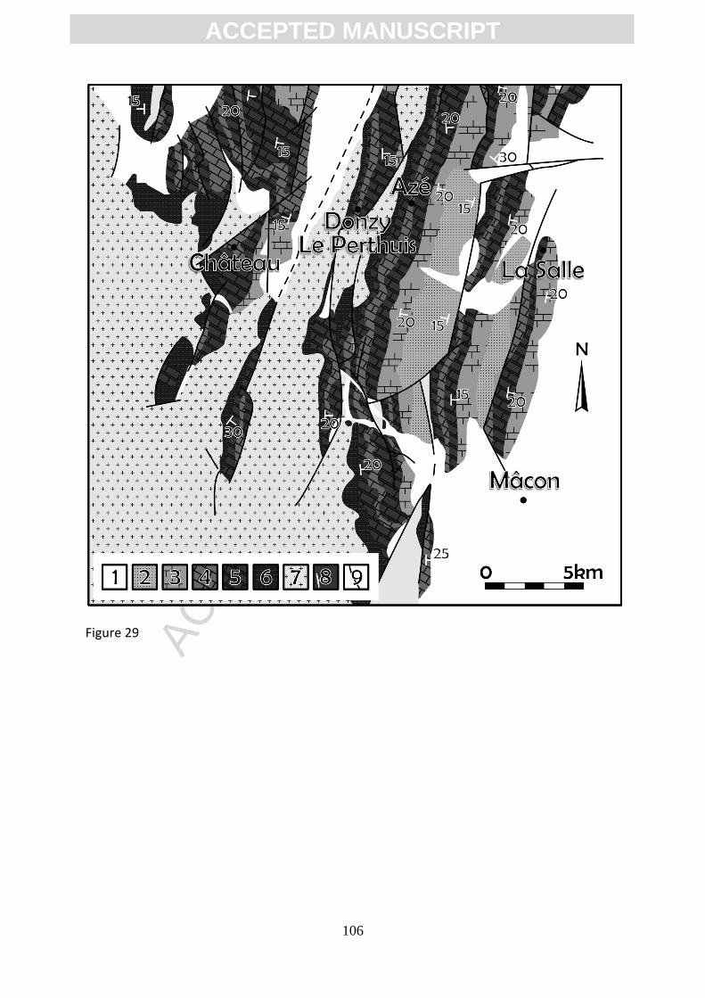
ACC
EPTE
D M
ANU
SCR
IPT
ACCEPTED MANUSCRIPT
106
Figure 29

ACC
EPTE
D M
ANU
SCR
IPT
ACCEPTED MANUSCRIPT
107
Figure 30

ACC
EPTE
D M
ANU
SCR
IPT
ACCEPTED MANUSCRIPT
108
Figure 31

ACC
EPTE
D M
ANU
SCR
IPT
ACCEPTED MANUSCRIPT
109
Figure 32
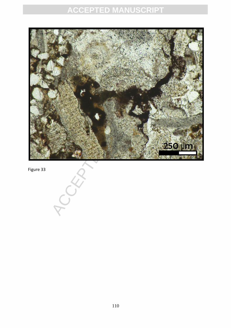
ACC
EPTE
D M
ANU
SCR
IPT
ACCEPTED MANUSCRIPT
110
Figure 33
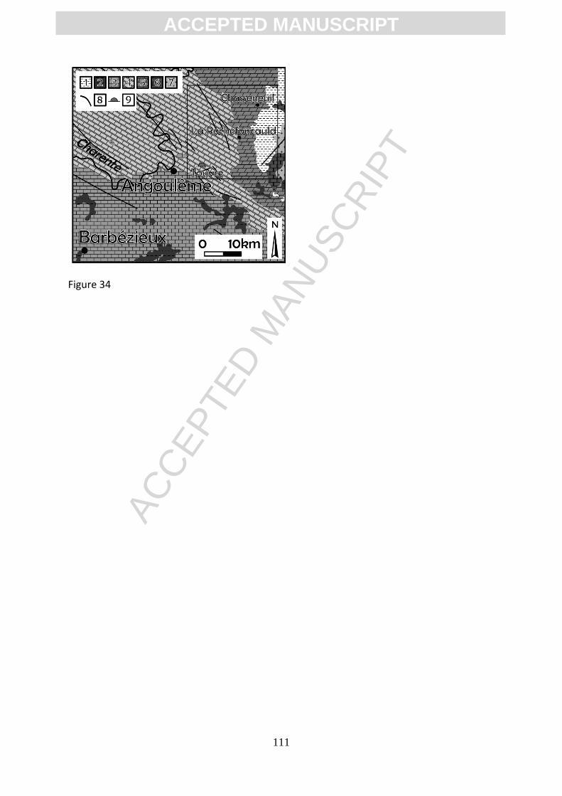
ACC
EPTE
D M
ANU
SCR
IPT
ACCEPTED MANUSCRIPT
111
Figure 34
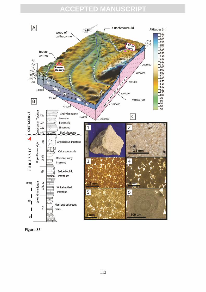
ACC
EPTE
D M
ANU
SCR
IPT
ACCEPTED MANUSCRIPT
112
Figure 35
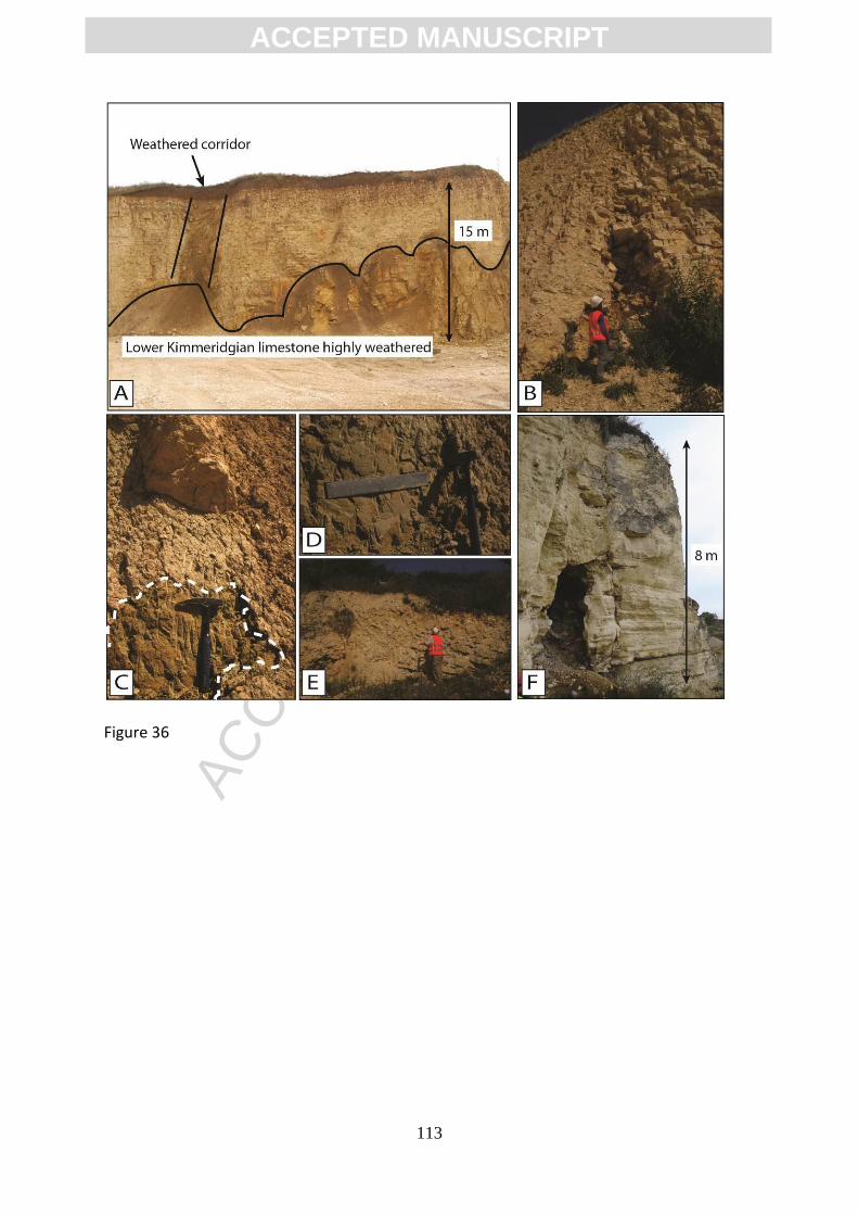
ACC
EPTE
D M
ANU
SCR
IPT
ACCEPTED MANUSCRIPT
113
Figure 36
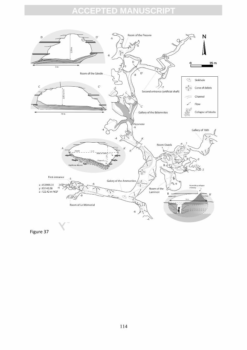
ACC
EPTE
D M
ANU
SCR
IPT
ACCEPTED MANUSCRIPT
114
Figure 37
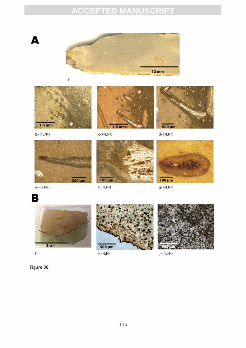
ACC
EPTE
D M
ANU
SCR
IPT
ACCEPTED MANUSCRIPT
115
Figure 38
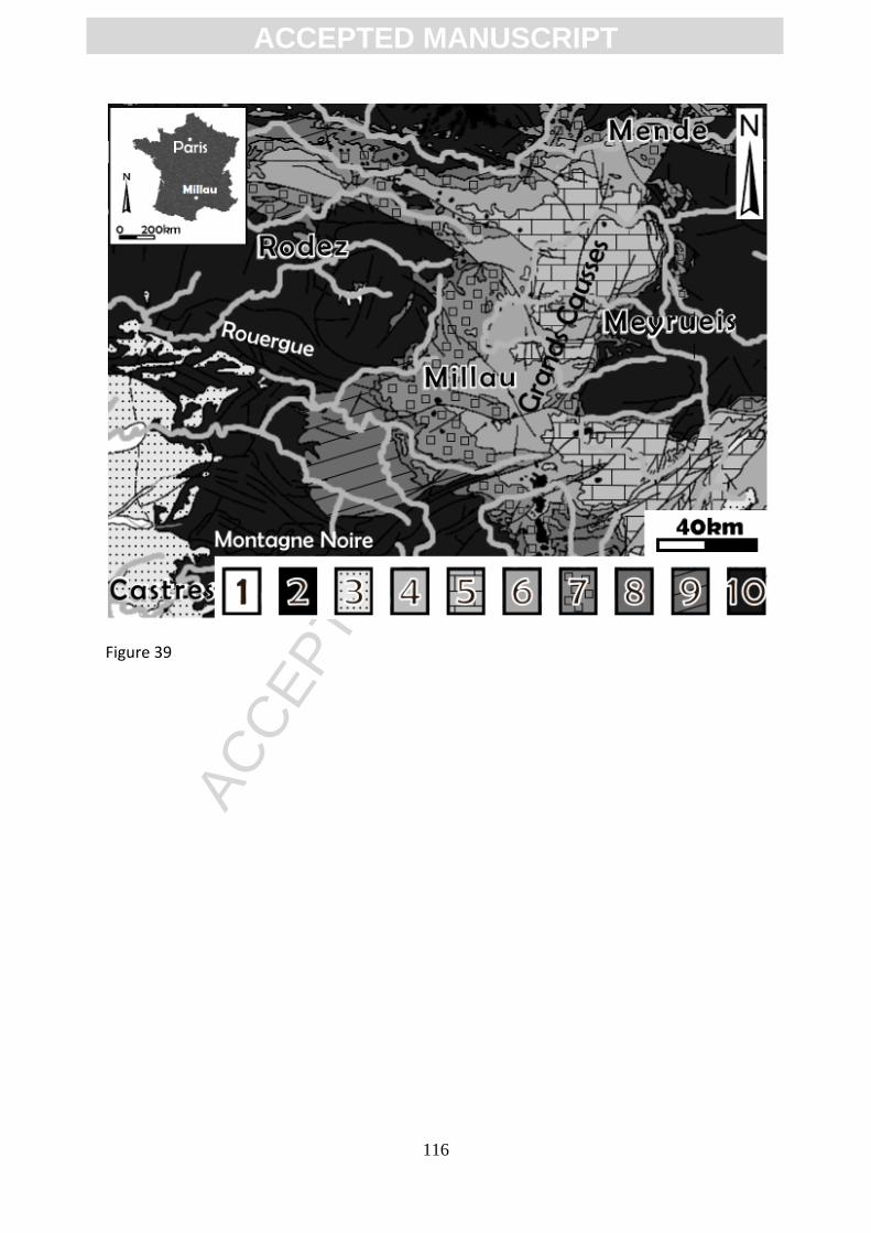
ACC
EPTE
D M
ANU
SCR
IPT
ACCEPTED MANUSCRIPT
116
Figure 39

ACC
EPTE
D M
ANU
SCR
IPT
ACCEPTED MANUSCRIPT
117
Figure 40

ACC
EPTE
D M
ANU
SCR
IPT
ACCEPTED MANUSCRIPT
118
Figure 41

ACC
EPTE
D M
ANU
SCR
IPT
ACCEPTED MANUSCRIPT
119
Figure 42
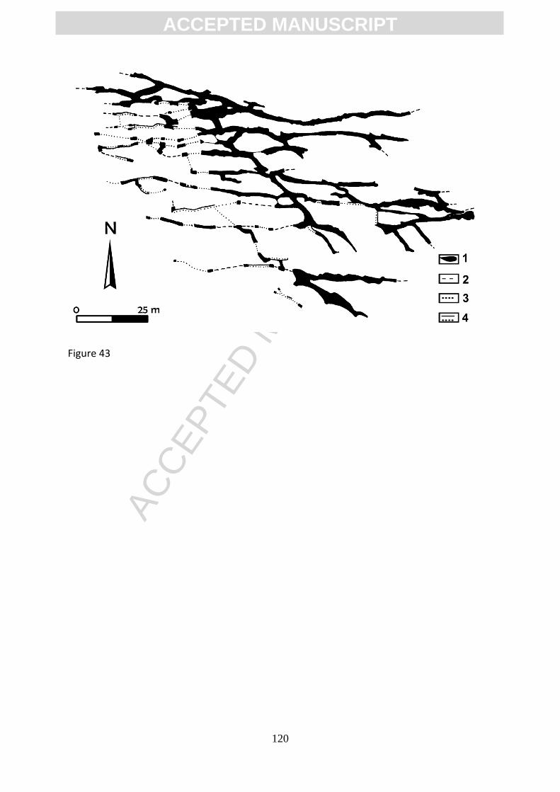
ACC
EPTE
D M
ANU
SCR
IPT
ACCEPTED MANUSCRIPT
120
Figure 43
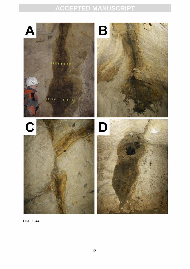
ACC
EPTE
D M
ANU
SCR
IPT
ACCEPTED MANUSCRIPT
121
FIGURE 44

ACC
EPTE
D M
ANU
SCR
IPT
ACCEPTED MANUSCRIPT
122
Figure 45
ACC
EPTE
D M
ANU
SCR
IPT
ACCEPTED MANUSCRIPT
123
Figure 46
ACC
EPTE
D M
ANU
SCR
IPT
ACCEPTED MANUSCRIPT
124
Figure 47

ACC
EPTE
D M
ANU
SCR
IPT
ACCEPTED MANUSCRIPT
125
Figure 48
ACC
EPTE
D M
ANU
SCR
IPT
ACCEPTED MANUSCRIPT
126
Figure 49
ACC
EPTE
D M
ANU
SCR
IPT
ACCEPTED MANUSCRIPT
127
Figure 50
ACC
EPTE
D M
ANU
SCR
IPT
ACCEPTED MANUSCRIPT
128
Figure 51

ACC
EPTE
D M
ANU
SCR
IPT
ACCEPTED MANUSCRIPT
129
Figure 52
ACC
EPTE
D M
ANU
SCR
IPT
ACCEPTED MANUSCRIPT
130
Sample Location
Montm/Quartz Calcite Quartz Opal
SiO2 Al2O3 Fe2O3 MgO CaO K2O Na2O TiO2 MnO H2O- H2O
+
Grade
(cm) % % % N°
A0 -5
17.94 1.03 0.67 0.60 43.51 0.21 0.08 0.02 0.01 0.70 35.16 I
A1 0
20.65 0.77 0.74 0.55 41.50 0.43 0.02 0.02 0.02 0.77 34.20 II
A2 5.5 2.4 4 37 59 71.18 7.45 4.45 1.00 2.36 0.96 0.23 0.23 0.03 5.61 5.52 IV
A3 14 3.5 0 17 83 73.44 7.15 4.17 0.92 1.64 0.89 0.16 0.16 0.01 5.76 4.78 IV
A4 20 2.2 0 31 69 76.09 6.77 3.92 0.90 1.02 0.86 0.14 0.14 0.02 5.57 4.45 V
A5 30 6.0 7 75 18 56.78 13.96 6.73 1.68 1.36 1.56 0.58 0.58 0.02 10.10 6.54 V
A6 50 4.6 0 31 79 79.71 5.32 2.97 0.70 0.76 0.83 0.12 0.12 0.01 5.04 3.30 V
A6+ 51
81.08 4.94 2.58 0.60 0.72 0.85 0.15 0.15 0.01 4.57 2.98 V
A7 72 6.3 13 34 53 66.41 10.79 5.36 1.23 1.35 1.38 0.41 0.41 0.02 7.45 5.34 V
A8 82 6.4 28 23 49 72.97 7.95 4.50 0.90 0.98 1.04 0.32 0.32 0.03 6.48 4.69 V
A9 106 24.5 0 25 75 73.61 7.76 4.49 0.90 1.03 1.02 0.11 0.28 0.03 6.14 4.40 V
A10 130 16.6 69 6 25 66.42 10.43 5.79 1.14 1.42 1.45 0.14 0.39 0.07 6.77 5.66 V
A11 163 0.0 65 35 0 67.12 10.00 5.42 1.10 1.42 1.47 0.15 0.42 0.08 6.07 5.47 V
A12 203 2.8 0 22 78 83.80 4.45 2.58 0.50 0.82 0.71 0.10 0.11 0.03 3.81 2.91 V
A13 211 6.0 0 53 47 66.35 8.75 5.25 1.20 2.68 1.61 0.12 0.28 0.03 7.20 6.16 IV
A14 223 4.2 0 37 63 63.37 5.56 3.26 0.79 8.16 1.06 0.11 0.23 0.03 7.91 9.00 III
A15 238 22.65 1.35 1.04 0.60 39.30 0.40 0.06 0.04 0.02 1.11 32.86 II
Table 1
ACC
EPTE
D M
ANU
SCR
IPT
ACCEPTED MANUSCRIPT
131
Region and
Lithology
Initial
conditions
Timing of
ghost-rock
karstification
Chemical and
Hydrodynamic
Energy
Subsequent development
Soignies
(Belgium)
Upper Tournaisian
limestone and
dolomitic limestone
Upper Jurassic and Lower
Cretaceous tectonic
extension created open
vertical joints: N60°E;
N150°E; N110°E
During emergence
in the Upper
Jurassic and Lower
Cretaceous
Hot and wet climate
accompanied by low
relief
Thanetian: marine transgressions during which the karst became a palaeokarst.
Danian: a (?tectonic) disturbance generated underground flow during which some
weathered features were emptied of their alterite and replaced by a fluvial detrital
series. Caves with cupolas were created and then fossilised by transgressions in the
Thanetian and Ypresian. Present: quarrying and pumping has lowered the piezometric
level and created new hydrodynamic potential. In the quarries, new caves have formed
while, at the surface, alterite compaction has led to the formation of sinkholes.
Tournai
(Belgium)
Upper Tournaisian
siliceous and
dolomitic limestone
Upper Jurassic and
Lower Cretaceous
tectonic extension created
open vertical joints:
N60°E; N150°E; N110°E
During emergence
prior to the
Cenomanian
Hot and wet climate
accompanied by low
relief
Cenomanian: marine transgressions during which the karst became a palaeokarst.
Quaternary: the ghost-palaeokarsts were probably reactivated during glacio-eustatic
regression. Present: quarrying and pumping has lowered the piezometric level and
created a new hydrodynamic potential. At the surface, alterite compaction has led to
the formation of sinkholes.
Engis
(Belgium)
Viséan limestone
Mesozoic tectonic
extension created open
joints
During emergence
in the Upper
Jurassic and Lower
Cretaceous
Hot and wet climate
accompanied by low
relief
Neogene: creation of hydrodynamic potential due to uplift. The reactivation of some
palaeokarsts led to the formation of caves during the Plio-Quaternary. These caves
have numerous cupolas and vertical corridors filled with Quaternary sediments while
their subsequent development has created galleries with torrential morphologies (e.g.
overdeepening, swage, and potholes).
Aquitaine
(France)
Lower Oligocene
bioclastic limestone
Highly porous rock due to
weak diagenesis along
with some vertical
tectonic joints
Upper Rupelian to
Lower Chattian
?at the contact
between freshwater
and seawater while
the area was close to
sea-level
Chattian: marine transgressions deposited the ‘Agenais Molasses’ during which the
karst became a palaeokarst. Pliocene-Quaternary: creation of hydrodynamic potential
due to uplift and stream incision. The reactivation of some palaeokarsts led to the
emptying of horizontal ghost-endokarsts by regressive mechanical erosion. Present:
anthropogenic modification of the vegetation cover has changed the hydrological
regime and reactivated the ghost-endokarsts.
Burgundy
(France)
Middle Jurassic
limestone
Aalanian-Bajocian
tectonic extension
coupled with more porous
strata
During emergence
in the Upper
Jurassic and
Cretaceous
Hot and wet climate
accompanied by low
relief
Oligocene: formation of the Bressan Graben and surrounding horst created
hydrodynamic potential during which the alterite was partially eroded. Pliocene-
Quaternary: underground rivers flow though the partially emptied ghost-rock
features, eroding the remaining alterite, and providing the sedimentary material for the
paleontological and prehistoric sites.
Charente
(France)
Middle and Upper
Jurassic oolitic
limestone
Upper Jurassic to Lower
Cretaceous tectonic
extension creates open
joints in addition to the
bedding planes
During emergence
between the Late
Kimmeridgian and
the Lower
Cenomanian
Hot and wet climate
accompanied by low
relief close to sea-
level
End of Lower Cretaceous: marine transgressions during which the karst became a
palaeokarst. Upper Cretaceous: the creation of sporadic hydrodynamic potential
during which sediments became trapped in some partly emptied ghost-rock features
and hydraulic breccias formed. Lower Maastrichtian-Danian: continental landscape
development with the deposition of sediments from the Massif Central. A sandy-clay
ACC
EPTE
D M
ANU
SCR
IPT
ACCEPTED MANUSCRIPT
132
Cenozoic overburden covered the landscape and fossilised the ghost-endokarsts.
Pliocene-Quaternary: the creation of hydrodynamic potential due to stream incision
resulting from uplift of the Massif Central. The reactivation of some palaeokarsts led to
the emptying of deep flooded cavities while water-table fluctuations also helped to
empty ghost-rock features and led to the creation of maze caves.
Les Grands
Causses
(France)
Jurassic limestone
and dolostone
Greater permeability at
the Hettangian-
Sinemurian contact and
tectonic extension
between the Cretaceous
and the Eocene
Upper Jurassic to
Miocene although
ghost-rock
karstification may
be ongoing in the
central parts of the
plateaux
Hot and wet climate
accompanied by low
relief
Miocene: the creation of hydrodynamic potential due to stream incision resulting from
uplift of the Cevennes lead to the onset of erosion of the alterite. Present: continuing
erosion of the alterite which may be enhanced by quarrying.
Normandy
(France)
Cenomanian chalk
freestone facies
Erosion of the
impermeable cover during
the Quaternary
Eemian
Wet temperate
oceanic climate
accompanied by low
relief
Last glacial period: erosion led to the removal of the overlying ‘Sands of Perche’
which interrupted ghost-rock karstification and fossilised the features.
Lombardy
(Italy)
Liassic silico-clayed
limestone
More porous strata and
tectonic extension of
subvertical joints (N-S
and E-W)
Upper Oligocene
with biostasic
conditions during
the Miocene
Hot and wet climate
accompanied by
moderate relief
following the onset
of Alpine tectonics
Upper Miocene: uplift of the Alps interrupted ghost-rock karstification and eroded the
alterite. Messinian: sea-level fall enhanced removal of the alterite from the ghost-rock
features by regressive mechanical erosion.
Pembrokeshire
(Great-Britain)
Viséan argillaceous
limestone and
mudstone
Nearshore or coastal
environment with
contrasting facies
Late Viséan
weathering
following soon after
diagenesis
Hot and wet climate
accompanied by low
relief close sea level
Serpukhovian: deposition of the Pendleian Aberkenfig Formation sealed the
underlying Brigantian Oystermouth Formation and fossilised the weathered features.
Cenozoic: exhumation reactivated the weathering process. Present: the wide
weathered areas are in the process of being removed by the present cycle of marine
erosion.
Table 2