Projected Status of the Ghost Orchid (Dendrophylax lindenii ...
Upload
u-bordeaux3Category
view
6download
0
Earth-Science Reviews 131 (2014) 116–148
Contents lists available at ScienceDirect
Earth-Science Reviews
j ourna l homepage: www.e lsev ie r .com/ locate /earsc i rev
The process of ghost-rock karstification and its role in the formationof cave systems
C. Dubois a,b,⁎, Y. Quinif a, J.-M. Baele a, L. Barriquand c, A. Bini d, L. Bruxelles e,f,g, G. Dandurand h, C. Havron i,O. Kaufmann a, B. Lans h, R. Maire h, J. Martin c, J. Rodet j, M.D. Rowberry k, P. Tognini d, A. Vergari l
a Department of Geology and Applied Geology, Faculty of Engineering, University of Mons, rue de Houdain 9, B-7000 Mons, Belgiumb Fond National de la Recherche Scientifique (FNRS), rue d'Egmont 5, B-1000 Brussels, Belgiumc Association de Recherche Paléoécologique en Archéologie (ARPA), Department of Earth Science, University Claude Bernard, Lyon I, rue Dubois 2, F-69622 Villeurbanne, Franced Department of Earth Science, University of Milan, via Mangiagalli 34, 20133 Milan, Italye Institut National de Recherches Archéologiques Préventives (INRAP), rue Etienne Lenoir 561, F-30900 Nimes, Francef Travaux et Recherches Archéologiques sur les Cultures, les Espaces et les Sociétés (TRACES), UMR 5608, Centre national de la recherche scientifique (CNRS), University of Toulouse le Mirail,Allée Antonio Machado 5, 31058 Toulouse, Franceg School of Geography, Archaeology and Environmental Studies (GAES), University of the Witwatersrand, Jan Smuts Avenue 1, 2000 Johannesburg, South Africah Laboratoire de l'Aménagement, Développement, Environnement, Santé et Sociétés (ADES), UMR 5185, Centre national de la recherche scientifique (CNRS), University of Bordeaux III,Esplanade des Antilles 12, 33607 Pessac, Francei Institut Interuniversitaire des Silicates, Sols et Matériaux (INISMa), Avenue Gouverneur Cornez 4, B-7000 Mons, Belgiumj Laboratory of Continental and Coastal Morphodynamics, UMR 6143, Centre national de la recherche scientifique (CNRS), University of Rouen, Place Emile Blondel,76821 Mont Saint Aignan, Francek Department of Engineering Geology, Institute of Rock Structure and Mechanics, Academy of Sciences of the Czech Republic, V Holešovičkách 41, 182 09 Prague 8, Czech Republicl SAGREX, Heidelberg Cement Group, Chaussée de la Hulpe 185, B-1170 Bruxelles, Belgium
⁎ Corresponding author at: Department of Geology anfax: +32 65374610.
E-mail addresses: [email protected] (C. Du(L. Barriquand), [email protected] (A. Bini), [email protected] (B. Lans), [email protected] (R. Mair
0012-8252/$ – see front matter © 2014 Elsevier B.V. All rihttp://dx.doi.org/10.1016/j.earscirev.2014.01.006
a b s t r a c t
a r t i c l e i n f oArticle history:Received 3 July 2013Accepted 21 January 2014Available online 5 February 2014
Keywords:KarstificationLimestone dissolutionChemical weatheringGhost-rockSpeleogenesisWestern Europe
This paper presents an extensive review of the process of ghost-rock karstification and highlights its role in theformation of cave systems. The process integrates chemical weathering and mechanical erosion and extends anumber of existing theories pertaining to continental landscape development. It is a two stage process that differsin many respects from the traditional single-stage process of karstification by total removal. The first stage ischaracterised by chemical dissolution and removal of the soluble species. It requires low hydrodynamic energyand creates a ghost-rock feature filledwith residual alterite. The second stage is characterised bymechanical ero-sion of the undissolved particles. It requires high hydrodynamic energy and it is only then that open galleries arecreated. The transition from the first stage to the second is driven by the amount of energywithin the thermody-namic system. The process is illustrated bydetailed field observations and the results of the laboratory analyses ofsamples taken from the karstotype area around Soignies in southern Belgium. Thereafter, a series of case studiesprovide a synthesis offield observations and laboratory analyses from acrosswestern Europe. These studies comefrom geologically distinct parts of Belgium, France, Italy, and the United Kingdom. The process of ghost-rockkarstification challenges a number of axioms associated with the process of karstification by total removal. Onthe basis of the evidence presented it is argued that it is no longer acceptable to use karst morphologies as abasis withwhich to infer specific karstogenetic processes and it is no longer necessary for a karst system to relateto base level as ghost-rock karstification proceeds along transmissive pathways in the rock. There is also someevidence to suggest that ghost-rock karstification may be superseded by karstification by total removal, andvice versa, according to the amount of energy within the thermodynamic system. The proposed chemicalweathering and subsequent mechanical erosion of limestone suggest that the development of karst terrain is re-lated farmore closely to the geomorphological development of aluminosilicate and siliceous terrains than is gen-erally supposed. It is now necessary to reconsider the origin ofmany karst systems in light of the outlined processof ghost-rock karstification.
© 2014 Elsevier B.V. All rights reserved.
d Applied Geology, Faculty of Engineering, University of Mons, 9 rue de Houdain, 7000 Mons, Belgium. Tel.: +32 65374613;
bois), [email protected] (Y. Quinif), [email protected] (J.-M. Baele), [email protected]@inrap.fr (L. Bruxelles), [email protected] (G. Dandurand), [email protected] (O. Kaufmann),e), [email protected] (J. Rodet), [email protected] (M.D. Rowberry).
ghts reserved.

Contents
C. Dubois et al. / Earth-Scien
1. Introduction . . . . . . . . . . . . . . . . . . . . . . . . . . . . . . . . . . . . . . . . . . . . . . . . . . . . . . . . . . . . . . 117
2. Background . . . . . . . . . . . . . . . . . . . . . . . . . . . . . . . . . . . . . . . . . . . . . . . . . . . . . . . . . . . . . . 1172.1. The traditional process of karstification by total removal . . . . . . . . . . . . . . . . . . . . . . . . . . . . . . . . . . . . . . 117
2.1.1. Two simultaneous stages: chemical dissolution and mechanical erosion . . . . . . . . . . . . . . . . . . . . . . . . . 1182.1.2. The thermodynamic regime . . . . . . . . . . . . . . . . . . . . . . . . . . . . . . . . . . . . . . . . . . . . . . . 1192.1.3. The structure and feature geometry of the karst network . . . . . . . . . . . . . . . . . . . . . . . . . . . . . . . . . . 119
2.2. The recently proposed theory of ghost-rock karstification . . . . . . . . . . . . . . . . . . . . . . . . . . . . . . . . . . . . . . 1192.2.1. The process of ghost-rock karstification . . . . . . . . . . . . . . . . . . . . . . . . . . . . . . . . . . . . . . . . . . 1202.2.2. The thermodynamic regime . . . . . . . . . . . . . . . . . . . . . . . . . . . . . . . . . . . . . . . . . . . . . . . 1212.2.3. The structure and feature geometry of the karst network . . . . . . . . . . . . . . . . . . . . . . . . . . . . . . . . . . 121
3. The karstotype for ghost-rock karstification: Soignies, southern Belgium . . . . . . . . . . . . . . . . . . . . . . . . . . . . . . . . . . . 1223.1. The geological setting of the area . . . . . . . . . . . . . . . . . . . . . . . . . . . . . . . . . . . . . . . . . . . . . . . . . 1223.2. Field observations of ghost-rock features . . . . . . . . . . . . . . . . . . . . . . . . . . . . . . . . . . . . . . . . . . . . . . 1233.3. Analytical investigations of the alterite . . . . . . . . . . . . . . . . . . . . . . . . . . . . . . . . . . . . . . . . . . . . . . 1243.4. Subsequent erosion of the ghost rock features . . . . . . . . . . . . . . . . . . . . . . . . . . . . . . . . . . . . . . . . . . . 1253.5. A summary of the results in terms of ghost-rock karstification . . . . . . . . . . . . . . . . . . . . . . . . . . . . . . . . . . . . 126
4. Ghost-rock karstification in other geological settings . . . . . . . . . . . . . . . . . . . . . . . . . . . . . . . . . . . . . . . . . . . . 1264.1. Belgium . . . . . . . . . . . . . . . . . . . . . . . . . . . . . . . . . . . . . . . . . . . . . . . . . . . . . . . . . . . . 127
4.1.1. The Tournaisian siliceous limestone of Tournai . . . . . . . . . . . . . . . . . . . . . . . . . . . . . . . . . . . . . . . 1274.1.2. The Dinantian oolitic limestone of Engis . . . . . . . . . . . . . . . . . . . . . . . . . . . . . . . . . . . . . . . . . . 127
4.2. France . . . . . . . . . . . . . . . . . . . . . . . . . . . . . . . . . . . . . . . . . . . . . . . . . . . . . . . . . . . . . 1284.2.1. The Rupelian bioclastic limestone of Aquitaine . . . . . . . . . . . . . . . . . . . . . . . . . . . . . . . . . . . . . . . 1284.2.2. The Mid-Jurassic limestone of Burgundy . . . . . . . . . . . . . . . . . . . . . . . . . . . . . . . . . . . . . . . . . 1304.2.3. The Kimmeridgian oolitic limestone of Charente . . . . . . . . . . . . . . . . . . . . . . . . . . . . . . . . . . . . . . 1324.2.4. The Jurassic limestone and dolomite of Les Grands Causses . . . . . . . . . . . . . . . . . . . . . . . . . . . . . . . . . 1354.2.5. The Cenomanian chalky limestone of Normandy . . . . . . . . . . . . . . . . . . . . . . . . . . . . . . . . . . . . . . 137
4.3. Italy . . . . . . . . . . . . . . . . . . . . . . . . . . . . . . . . . . . . . . . . . . . . . . . . . . . . . . . . . . . . . . 1384.3.1. The Liassic silico-clay limestone of Lombardy . . . . . . . . . . . . . . . . . . . . . . . . . . . . . . . . . . . . . . . 138
4.4. Great Britain . . . . . . . . . . . . . . . . . . . . . . . . . . . . . . . . . . . . . . . . . . . . . . . . . . . . . . . . . . 1394.4.1. The Carboniferous limestone of southern Pembrokeshire . . . . . . . . . . . . . . . . . . . . . . . . . . . . . . . . . . 139
5. Discussion . . . . . . . . . . . . . . . . . . . . . . . . . . . . . . . . . . . . . . . . . . . . . . . . . . . . . . . . . . . . . . . 1426. Conclusions . . . . . . . . . . . . . . . . . . . . . . . . . . . . . . . . . . . . . . . . . . . . . . . . . . . . . . . . . . . . . . 145Acknowledgements . . . . . . . . . . . . . . . . . . . . . . . . . . . . . . . . . . . . . . . . . . . . . . . . . . . . . . . . . . . . . 147References . . . . . . . . . . . . . . . . . . . . . . . . . . . . . . . . . . . . . . . . . . . . . . . . . . . . . . . . . . . . . . . . . 147
117ce Reviews 131 (2014) 116–148
1. Introduction
This manuscript presents the first comprehensive review of the pro-cess of ghost-rock karstification and highlights its role in the formationof cave systems. It is a process that has been investigated intensively byresearchers from the Francophone karstological community since themid-1990s. However, as most of the studies have been published inFrench, this review also enables the process of ghost-rock karstificationto be presented to the wider karstological and geological communitiesfor the first time. The process of ghost-rock karstification offers an alter-native to the traditional paradigm that exists within karstological re-search, that of karstification by total removal, by separating chemicaldissolution and mechanical erosion into two very distinct stages. Ithas long been known that chemical weathering of crystalline rocksleaves the less soluble materials— this process is commonly recognisedat or near the surface to form, for example, sandy regoliths or lateriticsoils (Bisdom, 1967; Meunier, 1977). This paper aims to demonstratethat the same fundamental process also occurs in karst regions andthat this process may extend to great depths.
It is well known that dissolution phenomena occur when calciumcarbonate comes into contact with water catalysed acid (Bögli, 1964;Caro, 1965; Roques, 1967; Thraikill, 1968; Bakalowicz, 1975; Morse,1983; Dreybrodt, 1987). Moreover, any type of acid can enhancethe rate of chemical dissolution, and this may come from the surface(e.g. soil and air), from depth (e.g. hydrothermal), or from within therock itself (e.g. bacterial oxidation). The in situ weathering of limestoneproduces a residual material called alterite and this process is calledghost-rock karstification due to the fact the rock retains the same phys-ical appearance despite having been greatly altered. Ghost-rock featureshave been found in limestone (Schmidt, 1974; Martini, 1985; Quinifet al., 1993), dolomite (Bini, 2002; Bruxelles, 2002a,b) and chalk
(Rodet, 1996). There was no direct evidence to link ghost-rockkarstification to the formation of cave systems until ten years ago de-spite strong observational support (Rodet, 1999; Bruxelles, 2001;Bruxelles and Bruxelles, 2002; Rodet, 2002, 2003, 2004; Quinif et al.,2006). It wasfinally demonstrated experimentally following the discov-ery of Quentin Cave in southern Belgium (Quinif and Maire, 2007;Quinif et al., 2014).
The first part of this manuscript describes the processes ofkarstification by total removal and ghost-rock karstification then, foreach, outlines their thermodynamic regime and their structure andfeature geometry. The second part details the ghost-rock featuresand analytical properties of the alterite found around Soignies in southernBelgium. The third part illustrates the process of ghost-rock karstificationin geologically distinct parts of western Europe: Belgium (the siliceouslimestone of Tournai and the oolitic limestone of Engis); France (thebioclastic limestone of Aquitaine; the limestone of Burgundy; the ooliticlimestone of Charente; the dolomite of Les Grand Causses; and the chalkylimestone of Normandy); Italy (the silico-clay limestone of Lombardy);and the United Kingdom (the argillaceous limestone of Pembrokeshire).The manuscript concludes with a discussion of some of the implicationsof this process. It is, in particular, suggested that there are far greater sim-ilarities between the processes operating on karst and non-karst terrainthan is generally appreciated.
2. Background
2.1. The traditional process of karstification by total removal
Thepioneering cave explorations carried out by the father ofmodernspeleology, Édouard-AlfredMartel (e.g. Martel, 1894, 1900, 1928), haveled to the study of innumerable karst systems around the world

Fig. 2. A schematic diagram showing themain features of a limestone bedrock affected bythe process of ghost-rock karstification (Quinif, 2010a,b): (1) limestone with beddingplanes; (2) marker horizons such as chert beds, calcite veins and stylolites; (3) joints;(4) ghost-rock features containing their residual alterite — the different shades of greyrepresent different weathering intensities; (5–6) different types of overburden. This dia-gram is based on examples seen in quarries in the Tournai region of western Belgium.
118 C. Dubois et al. / Earth-Science Reviews 131 (2014) 116–148
(e.g. Van Den Broeck et al., 1910; Courbon and Chabert, 1986; Whiteand Culver, 2012). The enduring paradigm in karstogenesis assertsthat a karst network develops as a result of the flow of chemicallyaggressive waters along an open discontinuity in the bedrock. This oc-curs within certain hydrogeological contexts: vadose, epiphreatic, andphreatic karstification (e.g. Gründ, 1914; Davis, 1930; Swinnerton,1932; Rhoades and Sinacori, 1941; Bretz, 1942; Bögli, 1964; Caro,1965; Renault, 1967; Roques, 1967; Thraikill, 1968; Jennings, 1971;Herak and Stringfield, 1972; Nicod, 1972; Bakalowicz, 1975; Grillotand Guerin, 1975; Ford and Cullingford, 1976; Jakucs, 1977; Bögli,1980; Morse, 1983; Bonacci, 1987; Dreybrodt, 1987; Lohmann, 1988;Ford and Williams, 1989; White, 1989; Palmer, 1991; Salomon, 2006;Gilli, 2011).
2.1.1. Two simultaneous stages: chemical dissolution and mechanicalerosion
An acid–base reaction decomposes calcium carbonate into calciumand carbonate ions when acidified water comes into contact with lime-stone. As the source of the acid must be renewed, this reaction can onlyoccur when there is flowing water, otherwise the solution saturates inions and the dissolution process is inhibited. Therefore, the karst systemdevelops along more permeable zones within the bedrock, such asalong discontinuities — the soluble parts of the discontinuity walls
Fig. 1. The locations in which ghost-rock karstification phenomena have been studied inEurope. (A) Belgium: 1—Wallonia; (B) France: 2—Aquitaine; 3—Burgundy; 4—Charente;5 — Languedoc; 6 — Normandy; (C) Great Britain: 7 — Pembrokeshire; (D) Italy: 8 —
Lombardy; (E) Netherlands: 9 — Limburg; (F) Switzerland: 10 — Canton of Bern.
are gradually dissolved during this acid–base reaction. Laboratory ex-periments have demonstrated that limestone dissolves progressively:dissolution begins with the micritic constituent of the carbonate beforelater affecting the bulkier particles such as sparitic crystals and fossils(Roques and Ek, 1973). In that experimental study, the insoluble min-erals, such as clays and quartz, and the as yet undissolved particles fallto the bottom of the apparatus. During karstification by total removal,when the rock is partly dissolved, the flow of water simultaneouslyremoves both the dissolved species and insoluble particles. This leadsto the creation of an open void — no material remains as a productof the karstification phenomenon. The open void may then developin different way according to the flow conditions: it may continueto expand, it may become filled with sediments, or it may simplybecome inactive. In summary, the process of karstification by totalremoval is characterised by: (1) chemical dissolution of the soluble
Fig. 3. The regressive mechanical erosion of a ghost-rock feature containing its residualalterite: (A) a weathered gallery (1) within a host limestone bedrock (2) sealed by animpermeable overburden (3); (B) incision into the bedrock creates relief which bothincreases the hydrodynamic potential of the system (4) and enables water to infiltrateinto the weathered gallery (5) — this flow progressively empties the weathered galleryof its alterite from the downstream end towards the upstream end; (C) complete removalof the alterite reveals a gallery between the loss (6) and resurgence (7) of the system. Thisdiagram is based on an example from the Entre-deux-Mers area in the Aquitaine region ofsouthwestern France (Dubois et al., 2011).

119C. Dubois et al. / Earth-Science Reviews 131 (2014) 116–148
elements of the rock; (2) simultaneous removal of the dissolvedspecies and mechanical erosion of the undissolved particles; and(3) the creation of open voids.
2.1.2. The thermodynamic regimeFrom a thermodynamic perspective, karst is a dissipative system
(Prigogine, 1962; Glansdorff and Prigogine, 1971). The initial conditionsof the system are essential as these determine whether water is able toflow through the rock. It is necessary to have open discontinuities suchas bedding planes, joints, or faults in extension. The energies dissipatedare chemical and hydrodynamic (Quinif, 1999). The chemical energy isobtained from the presence of an acid in the water and it enables disso-lution of the rock while the hydrodynamic energy is obtained fromeither a potential difference in the water pathway or from hydro-thermalism. The hydrodynamic energy must be sufficiently high forthe water to both remove the dissolved species and to erode the undis-solved particles. It has been shown that, in contrast to preconceivedideas, these energies must be dissipated simultaneously to form akarst network (Quinif, 1998). The subsequent development of galleriesalso relates to the energy of thewater: if the streamstill has high energy,it will continue to erode the rock and the gallery will widen while, con-versely, if the stream has low energy, any transported particles will bedeposited and the gallery will seal (Renault, 1967). Finally, if the flowstops or if the gallery is dewatered, it becomes inactive. Initially, laminarflow passes through a fractured aquifer. The first phase of karstificationby total removal consists of widening the discontinuities and mechani-cal relaxation of the relief— this corresponds to the “protocave”phase ofFord and Williams (1989). However, as the subterranean pathwaywidens, the behaviour of the aquifer becomes nonlinear: Darcy's lawis no longer applicable. From that moment, the aquifer becomes struc-tured by individualising two features: themain drains, with high trans-missivity but low capacity, and annex systems, with low transmissivityand high capacity (Mangin, 1975, 1982). This represents the transitionfrom the joint lattice system to a karst network.
Fig. 4. The thermodynamic concept of karstification: (A) karstification by total removal requiresa considerable amount of hydrodynamic energy to remove both the dissolved species and undispreferential pathways are provided by opened joints or empty galleries resulting from previouenergy to dissolve the calcium carbonate but only a small amount of hydrodynamic energy topathways are provided by opened joints or more transmissive zones within the rock. The undisufficiently.
2.1.3. The structure and feature geometry of the karst networkThe first factor that determines the structure of the karst network is
the possibility thatwater is able to access to the bedrock. This geometry,therefore, depends on the interaction between the joint lattice and thetectonics stress (Quinif et al., 1997). The second factor depends on thegeometric constraint as it is this that imposes the direction of waterflow between the input and the output within the system — this direc-tion is imposed by the relief. During the development of the karstsystem, the second factor becomes more dominant: the system is hy-draulically structured (Havron et al., 2004). Therefore, under these con-ditions, caves systems found at several levels are commonly related todeepening piezometric levels or glacial stages (Ek, 1961; Quinif,1989b; Audra, 1994; Jolivet andMartin, 2008). Karst networks comprisecombinations of galleries, shafts, and chambers while those parts of thekarst system beneath the surface are called endokarst. These galleries,shafts, and chambers may be empty or filled with fluvial sediments orconcretions. A fossilised karst is a karst that is disconnected from activeflow and erosional processes while a fossilised karst that has beensealed by a transgression and covered by sediments is termed apalaeokarst (Bates and Jackson, 1980; James and Choquette, 2012).Furthermore, the galleries themselves may have several types ofmorphologies including cupolas, overdeepings, side benches, or potholeswhile their wallsmay present differentmicroforms such as anastomosis,channels, floots, or swage (Bretz, 1942; Renault, 1967). These networksare accessible to humans and can be explored in speleology.
2.2. The recently proposed theory of ghost-rock karstification
The study of weathered limestone features has intensified followingtheir discovery in the Carboniferous limestone of southern Belgium(Quinif, 1989a; Quinif et al., 1993; Vergari and Quinif, 1997; Vergari,1998; Kaufmann and Quinif, 1999; Kaufmann et al., 1999; Quinif, 1999;Kaufmann, 2000; Havron et al., 2007; Quinif et al., 2011, 2012; Duboiset al., 2014; Kaufmann and Deceuster, 2014; Quinif et al., 2014).These features and their associated residual alterite have now been
a considerable amount of chemical energy to dissolve the calcium carbonate togetherwithsolved particles.Watermust be able to flow through the rock for karstification to occur ands karstogenesis; (B) ghost-rock karstification requires a considerable amount of chemicalremove the dissolved species while leaving the undissolved particles in place. Preferentialssolved particles will be removed by flowing water if the hydrodynamic energy increases

120 C. Dubois et al. / Earth-Science Reviews 131 (2014) 116–148
investigated in many parts of western Europe (Fig. 1): France — Alps(Audra et al., 2007), Aquitaine (Lans et al., 2006; Dubois et al., 2011;Courreges-Blanc and Maire, 2014), Burgundy (Barriquand et al., 2011a,2012), Charente (Dandurand, 2011; Dandurand and Maire, 2011;Dandurand et al., 2014), Languedoc (Bruxelles, 2001; Bruxelles andBruxelles, 2002; Bruxelles and Wienin, 2010), and Normandy (Rodet,1996, 1999, 2014); Great Britain — Pembrokeshire (Rowberry et al.,2014); Italy — Alps (Audra et al., 2007), and Lombardy (Tognini,1999a,b; Bini, 2002; Bini et al., 2012); Netherlands — Limburg(Willems et al., 2007); and Switzerland — Alps (Audra et al., 2007;Cailhol and Meury, 2012). Furthermore, instances of ghost-rockkarstification are now known in South Africa (Maire et al., 2013)and Brazil (Hardt et al., 2013).
2.2.1. The process of ghost-rock karstification
2.2.1.1. Stage one: chemical dissolution. The process of ghost-rockkarstification, as with karstification by total removal, begins with thefundamental phenomenon of calcium carbonate dissolution by acidifiedwater. This dissolution requires a flow of water in order to renew theacid solution and, therefore, a weathering network develops frommore permeable zones within the rock. The kinetics of carbonate disso-lution are the same as they are for karstification by total removal: disso-lution begins with the micritic constituent of the carbonate before lateraffecting the bulkier particles while leaving the insoluble elements in-tact. As the rock weathers, the seeping water removes the dissolved
Fig. 5. Examples of labyrinthine cave networks in which the residual alterite has been observedolostone and Sinemurian limestone. This network comprises c. 10 km of galleries with deniDevonian limestone. This network comprises c. 2 kmof gallerieswith denivelation of c. 50m; (CCausses. This network comprises c. 11 km of galleries with denivelation of c. 100 m (Bruxelles
species but, unlike the process of karstification by total removal,the undissolved materials are not eroded simultaneously — theyremain in place within the rock matrix. Therefore, during this stage ofghost-rock karstification, no open voids form but instead the ghost-rock features contain a residual material termed ‘alterite’ (Fig. 2)(cf. Section 3.2).
2.2.1.2. Intermediate stage: vadose evolution. For as long as the ghost-rockfeature remains below the piezometric surface, thewater present in thealterite applies an interstitial pore pressure on the particles of themate-rial and, therefore, the structure of the alterite is preserved in its originalstate. However, if the groundwater level drops below the ghost-rockfeature, the interstitial water drains away from the alterite and causesits collapse due to the effect of gravity— the ghost-rock feature is settledand amacroscopic void appears at the top of the ghost-rock feature. Thisoccurs when the piezometric level is deepening (cf. Section 4.1.1 —
Tournai, Belgium) or when there is a fluctuating piezometric level (cf.Section 4.2.3 — Charente, France). In contrast, if the ghost-rock featureis close to the ground surface, it immediately swallows the overburdenand generates a doline or a collapse sinkhole. Moreover, if the ghost-rock feature is fully encapsulated within bedrock, compaction of thealterite may weaken the rock at the top of the feature and this is ableto cause the roof to collapse (Dandurand, 2011).
2.2.1.3. Stage two: mechanical erosion. During the subsequent geologicalevolution of area the alterite is emptied from the ghost-rock feature by
d: (A) Trabuc Cave in Languedoc, France, is located at the contact between the Hettangianvelation of c. 200 m (Bruxelles, 1998); (B) Fayt Cave in Ardennes, Belgium, is located in) Felix–Mazauric network of Bramabiau Cave in Languedoc, France, is located in theGrandsand Bruxelles, 2002).

Fig. 6. A schematic diagram showing typical ghost-rock features: (A) fresh unweatheredlimestone; (B) large weathered features; (C) weathered corridors; (D) ghost-endokarst;(E) weathered galleries.Modified from Kaufmann (2000).
121C. Dubois et al. / Earth-Science Reviews 131 (2014) 116–148
regressive mechanical erosion (Fig. 3) (cf. Section 4.2.1 — Aquitaine,France). Upon completion the new void has the same form as a classicalgallery. It may then continue to develop in one of the various waysoutlined for karstification by total removal: it may continue to expand,it may become filled with sediments, or it may simply become inactive(cf. Section 4.2.2 — Burgundy, France and Section 4.3.1 — Lombardy,Italy). In summary, the process of ghost-rock karstification ischaracterised by: (1) chemical dissolution of the soluble elements ofthe rock; (2) removal of the dissolved species; and (3) creation of aweathered feature filled with the remaining alterite. Subsequently,when the appropriate conditions are met, there may be (4) mechanicalerosion of the undissolved particles and (5) the creation of an opengallery.
2.2.2. The thermodynamic regimeFrom a thermodynamic perspective, it is possible to differentiate be-
tween karstification by total removal and ghost-rock karstification dueto the prevailing environmental conditions (Quinif, 1998, 2010a). Aswith karstification by total removal, the ghost-rock karst system maybe considered as a thermodynamic system with initial conditionswhich then exchanges energy and matter with the outside world(Fig. 4). The initial conditions of the system are the same— they enablewater toflow through the rock via permeable pathways such as beddingplanes, joints, faults in extension, and also porous heterogeneities with-in the rock. For ghost-rock karstification to occur there needs to bechemical energy to convert the bedrock into a dissolved phase (ionssuch as Ca2+, HCO3
−) and a non-dissolved phase (sparitic calcite, clayminerals, fossils, insoluble minerals) and enough hydrodynamic energyto ensure the circulation of fluids within the system. However, the hy-drodynamic energy must be very weak to ensure that there is no me-chanical erosion of the residual alterite. It is only during latergeological evolution, when there is sufficient hydrodynamic energy,that there can be mechanical erosion of the undissolved particles and
Fig. 7. Examples of ghost-rock features in the Carboniferous limestone around Soignies in soualterite has undergone compaction the overburden has been drawn down into the weathereda ghost-endokarst.
the creation of an open karst gallery. Therefore, to initiate the processof karstification, it is no longer necessary to invoke the “protocave”phase of Ford (Ford and Williams, 1989). The link between the inputand the output of the system is ensured by the matrix porosity anddiscontinuities within the rock. In ghost-rock karstification, as waterflows through the porous matrix of the alterite, the flow remains lami-nar and Darcy's law is applicable. A ghost-rock karst system can also bethought of as a system comprising main drains (well-connected zonesin which the alterite presents high permeability) and annex systems(more isolated zones of alterite).
2.2.3. The structure and feature geometry of the karst networkThe structure of karst network created by ghost-rock karstification is
dictated by the initial flowpathwayswithin the rock. The geometrymaydepend on the combination of the joint lattice and the tectonic stresses,as with karst networks created by total removal, or on the distributionof highly permeable zones within the rock. However, the direction be-tween the input and output of the water in the system does not affectthe weathering. Therefore, many emptied ghost-rock systems presenta labyrinthine-type network (Fig. 5) with dead-end galleries and no hi-erarchy to the network organisation (Bruxelles and Bruxelles, 2002).Moreover, as the weathering propagates through highly permeable hy-draulic pathways, the network may be spread over a number of differ-ent levels and the emptied caves from such networks bare no relationto the water table or with glacial phases (cf. Section 3.1.1 — Lombardy,Italy). The isovolumetric material is an alterite defined as “a weatheringproduct with slight or no change in rock volume and remnant rockstructure” (Delvigne, 1998). This material, comprising the less solubleelements of the rock, is very different from its parent. The weatheringaffects the rock matrix in several ways: as the calcium carbonate is dis-solved there is a change in the overall composition of the material andits structure, while removal of the dissolved species creates a secondaryporosity within the matrix, altering the hydrological properties of therock and weakening. However, the alterite keeps the original structureof the bedrock and insoluble elements remain distinguishable (e.g. fos-sils, chert, calcite veining). The ghost-rock karst network may ramifythrough the bedrock (Fig. 6).
A nomenclature of ghost-rock features can be established to high-light their characteristic geometries: (1) wide weathered areas: theseare situated beneath the overburden and they are often affected by com-paction due to their dimensions which draws down the overlyingcover (Fig. 7A); (2) weathered corridors: these are vertical pipes whichare here seen to cross the quarry for several tens of metres (Fig. 7B);(3) weathered galleries: these are longitudinal branches of theweathering network with no apparent connection to the surface; and(4) ghost-endokarst: these are cross-sectional branches of theweathering network with no apparent connection to the surface
thern Belgium: (A) a large weathered corridor situated beneath the overburden. As thecorridor; (B) a weathered corridor still containing its residual alterite; (C) an example of

Fig. 10. (A) A weathered zone selected for sampling in the Petit Granit at Clypot Quarry inNeufvilles. (B) A sketch of the weathered zone — the samples were taken in stratigraphiccontinuity and they are identified by their distance, in cm, from the centre of theweathering (Dubois et al., 2014). The zone comprises five distinct constituents as definedby the standard terminology of Price (2009): I — fresh rock with no recognisable signs ofweathering; II— slightly weathered rockwith slight changes in colour and slight weaken-ing; III — moderately weathered rock with conspicuous changes in colour and noticeableweakening but which cannot yet be broken by hand; V — completely weathered rockwith its original texture still apparent but considerablyweakened andwhich disintegratesinwater (= alterite); VI— residual soil derived from in situweatheringwhich has lost theoriginal texture and fabric of the fresh rock. It should be noted thatGrade IV, highlyweath-ered rock, is not present in this weathered feature.
Fig. 8. Examples of parietal morphologies resulting from ghost-rock karstification aroundSoignies in southern Belgium (A) and Aquitaine in southwestern France (B) (Dubois et al.,2011): (A1) a weathered corridor containing its residual alterite presents cupolas on itswalls; (A2) a weathered gallery with cupolas seen after removal of the alterite; (B1) aghost-rock feature containing its residual alterite presents vault anastomoses; (B2) vaultanastomoses resulting from ghost-rock karstification seen after removal of the alterite.
122 C. Dubois et al. / Earth-Science Reviews 131 (2014) 116–148
(Fig. 7C). These features are all filledwith alterite and canbe seen to pre-serve the overall structure of the parent rock. A fossilised ghost-rock fea-ture sealed by sediments, is designated a ghost-palaeokarst, followingthe terminology of Bates and Jackson (1980). It is important to notethat some morphologies that have commonly been related tokarstification by total removal, such as cupolas and anastomosis, arealso found in ghost-rock features still containing their alterite (Fig. 8).It is possible to observe ghost-rock features in quarries where the bed-rock is exposed but their passages can only be explored by speleologistsonce they have been emptied. However, once emptied of their alterite,
Fig. 9. A simplified geological map of the area around Soignies in southern Belgium. OverbCarboniferous); 4 — Upper Tournaisian (Lower Carboniferous); 5 — Lower Tournaisian (LowerModified from Doremus and Hennebert (1995).
the ghost-rock features will develop as classical galleries and presentthe same profiles.
3. The karstotype for ghost-rock karstification: Soignies,southern Belgium
3.1. The geological setting of the area
The karstotype defines the area in which a specific karst feature orprocess is most representative and, for ghost-rock karstification, thisarea is found around Soignies in southern Belgium (Doremus andHennebert, 1995). It is recognised in the Carboniferous bedrock andit appears that the Upper Tournaisian limestones are particularly sus-ceptible to this karstification process. These are very compact pure fos-siliferous limestones with low bulk porosity and a dark blue-greycolour. The Palaeozoic strata in hereabouts have a monoclinal structure
urden: 1 — Quaternary; 2 — Cenozoic (pre-Quaternary). Bedrock: 3 — Viséan (LowerCarboniferous); 6 — Upper Devonian.

Fig. 11. The development of the properties of the Petit Granit according to the weathering intensity from I, fresh rock, to VI, residual soil (Dubois et al., 2014): (A) density in g/cm3;(B) CaCO3 mass content; (C) porosity in %; (D) nitrogen permeability in mD; (E) resistance force to drilling in N.
123C. Dubois et al. / Earth-Science Reviews 131 (2014) 116–148
oriented North 100° and dipping 12° to the South (Fig. 9). Individualbeds are from 0.7 m to 2 m thick while the total thickness of the unitin this area is about 125m. The strata are unconformably overlain byCe-nozoic overburden. These units are affected by intensive fracturing thatfollows threemain directions: N60°E, N100°E, andN120°E (Quinif et al.,1997). Due to its quality, a large number of quarries around Soigniescontinue to exploit the limestone as an ornamental stone, and thesequarries represent exceptional places in which to observe karstphenomena.
3.2. Field observations of ghost-rock features
In this area it is possible to study ghost-rock features as soon as theyappear in fresh quarry faces (Quinif et al., 2006; Havron et al., 2007;
Fig. 12. Thin-sections of the Carboniferous limestone Petit Granit in various stages of weatherinsample, in cm, relative to the centre of the weathered feature: (#130) — fresh unweathered r(#02) to (#00) — residual soil. The transition from Grade V to Grade VI is clear in thin-sectionof the alterite in (#02b).
Quinif, 2010a; Quinif and Maire, 2010; Quinif et al., 2012, 2014;Dubois et al., 2014). The ghost-rock features spread vertically alongthe permeable pathways such as joints and fractures in the bedrock. Itis common for joints, in particular, to be affected by theweathering pro-cess and it is possible to see numerousweathered corridors beneath theoverburden and ghost-endokarsts at several tens of metres below thesurface (Fig. 7). The weathered corridors and ghost-endokarsts mayhave widths from centimetres to decametres and they can deepen toseveral tens of metres. These features are often highly concentratedand, due to the fact that the weathering affects each of the three differ-ent joint systems, they coalesce to form a three-dimensional maze.However, in this region, perhaps the most important observations re-garding the process of ghost-rock karstification have been made atNocarcentre Quarry and Gauthier–Wincqz Quarry.
g under cathodoluminescence. The number of the thin-section refers to the position of theock; (#20) — moderately weathered rock; (#08) to (#02) — completely weathered rock;(#02). It is possible to see, for example, a notable change in the composition and texture

Fig. 13. SEM images of the limestone from Gauthier–Wincqz Quarry in Soignies (Havron et al., 2007). The samples were taken along the same stratigraphic level though a weatheredfeature: (A) fresh unweathered limestone— the grains are interlocking and no voids or signs of weathering are visible; (B) weathered limestone— the grains are disconnected by a con-tinuous pore network; (C) detail of a weathered sparitic crystal affected by corrosion gulfs.
124 C. Dubois et al. / Earth-Science Reviews 131 (2014) 116–148
3.3. Analytical investigations of the alterite
The weathered alterite from Clypot Quarry has been subjected tomineralogical and petrophysical analyses in order to understand thedevelopment of the alterite properties during the weathering process(Dubois et al., 2014). In that study, samples were obtained from aghost-rock endokarst, and were selected to represent a wide range ofweathering intensities (Fig. 10). The samples followed a stratigraphiccontinuity to ensure the homogeneity of the original bedrock. Its mea-sured properties demonstrate that it is a compact limestone (density of~2.65 g/cm3 and porosity of less than 2%), very pure (mass content ofthe CaCO3 is ~98%), impermeable (permeability of less than 0.6 mD),and it has a high resistance (a representation of the mechanical strengthof the samples is given by resistance force to drilling — here it is morethan 1000N) (Fig. 11). However, the petrophysical andmechanical prop-erties of the limestone are greatly modified by the weathering. Thegrades I to V correspond to degrees of weathering that can only resultfrom dissolution of the calcium carbonate — the resulting alterite islight (density is about 1.5 g/cm3), highly porous (porosity of more than45%), permeable (permeability of about 10 D), and it has almost no
Fig. 14. The development of a ghost-rock karst network following an increase in thehydrodynamic potential. (A) The initial weathering network developed within the hostlimestone: (1) limestone; (2) overburden; (3) ghost-rock karst network; (4) naturalpiezometric level. (B) The creation of hydrodynamic potential due to quarrying of thelimestone: (5) pumping; (6) artificial piezometric level caused by the pumping; (7) in-creased hydrodynamic potential; (8) removal of the alterite by flowing water.
mechanical strength (resistance force ~0 N). It does, however, still con-sist mainly of CaCO3 (~85%). In contrast, the CaCO3 content drops dra-matically, to 40%, at the centre of this weathering feature (grade VI).This zone appears to collectmaterial inputs such as clay and organicmat-ter although the reasons for this are not entirely clear. XRD analyses oncrystallisedminerals have shown a limestonemainly composed of calciteand, as the weathering proceeds, it decreases the calcite content andhighlights secondaryminerals (mainly quartz but also dolomite, gypsum,pyrite, and clays). XRD analyses on oriented aggregates have enabled theclay minerals to be determined. The fresh rock contains illite and tracekaolinite whereas smectite is detected in the weathered rocks and itsconcentration increases with increasing weathering intensity.
Furthermore, polished thin-sections of resin-impregnated sampleswere made to examine the effects of the weathering on the micro-structure of the rock. They were analysed under optical and cathodolu-minescence (CL) microscopy (Fig. 12). In fresh rock (#130) thelimestone matrix exhibits a dull brownish luminescence under CL andthe crinoids show a dark CL. Diagenetic dolomite also occurs as brightred-luminescing rhombs scattered in the matrix of the rock and manyof these rhombs exhibit bright yellow-luminescing spots concentratedalong their outer rim. These spots constitute calcite replacing dolomite(dedolomite), which typically results from the exposure of dolomiteto fluids with a low Mg/Ca ratio such as meteoric water (Ayora et al.,1998). The porosity of the fresh rock cannot be resolvedwith this obser-vation method. In moderately-weathered rock (#20) the CL analysisreveals that all the dolomite rhombs have been dedolomitised, as dem-onstrated by their conspicuous bright yellow luminescence. It is not yetpossible to recognise pores in the thin-section, due to their very smallsize, despite the fact that the petrophysical analyses indicate that theporosity of the sample should be about 30%. In contrast, the highly-weathered rock (#08) shows a network of very fine pores under opticalmicroscopy.Most crinoids, about 90%, present cracks that are influencedby cleavage planes and dedolomitisation affects the dolomite inclusionsthat are located along these cracks. The numerous dolomite inclusionsscattered in crinoids result from diagenetic stabilisation of the magne-sian calcite produced by echinoderms (Blake et al., 1984). The com-pletely weathered rock (#04 and #02a-b) has a crumbly appearancedue to the fact that a large part of the matrix has been dissolved andits fossils corroded. It is very obviously associated with a high porosity.Sample #02b presents the transition from the completely weatheredgrade to the residual soil grade, duringwhich thematrix calcite sudden-ly disappears. In the residual soil (#02b-c and #00) thematrix is no lon-ger luminescent and the only remaining calcite is found in relic crinoidswhile gypsum crystals are observed as radiating needles (#02c). Thereare also many quartz grains and kaolinite patches as indicated by adeep blue luminescence. However, in the very centre of the weatheredzone (#00), extraneousmineral deposits flank the pore and crackwalls.These aremainly quartz with some zircons. Detrital grains and kaoliniteare major components of the Lower Cretaceous clayey sands overlyingtheweathered limestone and it is, therefore, likely that they progressed

Fig. 15. A map of the upper level of Quentin Cave (Quinif and Maire, 2007, 2010). Section 1–1′ presents a cross-section of the shaft entrance to the cave. Section 2–2′ presents a cross-section of a cupola shaped gallery: (A) entrance shaft; (B), (C), (D) weathered galleries with parietal cupolas and an underground river flowing on the residual alterite; (E) the end ofthe gallery — the source of the underground river is located here within the alterite itself.
125C. Dubois et al. / Earth-Science Reviews 131 (2014) 116–148
down open fractures in the limestone and were subsequently incorpo-rated into the residual soil material. The gypsum is of secondary originand forms as a result of the reaction between carbonate and thesulphuric acid produced by pyrite oxidationwhich is a commonmineralin the Tournaisian limestone. Finally, scanning electron microscopeanalyses on samples from Gauthier–Wincqz Quarry, were conductedto complete this microscopic study (Havron et al., 2007). The SEMimages of the fresh rock show calcite in the form of well-crystallisedrhombohedra — crystals are interlocking and the rock structure is verycompact with very few intergranular voids (Fig. 13A). In the completely
Fig. 16. (A) A ghost-endokarst in the shape of a keyhole at Gauthier–Wincqz Quarry in Soig(2) stratified silt deposits; (3) a thin fluvial deposit with highly weathered quartz pebbles; (4)
weathered alterite the large calcite rhombohedra are affected by corro-sion gulfs and the fine-grained calcite matrix exhibits numerous inter-connected pores (Fig. 13B and C).
3.4. Subsequent erosion of the ghost rock features
The association between ghost-rock karstification and the develop-ment of cave systemswas demonstrated for the first time at NocarcentreQuarry (Quinif and Maire, 2007, 2010). The quarry acts as a natural lab-oratory because the operation area has to be dewatered in order for the
nies (Quinif et al., 1993). (B) A sketch of the feature: (1) fresh unweathered limestone;the remaining residual alterite resulting from ghost-rock karstification.

Fig. 17.A geological map showing the Palaeozoic bedrock units and structure in the area around Tournai: 1—Namurian; 2— Viséan; 3— Tournaisian; 4—Devonian; 5— syncline;6 — anticline; 7 — fault; 8 — national boundary.
126 C. Dubois et al. / Earth-Science Reviews 131 (2014) 116–148
limestone to be extracted. Therefore,while pumping, the piezometric sur-face is artificially lowered which leads to dewatering of the ghost-rockfeatures and increases the hydrodynamic potential Fig. 14. The secondstage of the ghost-rock karstification process, regressive mechanical ero-sion of the alterite, is artificially triggered by anthropogenic modificationof the water table. During 50 years of mining, regressive erosion of thealterite has excavated a network of galleries with a total length of around100m that together comprise Quentin Cave (Fig. 15). These galleries havedeveloped along fractures and they occur at several levels connected byvertical shafts (Fig. 15A) while their walls, especially those of the largegalleries, are characterised by cupolas (Fig. 15B and C). The river respon-sible for excavating the alteriteflows through the galleries on a thick layerof residualmaterial (Fig. 15D) and its source is located in an impenetrablesump within the alterite itself (Fig. 15E). The erosion of the alteriteprogressed to the extent that, in just a few months, the river abandonedits original gallery in favour of a lower gallery. This example clearly illus-trates that cave systems are able to develop over several levels withoutneeding a corresponding change in base level.
In Gauthier–Wincqz Quarry, a more complicated type of ghost-rockendokarst feature can be observed. This has the morphology of a key-hole (Fig. 16) and the filling material is characterised by three distinctunits (Quinif et al., 1993, 2012). The uppermost unit comprises strati-fied silts which unconformably overlie the underlying deposits, themiddle unit comprises fluvial deposits in which large weathered quartzpebbles are found within a finer matrix, and the lowermost unit com-prises the remaining alterite derived from the weathering of the sur-rounding limestone. It has been compacted due to the weight of theoverlying sediments. The analysis of the material encased within thisghost-rock endokarst feature demonstrates that it was, at one time, anempty gallery through which water flowed. It is not possible to saywith certainty how this gallery formed. The flow must have had suffi-cient hydrodynamic energy to carry the pebbles and, therefore, it is rea-sonable to assume that any residual alterite had already beenexcavated. However, the pebbles are now highly weathered and theycould not have been transported in this state by the stream. Therefore,it appears that both weathering of the pebbles and weathering of theunderlying limestone occurred after the creation of an open gallery.This example suggests that, if the right hydrodynamic conditions aremet, alterite can be produced after the creation of an open void
irrespective of whether the void formed as a result of karstification bytotal removal or by ghost-rock karstification.
3.5. A summary of the results in terms of ghost-rock karstification
(1) Lithology: limestone and dolomitic limestone from the UpperTournaisian.
(2) Initial conditions: the initial permeability of the bedrockwas con-ditioned by a phase of tectonic extension between the Upper Ju-rassic and Lower Cretaceous (Vandycke and Bergerat, 1989;Vandycke, 2002). This created open vertical joint sets: N60°E,N150°E and N110°E.
(3) Timing of ghost-rock karstification: during emergence in theUpper Jurassic and Lower Cretaceous.
(4) Chemical energy: therewas abundant chemical energy due to thehot and wet climate.
(5) Hydrodynamic energy: there was only low hydrodynamic poten-tial due the subdued relief.
(6) Subsequent development:
(1) Thanetian: marine transgressions during which the karstbecomes a palaeokarst;
(2) Danian: a disturbance, probably tectonic, generated under-ground flow. Some of the pseudoendokarsts were emptiedof their alterite and replaced by a fluvial detrital series(Quinif et al., 2006). Caves with cupolas of metric dimen-sions formed and were then fossilised by transgressionsduring the Thanetian and Ypresian;
(3) Present: quarrying and pumping has lowered the piezomet-ric level and created new hydrodynamic potential so that, inthe quarries, the ghost-rock features are emptied to becomespeleological caves. In other places, the alterite compacts,leading to the formation of sinkholes.
4. Ghost-rock karstification in other geological settings
This section presents a series of case studies that have investigatedghost-rock features across western Europe. These case studies comefrom geologically distinct parts of Belgium, France, Italy, and the

Fig. 18. (A) Weathered corridors at Hainaut quarry in Soignies. (B) “Pic-à-glace” Cave atMilieu Quarry in Tournai. This ghost-rock feature is surrounded by fresh unweatheredlimestone and there is an abrupt transition from the fresh rock to the alterite-specificmarkers can be followed from the fresh rock through the alterite. A void has been createdat the top of the feature due to compaction of the alterite under the influence of its ownweight. The trace of the original vertical joint (marked V.F.) is visible in the centre of thefeature.Panel B is modified from Vergari (1998).
127C. Dubois et al. / Earth-Science Reviews 131 (2014) 116–148
United Kingdom. Each offers an outline of the regional geology, a de-scription of the ghost-rock features, and a summary of the available an-alytical results. It is clear that ghost-rock karstification affects severallithologies and that the weathering process may produce a range ofkarst features. In addition, the structure and organisation of ghost-rock networks are emphasised.
Fig. 19. SEM images of the Tournaisian siliceous limestone from Tournai: (A) the fresh unweatmainly calcite,may range from a fewmicrons to several tens ofmicronswhile the pores are smaless dense texture than that of the fresh rock. The grains, mainly silica, may range from amicronensures themechanical stability of the alterite, despite the fact that the calcite has almost compnected network.
4.1. Belgium
4.1.1. The Tournaisian siliceous limestone of TournaiThe city of Tournai is located in southwest Belgium close to the border
with France (Fig. 17). The bedrock in this region consists of Lower Carbon-iferous Tournaisian limestone overlain unconformably by deposits fromthe Mesozoic and Cenozoic (Hennebert and Doremus, 1997a,b). Thisdark micritic limestone includes many chert beds. It also incorporates athree-dimensional interstitial network that comprises 12% microcrystal-line silica and 8% clay. It has long been known that this argillaceous-sand network remains intact as calcium carbonate dissolution proceedsduring weathering (Camerman, 1947). The bedrock structure resultsfrom oblique dextral compression during the late-Hercynian and the cen-tral part of the region comprises the faulted anticline of Melantois–Tournaisis. In this region the formations dip sub-horizontally whilemajor right-lateral strike-slip faults trend from east to west. These lime-stones form part of the great Carboniferous aquifer of Wallonia.
The ghost-rock karst features in this region are represented byweathered corridors and ghost-palaeokarsts filled with their alterite.The corridors are aligned according to the fracture directions and theymay attain widths of up to 10 m along with depths and lengths of sev-eral tens of metres. The ghost-palaeokarst encountered at “Pic-à-glaceCave”, discovered during quarrying, represents the historical karstotypefor ghost-rock karstification (Fig. 18). It has a height of 7 m and avariable width from 1 to 3m (Vergari, 1996, 1998). The residual alteritestill remains in the ghost-palaeokarst although it has been deformedslightly due to compaction under its own weight caused by dewateringof the quarry. This has led to the formation of a void at the top of theghost-palaeokarst. It is clear that specific levels, in particular the chertbeds, can be traced from the fresh rock through the alterite while theinitial fracture is still recognisable in the centre of the feature. Thewalls of this ghost-palaeokarst are shaped with cupolas.
The fresh rock and the alterite at the centre of Pic-à-glace Cave havebeen subjected to petrophysical analyses (Kaufmann et al., 1999;Kaufmann, 2000). The density of the fresh rock is about 2.8 g/cm3
while its porosity is almost zero. In contrast, the density of the alteritedrops to 0.9 g/cm3 while its porosity increases to 65%. The ratio ofCa/Si is 2.2 for the fresh rock and 0.05 for the alterite while the ratioof Al/Si goes from 0.15 in the fresh rock to 0.1 in the alterite. These re-sults reflect carbonate dissolution leaving a siliceous skeleton. TheSEM analyses on a sample of fresh rock and a sample of alterite(Fig. 19) show an almost complete loss of calcite (Kaufmann et al.,1999). The weathering process induces high interconnected porositywhile leaving a framework of silica grains that ensures the mechanicalstability of the alterite.
4.1.2. The Dinantian oolitic limestone of EngisThe town of Engis is located near the city of Liège in eastern Belgium.
The bedrock consists of a tectonised lens of Dinantian limestone (Fig. 20)
hered rock presents amorphous silica grains interlocked in a carbonate matrix. The grains,ll and very thin (μm)which creates inter-crystalline porosity; (B) the residual alterite has ato tenmicrons and their edges have been dulled by weathering. However, their structure
letely disappeared. There aremany pores, from amicron to tens ofmicrons, forming a con-

Fig. 20.A simplified geologicalmapof the area around Engis in eastern Belgium: 1—Quaternary; 2—Cenozoic (pre-Quaternary); 3—Namurian (Lower Carboniferous); 4—Viséan (LowerCarboniferous); 5 — Tournaisian (Lower Carboniferous); 6 — Upper Devonian; 7 — Middle Devonian; 8 — Lower Devonian; 9 — Silurian.Modified from Stainier (1899).
Fig. 21. The weathered zone selected for sampling in the Dinantian limestone at EngisQuarry. The six samples were taken to represent different weathering states and theyare identified by their distance, in cm, from the centre of the weathering feature: (#150)slightly weathered rock; (#50) moderately weathered rock; (#40) and (#−70) highlyweathered rock; (#20) and (#0) completely weathered rock.
128 C. Dubois et al. / Earth-Science Reviews 131 (2014) 116–148
wedged between the Eifelian Fault to the south and the Yvoz–RametFault to the north (Quinif et al., 2011). The limestone beds are massivewith sub-vertical dips while it is cut by two main joint sets: N110°Nand N25°W. In this region the formations affected by ghost-rockkarstification are very pure oolitic and bioclastic limestones. Theweathering is represented by a maze of weathered strips that followboth the stratification and the two joint sets (Fig. 21). These stripshave widths ranging from few decimetres to several metres and theyare filled with a macroscopically powdery, loose, and friable residualalterite. A series of six samples were obtained from a ghost-rock featurethat has developed from a stratification bed (Fig. 21). Due to the fact thatthe weathering spread from the bedding plane into the stratum, thesamples taken to represent different weathering states are not in strati-graphic continuity, but are instead perpendicular to it.
The mineralogical and petrophysical properties of these sampleshave been analysed in order to assess their development accordingto the weathering intensity (Fig. 22). The fresh rock is representedby the following values, given by the quarry: density = 2.55 g/cm3;porosity = 0.5%; and mass content in CaCO3 = 99%. In contrast, analy-ses of the alterite shows that these values have decrease to: density =1.4 g/cm3; porosity = c. 50%; and mass content in CaCO3 = 79%.These results reflect an intermediate weathering state in which theweathering process stopped before the carbonateswere completely dis-solved and before the arrival of exogenous material. In contrast to thatdescribed from Pic-à-glace Cave there has been no compaction of thealterite at this site. XRD analyses of crystallised minerals show a lime-stone essentially composed by calcite and in which the calcite contentdecreases as a result of weathering. These analyses highlight that quartzrepresents the only impurity while analyses on oriented aggregateshighlight that illite represents the only clay mineral found in eachweathering state.
Thin sections of samples were prepared and analysed undercathodoluminescence microscopy (Fig. 23). The slightly weatheredrock (#150) has a very complicated structure. It is composed of a verythin and heterogeneous calcareous matrix while the disc-shaped com-ponents are oolites. Drying forms are visible around the oolites, whichprobably date from sedimentation or diagenesis of the limestone,while calcite has subsequently crystallised in these openpores. The frac-tures developed later and affect thewhole rock. Themoderately weath-ered rock (#50) is less luminescent. The duller areas correspond to thedevelopment of porosity as a result of dissolution of the matrix whilethe clastic quartz crystals, shown in dark blue, are cemented to the
carbonate matrix by diagenetic quartz. The completely weatheredrock (#0) is mainly non-luminescent. The well crystallised calcite isbrighterwhile thematrix shows dissolution features that reveal second-ary porosity.
4.2. France
4.2.1. The Rupelian bioclastic limestone of AquitaineEntre-deux-Mers is located in the Aquitaine region of southwest
France (Fig. 24). The region comprises a limestone plateau dating from

Fig. 22. The development of the properties of the Dinantian limestone at Engis Quarry according to the weathering intensity from I, fresh rock, to VI, residual soil: (A) density in g/cm3;(B) porosity in %; (C) CaCO3 mass content.
129C. Dubois et al. / Earth-Science Reviews 131 (2014) 116–148
the early Oligocene (Rupelian) whose formations reflect repetitiveemergence and submergence of the carbonate shelf. They are sub-horizontally stratified and present numerous lateral facies variationsalong with a large number of sedimentary structures (Dubreuilh,1976; Klingebiel et al., 1993; Lans et al., 2006). The karst phenomena af-fect the “Calcaire à Asteries” limestone formation, which is situated be-tween two impervious formations, the underlying late Eocene“Fronsadais Molasse” (Priabonian) and the overlying late Oligocene“AgenaisMolasse” (Chattian). The composition and texture of this high-ly fossiliferous rock varies greatly although, in general, it is friable andporous due to its weak diagenesis. The karst phenomena are reflectedby two features: speleological caves and ghost-rock features filledtheir alterite, visible in the quarries of the region.
The cave galleries are horizontal and comprise loss-resurgence sys-tems crossed by an underground river. The karst network “Trou de laBarrique” presents galleries whosemorphology helps to show the tran-sition from ghost-rock feature to speleological cave (Fig. 25). The upperpart of the gallery is characterised by a lens shape whose horizontalextension follows a weathered stratum while the lower part is char-acterised by lateral banquettes and potholes. It is proposed that part ofthe alterite from the weathered stratum was initially removed bymechanical erosion, thereby creating a pipe, whose subsequent
Fig. 23. Thin-sections of the Dinantian limestone at Engis Quarry in various stages of weatherinsample, in cm, relative to the centre of the weathered feature: (#150) slightly weathered rock
development can be regarded in classic fluvial terms — the pipe wasoverdeepened by a subsurface flow of water. The ghost-rock featuresseen in the quarries of the region are represented by horizontal galler-ies, connected by vertical joints,with heights fromone to severalmetresand lengths of sometimes more than 100 m (Dubois et al., 2011). Incross-section they bear a strikingmorphological similarity to speleolog-ical cave galleries (Fig. 26). These features initially developed frommoreporous zones within the rock.
A series of three samples were taken from a ghost-rock feature inPiquepoche Quarry. The mineralogical and petrophysical analysesshow an increase in porosity which implies a decrease in the densityand proportion of CaCO3 (Fig. 27). The composition of the “Calcaire àAstéries” limestonewas obtained byXRD. For all weathering intensities,the limestoneonly comprises calcite andquartzwhile it can be seen thatthe weathering leads to a relative increase in the quartz content. Fur-thermore, the clay-XRD spectrum shows that each sample containsillite, kaolinite, and smectite. Thin sections of samples were preparedand analysed under opticalmicroscopy (Fig. 28). The slightlyweatheredSample #1 shows a considerable number of fossils and rolled grainscomposed of calcite, poorly cemented by a calcareous micrite. There issignificant primary porosity between the grains as a result of the weakrock diagenesis while the voids are lined with sparitic calcite
g under cathodoluminescence. The number of the thin-section refers to the position of the; (#50) moderately weathered rock; (#0) completely weathered rock.

130 C. Dubois et al. / Earth-Science Reviews 131 (2014) 116–148
crystals. The weathered Sample #3 shows an increase in the porosityboth by the number and size of voids and by the appearance of smallvoids in the fossils and matrix — these voids are connected to formmicrokarsts. The microscopic structure of both the rock and the fossilshas also been erased in this sample while the majority of pores are bor-dered by ocher clays (clay coatings). These clays locally impregnate themicrite and underlie the fossils.
Fig. 25. A gallery in the cave “Trou de la Barrique”: (1) the widening at the top of the sec-tion has developed along stratum affected by chemical dissolution; (2) the overdeepenedpart of the section, and its banquettes, result from subsequent fluvial evolution.
4.2.2. The Mid-Jurassic limestone of BurgundyMacon and Cluny are located at the northeastern boundary be-
tween the Massif Central and the plain of the Saone (Perthuisot, 1966;Barusseau, 1967; Rat, 2006; Dechamps, 2011). The region comprisesPalaeozoic basement consisting of granitoids and sedimentary rocksoverlain unconformably by sediments from the Mesozoic which arethen, in turn, overlain unconformably by fluviolacustrine sedimentsfrom the Cenozoic (Fig. 29). It has been subjected to two extensionalstages during or after the Mesozoic (Quesne et al., 2000). The first oc-curred from the Aalenian to the Bajocian in association with rifting ofthe Piemont–Liguria Ocean and is characterised by normal microfaultswith metre-scale slip and shallow dips (40–60°). The second occurredin the Oligocene and corresponds to the establishment of the BressanGraben— this period represents a general phase of extension across cer-tain parts of western Europe during which a number of grabens formed(i.e. the Rhine Graben and the Forez Graben). This phase of east–westextension is responsible for the current structure in which tilted blocksdip towards the Saone in Macon. This tilting was accommodated alongunconformable normal faults that generally trend in a north–south di-rection (N10–20°E). These steeply dipping faults (70–80°) are predom-inately Hercynian structures reactivated by new contemporary stressfields in theCenozoic. The karst phenomena affect the carbonates datingfrom the Middle Jurassic while the ghost-rock features are observed inrelation to both tectonic episodes.
In the quarry of La Salle (Fig. 30A) ghost-endokarst features arefound in Upper Aalenian to Bajocian crinoidal limestones and theseare associated with joints developed in the Jurassic. The transitionfrom fresh rock through slightly weathered rock and on to completelyweathered limestone has been observed in several places. The alteritecomprises 49% silt and 41% sand while the coarsest fractions consist
Fig. 24. A simplified geological map of the area around Entre-deux-Mers in the Aquitaine region4 — Rupelian (Lower Oligocene); 5 — Upper Eocene.Modified from Cellule Cartographie/SIG (2008).
only of fossil debris. It is thought that the tectonic block movementsduring the Oligocene caused some of the ghost-rock features to be emp-tied of their alterite including that which created the “well with ribs” ofMacon (e.g. Donzy Perthuis (Fig. 30B)).
The endokarst of Azé represents the downstream part of a loss-resurgence system oriented north–south following the direction of themain geological structures (Guillot et al., 2005). It comprises two paral-lel galleries that exit onto a valley slope (Fig. 31). The shorter of these,Dry Cave, runs for 436 m in Upper Bajocian to Lower Bathonian lime-stone. Inmanyparts of theDry Cave there are significantfluvial depositsand cave formations that almost completely obstruct the gallerieswhichare rich in paleontological and prehistoric remains (Barriquand et al.,2011a). The most common underground forms are metre-size parietalcupolas that have often merged together to give a characteristic ‘cloche
of southwestern France: 1—Holocene; 2— Pleistocene; 3— Chattian (Upper Oligocene);

Fig. 26. Weathering of the “Calcaire à Astéries” limestone at Piquepoche Quarry in the Aquitaine region of southwestern France. (A) A weathered gallery containing its residual alterite.Three samples were taken to represent different weathering states: (#1) slightly weathered rock; (#2) moderately weathered rock; (#3) completely weathered rock. (B) Mechanicalerosion of the alterite results in a feature that looks like a speleological gallery.
Fig. 27. The development of the properties of the “Calcaire à Astéries” limestone at Piquepoche Quarry: (#1) slightly weathered rock; (#2) moderately weathered rock; (#3) completelyweathered rock; (A) density in g/cm3; (B) porosity in %; (C) CaCO3 mass content.
Fig. 28. Thin-sections of the “Calcaire à Astéries” limestone at Piquepoche Quarry in various stages ofweathering under optical microscopy: (#1) slightlyweathered rock; (#3) completelyweathered rock.
131C. Dubois et al. / Earth-Science Reviews 131 (2014) 116–148

Fig. 30. (A) The Upper Aalenian limestone in the quarry of La Salle in the region of Saône-et-Loire in eastern France. The process of ghost-rock karstification has produced areas offresh limestone (circled yellow), weathered limestone, and residual alterite. (B) TheLower Bajocian limestone in the quarry of Donzy Le Perthuis. The hydrodynamic potentialneeded to remove the alterite was created as a result of tectonic activity in the Oligoceneand these features when then later filled with fluvial deposits.
132 C. Dubois et al. / Earth-Science Reviews 131 (2014) 116–148
vault’morphology. In several places differential chemical corrosion hasreleased fossils that are chemically stronger than the surrounding rock.The main gallery in the prehistoric cave is terminated by fluvial de-posits. However, as the cave is particularly valuable for paleontologicaland prehistoric remains, cavers decided to dig a gallery parallel to thefluvial deposits. This ran for several tens of metres in a loose materialthat was later found to be residual alterite (Fig. 32A) (Bonnefoy, 2002;Barriquand et al., 2011a,b). This discovery confirmed that ghost-rockkarstification was responsible for the origin of the cave (Quinif, 2010a,b, 2011; Barriquand et al., 2012). Furthermore,while thefluvial depositstypically comprise fluvial sediments such as sand and pebbles, there arealso blocks of residual alterite as confirmed though optical microscopyand XRD (Barriquand et al., 2012).
The longer of the two parallel galleries, Cave of the UndergroundRiver, runs for 1256 m in Upper Aalenian to Lower Bajocian limestone(Dechamps, 2011). In this cave another path, this time to improve thetourist infrastructure, was dug in alterite and thereby confirmed thatghost-rock karstification was also responsible for the origin of thiscave. The alterite on thewalls of theCascade Room is several centimetresthick (Fig. 32B). The microscopic analyses of this alterite shows that themicrite has completely disappeared and that only the sparitic calcite andquartz crystals remain (Fig. 33) (Barriquand et al., 2012). Furthermore, ithas been shown that the created porosity is partially filled by ferroman-ganese bacterial deposits (Papier et al., 2011). The loss of material due toghost-rock karstification is not only marked by an increase in porositybut also a decrease in density from 2.52 g/cm3 to 1.85 g/cm3.
4.2.3. The Kimmeridgian oolitic limestone of CharenteThe region of Charente is located in southwestern France in the
northeastern part of the Aquitaine Basin at the contact with westernedge of the Massif Central. Its bedrock is dominated by a massive Juras-sic carbonate platform with a low dip to the southwest (Fig. 34). Thekarst phenomena are concentrated around La Rochefoucauld, one ofthe largest French karst areas (550 km2), situated between the city ofAngoulême to the west and the town of Montbron to the east. Thiskarst area comprises a series of three plateau surfaces that slope gentlyto thewest at elevations of between 250 and 120m asl. The only known
Fig. 29.A simplified geologicalmapofMâcon andCluny (Quesne et al., 2000): 1—Alluvium;2 — Cenozoic; 3 — Late Jurassic; 4 — Middle Jurassic; 5 — Early Jurassic; 6 — Triassic; 7 —
Palaeozoic; 8 — dips; 9 — faults.
outlet is represented by the Touvre Springs which is the second biggestresurgence in France (13m3/s) after Fontaine-de-Vaucluse in Provence-Alpes-Côte d'Azur. The catchment mainly comprises Middle and UpperJurassic micritic oolitic limestone cemented by sparitic crystals. This
Fig. 31.Maps of the two karst networks that together comprise Azé Cave: (A) Cave of theUnderground River; (B) Prehistoric Cave.

Fig. 33. Thin-section of the weathered limestone obtained to the north of the CascadeRoom in the Cave of the Underground River. It shows quartz grains partially enclosed byiron bacterial and manganese bacterial filaments and clumps.Photograph: R. Maire
133C. Dubois et al. / Earth-Science Reviews 131 (2014) 116–148
nearly uninterrupted stratigraphic sequence spans from the Aalenian–Bajocian to the Kimmeridgian (Fig. 35). The Upper Cretaceous is sepa-rated from the Lower Cretaceous by a major gap of 45 Myr duringwhich the region developed under continental conditions. This periodwas conducive to deep weathering of the carbonate platform.
The main ghost-rock features in this region are seen in severalquarries. In the quarry of Peusec, near the Touvre Springs, it is possibleto see many of the morphologies associated with ghost-palaeokarstsas well as their relationship to features found at the surface. It canbe seen, in the exposed quarry faces, that the lower bedding plane ofthe Kimmeridgian limestone is deeply weathered (Fig. 36). Theseghost-palaeokarsts represent a residual soil, now without its originaltexture and fabric, which resulted from in situ weathering. Thispalaeosol is mixed with allochthonous alluvial white sandy layers andthick dark clayey deposits. There are a number of vertical weatheredcorridors that cross the whole Kimmeridgian series while other weath-ered galleries and ghost-endokarst have also been observed in the quar-ry (Fig. 36). These present typical gallery morphologies, includingcupolas and lateral benches, and they are partially filled by dark clayeyflow deposits containing subrounded blocks of weathered limestonemixed with thin silt and glauconitic sandy layers dating from the EarlyCenomanian.
It is typical for the speleological networks in this region to be repre-sented bymaze caves. Several studies have investigated the relationshipbetween ghost-rock features and speleological caves. The cave of La Fuieis situated near Chasseneuil in the northeastern part of the karst area ofLa Rochefoucauld. It has developed laterally for over a kilometre into theBajocian dolomitic limestone with chert nodules (Fig. 37). The maindrain is represented by the Galleries of the Ammonites and Belemnites,less than 10 m below the surface, in the epiphreatic zone. A number ofmorphological observations have indicated progressive weathering ofthe walls from a slightly weathered rock (a creeping rock that forms
Fig. 32. (A) The Prehistoric Cave in the karst system of Azé: at the entrance to ChauffaillesGallery it is possible to observe contacts between a weathered rock with mechanicalstrength (1), a weathered rock with no mechanical strength (2), and Quaternary sedi-ments in which the alterite can be seen as whitish lamina (3). (B) The Cave of the Under-ground River in the karst system of Azé: to the north of the Cascade Room it is possible toobserve completely weathered limestone which can be easily disintegrated by hand.
microgours and micropipes with widths of less than 2 mm), to a highlyweathered rock with interbedded planes, and onto completely weath-ered rock steps with ascending collapse chimneys. The chert beds passfrom the fresh rock into the alterite without interruption while it isalso frequently possible to trace other geological features from un-weathered to weathered limestone (e.g. calcite and ferromanganeseveins, chalcedony geodes, and belemnite rostra fossils). A piezometerin the Gallery of the Belemnites has shown that the karst water tableis characterised by high amplitude fluctuations. This fact, combinedwith evidence obtained during studies of the ascending collapse chim-ney and ghost-rock features, demonstrates that it is possible to excavatethe residual alterite through the repeatedflooding/dewatering of galler-ies in a cave system.
The speleogenesis of La Fuie Cave can be summarised in three chro-nological steps (Dandurand, 2011). The first phase is represented by theweathering of horizontal and vertical discontinuities which occurredduring the 45 Myr period of emergence that began in the Early Creta-ceous. It is thought that the alterite was not removed at that time
Fig. 34. A simplified geological map of Charente in western France: 1 — Neogene; 2 —
Palaeogene; 3— Late Cretaceous; 4— Late Jurassic; 5—Middle Jurassic; 6— Early Jurassic;7 — Devonian; 8 — Main faults; 9 — Touvre Springs.Constructed using data from IGN and BRGM.

134 C. Dubois et al. / Earth-Science Reviews 131 (2014) 116–148
because of the negligible hydraulic gradient associated with the low-lying carbonate platform. The second phase is represented by partialremoval of the alterite due to a higher hydraulic potential that enabledtransport of weathered particles. It is thought that this process corre-sponds to a particular type of regressive erosion in which the internalwater passes slowly through the porous ghost-rock feature and gradu-ally excavates the carbonate particles. This stage is linked to erosion ofCenozoic overburden in the Early Pleistocene caused by uplift of theMassif Central. At this time the Galleries of the Ammonites and Belem-nites become the most important drainage channels and removal ofalterite was promoted by the high karst water table fluctuations. More-over, dewateringmay also have been influenced by the opening of a hy-drological window, the Valley of the Bonnieure, causing a lowering ofthe local groundwater level. The third stage is represented by the me-chanical erosion that occurs when the ghost-rock features pass from
Fig. 35. (A) 3D digital terrain model of the karstic area of La Rochefoucauld together with thsedimentary basins is a clearly defined morphostructural feature. I1–I9: Liassic dolomite andlithostratigraphic column; the red arrow points to themain gap duringwhich the ghost-rock is(1 & 2: a white Bajocian oolitic limestone from Charente; 3, 4, 5: it can be seen that compactiopossibly at an early-stage; 6: the structure of an individual oolite).
the phreatic zone into the vadose zone. It is thought that the ascendingcollapse chimneys formed during this stage, which is ongoing atpresent.
In total twelve samples have been analysed from Peusec Quarry. Thepetrophysical analyses show a progressive weathering gradient fromslightly weathered rock near the edge of a gallery in the quarry face tocompletely weathered rock at the centre of the feature. The fresh andslightly weathered samples are characterised by densities of about2.65 g/cm3, average porosities of about 15 ± 0.5%, and the material iscomposed entirely of carbonate (100%). At the centre of the featurethe density is reduced to b2 g/cm3, the porosity is increased by about40%, and the CaCO3 mass content drops drastically to less than60%. From the study of thin-sections it is seen that the increase in poros-ity initially results from dissolution of the inter-oolite sparitic andmicrosparitic structures before progressing to the micritic oolites.
e location of Peusec Quarry. The junction between the Massif Central and the adjacentmarls; J1–J8: Jurassic limestones; C2–C3: Late Cretaceous marls and limestones. (B) A
thought to have developed. (C) The petrography of a typical unweathered oolitic limestonen is weak while the void spaces are almost completely filled by sparite — cementation is

135C. Dubois et al. / Earth-Science Reviews 131 (2014) 116–148
There are also concentrations of iron oxides on the edges of oolites andsometimes even within the oolites themselves (Fig. 38). The origin ofthis ferruginisation is not yet clear although, as bacterial activity appearsto be conducive to oxidation, bacteriamaywell play a role in the forma-tion of ferric microspheres on, in particular, the edges of the oolites.
4.2.4. The Jurassic limestone and dolomite of Les Grands CaussesThe Grands Causses are located in the southern part of the Massif
Central (Fig. 39). Its bedrock is dominated by Jurassic limestone and do-lomite while the landscape is characterised by huge limestone plateauxcut by deep canyons. At the end of the late Jurassic the sea retreated andthis area was affected by the first stages of karstification as representedby bauxite formations and also some karst morphologies such as poljes.These landscapes were fossilised during the Upper Cretaceous trans-gression which covered the entire southern margin of the MassifCentral. The tectonic framework of the region during the Cenozoic re-sulted from Pyrenean uplift in the Eocene. However, from the Oligoceneto the beginning of theMiocene, a succession offlat karst surfaces devel-oped in association with the poljes. From the beginning of the Miocene,due to uplift of the Massif Central, the Jurassic platform has beendissected by incising rivers and the plateaux have become increasinglyisolated. The higher hydrogeological gradient leads to the partial de-struction of flat morphologies and the emptying of ghost-endokarst.These processes are continuing at present as illustrated by karst
Fig. 36. Examples of ghost-rockweathering at Peusec Quarry: (A) the lower part of the Kimmerilimestone series; (B) a ghost-rock feature leading to the development of collapse breccias; (C–planes can be followed from the fresh rock, to the right of the person, and through the alterite, toered zone on the left side of the photo associated with a vertical fracture and collapse breccias.porous limestone and, at lower levels, fine glauconitic sandy loam assigned to the Cenomanian
drainage reorganisation, the stripping of surficial deposits, and excava-tion of the karst systems.
This area is characterised by several types of ghost-rock featurewhich have developed in two different formations (Bruxelles, 2001).First, the Bajocian limestones and dolomites with cherts appear mainlyat the edge of the plateaux or alongmajor faults. This formation is deep-ly decomposed and has innumerable pockets of clay or sandwith cherts(Fig. 40). The calcite has been dissolved to leave siliceous pockets par-tially filled with neogenetic smectites. These pockets can be distin-guished from cryptokarst due to the fact that it is possible to recognisechert horizons, warped due to post-dissolution compaction, runningthrough the alterite (Fig. 41). The clays with flints that result from thisweathering are very important in the subsequent development of thekarst topography. From the edges of the plateaux, the clays with flintsare reworked toward the central parts, where they constitute a thickcover — many karst features including cryptocorrosion surfaces, corro-sion borders, and poljes have developed as a result of this clayeycover. Second, the Bathonian dolomite outcrops over a very large partof the Grands Causses. This has a thickness of about 150 m and mostof its discontinuities are weathered from the surface to the base of theformation. These weathered faults, cracks, and joints create a networkof high corridors filled with dolomitic sand— this sand comprises dolo-mitic rhombohedrawhile only the calcitic cement has been removed bydissolution. However, following a drop in base level, surface erosion is
dgian formation is entirelyweatheredwhile aweathered corridor cutswhole of the visibleD) the residual alterite is sometimes still present as part of a residual soil; (E) the beddingtheir left; (F) a cave exposed at the quarry face. The petrographic analyses reveal aweath-
Its fill originates from a debris flow inwhich there are heterometric sub-rounded blocks of.

136 C. Dubois et al. / Earth-Science Reviews 131 (2014) 116–148
able to remove the sand easily leaving a series of dolomitic pinnacleswith heights of up to 30 m— these are mega-lapiaz and they constitutethe most famous characteristic landforms in the Grands Causses(Fig. 41). The removal of this alterite leads to the development ofunderground rivers, pits, and speleological caves. It is an ongoing activeprocess and it is known that huge amounts of dolomitic sand are exca-vated during each flood event.
While the formation of ghost-rock has had an important impact onthe development of the karst landscape of the Grands Causses, it also
Fig. 37. The topography of La Fuie Cave shows that the main galleries of the Ammonites and thtuations promote the removal of the alterite. This example highlights the link between ghost-roand dewatering.Mapping by P. Bussard, J.-M Devesnes, D. Doucet, C. Dupré, F. Versaveau, G. Fersing and G. Dan
plays a major role in defining the location and organisation of thekarst aquifers. The local geological history suggests that ghost-rockwas able to develop from the end of the Jurassic to the beginning ofthe Miocene due to the fact that there was an insufficient hydro-geological gradient to remove the alterite during this long period. How-ever, as soon as canyon dissection enabled the development a numberof powerful karst springs, the alterite began to be removed. Headwarderosion in the weathered limestones and dolomites exported the dolo-mitic sand and emptied the highest discontinuities. In this way, the
e Bélemnites constitute the most important drain collector in which the water table fluc-ck karstification and the “initiation” of caves through alternating periods of gallery flooding
durand.

137C. Dubois et al. / Earth-Science Reviews 131 (2014) 116–148
catchment areas of the springs grew rapidly within the plateauwhile, atthe surface, many sinkholes appeared as a consequence of alteriteexcavation by underground streams. It is common to find new sinkholesregularly appearingwhile the largest springs, benefiting from favourablegeological structure and close connection to a ghost-rock network, oftencapture the catchment areas of their adjacent springs (Bruxelles, 2001).
4.2.5. The Cenomanian chalky limestone of NormandyThe hills of Perche in the south of Normandy, near the eastern mar-
gin of the Armorican Massif, represent the interfluve separating thecatchments of the Seine and Loire Rivers. Its Cretaceous bedrock is dom-inated by chalky limestone from Lower and Middle Cenomanian, over-lain by an almost always impermeable clay–sand formation, the UpperCenomanian ‘Sands of the Perche’. In the north, a long glacis extendingacross the Sands of the Perche has promoted the development of adense network of streams that feed the tributaries of the Seine. In thesouth, around the Huisne River in the Loire Basin, the surface drainageis associated with a large depression in the Cenomanian cover whichfollows the edge of a cuesta. In this region there are a number of quarriesthat intersect the karstified tectonic axis. The most notable site is theMansonnière in Bellou sur Huisne, Orne, which has developed beneath
Fig. 38. (A) Thin-section analysis of a sample obtained from the Kimmeridgian limestone at Peuwith themost compact rock, characterised by its grey colour, in the centre; (b), (c), (d) thin-sectered rock (beige, orange, or light grey); (e) thin-section showing the penetration of weatherof iron-binding; (g) thin-section showing an iron micro-pisolith which may form as a result o(h) the sample impregnated in blue resin showing the edge of the weathered chert; (i) thin-sebetween the weathered rock (darker area — higher porosity) and slightly weathered rock (ligh
a plateau between two meridian dextral strike-slip faults at around150 m asl (Fig. 42). This has generated an extremely tight cluster offaults that extends and connects discontinuities to form a plurimetricmeshed network which fully incorporates the karst maze. More than1000 m of natural corridors, almost entirely filled with chalky sandand particularly fine swelling clays (smectite), have been investigatedafter digging (Fig. 43). This network is founda fewmetres below the sur-face in a freestone facies known as the ‘Chalk of Rouen’. The surroundingrock presents a very thin layer of weathered clayey limestone with athickness of less than 0.20 m (Rodet, 1996).
From studying the loose material in these galleries it is known that:(1) vertical beddingdominates and this is characteristically almost sym-metrical around a near vertical clayey centreline that represents the ini-tial discontinuity fromwhich theweathered feature has developed; and(2) there is an absence of horizontal sedimentation resulting from flowprocesses. Therefore, since their formation, these features have nothosted fluvial drainage. Furthermore, geochemical analyses (Table 1)show that themineral composition is verymonotonous and that the un-consolidated material is derived entirely from the host rock (Rodet,2014). These features result from chemical weathering processes inwhich water from the surface infiltrates along the discontinuities until
sec Quarry (Sample PS8): (a) the sample showing more or less porous weathering haloesions showing the contact between theweathered rock (grey) and the slightly or unweath-ing along a microcrack; (f) thin-section showing iron bacterial clumps highlight the rolef iron-binding. (B) Thin-section analysis of a weathered chert sample from la Fuie Cave:ction showing a crust on the outer edge of the chert; (j) thin-section showing the contactter area — lower porosity).

138 C. Dubois et al. / Earth-Science Reviews 131 (2014) 116–148
it encounters a stratigraphic or piezometric obstacle. The percolatingwater is also diffused horizontally thereby expanding the lateral influ-ence of the weathering (Rodet, 2003). The weathered features varygreatly in width from a few centimetres to as much as 6 m over veryshort distances (N1m). Thewider areas reflect points atwhich differentweathering features intersect and coalesce. It, therefore, appears thatthe width a specific weathered feature directly reflects the amount ofwater that is able to infiltrates into it (Fig. 44). In the context of progres-sive weathering of the bedrock this example corresponds to a late stageof weathering during which the weathering is not simply confined totectonic joints but can also develop locally along bedding planes. Inthe terminology of chalk weathering, these features are ‘primoforms’from an ‘introduction karst’, in which no connection has yet beenmade between the input and output of the system (Rodet, 2002).
4.3. Italy
4.3.1. The Liassic silico-clay limestone of LombardyMonte Bisbino is located along the western side of the western
branch of Lake Como and represents the last mountain to the south ofthe Italian Alpine foothills (Fig. 45). The western side of the lake is en-tirely composed of Moltrasio limestone from the Lower Lias and this isawell stratified dark grey limestonewith flint nodules or beds interbed-ded with clays and marls. The CaCO3 content of the limestone variesfrom 45% to 60% while the remainder is dominated by silica fromsponge spicules. From a structural perspective the area is almostmonoclinal with dips to theW–SW. It has been affected by strong brittledeformation and eight fracture systems can be recognised — the mainones are oriented E–W, N–S, and NE–SW. Many of these fractureswere reactivated as normal faults during the Cenozoic, especiallythose orientated N–S, sometimes accompanied by an E–W strike-slipcomponent. The process of ghost-rock karstification systematically af-fects the N–S and E–W vertical joints and this has generated a latticenetwork of weathered discontinuities (Tognini, 1999a,b). These discon-tinuities guide the spatial distribution of subterranean cave galleries aswell as ghost-rock features at the surface. The N–S system is verydense but mainly comprises short fractures while those of the E–Wsys-tem are usually longer. As a result the N–S system is associated with
Fig. 39. A geological map of the southern part of the Massif Central of south-central France: 1Jurassic; 6 — Middle Jurassic; 7 — Early Jurassic; 8 — Triassic; 9 — Permian; 10— Palaeozoic ba
widespread short shallow ghost-rock features while the E–W systemis associated with far longer features.
The surficial weathering forms are represented by corridors that canattain depths of more than 10m and which are organised as an orthog-onal network with constant spacing (Fig. 46). The precise nature of therectangular pinnacles and towers depends upon the extent towhich thealterite has been removed. It is possible to find local screes composed ofrectangular blocks that, from a conceptual point of view, are identical tothose that result from the arenisation of granite (Fig. 47). Furthermore,these fractures are slowly forced open by gravitational slope deforma-tions so that slope processes are, in turn, partly responsible for enlargingtheweathered joints and excavating the alterite. The presence of deeplyweathered fractures, exhibiting unstable mechanical behaviour, hasclearly conditioned the distribution and geometry of deep seated grav-itational slope deformations. These phenomena are interconnected andeach has the ability to enhance the other. Instances of ghost-rockkarstification are evenly distributed from the top of Monte Bisbino at1325 m asl down to almost 600 m asl. The spatial distribution of theweathered network suggests that the weathering process becomes in-creasingly ineffectual with depth from the surface.
The excavation of subterranean ghost-rock features by mechanicalerosion has created a number of karst systems. There are twenty fiveknown caves on Monte Bisbino, of which the main ones are: Bucodella Volpe, Grotta dell'Alpe Madrona, and Zocca d'Ass (Fig. 48) (Biniand Cappa, 1977). Despite the fact that the karst potential exceeds1100 m there are only a small number of caves below the limit ofghost-rock karstification. It is clear that karst is strictly linked to the pro-cess of ghost-rock karstification. The cave morphologies arecharacterised by: (1) a lattice network of galleries that often intersectat right angles; (2) gallerieswhosewalls aremade of alterite and exhibitdiverse cross-sectional forms (i.e. sub-circular, elliptical, and rectangu-lar); (3) irregular galleries with -forms, -forms, +-forms, or L-formsdeveloped at the intersection of several ghost-rock features; (4) discon-nected shallow-holes; and (5) galleries terminating in ending in dead-ends. These criteria are all symptomatic of galleries that result fromthe excavation of ghost-rock features.
It is known from microscopic analyses that the micritic limestonematrix disappears as a result of weathering and the new open pores
— Quaternary; 2 — Volcanism; 3 — Cenozoic (pre-Quaternary); 4 — Cretaceous; 5 — Latesement.
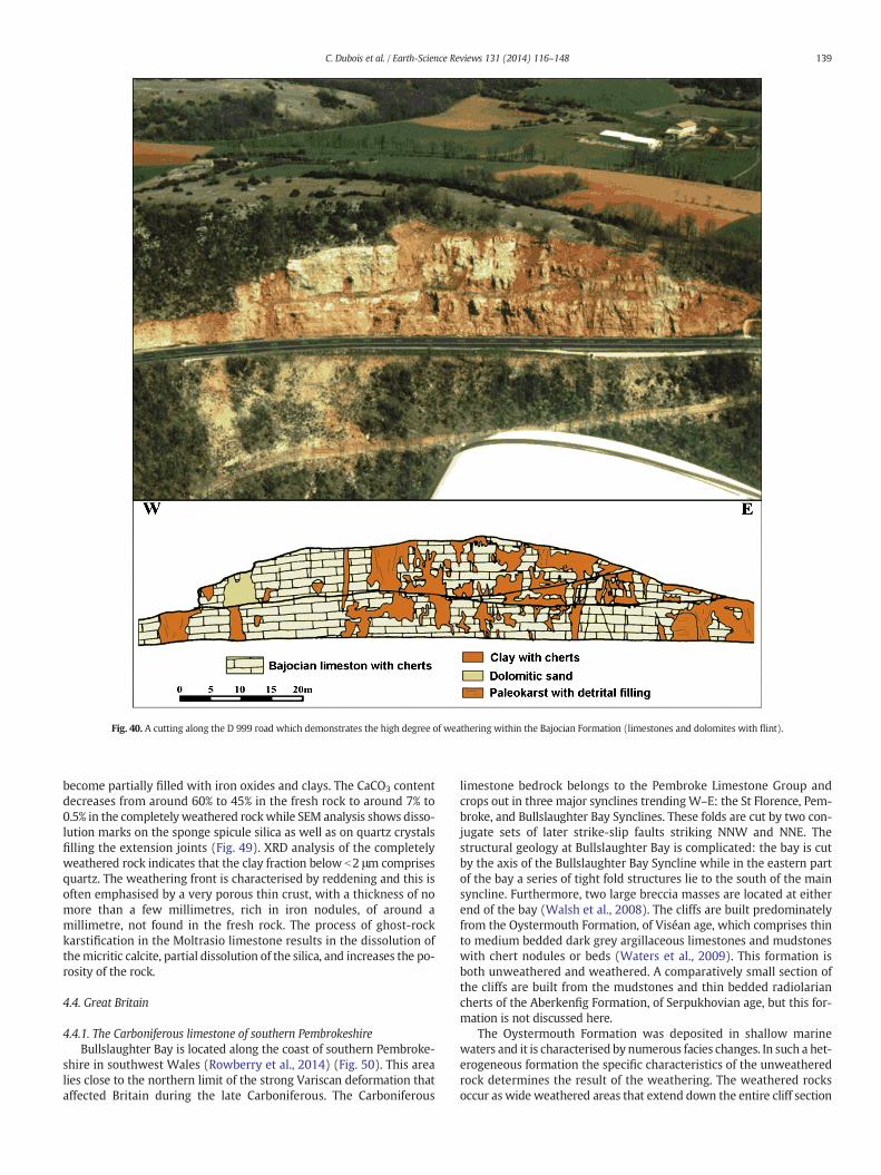
Fig. 40. A cutting along the D 999 road which demonstrates the high degree of weathering within the Bajocian Formation (limestones and dolomites with flint).
139C. Dubois et al. / Earth-Science Reviews 131 (2014) 116–148
become partially filled with iron oxides and clays. The CaCO3 contentdecreases from around 60% to 45% in the fresh rock to around 7% to0.5% in the completely weathered rockwhile SEM analysis shows disso-lution marks on the sponge spicule silica as well as on quartz crystalsfilling the extension joints (Fig. 49). XRD analysis of the completelyweathered rock indicates that the clay fraction below b2 μm comprisesquartz. The weathering front is characterised by reddening and this isoften emphasised by a very porous thin crust, with a thickness of nomore than a few millimetres, rich in iron nodules, of around amillimetre, not found in the fresh rock. The process of ghost-rockkarstification in the Moltrasio limestone results in the dissolution ofthemicritic calcite, partial dissolution of the silica, and increases the po-rosity of the rock.
4.4. Great Britain
4.4.1. The Carboniferous limestone of southern PembrokeshireBullslaughter Bay is located along the coast of southern Pembroke-
shire in southwest Wales (Rowberry et al., 2014) (Fig. 50). This arealies close to the northern limit of the strong Variscan deformation thataffected Britain during the late Carboniferous. The Carboniferous
limestone bedrock belongs to the Pembroke Limestone Group andcrops out in three major synclines trendingW–E: the St Florence, Pem-broke, and Bullslaughter Bay Synclines. These folds are cut by two con-jugate sets of later strike-slip faults striking NNW and NNE. Thestructural geology at Bullslaughter Bay is complicated: the bay is cutby the axis of the Bullslaughter Bay Syncline while in the eastern partof the bay a series of tight fold structures lie to the south of the mainsyncline. Furthermore, two large breccia masses are located at eitherend of the bay (Walsh et al., 2008). The cliffs are built predominatelyfrom the Oystermouth Formation, of Viséan age, which comprises thinto medium bedded dark grey argillaceous limestones and mudstoneswith chert nodules or beds (Waters et al., 2009). This formation isboth unweathered and weathered. A comparatively small section ofthe cliffs are built from the mudstones and thin bedded radiolariancherts of the Aberkenfig Formation, of Serpukhovian age, but this for-mation is not discussed here.
The Oystermouth Formation was deposited in shallow marinewaters and it is characterised by numerous facies changes. In such a het-erogeneous formation the specific characteristics of the unweatheredrock determines the result of the weathering. The weathered rocksoccur as wide weathered areas that extend down the entire cliff section

Fig. 41. (A) A section of ghost rock in the Bajocian Formation. It is possible to follow cherts beds in the limestone into themiddle of the pockets although the layers have sagged slightly dueto compaction and the lost of matter (calcite). (B) The northern edge of the CausseMéjean. Mechanical erosion of the dolomitic sand reveals the extent towhich the Jurassic dolomites areaffected by deep weathering as it exhumes these tower-like mega-lapiaz.
Fig. 42.A geological map showing the area around LaMansonnière: 1— river terraces;2 — Cretaceous; 3 — thalwegs; 4 — faults; 5 — the location of caves and mines. The karstnetwork has developed in one of these mines.
140 C. Dubois et al. / Earth-Science Reviews 131 (2014) 116–148
while theweathering profiles are not characterised by vertical gradients(Fig. 51A–F). In some places the weathered limestone appears asisolated decalcified blockswhile in others it appears as banded ochreousand slightly calcareous sands and silts. The banded sands and silts werepreviously thought to represent a sedimentary deposit but this interpre-tation does not take account of the fact that the isovolumetric nature ofthe weathering is readily recognisable. It is frequently possible to trace
Fig. 43. The karst network of La Mansonnière: 1 — penetrable gallery; 2 — impenetrablegallery; 3 — gallery cut during mining; 4 — gallery drilled at the mine face.

Table 1The results of geochemical analyses of samples from Grasteau Gallery in La Mansonnière, Bellou sur Huisne, Normandy. Weathering grades: I — fresh unweathered rock; II — slightlyweathered rock; III — moderately weathered rock; IV— highly weathered rock; V — completely weathered rock.Analyses by A.-V. Walter, Besançon.
Sample Location(cm)
Montm/quartz Calcite(%)
Quartz(%)
Opal(%)
SiO2 Al2O3 Fe2O3 MgO CaO K2O Na2O TiO2 MnO H2O− H2O+ Gradeno.
A0 −5 17.94 1.03 0.67 0.60 43.51 0.21 0.08 0.02 0.01 0.70 35.16 IA1 0 20.65 0.77 0.74 0.55 41.50 0.43 0.02 0.02 0.02 0.77 34.20 IIA2 5.5 2.4 4 37 59 71.18 7.45 4.45 1.00 2.36 0.96 0.23 0.23 0.03 5.61 5.52 IVA3 14 3.5 0 17 83 73.44 7.15 4.17 0.92 1.64 0.89 0.16 0.16 0.01 5.76 4.78 IVA4 20 2.2 0 31 69 76.09 6.77 3.92 0.90 1.02 0.86 0.14 0.14 0.02 5.57 4.45 VA5 30 6.0 7 75 18 56.78 13.96 6.73 1.68 1.36 1.56 0.58 0.58 0.02 10.10 6.54 VA6 50 4.6 0 31 79 79.71 5.32 2.97 0.70 0.76 0.83 0.12 0.12 0.01 5.04 3.30 VA6+ 51 81.08 4.94 2.58 0.60 0.72 0.85 0.15 0.15 0.01 4.57 2.98 VA7 72 6.3 13 34 53 66.41 10.79 5.36 1.23 1.35 1.38 0.41 0.41 0.02 7.45 5.34 VA8 82 6.4 28 23 49 72.97 7.95 4.50 0.90 0.98 1.04 0.32 0.32 0.03 6.48 4.69 VA9 106 24.5 0 25 75 73.61 7.76 4.49 0.90 1.03 1.02 0.11 0.28 0.03 6.14 4.40 VA10 130 16.6 69 6 25 66.42 10.43 5.79 1.14 1.42 1.45 0.14 0.39 0.07 6.77 5.66 VA11 163 0.0 65 35 0 67.12 10.00 5.42 1.10 1.42 1.47 0.15 0.42 0.08 6.07 5.47 VA12 203 2.8 0 22 78 83.80 4.45 2.58 0.50 0.82 0.71 0.10 0.11 0.03 3.81 2.91 VA13 211 6.0 0 53 47 66.35 8.75 5.25 1.20 2.68 1.61 0.12 0.28 0.03 7.20 6.16 IVA14 223 4.2 0 37 63 63.37 5.56 3.26 0.79 8.16 1.06 0.11 0.23 0.03 7.91 9.00 IIIA15 238 22.65 1.35 1.04 0.60 39.30 0.40 0.06 0.04 0.02 1.11 32.86 II
141C. Dubois et al. / Earth-Science Reviews 131 (2014) 116–148
calcite veins, bedding planes, cracks, or cleavage from the unweatheredlimestone and into its weathered counterpart and from there into loosematerial. The banded sands and silts also incorporate highly angular
Fig. 44. (A) Section of a weathering feature completely filled by in-situ alterite — thetwo lines emphasise where samples were taken. (B) Section in an enlarged crack — inthe upper part, weathering haloes surround a vein of black smectite whereas, in thelower part, small horizons emphasise the weathering of blocks loosened from the wall.(C) Section of a vault showing two joints abutting against a mini strike-slip — the areaweathered within the rock is discontinuous due to infiltration from the surface (scaleprovided by the little mouse-eared bat). (D) Section of the Gallery of the Banc at LaMansonnière located on oblique cracks— the void at the top of the section formed as a re-sult of compaction of the alterite.
“corestones” whose angularity is not indicative of whether or not theyare decalcified. Schmidt Hammer Tests have shown that theweatheringhas caused a loss of compressive strength without necessarily changingin the physical appearance of the limestone. In themain cove of the bayaweathered laminated alterite derived from shale and siltstone has pre-served a residual Brigantian conodont assemblage (Błażejowski andWalsh, 2013) and revealed crinoid remains (Rowberry et al., 2014).
The samples subjected to laboratory analyses were obtained fromsheltered sites at the base of the cliffs (Rowberry et al., 2014). Theanalyses comprised calcimetry, granulometry, X-ray diffraction, andexoscopy. The calcimetric analysis provides information regarding theloss of calcium from an impure parent limestone. It has been foundthat the calcium carbonate content ranges between 3.5% and 97%(Fig. 52A and B). There may be an abrupt transition from an unweath-ered limestone to decalcified clays. The granulometric analysis is ableto differentiate between collapsematerial and isovolumetrically weath-ered material. It was found that the obtained curves are dominated byfine silt with low or very low quantities of clay and sand — the paucity
Fig. 45. A geological map of the area around the western part of Lake Como in theLombardy region of northern Italy: 1 — Quaternary; 2 — Cenozoic (pre-Quaternary);3 — Cretaceous; 4 — Jurassic; 5 — fault; 6 — national boundary. Monte Bisbino attains anelevation of 1325 m asl.

Fig. 47. A series of schematic sketches showing the ghost-rock features onMonte Bisbino:(A–B) an orthogonal network of weathered corridors with constant spacing; (C–D) re-moval of the residual alterite leads to the formation of rectangular pinnacles and towersthat collapse to form screes comprising fresh rock blocks within the residual alterite.
142 C. Dubois et al. / Earth-Science Reviews 131 (2014) 116–148
of sand and clay suggests inheritance from the parent rock and reflectsin situ weathering process (Fig. 52C and D). The XRD provides informa-tion regarding secondary clay formation. The primary minerals in theweathered samples have all been preserved so it is clear that the parentrocks were either impure limestone or shale rich in quartz, illite, andgoethite. There is little evidence for secondary clay formation. Theexoscopy of individual quartz grains provides information about the ini-tial sedimentary environment and the effects of weathering. The twoanalysed samples show surfacemorphologies typical of marine and flu-vial grains, respectively, and it has been hypothesised that these mor-phologies are inherited from transportation prior to diagenesis(Fig. 52E and F) (Rowberry et al., 2014).
5. Discussion
The process of karstification by total removal is a single stage processin which chemical dissolution and removal of the soluble species occursat the same time as mechanical erosion of the undissolved particles.This process is driven by high hydrodynamic energy and creates openvoids in the host rock. The process of ghost-rock karstification is, incontrast, a two stage process. The first stage is characterised by chemicaldissolution and removal of the soluble species. This stage requires lowhydrodynamic energy and creates a ghost-rock feature filledwith residu-al alterite. The second stage, when there is sufficient hydrodynamic con-ditions aremet, is characterised bymechanical erosion of the undissolvedparticles. It is only during this stage that open voids are created. This twostage model has similarities to the biorhexistasy theory of Erhart (1955,1967). The first stage of ghost-rock karstification reflects the biostasystage duringwhich there isweathering of the bedrock under a vegetationcover — after chemical weathering the soluble part of the rock is takenunderground while the insoluble part remains to constitute the soils.This situation occurs as the vegetation provides large amounts of acid
Fig. 46. Examples of ghost-rock features on the slope of Monte Bisbino: (A) ghost-endokarstcorridor.
while protecting the residual material frommechanical erosion. The sec-ond stage of ghost-rock karstification reflects the rhexistasy stage duringwhich there ismechanical erosionof the residual alterite. Table 2providesa summary of the presented case studies and highlights the range of li-thologies affected by ghost-rock karstification, the timing of the ghost-rock weathering, and the subsequent geological history of each region.
; (B) weathered strata; (C) fresh rock blocks within the residual alterite; (D) weathered

Fig. 48. A cross-section through Monte Bisbino showing the three main cave systems: (A) Zocca d'Ass; (B) Grotta dell'Alpe Madrona; (C) Buco della Volpe. The karst systems havedeveloped above the limit of ghost-rock weathering as depicted by the dotted line.
143C. Dubois et al. / Earth-Science Reviews 131 (2014) 116–148
The ‘two-cycle’ theory of cave formation proposed by Davis (1930)suggests that most caves develop deep in the phreatic zone and thatthey are exposed as fully formed features following a cycle of erosion.This hypothesis has been used to account for cave systems with irregu-lar three-dimensional networks and no conspicuous horizontal control.In light of the evidence presented in this review it seemsmore probablethat such systems result from the process of ghost-rock karstification. Ingeomorphological research there has long been much debate as towhether certain landforms associated with crystalline rocks owe theirexistence to periods of chemical weathering alternating with periodsofmechanical erosion orwhether these processes occur simultaneously.The former, for example, has been proposed for the formation of tors in
Fig. 49. SEM images of the Moltrasio limestone from Monte Bisbino: (A) fresh unweathered rno porosity; (B) weathered rock in which the micritic calcite has been entirely dissolved whian increase inporosity; (D)weathered rock inwhich the clay crystals are structured as a rolled sh(F) weathered rock in which there are silica dissolution marks on the quartz crystals filling the
southwest England (Linton, 1955) and inselbergs in Uganda (Ollier,1960). The latter, for example, has been proposed for the formation ofbornhardts in Nigeria (Thomas, 1965). The seminal ‘two-stage’ modelof tor formation first came to prominence following the work ofLinton (1955). It was suggested that weathering at the surfaceproceeded to create a basal platform which then became the groundsurface, complete with tors, following removal of the weathered mate-rial. Linton (1955) noted that, “This possibility that the weathering im-plied by the upland tor is late Tertiary is attractive because of the knownwarmth of our Pliocene climate. To admit such a possibility, however,emphasises the distinction between the two phases of tor formation;exhumation may be much later than decomposition”. However, even
ock in which sponge spicules are embedded in the micritic calcite while there is almostle the network of spicules remains in place; (C) weathered rock in which there has beeneet; (E)weathered rock inwhich there are silica dissolutionmarks on the sponge spicules;extension joints.

Fig. 50.A simplified geological map of Bullslaughter Bay in southern Pembrokeshire, GreatBritain: 1 — Serpukhovian (Pendleian); 2 — Viséan (Brigantian); 3 — Viséan (Asbian–Brigantian); 4 — faults; 5 — anticlines; 6 — synclines.A detailed geological cross-section through the eastern part of the bay was recently pre-sented by Błażejowski and Walsh (2013).
144 C. Dubois et al. / Earth-Science Reviews 131 (2014) 116–148
in southwest England, the ‘two-stage’ model of tor formation is neverbeen unequivocally accepted (e.g. Palmer and Neilson, 1962; Eden andGreen, 1971). It is, nonetheless, clear that certain hypotheses used to ex-plain the development of landforms associated with crystalline rocksmay have greater applicability in carbonate terrains than has beenhitherto appreciated. In this regard it should be unsurprising thatcertain karst features may owe their existence to periods of chemicalweathering alternating with periods of mechanical erosion, as inghost-rock karstification, or to simultaneous weathering and erosion,rather than in karstification by total removal.
The association between certain karst morphologies and specifickarstogenetic processes is often accepted unequivocally. However, ifthe process of ghost-rock karstification is able to produce caves with
Fig. 51. An overview of Bullslaughter Bay and its weathering features. The cliffs around the baytheWestern Cove; (B) deep weathering in the southern part of theMain Cove; (C) deep weathexample of deepweathering in theMainCove; (F) an example of deepweathering in the Easternin others it appears as banded ochreous and slightly calcareous sands and silts.
the same morphological features to those produced by the process ofkarstification by total removal, it follows that the processes which arenormally assigned to specific cavemorphologiesmay not be constrainedaccurately (Dubois et al., 2011). It is, for example, commonly acceptedthat parietal forms within a cave reflect the flow conditions that leadto their formation, such as in the case for both cupolas and vault anasto-moses. The hemispherical to ellipsoidal cupola forms often seen in gal-lery walls and vaults are usually thought to result from chemicalcorrosion by slowing flowing waters in the flooded phreatic zone. How-ever, these forms have also been found in association with ghost-rockfeatures, at the boundary between the fresh rock and the alterite(Fig. 8A). Likewise, vault anastomoses are generally thought to resultfrom the flow of water in an open channel between the vault and thedetritic filling, or in a horizontal joint between the calcareous vault andthe clayed interstratum. Again, these forms have also been found in asso-ciationwith ghost-rock features, at the boundary between the fresh rockand the alterite (Fig. 8B). Both the cupolas and vault anastomosis remainafter mechanical removal of the alterite and they are very similar to, orpossibly indistinguishable from, the same forms that are supposed tohave resulted from karstification by total removal. These examples dem-onstrate that the samekarstmorphologiesmay result fromdifferent pro-cesses — they are examples of geomorphological equifinality. Theauthors argue that it is no longer acceptable to use karst morphologiesin order to infer specific karstogenetic processes.
It has also been shown that cave systems in which the galleries arearranged on different levels do not necessarily reflect changes in baselevel. Therefore, it may be futile to attempt to link these galleries with,for example, fluvial terraces or glacial stages. However, the process ofghost-rock karstification offers a new explanation for the organisationof such galleries. The weathered network created during the first stageof ghost-rock karstification reflects the fact that the weathering de-velops along highly transmissive pathways in the host rock— its precisecharacteristics depend far more on the location of discontinuities suchas faults, joints, and bedding planes. Therefore, the weathered networkis often characterised by a three-dimensional maze structure which,once emptied of its alterite, creates a cave system with same three-dimensional maze structure. This serves to explain how galleries canbe arranged on many different levels without needing to invoke baselevel changes as a cause. It is clear that, over time, one type of
attain a maximum height of approximately 40m: (A) deep weathering and brecciation inering in the Eastern Cove; (D) an example of deep weathering in theWestern Cove; (E) anCove. In some places theweathered limestone appears as isolated decalcifiedblockswhile

Fig. 52. (A–B) Representative results of calcimetric analysis, presented in their original field setting, for six samples obtained from theWestern Cove. (C–D) Representative granulometricparticle size distribution graphs showing well sorted grains indicating an in situ weathering process. (E–F) Representative exoscopic images present a generally rounded low relief quartzgrain (E) and a sub-rounded medium relief quartz grain (F). These morphologies are thought to have been etched prior to diagenesis and rather than reflecting more recent transport.
145C. Dubois et al. / Earth-Science Reviews 131 (2014) 116–148
karstification process may supersede the other. Karstification by totalremoval is perhaps more likely to supplant ghost-rock karstificationgiven that the second stage of the latter process requires mechanicalerosion to excavate the alterite. Therefore, if an erosive stream con-tinues to flow after excavation of the alterite, subsequent enlargementof the gallery will reflect the process of karstification by total removal.However, the reverse can also occur if the hydrodynamic energy islost, and it has been shown that an excavated gallery partly filled withfluvial sediments once again started to develop through ghost-rockkarstogenesis.
It is increasingly accepted that karst systems are not solely confinedto carbonate rocks and that many such systems are found in siliceousand alumino-siliceous (Galan and Lagarde, 1988; Vicat et al., 2002;Willems et al., 2002a,b; Hardt et al., 2013). These present the samecharacteristics as karst systems in carbonate rocks (i.e. surfacemorphol-ogies, underground morphologies, and non-linear hydrodynamics) butthey cannot be explained satisfactorily by the traditional single-stageprocess of karstification by total removal. However, the two stageprocess of ghost-rock karstification is able to explain the occurrence ofkarst in supposedly insoluble rocks. During the first stage there isdeep chemical weathering of the rock leaving a residual materialsuch as granitic arena — this residual phase incorporates neoformed
minerals such as clays which are incompatible with the process ofkarstification by total removal. During the second stage the mechanicalerosion of the alterite excavates galleries, in the case of undergroundfeatures, or creates karst relief, in the case of surface features (e.g. gra-nitic blockfields).
6. Conclusions
This manuscript has reviewed the recently proposed process ofghost-rock karstification. The process integrates chemical weatheringand mechanical erosion and fits into the general framework of conti-nental landscape development. The process of ghost-rock karstificationdiffers from the traditional process of karstification by total removal inthat it is a two stage process. The first stage is characterised by chemicaldissolution and removal of the soluble species to create a ghost-rockfeature filled with residual alterite while the second is characterisedbymechanical erosion of the undissolved particles to create open galler-ies. The two karstification processes have been considered from athermodynamic point of view. Both need a flow of water to providethe chemical energy to dissolve the calcium carbonate. However,karstification by total removal requires a far higher amount of hydrody-namic energy to simultaneously remove the dissolved species and

Table 2A summary of the presented case studies highlighting the range of lithologies affected by ghost-rock karstification, the timing of the ghost-rockweathering, and the subsequent geologicalhistory of each region.
Region and lithology Initial conditions Timing of ghost-rockkarstification
Chemical andhydrodynamic energy
Subsequent development
Soignies(Belgium)Upper Tournaisianlimestone anddolomitic limestone
Upper Jurassic and LowerCretaceous tectonicextension created openvertical joints: N60°E;N150°E; N110°E
During emergence in theUpper Jurassic and LowerCretaceous
Hot and wet climateaccompanied by low relief
Thanetian:marine transgressions duringwhich the karst becamea palaeokarst.Danian: a (?tectonic) disturbance generated underground flowduring which some weathered features were emptied of theiralterite and replaced by a fluvial detrital series. Caves withcupolas were created and then fossilised by transgressions in theThanetian and Ypresian.Present: quarrying and pumping has lowered the piezometriclevel and created new hydrodynamic potential. In the quarries,new caves have formedwhile, at the surface, alterite compactionhas led to the formation of sinkholes.
Tournai(Belgium)Upper Tournaisiansiliceous and dolomiticlimestone
Upper Jurassic and LowerCretaceous tectonicextension created openvertical joints: N60°E;N150°E; N110°E
During emergence prior tothe Cenomanian
Hot and wet climateaccompanied by low relief
Cenomanian: marine transgressions during which the karstbecame a palaeokarst.Quaternary: the ghost-palaeokarsts were probably reactivatedduring glacio-eustatic regression.Present: quarrying and pumping has lowered the piezometriclevel and created a new hydrodynamic potential. At the surface,alterite compaction has led to the formation of sinkholes.
Engis(Belgium)Viséan limestone
Mesozoic tectonicextension created openjoints
During emergence in theUpper Jurassic and LowerCretaceous
Hot and wet climateaccompanied by low relief
Neogene: creation of hydrodynamic potential due to uplift. Thereactivation of some palaeokarsts led to the formation of cavesduring the Plio-Quaternary. These caves have numerous cupolasand vertical corridors filled with Quaternary sediments whiletheir subsequent development has created galleries with tor-rential morphologies (e.g. overdeepening, swage, and potholes).
Aquitaine(France)Lower Oligocenebioclastic limestone
Highly porous rock due toweak diagenesis alongwith some vertical tectonicjoints
Upper Rupelian to LowerChattian
?At the contact betweenfreshwater and seawaterwhile the area was close tosea-level
Chattian:marine transgressions deposited the ‘AgenaisMolasses’during which the karst became a palaeokarst.Pliocene–Quaternary: creation of hydrodynamic potential due touplift and stream incision. The reactivation of some palaeokarstsled to the emptying of horizontal ghost-endokarsts by regressivemechanical erosion.Present: anthropogenic modification of the vegetation cover haschanged the hydrological regime and reactivated the ghost-endokarsts.
Burgundy(France)Middle Jurassiclimestone
Aalanian–Bajocian tectonicextension coupled withmore porous strata
During emergence in theUpper Jurassic andCretaceous
Hot and wet climateaccompanied by low relief
Oligocene: formation of the Bressan Graben and surroundinghorst created hydrodynamic potential during which the alteritewas partially eroded.Pliocene–Quaternary: underground rivers flow though thepartially emptied ghost-rock features, eroding the remainingalterite, and providing the sedimentary material for the paleon-tological and prehistoric sites.
Charente(France)Middle and UpperJurassic ooliticlimestone
Upper Jurassic to LowerCretaceous tectonicextension creates openjoints in addition to thebedding planes
During emergencebetween the LateKimmeridgian and theLower Cenomanian
Hot and wet climateaccompanied by low reliefclose to sea-level
End of Lower Cretaceous: marine transgressions during whichthe karst became a palaeokarst.Upper Cretaceous: the creation of sporadic hydrodynamicpotential during which sediments became trapped in some partlyemptied ghost-rock features and hydraulic breccias formed.LowerMaastrichtian–Danian: continental landscape developmentwith the deposition of sediments from the Massif Central. Asandy-clay Cenozoic overburden covered the landscape andfossilised the ghost-endokarsts.Pliocene–Quaternary: the creation of hydrodynamic potential dueto stream incision resulting from uplift of the Massif Central. Thereactivation of some palaeokarsts led to the emptying of deepflooded cavities while water-table fluctuations also helped toempty ghost-rock features and led to the creation of maze caves.
Les Grands Causses(France)Jurassic limestone anddolostone
Greater permeability at theHettangian–Sinemuriancontact and tectonicextension between theCretaceous and the Eocene
Upper Jurassic to Miocenealthough ghost-rockkarstification may be on-going in the central partsof the plateaux
Hot and wet climateaccompanied by low relief
Miocene: the creation of hydrodynamic potential due to streamincision resulting from uplift of the Cevennes lead to the onset oferosion of the alterite.Present: continuing erosion of the alterite which may beenhanced by quarrying.
Normandy (France)Cenomanian chalkfreestone facies
Erosion of theimpermeable cover duringthe Quaternary
Eemian Wet temperate oceanicclimate accompanied bylow relief
Last glacial period: erosion led to the removal of the overlying‘Sands of Perche’which interrupted ghost-rock karstification andfossilised the features.
Lombardy(Italy)Liassic silico-clayedlimestone
More porous strata andtectonic extension ofsubvertical joints (N–S andE–W)
Upper Oligocene withbiostasic conditionsduring the Miocene
Hot and wet climateaccompanied by moderaterelief following the onsetof Alpine tectonics
Upper Miocene: uplift of the Alps interrupted ghost-rockkarstification and eroded the alterite.Messinian: sea-level fall enhanced removal of the alterite fromthe ghost-rock features by regressive mechanical erosion.
Pembrokeshire(Great Britain)Viséan argillaceouslimestone andmudstone
Nearshore or coastalenvironment withcontrasting facies
Late Viséan weatheringfollowing soon afterdiagenesis
Hot and wet climateaccompanied by low reliefclose sea level
Serpukhovian: deposition of the Pendleian Aberkenfig Formationsealed the underlying Brigantian Oystermouth Formation andfossilised the weathered features.Cenozoic: exhumation reactivated the weathering process.Present: the wide weathered areas are in the process of beingremoved by the present cycle of marine erosion.
146 C. Dubois et al. / Earth-Science Reviews 131 (2014) 116–148

147C. Dubois et al. / Earth-Science Reviews 131 (2014) 116–148
undissolved particles. The process of ghost-rock karstification has beenillustrated by a number of case studies taken from across westernEurope. It is suggested that the origins of many karst systems shouldnow be reconsidered in light of this process and that many commonlyaccepted ideas in karstogenesis must now be revised.
Acknowledgements
The authors wish to express their gratitude to all the quarrying com-panies that have granted permission for us to access and work at theirsites— so many of the presented case studies would not have been pos-sible without that permission. We would also like to thank HenryNeimark, the General Council of Saône-et-Loire, the members of theCultural Association of Azé Cave, and Spéléo-Club Argilon for the sup-port they have provided during studies of the karst of Burgundy.
References
Audra, P., 1994. Karsts Alpins: Genèse de Grands Réseaux Souterrains. Karstol. Mém. 5.Audra, P., Bini, A., Gabrovšek, F., Häuselmann, P., Hobléa, F., Jeannin, P.-Y., Kunaver, J.,
Monbaron, M., Šušteršič, F., Tognini, P., Trimmel, H., Wildberger, A., 2007. Cave andkarst evolution in the Alps and their relation to paleoclimate and paleotopography.Acta Carsol. 36, 53–68.
Ayora, C., Taberner, C., Saaltinka, M.W., Carrera, J., 1998. The genesis of dedolomites: a dis-cussion based on reactive transport modeling. J. Hydrol. 209, 346–365.
Bakalowicz, M., 1975. Géochimie des eaux karstiques et karstification. Ann. Spéliol. 30,581–589.
Barriquand, J., Barriquand, L., Argant, A., Floss, H., Gallay, A., Guerin, C., Guillot, L., Jeannet,M., Nykiel, C., Quinif, Y., 2011a. Le site des Grottes d'Azé. Quaternaire 4, 15–25(Special Issue).
Barriquand, J., Barriquand, L., Guillot, L., Nykiel, C., 2011b. Le site des grottes d'Azé. Le fruitde 60 ans de recherches dans le karst du massif de Rochebin (Saône-et-Loire).Spelunca 123, 7–16.
Barriquand, L., Barriquand, J., Baele, J.-M., Dechamps, S., Guillot, L., Maire, R., Nykiel, C.,Papier, S., Quinif, Y., 2012. Les grottes d'Azé (Saône-et-Loire, France): de la rochealtérée aux sédiments. Karstologia 59, 19–32.
Barusseau, M., 1967. Les Changements de Facies du Jurassique Moyen dans les Monts duMâconnaisLaboratoire de Géologie de l'Ecole Normale Supérieure, Paris (97 pp.).
Bates, R.L., Jackson, J.A., 1980. Glossary of GeologySecond ed. American Geological Insti-tute, Falls Church, VA (749 pp.).
Bini, A., 2002. Grotte in Provincia di ComoEdlin, Milan (158 pp.).Bini, A., Cappa, G., 1977. Some considerations on the applicability of speleogenetic and
morphogenetical theories. Proceedings of the 7th International Congress of Speleology,Sheffield, pp. 45–47.
Bini, A., Zuccoli, L., Quinif, Y., 2012. Karst et fantômisation dans la dolomie de la ValleImagna (Bergamo, Italie). Karstologia 60 (2).
Bisdom, E.B.A., 1967. Micromorphology of a weathered granite near the Ria de Arosa (NWSpain). Leidse. Geol. Meded. 37, 33–67.
Blake, D.F., Peacor, D.R., Allard, L.F., 1984. Ultrastructural and microanalytical results fromechinoderm calcite: implications for biomineralization and diagenesis of skeletal ma-terial. Micron Microsc. Acta 15, 85–90.
Błażejowski, B., Walsh, P.T., 2013. A Viséan (Brigantian) conodont assemblage preservedin the dissolution residue of a breccia matrix at Bullslaughter Bay, Pembrokeshire,South Wales. N. Jb. Geol. Paläont. (Abh.) 267, 239–254.
Bögli, A., 1964. Corrosion par mélange des eaux. Int. J. Speleol. 1, 11–23.Bögli, A., 1980. Karst Hydrology and Physical SpeleologySpringer-Verlag, Berlin (284 pp.).Bonacci, O., 1987. Karst HydrologySpringer-Verlag, Berlin (184 pp.).Bonnefoy, M., 2002. A 300 pieds sous les Vignes de Rochebin. L'exploration et les travaux
d'aménagements des Grottes d'AzéAssociation Culturelle des Grottes d'Azé et ConseilGénéral de Saône-et-Loire.
Bretz, J.H., 1942. Vadose and phreatic features of limestone caves. J. Geol. 50, 675–811.Bruxelles, L., 1998. Karsts et paléokarsts du Bassin de Mialet (Bordure Cévenole, Gard):
formation et évolution d'un karst démantelé. Karstologia 30, 15–24.Bruxelles, L., 2001. Dépôts et altérites des plateaux du Larzac central: Causses de
l'Hospitalet et de Campestre (Aveyron, Gard, Hérault): evolution morphogénétiques,conséquences géologiques et implications pour l'aménagement. Ph.D. Thesis Univer-sity of Provence, Aix-en-Provence.
Bruxelles, L., 2002a. Reconstitution morphologique du Causse du Larzac: rôle des forma-tions superficielles dans la morphogenèse karstique. Karstologia 38, 15–28.
Bruxelles, L., 2002b. Ghost structures in the Bajocian limestones of the Causse du Larzac(France). Proceedings of the 1st Geologica Belgica International Meeting, Leuven,pp. 149–152.
Bruxelles, L., Bruxelles, S., 2002. La chasse aux fantômes dans les Grands Causses:utilisation d'un nouveau concept de spéléogenèse dans la recherche de cavités.Spelunca 88, 14–20.
Bruxelles, L., Wienin, M., 2010. Les fantômes de roche de la mine de la Grande Vernissière(Fressac, Gard). Premières observations sur l'origine de certains karsts de la bordurecénévole. Karstol. Mém. 17, 192–200.
Cailhol, D., Meury, P., 2012. Processus de fantômisation dans les calcaires du JurassiqueSupérieur du Jura tabulaire. Karstologia 59, 15–28.
Camerman, C., 1947. Le calcaire du Tournaisis. Congrès du centenaire de l'AiLg, sectionGéologie 349–353.
Caro, P., 1965. La chimie du gaz carbonique et des carbonates, et les phénomèneshydrogéologiques karstiques. Chron. Hydrogeol. 7, 51–77.
Cellule Cartographie/SIG, 2008. Atlas de l'Aquitaine, Les Caractéristiques PhysiquesConseilrégional d'Aquitaine.
Courbon, P., Chabert, C., 1986. Atlas des Grandes Cavités MondialesUnion Internationalede Spéléologie, Paris (255 pp.).
Courreges-Blanc, M., Maire, R., 2014. Altération de type fantôme de roche dans les calcairesoligocènes du Médoc (France): étude pétrographique et micromorphologique. Geol.Belg. 17, 9–16.
Dandurand, G., 2011. Cavités et remplissages de la nappe karstique de Charente (bassin dela Touvre, La Rochefoucauld): spéléogenèse par fantômisation, archives pléistocèneet holocène, rôle de l'effet de site. Ph.D. Thesis University of Bordeaux.
Dandurand, G., Maire, R., 2011. Essai de typologie des cavités du karst de la Rochefoucauld(Charente): rôle de la «fantômisation» crétacée, du battement de la nappe et de l'effetde site. Dynam. Environ. 27, 11–28.
Dandurand, G., Maire, R., Dubois, C., Quinif, Y., 2014. The Charente karst basin of theTouvre: alteration of the Jurassic series and speleogenesis by ghost-rock process.Geol. Belg. 17, 27–32.
Davis, W.M., 1930. Origin of limestone caverns. Geol. Soc. Am. Bull. 4, 475–628.Dechamps, S., 2011. Sédimentologie du Bajocien et du Bathonien des grottes d'Azé
(France), et comparaison avec le Luxembourg. MSc. Thesis University of Liège.Delvigne, J.E., 1998. Atlas of micromorphology of mineral alteration and weathering.
Canadian Mineralogist Special Publication 3, Ottawa (494 pp.).Doremus, P., Hennebert, M., 1995. Carte géologique de Wallonie 1:25.000. Planche Lens-
Soignies (Plus Notice Explicative)Ministère de la Région Wallonne.Dreybrodt, W., 1987. The kinetics of calcite dissolution and its consequence to karst evo-
lution from the initial to the mature state. NSS Bull. 49, 31–49.Dubois, C., Lans, B., Kaufmann, O., Maire, R., Quinif, Y., 2011. Karstification de type
fantômes de roche en Entre-deux-Mers (Gironde, France). Karstologia 57, 19–27.Dubois, C., Quinif, Y., Baele, J.-M., Dagrain, F., Deceuster, J., Kaufmann, O., 2014. The evolu-
tion of the mineralogical and petrophysical properties of a weathered limestone insouthern Belgium. Geol. Belg. 17, 1–8.
Dubreuilh, J., 1976. Contribution à l'étude sédimentologique du système fluviatileDordogne — Garonne dans la région bordelaise. University Thesis Les ressourcesen matériaux alluvionnaires du département de la GirondeUniversity of Bordeaux 1.
Eden, M.J., Green, C.P., 1971. Some aspects of granite weathering and tor formation onDartmoor, England. Geogr. Ann. 53A, 92–98.
Ek, C., 1961. Conduits souterrains en relation avec les terrasses fluviales. Ann. Soc. Geol.Belg. LXXXIV, 313–340.
Erhart, H., 1955. “Biostasie” et “rhexistasie”: esquisse d'une théorie sur le rôle de lapédogenèse en tant que phénomène géologique. C. R. Acad. Sci. 241, 1218–1220.
Erhart, H., 1967. La genèse des sols en tant que phénomène géologique. Colloquium onthe Evolution of Science, Paris (165 pp.).
Ford, T.D., Cullingford, C.H.D., 1976. The Science of SpeleologyAcademic Press, London(593 pp.).
Ford, D.C., Williams, P., 1989. Karst Hydrogeology and GeomorphologyJohnWiley & Sons,Chichester (562 pp.).
Galan, C., Lagarde, J., 1988. Morphologie et évolution des cavernes et formes superficiellesdans les quartzites du Roraima (Vénézuela). Karstologia 11–12, 49–60.
Gilli, E., 2011. Karstologie — Karsts, Grottes et SourcesDunod, Paris (244 pp.).Glansdorff, P., Prigogine, I., 1971. Thermodynamic Theory of Structure, Stability and
FluctuationsWiley-Interscience, London (306 pp.).Grillot, J.C., Guerin, R., 1975. Tectonique, microtectonique et directions des écoulements
souterrains: exemples de relations dans le bassin karstique du Haut-Vidourle Gard,France. Rev. Géogr. Phys. Géol. Dynam. XVII, 45–60.
Gründ, A., 1914. Der Geographische Zyklus im Karst. Ges. Erdkunde 52, 621–640.Guillot, L., Morel, J., Simonnot, G., 2005. Gouffres et cavernes des Monts du Mâconnais.
Bulletin des Ligues Spéléologiques de Bourgogne et de Franche-Comté 34–41.Hardt, R., Rodet, J., Pinto, S.d.A.F., 2013. Complex karst evolution in sandstone: the
Chapada dos Guimarães Site, Brazil. Proceedings of the 16th International Congressof Speleology, Brno (Rép. Tchèque). 3, pp. 264–267.
Havron, C., Quinif, Y., Vandycke, S., 2004. Tectonique et karstification: le cas de la régionde Han-sur-Lesse (Belgique). Karstologia 43, 19–26.
Havron, C., Baele, J.-M., Quinif, Y., 2007. Pétrographie d'une altérite résiduelle de type«fantôme de roche». Karstologia 49, 25–32.
Hennebert, M., Doremus, P., 1997a. Carte Geologique De Wallonie 1:25.000. PlancheAntoing-Leuze (plus notice explicative)Ministère de la Région Wallonne.
Hennebert, M., Doremus, P., 1997b. Carte Geologique De Wallonie 1:25.000. PlancheHertain-Tournai (plus notice explicative)Ministère de la Région Wallonne.
Herak, M., Stringfield, V.T., 1972. Karst, Important Karst Regions of the NorthernHemisphereElsevier, Amsterdam (551 pp.).
Jakucs, L., 1977. Morphogenetics of Karst Regions — Variants of Karst EvolutionAdamHilger Ltd., Bristol (284 pp.).
James, N.P., Choquette, P.W., 2012. PaleokarstSpringer-Verlag, New York (416 pp.).Jennings, J.N., 1971. KarstMassachusetts Institute of Technology Press, Cambridge MA
(252 pp.).Jolivet, J., Martin, C., 2008. La morphologie karstique dans le canyon de la Cèze et sur le
plateau de Méjannes-le-Clap (Garrigues nord, Gard, France) — Rapports avecl'évolution paléogéographique mio-pliocène. Physio-Géo 2, 53–75.
Kaufmann, O., 2000. Les effondrements karstiques du Tournaisis. Genèse, évolution,localisation, prévention. Ph.D. Thesis Faculté Polytechnique de Mons.
Kaufmann, O., Deceuster, J., 2014. Detection and mapping of ghost-rock features inthe Tournaisis area through geophysical methods — an overview. Geol. Belg. 17,17–26.

148 C. Dubois et al. / Earth-Science Reviews 131 (2014) 116–148
Kaufmann, O., Quinif, Y., 1999. Cover-collapse sinkholes in the “Tournaisis” area, southernBelgium. Eng. Geol. 52, 15–22.
Kaufmann, O., Bini, A., Tognini, P., Quinif, Y., 1999. Etude microscopique d'une altérite detype fantôme de roche. Karstologia, Actes du Colloquium, Karst-99.
Klingebiel, A., Gayet, J., Maire, R., 1993. Facteurs faciologiques et tectoniques contrôlant lakarstification sur la marge nord-Aquitaine (France): exemple de l'Oligocène nordAquitaine. C. R. Acad. Sci. II 317, 523–529.
Lans, B., Maire, R., Ortega, R., Deves, G., Bacquart, T., Plaisir, C., Quinif, Y., Perette, Y., 2006.Les stalagmites du réseau du trou Noir (Gironde): rôle de l'effet de site dansl'enregistrement du signal climatique et environnemental. Karstologia 48, 1–22.
Linton, D.L., 1955. The problem of tors. Geogr. J. 121, 470–481.Lohmann, K.C., 1988. Geochemical patterns of meteoric diagenetic systems and their ap-
plication to studies of paleokarst. In: James, N.P., Choquette, P.W. (Eds.), Paleokarst.Springer-Verlag, New York, pp. 58–80.
Maire, R., Bruxelles, L., Ortega, R., Roudeau, S., Stratford, D., Braga, J., 2013. Cave genesis inthe Cradle of Humankind (South Africa), role of the «ghost-rock» process. Associationof Southern African Professional Archaeologists Biennial Conference, Gaborone, 7–13July 2013.
Mangin, A., 1975. Contribution à l'étude hydrodynamique des aquifères karstiques. Ann.Spéliol. 29 (3), 283–332 (29, 4: 495–601; 30, 1: 21–214).
Mangin, A., 1982. L'approche systémique du karst, conséquences conceptuelles etméthodologiques. Reunion Monografia sobre el Karst, Larra 141–157.
Martel, E.-A., 1894. Les Abîmes: les Eaux Souterraines, les Cavernes, les Sources, laSpéléologie: Explorations Souterraines Effectuées de 1888 à 1893 en France, Belgique,Autriche et GrèceDelagrave, Paris (578 pp.).
Martel, E.-A., 1900. La Spéléologie ou Science des CavernesCarré et Nord, Paris (126 pp.).Martel, E.-A., 1928. Le Nouveau Traité des Eaux SouterrainesLibrairie Octave Doin —
Gaston Doin, Paris (838 pp.).Martini, J., 1985. Caves of South Africa. Karstologia 5, 39–44.Meunier, A., 1977. Les mécanismes de l'alteration des granites et le rôle des
microsystèmes: etudes des arènes du massif granitique de Parthenay (Deux-Sèvres).Ph.D. Thesis University of Poitiers.
Morse, J.W., 1983. The kinetics of calcium carbonate dissolution and precipitation. In:Reeder, R.J. (Ed.), Carbonates: Mineralogy and Chemistry. Mineralogical Society ofAmerica, Washington D.C., pp. 227–264.
Nicod, J., 1972. Pays et Paysages du CalcairePresses Universitaires de France, Paris (242 pp.).Ollier, C.D., 1960. The inselbergs of Uganda. Z. Geomorphol. 4, 43–52.Palmer, A.N., 1991. Origin andmorphology of limestone caves. Geol. Soc. Am. Bull. 103, 1–21.Palmer, J.A., Neilson, R.A., 1962. The origin of granite tors on Dartmoor, Devonshire. Proc.
Yorks. Geol. Soc. 33, 315–339.Papier, S., Baele, J.-M., Gillan, D., Barriquand, J., Barriquand, L., 2011. Manganese
geomicrobiology of the black deposits from the Azé Cave, Saône-et-Loire, France.Quaternaire 4, 297–305 (Special Issue).
Perthuisot, J.-P., 1966. Contribution à l'étude géologique desMonts duMâconnais (feuillesTournus n°5 et Tournus n°6)Laboratoire de Géologie de l'Ecole Normale Supérieure,Paris (111 pp.).
Price, D.G., 2009. Engineering Geology: Principles and PracticeSpringer, Berlin (472 pp.).Prigogine, I., 1962. Non-equilibrium Statistical MechanicsInterscience Publishers, New
York (319 pp.).Quesne, D., Guiraud, M., Garcia, J.-P., Thierry, J., Lathuillere, B., Audebert, N., 2000.
Marqueurs d'une structuration extensive jurassique en arrière de la marge nord-téthysienne (Monts deMâconnais, Bourgogne, France). C. R. Acad. Sci. II 330, 623–629.
Quinif, Y., 1989a. Paleokarsts in Belgium. In: Bosák, P., Ford, D.C., Glazek, J., Horacek, I.(Eds.), Paleokarst. Academia, Prague, pp. 35–50.
Quinif, Y., 1989b. La notion d'étages de grottes dans le karst belge. Karstologia 13, 41–49.Quinif, Y., 1998. Dissipation d'énergie et adaptabilité dans les systèmes karstiques.
Karstologia 31, 1–11.Quinif, Y., 1999. Fantômisation, cryptoaltération et altération sur roche nue, le triptyque
de la karstification. Etudes de géographie physique, Travaux 1999 — Supplement18. University of Provence, pp. 159–164.
Quinif, Y., 2010a. Fantômes de Roche et Fantômisation— Essai sur un Nouveau Paradigmeen Karstogenèse. Karstol. Mém. 18.
Quinif, Y., 2010b. Ghost rock structures and the nature of Azé and the Mâconnais. Field-trip of the 16th Cave Bear and Lion Symposium. Imprimerie Conseil Général deSaône-et-Loire, pp. 27–39.
Quinif, Y., 2011. Ghost rock structures and the nature of Azé Caves. Quaternaire 4, 7–14(Special Issue).
Quinif, Y., Maire, R., 2007. La grotte Quentin (Hainaut, Belgique): un modèle d'évolutiondes fantômes de roche. Colloque International de Karstologie organisé parl'Association Française de Karstologie et ARSIP, Arette, 6–8 September 2007.
Quinif, Y., Maire, R., 2010. La grotte Quentin (Hainaut, Belgique): un modèle d'évolutiondes fantômes de roche. Karstol. Mém. 17, 214–218.
Quinif, Y., Vergari, A., Doremus, P., Hennebert, M., Charlet, J.-M., 1993. Phénomèneskarstiques affectant le calcaire du Hainaut. Soc. Belge Géol. Bull. 102, 379–394.
Quinif, Y., Vandycke, S., Vergari, A., 1997. Chronologie et causalité entre tectonique etkarstification. L'exemple des paléokarsts crétacés du Hainaut (Belgique). Bull. Soc.Geol. Fr. 168, 463–472.
Quinif, Y., Meon, H., Yans, J., 2006. Nature and dating of karst filling in the Hainaut Province(Belgium). Karst, geodynamic andpaleogeographic implications. Geodin. Acta 19, 73–85.
Quinif, Y., Camelbeeck, T., Delaby, S., Tshibangu, K., Vandycke, S., Van Ruymbeke,M., 2011.Considérations karstogénétiques sur le système de Ramioul. Bull. Soc. R. Belg. EtudesGéol. Archaeol. 3, 79–96 (Les Chercheurs de Wallonie).
Quinif, Y., Baele, J.-M., Deschuyteneer, D., Gline, S., 2012. Fantômisation d'une galerie àremplissage fluviatile (Carrière de Gauthier-Wincqz, Soignies, Belgique). Karstologia59, 15–28.
Quinif, Y., Baele, J.-M., Dubois, C., Havron, C., Kaufmann, O., Vergari, A., 2014.Fantômisation: un nouveau paradigme entre la théorie des deux phases de Davis etla théorie de la biorhexistasie d'Erhard. Geol. Belg. 17, 66–74.
Rat, P., 2006. Guide Géologique Bourgogne MorvanDunod, Paris (216 pp.).Renault, P., 1967. Contribution à l'étude des actions mécaniques et sédimentologiques
dans la spéléogenèse. Ann. Spéliol. 22, 5–17 (209–267).Rhoades, R., Sinacori, N.M., 1941. Patterns of groundwater flow and solution. J. Geol. 49,
785–794.Rodet, J., 1996. Une nouvelle organisation géométrique du drainage karstique des craies:
le labyrinthe d'altération, l'exemple de la grotte de la Mansionnière (Bellou-sur-Huisne, Orne, France). C. R. Acad. Sci. III 322, 1039–1045.
Rodet, J., 1999. Le réseau de fracturation, facteur initial de la karstification des craies dansles collines du Perche: l'exemple du site de la Mansonnière (Bellou-sur-Huisne, Orne,France). Geodin. Acta 12, 259–265.
Rodet, J., 2002. Le karst, milieu conservateur. In: Miskovsky, J.-C. (Ed.), Géologie de lapréhistoire — méthodes, techniques, application. Association pour l'étude del'environnement géologique de la préhistoire, Paris, pp. 167–187.
Rodet, J., 2003. La Normandie souterraine. In: Guérin, A. (Ed.), La Normandie:la Géologie, les Milieux, la Faune, la Flore, les Hommes. Delachaux et Niestlé,Lausanne, pp. 52–63.
Rodet, J., 2004. Karst and chalk in Normandy: a geographical approach. Proceedings of the2003 European Meeting of the French Association of Karstology, Rouen, pp. 16–31.
Rodet, J., 2014. The primokarst, former stages of karstification, or how solution caves areborn. Geol. Belg. 17, 58–65.
Roques, H., 1967. Chimie des carbonates et hydrogéologie karstique. Mém. Doc. CNRSNew Ser. 4, 113–141.
Roques, H., Ek, C., 1973. Etude expérimentale de la dissolution des calcaires par une eauchargée de CO2. Ann. Spéliol. 28, 549–553.
Rowberry, M.D., Battiau-Queney, Y., Walsh, P., Błażejowski, B., Bout-Roumazeilles, V.,Trentesaux, A., Křížová, L., Griffiths, H., 2014. The weathered Carboniferous limestoneat Bullslaughter Bay, South Wales: the first example of ghost-rock recorded in theBritish Isles. Geol. Belg. 17, 33–42.
Salomon, J.-N., 2006. Précis de KarstologiePresses Universitaires de Bordeaux, Pessac (288pp.).
Schmidt, V.A., 1974. The paleohydrology of Laurel Caverns, Pennsylvania. Proceedings ofthe 4th Conference on Karst Geology and Hydrology, Morgantown, pp. 123–128.
Stainier, M.X., 1899. Carte Géologique de la Belgique (1:40 000). Planche 133 Jehay-Bodegnée-Saint-GeorgesCommission Géologique de Belgique, Institut CartographiqueMillitaire.
Swinnerton, A.C., 1932. Origin of limestone caverns. Bull. Geol. Soc. Am. 43, 662–693.Thomas, M.F., 1965. An approach to some problems of landform analysis in tropical envi-
ronments. In: Whittow, J.B., Wood, P.D. (Eds.), Essays in Geography for Austin Miller.University of Reading, Reading, pp. 118–143.
Thraikill, J., 1968. Chemical and hydrologic factors in the excavation of limestones caves.Geol. Soc. Am. Bull. 79, 17–46.
Tognini, P., 1999a. Individuazione in un nuovo processo speleogenetico: il carsismo del M.Bisbino (Lago di Como). Ph.D. Thesis University of Milan.
Tognini, P., 1999b. The Mt. Bisbino (Northern Italy) karst: a new speleogenetic process.Etudes Géog. Phys. XXVIII, 185–190.
Van Den Broeck, E., Martel, E.-A., Rahir, E., 1910. Les Cavernes et les Rivières Souterrainesde la Belgique, 2. Lamertin, Brussels.
Vandycke, S., 2002. Paleostress records in Cretaceous formations in NW Europe: exten-sional and strike-slip events in relationships with Cretaceous–Tertiary inversion tec-tonics. Tectonophysics 357, 119–136.
Vandycke, S., Bergerat, F., 1989. Analyse microtectonique des déformations cassantesdans le Bassin de Mons. Reconstitution des paléo-champs de contraintes auCrétacé-Tertiaire. Ann. Soc. Geol. Belg. 112, 479–487.
Vergari, A., 1996. Contraintes paléokarstiques dans l'exploitation du calcaire carbonifèresur le bord nord du synclinorium de Namur en Hainaut occidental. Ph.D. ThesisFaculté Polytechnique de Mons.
Vergari, A., 1998. Nouveau regard sur la spéléogenèse: le pseudo-endokarst du Tournaisis(Hainaut, Belgique). Karstologia 31, 12–18.
Vergari, A., Quinif, Y., 1997. Les paléokarsts du Hainaut. Geodin. Acta 10, 175–187.Vicat, J.-P., Mvondoc, H., Willems, L., Pouclet, A., 2002. Phénomènes karstiques fossiles et
actuels au sein des formations métamorphiques silico-alumineuses de la nappe pan-africaine de Yaoundé (Sud-Cameroun). C. R. Acad. Sci. II 334, 545–550.
Walsh, P.T., Battiau-Queney, Y., Howells, S.E., Ollier, C.D., Rowberry, M.D., 2008. TheGash Breccias of the Pembrokeshire Peninsula, SW Wales. Geol. Today 24,137–145.
Waters, C.N., Waters, R.A., Barclay, W.J., Davies, J.R., 2009. A lithostratigraphical frameworkfor the Carboniferous successions of southern Britain (onshore). British GeologicalSurvey Research Report RR/09/01.
White, W.B., 1989. Geomorphology and Hydrology of Karst TerrainsOxford UniversityPress, Oxford (464 pp.).
White, W.B., Culver, D.C., 2012. Encyclopedia of CavesElsevier, Amsterdam (654 pp.).Willems, L., Compère, P., Hatert, F., Pouclet, A., Vicat, J.-P., Ek, C., Boulvain, F., 2002a. Karst
in granitic rocks, South Cameroon: cave genesis and silica and taranakitespeleothems. Terra Nova 14, 355–362.
Willems, L., Pouclet, A., Vicat, J.-P., 2002b. Existence de karsts en roches cristallinessilicatées non carbonatées en Afrique sahélienne et équatoriale, implicationshydrogéologiques. Bull. Soc. Geol. Fr. 173, 337–345.
Willems, L., Rodet, J., Fournier, M., Laignel, B., Dusar, M., Lagrou, D., Pouclet, A., Massei, N.,Dussart-Baptista, L., Compere, P., Ek, C., 2007. Polyphase karst system in Cretaceouschalk and calcarenite of the Belgian–Dutch border. Z. Geomorphol. 51, 361–376.
Copyright © 2022 FDOKUMEN