CAVE CLIMATE - ZRC SAZU
92
KARST RESEARCH INSTITUTE SRC SASA Speleological Association of Slovenia Slovenian National Commission for UNESCO Karst Commission IGU International Speleological Union UIS 17 th INTERNATIONAL KARSTOLOGICAL SCHOOL “CLASSICAL KARST” CAVE CLIMATE GUIDE BOOK & ABSTRACTS Postojna, 2009
-
Upload
khangminh22 -
Category
Documents
-
view
1 -
download
0
Transcript of CAVE CLIMATE - ZRC SAZU

KARST RESEARCH INSTITUTE SRC SASA
Speleological Association of Slovenia Slovenian National Commission for UNESCO
Karst Commission IGU International Speleological Union UIS
17t h INTERNATIONAL KARSTOLOGICAL SCHOOL “CLASSICAL KARST”
CAVE CLIMATE
GUIDE BOOK & ABSTRACTS
Postojna, 2009

17h International Karstological School “Classical Karst”, Postojna, Slovenia, 2009 2
Editors Franci Gabrovšek & Andrej Mihevc Organizing & Scientific committee Franci Gabrovšek Andrej Mihevc Metka Petrič Mitja Prelovšek Janez Turk Matija Perne Tadej Slabe Andrej Kranjc Martin Knez Janja Kogovšek Bojan Otoničar Nataša Ravbar Stanka Šebela Philippe Audra Pavel Bosak Petr Pruner Trevor Shaw Published by Karst Research Institute, Scientific Research Centre of the Slovenian Academy of Sciences and Arts, Titov trg 2, 6230 Postojna, Slovenia Organizer Karst Research Institute, Scientific Research Centre of the Slovenian Academy of Sciences and Arts Supported by Slovenian Research Agency Slovenian National Commission for UNESCO Scientific Research Centre of the Slovenian Academy of Sciences and Arts Commune of Postojna Turizem Kras, d.d. Park Škocjanske jame, Slovenija Co-financed by the European Union Marie Curie Conferences and Training Courses SMART-KARST (MSCF-2005-029674)

17h International Karstological School “Classical Karst”, Postojna, Slovenia, 2009 3
Contents General information ……………………………………………… ……..5 Programme………………………………………………………………….7 Field trips…………………………………………………………………...11 Abstracts........................................................................................................49 CD with short papers

17h International Karstological School “Classical Karst”, Postojna, Slovenia, 2009 4
Financed by the European Union
Marie Curie Conferences and Training Courses (http://cordis.europa.eu/mariecurie-actions/scf)
Project SMART-KARST
(MSCF-2005-029674)
Within the frame of the 6th FP Action Marie Curie Conferences & Training Courses the Karst Research Institute SRC SASA is leading the project SMART-KARST: International Karstological school “Sustainable management of natural resources on karst”. The project supports five events organized in the period of 2006 to 2009. Four of them are our regular International Karstological Schools “Classical Karst” held each year in June, and the fifth one is the Symposium on Time in Karst organized in March 2007. An important objective of the project is to bring together researchers of karst from different disciplines, and especially to facilitate and disseminate knowledge from experienced to early-stage researchers. Therefore at each event 45 participants in the early stage of their research career receive a grant which covers travel costs, living allowance, and registration fee. Organisation of each event is partly supported by the project. According to the rules of the Marie Curie programme all participants are invited to complete the Assessment Questionnaire, which is designed to give the EU Commission feedback on the overall impact of the event. As our SMART-KARST project is thoroughly monitored by the European Commission, we would be very thankful to you if you could take some time and complete the questionnaire after the end of the School. A web based application has been developed to allow the online submission of questionnaires. It is available at http://webgate.ec.europa.eu/sesam First you should click MCA Questionnaires in the left upper corner. Then you choose: Instrument: MCA-Marie Curie Actions Project type: SCF-Series of Events Then click the button: Edit Questionnaire Project ID is: 029674 Then click the button: Validate In this way you reach a short questionnaire, which you can complete in few minutes. All information provided to the European Commission will remain anonymous and confidential.

17h International Karstological School “Classical Karst”, Postojna, Slovenia, 2009 5
GENERAL INFORMATIONS: Lunch:
- Lunches are not organized during the session days, but 90 minutes lunch breaks are in the schedule (see the places to eat given below).
- A field lunch will be organised for the excursion on Thursday and a simple traditional lunch in the restaurant on Friday. Note that the lunch is not included in the registration, so additional payment (about 7 - 8 EUR/Lunch) at registration desk is required. One non-alcoholic beverage is included in the price.
Excursions:
- register for each excursion at the registration desk, - first bus departs from the parking place in front of the Hotel Jama and the second bus from
public parking in front of PTC Primorka (Novi trg 6, Postojna, No. 3 on the map below). When required, the busses will stop at the Epicenter hotel,
- head light are recommended, walking shoes and field clothes are necessary, - insect repellents are recommended (we will be walking in the areas populated with ticks
(Ixodes ricinus) that transfer mainly lyme desease and tick-borne meningitis, - take care for additional information and changes regarding the bus departures, - water will be available on all busses, - participation on the excursions is at your own risk.
Posters:
- Leave posters at registration desk on Monday before the lunch break, - posters will be divided according to their contents in different groups, - max. format of poster: 70 cm x 100 cm (width x height) PORTRET layout, - stand by your poster during the poster sessions.
Where to eat:
- Minutka (No. 4 on the map): Nice restaurant with pizza, pasta, excellent Balkan food and daily menu.
- Čuk (No. 5 on the map): Restaurant in the Sport park with plenty of space. Although known as pizzeria, they also serve good pasta, Balkan food, traditional local and “global” food, incl. salad bar and daily menu.
- Bar Bor (No. 6 on the map) For those of you who will wonder where is Jadran.... They serve their food in Bar Bor, 50 m down the street from the old location.
- Šport hotel (No.7 on the map) also serves daily meals. - Špajza (No. 8 on the map) for those looking for fine ambient and food.

17h International Karstological School “Classical Karst”, Postojna, Slovenia, 2009 6
Hotel Jama
Map of the town centre with important places: 1 – Karst Research Institute at ZRC SAZU (Titov trg 2) 2 – Cultural Centre of Postojna (Kulturni dom, Prešernova ulica 1) 3 – Parking place in front PTC Primorka, Novi trg 6 4 – 7 – Places to eat.
HOTELS outside Postojna centre: Epicenter Hotel (Tržaška cesta 82) Hotel Jama (at Postojna cave; Jamska 30)
2
1
3
4
5
6
8
7

17h International Karstological School “Classical Karst”, Postojna, Slovenia, 2009 7
PROGRAMME
Monday, June 15th, 2009
7:30 – 13:00 REGISTRATION / Cultural Centre Postojna 8:30 – 9:00 OPENING SESSION (Cultural Centre) SESSION 1 (Cultural Centre) 9:00 – 10:00 Giovanni Badino: Cave meteorology and cave climatology 10:00 – 11:00 Jan Zelinka & Kamil Poturnaj: New conception of microclimate integrated
monitoring system in Slovak caves 11:00 – 11:15 Coffee Break SESSION 2 (Cultural Centre) 11:15 – 11:30 Oleksandra Levytska: Microclimatic characteristic of Bukovyna’s karst caves 11:30 – 11:45 Ekaterina Kapralova: Application of karst cave climate features for remote sensing 11:45 – 12:00 Jiří Bruthans: Affect of relative air humidity and temperature changes on stability of
natural salt caves (Zagros Mts., Iran) 12:00 – 12:15 Nenad Buzjak: Recent cave microclimate research in Croatia 12:15 – 12:30 Gabriel Lešinský: Displays of thermal and pressure gradients during discovering
new caves in Slovak karst Mts. and their importance in practical speleology 12:30 – 12:45 Additional presentation 12:45 – 13:00 Additional presentation 13:00 – 14:30 Lunch Break SESSION 3 (Cultural Centre) 14:30 – 15:30 Andreas Pflitsch: About the dynamic climatologic processes of barometric cave
systems in relation to the outside weather conditions and different cave structures 15:30 – 16:30 Wolfgang Dreybrodt: Isotopes 13C and 18O, stalagmites, paleo-climate !? 17:00 – 19:00 POSTER SESSION AT THE KARST RESEARCH INSTITUTE

17h International Karstological School “Classical Karst”, Postojna, Slovenia, 2009 8
Tuesday, June 16th, 2009
SESSION 4 (Cultural Centre) 8:30 – 9:00 Marc Luetscher: Processes controlling the formation of ice caves 9:00 – 9:30 Bulat Mavlyudov: Ice in caves and its connection with caves climate 9:30 – 10:00 Olga Kadebskaya: The formation of new minerals in the microclimatic conditions of
Kungur ice cave 10:00 – 10:15 Aurel Perşoiu: The interplay of external and internal factors in determining the
climate of ice caves 10:15 – 10:30 Daniel Rojšek: Study of underground glacier with georadar in the Velika ledena jama
v Paradani (Trnovski gozd, Slovenija) 10:30 – 10:45 Jurij Kunaver: The ice cave G2 in the Kanin mts. (Slovenia), an indicator for the
global warming 10:45 – 11:00 Elena Trofimova: Factors of the microclimate's formation of Kapova cave 11:00 – 11:15 Coffee Break SESSION 5 (Cultural Centre) 11:15 – 11:45 Chris de Freitas: Role and importance of cave climate in sustainable management of
tourist caves 11:45 – 12:00 Simone Milanolo: Monitoring of Srednja Bijambarska cave microclimate 12:00 – 12:15 Damir Lacković: Paleoenvironmental reconstruction of Veternica cave, Medvednica
Mountains, Croatia: new insights from cave flowstone and shelfstone 12:15 – 12:30 Mladen Garašić: Relation between measured concentration of radon gas and air
circulation in newly discovered caverns 12:30 – 12:45 Ahmad Afrasibian: The importance of study of speleogy in karstic terrains with
special emphasis in karst engineering in Iran 12:45 – 13:00 Additional presentation 13:00 – 14:30 Lunch Break SESSION 6 (Cultural Centre) 14:30 – 15:00 David Culver & Tanja Pipan: The role of climate and the physical environment in
adaptation to subterranean life 15:00 – 15:30 Maja Zagmajster: Cave microclimate and bats 15:30 – 16:00 Slavko Polak: Vertical Migration of Terrestrial Subterranean Animals as a respond to
the Superficial Climate Fluctuations 16:00 – 16:15 Janez Mulec: Aerobiology in Caves 16:15 – 16:30 Franc Malečkar: Dimnice 16:30 – 16:45 Coffee Break 16:45 – 17:00 Additional presentation 17:00 – 17:15 Additional presentation 18:00 – 21:00 Evening field trip to Postojnska jama / Meeting at the main entrance to the cave,
be exact as the cave-train departs at 18:00.

17h International Karstological School “Classical Karst”, Postojna, Slovenia, 2009 9
Wednesday, June 17th, 2009
SESSION 6 (Cultural Centre) 8:30 – 9:30 Pierre-Yves Jeannin: A conceptual model of heat fluxes in karst massifs:
interpretation of cave and spring water temperatures, and consequences for the exploitation of geothermal heat
9:30 – 10:00 Arrigo A. Cigna: Radon in caves 10:00 – 10:30 John Gunn: Radon in British limestone caves : An overview 10:30 – 10:45 Janja Vaupotič: Radon levels in karst caves in Slovenia 10:45 – 11:00 Ilona Bárány - Kevei: Radon Transport Measurements in Caves Located in the
Area of Mecsek Mountain 11:00 – 11:15 Coffee Break SESSION 5 (Cultural Centre) 11:15 – 12:30 Special session: Unresolved mysteries in karst 12:30 – 14:00 Lunch Break 14:00 – 19:30 AFTERNOON EXCURSION (2): CAVES AND DEPRESSION OF THE
N EDGE OF PLANINSKO POLJE
Thursday, June 18th, 2009 8:00 – 19:30 WHOLE-DAY EXCURSION (3): CLIMATE OF CAVES AND KARST
DEPRESSIONS OF TRNOVSKI GOZD PLATEAU 20:30 RECEPTION AT THE KARST RESERCH INSTITUTE
Friday, June 19th, 2009 8:30 – 19:00 WHOLE-DAY EXCURSION (4): CLASSICAL KARST
Saturday, June 20th, 2009 Optional tourist trip to Postojnska jama (every hour, starting at 9:00)

17h International Karstological School “Classical Karst”, Postojna, Slovenia, 2009 10

17h International Karstological School “Classical Karst”, Postojna, Slovenia, 2009 11
FIELD TRIPS
Map of field trips. Four excursions are planned: Tuesday evening, Wednesday afternoon and whole day excursions on Thursday and Friday. Additional free entry to a regular tourist trip to Postojnska jama is possible for participants on Saturday. Wear good walking shoes, field clothes and bring with your headlamp to see more.

17h International Karstological School “Classical Karst”, Postojna, Slovenia, 2009 12
EVENING EXCURSION (1) CLIMATE OF POSTOJNSKA JAMA Tuesday, 16. 6. 2009, 18:00-21:00 Postojnska jama
Postojnska jama (45°46´57.79˝N; 14°12´13.18˝E) is the longest cave in Slovenia and is one of the oldest and largest tourist caves of the world. Important tourist development of the cave started in 1818, although cave was known for visitors already in 13. century.
Cave developed on N edge of noncarbonate flysch Pivka basin where river Pivka sinks
into the Postojnski kras plateau and flows through it towards Planinsko polje where it springs from Planinska jama cave. The gentle fluvial surface of the fluvial basin itself stands out in sharp contrast to the karst lands above the cave and to other higher karst plateaus.
The historical entrance at 529 m a.s.l. is located above the modern ponor (511 m). Other entrances or caves connected to the system: Otoška jama, Magdalena jama, Črna jama and Pivka jama are scattered on the surface in elevations at about 600 to 650 m a.s.l. All these caves are interconnected and form a cave system 20.5 km in length. The cave ends with terminal sump in Pivka jama is at 477 m a.s.l. There are still more than 2,200 m of unexplored galleries before the river re-appears in Planinska jama at 460 m a.s.l.
The entrance to Postojnska jama is situated near the contact between the Eocene flysch and the Upper Cretaceous limestones. The entire cave system is developed in an 800 m thick sequence of the Upper Cenomanian and Turonian to Senonian limestones.
The cave passages are formed in the Postojna anticline, which is oriented NW–SE, most of channels being in its steeper south-western flank.
The known passages were formed at two main levels. The upper level is between 529 m a.s.l., at the main entrance to the cave and 520 m a.s.l. in the Črna jama. This level is composed of large passages, generally up to 10 m high and wide. Profiles of these passages are rounded and show also traces of paragenesis (levelled ceilings, side notches and scallops on the walls and ceiling). There are also remnants of sediment fills indicating repeated fillings of the cave and successive erosion of the sediments. Speleothems were deposited in different phases above clastic sediments. The natural floor of the cave was modified for the construction of a railway during opening for tourists.
The second level is about 18 m below the upper one, where the modern underground Pivka river flows from its entrance. The river bed has a low gradient and, except for some collapses and narrow parts, there are no natural barriers. It leaves the system through a terminal sump. The active river passages are mostly smaller than the higher ones. The river bed is covered mostly with gravels derived from the Eocene flysch. The mean annual discharge of the river is 5.2 m3s-1. The water level can rise 10 m during floods.

17h International Karstological School “Classical Karst”, Postojna, Slovenia, 2009 13
Fig. 1.1: Map of Postojnska jama cave system.

17h International Karstological School “Classical Karst”, Postojna, Slovenia, 2009 14
Fig. 1.2: Geology of Postojnska jama cave system (Šebela 1998)

17h International Karstological School “Classical Karst”, Postojna, Slovenia, 2009 15
The cave is filled by several kinds of alluvial deposits characteristic of the internal cave facies, such as silts, sands, gravels, covered and/or intercalated by rich speleothems. The entrance cave facies consists of slope-derived debris mixed with the fluvial deposits.
Pleistocene large mammal fauna such as hippopotamus, cave lion and cave bear, were found here as well as Palaeolithic stone tools from the last glacial (Brodar 1969).
Intensive growth of flowstone is due to high annual precipitation, about 1700 mm, and high mineralization percolating water. Calcite is the main secondary chemical mineral in the cave, others noncarbonate minerals are less than 1 %.
The oldest flowstone in the cave is red one from Pisani rov, which shows the traces of erosion on it and also scallops were found on it. In some speleothems, between separate layers, flood loam was found; this shows on floods during speleothem growing. Climatic characteristics of the cave
Cave temperatures in the area usually reflect the mean annual temperature of the surface. In Postojna, at an altitude of 530 m and 37 km from the coast, the mean annual temperature is 8.8˚ C; mean temperature for July is 17.6˚ C and -1˚ C for January. Precipitation amount is 1551 mm. There is snow cover lasting on average 100 days per year.
Present climatic conditions in the cave were well described after observations of cave climate by Creatoni&Anelli (1936). There were several short time observations of the cave climate since, and lately there are some monitoring of some climate parameters going on in the cave. Most of them are connected with the present use and protection of the cave. Long cave system, large entrances on different height, inflow of Pivka river and large oscillations of external temperatures and precipitations during the year make Postojnska jama very complex climatic system where each part of the cave shows different conditions.
Fig. 1.3: Winter conditions in Postojnska jama. Schematic and simplified presentation of air temperature and circulation and heath flux during winter. Numbers are only indicative. Legend: 1 warm air, 2 cold air, 3 cold Pivka river, 4 cold rain and melt water inflow, 5 air currents; the colour indicates warmer or cooler air. In winter, cold air rushes into the cave through the larger entrances. The cave is also cooled by cold snow-water and the water of the Pivka. The air in the cave warms up, becomes lighter and rises to the surface through higher entrances or numerous impassable fissures.

17h International Karstological School “Classical Karst”, Postojna, Slovenia, 2009 16
Fig 1.4.: Summer conditions in Postojnska jama. Schematic and simplified presentation of air temperature and circulation and heath flux during summer. Numbers are only indicative. Legend: 1 warm air, 2 cold air, 3 warm Pivka river, 4 warm precipitations, 5 air currents; the colour indicates warmer or cooler air. In summer cave is warmed by percolating rain water, water of the Pivka river and air exchange. Air circulation is inverted; cooler air is going out of lower entrances.
There are large differences between entrance parts and passages along the underground river where air circulation, oscillations of temperatures and humidity are the largest and inner parts or side passages which have more stable conditions. On the entrance in winter sometimes cold air with temperatures to -20° C is entering, causing freezing the water on the floor. At same time below the ceiling there is flow of warmer air, 5-6° C out of the cave. The cold air is flowing along the main passage Stara jama. Here temperatures (4-7ssC) are few degrees lower than in side passages or below the ceiling or on the top of large collapses like Velika gora (8-10° C). Cold air, cooled by the river is all along the underground Pivka, it moves into warmer higher passages. Inflow of cold air is also through other entrances like Pivka jama or Črna jama, where also freezes deep in cave. There are two important impacts of winter circulation on the cave: freezing is causing gelifraction and cryoturbation at the entrance parts and cold dry air entering and warming inside is causing drop of relative humidity. Large parts of p are desiccated during winter. This affects growth of speleothems and forming dust from particles of rock loosened by condense corrosion on the walls and clasts from the cave floor. In warm part of year the air is colder than the air outside and it moves out of cave from the lower, main entrance and new air is entering the system through higher known and unknown entrances. Warm air that enters cools down which causes condensation on the cave walls, especially on those passages which were cooled down by cold winter air close to entrances. All cave surfaces are wet and there is no dust production in the cave in summer. Recent and past climatic conditions are expressed also in cave morphology, on the small corrosion features on the walls, shape of the flowstone, appearances of the dust, some autogenic clastic sediments and periods of flowstone deposition or destruction. There are more pronounced close to the entrances. These morphologies signs also where were some now blocked entrances in the past.

17h International Karstological School “Classical Karst”, Postojna, Slovenia, 2009 17
Air circulation and cave use for tourism. In the cave walls are showing several negative impacts of use of the cave. Among them the dark coatings and the dust deposition are important from climatic point of view. This is mostly in the entrance parts of the cave and all along the underground railway in Stara jama, while in side passages is nearly missing. The deposition of this dark coating some authors attributed to use of torches in the past and later fire of gasoline stored at the entrance. It this was true the dark coatings of the torches should be even all around the touristic cave. Also, torches for illumination were forbidden in first half of 19th century, and electricity is used for more than 120 years already. The fire of gasoline was one short event 65 years ago and was limited only to proximity of the fire. Besides these coatings there is evident also recent deposition of the dust. To understand the origin and the transport of the dust some observations of this part of the cave were made. We measured temperatures and the air currents and at the entrance and two more points along the railway. Measurements show two distinct seasons in this part of the cave. In cold season, starting usually in November cold air starts to flow into the cave, slowly cooling and drying the floor of the main passage as far as the terminal railway station below Velika gora. At entrance we have also freezing. The highest velocity of the air current trough the main entrance with profile 30 m2 was 1.5ms-1. At about 200 m from the entrances temperature is in winter about 4° C, while below the ceiling about 6° C. The walls of the passage, rock and flowstone is dry and there is nearly no dripping through ceiling. After February usually direction of air flow in this part of cave reverses. The temperatures are now more even through the whole profile of the passage and the condensation of the moisture starts. Walls and floor of the cave are wet and there is lot of dripping from the ceiling. It is obvious, that the dust can be created in a cave only during the cold, dry period. It seems that the main production of the dust is by the railway, the rust of railings, grinded rock, railing reparations and rotting wood ties. The fine particles are in dry season uplifted by the drift of air produced by fast trains which was measured to 1.6 ms-1. Dust deposits on all slightly inclined walls make the cave look dirty. To diminish this effect we proposed to install provisional curtain on the gate of the main in 1864 artificially opened entrance. This would stop the cooling and drying of the cave floor. This can be only temporary solution, until the main producer of the particles which are in any case polluting the cave is removed. Geomorphic evidences of changes of cave climate In the past cave climate in Postojnska jama was different because of changes in arrangements of opened entrances or different outer climate. This affected also cave morphology which is clearly seen in roof collapsing at Velika gora and blocking of the entrances at speleobiological station. Velika gora
Kalvarija or Velika gora is the largest collapse chamber in Postojna cave. Collapsing is possible because of the favourable tectonisation of the limestone, but the sediments, rubble of different size and flowstone show, that there were probably several phases of collapses and that at present the collapsing is in low intensity.

17h International Karstological School “Classical Karst”, Postojna, Slovenia, 2009 18
Fig. 1.5: Schematic cross section trough Kalvaria (Velika gora) collapse. Positions of samples and the age of the flowstone are marked on the sketch.
Samples of flowstone were taken and analysed in U series dating lab at dr. Stein-Erik Lauritzen, Department of Geology, University of Bergen by alfa counting.
Three periods of flowstone growth were recorded. The oldest flowstone was dated at the foot of collapse at the railway station. Flowstone was deposited above collapse boulders and some layers of flowstone that was polluted with sand and clay. The age is 152 +
- 40 Ka. Possible of the same period is flowstone dome at the top of Kalvaria with age of 70 +
-26 Ka. From these two samples is difficult to reconstruct the environment in the cave.
Important growth of flowstone was recorded with five samples. Stalagmites were growing on the clay sediment in Pisani rov (41 +
-3 Ka, 43 +-10 Ka), on the collapsed boulders
(37 +_ 7 Ka) and on rubble (47 +-7 Ka). They fall over due washing off the clays, were covered with big boulders or broken and covered with scree.
The youngest phase of flowstone deposition is recorded in samples of gray crystalline flowstone (12 +- 5 Ka and 6 +- 4 Ka), which forms a crust and stalagmites. This crust covers all collapse blocs, showing low intensity of collapsing in present conditions.
The sediments in Velika gora and dating of flowstone, even if the errors are large show some clear phases of collapsing in alternation with flowstone deposition. Apparently the collapsing is connected with colder climate, flowstone deposition with warmer.
Observations ob cryoturbated sediments in the entrance parts of the cave show, that the freezing in Pleistocene was influencing only entrance parts of the cave, where characteristic types of sediments and cryoturbation of them occurred. Collapsing in Kalvarija it therefore probably related to changed chemistry of percolating water. In cold periods water was not saturated, it was corroding only, making the fractured ceiling unstable. In warmer periods (Holocene and Wurm II, isotopic stage 3) there was deposition of the flowstone not only on the floor but also in fissures in ceiling, cementing them, and lowering the intensity of the collapsing. Rov novih podpisov and Speleobiological station
Rov novih podpisov (Passage of New Signatures) is 220 metres long and lies at between 20 and 30 metres below the surface. To the north it opens into the Old Cave. To the south it was blocked by rubble. Since it was easily accessible from the Old Cave, eminent visitors in the 19th century were allowed to sign their names on the walls. In 1931

17h International Karstological School “Classical Karst”, Postojna, Slovenia, 2009 19
a biological station was set up in the passage. In 2002 the sediments which had closed the former entrance to the passage were removed and cave vivarium was installed.
Passage is one of the old entrance passages formed by sinking stream Pivka. The passage is today out of hydrological function about 15 m above the level of the present river level. Two profiles of gravel-filled passage were exposed with similar sequence of sediments. One is in the tunnel for the railway; in them cave bear bones and stone tools dating to Moustérien (~40 ka) were found. The similar profile is exposed to visitors at the entrance of the passage.
Fig. 1.6: Schematic cross section of the sediment profile at the entrance part of the Rov novih podpisov passage. Legend: 1. limestone, 2. flowstone, 3. cave loam and clay, 4. limestone rubble mixed with clay, 5. rubble and breccias, mostly of broken flowstone, 6. flysch gravel and clay, 7. bones of a cave bear.
Bottom of the profile (6) forms sediment of flysch gravel and clay mixed with non-rounded limestone fragments. This is the remains of the oldest sediment deposited in the cave by the Pivka underground stream. Upper part of the sediment was eroded away.
On it was deposited after an important erosion phase about 2 m thick strata of rubble and breccia (5). It was formed through freezing and disintegration of the ceiling and walls in the entrance section of the cave. Pieces of flowstone outnumber pieces of limestone among the rubble. The white flowstone indicates that it grew in entrance conditions with low winter temperatures causing gelifraction and summer deposition of calcite. The climate was similar to present. This stratum was probably formed at the beginning of the last glaciation (Würm I).
In the Spelebiological station we can still see thick stalactites that are inclined into the cave, indicating strong winds during the growth. Most of them are broken which most

17h International Karstological School “Classical Karst”, Postojna, Slovenia, 2009 20
likely attributed to the growth of this layer. Later on them new thinner stalactites were formed they are either Holocene in age or formed after the cave entrance was closed.
Porous flowstone and dark coatings (3) that follows shows either warmer humid period or closing of the cave entrance by rubble from the slope above it. Towards the side of the passage the layers is much thinner and intercalated with clays.
Limestone rubble mixed with clay (4). Rocks of the layer show subcutaneous corrosion features. The origin of the rubble is the slope above the cave. Rocks pilled up at the entrance and than slide into the cave by cryoturbation. The lower part of the stratum contains the bones of a cave bear. In similar strata in the other profile trough the passage, archaeologists have unearthed Moustérian stone tools, so the stratum formed between 40,000 years and Holocene.
Clayey layer (3). A stratum of clay up to 50 centimetres thick was washed into the cave from higher clay filled voids.
The stalagmites and the flowstone (2), which covers the floor developed when the entrance to the cave was blocked for the air circulation and the passage was no longer exposed to freezing, however white flowstone crusts indicates minor impact of winter dry air.
The sequence of sediments in profile represents the climatic oscillations within the last glacial period and also changing of the cave climate because of filling the entrance by surface rubble which slowly minimised the air flow.
The temperature variation of Pivka river along its underground course
The Pivka river is an important factor of heat exchange in the local karst massif. The river (Qmin < 0.1 m3/s, Qmean = 4 m3/s, Qmax > 50 m3/s) has a typical seasonal and diurnal temperature variations of surface rivers. To describe how the temperature signal changes along the underground course, a set of monitoring stations has been established as shown on Fig. 1.7. Results for the year 2008 are presented on Fig. 1.8. Seasonal and diurnal variations are preserved deep into the system. However, the diurnal variations vanish at distant points at low waters. A closer look at the data shows that temperatures tend towards a local equilibrium temperature which changes during the course of year. This is demonstrated on Fig. 1.9. Ongoing modelling studies may reveal some more mechanisms to explain the observed data. Using this data, we have calculated that yearly energy exchange of Pivka river and karst massif is about 150 TJ. Fig. 1.7: Map of Postojnska jama with monitoring stations where temperature and stage has been recorded.

17h International Karstological School “Classical Karst”, Postojna, Slovenia, 2009 21
Fig. 1.8: Yearly temperature variations at observation points and the discharge of Pivka river. Tav (°C) Tmax (°C) Tmin (°C) σ (°C)
Postojna cave 10.4 19.2 0.2 5
Pivka cave 9.8 15.6 2 3.5
Table 1: Basic statistical parameters of yearly temperatures of Pivka river at T1 and T7. Similar results in 1997 (i.e. Tav=10.4 °C and σ = 5.5 °C) in Postojnska jama were also obtained by Vokal et al. (1999) .
Figure. 1.9.: Temperatures atT1 and T7 reveal the tendency towards a local equilibrium.

17h International Karstological School “Classical Karst”, Postojna, Slovenia, 2009 22
AFTERNOON EXCURSION (2) CAVES AND DEPRESSION OF THE N EDGE OF PLANINSKO POLJE Wednesday, 17. 6. 2009, 14:00-19:30 Planinsko polje
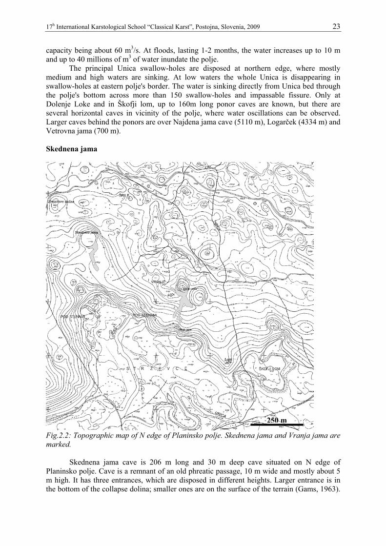
Fig. 2.1: Planinsko polje and the karst around it. Legend: 1. Postojnska jama cave, 2. Planinska jama, 3. Tkalca jama, 4. Zelške jame – Karlovica cave, 5. Logarček, 6. Najdena jama, 7. Gradišnica, 8. Vetrovna jama, 9. Skednena and Vranja jama.
Planinsko polje is overflow polje, of rectangular shape, 6 km long, 2 km wide, with two narrow pocket valleys on SW part, 50 m deep, with 16 km2 flat surface at height of 450 m. Its wider surrounding is built by Upper Triassic dolomite, Jurassic and Cretaceous limestone. The development of closed karst depression is result of accelerated corrosion, controlled by geological structures. It presents the most important water confluence in the river basin of Ljubljanica. Tectonically crushed and almost impermeable dolomite barrier along the Idrija wrench fault zone, which crosses the polje, forces the karst waters to overflow from higher karstified limestone background to the surface and after crossing Planinsko polje toward NE they can sink into the underground again. The principal Unica springs, with mean annual discharge 24 m3/s (min. 0, 3 m3/s, max. 100 m3/s) are situated in the southern polje's part in Cretaceous limestone, where the confluence of waters from Cerknica, Javorniki Mt. and Pivka is located. Main spring is 6656 m long Planinska jama cave. Planinsko polje is flooded several times in a year. The minimum inflow to the polje amounts to 1, 5 m3/s; mean 23 m3/s, maximal was estimated to 100-120 m3/s, the total ponor
17h International Karstological School “Classical Karst”, Postojna, Slovenia, 2009 23
capacity being about 60 m3/s. At floods, lasting 1-2 months, the water increases up to 10 m and up to 40 millions of m3 of water inundate the polje. The principal Unica swallow-holes are disposed at northern edge, where mostly medium and high waters are sinking. At low waters the whole Unica is disappearing in swallow-holes at eastern polje's border. The water is sinking directly from Unica bed through the polje's bottom across more than 150 swallow-holes and impassable fissure. Only at Dolenje Loke and in Škofji lom, up to 160m long ponor caves are known, but there are several horizontal caves in vicinity of the polje, where water oscillations can be observed. Larger caves behind the ponors are over Najdena jama cave (5110 m), Logarček (4334 m) and Vetrovna jama (700 m). Skednena jama
Fig.2.2: Topographic map of N edge of Planinsko polje. Skednena jama and Vranja jama are marked.
Skednena jama cave is 206 m long and 30 m deep cave situated on N edge of Planinsko polje. Cave is a remnant of an old phreatic passage, 10 m wide and mostly about 5 m high. It has three entrances, which are disposed in different heights. Larger entrance is in the bottom of the collapse dolina; smaller ones are on the surface of the terrain (Gams, 1963).
250 m

17h International Karstological School “Classical Karst”, Postojna, Slovenia, 2009 24
The gallery floor form clastic sediments: rocks, gravel and smaller particles size of sand and silt. The main part of the cave passage, in the length of more than 100 m, is smooth and leveled to an even surface with inclination of 7-10º and horizontal in cross section.
The mean annual temperature of the area is about 8ºC. The coldest month is January (–1ºC) and the warmest July (+18ºC). During the winter there is a strong air draft in the cave, and the cave temperatures at the floor are for several months below 0ºC. Air temperatures measured at the cave floor are similar to those on the surface, but in domes in the ceiling or in side passages temperatures are much higher, they even do not fall below the freezing point.
The floor freezes and on the places with dripping water ice stalagmites are formed. During the thawing of the surface small, short lasting lakes can form, ground in the depth thaws a month or two later.
Leveled cave floor show recent patterned ground cryoturbation features like sorted stone circles, sorted polygons, stripes and clay hummocks. These features develop due to repeated freezing and thawing of the cave sediments, which cause the shifting, or movement rocks mixed with finer sediments that contain moisture. These features are present in all parts of the cave floor with even slope, but are better developed in vicinity or down slope of the dripping points where locally the ground contains more moisture.
Cryoturbation develop due to increasing of the volume of the ground when it freezes and thus expands its volume. This causes the upwards mowing of the whole cave floor. For two seasons we measured the upward movements of the selected stones. The upward movements from 5 – 10 cm in vicinity of the dripping water over 20 cm were measured.
Vertical movements are also causing horizontal shifting of the particles down dip, because the particles, which are uplifted perpendicular to the inclined surface, are lowered vertically during the thawing. This is morphologically important, and it leveled the whole cave floor bottom to even dip.
Fig.2.3: Cross section through Skednena jama. Vranja jama Vranja jama is in many respects similar to Skednena jama. It is the remnant of the same cave system, which is now partly collapsed or unroofed. It has two entrances and the

17h International Karstological School “Classical Karst”, Postojna, Slovenia, 2009 25
large entrance is also in the collapse dolina. The smaller entrance that is in lower position is named Mrzla jama (Cold cave) that is the reason for strong outflow of cold air in summer time. Vetrovna jama
Fig. 2.4: Topographic map of Laška kukava and the position of the cave. In some other large collapse dolines the summer temperature inversion is also maintained by the cold cave air. Vetrovna jama is 700 m long and 115 m deep cave. It was discovered after long digging in narrow passages following the strong winds that blew out of cave. The cave reaches underground flow of Ljubljanica river between Planinsko polje and springs at Vrhnika. It is mainly fed by the water comming from the eastern rim of Planinsko polje. The cave ends under the slopes and close to the bottom of large collapse doline Laška kukava. Cave and dolina are connected by impassable passages through strong air currents transfer cold air into dolina at summer. Kukava is one of the dolines where temperature inversion was studied by biologists (Martinčič, 1974) but the low temperatures of the air were

17h International Karstological School “Classical Karst”, Postojna, Slovenia, 2009 26
attributed to cooling of the air between the collapse boulders on the slopes of the dolina. The inversion of temperature is more pronounced in summer time, when bottom temperatures do not exceed much the cave temperatures of the cave.
Fig: 2.5.: Schematic cross section through Vetrovna jama and Laška kukava.
Fig: 2.6.: Stage response to a flood in caves Ne from Planinsko polje. Note the delayed recession in Vetrovna jama.

17h International Karstological School “Classical Karst”, Postojna, Slovenia, 2009 27
WHOLE-DAY EXCURSION (3) CLIMATE OF CAVES AND KARST DEPRESSIONS OF TRNOVSKI GOZD PLATEAU Thursday, 18.6.2009, 8:00-19:30 Trnovski gozd
Central part of High Dinaric Karst in south-western Slovenia comprises a row of karst plateaus of total area of approximately 700 km2. In carbonate rocks deep karst is developed with no surface waters.
Trnovski gozd one of these karst plateaus. It is about 10 km across and 20 km long. On the northern side there are deep valleys of Idrijca river and tributaries, on southern Vipava valley. From Banšice plateau is separated by Čepovanski dol, huge dry valley, while towards E there is more gentle transition to another high plateau Hrušica.
The surface of Trnovski gozd is mostly between 800 – 1200 m a.s.l., the highest peaks are 1495 m high Mali Goljak. Surface of the plateau is well levelled but dissected by numerous large dolines and uvalas (Mojska draga, Mrzla draga and Smrekova draga, Velika lazna and others) and conical hills among them. There are hundreds of caves in the area, the deepest is Velika Paradana, 650 m deep ice cave, and there are 18 others deeper than 100 m, but there are no horizontal caves in the whole area.
Fig. 3.1: DEM of the central part of Trnovski gozd karst plateau. Surface is dissected with numerous large dolines among which Smrekova draga is the largest.

17h International Karstological School “Classical Karst”, Postojna, Slovenia, 2009 28
Some depressions are partly filled with moraine material, there were small glaciers on the plateau, but they didn’t move much over the rough karst terrain. They discharge their melt water mostly in the karst directly.
In the central, highest part of Trnovski gozd the climate is rather cold. Mean temperatures in January are from -4º - -2º C. Warmest month is July with temperatures 12 - 14º C. Main annual temperature is between 7 - 9º C. There is between 1700 and 2000 mm of precipitations on the plateau but in the central part at Mali Goljak up to 3200 mm. Precipitations are distributed all over the year with maximums in October and November and from April to June.
There is no superficial flow in the area; all waters appear on the edge of the plateau in large springs like Hubelj, (250 l/s to 60 m3/s), Lijak (discharges from 0 l/s to 32 m3/s), Mrzlek (estimated discharges from 600 l/s to 40 m3/s) and others. Suho brezno
Mala lazna is large karst depression in Jurassic limestone, with chert and dolomite
limestone. Their bottom is covered by fluvioglacial gravel in which alluvial dolines were formed. North of Mala lazna are some dolines still partly filled with gravels but there are also many dolines, collapsed features and shafts, the deepest are Suho brezno. It is 155 m deep and 226 m long pothole with entrance at elevation of 1110 m. In the past the entrance part was completely filled with ice, so that the known depth of the cave was only 20 m. Shepards, people that worked in forests and during the WW I the ice was extracted from the cave for local use. It was in past decade that ice melted and opened the inner parts.
Fig. 3.2: Suho brezno, exended elevation.

17h International Karstological School “Classical Karst”, Postojna, Slovenia, 2009 29
Ice cave Velika ledena jama v Paradani Velika ledena jama v Paradani (Great Ice cave in Paradana) is probably the best
known ice cave in Slovenia. It lays on the Dinaric karst plateau Trnovski gozd. The morphology of the surface around the cave is large dolines and conical hills among them. The cave is 4000 m long and 650 m deep. The entrance is 1130 m above sea level in the bottom of large, 50 m deep, 500 m long and 250 m wide doline between peaks that are over 1400 m high. The entrance part is a funnel-like depression formed by collapse that continues into three chambers and few metres of horizontal passages. From here several series of inner pits continue into the depth.
Fig. 3.3: Schematic cross section and some climatic observations from the Velika ledena jama v Paradani.

17h International Karstological School “Classical Karst”, Postojna, Slovenia, 2009 30
Sporadic measurements and observations show strong air currents into the cave in winter time and much weaker air movements out of the cave in summer. The air in summer is about 2º C, while winter temperatures are much lower.
The snow appears usually at beginning of November and lasts till May at the bottom of the entrance doline.
Ice estimated volume of about 8000 m3 is only in the entrance parts, to a depth of about 100 m, but the cold air currents can cause freezing of water as deep as 200 m. Measurements of temperature at March 28. 2001 are representative for the distribution of temperatures in the cave (Nagode, 2002, 110). In the inner parts the temperature was 4.4˚ C at depth 650 m (480 m a.s.l), 2.2˚ C at depth 300 m (830 m a.s.l), -1.6˚ C at -50 m and 0˚ C on the edge of the doline above the entrance. Observations of the ice showed thawing between 1950 and 1960 but later the ice build up. Ice was melted from below in some parts of cave after 1977, than rebuilt and at the moment in is melting some parts, while in others it is building up again. It all shows an intrinsic and self-regulating mechanism of the ice forming in the cave. Large opening means strong winter circulation and cooling of the rock and forming of the ice. When the entrance is choked by ice, the warmer air from the depth and surface melt the ice and opens the entrance and start the circle again. Important is inflow of the cold air in summer from the karst massive above. This cold air is keeping the temperature low and so preventing the melting of the ice.
The ice was quarried from the cave already in 19. century when the forestry roads were build. Moser (1889) reports that in the year 1867 800 m3 of ice was extracted from the cave and sold to coastal city Trieste. The ice was used for the supply of the town and the port. It was shipped also to Alexandria, where ice was sold at good price.
In Paradana in 1906 G. Beck (Die Umkehrung der Pflanzenregion in den Dolinen des Kars. Sitzber. Akad. Wiss.CXV . Wien) described the temperature inversion and with it connected vegetation inversion. Later these phenomena were much studied in vicinity in Smrekova draga. Smrekova draga
Smrekova draga is about 1 km wide, 1.5 km long and more than 150 m deep closed depression, a large composed dolina. Whole dolina is formed in Triassic dolomites and dolomitic limestones.
The dolina is well known for its and vegetation inversion, a phenomena that there are belts of vegetation according to height, but in inverse order, in this case beech threes at the rim, coniferous trees like Picea and Abies below and Pinus mugho and Salix at the bottom. The phenomena was first attributed to temperature inversion, but researchers discovered, that the temperature inversion at least in summer time is not existing and that very cold air can be found only close to the ground in less than 1 m thick layer. Also cold air is only on some places, not all around the dolina and is missing at the lowest part of the dolina. Biologists explained that cold layer of the air is coming from the empty spaces between slope boulders and rubble.
However, the distribution of the springs of cold air and low temperatures which maintain low all summer time (about 2-3º C) indicate that the origin of the cold air is more likely the caves and not the spaces between the blocks. Only large cave system of the whole massive above the Smrekova draga can provide such a source of cold air. Smrekova draga is locally the lowest relief and the climate in it is partly cave climate.

17h International Karstological School “Classical Karst”, Postojna, Slovenia, 2009 31
Fig. 3.4 : Topographic map of central part of Trnovski gozd with numerous large dolines.
1 km

17h International Karstological School “Classical Karst”, Postojna, Slovenia, 2009 32
WHOLE-DAY EXCURSION (4) CLASSICAL KARST Friday, 19. 6. 2009, 8:30-19:00 CLASSICAL KARST
Slovene Classical karst is a part of karst of Dinaric mountains. It spreads from the
Mediterranean coast to the spring of Ljubljanica river. It covers two karst river basins: of Reka – Timavo river and Ljubljanica river.
This karst has abundance of interesting karst phenomena like large sinking rivers and springs, intermittent lakes, numerous large caves and relief features like karren, dolines, collapsed dolines, uvalas, poljes and levelled surfaces and plateaus. But it was the exploration of the people that were driven first by curiosity and later by land use or water management issues and tourism that make this karst famous. Well researched, described and mapped natural phenomena in 19th century made the area cradle of a new scientific discipline – karst studies. Postojna is situated well in the middle of the assigned area. Short outline of the climate and vegetation of the area The climatic conditions can be well defined by the data from weather stations in Koper, situated at the coast of Trieste and at stations in Komen, Postojna and Gomanjce that lie inland at different altitudes.
In the area studied there are different types of climate, from Mediterranean to a more continental and alpine climate, depending on the altitude and distance from the sea. There is only one common feature, the cold continental burja wind, which especially in winter brings low temperatures, snow and frost to the coast.
At the coast the mean annual temperature is 14 ˚C (Koper 13.5 ˚C). Mean July temperature is 24 ˚C and January temperature 4 ˚C.
Within a short distance from the sea, the relief rises rapidly to the karst plateau. At Komen, a village in the centre of the Kras, 10 km from the coast at an elevation of 290 m a.s.l., the mean annual temperature is 12 ˚C. The warmest month is July with 20.8 ˚C and the coolest, January, with 2.4 ˚C. Snow cover is not thick, and there are only 7 days with snow cover per year. Annual precipitation is 1645 mm, with maximum in autumn, and all months have at least 100 mm of precipitation. In spite of that, July and August are quite dry because of high temperatures, thin soil and underground karst discharge.
At Postojna, at an altitude of 530 m and 37 km from the coast, the climate is much colder. The mean annual temperature is 8.8 ˚C, mean July temperature 17.6 ˚C and January temperature -1 ˚C. Precipitation amounts to around 1551 mm. There is abundant snow cover lasting on average 100 days per year.
At the same distance from the coast, at an altitude of 937 m on the edge of the plateau of Snežnik, is the meteorological station at Gomanjce. Here the annual precipitation is 2928 mm. Mean temperature is 6.7 ˚C, in July 15.5 and in January -3.5 ˚C. There are 127 days with a mean daily temperature below freezing.
Natural vegetation in the area is forest, and before the appearance of man the forest covered most of the surface. Pollen analysis of samples from bore holes and archaeological sites in the area between the coast and high Dinaric plateaus show us the evolution of the forest cover and especially the human interference in the area.
The beech-fir forest (Abieti-Fagetum) and oak-hornbeam in lower warmer positions (Querco-Carpinetum) were representative about 7000 years ago in most of the area except for

17h International Karstological School “Classical Karst”, Postojna, Slovenia, 2009 33
the lower littoral. The changes in the three pollen spectra at about 6000–5000 years BP are the first evidence of human interference. By cutting and burning and with grazing, man gradually changed the forest into grassland.
Intensive use of the forests was most pronounced during medieval colonisation and also the phase of maximum population (agrarian) in the 18th century. Wood was used for firewood, charcoal, for shipbuilding and for construction. In the lower areas, along the coast and on the Kras, the forests completely disappeared. In the 19th century a large part of the karst between Trieste and Postojna was a bare rocky landscape.
Inland, above 600 m a.s.l., because of a more humid climate and different land use, the forests remained. In general in Slovenia there was a minimum of surface area covered by forest around the year 1875. Around Postojna, which also includes part of the Kras, the forest covered only 26% in 1880. In 1985 the share of forest had increased to 42% and in 1998 to over 50%.
There are two reasons for the reforestation of the area: numerous protective regulations and reforestation attempts like reforestation with black pine (started in 1852) and a ban on goat grazing and breeding, except in stables. More important is the change in the economy in the past century. There is no longer such enormous pressure on the land.
At present over 50% of the surface is covered by forest. The course of reforestation is now self-perpetuating: pastures are becoming overgrown by shrubs, and this slowly transforms into forest. Pivka basin The bottom of the Pivka basin, an area of about 70 km2, is of Eocene flysch rock. A river network has formed on the floor of the basin; the water flows into the boundary limestone rock going to different river basins. Karstificated limestone surrounds the valley from all sides; at the contact on higher levels there is flysch. Along the 59 km long lithologic contact of flysch and limestone, 17 larger and a number of small rivers sink, transforming only 2.3 km2 of karst. The Pivka, with a mean flow of 6 m3, is the largest sinking river in the basin. Most of its water flows from karst sources on the southern part of the basin, at the foot of the Javorniki, where a karst polje formed on limestone. For a large part of the year, the Pivka is dry; when waters are high, it floods the floor of the field. The main inflow into the Pivka from flysch rock is the Nanoščica, which flows from W; it collects water in the western part of the flysch basin. The Pivka sinks into the 20 km long Postojnska jama cave about 511 m a.s.l. The cave has several levels, the main level being between 520 and 530 m a.s.l., and the lowest between the sink of the Pivka and the outflow sump at 477 m a.s.l. There are still more than 2,200 m of unexplored galleries before the river re-appears in Planinska jama at 460 m a.s.l. Kras plateau The Kras is a low, 40 km long and up to 13 km wide, NW–SE-trending limestone plateau lying between Trieste Bay, the northernmost part of the Adriatic Sea, Vipava valley in north-east, and Friuli–Venezia Giulia lowlands and river Soča in north-west. The 45°45´´N and 14°00´´E lines of latitude and longitude cross the Kras near Divača village. The name itself has a pre-Indo-European origin from word karra, which means rock – stone. The ancient word for “stone” gave the origin to the ancient name for the region

17h International Karstological School “Classical Karst”, Postojna, Slovenia, 2009 34
(Carusadus, Carsus) and this word changed according to different languages into Kras (Slovene), Karst (German) and Carso (Italian). From this toponym the international term – karst – for such type of landscape is derived. The name and some other terms from the area like dolina, polje, and ponor have entered to international scientific terminology from here. Climate is sub-Mediterranean with warm dry summers and most of the precipitation in autumn and spring. Cold winters, with NE wind "burja " (bora = borealis) show strong influence of the continent. Average yearly precipitation on Kras varies from 1400 to 1650 mm, and average yearly evapotranspiration from 700 to 750 mm. Because of different land use, pasturing, in past centuries, the Karst was bare, with rocky and grassy surface. Last decades the bushes and trees are overgrow the landscape. The Kras belongs to Adriatic–Dinaric Carbonate Platform of the External Dinarides composed of shallow marine fossil-bearing Cretaceous and Palaeogene carbonates. Eocene flysch rocks encircle the carbonate plateau. Kras and Matarsko podolje tectonically belong to Komen thrust sheet, which is thrust over Eocene flysch and Palaeocene/Eocene limestone of the Podgorski kras.
The main part of the plateau is essentially levelled, inclined slightly towards the north-west, with numerous dolines, caves and other karst features. About 3490 caves are known on the Kras plateau. In seven of them we can reach 21 km of passages of the underground Reka which flows between 2000 and 300 m below the surface. There is a belt of slightly higher relief in the central part of the plateau, formed by conical hills like Grmada (324 m a.s.l.), and dissected by large depressions. The higher relief divides the Kras into two separated levelled surfaces. In the north-western part, the plateau descends to below 50 m a.s.l. on the edge of the Friuli Plain; on its south-eastern edge altitudes are about 500 m a.s.l. There is about 300 m of accessible vadose zone with caves formed at all altitudes from the surface to the sea level and below it.
No superficial streams occur on the Kras surface, because all rainwater immediately infiltrates to carbonate rocks. There are two dry valleys crossing the plateau and some NW–SE-trending belts of lower relief which are result of young tectonics.

17h International Karstological School “Classical Karst”, Postojna, Slovenia, 2009 35
Fig. 4.1: DEM of the Kras plateau.
The age of the karst of Kras plateau can be defined as the time when the karst rocks
were uplifted out of the sea. For the most of Dinaric karst in Slovenia this occurred after the Eocene, since after that there is there is no evidence of younger marine sediments. As soon as the carbonate rocks were exposed, we can expect that the karst was formed, but there are no remnants of karst features from that time. Most likely denudation has already destroyed them.
The oldest features in the karst relief are unroofed caves. They were caves that were formed by sinking rivers, bringing allogenic sediments to caves in Kras . At the end of the morphogenetic phase all these caves were filled with fluvial sediments. This indicates the diminishing of the gradient in the whole area. Diminishing of the gradient which ended with planation could mean tectonic phase which ended at about 6 Ma ago. After that a new tectonic phase started. Three areas faced uplift and tilting for several hundreds meters. The uplift was stronger in the SE part of the area. Karst denudation was evenly lowering the surface, so the surface remained well preserved, dissected on central parts of karst with dolines, which represent few percent of total area only. The even denudation exposed former old caves to the surface. Some of them are filled with sediments, from some sediments were washed away or were never filled.
On the surface, they are expressed as narrow and often meandering shallow trenches, shallow oblong depressions, and doline-like forms in rows and collapsed dolines.
The appearance of old unroofed caves and their fills resulted from denudation, erosion and chemical dissolution of limestone above the cavities. Fills exposed on the present surface include speleothems and cave fluvial deposits. The ancient directions of flow, different catchment areas of sinking rivers and different organisation of the ancient underground

17h International Karstological School “Classical Karst”, Postojna, Slovenia, 2009 36
drainage were reconstructed from several unroofed caves opened during highway construction in the Divaški kras (Mihevc 1996; Mihevc & Zupan Hajna 1996, Mihevc 2001). The thickness of rock overburden removed above cavities was established to have been 50–100 m. The age of cave fills was calculated from denudation rates and the expected thickness of missing overburden to 0.7–5 Ma. This large time range resulted from the expected minimum (20 m.Ma-1) and maximum denudation rates (50 m.Ma-1) calculated or measured in the area. Divaški kras Karst surface above Škocjanske jame, Divaški kras is a SE part of the Kras plateau between the sinks of Reka river and the village Divača. It is built mostly by Cretaceous and Paleogene limestone. The surface is levelled in elevations between 420 and 450 m a.s.l, inclined slightly towards NW. The karst features here are exceptional; there are sinks of Reka river, 15 large collapse dolines and hundreds of dolines. In the Divaški kras there are known 64 caves with the total passages length of 18,500 m. The largest caves of the area are Škocjanske jame, 5800 m long and 250 m deep cave. They were formed by the sinking river Reka that after sinking flows towards Kačna jama, Labodnica and then to springs of Timavo. The largest collapse doline in the area is the Radvanj double collapse doline (volume 9 million m3). It is followed by the 122 m Sekelak, the volume of which is 8.5 million m3 and Lisični dol (6.2 million m3). Then there are: Globočak (4.6 million m3), Bukovnik (1.5 million m3), Risnik (1.5 million m3) and others. As rooms as big are not usual in the Karst, we must assume that collapse dolines this large could develop only with simultaneous rock removal. If this were not the case, the room would fill up with caved-in rock and only collapse dolines much smaller than the primary cave would appear on the surface (Mihevc 2001). Kačna jama is the longest cave system of Reka River in the continuation of Škocjanske jame. The entrance lies west from Divača 435 m a.s.l. The total length amounts to 12.500 m. In the lower level the actual underground flow of Reka is met at 195 m respectively.

17h International Karstological School “Classical Karst”, Postojna, Slovenia, 2009 37
Fig.4.2: The map of the Divača karst. On the levelled surface the large collapse dolines are dominating features, solution dolines are frequent, but they represent only small proportion of the surface. The outlines of the main caves and the main unroofed caves are marked. On the map made of DEM with 12.5 m grid the road cuts or causeways are also seen. Legend: 1. Outline of the active river caves, 2. Divaška jama cave, 3. Unroofed cave, 4. Unroofed caves mentioned in the text: A: Unroofed cave near Povir, B: Unroofed cave in doline Radvanj, continuation of Divaška jama, C: Unroofed cave above Škocjanske jame, 5. Height of the surface, 6. Height of the water level in caves, 7. Reka river and ponors, 8. The supposed direction of water flow, 9. Outline of the town Divača. Reka River The Reka river is the main sinking river of the Kras edge. It gathers the water from the area of more than 350 km2. Around 60 % of it is with surface drainage network on Eocene flysch. In the period 1961-1990 the minimal measured discharge of the Reka River was 0.18 m3/s and the mean discharge 8.26 m3/s. In the time of extremely high waters its discharge can reach up to more than 300 m3/s. At such conditions the water is dammed in the underground and over 100 m high floods occur in Škocjanske and other caves.

17h International Karstological School “Classical Karst”, Postojna, Slovenia, 2009 38
After underground flow the Reka and rainwater from the Kras and inflows from the rivers Soča, Vipava and Raša reappear at springs as Timavo about 35 NW from Škocjanske jame. Three main springs with mean discharge 30.2 m3/s are on the coast are connected by a network of passages that reach a depth of about 80 m below the sea level. Škocjanske jame The Škocjanske jame caves are 5,8 km long. The Reka river, mean annual discharge 8,26 m3/s enters the cave at an altitude of 317 m; in the Martelova dvorana room, it is 214 m above sea levelled at terminal sump at about 190 m a.s.l. (i.e. 127 m lower). At low waters Reka sinks before it enters the cave. Floods usually reach up to 30 m. The largest known flood in the previous century raised the water table level for 132 m.
Morphology and development of Škocjanske jame cave are described acording to Mihevc (2001). Caves are developed in a contact area of cretaceous thick-bedded rudistic limestone and Palaeocene thin-bedded dark limestone. Most primary channels developed along tectonized bedding-planes these, and this structure is also morphologically distinct on the surface. Small dolines, and occasionally denuded caves, formed in places where the caves emerged on the surface.
Škocjanske caves are composed of phreatic tunnels and gravitational or paragenetic reshaped galleries. The proto-channels developed in phreatic conditions, formed along tectonised bedding-planes. The water flow demanded a high degree of phreatic rising and falling between individual bedding-planes which are in the area of the chambers Svetinova dvorana and Müllerjeva dvorana approximately 175 m. Large quantities of water could flow through all these tunnels, but meanwhile, rubble was transported through water table caves above them. Remnant of such a cave is unroofed cave in Lipove doline at an altitude of around 450 m. A long period followed when the piezometric water table was 340-300 m above sea level and the gradient was in a south-west direction. The Reka formed new or adopt old passages by paragenesis and bypassing. The large galleries Mahorčičeva and Mariničeva jama, Tominčeva jama, Schmidlova dvorana in Tiha jama were formed.
In the further development of Škocjanske caves, potent entrenchment prevailed. Cutting occurred in inner parts of the cave, in Hankejev channel for about 80 m, much less about 10 m, in the eastern, entrance part of the cave.
First paths in the cave area were made in 1823, but construction of paths for exploration and for the visitors started in 1884. Cave exploration was done by cavers of DÖAV (Litoral section of Austrian Alpinistic club) from Trieste. The most important explorer was Anton Hanke. In 1891 they already reached the final sump in the cave. The largest chambers are Martelova dvorana, with a volume of 2,100,000 m3, and Šumeča jama (870,000 m3). Some of big chambers collapsed forming the big collapse dolines like Velika and Mala dolina.
Because of their extraordinary significance for the world's natural heritage, in 1986 the Škocjanske jame were included in UNESCO’s World Heritage List. The Republic of Slovenia pledged to ensure the protection of the Škocjanske jame area and therefore adopted the Škocjanske jame Regional Park Act.

17h International Karstological School “Classical Karst”, Postojna, Slovenia, 2009 39
Fig. 4.3: Map and stratigraphy of Škocjanske jame.
Floods and winds in caves with the active flow of the Reka river The aquifer of Kras is as complex as a karst aquifer can get. More than 300 m deep
vadose zone, huge underground cavities, all possible flow regimes, complex recharge and discharge conditions and multiphase evolution are enough to believe that the system is far from being resolved.
Fig. 4.4: Simplified cross-section of the Kras plateau with main caves and measurement points.

17h International Karstological School “Classical Karst”, Postojna, Slovenia, 2009 40
The epiphreatic zone is characterized by high flow variability of the Reka river. At the moment we know five caves leading to the active subsurface flow: Kačna cave and Labodnica/Grotta di Trebiciano are well known and have already been thoroughly investigated. Recently, three additional caves were pushed down to the depths of active Reka flow: Lazzaro Jerko in Italy; Jama 1 v Kanjaducah and Brezno v Stršinkni dolini in Slovenia. The river has also been reached through Brezno 3G, which turned out to be a possible second entrance of Kačna cave.
In Škocjan caves and Kačna cave it is possible to follow several kilometers of the underground while only small fragments are accessible in other caves as the confining siphons are not far apart, therefore further exploration is left to cave divers.
In 2005 we have established a monitoring of water level, temperature and electrical conductivity in all known caves that reach the Reka river. It is based on Schlumberger’s CTD Divers which enable unattended long term, high frequency record of given parameters. The water level in selected caves responds vigorously to the floods. The highest known stages are more than 100 meters above the base flow stage.
Figure 4.5: Part of the recorded time-series showing the seasonal tempersture variations and response to the flood events.
Figure 4.6 shows the response of stage, temperature and SEC in Škocjanske jame
during a flood event in December 2009, the largest flood since the beginning of monitoring. The stage rose for 66 meters at maximum flow of Reka 255 m3/s. The rising rate reached 6 m/h, while during the recession period, the water level was dropping up to 11 m/h. Data in other caves have not been collected yet.

17h International Karstological School “Classical Karst”, Postojna, Slovenia, 2009 41
Fig. 4.7: Discharge, stage, temperature and SEC of Reka during the flood event in December 2008. Discharge is measure at the gaging station about 6 km upstream from Škocjanske jame.
The morphology of caves (i.e. large voids connected to the surface with series of
shafts and small entrances) combined with vigorous stage response to the flood inputs also dictates extreme ventilation in these caves. Four of these caves have been explored by following the leads along openings, where strongest air currents were sensed during the flood events.
One of these is Jama 1 v Kanjaducah, where the exploration breakthrough to the Reka river was done in 2003. The cave is 310 m deep. Most of the entrance part is in the fractured zone with boulder-chocks, where small passages have been excavated following the main air currents. The cave continues with large inclined/vertical gallery down to the level of Reka. Large passages have been found in the upstream and downstream directions along the Reka river. Recent diving revealed another large dry gallery behind the terminate siphon.
Fig. 4.8: Extended elevation of Jama 1 v Kanjaducah with the positions of instruments.

17h International Karstological School “Classical Karst”, Postojna, Slovenia, 2009 42
To follow the air during the flood event we have installed Schlumberger’s barologger at the top of big gallery to measure the air pressure and anemometer close to the entrance, additional to the diver in the terminate lake (see figure 4.8). Figure 4.9 presents the results of measurements. Stage rose to 50 m, with maximal rate of about 1 m/s. This pressed the air out through the caused the rising of the air pressure rise for 30 cmH2O approc. 30 mbar) in 8 hours. A rough estimation (assuming area of 5 m2) gives, that about 0.6 x 10⁶ m3 of air was squeezed through the entrance. The “negative” pressure difference and wind speed was recorded during the flood recession.
Figure 4.9: Water level, air pressure and wind speed during the flood event in November 2005.
Ljubljanica river system Ljubljanica River collects the water from SW part of Dinaric karst in Slovenia and belongs as right Sava affluent to Danube and of Black Sea. The water basin is about 1100-1200 km2 large. Nearly all watershed of the river is in karst and therefore is not well defined. The mean annual precipitation in the basin is 1300 - 3000 mm, during 100 to 150 rainy days. The one-day maximal amount to 100 mm, in extreme cases even 300 mm.
Most of the river basin is formed on the Mesozoic rocks, mostly limestone. On these rocks the precipitations infiltrate directly into the karst and there are no surface rivers. Triassic dolomite is important, allowing some surface flow, forming bottoms of some karst poljes or forming hydrologic barriers.
The highest parts of the basin are high karst plateaus Hrušica, Javorniki and Snežnik and Racna gora. On the poljes among them surface rivers appear only, but they have different names: Trbuhovica, Obrh, Stržen, Rak, Pivka, Unica and finally after the springs at Vrhnika the name Ljubljanica. The highest lying is the karst polje near Prezid (770 m), followed by

17h International Karstological School “Classical Karst”, Postojna, Slovenia, 2009 43
Babno polje (750 m), Loško polje (580 m), Cerkniško polje (550 m), Rakov Škocjan and Unško polje (520 m), Planinsko polje (450m), Logaško polje (470 m) and finally by Ljubljansko Barje (300 m) where the Ljubljanica springs are at 300 m a.s.l. There are several large springs are dispersed along the edge of the Ljubljana Moor, which is connected with gradual tectonic subsidence of the area. Mean annual discharge of the Ljubljanica at springs is 38.6 m3.
Fig 4.10: Legend: 1. Ljubljanica springs at Vrhnika, 2. Logaško polje, 3. Planinsko polje, 4. Rakov Škocjan, 5. Cerkniško polje, 6. Loško polje, 7. Babno polje, 8. Postojna, 9. Pivka basin and polje. High karst plateaus: 10. Snežnik, 11. Racna gora, 12. Javorniki, 13. Hrušica, 14. Trnovski gozd, 15. Nanos. Karst levelled surfaces: 16 Logaški ravnik, 17. Hotenjski ravnik, 18. Slavenski ravnik; 19. Škocjanske jame cave, ponor of Reka river, 20. Vipava spring, 21.Divje jezero spring at Idrija.

17h International Karstological School “Classical Karst”, Postojna, Slovenia, 2009 44
Fig. 4.11 : Longitudinal cross section of Ljubljanica karst river basin (Gospodarič & Habič 1976).
There are 1540 caves, accessible fragments of underground drainage system known in the catchments area of the Ljubljanica. The average length of the cave is 48 m and the depth 18 m. However, the largest caves are the ponor or spring caves; in them we can follow the 71 km of passages of the main rivers, tributaries of Ljubljanica.
Cerkniško polje
Cerkniško polje is the largest karst polje in Slovenia. Often it is called just Cerkniško jezero (Lake of Cerknica), because of its regular floods, or intermittent lake. The intermittent lake covers 26 km2 when is full; it is 10,5 km long and almost 5 km wide. Its hydrological properties caused that already in the beginning of New Age scholars from all round Europe were attracted to it. The lake becomes still more known through the Valvasor’s description in 1689. It is a karst polje developed in the important regional fault zone – Idrija fault. Idrija fault has “Dinaric” direction (NW-SE); in the same fault zone are developed: Planinsko polje, Loško polje and Babno polje. Bottom of Cerkniško polje covers 38 km2 in elevation of about 550 m. Bottom is formed on Upper Triassic dolomite, which is presented also on the N, E and SE side of the polje, there are some Jurassic dolomites also presented. On W and NW the Cretaceous limestone are presented. Inflows are on E, S and partly on W sides of polje. The largest tributary to polje is Cerkniščica drained the dolomite catchments area. The important karst springs are Žerovnica, Šteberščica and Stržen. Stržen flows on the W side of polje towards the ponors in the middle of the polje, from where water flows directly to Ljubljanica springs, and towards NW side of polje, from where the water flows to Rakov Škocjan. From the foot of Javorniki mountain to the contact with dolomite in the polje bottom is 12 ponor caves. They are connected to Karlovica cave system to which also the highest waters from polje flows. It the system there is more the 7 km of passages. Passages are generally low, because they are filled by alluvia. Thickness of alluvia in Jamski zaliv, before the caves entrances, is about 8 –15 m. During the last centuries a lot of plans for the hydro melioration of polje has been made, but not any of them was realised. In 1965 was proposed to make Cerkniško polje a permanent lake, in the years 1968 and 1969 entrances to the caves Velika and Mala Karlovica

17h International Karstological School “Classical Karst”, Postojna, Slovenia, 2009 45
were closed by concrete walls and 30 m long tunnel was made to connect Karlovica with the surface, but small effect of retention in dry period and less moistened years were assessed. The bottom of Cerkniško polje covers 38 km2 in elevation of about 550 m. Inflows are on E, S, and partly on W polje's side. There are some small superficial tributaries to polje, the largest is Cerknišcica, with about 45 km2 of hinterland mostly dolomite. Flattened bottom of Cerkniško polje is regularly flooded for several months in autumn winter and spring time, at floods it alters to spacious karst lake. Lower waters are sinking mostly in marginal swallow holes and in numerous grounds swallow holes and estavellas, which are disposed in central polje's bottom. Principal ponor caves and swallow holes are disposed at NW polje's border. Next to the polje border, from the foot of the Javorniki to the contact with dolomite in the polje bottom is 12 ponor caves with more than 7 km of passable channels. Largest are Velika and Mala Karlovica caves. Most of caves are short, they get narrow or end with breakdowns or sumps. Outflow from the polje was not oriented to one channel, rather to a mesh of channels, which about 200 m from the edge of polje combine into a couple of larger galleries. They are generally low, because the bottom are filled with alluvia. Alluvium at altitude of 550 m is distinctive in all the ponor caves, its thickness is possibly the same as a thickness of alluvia in Jamski zaliv, 8 - 15 m respectively. Rakov Škocjan
Rakov Škocjan is a karst depression about 1,5 km long and 200 m wide. It is situated below the N side of Javorniki Mountain at elevation about 500 m between Planinsko and Cerkniško polje. Through the depression flows the permanent river Rak. The Rak springs from Zelške jame cave, bringing water from Cerkniško polje. Zelške jame are about 5 km long; the end of the cave is in huge collapse doline Velika Šujca, where from the other side the Karlovica cave system ends. In Karlovica system is the main outflow from Cerkniško polje. Numerous collapse dolines are situated around the entrance of Zelške jame. In one of them the Small natural bridge is present. Downstream the valley widens and several springs bring additional water to the Rak River. The valley is narrowed at the Great Natural Bridge and afterwards the Rak sinks into Tkalca jama cave from where the water flows towards cave Planinska jama at Planinsko polje. The connections of the Rak with water from Cerkniško polje and with the Unica springs at Planinsko polje were proved by water tracing.
Before 1st World war Rakov Škocjan was owned by the Windischgrätz family and was closed as their private park; between 1st and 2nd World war, the Italians also closed the area for the public. From 1949 Rakov Škocjan has been a Landscape Park.
Fig. 4.12: Cross-section along Rakov Škocjan karst depression between spring at Zelške jame and sink in Tkalca jama. Legend: 1 – rocky bottom, 2 – alluvia, 3- fault zone, 4 – flood in

17h International Karstological School “Classical Karst”, Postojna, Slovenia, 2009 46
1982, 5 – karst spring, 6 – water flow directions, 7 – terraces, 8 – boulder rocks, 9 – altitude (Gospodarič et al. 1983) Logaško polje
Logaško polje is border polje, developed on the contact of dolomite and limestone between 470 and 480m a.s.l. A number of small streams flow onto it, the largest being the Logaščica, which collects run-off from a dolomite area of 19 km2. The mean flow is 0.3 m3/s. Short lasting floods occur at the swallow-holes on the Logaško polje when the flow exceeds 30 m3/s. The ponor of the Logaščica river is in the centre of the town, and there is located also the central waist water treatment plant. The water from the plant is directly flowing into the stream just 50 m before it sinks. The station located near the school, church, kindergarten, cemetery and school playground and direct injection of often not enough treated water is interesting case of understanding of sustainable use of karst resources. The Logaško polje developed on the contact of dolomite and limestone between 470 and 480m a.s.l. A number of small streams flow onto in, the largest being the Logaščica, which collects run-off from a dolomite area of 19 km2. The mean flow is 0.3m3/s. Short lasting floods occur at the swallow-holes Jačka on the Logaško polje when the flow exceeds 30 m3/s.
Selected References Balch, E.S., 1900: Glacieres or Freezing Caverns. Allen, Lane&Scott, 337, Philadelphia. Brodar, S., 1952: Prispevek k stratigrafiji jam Pivške kotline posebej Parske golobine. Geografski vestnik, 24,
43-76, Ljubljana. Brodar, S., 1966, Pleistocenski sedimenti in paleolitska najdišča v Postojnski jami. AC 4, 55-138.
Civita, M. & F. Cucchi A.& Eusebio & S. Garavoglia & F. Maranzana & B. Vigna 1995: The Timavo Hydrogeologic System: An Important Reservoir Of Supplementary Water Resources To Be Reclaimed And Protected. Acta carsologica 24, 169-186, Ljubljana.
Gams, I., 1974: Kras. Slovenska matica, 1-357, Ljubljana. Gams, I.,1983: Škocjanski kras kot vzorec kontaktnega krasa. Medn.simp."Zaščita Krasa ob Gospodarič, R.,
1976: Razvoj jam med Pivško kotlino in Planinskim poljem, Acta carsologica, 7, 9-139, Ljubljana. Gams, I. 2003: Kras v Sloveniji v prostoru in času. Ljubljana: Založba ZRC, ZRC SAZU, 516 p., Ljubljana. Gospodarič, R., & P. Habič, P., 1976: Underground water tracing. Third International Symposium of
Underground Water Tracing (3. SUWT), 1-312, Ljubljana. Gospodarič, R., 1976: Razvoj jam med Pivško kotlino in Planinskim poljem, Acta carsologica 7/1, 5-121,
Ljubljana. Habič, P.,1982: Kraški relief in tektonika. Acta carsologica, 4, 23-43, Ljubljana. Kranjc, A, 1997: Kras: Slovene classical karst. Znanstvenoraziskovalni center SAZU, Založba ZRC: Inštitut za
raziskovanje krasa ZRC SAZU, 1997. 254 p. Ljubljana. Martinčič, A., 1977: Prispevek k poznavanju ekologije mrazišč v Sloveniji. Botanično ekološka skica = Beitrag
zur Kenntnis der Ökologie der Kältelöcher in Slowenien : botanisch-ökologische Skizze. Razprave SAZU, Razred za prirodoslovne vede, 20/5, 91 Ljubljana.
Melik, A., 1955: Kraška polja Slovenije v pleistocenu. Dela Inštituta za geografijo SAZU, 3, 1-163, Ljubljana. Michler, I., 1952: Velika in mala ledena jama v Trnovskem gozdu. Proteus 12, 1949/50, 209-214, Ljubljana. Mihevc A. 1998 - Brezstropa jama pri Povirju in denudirane jame v okolici Divače.- Geografski obzornik, 45, 2,
12-17, Ljubljana Mihevc A. & T. Slabe & S. Šebela 1998 - Denuded caves - an inherited element in the karst morphology; the
vcase from Kras. Acta Carsologica 27/1, 165-174, Ljubljana Mihevc A., & N. Zupan, 1996: Clastic sediments from dolines and caves on the route of highway at Divača,
Acta Carsologica 25, 169-191, Ljubljana. Mihevc, A., 2001: Speleogeneza Divaškega krasa. Založba ZRC, ZRC SAZU, 180 p. Ljubljana. Mihevc, A. & Gams, I., 1979: Nova odkritja v veliki ledeni jami v Paradani (kat.št. 742). Naše jame 20, 7-20,
Ljubljana.

17h International Karstological School “Classical Karst”, Postojna, Slovenia, 2009 47
Mihevc, A., 2002: Postojnska jama cave system, U/Th datation of the collapse processes on Velika Gora (Point 4). V: GABROVŠEK, Franci. Programme and guide booklet for the excursions : evolution of Karst: from Prekarst to Cessation, september, 17th-21st, 2002. Postojna: Karst Research Institute ZRC SAZU, Postojna.
Mihevc, A., 1993: Ledene in snežne jame. Geografski obzornik 40/4, 32-35, Ljubljana. Nagode, M., 2002: Led v Veliki ledenici v Paradani. Naše jame 44, 106-113, Ljubljana. Radinja, D., 1972: Zakrasevanje v Sloveniji v luči celotnega morfogenetskega razvoja. GZ,13, SAZU, Ljubljana. Šebela, S., 1998a: Tectonic structure of Postojnska jama cave system. Založba ZRC SAZU, 18, 112 pp,
Ljubljana. Zupan Hajna, Nadja, Mihevc, Andrej, Pruner, Petr, Bosák, Pavel, 2008: Palaeomagnetism and
magnetostratigraphy of Karst sediments in Slovenia, (Carsologica, 8). Ljubljana: Založba ZRC, ZRC SAZU,. 266 str.

17h International Karstological School “Classical Karst”, Postojna, Slovenia, 2009 48

17h International Karstological School “Classical Karst”, Postojna, Slovenia, 2009 49
ABSTRACTS
(Ordered by authors in an alphabetical order)
THE IMPORTANCE OF STUDY OF SPELEOGY IN KARSTIC TERRAINS WITH SPECIAL EMPHASIS IN KARST ENGINEERING IN IRAN
A. Afrasiabian Pars karst water company, Dr fatemi st. jahad sq. No41.4thfloor. APT25 Tehran, Iran; [email protected] According To difinition given by international speleological union a cave is natural underground openning in rocks that is large enough for human entry the direct and the most noticeable result of Karstification is A specific morphology that makes Karst Terrain quite Different from non Karst region . one of the most representative morphological forms Associated with Karst terrains Are cave and poljes and sink koles. As such Their Recognization is very important specialy in Karst engineering And Damages which can be caused due to their misrecognization. And in many times create A lot of damages and hence many dam failure in Karstic Region. As cited in the Paper A special athempt Has to be made for formulation of specification and code of practice for cave study in karstic region and international co – operation and Exchange of information and Experience can Lead to A uniform plan And Methodology which has been emphasized in the paper.
RARE EARTH ELEMENTS DISTRIBUTION BETWEEN DRIP WATER AND CALCITE; RESULTS FROM EXPERIMENTAL SPELEOGENESIS
M.P. Aliaga M.P., J.P. Bernal & E. Lounejeva Departamento de Geoquímica, Instituto de Geología, Universidad Autónoma de México, Circuito Exterior s/n, Cd. Universitaria 04510, México DF., México; [email protected], [email protected], [email protected] For the last decades speleothems have been used as paloeclimatic archives because of the conditions in which they are formed. The drip water, from which the stalagmites grow, thus the secondary carbonate, is known to provide information about the climatic conditions at a specific time. The use of minor and trace elements in the calcite, such as Mg, Sr, Ba, has been used to trace hydrogeochemical and pedological processes in the karst, associated with the climatic conditions. However, these proxies are not sensitive to changes in redox conditions in the karst, or to the changes in the percolation route, or water-rock intereactions. In this work, we study the distribution of Rare Earth Elements (REE) in percolation and secondary calcite. However, because there is little knowledge on their behaviour there is the need to “calibrate” their behaviour against the current climatic conditions. We present the results form the ongoing long term calibration taking place in “Grutas Las Karmidas” located in Zapotitlan de Mendez, Puebla, Mexico (N 20° 00’ 01.19” and W 97° 42’ 58”). The current climatic conditions of the cave are been monitored (temperature, humidity, PCO2), percolating and stagnant water, as well as calcite precipitated from them have been collected every three months for the last 26 months, and analyzed for their trace element composition, including REE. By knowing the actual climatic conditions and relating them seasonally to the trace element data gathered, it will be possible to compare these records with that in a 1600 y stalagmite, collected in the same cave, in order to learn about the paleoclimatic conditions and hydrogeological processes that have been occurring in the zone.

17h International Karstological School “Classical Karst”, Postojna, Slovenia, 2009 50
MONITORING OF PROTEUS ANGUINUS IN SEMI-NATURAL CONDITIONS OF CAVE
LABORATORY TULAR – A GIS APPROACH Gregor Aljančič 1 & Magdalena Năpăruş2
1Cave Laboratory Tular, Kranj, Slovenia; [email protected] 2Faculty of Geography, University of Bucharest, Romania; [email protected] Cave Laboratory Tular is an underground facility arranged by Marko Aljančič in 1960, in a conglomerate cave Tular in Kranj, Slovenia. The laboratory studies the behavior and ecology of human fish, an endemic cave salamander of Dinaric Karst (Proteus anguinus Laurenti, Urodela, Amphibia), with special emphasis on conservation of this endangered species. Previous observations of Proteus, kept in large laboratory pools, have only been sporadic and short termed. Many important details of Proteus behavior have been overlooked by the observer, mostly due to long periods of the animal’s inactivity. It is therefore understandable that only a real-time and a long-term monitoring could obtain adequate information on Proteus behavior, as well as registering some basic ecological parameters in the observed pool (temperature, pH, O2 levels etc.). To process, analyze and visualize such large quantity of data, a more automated method is required. For more accurate visualization and monitoring of Proteus behavior we decided to use ArcGIS Desktop software and created GIS data. For a pilot study we chose one of the laboratory pools with 14 animals. First we created a base layer – a map which represents the physical environment of the tested pool (e.g. basic topography, temperature of water and air etc.). To this base layer we added vector data of Proteus activity captured during a one-week, real-time, infra-red video recording. GIS-generated maps show current Proteus distribution in the pool with information such as preferred areas for feeding, resting, courtship, breeding and other behavior patterns. The method developed in this pilot project will be applied to all other pools and the results will be analyzed using GIS tools. Such monitoring will not only tell us more about intraspecific relations between animals but also about parameters of semi-natural conditions in Cave Laboratory Tular. CAVE - BENEFITS BUT PROBLEMS TO MAINTAIN THEIR ECOLOGICAL STABILITY
IN NEPAL Pushpa Raj Acharya
Prince Of Songkhla University, Biology department, PSU- Dormitary 111423, Hat Yai, Nepal; [email protected] Nepal is a country of natural paradise with interesting geological and geographical features. The rugged mountains at different elevation level (60m to world topmost peak) hosting several cavern structures with various climatic diversity. Cave people association have so long cultural and archaeological evidence since ancients period of Hindus and Buddhist origin and is being stronger at present too. Parallely, these amazing land structures housing several biotic features either as winter temporary hibernation or for the permanent habitat. Cave tourism is the newly growing aspects of tourism in the country is seems successful to attract visitors. The speleological studies are quite new and fairly sporadic but have several potentialities for the ecological and archeological research. The trained manpower for speleological research is seems urgent to explore much information on these hidden treasures. I will present some information that I had documented during my academic research on ‘bats’ in Nepal including some benefits and prevailing threats over the cave ecosystem.
CAVE CLIMATOLOGY AND CAVE METEOROLOGY Giovanni Badino
Dip. Fisica Generale, Universita di Torino
A new generation of detectors and careful data analysis are permitting to detect transient changes into the caves microatmospheres, essentially in the fields of temperature variations either temporal -diurnal and seasonal- and spatial -thermal stratification and internal lapse rate-, water vapour saturation -clouds- and wind speed fluctuation -infrasounds-. These phenomena and some detection problems are discussed.

17h International Karstological School “Classical Karst”, Postojna, Slovenia, 2009 51
RESULTS OF EXPLORING THE MUNIŽABA CAVE (VELEBIT, CROATIA) WITH
SPECIAL REFERENCE TO MEASUREMETS OF PHYSICO-CHEMICAL AND MICROCLIMATIC PARAMETERS
Petra Bajo1, Andrej Stroj1,2, Dalibor Paar1,3, Magdalena Ujević4, Darko Bakšić1,5, Damir Lacković1,6, Ana Čop1, Vanja Radolić7
1Speleological section Velebit, Radićeva 23, Zagreb, Croatia; [email protected] 2Croatian Geological Survey, Sachsova 2, Zagreb, Croatia; [email protected] 3Faculty of Science and Mathematics, Bijenička 32, Zagreb, Croatia; [email protected] 4Croatian National Institute of Public Health, Rockfellerova 7, Zagreb, Croatia 5Faculty of Forestry, Svetošimunska 25, Zagreb, Croatia 6Croatian Natural History Museum, Demetrova 1, Zagreb, Croatia 7Department of Physics, University of Osijek, P.O. Box 125, Osijek, Croatia The Munižaba cave is located in the SE part of the Velebit Mountain range called Crnopac. Crnopac massif is mostly built of the upper Paleogene and Neogene carbonate breccias, in literature known as Jelar breccias. Due to the specific mechanical and petrographical properties of Jelar breccias, the terrains built of these breccias are characterized by the extremely developed solution karst landforms, and also the entrance parts of the majority of the deepest explored caves in Croatia are developed in them. Several significant caves are thus discovered in the Crnopac area, whose main morphological characteristic is a network of multiphase cave passages, some of them with very large cross-section dimensions. The most important caves of Crnopac massif are Munižaba (5993m, -437m), Kita Gaćešina (10603m, -456m), Burinka (325m, -290m), Gornja (Upper cave) (2682m, -42m) and Donja (Lower cave) Cerovačka pećina (1295m, -22m). The above mentioned caves have not been physically connected by cavers yet, but their corresponding levels probably belong to the same paleodrainage systems. During the recent speleological explorations of the Munižaba cave, microclimatic measurements of cave air temperature, humidity and air circulation, radon concentration measurements and physical and chemical analyses of drip water have been performed periodically in some places.
SIRTLANINI CAVE: A RICH CAVE OF FOSSILS AND SPELEOTHEM WHICH IS LOCATED IN THE UPPER PART OF THE CITY OF VENUS (SW TURKIYE)
M.Oruç Baykara, Mehmet Özkul, Arzu (Gül) Akçay Department of Geology Engineering, Faculty of Engineering, University of Pamukkale, Denizli, Turkiye; [email protected] The Sırtlanini cave is located in approximately 1.5km south-east of Çamarası Villige which belongs to Karacasu county, Aydın. The elevation of cave is 1060 meter. The total measured length of cave is 450 meter. The deepest point is 40 meter according to the entrance level. It is possible to reach to the Sırtlanini cave in every month with highway. There is a Karacasu junction to the south after 60th km. of Denizli-Aydın highway. It can be reached to Geyre after taking 37 km from Karacasu junction. When Geyre is passed in the south-west direction Çamarası village is over there. After taking the stabilized road by approximately 1,5 km, Sırtlanini Cave is then reached. The Sırtlanini cave was formed in highly karstified Mesozoic recrystallized limestone which is covering unit of Menderes Massif. The region was fairly affected from the tectonic activities. Two different levels were observed in the Sırtlanini cave which were completed its formation and development. Both two levels were in vadose zone. In rainy seasons, some dripping water are observed in the cave however in arid seasons totally is dried. The oldest level which was formed approximately 5 meter above from the entrance level of the cave, is so close to the surface that some lemur roots were seen in this level. Different arachnid species, worms and bats were observed in the cave. There were life evidences that belong to the past in the cave. There were plenty of bones and teeth pieces found in the cave. We thought that these remains were belonging to horses, boars, goats and hyenas. It was thought that hyenas, which give the name of the cave, were fed in the cave after hunting. Notice that region was exposed to two major earthquakes in 4th and 7th century according to some documents which were found in Aphrodisias antique city excavation where 10 km northwest of
17h International Karstological School “Classical Karst”, Postojna, Slovenia, 2009 52
Sırtlanini cave. In these documents it was written that groundwater level was changed during the earthquake that occured in 4th century and some part of the city was flooded (Erim, 1988). It was thought that groundwater level in the cave was affected by these earthquakes. Numeruous existence of stalactite, stalagmite and column show that crack systems highly developed in the limestone. The Sırtlanini cave has been thought to organize for tourism activities, to improve the level of income of the region. The Sırtlanini cave should be well protected since its geological, paleontological, biological richness and negative effects of man activities. References: Erim, K.,T., (1988). Aphrodisias: City of Venus Aphrodite. American Journal of Archaeology, Vol. 92, No. 2, 303-304. COOPERATIVE CHINESE/US EFFORTS TO ENHANCE KARST WATER RESOURCES IN
SOUTHWEST CHINA THROUGH EDUCATION AND TRAINING Lee Anne Bledsoe, Priscilla Baker & Chris Groves
Hoffman Environmental Research Institute, Western Kentucky University, Bowling Green, KY USA; [email protected] Southwest China holds one of the world’s greatest karst landscapes, covering some 500,000 km2 over eight provinces and providing a home to 80-100 million largely rural residents. Like other parts of the world, development challenges occur there due to environmental conditions associated with karst systems, but in China’s rural southwest these are especially severe. Commonly in the region’s karst plateaus the water table may be hundreds or more than a thousand meters below the surface and surface water supplies are especially limited during the prolonged winter dry season. Historically many villages in the region were established in the vicinity of small springs formed by “charging” of storage in the epikarstic zone during the summer wet season that would provide enough water throughout most winters to supply a few hundred people. However, following massive deforestation beginning in the late 1950s and the resultant hydrologic disruption and destruction of shallow epikarstic storage, many residents must walk to obtain water. This in turn has negative impacts on economic development, public health, and quality of life. Seven of the eight karst-rich provinces of China’s southwest are now among the country’s poorest. Following ten years of collaborative research in karst hydrogeology and geochemistry between Western Kentucky University (WKU), the Institute of Karst Geology in Guilin China, and Southwest University (SWU) in Chongqing China, in 2006 the China Environmental Health Project (CEHP) was initiated with major support from the US Agency for International Development and the ENVIRON Foundation. Specifically, we have developed a program to improve environmental/public health conditions with regard to karst water supply through an academic partnership with SWU along with A Child’s Right and the China Environment Forum. Over the past three years of the program, CEHP has conducted workshops for students and scientists at SWU in technical aspects of karst water resource development, as well as established laboratories for analysis of fluorescent dyes for groundwater flow tracing and Geographic Information Systems (GIS). Two week-long workshops in current methods in karst hydrogeology have been implemented, along with others in cave surveying, Single Rope Techniques, and specialized methods in GIS. These efforts have also supported joint US/Chinese fieldwork in karst hydrogeology as a training vehicle at demonstration sites in the karst basin of Qinmuguan, Chongqing and the East Mountain Plateau of southern Yunnan.
CHARACTERISTIC pH AND WATER TEMPERATURE MEASURED IN SOME CAVES
Ognjen Bonacci & Ivo Andrić University of Split - Faculty of Civil Engineering and Architecture, Croatia By studying the karst watersheds and karst aquifers, it is reasonable to investigate also the natural piezometers, the caves and the water in them by measuring its physical and geochemical parameters. The caves in which the measurements were obtained, are located in the Dinaric karst, region Dalmatia (Croatia) and southwest Bosnia and Herzegovina. Studied region is the south central part of the Dinaric karst, and studied caves are located as well on the mainland and on the islands in the Adriatic Sea. In five different caves the water temperature and its pH value were measured on the different locations and depths of the caves. The air temperature in the cave was also measured. Considering the

17h International Karstological School “Classical Karst”, Postojna, Slovenia, 2009 53
climatic and geological settings of the studied sites, the difference in the water temperature can explain the origin of the water in the caves and its residual time in the karst matrix. One of five studied caves is 653 m deep and the measurements were taken at four different depths. Other four caves are 153, 88, 67 and 46 meters deep. Water temperature in the deepest studied cave called “Nevidna Voda” (B & H) varies from 2,9 °C at the depth of 150 m, to 8,4 °C at the bottom at 653 m. On the other studied locations the water temperature was registered in the range from 3,4 up to 8,9 °C. The pH value of the water in all of the studied caves varies from 8,04 up to 8,54. The obtained parameters are not a result of a permanent monitoring, therefore there are not considered as basis for any hydrogeological, geochemical, or biochemical modelling, but they are giving a representative information on cave climate and water characteristics in the studied caves in general.
GEOCHEMICAL CHARACTERIZATION OF GYPSUM MEGACRYSTALS IN A KARST ENVIRONMENT
S. Briceño-Prieto1, J. P. Bernal1, I. Rosales-Lagarde2, R. Villasuso-Martínez3 1Insituto de Geología, Universidad Nacional Autónoma de México, Ciudad Univesitaria, Coyoacán, Mexico City, 04510, Mexico; [email protected] 2Department of Earth & Environmental Science, New Mexico Tech, Socorro, NM 87801 3Minera Fresnillo, Unidad Naica, Naica, Chihuahua, 33640, Mexico The present research aims to understand the origin of gypsum megacrystals. Giant selenite crystals within Naica Mine, northwest of Mexico, which are among largest crystals in the world, with specimens reaching up to 10 m in length [1]. Selected crystals and water were studied using different geochemical approaches: major and traces elements analysis, oxygen-18 and deuterium content of water, sulfur-34 oxygen-18 content of gypsum crystals. The analysis of a crosssection from a single crystal from “Cueva de los Cristales” presented significant difference concentrations of Sr and Mg between the crystal edges and the core. Such difference could be the result of the variations of temperature, grown rate and hydrochemistry. However, based on the water/gypsum partition coefficients for Sr and Mg [2], and their relationship with temperature, ruled out temperature as a source of such differences. Stable isotope analysis (δ18O, δ2H) of groundwater, and selenite (δ18O), strongly suggest that the latter precipitated in isotopic equilibrium with the former at ~50°C. [1] Garcia et al. (2007) Geology 35,327-330. [2] Kushnir (1982) Geochim. Cosmochim. Acta 46, 433-446 .
RECENT CAVE MICROCLIMATE RESEARCH IN CROATIA
Nenad Buzjak1, Dalibor Paar2
1Department of Geography, Faculty of Science, University of Zagreb, Croatia 2Department of Physics, Faculty of Science, University of Zagreb, Croatia In the last 15 years there are a lot of caver's activities in the measuring characteristics of the cave microclimate in Croatia. The researches were performed with various types of the thermohygrographs – from classical mechanical bimetal types till the newest electronic types with data loggers. Up to now measurements were made (or are still in progress) in 40 caves and shafts. Microclimate data were collected for the research of cave microclimate, research of geomorphic processes or as a part of geoecological and biospeleological research projects. According to the measurement time there are short (up to 14 days) measurements during cave expeditions or long-term measurements (monthly, seasonal or yearly) in different research projects. Measuring intervals recorded with data loggers vary from 1 minute to 4 hours, depending on aim of research. Predominate type of the collected data are air temperature, air relative and absolute humidity and dew point. Measurements of the air circulation are rarer and mostly momentary measurements. In some cases correlation with the surface climate elements was also determined. Up to now we have data from all climate types in Croatia (type C and D climates with subtypes according to Köppen's climate classification) so we can track changes of microclimate elements among them owing to various climate factors: geographical position, altitude, sea influence, relief and anthropogenic influence. In this paper we analyze cold mountain shafts in Velebit Mt., (Köppen's climate type Df) and warm Čavlinka cave (Dalmatia) located in Zrmanja river valley near Adriatic sea (Köppen's climate type Cfa).

17h International Karstological School “Classical Karst”, Postojna, Slovenia, 2009 54
MEASUREMENTS OF TEMPERATURE AND HUMIDITY IN CAVE LIPIŠKA JAMA
Rosana Cerkvenik, Jurij Jakofčič – Jaka, Emil Kariž Park Škocjanske jame, Škocjan 2, 6215 Divača, Slovenija; [email protected] Cave Lipiška jama is one of the most well known caves on Classical Karst in Slovenia. It is more than 1 km long and 233 m deep. The cave is located above the underground flow of Reka River. The first part of the cave is mainly filled with flowstone and there are many breakdown blocks. The second part of the cave, discovered in 1977, is called Kozinski rov and is filled with fine sediment. There are also preserved different forms of cave rocky relief. Cavers from cave society of Sežana are trying to find the proceeding of the passage at the bottom of the cave. The investigations are almost every week. At this occasion the temperature and humidity are monitored on the surface and at the bottom of the cave. We also remark air circulation in the narrowest part of the cave.
RADON IN CAVES
Arrigo A. Cigna Frazione Tuffo I-14023 COCCONATO (Asti), Italy The physical characteristics of radon are reported as well as its sources, the transport in rock and its behaviour in caves. Then, the instruments, both active and passive, used for the measurement of radon concentration are discussed by taking into account their respective advantages and disadvantages for the use in the cave environment. Since in many countries radon is the object of regulations that were adopted for radiation protection purposes, this aspect is examined and the recommendations issued by international organisations and enforced in different countries are reported. Materials, methods and other remarks on the limits implementation are also listed with the aim of providing the managers of show caves with some instruments to comply with the domestic requirements in the most convenient solution.
THE ROLE OF CLIMATE AND THE PHYSICAL ENVIRONMENT IN ADAPTATION TO SUBTERRANEAN LIFE
David C. Culver1 & Tanja Pipan2
1Department of Environmental Science, American University, 4400 Massachusetts Ave. NW, Washington DC 20016, USA 2Karst Research Institute ZRC-SAZU, Titov trg 2, SI-6230 Postojna, Slovenia The dominant paradigm of adaptation to subterranean life (i.e., the evolution of troglomorphy), especially in caves is that the predominant shared environmental features are darkness, lack of variation (daily and seasonal), and food and nutrient scarcity. Troglomorphic traits include not only losses such as eye and pigment loss, but also gains, such as increases in extra-optic sensory structures. We review several lines of evidence that suggest only darkness and large cavity size is required for the evolution of troglomorphy. Many aspects of troglomorphy apparently evolved in order for the animal to find its way in darkness, a necessary trait whether food is abundant or not, and whether or not the climate is seasonal. First, the climate of many caves fluctuates both daily and seasonally. For example, any cave with day roosts of bats varies daily because of bat activity. Second, many caves with relatively abundant food sources harbour troglomorphic species. An example of this is the Mexican cavefish Astyanax mexicanus, which shows many troglomorphic features even though it lives in a food-rich environment. The exceptions are species living on or in guano, where densities are very high and so food and mate finding is presumably relatively simple. Third, many troglomorphic species are found in superficial subterranean habitats both in and out of karst regions. These habitats, including epikarst, seeps, and the “milieu souterrain superficiel”, are highly variable, often with

17h International Karstological School “Classical Karst”, Postojna, Slovenia, 2009 55
abundant food. These habitats may be especially important in understanding adaptation, because they may serve as a gateway to the subterranean realm. We review the environmental variability of these habitats, especially with respect to temperature.
CAVE SEDIMENTS IN THE LATE TRIASSIC ROCKS OF Mt.RUMIJA, SOUTHERN MONTENEGRO
Nikola Čadjenović, Neda Dević Montenegro Geological Survey, Montenegro, Kruševac b.b., 81000 Podgorica Southeastern Montenegro is the only part of the Adriatic Carbonate Platform (AdCP). Upper Triassic carbonates of Mt. Rumija are the basal unit of the AdCP. These sediments contain: intraformational conglomerates/breccias, mudcracks, paleokarstic with speleothems, limonite crusts and bauxite representing a supratidal environment, which tall us about climate environment of this time. Focus of this paper is types of cave sediments which can form only in unique clime environment. The caves are interpreted as due to active corrosion at the saline water–fresh-water mixing zone. Each cave system passes into a prominent horizon, of spongy porosity with crystal silt infills and red Fe-oxide coatings. In the most landward sections a number of collapse breccia zones are identified, but their origin is unclear. The paleokarst system as a whole formed during the pulsed rise that followed the initial sea-level drop, with the three main cave-spongy zones representing three successive sea-level stillstands, recorded by stacked parasequences infilling large erosional scallops along the shelf margin.
ON DISTRIBUTION AND ORIGIN OF LARGE KARST DEPRESSIONS IN THE REGION
OF KATUNSKA NAHIJA, MONTENEGRO Jelena Ćalić
Geographical Institute “Jovan Cvijić”, Serbian Academy of Sciences and Arts, Djure Jakšića 9, 11000 Belgrade, Serbia The historical region of Katunska Nahija (also known as Katunski Kras) is situated in south-western part of Montenegro. The studied area geologically consists of thick sequences of limestones, ranging in age from the Triassic to the Cretaceous. Elevations are ranging from about 800 m to 1749 m a.s.l. (Štirovnik peak, Mt.Lovćen). Due to deep karstification, the whole area completely lacks surface waters, regardless of the season. Karstic resurgences, the largest of which are Ljuta, Gurdić and Škurda, are situated at the sea level, in the Boka Kotorska Bay. Surface relief consists mainly of karstic depressions of various sizes. Some of them even exceed 10 km along longer axis, like Podbukovica – Gornja Zaljut. The paper includes case studies of six depressions: Broćanac Nikšićki, Ljeskovi Dolovi, Ubli, Velestovo, Ilinski Do, and Dolovi, which are included in a detailed morphometrical analysis. On two locations (Ilinski Do and Dolovi), detailed structural-geological mapping was carried out in order to determine tectonic influences on their morphogenesis.

17h International Karstological School “Classical Karst”, Postojna, Slovenia, 2009 56
ISOTOPES 13C AND 18O, STALAGMITES, PALEO-CLIMATE !?
Wolfgang Dreybrodt Karst Processes Research Group, University of Bremen, FB1, Bremen, Germany Karst Research Institute ZRC SAZU, Postojna , Slovenia This lecture introduces into the basic principles of isotopic fractionation in isotopic equilibrium. Then it deals with Rayleigh-distillation in isotopic equilibrium and the changes of the isotopic composition of carbon and oxygen in a system, when carbon or oxygen containing molecules are removed into a second phase in equilibrium with the system. In contrast to this, one also has to consider the changes of the isotopic composition due to fractionation by kinetic processes where the removal of molecules from the system is governed by kinetic rate laws (e.g. linear), which proceed irreversibly into one direction until equilibrium is attained. For the interpretation of climatic signals in speleothems it is important to understand how the isotopic composition of carbon and oxygen in an H2O-CO2-CaCO3 solution supersaturated with respect to calcite evolves, when calcite is precipitated. The results show that for drip times less than 30s the isotopic composition of oxygen in the calcite precipitated at the apex of a stalagmite is in isotopic equilibrium with the oxygen in the H2O-molecules of the solution and this way carries the isotopic signature of the drip water.

17h International Karstological School “Classical Karst”, Postojna, Slovenia, 2009 57
METHODOLOGY FOR THE INVENTORY AND ASSESSMENT OF GEOMORPHOSITES: APPLICATION IN THE KARST AREA OF THE TERRITORIAL UNIT OF ALVAIÁZERE
(CENTRAL PORTUGAL) João Forte1, Gonçalo Vieira2 & Lúcio Cunha3
1Departamento de Geografia, Faculdade de Letras da Universidade de Lisboa 2Centro de Estudos Geográficos, Faculdade de Letras da Universidade de Lisboa 3Centro de Estudos Geográficos da Universidade de Coimbra [email protected]; [email protected]; [email protected] The Territorial Unit of Alvaiázere is situated in the Southeast part of the Sicó Massif, in the so called portuguese Meso-Cenozoic Ocidental Edge. It is an area with very peculiar characteristics concerning karst geology and geomorphology, witch represent a very important legacy in the cultural landscape of “Terras de Sicó”. This research, witch constitute the final results of a master thesis, lead to the implementation of a methodology of inventory and evaluation of the geomorphological heritage and additional values situated in this very particular karst region. To achieve these aims it was elaborated a plan work divided in two; the first half was based in an extensive bibliographical research while the second half was based in extensive field work in witch potential geomorphosites were recognized. It was applied the evaluation methodology for geomorphosites developed for the Montesinho Natural Park, by Pereira (2006), supported by geomorphological characterization, having in mind two main stages: the inventory and quantification. During the field work thirty potential geomorphosites were identified, resulting from the qualitative evaluation sixteen geomorphosites were chosen, witch characterization was made. Subsequently the geomorphosites were valuated concerning criteria based in all of the values associated with them, as well any kind of restriction of its use as geomorphosite. After that, comparisons were done and the final numerical values were ranked. The obtained scores contributed to underline the importance of panoramic viewpoints in this area and allowed also the development of a proposal geoconservation strategy for the Territorial Unit of Alvaiázere. The development of interpretative landscape panels, pedestrian trails, the recovering of old some old buildings, as well the use of new technologies present themselves as a good answer to valuation and diffusion of the geomorphological heritage of this karst area. ROLE AND IMPORTANCE OF CAVE CLIMATE IN SUSTAINABLE MANAGEMENT OF
TOURIST CAVES C. R. de Freitas
School of Geography, Geology and Environmental Science , University of Auckland, New Zealand ; [email protected] Cave climate is a key component of cave ecosystems. It is important in the study of cave flora and fauna, certain karst processes underground and hydrogeologic aspects of speleothems. An understanding of climate processes is especially important in the management of heavily used tourist caves. Here, examples are drawn from research on New Zealand caves and examined in the context of sustainable management practices. The work considers that the cave manager is concerned, firstly, with defining the desired or optimal level or range of environmental conditions that should prevail and, secondly, with maintaining them. To do this requires an appropriate and reliable monitoring system. It involves selecting key indicators to be monitored and setting target standards; for example, a given range of temperature and humidity, a maximum allowable vapour pressure deficit, or a maximum carbon dioxide level, concentrations above which may lead to corrosion and irreversible damage of calcite features of the cave. Criteria should also take into account sensitivities of cave fauna, which are frequently obligate species and habitat specialists that are often vulnerable to minor changes of light, moisture and heat, and populations may not recover from a short term or longer term stress. By this monitoring, cave managers can assess the consequences of change and modify management strategies accordingly. Selection of an appropriate monitoring system, however, relies on

17h International Karstological School “Classical Karst”, Postojna, Slovenia, 2009 58
having a good understanding of the climate processes operating - basically how they work and how they might be managed. Unlike microclimates at the atmosphere-land boundary layer, which are characterized by vertical exchanges, processes determining climate in all but near- closed caves are dominated by advection of heat and moisture. It is this process that may give rise to distinct spatial and temporal patterns of climates in caves. Thermodynamic aspects of external air-cave air interaction are assessed to explain spatial as well as short term and seasonal variations of thermal and moisture states of the cave atmosphere. The relevance of all this to cave management is explained. It is argued that cave management is not simply a matter of determining usage levels or carrying capacity of caves; rather, it involves determining environmental management techniques that are appropriate to a particular cave condition or environmental state that should prevail. DNA ANALYSIS OF FECAL BACTERIA TO TRACE TRANSPORT OF AGRICULTURAL
PATHOGENS AT CRUMP’S CAVE, KY, USA Rick Fowler1, Brian Ham1, Chris Groves1 & Carl Bolster2
1Western Kentucky University, 1906 College Heights Blvd. Bowling Green, KY 2United States Department of Agriculture Agricultural Research Service 230 Bennett Ln. Bowling Green, KY A rainfall simulation experiment was performed to investigate the transport behavior of fecal-derived bacteria through shallow karst soils and through the epikarst. The experiment was conducted at Crump’s Cave located just south of Mammoth Cave National Park on the Sinkhole Plain of South Central Kentucky. Using a rainfall simulator, water containing 514 ppm sulforhodamine was applied at a rate of 6.6 cm/hr for 4 hrs to 150 kg cow manure spread over a 10 m2 plot on the surface. Water was then sampled at 15-minute intervals from a waterfall within the cave known to be hydrologically connected to the surface area where the manure was applied. Fecal and E. coli most probable numbers (MPN) were determined by standard culturing procedures. DNA was extracted from each fraction by direct lysis, and the total DNA concentration was measured by fluorometry. DNA was further analyzed by quantitative Real-Time PCR (qRT-PCR) with primers to specifically amplify and quantify Bacteroides DNA (fecal-specific bacteria) and Eubacterial DNA (all bacteria) in the samples. Both methods show a bimodal distribution of fecal bacteria as it infiltrated through the soil and epikarst. Fecal bacteria and DNA levels peaked in samples collected approximately 90 min ahead of the tracer dye followed by a second peak of fecal bacteria and DNA which roughly corresponded to the dye peak. DNA analysis also revealed that a surge of non-fecal bacteria was carried along just ahead of the dye front. These data suggest that a mobile population of non-fecal bacteria in the soil was carried along with the rain event, and that the fecal bacteria followed two routes of transport through the soil and epikarst - some fecal bacteria applied to the surface reached the waterfall quickly by way of high flow paths through the porous limestone while other fecal bacteria infiltrated through soil and interstitial fluids along with the dye front.
RELATION BETWEEN MEASURED CONCENTRATION OF RADON GAS AND AIR CIRCULATION IN NEWLY DISCOVERED CAVERNS
Mladen Garašić University of Zagreb, Faculty of Civil Engineering, Department of Geotechnics and Geology; [email protected] Croatian Speleological Federation; [email protected] During recent construction and building (of highways, bridges, hydro technical objects, slides, quarries, and especially tunnels) in Croatian karst, caverns e.g. speleological features without natural surface entrance are often found. In the past 20 years, over 950 of such caverns were explored in detail. The figure proves that civil engineers are interested in research and, if necessary, adequate sanation of mentioned objects, with safety of tunnels and protection of underground waters in mind. These caverns in karst are often referred to as «holes in the cheese». Radon concentration measurement in such caverns points to correlation between air circulation and radon concentration. Measurements were done in 19 caverns, immediately after their openings, were continuously repeated during few months, and immediately before tunnels and roads were opened for

17h International Karstological School “Classical Karst”, Postojna, Slovenia, 2009 59
traffic. In the same time, radon concentration was measured in the caves and shafts of surrounding area. In the caverns with poor or lower air circulation (paleo or recent circulation) lower concentrations of radon gas were found. Caverns with higher air circulation (from the tunnel towards cavern or from the cavern towards the tunnel) had much higher radon concentration. Comparing to the caves and shafts with natural surface entrance, caverns in that area had lower concentrations of radon gas. Volume of air brought in the cavern by tunnel ventilation (L/sec), can be put in theoretical correlation with concentration of radon in cavern. Radon concentration in tunnels is different than radon concentration in caverns. Research continues.
EFFECT OF TECTONIC STRESS OF THE EARTH'S CRUST TO THE KARST MASSIFS MORPHOLOGY (AN EXAMPLE OF INDIAN-AUSTRALIAN PLATE)
Georgievskiy Boris V. Sergeev Institute of Environmental Geoscience Russian Academy of Sciences (IEG RAS), Laboratory of Remote Sensing Methods, Ulansky pereulok 13, building 2, P.O.Box 145, 101000, Moscow, Russia, [email protected] This research is connected to learning morphological features of karst massifs and to eliciting of dependence between a planning configuration of karst cavities and regional stress field in the area of Australian continent. Our research base on the data about extending of a karst on the Australian continent, the data of The Australasian Stress Map Project and high-definition remote sensing data on area of interest. We have analyzed the largest karst massifs of Australia. In particular these are Nullarbor Karst, the areas around Murray Basin, western coast of Australia near Perth, coast of South Australia, and also a series of supporting areas of Northern Territory, Queensland and New South Wales. Data about stress field (azimuth of the principal compressive axes) and stress regimes (type of faulting) are known for many close located Australian Stress Provinces: Flinders Ranges, Otway Basin, Bowen Basin, Canning Basin, Southern Bonaparte Basin and others. Analysis of remote sensing data revealed two possible scenarios of unsymmetrical evolution of a planning configuration of karst bodies. In some cases separate vacuities are stretched in a various degree, and in another cases – more or less isometric karst cavities are appropriately arranged and they are form linear-extended clusters. In both cases their spatial configuration can be caused by evolution of karst shapes (dynamics of karst processes) regional tectonic stress field. The odds can consist that in the first case the oblongness of the caverns is caused by orientation of compressive axes directly, and in the second – orientation of the weakened zones may be controlled by one of the directions in tectonic displacements systems which formed in regional stress field (for example, oblique shears can be propagated under strike-slip faulting). Thus there is an interrelation between orientation of axes of modern maximal tectonic stresses and morphology (a spatial configuration) of karst cavities. On the one hand it confirms the influence of a regional tectonic stress field on the development and dynamics of karst processes. On the other hand it allows to use the patterns of a karst landscape on remote sensing data for studying local stress and regional intraplate stress field.
STUDY OF CHANGES IN MICROCLIMATOLOGY IN THE ICE CAVES OF THE UNTERSBERG FROM 1876-2008 – e.g. THE SCHELLENBERGER ICE CAVE
(BERCHTESGADENER LIMESTONE ALPS, GERMANY) Grebe C., Ringeis J. & Pflitsch A.
Workgroup of Cave & Subway Climatology, Department of Geography, Ruhr-University Bochum; [email protected], [email protected], [email protected] The Schellenberger ice cave is known since a long time and was first mentioned in 1826 in the Bavarian ordnance map. Since 1925 the cave is run as a show cave and to this day only illuminated by carbide lamps, as there is no access to electricity in this part of mountains. The biggest accessible ice cave in Germany is located at the Untersberg massif (1570 m a. s. l., total length: 2815 m). A big entrance leads to the biggest hall in the cave with a dimension of 70 x 40 m (“Josef-Ritter-von-Angermayer-Halle”). The floor of this hall completely consists of a approx. 30 m thick and 60000 m3

17h International Karstological School “Classical Karst”, Postojna, Slovenia, 2009 60
ice block, which is surrounded by the show cave trail. At the deepest point of the show cave trail (“Fuggerhalle”) the ice was dated through a pollen analysis of an age of 3000 years b. p. . Apart from the 500 m ice cave part there is one main non-ice part, which leads through several shafts to the deepest point of the cave (-210 m). Although the cave is known since the late 19th century, only a few but important investigations about the cave climate has been carried out yet. Among these older measurements is a study carried out by Professor Eberhard Fugger in the 1870s-1880s in the ice caves of the Untersberg (which lead to the theory of static ice caves), later in the 1920s a time series of icelevel measurements by Gustave Abel and by the former cave guide and speleologist Fritz Eigert (†) during his work from 1957-1986 in Schellenberger Eishöhle. At first the problems and chances of using data that has been collected some time ago will be discussed on the example of the data from Schellenberger Eishöhle and the other ice caves at Untersberg. The difficulties here lie in the documentation of how and where exactly the data was collected, the time lag concerning the circumstances (morphology, anthropogenic influence, ice ablation) in the specific ice caves etc.. Then the analysis of the icelevel measurements and the temperature data will be presented. The focus here lies on the magnitude of change in icelevel on an inter- as well as an intra-annual basis and on the relation between icelevel change and outside air temperature and precipitation. Theories to the processes, dynamics and controllers of the ice caves will be presented. Furthermore we present the new measuring campaign and the results of the first year of investigations, which were part of a master thesis at the Ruhr-University Bochum, Germany. The aim of this campaign was to characterise different seasonal aspects in the temperature regime, to define the climatic behaviour of the cave also in its interaction to the ice block. These measurements characterise the beginning of a long-term monitoring campaign in German ice caves.
NEW SOFTWARE UTILIZATION FOR TIME-SERIES DATA ANALYSING AND PROCESSING
M. Gregor Faculty of Natural Sciences, Comenius University, Bratislava, Slovakia This presentation is centred to introduction of several new computers programs, which I developed mainly for analyzing and processing of hydrological time-series data, but their utilization is possible in climatological sciences too. The first program (FDC 1.0) was developed for duration curves analysing of selected parameters in time-series. Second program (TS Editor 1.0) include many kinds of functions for time-series processing, controlling, gap infilling, recalculating and for statistic generating. The last two programs (TLM 1.0 and AMn 1.0) are concentred to analysing of extreme values in the time-series. These programs using for extreme values analysing many methods, as for example threshold level methods, sequent peak algorithm, minimal or maximal annual n-days average value separating. Utilization of mentioned programs will be presented on the climatological time-series from Domica cave.
RADON IN BRITISH LIMESTONE CAVES : AN OVERVIEW John Gunn
Limestone Research Group, GEES (School of Geography, Earth & Environmental Sciences), University of Birmingham, Edgbaston, Birmingham B15 2TT; [email protected] This paper presents an overview of radon / radon progeny concentrations in British limestone caves and the response of recreational cavers, providers of instructed caving, and tourist cave owners to the potential health risks. The majority of the measurements were made by the Limestone Research Group which was based at Huddersfield University from 1993 to 2007 and moved to Birmingham University on 1st January 2008. Since 2008 measurements in tourist caves have been made by Limestone Research & Consultancy Ltd (LR&C Ltd). The majority of British caves have formed in Carboniferous limestones, with a small number in older (Devonian to Neoproterozoic) and younger (Cretaceous to Permian) limestones. Radon is ubiquitous, and very high concentrations of both gas and progeny have been measured in some caves.

17h International Karstological School “Classical Karst”, Postojna, Slovenia, 2009 61
Legislation under the Health & Safety at Work Act (the Ionising Radiations Regulations (IRR) 1985, subsequently amended as IRR 1999) provided a major impetus for research into cave radon and radon progeny concentrations in the late 1980s and early 1990s. In wild caves, the first large scale survey was undertaken in the Derbyshire Peak District where radon gas concentrations were measured using passive CR-39 alpha track detectors [ATD] at 19 sites in 9 caves over 13 x 28 day sampling periods between 6/11/1989 and 5/11/1990. Subsequently a major survey of radon gas concentrations in England and south Wales was undertaken with ATD exposed at 250 sites in 36 caves over four 6-8 days sampling periods: summer (August 1991), autumn (November 1991), winter (February 1992) and spring (May 1992). Sampling was focussed on three of the main caving regions (Carboniferous limestone): the Northern Pennines (13 caves), the Peak District (11 caves), and south Wales (9 caves). In addition, two caves were studied in the Mendip Hills (Carboniferous limestone) and one in the Cretaceous chalk. Although Hyland (1995) analysed data from the survey as part of his doctoral thesis the results have not been published other than as a brief summary (Hyland & Gunn, 1994). The survey highlighted major spatial differences at three scales:
1. from region to region (Peak District average concentration 8528 Bqm-3; south Wales (2601 Bqm-3); North Pennines (1116 Bqm-3)).
2. within regions (e.g. Peak District max 46080 Bqm-3, min 9 Bqm-3) 3. within individual caves (e.g. Bagshaw Cavern, Peak District, summer max 31817 Bqm-3;
summer min 20,846Bqm-3). There were also temporal differences with summer average concentration markedly higher than the other seasons in each of the three main regions and with spring average > autumn > winter in the Peak District and south Wales but no difference in the Northern Pennine seasonal averages. Hyland also undertook the most detailed study yet undertaken of a British cave, making weekly measurements of radon and radon progeny at 28 sites in Peak Cavern over a 56 week period from June 1991 to July 1992. Subsequent to these studies there have been only four published accounts of radon measurements in wild caves, one from the Mendip Hills, one from the Magnesian Limestone at Creswell Crags and two from Ogof Ffynnon Ddu in south Wales. In the late 1980s and early 1990s the LRG published brief papers aimed at the recreational caving community outlining the risk from radon and noting that in some caves the radiation dose accrued in a single visit could be as high as the normal annual outdoors dose. The response of the caving community was largely negative or, at best, apathetic but the National Caving Association (NCA, now the British Caving Association, BCA) set up a Radon Working Party. In 1996, following consultation with the Health and Safety Executive and the National Radiological Protection Board, the NCA published a set of guidelines on radon exposure during underground trips. This document is currently being revised but it is apparent that the majority of recreational cavers in Britain do not regard exposure to radon progeny as being a significant health risk, although the fact that a small number of non-smoking cavers have died from cancer at a relatively young age has promoted some debate. The employers of those working in caves (and those who are self-employed) are required by law to estimate the annual radiation dose accrued by each worker. There are two broad groups of workers: (1) instructors who lead parties, often of children from outdoor pursuits centres but also adult groups and (2) employees in tourist caves. The only region where there is known to have been a co-ordinated approach is the Peak District where the Peak Instructed Caving Affiliation (PICA) commissioned the LRG to prepare a spreadsheet that would permit dose estimation. Data from all caves was assembled on a monthly basis and instructors can enter the hours that they spend in each cave and obtain a dose estimate. As with all models, the estimate is constrained by the relative paucity of data and has yet to be tested against estimates based on personal dosimetry. In the late 1980s most tourist caves commissioned radon surveys and those with the highest concentrations installed forced air ventilation. Contrary to perceived wisdom this does not appear to have resulted in any adverse impacts on the cave environment. The recommended procedure for estimating radiation dose in mines is personal dosimetry. However, most tourist caves have a transient workforce and individuals do not work regular shifts underground. This, together with difficulties in estimating the equilibrium factor, lead to the adoption of an area monitoring approach to employee radiation dose estimation at those caves monitored by LRG / LR&C Ltd. Regular measurements of radon progeny are combined with records of the numbers of hours each employee spends underground

17h International Karstological School “Classical Karst”, Postojna, Slovenia, 2009 62
to obtain monthly dose estimates which are summed to give an annual total. Under IRR99 the maximum annual dose for employees is 6 mSv unless they are classified in which case the maximum is 15 mSv. However, in all caves monitored by LR&C Ltd no employee accrues a dose in excess of 6 mSv and the vast majority of employees accrue a dose of less than 3 mSv.
ASSESSMENT OF VERTICAL TEMPERATURE STRUCTURE IN A CAVE ENVIRONMENT
Ritu Gupta Department of Environmental Science, Mahraja Agrasen Internatinal College, Raipur India; [email protected] Investigations have been made into the vertical temperature gradients in cave in Baster India. Temperatures were recorded onto a data every 10 minutes at 10 sites in the cave and sampled for eight monthly periods during 2007/08. It was found that, in summer, cave temperatures were almost isothermal with a strong outflow of cool air at the cave entrance. In winter, cold air flowed into the cave whenever outside temperatures fell below those of the cave, to produce a strong inversion of temperature. Highest temperatures were found in the highest parts of the main chamber. When winds forced air into the cave entrance, the temperature gradient depended upon the relative temperature differences between outside and inside. Cluster analysis demonstrated distinct areas of similar temperature variation. In summer there were no real differences, while in winter the entrance tunnel and lower parts of the cave were markedly different from the higher parts.
ASSESSMENT OF CAVE CLIMATE AND ITS INTERACTIONS WITH KARST GEOMORPHOLOGY
Sapana Gupta Pt Ravishankar Shukla University Raipur, India, School of Studies in Chemistry, Pt Ravishankar Shukla University, G E Road, Amanaka, Raipur-492010, India; [email protected] Caves, along with other natural features come under conservation and management regimes on the basis of their heritage significance. Chhuikhadan is a recently discovered interesting vertical cave developed in dolomite rocks and having only one upper entrance. The carbonate massif is characterized by the almost complete lack of surface water flow during most of the year and by an important well developed underground and active drainage network. Chhuikhadan is characterised by a succession of some vertical shafts that allow to access a vadose meandering canyon excavated along a normal fault. The cave has a development of 1.0 km and a depth of 110 m. The aim of the work is to define the importance of condensation processes on the hydrogeological balance of this karst system and to analyse its possible interaction with speleogenetical processes. The cave climate also has an influence on cave morphology, because the evaporation-condensation processes which can be triggered by fluctuations around the equilibrium, are able to continuously wet the walls with unsaturated water. The dissolution induced by the condensation is strongly isotropic then very different from that due to water fluxes, and then characteristic morphologies, like the extraction of less soluble rock from the matrix, can result. These observations will allow to collect important information and to stimulate interesting discussions concerning the feeding of the karst aquifer not only by infiltration but also by condensation. GIS-BASED MODELING AND DECISION-SUPPORT SYSTEM FOR THE MANAGEMENT
OF MEDITERRANEAN KARST GEOSYSTEMS IN LEBANON: “YÂMMOUNÉ” POLJE REGION AND “QNÂT” KARST GEOSYSTEM
Samer Al Hachem National Council for Scientific Research- Remote Sensing Center, Lebanese University, Institute of Geo-Sciences. Karst is an integral part of the Lebanese landscape with more then 80% of the country underlain by karstic limestone, this allows for a great diversity in the country’s cave and karst since each karst region has unique characteristics due to differing hydrogeologic conditions. The abundance of karst in

17h International Karstological School “Classical Karst”, Postojna, Slovenia, 2009 63
Lebanon affects everythingfrom the countries biodiversity to the history of human settlement. The widespread and intense karstification of the country also poses tremendous environmental impact issues due to continued population growth and urban sprawl. Increasingly, the karst areas of Lebanon face rapid development and a losing battle due to lack of knowledge about our subsurface environment. Geographic information system (GIS) data are becoming an important component of today’s technology. Modeling based on geographic information systems is a powerful tool to understand the environmental systems. Its potential is of special interest when problems of anthropogenic environmental impact are considered. As karst creates specific geosystems, which need detailed studying as they are very sensitive to external impact and require special treatment; GIS-based modeling offers excellent opportunities to understand these systems and their behaviour. This paper discusses the results obtained from the application of a GIS-based modeling and geologic mapping of two karst geosystems in Lebanon: I - “Yâmmouné” Polje region; II – “Qnât” karst geosystem. These two karst geosystems have been selected because of their specific features; each of them is typical for a specific karstic region of Lebanon. The use and analysis of geologic maps, surface topography maps derived overburden thickness maps, high resolution satellite images and aerial photos and their integration in a GIS (Karst Information System), allow a detailed mapping of both geosystems and to derive sensitive areas maps in order to delineate those most vulnerable.
TEMPERATURE AND RELATIVE HUMIDITY VARIABILITY OF THE PETRUK CAVE, CENTRAL JAVA-INDONESIA
Eko Haryono, Murniyati, Suratman Karst Research Group, Faculty of Geography-Gadjah Mada University, Indonesia, [email protected] The research documented herein is a preliminary research on cave temperature and realtve humidity variation in natural condition and under the impact of visitors. Petruk Cave is an active phreatic cave with small underground river discharging approximately 25 lt/s. The entrance dimension is 18 high and 23 m wide. Temperature and relative humidity were measured in 12 sites from twilight zone to total dark zone in the depth of 300 m. Measurement sites are the passages mostly visited, as of its 664 meter explored length. Measurements were conducted temporally within four circumstances, i.e. during no visitor, 50-100 visitors, and 100-150 visitors. The result shows that daily temperature variability is slightly different as compared to outside temperature pattern. The highest temperature is 27.6° C taking place between 16.00 and 18.00. On the other hand, the highest outside temperature is 32.4° C at 13.00-15.00 local time. The lowest temperature measured in Petruk Cave is 22.8° C occurs between 06.00 and 08.00. Pattern of relative humidity variation exhibits slightly different pattern to temperature. The lowest relative humidity takes place during mid day. Minimum and maximum relative humidity measured respectively are 84.7% and 100%. Temperature fluctuation varies between 2.6° to 3° C. Visitors impacts to temperature and relative humidity in Petruk Cave are apparent. A temperature increase from 0.1° up to 0.9° C were recorded when visitors encounter 100-150 people. Further research agendas is developing cave carrying capacity index and cave carbon flux.
UNRESOLVED MYSTERIES IN KARST - A LOOK INTO THE FUTURE Philipp Häuselmann
Swiss Institute for Speleology and Karst studies SISKA, c.p. 818, 2301 La Chaux-de-Fonds, Switzerland; [email protected] Although research in speleology and karstology boosted considerably in recent decades, there are still mysteries that are not elucidated completely. Among these is the recrystallization of speleothems. Some deny that it is possible under normal conditions, others firmly believe it. Some tell us that recrystallized speleothems are not datable, while others proudly present paleoclimatic data oobtained from grossly recrystallized speleothems. And how do triangular stalagmites form? The form of scallps is erosive. Why are there so few scallops on granites? Wall weathering occurs; in a violent flood the wall should be abraded. Why then do the most commonly seen calcite-rich laminated sediments prove

17h International Karstological School “Classical Karst”, Postojna, Slovenia, 2009 64
a glaciation rather than wash-down of the walls? The presented talk tries to give some answers and to stimulate research that has all the potential to go on. FROM SINK TO RESURGENCE: THE BUFFERING CAPACITY OF A CAVE SYSTEM IN
THE TONGASS NATIONAL FOREST, USA Melissa Hendrickson
University of Western Ontario, Department of Geography, 1151 Richmond St., London N6A 5C2, Ontario, Canada; [email protected] The Tongass National Forest of Southeast Alaska, USA provides a unique environment for monitoring highly acidic insurgence waters and the effect that the cave climate has on the buffered resurgence waters at the spring outlet. The accretionary terrane setting of the area has developed into a complex and heterogeneous geologic landscape which includes numerous blocks of limestone with intense karstification. During the Wisconsian glaciation, there were areas of compacted glacial sediments and silts deposited over the bedrock. Muskeg peatlands developed over these poorly drained areas. The dominant plants of the muskeg ecosystem are Sphagnum mosses, whose decomposition leads to highly acidic waters with pH as low as 2.4. In accordance with the Tongass Land Management Plan, one of the research priorities of the National Forest is to determine the contributions of karst groundwater systems to productivity of aquatic communities. On Northern Prince of Wales Island, the Conk Canyon Cave insurgence and the Mop Spring resurgence were continuously monitored to understand the buffering capacity of the cave system. Over the gradient of the system, the pH increases from an average 3.89 to 7.22. The insurgence water temperature, during the summer months, ranged from between 10°C to 17°C. After residence in the cave system, the resurgence water had been buffered down to 6°C to 9°C. Over the continuum from insurgence to resurgence, the specific conductance had increased by an order of magnitude with the resurgence waters having a higher ionic strength. The cave climate acts as a buffer on the incoming acidic muskeg water to yield resurgence water chemistry of a buffered karst system. These buffered waters contribute to the productivity in aquatic environments downstream. The waters from this system drain into Whale Pass, an important location for the salmon industry. The cool, even temperatures, as well as buffered flow rates delivered by the karst systems are associated with higher productivity of juvenile coho salmon.
PRELIMINARY RESULTS OF NANOPARTICLE MEASUREMENT IN POSTOJNA CAVE
Ivan Iskra, Maja Remškar, Janja Vaupotič Inštitut Jožef Stefan, Jamova cesta 39, Ljubljana Radionuclides 218Po, 214Bi, 214Pb and 214Po, ubiquitously present in environmental air, are of great social concern because they contribute more than half to the radiation dose we receive from all natural radioactivity, and are a major cause of lung cancer, second only to cigarette smoking. They appear as aerosols, bimodal distributed in the 1–10 and 200–800 nm size ranges, of which the former being crucial with regards to detrimental health effect. In the Postojna Cave, as also at many other living and working environments in Slovenia, these radionuclides have been monitored systematically for years in order to estimate radiation doses of the personnel and to keep them below an acceptable level. The cave environment has been found as exceptional because of much higher concentration of the 1–10 nm fraction than anywhere else. In order to reveal whether the reason is a very low concentration of non-radioactive nano aerosols to which the radionuclides attach, we initiated measurements of concentration and size distribution of aerosols in the 10–1100 nm size range. The study is aimed at showing the levels of the nano-size non-radioactive aerosols in the cave and their dependence on the environmental conditions (i. e., barometric pressure and outdoor air temperature, as well as the working regime in the cave), and, consequently, at explaining the concentration levels of the 1–10 nm fraction of radionuclides. In this contribution, our measurements are described and preliminary data presented and commented on.

17h International Karstological School “Classical Karst”, Postojna, Slovenia, 2009 65
FEATURES CLAY IN DEPOSITIONS OF KARST CAVITIES OF THE PERM EDGE
Jakova U.V. Perm University natural sciences institute, Laboratory of ecological geology, Genkelya street, 4, 614990, Perm, Russia Cave systems are unique natural formations where analysis rare mineral situations (features mineralogeneses) is possible. Clay of caves are least studied, that is caused by difficulty of their separation in a "pure" kind. Namely minerals clay can be considered as parameters of a maturity of a lithogenesis at various stages of development of karst cavities. A parity of such minerals as montmorrilonit, kaolinit, hydromica, hlorit, and their transformation аllow to reveal prevailing processes in various sites of karst caves. Clay of caves concern to "residual" and "water-mechanikal" types of depositions. In the majority of ancient caves are characteristic парагенетические associations of residual depositions with clay and the loams introduced инфильтрационными by waters on fractures and karst channels from a surface. Their initial material are ground, barks of an airing, сhemical carbonaceous formations (calcitic cement, various accumulate), landslide accumulation. Voided components are oxidized, leached, and further these transformations terminate at different stages. Clay of water mechanical depositions are introduced through fractures, wells and mines. These depositions contain the greater and versatile information. The structure of a clay filler of karst cavities is homogeneous enough. In clay various genesis, in comparison with clayами earth crust, usually collect only Be, Ba, Mn, Zr, Cr, Sn, Y. Other elements contain in the quantities equal or smaller klark. However clay concentrate significant amounts акцессорных elements, including Ni, Co, P. 19 samples of clay from caves of the Perm edge have been selected and studied.
A CONCEPTUAL MODEL OF HEAT FLUXES IN KARST MASSIFS: INTERPRETATION OF CAVE AND SPRING WATER TEMPERATURES, AND CONSEQUENCES FOR THE
EXPLOITATION OF GEOTHERMAL HEAT Pierre-Yves Jeannin
Swiss Institute for Speleology and Karstology, SISKA A better understanding of heat fluxes and temperature distribution in continental rocks is of great importance for many engineering aspects (tunnelling, mining, geothermal research, etc.). Karst environments display a specific behaviour with this respect, with distributions differing considerably from those in other rocks. In temperate regions, water circulation is usually high enough to ‘drain-out’ completely the geothermal heat flux at the bottom of karst systems (phreatic zone). A conceptual approach based on temperature measurements carried out in deep caves and boreholes demonstrates, however, that air circulation can largely dominate water infiltration in the karst vadose zone, which can be as thick as 2000 m. Consequently, temperature gradients within this zone are similar to the lapse rate of humid air (-0.5°C 100 m-1). Yet, this value depends on the regional climatic context and might present some significant variations. This model and some of its specificities (e.g. warming during drought periods or “geothermal shadows”) will be presented as well as the way to interpret temperature measurements (e.g. spring thermographs or borehole temperatures) and the way to exploit heat in karst environements. Main references: Lismonde B. 2002. Climatologie du monde souterrain, tome 1 : vent des ténèbres. – CDS Isère, 168 p. Lismonde B. 2002. Climatologie du monde souterrain, tome 2 : Aérologie des systèmes karstiques. – CDS Isère, 362 p. Lismonde B. 2005. Le flux géothermique avec circulation d’eau profonde dans les karsts : la surprise des transitoires. – Karstologia n° 44 xx – xx. Lütscher & Jeannin 2004. Temperature distribution in karst systems: the role of air and water fluxes. – Terra Nova, Vol 16, No. 6, 344-350.

17h International Karstological School “Classical Karst”, Postojna, Slovenia, 2009 66
Jeannin P.-Y. 1990. Températures dans la zone vadose du karst. – Bulletin du Centre d'Hydrogéologie de l'Université de Neuchâtel, No 9 (1990) : 89-102. Badino G. 2005. Underground drainage systems and geothermal flux. – Acta Carsologica 2005, 34 (2), 277-316. Badino G. 1995. Fisica del Clima Sotterraneo. – Memorie IIS 7, II.
ENVIRONMENTAL & MICROCLIMATIC MONITORING IN ANCIENT TOURIST CAVE OF INDIA
Vinod Kumar Jena Department of Chemical Science, Columbia Institute of Engineering & Technology, Near Vidhan Sabha, Tekari, Raipur, India Karst territories and caves represent significant nature phenomena. It requires legislative protection as well as the practical care. The paper deals with the activities of the Cave Protection in the field of speleoclimatic monitoring. The monitoring is concentrated on detail survey of basic climatic parameters processes (temperature, relative air humidity, dew point, air velocity, atmospheric pressure etc.) .The essence of obtained knowledge is to enhance cave protection in the practice of show caves, better understand the geo-ecosystems; determine visitors’ influence, the period of regeneration and evaluation of possible negative influences. The present protection and practical care for the show caves in Chhattisgarh, India is done on the basis of the latest scientific knowledge. We choose the monitoring sites so that we could characterize the changes of cave climate in all important parts of the cave. The sites reflect the extreme difference of studied parameters and give a representative picture on climatic regime of the individual cave. The results of the monitoring are used for determining the carrying capacity of individual caves, limits for visitors and other necessary measures. Performing the speleotherapeutic stays in the monitored caves does not cause irreversible changes of speleoclimatic conditions; the results in all cases confirm a relatively high thermodynamic stability of the cave climate.
THE FORMATION OF NEW MINERALS IN THE MICROCLIMATIC CONDITIONS OF KUNGUR ICE CAVE
O.I.Kadebskaya & I.I.Tchaikovskiy Mining institute of UB RAS, Russia, Perm region Various conditions for new mineral formation were fixed in Kungur Ice cave. These conditions are closely connected with rock containing sulphate and calcium composition. The main influencing factor in formation of new minerals is the microclimate of karst cavity. This one is defined by the next features: position under watershed, labyrinth type of the cave and many ways for air to come into the cave system from the outside. Such cavities as Kungur ice cave are very complex from climatic point of view – they have several climatic zones: zone of negative temperature anomaly, transition zone and zone without temperature fluctuations (oscillations) or neutral zone. There is constant glaciation in the zone of negative temperature anomaly and the seasonal one in transition zone. Natural air circulation in the cave is artificially regulated. Conditions of new mineral formation in the cave are connected with the different boundary phases: rock, clay, water, air. In zone of negative temperature anomaly the annual temperature is always below zero. In winter the ice in zone of negative temperature anomaly intensively evaporates under the influence of low temperature and high speed of air flow from outdoor. The main process of mineral formation for this zone is cryogenic mineralization of sulfate and calcium water. It is possible that Kungur Ice cave is the first place where cryogenic minerals were found. In 1880 I.Polyakov got interested in the “gypsum powder”. He had connected its appearance with freezing of mineralized water, followed by melting of ice. Later other scientists have connected depositing of micro fractions of gypsum with dry evaporation of ice, without “liquid” phase. The modern researches, has revealed that gypsum powder consists of two morphological types of gypsum aggregates. Signs of formation on the ice surface and evolutional changes of mineral aggregates (microcrystals → twins → spherulites) prove that mineral admixtures are freezed out from oversaturated water.

17h International Karstological School “Classical Karst”, Postojna, Slovenia, 2009 67
Sampling and researching of new gypsum formations from Perviy (in zone of negative temperature anomaly) and Scandinavskiy (in transition zone) grottoes allowed to fix considerably larger and diversified forms of cryogenic gypsum extraction. That fact allowed to suppose another way of their formation. The morphology of aggregates lets us suppose about fast defect growing followed by slower one. Such crystals formation is of solutions which mineralization sharply decreased with time. The warm period in the transition zone with temperatures over 0°C and up to 3°C starts in April and lasts till October or November – it’s related with above zero outdoor temperatures. During winter time (from December to March) seasonal ice deposits in several grottoes are formed. Cryogenic minerals, evaporated from ice during winter are transferred by melt water from “organic tubes” to pre-boundary parts of perennial ice deposits. Gypsum crystals are formed just here, on the gypsum debris, covered by clay from the talus under the organic tube. There were found «thin root» spherulites and twin and non-consistent flat aggregates of crystals. All of them are characterized by normal growth followed by split one and on the contrary. Summarizing the morphological features of crystals, we can state that the absence of gypsum of micron size, most likely, shows his considerable transformation (recrystallization). So, there are 3 types, or trends of formation of cryogenic mineralization: 1)the first one: it is connected with freezing followed by the evaporation of ice in the zone of negative temperature anomaly, 2) the second type: it is connected with recrystallization of wet gypsum powder in warm period in transition zone, and 3)the third type is the rejelacion, it means temperature fluctuations, followed by recrystallization of ice and gypsum in the zone of negative temperature anomaly and transition zone. There are gypsum crystals of the second type of formation of cryogenic mineralization on the walls of “organic tube”. We also discovered white silky mineral aggregates on the ceiling and walls of the Polar Grotto in transition zone. These aggregates are called ephemeral minerals , mirabilite and bloedite. They are concentrated mostly in transition zone where temperature is close to 0° C. The influence of temperature on formation of ephemeral minerals is proved by the change of transition zone`s location. For formation of ephemeral minerals there should be suitable temperature and air draft as well. The ceiling amount of ephemeral minerals in Smelyh grotto is fixed in winter when the air draft is of highest speed. Ephemeral mineral crystals are piliform due to their formation from mineralized solutions coming through the clay interstices. There are so called “cotton pellets” on the porous substratum and thin clay films in transition zone. Such minerals contains different sulphates. Their formation is connected with the oozing of minerals and with rapid skeletal development on the level of clay substratum and air. The most part of the cave’s area lies in the neutral zone with practically constant temperatures (near +5°C). The most prevail processes in this zone are the processes of hydratation of anhydrite because of diffusion migration of porous waters in sulphate rock, infiltration of water along cracks and on the cave’s walls due to condensation. Formation of minerals goes there in contact zones rock-sediment, rock-water and rock-air. The most common new minerals here are gypsum cores, yarozite, different crystals and aggregates of gypsum (corallites, druzes and so on) and calcite (film, cornices and cores). So, the cave, which is layered in sulphate rock is characterized by very specific complex of mineral formations, which are closely connected as with the composition of containing rocks as with character of interaction of different phases: water, air and solid (rock and so on). The cave is the “lab” where we can observe the processes of modern formation of minerals (and cryogenic too). The variety of forms existence of water (liquid, ice, steam), the character of moving of air and thermal regime are defined the variety of microclimate zones and geochemical barriers. These ones are defined very vast variations of crystallomorphological features of new-formed gypsum, calcite and other minerals.

17h International Karstological School “Classical Karst”, Postojna, Slovenia, 2009 68
HIGH RESOLUTION GIS MODELING OF CAVE CLIMATE VARIATION AS A FUNCTION OF ALLOGENIC RECHARGE, COLDWATER CAVE, IOWA, USA
Patricia Kambesis1, John Lovaas2 & Michael J. Lace2
1Hoffman Environmental Research Institute, Western Kentucky University, USA 2Coldwater Cave Project, USA The two factors that affect contemporary cave climate within a complex fluvio-karst cave system, are air flow from open surface entrances, and allogenic recharge. Cave airflow is a function of air exchange with the outside environment, driven by barometric fluctuations. Variations in cave stream temperature from allogenic recharge can cause significant diurnal and seasonal fluctuations in cave air/water temperature deep inside the cave. Coldwater Cave System, Iowa USA, has only two natural entrances. Both are springs and only one is humanly enterable requiring SCUBA There are two man-made entrances which are kept sealed except for monthly research trips. Because of the lack of open air entrances the cave displays only the deep cave environment allowing for a unique opportunity to study the affect of allogenic recharge on cave climate. This study utilized a novel method to monitor long term, high resolution temperature variations to model overall climate within a deep cave environment . Significant variations in water and air temperature were detected at three of five sampling locations and at both springs, with seasonal water temperature ranging between 2o to 18oC and underground air temperature variations ranging from 8o to 16oC, correlating with seasonal and diurnal variations in surface air/water temperatures. Integrating surface topography, cave survey and climatic data into a GIS format, we demonstrate that complex allogenic recharge modulates variation in overall cave climate throughout the Coldwater Cave System. These data provide a comprehensive insight into the complex relationship between surface and in-cave hydrology/climate.
VARIATIONS IN CAVE TEMPERATURE AS A RESULT OF ALLOGENIC RECHARGE. COLDWATER CAVE, IOWA, USA
Patricia Kambesis1, John Lovaas2
1Hoffman Environmental Research Institute, Western Kentucky University, USA, [email protected] 2Coldwater Cave Project USA It is important to consider the processes that control cave climate for the study of cave ecosystems, speleothem development, thermodynamic controls on subterranean karst processes, and for management and protection of caves. Two factors that affect modern cave climate are airflow and stream flow from allogenic recharge. Both bring the influence of surface conditions into the cave environment. Cave airflow is a function of air exchange with the outside environment. Water flow from allogenic recharge can cause diurnal and seasonal fluctuations in cave air/water temperature deep inside the cave. Coldwater Cave, USA, displays significant variations in air and water temperature deep within the cave. The cave has one natural entrance located at Coldwater Spring. The entrance is negotiable only via SCUBA and leads to a half kilometer of underwater passage before emerging into air-filled stream passage. After 5 km the stream passage becomes seasonally sumped. There are two man-made shaft entrances that are open less than 3% of the year. Air exchange with the surface occurs via fissures and joints within the bedrock and from the many vadose domes that populate the system and which are fed by the epikarst. The lack of open-air entrances means that the cave does not have ecologic entrance or twilight zones. Initially, dataloggers measuring water temperature were installed in five locations within the cave system and at the two springs that drain the system. Dataloggers to measure air temperature were later added. Surface temperature measurements were obtained from local climate stations. The data showed significant variations in water and air temperature at three of the five locations and at both springs with seasonal water temperature ranges between 2° to 18°C. Corresponding air temperature ranged from 8° to 16°C. The two sites that showed the least variations ranged between 8 °-10 ° C for water temperature and between 8-9 ° C for air temperature. The sections of the cave located less than 200 meters from surface recharge points displayed the most variation in air/water

17h International Karstological School “Classical Karst”, Postojna, Slovenia, 2009 69
temperature. The temperature variations at the springs resulted from the confluence of all cave streams with varying temperatures within the system.
APPLICATION OF KARST CAVE CLIMATE FEATURES FOR REMOTE SENSING Kapralova Ekaterina
Geolidar, Scientific-research and technical support, Sofiyskaya emb., 30, bild. 3, Moscow, Russia Climate of karst caves differs notably from this of superficial in cave surroundings. Caves have proper temperature regime, air circulation, humidity and atmospheric gases composition. Such climatic peculiarities allow exploring karst caves by remote sensing including airborne thermal imagers, hyperspectral sensors and aerial photocameras. Thermal imagers and hyperspectral sensors operating in thermal infrared (TIR) diapason especially in the 8-12 micron atmospheric window are used to discover subterranean cavities basing on corresponding thermal anomalies. Directional air mass motion in karst caves can be detected very effectively too. As a result hundreds of large cavities were discovered by presence of air flow with temperature different from this of environment. In winter conditions such effect causes the growing of thawed patch in snow cover which can be easily detected by aerial photocamera. In summer conditions hidden caves can be detected by presence of cold flow from invisible sinkhole cracks. The same principle applies to find out the possible connection between cave systems. Hyperspectral TIR scanners are used to investigate biochemical composition of atmospheric gases as well as for mineral identification. Minerals have highly structured emission and reflectance spectra in the TIR and many atmospheric gases of interest have proper absorption features. Also this equipment detects geological structure boundaries, relative soil humidity and other parameters.
APPLICATION OF MATHEMATICAL MORPHOLOGY OF LANDSCAPE FOR STUDYING
IMPACT OF CLIMATE CHANGE ON PERMAFROST ROCKS Kapralova Veronika
Institute of Environmental Ecology of Russian Academy of Sciences, Laboratory of Remote Sensing of Geological Environment, Ulansky per. 13/2, 101000, Moscow, Russia Climatic changes render diverse effect on the environment, and it in turn affects economic activities. The area of development of permafrost rocks is one of the most sensitive to climatic changes. More than 60 % of Russia is a zone of distribution of permafrost. Accordingly problems of permafrost rocks and integrated with them exogenous geological processes are very actual for our country. It is especially true for Siberia, which significant part is the permafrost area. As a rule, under technogenic intervention and climatic changes the processes within frozen ground including those in a stage of stabilization or attenuation become more active, receiving a new impulse. And even more, they can reach higher degrees of intensity in their development. Besides other processes arise, which were not developed earlier at this territory. One of the important problems is to find out principles of distribution and dynamics of thermokarst development with the purpose of forecast of environment change under influence of climatic changes. Many researches are devoted to studying thermokarst processes, but an attention given to statistical methods was not enough, in particular little consideration was given to analysis of quantitative aspects of the morphological structures originated by thermokarst processes. In our work we use a method of mathematical morphology of a landscape - a branch of landscape science, investigating quantitative laws of construction of mosaics which are formed on an earth surface by natural units, and methods of the mathematical analysis of landscape patterns. Theoretical basis of mathematical morphology of a landscape is formed by mathematical models of morphological structures – the quantitative dependences describing the basic properties of morphological structures. The equations of the mathematical model of a morphological pattern for thermokarst lake plains proposed by A.S. Viktorov were used for the analysis of data and forecast constructions. They represent combination of the probabilistic mathematical relations reflecting the most essential geometrical features of the pattern. Theoretical conclusions were verified on several model parcels.

17h International Karstological School “Classical Karst”, Postojna, Slovenia, 2009 70
RADON TRANSPORT MEASUREMENTS IN CAVES LOCATED IN THE AREA OF MECSEK MOUNTAIN
Gabriella Koltai, János Ország & Ilona Bárány-Kevei University of Szeged, Department of Climatology and Landscape Ecology, 6722, Szeged, Egyetem u. 2., Hungary; [email protected] Radon transport processes have been investigated in 9 caves (Szuadó-, Trió-, Gilisztás-, Pietró-, Tüskés-, Sózó,-Vadetetős-, Szajha- and Aktív- caves) of the Mecsek Mountain. The caves were selected on a morphological basis: their entrance was situated either in a valley, or in a brae or in a knoll. Underground temperature, pressure and radon concentration were detected in order to gain information about the convectional systems of these caves. DATAQUA monitoring devices were used for data collection and the underground results were graphed and analyzed in relation to surface temperature and atmospheric pressure. Our primary intention was to answer the following questions. Are there any differences between the caves on the basis of the previous measurements? Can permanent convectional changes be detected on the basis of radon concentration in the caves observed? To what extent do radon transport measurements confirm the convectional models of the given caves indicated by their morphological location? In our study we summarize the convectional laws of the caves investigated. STUDY OF UNDERGROUND GLACIER WITH GEORADAR IN THE VELIKA LEDENA JAMA
V PARADANI (TRNOVSKI GOZD, SLOVENIJA) P. Komel, B. Praznik, M. Pavlič, D. Rojšek
ZRMK, Dimičeva 12, 1000 Ljubljana, Slovenija The first survey of underground glacier with georadar in the Velika ledena jama v Paradani from December 2004 was not successful, so it was repeated in January 2008. Autors will represent georadar and results of the successful survey of the small glacier in Kristakna dvorana (8 profiles in total length 90.8 m and the 3-D model of the underice rocky surface). Also some data of the oscilation of the glacier in the entrance part of the cave system (the vhodna dvorana and the Grlo) will be presented in a communication.
CALCITE MOONMILK AND ITS BACTERIAL ASSOCIATION M. Kosina, A. Teshim, E. Němcová, I. Sedláček, O. Šedo, M. Lexa
Masaryk University, Faculty of Science, Department of Experimental Biology, Czech Collection of Microorganisms, Tvrdého 14, 602 00, Brno, Czech Republic; [email protected] Caves are considered to be an extreme environment for life. However, closer investigation might reveal that life in caves can be unexpectedly various. Calcite moonmilk, a secondary cave deposit was examined for bacterial component in our study. The origin of this material is still discussed although earlier works showed occurence of microorganisms and the possibility of their influence on formation of moonmilk. Active or passive role of microbiota is still unclear. The aim of our work was to characterize isolated bacterial strains by using a polyphasic taxonomic approach and also find an equivalence of bacterial phenotypic characteristics according to a place of sampling. Moonmilk was sampled in caves of The Moravian Karst, Czech Republic and also in caves in Slovakia. Eighty-two bacterial strains were isolated from the moonmilk samples on four different media. The samples were aerobically cultivated at 10°C and 15°C. The isolated psychrotrophic bacterial strains were characterized by biochemical, physiological tests and whole-cell protein analysis by SDS-PAGE. Selected group of strains was also characterized by ribotyping and MALDI-MS TOF. Partial 16S rRNA gene sequencing was performed on 10 gram-negative strains and followed by sequence alignment analysis with the GenBank BLAST program. Only two isolates represented gram-positive rods and the rest of strains were gram-negative non-fermenting rods. The majority of them were classified as fluorescent pseudomonads with some atypical biochemical properties. Phenotypic characteristics of some strains even showed equivalence among distant places of sampling. This contribution is part of the project MSM0021622416.

17h International Karstological School “Classical Karst”, Postojna, Slovenia, 2009 71
GENERATIONS OF TECTONIC EVENTS AND THEIR INFLUENCE ON GENESIS OF THE BELIANSKA CAVES (SLOVAK REPUBLIC, BELIANSKE TATRY MTS.)
Martin Kucera State geological institute of Dionyz Stur, Quarternary geology, Mlynska dolina 1, 817 04 Bratislava, Slovakia; [email protected] The studied area is located in the Belianske Tatry Mts. within the Kobylí massif. Belianska cave system is situated in Gutenstein member massive of fatricum unit. During the structural field mapping of the presented cave the collected cave-related data were completed with the surface-measured data. From the measured values we were able to separate five monogenetic groups of discontinuities. The complex of five monogenetic groups of discontinuities we divided based on their orientation to the paleostress axes. The most extensive discontinuities have relation with the NW – SE structures of Subtatric-Ružbachy fault system. There are two monogenetic groups with suitable orientation of the paleostress axes, but different tectonic regime. One of group is in position normal faults and other of group is in reverse faults. The water was drawn up along the failure zone, thus initiated the cave formation.
THE ICE CAVE G2 IN THE KANIN MTS. (SLOVENIA), AN INDICATOR FOR THE GLOBAL WARMING
Jurij Kunaver
The ice cave of G2 is situated in the altitude of 1890 m on the lower edge of the main plateau of Kanin (Kaninski podi) in Kanin Mts. (Slovenia), not far from the old location of the mountain lodge Peter Skalar. It is quite a unique example of an ice cave because of its entrance at the bottom of a collapsed dolina. A great quantities of snow normally accumulates every winter at the bottom of the dolina and closes the above mentioned entrance into the cave for more than a half year, at least. The ice body was found at the first visit in 1963, which in that time completely filled the cave gallery and made the cave unaccessible. Since then the observations were made in the intervals of some years. The main finding and conclusion is that the ice body has been reduced a lot up to now as the result of recent climatic trends in last decades. More unusuall is the presence of stratified ice in the cave, although its origin from the Litle ice age could’nt be questionable. Considering the fact that the microclimate of the collapsed dolina resembles a lot to the microclimates of a karst depressions with extremely low temperatures in high mountains of Komna, E. Julian Alps, found and studied thoroughly in last years, the remaining of an old ice in G2 corresponds with long lasting winter temperature inversion at the bottom of the collapsed dolina. In the early winter, when the first snow doesn’nt yet close completely the cave entrance, the cave rock is first cooled down, but later in the winter the low temperature is preserved by a thick snow, which separates the cave from the surface influences until early summer.
PALEOENVIRONMENTAL RECONSTRUCTION OF VETERNICA CAVE, MEDVEDNICA
MOUNTAINS, CROATIA: NEW INSIGHTS FROM CAVE FLOWSTONE AND SHELFSTONE
Damir Lacković1, Bosiljka Glumac2 & Yemane Asmerom3
1Croatian Natural History Museum, Zagreb, Croatia 2Dept. of Geosciences, Smith College, Northampton, Massachusetts, USA 3Dept. of Earth & Planetary Sciences, University of New Mexico, Albuquerque, New Mexico, USA This study of flowstone and shelfstone from Veternica Cave (Medvednica Mountains, Croatia) documents significant changes in environmental conditions in the geological history of this cave. Entrance to the cave is at 320 meters above sea level. The cave passages have a combined lenght of 7128 m and range in elevation from 265 to 418m above sea level (asl). The passages are of varying morphology and are located mainly along an unconformable contact between Triassic dolostones below and Miocene limestones above. Some of the passages also follow fractures in both of these deposits. This study was carried out in the main passage of the cave, from its entrance to about 750 m of cave lenght. The first part of this passage, from entrance to 390m of lenght is characterized by wide,

17h International Karstological School “Classical Karst”, Postojna, Slovenia, 2009 72
circular to elliptical channels suggesting mostly phreatic origin. This part of the passage contains flowstone at 250m from the cave entrance at the elevation of 314m asl. The second part of the passage is higher upstream extending farther inside the cave, and representing narrow and tall channels of typical vadose origin. In this part of the passage we observed 9 diferent shelfstone remnants at the elevation ranging from 318.8 to 320.2m asl. The lateral extent of the shelfstone indicates that the transition from paleolakes to syphon or phreatic conditions was 390m from the cave entrance, according to the major (vadose to phreatic) change in channel morphology. U-Th age dating of the highest shelfstone (from 320.2m asl) gives the age of ~380000 yrs BP, and the age of the lowest analyzed shelfstone (from 318.9m asl) is ~245000 yrs BP. U-Th age dating of the flowstone layers indicates their formation ~235000 to 205000 years BP. The time period between formation of the youngest shelfstone (which represents phreatic conditions in the lower part of the channel), and the oldest part of the flowestone (which marks the beginning of vadose conditions) represents the transition from phreatic to vadose conditions from about 245000 to 235000 years BP. After the formation of the youngest flowestone layer, ~205000 years BP, chemical composition of water in the cave changed as reflected in the subsequent corrosion and erosion of the flowstone. This produced scallops at the flowstone surface and eroded a 40 cm deep channel in the flowstone. Following that event, the channel dryed to its recent state.
PRELIMINARY DATA ABOUT CLIMATE DYNAMIC IN TWO CAVES OF CENTRAL
PORTUGAL IN ORDER TO CALCULATE ITS VISITOR CARRYING CAPACITY Cátia LEAL1, Lúcio CUNHA1 Luca DIMUCCIO2 & Olímpio Martins3
1Centro de Estudos de Geografia e Ordenamento do Território (CEGOT) & Instituto de Estudos Geográficos, Universidade de Coimbra (Portugal) ([email protected], [email protected]) 2Centro de Estudos de Geografia e Ordenamento do Território (CEGOT) & Departamento de Ciências da Terra, Universidade de Coimbra (Portugal) ([email protected]) 3Instituto de Conservação da Natureza - Parque Natural das Serras de Aire e Candeeiros (PNSAC – Portugal) Protection and conservation of the karst caves, in particular of the touristic caves, require a suitable management based on detailed knowledge of the microclimatic conditions and dynamics. The intrinsic vulnerability of the karstic systems and the negative impacts of the human presence on the subterranean climatic conditions provoke some alterations in its sensitive natural equilibriums. The visitors exhalation (tourists and speleologists) of water vapour and carbon dioxide into the air, as well as the use of artificial lighting into the caves, modify the main environmental parameters (relative humidity, air temperature and CO2 concentration), leading to the degradation of speleothems due to high rates of condensation-corrosion, among other negative impacts. In order to calculate the visitor carrying capacity of two important caves of Central Portugal (Pena and Soprador do Carvalho, respectively in Estremadura and Sicó Massifs), the continuous monitoring and its climate dynamic analyse are in course. Preliminary data and results are presented here. Although if these two caves are not tourist strictly, they are very visited in order to perform a environmental education and speleological investigation. The variation of climatic parameters (air, water and rocks temperatures, relative air humidity and CO2 concentration) in space and time, in relation also with the number of visitors (tourist frequentation, school education and speleological activity), are measured in continuous through the installation of two networks of meteorological stations, inside and outside the selected caves. Periodically mobile measurements (two times in a month) of relative air humidity and temperature into the caves are recorded by portable thermo-hygrograph meter. Geostatistical tools for characterizing spatial and temporal variability of the microclimatic data is used and included in the construction of a underground climate dynamic model for each one of the caves, through also the interaction with the cave morphological profiles, water/air located inputs (entrances) and water flow and air circulation. The preliminary results from the analysis of the microclimatic data records and the acknowledgment of the anthropogenic impacts on Pena and Soprador do Carvalho caves are used to establish the regeneration period of the subterranean atmosphere after the human presence in the caves, as well as the construct of a first suitable management model for underground environments conservation. The visitor carrying capacity calculation will be the next step in this investigation after more data record. The importance of such knowledge allows not only understanding better the selected caves, but also

17h International Karstological School “Classical Karst”, Postojna, Slovenia, 2009 73
determining the anthropogenic influences on its changes, stability and regeneration possibility in the space and time, that is a significant contribution for this thematic never studied in Portugal before.
MICROCLIMATIC CHARACTERISTIC OF BUKOVYNA’S KARST CAVES. LEVYTSKA O., RIDUSH B.
Oleksandra Levytska The Maria Curie-Skłodowska University, The Polish Language and Culture Centre for Polish People from Abroad and Foreigners, Postgraduate program in humanities for foreign students, Weteranów 18, 20-038, Lublin, Poland; [email protected] The Northern Bukovyna, particularly it’s part, which is situated to the south from the middle current of the Dnister River, within boundaries of Chernivtsi Region (Ukraine), is quit rich with gypsum karst manifestations. Among the numerous karst caves of this region, we have paid particular attention to the observations and microclimatic research of the Bukovynka and the Pionerka Caves, which are good examples of, consequently, warm and cold caves. We have started our exploration in 2003, when the first detailed microclimatic research in Bukovyna caves has been conducted, namely the vertical microclimatic cave prospecting. The Bukovynka Cave (Stalnivci, Novoselycky District, Chernivtsi Region) is a warm, horizontal, maze gypsum cave. The air temperature nearby the entrance is conditioned by the seasonal changes in the atmosphere. In the inner areas the air temperature is stable. The inversion of the air temperature is characteristic to the whole cave, however, during our research, we have encountered isothermal areas. Moreover, as we have observed, certain species of bats, eg. Myotis myotis do not reside during the winter in the deepest and the warmest sections of the cave, but in the upper central zone, to suit their physiological condition at that time. Other species, such as Rhinolophidae settle in the warmest sections. The Pionerka Cave (Pogorylivka, Zastavnivsky District, Chernivtsi Region) is a cold two-level gypsum karst cave with a varied morphology. The lower lever constitutes vadose hall with a lower air temperature. During the vertical studies, we have noticed a cold air mass in the lower hall during the autumn and winter seasons. The air mass is dozens of meters long with identical isothermal characteristics, even though in other areas of the cave inversion has been observed. Microclimatic circulation and vertical stratification of the air influences the fauna (bats hibernate above the level of 0°C isotherm) and the formation of special cryomineral aggregates occur below 0 °C isotherm. During the winter months, in the proximity of the entrance we can observe temporary ice forms, such as stalactites, stalagmites, and an ice column of considerable size, lasting until May. Microclimatic measurements which we have obtained may be used for the estimation of utilization perspectives of these and similar karst caves as the elements of the ecological net, as they are also the ecotope of troglophiles and troglobiontes.
PROCESSES CONTROLLING THE FORMATION OF ICE CAVES Marc Luetscher
Swiss Institute for Speleology and Karstology (SISKA), CH-2301 La Chaux-de-Fonds Subsurface ice accumulations in temperate karst environments are assumed to be highly sensitive to external climate forcing and represent therefore a favorable setting for studying processes controlling heat exchanges in the heterothermic zone of a karst system. By way of example we present a case study from Monlesi ice cave, for which the energy balance could be quantified for an annual cycle. Results demonstrate that forced convection is a driving force for the heat exchange between the cave and the surrounding environment. Modifications of the subsurface ventilation regime due external environmental changes therefore significantly affect the cave ice mass balance. Predictive models of cave ice mass balance can therefore be formulated and analyzed with respect to paleoenvironmental changes.

17h International Karstological School “Classical Karst”, Postojna, Slovenia, 2009 74
STUDY OF DIAGENETIC PROCESSES OF GEOCHEMICAL SIGNALS IN
SPELEOTHEMS, CASTAÑAR CAVE (CÁCERES, SPAIN) R. Martín-García
Universidad Complutense de Madrid – CSIC, Departamento de Petrología y Geoquímica. CSIC-UCM C/ Jose Antonio Novais, 2 Geochemical signals in speleothems are commonly studied in the investigation of palaeoenvironments. However, in most cases, little attention is paid to check whether these signals are primary or have been altered by diagenesis. The speleothems of the Castañar Cave (Cáceres, Spain), which are initially of calcite or aragonite, have undergone a variety of meteoric diagenetic processes such as neomorphism (inversion), which, as this work shows, resulted in the partial or even total loss of their primary features (textures, mineralogy and geochemical signals). The mean δ13C and δ18O values of the aragonites in the cave are -8.66 and -4.64 respectively, while the primary calcites show mean δ13C and δ18O values of -9.99 and -5.77 respectively. Where inversion took place, some neomorphic calcites show preserved aragonite, whereas others not. The neomorphic calcites without relics show isotopic values slightly higher than those of the primary calcite due to the inheritance of the aragonite signal. Where aragonite relics are preserved, the isotopic signatures are very similar to those of the aragonite. In addition, the stable isotopic values and Sr and Mg contents of the speleothems became modified by micritization and/or inversion. The present results highlight how important diagenesis is in caves and how the initial features of cave minerals may be lost. These changes alter the geochemical signals shown by speleothems, which may have an impact on the interpretation of the results obtained in palaeoenvironmental studies.
THE IMPACTS OF SOLAR ACTIVITY ON CLIMATE AFFECT – A CASE STUDY OF CAVE VELIKA PEĆA
Natalija Matić1, Gustav Kren2 & Vinko Škrlec3
1Geoaqua d.o.o., Hanamanova 16 a, Zagreb, Croatia; [email protected] 2Astronomical Observatory, Astronomical Association of Zagreb, Opatička 22, Zagreb, Croatia; [email protected] 3University of Zagreb, Faculty of Mining, Geology and Petroleum Engineering, Pierottijeva 6, Zagreb, Croatia; [email protected] The climate on Earth has changed over time because of cosmic, astrophysical, physical, chemical factors and today because of human activity. Electromagnetic radiation of the Sun, like astrophysical factor, is a main source of thermal energy in a climate system of Earth and it is also subject of changes. Towards the Milankovitch mathematical theory of climate, based on the seasonal and latitudinal variations of solar radiation received by the Earth, changes in Earth’s orbit and orientation cause cyclic changes in climate respectively temperatures of air. Temperature oscillations of air are natural phenomena with lots of paleoclimate researches about colder and warmer periods. The United Nations proclaimed 2009 the International Year of Astronomy on an initiative of the International Astronomical Union and UNESCO. IYA2009 celebrates the 400 years of astronomical use of the telescope made by Galileo Galilei. Also, 2009 is The Year of Climate Change. Researching changes in solar system and solar activity it is possible to understand climate changes. This paper presents the impacts of solar activity on climate affect. Historical evidence for all climate changes like droughts and floods are found in a many different proxies including cave deposits (speleothems). Speleothems have been a part of the caves for millions of years and they are very sensitive to changes in climate. They provide unique and valuable information about the past like indications of paleomagnetics and paleoclimate conditions. Stalactites record climate changes in their growth rings. These rings determine a temperature of the water and a season. Changes in growth rings could result with changes in the interaction of the solar wind with the Earth’s magnetosphere because sunspots have a 22-year magnetic field cycle (magnetic field of sunspots reverse after each 11-year max/min cycle). By determining climate trends in the past, it will be able to predict future climate trends and weather patterns.

17h International Karstological School “Classical Karst”, Postojna, Slovenia, 2009 75
The cave Velika Peća is a natural speleological object which is an important archeological site too. The background of mountain Biokovo has a mark of Mediterranean climate and the cave has a typical cave climate. Climate changes have an impact in cyclic changes colder glacial and warmer interglacial events which caused cave microclimate conditions and her forms. In the time of interglacial periods there were formed stalactites and it was a time of accumulation of sediments. This cave contain valuable data that are relevant to global climate change (evidence of past glacial and interglacial events) and the cave is a depot of information on natural resources, human history and evolution.
ICE IN CAVES AND ITS CONNECTION WITH CAVES CLIMATE Mavlyudov B.R.
Institute of geography of the Russian Academy of Sciences A temperature field of karst massif surrounding a cave firstly determines caves climate. Air and water circulation in cavities are imposed as external factors on this temperature field of karst massif. When air and water in a cavity do not circulate the temperature in it is constant and does not change during a year. At presence in caves of air and water circulations from ground surface in these underground cavities the complex system of temperature distribution is origin. It leads to origin temperature anomalies in caves, which make a picture of air and walls temperature distribution non-uniform. In such case we need to say not about caves microclimate but about complex caves climate. Temperature anomalies in caves can be positive and negative. In warm temperature anomalies air and walls of a cavity temperature exceed temperature in a "neutral" zone of a cave, and in cold temperature anomalies – is below of temperature in a "neutral" zone of a cavity. There, where the temperature within the limits of cold temperature anomalies in caves has negative mid-annual values, permanent ice can origin, and there where the temperature within the limits of cold anomaly has negative values only during a winter season can collect, there are seasonal snow and an ice accumulations in cave. In the report features of formation of temperature anomalies in caves of different morphology in different regions of Russia and the world are considered. Features of caves glaciation in cavities of different morphology located in different climatic conditions are shown. The analysis of stability of caves glaciation in different climatic zones of the Earth is resulted. In the report the analysis of character of changes of caves glaciation in conditions of an external climate change also is spent.
ICE CAVES IN SLOVENIA Mihevc A.
Karst Research Institute, ZRC SAZU, Titov trg 2, Sl – 6230 Postojna, Slovenia There are 551 caves with perennial ice and snow reported in Slovenia, but there are also several times more caves where winter ice remains deep into summer. There are several cases where caves, cooled in the winter, are advecting cooler air in the warmer part of the year into karst depressions, causing a significant drop of temperature in them and preserving the snow there deep into summer. The lowest lying ice cave has entrance at 645 m a.s.l. and the highest at 2434 m. The number of caves increases with elevation, but the main reason for perennial ice is the shape of the cave entrances and the general relation between karst surface and underground which defines the air circulation in caves. However, most ice caves are simple shafts where ice and snow in mostly accumulate in entrance parts. Caves where perennial ice is formed away from the entrances are rear. There are oscillations of the ice in caves recorded, but the observations are sporadic and it seems that there is no one common response to annual variations of climate, however in past decade the ice is melting and disappearing from caves in higher rate than in previous years. Ice caves are important from economic point of view, in past they were sources of water an ice and now some of them are managed as a show caves.

17h International Karstological School “Classical Karst”, Postojna, Slovenia, 2009 76
MONITORING OF SREDNJA BIJAMBARSKA CAVE MICROCLIMATE
Milanolo Simone Hydro Engineering Institute Sarajevo, Laboratory for Water and Wastewater quality, Stiepana Tomica 1, 7100 Sarajevo, BiH The presentation will highlight the variation in the most relevant microclimate parameters in the Srednja Bijambarska cave. A conceptual model will be presented and linked with the oscillations of Carbon dioxide concentration. Experiments to define human impact on these parameters will also be presented
CAVE SYSTEMS OF ZLATIBOR MOUNTAIN MASSIF (WESTERN SERBIA) Milenic D.1, Milankovic Dj.1, Klickovic M.2, Vranjes A.1, Savic N.1
1University of Belgrade, Faculty of Mining & Geology, Department of Hydrogeology Djusina 7, 11000 Beograd, Serbia; [email protected] 2Institute for Nature Conservation of Serbia, Dr Ivana Ribara 91, 11070 Novi Beograd, Serbia The Zlatibor mountain massif covers an area of over 1000 km2 in the western part of Serbia with general northwest-southeast strike. Geotectonically, Zlatibor belongs to the region of the Inner Dinarides of Serbia. The majority of litho stratigraphic units constituting the Zlatibor mountain massif were being formed during Mesozoic era. Ultramafites (peridotite, lherzolite, harzburgite and serpentinite) of Jurassic age prevail in the western part, while the distribution of the Middle Triassic carbonate complex prevails in the eastern part. Rocks of diabase-horn formations created during the Middle and Upper Jurassic (Dogger and Malm) are situated locally between these two lithographic units. The carbonate part of the Zlatibor mountain massif is characterized by a large number of subsurface and surface karst geomorphologic forms (caves, depressions, ponors, blind valleys, sinkholes). By explorations carried out so far, 94 caves and 40 depressions have been investigated in the Zlatibor region. The cave systems of the Zlatibor mountain massif are distributed into several watersheds: the Đetinja watershed, the Golijska Moravica watershed, the Lim watershed, and the Drina watershed with the Crni and Beli Rzav. Short caves and shallow depressions (the average length of caves amounts about 73 metres and the depth of depressions about 26 metres) prevail among subsurface karst geomorphologic forms within the karst part of Zlatibor. The most significant cave systems in the region of this mountain massif are: the Stopića cave, the Potpećka cave, the Pipalska cave and the Ršum cave (Ušendića cave), the Terzića cave. Recent regional hydrogeological investigations carried out in the region of Zlatibor have pointed out the necessity to conduct detailed speleological research in order to define hydrogeological characteristics of the karst aquifer formed within the Middle Triassic carbonate complex of the Zlatibor massif. Bearing in mind significant reserves of groundwater formed within the karst aquifer in the region of the Zlatibor mountain massif, detailed hydrogeological investigations are required in order to determine elements of karst hydrogeological systems, and then to determine the regime and reserves of groundwater formed within the karst aquifer in the nearest future. Susceptibility to groundwater pollution, and with that to environmental pollution alone, is an especially current issue in environments of this kind, thus it requires the solution that implies several aspects and the application of a multidisciplinary approach while determining the groundwater sanitary protection zone, where, besides hydrogeological methods of investigations, speleological methods of investigations will play the part as well. The aim of this paper is to contribute to the knowledge of the most significant cave systems of the Zlatibor mountain massif, as well as to point out the significance of speleological research results for regional geological and hydrogeological investigations in this area.

17h International Karstological School “Classical Karst”, Postojna, Slovenia, 2009 77
GEOECOLOGICAL EVALUATION OF KARST GEOMORPHOLOGICAL PHENOMENA OF NORTHERN PART OF THE IMOTSKO POLJE (CROATIA)
Marija Misilo1, Nenad Buzjak2, Petra Bajo3, Ankica Oros Sršen4
1Faculty of Science, Zmaja od Bosne 33-35, Sarajevo, Bosnia and Herzegovina, [email protected] 2Faculty of Science, Marulićev trg 19, Zagreb, Croatia, [email protected] 3Gustava Krkleca 24, Zagreb, Croatia 4The Institute for the Palaeontology and Geology of the Quaternary Period, Ante Kovačića 5, Zagreb, Croatia Imotsko polje is one of the many poljes in the Dinaric karst region, located on the southern border between Croatia and Bosnia and Herzegovina. This area is famous in the world karstological literature, if not by the polje itself, then certainly by the Red and Blue lakes. Besides these two world-known karst phenomena, this region is abundant with some others, less known but equally valuable ones. These are: a series of collapse dolines along the northern edge of the polje (permanent or periodical karst lakes), the Prološko Blato Lake whose surface area extremely oscillates between dry and wet periods, a small Krenica Lake, Suvaja gorge by which the surface water comes to the field from the northeast hinterland, and the karst springs of the Vrljika River. The landscape of the area is ecologically preserved and geoecologicaly valuable, but it has been poorly valorised. In order to make its proper valorisation, the inventory, research and evaluation of relief are necessary. The aim of this work is to show a series of karst phenomena in the northern and edge part of Imotsko polje and to evaluate them for the purpose of tourism and recreation. For the evaluation, the relief relative evaluation method and the recreation potential indexing method have been used.
MONITORING DRIPWATER CHEMISTRY IN REFUGIO CAVE (SOUTHERN SPAIN) AS
A CONTRIBUTION TO UNDERSTAND INFILTRATION AND SPELEOGENETIC PROCESSES IN KARST AQUIFERS
M. Mudarra, B. Andreo, J.A. Barberá, & I. Vadillo Center of Hydrogeology of the University of Málaga, Spain; [email protected] Caves represent exceptional and strategic sites for the investigation and monitoring of hydrokarstic processes. Environmental conditions and hydrochemistry of drip water within a cave can provide information about infiltration and flow path modalities through the non-saturated zone, speleothem precipitation processes, and speleogenesis. Since 2003, some investigations have been carried out in Refugio Cave (southern Spain, Málaga Province), which is located in Sierra Mijas, to the west of the city of Málaga. The cave developed in highly fissured Triassic dolomitic marbles, with a low degree of karstification. Refugio Cave is situated in the non-saturated zone of the Sierra Mijas aquifer overlain by five meters of marble and poorly covered by soil. Two environmental parameters are monitored in Refugio Cave: CO2 and temperature. Results show higher CO2 content and low air temperature in summer, while in winter, CO2 decreases and air temperature increases. Several hydrochemical components have been monitored from five drip water points inside the cave: Cl-, NO3-, Mg+2, HCO3-, and total organic carbon (TOC). Data show two drip water groups with different chemical compositions. The first group consists of three drip water points and is mainly characterized by high Mg+2 content due to relatively slow flows. The second group consists of two points and displays lower Mg+2 content. Temporal evolution of hydrochemical parameters and TOC from each drip water point shows seasonal variation during the hydrological year. In autumn, electrical conductivity decreases with alkalinity, Ca2+, and Mg+2, while the Mg+2/Ca2+ ratio increases. This hydrochemical evolution during the period of low CO2 content inside the cave promotes the precipitation of calcite speleothems growing during this period. The rest of the year, electrical conductivity, alkalinity, Ca2+, and Mg+2 display higher values. NO3- and TOC concentrations increase only by recharge resulting from the first rainfall after summer, which indicate that rapid infiltration reaches the cave prior to the slow infiltration that drips into the cave during the rest of the year.

17h International Karstological School “Classical Karst”, Postojna, Slovenia, 2009 78
RADON CONCENTRATION MEASUREMENTS ON MT.VELEBIT AND MT.ŽUMBERAK
(CROATIA) Dalibor Paar1,6, Vanja Radolić2, Damir Lacković3,6, Nenad Buzjak4, Ana Čop6 & Darko Bakšić5,6 1Department of Physics, Faculty of Science, Bijenička 32, Zagreb, Croatia; [email protected] 2Department of Physics, University of Osijek, P.O. Box 125, Osijek, Croatia 3Croatian Natural History Museum, Demetrova 1, Zagreb, Croatia 4Department of Geography, Faculty of Science, Marulićev trg 19/II, 10 000 Zagreb, Croatia 5Faculty of Forestry, Svetošimunska 25, Zagreb, Croatia 6Speleological Section Velebit, Radićeva 23, Zagreb, Croatia Integrated measurements of radon concentrations in pits and caves on Mt. Velebit and Žumberak region (Croatia) were performed by means of passive track etching method with two LR-115 type II detectors (Kodak-Pathé, France). On Mt. Velebit the highest radon concentration of 1.6 kBq/m3 has been recorded in Velebita pit at the depth of 800 m while on Mt. Žumberak the highest value of 21.8 kBq/m3 was measured in Dolača cave 250 m from the entrance in summer time. There is a significant difference in radon concentrations between those two regions that can partially be attributed to different geomophological, hydrological and microclimatic characteristics. References: Paar, D., Ujević, M., Bakšić, D., Lacković, D., Čop, A., Radolić, V.: Physical and Chemical Research in Velebita pit (Croatia), Acta Carsologica 37/2-3, 273-278, 2008 Paar, D., Radolić, V., Buzjak, N., 2005: Measurements of concentration of radioactive gas radon in the caves of Žumberak. Znanstveno-stručni skup istraživača krša Žumberačke gore, 20, Bregana. Planinić, J., Radolić, V., Faj, Z., Šuveljak, B., 1997: Radon equilibrium factor and aerosols. Nuclear Instruments and Methods A, 396, 414-417.
THE INTERPLAY OF EXTERNAL AND INTERNAL FACTORS IN DETERMINING THE CLIMATE OF ICE CAVES
Aurel Perşoiu, Ioana Perşoiu, Bogdan Onac University of South Florida, Geologyv, 4202 E. Fowler Ave., SCA 528, 11317, Tampa, FL, USAm [email protected] Ice in caves is a peculiar presence in mid-latitude, mid-altitude caves in mainland Europe. Its occurrence is related to the combination of climatic, morphologic and hydrologic conditions that led to the freezing of water and subsequent accumulation of large (up to 100000 mc) ice blocks inside the caves. These ice blocks are in a delicate and very complex energetic balance with the external and internal environment, their dynamics being in some cases rather “unexpected” to glaciologists. The presence of ice exerts a strong influence upon the microclimate of the cave, extending far beyond the area occupied by ice. In this paper, we present a comprehensive analysis of ice caves climate, with a special focus on air temperature and dynamics. We use two examples from the Romanian karst – Focul Viu Ice Cave and Scărişoara Ice Cave, as well as supporting data from other caves in Europe. Our data shows that there is a strong relation between the two environments (cave and outside) as long as external air temperature is bellow 0°C (cold season), this relation being traceable well inside the caves, being partly aided by the morphology of the cave passages (mostly descending, pocket-end passages). During the warm season (with external air temperature above 0°C), the two environments are decoupled, the cave temperature being controlled only by the presence of ice. Geothermal heat, as well as heat transfer by conduction through the air column in the entrance shafts of the caves and the surrounding rock, determines the melting of ice and hence the temperature of air is kept constantly near 0°C in the close vicinity of the ice block, and slowly increasing with increased distance from the it. Moreover, the presence of ice determines the depression of mean annual temperature to values well bellow that recorded outside.

17h International Karstological School “Classical Karst”, Postojna, Slovenia, 2009 79
THE INFLUENCE OF TOURISTS ON THE AIR TEMPERATURE IN A SHOW CAVE - “PEŞTERA URŞILOR DE LA CHIŞCĂU”, ROMANIA
Ioana Perşoiu Al. I. Cuza University, Faculty of Geography - Geology, Department of Geography, B-dul Carol I Nr. 22 (corp B), Iasi, Romania; [email protected] “Peştera Urşilor de la Chişcău” Cave is the most important Romanian show cave. Climatic measurements performed by the Speleological Institute “Emil Racoviţă”, Cluj Napoca in the first years after the discovery (1973), shown a very stable climate, as a consequence of the previous evolution of it: an isolated cave, where the only exchanges with the exterior were possible trough the fissure network of the calcareous rock and the underground river from lower level of the cave. The touristic arrangement of the cave introduced an important change in the system, as two artificial openings (closed by doors) were made in the upper fossil level and an illuminating system has been installed. In time, repeated climatic measurements noticed an increase of temperature and relative humidity, as well as the presence of a unidirectional air circulation at the level of the superior galleries, which was missing at the moment of the cave’s discovery. Between January and October 2003, air temperature in four points located along the touristic pathway was performed on an hourly basis. Additionally, the number of tourists in this period of time was considered. The data shows that during the winter months, when the cave is closed for tourists, a good correlation between the air temperature in the different parts of the cave and the outside exists. Opposite, during the summer months, the natural connection with the exterior is no more evident, and a good correlation between the behavior of this parameter and the number of tourists can be established. At a monthly scale, a slow increase of the air temperature is noticed, in a series of steps, each about 0.1-0.2 0C in amplitude, suggesting the crossing of critical values. When the number of tourists starts to diminish, the temperature also decrease, but with a lag of a few days.
EVERLASTING ICE IN TISOVA JAMA, BELJANICA MOUNTAIN – EASTERN SERBIA Branislav Petrović
Department of Hydrogeology, Faculty of Mining and Geology, Belgrade Ministry of Sience and Technological Development grant holde Beljanica Mountain is a part of long Carpatho-Balkan chain of mountains and it is located in Eastern Serbia, approximately 200 km SE from Belgrade. Beljanica Mountain is generally built from limestone of Jurassic and Cretaceous age and as a result karstic features have been formed in huge number and variety. Karstic massif represents a large and mostly unexplored area. During summer of 2006 international speleological expedition “Beljanica – Busovata 06” was organized with one goal: to discover and identify as more karst features as possible. Among several shafts and few caves the most impressive speleological object that has been explored is Tisova jama. The pit is formed on the bottom of huge conical (more than 150 m in diameter) doline. Depth is 128 m from entrance vertical of the pit, and 228 m from the top of the doline. Thing that makes this pit even more attractive is everlasting ice cover on the one part of pit. Ice cover has been discovered only in Tisova jama, although there are few objects that in name have attribute “icy” (Ledena pećina and Ledena jama), but only temperature is “icy” there. Location of Tisova jama and local weather conditions maybe has the greatest influence on the existence of ice in it. The pit is situated in well forested area, where humidity is higher than in other parts of area. Shape and orientation of doline and pit have huge influence on air circulation. Combined humidity, temperature and direction of air flow create perfect conditions for forming of ice cover on the walls of pit. Unfortunately, these presumptions still haven’t been confirmed with detailed exploration that includes sampling of ice, installing stations for humidity and temperature measurement etc. Plans for further research exists but problems (lack of laboratories and proper instruments) stands in a way of science and desire for exploration.

17h International Karstological School “Classical Karst”, Postojna, Slovenia, 2009 80
ABOUT THE DYNAMIC CLIMATOLOGIC PROCESSES OF BAROMETRIC CAVE SYSTEMS IN RELATION TO THE OUTSIDE WEATHER CONDITIONS AND DIFFERENT
CAVE STRUCTURES Andreas Pflitsch
Ruhr-University, Department of Geography, Workgroup Cave and Subway Climatology, University Street 150, 44801 Bochum, Germany Air pressure variations in the outer atmosphere usually enter the cave system quite quickly through its openings. Air pressure increase outside, leads to a rising pressure inside the cave, falling air pressure outside to a decrease of pressure within the cave. Short-term air pressure differences between the outer atmosphere and a cave and air pressure exchange are not or hardly measurable in most cave systems. This holds especially true for small and middle-sized cave systems which either have a high number of openings or caves with a few small openings where quick air exchange is not possible. Even big cave systems with big openings show a quick air pressure exchange, but the air flow is not measurable. This is different for cave systems with an entrance that has a small cross section, compared to the size and volume of the cave. The air exchange is prevented and a quick air pressure exchange is not possible. Passing and stationary weather (pressure) systems are macro-scale features with meso-scale variations and not micro-climatologic phenomena. Therefore they influence a whole region and the whole cave system. The compensating air flow takes place at all cave openings at the same time. That means, it is of no importance how many openings a cave has. The important factor is the relation of cave volume and the width of the cave openings. The more the disadvantage between these factors, the more the compensational effects are noticeable and measurable. Furthermore, the cave structure and the friction coefficient of the cave walls are responsible for the duration and strength of the air exchange. Especially with longer-lasting or very quick changes in air pressure the result is a rapidly-rising pressure difference between cave air and outer atmosphere. This leads to long-lasting and intense compensating air flow. If the cave structure represents one big unit, with wide corridors and halls, the compensating air flow can only be detected near the openings. If the cave structure is strongly jointed with several different parts, which are separated by narrow passage ways and tunnels, compensating air flows are detectable in many parts of the cave system. The most important difference between thermal and barometric caves resulting from the character of the air flows are:
Variability in time. The compensating air flow within thermal caves mainly has a strong seasonal influence with clear differences between summer and winter and stronger oscillation of direction during spring and autumn. Barometric caves show small differences between summer and winter; this effect is due to the seasonal variability and stability of passing pressure systems. The typical change of direction is taking place throughout the whole year and they are showing different intervals of a few seconds up to several days.
Direction of air flow. The most characteristic difference between both cave systems is the direction of air exchange. Within an ideal barometric type of cave, air exchange is taking place through all openings at the same time and into the same direction (into or out of the cave). In contrast to this, air flow into and out of the cave in thermal caves takes place usually at the same time (inflow in one outflow at another entrance), but through different openings. Caves with just one opening show a vertical difference in air exchange. The above considerations are useful theoretical concepts, as, apart from showing the different processes at an ideal type of cave, thermal and barometric caves are clearly separated from each other. This clear separation does not exist in reality. Within each cave thermal and barometric generated processes exist side by side. Key factors that influence the most important effects are:
Cave structure Size of the cave Relation between cave volume and width of the openings

17h International Karstological School “Classical Karst”, Postojna, Slovenia, 2009 81
Within a thermally distinct cave, the identification of barometric processes is relatively small (as far as they are detectable). The fast processes, occurring at all openings at the same time, air flow changes or modifications of the thermal generated air flow can be easily and clearly identified. The identification of thermal processes in barometric caves is more difficult. Thermally generated air flow is weaker, not very distinct and different at the different openings. Therefore, barometric events are overprinting or overlapping each other more or less intensely. Furthermore, the reasons for several different cause-and-effect connections are harder to put together as the barometric processes are based on atmospheric air pressure changes. My research on barometric cave systems is concentrated for more than 7 years on the both large caves systems of Jewel & Wind Cave in South Dakota (USA) and started 2008/09 in Carlsbad Caverns and Lechuguilla Cave in New Mexico. Each cave system shows a characteristic air flow pattern that depends on the size of the cave and the cave structure in addition to the weather situation. Since the discovery of these caves the extent of the cave systems is still unknown. The full size and volume of the caves is one of the main aspects of the investigation. The presentation shows various examples and results of this research.
DEVELOPMENT OF A NEW METHOD FOR MEASURING HIGH RESOLUTION CARBONATE DISSOLUTION RATES
Lukas Plan, Anna Berger & Rudolf Pavuza Department for Karst and Caves, Natural History Museum Vienna, Museumsplatz 1/10, A-1070 Vienna, Austria; [email protected] As dissolution is the main process in karstification, many karst scientists have tried to quantify natural dissolution and denudation rates of karst landscapes. Several methods exist to determine denudation like measuring the height of limestone pedestals, direct micrometer measurements, mass balances for the distinct catchment areas and weight loss measurements using carbonate tablets. For local and short term measurements the latter method is the most suitable. For alpine climates dissolution rates are in the order of about 10 to 50 µm per year while the error is few µm. Therefore one year is the minimum period for obtaining significant results. We are developing a method where a profilometer is employed for a high resolution survey of the carbonate tablets before and after exposure to natural dissolution. For non corrodible reference bore glass tubes are inserted into the tablet. We use a contact profilometer being capable of surveying lines with a vertical resolution of 10 nm. With this method we hope to obtain significant seasonal dissolution rates or even for shorter periods. This would help to clarify the influence of climatic conditions like snow cover, possibly single heavy thunderstorms and fluctuations of the subcutaneous biological activity.
VERTICAL MIGRATION OF TERRESTRIAL SUBTERRANEAN ANIMALS AS A RESPOND TO THE SUPERFICIAL CLIMATE FLUCTUATIONS
Slavko Polak Notranjski muzej Postojna, Ljubljanska 10, SI-6230 Postojna, Slovenia The apparent climatic stability of the subterranean environment is proverbial. The main characteristic of the cave environment is total darkness, scarcity of food resources, high humidity and stable temperatures. The only stable factor is the permanent lack of daylight. Cave humidity is relatively constant and close to saturation level, although there is much variation at a micro level, depending on air currents and temperature. It is widely accepted that temperature in the caves is stable and similar to the annual temperature average of the surface region. But what is generally called “cave” is just a small part of a wider subterranean environment. It is actually connected to the surface through shafts, cracks and micro fissures. The annual and daily climatic oscillations taking part within the surface environment are therefore transferred through the fissures to the subterranean environment below as well. So, there is no strict climatic barrier between these two environments, but rather a gradual transmission amongst the surface and the subterranean environment.

17h International Karstological School “Classical Karst”, Postojna, Slovenia, 2009 82
Studying subterranean beetles we found the subterranean environment in a wider sense more complex and less isolated from the surface climate. In a long term population monitoring carried out in the Slovene high dinaric karst area we found significant fluctuations in cave beetles numbers and space distribution. Despite suitable adaptation of the cave beetles to the cave conditions we found that even some highly troglomorphic beetle species occasionally migrate vertically, probably searching for food resources that are definitely richer closer to the surface. Since they are pre-adapted to high humidity and constant temperatures their movement towards the surface is possible only in a particular time of the year. We stated such a season in early spring after the snow cover melts and in late autumn in the period of heavy rains. In such periods the surface temperatures are similar to those within the caves, with average temperatures between 5 and 10 Co and humidity conditions in the surface soil and in the leaf litter close to saturation. In that periods we found a lack of epigean species performing predatory pressure on the hypogean troglomorphic species as an important reason making subterranean fauna vertical migration to the surface possible. Besides the troglomorphic beetles we noticed a similar seasonal vertical migration of other terrestrial invertebrates such as spiders, terrestrial isopods, diplopods and probably others.
THE BIODIVERSITY, CAVE CLIMATE AND CAVES AS UNDERGROUND HABITAT: A PRELIMINARY REVIEW FROM CAVES OF JAVA ISLAND, INDONESIA
Cahyo Rahmadi1,3, Tjahyo Nugroho Adjie2, Sigit Wiantoro1,4, Sidiq Harjanto5, Anang Hendrawan5 & Sunu Widjanarko6
1 Museum Zoologicum Bogoriense, Research Center for Biology Indonesian Institute of Sciences, Cibinong, Indonesia 2 Faculty of Geography, Gadjah Mada University, Yogyakarta, Indonesia 3Graduate School of Science and Engineering, Ibaraki University, Mito, Japan 4 University Malaysia Sarawak, Sarawak, Malaysia 5Matalabiogama, Faculty of Biology Gadjah Mada University, Yogyakarta, Indonesia 6Ascintyacunyata Speleological Club, Yogyakarta, Indonesia Java Island is the most densely populated island in Indonesian Archipelago. The karst are relatively well explored compare to other islands with total area is about 4 percent (5500 km2) of present day surface. Several caves are well explored but the knowldege about the biodiversity is relatively poorly known. The fieldwork of the cave survey was done in 2005 to 2008. More than 60 caves from eleven karst areas are surveyed for the biodiversity and among them, seven caves are studied for the cave environment such air humidity, air temperature and other physical factors. The caves are located on altitude between 70 to 800 m above sea level. More than 150 species of cave arthropods and 34 species of bats are collected. Among the cave arthropods, 50 species are believed as cave adapted species and some are new to science. About 34 species of bats from eight families are collected. A range of cave air humidity in the caves surveyed is varied between 73% - 96% in rainy season and 58% - 97% in dry season. An air temperature in the caves surveyed is varied between 22.7oC – 30o C in rainy season and 21.7o C – 31.0o C in the dry season. The relation of the biodiversity, cave environment and cave as habitat are discussed.
THE EFFECT OF VISITORS IN TEMPERATURE AT EAGLE CAVE (SPAIN) Razola, L.1; Domínguez-Villar, D.1,3; Carrasco, R.M.2; Fairchild, I.J.1; Baker, A.1; Pedraza, J.3
1School of Geography, Earth and Environmental Sciences, University of Birmingham, UK 2Dept. Ingeniería Geológica y Minera, Universidad de Castilla-La Mancha, Av. Carlos III s/n, 45071, Toledo (Spain) 3Dept. Geodinámica, Universidad Complutense de Madrid, C/ José Antonio Novais 2, 28040 Madrid (Spain) Caves with relatively stable environmental conditions through the year are common. In those cases no evident air currents exit, the cave is developed at a certain depth and their galleries are long enough to mitigate the external influence. However, a certain range of environmental variability could be found even in the most stable cases. The presence of visitors can influence those delicate cave environments. So, it is important to understand the processes that visitors can have at each cave.

17h International Karstological School “Classical Karst”, Postojna, Slovenia, 2009 83
We are studding the effects of visitors in Eagle cave, in central Spain. The cave is located only 250 km from Madrid, and no other tourist cave can be found in hundreds of kilometres around. Therefore, several thousands of tourists visit the cave each year. The cave consists in a main hall with a limited extension with a natural temperature stable once the external influence is mitigated in the entrance gallery. The humidity of the cave is around 100% through the year, which is obvious since condensation processes are common in the cave walls. A network of thermometers located along the cave shows how the monitoring sites located closer to the public paths are recording increases of temperature in coincidence with visiting hours. In contrast, thermometers located some meters apart from the paths do not record any influence at all. Significant correlations are found between number of visitors and temperature increases, although range of anomalies is only some decimals of degree. The recorded values suggest that despite the large number of visitors, the temperature anomalies are recovered in some hours or days. The small increases in temperature are not affecting the stable zones of the hall, and the dissipation of temperature should be mitigated via condensation.
CHARACTERIZATION OF THE CHEMICAL AND PHYSICAL PROPERTIES OF SOME LAKES ON THE AGGTELEK AND SLOVAK KARST
Andrea Samu, Ilona Bárány-Kevei University of Szeged, Climatology and Landscape Ecology, Egyetem u. 2., 6722 Szeged, Hungary, [email protected] We examined the physical and chemical parameters of four lakes (Papgödör-lake (Farárova jama), Vörös- lake, Kender-lake, Aggteleki-lake, Gyökérréti-lake (Jašteričie jazero)) on the Aggteleki and Slovak Karst from April 2008 till October 2008. We have decided to start monitoring because as a result of unforeseen human activity and lately as the effect of the effort for their rescue the state of these lakes has changed remarkably. Currently most of the lakes are strongly eutrophicated. This process started in the mid-eighties and progressed fast in the last few decades. The aim of the study is to get baseline data of the state of the lakes and to determine the changes in their states. In the case of the Papgödör and Gyökérréti lakes older data are also available which provide an opportunity for comparison and change detection. Karstic lakes are part of the natural values of karsts. Some of them have been very significant land elements, both important as habitat and aesthetic attraction. The lakes accumulate pollutants so they indicate the human presence and it’s effect on nature. Therefore it’s important to follow their development.
GEOCHEMISTRY OF TUFA CARBONATES Paul Saunders
Dept. of Geography, University of Hull, Hull, UK; [email protected] Ambient temperature freshwater carbonates (“tufas”) are part of a continuum of carbonate deposits encompassing speleothems, travertines and marine stromatolites and have great potential as an archive of palaeoclimate through the analysis of their geochemical composition. However, before these proxies can be reliably used, it is essential to have a quantitative understanding of the influence that microbial biofilms have on carbonate precipitation. A number of in-vitro studies have highlighted the association between calcite precipitation and micro-organisms in both speleothems and tufas at different temperature settings and how this affects precipitation rate and stable isotope composition, indicating strong biotic influence on growth and δ13C but little impact on δ18O.Trace element data are increasingly used as proxies in other carbonate-based palaeoclimate archives and offer much in the context of tufas, in particular the Mg/Ca ”palaeothermometer”, but the degree of biotic deviation from equilibrium has yet to be established for these systems. . This study describes the results of an experiment which seeks to address this issue via systematic in-vitro experimentation. Calcite for analysis is precipitated from a liquid medium in the presence or absence of microbiological communities obtained from a local tufa precipitating stream. The experiment consisted of four treatments; unaltered biofilm (a mixture of exopolymeric substance (EPS) and cells of both

17h International Karstological School “Classical Karst”, Postojna, Slovenia, 2009 84
phototrophs and heterotrophs), unaltered biofilms in darkness (thus excluding the phototrophs), sterile EPS and EPS free cells. The liquid medium is based on a standard “B4” recipe with the normal addition of calcium acetate replaced by addition of a prepared mixture of calcium, barium, strontium and magnesium acetates to provide metal ratios that match a local tufa precipitating river. The treatments were held at 15°C in an incubator and monitored for pH and conductivity. After four weeks the calcite precipitates were recovered and processed prior to examination by ICP-OES for their M2+/Ca2+ ratios.
MODERN KARST AND PALEO KARST IN THE MEXICAN GULF COAST BASIN: DOUBLE MEANING FOR HUMAN ACTIVITY
Sitar1 К.А. & Georgievskiy2 B.V. 1Lomonosov Moscow State University, 2Institute of Environmental Geoscience Russian Academy of Sciences, Russia Area of our research is the western coast of Gulf of Mexico where the set of well-known oil provinces is located. There are (from north to south) the Burgos, Tampico-Misantla, Veracruz, Isthmus Salina, Chiapas-Tabasco, Sierra de Chiapas, Macuspana provinces. This region is area of extensive distribution of various age carbonate rocks which are represented by the numerous karst fields located in similar physiographical provinces in a modern relief. It leads to characteristic and specific representation of an anthropogenic-karstic landscape on remote sensing materials and forms special pattern on satellite data. In our investigation we have made an attempt the analysis and determination of geologic backgrounds of forming of such complex visual environment. First we have studied a geological structure of area. Upper Triassic and lower and upper Cretaceous carbonate rocks are presented here. Mesozoic and Cenozoic history of Central American region’s geologic evolution, sedimentary evolution and favorable complex paleo geographic conditions have caused generation, migration and accumulation of hydrocarbons. These factors have led to forming of large and giant oil accumulations at coast Gulf of Mexico. However one of the most remarkable facts is presence and, apparently, rather vast extending of paleokarst. The karst was known for a long time in the area of Gulf of Mexico, however the subsurface karst features were discussed recently [1]. Paleokarst events have led to forming of some carbonate reservoirs in fractured and brecciated rocks (for example, Albian-Cenomanian rocks of the El Abra Formation). Extending of modern karst massifs and surfaces with caverns and caves has action on present human activity and determination of placement human settlement in the historical plot, but in the investigated area the distribution of paleokarst can be used for the forecast and looking up of new hydrocarbon reservoirs and to determinate the areas of the future human activity.
1. Carrasco-V.B., 2003, Paleokarst in the Marginal Cretaceous rocks, Gulf of Mexico, in C. Bartolini, R.T. Buffler and eds. The Circum-Gulf of Mexico and the Caribbean: Hydrocarbon habitats, basin formation, and plate tectonics: AAPG Memoir 79, p. 169–183.
GYPSUM KARST IN THE OLVERA AREA (CADIZ PROVINCE, ANDALUSIA, SPAIN) Suma, A.1 & Gracia, F.J.2
1Dipartimento di Scienze della Terra, Università degli Studi di Ferrara, Ferrara, Italy; [email protected], Tel. +39-0532-974696; 2Dept. de Ciencias del Mar y Ambientales, Universidad de Cadiz, Puerto Real, Spain; [email protected], Tel. +34-956-016168. In the Olvera area (Cádiz Province, Andalusia, Spain) different karstic lithologies (preferentially carbonates and gypsum) are recognizable, relating to rainfall values of the area and producing a karst complex of a certain interest. The major karst landforms developed in gypsum terrains of Subbetic Triassic Unit (Keuper German-Andalusian facies type) as it occurs in other areas of the External Zones of the Betic Ranges. The Triassic extensive gypsum outcrops are characterized by the presence of a significant number of karst depressions, not yet studied and about which this work gives a general preliminary description. The gypsum Keuper facies terrains, along with high gradients of water granted by the nearby Guadalete and Guadalporcún rivers, promote the development of impressive

17h International Karstological School “Classical Karst”, Postojna, Slovenia, 2009 85
collapse dolines (and associated minor karst conduits), grouped into two large fields located NE of Sierra de Líjar. Some of these depressions have great steepness, with collapsed sides that are 15-20 meters deep, occasionally coalescent (with widespread edges and sizes up to 1000 meters long and 100-150 meters wide), intercepting deep fluvial drainage system of some complexity, affecting an area of significant size, estimable (through photointerpretation) in at least 200,000 m². The Triassic gypsum terrains collect and convey infiltrating waters, acting as permeable and transmissive elements of negligible capacity, guaranteed by surrounding lithologies (helping to regulate the drainage of the karst system). A clear structural component in the doline origin is evident in the apparent alignment of the dolines with the regional structural lines. In the Triassic Keuper facies, along with major exokarstic forms, centimetric to metric microforms are also recognizable. They mainly consist in rillenkarren, whose average length is 10-60 cm, 1-3 cm in width and depth less than a centimeter. The origin and evolution of the doline fields seems to be related to the initial episodes of valley deepening of the surrounding Guadalete and Guadalporcún rivers, which form gorges excavated upon an erosion surface of a presumably Pleistocene age. PROTECTED COMPLEX OF BIJAMBARE – CAVE SYSTEM IN THE CENTRAL BOSNIA
Temimović Emir & Jahić Haris University in Sarajevo, Department of Geography, Zmaja od Bosne 33-35, 71000, Sarajevo, BiH; [email protected] The protected complex of Bijambare – near Olovo in central Bosnia, represents a unique area inside which the cave system of eight facilities represents a nature monument of the fifth grade “Protected landscape”. The researched area belongs to the calcareous plateau of the Black-River (Crna rijeka) plateau, at altitudes over 900 m above sea level. It covers an area of 370 hectares. Because it is close to the regional road Sarajevo-Tuzla, the area has predispositions for quality tourist valorisation. Cave systems of 8 facilities, although of modest size, have very complex morphological forms. All caves have been created at contact between limestone and dolomite as impermeable cliffs and slate, marls and sandstones as hydrological barrier. Cave systems are made of the following caves:
• Middle Bijambare Cave • Lower Bijambare Cave • Upper Bijambare Cave • Ledenjača Cave • Đuričina Cave • Dimišina Cave • Ledenica Cave • New Cave
Ledenjača and Ledenica Caves are especially interesting. Due to water infiltration and occasional hydrological function of those facilities, the ice is formed during most part of the year. Those facilities are at the preliminary phase of research and in the next period we are awaiting more detailed data and information regarding those valuable caves.
CAVE CLIMATE MONITORING IN A BRAZILIAN SACRED CAVE: A PRELIMINARY APPROACH
Luiz Eduardo Panisset Travassos1 & Rose Lane Guimarães2
1PUC Minas University, Environmental Studies Laboratory, Post-Graduation Program in Geography, Belo Horizonte - MG, Brazil ([email protected]; [email protected]). Promove College. 2Undergraduate degree in Geography. Researcher of the Project Geopark of Quadrilátero Ferrífero, PUC Minas. The region of the Quadrilátero Ferrífero (QF) in Minas Gerais, Brazil, is characterized by the presence of iron deposits widely exploited by the mining industry. It is considered one of the most important mining districts in Brazil due to both the concentration and variety of minerals that are found in the area (e.g. gold, iron and manganese). Iron is in the first place as the most important product. According to Ruchkys (2007), the region is also a district of rare scenic beauty and unusual topography as a result of the response of a great variety of rocks to weathering and deformation processes occurring throughout its geological evolution. Still according to the author, the stratigraphic context of the QF is characterized by large sets of rocks: 1) the complex of metamorphic Archean

17h International Karstological School “Classical Karst”, Postojna, Slovenia, 2009 86
crystalline rocks; 2) the sequences of Archean greenstone belts represented by the Rio das Velhas Supergroup, and 3) the metasedimentary Paleo and Mesoproterozoic sequences represented by the Minas Supergroup (Caraça, Itabira and Piracicaba Groups), the Sabará Group (primary composed of schists and phyllites, metaconglomerates, quartzites and rare ferriferous formations), the Itacolomi Group (consisting mainly of quartzites and conglomerates lenses with Itabirito pebbles), and the Espinhaço Supergroup (represented by the quartzite Serra das Cambotas). Historically, exploitation of the region began in 1695, a period in Brazilian history known as the Golden Cycle. In the subsequent years, the exploitation of the region marked the Brazilian history and was leader in the international overall production of gold throughout the 18th century. The dolomites from the Gandarela Formation, Itabira Group stand out in this work. Regarding the Paleoproterozoic dolomites of the Gandarela Formation (2.4 Ga), the oral tradition talks about the discovery of a cave in 1722 or 1767 (called Lapa of Antônio Pereira, Gruta da Lapa or Grotto of Our Lady of Conceição da Lapa - register SBE MG-1649), when the pilgrimages to the place began after alleged appearances. The cave was first identified by Father Manoel Aires de Casal in his work “Corographia Brasilica” (1817) and by Spix and Martius (1824) in “Reise in Brasilien (...)” or “Travels in Brazil (...)”. The last book was written by the Bavarian naturalists sometime from 1817 to 1820. It is also registered in the journals of the Brazilian Emperor D. Pedro II on April 18th, 1881. The Cave has about 239,480 m of horizontal projection divided into a main chamber where the main altar and other structures that serve as an actual church are. To the right of the altar it is possible to see a speleothem perceived by the pilgrims as the image of Our Lady. In the back of the main chamber, another one is used to receive the candles settled down by the pilgrims, especially on August 15th, the day which is dedicated to this Saint. The cave has been studied by Travassos, whose aim is to establish the continuous monitoring of cave climate. Although it is known to be necessary to make measurements at least 4 times a day (e.g., at 6:00, 12:00, 18:00 and 24:00), the authors were capable of doing only two measurements: one at 6:00 a.m., before the pilgrimage, and another one during it, on August 15th, 2008. Digital thermohygrometers were placed in 11 stations along the cave to measure temperature and humidity conditions. They were placed at 1 m from the walls, speleothems and soil as Cigna (2002) suggests. Even without any other measurements, the data gathered then allowed a first approximation of the impacts caused during the pilgrimage, such as the increase in temperature and humidity. It is known that the number of visitors during the year is not so high and concentrated as the large number of visitors that go through the cave during the religious festival (10 to 15,000 people). With this first approach it is the researcher’s intention to establish the annual monitoring with at least one measurement per month (Cigna 2002). It is also being suggested that incandescent lamps are exchanged for others of lower intensity in order to minimize the impacts on the cave and allow the continuation of its use as it has happened for more than 250 years. LOCAL CHARACTERISTICS OF POSTOJNSKA JAMA CLIMATE, AIR TEMPERATURE
AND PRESSURE MONITORING Janez Turk & Stanka Šebela
ZRC SAZU, Karst Research Institute, Titov trg 2, 6230 Postojna, Slovenia; [email protected], [email protected] Monitoring of active tectonic structures with TM 71 extensometers in Postojna Cave is going on since 2004. Dinaric oriented fault zone (NW-SE) is observed and monitoring is organized in two sites. Postojna 1 represents contact between collapse block cemented by flowstone and fault plane and Postojna 2 represents artificially enlarged place between two fault planes within the observed fault zone. To better understand radon emanations connected with micro-tectonic displacements and microclimate conditions of two monitoring sites, regular monitoring of air temperature and air pressure started on 21st July 2008 at Postojna 2 site. Almost one year long monitoring of air temperature and pressure was accomplished at Postojna 2 monitoring site. Later, three additional monitoring sites were established, hence they were studied for a shorter period. Two additional sites are in the cave and one on the surface above the cave. Postojna 1 is located in the northern edge of the biggest collapse chamber at 561,4 m above sea level with about 65 m of the roof limestone layers and about 50 m far from a well attended tourist route. Postojna 2 is located at 526 m above sea with 58 m of limestone roof and about 20 m far from the tourist route.

17h International Karstological School “Classical Karst”, Postojna, Slovenia, 2009 87
Monitoring site number 3 is located just some metres SE from Postojna 2 at 524 m with about 60 m of the limestone roof and about 3 m away from the tourist route. First results show that pressure fluctuates totally identical at the surface and in the cave. We expected some phase shift in the underground, however, variations are synchronized. Measurements show clear increasing trend of air temperatures at Postojna 2 site, from summer towards winter. It is totally contrary as air temperature at the surface. Temperature of air at Postojna 2 monitoring site shows some characteristical patterns. Based on characteristics of underground time series (amplitude, periodicity) and its relation with outside temperature (normal, reverse, no relation), time series were divided into four groups, which roughly coincide with four seasons: summer, autumn, winter 2008 (Table 1) and spring 2009. Table 1. Statistics of air temperature data of Postojna 2 site and Postojna meteorological station (summer-winter 2008).
Mean Std.Dv. Minimum Maximum 25 % 75 % Cave (°C) – summer 9.78 0.02 9.66 9.960 9.77 9.80 Cave (°C) - autumn 10.10 0.18 9.78 10.580 9.95 10.25 Cave (°C) - winter 10.34 0.10 10.00 10.600 10.27 10.41 Postojna (°C) - summer 18.28 3.55 9.40 28.500 15.40 22.60 Postojna (°C) - autumn 10.12 3.53 -2.30 23.00 7.50 13.00 Postojna (°C) - winter 0.56 4.52 -13.00 10.40 -2.60 4.00 Variations of underground temperature are slight in the summer, when outsides temperatures are well above those of the cave. Relatively more distinctive variations occur in the autumn, winter and spring, especially when outside temperatures fall below those within the cave. Spectral analysis shows clear peak at 24 hours, while 12 hours peak is not significant. Such properties are characteristical for caves, which are of opened type, i.e. channels are well connected with the surface. Density currents of relatively cool air flow to the cave due to the gravity or density-induced convection. The greatest thermal variability occurred in the autumn, when cave begin to warm. In average, cave is undoubtedly the warmest in the winter. Air temperature at Postojna 2 site remained above 10°C in the winter 2008-2009, while in the autumn 2008 and spring 2009 it dropped slightly below this value several times.
AIR TEMPERATURE AND CARBON DIOXIDE DISTRIBUTION IN MELISSOTRIPA CAVE, KEFALOVRISO, ELASSONA (CENTRAL GREECE)
M. Vaxevanopoulos Aristotle University of Thessaloniki, Department of Mineralogy, Petrology, Economic Geology, School of Geology, GR-546 24, Thessaloniki, Greece; [email protected] Department of Mineralogy, Petrology, Economic Geology, School of Geology, Aristotle University of Thessaloniki, Greece Melissotripa cave is located in Elassona, Larissa prefecture, 2,5km southwest of Kefalovriso village. The entire cave system is developed in the neritic carbonate “Kranea unit”. The only entrance of the cave (alt.299m) forms a 14,6m shaft starting its developing at marble’s debris and continues at a fault zone inside the marble mass. More than 2000m of passages and chambers were mapped. All the areas are characterized of breakdown morphology, more or less and stop their widening in the marble’s normal faults. The cave has been developed under confined conditions from hypogenic solutions following the main tectonic discontinuities. Joints and faults are the planar breaks that have served the principal structural guides for underground flows. The area’s uplift leads the phreatic formed cave to the vadose zone where the phreatic tubes are destroyed under the air filled corrosion phenomena. Since 2005 air temperature and humidity data loggers were installed at the main chambers of Melissotripa cave in specific measurement stations. Carbon dioxide distribution was recorded with digital CO2 logger in every measurement station. Speleothems such as flowstone,

17h International Karstological School “Classical Karst”, Postojna, Slovenia, 2009 88
coralloids, frostwork, boxwork, cave blisters, cave powder and helictites that are found in cave’s chambers show to be affected by temperature, humidity and CO2 distribution.
RADON LEVELS IN KARST CAVES IN SLOVENIA Janja Vaupotič
Jožef Stefan Institute, 1000 Ljubljana, Slovenia There are almost ten thousand karst caves in Slovenia, of which 12 are show caves accessible to tourists, and the remainder only for speleologists and cavers. The first radon (222Rn) measurements were carried out on the air of the Postojna Cave in 1978. In subsequent years, this survey was extended to all the show caves and 26 others. Depending on the size, geometry and ventilation pathways, radon levels differ from cave to cave, and also from one point to another in the same cave, ranging from about 50 Bq m–3 up to 22,000 Bq m–3. In the Postojna Cave with the largest number of visitors and tourist guides, comprehensive radon monitoring of radon and radon short-lived decay products (218Po, 214Bi, 214Pb and 214Po) have been carried out, using a variety of complementary devices. Based on the results, a methodology has been established to maintain permanent optimal radon monitoring, in order to determine the effective doses of the personnel working in the cave, and to keep doses below an acceptable low level by limiting their working time. In the last decade, in addition to the regular monitoring, the fraction of unattached radon decay products, the crucial parameter in radon dosimetry, has been measured in order to determine its dependence and, consequently, that of the effective doses, on meteorological conditions and working regime.
HYDROGEOLOGICAL SETTINGS AND CLIMATE OF CHARLES BREWER CAVE (MACIZÓ CHIMANTÁ, VENEZUELA) – PRELIMINARY RESULTS
Lukáš Vlček1,2,3,4 – Tomáš Lánczos5 – Charles Brewer-Carías2 and Branislav Šmída1,2,6
1Slovak Speleological Society, Hodžova 11, Liptovský Mikuláš, Slovak Republic; [email protected] 2Grupo Espeleológico de la Sociedad Venezolana de Ciencias Naturales, Caracas, Venezuela; [email protected] 3State Nature Conservancy of Slovak Republic – Slovak Caves Administration, Hodžova 11, Liptovský Mikuláš, Slovak Republic; [email protected] 4Department of Geology and Paleontology, Faculty of Natural Sciences, Commenius University, Mlynská dolina, pav. G, Bratislava, Slovak Republic 5Department of Geochemistry, Faculty of Natural Sciences, Commenius University, Mlynská dolina, pav. G, Bratislava, Slovak Republic; [email protected] 6Department of Geography, Faculty of Natural Sciences, Commenius University, Mlynská dolina, pav. G, Bratislava, Slovak Republic; [email protected] During the international Slovak-Venezuelan-Croatian expedition Chimantá – Roraima 2009 to the table mountains in Venezuela were besides the geology and biospeleology researched also the hydrology and climate of Churí tepuy and the caves in this area. The drainage of Churí tepuy is oriented from north to south (or NE – SW) along the dip directions of quartzite beds. Locally, the orientation of underground drainage controls also big crevaces “grietas”, oriented particularly in W – E and NW – SE directions. But many of them are not reflecting on the shape of the caves, because they reached not as deep as the level of horizontal caves. The 7.5 km long Charles Brewer Cave, consisting of two principal parts – Cueva Charles Brewer branch and Cueva del Diablo – is oriented predominantly in NE – SW direction; the river flowing trough the cave originate from the northern area of Churí tepuy. The water is poor of nutrient with pH 3.3 to 5.64. The flow rate is between 300 and 600 l. sec-1 in minimum, reflected the rainfall in several hours and during the flooding period floods the cave to the hight of several meters. The air temperature in the cave is relatively stable; in January 2009 it reaches 14.0 to 15.1° C in the entrance part of cave and 13.2 to 13.8° C deeper in the cave tract. During the flooding period of cave, the temperature stoops to 10.6° C, what was the consequence of cold rainwater rapid flood.

17h International Karstological School “Classical Karst”, Postojna, Slovenia, 2009 89
SCIENTIFIC EXPEDITION CHIMANTÁ – RORAIMA 2009 (VENEZUELA) Lukáš Vlček1,2,3 – Branislav Šmída1,2,4 – Roman Aubrecht3 – Charles Brewer-Carías2 – Federico
Mayoral2 –Tomáš Lánczos5 – Ján Schlögl3 & Tomáš Derka6
1Slovak Speleological Society, Hodžova 11, Liptovský Mikuláš, Slovak Republic; [email protected] 2Grupo Espeleológico de la Sociedad Venezolana de Ciencias Naturales, Caracas, Venezuela; [email protected] 3Department of Geology and Paleontology, Faculty of Natural Sciences, Commenius University, Mlynská dolina, pav. G, Bratislava, Slovak Republic; [email protected], [email protected] 4Department of Geography, Faculty of Natural Sciences, Commenius University, Mlynská dolina, pav. G, Bratislava, Slovak Republic; [email protected] 5Department of Geochemistry, Faculty of Natural Sciences, Commenius University, Mlynská dolina, pav. G, Bratislava, Slovak Republic; [email protected] 6Department of Biology, Faculty of Natural Sciences, Commenius University, Mlynská dolina, pav. G, Bratislava, Slovak Republic; [email protected] The last international expedition to the table mountains in Gyana Highland, in the border area of Venezuela, Brazil and Guyana brought again the great speleological and scientific discoveries. Two table mountains (tepuis) were attended – Churí tepuy in Macizó Chimantá and Roraima tepuy in Roraima Group. We discovered two new caves with length more than 1 km – Cueva Colibri (4 km) and Cueva Yanna (1.08 km); and elonged the caves Cueva Zuna (3.52 km) and Cueva Charles Brewer (7.5 km). Total length of new discovered space is more than 8.5 km. The last expedition, Chimantá – Roraima 2009, which scientific tasks were geological, hydrogeochemical and biological field research, also the longest one – Cueva Ojos de Cristal (16.14 km) and the largest one – Cueva Charles Brewer (7.5 km) caves in silicious rocks in the world, were explored. Horizontal shape of those caves is underlined by lithological settings. Our results show that the speleogenesis tooks place in the horizons which were unlithified or only poorly lithified, because they were sheltedred from the diagenetic fluids by the impermeable overlying and underlying rocks. Extensive sampling of biospeleothem surfaces was also carried out during the expedition. New species of living organisms were found in the caves and on the surface of tepuis.
ACTUAL LIST OF THE LONGEST QUARTZITE CAVES IN THE WORLD (25 LONGER THAN 1 KM)
Lukáš Vlček1,2,3 1Slovak Speleological Society, Liptovský Mikuláš, Slovak Republic; [email protected]. 2State Nature Conservancy of Slovak Republic – Slovak Caves Administration, Liptovský Mikuláš, Slovak Republic; [email protected]. 3Grupo Espeleológico de la Sociedad Venezolana de Ciencias Naturales, Caracas, Venezuela. The speleological exploration and research of quartzite karst caves began only half century ago. The quartzite karst areas rich in caves are in Guyana Highland (Venezuela, Brazil), Minas Gerais and Mato grosso area (Brazil) and Northern Transvaal or Cepe Peninsula in South Africa. But the most abundance of caves represents the areas of quartzite karst of the table mountains (tepuis) in Venezuela. First in detail explored caves were Cueva del Cerro Autana on Autana tepuy and caves on Sarisariñama plateau, explored in ´70. Important progress constituted the discoveries on Auyán tepuy in ´80 and ´90. Very important discoveries of caves brought the exploration of plateaus Roraima and Churí (Macizó Chimantá massif) in the beginning of century. Nowadays, 25 localities in the world are longer than 1 km. Many of them are active fluvial caves with horizontal corridors, similar to the corridors in caves of classical limestone karst. The list of the longest quartzite caves: Cueva Ojos de Cristal (Crystal Eyes Cave) in Venezuela – 16.14 km/-73 m, Cueva Charles Brewer (+Cueva del Diablo) in Venezuela – 7.5 km/-110 m, Gruta do Centenario in Brazil – 4.7 km/-481 m, Cueva Colibri in Venezuela – 4.0 km/-130 m, Gruta da Bocaina in Brazil – 3.2 km/-404 m, Cueva Juliana in Venezuela – 3.0 km/-40 m, Sima Auyán-tepuy Noroeste in Venezuela – 2.95 km/-370 m, Gruta das Bromélias in Brazil – 2.75 km, Cueva Zuna in Venezuela – 2.52 km/-85 m, Sistema de la Araña in Venezuela – 2.5 km, Sistema Akopán (Cueva Akopán + Cueva dal Cin) in Venezuela – 2.5 km, Magnet Cave in South Africa – 2.49 km, Sima Aonda Superior in Venezuela – 2.128 km/-136 m, Sima

17h International Karstological School “Classical Karst”, Postojna, Slovenia, 2009 90
Aonda in Venezuela – 1.88 km/-383 m, Bat´s – Giant´s – Climber´s System in South Africa – 1.63 km, Caverna Aroe Jari in Brazil – 1,4 km, Toca do Chico Lino in Brazil – 1,35 km/-15 m, Krem Dam in India – 1.35 km, Sima Acopán 1 in Venezuela – 1.376 km/-90 m, Sima de La Lluvia de Sarisariñama in venezuela – 1.352 km/-202 m, Gruta Alouf in Brazil – 1.20 km/-294 m, Sima Menor in Venezuela – 1.158 km/-248 m, Cueva Yanna in Venezuela – 1.08 km/-40 m, Sima Aonda 2 in Venezuela – 1.05 km/-325 m, Cueva del Maripak (Cueva Elladio) in Venezuela – 1 km.
CAVE MICROCLIMATE AND BATS Maja Zagmajster
Oddelek za biologijo, Biotehniška fakulteta, Univerza v Ljubljani, Večna pot 111, SI-1000 Ljubljana, [email protected] Caves are inhabited by animals that do not live there exclusively but use surface habitats for feeding or other activities, the most obvious example being bats. They are important sources of organic matter in subterranean habitats through guano deposits, carcasses and discarded prey pieces. Whether a cave is an appropriate bat roost depends largely on its microclimatic conditions, with requirements differing among bat species. Bats use caves or similar structures (e.g. mines) for rearing young, hibernation, mating or as temporary roosts during night feeding or migration. Bats change roosts seasonally, and can migrate long distances among favorable roosts. They can use caves opportunistically or obligatory, and can be found there individually or in large numbers. The largest mammal aggregations are some bat colonies in caves; the most famous in Bracken cave in Texas contains about 20 million Mexican free tailed bats. In temperate caves, nursery colonies (groups of females with young) are located in pockets of warm air. Hot cave chambers with temperatures greater than 25°C and high humidity are suitable nursery roosts for great number of bats. Absence of warm caves in the northern temperate zone limits the distribution of cave-dwelling species to lower latitudes (e.g. Schreiber’s bats to southern Europe). On the other hand, some species, that are cave-dwellers in lower latitudes, have adapted to utilizing warm attics of buildings in the north of their distribution (e.g. greater mouse-eared bats). In winter, temperate bat species, which are almost exclusively insectivorous, hibernate due to the decline in food supply and low temperatures. Bats lower their body temperature to a few degrees above ambient temperature, to save energy. Caves with stable low temperature and high humidity are suitable bat hibernacula. Yet, temperatures should not be too low, because only few species are able to survive longer periods below 0°C. Forming tight clusters enables bats to roost at lower temperatures than individually. In a single cave system, bats can use deeper cave zones in winter, while they can be found closer to cave entrances in warm part of the year. Large aggregations of bats in only a few cave roosts make those more vulnerable to disturbance and more important for the species conservation. New man-made cave openings, improper closure of cave entrances and excessive visits to caves may change cave environments and cause bats to abandon their roost or die due to disturbance.
PALAEOCLIMATE PROXIES IN SUB-RECENT FRESHWATER CARBONATE SYSTEM
IN RIVER KRKA, SLOVENIA S. Zavadlav & S. Lojen
Jožef Stefan Institute, Jamova 39, Ljubljana, Slovenia, [email protected] Most convenient way for determining whether trace elements and stable isotopes of carbon and oxygen are suitable as past climate proxies is to evaluate their behaviour in recent systems, resembling the one we have chosen for our study. We present records of trace elements (Mg, Ca, Sr and Ba) and stable isotope (δ13C, δ18O) variations in freshwater stream carbonate (tufa). The relationships between parameters measured in water and in carbonate were found to be very complex and need further study. High correlations exist between C and O stable isotope compositions and Mg concentrations which implies that much of the variation observed in these variables is controlled by the same or several linked processes. The other variables show weaker correlations or no correlation at all, as in the case of Ca. Commonly used isotope palaeotemperature equations were applied to estimate the tufa

17h International Karstological School “Classical Karst”, Postojna, Slovenia, 2009 91
precipitation temperature. The differences between measured and calculated water temperature reached up to 6 °C which shows specific demeanour of river Krka’s hydrology and its tufa occurrence.
CONNECTION BETWEEN LAND COVER AND DOLINES AREA - DEFINING OF SKY VIEW FACTOR BASED ON DIGITAL SURFACE MODELS ON THE BUKK-PLATEAU
(BÜKK-FENNSÍK), HUNGARY Z. Zboray & I. K. Bárány
University of Szeged, Department of Climatology and Landscape Ecology, 6722 Szeged, Egyetem u. 2. Pf. 653.; [email protected] On the plateau of the Bükk Mountains, huge areas of forest were cut down to fulfill the requirements of the local industry in the 18th Century. The clearings became mountain meadows and many dolines can be found in that area today. Even after calm summer nights frost can develop in the mornings here. The extreme microclimate of the plateau makes it hard for trees to redevelop. Using aerial stereo-photogrammetry digital elevation model can be done, which also contains the height of the trees in the forests. Using archive images the actual forest heights of previous decades can be measured as well. We used these digital elevation models as a base data for analyzing Sky View Factor. We took the surrounding areas of the dolinas as the basis, to measure the change in the land cover, over a given period of time: If there are old high trees around the dolina, than the Sky View Factor is limited from inside the dolina. If the trees are cut down, than the shading effect is gone, so the Sky View Factor will be higher. The Sky View Factor is measured between 0 and 1. The value of the Sky View Factor is 100%, if the whole hemisphere is visible from the dolina. The area of the Nagy Mező is on a plateau, in some places its value can even reach 94-95%. The terrain is a limiting factor, and the shape and deepness of the doline. The average Sky View Factor was calculated for 275 dolina in the area, using ERDAS IMAGINE 9.1 ATCOR module. We made conclusions based on the results, for the dolinas affected the most by the extreme microclimate. After the study, we can say that the land cover has not changed during the researched period. If we take into account the huge human interventions, we can assume recent forest growth, and the spreading tendency of the conservationist approach.
NEW CONCEPTION OF MICROCLIMATE INTEGRATED MONITORING SYSTEM IN SLOVAK CAVES
Zelinka Jan1, Poturnaj Kamil2
1Sate Nature Conservancy of Slovak Republic, Slovak Caves Administration, Hodzova 11, 031 01 Liptovsky Mikulas, Slovakia; [email protected] 2MicroStep-MIS, Cavojskeho 1, 841 04 Bratislava, Slovakia; [email protected] This paper presents the genesis of research and monitoring approach of microclimatic conditions in Slovak caves since the reconstitution of Slovak Caves Administration. The introduction characterizes role of the Administration, legistative frame for cave protection and mission of monitoring. Within more than 5500 registered caves, there are several highly valued caves and 5 caves inscribed in UNESCO World Heritage List. The monitoring is focused on several caves sensitive to changes of outside climate and caves affected by antropogenous changes. Further the paper presents monitoring equipment used during the evaluated interval and describes methodic used for realisation of new monitoring in caves. Development based on this approach lead in the year 2006 to realisation of new integrated monitoring system which is now installed in 5 show caves. It presents evaluation of system benefits
• one supplier for software and hardware, which is modified in a special way and tested for aggresive cave climate
• automatic data collection to centre using the GSM data transfers • central database provides archiving, processing and visualisation of acquired data

17h International Karstological School “Classical Karst”, Postojna, Slovenia, 2009 92
This system is open and it allows import of historical data, data from other measuring equipment and including of additional sensors like hydrological monitoring.
CAVES OF THE HERZEGOVINA Željko Zubac
Hydroelectric Power Plants on Trebisnjica river, Trebinje, Bosnia and Herzegovina , [email protected] , [email protected] ; +387 65 745 723 This paper contains a display of some characteristics of many subterranean karst objects in the huge karst region – Herzegovina. Eastern Herzegovina and Dubrovnik littoral area covers part of a high karst geotectonic unit known as Dinaric karst. Beside physical and chemical characteristics of waters in caves , methods of investigation and usage of new techology in speleology, also represents a lot of endemic species which lives in underground of Herzegovina.