AMCS - association for mexican cave studies
176
-
Upload
khangminh22 -
Category
Documents
-
view
0 -
download
0
Transcript of AMCS - association for mexican cave studies


A M C SA C T I V I T I E SN E W S L E T T E RNumber 34 June 2011

AMCSACtivitieS newSletter
number 34 June 2011
ASSOCiAtiOn FOrMeXiCAn CAve StUDieS
BOX 7672AUStin, teXAS 78713www.amcs-pubs.org
© 2011 AMCSAll rights reserved.
Authors, photographers, and cartographersretain copyrights to their individual contributions.
Printed in the United States of America.
the AMCS Activities Newsletter is published by the Asso-ciation for Mexican Cave Studies, a Project of the national Speleological Society. The AMCS is an informal, nonprofit group dedicated to the exploration, study, and conserva-tion of the caves of Mexico.
the Activities Newsletter seeks articles and news items on all significant exploration and research activities in the caves of Mexico. the editor may be contacted at the address below or at [email protected]. exceptional color photographs for the covers are also sought. they need not pertain to articles in the issue, but need to be high-resolutions scans or digital originals.
this issue was edited by Bill Mixon, with help from Yazmin Avila, Jim Coke, Yvonne Droms, rodolfo “Fofo” González, Jim Kennedy, Mark Minton, laura rosales, and Jack “Solo” white.
All previous issues of the Activities Newsletter are available, as are various other publications on the caves of Mexico. Contact [email protected], see www.amcs-pubs.org, or write the address below.
Front cover
Alex Alvarez views bones at the bottom of Hoyo negro in Sistema Aktun Hu, Quintana roo. See article on page 53. the marks on the rod are 10 centimeters long. Photo, here printed as mirror image, by Daniel riordan.
Back cover
ricardo Pacheco in the entrance to Olbastl Koltik, Ocotempa, Puebla. See article on page 81. Photo by Franco Attolini.

COntentS
5 Mexico news, compiled by Bill Mixon 43 long and Deep lists, compiled by Mark Minton
47 Sistema del tercer Ojo, Peter Sprouse 53 Hoyo negro, Alberto Nava Blank 59 Diving tulum’s Chan Hol, Barbara Dwyer 65 Sistema río la venta, Chiapas: An Unforgetable through-trip, Tullio Bernabei and
Francesco Sauro 75 travesía el Semillero, veracruz, Edgar Soto Valdéz and María de los Angeles Verde
Ramírez 78 exploring tamakas ecological Park, Alberto Nava Blank 81 Paisano 2001 expedition, Gustavo Vela Turcott 87 Sistema Sac Actun 1987–2011, James G. Coke IV 91 Caribbean Coast Caving, Juan Laden 98 the nineteen-Second Shaft: Múzquiz, Coahuila, Dan Green 103 la Cueva de toscano: A Most Unusual Cave, John Pint 107 Caves of the Juquila Canyon Area, Oaxaca, Marco Mecchia and Leonardo Piccini 120 Michoacán-Colima expedition, December 2010–January 2011, Peter Ruplinger 125 Pozo de Agua verde, Peter Sprouse 129 tabasco Underground, Laura Rosales Lagarde, Roberto Porter, Vickie Siegel, and Eladio
Terreros Espinosa 136 Cave Bats of tabasco, Cornelio Sánchez-Hernández and María de Lourdes Romero-
Almaraz 140 Arthropod ecology in Cueva de las Sardinas, tacotalpa, tabasco, José G. Palacios-
Vargas et al. 142 Microorganisms at Cueva de las Sardinas, Diana Northup and Dan Jones 145 the Diamante Story: Four Years under the el Abra, Mark Minton (reprint) 152 Back to the Ombligo, Francesco Sauro 155 Mexico’s Caves and Caverns, Pemex (reprint)
42 History: 1976 discoveries in San Agustín, Mark Stock 64 Story: Supercavers and Supercaves, Ergor Rubreck 86 Memory: Cheve 1990, Ian McKenzie 106 Song lyrics: the encounter of the long Count Keeper, Barb MacLeod 119 Book review: Blind Descent, Bill Mixon 123 essay: the experience, Roberto Rojo 144 remembrance: wes Skiles, Bill Stone 151 Book review: From Forests to Deserts, Bill Mixon 102,172 Cartoons: Jim Kramer

NEWS
Formations at –500 meters in Oztotl Altepetlacac, Ocotempa, Puebla. Gustavo Vela.

AMCS ACTIVITIES NEwSLETTER NUMBER 34
5
MeXiCO newSCompiled by Bill Mixon
CHiAPASthe expedition Chiapas 2009
took place from April 2–7 on the left hydrographic side of the Río La Venta, Mexico. the expedition had two main aims: to carry out a high-quality photographic documenta-tion of Cueva del río la venta and complete the rigging and to resume the research in the northwest sector, interrupted in 1998. in all, counting italians, Spanish, Mexicans, and rumanians, thirty people took part in the expedition. this made the lo-gistics a bit heavy and complex, but on the other hand gave a large and heterogeneous group of people the opportunity to admire the wonders of the cave and the area in general. the expedition used as base camp the area that la venta is acquiring in order to protect and reforest it. the photographic session saw the participation of twenty-five people and lasted sixty-one hours, with two cave camps. Source: Kur Magazine, number 12, June 2009, p. 5. (See article on the through-trip in Cueva del río la venta in this issue.)
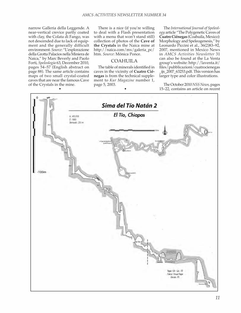
AMCS Activities Newsletter 27 contained in “Mexico news” a summary of 2002 and 2003 projects in Chiapas by the explorations Karstiques Sud-Américaines group, mainly from the Spéléo Club de la Seine in France and Grupo Jaquar in tuxtla Gutiérrez. reports on those visits and additional ones in 2004 and 2005 are at http://eksa.free.fr. the tables of caves, location maps, and maps of Sima del Tío Natán 2, Cueva Santo Domingo, and the system Sumidero el Porvenir–Cueva Romana published here are from those reports. (Sima del tío natán 2 has been extended since the 2002
map in number 27.) the reports, which are in French, contain many additional maps of smaller caves. the web site also has an interactive Google-based cave-location map of the project area south of tuxtla.
CHiHUAHUAKur Magazine number 10, June
2008, pp. 16–23, contains an article
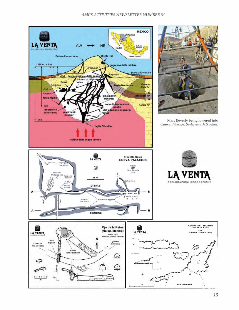
as “How Does the Cave of the Crys-tals Feel?” it concerns the impacts of their current environment on the crystals and the future of the room. it points out that keeping the naica Mine dewatered for a year currently uses 100 million kilowatt-hours of electricity, worth approximately 10 million euros. even though keep-ing the mine dry only to the depth of the Cave of the Crystals would cost a good bit less, it is unlikely to be practical to keep the room and the route to it dry after the mine’s ore is exhausted.
A new cave at naica, Cueva Pala-cios, was intersected by a borehole from the surface at a depth of 150 meters. it is the largest cave known there, but it contains no crystals because it was above the water table when the crystals were forming in the other caves in the hill. explora-tion was difficult due to the tempera-ture of 44.5°C (112°F) at the bottom of the shaft and 48°C (118°F) in the
One of the pumping stations that keep the Cave of the Crystals at naica dry.
Giovanni Badino.
“trenta mesi de naica” (“thirty Months of naica”) by Giovanni Badino sum-marizing the beginnings of the work by the la venta Esplorazione Geografiche group in the Cave of the Crystals at naica. Articles on the Cave of the Crys-tals are in AMCS Activities Newsletters number 25, pp. 72–77, and number 30, pp. 50–54.
Kur Magazine, published by the la venta esplorazione Geografiche, has an article in number 12 (June 2009) titled “Come sta la Cueva de los Cristales?” Someone translated that into english

AMCS ACTIVITIES NEwSLETTER NUMBER 34
6

AMCS ACTIVITIES NEwSLETTER NUMBER 34
7

AMCS ACTIVITIES NEwSLETTER NUMBER 34
8

AMCS ACTIVITIES NEwSLETTER NUMBER 34
9

AMCS ACTIVITIES NEwSLETTER NUMBER 34
10
AMCS ACTIVITIES NEwSLETTER NUMBER 34
11
narrow Galleria della leggende. A near-vertical crevice partly coated with clay, the Colata di Fango, was not descended due to lack of equip-ment and the generally difficult environment. Source: “l’esplorazione della Grotta Palacios nella Miniera de naica,” by Marc Beverly and Paolo Forti, Speleologia 63, December 2010, pages 54–57 (english abstract on page 88). the same article contains maps of two small crystal-coated caves that are near the famous Cave of the Crystals in the mine.
•
there is a nice (if you’re willing to deal with a Flash presentation with a menu that won’t stand still) collection of photos of the Cave of the Crystals in the naica mine at http://naica.com/mx/galeria_pc/htm. Source: Mónica Ponce.
COAHUilAThe table of minerals identified in
caves in the vicinity of Cuatro Cié-negas is from the technical supple-ment to Kur Magazine number 1, page 5, 2003.
•
the International Journal of Speleol-ogy article “the Polygenetic Caves of Cuatro Ciénegas (Coahuila, Mexico): Morphology and Speleogenesis,” by leonardo Piccini et al., 36(2)83–92, 2007, mentioned in Mexico news in AMCS Activities Newsletter 31 can also be found at the la venta group’s website: http://laventa.it/files/pubblicazioni/cuatrocienegas _ijs_2007_63253.pdf. this version has larger type and color illustrations.
the October 2010 NSS News, pages 15–22, contains an article on recent
AMCS ACTIVITIES NEwSLETTER NUMBER 34
12
explorations on Mesa El Huisache below the Sierra Santa rosa north-west of Múzquiz. the article is by ellie watson. See the article on the area by Dan Green in this issue.
GUerrerOAbstract: “A speleothem record
of Holocene climate variability from southwestern Mexico,” by Juan Pablo Bernal, Matthew lach-niet, Malcolm McCulloch, Graham
Mortimer, Pedro Morales, and edith Cienfuegos.
A paleoclimate reconstruction for the Holocene based upon variations of δ18O in a U–th dated stalagmite from southwestern Mexico is pre-sented. Our results indicate that the arrival of moisture to the area has been strongly linked to the input of glacial meltwaters into the north Atlantic throughout the Holocene. the record also suggests a complex
interplay between Caribbean and Pacific moisture sources, modulated by the north Atlantic SSt and the position of the ITCZ, where Pacific moisture becomes increasingly more influential through ENSO since ~4.3 ka. the interruption of stalagmite growth during the largest climatic anomalies of the Holocene (10.3 and 8.2 ka) is evidenced by the presence of hiatuses, which suggest a severe disruption in the arrival of moisture
AMCS ACTIVITIES NEwSLETTER NUMBER 34
13
Marc Beverly being lowered into Cueva Palacios. Speleresearch & Films.

AMCS ACTIVITIES NEwSLETTER NUMBER 34
14
AMCS ACTIVITIES NEwSLETTER NUMBER 34
15
to the area. the δ18O record presented here has important implications for understanding the evolution of the north American Monsoon and cli-mate in southwestern Mexico, as it represents one of the most detailed archives of climate variability for the area spanning most of the Ho-locene.
Source : Quaternary Research 75: 104–113, 2011, doi:10.1016/j .yqres.2010.09.002. the source of the sample was Cueva del Diablo.
MiCHOACánthe authors, with many Polish
colleagues from Silesian clubs and two Mexican cavers from Base Draco, explored caves in the Mexican state of Michoacán and at the southern margin of the Chihuahuan Desert during several expeditions in the years 2006–2010. the largest cave explored was Cueva Vinata, 3300
meters long and terminating in sumps. Source: english summary of article by Jerzy Zygmunt and Damian Sprycha in Jaskinie–The Caves 60 (third 2010 issue), www.sktj.pl/epimenides/jaskinie/jask60.html. there is a map of Cueva vinata in AMCS Activities Newsletter 23, page 43.
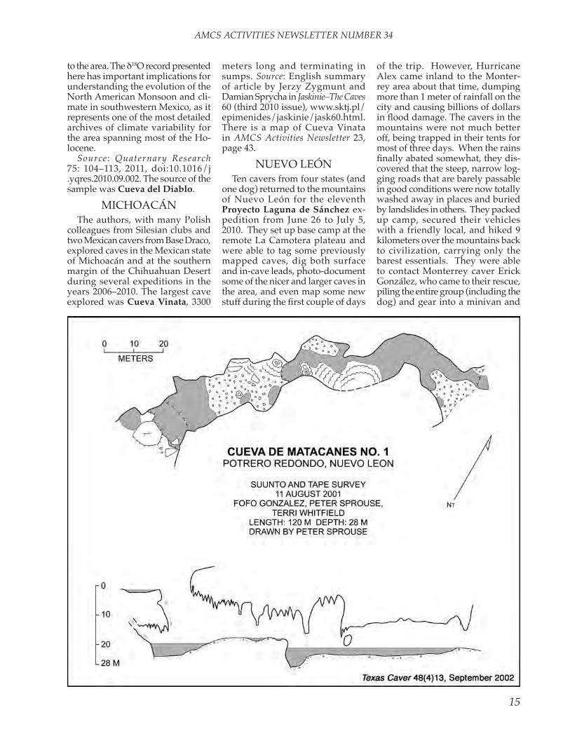
nUevO leónten cavers from four states (and
one dog) returned to the mountains of nuevo león for the eleventh Proyecto Laguna de Sánchez ex-pedition from June 26 to July 5, 2010. they set up base camp at the remote la Camotera plateau and were able to tag some previously mapped caves, dig both surface and in-cave leads, photo-document some of the nicer and larger caves in the area, and even map some new stuff during the first couple of days
of the trip. However, Hurricane Alex came inland to the Monter-rey area about that time, dumping more than 1 meter of rainfall on the city and causing billions of dollars in flood damage. The cavers in the mountains were not much better off, being trapped in their tents for most of three days. when the rains finally abated somewhat, they dis-covered that the steep, narrow log-ging roads that are barely passable in good conditions were now totally washed away in places and buried by landslides in others. they packed up camp, secured their vehicles with a friendly local, and hiked 9 kilometers over the mountains back to civilization, carrying only the barest essentials. they were able to contact Monterrey caver erick González, who came to their rescue, piling the entire group (including the dog) and gear into a minivan and
AMCS ACTIVITIES NEwSLETTER NUMBER 34
16
driving them to food, showers, and beds. the next day he took them to the bus station so they could return to families and jobs.
the expedition donated money to the locals to help rebuild the roads, and the four trucks were retrieved a couple of months later, with no ill effects other than a few mildewed items of clothing. A longer trip re-port is posted on the project’s website at www.garot.com.ldeS. Source: Jim “Crash” Kennedy.
Abstract: “Proyecto Laguna de Sánchez—13 Years in the Cumbres de Monterrey, Mexico,” by Jim Kennedy.
Since June 1997 an irregular series of trips have been organized to the mountains southwest of Monterrey, nuevo león, Mexico. More than seventy cavers from eight states and three countries have participated. As of the tenth trip, in november 2009, there were 121 known caves, with 86 of those mapped. the relatively small size of most of caves is reflected in the combined survey length of 3927 meters. nevertheless, these caves provide a fascinating glimpse into the local geology and biology, as well as an opportunity to experience the incredible beauty and solitude of the area. the most significant cave is El Infierno de Camotera, a 55-meter open-air pit leading to a large room with an important colony of endangered Leptonycteris nivalis, the Mexican long-nosed bat. And Cueva Oyamel (242 meters) is the type location for a new species of scorpion, Vaejovis norteno. expe-dition number 11, which just took place in late June of this year [2010], adds even more caves and faunal records to our database. the most current information can be found on the project’s website at www.garot .com/ldeS.
Source: 2010 nSS convention pro-gram book, pages 43–44.
there is a trip report on an ex-pedition to Laguna de Sánchez in the Texas Caver, 56(4)3–14, Oc-tober–December 2010. the text of the report is also at www.garot .com/ldeS/priorexpeditions/2010 _summer_Matt_trip_report.asp.
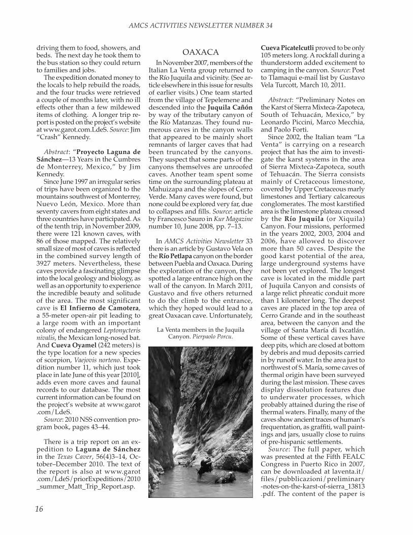
OAXACAin november 2007, members of the
italian la venta group returned to the río Juquila and vicinity. (See ar-ticle elsewhere in this issue for results of earlier visits.) One team started from the village of tepelemene and descended into the Juquila Cañón by way of the tributary canyon of the río Matanzas. they found nu-merous caves in the canyon walls that appeared to be mainly short remnants of larger caves that had been truncated by the canyons. they suspect that some parts of the canyons themselves are unroofed caves. Another team spent some time on the surrounding plateau at Mahuizapa and the slopes of Cerro verde. Many caves were found, but none could be explored very far, due to collapses and fills. Source: article by Francesco Sauro in Kur Magazine number 10, June 2008, pp. 7–13.
in AMCS Activities Newsletter 33 there is an article by Gustavo vela on the Río Petlapa canyon on the border between Puebla and Oaxaca. During the exploration of the canyon, they spotted a large entrance high on the wall of the canyon. in March 2011, Gustavo and five others returned to do the climb to the entrance, which they hoped would lead to a great Oaxacan cave. Unfortunately,
Cueva Picatelcutli proved to be only 105 meters long. A rockfall during a thunderstorm added excitement to camping in the canyon. Source: Post to tlamaqui e-mail list by Gustavo vela turcott, March 10, 2011.
Abstract: “Preliminary notes on the Karst of Sierra Mixteca-Zapoteca, South of tehuacán, Mexico,” by leonardo Piccini, Marco Mecchia, and Paolo Forti.
Since 2002, the italian team “la venta” is carrying on a research project that has the aim to investi-gate the karst systems in the area of Sierra Mixteca-Zapoteca, south of tehuacán. the Sierra consists mainly of Cretaceous limestone, covered by Upper Cretaceous marly limestones and tertiary calcareous conglomerates. The most karstified area is the limestone plateau crossed by the Río Juquila (or Xiquila) Canyon. Four missions, performed in the years 2002, 2003, 2004 and 2006, have allowed to discover more than 50 caves. Despite the good karst potential of the area, large underground systems have not been yet explored. the longest cave is located in the middle part of Juquila Canyon and consists of a large relict phreatic conduit more than 1 kilometer long. the deepest caves are placed in the top area of Cerro Grande and in the southeast area, between the canyon and the village of Santa María di ixcatlán. Some of these vertical caves have deep pits, which are closed at bottom by debris and mud deposits carried in by runoff water. in the area just to northwest of S. María, some caves of thermal origin have been surveyed during the last mission. these caves display dissolution features due to underwater processes, which probably attained during the rise of thermal waters. Finally, many of the caves show ancient traces of human’s frequentation, as graffiti, wall paint-ings and jars, usually close to ruins of pre-hispanic settlements.
Source: the full paper, which was presented at the Fifth FeAlC Congress in Puerto rico in 2007, can be downloaded at laventa.it/files/pubblicazioni/preliminary -notes-on-the-karst-of-sierra_13813 .pdf. the content of the paper is
la venta members in the Juquila Canyon. Pierpaolo Porcu.

AMCS ACTIVITIES NEwSLETTER NUMBER 34
17
similar to that of the Juquila article in this issue.
there is a video (really just a slide show) of Grutas de San Antonio Eloxochitlan at www.youtube.com/watch?v=gJgcvUtAmGQ. Source: David locklear.
Summaries of past US Deep Cav-ing team expeditions to Mexico can be seen at www.usdct.org/past _expeditions.php.
the author [Kasia Biernacka] was one of six Polish cavers who took part in the 2009 expedition of Proyecto Cheve, an international effort initiated and animated by Bill Stone for exploration of the deepest cave system in the western Hemi-sphere. the main goal was to push through sumps at the bottom of J2 in hope of connecting it with Cheve into a cave that would surpass 2 kilometers in depth. new galleries explored by the expedition seem to turn towards Cheve. Another cave named Last Bash was also explored. it could provide a bypass for the narrow entrance series in J2, but no connection was found. J2 is now 1222 meters deep and 11017 meters long. Source: english summary of an article in Jaskinie–The Caves 55 (second 2009 issue) at www.sktj.pl/epimenides/jaskinie/jask55.html. Jaskinie is the magazine of the Caving Commis-sion of the Polish Mountaineering Association (Komisja taternictwa Jaskiniowego Polskiego Zwiazku Aplinizmu). An article on this expe-dition appeared in AMCS Activities Newsletter 33, pages 83–88.
An international team of fourteen cavers, including four from Poland, continued exploration of the J2 sys-tem in Mexico in 2010. exploration could begin only after two weeks of negotiation with local authorities. the main goal was to connect Last Bash Cave, discovered in 2005, with the main cave and thus secure a shorter and safer access to the final sump. the connection was attained in the expected place. Another goal was to explore an ascending branch before the final sump, found by russian members of the former ex-pedition. the series, dubbed From
russia with love, does not seem to provide the desired bypass of the final sump. Diving equipment left at the final sump a year earlier was found suspended between project-ing rocks up to 12 meters above the sump, providing evidence of the water-level rise during the wet season. Source: english summary of article by Kasia Biernacka and Marcin Gala in Jaskinie–The Caves 59 (second 2010 issue) at www.sktj.pl/epimenides/jaskinie/jask59.html. An article on this expedition ap-peared in AMCS Activities Newsletter 33, pages 39–44.
Abstract: “2010 J2 expedition, Oaxaca, Mexico,” by Bill Stone.
the 2010 J2 expedition was the latest of the US Deep Caving team’s work in the Cheve karst of southern Mexico. At the end of the 2009 expe-dition, J2 had been extended to 1222 meters of depth and 11 kilometers of surveyed passage, thanks to a three-month-long major dive effort. the 2010 expedition continued the efforts of the previous year, without the bulk and weight of dive gear, by pushing into the depths of nearby 500-meter-deep last Bash to attempt a connection to J2. Last Bash was successfully removed from the deep-cave list of Mexico, and Sistema J2 was created. Along with the connec-tion, a faster and safer route to Camp 2 in J2 was discovered, removing any threat of heavy rains trapping cavers deep in the cave. near the end of the six-week expedition, team members pushed several high leads deep in J2, with one up-trending route pointing towards a suspected third entrance to the system.
Source: 2010 nSS conventions program book, page 44.
A team of British cavers, including members of the Cave Diving Group, planned to return to the Huautla area and attempt to close the gap between Sistema Huautla and the wet-weather resurgence Cueva de la Peña Colorada. the plan was to pursue Sump 7 in Peña Colorada in spring 2011 and then revisit Sump 9 in Huautla in 2012. they had been promised a grant of £600 from the British Caving Association toward the estimated £17,000 cost of the 2011
expedition. evidently convinced they had underestimated the logistical challenges, they have postponed their project until at least 2013. Source: www.cdg-exped.org.
PUeBlAin April 2010, the tláloc expedi-
tions continued in the state of Puebla, following on discoveries of 1998, 2002, and 2008 [see “Mexico news,” AMCS Activities Newsletter 32]. the main objective was the system Cueva del Viento–Cueva de Mama Mia, discovered in 2008. A length of al-most 7 kilometers has been reached, with four entrances. the two main streams in the system were followed upstream for dozens of meters in the search for a connection with caves that are almost certainly hydrologi-cally related. thus Cueva del viento, 3.2 kilometers long, became closer by 170 meters to the downstream branch of Cueva de Los Cochinos, approximately 1 kilometer long. the exploration in this direction ended under a waterfall about 10 meters high. Some side passages revealed a complex and mazy network that most likely conceals additional pas-sage, while a pit, previously only seen from below, was identified and descended.
in the Cueva de Mama Mia, 3.7 kilometers long, besides a series of new loops and smaller branches, the teams were able to pursue the old bottom upstream, getting closer by 30 meters to the coveted junction with Resumidero de Miquizco. A large stream (Mama non Mama) issues from a breakdown pile that seems rather impossible to over-come.
the other major achievement of the expedition was increasing the size as well as the understanding of resumidero de Miquizco, which is now 2.3 kilometers long, with five entrances. this was possible because the team returned to a cave that had been given little consideration in the past, Cueva del Camarón, which is now 600 meters long. the discovery of new passage in that cave, together with the use of a handheld DistoX for its survey, enabled the cavers to notice, in real time, the remark-able proximity of resumidero de Miquizco, which led to an exciting

AMCS ACTIVITIES NEwSLETTER NUMBER 34
18
GSAB 2010 Photos by Gustavo vela
in Cueva tepetzala. Clockwise from upper left: ri-cardo lugo and vincent Detraux. ricardo lugo and vincent Detraux at the entrance. François Saussus and André-Marie Dawagne. François Saussus.

AMCS ACTIVITIES NEwSLETTER NUMBER 34
19
junction. During these explorations, more passages were surveyed in the southern part of the resumidero de Miquizco, and a fifth entrance was found.
One note of interest is that, thanks to the recent discoveries in Mama Mia, the new Miquizco system is now only 20 meters from the system Cueva del viento–Mama Mia. if they were to connect, the total length would reach 9.5 kilometers, with nine entrances.
various other minor caves, with lengths under 100 meters (Cueva de Victor, Pequeña Agonia, Embudo de Rancho Viejo, Ojo Escondido, Sótano del Sendero), gave a better understanding of the cave potential of the area.
Participants were members of Gruppo Speleologico Bergamasco le nottole, Speleo Club Orobico CAi Bergamo, Gruppo Grotte i tassi CAi Cassano, Gruppo Grotto Milano CAi Sem, with assistance from the Mexico City group UriOn.
Source: part of a short article in Speleologia 63, pages 79–80, by Al-berto Buzio and Giogrio Pannuzzo, translated from italian for the AMCS by Yvonne Droms.
the Groupe Spéléo Alpin Belge (GSAB) returned to the Sierra negra in Puebla on their thirtieth anni-versary of Mexico exploration. the results were rather disappointing, with only about 1000 meters of new passage mapped. their main objec-tive was to continue exploration in Tepetzala, where in 2009 they had turned around at a 20-meter waterfall at 310 meters depth and 4.5 km from the entrance. in 2009 exploration teams went on eighteen-hour trips from base camp, yet were able to actually explore for only two hours, so it was decided to set up an underground camp closer to the lead. the cave was rerigged, and a camp was established and stocked at –270 meters. the route through the two main breakdown piles was flagged, waterfalls were rigged downstream, and gear was hauled to the lead. Finally, the team tackled the virgin cascade. Bolting anchors was not possible due to fragile rock, so natural rigging had to be used to rebelay their way down the drop.
At the bottom, the river plunged down another drop, 35 meters, then flowed down a large passage for a few meters until the walls narrowed and the ceiling met with the water. the sump is impenetrable, filled with sand and gravel. A couple of leads at the base of the pit ended in loops, and so tepetzala was sur-veyed and derigged. the rest of the expedition was spent in exhausting, difficult hikes towards dark holes in the high karst, identified by way of Google earth, and in checking a lead in Cueva Natalia (number CO2). At –200 meters, after finding 250 meters of passage, the team stopped at a 25-meter drop with loud sounds of falling water. Good air and its loca-tion in relation to tepetzala indicate a potential connection with it, and this will be one of the objectives of the 2011 expedition. the other ob-jectives will be the holes in the high plateau, which are suspected to be high entrances to the resurgence of Atlixicaya, which has been explored for 12 kilometers. Source: Summary by Yvonne Droms of article in French by richard Grebeude, Regards 73, november–December 2010, pages 24–26. See also following item.
As a conclusion to the GSAB expedition in 2010, attempts were made to reach Google earth leads on a high plateau, dubbed Caves 1, 2, 3, and 4. Cave 2, a 50-meter blind pit, was relocated, and new Cave 1, named Sótano Kouachipetli, was descended. it is described as deep, large, and beautiful; a few leads at its bottom ended immediately. Cave 4 was not reached because of horrible vegetation and “death karst.” Source:
Cumbre. Resumidero Ixtololo Atl was pushed to 2614 meters long and a depth of 510 meters at a sump. A dry passage taking off at about –400 meters was partially explored and may provide a bypass to the sump. they plan to return in 2012. Source: Post to tlamaqui e-mail list by Omar Hernández, May 2, 2011.
the original Spanish text of Gusta-vo vela’s article on the El Santito 2009 expedition (AMCS Activities Newsletter 33, pages 51–56), along with many illustrations, is on-line a number of places, among them www.oztotl.com/ps/reports/Sistema _nogochl_1.pdf and revista.e-lte .com.mx/images/articulos/pdf/nogochl.pdf. there is an article in French on the same expedition in SpéléOc 125, pages 14–16, 2010, avail-able at www.comite-speleo-midipy .com/speleoc/revues/speleoc125 .pdf. Source: Mark Minton.
Articles by Gustavo vela in Spanish about the 2007 and 2008 Akemabis expeditions are avail-able at revista.e-lte.com.mx/images /articulos/pdf/ocotempa.pdf and /akemabis-2008.pdf. english ver-sions appear in AMCS Activities Newsletters 31, pages 27–36, and 32, pages 47–52. Source: Mark Minton.
Al warild’s photos from the Tres Quimeras expedition of the So-ciété Québécoise de Spéléologie in March and April 2009 are on the web at http://home.exetel.com.au/alw/3Q9/index.html.
A PDF file of the 3-D model of caves in the Akemabis/Akemati area
“tzontzé 2010 (Mexique),” by David Gueulette, Benoit and Étienne letellier, and Serge Delaby, Regards 73, november-December 2010, pages 27–28.
the Grupo espeleológico Chicomóztoc returned to the community of Ojo de Agua in the Sierra negra in 2011. Cueva Cocohuastli was explored to a depth of 124 meters and length of 711 meters to its resur-gence, el Gran Colector de la

AMCS ACTIVITIES NEwSLETTER NUMBER 34
20
that appeared on page 53 of AMCS Activities Newsletter 33 is on-line at http://home.exetel.com.au/alw/Akema12.1.pdf. viewers with a suf-ficiently modern version of Adobe Acrobat can rotate, pan, and zoom the image.
Sótano del Centro was mentioned in “Mexico news” in AMCS Activi-ties Newsletter 33, but the map here was received too late to publish in that issue.
QUerÉtArODuring the period 2003–2008,
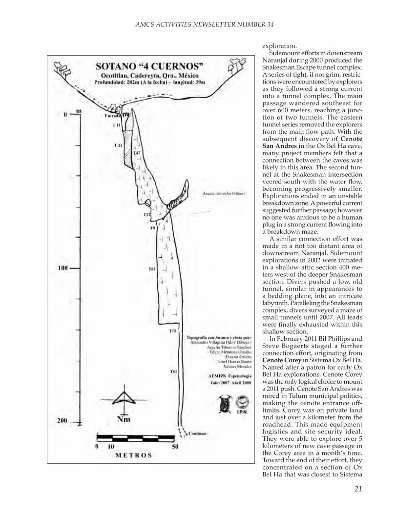
the Grupo de espeleología of the Asociación de excursionismo y Montañismo del instituto Politéc-nico nacional investigated caves in Querétaro near the río Moct-ezuma border with Hidalgo, from el Aquacate north to Puerto de la luz and Ocotitlán. they located and explored twenty-five caves, including the original discovery of 360-meter-deep Sótano de la Cule-bra, later mapped in more detail by a joint US-Mexican team (see AMCS Activities Newsletter 29, pages 31–36), and Sótano de las Cuatro Cuernos, with several drops to a depth of more than 200 meters. Source: paper given at the iX Congreso nacional Mexicano de espeleología in 2009, www.umae.org/cong08/articulos/memorias23.pdf.
QUintAnA rOOAt the end of 2010, the Quintana
roo Speleological Survey had data for 206 underwater caves totaling 903 kilometers (561 miles) in length. Over 80 kilometers of that was added in 2010. they also had data for 49 dry caves with over 37 kilometers of passage. through April in 2011, 40 kilometers of underwater cave and 11 kilometers of dry cave have been added to the totals. Sources: QrSS 2010 annual report to the nSS, Jim Coke.
Sistema Ox Bel Ha was connected to Sistema Naranjal in March 2011 after a lengthy history of connection attempts. Both caves held the title of the world’s longest underwater cave at the zenith of their explora-tion. It is fitting that they are united after a combined 25-year history of
AMCS ACTIVITIES NEwSLETTER NUMBER 34
21
exploration.Sidemount efforts in downstream
naranjal during 2000 produced the Snakesman escape tunnel complex. A series of tight, if not grim, restric-tions were encountered by explorers as they followed a strong current into a tunnel complex. the main passage wandered southeast for over 600 meters, reaching a junc-tion of two tunnels. the eastern tunnel series removed the explorers from the main flow path. With the subsequent discovery of Cenote San Andres in the Ox Bel Ha cave, many project members felt that a connection between the caves was likely in this area. the second tun-nel at the Snakesman intersection veered south with the water flow, becoming progressively smaller. explorations ended in an unstable breakdown zone. A powerful current suggested further passage; however no one was anxious to be a human plug in a strong current flowing into a breakdown maze.
A similar connection effort was made in a not too distant area of downstream naranjal. Sidemount explorations in 2002 were initiated in a shallow attic section 400 me-ters west of the deeper Snakesman section. Divers pushed a low, old tunnel, similar in appearances to a bedding plane, into an intricate labyrinth. Paralleling the Snakesman complex, divers surveyed a maze of small tunnels until 2007. All leads were finally exhausted within this shallow section.
in February 2011 Bil Phillips and Steve Bogaerts staged a further connection effort, originating from Cenote Corey in Sistema Ox Bel Ha. named after a patron for early Ox Bel Ha explorations, Cenote Corey was the only logical choice to mount a 2011 push. Cenote San Andres was mired in tulum municipal politics, making the cenote entrance off-limits. Corey was on private land and just over a kilometer from the roadhead. this made equipment logistics and site security ideal. they were able to explore over 5 kilometers of new cave passage in the Corey area in a month’s time. toward the end of their effort, they concentrated on a section of Ox Bel Ha that was closest to Sistema

AMCS ACTIVITIES NEwSLETTER NUMBER 34
22
Naranjal. A connection was finally made to naranjal through a maze of unstable breakdown, joining the Snakesman complex in naranjal to Ox Bel Ha.
As of May 2011, the length of Ox Bel Ha is 222 kilometers, all under water. it has 131 cenote entrances. Source: Jim Coke.
the color area map is a prelimi-nary view of known cave zones near the city of tulum. the outlines extend 250 meters from the line plots of known caves as of January 2011. Unsurveyed side passages are expected to extend at least that far from the surveys. the government plans for tulum to expand greatly over the next ten years, including a new international airport. Source: Quintana roo Speleological Survey, www.caves.org/project/qrss/cmap .htm.
there are few really deep areas in the underwater caves of Quintana roo. One is The Pit in Dos Ojos, –119 meters (AMCS Activities Newsletter 24, pages 84–91), and another is the Blue Abyss, –72 meters, in the No-hoch Nah Chich section of Sistema Sac Actun (number 20, pages 86–87). these two deep spots are not far apart. Cave divers have sought a con-nection through shallower passages between Dos Ojos and Sac Actun for many years without success. Polish diver Krzysztof Starnawski, supported by irena Stangierska and Marek Klyta, did deep rebreather dives during March and April 2011 seeking passages that might make the connection. He spent a week making sure it was possible to pass the breakdown at the bottom of the Blue Abyss, poking a camera through crevices and then pushing the chosen opening, eventually with a no-mount configuration, until find-ing a huge passage. He calls the new route, which verifies that the Blue Abyss goes, tKM, an initialization of something in Polish that he claims is unprintable. [i vaguely remember those days when there were unprint-able words in english.—ed.] next he turned his attention to the Pit, cul-minating in a twelve-hour dive with 1.5 hours bottom time at 100 meters depth to a new passage named
Stairway to Heaven. Preparations for that dive took almost a week, repairing a decompression habitat, laying a phone line from the habitat to the surface, and placing stage bottles and a backup DPv. He plans to return to Mexico in September, when he expects additional drives in the Pit to reach the vicinity of the Blue Abyss. Source: www.cavediver.net/forum/showthread.php/16079 and /16117. Some information in Polish and many photographs are at dualrebreather.com.
Cave divers from the Česká spe-leologická společnost (Czech Spe-leological Society) continued their explorations in the K’oox Baal and Tux Kupaxa underwater caves in early March 2011. the caves have now reached 36743 meters and
18951 meters in length, respectively, including both underwater and dry portions. As the caves are only meters apart, hopes are high for a connection. Source: Jim Coke.
el Centro investigador del Sistema Acuífero de Quintana roo A.C. is a Mexican Civil Association based in Playa del Carmen, Quintana roo. CINDAQ is able to receive tax-deductible donations in Mexico. CinDAQ is also able to receive tax-deductible donations in the United States through the Friends of Mexican Development Foundation in new York City.
through innovative programs and partnerships CinDAQ:
• Provides underwater cave-exploration expertise about the karst aquifer of Quintana roo, Mexico.

AMCS ACTIVITIES NEwSLETTER NUMBER 34
23
• Develops outreach programs to better educate local and state govern-ments, residents, and visitors about the importance and fragility of the region’s karst aquifer.
• Develops relationships with the scientific community and concerned national and international institu-tions and foundations to expand the knowledge-base and develop sustainable management practices and policies for Quintana roo’s karst aquifer.
CinDAQ’s vision is the imple-mentation of a regional model for sustainable development that serves the long-term interests of the citizens of Quintana roo and provides a model for other similarly threatened areas.
To find a large, pristine fresh-water supply in this world is rare. Mexico’s Yucatan Peninsula contains such a resource. the peninsula is made up of the Mexican states Campeche, Yucatán, and Quintana roo. it is a land rich in both human and natural history. the landscape is dominated
by temples and pyramids, which testify to the achievements of the ancient Maya civilization.
the modern Maya culture and the environment upon which it depends still thrives, with many traditions and a strong cultural identity and natural systems intact. that identity is bound by a common thread that has woven the fabric of life together on the peninsula for the last 10,000 years. this thread is the fresh water supply, which runs through a com-plex and little understood system of flooded solution caves.
rampant development threatens one of Mexico’s largest, most pris-tine, and most culturally significant aquifers. the coast of Mexico’s rivi-era Maya is facing unprecedented growth that ranks it among the fastest-growing regions of the world. Out of sight and mind, the flooded cave systems of the region play a crucial role as conduits for freshwa-ter moving from the jungle interior out to the Mesoamerican Barrier reef. the need to explore and better
understand the aquifer of northern Quintana roo is critical, as these hidden rivers directly influence the health and economic well-being of the human population above them and the many ecosystems they nour-ish from below. Due to the aquifer’s extreme fragility and vulnerability to contamination, over-development on the surface means that the ecol-ogy of the area is nearing a tipping point. Since this region contributes approximately 10 percent of Mexico’s GnP, the impact of a contaminated aquifer and associated ecosystems would have far-reaching and poten-tially disastrous results, not only for the region’s tourist-based economy but for Mexico as a whole. Cave-diving explorers provide a critical knowledge-base by mapping the subterranean waterways, providing a foundation for scientific work that ultimately will promote understand-ing and protection of the aquifer and the many ecosystems and the economy that it supports.
S o u rc e : w w w. c i n d a q . o rg /

AMCS ACTIVITIES NEwSLETTER NUMBER 34
24
CinDAQ%20english/about.html. See also a newsletter at www.cindaq .org/CinDAQ%20english/cindaq newsletter_final.pdf.
there is a lot of information about cave diving in Quintana roo at the websites of Dir México (www.dir -mexico.com), the Mexican Cave exploration Project (www.mcep.org.mx), and Global Underwater explorers (www.gue.com). these organizations are related, and the links between their sites are often confusing. the resulting mess is a good example of what happens when people think websites are a substitute for actual published ar-ticles (hint). the following Mexico news paragraphs were compiled from one of the sites.
•The Mexico Cave Exploration Project kicked off 2009 with a sig-nificant push forward in the ongoing exploration and documentation of the world’s longest underwater cave. two small-scale projects in the Ox Bel Ha cave system have revealed some of the most stunning passage and exciting finds to date. Nearly ten years ago, an amazing area of cave passages was discovered, including two new cenotes named Sac U and Sak Ek. Due to the difficult logistics in accessing this area, no subsequent dives had been made in this area . . . that is, until this year. in January 2009, MCeP divers revisited this area, spending a total of four nights in the jungle and exploring and surveying 8,892 ft/2,710 m of new cave passage.
nine dives were made, entering from Sak U, Sak ek, and a nearby cenote named Libby. For the first time, rB80 rebreathers were applied to the exploration of these relatively shallow and complex caves. in ad-dition to extending the established main passages, a maze of decorated deeper tunnels was found intersect-ing these routes. Complementing the exploration and survey, photo documentation concentrated on some exciting archaeological dis-coveries.
•Exploration efforts from Febru-ary 25 to March 1 in the Ox Bel Ha cave system has led to the discovery of the most stunning cave passage-ways to date. in addition, while
exploring a 60ft (18mts) canyon, the team located various large animal bones. So far this year, more than 18,000ft (6 kms) of new cave has been revealed in Ox Bel Ha.
After eleven years of exploration, the Ox Bel Ha cave system (Maya for “three Path of water”) is still one of the most exciting exploration projects in Mexico.
•Recent efforts by the Mexico Cave exploration Project & Centro investigador del Sistema Acuifero de Quintana roo (CinDAQ) are marked by smaller scale mini-projects. the
method consists of one or two off-road vehicles to move divers and equipment as close as possible to a cave opening, and for the following few days the passages found are explored and documented. easier to schedule and fewer divers and gear to transport allows this method to be repeated more frequently than larger scale projects required for more extensive penetrations.
the most recent of these concen-trated efforts took place from March 30 to April 4 in the Ox Bel Ha cave system and has resulted in the survey
meters180039 Sistema Ox Bel Ha178034 Sistema Sac Actun* 64537 Sistema Dos Ojos* 41808 Sistema Xunaan-Há 29862 Sistema Aktun Hu* 29054 Sistema K’oox Baal 29039 Sistema toh Ha* 24432 Sistema naranjal
meters222340 Sistema Ox Bel Ha217495 Sistema Sac Actun* 82242 Sistema Dos Ojos* 58697 Sistema Xunaan-Há* 36744 Sistema K’oox Baal* 29039 Sistema toh Ha 18925 Sistema tux Kupaxa* 18288 Sistema Aerolito
the past year has been an ex-citing one for cave-exploration in Quintana roo. Among other things, there have been two major connections that took the lengths of two underwater caves to over 200 kilometers, among the ten longest caves, wet or dry, in the world. the tables show the dra-matic changes in the lists of long underwater caves in Quintana roo. it is important to note that almost all of the survey in these caves has been done with the knotted-line technique, where distances are measured by knots tied in the divers’ lines at ten-foot intervals, as described in “Survey-ing Underwater Caves,” by Jim Coke, AMCS Activities Newsletter
24, 2001. After repeating some of the surveys with a tape, Jim found that the knotted-line lengths tend to exceed taped lengths somewhat. On the other hand, because of time constraints, limited visibility, and other aspects of cave-diving exploration, the mazy underwa-ter caves of Quintana roo are less thoroughly surveyed than most dry caves, so the surveys understate the true lengths of the caves. in the tables below, the two longest caves should be regarded as tied for first place. The Quin-tana roo Speleological Survey site has a long table of lengths of underwater caves at http://www .caves.org/project/qrss/qrlong .htm.—Bill Mixon
MAY 2010 MAY 2011
*includes a small amount of connected dry cave.

AMCS ACTIVITIES NEwSLETTER NUMBER 34
25
of some 2,100 meters/7,000 ft of new passageway. this time, the team entered the cave from an opening named Cenote Coka Ha.
Additionally, more cenotes in the Sian Ka’an Biosphere Reserve were observed and located from the air during a fly-over of the area. the SKBr contains 700,000 acres of wetlands, including mangrove, marsh, savannah, and swamp. this UneSCO world Heritage site bor-ders the Ox Bel Ha cave system to its north.
•From May 4 to 9, CINDAQ and MCeP continued with their joint exploration efforts in mapping the aquifer here in Quintana roo, Mex-ico. this time further investigations were conducted using rB80 rebreath-ers in the Sian Ka’an Biosphere Reserve. During the last three years, five caves were discovered below the wetlands that covers the majority of this UneSCO world Heritage site. two of the caves, Entrada Caapechen and Entrada Boca Paila have become the main focus of exploration in the area. these caves are very unique and are characterized by high-flow entrances and heavy percolation. A mysterious bacteria growth covers most of the walls, ceilings, and floor, and completely opposite flows of water can be witnessed above and below the halocline. Apart from the original entrances, no other openings have yet been discovered. For this project, the team concentrated their investigation in entrada Boca Paila. with the week of new exploration the cave now has a total length of over 9,000 meters/30,000 ft.
Also, Cenote Coka Ha, deep in-side the Ox Bel Ha cave system, has witnessed more exploration efforts during the week. the cave resembles a honeycomb, with a large fresh wa-ter conduit at a depth of 15 m/50 ft, other branching aisles starting below the halocline at a depth of 21 m/70 ft, and again darker, well-defined, but decorated tunnels starting at a depth of 30 m/100 ft. the discovery of this deeper tunnel will keep the team working relentlessly in that particu-lar area. in addition to exploration efforts, Dr. ed reinhardt from Mc Master University & the Geographic Society conducted further sediment sampling and water profiling with a
hydrolab. Dr reinhardt´s on-going study is focused on foraminifera and thecamoebians. Both are amoebae with shells that live in the cave and are preserved in the sediment record. they are useful indicators in coastal environments for recon-structing salinity, sea levels changes, climate, etc.
•The caves of the Sian Ka’an Bio-sphere Reserve on the Mexican Carib-bean coast have become a major focal point for MCeP (Mexico Cave explo-ration Project) & CinDAQ (Centro investigador del Sistema Aquífero de Quintana roo) joint projects. More than 15,000 meters/50,000 ft of new tunnels have been discovered in cave systems under the wetlands of this UneSCO world Heritage site over the last three years of exploration. these caves account for an important quantity of water movement in this area with signifi-cant flows in both the fresh and salt water layers. Much is still needed in order to fully understand the unique cave hydrology of this area. Over the years, GUe (Global Un-derwater explorers) has become a key partner in the success of cave exploration in the area with support through training, logistics and diver resources.
Joining the team for the June 20 to 24 exploration project were visiting GUe and wKPP members Casey McKinlay and David rhea. their enthusiastic participation was hugely appreciated during the week and their invaluable experience contributes greatly to the advance-ment in productive rB80 rebreather exploration in Mexico.
Although not comparable to the visibility in most other Mexican caves, the diving conditions in Sian Ka’an were excellent, with at times up to 30 m/100 ft visibility in the freshwater and 9 m/30ft in the salt water.
the multiple exploration teams using rB80 rebreathers entered the Boca Paila cave; successfully extending the furthest part of the cave by another 596 m/1,957 ft. this brings the penetration distance from the single entrance to over 3,000 m/10,000 ft. Other objectives included the exploration and survey of side-tunnels in the 1,500 m/5,000
ft to 2,500 m/8,000 ft range. this has now brought the total length of this single entry cave to 7,620 m/25,441 ft.
in addition, the team dedicated a day of exploration in the Ox Bel Ha cave system from a cenote named Coca Ha, concentrating on some of the leads established over the past few months. this day resulted in 921 m/3021 ft of new exploration, and although we were able to close the door on some of the previously known leads, more questions here remain to be answered.
Sources: Mexican Cave exploration Project press releases accessible from www.dir-mexico.com/articles.htm. An extensive article on the initial exploration of the caves in the Sian Ka’an Biosphere reserve appeared in AMCS Activities Newsletter 30.
there is a partial catalog of un-derwater caves in Quintana roo and Yucatán at http://www.caveatlas.com/cave_systems.asp?co=MX. Source: Peter Sprouse.
there is a nine-minute video of cave diving in Quintana roo at www.you tube.com/watch?v=l2hY6hfCGni. Most of the diving is in the Grand Cenote area of Sac Actun and in Nohoch Nah Chich. Source: David locklear.
there are reports on cave-diving projects conducted by Alessandro reato and colleagues on the web site www.filoariannadive.com. Most no-table is the history of the exploration of the Sistema Xunaan Ha, over 50 kilometers long. Source: Jim Coke.
A landowner at the Coop One cenote entrance to the Tux Kupaxa cave system near Chemuyil has been excavating with heavy machinery without a permit. Perhaps he is try-ing to make a friendlier entrance; the Coop One cenote does not provide easy access to the underwater cave. Source: Jim Coke.
in the process of making a video 20’12 [don’t ask], divers luis Sánchez and ricardo Castillo visited the Pit in Dos Ojos as far as the wakulla room. (See article and map in AMCS Activities Newsletter 24, pages 84–91.)

AMCS ACTIVITIES NEwSLETTER NUMBER 34
26
the documentary won the Dimitri rebikoff Prize at the Festival mon-dial de l’image Sous-marine 2010 in Marseille. A preview is at www .youtube.com/watch?v=iJ_tZcx raek. it was released in Mexico in March 2011 and will eventually be re-leased in europe and the US. Source: Underwater Speleology 38(1)19–21, January–March 2011.
in november 2010, Gustavo vela and companions completed their fourth project in Río Secreto, or Yok Ha Hanil in Mayan, with 1300 meters of new survey, including 300 meters of underwater passage surveyed by Daniel riordan and Alex álvarez. the semi-dry passage in río Secreto has been largely finished, although
additional passages cannot be ruled out. now it is up to cave divers to add to the 14 kilometers of known cave. (Part of río Secreto is operated as a show cave; see www.riosecre-tomexico.com.mx.) Source: post to tlamaqui e-mail list by Gustavo vela, november 30, 2010.
in June 2010, Alex álvarez, Beto nava, Daniel riordan, Susan Bird, and Franco Attolini conducted their third annual project at Aktun Hu. During the week, 1.2 kilometers of new passage was explored, making the length of the underwater cave 31,032 meters. the new areas are small, and the exploration was slow and tedious, but the system still has potential for further discoveries. Source: tlamaqui e-mail list post by Franco Attolini, June 28, 2010. there was an article about the early exploration of Aktun Hu in AMCS Activities Newsletter 33, and there are three articles about it in this issue, including the one about its connec-tion to Sac Actun.
On July 22, 2010, Mexico’s na-tional institute of Anthropology and History released photographs of a reconstruction based on a skeleton found in an underwater cave near tulum. the skeleton, of a woman dubbed la Mujer de las Palmas, was 90 percent complete. Physical anthropologists estimate that she was about 50 years old when she died, was about 1.5 meters tall, and weighed 58 kilograms (128 pounds). A government archaeologist says that the reconstruction resembles people
about 30 feet (10 meters) underwater, German cave divers swam more than 1,800 feet (550 meters) through dark tunnels spiked with rock formations. there they accidentally uncovered an ice Age human’s remains and notified archaeologists based in the surrounding state, Quintana roo.
For the last three years research-ers led by Arturo González, director of the Desert Museum in Saltillo, Mexico, have been studying and documenting the bones in place, so as not to lose any clues offered by context. in late August 2010 scuba-diving researchers finally raised the bones for lab study, after having placed them in plastic bags of cave water and sealing the remains in plastic bins.
no fewer than 10,000 years ago, Chan Hol filled with seawater as Ice Age ice caps melted, the researchers say. no human, they conclude, could have ended up so far back in the cave system after that point, which is why they believe the young man is at least 10,000 years old. the exact age of the bones should be determined by ongoing carbon-dating tests, which should be completed in three to four months, González said.
the newly raised skeleton is the fourth to be found in underwater caves around the town of tulum. One of the other skeletons, named eve of naharon, is thought to be even
the landowner’s excavation of Cenote Coop One. Alessandro Reato.
Cavers in río Secreto. Gustavo Vela.from southeast Asia and complicates the picture of the origin of ancient people in the Americas, but that is contro-versial. Source: AP dispatch “Ancient woman Suggests Diverse Migration,” by Mark Stevenson, www.physorg .com/news199120922.html and lots of other places.
About 80 miles (130 kilo-meters) south of Cancún, the cave system of Chan Hol—Mayan for little hole—is like a deep gouge into the Ca-ribbean coast. in 2006, after entering the cave’s opening,
la Mujer de las Palmas. INAH.

AMCS ACTIVITIES NEwSLETTER NUMBER 34
27
more ancient, around 12,000 years old. At about 60 percent complete, the “Joven de Chan Hol” skeleton is remarkably whole for a 10,000-year-old specimen, the researchers say. especially revealing are his teeth—lack of wear tipped off the team to the individual’s relatively young age at death.
For now, the bones have been sealed in a special chamber for the next six months to a year to dry out and to allow time for their minerals to harden, making the remains less fragile. Afterward, the bones will be scanned to create 3-D computer models that can be compared with the bones of other ancient native American remains, project-leader González said.
the skeletons found in the Quin-tana roo caves could force scientists to rethink their ideas about the initial population of the Americas, González said. For example, the skulls of both the Joven de Chan Hol and the eve of naharon have anatomical features that suggest their owners were descended from people of South Asia and indone-sia—not from northern Asia, like
north America’s other known early migrants. the discovery supports the idea that multiple groups of migrants may have entered north America via the Bering Strait—using the now submerged land bridge that once connected what are now Siberia and Alaska—at different times in history, González said.
Source : Adapted from news .nationalgeographic.com/news/ 2010/09/100915-oldest-skeleton -underwater-cave-science/. there are many other things on the inter-net about this. One in Spanish is at www2.esmas.com/noticierostele visa/cultura/198240/. there is a collection of photographs at http://artdaily.org/inah/. See also article on the exploration of Chan Hol in this issue.
Abstract: “First records of Poly-chaetous Annelids from Cenote Aerolito (Sinkhole and Anchialine Cave) in Cozumel island, Mexico,” by Sarita C. Frontana-Uribe and vivianne Solís-weiss.
in this study, polychaetous an-nelids are recorded for the first time in Mexican cenotes and anchialine
caves. these organisms were col-lected in the Cenote Aerolito (Co-zumel island, on the Caribbean coast of Quintana roo) during three sampling events from February 2006 to April 2008, among algae, roots of mangroves, and in karst sediments. A total of 1518 specimens belong-ing to five families (Paraonidae, Capitellidae, nereididae, Dorvillei-dae, and Syllidae), ten genera, and eleven species were collected. in the cave system, two specimens of the amphinomid Hermodice carunculata were found. this cenote and its biota are now in danger of disappearing because of a marina construction project in its western shore.
Source: Journal of Cave and Karst Studies, volume 73, pages 1–10, April 2011 (doi: 10.4311jcks2009lsc0107). the full paper is available on-line at http://caves.org/pub/journal/PDF/v73/cave-73-01-1.pdf.
Abstract: “effective Place-Based Field learning Spanning Subdisci-plines and Undergraduate-Graduate Program levels: northwestern Uni-versity Field excursion to the Karst Geology of the Yucatan Peninsula,”
Photographing the Joven de Chan Hol. Jerónimo Avilés/INAH.
team of divers with recovered skeleton in Cenote Chan Hol. M. Marat/INAH.

AMCS ACTIVITIES NEwSLETTER NUMBER 34
28
by Patricia A. Beddows.Field-based learning is recognized
for the ability to engage and inspire earth science students of all levels. the long tradition of departmental sponsored field trips at Northwest-ern University has provided the basis for developing an 8 to 10 day structured non-credit field excursion to the Yucatan Peninsula of Mexico, undertaken in 2009 and 2010. Stu-dent participation has reached over 80% of the cohort, while feedback indicates success at building moral within the department, increasing confidence in undertaking field-based research, and the citation of the excursion as the highlight of the undergraduate program by gradu-ating majors. Pre-trip preparations include 2 to 3 introductory overview lectures, and completion of 2 to 4 self-selected journal articles. thus, a mutually supportive learning environment is established as each student arrives with overlapping but distinct knowledge on the local earth system. each day is focused on a topic, such as carbonate depo-sitional environments, diagenesis and karstification, hydrogeology, biogeochemistry, biogeography, geo-physics, seismology, the Chicxulub impact crater, Caribbean tectonics, water resource and waste manage-ment, and environmental hazards. the focus of each day is coupled with skill based field exercises that gen-erate observational data sets to test hypotheses. During field lectures, in-dividual students are called upon to share their knowledge to the group based on their pre-trip readings. this approach of guiding the learning and communication of knowledge by individual students to peers has allowed for a rich experience across sub-disciplines and program levels from freshman undergraduate to the senior levels of the PhD program. Ongoing development of the ex-cursion design includes increasing student-led exercises, advancement of the trip ‘wiki’ for pre- and post-excursion information exchange, development of new skill exercises in geochemistry and geophysics including instrument use from iriS, further integration with regular ses-sion course including a new course offering on instrumentation and
Field Methods, and progressing towards student-led publication based on results of field sampling during the excursion.
Source: Geological Society of America Abstracts with Programs vol. 42, no. 5, p. 433 (2010 GSA Denver Annual Meeting).
According to a november 4, 2010, article at www.telegraph.co.uk/sport/othersports/diving/8111599/Free-diver-smashes-cave-world -record.html, “A free diver set a new world record yesterday by swimming for 150 metres (492ft) through a cave system without us-ing any breathing apparatus. Carlos Coste, 34, had to cover 75 metres for a new record, but the venezuelan swam double that in two minutes and 30 seconds. the risky feat was achieved, using only a large flipper and a torch, in Yucatan, Mexico. ‘i have been doing competitive div-ing for 10 years and this is by far the most bizarre run i have ever made,’ he said. ‘to achieve this is a dream come true for me. i have been interested in speleology (the study of caves) since i was a little boy and to combine this with my profession as a freediver was amazing.’ Mr Coste can hold his breath for seven minutes but he completed his record-breaking run in just two minutes and 30 seconds after three years of planning.” Another note about the same dive is at boatworktimes.com/sports-mainmenu-116/diving/4519 -free-diving-champion-carlos-coste-secured-new-guiness-world-record.html. Bil Phillips reports that he thinks Costa started at the Tak Be Ha entrance to Dos Ojos and that he finished the dive at the spring side of the west eye of the Dos Ojos, based on the video of the dive.
evidently all record claims require careful reading, because at the time the records for breath-hold swim-ming distance with fins were already 265 meters for men and 225 meters for women. Perhaps Coste’s dive is a record for such a swim in a cave.
Abstract: “the Quintana roo Spe-leological Survey: recent Advances in Underwater Cave exploration in Quintana roo, Mexico,” by James Coke iv.
the Quintana roo Speleological Survey supports conservation, safe exploration, and survey documen-tation of the underwater and dry caves in Quintana roo, Mexico, Our present study area incorporates 6300 square kilometers in eastern Quintana roo. At this time we ar-chive 868 kilometers of confirmed underwater survey data for 200 independent underwater caves and cave systems. Over 150 collaborators have contributed raw survey data to the database, establishing one of [an understatement if there ever was one—ed.] the largest archives of underwater survey data in the world.
Over 100 kilometers of new un-derwater survey has been reported in the preceding two years. Current investigations for a common pas-sage between Sistema Sac Actun and Sistema Dos Ojos are focused on the southeast area of Dos Ojos. resurvey and explorations in Dos Ojos are integrated with dry-cave explorations to identify potential sump connections between the two cave systems.
explorations in the Chemuyil region caves continue within the coastal and inland zones. the Czech Speleological Society has made strong southern advances towards the coast within the inland caves of Sistema K’oox Baal and Sistema Tux Kupaxa. resurvey missions and explorations have added over 30 kilometers of passage in Sistema Xunaan Há. new passage continues to be found in this coastal cave, notably within its northern section. with a recent connection made to Sistema Pitch, Sistema Xunaan Há has the potential to exceed 70 kilo-meters in length.
Source: 2010 nSS convention pro-gram book, page 43.
Abstract: “Did Groundwater Strati-fication during Drought Provide Po-table Groundwater in the northern Yucatan Peninsula during the Maya terminal?” by eduard reinhardt, Jeremy Gabriel, Peter van Hengstum, and Particia Beddows.
Paleoclimate data from closed basin lakes on Mexico’s Yucatan peninsula shows drought occurring in the Maya lowlands: the drought

AMCS ACTIVITIES NEwSLETTER NUMBER 34
29
coincides with the terminal Classic Maya Collapse and has been as-cribed to the southern migration of the itCZ. However, drought as the trigger for the collapse has been con-troversial since Mayan cities in the northern lowlands (vs Southern), which should have been affected first by drought, continued to persist into the terminal and Post-Classic periods. Here, we present microfos-sil (foraminifera and thecamoebian) data from aquatic cave sediment cores (n=5; Ox Bel Ha and Aktun Ha cave systems near tulum) from the northern lowlands that may explain the observed pattern of population decline. results from the cave sediments span the last 3500 yrs and show changes in the salinity of the meteoric lens with fresher condi-tions commencing in the terminal Classic and continuing into the Post-Classic period where drought is the most pronounced. During drought periods, the density strati-fication of the meteoric and marine water masses ensures that potable groundwater remains available in the shallow subsurface, and may in fact have decreased in salinity. while drought caused a decreased thickness of the meteoric water, it also resulted in reduced flow and less turbulent mixing with the underly-ing marine water within the flooded cave conduits and may account for our observed freshening of the near surface meteoric water. in contrast, during wet periods, increased flow caused increased turbulent mixing with underlying marine water thus increasing its salinity and decreasing its potability. this may have varied in effect from area to area, and empha-sizes that regional patterns of water resources may have allowed some population centers to survive the Classic Maya Collapse, particularly in the northern lowlands.
Source: Geological Society of America Abstracts with Programs vol. 42, no. 5, p. 226 (2010 GSA Denver Annual Meeting).
thecamobians and foraminifera are testate amoeba that inhabit fresh to marine water environments around the world. they have ex-ploited every aquatic niche from the deep sea to lakes and marshes.
these organisms produce a shell (microfossil) which are about the size of a grain sand, and are found in abundance in the sediment, with a tablespoon often containing thou-sands of specimens. they are also very sensitive to environmental change, with certain species living in specific aquatic environments. this makes them very useful for reconstructing past environments and how they changed through time. So, we can retrieve a sedi-ment core, examine the succession of microfossils in the sediments and reconstruct environmental changes that have occurred in that location through time.
this technique of environmental reconstruction is well developed, and often used in the oil industry, hav-ing been applied in many locations
light etc.) to interpret species changes we find in the sediment cores. Ra-diocarbon dating will place the core sediments in a temporal context al-lowing a reconstruction of the cave environment through time.
no doubt this preliminary work will pose further questions that will require further sampling and research to fully understand the cave system. However, we hope this research will make a significant contribution to our understanding of how the cave systems evolved to what they are today.
Source: http://mcep.org.mx/ science/reconstructingYucatan.pdf. Abstracts of papers that appear to have resulted from this work appear in Mexico news in AMCS Activities Newsletter 32.
illicit drugs, pharmaceuticals, pesticides, highway chemicals and other substances have polluted the large aquifer beneath the “riviera Maya” in Mexico, researchers re-ported in Sunday’s edition of the journal environmental Pollution.
Water-filled caves resting below the popular tourist destination in the Yucatan Peninsula have been contaminated, and the polluted wa-ter flows through those caverns and into the Caribbean Sea, according to a press release from United nation’s University (UnU).
that pollution, combined with overfishing, disease, and climate change, has resulted in the loss of as much as 50% of the coral reefs off the region’s coast since 1990.
Furthermore, with the area’s population expected to increase ten-fold over the next two decades, the problems will likely become much worse by 2030, according to research was conducted by Chris D. Metcalfe, a professor at trent University and a senior research fellow at the UnU’s institute for water, environment and Health (inweH) in Canada.
“These findings clearly underline the need for monitoring systems to pin-point where these aquifer pollut-ants are coming from,” Metcalfe said in a statement on Sunday. “As well, prevention and mitigation measures are needed to ensure that expanding development does not damage the marine environment and human
the thecamobian Centropyxis aculeata from Sistema Ponderosa.
around the world, from oceans, lakes, deltas, lagoons etc. However, it has never been applied in the cave environment. we know nothing of the distribution of these organisms in cave systems and their potential for understanding the environmen-tal evolution and paleohydrology of caves. the research is still in its infancy, but based on preliminary results showing that thecamoebians and foraminifera inhabit the cave environment it looks promising.
the 2006 project (Aug 27th to Sept 8th) retrieved sediment and core samples from Ponderosa, Aktun Ha and Mayan Blue. Further analysis in the laboratory over the next year will determine the distribution of species relative to environment (e.g.. salinity,

AMCS ACTIVITIES NEwSLETTER NUMBER 34
30

AMCS ACTIVITIES NEwSLETTER NUMBER 34
31
health and, in turn, the region’s tourism-based economy.”
Among the substances discovered in the waters were pesticides, co-caine, caffeine, metabolized nicotine, painkillers such as acetaminophen and ibuprofen, ingredients common to deodorants and perfumes, and triclosan, an anti-bacterial agent used in toothpastes, hand sanitizers, and cleansers.
while water treatment systems are commonly used in the riviera Maya region, they are “unlikely to remove all micro-contaminants,” according to the UnU study. in their paper, the authors recommend installing impermeable liners beneath golf courses and similar areas; creating drainage canals, retentions ponds, and treatment systems to deal with runoff in certain areas; and improved wastewater treatment procedures.
the study, which was funded by the world Bank, was part of the UnU-inweH Caribbean Coastal Pollution Project (CCPP), which was launched in 2007 in order to help build improved assessment, moni-toring and management of Persis-tent Organic Pollutants (POPs) and Persistent toxic Substances (PtS) in Caribbean coastal ecosystems.
Source: http://www.redorbit .com/news/science/1991897/ pollution_threatening_mexicos _riviera_maya_region/, posted 7 February 2011. See the following abstract.
Abstract: “Contaminants in the Coastal Karst Aquifer System along the Caribbean Coast of the Yucatan Peninsula, Mexico,” by Chris Met-calfe et al.
intensive land development as a result of the rapidly growing tour-ism industry in the “riviera Maya” region of the Yucatan Peninsula, Mexico may result in contamina-tion of groundwater resources that eventually discharge into Caribbean coastal ecosystems. we deployed two types of passive sampling devices into groundwater flowing through cave systems below two communi-ties to evaluate concentrations of contaminants and to indicate the possible sources. Pharmaceuticals and personal care products accu-mulated in the samplers could only
have originated from domestic sew-age. PAHs indicated contamination by runoff from highways and other impermeable surfaces and chloro-phenoxy herbicides accumulated in samplers deployed near a golf course indicated that pesticide applications to turf are a source of contamination. Prevention and mitigation measures are needed to ensure that expanding development does not impact the marine environment and human health, thus damaging the tourism-based economy of the region.
Source : Environmental Pollu-tion, volume 159, number 4, pag-es 991–997, 2011, doi:10.1016/j .envpol.2010.11.031.
An explosion destroyed the res-taurant at the Grand riviera Princess Hotel in Playa del Carmen on no-vember 14, 2010, killing seven. local authorities blamed the explosion on “swamp gas” accumulated in a cave under the building. while methane in a cave in the area is possible due to the careless disposal of sewage from resorts and other develop-ments, geologists were skeptical of the claim, and a leak of cooking gas or some other source was thought more likely, especially considering the scale of the destruction. Sub-sequently, authorities found that an unauthorized gas line had been run under the lounge and have filed charges again five contractors and employees at the hotel. Source: http://www.therecord.com/news/article/284635 and /479954.
SAn lUiS POtOSíin early January 2011, María lucas
Rodríquez, age eighty-five, arose in the night and fell into a 15-meter pit near the village of la Palmilla, in the vicinity of Tamasopo. She was missed early the next morning by her grandson Salome Guillén rangel, who lives with her in the village of twenty-two people and searched the area for her. Authori-ties in tamasopo were alerted, but it wasn’t until late in the afternoon that someone heard María’s cries from the pit, which is used as a dump by the village. Four members of the municipal police force worked for three hours to rescue the old lady from the narrow slot in which most
of them could not fit. The woman, despite having been underground without food or water for fourteen hours, was quiet and cooperative and had no broken bones. Source: Press article at www.pulsoslp.com .mx/notas.aspx?nota=791, accessed January 5.
this detailed map of the Crev-ice area below the main floor of Sótano de las Golondrinas has not been previously published by the AMCS. A large, folded copy was among the things donated to the AMCS Archives by william rus-sell. Detailed maps of the Crevice were first published on pages 27 and 28 of an article by John Bassett in the Bloomington Grotto Newsletter, volume 9, number 2, 1970.
My house in Aquismón is ready for cavers. it is located approxi-mately 400 meters from the plaza and about one hour from such great sótanos as Golondrinas. in addition to the great pits, there are a num-ber of other caves, such as Cueva Linda, to visit. if you are caving in Mexico, Aquismón is one of the most caver-friendly towns. the house has two kitchens, two living rooms, bathrooms, an outside bar, a 12-meter rappel-practice area, and safe parking. twenty-two cav-ers have stayed there, and all had beds. it is only open to cavers, at $12.50 per person per night. Con-tact me to check on available dates. Source: Mike walsh, (512) 249-2283, [email protected].
the Association for Mexican Cave Studies has apparently never pub-lished a map of Sótano de Soyate, an important cave in the Sierre de el Abra, in a newsletter. this descrip-tion and the map are reprinting from AMCS Bulletin 14, Karst Hydrology of the Sierra de El Abra, Mexico, by John Fish, page 114.
Sótano de Soyate lies about half way up the western flank of the El Abra range, 2 km east of the los Sa-binos area swallet caves. Figure 6.17 is a map and a profile modified from ones by elliott (1970) [Texas Caver, vol. 15, pp. 63–66, 1970] by a new cave depth survey, including use of a wire and the inclination for the

AMCS ACTIVITIES NEwSLETTER NUMBER 34
32
entrance, by water depth measure-ments, and by minor alterations of detail. the entrance is a very deep shaft along a major joint or joints inclined at 83°. it descends 103 m, typically 6 m by 12 m in cross section, to a ledge or restriction of the pit, then another 92 m as a long fissure to the floor 195 m (639 feet) below the surface. there are a number of places where the fissure and other recesses extend beyond the reach of the light from a carbide lamp. Vadose films have left a 1 m thick deposit of flowstone for the lower 150 m of the pit on the “footwall,” or wall descended by explorers. the floor is covered by small angular breakdown that has come mostly from the top 20 m of the pit, and by some mud. At the south end of the floor of the entrance pit, a series of
travertine dams and slopes drop 20 m into the end of a large chamber. At this level, the walls and the floor are covered by a thick deposit of mud, and there are some cobbles washed down from above. A small hole in the floor drops another 11 or 12 m (under normal water conditions) to a deep lake that fills the lower part of the chamber. the lake is 147 m long and 20 to 25 m wide for the most part. it was plumbed in a number of places approximately along a lengthwise center line, at a time when the lake was 11 m below the top of the hole. the deepest point measured was 53.4 m (175 feet), and no depth less than 33.5 m was found. thus, the bottom of the lake is nearly at sea level and well below the el Abra base level. From the view Point, the chamber appears immense, possibly
higher than the 34 m (110 feet) given by elliott (1970). the total depth to the lake surface was surveyed to be 233.9 m (767.3 feet).
in late February 2011 human bones were discovered in a cave at la Soledad, near Tampaxal. the police for Zona Huasteca Potosina were notified and investigated. The skull fragment, femur, and forearm bone were estimated by experts to be from 300 to 500 years old. Sources: www .oem.com.mx/elsoldesanluis/notas/n1979229.htm, www.pulsoslp.com .mx/noticias.aspx?nota=3514.
Cave life is known to favor the evolution of a variety of traits, in-cluding blindness and loss of eyes, loss of pigmentation, and changes in metabolism and feeding behavior. now researchers reporting online on April 7 in Current Biology, a Cell Press publication, have added sleep-lessness to that list.
“Cave-adapted fish sleep less—much less—than closely related surface fish,” said Richard Borowsky of new York University. “in some ways, their sleep phenotypes are similar to those of humans with sleep disorders.”
the fish do sleep, but only for relatively short periods, Borowsky explained. Once they wake up, they remain active for a relatively long time. that sleep-and-wake cycle is repeated throughout the continued darkness of the cave.
the discovery was made by studying three cave populations of Mexican Blind Cave Fish (Astyanax mexicanus), a species ideal for such studies because it includes eyed surface and numerous blind cave populations. Although most of those cave populations have been founded independently by individuals living on the surface, they have nonethe-less converged over the course of evolution on similar traits suitable to their new environments.
Borowsky and erik Duboué, lead author of the study, got the idea that the transition from surface to cave might be associated with less sleep based on anecdotal, nighttime ob-servations of fish in their laboratory. Their surface fish clearly sleep at night. they could be found inactive

AMCS ACTIVITIES NEwSLETTER NUMBER 34
33
at the bottom of their tanks with fins drooping. The cavefish, on the other hand, actively patrol their laboratory homes through the wee hours.
to further study the basis of those behavioral differences, the research-ers allowed surface and cave individ-uals to mate in the lab and studied their hybrid offspring. those studies yielded evidence showing that cave-fish differ from surface fish in sleep behavior because of a few dominant gene mutations that became fixed in the cave populations as they adapted to their new life.
“we have documented a cave-related phenotype unsuspected until now that might turn out to be the most basic adaptation of aquatic vertebrates to cave life,” Borowsky said. His team plans to investigate further to parse out the evolutionary forces driving the convergence.
it remains to be tested, but Borowsky doesn’t think the cave-fish need less sleep, exactly. Rather, they may need to be awake more. “These fish live in an environment where food is generally scarce and episodically and unpredictably pres-ent,” he said. “if you are asleep when a bit of food floats by, you are out of a meal and out of luck.”
the discovery might offer clues to understanding variation in sleep among other species and even sleep disorders in humans. that’s because the genes controlling sleep patterns in the fish are very likely to play the same roles in other animals.
“this study is the first step to identifying the responsible genes,” he said.
Source: press release at www .eurekalert.org/pub_releases/ 2011-04/cp-tec040511.php called to our attention by Jerry Atkinson. the following Mexico news item is the abstract of that paper.
Abstract: “evolutionary Conver-gence on Sleep Loss in Cavefish,” by erik r. Duboué, Alex C. Keene, and richard l. Borowsky.
Patterns of sleep vary widely among species, but the functional and evolutionary principles re-sponsible for this diversity remain unknown. The characin fish, Astya-nax mexicanus, has eyed surface and numerous blind cave populations.
the cave populations are largely independent in their origins, and the species is ideal for studying the ge-netic bases of convergent evolution. Here we show that this system is also uniquely valuable for the inves-tigation of variability in patterns of sleep. We find that a clearly defined change in ecological conditions, from surface to cave, is correlated with a dramatic reduction in sleep in three independently derived cave popu-lations of A. mexicanus. Analyses of surface × cave hybrids show that the alleles for reduced sleep in the Pachón [tamaulipas] and Tinaja [San luis Potosí] cave populations are dominant in effect to the surface alleles. Genetic analysis of hybrids between surface and Pachón cavefish suggests that only a small number of loci with dominant effects are involved. Our results demonstrate that sleep is an evolutionarily labile phenotype, highly responsive to changes in ecological conditions. To our knowledge, this is the first example of a single species with a convergence on sleep loss exhibited by several independently evolved populations correlated with popu-lation-specific ecologies.
Source: Current Biology, volume 21, number 8, pages 671–676, 2011, doi: 10.1016/j.cub.2011.03.020.
University of Maryland biolo-gists have identified how changes in both behavior and genetics led to the evolution of the Mexican blind cavefish (Astyanax mexicanus) from its sighted, surface-dwelling ancestor. in research published in the August 12, 2010 online edi-tion of the journal Current Biology, Professor william Jeffery, together with postdoctoral associates Masato Yoshizawa, and Špela Gorički, and Assistant Professor Daphne Soares in the Department of Biology, pro-vide new information that shows how behavioral and genetic traits coevolved to compensate for the loss of vision in cavefish and to help them find food in darkness.
This is the first time that a clear link has been identified between behavior, genetics, and evolution in Mexican blind cavefish, which are considered an excellent model for studying evolution.
worldwide, about 80 different species of cave-dwelling fish have evolved from surface-dwelling fish, but in most cases the surface-dwell-ing ancestor has disappeared. “the Mexican blind cavefish is one of the only cases where a similar ancestor still exists,” explains Professor Jef-fery. “except for the loss of eyes and pigment seen in the cave-dwelling form, the surface and cave-dwellers are hard to tell apart. You can study evolution very nicely if you have both the ancestral and derived forms of evolving animals.”
Jeffery is a leading expert on the developmental and evolutionary genetics of the blind cavefish. His previous research provided evidence that the loss of eyes in blind cavefish is the result of natural selection, and has inspired other researchers to take up Astyanax as a model system for studying eye loss and evolution in general. Studying the evolution of cave fish may help provide clues about human forms of blindness such as macular degeneration and cataracts, and the University of Maryland team is also exploring how studies of cave fish metabolism might be used to better understand the underlying causes of obesity and diabetes in humans. “it turns out that many of the mutations in genes studied in model organisms like Astyanax are the same genes that are involved in human disease,” says Jeffery. “By studying evolution, you can see what sort of mutations and genes are present in the population and how these can be selected for or against.”
Jeffery’s research team showed how an adaptive behavior found in blind cavefish that gives them an ad-vantage in locating food in the dark is linked to a genetic trait. “vibration Attraction Behavior” (or vAB) is the ability of fish to swim toward the source of a water disturbance in darkness. Postdoctoral associate Masato Yoshizawa measured this behavioral response in both wild caught and laboratory raised cave and surface-dwelling fish using a vibrating rod at different frequen-cies as a stimulus. Most cavefish displayed vAB and would swim toward the vibrating rod and poke at it, while few surface fish did.

AMCS ACTIVITIES NEwSLETTER NUMBER 34
34
this behavior is advantageous for feeding success in the dark caves where food sources are limited and large predators are absent. “Outside the cave, however, there are many predators,” explains Jeffery, “and indiscriminately going to a vibration would be a certain risk for predation for a surface-dwelling fish.”
the cavefish responded most frequently and strongly to a vibra-tion at a frequency of 35 Hz. “this frequency falls within the range that is detected by the superficial neuromasts,” explained Yoshizawa. “these specialized hair cells are part of the fish’s lateral line, which is the sensory organ used to detect movement and vibration in the sur-rounding water.”
To confirm the role of the superfi-cial neuromasts (Sn) and the lateral line, Yoshizawa measured the vAB after he inhibited the function of the superficial neuromasts in both cavefish and surface fish. “I used a non-toxic glue on their cheek region, and then released them in the water. this glue then peeled off from their skin as they moved in the water, and removed the superficial neuromast hair cells, or at least reduced their sensing ability,” explains Yoshizawa. “You can imagine that it is kind of like waxing your legs.”
without the sensing ability of the SN, the cavefish no longer exhibited the vAB, while the surface dwelling fish did not exhibit any more or less vAB. the team went on to explore the role that the number and size of the Sn played in vAB, as the cave dwelling fish have more and larger Sn cells and were the most likely to exhibit the adaptive behavior. Yoshizawa made a genetic cross between the surface fish and the cave dwelling fish to get a hybrid species. The cave dwelling fish, who have more and larger superficial neuro-mast (Sn) cells, were most likely to exhibit the adaptive behavior. the hybrid fish showed an intermedi-ate number of neuromasts and also exhibited an intermediate vibration attraction behavior reaction—more than the surface fish, but less than the cave fish.
From this, the research team con-cluded that the vAB and Sn en-hancement coevolved to compensate
for loss of vision and to help blind cavefish find food in darkness. this study adds important new information about how Mexican blind cavefish have adapted to their extreme environment through evolutionary changes. the next step in this research will be to identify the gene or genes involved in vAB, which offers the exciting possibility of understanding this behavioral shift at the molecular level.
Source: Press release published in Science Daily web site September 15, 2010, www.sciencedaily.com/ releases/2010/09/100914171325 .htm. the following item is the ab-stract of the published paper.
Abstract: “evolution of a Behav-ioral Shift Mediated by Superficial evolution of a Behavioral Shift Mediated by Superficial neuro-masts Helps Cavefish Find Food in Darkness ,” by Masato Yoshizawa, Špela Gorički, Daphne Soares, and william r. Jeffery.
How cave animals adapt to life in darkness is a poorly understood aspect of evolutionary biology. Here we identify a behavioral shift and its morphological basis in Astyanax mexicanus, a teleost with a sighted surface-dwelling form (surface fish) and various blind cave-dwelling forms (cavefish). Vibration attraction behavior (VAB) is the ability of fish to swim toward the source of a water disturbance in darkness. vAB was typically seen in cavefish, rarely in surface fish, and was advantageous for feeding success in the dark. the potential for showing vAB has a genetic component and is linked to the mechanosensory function of the lateral line. vAB was evoked by vibration stimuli peaking at 35 Hz, blocked by lateral line inhibitors, first detected after developmental in-creases in superficial neuromast (SN) number and size, and significantly reduced by bilateral ablation of Sn. we conclude that vAB and Sn en-hancement coevolved to compensate for loss of vision and to help blind cavefish find food in darkness.
Source: Current Biology, volume 20, number 18, pages1631–1636, 28 September 2010, doi: 10.1016/j .cub.2010.07.017.
tABASCOAn ancient ritual held in a Mexican
cave has prompted a species of fish to develop a toxin resistance. Deep in a sulfur cave in southern Mexico, a group of indigenous people have for centuries asked their gods for bountiful rain by stunning the cave’s fish with a natural plant toxin. Once the fish have succumbed, the Zoque people scoop them into baskets for eating. Now scientists are finding the ancient religious practice is impact-ing the fish’s evolution.
Those fish that are resistant to the anesthesia survive to pass on their genes, while the others simply meet their demise.
the religious ceremony is held in the sulfur cave Cueva del Azufre [= Cueva de Villa Luz; see AMCS Activities Newsletter 24, pages 48–54] each year at the end of the dry season during the holy week before easter. the Zoque grind up the toxic, carrot-shaped roots of the tropical barbasco plant and mix them with lime to form a paste, which they wrap in leaves. they place the bundles about 110 yards (100 meters) into the cave to poison its waters and anesthetize fish, which the Zoque believe are gifts from gods that inhabit the un-derworld. The collected fish supple-ment the meals of the Zoque until crops are ready for harvest.
“we actually got to eat some of these cave fish,” said researcher Michael tobler, an evolutionary ecologist at Oklahoma State Uni-versity. “they’re not very good, by the way.”
tobler and his colleagues were in the area investigating cave-dwelling specimens of the small, guppy-sized Atlantic molly (Poecilia mexicana) to figure out how these fish made their way from the surface all the way underground. And once in the dark reaches of the cave, tobler wondered how they survived in the cave system despite the presence of toxic hydrogen sulfide there.
“we learned about the ceremony, and actually attended it in 2007,” tobler recalled. “the families each take a certain amount of the fish home. the way we had ours pre-pared was that they were just mixed with scrambled eggs, although i hear

AMCS ACTIVITIES NEwSLETTER NUMBER 34
35
other families fry them. they had a funny salty taste to them, although i’m not sure if that’s because of their sulfuric environment, or something the cook messed up.”
to see whether this ceremony in-fluenced the evolution of these fish, the researchers collected specimens from the annually poisoned waters as well as areas upstream that hadn’t been affected by the ritual. they next placed barbasco root toxin into tanks holding the fish.
Fish exposed to the annual ritual indeed proved more resistant to the toxin than fish that lived elsewhere, able to swim in poisoned waters for roughly 50 percent longer. As such, the poison from the ceremony ap-parently has over time helped select fish that can tolerate it — fish that cannot get captured and killed by the Zoque.
“what is most exciting to me is that we were really able to find these connections between the natural world and culture, to find that over generations, the local community actually affected the evolutionary trajectory of this population of fish,” tobler told liveScience.
the local government has now ac-tually banned the ceremony, because they felt it might pose a danger to the cave fish.
“it’s very important that the cave and these fish are protected, but I think it’s also very important that the local people can live with these ceremonies they inherited from their ancestors,” tobler said. “we see our role as learning more about the actual impact of these ceremonies, to see if we can develop recommendations for the Zoque and the local govern-ment as to what a sustainable way to continuing this ceremony might be.”
The scientists detailed their find-ings online September 8 in the jour-nal Biology Letters.
Source: September 4, 2010, ar-ticle by Charles Q. Choi at www.cs monitor.com/Science/2010/0914/Religious-ceremony-prompts-fish -to-evolve. the published abstract follows.
Abstract: “An indigenous reli-gious ritual Selects for resistance to a toxicant in a livebearing Fish,”
by M. tobler, et al.Human-induced environmental
change can affect the evolutionary trajectory of populations. in Mexico, indigenous Zoque people annually introduce barbasco, a fish toxicant, into the Cueva del Azufre to harvest fish during a religious ceremony. Here, we investigated tolerance to barbasco in fish from sites exposed and unexposed to the ritual. we found that barbasco tolerance in-creases with body size and differs between the sexes. Furthermore, fish from sites exposed to the ceremony had a significantly higher tolerance. Consequently, the annual ceremony may not only affect population struc-ture and gene flow among habitat types, but the increased tolerance in exposed fish may indicate adapta-tion to human cultural practices in a natural population on a very small spatial scale.
Source: Biology Letters, volume 7, number 2, pages229–232, April 2011, doi: 10.1098/rsbl.2010.0663.
Abstract: “Petrology and Chem-istry of Cave Pearls from Gruta de las Canicas (Cave of the Marbles), tabasco, Mexico,” by Shari Houston, Peter Mozley, Andrew Campbell, and Penny Boston.
Cave pearls are relatively com-mon in caves, but are typically pres-ent in very low abundance. Gruta de las Canicas, a cave system developed in Cretaceous carbonates in tabasco, Mexico, is highly unusual in that it contains a tremendous quantity of pearls (estimated 200 million pearls found on the cave floor to a depth of a meter or more). the mechanism for the formation of this vast quantity of pearls has not been determined. Here we provide the first report of the mineralogy, texture and chemis-try of the Canicas pearls. the pearls were studied using standard opti-cal petrographic and geochemical methods (electron microprobe and stable isotopes). the pearls can be subdivided into three distinct zones based upon cement texture, pres-ence of impurities, and porosity. Clay-rich zones are enriched in clay-sized non-carbonate material, and typically contain little to no porosity. Cement-rich, non-porous zones con-tain mainly radially oriented spar,
with lesser amounts of microspar, and also have little to no porosity. Cement-rich porous zones are similar to the non-porous zones, but contain up to 50% porosity, with the pores elongated in a radial manner parallel to the radial spar crystals. the three zone types alternate concentrically in an apparently random manner. elec-tron microprobe analysis indicates that the carbonate is extremely pure low-Mg calcite (99.4 – 99.8 % CaCO3), with only minor substitution of Mg, and to a lesser extend Mn, Fe, and Sr for Ca in the calcite structure. A microprobe traverse detected no statistically significant variation in elemental composition from pearl center to edge. Microprobe analysis of the non-carbonate clay sized mate-rial in the pearls shows that a variety of minerals are present, including quartz and apatite. the abundance and distribution of porosity suggests that a more soluble phase (e.g., ara-gonite, organic matter) was removed by dissolution.
Source: Geological Society of America Abstracts with Programs, vol. 40, no. 6, p. 479 (2008).
tAMAUliPASthe historical route to Joya de
Salas was a long 4wD road from el encino on the inter-American Highway (highway 85) south of Cd. victoria. there is now a shorter road from Jaumave, southwest of victoria on highway 101. it would be interesting to drive all the way across the Sierra de Guatemala looking for caves. Source: Mark Minton, from www.janambre.com.mx/turistam/?p=134. Mark points out that the description of Sótano de la Joya de Salas there is rather overblown. See AMCS Activities Newsletter 32 for an article on the original exploration of that cave and maps.
the exploration of the Nacimiento del Río Sabinas was described in an article by Sheck exley in AMCS Activities Newsletter 10, 1979, but the map was not published there.
See also the material about blind fish under San Luis Potosí.

AMCS ACTIVITIES NEwSLETTER NUMBER 34
36
verACrUZAbstract: “Potencial volcano espe-
leológico: los tuxtla, reserva de la Biosfere,” by Guillermo Gassós.
la Reserva de la Biosfera Los Tuxtlas is characterized by its re-markable vegetal and animal diver-sity. it represents the extreme border of the neotropical rainforest in the American continents. Both basalts and basonites have been produced as a result of the intense volcanism in the area. nearly three hundred volcanic cones of basaltic composi-tion have been located, all of them at an elevation below 250 meters. However, there is also a volcano, San Martín, whose height is about 1720 meters. For that reason, the potential for vulcanospelelogy in the area is
enormous. venturing into los tux-tlas looking for hollows or cavities that preserve volcanic shapes and harbor amazing forms of life is one of the most positive activities for the enrichment of universal knowledge. Probably the only limitation would be the rainforest itself.
Source: english abstract (ed-ited) to article at www.oztotl . c o m / p s / re p o r t s / P o t e n c i a l _vulcano_espeleologico_los_tuxtlas .pdf. the full article includes de-scriptions and locations of lava caves Cueva de los Murciélagos, Cueva de Yayo, and Cueva de Linda Vista. there are maps of two of them, reduced and compressed to uselessness.
there is an impressive video of a wet-
weather trip to Sumidero de El Po-poca, a 70-meter pit, at www.youtube .com/watch?v=9MCszMAn6ng. the cave is also known as Sótano de el Popoca, resumidero del Po-poca, etc. Source: tlamaqui e-mail list post by ruben Aguilar. there is a description and map of the cave in AMCS Activities Newsletter 12, pages 61–62.
On December 22, 2010, a local man fell into the 180-meter entrance shaft to Atlalaquía (Sótano) de Ahu-ihuitzcapa in the Zongolica area, apparently by accident. the recovery was done by members of espeleo rescate México the next day. Source: Antonio álvarez.
During easter week 2011, ramón and ruth espinasa and family mem-bers visited lava tubes on a small volcano along the road between Xalapa and Perote. the area had been visited before by members of the Sociedad Mexicana exploraciones Subterráneas and the Sección vera-cruz of the Club de explorciones de México, and known caves include Cueva del Volcancillo, 570 meters long and 130 deep, Cueva de Tana-mpa, 1150 meters long, and Cueva de Tengonapa, so far mapped to 950 meters. they were shown Cueva de la Escalera, which they investigated and partially surveyed. they also visited a lava flow near Tlacolulan, where the Río Huichila flows under-ground in several places, including Cueva de la escalera. Ramón Espinasa.

AMCS ACTIVITIES NEwSLETTER NUMBER 34
37
the Sumidero de los Ranchillos. Source: tlamaqui e-mail list post by ramón espinasa, April 27, 2011.
YUCAtánAbstract: “investigating Ancient
Maya Agricultural Adaptation through Ground Penetrating ra-dar (GPr) Analysis of Karst ter-rain, northern Yucatán, Mexico,” by Mandy J. Munro-Stasiuk and t. Kam Manahan.
landscape adaptation on the northern Yucatán Peninsula, Mexico, is particularly difficult, as soils are thin and the terrain is devoid of any surface water other than the occasional sinkhole (cenote) that connects directly to the groundwater system. Despite this, ancient Maya cities, including Xuenkal, emerged and thrived, likely because of their proximity to natural sinkholes. in the case of Xuenkal, these sinkholes, known locally as rejolladas, have bases above the local water table and, as such, do not provide direct access to the underlying water, but they provide closer access. recog-nizing that the presence of rejolladas was likely important to the ancient Maya the purpose of this study is to characterize the rejolladas in terms of their subsurface characteristics, specifically bedrock configuration and soil. Ground penetrating radar analysis, as well as the results of a test pit excavation, confirm the presence of deep soils in the rejol-lada bases. it seems that the smaller deeper rejolladas have the thickest soils and sediment. the ancient city of Xuenkal is constructed amidst a particularly dense cluster of rejol-ladas which may have contributed to its location. Rejolladas, contain-ing significantly thicker soils than the surrounding karst surface, and the ability to sustain dense healthy vegetation would have been par-ticularly desirable for the Maya to capitalize on.
Source: Acta Carsologica 39(1)123–135, 2010. Full article on-line at http://carsologica.zrc-sazu.si/downloads/391/10Munro.pdf.
From Jim Conrad’s “naturalist newsletter,” issued March 14, 2010, from the Hacienda Chichén resort beside the Chichén Itzá ruins: when
vividly remembered the day when it was he who discovered this very depression.
in Maya such water-holding holes in limestone bedrock have their own name. Such a hole is a haltún [solu-tion pan, tinajita]. You can see some in the photograph.
in Maya culture, the haltún is important for the simple reason that when you’re wandering in the forest and find one, you can drink its water. At least older Maya are still acutely aware that humans need unpolluted water, and that if drinkable water disappears, living becomes impossible. For older Maya like Don Philomeno, the haltún de-mands great respect. Don Philomeno spent several minutes explaining to me the proper way to clean one and protect it, and i felt honored to be initiated in such a way into the mystical realm of the haltún.
i’m thinking about haltúnes nowa-days because most days i pull up a few buckets of water from the 80-ft-deep well where the Brittle Maidenhairs live, keep each haltún in the area filled, and water various saplings we want to bring through the current dry season.
Also i’m thinking about the haltún because if you want to see birds you can’t do better than to position yourself nearby, and just watch the stream of species come in from the forest and settle there for a drink.
the haltún is a wonderful thing.Source: www.backyardnature.
net/yucatan/haltun.htm. You can subscribe to Jim Conrad’s newsletter, e-mailed weekly from wherever he’s hanging out, at www.backyardna-ture.net/news/natnat.php. Jim has written numerous books. Among the most popular are Mexico: A Hiker’s
Guide to Mexican Natural History and The Maya Road.” Some of his books are available for free download at www.backyardnature.net/j/books/index.htm.
the red Bull “Cliff Diving world Series” has been held twice recently at Cenote Ik Kil, near Chichén itzá. Divers plunge from a platform 27.25 meters above the water. Gary Hunt won both events, one in April 2010 (http://newslite.tv/2010/06/09/sinkhole-cliff-diving-competit.html) and the second in April 2011 (http://redbull.com/cs/Satellite/en_int/event/red-Bull-Cli ff -Diving --Mexico-021242941889931).
the December 2010 issue of México Desconocido magazine contains an interesting article by Guillermo de Anda about archaeology in cenotes of the Yucatan Peninsula. Source: Gustavo vela.
MiSCellAneOUS“Caves, their depictions, and
the myths that accompanied them have always had a central role in Mesoamerican cultural traditions. Starting about 2000 B.C., the popu-lations living between Honduras and north-central Mexico began depicting caves on their monuments, thereby starting a tradition that was going to last until the Spanish inva-sion and beyond.” the introductory paragraph to an article by Davide Domenici, in the Maw of the Moun-tain, in Kur Magazine number 13, December 2009, pages 22–29.
there are Spanish/english and english/Spanish caving dictionar-ies with over 500 words at http://geography.lancs.ac.uk/Matienzo/
Haltúns. Jim Conrad.
I first arrived here Don Phi-lomeno, in his 70s and Ha-cienda Chichén’s longest-serving employee, showed me around the grounds. we came into an area where soil was completely missing, exposing nothing but an expanse of white limestone bedrock. the Don knelt be-side a water-filled depres-sion in the rock, about the size of a yellow dog, and proudly told me how he

AMCS ACTIVITIES NEwSLETTER NUMBER 34
38
YAAX niKYucatán
Photos byGustavo vela turcott
AMCS ACTIVITIES NEwSLETTER NUMBER 34
39
espeleología y poblamiento del continente americano, una visión desde la investigación arqueológica. Karen trinidad Consuegra.
Construcción del saber espeleológico ambiental: la nueva utopía (conferencia magistral). Karla Quintana Pearce.
Sunday, 6 FebruaryCuevas de Cuauhtinchan, Pue., hito fundamental de la his-
toria tolteca-Chichimeca, códices e historia local: riesgos y vulnerabilidades (conferencia magistral). Cecilia tapia Margaona y Andrés A. Sánchez Hernández.
exploración de iztacxochitla, Puebla, México. Arturo García Gómez.
la cueva como espacio natural dentro de la cosmovisión maya actual. raúl ernesto Manzanilla Haas.
video dentro del volcan las cuevas de la erupción 2004. Chiara Pulvirenti.
travesía a la Cueva del río la venta, Chiapas, México; 61 horas fotografiando la oscuridad. Jorge Antonio Paz tenorio.
la espeleología: el desarrollo de las funciones neurológicas para su
adecuado desarrollo. Marie Montes.video Cuevas de Coahuila. Mónica Ponce Gonzalez.Proyecto de Exploración Geográfica y Espeleológica San
Fernando, Chiapas 2010, últimos avances. Kaleb Zárate Gálvez.
La espeleofilatelia en México. Jose Ayrton Labegalini.importancia de la elaboración de un catastro de cuevas en
México: posibles usos y restricciones. Argelia tiburcio.revisión de la posición de tubos lávicos en el Pedregal de San
ángel del Distrito Federal. luis Samoyoa navarrete.Bioespeleología (conferencia magistral). José Gpe. Palacios
vargas.la inestabilidad de laderas en el sur de tuxtla Gutiérrez,
Chiapas; uso deexploraciones espeleológicas para su estudio. Jorge Antonio
Paz tenorio.Mediciones de radón intramuros usando detectores de
carbón activado y la metodología de tnS en cuevas de ixtacxochitla, Puebla. ramsés Alejandro Miranda Gambo.
expedición tlaloc. Jesus Dominguez navarro.Software de apoyo para espeleología. israel Huerta
ibarra.resultados de las estrategias deportivas para el buen
futuro del karstmexicano. Saúl Aguilar Morales.Problemática ambiental del suelo en la provincia de
Camaguey. Obllurys Cardenas lopez.espeleoCoahuila conocer para conservar. Monica Grissel
Ponce Gonzalez.importancia de modelar el relieve entercera dimensión,
como apoyo en el estudio de las zonas cársticas. Mario Gómez ramírez.
Monday, 7 Februaryel carso de Cuba y la espeleología (conferencia magistral).
Angel Graña Gonzalez.Cueva de naica exploraciones e investigaciones 2006–2009
(conferencia magistral). Carlos lazcano.Cavernas como pisajes racionales y simbólicos (conferencia
magistral). luiz Afonso vaz de Figueiredo.
the X Congreso nacional Mexicano de espleológia of the the Unión Mexicana de Agrupiones espele-ológicas, was held in at the Benemérita Universidad Autónoma de Puebla in February 2011. the program for the congress, from xcongresoespeleologia.org/Documents/programa_X_Congreso.xls, was:
Friday, 4 Februaryla espeleologia como actividad multidisciplinaria (confer-
encia magistral). Jose Ayrton lebegalini.exploración subacuática de los sistemas cavernícolas
de Quintana Roo (conferencia magistral). Zdeněk Motyčka.
Saturday, 5 Februaryespeleosocorro: cuando la ayuda no puede esperar (con-
ferencia magistral). efrain Mercado vázquez.Geología estructural del sistema sarstico Zacatecolotla–
las Grandas, la base para el desarrollo y formación de cavidades. rogelio Hernández vergara.
ensayo de interpretación de algunos rostros pintados en cavidades zoques de Chiapas. enrique Méndez torre.
impactos del turismo en cavidades subterráneas de la Huasteca Potosina. Alma rafaela Bojórquez vargas.
Análisis de procedencia de sedimentos de la resurgencia del río subterráneo las Granadas. rogelio Hernández vergara.
Una mirada hacia el oriente de Yucatán: actividades ritu-ales funerarias en la cueva de la estrella. María José Gómez Cobá.
la espeleología, una asignatura indispensable en la for-mación de licenciatura en turismo alternativo en la zona maya. richard Marco.
el uso de las tC en el análisis de la pérdida de los valores patrimoniales del valle viñales. Ana n. Abraham Alonso.
Costumbres, accidentes y mitología en las cuevas de la Península de Yucatán. Carlos Augusto evia Cer-vantes.
lineamientos para la elaboración de un plan de manejo de espacios subterráneos para la conservación y turismo espeleológico sustentable del municipio de Camerino Z. Mendoza (veracruz, México). Maili Alicia González Machorro.
exploraciones en Sierra negra, desde la cumbre hasta Ojo de Agua. Miguel Barragán torres.
la importancia de las cuevas en la cosmovisión de las culturas prehispánicas:
una revisión nacional. itzel Sigala regalado.estudio del área cársica de Boquerones, Ciego de ávila,
Cuba. Carmen Julia Sánchez de la torre.Servicios de mapas temáticos en web, mapoteca digital para
la informatización de la sociedad. Ana elena lambert Hernández.
Peregrinaje en el Puuc: aproximaciones al uso y función de Aktun Santuario. Fátima del rosario tec Pool.
Quiropterofauna en Cuevas de la Sierra nororiental del estado de Puebla, México. verónica Ortega Chávez.
exploraciones en Sistema J2 Oaxaca. Omar Hernández García.
Presentación del Xvi Congreso internacional de la UiS (Unión internacional de espeleología) Brno 2013. Zdeněk Motyčka.
X COnGreSO nACiOnAl MeXiCAnO De eSPeleOlóGiA

AMCS ACTIVITIES NEwSLETTER NUMBER 34
40
Dicts/intro.html. the Spanish is that of Spain, so, for example, sótano is absent, but they are still quite useful.
the book Técnica y Formación en Espeleología, published in 2000 by Federaciós española de espe-leología and escuela española de espeleología, is free online at http://megaupload.com/?d=84B94BwF.
it is about two hundred pages in 15 megabytes of PDF file. Included are introductions to caving techniques, including vertical caving and sur-veying, as well as some material on cave science.
interested in brushing up on your nahuatl? Download the Manual Vocabulary of the Spanish and Mexican Languages: In which are Contained
the words, Questions, and Answers Commonly and Usually Found in the Treatment and Communication between Spaniards and Indians, by Pedro de Arenas, published in Mexico in 1611, from www.wdl.org/static/c/2836/service/2836.pdf.
the program for the iX Congreso nacional Mexicano de espeleología, held in tabasco in early 2009, was

AMCS ACTIVITIES NEwSLETTER NUMBER 34
41
published in “Mexico news” in AMCS Activities Newsletter 32. Al-most all of the papers from that congress can now be found in PDF format at www.umae.org/paginas/cong09.php.
Kur Magazine, published by the italian group la venta esplorazioni Geografiche, is available as PDF files at www.laventa.it/ita/editoria/download-kur.html. As of now, issues 1 though 11, December 2003 through December 2008, are there. the group has done a lot of work in Mexico. the AMCS sells four of its books, and much material from Kur has appeared in the AMCS Activities Newsletter, including three articles in this issue. the magazine is in both italian and english throughout. the table of la venta trips to Mexico is from their recent book From Forests to Deserts, page 51. the book is
available from the AMCS.
An article “exploring Caves in Mexico: the Speleologist’s new Frontier,” by John Pint is at www.mexconnect.com/articles/3669.
espeleo rescate México has a website at espeleorescatemexico.org. its president Antonio Aguirre álvarez has provided the following information, which appeared on the website in Spanish.
in December 2010, espeleo rescate México celebrated its tenth anni-versary. it has participated in more than thirty cave-rescue or recovery operations, plus additional efforts in similar environments such as mines and wells. reports on many of the operations are on the web-site. Although bodies could not be recovered in five cases, they were 95 percent successful. Members
participated in four international and four national cave-rescue courses, in-cluding the ones held in December as part of the tenth-anniversary events. with more than 170 members in thirteen Mexican states and affiliates in nine other countries, erM is of-ficially recognized by the Federación espeleológica de América latina y el Caribe, the international Union of Speleology’s Cave rescue Com-mission, and the Dirección General de Protección Civil in many states as the organization responsible for coordination and operation of cave rescue in Mexico.
The first rescue training course was described in an article in AMCS Activities Newsletter 25. two courses were held in the Cacahuamilpa area in Guerrero in December 2010, the Fourth international Cave rescue Course and the First Cave rescue Management Course. Bernard tourte and Christian Dodelin of Speleo Secours Français and Sergio García-Dils from Spain were instructors.
the Primer Congreso nacional de espeleosocorro was held in taxco, Guerrero, December 3–5, 2010. lec-tures were:
Command Center Management and recovery Maneuvers in Progress: Dragonnière de Gaud, France, by Bernard tourte, Speleo Secours Français.
risk Analysis and to Belay or not to
las cinco travesías mas profundas de MéxicoThe five deepest through-trips in Mexico
Sistema Purificación, Tamaulipas 853mtres Quimeras, Puebla 815Sistema tepepa, Puebla 765Sistema Coyolatl-esperanza, Puebla 620Sistema río la venta, Chiapas 405
Gustavo vela, in September 2010 post to tlamaqui e-mail list.

AMCS ACTIVITIES NEwSLETTER NUMBER 34
42
Belay, by Antonio álvarez, erM president.
Hoya de las Guaguas, SlP, rescue, by Sergio Santana, national res-cue Operations Coordinator [see Mexico news, AMCS Activities Newsletter 30 or the full report at espeleorescatemexico.org].
rescue Operations in veracruz State, by Octavio Cruz, erM veracruz coordinator.
the erM Story, by Jesús torres Cid, erM national training coordina-tor.
rescue Operations in Chiapas State, by Manuel Hernández, erM Chiapas coordinator.
rescue in Resumidero La Joya, by
reyes Orozco, erM treasurer [see Mexico news, Guerrero, AMCS Activities Newsletter 33].
Crisis intervention in Cave rescue Operations, by enrique Bastida, Cruz roja México and erM Mex-ico City.
Presentation of His Book Sótanos de México: Abismos de luz y Sombras, by ricardo Arias.
the congress also included the following workshops and round-table discussions.
Planning and Organization of Camp-ing in Cave rescue Operations, led by Jesús torres Cid, erM national
training coordinator.Management and information Flow
in Cave rescue Operations, led by Martha vallejo, erM national liaison coordinator.
SteF techniques in nest Stretcher, led by Omar Hernández, erM Mexico City. (SteF stands for Sistema de transporte y estabili-zación Fácil, a system for handling Petzl’s stretcher.)
Management of Material resources in Cave rescue Operations, led by elke Schilling, erM Mexico City.
Basic First Aid in Cave rescue Op-erations, led by David Belmonti, erM Mexico City.
Part of a letter, as published in the April 1977 windy City Speleonews, dated February 3, 1977, from Mark Stock to Bill Mixon. This is the first report on major discoveries in Sótano de San Agustín during the first trip back to the Huautla, Oaxaca, area since 1970.—ed.
last December i went to Sótano de San Agustín with richard Schreiber, Jim Smith, Steve Knutson, Don Brousard, e. t. Davis, and Phil O’dell. the first day we rigged down to about the –1850-foot level. the next day we got to Schreiber’s lead (he had been there with some Canadians several years earlier) at the –1850-foot level. while Jim and richard were looking at rich-ard’s lead, i found an obvious route through the breakdown, which went to a passage going downstream. i worked my way back to the others, who then started on the route i had found. we only got about 500 feet farther because we ran out of rope after two drops.
we had a day of rest, then e.t., Jim, Steve, richard, and i took several more ropes down to continue. Since we had more than enough people for a mapping crew it was decided to have a two-person push crew. Steve and e. t. volunteered to be surveyors, while the three obnoxious
bastards (richard, Jim, and i) were forced to flip coins to see which of us would be stuck surveying. i lost. After a couple of hours of surveying (the passage was narrow and sinu-ous), we heard Jim and richard. they came back reporting having found a huge lake that was a terminal siphon. richard took my place on the survey crew so i could snoop out the lake. Jim carried the extra ropes back to richard’s old lead. i followed the passage down to the lake and swam across it. it’s kind of weird swim-ming across a large underground lake when you’re solo. when i got to the other side (only about 100 feet, actually), i started poking around in the breakdown. After about forty-five frustrating minutes’ worth of dead ends i found a way through. i got into a 15-foot-wide, 40-foot-high passage with four times the amount of water that we had seen in the stream at any other point in the cave. i progressed downstream, lowering myself on the lips of pot holes. i reached a point, about 20 vertical feet below the lake, where i wasn’t sure i could make it back. that is where i wimped out. the field calculated depth of the surface of the lake was 2150 feet.
After a day’s rest, we derigged the cave. richard wanted to leave
Huautla a bit early because he wasn’t sure that he could get his van out on the horrible roads. when we arrived back at the surface, we found that a group of texans had arrived.
Our group, except Jim Smith, left the next day. Bill Stone drove his monstrous truck back with the van to help pull richard out of mud holes. His help was both necessary and appreciated.
After we left, Jim, Bill Stone, Frank Binney, and roy Jameson rerigged San Agustín and pushed the route i had found. they reported huge borehole passage with much water. At the end of what they found, there was a fissure taking three times as much water as i had seen. At this point they wimped out (at least i don’t think that they were out of rope). they claim that the surveyed depth of San Agustin is now over 2500 feet, but then that may have to be rounded downward knowing the texas exaggeration factor. the cave was definitely continuing at that point, but drier weather would make things more pleasant. there is a very good chance of connecting-in higher entrances, perhaps as much as 1000 feet higher. Supposedly, the cave can go 1500 feet deeper as well. Maybe North America will finally have something to match europe.
HiStOrY

AMCS ACTIVITIES NEwSLETTER NUMBER 34
43
DeeP PitS OF MeXiCOMark MintonMay 2011Depth in meters
1 2 3 4 5 6 7 7 9 9 11 12 13 13 15 16 16 18 19 19 19 19 23 24 25 25 27 28 28 30 31 32 33 33 33 33 33 33 33 40 41 42 42 42 42 42 47 48 49 50 50 50
el Sótano (de el Barro) entrance drop Querétaro 410Sótano de las Golondrinas entrance drop San luis Potosí 376Sótano de la Culebra entrance drop Querétaro 336el Zacatón (mostly underwater) entrance drop tamaulipas 335Sótano de tomasa Kiahua entrance drop veracruz 330Sótano de Alhuastle P’tit Québec Puebla 329Sistema nogochl (Akemabis - el Santito) Pozo ratoncitos Ahogados Puebla 310nita Xonga Psycho Killer Oaxaca 310Pozo Poseidon entrance drop Coahuila 288Sotanito de Ahuacatlán 2nd drop Querétaro 288Sótano del Arroyo Grande entrance drop Chiapas 283Sima Don Juan entrance drop Chiapas 278Sima Dos Puentes la ventana Chiapas 250Hálito de Oztotl entrance drop Oaxaca 250Cueva Santo Cavernario el Santo tiro (Pozo Fabian) Puebla 245resumidero del Pozo Blanco entrance drop Jalisco 233Sótano del Aire entrance drop San luis Potosí 233Sistema Ocotempa Pozo verde Puebla 221Sótano de los Planos Puits tannant Puebla 220live in Busch entrance drop Oaxaca 220Sistema Soconusco Sima de la Pedrada Chiapas 220Sótano de eladio Martínez entrance drop veracruz 220Sótano de Coatimundi entrance drop San luis Potosí 219Pozo del Cerro Grande entrance drop Jalisco 218resumidero el Borbollón tiro Grande San luis Potosí 217Sótano de Sendero entrance drop San luis Potosí 217Sima del Chikinibal entrance drop Chiapas 214Unnamed pit entrance drop Chiapas 210Kijahe Xontjoa Son On Jan Oaxaca 210nacimiento del río Mante (underwater) Macho Pit tamaulipas 206Hoya de las Guaguas entrance drop San luis Potosí 202Hoyanca Calpulalpan entrance drop tlaxcala 201Hueholvastempa entrance drop Puebla 200Fundillo de el Ocote entrance drop Chiapas 200Hard rock Cave Oaxaca 200nita Gatziguin entrance drop Oaxaca 200Sistema de la lucha entrance drop Chiapas 200Kijahe Xontjoa lajao Se Oaxaca 200Sistema H3-H4 Puebla 200Sima la Funda entrance drop Chiapas 198Sótano de Soyate entrance drop San luis Potosí 195Sótano de tepetlaxtli no. 1 entrance drop Puebla 190Cueva de los Murmullos (Cueva del tízar) tiro de los Murmullos San luis Potosí 190Cuaubtempa Pozo con Carne Puebla 190Sótano de Alpupuluca entrance drop veracruz 190el Hundido entrance drop Chihuahua 190Sótano de Puerto de los lobos (Sótano Hondo) entrance drop San luis Potosí 189Hoya de la luz entrance drop San luis Potosí 188Sótano de Hermanos Peligrosos 2nd drop veracruz 186Croz 2 entrance drop Puebla 180Atlalaquía (Sótano) de Ahuihuitzcapa entrance drop veracruz 180Sima de veinte Casas entrance drop Chiapas 180

AMCS ACTIVITIES NEwSLETTER NUMBER 34
44
1 2 3 4 5 6 7 8 9 10 11 12 13 14 15 16 17 18 19 20 21 22 23 24 25 26 27 28 29 30 31 32 33 34 35 36 37 38 39 40 41 42 43 44 45 46 47 48 49 50
DeeP CAveS OF MeXiCOMark Minton
May 2011Depth in meters
Sistema Cheve Oaxaca 1484Sistema Huautla Oaxaca 1475Cueva Charco Oaxaca 1278Akemati - Akemasup Puebla 1226Kijahe Xontjoa Oaxaca 1223Sistema J2 (Ozto J2 (Faustino, Barbie) + last Bash (Hija Puta)) Oaxaca 1222Sistema nogochl (Olbastl Akemabis - el Santito) Puebla 1182Sistema Ocotempa Puebla 1070Soncongá Oaxaca 1014Sistema Purificación Tamaulipas 957Guixani n’dia Kijao Oaxaca 955Sistema Perrito (nia Quien nita + nia nga’co nita) Oaxaca 906Sistema tepepa (ehécatl+niebla+Xalltégoxtli) Puebla 899nita Chó Oaxaca 894Sótano de Agua de Carrizo Oaxaca 843Sótano de el Berro veracruz 838Sótano de trinidad San luis Potosí 834Hard rock Cave Oaxaca 830resumidero el Borbollón San luis Potosí 821las tres Quimeras Puebla 815X’oy tixa nita Oaxaca 813nita Ka Oaxaca 760Sistema H31-H32-H35 Puebla 753Sonyance Oaxaca 740nita Xongá Oaxaca 739Yuá nita Oaxaca 705Aztotempa Puebla 700Sótano de los Planos Puebla 694Sótano de Alfredo Querétaro 673Cueva Santo Cavernario+tototzil Chichiltic Puebla 667Sistema de los tres Amigos (te Chan Xki) Oaxaca 659Sistema Cuetzalan (Chichicasapan+San Miguel) Puebla 658Cueva tipitcli (tipitli) Puebla 653Sótano de tilaco Querétaro 649nita nashi Oaxaca 641Cuaubtempa Superior Puebla 640Oztotl Altepetlacac (Cueva Paisano) Puebla 638Sistema Soconusco - Aire Fresco Chiapas 633Sistema Atlalaquía veracruz 623Cueva de Diamante tamaulipas 621Sistema Coyolatl Puebla 620r’ja Man Kijao (nita) Oaxaca 611nita He Oaxaca 594Meandro Que Cruce (Meandre Qui traverse, H54) Puebla 588Yometa Puebla 582Sótano de las Coyotas Guanajuato 581Sistema los toros nuevo león 576Olbastl Koltik (Sótano Chueco) Puebla 565Arriba Suyo Sótano San luis Potosí 563Sistema tepetlaxtli Puebla 535

AMCS ACTIVITIES NEwSLETTER NUMBER 34
45
lOnG CAveS OF MeXiCOMark MintonMay 2011length in meters
1 2 3 4 5 6 7 8 9 10 11 12 13 14 15 16 17 18 19 20 21 21 23 24 25 26 27 28 29 30 31 32 33 34 35 36 37 38 39 40 41 41 43 44 45 46 47 48 49 50
Updates and corrections: Mark Minton, 8758 Frog Hollow road, linville, virginia 22834, [email protected]
Sistema Ox Bel Há Quintana roo 222340Sistema Sac Actun Quintana roo 217495Sistema Purificación Tamaulipas 94889Sistema Dos Ojos (Sistema Jacinto Pat) Quintana roo 82242Sistema Huautla Oaxaca 62099Sistema Xunaan-Há (María isabella, 3B) - tixik K’una - templo Quintana roo 58697Cueva del tecolote tamaulipas 40475Sistema Cuetzalan (Chichicasapan+San Miguel) Puebla 37676Sistema K’oox Baal Quintana roo 36744Kijahe Xontjoa Oaxaca 31373Sistema toh Há Quintana roo 29039Sistema tepepa (ehécatl+niebla+Xalltégoxtli) Puebla 28564Sistema Soconusco - Aire Fresco Chiapas 27793Sistema Cheve Oaxaca 26194Sistema Coyolatl Puebla 23000Sistema tux Kupaxa Quintana roo 18925Sistema Aerolito Quintana roo 18288Cueva de Alpazat Puebla 15200Sistema PonDerosa (Pondazul, edén) Quintana roo 15019Sistema Yok Ha’ Hanil (río Cristal, Pool tunich, río Secreto) Quintana roo 14008Sistema J2 (Ozto J2 (Faustino, Barbie) + last Bash (Hija Puta)) Oaxaca 13492Chjine Xjo Oaxaca 12400Atlixicaya Puebla 12200Sistema Camilo Quintana roo 11405Sistema río la venta Chiapas 11020Sistema San Andrés Puebla 10988Cueva de la Mano Oaxaca 10841Actun Káua Yucatán 10360Grutas de rancho nuevo (San Cristóbal) Chiapas 10218Cueva del Arroyo Grande Chiapas 10207Sistema Dos Pisos (Ka’p’el nah) Quintana roo 10110el Chorro Grande Chiapas 9650Sistema Muul three Quintana roo 9630Sistema tepetlaxtli Puebla 9600Sistema Chac Mol - Mojarra Quintana roo 9193Sistema ek Be Quintana roo 9165Cueva Quebrada Quintana roo 8921Sistema Brumas Selváticas Puebla 8870Sótano de las Calenturas tamaulipas 8308Gruta del tigre Quintana roo 8200Sistema de tepepan Zaragoza (tZ48-tZ62 (Promesa)) Puebla 8000Sumidero Santa elena Puebla 7884Sistema la Ciudad Puebla 7828Cueva Yohualapa Puebla 7820Cueva de la Peña Colorada Oaxaca 7793Cueva de Comalapa veracruz 7750Sistema Zapote (toucha-Há - vaca Há) Quintana roo 7697Sistema de los tres Amigos (te Chan Xki) Oaxaca 7474Sótano del Arroyo San luis Potosí 7202Sistema Perrito (nia Quien nita + nia nga’co nita) Oaxaca 7148

ARTICLESARTICLES
lorenzo Armas descending in Olbastl tlatekuintli, Puebla. Gustavo Vela.

AMCS ACTIVITIES NEwSLETTER NUMBER 34
47
SiSteMA Del terCer OJO
Peter Sprouse
The underwater caves of Quin-tana roo are world famous,
and rightly so. the longest mapped submerged caves on the planet are located there, the result of several decades of amazing exploration by large numbers of divers. A stretch of the Caribbean coast centered around the pre-Columbian trading center of tulum has been a veritable Mecca for cave divers, and these caves have grown at rates that dry cavers can only dream of, since they cannot fly through the passages like divers can. But in the last few years awareness has grown that there is a sizable role for non-divers to play in the karst of Quintana roo. it turns out that there are dozens, probably hundreds of kilometers of cave to be mapped that don’t require diving.
i was busy exploring the deep pits of the northern border area in 2009, but Aaron Addison kept bending my ear about endless caves to be mapped at the far end of Mexico. By the summer of 2010 we had achieved great success in Múzquiz, and i was ready to rotate to something new. Jim Coke of the Quintana roo Spe-leological Survey was very helpful in lining up a project at Sistema del tercer Ojo, arranging access with the property manager. this third eye is adjacent to Sistema Dos Ojos, which at 80 kilometers is the third longest cave in the state. Jim had mapped several hundred meters of dry cave in 2009 with plenty of leads continuing, but hadn’t gotten back to pursue it, so he passed it off to me. On a vacation trip in October 2010 i had a chance to visit the entrance and the property manager, laying
the groundwork for an expedition the following month.
Joining me on the november trip was my old caving buddy Cyndie walck, along with newer compan-ions Shane Fryer, Paul Bryant, tone Garot, and Joe Datri. we secured dormitory lodging at an environ-mental center by the beach, a lovely stretch of white sand, palm trees, and blue sea.
Our first order of business was to accept an invitation from
Gustavo vela to visit río Secreto, a wild-cave tour in a system known as Pool tunich. Gustavo had mapped the cave, which at 14 kilometers is the longest dry cave in the state. this close to sea level, typically at elevations around 13 meters, “dry” merely means you don’t need scuba gear, so we found ourselves wad-ing and swimming a fair amount. Joining us for the trip were Mexican
to hook us up with the principal from that group, Gil Harmon, who lived in Paamul nearby. A quick phone call led us all to a beachside restaurant with Gil and his wife. He agreed to join us for many of our caving trips the rest of that week.
the next day we began our sur-veys in Sistema del tercer Ojo, joined by Fátima and Carlos for a few hours before they had to head back home to Mérida and work. Just inside the Cueva del tercer Ojo entrance to the system we glided through some low-airspace passage, where we had been cautioned to be aware of tidal fluctuation, as the coast is only one kilometer away. Beyond that obstacle, we were pretty much out of the water, and in fact our shorty wetsuits never got used again. Jim had mapped over 300 meters the year before, passing several other entrances and leaving most pas-sages going. we spent a bit of time
cavers roberto rojo, Fátima tec Pool, and Carlos Duarte. we were led by tour guide tania ramírez, a veteran with Gustavo of the cave sur-vey effort. we ran through several kilometers of cave, passing under a number of skylights and collapse en-trances. the water passages were distinctive, in that we did not stir up the usual mud as we passed. The floors of the pools were instead cov-ered with the remains of cal-cite rafts, making for lovely water all the way through. these rafts had been on the surface when the original ex-plorers passed through a few years earlier. tania was keen

AMCS ACTIVITIES NEwSLETTER NUMBER 34
48
relocating his survey stations, then split into two teams to begin map-ping. Cyndie led a team to the south, where they spent the day working in a large lake lit by multiple sky-lights. This shallow lake was filled with columns that were not made of flowstone, but were actually tree roots. the trees on the surface did not have far to go to reach abundant water. Some of these roots belonged to the notorious chechen tree, which gives a burn like a stinging nettle, so we were warned not to touch these. the rest of us mapped into the mazy north section of the cave, completing a number of loops. when we left the cave we were relieved to find that the tide had not sumped us in.
the following day Cyndie, Shane, and tone continued mapping south from the big lake in a series of dry passages with occasional exits open-ing into the jungle. Paul, Joe and i continued mapping to the north, passing some Maya walls that Gil told us were for raising pigs. not far beyond the walls we passed under a small skylight where we could hear the sound of vehicles passing by. Paul climbed up this to find that we were right next to the main gravel road into the area. this provided an easy access into the back of the cave for day three of the survey. that was when we dropped into a lower-level crawl that led through more low airspace into a large passage with a flowing river. this river was shallow, clearly showing surface riffles of flow. In both upstream and downstream directions it became wide and very low, to where further progress may require digging while trying to keep one’s nostrils above water. there was also another exit into the jungle in this area, though the nature of the jungle made it easier to just return the way we’d come.
The third day of mapping had about wrapped up the survey of
tercer Ojo, though Cyndie did lead one more trip to wrap up another hundred meters in the south maze, bringing the cave to 1962 meters
long. the remainder of our week was spent checking out a number of other caves. Gil Harmon, who had discovered Pool tunich (río Secreto) and a large number of other caves over the years, picked out a cave for us to map to the west of Pool tunich. this was an area of jungle that had been sliced by cuts for property-line surveys, now somewhat overgrown. none of the lots had been built on yet, and these senderos provided routes into the jungle to search for caves. it took several hours for Gil to relocate the correct survey cut (“those GPS coordinates would have been handy”), but eventually we were at the lovely entrance to Gruta escondida de tara, named after the daughter of his companion on the exploration trip.
A slope led down into a large sink-hole with an entrance in a headwall on the south side. Massive roots hanging from the short cliff above the entrance gave it a jail-like ap-pearance. Gil reported that the cave was moderately long and that he had explored it for some hundreds of meters both north and south from this collapse sinkhole. He had seen no continuing leads, except for a low spot blowing air at the north end. By now it was late in the day, so we only had time for a couple hours of surveying. the parts we saw were spacious and well-decorated. As is often the case in these parts, there were places where no walls were visible, only a forest of columns that
became lower and lower. not the easiest to sketch, but still way better than lechuguilla-style boneyard. the six of us continued the next day without Gil. Cyndie, Shane, and Tone finished up the spacious south section, while Paul, Jo, and i mapped to the north. Gil’s description was accurate, and as the passage lowered we reached the blowing constriction. We had not flown to Quintana Roo with rock hammers, but being texas cavers, that did not stop us from dig-ging. the narrow walls were solid bedrock or flowstone, but a selection of loose rocks was used to bash and pry on the thin sheets of flowstone layered over sediments on the floor. in about an hour we were through and back in walking passage. this led us to another collapse entrance, with passage continuing around the left side of it. we gained another 70 meters or so before this gave out. we could see that there was another entrance with continuing passage on the other side of this collapse, but our rendezvous time was ap-proaching, so we needed to rejoin the other crew. Since we were at an entrance, we decided to return over the surface rather than through the cave. this can be risky when you have just popped out in a spot in the jungle where you have never been before. Of course my GPS was back at the tara entrance, so i scaled an azimuth and distance off of my sketch and we set off with Suunto in hand. not very precise, but we
Fátima tec Pool among stinging roots in the lake room in Sistema tercer Ojo.
Peter Sprouse.

?
ENTRADACLARABOYA
CHICA
ENTRADALAKE
SKYLIGHT
ENTRADA CLARABOYA LAGUNA
ENTRADAVENADO
ENTRADAMEAT LOAF
ENTRADAXIBALBA
ENTRADA TERCER OJO
ENTRADA ANGOSTA
ENTRADA PIG PEN
ENTRADA AGUA ARRIBA
ENTRADAHORMIGA
A
B
C
D
C D
E
F
G
H
ENTRADAVENADO
ENTRADAHORMIGA
A
B
ENTRADALAKE
SKYLIGHT
ENTRADALAKE
SKYLIGHT
sifon?
sifon?
E F
G H
ENTRADAXIBALBA
El Gancho
Gatera de Tone
NV
METROS
0 10 20 30 40 50
SISTEMA DEL TERCER OJOMUNICIPIO DE SOLIDARIDAD
QUINTANA ROO, MEXICO
TOPOGRAFIADO POR:
JIM COKE, 2009
PAUL BRYANT, JOE DATRI, SHANE FRYER,TONE GAROT, PETER SPROUSE, CYNDIE WALCK
21-27 DE NOVIEMBRE 2010
DIBUJADO POR PETER SPROUSE
LONGITUD: 1962 MPROFUNDIDAD: 7 M


AMCS ACTIVITIES NEwSLETTER NUMBER 34
51
managed to regain the original en-trance. the other crew was not yet there, so we enjoyed a tour of their section and found them. Altogether this cave was now 944 meters long. we hiked back to the car and had the thrill of coming across a large fer de lance on the drive out.
While our days were largely filled with caving, we did
round out our schedule with the pleasures of the Caribbean coast. we would usually surface before dark and head for a local restaurant for shrimp tacos and beer. then it was back to our beach accommodations and some night snorkeling on the reef. My favorite reef-dweller was the octopus, a strange, wondrous creature indeed. One favorite snor-keling stop was at tancah, where we went to the Casa Cenote restaurant. this is where a major resurgence for the area emerges 20 meters offshore as a noticeable spring boil. Here you can enjoy a beer and swim out to the mouth of the underwater cave. the mixing of the fresh and salt waters creates a distinct shimmery effect and attracts huge schools of fish.
On the science side of things, in addition to providing cave maps for the QrSS database we were also con-ducting biological collecting for Dr.
Oscar Francke at the UnAM institute of Biology. we collected a number of arachnid specimens for him, includ-ing scorpions, pseudoscorpions, schizomids, ricinuleids, opilionids, and spiders. Some of these may be new, and all will probably be undergoing genetic sequencing for the first time. Dr. Francke has a grant to conduct genetic studies on one hundred arachnids from the Yucatan Peninsula.
We had heard about a cave discovered years ago on one
of the many tourist adventure parks
Joe Datri (left) and Paul Bryant in the entrance passage of Gruta escondida
de tara. Peter Sprouse.
Joe Datri in a column forest in Gruta escondida de tara. Peter Sprouse.
along the coast road, and after stop-ping in at the park i visited their office in Playa del Carmen to ob-tain caving permission. this park encompasses quite a large area of undisturbed jungle between Pool tunich and the beach, and while they weren’t aware of the cave we had heard about, they did have three caves along their tourist trail. we took a look at the first two, both great leads with walking passage going off, and by the time we reached cave three we decided it was time to break out the mapping gear. this cave had two walk-in entrances in close proximity, and a vertical skylight just inside. Just past the skylight was a large lake where they stopped their tour. the lake contained a number of columns and had passages going in at least three directions. the center lead headed southeast toward the coast some 1500 meters away, with the other leads heading up and down the coast. Cyndie’s team mapped the left lead up the coast, and they did finish that one. The down-coast lead was mapped in wading passage to another lake room. while i was mapping in there with Joe and Paul, a tour group arrived at the entrance-room lake, so we hushed up while the guide pointed a spotlight in our direction and gave his spiel. then

AMCS ACTIVITIES NEwSLETTER NUMBER 34
52
we continued down-coast and got out of the lake, where wide passage about 1.5 meters tall continued on. we pulled out of there to check out the route toward the beach. On the far side of the entrance room lake we got out of the water and found two routes. we left both of these still going, as our trip was drawing to a close. this cave did not have a name, so we applied a local place name,
Paul Bryant and Peter Sprouse view a dry passage leading off beyond a lake in Sistema Kana Kiwi. Joe Datri.
Sistema Kana Kiwi. we had mapped 800 meters in it that day.
Our last day in the area, 27 no-vember 2010, was to be a short
one since we would need to pack our bags for the flight out the next day. i had arranged for a local guide to show us a number of caves he knew about inland from Akumal. At a quick pace we were shown nine
ricinuleid (top) and schizomid. Joe Datri.
cave entrances and cenotes, most of which appeared to continue on. there is plenty to do for the next trip—which i am packing for as i type these words.
Acknowledgments: Jim Coke and the Quintana roo Speleological Sur-vey, Aaron Addison for logistics help, Gil Harmon for cave access, luis leal of the Dos Ojos Dive Shop.
Sistema del tercer Ojo
A pesar de que Quintana roo es más famosa por sus largas cuevas subacuáticas, hay muchas cuevas no inundadas pendientes por ser exploradas. Ya que el área a lo largo de la costa está a tan baja altura, aún las cuevas secas contienen muchos lagos. el Sistema del Tercer Ojo fue topografiado en noviembre de 2010 hasta una longitud de 1692 metros. Durante la misma campaña se iniciaron las topografías del Sistema Kana Kiwi y la Gruta escondida de tara, ahora con 944 metros de longitud.

AMCS ACTIVITIES NEwSLETTER NUMBER 34
53
HOYO neGrO
Alberto nava Blank
In 2007, Alex álvarez, Franco Atto-lini, and Alberto nava discovered
a large pit inside the Aktun Hu Cave System (now part of Sistema Sac Actun). the ceiling above the pit is at a depth of 6 meters and is intact, so no access from the surface exits at the present time. the bottom lies at a maximum depth of 60 meters (197 feet), with the average depth being 46 meters. the lip of the pit is at a depth of 9 meters, where the diameter is 35 meters, and the diameter expands to 65 meters at the base. [See also the other article in this issue by Alberto nava, as well as Franco Attolini’s article in AMCS Activities Newsletter 33, pages 95–98.]
there are three tunnels that con-verge on Hoyo negro at the depth of 9 meters. the east tunnel comes from nearby Cenote ich Balam, located 60 meters to the east of the pit. the second tunnel extends from the pit in a southwest direction, leading to a low area where several deposits from the late Pleistocene have been found. the fossilized re-mains of fauna, including, according to thomas Deméré, mastodon and tapir, are resting on the sediments of the cave floor at a depth of 11.5 meters. the last tunnel represents the continuation of the main passage and extends northwest for at least another 2000 meters. All three pas-sages are filled with fresh water, and salt water is only found deep within the pit, where the halocline begins at a depth of about 17 meters.
the wall of Hoyo negro contains evidence of human activity at and under the edge at the east tunnel.
A series of vertical grooves along the edge of the drop-off could have been created by the friction of ropes used repeatedly at the site. these indentations start at 14 meters, just at the edge of a small ledge, and are scattered vertically along the wall all the way down to 21 meters. (All stated depths are from the water surface, not the lip of the pit.) they vary in color from one part of the wall to another and are as deep as 2 centimeters.
Just under these vertical grooves, at a depth of 27 meters, there is a hearth or fire pit 0.6 meters in di-ameter that contains charcoal and bones from small animals. the walls and speleothems above the hearth are stained black, possibly due
located at 41 meters.One important aspect of these
archaeological deposits is the close proximity between the mastodon re-mains, which had not been recorded before in the underwater caves of the region, and the human cranium. Some sections of the northern area are covered with thick layers of flowstone, and several large bones can be seen protruding from inside the calcite. One section displays mandible fragments, while in an-other section the spine of a large animal can be seen rising out of the sediment.
the southern part of the bottom is relatively flat, ranging in depth from 46 to 49 meters (150 to 160 feet). the floor here has small corroded holes,
Hearths and blackened formations in Hoyo negro. the arrows point to the hearth and
column shown in more detail in other photographs. Daniel Riordan.
to smoke emanating from fires in the hearth. Bones of small animals fill the spaces between the stalagmites, and several blackened formations appear to be totally scorched or scarred.
The bottom of Hoyo negro is divided into two sec-
tions, north and south. the north area is composed of large boulders, breakdown, and several flowstone for-mations, with the shallow peaks at 33 meters and the base of the boulders at 45 meters. Most of the material in this area has a yellow color. Several mastodon bones are located at 43 meters, and a well-preserved human cranium and several other human bones, including a humerus and a radius, are

AMCS ACTIVITIES NEwSLETTER NUMBER 34
54
Bone deposits in sediment in the north-ern area of the pit. Marks on the rod are 10 centimeters long. Left, Roberto Chávez-Acre; right, Daniel Riordan.
Closeup of the hearth indicated by an arrow in the photograph on the preced-ing page. Daniel Riordan.
Bones in the southern part of the floor of the pit. Roberto Chávez-Acre.

AMCS ACTIVITIES NEwSLETTER NUMBER 34
55
Since the discovery of Hoyo ne-gro, several efforts to document
it have attempted to capture the site in its pristine state. in 2007, photographer Daniel riordan, with the help of Franco Attolini and Alex álvarez, conducted four dives to the site and captured over two hundred images of the main deposits on the north side of the floor. All images included a scale and north arrow. Also in 2007, Alberto nava, with the help of Susan Bird, collected forty minutes of video footage of the base of Hoyo negro. in 2009, a video survey was conducted to help identify the general structure of the pit. A triangular survey route was established starting under the edge at the east tunnel. the video survey shows the relative positions of some of the main deposits and includes several 360-degree video pans to provide a good sense of the dimensions of the area. this video endeavor utilized two powerful HMi lights that divers positioned above the videographer as the team moved along the survey path.
All of these materials were shared with Guillermo De Anda and other members of the Facultad de Ciencias Antropológicas at the Universidad Autónoma de Yucatán and Domi-nique rissolo of the waitt insti-tute, who helped with preliminary
Grooves in the rock below the lip on the east side of the pit. Gideon Liew.
and the color of the floor and wall is white to gray. Several archaeological deposits are located in this section. One of them is a large pelvis, pos-sibly from a mastodon. A cluster of seeds can be seen resting on top of this large bone.
Scarred and blackened column above the area of hearths. this is the column
indicated by an arrow in earlier photograph. Gideon Liew.
Another hearth, showing charcoal and bones of small animals. Gideon Liew.

AMCS ACTIVITIES NEwSLETTER NUMBER 34
56

AMCS ACTIVITIES NEwSLETTER NUMBER 34
57
Salinity, pH, and dissolved oxygen at depths in Hoyo negro. note that the hori-zontal axis is just sample number, not depth, which is indicated by its own blue
line. For example, the salinity is about 28 ppt at a water depth of 20 meters.
line plot of preliminary surveys of the pit, including perimeters near the top of the pit and water depths of 40, 60, and 80 feet.
identification of some of the deposits. the material was also shared with the instituto nacional de Antropología e Historia as part of a report on the site to Pilar luna erreguerena of the Subdirección de Arqueología Subacuática of inAH and Adriana velázquez Morlet of Centro inAH Quintana roo.
In 2010, in order to help support the inAH research effort at Hoyo
negro, we decided that a map of the area was needed. the map will help researchers understand the site and will enable them to accurately record the position of their finds. With this idea in mind, we have started to create a map of the site. Due to the complexity and depth of the site, the mapping effort has been divided into two phases. Phase i will map Hoyo negro to a maximum depth of about 15 meters, while Phase ii will include collecting data from the pit itself. Phase i mapping tasks include a plan view that shows the three entrance tunnels and some of the details surrounding them, as well as an east-west profile aligned with the east tunnel.
two one-week mapping efforts were conducted in December 2010 and February 2011 to support these objectives. in December, we col-lected circumference survey data around the pit at depths of 40, 60, and 80 feet. A line plot of the data is included here. One additional task that was accomplished during this project was the use of a Hydrolab multi-parameter instrument to re-cord data on water composition in Hoyo negro. it is interesting to note the low O2 saturation level below 12 meters depth.
in February, Alex álvarez, ro-berto Chávez Arce, Jacob Mellor, and Alberto nava collected descriptive information on the walls of the three main tunnels, as well as a profile view that includes the east tun-nel and the ceiling and floor of the pit. More detailed information on the east tunnel was also collected during this project. Several photo-mosaics of the sides of the tunnels were captured by Chávez in order to evaluate techniques to be used for future work. During the February project we also had the opportunity

AMCS ACTIVITIES NEwSLETTER NUMBER 34
58
to conduct one dive to the southern section of the floor of the pit. We dis-covered several new bone deposits near the walls. the most impressive discovery was the pelvis of a large animal, most likely a mastodon. the adjacent meter-long leg bone is in very good shape, and it has a small collection of organic material on top of it, most likely some kind of seed [see the front cover photograph]. A preliminary version of the map drawn from the data collected in February 2011 is included here.
We are gearing up to finish Phase i of the mapping project in May and June of 2011. Once this phase is com-pleted, a final map will be produced and released to the community. this material will be provided to inAH so it can serve as the baseline for
future research and documentation efforts in Hoyo negro.
the following organizations and individuals contributed to the Hoyo negro exploration and documenta-tion efforts.
Centro inAH Quintana rooSubdirección de Arqueología
Subacuática del inAHCentro investigador del Sistema
Acuífero de Quintana rooQuintana roo Speleological Sur-
veyArchaeological institute of Amer-
icaZero Gravity Dive Centernational Geographic Societynautical Archaeology Societywaitt instituteidelfonso rodríguez
Jim Cokeeduard reinhardtChris UnderwoodChristina elsonChris SloanFabio esteban AmadorSusan BirdSam Meachamroberto Chávez ArceAlex álvarezFranco AttoliniFred DevosChristophe le MaillotJacob MellorDaniel riordan AraujoGuillermo de AndaPilar luna erreguerenaAdriana velázquez MorletDominique rissolothomas Deméré
Hoyo negro
en las profundidades del Sistema Aktun Hu hay un pozo bastante grande que contiene los restos de fauna del pleis-toceno tardío y los de un humano, además de evidencia de actividad humana. la documentación preliminar, mediante fotografías y videos, ha sido recolectada, produciendo más de cuatrocientas imágenes y alrededor de cuatro horas de video. Se ha iniciado un proyecto de largo plazo para producir un mapa que será usado como la base para la investigación futura en el Hoyo negro. Se incluye una versión preliminar de este mapa en el artículo.
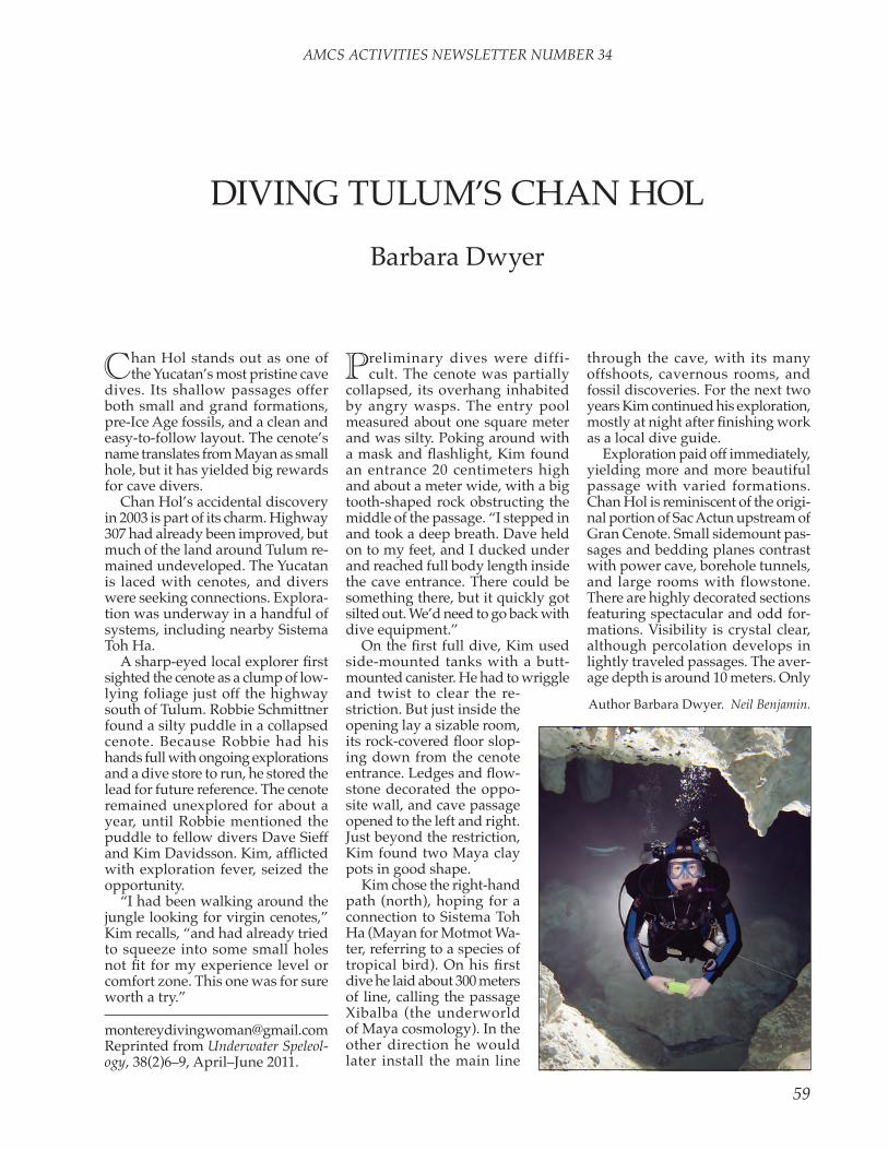
AMCS ACTIVITIES NEwSLETTER NUMBER 34
59
DivinG tUlUM’S CHAn HOl
Barbara Dwyer
[email protected] reprinted from Underwater Speleol-ogy, 38(2)6–9, April–June 2011.
Chan Hol stands out as one of the Yucatan’s most pristine cave
dives. its shallow passages offer both small and grand formations, pre-ice Age fossils, and a clean and easy-to-follow layout. the cenote’s name translates from Mayan as small hole, but it has yielded big rewards for cave divers.
Chan Hol’s accidental discovery in 2003 is part of its charm. Highway 307 had already been improved, but much of the land around tulum re-mained undeveloped. the Yucatan is laced with cenotes, and divers were seeking connections. explora-tion was underway in a handful of systems, including nearby Sistema toh Ha.
A sharp-eyed local explorer first sighted the cenote as a clump of low-lying foliage just off the highway south of tulum. robbie Schmittner found a silty puddle in a collapsed cenote. Because robbie had his hands full with ongoing explorations and a dive store to run, he stored the lead for future reference. the cenote remained unexplored for about a year, until robbie mentioned the puddle to fellow divers Dave Sieff and Kim Davidsson. Kim, afflicted with exploration fever, seized the opportunity.
“i had been walking around the jungle looking for virgin cenotes,” Kim recalls, “and had already tried to squeeze into some small holes not fit for my experience level or comfort zone. this one was for sure worth a try.”
Preliminary dives were diffi-cult. the cenote was partially
collapsed, its overhang inhabited by angry wasps. the entry pool measured about one square meter and was silty. Poking around with a mask and flashlight, Kim found an entrance 20 centimeters high and about a meter wide, with a big tooth-shaped rock obstructing the middle of the passage. “i stepped in and took a deep breath. Dave held on to my feet, and i ducked under and reached full body length inside the cave entrance. there could be something there, but it quickly got silted out. we’d need to go back with dive equipment.”
On the first full dive, Kim used side-mounted tanks with a butt-mounted canister. He had to wriggle
through the cave, with its many offshoots, cavernous rooms, and fossil discoveries. For the next two years Kim continued his exploration, mostly at night after finishing work as a local dive guide.
exploration paid off immediately, yielding more and more beautiful passage with varied formations. Chan Hol is reminiscent of the origi-nal portion of Sac Actun upstream of Gran Cenote. Small sidemount pas-sages and bedding planes contrast with power cave, borehole tunnels, and large rooms with flowstone. there are highly decorated sections featuring spectacular and odd for-mations. visibility is crystal clear, although percolation develops in lightly traveled passages. the aver-age depth is around 10 meters. Only
Author Barbara Dwyer. Neil Benjamin.and twist to clear the re-striction. But just inside the opening lay a sizable room, its rock-covered floor slop-ing down from the cenote entrance. Ledges and flow-stone decorated the oppo-site wall, and cave passage opened to the left and right. Just beyond the restriction, Kim found two Maya clay pots in good shape.
Kim chose the right-hand path (north), hoping for a connection to Sistema toh Ha (Mayan for Motmot wa-ter, referring to a species of tropical bird). On his first dive he laid about 300 meters of line, calling the passage Xibalba (the underworld of Maya cosmology). in the other direction he would later install the main line

AMCS ACTIVITIES NEwSLETTER NUMBER 34
60
light flow is present. On a more recent dive in 2009,
Kim connected to a cenote across the main road, Cenote Ba’ab Zotz (Swimming Bats). this passage added another 1845 meters and was unlike most other parts of the cave. the tunnels are dark and narrow and require removal of at least one tank to pass the restrictions. Brown, fluffy “mung” and mud cover the floors and walls. Percolation is abundant, and one careless fin kick will reduce visibility to zero. there is little to no flow here. It’s an easy place to get lost, and divers are discouraged from casual investigation. For that reason, the route has not been made easy to find.
Chan Hol is located on rancho loma linda, about 11 kilometers
south of tulum on Highway 307. After the big bend in the road, look for the rancho loma linda sign on the right-hand side. turn right at the end of the driveway and stop after about 15 meters. Owners Don Domingo and Doña Hermina or their representatives greet divers, welcome them, and collect a fee of 150 pesos per diver per day. they ask that divers be out of the water by dark.
Jungle access is no longer neces-sary. the owners built their home in 2006 on the property. in addition to providing tables, they installed a retaining wall between the cenote and the highway, removed the itch-producing chechem trees, and built
a step to assist cenote entrance and exit. there is a baño at the rear of the house. Don Domingo proudly showed me his property last year, pointing out the chaca tree, which offers a remedy for the chechem’s ef-fects, his cenote-irrigated vegetable gardens, and his chickens.
the property owners and diver traffic have enlarged the entry since the early days of exploration. A few years ago, back-mounted entry required turning to the right and considerable wiggling, even for smaller divers. now, a large diver with bulky back tanks can easily clear the floor or the ceiling without silting. The floor has suffered some damage, mostly near the entrance zone, and the occasional hand print or stage bottle damage is visible as far as about 800 to 1000 meters in. the original explorers want to em-phasize conservation and request that divers sharpen their buoyancy control, propulsion technique, and other skills before diving here.
A line to the surface marks the cave entrance. it connects with the short “torpedo” line, marked with a double arrow, which indicates the fastest exit from the cave. Making a left at the next T (about a five-minute swim) leads divers to the main line and numerous passages to explore. the little cave becomes large here quickly. Divers who choose the right-hand side of the circuit can note the longer path back to the entrance and then jump onto the Xibalba line. the cave is shallow enough to allow
several dives in a single day.
In 2006, German divers Alex and thorsten Kampe found a nearly
intact skeleton just off the main line about 400 meters into the cave. the Kampes found bones from the extremities, vertebrae, ribs, and skull, together with some intact teeth. the very slight dental wearing indicated that the person had died at a young age. el joven de Chan Hol (the young man of Chan Hol), as he is known to scientists, lived more than 10,000 years ago, during the last ice Age, when Yucatan’s caves were above sea level. the way in which the bones were placed reportedly suggests that the boy was ritually buried.
Scientists expect that this discovery will provide new data regarding the settlement of the Americas, accord-ing to Mexico’s instituto nacional de Antropología e Historia (inAH). its distance from the entrance and previous work done (Coke, J. G. iv, Perry, e .C., and long, A., 1991, Sea level curve: Nature: 353, no. 6339, p. 25) are expected to corroborate radioisotope dating of its age.
el joven de Chan Hol is one of four such skeletons found in un-derwater caves near tulum. Other human skeletons that have been discovered in nearby caves are eva de naharón (eve of naharón), la mujer de las Palmas (the woman of las Palmas) and el hombre de el templo (the man of el templo). their ages are between 10,000 and 14,000 years old. Other finds in area
left, monkey skull and bones in Chan Hol. right, Maya pots. Neil Benjamin.


AMCS ACTIVITIES NEwSLETTER NUMBER 34
63
underwater caves include tools, fire pits, and remains of animals that date from the late Pleistocene.
Until recently, divers who knew where to look could see these re-mains. However, the entire skeleton was recovered by inAH investiga-tors for radioisotope dating. we had hoped to see a few remaining bones on our dives this past Decem-ber, but found only a box labeled with inAH’s logo. [See photos in “Mexico news” in this issue and http://www.inah.gob.mx/index.php/english-press-releases/61-anthropology/62.]
Many more relics are visible if you look for them. Some examples are pottery and intact fire pits that can be seen along the main line and elsewhere. The first pots discovered, along with a monkey’s fossilized skull and some long bones, have been placed on a ledge just across from the entrance.
Chan Hol remains under explora-tion to this day, with new passage being found. For a brief time, until the connection to toh Ha, it was the longest single-entrance underwater cave in Mexico. the total system is 29,039 meters long, with a maximum depth of 14.9 meters. Sixteen cenotes have been reported in the system to date.
Kim Davidsson heading out along the line. Neil Benjamin.
Buceando el Cenote Chan Hol en tulum
el Cenote Chan Hol fue descubierto en 2003 por robbie Schitt-ner. Kim Davidsson se convirtió en su principal explorador. la entrada a esta cueva subacuática fue difícil al principio, pero se ha ensanchado desde entonces. Se descubrió un esqueleto humano en 2006, y fue nombrado el Joven de Chan Hol, y fue recuperado por el inAH. Por un tiempo Chan Hol fue la cueva subacuática más larga de México con una sola entrada, pero ha sido conectada con el Sistema toh Ha y el Cenote Ba’ab Zotz. el sistema completo tiene una longitud de 29,039 metros.

AMCS ACTIVITIES NEwSLETTER NUMBER 34
64
the editor of Outhouse Magazine, foremost outdoor adventure monthly, asked me to pack my bag and fly to Oaxaca, Mexico, and interview Bob rock, famous supercaver. He was preparing to break the world cave depth record of 7,432.6 meters set in Gruta Phreefall, that unbelievably deep hole—twice the size of the Petronas towers in Moldavia—that was bottomed by a Kurdistan caver team just last year. the fact that none of them survived made it impossible to interview them.
As i stepped off the Aer Mex 747 onto the tarmac i was met by a smiling Bob rock, with tanned, chiseled face and an imposing seven-foot two-inch frame. He thrust his hand down and forward and squeezed mine like the Boston Strangler. “¡Ola, Ergor, mas tiempo no si!” we reminisced about our caving together in Cenote del Muerto several years before. we were waved out of the way because the afternoon plane was circling to land.
As we jounced and hacked our way through the rainforest in his eight-wheel drive truck, Bob told me how the expe-dition was going. “we have thirty-two ropes in place, sixteen camps staked out, and 300 kilos of beans staged,” he said. i asked about the golf bags in the bed of the truck. He said they are not golf bags, but descending-rack bags. “We use twenty-five-bar racks on these deep boogers,” he said, “and the bars are sodium-cooled titanium to withstand the heat when we whiz down to the bottom of each pitch.”
At the expedition’s camp, which hung from hammocks in jungle trees “to keep the tapirs away,” i met a striking statuesque redhead named Consenta. An expedition member told me she was the champion pit rigger of Kazakstan in 2008, and the current esmeralda of Bob rock. the twenty-seven-pound gas-powered bolting hammer that swung from her waist caused her to list to port about fifteen degrees. She gave me a wink and a forty-eight-karat smile, a little nudge, and a palm-scratching handshake. i did not want to get too close as she inched perceptibly toward me for fear her bolt-ing hammer’s muffler had not cooled down sufficiently.
“Stash your gear, get some grub and some shut eye,” Bob said, “because tomorrow we are going 6,272.6 meters down to Camp 16.” i learned later from Consenta that Camp 16 was suspended by parachute cord from a soda straw, and was constantly pelted by plantain leaves
showering down upon it. Consenta said the crunchiness of the leaves made love-making a noisy affair at Camp 16.
After washing down a rasher of hue-vos rancheros, beans, and plantain seeds with two gallons of free-trade coffee, we entered the yawning maw of the cave. it was so large you could park three 747 tires in the Sala Grande. Gaucho birds swooped and dive-bombed us with a curious paste-like substance that did not taste good, either. we descended a 500-meter fixed rope. I was a little concerned, because where they fixed it the electrical tape was coming unwound. At each stainless-steel bolt and rebelay i dangled and thrashed, hooking my cowstail over each bolt, and traversing sideways, sometimes upside down. At the bottom, near Camp 15, i asked about the numerous windows we passed on the perilous descent. Bob said, “we don’t screw with them. they are horizontal cave and who cares about horizontal cave? Depth is where it’s at—depth!”
Camp 15 was laid out on blue tarps over six inches of quicksand. the coffee was getting to me about then, and Bob motioned for me to use the pee bottle. these deep supercavers are fastidious and take out of the cave everything they take in. last year in the dreaded Santa Anita d’eques , Manuel labour lost his right leg when it was shredded in a Ju-mar, and dutifully carried it 5,326 meters back out of the cave. Asked whether it hurt, he replied, “Only when i laugh.” i could not hear any of the preparation briefing at Camp 15 as the blue tarp
crinkled and crackled so loudly as to drown out conversation. i imagined the noise would make amorous activity less private.
lunch at Camp 15 consisted of tubes of guacharo butter, double refried beans, and Ho Hos. Bob started to lecture me on carbohydrate loading, but i told him to stop, as my Ph.D. is in nutritional Science and Arts. the lunch was not very good.
A couple more 600-plus-meter drops and we were at Camp 16, the jump-off for the two-kilometer sump through twisty little passages that looked all alike. the super-cold water was at 0°C, and i was handed an ice pick in case the liquid turned solid on my transit. I was fitted with a self-contained breathing device and told that so long as the green leDs were glowing i had nothing to worry about. i sank into the depths and picked up a clothesline that wound through and around boulders, drowned speleothems and speleogens, and one vw.
emerging in a gigantic hall, i pulled myself up on a shale beach and awaited the other divers. Bob rock was next. He said the others had decided not to dive when their refried beans took to outgassing and floated them to the ceiling of the sump in a bad air bell. we scrambled along the beach in a tube 432 meters in diameter, slanting downward at eight degrees. we passed the bloated dead bodies of the Kurdistan dive team arranged in a circle, heads to a butane stove, long since out of gas.
Bob said, “Poor devils, they had just set a brass elevation marker at their world record depth when their butane tank leaked. without mercaptan, they could not smell the deadly CO gas con-centration when their stove blew out. we stood still a moment in their memory, then proceeded to the brass cap:
Gruta PhreefallWorld Depth Record
7,432.6mKurdistan Deep Speleology Team
Bob whipped out a trowel and a length of measuring tape. He dug a hole in the floor at that point 1.4 meters deep. “now, i have set the depth record, 7,434 meters!” i said that he could have dug a deeper hole. He said, “that’s three years from now. i already have $7M lined up for my expedition to Brazil next year. And i’m taking Amazonia. She’s the best caver in Brazil.”
SUPerCAverS AnD SUPerCAveSergor rubreck
Consenta with plantains

AMCS ACTIVITIES NEwSLETTER NUMBER 34
65
SiSteMA ríO lA ventA, CHiAPASAn UnFOrGetABle tHrOUGH-triP
tullio Bernabei and Francesco Sauro
reprinted from the english versions of articles in Kur Magazine number 11, December 2008, and its techni-cal supplement, published by la Venta Esplorazioni Geografiche in italy. the english translations are by libero vitiello and Chris lof-fredo. thanks to Antonio De vivo for providing files of the english text. tono has also supplied the fol-lowing accurate figures for the cave: total length 11,020 meters, length of through-trip from Sumidero ii to resurgence 6600 meters, total depth 432 meters, descent from Sumidero ii to resurgence 405 meters.
On 13 April 2008, a small group of cavers walk in light rain near
the village of lópez Mateos, in Chia-pas, Mexico. we are on a plateau, at about 750 meters elevation and a few kilometers away from the río la venta canyon. we are following a friend and local guide, Manuel Pérez, who is the owner of the upper entrance of Cueva del río la venta, which is the largest underground system we have found and explored during the course of our explora-tions in Mexico. it is late afternoon, the light is already waning, and the rain seems to have no intention of stopping. when we reach some sort of pass, Manuel announces that we are near the cave. Before us opens a semicircular valley. when we emerged up there for the first time in 1995, the valley wasn’t visible, just forest, dense vegetation, and gigantic trees. Massive chicozapote and ceiba create shade for a well-kept cafetal. now there are only sun-baked stones and small spiny shrubs. i look at
Manuel, and while i’m asking him if he remembers what this place was like, i realize how stupid my ques-tion is. The great 1998 fires were a huge loss for him, as well as for the planet in general.
Shortly before we reach the cave, we come across a few trees and some vegetation worthy of the name, thanks to the microclimate gener-ated by the entrance to the cave, a gigantic subterranean collector that leads, after almost 13 kilometers and a descent of 400 meters, to the bottom of the río la venta canyon. we found the lower entrance in January 1990, during the first exploration of the canyon, and from there climbed up, year by year, towards a hypothetical upper entrance that the strong air currents led us to believe existed. But it wasn’t easy. in 1994 the explorers reached +300 meters, thanks to two cave camps and difficult climbs, but a large, dark lake, lago degli ignavi (lake of the Slothful), and the dis-tance from the entrance put an end to the exploration.
An attack from above was needed, and we did that the next year, finding the entrance at the end of the cafetal and discovering a large gallery that ran a few dozen meters below the surface. the air current was also present here, but not the hoped-for connection with the cave below. On 25 november 1995, i had the good fortune of making it through a col-lapsed area and descended, with butterflies in my stomach, to the lago degli ignavi. the connection was made, and it was possible to enter the upper entrance and come out at the bottom of the canyon.
we celebrated for a long time, and above the key passage used acety-lene lampblack to write “Un sogno chiamato río la venta,” “A dream called río la venta.”
In the initial chamber, safe from the rain, we allow ourselves a
photographic souvenir. Along with me, geared up and ready to go, are Marco Mecchia, Francesco Sauro, Marco Zocca (Juan Pedro), Giacomo Strapazzon, Carlos Sánchez, and Mauricio Náfate—in all, five Italians, a Spaniard, and a Mexican—a nice assortment. Gianni todini and lucas ruiz are also there, but they will return to the village for safety rea-sons. During such long and complex descents, it’s a good idea to leave someone outside just in case, and it is their lot to be sacrificed. They have another important duty, to meet us at the exit, at the bottom of the canyon, together with Manuel Pérez, who is the only one to know the way back to the village from there.
it is Sunday, 7:30 p.m. Our mood is good, our physical condition some-what less, as we have just spent ten or so very demanding days exploring the Ombligo del Mundo [see article elsewhere in this issue]. Francesco has even had a cold and a fever for the last few days. But the desire is strong: it is to be only the third through-trip between Sumidero ii and the río la venta entrance. the first was carried out by De Vivo and rivadossi a few days after the con-nection in 1995, the second in 1997 by rivadossi, four other italians, two Americans, and one Croatian. we plan to rig the pits with new

AMCS ACTIVITIES NEwSLETTER NUMBER 34
66
stainless-steel anchors.in fact, what awaits us isn’t at all
clear, and the reason is simple: no one knows the cave apart from me, and i’ve only seen the beginning and the end, but not the long central section. let’s say that 70 percent of the cave is unknown to us, but in our favor we have an old route description and a reliable team. we don’t even know the way back to the plateau from the exit, but for that we are counting on Manuel, lucas, and Gianni’s external help. we make a
rough appointment for around 4 p.m. tomorrow at the lower exit. twenty hours or so should be enough for what we have to do.
Outside night is falling, and the rain also falls, gently. we’re at the peak of the dry season, the ideal time. According to the locals, this is just a passing spot of bad weather, noth-ing important. in our bags we have lots of rigging equipment and very few personal items, just something to eat, a bare-bones first-aid kit, and little else. it is a very light approach,
perhaps too much so for a trip that will take at least 24 hours. i, in par-ticular, have few extra batteries and just a light change of clothing, even though i know that we will enter wa-ter. But anyway, it’s a tropical cave; one knows that it’s warm. . . .
Finally we enter, strangely at ease despite the dark clouds gathering, not only in the sky. we are tackling an active cave while it is raining, we don’t know most of the route, and we are equipped as for an easy tour of just a few hours. It’s like a film that we have already seen, yet we take a seat to watch it anyway.
the gallery called Sueño Blanco welcomes us invitingly, very beau-tiful, as in the photographs. Marco has a small audio recorder on which we want to leave as many comments as possible, describing the cave and the new anchors we’ll be installing as we go along. Francesco seems to gain energy as he descends. He handles the heavy Hilti drill deftly, placing the steel bolts and the chains for the double-rope rappels in all the right places.
we move quickly and get sweaty. Giacomo is afraid of histoplasmosis and is wearing a small experimen-tal mask that should allow him to breathe easily, even under exertion. Carlos the Spaniard takes some pictures, and Mauricio the Mexican brings up the rear and recovers the double rope in his usual calm way.
we negotiate three pits of around 15 meters each and end up in a large gallery, the one discovered in 1995. it is over 20 meters wide and about 15 high. A climb up a calcite flow, and then ever larger spaces bring us to the collapse chamber where the connection was made. it is 9 p.m., the chamber is huge, but here i know where to go, and we soon reach the historic words written above the key passage. A strong breeze blows on our faces. it is always impressive to look out into the 30-meter pit that leads to the lago degli ignavi. the old rigging is rotten: both the rope and the carabiners show all of their thirteen years in the damp darkness. new anchors are installed, nice and safe. By now we are in harmony with the cave, moving quickly and cheer-fully. Marco uses wondrous words to describe our surroundings.

AMCS ACTIVITIES NEwSLETTER NUMBER 34
67
the lago degli ignavi really is sinister; its waters are extremely deep. luckily an old rope goes up to the right, towards a hole in the wall, which allows us to avoid a swim. We re-rig a rather difficult cableway, which brings our sweat-ing to a maximum. new rope; the passage is now safe.
From here on, no one knows the way, and we immediately realize that the old route description we have with us isn’t detailed enough for the complexity of this cave. Some searching will be necessary.
we wander for a while in an area called rami di Cnosso (Knossos Branches), following our compass more than the description, then see an arrow in lampblack that leads us to the summit of a large chamber. the side walls can’t be seen. it is certainly the Murciélagos Chamber, but it is too large for the bats to be visible. the descent through the chaos of blocks has some difficult points, even in finding the way. I tell myself that we should make some cairns, but we are already behind schedule, and there is no time for that.
Only Carlos has an acetylene light, which isn’t powerful enough for such large spaces. i discover that my electric light has less charge than expected and is already getting dim-mer. As a reserve i have a three-leD tikka, which may be too little for this trip. the bottom of the chamber is slippery, and this slipperiness stays with us for long stretches. it is a kind of thin, slimy film, evidently depos-ited by large floods, which forces us to be doubly careful. the gallery finally becomes a gorge, and we find the stream again. Soon afterwards, a roar heralds the escala del Diablo, a series of waterfalls 30 meters high. the atmosphere is packed with mist, to the point that Giacomo tears his mask off in order to breathe. it’s half past midnight.
we notice some rope segments cut up by the floods; none of the rigging in place here is usable any more. Francesco makes a traverse to do some rigging, complex and tak-ing about two hours, but effective. i bring up the end of the line, trying to recover as much old material as possible.
At that same moment, in the small
house at lópez Mateos, Gianni and lucas cannot sleep. they fear that the violence of the storm will tear the roof off. Outside it looks like the Deluge. the ground is covered by raging torrents that gush under-ground as soon as they can.
At two-thirty we are all beyond the series of waterfalls and give
ourselves a break in order to eat something. we have no idea what is happening outside, and none of us knows what the normal water-flow should be at this point. And anyway, we are in full dry season. we don’t even remotely suspect the truth.
we start off again, fully recharged, and enter the area called the Galleria Genç Osman, where the stream is unavoidable. we enter the water, first to above the knee, then to the waist. it is cold, but moving along you get used to it. then the stream suddenly disappears, in its place a gigantic heap of blocks, the Salone della Città Perduta (Chamber of the lost City). this is another huge and dark place, where the direction to take isn’t at all clear. we stop and study the map, without finding any clear answers.
i take off to the right to have a look. the rest of the group remains a bit behind, and i hear them taking another direction. i’m convinced that my way is the right one, so i give a shout to the others and keep going. there are no noteworthy forks on
the way, and sooner or later we’ll meet up again. i feel that i’m a bit responsible for finding the way, since i have the most experience in tropical caverns. i therefore make an effort to go ahead quickly, in order to sort things out. Progress is difficult, and i must choose between different levels. Unfortunately, i’m also in the slipperiest area, and my main light has become very weak, to the point that i have to turn the tikka on. After an hour of balancing exercises, tired and sweaty, i stop above a pit sev-eral meters deep, where a rope that i don’t have is needed. i’m almost certain that this is the right way. this should be the Galleria di Ollin. But there is no sign of the others.
leaving the heavy bag behind, i reluctantly go back to see what’s happening. very little light, very tired, i’m alone and barely halfway through. Finally i hear them, they’re coming. the meeting is hearten-ing and confirms that I had taken the right way. Marco’s tired voice records, “Another long trek in a gallery, mostly high, far from the water. Slippery blocks, what a pain in the ass.”
We finally return to the water, but the joy doesn’t last long. we are in up to our chests, and then we make difficult climbs above the stream to avoid deep lakes. the group is beginning to be tested, or, better, surprised, by the length and diffi-culty of the passages. At ten past five,
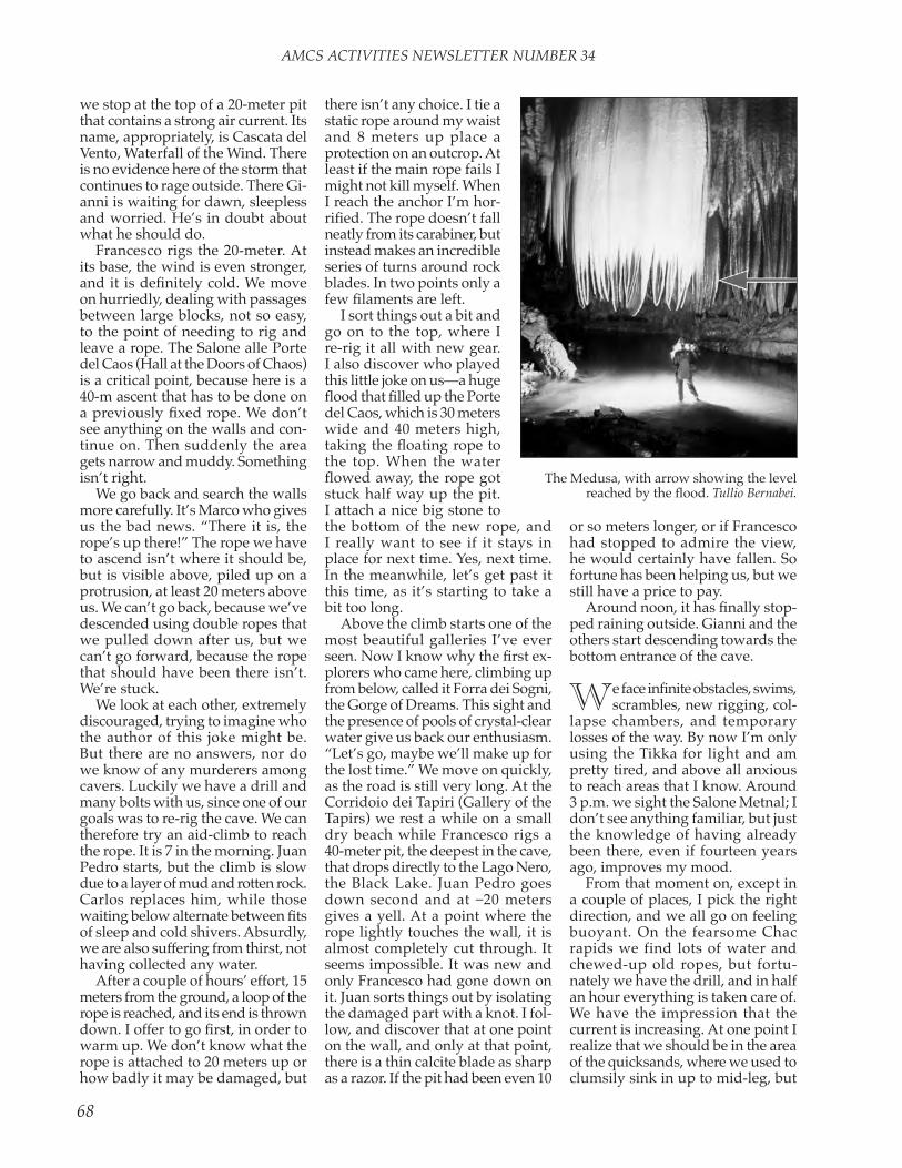
AMCS ACTIVITIES NEwSLETTER NUMBER 34
68
we stop at the top of a 20-meter pit that contains a strong air current. its name, appropriately, is Cascata del vento, waterfall of the wind. there is no evidence here of the storm that continues to rage outside. there Gi-anni is waiting for dawn, sleepless and worried. He’s in doubt about what he should do.
Francesco rigs the 20-meter. At its base, the wind is even stronger, and it is definitely cold. We move on hurriedly, dealing with passages between large blocks, not so easy, to the point of needing to rig and leave a rope. the Salone alle Porte del Caos (Hall at the Doors of Chaos) is a critical point, because here is a 40-m ascent that has to be done on a previously fixed rope. We don’t see anything on the walls and con-tinue on. then suddenly the area gets narrow and muddy. Something isn’t right.
we go back and search the walls more carefully. it’s Marco who gives us the bad news. “there it is, the rope’s up there!” the rope we have to ascend isn’t where it should be, but is visible above, piled up on a protrusion, at least 20 meters above us. we can’t go back, because we’ve descended using double ropes that we pulled down after us, but we can’t go forward, because the rope that should have been there isn’t. we’re stuck.
we look at each other, extremely discouraged, trying to imagine who the author of this joke might be. But there are no answers, nor do we know of any murderers among cavers. luckily we have a drill and many bolts with us, since one of our goals was to re-rig the cave. we can therefore try an aid-climb to reach the rope. it is 7 in the morning. Juan Pedro starts, but the climb is slow due to a layer of mud and rotten rock. Carlos replaces him, while those waiting below alternate between fits of sleep and cold shivers. Absurdly, we are also suffering from thirst, not having collected any water.
After a couple of hours’ effort, 15 meters from the ground, a loop of the rope is reached, and its end is thrown down. I offer to go first, in order to warm up. we don’t know what the rope is attached to 20 meters up or how badly it may be damaged, but
the bottom of the new rope, and i really want to see if it stays in place for next time. Yes, next time. in the meanwhile, let’s get past it this time, as it’s starting to take a bit too long.
Above the climb starts one of the most beautiful galleries i’ve ever seen. Now I know why the first ex-plorers who came here, climbing up from below, called it Forra dei Sogni, the Gorge of Dreams. this sight and the presence of pools of crystal-clear water give us back our enthusiasm. “let’s go, maybe we’ll make up for the lost time.” we move on quickly, as the road is still very long. At the Corridoio dei tapiri (Gallery of the tapirs) we rest a while on a small dry beach while Francesco rigs a 40-meter pit, the deepest in the cave, that drops directly to the lago nero, the Black lake. Juan Pedro goes down second and at –20 meters gives a yell. At a point where the rope lightly touches the wall, it is almost completely cut through. it seems impossible. it was new and only Francesco had gone down on it. Juan sorts things out by isolating the damaged part with a knot. i fol-low, and discover that at one point on the wall, and only at that point, there is a thin calcite blade as sharp as a razor. if the pit had been even 10
or so meters longer, or if Francesco had stopped to admire the view, he would certainly have fallen. So fortune has been helping us, but we still have a price to pay.
Around noon, it has finally stop-ped raining outside. Gianni and the others start descending towards the bottom entrance of the cave.
We face infinite obstacles, swims, scrambles, new rigging, col-
lapse chambers, and temporary losses of the way. By now i’m only using the tikka for light and am pretty tired, and above all anxious to reach areas that i know. Around 3 p.m. we sight the Salone Metnal; i don’t see anything familiar, but just the knowledge of having already been there, even if fourteen years ago, improves my mood.
From that moment on, except in a couple of places, i pick the right direction, and we all go on feeling buoyant. On the fearsome Chac rapids we find lots of water and chewed-up old ropes, but fortu-nately we have the drill, and in half an hour everything is taken care of. we have the impression that the current is increasing. At one point i realize that we should be in the area of the quicksands, where we used to clumsily sink in up to mid-leg, but
the Medusa, with arrow showing the level reached by the flood. Tullio Bernabei.
there isn’t any choice. i tie a static rope around my waist and 8 meters up place a protection on an outcrop. At least if the main rope fails i might not kill myself. when i reach the anchor i’m hor-rified. The rope doesn’t fall neatly from its carabiner, but instead makes an incredible series of turns around rock blades. in two points only a few filaments are left.
i sort things out a bit and go on to the top, where i re-rig it all with new gear. i also discover who played this little joke on us—a huge flood that filled up the Porte del Caos, which is 30 meters wide and 40 meters high, taking the floating rope to the top. when the water flowed away, the rope got stuck half way up the pit. i attach a nice big stone to

AMCS ACTIVITIES NEwSLETTER NUMBER 34
69
this doesn’t happen, and instead the water level is high, very high, so much so that we have to swim at several points. By now it’s clear that something is wrong, and when we pass under a waterfall that i don’t remember, I finally accept the hard truth. the rain outside has evidently continued, and the cave is flooding. in this season it shouldn’t have hap-pened, but it did. Our thoughts go to the Medusa, one of the last pas-sages that await us. we know that there the water can reach the ceiling and form a sump. that would really stop us.
we run along the sand banks, swim, run again. i don’t recognize the places, or i remember that here we used to walk in ankle-deep water and now we are completely im-mersed. This is truly a big flood.
the wind is strong, which means we can still pass through. we swim for over 100 meters until we reach a narrowing, through which we barely squeeze ourselves with a dozen or so centimeters of air left: it’s her, the Medusa, even if the passage is unrecognizable because the water level is several meters higher. From later calculations, we figured out that the peak of the flood would have reached this point, probably closing it, one or two hours after we went through. Just in time, then.
we feel as though we’re practi-cally outside, and it is 5 p.m.; all in all not so bad, considering all that has happened. But the surprises are not over. the descent into the Salone della Cascata (Chamber of the Waterfall) gets us lost one final time before we’re finally at the base of a 5-meter wall which leads up to the exit. there should be a rope. But there isn’t.
we’re all very knackered, but the drill still has some charge left, and with a couple of bolts we can climb. i climb onto Mauricio’s shoulders and in a precarious balance attach an anchor to the flowstone. It’s obvious that it won’t hold much, but maybe enough for me to go up a bit higher and attach a second, definitive one. As soon as i do that, i fall.
the two of us roll down the slope, knocking some of the others over as if they were bowling pins. it would be funny if it didn’t feel so tragic. nobody gets hurt, apart from a nasty blow to my back, which has already been operated on for a her-nia. Someone else restarts the climb. i feel stupidly at fault, who knows why, and try to find an alternative way out. i insert myself into a high pile of blocks, crawling between the boulders with only one very weak light. I don’t find a passage and use up the last of my energy.
when i get back to the climb, the rope is in place and the others are already leaving. i join them, slowly. it is half past eight. Twenty-five hours in the cave, but it could have been much, much worse.
there is nobody outside, and it is raining. we call out in vain, ask-ing ourselves what has happened. Maybe they’re at the Campo della Croce, along the river. we rig the descent from the entrance and begin heading down to the bottom of the canyon. the río la venta is in full flood, and the beach no longer exists. After a couple of hours of useless searching, we return to the cave entrance with the idea of sleeping a few hours and putting off all deci-sions until the morrow. Francesco and i settle ourselves down in a niche, lying on a damp copy of the cave map. it is a restless sleep, cold and filled with nasty dreams, but still some rest after thirty hours on the move.
With the first light of morning come Manuel and lucas’s
shouts. it’s really a relief to see them. they tell us that yesterday they entered the entrance twice: in the afternoon and in the evening around ten, without seeing us. wicked fate had it that at ten o’clock we were looking for them along the river: we just missed each other. All’s well that ends well? not yet.
not having found us, Gianni had decided to take the car to the city and ask for the help from the local caving groups, even though a real rescue team doesn’t exist. we have to stop him, otherwise this story will become an international incident: five Italians trapped by a flood in the heart of a Mexican cave. . . . i tell Manuel to run to the village, go to the public phone and call the ramos home in Cintalapa, where i hope Gianni will stop. then, after an injection of painkillers for my back, we start off slowly with lucas. the very steep, continuous climb 350 me-ters up a muddy track is an ordeal, especially for me and Mauricio. we find Gianni on the plateau; the phone call had come just as he was passing
Cueva del río la venta, the lower entrance to the system. Carlos Sánchez.

AMCS ACTIVITIES NEwSLETTER NUMBER 34
70
through Cintalapa. He meets us with a couple of horses and the look of someone who had been through a nightmare, maybe even worse than ours. At three in the afternoon of tuesday, April 15, we reach the car, after forty-four hours of travel. It was definitely an unforgettable trip.—Tullio Bernabei
In April 2008, a few members of the la venta team, along with Mexican
and Spanish cavers, repeated the legendary Cueva del río la venta through-trip. the main goal was to completely re-rig the cave for de-scents using double-rope technique, so that any future through-trips would be simpler and safer. During our visit, we also tried to collect as much information as possible, in order to create a description of the route and of the system’s geomor-phic characteristics. Unfortunately the arrival of an unexpected flood did not allow us to finish this last task properly.
this traverse involves a number of risks that should not be underes-timated. Among them, and perhaps the most insidious, is the constant difficulty of finding the way through huge chambers, collapses, and many lakes, often made dangerous by the presence of quicksand. From the en-trance at Sumidero ii until the Cueva del río la venta, one drops 450 me-ters and covers a distance of about 10 kilometers, journeying through a sequence of underground landscapes of rare beauty and majesty. [See the footnote at the beginning of the ar-ticle for accurate distances.]
the entrance of Sumidero ii is on private land belonging to Manuel Pérez, who lives in the Colonia ló-pez Mateos. Before taking any step towards the cave, it is absolutely necessary to contact him and ask for permission. whoever does not do so risks compromising access to the cave for everyone in the future. the local inhabitants take a rather dim view of cavers who go adventuring into the caves within their territory. there is always the fear that they are going to raid some archaeologi-cal treasure or steal something. On this occasion, Manuel Pérez agreed to accompany our group to the entrance of Sumidero ii, saving us
a lot of time.Along the way, from the upper en-
trance to the exit on the río la venta, one encounters fifteen descents and three ascents. the longest drop is 40 meters. the main drops are equipped with raumer Full time stainless-steel expansion bolts, which, hav-ing a hanger and ring, have proven themselves to be especially suited for rigging the pull-down rappels. the longest drops are equipped with doubly attached chains, again of the Full time type. the traverses for reaching the starting points of the ascents and descents have been rigged with new ropes, with the exception of a few brief stretches where it will still be necessary to replace the old 1997 ropes, which are often damaged by floods.
Unfortunately, we have observed that the cave is periodically affected by floods, which are capable of fill-ing huge chambers, with the water level rising even dozens of meters. there can therefore be no absolute certainty that the in-place rigging, especially the fixed ropes of the ascents and traverses, will be found in place after long periods of time. we advise that anyone interested in repeating the traverse should bring a drill and bolts, in order to take care of any problems that may be found on the way.
A stream flows through the cave that, in its lower reaches, has a nor-mal flow of 500 to 1000 liters per second. There are very many flooded stretches, beginning with the lago degli ignavi in the highest part of the cave. the route we propose here avoids, where possible, entering the water. Despite that, many dips, even complete ones, are unavoidable in the second half of the trip. luckily the temperature is fairly high in this tropical cave, and as long as one keeps moving, the cold is bearable and drying is quick. we therefore seriously advise against using wet suits or similar equipment. the best solution is to go in with light and quick-drying clothing beneath cave suits.
When crossing flooded galleries, special attention should be paid to the presence of quicksand, some-times hard to see, which can cause problems and losses of time and
energy. the route through chambers is only rarely marked by cairns, which are often destroyed by floods, so one must improvise and try to follow the description and find, possibly using powerful lights, the best route. A compass can be very useful.
Also, the return from the bottom of the canyon to the starting point shouldn’t be underestimated. that in itself is a difficult excursion along steep and slippery, hard-to-find paths. Outside support for the return is practically a necessity.
the time inside can vary, between sixteen and thirty hours, depend-ing on the number of people in the group and the unexpected problems encountered, to which five or six hours’ walk to return to the starting point should be added. A bivouac at the exit on the río la venta should be considered.
One should absolutely not enter if the weather is uncertain, because bad surprises could be in store, as we have learned from experience.
required materials include two 40-meter ropes, one 20-meter rope, at least 30 meters of rope to leave behind at any necessary rerigging, and a drill, rigging bag, various bolts, and a few carabiners.
Entrance coordinates of Sumidero ii of Sistema río la venta: Zone
15, 425248 e, 1868851 n (UtM). entrance coordinates of Cueva del río la venta: Zone 15, 425784 e, 1871430 n.
the Sumidero ii entrance lies 2.7 kilometers northeast of the Co-lonia Adolfo lópez Mateos, in an area which is currently deforested and characterized by deep karst depressions. to reach the entrance, we advise having the landowner guide you.
the large entrance, about 5 to 6 meters wide, opens at the bottom of a small closed valley. From the initial chamber, one takes a low passage to the left until reaching a junction, from which to the right one reaches the wonderful Sueño Blanco conduit. After a few dozen meters, one reaches the first descent to rig. two others follow promptly, all about 10 to 15 meters deep. At the base of the third drop, one follows

AMCS ACTIVITIES NEwSLETTER NUMBER 34
71
a lovely conduit that leads into a larger gallery, 20 by 10 meters. this should be followed towards the right, in a southerly direction, and then up a long, slippery slope. One continues along the main gallery for about 400 meters, following the cairns and doing some up-and-down scrambling, until a larger chamber is reached, where one then descends along the debris cone to the left. Here one must find, along the chamber’s wall, the passage through a collapsed area that leads to the connection pit; follow the lampblack arrows. After descending the small pit, one is in a small chamber overlooking a large pit of about 35 meters that drops into a large room. Heading north, one reaches the shores of the tenebrous lago degli ignavi, the lake of the Slothful. Here one goes up a tyrolean to enter an obvious fossil gallery on the right wall about 10 meters from the lake. After following this gallery for about 100 meters, passing another opening to the river, one enters a fairly complicated zone, the rami di Cnosso (Knossos Branches), where one needs to keep to the left at a fork, the right leading in another direc-tion to some blocked passages not shown on the map. the dry gallery then leads to the large Murciélagos Chamber, where one descends again to the level of the river and follows it for about 200 meters, keeping to the left, until a large waterfall is reached, the escala del Diablo. this obstacle is passed by a long traverse, permanently rigged, that ends up descending 30 meters in areas clear of the powerful fall, a direct descent being impossible.
From the base of the escala del Diablo, one follows the Galleria Genç Osman for about a kilometer, walk-ing on the side sand banks where possible, although one is forced to enter the water several times up to the waist. One then enters the grand Salone della Città Perduta (Chamber of the lost City), which is about 200 meters long and 50 wide and strewn with gigantic boulders that make finding the way very difficult. In the middle of the chamber towers an enormous flowstone column. One passes by the obvious dry branch to the left, called Orto dei Carciofini (Garden of the little Artichokes),
and continues through the chamber, keeping to the right-hand side until descending almost to the level of the river. when the gallery narrows, you scramble up a collapse and start go-ing down the aggravating Selva de Pietra Gallery, smaller, though still about 10 meters in diameter. One faces many climbs between blocks along the active branch. After about half a kilometer, the gallery turns into a very high gorge, the Galleria Ollin–rojo Blanco, with deep lakes and white-water rapids that are diffi-cult to avoid. At the end of the gorge, the torrent leaps down the imposing Cascata del vento (waterfall of the wind), which is about 20 meters deep and is passed using a long traverse to the left, allowing a descent away from the flow. From the base of the descent, where the mist and the wind are intolerable, one continues going down between giant cemented collapse blocks, completing some brief but insidious climbs, until an impressive dry loop is reached that was the site of a 1995 camp.
After passing this 180-degree curve, one enters the beautiful Segna-li di Fumo (Smoke Signals) Gallery, which is 20 meters wide on average, having a characteristic barrel-shaped cross-section floored with clastic deposits underneath which the tor-rent flows. At the end of the gallery, one rejoins the river, then goes over a gigantic hill of collapsed stones about 30 meters high that leads to the Salone alle Porte del Caos (Hall at the Doors of Chaos). Here one must be very careful not to continue into the hall, but instead to find the fixed rope for a 30-meter ascent on the left-hand wall. Once past the ascent, one enters the wonderful Forra dei Sogni (Gorge of Dreams), a normally dry area incredibly worn by the waters which, during exceptional floods, fill up the Salone alle Porte del Caos below and violently pour into this imposing canyon. it’s certainly one of the most fascinating places of the entire traverse, notable for the complete lack of any clastic deposits and for the scallops that cover all the walls up to the ceiling.
the gorge, after heading steeply down for about 100 meters, drops into a large pit with a sump at the bottom. One must look for a rope on
the left-hand wall, shortly before the pit, that ascends about 15 meters to the dry conduit called the Corridoio dei tapiri (Hallway of the tapirs). it is a highly decorated gallery, where stalagmites and columns emerge from a sandy floor, creating a very impressive landscape. Following the notable air current, one reaches a drop of about 15 meters that leads to the large hall called Sforza italia (“exertion” italy, a satirical play on the name of a certain political party), also characterized by large deposits of sand. Here one doesn’t descend to the hall, but instead goes along the wall to the left, entering some low conduits and passing through a crawlway on hands and knees between angel-hair formations. One emerges on a large debris slope that leads to the edge of a large drop of about 40 meters, which in turn leads to a hall characterized by a gigantic cone of mud. At the base of the hall, one sees the shores of the impressive and gloomy lago nero (Black lake). However, one must keep to the left to enter a passage where the water is less deep, even if a full immersion for about 10 meters is still necessary. The configuration of this section of the cave can be significantly changed by floods; it’s possible that over time these flooded sections could fill up with sediment or instead become deeper, possibly necessitating more or less long swims.
Beyond this, one continues into the large Bella Addormentata (Sleep-ing Beauty) Gallery, characterized by deposits of sand and mud, for about 300 meters. One then enters into the via col vento (Gone with the wind) Gallery, a succession of deep holes, gours, and small lakes with imposing formations. in the narrower parts one notices the very strong airflow. One climbs down a few meters and, after about 100 meters, reaches the edge of a huge flowstone watered by the stream, the Quarta Medusa (Fourth Medusa). Using a rope to descend this obstacle, one enters the wonder-ful Salone Metnal, in whose center towers a gigantic stalagmite called the terza (third) Medusa. Crossing the hall keeping to the right-hand side, one goes into a narrower gorge that leads to an area characterized by dangerous quicksand. next to the

AMCS ACTIVITIES NEwSLETTER NUMBER 34
72
A so
mew
hat m
ore
legi
ble
vers
ion
of th
is m
ap a
ppea
rs a
s a lo
ng fo
ldou
t on
page
17
of A
MCS
Act
iviti
es N
ewsle
tter 2
3, re
prin
ted
from
Spe
leolo
gia 3
5, 1
996.
A
nyon
e pl
anni
ng a
vis
it sh
ould
obt
ain
a co
py o
f the
Spe
leolo
gia m
ap, w
hich
is
abou
t 20
by 5
5 in
ches
and
on
whi
ch p
lace
nam
es m
entio
ned
in th
is a
rtic
le a
re
legi
ble.
the
AM
CS
has a
cop
y of
that
map
.

AMCS ACTIVITIES NEwSLETTER NUMBER 34
73

AMCS ACTIVITIES NEwSLETTER NUMBER 34
74
longest lake, one must keep to the right and then cross it at its middle (careful, as here too the morphol-ogy can change from time to time). Another large formation is reached, the Seconda Medusa. After passing several other lakes, one begins to hear the loud roar of the river as it throws itself into the Chac rapids. the gallery narrows quickly and descends about 20 meters, creating some dangerous rapids, which can be bypassed thanks to a ledge on the right that can be rigged with a rope. Shortly beyond the rapids is a large, semi-flooded gallery that leads to a spot where the roof is low and drips copious amounts of water. the very strong wind, which manages to make the water choppy, shows that the passage is open. this is the Prima (First) Medusa, a gigantic flowstone mass that fills up almost the entire passage and where, in the case of a flood, the way could easily sump, blocking the exit.
One continues, crossing more lakes and climbing up through blocks until coming out in the large Salone Kinich Ahau, characterized by great collapses that hide the route of the river. Keeping to the right, beyond the hall one goes along a gallery characterized by a large lake (Secondo lago), which leads to a loop where one begins to ascend the right-hand wall, going along a grand flowstone column. One then enters a gallery that can be followed
at several levels among collapses, the mid-level being the best and easiest route. One then goes down to the level of the river, crossing another large lake (Primo lago). Here the way becomes very complicated; the water enters tight passages, while, climbing through collapsed blocks, one reaches the Salone del teatro (Hall of the theatre), where the formations are very spectacular. it is also possible to reach the con-tinuing passage directly through the blocks, skipping the hall. One goes down this passage, walking on some sloping rocks that have been strongly eroded by the water, until coming out in a great room full of collapsed blocks. One follows it, keeping to the left at mid-height, to then scramble down through col-lapses to the edge of a large 25-meter flowstone that needs to be passed us-ing a rope. this leads to the gigantic and complex Salone della Cascata (Hall of the waterfall), which is fol-lowed northward, passing next to a spectacular waterfall that loudly pours over 500 liters per second of water into the hall, resulting in a large misty area. One goes up and then descends a detrital slope until reaching the bottom of an imposing flowstone on the left-hand wall. One ascends 5 meters using the rope and then keeps heading up for about 20 more meters, along a dry stairway, until entering a vast and richly decorated room. One follows it for
about 100 meters until emerging into the río la venta canyon, through a beautiful 10-by-8-meter entrance, from which one has to descend 8 meters with rope in order to reach the ground.
One goes down the valley for about 50 meters to reach the shores of the río la venta. One goes upriver for about 15 minutes to reach the Campo della Croce, situated on a vast sandy loop on the left bank of the river. there one can see a green Christian cross on the other side of the river, stuck between the rocks about 15 meters up. From here one has to take an uphill track, initially passing over some rocks. the path climbs the steep slope for over 500 meters elevation, until reaching the edge of the plateau. From here, one continues until a first rancho, situated only a few hundred meters from the edge of the canyon. One then follows several kilometers of well-used paths, returning to the vicinity of the Sumidero ii entrance and from there to the car. Along this route there are many forks that could be confusing. For this reason, we find it very important to recon-noiter the way, at least to the edge of the canyon, or, better, to have some local support.
it is an unforgettable experience, but also very demanding. It is defi-nitely worth the effort, considering that it is one of the most beautiful through-caves in the world.
—Francesco Sauro
Sistema río la venta, Chiapas, una travesía inolvidable
la primera travesía en el Sistema río la venta fue realizada en 1995. la cueva tiene 11,020 metros de longitud, y una travesía desde la entrada Sumidero ii en las alturas hasta la Cueva río la venta en el cañón es de 6600 metros, con un desnivel de 405 metros. Cinco espeleólogos de italia, uno de españa y uno de México realizaron la travesía en abril de 2008. Se tuvo que reemplazar mucho equipo de armado en malas condiciones debido a las inundaciones, y el viaje tornó difícil debido a una tormenta fuera de temporada que provocó que la cueva se inundara. Para una mejor copia del mapa, ver AMCS Activities Newsletter 23.

AMCS ACTIVITIES NEwSLETTER NUMBER 34
75
trAveSíA el SeMillerO, verACrUZ
edgar Soto valdéz and María de los Angeles verde ramírez
verde: [email protected]: [email protected] from Spanish by Yazmin Avila and Jim Kennedy.
The community of totomochapa is part of the municipio of te-
quila, in the state of veracruz. it is located in the Sierra de Zongolica, which is in the southern part of the Sierra Madre Oriental, in eastern Mexico. Access to this area from Mexico City is by federal highway 150 to the city of Córdoba, vera-cruz, where you take the cut-off to Amatlán de los reyes, continuing south from there to the turnoff to the town of Coetzala. Finally, you take the dirt road from Coetzala to totomochapa. near this town is the Sótano de Popoca, a place frequently visited by cavers and hikers who come to admire the 70-meter-deep pit (see AMCS Activities Newsletter 12, pages 59–70). However, there are other caves in the region that had not yet been explored. One of them, el Semillero, is the subject of this article. the cave takes its name from the place where the main entrance is located. it is almost 1 kilometer from the Río Coatl, which flows into Sótano de Popoca.
the exploration and mapping of the main passage of el Semillero was completed in two visits in 2010
and one visit for three days in Janu-ary 2011. Besides the mapping, soil samples and cave organisms were collected for biological analysis.
El Semillero has a total length of 1331 meters, with a horizontal
extent of 1258 meters and a depth of 90 meters. A large percentage of the cave is active, and it is predominantly horizontal. the cave has areas with fossils. even in the dry season, water is up to a meter deep. the entrance (UtM 14Q0715614n 2074236w) is 1 meter wide and 4 meters in height and leads to a dry meander 60 meters long. From that passage one can access the first pit, 12 meters deep. After this, you can go through a small section that ends quickly, or you can continue up a 2-meter climb followed by a 4-meter climb. Beyond these obstacles is a small drop of 3 meters that requires rope. Again it is necessary to climb, for 5 meters up flowstone that leads to a small
area of rimstone pools. the next pit is 12 meters deep, and at the bottom is the start of a breakdown area with blocks up to 3 meters in length. there are also some stalactites. After that, the cave narrows to form a tunnel with a sand-covered floor. This is considered the most suitable area in the cave for a bivouac.
Farther on, there is a room of large proportions, covered with blocks. it leads to another fossil meander that ends in a 19-meter pit that goes to an active stream passage. One can follow the passage upstream, where it divides into two branches. Both are covered with rimstone, and one ends in a sump spring and the other in breakdown. if you head downstream instead, you will pass through an area of meanders and rimstone 120 meters long. This branch also finally divides into two paths. One goes to a wide gallery inhabited by a colony of bats, and the other to another entrance (0716145n 2073835w).
At the entrance to the cave, from left: everardo tepepa (guide from toto-mochapa), edgar Soto valdéz, Ana
Perez trujillo, Arturo García Gómez, María de los Angeles verde ramírez, ramsés Alejandro Miranda Gamboa,
and Alberto iván García escobar. Edgar Soto Valdéz.

AMCS ACTIVITIES NEwSLETTER NUMBER 34
76

AMCS ACTIVITIES NEwSLETTER NUMBER 34
77
this entrance is on the río Coatl, and there is a water tank that is not yet operational.
in addition to translucent stalac-tites and stalagmites, there are helic-tites and small false floors of calcite around pools with bottoms covered with crystals. Also of particular inter-est are the fossils seen on the walls and some ceilings, some of which have been identified as remnants of Turritella snails and bivalves.
Turritella snail fossil with calcite-filled chambers.Edgar Soto Valdéz..
Fossils in the ceiling of the third drop. Edgar Soto Valdéz.
Alberto iván García escobar views spele-othems at a collapse. Edgar Soto Valdéz.
the fauna of the cave is composed of millipedes, cave crickets, rodents, and bats, which is why the cave is very noisy. the cave has two rooms that host a colony of about thirty bats.
we thank Arturo García, Héctor Guzmán, Alejandra lópez Por-tillo, Ana Pérez trujillo, Amilcar Jiménez, and tepeu eldae for their
participation in exploration and in the making of the map.
we also thank everardo tepepa for guiding us, Doña Patricia and Don lorenzo tepepa for being our translators and offering lodging in their house, and Don Melquiades, owner of the land. Finally, we thank the individuals who provided equip-ment for this exploration (Saúl Agui-lar, GeU UnAM, Daniel Sánchez).
travesía “el Semillero”, veracruz
en el estado de veracruz se ubicó una cueva con potencial de desarrollo y es conocida por los lugareños como “el Semillero”.en febrero y mayo del 2010 se llevaron a cabo las exploraciones de la cueva, mismas que nos llevaron a obtener la descripción, características generales y la topografía. es importante hacer notar el carácter horizontal de esta cavidad, la cual compensa su desnivel con tiros y escaladas. Uno de los aspectos más interesantes de esta oquedad es la presencia de restos fósiles en las paredes y techos; estos son en su mayoría gasterópodos y conchas embebidos en la roca caliza con cortes en diversas orientaciones. tam-bién se hallan con facilidad organismos cavernícolas como escorpiones, grillos y murciélagos.“el Semillero” tiene una profundidad de 90 m, un desar-rollo de 1331 m y una extensión horizontal de 1258 m. la orientación preferencial de la cueva es hacia el Se.
Map of travesía el Semillero, totomochapa, Mpo. tequila, veracruz. Cartography by Alberto ivan García escobar and ramsés Alejandro Miranda Gamboa.➙

AMCS ACTIVITIES NEwSLETTER NUMBER 34
78
eXPlOrinG tAMAKAS eCOlOGiCAl PArK
Alberto nava Blank
[email protected] from Quest: The Jour-nal of Global Underwater Explorers 8(4)22–25, fall 2007.
Early this year [2007] i received an e-mail from my friends Alex ál-
varez and Franco Attolini in Mexico asking me to fly down to help them explore and map the cenotes in rancho tamakas, the site of a new ecotouristism development project in the tulum, Quintana roo, area. the owner of the land, along with his investment group, was very in-terested in learning about the caves on and underneath his property. Among the things they wanted to know was where the water went, whether the cenotes were intercon-nected, whether they connected to any other cave system in the area, and whether these caves were good for snorkeling or cave diving.
this query from the landowner startled me, leading me to realize that cave divers have become an impor-tant resource for local communities in the Yucatan Peninsula. in the early 1990s, cave divers were considered pests to landowners, showing up on their land asking for permission to dive in their wells. After that, and for the next ten years, these divers became solely a source of regular income for landowners as they visited the caves on their vacation trips and paid entrance fees to dive in their cenotes. today, cave explor-ers are seen by some landowners as potential resources to help them gauge the value of their properties and to determine how to best make use of the caves and how to protect them for the future.
Understanding and preserving
these underwater resources, how-ever, is not only relevant to landown-ers. More importantly, understand-ing and preserving these resources is vital to safeguarding the future of the state of Quintana roo, as these caves hold all the fresh water available to the region. Hence their future is closely related to the health of the area and the growing tourist industry.
rancho tamakas is a small area, approximately 50 hectares, located 6 kilometers from the riviera Maya coastline. the ranch is part of the ejido Jacinto Pat, which was cre-ated in 1987 and is composed of 173 communal families, most of Maya origin. the ranch contains six main cenotes, two of which contain large underwater passages. the goal of the development group is to build several small houses on the property while preserving as much as possible the natural state of the land, its flora and fauna, and its water resources. these houses will go on the market, targeting as buyers the new wave of ecotourists who are becoming com-mon in the area.
The first phase of our project was to identify the different cenotes on the tamakas property. we located a total of six entrances. toward the north, we found Aktun Hu and Cueva Seca; to the south, we found Cenote Gorila, Cabeza Azteca, isla Perdida, and Cenote Bóveda.
Aktun Hu and Cueva Seca held the most potential for exploration and actually had some existing exploration line inside. the cenotes located to the south were part of a large collapse. there was little water flow in these entrances, and most of the pool sections were filled with calcite material that had been deposited there over the years. work-ers at tamakas had made channels in the material so that people could venture inside the dry areas that made up most of the caves in that part of the property. we did a couple of reconnaissance dives in the south, but most of the caves proved too small or too silty to explore. Cenote Gorila, a mix of dry rooms and pools, was the best option, but still not an initial target of our exploration. its name comes from a large flowstone
Alex álvarez at the Aktun Hu entrance to the system. Franco Attolini.As part of their develop-
ment plans, the owners of tamakas are seeking to establish where to acquire land to expand their projects. Cave divers can help inform their decision by discover-ing new cenotes connected to the ones already on their property. this will then allow them to acquire adjoining land containing the new entrances and increase the extent and value of their eco-park development.

AMCS ACTIVITIES NEwSLETTER NUMBER 34
79
mound at the entrance that looks like King Kong.
Aktun Hu and Cueva Seca, al-though technically different caves, are actually part of a very large collapse that blocked water flow between the two entrances. Aktun Hu is the entrance to the upstream (spring) section, while Cueva Seca is the entrance to the downstream (siphon) section. [See also another article on the initial exploration of Aktun Hu in AMCS Activities News-letter 33, pages 95–98.}
Our first dives were dedicated to resurveying the existing line. togeth-er, the upstream and downstream sections had about 1200 meters of line installed. Subsequent dives in Aktun Hu extended the system out to about 4500 meters of explored cave passage. the initial 900 meters of line runs along a single tunnel that cuts through two additional cenotes, Cenote estaca and Cenote nariz. this tunnel is marked by very tall columns along the way and some extremely decorated rooms with pristine tide pools.
At about 1000 meters the cave
splits into four tunnels. tunnels A, B, and C are narrow and highly decorated with speleothems. tunnel e is about 1200 meters long, and its morphology is more like a tall can-yon. the canyon narrows at about 2100 meters of penetration, and all leads are small and silty.
located 250 meters from Aktun Hu, Cenote estaca is a large, dry chamber marked by a small hole at the top. Several tree roots extend down to cover the ceiling of the room. Depending on the time of day and the sun’s orientation, rays of light shine through the opening and can be seen from below. Cenote estaca is within the tamakas ranch, and we were able to locate the small entrance in the jungle.
Cenote nariz offers good potential for snorkeling. Based on GPS coor-dinates we collected, we had ranch workers cut a trail to it. As the cenote lies outside tamakas, it provides a suggestion in what direction to expand the park.
the downstream section, or Cue-va Seca, measures about 900 me-ters of underwater passage and
is connected to one of the smaller cenotes on the southwest side of the property, Cenote Cabeza Azteca. this connection made the owner of the property extremely happy, as he wanted to know if the cenotes on the north and the south were linked together. A traverse dive across the property is now possible.
we spent a couple of dives look-ing for a connection between Aktun Hu and Cueva Seca. Unfortunately, none was found, but we still have a few leads to check during future projects.
At the request of the landowner, we spent one day checking Cenote Gorila in the south. in order to dive this cave, we had to first walk through a tunnel that had been dug out by the landowner and then walk through two connected dry chambers until we reached three pools of water. Only one of them had any reasonably sized passages, and we were able to lay about 90 meters of line before the passages
Franco Attolini and Alex álva-rez scooter through the e tunnel in Sistema Aktun Hu. Daniel Riordan.

AMCS ACTIVITIES NEwSLETTER NUMBER 34
80
became too small for our equipment configuration.
Our day on the south end of the property was not very productive from an exploration viewpoint. However, it provided a great ad-venture through the caves, and we spent a lot of time listening to old stories from the Maya workers. One story was of an old sinkhole with Spanish gold in it that could only be seen when the sun shines in at the right angle. However, they said it was very deep and scary. Maybe next time . . . .
Logistics for exploring tamakas are interesting. the property is
located 6 kilometers from Carretera Federal 307. Driving twenty minutes on an unpaved road took us to the entrance to the ranch, where Don Alejandro and his workers were happy to greet us and help us with our gear. From there, a half-kilometer of jungle led to Aktun Hu and Cueva Seca and about one kilometer of trail led to Cenote Gorila.
in order to transport the gear we required for exploration, two four-wheel-drive Yamaha rhino 660s were made available to us. these are four-wheel-drive versions of golf carts and can handle the jungle terrain very well. each rhino can be loaded with two people, a set of doubles, three stage tanks, and one Gavin scooter. Several trips each morning and afternoon were required to move the equipment. Most divers who have experienced
this mode of transportation can attest to the fact that the ride is probably the best part of the day, especially if you’re the one driving. without the resources from tamakas, the exploration of these cenotes would have been very difficult.
During our three weeks of explo-ration in tamakas, we were able
to locate and visit many additional cenotes in the vicinity of the ranch. we learned about most of those from local workers who had discovered them on their walks to collect wood or other resources from the jungle. Some of the cenotes were small holes that did not invite further explora-tion, but some of them were large pools of clear, flowing water that surely contain underwater cave passages. it seemed to us that once you started exploring an area, you would find many more cenotes that
Franco Attolini and Alex álvarez in the main tunnel in Aktun Hu. Daniel Riordan.
compelled you to continue. Once you start, it’s difficult to stop. Time and resources are the only limiting factors.
exploring rancho tamakas was a great experience for the entire dive team, as we were able to explore and map 5700 meters of cave passages. Our exploration skills improved greatly as a result of this project, not only in terms of logistics, but also in terms of personal capacity. we refined our guideline and survey-ing techniques, we developed better procedures for staging equipment inside the cave to reduce set-up times, and we learned how to use software tools for mapping caves and collecting GPS coordinates. in the future, this will allow our team to conduct exploration more efficiently. it’s our hope to continue working with landowners in the area to help them understand and document their aquatic resources.
i would like to thank my team members Alex álvarez and Franco Attolini, without whom this explora-tion would not have been possible. thanks also to all of the other divers involved in this project, Devin Mack-enzie, luca Maghelli, and Gianmario roca, as well as the tamakas group, Alejo Chimal, Mauricio Muños, and Alfredo Saavedra, for their help dur-ing the exploration. Special thanks to Jim Coke for his explanation of the geology of the area and numerous tips on mapping software.
explorando el Parque ecológico tamakas
Un grupo de espeleobuzos fue invitado en 2007 a explorar los cenotes del rancho tamakas, cerca de tulúm, Quintana roo. Ubicaron un total de seis entradas. Actún Hu y Cueva Seca, en la misma dolina en la parte norte del terreno, ofrecieron los mejores pasajes. Se exploraron 4500 metros de pasajes subacuáticos en Aktún Hu y se descubrieron otras dos entradas a la cueva. Cueva Seca fue explorada por 900 metros y fue conectada a un cenote pequeño en la parte sur del rancho, el Cenote Cabeza Azteca, brindando una posible travesía para espeleobuzos visitando el parque ecológico. el único otro cenote en el sur que parecía pro-metedor, Cenote Gorila, se volvió demasiado pequeño después de 90 metros.

AMCS ACTIVITIES NEwSLETTER NUMBER 34
81
PAiSAnO 2011 eXPeDitiOn
Gustavo vela turcott
[email protected] from Spanish by the author with help from Al warild.
After a two-year break since our last Sierra negra expedition,
Franco Attolini, Al warild, and i and a few friends once again set up camp in the vicinity of Ocotempa, Puebla. we’d come to continue exploration of some of the caves we’d left in-complete in 2009 and to look for new caves to explore. we planned to stay for four or five weeks, depending on the weather and what we found. this year we placed our base camp up on the plateau, at 2300 meters, 500 meters higher than our previous camps at Doroteo’s house. this gave us more direct access to the higher parts of tzontzecuiculi between 2400 m and 2700 m that we’d only just touched in 2008 and 2009. [See “Proyecto Akemabis 2008” in AMCS Activities Newsletter 32, pages 47–52, and “el Santito 2009,” in number 33, pages 51–56.]
the plan was for an expedition of twelve to fourteen cavers to be in the field from March 10 to April 12, using generally light techniques: no underground camps and 8- and 9-millimeter ropes. we even had a new super-mini power drill, only 1.3 kilograms with battery.
Once we’d done the usual food and hardware shopping in tehuacán, we moved up to Huizmaloc with only a few problems. My “new” truck appeared to be cursed. First it overheated on the trivial 2000-meter ascent up from Coxcatlán, and then it got stuck in the only patch of mud on the last climb. But we got there with only a little help from Franco’s
4wD. we’d already arranged the next stage of transport, and thirteen mules and unassorted burros were ready and waiting to go. All that remained was to settle the price to carry a ton of gear 900 meters uphill in the blazing sun.
it took another day and a half to build the camp, dig a toilet, arrange a kitchen, and pick places to sleep. As we knew it could—and probably would—rain in abundance, we had quite a collection of tarps to save us from getting too wet. in the end, our camp more resembled a multicolored protest camp in the corner of Mexico City’s Zócalo than a speleo base camp, so we called it Campamento SUte, for Sindicato Único de los trabajadores de la espeleología.
Our first objective was Altepetla-cac (Cueva Paisano). Found on
a recce and explored to –40 meters in 2008, it had been extended to –316 meters on “rest” days in 2009. the strong breeze showed great potential, and its entrance is at 2400 meters and probable resurgence at 380 meters. in two trips, Olga, Pablo, and Al passed the short pitch where
we had stopped two years before and continued into the unknown until they ran out of rope at about –370 meters on the edge of another pitch.
the next day Beluga, Alejandra, and Guillaume completed the sur-vey to that point and continued on. Once on rope, Guillaume could see
tHiS YeAr’S FinDS Depth m length mOztotl Altepetlacac (Cueva Paisano) 638 1251Olbastl Coltic (Sótano Chueco) 565 824Olbastl tlatekuintli (Sótano trueno) 145 185Oztotl Chokilistli (Cueva del llanto) 55 95Olbastl Kalsachiuki (Sótano Calcetín) 55 106Oztotl tlasojtlalistli (Cueva del Amor) 51 119Sótano rampa su Madre 40 44tt33 49 50tte 34 34 59
we were all surprised by this enormous snail. Gustavo Vela.

AMCS ACTIVITIES NEwSLETTER NUMBER 34
82
that, while there was a pitch below, there was also a big room a short pendulum away. Halfway down it also became obvious that the pitch passed between giant blocks held up by wet sand and good luck. with a sense of imminent and violent death, should we call it Juárezistan or perhaps Ciudad Juárez?
Al, Chibebo, and i went down for the next push and it fell to me to check Ciudad Juárez. i tiptoed away from the bottom of the rope, taking care not to touch anything more than necessary, and reached a meander that appeared to continue, but needed a rope—what a relief, i could go no farther and had to return to the rope and climb above the suspended blocks. Here we did a short pendulum and climb and landed at one end of a huge room, the Salón SUte. excitedly we almost ran from one vantage point to the next looking for the vast descending passage that must follow. it wasn’t there. in the end, we settled for the biggest descending ramp, which led to three small pitches and a few tight rifts that went nowhere. Feeding the survey data directly into Auriga as we returned, we found that the room was more or less rectangular and 120 meters long, 80 meters wide, and up to 35 meters high and that we’d stopped at only –485 meters. Some-thing like this should continue.
not everybody was tied up in Paisano, so there was plenty of time
for prospecting among the sharp, loose karst, maguey, and pines. Gi-ant blocks that move, plants with spikes, vines with thorns, and hard, scratchy thickets that you could only see through for a few meters exacted a price in blood, scratches, twisted ankles, and lost cavers. But while the Betadine got a workout, nobody had to spend the night out in the wilds, and the worst injuries were stubbed toes around camp. we did score a few good entrances that got equally good names. Olbastl Kalsachiuki (Sótano Calcetín [Sock]) reached –35 meters to a domed “toe.” Sótano rampa su Madre (after a well-known Mexican expletive) went to –50 meters, with hyper-technical rigging to cope with the numerous loose blocks, some of which served as anchors and others that fell all the way to the bottom and needed avoiding.
The next group in Paisano was Franco, Marcela, and David,
and after a quick tourist lap they took a few photos and tried a pit in the farthest corner of the room; it choked after only 25 meters. Only 150 meters from the entrance, they had the misfortune to be heading out as the water from the only decent downpour of the expedition was heading in. Franco and Marcela continued up and out to reach the entrance wet but intact, but David was not to be seen. they waited, they
shivered, they worried. After an hour David appeared, equally sodden. He explained how he’d thought to wait it out (it was, after all, just a passing storm), but as he was waiting under a cascade, he might just as well be moving up.
A few days later Olga, Pablo, and Al took another look at the Sala SUte and, to their surprise, found a window in the side of one of the blind shafts. it went down a few unpleasant pitches to a really narrow slot at –500 meters. Olga and Pablo are small, and they certainly don’t hesitate to push small passages. they wiggled through the 17-centimeter vertical slot followed by an interest-ing 90-degree bend to see if there was anything beyond. there was.
Beyond yet another “interesting” spot, the cave finally widened out and looked like it was really going somewhere. As we descended, we followed our progress by mapping as we went. the passage moved away from the Sala SUte, then abruptly turned back under it. it was bound to do something once it passed back under the sala. it did. it became im-passable at –638 meters.
Only one lead left: Ciudad Juárez. the meander that appeared to con-tinue didn’t, nor did a slightly deeper and dirtier passage, the description of which is better left unprinted. It took five trips to remove all the equipment.
Between Paisano trips, Franco and Al found, less than 100 meters
from Paisano, a nice-looking sótano some 60 to 80 meters deep. Franco and Beluga were the first down, and later Alejandra, Guillaume, and Al. the spiraling entrance pitches gave way to a strongly drafting squeeze, Moscalandia. rocks dropped from the entrance were quite capable of bouncing their way to here, so the rigging was always suspended from the ceiling, with almost no possibil-ity of our touching the floor. The apparently vertical shafts were in fact all off vertical, so an anchor in the roof would always land you on the opposite wall no matter how far you swung for a good hang. it was
ricardo Pacheco at –300 meters in Olbastl Koltik. Franco Attolini.

AMCS ACTIVITIES NEwSLETTER NUMBER 34
83
like redefining vertical. even some of the stalagmites refused to line up with the rope hanging straight down, so we ended up calling it Olbastl Koltik (or Sótano Chueco [twisted]). Once it had earned its name, it became more normal and settled down to comfortable shafts interspersed with tight meanders, a real alpine cave.
As we only had one going cave and eleven cavers, we had plenty of excess energy to prospect higher up the mountain. very early one morning Franco, Chibebo, and i took a look at the 2600-meter level. it was an exhausting day of blazing sun, gigantic moving boulders, and spiky plants, but it paid off with some great looking sótanos, the deepest of which looked like around 80 meters deep.
Full of enthusiasm, we arranged rolling camps in a beautiful, but dry campsite, starting with a team of five to get all the gear up there, but only leaving two behind to camp. Al and Franco descended the best-looking hole to around –120 meters with plenty of black below, but no more rope. with an electrical storm raging outside, neither was very keen to get out quickly. Olbastl tlatekuintli (Sótano trueno [thunder]) was
finally bottomed to a rock choke and mapped by Olga and Pablo when they took their turn in the high camp with Beluga.
exploration in Koltik also con-tinued through an “interesting” double squeeze (el Doble hiperfiltro sin fondo) that first squeezes you sideways, then provides a unique birthing experience onto the top of a pitch. A few more pushes and the cave finally widened out and looked like it was really going somewhere. And it did too—to a just-passable Z squeeze followed by an estimated 20-meter pitch blocked by enough rock spikes to bar human passage at –565 meters.
On the very last day of the expe-dition Al, Chibebo, and i took
a walk to the very highest areas of tzontzi, at 2700 meters and above, a 14-kilometer walk to an enticingly promising entrance we’d seen from a distance in 2009 and dreamed about for two years. As we approached through the typically scratchy scrub, the 4-by-8-meter walk-in entrance came into view, and a steep ramp descended into the mountain for all of 100 meters before it hit a solid wall. we walked the walls and poked into every crevice. nothing. i almost cried. Oztotl Chokilistli (Cueva del llanto [Crying]) is an estimated 55 meters deep and 95 m long.
Franco Attolini, Marcela ramírez, and David tirado running around to
illuminate Sala SUte in Oztotl Altepetlacac. Franco Attolini.
Al warild and roberto rojo rigging. Gustavo Vela.
Guillaume Pelletier and Alejandra lópez preparing dinner. Gustavo Vela.

AMCS ACTIVITIES NEwSLETTER NUMBER 34
84
deserted except for four guys on a bench. Franco and Al greeted them and asked whether the inspector (the highest authority in town), was about. no, he wasn’t. So they sat in the shade, had a drink, chatted a while, and eventually got bored. re-turning to the four silent guys, they inquired about leaving the gear in the only open office. One of the four stepped forward. “Yes of course, it’s my office, and the Inspector asked me to wait for you and accept the rope and magazines.” Ah, life in the sierra, a different pace, a different way of thinking.
Participants: lorenzo Armas, Franco Attolini, Alejandra lópez, ricardo lugo (Beluga), ricardo Pacheco, Marcela ramírez, roberto rojo (Chibebo), David tirado, and Gustavo vela from Mexico, Olga García and Pablo Martínez from Spain, Guillaume Pelletier from Canada Quebec(!), and Al warild from Australia.
thanks to those who have gener-ously sponsored our ongoing expedi-tions: limite X, Montañas y Caver-nas, Petzl and Carlos Magno.
Stalactite at –500 meters in Oztotl Altepetlacac. Gustavo Vela.
After five weeks for thirteen cav-ers we can call Paisano 2011 a suc-cess, having explored two caves over 500 meters deep and spotted seven rattlesnakes without a single bite. More importantly, camping on the edge of the plateau at 2300 meters opened up an area that we never would have reached from the more comfortable campsites lower down
the mountain. this has proved that the mountain contains sizable caves with great vertical potential. we didn’t find any thousand-meter-deep cave this year, but we will. explora-tion continues. . . .
On our way out, Franco and Al dropped by Ocotempa to say good-bye to the officials and donate some rope to the village. the place was

AMCS ACTIVITIES NEwSLETTER NUMBER 34
85
we found this beautiful harvestman at –400 meters in the Sala SUte, Oztotl Altepetlacac. Gustavo Vela.
Expedición Paisano 2011
la cuarta expedición Mexicana-internacional realizada por Al, Franco y Gustavo en la Sierra negra, en el estado de Puebla fue un éxito. en la expedición “Paisano 2011” se reunieron 13 espeleólogos de México, españa, Australia y Quebec y durante cinco semanas se pusieron a explorar en las mesetas de 2400, 2600 y 2700 msm de la montaña tzontzecuiculi. en Cueva Paisano o Oztotl Altepetlacac retomaron la exploraron a –316 m que habían dejado en el 2009, encontraron un gran salón al nivel –400 m, después unas partes estrechas al nivel –500m que retrazaron la exploración para que finalmente la cueva se cerrara en un paso muy estrecho al nivel –638 m. A la par de estas exploraciones encontraron y exploraron Sótano Chueco u Olbastl Koltic hasta el nivel –565m pero desafortunadamente también se cerró en un paso muy estrecho. Asimismo se realizaron muchos viajes de prospección por varias mesetas encontrando algunos sótanos, el mas grande de 145m. la expedición regresará para continuar con las exploraciones en la zona.

AMCS ACTIVITIES NEwSLETTER NUMBER 34
86
the resurgence stage of Proyecto Papalo was over. Just Sheri engler and nancy Pistole remained down at the river, waiting for the arrival of mules to haul the ropes, tents, and other equip-ment up to the road; everyone else had left for the llano to join the Cueva Cheve part of the expedition, or for Ciudad Oaxaca to head home. After dropping off a load of cavers and gear at the llano, i departed in the dawn mist for the long drive back to the trailhead to pick up Sheri, nancy, and the gear.
i had lots of time, as the mules should have left early that same morning and would return early that afternoon. After a bit of paranoia about taking the wrong road back, i found myself on familiar terrain by about one o’clock and slowly passing a clot of villagers on their way to market. As the back of the truck was still fairly full of junk, i passed most of them before spotting the most needy couple, an elderly lady with her hus-band, who was drunk and bleeding from a punched lip. i stopped and was immediately surrounded by the mob before i could roll down my window and explain “Deux seulement . . . er, no . . . ¡Dos, dos personas, no mas!” the crowd obligingly pushed the bleeding drunk and his embarrassed wife into the cab of the truck and we were off.
Having dropped off my charges and refused payment of tortillas and refrescos, i jostled along to the trailhead, afraid that i was now a bit late. no mules, Sheri, or Nancy. Well, that was just fine by me, as i settled in for a sunny siesta. every half hour or so i’d wander to the edge of the road and look down the hill, until finally it seemed that they were awfully late.
eventually two men with loads of wood came by. A painful and somewhat one-sided conversation ensued, but i understood that they already knew that i was waiting for friends to come up from the river, having recognized about three Spanish words: amigos, mulas, and río, and engaging in a lot of pointing and nodding. these two guys, who seemed to know quite a bit of the situation, advised me to wait here until “ocho horas” or eight o’clock, one of them sweeping his arm across the sky to denote p.m., which would mean that the mules hadn’t even left yet. “¿Donde
es los mulas?” i pleaded, but they just waved and carried on.
well, eight o’clock came and went, as did eight o’clock the next morning. Great, i thought, here i am alone in the middle of Mexico, i don’t speak Spanish, those that do are back caving in Cheve, or down at the river wondering where los damn mulas are. i wished i had paid more attention to the original mule ar-rangements; where had they come from? i was about to start the long hike down the mountain to at least let Sheri and nancy know what was or wasn’t go-ing on, and perhaps discuss whether to hide the gear and go get the others . . . but surely there was something i could do up here.
then a helpful chap came along, lead-ing a mule. Aha, i thought, and asked him how many mules he had, despite being intimidated by the revolver he wore openly under his left arm. “Buenos días, señor. Ah, quanto, quanto mulas. ¿Hai cinco mulas?” The only man with five mules was Señor something-or-other up the road; i must speak with him. Okay, that must be the guy, let’s do something decisive here.
Anyway, i did manage to arrange for five mules to go down to the river, but not until five the following morning, when it would be cooler. Made frantic by the lost time and worried about Sheri and nancy, i slept in the truck right on the mule-owner’s doorstep. i was considerably relieved when five mules actually did show up, and soon we were off through the morning mist down the track once again, me rubbing the sleep out of my eyes and absurdly proud that i had managed to do something in Spanish. end of Problem.
not quite. when we arrived down in the valley several hours later, there stand-ing around the heaps of gear, along with Sheri and Nancy, were five more mules, the ones Sheri and nancy had arranged themselves with a friendly farmer just up the river. we discussed what to do, as my muledriver demonstrated his skill with a rifle to their muledriver, and agreed that because my guy had come the farthest (and had the gun), he won the contract.
end of Problem? not quite! After a long day, paying off the mules with our last bit of expedition funds, loading the
truck, and just about to leave, we were invited to El Presidente’s office for a chat. Fortunately i could now rely on Sheri’s Spanish and take in occasional transla-tions. After discussing our finds in the valley, el Presidente calmly informed us that some mule-money had gone missing, and demanded payment of a sort of village tax of a hundred thousand pesos. After the delays and stresses of the past few days, now this; we were stunned. the obligatory crowd had by now gathered at the door, fronted by an obnoxious man in a blue shirt. we refused to pay, at least, not without consulting the others. Sheri claimed she and nancy had left all of their money with their “husbands,” she knew more of Mexicans than just their language. Blue Shirt was not impressed and asked me how much money i had. “Tres mil pesos,” i replied; about a dollar, to which they laughed. But it was true. Blue Shirt wanted to check my pockets, which alarmed nancy and Sheri; apart from not wanting to be searched, nancy actually had enough money in her pocket to get her out of Mexico. would they want to search the truck next?
the day wore on; we were not free to leave. el Presidente opened up a jar of caña, a homemade liquor, and passed it around as Sheri insisted that we had to consult with our jefe at the llano before agreeing to spend money. Could el Presidente provide us with an official letter to take back to him? Blue Shirt jeered at this potential solution, and was starting to grate on even el Presidente’s nerves. we were probably not alone in wishing someone would punch Blue Shirt’s lights out.
Suddenly Blue Shirt left for a while, and El Presidente drafted the official let-ter. we quickly piled into the toyota to get our jefe to negotiate this thing. it was now Somebody else’s Problem, and we drove off to the laughter of children.
Author’s note: i wrote this article in 1990 shortly after returning from four months in Central America with randy Spahl, but misplaced it for seventeen years before it appeared in the Journal of Subterranean Metaphysics in October 2007 [from which it was reprinted in Canadian Caver 73, January 2011, and thence to here].
MY little MeXiCAn ADventUreian McKenzie

AMCS ACTIVITIES NEwSLETTER NUMBER 34
87
SiSteMA SAC ACtUn 1987–2011
James G. Coke iv
It all started with an early-morning flight from the Tulum Naval Base
airport. Steve DeCarlo and i were uncomfortably cold as we drove into the military camp at dawn. the eastern horizon was beginning to brighten as a slice of the sun rose over the warm waters of the Caribbean. venus, the morning star, hovered just above the horizon in a momentary flash of blazing glory. we were challenged by a couple of cold and very unfriendly sentries at the front gate. A signed letter from el Comandante and a cursory search of Steve’s pickup truck opened the metal barrier to the airstrip. A few gentle breezes announced a rising sun as we conducted a preflight in-spection of Steve’s plane in the public parking ramp. A fragile coastal-patrol aircraft with canvas wings and fuselage was parked nearby. Steve’s Cessna was just as cold as we were, but the engine, protesting our profane encouragement, eventu-ally started.
we managed to get “wheels up” as the sun climbed above the hori-zon. turbulence was at a minimum, although it would not take the sun long to heat up both the land and atmosphere. As we were flying low hunting for cenotes, we preferred to have a calm atmosphere. we elected to fly west along the Coba Road. within a few kilometers we spotted an old milpa that contained an island of tall and verdant trees. neither the palapa nor the surrounding property had been used for years for grow-ing corn and beans. the large green dimple in the middle of the milpa
caught our attention, and Steve circled back, coaxing his aircraft to perform low-altitude antics so both of us could get a better view into the green island. A glint of water sparked in both the south and north ends of a large depression. we also caught a glimpse of vertical walls. we had found a promising cenote that was fairly close to the Coba road.
Sistema Sac Actun was one of the first underwater caves to be
explored in Quintana roo. the cave was described in AMCS Activities Newsletter 17, pages 100–103, where there is a map of 3 kilometers of what is known today as the Classic Area of Sac Actun. the cave received increasing attention from cave divers after 1989. Sidemount explorations expanded the cave to the northwest and southwest. Further probes utiliz-ing this flexible gear configuration opened a complicated downstream area of the cave. in 1999, two com-peting teams made an important connection between Sac Actun and the upstream passage from Cenote naval, the Strangler roots connec-tion. Bil Phillips and Marike Jasper prepared an updated map of the 17 kilometers of Sistema Sac Actun in 2000 after the naval connection. Both past Sac Actun and present Sistema naval explorers contributed to the production of the new map (see AMCS Activities Newsletter 25, page 79).
Cenote naval had been an ac-tive exploration project for Dan lins, Mike Madden, Matt Matthes, and Chuck Stevens. expanding on older explorations, they had made important advances in both spring
(upstream) and siphon (downstream) areas. the siphon passage had been explored to unstable breakdown a few hundred meters northwest of Sistema Abejas. the naval upstream section, now connected to Sac Actun, was isolated from the siphon passage by a large area of open water in the cenote. earlier explorations, in 1989, by Paul Deloach, Bill Gavin, Hilaire Hiler, and George irvine provided the key to making two important connections. From their area, a tun-nel was found in 2003 that skirted Cenote naval, connecting the naval upstream and downstream sections. this increased the length of Sistema Sac Actun to nearly 24 kilometers. A second tunnel in that area was discovered and showed promising development to the southeast. this would eventually connect to Sistema esqueleto (also known as Calavera or temple of Doom) during 2005.
A second article, in AMCS Activi-ties Newsletter 30, pages 39–42, de-scribes explorations in Sac Actun as it was connected to Sistemas Abejas, nohoch Kin (or Kiin), Muul Ha, and finally Nohoch Nah Chich caves. A 2004 connection to Sistema Abejas through breakdown rubble allowed a new group of explorers to hopscotch over Abejas towards Altar Maya and nohoch Kin. little was known about the Altar Maya underwater cave, which had been explored by a French team. the Sac Actun exploration team, a collaborative effort among nadia Berni, Steve Bogaerts, Kim Davidsson, robert Schmittner, and David Sieff, began a resurvey of Altar Maya, making connections to both nohoch Kin and Muul Ha caves.

AMCS ACTIVITIES NEwSLETTER NUMBER 34
88

AMCS ACTIVITIES NEwSLETTER NUMBER 34
89
Downstream Muul Ha advanced slowly towards the Caribbean coast and a possible connection to Sistema nohoch nah Chich. Passages in thinly bedded coastal limestone re-quired the refinement of the crucial no-mount technique. A minimalist approach to gear configuration, it permits underwater cave explorers to pass through very small passages without too much delay. A connec-tion to Sistema nohoch nah Chich was finally made in 2007, making the system more than 150 kilometers long. with the addition of nohoch nah Chich, work to extend Sac Actun could be done farther inland to try to connect other satellite caves. Here larger passages in more consolidated limestone would provide a welcome relief from the more irregular coastal limestone beds. the rediscovery of Cenote Outland, near Sistema Aktun Hu, was one key to progress in this area. the explorers’ ultimate goal was, and still is, a long-sought and elusive connection between the old nohoch nah Chich passages and Sistema Dos Ojos.
Mike Madden had established Sistema nohoch nah Chich
as the longest underwater cave during the early 1990s. it was an amazing effort that took many tal-ented explorers with diverse skills. Mike was quick to recognize that his project would eventually wall out the largest nohoch nah Chich tunnels if he continued to rely on traditional equipment configura-tions and familiar cenote entrances. Madden encouraged his landowner partner to search for new cenotes in the most remote parts of rancho San Felipe. Perhaps he would find a more remote cave entrance that could be connected to nohoch nah Chich. in the following weeks the landowner’s sons found two mag-nificent depressions. One depression was surrounded by high walls, lined with a near-continuous ribbon of crystal-clear water and obvious underwater cave entrances. One section of the depression contained a few curious rock formations that emerged from the narrow pool. Madden was able to complete three exploration dives at Cenote Outland. each dive required two or three days
to complete. Diving equipment for two was carried on horseback to the Outland depression. the trip was more than 6 kilometers on rough and poorly made jungle trails that took a toll on both horses and explorers. while the horses carried the heavi-est diving kit, Madden and Steve Gerrard packed their personal gear, water, and caving lights to the Out-land entrance for the day’s excursion. After a few-hour exploration dive, a long 6-kilometer hike to the trail-head remained. their diving gear might follow that night, or the next morning. Mike and Steve found 1515 meters of going cave in the upstream and downstream sections of Cenote Outland before explorations were abandoned. logistics and concerns for the horses’ safety on the rough trail were factors in the decision to quit the cave. the downstream section of Outland was leading di-rectly towards nohoch nah Chich, but the passage was too constricted for backmount equipment. Further expeditions to the Outland cave could not be justified in 1992. There were other things to explore in the nohoch nah Chich region.
In 2007, Alberto nava, Franco Atto-lini, and Alex álvarez discovered a
complicated array of interconnected cenotes within the tamakas ecologi-cal Park (see the article in this issue by Alberto nava, as well as Franco Attolini’s article in AMCS Activities Newsletter 33, pages 95–98). As their project at Aktun Hu developed, the team became a familiar and trusted group to local landowners and jungle workers. it was not long before the team was invited to visit a special cenote. the new cenote was de-scribed as being close to Aktun Hu; diving equipment could be carried to the cenote in just a few minutes. A reconnaissance trip revealed a large and striking depression marked by tall limestone walls. lining the walls was a band of crystal-clear water. A curious rock formation in one sec-tion of the cenote poked through the water’s surface. this formation was called la virgen by local residents. GPS and cave resurvey in la virgen confirmed the rediscovery of Cenote Outland. it was a keystone discovery, shifting future exploration efforts at
Aktun Hu into high gear. Connec-tions to the Aktun Hu section, the Cenote Fenómeno region, and the discovery of Hoyo negro were made in short order. Sistema Aktun Hu was set to grow into a world-class cave, both in length and archaeological discoveries.
By the end of 2010, the most north-western underwater passages in Actun Hu were impinging on a subtle geological feature known as the Holbox Fracture Zone. Survey and exploration missions to this area are staged from Cenote Fenómeno. A long scooter ride takes a well-pre-pared team to a prominent junction. Cave development inland is arrested at the junction. the southwest-to-northeast Holbox Fracture Zone produces an unmistakable reorienta-tion of trunk passages to parallel to the coast. Water flow changes direc-tion at this intersection. Fresh-water flow emanates from the southwest tunnel area. A small portion of the flow carries on through northeast-oriented, fractured conduits. A large portion of the fresh-water volume is diverted southeast towards Cenote Fenómeno and eventually Cenote Outland. through what tunnels does the water flow?
Backmount dives in the down-stream sections of Cenote Outland discovered a considerable flow into restricted and silty sidemount tunnels. two probes in upstream nohoch nah Chich toward a likely area for a connection to Aktun Hu demonstrated a likely hydrological connection. large volumes of fresh water, perhaps from Aktun Hu, flushed through impossibly thin bedding-plane voids at the known end of nohoch nah Chich. the problem of an Aktun Hu to nohoch nah Chich connection plagued many explorers. And could there be con-nections to other caves?
enter the wild-card caves, these being a collection of caves at the lab nah Ha (or labnaHa) Cenotes and eco Park. explorations in the eco Park are not well documented, as access to the park is highly restricted. Cavers working within the resort’s boundaries are secretive about their long-standing project. As a result, we have very little information concerning this collection of caves.

AMCS ACTIVITIES NEwSLETTER NUMBER 34
90
what we do know is not the result of intentional trespassing on the lab Nah Ha property. We are confident, though, of the location of one cave, possibly connected, south of Cenote Aktun Hu. A second lab nah Ha cave, Caracol, is located south of Outland Cenote. A few of Caracol’s northern passages were reported to be very close to nohoch nah Chich some years ago.
With downstream Aktun Hu explorations stalled, robert
Schmittner took an interest in a connection project between Aktun Hu and the nohoch nah Chich sec-tion of Sac Actun. with the original Aktun Hu team’s agreement, robbie started a resurvey of the downstream passages in Outland. A single tun-nel, the BallBreaker, an extension of south-trending passage, deviated towards the east of an ever-shrinking
southern tunnel. After 500 meters of shallow sidemount passage, robbie broke into a larger passage just short of a new cenote. Cenote Chi Chan Can (little Snake) was located about 150 meters from the classic nohoch nah Chich tunnels and was not difficult to find by land, creating a new staging point for explorations. the new entrance would simplify exploration in a complicated maze of shallow and low-visibility tunnels.
On one last exploration dive in upstream nohoch nah Chich, rob-bie pushed the end of the Knife line. this passage had been explored by Mike Madden in 1989. the new cave started as a friendly hundred meters of sidemount passage, shriveling to near no-mount dimensions just be-fore emerging into a comparatively large cavern zone. this would prove to be the eastern end of Cenote Chi Chan Can, opposite the passage from
Aktun Hu. As close as the connection was, a short and highly frustrating open-water section of the cenote pool separated Sistema Sac Actun from Sistema Aktun Hu. numerous dives staged from Chi Chan Can produced more explored passage and a confirmed connection to Lab nah Ha’s Caracol cave. Finally, a dive by robbie Schmittner in the southeastern area of Chi Chan Can resulted in a mandatory series of decompression stops. During his last stop, he noticed a small cleft in the wall of the passage. the cleft was an illusion; it was a small window open-ing into a tunnel that looped around the eastern fringe of Chi Chan Can cenote to the Knife line extension, bypassing the open water. On Janu-ary 30, 2011, to create an underwater cave 215 kilometers long, Aktun Hu and Sac Actun became one cave dur-ing a decompression stop.
Sistema Sac Actun, 1987–2011
la primera entrada al Sistema Sac Actun fue descubierta desde el aire en 1987. Muchas conexiones subacuáticas a través de los años han propiciado un crecimiento im-presionante en la longitud del sistema. recientemente, Aktun Hu, explorada desde 2007, fue conectada al Sistema Sac Actun en enero de 2011, creando un sistema con 215 kilómetros de pasajes subacuáticos.

AMCS ACTIVITIES NEwSLETTER NUMBER 34
91
CAriBBeAn COASt CAvinG
Juan laden
March 26, 2011, saw two groups of four arc their way over
the azure waters of the Caribbean to land in Cancún on their way to mapping in a vast system of dry caves in Quintana roo on the Yu-catan Peninsula. The first wave of the crew consisted of Peter Sprouse (expedition leader), Juan laden, Gary Franklin, and ryan reid, all of whom had arrived at mid-morning. After getting through immigration and customs, we were swept up by our rental car guy and taken to one of those metal-sided yards that have some new cars, but also some that looked like they could be used as props in the Road warrior series. it was especially refreshing to be of-fered, almost as soon as we got there, either a cold soda or a beer. “Cerveza, por favor.” the second wave con-sisted of Barbara luke, Chris lloyd, Mike Pugliese, and raquel Aguilar, who would arrive later in the day, after we had gotten settled into our dormitory at the Centro ecológico Akumal, or CeA. From the outside, this whole crew could be considered unremarkable, but i have found that on Peter’s expeditions everyone is of top-notch caliber, “professional,” and always up for fun. Although Peter is based out of the Austin area and in all half of the crew was from there (ryan, Gary, and Mike), the rest of us came from diverse locations: Barbara is from Blue Diamond, ne-vada, Chris is from Guadalajara, i’m from lander, wyoming, and raquel
is from Mexico City.After the slightly sporting drive
down to Akumal and a stop for provisions and beer at the super-mercado, we finally went to the CEA headquarters to get our dorm rooms. while the others got moved in, Peter and i took off in the car to make arrangements for the two places where we were hoping to cave that week. All of this was facilitated by Peter’s Spanish. The first place we went was an Atv park near the os-tentatious Xplor amusement park. A quick stop established that we were welcome to continue mapping the caves. next, in Akumal Pueblo we met with Juan Pablo to look at his caves on rancho Santa Cruz just west of the town. Juan Pablo was a tall,
handsome man, and we joked at the tocayo, the fact that we had the same first name. He couldn’t understand why i don’t speak Spanish.
then it was on to the caves. Our objective was Sistema Katu Balam, which had been explored by Juan and his friends but not surveyed, and where some parts were unex-plored altogether. they lead tours into parts of the cave, and it was close to an already surveyed system called Santa Cruz that had a couple of cenote entrances.
the caving area that we were focusing on is along the Caribbean coast in eastern Quintana roo. All over the countryside are collapse features that serve as entrances to the caves. Close to the coast, all these
inside one of the entrances to Sistema Santa Cruz. Juan Laden.

AMCS ACTIVITIES NEwSLETTER NUMBER 34
92
collapse features are cenotes, and as the land rises up slightly going inland, air-filled caves are found. Since the layer of rock above the pas-sages is thin, the caves are festooned with extensive root systems that are covered in calcite, prompting some chicken-and-egg discussion about which came first, the stalactites or the roots. Due to the jungle growth over most of the terrain it is difficult to find the entrances, but in recent years there has been a lot of subdi-viding of the land for development. the resulting survey cuts and roads have revealed lots of entrances. At the time of year that we were there, spring, the motmot birds are also helpful in locating caves. they nest in the entrances and have a distinct call as they advertise for a mate, and, if one is attentive, he can follow their calls to an entrance.
Peter and i came back from our little scouting trip satisfied that there was plenty to do and that we had the permissions needed for a couple of specific caves. We met up with the rest of the crew, who in the meantime had gotten moved in. we all decided to walk west over the highway’s disco overpass (most of the overpasses are decorated with pulsating colored leDs) and into Akumal Pueblo for a late supper. it was a good time to get acquainted,
since not all of us knew each other, and to celebrate making it down to such a wonderful place with caves going as far as we could imagine.
The next morning found us gath-ering at the rental cars, gear
ready, and heading up north to Paamul to meet up with Gil Harmon and his wife Pat. Gil started coming down to Mexico decades ago, and he spends about half the year there and half back in northern idaho. He has been exploring the local caves for years and has done some rudi-mentary surveying, running string lines through the booming parts of the caves. He is an enthusiastic and friendly guy who, along with cohorts Bill Plaut and rick nelson, has found numerous caves.
we drove into the back side of the area of the río Secreto tourist cave, which, at 14 kilometers, is the longest dry cave in the state. in our convoy of two black jeeps, looking somewhat like members of a drug cartel, we encountered a tribe of coatis, like a bouncy cross between monkeys and raccoons, that crossed the road between the two vehicles, a real hoot to see. we followed a nice macheted trail to the recently discovered cave system that we would later name Sistema Pulpo. After a short tour of a couple of entrances and some large
passages, we split into three teams and started surveying from the lost Glasses entrance, named because Plaut had lost his glasses there. the teams were Chris (sketcher), Gary, and ryan; Barb (sketcher), Mike, and raquel; and Peter (sketcher) and Juan. we had a great day of mapping, got a good idea of the vastness of the system, and got a little over a kilometer of passage.
It was a great first day that could only be ended with a little commu-nity relations, stopping in at a jungle bar run by a local landowner. it was difficult to extricate ourselves, but one does have to eat, so we headed for a taco shop in Puerto Aventuras for dinner. then some of the crew did some night snorkeling back in Akumal.
On March 28, most of the crew headed back to Paamul to pick up Gil and some of his group to continue mapping in Sistema Pulpo. Barb and Mike and i went to survey the cave northwest of Akumal that Juan Pablo had shown us, Katu Balam. Unfor-tunately i misunderstood which entrance we were supposed to start at, and we ended up resurveying part of Sistema Santa Cruz. it sure was pretty, especially when we came to the cenote entrance and realized the mistake i had made. while we were chasing someone else’s tail,
Mike Pugliese.
Juan laden at a lake with a thick coat-ing of calcite ice in Katu Balam. Mike Pugliese.

AMCS ACTIVITIES NEwSLETTER NUMBER 34
93
the other crews were working on Sistema Pulpo and getting good kilometerage. Once again coatis were seen, at the entrance this time, and they could have been the same tribe that we had seen on the road. they spent another evening at the jungle bar after caving, where Gary entertained all playing the guitar. Our crew went straight home to CeA, as i was coming down with some respiratory ailment and had little energy for anything but cav-ing. the whole crew did meet up with Patricia “trish” Beddows, a Canadian hydrogeologist who was just finishing up a field trip with her students. She had been so kind as to mark all of the food left over from their stay and thereby transfer it over to our group in the kitchen at CeA. we all went out to one of the local eateries and shared stories.
Our third day of caving, March 29, was somewhat of a repeat of the previous day as far as teams and locations. Barb, Mike, and i first returned to Santa Cruz to remove all of our survey markers and do some photography. then we began the survey of Katu Balam. the other two crews were over at Pulpo map-ping lots more passage, with Bill Plaut joining Peter’s crew and Gil Harmon doing recon. Gil remarked, “it is sure great to see you guys do a proper survey, but it doesn’t look like much fun to do.” the Pulpo crews were finding out the chal-lenges of surveying passage that could exceed 30 meters wide with intermediate wall partitions and
crawls, and they ended up return-ing to the Seven Skylights room, which in the end actually had nine skylights but, in deference to Gil’s nomenclature, kept the Seven Sky-lights name. this had been mapped the day before, and it was noted that the ceiling in the skylight area was less than a meter thick. the biggest skylight was about 2 meters across, and some of them had trees grow-ing in them. Peter and ryan spent a lot of time and added many meters to the survey in the vast 747 room
of sketching. the water, though cool enough to be refreshing, was warm enough for us to spend long periods submerged, but by the end of the day we were getting chilled from hours of being in up to our necks.
After four days of surveying, the totals from all teams were still slightly above a kilometer a day, which was cause for celebration. not that we needed any excuse. in the evenings we did the daily data-entry and checked our surveys against the line plots to make sure there were no “issues” with our surveys. Short of an occasional “beer entry error,” things were shaping up nicely, and it was great to see what we were adding to the overall area of mapped cave.
March 31 saw some shuffling of the crews. Both vehicles first
went to Puerto Aventuras, and we picked up liliana viola at our ren-dezvous with Gil. Peter and i teamed with liliana, who hails from Uru-guay and is married to a cave diver in the area. She had started out cave diving, but after having children found it too stressful and decided to try air caves instead. we were going to do some mapping at Sistema Sac
Barbara luke in the jungle. Mike Pugliese.
Barbara luke and Juan laden under the sky-light entrance to Katu Balam. Mike Pugliese.
columns. Having the Bosch rangefinders was a great help; it was vastly quicker than tape, and one could shoot quick spray shots just to assist the sketcher.
in Pulpo, both crews were finding spectacular areas of speleothems and water passages, including a deep lake in the 747 room that would need cave divers. Plants in this karst area send their roots down through the rock and the cave until they hit water.
the fourth day it was the same crews, with Barb, Mike and i going to Katu Balam and the other two crews go-ing to Pulpo. this day ended up being sort of a mop-up for all of us, and we were all able to mostly punch out each of the caves to complete the maps. Chris’s crew did some loops that took them at one point into some tight
area before they played out that end of Pulpo. Meanwhile my crew was up to our necks in swimming passage with crotch-deep guano and rot-ting fruit dropped by bats. the water was often so full of root hairs that one wondered if there were scary things about. we surveyed to the last room, where Barb had to sit on my knee while i braced between the ceiling and the root-muck pile to give her support enough to use both hands to sketch. i was really thankful for the Stenlight, as it was a real aid in lighting up the cave for that last bit

AMCS ACTIVITIES NEwSLETTER NUMBER 34
94
NT
0 1 2
kilometers
Sistema Sac Mul
Sistema Pulpo
Gruta Escondida de Tara
SistemaFuera de Lugar
Cueva Mordidade Hormiga Cueva Abejas
Cueva Google
Cueva Manos y Rodillos
C. ElvisC. Higo
XCARET AREA CAVESPLAYA DEL CARMEN, QUINTANA ROO
LINE PLOTS PREPARED BY PETER SPROUSE
APRIL 2011
SURVEYS BY:ALBERTA SPELEOLOGICAL SOCIETY
PAA MUL GROTTO, NSSASSOCIATION FOR MEXICAN CAVE STUDIES
Mul, a cave that had been mapped a few years earlier by Canadians from the Alberta Speleological Society. An entrance at the west end of Sac Mul was actually a large collapse, and we were able to work our way around the collapse while staying under the drip line. On the far side we headed back into continuing passage via the termitarium entrance. this led westward to another entrance in a collapsed sink, which we named the Ant lion entrance. this col-lapse appeared to separate Sac Mul from the next passage segment to the west, but we still had a passage to explore in the vicinity of the Ant lion entrance. this passage was wide and spacious, and soon split. we went to the left, and it soon got quite hot and humid, indicating no
airflow, and then we got to a large lake. this ended up sumping, and it could be a good lead for the divers. Liliana filed this information away for future reference. Heading back to the main passage, we ventured off to the right, but left it going in a mazy area of columns.
Barbara, Gary, and Mike went into another cave shown to them by Gil that might connect to the Sac Mul system. Chris, raquel, and ryan went to a cave with a large entrance that got it named Google Cave due to its visibility on imagery. in order to tie it in to the survey of Pulpo, they had to do an overland survey across the collapse, which required getting out the tape, because they had difficulties with the laser in the foliage. Google turned out to be a Mike Pugliese.

AMCS ACTIVITIES NEwSLETTER NUMBER 34
95
collapse with a large tree about a meter across. it occurred to Chris that most of the jungle in the area is recent growth. later, Gil told Chris that there had been a big fire years back, which might explain why the jungle seemed to be so immature. while Chris and crew were tying up Google Cave and Peter, liliana, and i were doing the Ant lion entrance area to Sac Mul, Barb and crew had gone to the tree Frog entrance, named for the red-eyed green tree frog in the entrance. the cave that this led into was named Fuera de lugar, because the kind of passages it contained seemed out of place with others in the area.
On April 1, half of the crew, Barb, Gary, Mike, and raquel, decided to take a day off to go see the ruins at tulum and Cobá. the rest of us met up with Gil again and then went out to Broken Pot Cave, where some remnants of Maya pottery and a stuccoed altar were all that was left after the pothunters had gone through. After our little tour of that, Peter and i went on to survey some more in the Sac Mul area, where we decided to map two “shelter” caves, Cueva Higo and Cueva elvis, that actually had decent amounts of passage going off the sides of large surface collapses. then we went on to Sac Mul to continue mapping in the western extension. we worked in a mazy area of loops and columns that added two additional entrances
one day when the wind was down and the water relatively clear for diving.
We got up and out early the next morning, our seventh
day of caving, since the crew that was going to the Atv park was sup-posed to get there before 8:00 a.m. to avoid running into customers. For several mornings Gary had been in
the group kitchen organizing the cooking of breakfast for everyone, so he was up especially early that morning. Peter, Gary, and Mike were going to the Atv park to continue mapping in a cave from the novem-ber trip, Sistema Kana Kiwi. [the november trip is reported in the article on Sistema del tercer Ojo in this issue.] they mapped most of the remaining leads there, then started another cave closer to the highway. Sistema Dos Arboles took off to the northwest and showed signs of collapse and fill from highway construction. they passed under a number of additional entrances and left a number of going passages. in the meantime, two crews, Barb and i and Chris, raquel, and ryan went to Sistema Fuera de lugar, via the tree Frog entrance, splitting up the right and left sides that hadn’t been done on the first day. We were try-ing to head toward other systems to link up with them, but that was not to be. Barb and i took the right side and ended up finding another very small entrance and then spend-ing the rest of the day spiraling
Mike Pugliese in Sistema Kana Kiwi. Peter Sprouse.
raquel Aguilar in the lake room with the lol-lipops in Sistema Fuera de lugar. Chris Lloyd.
that we called Bone Spur and Bony A. these opened into the same collapse as the termitarium entrance. Meanwhile, Chris and ryan stayed and surveyed Broken Pot Cave and then headed back over to a small entrance that they had passed the day before. inside, it was a little too small for the likes of Gil, but it did open up in places. Over all, it was a bit crawly compared to other caves nearby, and it ended up being christened Cueva Manos y rodillas (Hands and Knees Cave). it trended parallel to Google with just about 10 meters separating them.
After returning from cav-ing that day, some of the crew got in some snorkeling and turtle watching. But by that time i was feeling a little sick, so i decided just to rest. Unfortunately, i missed the

AMCS ACTIVITIES NEwSLETTER NUMBER 34
96
down below the tree Frog entrance through multiple layers of massive breakdown. That made for difficult surveying, as there are no real walls in such a three-dimensional maze. Chris’s crew did a little crawling and then got into very decorated and open cave with lakes and lollipop speleothems that indicated a higher water table in the past.
Peter had arranged for us to meet that evening with a couple of local cave divers, italian Alex reato and Canadian Dennis weeks. they enter-tained us with stories of the politics in the cave diving scene.
On April 3, Peter and ryan went back to the west end of Sac Mul, where a collapse separates it from the next cave to the west, which they named Cueva Abejas. they began the survey of Abejas, which is a cave that is generally about 50 meters wide, but it is divided by columns and partitions, requiring extensive lateral mapping. it trends westward toward Sistema Fuera de lugar, but an intervening collapse may prevent a connection. Barb, Mike, and i, and Chris, Gary, and raquel went back to Fuera de lugar, where Chris’s group promptly headed into their northwest Passage area and popped out at another entrance, the Jungle Skirt entrance. they were hoping to keep their survey underneath
several directions.
On April 4, we put raquel on a bus in Puerto Aventuras; she
was catching a flight back to Mexico City that day. Meanwhile we picked up liliana in Puerto Aventuras and tania ramírez, who works at the río
Secreto office. Tania is a very expe-rienced caver, having participated with Gustavo vela in the mapping of that cave. Peter, ryan, and tania went back to the Ant lion entrance area of Sac Mul to try to find a con-nection westward that would stay under the drip line over to Cueva Abejas. they narrowed the gap, mapping a small cave off the col-lapse that they named Bruno after tania’s dog, but did not make the connection. they then moved west into Cueva Abejas to map more loops there, and ryan learned sketching in this cave. liliana joined Barb and me to continue mapping the layer cake below the entrance of Fuera de lu-gar. At every turn more cave opened up, and just figuring out where to set stations was daunting. there was lots of scouting, backtracking, and finding ways to make loops that didn’t create an excessive number of stations. Chris, Gary, and Mike went to Cueva Mordida de Hormiga, mapping the main passage and the Sandbox area. they made good progress to the northwest, increas-ing the likelihood of connecting to Gruta escondida de tara.
April 5 was the day that Chris was to fly home to Guadalajara, so
March – April 2011 Quintana Roo expedition survey totals(not including surface surveys)
Cave name Length (m) Depth (m) Length* EntrancesSISTEMA PULPO 4055 15 10SISTEMA FUERA DE LUGAR 1651 12 3SISTEMA DOS ARBOLES 1161 8 12SISTEMA KATU BALAM 861 10 3CUEVA DE LAS ABEJAS 781 9 2SISTEMA SAC MUL 754 15 2769 ?CUEVA MORDIDA DE HORMIGA 550 14 1SISTEMA KANA KIWI 296 6 1096 3CUEVA GOOGLE 295 10 4CUEVA MANOS Y RODILLAS 277 19 3CUEVA OLLA QUEBRADA 129 5 3CUEVA DE ELVIS 94 3 1CUEVA DEL HIGO 86 3 1CUEVA DE BRUNO 85 7 1Total 11075* including previous surveys
roots and calcite in Kana Kiwi. Mike Pugliese.
the drip line, but couldn’t manage that, so this became a new cave that they named Cueva Mordida de Hormiga. they surveyed northwest from this entrance, which was called Cueva v, and left it going. Barb, Mike, and i continued spiraling around below the tree Frog entrance in the breakdown, with nice decorations in places. By this time it was becoming clear that we were in a deep, cone-shaped collapse feature below the entrance, where there must have been a large, deep void that created the pile of breakdown blocks where we had been survey-ing now for two days. in the upper part of the cave there don’t seem to be leads toward the northwest or east toward Cueva Abejas. But lower down in the break-down maze there are still lots of leads, with possibilities in

AMCS ACTIVITIES NEwSLETTER NUMBER 34
97
he took the shuttle up to the airport in the afternoon. On our tenth and last day of caving, we went back to the Atv park. the crews were ryan (sketching again), Gary, and Peter mapping north in Sistema Dos Ar-boles, and Barb, Mike, and i working to the south. these passages all go
dumpster diving. Poor Barb had lost her voice a few days earlier, so we ended up repeating the survey data quite a bit during our work in the caves. the last two days we had a party of three, so there was a bit of relaying messages.
that night was the usual scene
Chris lloyd taking notes in Cueva Mordida de Hormiga. Mike Pugliese.
of data entry lubricated with beer. Peter would plot the day’s surveys and total the amounts. A beautiful picture on the computer screen with different colored lines for all of the caves put things in perspective. it is an amazing thing to be able to spend the day surveying and then see the line plot of the cave and actually recognize stations and the twists and turns of the cave that you had just spent the day in. we traded photos and started packing, since we were going to have to leave fairly early in the morning for the trip to the airport.
We had spent an intense twelve days in Quintana roo, with
ten days of caving and over 11 kilo-meters of mapped passage to show for it. Up to the date of our arrival, there were some 40 kilometers of total mapped passage of dry cave in the state, so we had just added 25 percent more to the total. And there is plenty left to do.
we had an uneventful drive back up the concrete highway to Cancún. we dropped off the rental car and got taken back to the airport, where we continued to edit the cave data while eating overpriced burgers at Jimmy Buffett’s Margaritaville. i was eating my boiled eggs and thinking about how i was going to save enough money for the next trip.
off of the same collapse, but are connected in at least one area underground. ryan’s team had lots of passage to survey to the north, overlap-ping into passage explored by Gil many years earlier. they mapped under several new entrances and cenotes, including entradas Kirsty MacColl, Sanitario, Creep-ing Death, and Cerveza. Barb’s team mapped the area around the west and south sides of the Dos Arboles col-lapse and eastward to a sec-ond collapse that contained the Dos Piernas and Opilión entrances. in the past couple of days, some of the crew had begun to exhibit respi-ratory distress similar to what i had contracted at the beginning of the trip. Peter, ryan, and Barb all got some of the mung that ryan called the sickness spawned in the dumpsters of wyoming, due to my propensity for
espeleología en las Costas del Caribe
Espeleólogos de los Estados Unidos y México topografiaron 11 kilómetros de pasajes no sumergidos en Quintana Roo a finales de marzo y principios de abril de 2011, aumentando la longitud de los pasajes no inundados ex-plorados en el estado en un 25%. las cuevas más largas fueron el Sistema Pulpo, con 4055 metros, y el Sistema Fuera de lugar, con 1651 metros.

AMCS ACTIVITIES NEwSLETTER NUMBER 34
98
tHe nineteen-SeCOnD SHAFtMÚZQUiZ, COAHUilA
Dan Green
[email protected] version of this article appeared in Canadian Caver 73, January 2011, pages 26–29. there is also an article on this project in the October 2010 NSS News.
Using aerial photos and Google earth, Peter Sprouse found
promising new caving areas near the town of Múzquiz in the northern Mexican state of Coahuila. initial recce trips had followed GPS coor-dinates to many new pit entrances, and a few caving trips had already mapped fifty pits, some hundreds of meters deep. At the end of May 2010, i joined cavers from Canada, Mexico, and the US for exploration in the los Ojos area west of Múzquiz. we camped off the main arroyo, along an oxbow on a remote ranch road where thick thorn forests climb slopes and thin out on the scrubby, flat-topped mesas where all the pits are. we mapped twenty-one new caves, including a cluster of the deepest pits near texas.
Peter had advised us that the caves in Múzquiz are all vertical, so we’d arrived with six hammer drills, piles of maillons and bolts, and several kilometers of rope. there were also a half-dozen sketchers along to keep survey teams mapping. throughout the week there were always a few deep caves on the go. they were mainly just big shafts with a few flattish spots to break up endless hours hanging in a harness. these caves are so predominantly vertical that each ledge gets a name.
On the previous trip to the area, a pit called Pozo Poseidon had been
rigged and mapped about 30 meters before the trip ran out of time. the small 1-by-2-meter elliptical en-trance sits on flat ground beneath a gnarled oak; it would go unnoticed unless you walked within 4 meters of it. Geoff Hoese, Colin Massey, and I took a crack at it on the first day of caving, but got chased off the plateau by sweat-hunting bees. the bees were a problem all week, all over. they especially liked Colin and followed him 25 meters down Poseidon’s entrance rope, caus-ing temporary insanity. when we finally bailed, the bees followed him halfway down the arroyo back to camp.
After a bee-free attempt in Pozo
only ledge in the cave where you can stand up, a tiny interruption in the shaft at –230 meters they called ledge 4-2, since it was only big enough for two cavers. where Matt ran out of rope, he spotted a rocky floor about 30 meters down. It sounded a lot like the cobble floor we’d found a few days earlier in another deep cave a few hundred meters away, where the shaft just jogged 10 meters and continued down, so this was encouraging.
the following day was the last day of the trip. Philip rykwalder, elliot Stahl, Paul Bryant, and i took a hundred more meters of rope and headed down Poseidon, vowing to finish the cave or rig all the rope and
Matt Oliphant in Pozo Poseidon. Peter Sprouse.Poseidon a few days later that left cavers at the end of their ropes 100 meters down, an excited team led by Geoff stumbled into camp and an-nounced that rocks were still falling for nineteen seconds. everybody laughed. “well, there are a few bounces,” he replied, but then guaranteed that the shaft would drop for another two hundred meters. nineteen seconds, two hundred meters—those are big, crazy numbers. But, as it turned out, they were right.
Peter and Matt Oliph-ant gave it a go next and spent twelve hours on rope, mapping and rigging down to –250 meters. After Matt had changed the rigging to avoid Skull Crusher ledge, they eventually reached the

AMCS ACTIVITIES NEwSLETTER NUMBER 34
99
leave it going for the next trip. Paul went in an hour before me with the hammer drill and all the rope, so when i dropped in he was already rigging new territory. the shaft bells out beneath the entrance to about 6 meters in diameter and then slowly corkscrews downward, so neither Paul below nor the entrance above was visible. the walls were as loose and shattered as earlier teams had described; Matt had advised us not to breathe on anything. twenty min-utes later a few microscopic zingers started to whiz by, and i knew Philip and elliot were on rope above. i worked my way down the lines and eventually could see the lights from the rest of my team, strung out on the nylon jungle gym rebelayed and redirected countless times up and down the entire length of the shaft. Matt had done an incredible job keeping the rope off the delicate walls. Soon i reached ledge 4-2 and could communicate with Paul, who had rigged to the floor and found it to be the bottom of the cave. what we had hoped was a cobble-floored ledge was a mud-sump floor com-pletely covered in the freshly shat-tered rock that riggers had been knocking down the shaft all week. We all bottomed and finished the last 50 meters of survey. the entire cave, from the small entrance to the mud floor, was a single shaft 288 meters deep, the deepest shaft
soaring pitches with solid bedrock all of the way down. it was split up nicely with ledges and bottomed out in a blowing constriction at –298 me-ters. if cavers start visiting the area to drop pits, Arcos is sure to become a classic. with few places to get off rope, the vertical exploration in these caves is entirely different from other kinds of caving. we’d use one rigger out front with a drill and the rope, and this worked well as long as there was enough rope carried to the front. Surveying was differ-ent, as only two people can really work on it. i’d follow the rigger and
Dan Green in the entrance to Pozo los Arcos. Elliot Stahl.
sketch, with one instrument/tape person following me. Stationed at a bolt, i’d cross over and wait for the tape to be clipped to the rope above and lowered to me, then record the instrument readings by the person above. then we’d descend to the next bolt and repeat. it was fast and efficient, and I really enjoyed it.
During the week Peter recce’d another area at a higher elevation and found another cluster of pits and a nice campsite. the mesa land-scape looks endless, and Peter an-ticipates decades of good caving in Múzquiz.
the ranchers who own the prop-erty are excited that, after all their years of working the land, somebody else finds it interesting too. The local tv network in Múzquiz knows when Peter is in town and sends camera crews for interviews. But recently planned trips to the area have been postponed because of the growing instability in the region. violence, especially near the border, among warring drug cartels has claimed over thirty thousand lives this past decade, with more than five thou-sand murders in 2010 alone. the short drive to Múzquiz from Aus-tin crosses into Mexico at Piedras negras, between nuevo laredo and Juárez, both hotspots. the local police in Múzquiz intercepted our
Dan Green in Pozo los Arcos. Elliot Stahl.
in Coahuila. we derigged, with each of us eventually hauling about 100 meters of rope. i gingerly inched across the anchors to avoid knocking anything down on elliot and Philip below, and somewhere above me Paul was doing the same.
Much of the caving over the week was like that,
though most of the other caves were solid and less stressful. there were lots of short and blind pits that were quickly GPSed, rigged, and mapped. Farther along on the same mesa as Posei-don was Pozo los Arcos, the most enjoyable vertical cave i’ve explored—big, clean,

AMCS ACTIVITIES NEwSLETTER NUMBER 34
100
Nt
pasaje de “boneyard”
The Evil Rock Pit
Entrada
32
POZO QUE NO ESMuzquiz, Coahuila
Topogra�ado con Suuntos y cinta27 y 28 de Noviembre 2010
12 y 13 de Febrero 201030 de Mayo 2010
por Aimee Beveridge, Andrea Croskrey,Joe Datri, Jose Fernandez,Jean Krejca, David Ochel,
Matt Oliphant, Mauricio Perezgomez, Mark Sanders, Matt Zappitello,
y Saj Zappitello
Dibujado por David Ochel, 2010
Profundidad: 298 m
Simbología PEP
Per�l 220º
-150 m
-100 m
-50 m
-25 m
0 m
0 m 12.5 m 25 m
escala doble!2010-07-2201
-250 m
-200 m
-298 m
Pasaje del Parto
Pozo de Ronquidos

AMCS ACTIVITIES NEwSLETTER NUMBER 34
101
0 5 10
METERS
NT
Grim LoomingRock of Death
Skull Crusher Ledge
Ledge 4-2
0
50
100
150
200
250
288 METERS
SU
UN
TO A
ND
TA
PE
SU
RV
EY
FE
BR
UA
RY
- M
AY 2
010
D
EP
TH: 2
88 M
ETE
RS
D
RAW
N B
Y G
EO
FF H
OE
SE
AN
D P
ETE
R S
PR
OU
SE
JOE
DAT
RI,
DA
N G
RE
EN
, GE
OFF
HO
ES
E, M
ATT
OLI
PH
AN
T, R
ON
RU
THE
RFO
RD
, PH
ILIP
RY
KW
ALD
ER
, PE
TER
SP
RO
US
E, T
ER
RI S
PR
OU
SE
, ELL
IOTT
STA
HL,
BIL
L S
TEP
HE
NS
POZO
PO
SEID
ON
- M
UZQ
UIZ
, CO
AH
UIL
A
PROFILE: 90DEGREE VIEW
(plan sections)
Entrance
outline oflower levels
FIRST LEDGE
ENTRADA
SCORPION LEDGES
COBBLE LEDGE
0
20
60
40
80
100
120
160
140
180
200
220
260
240
280
300 METROS
1
2
3
air
air
PERFIL: VISTA 270 GRADOS
0 10 20
METROS
NT
TOPOGRAFIADO CON SUUNTOS Y CINTAPAUL BRYANT, DAN GREEN,
VINCE MASSEY, ELLIOT STAHL31 DE MAYO - 2 DE JUNIO 2010DIBUJADO POR DAN GREEN
LONGITUD: 330 MPROFUNDIDAD: 298 M
POZO LOS ARCOSMÚZQUIZ, COAHUILA

AMCS ACTIVITIES NEwSLETTER NUMBER 34
102
Mike Pugliese, Paul Bryant, and Joe Datri hike on the mesa. Peter Sprouse.
caravan of toyotas before clearing us to proceed to the mountains, and did the same as we passed back through on the way to Austin. the worsening situation has slowed the stream of cavers driving into Mexico.
el tiro de Diecinueve Segundos, Múzquiz, Coahuila.
Al oeste de Múzquiz, en la zona de los Ojos, hay mesetas de caliza con muchas cuevas con un desarrollo esencialmente vertical. Du-rante una campaña en esa zona, espeleólogos de Canadá, México y los EE.UU. topografiaron veintiún cuevas nuevas, incluyendo una donde las rocas caían por diecinueve segundos, pero rebotando en repisas. Desafortunadamente, debido a las condiciones imperantes en el norte de México, no hay planes para regresar a la zona en el corto o mediano plazo.

AMCS ACTIVITIES NEwSLETTER NUMBER 34
103
lA CUevA De tOSCAnO:A MOSt UnUSUAl CAve
John Pint
[email protected] from www.saudicaves .com/mx/toscano/. this web page also contains a video of the bats taken by infrared light.
When bat researcher leonel Ayala invited me to visit a
cave he had found overlooking lake Chapala, I figured it had to be typical of every other cave i’ve seen in the area: a closet-size hole that only gets dark at night. However, when he casually added that he’d appreciate my help in surveying and mapping Cueva de Toscano, I figured his cave might even turn out to be two or three closets long. well, i was in for a big surprise.
One day leonel and i picked up caver luis rojas and drove off toward the town of Jamay, Jalisco, which is located at the eastern end of lake Chapala. we parked in front of a lakeside restaurant, and leonel went off to talk to the owner of the land on the other side of the highway. “we have permission to visit the cave,” he announced a little while later, and off we went. After working our way through a grapefruit orchard, we came to a high promontory overgrown by a giant amate tree whose tendril-like roots formed a bizarre kind of Chinese string curtain.
the trail took us to a higher point from which we could see the lake in all its glory. A little higher yet, at an elevation of 1650 meters, we came to a fissure in the rock, 2 meters wide. “this is it,” said leonel.
Aha, i thought, just a crack. that’s about all you can expect in volcanic conglomerate like this. But we took
out our tape, compass, and clinom-eter and began surveying. well, the floor of this crack was slanted up-ward at an angle of about 49 degrees, and when we got up to the very top we found ourselves standing in the doorway of a big room 8 meters high with horizontal passages going off in two directions. “what?” i gasped. “leonel, this looks like a real cave—why didn’t you tell us?” leonel, however, was too busy watching the screen of his video camera to answer me. He had lit up the roof of the big room, which was in total darkness, with invisible infrared light and was watching the antics of the many bats roosting there. Zooming in on two of these playful creatures, we could see
its food in about fifteen minutes. “I read about this cave in a book on Mexican bats,” said leonel. “the author visited this cave decades ago.” leonel’s bat book is called Los Murciélagos de México, by Bernardo villa (UnAM, 1966). So far this book has successfully led us to two caves we knew nothing about, so i would say the cavers of the world should look into sources like this for redis-covering long-forgotten caves.
while leonel took notes on the bats’ behavior, luis and i went off to survey the passage on the left, whose walls were slanted at a 51-degree angle. Here we spotted several flat spiders of the sort you’re more likely to find crawling on the rocks
luis rojas and leonel Ayala at the entrance to Cueva de toscano. John Pint.
every one of their whiskers in perfect focus. leonel also had a device that lowers the frequency of the bats’ voices to within human range, so we could all hear the chattering, twittering, and whistling of the socializing, quarreling and love-making that was going on above us. what a show!
we learned that there are two kinds of bats living in this cave, both rather re-markable. One of them is Pallas’s long-tongued bat (Glossophaga soricina), fa-mous for having the fastest metabolism of any mam-mal in the world, similar to that of a hummingbird. the other is the Jamaican fruit bat (Artibeus jamaicensis), one of the world’s most ef-ficient mammals in terms of food digestion. it processes

AMCS ACTIVITIES NEwSLETTER NUMBER 34
104
alongside río Caliente.
We also discovered a chinche hocicona on the wall, a blood-
sucking vinchuca or assassin bug. this is the dreaded Triatoma infestans, which transmits trypanosomiasis or Chagas disease, the infirmity that laid Charles Darwin in his tomb. these bugs have radar-like heat sen-sors in their antennae and subsist on a diet of blood. they’re most com-mon in South America, where they typically glide into your bedroom on air currents, inject a quarter-inch long needle into your neck and suck out up to seven times their body weight in blood. then, uncouth visitors that they are, they defecate on your skin, thus depositing the parasite Trypanosoma cruzi, which up to twenty years later, might give you a heart attack. As there is no cure for Chagas disease, according to the University of texas, i recommend
you avoid sleeping “under the good old stars” in Mexico, and that goes for sleeping in caves too. Believe it or not, we put up tents when we do sleep underground.
Fortunately, the chinche hocicona doesn’t bother people who are wide awake and moving around, so we weren’t worried and carried on our survey.
As soon as we crawled into the right-hand passage, we knew
this cave was something out of the ordinary. we found ourselves in an almost square tunnel 75 centime-ters wide by 85 high and perfectly straight. normally this means you
John Pint pursues assassin bug with camera. luis Rojas.
are in a man-made passage inside a mine, but this tunnel in toscano Cave showed no sign of chiseling or chopping. we followed it for 12 meters to a room where we had to walk above a deep crack half filled with water, supporting our weight
on nubs sticking out of a wall. that’s where i turned around, but climb-ers luis and leonel took over the survey.
On the other side of the water were passages heading left and right, and once again they were

AMCS ACTIVITIES NEwSLETTER NUMBER 34
105
the chinche hocicona or assassin bug. John Pint. Jamaican fruit bat. John Pint.
square crawlways like the first. The left branch ended abruptly after 27 meters, while the right-hand one curved around toward the cave’s entrance and actu-ally passed underneath the entrance fissure, only to end at the foot of a 9-meter-high tube about a meter in di-ameter.
luis rojas in a square passage. John Pint.
la Cueva de toscano: una cueva bastante inusual junto al lago de Chapala
la Cueva de toscano es una pequeña cueva en conglom-erado volcánico. Contiene dos especies de murciélagos, y en las paredes hay chinches hociconas (o vinchucas). la mayor parte de los pasajes son gateras de perfil cuadrado con altura y anchura menores a 1 metro cada una, y una segunda entrada es un tiro inclinado de 9 metros.
i was standing outside of and above the cave entrance when i suddenly saw leonel’s head pop up right out of the ground. A weird cave indeed it turned out to be, with a total of 118 meters of passages, most of them nearly square and about a meter high and wide . . . mighty sus-picious, eh? well, we are waiting for the experts to explain it all to us.

AMCS ACTIVITIES NEwSLETTER NUMBER 34
106
Old the dust that sifts upon the altar older still;A thousand years since man stood here or walked beneath this
hill;Above, the tangled forest wild where once the temples stood,But here the tendrils never reach, nor falls the rotting wood.
Old the bowls where incense burned, and older yet the stones;They whisper, warn to not disturb the endless sleep of bones;Deep and black, the river calls; the Maya answered then;The water spirits beckon still to those who venture in.
I chose this cave where spirits dwell to find the finest threadThat takes me to the edge of things where wisdom lies ahead;For this place I could not prepare; by unperceived designI stood before the altar there and waited for a sign.
The writing on the mossy stone the ancients did incise;It danced and faded, and it touched somewhere behind my eyes;Above the glowing coals I raised my trembling fingers high,And there let fall the white copal that calls the spirits nigh.
The pungent smoke curled upward, casting shadows on the wall;My shadow, solitary, stood—but I was not alone at all!I could not breathe; the air was thick with breath that reeked of
slime;“I’ve come,” said he, “and now with me you’ll cross the edge of
time.”
My hardhat and my carbide lamp he made me leave behind;With pitch-pine torch I stumbled down to where the stream does
wind;Chill and black, the water stood; I shuddered but stepped in;From rock to rock I waded as he drew me from within. . . .
The powdered marble stalagmites before me seemed to grow;Behind me, silently, they moved—but this I did not know;The vampires bared their needle teeth and fluttered past my head;“Behold, the bat god welcomes you,” my unseen guide then said.
“Take heed, do not be frightened here; you know these caverns well;
Your eyes have marked the way back out; you’ll have a tale to tell.”
I’d told myself these words before; I grappled with them now,But terror seized the moment and I turned—I know not how.
The cave behind looked strange to me, as strange as that ahead.“They look the same exactly,” my guide, then laughing, said;“The way in is the way back out, outside your mind or in;It’s just another way to go back where we all begin.”
I’d had enough; I started back—it seemed to matter then,But every lead I followed only took me deeper in;“And so, the joke,” he laughed aloud, “you’re here, you’re where
you are;For once you’ve let go of the past, you cannot go too far.”
“But come, let’s hurry on,” he called, “you said you came to learn;”
The torch I carried flickered low; it hadn’t long to burn;On and on, my mind adrift on seas of fallen stonesThat broke on shores of oozing mud that hungered for my bones.
“But what about the sun o’erhead, the great and mossy trees,The moon, the wind, the stars, the rain, why can’t I learn from
these?”“You shall meet them all;” he said, “you’ll come to know them
well,But hurry, for your torch burns low, and with it ends the spell.”
The shadows rose, and with me travelled now the taunting phantom fear;
The torch became too short to hold; he said, “I leave you here.Perhaps you’ll find a vaulted room where daylight trickles in;The damp green moss and songs of birds could guide your foot-
steps then.”
I watched the scattered embers fade, the dying of the light;And now my silent universe was filled with starless night;But through my resignation came the challenge of his words:Perhaps I’d find the sunlit room, perhaps I’d hear the birds . . . .
Now plunged into total darkness, on I groped along the ground,But suddenly I saw the crack where sunlight filtered down!I cried for joy and scrambled on; the rocks below me rolled,The air was thick with mist, the sun a flash of cherished gold.
Before me now a narrow path around the breakdown wound,Where tracks of many unshod feet impressed in dust I found;And rows of jars in shadow waited, catching dripping water clearCollected for the month Muan, the fifteenth of the year.
I climbed to meet the tangled vines with birdsong overhead;Ecstatic as I found the trail that through the forest led;But when I’d reached the ridge beyond, my unbelieving eyesAcross the emerald valley saw the gleaming temples rise.
So now at last, the play unfolds; I’ve crossed the edge of time;It’s counted out by twenties now, in cycles sung to rhyme;So many things to ask of them: How did the world begin?And what do all these pictures say? How will the katun end?
For this I’d learned their words for wind, and stars, and rain as well;
I wonder will these Maya old their secrets to me tell?I’ve journeyed from beneath the earth, a stranger strayed afar;Perhaps I’ll learn to count the days in pictures, as they are.
The dusty lamp and hardhat speak a muted mystery.How came I then to leave them here, and where then can I be?Old the dust that sifts upon the altar older still,But how long since I stood there, or walked beneath this hill?
tHe enCOUnter OF tHe lOnG COUnt KeePerBarb Macleod
1972

AMCS ACTIVITIES NEwSLETTER NUMBER 34
107
CAveS OF tHe JUQUilA CAnYOn AreA, OAXACA
Marco Mecchia and leonardo PicciniThe text is from part of a longer
article on the geology and caves of the area in the technical supplement to Kur Magazine number 7, published by the La Venta Esplorazioni Geographiche group in 2006. The area map is from that article. The cave maps and table are the supplement to Kur number 8, June 2007. Together the two supplements con-stitute “A Synthesis on the Knowledge of the Karst Phenomenon of the Juquila Canyon, Oaxaca, Mexico.”
The Río Juquila is spelled Xiquila on some maps.
JUQUilA CAnYOnThe watercourse flowing inside
the canyon originates on the lime-stone area, enters the range at an elevation of approximately 1950 meters, flows across it northward for a first stretch, and then, with a sudden bend, heads eastward; finally, after having covered ap-proximately 40 kilometers, it leaves the limestone massif at 800 meters elevation and joins the río Salado. two important tributaries from the
left (looking downstream) join the canyon in the upstream section of the gorge, further subdividing the western part of the highland. the canyon sides are sheer, sometimes forming almost vertical walls that reach up more than 500 meters.
During the dry season, in winter, the water in the main canyon is a modest stream all the way down to la Huerta springs, located at an eleva-tion of approximately 1200 meters. the tributaries are normally dry.
Several springs gush out from

AMCS ACTIVITIES NEwSLETTER NUMBER 34
108

AMCS ACTIVITIES NEwSLETTER NUMBER 34
109

AMCS ACTIVITIES NEwSLETTER NUMBER 34
110
both sides of the riverbed at la Huerta. in this area, in fact, the in-cision of the canyon has reached a less permeable formation, made up of limestone reefs alternating with marl and sandstones that underlie the strongly karstified limestone that forms the upstream stretch of the canyon and the highland.
One of the spring outlets, the Grotta-Sorgente (GS), located on the left side, may be explored for about 70 meters to a terminal sump. Dur-ing the winter of 2003, its flow was a few tens of liters per second. the total flow in the area of springs is not known, but it is significant even in the driest periods. According to the available information, there doesn’t seem to be much difference between the flow of the dry season and that of the wet one.
Along the canyon, besides the Grotta-Sorgente, several cave en-trances may be spotted, both close to the riverbed and on its steep sides. Upstream of la Huerta, at elevations between 550 and 580 meters, four openings cut by erosion have been explored. these are short passages up to 10 meters in diameter, most probably ancient conduits of phreatic origin, that are plugged by fluvial deposits after a few meters. the only cave with a significant development is Cueva Dos Ojos (DO), located on the left side almost 300 meters above the active springs. this is an almost-straight, dry passage a little more than 1 kilometer long, also showing
phreatic features. Both this passage and the other fossil caves explored in the canyon are probably relicts of an ancient phreatic drainage net collecting the waters that filtered down from the highland. then their flows were cut and deactivated by the deepening of the canyon.
Another interesting, well-known cave is located in the secondary canyon of the río Grande, which penetrates into the limestone massif near the village of Puerto Mixteco. we are talking about Puente Colosal (PC), a natural 250-meter-long tun-nel. this imposing passage, located on the valley floor, is 50 meters high and never less than 15 meters wide. Ñuiñe paintings and inscriptions are present on the gallery walls; the archaeological studies date them to before the Conquest, between AD 300 and 800. today the cave is completely dry, but in the past it evidently carried a big stream.
the Grande traforo (Gt), just downstream of la Huerta, is 100 me-ters long and still an active river cave. it may give an idea of the origin and appearance of the Puente Colosal at the time of its formation.
leFt-SiDe (weSt) HiGHlAnD
the western section of the high-land consists of a 15-kilometer-long range connecting, from south to north, Cerro tequelite, Cerro Peri cón, and Cerro verde, the lat-ter reaching almost 3000 meters
in elevation. the range contains rounded crests covered by woody vegetation, particularly on the north-facing slopes. the highland’s sides are covered with detrital deposits, particularly thick and wide in the lower bands.
All explored caves are concen-trated in two areas: Cerro tequelite (tK zone) and Mahuizapan (MZ zone) a little to the north. All fifteen caves explored are located in the higher areas, mostly close to the crests and in areas of gentle slopes around 2600 meters in elevation. For the most part they are relicts of verti-cal caves, intersected by erosion and showing clear signs of senescence, as decaying stalactite and stalagmite deposits clearly demonstrate. the longest cave is MZ-2, at an elevation of 2600 meters on the southern crest of Cerro Pericón. this cave consists of some parallel interconnected shafts with flowstone walls. In the isolated highland section south of the Puente Colosal canyon we explored the 20-meter-deep JQ-5 pit, located close to the top of the ridge, at an elevation of 2600 meters.
riGHt-SiDe (eASt) HiGHlAnD
this highland is characterized by plateaus that present, in contrast to what may be found on the left-side highland, several wide and shallow dolines and some collapse hollows. twenty-six caves have been explored in this area, most of which have a vertical development explainable as relict caves cut by surface erosion. Some occasionally active sinkholes are also present, but they may be fol-lowed for only short distances. the explored caves are concentrated in two areas: Cerro Granudo (CG zone) in the northwest, in the municipio of tepelmeme, surveyed in 2003, and llano la Cumbre, in the southeast (iX and tSA zones), in the municipio of Santa María ixcatlán, surveyed in 2006.
Cerro Granudo. the longest cave is the Sótano de la laguna Prieta (CG-3) located near the top of Cerro Grande. the entrance consists of a wide collapse doline opening on a 140-meter-deep shaft, formed by two joined parallel pits. A ledge made of blocks of rock opens on
PUente COlOSAl (nDAXAGUA)
Mpo. tepelmeme de Morelos, Oaxaca
UtM 14 6 82990 e, 19 84800 nelevation 1790 mlength 255 m, depth 37 m
Survey: A. De vivo, U. vaca,expedición Juquila 2002
Drawn by A. De vivo
(from Kur magazine #1, technical notes supplement, p. 8, 2003)

AMCS ACTIVITIES NEwSLETTER NUMBER 34
111

AMCS ACTIVITIES NEwSLETTER NUMBER 34
112

AMCS ACTIVITIES NEwSLETTER NUMBER 34
113

AMCS ACTIVITIES NEwSLETTER NUMBER 34
114

AMCS ACTIVITIES NEwSLETTER NUMBER 34
115

AMCS ACTIVITIES NEwSLETTER NUMBER 34
116

AMCS ACTIVITIES NEwSLETTER NUMBER 34
117
a 40-meter vertical drop to a high gorge, a few meters wide, heading southeast. A further 35-meter-deep pit leads into a chamber with big breakdown blocks on the walls. the bottom section is partially filled with breakdown and detrital deposits; the gorge is definitely plugged by mud and organic material.
the other important cave is the Pozo de la vaca ladra (CG-4), not far from CG-3. its entrance, also of collapse origin, leads into a 12-meter-deep pit. At its base a debris slope opens through a small window onto a 100-meter vertical drop. the drop consists of an elliptical pit with a 4-by-6-meter cross-section, decreas-ing to 3-by-4 at its base. A side crack along the generating fracture of the pit leads after a few meters to a 7-meter drop, plugged by mud at the bottom.
Among the lesser caves we only mention the Pozo de la Mosca Moles-ta (CG-5), 40 meters deep, containing inactive speleothems and closed by detrital deposits at the bottom.
Llano la Cumbre. llano la Cumbre
is a wide depression located on top of the highland, artificially dammed in order to form a vast basin for livestock watering. the caves are located in the surrounding hills and valleys.
the longest cave in this area is Sótano rodeo (iX-1). it opens south-east of the llano, in the woods, as a 10-meter-diameter triangular pit. At the base of the wide entrance pit, almost 40 meters deep, a debris slope leads to drops of 4 and 10 meters, leading to the top of the big pit, 75 meters deep. A small canyon at its bottom is plugged by debris after about 20 meters, at a depth of 135 meters.
For the most part, the other ex-plored caves open in the small val-leys of the terrero San Antonio, 2 to 3 kilometers north of llano la Cumbre. Among the caves opening on the sides of the small valleys, the one having the most vertical develop-ment is Sótano la Calavera (tSA-6), consisting of a single 77-meter-deep shaft.
the small valleys form small

AMCS ACTIVITIES NEwSLETTER NUMBER 34
118
natural blind basins, aligned in a north-south direction and drained by sinkholes. Probably, before the sinkholes formed and the waters got absorbed in the underground, they formed a single valley, a left-hand tributary of the río Seco. At the present time the small valleys are crossed by arroyos active only in the wet season. By following the arroyos, two sinkholes were discovered and explored for a few tens of meters, Cueva Perfecto 3 (tSA-15), upstream, and Sumidero San Antonio (tSA-4), downstream.
Cueva Perfecto 3 starts with a 20-meter pit and continues in a gorge
that after a dozen meters ends up in a chamber, where two different routes may be followed for a maximum of 30 meters both upstream and down-stream. the occasionally active one shows a meandering, slightly sloping course and ends up in a shallow pool at –39 meters.
in the same valley, 700 meters downstream of TSA-15, we find the second cave, Sumidero San Anto-nio, 100 meters long. this cave and Cueva el Calacote (tSA-10), which opens 2 kilometers farther west, are particularly interesting for the study of the geological evolution of the area. As a matter of fact, these
caves show morphologies typical of convective circulation of thermal waters, with calcite covering typi-cal dome-shaped areas. Should the observed clues be confirmed, we might think of an ancient phase of karstification produced by the ascent of hot fluids through fractures, and therefore the two caves might be among the most ancient ones in the region. Afterwards, the two caves would have been brought to light by the erosion of the highland. in Sumidero San Antonio, the more ancient hydrothermal morpholo-gies are locally covered by features formed by the flow of the stream sinking into it.
All the caves described up to now in this sector are in limestone, whereas the last cave to be described is in tertiary conglomerates. the now-isolated strips of the originally

AMCS ACTIVITIES NEwSLETTER NUMBER 34
119
wide conglomerate plain, several tens of meters thick, are located on the eastern edge of the highland. the Cueva de la loma del Muerto (iX-3) is found in the locally sub-horizontal reefs located on top of the forma-tion, which consists of limestone pebbles. the cave opens on a wall with two big “eyes.” the entrances lead to two ascending passages that do not connect and are completely closed after a few meters. the pas-sages feature small chimneys in their ceilings, 1 to 2 meters wide and 3 to 4 meters high.
Cuevas del área del Cañón Juquila, Oaxaca
espeleólogos del grupo italiano la venta exploraron cuevas en el cañón del río Juquila (o Xiquila) y también en las alturas en ambos lados del cañón. el artículo resume los resultados de los viajes.
BOOK review
Blind Descent: The Quest to Discover the Deepest Place on Earth. James M. tabor. random House, new York; 2010. iSBn 978-1-4000-6767-1. 6 by 9 inches, 286 pages, hardbound. $26.00.
that guy should be on drugs. to judge by the fifty-three very short chapters in this book, he has an attention-deficit disorder. He ends the tiny chapters with cliff-hangers, many of them contrived. He eas-ily gets overexcited. everything is super—supercaves and supercavers, terminology i hope doesn’t catch on. Sometimes he is completely out of control. Cavers don’t go about “banging like human wrecking balls into rock faces.”
this book is about the quest for world-record-deep caves and es-pecially about the men who have been the principal leaders in the explorations of Sistemas Huautla and Cheve in Oaxaca, Mexico, and Krubera Cave in Abkhasia, repub-lic of Georgia (or not, depending on your politics). with regard to both caves and leaders, the goal of the author was to “compare and contrast,” like a feared college es-say assignment. the first half of the book is about Bill Stone and the
Mexican projects through 2003, and part 2, much shorter, is on Alexan-der Klimchouk and the exploration of Krubera through the same year. this is especially welcome, because relatively little has been published in english about that project. Part 3 covers the expeditions of both teams in 2004, which is when the book really ends, although a short afterword updates things somewhat. the Mexican caves were and still are essentially tied at about 1480 meters deep. Krubera turned out to be the deepest known cave by a good measure, at 2,191 meters. we will probably never be sure where the “deepest place on earth” really is, although Krubera will be hard to beat. there is a sixteen-page insert of color photos, including one that in-cludes my decidedly non-supercaver self, but the book is otherwise not illustrated.
i never did get used to tabor’s giving all the dimensions of caves in Mexico and europe in feet, but i suppose it might be appropriate for the unsophisticated audience for whom the book clearly was written. Of greater concern are the errors or half-truths for effect. A few of them are significant. There was not, in fact, a lot of digging involved in pushing
Cueva Charco, near Cheve. it was misleading to write that Chris Yea-ger’s body was hauled out of Cheve in three days; the whole recovery project took two weeks. More of them are merely annoying. Abkha-sia is not in southeastern Georgia. it is actually at the opposite end of that country. The names of the first team to reach Saknussemm’s well in Cueva Cheve are wrong. Cheve’s Camp 2 is not 3.1 miles from the entrance. the correct distance is 2.3 miles (3.7 kilometers). this list could be extended past the point of tedium.
there are a lot more things that are right than wrong, of course, and the subject is a fascinating and, yes, excit-ing one. while tabor’s enthusiasm for the triumphs is sometimes over the top, problems and controversies have not been whitewashed. i can’t say that the principal characters are seriously misrepresented. the gen-eral public will get an only mildly distorted view of some hard-core ex-ploration unfamiliar to most of them, and cavers will enjoy reading it, as long as they’re not expecting more than a lightweight writer careless of facts and more than a little given to hyperbole.—Bill Mixon

AMCS ACTIVITIES NEwSLETTER NUMBER 34
120
MiCHOACán-COliMA eXPeDitiOnDeCeMBer 2010–JAnUArY 2011
Peter ruplinger
This was my ninth fantastic cave-mapping expedition to
the Coahuayana area of Mexico. the Coahuayana valley is on the border between Colima and Michoacán, near the coast. now that we’re back, the questions that Kent Forman, Josh Kaggie, and i are most often asked are “Did you find any cool caves?” and “Did you have any scary experi-ence with drug violence?” Yes, we explored and mapped nine caves. we did a lot of rigorous hiking up steep mountains through dense and beautiful jungles. no, we didn’t have any scary experiences with drug vio-lence, but were continually careful where we went and what we did. we passed two clearly visible marijuana fields and no doubt others, sheltered from view by dense vegetation. Once we were stopped by the army, inter-rogated, and searched.
if you are planning a trip to Mex-ico there are two major points to remember. Don’t be out at night. Personally know the people in your immediate area. it is their territory. the importance of territory can’t be overemphasized. Mexicans are anx-ious to help if they know who you are, but if you’re in the wrong area, and they don’t know you, you may get shot. Don’t go on others’ property without asking permission. Don’t go into the back country without a local escort who personally knows the people where you will be caving. Similar advice could be offered for Mexican cavers coming to the United States. Don’t wander or drive into what may be hostile neighborhoods of major cities, during the day or
night.One of our objectives on this trip
was to map el tapasón, a cave high on the opposite side of the mountain from where we have spent the past few years mapping Cueva de la Canoa, Michoacán. [See AMCS Ac-tivities Newsletter 33, pages 75–76.] Pedro Mendoza, who had helped us on prior trips, introduced us to his neighbor rafael Juárez, who knows the tapasón side of the mountain well. we ascended 400 meters over a distance of 4 kilometers through dense jungle to reach el tapasón. the name means “the large cover.” the cave entrance is a large overhang that
50 centimeters. they don’t worry me at all. what do bother me are the tarantula-size black spiders that we often see in Coahuayana caves. Unlike tarantulas, they have pointed legs and delicate little fangs. like the tindarapos, they appear to be blind. they give me the creeps.
Next to el tapasón was a small fissure cave that went in about
10 meters and then up as a chimney approximately 12 meters to the sur-face. A stone’s throw to the south was a small tomb-like cave about a meter in diameter. it went down about 3 meters, horizontally about 3 meters,
EL TAPASÓNPalos Marías, Michoacán
WGS 84 13Q 0654507 2079124 elev 550 msketch 31 December 2010
Pedro Mendoza, Rafael Juárez, Peter Ruplinger, Josh Kaggie, Kent Forman
has sheltered locals for mil-lennia. the cave was some-what of a disappointment. we had heard that it was large and possibly connected to Cueva de la Canoa. the cave went in only about 20 meters. it was, however, a beautiful cave with numer-ous formations.
Pedro ventured into the cave with us. rafael had promised his mother that he wouldn’t go in. So he stayed outside and prepared us a scrumptious barbeque of venison from a deer that he had shot just the day before. His mother believes caves are inhabited by evil spirits. Perhaps she is correct. we didn’t see any ghosts, but we did see several large spider-like creatures which the lo-cals call tindarapos. Cavers know them as amblypygids. they have pinchers and leg-spans sometimes exceeding

AMCS ACTIVITIES NEwSLETTER NUMBER 34
121
and down another 6 meters. Due to its structure, we named it Pierna del Perro (Dog leg). On our descent, we teamed up with Mario villanueva, another of Pedro’s friends. He took us to a hill topped by a mound of sharp, jagged limestone. Snake-like roots wove over the mound like countless guardian serpents. Under the mound was a maze of cave pas-sages. in the lower area there were many potsherds. the cave isn’t immense, but its Swiss-cheese pas-sages couldn’t be surveyed in the time we had. it has entrances on the east and west sides of the mound. locals know this cave as el rincón (the Corner). i don’t know why. to the east of el rincón is a small cave that may have been used as a tomb. Mario chose to name it Cueva del Javero. Javero is the name of a large tree below the cave.
while i was preparing a sketch of el rincón, Kent and Josh went to the west of el rincón and explored our sixth cave for the day. Mario scratched his head and couldn’t think of a name for it, so i named it Cueva del Otro lado (Cave on the Other Side).
It had been a rough day. in the evening a local family headed by
ricardo and María invited us for dinner. it was a lot of fun. their two charming teenage daughters were enchanted with Josh and dragged him off to a karaoke party to usher
the town of San Gabriel, Colima. Chanchopa is the name of the town at the base of the mountain where San Gabriel is nested. Chancho is one of several Mexican words for pig. there is a large hog farm in Chanchopa, so perhaps the town is named after the hog farm. the people there go out of their way to be cordial, but the area stinks. How would you like to live in a stinky town called Pigville? Dur-ing last year’s visit to San Gabriel, rodney Mulder had descended the
pit, but due to the late hour, Kent and i hadn’t had time. On this trip we did. the cave is over 120 meters deep. it took nine minutes to descend and twenty-five to climb out. Kent and i both came face to face, just inches away, with one of those big black ugly spiders. At the bottom the air was bad. A cigarette lighter wouldn’t begin to light. Kent and i had to breathe twice as fast as nor-mal. i didn’t venture past the room where we got off rope. Kent went on to a second, highly decorated room with a 30-meter ceiling. this second room had a pit at the far end. Due to the bad air, Kent prudently didn’t drop this second pit. [there is another sketch map of Cueva rumba a Chanchopa in AMCS Activities Newsletter 33, page 77.]
Two days later, back in Palos Marías, Michoacán, one of the
town’s oldest residents, Sirilo, took us to a cave near the summit of the immense mountain northeast of Palos Marías. Sirilo is eighty-five years old. He has hunted deer and harvested exotic hardwoods in this area all his life. Sirilo rode his little donkey. the rest of us walked. to save time we didn’t take the switch-backs, but marched straight up the hill. it was an arduous hike. Josh fell on sharp, weather-eroded limestone and cut his shin. Kent, who always carries everything he might possibly need in his huge backpack, produced butterfly sutures and other first-aid items to dress the wound. the scari-est experience of our climb was when the area where we were sitting to rest suddenly began to slide down the hill. the rocks rumbled like thunder. Fortunately they only slid about 2 meters. when the rocks stopped, my left leg was pinned to the knee between two boulders. Fortunately i was able to remove it. we carefully crept to safer ground.
Sirilo said there are numerous caves on the mountain. it’s just a matter of finding them. He found this cave ages ago when he shot a deer. He tracked the wounded dear to the entrance of the cave, where it had fallen. Sirilo wasn’t aware of a name for the cave. Mario said we should call it Cueva del venado (Cave of the Deer).
EL RINCÓNPalos Marías, Michoacán
WGS 84 13Q 0652412 2080232 elev 293 msketch 31 December 2010
Mario Villanueva, Pedro Mendoza, Peter Ruplinger,Kent Forman, Josh Kaggie
in the new year. Josh came back a little after twelve, boasting that he had sung Moon river. in the mean-time, Kent became a hero by fixing the family’s virus-infected computer. i shocked everyone by relating a story about finding a venomous snake in the cave and then producing it from within my shirt. it was rubber of course. exon, their eight-year-old boy, roared with laughter and was delighted when i gave him the snake.
the next day we made a return trip to Cueva del rumbo a Chanchopa (Cave on the way to Chanchopa). it is located north of the Coahuayana valley, near
CUEVA DEL OTRO LADOPalos Marías, Michoacán
WGS 84 13Q 0652381 2080298 elev 540 msketch 31 December 2010
by Kent Forman

AMCS ACTIVITIES NEwSLETTER NUMBER 34
122
the cave was in a beautiful area with huge trees. there was only one opening, but it quickly divided into two parallel fault-like passages. Once again, we simply did not have time to make a detailed map. About halfway down the right-hand pas-sage, i found what appeared to be a pedestal. It consisted of four fist-size stones with a dish-like stone on top of them. it had been placed in a shrine-like corner. Below the pedes-tal was a large, elegant pot, broken to pieces. Although moderate in size, the cave was heavily decorated. Almost every surface was covered with veils, stalactites, stalagmites, and shark-tooth draperies.
CUEVA RUMBO A CHANCHOPASan Gabriel, Colima
WGS 84 18°53.814′N 103°43.544′Welev 449 m
resketched 3 January 2011Peter Ruplinger, Kent Forman, Josh Kaggie,
José Luis Verduzcocave has bad air
profile looking east
profile of left passsage looking south
CUEVA DEL VENADOPalos Marías, Michoacán
WGS 84 13Q 0653782 2084097 elev 798 msketch 4 January 2011
Sirilo Varajas, Mario Villahueva, Peter Ruplinger, Josh Kaggie, Kent Forman
expedición Michoacán-Colima, diciembre 2010-enero 2011
Se exploraron y topografiaron varias cuevas en los alrededores de Pal Marías, Michoacán, y San Gabriel, Colima.

AMCS ACTIVITIES NEwSLETTER NUMBER 34
123
tHe eXPerienCeroberto “Chibebo” rojo
A strange movement wakes me up. i open my eyes as a tremor shakes the silent land. Camerino speaks loudly on the radio, “Get out of there!” A skinny dog, almost translucent, looks toward the sky, and the puddle on the dirt road sways in waves. in front of me, an old cistern, clinging precariously to the wall, propped up by stilts, looks like it will finally fall. Small pieces slip, and I am afraid they all will come down. After nearly a minute, the earth settles. it is as if a giant stretches at dawn.
Calm returns to me. For some reason, as i sit in my truck, i remember another cold night that forced me to move to the truck cab in order to put on the heater.
My mind wanders. i hope that no one was in a cave during the quake. i review the list of my companions: David, Alexandra, and Pacheco went yesterday to tío Chueco. By this time they should be out. i dread thinking of going through the very small passages in that cave, and imagine how they must have felt during the ground shaking.
relieved, i continue reviewing my list. Olga, Pablo, and Beluga are camp-ing the farthest away, about three hours from base camp, which itself is in a remote location. Surely they have been awakened by the movement of the trees overhead. Gus and lencho must have been surprised on the road through the karst. Al and Franco are in the camp. i can imagine their shock, and then their spontaneous jokes afterwards.
Surely everybody is fine.Up here, we form a small community
of which i am proud to be a member. Our camp is installed in a pass between the mountains and between two lands, one without trees (though it is being refor-ested) and another with a beautiful forest that bears witness to what the nearby hillside was like a few years ago.
From the deforested area we can look through the mountains and see the imposing tzonztzecuiculi, majestic and challenging. it also allows us to see the starry sky, and, one special morning, where the great full moon sat down on the hill to rest at eleven o’clock. i later learn that this was one of the few oc-casions where the moon has been that
big. when we are inside a cloud, the deforested area enshrouds us in an air of desolation. the dead trees, painted black by the previous fire, loom large in the whiteness, a grim reminder of past human devastation. twice we see a pair of eagles passing nearby. i think they are approaching us to investigate.
in the small forest, however, the views and feelings are totally different. On clear days, if we pay attention, we can see an explosion of life: beds of moss; strange fern fronds dotted with sori; plants with modest but beautiful purple, green, and yellow flowers; sensuous tangles of vines that embrace the trees; bromeliads sitting on branches; and Spanish moss hanging hay-like, making wise bearded trees. And the trees: large cypress trees that give us shelter and shade. there is a hum of in-sects everywhere: bees feverishly work-ing from dawn, metallic flies searching for food, giant crane flies dancing while flying, jewels of beetles walking on the plants, simple but beautiful butterflies valiantly fighting the air currents, con-fident syrphid flies smoothly hovering in the rays of sunlight filtering through the forest. when the clouds break in and investigate, the forest changes its colors to a disturbing monochrome tone and all becomes gloomy. But this is just an intimidating phase that the forest some-times likes to adopt.
even though there are times when entire days pass like nights, the birds signal their change of mood through their singing. One, two, three . . . maybe ten species of songbirds can be heard, from a discrete “pit pit” to long “uh uuuh.” But the glorious spring stands out with its impossible and redundant song. On one occasion, in the night, an owl perches on my tent, and curious, we watch each other a long time.
Between these two different areas, is our country, the country of cavers. it is a strange triumvirate endowed with libertine/liberal democracy. in this independent place is a system of non-existent government, splashed with anarchy and rebellion.
we have all the necessary facilities for living, including a large multipurpose table with seats of pine planks, a kitchen
with cabinets, a cupboard designed by D’tirado, an installation of solar cells based on warild’s design, a rustic tripod for separating trash, a rustic storage box, a cypress swing for three, a campfire area, and a high class latrine. life is quiet.
we used to get water from a little spring about 20 meters from the camp, but, as usual due to human overuse of the resource, we now must travel 25 minutes carrying 25-liter containers from a sinkhole where there is water. this will be done while we wait for the little spring to recharge. we have already learned a lesson.
Our little society is evolving rapidly. we leave the practical phase, and can now devote time to luxury. the camp table is full of graffiti, some of them true works of art.
You have to walk around carefully. Olga just found a beautiful rattlesnake. And although the scorpions in this region are not normally reported to be harmful to humans, we find some, even under our mattresses.
the hours of work are ongoing and sometimes debilitating, really tiring. Some of us rise at sunrise, others a little later, but there is always activity. One must wash the dishes, make breakfast, go for water, make repairs, charge batteries, prepare gear, and go. even people who stay in the camp hardly have a moment of solace. Some of us are dressed in rags, our clothes ripped (as well as our skin) by sharp edges and thorns. Pants sometimes almost disappear under multiple patches.
if you are going out to prospect for caves, you have to carry enough water, wear a hat, and perhaps most impor-tantly, dress in comfortable but tough clothes. it is especially important to wear gloves. nature here is inhospitable and sometimes hostile. the plants have thorns everywhere and are organized into real traps. the rocks are as sharp as razors and dance beneath our feet.
Beluga dropped a big block on his leg; Allan fell down; Gustavo had the point of a branch buried in his back; a plant pricked David’s eye; Olga hit a tree; Marco, Franco, Al, and i got lost; my foot was trapped under a sliding block; and

AMCS ACTIVITIES NEwSLETTER NUMBER 34
124
lencho’s cheek was pierced by a sharp branch. this is how nature is playing with us. it reminds me of a crowd playing with the local drunk after a party. when we walk, the plants push us, pull us, hit us in the head, and bite us in the ribs or the back. the rocks move beneath our feet and make us stumble, or they take off and make us fall into holes. After the commotion is over and everyone looks around to see . . . all those rocks and plants just look innocent. they are immobile as if they were not guilty of anything. we just hear the giggle of the passing breeze.
the reward: good adventure, always beautiful changing scenery (in fact, it still amazes me that the same type of vegeta-tion or rock, at every turn, is completely different), and some (or many) marks on the skin. But above all, we are rewarded by finding new caves.
the terrain is tricky. Sometimes it seems that there will be something big in a sinkhole or a valley we explore, but we find no more than tangles and dirt. At other times, out of nowhere, the ancient eye of a cave sticks out from the vegetation, mysterious, hidden in the jungle or forest. we approach with excitement, as the fresh breath that hints at its depth inevitably calls us to it. with fear, anxiety, anguish, and joy, we must prepare to enter.
if we are traveling to a cave, we need to be prepared with proper equipment and surveying gear. loaded and men-tally prepared for an arduous day, teams go out from the camp and disappear behind the hill, accompanied by shouts of “Gloria o Muerte,” “Éxito,” or “Nos vemos pronto.”
the way to reach the cave area is simple: circumnavigate the sinkhole, past “las tablas,” climb up to the tree trunk that seems to smack us all, cross Panda Pass, go through the rattlesnake zone, past the Y tree near the burned stick, past the cut agave, over the high point on the trail, down the road through the little pines, and past the Maya pyramid before we finally get out of the difficult area. then we cross to tío Chueco, past the Cave of love, head to the raining rock, and finally get to the conversation tree. the funny thing is that everyone has his own mental map of the road with different landmarks and his own nomenclature.
Once out at the cave we must gear up. Cavers have always seemed like super-heroes. they wear helmets that once had a flame on front and now carry lights so strong that they seem like locomotives. they wear suits of strange colors and almost indestructible material, as well as gloves and high boots. they also have extraordinary powers such as the abil-ity to navigate through unusual terrain on ropes (in fact, when i see the skill with which a spider moves on its thread, i can not avoid thinking of cavers), are able to cross impossible straits, get where no-body ever was before, go upriver, jump into the voids, and spend long hours in the dark and cold without eating more than small portions for energy. they also have the ability to dispense altogether with what ordinary people call bathing. the caver helps the environment by not having any resistance to the free flow of gases between him and his surroundings. Cavers also have special harnesses and artificial limbs in the form of ascenders, descenders, and ropes. in their bags they carry weapons (drill, hammer) and bullets (bolts, hangers, carabiners, maillons, etc.), webbing, and slings. they also sometimes carry laser weapons for measuring cavities, and, to complete the picture, wear a spur called the Pantin.
Below the surface, the landscape is like another world. large vertical wells with clean-washed walls seem to end in small puddles, but then continue through inhumanly narrow passages where the cave presses your chest and you have to fight to pass through, sometimes aided by gravity. And speaking of gravity, in these places you realize the relentless force that pulls us down. the rocks have so much energy here, and i’m not talking about metaphysics. large blocks are in such a precarious balance that you can almost see the release of kinetic energy when you move some of the smaller rocks. with a hair trigger, they are under extreme tension and can randomly collapse, ready to drop tons and tons of material.
Hanging on the line, one must have everything secured to the harness, as the vacuum calls with its ancient force to anything that is loose . . . even us.
the environment outside the caves toys with us, and the cave’s interior also has its jokes. it gives us wrong perspec-tives and angles, leaving us guessing
about vertical theory. while on rope we take a downward spiral that is only understood when we see the map that is formed from the data collected.
there are caves large and small, but each has its own personality. During Al’s birthday, after the now-traditional cake, lencho and i enter a new cave. we make a short drop of about 12 meters, when suddenly there is a glorious beam of light illuminating the cavity. where it ends, green plants form a nice tapestry between old blocks of fallen rocks. A little farther, a salamander moves slowly with its cartoon fingers and eyes. After passing the tight area of the cave with its rough caress, lencho tells me, “Come, see the grass.” i think he is joking, but when i get to him, i sit beside him and turn off my light. A green fluorescent line lights up before my disbelieving eyes. About 3 meters away from us, and in area no bigger than 20 centimeters, is the bottom of another sinkhole. i can see brilliant leaves, and the overall image of an unreachable paradise shakes me. returning through the cave passage, Lencho finds the remains of a skunk who probably decided that this magical place would be his grave.
like a family of moles, we advance through the crawlways looking at the back of the person in front of us or lis-tening to his voice. like spiders, we get on our ropes, advancing on thin threads. like salamanders, we seek the dark places, wet and cold. like bats, we are attracted to the dark, dark cavities. But as humans, we move into the unknown in search of knowledge and emotion.
More than half a kilometer deep, sit-ting in the solitude of eons, imperturb-able amid the stone walls, i see a tiny yellow spider walking near me shyly. i am amazed to see that life is gaining ground in the most unexpected places, and i get happy knowing that we inhabit a world that is fantastic and sublime.
i hear the voices of my approaching colleagues. it is time to go, the “street” is just hours away, and we are ultimately beings of light, foreigners in this country in darkness. we must go out, go up, speak, and live. Our lights disappear, and also our mood. But that place will remain always. (Translated from Spanish by Yazmin Avila and Jim Kennedy)

AMCS ACTIVITIES NEwSLETTER NUMBER 34
125
POZO De AGUA verDe
Peter Sprouse
It was one of those eureka! mo-ments. i was perusing the northern
deserts in Google earth, where i spend many an evening. northern Coahuila doesn’t have a lot of trees, and this spot jumped out at me: a black hole on the side of a mountain, with a major drainage dumping into it. it was a long way from anywhere, at least anywhere that mattered. Although it was only 9.6 kilometers southwest of Dryden Crossing, texas, getting to this pit was going to require a long journey through the desert from Ciudad Acuña. But first I had to figure out who the ranch belonged to, for surely there would be locked gates to pass through. So i began to work the contacts i had developed through years of explor-ing on the ranches of the area. After a few months of calling and e-mailing, trying to explain where it was i was trying to go, i reached a woman in Piedras negras who owned the rancho Agua verde. She said they didn’t know about any caves on the ranch, but agreed to let us go anyway. to my surprise, she assured us that there were no locked gates involved in the journey.
nine of us set out for Agua verde in late May 2009. Along on this trip were Aimee Beveridge, Paul Bryant, Joe Datri, Mignonne Gros, Geoff Hoese, Kristina Hager, ron rutherford, terri Sprouse, and me. Knowing we had a very long drive across the desert, we camped the first night at Lake Amistad, Texas, and crossed into Mexico early in the morning. we picked our way through Acuña to an obscure road
i hadn’t been on in about fifteen years. this is the road that leads west across the northern swath of Coahuila to what used to be the la linda crossing into Big Bend. i call this the road that Goes On Forever, and since we had 150 kilometers to go that day, we got to it. the pave-ment ran out, leaving endless dirt road. thanks to some local advice and Google earth, we located our turn north toward the río Bravo onto a road that progressively got more obscure as we passed through successive ranches. Finally, with only the nearly abandoned rancho Agua verde between us and the river, we got to a serious washout that stopped us temporarily. it was a pretty deep waterhole with the road continuing on the other side, and there was no way around it. So gunning the engine i drove the 4runner into it and managed to make it up the far bank. Joe was not so lucky in his
land Cruiser, which needed a pull to get up the bank.
As we continued north, we could see to our west the mountain range where we knew the pit was located. Our first shot at taking a road toward it was a dud; we ended up on top of a bluff with no way across an arroyo. there were some nice ammonites exposed in the creek bed, however. this left us with one last, vague road that i had traced off Google earth. it was clear that no one had driven this in years, because we were soon driving through tall shrubs with al-most no trace of a road. But we knew where to look and soon regained it, and we dropped down into a valley that was as close as we could drive to our goal and made a nice camping spot. we still had some daylight left, enough time for a quick recon up to the pit, only 1.4 kilometers distant. the walk was an easy and pleasant one, and anticipation built as we

AMCS ACTIVITIES NEwSLETTER NUMBER 34
126
POZO DE AGUA VERDEMUNICIPIO DE ACUÑA, COAHUILA
SUUNTO AND TAPE SURVEY23 MAY 2009
GEOFF HOESE, RON RUTHERFORD,PETER SPROUSE
LENGTH: 110 MDEPTH: 50 M
DRAWN BY PETER SPROUSE
0
10
20
30
40
50
PROFILE: 45 DEGREE VIEW
ENTRANCE
0 10 20 30 40 50
METERS
A
B
airflow
NT
A
B
entrance offset
abandoned drainagechannel
airflow

AMCS ACTIVITIES NEwSLETTER NUMBER 34
127
rounded the last hill. worries that our feature might have been a pond or non-cave of some sort evaporated when we looked down into an im-pressive hole. it was a classic col-lapse pit, and we could see that the floor was covered with breakdown sloping down to flat silt way back under the dripline. we scouted out the only clean rig-point, which was in the arroyo that drained into the pit, where solid bedrock could be found and the danger of rockfall was minimized.
With plan in hand, we returned to the pit in the morning, and
Paul set some bolts for the rigging. Just under the lip was the source of a small waterfall that emerged from a bedding plane, no doubt pirated from some flow farther up the arroyo. Directly below on the breakdown slope was a large colony of green ferns that was the focal point of the pit’s floor. Eventually all of us had had our turns on rope, and we set about exploring the cave. the breakdown slope descended to the west, back under the surface arroyo. At the southeast corner of the chamber was an obvious side passage, probably formed along a fracture, that sloped up to an end. less obvious were possible routes on at the bottom of the breakdown
slope. the west end of the chamber, at the foot of the slope, consisted of a flat silt floor. Clearly this pit takes a lot of water, and this flow would reach this plain and flow along the back wall to try to find an exit at the foot of the breakdown slope at the north and south ends of the plain. At the south end it was possible to enter the breakdown for several meters, but nothing looked promising there. the north end was quite a bit more interesting. we were able to crawl in for about 5 meters, with the bedrock wall on our left and boulders to the right, overhead, and underneath us. Branches were jammed into the breakdown ahead of us, and there
was strong airflow. Clearly this was the way on. these few areas of dark zone turned up some interesting cave fauna, including a possible new species of scorpion in the genus Pseudouroctonus.
The first order of business was mapping, however, so Geoff, ron, and i set about doing a circumference survey of the entrance chamber. Our survey circled the others, whom Joe was directing in a nude-calendar photo shoot. we tried not to look. Once the survey was done, ron and i dove into the dig. we made good progress pulling rocks out of the hole, but the threat of col-lapse from above was constant. we moved forward about 3 meters, but where we called it quits there was no indication of how much more digging it would take to get out of the breakdown zone.
With a very successful day behind us, we had a grand
dance party in the desert that night. it went till quite late, and when some people headed to their tents they had to suffer a line dance that encircled them. this silliness was quashed when a vigorous thunderstorm blew in, drenching the desert. we still had another day available for explora-tion before we had to head for the
Mignonne Gros rappeling into the pit. Peter Sprouse.
The floor of Pozo de Agua Verde, with the patch of ferns below the lip where
the arroyo pours into the pit. Peter Sprouse.

AMCS ACTIVITIES NEwSLETTER NUMBER 34
128
border, but with the recent rain we figured it would be best to get past the waterhole the next day.
in the morning we wanted to let things dry out for a bit before trying the water hole, so we decided to tour the rancho Agua verde. the moun-tain range we were camped along was cut by a canyon to the north of us, so first we drove up that way. the road ended short of the ranch, at an abandoned ranchito that had an extensive array of fighting-cock houses, each constructed of two slabs of Boquillas flagstone leaned together. Heading north from there on old roads, we spotted a metal water tank on a distant low hill. these are often a real treat on the
From left: Geoff Hoese, Joe Datri, terri Sprouse, ron rutherford, Aimee Bev-
eridge, Paul Bryant, Kristina Hager, Mignonne Gros, and Peter Sprouse.
Peter Sprouse.
desert ranches—time for a swim! the giant cold-tub was quire re-freshing, and afterward we set out on another overgrown road toward where the map indicated the ranch headquarters was. this road took us
day’s travel back across northern Coahuila.
As we drove south, we managed to get back across the waterhole in the same manner we had passed it two days before. with that potential show-stopper behind us, we contin-ued on south to rejoin the road that Goes On Forever. we drove to the west into a large canyon to explore a bit and find a place to camp for the night. we scanned the limestone canyon walls, but did not see any obvious caves. we found a good campsite on a ranch, at a pleasant elevation just getting up into the trees, including piñon pine. in the morning we made the long drive back into Ciudad Acuña, stopping there to wash the cars so that we wouldn’t get turned back by the U.S. Department of Agriculture.Peter Sprouse.
along the top of a bluff over a deep canyon that drains toward the río Bravo. At one point it was nearly over-grown, and we had to do some serious vegetation trimming, but we made it to the ranch. the buildings were closed up, with no one at home. it was only another kilometer to the river, so we drove on up to it. we sat on top of a limestone cliff over the muddy river, staring at texas, knowing that to get there would take another
Pozo de Agua verde
el Pozo de Agua verde está bastante cerca de la frontera entre Coahuila y texas, pero el camino desde Ciudad Acuña es largo y difícil. Fue descubierto mediante imágenes de Google earth. Hay un pasaje no explorado con una corriente de aire en el punto más bajo en el fondo del pozo, pero no se sabe cuanto material habría que remover para llegar a un pasaje en la roca subyacente.

AMCS ACTIVITIES NEwSLETTER NUMBER 34
129
tABASCO UnDerGrOUnD
laura rosales lagarde, roberto Porter, vickie Siegel, and eladio terreros espinosa
This and the following Tabasco ar-ticles are English-language versions prepared for the AMCS of chapters writ-ten for a 2011 book la biodiversidad en tabasco: estudio de estado, edited by D. J. Palma-López and E. Mata-Zayas, one of a series books on Mexican states to be published by the Comisión Nacional para el Conocimiento y Uso de la Biodiversidad (conabio). Thanks to Laura Rosales for making these avail-able to us.—ed.
Karst is defined as the ensemble of phenomena caused by the
dissolution of rocks by underground and surface water, expressed as cavi-ties or caves (lugo Hubp, 1989). in the state of tabasco, karst forms part of the region of hill and mountain slopes, especially close to the base of the slopes at the fluvial plain. Karst morphology varies from moderately developed, as in the Sierra tapijulapa (Figure 1), to highly dissected (Figure 2). the rocks subject to dissolution are mainly Cretaceous limestone and dolostone and some younger limestone, conglomerate, and sand-stone (Siegel and Pisarowicz, unpub-lished results). Some of these rocks are affected by folds, faults, and joints (Meneses-rocha, 2001). these structures modify the water flow and therefore the cave-formation processes, affecting the shape and size of the cave passages. Cave pas-sages serve as a refuge or home for a variety of biological species, from microorganisms to vertebrates, both
those that have adapted to darkness and lower nutrient availability and feed and conduct all other activities of life inside the caves and those that occasionally visit caves, coming and going between the surface and
Figure 1. Moderately developed karst relief of the Sierra de tapijulapa
viewed from the Puxcatán river. Roberto Porter Núñez.
Figure 2. Aerial photograph of highly dissected karst morphology forming mogotes or cockpit
karst in the Poaná region, tacotalpa. A dirt road at bottom center serves as scale.
Jim Pisarowicz.
subsurface.
Over sixty caves have been mapped in tabasco in
the Macuspana, tacotalpa, teapa, and tenosique mu-nicipalities, and there are still many more to be explored (Pisarowicz, 1987; Siegel, personal communication; Figure 3). the deepest cave in tabasco is Sótano del Mad-rigal 5, with 74 meters from the entrance to the bottom; vertical gear is required to visit it. Sistema Agua Blanca is the longest cave in tabasco at present, with a total of
5051 meters of surveyed passages (Pisarowicz et al., 2005). it is called a cave system because it has more than one entrance. this system can discharge 10 to 20 cubic meters per second of water during the rainy
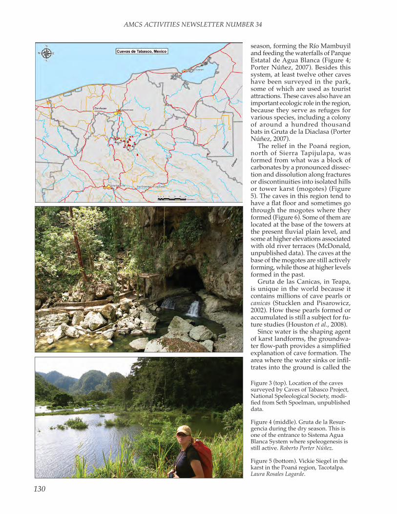
AMCS ACTIVITIES NEwSLETTER NUMBER 34
130
Figure 3 (top). location of the caves surveyed by Caves of tabasco Project, national Speleological Society, modi-fied from Seth Spoelman, unpublished data.
Figure 4 (middle). Gruta de la resur-gencia during the dry season. this is one of the entrance to Sistema Agua Blanca System where speleogenesis is still active. Roberto Porter Núñez.
Figure 5 (bottom). vickie Siegel in the karst in the Poaná region, tacotalpa. Laura Rosales Lagarde.
season, forming the río Mambuyil and feeding the waterfalls of Parque estatal de Agua Blanca (Figure 4; Porter núñez, 2007). Besides this system, at least twelve other caves have been surveyed in the park, some of which are used as tourist attractions. these caves also have an important ecologic role in the region, because they serve as refuges for various species, including a colony of around a hundred thousand bats in Gruta de la Diaclasa (Porter núñez, 2007).
the relief in the Poaná region, north of Sierra tapijulapa, was formed from what was a block of carbonates by a pronounced dissec-tion and dissolution along fractures or discontinuities into isolated hills or tower karst (mogotes) (Figure 5). the caves in this region tend to have a flat floor and sometimes go through the mogotes where they formed (Figure 6). Some of them are located at the base of the towers at the present fluvial plain level, and some at higher elevations associated with old river terraces (McDonald, unpublished data). the caves at the base of the mogotes are still actively forming, while those at higher levels formed in the past.
Gruta de las Canicas, in teapa, is unique in the world because it contains millions of cave pearls or canicas (Stucklen and Pisarowicz, 2002). How these pearls formed or accumulated is still a subject for fu-ture studies (Houston et al., 2008).
Since water is the shaping agent of karst landforms, the groundwa-ter flow-path provides a simplified explanation of cave formation. the area where the water sinks or infil-trates into the ground is called the

AMCS ACTIVITIES NEwSLETTER NUMBER 34
131
recharge area (Figure 8). Here, the acidity of the water increases as it infiltrates through the soil, and it then attacks the underlying rock, slowly enlarging fractures to form caves and carrying all the dissolved minerals away. The infiltrating water continues its underground journey, tending to concentrate in an aquifer or the rocks able to hold water in cavities, fractures, or pores. Finally, the groundwater returns back to the surface at the discharge point or spring (Ford and williams, 2007). But because of the geologic context in tabasco, the cave-formation pro-cesses and groundwater flow are more complicated than shown.
Speleogenesis can still be active, such as at Sistema Agua Blanca, Ma-cuspana (Figure 4), or inactive, like in most of the caves at Poaná (Fig-ure 6) or Arroyo Chispa, tacotalpa. Meanwhile, the mineral-enriched water can reach the caves and release the minerals it is carrying, forming speleothems such as stalactites and stalagmites like those in Grutas de Coconá (Figure 9).
Some groundwater is driven deeper into the subsurface, travel-ing through longer paths, increasing the time it has to dissolve the rocks and become more mineralized. in tabasco, some of the rocks at depth contain minerals more soluble than the calcite in limestone, such as halite (naCl, sodium chloride) and
Figure 6. Seth Spoelman in a passage in Safari Cave in the Poaná region, tacotalpa, with an evident contrast between the cave walls. One was sculpted by water when the cave was totally filled with water, and the other has flowstone formed after the water level dropped. Vickie Siegel.
Figure 7. José Antonio nieves rodríguez in one of the rooms at Gruta de las Canicas
with a floor covered with cave pearls. Roberto Porter Núñez.
anhydrite (CaSO4, calcium sulfate). this water can fur-ther react in the subsurface or get enriched by deep gases until it discharges as hydrogen-sulfide-rich water. Sulfidic water containing this H2S gas emerges from several springs at or near tabasco’s mountain slopes,
Figure 8. Sketch showing a simplified model of groundwater flow and cave formation,
modified from Toth, 1999, and Klimchouk, 2007.

AMCS ACTIVITIES NEwSLETTER NUMBER 34
132
such as the Balneario el Azufre at teapa or Cueva de las Sardinas [Cueva de la villa luz] in tacotalpa (Figure 10, rosales-lagarde et al., 2007; Hose et al., 2000). the toxic hydrogen sulfide, with its charac-teristic rotten-egg smell, escapes to the atmosphere as a gas. lengthy exposure or high concentrations can be fatal. Such conditions are found in some of the darkest and most remote chambers of Cueva de las Sardinas, where despite our ability to detect low concentrations of this gas, our senses soon get numb.
the presence of H2S can greatly affect the cave’s morphology and appearance (Figure 10). Spring water with high sulfide concentra-tions is clear (Figure 11), but when the sulfide is oxidized to elemental colloidal sulfur it colors the water white (Figure 12). the dissolved sulfide and perhaps the sulfur are nutrients for microorganisms that form white strings or pink filamen-tous and mat-shaped colonies.
when H2S passes to the atmo-sphere, it can be oxidized to produce yellow patches of elemental sulfur (Figure 13) on the walls or corrosive sulfuric acid. Some microorganisms form hanging films called snottites, where they enhance the production of this acid while feeding on the hy-drogen sulfide (Figure 14). When the sulfuric acid comes in contact with the carbonate rock on the cave walls, ceiling, or floor, it dissolves the rock, producing a white gypsum paste or clear crystals of gypsum called selenite. the presence of microorgan-isms associated with the gypsum may indicate their involvement in these reactions. the best example of
Figure 9 (top). the Salón de los Fan-tasmas in Gruta de Coconá, teapa,
contains a variety of speleothems such as stalactites, stalagmites, and
columns. Roberto Porter Núñez.
Figure 10 (middle). Simplified scheme of the chemical reactions affecting Cueva de Las Sardinas, modified
from Hose et al., 2000, and Palmer and Palmer, 1998.
Figure 11 (bottom). Balneario el Azufre, teapa, one of several sul-
fidic springs in Tabasco. Laura Rosales Lagarde.

AMCS ACTIVITIES NEwSLETTER NUMBER 34
133
Figure 12 (above left). Diana northup inspects the white stream coming out from the Cueva de las Sardinas (Cueva de la villa luz) resurgence, in contrast with the surface stream from the left. the white water is due to the presence of colloidal sulfur and sulfur-oxidizing bacteria colonies. Kenneth Ingham.
Figure 13 (above right). Selenite and elemental sulfur (yellow) are some of the minerals deposited in the walls and ceilings of Cueva de las Sar-dinas and other sulfidic caves in Tabasco. Louise Hose wears safety gear for protetion from toxic hydrogen sulfide. Dan Jones.
Figure 14 (below left). Colonies of sulfur-oxidizing chemoautotrophic microorganisms informally called snottites. they hang from ceilings and walls in Cueva de las Sardinas. Kenneth Ingham.
Figure 15 (below right). The sulfidic water inside Cueva de Las Sardinas and its most prominent inhabitant, the fish Poecilia mexicana. These fish measure an average of 3 centimeters (Plath, personal communication). Roberto Porter Núñez.
this speleogenesis process is Cueva de las Sardinas. in this cave the H2S in the water and atmosphere serves as an energy source for a very rich ecosystem, despite its toxicity. One of the most distinctive habitants of this cave is the fish Poecilia mexicana (Figure 15).

AMCS ACTIVITIES NEwSLETTER NUMBER 34
134
There is evidence of human cave exploration dating to at least
1000 years BC (terreros espinosa, 2006). From that time till the Span-iards’ arrival, Zoque people left ceramic objects, and between 700 and 1500 AD they also placed ob-sidian blades and human burials in at least twenty caves in the tabasco mountain ranges (Figure 16; ter-reros espinosa, unpublished data). For these earlier visitors caves were sacred places. Furthermore, this has lasted to the present time, and local inhabitants still perform rituals, including witchcraft ceremonies, inside the caves for the purposes of requesting rain, prosperous crops, and improvement in their economy. An example of these rituals is the “la Pesca” ceremony conducted at Cueva de las Sardinas (Pisarowicz and Hose, 2001; tobler et al., 2011).
later, in 1892, rovirosa docu-mented his exploration of Grutas de Coconá at teapa, now a tourist cave (Figure 9; rovirosa, 1978). More recently, several caving groups have documented their visits to the caves of tabasco by producing cave maps. these maps serve as the founda-tion for further studies. A complete cave map consists of a plan view, a profile, and cross sections as shown in Figure 17. Some of these groups
are the Caves of tabasco Project of the national Speleological Society, Sociedad espeleológica de tabasco, and Grupo Jaguar extremo.
Besides their cultural use, sev-eral caves in tabasco are exploited as tourist attractions due to the beauty of the rock formations or speleothems in them, like those at Grutas de Coconá, teapa (Figure 9), or the sense of adventure gained by the visitors. the speleothems potentially contain a record of past
who started the project, and Peter lord. Penelope Boston, my adviser, opened the door to this project and has supported me [laura rosales, the genuine author of this article] through it. louise Hose, Diana northup, Mike Spilde, and other members from the Subsurface life in Mineral environments (SliMe) team got me started by sharing their work. Martin Plath, ingo Schlup, Michael tobler, Dr. José Palacios vargas, and other researchers shared their ideas
Figure 16. Héctor Gómez Alejo with some of the archaeological remains found in tabasco caves. Roberto Porter Nuñez.
Figure 17. Example of a cave map, including a plan view, profile or lon-gitudinal section, and transverse sections (Siegel, 2009).
Figure 18. Arroyo Azul karst spring at taco-talpa serves as a drinking-water source for
several communities in the area. Laura Rosales Lagarde.
climate (Ford and williams, 2007). to know how climate has changed in the past can help us understand present changes. Caves can also pre-serve evidence of changes in the landscape or past floods. Cave springs can be a water source for nearby commu-nities, as at Sistema Cerro Blanco or the Arroyo Azul karst spring (Figure 18).
Acknowledgements: Many people have contributed to the development of the study of tabasco caves. All the members of the Caves of tabasco Project shared their enthusiasm for finding and surveying the tabasco caves, especially Jim Pisarowicz,

AMCS ACTIVITIES NEwSLETTER NUMBER 34
135
and knowledge. the inhabitants and authorities in the tacotalpa, teapa,and Macuspana municipali-ties hosted us and shared their caves with us. Consejo nacional de Cien-cia y tecnología and the national Cave and Karst research institute provided economic support. the instituto de Geología at the Universi-dad nacional Autónoma de México, Pemex exploración y Producción, the Comisión nacional del Agua, and the instituto nacional de Geografía y estadística supported us with data and logistics. Hugo Gutiérrez Jurado, Marcia Bardy, and Diana northup reviewed this document.
the Caves of tabasco Project has a web site at http://www.garot .com/tabasco/.
Ford, D., and P. williams, 2007. Karst Hydrogeology and Geomorphology, John wiley and Sons, 562 pp.
Hose, l. D., A. n. Palmer, M. v. Palmer, D. e. northup, P. J. Bos-ton, and H. r. DuChene, 2000. Microbiology and geochemistry in a hydrogen-sulphide-rich karst environment. Chemical Geology, 169: 399–423.
Houston, S., P. S. Mozley, A. r. Campbell, and P. Boston. Petrol-ogy and Chemistry of Cave Pearls from Gruta De las Canicas (Cave of the Marbles), tabasco, Mexico: Geological Society of America Abstracts with Programs, 40: no. 6, p. 479.
Klimchouk, A., 2007. Hypogene Spe-leogenesis: Hydrogeological and Morphogenetic Perspective. national Cave and Karst research institute Special Paper no. 1, Carlsbad, new Mexico, 106 pp.
lugo Hubp, J., 1989. Diccionario Geo-morfológico. Universidad nacional Autónoma de México, México, 337 pp.
Meneses-rocha, J. J., 2001. tectonic evolution of the ixtapa graben, an example of a strike-slip basin in southeastern Mexico. implications for regional petroleum systems. in: The western Gulf of Mexico Basin: Tectonics, sedimentary basins, and petroleum systems (C. Bartolini, r. T. Buffler, and A. Cantú-Chapa, eds.). American Association of Petroleum Geologists Memoir
number 75, p. 183–216.Pisarowicz, J., 1987. Caving in ta-
basco. AMCS Activities Newsletter 16: 30–37.
Pisarowicz, J., P. rykwalder, l. Hose, and C. Amidon, 2005. return to tabasco. AMCS Activities Newslet-ter 28: 27–57.
Pisarowicz J., and l. D. Hose, 2001. the Acid test: Cueva de villa luz. AMCS Activities Newsletter 24: 48–54.
Palmer, A. n., and M. v. Palmer, 1998. Geochemistry of Cueva De villa luz, Mexico, an Active H2S Cave (abstract). Journal of Cave and Karst Studies 60: 188.
Porter núñez, r., 2007. estudio de factibilidad de actividades de turismo alternativo en el Parque estatal Agua Blanca. in: Plan Maestro para el Desarrollo turístico del Parque Estatal Agua Blanca, Ta-basco, México (C. Zequeira larios, l. Gama Campillo, A. Galindo Alcántara, eds.). Universidad Juárez Autónoma de tabasco, tabasco, México.
rosales-lagarde, l., P. J. Boston, M. Spilde, A. Campbell, and K. w. Stafford, 2007. Cuevas de tabasco: en búsqueda de la extensión de la espeleogénesis hipogénica en el área (abstract ). I Congreso FEPUR / V Congreso FEALC, Des-cubriendo el mundo subterráneo de América Latina y el Caribe, Programa de Conferencias y Actividades, p. 135–136.
rovirosa, J. n., 1978. viaje a teapa y a las sierras que concurren a la formación de su valle. in: Obras Científicas de José N. Rovirosa (1887-1910), Consejo editorial del Gobierno del estado de tabasco, ediciones de la Sociedad Mexicana de Historia natural, México, D.F., p. 687–711.
Siegel, v., 2009. tabasco 2009, AMCS Activities Newsletter 32: 70–76.
Stucklen, B., and J. Pisarowicz, 2002. tabasco 2001: AMCS Activities Newsletter 25, 34–39.
terreros espinosa, e., 2006. Arque-ología zoque de la región serrana tabasqueña. in: Presencia zoque: una aproximación multidisciplinaria (D. Aramoni Calderón, t. A. lee whiting y M. lisbona Guillén, coords.). Universidad de Ciencias y Artes de Chiapas, Consejo de Ciencia y tecnología del estado de Chiapas, Universidad Autónoma de Chiapas, Universidad nacional Autónoma de México, México, D.F., p. 223–256.
tobler, M., Z. w. Culumber, M. Plath, K. O. winemiller, and G. G. rosenthal, 2011. An indigenous religious ritual selects for resis-tance to a toxicant in a livebearing fish. Biology Letters 7: 229–232. doi: 10.1098/rsbl.2010.0663.
toth, J., 1999. Groundwater as a geologic agent: An overview of the causes, processes, and mani-festations. Hydrogeology Journal 7: 1–14.
tabasco Subterraneo
El carso o carst se define como el conjunto de fenómenos causados por la disolución de rocas por agua subterránea o superficial, y uno de los fenómenos son las cuevas. en el estado de tabasco el carso forma parte de las regiones de colinas y las bases de montañas, so-bre todo cerca de la base de las pendientes en la planicie fluvial. La morfología del carso va desde un desarrollo moderado, como en la Sierra tapijulapa, a uno bastante avanzado. las rocas que sufren la disolución son principalmente calizas cretácicas y dolomitas, así como algunas calizas más jóvenes, conglomerados y areniscas. Algunas de estas rocas son afectadas por los pliegues, fallas y diaclasas. estas estructuras modifican el flujo de agua y por lo tanto los procesos de formación de cuevas, influyendo en la forma y tamaño de los pasajes. los pasajes de cuevas sirven como refugio u hogar para una variedad de especies, desde microorganismos hasta vertebrados, tanto aquellas que se han adaptado completamente a la vida en la oscuridad y a la baja disponibilidad de nutrientes y toda su vida transcurre en el interior de las cuevas, como aquellas que ocasionalmente visitan las cuevas, alternando entre la vida en la superficie y debajo de ella.
AMCS ACTIVITIES NEwSLETTER NUMBER 34
136
CAve BAtS OF tABASCO
Cornelio Sánchez-Hernández and María de lourdes romero-Almaraz
Bats belong to the class Mammalia, members of which, among other
characteristics, have their bodies covered with hair and feed their offspring with milk. Some people think that bats are blind mice with wings, but this is not true. Bats are a different group, and they are not blind. when they are born, they already have wings. For this reason, they make up the order Chiroptera, a word that derives from the roots chiros = hand and pteron = wing, that is, mammals with hands modified into wings.
in American pre-Hispanic cultures they were considered gods and symbols of long life, wealth, and fertility; and they were recognized as messengers from the sky, the earth, and the underworld because they inhabit caves or the interior of the earth. But today, little is known about their importance, and the bad reputation of vampires (bats that feed on blood) has favored the destruction of their populations. we cannot deny the problem that the existence of vampires is for men and domestic animals, because they are the main vectors of rabies, but bats that do not feed on blood are more numerous and are important from various points of view.
Among bats, there are insectivo-rous species. they are the most im-portant predators of nocturnal insects that may become pests. Other bats are pollenivorous or nectivorous, and they carry out the pollination and fertilization of plants of economic importance for food and culture, like the agave from which tequila is
obtained. Frugivorous bats help in the dispersal of the seeds of many fruit trees, and they help reforestation in the areas where they are distributed. Additionally, the excreta, or guano, of many types of bats is used as a fertilizer with a high concentration of nitrogen, and it is also the basis of many food chains in caves or other places where it is concentrated.
Bats are mainly nocturnal, and they navigate by echolocation, that is,
they emit ultrasounds through the larynx. when echoes return, they are heard by the bats, allowing them to detect the presence, form, and movements of objects. thus they can find their way and their food even in complete darkness.
they have great physical endur-ance and capacity for flight, and some species can migrate hundreds or thousands of miles in search of places with favorable temperatures and abundant food. For example, the free-tailed bats Tadarida brasiliensis travel from the southern United States and northern Mexico to central and southern Mexico, and every year they return to their places of origin. Other species live in extremely cold environ-ments, and they do not migrate, but hibernate, that is, they lower their temperature and metabolism to a level at which the energy cost is very low, and they can survive in hibernation for four or five months without food during the winter.
In tabasco, sixty-one species of bats have been recorded, and
of these, thirty-five (57 percent) are associated with cave systems (Sánchez-Hernández et al., 2005),
and one of them, the pollenivorous bat Glossophaga morenoi, is endemic, found only in Mexico. Of these spe-cies, sixteen feed on insects, eight on fruit, five on pollen, and three on blood. One species is omnivo-rous, one is piscivorous (it feeds on fish), and one is a carnivore. Also, fourteen of the species breed once a year; eight, twice; and nine species, three or more times per year. Four species are considered threatened, and four are endangered (nOM-059-eCOl-2001).
there are many caves in tabasco; among the most important are Cueva de las Sardinas [Cueva de la villa luz], the caves of the teapa region, where the best-known is Grutas de Coconá, and the Agua Blanca cave system in the municipality of Ma-cuspana. in Cueva de las Sardinas, colonies of thousands of bats of the family Mormoopidae, such as Mor-moops megalophylla, Pteronotus davyi, P. parnellii, and P. personatus have been recorded (Gordon and rosen, 1962; Palacios-vargas, 2009; ibáñez et al., 2000), as well as smaller colonies of P. gymnonotus (ibáñez et al., 2000) and M. nigricans (rosales l., personal communication).
in the region of teapa there are twenty-six species in five families associated with caves, among which we can highlight the presence of Bal-antiopteryx io, because this is the only place where it has been recorded in tabasco, as well as six of the eight endangered or threatened species (Sánchez-Hernández and romero-Almaraz, 1995). in the Agua Blanca system there are at least nineteen species. this area is very important because some species considered

AMCS ACTIVITIES NEwSLETTER NUMBER 34
137
Family Emballonuridae Balantiopteryx io Thomas´s Sac-winged Bat Insectivorous 1 x Balantiopteryx plicata Gray Sac-winged Bat Insectivorous 1 x x Peropteryx kappleri Greater Dog-like Bat Insectivorous 1 Pr x Peropteryx macrotis Lesser Dog-like Bat Insectivorous 1 x Saccopteryx bilineata Greater Sac-winged bat Insectivorous 1 x Family Noctilionidae Noctilio leporinus Greater Bulldog Bat Piscivorous 2 x x
Family Mormoopidae Mormoops megalophylla Peters´s Ghost-faced Bat Insectivorous 2 x x xPteronotus davyi Davy´s Naked-backed Bat Insectivorous 1 x xPteronotus gymnonotus Big Naked-backed Bat Insectivorous Pr x Pteronotus parnellii Common Mustached Bat Insectivorous 1 x x xPteronotus personatus Wagner´s Mustached Bat Insectivorous 1 x x x
Family Phyllostomidae Micronycteris microtis Common Big-eared Bat Insectivorous 1 x xDesmodus rotundus Common Vampire Bat Hematophagous 1 x x xDiaemus youngi White-winged Vampire Bat Hematophagous Pr x Diphylla ecaudata Hairy-legged Vampire Bat Hematophagous 2 x Chrotopterus auritus Woolly False Vampire Bat Omnivorous 1 Th xTrachops cirrhosus Fringe-lipped Bat Carnivorous Th xLonchorhina aurita Common Sword-nosed Bat Insectivorous 1 Th x xMacrophyllum macrophyllum Long-legged Bat Insectivorous 2 Th x Anoura geoffroyi Geoffroy’s Tailless Bat Pollenivorous 1 Choeroniscus godmani Godman´s Long-tongued Bat Pollenivorous Glossophaga morenoi Western Long-tongued Bat Pollenivorous 3 Glossophaga soricina Pallas´ Long-tongued Bat Pollenivorous 3 x xHylonycteris underwoodi Underwood´s Long-tongued Bat Pollenivorous 2 x xArtibeus intermedius Intermediate Fruit-eating Bat Frugivorous 3 Artibeus jamaicensis Jamaican Fruit-eating Bat Frugivorous 3 x xArtibeus lituratus Great Fruit-eating Bat Frugivorous 3 xCarollia sowelli Sowell´s Short-tailed Bat Frugivorous 2 x xCarollia perspicillata Seba´s Short-tailed Bat Frugivorous 3 x xCarollia subrufa Gray Short-tailed Bat Frugivorous 2 Dermanura phaeotis Pygmy Fruit-eating Bat Frugivorous 3 x xSturnira lilium Little Yellow-shouldered Bat Frugivorous 3 x x
Family Natalidae Natalus stramineus Mexican Funnel-eared Bat Insectivorous 1 x x
Family Vespertilionidae Myotis nigricans Black Myotis Insectivorous 3 Pr x x Myotis velifer Cave Myotis Insectivorous 2 x
Scientific Name Common Name Feeding Reproductive Status Caves Habits Events NOM-059 1 2 3
BaTS aSSOCIaTED WITH CaVES IN THE STaTE OF TaBaSCO
NOM-059 status: Pr, protected species; Th, threatened species. Caves: 1, Cueva de Las Sardinas; 2, Teapa mu-nicipality; 3, Parque agua Blanca.

AMCS ACTIVITIES NEwSLETTER NUMBER 34
138
Photographs of some bats recorded in the caves of the state of tabasco. 1. Gray sac-winged bat, Balantiopteryx plicata; photo Cornelio Sánchez Hernán-dez. 2. Peters´s ghost-faced bat, Mormoops megalophylla; photo Cornelio Sánchez Hernández. 3. Greater bulldog bat, Noctilio leporinus; photo Cornelio Sánchez Hernández. 4. Common mustached bat, Pteronotus parnellii; photo Cornelio Sánchez Hernández. 5. Common vampire bat, Desmodus rotundus; photo María de lourdes romero Almaraz. 6. Mexican funnel-eared bat, Natalus stramineus; photo María de lourdes romero Almaraz.
rare are found there; among them are Chrotopterus auritus, Trachops cirrhosus, and Lonchorhina aurita (Sánchez-Hernández and romero-Almaraz, 1995; Castro-luna, 2007).
In spite of the extraordinary crea-tures that bats are, they are among
the animals that are least understood and most threatened by man. the mere mention of the word bat makes most people think of dirty and dan-gerous creatures. this makes them feared and pursued creatures and fa-vors their indiscriminate destruction, without considering that without them some ecosystems cannot be sustained, and this could lead to the extinction of many species, includ-ing man. in addition to deliberate destruction, agriculture, ranching, urbanization, and nowadays climate change are altering or destroying the areas where bats feed, thus causing a decrease in their numbers and in some cases their extinction.
it is undeniable that education is the best weapon for the conservation of bats, because it makes people aware of their diversity and importance. this must be done at all levels. if people get to understand the issue of vampires and to know about the biology, behavior, and importance of beneficial bats, they will help to reduce disturbance and mortality of the beneficial species. However, to benefit their populations we must also preserve natural areas appro-priate for the bats’ existence. their roosts must be protected from van-dalism, and, as far as possible, people must be requested not to visit those places so they do not cause them unnecessary disturbance. when the roosts are part of a tourist attraction, the administrators should see that they remain isolated and in total or semi-darkness, so that light and the presence of people do not chase the bats out of the area.
Acknowledgements: to laura rosales for reporting the presence of the Myotis nigricans colony in Cueva de las Sardinas and for her logistical support. to José Palacios for provid-ing us literature about Cueva de las Sardinas. to ingo Schlupp for the in-vitation to collaborate on the project. laura lara and laura rosales helped

AMCS ACTIVITIES NEwSLETTER NUMBER 34
139
with the english translation.
Castro-luna, A. A., 2007. Cambios en los ensamblajes de murciélagos en un paisaje modificado por ac-tividades humanas en el trópico húmedo de México. tesis de Doc-torado en ecología y Manejo de recursos naturales, instituto de ecología, A. C., veracruz. 119 p.
Gordon, M. S., and D. e. rosen, 1962. A cavernicolous form of the Poeciliid fish Poecilia sphenops from tabasco, Mexico. Copeia 2: 360–368.
ibáñez, C., r. lópez-wilchis, J. Juste B., and M. A. león Galván, 2000. echolocation calls and a noteworthy record of Pteronotus
gymnonotus (Chiroptera, Mor-moopidae) from tabasco, Mex-ico. Southwestern Naturalist 45: 345–347.
Palacios-vargas, J. G., 2009. los estudios Bioespeleológicos de la Cueva de las Sardinas y sus Perspectivas. Mundos Subterráneos 20: 22–26. (Also printed in IX Con-greso Nacional Mexicano de Espele-ología, Memorias, pages 170–173, http://www.umae.org/cong08/articulos/memorias35.pdf.)
Sánchez-Hernández, C., and M. l. romero-Almaraz, 1995. Murcié-lagos de Tabasco y Campeche: una propuesta para su conservación. Cuadernos 24. instituto de Bi-ología, Universidad nacional
Autónoma de México, 215 p.Sánchez-Hernández, C., M. l.
romero-Almaraz, and C. García-estrada, 2005. Mamíferos. in: Biodiversidad del estado de Tabasco (J. Bueno, F. álvarez, and S. San-tiago, eds.) instituto de Biología, UNAM−CONABIO, México. p. 285–304.
Secretaría de Medio Ambiente y recursos naturales, 2002. nor-ma Oficial Mexicana NOM-059-eCOl-2001, protección ambien-tal—especies nativas de México de flora y fauna silvestres—Cate-gorías de riesgo y especificaciones para su inclusión, exclusión o cambio—lista de especies en riesgo. Diario Oficial, 6 de marzo del 2002: 1–56.
Murciélagos de Cuevas de tabasco
Se han identificado sesenta y un especies de murciélagos en Tabasco, y de ellas, treinta y cinco han sido asociadas con sistemas de cuevas, y una de el-las, el murciélago polinífero Glossophaga morenoi, es endémico, únicamente encontrado en México. De estas especies, dieciséis se alimentan de insectos, ocho de frutas, cinco de polen y tres de sangre. Una especie es omnívora, una es ictiófaga y una es carnívora. Cuatro especies se consideran amenazadas de extinción y cuatro están en riesgo de extinción. Debido a la mala repu-tación de los murciélagos vampiro, es necesario educar a la gente para que sea entendido que la gran mayoría de murciélagos son benéficos y no deben ser molestados. la preservación de áreas esenciales para los murciélagos es también importante.

AMCS ACTIVITIES NEwSLETTER NUMBER 34
140
ArtHOPOD eCOlOGY in CUevA De lAS SArDinAS, tACOtAlPA, tABASCO
José G. Palacios-vargas et al.*
[email protected]*Gabriela Castaño-Meneses, Daniel A. estrada, Blanca Mejía,leopoldo Cutz, ricardo iglesias, and Carmen Maldonado
Figure 1. A. Mesostigmata mite. B. neanuridae springtail (Americanura sadina-sensis). C. Hypogastruridae springtail. D. Dicyrtomidae springtail.
Cueva de las Sardinas (aka Cueva de villa luz) is located 2 kilo-
meters from villa tapijulapa, in a remnant of tropical forest locally known as Parque villa luz, in the municipio of tacotalpa, tabasco. the importance of this cave has been stressed by Hose (1999) because of its rich biodiversity, especially the chemoautotrophic bacteria that are developed in elongated biological structures with a gelatinous (or mucus-like) appearance calls mocoti-tas or snottites (Hose and Pisarowicz 1999). there are three kinds of energy sources in this cave: the guano from bat colonies, the dead leaves and other detritus falling through the skylight openings to cave rooms, and the presence of colonies of snottites and other types of bacteria. the rooms where these resources are located provide both uniform environments and niches that are habitats for flora and fauna.
Micro-arthropods, principally springtails (insects) and mites (arach-nids), are the most diverse and abundant organisms in the soil and other subterranean environments. Some authors have considered them “plankton underground,” for their important role in the underground food chain, helping to recycle nutri-ents and providing food for other, larger animals.
There have been several studies of the arthropods in Cueva de las
Sardinas, but they are mainly taxo-nomic (estrada and iglesias, 2003; estrada and Mejía-recamier, 2005; Palacios-vargas and estrada, 2003; Palacios-vargas et al., 2009) and say little about the communities and the complex food webs that occur there. ecological data of micro-arthropod communities are provided here based on quarterly sampling from March 2001 to March 2002.
Biodiversity in this ecosystem was studied in three different habi-tat types in twelve different rooms inside the cave. the ecosystems in
three of them are based on guano, three on dead leaves, and three on colonies of snottites; three places that had only bare soil serve as a control.
in each selected room, we col-lected about 600 cubic centimeters of sediment. these samples were taken to the laboratory for processing and arthropod extraction. extracted arthropods were fixed in alcohol, separated by species, and counted. then, we calculated the abundance, indices of ecological diversity, and comparison of species diversity for each season of the year. Using statistical methods, we evaluated

AMCS ACTIVITIES NEwSLETTER NUMBER 34
141
the effect of the habitat type at each collection point on the density of the arthropods.
A total of 27,913 specimens were collected, with the greatest abun-dance in the guano habitats (21,422 specimens, or 7 specimens per cubic centimeter of cave soil), followed by the plant-detritus habitats (4,455 specimens, or 1.5 cm−3), the bacterial-colony habitats (1,614 specimens, or 0.5 cm−3), and finally the control areas (422 specimens, or 0.1 cm−3). The environment has a significant effect on the density of arthropods, especially in the dead leaves, while the collection points and their inter-action with the habitat did not seem to have a great effect on the density of micro-arthropods.
Plant detritus had the highest di-versity, followed by the control areas, guano, and the soil under bacterial colonies. Species with the most resis-tance to highly acidic conditions are mites of the families Histiostomidae (Astigmata) and Oppidae (Cryp-tostigmata). the mites, mainly Me-sostigmata, are the most abundant micro-arthropods in Cueva de las Sardinas (Figure 1A). this is very different from what have been found in other caves, where springtails
are the dominant group. in Cueva de las Sardinas, springtails (Figure 1B–1D) are only sixth in abundance, after the Mesostigmata, Astigmata, Cryptostigmata, Prostigmata, and beetle larvae.
the rich fauna in this cave can be explained by the diversity of microenvironments and sources of nutrients available for arthropods. the surrounding vegetation may also have an important role.
la Cueva de las Sardinas has the most diverse fauna known in Mexico, around 170 species if adding the arthropods and bats. However, some species live in several different environments, while others have limited distribution.
this project was made possible thanks to support from COnACyt project 3965-V. The field work was done with the help of Ada ruiz Cas-tillo, Saúl Aguilar, Mariano García and Arturo Fuentes.
estrada, D. A., and r. iglesias. 2003. Biodiversidad de ácaros oribáti-dos (Acari:Cryptostigmata) de la Cueva de las Sardinas, tabasco, México. Entomología Mexicana 2:46–52.
estrada, D. A., and B. e. Mejía-recamier. 2005. Cunáxidos de la Cueva de las Sardinas, ta-basco, México, in Memorias del VII Congreso Nacional Mexicano de Espeleología, Monterrey, México. p. 44–46.
Hose, l. D. 1999. exploring one of the world’s Strangest Caves. The Explorers Journal (spring): p. 22–27.
Hose, l. D., and J. A. Pisarowicz. 1999. Cueva de villa luz, tabasco, Mexico: reconnaissance study of an active sulfur spring cave and ecosystem. Journal of Cave and Karst Studies 61:13–21.
Palacios-vargas, J. G., and D. es-trada. 2003. Comparación entre los colémbolos que habitan dentro de la Cueva de las Sardinas y las que viven en el exterior. Memorias VI Congreso Nacional Mexicano de Espeleología, Tuxtla Gutiérrez, Chiapas, México: 11–14.
Palacios-vargas, J. G., J. C. Simón Benito, and J. Paniagua nuca-mendi. 2009. especies nuevas de Americanura (Collembola: nenauridae) de América latina. Revista Mexicana de Biodiversidad, 80:431–443.
ecología de los artrópodos de la Cueva de las Sardinas, tacotalpa, tabasco
la Cueva de las Sardinas se encuentra a dos kilómetros de la villa tapijulapa, en un relicto de selva tropical conocido localmente como Parque villa luz, en el municipio de tacotalpa, tabasco. la riqueza faunística de la cueva de las Sardinas puede explicarse por la gran diversidad de mi-croambientes o fuentes de nutrientes disponibles para los artrópodos. la vegetación circundante también puede tener un papel importante. la Cueva de las Sardinas es la que tiene la fauna más diversa de las que se conocen en México, ya que si sumamos los artrópodos y los murciélagos tienen cerca de 170 especies. Sin embargo algunas viven en varios de estos ambientes y otras tienen distribución restringida.

AMCS ACTIVITIES NEwSLETTER NUMBER 34
142
MiCrOOrGAniSMS At CUevA De lAS SArDinAS
Diana northup and Dan Jones
Cueva de las Sardinas (Cueva de villa luz) is really a paradise of
microbial biodiversity, with the pres-ence of the groups Bacteria, Archaea, and other micro-organisms that live in various types of communities along the rooms and streams of the cave. white biological structures with viscose appearance, known as mocotitas or snottites, hang from the walls and ceilings of the cave. these snottites are formed by microbial biofilms or aggregates of microor-ganisms surrounded by gel secre-tions, or mucus, used as a protective mechanism. the snottite microbial community is formed primarily by an acid-loving, sulfur-eating bac-terium known as Acidithiobacillus thiooxidans. A. thiooxidans consumes hydrogen sulfide (H2S) gas from the cave atmosphere, and produces sulfuric acid (H2SO4) as a byproduct.
Because of this bacterial acid pro-duction, the snottite biofilms are very acidic and can have pH values below 0, which is more acidic than battery acid.
Other organisms that live in snot-tites include different species of bacteria, archaea, nematodes, some fungi and protozoa, and other mi-croscopic invertebrates. little is known about the other organisms from snottites, and there are still new species to be discovered and described.
in other places in the cave, a thick black sludge covers the white bottom of the stream. Oxygen is nonexistent here, but sulfate-reducing bacteria turn sulfate molecules into hydrogen sulfide that is used by other bacteria. Thick biofilms called phlegm balls cover the fractures where springs emanate, discharging hydrogen
sulfide and other gases. These bio-films contain communities rich in Epsilonproteobacteria, which oxidize hydrogen sulfide, and also some Ar-chaea that generate methane gas.
In the darkest and deepest regions of the cave, there are rocks covered
with a green biofilm sticking out from the stream. within this green biofilm are communities of Archaea of the genus Ferroplasma, a group of organisms that get their energy from iron, prefer acidic conditions, and have no cell wall. Other com-munity members include the tM7 phylum, a new division of bacteria, and bacteria that like salty or acid conditions and have names like Salinisphaera, Acidithiobacillus (which also lives in the snottites), Haloth-iobacillus, and Acidiphilium. Some of these bacteria metabolize sulfur or
Snottites hanging on the wall in one of the rooms in Cueva de Las Sardinas. Image size ~10 cm. Kenneth Ingham.
Phlegm balls cover an opening in the wall at Phlegm Spring in Cueva de las Sardinas. Kenneth Ingham.

AMCS ACTIVITIES NEwSLETTER NUMBER 34
143
iron, rather than the organic carbon that we humans eat.
Above the stream and in dry places like the ragu Passage, bio-vermiculations bloom on the walls of the cave. these biovermiculations resemble worm tubes on the walls and contain a diverse community of Bacteria and Archaea, including organisms that generate methane or utilize sulfur, carbon, iron, nitrite, or ammonia for energy.
So, in whatever community the microbes live, they can take advan-tage of the environmental condi-tions, difficult for others, provided by Cueva de las Sardinas. the microbes, in turn, are food for other organisms that live in the cave, in-cluding the fish of the species Poecila mexicana.
Green biofilms cover rocks sticking out of the stream in the Big Room. Image ~30 cm. Kenneth Ingham.
Biovermiculations on the wall in the ragu Passage. image size ~30 cm. Kenneth Ingham.
Microorganismos de la Cueva de las Sardinas
la Cueva de las Sardinas es realmente un paraíso de la bio-diversidad microbiana con presencia de los grupos Bacteria, Archaea y otros microorganismos viviendo en varios tipos de comunidades a lo largo de las cámaras y arroyos de la cueva. las “snottites” o mocotitas son formaciones de color blanco con apariencia y textura viscosa que cuelgan de las paredes y el techo de esta cueva. en algunos lugares de la cueva un espeso lodo negro cubre el fondo del arroyo color blanco. en este lodo no existe el oxígeno pero bacterias reductoras de sulfato con-vierten moléculas de sulfato en ácido sulfhídrico, usado a su vez por otras bacterias. Sobresaliendo del arroyo color blanco, en las cámaras más oscuras y profundas de la cueva hay rocas cubiertas por biopelículas verdes.

AMCS ACTIVITIES NEwSLETTER NUMBER 34
144
It was in the fall of 1980 that I first met wes Skiles. i had driven down to Jacksonville non-stop from Maryland to continue training in deep diving with Sheck exley. Sheck was teaching me how to dive deep on air for an expedition i had planned for 1981 to the San Agustín sump in Oaxaca. He recommended i pick up a set of twin 104s and went so far as to recommend a dive shop where i could get them, the Aquifer Dive Center in Jacksonville. it happened to be the dive shop owned by Clark Pit-cairn. wes worked for Clark and split his time equally between surfing and cave diving. So at that time wes was a 23-year-old cave diving surfer bum, doing anything for a weekly cave div-ing fix and catching the next wave. Like several of us who were lucky enough in that era, wes had the good fortune of be-ing Sheck’s protégé—a redneck protégé with a wicked sense of humor.
i lost track of wes until the fall of 1987, when an unusual series of events led to a three-month permit to explore wakulla Springs in Florida. By that time, wes was well known as one of Florida’s top cave divers, and there was little question he would be involved with the project. So was national Geographic. the expedi-tion was short on cash, and we had let this fact be known to our sponsors at national Geographic. At that time, the best-known underwater photographer at national Geographic was emory Kristoff. not long after sending the emergency note to nGS, wes and i were working on gear when comes a knock on the door. wes goes and answers it, and there, in a trench coat in the rain, is emory Kristoff. He walks in and, doing his best James Cagney impersonation, says, “Da boys in DC heard yer message, so dey send me to deliver de money.” whereupon he opens the trench coat and slaps a wad of $3,000 in cash on the table. then he turns to wes and says, “Hey kid, i hear you knows how to run a camera underwater?”
And wes is stumbling for words. So Kristoff continues, “well, de boys in the de basement at 17th and M sent me with another present for yuz.” And he has his
assistant outside bring in several boxes with $20,000-worth of Benthos deep submersible camera gear. He and wes then disappeared for some time together, and the next thing we saw was this tank sled carrying all this camera gear that bolted under an Aqua Zepp.
leo Dickinson was also there in 1987, filming a documentary with Wes’s help for Htv Britain. Following the longest exploration dive of the project, almost 1400 meters from the entrance in B tun-nel, leo interviewed wes, who had just turned thirty, and said, “Do you feel you’ll be able to keep this up?” And Wes responded, on film, “As I get older I know things will become more difficult, but we’ll just change that with technol-ogy” . . . and keep on diving.
there was a long gap before i saw wes again. it was thanksgiving 1993 and we were testing the Cis-lunar Mk4 in Ginny Springs before a planned expedition to Huautla in the spring of 1994. then i saw wes at a barbecue at woody Jas-per’s in February 1994. it was a send-off party for two important expeditions that spring —for Sheck and Jim Bowden’s push on Zacatón and for our project at Huautla. late that evening wes broke out some videos he and Kenny Broad had collaborated on, and with a tongue-in-cheek smile warned us to learn from these videos so we would not make the same mistakes on the upcoming projects. One was the infamous “Jacque eye-ear” escapade in which a famous French free-diver (played by Kenny) attempts to swim from Devil’s eye to Devil’s ear on one breath. the second was “Captain Safety,” an insane underwater horror flick with monsters with glowing eyes and Aqua Zepps that flew upside down. Both used novel points-of-view that were early indicators of wes’s genius behind a camera.
A few months later, during much sadder times following the loss of Sheck in Zacatón and our Scottish teammate ian rolland in San Agustín, wes came to Huautla. He arrived like the cavalry on a white horse, instilling new enthusiasm in a demoralized team. He was on official assignment from national Geographic
and was determined to capture on film the essence of the undertaking and to buoy the spirits of those who chose to continue on. He succeeded in both. He knew exactly what he needed to get, and i watched as he spent more than a week hanging on rope, and twenty-seven rolls of film, to get one picture of the entrance to the Sótano de San Agustín that he knew was a keeper. He did that fifteen more times in other places, and the result was the National Geographic story on the expedition printed in September 1995. i owe a great debt of gratitude to wes for doing that. Had he not brought the team back together, it is doubtful we would have gone on to continue exploration beyond the San Agustín sump.
i had the privilege of working with wes at wakulla Springs again in 1999. this time he had a much more mature style and a crew of six working for him. But he carried that same gleam of excite-ment in his eye at being where it was happening and the same determination to get the shot. He was now a regular with national Geographic, and his foot-age was at the heart of the hour-long documentary “Mapping the labyrinth” that captured the essence of the effort to build the first 3D cave map. I enjoyed the frequent evening campfires we had at indian Springs, where the team was based for that project, with wes telling tales of his upcoming projects.
the August 2010 issue of National Geographic Magazine had on its cover what may be wes’s most stunning image ever, and a three-page foldout inside. He went out at the top of his game. the best underwater photographer on this planet.
i would have worked with wes any-where. Under any conditions. On this planet or off it. He was a true expedition-ary man, a true brother in exploration. if there is life after death, or existence in a parallel dimension, i know that wes is out there now, showing them how to make perfect pictures. Carry on brother.—Bill Stone
(Condensed from a tribute in Underwater Speleology, 37(4)24–26, October-December 2010.)
weS SKileS1958–2010

AMCS ACTIVITIES NEwSLETTER NUMBER 34
145
tHe DiAMAnte StOrYFOUr YeArS UnDer tHe el ABrA
Mark Minton
rePrint
The Sierra de El Abra was one of the most popular caving areas in Mexico during the 1970s, perhaps partly because it was relatively close to the United States. The narrow limestone range is the first ridge inland from the Gulf of Mexico roughly between Valles, San Luis Potosí, and Mante, Tamaulipas. To the north it merges with the Sierra de Guatemala. Almost entirely without roads or trails, many of its most signifi-cant caves were seen from the air and reached by arduous chops through the thorny forest. This article, reprinted from AMCS Activities newsletter 8, May 1978, pages 6–15 plus foldout map, reports the exploration that made Cueva de Diamante the fourth deepest cave in Mexico at the time, and the deepest outside of the Huautla, Oaxaca, area.
The Christmas caving season of 1974 was a very special one
for AMCS activities in the el Abra. An unprecedented stroke of luck befell us in the form of a road con-structed from el Salvador on the inter-American Highway directly across the range to Mina Otates on its eastern crest, a distance of about 18 kilometers. the placement of this road was auspicious indeed, since it led into one of the most desir-able yet inaccessible regions of the jungle. not only are numerous pits and sinkholes visible from the air, but the range is also at its highest point above the coastal plain, thus providing the potential for very deep caves. the importance of the road is stressed here (there are not even any burro trails) because without it the equipment, especially rope and water, necessary for extended exploration of a major cave would
be exceedingly difficult to carry in. the stage was therefore set for a new flurry of activity in this caving region.
Cueva de Diamante was first located by william russell at the bottom of a very large sink (later surveyed: 0.5 by 1 kilometer and 76 meters deep) on the northern edge of the road about a half kilometer from the crest. the cave was named for the numerous and often well-formed Herkimer diamonds (doubly termi-nated quartz crystals) found in the arroyos leading to the cave. there are two entrances: a low crawl tak-ing the arroyo and an obscure karst window a few meters to the south. the initial reconnaissance party of william russell and Andy Grubbs explored approximately 90 meters of steeply sloping flowstone-filled phreatic tube to a depth of 40 meters, where they were stopped by a short pit. Although the cave apparently takes large amounts of water dur-ing heavy rains (walls scoured clean and almost no mud present) and has reasonable air movement, it was not considered a high-priority find. The passage is small, generally 2 meters high by 1 meter wide, and is often nearly plugged with flowstone. Other caves draining sinkholes in the el Abra have generally been short and unimportant (with the exception of Monos), so the lead was not immediately pursued by its discoverers.
A few days after the discovery of Diamante another group arrived in the area and took interest in the cave. to our group, with caving origins in the Midwest and much less experi-ence in Mexico, the small, relatively
unappealing cave was not at all intimidating. Armed with a single rope for the drop we had been told about, we set off with high hopes of a big scoop. we quickly reached a “pit” that we rigged and descended, only to find another drop which was obviously not climbable. returning to the rope, we found the series of steep 2- to 3-meter-high flowstone cascades to be free climbable. these were later named Frog Falls for the many green tree frogs clinging to the rock. we then moved the rope down to the next drop and rigged in. ten meters down, the pit is intersected by a ledge and is divided by a very thin bedrock partition. Following what was apparently the main route, to the left of the partition, we arrived at the bottom in another 10 meters. there, a small passage leads back under the one above and quickly drops to another pit. Since we had no more rope, we were forced to retreat and check out the other side of the partition in the first pit. Both sides of the pit below the partition were found to be climbable; for ascend-ing climbing is actually easier than using the rope.
A narrow, jagged, highly sculpted canyon quite unlike any of the pas-sage above led off from the other side of the pit. this torturous pas-sage dropped steadily and finally led to an overhung 7-meter pitch. Being without rope and faced with a choice of turning back or risking a climb, we naturally opted for the latter—after all, we could see bigger passage below. richard Minton and Steve Barbee managed to squeeze through a vadose trench a meter back up the passage and emerged

AMCS ACTIVITIES NEwSLETTER NUMBER 34
146
partway down the pit, from where they could easily climb to the bot-tom. the drop was thus named Size 28 Pit after the limiting waist size of the trench. i remained on top hammering at the hole with a mini-crowbar and finally enlarged the slot enough to fit through—if I took off my belt. the larger passage we had seen very quickly narrowed down and once again we were inch-ing along in a miserably tight fissure changing levels frequently in order to squeeze through. this passage is so tight that it is not always possible to turn one’s head or feet around, and there is frequently no floor—just a narrow crevice waiting to swallow up a carelessly dropped item of equipment or a misplaced foot or leg. The fissure ends abruptly and is intersected by a slightly larger canyon to the right.
Our hopes began to rise as we rounded a corner and came into wider passage that seemed to be getting bigger. it did so, but only for about 10 meters before pinching back down as tight as ever. Many Herkimer diamonds were found in the stream gravel in this area. the fissure beyond snaked its way along and finally began getting exceed-ingly tight. As we contemplated leaving this nightmare, i noticed an apparent widening in the lower part of the canyon, and chimneyed down for a closer look. Much to my surprise i was greeted by an echoing black chasm. lack of rope forced an exited group to return to the surface and tell of our find.
Since our trip was near its end, we decided to map in to the first pit and then explore the next drop on the left side of the partition. this drop also led into a different sort of passage than we had seen before. All of the flowstone was highly crystalline, and small alcoves in the pit walls were filled with 6-inch-long crystals of dogtooth spar. A short passage at the bottom led two different directions, both ending in pits. the largest of these was also covered with dogtooth spar; it was later dubbed the Crystal room. the main watercourse, however, seemed to be down the smaller shaft. Her-kimer diamonds and inch-long white isopods abounded.
we sadly had to leave for home after this brief but tantalizing look into Cueva de Diamante. exploration had been stopped by pits at every turn, each one moving air. little did we realize at that time that we had already seen virtually the entire horizontal extent of the cave.
The following easter (1975) a group of texans led by Andy
Grubbs returned to Diamante to check the Crystal room area. From the bottom of the room they found a semi-chimneyable slot leading down 15 meters to a hand-line drop. this led to another drop for which they had no rope, so they returned to the surface. Mike McKee fell 4.5 meters on one of the climbs when a handhold broke, but wasn’t hurt.
Armed with additional rope they returned the following day and rigged a few more short drops to a tight squeeze overlooking a deep fissure. This fissure, approximately 40 meters deep, was descended and partially explored, but time prevented an accurate assessment of leads. the area was named Hand-burger Hill due to the sharp rocks encountered and was estimated to be 300 meters below the surface.
Spurred on by the texans’ dis-coveries in March, a large group of cavers (John Ferguson, Harold Gold-stein, Mark and richard Minton, neal Morris, Cady Soukup, ron tilkens, and Barb vinson) headed back to Diamante for the Christmas ’75 season. there was now a consid-erable amount of passage known but not mapped, and leads abounded.
checking around produced a survey station—we had reconnected with the Crystal room route about 80 meters down. what a bummer—two of our leads were now finished. the cave was 276 meters deep, not even the thousand feet we had been hoping for.
while part of the group derigged, neal, Barb, and i set out on the grim task of mapping the 180-meter-long canyon passage leading off the bottom of the other side of the first pit. Progress was quite slow, since shots were of necessity rather short. we stopped for a rest at the enlargement in the passage noted previously about halfway through the canyon. Barb reached over, picked up a funny-looking rock, and handed it to neal. “what’s this?” neal could hardly believe his eyes; it was a well-preserved mastodon molar. A frenzy of digging in the mud bank and stream gravel produced several horse-like teeth and unidentifiable bone fragments. Samples were collected for further study, and were later found to date from the Pleistocene. Proceeding on from the Bone room, we mapped the remainder of the fissure without incident and left a rope at the top of the drop that had halted exploration the previous year.
A return to the end of Canyon-lands, as the torturous fissure is now called, was made a couple of days later. this time an extra rope was brought along in anticipation of what lay ahead. the drop at the end of the canyon turned out to be 25 meters down into a larger
Harold Goldstein topping out of the entrance pit. Hal Lloyd.
we decided to map the Crys-tal Room route first, since it was easily accessible and reportedly had a going lead at the bottom. Although several leads were checked, nothing was passable. rocks could be rattled on down in narrow fissures, but it would take extensive blasting to open anything up. the other pit lead at the bottom of the second drop was explored while surveying, and after two more extremely jagged-walled drops we found our-selves in familiar-looking surroundings. indeed, a little

AMCS ACTIVITIES NEwSLETTER NUMBER 34
147
canyon. Unfortunately the larger passage quickly turned narrow and became totally impassable. was this the end? in desperation we took to the walls of the canyon and began climbing to higher and higher levels looking for a way through, finally finding one about 5 meters up from the floor. A false floor was present for a while, but then gave way to a 20-meter drop. Since i was ahead of the others, who had the rope, i chimneyed across and down the far side of the pit. From the bottom a canyon passage led 15 meters to another pit that was obviously unclimbable. Chimneying back up turned out to be much harder than i had anticipated, since all the ledges were sloping down and covered with greasy mud. But after considerable time and sweat, i returned to the others. we rigged our final rope, collected rocks, and headed for the new pit, which had considerable air movement. An apparent floor 15 meters down turned out to be a ledge; rocks fell free for four and a half seconds. we could hardly be-lieve our ears. But the lead would have to wait, because this was our last trip of the year. the thought of dragging a 100-meter rope through Canyonlands was dismal indeed, but we were already making plans to return.
One of the problems with caving in Mexico when one lives far
away is that trips happen only infre-quently. it was an entire year before we once again collected a crew (John Ferguson, Harold Goldstein, Max Miller, Mark and richard Minton, Neal Morris, Tommy Shifflett, Cady Soukup, ron tilkens, and Barb vin-son) and headed south. this was to be the final year at Diamante. We were all determined to see it through to the bitter end and had brought enough rope to rig the cave nearly 500 meters deep, surely enough for the el Abra. we also realized that the rather cavalier approach of past trips would no longer be possible. there were enough obstacles and pits that a more organized plan of action was needed.
with the above considerations in mind, a rigging team of five per-sons carried six ropes into the cave,
including a 95-meter length for the big pit plus two extra ropes for what-ever lay below. Progress was rapid and soon the big rope was lowered into the blackness. I rappelled in first, admiring the spaciousness of the drop—an uncommon luxury in Dia-mante! i was quickly snapped back to reality, however, when i backed over a ledge and saw the end of the rope swinging free. So already one of our extra ropes had to be brought into play. the pit ended up being 92 meters (302 feet) deep and became known as the 300. three meters of canyon led to a 14-meter pitch that immediately opened into a 9-meter drop with another hole visible in its floor, a scenario to be repeated many times in the days to come. the last rope put us down another 14-meter pitch and left us look-ing down a similar hole. this was amazing. in less than twelve hours we had pushed this side of the cave nearly as deep as the Crystal room route. And it showed no signs of letting up. On the way out we were treated to Diamante’s penchant for bad breakovers. they are among the worst anywhere. nearly every drop requires some bizarre contortion to get over the lip.
Our next assault was divided between a push team of four, each carrying a rope, and a support crew that came in seven hours later. the purpose of the latter group was to rig handlines at some of the more dangerous climbs (Frog Falls, Size 28 Pit), place bolts to alleviate some of the worst breakovers, and bring in extra food, water, and carbide. After rigging a couple more short drops the lead team came to a 30-meter pitch—our first 1000 feet were now in hand. Unfortunately, richard became ill at the bottom of this drop and decided to wait there. Four me-ters of stoopway led to another drop. Although the rope we used was too short, it was possible to free-climb the last dozen meters. For the first time several small side leads were present, but we were anxious to push on. Our last rope, about 60 meters, was tied off and thrown into the nar-row slot ahead. it was found piled on the floor only 12 meters down, but another slot beckoned, so the rope went down it, too. Again, we
ran out of rope; again, we climbed down. About 8 meters below the end of the rope we had to stop, at the top of another drop. we had mapped in: only seventeen stations, but 180 vertical meters were netted.
the trip out was slow, being complicated by failing lights and bad breakovers, including the worst top-out i’ve ever done, a v-shaped slot completely undercut with the rope lying in the bottom. By the time we returned to richard, he had grown much worse. Before reaching the 300, he began to vomit. this was a serious situation, since there was no way we could pull him up that 92-meter drop; even if we could, getting him through Canyonlands would be impossible. two of us decided to go up to where the sup-port crew was waiting and send them down. After nine hours of waiting, they were happy to see us but saddened by the prospects of get-ting richard out. After a lot of rest, richard mustered his strength and clipped onto the rope. three hours later, after falling asleep on a ledge only to awaken bobbing in mid-air, he made it over the lip. From then on it was smoother going, and the last person emerged after a staggering thirty hours underground.
This cave was getting serious: nearly 400 meters deep and
still going. it was now clear that trips would be very long. Oh, how we missed the comparatively easy Crystal room route. why didn’t it go, instead of that horrible canyon? we also had a new factor to consider. what if we didn’t reach bottom this trip? But we had to; it couldn’t be much deeper. the estimated height of the range was less than 500 me-ters; the cave plus sinkhole already totaled over 470 meters. we were also running out of rope, a fate we cer-tainly wouldn’t have predicted. we decided on one final trip, taking all available rope, and agreed to derig even if we didn’t reach bottom.
A five-man team entered the cave and made good time to the 300-meter level, where ropes were reshuffled to maximize use of the available lengths and to allow the last two drops done previously to be rerigged with ropes long enough to reach


AMCS ACTIVITIES NEwSLETTER NUMBER 34
149
bottom. Climbing pits is dangerous anywhere, but at –320 meters on sharp rock prone to breaking off it is especially bad. A few of the leads noted previously were checked, but just looped back in vertically. the main lead was finally rigged with one of the precious remaining ropes and was descended. Sitting in what appeared to be another tight canyon at the bottom (oh no, not more can-yon), one could hear running water. Aha, i thought, perhaps a base-level river passage lay ahead.
the canyon went only about 5 meters before the bottom dropped out and our last rope had to be de-ployed. two short 6-meter pitches later the water appeared—a very small waterfall, really only a heavy drip. But its source was significant; it came from a dome we hadn’t come down. This was the first time we had seen evidence for input other than the way we had come. the water landed directly on a small partition
and flowed equally in two direc-tions. A brief reconnaissance showed that each led to a drop; we opted to continue basically “straight ahead.” there was enough rope left to tie it off again and go down another 20 meters, which i did. two short drops were followed by a larger one, and that’s where the cave won. i threw the remaining rope in, knowing it would not reach bottom, and cau-tiously rappelled all the way off the end, stopping on a tiny ledge about 5 meters above an apparent floor. this one was unclimbable, but even had i been able to continue it would have been to no avail; i could see yet another black hole in the floor below. this shaft also went up into a dome different from the way we had entered and was larger in diameter than the last several.
we surveyed all we had seen and were preparing to check the other lead when i slipped topping out and cut my hand on the razor-like rock. it
was a bad cut, 3 centimeters long and a half centimeter deep on one end. Amazingly, it wasn’t bleeding badly, but a quick exit (hah!) was impera-tive. neal and i left, while the others began the slow grind of derigging. Once on the surface, i was bandaged by our resident nurse, Barb, and then she, Cady, and Max, an all female party, valiantly entered the cave to relieve the push crew. Over the next twenty-four hours two more groups of people wearily entered the cave, including neal, who had come out only hours earlier. in order to move so much rope through the canyon, where one usually needs both hands just for balance, it was decided to tie all the ropes end to end, station people along the way to help pull and prevent snags, and pull them through as one continuous snake. this unorthodox technique worked admirably for the monumental task at hand. Finally all the people, four-teen ropes, and one cable ladder were

AMCS ACTIVITIES NEwSLETTER NUMBER 34
150
back in camp. the last push and all derigging saw people in the cave continuously for fifty-two hours; neal was in for forty-two of those.
We now had a cave over 450 meter deep, with two leads
both of which were taking water, blowing air, and going down. Ob-viously the range was higher than we had been led to believe. the cave was deeper than any of us had ever been before, which made it difficult to judge our abilities. With twenty-six- to thirty-hour trips now the norm, endurance was becoming a limiting factor. would we be able to finish this cave? Camping under-ground was out of the question. it would be almost impossible to drag in the necessary gear. And even if we could, there wasn’t a suitable place to put up a camp. So the prospects for future exploration were grim but exciting. in spite of attempts to give away the leads over the next year, there were no takers. By December of 1977 we found ourselves planning to do battle once again. the notoriety of Diamante had spread, bringing Hal lloyd and Marion Smith into our ranks to replace John Ferguson and ron tilkens. A massive rigging trip was organized during which we planned to move all the necessary rope into the cave. in order to mini-mize waste of rope, we brought along a 180-meter length of Goldline to cut for each new drop we encountered. (in spite of its stretch, the abrasion resistance of Goldline makes it the preferred rope for Diamante, with its unusually sharp, jagged walls.) Using the snaking technique of the previous year, ten people succeeded in reaching and rigging the 300 in a mere sixteen hours.
On the next trip the remaining known drops were rigged. At one point we had trouble tossing the rope down a drop due to its getting caught on projections. the rope eventually got so entangled that a second line had to be rigged so that someone could go down and straighten things out. We were finally at the lead after thirteen hours. The floor I thought i’d seen the previous year turned out to be only a wide ledge; the real bottom to the drop was over 30 meters below. At this point we had
to deal with one of the less desirable properties of Goldline, its tendency to form kinks and snarls. there was barely enough rope free from a large tangle to allow one to touch bot-tom. Getting the rack off rope with nearly full tension required a lot of gymnastics.
what came next was unbelievable: Hal yelled up that there was a five-second pit ahead. this at 500 meters down. we were especially excited at this point, since one of our secret desires was to beat Sótano de nogal (–529 meters), the big find of the previous year. Marion won the dubi-ous honor of going first, in a trickle of waterfall. He stopped at a major ledge 55 meters down and explored a small side shaft. it went. neal and i rappelled in, noting a large passage intersecting the pit 25 meters below the lip. the main shaft continued from the ledge and sounded deep, but we were all feeling burned out. it looked as though more rope would be needed anyway, so we decided to leave it all for another day.
Gathering additional ropes, we headed back in two days later with visions of two thousand feet danc-ing in our heads. with all the drops rigged, we zoomed down to the leads in no time. we opted for the main shaft, again with Marion in the lead. A few minutes later the familiar call for more rope rang out. Marion had stopped on a small ledge where a large boulder was wedged into the elliptical shaft, unsure of whether the rope would reach bot-tom. i descended with more rope, sending down a shower of broken projections that elicited a tirade of expletives from below. we tied off a new rope and Marion descended. Although the main line turned out to be long enough, i also had to go down the second line, because one doesn’t step off a ledge attached be-low 100 meters of stretchy Goldline. the next person down derigged the second line without getting off the main line onto the ledge.
After a minor clearing out of wedged boulders, we used some knobs for convenient, if somewhat dubious, rig points for further prog-ress. Finally, cautiously, Marion reported a solid-looking floor. There was a scant 6 meters of rope to spare.
the rest of the group descended and began poking into every hole we could find. Tommy found a muddy crawl and canyon, but it pinched out after about 30 meters. the relatively spacious bottom room was character-ized by several enlarged intersecting joints and a conspicuous absence of water. (we had expected to hit base level.) it was hard to believe, but four years after its discovery we were finally at the bottom of Diamante.
A lack of time and energy pre-vented our checking any of the other leads, including the other major pas-sage at the waterfall divide discov-ered the previous year, which may even be the “main route” down. the cave was derigged as far as the 300 on the bottoming trip. A subsequent twenty-four-hour effort by nine people completed the derigging, again via the snake technique.
When the survey was tallied up, we had –621 meters (–2038
feet), the fourth deepest cave in the western Hemisphere and the only two-thousand-foot-deep cave outside of Huautla. A relatively small group of people has put in over fifteen hundred man-hours in their four-year obsession with the cave, which really isn’t finished yet. Although several leads remain, there are no plans to return soon. Allow-ing for the depth of the sinkhole,
neal Morris assaults the Double Slot Drop at –350 meters. Marion Smith.

AMCS ACTIVITIES NEwSLETTER NUMBER 34
151
the bottom of the cave is nearly 700 meters below the surface. the triangulated height of the range is only 728 meters; thus potential for increased depth is rather limited, although a horizontal base-level passage is still conceivable. the presence of a small nacimiento, of the río tantoán, on the coastal plain just to the south lends credence to this possibility. Diamante is clearly the most difficult cave in the El Abra and also the deepest, nearly twice the previous record of 318 meters for Hoya de Zimapán. the promising Otates area thus lived up to and far surpassed all expectations.
Postscript: In January 1988 a re-turn visit was made to Diamante. It was organized by Tommy Shifflett and John Ganter. The main goal was
to push Tommy’s Lead, shown on the map at about –440 meters. Some prog-ress was made, but a slot leading to a pit that sounded deep was too narrow. They suspect that the pit intersects the known cave farther down. The article on this trip is Shifflett, Tommy, 1988. The Return to Cueva de Diamante. D.C. Speleograph, vol. 44, no. 5, cover, pages 3–8. Reprinted BCCS Newsletter, vol. 13 (for 1987), pages 2, 5–14.
Significant reports on the Sierra de El Abra include:
Atkinson, Gerald, 1982. An Updated list of the Caves of the Sierra de el Abra. AMCS Activities Newslet-ter 12, pages 87–92 plus foldout location map.
Bonet, Federico, 1953. Datos Sobre las Cavernas y Ostros Fenómenos erósivos de las Calizas de la Sierra
de el Abra. Memoria del Congreso Científico Mexicano, III, Ciencias Físicas y Matemáticas, UnAM, México D.F., pages 238–266 plus unnumbered plates. reprinted in AMCS reprint 10, 2009.
Fish, Johnnie, 1977. Karst Hydroge-ology and Geomorphology of the Sierra de el Abra and the valles–San luis Potosí region. PhD dis-sertation, McMaster University, Ontario, 469 pages. reprinted 2004 as Association for Mexican Cave Studies Bulletin 14 with title Karst Hydrogeology of the Sierra de El Abra, Mexico, 186 pages.
Morris, neal, 1989. Sierra de El Abra Cave Map Folio, Association for Mexican Cave Studies, Austin, texas. ten folded area and cave maps in envelope.
la Historia del Diamante: cuatro años bajo el Abra
esta es una reimpresión de un artículo de la AMCS Activi-ties Newsletter 8 acerca de la exploración de la Cueva de Diamante, tamaulipas. Ubicada en la Sierra de el Abra, es una cueva muy difícil debido a que la mayor parte de los pasajes son pequeños. Fue explorada a una profundidad de 621 metros de 1974 a 1977. Un grupo de espeleólogos regresó a principios de 1988 para revisar incógnitas en la cueva, pero no se descubrió mucho.
BOOK reviewFrom Forests to Deserts: A Journey in the Caves of Mexico. Corrado Conca, Antonio De vivo, leonardo Piccini, and Guiseppe Savino, editors. la venta esplorazioni Geografiche, tresivo, italy; 2009. iSBn 978-88-95370-06-4. 8.5 by 8.5 inches, 155 pages, hardbound. €30.
the italian group la venta has been making trips to Mexico since 1990, mainly caving or cave-related. their principal project areas have been the río la venta and Selva
Ocate in Chiapas, the río Juquila canyon and adjacent highlands in Oaxaca, Cuatro Ciénegas and the surrounding mountains in Coahuila, and the Cave of the Crystals in the mine at naica, Chihuahua. this book summarizes those projects in a handy, compact form, except for naica, which is the subject of another book with similar format, if many fewer pages (see review in October 2009 NSS News). the book begins with a nice overall introduction to
the caves and karst of Mexico by Carlos lazcano. there are cave or area maps or color photographs on almost every page; many of the photos are full-page or larger. there are also versions in italian (available from www.ecstore.it/default/cultura -generale/la-venta/index.html) and Spanish. the english-language ver-sion is available in the U.S. from the Association for Mexican Cave Studies (amcs-pubs.org) and other cave-book sellers.—Bill Mixon

AMCS ACTIVITIES NEwSLETTER NUMBER 34
152
BACK tO tHe OMBliGO
Francesco Sauro
reprinted from Kur Magazine num-ber 12, June 2009, published by la Venta Esplorazione Geografiche. The english version there was translated from italian by libero vitiello.
It takes a combination of several factors to turn a geographical place
into a myth. that is the case, cer-tainly, for the Ombligo del Mundo, the navel of the world. thanks to this name, a simple depression on the earth’s surface became in time the goal towards which the dreams of many explorers spiraled, irresistibly attracted by the mystery surround-ing that place.
it began in 1993. while looking at the aerial photos of the Selva el Ocote in Chiapas, we became aware of the presence of a gigantic sótano, a circular abyss that swallowed the forest into the darkness of the underground. this abyss, however, opened in the middle of another one, the forest itself: impassable, feared, but also rich in mysteries, lost cit-ies, forgotten shamanic rites, and dreadful animals like jaguars and nauyacas. All this fed our curiosity about the place and the desire to explore it, but this seemed impos-sible to carry out.
we tried in 1994, even though we knew that the chances of succeeding were slim. Despite the help of Carlos Sánchez, one of the most skillful guides in the reserve, the group had to give up a few kilometers before reaching the hole. the next year another attempt, once again designed in an Alpine style with moving camps, was stopped even earlier. this made the mystery even more compelling and turned the Om-bligo into one of the most difficult speleological targets of those years.
we had to explore it at all cost. we then decided on a new approach, from a new direction, the sky. while the helicopter of the Procuraduría General de la república drug squad lowered tono and Gaetano into that giant mouth, it became increasingly clear to everybody that it was not going to be a stroll in the park. the two explorers reached the Ombligo and lowered themselves into it for a hundred meters. However, they had to spend a night in the dark embrace of the forest, then the helicopter just about crashed into the top of the trees with the two of them hanging from a hundred-meter-long rope. An umbilical cord, holding them at the verge of the world.
those adventures had hundreds of cavers dreaming—people like me, who in those years read the stories and watched the interviews on tv, from which we could sense how much those explorers had been captivated by the mysteries of that place.
in 1998, thanks to a huge effort that lasted for weeks, the Ombligo was finally reached by land. A seem-ingly endless trail 35 kilometers long was opened by dozens of people, both foreign explorers and locals, so that just two of them could descend again into the abyss and continue its exploration. Beyond the initial chasm, the cave continued into a deep room where the light and the chatter of the parrots did not reach. its bottom, though, seemed to be the end. But while derigging the ropes to leave, the two explorers, preoc-cupied with the lengthy return to civilization lying before them, saw another lead, a tunnel that continued in the dark and that they could not explore.
rather than fading away, the myth continued to grow, and sooner or later it was bound to capture some-body else’s attention.
Ten years had gone by since the Ombligo was first reached.
During this time the la venta ar-chaeological project focused on the study of some Zoque sites in the Selva el Ocote, in the highlands above the steep walls of the río la venta’s canyon. Often the archaeo-logical surveys led farther into the forest, heading northwest. From the aerial photos and the maps, it was soon realized that the Ombligo was not that far away from those areas. while pursuing other goals, project members had once again bumped into that legendary cave, possibly discovering an alternative route to reach it. A new hope was born: finding a new path to reach the abyss in a few days, so that it could finally be explored safely and easily. they were also encouraged by the beautiful friendships that had been established with the locals during the archaeological expeditions. the hospitality of Don reymundo, Don Antonio and, in particular, of Don lorenzo’s family, provided an im-portant base for the success of the project. lucas and his brothers were indeed the key that allowed us to open this northwest passage.
the forest appears very inhospi-table, suffocating, a place into which westerners move around with great difficulty, fearing every step. In there it feels like one has been blindfolded and spun around many times, so that his sense of orientation is lost forever. valleys come one after the other, all looking the same, through primary forests and thick mazes of

AMCS ACTIVITIES NEwSLETTER NUMBER 34
153
thorn bushes growing in recently burned areas, a real-life selva oscura that challenges the mind, not just the body. in contrast to western explor-ers, locals move around in this envi-ronment with complete nonchalance; they are not afraid; they know the forest and its secrets and can climb like monkeys above the green sea to find the right path.
it is only after having grasped, at least to some extent, the way of thinking of these people that one can believe that such a task can actually be achieved by light expeditions, without sophisticated equipment, GPS, helicopters, and whatever else.
And so it happened that yet anoth-er person was irresistibly bewitched by the myth. in 2003, la venta mem-ber Gianni todini decided that the goal was possible and began explor-ing the forest with lucas, studying paths and finding springs that could provide water, something as precious as gold in this karst land devoid of surface streams. within a few years, valleys and peaks were learned, and, slowly but surely, the mystery began to unravel. the Ombligo was there, behind those three peaks, the only certain landmarks one could infer from the little information gathered from the previous expeditions. in March 2007 a new attempt began. in two weeks a small group of explor-ers opened a new trail and managed
to reach a great depression that became known as tarzan’s valley. they thought they had reached their target, but they could not locate it. Only on the very last day did they realize that they had not gone far enough and that the abyss lay in the next valley. Once again, an expedi-tion was stuck close to its target; but they knew they were almost there. And it was with this knowledge that, exactly one year later, the Ombligo 2008 expedition began.
Truth be told, we still had many doubts when we left in March
2008 from Plan de la reyna to set up the base camp in tarzan’s valley. Gianni and lucas’s search the previ-ous year had relied on map-reading, sun-based orienteering, and a series of gut-instinct decisions along the way. the Ombligo was near, but how near? Figuring this out was the task of our first small group. Crossing the jungle to reach tarzan’s valley was a grueling march, which the first time took us nine relentless hours. Our path was complex but logical, enter-ing the northbound closed valleys and proceeding along their bottoms, flatter and less obstructed, thereby getting closer and closer to the Om-bligo. tarzan’s valley appeared to be the best place to set the camp, even though the closest spring is about four hours away by foot. Fortunately, the trip is much easier for our local
slope, we reached the edge of the precipice. the wall in front of us, slightly overhanging, was almost 200 meters tall. A thick forest of small wild banana trees fills up the bottom of the abyss. At the bottom of the wall we could glimpse the entrance of a tunnel. was that the opening that had not been entered in 1998? we were dying to descend into it, but at that point, with the trail open, it was time to go back and prepare the final attack. We were going to set up an advanced camp on hammocks right at the mouth of the abyss. it took almost a week to go back, pick up the other members of the expedition, organize the complex logistics of the porters, and finally get back to the valley.
we spent three days on the edge of the Ombligo del Mundo, differ-ent teams switching between the base and advanced camps, enjoying the voices of screaming monkeys and resting on a hammock tied to a tree bearing the marks of a jaguar’s claws. the place was magic, surely, and slowly the camp deep in the forest began to feel like home. De-scent after descent, many mysteries began to unravel. we found traces of the previous visits, and, finally, we too could enjoy the awesome view of the abyss from the inside. lucas came down with us and, together with Gianni, immediately focused his interest on the opening that had previously been seen. we passed the debris of a collapse and entered inside some flowstoned halls. enthusiasm was sky-high as we proceeded downward over some large rock steps, but soon we faced another collapse, this time too big to be passed. the following day we de-cided to go back to the deeper room explored in 1998. we descended into it for 70 meters and crawled inside a series of terrible keyholes at its base. we knew that at the time tono, being alone, did not want to tackle them. we tried our best, but we could not get through. the Ombligo had de-cided to keep its secrets for itself, the violent airflow, arriving from who knows what underground rivers, mocking us.
the last day was dedicated to photo and video documentation. Don lorenzo and Don Antonio,
From Kur number 2. Tulio Bernabei.friends, even while carrying very cumbersome 20-liter jerrycans.
the day after setting up the camp, Gianni and lucas took off to cross the last pass and enter the Ombligo’s valley. it was from there, on that hill, after climbing a tree, that Lucas finally saw the upper wall of the great abyss. now there were no more doubts—the abyss was only two hours away from camp, and this time we were going to explore it for real.
the following day we all reached it. the cave made itself known by the noise of dozens of yellow parrots whirling inside its mouth. After climbing up a small

AMCS ACTIVITIES NEwSLETTER NUMBER 34
154
ombligo del mundoSurveyed by T. Bernabei, A. Davila, M. Mecchia, M. Nafate, L. Ruiz Perez, C. Sanchez, F. Sauro, G. Strapazzon, G. Todini, M. Zocca (2008)La Venta Esplorazioni Geografiche
Entrance
PROFILE
EntrancePLAN
From Forests to Deserts, page 88.
following the now-open trail, joined us at the edge of the legendary abyss. And then, reluctantly, we all left that magical place, somewhat dejected, for we had not been able to enter el Ocote’s belly.
Along our way back, a few hun-dred meters from the Ombligo, we noticed some peculiar rocky structures at the side of the valley. On closer inspection, we were left gasping upon realizing that we were looking at Zoque ruins. no one had ever thought that they had expanded so deeply into the forest. One of these sites, a small platform, looked almost like an altar. So there we were, sitting under the foliage of huge trees, surrounded by the noises of a living entity, the forest, and it dawned on us that the myth of this place is way older than we are. And who knows, maybe one day
somebody will come, with new ideas and greater resolve, and will succeed in adding more stories to the legend of the Ombligo del Mundo.
Participants in the expeditions Ombligo 2007 and Ombligo 2008 were Gianni todini, luca Sgamel-lotti, Stefano Soru, lucas ruiz,
Francesco Sauro, Marco Mecchia, tullio Bernabei, Giacomo Strapaz-zon, Marco Zocca, Mauricio náfate, Carlos Sánchez, Alicia Dávila, and lucas and Abram ruiz. Special thanks go to the families of Don lorenzo ruiz, Don Antonio Cip-rianes, and Don reymundo Flores Corzo.
regreso al Ombligo
el Ombligo del Mundo, en la Selva del Ocote, Chiapas, fue visto desde el aire por espeleólogos italianos del grupo la venta en 1993 y fue visitado por primera vez en 1998. en 2007 falló otro intento de llegar a él, pero en 2008 finalmente se tuvo éxito. El grupo pasó tres días ahí, y al momento de partir descubrieron antiguas ruinas Zoque en la jungla a unos cientos de metros del pozo.

AMCS ACTIVITIES NEwSLETTER NUMBER 34
155
MeXiCO’S CAveS AnD CAvernS
rePrint
This is the text of the 1964 edition of a small thirty-two-page pamphlet promoting visits to the caves of Mexico, published by the PEMEX Travel Club. There were a few other photographs in the pamphlet, but the quality of their printing did not encourage reproduction. Aside from cor-recting, I hope, the errors made by the OCR software and some obvious misspellings, I have not edited the material, so things like use of accents or punctuation are not consistent.—editor
Mexico is a country of caves, cav-erns, grottos. this is only natural in an extensive region of mountains, especially where volcanoes are fre-quently active, where they raise up hills and create cavities. Of course this is not unique; many other countries are mountainous and have numerous caves, complete with the stalactites and stalagmites that are so spectacu-lar here.
But there is something special about Mexico’s caves. As in other places, also (especially the Southwest of the United States), they have mystical-religious significance. Since the time that man found shelter under rocks he painted the walls, made offerings, undoubtedly to thank his deities for giving him a roof, protection, and to ask for aid in the hunt.
Man created great works of art on the rocky walls of Altamira, lascaux, les Combarelles, la Mairie, Pech-Merle, niaux, Barranco de vallarta. And in other caves he worshipped, buried his dead, left ceramics, textiles, jewelry, but did not execute paintings, in some parts he continues to regard caves and rocks as sacred.
the Zapotecs of Oaxaca believe themselves descended from great rocks and trees. the Mayas of Yucatan considered the cenotes, underground caves with subterranean rivers, not only the givers of life (water) but as a place to which to return life. the sacred
cenotes of Chichen itza and Dzibil-chaltun are proof of this; they have returned countless human remains and many valuable offerings.
the “Seven Caves”, or Chicomoz-toc, is almost a magic word in ancient Mexican history. this is a region associated with many groups. the Otomies lived in the caves, which were taken away from them by the toltec-Chichimecs. we hear a great deal about the Seven Caves in ancient Mexico, and the legendary Seven Cities of Silver are a result of this tradition. in looking for the all-important caves the Spanish conquerors confused them with real cities, and of course, where there was mineral wealth. But so important was this region, the starting place of many groups, that Jimenez Moreno has claimed that it is synonymous with the idea of the mother’s womb, the beginning of life as remembered by man. For thousands of years people lived in caves, especially in western Mexico and southwestern United States (the Pueblo indians devel-oped extensive “apartment houses” up and down the faces of cliffs). in Arizona, new Mexico, all along the Sierra Madre range, in Zacatecas, in the region of the tarahumaras and Cazcanes, caves were the preferred habitation. Some groups from the U.S. Southwest believed that they had come from the center of the earth through a large cave.
At the end of the past century Carl lumholtz made numerous long visits to the Southwest and to northwestern Mexico, for the American Museum of natural History. the results of his work here is not only a mine of eth-nological information but a series of delightfully entertaining books: new trails in Mexico, Unknown Mexico, Symbolism of the Huichol indian. lumholtz found a great deal of sig-nificant information regarding caves, mountains, rocks. He describes much
of this, which we quote here, and we should like to mention that a great deal of it is true to this day. Many peoples of northwestern Mexico (and other regions) continue to act and think as their forefathers did:
On the Arizona-Mexico boundary (in new trails in Mexico): “A visit was made to the so-called Montezuma’s Cave, once sacred to the Papago as the principal habitation with which tradition credits Sihu, also called iitoi, the most important mystical person-age of all Papago mythology, being their elder brother as well as creator of the world. the cave is called elder Brother’s House. . . it is situated at 6 miles’ distance from Fresnal. we climbed nearly 1000 feet, and on the south side of a hill, below the peak, our guide, the medicine-man, pointed out the entrance to the sacred-place, half hidden among bushes.
“it was closed with a wall of loose stones and was so small that a man could only squeeze through with difficulty. The cave was found to be spacious and well formed. At one corner was depositied several hun-dred arrows (sacred to many groups), upright in a bunch, with nothing but the wooden part remaining. No flint points were visible. there is another cave on the east side of the Baboqui-vari range . . . where a considerable number of obsidian tipped arrows were secured. . .”
And about another cave visited: “there was an entrance to a subter-ranean cave which he (lumholtz’ indian guide) distinctly remembered not to be the right one, and here we noticed some marks cut in a sahuaro which was growing near the hole that led downward. Our cave turned out to be a long natural tunnel, the bottom of which ran for some 20 feet below the surface. the roof of the tunnel had fallen in for about 10 yards just where the entrance to the holy place

AMCS ACTIVITIES NEwSLETTER NUMBER 34
156
had been, and hence our guide did not at first recognize it. The passage is believed by the indians to run west-ward underneath the mountains, then under the sea until it reaches an island where elder Brother’s wife lives. the god has another though less important “house” some miles from this cave on the same side of the mountain. . . it evidently filled Quelele with dismay that ‘iitoi’s house had fallen down’. the god himself had caused this destruction in anger against the people who no longer came to deposit offerings and do him homage. Some old, weather-worn sacrificial objects were observed around a small natural terrace down in the opening, as well as in the cracks of the rocky sides. Our guide was too old to descend himself, but he asked the two indians, Guadalupe and Clemente, to perform the sacrifice for him. They clambered down and Guadalupe deposited in a crack of the old lava the ceremonial objects we had brought along. these objects were an arrow, as a mark of respect and for the use of the god, a prayer-stick, colored by red ochre with a small eagle plume tied to its top, to secure luck in hunting; a bunch of yucca fibre tied in a knot, in order that the wind might be favorable to us; some cigarettes for the god’s personal use; a piece of blue glass bead necklace, for the god to use as appendages for his ears and for the septum of his nose On their own account Guadalupe and Clemente each placed a strand of fibre in order that nothing untoward should happen to either of them while on the expedition, asking especially for protection against storms. . .”
in his Symbolism of the Huichol indians: “Generally the caves contain some small spring or pool of water, called a kutsa’la in which children must be bathed at certain seasons. At the kutsa’la of Grandmother Growth (a goddess) every Huichol must wash himself once a year with the holy wa-ter. Sacred caves are called by the same name as the god-houses . . . si’liki. the caves of Grandmother Growth and Mother west-water are called their houses. . .
“. . . a place in this valley (Santa Catarina) which is the most important of the sacred spots in the Huichol country. its chief feature is a little temple dedicated to Grandfather Fire,
adjoining which are three god-houses consecrated to three other great gods, and three dedicated to lesser ones. these stand on a small level space scarcely ten metres square, situated at the foot of an argillaceous rock that rises almost perpendicularly about 50 metres. the rock inclines slightly forward. its color is dark red, hence its association with Grandfather Fire. . . in the little temple of this god, which in the picture stands in the background, an ancient idol was recently to be seen. this locality, which is teaka’ta, owes its name to the presence of the temple. this name is the same as that applied to the hole in the ground in which the Huichols cook deermeat, mescal, etc., between hot stones covered with an earth mound. it here refers to the cavity underneath this temple, where stands a still more ancient and important idol of the same god. . .” it is interesting to note that rocks, fire, and the most important food and drink were closely associated.
Caves and rocks being almost one, it is worth noting that rocks and stones were considered sacred, too; they were either regarded as gods themselves or as fetishes: “Gods in the form of small stones. Frequently gods are represented by small pebbles of some curious shape or color, which are kept in the god-houses carefully wrapped up in rags. . .
“Fetishes.—Stones, generally chal-cedony, having a peculiar shape or color, become fetishes of the indians, and are plentiful, especially in the neighborhood of San Andrés. Some-times there is a whole heap of such stones, in which case every one is thought to be related to every other stone within the same heap; the whole heap being one family, so to speak, and called by the same collective name, after the principal member. All are instruments in producing rain and bringing good luck; and ceremonial arrows and votive bowls are placed near them”.
lumholtz (in Unknown Mexico) visited many cave-houses, like those of the Pueblo, in the Sierra Madre Oc-cidental range, near nacozari, Sonora and around the state of Chihuahua. He dedicates a few chapters to these, which are very interesting reading Many of his explorations are in Cave valley (valle de las Cuevas), where
the Piedras Verdes River flows. As the name indicates, there are innumerable caves in the green feldespar stone. these caves were not inhabited just as they are, but were improved by their owners, who worked many stone walls in order to form rooms, painted the walls in flat colors and also deco-rated some of them with figures, made doors, installed wood. and even had a grain silo in the middle of one great cave. Adobe was a popular building material and is found here. in some caves there were signs that two-stories houses had been constructed inside. there were many physical remains also, such as corn and beans, yucca sandals, wooden and stone weapons, and mummies in foetal position.
Many of the northwestern tarahu-mara indians still live in caves.
today we continue to discover inter-esting cave remains like this, and shall discuss it further on (example, Cueva de la Candelaria, recently investigated by the institute of Anthropology).
in order to facilitate the study of Mexico’s caves and caverns, we shall organize this booklet geographically inasmuch as is practical: from north to south, from west to east. How-ever, we prefer to first mention all the grottos that are easily accessible for the speleologist or just the curious explorer. therefore we shall take the main highways from the United States border down to the center and south of Mexico, and will mention some out-of-the-way places for those with unusual interest in the hundreds of mountain holes that are so character-istic of Mexico.
MOnterreY– MeXiCO CitY HiGHwAY
villA GArCiA CAvernSMonterrey, capital of nuevo leon
State, is the first large city the visitor encounters on his way south into Mexico, from laredo, eagle Pass, Brownsville, and a number of other border cities. As Monterrey is con-nected with western Mexico (torreón, Guadalajara, etc.) by excellent high-ways, and all are connected with the United States border and then with southern Mexico, it is possible to reach these famous grottos from almost any point. Monterrey is an enchant-ing city, with narrow old streets and

AMCS ACTIVITIES NEwSLETTER NUMBER 34
157
picturesque houses contrasting with wide new avenues, sleek modern ar-chitecture and great department stores, hotels, restaurants, theaters. this is an industrial center and it is interesting to visit the breweries and factories, all of whom are happy to have visitors and receive them courteously.
the environs of Monterrey are so beautiful that it is easy to believe that the hills are full of spectacular scenery and exciting caves (for the villa Garcia Caverns are not the only ones). the city is 1,762 feet above sea level, which gives it a comfortable year round climate, a little cool in the winter, somewhat warm in the sum-mer. it is located in a valley at the foot of Saddle Mountain (Cerro de la Silla) and Miter Mountain (Cerro de la Mi-tra). Although the latter is the higher, the former conforms to its name, as it looks like a great saddle from the distance. the Sierra Madre range peaks in the background tower over all this. there are interesting excursions in this region, and it is worth while to stay in one of the city’s good hotels while exploring such exciting places as Horse tail’s Falls, about 20 miles south of Monterrey and then west (from el Cercado), Chipinque Mesa, a lovely mountain resort about 15 miles out of town, Huasteca Canyon, 10 miles west of the city and two miles south of the Saltillo Highway (from Santa Catarina), the Devil’s Canyons, and villa Garcia Caverns
to reach these fabulous grottos, take the highway south from Monterrey to a point 3 miles below Santa Catarina, or 13 miles from the former city. turn off here to the west and continue about the same distance to the picturesque little town of villa Garcia. Until fairly recently it was necessary to continue from here by horse and with a guide. However, due to the energetic inter-est of Sr. Pedro wood, President of the lions Club of Monterrey in 1946, as well as that of the Governor of the state at that time, licenciado de la Garza, and President Aleman, the villa Garcia Caverns were equipped with electricity, steps were made inside, tunnels enlarged, and the access to the place made easier. Still, however, it is necessary to cover the last lap on foot or by horse, although there are plans to install a small cable car.
the entrance to the grottos is found
about 8 miles to the north of the town of villa Garcia. right now we shall mention another similar cavern, less known and little explored, across the canyon from the villa Garcia, located in another cliff, and at the north of a mountain called Puerto de Cristo. this is called lA nevADA and is famed, also, for its formations of stalactites and stalagmites. we have heard that there is another in the neighborhood called lA BrUJA, or the witch.
the mouth of villa Garcia Caves is a majestic archway carved by nature, 12 meters high and 15 wide. in the small entrance cave there is a restaurant and bar, a welcome convenience for hikers. the altitude at this point is 1,110 meters above sea level. A large door provides access to the caves, and from here on we enter the world of fantasy and leave automobiles, factories, stores and other everyday things behind us.
we do not know the history of villa Garcia before the middle of the past century. the fact that there was a town relatively near the caves makes us think that its presence was known. As caves and rocks were worshipped here long ago, it is probable that this cave, too, was a sacred place. Be this so or not, the first news the modern world had of the marvels in the Hill of the Friar was between 1843 and 1845. the priest of Pesqueria, as villa García was then called, was Fray Juan Antonio de Sobrevilla. He was accustomed to taking long walks in the country. Many times Sobrevilla noticed mouths of caves in the mountain above. eventu-ally he managed to climb up the craggy rocks and discovered the marvelous caverns, , which at that time acquired the name “Friar’s Grottos”, and the mountain “Hill of the Friar”.
The first time Sobrevilla entered the caverns he did not dare go far, but later, accompanied by people from the town and equipped with ropes and lanterns, he reached the gallery now called the room of light. From this time on the fame of the caverns spread. People of many nationalities came to visit villa García. General Zaragoza, Mexican hero not only vis-ited the caves and held a banquet with 100 persons in this room of light. it is mentoned that the famed liberals Guillermo Prieto, Gomez Farias and Dr. José e. Gonzales, and Bishop Mon-tes de Oca examined the splendors of
villa Garcia, accompanied by guides carrying torches and who finally set off fireworks inside the halls. Many other well known excursionists have seen these great galleries, although probably not so many as more easily accessible Cacahuamilpa.
the three-hour excursion through these marvelous caves, of more than 5 miles in length, is an experience that will stay in the memory, forever, along with the impression caused by magic wonders in Cacahuamilpa and Juxtlahuaca . . . and perhaps Mulegé, Candelaria and other exciting but less easily accessible places, if you are really a cave-fancier.
like the 12-hour trip through Jux-tlahuaca, one can dedicate an entire day to villa Garcia, if every strange invention of nature, every simulated fountain, curtain, snowman, tree, waterfall, and the thousand and one natural art works caused by water on stone, is examined. One of villa Garcia’s outstanding features is that its galleries are not always horizontal and neatly arranged, but are frequently abrupt, great chasms at one side or another. this makes the formations ex-citing, dramatic, splendid to look at. it also makes them dangerous, although the excellent work by Sr. Pedro wood and other enthusiasts of the Monterrey region has eliminated these problems as much as possible. neat cement or wooden stairways connect room with room, floors are inspected to eliminate slipperiness, signs are frequent, lights are plentiful, and there are the indis-pensable guides.
Another special feature of these grottos is the abundance of water. Although subterranean rivers are not only frequent in these places but are the very cause of the formations, there seem to be more lakes, pools, brooks, in villa Garcia than in other caverns we have visited. this makes the scenery—for underground there is scenery as special and striking as there is above ground—more beautiful. there is an enchanted air, this is a winter’s dream frozen in time. the millions of apparent icicles are reflected in all their crystal-line delicacy in the clear calm water below. And one of nature’s strange touches is the existence of fish and in-sects who live and swim in the eternal midnight (before the appearance of electric lights), without eyes.

AMCS ACTIVITIES NEwSLETTER NUMBER 34
158
Mirror lake is one of the halls with the floor a lagoon, the ceiling a great arch rich in formations. Another is now called inca’s Pool, for the platforms resemble artificial planting platforms in agriculture-wise ancient Peru; this room was “Small water” previously.
Some of these underground lakes have permanent water supply and others are fed by the constant filter-ing that is so typical. A unique phe-nomenon, supposedly the only one of its type known, is a pool called by the not-too-pleasant name “Grave of Blood”, although the “grave” itself is really lovely. Any geology student knows that the oxidation—by water or otherwise—of certain minerals produces red tones. this is probably the case here unless there is cinnabar in the rocks, for the water is truly tinted like blood.
the Hall of Dawn reminds those of us who have lived in the far north of the aurora borealis, which lights the Canadian sky. In this magnificent hall, whose roof is more than 90 yards high, there is an opening high up, and as daylight pours through it breaks into a thousand rays that ricochet from one alabaster form to another, causing a breathtaking effect. it seems to us for a moment that someone is playing tricks with a mirror, but it is only good old nature again, who has cut through millions of years of rocks with her minimum but constant flow of water.
the Hall of light has similar ef-fects to the aforementioned one. Here there are massive formations, one resembling a Madonna, one a gigantic skull. it is possible to see almost every form, human, animal or plant. we wonder how tom Sawyer felt when he and Becky thatcher were trying to find a way out of the cave while the indian was chasing them. every time they turned around they must have seen another pursuer in the natural limestone figures.
At Villa Garcia we find the famous Stone Flowers, often called orchid of the mineral kingdom, until recently thought to be exclusive with the Sky-line Grottos in Virginia. These flowers, formed by water on stone and tectonic pressures, are colored by oxidation of the rock’s mineral content, which produces reds, greens, blues.
everyone who has entered the
marvelous grottos of nuevo leon state has contributed a name to one or more of the halls. Some times these names are accepted generally, sometimes they are for their inventors alone. All names are descriptive mostly for the forms of the stalactites and stalagmites, sometimes for other reasons, such as the case of the Hall of winds. Here the “chiflon del diablo”—the devil’s draft—flutters skirts and makes people turn up their collars. Part of this im-mense Hall of winds was named “treasure vault”.
“Jungle of Pagodas” is another name we particularly like. this is part of a great salon where needle-like spires rise up in oriental splendor. in the middle of this room there are two tall, slender marble-like fingers rising from the floor, one 5 yards high, the other 8 yards. if there were sun inside the caves we would call these sun dials, as their delicate shadows cut across the floor sharply and seem to be indicating hours.
28 halls, balconies and galleries are those that are explored to date. “vault of the tannery” is hung with many fine formations that appear to be hides hung to cure. As we walk through one gallery and another, we are sur-prised by the rajah’s Palace. similar to the countless pagodas built for an oriental princess. the Cataracts look like a live waterfall, and we can hardly believe that the leaping water is really still rock. the Hand of the Dead is a figure which appears to be a ghostly hand with one long finger pointing to the sky. the Chamber of Colors is just that: where nature has taken her paint brush and has liberally applied varied tones to the walls. in contrast to this is the range of Shadows, where what seems to be a miniature mountain range projects long dark forms against great vaults.
In every one of these caves we find what we think is a pulpit, or altar, or niche. Frequently people place saints or candles in these. villa García has its “Saint’s niche” also. . .
in the Phoenix Bird hall, a great gaping gallery, there is a 15-yard-high stage called the theater. with its rock curtains and semicircular form it really does look like a setting for Shakespeare or Cervantes. the Swimming Pool is what its name implies: a pool of calm water where the daring may dive in.
there must be many who are not afraid of underground currents, or perhaps there are none, for many names are cut into the stone at the far end.
Among other names (and forma-tions) that fascinate us are Castle of talismans. Hiding Place of the Mon-sters, Fountain of Meringues, the Convent, formerly called Cloister of the Sisters because two little girls, sisters, were lost here in 1889. they were daughters of a guano collector, and wandered out of the sight of their father, where they remained for 18 hours until found.
there is a “Christmas tree”, with hundreds of branches and, seemingly, mounds of gifts at its feet, in every one of these caves. there is a Frozen Fountain too, that gives forth not water but stalactites. there is, in fact, a formation for every taste at villa Garcia, and perhaps the best thing about the caverns is that they are quite near the U.S. border, a short distance from the great city of Monterrey, and easily accessible.
leaving this place of a thousand de-lights and returning to the main high-way, look at your PeMeX road map to see the many other attractions along the route. As you go south toward Mexico City you will pass attractive cit-ies, such as valles and tamazunchale. the GrUtAS De QUinterO caves are near el Monte, tamaulipas. when you come to the less tropical state of Hidalgo you will go through Actopan, now a hamlet, but where there is a magnificent early colonial convent now turned into a museum. A walk through the stately halls and gardens, or over the castellated roofs, so typical of the sixteenth century, is reward-ing. Driving west fromActopan you will reach tula in a couple of hours. this is the site of the ancient toltec empire. the city, almost a millen-nium old, is well preserved and has been reconstructed by the institute of Anthropology. Something special here are the enormous anthropomorphic columns that once sustained the roof of the tlahuizcalpantecuhtli temple. Also near Actopan is ixmiquilpan (check your map), where there is a sixteenth century monastery and church with extraordinary frescoes. these seem to have been taken directly from the codi-ces, or preconquest picture books, with the addition of european romanic
AMCS ACTIVITIES NEwSLETTER NUMBER 34
159
motifs. there is an indigenous center in ixmiquilpan that has an arts and crafts museum and a store connected with it where handsome woven goods and other crafts may be bought. the market in the town on Mondays is colorful and is also a good place to buy folk art. if you turn off for tula you can to directly to Mexico City from here via the Queretaro highway.
Or if you prefer the more western route to Mexico from Monterrey, turn west at this city for the Guadalajara Highway and go south where indi-cated for the nation’s capital.
But before abandoning the region there are other fabulous grottos to see. These are the Xoxafi Caverns, very little known.
The Xoxafi are located in the Mez-quital valley, home of the Otomies, the indian group responsible for ixmiquilpan and for the wonderful woven goods here. As the visitor drives through this country south of Monterrey he will observe great mountain peaks and crags. Many of them are dotted with caves, but not all are known. Mexico is a mountainous country, prone to earthquakes, and as the rocky earth suddenly moves it creates, not only new valleys and new peaks but also pockets inside itself, the numerous caves of Mexico.
Kilometer 126 on the Mexico-laredo Highway is the turning off point for the town of lagunillas, a litte more than a mile away. From here Xoxafi is but a short distance, on a hill called loma del Zopilote. these caverns are easy to reach, and we find the people of the area more than anxious to help as guides, as they are very interested in attracting visitors to their caves, rivals of the more spectacular villa Garcia.
next to the yawning mouth that is the entrance to Xoxafi, there is another entrance to still different caverns, the latter called Cristo Grottos. However, these are of difficult access and for specialists only, who furthermore should go well equipped and accom-panied by excellent guides. Cristo, like Candelaria in the laguna region, has a vertical entrance and it is necessary to lower oneself—or be lowered—with cables or strong ropes.
Although the entrance to Xoxafi is not vertical, like Cristo, the caves in this area have sharply defined rooms
and one is usually quite a bit lower than the other, like the houses in taxco or Guanajuato. A good strong lamp and much care is needed. The first hall, at the entrance, is 50 yards high and is but an introduction to the rest, as it has few stalactites and stalagmites, and no strange formations. At the back of this room and at the left there is a narrow passage that goes down and down (via wooden stairway, fortunately) to other galleries.
From this second room, called Hall of Silence, we go on down to the Sec-ond Silence Hall, where we find more formations, in rose tones. the third room, which is also reached by going downwards, is striking in its columns and lovely figures. Agustin Perez Leon has given the various names of natural architecture and sculpture here: the Chinese tower, the Dromedary, the Bison and the Harp.
the laberynth follows, which takes us through winding corridors to a plain hall, the darkness before the light, Cinderella before she becomes the princess. For the next,. Chorus of the Fairies, is really a dream, where gnomes and pixies play among the stone lace curtains, crowns of flow-ers, slender columns and hundreds of corners in which they hide.
Xoxafi reminds us of a plot dreamed up by Jules verne, especially of Hol-lywood’s realizations of this great author’s works. it is marvelous, a place from another world, yet mysterious, a little frightening. Perhaps one reason for the latter is that little has been explored and there are countless dark corridors to the unknown.
MAPiMi, DUrAnGO StAte
Mexico is really a country of con-trasts. Great mountain peaks (modern, if we compare them with the more ancient Appalachians, although their geological youth is challenged by the rockies) with gentle valleys in between, dry desert and lush jungle, flat extensions of land and the even more frequent rocks and crags. And, of course, the enormous number of caves and caverns. every state in the republic has many, although most of them are not known. But the few that are constitute a real treasure ground for the explorer.
take Mapimi, for example. these
“scarlet grottos” are in Durango, but not too far from the capital of the bordering state, torreon, in Coahuila. They are reached by a fine highway from the latter city. it is claimed that they are larger than Kentucky’s Mam-moth Caves, as they measure 15 ki-lometers (about 10 miles) long, but are perhaps somewhat smaller than Cacahuamilpa.
Durango is famed for its mountain of solid iron, one of the three in exis-tence (another is in Baja California, a third in Sweden). the whole state is rich in metals and minerals, and we see this in the brilliant tones of oxidized metals in the cave’s interior. thus the name “Scarlet”. the walls of Mapimi really look like a true underworld . . . glowing and red!
excursionists, especially those of the everest Club, have delighted in naming the halls according to their physical appearance. Thus we find witch’s vault, the Kidneys, because of the form, the limb (it sounds as if a doctor had a hand at some of the naming), the waterfall (every grotto has a simulated rush of water, made of stone), the lone Pillar . . . similar to one at Xoxafi, the Weir, another Hindu temple, three Marys. the latter name has more significance for Mexicans, as it is commpn in this country to name three mountain peaks that way. there is a “tres Marías” or three Marys be-tween Mexico City and Cuernavaca; it is the highest point on the road. then, too, at any soda fountain ask for tres Marias and you will be served the classic three peaks, except that they will be of ice cream.
Getting back to the grottos, whose colors go from brilliant scarlet to dull red to pink to magenta, they are not so thoroughly explored as, for example, Cacahuamilpa and villa Garcia. At some points it is even necessary to crawl through a narrow passage. But the reward is great, for the interior is an amazing spectacle of slender stalactites and stalagmites, combined with bub-bly forms, all whims of limestone and thousands of years of trickles. there are spacious halls with, it seems, no end, and tiny intimate rooms, one or which is called the tabernacle. there are the altars and niches found in all these caverns. it seems that there is a great crystal chandelier in every room.

AMCS ACTIVITIES NEwSLETTER NUMBER 34
160
the light of the lanterns reaches into far corners, and sometimes does not illuminate the bottom of a black abyss that appears at our feet. But the sweet with the sour . . . we must expect bottomless holed in these grottos, al-though, fortunately, they are few and, where excursionists have penetrated, are well marked.
this northern region of Mexico is well dotted with caves. in the neigh-boring state of Coahuila there are the caverns of Arteaga. in el leon, tamau-lipas, there are others. Guerrero has various (Juxtlahuaca for example). “el Caballero”, near Saltillo, is outstanding for its various colors; the walls are rich green, white, coral, orange and black tones. where grottos are easily reached they are mentioned in this booklet. in every region there is a large city (or small) that can be used as a base for operations: Durango, the capital of the state of the same name, torreón, modern and comfortable, Monterrey, Chilpancingo, Acapulco.
CAnDelAriA CAve, COAHUilA
while still in northern Mexico, we think it is worth while to discuss the Cueva de la Candelaria, whether we visit it or not. Many articles have been written about this well-known mortuary cave, and one excellent book: “Cueva de la Candelaria” by Pablo Martínez del río, luis Aveleyra Arroyo de Anda, Manuel Maldonado Koerdell and ignacio Bernal. these men are all technicians of the institute of Anthropology of Mexico. Other specialists and scholars have visited this and other caverns in the immediate region, including Arturo romano, now Director of the Museum of Anthropol-ogy, J. Alden Mason of the Museum of the University of Pennsylvania, Dr. edward Palmer, who made a collection of six mummies and their costumes for the Peabody Museum of Harvard University in 1880, Dr. walter taylor, American archaeologist, and many others.
the first news of Candelaria in modem times was in 1838, when Fer-nando ramirez wrote from Durango on the 15th of June, to Carlos María de Bustamante:
“this important discovery is due to casualty, for an hacendado (gentleman farmer) of this region was walking in
the region of Mapimi (we remember that there are other popular caves here, carrying the name of Mapimi), and, feeling thirsty, sought water at the foot of a mountain near the Sierra Mojada and he found a cavern which he entered. there he says he saw nearly 1000 bodies wrapped in cloths and bound with bands, placed symmetri-cally and in groups; he also says that it seems that they were placed in the order of families, for in the different groups there were adult bodies and those that appeared to be children: all preserved the position of a man who is sitting on the floor with his hands toward his knees, holding these at the height of the chest. . . immediately he had 3 or 4 mummies taken out, whose objects he removed and which i send as samples with their respective de-scriptions. . .”
where is this exciting Candelaria Cave?
it is found northeast of torreón, capital of Coahuila State, but near the border of Durango, where the two come together. in this region there are countless caves, some in Coahuila, some in Durango. torreón, for that matter, has a twin city, Gomez Palacio, almost like St. Paul and Minneapolis. Gomez Palacio is in Durango.
this is the farming region called la laguna. there is a good highway that goes through torreon and connects the city with east, west, south and north. Candelaria is located in the valley of Delicias, in the southwestern part of the state, although it is northeast of torreón. the cave is situated on the northern side of the extreme northern part of the small Candelaria range, to the south of the Delicias valley. it is about 3 ½ hours by a fair road by car from (and to the northest of) the town called San Pedro de las Colonias.
Although Candelaria had been dis-covered in modern times it had also been forgotten. However, in February of 1953, a group of students from the Secondary and Preparatory School “venustiano Carranza”, in torreón, explored the cave under the direc-tion of the director of the school and their professor. the cave had been located by Sr. luis tolamantes, and the students made various excursions. they brought back written facts and samples of the material found, which they sent via the mayor of the city to
the institute of Anthropology. So the specialists set out, accompanied by various students. the result of the expeditions which followed was a richer knowledge of ancient peoples of the region, as well as exploration of even more caves.
en route, the anthropologists ex-plored the ventana (window) Cave in the District of Pedriceña, Durango, where they found human remains.
the mouth ot this cave (Candelaria) at the top of the mountain, is a hole located horizontally, with a diameter of about 1.30 meters. it is not an easy cave to enter, as this must be done by means of a rope ladder, and vertically. the cave is shaped like a cone. with the largest part farther down and with the floor inclined toward the southwest, where there is an entrance to a much larger gallery. this second and larger room is, however, lower, for its ceiling is 4 meters high and that of the first is 9 meters.
the second chamber is to the south but below the first. It has a very ir-regular floor, with enormous cracks that lead to other rooms. exploring all this is dangerous and unnecessary, as the first room is the one that was used as a cemetery. it does seem, though, that the first and the second were one, but were separated due to upheavals of the earth, and cave-ins.
The first room was used by peoples of the laguna area as a funeral deposit, or graveyard. the bodies were not buried, but were wrapped in mummy burials, such as those that we find so commonly in South America. the an-thropologists found the remains very mixed up and many artifacts removed, all this by treasure hunters, probably from centuries back. However, it was possible to see that the wrappings for the mummies were of finely woven cloth which at times was decorated with colored lines or geometric de-signs. All of the figures were in the foetal position, and they were tied in order to keep them that way.
Offerings accompanied the mum-mies: weapons or objects that had belonged to the individuals when they were alive. leather was used to cover the faces, and also as bands, belts and for strips around the waist. One of the most attractive of the ornaments was a type of beading woven in with the hair. these beads were made of

AMCS ACTIVITIES NEwSLETTER NUMBER 34
161
small seeds with holes bored in them, or were cut out of bone, and formed into flowers.
the mummies were deposited be-tween great stones or on top of coas (planting sticks) which served as beds. Although these coas are signs of an agricultural people, the group which studied the region believes that the laguna inhabitants were nomads and used the sticks for digging up roots.
At times, instead of coas, the bod-ies were placed on fine mats of reeds, many of them bound with cords in bright colors, especially red and blue. the mummy bundles were separated, also, by large cactus leaves, from the nopal plant, or with palm fronds.
Among the most frequently found objects we can name, above all, san-dals. there are as many as eight varieties, these determined by the material used, the type of weave and the shape of the toe and the heel. tightly woven sandals are thin and loosely woven ones are of thick soles. there are all sizes, indicating that even small children used sandals. Bows and arrows were found in numbers here, too. there are bow strings six feet long. the propelled lance, Middle America’s favorite weapon and called the atlatl is not missing at Candelaria. There are knives, fishing equipment including nets, cloths—many of them destroyed by rats, the yahual—straw wreaths used to carry bundles on the head, a quantity of jewelry that includes necklaces and bracelets of seeds with tiny vertebraes of reptiles (supposedly related to witchcraft), deers’ horns for ceremonial use, small cases for thorns that were used for self-sacrifice (in bleeding by pricking the flesh), and handsome baskets. The latter are compactly woven, as fine as those of the Basket Makers, and were undoubtedly used for containing liq-uids and for heating by throwing hot stones into them.
the fact that only two fragments of ceramics were found (although perhaps some were stolen previously) proves that these people were authen-tic Basket Makers. A predominance of basketry, especially of the type for hot food and for water, is a proof of lack of pottery. From the human bones found it is seen that the inhabitants of the laguna were tall, and that they did not practise artificial skull
deformation like the majority of the people of Middle America (although northwestern Mexico can be consid-ered as Arid America).
tests made on the ancient mate-rial found show that it is not so old after all, and probably goes back only about 500 years, or just before the Conquest. the caves might even have been used during the early period of colonization, when some indians did not want to embrace Christianity and continued their rites in the private of the mountainous cavities. Martínez del río cites one of the early missionaries, Father Alegre: “. . . in one town some injured voices were heard during the night, asking for help, coming from an indian who was violently pulled to the mountain by an invisible hand. they followed him, with two priests, to a gully full of sheer walls and caves. . . they found the indian without a sign of life, until after a long time he came to and asked for baptism. . . On that occasion they found there many burials full of skulls and human bones, that the indians covered with many stones so that the dead would not ap-pear before them. . .” this reminds us of the Huichol tradition (lumholtz): “. . . that they originated in the south, got lost underneath the earth and came forward again in the east. . .” (via caves?). “there are a great many sacred caves devoted to various gods . . .” and “. . . rock crystals express hailstones as well as the Corn Mother; they are also the ancestors or relatives of the Huichol.”
the Candelaria expedition visited many other caves in the region of the laguna. among them the Coyote Caves, north of torreon, near the Can-delaria and Paila Caves, 50 kilometers (30 miles) northeast of Parras, where there are artifacts similar to those at Candelaria. Paila is in the Arroyo del Muerto of the Sierra de la Paila, Coahuila. to reach this place, start from Parras, grape region, go north, crossing successively the torreon-Saltillo Highway, the railroad line, the so-called Paila “mire”, which is the bottom of an extinct lake. Paila has a vertical entrance like Candelaria, but unlike the latter has only one room instead of various. Here the only example of cloisonné decoration on calabash gourd from northern Mexico was found.
Other caves in the area are Cueva del Angosto (narrow), at the north of Candelaria, also used for burial purposes; Cueva de la Hundida (Sunken), northwest of torreon and Gomez Palacio and in Durango State; the “Buen Abrigo” or Good Shelter Cave at the foot of Sierra San lorenzo, explored in 1925 (one of the visitors, Sra. Cuatápara, gave a piece of cloth with a human figure woven on it to the Museum, assuring that it was from this cave); caves explored by Alden Mason, such as Del vapor. Del Agua, Del indio, Del Macho, Del Cura, De los Poderes, De los Jeroglíficos (rock drawings or glyphs), and others. it is well known that there are many petroglyphs in this region.
there are many archeological sites all over Mexico, including the north (see PeMeX’s guide to archeological zones): Casas Grandes, Sitio Schroeder, toluqilla and ranas, Chalchihuites. the latter site, in northern Zacatecas state reached by the Mexico City-el Paso Highway, has a series of interest-ing caves, either natural or man-made. the entrances are small and are usually on a hillside, but the interiors are large and have connecting rooms. the more easily-reached cave at Chalchihuites is Fortaleza (Fort) del Chapín, about 5 miles southeast of Chalchihuites.
there are petroglyphs in many parts of Sonora State. 4 miles northwest of Granadas there are rock engravings of human figures, also some that rep-resent the deified dragon fly found in many sites in Arizona and northern Mexico. there are 3 places with rock paintings in the bed of los Balos river, a tributary of Bavispe, part of the Yaqui river.
But for the most spectacular cave paintings in Mexico, we must go to Baja California, near Mulegé, below Santa rosalía, on the Gulf of California coast. Santa rosalía may be reached by air (trans-Mar de Cortés line) or by boat which leaves Guaymas, Sonora, three times a week. there are also boats (large enough to transport cars) that go from Mazatlán, Sinaloa, to la Paz; others from la Paz to topolobampo, Sinaloa, and from ensenada, northern Baja California, and la Paz, Southern Baja California.
Barbara Dahlgren, who studied these paintings, claims that they are the finest on the continent. She says:

AMCS ACTIVITIES NEwSLETTER NUMBER 34
162
“they are found . . . on the roofs and walls of caves and rock shelters, quite high in the mountains. the sites are always somewhat isolated and difficult to find, since the entrances appear to have been disguised by piles of rocks and stones. the fact that they are always found close to a permanent spring leaves no doubt that they were dwellings or gathering places.” Mrs. Dahlgren describes the Cave of San Borjitas, inland a short distance from the town of Mulegé. there are various types of figures painted on the walls, mostly human but some animal, and there is a shark. the paintings “could be attributed to sympathetic magic, as in the cases of the deer, the shark pierced by an arrow, and the probable symbols of rain. The people transfixed by arrows represent enemies, sacrificed victims, or victims fallen in battle.” the age of the Mulegé caves is not known, but undoubtedly they are preconquest and of considerable age.
* * *Getting-back to central Mexico, we
find grottos right outside of Mexico City. these are in the beautiful ancient ceremonial center of San Juan teoti-huacan, the metropolis full of magnifi-cent buildings and pyramids, some of which date back to before the time of Christ. A restaurant has been installed in the grottos, called, appropriately, las Grutas. it is a pleasant experience to relax and eat in these cool, deep caves after examining the marvelous remains left us by the teotihuacanos.
MeXiCO-ACAPUlCO rOUte
there are two outstanding caverns on this route: Cacahuamilpa and Juxt-lahuaca. However, we suggest a third stop (and a fourth or fifth possibly, which we shall mention later on). the extra stop is not a cave, properly speaking, but is a great hole in the ground with a refreshing waterfall. it is San Anton Falls on the outskirts of Cuernavaca (ask directions in that city) and in our opinion should definitely be visited by the cave-and-cavern-explorer. this large cavity is of great and unusual beauty, for its walls are gigantic basaltic formations, like inverted icicles one on top of the other, dark red in color. it is a strange experience to have those thousand
fingers thrust at one on all sides, but at the same time there is no feeling of claustrophobia, for the place is ample, though deep. it is well arranged, too, for steps carved out of the rock go down the steep walls, around the canyon and under the falls, to come out the other side and continue under overhanging rocks. this is an ideal place for a picnic.
CAvernS OF CACAHUAMilPA
the fame of these spectacular cav-erns is so great that they have been ex-plored by almost every distinguished visitor to Mexico over the centuries, and one finds them mentioned in en-cyclopedias in various languages.
it is very easy to reach Cacahuamil-pa and they, as well as their sister caverns Juxtlahuaca, in the same state of Guerrero, should be visited in the inevitable trip to the Paradise of the Pacific, Acapulco.
it is a journey of less than 100 miles from Mexico City to Cacahuamilpa, or 46 miles from the flower-drenched city of Cuernavaca, capital of Morelos State. So this makes the site attractive as a one-day excursion also. take either the scenic free road that winds through pine forests to Cuernavaca, or the fast toll highway. then go south to Alpuyeca, a tiny town with an in-teresting church. it is easy to identify Alpuyeca because it is right on the hundred-kilometer mark. every kilo-meter on Mexican highways is marked, giving the distance from Mexico City or the main city in the region. this makes it much easier for the driver. So when you come to a white cement marker at the side of the highway with “100 km.” on it, you know you are that distance from the republic’s capital and, in this case, at Alpuyeca.
the road to the caverns goes west, then southwest, and the kilometer marks begin again. So when we come to the number 49 we are not only at Cacahuamilpa but 49 kms. from the turning oft point on the main high-way. vegetation is more tropical here and we pass a number of picturesque towns: Miacatlan, tetecala, Coatlan del río, Coyutla, Chavarria and Michapa. However, the most important extra sight on the way, and one we’d advise not missing, is a detour to the archeo-logical zone of Xochicalco, at km. 12
on the Cacahuamilpa road. there is a side road leading north here, winding around a mountain, and it’s worth following it to the top, where there is a magnificent ancient city, complete with pyramids, ball court, recently found stelae with Mayan hieroglyphs (although this is not properly a Mayan city, but rather one with Mayan influ-ence). there is also a type of cave here, or underground room that has been called an observatory.
After this delightful detour we reach a green valley sheltered by sharp cliffs and are at Cacahuamilpa. through the efforts of PetrOleOS MeXiCAnOS a fine parking space was built that can accomodate an amazing number of cars, so that even on Sundays and holidays, popular times for these cav-erns, there is no feeling of crowding. in this area there are many restaurants, novelty shops and a swimming pool. it seems that all the townspeople sell canes worked of local wood, taking advantage of the forms of the branches in order to leave an animal head at the top to hold onto. As these canes cost the magnificent sum of a few cents apiece, we always buy a number of them, not only because they are charming but because they are extremely useful in the journey into the stalactites.
the entrance to the caverns is in a lovely cool setting: A man-made wide path leads up to it, but on the left a sharp but not deep cliff cuts off. this barranca is lush with green tropical vegetation, inviting and cool. A path leads down over the rocks and through the rich plants to the mouth, or rather mouths, of two great caves, immedi-ately underneath the entrance to the Cacahuamilpa Caverns. this spot is called Dos Bocas (two Mouths) because the Chontalcuatlan and San Jerónimo rivers (the latter with its place of ori-gin in the nevada de toluca, extinct volcano in the State of Mexico) join here after a long underground voy-age, and form what is called, from Cacahuamilpa on south, the Amacu-zac river. this is an interesting and little-visited part of the caverns, for here one can observe the calm, cold water below, walls of calcareous strata with great regularity, and the vaults of the roof that often reach a height of 100 meters. the calcium carbonate is in a constant though slow state of dissolution, in contact with the waters

AMCS ACTIVITIES NEwSLETTER NUMBER 34
163
that filter through karstic soil. This causes the formation of the stalactites and stalagmites that turn the caverns into magic places. these Dos Bocas, as well as the caverns above, are such magnificent subjects for geological study that they are included in a field trip taken every year by students of geology at the national School of Anthropology, and are included in the Mexico-Acapulco Geological route of the XX international Congress of Geol-ogy held in Mexico, and published by the institute of Geology.
the entrance to the caverns is a great natural doorway, 70 feet high and 156 feet wide. this is brightly lighted by daylight, but as we penetrate, elec-tricity takes the place of nature and brings out every detail of the glistening towers, tunnels, lacey curtains and human and animal forms created over the millenniums by water filtering on beds of limestone, gypsum, rock salt and volcanic material.
Although the size of these immense caverns is not known exactly, some-what more than 6 miles have been explored. the height of the arches var-ies between 40 and 100 meters. there are various halls or galleries, the first measuring more or less the same as the Big room in Carlsbad Caverns in new Mexico: approximately ½ mile long, 400 feet wide at the maximum and 350 feet long. A long stairway of various hundreds of meters leads down from the ample vestibule at the entrance to the first great hall.
each gallery is divided by natural formations into various rooms. the rooms have a multitude of names, according to the shapes that suggest these, and according to the person or persons who have observed them. we cite some of the rooms in the Central Gallery, according to the order in which they are found:
the Goat or the lobbythe Fountainsthe Sugarplumsthe Dawnthrones or Portal of the Cherubsthe Cemetery or the reliquarythe Ovensthe tower and the tribune, or the
Braziersrocks of the Dead or volcano Salonthe Belfry, Main Square or Plaza of
Arms
the Monuments, or the Souls, or Dante’s Pass
Holy water or the Baptisterythe lagoon or little lagoons, or
PondsPalms Groves, or Palm trees, or the
Bottle of Champagneimperial Salon or the empress’ Sa-
lonthe little Basketsthe labyrinthvirginia’s Promenade in the High
Gallerythe Organsthe Glorylittle infernothe Diamond tablePail of Snow
Some of these names have reasons other than physical formations. For example, the imperial Salon was named in honor of empress Carlotta, who visited the famous caverns and inscribed on the wall: “María Carlotta reached this point”. Holy water Salon or the Baptistry has a tiny stream of water that is constantly running from the peak of a stalagmite. this was blessed by the Bishop of Chilapa during a visit to the place.
it takes about four hours to cover the guided tour of the different gal-leries, and this does not include all that may be seen. it is not advisable, however, to continue alone, as it is possible to slip on the glasslike surface, or get lost amidst the maze of whitish alabaster-type formations. A couple of skeletons found inside the caves, including a very old one partially covered by stalagmites, bear testimony to the latter.
there are many legends and much fact about Cacahuamilpa. Many writ-ers have written on the wonders of the place, including PeMeX journalists. A large part of tile PeMeX trAvel ClUB BUlletin for February, 1954, was dedicated to these grottos, and “Cacahuamilpa, the Subterranean Palace”, a booklet in english, is the work of one of PeMeX’s writers. An-tonio García Cubas, noted Mexican historian, has written a great deal about Cacahuamilpa, some of which we shall cite further on, the Marquesa Calderón de la Barca dedicated one of her famous letters to the site, the Universal Dictionary of History and Geography, Appendix, t. ii, 1855,
mentions that “they now figure as among the most notable (caverns) that are known in the entire globe”, and visitors and chroniclers from the time of the conquest to the present have spoken about them.
Usually the discovery of the Cav-erns is credited to an englishman, who entered the maze with his dog during the past century, and failed to come out. Although undoubtedly these grottos were known and used for ritual purposes even before the time of the conquest, the story of the englishman is sad but probably true. About the middle of the past century the englishman, a tourist, decided to explore the caves, and entered with his dog and with a lantern. He certainly did not realize that the caverns are extensive, which is a fact that amazes people even today, and he probably wasn’t well prepared. it is believed that he penetrated too far and that his light failed. in this condition it would be almost impossible to retreat with certainty. the rooms are vast, there are innumerable entrances and it would be the easiest thing in the world to get lost. Add to this the slipperi-ness of the floors (one pass is called Soap Maker’s Pass and another the Gummed or Sticky Pass) which would cause incredible danger in the dark-ness. the dog, with canine instinct, managed to get out and went to the town of Cacahuamilpa, where he spent three days in the plaza, howling, and trying to attract the attention of the people. they thought he was rabid, however, and drive him off. A number of months a group of explorers entered the caves and found the body of the tourist with that of the dog at his feet. there is today a mound and a cross over their grave.
Citing ing. Benítez, a priest who officiated in San Mateo ixtla from 1789–1793 wrote a manuscript in which he mentions “a very ancient account of very marvelous things that are seen in some enormous caves not far from here”, and tells a romantic story which may or may not be factual: “A chief of a tribe that existed much time before the conquest of Don Hernán Cortés, in the region of tetipac, as he had been dethroned, he wandered over the mountains in search of a safe shelter and found these caverns, and, marvel-ing at what he saw, thought to profit

AMCS ACTIVITIES NEwSLETTER NUMBER 34
164
by them in resorting to a stratagem to regain the throne. this chieftain had a daughter whom no one knew, and, firm in his purpose, he trained her to present her to his people as a deity. He went to visit an old man who had re-mained faithful to him, and he brought him with him to the caves, where he showed him that apparition. the old man, in turn, went back to the tribe and told the people, in a frightened manner, what he had seen inside of the caverns. Followed by other elders of the tribe and by many other indi-ans, he came again with them to the grottos, penetrating into them to one where the divinity (the daughter) was on a pyramid shape form in the center. when she saw them enter she lifted her voice and menaced all with razing the region with fire from the infernos, if they did not ask pardon of their Prince and return the power to him.” it seems that this stategy was successful . . . “and it is well known that this tribe continued for some time to worship in secret, in the mysterious sanctuary of that assumed divinity. . .”
it does seem odd to us that a chief-tain would have a daughter whom no one knew, and who would be content to spend the rest of her life inside some damp, if beautiful, caverns. However, this is probably a later attempt to explain preconquest worship in (and of) caves, which we know to have been true.
Antonio García Cubas, Mexican historian, mentions another legend which is supposed to be responsible for introducing the world to Caca-huamilpa. “An incident revealed to the civilized world the importance of this prodigious natural work. it is said that a criminal who found refuge in the Caves, stayed in these during the time he was being pursued; when this time was up he could return to his home, then astonishing the people of tetecala with his fantastic tales; they immediately arranged the first expedi-tion. . .” this incident is supposed to have taken place in 1833. Before this, according to the same historian . . . “the same indians . . . did not dare enter the Grottos, believing, in their blind fanaticism, that the first stalagmite in the figure of a goat was the incarna-tion of the bad spirit, which prevented access to the interior.” From this we gather that the caves had been visited,

AMCS ACTIVITIES NEwSLETTER NUMBER 34
165
at least, as far as “the room of the enchanted Goat”.
A tradition accepted as fact is an incident from 1812, during the war for independence. An insurgent chief named rubi was defeated in this year by Spanish troops commanded by an officer named Lopez. Guided by a girl called Jacinta, Rubi fled to the Caverns, entering the Solachi Cave, coming out three days later through its present entrance, where he then joined the forces of General Galeana (of the revolutionary movement) in Cacahuamilpa.
One of the most charming accounts of a visit to the famous Grottos is given by Frances Calderon de la Barca, wife of the first Ambassador to Mexico from Spain after the winning of the indepen-dence from the latter country, in her book of letters, “life in Mexico”. we cite from her thirty-third letter:
“the Cave of Cacahuamilpa, whose actual wonders equal the fabled de-scriptions of the palaces of Geni, was, until lately, known to the indians alone, or if the Spaniards formerly knew anything about it, its existence was forgotten amongst them. But although in former days it may have been used as a place of worship, a superstituous fear prevented the more modern indi-ans from exploring its shining recesses, for here it was firmly believed the evil spirit had his dwelling, and in the form of a goat, with long beard and horns, guarded the entrance of the cave. the few who ventured there and beheld this apparition, brought back strange tales to their credulous companions, and even the neighborhood of the en-chanted cave was avoided, especially at nightfall.
“the chain of mountains, into whose bottom it leads, is bleak and bare, but the ravine below is refreshed by rapid stream, that forms small waterfalls as it tumbles over the rocks, and is bor-dered by green and flowering trees. Amongst these, is one with a smooth, satin-like bark, of a pale golden color, whose roots have something snakish and witch-like in their appearance, intertwining with each other, grap-pling as it were with the hard rock, and stretching out to the most extraor-dinary distance.
“we arrived at the entrance of the cave, a superb portal, upwards of 70 feet high, and 150 feet wide, according
to the computation of a learned trav-eler . . . the rocks which support the great arch so symmetrically disposed as to resemble a work of art. the sun was already high in the heavens, shining with intense brightness on the wild scenery that surrounded us, the rocks and trees and rushing waters; a sensation of awe came over us as we stood at the mouth of the cave, and, turning from day to night, strained our eyes to look down a deep descent into a gigantic vaulted hall, faintly lighted by the red embers of a fire which the indians had kindled near the entrance. we made our way down a declivity of, it may be, 150 feet, sur-rounded by blocks of stone and rock, and remained lost in astonishment at finding ourselves in this gloomy subterranean palace, surrounded by the most extraordinary, gigantic, and mysterious forms, which it is scarcely possible to believe are the fantastic productions of the water which con-stantly trickles from the roof.
“twenty four huge pine torches were then lighted, each man carrying one. to K. . . and me were given lighted wax candles, in case by accident any one should go astray from his com-panions, and lose his way, as would too certainly happen, in the different windings and galleries and compart-ments of the cave, and be alone in the darkness! we walked on in awe and wonder, the guides lighting up the sides of the cavern with their torches. Unfortunately, it is indescribable; as in the fantastic forms of the clouds, every one sees some different creation of his fancy in these stupendous masses. it is said that the first sala, for travelers have pretended to divide it into halls, and a very little imagination may do so, is about 200 feet long, 170 wide, and 150 in height—a noble apartment. the walls are shaded with different colors of green and orange; great sheets of stalactites hang from the roof; and white phantoms, palm-trees, lofty pillars, pyramids, porches, and a thousand other illusions, surround us on all sides. One figure, concerning which all agree, is a long-haired goat, the evil One in that form. But some one has broken the head, perhaps to show the powerlessness of the enchanted guardian of the cave.
“we passed on to the second sala, collecting as we went fragments of
the shining stones, our awe and as-tonishment increasing at every step. Sometimes we seemed to be in a subterranean egyptian temple. the architecture was decidedly egyptian, and the strange forms of the ani-mals resembled those of the uncouth egyptian idols; which, together with the pyramids and obelisks, made me think, that perhaps that ancient people took the idea of their architecture and of many of their strange shapes from some natural cave of this descrip-tion, just as nature herself suggested the idea of the beautiful Corinthian pillar.
“Again we seemed to enter a tract of country which had been petrified. Fountains of congealed water, trees hung with frozen moss, pillars cov-ered with gigantic acanthus leaves, pyramids of 90 feet high losing their lofty heads in the darkness of the vault, and looking like works of the pre-Adamites; yet no being but He who inhabits eternity could have cre-ated them. this second hall, as lofty as the other, may be nearly 400 feet in length.
“we then passed into a sort of double gallery, separated by enormous pyra-midal formations—stalagmites, those which are formed by water dropping on the earth. the ground was damp, and occasionally great drops trickled on our heads from the vaults above. Here Gothic shrines, odd figures; some that look like mummies, others like old men with long beards, appall us like figures that we see in some wild dream. these are intermingled with pyramids, obelisks, baths that seem made of the purest alabaster, etc. A number of small round balls, petrifac-tions of a dead white, lie about here, forming little hollows in the ground. Here the cave is very wide—about 200 feet, it is said.
“when we left this double gallery, we came to another vast corridor, supported by lofty pillars, covered with creeping plants, but especially with a row of the most gigantic cau-liflowers, each leaf delicately chiseled, and looking like a fitting food for the colossal dwellers of the cavern. But to attempt anything like a regular description is out of the question. we gave ourselves up to admiration, as our torches flashed upon the masses of rock, the hills crowned with pyramids,

AMCS ACTIVITIES NEwSLETTER NUMBER 34
166
the congealed torrents that seem to belong to winter at the north pole, and the lofty Doric columns that bring us back to the pure skies of Greece. But amongst all these curious accidents produced by water, none is more curi-ously exquisite than an amphitheater, with regular benches, surmounted by a great organ, whose pipes, when struck, give forth a deep sound. it is really difficult not to believe that some gigantic race once amused themselves in these petrified solitudes, or that we have not invaded the sanctuary of some mysterious and superhuman beings. it is said that this cavern has been explored for four leagues, and yet that no exit has been discovered. As for us, i do not know how far we went: our guides said a league. it seemed impossible to think of time when we looked at these great masses, formed drop by drop, slowly and rarely and at distant intervals falling, and looked back upon the ages that must have elapsed since these gigantic forma-tions began.
“At length, on account of the loose stones, the water, and the masses of crystal rock that we had to climb over, our guides strongly recommended us to return. It was difficult to turn away our eyes from the great unformed masses that now seemed to fill the cave as far as the eye could reach. it looked like the world in chaos-nature’s vast workshop, from which she drew the materials which her hand was to reduce to form and order. we retracted our steps slowly and lingeringly through these subterranean palaces, feeling that one day was not nearly sufficient to explore them, yet thank-ful that we had not left the country without seeing them. the skeleton of a man was discovered here by some travelers, lying on his side, the head nearly covered with crystallization. He had probably entered these labyrinths alone, either from rash curiosity or to escape from pursuit; lost his way and perished from hunger. Indeed to find the way back to the entrance of the cave is nearly impossible, without some clue to guide the steps amongst these winding galleries, halls, and issues and entries, and divided corridors.
though there are some objects so striking that they may immediately be recognized, such as the amphitheatre for instance, there is a monotony even
in the variety! and i can imagine the unfortunate man wandering amongst obelisks and pyramids and alabaster baths and Grecian columns—amongst frozen torrents that could not assuage his thirst, and trees with marble fruit and foliage, and crystal vegetables that mocked his hunger: and pale phantoms with long hair and figures in shrouds, that could not relieve his distress—and then his cries for help, where the voice gives out an echo, as if all the pale dwellers in the cave answered in mockery—and then, his torch becoming extinguished, and he lying down exausted and in despair near some inhospitable marble porch, to die.
“As we went along, our guides had climbed up and placed wax candles on the top of all the highest points, so that their pale glimmering light pointed out the way to us on our re-turn. the indians begged they might be left there “on account of the blessed Souls in purgatory”, which was done. As we returned, we saw one figure we had not observed before, which looks something like a woman mounted on an enormous goat. to one hall, on account of its beauty, some travelers have given the name of the ‘Hall of Angels’. it is said that, by observation, the height of the stalagmites might determine the age of their formation, but where is the enterprising geologist who would shut himself up in these crystal solitudes sufficiently long for correct observation?”
“. . . Some day, no doubt, this cave will become a show-place, and mea-sures will be taken to render the approach to it less dangerous; but as yet, one of its charms consists in its being unhackneyed. For, long after, its recollection rests upon the mind, like a marble dream. But, like niagara, it cannot be described; perhaps even it is more difficult to give an idea of this underground creation, than of the emperor of cataracts, for there is nothing with which the cave can be compared. . .”
Almost every renowned visitor to Mexico, as well as Presidents of this country, and, of course, the usual Sunday and holiday excursionists, have investigated the Cacahuamilpa Caverns. Some of the outstanding names in this long list are: empress Carlotta, wife of Maximilan; Antonio
lopez de Santa Anna (once President); Guillermo Prieto, an outstanding in-tellectual; President Sebastian lerdo de tejada (who took advantage of his visit to make his own joke, by writing “lerdo de tejada passed this point” under the “María Carlotta reached this point” inscribed by the unfortunate empress who lost her crown and her sanity due to the French intervention in Mexico); the geographer and traveler Baron Von Humboldt; Porfirio Díaz, long-time President and dictator; General Pedro Baranda, first Governor of the State of Morelos; the Marquise Frances Calderón de la Barca; Ga-briela Mistral, Chilean poetess who dedicated one of her famous poems to the caves; intellectuals and writers such as Mariano escobedo, Orozco y Berra, velazquez de leon, García Cubas, General Carlos Pacheco, and President ignacio Comonfort.
CAvernS OF JUXtlAHUACA
leaving these million-year old won-ders of Cacahuamiipa, we direct our car south in search of other spectacular grottos, Juxtlahuaca.
the highway goes southeast, and if we join the Acapulco super-road at Amacuzac, we can speed right on down past iguala to Chilpancingo, state capital, and then to Petaquillas, our turning-off place. Or from Caca-huamilpa we can join the taxco road, make a short detour southwest, and include this marvelous city of silver mines, silver-working shops and picturesque cobbled streets in our trip. there are good hotels in taxco and it is worth staying all night here if the visitor is not acquainted with this place, so authentically charming and filled with tradition and old archi-tecture that it is considered a national monument.
there is a road sign indicating Gruta de Juxtlahuaca on the Mexico-Acapuico Highway; the grotto road goes to the east. this is beautiful countryside, rich, exuberant. in the stretch from Petaquillas to Juxtla-huaca many interesting towns and much colorful scenery is passed. the Hacienda tepechicotlán is one, then come Mochitlan, Quechultenango, Coscamila and Colotlipa. the rio Azul (Blue river) comes into existence just south of Quechultenango, and

AMCS ACTIVITIES NEwSLETTER NUMBER 34
167
continues with the name rio limpio (Clean river). its transparent waters fill the Toma Vieja Dam, which waters culivated fields on the ex-Hacienda San Sebastian. there is a bathing place here, called “el Chorro”. the Clean river joins the Huacapa and together they reach Coscamila, where the joint rivers are now Blue river, as the water has acquired this color.
There is a fine spa fed by springs here, the Borbollon. the river follows our course and, in fact, is responsible for the magic formations of Juxtla-huaca, as the Chontalcuatlan and San Jeronimo are responsible for Cacahuamiipa. At embudo (Funnel) Dam the Blue river takes the form of many shining waterfalls that lose themselves in the rocks and reap-pear a short distance below in one churning stream. Soon the Blue joins the white river and both go on to the coast. the Funnel, well-named, reminds us of a similar phenomenon at tzaráracua in Michoacan, near the city of Uruapan.
if you haven’t a car, there are buses from Chilpancingo to Colotipa and intermediate points. the road is all-weather as far as Colotipa, but the last stretch from here to the grottos is passable by vehicle only in dry weather (the rainy season is from June through September in this area). there are good hotels in Chilpancingo and a guest house in Colotipa, but our suggestion is to continue on to the beautiful port of Acapulco if possible. There is an official guide and guardian in the caves who is very helpful. Our advice is that no caverns, or even smaller caves, should be visited without a guide who knows the place thoroughly, or without the proper provisions. On all these excur-sions, wear slacks (washable, because they are likely to get muddy) and low-heeled, comfortable shoes. take a sweater along, as the temperature inside is sometimes lower than that outside.
It is about five miles from Colotipa to Juxtlahuaca. the guide will secure horses if these are desired, but on foot the excursion is delightful, as the río Blanco follows one and the vegetation is rich and tropical.
the vegetation is even thicker and lovelier at the entrance to the grot-tos, and a cluster of houses shows us that we are here. two trees, with the
picturesque name of cacaloxóchitls mark the mouth of Juxtlahuaca, which is 4 meters wide and five high, with a vestibule of about 15 meters. the guardian trees are covered with flow-ers at certain times of the year. .
electric light has not yet been in-stalled at Juxtlahuaca, so it is neces-sary to take lanterns and flash lights. there are powerful gasoline lanterns, which the guide will secure, that il-luminate as well as electricity. At the beginning there is a passageway called “la lagunita”, about 25 meters long and 3 wide. The floor of this is under shallow water after the rainy season, from September to november (wear boots). there is a small room adorned with columns formed by nature’s hand at the end of the passage. From here to the Hall of the inferno, a tiny room and therefore hot, and because of this, its name.
the guide takes us to another room called “elephant’s trunk” because of a formation that appears to be the head of an elephant with his long trunk. then we pass, on the right, what seems to be an enormous cactus. the extreme heat continues. As the path goes upward we pass many halls, all with fantastic forms made of stalactites and stalagmites. there are columns, figures that seem human or animal or brought from fairyland. then sud-denly we are in a great room starkly devoid of these limestone and water phenomena.
now the path goes downward and soon we are out of the high tempera-ture zone and what has been called the Path of the inferno. returning to the inferno room, or Door, we go off in another direction, to a gallery that is low and narrow. this is rich in formations, and the water drips, drips, as it goes on creating fountains, pillars, and myriads of forms. Farther ahead there is a very large hall where we find the Sacrifice Stone, set in a hole almost 40 feet deep. this Stone is called Sacrifice only because of its shape, for no ceremonies were held here that we know of.
the halls are, in general, of white alabaster hue, but we now go through a rose-toned room, where the pointed stalactites stand out like white needles against the background. we reach the Fifth of May Gallery, named for a battle famous in Mexican history.
However, here there are no formations that represent soldiers, or battles, but there was a dreadful destruction of the beautiful limestone formations over 30 years ago, and that is what reminds one of a battle. Fortunately, the constant dripping of underground waters on the rock have little by little formed new figures, but the name of the room will probably remain.
the many interesting halls continue, and we pass through one named in honor of the iguana, type of lizard, because of a figure that looks like this animal; the Bull’s neck, a fairly long passage that we go through bent over, because of the low roof; the Hall of the Bulls; the Gallery of the Bells, where a clear bell-tone is found by touching the formations with metal or wood; the Marimba and the teponaxtle (the latter a preconquest drum) much for the same reason; the Cave of the Dead, where human skeletons in sitting position were found many years ago, probably because some intrepid ex-plorers had entered the caves without the proper provisions; rooms in which we see simulated waterfalls, and oth-ers whose walls appear to be covered by xicalcolhiuqui, the fret design seen at Mitia, Yagul and other preconquest cities; the little Car hall, which seems to have a car made of stalagmites in the middle. this little Car room is spectacular both in color (mainly black, with rosy formations in contrast) and in figures: there is a high relief made by nature at one side that is called the Crown of the Holy Pope.
the Hall of Dry lagoons seems to be just this, with many small “lake-beds” on the floor. There are Halls of the virgin and of the Bride. the Bride actually has a figure of a lovely young woman dressed in white wed-ding clothes, or so it seems. And the virgin room has one that resembles the virgin of Guadalupe with hands in attitude of prayer.
Other galleries that attract our at-tention because of their descriptive names and their interesting formations are the Pulpit, the Canopy, the tunnel of love, the Aqueduct, the room of Apaches, the Dance Hall, the tiger and Serpent, the Baptistery, the enchanted Fountain, the Curtains, the Column of independence, Hall of a thousand Marvels, room of Surprises, the rose room and the Clubs.

AMCS ACTIVITIES NEwSLETTER NUMBER 34
168
Some of the halls preserve the line of flood waters, so common before and now controlled. the Pulpit, of course, resembles this, and we almost fancy ourselves in church. the Cur-tains and Altars need no description, as they are nature’s representation of these objects. Many tunnels lead us from room to room, some high, whose ceilings are almost lost in the shadows, some so low that we must crouch down and follow the guide who knows every corner of these fabulous grottos. Some halls are crowded with stalagmite touching stalactite, and some are mysteriously devoid of these formations. Perhaps this is nature’s way of letting us breathe between fantastic adornments, of alternating the classic and the baroque.
we find something here that is not common in every cavern of this type, rock paintings. Perhaps other caves have had their walls covered by drawings but time and the dripping water have covered them up. in the Apaches room there is a painting in yellow, black and red of a man with feather head dress, carrying a bow, and a woman seated with a child in her arms. As these paintings have not been studied we have no idea of their age. they may be very old or relatively modern. if they belong to the preconquest era, they could not have been executed before 990 A.D., as the bow and arrow (common in the northwest since long before this) was not introduced to the central area of Mexico until the Chichimecs brought it with them about this date, or somewhat later. Here is a challenge to archeologists and artists, a study of this unusual wall painting.
A tiger and a serpent are painted on the wall of the tiger and Serpent Gal-lery, in the same colors as the Apaches. the Mexican tiger, or ocelot, is in an attitude of attacking the serpent. Some people have seen in this painting an indication of the marking of a buried treasure and have dug at the foot of it, without finding the treasure. We see something else. it is very probable that the paintings are preconquest, and in that time there were two organizations of warriors here, the tigers and the eagles. One had to be an outstand-ing soldier to be admitted to these exclusive groups. Perhaps the painting
refers to something connected with the tigers. On the other hand, both the ocelot and the serpent are well-known motifs in Mesoamerican (and South American) art and symbolism. the eagle was another. Miguel Co-varrubias has written extensively on this subject, and Heine-Geldern has made many comparisons with the same motifs as used in the Orient, and has shown how there must have been transpacific exchange of ideas, custom, objects. At any rate, the fig-ures painted at Juxtlahuaca demand a professional study.
the Baptistery is a splendid little baptismal font, or fountain, that con-tains pure spring water. the entrance to this place is not yet perfect, so a connecting tunnel is being excavated. Juxtlahuaca has not received the at-tention that Cacahuamilpa and villa García have seen, and lacks not only a complete installation of electricity but also stairs, guiding ropes, etc. the enthusiasm of the guide-caretaker supplants these things in part, as he spends all his spare time putting up signs and arrows and preparing steps where they are most needed.
we cannot stress too emphatically the need of a guide in these caverns, or in any others. For example, in front of the Baptistery there is an enormous well, apparently bottomless. Andrés, the guide, has descended 30 yards in this deep well, but the light of his lantern has shown no bottom. it is thought that flood waters that have covered many of the galleries at dif-ferent times drain off here. You see it wouldn’t be a good idea to wander around alone without sufficient light and experience, with occasional wells like this present.
One of the most dramatic of the formations is the enchanted Fountain. this is really a fountain, with clear cool water. it measures 10 yards in its length and is 4 yards wide at its widest point. At one side a great thick column reaches up to the ceiling, where it seems to turn back and reach for the floor again, in many stalactites. An immense curtain formation surrounds the fountain at the other side. three “islands” are inside the fountain, two with vertical columns and the third with a frog-like figure seated on it, contemplating the water.
the Galleries of the thousand Marvels can have no better name. there are various halls, one with a subterranean swimming pool. Antonio Hernandez Sanchez, who has written a booklet on Juxtlahuaca for the tourist Department of the State of Guerrero, claims that in 1957 these galleries were completely covered with water, and it was necessary to swim across them. now swimming is a pleasure and not a necessity, as the water evidently drains off in the aforementioned well. Here there is a wonderland of marble-like structures, curtains, designs, figures, everything we could wish to see, and, like cloud formations, we interpret each one as we wish.
Beyond this there are more halls, but the entrance is difficult and not yet prepared for visitors. So we return to our starting point in less than two hours, although a thorough examina-tion of all the halls takes twelve! Of course each group may see as much as it chooses of these underground wonders. two or three hours inside will suffice if one wants a general impression plus a close study of a few halls. Or stay the whole time, cover the entire route, and be back at the starting point in almost thirteen hours. From this you can calculate how much food to take and how many lamps to carry. Aside from regular gasoline lamps we would suggest a couple of powerful flashlights with extra batteries, and thick candles with plenty of matches (the latter to place on stalagmites to mark the way). the guide, of course, is a mine of information and is most helpful.
After leaving the caverns of Juxtla-huaca there is still the return trip via horseback or on foot. if you wish to see much of the caves, go to nearby Chilpancingo to spend the night, where there are good hotels and fine food. And then continue south along the broad highway to the incomparable Paradise of the Pacific, Acapulco, for a visit which is the opposite of cave exploring: a few days of lazy living in the sun, stretched out on the beach or in a hammock in the shade under a palm tree, coconut drink in hand, or eating sea food while watching turquoise waters. Contrasts make life more interesting.
* * *

AMCS ACTIVITIES NEwSLETTER NUMBER 34
169
it is impossible to record all of Mex-ico’s caverns, but we have been told of another cave along the Acapulco route, which, however, is not well known. it is at the town of Acuitlapan, on the old highway (not the super toll road) to taxco, Guerrero. it would be wise to inquire about this in taxco, the lovely silver city, where you will probably be staying anyway. then, too, at San Francisco Cuadra, a ranch-hotel near taxco, there are countless abandoned mines that can be explored, although they are man-made and not natural caves.
we should also like to note the exis-tence of a cave with rock paintings at its entrance in Cualac, or Cototolapan, Guerrero. this village is in the nort-ern part of the state, southwest of the boundary with Puebla State, near the towns of Huaxuxtitlan, Cuautla and Chiepetlan. it is in a direct line, but west of, Zoquiapan, Oaxaca, and is also en route from Atlixco, Puebla and Matamoras izucar, with Olinalá in the same line but farther south. there were habitations inside in former times, where remains of corn and sandals have been found. An interesting his-torical codex (picture-writing book) wos found in Cualac. it dates from the Xvi century but is post-conquest, as it is executed on european paper. this codex was made known by lizardi ramos, and a description of it and the region may be found in “el Códice de Cualoc” by Florencia Muller.
verACrUZ AnD OAXACA
the number of mammoth caves with stalactite and stalagmite forma-tions in Mexico is really amazing. they are scattered all over the country, most of them unknown except to intrepid explorers, archeologists and excursion clubs. we shall mention a few here, and will say that the descriptions of Cacahuamilpa, villa Garcia and Jux-tlahuaca fit almost all of them.
the Grottos of teZOnAPA, ve-racruz, are south of but near the flower-drenched city of Cordoba. From tezonapa there is a gravel road to the entrance, so the caves are easy to reach, but are not illuminated with electricity. the entrance is a large mouth in the rock, 20 meters, high and 40 meters wide. the formations inside
are dramatic and stunning. there are archeological remains also. Among other things, remains of incense burn-ers have been found, showing the ceremonial character of the grottos. we have a daring friend who tried to find the end of the caves, but he spent two days inside and reached nothing but more and more halls full of nature’s fantasy in the form of embroidered rocks. Convinced, of the enormous size of tezonapa Caverns, he turned around and followed his rope guide back to the outside world.
OAXACA: we have mentioned that the Zapotecs believed themselves de-scended from great rocks. they, as well as the Mixtecs, worshipped caves and mountain peaks. Barbara Dahlgren, in her book “la Mixteca” describes many of these religious beliefs. She says: “. . . For the worship of their gods . . . each town had a temple in its center and adoratories in caves and on nearby peaks. . . in Achiutla the temple was on the top of a near mountain, a place of such difficult access that they had another adoratory with another idol in a cave of Yanhuitlan (parenthesis to say that this town is on the Mexico-Oaxaca highway) for the ‘feeble and women who could not go up the sharp mountains of Achiutla’. . . that the mountain peaks were sacred is a fact confirmed as much by archeology as by the chronicles. the mountains of the Mixteca are literally sown with ruins, among the outstanding are Yucuñudahui and Monte negro, next to tilantongo. the Proceso de Yanhu-itlan mentions no fewer than seven hills in that region, where sacrifices were made, and about tamazola and tecomaxtlauca we know, respectively, ‘that they had their idols on the highest peaks in their hermitages’. . . Caves are places of adoration, . . . citing eurgoa and the testimonies of the Proceso de Yanhuitlan, their importance in the Mix-tec cult was fundamental. in the hill of Cervatillos, next to Chalcoatongo, there is a cave that was the ‘cemetery that was generally venerated by all the towns and dominions of the Mixteca in . . . a great cavity or cave’, with the mummies . . . of their kings and lords . . . with small altars like niches, in which they had a number of idols, of various figures, and a variety of ma-terials, of gold, metals, stones, wood
and painted cloths.”Mrs. Dahlgren goes on to describe
an enormous cave, mentioned by Fa-ther Burgoa, that was located in the limits between the Mixtec and triqui zones, halfway on the road between Justlahuaca and San Miguel Chicahu-castla, where the gods “who took care of giving the waters and irrigating the seeds and fruits which sustained them and which would help them in their work.”
these water gods were so famous that people came from great distances to make sacrifices to the god of that cave. we might mention that the “sacrifice” referred to was the prick-ing of tongue or ear lobe with maguey thorns in order to let blood. there are 5 caves in the region of Yanhuitlan and Herrera and Davila Padilla mention another that is between Coixtlahuaca and tequicistepec, dedicated, also, to the water god. in order to reach this cave it was necessary to pass through a long and narrow tunnel which then opened up into a large room. the main idol was an immense stalagmite, but there were other figures around it.
Abel Palacios recently discovered a cave which is entered by a long tunnel in Tepelmeme, District of Coixtlahuaca, Oaxaca. the coincidence is so great that we cannot help but feel it is the same cave mentioned in the chronicles and then in Dahlgren’s book. the te-pelmeme cave has been investigated by Dr. Alfonso Caso and specialists from the institute of Anthropology. the tun-nel here is 200 meters long, 100 meters wide (here is a discrepancy, because Davila Padilla says that it is narrow), and 70 high. it is found 15 kilometers (10 miles) to the north of tepelmeme. the outstanding feature of tepelmeme Cave is that at a distance of 10 meters inside the cave there are polychrome paintings on the walls.
right near the city of Oaxaca, capital of the state of the same name, there are caverns with stalactite formations. these are found in Sola de Vega, twenty minutes by car or bus southwest ot Oaxaca City. Ask in Sola de vega, for directions in reaching these spectacular caverns.
the Grottos of Montiflor is found on a tobacco hacienda, property of Sr. Al-varo Alvarez, on the Mexico City–valle nacional Highway. this highway is

AMCS ACTIVITIES NEwSLETTER NUMBER 34
170
paved as far as valle nacional, Oaxaca. About 6 kilometers (4 miles) before reaching the latter city the hacienda is found. After asking permission to visit the caves, walk about 10 minutes to the entrance. this is a very small entrance and plump people might not get through easily. An archeologist friend of ours actually found inside the shoe of a non-slim investigator who had been there two years previously but had had trouble getting out. the rooms inside are large but care should be taken, as these caves are virtually unexplored. take not only lights and ropes but go with a guide. there are no official guides, but a workman from the ranch may possibly be persuaded to go along.
Among other caves in the state of Oaxaca are rock paintings, at the foot of Guiengola Mountain, a fortified hill with ancient ruins near the city of tehuantepec. they are found in rock shelters and are of Mixtec type.
On the hill of Ixtaltepec, off the highway between Juchitan and ixte-pec, on the isthmus of tehuantepec, there are rock paintings, also of late Mixtec style.
Just outside Mitla, the sacred city that was called lyobaa in prehispanic times, there is a cave on a hillside that is still worshipped. the cave repre-sented the womb, or beginning of life, and, as we have seen, the end also, for in caves people were buried. in the Zapotec region it was the mouth of the earth jaguar through which man came into the world and through which he returned to the earth. this particular cave, only one of many in the area, was particularly sacred. early Christian fathers, in their desire to eliminate paganism, placed a cross at the mouth of the cave, which was soon torn down by the people. So another cross was erected farther down the hill, and for some reason it stayed. little by little the Zapotecs—not only of Mitla but of the entire region— began to pray to the cross and not the cave. now it is called the Cross of Petitions, and every new Year’s eve the inhabitants of the valley bring their petitions . . . little figures formed of beeswax, twigs, cloth, etc., in the image of that which they most desire (a house, animals, a child) and place them on the hill, below the cross and below the cave. these are blessed
and then their makers sit up, candles glowing against their faces, talking soft Zapotec, all night long. if you happen to visit Mitla when it is not new Year’s eve (which is most likely), see some of these petition-figures in the church of tlacolula, where there is also a colorful market every Sunday. And now that you are in the neighbor-hood, don’t miss the tule tree at Santa María del tule, near Mitla. this is the largest and oldest thing alive, and is supposed to have been blooming at least 2,000 years ago.
YUCAtAnthe peninsula of Yucatan lies to
the southeast of most of the rest of Mexico . . . or, rather, east, but sepa-rated in part by the Gulf of Mexico. it was fairly inaccessible until recent years and therefore has a culture and customs almost its own. in many parts of Yucatan the people still speak Maya, and the isolation in ancient times was so that the culture developed with little interruption over more than a thousand years, leaving us great tes-timonies of Maya genius. the entire peninsula is dotted with magnificent ruins, such as Chichén itzá, Uxmal, Kabah, Zavil, Mayapan, and scores of unexplored cities in Quintana roo, the eastern part of the peninsula.
As a result of the limestone rock and karstic soil that constitutes most of the peninsula, the rivers run underground. when it rains the water penetrates in-stead of staying on the surface. in order to obtain water, the people have wells or windmills. But the main source of water is from the caves or cenotes that are found everywhere. Chen means cenote or well, and we see from names in Yucatan where these cenotes are. For example, Chichén itzá means “Mouth” (chi) of the “well” (chen), of the itzaes, ruling family of that area many many centuries ago.
Bolonchén means nine wells, as there is a group of cenotes in the town of Bolonchenticul, Campeche. Point of departure: city of Campeche, in western Yucatan. All of the cenotes are in a gigantic cave, the Gruta de Xtucumbi-Xunan . . . “Hidden woman”. there is a folk legend that deals with a beautiful maiden who had an un-happy love affair and sought a most solitary but beautiful place in which
to live the rest of her life. this place, of course, is Xtucumbi-Xunan. there is a tree-trunk stairway that is 1,400 feet long and goes down to the water level, 500 feet below the surface. the entrance is along a narrow trail, until we reach a ledge that overlooks the impressive series of pools (there are seven; perhaps the other two are in different cenotes out of sight). Blind fish swim here, as well as iguanas.
in Yucatan State, two of the most famous cenotes are in Chichén Itzá, not far from Mérida. One is the cenote used for drinking water and the other is the Sacrifice Cenote. Much magnificent jewelry was taken from the latter and many human bones were found here. Supposedly, people were thrown into the well as offerings to the gods. the favorite story is that the victims were fair young maidens, but anthropolo-gists who have studied the remains have found a predominance of male skeletons. it is said, also, that if the vic-tims managed to stay afloat in the well a day and a night without drowning, it was considered that they had been in contact with the gods, and they were taken out and much revered.
the Cenote of Mukuyche, which means Dove-tree, is called this be-cause of the countless doves in the area. to reach Mukuyche, take the Merida-ticul road (or railroad) as far as the Mukuyche Hacienda, which is 50 kilometers (30 miles) from Mérida. this is a beautiful hacienda, where many varieties of fruit are grown. the cenote has an open part which we enter, and the rest is a great lime-stone vault inside. Stone steps lead down to the water level, about 50 feet below the surface. the pool is another 50 feet in diameter, shallow near the steps but about 20 feet deep at the far end, where it disappears under the rocks. Although it has a slight cur-rent, indicating that it is part of the underground river system, the water at Mukuyche is cool and ideal for bath-ing. empress Carlotta, who wrote her name on the wall at Cacahuamilpa, took a dip here, and before her time, Stephens, who wrote two wonderful books on the Mayan area (illustrated by Catherwood), raved about the marvels of this cenote.
the Cave of Loltun in Yucatan (“Stone Flower” caverns) are of great extent,

AMCS ACTIVITIES NEwSLETTER NUMBER 34
171
with many galleries. its walls are covered with ancient paintings and glyphs. to reach some of these out-of-the-way caves, consult a travel agency in Mérida. they will be willing to help, and it is frequently necessary to ask permission to visit cenotes on people’s property.
Balancanché is a suburb of Chichén itzá, and can be visited at the same time that one sees the ancient city. there are good hotels at Chichén and it is advisable to stay at least overnight, for there is much to see.. Chichén itzá and Balancanché are about 75 miles from Mérida on the good highway that leads to valladolid.
Balancanché is a series of caves which were long ago dedicated to the worship of tlaloc, rain god. the name of the caverns means “Hidden adoratory”. the institute of Anthro-pology has installed electricity here but otherwise it remains are as they were found. Most of the ceremonial objects are incense burners in the form of the rain god. there are also stalactite and stalagmite formations. A shallow river runs through the caves: the ceramics are very similar to that from tula, Hidalgo, which proves the toltec immigration from the latter city to the Mayan area after 1000 A.D.
Undoubtedly there are many such ritual caves in Yucatan. not long ago a humble farmer named Bernardino Us Col followed an animal he was hunt-ing and had wounded to the low hills (there are no mountains in Yucatan), where the creature disappeared. On moving a large rock to look for it, the man discovered the entrance to a cave. this cave is 6 kilometers (4 miles) northwest of the town Ozkutzcab. Ceremonial objects were found here also, as well as glyphs and drawings on the walls.
QUintAnA rOO: Quintana roo is still a territory and a part of the Penin-sula of Yucatan, to the east of Yucatan State. There are regular flights to Isla Mujeres and Cozumel, both of which have good hotels and have become outstanding tourist attractions. there is regular boat service from Cozumel to tulum, and a certain amount of food is sold there, especially fish from the Caribbean.
Highways are being cut through the
jungle and it will not be long before Mérida is well connected with the major cities of Quintana roo. what was once an odyssey will be in the near future a comfortable excursion. Furthermore, recent investigations have turned up so many ruined cities that a trip to this region will be more and more exciting.
As a trip to Mérida is highly rec-ommended to the visitor to México, who can study in the vicanity count-less archeological sites as well as the fascinating cenotes, we suggest that a jaunt to the east coast of Quintana roo be added to the itinerary. this will be most rewarding. we have heard many rumors of caves along this coast, which would not surprise us, as the soil is similar to the rest of the peninsula. Concretely, we can describe a sacred cave at tancah, where there are ruins, and which is near the exciting center of tulum.
The first complete exploration of the east coast of Quintana roo was done by the Carnegie institution of washington, under the direction of Dr. Sylvanus Morley, and the results published in 1924 by Samuel lothrop. this book. called “tulum, an Ar-chaeological Study of the east Coast of Yucatan” is excellent and still quite up to date, as little intensive work has been done in the region since then. now, of course, the Mexican institute of Anthropology is dedicating serious attention to the area.
lothrop describes a cave near tancah, which in turn is about 3 miles up the coast (north) from tulum. Al-though this is the only cave examined by the expedition, the type of limestone soil and rocky coast would undoubt-edly make possible any number of caves. the expedition had heard of a long hieroglyphic inscripion cut on the walls of the cave, when they were in Belize, but when they explored the site they discovered that the “hieroglyphs” are pictographs instead.
this cave is about a quarter of a mile inland from the coast. workmen at the coconut plantation at tancah can lead a visitor there. there is a cenote nearby, as well as remains of ancient architecture. the cave is semicircular, about 20 feet and nearly 100 feet long. There is a flat ledge near the bottom that has been leveled and improved
somewhat by masonry. the very bottom, below this ledge, is covered with cool water. Just above the water the pictographs are cut into the stone wall. there are apparent glyph-blocks which have not been deciphered. the Carnegie expedition came to the con-clusion that after the introduction of Christianity the people of the region had used the cave (and perhaps others) as a retreat in which to continue their former ceremonies. the pictographs, or glyphs, it is suggested, were prob-ably the result of an attempt to use hieroglyphs after real knowledge of this art or type of writing had gone. A crude stone idol was found in the cave, which strengthened this theory. the idol made of a stone slab was decorated, too, with the same type of pictographs. there was also an altar in the form of a miniature pyramid covered with plaster.
intereStinG CAveS in tHe StAte OF HiDAlGO
in tulancingo, Hidalgo State, there is an archeological site called Hua-palcalco, excavated by archeoiogists Florencia Muller and lizardi ramos. this is a very interesting zone, as it was occupied many thousands of years ago, and had continuous occupation, since then until after the Spanish conquest. there are many structures, including a pyramid with preclassic fresco paint-ings (from 150 B.C.), additional build-ing periods throughout the centuries until the time of the Aztecs; then a Spanish colonial church was erected on top of this pyramid.
there are various caves at Huapal-calco, one of them explored. this is Cueva del Chivo (Goat Cave). A flint hand axe, that dates back to prehistoric and preceramic times, was found in the cave, under two stucco floors that had remains of other periods of occupation. More recent remains from Goat Cave are fragments of obsidian knives, balls of copal incense, skeletons of children, and ceramics from late preconquest periods.
Although there is little cave-ex-ploring in tulancingo (archeological sites may not be examined without written permission from the institute of Archeology, if this involves any dig-ging), Huapalcalco itself is interesting, with its pyramid and other structures.

AMCS ACTIVITIES NEwSLETTER NUMBER 34
172
to reach this place, take the Mexico City–tuxpan, veracruz, Highway as far as tulancingo, at 140 Kms. the archeological zone is 4 kilometers north of town.
tHe AMAZinG CAveS OF PUeBlA
the caves in the southern part of Puebla State, the most famous of which is Coxcatlán, explored by Dr. richard Macneish and other specialists, are filling in many missing links in ancient American history. From these caves, as well as from others in the southeast of tamauliipas, have come gourds, chili, and pumpkin more than 8,000 years old; beans 6,000 years old; and corn and squash 4,000 years old.
these amazing finds, which es-tablish man in America as sedentary and with a formed agriculture almost 9,000 years ago, are filling in a blank which is the “neolithic revolution”, described frequently by historians but not proven before, as Macneish points out, by archeological finds.
in Coxcatlán, which is south of tehuacan, a famed mineral spring resort, a long list of objects has turned up, including not only these very ancient proofs of agriculture, but lithic instruments, ceramics, cloth, sandals, cord. etc. we do not suggest amateurs’ exploring caves with this type of remains, as in all probability invaluable objects would be destroyed. no one but a specialist, for example,
would recognize the small hybrid corn of so many thousands of years ago. However, for those with spe-cial interest, the headquarters of the “tehuacan Archeological-Botanical Project”, whose results are being studied by Dr. P. C. Mangelsdorf, of the Botanical Museum of Harvard University, are in tehuacan, Puebla, at the Peñafiel Hotel. To date, 365 caves in Puebla, tamaulipas, Chiapas and other states, have been studied . . . one for every day of the year, like the churches in Cholula! And who knows what exciting results will come from the study of these remains. then, too, there are thousands of caves in Mexico, so history may be pushed back more millenniums yet.
Cuevas y Cavernas de México
esta es una reimpresión del texto de un pequeño libro de 32 páginas de 1964 promoviendo visitas a las cue-vas de México que fue publicado por el Club de viajes PeMeX.