Sustainable supply chain network design: a multicriteria perspective

multicriteria analysis, wind farm location, AHP, WLC
Michał SZUREK*, Jan BLACHOWSKI**, Anna NOWACKA**/***
GIS-BASED METHODOLOGY FOR WIND FARM LOCATION
MULTICRITERIA ANALYSIS
The paper presents a GIS-based methodology for optimum location of wind farm on the example of the
Prusice commune in Lower Silesia in SW Poland. The adopted multi-criteria approach utilises the Analytic
Hierarchy Process (AHP) and Weighted Linear Combination (WLC) methods to determine weights of sitting
criteria (factors and constraints) and to develop a composite suitability map from single-factor maps repre-
senting these criteria. The adopted sitting criteria, identified based on literature review, concern: technical,
spatial, social and environmental aspects of wind farm development and also address the characteristic con-
ditions of Poland.
In the result of the study, unsuitable areas have been excluded and the most suitable areas have been
identified. The most suitable and suitable areas have been presented on a wind farm suitability map for the
commune has been developed, The size of the largest appropriate areas (14) is 10 to 64 hectares.
The proposed methodology and the results of this work can be used to support sustainable spatial policy
and spatial development on all levels of public administration related to renewable resources use.
Abbreviations:
AHP – Analytical Hierarchy Process,
GIS – Geographic Information System,
MCA – Multi-Criteria Analysis,
MCE – Multi-Criteria Evaluation,
OWA – Ordered Weighted Averaging,
WLC – Weighted Linear Combination
* - University of Wroclaw, Institute of Geography and Regional Development, pl. Uniwersytecki 1,
50 - 137 Wrocław ** - Wroclaw University of Technology, Institute of Mining Engineering, Wyb. Wyspiańskiego 27,
50-370 Wrocław, *** - POLTEGOR – INSTITUTE, Institute of Open Cast Mining, ul. Parkowa 25, 51-616 Wrocław

1. INTRODUCTION
Electric energy is essential for economic growth and existence and well-being of human
populations. The growing concern with pollution resulting from the use of fossil fuels in-
creases the pressure to use renewable energy sources to produce electricity. One of such
resources is the energy obtained from wind. Location of wind farms for electricity produc-
tion requires careful and combined analysis of numerous criteria such as technical require-
ments, as well as environmental, social and spatial constraints.
This study focuses on adopting a geographically referenced method to assess land suita-
bility for location of wind farms on the example of the Prusice commune in Lower Silesia
(SW Poland). With this aim a multi-criteria spatial data analysis methodology based on the
Analytical Hierarchy Process (AHP) and the Weighted Linear Combination (WLC) in geo-
graphic information system (GIS) was used.
Spatial multi-criteria analysis (SMCA) can be described as a process that combines and
transforms geographically referenced data into a resultant decision. The GIS data are usually
organized as vector or raster format thematic datasets known as maps or layers. Data repre-
senting particular criteria are referred as single-factor maps.
Multi-criteria analysis (MCA) also referred as multi-criteria evaluation (MCE) methods
allow analysis of complex, multi-dimensional trade-offs between choice alternatives for ex-
ample locations or suitability analysis of an area (Meng et al. 2011). The basic principle of
MCE is to analyse a finite number of choice possibilities with respect to multiple criteria
and different objectives (Voogd 1983). In recent years various multi-criteria evaluation
(MCE) methods have been developed and implemented in GIS. Malczewski (2004; 2006)
provides a concise review of these methods, which include: deterministic, probabilistic and
fuzzy based multi-attribute and multi-objective techniques. Among the multi-attribute meth-
ods such as the: Boolean operator overlay, Weighted Linear Combination (WLC), Ordered
Weighted Averaging (OWA), Analytical Hierarchy Process (AHP), concordance analysis
and ideal point method. The first two are the most widely employed for site selection studies
or suitability analysis (Malczewski 2004; Drobne and Lisec 2009). These methods have
developed from the original map overlay concept by McHarg (Steinar 2006). However,
overlay procedures that use Boolean operators can do little more than identify areas, which
simultaneously satisfy the specified criteria. Therefore, additional procedures based on the
MCE methods such as the ones listed above are required to evaluate the suitability of sites
and produce rankings of locations in terms of their attractiveness (Carver 1991).
Noteworthy applications of GIS-based analyses in wind farm selection evaluations in-
clude studies by (Baban and Parry 2001; Hansen 2005; Haaren and Fthenakis 2011; Kas-
badji Merzouk and Djamai 2011). Baban and Parry (2001) proposed wind farm location
criteria for UK based on a questionnaire of public and private sectors and GIS-based raster

operations to produce a composite suitability map for a test area based on 14 identified cri-
teria represented by single factor maps. The study by Hansen (2005) aimed at developing a
multi-criteria evaluation method for analyzing the trade-offs between choice alternatives
with different environmental and socio-economic impacts with fuzzy logic approach in GIS.
Haaren and Fthenakis (2011) proposed a GIS-based multi-criteria methodology for cost-
revenue optimization of wind farm site selection. The method applied to the State of New
York consisted of three stages. The first one excluded unsuitable sites based on land use and
geological constraints, the second one identified the best sites based on the expected net
present value, the last stage assessed potential ecological impact of wind farm project. Kas-
badji Merzouk and Djamai (2011) have used GIS for wind resource mapping.
The evaluation of wind farm location criteria in the Polish conditions has been described
on the example of the Dolnoslaskie Voivodeship in (WBU 2010; WBU 2012), as well as in
other regions. This study attempted to identify and assess: environmental, spatial, legal and
technical conditions of wind farm locations in the Dolnoslaskie region including an analysis
of local spatial development plans and studies of condition and directions of spatial devel-
opment with respect to wind farm location plans. A comprehensive methodology for a re-
gional scale assessment of environmental conditions in relation to the establishment of wind
farms has been proposed by Kistowski (2012). It includes the following environmental cri-
teria: lithology, climate, hydrographical, biotic-ecological and conservation of natural re-
sources and values. The anthropological criteria are: infrastructure, spatial functions of land,
legal protection of historical monuments and cultural environment, as well as effects of
long-term exposure to wind turbine influence. One of the few examples of multi-criteria
analysis in the evaluation of wind farm locations in Poland has been done by Synowiec and
Luc (2013). This study employed GIS tools to assess land suitability for sitting a wind farm
project on the example of the Rymanów commune is SE Poland. Based on a MCA analysis
of anemometric, environmental, technical and spatial factors a suitability map for this area
has been developed.
In our study, the Analytical Hierarchy Process (AHP) methodology has been employed
to determine weights of factors conditioning location of wind farms. The method developed
by Saaty (1977) is one of the multi-criteria methods for hierarchical analysis of decision
problems. It enables decomposition of a complex decision problem into sub-problems and
construction of a ranking for a finite set of variants. It is widely used to determine weights
of factors used in multi-criteria evaluation. In the scope of this study the AHP method was
employed to derive the weights associated with wind farm sitting criteria maps used in the
WLC to produce an output composite suitability map. In the WLC continuous criteria are
standardized to a common numeric range, and then combined by means of weighted average
to produce an output map (Carver 1991; Drobne and Lisec 2009). Combination of these two
methods allowed spatial referencing of the analysed problem. Both are explained in the fol-
lowing sections.

The proposed approach is aimed at determining significant criteria of wind farms sitting
and assessing land suitability for location of such projects. The methodology and the results
of this study can be used to support sustainable spatial policy and spatial development on all
levels of public administration related to wind resources uses. It can also be used as means
of evaluating wind farm area designations in local planning documents as there are cases of
wind farm construction in areas that do not always guarantee the optimization of environ-
mental gains generated by these installations (WBU 2010; Kistowski 2012).
2. STUDY AREA
The study area for the preliminary research concerned the Prusice commune located
in the NE part of the Dolnoslaskie Voivodeship (SW Poland). The commune covers
approximately 158 square km. The land use structure is dominated by agriculture with
70.7% of the total area, followed by forest and wooden areas (24.1%). Built-up areas
take 4.1% of the land. The population of this administrative unit amounted to 9 441
people (GUS, 2013) and the population density is approx. 60 people per square km. The
biggest localities are the town of Prusice and the Skokowa village with 2333 and 1112
inhabitants respectively. There are 25 smaller localities.
The commune lies in the Barycz River Basin (located beyond the commune’s bound-
aries) and the river network consists of the Sąsiecznica river and its tributaries. There is
a large number of lakes and ponds used for fish breeding purposes and these cover ap-
prox. 240ha of the total area.
Two geographical regions, the Trzebnickie Hills and the Żmigrodzka Valley can be
distinguished within the commune’s borders. The first one consists of end moraines that
are the result of the last Scandinavian glaciation. The elevation differences between the
top of the moraines and the gullies separating them reach up to 60 m. The main part of
the second unit is the Prusice Plain in the northern part of the commune. The heights in
this part vary from 95 to 125 m a.s.l. The highest point in the analysed region reaches
216.5 m a.s.l.
The nature protection areas include a fragment of the Barycz River Valley Landscape
Park (87ha) and 81 registered nature monuments, mainly oak and beech trees. There are
two Nature 2000 areas partially within the commune’s administrative limits. One in the
north-east part near the Osiek and Gąski villages and the other close to its western bor-
der, near the Ligota Strupińska locality.
The prevailing wind direction is from the West and large forest areas tend to lower
the wind speed.
The main communication route is the national road 5 connecting the cities of
Wrocław (to the south) and Poznań (to the north). There are also two regional roads,

342 connecting the commune with the nearby Oborniki Śląskie and 339 connecting the
area with the city of Wołów to the east. The remaining roads are of local categories and
connect the localities. A 110kV power line passes through the commune from the
Oborniki Śląskie direction (to the south) towards Żmigród (to the north).
General land use map of the Prusice commune is shown in Fig. 1. The present study
of conditions and directions of development of the Prusice commune (2011) does not
designate areas for wind farm locations.
Fig. 1. Map of the Prusice commune.
3. MATERIALS AND METHODS
3.1. WIND FARM SITTING CRITERIA
The criteria that determine location of wind farms can be classified into the following
groups: environmental, spatial, social and technical. The environmental criteria include
nature protection aspects, i.e.: location of nature protection areas, sensitive land such as

forests, wetlands, surface waters. The technical criteria include communication and
power grid accessibility, as well as anemometric factors. The social criteria concern
human safety and well-being and the spatial ones relate to land use functions and des-
ignations.
These criteria may be divided into factors and constraints. Factors increase or de-
crease suitability of a given element and are assessed on a continuous scale e.g. slope
derived from Digital Elevation Model (DEM) or wind speed. Constraints determine the
qualification of a given element and are usually of logical character expressed as 1 –
suitable, and 0 – restricted, e.g. existence of built up area restricts location of wind tur-
bine.
The criteria used in our study for the assessment of land suitability for location of a
wind farm have been determined based on literature review presented in part 1, and
analysis of the legal acts including regulations concerning investments in nature protec-
tion areas (Environmental Act, Nature Conservation Act, Act on the Provision of Infor-
mation on the Environment and its Protection, Public Participation in Environmental
Protection and Environmental Impact Assessments), protection of forests (Act on For-
ests), protection of cultural heritage monuments (Act on the protection of monuments
and the guardianship of monuments), protection of waters (Water Act), human health
and safety standards and regulations concerning road (Spatial Planning and Develop-
ment Act), railway and power grid technical standards.
The criteria determined and used in further studies include:
location of nature protection areas and their buffer zones,
built-up areas and their buffer zones,
location and distance from power lines,
location and distance from rivers and surface waters,
location and buffer zones from forests,
location, technical standards and distance from roads,
location, technical standards and distance from railways,
slope,
aspect,
location and distance from telecommunication lines.
The adopted threshold values of these criteria have been given in part 3.3. and are
generally more strict than the values given in literature and regulations. Anemometric
factors, e.g. wind speed, roughness of the terrain, as well as aesthetic factors have not
been considered in this case. Fig. 2. shows example of two modern wind turbines con-
stituting part of a larger wind farm.

Fig. 2. Part of the Lipniki wind farm in the Kamiennik commune (Nyski poviat)
(source: http://www.tauron-ekoenergia.pl/elektrownie/energia-z-wiatru/farma-wiatrowa-lipniki)
3.2. DATA AND SOFTWARE
The main source of spatial data was the VMAP (Vector Map) Level 2 database from
the Regional Office of Land Surveying and Cartography. It includes vector datasets
representing:
major road networks,
railroad networks,
utility networks (pipelines and communication lines),
hydrologic drainage systems,
populated places,

elevation contours.
In addition, the General Directorate for Environmental Protection and the Head Of-
fice of Land Surveying and Cartography Web Map Services1, as well as the study of
conditions and directions of development of the Prusice commune (2011) have been
used as spatial data sources.
Spatial data modelling with the Weighted Linear Combination (WLC) method in
GIS has been done in the ArcGIS Advanced 10.2 software and the ArcGIS Spatial An-
alyst extension (ESRI, 2014).
3.3. DATA PREPARATION
In the first step vector datasets representing individual criteria listed in part 3.1. have
been identified and preprocessed. This stage included the following tasks:
generating new feature class from dataset representing nature protection ar-
eas that included 2000m buffer zone around these areas,
generating new feature class from dataset representing built-up areas that
included multiple buffer zones: 0-500m, 501-1000m and >1000m around
these areas,
generating new feature classes from datasets representing sensitive areas:
forests, rivers, surface waters that included multiple buffer zones: 0-200m,
201-350m, 351-500m, 500-650m, 651-800m and >800m around these areas,
generating new feature classes from datasets representing infrastructure:
railways and telecommunication lines that included multiple buffer zones:
0-200m, 201-350m, 351-500m, 500-650m, 651-800m and >800m around
these areas,
generating new feature classes from datasets representing power lines that
included multiple buffer zones: 0-250m, 251-500m, 351-500m, 501-750m,
751-1000m, 1001-1250m and >1250m around these areas; in these cases the
first buffer zone represented unsuitable areas for location of wind farms due
to safety reasons and the remaining buffer zones represented diminishing
suitability,
generating new feature classes from datasets representing roads that in-
cluded multiple buffer zones: 0-50m, 51-250m, 251-500m, 501-750m, 751-
1000m, and >1000m around these areas; in these cases the first buffer zone
1 The OpenGIS® Web Map Service Interface Standard (WMS) provides a simple HTTP interface for
requesting geo-registered map images from one or more distributed geospatial databases. A WMS request
defines the geographic layer(s) and area of interest to be processed. The response to the request is one or
more geo-registered map images (returned as JPEG, PNG, etc) that can be displayed in a browser applica-
tion (OGC, 2014)

represented unsuitable areas for location of wind farms due to safety reasons
and the remaining buffer zones represented diminishing suitability.
All of the above vector datasets have been converted to raster format with 10m pixel size
and reclassified to a common scale 0 to 5. Where 0 represents constraint (restricted location),
1 the least suitable and 5 the most suitable areas. The complete classification has been pre-
sented in Table 1.
Slope and aspect raster maps were generated from DEM produced from contour line
data in the VMAP Level 2 dataset. The slope single-factor map was reclassified into 5 clas-
ses: 0°–2.5°, 2.5°-5°, 5°–7.5°, 7.5° – 10° and above 10°. The first class representing flat
areas has been judged as the most suitable. Based on the Wroclaw meteorological station
data (University of Wrocław, 2012) the aspect map has been determined where flat land and
slopes facing west and north-west have been determined as the most suitable.
Tab. 1. Classification of single criteria raster maps
Criterion \ raster cell
value 0 1 2 3 4 5
Nature protection zones <2000 m - - - - >2000 m
Distance from popu-
lated areas < 500 m - -
501–
1000 m - >1000 m
Distance from power
lines < 250 m >1250 m
1001–
1250 m
751–
1000 m
501–750
m
251–
500m
Distance from forests < 200 m 201–350
m
351–500
m
501–650
m
651–800
m >800 m
Distance from rivers
and surface waters < 200 m
201–350
m
351–500
m
501–650
m
651–800
m >800 m
Slope - >10° 7.5°-10° 5°- 7.5° 2.5°-5° 0° - 2.5°
Aspect - E, SE - N, NE,
S, SW -
W, NW,
FLAT
Distance from railway
lines < 200 m
201–350
m
351–500
m
501–650
m
651–800
m >800 m
Distance from telecom-
munication lines < 200 m
201–350
m
351–500
m
501–650
m
651–800
m >800 m
Distance from roads < 50 m >1000 m 751–
1000 m
501–750
m
251–500
m
51–250
m
Examples of single factor raster, input, maps for the Weighted Linear Combination anal-
ysis in GIS have been presented in: Fig. 3 – nature protection criterion, Fig. 4 – populated
areas criterion, Fig. 5 – sensitive areas (forests) criterion, Fig. 6 – slope criterion, Fig. 7 –

distance to power lines criterion, Fig. 8 – aspect criterion and Fig. 9 – distance to roads
criterion. The remaining ones can be found in (Szurek, 2014). The classifications of partic-
ular criteria have been symbolized with shades of blue, where light blue represents restricted
or the least suitable areas and darker blue more suitable areas for location of wind farms.
Fig. 3. Map representing nature protection areas and the buffer zones around them.
Fig. 4. Map representing built-up areas and the buffer zones around them.

Fig. 5. Map representing forests and the buffer zones around them.
Fig. 6. Map representing slope.

Fig. 7. Map representing distance to power lines.
Fig. 8. Map representing aspect.

Fig. 9. Map representing distance to roads.
3.4. ASSESSMENT OF CRITERIA WEIGHTS WITH ANALYTICAL HIERARCHY PROCESS
Assessment of the relative weights of suitability criteria has been done with the Analyt-
ical Hierarchy Process proposed by Saaty (1977). In this method the problem is analysed in
a hierarchical structure, usually composed of several levels, i.e.: aim, criteria, sub-criteria
and variants. The sub-criteria levels are optional. The method is used to obtain a comparison
scale based on a comparison of the analysed criteria in pairs. The preferences are determined
with relative grades expressed as numerical values, usually 1 to 9, where 1 indicates that the
compared criteria are equivalent and 9 indicates that the first of the compared elements is
strongly preferred with respect to the other element. On this basis preference matrices are
constructed taking into account the following principles, a given element of the matrix is
equivalent to itself, i.e. equal to 1 and the value of element a with respect to element b is the
reciprocal of the value of element b with respect to element a (1) (Saaty 2008),
M = [
a11 = 1 a12 a1n
a21 1 a2n
an1 an2 ann = 1] (1)
The values of the normalised matrix are determined from equation (2) and priority vec-
tors indicating weights of criteria from equation (3).

𝑤𝑖𝑗 = 𝑎𝑖𝑗
∑ 𝑎𝑖𝑗𝑛𝑖=1
(2)
𝑤𝑖 = ∑ 𝑤𝑗𝑛𝑗=1 𝑎𝑖𝑗 (3)
where,
wj =∑ wij
ni=1
n (4)
The pairwise comparison values have been assigned based on the analysis of literature
presented in part 1. The normalised matrix of the analysed criteria and the resulting weights
of criteria are given in Table 2.
Tab. 2. The normalized pairwise comparison matrix and criteria weights
1 2 3 4 5 6 7 8 9 10 11
wei
gh
t
1 0,24 0,25 0,27 0,27 0,27 0,27 0,19 0,19 0,15 0,14 0,14 0,22
2 0,24 0,25 0,27 0,27 0,27 0,27 0,26 0,26 0,20 0,19 0,18 0,24
3 0,08 0,08 0,09 0,09 0,09 0,09 0,11 0,11 0,15 0,14 0,14 0,11
4 0,08 0,08 0,09 0,09 0,09 0,09 0,11 0,11 0,11 0,10 0,10 0,10
5 0,08 0,08 0,09 0,09 0,09 0,09 0,11 0,11 0,11 0,10 0,10 0,10
6 0,08 0,08 0,09 0,09 0,09 0,09 0,11 0,11 0,11 0,10 0,10 0,10
7 0,05 0,04 0,03 0,03 0,03 0,03 0,04 0,04 0,07 0,06 0,06 0,04
8 0,05 0,04 0,03 0,03 0,03 0,03 0,04 0,04 0,07 0,06 0,06 0,04
9 0,03 0,03 0,01 0,02 0,02 0,02 0,01 0,01 0,02 0,06 0,06 0,03
10 0,03 0,03 0,01 0,02 0,02 0,02 0,01 0,01 0,01 0,02 0,06 0,02
11 0,03 0,03 0,01 0,02 0,02 0,02 0,01 0,01 0,01 0,01 0,02 0,02
1 – nature protection zones,
2 – distance from populated areas,
3 – distance from power lines,
4 – forest areas,
5 – surface waters,
6 – rivers,
7 – slope,
8 – aspect,
9 – distance from railway lines,
10 – distance from telecommunication lines,
11 – distance from roads
3.5. LAND SUITABILITY ANALYSIS WITH WLC
The single factor raster maps described in part 3.3 and classified to a common scale, have
been multiplied by the corresponding weights obtained in the result of AHP analysis to gen-
erate weighted map layers. The weighted overlay operation in ArcGIS software has been
then performed to generate the overall composite suitability raster map shown in Fig. 10. In
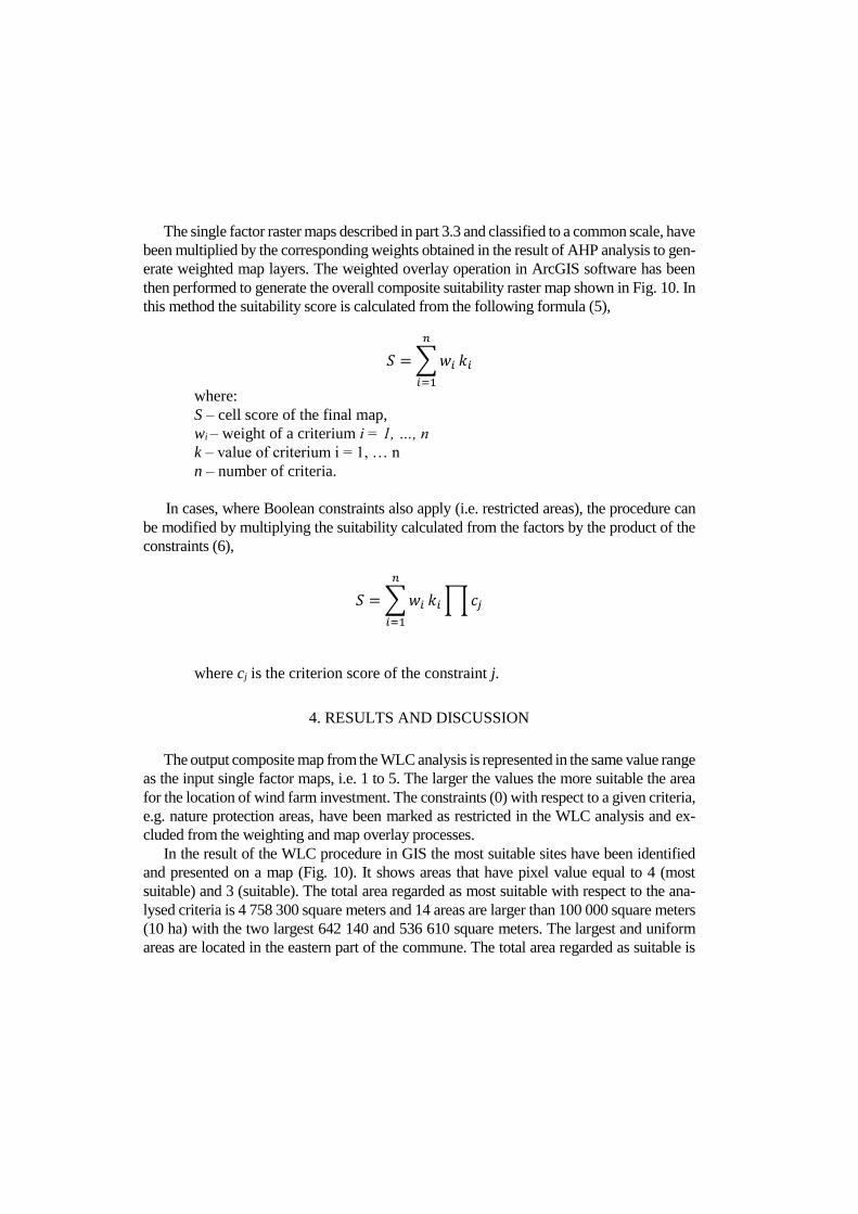
this method the suitability score is calculated from the following formula (5),
𝑆 = ∑ 𝑤𝑖
𝑛
𝑖=1
𝑘𝑖
where:
S – cell score of the final map,
wi – weight of a criterium i = 1, …, n
k – value of criterium i = 1, … n
n – number of criteria.
In cases, where Boolean constraints also apply (i.e. restricted areas), the procedure can
be modified by multiplying the suitability calculated from the factors by the product of the
constraints (6),
𝑆 = ∑ 𝑤𝑖
𝑛
𝑖=1
𝑘𝑖 ∏ 𝑐𝑗
where cj is the criterion score of the constraint j.
4. RESULTS AND DISCUSSION
The output composite map from the WLC analysis is represented in the same value range
as the input single factor maps, i.e. 1 to 5. The larger the values the more suitable the area
for the location of wind farm investment. The constraints (0) with respect to a given criteria,
e.g. nature protection areas, have been marked as restricted in the WLC analysis and ex-
cluded from the weighting and map overlay processes.
In the result of the WLC procedure in GIS the most suitable sites have been identified
and presented on a map (Fig. 10). It shows areas that have pixel value equal to 4 (most
suitable) and 3 (suitable). The total area regarded as most suitable with respect to the ana-
lysed criteria is 4 758 300 square meters and 14 areas are larger than 100 000 square meters
(10 ha) with the two largest 642 140 and 536 610 square meters. The largest and uniform
areas are located in the eastern part of the commune. The total area regarded as suitable is

2 406 700 square meters. The area required for a single wind turbine is 2000 to 4000 square
meters, whereas a wind farm consisting for example of 15 turbines can take up to 225 ha of
land, e.g. “Zagórze” wind farm in NW Poland (Tauron, 2014). The area between the tur-
bines can be used for example for agricultural purposes. It must be mentioned that the iden-
tified sites are provisional and require further and more detailed investigations including
field reconnaissance before final decision can be reached.
Fig. 10. Results of land suitability analysis for wind farm location
The proposed method, utilising a combination of AHP and WLC methodologies in GIS,
provided a quantitative evaluation of criteria that determine land suitability for location of
wind farms. The map obtained from the WLC presents continuous representation of the
suitability for this purpose. The continuous character of the WLC single factor maps does
not allow to estimate exactly the threshold values that would determine land suitability. This
is known as trade-off or substitutability (Drobne and Lisec 2009). Therefore, input maps
have been classified to a common scale and constraints have been introduced using Boolean
operators to account for restricted areas such as nature protection sites and exclude them
from further analysis. An another method that can be used to account for the continuous

character is to apply fuzzy membership measures in multicriteria evaluation, as suggested
by (Jiang and Eastmann 2000).
Application of pairwise comparison method (AHP) in assessment of criteria weights,
which uses direct trade-off between each pair of compared factors, has the advantage of
allowing an organized, and in many cases hierarchical, structure of criteria, which provides
a better focus on specific criteria during the weight allocation process. The selection of at-
tributes – criteria for comparison has to take into account their completeness. In this study
it has been based on literature review but an another possibility is to perform a survey of
group of experts representing different disciplines, such as spatial planning, environmental
protection, electricity production, public administration, local communities, etc.
5. CONCLUSIONS
The aim of this study was to propose and test on a pilot area a GIS-based procedure for
the assessment of suitable sites for wind farm locations taking into account the Polish con-
ditions. The Analytic Hierarchy Process method was proposed for assessment of the weights
of criteria determining suitability of wind farm location and the WLC method for identifi-
cation of suitable sites in GIS. The following criteria groups have been used: environmental,
social, spatial and technical. The particular factors and constraints have been identified
based on literature of the subject and review of the Polish legal acts regulating such invest-
ments. One should note that as for now there are no regulations stating the minimum dis-
tance of wind turbines from populated areas. The proposed GIS-based geoprocessing model
was applied to a pilot area in SW Poland – the Prusice commune and suitable areas were
identified. The total area with the highest suitability score is 475 ha with an additional 241
ha regarded as suitable. The two largest identified sites are 64.2 ha and 53.7 ha.
The procedure allows for inclusion of other criteria that have not been considered in this
study, such as minimum size of area, which is specific for each wind farm project or wind
speed and roughness of the terrain, which influence the performance of a wind farm. These,
as well as other criteria can be added to the spatial data processing model if necessary. In
addition landscape aesthetics can be analysed using 3D visualisation capabilities of GIS.
The results, presented in the form of maps and reports, can play a significant role in the local
community consultations process.
ACKNOWLEDGMENTS
The study has been done with the project no 3CE393P3 Effective development of dis-
persed renewable energy in combination with conventional energy in regions - ENER-
GYREGION financed from the European Regional Development Fund.

BIBLIOGRAPHY
BABAN S., PARRY T., 2001. Developing and applying a GIS-assisted approach to locating wind farms
in the UK. Renewable Energy, Vol. 24, pp. 59-71.
CARVER S., 1991. Integrating multi-criteria evaluation with geographical information systems. Interna-
tional Journal of Geographical Information Systems 5:3, pp. 321-339.
CENTRAL STATISTICAL OFFICE, 2014. Local Data Bank. @ http://www.stat.gov.pl/bdlen/app/strona.html?p_name=indeks, accessed 2014-03-28.
DJAMAI M., KASBADJI MERZOUK N., 2011. Wind farm feasibility study and site selection in Adrar,
Algeria. Energy Procedia 6, pp. 136-142.
DROBNE S., LISEC A., 2009. Multi-attribute Decision Analysis in GIS: Weighted Linear Combination
and Ordered Weighted Averaging. Informatica 33, pp. 459–474.
ESRI, 2014. ArcGIS 10.2.1 for Desktop Functionality Matrix, @ http://goo.gl/u1Yw5i, accessed 2014-
04-02.
GMINA PRUSICE, 2011. Studium uwarunkowań i kierunków zagospodarowania przestrzennego gminy
Prusice. Dokument przyjęty uchwałą nr XII/64/11 Rady Miasta i Gminy Prusice z dnia 8.06.2011 r.,
@ http://bip.prusice.pl/#Z2V0Q29udGVudCgzNDE1OCk=, accessed 2014.04.03 (In Polish).
HANSEN H.S., 2005. GIS-based Multi-Criteria Analysis of Wind Farm Development, Proceedings of the
10th Scandinavian Research Conference on Geographical Information Sciences, 13th-15th June 2005,
Stockholm, Sweden, pp. 75-87.
HAAREN R., FTHENAKIS V., 2011. GIS-based wind farm site selection using spatial multi-criteria
analysis (SMCA): Evaluating the case for New York State. Renewable and Sustainable Energy Re-
views, Vol. 15, pp. 3332-3340.
JIANG H., EASTMAN J. R., 2000. Application of fuzzy measures in multi-criteria evaluation in GIS. In-
ternational Journal of Geographical Information Systems 14:2, pp. 173–184.
KISTOWSKI M., 2012. A methodological proposal for regional-scale assessment of environmental con-
ditions in relation to the establishment of wind farms, Geographical Review, Vol. 84:1, pp. 5-22, (In
Polish with English Summary).
MALCZEWSKI J., 2004. GIS-based land-use suitability analysis: a critical overview. Progress in Plan-
ning 62, pp. 3–65.
MALCZEWSKI J., 2006. GIS‐based multicriteria decision analysis: a survey of the literature. Interna-
tional Journal of Geographical Information Science 20:7, pp. 703-726.
MENG Y., MALCZEWSKI J., BOROUSHAKI S., 2011. GIS-Based Multicriteria Decision Analysis Ap-
proach for Mapping Accessibility Patterns of Housing Development Sites: A Case Study in Canmore,
Alberta. Journal of Geographic Information System 3, pp. 50-61, doi:10.436/jgis.2011.31004.
OGC, 2014. Web Map Service Standard, @ http://www.opengeospatial.org/standards/wms, accessed
2014.04.07.
REGIONAL OFFICE OF LAND SURVEYING AND CARTOGRAPHY, 2002. Vector Map Level 2.
SAATY T., 1977. A scaling method for priorities in hierarchical structures. J. Math. Psychology. 15, pp.
234-281.
SAATY T., 2008. Relative Measurement and Its Generalization in Decision Making Why Pairwise Com-
parisons are Central in Mathematics for the Measurement of Intangible Factors The Analytic Hierar-
chy/Network Process. Rev. R. Acad. Cien. Serie A. Mat. 102: 251–318.
http://www.rac.es/ficheros/doc/00576.PDF, accessed 2013-12-03.

STEINAR F. (Ed.), 2006. The Essential Ian McHarg: Writings on Design and Nature. Island Press.
SYNOWIEC W., LUC M., 2013. A multicriterial evaluation of land suitability for wind energy develop-
ment, as exemplified by Poland’s gmina of Rymanów. Geographical Review, Vol. 85:3, pp. 323-352,
(In Polish with English summary).
SZUREK M., 2014. Multicriteria analysis for selection of the optimum location of wind farms in the Prusice
commune. Thesis, GIS Postgraduate Study, Wroclaw University of Technology, Wroclaw, (in Polish
with English summary).
TAURON EKOENERGIA SP. Z O.O., 2014. Energia z wiatru, @http://www.tauron-ekoenergia.pl/elek-
trownie/energia-z-wiatru/Strony/wiatrowa.aspx, accessed 2014-04-09
UNIVERSITY OF WROCLAW, 2012. Meteorological Bulletin. Publisher: Department of Climatology
and Atmosphere Protection - Institute of Geography and Regional Development, Wroclaw, @
http://goo.gl/ZQDC5i, accessed 2014-04-03
Ustawa z dnia 27 kwietnia 2001 r. Prawo ochrony środowiska (Dz. U. 2001 Nr 62 poz. 627)
Ustawa z dnia 16 kwietnia 2004 r. o ochronie przyrody (Dz. U. 2004 Nr 92 poz. 880)
Ustawa z dnia 3 października 2008 r. o udostępnianiu informacji o środowisku i jego ochronie, udziale
społeczeństwa w ochronie środowiska oraz ocenach oddziaływania na środowisko (Dz. U. 2008 Nr 199
poz.1227)
Ustawa z dnia 23 lipca 2003r. o ochronie zabytków i opiece nad zabytkami (Dz. U. 2003 Nr162 poz. 1568)
Ustawa z dnia 27 marca 2003r. o planowaniu i zagospodarowaniu przestrzennym (Dz. U. 2003 Nr 80 poz.
717)
VOOGD H., 1983. Multicriteria evaluation for urban and regional planning. London. Pion
WBU, 2010. Studium przestrzennych uwarunkowań rozwoju energetyki wiatrowej w województwie dol-
nośląskim. Wojewódzkie Biuro Urbanistyczne we Wrocławiu, Dokument przyjęty uchwałą nr
4857/III/10 zarządu województwa dolnośląskiego z dnia 31.08.2010 r. @http://goo.gl/SSPn8n, acces-
sed 2014.04.04 (In Polish). http://goo.gl/vCyKB7, accessed 2014-04-02
WBU, 2012. Aktualizacja Studium przestrzennych uwarunkowań rozwoju energetyki wiatrowej w woje-
wództwie dolnośląskim 2011. Wojewódzkie Biuro Urbanistyczne we Wrocławiu, Dokument przyjęty
uchwałą nr 2082/IV/12 zarządu województwa dolnośląskiego z dnia 4.04.2012 r.
@http://goo.gl/SSPn8n, accessed 2014.04.04 (In Polish).
Copyright © 2022 FDOKUMEN