A comprehensive analysis of groundwater resources using GIS and multicriteria tools (Caldas da...
17
THEMATIC ISSUE A comprehensive analysis of groundwater resources using GIS and multicriteria tools (Caldas da Cavaca, Central Portugal): environmental issues J. Teixeira • H. I. Chamine ´ • J. Espinha Marques • J. M. Carvalho • A. J. S. C. Pereira • M. R. Carvalho • P. E. Fonseca • A. Pe ´rez-Alberti • F. Rocha Received: 18 March 2014 / Accepted: 9 August 2014 Ó Springer-Verlag Berlin Heidelberg 2014 Abstract Hard-rock watersheds are essentially confined to fractured and weathered horizons, but they are a source of valuable water resources at a regional level, namely for domestic, industrial and agricultural purposes, and public supply. They commonly exhibit complex geological bed- rock and morphological features as well as distinctive gradients in rainfall and temperature. Hydromineral and geothermal resources have relevant economic value both for the bottled water/thermal spas industry and for energy supply. A comprehensive evaluation and integrated groundwater resources study has been carried out for the Caldas da Cavaca hydromineral system in Central Portugal, using hydrogeomorphology and GIS mapping techniques. Thematic maps were organised from a geodatabase com- prising several layers, namely lithology, tectonic linea- ments density, slope, drainage density, rainfall, net groundwater recharge and water quality. Normalised weights were assigned to all these categories according to their relative importance to groundwater potential, based on their effectiveness factors. Hydrogeochemistry, natural radioactivity and intrinsic vulnerability assessment (GOD- S, DRASTIC-Fm, SINTACS, SI indexes) issues were also cross-checked. Based on all the compiled information, a hydrogeomorphological map was produced. This multi- disciplinary approach highlights the importance of hy- drogeomorphological mapping as a tool to support hydrological conceptualisation, contributing to groundwa- ter decision-making process in different stages, like water resources management and territory planning, and thus, to environmental sustainability. Keywords Applied cartography Á Groundwater Á Hydrogeomorphology Á Infiltration potential index Á Central Portugal Introduction Hard-rock aquifer systems are an important source for domestic, industrial, agricultural and public supply pur- poses. Moreover, these systems have a significant eco- nomic value, where groundwater is used in thermal bath spas. In these areas, geology, geomorphology, climatology and hydrological properties control the groundwater flow, J. Teixeira Á H. I. Chamine ´ Á J. M. Carvalho Á F. Rocha Centre GeoBioTec|UA (Georesources, Geotechnics and Geomaterials Research Group), University of Aveiro, Aveiro, Portugal J. Teixeira (&) Á H. I. Chamine ´ Á J. M. Carvalho Laboratory of Cartography and Applied Geology, Department of Geotechnical Engineering, School of Engineering (ISEP), Polytechnic of Porto, Porto, Portugal e-mail: [email protected] J. Espinha Marques Centre of Geology of University of Porto, Department of Geosciences, Environment and Spatial Planning, Faculty of Sciences, University of Porto, Porto, Portugal A. J. S. C. Pereira Laboratory of Natural Radioactivity, Department of Earth Sciences, Faculty of Sciences and Technology, University of Coimbra, Coimbra, Portugal M. R. Carvalho Á P. E. Fonseca Centre of Geology of University of Lisbon, Department of Geology, Faculty of Sciences, University of Lisbon, Lisbon, Portugal A. Pe ´rez-Alberti Laboratory of Environmental Technology (Geomorphology Area), Institute of Technological Research, University of Santiago de Compostela, Santiago de Compostela, Spain 123 Environ Earth Sci DOI 10.1007/s12665-014-3602-1
Transcript of A comprehensive analysis of groundwater resources using GIS and multicriteria tools (Caldas da...
THEMATIC ISSUE
A comprehensive analysis of groundwater resources using GISand multicriteria tools (Caldas da Cavaca, Central Portugal):environmental issues
J. Teixeira • H. I. Chamine • J. Espinha Marques •
J. M. Carvalho • A. J. S. C. Pereira • M. R. Carvalho •
P. E. Fonseca • A. Perez-Alberti • F. Rocha
Received: 18 March 2014 / Accepted: 9 August 2014
� Springer-Verlag Berlin Heidelberg 2014
Abstract Hard-rock watersheds are essentially confined
to fractured and weathered horizons, but they are a source
of valuable water resources at a regional level, namely for
domestic, industrial and agricultural purposes, and public
supply. They commonly exhibit complex geological bed-
rock and morphological features as well as distinctive
gradients in rainfall and temperature. Hydromineral and
geothermal resources have relevant economic value both
for the bottled water/thermal spas industry and for energy
supply. A comprehensive evaluation and integrated
groundwater resources study has been carried out for the
Caldas da Cavaca hydromineral system in Central Portugal,
using hydrogeomorphology and GIS mapping techniques.
Thematic maps were organised from a geodatabase com-
prising several layers, namely lithology, tectonic linea-
ments density, slope, drainage density, rainfall, net
groundwater recharge and water quality. Normalised
weights were assigned to all these categories according to
their relative importance to groundwater potential, based
on their effectiveness factors. Hydrogeochemistry, natural
radioactivity and intrinsic vulnerability assessment (GOD-
S, DRASTIC-Fm, SINTACS, SI indexes) issues were also
cross-checked. Based on all the compiled information, a
hydrogeomorphological map was produced. This multi-
disciplinary approach highlights the importance of hy-
drogeomorphological mapping as a tool to support
hydrological conceptualisation, contributing to groundwa-
ter decision-making process in different stages, like water
resources management and territory planning, and thus, to
environmental sustainability.
Keywords Applied cartography � Groundwater �Hydrogeomorphology � Infiltration potential index �Central Portugal
Introduction
Hard-rock aquifer systems are an important source for
domestic, industrial, agricultural and public supply pur-
poses. Moreover, these systems have a significant eco-
nomic value, where groundwater is used in thermal bath
spas. In these areas, geology, geomorphology, climatology
and hydrological properties control the groundwater flow,
J. Teixeira � H. I. Chamine � J. M. Carvalho � F. Rocha
Centre GeoBioTec|UA (Georesources, Geotechnics and
Geomaterials Research Group), University of Aveiro,
Aveiro, Portugal
J. Teixeira (&) � H. I. Chamine � J. M. Carvalho
Laboratory of Cartography and Applied Geology, Department of
Geotechnical Engineering, School of Engineering (ISEP),
Polytechnic of Porto, Porto, Portugal
e-mail: [email protected]
J. Espinha Marques
Centre of Geology of University of Porto, Department
of Geosciences, Environment and Spatial Planning, Faculty
of Sciences, University of Porto, Porto, Portugal
A. J. S. C. Pereira
Laboratory of Natural Radioactivity, Department of Earth
Sciences, Faculty of Sciences and Technology, University
of Coimbra, Coimbra, Portugal
M. R. Carvalho � P. E. Fonseca
Centre of Geology of University of Lisbon, Department
of Geology, Faculty of Sciences, University of Lisbon,
Lisbon, Portugal
A. Perez-Alberti
Laboratory of Environmental Technology (Geomorphology
Area), Institute of Technological Research, University of
Santiago de Compostela, Santiago de Compostela, Spain
123
Environ Earth Sci
DOI 10.1007/s12665-014-3602-1

storage and occurrence (e.g. Carvalho 1996; Jaiswal et al.
2003; Surrette et al. 2008).
In a complex hydrogeologic setting, hydrogeomorphol-
ogy provides a very valuable approach on hard-rock
aquifers characterisation, analysis and assessment (e.g.
Tricart 1961; Sidle and Onda 2004; Babar 2005; Teixeira
et al. 2013). In addition, the relationship with other related
domains, such as, remote sensing, morphotectonics, struc-
tural geology, hydrogeology, applied geophysics, soil and
rock geotechnics, climatology and natural hazards assess-
ment usually provides original and useful insights. Hy-
drogeomorphology is also fundamental for understanding
the linkage between hydrologic processes and landforms
and earth materials, as well as the interaction of surface
water and groundwater regimen in a given area (Bisson and
Lehr 2004; Kudrna and Sindelarova 2006; Teixeira et al.
2013).
Sustainable development requires a better understanding
of hydrogeological resources and their correct management
in close relationship with the socioeconomic scope. The
ecosystem goods and services provided by hydrogeological
systems, such as freshwater provisioning, protection
against salt water intrusion or floods and water quality
issues, are fundamental for human welfare (e.g. NAP 1997;
Wallace 2007). In order to correctly assess the georesource
there are several factors controlling the occurrence and
path flows of groundwater, such as, topography, lithology,
structure, weathering grade, fracture extent, permeability,
slope, drainage pattern, landforms, land use/land cover and
climate (e.g. Jaiswal et al. 2003; Nilsson et al. 2006; Sur-
rette et al. 2008; Yeh et al. 2008; Teixeira et al. 2010,
2013). Instead, intrinsic geological and hydrological vari-
ability and uncertainty data should be identified and
properly characterised (e.g. Nilsson et al. 2006; Keaton
2013; Chamine et al. 2013 and references therein).
The use of ground models and hydrological conceptual
models based on hierarchical analysis of groundwater flow
often provide significant contributions for understanding
the complexity of Earth systems (e.g. Griffiths and Stokes
2008; Kresic and Mikszewski 2013; Chamine et al. 2013;
Griffiths 2014). In this context, good quality groundwater
modelling requires hard-rock aquifer mapping and con-
ceptualisation of hydrogeological systems (Chamine et al.
2013; Teixeira et al. 2013). Groundwater-based mapping
took advantage of the progress of geographical information
systems (GIS) techniques, methods and analysis (e.g. Jai-
swal et al. 2003; Jha et al. 2007; Yeh et al. 2008; Balluk-
raya and Kalimuthu 2010; Jha 2011; Teixeira et al. 2013).
The multicriteria approach is greatly benefited by these
GIS techniques when coupled with other decision tools
(e.g. analytical hierarchy processes or fuzzy logic; Ett-
azarini 2007; Saaty 2008; Kim et al. 2009). Geovisualisa-
tion is another important issue to characterise hydrologic
systems as it carries challenging approaches in map design
(e.g. Dykes et al. 2005; Cascelli et al. 2012, and references
therein).
This paper intends to present a comprehensive meth-
odology of groundwater resources evaluation, based in GIS
analysis and multicriteria tools. Remote sensing, hydro-
structural cartography, hydrogeomorphological and vul-
nerability mapping, as well as hydrogeological field
inventory and hydrodynamic features were key parameters
to the assessment of Caldas da Cavaca hydromineral sys-
tem (Central Portugal). This approach greatly contributes
to the development of the hard-rock hydrogeological con-
ceptual site model, and may provide valid guidelines for
decision-making in the groundwater and surface water
protection, planning and management, as well as to equi-
table and sustainable exploitation of water resources.
Caldas da Cavaca hydromineral system: regional
framework
The Caldas da Cavaca area is sited in the municipality of
Aguiar da Beira, Guarda district (Central Portugal). The
study region is located in Beiras Variscan granitic belt—
Dao complex granite (Boorder 1965)—of the Iberian
Massif (Central-Iberian Zone), nearby the western border
of the Braganca–Vilarica–Manteigas major fault zone, with
a general trend of NNE–SSW (Brum Ferreira 1991; Ribeiro
et al. 2007). The site belongs to the regional morphotec-
tonic unit of the Central Plateau, in the northern part of the
wide range of ridges, the so-called ‘Cordilheira Central’ or
Central Range (Ribeiro 1949; Brum Ferreira 1980), Fig. 1.
The study area is mainly composed of coarse-grained
porphyritic granite, alluvial deposits and doleritic dykes
(Boorder 1965). The mafic dykes are mostly exposed over
distances of less than 30 m and often highly weathered to
fresh.
The drainage network in Caldas da Cavaca study site is
part of the Dao River catchment, which is a tributary of
Mondego River. The NNE–SSW Ribeira de Coja valley
(bottom c. 521 m) is locally the main morphologic struc-
ture, with steep slopes and about 200 m of altitude dif-
ference. The surrounding area is mainly dominated by
granitic rocks outcrops, some Pinus pinaster forest, and
agriculture in small flattened areas. The slopes are gener-
ally covered by bushes/scrub.
The climate is generally temperate, corresponding to a
Koppen–Geiger Cfb climate (McKnight and Hess 2000;
Peel et al. 2007), which corresponds to a temperate humid
climate, with a mild summer. The mean annual temperature
is 13 �C, ranging from 6.2 �C in January to 20.1 �C in July.
The average annual precipitation is 1,252.4 mm/year,
being January the wettest month, with a mean rainfall
Environ Earth Sci
123

reaching 189 mm, and July the driest, with 16 mm. The
Thornthwait and Mather (1955) water balance (field
capacity of 150 mm) revealed a water deficit from June to
September, especially during July and August, with a total
deficit in the 4 months of 117 mm. The water surplus is
registered from December to May, with total values around
743 mm (Teixeira 2011). The estimated recharge is about
175 mm/year, corresponding to 14 % of the mean annual
rainfall (Carvalho et al. 2005a).
Caldas da Cavaca site is recognised in the region for
the thermal spa tradition, which dates back to the late
nineteenth century (e.g. Freire de Andrade 1937; Acci-
aiuoli 1952/53; Carvalho 1996). Lately, an entire reha-
bilitated thermal centre has re-opened, after many years
of inactivity. The old thermal spring and former shallow
well (Freire de Andrade 1935, 1938) used in the past
for therapeutic purposes at the old spa, was replaced by
two new wells. Their location resulted from the geo-
logical, geomorphological and hydrogeological studies
carried out in the last years (Carvalho et al. 2005b;
Teixeira et al. 2010; Teixeira 2011; and references
therein).
The hydromineral waters from Caldas da Cavaca, with
output temperatures around 29.8 �C, are characterised by
(details in Teixeira et al. 2010; Teixeira 2011): (1) relatively
high pH values (c. 8.3); (2) TDS contents in the range of
262–272 mg/L; (3) the presence of reduced sulphur species
(HS-c. 0.9 mg/L); (4) high silica contents around 55 mg/L
which represents a considerable percentage of total miner-
alisation (around 21 %); (5) Electrical conductivity (EC)
measurements ranging 353–427 lS cm-1 indicating the
presence of medium mineralised waters and (6) high fluoride
concentrations up to 14 mg/L. These waters belong to
HCO3-Na facies.
Fig. 1 Regional framework of
the Caldas da Cavaca
hydromineral system, Aguiar da
Beira municipality: a location of
study area; b satellite image
(compiled from Landsat 7
ETM? data, 2000/01; all IR
colour, bands 7-4-5 = RGB;
adapted from Global Land
Cover Facility); c shaded relief,
regional geology (adapted from
Oliveira et al. 1992) and
hydrogeology (adapted from
Carvalho 2006; Carvalho et al.
2007) and main hydromineral
springs (adapted from Carvalho
2006)
Environ Earth Sci
123
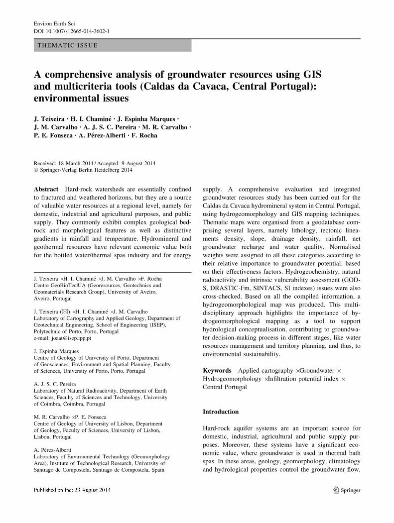
Materials and methods
In this study, several data collection techniques and pro-
cedures mainly related to remote sensing, GIS mapping,
structural geology, applied geomorphology, engineering
geosciences, and hydrogeology have been used (e.g. Ass-
aad et al. 2004; Dykes et al. 2005; Smith et al. 2011). In
addition, the recommendations of the Geological Society
Engineering Group (GSE 1995), the Committee on Frac-
ture Characterisation and Fluid Flow (CFCFF 1996) and
the International Society for Rock Mechanics (ISRM 2007)
were followed. Topographic and geological maps, aerial
orthophotos and also LandSat ETM? and SPOT5 images
have been used to build several thematic field maps to
support all the exploration stages.
The data collection stage (Fig. 2) had great importance
in this approach, and resulted in a large amount of
information which was divided into two main groups:
(a) basic cartographic description, which comprised
topography, remote sensing, structural geology, morpho-
tectonics, land use and hydroclimatology; (b) field and
laboratory data, such as hydrogeological inventory, field
hydrogeotechnics, and hydrochemical, isotopic and
radiological analysis.
Hydrogeological parameters were measured during the
field inventory (e.g. temperature, pH, electrical conduc-
tivity) using a multiparametric portable equipment (Hanna
Instruments, HI 9828).
The water sampling sites (namely, springs, dug wells,
water wells, water galleries, streams and fountains) were
georeferenced with a high-accuracy GPS (Trimble Geo-
Explorer). In addition, the basic geological and geomor-
phological description of rock masses (e.g. lithology,
weathering grade, structure, morphology) was recorded, as
well as the hydrological and climatological features of the
site region.
Fig. 2 Conceptual flowchart representing the methodologies used in this study
Environ Earth Sci
123

Hydrochemical parameters of each water sample were
evaluated in a certified laboratory. Samples were condi-
tioned and analysed according to standard field procedures
(see details in Assaad et al. 2004). The d2H and d18O
isotopes content were determined at the Stable Isotopes and
Instrumental Analysis Facility (SIIAF) Laboratory, Uni-
versity of Lisbon (Portugal), by mass spectrometry con-
tinuous flow (CF-IRMS). The results are expressed as d %V-SMOW and the analytical accuracy is \0.1. In some
water samples, ICP-MS analysis was made in Activation
Labs (Canada). In order to evaluate the abundance and
variability of radioisotopes in groundwater, as well as their
impact on water quality, 238U, 234U, 226Ra and 222Rn were
analysed in the Laboratory of Natural Radioactivity of
University of Coimbra (Portugal). The radionuclide activ-
ity was measured by liquid scintillation counting tech-
niques (LSC) using an ultra-low-level spectrometer Perkin
Elmer Quantulus 1220 (see details in Goncalves and
Pereira 2007).
Cartographic, laboratory and field data were cross-
checked and organised in a GIS environment, and a series
of thematic maps was produced. This mapping was the
base for the subsequent GIS overlay and analysis, namely
the infiltration potential zoning and the groundwater vul-
nerability mapping. These maps were grouped in four main
groups, namely the geological description of rock masses,
geographical description, hydrogeomorphological and
hydrogeological features of the study site.
The identification of the explaining factors for the cal-
culation of the infiltration potential zoning index followed
the methodology proposed by Teixeira et al. (2013). The
relative weight and score for each factor was calculated
using the analytical hierarchy process (AHP) method (e.g.
Saaty 2008; Kim et al. 2009; and references therein), and
the inner scores were mainly assessed from fieldwork data.
The adopted grid data structure consisted of a pixel of
1 9 1 m. The GIS analysis resulted in a map displaying the
spatial distribution of the infiltration potential index,
ranging from 0 to 100, where the highest values represent a
combination of favourable characteristics in most
explaining factors. A more detailed explanation can be
found in Teixeira et al. (2010, 2013).
The groundwater vulnerability assessment was made
using several methods, some of them adapted and revised
from the bibliography:
• GOD-S—Groundwater hydraulic confinement, Overly-
ing strata, Depth to groundwater table, Soil media. The
GOD-S vulnerability index is an evolution of GOD
index, considering soil media properties (Foster 1987;
Foster and Hirata 1988; Foster et al. 2002)
• DRASTIC-Fm—Depth to water, net Recharge, Aquifer
media, Soil media, Topography, Impact of vadose zone,
hydraulic Conductivity, Fractured media. Regarding
the DRASTIC-Fm index, the original DRASTIC index
(Aller et al. 1987) was slightly modified following the
proposal by Denny et al. (2007), taking into account the
specificities of the fissured hard-rock aquifers. The
fractured media parameter (Fm) was derived from the
tectonic lineaments density map, and grouped into four
classes, with rating varying from 4 to 10, according to
the tectonic lineament density. In the definition of the
Fm factor weight, the approach by Denny et al. (2007)
was followed, and a rating of 3 was given to this factor.
• SINTACS—depth to groundwater (S), recharge action
(I), attenuation capacity of the vadose zone (N),
attenuation capacity of the soil (T), hydrogeological
characteristics of the aquifer media (A), hydraulic
conductivity (C), and topographic slope (S). The
SINTACS method, an evolution of the DRASTIC
method, was applied to the study area, following the
recommendations of Civita and De Maio (2000) and
Civita (2010), using the normal strings for the multi-
plier weights.
• SI—susceptibility index. The susceptibility index (SI)
proposed by Ribeiro (2005) and described in Stigter
et al. (2006) was applied in the study area. This rating
uses several parameters from the DRASTIC index (D,
R, A, T), and takes into account the land use (LU),
classified according to Land Cover and Land Use maps
(Corine Land Cover 2006—Caetano et al. 2009; Painho
and Caetano 2006; Carta de Ocupacao do Solo 2007—
IGP 2010), updated with more detailed information
from high-resolution satellite imagery. This SI method
is used, since 2012, in the Portuguese territory planning
laws to identify and protect the aquifer recharge areas.
The integrated approach led to a great improvement in
the understanding of the groundwater systems occurring in
Caldas da Cavaca area, to a more detailed and accurate
conceptual model, and thus to an efficient and sustainable
management of groundwater resources.
Results and discussion
A geoscience interdisciplinary approach was employed to
characterise and evaluate the Caldas da Cavaca aquifer
systems. In fact, the petrophysical and hydrological prop-
erties of soil and rock masses are usually variable in spatial
and temporal scales. This approach took advantage of
multiple data sources including geology, morphotectonics,
hydrogeology, hydrogeochemistry, environmental isotopes
and radioisotopes, hydrogeomorphology and land cover.
GIS-based mapping was used to produce an interactive
geodatabase, to assess the spatial distribution of the field
Environ Earth Sci
123

and analytical data, as well as to create intrinsic vulnera-
bility maps (see details on the methodology approach in
Teixeira et al. 2010, 2013, and references therein).
Geological description of rock mass: lithology,
structure, weathering grade, fracturing degree
Locally, a coarse-grained granite dominates and was clas-
sified in three main groups, according to its exposure
weathering degree (Teixeira et al. 2010; Teixeira 2011),
Fig. 3a: (a) fresh to slightly weathered granite (W1–2),
occurring in the higher altitude areas (600–700 m) and,
mostly, showing moderate (F3) to very close to close
fracturing degree (F4–5). This unit has a great morpholog-
ical importance, defining core stones shaped forms in the
granitic outcrops of the area; (b) moderately weathered
granite (W3) is found at lower altitudes (500–650 m), in a
wide corridor (ca. 500–1,000 m), with a general NE–SW
Fig. 3 Infiltration potential zoning factors: a lithology and weathering grade; b tectonic lineaments density; c land cover; d drainage network
density; e slope; f rainfall
Environ Earth Sci
123

trend; (c) the last group is the most weathered granite
(W4–5), which dominates in plateau areas. The mineralogy
and grain size of this granite results, locally, in intense
arenisation. The rock masses (W1–2/W3) are generally
bordered by faults and fracture zones, with NNE–SSW to
NE–SW, and NW–SE trends. Along these depressed areas,
several narrow corridors of highly weathered granite
(W4–5) surrounding the fresh rock masses were identified.
The weathering grade is very intense and may reach
depths of about 50 m, especially in the NNE–SSW trend-
ing megastructure, the so-called Ribeira de Coja fault zone
(Carvalho et al. 2005b). The dolerite veins and dykes fol-
low the general structural pattern, namely NE–SW and
NW–SE orientations. These mafic structures have different
weathering grade ranges, but in most cases are altered and
present light green to orange colour. In the Iberian Massif
these structures are usually associated with deep fluid cir-
culation (Carvalho 1996, 2006).
Finally, the sedimentary cover is more significant in the
bottom of the Ribeira de Coja valley. The thickness of
these silty–sandy deposits is small, ranging 3–5 m.
The regional and local structures were also confirmed at
the very detailed rock mass scale, supported with hydrog-
eotechnical surveys related to the fracturing degree and
hydrogeomechanical parameters. The structures (mainly
faults) with orientations around N308E to N608E have a
great importance at macroscale. The N458–508W trend
structures are mainly joints, and have less continuity than
the NE–SW ones.
The tectonic lineaments density (Fig. 3b) shows scatter
behaviour, following predominantly the trending line of the
structures mapped. However, a large corridor was identi-
fied, with a general NE–SW trend. Nearby the Caldas da
Cavaca thermal site, a framework of tectonic lineament
nodes was identified, conducting to a higher density frac-
ture damage zone. In addition, the hydromineral fluid cir-
culation is more favourable in a context of higher
fracturing density.
Morphological and hydroclimatological features
Land cover (Fig. 3c) is an important factor controlling the
surface water regimen, and thus, the infiltration (e.g. San-
ford 2002; Shaban et al. 2006; Jha et al. 2007; Yeh et al.
2008). It is also a key parameter in some vulnerability
indexes.
Thus, the site land cover mapping was updated with
recent ortho-photomaps and high-resolution satellite
imagery at a very detailed scale. In the study site, two main
groups could be identified: (a) the forest and agricultural
(dryland farming) areas are concentrated mainly in the NW
area around the Quinta das Lameiras locality, and in the
SE, around the Cavaca settlement; (b) the less weathered
granite areas generally have correspondence, in the land
cover, to the rocky outcrops. These outcrops are generally
surrounded by bushes/shrubs, and sometimes by small
forest or agricultural areas. Some agricultural areas,
namely the one around Caldas da Cavaca (CC) site are
presently abandoned.
The drainage network density (Fig. 3d) is also an
important factor, that gives important clues about the sur-
face and groundwater flows (e.g. Chowdary et al. 2003;
Jaiswal et al. 2003; Sener et al. 2005; Sreedevi et al. 2005;
Sander 2007; Ballukraya and Kalimuthu 2010; Elewa and
Qaddah 2011). These key studies point that a higher den-
sity of stream lines is generally associated with less
quantity of surface runoff available for infiltration, and
thus, for groundwater flow, storage and occurrence. How-
ever, in some cases, when the aquifer has hydraulic con-
nection to the stream lines, it could act in the opposite way.
In Caldas da Cavaca site, the higher drainage network
density area follows the general trend of the main stream
lines of the area, with a general direction approximately
NE to SW. The higher values were registered in the SW
area of Caldas da Cavaca.
About 80 % of the area has very low to low slope values
(\58 and 58–158), which favours groundwater infiltration
potential (Fig. 3e). These flattened areas are generally
found around the settlements and are normally occupied by
agriculture. The medium and high slope values (158–258and [258) are mainly represented in the Ribeira de Coja
valley, and are normally associated with rock outcrops.
According to the available official data from INAG
(2013), the mean annual rainfall (Fig. 3f) has low spatial
variation in Caldas da Cavaca area (around 950–1,300 mm/
year). However, a general trend was identified, with the
higher values in the NE sector.
Hydrogeology features: inventory, hydrogeochemistry,
isotopic analyses
The hydrogeological inventory, acquired from the different
field campaigns, is presented in Fig. 4. The water points of
the area are not evenly distributed. Most of the shallow dug
wells are located in the higher planned surfaces. They are
related to the agricultural sites, which have in this area a
high demand of water, mainly in the spring and early
summer. These structures have small depths (normally
\5 m), and are mainly fed by the unconfined aquifer
(Carvalho et al. 2005b). The horizontal water galleries,
usually hand-made, are located at lower altitudes
(550–600 m). Springs are relatively rare and mainly loca-
ted at altitudes between 650 and 700 m. These springs have
very small yields (0.01–0.05 L/s), low temperature
(\17 �C) and very low electrical conductivity (\50 lS/
cm).
Environ Earth Sci
123

The normal waters of the Caldas da Cavaca area can
be divided into two main groups: (a) groundwater from
weathered or fractured granitic areas, with a pH ranging
from 5 to 6.5 and electrical conductivities between 20
and 50 lS/cm; (b) surface water and groundwater from
alluvia, with pH ranging from 5.5 to 6 and electrical
conductivities up to 20 lS/cm. In both groups, water
temperature varies from 9 �C in the winter season to
17 �C in the summer season and is directly dependent
on the air temperature. As for hydrodynamic features,
this aquifer is characterised by transmissivity values
below 1 m2/day and long-term well yields below 1 L/s.
However, springs have lower values, usually below
0.1 L/s.
Fig. 4 Hydrogeological map and field water
inventory in Caldas da Cavaca area
Environ Earth Sci
123

The characteristics of Caldas da Cavaca hydromineral
waters contrast with those from normal groundwater:
emerging temperature around 30 �C, pH around 8.3 and
electrical conductivity values ranging from 400 to 450 lS/
cm. The hydromineral water wells are located in the bot-
tom of the valley, intersecting the alluvia deposits in the
first metres, and reaching a maximum depth of 220 m, with
yields between 1 and 4 L/s and transmissivities ranging
from 27 to 136 m2/day (Carvalho et al. 2005b).
All the hydromineral water sites seem to be somehow
related to the regional tectonic lineaments, and located very
close (\100 m) to the tectonic lineaments. The context of
hydrogeological trap is observed particularly in the bottom
of the valley, where the hydromineral water wells are sit-
uated. This could be a key factor for the location of the
former hydromineral spring, and was also an important
issue for the location of the new hydromineral water wells
built in the last years.
The hydromineral water of Caldas da Cavaca is part of
the Portuguese Sulphurous Waters group (e.g. Acciaiuoli
1952/53; Machado 1988; Carvalho 1996; Calado 2001),
having deep circulation and long residence time. Besides
the relatively high pH, they have a high percentage of silica
(ca. 15 % of total mineralisation), high fluoride values
(around 14 mg/L), the presence of reduced forms of sul-
phur and sodium as the dominant cation.
These waters are mainly recommended for liver and
intestine diseases (by ingestion), skin and rheumatic dis-
eases (bath application) and respiratory diseases (by inha-
lation) (Pral 1965; Almeida and Almeida 1975).
The Stiff and Piper diagrams (Fig. 5a, c) show the
results for the sampling sites in the study area (Fig. 5b).
The hydromineral waters of Caldas da Cavaca can be
considered as mesothermal, medium mineralised with
alkaline reaction, sodium bicarbonate facies, fluoridated
and sulphurous waters (Carvalho et al. 2005b). Their
chemical composition is very stable, and is similar to the
hydromineral water of the former spring (Freire de And-
rade 1935, 1938). On the contrary, normal waters have
very low mineralisation and generally a sodium chloride
to sodium bicarbonate facies.
The main uranium decay chain isotopes occurring in
natural waters (226Ra and 222Rn) are generally controlled
by geological factors (Goncalves and Pereira 2007). In
Caldas da Cavaca site (Fig. 5b), the 222Rn values in
groundwater are generally within the variation interval
observed in Portugal for granitic aquifers (104–373 Bq/L;
Pereira et al. 2010). However, some values are much higher
than the proposed interval, reaching 943 Bq/L. The mean
value for Caldas da Cavaca samples is 392 Bq/L, and the
values varying from\20 Bq/L to almost 950 Bq/L. This is
a natural variation pattern for the radon gas in granitic
rocks (Pereira et al. 2007). The higher values seem to be
related to fault zones contexts, especially with orientations
NNE–SSW to NE–SW.
The radon gas variations does not seem to be related to
other groundwater features (pH, electrical conductivity,
hydrogeochemical facies) either with the altitude or depth
of the water wells. This is also pointed in other study
areas (e.g. Choubey et al. 2003; Pereira et al. 2010). The
local variations of the radon gas could be related to local
variations of uranium concentrations, rock geochemistry,
permeability or fracturing along the groundwater flow
paths (LeGrand 1987; Choubey et al. 2003; Pereira et al.
2010).
The a particle activity values are low, ranging from 0.03
to 0.25 Bq/L. Also, the b particle activity is low, ranging
from 0.03 to 0.99 Bq/L. These values are below the
admissible values in natural waters for total a and b particle
activities by the Portuguese legislation (0.5 and 1 Bq/L,
respectively). Also, the low values of a and b indicates the
probable presence, in these waters, of other radionuclides in
insignificant concentrations (238U, 234U and 226Ra).
The preliminary environmental isotopic data (Fig. 5d)
for normal groundwater and hydromineral water show
values of d18O (from -7.5 to -6.3 %) and d2H (from
-48.1 to -36.3 %) close to the global (Global-MWL,
Craig 1961) and regional meteoric (Regional-MWL, Car-
reira et al. 2006) water lines. Rain water from Vila Real
(555 m.a.s.l.) shows -6.4 and -42.5 %, for d18O and d2H,
respectively. This may indicate a similar recharge area, for
normal and hydromineral groundwaters but different flow
paths, given the hydrochemical and temperature charac-
teristics. However, the hydromineral water shows lighter
isotopic composition, probably related to slightly higher
recharge area or water–rock interaction, like silicate
hydration processes. Additional isotopic and hydrogeo-
chemical studies are being carried on this subject.
The preliminary isotopic data (Fig. 5d) show relatively
similar values of d18O and d2H for normal groundwater and
hydromineral water, and also close to the global and
regional meteoric water lines (Global-MWL and Regional-
MWL, respectively). This may indicate a similar recharge
area, for the normal and hydromineral groundwater.
However, the flow paths for the normal and hydromineral
groundwater must be different, given the hydrochemical
and temperature characteristics. Additional studies are
being carried on this subject.
Hydrogeomorphology and vulnerability mapping
The hydrogeomorphological map of Fig. 6 presents the
main results of the calculation of the infiltration potential
zoning, combining, in a GIS environment, the geologic,
geomorphologic, climatic and hydrogeological factors. The
spatial distribution of the infiltration potential becomes
Environ Earth Sci
123

perceptible when using this type of hydrogeomorphological
zoning (Teixeira 2011; Teixeira et al. 2010, 2013). The
infiltration potential map (Fig. 6) showed that the most
effective infiltration areas were located in the NW and SE
sectors of the Caldas da Cavaca thermal site, namely near
the settlements of Quinta dos Matos, Quinta das Lameiras
and Cavaca. These zones correspond to highly weathered
granite with a high thickness arenisation, and are located
mainly in plateau areas. The less effective infiltration areas
were found in an NE–SW corridor sub-parallel to the main
tectonic valley and correspond to less weathered granites
and higher slopes.
The valley bottom also presented high infiltration
potential, resulting from the combination of lithology
Fig. 5 Stiff diagrams (a), radon gas concentrations and location (b), Piper diagram (c) and preliminary isotopic data (d) for the water sampling
points in Caldas da Cavaca study site
Environ Earth Sci
123

(alluvial cover) and the very low slope (flattened valley
bottom). However, the recharge area for hydromineral
aquifer is probably located at higher altitudes ([675 m).
The hydraulic connectivity between the alluvia deposits
and the stream lines is very important to the groundwater
recharge in this aquifer. The constructed areas in the
Cavaca and Quinta das Lameiras settlements have the
lowest infiltration potential.
The main features of the areas of higher infiltration
potential were identified (Teixeira 2011; Teixeira et al.
2013): (1) moderately to highly weathered granitic rock
(including arenisation layers); (2) moderate to close
Fig. 6 Infiltration potential zoning, geomorphology and hydrogeological field inventory from Caldas da Cavaca aquifer system
Environ Earth Sci
123
fracturing degree; (3) low slope areas at the highest ele-
vations; and, (4) agricultural and forest areas.
Most of the water points (80 %) identified in Caldas da
Cavaca study site are located in zones of high infiltration
potential or in transition areas between the high and med-
ium infiltration potential areas.
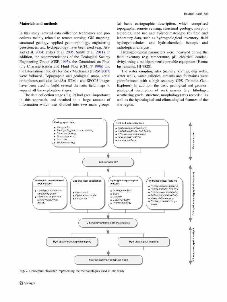
Figure 7 shows the results of the intrinsic vulnerability
assessment based on GOD-S, DRASTIC-Fm, SINTACS
and SI indexes. This type of vulnerability map evaluation
has been successfully applied in many aquifer systems
around the world.
According to GOD-S index (Fig. 7a), most of the Caldas
da Cavaca area fits in a moderate vulnerability class. This
class corresponds to the highly weathered granite (W4–5).
The low and very low vulnerability classes are related to
the moderately weathered (W3) to slightly weathered
(W1–2) granite and with the dolerite dykes. On the contrary,
the high vulnerability class corresponds to the alluvia
Fig. 7 Vulnerability indexes from Caldas da Cavaca aquifer systems and surrounding area: a GOD-S; b DRASTIC-Fm; c SINTACS; d SI
Environ Earth Sci
123
sedimentary cover, in a narrow strip along the bottom of
the valley.
In the case of the DRASTIC-Fm index (Fig. 7b), a clear
dominance from the lithology becomes apparent in the
moderate-high and high vulnerability classes. Those clas-
ses are closely associated with the flat valley bottom, where
the alluvia sedimentary cover prevails. The moderate vul-
nerability areas are located SE, N and NW of Caldas da
Cavaca thermal site, mostly in large corridors with NE–SW
trends. That is in relationship with the slope, the fracturing
density and less weathered granite. Almost 50 % of the
area has low-moderate and low vulnerability. Those areas
are located mainly in the NW and SE areas of the study
region, close to the Quinta das Lameiras and Cavaca
localities.
The very high and extremely high SINTACS values
(Fig. 7c) are located mainly near the settlements of the
study site (Quinta das Lameiras, Quinta dos Matos and
Cavaca), and in the bottom of Ribeira de Coja valley. The
low slope values and lithology (alluvia or highly weathered
granite) are the main controlling factors. Higher slope
values and less weathered granite are the main features of
the moderate-high vulnerability areas, mainly in a large
NE–SW corridor, along the valley slopes. The lower index
values correspond to the dolerite rocks, and are related to
the argillaceous weathering of these dykes.
The SI index (Fig. 7d) reveals a similar pattern with
SINTACS. However, land use can be clearly seen as an
important parameter, namely around the settlements, where
the buildings and agricultural areas are concentrated.
Besides, these high to very high vulnerability areas have
low slope values. The high slope, rocky outcrops and less
weathered granitic areas have moderate or low-moderate
vulnerability values. The high vulnerability area showed in
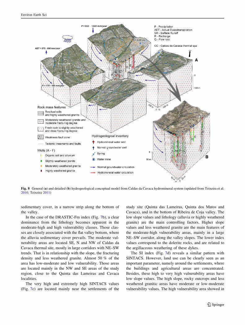
Fig. 8 General (a) and detailed (b) hydrogeological conceptual model from Caldas da Cavaca hydromineral system (updated from Teixeira et al.
2010; Teixeira 2011)
Environ Earth Sci
123

the other indexes is not clearly seen in SI index; only a very
small area has high vulnerability, in the N of the Caldas da
Cavaca thermal site.
Conceptual site model: implications on aquifer systems
In the Caldas da Cavaca hydromineral system discharge
zone, three aquifer types were identified, and an outline of
the hydrogeological conceptual model of the area is shown
in Fig. 8:
(a) A shallow, unconfined aquifer, related to the alluvia
cover, and located in the valley bottom, near the Caldas
da Cavaca thermal site; the groundwater in this
hydrogeological unit has pH between 5 and 6.5 and
electrical conductivity under 20 lS/cm (very low
mineralisation). Water temperature is strictly depen-
dent of the air temperature. This aquifer has high to very
high vulnerability to potential load contamination.
(b) An unconfined to semi-confined aquifer, in the weath-
ered rock mass and in fractured granite. These ground-
waters have pH between 5 and 6.5 and electrical
conductivity varying from 20 to 50 lS/cm (low
mineralisation). The water yields, in the measured
springs, are very low (\0.05 L/s), and the transmissiv-
ity is lower than 1 m2/day. These normal waters have
very low mineralisation, and generally a sodium
chloride facies. In general, this aquifer has moderate
to high vulnerability to potential load contamination.
(c) A deep confined hydromineral aquifer is clearly
controlled by a deep fault zone, in the fresh granite.
The hydromineral water has temperatures around
30 �C (mesothermal waters), higher electrical con-
ductivities (350–400 lS/cm; medium mineralised
waters) and pH around 8.4–8.6. These waters have
an alkaline reaction, a sodium bicarbonate facies,
fluoridated and sulphurous. The transmissivity in the
hydromineral aquifer varies from 27 to 136 m2/day.
The Ribeira de Coja fault zone, with general NNE–
SSW trend, mapped around Caldas da Cavaca area,
has a regional cartographic expression, and locally,
fault gouge was observed. This may be the main
structure controlling the occurrence of hydromineral
waters in this site. The two still working hydromin-
eral water wells (wells C and D) are located along
this fault. The other wells are not presently
operational.
Conclusions
The multidisciplinary approach, based on GIS mapping
tools, has proven its value and contributed to improve the
knowledge on the groundwater storage and flow in the
study area. These tools can provide an accurate method to
assess the favourable hydrogeomorphological features that
are favourable to infiltration and aquifer recharge or dis-
charge. Also, its contribution is important to build and
improve the hydrogeological conceptual model of the study
area.
Thus, in Caldas da Cavaca site the main factors con-
trolling the infiltration and recharge are the highly weath-
ered granite, the close fracturing degree, as well as the
planned surfaces in the higher areas, especially when the
land use corresponds to agricultural or forest areas.
Regarding the discharge, it can be controlled by the
fresh granite, in the areas with higher fracturing degree,
and especially in the lower areas of the valleys.
As proven in this study, for a successful hydrogeological
operation and development of the groundwater resources of
a given area, it is fundamental the comprehensible inte-
gration of all data obtained at different scales (remote
sensing, geology, morphotectonics, hydrogeochemistry,
land cover, hydrogeological inventory, etc.). All data
should be synthesised at adequate scale, and the compar-
ative analysis of the results are improved by GIS integra-
tion and analysis (e.g. overlay analysis and/or multicriteria
analysis). Also, all the results and the conceptual model
may indicate, more accurately, priority areas to develop
complementary studies (e.g. isotopic analysis and/or natu-
ral tracers). They can also contribute to a re-evaluation and/
or redefinition of wellhead protection areas, both for hy-
dromineral or normal groundwater.
The improved conceptual model of the site was very
useful in the decision-making process regarding the inte-
grated management of the water resources (surface water,
normal groundwater and hydromineral water). In addition,
it helped the planning of future hydrogeological investi-
gations, and thus, reduce the costs of more advanced
studies. Also, it may support the definition of the most
vulnerable areas to contamination or the delineation of
wellhead protection areas, as well as the sustainable man-
agement of the groundwater resources of the region.
Acknowledgments JT holds a doctoral scholarship from the Por-
tuguese Foundation for Science and Technology (SFRH/BD/29762/
2006). This work was partially financed by FEDER EU COMPETE
Funds and the Portuguese Foundation for the Science and Technol-
ogy, FCT (PEst-C/CTE/UI4035/2014, PEst-OE/CTE/UI0039), LAB-
CARGA|ISEP re-equipment program (IPP-ISEP|PAD’2007/08) and
HydroSPOT R&D project from European Space Agency (ESA-
ID5750). The authors would like to thank to the Aguiar da Beira
Municipality and TARH Lda Company the authorisation to publish
some hydrological data. We acknowledge the anonymous reviewers
for the constructive comments that helped to improve the focus of the
manuscript. The present paper is dedicated to late Mining Engineer
and Geologist Carlos Freire de Andrade (1893–1956), who promoted
the accurate use of the combined tectonic and hydromineral waters
studies in hydrogeology practice.
Environ Earth Sci
123

References
Acciaiuoli LMC (1952/53) Le Portugal hydromineral, vol 1 and 2.
Direccao Geral dos Servicos Geologicos, Lisbonne
Aller L, Bennett T, Leer J, Petty J, Hacket G (1987) DRASTIC: a
standardised system for evaluating groundwater pollution
potential using hydrogeologic settings. US hydromineral water
wells Protection Agency, Oklahoma
Almeida A, Almeida JD (1975) Inventario hidrologico de Portugal:
Beira Alta, vol 3. Instituto de Hidrologia de Lisboa, Lisboa
Assaad FA, LaMoreaux PE, Hughes TH, Wangfang Z, Jordan H
(2004) Field methods for geologists and hydrogeologists.
Springer, Berlin
Babar M (2005) Hydrogeomorphology: fundamentals, applications
and techniques. New India Publishing Agency, New Delhi
Ballukraya PN, Kalimuthu R (2010) Quantitative hydrogeological
and geomorphological analyses for groundwater potential
assessment in hard rock terrains. Curr Sci 98(2):253–259
Bisson R, Lehr J (2004) Modern groundwater exploration: discover-
ing new water resources in consolidated rocks using innovative
hydrogeologic concepts, exploration, drilling, aquifer testing and
management methods. Wiley Interscience, NJ
Boorder H (1965) Petrological investigations in the Aguiar da Beira
granite area, Northern Portugal. University of Amsterdam, p 126
(PhD Thesis)
Brum Ferreira A (1980) Surfaces d’aplanissement et tectonique
recente dans le Nord de la Beira (Portugal). Rev Geol Dyn Geogr
Phys 22(1):51–62
Brum Ferreira A (1991) Neotectonics in Northern Portugal: a
geomorphological approach. Z Geomorphl 82:73–85
Caetano M, Nunes V, Nunes A (2009) CORINE Land Cover 2006 for
Continental Portugal. Instituto Geografico Portugues, Lisboa
Calado C (2001) A ocorrencia de agua sulfurea alcalina no macico
hesperico: quadro hidrogeologico e quimiogenese. University of
Lisbon, p 462 (PhD Thesis)
Carreira PM, Valerio P, Nunes D, Araujo MF (2006) Temporal and
seasonal variations of stable isotopes (2H and 18O) and tritium
in precipitation over Portugal. In: Proceedings of Isotopes in
Environmental Studies, Aquatic Forum 2004. IAEA, Vienna,
pp 370–373
Carvalho JM (1996) Mineral water exploration and exploitation at the
Portuguese Hercynian Massif. Environ Geol 27:252–258
Carvalho JM (2006) Prospeccao e pesquisa de recursos hıdricos
subterraneos no Macico Antigo Portugues: linhas metodologicas.
University of Aveiro, p 292 (PhD Thesis)
Carvalho JM, Chamine HI, Afonso MJ, Espinha Marques J, Medeiros
A, Garcia S, Gomes A, Teixeira J, Fonseca PE (2005a)
Productivity and water costs in fissured-aquifers from the Iberian
crystalline basement (Portugal): hydrogeological constraints. In:
Lopez-Geta JA, Pulido-Bosch A, Baquero-Ubeda JC (eds)
Water, mining and environment: Book Homage to Professor
Rafael Fernandez Rubio. Instituto Geologico y Minero de
Espana, Madrid, pp 193–207
Carvalho JM, Chamine HI, Afonso MJ, Espinha Marques J, Teixeira
J, Cerqueira A, Coelho A, Gomes A, Fonseca PE (2005b)
Prospeccao hidrogeologica da area do sistema hidromineral das
Caldas da Cavaca (Aguiar da Beira, Portugal Central): impli-
cacoes na gestao dos recursos hıdricos subterraneos. In: Fern-
andez Rubio R (ed) Actas del I Foro Iberico sobre Aguas
Envasadas y Balnearios, Madrid, pp 109–121
Carvalho JM, Espinha Marques J, Afonso MJ, Chamine HI (2007)
Prospeccao e pesquisa de recursos hidrominerais e de agua de
nascente no Macico Antigo Portugues. Bol Min 42(2):161–196
Cascelli E, Crestaz E, Tatangelo F (2012) Cartography and geovi-
sualization in groundwater modelling. In: Borruso G, Bertazzon
S, Favretto A, Murgante B, Torre CM (eds) Geographic
information analysis for sustainable development and economic
planning, New technologies. IGI Global, USA, pp 49–67
CFCFF—Committee on Fracture Characterization and Fluid Flow
(1996) Rock fractures and fluid flow: contemporary understand-
ing and applications. National Research Council, The National
Academies, Washington, DC
Chamine HI, Carvalho JM, Afonso MJ, Teixeira J, Freitas L (2013)
On a dialogue between hard-rock aquifer mapping and hydro-
geological conceptual models: insights into groundwater explo-
ration. Eur Geol Mag J Eur Fed Geol 35:26–31
Choubey VM, Bartarya SK, Ramola RC (2003) Radon in groundwa-
ter of eastern Doon valley, Outer Himalaya. Rad Measurem
36(1–6):401–405
Chowdary VM, Rao NH, Sarma PBS (2003) GIS-based decision
support system for groundwater assessment in large irrigation
project areas. Agric Water Manag 62(3):229–252
Civita MV (2010) The combined approach when assessing and
mapping groundwater vulnerability to contamination. J Water
Resour Prot 2:14–28
Civita MV, De Maio M (2000) Valutazione e cartografia automatica
della vulnerabilita degli acquiferi all’ inquinamento com il
sistema parametrico: SINTACS R5. Pitagora Editrice, Bologna
Craig H (1961) Isotopic variations in meteoric waters. Science
133:1703
Denny SC, Allen DN, Journeay JM (2007) DRASTIC-Fm: a modified
vulnerability mapping method for structurally controlled aquifers
in the southern Gulf Islands, British Columbia, Canada. Hydro-
geol J 15(3):483–493
Dykes J, Maceachren AM, Kraak M-J (2005) Exploring geovisu-
alization. International Cartographic Association Elsevier,
Oxford
Elewa H, Qaddah A (2011) Groundwater potentiality mapping in the
Sinai Peninsula, Egypt, using remote sensing and GIS-
watershed-based modeling. Hydrogeol J 19(3):613–628
Ettazarini S (2007) Groundwater potentiality index: a strategically
conceived tool for water research in fractured aquifers. Environ
Geol 52(3):477–487
Foster SD (1987) Fundamental concepts in aquifer vulnerability,
pollution risk and protection strategy. In: van Duijvenbooden W,
van Waegeningh HG (eds) TNO Committee on Hydrological
Research, Vulnerability of soil and groundwater to pollutants,
Proceedings and Information, The Hague, 38:69–86
Foster SD, Hirata R (1988) Groundwater pollution risk assessment: a
methodology using available data. WHO-PAHO/HPE-CEPIS
Technical Manual, Peru
Foster SD, Hirata R, Gomes D, D’Elia M, Paris M (2002)
Groundwater quality protection: a guide for water utilities,
municipal authorities, and environment agencies. The World
Bank, Washington, DC
Freire de Andrade C (1935) Projecto de modificacao de captagem das
aguas das Caldas da Cavaca (unpublished report). Lisboa, p 11
Freire de Andrade C (1937) Os vales submarinos portugueses e o
diastrofismo das Berlengas e da Estremadura. Servicos Geolog-
icos de Portugal, Lisboa 236 p
Freire de Andrade C (1938) Nota acerca dos trabalhos realizados para
a modificacao da captagem das aguas medicinaes das Caldas da
Cavaca (unpublished report). Lisboa, p 7
Goncalves CVM, Pereira AJSC (2007) Radionuclides in groundwater
of the Serra do Bucaco region (Portugal). In: Proceedings of the
XXXV Congress of the International Association of Hydroge-
ologists, Groundwater and Ecosystems, IAH, Lisboa, p 9
Griffiths JS (2014) Feet on the ground: engineering geology past,
present and future. Quart J Eng Geol Hydrol 47(2):116–143.
http://dx.doi.org/10.1144/qjegh2013-087
Environ Earth Sci
123
Griffiths JS, Stokes M (2008) Engineering geomorphological input to
ground models: an approach based on earth systems. Quart J Eng
Geol Hydrol 41(1):73–91. doi:10.1144/1470-9236/07-010
GSE—Geological Society Engineering Group Working Party
Report (1995) The description and classification of weathered
rocks for engineering purposes. Quart J Eng Geol Hydrol
28(3):207–242
IGP—Instituto Geografico Portugues (2010) Carta de Uso e Ocu-
pacao do Solo de Portugal Continental para 2007—COS2007:
memoria descritiva. Instituto Geografico Portugues, Lisboa
INAG—Instituto da Agua (2013) SNIRH—Sistema Nacional de
Recurso Hıdricos. http://www.snirh.pt. Accessed 30 June 2013
ISRM—International Society for Rock Mechanics (2007) The
complete ISRM suggested methods for characterization, testing
and monitoring. In: Ulusay R, Hudson JA (eds) Suggested
methods prepared by the commission on testing methods.
ISRM and ISRM Turkish National Group, Ankara,
pp 1974–2006
Jaiswal RK, Mukherjee S, Krishnamurthy J, Saxena R (2003) Role of
remote sensing and GIS techniques for generation of ground-
water prospect zones towards rural development: an approach.
Int J Rem Sens 24(5):993–1008
Jha MK (2011) GIS-Based groundwater modeling: an integrated tool
for managing groundwater-induced disasters. In: Laughton RH
(ed) Aquifers: formation, transport and pollution, environmental
science, Engineering and Technology Series. Nova Science Pub.
Inc., Hauppauge, pp 149–190
Jha MK, Chowdhury A, Chowdary V, Peiffer S (2007) Groundwater
management and development by integrated remote sensing and
geographic information systems: prospects and constraints. Wat
Res Manag 21(2):427–467
Keaton J (2013) Engineering geology: fundamental input or random
variable? In: Withiam JL, Phoon KK, Hussein M (eds)
Foundation Engineering in the Face of Uncertainty, Honoring
Fred H. Kulhawy. ASCE, GSP 229:232–253
Kim G-B, Ahn J-S, Marui A (2009) Analytic hierarchy models for
regional groundwater monitoring well allocation in Southeast
Asian countries and South Korea. Environ Earth Sci
59:325–338
Kresic N, Mikszewski A (2013) Hydrogeological conceptual site
models: data analysis and visualization. CRC/Taylor & Francis
Group, Boca Raton
Kudrna K, Sindelarova M (2006) Principles of hydrogeomorphology
as a basic precondition for solution of territorial structure of
unitary system of agricultural, forest and water management.
J Center Eur Agric 7(4):669–676
LeGrand HE (1987) Radon and radium emanations from fractured
crystalline rocks: a conceptual hydrogeological model. Ground
Wat 25:59–69
Machado MJC (1988) O quimismo das aguas sulfureas portuguesas.
Estud Not Trab Serv Fom Min 30:37–49
McKnight TL, Hess D (2000) Climate zones and types: the Koppen
system. In: McKnight TL, Hess D (eds) Physical geography: a
landscape appreciation. Prentice Hall, New Jersey
NAP—National Academy Press (1997) Valuing ground water:
economic concepts and approaches. Washington, DC
Nilsson B, Højberg AL, Refsgaard JC, Troldborg L (2006) Uncer-
tainty in geological and hydrogeological data. Hydrol Earth Syst
Sci Discuss 3:2675–2706
Oliveira JT, Pereira E, Ramalho M, Antunes MT, Monteiro JH (1992)
Carta Geologica de Portugal 1/500000. 5a edicao, Servicos
Geologicos de Portugal, Lisboa
Painho M, Caetano M (2006) Cartografia de ocupacao do solo,
Portugal Continental 1985–2000. Instituto do Ambiente, Am-
adora, p 56
Peel MC, Finlayson BL, McMahon TA (2007) Updated world map of
the Koppen-Geiger climate classification. Hydrol Earth Syst Sci
11:1633–1644
Pereira AJSC, Neves LJPF, Goncalves CVM (2007) Radon in
groundwater from the Hesperian massif (Central Portugal). In:
Ribeiro L, Chambel A, Condesso de Melo MT (eds) XXXV
Congress of the International Association of Hydrogeologists,
Groundwater and Ecosystems. Lisbon, p 190
Pereira AJSC, Godinho MM, Neves LJPF (2010) On the influence of
faulting on small-scale soil-gas radon variability: a case study in
the Iberian Uranium Province. J Environ Rad 101:875–882
Pral A (1965) Primeira nota clınica sobre as Caldas da Cavaca, 28Congresso Internacional Luso-Espanhol da Hidrologia. Tipog-
rafia Luso-Ultramarina, Lisboa 10 p
Ribeiro O (1949) Le Portugal Central. In: Livret-guide de l’excursion
C, Union Geographique Internationale. XVI Congres Interna-
tional de Geographie, Lisbonne, p 180
Ribeiro L (2005) Um novo ındice de vulnerabilidade especıfico de
aquıferos: formulacao e aplicacoes. Actas do VII Simposio de
Hidraulica e Recursos Hıdricos dos Paıses de Lıngua Oficial
Portuguesa (SILUSBA), Evora, p 15
Ribeiro A, Munha J, Dias R, Mateus A, Pereira E, Ribeiro L, Fonseca
PE, Araujo A, Oliveira JT, Romao J, Chamine HI, Coke C, Pedro
J (2007) Geodynamic evolution of the SW Europe Variscides.
Tectonics 26(TC6009):1–24
Saaty TL (2008) Decision making with the analytic hierarchy process.
Int J Serv Sci 1(1):83–98
Sander P (2007) Lineaments in groundwater exploration: a review of
applications and limitations. Hydrogeol J 15(1):71–74
Sanford W (2002) Recharge and groundwater models: an overview.
Hydrogeol J 10(1):110–120
Sener E, Davraz A, Ozcelik M (2005) An integration of GIS and
remote sensing in groundwater investigations: a case study in
Burdur, Turkey. Hydrogeol J 13(5):826–834
Shaban A, Khawlie M, Abdallah C (2006) Use of remote sensing and
GIS to determine recharge potential zones: the case of
Occidental Lebanon. Hydrogeol J 14(4):433–443
Sidle RC, Onda Y (2004) Hydrogeomorphology: overview of an
emerging science. Hydrol Process 18(4):597–602
Smith M, Paron P, Griffiths J (2011) Geomorphological mapping:
methods and applications. Developments in earth surface
processes 15. Elsevier, Oxford
Sreedevi PD, Subrahmanyam K, Ahmed S (2005) Integrated approach
for delineating potential zones to explore for groundwater in the
Pageru River basin, Cuddapah District, Andhra Pradesh, India.
Hydrogeol J 13(3):534–543
Stigter TY, Ribeiro L, Carvalho Dill AMM (2006) Evaluation of an
intrinsic and a specific vulnerability assessment method in
comparison with groundwater salinisation and nitrate contami-
nation levels in two agricultural regions in the south of Portugal.
Hydrogeol J 14(1–2):79–99
Surrette M, Allen D, Journeay M (2008) Regional evaluation of
hydraulic properties in variably fractured rock using a hydro-
structural domain approach. Hydrogeol J 16(1):11–30
Teixeira J (2011) Hidrogeomorfologia e sustentabilidade de recursos
hıdricos subterraneos. University of Aveiro, p 507 (PhD Thesis)
Teixeira J, Chamine HI, Espinha Marques J, Gomes A, Carvalho JM,
Perez-Alberti A, Rocha F (2010) Integrated approach of
hydrogeomorphology and GIS mapping to the evaluation of
ground water resources: an example from the hydromineral
system of Caldas da Cavaca, NW Portugal. In: Paliwal BS (ed)
Global groundwater resources and management (selected papers
from the 33rd international geological congress, general sym-
posium: hydrogeology). Scientific Publishers (India), Jodhpur,
pp 227–249
Environ Earth Sci
123
Teixeira J, Chamine HI, Carvalho JM, Perez-Alberti A, Rocha F
(2013) Hydrogeomorphological mapping as a tool in groundwa-
ter exploration. J Maps 9(2):263–273
Thornthwaite CW, Mather JR (1955) The water balance. Publications
in Climatology, New Jersey
Tricart J (1961) Geomorphologie et eaux souterraines. IAHS Red
Book Series 56:22–27
Wallace KJ (2007) Classification of ecosystem services: problems and
solutions. Biol Conserv 139:235–246
Yeh H-F, Lee C-H, Hsu K-C, Chang P-H (2008) GIS for the
assessment of the groundwater recharge potential zone. Environ
Geol 58:185–195
Environ Earth Sci
123