Geographic Information System (GIS) What is GIS? - Connect ...
Upload
khangminh22Category
view
0download
0
BioMap2 CONSERVING THE BIODIVERSITY OF
MASSACHUSETTS IN A CHANGING WORLD
Longmeadow Produced in 2012
This report and associated map provide information about important
sites for biodiversity conservation in your area.
This information is intended for conservation planning, and is
not intended for use in state regulations.

BioMap2
Conserving the Biodiversity of Massachusetts in a Changing World
Natural Heritage Massachusetts Division of Fisheries and Wildlife
1 Rabbit Hill Road, Westborough, MA 01581 & Endangered
phone: 508-389-6360 fax: 508-389-7890
Species Program
For more information on rare species and natural communities, please see our fact sheets online at www.mass.gov/nhesp.
Table of Contents
Introduction
What is BioMap2 – Purpose and applications
One plan, two components
Understanding Core Habitat and its components
Understanding Critical Natural Landscape and its components
Understanding Core Habitat and Critical Natural Landscape Summaries
Sources of Additional Information
Longmeadow Overview
Core Habitat and Critical Natural Landscape Summaries
Elements of BioMap2 Cores
Core Habitat Summaries
Elements of BioMap2 Critical Natural Landscapes
Critical Natural Landscape Summaries

BioMap2
Conserving the Biodiversity of Massachusetts in a Changing World
Natural Heritage Massachusetts Division of Fisheries and Wildlife
1 Rabbit Hill Road, Westborough, MA 01581 & Endangered
phone: 508-389-6360 fax: 508-389-7890
Species Program
For more information on rare species and natural communities, please see our fact sheets online at www.mass.gov/nhesp.
Introduction
The Massachusetts Department of Fish & Game,
ɳɧɱɮɴɦɧ ɳɧɤ Dɨɵɨɲɨɮɭ ɮɥ Fɨɲɧɤɱɨɤɲ ɠɭɣ Wɨɫɣɫɨɥɤ˘ɲ
Natural Heritage & Endangered Species
Program (NHESP), and The Nature
Cɮɭɲɤɱɵɠɭɢɸ˘ɲ Mɠɲɲɠɢɧɴɲɤɳɳɲ Pɱɮɦɱɠɬ
developed BioMap2 ɳɮ ɯɱɮɳɤɢɳ ɳɧɤ ɲɳɠɳɤ˘ɲ
biodiversity in the context of climate change.
BioMap2 ɢɮɬɡɨɭɤɲ NHESP˘ɲ ȯȬ ɸɤɠɱɲ ɮɥ
rigorously documented rare species and natural
community data with spatial data identifying
wildlife species and habitats that were the focus
ɮɥ ɳɧɤ Dɨɵɨɲɨɮɭ ɮɥ Fɨɲɧɤɱɨɤɲ ɠɭɣ Wɨɫɣɫɨɥɤ˘ɲ ȮȬȬȱ
State Wildlife Action Plan (SWAP). BioMap2 also
ɨɭɳɤɦɱɠɳɤɲ Tɧɤ Nɠɳɴɱɤ Cɮɭɲɤɱɵɠɭɢɸ˘ɲ ɠɲɲɤɲɲɬɤɭɳ
of large, well-connected, and intact ecosystems
and landscapes across the Commonwealth,
incorporating concepts of ecosystem resilience
to address anticipated climate change impacts.
Protection and stewardship of BioMap2 Core
Habitat and Critical Natural Landscape is
essential to safeguard the diversity of species
and their habitats, intact ecosystems, and
resilient natural landscapes across
Massachusetts.
Get your copy of the BioMap2 report! Download
from www.mass.gov/nhesp or contact Natural
Heritage at 508-389-6360 or
What Does Status Mean?
The Division of Fisheries and Wildlife
determines a status category for each rare
species listed under the Massachusetts
Endangered Species Act (MESA), M.G.L. c.131A,
and its implementing regulations 321 CMR
10.00. Rare species are categorized as
Endangered, Threatened or of Special Concern
according to the following:
Endangered species are in danger of extinction
throughout all or a significant portion of their
range or are in danger of extirpation from
Massachusetts.
Threatened species are likely to become
Endangered in Massachusetts in the foreseeable
future throughout all or a significant portion of
their range.
Special Concern species have suffered a decline
that could threaten the species if allowed to
continue unchecked or occur in such small
numbers or with such restricted distribution or
specialized habitat requirements that they could
easily become Threatened in Massachusetts.
In addition NHESP maintains an unofficial
watch list of plants that are tracked due to
potential conservation interest or concern, but
are not regulated under the Massachusetts
Endangered Species Act or other laws or
regulations. Likewise, described natural
communities are not regulated by any law or
regulations, but they can help to identify
ecologically important areas that are worthy of
protection. The status of natural communities

BioMap2
Conserving the Biodiversity of Massachusetts in a Changing World
Natural Heritage Massachusetts Division of Fisheries and Wildlife
1 Rabbit Hill Road, Westborough, MA 01581 & Endangered
phone: 508-389-6360 fax: 508-389-7890
Species Program
For more information on rare species and natural communities, please see our fact sheets online at www.mass.gov/nhesp.
reflects the documented number and acreages of
each community type in the state:
Critically Imperiled communities typically have 5
or fewer documented good sites or have very
few remaining acres in the state.
Imperiled communities typically have 6-20 good
sites or few remaining acres in the state.
Vulnerable communities typically have 21-100
good sites or limited acreage across the state.
Secure communities typically have over 100 sites
or abundant acreage across the state; however,
excellent examples are identified as Core Habit
to ensure continued protection.
In 2005 the Massachusetts Division of Fisheries
and Wildlife completed a comprehensive State
Wildlife Action Plan (SWAP) documenting the
status of Massachusetts wildlife and providing
recommendations to help guide wildlife
conservation decision-making. SWAP includes
all the wildlife species listed under the
Massachusetts Endangered Species Act (MESA),
as well as more than 80 species that need
conservation attention but do not meet the
requirements for inclusion under MESA. The
SWAP document is organized around habitat
types in need of conservation within the
Commonwealth. While the original BioMap
focused primarily on rare species protected
under MESA, BioMap2 also addresses other
Species of Conservation Concern, their habitats,
and the ecosystems that support them to create a
spatial representation of most of the elements of
SWAP.
BioMap2: One Plan, Two Components
BioMap2 identifies two complementary spatial
layers, Core Habitat and Critical Natural
Landscape.
Core Habitat identifies key areas that are critical
for the long-term persistence of rare species and
other Species of Conservation Concern, as well
as a wide diversity of natural communities and
intact ecosystems across the Commonwealth.
Protection of Core Habitats will contribute to the
conservation of specific elements of biodiversity.
Critical Natural Landscape identifies large
natural Landscape Blocks that are minimally
impacted by development. If protected, these
areas will provide habitat for wide-ranging
native species, support intact ecological
processes, maintain connectivity among
habitats, and enhance ecological resilience to
natural and anthropogenic disturbances in a
rapidly changing world. Areas delineated as
Critical Natural Landscape also include
buffering upland around wetland, coastal, and
aquatic Core Habitats to help ensure their long-
term integrity.
The long-term persistence of Massachusetts
biological resources requires a determined
commitment to land and water conservation.
Protection and stewardship of both Critical
Natural Landscapes and Core Habitats are
needed to realize the biodiversity conservation
vision of BioMap2.
Components of Core Habitat
Core Habitat identifies specific areas necessary
to promote the long-term persistence of rare
species, other Species of Conservation Concern,
exemplary natural communities, and intact
ecosystems.
Rare Species
There are 432 native plant and animal species
listed as Endangered, Threatened or Special
Concern under the Massachusetts Endangered
Species Act (MESA) based on their rarity,
population trends, and threats to survival. For
BioMap2
Conserving the Biodiversity of Massachusetts in a Changing World
Natural Heritage Massachusetts Division of Fisheries and Wildlife
1 Rabbit Hill Road, Westborough, MA 01581 & Endangered
phone: 508-389-6360 fax: 508-389-7890
Species Program
For more information on rare species and natural communities, please see our fact sheets online at www.mass.gov/nhesp.
BioMap2, NHESP staff identified the highest
quality habitat sites for each non-marine species
based on size, condition, and landscape context.
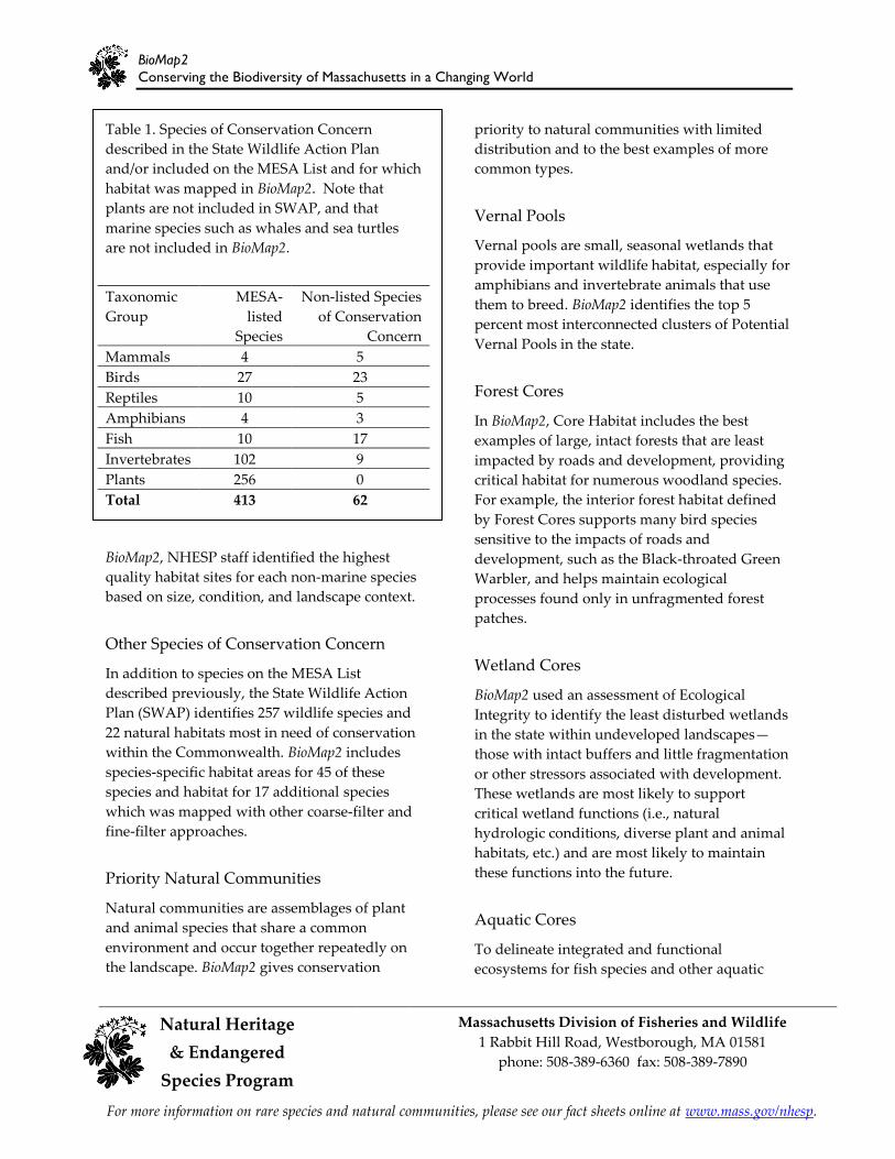
Table 1. Species of Conservation Concern
described in the State Wildlife Action Plan
and/or included on the MESA List and for which
habitat was mapped in BioMap2. Note that
plants are not included in SWAP, and that
marine species such as whales and sea turtles
are not included in BioMap2.
Taxonomic MESA- Non-listed Species
Group listed of Conservation
Species Concern
Mammals 4 5
Birds 27 23
Reptiles 10 5
Amphibians 4 3
Fish 10 17
Invertebrates 102 9
Plants 256 0
Total 413 62
Other Species of Conservation Concern
In addition to species on the MESA List
described previously, the State Wildlife Action
Plan (SWAP) identifies 257 wildlife species and
22 natural habitats most in need of conservation
within the Commonwealth. BioMap2 includes
species-specific habitat areas for 45 of these
species and habitat for 17 additional species
which was mapped with other coarse-filter and
fine-filter approaches.
Priority Natural Communities
Natural communities are assemblages of plant
and animal species that share a common
environment and occur together repeatedly on
the landscape. BioMap2 gives conservation
priority to natural communities with limited
distribution and to the best examples of more
common types.
Vernal Pools
Vernal pools are small, seasonal wetlands that
provide important wildlife habitat, especially for
amphibians and invertebrate animals that use
them to breed. BioMap2 identifies the top 5
percent most interconnected clusters of Potential
Vernal Pools in the state.
Forest Cores
In BioMap2, Core Habitat includes the best
examples of large, intact forests that are least
impacted by roads and development, providing
critical habitat for numerous woodland species.
For example, the interior forest habitat defined
by Forest Cores supports many bird species
sensitive to the impacts of roads and
development, such as the Black-throated Green
Warbler, and helps maintain ecological
processes found only in unfragmented forest
patches.
Wetland Cores
BioMap2 used an assessment of Ecological
Integrity to identify the least disturbed wetlands
in the state within undeveloped landscapes—
those with intact buffers and little fragmentation
or other stressors associated with development.
These wetlands are most likely to support
critical wetland functions (i.e., natural
hydrologic conditions, diverse plant and animal
habitats, etc.) and are most likely to maintain
these functions into the future.
Aquatic Cores
To delineate integrated and functional
ecosystems for fish species and other aquatic

BioMap2
Conserving the Biodiversity of Massachusetts in a Changing World
Massachusetts Division of Fisheries and Wildlife Natural Heritage 1 Rabbit Hill Road, Westborough, MA 01581
& Endangered phone: 508-389-6360 fax: 508-389-7890
Species Program
For more information on rare species and natural communities, please see our fact sheets online at www.mass.gov/nhesp.
Species of Conservation Concern, beyond the
species and exemplary habitats described above,
BioMap2 identifies intact river corridors within
which important physical and ecological
processes of the river or stream occur.
Components of Critical Natural Landscape
Critical Natural Landscape identifies intact
landscapes in Massachusetts that are better able
to support ecological processes and disturbance
regimes, and a wide array of species and
habitats over long time frames.
Landscape Blocks
BioMap2 identifies the most intact large areas of
predominately natural vegetation, consisting of
contiguous forests, wetlands, rivers, lakes, and
ponds, as well as coastal habitats such as barrier
beaches and salt marshes.
Upland Buffers of Wetland and Aquatic
Cores
A variety of analyses were used to identify
protective upland buffers around wetlands and
rivers.
Upland Habitat to Support Coastal
Adaptation
BioMap2 identifies undeveloped lands adjacent
to and up to one and a half meters above
existing salt marshes as Critical Natural
Landscapes with high potential to support
inland migration of salt marsh and other coastal
habitats over the coming century.
The conservation areas identified by BioMap2
are based on breadth and depth of data,
scientific expertise, and understanding of
Mɠɲɲɠɢɧɴɲɤɳɳɲ˘ ɡɨɮɣɨɵɤɱɲɨɳɸ˅ Tɧɤ ɭɴɬɤɱɮɴɲ
sources of information and analyses used to
Legal Protection of Biodiversity
BioMap2 presents a powerful vision of what
Massachusetts would look like with full protection of
the land most important for supporting the
Commonwealth’s biodiversity. While BioMap2 is a
planning tool with no regulatory function, all state-listed
species enjoy legal protection under the Massachusetts
Endangered Species Act (M.G.L. c.131A) and its
implementing regulations (321 CMR 10.00). Wetland
habitat of state-listed wildlife is also protected under
the Wetlands Protection Act Regulations (310 CMR
10.00). The Natural Heritage Atlas contains maps of
Priority Habitats and Estimated Habitats, which are
used, respectively, for regulation under the
Massachusetts Endangered Species Act and the
Wetlands Protection Act. For more information on
rare species regulations, and to view Priority and
Estimated Habitat maps, please see the Regulatory
Review page at
http://www.mass.gov/eea/agencies/dfg/dfw/natural-
heritage/regulatory-review/.
BioMap2 is a conservation planning tool that
does not, in any way, supplant the Estimated
and Priority Habitat Maps which have
regulatory significance. Unless and until the
BioMap2 vision is fully realized, we must
continue to protect our most imperiled species
and their habitats.
create Core Habitat and Critical Natural
Landscape are complementary, and outline a
comprehensive conservation vision for
Massachusetts, from rare species to intact
landscapes. In total, these robust analyses
define a suite of priority lands and waters that, if
permanently protected, will support
Mɠɲɲɠɢɧɴɲɤɳɳɲ˘ ɭɠɳɴɱɠɫ ɲɸɲɳɤɬɲ ɥɮɱ ɦɤɭɤɱɠɳɨɮɭɲ
to come.

BioMap2
Conserving the Biodiversity of Massachusetts in a Changing World
Natural Heritage Massachusetts Division of Fisheries and Wildlife
1 Rabbit Hill Road, Westborough, MA 01581 & Endangered
phone: 508-389-6360 fax: 508-389-7890
Species Program
For more information on rare species and natural communities, please see our fact sheets online at www.mass.gov/nhesp.
Understanding Core Habitat Summaries
Following the Town Overview, there is a
descriptive summary of each Core Habitat and
Critical Natural Landscape that occurs in your
city or town. These summaries highlight some
of the outstanding characteristics of each Core
Habitat and Critical Natural Landscape, and
will help you learn more about your city or
ɳɮɶɭ˘ɲ ɡɨɮɣɨɵɤɱɲɨɳɸ˅ Yɮɴ ɢɠɭ ɥɨɭɣ ɮɴɳ ɬɮɱɤ
information about many of these species and
natural communities by looking at specific fact
sheets at www.mass.gov/nhesp.
Additional Information
For copies of the full BioMap2 report, the
Technical Report, and an interactive mapping
tool, visit the BioMap2 website via the Land
Protection and Planning tab at
www.mass.gov/nhesp. If you have any
questions about this report, or if you need help
protecting land for biodiversity in your
community, the Natural Heritage & Endangered
Species Program staff looks forward to working
with you.
Contact the Natural Heritage & Endangered
Species Program
By phone 508-389-6360
By fax 508-389-7890
By email [email protected]
By Mail 100 Hartwell Street, Suite 230
West Boylston, MA 01583
The GIS datalayers of BioMap2 are available for
download from MassGIS at
www.mass.gov/mgis.

BioMap2
Conserving the Biodiversity of Massachusetts in a Changing World
Natural Heritage Massachusetts Division of Fisheries and Wildlife
1 Rabbit Hill Road, Westborough, MA 01581 & Endangered
phone: 508-389-6360 fax: 508-389-7890
Species Program
For more information on rare species and natural communities, please see our fact sheets online at www.mass.gov/nhesp.
Town Overview
Longmeadow lies within the Connecticut River
Valley Ecoregion, the borders of which are
primarily defined by the bedrock geology, has rich
soils, a relatively mild climate and low rolling
topography. The valley floor is primarily cropland
and built land. Central hardwoods and transition
hardwood forests cover the ridges.
Longmeadow at a Glance Total Area: 6,141 acres (9.6 square miles)
Human Population in 2010: 15,784
Open space protected in perpetuity: 1,071
acres, or 17.4% percent of total area*
BioMap2 Core Habitat: 1,567 acres
BioMap2 Core Habitat Protected: 984 acres or
62.8%
BioMap2 Critical Natural Landscape: 1,252
acres
BioMap2 Critical Natural Landscape
Protected: 799 acres or 63.8%.
BioMap2 Components
Core Habitat
2 Exemplary or Priority Natural Community
Cores
1 Wetland Core
3 Aquatic Cores
1 Vernal Pool Core
3 Species of Conservation Concern Cores**
o 1 bird, 1 reptile, 1 amphibian, 2 fishes, 2
insects, 8 plants
Critical Natural Landscape 1 Wetland Core Buffer 2 Aquatic Core Buffers
* Calculated uɲɨɭɦ MɠɲɲGIS ɣɠɳɠ ɫɠɸɤɱ ȃPɱɮɳɤɢɳɤɣ
and Recreational Open Space—March, ȮȬȭȮȄ.
** See next pages for complete list of species,
natural communities and other biodiversity
elements.

BioMap2
Conserving the Biodiversity of Massachusetts in a Changing World
Natural Heritage Massachusetts Division of Fisheries and Wildlife
1 Rabbit Hill Road, Westborough, MA 01581 & Endangered
phone: 508-389-6360 fax: 508-389-7890
Species Program
For more information on rare species and natural communities, please see our fact sheets online at www.mass.gov/nhesp.
BioMap2 Core Habitat and Critical Natural Landscape in Longmeadow

BioMap2
Conserving the Biodiversity of Massachusetts in a Changing World
Natural Heritage Massachusetts Division of Fisheries and Wildlife
1 Rabbit Hill Road, Westborough, MA 01581 & Endangered
phone: 508-389-6360 fax: 508-389-7890
Species Program
For more information on rare species and natural communities, please see our fact sheets online at www.mass.gov/nhesp.
Species of Conservation Concern, Priority and Exemplary Natural Communities,
and Other Elements of Biodiversity in Longmeadow
Insects
Dragonflies
Riverine Clubtail, (Stylurus amnicola), E Arrow Clubtail, (Stylurus spiniceps), Non-listed SWAP species
Amphibians
Northern Leopard Frog, (Rana pipiens), Non-listed SWAP
Fishes
Shortnose Sturgeon, (Acipenser brevirostrum), E Burbot, (Lota lota), SC
Reptiles
Eastern Worm Snake, (Carphophis amoenus), T
Birds
Bald Eagle, (Haliaeetus leucocephalus), T
Plants
Green Dragon, (Arisaema dracontium), T Gray's Sedge, (Carex grayi), T Narrow-leaved Spring Beauty, (Claytonia virginica), E Frank's Lovegrass, (Eragrostis frankii), SC Many-fruited False-loosestrife, (Ludwigia polycarpa), E Winged Monkey-flower, (Mimulus alatus), E Philadelphia Panic-grass, (Panicum philadelphicum ssp. philadelphicum), SC Swamp Dock, (Rumex verticillatus), T
Priority Natural Communities
Major-river Floodplain Forest, S2 Sandplain Grassland, S1
Other BioMap2 Components
Aquatic Core Wetland Core Vernal Pool Core Aquatic Core Buffer Wetland Core Buffer
E = Endangered

BioMap2
Conserving the Biodiversity of Massachusetts in a Changing World
Natural Heritage Massachusetts Division of Fisheries and Wildlife
1 Rabbit Hill Road, Westborough, MA 01581 & Endangered
phone: 508-389-6360 fax: 508-389-7890
Species Program
For more information on rare species and natural communities, please see our fact sheets online at www.mass.gov/nhesp.
T = Threatened
SC = Special Concern
S1 = Critically Imperiled communities, typically 5 or fewer documented sites or very few remaining acres in
the state.
S2 = Imperiled communities, typically 6-20 sites or few remaining acres in the state.
S3 = Vulnerable communities, typically have 21-100 sites or limited acreage across the state.

BioMap2
Conserving the Biodiversity of Massachusetts in a Changing World
Natural Heritage Massachusetts Division of Fisheries and Wildlife
1 Rabbit Hill Road, Westborough, MA 01581 & Endangered
phone: 508-389-6360 fax: 508-389-7890
Species Program
For more information on rare species and natural communities, please see our fact sheets online at www.mass.gov/nhesp.
BioMap2 Core Habitat in Longmeadow
Core IDs correspond with the following element lists and summaries.
BioMap2
Conserving the Biodiversity of Massachusetts in a Changing World
Natural Heritage Massachusetts Division of Fisheries and Wildlife
1 Rabbit Hill Road, Westborough, MA 01581 & Endangered
phone: 508-389-6360 fax: 508-389-7890
Species Program
For more information on rare species and natural communities, please see our fact sheets online at www.mass.gov/nhesp.
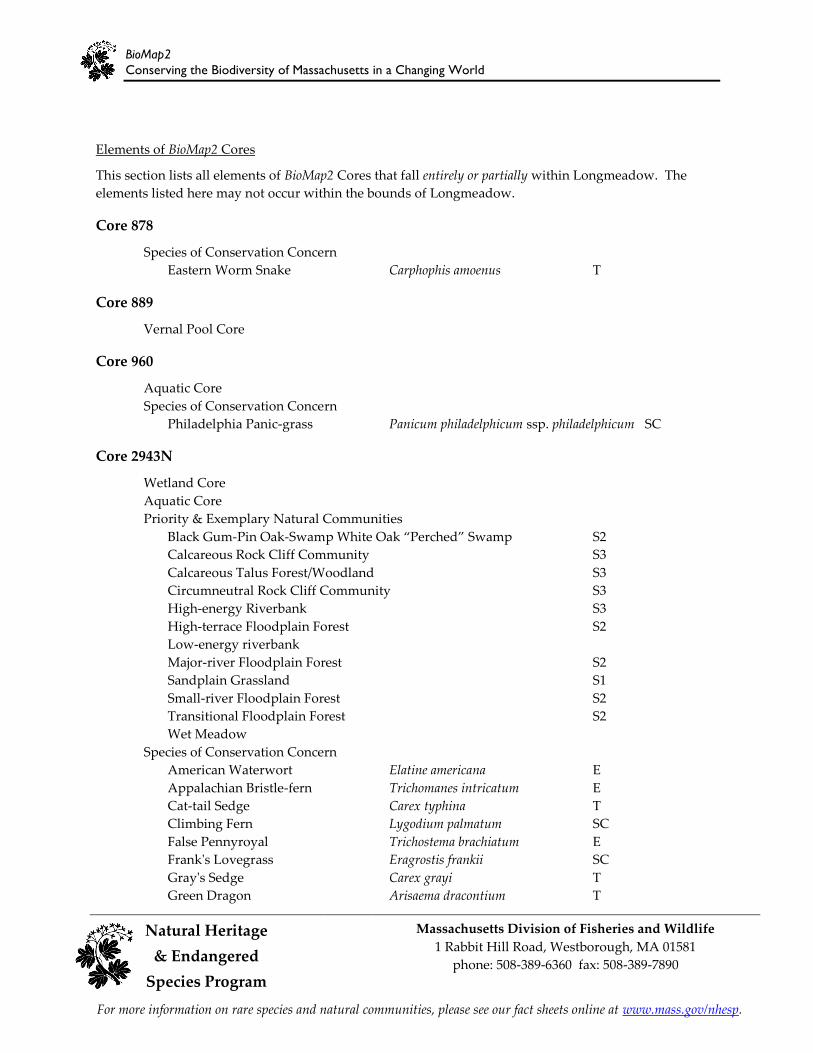
Elements of BioMap2 Cores
This section lists all elements of BioMap2 Cores that fall entirely or partially within Longmeadow. The
elements listed here may not occur within the bounds of Longmeadow.
Core 878
Species of Conservation Concern
Eastern Worm Snake Carphophis amoenus T
Core 889
Vernal Pool Core
Core 960
Aquatic Core
Species of Conservation Concern
Philadelphia Panic-grass Panicum philadelphicum ssp. philadelphicum SC
Core 2943N
Wetland Core Aquatic Core Priority & Exemplary Natural Communities
Black Gum-Pin Oak-Sɶɠɬɯ Wɧɨɳɤ Oɠɪ ȃPɤɱɢɧɤɣȄ Sɶɠɬɯ S2
Calcareous Rock Cliff Community S3
Calcareous Talus Forest/Woodland S3
Circumneutral Rock Cliff Community S3
High-energy Riverbank S3
High-terrace Floodplain Forest S2
Low-energy riverbank
Major-river Floodplain Forest S2
Sandplain Grassland S1
Small-river Floodplain Forest S2
Transitional Floodplain Forest S2
Wet Meadow
Species of Conservation Concern
American Waterwort Elatine americana E
Appalachian Bristle-fern Trichomanes intricatum E
Cat-tail Sedge Carex typhina T
Climbing Fern Lygodium palmatum SC
False Pennyroyal Trichostema brachiatum E
Frank's Lovegrass Eragrostis frankii SC
Gray's Sedge Carex grayi T
Green Dragon Arisaema dracontium T

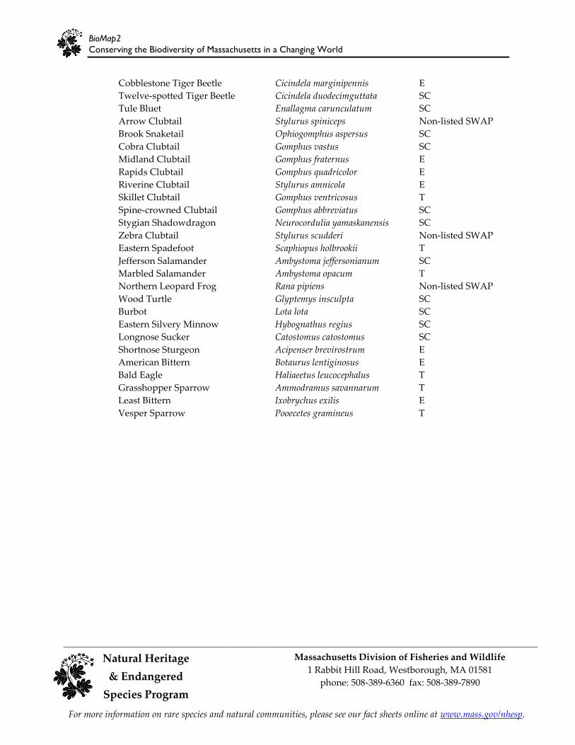
BioMap2
Conserving the Biodiversity of Massachusetts in a Changing World
Natural Heritage Massachusetts Division of Fisheries and Wildlife
1 Rabbit Hill Road, Westborough, MA 01581 & Endangered
phone: 508-389-6360 fax: 508-389-7890
Species Program
For more information on rare species and natural communities, please see our fact sheets online at www.mass.gov/nhesp.
Green Rock-cress Boechera missouriensis T
Intermediate Spike-sedge Eleocharis intermedia T
Low Bindweed Calystegia spithamaea E
Many-fruited False-loosestrife Ludwigia polycarpa E
Michaux's Sandwort Minuartia michauxii T
Mountain Alder Alnus viridis ssp. crispa T
Narrow-leaved Spring Beauty Claytonia virginica E
Nodding Chickweed Cerastium nutans E
Philadelphia Panic-grass Panicum philadelphicum ssp. philadelphicum SC
Purple Clematis Clematis occidentalis SC
Putty-root Aplectrum hyemale E
Pygmyweed Crassula aquatica T
Red Mulberry Morus rubra E
Sand Violet Viola adunca SC
Sandbar Cherry Prunus pumila var. depressa T
Sandbar Willow Salix exigua ssp. interior T
Shore Sedge Carex lenticularis T
Smooth Rock-cress Boechera laevigata SC
Swamp Dock Rumex verticillatus T
Tiny Cow-lily Nuphar microphylla E
Tradescant's Aster Symphyotrichum tradescantii T
Tuckerman's Sedge Carex tuckermanii E
Tufted Hairgrass Deschampsia cespitosa ssp. glauca E
Upland White Aster Oligoneuron album E
White Adder's-mouth Malaxis monophyllos var. brachypoda E
Winged Monkey-flower Mimulus alatus E
Wright's Spike-rush Eleocharis diandra E
Sunderland Spring Planarian Polycelis remota E
Brook Floater (Swollen Wedgemussel) Alasmidonta varicosa E
Creeper Strophitus undulatus SC
Dwarf Wedgemussel Alasmidonta heterodon E
Eastern Pondmussel Ligumia nasuta SC
Tidewater Mucket Leptodea ochracea SC
Triangle Floater Alasmidonta undulata Non-listed SWAP
Yellow Lampmussel Lampsilis cariosa E
Barrens Buckmoth Hemileuca maia SC
New Jersey Tea Inchworm Apodrepanulatrix liberaria E
Orange Sallow Moth Pyrrhia aurantiago SC
Pine Barrens Speranza Speranza exonerata SC
Pine Barrens Zale Zale lunifera SC
Pine Barrens Zanclognatha Zanclognatha martha T
Pink Sallow Psectraglaea carnosa SC
Sandplain Euchlaena Euchlaena madusaria SC
Frosted Elfin Callophrys irus SC
BioMap2
Conserving the Biodiversity of Massachusetts in a Changing World
Natural Heritage Massachusetts Division of Fisheries and Wildlife
1 Rabbit Hill Road, Westborough, MA 01581 & Endangered
phone: 508-389-6360 fax: 508-389-7890
Species Program
For more information on rare species and natural communities, please see our fact sheets online at www.mass.gov/nhesp.
Cobblestone Tiger Beetle Cicindela marginipennis E
Twelve-spotted Tiger Beetle Cicindela duodecimguttata SC
Tule Bluet Enallagma carunculatum SC
Arrow Clubtail Stylurus spiniceps Non-listed SWAP
Brook Snaketail Ophiogomphus aspersus SC
Cobra Clubtail Gomphus vastus SC
Midland Clubtail Gomphus fraternus E
Rapids Clubtail Gomphus quadricolor E
Riverine Clubtail Stylurus amnicola E
Skillet Clubtail Gomphus ventricosus T
Spine-crowned Clubtail Gomphus abbreviatus SC
Stygian Shadowdragon Neurocordulia yamaskanensis SC
Zebra Clubtail Stylurus scudderi Non-listed SWAP
Eastern Spadefoot Scaphiopus holbrookii T
Jefferson Salamander Ambystoma jeffersonianum SC
Marbled Salamander Ambystoma opacum T
Northern Leopard Frog Rana pipiens Non-listed SWAP
Wood Turtle Glyptemys insculpta SC
Burbot Lota lota SC
Eastern Silvery Minnow Hybognathus regius SC
Longnose Sucker Catostomus catostomus SC
Shortnose Sturgeon Acipenser brevirostrum E
American Bittern Botaurus lentiginosus E
Bald Eagle Haliaeetus leucocephalus T
Grasshopper Sparrow Ammodramus savannarum T
Least Bittern Ixobrychus exilis E
Vesper Sparrow Pooecetes gramineus T

BioMap2
Conserving the Biodiversity of Massachusetts in a Changing World
Natural Heritage Massachusetts Division of Fisheries and Wildlife
1 Rabbit Hill Road, Westborough, MA 01581 & Endangered
phone: 508-389-6360 fax: 508-389-7890
Species Program
For more information on rare species and natural communities, please see our fact sheets online at www.mass.gov/nhesp.
Core Habitat Summaries
Core 878
A 37-acre Core Habitat featuring a Species of Conservation Concern.
Eastern Worm Snakes are small, glossy, thin snakes, and range from 4 to 11 inches in length. They are
typically brown dorsally and bright pink ventrally. The Eastern Worm Snake is a fossorial snake,
spending most of the year underground, under rotting logs and woody debris, and in moist piles of
leaves and compost. The Eastern Worm Snake prefers moist, non-saturated, sandy soil and woody
debris. It occurs in deciduous hardwood forest, mixed pine-hardwoods, pine forest, rights-of-ways, early
successional fields, and ecotonal areas abutting such habitats. They are rarely observed due to their
fossorial nature, small size, and dull coloring.
Core 889
A 35-acre Core Habitat featuring Vernal Pool Core.
Vernal pools are small, seasonal wetlands that provide important wildlife habitat, especially for
amphibians and invertebrate animals that use them to breed. BioMap2 identifies the top 5 percent most
interconnected clusters of Potential Vernal Pools in the state.
Core 960
A 2-acre Core Habitat featuring Aquatic Core and a Species of Conservation Concern.
Aquatic Cores are intact river corridors within which important physical and ecological processes of the
river or stream occur. They delineate integrated and functional ecosystems for fish species and other
aquatic Species of Conservation Concern.
Philadelphia Panic-grass, a member of the Grass family, is a slender, hairy, herbaceous, annual grass with
yellow-green leaves. Philadelphia Panic-grass subspecies philadelphicum grows primarily on sandy shores
of lakes and streams.
Core 2943N
A 27,102-acre section of a larger 93,990-acre Core Habitat featuring Wetland Core, Aquatic Core, Priority
Natural Communities, and Species of Conservation Concern.
The mainstem of the Connecticut River is the spine of a much more extensive Core Habitat that connects
many of the most biologically important sites in the river valley. Just in the mainstem and adjacent
uplands, 91 rare and uncommon species have been found. This large, meandering river hosts seven
species of rare dragonflies, including the globally rare Skillet Clubtail and the Midland Clubtail, which is
found nowhere else in the state. Below the Turners Dam, the river supports the federally Endangered
Shortnose Sturgeon, the state's only population of Burbot, and Eastern Silvery Minnows. High above the
river Bald Eagles soar; this river is a key breeding and wintering site for this bird in Massachusetts. On
the Connecticut border, the extensive floodplain forests of the Fanny Stebbins Wildlife Refuge are home
to seven rare and uncommon plants, including the Endangered Winged Monkey-flower.

BioMap2
Conserving the Biodiversity of Massachusetts in a Changing World
Natural Heritage Massachusetts Division of Fisheries and Wildlife
1 Rabbit Hill Road, Westborough, MA 01581 & Endangered
phone: 508-389-6360 fax: 508-389-7890
Species Program
For more information on rare species and natural communities, please see our fact sheets online at www.mass.gov/nhesp.
Black Gum-Pin Oak-White Oak "Perched" swamps are an unusual type of wetland found in
Massachusetts in one area of the Connecticut River Valley. This community type is dominated by red
maple, with black gum, pin oak, and swamp white oak. This moderate-sized example of Black Gum-Pin
Oak- Swamp White Oak "Perched" Swamp is of high-quality and is surrounded by both forested upland
and agricultural fields.
Calcareous Rock Cliffs are sparsely vegetated cliff communities. Unusual, highly specialized plants and
ferns grow in cracks and ledges in the calcium-rich cliff face. This type of cliff community has more
species diversity than Acidic Rock Cliffs. Two small examples of Calcareous Rock Cliff including one that
is in good condition, despite its minimal buffer to human disturbances. It is free of exotic invasive species
and has several unusual plant species present.
Calcareous Talus Forest communities develop on loose rocky slopes below calcareous cliffs or rock
outcrops. The soil between the boulders is usually moist and loamy. Trees are usually best established on
lower slopes. This example of Calcareous Talus Forest is in good condition, despite its proximity to
development. It is of moderate size and an invasive exotic species is present.
Circumneutral Rock Cliff communities consist of extremely sparse plants growing on small ledges and in
crevices on a circumneutral cliff face. These communities tend to support a greater diversity of species
than do Acidic Rock Cliff communities. This example of Circumneutral Rock Cliff is open, dry, and west-
facing, with many associated rare plants. Although these popular cliffs are somewhat disturbed by
trampling, they remain a good-quality natural community.
High-Energy Riverbank communities are sparse, open graminoid communities found on cobble and sand
deposits along fast-flowing rivers that experience severe flooding and ice scour. This Core has four small
examples and one large example of High-Energy Riverbank. Each is pristine with good species diversity
and two in particular are well-buffered and influenced by intact natural processes that perpetuate them.
High-Terrace Floodplain Forests are deciduous hardwood forests that occur along riverbanks, above the
zone of annual flooding. Although they do not flood annually, they flood often enough for the soil to be
moderately enriched. This Core has two examples of High-Terrace Floodplain Forest. A moderate-sized
example is well-developed, with good structure and diversity and moderate levels of disturbance. The
other is quite small and in somewhat degraded condition.
Low-Energy Riverbanks are open herbaceous communities occurring on sandy or silty mineral soils of
river and streambanks that do not experience severe flooding or ice scour. One example is a high-quality,
species-rich Low-energy Riverbank community, a different community with more grasses than is found
on more northern islands in the Connecticut River. Another example is moderate-sized and is an unusual
variant of this community type that experiences periodic flooding, resulting in an unusual species
composition.
Major-River Floodplain Forests are dominated by silver maple. This community is found along the
floodplains of large rivers. The soils here are enriched with nutrients brought by annual floods, resulting
in a diversity of plants and insects. Seven examples of Major-River Floodplain Forest ranging from an
extremely small remnant of a once larger forest, somewhat degraded by exotic invasive species, to a large
example in excellent condition with good floral diversity, with the exception of some recreational use
areas that have been trampled and are being invaded by exotic species. This Core includes the largest and
highest-quality examples of Major-River Floodplain Forest currently known in Massachusetts.

BioMap2
Conserving the Biodiversity of Massachusetts in a Changing World
Natural Heritage Massachusetts Division of Fisheries and Wildlife
1 Rabbit Hill Road, Westborough, MA 01581 & Endangered
phone: 508-389-6360 fax: 508-389-7890
Species Program
For more information on rare species and natural communities, please see our fact sheets online at www.mass.gov/nhesp.
Sandplain Grasslands are open, essentially treeless, grass-dominated communities that generally occur
on sand or other dry, poor soils. Occurrences are maintained by fire, salt spray, and, now, mowing. This
Sandplain Grassland is an unusual Connecticut River Valley variant of this community, which is found
primarily in the Cape and Islands. It is succeeding to forest and is threatened by human disturbances
including ORV use.
Small-River Floodplain Forests are silver maple/green ash forests occurring on alluvial soils of small
rivers and streams. They occur on small tributaries of the Connecticut and Nashua Rivers and along some
small rivers of eastern Massachusetts. This Core includes three of the top four examples of Small-River
Floodplain Forest in Massachusetts. They are in excellent condition, with good structure and diversity.
Transitional Floodplain Forests are riverside silver maple-green ash-American elm forests that experience
annual floods. Of the three floodplain forest community types, these communities are intermediate in
vegetation and soils. This Core includes three examples of Transitional Floodplain Forest including the
largest and best quality of its kind in Massachusetts. There are only five locations of this community type
known in Massachusetts.
Wet Meadows are graminoid communities similar to Deep and Shallow Emergent Marshes except that
they are temporarily rather than seasonally flooded. They occur in lake basins, wet depressions, along
streams, and in sloughs along rivers. This small wet meadow is in very good condition, with high floristic
diversity.
Wetlands Cores are the least disturbed wetlands in the state within undeveloped landscapes—those with
intact buffers and little fragmentation or other stressors associated with development. These wetlands are
most likely to support critical wetland functions (i.e., natural hydrologic conditions, diverse plant and
animal habitats, etc.) and are most likely to maintain these functions into the future.
Aquatic Cores are intact river corridors within which important physical and ecological processes of the
river or stream occur. They delineate integrated and functional ecosystems for fish species and other
aquatic Species of Conservation Concern.

BioMap2
Conserving the Biodiversity of Massachusetts in a Changing World
Natural Heritage Massachusetts Division of Fisheries and Wildlife
1 Rabbit Hill Road, Westborough, MA 01581 & Endangered
phone: 508-389-6360 fax: 508-389-7890
Species Program
For more information on rare species and natural communities, please see our fact sheets online at www.mass.gov/nhesp.
BioMap2 Critical Natural Landscape in Longmeadow
Critical Natural Landscape IDs correspond with the following element lists and summaries.

BioMap2
Conserving the Biodiversity of Massachusetts in a Changing World
Natural Heritage Massachusetts Division of Fisheries and Wildlife
1 Rabbit Hill Road, Westborough, MA 01581 & Endangered
phone: 508-389-6360 fax: 508-389-7890
Species Program
For more information on rare species and natural communities, please see our fact sheets online at www.mass.gov/nhesp.
Elements of BioMap2 Critical Natural Landscapes
This section lists all elements of BioMap2 Critical Natural Landscapes that fall entirely or partially within
Longmeadow. The elements listed here may not occur within the bounds of Longmeadow.
CNL 514
Aquatic Core Buffer
CNL 1322
Aquatic Core Buffer
Landscape Block
Wetland Core Buffer

BioMap2
Conserving the Biodiversity of Massachusetts in a Changing World
Natural Heritage Massachusetts Division of Fisheries and Wildlife
1 Rabbit Hill Road, Westborough, MA 01581 & Endangered
phone: 508-389-6360 fax: 508-389-7890
Species Program
For more information on rare species and natural communities, please see our fact sheets online at www.mass.gov/nhesp.
Critical Natural Landscape Summaries
CNL 514
A 2-acre Critical Natural Landscape featuring Aquatic Core Buffer.
A variety of analyses were used to identify protective upland buffers around wetlands and rivers. One,
the variable width buffers methodology, included the most intact areas around each wetland and river,
by extending deeper into surrounding unfragmented habitats than into developed areas adjacent to each
wetland. Other upland buffers were identified through the rare species habitat analysis. In this way, the
conservation of wetland buffers will support the habitats and functionality of each wetland, and also
include adjacent uplands that are important for many species that move between habitat types.
CNL 1322
A 288,370-acre Critical Natural Landscape featuring Aquatic Core Buffer, Wetland Core Buffer and
Landscape Block.
A variety of analyses were used to identify protective upland buffers around wetlands and rivers. One,
the variable width buffers methodology, included the most intact areas around each wetland and river,
by extending deeper into surrounding unfragmented habitats than into developed areas adjacent to each
wetland. Other upland buffers were identified through the rare species habitat analysis. In this way, the
conservation of wetland buffers will support the habitats and functionality of each wetland, and also
include adjacent uplands that are important for many species that move between habitat types.
Landscape Blocks, the primary component of Critical Natural Landscapes, are large areas of intact
predominately natural vegetation, consisting of contiguous forests, wetlands, rivers, lakes, and ponds, as
well as coastal habitats such as barrier beaches and salt marshes. Pastures and power-line rights-of-way,
which are less intensively altered than most developed areas, were also included since they provide
habitat and connectivity for many species. Collectively, these natural cover types total 3.6 million acres
across the state. An Ecological Integrity assessment was used to identify the most intact and least
fragmented areas. These large Landscape Blocks are most likely to maintain dynamic ecological processes
such as buffering, connectivity, natural disturbance, and hydrological regimes, all of which help to
support wide-ranging wildlife species and many other elements of biodiversity.
In order to identify critical Landscape Blocks in each ecoregion, different Ecological Integrity thresholds
were used to select the largest intact landscape patches in each ecoregion while avoiding altered habitat
as much as possible. This ecoregional representation accomplishes a key goal of BioMap2 to protect the
ecological stages that support a broad suite of biodiversity in the context of climate change. Blocks were
defined by major roads, and minimum size thresholds differed among ecoregions to ensure that BioMap2
includes the best of the best in each ecoregion.

Help Save Endangered Wildlife!
Please contribute on your Massachusetts income tax form or directly to the
Natural Heritage &
Endangered Species Fund
To learn more about the Natural Heritage & Endangered Species Program and the Commoɭɶɤɠɫɳɧ˘ɲ ɱɠɱɤ ɲɯɤɢɨɤɲˆ ɵɨɲɨɳ ɮɴɱ ɶɤɡ ɲɨɳɤ ɠɳ www.mass.gov/nhesp.
Copyright © 2022 FDOKUMEN