GIS PROFESSIOvAL - URISA
24
the GIS PROFESSIONAL A publication of the Urban and Regional Information Systems Association Issue 249 • July/August 2012 IN THIS ISSUE 10 Using GIS to Prepare Data for Next Generation 911 12 Tracking Hotspots: Using ArcGIS to Improve Mooresville’s Sanitary Sewer System 15 Book Review 16 President’s Column 18 Welcome New urisa Members 21 2012 Sponsor Directory continued on page 1 As the 50th Annual Confer- ence to be held this year attests, URISA has a long his- tory of service to—whom? According to our articles of incorporation, URISA was formed “to stimulate, encourage, and otherwise provide for the advancement of an interdisciplinary and multiprofessional approach to the planning, designing, and operating of urban in- formation systems” (Certifi- cate of Incorporation, Article 3, Dec. 17, 1968). The first events were called the “Annual Conference on Urban Planning Information Systems and Programs.” Planning information systems became generalized to urban and regional information systems when URISA was incorporated, but the name was not really the issue. According to a history of URISA written by Ken Dueker, the big debate back then was whether to emphasize automation of existing processes or the creation of new analytical processes made possible by automation. (Yes, this doesn’t seem like much of a debate now.) On the automation side was the Urban Inter-agency Advisory Committee. On the analytical side was the Census Small Area Data Committee. Over time, this turned into a debate between computer-aided mapping (automation) and geographic information systems (analysis), although those terms were just beginning to be used. Officer elections were highly contested, with lots of backroom campaigning. The Past President’s Council of URISA is currently writing a book on the history of URISA and its role in laying the foundation of urban and regional information systems, geographic information systems, and the field of geographic information science. That effort, being led by Barry Weller, clearly demonstrates the Association’s significant contributions to the literature on research, education, training, and applications. You can take all of the information contained in the articles of incorporation and the history of URISA to produce the following basic strategic plan, which we have been implementing for the 50 years of URISA’s existence 1 : 1. Foster the exchange of ideas related to urban information systems. 2. Promote studies focusing on such systems for planning and operational needs. 3. Analyze the broader issues and consequences of such systems. 1 The first Conference was held in 1963, making the 2012 Conference the 50th in the series. The first several Conferences were organized by a group of interested persons led by Edgar Horwood. According to Ken Dueker, who was there, URISA was substantively formed at the 1966 Conference. The URISA name was first used at the 1967 Conference. The articles of incorporation (called the Certificate of Incorporation in Delaware, where URISA was created) were filed after the 1968 Conference. Directing URISA into the Future: A Proposal for Discussion
-
Upload
khangminh22 -
Category
Documents
-
view
1 -
download
0
Transcript of GIS PROFESSIOvAL - URISA
theGIS ProfeSSIonalA publication of the Urban and Regional Information Systems Association Issue 249 • July/August 2012
IN THIS ISSUE10 Using GIS to
Prepare Data for Next Generation 911
12 Tracking Hotspots: Using ArcGIS to Improve Mooresville’s Sanitary Sewer System
15 Book Review
16 President’s Column
18 Welcome New urisa Members
21 2012 Sponsor Directory
continued on page 1
As the 50th Annual Confer-ence to be held this year attests, URISA has a long his-tory of service to—whom? According to our articles of incorporation, URISA was formed “to stimulate, encourage, and otherwise provide for the advancement of an interdisciplinary and multiprofessional approach to the planning, designing, and operating of urban in-formation systems” (Certifi-cate of Incorporation, Article 3, Dec. 17, 1968).
The first events were called the “Annual Conference on Urban Planning Information Systems and Programs.” Planning information systems became generalized to urban and regional information systems when URISA was incorporated, but the name was not really the issue. According to a history of URISA written by Ken Dueker, the big debate back then was whether to emphasize automation of existing processes or the creation of new analytical
processes made possible by automation. (Yes, this doesn’t seem like much of a debate now.) On the automation side was the Urban Inter-agency Advisory Committee. On the analytical side was the Census Small Area Data Committee. Over time, this turned into a debate between computer-aided mapping (automation) and geographic information systems (analysis), although those terms were just beginning to be used. Officer elections were highly contested, with lots of backroom campaigning.
The Past President’s Council of URISA is currently writing a book on the history of URISA and its role in laying the foundation of urban and regional information systems, geographic information systems, and the field of geographic information science. That effort, being led by Barry Weller, clearly demonstrates the
Association’s significant contributions to the literature on research, education, training, and applications.
You can take all of the information contained in the articles of incorporation and the history of URISA to produce the following basic strategic plan, which we have been implementing for the 50 years of URISA’s existence1:1. Foster the exchange of
ideas related to urban information systems.
2. Promote studies focusing on such systems for planning and operational needs.
3. Analyze the broader issues and consequences of such systems.
1 The first Conference was held in 1963, making the 2012 Conference the 50th in the series. The first several Conferences were organized by a group of interested persons led by Edgar Horwood. According to Ken Dueker, who was there, URISA was substantively formed at the 1966 Conference. The URISA name was first used at the 1967 Conference. The articles of incorporation (called the Certificate of Incorporation in Delaware, where URISA was created) were filed after the 1968 Conference.
Directing URISA into the Future: A Proposal for Discussion

4. Promote acquaintance and discussion among members and with scholars in related fields.
5. Stimulate research in urban information systems.
6. Encourage the publication of scholarly studies regarding such systems.
7. Perform services to aid in the advancement of its members and the field of urban development.
We’ve done all these things, and done them well. For decades, URISA was the prominent publisher of scholarly books and conference papers. Our annual conference proceedings publication was the size of a city phone book. Now we have PowerPoint presentations. In fact, publications are so rare that URISA’s Publications Committee is essentially inactive in terms of actually producing documents. Things have changed, but our operations have not.
Fifty years is a long time to keep doing the same thing. As Barry Wellar wrote, “it is institutionally important for a professional organization such as URISA to periodically take stock of its progress, but with a specific focus.” In the context of his statement, he was talking about identifying and appreciating what URISA has done. I want to address what URISA must now do. Things have changed. More change is
coming. Will we control it, or will it control us? It’s time to re-establish the mission of URISA and set a new direction for the Association.
What Changed?When URISA was created, there was no off-the-shelf GIS software; you had to make your own. As a result, URISA’s conferences were focused on that mission. Participants in early con-ferences actually had to develop a new computer programming language in order to use census data. Our members and confer-ence attendees had to be fairly well versed in informa-tion technology and in the underlying spatial science and the field of application. They were, for lack of a bet-ter term, the elite members of their professions, the people who were creating a new field of endeavor from scratch. (Horwood called them “misfits.”) URISA is correct to recognize that important contribution and for the organization itself to get some of the credit for the world of today, with its ready availability of ubiqui-tous spatial data and tech-nology.
Unfortunately, the world is relatively indifferent to history. While past performance may be an indicator of the value an organization presents to its members, the real test is how it answers the question, “What have you done for me lately?” Or, perhaps more to the point, “What have you done lately that has value to my boss, who has to authorize payment for my dues and participation in
URISA activities?”As much as we may
resist believing it, the world in which the geospatial field was created and we as participants in that field grew up no longer exists. Almost anyone can use GIS technology today. It is not just technology that has changed, but our entire society, which looked very different in 1968 when URISA was formed. Professional interaction at the conversational level required leaving home and meeting together in a physical space, and we had time to do so. Today, we don’t have the time or the money, and electronic meetings are commonplace. There is less need for us to hold an Annual Conference in order to interact.
With URISA’s Annual Conference attendance down to just a few hundred people, one must conclude that either there is less of a need for the members to gather for key discussions or someone else is having those discussions. I submit the answer is “Both,” because total attendance at geospatial conferences is still significant. GIS has evolved in much of the world to the point where it is now substantially an out-of-the-box product, which means an Association designed to figure out how to do something that is now routinely accomplished has little to do. Most users of the market-leading software, ArcGIS, can get their needs for how-to information met by attending the software company’s conferences.
Esri consistently has tens of thousands of its users attending its sponsored conferences at the regional, national, and international levels, which means that Esri now provides the most apparent value to our members and their supervisors. Those members who need peer interaction beyond that offered by Esri or other suppliers of GIS tools go to the increasingly successful regional and local conferences being conducted by URISA chapters and other user groups. Those conferences are not notably different from the URISA Annual Conference and are much cheaper to attend.
These observations are proof of URISA’s past success. What URISA was formed to help create has been created so well that the number one GIS implementation platform in the world is the cell phone, which commonly displays maps, the user’s location, and information about the surrounding area. We are well beyond the “make your own” period of GIS and urban information systems based on that technology. We need to declare victory and move on.
So, the next question is, “Move on to what?” Should it be retirement? Has the lifespan of URISA come to an end? Has URISA outlived its reason for existence? I respectfully submit the answer to all these questions is “Yes.” URISA, as it has been for the last 50 years cannot continue to be as it always was. We don’t need
Directing URISA continued from page 2
The GIS Professional • JUly/AUGUST 2012 • Page 2
continued on page 4
it. We need something else, an Association that serves the needs of its members today and tomorrow.
What Is the New URISA?Just because the original mission has been completed doesn’t mean there is noth-ing left to do. Without intending to do so, URISA started a new profession, the GIS profession. This is quite ironic given that its avowed mission was to prevent one from being formed. URISA must become the guild association of that profession, like the American Planning Association (APA), the American Society of Civil Engineers, the American Medical Association, and the International Association of Assessing Officers (IAAO).
The plan for redirecting URISA has five major components. First, URISA needs to decide that it wants to become the association of GIS professionals. Second, it must define that profession through the creation of professional practice standards. Next, it needs to create solid accreditation and certification programs based on the professional practice requirements. Fourth, it needs to alter the chapter model it uses from that of a franchising system to a strong corporate structure where the national association and the chapters are parts of a single association. Lastly, it needs to internally restructure itself in order to be in a better position to implement the plan.
1. The GIS Profession Needs an Objective LeaderEsri is a great organization that supports a variety of initiatives, but no profes-sion can be founded on the activities of a single ven-dor. The geospatial field is fragmented into a number of small GIS-related profes-sional associations of which URISA is typical. No one as-sociation has the resources to do much of anything. Association-stimulated research has essentially ground to a halt; URISA’s continuing publication of the URISA Journal and men-toring of the FGDC Address Standard are notable excep-tions. A few well-known individuals, some affiliated with one of the professional associations, act largely on their own. There is no uni-fying organization for the GIS profession, with little or no consensus or coordi-nation among the several professional associations that include us among their members. (Yes, there is the Council of Geospatial Or-ganizations, but it is largely ineffective at addressing significant issues and is not involved in the day-to-day operation of the member organizations.) Local chap-ters operate substantially independent of their parent organizations. Since every-one is going in their own di-rection, there is little in the way of economies of scale. We speak with many quiet voices, not one loud voice.
URISA can and must be the leader who represents the GIS profession. As its past presidents have demonstrated, URISA has the historical weight to serve in this role. We have the required professional
association infrastructure and name recognition, plus a stronger reputation in the field than many of us realize. We filled this role before, when we created the geospatial field. We will suffer if URISA does not immediate seize this role again, because it will take a long time for any other organization to be in a position to do the job, and we certainly don’t need yet another new organization to form and attempt to build the foundation of institutional leadership.
Let me be direct: We have too many professional associations poorly serving what we contend to be a single profession. We need to consolidate, and URISA needs to be the seed around which that consolidation forms. I don’t say this because URISA is doing such a great job compared to the other choices but because URISA has the best chance to be the most effective from Day 1 once consolidation occurs.
Let me be equally clear that I apply a fairly narrow definition to what I see as the profession URISA is to serve. For example, I do not include surveying and photogrammetry, as I see them as different professions with different professional practices, standards, and market interests. Thus, I classify the American Society for Photogrammetry and Remote Sensing (ASPRS) as a photogrammetry association, not a GIS one, even though it has many GIS-focused members. The GIS profession may use the
products of these other professions as inputs and we may use some of the same techniques to create our own data, but surveying and photogrammetry are, in my opinion, distinct professions that need their own advocates. From a practical matter, there are just too many regulatory, professional practice, and market differences for us to reasonably expect to consolidate across the entire geospatial field. Rather than be defined by these other professions as things they don’t do, we should stand up and declare for ourselves what we do as a profession.
2. The GIS Profession Needs Professional Practice StandardsDespite the fact that we may be declaring, “Mission accomplished!” relative to URISA’s original reason for being, the geospatial field is still quite immature. The technology of GIS is not our professional guide; it is a tool our profession uses. URISA built the foundation of the geospatial field, and acted to create the GIS Cer-tification Institute (GISCI) on which to base a GIS profession, but it has done little to actually construct such a profession. For one thing, there are no profes-sional practice standards, no guide telling new members of the profession how to do the work of that profession or against which to judge the performance of other professionals. Again, the FGDC Address Standard is a notable exception, but it is perhaps most notable
The GIS Professional • JUly/AUGUST 2012 • Page 3

Directing URISA continued from page 3
for its exclusivity at a time when such efforts should be routine.
The annual Esri User Conference may be the place for most of our members to learn how to use a specific tool to get a specific result, but that is really the easy part of the job. It omits the hard part, such as knowing which tool or technique to apply to a given problem, being able to tell if the results are reasonable, understanding the process being applied by the tool, having the capacity to create new tools, and evaluating the quality of the data being used. To answer these problems, you need to be skilled in more than how to use software. You need to know how to practice the profession, which is not exemplified by knowing how to mechanically use software. The software is just a tool, one used by many professions. This is why Esri technical certification cannot be the foundation for our profession. If URISA is going to be the leading association for the GIS profession, then it needs to help define that profession. It does so by saying how to practice it.
URISA should become a recognized initiator and issuer of industry practice standards, probably within the American National Standards Institute (ANSI) model and as a member of INCITS-L1, the GIS technical committee for the International Committee
for Information Technology Standards. A standard of practice tells us the normal and accepted method of accomplishing a task. There are also best practices, recommended practices, and other terms for defining ways for which a task may be accomplished; these additional guides may also be part of the mix. URISA needs to define the practice standards and guidelines for the GIS profession because it is the objective market leader. If we are going to call ourselves, “The Association for GIS Professionals,” then we better really mean it. We need to establish the acceptable method for compiling data, converting it to various forms, and evaluating its quality; merging data from multiple sources; performing analyses; producing maps and reports; and the other actions intrinsic to the GIS profession.
Although there is now a new profession for URISA to focus on, it should still continue its long-time multiprofessional mission. GIS professionals typically deal with basic themes, like street centerlines, streams, bodies of water, utility infrastructure, political boundaries, elevation contours, and real property boundaries. These data themes are often the focus of a specific user group, but they are also referential frameworks on which other data themes are displayed. Thus, URISA should also be the leader
for creating thematic data standards, such as to help answer the question, “How close is close enough?” for an intended use. The Association’s work to develop the address standard is an example that should be copied for other data themes.
As part of its multiprofessional responsibilities, URISA must aid those affiliated professions that utilize aspects of our professional practices in their own work. Planners, engineers, surveyors, property assessors, and public administrators use GIS technology in specific ways to conduct their professional activities. URISA will never be the professional association for these other industries, but its role as the association for GIS professionals means that it has a responsibility to those professions for which we provide services and data. We must help these other professions utilize spatial data and technology in a consistent manner by participating in the process to create standard practices that meet their unique needs.
URISA should reach out to IAAO to create a formal standard of practice for integrating cadastral data into GIS and using GIS to maintain cadastral data as a logical extension of its co-hosting the CAMA/GIS Conference. We are already working together to hold the GIS and CAMA Conference, which talks about the role of GIS in
doing mass appraisals. That relationship needs to be expanded along the lines proposed by Peirce Eichelberger to embrace the process of merging individual property surveys to create the cadastral fabric that is one of the major themes of GIS.
URISA can extend the process by establishing a formal relationship with APA to jointly create a standard of practice for GIS and spatial data in the planning profession. With our reason for existence being the development of planning information systems, why have we never developed a strategic relationship with the planning profession?
One area in particular that surprisingly needs significant attention as we develop the GIS profession is our information technology component. The “regular” IT people don’t really understand the special needs of the “G” in our profession’s name, and people who came into the profession through application area workgroups don’t understand the enterprise-level requirements of an IT infrastructure. URISA needs to establish a bridge of mutual education to help create the fundamental connection between our two professions and provide the IT rigor necessary for secure and reliable delivery of GIS services to our users.
3. The GIS Profession Needs Integrated Accreditation and Certification ProgramsEvery widely recognized
The GIS Professional • JUly/AUGUST 2012 • Page 4
profession has a clear state-ment of what its members need to know in order to enter the profession. Such a statement leads to accredi-tation, which establishes the standard of practice for those education institutions that declare they are try-ing to prepare students for entry into the profession. In short, to provide the guid-ance on what they must teach persons who seek to enter that profession. At the present time, there is no accreditation standard for educating the members of the GIS profession, although there are several existing building blocks for creat-ing such a standard. Those building blocks include the Geographic Information Sci-ence and Technology Body of Knowledge and several competency models devel-oped.
David DiBiase, who is an URISA director and has done more to create the academic foundation for the GIS profession than anyone, recently published an article in ArcNews titled, “Strengthening the GIS Profession” (Summer 2012, Vol. 34, No. 2). His “Seven Things Every GIS Professional Can Do to Strengthen Our Field” is complementary to the strategic direction proposed here. He describes the GIS profession as a learned profession under the U.S. Department of Labor’s Fair Labor Standards Act, which calls for such a profession to involve the exercise of discretion and judgment based on advanced knowledge that must be acquired by a prolonged course of specialized
intellectual instruction in a field of science or learning.
As the objective market leader and the institution for creating professional practice standards, URISA must establish the educational requirements of persons entering the profession. The Association’s success with developing geospatial competency models puts URISA in the leadership position for creating the needed accreditation program in concert with the Association of American Geographers (AAG), the National GeoTech Center, and the University Consortium for Geospatial Information Science (UCGIS).
Only when you know what the profession requires can you identify what educational foundation must be provided for future members of the profession. Just as academia was present when GISCI was formed, it must be re-engaged now to create the solid foundation for establishing the pre-entry and continuing education requirements of the GIS profession in concert with the members of that profession. Without such a foundation, any certification credential will remain open to debate and inadequately serve the GIS profession. This, I believe, is the situation with the GIS Professional (GISP) certification. Consolidation of the profession within a single representative association should include reintegration of certification into URISA so the professional
practice foundation of the certification program can be reliably established.
Accreditation and certification must be addressed in parallel. Where accreditation sets the standard for preparing persons to enter a profession, certification denotes the point when they actually enter that profession. URISA is already in a position to lead the process of creating a certification program, a fact demonstrated by its creation of GISCI. However, the promise of GISCI has not been realized, in part, I believe, because the GISP certification program is not founded on standards of professional practice. Instead, we had to use proxies for judging competence, like years of work and educational courses taken. GISCI has been working for years to devise a formal certification testing process, but absent professional practice standards, what will be the source for the questions on such a test? Each profession has a set of minimum performance standards that say what the members of that profession are competent to do. We should not certify someone as a GISP until we can rationally compare that person’s knowledge, skills, and abilities to the standards expected of a member of that proclaimed profession.
I reached this judgment as a result of my many years of involvement in the activities that led to GISCI’s creation and as
its past president and current Ethics Officer. I support certification. What I question is the ability of the current program to serve the role of effectively providing competency-based certification given the Institute’s multiple-allegiance governance structure and a lack of clearly defined practice standards. There are 5,000 GISPs, but only about 10% have been certified in the last few years. URISA needs to lead the way toward an effective GIS profession certification program—one based on established professional practice standards. First, though, we need to create those standards.
A revised certification program should recognize the dichotomy of the GIS community, which is split between providers and users. Providers include full-time generalists and application-area specialists who create data and tools or perform analyses for persons in other professions. Users include members of other professions who utilize GIS and spatial data in the performance of their work. Both groups are members of the GIS profession but have different roles and resulting performance requirements. The GISP certification program currently makes no distinction between these two groups. An effective GIS certification program needs to mirror the profession’s duality, with separate certifications for full-time GIS professionals
continued on page 6
The GIS Professional • JUly/AUGUST 2012 • Page 5

Directing URISA continued from page 5
who support others and part-time GIS practitioners who utilize GIS as part of a separate profession. URISA should work with affiliated professional associations, such as APA and IAAO, in the effort to develop practitioner certification.
For the GIS profession to be well established, its members must have a recognized career path for growth throughout their working lives. GIS professionals will typically move from technician, to analyst, and then to manager. GIS practitioners will usually move from an initial technically focused level of work, where they use GIS directly, to a more senior position supervising staff who perform work using GIS. Thus, the career path for both GIS professionals and GIS practitioners leads them to stop using the technology in a hands-on way and to begin to supervise others who are directly creating and using GIS tools and spatial data. The professional practice continuum developed by URISA must support our members at every rung of this career ladder. Not only is it important for our members to remain engaged in the profession, it is also important for the profession to include members at all levels of professional development.
Integration of accreditation and certification is just as important after someone
has joined the profession, because accreditation activities should extend to embrace continuing education opportunities for a dynamic profession. Not only does the technology we employ rapidly evolve, so, too, will our professional practice standards. At first, we will need to develop a solid foundation of fundamental standards and a mechanism to educate our members on their use. URISA cannot possibly expect to meet the entire need for such education and must involve those qualified additional providers who can reliably offer education to our members. Thus, accreditation of continuing education programs provided by others should be part of the mix.
Multiple levels of certification may be justified beyond recognizing the distinction between GIS professionals and GIS practitioners. For example, there has been considerable interest by academic institutions in offering a “GISP-in-Training” certification for persons who have the requisite training but still need the professional experience to become certified as a GISP. There may also be justification for areas of specialization for GIS professionals, such as in data compilation, spatial analysis, database design, and application development. URISA has already recognized that the managers of
GIS workgroups require knowledge, skills, and abilities that go beyond those of the general professional. In an effort that began with the URISA Leadership Academy, the Association is undertaking a GIS Management Initiative (GMI) to more fully develop the foundation for the GIS management area of specialization. This initiative includes accreditation and certification elements and is a natural fit for what I am proposing.
In the process of GMI implementation, URISA must be cognizant of the two paths to GIS management positions. One is through promotion from technician and analyst levels of the GIS profession. A second is from the outside in a parallel move or through a change in the scope of an existing manager’s responsibilities. For the new manager with GIS technical skills, URISA must provide a process that adds supervisory and managerial skills to the GIS professional. For the manager new to the field of GIS, URISA must provide a foundation in the important elements of the GIS profession so the manager can better understand the responsibilities and needs of the subordinate staff. A course like “GIS for the Manager” is a good start.
These two very different paths suggest that any Certified GIS Manager credential should be supplemental to that of the manager’s original profession. However, to the extent that such a credential
is intended to support professional development, it is more important as a demonstration of capabilities for a non-management GIS professional seeking to move up. Thus, creating a “GISP-M” certification may have the greatest initial value.
In addition to technical issues, the development of a new profession must include the institutional memory of its own history and the ethics of honorable practice. The past presidents’ publication regarding URISA’s history and that of our profession is a great start. We need to include learning the history of our profession and how to practice it ethically as components of our education and certification programs.
4. URISA Chapters Need to Be Integrated into the AssociationURISA is two entities: an in-ternational organization that principally conducts confer-ences on the use of GIS and a collection of chapters that independently serve the needs of their members. As our members see less need to attend the URISA Annual Conference, they increasingly attend local and regional conferences, many of which are conducted by URISA chapters. Some might see these chapter-sponsored conferences as competing with URISA’s events, but they really are exemplary of a diverse profession that has a wide membership. URISA needs to embrace the chap-ters as part of the overall de-
The GIS Professional • JUly/AUGUST 2012 • Page 6

livery of Association services to our members.
URISA presently uses a franchise model for its chapters. A local group forms and decides to affiliate with URISA, but there is little connection between membership in the Chapter and membership in URISA. This has been and continues to be a source of friction between the chapters and URISA. The result is a total chapter membership in excess of 10,000 and URISA membership of less than a fifth that. Clearly, chapter members believe they get the most benefit from the local affiliation and relatively little from URISA membership. This conclusion must be changed. We can do so by providing membership value in URISA.
A corporate model should replace the franchise model for URISA chapters, which must be more strongly integrated into the overall structure of URISA. The chapters and URISA must be two components of one entity, all providing a single set of benefits to their members. If URISA is to become the guild organization of the GIS profession, then both URISA and chapter members will declare their participation in that profession through their membership. You can’t be a GIS professional at one level and not the other. We need the socialization and hands-on benefits provided by the chapters and the global reach and presence of the national organization.
Where it makes sense to do something collectively, such as to develop professional practice standards, buy directors and officers insurance, gain tax-exempt status, or provide professional policy leadership, it should be done by the national component of URISA. Where it requires one-on-one interaction, the chapters are the best place for the effort.
There are three hurdles to overcome before the goal of chapter integration can be achieved. First, the chapters must cover the entire USA. There are big gaps in geographic coverage today and considerable differences among the chapters in terms of service delivery and the cost of membership. If there is to be a quality URISA brand, it must be consistently delivered throughout the country. URISA must speak with one voice. Chapter dues should be collected by URISA as part of its annual membership renewal process and delivered to the chapters on a regular basis for their use, for which we should collectively establish performance expectations. The URISA Chapter Leaders Manual is already in the process of being revised to serve this function.
As a member of the Chapter Affiliation Working Group, I am well aware of the wide range of chapter practices related to URISA membership, dues, conferences, and other aspects of their operation. We cannot expect them
to simply abandon their own histories and adopt the corporate chapter model I propose here on the promise of things to come. A transition period of five years may be required to allow existing URISA chapters to decide if they want to strengthen their relationship with URISA as a chapter. During that time, URISA would further develop the aspects of membership and chapter operation that I propose here so that the value of affiliation can be calculated by each chapter. New chapters would be established using the corporate model where none exist today or in those areas where existing chapters choose to declare their independence from URISA and we must sponsor new local organizations for the delivery of services to our members.
Second, we should create a separate international extension of the USA chapter model by adopting a peer-to-peer affiliation approach. There are simply too many differences in the taxation and liability laws between countries for URISA to realistically offer consistent benefits to chapters outside the USA. The record clearly shows that chapters in other countries do not rely upon URISA for their existence. For example, only about five percent of Canadian chapter members are also URISA members, and the newly formed chapter in the United Arab Emirates has proposed a
manner of operation that will make it functionally parallel to URISA.
To supplement the uniform corporate chapter model for the USA with a more effective one for chapters in other countries, we should support the creation of standalone, affiliated organizations that present the potential for dual membership in URISA. Such an approach is analogous to the current franchise chapter model but with no corporate benefits, such as tax-exempt status or insurance coverage. Our advocacy agenda for professional practice needs to be tailored for US laws at the federal, state, and local levels, but general policy and technically oriented professional practice standards should be relatively uniform throughout the world. To the extent possible, we should work with affiliated organizations in other countries to develop uniform professional practice standards and URISA should continue to support the legislative efforts of our international partners.
My proposal is not the same as saying there should be no international members of URISA, or that we have no interests in common with GIS-related associations in other countries. What I am saying is that the corporate model we need to implement for chapters in the USA cannot be applied to chapters in other countries, where
continued on page 8
The GIS Professional • JUly/AUGUST 2012 • Page 7
Directing URISA continued from page 7
we need to continue the current franchise model. We should also provide the option for US-based chapters to continue to operate under the franchise model and transition to an affiliated organization approach at the end of the transition period if they want to provide separate membership.
Third, we should help position the chapters to be the primary delivery level for face-to-face education and peer-to-peer interaction. Doing so will require development of educational offerings that build on our existing workshop inventory, plus a series of train-the-trainer courses to develop the large number of local education providers that will be required. Perhaps all URISA conferences should be part of chapter activities, with national office staff providing support when needed. Other private and public service providers, especially the smaller colleges represented by the National GeoTech Center, should be leveraged in providing member education, and we should continue to work with our conference partners.
5. URISA Needs to Adjust Its Corporate StructureFive significant changes need to be made to URISA’s organizational structure to put it into the best position for moving forward in the manner proposed above. First, URISA should realign its internal structure to bet-
ter apply its resources in the strategic direction pro-posed above. URISA pres-ently subdivides its standing committees into Education, Publications, Outreach, and Operations divisions. This is an operational or line-of-business arrangement. Under the new strategic di-rection, the logical divisions are Advocacy, Professional Practice Standards, Accredi-tation, Certification, and Member Services.
The Advocacy Division would include the present functions of the Policy Advisory, Chapter Relations, and Industry Relations committees, the Past Presidents Council, the Vanguard Cabinet, and our liaisons to other organizations. This division would analyze issues and present its findings to the Board of Directors when new policy must be created. It would also draft statements, personally present them, and otherwise express adopted URISA policies.
The Professional Practice Standards Division would include the existing functions of workshop development, webinar development, and publications, with the addition of a new charge to develop professional practice standards and educational offerings to teach those standards to our members. GMI would also be housed in this division, although its activities would extend to others.
Both the Accreditation and Certification divisions
would participate in the development of professional practice standards until such time that a sufficient number of fundamental practice standards were in place to create and sustain the accreditation and certification processes. Once that threshold is reached, the Accreditation Division would focus on the new mission of establishing accreditation standards for undergraduate, graduate, and continuing education programs, governmental agencies, and private firms, while the Certification Division would undertake management and redevelopment of practice-based certification programs for GIS professionals, practitioners, and managers, either directly or through GISCI.
The Member Services Division would conduct our outreach efforts and business operations, such as conferences, the URISA Leadership Academy, awards, leadership development, elections, website design, and other operational activities. This division would also provide support for the chapters and GISCorps and develop “URISA University,” a traveling school that would conduct workshop-only events around the country on a quarterly basis in cooperation with the chapters and academic institutions.
Second, URISA should seek to have its advocacy and certification activities assigned to a subordinate 501(c)(6) industry
association, thereby isolating those activities from the limitations inherent in the educational, scientific, and charitable requirements of the 501(c)(3) designation. The 501(c)(6) designation was selected by URISA for GISCI so it could be an advocate for the GIS profession, although it later chose not to undertake that role. URISA should now assume the role and become the leading advocate for the GIS profession. Thus, it needs the same organizational designation to do so. Charitable and educational activities, such as those of GISCorps and the Accreditation Division, would remain within the activities of the 501(c)(3) part of the Association.
Speaking of GISCorps, the third thing URISA needs to do is fully support that program using URISA staff. GISCorps does not get the visibility and tangible support it deserves. Having reached the 100th mission threshold in June 2012, this volunteer-driven program provides critical services to government agencies and non-profit organizations around the world, often as part of an emergency response mission. This hallmark program recently won the 2012 Presidential Voluntary Service Award, which is just one of the many awards earned by this program that is unique among professional associations. Yet, it depends on the dedicated performance of a small band of URISA members,
The GIS Professional • JUly/AUGUST 2012 • Page 8

the Core Committee (Shoreh Elhami, Heather Milton, Allen Ibaugh, Dianne Haley and Mark Salling), who spend many hours each day vetting applications for support and assigning volunteers to the work. I can’t say enough about the hard work of the Core Committee, but, frankly, it suffers from a lack of scalability.
We—and the world—need GISCorps to have a greater productive capacity. I want GISCorps to become the international outreach mechanism for URISA and the GIS profession. As missions in many countries demonstrate, a local capacity to compile spatial data and provide GIS services does not exist today throughout much of the world. Even where it does exist for normal operations, natural and manmade disasters may justify additional resources anywhere in the world, including the USA. It has always been and should remain a central function of URISA to help people acquire and apply the tools of the GIS profession.
GISCorps is a key mechanism to fulfill that function.
Providing such capacity requires subject matter experts who can identify the needs for each project, and then seek and assign qualified volunteers. URISA does not presently have such people on staff. We need to work on how to fund a staff person to support the program under the continuing leadership of the GISCorps Core Committee. One suggestion, from URISA President Greg Babinski, is that we seek donors and funders who would “Sponsor a Mission” so people can make tax-exempt contributions to a specific volunteer mission.
Fourth, I want URISA to consider electing its directors using geographic regions. Grouping chapters into regions for the purpose of electing at least some URISA directors will reinforce the stronger tie between these two components of an integrated association.
Lastly, URISA should once again seek a group
501(c)(3) tax exemption status for its chapters. This was attempted years ago, but the lack of integration of the chapters into the Association’s operations led to denial of certification by the IRS. Once the changes to that relationship proposed above have been completed, URISA should reapply for the group exemption.
What Do You Think?When I campaigned for the office of URISA President-elect, my platform offered changes for many aspects of URISA in order to increase its value to the members. Many of the ideas I expressed at that time are now more fully presented here follow-ing consultation with key URISA members. Still, the proposals described in this article merely represent the thoughts of just one person and have not been endorsed by the URISA Board of Direc-tors or any other group or individual. They are offered simply to stimulate a neces-sary discussion regarding the direction URISA will set for itself over the next five years. This article is an editorial, not a Board policy statement.
URISA can continue its historic role as the meeting place for people from many professions who use spatial data and start the process of defining the new profession of people who have the collection and use of such data as their primary job responsibility. The breadth of URISA’s scope has also been its weakness. Instead of being a collection of Horwood’s “misfits,” URISA should be the home of the GIS profession.
Will the Association’s 55th anniversary in 2017 look much like the 50th anniversary of its hallmark Annual Conference, or will it look different? Will there even be a 55th anniversary? Only you, the members, can provide the input necessary to answer those questions. Where do you want us to go? Contact me at [email protected] with your comments, criticisms, and ideas.
J. Allison Butler, URISA Presi-dent ElectJuly 1, 2012
The GIS Professional • JUly/AUGUST 2012 • Page 9

Reprinted with permission from the Winter 2012 issue of The Summit, Washington URISA’s chapter newsletter.
With all of the advances in cellular phone technol-ogy that the United States has seen over the past few decades, one would think that you could text to 911. But it’s not possible. Not yet, anyway. Right now, 911 communication centers are not equipped to receive text messages, picture mes-sages, or video from cellular phones and other devices. Falling under the umbrella of Next Generation 911 (NG911), these capabilities are on their way to call cen-ters but there are a few hur-dles that need to be cleared first. Updated standards and mandates for wireless phone carriers and jurisdic-
tions must be solidified and money must be channeled toward the project. But an-other major issue is the text message itself.
Text messages and other data do not come attached with location information in the same way voice calls do. This means that while your voice call is automatically routed to the correct 911 communication center based on your location, a text message wouldn’t be, therefore prohibiting speedy assistance during an emergency. In order for communication centers to be NG911 ready, they must install infrastructure and synchronize databases. This is where GIS plays a role.
According to the National Emergency Number Association (NENA) standard 71-501, Version 1.1, “Comparing the MSAG and GIS databases will identify inconsistent naming conventions, inaccurate address information, improper ESN assignments to MSAG records, improper community assignments, improper exchange designations, and other discrepancies.” For complete text of the Synchronizing GIS with MSAG & ALI standard, visit http://www.nena.org/?page=Standards (please note this is an informational working document and subject to revision.) Basing synchronization on a uniform standard is the key to minimizing discrepancies and response delays. Rules to follow include avoiding punctuation, removing special characters, and using standard street suffixes according to UPSP Publication Number 28, among others.
Local addressing preferences may vary from authority to authority, but it’s critical that standardization take place in 911 databases to allow interoperability between agencies, both at local
By Miranda Hett, GIS Specialist, King County Sheriff’s Office - Communications Center
Using GIS to Prepare Data for Next Generation 911
Currently 911 calls are routed based on the Master Street Address Guide (MSAG). It’s a database of house numbers and street names within associated service zones and numbers. However, static street address ranges are not applicable to wireless and IP-based devices in NG911.
Wireless calls account for over half of the thousands of calls received by the King County 911 Communication Center in Renton each year. So, it is important to be able to handle the calls accurately.
Latitude and longitude coordinates describe a caller’s wireless location, and because GIS can be used to graphically display coordinates on a map, the MSAG data must be synchronized with GIS data. Plotting coordinates using GIS with other reference data, such as jurisdictional boundaries, water bodies, and landmarks, allows for better interpretation of relative location by call receivers.
The GIS Professional • JUly/AUGUST 2012 • Page 10
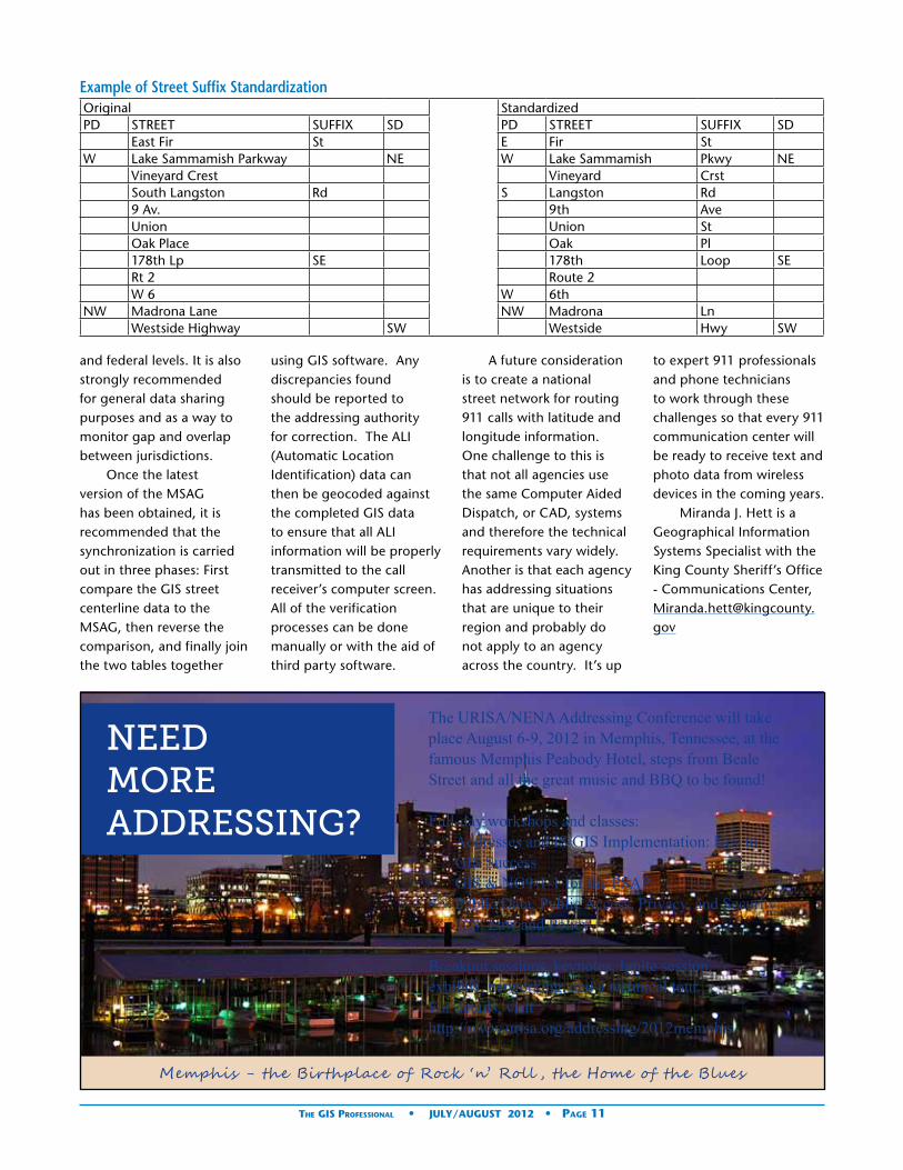
and federal levels. It is also strongly recommended for general data sharing purposes and as a way to monitor gap and overlap between jurisdictions.
Once the latest version of the MSAG has been obtained, it is recommended that the synchronization is carried out in three phases: First compare the GIS street centerline data to the MSAG, then reverse the comparison, and finally join the two tables together
Example of Street Suffix StandardizationOriginal StandardizedPD STREET SUFFIX SD PD STREET SUFFIX SD
East Fir St E Fir StW Lake Sammamish Parkway NE W Lake Sammamish Pkwy NE
Vineyard Crest Vineyard CrstSouth Langston Rd S Langston Rd9 Av. 9th AveUnion Union StOak Place Oak Pl178th Lp SE 178th Loop SERt 2 Route 2W 6 W 6th
NW Madrona Lane NW Madrona LnWestside Highway SW Westside Hwy SW
using GIS software. Any discrepancies found should be reported to the addressing authority for correction. The ALI (Automatic Location Identification) data can then be geocoded against the completed GIS data to ensure that all ALI information will be properly transmitted to the call receiver’s computer screen. All of the verification processes can be done manually or with the aid of third party software.
A future consideration is to create a national street network for routing 911 calls with latitude and longitude information. One challenge to this is that not all agencies use the same Computer Aided Dispatch, or CAD, systems and therefore the technical requirements vary widely. Another is that each agency has addressing situations that are unique to their region and probably do not apply to an agency across the country. It’s up
to expert 911 professionals and phone technicians to work through these challenges so that every 911 communication center will be ready to receive text and photo data from wireless devices in the coming years.
Miranda J. Hett is a Geographical Information Systems Specialist with the King County Sheriff’s Office - Communications Center, [email protected]
NEED MORE ADDRESSING?
The URISA/NENA Addressing Conference will take place August 6-9, 2012 in Memphis, Tennessee, at the famous Memphis Peabody Hotel, steps from Beale Street and all the great music and BBQ to be found!
Full-day workshops and classes:• Addresses and IS/GIS Implementation: Key to
GIS Success• GIS & NG9-1-1 for the PSAP• Public Data, Public Access, Privacy, and Security:
U.S. Law and Policy
Breakout sessions, keynotes, Ignite session, exhibits, networking, and a technical tour. For details, visit http://www.urisa.org/addressing/2012memphis
Memphis - the Birthplace of Rock ‘n’ Roll , the Home of the Blues
The GIS Professional • JUly/AUGUST 2012 • Page 11

continued on page 10
By Alan Saine, Civil Engineer, Town of Mooresville, N.C.
Tracking Hotspots: Using ArcGIS to Improve Mooresville’s Sanitary Sewer System
In 2010, the Town of Mooresville, North Carolina began experiencing a rise in the number of sanitary over-flows and sewer stoppages. The reason for the problem was evident: the Town of Mooresville has over 6000 manholes and 250 miles of sanitary-sewer gravity-main lines; only 30 percent of that infrastructure has been constructed in the last 20 years. In addition to aging infrastructure, the Town of Mooresville population has tripled in the last 20 years, thus putting more strain on the significantly aged sani-tary sewer system.
Mooresville, like most municipalities, has permit requirements that are regulated by the Division of Water Quality, a division of the North Carolina Department of Environment and Natural Resources. One of the requirements is the permittee shall assess all cleaning needs, and develop and implement a program
to appropriately clean all sewer lines. The Mooresville Water Sewer Maintenance Department (WSMD) manages this requirement on a day-to-day basis and recently requested the assistance of the Town’s Engineering Department to help them determine all the distressed spots, or “hotspots,” in the system in order to more strategically and effectively clean and maintain the system. Fortunately, the Engineering Department had recently finished a year-long project, which employed ESRI’s ArcGIS software, to locate, map and input all the features of the Town’s sanitary sewer system.
“Economic growth kept our staff very busy for years with installing all of the water and sewer taps. Since the growth slowed due to the recession, we had to move from a reactive approach to being
proactive. In the past, crews would alternate cleaning sewer lines in whatever area they wanted to and areas were being left out. By restructuring crews, we dedicated a crew to do all of the line cleaning and with this continuity we were able to grasp the needs of our wastewater collection system,” said Jamie Johnson Water/Sewer Maintenance Field Supervisor.
In order to assist the WSMD in identifying distressed spots on the system, the Engineering Department needed to pinpoint these locations on a map and assign date(s) for when the sewer feature(s) (manholes, sewer main) were cleaned. The WSMD maintained monthly data, from August 2009 to January 2011, of where and when the sewer cleaning occurred in Microsoft Excel spreadsheets. Each spreadsheet contained the cleaning data for that month as well as a unique identifier, Manhole ID (MHID), to capture the location. Once the spreadsheets were reviewed, it was decided that Python scripting would be an optimal way to process the batch of excel format cleaning data and generate a comprehensive dataset.
Automating with PythonCreating the Cleaning Data would require the repetition of several steps; this process was simplified by using Py-thon. The Python script was developed so that the user would have the Excel file in a folder on their computer and they could extract the month and MHIDs from it and perform several analy-ses. The Python script was also saved into a custom ArcToolbox so that any user could access it using Arc-Map.
The first step was to create the cleaning data. This was done by creating a join between the MHID in the Excel file and the MHID in the Town’s ArcGIS SDE database. A copy of cleaned manholes was created and all intersecting sewer lines to cleaned manholes were selected and copied. Simple reports were also created utilizing the Arcpy function in Python. An example of this: the ArcGIS Analyst Frequency Tool was used to calculate the number of sewer mains and their length that were cleaned that month. Once the cleaned sewer mains were created, the process was repeated for the next month’s data. After the monthly cleaned sewer mains data was created, the
The GIS Professional • JUly/AUGUST 2012 • Page 12

data was merged together into one layer and the frequency of how often that line has been cleaned was calculated and coded using a red-yellow-green scheme. Hotspots, or areas that had been cleaned 7 or more times, were displayed as red so it would be evident where there were issues.
Locating the Cleaning HotspotsThrough the Python auto-mation, it was easy to use ArcMap to display all the cleaning data, which were symbolized using green, yel-low and red to represent the frequency which the lines had been cleaned. The abil-ity to map where the sewer cleaning was occurring and how often it occurred yielded some interesting results. There were over a dozen separate areas where the sewer mains had been cleaned 7-12 times in an 18 month span. This informa-tion became a catalyst for improved interdepartmental communication between the WSMD and the Town of Mooresville Fat Oils Grease Department (F.O.G.).
“Our sewer cleaning map has helped us to identify those areas that require more frequent inspections and increased pumping/cleaning frequencies for food service establishments,’’ said Jamie Levis, F.O.G Compliance Officer. “The use of ArcGIS has helped the FOG staff identify and remedy problem grease interceptors (problem spots) on multiple occasions. With the use of
Tracking Hotspots continued from page 12
this tool, what used to take weeks now takes minutes to look up and identify.”
Fixing the HotspotsMapping the hotspots gave the WSMD and F.O.G de-partment specific areas to target and improve. Several methods were used to in-vestigate these areas, such as closed-circuit television (CCTV) of the sewer mains and inspecting all the oil/water separators in the vi-cinity of the sewer cleaning hotspot. Several problems were fixed by simple root control treatments and lo-cating grease violations by local restaurants.
Prior to this project being implemented, in 2010, the WSMD did not know where the “hotspots” were and did not have a way to track areas that were being repeatedly cleaned. In 2010, the Town cleaned 51 miles of sewer mains. Of those cleaned sewer mains, 58% of them had
already been cleaned earlier that year. In 2011, after the project, the Town cleaned 144 miles of sewer mains and only 32% of them were repeats. By having the ability to identify hotspots and correct issues, the Town was able to clean almost three times more and cut the repeat trips by 26%. “Since our productivity has increased, we have noticed a decrease in main-line stoppages and after-hour callbacks resulting in cost reductions including less overtime pay for employees. This has also resulted in less service interruptions to the customer and less of an impact on surface waters caused from overflows,” Jamie Johnson Water/Sewer Maintenance Supervisor.
Ryan Rase, Deputy Town Manager also praised the results of the project: “The WSMD has not been immune to the downturn in the economy, we are constantly being asked to do more with less. Through
the use of technology and teamwork we were able to provide a tangible example of how the WSMD has been able to become more efficient.”
Next Steps - Going mobileToday the Town continues to map the sewer cleaning, but using ESRI ArcGIS app, workers can now use iPads to log cleaning data directly into the system from the field (instead of keeping track of Excel spreadsheets). The sewer cleaning crew can instantly view where the cleaning truck has been in the past two years and be strategic in cleaning by maximizing the route of the cleaning crew and migrating to areas that need atten-tion. Additionally, they can easily identify hotspots that show up red on the map and communicate where customer intervention may be needed. This project cre-ated a proactive approach to maintaining the Town sewer system and enhanced
This map is an example of the red-yellow-green scheme that displays the frequency of how often that line has been cleaned in the 18 month span.
continued on page 14
The GIS Professional • JUly/AUGUST 2012 • Page 13

interdepartmental commu-nication.
“This project has ended up being a model to the entire Public Services Division of how, through the use of technology, both time and money can be saved. The WSMD employees have recognized this and now are bringing ideas to Engineering so they can be implemented in such areas as valve exercising, CCTV, and inflow and infiltration repairs. We look back now and wonder how we ever survived without it,” said Ryan Rase, Deputy Town Manager.
About the AuthorAlan Saine is a Civil Engineer and Engineering Intern at
the Town of Mooresville in North Carolina. He is a graduate of the University of North Carolina at Charlotte and is currently pursuing his Masters in Geospatial Information Science and Technology at North Caro-lina State University. At the Town, Alan recently finished implementing an enterprise GIS system in the Public Services Division. He is a member of URISA, is cur-rently working towards his GISP and plans to sit for the Professional Engineering Exam in 2013.
For more information, contact Alan Saine, Civil Engineer for the Town of Mooresville at [email protected]
The ESRI app on the iOS device displays the sewer cleaning data and the MHID’s, therefore the user knows if that line has been cleaned recently.
We help you putGIS to work!
206-263-5220www.kingcounty.gov/gis/training
Professional GIS training in our Seattle facility or at your site.Professional GIS training in our Seattle facility or at your site.
GIS TRAININGEXPRESS ™
✔ URISA’s Pacific Northwest Education Center
✔ ESRI®-Authorized Classes
✔ Custom Classes Created and taught by working GIS professionals
✔ GIS Academy“Beyond the Basics”
✔ GIS Certification Institute Qualified Earn GISCI points
✔ Veterans’ GI Bill BenefitsSelected programs of study at the King County GIS Center are approved for those eligible to receive benefits under Title 38 and Title 10, USC.
Congratulations to the newest URISA Leadership Academy Graduates!
They just participated in the ULA in Savannah, Georgia. Great group of attendees and instructors. 100% of survey respondents said they would rec-ommend the ULA to a colleague or coworker. Stay tuned for the announcement about next year’s ULA offerings…
The GIS Professional • JUly/AUGUST 2012 • Page 14

Book Review
A Python Primer for ArcGIS Authored by: Nathan Jennings https://www.createspace.com/3679548www.jenningsplanet.comCreateSpace, 2011, 458 pp., ISBN: 146627459x, ISBN-13: 978-1466274594Copyright 2011 Nathan JenningsAll rights reserved.
Reviewed by: David Wilcox, GISP, City of Sacramento, CA
Ever since ESRI included the open source scripting lan-guage Python, for many of the geoprocessing tools and functions in ArcGIS, there has existed the need for a Python primer for ArcGIS. The book’s Intro states that, it is written for those who want an introduction to Py-thon using ArcGIS geopro-cessing. It is not intended as a detailed text on Python, or to be a “for Dummies” guide of ESRI’s ArcGIS software. It will help the newcomer to GIS and pro-gramming as well as those who are strong users of Ar-cGIS geoprocesses, to have a better understanding in writing scripts. It focuses is on developing geoprocesses and python scripts, in a logical manner, to develop stand alone scripts that can be run inside or outside of ArcGIS. It is written with step by step instructions and screen captures so that the reader can follow along, explaining each section of code. At the end of each chapter, there are several demos, exercises and or questions to help reinforce what was just covered. In addition there is a “log-in” and “password” that comes in the book, so the reader can download the exercise data from the author’s web-site.
The book is divided into 3 sections.
Section 1- Fundamentals This is an overview of the concepts and how Python is
used in ArcGIS. It explains things like installing the correct version of Python depending on the version of ArcGIS you are using. It shows how to run the scripts either from the ArcGIS com-mandline or from the IDE “IDLE” that comes with Py-thon. Be sure to read about the “Getting Help” part and what the ArcGIS error codes mean. There is a very useful overview that shows you how to use ESRI’s Mod-elbuilder to create geopro-cesses and Python scripts.
Section 2- Writing Python Scripts for Common Geoprocessing TasksThis section goes into many useful topics. It goes into querying and selecting data, creating and using cursors, table joins, describing data and operations on lists, error handling and creating log files (a very useful tool!). In chapter 6 there is a revision you will need to download.
Chapter 9 is called the “Mapping Module”. It is loaded with useful info on automating your mapping products. Some of this material is now replace by ArcGIS 10’s new data driven pages.
Section 3- Integrating and Automating Python Scripts for ArcGISThe last section of the book, expands on capabilities previously discussed in the book. It goes into customiz-
ing ArcGIS Tools and Python Scripts. There is a part about creating a new Arctoolbox and associating a custom python script to run in it. In here, you learn how to auto-mate processes that need to be run on a regular basis.
In Summary, this book covers a lot of ground. There are many great demos and examples for the user to try out. They are well documented with screen shots and descriptive text to help keep the reader on track. These examples go into a problem solving process, which the author calls the “modified scientific method”. This is a great skill to learn. Don’t forget to answer the questions at the end of each chapter. The example scripts include documentation in them and are compatible with the current ArcGIS 10 software. I would suggest running through the examples several times and have other Python reference materials; to assist in the Python scripting concepts and terminology. This book is a great resource. It will give you a head start with many ideas on how to develop and automate the tasks in your next GIS project.
Happy Geoprocessing!
The GIS Professional • JUly/AUGUST 2012 • Page 15

President’s Column
The ‘U’ in URISA – Urban is Where It’s At!Greg Babinski, GISP
At some point during the last two or three years (‘now’ in broad historical terms) the percentage of the world’s population living in urban areas exceeded the world’s population living in rural areas for the first time in hu-man history. Did you notice? What does that event mean for us? What does that event mean for URISA?
Look at my little diagram above. In 1950, approximately 30% of the world’s population lived in cites and 70% lived in rural areas. U.N. demographic projections forecast that by 2050, those percentages will be reversed, with 7 out of ever 10 humans living in an urban area. The significance of this trend is profound. It reflects the impact of disruptive technologies, changing political structures, more efficient agricultural practices, aggressive public health programs, public transportation development, and many other demographic factors.
In both Canada and the U.S. today the percentage is
more than 80% urban. Are you surprised to learn that Saudi Arabia, Argentina, Venezuela, Greenland, and Brazil are among the 35 countries with even more than 80% urban? China and India each have more total urban population than the total U.S population. The population of the U.S. is projected to increase by 139 million by 2050, most in urban areas.
The move of a couple billion more people to urban areas in the next 38 years will be disruptive. If you live, work, or commute through an urban area, imagine 50% more people living in your urban space. Imagine the impact of two billion more people living in urban areas on roads, bridges, sewers, water and power utilities, schools, and medical facilities. Imagine the impact on urban pollution and environmental health. Imagine the impact on climate change. What about the impact on green space and agricultural land? Urbanization has an impact on social structures too, as third world rural people leave the tight-nit family
focused structure of their rural village to the more anonymous social structure of a modern city.
Why are so many people moving to cities in the face of these myriad problems? Urban is where it’s at…and this holds true for rich, developing, and poor countries. Cities are where it is easier to gain access to education, health care, jobs, and security. Cities are connected globally in ways that rural communities are not…from Starbucks and KFC in Hanoi, to Tex-Mex in London, to sushi in Des Moines, cities level the playing field for cultures.
Some cities may team with the poor and slums, but cities are where the jobs are. Even the poor living in urban slums are often richer than their rural cousins. And in cities opportunities abound. Cities enable the self employed to become business owners in ways that rural communities do not. Cities provide opportunities for innovators and risk takers in ways that traditional, risk adverse rural areas do not. And cities bring together multiple interwoven communities that thrive off each other and create wealth and opportunity. Think of the history of the San Francisco Bay Area…a shipping and industrial center with two great universities, becomes a center of defense
industry (Lockheed and Kaiser Engineering), and then of the oil and gas industry (Chevron and Union 76), and then of engineering design (Bechtel), and then of high technology (HP and Apple), then of entertainment (Lucasfilms), and the Internet (Google). Cities work, they really work!
But how to deal with the challenges and problems that two billion more people living in cites will bring? Where do really innovative ideas come from to accommodate growing and changing urban populations? Where are the programs launched and refined that serve as models for cities around the world, to deal with radical demographic changes? Do you think that top-down national programs are the answer? Do the most innovative ways to deal with strained urban infrastructure, traffic congestion, environmental health, public safety, and general social equity issues emanate
R
UNow1950 2050
30%
70%
Greg Babinski, GISP
The GIS Professional • JUly/AUGUST 2012 • Page 16

from central planning departments, federal bureaucracies, or ministries located in rich national capitals? I think that at best, international agencies and national governments can identify issues, set broad policy, provide funding (with performance expectations and transparent public oversight) to urban and regional agencies, and then get the hell out of the way.
In many cases, funding isn’t even necessary. Congestion based pricing for access to urban cores originated not from Whitehall (the UK national government), but from Ken Livingston, the innovative (and very disruptive) former mayor of London. GIS-based parking policy, pricing, and enforcement did not originate on Capitol Hill, but from the humble Washington, D.C. Parking Enforcement Department.
Closer to home (for me) the Federal Government provided small grants that led to a simple GIS-based program for King County, Washington to incentivize the planting of trees by semi-urban landowners to mitigate climate change (http://gismaps.kingcounty.gov/ForestryCPR/). Other grants led to the development of compelling GIS based web applications that motivate citizens to eat more healthy diets, incentivize groceries to offer healthy fresh foods, and restaurants to provide healthy menu choices to every segment of the urban population. Each of these grants succeeded in achieving their goals
because Seattle provides access to a complex urban area, supportive county and municipal agencies, mature GIS operations, and a world-class research institution in the University of Washington. The Seattle area has something else…a Chapter of URISA that educates and empowers GIS professionals and geospatial technology users to envision ways that urban information systems and geospatial technology can be applied to issues in ways that are innovative.
I was there when the two applications described above were being envisioned by small groups of scientists and program managers within King County. I was there when they engaged key King County GIS Center staff members who were not just geospatial technologists, but GIS professionals who were partners in understanding the business problems facing King County. These GIS professionals understood the goals we were trying to achieve with these small grants and contributed innovative ways to mine urban and regional data sources, test new analysis techniques, embed scientific models in GIS based applications, and design user-friendly interfaces for the public to help maximize the benefit from these new tools.
King County GIS Center staff members are frequent Washington URISA (and BC and Oregon URISA) chapter conference attendees and presenters. Many have also attended URISA annual conferences, workshops, and the ULA. They read the
URISA Journal and the GIS Professional, which empower them to think innovatively and suggest disruptive applications of geospatial technology. URISA and its chapters play a key role in putting GIS to work in urban areas in new and exciting ways. Seattle and the University of Washington of course also have a special place in URISA origins through the early work of Edgar Horwood, Ken Deuker and others.
The reach of URISA in influencing and disseminating innovative applications of GIS is broader than many might think. I know from direct personal experience that there is a very high awareness of URISA and its continuing leadership in applying GIS in urban areas in Taipei, Taiwan (how many of you spoke with the GIS analysts from Taipei who attended GIS-Pro 2010 in Orlando, or Dr. Chi-hong Sun from the Taiwan GIS Center, who attended GIS-Pro-2011 in Indianapolis?). Our colleagues from URISA sponsor 24GIS in Poland joined URISA to facilitate their innovative development of a public participation GIS-based planning application for the growing city of Kielce. Come to GIS-Pro 2012 in Portland and talk to our colleagues from SSSI in Australia about how geospatial technology is being used to manage urban development there.
Want more proof? Take a look at URISA’s ESIG (Exemplary Systems in Government) awards. Most are for urban systems.
Want more proof? Look at the projects of URISA’s GISCorps (which recently launched its one hundredth mission, by the way). Many address urban issues, while responding to the challenges of rural communities as well.
Urban is where disruption will occur and where innovation will come from. URISA’s focus on GIS and urban and regional areas means we have an important future role to play for society as a whole. The vision I have for URISA is an organization that plays a key role in defining international best practices and standards for geospatial operations, managers, educational institutions, and consultants.
For those of you anywhere with an interest in the application of geospatial technology to address urban challenges into the Twenty-first Century, I invite you to join us. This year URISA will hold its 50th Annual Conference, GIS-Pro, in Portland. I invite you all to attend and celebrate our past accomplishments, continue our on-going work, and plan your future, URISA’s future, and just possibly the future of 70 percent of the world’s population.
I will be at GIS-Pro 2012. And I just might make it to GIS-Pro 2050. If I do I am confident that URISA members will have made great contributions to the nature of the highly urbanized world we then will live in. Urban is where it’s at…and URISA will help lead the way there!
Contact Greg at: [email protected].
The GIS Professional • JUly/AUGUST 2012 • Page 17

Welcome New URISA Members
Mahdi Abalharth - University of British Columbia - Vancouver, BC Canada
Kelly Allen GISP -Tulsa Community College - Tulsa, OK
Eric Anderson -HDR Inc. - Folsom, CA
Daniel Barber GISP -Martin County - Stuart, FL
John Bean -University of Alaska Anchorage - Anchorage, AK
Belinda Beller -Portland Community College - Portland, OR
Judith Bock -Judith Bock - Grayslake, IL
Cathy Cole -Cabarrus County - Charlotte, NC
Rod Coleman -Tuscaloosa County E 911 - Tuscaloosa, AL
Kevin Coles -TerraGo Technologies - Charlottesville, VA
Paul Cone -City of Portland - Portland, OR
Andrea Conver -Sanametrix - Washington, DC
R. Michael Cousins GISP -Ardaman & Associates, Inc - Orlando, FL
Richard Couture GISP -Noble Energy Inc - Denver, CO
Kevin Dunlop -CH2MHILL - APO, AP
Hussein Elkhansa GISP -State of West Virginia - Charleston, WV
Jonathan Farmer -Austin Community College - Austin, TX
Tiffany Felton -Izard County Assessor - Melbourne, AR
Nicholas Ferri - Katy, TX
Kevin Garcia -Northwestern Indiana Regional Planning Commission - Portage, IN
David Grigg GISP -Michael Baker Jr Inc - Lexington, SC
Tanya Haddad GISP -State of Oregon - Portland, OR
Jonathan Haller -Tierra Right of Way - Tucson, AZ
William Hayden -SWCA - Pasadena, CA
Miguel Hernandez -Port of Long Beach - Long Beach, CA
Donna Holmquist - Woodinville, WA
Rachel Hood -City of Durham - Mebane, NC
Jeffrey Horneman GISP -L.W. Survey Co. - McMurray, PA
Susan Horvath -Bureau of Economic Geology- University of Texas at Austin - Austin, TX
Robert Hughes -OTIA - Columbia, MD
Lynn Jarzombek GISP -Pima County - Tucson, AZ
Justin Koppa GISP -US Air Force - APO, AE
Tim LaBarr -Manatee County - Bradenton, FL
Andy Lanier -Oregon Coastal Management Program - Salem, OR
Aaron Lee -Maricopa County Assessor’s Office - Phoenix, AZ
Kira Lofgren -Sky Research - Parker, CO
Todd McAulliffe -Planning Communities - Raleigh, NC
Deborah McDonald Matthews GISP -New Mexico Gas Company - Albuquerque, NM
Robert McLaughlin -Manatee County - Bradenton, FL
Pamela Nabors GISP -Tennessee Valley Authority - Knoxville, TN
Stephani Onisko GISP -Cardno ENTRIX Inc - Portland, OR
Nicholas Parish - Hattiesburg, MS
Piotr Pestka -SAIT BGIS - Calgary, AB Canada
Kenneth Poon -City of Fort St. John - Fort St. John, BC Canada
Doug Ritter GISP -Ritter GIS - Livonia, MI
Paul Ritter -Ritter GIS - Livonia, MI
Case Robertson GISP -Electric Cities of Georgia - Powder Springs, GA
Warren Roe -DOGAMI - Portland, OR
Michele Sanchez -Royal Botanic Gardens, Kew - Richmond, Surrey, United Kingdom
Tammi Shepherd -Oakland County - Pontiac, MI
Kimberly Sparks GISP -State of North Carolina - Raleigh, NC
Roy Stine -UNCG - Greensboro, NC
Janice Sutherland -Department of Water Resources - West Sacramento, CA
Subramanian Swaminathan GISP -Delta State University - Cleveland, MS
Thomas Thaller GISP -SAIC - Orlando, FL
Janet Troeger -Port of Long Beach - Long Beach, CA
Kacie Vanasse -Maricopa County - Glendale, AZ
Jeff Ward -Summit County Utah - Coalville, UT
Phillip Watkins -IPL/AES - Indianapolis, IN
Anthony Williams -SHN Consulting Engineers & Geologists - Eureka, CA
Jeff Williams -Washington County - Fayetteville, AR
Michael Wood GISP -US Army - APO, AE
Angela Woods - Columbia, MD
Jennifer Zeisloft GISP -University of Wisconsin-Madison - Madison, WI
The GIS Professional • JUly/AUGUST 2012 • Page 18
GIS-Pro 2012 is co-hosted by the Northwest GIS Users’ Group. NWGIS is presenting optional classes to kick off GIS-Pro 2012 (note that at-tendance at these classes is extremely limited and they are expected to sell out quickly):• Understanding and Using Python
& ArcPy in ArcGIS 10 • Working with Geodatabases &
Linear Referencing • ArcPad 10 Bootcamp™ • ArcGIS Desktop 10 Associate Exam
Prep
Reach this informed and influ-ential market!
Visit www.gis-pro.org for information about exhibits and
sponsorships.
Conference Site - Hilton Portland & Executive Tower921 SW Sixth Avenue, Portland, Oregon Located in the heart of the city center and only a block away from the MAX Light Rail system (provides quick and easy transportation around the city as well as to Portland International Airport).
Portland – Affordable & StunningIn Portland, free time is filled with great food and drink, culture, and tax-free shopping. Whatever your interests, you’ll find much to do when the day’s work is done. Art, great dining, gor-geous scenery, and a truly walkable city are waiting to be explored.
For conference information and registration details, visit www.urisa.org or www.gis-pro.org.
Follow conference happenings on Twitter (@urisa, #gispro)
URISA Certified Workshops (included with full conference registration):• GIS Return on Investment - (new
half-day workshop)• Emergency Preparedness for GIS -
(new half-day workshop)• Asset Management: Planning,
Strategy and Implementation• An Overview of Open Source GIS
Software• Public Data, Public Access, Privacy
and Security: US Law and Policy• An Introduction to Public Partici-
pation GIS: Using GIS to Support Community Decision Making
• GIS Program Management
Educational Sessions Packed with Content:Learn about measuring GIS matu-rity and Return on Investment (ROI). Discuss GIS leadership, ethics and manage ment strategies. Explore open source solutions, cloud computing and the mobile future. And so much more!
Come to Portland to interact with your peers and industry thought lead-ers...prepare to be both challenged and inspired! Register today! Earn points towards GISP Certification or renewal—a rec-ognized certification among GIS Professionals (www.gisci.org).
Learn and Grow ~ Challenge and Inspire ~ Lead
Photos courtesy of Travel Portland
Featured Speakers
Professor Michael Goodchild, University of California, Santa Barbara
John Sanderson, Microsoft’s Cloud Evangelist
Jack Dangermond, Esri
Join your colleagues in the beautiful and affordable Pacific Northwest for an outstanding education program, networking opportunities and events designed to help you and your organization reach the next level of success!
Highlights follow, but please visit www.urisa.org or www.gis-pro.org for complete details about the invited speakers, peer presentations, lightning talks, luncheon presentations, and much more!
GIS-Pro 2012: URISA’s 50th Annual Conference for GIS Professionals
September 30 – October 4, 2012 Portland, Oregon

Your Decisions Affect TheirsGovernment decisions affect more than 300
million Americans a year. With Esri® Technology,
you can connect with your entire constituency.
Esri helps you demonstrate accountability, foster
collaboration, and make the effective decisions
that keep your constituents happy.
Copyright © 2011 Esri. All rights reserved.
Learn more at esri.com/urisatgp
URISATheGISProf_March2012.indd 1 2/28/12 4:51 PM

2012 Sponsor Directory
Platinum CorporateSponsor
Esri
380 New York St, Redlands, CA 92373 Phone: (909) 793-2853 [email protected]
Since 1969, Esri® has been helping or-ganizations map and model our world. Esri’s GIS software tools and meth-odologies enable them to effectively analyze and manage their geographic information and make better decisions. They are supported by our experienced and knowledgeable staff and extensive network of business partners and international distributors.
A full-service GIS company, Esri sup-ports the implementation of GIS tech-nology on the desktop, servers, online services, and mobile devices. These GIS solutions are flexible, customizable, and easy to use.
Esri software is used by hundreds of thousands of organizations who apply GIS to solve problems and make our world a better place to live. We pay close attention to our users to ensure they have the best tools possible to accomplish their missions. A com-prehensive suite of training options offered worldwide helps our users fully leverage their GIS. Esri is a socially conscious business, actively supporting organizations involved in education, conservation, sustainable develop-ment, and humanitarian affairs.
Gold Corporate Sponsor
CDM Smith
50 Hampshire Street, One Cambridge Place Cambridge, MA 02139 Phone: (617) 452-6000 [email protected]
What began in February 2011 with joining of two industry forces has cul-minated in a fully integrated provider of comprehensive water, environment, transportation, energy and facilities services united under the new brand CDM Smith.
One promise: doing what is right for our clients and communities
One partner: providing integrat-ed water, environment, transportation, energy and facilities solutions
One passion: creating a better future, together
At CDM Smith, we are committed to building strong and lasting relation-ships with our clients and each other. Together, we are solving the world’s water, environment, transportation, energy and facilities challenges with smart, integrated solutions. As your trusted partner, we are shaping tomor-row while delivering the services you need today. Proving every day—in every way—we’re better together.
Silver Corporate Sponsors
Data Transfer Solutions
3680 Avalon Park Blvd East, Suite 200, Orlando, FL 32828 Phone: (407) 382-5222 [email protected]
Headquartered in Orlando, DTS is a leader in asset management, geo-graphic information systems, and transportation planning. We specialize in creating solutions to help clients automate their worlds, reduce their workload and organize their data through customized technology.
DTS is comprised of seven divisions, each with its own scope of services. Often however, a single project spans several divisions before completion because we uniquely offer all the necessary cutting-edge services, inte-grated within one company.
Pictometry International
100 Town Centre Dr, Suite A, Rochester, NY 14623 Phone: (585) 739-1854 [email protected]
Pictometry International Corp. is a leading provider of geo-referenced, aerial image libraries and related soft-ware. Pictometry has captured nearly 130 million digital aerial images which represent more than 80 percent of the United States population and all major U.S. markets.
Using its proprietary imaging process, Pictometry captures geo-referenced, high-resolution orthogonal (straight down view) and oblique (captured at an angle) imagery within which structures and land features can be measured. Pictometry customizes and markets these technologies for govern-ment and commercial applications. Pictometry’s standard oblique imagery includes second order visualization tools that do not produce authoritative or definitive information (surveying).
Bronze Corporate Sponsors
Archon Information Systems
935 Gravier Street, Suite 1700, New Orleans, LA 70112 Phone: (504) 267-0065 [email protected]
We provide all levels of government and governmental agencies with com-prehensive, progressive tax related and treasury management solutions. Let Archon bring your state, city or munici-pality to the forefront of the intersec-tion of government and technology.
The GIS Professional • JUly/AUGUST 2012 • Page 21
Your Decisions Affect TheirsGovernment decisions affect more than 300
million Americans a year. With Esri® Technology,
you can connect with your entire constituency.
Esri helps you demonstrate accountability, foster
collaboration, and make the effective decisions
that keep your constituents happy.
Copyright © 2011 Esri. All rights reserved.
Learn more at esri.com/urisatgp
URISATheGISProf_March2012.indd 1 2/28/12 4:51 PM
continued on page 22
British Columbia Assessment
400 - 3450 Uptown Blvd. Victoria BC V8Z 0B9 (250) 595.6211
BC Assessment produces independent, uniform and efficient property as-sessments on an annual basis for all property owners in the province.
Geographic Technologies Group
Corporate Office 1202 Parkway Drive Goldsboro, North Carolina 27534 Tel: 919.759.9214 Toll Free: 1.888.757.4222 Fax: 919.759.0410 Primary Contact: Curtis Hinton, GISP
GTG is a full-service local government GIS consulting company offering spe-cialized experience in the planning, de-sign, implementation, and procurement of geo-technologies. GTG develops GIS products that spatially enable various enterprise solutions and integrates an organization’s IT investment via a com-mon interface. GTG also offers stand-alone products for land management, public safety, public access, touch screen technology, and utilities.
Manatron Inc.
510 East Milham Ave., Portage, MI 49002 Phone: (800) 666-5300 [email protected]
Manatron, a Thomson Reuters business, is a global leader in providing integrated property tax and land administration software for governments worldwide. With unparalleled experience and history in property recording, land registry, GIS tax assessment, billing and collection,
Manatron has been at the forefront of innovative product and service development since 1969. Manatron currently provides 1600+ customers with the power to manage over 45 mil-lion parcels.
Property Assessment Land Records Cadastral Mapping Tax Billing and Collection eGovernment
Merrick & Company
2450 South Peoria Street, Aurora, CO 80014 Phone: (303) 751-0741 [email protected]
Merrick & Company provides com-prehensive, client-focused land information services, including image acquisition (aerial and satellite), GPS Surveying, digital photogrammetry, Light Detection and Ranging (LIDAR), digital imaging, digital orthophotog-raphy processing, LiDAR software tools (MARS®), GIS database design and application programming. Merrick’s primary markets include city/county, federal government, electric utilities, engineering design firms and pipeline operators.
Milsoft Utility Solutions Inc
4400 Buffalo Gap Rd Ste 5150, Abilene, TX 79606 Phone: (800) 344-5647 [email protected]
Get the most out of your GIS by fully integrating the best electrical grid analysis into your Esri GIS environment.
Sanborn
1935 Jamboree Drive, Suite 100, Colo-rado Springs, CO 80920 Phone: (719) 593-0093 Toll-Free: 1.866.SANBORN (1.866.726-2676) [email protected]
With a rich tradition of mapping dating back to 1866, Sanborn is a compre-hensive geospatial solutions company. Sanborn provides geographic and location-based information from data capture through design and develop-ment of custom applications including; systems integration, spatial analysis, and modeling.
Valtus Imagery Services
212, 5438-11th St NE, Calgary, AB T2E 7E9 Canada Phone: (403) 295-0694 Toll Free: (800) 661-6782 [email protected]
Valtus Imagery Services provides best in class solutions for the storage, man-agement and delivery of geospatial information in the form of ortho-imagery and elevation data through web delivery systems.
Business Sponsors
24 GIS
Office in Kielce: Ul. w. St. Leonarda 1/6, 25-311 Kielce Poland TEL: (41) 307-38-07 Office in Warsaw: Ul. Kępna 2B/9, 03-730 Warszawa Poland TEL: (22) 662-11-17
E-MAIL: [email protected] or [email protected] The company’s mission is to provide reliable 24GIS services related to con-sulting, analytics and data acquisition in the creation and use of spatial infor-mation systems for public institutions, business and academics.
geographic Data Base Management Systems, Inc.
41 E. 4th Avenue, Collegeville, PA 19426-2341 (610) 489-0353 [email protected]
gDBMS Services include: Technical reviews and ongoing evalua-tions of existing GIS programs. Making sure GIS is all that it can be in your jurisdiction.
GeoPlanning Services, LLC
3564 Avalon Park Blvd E., Suite 1, #243, Orlando, FL 32828 Phone: (407) 608-4186 [email protected]
GeoPlanning Services, LLC of Orlando, FL was founded in early 2009 is a full service provider of geospatial tools and analysis to support urban planning, logistics, real estate and economic development organizations.
2012 Sponsor Directory (continued)
The GIS Professional • JUly/AUGUST 2012 • Page 22

For information about URISA Sponsorship, please visit: http://www.urisa.org/sponsorship or contact Wendy Nelson at URISA Headquarters.
GeoTechVision Enterprises Limited
Unit #8A Seymour Park, 2 Seymour Park Avenue Kingston 6, Jamaica, W.I. Phone: (876) 620-4513 [email protected]
Based in Jamaica, GeoTechVision En-terprises Limited is a team of qualified professionals who specialize in innova-tive spatial technology and provide clients with high-end geospatial prod-ucts and services, practical advice and solutions. GeoTechVision Enterprise specializes in, among other services, GIS Consultancy, GIS Training, Personal and Vehicle Tracking and Mapping Solutions.
GPC Global Information Solutions LLC
P O Box 129060, Abu Dhabi, United Arab Emirates Tel: + 971 2 666 6574 [email protected]
Based in Abu Dhabi, UAE, GPC Global Information Solutions LLC (GPC-GIS), was launched in 2008 by the Geo-graphic Planning Collaborative, Inc. (GPC) to specialize in the delivery of geospatial information services to the MENA Region. By harnessing more than 25 years experience of GPC partners, we provide consulting services in Geospatial Information Technology and Services (GITS), Spatial Data Infrastructure (SDI), Geospatial Education, Location Based Services and Information Management for a wide variety of organizations and projects in the region.
Kessler GIS
20414 W Baker Rd., Cheney, WA 99004 509-235-5500 [email protected]
Bruce Kessler founded Kessler GIS in the spring of 2001. He emphasizes edu-cation, consulting and map production in ArcGIS, Workstation ArcInfo, and ArcView 3.x and uses his broad-based GIS experience starting in 1985 to help clients understand the basics and work through complex GIS procedures.
North River Geographic Systems, Inc.
215 Jarnigan Ave, Chattanooga, TN 37405 Phone: (423) 653-3611 [email protected]
North River Geographic Systems, Inc. is a Geographic Information Systems and Services Company located in southeast Tennessee. Although in business for just over two years, we bring over 15 years experience in the GIS/Mapping industry. NRGS has provided an array of services such as GIS consulting, spatial analysis, and cartography to an array of public and private organizations. Be-ing a small company and Esri business partner gives us the ability to keep costs low and solutions innovative. Please give us a call/email if you have any questions.
Open Spatial Corporation
5701 Lonetree Blvd, Suite 109 Rocklin, CA 95765 (800) 696-1238 [email protected] Contact: Colin Hobson
Spatial Focus, Inc.
6813 40th Ave, University Park, MD 20782 Phone: (301) 277-6212 [email protected]
Spatial Focus, Inc. is an independent consulting firm, specializing in plan-ning, design, implementation and technical services in the field of geo-graphic information systems.
Spatial Focus, Inc. was formed to offer a new standard for vendor-indepen-dent technical and consulting services in geographic information of all kinds. Organized in 1998, Spatial Focus, Inc. specializes in integrating geographic information throughout public and private enterprises, giving them spatial focus.
Spatiax Infosystems
P.O. Box 81546 Lafayette, LA USA 70508 855-SPATIAX (855.772.8429) Contact Lloyd Charlier
SpatiaX is a software company special-izing in the design, development and marketing of information solutions for the enterprise.
Leveraging key technologies such as content management, computer-aided design (CAD), geographical informa-tion systems (GIS), workflow and collaboration, SpatiaX solutions enable users to easily access disparate data sources and applications across the enterprise in new and powerful ways.
The SpatiaX team is comprised of talented professionals bringing to bear extensive industry experience in software development, engineer-ing, surveying, global positioning, web design, workflow and document management for one purpose: the delivery of customer-focused solutions
enabling enterprise clients to work more productively.
Wellar Consulting
Ottawa, ON Canada Phone: (613) 728-3483 [email protected]
Wellar Consulting services include design and evaluation of education and training courses and currricula for GISystems and GIScience programs; advice and workshops on the develop-ment of quantitative measures to assess information system and trans-portation system performance; critical reviews of IS and GIS RFPs; seminars on the safety and security aspects of interdependent infrastructures; pro-fessional opinion on land use planning and zoning issues; and, expert opinion on liability for safety-related incidents involving pedestrians, cyclists, and motor vehicle operators.
Federal Agency Sponsor
U.S. Census Bureau 4600 Silver Hill Road, Washington, DC 20233
The Census Bureau serves as the lead-ing source of quality data about the nation’s people and economy. We honor privacy, protect confidentiality, share our expertise globally, and con-duct our work openly. We are guided on this mission by our strong and capable workforce, our readiness to innovate, and our abiding commitment to our customers.
Thank you to all of URISA’s sponsors
The GIS Professional • JUly/AUGUST 2012 • Page 23
Mark Your Calendar!
August 6-9, 2012 URISA/NENA Addressing ConferenceMemphis, Tennessee
September 30 – October 4, 2012GIS-Pro 2012: URISA’s 50th Annual Conference for GIS ProfessionalsPortland, Oregon
November 12-16, 2012URISA’s Caribbean GIS ConferenceMontego Bay, Jamaica
March 4-7, 2013GIS/CAMA Technologies ConferenceAlbuquerque, New Mexico
June 17-20, 2013URISA’s GIS in Public Health ConferenceMiami, Florida
PRESIDENTGreg Babinski, GISP – King County GIS [email protected]
PRESIDENT-ELECTAl Butler, GISP, AICP – City of Ocoee (FL)[email protected]
IMMEDIATE PAST-PRESIDENTCy Smith, GISP – State of [email protected]
SECRETARYTom Conry – Fairfax County (VA)[email protected]
TREASURERCarl Anderson, GISP – Spatial Focus, Inc. (FL)[email protected]
Tripp Corbin, GISP – eGIS Associates (GA)[email protected]
David DiBiase, GISP – Esri (CA)[email protected]
Twyla McDermott, GISP – City of Charlotte (NC)[email protected]
Cindy Post – University of Alberta [email protected]
Nancy Obermeyer, GISP – Indiana State [email protected]
Christopher Thomas – Esri (CA)[email protected]
Teresa Townsend – Planning Communities LLC (NC)[email protected]
THE GIS PROFESSIONALA publication of URISA – The Association for GIS Professionals.URISA is a non-profit professional and educational association that promotes the effective and ethical use of spatial information and information technologies for the understanding and management of urban and regional systems. It is a multidisciplinary association where professionals from all parts of the spatial data community can come together and share concerns and ideas.
URISA Headquarters701 Lee Street, Suite 680Des Plaines, IL 60016Phone (847) 824-6300Fax (847) 824-6363 [email protected]
SubmissionsManaging Editor – Wendy Nelson, Executive Director, [email protected] Editor – Comfort Manyame, GISP, [email protected] Editor – Keri Shearer, GISP, [email protected]
RFP Distribution
URISA members, remember that URISA will distribute your RFP/RFQ announcements to our corporate and business members at no charge. Simply email your announcement to [email protected] (Subject: RFP Service) and we’ll send it right out for you!