Geology of the Hawaiian islands - USGS Publications ...
127
-
Upload
khangminh22 -
Category
Documents
-
view
0 -
download
0
Transcript of Geology of the Hawaiian islands - USGS Publications ...


GEOLOGY OF THE BA. W A.IIA.N


GEOLOGY OF THE BA. W A.IIA.N ISLANDS

GEOLOGY OF THE HAWAIIAN ISLANDS
BY
HAROLD T. STEARNS District Geologist, U. S . Geological Survey
BULLETIN 8
Prepared in cooperation with the Geological Survey, United States Department of the Interior
TERRITORY OF HAWAII I~"GRAM M. STAINBA C K , Governor
A. LJ:STJ:R MARKS, Commission er of Public Lands
DIVISION OF HYDIWGRAPHY MAX H . CARBO N, Chief Hvdrographer
HONOLULU, HAWAII

FIRST PR! T I G, 1946
SECO D PRI T I G, with Supplement, 1967
STATE OF HAWAII
JOHN A. BURNS Governor
BOARD OF LAND AND NATURAL RESOURCES
JIM P. FERRY, Chairman, Oahu Member
RICHARD L. S MMERS, Oahu Member
GEORGE S. YAMAKI, O ahu Member
HIROSHI TA AKA, H awaii Member
TAI SU G YA G, Maui Member
OBUICHI MASU AGA, Kauai Member
Department of Land and Natural Re ource
JIM P. FERRY, Chai rman and Member Board of Land and atural Resources
SU AO KIDO , Deputy to the Chairman ROBERT T. CH CK, Manager-Chief Enginee r
Division of Wa ter and Land Development
II

CONTENTS
f'AOE
Abstract . . . . . . . . . . . . . . . . . . . . . . . . . . . . . . . . . . . . . . . . . . . . . . . . . 1
Introdu ction . . . . . . . . . . . . . . . . . . . . . . . . . . . . . . . . . . . . . . . . . . . . . . 1
Geography and climate. . . . . . . . . . . . . . . . . . . . . . . . . . . . . . . . . . . . . 2
Geomorphol ogy . . . . . . . . . . . . . . . . . . . . . . . . . . . . . . . . . . . . . . . . . . . 5
Geology . . . . . . . . . . . . . . . . . . . . . . . . . . . . . . . . . . . . . . . . . . . . . . . . . . 16
Geueral statement . . . . . . . . . . . . . . . . . . . . . . . . . . . . . . . . . . . . . 16
IRland of Hawaii . .. .... .. ...... . . ........ .. . . . . . . . . . . . 25
l\Iauna Kea
l\Ianna Loa
H ualalai .. ....... . ... . .... ..... .... .. ... . . .. .... .
Kohala .. . . ... .. ... ..... .. . .. . . . ... . .. .... .. . . .. . .
Kilauea . ........ . ...... . .. . ..................... .
I sland of Maui ..... .. ... .. .. . . .... ... ... .. .. .. ... . .. . .
W est Maui . . . ... . .... . .. .. . . . . ... ....... . . . . .. . . .
Ea .·t 1aui or Halea kala .. .. .. . .. . ................ .
h lall(l of Kahoola we . . . . . . ... ........ ...... . . .. . . . ... . .
Island of Lanai ....... . . . .. .. ... ................ . .. . . .
Island of Molokai ......... ... . ... .. .. ..... . .... .. . . .. .
We t Molokai ..... . ..... . ... . .. ....... .. . .. . .... . .
Ea t 1olokai .................... . ........ .. . .. . . .
Kalaupapa .. ..... . ... . ..................... . .... .
I ·land of Oahu .. ....... .. . ... .. ... . . .. . . . . . .. . .. ... . . .
\Vaianae Range .. ..... ... . .... ........... . .. . .. .. .
Koolau Range . . .. . .. . . . .......................... .
I sland of Kauai . . . . . .. . .. .. . . .... . .... . .. . ...... .. ... .
Island of Niihau . . .... .. . . . . ...... . . . . . . . ...... .. .... . .
OffRhor i l ts .. . . .... . . ... . ... . .. . ..... ... . ... ..... .. .
Le " ·at· I 1 land .. .......... . ........ . ..... .. ... .. ... .
30
32
37
38
43
49
49
59
63
67
69
69
71
73
73
77
78 2
90
93
93
eologi hi story . . . . . . . . . . . . . . . . . . . . . . . . . . . . . . . . . . . . . . . . . . 95
elected uiuli ography of the geology of th H a waiian I ·land .. 100
Ind x . ... . .. . .. . .... .. .......... .. . . ... . .. .... . ...... .. .. 102
iii

PAOli
Supplement . ................................ ·. · · .... · . . ..... 106
Geomorphology ... ........... . . . ... · .... · · · · · .. . · · · . . . . . 106
Geology .. ...... .. . ........... . . · · · · · · · · · · · · · · · · · · · · · · . . 106
Island of Hawaii . . . . . . . . . . . . . . . . . . . . . . . . . . . . . . . . . . . 106
Island of Kauai . . . . . . . . . . . . . . . . . . . . . . . . . . . . . . . . . . . . 107
Ages of the Hawaiian Rocks . . . . . . . . . . . . . . . . . . . . . . . . . . . . 110
IV

ILLUSTRATIONS
PLATES PAGil
Vi ew of Hanalei Valley, Kauai. ...... . .. ... .. .. .. . ........ . frontispiece 1. Map of the larger islands of Hawaii, their known rift zones, subma-
rine contours in feet, and principal islets .. . . .. .. .... . .. facing page 2 2. Halawa Valley, Molokai, a typical amphitheater-headed valley. . . . . 6 3. Stages 1 and 2 in geologic development of Oahu . . . . . . . . . . . . . . . . . . . 9 4. Stages 3 and 4 in geologic development of Oahu . . . . . . . . . . . . . . . . . . . 10 5. Stages 5 and 6 in geologic development of Oahu. . . . . . . . . . . . . . . . . . . 11 6. Stages 7 and 8 in geologic development of Oahu. . . . . . . . . . . . . . . . . . . 12 7. "Curtain-of-fire" formed by coalescing lava fountains, Mauna Loa
Volcano, Hawaii . . . . . . . . . . . . . . . . . . . . . . . . . . . . . . . . . . . . . . . . . . . . . . 15 Summit of Mauna Loa Volcano, Hawaii showing Mokuaweoweo and
pit craters . . . . . . . . . . . . . . . . . . . . . . . . . . . . . . . . . . . . . . . . . . . . . . . . . . . . 18 9. Halemaumau, Hawaii in eruption September 1934 . . ..... .... . .. . .. . 24
10. Summits of Mauna Ken and Mauna Loa volcanoes, Hawaii . . .. ... .. 31 11. Eruptions of Mauna Loa Volcano, Hawaii . . . .... . ....... ... ....... 35 12. Waipio Valley, Hawaii ......... . .. . ...... .. ...... .. ... . . ... .. .. .. 42 13. Summit depression of Haleaka la , Maui. . . . . . . . . . . . . . . . . . . . . . . . . . . . 50 14. The Needle, lao Valley, West Maui . . . . . . . . . . . . . . . . . . . . . . . . . . . . . . . 51 15. Stages 1 and 2 in the geologic development of Maui. . . . . . . . . . . . . . . . 55 16. Stages 3 and 4 in the geologic development of Maui . . . . . . . . . . . . . . . . 56 17. Stages 5 and 6 in th e geologic development of Maui. . . . . . . . . . . . . . . . 57 1 . Stages 7 and in the geologic development of Maul.. .... . . . . . . . . . . 58 1!.J. Honokahau Ca nyon, We t Maui. ...... . . . . .............. . . . . . . . . . . 60 20. West Ma ui Mountains behind Lahaina. . . . . . . . . . . . . . . . . . . . . . . . . . . . 62 21. Aerial mosaic of Knhoolnwe Island . . . . . . . . . . . . . . . . . . . . . . . . . . . . . . . 64 22. Lanai as seen from \Vest Maui. ....................... . . . .. ...... 66 23. 'l' he great cliff on the north side of En ·t Molokai . . . . . . . . . . . . . . . . . . 70 24. The Pali on Oahu . . . . . . . . . . . . . . . . . . . . . . . . . . . . . . . . . . . . . . . . . . . . . . . . 76 25. Mukua Cave, Oahu Island .. .. ..... . .... . .. . . .... . ... . .. . . . . . . . . . . 79 26. Kaau Crater, Oahu I land . . ... .. . .. . .. .. ... . ... . ... .... . ... ... . .. SO 27. Napa li Coast, Kauai Island ... . ..... ..... .... . .......... . . . . . . . . . . 84 28. Waimea Canyon, Kauni I land .... . ............. . ............... . . 6 2!.J. Haupu Ridge, Kauai Island . . .. . . ..... ... ... ....... . .. ... ... .... .
F"IG C RJo;S PAGE
1. Map and profi le of the Hawaiian Archipelago showing submarine con-tour . . . . . . . . . . . . . . . . . . . . . . . . . . . . . . . . . . . . . . . . . . . . . . . . . . . . . . . . . 4
2. Diagram illustrating the formation of amphitheater-headed valley . . 7 3. 'l'hree stage. showing the geologic history of a sea cliff ,·eneered with
]a,·a . . . . . . . . . . . . . . . . . . . . . ... . . . . . . . . . . . . . . . . . . . . . . . . . . . . . . . . . . 13 4. Profi les of cognate secondary cone. ·.. .. . .. .. . . .. . .. . .... . . . . . . . . . . . 17 5. Eight tages in th e geologic history of a volcanic i land in th e cent ra l
Pac- ific . . . . . . . . . . . . . . . . . . . . . . . . . . . . . . . . . . . . . . . . . . . . . . . . . . . . . . . . 20 6. Sections of typicnl bulbous domes . . . . . . . . . . . . . . . . . . . . . . . . . . . . . . . . . 21 7. la p of Hnwnii showi ng hi storic la,·a fl ows......... . .............. 25
Grnpb bowing periods of ncti\'lty of Kilauea and ~launa Lon YOI -
cnnoe · . . . . . . . . . . . . . . . . . . . . . . . . . . . . . . . . . . . . . . . . . . . . . . . . . . . . . . . . 26 9. G ologic mup of the i ·Janel of II a wa ii .. .. .. .. .. .. .. .. .. .. . .. .. .. .. 29
v

b' I OORES PAO E
10. Gra ph bowing the location and al titude of erupt ions of fa una Loa Volcano, 1 32-1942 . . . . . . . . . . . . . . . . . . . . . . . . . . . . . . . . . . . . . . . . . . . . 32
11. Diagram showing the origin of Puu Wn nwn a , Hawaii . . ...... . ... . 37 12. F our s tage in the development of Wuipio and Wuiman u Valleys,
Hawa ii ................... . .... . ... . ... . ....... . .. .. ........ . . 40 13. H ypotheti cal relation of K ilauea and Mauna Loa vol anoes with the
inte rior of the en rth . . . . . . . . . . . . . . . . . . . . . . . . . . . . . . . . . . . . . . . . . . . 44 H . Diagra m illu trating the r lation of fau lting to s uccessive la va fl ows 48 15. Geologic map of th e i la nd of Maui. . ... . . . ............ . . . . . . . . . . . 52 16. Geologic ma p a nd cction ·of the i ·land of Kahoolawe . ........... . . 65 17. Geo logic ma p of the is land of Lana i. . ..... .. . .. . ... . . . .... . . ..... . 6 1 . Geologic map of the isla nd of Molokni . . . . . . . . . . . . . . . . . . . . . . . . . . . . . 72 10. Geologic ma p of the i lund of Oahu . . . . . . . . . . . . . . . . . . . . . . . . . . . . . . . 74 20. Mop of Oahu bowing merg d and fr inging reefs . . . ..... . .. . .... .. 81 21. Ma p of so utheastern Oahu showing secoii(Jary post-Koolnu volcan ic
,·ent · . . . . . . . . . . . . . . . . . . . . . . . . . . . . . . . . . . . . . . . . . . . . . . . . . . . . . . . . . 82 22. Reconna i a nce geologic mnp of the i land of Kauai .. .... . . . . . . . . . . 83 23. Section showing th development of the apnli Cliff, Kuuai .. .... . . 90 24. Geologic map of the i land of iiha u . . . . . . . . . . . . . . . . . . . . . . . . . . . . . 92 25. The Ha wai ian archipelago ncar th e nd of th e Pliocene........... . . 97 26. The Bawniian nrch ipelago dur ing the minus 300-foot stand of th sea
in the ea r ly ( ?) P I i tocene . . . . . . . . . . . . . . . . . . . . . . . . . . . . . . . . . . . . . 98 27. 'l'he Bnwaiian a rchipelago at the present t ime. . ... . . . . . . ...... . ... 99

GEOLOGY OF THE HA\VAIIAX ISLANDS
By HAROLD T. STEARXS
ADSTRACT
A. l.Jrief ·ummar.v of the geogmphy, climate, aud geomorphology is giren . Streams develop slowly after the exti nction of a volcano becan ~ e of t he hi~rh permeability of the ro ·k . Once e ·tabli ·heel they cnt rapidly because of the teep slope and fractlll·ed condition of the rock.. tream erosion varie enormously on differ nt lope of the .-ame monutain due to the great differences in rainfall and to other canses . Six reason. are given for the development of amphit heatet·-headed valleys. Marine ero ion has formed cliff a much a 1 000 feet high on the leeward side and 3 000 feet high 011 the windward sid e of orne of the dome . The i lands hare undergone a complex ~etie of emergences and submergences learing marine fossiliferon · lime. to11e up to 1,070 feet al.Jove ·ea lerel and valley. drowned more t han 1,200 feet. Twehe terrace le1·el ·are recognir.ed . ome are definitely eustatic .
. :y11op ·is is given of the pre ·ent knowledge of the geology of each ,·olcanic mountain, a. 1 Jl a. a table of the rock unit. and "'eologic maps of nll major island ·. The volcanoe pas· through four major pha. e · between birth and extinction and are built arou nd one minor and two major rift r.ones. The volcanoe began theit· history above :;pa Ie1·el in the 'rertiary. Mo ·t of t hem became dormant either before or <ln1·inrr the early Qnatel'llary. Activity was renewed in the late Qnaterna1·y. Mauna Kea wa glaciated in t he late Plei . tocene. The chnrnctl·t· of each i.-let in the archipelago i tabulated.
INTRODUCTION
This paper i a ynop i of the "eology of the IIawaiian I.-land·. 'l'h e IITiter ha :pent 15 year mapping the geolO"'Y and ground-water resource of the i lauds for the Geological Survey in financial cooperation with the 'l'el'l'itory of Hawaii. The interior of Kauai ha.IIOt )·et been fully inve tigated. The i let. between Kanai and Mid way h:ll'e been seeu only ft·om a plane. Thi paper wa wri tten in 1939 but it: publication was delayed by the war. It has been sli"'htly revi ed ·ince.
The wri ter acknowl ed"'eS the valuable critici m of l\Ie . . r . T. A. Jarr~ar. . E. l\Ieinzel', G. A. Ia cdonald . Ro , an l M. H.
'n1·son. Jame. Y. ~itta and Ben :Korri pt· pared the illu. tmtion .
1
GEOGRAPHY AND CLIMATE
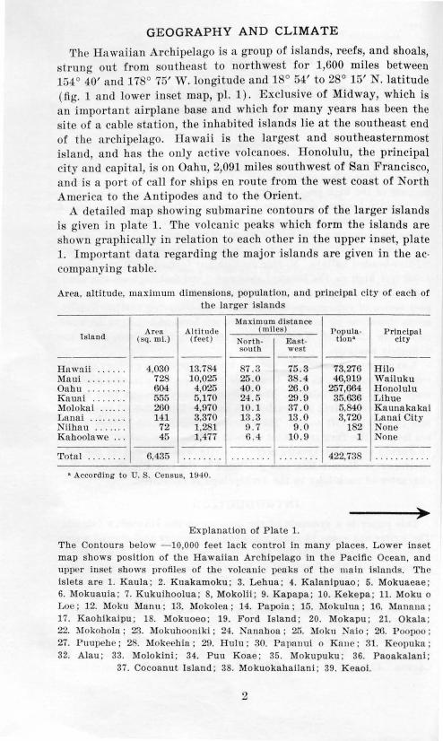
The Hawaiian Archipelago i a group of i land , reef , and shoals, trung out from southeast to northwe t for 1,600 mile between
154° 40' and 178° 75' W. longitude and 1 ° 54' to 2 ° 15' N. latitude (fig. 1 and lower in. et map, pl. 1). Exclu ive of Midway, which is an important airplane ba e and which for many years ha been the site of a cable tation, the inhabited i lands lie at the outheast end of the archipelago . lla waH is the largest and outheasternmo t i land, and has the onJy active volcanoe ·. Honolulu, th principal city and capital, is on Oahu, 2,091 mile southwe t of San Francisco, and is a port of call for hip en route from the west coa t of rorth America to the Antipode and to the Orient.
A detailed map showing submarine contours of the larger islands is given in plate 1. The volcanic peak which form the islands are hown graphi cally in relation to each other in the upp r in et, plate
1. Important data regarding the major i lands are given in the ac· companying table.
Area, altitude, maximum dimensions, population, and principal city of each of the larg r is land
Maximum distance Aren Altitude (miles) Popula· Principal
Island (sq. mi.) (feet) North · East· tlon• city ROUth west
----Hawaii .. . . . . 4,030 13.7 87.3 75.3 73,276 Hilo Maul .. ... . . . 72 10,025 25.0 3 .4 46,91!) Vi'niluku Oahu ...... .. 604 4,025 40.0 26.0 257,664 Honolulu Kauni ..... . . 555 5,170 2-4.5 29.9 35,636 Lihue Molokai ...... 260 4,970 10 .1 37 . 0 5,840 Kaunakakai Lanni . .. ..... 141 3,370 13.3 13.0 3,720 ~~nui City Niihuu . . . . . . . 72 1,281 0.7 9 .0 1 2 one Kuhoolawe -·- 45 1,477 6.4 10.9 1 None
----Total . ... . . . . 6.435 . .... .. . . . . . . . . . . . . . . . . . 422,73 . .. .. . . . . ..
• According to U. . Census, 1940.
Explanation of Plate 1.
The Contours below - 10,000 feet lack control in many places. Lower inset map shows position of the Hawaiian Archipelago in the Pacific Ocean, and upp r in et shows profi les of th e volcani c peaks of the main islands. The islets are 1. Kaula ; 2. Kuakamoku; 3. Lehua; 4. Kalanipuao ; 5. Mokuaeae; 6. Mokuauia; 7. Kukuihoolua; 8, Mokolii ; 9. Kapapa; 10. Kekepa; 11. Moku o Loe ; 12. Moku Manu; 13. Mokolea; 14. Papoia; 15. i\lokulua; 16. Manana; 17. Kaohikaipu; 18. Mokuoeo; 19. Ford Island; 20. Mokapu; 21. Okala ; 22. l\Iokoholn; 23. Mokuhooniki; 2-l. Nannhoa; 25. l\Iokn Nnio; 26. Poopoo ; 27. Puupehe ; 2 . I okePhin ; 2!>. Hulu; 30. Pat1nnui o Knue ; 31. Kcopuka ; 32. Alau; 33. Molokini; 34. Puu Koae; 35. Mokupuku ; 36. Paoakalanl ;
37. Cocoanut Island ; 38. Mokuokahailani; 39. Keaoi.
2

158' FEET 20000 FEET
20000 !6000 MAIJNAI...OA MAUNAKEA 16000 12000
12000 8000
8000 22'
4<JOO
0 40 50 60 70 MILES
PA c Jl lF Jl
TERRITORY OF HAW AI I '··
0 20 40 MILES
SOUTH PACIFIC 19 '
CONTOUR INTERVAL 1000 FEET
I I
158' 157'
). 100' 120' 140' 160' 180' 160' 140' 120' 100•
Plate 1. MAP OF 'l'IlE L..\H(Jl~H 1 'LA.l\D' OF HA\\'.\11 , TilELlt K.l\U \\' 1\ Hll<'T ZO t E , · BM.\lHNE ' 0!'\'1'0 1t lN FEET, A ' D PlU~ 'lPAL lSLE'l'S. (E.xplunat ion of number on facing page.)
Although the island are at the northern margin of the tropics, they have a subt ropical climate becau e cool waters from Bering Sea drift to the r egion. The temperat ure of the surrounding waters is about 10° F. lower than that of other regions of the same lati tude; and this relative coolness is, in part, t he reason for the poor development of coral reefs. The ocean at Waikiki, Oahu, ranges from about 70° to 85° F.1 The temperature of the air ranges from below freezing on the high peaks to about 97° F . at sea level on the leeward coasts.
The Hawaiian Islands lie in the belt of northeasterly trade winds which persist throughout the year, but are occasionally interrupted during the winter by southerly or "kona" winds which blow for only a few days at a time. The mean direction of the trade winds is not constant. Weather Bureau records for the decade following 1900 show that the winds veered progressively to the east, but in late years they have shifted slowly back toward the north again. This change in the wind direction is important because the consequent shift in precipitation affects the erosive power of streams.
Both the trade and southerly winds bring rain to the islands. The heavy storms usually come from the south. During such storms as much as 24 inches of rain has been recorded in four hours, and rainfall exceeding 20 inches in 24 hours has been recorded in several places.
Winds blow across miles of ocean before reaching the islands and con equently arrive laden with moisture. As they rise over the mountains, the winds are cooled and drop their moisture. The northeastern sides of the islands are usually wettest because the prevailing wind is from that direction. The maximum precipitation occurs between altitudes of 2,000 and 6,000 feet depending upon the form and height of the island. Above 6,000 feet the precipitation decreases, making the high peaks emiarid. As the winds de cend the lee slopes, they become warmer, drying winds, causing arid and semiarid climates on the leeward sides of the islands. On the island of Hawaii, where the mountains are sufficiently high to pierce the layer of trade winds, eddies result in prevailing southwest winds on the lee side so that the climate in the leeward districts is fai.t:ly wet. The annual rainfall ranges from 10 inches or less on the lee coasts to about 450 inches in the wettest belts. In one year more than 600 inches of rain was recorded on the summit of Kauai at an altitude of 5,170 feet.
Such islands as Kahoolawe and Lanai are relatively low and sheltered from the trade winds by other islands and con equently are very dry. In windy ea on ribbon- haped du t cloud from these two i lands comm<>nly extend many miles over the ocean.
1 A tempera ture ot 90• F . wa s reco rded ln August 1934, but tbls may have been an error b cause the readings are made by hotel attendants, and the second highest reading ts s:s• F.
3

4>-
p A c
0
~ HAWAIIAN ARCHIPELAGO
0 9() !90 15() toO WILU
.L. H[T
p /
0 C'
lJ
-e -<1
&~, 20"
f[[T toOOO 15000 10000
:l~~!l·:.l.,l!·.:·::::l::.ii):!: .O:,·::Ii~BII~I::.I:I~:m:illi· ... !l~@l:,l::l-llij!ill::~~j '""" . ,.,. 300 400 '00 100 7nn •nn enn 1nnn ,, ,.., ,, nn """ ' "'" " , . ... ..... ,, r• - tO OOO
Figure 1. llinp nnd p r o lll c of the Hnwniinn A•·c bipc lngo s h o wing s uhmar in e conto u•·s in t eet. Exp la n at ion of numbe r·s on facing page.

GEOMORPHOLOGY
The major islands are basaltic volcanic domes in various stages of dissection. Oahu and Niihau have the only extensive coastal plains. The great permeability of the coral rock and basalt has an important bearing on the geomorphology of the islands. For some time after the cessation of volcanic activity, streams are unable to develop water courses because the surface is highly porous. For example, even though t he rainfall is high, stream channels are not developed on most of Kilauea Volcano. Because temperatures are uniformly high and, except on high peaks, not below freezing, chemical weathering dominates over mechanical disintegration. Gradually thick lateritic soils form and reduce the porosity of the slopes, and stream courses are able to develop. Even though flashy, the streams are powerful agents of destruction because of the steep slopes and fractured condition of the rocks.
The amount of stream erosion varies enormously on the different lopes of the same dome. The northeastern lopes of the larger
islands may be incised by deep canyons because of the high rainfall, whereas the leeward sides may have relatively small gulches. Anomalous physiographic relationships are common. On some of the domes, high fault scarps have protected one slope fl'om lava flows while another slope was being covered. Differences in the age of the rocks on the two sides of a mountain give rise generally to vastly discordant stages of erosion; for example, on the Waianae Range, Oahu, the leeward slope is older, hence much more eroded than the windward side.2 Further, the rate of erosion on a volcano may be slackened by the growth of another volcano to the windward, as happened when the Koolau dome cut off the trade winds from t he Waianae dome (pls. 3- 6).
2 Stearns, H. T., Geologic map and guide of the island of Oahu, Hawaii: Hawaii Div. Hydrography, Bull. 2, 1939.
Explanation of figure 1.
1. Unnamed shoal; 2. Bensaleux Reef; 3. Kure or Ocean Is land ; 4. Green Island; 5. Nero Bank; 6. Midway Islands; 7. Gambia Shoal ; . Pearl and Hermes Reef; 9. Lisianski Is land ; 10. Fisher Reef; 11. Minor Reef; 12. Neva Shoal ; 13. Springbank Reef ; 14. Lay san Island; 15. Maro (Dowsett) Reef; 16. Raita Bank; 17. Gardner Pinnacles; 18. Two Brothers Reef; 19. S t. R ogatien Bank; 20. Brooks Banks; 21. La Perouse Pinnacle; 22. French Frigate Shoal; 23. Necker Island; 24 . Nihoa; 25. Unnamed shoal ; 26. Kaula ; 27. Niihau; 28. Kauai; 29. Oahu; 30. Molokai ; 31. Lanai; 32. Maui; 33. Kahoolawe;
34. Hawaii.
5

0'>
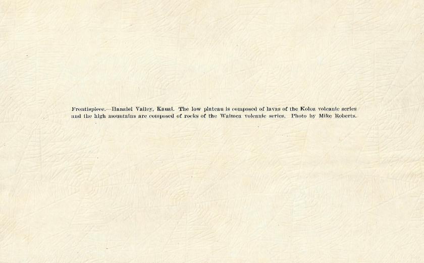
Pla te 2. Halawa Valley, M olokai, a typica l amph itheater-headed valley. Photo by U.S.A.A.F.

The unusually high rainfall zoned by altitude, together with the steep radial drainage developed on alternating layers of weak and strong vertically jointed rocks dipping eaward, have produced on these i lands a di tinctive type of valley best described a amphitheater-headed (pl. 2 and fig. 2, D). Most of the larger islands, except tho ·e n'Jleel' •d with more recent lava, are inci ed by va.lle}'S of this type. Sev r·al factor are concerned in t he development of amphitheater-headed valleys.
Figur 2. Dingram illustrating the formntion of amphith nter·headed ,·alleys. A. Youthful dom e with radial d rainage. B. Detail · of stream pirac-y that lead to u master stream, the prec ur or of an a mphitheater-hea ded ntlley. C. Water falls cuu ed ll.v alte rnating r e istant and 11 onre istant bel of basalt. D. Dome with nmphithenter-heuded ,·alleys fornwd hy th e master stream .
1. Original .·lope of the ·m face: Stream· that flowed or·igina lly on slope. of abont 3° or le have not developed amphitheat r-headed cauyons · tho e t hat flowed on teeper lope have developed amphitheaters; for example, Manoa Stream on Oahu. The original :lope seems to be the mo t fundamental influence contributing to the formation of t hese valley .
2. Alteruate re istant and nonr·e. istant beds, nsnally dipping down tJ·eam (fig.~ . '): The nonrc i taut clinker bed are under ut b<>neath t he J' s istant layt>r. of dem;e ba,alt and form watet·fall a. th y a r·e cut hack. uch fall increa e in h ight as they follow the dip up tream and tend to coale. ce into one high fall. l o t of the ·tr ams han~ a ' fall point,' ' above whi ch the stream actively incise·
7

its cauyou iu t he bedrock and blow which the ir >am cut - latera lly; for exampl ', Haiku Stream, Oahu, has a 3.8 percent gt·adient below the fall point and an perc nt gradient a bove t h point {d t oppiug 1,500 feet in a horizontal distance of 1,700 feet).
6. Rainfall and ·tream captUI·e : The stream· fl owin g more or le · · radially from the center of the dome are spaced relatively far apart iu the region of low altitudes and low rainfall (fig. 2, A). With increa iug altitude and rainfall , tream increase in number for a uni t area and strea m capture becomes dominant (fi g. 2, B ) . Thu ·, the catchm nt un ~in of t h • ·tr am nlarge into an amphitheater near it onrce. This proces i vastly more ffective t han it is on an ordinary linear mountain range b cau ·e of t he radial pattern, or headward conv rgence, of t he drainage on th upper part of t he dome. The rr t•otwd water confined in the rocks of t he dike complex is tapped first by t he dominant streams, and this p reunial additi onal water accelerates their ability to capture new stream·. apping by the prings al o widens the amphitheater.
4. Pluuge-pool action: aptured tributaries entering a ma ·ter strea m form coale cing plunge pool. atound t he amphitheatet· wall. The nan-ow ridrre. between t he plunge pools a r undercut a nd fail under their O\\ n weight, generally breaking off during heavy ~ torm · along some laye r of ash or cinder weakened by aturation and weatherin g. Land Uding is a u active process in Hawaii, but the scars a t·e o,·etlook d beca u ·e they b come covered . o quickly with vegetati on . After the "kona" ( outherly) storm in November 1930, H new landslide· were counted in the upper uuanu Valley. Oahu . Stream of low gradient do not develop high waterfall and con equen tly ca nnot form plunge pools large enough to und ermiu ' t he divides at the fall point.
5. Cliff-forming rock : Rock mu t be competent to tand iu ,-et·tical or nearly vertical wall . Basalt readily tands iu hi gh cliffs. Vel'tical jointing common in basalts is a contributin g factor to .·heer wall s. If rock are weak, the sheer amphitheater wall can not develop at the head of a valley.
6. Inclination of t he bedding: The attitude of the b d i. probably important, but in Hawaii whel'e trata rarely dip teeply, the part play d by this factor cannot readily l>e determined. t eply d ipping l>ed , however, probably might not form heer wall s.
Following overgrazin g and deforestation, t he wind ha.. t•oded large quantities of lateriti c oi l from some of t he island . KallOolawe and Lanai are notable exampl e. . Wind erosion affects localitie · where more t han 100 inches of ra in falls annually if the surface become l.Jare th rough landslides or other causes. Iu the Kau Di -tri ct Hawaii , ash depo it are 50 feet or more iu t hi ckne ·. Du t blown from the a ·h-covered Kau De ert on Kilauea con t itute · an
8


appreciable part of these deposits. On Oahu, Maui Molokai, Kauai, Lanai, and Niihau, dunes composed of calcareous beach sand and reaching heights of 100 feet, have drifted far inland. Most of the dunes are of late Pleistocene age and migrated inland when sea level was lower than at present. Some are now thoroughly lithified.
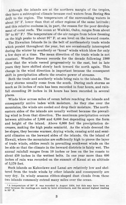
Marine erosion is most effective on the northeast or trade-wind coasts where sea cliffs nearly 3,000 feet have been cut. Because many of the severest storms come from the south and southwest, however, the coasts facing the e directions- where not veneered by recent lava flows and not sheltered by other islands-also have high sea cliffs, some of which are 1,000 feet or more in height. Some sea cliffs have been retarded in their development by lava flows that have been eroded away (fig. 3). The sea cliffs generally plunge into deep
New lava flow
Figure 3. Three stages showing the geologic history of a sea cliff veneered with lava. A. Before veneering. B. Immediately after emplacement of lava flow. C. Veneer removed by subsequent wave erosion.
water or are skirted by low, emergent fringing reefs. These facts indicate that the cliffs were cut when the sea stood lower than at present, possibly during glacial epochs when the temperature of the surrounding ocean may have been too cold for corals to build fringing reefs. The high cliffs and great valleys have been cut simultaneously.
As a result of submergence, all the large valleys are partly drowned. Drilling on Oahu indicates that submergence exceeded 1,200 feet. On Lanai, fossiliferous marine sediments 1,070 feet above sea level and excellent beach deposits at 560 feet are demonstrable proof of large emergence. A complicated hi tory of emergences and submergences in Pleistocene time is shown by the geologic work now accomplished. Ancient shore lines determined so far are listed with the youngest at the top.
13

Aucient shor lin s in the Hawaiian Islands*
Approximate a ltitude
.\pproxfmnl•l altitude (fPN) Name of terrace (teet) Name of terrace
0 .. .. ..... .. ....... . Present 5 .. . ..... ... . .. . .. .. Kapapa
"2G . . . . . . . . . . . . . . . Waimanalo - GO±. . . . . . . . . . . . . . . . . . . . Waipio
-lG ...•.•.•. . ....•. ... Waialae 70 .. .. .. ... • .•.. .... .... Laie Vii ... . ... .. . ........ .. Kaenn
- 300± . ........... . ... .. .. Kahipa 55 . .. .. .... . .... . ... . Kahuku
260± . . . . . . . . . . . . . . . . . . . Olowalu 560 . . . . . . . . . . . . . . . . . . . . 1anele
1,200± . . . . . . . . . . . . . . . . . . . Mahana - 1,200±. . . . . . . . . . . . . . . . . Lualualni
• T wo 'hvre lines 22 and 27 feet above menu sea level.
A~ far ;t · is known, all terraces younger than the 260-foot halt are 'Ollt:on1aut. indicating that the hore lines are eustatic. Th se strand
lines t1 ert>lup •d becau . e of changing ocean level which, in turn, de· tlPUdl•l1 upon either chatwe iu the volume of the polar icecaps, or t:II<llt g-e~ in the coufigurati u of the ocean fioor, or upon both these ca use~ <·< ,mhiued. ro sibly the older strands can be attributed to i~osta ric adj u. tmeu t follo\\·ing the tran fer underground of large \·olunw. of ma gma or to preglacial eustatic movements.3 This subjed . Jt o,,·er t' awaits additional tudy.
l·:n>u tltotwh on ly a few mile apart, each volcano in the Hawaiian I slanl1: wa built seemingly over a practically indep ndent magma rt>senoir: each ha an ro ional hi tory peculiar to its height and l'oJ·Ht: ;t u<l ea h differs somewhat in age from the· others. Volcanoe · o tt adjacent island may have a more closely related hi tory than those on the same i land, because the number of volcanoes incorpora tPd in ;tuy particular i land depends on the pre en t level of the ocl:'au and is, therefore, entirely fortuitou . If the present ocean level were lowet·ed 2,000 feet, an entirely different grouping of volcanoes aml a · ~ ernul age of island would appear ; for example, :M:aui, Molokai, and Lanai would be joined if the sea fell 250 feet (fig. 26) . Becau ·e of individual characteristics, the geology of each volcano is given brieRy in the following pages. For convenience in locating, volcanue:s ate discu ·ed under the name of the island.
3 Stenrn,. H . T .. Eustatic shore lines In the Pacl.fic: Geol. Soc. America Bull. , YO!. riG, pp. 1071- l Oi , 1945.
'See upplemcnt for rev ision of this table.
14

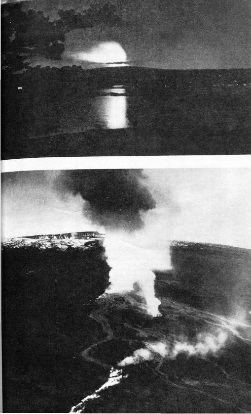
Plate 7.A. "Curtain of fire" formed by coal cing laYa fountain s along fissure on the floor of l\Iokua weoweo alderu, April , 1940.
Plate 7B. "Curtain of tire" on the night of April , 1940. Photos by U.S.A . .A.F.

GEOLOGY
GENERAL STATE 'lENT
The Hawaii an I lands are a chain of shi ld- ·haped basaltic domes built over a fissure 1,600 mile long in t he ocean floor. Thi · tectonic feature ha · exi ted probably ince at lea t Middle Tertiary· but it is not known whether the fi sure i a tear along the crest of a fold, a simple ten ion crack, a group of e helon faults bo umlin g a rai ·eel block, or a strike- lip fau lt. 4 The lava now rises a long ten ion crack boundi ng loz uge- haped block strung out linearly from s u then t to northwe t . The \'ent. are paced about 25 mile: apa rt.
Exposed part of the dome contain by volnm le · t han one-half of 1 perc nt of expl o i\'e d bri , thu indi cating th dominance of lava outpouring . The fl ow range from a few in he· to 900 feet in thickness, but mo t of t hem are from 10 to 30 feet. Phreatic and phreatomagmatic explo ion ha \'e o curred paringly.
The main bulk of the dome con ist. of lava bed dipping 3° to 20° away from t hei r ource a nd rat'ely ·eparated \'en by t hin :oil bed , t hereby indicating rapid accumnlntion of flow ·uch as is taking place now on Mauna Loa Volcano, Hawaii. Thin so il s bet ween the flow in some volcanoes, . how that the t ime in terval epamting eruption lengthened toward t he lo e of t he dome-building epoch. Many of the e oil bed are decompo ·eel vitri tuff which durin' t he early pha e of eruption, generally is deposited in sma ll quantities by lava fountain at the Yent .
Fis ure eruption charact t'ize Hawaiian \'Olcanoes. The n ual eruption is preceded by a few li ht ear t hquake as t he ground open to allow the exit of the magma. These fi ure are a few inche to a few feet wide, and during th rapi 1 dome-building epoch a re limited to definite rift zones (pl. 1). The widest ingle dike kn own in Hawaii is 40 feet aero s, but th average wid t h i abo ut 2 fe t . Eruptions often begin with a lava fountain "hich i can eel by frothing at the top of the lava column when pre ure on the enclosed ga e is released (pl. 7 ) . If effervescence is li ght, a line of sr atter cones 5 to 50 feet high is built; if voluminou , a line of cinder cones 50 to 300 feet high result . River of pahoehoe pour from the fissure; but a i t flows down the mountainside, the lava u ually changes to aa. om of the lava fl ows entering the sea di rupt violently and build fragmental cones. Recorded eruptions have la ted from a few hout'S to 10 month , and t he flows have ranged in length from a few feet to 35 miles. The di charge of juvenile water in crea e. · in direct proportion to t he amount of effervescence. Profile of typical cognate secondary cones superimposed on the great lava domes are hown in figure 4.
• Betz, F. and Hess, H. H. , The floor or the North Pacific Ocean: Geogr. Rev., vot. 32, p. 111, 1942.
16

Feei Feet 500
soo l_ ____ _. .................................. ._ ______ _j 0
o Lava cone
!)00 500 tOOO t
0 L--.... -· j
tOOO
...... ____ ~-..... _j 0
tO OO
500
0
Spatter cone
OC::====='i~~===:===:===:===:=:=il M i I e
tOOO
500
0
Fi"ure 4. Profil<:s of eognnte f'(·oncla n · cone . A b cone after con olidntion are call ed tuff cones.
In crea.·e<l kno11'h>dg-e 1·eg-nnliug the gl'Ology of the islands seems to indicate that all llawaiian H)l anoes pas· through t he following more or les. s imihu· F<hlges in <le ,·elopmeu t (fi<r. 5).
Stage J .- Building- of a 1·olcano from the ocean floor to :ea level. Du1·ing thi submad ne phase, the 1·olcano in development probably l;tys down chi •fly pill ow hwn.' and produces lar•Te quautitie. of ash and pumice a a r esult of the coutact of the magma with ea water. \Yheu a co ne tir~t rise abo1·e . ea le1·el, it i compo ed largely of wea kly co usoliclnted ash which is rapidly eroded by the sea. Shortly nftennn<l. lara flo 1n; r eneer the cone, and the ero ·ive effectivene s of wa1·e act ion i s g-reatly decrea:ed.
Stage ~.-Once the one i~-; abo1·e sea Jerel , thin :heet of highly fluid pdmiti,·c-type oli1·iue ha:alts are rapidly potu·ed out u ually f1·om one min or and t11·o major rift: as well a from a small crater at tht'ir intPI·se ·t ion. Ereutnally a shield - ·haped dome i built. In the dominantly oli,·in e·hPa ring- ba:alt~, ·mall f ld par phenocry t are ·ommon and pyroxene phenocrysts are scarce. inder cone ·eldom form. l'~nally a H'Jlt i~ either a fis ·nre bordered by low. patter heaps or au open ing COllCl'nled by a fla t mound of pahoehoe. A few thin bed: of lithi c and 1·iti·i c inft may be depo. ited. Becau e t he :n1·face is highly porons and the time intenal between eruption. L shod, l't ream ros ion is non xifitent. All Hawaiian vol ca noe ha1·e passe<l through thi yonthfnl stage.
Stage :~.-The r olca no gradual ly collap e · o1·er the 1·ent areas to fo1·m a t:a ldr ra on th e :nmmit (pl. ) aiHl shallow g t·aben along the majo1· rifts. 'rhe eomposition of th e larn: doe uot hange appn•ciably. no1· does th e tim inten·al between I·nption l ngthen. Lara pond ed in (']ost'd fault ba:in. ar 1·r ry mas. ive however, and )u
physical app<'<11'<UlC ditfer greatly from th pre-ca l iera la ra . \Yheu -c i·o<lcd they form she r cl itl's whi ch n. nall~' :how columnar ·true-
17


Opposite page: Plate 8. Summit of Mauna Loa Yol<:auo . howiug- ~Jokua
weoweo Caldera and the pit crater on the southwest rift after a flnrry or snow. Mauna Kea in the background. Photo by .S.A.A.F.
ture. Lithic and vitric tuff beds may be developed more frequently than in the first phase. The highest wall of the caldera n. nally bounds a segment between the two rift zones which intersect at an obtuse angle. Generally the seaward slope of this high wall cea. e. to be flooded with lavas; and as a result, canyon are eroded into it, while flows continue to veneer the other slopes. Sea cliffs are another characteristic feature of the high-walled slope. Two di tinct phy iographic stages may exi t, therefore, on the arne volcauo.
Mauna Loa, Kilauea, and Lanai are now in this volcanic pha e. The other domes have passed through this stage. The West )lolokai dome adjacent to the summit collap. ed but apparently a caldera did not form.
Stage 4.-'\Vhen the volume of the lava. poured out exceed . the amount of the collapse, the caldera and grabens are partly or entirely obliterated. Time interval between eruptions grow progressively longer, and the composition of the lava may change slowly or abruptly to more feldspathic type . Trachyte, andesite, or clo ely related rocks are laid down in thick sheets, chiefly as aa flow . In this phase, the more highly ferromagnesian lavas usually contain large phenocry ts of one or all the following mineral : pyroxenE', olivine, and feldspar. Peridotitic and gabbroic cognate in ln sion are common. High lava fountain which build large ciuder cones characterize most eruption·, and bulbous dome may be formed (fig. 6) . Vitric tuff beds increase in number and thicknes . The profile of the dome steepens and become. studded with cones. ome of the vents lie outside of the rift zone . Ero ion ha re ulted in local unconformities between some of the flow . Hualalai, )Ja una Kea, and Kohala domes are in this phase.
Volcanoes passing through this phase take either of two courses. One is the course followed by West Maui, Kohala, and Ea t Molokai in which the primitive olivine basalts are succeeded by (1) a thin incomplete veneer of olivine porphyritic basalt u. ually carrying augite phenocrysts, (2) a relatively short pau. e, and (3) eruptions of oligoclase andesites and trachytes which form an incomplete veneer and add only a few hundred feet of lava to the ummit of the volcano. The econd i the course followed by Haleakala and )fauna Kea in which no inactive period occurs, trachytes and oligocla e ande ite are rare or absent, and andesine ande ites dominate but are interbedded with both olivine basalt and picrite ba alts carrying large augite phenocryst . The e lava may add several thou and feet to the height of the volcano.
HI

E xplos1ve submarine stage
Ocean
3 C ollapse or ca ldera stage
5 1v{arine and .
stream eros1on st.age
7 S econdary eruption and
barrier reef stage after partial emergence
2 L ava producing or
dome stage
.. :..:..v~'-, . .~;~::;_i:2.: ... -J
4 T rachyte and
cinder cone stage ,., ~ )l 1)
_ ,, ll ) ,/ (~ --, L .t' •.
r,r· .i .J ... ...- ·_./ I' ' \.'') I\ (./ . ~ /
.. ..... " .... _.,_, ..... · .. ..
6 S ubmergence and
fringing reef stage
Fringong reef
8 A tol l and
resubmergence stage
Alollr•m
Figure 5. Eight stages in the geologic hi tory or a volca nic island in the central Pacific.
20

~ .......
FEET Goo, A
0
D
F
Tr achyt.ic
Blocky clinker
dome B u l.bo u /---;---
--,--.--1-
/" -I
...... I
................ , ' , .... ' '
/
' ,,.
Figure 6. Secti ons of typica l bulbom~ domes. A to C shows formation of common bulbous dome underlain with cinders. D. Puu Wanwaa, Hawai i. E. Andesite dome and flow. F . Trachyte bulbous dome and flow.
1000
750
500
250

Stage 5.-Marine and stream erosion partly destroy the volcanic dome. The effectivene s of the e agents depends upou the height, which determines the rainfall, and thQ exposure, whether the i land lies to the lee of another. Those which have been in this stage for a long period develop fringing reefs, high sea cliffs, and deep valleys.
Stage 6.- Deep submergence partly drowns the islands and extensive fringing reefs develop. Barrier reefs may develop or the growth of coral may be interrupted by secondary volcanic eruption. as shown in the next stage.
Stage 7.-A rejuvenat ion of volcanicity occurs and secondary eruptions occur. These lavas, extruded in middle ( ?) and late Plei . tocene and Recent times, commonly contain either nepheline ot· melilite or both minerals. The basalts may contain or lack pyroxene, feld par, and olivine phenocrysts. Peridotitic and gabbroic cognate inclusions are usual. Vitric or crystal-lithic-vitric tuffs may be widespread. The latter result chiefly from phreatomagmatic explosions. These lavas are unconformable upon extruded rocks of all three preceding phases, a fact that clearly points to the intervention of a long erosion cycle. The domes of Haleakala, West Maui, East Molokai, Kahoolawe, Koolau, Waianae, Kauai, and Niihau are in this volcanic phase. Many of these later vents show no close relationship to the ancient rift systems of the volcanoes on which they are formed. Many lie on north-south rifts, especially on Niihau, Kauai, and Oahu.
Stage 8.-If submergence continue or the island is planed off by marine and stream erosion during the fluctuating seas of the Plei -tocene an atoll may develop on the eroded and submerged volcanic mass. The atolls in the leeward part of the archipelago were formed in this manner.
A correlation of the stratigraphic rock units in the Hawaiian Islands is given in the accompanying table.
22

!-.:> v.:>
Stratigraphic rock units in the Hawaiian Islands
Ap Nllhau K&ual Oabu Molotal
Lan&l K&U&! lloonlal.u HO&rl' Head WalaD&el!&np Koolau Rance Wm Molotal Eut Molotal
Hllt«te YOUD(tr allurlum, un-Coral ftU Coral ftll
YOIIllltr allurlum, playa conaoUdal<d ealtlltOUJ Youl!ltr allurlum and Yoo.na:er allurlum, un· YOUI!Itr allurlum and YOUI!Itr aUurlum and Youucer allurlum aod depoolil , and UDCOII· beach and duoe de- UDCODIO!Idal<d caleat· YOWlCtr allurlum and conaolldal<d beach and 11llCODIOUdattd cal- uDCODIOUdattd cal- unconaoUdattd cal-aoUdal<d eaiCiftOOI pooill, and youncer .... beach and uD<OOJOildal<d ealear- duot depoolll, and eattOUI beach aDd cartOU beach dtJ)OIIIJ carooua beach and lltcalt lleacbanddunesand nltU ol the Koloa dune deporlll t0111 beach and dune YOWlCtr rocta 1u tbe dune dtJ)OIIU dune dtJ)Oilll
TOic::anJe aeries deJ)OIIII Hooolulu roleanle ltrlta
Loca11III<OIIIIlnllltJ Wtbllltd cal..,..,.. LltbUitd cileatt0111 WtbUiod calCiftOOI
dv.ota, tmtl'ltd marlue Llthllled caleartOUa Lltbllltd caleareou dUD<t, emtr~td dunes, tmtl'ltd marlDt Wtbllltd ealeareou Emtretd marine lime· Lltltllled caleareoua Plelltoceoe uar~ooe, dUDe~ or duDtJ, older alluTium, dunes and older marlDt UllleltDDt, llmeiiUl!le, oldtr allu- dunt1 and older ttone, older alluTI.um, dunet, merced marble
rolcanle aDd, oldtf and oldtf roeta ol tbe allurlum older allurlum, and rlum, and older nltU allurlum Kalaupapa bualt, llmt~tone, and older allarlum, and Klekle Kole& Toleanle aries Kolekole rolcaulea 1u tbe Honolulu rol- and Mokuboonlkl tuft' aUudum •oiWlle l«les eartle aerleJ _. ___ ......; ___ Orut eroolooal UDtODI.,.lty
PUoeoDtand old<r
I I
Waimea roleartle aerlt1; I!Uupu roleanle aertea; I WalaD&e roleartle Pan.laa fOieanle ~trlea caldera-ftll1uc (apper) caldera-ftlltl!l and aerlea ; upper , lower,
aDd utn-ealdera utn-caldera memben and •ldclle111emben (lower) -ben I
Koolau and JUlius roleanle aerlea
I
W. llolotal roleanle aertea
llaal Hawaii
I
E. Molotal rolcanle I ~ertes; opper, lower, L&nLI roleanie serie~ and caldera eomplu llltlllben
Ap K&hoo!awe Welt llaul Eut llaaJ Koba4 IIOUDI&iu llaan& Loa Volcano Maan& Kea Hualalai Volcano Kilauea Volcano
--------·1-----------~·------------1
Hlatorle member ol the ~~~\:.~ tbe lllatorle member o1 tbe Hlatorle Red 10011 Voleanlea oll750(1) IUu roleartle aerlea YOWlltr allurlum , un- ~trlea. (Voleanlea o1 Pun& roleaoleserlea
YOWICtr allurl .. and Youu&er allurlum, UD· and mudlkttr ollSSS =·~=:,':~ 18QO-Ol) ------1---------1 uDtOIIIOlldal<d cal· t01110Udattd caltlltOUJ eanle ADd dunes, 1---------1--------
tlttOUI bu.eh and YOOllJtr ali.Uflum, UD· beach deporlll, and •lttle uh dtJ)OIIII, UnconaoUdattd calear-YOUIIItr allurl011, uu· dune cleporlta conaoUdattd beach and black AJid dunea Black AJid duDtl, and aod upper member ol eou beach cleJ)OIIta, Black sand dunea. aJJd
Ktc:oot <01110Udattd caleatt0111 dune cleporlll, and tbe prehlatorle membef the Laupaboehoe •ol- and YOOllJtr roeu i><ehlotDrle membef or beach deJ)OIIII and YOIIIII"' nltU 1u tbe ot the Kau •olcaule eartle aerle1 ol tbe prehlatorlc the Puna •oleanle !ale •oleartlca Halla •oleartlt aerlea ~trlea member ot tbe Hual&lal aetltl
Yoleaulc ttriea
-----------------LDtal 1111<0111ooU~--------------------~------------~----------~~~--~~----------------------------Kaupo nd8ow old<r Olaelal dtpooill, oldu Eloel'lecl utlDt u- allorlum ..,.j oldtf alluflum, 16ftr ,...,. Pahala aab and older
- older aUUfiDII nltU ln ihe Halla Old" aUurlum, Pabala Pahala uh and K&buku bet ol the Laupaboeboe nltU ol tbe Hn&lalal P&bala aab and HUina Plelltoceoe Oldtr allurlu• and Labalua •oleanle' roleanle ..rtea lnclDd- ub, and Haw! rol- foleanle aer1ea rolcanle 1trle1, Pabala roleartle ltrlea ln- rolcanle oerlea
IIC'Iea ID& tbe Kipahulu eanle aerlea uh, and yooncer roeta elodln& the Wuna ....,ber !:.,~!:Sku •ol- ruleanlea
~---------1-----------1----------Piloetae and I Kaaapou roleaale ...... ,llooolua roleanle ...... , Kula •olcanle ...... I Older uutlpoaed roeu ProbablY ~ .. p UDtX])(lOid I I I I J
old<r caldera and utn WaUuka •olcanle ltrlea HODOIIW1U •olcanle aerlea Pololu •oleanle ltl'lta Ninole rolcanle ltl'lea In tbe !IIIB&ku •ol- nltU ln the Hu&lal&l . _____ ..__.caldera= -. eanle ~trlea fOleanle_ 1trlt1 ·--- - · .


Oppo.itc pnge, top : Pla te DA. llnl C' mn uman iu e rup t ion, ep tC'IlliJPr G. 10:34.
Bot tom : P lntf' OB . La Ya ·a !':ciHl c 400 f f'(•t hi ~h on wnll o f Il nlcmanmllt l. SPptemiJer 7, 1034. Photo by U.S. A.A.F.
I SLAXD OF HAWAII
The isla n rl o f Ha wai i con s i. t s of fi\·e r o lca noe ·, nanwly. )Ja nn a Kea (1:3,78-! fed ) , Mau nn. Loa (13.679 f et ), H uala la i (8,26 1 feet ), Koha la (3 ,:)0:) fl'et ), a nd K il a n Pa (4- ,0-!0 feet ) (p l. 9 ) . Fi~n re 7 i s a map o f' Ha wa ii . h o wi n~ t he hi sh>J· ic la r a fl ows.
156 ' !55'
o 10 2omiles "'==::ES:=~"""""',a
15 6 ' 155'
F igu re 7. :\ la p of ll a wnii showi ng b i:-;iol'i c lam fl ows . Afte r G. \ . l\Ia cdonnld .

JfMAM.t..IAIO.D
KILA._.
Figure 8. Graph showing periods of activity of Kilauea and Mauna Loa volcanoes. (Revised by Macdonald and Hubbard,
Volcanoes of the ational Parks in H awaii, 1965.)
26

During the past century Mauna Loa has averaged one outbreak in the caldera for e,·ery 3)1 years, and has produced a lava flow erery 6 years.5 Kilauea has contained a lava lake for years at a time. but since 1800 has produced only seven flows outside of its cald~ra (fig. 8). The only recorded eruption of Hualalai was in 1 00- 1801. Mauna Kea and Kohala have not erupted in historic time.
Hawaii, except for the windward slope of Kohala is little dis-sected. The only perennial streams are on the northeastern slopes of :Mauna Kea and Kohala. The high permeability of the fresh lavas forming the surface of Kilauea, Mauna Loa, and Hualalai inhibit the derelopment of permanent streams. Large areas on these mountains are co,·ered with black rock and are bare and devoid of vegetation. The outhwestern side of Kilauea is a desert.
The lavas of Mauna Loa interfinger with the lavas of Kilauea, Hualalai, and Mauna Kea. The lavas of Mauna Kea interfinger with the late t lava of Kohala Mountain. The 25-foot shore line has been found on Mauna Kea but not on Hualalai, Mauna Loa, or Kilauea. Marine conglomerates reach a height of 260 feet and stream terraces, a height of 1,100 feet on Kohala Mountain. Thus, Kohala Volcano beca me extinct before all others on the island. It is probable, howerer. that all except Kilauea have been active simultaneously since ·orne time in the Tertiary. The stratigraphy given in the accompanyjug table and the distribution of the rock units shown in figure 9 hare been recently completed. 6 The mountains are described in order of hei ght.
' Jn ggnr, '1'. A. , Hnwn ilnu Volcano Hesearch Assoc., Volcano Letter, no. 443, p. 1, Jan. 1937.
'Sren rns, H . '1'., und Ma cdona ld, G. A., Geology and ground-water resources ot the I sland of Hawaii: Hawaii Dh•. H~·drograph y, Bull . 9 ( in press).
27

1-.;) (X)
Stratigraphic rock units in the island of Hawaii (The volcanic rocks of Mauna Lon, Mauna Ken, and Hualalai, those or Mauna Ken and Kohala, and those or Mauna Loa and Kilauea lnterfingel")
Age Hualalai Kohala Mountain Mauna Loa Kilauea Mauna Ken
Historic mem- Mud Historic member of the ber of the Historic member of the Historic Hualalai volcanic se- Kau volcanic flow Puna volcanic series Ribbons of
ries ( 1800-01 ) series of (1790--1934 ) gravel Unconsolidated alluv- ( 1832-1942) 1868 and
ium, dunes and land-
~ small
slides
~ Upper mem- alluvial
ber or the fans Recent Laupahoe-
hoe volcanic Prehistoric member of series
the Hualalai volcanic Prehistoric member of Prehistoric member of series the Kau volcanic se- the Puna volcanic se- Glacial debris and fluvia l
ries ries conglomerates Fluvial conglomerates
Lower member of the Laupa-hoehoe volcanic series
Late Local erosional ___ Pleistocene
I~ Pahala ash (exposed Pahala ash (not dif- y IY a
on Waawaa volcanics ferentiated) h
only) h h
Early and Fluvial conglomera tes middle Kahuku Pleistocene Waawaa volcanics and
Hawi volcanic series volca nic Hi !ina Hamakua lower unexposed part series volcanic volcanic of Hualalai volcanic Great erosional unconformity series series
Pliocene series I Ninole YO!ca nic series Pololu volcanic series
--- --

106'00'
~ ~~~~r Z 'iij H l s"t.oric u -~ lavn
!fi f7777.l l:x:O~
KOHAL.A MOUNTAIN
UJ I > Prehist.orlc
g~ lovoo B E (/) WBawaa volcanics Hawi ki A , pumice cone volcanic ~ ~ B, lrachyt.e lava f1ow eerles
~: G=~8rus~L.
~ -~ l fblol u volcan ic Mriea
'w
~ Cinder and sprt.t.ero::nes and pltcnotera
155'00'
0 c==--..\1~0==--;;20; M lle3
By H.T. Steams and G.A.Macdona ld --•!100' 1924,1940-431
155*00"
KILAUEA
av~o~o s~ u Hlat.orlc
~ lavae
' ' >
I I I I I II II
I! Prehlet.orio c( lavas
I .. I H i line volcanic series, capped by Pa hala ash
Figure 9. Geologic map of the i land of Hawaii. Faults omitted.
29
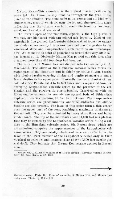
~!At::-;A Ku.- 'Ihi mounta in i t he highe t in ula r pea k on the earth (p l. 10). no" · nsna ll y remain tht•onghout the yea t· in one place on the summit. The dome is 30 mil es a ceos · and studd d with cinder cones, most of whi ch a re nea r th top and clu tet·ed in to zone indicating that th YOlca no \Ya buil t over rift trending nol'th a t" ard outh ward, and we tward.
The lower lope· of t he mountain, pecially the high plain of Waimea, are blanketed with tan-colored ash depos its. Mo t of thi. materia l i. fine-grained firefonotain debri wafted from the numerou cinder cones nearby.7 Stream have cut na rrow ga hes in the windward lope and Laupahoehoe Gulch con ta ins an in t ra ca nyon fl ow. At it· mouth is a fl a t of pahoehoe o recent that very little oil has fo rmed on it. Obviou ·ly Mauna Kea poured out this lava a fter a canyon more t han 400 feet deep bad been cu t.
The volcanics of Maun a Kea a re divided in to t wo erie I.Jy . A. ~1acdunald. The older or the Hamakua vol an ic . eri e form the major part of the mountain a nd is chiefl y primitive olivine ba ·alt · with picrite-ba a lts carrying olivine a nd a ugite phenocryst and a fe w ande ites in its upper part. It usually carr ie a blanket of ta ncolored vitric Pahala a h 4 to 15 feet thick a nd i parated from t he o\·erlyin g Laupahoehoe volcanic eries by t he pre ence of t he a h bla nket and t he pot•phyritic picrite-ba alts. Interbedded wi th the Hamakua lava near t he summi t a re everal beds of lithic-vitric explosion breccias reaching 90 feet in t hi ckne . The Laupa hoehoe volcanic eries are pl'edominantly ande ine ande ite but oli vine ba alt at'e a l o pre ent. The lava of t hi erie form a thin veneer o,· r t he upper part of the cone, r eachin g a maximum t hickne at the ummit . 'l'hey are characterized by ma ny hort flow and bulky ci nde1· cone .. The top of the mounta in above 11,000 feet is a plateau that may be caused by t he Laupahoehoe volcani c ries filling a caldera iu the Hamakua volcanic erie . ix Recen t fl ow , which a re a ll ande ite , compri e the upper member of t he Laupahoehoe volca nic serie . They are mostly black and baee a nd ditfee from t he lava in the lower member of t he Laupahoehoe ·er ie only in their youthful appearan ce a nd because t ho e abo,·e 10 500 fe t overlie glacial drift. They indicate t hat Mauna Kea became ext inct in Recent time.
1 Wentwo r t h , C. K. , As h formnrions of the I sland Hawaii : Hawnllun Vol cano Obse r ,·ntory. 3rd pee. Rept. , p. 57, 193 .
Oppo ite page: Pla te 10. "\ i w of . ummits of Mauna Kea and Mauna L a ,-oica 11oes. Photo by U .. A.A.F.
30

' •'
:I '_,: ·•' \
'

A g-lncil'r abo n t 2:>0 feet thick covered t lw top of th mountain during the \\' i:<·onsiu glacial Rtage as sho w11 by moraineR and gla iatecl areas ahm-e 10,i)00 fC'et . The ~ l acia l evid nce wa R di~'> ·ove t·ed in 1909 a1Hl <ldails h ave been described mor r ecen tly.!l 'l'lne older drift · han· been cl escribed. 10 bu t tllt'"t' have bee11 fonnd to be f a nglomerate and exp lo.· ion deposit.-.u
.:\J .\L·:o LoA.- :Ji atma Loa i s a shieltl -s haped d ome abo u t fiO mile long- ancl :w milt' s " ·itl e ( pl. 10 ). lt is o ne of t·he most prolifi c lara ptodtlct> rs on t'<Hill. A ft•w c incl >r cones li e on i ts ·lope,· and in the s n1nmit ca ld ent, i\l ok na ,,·eoweo. The calclern r e.-n lted from colhtp.·e and is g 1·owing bt·oadPr throu gh coa lescence wi t h adjacent pi t cr aters ( pl. ~ ) . It is 110\\' abo ut 1 0. :>00 f00 t lm q.!. 9.200 fed \\"i<lt• nne! !iOO [ePt deep. During t·Pcl'nt yea 1·s, I;J\'<1 , pon1·t>tl f rom fissure.- an<! tonc•s on it:-; floor ancl J·im. h11s h<:'!'ll fi llin g t he dt>pt·L•.-sions, and a ft •w \\'P<Ik e:q1lo:--; ions hare ot·c· unecl .12
A LT ITUDE IN FEET 1000 I 000 000 5000 7 000 9000 11000 3000 13000 11000 9000 7000 3 I
'I ' I ' I ' I ' I ' I 1942 • NE' I sw rs-4o I
1 ~35 NE sw 1933
I sw 1926 1/) I s w 1919 Q)
a} sw I I ..,
1914 <ll
~ sw 1907 'U 1903 -=i NE
~ Rm= ~ sw I 7
I ~ NE
w 1877 c I Pm: 0
5 :;; I P.lli:: 0..
I 3 ::J 1872 I..
I sw w
I I ~~~~ NW
I I 55 NE
~ NE
I SW ~4~ . ~ . I . I . I . I
1843 N~l ? 1832 l.lo.. ?. --=> outhwest flank ummitk--- North fl an~<, ......:..:...
Fi;.:un-' 10. Gntph !;<hO \\in;.: the lo!'ation and nltitude of Prnptions o f .\Iuunn
Loa Volcano, 1 32-1942.
JLH 111 1<1 Lou lfns " ·ell -dC:' fi ned .-o ut l1\r l':t n nd Jl ort hpnst rift zon e ancl a ,,·en kl y dt' \' l opt•tl nodh 1·i ft :~.one ( pl. l ) . )lost e1·npt ion .-tart n:--; hig-h, :--;hOJ·t -li\'(_'cll a ,·a fountain~'> in th e tnld e1·a. th e n cha n ge to ou t ponrili).!.'S of lnnt fl'o m ,·e n t.· at lo \\-e t· altitndp::; along t he riftR. The loc-ation a nd a lti t nd!' of the el'nption:--; a 1·e Rh0 \\' 11 in fi gm · 10.
8 Dal,1·. R. A .. ProlJlPm s of thr l'a<"ifl <· T' lan<l': Am .. To ur. Rei.. 4th 'e r ., ,-ol. -n. p. 17~. lfJl!i. ' Grr~:or_v. II . E . an <l \\'Pnt worth, '. K., (;,•nrral fPn turr' nn<l Glncinl gcolo~;y of .\l auna Ko•a. llawaii: GP<•l. Sop. ,-\uu·ri<-a Bull .. YO!. 4 . Jlp . 1719- 1742. D ec. 1, 1937. 1n \\" t>lltwort h . C'. K. au d PowPr~, \\~ . E .. :\[ultipl <' ;.:la cia t ion o f )fauna K en
1 llnwnii: Geo l.
So<·. AnH•I'i<·n Bull.. vo l. fi:l. pp. llH:J- t:llR Au;.:. 1!)-Jl . 11 Stt•:t rns. 11. ·r .. t:ln(·hHion of :\I a una KPa. ll awnii: Gt-' ol. So c-. Alllf>ric-u Hull. . , ·ol. :a;. pp. :lH7- :!7 -L 1045.
I!: St f\H J'II S, II. '1' .. a nd 'lark, \\'. 0 .. t:f'olo;:y nn tl wnt(~ r n•:-"() tJf ('(" ~ or th e Knu Di: tri ct, ll awaii: ·. ~- Geol. San·py \\'nter - ~upp l y l'ape r 61fJ , p. lu:.l, 1930.
32
'

The southwest rift probably produce· ·ubmariue flows also. The south and southeast sides of t he Yolcano are broken by echelon fault arra n red in t wo pattern ., One distingui hed by the northeaf;terly trike of the faults, i ·the most com mou. The other with radial faults
is best developed in the so uthwe.-t rift zone. Displacement aloug a few faults has occuned in hi tori<: time. Some of the ·ca t·p · in the southea t lope r each height. of about GOO feet.
On the south east slope, ash deposit , attaining a t hi cku es · of :l:i
feet blanket the lower slopes of the mountain. The bed i · compo. ed of wind-blown dust from the ash deposits in the Kau De.-ert, a. h from explosions at Kilauea,13 and tine ,·itric mate1·ial from cone on Mauna Loa aud Mauna Kea.
A number of radial 1·idges project aboYe the general ·lope of Mauna Loa in the outhea. t slope. '!'he ri dg-es a re belieYed to represent diYides behn•en ca uyons several thousand feet deep whi ch were eroded in Mauna Loa aud later partly tilled with laYa Ao,,· · . 1 ~ Mauua Loa appea r , t herefore, to be au eroded rna ·· probably a old as Kubala Mountain. The volcano may l1<we been completely inactise during the ero ·ion of the ,-a ll ey:, although a hi gh fault escarpment might have botdeted the summit ca ldera a nd for a long time sh ielded the di tri t from lava fl ows. Becaus of the fairly hi gh rainfall in the area a nd the ot igin a lly ·tt•ep gradient · of t he .-tt·ea m · tumbling ove r fault esca rpment.-, these canyon may haYe been cnt in a relat i rely short time.
A typical eruption of i\lauua Loa berrins ,,·ith a fume cloud rising sereral mil e· a nd lava fouutaiu s rPachin g height of se,·eral buudred feet (p l. llA) . Thest- fountains erup t from long crack.- a few feet wi de and e,·eutually meq:~e in to ,-eri tah le curtains of molten lava (pl. 7). At first they do uo t produ ·c cones, but t he de cendi ng lava fl ow a\\'ay as frothy pahoehoe (pl.llB). Some pumice falls clo.-e to the founta in s, but most of it floa ts away on the la r a st ream, thounh sma ll quantities of pumice and Pele's ha it· are IJlowu away IJy t he wind. Generally within a few day ' or a week t he fountains die down leavin.r spatter ramparts or cha in !:> of spatte r a nd cinder co nes along the ti.-su res.
Usua lly g1·eat qua utities of hi ghly fluid !ant are rapidly poured out during an eruption. At its source the lava i. geuerally pahoehoe but change to aa iu it ru h down the mountain. At th summ it, flow. are usuall y less than (j feet thick and most ften only a few
"Stearn~ . II. T., 'l'he exp losh·e phn~P of Kilnuen Volcano, llnwnii. in 1924: Bull. volcnnolog!qu~. no~. 5 nnd G, pp. 193- 209, 19~ 5.
"Stea rns, II . '1' ., nn<l Clnrk, W. 0 .. op. ci t .. p. 52, 1030.
33

in he thick. On the lower lope they average 10 feet in thickne but, where pool · form, the thickne s of individual flow may attain 50 feet or more.
During short-lived erupt ions, an. is mo ·t almudaut a. the pahoehoe changes quickly to aa . During loug eruption , the pahoehoe rivet' crusts over and builds one or more feeding tubes which conduct the lava many miles with but light lo:s of h at. The flow of 1859 la ted 10 months and is 33 mile long. It produced pillow laYa where it ran into the ea.l 5 The flow· from Manua Loa that go north and northeast are building up t he saddles between 1auna Loa and Mauna Kea and Mauna Loa and Hualalai . The e fl ows are much thicker than usual and have gentle dip where ponded agaiu t older mouutain. , a helpful criterion for determining the relative ages of adjacent volcanoes.
The rocks of Mauna Loa are divided into three units. All are olivine basalts. The olde tis the Tinole volcanic serie ·. It forms the core of the mountain and i expo ed in the ancient divide between the part-filled canyons in the outheast slope. Oue intercalated vitric tuff bed 15 feet thick lie 500 feet below the top of the serie . A steep angular erosional unconformity separates the Jinole lava from the overlying Kahuku volcanic serie . The latter attain a thickne s of 600 feet and i eparated from the overlying Kau volcanic serie by a thick mantle of Pahala ash 5 to 50 feet t hick. A few of the Kahuku fl ows interfinger with the ash. The Kau volcanic series are fairly fresh lavas, commonly bare and rocky in dry areas and rarely more than 25 feet thick except in the upper part of Mauna Loa where they exceed 800 feet in thickness. The historic member of the Kau volcanic series comprises the lavas erupted since 1832. Pertinent data regarding their volume and area are given in the accompanying table.
,. Alexander, W. D., Mnunn Lon's greatest eruption: Mid-Pacific Magazine, vol. 45, p. 318, 1933.
Opposite page, top: Plate llA. Eruption of Mauna Loa Volcano as seen from Hilo, April 1940. Photo by Hilo Photo Supply.
Bottom : Plate llB. lflank eruption of 1935 of Mauna Loa Volcano. Photo by U. S. avy.
34

Date ot commence-
ment
Month Year and
day
-- ---1832 June 20 1843 .Jan. 9 1849 May 1851 Aug. 8
1852 F eb. 17 1855 Aug. 11 1859 Jun . 23 1865 Dec. 30 186 Mar. 27 1872 Aug. 10 1873 Jan. 6 1873 Apr. 20 1875 Jau. 10 1875 Aug. 11 1876 Feb. 13 1877 Feb. 14 1880 May 1 1880 Nov. 1 1 87 Jan. 16 1892 NO Y. 30 1896 Apr. 21 1899 July 4 1903 Oct. 6 1907 Jan.9 1914 Nov. 25 1916 May 19 1919 Sept. 29 1926 Ap r . 10 1933 Dec. 2
1935 Nov. 21 1940 Apr. 7
1942 Apr. 26 -- ---Total
Eruptions of Mauna Loa• (Prepared by G. A. Macdonald)
~ Approximate 0 ..,
o.....,. .c duration "'"'~ ...... (days) .,-o
~.,s .... .... 8g~ 0 o~ .. - ., .. ~-;ig
Sum- ~ g,!l: "'"' F lank ~u~ " ""~ 0'0 -mit ......... .. 0 .....
~-;;~ c.~ c. erup- erup- <.>.!: ..... c..,c tlon .3 ... " tlon c.o ..qe ~ ..q c.., --- -- --
21 ( ?) SW. rift 8,200( ?) . 'i26 5 90 N. flank 9,800 us . . ( ?i Calde ra 413,000 73 21 Caldera &
W. rift 13,800 26 1 20 NE. rltt 8,400 6
. . . . . 450 do . 10,500 ( ?) 41 <1 300 N. flank 9,200 26
120 . . ~i:i Ca ldera 13,000 73 1 SW. rift 3,300 23
'60 . . . . . do. 13,000 52 2( ?) . . . . . do. 13,300 3
547 ... . . do. 13,000 3 30 .. .. . do. 13,000 2
7 .. .. . do. 13,000 6 Short do. 13,000 6
10 •1 W. flank - 180+ 12 6 · · 2so Caldera 13 ,000 38
.... . NE. rift 10.400 6
.... 3 10 SW. rift 5,700 65 . . .. . do . 13,000 68
16 . . ... do. 13.000 41 4 19 NE. rltt 10,700 38
60 .. . i5 Ca ldera 13,000 50 <1 SW. rift 6,200 .37 48 . .. i4 Caldera 13,000 94
si:.oi-i: SW. rift 7 ,400 16
42 do. 7,700 40 Short 14 SW. rift 7,600 77
17 <1 Caldera&. , W. rltt 13,000 91
<1 42 NE. rift 12,100 23 133 <1 Caldera &
SW. rltt 13,000 51 2 13 NE. rift 9,200 20
-- -- - -1,136 1,314
.., .. ., ., .. ~ ...... ., :::l .. -'0
!1:8 S"' .. ><~~ ""'o"' o~:;; ee~
gS<O" c.::>.O ,.. ,.. a c.-" -<i!!~ _,qO <> .. ~ ---
6.8( ?) 90,000,000 ( ?) 20.2 250,000,000 .. . ... . . . ... . . ·· ··· 6.9 90,000,000
11.0 140,000,000 •12. 2 1 50,000,000 •32. 7 •600,000,000
.... . .. · ~ i !io:o·o·o·.ooo •9 . 1 . . .. . . . . ........ . ..
. . . . . . . . . . . . . . . . . . . •••••• 0 .. . . . .. ····· . . .. . . . ..... . ...... . . .. . .. .... . ....... . . . . .. . . ...... . . .. . . . . . . . . ....... .. . . . · · · 2-i:o · · iloo:o·o·o·,ooo
•u .s •300,000,000 .. .. .. . . . . . . . . . . . . . · · · ia : 2 · · 2oo:o·o·o,ooo .... s:i · · ioo:o·o·o·,ooo . . ..... · · · so:o·o·o·.ooo 6 .6
•9. 2 •350,000,000 •13.4 •150,000,000
2.0 100,000,000 113.8 160,000,000
13.9 100,000,000 '10.6 100,000,000
----211 . 2+ q,450,000 ,000
• The duration for most of tbe eruptions previous to 1899 Ls only approximate. Heavy columns of fume at Mokuaweoweo, apparently rep resent ing copious gas release accom· panled by little or no lava di scharge, were observed In January 1870, December 1887, March 1921, November 1943, and August 1944. They are not Indicated In the table.
"Upper end of the flow cannot be ldentlfled with certainty. • Ar a above sea Je,·el. The vo lume below sea level Is unknown, but estimates give
tbe following orders of magn itude : 1859-300,000,000 cubic yards; 1868--100,000,000 cubic ya rds; 1887-200,000,000 cubic yards; 1919-200,000,000 cubic yards ; 1926--1,500,000 cubic yards. These are Included In the volumes g iven In the table.
d All eruptions In the caldera are lis t ed at 13,000 teet altitude, although many ot them were a li ttle lower.
• Flank eruption started April 7. r Activity In the s ummit ca ldera may have been essentially continuous from August
1872 to F ebruary 1877, only the most violent a ctivity being visible from Hllo. g \Jbmartne e n1ptton o ft' K en1nkekun , on the w &t cotuit ot Hawa11. • 2.5 square miles ot this Is tbe area of the thin flow near the summit. An unknown
area Ilea below sea level. ' About 0.5 square mile ot this Is covered by the thin flank flow above the main cone
nod 0.8 square mile Is In Mokuaweoweo Caldera . J 2.8 square mil es Is In Mokuaweoweo Caldera and 1.1 square miles outside the caldera. • 2. square mUes of this Is cove red by the thin flank flow near the summit, and 0.5
ROII I\ re mil e Is In th e caldera.
36

HuALALAI.-Hualalai Volcano is about 17 miles in diameter and is one of the most symmetrical cones in the Hawaiian Islands. The mountain is studded with cinder cones and near the summit is pockmarked with craters. The volcano is built over a northwest rift, a southeast rift, and a poorly developed northea t rift.
Its rocks have been divided into historic, prehistoric, and Waawaa members of the Hualalai volcanic series. The Hualalai volcanic series comprise all the rocks in the mountain. The Waawaa volcanics comprise Puu Waawaa, a trachyte cone, and the lava flow from it. The rocks of the Hualalai volcanic series are chiefly olivine basalts with an incomplete veneer of picrite basalts carrying augite phenocrysts. Only one basaltic ande ite has been found.
Figure 11. Two stages in the geologic hi tory of Puu Waawaa. A. Massive trachyte lava flow overlying thin basult flows at close of the eruption. B. Pres nt stage showing cone eroded and Ia va flow weathered and nearly buried by later basalt flows.
37

Puu vVaa waa, on t he north slope, i a one 1,220 feet hi 7 h com. po ed of t rachyte pumice containing a noticeable amount of obidian. The writer interprets a a lava flow a rid ge of trachyte everal hundred feet t hi ck which extend northwest from th cone (fig. 11). Thi trachyte ridge was fit'"t noted by ro .16 It is overrun in places by later aa flow from Hualalai, a fact that indicates ba alt sometimes follows trachyte in the closing pha e of a Hawaiian volcano. The only other oda trachytes are on Kohala Mountain, but Puu Waawaa doe not lie on the extension of any Kohala rift ; hence, it is likely the result of local differentiation in the Hualalai hearth.
H ualalai wa Ia t actiYc in 1 00-1 01 when volumiuou · Java flow poured from a long crack on the north west fl a nk. Known as t he Kaupulehu flow, it is remarkable for its cognate inclusions. The lava contains thousands of ton of angular and subangular dunite and gabbro xenoliths mostly less than a foot in diameter. Feld par crystals, some of gem quality, reaching three-quarter of an inch long are also found . Near the source vent small xenolith coated with lava of 1801 are piled up like cobble . These dunite xenoliths look like green candies dipped in chocolate. Before eruption, apparently, the magma stoped away a large precooled mass of dunite and gabbro. Also remarkable are the lava stalactite on the ides of the channels in the flow.
A line of spatter cones below the main belt road in the same area marks the source of a black flow known a the Huehue flow, which, according to the Hawaiians, was al so erupted in 1801.17 The olivine basalt contains pieces of partly charred wood in its tree molds as does the Kaupulehu flow.
KoHALA.- Kohala Volcano was built over a northwest rift, a southeast rift, and a poorly developed southwest rift. Along the northwest and southeast rifts numerous cinder cones are clustered. The mountain is 21 miles long and 13 miles wide. Much of the south slope is buried under lava flows from Mauna Kea. Deep gorges are incised in the east slope. Faults are re pon ible for t he direction of the headwaters of Waipio and Honokane Streams. A sphagnum swamp lies to the east of the summit. A traverse revealed hidden in the swamp and in the adjacent jungle, numerous small , deep, narrow, collapsed pits along fault cracks and holes in aa flows.
"Cross, Whitman, An occurrence ot trachyte on the Island ot Hawaii: J our. Geo logy, vol. 12, pp. 510-523, 1904.
11 In a personal communication dated Jan. 14, 1938, Dr. T. A. Jagga r states tha t "Miss Paris says natives told her !ather t he Kaupul ehu fl ow wns the first ( 1800) am! higher, and the Huehue flow wns the second (1801) and lower flow."
38

Streams have barely cut into the west slope of the mountain; whereas the canyons on the east side ar more than 2,000 feet deep and the heernes of their wall is unsurpassed anywhere in the i land (pl. 12) . I ear the coast, bedrock floors of the gorge are dr·owned to a depth of nearly 1,000 feet, a noted long ago l.>y Brauner. 1 Remnant of gravel terrace rise in these canyons to 1,100 feet and indicate great subm rgence following the deep submergence succeeded by a later emergence. The we ·t or le coa t i. not cliffed and, except near the everal large cone , has only a thin oil covering in contrast with the east coast where sea cliffs are 1,200
feet high and soil as much as 20 feet deep. Thi. great difference i not due solely to dis imilar condition. of rainfall and roughne s of eas on windward and leeward ides of the volcano, but at lea tin
part is attributable to difference in age. The lava bed on the west slope are younger than most of those on t he east. Four stage. in the geologic development of Waipio and \\ aimanu \ alley are . hown in figure 12.
The rocks of Kohala Mountain are divided into two volcanic serie . The older Pololu serie i composed of thin-bedded primitive olivine, ba. alt with porphyries at the top in most places. The younger Hawi series is composed chiefly of oligoclase ande ites and a few soda trachyte . Some of the more vi cous flows formed bulbou domes but bulky cinder cones lie on the fi sure vents of mo t of the flows. The Hawi lavas lie mostly at the top of the mountain and are usually from 1 to 3 flow thick. A thin r d lateritic oil feom a few inches to several feet thick separate the Hawi from the underlying Pololu lavas except in the wet windward ·lope where the lavas are separated by an erosional unconformity. A Hawi flow several hundred feet thick spilled into Pololu Valley. The later Hawi lavas interfinger outh of Waipio Valley with the lavas of the Hamakua series from Mauna Kea. A late flow in the Hamakua series spilled into the outhea t side of Waipio Valley.
A graben half a mile wide and 3 mile long eros es the summit of Kohala Mountain. It is bordered by faults arranged en echelon. The faults cut both volcanic erie . They appear to outline a caldera 2 miles wide and 3 mile long that was largely filled by the Hawi volcanic serie . The Hawi lavas did not overtop the walls of the graben; hence, most of the late lavas flowed northwestward and southeastward before fanning over the slope . Thi fault-controlled di tribution left two large area of Pololu lavas uncovered, one to the southwest and the other to the northea t of tbP. summit graben.
"'Branner, J . ., otes on tb geology of the Hnwnllnn Islnnlls: Am . Jour. Sci., 4th ser., vol 16, no. 94, p. 301, 1903.
39

Stage 1. Wa ipio Stream flows nl ong the margin of the hea ,·y nndesite of the Ha wi Yolcan ic erie . 'l'he rest of the block con ist of older ea ily eroded th in-bedded basalts of the P ololu volca nic . erie . 'l'he location of the upp r t ributarie of Waipio and " 'a imanu treums are det e rmin e d partly by fault s arps. The line AA' i th north boundar~· of a dike s warm.
Stage 2. Waipio and Waimanu tt·eams ba ve cut deep canyons in the carapace of the mountain. Hiilnwe, Waimann, and Waihilau tream tap water confined between a few tray dike whereas the headwater of Wai-pio Stream have tapped water confined in the main dike swarm which trend parallel to the line AA'. The sea has cnt hi"'h cliffs along the hor The spur on the left side of Waipio Canyon being armored by thick andesites has re i ted wave erosion better than the rest of the block consisting of basalt.
Figure i 2. Four stages showing the developmt~·
40

Stage 3. The la rge YO!ume of . pring water tapped in the main dike warm by Wa ipio st rea m has cau ·eel its tributaries to cut beaclward faster o that the a ncestra 1 Kawai n ui
stream has been captured by \\"ai pio Strea m. A laYa fl ow from !!lnuna Kea ha s spill ed in to HiiIuwe co ,·e and flowed cl own Wui pi o Ya ll c~· . Oth rs ha Y pille<l on :! r the ea cli ff left
of Wnipi o anyon slo\\·ing down ma rin e e rosion in tbi · ector. Hi gh cli ffs bare been cn t hy the en ou the wea k baa lts .
tag 4. 1i s ubm e rg-cn<'C of the i ·Iantt by more than 1,200 fePt has partly drowned the ea difl' nn<l main canrons. All u\'ium fl oo r 'Vaipio nnd \Va iman u Ya ller . Landslid es a re filling t he hea cl of ' Va imanu Ya l-ley as a rc. nit of t he dec rease in fl ow f rom lo:' s of mor «ronnel water to " ' aipio t r eam.
> 0
a: .I'
0 C E
1f Waipio a nd Waima nu va lleys, H a wa ii.
41
N
A
:; c
ro E
i
::J c l
1


Opposite page: Plate 12. Looking into Waipio Valley showing the flat alluvial floor and the spring coves at its head. The cove on the left is Hiilawe into which spilled a lava flow from Manna Kea . In the background are andesite cinder cones of the Hawi volcanic series. Photo by U.S.A.A.F.
Two hundred and fifty dikes are exposed in the canyons in the windward slope. They range from a few inches to 40 feet in width and average about 2 feet. The widest basalt dike is 15 feet. Three hornblende biotite soda trachyte dikes 18, 30, and 40 feet wide respectively, are exposed also. An olivine basalt intrusive a mile long, possibly a stock, is exposed in the Kawainui Branch of Waipio Valley. A few feet of Pahala ash overlies the Hawi volcanic series on the southern slope. Vitric ash beds are common near the summit in this series but scarce in the perifery of the mountain and in the Pololu series. :No lithic explosion breccias were found.
KILA. Ea.- Kilauea Volcano nestles on the southeast slope of Mauna Loa and merges so imperceptibly with its giant neighbor that significant dimensions cannot be assigned. Lava flows from Mauna Loa pass over the slopes of Kilauea, and it is entirely possible that some day a fl ow from Mauna Loa may enter the caldera of Kilauea.
The notable features of Kilauea are: The summit caldera 2.93 miles long and 1.95 miles wide, the active pit crater of Halemaumau which for years at a time contains a lava lake (pl. 9), the high echelon fault e carpments on the south coast, the chain of pit craters on the southeast rift zone, and the long cracks in the southwest rift zone.
A den e forest covers the windward slope of Kilauea, but the Kan Desert on the lee side is nearly devoid of vegetation. There, drifting sand dunes 10 to 20 feet high are formed largely of reworked ash.
It is believed that Kilauea lies on the main volcanic rift passing through Kohala and Mauna Kea and originated when the great faults on the south side of Mauna Loa tapped the magma in this rift.1 9 The basement of Kilauea is probably composed of lava from Mauna Loa. Figure 13 is a diagram showing a hypothetical relation of th e volcanoe to the interior of the earth.
10 Stea rn s, H. T., and Cla rk, W. 0 .. Geology a nd water r~sourrP" or t he Kau Dl•trict, Hawaii: U. S. Geol. Survry Watrr· upply Paper 616, p. 107. 1!!30.
43

Figure 13. Hypothetical relation of Kilauea and Mauna Loa volcanoes with
the interior of the earth.
Kilauea is an ash producer. At l a t 11 different ash eruptions can be recognized in it surficial deposits,20 and not all came from Halemaumau. A paroxy mal magmatic explo ion took place at Halemaumau in 1790 when part of the army of a warring Hawaiian chieftain wa burned to death.
The explosions in 1924 were definitely phreatic and have been attributed to basal ground water. Subsequent studies on the presence of water in the dike complexe or eroded rift zones of the islands of Hawaii show that large quantities of ground water are stored between dikes, hundreds and even thousands of feet above sea level. A plausible explanation for the team explosions of 1924 is that the water was released from torage in the adjacent dikP. complex which underlies the southeast rift, as a result of the intense cracking preceding the explosions. If this is true, the foci of the explosions were
20 Idem, pp. 143- 152.
44
shallow and not below sea level, a po ition which is mandatory if the basal r.one of saturation supplied the water.2 1
Lava flows from Kilauea, except those that pool in depressions, range from a few inches22 to 15 feet in thickness and average 8 feet. They vary in length from a few feet to several miles. Some lavas chilled so quickly when they came in contact with vegetation that molds of even delicate fern fronds and grass were formed. In the tube of the flow of 1920, lava stalactites 3 feet long and no thicker than a lead pencil are the result of secondary melting. Within historic time, some small flows have issued so quietly that they were not discovered until the lava had cooled, even though the staff of the Hawaiian Volcano Observatory is constantly watching for them. Pertinent data regarding the volume and area of historic flows of Kilauea are given in the accompanying table.
11 This hypothesis was described by the writer In an artlcie entitled "High-level ground water a s a cause of volcanic explos ions at Mauna Loa and KUauea volcanoes, Hawaii ," submi t ted to Dr. T . .A . Jaggar of the Hawaiian Volcano Observatory In May 1934 but not pubUshed . Dr. Jaggar does not agree with t his eYplanatlon. Mr. Finch. the present dl· rector of the Observatory. believes th iJ! hypothesis does explain the explosion of 1924 at Kilauea. See " Lava surgings ln Halemaumau and the explosive eruptions In 1924" : Volcano Letter no. 479, pp. 1- 3, 1943.
u Stearns , H. T. , T he Kealwa or 1823 lava flow from Kilauea Volcano, HawaU : Jour. Geology, vol. 34, pp. 336-351, 1926.
45

Data regarding hi sto ric ruptions of Kilauea• (Prepared hy G. A. Macdonalrl )
----~------~----------- ----~----~----~-------
Date or Duration Altitude :l eu r outbreak (days) (feet)
1750( 'I) ......... 1.700 17!11) ( "!) ..... ... . 1 ,1 0-750 1 7!10• XO \' . ( '!)
· fii,;.-rt · ...... .. . .
1823 I ;' ~ b. · .Jnl.r 1,700- 250 1 32 Jan . H .hort 3,650
1 40 .\la .r 30 26 3.1.00-750 186, April 2 . .'hort 3,350 186 Apr . 2( ?) Shor t 2.550 1877 ~l ay 4 1 ( ?) 3,500( ?) 1 77 May 21 ( ?J 3,450( '!l 1 .j .Ja n. 22• 1 -60( ? 1 85 ~lurc h 0(?) 3.640 ( ?) 1, !H ~la r. 21 6+ 3,690 18!H .Jul y 7 4 (?) 3.690 191 . l<' elJ. 23 H 3,700 191 !) li'cb. 7 ':!94 3,700 1 !)1\l Dec. 21 221 3,000 l!)21 ~l ar . 1, 7 3.700 1!)22 .hlny 2 2 2,650-2,400
1!)23 L\ tlg". 25 (:) 1 3,000 1 !)2-1• il1 ay tO 17 .. .. . ... .. 1!)24 .July 1 !) ]] 2,365 1!)27 .lul y 7 13 2,400 1929 ~'eb. 20 2 2,500 1929 .July 25 4 2.560 1030 ·ov. 19 19 2,600 1931 Dec. 23 H 2,700 1H34 ~~pt. 6 33 2,800
"' ;:_ "' 0 "' c.~.:::
"'"' ~ """cd= ., - 0
Lo~utlon ~.,a
~~-·~ ·cc; oro·-'- 0 ~ o.·- c. o.s...= -<l"'" 0.<1.
- -m. r ift E. rift Ctlldem S IV. rift 1~. rim of
caldern El . rift Kil auea lki ' IV. rift Caldera wa ll Kca oakakol E. ri ft
a ld era Caldera 'a lde ra a lde ra
Cn ldern S W. ri ft Ca ld ern ~laknopuhi
& 'npau E . r i.ft Calu crn llul emaumnu 2.5 H nlemnumuu 35 I fu lemuumu u 19 llal emuumuu 5 Uu lemuurnau 15 .5 llalcmuuma u 12 . 5 llalemaumau 44
Arcu (square miles)
---1..57 3.04
ro la va "3. 6
( 'I) 06.60
.07
.04 ( ?)
.04 ('!) ( ?) ('!) ('!)
.04 1. 60 5 . 00
. 77
. 04
.20 No ·ln vn_
.02
.04
.06
.0
.09
. 12 . 1.6
Volume (cubic ynrds)
19,500,000 37,670.000
No la,·u fl ow d 15,000,000
( ?) d2 1 ,000,000
( ?) 250,000 ( ?) ( ?) ( ?) ('!) ('!) ( ?) 250,000
34,500,000 ( ?) 62,000,000
' 00 ,000
( ?) 100,000 ro lava
320,000 •3.~60,000 1 ,920,000
"3,600,000 I ,4 0,000 l9.640,000 9.500,000
• ~[an y eruptions ha ve occurred on the Ooo r of the caldern , bu t onl y ll f w or the Inter ones n re li sted here, data being inadequate o r totnlly lacking fo r the ea rli er ones. On ,January 11 , 192 , n sma ll amount of ln,·a was e xtruded on t he fl oo r of Hal maumnu , but t hi s Is beli e,· d lo have been squeezed out by t he weight of a heavy Innd ·llue on the crust of the 1927 In va which was st ill lluld benenth (.Jngga r, Volcano Lette r 370, 1932).
" During t he cu rly hi sto ri c pe riod Kilnuen Cnldern wu s observed on ly occns ionall y, nnd no defini te re ·o rd ex ists of t he many cnldera flows which are known to hllve occurred.
• Viol Pntly explo ·h·e. "A rea abo ,·e sea Ie,·ei. Th e volu me below sen level i unknow n; but est imates give
the following order s or mag ni t ude : 1832- 3,000,000 cubic ya rds; 1840- 200,000.000 cubic yards. These are in cluded in the volumes given in the table.
• Pa ci fic Commercial Advertiser, F eb. 2, 18 4. "A co lumn or water, like a dome, sh ot severa l hund red fee t up in to the u ir, accompanied with cloud s of smoke and s team. " No furth e r eruptiou was obsened next day.
r everal separnte fl ows, with shor t Intervals wi thout ext rusion . • Viol ent phren ti c explos ions, possibly nccompnnied by a s ubmarine lava fl ow on the
E. rift. "Powers , H. A., Volcano L tte r 243, 1929. 1 J aggnr, Vol cuno Lette r 311. 1930. J Jagga r , Volcano Letter 366, 1931.
The eruptive cycle of Kilauea apparently begins with an explosion which forms a large pit on the floor of the caldera. Concurrent and subsequent collapse widens thi pit until most of the floor of the
46

caldera is engulfed, as happened after the explosions in 1790, or only a small part of it, as after the explo ions of 1924. Then for several decades eruptions, separated by quie cent intervals of several months or several years, break out in the floor or wall of the pit and lowly fill it up. These eruption produce cinder and spatter cones and lava lakes which solidify soon after the fountain activity ceases. Small quantities of pumice from the fountains are blown away and accumulate to the leeward on the floor and on the rim of the caldera. Slowly but teadily the pit fills . Finally the lava erupts in the pit without fountaining and the slowly rising gases keep the lava lake hot and in motion for months and even years. Eventually the pit fill , and lava flow ove1· the caldera floor. In 1921 a small tongue of lava overflowed the south rim of the caldera. The lava lake may abruptly sink out of sight leaving a fuming, dark, collapsing pit. If a lake so disappears, the lava is diverted into flank flows, submarine eruptions, or intrusions into the mountain; or it may return to the reservoir whence it came.
During the lake pha e, islands of solid aa form, and these rise and fall in the molten lake. Jaggar and his associates have contributed invaluable studies of the lava lake. They establi bed its shallow depth by soundings, found tidal motions in the lake, proved the temperature was hotter at the surface than at the bottom, observed flames caused by burning gase , and collected and analyzed the gases from source wells and from cracks. In addition, they kept a detailed record of the crack and the earthquakes, the areas and volumes of the flows, the tilting and tumescence of the mountain, and a vast amount of other data applying to Kilauea and Mauna Loa (see Bibliography).
The volcanic rocks of Kilauea have been divided into two units, the Hilina and Puna volcanic series. The Hilina volcanic series is more than 1,000 feet thick and consists of basalts and several thin vitric tuff beds. It crops out only in the high fault escarpments in the southern slope of Kilauea. It is overlain and separated from the Puna volcanic series by 10 to 40 feet of Pahala ash. The lavas of the Puna series thicken toward the summit and reach a thickness of 490 feet in the wall of the caldera. A few inches to 30 feet of a h caps the erie in the vicinity of the caldera. The Puna volcanic serie is divided into the prehistoric and historic member .
The faults on th southern coast are arranged en echelon and dip from 30° to 45° eaward. The aggregate displacement i 1,500 feet in places. The whole slope for four miles inland i actively foundering. Many of the late flows in the Puna series have been displaced since they spilled over the scarps (fig. 14).
47
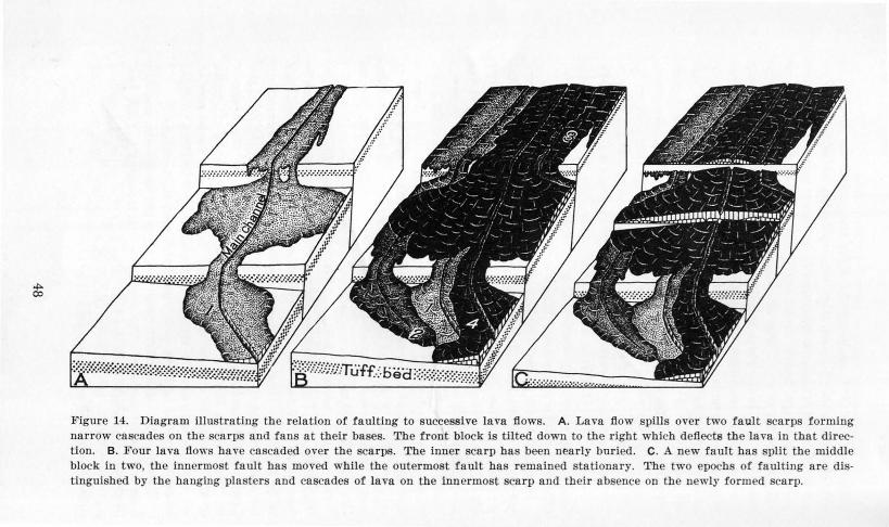
~ o:>
.!figure 14. Diagram illustrating the relation of faulting to successive lava flows. A. Lava flow spills over two fault scarps forming narrow cascades on the scarps and fans at their bases. The front block is tilted down to the right which deflects the la va in that direction. B. Four lava flows have cascaded over the scarps. The inner scarp has been nearly buried. C. A new fault has split the middle block in two, the innermost fault has moved while the outermost fault has remained stationary. The two epochs of faulting are distinguished by the hanging plasters and cascades of lava on the innermost scarp and their a bsence on the newly formed scarp.

ISLA D OF MA UI
Maui, like Oahu, is composed of two volcanic cones. East Maui, or Haleakala Volcano, famed for its gigantic summit depression of unusual shape, is 10,025 feet high and 33 miles across (pl. 13). West Maui, 5,788 feet high and 18 miles across, is distinguished for the eedle, a rock pinnacle in the spectacular lao Valley (pl. 14). The tratigraphlc rock unit on the island are given in the accompanying table and their distribution is shown in figure 15. Eight stages in the geologic history of Maill are shown in plates 15 to 18.
Stratigraphic rock units on the island of Maui
Major rock uni ts Major geologic unit
Eas t Maut Wes t Maul
Historic volcanic rocks Volcanics erupted in 1750
I I I I I ( ? ) near Makena
R.ecent ediments Unconsolidated d posits Unconsolidated deposits
Ca lcareous dunes Calcareous dunes Consolidated earthy de-Pleistocene sediments posits Consolidated earthy de·
Kaupo mudflow deposits
Plei tocene and Recent Han a volcanic series (in-
eludes Kipahulu mem- Lahaina volcanic series volcanic rocks ber in Kipahulu Valley)
~---~~Great erosiOnal unconformity.-...--...-.._... ................. ~ ................. ~...-..-
Pliocene and Pleistocene I Kula volcanic series I Honolua volcanic series ( ? ) volcanic rocks
Honomanu volcanic series Wailuku volcanic series
WEST MAur.-West Maill is incised by deep amphltheater-headed valleys (pl. 19) and on the east is overlapped by lava flows from Haleakala which have built a saddle known as the I thmus. lao Valley is an old caldera tapped by the Wailuku River and enlarged by erosion. Vent breccia at the head of the adjacent Waikapu Canyon indicates that this stream also tapped the caldera or an adjoining crater. Although rift zones are known (pl. 1) , this volcano approaches the "central type," in contrast to the "fissure type," because dikes radiate in all directions from the ancient caldera and almost all the lava beds are teep and many were poured from the central vent. Single basaltic dikes as much as 24 feet across, the widest ba altic dike yet found in the i lands, crop out on We t Maui. Typically, the ba alt is thln-bedded aa and pahoehoe erupted chlefly through narrow cracks so that only a few cinder cones were produced. Toward the close of the basaltic eruptions, violent explosions are indicated by interstratified beds of lithic tuff and agglomerate containing large block .
49

Plate 13. View looking westward across Kipahulu Valley showing the terrace of ea rly Hana la vas (Kipahulu member) Bordered by valley fill of later Hana lavas. The summit depression of Halea kala is in the background. Photo by U.S.A.A.F.

(Jl
Plate 14. lao Valley, the ancient eroded caldera of the West Maui Volcano, now cool and clothed with fores t verdure and famous for its pinnacle, called the Needle. Photo by Pan Pacific Press Bureau.

(.n
""
10 ' 1 ~6"00'
~ I 1 1 l 2 1·o0' >0-
~o·
""" ..," {. ~ " f'"V -
"" >Vt.. 7 "<v < "" ~ v" ,_ ..,<"> f -' ,.-.-',." .J
> " 1\ 1,.. I'\ ( > "' l. .> l- t' v> <. _,-.JL'C.Jr~~.lL.l<
" .J (. 1\ > > ...,J "
/'- 1-,...<..,..,<. . <l'" t v ,..- ,... .., < > <. " "< < 1 -' \ ,_ < r v : v -' r
v " 1... "7 ~ , ,... 'v > .,l. "
'- 1.- 1 ,- "~ > < " < > r " '" ~ v > " " > .< ... ,... -' " .J (" " .l -'
I' > .., v ..l V ..> "1 ->t" L t > L ~ v -,"l'-.J<:?-Jr L e,._'- ~ >..,'"" ..lL
,_ < < .., .J < "1 .J -' >• " ~ < > 1f~v > 1.- " <. _,., < " -' ~ " ..> " <" v ,.. v v t v
> <" I' -, .., L > -.J 7 <. -.J " 7 I' <. .{' ~ ~ ~~ >.J<. .., ,. .., ' v<><""< > 1 .J ..... >
~~..,<>"Ea t "M> ~. <."
" " "" s au1 .,~ ~"- > f~S'IIe,akaJaJ" ""\ < " (
naeValley
MoJo

U1 v:>
SEDI......,E.NTA...A..-.......- 'R..C>Cl<.S
, REC_f:NT ---- -- PLEISTOCENE
Younger a II uvi urn
I ,. :~~-. ~« I Lie iliw- I, diU, ,.1 1,(
Dunes, chiefly I ithifi ed
Older alluvium
VOLCANIC ROCKS
I .d~1llll Mud flow
EAST MAUl WEST MAUl HISTORIC
Lava flow of 1750 (?)
REGENT
pahulu member M?"i""7' 3?53?S?!XXX'!Ji': :l
Cone -1 !=iJ Hana volcanic series Lahaina volcanic series
EROSIONAL UNCONFORMITY PLEISTOCENE
• , • , , <J ~:-~-:·:rr·:-:-:-:-:-:-:-:-:-:-:1 Cone ~, ~ ~ ~ ~ < Cone :::·.-.-.-:}?}:;:;:;:;::;;:;:;:;:;:;:; Kula volcanic series Honolua volcan ic series
TERTlARY
l'')i;;;Wfl Caldera complex--O}l~-Stock Honomanu volcanic series Wailuku volcanic series
0 5 IOMILES
Geology by H .T. Stearns, 1932-1941
Figure 15. Geologic map of the island of ·Mani. Faults and dikes omitted.
PLATES Ui TO 1 SHOWING EIGHT STAGES I THE DEVELOPMENT OF MAUl
15A. Stage 1 iu the development of Maul showing the East Maui and West Maui volcanoes as separate islands erupting primitive basalts.
15B. Silhouette of stage 1.
150. Stage 2 in the development of Maui showing East Maui volcano with a caldera on its summit and faults on its south side, and West Maul volcano erupting Honolua lavas and joined to Lanai and Molokai volcanoes.
16A. Stage 3 in the development of Maui showing East and West Maul joined with Kahoolawe, Lanai, and Molokai. East Maui volcano is erupting Kula lavas. PrP.sent outline of Maui indicated by a dotted line.
16B. Silhouette of stage 3.
160. Stage 4 in the development of Maui showing the canyon-cutting period of early Pleistocene time with all volcanoes dormant. Present outline of Maul indicated by a dotted line.
17 A. Stage 5 in the development of Maui after the great submergence during the Olowalu 250-foot stand of the sea. East and West Maul are separate island . The valleys have been deeply filled with alluvium.
17B. Silhouette of stage 5.
170. Stage 6 in the development of Maui showing East and West Maui united during the Kahipa minus 300-foot stand of the sea. Hana lavas have started to fill the canyons on East Maui, and the Kaupo mud flow has just been emplaced.
18A. Stage 7 in the development of Maui showing the i land during the Waipio minus 60-foot stand of the sea with the Han a and Lahaina Ia vas being erupted and dunes forming on the Isthmus.
18B. Silhouette of stage 7.
180. Stage 8, Maui at the present time.
(Silhouettes are sections of Mani where important changes haYe occurred.)
54

VOLCANO
20'
STAGE I
0
SILHOUETTE OF ST~G)~. i
.---~ -·~~--,_ ... --·~'
0
0 ~Mil••

0 SMil u
'"' ·~ · .... ...

~;., ~ SJLHOUE:rTE OF ST.A~E !i -.. ............. --• ........ _aoii'iiR!!~-:--- ._:..i¥._ ttec .... ,
STAGE 6
0

.~ . ·- ~~-..-.o:SJLHOUETTE ~-;:s
...._.~~--- -~
STAGE 8
0

Extru ion of the ba alts, which con titute the mass of the mountain wa followed by a re t period during which a few inche to several feet of soil formed. The e basaltic volcanic form the Wailuku volcanic series. Then, oligoclase ande ite and tiff trachyte from fi sure and local vents almo t completely veneered the dome. These rocks form the Honolua volcanic serie . The light color produced by the weathering of the ande ite and trachyte in contrast with the darker product from the decomposition of ba alt gives the mountain the appearance of a brown cake partly covered with white frosting. Trachyte cones are prominent, and many of them are bulbous domes (fig. 6). The pre ence of soil 20 feet or more thick indicates that the volcano probably became extinct in Pliocene or earlie t Pleistocene time.
During the erosion cycle when the great canyons were carved, exten ive fanglomerates were laid down along the ea t ·ide of the mountain and smaller ones along part of the leeward coast (pl. 20). Some of these deposits are probably marine; for in the later Plei -tocene time, the island pa ed through a serie of ubmergences and emergences similar to those of Oahu, as shown by the presence of fossiliferous conglomerates up to an altitude of 250 feet near Olowalu, and by the loss of lateritic soil through marine ero ion at point now 1,200 feet above sea level. Near the outhern coa ·t, a few flow and cone of picrite ba alt and nepheline basanite were erupted in late Pleistocene time and rest upon, and in place are inter-stratified with the fanglomerate . The e rock form the Lahaina volcanic ·eries.
EAST M.aur on HALEAKALA..-The summit depression of Ea t Maui or Haleakala Volcano is 7 mile long and 211z miles wide, and its floor is covered with bare flows and large cinder cone (pl. 13). The flanks of the mountain are covered with flow some of which are black and bare. According to Hawaiian tradition, one flow wa erupted as recently as 1750. The volcano wa built over thr e rift zones (pl.1) and is unlike West Maui because the e rifts are stud led with large cinder cones. Mo t of the lava flows, except those on the Isthmus, dip about 12° . In many places three eries of lavas can be di tingui bed. The lower unit, the Honomanu volcanic erie , consists of thin-bedded, typical basaltic pahoehoe and aa. Ov dying this unit conformably i the Kula volcanic series, composed chiefly of thicker ande iti aa flows which issued in a more viscous tate and which contain many interstratified, thin a h- oil layer . Becan e many of the large cinder cone were built during thi epoch a h bed are more numerou than in the lower underlying Honomanu basalts. Some olivine ba alt and picrite ba alt occur in the Kula serle .
59

<I
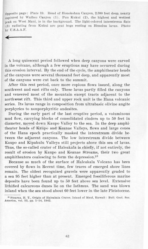
Oppo ite page: Plate 19. llead of Honokohau anyon, 2.300 fe t deep, nearly captured b~· Wa ih •e an yon (1). Puu Kukui {2), th e highest and wette t peak on 'Yest Maui. i in U1e background. The li «ht-colored inter t rea u1 flat (3) radiatin ' f rom K ukui a t·c peat bog r esting on Honolua luva ~;. Photo bY U.S.A.A.F.
A long quie cent period followed when deep canyon were carved in the volcano, although a few eruption may have occurr d during thi ero ion intervaL By the end of the cycle, the amphitheater heads of the canyon were several thou and feet deep, and apparently mo t of the canyons were cut back to the summit.
After this rest period, once more copious flow i sued along the south we t and ea t rift only. The ·e lava partly filled the canyons and veneered most of the mountain except tracts adjacent to the northwest rift. This third and upper rock unit is the Hana volcanic series. Its lavas range in composition from ultraba ic olivine augite porphyries to nonporphyritic andesites.
During the early part of the last eruptive period, a voluminou mud flow carrying blocks of con olidated cinder:s up to 50 feet in diameter, moved down Kaupo Valley to the sea. In the deep amphitheater heads of Kaupo and Keanae Valley , flow and large cones of the Hana epoch practically rna ked the inter. tream divide between the adjacent canyons. The low inter tream divide between Kaupo and Kipahulu Valleys still project above this sea of lavas. Thus, the so-called crater of Haleakala is chiefly, if not entirely the result of erosion by Kaupo and Keanae Stream , their two great amphitheaters coalescing to form the depre ion.2 3
Becau e so much of the surface of Haleakala Volcano ha been covered by flows in Recent time, few traces of emerged hore lines remain. The olde t recognized gravels were apparently graded to a sea 95 feet higher than at pre ent. Emerged fo siliferous marine depo its have been found up to 50 feet above ea level. Exten ive lithified calcareous dunes lie on the I tbmus. The and was blown inland when the sea stood about 60 feet lower in the late Pleistocene.
23 tearns, H. T., Origin of Haleaknln Crate r , I sland of Maul, Hawaii: Bull. G ol. oc. America, vol. 53, pp. 1- 14 , 1942.
Iii


Opposite page: Plate 20. Fields of sugar cane on the slopes of the West Maui Mountains behind Lahaina. Photo by Hawaiian Airlines, Ltd.
ISLA D OF KAHOOLA WE
Kahoolawe lies 7 miles off the south coast of Matti and 17 mile southeast of Lanai. It is 10.9 miles long, 6.4 miles wide, 1,427 feet high, and has an area of 45 square miles. Only a few families have lived on the island at one time, even in ancient days.24 Now the only resident is a man who takes care of the cattle.
Kahoolawe is a single volcanic dome (pl. 21) composed of thinbedded pahoehoe and aa basalt together with a few thin local beds of firefountain debris and several cinder cones, the largest being on the summit. These rocks including the associated intrusives are named the Kanapou volcanic series after Kanapou Bay where the type section is located. The higher parts of the island were once covered with deep lateritic soil, indicating that Kahoolawe is one of the older islands in the Hawaiian group. Overgrazing and strong winds have caused vast quantities of this soil to blow away.
The large, angular bay on the northeast coast expo es a great fault bounding the east side of a caldera 3 miles across and more than 800 feet deep. Subsequently this depression was completely filled with lava. A swarm of dikes running due ea t is exposed al o in this cliff; and resting unconformably on its face, are five Recent cinder cones and flows . In the sea cliff forming the high south shore of the island, several faults are exposed. They apparently bound the south side of a graben which extended southwest from the caldera. The fault scarps were overflowed by lavas near the close of the domebuilding epoch.
The island was built over three rifts (pl. 1), and two groups of lavas are distinguished in the Kanapou volcanic eries, namely, (1) the pre-caldera lavas; and (2) the caldera-filling lavas, some of the upper members of which are slightly differentiated; five posterosional lavas and pyroclastics of Recent age lie unconformably on the cliff at Kanapou Bay. Their distribution i shown in figure 16.
The valleys are partly drowned, indicating submergence; and the soil has been swept away by marine erosion to at least 800 feet above sea level.
"'McAlllster, J . G. , Archaeology o! Kahoolawe: B. P. Bi shop Mus. Bull. 115, p. 58, 1933.
63


0) (J1
~{ I I Beach deposit.s
~ and alluvium
• Late volcanics
GREAT EROSIONAL UNCONFORMITY
KANAPOU VOLCANIC SERIES
~---Caldera -filling volcanics
Wl Lava ~Cinder r cone cone ~ Extra -caldera volcanics
[iLJ Dikes
.....,2_ .....L_ .....L
F au It showi~ downthrown si e
20'30' 0 I 2 M I LES
Geology by H.T. St.earno,l939
Figure 16. Geologic map and sections of the island of Kaboolawe. The extra-caldera volcanics include the post-caldera volcanics also.
J


I 'LA~W OF LA1 A I
Lanai consists of a ingle ba ·altic cone 3,370 feet high and about 13 mile across (pl. 22). rear the ummit i Palawai Ba in, the former caldera, which is approximately 31j2 mile· in diameter. It i now partly filled with alluvium and it formerly steep wall are moothed by weathering and ero ion. Lat ritic soils 50 feet deep or more indicate that volcanic activity cea ed probably in the late Tertiary. The volcano is built of thin-bedded aa and pahoehoe ba altic flows which, if not di turbed by faulting, dip 6° to 15°. M:ost of the lava welled out quietly from fi ure and only a few mixed cinder and ·patter con s were produ ed. Altogether about 37i' feeding dik s are expo ed, one of which contains ropy pahoehoe, and two, clinkery aa. These volcanic rock comprise the Lanai volcanic eri e . The distribution of the rock i hown in figure 17.
The volcano was built over a northwest rift zone, a suuthw st rift zone, and a outh rift zone which inter ect at the nmmit (pl. 1). After a long, uninterrupted period of extru ion the northwest and south rifts collap eel to produce the graben which radiate from the caldera. At t he same time, fault scarp more than ] ,000 feet high were formed, and much rock wa hattered. M:ore than 100 fault trace are now expo. ed on Lanai. One of the hi gh fault scarps shielded t he whole northeast segment of the dome from lava flows of later date and deep canyon were eroded on thi. lope.
The volcano wa extinct long enough for thick lateriti soil to form, then the i ·land pa sed through a erie of Plei tocene submergence and emergences similar to tho e of Oahu. Becau e of aridity, many of the emerged shore line· are well pre erved; and the hi o-he t fo iliferous marine conglomerate known in the Hawaiian Islands i 1,070 feet above ea level on the ·outh ide of the i land. Below a n altitude of 1,200 feet, much of the oil ha been remo,·ed by marine erosion, and th urface i a bare, rocky scabland. At an altitude of 5GO feet an excellent shore line can be traced around the i land b) the benche and fo iliferous conglomerate · and at several lower level , till other former strand line can be observed.25 Lithified calcareou dune blown inland dur-ing the laRt Plei . tocene low tand of the ea crop out in a narrow trip to an altitude of 950 feet.
High marine cliffs we1·e not cut during ubmergence · but when the sea tood below the pre ent ocean level roo t of the outh and we t coa t \vere cliffed, in orne place to heights of 1,000 feet.
Lanai ha been extinct longer than any of the other main i, land . The i land of Niihau Kauai, Oahu, Molokai, i\laui , Kahoolawe, and Hawaii have had econdary eruption in late Plei tocene or Recent time .
.. Stearns. 1!. T .. Ancient sho r lin~ on the Island of Lanni . llnwnll : Geol. oc. AmerIca Bull. , ,-ol. 49, pp. 6115- 62 , 193 .
67
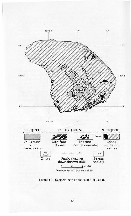
1 ~7'00' ~~· ~o·
1~7'00' ~o·
~--- PLEISTOCENE ---~
I I ~~ ,-----1 -~-=-->~"":~~ Ven~~ Alluvium
and beach sand
[jiJ D ikes
Lith i f ied dunes
Mar ine conglome rate
L ana i vo lcan ic
ser ies
Fault showing dow nth rown side
O'=====i2;_-~4 MILES
Geology by H.T.Steams, 1936
G Strike and dip
Figur e 17. Geologic map of the island of Lanai.
r.s

ISLAND OF MOLOKAI
Three volcanoes built Molokai. The western one, known as West Molokai, is 1,381 feet high and about 12 miles acros . The eastern one is called East Molokai Mountain. This volcano is 4,970 feet high, 27 miles long from north to south, and 8 miles wide from east to west. A Slnaller and much later volcano forms the Kalaupapa Penin. ula on the north coast of the eastern volcano. The stratigraphic rock nnits on tbe island are given in the accompanying table and their distribution is shown in figure 18.
Stratigraphic rock units on the island of Molokai
Rock assemblage Age
Sedimentary rocks Volcanic rocks
Younger alluvium and uncon-
I I I I I I I I Recent solidated beach and dune de-posits
Pleistocene Litbified dunes, emerged reef Kalaupapa basalt limestone, and older alluvium -~~ .......... Great erosional unconformlty- ............... ....,..,._.... ....... ....,..,._...._w ___ _
Tertiary
East Molokai volcanic series
Lower (basalt) member
Caldera complex {
Upper (andesite ) member
member ......,Erosional unconformity-We t Molokai volcanic series
WEST MoLOKAI.-Most of West Molokai is covered with lateritic soil10 to 50 feet thick, indicating long extinction. The former center of volcanic activity lies ju. t south of the summit and is barely exposed in a narrow gorge draining the area. Most of the lava was extruded from a rift zone which extends 10 miles to the southwest and plunges under the sea. Penguin Bank, the most exteu ive sub· marine shelf adjacent to the main island , stretches 27 miles to the southwest of Molokai (pl. 1). The average depth of water over the bank is about 1 0 feet . At the edge of the shelf is a beer submarine cliff 1, 00 to 3,600 feet high. This bank trends southwestward along the submarine extension of the southwe t rift zone of West Molokai and, therefore, may be a marine platform which was planed across the rift zone ridge during a low stand of the sea. A veneering reef may also exist. Another explanation is that the bank was originally a separate volcano leveled by the sea and possibly capped by coral reef. If ther wa an old r volcano, then po sibly We t Molokai was built on the northeast rift zone of that mountain.
69


Opposite page: Plate 23. The great cliff on the north side of East Molokai. The peninsula in the foreground is Kalaupapa Vol<:ano which is younger than the cliff. Note the dikes forming walls in the right foreground . Photo
by U. S. Navy.
West Molokai consists almost enti rely of thin-beJ:ided aa and pahoehoe ba alt flows, named the West Molokai volcanic series. The volcano has a flatter dome than most of the others in the Hawaiian group. A few eroded and weathered cinder and spatter cones lie on the rifts.
On the east side are numerous fault flocks indicating collapse of the northea t slope. The most prominent scarp is 500 feet high.
In the gulch draining outhward from the main vent, the We t Molokai lavas, covered "ith 3 feet of lateritic soil and underlain by 6 feet of spheroidal weathered basalt, can be seen passing under the flows from the ea tern volcano. Therefore, West Molokai Volcano must have become extinct a long time before its large eastern neighbor.
Mo t of the lower slopes are covered with the shingle of former beache -the surface having been wept bare of lateritic soil. These indications of former high sea level have not yet been studied in detail. Calcareous dunes which have migrated inland for 4 miles cover a tract of about 2 ·quare miles on the western part of the windward (northeast) side. Some of these dunes are lithified, and, along the northwest end of West Molokai, extend into the ocean at the foot of a nearly vertical marine cliff about 500 feet high. Obviously, the cliff was cut during a low stand of the ocean which preceded another fall of ea level when the dunes were formed. Further study will probably show a serie of emergences and submergences similar to those on Oahu and Lanai.
EAST MoLOK.AI.-The large eastern dome is cut into great amphitheater-headed valleys on the windward ide and smaller ones on the leeward side. A spectacular cliff, reaching a maximum height of 3,600 feet, forms the entire north coast of the mountain (pl. 23). Faulting may have played a part in the origin of this cliff.
A survey of the heads of Wailau and Pelekunu valleys revealed that the e valleys tapped a caldera about 4 mile across and that the ize of their amphitheater head i only partly attributable to erosion.2 6
• tearns, IT. T . , Large caldera on the Island ot Molokal , Hawaii: Geol. Soc. America Proc. 1937, p. 116, 193 .
71
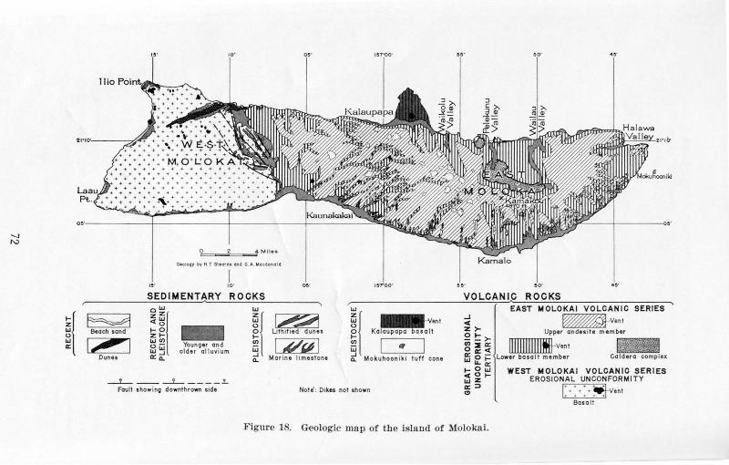
-...)
1\J
~~
0 2 4 1•·411••
G• oloqy by H T Sl t ornt Gnd G A Mo c.donol d
I 10'
SEDIMENT~RY ROCKS
~ 0
w ~~ zZ w w (.) <o - o t-0 t-zt- U>
W ~ Younoer a ~d W " -I . ,.., . ..... . . " ... ,.. .. ....... WJ o_ a:o_
~ [:721 L•thtfied dunes
1 ~ 1 Beach •unu
___!.._ -- ____L_ ---- .!.
VOLCANIP ROCKS
ex
r---- ---- -j ---- -- -- ~ w EAST MOLOKAI VOLCAN IC SERIES
~~ ~·"' ~ ~v·"' ~ Kalaupapa basa l t ~ ~ Upper andes i te member
g I '~ I ~ ~ ~ llllllllllllltlJ-vant ~ Mo kuhoon tkt tuff cone LIJ 0 't= lower ba s a lt member
"-a: t-Ow <tOtwZ
WEST MOLOKAI VOLCANIC SERIES EROSIONAL UNCON FORMITY
a:=>
"' Fault show ino downthrown stde
I. .. I Note': Dike& not shown I . ···~ent .......
Basa l!
Figul'e 18. Geologic map of tbe isla nd of MolokaL

This volcanic dome is composed chiefly of thin-bedded basaltic aa and pahoehoe having an average dip of about 12° except where the flows bank against West Molokai. They con titute the lower member of the Ea t Molokai volcanic series. Mo t of the dome is veneered by oligoclase andesite and trachyte poured out mainly from large cinder cones and bulbous domes which are now prominent topographic features . These rock constitute the upper member of the East Molokai volcanic set·ies. The volcano was built over eastwardand northwestward-trending rift zones, but some of the andesite and trachyte cones are not associated with the rifts.
The leeward shore is bordered by a live fringing reef a mile wide, and the slopes above it for 1,000 feet are stripped by marine erosion. Fossiliferous marine conglomerates crop out in a series of narrow discontinuous terraces up to an altitude of 280 feet. The drowned windward valleys and emerged marine deposits offer clear evidence of the complex emergences and submergences on both East and West Molokai.
KALAUPAPA.-At the foot of the great windward cliff in late Pleistocene time, a small volcano wa formed, and flows from it have built a low peninsula about 4 square miles in area and 405 feet high. The e lavas are named the Kalaupapa basalt. The Leper Settlement called Kalaupapa lies on the peninsula (pl. 23) . The submarine part of the volcano is huge and well may represent the young stage of a great new dome. A crater 400 feet deep indents the summit of the dome. Some of the loose coral debris along the shore is apparently in a higher position than storm waves could have thrown the fragments, and seems to indicate an emergence of 5 feet or more. Conglomerate overlying the ba alt on the southeast side of the peniusula eems to be graded to a tand of the ea 25 feet higher than the pre ent. On this evidence the Kalaupapa basalt is as igned to the late Plei tocene. Mokuhooniki, an island off the east end of Molokai, al o belongs to this renewed epoch of volcanism.
ISLAND OF OAHU
Oahu i made up of the Waianae Range, 4,025 feet high and 22 miles long, and the Koolau Range, 3,10:5 feet high and 37 miles lon". connected by the Schofield Plateau which lies between the mountains. Both ranges are deeply eroded ba ·altic volcanoes. The Waianae Volcano became extinct fir t. The age relation hip of the two volcanoes i shown in Kaukonahua Gulch near Waialua where Koolau flows overlap unconformably the oil-covered Waianae lava . The rock unit on Oahu are given in the accompanying table and the ir di. tt·ibntion i · hown in figure 19. Eight tage in the geologic hi tory of Oahu at·e hown in plate 3 to 6.
73

74

-..J (.J1
SEDIMENTARY ROCKS
RECENT PLEISTOCENE ,-----"-------
1 ~ .·1 -Beach and dune sand
Alluvium Limestone (Reefs and dunes)
VOL.CAN I C ROCKS KOOLAU RANGE WAIANAE RANGE
, QUAT~R~_N_AR __ Y ______________ ~
Lavas--f'lliiiiJPyroclastics Honolulu volcanic series
® Kolekole volcanics
EROSIONAL UNCONFORMITY TERTIARY
Flows [":;""§Dike complex
Koolau volcanic series
{ ~ Lava flows
Caldera -rn:fi:= Vent breccia complex ·· ''"
D ike complex
Kailua volcanic series
Upper member Lower and
middle membersi iiiiiiiiiii JI"'"[J breccia Waianae volcanic series
0 5 IOMILES
Geology by H.T Stearns, 1930-1932
Figure 19. Geologic map of the island of Oahu. Faults and dikes omiltt:!d.

-...} 0)
Pla te 24. Looking southwest toward prectpttous Nuuanu Pali . Kokokahi Pea k (A ), a root of the form er firepit of K oola u Volcano; Puu Kona huanui ( B), the h ighest pea k of the K oola u R a nge; Pal i ga p ( C ); Puu La nihul i (D ) .
Photo by U.S.A.A.F .

WAIANAE RANGE.-The Waianae Range is composed of three groups of lavas erupted in Tertiary and po::; ibly in early Pleistocene time from three rift zone (pl. 1). The exposed part of the oldest Java is nearly 2,000 feet t hick and consists largely of thin-bedded pahoehoe. In most places an angular unconformity and talus breccia, and in a few pla ces, an erosional unconformity, separate the middle lavas from the first aerie . The middle basalts are about 2,000 feet thick and closely resemble the lower ones except that the later beds contain more aa. The upper lavas are about 2,300 feet thick and are mo tly massive aa a ndesite flows which issued from large cinder cones.
A few secondary erup t ions also occurred on the Waianae Range during t he Plei tocene near the ancient caldera.27 These lavas and cinders are deeply w athered and nearly cut away by erosion. They crop out near Kol ekole J'a s and are named the Kolekole volcanics. They are probably correlative with the secondary eruptions on the Koolau Range. The -n aianae Volcano, like most of the others in the islands, produced only small amounts of ash, and most of the lavas were extruded from fis. ures a few feet wide, now indicated by dikes. The caldera complex near Kolekole Pass, at the head of Lualualei Valley, was the center of volcanic activity. A trachyte flow 400 feet thick crops out in Lualualei \alley and is being used for the manufacture of Portland cement. It i in the middle member.
"'Stearns, H. T., Supplement to the geology and ground-water resources of the Island of Oahu, Hawaii : Hawaii Dlv. Hydrography Bull. 5, pp. 47-48, 1940.
Stratigraphic rock units on the island of Oahu
Age Sed imen ta ry rocks
Rock assemblage
Volcanic rocks
Coral fills, younger alluvium, Younger members of the Ho-Recent and unconsolidated beach and nolulu volcanic series
dun sa nd
Older alluvium, lithilied dunes, Older members of the Bono-
Plei tocene and emerged marine lime- lulu volcanic series and the tones chiefly coralliferou Kolekole volcanics
G t·ea ro on a uncon orm it y
Koolau and Kailua volcanic seri
Pli O<'C' ll ~' ~Erosional unconformity-Waiana E' { pper member
volcanic Middle member eries Lower member
77

KooLAU RA OEJ.-The lavas of the Koolau Volcano were extrnded in Tertiary time from three rift zones (pl. 1). They IJelong to two groups. One, the Kailua volcanic series, i greatly altered by hydrothermal action and its ve icles are filled with quartz, zeolite , and other minerals.28 These lavas and their feeding dikes al'e expo ed only near Kailua, where the beds are 600 f et thick; however, no contact could be found between these lava and tho e of the Koolau volcanic series. This second group is not altered and make up the greater part of the Koolau Range. The Kailua lava are believed to have accumulated in the caldera of the Koolau Volcano.
Two large masses of vent breccia adjacent to the Kailua lavas, indicate that the caldera of the Koolau Volcano was several mile across and occupied much of the area between Waimanalo and Kaneohe. Most of the lava was extruded from the northwe t rift zone as is shown by the extension of the i land in this direction. The flows of the Koolau volcanic eries have an exposed thickness of about 3,000 feet and con i t of thin-bedded pahoehoe and aa with inappreciable a.mounts of ash. Only two small cinder cone were found in this series. Practically all the lavas were erupted from narrow fissures unaccompanied by large lava fountains.
During the Pleistocene large parts of both the Waianae and Koolau Ranges were removed by fluvial and marine erosion. The unusual physiographic feature of Oahu is the lo s through fluvial erosion of much of the leeward side of the Waianae Volcano, whereas large parts of the rainy or windward side remain. This anomaly is explained on page 5.
'Ihe master streams of the Koolau Range have deep amphitheaterheaded valleys. During the erosion cycle, a large part of the windward slope was eroded away by stream . The great "PaH," or northeast cliff, of the Koola u Range is the result of two proce se (pl. 24). First, the amphitheater-headed valleys ate headward and a little beyond their divides, and second, most of the inter tream divide were buried through alluviation which accompanied the deep ubmergence of the islands. 29
After the two ranges were sculptured by fluvial and marine erosion into essentially their present form, the island went through a complicated series of emergences and submergences. Data from well logs show that the valleys have been drowned at least 1,200 feet; and the island may still be submerged nearly 1,800 feet, if the submarine
•• Dunham, K. C., Crystal cavities In !ants !rom the HawaUan Islands: Am. Mineralogist, vol. 18, no. 9. pp. 369-386, 1933.
'"Stearns, H. T. , and Vaksvlk, K. N. , Geology and ground-water resources o! the Island o! Oahu, Hawaii : Hawaii Dlv. Hydrography Bull. 1, pp. 26-29, 1935.
78

79

Plate 26. Th e youthful Kaau Crate r indents tb e rugged topograph y of the K oolau l<ange. Photv by U.S.A.A.F.

shelf at that d •pth around Oahu \\·a. originally a hallow water platform. Further, the slope of the i ·land ho' eddence of marine action everal hundred feet above ea le,·el indicating an m·en greater ubmergenc in the pa t. Apparently the emergence was not con
tinuous for a halt is sugge ·ted at 5GO feet a well as at everallower levels. neon formable emerged marine deposit·, well log· and a submarin e helf at 50 fathom , all indicate that the ocean receded to about 300 f et below the pre ent tT·a nd. Again the ocean ro e 95 feet above ea level and left a well-marked hore line and . orne emerged reef. Another regre ·ion with minor halts topped about 60 feet below. ea level , and wa follo \\·ecl by a tran gre ion that ro e 25 feet above the pre ent trand. During the last emergen e of the i land, the ea halted for a short time alJout 5 feet abo \ e the shore line, then established it. pre ent level. In addition to the terra es, wide a t'eas of emer"ed reef lime tone (fic:r. 20), abandoned sea caves
OAHU
0 10 MILES
0 0 ~ "~N ---.';01
Figure 20. Map of Oahu bowing areas of em r~ed r eef (solid black) and
fringing reefs (dotted line shows outer edge) .
(pl. 25) bear witne to the changi ng relation hip of land and ea. oncomitant with th hifting of ocean 1 Yels, pa modic l'llp
tion ·at the onthea tend of the Koolan Range produced many lava flow and inder and tuff cones, most of which m·e nepheline basalt ~fig. 21 and pl. 2Ci). TIP e an• ih Honolulu ,·olcan i · :t•ri es. The
81
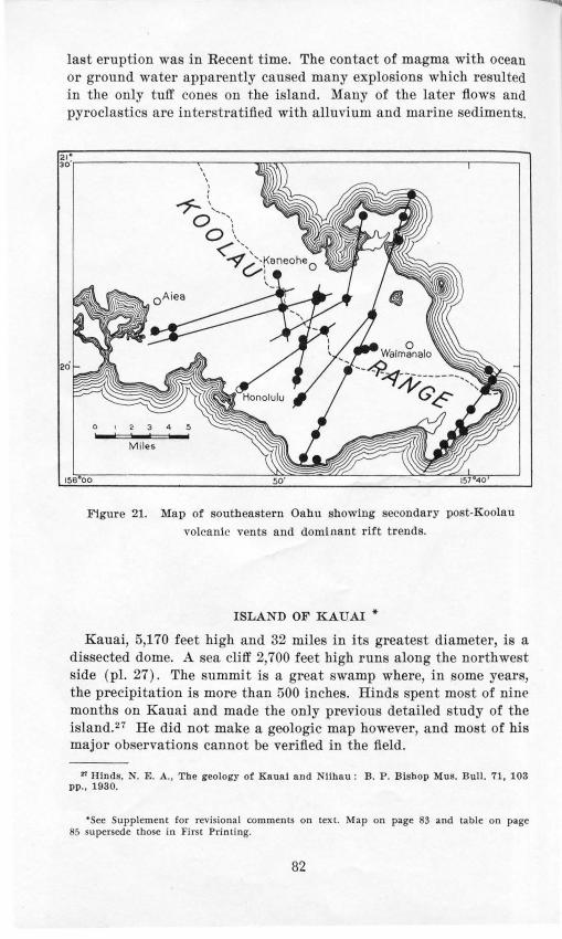
last eruption was in Recent time. The contact of magma with ocean or ground water apparently caused many explosions which resulted in the only tuff cone on the island. Many of the later flows and pyroclastics are interstratified with alluvium and marine sediments.
Figure 21. Map of southeastern Oahu showing secondary post-Koolau
volcanic vents and dominant rift trends.
ISLAND OF KAU.AI *
Kauai, 5,170 feet high and 32 miles in its greatest diameter, is a dissected dome. A sea cliff 2,700 feet high runs along the northwest side (pl. 27) . The summit is a great swamp where, in .some years, the precipitation is more than 500 inches. Hinds spent mo t of nine months on Kauai and made the only previous detailed study of the island.27 He did not make a geologic map however, and most of his major ob ervations cannot be verified in the field.
21 Hinds, N. E. A., The geology or Kaual and Nlihau: B. P . Bishop Mus. Bull. 71, 103 pp., 1930.
•see upplement for revisional comments on text. Map on page 83 and table on page 85 supersede those in First Printing.
82

co L>:>
1~9" 40' 109" 30' 1!!19 " 20'
Fig ure 22. Geolog ic map of the is la nd of K a uai , dikes omitted.
l{ I I I I I I
-~ ~ ~ 5 u -a o
-~ "i: " -~ j
I!: :a Alluv1um beach and dune aond,
lagoonal clays and marla.
HWif:WJ:M Lith1tiad calcareous dune sand ..
BrecCJO and conglomerate c1f Palikea 1orma1Jon.
~ Lavas of Koloa volcanic seriu.
:1 ~-· I . . . I . . . 1 : Lavas of Makaweli formation.
~
or. Lavaa of Olokale format ion.
~ Lavas of Houpu format ion.
C) . . Lavae of Napoli forma11on.
~ Vents of Koloa and
Waunea Canyon volcanic series.
- --- Buned fault scarp
Gl • olofl' try H T S!tomt, G A lttczodonald 0 A DO'Yl • , and n C eca.. 1934 ~&4
,.. 0:: <: z 0::
"' ... <: ::> 0
,.. 0:: <: ;:: 0::
~


Opposit pa "'e: Plate 27 . L ookin"' norihcn. t nlon~ fh <' :'\npn li CM;:;t of Knuni. '!'he Inr •e ralley i K alnl au. Photo l>y · ... \ .A. F .
The g olo O'y i ·complex and i.-n o"· being illl·e:tigated. Beca n · of the lack of data, rift.- are not .·ho \\'n on p la t J bnt Hi;; kn o\\'n tha t many r adial dik e· exi t. Dmi ng a. 1·econ nai , sa n ·e in J !):3-J., a profound angu la r un onfot·mity wa .- di ·co r red a t th e henu of \Yainh ulu Gulch, a tributary of \\ aimea Uanyo n, <lnd a not her \\'3 S fouud in Olokele anyon. In the \\' aia huln nn ·onfo r·mi1y , th e hwas on 1h outh\\ est s ide al'e older t han tho e on ih e nodhen;;t sid and in
place · are eparatecl by ta lu .. 'J'hi .· nn co nformi1y i: th e fault esca rpment formin <r the ·outhea.-1· " ·all of a. great ·nmmi t ('ald e ra abou t 10 mile aero ·s. 'J'he laxa.- on t he north 'ast a 1· th ma:s i1·e nea rly horizontal type whi ch r c.- nl t fl- om ponding in n cal<h:' r·a. The pl'incipal rock units a re given i11 the accompanJing ta bl e a.ncl thei r· li s tribu t ion i hO\\'D in figure 22.
t t·atigrnphi ·rock unit. on th i. ·Iantl of K 11un i
.,, Vok.aiUC roc: lt
Rf:Cf'nt lkaeh and durw: ~.and and allu,mm
--- Local uncomfonni1y ----1-------------------Older alltnium and luhtrted dune und : lagoon
deposits of Mana Plam
Pleistocene --- Local unconfomtity ----1 Pahke~o fonnation : poorly .M>r~ b~a and
poorly to modf'r.ltcly toned eongkm\Cn.te at the ~X' of, and mtercalatcd with, the roc:kt of the Kok>JI \'okamc scrin
Ko~ \'okamc M'Oei u a.nd ~OI:'hOI:' !au. floW'i o( ~phdmitc. p•rntc-·l».u.h, bau.mtc:, and aU.alic oil \~ ~It, wuh JC~ne •nterul:ltcd 1..h and tuffaccou• JOil ~ cmdcr cond at the \'t.ntl, and a tuff cone at Ktbouc.l Ba)
Major e~al unconfonnuy ----------------
Moimonc member of ~ Mahwch fonnation : poorly tolled br«c:ia at the hue ol, and mod· crate:ly 110rtcd congMxnera le mttrbcdded "ilh, the lav:IJ o( the MaltaW1:'li fonnation
M:t.ka"~h formation : aa :1nd p.:.hociK)C: (:IH flo"-~ ac· cumulated m a ~uben on thr .ot.uh"'f>'t stde of the Kau:11 .Judd ,oJcano
OioLcde fonnauon: thtd. ma~l\r no.,.., .lCC'urnulatcd m .l bro.o~.d caldera a1 ~~ sumnut of the- K.au;u dlteld \"Okano
H:uhrJ:~o~~;;'!~cr t~c~h:,na~~:,:~J:.;':r":t:!.l~u~~ JlK'ld \'Okano
Na,,.h formation thm.ht<J<kd 1~h«hor: and ;u flows formin~ the Kau;u Uudd ,oluno .and d1ppm~ 001· ward at angkt of ~.ao · m all duwttrm' fnxn thr uldc"' boundt)
Th e main IJulk of Knn a i is a <l reply erod ed s hi el!l-:h apPu ,-ol ·nn o or dom \\'i th .it:· :u;so(' i;ll d in t rn s i,·es. h re('(· ias. an!l thin ,·itri · tutr b d .. The ·e r o(' k: compr·isc 1h \Ya imea ,-ol!'a ni !' S!'t·ies anrl 1\'C l' P
rupt d in t lJ> Tl'rtia t·y. Th e ext 1·n -ca l<le r·a m· lower mc m her is co mpo ed of mor· than ., 000 fee t o f i hin -l>l•<ld ed primiti,·l·· t,Y]H' uli ,·in c ba . alt. tlippin p; :) 0 in :wo a\\'<J,Y fr ·om 1hc <lll t il'nt ta l<l c ra (pl. ~8 ) .
'l'h ·ald ra -fillin g or· uppee nwrJJher i · co n1post>d o[ J.OOO f'Pl'l of chidly horir.on1al and mn · ·i1·e olirirw hnsa l ts (pl. :.!~ ) laid do\\'n in
5


Opposite page: Plate 28. Waimea Canyon, Kaual. The lavas on the left belong to the lower member and the horizontal bedded ones in the background belong to the upper member of Waimea volcanic series. The horizontal lava beds in the bottom of the canyon and forming the right wall belong to the Koloa volcanic series. Photo by U.S. Navy.
the summit caldera. The high Waialeale plateau is underlain by these rocks. A few basaltic andesites are present at the top of this member. The upper and lower members are separated by partly exhumed fault scarps more than 3,000 feet high and talus breccia.
The Haupu volcanic series forms Haupu (Hoary Head) Ridge near Lihue (pl. 29) . It is composed of an extra-caldera or lower member of thin-bedded primitive-type olivine basalts dipping 8° to 15° away from the central vent and an upper member of horizontal massive basalts filling a caldera 11;2 miles across. The upper and lower members are separated by a partly exhumed fault scarp and talus breccia. The Haupu volcanic series is the remains of an independent volcano about 2,300 feet high on the side of the ancient Waimea Volcano, and is similar to the position of Kilauea Volcano to Mauna Loa Volcano.
The rocks of the Waimea and Haupu volcanic series are separated everywhere by a deep zone of weathering and a great angular erosional unconformity from a third unit, named by Hinds, the Koloa series. The Koloa volcanic series is composed of olivine basalts, and ultrabasic rocks carrying nepheline and melilite. The flow near the mouth of Waimea Canyon carries log molds in pillow lava.30 The Koloa volcanic series are correlative in composition, stratigraphic position, and age to the Honolulu volcanic series oc Oahu, but are much more voluminous. They built a broad plain between Koloa and Kapaa. Kilohana Crater is one of the largest vents. Most of the vents lie on north-south rifts. The cycle of renewed activity when they were erupted was fairly long for in Hanapepe Canyon two ets of intercanyon lavas crop out separated by a profound erosional unconformity. Similar unconformities exi t elsewhere on Kauai.
Hindss1 reports conglomerates between lavas in Koaie and Poomau tributaries of Waimea Canyon and tates that they indicate a great erosion interval during the accumulation of the lavas in the early Kauai dome, or in the Waimea volcanic eries. The lava overlying the conglomerate i a flow belonging to the Koloa volcanic
ao Stearns, H. T., Plllow lavas In Bawall: (abst.) Geol. Soc. America Proc. for 1937, pp. 252-268, 1938.
" Idem, p. 5U.
87


series; hence is not evidence of an erosional interval in the Waimea series. Clark describes the line of vents from which these Koloa lavas issued .32
The Koloa volcanic series have greatly affect-ed the course of streams and built extensive plateaus at the mouths of the major valleys. The so·called elevated marine plain at 500 feet above sea level described by Hinds33 is not a marine plain but a series of plateaus built by lavas of the Koloa volcanic series. HitchcockS 4
thought the plain was built of young ashes instead of lava. The hills near Wailua do not outline a great caldera north of Lihue as Hinds tbought.35 Instead, they are erosional remnants of the lower member of the Waimea volcanic series nearly buried by lavas of the Koloa series as shown by the dip and character of the lavas in them. The ancient Waimea dome was deeply dissected by great amphitheater-headed valleys similar to those in the Waianae Range, Oahu I land, but the floors and some of the interstream divides have been buried by the copious Pleistocene lavas. Only Wainiha Valley retain e sentially its original form .
The great sea cliff 2,700 feet high forming the scenic Napali coast (pl. 27) i not a fault scarp as commonly supposed. It was caused by marine ero ion battering back, as the island submerged, the interstream divides composed of the weak lavas in the lower member of the Waimea volcanic series. Between Haena and Kalalau Valley, where the highest part of the coastal cliff lies, the lower member was cut away and the sea was arrested by the massive wave-resisting upper member of the series. This part of the coast is an obsequent fault-line scarp and is due to the difference in strength of the rock in the caldera and extra-caldera member of the Waimea volcanic series. The ancient fault dips southeastward away from the coast rather than northwestward into the sea (fig. 23).
"'Clark, W. 0., Geology of the Island of Kaual (abst.) : Oeol. Soc. Ame r ica Proc. tor 1934, p. 72, 1935.
" Idem , p. 35 . "Hitchcock, C. H. , Ha wall and Its volcanoes, p. 13, 1909. "' Idem. p. 36.
Oppo ite page : Plate 29. Haupu (Hoary Rend ) Ridge and Nawiliwili Harbor, Kaual. The la va in the ridge belong to the Haupu volcanic series. The lavas underlying the sugar can fields belong to the Koloa volcanic series. Photo by Hawaiian Airlines, Ltd .
89

B
0 5
Figure 23. Sections showing the development of the Napali Cliff, Kauai . A. At close of volcanism. B. After stream erosion had carved valleys In the weak pre-caldera lavas. C. Present stage, an obsequent fault-line scarp caused by the resistance of massive caldera-filling lavas to wave erosion.
Waimea Valley is described by Hmds8 u as due to faulting. Although the position of Waiahulu tributary was determined by a fault, Waimea Canyon from the mouth of this fork to the sea owes its position to displacement westward by lava flows of the Koloa volcanic series (fig. 22) . Waimea Canyon owes its large size to the fact that it drained the major part of the summit caldera where the rainfall is even now in excess of 450 inches per year.
ISLAND OF NIIHA U
Niihau, 17Yz miles southwest of Kauai, is 18 miles long, 6 miles wide, and has an area of 72 square miles. It is 1,281 feet high and consists of an eroded upland skirted on the north, west, and south sides by a coastal plain. The east and northeast sides of the upland are bounded by a high sea cliff. The climate is semiarid. No. living streams exist but playa lakes are numerous.
The stratigraphic rock units on the island are given in the accompanying table and their distribution is shown in figure 24. The main mass of the island is composed of the Paniau volcanic series, which constitutes a deeply weathered remnant of a Tertiary basalt dome cut by a dike complex trending :NE-SW. The dikes are well exposed
10 Idem, f!g. 13.
90

in the eastern sea cliff. The central vent lay about 2 miles out to ea to the east. The dome, after deep gulches had been cut into it
by stream erosion and the margins had been cliffed by th~ sea, was partly ubmerged. The cliff on the ea tern ide is probably a fault scarp3 7 which has l'etreated about 11/2 miles under powerful wave attack. It probably was originally the west wall of the summit caldera.
The marine platform skirting the dome is partly submerged and partly built above sea level by Pleistocene volcanics, calcareous dunes, and alluvium. These young volcanics are called the Kiekie volcanic series and were erupted from 8 visible vents and by others now buried. Their presence was first noted by Powers.ss They are olivine basalt 39 that issued from lava cones and vitric-lithic tuffs from Kawaihoa cone and Lehua Island.
"H ind s, N. E. A. , op. cit. p. 93. Incorrectly calls It a fuult-llne scnrp although bls text Indicates that he menns 11 battered fault sca rp.
•• Powers, S., Notes on Hnwallnn petrology: Am. Jour. Sci., 4th ser., vol. 50, o. 250, 1920.
" A mellllte-nephellne ba salt was reported by Hinds but rot lo~ated by the writer.
Age
Recent
Pleistocen<'
Stratigraphic rock units on the island of Niihau
Rock assemblage
Sedimenta ry rocks
Younger alluvium, playa deposits, and unconsolidated ca lcareous beach and dune and
Lithified ca lca reous dunes , emerged marine limestone, dnne of YOlcanic and, and older alluvium
Volcanic rocks
Olh·ine basalts and vitric-lithic tuff of the Kiekie volcanic series
"""--.Great ero ionnl unconformity·~~--~-~~-~--~-~~
Ba alt and corr lative dikes Tertiary and plugs of the Paniau vol-
t'aniC' . erie
91

t
~ J);;~us § Calcareous
dunes a: beach sand
~;-~ - -t! Consol idated Consolldated ~ calcareous dunes of
dunes volcanic sand
-Lacustrine calcareous beach sand -AJiuvium
~ ventR Vitrlc- Basalt li th ic tuff
~ X Marine foss iliferous li mestone
it GREAT EROSIONAL UNCONFORMITY
~Plug Basalt
0 Wells and waterholee ,<tr Strike and dip in bed I
160"05"
Figure 24. Geologic map or the island of iihau . The Pleistocene basalts are named the Kiekie volcanic series and the Tertiary basalts are the Panfau
volcanic series.
92

OFFSHORE I LETS
Thirty-nine islets shown on plate 1 li e dose to the main islands. Islets numbered 1, 2, 3, 12, 16, 23, and 3' are econdary tuff cones of late P leistocene or Recent age. Tho. e numbered 4, 5, 8, 20, 21, 22, 24, 2:5, 26, 28, 29, 30, 31, 34, 33, 36, 37, 3 , and 39 arc remnant. of Jam Row isolated from the main i.· Ia nds by mariJ1e erosiou . I , lets 11 a nd 15 are part of the dike comph•x of the Kool an \ olcauo; 7 !.l, and 10 are lithifi ed dunes of t he W aipio tenace stage; 17, 27, aud 32 are remnant of cinder cone · 13 is the remnant of a econdary nepheline ba ·alt flow or crater fill ; 19 is composed of reef limestone, Salt Lake tuff, and ear t hy .-ediment.· · 6 a nd 14 are of reef lime tone of the Kapapa terrace . tage; and 18 is of uncotL 'olidated sand and is being enlarged by dredged mate rial.
LEEWARD ISLAN DS40
Extendin g northwesh,·a rd from :K iih a u are 2G i ·lets, rePf , and shoals kn own a· t he Leeward I ·lands. They mark the ummits of submarine volcanoes (fi g. 1) . West of Gardner Island ( fi g. 1, no. 17), only low oral island .- are fo und , wherea. to the east many are remn ant of ba.-altic cones. The number.- in the following cla sifted li t refer to the numbers in figure 1.
'0 ~!o•t of the data for t h e Leeward Island" were CO IIltl ii Nl from t he followin~: puullcn· tlo ns: ll ltch cock. C. II.. Il uwuii a nd it· volcnnoes. pp. 1- 10, ll onolu lu , 1909. Etsch er , C., 'J'hc L~cwnrd l Hinnds or the Hnwaiian ~:roup: RPp rint fro m Sunday A<h·e r t isc r . pp. 1- G . ll o nol nlu , 1915. llrynn , \\' . A., ·ntura l histo ry of llnwnii. pp. 94- 99, H onolulu, 1\!15. \Yushin~:ton. H .... nnd K<·~· cs . ;\I. U., l'e tro l o~:.l' of th e H nwnlinn Islnnd ·. V , T he Lcewnrl l s ln nds : Am . . Jou r .. ci., .ith ser .. ,·o i. 12, JlP. 336- 35:!. 1926. l'nl nw r . H. S. (;polo~:~· of Knni n. Xih on . ?\Pcke r . nnd (:unln c r J"lnnds. n nd ~· r• • n ch ~·ri~:atc Shonl: ll . l'. lli " hup Mu •. Dull , 35, Jlll . l - ll5 , 1!!:!7.
17. 21. 2R. 24. 26.
VOL ' A I G l i:; LA);]).'
Gunlu er ( basalt flows aud dikes) .... . . . ... . ............ . La P erouse Piunacle iu Frem·h Frigate Atoll ( basa lt fio ws) Nec ke r (ba a lt fl ow aud dikes) ..... . . . ..... . .. .. . .... . . l\'iboa ( basa lt fl ows a nd dikes ) ........................ .. K uuh.t (tuff ) .. .. . . ... ....... ... . . .......... . . . ........ .
EMI<JTIGED ORAL ATOLLS OR NEA R ATOL LS•
:!. Kure or Ocea u ( Hnlll e of atoll ) ..... . ......... . .. .
Heigh t ( f e t)
1!.l0 122 277 !.l10 550
4. Gr et' ll (sa nd is lanll iu;;i<le of Kure aroll ) ......... . . .... . . 20 6. Midwll ,\' . . . . . . . . . . . . . . . . . . . . . . . . . . . . . . . . . . . . . . . . . . . . . . . . 43
PPH rl and H e rmes . . . . . . . . . . . . . . . . . . . . . . . . . . . . . . . . . . . . . . 12 0. L i. ian ki .. .. .. .. .. .. . .. . ... .. .. .. .. . .. .. .. . .. .. .. . .. .. . 4-!
H. Lay. an . . . . . . . . . . . . . . . . . . . . . . . . . . . . . . . . . . . . . . . . . . . . . . . . 56
n ThP tu~ igoht g-i\'{'11 i~ JllPilf.;Hrt'd tu tl w top of sand dtHl(\~ nnd cloP~ not inc.licate amount of t.'llH' rJ.!f'ltC't' . Tht' hi ,eht·~t t•lll('fJ,!Ptl fi'Pf known i:-: o11ly ubout 5 fPt.•t . The litprn ture dOPK 1111( elt•Hrl ,\' :-; tat(• tilt' l ' \"ld t.•Ji t'l' uf l'llll'fg't' ll<'l' t'X(.'t •pt fur ~l idwuy Ulld l'enrl Hllt.l ll t:> f llll'~ l sl uud~.

COHAL ATOLLS OR NEAR ATOLLS
1. nnamed ... . .. .. . . ....... . ............. . ........... Brea ke rs 2. Bensaleux . . . . . . . . . . . . . . . . . . . . . . . . . . . . . . . . . . . . . . . . . . . . . . Do
10. ~'isher . . . . . . . . . . . . . . . . . . . . . . . . . . . . . . . . . . . . . . . . . . . . . . . . . Do 11. finor . . . . . . . . . . . . . . . . . . . . . . . . . . . . . . . . . . . . . . . . . . . . . . . . . Do 15. Maro ( Dowsett ) . . . . . . . . . . . . . . . . . . . . . . . . .. . . . . . . . . . . . . . . Do 1 . Two Brothers . . . .. . . .. ... . . . .... .. .. . . ............. . .. . 22. French Frigate (excluding La Perouse Pinnacle) .... ..... 10
SHOALS (PROBABLY S EMERGED ATOLLS )
5. Nero . ..... . . ........ . ... .... . .. . .... . . .. . . . ... ... . .. . - 4!)2 7. Gambia .. ... . ....... .. .. . .... .. ...... . ... . . . .... . .. . . -8-i
12. Neva .... .. .... .. ....... .. .. . . . . . .. . . . .. . ..... . . . ... . - 1 13. Springbank . . ... . . . . .. ... . . . . . ..... ... . .. .. ... ....... . - 10 16. Raita .. . .. . .. . .. ... . . . . .. . . ... . .... . . . . . . . . .. . . . . . . . . - 54 19. St. Rogatien . ... . ... .. ... .. . .... ..... .. .... .. .. .... . . . - 72 20. Brooks ...... . . . ...... ... ... . . .. . .. . . .. . . . .. .. . ... . .. . - 84 25. Unnamed ... .. .......... ..... .. . . ...... . .. .......... . - 192
Kaula is a secondary tuff cone built on a reef platform ;41 whereas the other volcanic islands are probably eroded remnants of primary volcanic domes. The rocks are composed of andesine, picrite, olivine, and nepheline basalts.42 Andesine ba alt i rare. The one specimen of nepheline basalt was collected on Necker I land from a dike which may have been the feeder to a secondary flow; but from the publi hed description, this ba alt appears to contain anemousite feldspar. If so, the lava probably belongs to the andesitic phase.
Coralline algae are the principal constituent of the living and emerged reefs. At Midway and probably at some of the nearby is· land , the reefs contain an appreciable numb r of barnacles. The emerged reef on Midway stands 5 feet above ea level and indicates a Recent, apparently world wide, emergence of this amount. 4 2a
"Palmer, H. S., Geology of Lehua and Ka ula I slands: B. P . Bishop Mus. Occ. Paper, vol. 12, no . 13, p. 18, 1936.
"Washington , H . ., and Keyes, ll!. G. , P etrology or the Hawaiian I slands, V, the Leeward I slands: Am. Jour. Sci. , 5th se r., vol. 12, pp. 336-315 2, 1926.
" • Stearns, H . T ., Shore benches on 'orth P acific I slands: Gcol. Soc. Ame rica Bull. , \'01. 52, pp. 773- 780, 1941.
94

GEOLOGIC HISTORY
Much of the geologic history of the Hawaiian Islands remains to be deciphered. The long and undoubtedly complicated development of the submarine basement may never be unraveled. Practically no evidence is available to indicate when any of the Hawaiian volcanoes began. At present, only the time of extinction can be determined, and these estimations depend largely on finding lavas of younger volcanoes ponded against their neighbors so that the beds dip less where they came to rest against the adjacent dome. Erosion has exposed a few unconformities or overlaps of lavas from one cone on those from another. Using available information of the type mentioned, a tentative order of extinction has been determined. The succession from oldest to youngest is:
1. Waianae Range; 2. Koolau Range; 3. West Molokai; 4. East Molokai; 5. West Maui and Lanai; 6. Kahoolawe; 7. Haleaka'ia. Further study may suggest changes in this order. Kauai is too far from Oahu, and Hawaii is too far from Maui for overlaps to be effective. Kohala Mountain became extinct before Mauna Kea. Hualalai, Mauna Loa, and Kilauea have erupted in historic time. The eastern part of the Niihau volcano is below sea level; hence dips cannot be used for determining the relative ages of Niihau and Kauai. The primary Kauai dome appears to be as old if not older than the Waianae Range. The age relationships of the islets and atolls stretching northwest from Kauai are unknown. These islets may be (1) large, high volcanoes planed off by fluvial and marine erosion and then submerged, (2) small low volcanoes, or (3) submarine volcanoes that approached near enough to sea level to support coral reefs. Kaula and Lehua are late cones which can be correlated with secondary cones on the other islands. 43
Seemingly the larger, high volcanic islands were built above sea level in Tertiary time, possibly as late as the end of the Pliocene. Dana44 states that the volcanoes became extinct from northwest to southeast. If secondary activity is disregarded, this statement is nearly true. During the soil-forming epoch, which followed extinction, drainage systems were developed and sea cliffs were cut. This erosion period was long, for deep canyons and high cliffs are found on all the islands, and lateritic soil 5 to 100 feet thick was formed.
"'Palmer, H . S., Geology o! Lehua and Kaula Islands: B. P. Bishop Mus. Occ. Papers, vol. 12, no. 13, 1936.
"Dana, J . D., Geology, In U. S. Exploring Expedition, 1838- 1842, vol. 10, pp. 282, 414-416, 1849.
95
Then followed a period of great submergence, amounting probably to more than 2,500 feet, accompanied by a new epoch of volcani m when secondary outbreaks continuing into Recent time occurred on all the major islands except Lanai. The great submergence may have been complex and at times interrupted by emergence . Next, a com. plex series of emergences and submergences progressed so rapidly that little reef was laid down and very little cliffing accomplished. As a present result, the islands are emerged approximately 1,200 feet or about half the amount of the previous great submergence.
Mauna Loa, Kilauea, and Hualalai have erupted in historic time. Haleakala, according to legends, erupted about 1750. Some of the other islands had secondary eruptions that antedate the latest change in sea level, a 5-foot shift downward in Recent time. Small flows overlie the Wisconsin glacial moraines on Mauna Kea.
Four stages in the geologic development of the archipelago are shown in figures 25 to 27.
96

<.0 --.!
110"
/,~) ?. <·
• c,;- I r , , . ' '
.6~K~G~ VO·L~AN~; '·'
r ,, .. 157. ,,,. rsa·
~~~--r---+-----+------1-- ... HAUl" VO<.CANO !;'\ '
1'\~;·' ,/ ! EST MOLOKAI VOLCANO
WAIANAE VOLCAN~}~i~~~~, ~-- KOOLAU VOLCANO
I ,..<~ -~~ >~ I
·.... 1 r ~ ' ;if:. I ll"'---------f------ PENGUIN BANK VOLcA;;;O ~-;:9.'-:J,:_ . '<, · .;'EST MAUI
1 VOLCANO 21.
LANAI ~""' .: ~ST MAUl VOLCANO r VOLCAN -~"- (1.: ~~~~ (HALEAKALA)
(";..,
KAHOOLAWE VOLCANO r··;,.
~OHALA VOLCANO
20· .• • 1 20" ~ ~
0 20 40Mlles
MAUNA KEA VOLCANO
I
19 ,,.
l&o· 15t• 158 . 157 . ,,,. 155.
Figure 25. The Hawaiian archipelago near the end of the Pliocene.

leo• l iSt• lae· 1!57. ., .. .,,.
~ w
<:'J
'~...,.,,.;::-----1--------r----ZI" 0 I p·::,·. . ., = j:)''.=..t ...... .
.I> $> I L .;
0 <.D (X)
zo• I C>- . • ~,... . l
I I I >' ·~"'··~"'i- · .,
-
u"i' ·"'--=·· , 20"
~ ~~Yo~.,_~ · ': .. · : ; ·'" -~ ... ~~l~ .. 0 20 40
... 1eo· ,,. 151 . 15&·
Figure 26. The Hawaiian archipelago during the minus 300-foot stand of the sea in early ( ?) P leistocene.

<.0 <.0
un• 1&1•
u• --·-··t:>l ~ I I I I I u·
•KAULA
-r-----------1----- .,.
,.--t------20'
0 20 40
~ w
180. ~~·· 1!51 · 1~5·
Figure 27. The Hawaiian archipelago at the present time.

SELECTED BIBLIOGRAPHY OF THE GEOLOGY OF T HE HAW AllAN ISLANDS
BISHOP, S. E., Geology of Oahu: Thrum' Annual for 1901, pp. 59-73, Honolulu, 1900.
BRIGHAM, W. T., The volcano s of Kilauea and Mauna Loa: B. P. Bi hop Mus. Mem., vol. 2, no. 4, 222 pp., 1909.
BRYAN, W. A., atural history of Hawaii- An account of the Hawaiian people. the geology, geography of the islands, and the native and introduced plants and animal of the group, 596 pp., 117 ill us., Honolulu, Hawaiian Gazette Co., 1915.
Ross, WHITMAN, La>as of Hawaii and their relations: U.S. Geol. Survey Prof. Paper , 97 pp., 4 pis., maps, 1915.
DALY, R. A., Magmatic differentiation in Hawaii: Jour. Geology, vol. 19, pp. 2 9-316, 1911.
---, The nature of volcanic action: Am. Acad. Arts and Sci. Proc., vol. 47, no. 3, pp. 47- 122, 1911.
DANA, J. D., Geology, in U. . Exploring expedition, 1 3 1842, under the command of Charles Wilkes, U.S. ., vol. 10, 756 pp., 1849.
---, Characteristics of Yol canoe , 399 pp., 16 pi ., 55 figs., 1 90. DUTTON, c. E ., Hawaiian volcanoe : . s. Geol. Survey 4th Ann . nept., pp.
75-219, pis. 2-30, figs. 3- 5, 1 4. Gru;:ooRY, H. E., A D WENTWORTH, . K., General features and glacial geology
of Mauna Kea, Hawaii: Geol. oc. America Bull., vol. 48, pp. 1719-1742. 5 pis., 5 figs., 1937.
Hnms, . E. A., The geology of Kauai and Niihau: B. P. Bishop Mu . Bull . 71, 103 pp., 12 pls., map, 16 figs., 1930.
---, The relative ages of th e Hawaiian landscape : California Unh·. Dept. Geol. Sci., Bull., YOL 20, no. 6, pp. 143- 260, 27 pis., 13 figs ., 1931.
HrTOHCOCK, '. H., Hawaii and its YOlcanoes, 2d ed., 314 pp. and pp. uppl. , 53 pis., Honolulu, Hawaiian Gazette Co., 1909.
JAOOAR, T. A., Hawaiian Volcano R earch Assoc., YOlcano letter, no. 1- , 1925-to-date.
---, Volcanological ill\·estigations at Kilauea: Am. Jour. Sci., 4th ser. , ,·ol. 44, pp. 161-220, 1917.
--- , Seismometric inve tigation of the Hawaiian lava column: Seismol. Soc. America Bull., vol. 10, pp. 155-175, 1920.
LINDGREN, WALDEMAR, The water re ources of Molokai, Hawaiian I lands: U. S. Geol. Sur vey Water-Supply Paper 77, 62 pp., 3 pl. , map, 1903.
MACDONALD, G. A. , The 1840 eruption and crysta l differentiation in the Kilauean magma column: Amer. Jour. Sci., vol. 242, pp. 177-189, 1944.
PALMER, H. S., The geology of the Honolulu artesian system: Honolul u Sewer and Water Corum. Rept. to the L gislature of the Territory of Hawaii, Hth regular sess., 1927, Suppl., 68 pp., 21 figs., map, 1927.
- --, Geology of Lehua and Kaula Islands: B. P. Bishop Mus. Occ. Paper, vol. 12, no. 13, 1936.
PERRET, 1!'. A., Some conditions affecting volcanic eruptions: Science, new ser ., vol. 28, pp. 277- 287, 1908.
PoLLOCK, J. B., F ringing and fossil coral reefs on Oahu: B. P. Bishop Mus. Bull. 55, 56 pp., 6 pis., 3 figs., 192 .
PowERS, SIDNEY, ' otes on Hawai ian petrology: Am. Jour. Sci., 4th ser., vol. 50, pp. 256-2 0, 3 figs., Oct. 1920.
100

STEARNS, H . T ., Shore benches on the island of Oahu, Hawaii: Geol. Soc. America Bull., vol. 46, pp. 1467-14 2, 6 pis., 4 figs., 1935.
--,Pleistocene shore lines on the islands of Oahu and Maui, Hawaii: Geol. Soc. America Bull., vol. 46, pp. 1927-1956, pis. 178--1 0, 5 figs. , 1935.
---, Ancient shore lines on the island of Lanai, Hawaii: Geol. Soc. America. Bull., vol. 49, pp. 6HHl28, 3 pis., 1 fig. , 1938.
--, Geologic map and guide of the island of Oahu, Hawaii: Hawaii Div. Hydrography, Bull. 2, 75 pp., 6 pis., 23 figs., 1939.
---, Supplement to the geology and ground-water resources of the island of Oahu, Hawaii: Hawaii Div. Hydrography, Bull. 5, 164 pp., 6 pi ., figs., 1940.
---, Geology and ground-water resources of the islands of Lanai and Kahoolawe, Hawaii: Hawaii Div. Hydrography, Bull. 6, 177 pp., 1 pis. , 34 figs., 1940.
---, AND CLARK, W. 0., Geology and water resour ·es of the Kau District, Hawaii, with a chapter on ground water in the Hawaiian Islands by 0. E. Meinzer: U. S. Geol. Suney Water-Supply Paper 616, 194 pp., 33 pis. , 9 figs., 3 maps, 1930.
---, AND MACDONALD, G. A. , Geology and ground-water resources of the island of Maui, Hawaii: Hawaii Dh·. Hydrography, Bull. 7, 344 pp., 44 pis., 46 figs., 1942.
---, AND ---, Geology and ground-water resources. of the i land of Hawaii: Hawaii Div. Hydrography, Bull. 9 (in press).
---, AND VAKSVlK, K. ., Geology and ground-water resources of the island of Oahu, Hawaii: Hawaii Div. Hydrograph y, Bull. 1, 479 pp., 33 pis., 34 figs. , May 1935.
STEARNS, N. D., An island is born, 115 pp., 55 pis. and figs. , map, Honolulu, 1935.
---, Annotated bibliography and index of the geology and water supply of the island of Oahu, Hawaii: Hawaii Div. Hydrography, Bull. 3, 75 pp., Honolulu, 1935.
STONE, J . B ., The products and structure of Kilauea: B. P. Bishop Mus. Bull. 33, 59 pp., 2 pis., 7 figs., Honolulu, 1926.
WASHINGTON, H. S., Petrology of the Hawaiian Islands. I, Kohala and Mauna Kea, Hawaii; II, Hualalai and Mauna Loa; III, Kilauea and the general petrology of Hawaii; IV, The formation of aa and pahoehoe: Am. Jour. Sci., 5th ser ., ,·oJ. 5, pp. 465-502, vol. 6, pp. 100-126, 33 367, 409-423, 1923.
---, AND KEYES, MARY G., Petrology of the Hawaiirul I lands, V, The Leeward Islands: Am. Jour. Sci. , 5th ser., vol. 12, pp. 336-352, 1926.
---, Petrology of the Hawaiian Islands, VI, Maui: Am. Jour. Sci. , 5th s r. , vol. 15, pp. 199-220, 1928.
WENTWORTH, C. K., '.rhe geology of Lanai: B. P. Bishop Mu . Bull. 24, 72 pp., 7 pis., 13 figs., 1925.
- --, Pyroclastic geology of Oahu: B. P . Bishop Mns. Bull. 30, 121 pp. , 22
pis., 28 figs., 1926. ---, Estimates of marine and fluvial erosion in Hawaii: Jour. Geology,
vol. 35, pp. 117-133, 1927. ---, Principles of stream erosion in Hawaii: J our. Geology, ,·ol. 36, pp.
3 5-419, 20 fig ., 1928. ---, Ash formations of the island of Hawaii: 3rd pecial Rept. of the
Hawaiian Volcano Observatory, 1 pp. , 10 pis., 16 fig ., 1938.
101

INDEX
PAOJl
Abstract . . . . . . . . . . . . . . . . . . . . 1 Acknowledgmen t s . . . . . . . . . . . . . . . . . . 1 Alexander, W. D., cited . . . . . . . . . . . . . 34 Amphitheater-headed vall eys, develop-
me.nt ....................... 1, 7-8 formation (fig. 2) ... . . . . . . . . . . . . . . 7 view, Halawa Valley ( pl. 2) . . . . . . . 6
Ancien t shore llnes . .. .... . . 14, 61, 67, 94 Ash deposits . .. . ... . ... . . . ........ 8, 88 Atolls, age relationships. . . . . . . . . . . . . 911
coral ( fig. 1 ) ...... . ....... . ..... 4, 94 emerged coral (fig. 1 ) . . ... . . , ... . 4, 98 submerged (fig. 1 ) ..... . . . .•. . ... 4, 94
Barnacles . . . . . . . . . . . . . . . . . . . . . . . . . 94 Beach deposits . . . . . . . . . . . . . . . • . . . . . 13 Bensaleux Atoll (fig. 1 ) ..... . .•.. . . 4, 94 Bering Sea . . . . . . . . . . . . . . . . . . . . . . . . 8 Betz, F ., cited . . . . . . . . . . . . . . . . . . . . . . 16 Branner, J . C., clted . . . . . . . . . . • . . . . . 89 Breccia, Hawau .................... so
vent, Oahu ............•.. .. ..... 78 Brooks Shoal ( fig . 1 ) . ....•.... . . . . 4 , 94 Bryan, W. A., cited . . . . . . . . . . . . . . . . . 98
Calcareous dunes ........ 18, 61 , 67 , 71 , 91 Cinder cones . . . . .. . .. ... ... 16, 17, 78, 98 Clark, W. 0 ., cited ...... 32, 83, 43, 44, 89 Clltl's (see Sea clltl's ) Climate . .. ...................... . • 2-4 Cognate Inclusions . . . . . . . . . . . . . . . . . 88 Cones (see al so under proper name)
cinder ..... . ............ . .. . . . 78, 98 clnder , orig in . . . . . . . . . . . . . . . . . . . . 16 clnder , profile lflg. 4 ) ............. 17 fragmental, origin . . . . .. . . . . . . . . . . 16 secondary, typical profiles ( fig . 4).. 17 spatter, origin . . . . . . . . . . . . . . . . . . . 16 spatter, profile ( fig . 4 ) .. . .. . .... . . 17 trachyte ...... . . . ... . ......... 87, 119 tutl' ........... . .... . ....... 81, 82, 98
Conglomerates .......... 27, 116, 67, 73 , 8'1 Coral a tolls .................... 4 , 93- 911 Coralline algae . . . . . . . . . . . . . . . . . . . . . 94 Cross, Whitman, cited . . . . . . . . . . . . . . . 88 " Curtaln of fire" (pis. 7 A, 7B ) . . . . . . . 111
Daly, R. A., cited . . . . . . . . . . . . . . . . . . . 82 Dana, J . D., clted . . . . . . . . . . . . . . . . . . . 911 Development, geologic, of Islands (see
under proper name of Island ) stream . . . . . . . . . . . . . . . . . . . . . . . . . . 1
Deposits, ash (see also Pahala ash ). 8, 88 beach . . . . ...... . ............... . 18 explosion . . . . . . . . . . . . . . . . . . . . . . . . 82 marine .. .. . ... . .. .. ....... . 18 , 61, 81
Dikes . . ...... . .. . . . .. . .... 48, 49, 67, 815 view, Oahu (pl. 215) . . .. . .......... 79 widest .. . . . . . ....... . . .... . . . . .. 16
Domes , bulbous ....... . .......... 19, 159 bulbous, profile ( fig. 4 ) . . . . . . . . . . . . 17 bulbous, sections ( fig. 6 ) . . . . . . . . . . 21 shield-shaped ... . . . ......... . .. 16, 815 volcanic (pl. 21 ) .. . . . . ..... .. ... 63, 64
Dunes, calcareous . . . . ... 18, 61 , 67, 71, 91 Dunham. K. C. , cited . . . . . . . . . . . . . . . . 78
PAOli
East Maul (see Haleakala ) East Molokal clltl', v iew (pl. 28 ) . . . . . . 70 East Molokal volcanic series . . . . . . . . . 78 East Molokal Volcano . . .......... . 71- 73
di mensio ns ... . .. ................ 69 ex tinction . ........... ..... ...... 95
E merged coral atolls ............... 4, 98 E merged shore lines ...... . .. 14, 61 , 67, 94 E lscher, C., cited . ... ............... 93 E rosion , etl'ec t of rate of..... . . . . . . . . t!
marine . ............... 1, 18, 68, 67, 73 stream .. .. .. . . .................. 1, 5 wind .... . . . .. . ... .. . ..... . ...... 8
E ruptlon , typical . . . . . . . . . . . . . . . . . . . 83 Erui)tlons (see also under na me of vol
cano) tissure ....... . ........ ..... .... . 16
E us tatic s hore Jines . ....•......... . . 14
Fanglomerates (pl. 20) ........ . ... 59, 63 Faulting, relation to lava !lows (fig. 14) 48 Faults .. . ......... . ....... 63, 67, 71, 91 Fisher Atoll ( fi g. 1 ) .. ..... ....... . 4, 94 Fissure eruptions . . . . . . . . . . . . . . . . . . . 16 F ragmental cones . . . . . . . . . . . . . . . . . . 16 :French Frigate Atoll (see also La P6-
rous·e Plnnacle ) (fig. 1) .. . ..... 4, 94 Fringing r eefs, Oahu (fig. 20 ) ....... . 81
Gambia Shoal ( fig. 1) ............. . 4, 94 Geography .. . ...... ...... . . . . .... . 2-4 Geomorphology ..... . . . . . ... . . .... 15- 16 Gardner Island (fig. 1 ) ... . ......... 4, 98 Graben, Kohala Mountain . . . . . . . . . . . 89 Green Atoll ( fig. 1) ..... . . ...• . .... 4, 93 Gregory, H . E ., cited ........ ... . .. . . 82
Balawa Valley, Molokal, view (pl. 2 ) . 6 Haleakala Volcano ............... 119-61
dimensions . . . . . . . . . . . . . . . . . . . . . . 49 extinction . . . . . . . . . . . . . . . . . . . . . . . 95 !low of 17150 ( ?) . . . . . . . . . . . . . . . . . . . 119 summit, view (pl. 18) ............. 150
Halemauma u, 1948 eruption (pls. 9A, 9B ) ........ .. ..... . .... . . ... . 24
Hamakua volcanic series. . . . . . . . . . . . . SO Hana volcanic series .... . . . . ........ 61
view (pl. 13 ) .. . . . .. .. .. .. . . . . . .. . 110 Hanalei Valley, Kaual, view . . fron tl.&p(eoe Hanapepe Canyon, Kaual. . . . . . ..... 87 Haupu (Hoary Head) Ridge ......... 87
v iew (pl. 29) ........... . ......... 88 Haupu vo lcanic series . . . . . . . . . . . • . . . 87 Hawaii ..... . .................. ... 215
geologic map (fig. 9 ) . . . . . . . . . . . . . . 29 historic flows (fig. 7 ) ............. . 2 11 stratigraphic units ( t able) .....• ... 28
Ha wallan archipelago, area . . . . . . . . . . 2
102
climate . . . . . . . . . . . . . . . . . . . . . . . . . 8 geographic position . .. .. ....... " 'a.te 1 geologic development ( fi gs. 2~7) ..
97- 99 profil e ( fig. 1)............ .. .. . . .. 4 ralnfall . . . . . . . . . . . . . . . . . . . . . . . . . 8 statletlcs (table ) .. .. .. .. .. .. . .. .. 2 submarine contours (pl. 1) . . . . . . . . 2

PAGil
submarine contours, main islands (fig. 1) . ............ '........ . 4
Hnwn!lan Islands, geologic histo ry . 95, 96 o r igin . . . . . . . . . . . . . . . . . . . . . . . . . . . 16 stratigraphic units (table) . .. . ... .. 23
Hawa!lnn ,·olcanoes, stages of develop-ment . . .... . ...... . ......... 17-22
Haw! volcanic series .. .............. 39 view (pl. 12) ........... . ... .. . .. . 43
Hess, H. H ., cited .... ... .... . . .. ... J() H!l!ntt volcanic series ..... .. .. . ..... 4 7 Hinds, N. E . A., cited . . . . . . . . . . 2, 90, 91 History, geologic . ...... . ....... . ... 95 Hitchcock, C. H., cited ............ 89, 93 Honoknne Stream ......... . ..... . .. 3 Honokohau Canyon, view (pl. 19) .... 60 Honolnn volcanic series .... . . .... ... . 59 Hono lulu volcanic series . . ...... . .. 81, 82 Honomnnu volcanic series . ... ... ..... 59 Hualalai Yolcan!c series . . . . . . . . . . . . . 37 Hualalai Volcano .......... . .. .. .. 37-38
er uption of 1 00- 1801 ......... . ... 27 height . . ......... . .. .. ...•. . .. .. 25 last activity . . . . . . . . . . . . . . . . . . . . . 38
Huehue flow . . . . . . . . . . . . . . . . . • . 38
l ao Vall ey, 1\!nni .................... 49 view (pl. 14 ) .. . .. ... .. . .......... 51
Introduction . . . . . . . . . .. . . . . . . . . . . . . 1
J nggn r , T. A. , cited . .... . ...... 27, 38, 45
Knnu Crater, Oahu, view (pl. 26). . . . . 0 Knhoolnwe, a i r mosaic map (pl. 21) .. 64
geologic map (fig. 16 ) ....... . . . ... 65 Knhoola\ve Volcano, extiJ1ctlon ..... ... 95
geologic description . . . . . . . . . . . . . . . 63 Kahuku volcanic series ... . . . ........ 34 Kailua volcanic series ... .......... .. 7 Kalnlau Valley, Knun! , view (pl. 27).. 4 Kalaupapa basalt .... ... ... . .. ... . . 73 Ka laupapa Penin sula . . . . . . . . . . . . . . . 69 Ka la upapa Volcano . . . . . . . . . . . . 73
view (pl. 23) . . . . . . . . . . . . . . . . . . . 70 Knnapou Bay . . . . . . . . . . . . . . . . . . . . . . ()3 Knnnpou volcanic se ri es.. . . . . . . . . 63 Kaneohe .... . .......... . ...... . ... 78 Kapapn te r race stage . . .......... .. . . 93 Kau Desert ............... ... .. 8,33,43 Kau volcanic series .. ............... 34 Knunl ........ . ................. 2- 90
geologic map (fig. 22)... ... ... .... 3 stratigraphic units (table) .. ...... 811
Kaukonnhua Gulch. Oahu .. .. ........ 73 Kaula Island (fig. 1) .. ..... . .... . .. 4, 93
geologic description ... . . . ........ 94 Kaupo Valley . ......... . ..... . .. . .. 61 Kaupul ehu flow ....... . ..•......... 3 Kawnlhon Cone ... . . . .............. 91 Ken nne Vall ey .......... ...... . .. .. 61 Keyes, M. G., cited .. ... ...... .. .. 93, 94 Kiekle Yolcnn!c ser!e .....•.......... 91 Kilauea Volcano .... . ..... . . ..... 43-47
eruptive cycle ..... .. ... ...... . . 46-4 7 explosion o! 1790 . . . . . . . . . . . . . . . . 44 explosions of 1924 . . . . . . . . . . . . . . . 44 h lght ............. . ...... . . ... . 25 historic- eruptions (table) ... ....... 40 hypothetica l relation to ea rth 's Inte-
rior (fig. 13 ) .................. 44 lnYn flows . . . . . . . . . . . . . . . . . . . . . . . 45 periods of nett vlty (fig. ) . . . . . • . . . 26
Kllohnna Crater, Knunl . . . . . . . . . • . . . 7 Kipahulu Valley ............. . •.... 61
PACil
view (pl. 13) .......... . .......... 50 Koa!e t ributary , Wu :meu nnyon..... 7 Kohaln Volcano ... .. ......... .. .. 38-43
graben, description . . . . . . . . . . . . . . . 39 height . . . . . . .... . ....... . .... . .. 25 hi sto ric eruption s ..... .. ..... . .. . 27
Kokokah! Peak, view (pl. 24) .... .. .. 76 Kolekole Pass . . . . . . . . . . . . . . . . . . . . . . 77 Kolekole ,·o lcanlc series . . . . . . . . . . . . . 77 Koloa volcanic series . .. ......... . . 87-89 " Kona winds" . . . . . . . . . . . . . . . . . . . . . 3 Koolnu dome, geologic development
(p is. 3-6) ........... ..... . ... 9-12 Koolau Range ........... ...... ... 78-82
dimension . ..... .....•.. .. . .. ... 73 view (pl. 26) . . .. ......... .... ... 80
Koolau Yolcanic serle ............... 7 Koolau Volcano. extinction ....... . . . 95
view (pl. 24) .............. • ..... 76 Kula ,·otcanlc eries ........... , . . . . 69 Kure Atoll (fig. 1) .. ...... .. ....... 4, 93
La P~rouse Pinnacle (fig. 1 ) .. . •.... 4 , 93 Lahaina, llfaul, view (pl. 20) .. .. .... 63 Lahaina volcanic series .... .. . ... ... 59 Lanni ..................... ... ..... 67
geologic mnp (fig. 17) ........ . ... . 6 view from We t Maul (pl. 22) . . . 66
Lanni volcanic series . . ... . .. .. .. ... 67 Lanai Volcano, extinction . . . 95 Laupahoehoe Gulch .......... . ..... . 30 Laupahoehoe volca nic series ..... .. .. 30 Ln \'U flows, Haleaknln, flow f 1750 ( ?) 59
Huehue .. .. . ....... . . ........... 3 historic, of Hawaii Island (fig. 7 ) ... 2:5 Kaupule hu . . . . . . . . . . . . . . . 3 ~rn una Lon. flow of 1 5!). . . . . . . . . . 34 pe rmeability ..... . .... . .... . ..... 27 range In t hickness .. .. . .... .. 10. 33, 34 relation to faulting ( fig. H) . .. . ... 4
LaYa lakes . ..... . . ........... . ... . 47 Ln "n stalactites .................. 3 , 45 Lnysnn Atoll (fig. 1 ) ........... . ... 4. 93 Leeward Is lands (fig. 1) . • . . . . • . . . . . . 4
description ........ ...... . ..... 93-94 Lehun Is land ....... ........ . ...... 9 1 Leper Settlement, Molokn i .... ...... . 7:1 Limestone (fig. 20) ... . ............ 1, 81 L!slnn ski Atoll (fig. 1 ) ...... . ... .. . 4, 93 Lun!unlei Vall ey .. ............. . .. . 77
Macdonald, G. A., cited ...... 26, 27, 36, 46 Mnkua Cave, Oahu (pl. 25) .......... 79 lila rlne erosion .................... 1, 13 Maro (Dow ett) Atoll (fig .1 ) ...... . 4, 94 Mnul ................. ........ .... 49
geologic de,•elopment (pis . 1:1- 1 ) 55- :11! geologic map (fig. 15) . ... ... . ... 52- 53 stratigraphic units (table) ......... 49
Mauna Ken Volcano ......... . . . . . 30-3 :.! height ... . ... · . ......... .. ... .. .. 2.i histo ric e ruptions . . . . . . . . . . . . . . . . 27 su mmit, view (pl. 1 0) . . . . . ... ... . . 31 ,·lew (pl. 8) ....... . .. . .......... 1
Mauna Lon Volcano ... . .......... 32-34 eruption of 1935 (pl. llB) . .... . . . 311 eruption of 1940 (pl. llA) 3!\ eruption s, altitude and location (fig.
10) ... ............ ... ......... S2 eruptions (tab le) . . . . . .. . . . . . . . . . . 36 flow o! 1859 . . . . . . . . . . . . . . . . . . . . . 34 height . . . . . . . . . . . . . . . . . . . . . . . . . . 25 hypoth etica l relation to earth's lnte·
rior (fig. 13) ........ . .. . ...... H
103

PAGE
periods of activity (fig. 8) . . . . . . . . . 26 summit, view (p l. ) . ......... .. .. 18 summi t , vie w (p l. 10 ) . . .. . .. . .... . 31 typical eruption . . . . . . . . . . . . . . . . . . 33
McAllister, J . G. , cited. . . . . . . . . . . . . . 63 Midway Atoll (fig . 1) ...... . ..... . . 4, 93 ~llnor Atoll ( fig. 1) .. .. . . . ...... ... 4, 94 Mokuaweoweo Caldera, d ews ( pi s. 7A,
7B) .... . .... .. .. . .. . .... ..... Hi view (p l. ) .. . .. . . ... . .. . ....... 18
Mokuhoonlki . . . . . . . . . . . . . . . . . . . . . . . 73 Molds, fern fronds . . . . . . . . . . . . . . . . . 45
grass .. . . ... .. . . . . . . . ... • ....... 45 log . . . . . . . . . . . . . . . . . • . . . . . . . . . . . 7 t ree . . . . . . . . . . . . . . . . . . . . . . . . . . . . 88
Molokal .... ..... .. .. . .... . ........ 69 geologic map ( fig. 1 ) ..... . ....... 72 stratigrap hic units (tab le) . . . . . . . . 69
l\Iud flow , Maul . . . . . . . . . . . . 61
Napali CUll', development (!!g. 23) ... . 90 Napoli Coast, Kauai , view (pl. 27) .. .. 84 Nnwlllwlll Harbor, Kauni (pl. 29) .. .. 8 ' ecker I s land (fig. 1) ...... . . .. .... 4, 93
geo logy . ...... .. ....... . ........ 94 'ero Shoal (fig. 1 ) . .. .. . . . . .. • .... 4, 94 ' eva Shoal (fig. 1) .. .. . ......... .. 4, 94
Nlhoa I s land ( fig. 1) .. . . .. . ..... .. 4, 93 NLihau ......... . ..... . .... . .... . 90-91
geo logic map (!!g. 24) ........ . .... 92 stratig raph ic units (table) ...... . . 91
Ninole volcanic se ries .. . ...... . ... .. 34 Nuuanu Pali , origin .... ..... ..•. . .. 78
view (pl. 24) . . ......... . . . .. .... 76
Oa hu .. .. . ............. .. . .. .. . . 73- 82 geo logic development (pi s. 3- 6) ... 9- 12 geologic map (fig. 19) .. . ........ 74- 75 st ratig raphic uni ts (table) ....... . 77
Ocean Atoll (fig. 1 ) . . .. . . ..... .. . .. 4, 93 Olokele Canyon , Kaual . . ..... . . .... 85 Oll'shore I slets ........ .. .... . . .. plate 1
age relationships .... . ... . . . .... . . 95 desc ription . . . . . . . . . . . . . . . . . . . . . . 93 origin . ... . . .. ... . ..... . .... . . ... 95
P ahala a s h ..... . .. . ....... 30,34 , 43, 47 Palawai Bas in ... . . . .. ... . ... ... ... 67 Pa lm r , H . S., cited . . .. ... .. ... 93, 94, 95 Paniau volcanic se ries ....... . . ... .. 00 Pea rl and Her mes Atoll (fig. 1 ) .... . 4 , 93 Peat bog , Maui (pl. 19) . . ..... . .... 60 Pelekunu Valley . . . . . . . . . . . . . . . . . . . 71 Pele's hair . . . . . . . . . . . . . . . . . . . . . . . . 33 P enguin Bank . . . . . . . . . . . . . . . . . . . . . 69 P il low lavas . ... .. .......... . . 17, 34 , 7 Pit Craters, view (pl. ) ....... . .... 18 P laya lakes, Nilhau . . . . . . . . . . . . . . . . 00 l::' lunge- pool action . . . . . . . . . . . . . . . . . 8 Pololu Valley . ... .. . .... ... . . ... .. . 39 Poloiu vo lcan ic se ri es . ........ . .. ... 39 Poomau tributary, Waimea Ca nyon .. . 87 Portland cement . .. . ...... . ..... .. . 77 Post-Koolau volcanic vents (fig. 21 ) . . 2 Powers , W. E., cited .. ... .... . . . .. 32, 91 Pumice .... . . ... . . .. . ...... . . ..... 33 Puna volcanic se ries . . . . . . . . . . . . . . . . 47 Puu Konahuanul , view ( pl. 24) .. . .. . 76 Puu Kukul , view (pl. 19 ) .... . ... .... 60 Puu Lanlhuli , view (pl. 24) .. .. . ... . . 76 Puu Wnawaa Co ne ... . . .... .. . .. ... 38
lava fl ow from (fig. 11) .. . .... .... 37
Raitn Shoal (fig. 1) .. . ....... ... . 4. 94
PAOI Rift t rends, Oa hu (fig. 21) . . . . ...... 82 Rob erts, Mike, photo by ..... . f•·ontiapiece Rocks, clltr-formlng . . . . . . . . . . . . . . . . . 8
co ra l, e ll'ect of permeability. . . . . . . . 5 ell'ect of dlll'erences In a ge . . . . . . . . . 5
Sen cave ( Makua Cave, pl. 25) . . ..... 79 ea cllll's, development . . . . . . . . . . • . . . 13 formed by ma r ine erosion ... . . . . . . . 1 geo log ic history (fig. 3) . . . . . . . . . . . 13 Illlwail . . .. ..... . .. ... . ....... . . 89 Molokal .. ......... . . . .... . .. .... 71 Napall coast, development ... ... . . 89
Schofield Plateau ........... . . .... . 73 . hleld-sha ped domes . . . ... . ....... 16, 85 Shoals (fig. 1) ....... . .. . .. . ...... 4, 94
hor lines, ancient (table) . . . . ... ... 14 emerged, .Lanai . . . . . . . . . . . . . . . . . . 67 emerged, Maul .. ... ........ . .. ... 61 emerged, Midway . . . . • . . . . . . . . . . . 94 eu tatlc ... ... ................... 14 origin . . ...... ........ .. ... . .... . 14 pre ence of 25-foo t . . . . . . . . . . . . . . . 27 ty pe loca lities on Oahu (fig. 20) . . . . 81
Spatter cones (fig. 4) .. .... . . • . ... 16, 17 phagnum swamp . . . . . . . . . . . . . . . . . . 38 pringbank Shoal (fig. 1) ..... ...... 4, 94 L Rogatlen Sholl! ( fig . 1) .. .. .. ... 4, 94
'tearns, II. •r ., cited ..... 5, 14, 27, 32, 33, 43 ,44,45,61 , 67, 71 , 77 , 78,87, 94
Stratigra phic rock uni ts (tables) 23,2 ,40,69, 77,85,01
.·t ream development ...... . ... . .. . .. 1, 5 eros ion . . . .. ... ......... . . ...... 1, 5
' ubma rine flows .. .. .. ... .. ... . .. . . 33 11bmerged atoll s (fig. 1) . . . .... .... 4, 94 uga r cane, Maul, view (pl. 20) . ..... 62
Tem1 eratu re . .. .. .. .. ... .. . .. .. . .. . 3 The Neeclle, Maul ........ . .. . ...... 49
view (p l. 14) . . .... ... . . •... . .. . . 151 Trnchyte flow, Oahu ... ..... ... . .... 77
Puu Wnawaa (flg. 11 ) ............ . 38 Trnde wind s . . . . . . . . . . . . . . . . . . . . . . . 3 Two Broth ers Atoll (fig. 1 ) . . . .. ... . 4, 94 'l'ype sect ion , Knhoola we . . . . . . . . . . . . 63
un conformity , Hawaii . . . . . . •..... 34, 89 Knuai .... . . . ............ . . . .. 85, 87 ~h~a- .... . ............. . ... U Oahu ........ ... ... . .... .. ... . 73, 77
Unnamed co ral atoll (fig. 1 ) ... . . . . . 4, 94 Unna med sh oa l (fig. 1) ..... . ...... 4, 94
Valleys (Ha la wn , Hanalei, Kip a hulu , Ino , P elekunu, Pololu , Wallau , \Va imanu, \Y aip lo) (see under !Jroper name)
amp hitheate r-headed .. ...... . ... 1, 7- S tlrowned ....... . ... . .. . ... . .. . . 1, 78
\ 'o lcn nic island, geo logic histo r y (fig. 5) .. .. ....... . ................ 20
Volca nic isla nds, descr iption (fig. 1) 4,93-94
orig in .. . .. . . . . ... . . .......... . . 95 Volca nic se ries (East Molokal , Hama
kua , Ha na , Haupu, Ha w! , Hlllna , Honolua, H onolulu , Honomanu, Hualala i, Kahuku , Kailua , Kanapou , Knu, Kl eki e, Kol eko le, Koloa, Kula , Lahaina, Lanni , Laupahoeho~. "inole, Paniau , P ololu, Puna, \Vniluku , Waimea, West Moloknl) (sN' under p rope r name)
104

l 'AC E
Volcanoes, "central type''. . . . . . . . . . . . 49 eruptions (see under name of vol-
cano) "fissure type" . . . . . . . . . . . . . . . . . . . . 49 origin . . . . . . . . . . . . . . . . . . . . . . . . . . 1 stages of development .......... 12--22
waawaa volcanics . . . . . . . . . . . . . . 37 Waiahulu Gulch, Kauai .. . ......... . 85 Waialeale Platea u, Kaual ........... 87 Waianae dome, geologic development
(pls. 3- 6) ....... . . . . .. ....... 9-12 Waianae Ran ge . . . . . . . . . . . . . . . . . . . . 77
dimensions .. . .. . ... . .... . ..... . . 73 Waianae Volcano . . . . . . . . . . . . . . . . . . . 77
extinction . . . . . . . . . . . . . . . . . . . . . . . 95 Waihee Canyon (pl. 19) ...... . ... ... 60 Waikapu Canyon . . . . . . . . . . . . . . . . . . . 49 Wniiau Valley ... ......... . • .. . . ... 71 Wailuku volcanic series ... . ..... . . .. 59
PAGE
Waimanalo ....... .... .. .. . .. ... .. . 78 Wahnan u Valley (fig. 12) .......... 40--41 Waimea Ca nyon . ............ • . . . ... 85
origin ................ ..... .... . . 90 view (pl. 28) ....... . ..... . . . .. .. 86
Waimea volcanic seri es . . ....•. .. ... 85 Waimea Volcano . . . . . . . . . . . . . . . . . . . 87 Waipio Stream . . . . . . . . . . . . . . . . . . . . . 38 Waipio terrace stage .. ..... ........ 93 Waipio Valley (fig. 12) ............ 40--41
view (pl. 12 ) .... . ...... . .... . . . . 42 Washington. H. S., cited .......... 93, 94 Wentworth, C. K , cited ..... .. . . .. 30, 32 West Maul .. . ...... . ..... . ... . .. 49-59 West Maul Mts., view (pl. 20) .. . . ... 63 West Molokai Yolcnnic series ... ...... 71 West Molokai Volcano . . . ......... 69-71
extinction . . . . . . . . . . . . . . . . . . . . . . . 95 Wind erosion . . . . . . . . . . . . . • . . . . . . . . 8 Wiscousiu glacial s tage . ... . .. , . ... . 3~
105

SUPPLEMENT
By GORDO A. MACDONALD
Senior Professor of Geology , University of Hawaii
GEOMORPHOLOGY
The following table supersedes the table appearing on
page 14 .
Ancient shore lines in the Hawaiian Islandsa
Approximate altitude
(feet) Name of terrace
Present
Koko
-180c ....... .. ... Penguin Bank -300zd ..... . .. .. Mamala-Kahipa
2 . . . . . . . . . . . . . . . . . . . . Manana
Approximate altitude
(feet)
70
95 55
25oz
325z
Name of terrace
Laie Kaena
Kahuku
Olowalu
(Unnamed)
5 0 0 0 0 0 0 0 0 0 0 0 0 0 0 0 0 0 0 0 0 Kapapa 375z . . . . . . . . . . . . . . (unnamed)
12e . , , . . . . . . . . . . . . . . . . Ulupau
25 f . . . . . . . • . . . . . . . . Waimanalo
560 . . . . . . . . . . . . . . . . . . Manele 625zh ....•. ... ..... Kaluakapo
-60zg . . . • . . . . . • . . . . . . . . waipio
45 . . . . . . . . . • . . . • . . . . Waialae 1 . 2ooz
-1,200 to -1,800
Mahana
Lualualei
aModified after Stearns , R. T. , Eustatic shorelines on Pacific Islands: Zeits. f. Geomorphologie , Supp. Vol. 3 , p. 7, 1961.
bEaston , W.H., New Pleistocene shore lines in Hawaii: Geol. Soc . America, Cordilleran Sec ., 6lst Ann. Mtg ., Program, p. 21, 1965.
cPlaced at approximately 160 feet below sea level by Ruhe, R. v., Williams , J.M. , and Hill, E. L. , Shorelines and submarine shelves , oahu , Hawa ii: Jour . Geology , vol . 73, pp. 485-497, 1965.
dThe minus-300-foot shoreline was named Mamala by Ruhe and others, op. cit .. p. 486. It is the same level as previously named by Stearns the Kahipa shoreline , and Stearns (Geology of the State of Hawaii , p. 23, Palo Alto , 1966) suggests the compound name Mamala-Kahipa to avoid confusion. The minus-300-foot level probably was reached several times during glacial maxima on the continents . The last time probably coincided wi th the last major (Tazewell) advance of the Wi sconsin glaciation, approximately 17,000 years ago. If so, it must be later than the 5- and 12-foot stands of the sea , fossil shells from which have yielded ages , by the carbon-14 method , of approximately 26,000 and 32 , 000 years respectively. (Ruhe, and others, op. cit. , p . 494.)
eNamed the "Ulupau Stand" by Wentworth , C.K., and Hoffmeister , J.E ., Geology of Ulupau Head, Oahu : Geol. Soc. Americ a Bul l., vol. 50, p. 1571, 1939.
fTwo shorelines , respective ly 22 and 27 feet above sea level.
gRuhe, and others (op . cit., p . 286) , believe that -40 feet i s a better value.
h0rigina11y recogn i zed by Stearns (op. cit., 1961, p. 7), but not named by him. Named by Easton (op . cit.).
GEOLOGY
ISLAND OF HAW All
During the i nte r va l 1 9 35-19 51 there were 5 eru ptions of
Mauna Loa Vol cano , but Kilauea r ema ined c ompletely inactive .
In 1952 Ki lauea retur ned to activi t y after a quie s cence of
106
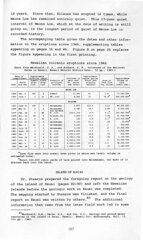
18 years. Since then, Kilauea has erupted 14 times, while
Mauna Loa has remained entirely quiet. This 17-year quiet
interval of Mauna Loa, which at the date of writing is still
going on, is the longest period of quiet of Mauna Loa i n
recorded history.
The accompanying table gives the dates and other infor
mation on the eruptions since 1946, supplementing tables
appearing on pages 36 and 46. Figure 8 on page 26 replaces the figure appearing in the first printing.
Hawaiian volcanic eruptions since 1946 (Data from Macdonald , G. A., and Hubbard, D. H., Volcanoes of the National
Parks in Hawai i, Hawaii Natural History Assn. , 52 pp. , 1965.)
Date of coumencemen t I Month
Year and day
1949
1950
1952
1954
1955
1959
1960
1961
1961
1961
1961
1962
1963
1963
1965
1965
June 27
May Jl
Peb. 28
Nov . 14
Jan . l3
Feb. 24
Mu . 3
July 10
Sept. 22
Dec . 7
Auq. 21
Oct. 5
Mor . 5
Dec. 24
d~~~~~~~(~:val ,,_,. I runk Loca tion of erup- erup- pr i ncipal tion tion outflow
136 0 Halesaawaau
3 0 Halem.aumau and caldera
0 88 E. ri f t
36 0 Kilauea Iki
0 36 .. rift
1 0 Halemawnau
22 0 Halemaumau
7 0 Halem.aumau
0 3 .. r ift
0 2 E . rift
0 2 E . r itt
0 1 .. rift
0 10 E . rift
0 1 .. rift
~pprox im.ate
Altitude of repoae per iod ma in vent alnce laat (ft. above eruption aea level) (montha)
KIIAUV.
.2 , 87 0 212.5
3,180 18.5
150- 1.310 8. 9
3 , 500 53.5
100 0.8
3 ,150 12.2
3 , 150 0.2
3 , 150 3. 5
1' 300-2' 600 2. 2
3. 100- 3 . 250 14.4
2. 700-3' 150 8.4
2' 300-2 ' 750 1. 4
2. 300-3 ' 000 17. 0
3 . 000-3' 150 9. 5
Area o f lava !low
(aq. railea)
0 .2 3
0. 44
6.18
0.24
4.18
.02
.1
.4
.3
.02
.06
. 6
3 .0
. 23
Approximate volWl'le of
lava (cubic yda.)
77 ,000,000
600. ooo . ooo•
6• .ooo ,ooo 8 , 500.000
120.000.000.
51 ,000. 000
155 . 000, 0008
30. ooob
3.50, 000
17.300,000
3 , 000.000
4 30.000
1. 100 . 000
10 ,000.000
38,000 ,000
1 , 160 ,000
aLava flow went i nto ocean; area given is above sea level; volume is estimated total .
bAbout 320,000 cub i c yards of lava poured i nto Halemaumau , but moat of it drained back into the vents .
ISLAND OF KAUAI
Dr. Stearns prepared the foregoing report on the geology
of the island of Kauai (pages 82-90) and left the Hawaiian
Islands before the geologic work on Kauai was completed.
The mapping started by Stearns was finished, and the final
report on Kauai was written by others. 45 The additional
information that carne from the later field work led to some
45MAcdonald , G.A. , Davis , D.A . , and Cox , D.C., Geology and ground-water resources of the island of Kaua i, Hawa ii: Hawaii Div. Hydrography , Bull. 13 , 212 pp .• 1 960 .
107

changes in interpretation. The principal differences from
Stearns' earlie r report are in the interpretation of the
ridge extending e a stward from Knudsen Gap to Kawai Point,
which we may call the Haupu Ridge; that of the origin of the
Lihue Basin, north of the Haupu Ridge; and that of the
origin of the lower course of the Waimea River and the
country just to the east.
Stearns regarded the Haupu Ridge as the remnant of a
shield volcano separate from the main Kauai shield, and
centering around the mass of Haupu itself . If this were
the case, the beds of lava in the west end of the ridge
should dip westward. The later work showed, however, that
the dips of the beds are continuously southeastward in the
western part of the ridge, and parallel to those in the
ridge of rocks unquestionably belonging to the main shield
that lies to the west of Knudsen Gap. Structurally, the
Haupu ridge is part of the main shield volcano.
Th 1 45 . h s . . d . e ater report agrees w~t tearns ~n cons~ er~ng
Haupu peak itself to consist of massive, nearly horizontal
flows of lava that accumulated in a small caldera or very
large pit crater . It differs, however, in considering the
crater not to be the summit caldera of an independent
volcano, but rather to be a subsidiary collapse crater on
the flank of the major shield, like Makaopuhi or one of the
other pit craters on the flank of Kilauea Volcano.
Stearns separated the rocks of Haupu Ridge from those
of the main shield and named them the Haupu volcanic series.
In the later report the rocks of the Haupu Ridge are included
with those of the main volcano as part of the Waimea Canyon
volcanic series. (See map, page 83.)
Stearns believed the Lihue Basin to have been formed
by erosional enlargement of the heads o f the two big stream
cut valleys that reached the sea respectively north and
south of the Kalepa-Nonou ridge. Under that interpretation
the ridge , and the nearby Aahoaka hill and Puu Pilo, repre
sent pa~t of the divide between the stream valleys. However ,
the general trend of the ridge is nearly across the supposed
courses of the stream valleys, and thus approximately at
right angles to the general trend of ridges that normally
would be left by erosive action of consequent streams. The
circular form of the basin suggests its origin by collapse
108

in the manner of a caldera, as was suggested by Hinds46 and 47 this is the hypothesis adopted in the later report although
certainly there has been modification of the original form
of the caldera by later erosion .
The hypothesis that the Lihue Basin originated by
collapse has recently received support from geophysical
studies, which have demonstrated the existence beneath the
basin of a mass of very heavy rock similar to those found
beneath other Hawaiian calderas .48
The mass appears to be
too dense to be a thick series of valley-filling lavas, and
no other such dense masses have been. found related to post
erosional eruptions, either on Kauai or on Oahu. It may,
however, be related to the main Kauai caldera, and slightly
offset from the caldera, as are the similar dense rock masses
represented by gravity highs on the island of Hawaii. 49 The
origin of the Lihue Basin still remains hypothetical, because
the evidence that might supply the proof of origin lies
buried beneath later lavas.
The ~ower part of Waimea Canyon cuts sharply across the
southwesterly trend that is normal for consequent streams on
that part of the Kauai shield volcano. Stearns (p. 90)
regarded the course of the Waimea River to be the result of
westward displacement of the stream by late lava flows. 50 Physiographic studies by Palmer demonstrated that an
approximately north- south fault must exist along the general
course of the river, as had previously been suggested by
Hinds. 51 Further studies demonstrated that the Waimea fault,
which is buried by later lavas, is the western edge of a
graben, the other boundary of which extends about N 10° W
from a point 3 miles inland from Hanapepe.52
Lavas from the caldera poured into the graben, partly
filling it . They are shown on the geologic map (p. 83) as
the Makaweli formation.
46ainds , N.E.A., The geology of Kauai and Niihau: B.P. Bishop Museum Bull. 71 , p. 36, 1930.
47Ma cdonald , Davis • . and Cox, op.cit., pp. 94-95. 48Krivoy, H.L., BaKer, M., Jr., and Moe , E.E ., A reconnaissance gravity
survey of the i sland of Kauai, Hawaii : Pacific Sci. , vol . 19. pp. 354-358, 1965.
49Kinoehita, W.T. , A gravity survey of the island of Hawaii: Pacific Sc i., vol. 19. pp. 339-340, 1965 .
50Palmer, H.S . , Fault at Waimea, oahu: Pacific Sci., vol. l, pp. 85-91, 1947 .
51ainda, N.E . A., op. cit., p . 79. 52Macdonald, Davis, and Cox. op. cit., pl . l.
109

Just before and during the eruption of the lavas of the
Koloa volcani c series, after the long period of erosion that
f ollowed the buildi ng of the main Kauai shield, voluminous
landslides and mudflows brought down a large amount of rock
debris and soil from the steep slopes of the mountainous
central upland. In part, it was deposited as breccias at
the foot of the steep slopes, in valley heads and along the
border of the marginal lowland; but part of it was carried
seaward by the streams and spread as gravels along the
valleys, interbedded with the Koloa lavas. The breccias
and conglomerates of this episode are indicated on the map
as the Palikea formation.
AGES OF HAW AllAN VOLCANIC ROCKS
The geologic ages assigned to the volcanic rocks in
the reports published by the Hawaii Division of Hydrography
were estimates based largely on the depth of weathering and
erosion they had undergone. Recently, more precise dating
has become possible through the use of the potassium-argon
method. The following table gives the ages, based on the
work of McDouga11, 53 Evernden and others, 54 and Naughton
and Barnes. 55
The K-A ages are consistent with the sequence of ages
determined by geologic mapping and the degree of weathering
and erosion. The changes in assigned geologic ages, shown
in the two right-hand columns of the table, are largely due
to the fact that the present accepted duration of the
Pleistocene (2 million years) is about twice that previously
accepted. Perhaps the greatest surprise in the K-A dating
is the very young age (less than 0.8 million years) for the
Pololu volcanic series in the Kohala Mountains of Hawaii.
The youngness of the rocks is supported by magnetic studies,
which show them to have a normal magnetic orientation, 56 and
thus to be younger than the last reversal of the earth's
53Mc:oougall, I., Potassium-argon ages from lavas of the Hawaiian Islands: Geol. Soc . America Bull., vol. 75, pp . 107-128, 1964 .
54 Evernden , J.F. , Savage , D.E., Curtis, G.H., and James, G.T., Potassiumargon dates and the Cenozoic mammalian chronology of North America : Am . Jour. Sci., vol. 262, pp . 156-159, 1964 .
55Naughton, J.J. , and Barnes , I.L. , Geochemical studies of Hawaiian rocks related to the study of the upper mantle : Pacifi c Sci. , vol. 19 , pp. 287-290, 1965 .
56ooell, R . R. ,. and Cox , A . , Paleomagnetism of Hawaiian lava flows: Jour. Geoph~• · Research , vol. 70, pp. 3377-3405 , 1965 .
110

Ages of Hawaiian volcanic rocks
(K-A ages from McDougall , Naughton and Barnes, and Evernden, et al.)
Volcanic K-A age Geoloaic aae Island Volcano series (millions Prevlously Presently
or formation of years) assigned assigned
Mauna Loa Ninole 0.1 -0. 5 Pliocene Pleistocene Hawaii Kohala Pololu O.B Pliocene Pleistocene
Ha leal<ala Kula 0 .4 -0.8 Pliocene Pleistocene Maui West Ma'Ui Honolua 1.15-1.17 Pliocene Pleistocene
Wes t M.aui Wailul<u 1.27-1. 30 Pliocene Pleistocene
East Molol<ai Upper member 1.3 -1. 5 Pliocene Pleistocene Molol<ai Bast Molol<ai Lower member 1.5 Pliocene Pleistocene
West Molol<ai .... 1.8 Pliocene Pleistocene
Koolau .... 2 . 2 -2.6 Pliocene Pliocene
Oahu Wa ianae Upper member 2.7 -2.8 Pliocene Pliocene Waianae Middle member 2.5 - 3 .0 Pliocene Pliocene
Waianae Lower member 2.9 -3.3 Pliocene Pliocene
Koloa 0.6 -1.4 Pleistocene- Pleistocene Recent
Kauai Mal<aweli 3.3 -4.0 Pliocene· Pliocene
Napali 4.5 -5. 6 Pllocene Pliocene
magnetic fie ld , about 0.7 million years ago. Actually,
despite such large canyons as Waipio and Waimanu Valleys,
the degree of erosional dissection of the Kohala Mountains
is not incompatible with this young age. The interfluves
between the major canyons show only a small amount of
dissection.
One apparent discrepancy in age does exist, however.
McDouga11 57 determined the age of the Mauna Kuwale "trachyte"
(rhyodacite), in the Waianae Range of Oahu, to be 8 . 4 million
years, as compared with 3.3 to 2.5 mi llion years for the
associated lavas of the lower and middle members of the
Waianae volcanic series. To explain this, he suggested that
the trachyte may be the top o f an older volcano burie d by
the Waianae lavas--a suggestion made earlier also by 58 Stearns, but not supported by the relationships found in
the field.59
McDougall's determination of the age of the trachyte
was made on grains of biotite separated from the rock,
57McDougall, I., op. cit. 58stearns, H.T., and val<svil<, K.N., Geology and ground-water resources
of the island of Qahu, Hawa ii: Hawaii Div. Hydrography, Bull. l , p. 181, 1935 . 59Macdonald, G.A., and Katsura. T., Chemical composi tion of Hawaiian
lavas: Jour. Petrology , vol. 5, p. 95, 1964.
111

whereas the ages of the other rocks were determined by
analysis of the whole rock. It appears possible that argon
may have been lost from the basalts to a greater degree than
from the biotite. This is supported by Naughton ~nd
Barnes• 60 determination of 3.46 million years as the age of
the trachyte on the basis of whole-rock analyses. The latter
age is still, however, somewhat greater than the ages deter
mined for the associated rocks of the middle member, to which
the trachyte appears most probably to belong. This remaini~
discrepancy may be explained by the fact, clearly demon-61 strated by Funkhouser that part of the argon in the
biotite was derived from the original magma at the time of . crystallization, instead of from the decay of potassium
within the biotite.
Fossils dredged from a depth of 1650 to 1700 feet below
sea level at the outer edge of a prominent terrace 6 miles
h f 1 l f . 62 Th t . sout west o Hono u u are o .M1ocene age. e errace 1s
part of the Lualualei terrace of Stearns (page 14). The
fossils include shallow- water corals, thus substantiating
the belief that the terrace was cut by waves near sea level
and has since been submerged as much as 1800 feet . Thus,
island masses must have been present in the Hawaiian area
during Miocene time, some 15 million years ago, and the
volcanoes that make up the present major islands were built
at least in part on the truncated remnants of older vol
canoe The older volcanoes may well have been approxi
mately contemporaneous with those that formed the bases
beneath the limestone caps of the Leeward Islands.
60Naughton and Barnes, op. cit. 61Funkhouser, J.G., The determination of a series of ages of a Hawaiian
volcano by the potassium-argon method: unpublished thesis for the Ph . D. degree, University of Hawaii, 1966.
62Menard, H.W. , Allison, E. C., and Durham, J . W., A drowned Miocene terrace in the Hawaiian Islands: Science, vol. 138, pp. 896-897, 1962.
112
2758 5739