LIBRARY CATALOGUE SLIPS. - USGS Publications Repository
282
LIBRARY CATALOGUE SLIPS. United States. Department of the interior. (U, S. geological survey.) Department of the interior | | Bulletin | of the | United States | geological survey | no. 82 j [Seal of the department] | Washington | government printing office | 1891 Second title: United States geological survey | J. W. Powell, director | | Correlation paipers | Cretaceous | hy | Charles A. . White | [Vignette] | Washington | government printing office | 1891 8°. 273pp. 3 pi. White (diaries A.). .-.^ United States geological survey | J. W. Powell, director | | Correlation papers | Cretaceous | by | Charles A. White | [Vi- gnette] | Washington | government printing office j 1891 8°. 273 pp. 3 pi. [UxiTED STATES. Department of the interior. (U. S. geological survey). Bulletin s2.J United States geological survey | J. W. Powell, director | | Correlation papers | Cretaceous | by | Charles A. White | [Vi- gnette] | Washington | government printing office | 1891 8o. 273 pp. 3 pi. [TJNiTKD STATES. Department of the interior. (U. S. geological survey). Bulletin 82.] G.
-
Upload
khangminh22 -
Category
Documents
-
view
2 -
download
0
Transcript of LIBRARY CATALOGUE SLIPS. - USGS Publications Repository

LIBRARY CATALOGUE SLIPS.
United States. Department of the interior. (U, S. geological survey.) Department of the interior | | Bulletin | of the | United
States | geological survey | no. 82 j [Seal of the department] | Washington | government printing office | 1891
Second title: United States geological survey | J. W. Powell, director | | Correlation paipers | Cretaceous | hy | Charles A.
. White | [Vignette] |Washington | government printing office | 1891 8°. 273pp. 3 pi.
White (diaries A.). .-.^United States geological survey | J. W. Powell, director | |
Correlation papers | Cretaceous | by | Charles A. White | [Vi gnette] |
Washington | government printing office j 18918°. 273 pp. 3 pi.
[UxiTED STATES. Department of the interior. (U. S. geological survey). Bulletin s2.J
United States geological survey | J. W. Powell, director | | Correlation papers | Cretaceous | by | Charles A. White | [Vi gnette] |
Washington | government printing office | 18918o. 273 pp. 3 pi.
[TJNiTKD STATES. Department of the interior. (U. S. geological survey). Bulletin 82.]
G.

ADVERTISEMENT.
[Bulletin No. 82.1
The publications of the United States Geological Survey are issued in accordance with the statute approved March 3, 1879, which declares that
"The publications of the Geological Survey shall consist of the annual report of operations, geological and economic maps illustrating the resources and classification of the lands, and reports upon general and economic geology and paleontology. The annual report of operations of the Geological Survey shall accompany the annual report of the Secretary of the Interior. All special memoirs and reportsof said Survey shall be issued in uniform quarto series if deemed necessary by the Director, but other wise in ordinary octavos. Three thousand copies of each shall be published for scientific exchanges and for sale at the price of publication; and all literary and cartographic materials received in exchange shall be the property of the United States and form a part of the library of the organization; and the money resulting from the sale of such publications shall be covered into the Treasury of the United States."
On Ju^y 7,1882, the following joint resolution, referring to all Government publications, was passed by Congress:
" That whenever any document or report shall be ordered printed by Congress, there shall be printed, in addition to the number in each case stated, tho 'usual number' (1,900) of copies for binding and distribution among those entitled to receive them." .
Except in those cases in which an extra number of any publication has been supplied to the Survey by special resolution of Congress or has been ordered by the Secretary of the Interior, this office has no copies for gratuitous distribution.
ANNUAL REPORTS.
I. First Annual Report of the United States Geological Survey, by Clarence King. 1880. 8°. 79pp. 1 map. A preliminary report describing plan of organization and publications.
II. Second Annual Report of the United States Geological Survey, 1880-'81, by J. W. Powell. 1882. 8°. Iv, 588 pp. 62 pi. 1 map.
III. Third Annual Report of the United States Geological Survey, 1881-'82, by j! W. Powell. 1883, 8°. xviii, 564 pp. 67 pi. and maps.
IV. Fourth Annual Report of the United States Geological Survey, 1882-'83, by J. W. Powell. 18S4. 8°. xxxii, 473 pp. 85 pi. and maps.
V. Fifth Annual Report of the United States Geological Survey, l883-'84, by J. W. Powell. 1885. 8°. xxxvi, 469 pp. 58 pi. and maps.
VI. Sixth Annual Report of tho United States Geological Survey, 1884-'85, byj. \V. Powell. -1885. 8°. xxix, 570 pp. 65 pi. and maps.
VII. Seventh Annual Report of the United States Geological Survey, 1885-'86, by J. W. Powell. 1888. 8°. xx, 656 pp. 71 pi. and maps.
VIII. Eighth Annual Reportof the United States Geological Survey, 1886-'87, by J. W. Powell. 1889. 8°. 2v. xix, 474, xii pp. 53 pi. and maps; 1 p. 1. 475-1063 pp. 54-76 pi. and maps.I.. Ninth Annual Report of the United States Geological Survey, 1887-'88, by J. W. Powell. 1889.
8°. xiii, 717 pp. 88 pi. and maps... Tenth Annual Report of the United States Geological Survey, 1888-'89, by J. W. Powell. 1890.
8°. 2 v. xv, 774 pp. 98 pi. and mapa; viii, 123 pp. The Eleventh and Twelfth Annual Reports ore in press.
MONOGRAPHS.
I. Lake Bonneville, by Grove Knrl Gilbert. 1890. 4°. xx, 438pp. 51 pi. 1 map. Price $1.50.II. Tertiary History of tho Grand Canon District, with atlas, by Clarence E. Dutton, Capt. U. S. A,
1882. 4°. xiv, 264pp. 42 pi. and atlas of 24 sheets folio. Price $10.00.III. Geology of the Comstock Lode and the WashoeDistrict, with atlas by George F. Becker. 1882.
4°. xv. 422 pp. 7 pi. and atlas of 21 sheets folio. Price $11.00.IV. Comatock Miuiug and Miners, by Eliot Lord. 1883. 4°. xiv, 451 pp. 3 pi. Price $1.50.

H ADVERTISEMENT.
V. The Copper-Bearing Rocks of Lake Superior, by .Roland Duer Irving. 1883. 4°. xvi, 464 pp. 151. 29 pi. and maps. Price$1.8J.
VI. Contributions to the Knowledge of the Older Mesozoic Flora of Virginia, by William Morris Fontaine. 1883. 4°. xi, 144 pp. 541. 54 pi. Price $1.05.
VII. Silver-Lead Deposits of Eureka, Nevada, by Joseph Story Cnrtis. 1884. 4°. xiii, 200 pp. 16 pi. Price $1.20.
Vin. Paleontology of the Eureka District, by Charles Doolittle Walcott. 1884. 4°. xiii, 298 pp. 241. 24 pi. Price $1.10. * ' IX. Braclaiopoda and Lamellibranchiata of the Raritan Clays and Greensand Marls of New Jersey, by Robert P. Whitfield. 1885. 4°. xx, 338pp. 35 pi. 1 map. Price $1.15.
X. Dinocerata. A Monograph of an Extinct Order of Gigantic Mammals, by Othniel Charles Marsh. 1886. 4°. xviii, 243pp. 561. 56 pi. Price $2.70.
XI. Geological History of Lake Lahontan, a Quaternary Lake of Northwestern Nevada, by Israel Cook Russell. 1885. 4°. xiv, 288 pp. 46 pi. and maps. Price $1.75.
XII. Geology and Mining Industry of Lead ville, Colorado, with atlas, by Samuel Franklin Emmons. 1886. 4°. xxix, 770 pp. 45 pi. and atlas of 35 sheets folio. Price $8.40.
XIII. Geology of the Quicksilver Deposits of the Pacific Slope, with atlas, by George F. Decker. 1888. 4°. xix, 486 pp. 7 pi. and atlas of 14 sheets folio. Price $2.00.
XIV. Fossil Fishes and Fossil Plants of the Tflassic Rocks of New Jersey and the Connecticut Val ley, by John S. Nbwberry. 1888. 4°. xiv, 152pp. 26 pi. Price $1.00.
XV. The Potomac or Younger Mesozoic Flora, by William Morris Fontaine. 1889. 43. xiv, 377 pp.« 180 pi. Text and plates bound separately. Price $2.50.
XVI. The Paleozoic Fr.shes of North America, by John Strong Newberry. 1889. 4°. 340 pp. 53 pi. Price $1.00.In press:
XVII. The Flora of the Dakota Group, a posthumous work, by Leo Lesquereux. Edited by F. H. Knowlton. 4° 400pp. 66 pi. . In preparation:
XVIII. Gasteropoda and Cephalopoda of the Raritan- Clays and Greensand Marls of New Jersey, by Robert P. Whitneld. The Penokee Iron-Bearing Series of Northern Wisconsin and Michigan, by Roland D. Irving and
C. R. Van Hise. Mollusca and Crustacea of the Miocene Formations of New Jersey, by R. P. Whitfleld. Geology of the Eureka Mining District, Nevada, with atlas, by Arnold Hague. Sauropoda, oy 0. C. Marsh. Stegosauria, by 0. C. Marsh. BrontotheridiE, by 0. C. Marsh. Report on the Denver Coal Basin, by S. F. Emmons.' Report on Silver Cliff and Ten-Mile Mining Districts, Colorado, by S. F. Emmons. '-i- The Glacial Lake Agassiz, by Warren Upham.
BULLETINS.
1. On Hypersthene-Andesite and on Triclinic Pyroxene in Augitic Rocks, by Whitman Cross, with a Geological Sketch of Buffalo Peaks, Colorado, by S.F. Emmons. 1883. 8°. 42pp. 2pl. Price 10 cents.
2. Gold and Silver Conversion Tables, giving the coining values of troy ounces of fine metal, etc., com puted by Albert Williams, jr. 1883. 8°. 8 pp. Price 5 cents.
3. On the Fossil Faunas of the Upper Devonian, along the meridian of 76° 30', from Tompkins County, New York, to Bradford County, Pennsylvania, by Henry S. W illiams. 1884. 8°. 36 pp. Price 5 cents.
4. On Mesozoic Fossils, by Charles A. White. 1884. 8°. 36 pp. 9 pi. Price 5 cents.5. A Dictionary of Altitudes in the United States, compiled by Henry Gannett. 1884. 8°. 325pp.
Price 20 cents.6. Elevations in the Dominion of Canada, by J. W. Spencer. 1884. 8°. 43 pp. Price 5 cents.7. Mapoteca Geologica Americana. A Catalogue of Geological Maps of America (North and South),
1752-1881, in geographic and chronologic order, by Jules Marcou and John Belknap Marcou. 1884. 8°. 184 pp. Price 10 cents.
8. On Secondary Enlargements of Mineral Fragments in Certain Rocks, by 'R. D. Irving-and C. R. Van Hise. 1884.- 8°. 56 pp. 6 pi. Price 10 cents.
9. A reportofworkdoneintheWastingtonLaboratoryduringthefiscalyearl883-'84. F. W. Clarke, chief chemist. T. M. Chatard, assistant chemist. 1884. 8°. 40 pp. Price 5 cents.
10. On the Cambrian Faunas of North America. Preliminary studies, by Charles Doolittle Walcott. 1884. 8°. 74pp. 10 pi. Price 5 cents.
11. On the Quaternary and Recent Mollusca of the Great Basin; with Descriptions of New Forma, by R. Ellsworth Call. Introduced by a sketch of the Quaternary Lakes of the Great Basin, by G. K. Gilbert. 1884. 8°. 66pp. 6 pi. Price 5 cents..
12. A Crystallographic Study of the Thinolite of Lake Lahontan, by Edward S. Dana. 1884. 8°. 34 pp. 3 pi. Price 5 cents.

ADVERTISEMENT. Ill
33. Boundaries of the United States and of the several States and Territories, with a Historical Sketch of the Territorial Changes, by Henry Gannett. 1885. 8°. 135pp. Price 10 cents.
14. The Electrical and Magnetic Properties of the Iron-Carburets, by Carl Barus and Vincent Strouhal. 1885. 8°. 238pp. Price 15 cents.
15. On the Meeozoic and Cenozoic Paleontology of California, by Charles A. "White. ; 1885. 8°. 33 pp. Price 5 cents.
16. On the Higher Devonian Faunas of Ontario County, New York, by John M. Clarke. 1885. 8°. 86pp. 3 pi. Price 5 cents.
17. On the Development of Crystallization in the Igneous Rocks of Washoe, Nevada, with Notes on the Geology of the District, by Arnold Hague and Joseph P. Iddings. 1885. 8°. 44 pp. Price 5 cents.
18. On Marine Eocene, Fresh-water Miocene, and other Fossil Mollusca of "Western North America, by Charles A. White. 1885. 8°. 26pp. 3 pi. Price 5 cents.
19. Notes on the Stratigraphy of California, by George F. Becker. 1885. 8°. 28 pp. Price 5 cents.20. Contributions to the Mineralogy of the Rocky Mountains, by Whitman Cross and W. F. Hille-
brand. 1885. 8°. 114pp. Ipl. Price 10 cents.21. The Lignites of the Great SiouxReservation. A Report on the Region between the Grand and Mo-
reau Rivers, Dakota, by Bailey Willis. 1885. 8°. 16 pp. 5 pi. Price 5 cents.22. On New Cretaceous Fossils from California, by Charles A. White. 1885. 8°. 25pp. 5 pi. Price
5 cents.23. Observations on the Junction between the Eastern Sandstone and the Keweenaw Series on
Keweenaw Point, Lake Superior, by R. D. Irving and T. C. Chamberlin. 1885. 8°. 124 pp. 17 pi. Price 15 cents.
24. List of Marine Mollusca, comprising the Quaternary Fossils and recent forms from American Localities between Cape Hatteras and Cape Roque, including the Bermudas, by William Healey Dall. 1S85. 8°. 336pp. Price 25 cents.
25. The Present Technical Condition of the Steel Industry of the United States, by Phineas Barnes. 1885. 8°. 85 pp. Price 10 cents.
26. Copper Smelting, by Henry M. Howe. 1885. 8°. 107pp. Price 10 cents.27. Report of work done in the Division of Chemistry and Physics, mainly during the fiscal ye:ir
l884-'85. 1886. 8°. 80pp. Price 10 cents.28. The Gabbros and Associated Hornblende Rocks occurring in the Neighborhood of Baltimore, Md.,
by George Huntington Willfcms. o 1886. 8°. 78pp. 4 pi. Price 10 cents.29. On the Fresh-water Invertebrates of the North American Jurassic, by Charles A. White. 1880.
8°. 41 pp. 4 pi. Price 5 cents.30. Second Contribution to the Studies on the Cambrian Faunas of North America, by Charles Doo
little Walcott. 1886. 8°. 369pp. 33 pi. 'Price 25 cents.31. Systematic Review of our Present Knowledge of Fossil Insects, including Myriapods and Arach
nids, by Samuel Hubbard Scudder. 1886. 8°. 128 pp. Price 15 cents.32. Lists and Analyses of the Mineral Springs of the United States; a Preliminary Study, by Albert
C. Peale. 1886. 8°. 235 pp. Price 20 cents.33. Notes on the Geology of Northern California, by X. S. Diller. 1886. 8°. 23 pp. Price 5 cents.34. On the relation of the Laramie Molluscan Fauna to that of the succeeding Fresh- water Eoceue
and other groups, by Charles A. White. 1886. 8°. 54 pp. 5 pi. Price 10 cents.35. Physical Properties of the Iron-Carburets, by Carl Barus and Vincent Strouhal. 1886. 8°. 62
pp. Price 10 cents.36. Subsidence of Fine Solid Particles in Liquids, by Carl Barus. 1886. 8°. 58pp. Price 10 cents.37. Types of the Laramie Flora, by Lester F. Ward. 1887. 8°. 354 pp. 57 pi. Price 25 cents.38. Peridotite of Elliott County, Kentucky, by J. S. Diller. 1887. 8°. 31pp. Ipl. Price 5 cents.39. The Upper Beaches and Deltas of the Glacial Lake Agassiz, by Warren Upham. 1887. 8°. 84
pp. 1 pi. Price 10 cents.40. Changes in River Courses in Washington Territory due to Glaciation, by Bailey Willis. 1887. 8°.
10 pp. 4 pi. Price 5 cents.41. On the Fossil Faunas of the Upper "Devonian the Genesee Section, New York, by Henry S.
Williams. 18,87. 8°. 121 pp. 4 pi. Price 15 cents.42. Report of work done in the Division of Chemistry and Physics, mainly during the fiscal year
1885-'86. F. W. Clarke, chief chemist. 1887. 8°. 152pp. Ipl. Price 15 cents.43. Tertiary and Cretaceous Strata of the Tuscaloosa, Tombigbee, and Alabama Rivers, by Eugene
A. Smith and Lawrence C. Johnson. 1887. 8°. 189 pp. 21 pi. Price 15 cents.44. Bibliography of North American Geology for 1886, by Nelson H. Barton. 1887. 8°. 35 pp.
Price 5 cents.45. The Present Condition of Knowledge of the Geology of Texas, by Robert T. Hill. 1887. 8°. 94
pp. Price 10 cents.46. Nature and Origin of Deposits of Phosphate of Lime, by R. A. F. Peurose, jr., with an Introduc
tion by N. S. Shaler. 1883. '8°. 143pp. Price 15 cents.

IV ADVERTISEMENT.
47. Analyses of Waters of the Tellowstone National Park, with an Account of the Methods of Anal- ysis employed, by Frank Austin Gooch and James Edward Whitfleld. 1888. 8°. 84 pp. Price 10 cents.
48. On the Form and Position of the Sea Level, by Kobert Simpson Woodward. 1888. 8°. 88 pp. Price 10 cents.
49. Latitudes and Longitudes of Certain Points in Missouri, Kansas, and New Mexico, by Robert Shnpson Woodward. 1889. 8°. 133 pp. Price 15 cents.
50. Formulas and Tables to facilitate the Construction and Use of Maps, by Robert Simpson Wood ward. 1889. 8°. 124pp. Price 15 cents.
51. On Invertebrate Fossils from the Pacific Coast, by Charles Abiathar White. 1889. 8°. 102pp. 14 pi. Price 15 cents.
52. Subaerial Decay of Rocks and Origin of the Red Color of Certain Formations, by Israel Cook Russell. 1889. 8°. 65pp. 5 pi. Price 10 cents.
53. The Geology of Nan tucket, by Nathaniel Southgate Shaler. 1889. 8°. 55pp. 10 pi. Price 10 cents.
54. On the Thermo-Electric Measurement of High Temperatures, by Carl Barus. 1889. 8°. 313 pp. incl. 1 pi. 11 pi. Price 25 cents.
55. Report of work done in the Division of Chemistry and Physics, mainly during tire fiscal year 1886-'87. Frank Wigglesworth Ciarke, chief chemist. 1889. 8°. 96pp. Price 10 cents.
56. Fossil Wood and Lignite of the Potomac Formation, by Frank Hall Knowltou. 1S8D. 8°. 72pp. 7 pi. Price 10 cents.
57. A Geological Reconnaissance in South western Kansas, by Robert Hay. 1890. 8°. 49pp. 2 pi. Price 5 cents.
,58. TheGlacial Boundary in Western Pennsylvania, Ohio, Kentucky, Indiana, and Illinois, by George Frederick Wright, with an introduction.by ThomasChrowder Chamberlin. 1890. 8°. 112pp. incl. 1 pi. 8 pi. Price 15 cents.
59. The Gabbros and Associated Rocks in Delaware, by Frederick D.Chester. 1890. 8°. 45pp. 1 pi. Price 10 cents.
60. Report of work done in the Division of Chemistry and Physics, mainly during the fiscal year 1887-'88. F. W. Ciarke, chief chemist. 1890. 8°. 174pp. Price 15 cents.
61. Contributions to the Mineralogy of the Pacific Coast, by William Harlow Melville and Waldemar Lindgren. 1890. 8°. 40pp. 3 pi. Price 5 cents.
C2. The Greenstone Schist Areas of the Menominee and Marquette Regions of Michigan; a contri bution to the subject of dynamic metamorphism in eruptive rocks, by George Huntington Williams; witli an introduction by Roland Duer Irving. 1890. 8°. 241pp. 16 pi. Price 30 cents.
63. A Bibliography of Paleozoic Crustacea from 1698 to 1889, including a list of North American species and a systematic arrangement of genera, by Anthony W. Vogdes. 1890. 8°. 177 pp. Price 15 cents.
64. A Report of work done in the Division of Chemistry and Physics, mainly during the fiscal year 1888-'89. F. W. Ciarke, chief chemist. 1890. 8°. 60 pp. Price 10 cents.
65. Stratigraphy of the Bituminous Coal Field of Pennsylvania, Ohio, and West Virginia, by Israel C. White. 1891. 8°. 212pp. 11 pi. Price 20 cents.
C6. On a Group of Volcanic Rocks from the Tewan Mountains, New Mexico, and on the occurrence of Primary Quartz in certain Basalts, by Joseph Paxson Iddings. 1890. 8°. 34 pp. Price 5 cents.
07. The relations of the Traps of the Newark System in the New Jersey Region, by Nelson Horatio Darton. 1890. 8°. 82 pp. Price 10 cents. *
68. Earthquakes in California in 1869, by James Edward Keeler. 1890. 8°. 25 pp. Price 5 cents.69. A Classed and Annotated Bibliography of Fossil Insects, by Samuel Hubbard Scudder. 1890.
8°. 101 pp. Price 15 cents.70. Report on Astronomical Work of 1889 and 1890, by Robert Simpson Woodward. 1890. 8°. 79
pp. Price 10 cents.71. Index to the Known Fossil Insects of the World, including Myriapods and Arachnids, by Samuel
Hubbard Scudder. 1891. 8°. 744pp. Price 50 cents.72. Altitudes between Lake Superior and the Rocky Mountains, by Warren Upham. 1891. 8°.
229 pp. Price 20 cents.73. The Viscosity of Solids, by Carl Barns. 1891. * 8°. xii, 139 pp. 6 pi. Price 15 cents.74. The Minerals of North Carolina, by Frederick Augustus Genth. 1891. 8°. 119 pp. Price 15
cents.75. Record of North American Geology for 1887 to 1889, inclusive, by Nelson Horatio Darton. 1891.
8°. 173 pp. Price 15 cents.76. A Dictionary of Altitudes in the United States (second edition), compiled by Henry Gannet1>
chief topographer. 1891. 8°. 393pp. Price 25 cents.77. The Texan Permian and its Mesozoic types of Fossils, by Charles A. White. 1891. 8°. 51pp.
4 pi. Price 10 cents.78. A report of work done in the Division of Chemistry and Physics, mainly during the fiscal year
1889-'90. F. W. Ciarke, chief chemist. 1891. 8°. 131pp. Price 15 cents.

ADVERTISEMENT. . V
79. A Late Volcanic Eruption in Northern California and its peculiar lava, by J. S. Diller. 1891. 8°. 33 pp. 17 pi. Price 10 cents.
80. Correlation papers Devonian and Carboniferous, by Henry Shaler Williams. 1891. 8°. 279 pp. Price 20 cents.
81. Correlation papers Cambrian, by Charles Doolittle Walcott. 1891. 9°. 447pp. 3 pi. Price 25 cents.
82. Correlation papers Cretaceous, by Charles A. "White. 1891. 8°. 273 pp. 3 pi. Price 20 cents.In press:.
91. Record of North American Geology for 1890, by Nelson Horatio Darton. In preparation: Correlation papers Neocene, by W. H. Dall and G. D. Harris. Correlation papers Eocene, by W. B. Clark. Correlation papers Jura-Trias, by I. C. Russell. Correlation papers Pleistocene, by T. C. Cbamberlin. Correlation papers Algonkian and Archean, by C. R. Van Hise, The Compressibility of Liquids, by Carl Barns. The Eruptive and Sedimentary Rocks on Pigeon Point, Minnesota, and their contact phenomena,
by W. S. Bayley. A Bibliography of Paleobotany, by David White.
STATISTICAL PAPERS.
Mineral Resources of the United States,-1882, by Albert Williams, jr. 1883. 8°. xvii, 813pp. Price 50 cents.
Minera.1 Resources of the United States, 1883 and 1884, by Albert Williams, jr. 1885. 8°. si v, 1016 pp. Price 60 cents.
Mineral Resources of the United States, 1885. Division of Mining Statistics and Technology. 1886. 8°. vii, 570 pp. Price 40 cents.
Mineral Resources of the United States, 1886, by David I. Day. 1887. 8°. viii, 813 pp. Price 50 cents.
Mineral Resources of the United States, 1887, by David T. Day. 1888. 8°. vii, 832 pp. Price 50 cents.
Mineral Resources of the United States, 1888, by David T. Day. 1890. 8°. vii, 652 pp. Price 50 cents. In preparation:
Mineral Resources of the United States, 1889 and 1890.The money received from the sale of these publications is deposited in the Treasury, and the Secre
tary of the Treasury declines to receive bank checks, drafts, or postage stamps; all remittances, there fore, must be by POSTAL NOTE or MONET ORDER, made payable to the Librarian of the U. S. Geological Survey, or in CURRENCY, for the exact amount. Correspondence relating to the publications of theSurvey should be addressed
To THE DIRECTOR OF THEUNITED STATES GEOLOGICAL SURVEY,
WASHINGTON, D. C. WASHINGTON, D. C., Augittt; 1891.

DEPARTMENT OP THE INTERIOR
BULLETIN
OF THE
UNITED STATES
GEOLOGICAL SURVEY
No. 82
WASHINGTONGOVERNMENT PRINTING OFFICE
1891


UNITED STATES GEOLOGICAL SURVEY
J. W. POWELL, DIRECTOR
CORRELATION PAPERS
CRETACEOUS
BY
CHARLES A. WHITE
WASHINGTONGOVERNMENT PRINTING OFFICE
1891


CONTENTS.
Page.Letter of transmittal......................................................... 9Outline of this paper................ .......................................... 11Preface......_......__.._.._........................................ 13Introduction...... _....................................................... 15
Scope .................................................................. 15Taxonomy and the criteria of correlation ................................ 17The literature of the North American Cretaceous......................... 25
List of publications consulted....................................... 26Historical sketch ........................................................ 61
Discussion of the formation hy regions................ .................... 72Explanation of terms and methods ...................................... 72Atlantic, border region ............... ................................ 74
New Jersey ......................................................... 78The Non-marine division ...................................i..... 80The Marine division .................:.......................... 82
1 Staten Island and Long Island ....................................... 84Martha's Vineyard.................................................. 86Pennsylvania and Delaware.....................!.......-......-....- 87Maryland and District of Columbia ................................. 88Virginia............................................................ 90North Carolina .._.___......................................... 91South Carolina.. ........................ ........................ 92Concluding remarks on the Atlantic border region ... ........ . 92
Gulf border region ...... .... ................. ... ......... 100Texan region .... . . . ............... .. ...... 114North Mexican region............................... ................. 130Great Interior area ......__................. ....................... 140
South Interior region ...........................".................... 154North Interior region . ...................... .............. 164The Lower Cretaceous ....._ _................................... 168The Upper Cretaceous .............................................. 170
Pacific border region............._ __ ..........._.................., 181The Lower Cretaceous .............................................. 183The Upper Cretaceous ..............__ ............................ 192
Extra-regional districts................................................. 201Correlation and taxonomy, illustrated by tables.......................... . 207Horizons of the North American Cretaceous.................................. 248
Potomac horizon..........._..............._.........-..-..-.--......- 251Comanche horizon .. _.................................................. 253Kootanie horizon .... _................................................ 254Shasta horizon ..............................._....................... 255Dakota horizon ............................_.......................... 257
5

Page, Horizons of the North American Cretaceous Continued.
Maritime and interior horizon. ....................../................ 258Colorado subhorizon .......................:..... ................. 261'Montana subhorizon ................................................ 261
Laramie horizon ..................................................._.-. 262Chico-Tejon horizon ..................................................... 264
Great displacements of, and volcanic material in, the North American Cretaceous 265 Explanation of map............................................ ......... 267Index ...........................................'............. ........... 269

ILLUSTRATIONS.
Pag* PLA.TE I. Map showing the outlines of the regions...................... . 72
II. Summary of the published Cretaceous sections for each region...... 246III. Map showing the distribution of the Cretaceous deposits of North
America........................................................ 268FIG. 1. Vertical section of the New Jersey Cretaceous series................ 79
2. Section from Philadelphia to Atlantic City ........................ 803. Section from Metuchen to Cape May, New Jersey .................. 824. Section from Hay wood to New Berne, North Carolina.............. 925. General section of the Cretaceous rocks of Alabama................ 1086. Section from Parker County to Navarro County, Texas............. 1187. The Sierra San Carlos section ... ..... ........ . .... 134
7


LETTER OF TRANSMITTAL.
DEPARTMENT OF THE INTERIOR, UNITED STATES GEOLOGICAL SURVEY,
DIVISION OF GEOLOGIC CORRELATION,Washington, J). (7., April 1, 1891.
SIR : I have the honor to transmit herewith a memoir by Dr. Charles A. White on the Cretaceous of North America, prepared for publica tion as a bulletin.
The Division of Geologic Correlation was created for the purpose of summarizing existing knowledge with reference to the geologic forma tions of North America, and especially of the.United States; of dis cussing the correlation of formations found in different parts of the country with one another and with formations in other continents; and of discussing the principles of geologic correlation in the light of American phenomena. The formations of each geologic period were assigned to some student already well acquainted with them, and it was arranged that he should expand his knowledge by study of the literature and by field examination of classic localities, and embody his results in an essay. The general plan of the work has been set forth on page 1C of the Ninth Annual Eeport of the Survey, and on pages 108 to 113 of the Tenth Annual Eeport, as well as in a letter of trans- mittal of Bulletin No. 80.
Two of the essays resulting from this work have already been pre sented. The first, by Prof. H. S. Williams, pertains to the formations of the Carboniferous and Devonian, and constitutes Bulletin No. 80. The second, by Mr. Charles D. Walcott, pertains to the formations of the Cambrian, and constitutes Bulletin No. 81. The present essay is the third of the series, and others will follow.
Dr. White discusses the American Cretaceous formations by dis tricts so chosen and arranged as to constitute a series, and through
r this discussion divides the formations into two series, which he calls Upper Cretaceous and Lower Cretaceous. These names as used by him have a purely American application and are not believed to coin cide with the upper and lower divisions of the European Cretaceous.
9

10 THE CRETACEOUS.
The American Cretaceous as a whole corresponds in general to the European as a whole, but it is impossible to recognize in America the precise equivalents of the upper and lower limits of the European Cretaceous.
Very respectfully, your obedient servant,G. K. GILBERT,
Geologist in Charge. Hon. J. W. POWELL,
Director U. 8. Geological Survey.
OUTLINE OFTHIS PAPER.
The primary object of this bulletin is the presentation of a summary of our present knowledge of the North American Cretaceous and a discussion of the system as it is developed on this continent, discussion of or direct reference to the details of the system as it is developed in other parts of the world being omitted.
Among the subjects treated of are the areal distribution of Cretaceous deposits, therecognition and correlation of the various formations which have by any author been published as belonging to this system, the partial rectification of the scale of Creta ceous formations as hitherto recognized, the characterization and delimitation of the now recognized formations and of the larger subdivisions of the system, and a discussion of its delimitation as a whole with reference to the formations which represent the next preceding and succeeding systems.
Preliminary to the principal discussions the bulletin contains a general statement of its object and plan, a historical sketch of the work that has been done with refer ence to the North American Cretaceous, an annotated list of the principal published works relating to the general subject in hand, and a discussion of the principles of correlation and taxonomy.
In the latter discussions the position is taken that while the European geological systems, as such, are more or less distinctly recognizable in different parts of the world, it has not yet been practicable satisfactorily to recognize their subdivisions beyond comparatively restricted geographical limits. It is therefore assumed that any attempt to correlate the subdivisions of the North American Cretaceous with those of the system as developed in Europe ought to follow, not precede, a thorough investigation of the former and perhaps also a partial revision of the general scale now in use.
It is shown that large portions of the continent are occupied by formations older than the Cretaceous and that therefore no strata referable to that system occur there. Those portions of the continent within which Cretaceous formations have been sys tematically studied are divided into seven regions, the outlines of which are shown on a small two-page map, and under the head of each of which regions its formations are severally discussed. The Cretaceous deposits which occur in other parts of the continent, and concerning which less is known, are briefly discussed under the head of Extra-regional districts.
These discussions include not only those deposits which all writers agree in refer ring to the Cretaceous system, but also those occurring at its base and top, respec tively , which may be regarded as transitional in character, or concerning the Cretaceous age of which geological writers have differed.
Two great .divisions of the Cretaceous system are recognized for North America, which are called Upper and Lower Cretaceous, respectively. The separatene'ss of these divisions from each other is recognized by means of evidence inherent in each, and without regard to their close agreement or disagreement with the Upper and Lower Cretaceous of Europe.
At the close of the discussions under the head of each region a table of its Cretaceous formations is given and compared with similar tables of the formations of adjacent regions. Following these discussions a series of nineteen tables is presented for the
11

12 THE CEETACEOUS. LBULL.82.
purpose of synoptically representing the correlation of the Cretaceous formations of the continent. Each table represents one of the principal sections which occur in different parts of the continent, and which have been published by different authors. At the side of each table is a uniform graduated scale which theoretically represents the full range of Cretaceous time. Opposite this scale are placed those spaces of the table which represent the respective formations of the section, the position of each space thus expressing the author's opinion as to the taxonomic position of the formation which it represents. By comparing these tables with one another the author's idea of the identity or of the equivalency of certain of the formations to one another is also seen.
Following the discussions and the tabular presentation of the subject of correla tion of the North American Cretaceous formations the subject of the recognition of broad horizons among those formations is discussed. The term "horizon" is here used in an unusual and extended sense. It is applied to a formation or to a series of more or less distinctly recognizable formations within the vertical and geographical limits of which the original vertical and geographical range of fossil species was never everywhere or at any time wholly broken. Such horizons have both a physical and biological entity. That is, they are physically expressed in series of sedimentary deposits and paleontologically characterized by their contained faunal and floral remains.
The necessity for recognizing such horizons in the future paleontological investi gation of the North American Cretaceous is pointed out. For example, it is shown that fossils which are found to characterize a formation in any given district ought to be studied as members of a fauna which originally had, or that may be assumed to have had, a much wider geographical distribution and, at least in part, a greater range in time than that which is represented by a single formation as developed within a limited district. That is, it is unsafe to assume that any fossil that may be discovered in any given assemblage of strata, in any given district within the geo graphical limits of any one of these horizons, will not be found in at least any adjoin ing district or in any immediately overlying or underlying assemblage of strata. It is shown that paleontological investigation with reference to the horizons thus indi cated will have a broader philosophical basis than has hitherto prevailed as relates to both biology and structural geology.
A map is inserted at the end of the bulletin upon which are approximately shown all the areas which aro known to be occupied by the formations which are hereindiscussed.

PREFACE.
The preparation of this work was undertaken at the request of the Director of the Survey as part of a general plan for the review of Ameri can formations. As the work progressed that which was proposed tobe merely an essay has grown to be a memoir, embracing a large range of subjects cognate with the discussion of Cretaceous formations.
It has been my purpose to use all available information that might aid me in correlating and identifying all the formations which have by any author been regarded as of Cretaceous age, even though some of them have been by certain authors referred to other geological systems. For paleontological evidence of correlation and identity I have relied mainly upon invertebrate remains because I believe them to be far more valuable for that purpose than any other fossils. Due weight, however, has been given to the evidence which plant and vertebrate remains afford, and I have used that evidence whenever it has been found available.
Those authors who have published invertebrate fossils from the forma tions which are discussed in this memoir have generally been so explicit as to the localities and to the strata from which their material has been obtained that 1 have been able to use the evidence thus furnished with out hesitation or serious doubt, and a similar remark may be made con cerning many of the published works containing descriptions of fossil plants. I have, however, frequently been unable to obtain information from publications containing descriptions of vertebrate fossils that would enable me to identify with certainty the strata from which they were obtained as portions of the respective formations which working geolo gists have long known by means of their characteristic invertebrate fossil faunas. For this reason I have felt obliged to omit reference to or consideration of such works in correlating and identifying the forma tions which I have discussed, notwithstanding that such omission im pairs the value which such a work as this ought to possess.
Many of the questions which I have found it necessary to discuss in this memoir are yet unsettled, and the views I have expressed concern ing them are intended to be only tentative. Furthermore, so great is the activity among investigators of North American Cretaceous geology that a considerable number of important facts have been published for the first time while this manuscript was in course of preparation, and
13

14 THE CRETACEOUS. lnuLL.82.
it is therefore likely that some of the statements herein made will need modification soon after its publication.
In the labor of reviewing the literature of North American Cretaceous geology and of collating the long array of facts which are therein recorded, and a large part of which it has been found desirable to notice in this memoir, I have received important assistance from many geologists, especially from Dr. G. M. Dawson, assistant director of the Canadian Geological Survey.
WASHINGTON, February 23,1891.

A REVIEW OF THE CRETACEOUS FORMATIONS OF NORTH AMERICA.
BY CHARLES A. WHITE.
INTRODUCTION.
SCOPE.
In planning and preparing this memoir my aim has been to produce a work for general reference which shall contain a concise summary of knowledge concerning the Forth American formations of Cretaceous age, together with bibliographical references to the principal published works upon the various branches of the subject, and such deductions as have been suggested to my mind by the various series of facts herein recorded. The special incentive to its preparation is the pressing need among geologists of such a grouping of the leading known facts con cerning the different geological formations of North America as will aid them in determining their relation to one another and in establish ing a rational scheme of their classification for special use upon this continent, and also serve as a basis for future discussions of their cor relation with those of other parts of the world.
It is primarily intended that this memoir shall be devoted to a con sideration of the Cretaceous formations alone; but it is found desirable to include, besides the undisputed Cretaceous, certain formations of doubtful age or of transitional character which occur respectively at the base and top of that system. The recognition of the Forth Ameri can Cretaceous system as such has been made by means of its general paleontological agreement with that of Europe; but in the case of the former it has not been found practicable so clearly to define its upper and lower limits as seems to have been done in Europe. This fact will plainly appear on following pages in connection with discussions of the formations referred to.
The question of close correlation of the various subdivisions of the Cretaceous system on this continent and in Europe will not now be discussed, because I believe that, beyond the recognition of the larger or more general subdivisions of the systems which have a place in the great geological scheme now in use, any attempt at ascertaining in
15

16 THE CRETACEOUS. [BULL. 82.
detail their correlation with formations upon other continents ought to follow, not precede, a comparatively complete investigation of all the formations of this continent, a work that will require yet many years of study by a large number of investigators. If this view is correct it is evident that we ought to expect to find features in the structural geology of this continent that would have greatly modified the scheme of classification in general use if geology had been first studied here. I have, therefore, felt no hesitancy in adopting such modifications as I have indicated when observed facts have seemed to warrant such a course.
In accordance with these views, and because of the conditions which I have found to exist among the North American Cretaceous formations, I have recognized only two general divisions of the system, an upper and a lower, instead of thf upper, middle, and lower divisions which are rec ognized in some parts of Europe. These two divisions I have called Upper and Lower Cretaceous, respectively, but without any present in tention of defining their relation to the Upper and Lower Cretaceous of Europe.1 They are simply the upper and lower divisions of the North American Cretaceous, and the terms used to designate them are believed to be natural in their application, and less objectionable than Earlier and Later, because the latter terms have been variously applied by geologists.2
So far as practicable the nomenclature of the North American for mations now in general use is employed in the text. The synonymy of this nomenclature, which has arisen from the independent studies of many geologists, is shown in a series of tables on following pages, which represent nineteen of the principal published sections of the North American Cretaceous. Each of these tables contains the names of the formations embraced in the section which it represents, and in each case the nomenclature used by the author of the section is given. The primary object of those tables, however, is to show, in accordance with my present judgment, the correlation of the formations which they represent.
A work so brief as this upon so comprehensive a subject as that which is treated in this memoir must be confined to its leading features. Its usefulness will therefore be limited to those who are seeking gen eral rather than special information, although the bibliographical list on following pages will serve as a guide to the latter. It is based
1 Up to a few years ago I was in doubt whether any North American Cretaceous formation ought to be regarded as of greater geological ago than the Middle Cretaceous of Europe. It is, however, to bo expected that the lower division now recoguized will prove to be homotaxially equivalent to certain parts of the European Lower Cretaceous, as has long been claimed by Marcou and others.
2Meek and Hayden on some occasions applied the terms Earlier and Later Cretaceous to the upper and lower portions, respectively, of their Upper Missouri Eiver section, which includes no formation older than the Dakota, and all the members of which section are included in the Upper Cretaceous as it is defined in this memoir. See, for example, Dana's Manual of Geology, 1874, pp. 456,457. Dr. George M. Dawson has applied the term Earlier Cretaceous to certain of tnose formations which in this memoir are designated as Lower Cretaceous, all of which are older than any of the Earlier Cretaceous of Meek and Hayden. (See Am. Jour. Sci., vol. 38, 1889, p. 120. See, also, a different use of the term Earlier Cretaceous, by Dr. Dawson in Proc. and Trans. Koy. Soc. Canada, vol. 1, sec. 4, p. 40.)

win .] TAXONOMY. 17
mainly upon the published results of the labors of many geologists, and it is therefore, as regards the facts herein stated, essentially a compila tion j but the discussions and the manner of presenting the subject-mat ter of such a work will necessarily reflect the personal views of the writer. In the present case his views are based not only upon a review of the published works of other geologists but upon his own personal studies of the North American Cretaceous, which have extended over a large part of the continent.
TAXONOMY AND THE CRITERIA OF CORRELATION.
For the purpose of indicating the basis of the views which are ex pressed or implied in the discussions recorded on following pages it is desirable to present some remarks upon the general subject of the tax onomy and correlation of geological formations, and upon the character and value of the criteria which have been held to demonstrate the latter. These remarks, however, are intended to apply almost exclusively to formations which are plainly of clastic origin, and generally to those which are more or less fossiliferous.
Geological taxonomy relates to the establishment of a general scheme of classification of the formations, and correlation to the assignment of those formations which occur in different parts of the world to their re spective places in that scheme. As between formations occurring in distant parts of the world correlation is necessarily of a general character only, but it may approach to actual identification within limited regions. The taxonomy of formations embraces not only their systematic arrange ment in chronological order, but also their characterization and delimi tation.
The scheme of classification referred to is necessarily a chronological one, or one that among working geologists indicates the order in which its respective subdivisions were produced. The basis of this scheme of classification is life, and beyond the actual observation of the superpo sition of formations upon one another and occasionally their subsequent lithological identification within limited districts, I do not know of any method of determining tbeir chronological relations except that which biological studies afford.
Formations are characterizable physically and biologically. Their physical characterization includes their litbogical composition and their stratigraphy. Their biological characterization includes a considera tion of uheir fossil contents both as regards specific identification and the evolutional development of the organic forms which they represent.
The delimitation of formations is also both physical and biological. Their physical delimitation is marked by a more or less complete litho logical and stratigraphical difference between them and those which re spectively underlie and overlie them ; and their biological delimitation is by the upper and lower limit of the vertical range of their contained fossil faunas and floras.
Bull. 82 2

18 THE CRETACEOUS. [RULL.82.
It is usually the case, especially with true marine formations, that the vertical range of the aqueous fossil forms which characterize them coincides with their upper and lower physical limits, because the physi cal changes which delimited formations usually arrested the progress of aqueous life and extinguished the living forms whose remains are now found to characterize them. It is, however, sometimes the case, espe cially with iiomnarine formations, that while the remains of water- breathing animals are found to range entirely through the vertical thickness of an unbroken series of strata, and no more, remains of other classes range through only a part of that thickness and are suc ceeded by others of the same class but of different species, and even of different types. Furthermore, some members of these latter classes may be found to range both above and beneath the extreme vertical limits of the aqueous forms. That is, the vertical range of fossil floras and of land air-breathing faunas may sometimes be independent of the well defined upper and lower physical limits of a given series of strata and of the vertical range of the invertebrate aqueous fauna which char acterizes it. In such cases it is plain that the changes of physical or of other conditions which affected the floras and land faunas referred to did not materially affect the invertebrate aqueous fauna, and that those changes which introduced and destroyed the latter did not similarly affect the former.
In accordance with the foregoing statements it will be seen that for the delimitation and characterization of formations for taxonomic pur poses, the cla^a derived from their aqueous faunas in connection with their physical characteristics are regarded as more trustworthy than any other.
It is apparent to every student of geology that the various authors who have written upon or with reference to the subject of the correlation of geological formations differ much in their views as to the proper cri teria to be used in such cases, or as to the relative value of those which different geological writers have recognized. It is also apparent that at least a part of the criteria which have been employed are illegiti mate and not to be relied upon. Some of these have fallen into disuse, but there are others, some of which are of great value in certain cases, of which illegitimate use may be and often has been made.
It is, however, gratifying to observe that so few of the criteria which have been proposed, even of those adopted in the infancy of geological science, have proved to be wholly valueless ; and this makes it all the more evident that the differences of opinion that appear in the publi cations of different geologists have been largely due to the frequent use of legitimate criteria in ex parte or illegitimate ways.
The criteria which properly may be used in arriving at conclusions as to the correlation of formations in different regions and in different parts of the world naturally fall into two categories, the one embracing biological and the other physical phenomena. Because the biological

WHITE.] CRITERIA OF CORRELATION. 19
phenomena to be referred to in this discussion all relate to fossil forms, the criteria based upon them may properly be classed under the head of paleontological, arid because the physical phenomena relate to geo logical subjects, those coming under this head may be designated as geological criteria. Those designated as paleontological may be di vided into evolutional and special, the first relating to the progressive secular development of living forms upon the earth during geological, time and the second to the recognition of identical or of similar fossil forms in the rocks of different regions, or of different parts of the world.
The geological criteria may, for our present purpose, be classed as structural, stratigraphical, and lithological. The general character of the lithological criteria is readily understood. In relative practical value they are perhaps next to the paleontological, but they vary in value as well as in kind and in the conditions of their application. The two geological criteria first mentioned are based upon paleontological data, becoming properly geological only in their application. This fact naturally leads to the remark that all the criteria which are to be con sidered are so interrelated that any classification of them is difficult, and that the one which is here adopted is only a matter of present con venience.
Of all the criteria that may legitimately be used in determining the correlation of formations it can not successfully be denied that while those which are based upon physical phenomena are of great value, and often the only ones directly available, the paleontological are much the most important. Indeed without the latter criteria a universal chrono logical scheme of classification of formations could never be success fully attempted, and local classification would be deprived of its most essential standard. It is, however, plain to everyone who takes a com prehensive view of the subject that even these are not to be relied upon to the exclusion of others, nor with that entire confidence that has been expressed by some prominent writers, and implied by many others.
The term correlation as here used is meant to imply that a given formation or series of formations, as the case may be, in one district or part of the world, being similar in its characteristics and associations to that of another, is referable to the same relative place in a recognized scheme of classification. As employed in this memoir it takes the place of other terms that have been used by various writers, such as equiv alency and contemporaneity, these terms being discarded except with reference to limited areas, as implying more than ascertainable facts will warrant.
It will therefore be understood that the term " correlation," in the more general use which is herein made of it, is intended to imply that the ascertaiuable relation to one another of the formations which are geo graphically widely separated is at best only homotaxial, and that even the cases of actual contemporaneity of widely separated formations

20 THE CKETACEOUS, [BULL. 82.
which must necessarily have existed can not be demonstrated for want of inherent or any other satisfactory proof. Within limited regions, however, correlation may be more definitely determined, and within certain districts of even considerable extent its determination may be essentially exact, in which cases terms implying equivalency and even contemporaneity may properly be used. That is, we may determine not only the homotaxial correlation of formations, but in some cases at least correlation of essential identity, or even of approximate contem poraneity, may satisfactorily be ascertained.1 It is the criteria of homo taxial correlation, especially those classed as evolutional, that I shall first consider, both as regards their legitimate and illegitimate use.
If the rate of progress of the secular evolution of organic forms had been uniform for all classes of those forms in all parts of the world, through the whole course of geological time, and if sufficient evidence of the same were discovered or discoverable, it would be a simple mat ter to determine not only the relative but the actual geological age of any and all formations containing fossils of any kind. In such a case their correlation would be not only homotaxial, but actual equivalency and contemporaneity could be accurately determined.
The practice of a large proportion of paleontological writers is evi dently based upon the affirmative side of the question here implied. They have assumed to decide, without reference to any related facts, the taxonomic position of strata in any and all parts of the world from which fossils submitted to them may have been obtained, using the European scheme of classification as if it were an infallible standard of universal applicability, even in its minor details. Paleontological liter ature abounds in cases of this kind and they embrace all branches of paleontology, vertebrate, invertebrate, and phytological. Even stu dents of special divisions of these branches have assumed to decide such questions by the results of their own labors alone.
The reasons why paleontological data alone do not constitute an ade quate basis for deciding all questions of correlation are various, among which are those implied in the following propositions, relating mainly to the subject of biological evolution.
(1) General biological evolution, while it has been progressive, has not progressed at a uniform rate throughout geological time and in all parts of the world. This is shown in many ways; for example, by the survival of a greater or less number of ancient types of life in associa tion with more advanced and later types, by the presence of such ad vanced types among certain ancient faunas, and by the general differ-
1 For a statement of views implying the dominant idea of contemporaneity of formations see Pictet, F.J., Traite do Paleontologie, vol. 1, 2° ed., Paris, 1853, p. 100. Also Schimper, W.Ph.,Trait6 de Pal6ontologie V6g6talo, yol 1,1869, p. 100, Paris.
For a presentation of the idea implied in the term "homotaxy," and for the first use of that term, see Huxley, T. H., Quart. Jour. Geol. Soc. Lend., vol. 18,1864, pp. 41,42. Literally, the term " homotaxy " im plies that any given system is divisible into formations of similar number, character, and relativo value in different parts of the world. As this is never actually the case, it is plain that even this term must be used in a restricted sense.

WHITE.] PROPOSITIONS CONCERNING BIOLOGIC EVOLUTION. 21
ences of grade of exiRting faunas and floras in different parts of the world, which maybe figuratively regarded as respectively the summits of evolutional columns of unequal height, and which indicate that simi lar differences prevailed during geological time. It is also shown by the evidence we have that in all ages certain trunk lines of descent successively became extinct, while contemporaneous lines continued their existence until they in turn were extinguished. 1
(2) The rate of general progress in the evolution of vertebrates, in vertebrates, and plants has not been the same for each at all times and in all parts of the world. Thus, for example, a given grade of floral development, which was contemporaneous with a certain grade of in vertebrate, or of vertebrate, life in one part of the world has been found to have been contemporaneous with a higher or a lower grade, as the case may be, in another part. Again, a given grade of invertebratedevelopment has remained comparatively unchanged during several periods in which great differentiation and evolutional advancement took place in certain floras and in other faunas.
(3) The progress of evolution, such as it has been, was frequently modified by physical causes. For example, the great physical changes which have frequently taken place in the earth's crust and upon its sur face, while they were never universally catastrophic as regards biolog ical evolution as a whole, have often been largely destructive of life over great areas. Such physical changes of course extinguished many of the then existing forms of life, and to that extent arrested faunal and floral evolution in the disturbed areas, while in undisturbed areas forms similar to those that were extinguished continued to exist until ade quate changes occurring there caused their extinction also.2
(4) Physical or other forces operating within a given region have at times caused the extinction or great modification of certain faunas and floras, while they have not affected other faunas to the extent of a change in specific characters. This proposition is, for example, sup ported by the conditions observed in the great series of strata which has received the name of the Laranfie group. This formation contains remains of vertebrates which paleontologists generally regard as char acteristic of the Cretaceous system, while at least the upper strata of the series contain a flora which paleobotanists have declared to be Ter tiary ; and yet a fresh-water brauchiferous inolluscau fauna ranges from base to top of the whole series without change in the specific character of its members. The survival of these branchiferous mollusca implies a continuity of congenial aqueous habitat from the earliest to the latest portion of the epoch which that series of strata represents and which
1 For remarks on tho extinction of trunk lines'of descent see Ward, Lester I\, Presidential Address, Biological Society, Washington, 1890.
2 It is not to be denied that certain faunal types, especially of marine invertebrates, wore almost world wide in their distribution, especially in the older geological periods, and that in such cases, re spectively, their remains seem to occur within a very narrow vertical range. But this fact does not invalidate the foregoing propositions.

22 THE CRETACEOUSo (BULL. 82.
was not affected by the causes that changed the flora. The whole series of strata, including those which bear plants of Tertiary characteristics, also presents the appearance of having been produced by uninterrupted sedimentation.
(5) Because of the facts stated in proposition 2, the remains of land animals and plants possess no inherent trustworthy evidence of the actual contemporaneity they may have had in life with aqueous forms. Therefore contemporaneity can not be proved in these cases except by the commingling of remains of the different kinds in one and the same deposit. Again, contemporaneity of fresh-water and marine faunas can not be proved by any inherent characteristics of either, because the differentiation of fresh-water forms as compared with that of marine forms, especially in the case of the mollusca, has been so slight and so slowly accomplished during geological time. Furthermore, because fresh-water and marine deposits were always separately formed, phys ical proof of contemporaneity is never conclusive, and usually it is wholly wanting. For these and for the other reasons just mentioned it is always difficult, and often impossible, to determine the true taxonomic relation of fresh-water to marine deposits.
The foregoing propositions relate mainly to evolutional criteria, and are largely of world-wide applicability; but some of them relate to the class which I have designated as special. The former are based upon the recognizability of a number of world-wide stages of biological de velopment, each of which is indicated by characteristic organic types. Their use is legitimate when they are considered in connection with other criteria and confined to a recognition of those general stages, and illegitimate when the recognition of definite upper and lower limits of those stages or of the identity of their smaller subdivisions is thus attempted. Such attempts are especially deplorable when no reference is made to other criteria.
The class of paleontological criteria which I have designated as special are of more restricted applicability than those designated as evolutional because they are based upon the recognition of identical or of similar fossil forms in different formations. Within limited areas these criteria are of direct applicability. For example, the recognition of specific identity of fossils in formations of marine or of lacustrine origin which occur in regions of moderate extent may properly be accepted as proof of approximate contemporaneity, or at least as suffi ciently indicating a close correlation of the formations bearing such fossils. But specific identity of fossils discovered in formations of widely separated parts of the world, even if the assumed identity is real, does not prove contemporaneity of those formations, because geographical distribution of species implies lapse of time which, in many cases, may have amounted to long geological periods. Further more, there are many forms, especially among the Ostreidae, Aviculidte, etc., which have differed so little from period to period of geological

WHITE.) DISCUSSIONS OF CORKELATION. 23
time as to present no observable change in their specific characters. Such apparent specific identity is plainly of no value in the correla tion of separate formations, although they may have some general value in the case of groups of formations.
In studying the correlation of widely separated formations by means of those paleontological criteria which I have designated as special, their use is necessarily of a more general character than that which is made of the evolutional criteria, with which, indeed, they are in this way closely connected. For example, if a given series of formations in one part of the world is found to contain the remains of faunas and floras which are respectively homologous to those of a series in another part, and if such series are respectively overlain and underlain by others which correspond in a similar mannejr, it ought to be accepted, when fortified by Other evidence, as proof of at least general correlation. That is, it is the general correspondence of the respective faunas and floras that is to be relied upon in these cases, rather than upon specific or other classificatory identification of fossils.
The upper and lower limits of a series of formations thus correlated with another series in a distant part of the world would, however, rarely coincide, and there would also necessarily be more or less faunal and floral differences between them, due to causes which have been referred to, and also to dissimilar physical conditions which prevailed in the dif ferent regions. These facts again plainly indicate the necessity of con sidering all available concurrent evidence before reaching a conclusion in such cases as have been mentioned.
It was intimated at the outset that all the criteria of correlation are closely interrelated. Turning now to those which are classed as geo-
' logical we find that for this reason it is difficult to discuss them sepa rately from one another, as we have already found it difficult to discuss those classed as paleontological separately from these.
This interrelationship of geological with paleontological criteria is especially close in the case of those which I have designated as struc tural, or those which relate to the taxonomic position in a great general scheme of classification of formations or groups of formations which are geographically widely separated. Indeed, these criteria are properly paleontological, but become structural in their application. So also the paleontological, criteria which are designated as special become strati- graphical in their application, and auxiliary to lithological criteria in the identification of formations and the recognition of the order of their superposition within limited regions.
Again, a given assemblage of strata may possess certain paleontolog ical characteristics which suggest that they are referable to a separate period from that of those beneath it, while other paleontological data, together with stratigraphical conformity, tend to connect the whole together as a single series. If then we find the whole assemblage to be involved in displacements which occurred immediately upon the com-

24 THE CRETACEOUS. [BULL. 82.
pletion of its deposition this is an additional reason for regarding all those strata as constituting a single formation and representing a sin gle epoch, notwithstanding the partial paleontological discrepancy referred to. Such a condition of things exists with relation to the great series of strata known as the Larainie formation,,
Compared with the paleontological, the lithological criteria are, at best, of limited application and available only in either direct or indi rect relation to the former. Their use in that relation is direct when they are applied to fossiliferous and indirect when they are applied to unfossiliferous formations. In the former cases they are simply acces sory to associated paleontological criteria, but in the latter they con stitute the principal evidence of correlation. 'Their application in the latter cases, however, can be made only with reference to some already known paleontological horizon.
It is hardly necessary in this connection to refer particularly to the former class of cases, but the extensive studies that have been made in the pre-Cambrian stratified rocks furnish cases of the latter class that are worthy of special consideration. 1 It has been shown that by use of lithological criteria a very satisfactory classification of these unfossili ferous formations can be made and that their correlation with one an other may be determined; but the fact that they are of pre-Cambrian age could be determined only by paleontological evidence. That is, their taxouomic position in the general scheme of classification could be determined only by means of paleontological criteria.
Paleontology, when it is available, affords beyond question the most trustworthy means for the identification of formations that occur within the regions that ordinarily constitute fields of geological study; but in the absence of fossils the geologist often reaches conclusions by methods of reasoning that it would be difficult even for himself to formulate, which conclusions are valuable in proportion to his experience and to the range of his acquirements and observation.
Among these less clearly definable methods is that which takes cog nizance of hornogeny; that is, of a method in connection with which certain inherent general characteristics which are presented by a series of strata in a given part of a region under investigation are accepted as evidence that it had a common origin with certain series in other parts of the same region presenting similar characteristics. This con clusion necessarily implies that originally there was physical continuity of similar strata between such localities whether near to or remote from one another, but these strata may have been either destroyed or ob scured.
This method of identifying formations is of great value in the hands of an experienced and broad-minded investigator, but some of the most grievous mistakes that geologists have made have occurred in conse quence of relying upon it to the exclusion of paleontology.
1 See, for example,Irving, K. D.: Classification of the Early Cambrian and pre-Cambrian formations. Seventh Ann. Kep. U. S. Geol. Survey, pp. 371-399.

WHITE.] LITERATURE OF THE CRETACEOUS. 25
Accepting the foregoing statements as <o the character and relative value of the criteria that may properly be employed in. determining the correlation of geological formations, especially those which are geo graphically widely separated, it is evident that no one criterion nor any one class of criteria is sufficient definitely to decide any question of that kind. It is also evident that the correlation of widely separated formations is at best more a matter of opinion than of demonstrable f;;ct, and that a final judgment in such cases must be the result of a con sensus of opinion of investigators in all branches of geological science.
THE LITERATURE OF THE NORTH AMERICAN CRETACEOUS.
While those who may consult this memoir are likely to find that much has been omitted which they desire to know, the accompanying briefly annotated bibliographical list will be found to contain the titles of the principal published writings upon the North American Creta ceous, and to serve either directly or indirectly as a guide to nearly all of the literature of the subject. The great mass of that literature has been passed in review by the writer in the preparation of this memoir; and those works whose titles the list coutains may be regarded as hav ing been especially consulted.
The necessarily limited scope of this work makes it impracticable to give an exhaustive bibliography of the whole subject, and therefore the question what to reject and what to include in this list has not been an easy one satisfactorily to decide. But the list has been abbreviated so far as could consistently be done, and titles of papers and smaller works are given only when they contain matter having an important bearing on the subject in hand.
Again, a number of important works have been omitted from the list because the substance of them, together with other matter, is included in later and more comprehensive publications by the same authors which are included in the list. Therefore the number of titles by any one author which the list contains does not necessarily bear any rela tion to the importance of Ms contribution to the literature of the sub ject. »

AN ANNOTATED LIST OF PUBLICATIONS CONSULTED IN THE PREPARATION OF THISMEMOIR.
BANNISTER, if. M. Report of a Geological Reconnaissance along the Union Pacific Rail road. <U. S. Geol. Surv. Terr, for 1872, Sixth Annual Report, pp. 519-541. 1873.
The author discusses marine Cretaceous and Laramie strata, and gives sections at Car bon, Black Buttes, along Bitter Creek, and at Aliny Coal Mines, all in Wyoming.
BANNISTER, H. M. Note on the age of the Laramie group, or Rocky Mountain Lig- nitic formation. <\Am. Jour. Sci., 3d ser., 1879, vol. 17, pp. 243-245.
The author states that Clarence King was in error in asserting that the Laramie is always unconformable with overlying formations.
BARCENA, MARTANO. Noticia cientificadeuna parte del estado de Hidalgo. <Anales del Ministerio de Fomento de la Republica Mexicana, vol. 1, 1877, pp. 331-351.
BARCENA, MARTANO. Materialea para la Jbrmacion de una Obera de Paleontologia Mexicana. <Anales del Museo Nacional de Mexico, torao 1, pp. 85-87; 195-202; 283-286. 1877.
BARRETT, L. On some Cretaceous rocks in the southeastern portion of Jamaica. <Quart. Jour. Geol. Soc. London, vol. 16, 1860, pp. 324-326.
The Cretaceous rocks referred to in this article are apparently equivalent to those which were afterward described by Duncan & Wall in the district of Clarendon.
BECKER, GEORGE P. Notes on the stratigraphy of California. <Bull. U. S. Geol. Sur vey No. 19. 1885.
The author discusses the relation to one another of the different Cretaceous formations of California, and gives his reasons for referring a large part of the metaphoric rocks of the coast ranges to the Cretaceous system.
BECKER, GEORGE F. [Administrative Report.] <Sixth Annual Report U. S. Geol.Survey, pp. 67-70. 1885.
The author discusses the age and time of uplift of the Coast Range formations and the equivalency of different Aucel la-bearing beds.
BECKER, GEORGE F. Cretaceous metamorphic rocks of California. <^Am. Jour. Sci., 3d ser., vol. 31, 1886, pp. 348-357.
The author repeats his opinion that a large part of the metamorphic rocks of the coast ranges of California are of Cretaceous age.
BECKER, GEORGE F. The Qucksilver Deposits of the Pacific Slope. <Monog. U. S. Geol. Surv., Vol. 13. 1889.
Dr. Becker discusses in this volume the question of the Cretaceous age of a large part of the metamorphic rocks of the coast ranges and of certain Aucella-bearing rocks.
BELL, ROBERT. Report on part of the basin of the Athabasca River, Northwest Terri tory. <Geol. Surv. Can. Report of progress for 1882-'83-'84. Montreal, 1885, 8°. pp. 786. Maps, plates, sections, and illustrations. 1885.
Cretaceous rocks are reported to exist at several localities, atone of which they are found resting uncouformably upon the Devonian limestone.
BILLINGS, E. On the Mesozoic Fossils from British Columbia. -\Geol. Nat. Hist.Survey Canada. Report of progress for 1872-'73. Appendix rr, pp. 71-75. 1873.
This article contains notes on the Mesozoic fossils collected by Mr. James Richardson inBritish Columbia in 1872. The author also gives a table comparing the Mesozoic rocks ofBritish Columbia with those of California, Nebraska, and England.
26

WUITE.J ANNOTATED BIBLIOGRAPHICAL LIST. 2?
BLAKE, WILLIAM P. Eeport on the geology of the route near the thirty-second par allel. <Pacific Railroad Surveys, vol. 2. 4°. Washington, 1855. pp. 1-40 and maps. 1856.
The occurrence of fossils on the Llano Estacado, now known to characterize the Co- manche beds of the Texas section, is announced.
BLAKE, W. P. Locality of secondary fossils in Oregon. <Ain. Jour. Sci., 2d ser., vol. 44, 1867, pp. 118, 119.
The fossils referred to are from the valley of John Day River, are of tbeage of the Chico group of California, and were subsequently described by Meek.
BLAKE, WILLIAM P. Geographical Notes upon Russian America and the Btickeen River, being a report addressed to the Hon. W. K. Seward, Secretary of State. Washington, 1868.
The author suggests that the coal-bearing formations of Sitka and other adjacent islands arc equivalent in age with those of Vancouver and Queen Charlotte Islands.
BLAKE, W. P.; C. H. HITCHCOCK and. (See Hitchcock, C. H., and W. P. Blake.)
BOOTH, JAMES C. Memoir of the Geological Survey of the State of Delaware; includ ing the application of the geological observations to agriculture. 8°. pp. t-xi and 9-188. 1841.
The author divides the "Upper Secondary " of the State into the "Red Clay " and the ' Qrcensand " formations, which seeui lo correspond to the 1'otouiac formation mid the New Jersey marls, respectively.
BHADLKV, F. H. Geological Chart of the United States East of the Rocky Mountains,and of Canada. Published by the author. 1875.
BROADIIHAD, G. C. The chalk beds of Wakeeney, Kansas. ^Kansas City Review, vol. 5, 1882, p. 616.
These beds furnish commercial " whiting" and belong to the Niobrara group of the Cre taceous section of Meek & Hayden.
CASTTLLO, ANTONIO DHL. Bosquejo de una Carta Geologicade la Republica Mexicana, fonnado por disposicion del Secretario de Fomento, Gen'1 Carlos Pacheco por uua comision especial bajo la direccion del Prof. Antonio del Castillo, Director de laEs- cuela Nacional de Ingenieros. Grabado por Erhard Hermanos, 35 calle Deufest- Rochereau, Paris. 1889.
CLARK, WILLIAM B. Discovery of fossil-bearing Cretaceous strata in Anne Arundel and Prince George Counties, Md. < Johns Hopkins University Circulars, No. 69, pp. 20, 21. 1888.
Considerable areas formerly supposed to be occupied by Tertiary deposits are, by the author, shown to be occupied by the upper division of the Cretaceous.
CLARK, W. B. On the Tertiary deposits of the Cape Fear River region. <Bull. Geol. Soc. Araer.,vol. 1,1890, pp. 537-540.
The author mentions the commingling of Cretaceous and Tertiary fossils in one and the waine stratum, and is inclined to regard it as mechanical, and not faunal.
CONRAD, TIMOTHY A. Fossil shells from the Tertiary deposits on the Columbia River near Astoria. <Am. Jour. Sci. 2d ser., vol 5, 1848, pp. 432, 433, including 14 wood-cuts.
Some of these species seem to be identical with some found in the Tejon group of the California State Survey. See Bull.U.S. Geol. Survey No.51.
CONRAD, TIMOTHY A. Observations on certain Eocene fossils, described as Cretaceous by Mr. W. M. Gabb in his report published in the "Paleontology of California." <Am. Jour. Conchology, vol. 1,1865, pp. 362-365
The fossils discussed by the author and declared to be Tertiary are from both the Chico and Tejon groups of the California State Survey.

28 THE CRETACEOUS. [BULL. 82.
CONRAD, TIMOTHY A. Note on the Tertiary of North and South Carolina. < Am. Jour. Sci.,2dser.,vol. 43, 1867, p. 2(50.
Reference is made in this note to the occurrence of Cretaceous forms in Eocene strata of South Carolina; and Mr. Conrad states that the evidence is conclusive that the comming ling took place by a breaking up in Eocene time of previously deposited Cretaceous strata.
CONEAD, TIMOTHY A. Reply to Mr. Gabb on the Cretaceous rocks of California. < Am. Jour. Sci. 2d ser., vol. 44, 1867, pp. 376,377.
The author again states his opinion that the fossils of the Tejon [group indicate their Eocene age.
CONRAD, T. A. On some points connected with the Cretaceous and Tertiary of North Carolina. <Am. Jour. Sci., vol. 1, 1871, pp. 468, 459.
The author denies the correctness of the opinion then current that Miocene and Cretaceous fossils are faunally commingled in one and the same stratum on Tar .River, N. C., but claims that the commingling is mechanical.
CONRAD, TIMOTHY A. Descriptions of new genera and species of fossil shells of North Carolina, in the State cabinet at Raleigh. <[Kerr's Report on the Geol. Surv. of North Carolina, vol. 1, Appendix A, pp. 1-28, plates 1-4. 1875.
The author states that the Cretaceous fossils described in this paper represent the Ripley group.
COOK, GEORGE H. The annual report of Prof. Geo. H. Cook, State geologist, to his ex cellency, Joel Parker, president of the board of managers of the Geological Survey of New Jersey, 8° pamphlet, pp. 24 and map and section. 1865.
The extension of the Cretaceous into Pennsylvania and Delaware is shown on the map. It also shows the presence of Cretaceous deposits upon Staten Island and a part of the ex treme western end of Long Island.
COOK, GEORGE H. Geology of New Jersey, pp. 900, imp. 8° and 7 plates. Also 13 maps in portfolio. 1868.
The Cretaceous formations of New Jersey are elaborately described. COOK, GEORGE H. Geological map of New Jersey. 1882.
This map exhibits by colors the areal distribution of the geological formations of the StatiAnd contains vertical and horizontal sections of them.
COOK, GEORGE H. Geological Survey of New Jersey. Annual Report of the State Geologist for the year 1883, p. 188.
This report contains a section of the Cretaceous formations of New Jersey, with descrip tions of the formations as found in artesian borings at Asbury Park and Ocean Grove.
COOK, GEORGE H. Geological Survey of New Jersey. Annual Report of the State Geologist for the year 1884.
This report contains a section of the Cretaceous formations of New Jersey, somewhat modified from those published in the earlier reports, the modification being due to Informa tion obtained by artesian borings.
COOK, GEORGE H. Sketch of the geology of the Cretaceous and Tertiary formations of New Jersey. <Brachiopoda and Lamellibranchiata of the Raritan clays and Greensaud marls of New Jersey. Monographs of the U. 3. Geological Survey, vol. 9, pp. i-xx. 1885.
In this article Prof. Cook gives sections of the Cretaceous formations of New Jersey, cor rected by late information obtained from artesian borings at the seacoast.
COOK, GEORGE H. Geological Survey of New Jersey. Annual Report of the State Geologist for the year 1886, pp. 254. 1887.
This report is mostly devoted to economic geology; but with the description of "Green- sand marls " sections of the New Jersey Cretaceous are given.
COPE, E. D. The fossil reptiles of New Jersey. <Am. Naturalist, 1868, vol. 1, pp. 23-30, and vol. 3, pp. 84-91.
These are popular articles, the second containing figures illustrating restoration of sev eral species.
COPE, E. D. On some Cretaceous reptilia. <Proc. Acad. Nat. Sci. Philad., vol. 22, 1868, pp. 233-242.

WHITE.] ANNOTATED BIBLIOGKAPHICAL LIST. 29
COPE, E. I). On the fresh-water origin of certain sands and clays in New Jersey. <Proc. Acad. Nat. Sci., Philad., vol. 20,1886, pp. 157,158.
The author regards the Haritan clays as of the age of the Dakota group (No. 1) of the uppur Missouri River section.
COPE, E. D. On some species of Pythonoruorpha from the Cretaceous beds of Kansaa and New Mexico. <Proc. Am. Philos. Soc., vol. 9,1870, pp. 574-584.
COPE, E. D. On the fossil reptiles and fishes of the Cretaceous rocks of Kansas. <C, Ann. Rep. U. S. Geol. Survey Terr, for 1870, pp. 385-424. 1871.
COPE, E. D. Synopsis of the extinct batrachia, reptilia, and aves of North America. <Trans. Am. Philos. Soc., vol. 14,1871, pp. 1-252. Pis. 1-14.
This work contains descriptions of many Cretaceous forms, and references to those pre viously published are given.
COPE, E. D. On the geology and paleontology of the Cretaceous strata of Kansas. <Anu. Rep. U. S. Geol. Surv. Terr, for 187], pp. 318-348. 1872.
COPE, E. D. On the existence of dinosanria iu the transition beds of Wyoming. <Proc. Am. Philos. Soc., vol. 12,1872, pp. 481-483.
The discovery of Agathaumus in the Laramie strata at Black But tea, Wyoming, is an nounced, and the strata there assigned to the Cretaceous. This appears to be the first pub lished reference ol Laramie strata to the Cretaceous.
COPE, E. D. [On the Cretaceous age of the lignites of the West.] <Proc. Acad. Nat. Sci. Philad., vol. 26, 1874, pp. 12, 13.
The author asserts the Cretaceous age of "the lignitic and other corresponding forma tions .of the West; " these strata constitute what is now known as the Laramie group.
COPE, EDWARD D. Review of the vertebrata of the Cretaceous period fouud west of the Mississippi River. <U. S. Geol. and Geog. Survey of the Territories, Bull., vol. 1 (first series), No. 2, pp. 5-48. 1874.
The author concludes that in the Laramie period a Tertiary flora was contemporaneous with a Cretaceous fauna, and that in the Rocky Mountain region there was "no real phys ical break in the deposition of sediments between the well marked Cretaceous and Tertiary groups."
COPE, E. D. Report on the vertebrate paleontology of Colorado. The Cretaceous period. <Ann. Rep. U. S. Geol. Surv. Terr, for 1873, pp. 431-454. 1874.
In this report the author discusses the mutual relations of the Cretaceous and Tertiary formations of the West.
COPE. E. D. Synopsis of the vertebrata whose remains have been preserved in the forma tions of North Carolina. Appendix K, report of the Geol. Surv. N. Carolina, vol. 1, by W. C. Kerr, pp. 29-52 and Pis. 5-8.
Both Cretaceous and Tertiary vertebrates arc described in this paper.
COPE, E. D. On the transition beds in the Saskatchewan district. <VProc. Acad. Nat. Sci. Phila., vol. 27,1875, pp. 9, 10.
The author shows that certain vertebrate remains from beds now known as Laramie indicate relationship with both the Tertiary and Cretaceous.
COPE, E. D. The vertebrata of the Cretaceous formations of the West. < U. S. Geo logical Survey of the Territories, vol. 2. 4°. pp. 302, Pis. I-LVII. 1875.
The author, besides describing and illustrating a great number of vertebrates, gives a chap ter "On the classification and distribution of the Cretaceous deposits." He includes all the strata now known as Laramie in the Cretaceous and concludes that during that period a Tertiary flora and a Cretaceous fauna were contemporaneous.
COPE, E. D. Report on the geology of the region of the Judith River, Montana, and on vertebrate fossils obtained on or near the Missouri River. <^Bull. U. S. Geol. Surv. Terr. No. 3, pp. 565-598, Pis. 30-34. 1877.
The author refers the Judith River formation of Meek and Hayden.which is now included in the Laramie group, to the Cretaceous.

30 THE CRETACEOUS. [BULL.82.
COPE, E. D. Fossils of the Mesozoic periods; with a sketch of the geology of the Meso- zoic and Tertiary beds of northern New Mexico. <^Geog. and Geol. Expl. and Surv. West of the 100th Meridian, vol. 4, part 2, chapter xr. 1877.
In the geological sketch the author recognizes all the members of the upper Missouri Cretaceous section of Meek and Hayden.
COPE, E. D. On the vertebrata of the Dakota epoch of Colorado. < Proc. Am. Philos. Soc., vol. 17, pp. 233-247 and 9 plates. 1877. (See note accompanying text entry.)
COPE, E. D. On the saurians recently discovered in the Dakota beds of Colorado. <[ Am. Nat., vol.12, 1878, pp. 71-85.
These are the first remains of that kind the discovery of which in strata of the Dakota group was announced on the authority of Dr. Hayden. The author of this article now believes that the remains in question came from Jurassic and not Dakota strata.
COPE, E. D. The formations of the Belly River of Canada. -\Am. Naturalist, vol. 21, 1887, pp. 171,172.
The author states that at least a large part of the vertebates of the Belly River group, of which numerous species are know n, are identical with Larauiie species.
COPE, EDWARD D. The Mesozoic and Cenozoic realms of the interior of North America. <Am. Naturalist, vol. 21, f887, pp.~445-462.
The author gives his view of the paleontological characteristics of the Cretaceous and its divisions, but it is based upon vertebrate faunas only.
COPE, E. D. Synopsis of the vertebrate fauna of the Puerco series. <\Trans. Am. Philos. Soc., vol. 16, 1888, pp. 298-361, Pis. 4 and 5.
On page 300 the author gives a list of his previous publications concerning the Puerco strata.
COTTEATJ. Note sur quelques Echinides du terrain Cr6tace du Mexique. \Bull. Soc. g6ol. de France, vol. 18, 3« s6rie, pp. 292-299, pi. 1 and 2.
The author reports a part of the specimens as coming from the same, or nearly the same, locality in Sonorafrom which Remond obtained his Comariche specimens. He thinks these indicate their Aptien age.
COZZENS, ISSACHAR, Jr. A geological hiBtory of Manhattan, or New York Island, and a suite of sections, tables, and columns, pp. Ill, aud 9 plates. 8°. New York. 1843.
The author says of the "Greensand or New Jersey marl" that " it is more than probable that this member of the Cretaceous group underlies Long Island." He refers to the discov ery of Exogyracoslata near Brooklyn, which seems to be the case mentioned by Merrill, Redfleld and others.
CREDNER, HERMANN. Die Kreide von New Jersey. <[Zeitschrift der deutscheu geol. Gesell., Jahr. 1870, pp. 191-251, and map.
Forty-two species from the New Jersey Cretaceous are specifically identified with those of Senonian strata of north Germany.
CROSS, WHITMAN. The Denver formation. <Am. Jour. Sci., 3d ser., vol. 37, 1889, pp. 261-282.
The characteristics and relations of the formation are described.
DANA, JAMES D. [Review of] Geological map of the United States, compiled for the Ninth [U. S.] Census by C. H. Hitchcock aud W. P. BlaTce. <Am. Jour. Sci., vol. 6, 1873, pp. 64-66.
The reviewer claims that no known facts warrant the mapping of the north side of Long Island as being occupied by Cretaceous deposits.
DANA, JAMES D. Manual of Geology; Treating of the Principles of the Science with Especial Reference to American Geological History, pp. xivand 798. 8°, and map. New York, 1880. Third edition.
DA vis, W. M. Relation of the coal of Montana to the older rocks. <Tenth .Census U. S., vol. 15, Report on the Mining Industries of the United States, pp. 697-737. 1886.
The author shows that coal and lignite beds are frequent in all or nearly all the Creta ceous formations from the Dakota to the Laramie, inclusive,

WHITE.] ANNOTATED BIBLIOGRAPHICAL LIST. 31
DAWSON, G. M. Note on the occurrence of Forarainifera, Coccolitha, etc., in the Creta ceous rocks of Manitoba. < Canadian Naturalist, new series, vol. 8,1874, pp. 252- 257.
These Protozoans are from the chalky layers of the equivalent of the Niobrara group of the Upper Missouri section.
DAWSON, G. M, Keport on the Tertiary lignite formation in the vicinity of the forty- ninth parallel. <[ British North American Boundary Commission, Geological Re port of Progress for the year 1873. 8°. Montreal, 1874. pp. 31, Pis. I and n.
The formation reported on is now known as the Laramie.
DAWSON, G. M. Report on the Geology and Resources of the Region in the Vicinity of the Forty-ninth Parallel, from the Lake of the Woods to the Rocky Mountains; with lists of plants and animals collected, and notes on the fossils, pp. 379, with 18 plates and 3 maps. Montreal, 1875.
The author recognizes iu this work all the members of the Upper Missouri Cretaceous section of Meek and Hayclen, from No. 1 to No. 5, inclusive. The immediatelyoverlyingfor- mation now known as the Laramie is culled the Western Lignite formation, and he con cludes that the general bearing of all the evidence is in favor of its Eocene Tertiary age.,
DAWSON, GBORGE M. The lignitic formations of the "West. < Canadian Nat., vol. 7, 1875, new series, pp. 241-252.
The author advances the opinion that production of lignites began before the marine Cretaceous waters had leftthc Rocky Mountain area and continued through the period now called Laramie. The latter is regarded as "lowest Tertiary."
DAWSON, GEORGE M. Report on explorations in British Columbia. <Geol. Survey of Canada, Report of Progress for 1875-1876, pp. 233-265. 1877.
Kefers the Cretaceous rocks near Tatlayoco Lake to the horizon of the Shasta group of California. Beds of the "Lignite group" come above these, which are "undoubtedly Ter tiary." It includes the Quesnel insect beds.
DAWSON, G. M. General note on the mines and minerals of economic value of British Columbia. <Geol. Surv. Canada, Report of Progress for 1876-'77, pp. 103-149. 1878.
Fuel-bearing rocks of British Columbia are: "1. Cretaceous, or Cretaco-Jurassic rocks of Queen Charlotte Islands, etc., holding anthracite; 2. Cretaceous rocks of Vancouver Islands, etc., with bituminous coal; 3. Tertiary rocks with bituminouH coal and lignite."
DAWSON, G. M. Report on explorations in British Columbia, chiefly in the basins of the Blackwater, Salmon, and Nechacco Rivers, and on Francois Lake. <Geol. Surv. Canada, Report of Progress for 1876-'77, pp. 17-94. 1878.
The author mentions the discovery of fossiliferon? strata on the IHasyouco River, the place of which is immediately beneath the Jackass Mountain group, which strata " bridge to some extent the gap ordinarily found between the Cretaceous and Jurassic."
Extensive outflows of volcanic rocks in the western part of both North and South Amer ica during Cretaceous time referred to in discussing the subject of this report.
DAWKON, G. M. Preliminary report on the physical and geological features of the southern portion of the interior of British Columbia. <xGeol. Survey, Canada, Re port of Progress for 1877-'78, pp. 1-173B. 1879.
The occurrence of Lower Cretaceous rocks on the Skagit River is mentioned and a table is given which shows the author's views as to the relation of the formations of British Co lumbia to those of other parts of North America.
DAWSON, GEORGE M. Sketch of the geology of British Columbia. <Report SOthmeet- ing British Ass'n Adv. Sci., pp. 588, 589. Also, Canadian Naturalist, vol. 9, n. s., 1880, pp. 445-447.
The age of the Cretaceous rocks of British Columbia is stated to be from that of the Upper and Lower Chalk to the Upper Neocomian. " Beds equivalent to the Chico group yield the bituminous coals of Nanairno, while anthracite occurs in the somewhat older beds of the Queen Charlotte Islands." The Cretaceous rocks are of great thicknessjand include exten sive contemporaneous volcanic beds.

'32 THE CEETACEOUS. [BULL. 82. '
DAWSON, GEORGE. M. Report on the Queen Charlotte Islands. <[<?-eol. Survey of Can ada, Report of Progress for 1878-'79, pp. 1-101; 3 maps. 1880.
Five formations of Cretaceous rocks are recognized, instead of three, as was done by Richardson, all of which are apparently conformable, and one of which bears anthracite coal. This series Is unconformably overlain by Tertiary deposits, and it rests unconform- ably upon Triassic rocks. The fossils are reported on by Mr. Whiteaves (entry on page .)
DAWSON, G. M. Note on the geology of the Peace Eiver region. <Am. Jour. Sci., vol. 21, 1881, pp. 391-394.
The Dunvegan sandstone, which has since been regarded as equivalent to the Belly River group, is also regarded by the author as equivalent to the Nioborar.a group of Meek and Hayden's Upper Missouri River section. It is spoken of as " a widely extended series of beds of Cretaceous age, persistently holding fresh-water and estuarine types of mollusks < and land plants," all of which fossils "closely resemble those of the Laramie group."
DAWSON, GEORGE M. On the Lignite Tertiary formation from the Souris River to the one hundred and eighth meridian. <Geol. Survey of Canada, Report of Progress for 1879-1880, pp. ISA. -49A. ,
A considerable number of sections are given in this article which show the prevalence of ' strata of the "lignite Tertiary," which are now known as belonging to the Laramie group.
DAWSON, GEORGE M. Eeport on an exploration from Port Simpson, on the Pacific coast, to Edmonton, on the Saskatchewan, embracing a portion of the northern part of British Columbia and the Peace Eiver country. <Geol. Survey of Canada, Re port of Progress for 1879-1880, pp. 1B-157B. 1881.
This report contains descriptions of the Cretaceous rocks, including the Laramie, of the region traversed ; and also a "comparative table of Cretaceous rocks," in which the forma tions of different parts of British America are compared with one another and with Euro pean formations.
DAWSON, G. M. Geology of British Columbia. <Geol. Magazine, December 2, vol. 8, 1881, pp. 156-162 and 214-227.
This article contains general descriptions of the Cretaceous formations of British Colum bia, and also a small geological map which includes Vancouver Island and extends north to the parallel of 55°.
DAWSON, G. M. Descriptive note on a general section from the Laurentian axis to the Rocky Mountains. <Trans. Roy. Soc. Canada, vol. 1, 1883, sec. 4, pp. 39-44.
The article contains a plate of sections. The Cretaceous formations from the Benton to the Laramie, inclusive, are discussed. The latter name is now used instead of the name [ " Lignite Tertiary," as formerly.
DAWBON, GEOBGE M. Notes on the more important coal seams of Bow and Belly River districts. <Canadian Nat., vol 10, 1883, p. 423.
The author shows that the coal beds of the districts named occupy various horizons, ranging from the base of the Pierre to the Laramie formation, inclusive.
DAWSON, G. M. Note on the geology of the Peace River region. < Canadian Natural ist, vol. 10, new series, 1883, pp. 20-22.
This article contains statements of views and facts similar to those expressed in an arti cle under the same title in the American Journal of Science. (See second entry on this page.)
DAWSON, GEORGE M. Preliminary report on the geology of the Bow and Belly River region, Northwest Territory, with special reference to the coal deposits. <Geol. Survey of Canada, Report of Progress for 1880, '81, '82, pp. 1B-23B, map, 2 plates. 1883.
A table of the formations of the region is given, showing the position of the Belly River bods beneath the Fox Hills and Pierre strata. The existence of numerous beds of coal is shown in the marine Cretaceous formations, as well as in the Laramie and Belly River formations.
DAWSON, G. M. Eeport on the region in the vicinity of the Bow and Belly Eivers, Northwest Territory. <Geol. Surv. Canada, Report of Progress for 1882, '83, '84, pp. 1-169C, and maps. 1884.
Three division? of the Laramie are recognized, having an aggregate thickness of 5,750 feet. The equivalents of the Port Pierre and Fox Hills groups together are called "Pierre," and are shown to underlie the Larauiie and to overlie the Belly River series, although the

IVIIITB.] ANNOTATED BIBLIOGRAPHICAL LIST. 33
DAWSON, G. M. Continued.hitter was formerly regarded as Laramie. The Belly River series is of brackish-water ori gin beneath and of fresh-water origin above. The total thickness is 910 feet. It rests on the "lower dark shales," which seem to be equivalent to the Fort Bcnton group. Coals and lignites are abundant from the base of the Belly River series to the top of the Larauiie, in clusive.
DAWSON, GEORGE M. Chapter on Canada in Macfarlane's Geol. Eailway Guide (pub lished separately). 1885.
Contains tables of the Cretaceous formations of Manitoba and the Northwest Territory, and of British Columbia.
DAWSON, G. M. Preliminary report on the physical and geological features of that portion of the Rocky Mountains between latitudes 49° and 51° 30'. <Geol. Surv. Canada, Ann. Rep. for 1885. Montreal 1886. pp. 1-169B, and maps. 1886.
Sir William Dawson's name, Kootanie, is used for a formation found in the eastern folds of the Rocky Mountain range, beneath the equivalent of the Dakota formation, and resting upon Carboniferous and Devonian rocks, and is referred to the lowestlCretaceous. Coal is found in its upper portion. An intercalation of volcanic rocks with the Dakota strata is believed to exist in this district. The rocks in question form a prominent feature. One of the Kootanie species of plants has been found 580 miles northwest from the northern limits of the Kootanie district. A table of the Cretaceous rocks of the district is given in this report.
DAWSON, G. M. On the Canadian Kocky Mountains, with especial reference to that part of the rango between the forty-ninth parallel and the headwaters of the Red Deer River. <Cauadian Record of Science, vol. 2, 1887, pp. 285-300.
The flora of the Kootanie group is spoken of as of " Cretaceousor Cretaceo-Jurassic " age.
DAWSON, G. M. Notes to accompany a geological map of the northern portion of the Dominion of Canada east of the Rocky Mountains. <Aun. Rep. Geol. Surv. Canada for 1886, pp. 1-62 3. aud map. 1887.
Dr. Duwson adds to these notes an important list of the publications he has consulted in the preparation of his map.
DAWSON, G. M. Ou the earlier Cretaceous rocks of the northwestern portion of the Dominion of Canada. <Am. Jour. Sci., vol. 38, 1889, pp. 120-127.
The author shows the existence of Lower Cretaceous rocks at numerous places from the northern boundary of the United States to within the Arctic Circle. A table is also given in which the author expresses his views as to the correlation of the Cretaceous formations of British Columbia with those of other portions of the continent.
DAWSON, G. M. Report on the exploration in the Yukon district, Northwest Territory, aud adjacent northern portion of British Columbia. <\Geol. Surv. Canada, Ann. Report of Progress for 1887-'88, pp. 5-178 B, aud map. 1889.
Dr. Dawson reports the discovery of Lower Cretaceous deposits at numerous places from Northern British Columbia to within the Arctic Circle. He also found strata in the valley of Lewes Rivor bearing Laramie species of pla-its.
DAWSON, G. M. On the later physiographical geology of the Rocky Mountain region in Canada, with reference to changes in elevation and the history of the Glacial period. <Trans. Roy. Soc., Canada, 1890, vol. 8, sec. 4, pp. 3-74, and 3 plates.
This memoir is devoted in part to the Cretaceous deposits of the regipn discussed, and con- Uvins sketch maps illustrating the author's views as to the respective areas originally oc cupied by the Lower Cretaceous, Upper Cretaceous, and Laramie.
DAWSON, G. M. British Columbia. List of formations. <American Railway Guide (Macfarlaue), 3d edition, pp. 79-81. 1890.
The author, in addition to a list of the formations of British Columbia, gives some valu able notes on the geology of the province, and correlates the formations which occur there
.with those of the interior region of British America.
DAWSON, G. M. Manitoba and Northwest Territory. List of geological formations. <American Railway Guide (Macfarlane), 2d edition, pp. 74-78. 1890.
Besides a list of the formations the author gives numerous geological notes.
DAWSON, G. M.; A. R. C. SKWYN a,ud. (See Selwyn, A. R. C., and, G, M- ' Bull, $3 3 '
34 THE CRETACEOUS. tuuLL.82.
DAWSON, SIB J. W. On the Cretaceous and Tertiary floras of British Columbia and the Northwest Territory. Koyal Soc. Canada, Proc. and Trans., vol. 1, Trans. Section 4, pp. 15-34, plates 1-8. 1883.
The author describes and figures plants from the "Middle and Upper Cretaceous," and from the " Laramie and Tertiary; " and discusses the relation of the Laratnie to the Cre taceous. A table of correlation of Cretaceous formation in various parts of western North America and in England is given on page 19.
DAWSON, SIB J. W. On some relations of geological work in Canada a"nd the Old World. <Trans. Koy. 8oc. Canada, 1884, vol. 2, sec. 4, pp. 1-5.
The "insensible gradation upward of the Cretaceous into the Tertiary " is mentioned on page 3, where it is also stated that "our lowest Cretaceous holds a strictly Mesozoic Horn, so far as known."
DAWSON, SIB J. W. On the Mesozoic floras of the Kocky Mountain region of Canada. <^.Koy. Soc. Canada, Proc. and Trans., 1885, vol. 3, sec. 4, pp. 1-22, Pis. i-iv.
The nameKootanie is proposed for a lower Cretaceous formation, and forty-seven species of plants are described from it. The author regards it as corresponding to the Rome of Greenland, and with the oldest European and Asiatic Cretaceous floras, lie thinks it is not newer than the Shasta group of California nor than the lower sandstones of Queen Char lotte Islands. Twelve species of plants are also described from the Belly River and Lara mie formations.
DAWSON, SIB J. W. Cretaceous floras of the Northwest. < Canadian Eecord of Science, vol. 2, 1886, pp. 1-9.
The author gives a table of floras from the Kootanie formation to I he Upper Laramie in clusive. The Kootanie is regarded " as a representative of the Urgonian or Neoconiian, or, at the very least, as not newer than the Shasta group of the United States geologists and the lower sandstones and shales of the Queen Charlotte Islands."
DAWSON, SIB J. W. On the fossil plants of the Laramie formation of Canada. <Koy. Soc. Canada Trans., vol. 4, sec. 4, 1887, pp. 19-34, Pls.-l, 2.
The author discusses the extent and stratigraphical relations of the Laramie formation, and enumerates many species of plants, most of which were previously published. He refers to the fact that a part of the species of plants from the Beily River group are identical with Lower Laramie species.
DAWSON, SIB J. W. Notes on fossil woods from the western territories of Canada. <Canadian Kecord of Science, vol. 2, 1887, pp. 499-502.
The author expresses the view that "the break which in western Europe separates the flora of the Cretaceous from that of the Eocene does not exist in America."
DAWSON, SIB J. W. Cretaceous florasof the northwest territories of Canad'a. <Aui. Naturalist, vol. 2, Nov., 1888, pp. 953-959.
Although numerous species of plants as now identified are common to the Belly River and Laramie formations, the author thinks that in these cases certain specific differences really existed.
DAWSON, SIB J. W. On fossil plants collected by Mr. K. A. McConnell on Mackenzie Kiver, and by Mr. T. C. Westoj on Bow Eiver. <Trans. Roy. Soc. Canada, vol. 7, sec. 4, 1889, pp. 69-74.
The author refers to his former similar work (see next preceding entry), gives notes on the geographical distribution of the species collected, and points out the strong resemblance of the flora from Mackenzie River to that of the Laramie. He also expresses the opinion that a line separating the Cretaceous from the Tertiary will pass between the Upper and Lower Laramie.
DE KAY, J. E. On the remains of extinct reptiles of the genera Mososaurus and Geosaurus found in the secondary formation of New Jersey; and on the occurrence of the substance recently named coprolite, by Dr. Bucklaud, in the same locality. 1830. <Annals N. Y. Lyceum Nat. Hist., vol. 3, pp. 134-141, and PI. 3.
DILLEB, J. S. Coal in the Chico group of California. <Science, vol. 5, 1885, p. 43.This announcement shows that the Chico, like its equivalent, the Nanaimo group, is a
coal-bearing formation.

WHITE.) ANNOTATED BIBLIOGRAPHICAL LIST. 35
DILLKR, J. S. Notes on the geology of northern California. <Bulletiu U. S. Geol. Survey No. 33, 1886, p. 23.
The author discusses the condition and distribution of the Cretaceous rocks in northern California.
DILLER, J. S. Note on the Cretaceous rocks of northern California. <[Aui. Jour. Sci., vol. 40, 1890, pp. 476-478.
This article contains a section in which is given a thickness of 3,897 feet for the Upper Cretaceous and 26,081 feet for the Lower, making a total of 29,978 feet.
DUCATKL, J. T. Annual report of the geologist of Maryland, pp. 30, 8°, and 2 maps. Annapolis, 1837.
The presence of Cretaceous deposits along Sassafras River is noticed.
DUNCAN, P. MAKTIN, and G. P. WALL. A notice of the geology of Jamaica, espe cially with reference to the district of Clarendon, with descriptions of the Creta- ceaus, Eocene, and Miocene corals of the islands. <Quart. Jour. Geol. Soc. Lond., vol. 21, 1884, pp. 1-15.
A small area in the parish of Upper Clarendon is shown to be occupied by Cretaceous rocks. The existence of Cretaceous rocks upon the islands of St. Thomas, St. Domingo, and Trinidad is mentioned or suggested.
BUTTON, C. E. Report on the geology of the high plateaus of Utah. <U. S.Geog. and Geol. Survey of the Rocky Mountain Region, pp. 307, 4°, with atlas. 1880.
The Lararnie group is designated as a Cretaceous formation, and its intimate strati- graphical relation to the marine Cretaceous formations is noticed. The full equivalent of the upper Missouri River section of Meek and Hayden exists in that district, but only the Dakota group of that section is separately recognized.
EICHWALD, EDWARD VON. Die Miocan und Kreideformation von Alaska nud den Aleutischen Inseln. <Geognost. Palaeont. Bemerkungen ii. d. Halbinsel Mangisch- lak u. d. Aleutischen Inseln, pp. 88-200; platea. St. Petersburg, 1871.
The author describes many Mesozoic fossils, among which are varieties of Aucella con- centrica, which he refers to the Neocomian.
ELDBIDGE, GEORGE H. Montana coal fields. <Eeports of the Tenth Census U. S., vol. 15, pp. 739-757; 19 plates of sections and 6 maps. 1886.
The author states that coal and lignite beds are numerous in the Cretaceous formations of Montana, including the Laramie formation.
EMMONS, S. F., ARNOLD HAGUE and. (See Hague, Arnold, andS. F. Emmons.)
ENDLICH, F. M. Post-Cretaceous beds of Trinidad region. <Ninth Ann. Rep. U. S. Geol. Surv. Terr., pp. 192-215. 1877.
The author states that the formation now known as the Laramie is, in the Trinidad district, sometimes found resting directly upon strata as low in the series as those of the Colorado formation, implying a time hiatus and probable unconformity there.
ENDLICH, F. M. Report on the geology of the White River district. <U. S. Geol. and Geogr. Survey of the Territories, Tenth Annual Report for 1876, embracing Colorado and parts of adjacent Territories, pp. 61-131. 1878.
Descriptions and sections of the Cretaceous formations from the Dakota to the Laramie, inclusive, are given in this report.
ENDLICH, F. M. Report on the geology of the Sweetwater district. <U. S. Geol. and Geogr. Survey of the Territories, Eleventh Annual Report for 1877, pp. 5-158. 1879.
This report contains illustrations and descriptions of tho Cretaceous formations from the Dakota Group to tho Laramie, inclusive.
EVANS, JOHN, and B. F. SHUMARD. Descriptions of new fossil species from the Creta ceous formation of Sage Creek, Nebraska, collected by the North Pacific Railroad Expedition, under Gov. J. J. Stevens. <Proc. Acad. Nat. Sci. Philad., vol. 7, 1854, pp. 163, 164.
FELIX, J. and H. LKNK. Beitriige zur Geologie nud Palaeontologie der Republic Mex ico. <Palaeontographica, vol. 37, 1891, pp. 117-194, plates 22-30.
This work embraces a discussion of the geology of Cretaceous deposits in the state of Fuebla, and descriptions of Cretaceous fossils from the states of Puebla and Oaxaca.

36 THE CKETACEOUS. IBUIL-KS.
FINCH, JOHN. Geological essay on the Tertiary formations of America. <Arn. Jour. Sci., vol. 7, 1824, pp. 31-43.
On page 32 this author refers certain deposits in the Atlantic and Gulf coast region to the "newer Secondary," which seems to be the earliest recognition of any North American deposits as representing the Cretaceous of the Old World.
FISCHEU, P. Sur quelques Fossiles de PAlaska. <Voyages a la Cote nord-ouest de1'Amerique, par Alph. L. Pinart, pp. 33-36, pi. A. Paris, 1875.
FONTAINE, WILLIAM MORBIS. The Potomac, or younger Mesozoic flora. Mouog. U. S. Geol. Survey, vol. 15,1889. Text, pp. 377. Plates (boundseparately), 180. 1889.
This work is primarily devoted to descriptions and figures of the plants of the Potomac formation, but the lirst 62 pages embrace important discussions concerning its structural geology.
GABB, WILLIAM M. Notes on some fossils from the gold-bearing slates of Mariposa, with descriptions of some new species. <Proc. Cal. Acad. Nat. Sci., vol. 3, 1864, pp. 172,173.
Among the fossils described is the Lima erringlonii of Gabb. They were referred by him to the Jurassic, but those strata are in this memoir regarded as of Cretaceous age.
GABB, WILLIAM M. Geological Survey of California. Paleontology, vol. 1, section iv, 1864. Description of the Cretaceous fossils. Pp. 55-236, and plates 9-32.
The author treats all the fossils of the Tejon group, as well as those of the Chico group, as of Cretaceous age.
GABB, WILLIAM M. Eeply to Conrad's criticism on Gabb's Report on the Paleontology of California. <Am. Jour. Conch., vol. 2, 1866, pp. 87-92.
Mr. Gabb contends for the Cretaceous age of the fossils of the Tejon group, which Mr. Conrad had asserted to be of Tertiary age.
GABB, AVILLIAM M. On the subdivisions of the Cretaceous rocks of California. <Am. Jour. Sci., 2d ser., vol. 44, 1867, pp. 226-229.
The paleontological characteristics of the strata now known as the Chico-Tejon series are discussed and their Cretaceous age confidently asserted. The substance of this article also appears in the California Academy of Science Proceedings, volume 3, pp. 301-306.
GABB, WILLIAM M. Geological Survey of California. Palaeontology, vol. 2, section 2, 1869, Cretaceous Fossils, pp. 125-276, and plates 19-36.
The fossils described are from the Chico-Tejon series and the Shasta group. Included in this work on the California Cretaceous fossils the author gives "Notes on some Mexican Cretaceous Fossils, with descriptions of new species." The Mexican fossils are from "near Arivechi, Sonora." See first entry ou p. 51.
GABB, WILLIAM M. Notice of a collection of Cretaceous fossils from Chihuahua, Mex ico. <Proc. Acad. Nat. Sci. Phila., 3d ser., vol. 2,1872, pp. 263-265, 2 plates.
These fossils seem to indicate the presence, "at a place called Nugal," of equivalents of both the Comanche and overlying formations of the Texas section. They probably were found at the same place as those obtained by James P. Kimball. Sec seventh entry on page 41.
GABB, WILLIAM M. On the topography and geology of Santo Domingo. <Trans. Am. Philos. Soc., Phila. vol. 15,1873, pp. 49-259, and two maps.
Rocks supposed to be of Cretaceous age are mentioned in this work. GALEOTTI, H. Notice sur le Calcaire Cr6tac6 des environs de Jalapa au Mexique.
<Bull. Soc. ge~ol. de France, vol. 10,1839, pp. 32-39. GALEOTTI, H. See NYST, H., and.GABDNEB, J. STAEKIE. On the age of the Laramie formation as indicated by its veg
etable remains. <Am. Nat., vol. 14,1880, pp. 565-569.Mr. Gardner says of the flora of the ''Great Lignite," that is, the .T^aramie group, " I en
tertain no doubt whatever that it is of the age of our Middle Eocene, and perhaps partly of our Lower Eocene."
CrAEDNEB, J. SxABKiK. On the relative ages of the American and English Cretaceous and Eocene series. -^Report of the 54th meeting of the P>ritish Assoc. Adv. Sci., London. 1885.
The author advances the opinion that at the time the Dakota group was deposited an Eocene iiora and a Cretaceous fauna coexisted. He is inclined to accept the evidence of the plaafcs as of greates value fcU&n, any other, and to segasd the Dakota as of Eocene age,

WHITE.] . ANNOTATED BIBLIOGRAPHICAL LIST. 37
GEIKIE, ARCHIHALD. Text book of Geology, pp. 971, 8°. New York. .1882.
GIBBEH, ROBERT W. Memoir on Mososanras and three allied new genera. <\Smith- souiau Contributious to Knowledge, vol. 2, article 5, pp. 14, plates 1-3. 1851.
The fossils discussed In this memoir arc from the Upper Cretaceous of both the Atlantic and Gulf border regions.
GILBERT, G. K., A. R. MARVINE, E. E. HOWELL, JULES MARCOU, and O. LOE\V. Geological atlas projected to illustrate geographical explorations and surveys west of the 100th meridian of longitude. 1873.
The reports upon which this atlas is based are contained in the annual and final reports of the surveys above indicated.
GREWINGIC, C. Die an der Westkiiste Nordamerika.3 und auf den Aleutischen Inseln bisher gefundenen fossileu Thier- uud P flan zen-Res te. <Verhand. der Russisch. kaiserlichen mineral. Gesells., 1848, 1849. St. Petersburg. 1850.
HAGUE, ARNOLD, and S. F. EMMONS. Descriptive Geology. U. S. Geol. Expl. Fortieth Parallel, vol. 2, pp. 890, and 26 plates. 1877.
This volume contains descriptions of the Cretaceous formations of the region bordering the fortieth parallel from the Rocky Mountains to California. The classification of those formations is the same as that used by King In vol. 1.
HALL, CHARLES E. The geology of Philadelphia County and the southern part of Montgomery and Bucks. ^Second Geol. Surv. Penn., vol. C6, pp. XX and 145, 1881.
A small exposure of clays in Bucks County, Pa, now referred to the Potomac formation, is doubtfully referred to the Wcalden.
HALL, JAMES. Geology and paleontology of the boundary. <United States and Mex ican Boundary Survey, vol. 1, 1857, pp. 101-140, and geological map.
The author discusses the then known Cretaceous rocks of North America and indicates the correlation of some of those of the great interior area with those of the Atlantic and Gull border regions. His map shows the distribution of the then known Cretaceous rocks of the continent, those of Vancouver Island only being at that time known to exist upon the Pacific coast. He notes the presence of Cretaceous deposits in northwestern Iowa and at various localities in Minnesota, and shows that they once extended as far north as the sources of the Mississippi.
HALL, JAMES. Observations upon the Cretaceous strata of the United States with ref erence to the relative position of the fossils collected by the [Mexican] Boundary Commission. <\Am. Jour. Sci., 2d ser., vol. 24, 1857, pp. 72-86.
The Cretaceous deposits of the Atlantic coast, Gulf coast, Texas, and interior regions are discussed and their correlation Indicated.
HALL, JAMES. Notes upon the geology of some portions of Minnesota, from St. Paul to the western part of the State. <^Traus. Am. Philos. Soc., n.s., vol. 13, 1867, pp. 329-339.
The author announces the existence of Cretaceous deposits at several localities in the valley of Minnesota Kiver and in the adjacent districts.
HALL, JAMES, and F. B. MEEK. Descriptions of new species of fossils from the Cre taceous formations in Nebraska, with observations on Baculitcs onatus and B. com- pressus, and the progressive development of the septa in Baculitcs ammonites and Scaphites. -\Mern. Am. Acad. Arts and Sci., vol. 5, new ser., 1856, pp. 379-411, 8 plates.
A section of the Cretaceous formations aloi\g the Missouri River is given, but the article is mainly paleontological. The region called "Nebraska" is now a part of both South and North Dakota.
HARLAN, RICHARD. On an extinct species of crocodile not before described. <^Jour. Acad Nat. Sci., Philad, vol. 4, 1824, pp. 15-24, plate 1.
The remains described are from the Greensand of New Jersey.

38 THE CRETACEOUS. . [BULL. 82.
HARLAN, RICHARD, Notice of the discovery of the remains of the ichthyosaurus in Missouri, N. A. <Trans. Am. Philos. Soc. Philad., vol. 4, 1834, pp. 405-409, pi. XXX.
Prof. Cope refers this form to Mosasaurus, and thinks it came from No. 4 of the Cretace ous section of Meek and Hayden.
HARPER, L. Preliminary report on the geology and agriculture of the State of Missis sippi, pp. 1-350, maps. 8°. Jackson, 1857.
The author divides the Cretaceous of Mississippi into two groups, the upper called the " calcareous," and the lower the "glauconitic" group. The Eutaw group ofHilgardhe believes is either "Permian or Triassic."
HAY, 0. P. The northern limit of the Mesozoic rocks in Arkansas. <Ann. Eep.Geol. Survey of Arkansas for 1888, vol. 2, 1888, pp. 261-290.
The limit of the formations referred to by the author is shown on the map accompanying the above-named report, and is described in the text.
HAY, ROBERT. A geological reconnaissance in Southwestern Kansas. Bull. U. S. Geol. Survey No. 57, pp. 49, and one geological map. 1890.
The author briefly discusses the Cretaceous deposits of southwestern Kansas, recognizing the Dakota, Fort Benton. and Niobrara groups of the upper Missouri River section.
HAYDEN, F. V. Notes explanatory of a map and section illustrating the geological ' structure of the country bordering the Missouri Eiver from the mouth of the Platte
Eiver to Fort Benton, in latitude47° 30' N., longitude 110° 30' W. <Proc. Acad. Nat. Sci. Philad., vol. 9, 1858, pp. 109-116, and map.
The region described was then known as Nebraska Territory and contained the present States of Kansas, Nebraska, South Dakota, North Dakota, and part of Montana. The form ations formerly published by Meek and Hayden are described, and the strata now known as Laramie are referred to the Tertiary.
HAYDEN, F. V. Geological sketch of the estuary and fresh-water deposit forming the Bad Lands of Judith Eiver. <Trans. Am. Philos. Soc., vol. 11, 1859, pp. 121-138.
The deposits described by the author are now regarded as a part of the Laramie formation.
HAYDEN, F. V. On the geology and natural history of the upper Missouri, with geo logical map. <Trans. Am. Philos. Soc., vol. 12, 1862, pp. 1-218.
Dr. Hayden gives a general section of the Cretaceous formations, and a table showing the vertical range of their fossils.
HAYDEN, F. V. [On an extensive chalk deposit on the Missouri River. ] <Proc. Acad. Nat. Sci. Philad., vol. 18, 1866, p. 314.
The author mentions the presence of chalk in the Niobrara group of the upper Missouri section.
HAYDEN, F. V. Eemarks on the Cretaceous rocks of the west known as No. 1, or the Dakota group. <Am. Jour. Sci., 2d ser., vol. 43, 1867, pp. 171-179.
This article is devoted mainly to a demonstration of the Cretaceous age of the strata in question.
HAYDEN, F. V. Notes on the lignite deposits of the West. <Am. Jour. Sci., 2d sen, vol. 45, pp. 198-208. U. S. Geol. Survey of the Territories, first annual report, em bracing Nebraska. 1867.
The lignite-bearing beds, which are now known as belonging to the Laramie formation, are regarded by the author as certainly of Tertiary age.
HAYDEN, F. V. Sections of strata belonging to the Bear Eiver group, near Bear Eiver City, Wyoming. <Am. Phil. Soc. Proc., vol. 11, 1871, pp. 420-425.
These sections include strata which are exposed in the valley of Sulphur creek, just above its confluence with Dear River, near the site of a temporary village called Bear River City, of which not a house now remains. They embrace marine Cretaceous strata as well as those which have since received the name of Bear River Laramie.
HAYDEN, F. V. Geology of the Missouri Valley. ^Preliminary report of the U. S. Geol. Survey of Wyoming and portions of contiguous Territories, pp. 83-188. 1872.
The section previously published jointly by the author and Mr. Meek is here repeated, and an attempt is made to correlate the formations with those of Europe.

WHITE.] ANNOTATED BIBLIOGRAPHICAL LIST. 39
HAYDEN, F. V. [Remarks on the age of tbe liguiticgroup.] <U. S. Geol. andGeog. Survey of the Territories, Bull., vol. 1, first series, No. 2, pp. 1 and 2. 1875.
The author states that up to this time he had "regarded the entire Lignitic group of the west as of Tertiary age." He now announces that at several localities coal has been found among the marine Cretaceous strata.
HAYDEN, F. V. Remarks on lignitic formation of the West. <U. S. Geol. Survey of the Territories, vol. 7, 1878, pp.m-ix, Contributions to the Fossil Flora of the Westdtn Territories, part 2, the Tertiary Flora. 1878.
The author adheres to his opinion that the " lignitic group " (Lararnie) is of Tertiary age.
HAYDEN, F. V.; F. B. MEEK and. (See Meek, F. B., and F. V. Hayden,)
HECTOK, JAMES. On the geology of the country between Lake Superior and the Pa cific Ocean (between the forty-eighth and fifty-fourth parallels of latitude), visited by the Government exploring expedition under the command of Capt. J. Palliser. <Quart. Jour. Geol. Soc. Lond., vol. 17, 1861, pp,"388-445, and map.
This article contains a "section of the Cretaceous system as developed in British North America, 17 together with other North American sections for comparison. The author also shows the Cretaceous age of the coal-bearing strata at Nanaimo, Vancouver Island, which seems to be the first published statement of that fact.
HEILPBIN, ANGELO. On the age of the Tej'on rocks of California, and the occurrence of Animomtic remains in Tertiary deposits. <Proc. Acad. Nat. Sci. Philad., vol. 34, 1883, pp. 196-214.
The author reaches the conclusion that the T6jon group of the California geologists is of Eocene age.
HEILPBIN, ANGELO. The geology and paleontology of the Cretaceous deposits of Mexico. <Proc. Acad. Nat. Sci. Philad., 1890, pp. 445-469, and 3 plates.
The author states that "Cretaceous deposits cover or are scattered over the greater part of Mexico from the Atlantic plains to the Pacific, and from the Rio Grando to or through the States of Colim*, Michoacan, Guerrero, and Oaxaca. These deposits are continuous with the Cretaceous area of the intr :ior basin of the United States, and nre largely the equiva lents in age of the deposits wl .ch are represented in Texas and in the other Gulf States."
HERB, OSWALD. [In a letter from Leo Lesquereux to J. D. Dana. ] On fossil plants col lected by Dr. John Evans at Vancouver Island and at Bellingham Bay, Washing ton Territory. <Am. Jour. Sci., 2d ser., vol. 28, 1859, pp. 85-89.
The opinion is advanced by Prof. Herrthat the plants from the coal-bearing strata of Van couver Island, now known to be Cretaceous, are of Miocene age. lie also states his opin ion that the plants collected from the Dakota formation are of Tertiary and not of Creta ceous age.
HEBB, OSWALD. Reply to Dr. Newberry on the age of the Nebraska leaves. <Am. Jour. Sci., 2d ser., vol. 31, 1861, pp. 435-440.
The leaves referred to are from the Dakota formation, and the author defends his previ ously expressed opinion that they are of Tertiary and not of Cretaceous age.
HICKS, L. E. The Dakota group south of the Platte River in Nebraska. <Troc. Amer. Assoc'n Adv. Sci., vol. 34, 1886, pp. 217-219.
The Dakota formation is announced as occupying 5,000 square miles in Nebraska. The discovery of marine fossils in Jefferson County is also announced, but upon subsequent ex amination they are found to be brackish-water forms commingled with Uniones and other fresh-water mollusca.
HILGARD, EUGENE W. Report on the Geology and the Agriculture of the State of Mississippi, pp. 389, 8° and plates and maps. 1860.
The author divides the Cretaceous of Mississippi into four divisions; the lowest he calls the Eutaw group, and the others, respectively, Tombigbee sand, Rotten limestone, and Eipley groups.
HILOABD, EUGENE W. On the Geological History of the Gulf of Mexico; -with a map. <Am. Jour. Sci., 3d ser., vol. 2, 1871, pp. 391-404.
The author here republishes his Cretaceous section of Mississippi. Ho thinks the Creta ceous of Arkansas is mostly confined to the equivalent of the Rotten limestone.

40 THE CRETACEOUS. [BULL. 82.
HILL, ROBERT T. The Texas section of the American Cretaceous. <Am. Jour. Sci., 3d ser., vol. 34, 1887, pp. 287-309.
The Cretaceous formations of Texas are described, and their relations with those of other parts of North America and of Europe are discussed.
HILL, ROBERT T. The Topography and Geology of the Cross-Timbers and surround ing regions in Northern Texas. <Am. Jour, Sci., 3d ser., vol. 33, 1887, pp. 291-303, plate 6.
A section of the Cretaceous formations of Texas is given, showing their taxonomic posi tion with relation to one another.
HILL, ROBERT T. The Neozoic Geology of Southwestern Arkansas. <Anu. Rep. Geol. Survey Arkansas for 1888, vol. 2, 1888, pp. 1-260.
The Tertiary formations are described in the text, and the ascertained Cretaceous areas are shown on a map accompanying the volume.
HILL, ROBERT T. Geol. Survey of Texas, Bulletin No. 4. A Preliminary Annotated Check List of the Cretaceous Invertebrate Fossils of Texas, pp. i-xxxi and 1-57. 8°. Austin, 1890.
This bulletin contains, besides lists of fossils, the author's classification of the Cretaceous formations of Texas.
HILL, R. T. A brief description of the Cretaceous rocks of Texas, and their economic value. <First Ann. Rep. Geol. Surv. Texas for 1889, 1890, pp. 103-141.
The Cretaceous section of Texas is given in tabular form on pages 132 and 133.HIND, HENRY YOULE. The Northwest Territory. Reports of Progress, together with
Preliminary and General Report on the Assiuniboiue and Saskatchewan Exploring Expedition. 4°. Toronto. 1859. Another edition of this report was published in London in 1860.
The large region drained in part by theSaskatchawan,now known to be occupied mainly by the Laramie formation, is reported as being occupied by the Cretaceous. Marine Cre taceous formations are also recognized in the same region, fossils from which are described by Mr. Meek. See third entry on page 45.
HITCHCOCK, C. H. Note on the Cretaceous strata of Long Island. <Proc. Am. Assoc'u Adv. Sci., vol. 22, 1873, pt. 2, p. 130.
The author explains his reason for coloring a large part of Long Island upon the geo graphical map which he had previously published as being- occupied by Cretaceous de posits.
HITCHCOCK, C. H. Geological map of the United States and part of Canada. Com piled for the American Institute of Alining Engineers. 1886.
This map is largely based upon the one compiled by W J McGee and published in the Fifth Annual Report of the U. S. Geological Survey. 1884.
HITCHCOCK, C. H., and W. P. BLAKE. Geological map of the United States, com piled for the Ninth Census. 1872.
HITCHCOCK, EDWARD. Report on the geology of Massachusetts. <\Arn. Jour. Sci., vol. 22, 1833, pp. 1-70.
Existence of Cretaceous deposits on the island of Martha's Vineyard suggested.
HITCHCOCK, EDWARD. Final report on the geology of Massachusetts; vol. 1, pp. 299, 4°, map and 14 plates; vol. 2, 1841, pp. 831, and 55 plates.
Prof. Hitchcock, speaking of the strata exposed at Gay Head, Martha's Vineyard, sug gests that some of them contain material which consists of " ruins of * * * the green sand and clay of the Cretaceous formation." See vol. 2, p. 423.
HODGE, James T. Observations on the Secondary and Tertiary formations of the South ern Atlantic States. <Am. Jour. Sci., vol. 41, 1841, pp. 332-343.
The author mentions the existence of Cretaceous deposits at Wilmington and along Cape Fear River in North Carolina.
HOLMES, W. H. Report on the northwestern portion of the Elk Range. <U. S. Geol. and Geogr. Survey of the Territories, Eighth Annual Report for 1874, embracing Col orado and adjacent Territories, pp. 59-71. 1876.
Sections of the Cretaceous formations from the Dakota to the Laramie, inclusive, are given in this report.

WIIITH.] ANNOTATED BIBLIOGRAPHICAL LIST. 41
HOLMES, WILLIAM II. Eeport as geologist of the San Juan division. <U. S. Geol. and Geogi1 . Survey'of the Territories, Ninth Annual Report for 1675, embracing Col-
' orado and parts of adjacent Territories, pp. 237-276. 1877.Several sections of the strata of the region of San Juan River are given, showing the Cre
taceous formations from the Dakota to the Laramie formation, inclusive.
HOWELL, EDWIN E. Report on the geology of the portions of Utah, Nevada, Arizona and New Mexico, examined in 1872 and 1873. -\Report Geogr. and Geol. Expl. and Surveys west of the one-hundredth meridian, by G. M. Wheeler, vol. 3, Geol ogy, pp. 227-264. 1875.
Only a brief account of the Cretaceous formation is given in this report.
HOWELL, EDWIN E. See entry third on page 37.
JAMES, THOMAS P. Handbook of the State of Georgia, accompanied by a geological map of the State. 1876.
The map shows that a comparatively small area bordering the Chattahooche River, and extending eastward less than 50miles, is occupied by Cretaceous deposits.
JOHNSON, LAWRENCE C., EUGENE A. SMITH and. (See Smith, Eugene A., and Lawrence C. Johnson.)
KERB, W. C. Report of the Geological Survey of North Carolina, vol. 1, pp. 325, 8° andmap with sections. Also 4 appendices with 7 plates, the first by T. A. Conrad, thesecond by E. D. Cope, the third by F. A. Genth, and the fourth by C. D. Smith. 1875.
The map shows the few small areas known to be occupied by the Cretaceous, and thesection shows its relations to otner deposits.
KIMBALL, JAMES P. Notes on the geology of Western Texas and of Chihuahua, Mex ico. <Am. Jour. Sci., vol. 48, 1869, pp. 378-388.
The author notices strata containing Texan Cretaceous fossils which lie found at the base of the Sierra Nogal, 20 miles from Presidio del Norte, on the Chihuahua road. They ap parently come from the same locality as those noticed by Qabb. See ninth entry on page30.
KING, CLARENCE. Geological aud Topographical Atlas accompanying the report of the Geological Exploration of the fortieth parallel. 1876.
The geological .sheets of this atlas contain results of the work of Arnold Hague and 8 F. Emmons, besides those of Mr. King's work. The east half of map 3, which was Issued, separately in 1875, contains the first announcement of King's classification of the Cretace ous formations, and the first use of the name "Laramie Group." See nextentry.
KING. CLARENCE. U. S. Geological Exploration. Fortieth Parallel, vol. 1, Systematic Geology, pp. 803 aud plates. 1878.
The equivalents of Nos. 2, 3, and 4, of the Upper Missouri Cretaceous section of Meek & Hayden are joined together under the name of Colorado group; and the strata now known as Laramic is assigned to the Cretaceous, as was done by this author in vol. 3.
KLOOS, J. H. A Cretaceous basin in the Sank Valley, Minnesota. <Am. Jour. Sci., 3d ser., vol. 3, 1872, pp. 17-26.
A deposit more than 70 feet in thickness is described, which apparently represents the Benton division of the Upper Missouri River section.
KNOWLTON, F. H. Fossil Wood and Lignite of the Potomac formation. <Bull. U. S. Geol. Survey No. 56, pp. 72 and 7 plates. 1889.
Professor Knowlton describes and figures six species based on the microscopic character of the fossilized wood, and briefly discusses the formation geologically.
LECONTE, JOSEPH. Elements of Geology. A text-book for colleges and for the gen eral reader. 1882.
LEIDY, JOSEPH. Extinct vertebrata from the Judith River and great lignite forma tions of Nebraska. <^Trans. Am. Philos. Soc., vol. 11, 1859, pp. 139-154. map and 3 plates.
These vertebrate fossils are from the Judith River strata described by Dr. Hayden. All these strata are now included in the Larauiie group.

42 ' THE CRETACEOUS. [BULL. 82.
LEIDY, JOSEPH. Cretaceous reptiles of the United States. <Sinithsouiau Contribu tions to Knowledge, vol. 14, 1805, pp. 135, plates :i-xx.
The fossils described in this memoir are mainly from New Jersey, but some are from the Gulf coast and the interior regions.
LEIDY, JOSEPH. Description of remains of reptiles and fishes from the Cretaceous for mations of the interior of the United States. ^Contributions to the Extinct Ver tebrate Fauna of the Western Territories. U. S. Geol. Surv. Terr., vol. 1, pp. 266- 310. 1873.
A few of the forms noticed or described in this work are from the Atlantic and Gulf Border regions.
LENK, H. See Felix J. and H. Lenk.
LESQUEREUX, LEO,, On some fossil plants of recent formations. <Am. Jour. Sci., 2d set., vol. 27, 1859, pp. 359-366.
The author refers the fossil plants collected by Dr. John Evans from the coal-bearing strata at Nanaimo, Vancouver Island, to the Miocene. They are apparently the same, at least in part, as those which are now known to be of Cretaceous age.
LESQUEREUX, LEO. On the discordance in the characters of the European and Amer ican flora at the Tertiary and Cretaceous epochs. < Ann. Rep. U. S. Geol. Surv. Terr, for 1870, 1871, pp. 377-385.
The author states that the development of botanical types progressed at a more rapid rate in North America than elsewhere.
LESQUEREUX, LEO. Fossil flora. < Ann. Rep. U. S. Geol. Surv. Terr, for 1871, pp. 283- 318. 1872.
Both Cretaceous and Tertiary species are described. Some Laramie species are included in the latter. He states that the Cretaceous and Tertiary floras of North America are inti mately related.
LESQUEREUX, LEO. Lignitic formation and fossil flora. <U. S. Geol. and Geogr. Sur vey of the Territories, embracing portions of Montana, Idaho, Wyoming, and Utah. Sixth Annual Report for 1872, pp. 317-427. 1873.
The author regards the formation now known as the Laramie as of Eocene age.
LESQUEREUX, LEO. Contributions to the fossil flora of the Western Territories, part 1, the Cretaceous Flora. <Report of the U. S. Geol. Surv, Terr., vol. 6, pp. 136, plates i-xxx. 1874.
The author discusses at length the relation of the fossil plants of the Dakota to those of other Cretaceous formations.
LESQUEREUX, LEO. A review of the Cretaceous flora of North America. <Ann. Rep. U.S. Geol. Surv. Terr., 1876, pp. 316-365, and plates 1-8.
The author, contrary to his earlier views, fully admits the Cretaceous age of the Dakota formation, but he points out the fact that its flora is more nearly like Tertiary than any then known Cretaceous flora.
LESQUEREUX, LEO. The lignitic formations of North America. ^Contributions to the fossil flora of the Western Territories, U. S. Geol. Survey of the Territories, part 2, the Tertiary flora, 1878, pp. 3-31.
The author adheres to his opinion previously expressed that, the "lignitic formations " (Laramie) are of Tertiary age. A large number of species of plants are described and fig ured.
LESQUEREUX, LEO,, Contributions to the fossil flora of the Western Territories, part II, the Tertiary flora. <U. S. Geol. Survey of the Territories, vol. 7, pp. 366, and 65 plates, 4°. 1878.
The author, after full discu ssion of the subject, refers all the lignite-bearing formations of the West to the Tertiary.
LINDGREN, W. Notes on the geology of Baja California, Mexico. <Proc. Cal. Acad. Sci., 2d series, vol. 1, 1888, pp. 173-196, and 5 plates.
The author describes and maps the small area occupied by the Cretaceous deposits at Todos Santos Bay that White has referred to the Walalla group.

WHITE.] ANNOTATED BIBLIOGRAPHICAL LIST. 43
LOUGHBIDG E, R. II. Report on the geological and economic features of the Jackson Purchase region, embracing the counties of Ballard, Galloway, Fulton, Graves, Hickinan, McCracken, and Marshall. ^Geological Survey of Kentucky, pp. 357, and 3 maps. 1888.
Tho Cretaceous of Kentucky hns not been found to be fossiliferous, and although Dr. Loughridge regardsit all as representing: the Ripley group, it resembles the Eutaw in lith- ological characteristics.
LOUGIIKIDGE, R. H. Report on the Jackson Purchase region. < Geological survey of Kentucky, pp. 32-36., and geol. map. 1888.
Dr. Loughridge shows that a narrow belt of Cretaceous deposits extend across the western extremity of Kentucky.
LYELL, CHARLES. Notes on the Cretaceous strata of New Jersey and other parts of the United States bordering the Atlantic. <|Geol. Soc. Quart. Jour., vol. 1,1843, pp. 55-60.
The author refers "all the [Cretaceous] fossiliferous formations of New Jersey to that part of the European series which ranges from the Maestricht beds to the Gault, inclusive."
LYELL, CHARLES. Notes on the Cretaceous strata of New Jersey, and parts of the United States bordering the Atlantic. <Ain. Jour. Sci., vol. 47,1844, pp. 213,214.
Mr. Lyell regards the Cretaceous of the Atlantic border region as agreeing with the Eu ropean Gault, to the Maestricht beds inclusive. He states that the limestone of Wilming- ton,N.C.,and of Santee River, S.C., which other geologists had called Upper Cretaceous, are of Eocene age.
MACFABLANE, JAMES. General note of the Geology of Mexico. <American Geo logical Railway Guide, second edition, 1890, pp. 415-420.
MARCOU, JULES. Notes on the Cretaceous and Carboniferous rocks of Texas. -^Bos ton Soc. Nat. Hist. Proc., vol. 8,1862, pp. 86-98.
In this article Professsor Marcou gives his views as to the order of superposition of the Cretaceous formations of Texas, which are essentially the same as those subsequently pub lished by Hill and "\Vhite, respectively. He repeats his formerly expressed opinion that the lower portion of the Comanche series is referable to the Aptien and Neocomian of Europe.
MAKCOU, JULES. Untersuchungen in Californien. <^Verhandl. d. K. K. Geolog. Reichsanstalt, 1875, pp. 215, 216.
The strata designated as the T6jon group by the California geologists are referred to as characteristically Eocene. '
MARCOU, JULES. Report on the geology of a portion of southern California. < Annual Report upon the Geogr. Surveys west of the 100th meridian by Wheeler. Annual Report of the Chief of Engineers for 1876, Appendix J J, pp. 158-172. 1876.
Professor Marcou recognizesthe unbroken characterof the greatseries of strata which in this memoir is designated as Chico-Tejon; but ho refers the whole series to the Tertiary.
MARCOU, JULES. Note sur la geologic de la Californie. <Soc. g6ol. France, Bull. 3° scr., vol. 11, 1883, pp. 407-435.
M. Marcou still regards the whole of the Chico and Tejon groups of the California geolo gists as of Tertiaryage.
MARSH, O. C. Notice of some new Mososauroid reptiles from the Greensand of New Jersey. <Am. Jour. Sci., 2d ser., vol. 48, 1869, pp. 392-400.
MARSH, O. C. Notice of some fosnl birds from the Cretaceous and Tertiary formationsthe United States. <Am. Jour. Sci., 2d ser., vol. 49, 1870, pp. 205-217.These remains of Cretaceous birds are from the Upper Cretaceous of New Jersey.
MARSH, O. C. On the Geology of the Eastern Uinta Mountains. <Am. Jour. Sci., 3d ser., vol. 1, 1871, pp. 191-198.
Prof. Marsh mentions the discovery of a crinoid, afterward described as Uinlacrinus «ocf- alia by Grinnell, in strata which appear to be referable to the Colorado group.

44 THE CRETACEOUS. iBuu,.82.
MARSH, O. C. Notice of some new fossil reptiles from the Cretaceous and Tertiary formations. <Am. Jour. Sci., 3d ser., vol. 1, 187], pp. 322-329.
MAKSII, O. C. Discovery of additional remains of Pterosauria with descriptions of twonew species. < Am. Jour. Sci., 3d ser., vol. 3, 1872, pp. 241-248.
MARSH, O. C. On the structure of the skull and limbs in Mososauroid reptiles with descriptions of new genera and species. <Am. Jour. Sci., 3d ser., vol. 3,1872, pp. 448-404; plates 10-13.
MARSH, O. C. Birds with teeth. <Third Ann. Eep. U. S. Geol. Survey, pp. 45-48. 1883.
The author states that these remarkable remains were obtained from the equivalent of No. 3 of Meek & Hayden's section of the Upper Missouri Cretaceous.
MARSH, O. C. Notice of a new germs of Sauropoda and other new Dinosaurs from the Potomac formation. <[Am. Jour. Sci., 3d ser., vol. 35, 1888, pp. 89-94.
The author refers the Potomac formation to the Jurassic.MARVINB, ARCHIBALD R. Report of Middle Park division. <U. S. Geol. and Geog.
Survey of the Territories, Seventh Annual Report for 1873, embracing Colorado, pp. 83-192. 1874.
This report gives sections and descriptions of formations at the eastern base of the Rocky Mountains, as well as in Middle Park. These show the different Cretaceous formations from the Dakota formation to the " Lignitic " (Laramie) inclusive, the names applied to the formations being the same as those of the Upper Missouri River section. He reports a lim ited unconformity between tho Laramie and Pox Hills strata in Middle Park.
MARVINE, A. R., A. C. PEALE, F. M. ENDLICH, C. A. WHITE and W. H. HOLMES. U.S. (jleol. and Geog. Survey of the Territories. Geological and Geographical Atlasof Colorado, and portions of adjacent Territory. Second edition, corrected. 1881.
The reports upon which this atlas Is based are contained in the Annual Reports of theSurvey.
MATHER, WILLIAM W. Report of W. W. Mather, geologist of the first geological dis trict of the State of New York. <State of New York in Assembly, February 20, 1838. Communication from the governor relative to the geological survey of the State, pp. 121-184. 8°. 1838.
On page 138 the author suggests that certain deposits in Suffolk and Richmond Counties are equivalent to certain of the New Jersey Cretaceous deposits.
MATHER, WILLIAM W. Geology of New York, part I, comprising the geology of the first geological district, pp. 653. 4° and plates and maps. 1843.
On page 272 the author definitely refers the deposits on Staten and Long Island, men tioned in the last entry, to the non-rnarine division of the Cretaceous of New Jersey.
McCoNNKLL, R. G. On the Cypress Hills, Wood Mountain, and adjacent country, with map. <Geol. and Nat. Hist. Surv. Can., Ann. Rep. for 1885. Montreal, 1886. pp. 1-78 C. 1 map and 3 plates.
The author describes Cretaceous formations from the Belly River to the Laramie forma tion, inclusive. The position of the former beneath the Fox Hills and Pierre, anditssepa- ratencsa from the Laramie fully stated.
McCoNNELL, R. G. On the geological structure of a portion of the Rocky Mountains. <Geol. Surv. Canada, Ann. Report for 1886, pp. 7-40 D. 1887.
Cretaceous rocks from the Kootanie to the Ben ton are discussed. The former rest upon Carboniferous rooks. Near Devil's Lake several species of marine molluscan fossils were found at the base of the Kootanie, which Mr. Whiteavcs identifies with species found in the lower portion of the Queen Charlotte Island Cretaceous section.
McGEE, W J. Map of the United States, exhibiting the present status of knowledge relating to the areal distribution of geologic groups. -\Fifth Annual Report of the U. S. Geological Survey. 1884.
McGEE, W J. The geology of the head of Chesapeake Bay. <Seventh Annual Re port of the U. S. Geological Survey, pp. 545-646. 1888.
The Potomac formation is defined, and the statement made that the " Sassafras River Greensand" rests unconformably upon it in the vicinity of Sassafras River, in Maryland.

WHITE.] ANNOTATED BIBLIOGRAPHICAL LIST. 45
McGEK, W J. Three formations of the Middle Atlantic Slope. <Ain. Jour. Sci., 3d set., vol. 35, 1888, pp. 120-143.
The Potomac formation is described in this article. It was first so named by Mr. McGco in the report of the health officer of the District of Columbia for the year ending June 30, 1885.
MEEK, F. B. Description of new organic remains from the Cretaceous rocks of Van couver's Island. <Trans. Albany Inst., 1857, vol. 4, pp. 37-49.
The fossils described are from the strata since known as the Nanaimo group. This arti cle is important as containing the first publication of Cretaceous fossils from thu Pacific coast.
MEEK, F. B. Remarks on the Cretaceous fossils collected by Prof. Henry Y. Hind, on the Assinniboine and Saskatchewan Exploring Expedition, with descriptions of some new species. <Reports on the Northwest Territory, by Henry Youle Hind, M. A., Toronto, 1859, pp. 182-185 and 2 plates.
MEEK, F. B. Remarks on the Carboniferous and Cretaceous rocks of Eastern Kansas and Nebraska, and their relations to those of the adjacent States and other locali ties further eastward, iu connection "with a review of a paper recently published on this subject by Jules Marcou, in Bulletin Societ6 g6ologiyue do France. <|Am. Jour. Sci., 2d ser., vol. 39, 1865, pp. 157-174.
The Cretaceous age of the Dakota formation is asserted, notwithstanding the modern character of Its plant remains. It is referred to the base of the Upper Missouri Iliver Cre taceous section, but is not regarded as of Lower Cretaceous age.
MEEK, F. B. Description of fossils from the auriferous slates of California. <Geo- logical Survey of California; Geology, vol.1, 1865, pp. 477-482, and 1 plate.
The author refers all these fossils, tho greater part of which belong to the genus Aucella, to the Jurassic, They are, however, referred to the Lower Cretaceous in this memoir.
MEEK, F. B. Preliminary list of the fossils collected by Dr. Hay den's Exploring Expe dition of 1871 in Utah and Wyoming Territories, with descriptions of a few new species. 1872.
A few Laramie fossils are catalogued with tho Cretaceous, but tho collections froiu tho so-called Bear Kiver Laramie are referred to tho Tertiary.
MEEK, F. B. Paleontologicai report. <^sixth Annual Report of the U. S. Geological Survey of the Territories by F. V. Haydeu, pp. 429-518. 1873.
This report is largely geological. It contains an important section of the Cretaceous rocks near Coalville, Utah, among which are an estuary deposit and several beds of coal. It also contains another section of similar formations in the valley of Sulphur Creek, west ern Wyoming, together with discussions of the formations and descriptions of new species. The latter section embraces the so-called Bear Kiver Laramle, which he refers to the Ter tiary.
MEEK, F. B. Notes on some fossils from near the eastern base of the Rocky Mountains, west of Greeley and Evans, Colorado, and others from about 200 miles farther eastward, with descriptions of a few new species. <^Bull. U. S. Geol. and Geog. Surv. Terr. No. 1, 2 ser., 1875, pp. 41-47.
The author discusses certain geological questions, and shows that the Laramie strata have been pierced by an artesian boring from 45 to 400 feet beneath the surface of tho plains at a point 200 miles east of Greeley, Colorado.
MtEK, F. B. Descriptions and illustrations of fossils from Vancouver's and Sucia Isl ands and other northwestern localities. <U. S. Geol. and Geogr. Survey of the Territories, Bull., vol. 2, pp. 351-376, and plates i-vi. 1876.
This article contains, among other matter, a republication with figures of Cretaceous fos sils from- Vancouver Island, which were originally published without figures in vol. 4 Trans. Albany Inst., 1857.
MEEK, F. B. Report on the Cretaceous fossils contained in the collections brought from New Mexico by the exploring expedition under the command of Capt. J. N, Macornb, of the U. S, Topographical Engineers. <[Report of the exploring expe dition from Santa Fe, New Mexico, to the junction of the Grand and Green Rivers
46 THE CRETACEOUS. [BULL. 82.
MEEK, F. B. Continued.of the Great Colorado of the West, in 1859, under the command of Capt. J. N. Macomb, Corps of Topographical Engineers, with geological report by Prof. J. S. Newberry. 1876.
Besides the descriptions of fossils, this report contains the descriptive Cretaceous sec tion of Dr. Newberry, and in connection with each division of the section he gives the names of the fossils which characterize it.
MEEK, F. B. Eeport on the paleontological collections of the expedition. < Report of explorations across the Great Basin of the Territory of Utah for a direct wagon route from Camp Floyd to Genoa, in Carson Valley, in 1859, by Capt. J. H. Simp- son, Corpsof Topographical Engineers U. S. Army, pp. 337-373, and plates l-v, 1876.
The author is inclined to regard the Bear River Laramie beds as of Upper Cretaceous age although he had formerly assigned them to the Lower Eocene.
MEEK, F. B. A Keport on the Invertebrate Cretaceous and Tertiary Fossils of the Upper Missouri Country. U. S. Geol. Sur. Terr., vol. 9, pp. I-LXIV and 1-629; 45 plates, 4°. 1876.
This great work contains a summary of many articles formerly published by the author alone or in coauthorship with Dr. Hayden, most of which articles are therefore not in cluded in this list. Pages I-L.XIV are devoted to geological discussion, and they contain discussions of the Cretaceous sections of different parts of North America. These are com pared with one another and in part with the European Cretaceous.
MEEK, F. B. United States Geological Exploration of the Fortieth Parallel, Clarence King, geologist in charge. Part I, Paleontology, by F. B. Meek, pp. 1-197 and plates i-xvn. 1877.
This work is wholly paleontological. It contains descriptions and figures of many Cre taceous fossils, and also some from the so-called Bear River Laramie.
MEEK, F. B., JAMES HALL and. (See Hall, James, and F. B. Meek.)
MEEK, F. B., and F. V. HAYDEN. Descriptions of new fossil species of Mollusca, col lected by Dr. F. V. Hayden in Nebraska Territory, together with a complete cata logue of all the remains of invertebrata hitherto described and identified from the Cretaceous and Tertiary formations of that region. <Proc. Acad. Nat. Sci. Phila., vol. 8, 1856, pp. 265-286.
This article contains the first publication of the section of the Upper Missouri Cretaceous, which has since become so well known.
MEEK, F. B., and F. V. HAYDEN. Descriptions of new species of Acephala and Gas teropoda, from the Tertiary formations of Nebraska Territory, with some general remarks on the geology of the country about the sources of the Missouri Kiver. <Proc. Acad. Nat, Sci. Phila., vol, 8, 1.856, pp. 111-126.
The formation now known as the Laramie is in this article referred to the Tertiary.
MEEK, F. B., and F. V. HAYDEN. Descriptions of new species and genera of fossils, collected by Dr. F. V. Hayden in Nebraska Territory, under the direction of Lieut. G. K. Warren, U. S. Topographical Engineers, with some remarks on the Tertiary and Cretaceous formations of the Northwest, and the parallelism of the latter with those of other portions of the United States and Territories. <Proc.- Acad. Nat Sci. Phila., vol. 9, 1857, pp. 117-148.
This article contains discussions of the Cretaceous formations constituting the Upper Mis souri River Cretaceous section published by these authors in the previous year.
MEEK, F. B., and F. V. HAYDEN. Eeroarks on the Lower Cretaceous beds of Kansas and Nebraska, together with descriptions of Carboniferous fossils from the valley of Kansas River. <Proc. Acad. Nat. Sci. Phila., 2d8er., vol. 2,1858, pp. 256-264.
The discussions refer to the opinion of Prof. Heer that the plants of the Dakota formation are of Tertiary age, and the authors show that that formation is overlain by at least 800 feet of Cretaceous strata.
MEEK, F. B., and F. V. HAYDEN. Remarks on the Lower Cretaceous beds of Kansas and Nebraska. <Am. Jour. Sci., 2d ser., vol. 27, ]859,pp. 219-227.
The authors reviewed the controversy that then prevailed concerning the true age of the Dakota formation, and show that it lies beneath welh.knowu Cretaceous formations.

WHITE.I ANNOTATED BIBLIOGRAPHICAL LIST. 47
MEEK, F. B.,aud F. V. HAYDEN. Systematic catalogue, with synouyma. etc., of Jurassic, Cretaceous, and Tertiary fossils collected in Nebraska by the exploring ex pedition under the command of Lieut. G. K. Warren, of U. S. Topographical En gineers. <Proc. Acad. Nat. Sci., Phila., 2d ser., vol. 4, I860, pp. 417-432.
t The fossils from the strata now known to belong to the Laramic are included with the Tertiary fossils in this catalogue.
MEEK, F. B., and F. V. HAYDEN. Descriptions of new Lower Silurian (Primordial), Jurassic, Cretaceous, and Tertiary fossils collected in Nebraska by the exploring ex pedition under the command of Capt. Wm. F. llaynolds, U. S. Topographical En gineers, with some remarks on the rocks from which they were obtained. <^Proc. Acad. Nat. Sci. Phila., 2d ser., vol. 5, 1861, pp. 415-447.
This article is largely geological, containing a "General Section of the Cretaceous rocks of Nebraska" and discussions of the formations. The authors compare the Nebraska Cretaceous section with that of New Jersey, and in part with the Cretaceous of the Old World.
MERTULL, F. J. H. On the geology of Long Island. <^ Annals of the New York Acad emy of Sciences, vol. 3,1886, pp. 341-364, and plates 27, 28.
Certain deposits at Glen Cove and other localities in the northwest part of Longlsland are regarded as equivalent to at least a portion of the non-marine division of the New Jersey Cretaceous.
MORTON, SAMUEL GEORGE. Geological observations on the Secondary, Tertiary, and alluvial formations of the Atlantic coast of the United States of America, arranged from the notes of Lardner Vanuxem. <Jour. Acad. Nat. Sci. Phila., vol.6, 1828, pp. 59-71.
The authorship of this article, except the descriptions of fossils which accompany it, is wholly due to Prof. Vanuxeni. See fourth entry on page 55. The Cretaceous strata of the Atlantic coast region are discussed. Prof. Vanuxem correlates them with the Cretaceous of Europe in a general way, but Dr. Morton, in additional notes by himself, refers them to the Lower Cretaceous.
MOUTON, SAMUEL GEORGE. Synopsis of the organic remains of the Cretaceous group of the United States. Philadelphia, 1834.
This work is a summary, with revision and additions, of his previous papers in the Amori- oan Journal of Science, vols. 17,18,22,23, and 21, and in the Journal Academy Natural Science, Philadelphia, vol. 6. It is mainly paleontological, but contains a brief general account of the Cretaceous deposits then known, which were mainly confined to the Atlantic border region. Vanuxem had previously referred these deposits to the "Chalk" of Europe, but Morton here continues to refer them to the Lower Cretaceous.
MORTON, SAMUEL GEORGE. Notice of the fossil teeth of fishes of the United States. The discovery of Gault in Alabama, and a proposed division of the American Creta ceous group. <Am. Jour. Sci., vol. 28, 1835, pp. 276-278.
The author proposes three divisions for the Cretaceous of the United States, the lower one of which ho refers to the Gault. The upper one embraced strata that are now regarded as Eocene.
MORTON, SAMUEL GEORGE. Description of several new species of fossil shells from the Cretaceous deposits of the United States. <Proc. Acad. Nat. Sci. Phila., vol.1,1841. pp. 100-110.
The fossils are from New Jersey and the Upper Missouri River region. Not figured.
MOKTON, SAMUEL GEORGE. Description of some new species of organic remains of the Cretaceous group of the United States, with a tabular view of the fossils hitherto discovered in this formation. <Jour. Acad. Nat. Sci. Phila., 1st ser., vol. 8,1842. pp. 207-227, and 2 plates.
The author still adheres to his three divisions of the Cretaceous mentioned in a preceding entry.
MUDGE, B. F: Notes on the Tertiary and Cretaceous periods of Kansas. <\U. S. Geol. and Geog. Survey of the Territories, Bull., vol. 2, 1876, pp. 211-221.
The author obtained marine fossils (described by Meek and White respectively) from Saline County, Kansas. He states that the Dakota formation in that State rests upon the Permian.

48 THE CRETACEOUS. [BULL. 82.
N^COLLET, I. N. On the Cretaceous formation of the Missouri Eiver. <Am. Jour. Sci., vol. 45, 1843, .pp. 153-156.
The author describes ce'rtaia of the Cretaceous deposits along the Missouri River, which afterward became well known through the publications of Meek and Hayden.
NICOLLET, I. N. Keport intended to illustrate a map of the hydrographical basin of the Upper Mississippi River. 8°. 1843, pp. 1-170.
Mr. Nicollet briefly describes the Cretaceous formations of the upper Missouri, which seeuis to be the first definite published announcement of their existence.
NEWBERRY, J. S. Report upon the geology of the route. ^Explorations and surveys for a railroad route from the Mississippi River to the Pacific Ocean, vol. G, part II, pp. 9-68. Routes in California and Oregon. Thirty-third Congress, second ses sion, H. R. Ex. Doc. No. 91. 1855.
The author discusses the age of the formation afterward named the Chico group by the California geologists, lie admits the Tertiary character of a part of the fossils, but is in clined to refer the formation to the Cretaceous because of the presence in it of Ammonites and liaculites.
NEWBEBRY, J:S. [Explorations in New Mexico. ] <\Am. Jour. Sci., 2d ser., vol.28, 1859, pp. 298, 299.
The author states that the so-culled Jurassic of Marcoii in New Mexico is Cretaceous, the horizon corresponding to that of Nos. 2 and 3 of the Upper Missouri Cretaceous section of Meek and Hayden.
NEWBERBY, J. S. Notes on the ancient vegetation of North America. <Am. Jour. Sci., 2dser., vol. 29, 1860, pp. 208-218.
The author reasserts his formerly expressed opinion as to the Cretaceous age of certain fossil plants from different parts of North America which other authors had contended were of Tertiary age.
NEVVBEBEY, J. S. Geological report. <^ Report upon the Colorado River of the West, explored in 1857 and 1858. Joseph C. Ives. Part in, pp. 1-154, 2 maps and 6 plates. Washington, 1861.
The author divides the Cretaceous series of New Mexico and Arizona into upper and lower divisions, corresponding to the Earlier and Later Cretaceous of Meek and Hayden, but he does not intend this as a correlation with the Upper and Lower Cretaceous of Europe.
NEWBEERY, J. S. Description of the fossil plants collected by George Gibbs, geologist to the United States Northwest Boundary Coramissiou, under A. Campbell. <^ Jour.Boston Soc. Nat. Hist., vol. 7, 1863, pp. 506-525.
The author shows that the plants from the coal-bearing strata of Vancouver and Orcas Islands are of Cretaceous age, and not Miocene, as claimed by Ileer.
NEWBERRY, J. S. Notes on the later extinct floras of North America, with descriptions of some new species of fossil plants from Cretaceous and Tertiary strata. <Annals N. Y. Lyceum Nat. Hist., vol. 9, 1868, pp. 1-76.
Dr. Newberry claims that the plants of the Dakota formation are of Cretaceous and not Tertiary types. He describes many species of Cretaceous plants, and also many from the Fort Union Laramie beds, which he then referred to the Miocene. The substance of this article is contained in his report published a year afterward. See next entry.
NEWBERBY, J. S. Report on the Cretaceous and Tertiary plants. <Geol. Report Expl. Yellowstone and Missouri Rivers in 1859-'60, by Dr. F. V. Haydeu, assistant, un der the direction of Capt. W. F. Raynolds, pp. 145-174. 1869.
The author reasserts the Cretaceous age of the plants of the Dakota formation, and also of those of Vancouver Island, except apart of those obtained at Birch Bay, north of Belling- ham Bay, which he refers to the Miocene. He refers plants from the Fort Union strata, near the mouth of the Yellowstone, to the Tertiary.
NEWBERRY, J. S. [Cretaceous rocks on Long Island. ] <^Proc. New York Lyceum Nat. Hist., vol. 2, 1874, p. 127.
Angiosperinous leaves found at Lloyd's Neck are " similar tQ those of KariUu) anc} of (4)6 Lgwer Qrefcaceous. jn th.e. far >Yestr"

WHITE.] ANNOTATED BIBLIOGRAPHICAL LIST. 49
NEWBERRY, J. S. On the lignites and plant beds of Western America. <Am. Jour, ot Sci., 3d ser., vol. 7, 1874, pp. 399-404.
The author states that all the lignite-bearing strata of New Mexico, as well as those of many other North American regions, which have been referred by certain authors to the Tertiary, are of Cretaceous age. Ho also mentions the identity of certain species of plants found in New Mexico, in strata equivalent to the Dakota formation, with certain forms found in the Raritan clays of New Jersey.
N.UWBERRY, J. S. Geological report. < Report of the exploring expedition from Santa Fc, New Mexico, to the junction of the Grand and Green Rivers of the Great Colo rado of the West, in 1859, under the command of Capt. J. N. Macomb. 1876.
In this report Prof. Newbcrry divides the Cretaceous section of New Mexico into three divisions, which appear to correspond to the Dakota, Colorado, and Montana divisions, respectively, as they are recognized in this memoir.
NEVVBKRRY, J. S. The Cretaceous flora of North America. <Traus. N. Y. Acad. Sci., vol. 5, 1886, pp. 133-137.
A table accompanying the discussions shows the author's views as to the correlation of the various Cretaceous plant-bearing horizons of North America with those of Europe.
NEWBERRY, J. S. The flora of the Arnboy clays. '<Bull. Torrey Botanical Club, vol. 13, 1,886, pp. 33-37.
Prof. Newberry gives a preliminary account of the fossil flora of the Amboy and .Raritan clays, which he is preparing for publication. He points out its close aflinity with the Da kota flora, and shows that many of its species arc identical with Upper Cretaceous species of Aachen and of Greenland.
NEWBERRY, J. S. The Great Falls coal-field, Montana. <School of Mines Quarterly, vol. 8, 1887, pp. 327-330.
The author announces that the coal-bearing strata in tho vicinity of the Great Falls of the Missouri are equivalent to the Kootanie formation which was first discovered at the eastern base of the Rocky Mountains in British America. He shows that several species of fossil plants of the Kootanie occur in the Montana strata.
NEWBERRY, J. S. The flora of the Great Falls coal-field, Montana. <Am. Jour. Sci., vol. 41, 1891, pp. 191-200.
The author shows that at least ten of the species of plants found in the Montana strata are identical with species of the flora of the Potomac formation.
NEWTON, HENRY. Geology of the Black Hills of Dakota. <Report on the Geology and Resources of the Black Hills of Dakota, with atlas, pp. 1-222. 1880.
The five divisions of Meek & Hayden's Cretaceous section of the Upper Missouri River region "surround the Black Hills in an annular rim of irregular width." The Laramie is found in that vicinity resting upon the marine Cretaceous, and is referred to the Ter tiary. The area occupied by these respective formations is shown upon the accompanying maps.
NIKITIN, S. Einiges iiber den Jura in Mexico und Centralasien. <Neues Jahrbuch fiir Min. Geol. u, Palaeout. Jahrgang 1890, n Band, Drittes Heft, pp. 273-274.
The author mentions the discovery of fossil shells near San Luis Potosi, which appear to be identical with those designated as Ancella concentrica in this memoir.
NYST, H., and H. GALEOTTI. [Sur quelques fossiles du calcaire jurassique de Tehua- can, au Mexique. -\Bull. Acad. Roy. des Sciences et Bell. Lett., vol. 7, 2d part, 1840, pp. 212-221, and 2 plates.
The fossils described in this article are probably not of Jurassic, but of Cretaceous age.
OWEN, DAVID DALE. Report of a Geological Survey of Wisconsin, Iowa, and Minne sota, and incidentally of a portion of Nebraska Territory, pp. 623, and plates and maps. 1852.
The existence of Cretaceous strata along the Missouri River west of Iowa is noticed, and some fossils from, them described and figured. The existence of such deposits in north western .Iowa is suggested.
OWKN, [RICHARD.] Notes on remains of fossil reptiles discovered by Prof. Henry Rogers, of Pennsylvania, United States, in Greensand formations of New Jersey. <Quart. Jour. Geol. Soc. Lond., vol. 5, 1849, pp. 380-383, plates 10, 11,
Bull. 82 4 y

50 THE CRETACEOUS. (BULL. 82.
PARRY, C. C. Geological features of the Eio Grande Valley from El Paso to the mouth of Pecos Eiver. < Report on the United States and Mexican Boundary Survey, vol. 1, part 2, 1857, pp. 49-61.
The author mentions a great thickness of Cretaceous strata as forming the walls of the Canon San Carlos, which seem to belong to the Comauche series.
PEALE, A. C. Eeporfc of A. C. Peale, M. D., geologist of the South Park division. <^U. S. Geol. and Geog. Surv. Terr., Seventh Ann. Eeportfor 1873, pp. 193-273. 1874.
This report contains descriptions and sections of the Cretaceous formations from the Da kota to the Niobrara group, inclusive. The names of the formations adopted are those of the Upper Missouri River section.
PEALE, A. C. Eeporb of A. C. Peale, M. D., geologist of Middle division. <U. S. Geol. and Geog. Survey of the Territories, Eighth Annual Eeport for 1874, em bracing Colorado and adjacent territory, pp. 73-180. 1876.
The Cretaceous formations from the Dakota to the Laramie formation, inclusive, are de scribed and illustrated. The latter formation is assigned to the Tertiary.
PKALE, A. C. Eeporfc of A. C. Peale, M. D., geologist of the Grand Eiver division, 1875. <U. S. Geol. and Geog. Surv. Terr., Ninth Ann. Eep. for 1875, pp. 31-101. 1877.
A plate of sections across the Uncompahgre Plateau shows the Dakota formation to be well defined in that far southern district. The author also recognizes there the eqvivalents of the other members of the Upper Missouri River section.
PEALE, A. C. Geological report on the Grand Eiver district. <U. S. Geol. and Geog. Survey of the Territories, Tenth Annual Eeport for 1876, embracing Colorado and parts of adjacent Territories, pp. 161-185. 1878.
This report contains sections and descriptions of the Cretaceous formations from the Da kota to the Laramie, inclusive, the classification of the marine Cretaceous formations' being that of the Upper Missouri River section.
PEALE, A. C. The Laramie group of western Wyoming and adjacent regions. <Bull. U. S. Geol. Surv. Terr., vol. 5, No. 2, pp. 153-200. 1879.
The formation described is the so-called Bear River Laramie, which, according to the author, extends from the southwest corner of Wyoming up into southeastern Idaho.
POWELL, J. W. Eeporfc on the geology of the eastern portion of the Uinta Mountains and a region of country adjacent thereto, pp. 218, 4° atlas. U. S. Geol. and Geog. Survey Terr. 1876.
The formations which in this memoir are referred to the Upper Cretaceous are recognized,but classified under new names. His Point of Rocka group is identical with the Laramie except that' he included a portion of the latter in his Bitter Creek group, which is rec ognized as of Eocene age. The areas occupied by the several formations are shown on the accompanying atlas.
PUMPELLY. EAPHAEL. Bituminous coals and lignites of the Northwest. <Tenth Census U. S., vol. 15, Eeport on the mining industries of the United States, pp. 689- 695, with 5 geological maps. 1886.
It is stated that the area occupied by bituminous coal is limited, but that of lignites is very great. Coal, or lignite, is found in the Dakota, Colorado, and Laramie formations. The author refers the coal of Judith Basin, Belt Creek, Sand Coulee, and Deep Creek to the Dakota formation. At least a part of this is referred to the Kootanie formation by Dr. New- berry.
RAMIREZ, SANTIAGO. Informe que como resultado de su Exploration, en la Sierra Mo-jada. <Anales del Ministerio de Fomento de la Eepublica Mexicana, vol. 3, pp.627-687. 1877.
EAMIREZ, SANTIAGO. Informe sobre el Mineral de Guadalcdzar en el estado de SanLuis Potosi. <Anales del Ministerio de Fomento de la Eepublica Mexicana, vol. 3,pp. 339-404. 1877.
EEDFIELD, W. C. [Cretaceous fossil in a deep well in Brooklyn, New York.] <Am.Jour. Sci., vol. 45, 1843, p. 156.
The author refers to the findmg of a specimen of Exogyra costata in digging a well in Brooklyn, New York, the specimen being the property of Dr. John C. Gay.

WHITE.] ANNOTATED BIBLIOGRAPHICAL LIST. 51 >
REMOND, A. Notice of geological explorations in northern Mexico. ^California'Acad. Sci. Proc., vol. 3, 1867, pp. 244-257.
The author mentions the presence of Cretaceous deposits "at tlie foot of the Sierra Madre, at Ariveehi, in Sonora," resting upon "porphyries and the Carboniferous limestone."
KICHABDSON, JAMES. Keport on the coal fields of Vancouver Island. <Geol. Surv. of Canada, Report of Progress for 1871-1872, pp. 73-94. 1872.
] The author gives a section and descriptions of the strata embracing the coal of the Na- naimo district, for which Dr. G. M. Dawson subsequently proposed the name of Nanaimu group.
KICHABDSON, JAMES. Report on the coal fields of Vancouver and Queen Charlotte Islands, with a map of the distribution of the former. <Geol. Survey of Canada, Report of Progress for 1872-1873, pp: 32-65. 1873.
This report is mainly devoted to economic geology, but it contains important sections of Cretaceous rocks, which were afterward more fully reported upon by Dr. G. M. 'Dawson.
RICHABDSON, JAMES. Report on the coal fields of Nanaimo, Comox, Cowichau, Bur- rard Inlet, and Sooke, British Columbia. <Geol. Survey of Canada, Report of Progress for 1876-1877, pp. 160-192, map. 1878.
The article treats mainly of economic geology, but numerous sections of the Cretaceous coal-bearing strata are given.
1 ROEMEB, FEBDINAND. A sketch of the geology of Texas. < Am. Jour. Sci. 2d ser., vol.2, 1846, pp. 358-365.
The character of theTexan Cretaceous is discussed, and its paleontological relation to that of southern Europe pointed out.
? ROEMEK, FEBDINAND. Contributions to the geology of Texas. < Am, Jour. Sci. 2d ser., vol. 6, 1848, pp. 21-28.
The author defines the seaward border of the Cretaceous area In Texas, and discusses the paleontological relation of the Texan Cretaceous to other strata of that system in the United States and to those of southern Europe.
ROEMEB, FEBDINAND. Texas, pp. 464, map 8°. Bonn, 1849.This work is mainly devoted to a popular account of Texas, but it contains preliminary
descriptions of the fossils afterward described in the author's Kreidebildungcn von Texas.
, ROEMEB, FEBDINAND. Die Kreidebildungen von Texas und ihre organischen Einsch- > liisse, pp. 100, plates 11, 4°. Bonn, 1852.
A large number of fossils are described and figured, and the character and distribution of the Cretaceous formations of Texas are discussed.
' ROEMEB, FEBDINAND. Ueber eine durch die Hscufigkeit Hippuriten artiger Chamiden ausgezeichnete Fauna der Oberturouen Kreide von Texas. <Palaeontologische Ab- handlingen herausgegeben von W. Dames und E. Kayser, Vierter Band., Heft 4, pp. 281-296, plates 31-33.
The fossils described by Prof. Koemet in this article and referred to the Upper Turonian are from the upper part of the Couianche scries of Texas.
ROGEBS, HENBY.D. Report on the Geological Survey of the State of New Jersey, pp. 174. 1836.
This report contains a descriptive section of the'New Jersey Cretaceous, in* which the de posits are defined essentially as they are now known.
ROGEBS, HENBY D. Description of the Geology of the State of New Jersey, being a final report. 8°, pp. 301, with map and plate of sections. 1840.
This report contains descriptions of the " Upper Secondary " formations of New Jersey, and the plate of sections shows their position with relation to the other formations of the State.
ROGEBS, HENBY DABWIN. The Geology of Pennsylvania, vol. 2. pp. 1045, 7 plates of sections, 1 map, 23 plates of fossils, 2 plates of views, 2 separate maps. 4°. Edin burgh and New York, 1868.
Prof. If.D.Rogers,in. vol.T, p.59, says that "Tertiary and Cretaceous strata border the State upon the southeast in New Jersey, but they do not cross the Delaware River into Pennsylvania." It is now known that the Potomac formation, which is provisionally re ferred to the Cretaceous, occurs upon the Pennsylvania side of the Susquehanna lliver.

52 THE CRETACEOUS. [BULL. 82.
ROGERS, WJLLIAM BARTON. A repriufc of annual reports and other papers on the Geol ogy of the Virginias, 8°, pp. 832, and map and sections. 1884.
The deposits now known as the Potomac formation are recognized by Prof. Rogers, who speaks of them as "Jurassic, passing upward into the base of the Cretaceous." He recog nized Cretaceous deposits in an artesian boring at Fort Monroc, Virginia.
SAFFORD, JAMES M. On the Cretaceous and superior formations of west Tennessee. <Am. Jour. Sci., 2d ser., vol. 37, 1864, pp. 360-372.
The author states that the Cretaceous outcrop is continued northward from Mississippi into Tennessee, and that at least the Ripley portion of the Mississippi section is continued northward into Kentucky.
S AFFORD, JAMES M. Geology of Tennessee. 8°, pp. 550, plates and map. Nashville, 1869.
The author recognizes three divisions of the Cretaceous in Tennessee, namely, the Ripley, Greensand, and Coffeesand. The last he regards as equivalent to the Tombigbee sand of Hilgard, and the first to the Ripley group of that author. The latter alone extends north ward to the Kentucky line.
SAWKINS, JAMES G. Keports on the geology of Jamaica, or Part n of the West In dian Survey. 8°, pp. 339, 1 map and 7 plates of sections. London, 1869.
SAY, THOMAS. Observations on some species of zoophytes, shells, etc., principally fossil. <Arn. Jour. Sci., vol. 1, 1819, pp. 381-387, and vol. 2, pp. 34-45.
The genus Exogyra is described. Mr. Say's studies of fossils appear to have been biolog ical only, and without reference to structural geology.
SCHOOLCKAFT, H. R. Discovery of a coal basin on the western borders of the Lake of the Woods. <Arn. Jour. Sci., vol. 19, 1855, pp. 232-234.
The proof that coal exists at the point indicated is not conclusive; but if it does exist there it probably pertains to an outlier of the Cretaceous.
SELWYN, A. R. C. Observations in the Northwest Territory from Fort Gary to the Rocky Mountain House. <Geol. Surv. Canada, Report of Progress 1873-'74, pp. 17-62. 1874.
The author notices the occurrence of coal in the Saskatchewan region in strata that have since beenldetermined as of the age of the Belly River to the Laramie formations, inclusive.
SELWYN, A. R. C. Age of the lignitic coal formation of Vancouver Island. <^Am. Jour.Sci., vol.9, 1875, p. 318.
Dr. Selwyn shows that the coal of Nanaimo, Vancouver Island, is of Cretaceous age, and thatLesquereux was in error in referring it to the Lower Eocene.
SELWYN, A. R. C., and G. M. DAWSON. Descriptive sketch of the physical geography and geology of the Dominion of Canada, pp. 55, map, 8°. Montreal, 1884.
Dr. Dawson gives a table comparing the Upper Missouri River Cretaceous section of Meek & Hayden with that of the Peace River, and of the Bow and Belly River districts. He speaks of the Laramie as> Cretaceo-Tertiary.
SHALER, N. S. Report on the geology of Marthas Vineyard. ^Seventh Ann. Rep. U. S. Geol. Survey. 1888.
The occurrence of Cretaceous rocks, but not in situ, is noticed on pp. 325,326.
SHUMARD, B. F. Description of new Cretaceous fossils from Texas. <.Trans. St. Louis Acad. Sci., vol. 1, 1860, pp. 590-610.
This article contains descriptions of many species of invertebrate fossils from the Crela- ceous formations of Texas, some of which have never yet been figured.
SHUMARD, B. F. Observations upon the Cretnceous strata of Texas. <Trans. St. Louis Acad. Sci. vol. 1,1860, pp. 582-590.
The author gives a section of the Texaii Cretaceous showing his view of their order of superposition, which .subsequent investigation has shown to be erroneous.
SHUMARD, B. F. See Evans, John, and B. F. Shumard.

WHITE.] ANNOTATED BIBLIOGRAPHICAL LIST. 53
SMITH, EUGENE A., and LA WHENCE C. JOHNSON. Tertiary and Cretaceous strata of the Tuscaloosa, Tombigbee, and Alabama Rivers. <Bull. U. 8. Geol. Surv. No. 43, pp. 189, and plates; plate xi being a small geological map of Alabama.
The map shows the areal distribution of the Cretaceous formations in Alabama. The authors recognize the Tuscaloosa formation as distinct from the Eutaw, and regard it as of doubtful age. The Kutaw, Rotten limestone, and Riplcy groups are referred to the Creta ceous.
STEVENSON, J. J. Geology of a portion of Colorado, explored and surveyed in 1873. <U. S. Geog. and Geol. Expl. and Surv. west of the 100th Merid. (Wheeler), vol. 3, chap. 13, pp. 361-410. 1875.
The author divides the Cretaceous into Upper, Middle, and Lower, apparently in the same manner as it was divided by Newberry. He seems to include the equivalent of the Dakota formation in the Lower, that of the Colorado formation in the Middle, and that of both the Montana and Laramie formations in the Upper.
STEVENSON, J. J. On the geological relation of the Lignitic groups. <Troc. Am. Philos. Soc., 1875, vol. 14, pp. 447-475.
The author states that the whole series of formations which in this memoir are referred to the Upper Cretaceous, including the Laramie, are lignite-bearing. He regards the Lar amie as of Cretaceous age, and includes with that formation the equivalent of at least a part of the Fox Hills group of Meek & Hayden.
STEVENSON, J. J. Preliminary report of a special geological party operating in*Colo- rado and New Mexico, from Spanish Peaks, south, field season of 1878. <^ Annual Report upon the Geographical Surveys of the territory of the United States west of the 100th Meridian, pp. 271-281. 1876.
Prof. Stevenson notes the blending of the Dakota with the overlying Colorado forma tion in New Mexico. He follows Kingin making the latter format! on eonsistof theecjuiva- lentsof the Fort Benton, Niobrara, and Fort Pierre groups of Meek & Hayden'sUpper Mis souri River section.
STEVENSON, J. J. Report upon geological examinations in southern Colorado and north ern New Mexico during the years 1878 and 1879. <U. S. Geog. Surv. west of the 100th Merid. (Wheeler), vol. 3. Supplement Geology, pp. 420 and 3 maps. 1881.
The author follows King in making the Colorado formation equal to the Benton, Niobrara, and Fort Pierre groups of Meek & Hayden, but he combines the equivalent of their Fox Hills group with the Laramie under the latter name. Therefore he represents the Laramie as resting upon the Colorado formation.
STEVENSON, J. J. Note on the Laramie group of southern New Mexico. ^Am. Jour. Sci., 3d sen, vol. 22, 1881, pp. 370-372.
The intimate stratigraphical relation of the Laramie to the underlying marine Cretaceous formation is noted, both formations being coal-bearing.
STIMPSON, WILLIAM. Cretaceous strata at Gay Head, Massachusetts. <Am. Jour. Sci., 2d ser., vol. 29,1860, p. 145.
He regards the strata at Gay Head as Cretaceous rather than Eocene; and reports the dis covery of "Cretaceous bones, vertebra}, and teeth of sharks, some brachyurous Crustacea, 12speciesof bivalve mollusca, one univalve, leaves, fragments, and seeds of dicotyledonous plants, etc." He mentions no identification of specie*, and gives no specific or generic names.
ST. JOHN, ORESTES. Notes on the geology of northeastern New Mexico. -\U. S. Geol. and Geog. Surv. of the Territories, Bull., vol.2, pp. 279-308, plates 42-49. 1876.
The Cretaceous formations of the upper basin of the Canadian River are described and discussed.
TOULA, FRANZ. Beschreibnng Mesozoischer Versteinerungen von der Knhn Insel. <Die zweite deutsche Nordpolarfahrt, ri Band, pp. 497-507, 2 plates. Leipzig, 1874.
A few fossils from Kuhn Island, off the east coast of Greenland, are described, among which are varieties of Aucella.

54 THE CRETACEOUS. [HUM,82.
TRASK, JOHN B. Description of a new species of Ammonite and Bacilli be from the Tertiary rocksof Chico Creek. <Proc. Cal. Acad. Nat. Sci., Isted., vol. 1,1856, pp. 85,86, figures on plate u.
The strata from which these fossils came were afterward included in the Chico group by the California geologists, which is now regarded as of Cretaceous age.
TROOST, GERARD. Fifth Geological Eeport to the Twenty-third General Assembly of Tennessee, pp. 75 and 3 maps. 1840.
The existence of a Cretaceous deposit in Tennessee is recognized and sonic of its fossils are mentioned by name.
TUOMEY, M. [Letter to Dr. S. G. Morton.] Proc. Am. Assoc. Adv. Sci., vol. I, pp. 32,33. 1848.
Prof. Tu< mey states that six species of Cretaceous fossils are ibund at Wilmington, North Carolina, and Santee, South Carolina, commingled with an Eocene molluscan fauna.
TUOMEY, M. Eeport of the Geology of South Carolina, pp. i-iv, and 1-293 and i, Ivi. Two maps. 4°. 1848.
The author shows the existence of Cretaceous deposits along the Great Peedee River and its tributaries. He also mentions the commingling of Cretaceous and Tertiary fossils, claim ing that no less than six species of Cretaceous mollusks pass up into the Eocene of North Carolina and South Carolina.
TUOMEY, M. First Biennial Eeport on the Geology of Alabama, pp. 176 and map, 8°. Tuscaloosa, 1850.
An upper and lower division of the Alabama Cretaceous is recognized; the lower appar ently corresponding nearly to the Tuscaloosa group of Smith, and the upper to the Rot ten limestone and Ripley groups together.
TUOMEY, M. Description of some fossil shells from the Tertiary of the Southern States. <Proc. Acad. Nat. Sci., Philad., vol. 6, 1852, pp. 192-194.
The fossils described are from Wilmington, North Carolina. Prof. Tuomey states that among the characteristic Eocene fossils several equally characteristic Cretaceous forms are found, but he regards the commingling as having occurred while all the forms in question were living.
TYRRELL, J. B. Report on a part of Northern Alberta and portions of adjacent districts of Assiniboia and Saskatchewan. <\Geol. Surv. Canada, Ann. Rep. for 1886, pp. 1-152E, with appendix by Mr. Whiteaves on Cretaceous and Laramie fossils, pp. 153-166E. 1887.
The Belly River, Ifox Hill-Pierre, and Laramie formations are reported on.
TYRRELL, J. B. The Cretaceous of Manitoba. <CAm. Jour. Sci., 1890, 3d ser., vol. 40, pp. 227-232.
Mr. Tyrrell shows that both the Colorado and Montana formations are represented in western Manitoba, but his section shows that no Belly River strata occur there.
TYSON, PHILIP T. First Report of Philip T. Tyson, State Agricultural Chemist, to the House of Delegates of Maryland, pp. 145, and Appendix, pp. 20, and geological map. 8C. 1860.
The Cretaceous is recognized as occupying a belt of country passing from northeast to southwest through the State.
TYSON, PHILIP T. Second Eeport of Philip T. Tyson, State Agricultural Chemist, to the House of Delegates of Maryland, p. 92. 8°. 1862.
This report contains a table of the formations of the State, including the Cretaceous.
UHLER, P. E. Observations on the Eocene Tertiary and its Cretaceous associates in the State of Maryland. <Trans. Maryland Acad. Sci.,vol. 1, 1888, pp. 11-32.
The author states that the Cretaceous deposits extend across Maryland in the same gen eral direction which their outcrop has in New Jersey and Delaware, and shows that the area occupied by the marine division is larger than it was before known to be.
UHLER, P. R. The Albirupean formation and its nearest relatives in Maryland. <Proc. Am. Philos. Soc.,vol. 25, 1888, pp. 42-53.
The name Albirupean is proposed for certain beds which unconformably overlie the Po- tomac formation in certain parts of Maryland.

WHITE.] ANNOTATED BIBLIOGRAPHICAL LIST. 55
UrnAM, WARREN. Artesian wells in North and South Dakota. < American Geolo gist, vol. 6, 1890, pp. 211-221.
The author gives a list of 30 wells in which water flows from the Dakota sandstone.
UPHAM, WARREN, N. H. WINCHELL and. (See Winchell, N. H., and Warren Upham.)URQUIZA, MANUEL. Exploracion del distrito de Coalcoman, estado de Michoacan.
<Anales del Ministerio de Fomento de Eepiiblica Mexicans, vol. 7, pp. 195-2G1. 1882.
VANUXEM, LARDNER. [Notes furnished to Dr. S. G. Morton for] Geological observa tions on the Secondary, Tertiary, and Alluvial formations of the Atlantic coast of the United States of America, arranged from the notes of Lardner Vanuxern. <Jour. Acad. Nat. Sci. Phila., 1828, vol. 6, pp. 59-71. (See fourth entry on page 47.)
VANUXEM, LARDNER. Eemarks on the characters and classification of certain Ameri can rock formations. <Am. Jour. Sci., vol. 16, 1829, pp. 254-256.
The author reasserts the Cretaceous age of certain deposits of the Atlantic Coast region, and refers to his paper published by Dr. Morton, (See preceding entry.)
VOGDES, A. W. Cretaceous and Tertiaiy of Charleston, South Carolina. < Am. Jour.Sci., 3d ser., vol. 16, 1878, pp. 69,70.
The author mentions the occurrence of Cretaceous strata at Charleston discovered in an artesian boring at a depth of 950 feet.
WALL, G. P. See Duncan, P. Martin, and G. P. Wall.WARD, LESTER F. Synopsis of the flora of the Laramie group. <Sixth Annual Re
port of the United States Geological Survey, pp. 405-557 and plates 31-65. 1885.The author discusses the Laramie group historically, and its flora with reference to that
of the Senoninn and Eocene.
WARD, LESTER F. Evidence of the fossil plants as to the age of the Potomac formation. <Am. Jour. Sci., 3d ser., vol. 36, 1888, pp. 119-131.
Prof. Ward expresses the opinion that the Potomac formation is not of later origin than the Wealden or the Neocomian.
WHITE, DAVID. On Cretaceous plants from Martha's Vineyard. <Am. Jour. Sci., 3d ser., vol. 39, 1890, pp. 93-101, and plate 2.
Mr. White shows that a considerable number of species of plants which characterize the New Jersey Cretaceous clays occur on the island of Martha's Vineyard.
WHITE, C. A. Report on the Geological Survey of the State of Iowa, vols. 1 and 2. 1870.
The existence of Cretaceous deposits in various parts of western Iowa is shown and evi dence given that a large part of the State was once covered by them.
WHITE, C. A. On the eastern limit of Cretaceous deposits in Iowa. <^Proc. Am. Assoc. Adv. Sci., 1872, vol. 21, pp. 187-192. 1873.
Localities.are mentioned at which limited or partially disturbed Cretaceous deposits have been discovered in Iowa, showing that those deposits once extended]very much farther eastward than their present unbroken eastern border.
WHITE, C. A. Report upon the invertebrate fossils collected in portions of Nevada, Utah, Colorado, New Mexico, and Arizona by parties of the expeditions of 1871, 1872, 1873, and 1874. <Geog. and Geol. Expl. and Surv. west of the 100th Me ridian, vol. 4, part I, pp. 1-219, pis. l-xxi. 1875.
The Cretaceous fossils described and noticed in this report are all from horizons above the Comanche scries. A few of them belong to species which pass up from the Laramie into the base of the Wasatch formation. Two species from southern Utah are apparently identical with forms which prevail in the so-called Bear River Laramie.
WHITE, C. A. Invertebrate paleontology of the Plateau Province, together with notice of a few species from localities beyond its limits in Colorado. <Powell's Report on the Geology of the Eastern End of the Uinta Mountains, pp. 74-135. 1876.
The species described are from, the marine Cretaceous formations, from the so-called Bear Itiver Laramie, and from the Laramie formation proper. Powcll's classification of the Cretaceous formations is adopted in this article, which includes the upper portion of the Point of Rocks group (the Laramie) in the basal portion of the Bitter Creek group (the Wasatch), the former being then treated as of Cretaceous age.

56 THE CRETACEOUS. [BULL.82.
WHITE, C. A. Paleontological Papers, No. 5: Eemarks on the paleontological character istics of the Mesozoic and Cenozoic groups as developed in the Green River region. <Bulletiu U. S. Geol.and Geog. Surv. of the Terr., vol. 3, pp. 625-629. 1877.
The gradual transition from the Cretaceous to the Tertiary noticed.
WHITE, C. A. Paleontological Papers, No. 4: Comparison of the North American Meso zoic and Cenozoic Unionidse and associated raollusks with living species. <Bull. U. S. Geol. and Geog. Surv. Terr., vol. 3, pp. 615-624. 1877.
The genetic descent of living Uniones from those of the Laramie period is suggested, and the untrustworthiness of fresh-water moliuscan fossils as indicating geological age is pointed out.
WHITE, C. A. Paleontological Papers, No. 7: On the distribution of moliuscan species in the Laramie group. <Bull. U. S. Geol. Surv. Terr., vol. 4, pp. 721-724. 1878.
The unity of the Judith River, Fort Union, Lignitic, and Point of Rocks (Bitter Creek series) groups is stated, and all are assigned to the Laramie formation.
WHITE, C. A. Report on the geology of northwestern Colorado. <Tenth Ann. Rep. U. S. Geol. and Geog. Sur. Terr., pp. 1-60; 1 map and 1 plate. 1878.
This report contains discussions of Cretaceous and other formations, showing their great displacement in the Uinta range and in two upthrust mountains. The strict conformity of the Laramie upon the marine Cretaceous formations, and the apparent conformity of the Wasatch upon the Laramie are noticed. A table of correlated sections by the writer and other authors is given and the proposition made to divide the marine Cretaceous de posits into only two formations, the equivalents of Nos.2 and 3 of Meek and Hayden's sec tion forming one, and those of Nos. 4 and 5 of that section the other.
WHITE, C. A. Paleontological Papers, No. 8. Remarks upon the Laramie group. <JBull. U. S. Geol. Surv. Terr., vol. 4, pp. 865-876. 1878.
The characteristics of the Laramie formation are discussed and the opinion expressed that it was deposited in a great inland sea. It is believed to represent both the close of Cretaceous time and the beginning of Tertiary time.
WHITE, C. A. Contributions to Invertebrate Paleontology, No. 1: Cretaceous fossils of the Western States and Territories. ^Eleventh Ann. Rep. U. S. Geol. and Geog. Surv. Terr, (for the year 1877), pp. 273-319, Pis. l-X. 1879.
Fifty-six species are figured, all of which are from the Upper Cretaceous.
WHITE, C. A. Report on the paleontological field work for the season of 1877. <\U. S. Geol. and Geog. Surv. Terr., Eleventh Ann. Rep. (for 1877), pp. 161-319. 1879.
Notes and tables in this report show the distribution of Cretaceous species, including the Laramie, in Wyoming, Colorado, and Utah. The equivalents of Nos. 2 and 3 and of 4 and 5, respectively, of Meek and Hayden's Upper Missouri .Cretaceous section are recog nized as constituting each a single formation, making only two in all instead of four. The opinion is expressed that certain members of the Eocene moliuscan fauna existed before the close of the Laramie epoch.
WHITE, C. A. Descriptions of new Cretaceous invertebrate fossils from Kansas and Texas. <Proc. U. S. Nat. Mus., vol. 2, 1880, pp. 292-298, Pis. i-v.
The Kansas fossils are marine species from the Dakota formation. They come from the most northerly known point at which marine fossils occur in that formation or its equiva lents. Other species from the same deposit were previously published by Meek.
WHITE, C. A. Description of a very large fossil gasteropod from the State of Puebla, Mexico. <Proc. U. S. Nat. Mus., vol. 3, 1881, pp. 140-142, and 1 plate.
The species described is Tylostoma princeps, and this announcement constitutes one of the few published indications of the presence of Cretaceous rocks in the southern part of the Mexican Republic.
WHITE, C. A. Descripcion de un gran fossil Gasteropodo del estaclo de Puebla (Me"x- ico). <La Naturaleza, tomo 6, 1882, pp. 219-22.1.
This description is also printed in Proc. U. S. Nat. Mus., vol. 3, pp. 140-142, and plate. (See next preceding entry.)
WHITE, C. A. On certain Cretaceous fossils from Arkansas and Colorado. <Proc. U. S. Nat. Mus., vol. 4, 1882, pp. 136-139, PI. i.
The Arkansas species, among which is Enclimatoceras ulricM, are now understood to be of Eocene and not Cretaceous age, as was then supposed.

WHITE.] ANNOTATED BIBLIOGRAPHICAL LIST. 57
WHITE, C. A. A review of the non-marine fossil niollusca of North America. <Third Ann. Rep. U. 8. (ieol. Surv., pp. 403-550, and Pis. I-XXXIT. 1883.
All the hitherto known species, from Devonian to late Tertiary time, inclusive, ivre no ticed and figured, 227 in number. The derivation of the brackish-water Laramio inollusca from Cretaceous estuaries thought probable, and that of certain living fresh-water mollusca and fishes from the Laramie sea, by the persistence of rivers, is suggested. The so-called Bear River Laramie molluscan fauna is shown to be entirely different from that of the Laramie proper, as well as from living faunas. The latter difference is thought to have been due to a nonperpetuation of the drainage of the waters in which the Bear River fauna lived.
WHITE, C. A. Late observations concerning the inolluscan fauna and geographical ex tent of the Laramie group. <Ara. Jour. Sci., 3d ser., vol. 25, 1883, pp. 207-209.
The discovery of Laramie fossils in the State of Nuevo Leon, Mexico, is announced.WHITE, C. A. Contributions to Invertebrate Paleontology, No. 2: Cretaceous fossils
from the Western States and Territories. ^Twelfth Annual Report U. S. Geol. and Geog. Surv. Terr, (for the year 1878), pp. 1-38, Pis. xi-xvm. 1883.
Among the species figured are ten that were originally described by Dr.Shumard, mostly
from Texas.WHITE, C. A. Contributions to Invertebrate Paleontology, No. 4: Fossils of the Lara
mie group. <^Twelfth Annual Rep. U. S. Geo1.. and Geog. Surv. Terr, (for the year 1878), pp. 49-103, Pis. xx-xxx. 1883.
This article contains a list of all the then known inolluscan species of the Laramie forma tion as it is now comprehensively understood.
WHITE, C. A. On the commingling of ancient faunal and modern floral types in the Laramie group. <Ara. Jour. Sci., 3d ser., vol. 2G, 1883, pp. 120-123.
It is shown that within the vertical range of characteristic Laramie niollusks Dinosau- rian remains have been found associated with plant remains which have bc^n referred to the Eocene and Miocene, among which also are two species that are identified with living species.
WHITE, C. A. On the Nautiloid genus Enclimatoceras Hyatt, and a description of the type species. <Bull. U. S. Geol. Survey, No. 4, on Mesozoic fossils, pp. 16 (104)-17 (105), Pis. vil-x. 1884.
This species is now regarded as of Eocene, and not Cretaceous age, as formerly sup posed.
WHITE, C. A. Description of certain aberrant forms of the Charnidse from the Creta ceous rocks of Texas. <Bull. U. S. Geol. Surv., No. 4, on Mesozoic fossils, pp. 5 (93)-9 (94), P'ls. i-v. 1884.
These forms are from the Comanche scries.
WHITE, C. A. On a small collection of Mesozoic fossils obtained in Alaska by Mr. W. H. Dall, of the U. S. Coast Survey. <Bull. U. S. Geol. Survey, No. 4, on Meso zoic fossils, pp. 10 (98)-15 (103), PI. vi. 1884.
The most abundant of these fossils is Aucella concentrica, which is now regarded by the author as of Cretaceous age.
WHITE, C. A. Notes on the Mesozoic and Cenozoic paleontology of California. Bull. U. S. Geological Survey, vol. 3, No. 15, pp. 1-33. 1885.
The Chico and Tejon groups of the California geologists are shown to form an unbroken faunaland stratigraphical series from the Cretaceous to the Tertiary'. The Aucella-bearing strata are of Cretaceous age, and a part of them are included in the " auriferous slates." All the Cretaceous faunas of the Pacific coast region are shown to be different from any in the interior and more eastern regions, even thote which presumably were contempora neous in their origin.
WHITE, C. A. On new Cretaceous fossils from California. <Bull. U.S. Geol.Surv., No. 22, pp. 1 (349)-15 (3G1), Pis. i-v. 1885.
The fossils described and discussed are from Mendocino County, California, and from Todos Santos Bay, Lower California. The name Wallala group is proposed for the strata from which they come, which are supposed to be older than the Chico and newer than the Shasta formation.
58 THE CRETACEOUS. [BULL. 82.
WHITE, C. A. On marine Eocene, fresh-watar Miocene, and other fossil mollusca of western North America. <^Bull. U. S. Geol. Surv., No. 18, pp. 1-39, Pis. i-m. 1885.
The Eocene fossils are from the Willamette Valley, Oregon. The strata from which they come represent) the upper part of the Tejon group, which, although doubtless of Eocene age, is discussed with the Cretaceous formations in this memoir.
WHITE, C. A. On the relation of the Laramie molluscan fauna to that of the succeeding fresh-water Eocene and other groups. <^Bull. U.S. Geol.Survey, vol. 5, No. 34, pp. 391-442, 5 plates. 1886.
It is shown that a part of the Laramie molluscan fauna ranged up into the Wasatch for mation, and that sedimentation was continuous from the marine Cretaceous through the Laramie to the Wasatch. The so-called Bear River Laramie is believed to be a separate formation from the Laramie proper, but the author did not then know whether the former was earlier or later than or contemporaneous with the latter.
WHITE, C. A. On the interrelation of contemporaneous fossil faunas and floras. <\Am. Jour.Sci., 3d ser., vol. 33, 1887, pp. 364-374.
The view is advanced that sedimentation was continuous from the Colorado Cretaceous to the base of the Eocene Wasatch, inclusive. Molluscan species are shown to range from the Laramie into the Wasatch. The impracticability of definitely correlating inland with ma rine coast deposits is shown.
WHITE, C. A. On the Cretaceous formations of Texas and their relation to those of other periods of North America. <Troc. Phila. Acad. Nat. Sci., 1887, part 1, pp. 39-47.
This article contains a descriptive section of the Texan Cretaceous and a table of correla tion of the formations above the Comanche with those of other parts of the continent. A marine formation, the Timber Creek group, is recognized as equivalent to the Dakota for mation.
WHITE, C. A. On the age of the coal found in the region traversed by the Rio Grande. <Am. Jour. Sci., 3d ser., vol. 33, 1887, pp. 18-20.
The coal in question is shown to occur in the Laramie formation, and also in the Eagle Pass beds and their equivalents.
WHITE, C. A. On the Puget group of Washington Territory. <Am. Jour. Sci., 3d ser., vol. 36, 1888, pp. 443-450.
A great estuary formation in Puget Sound basin and upon the western flank of the Cas cade Mountains is described. It was probably formed contemporaneously with the Laramie formation, and perhaps in part also with the Tejon.
WHITE, C. A. On the relation of the Laramie group to earlier and later formations. <Am. Jour. Sci., 3d ser., vol. 35, 1888, pp. 432-438.
In this article it is shown that the Laramie formation passes beneath Eocene strata in the valley of the lower Rio Grande, and the author gives reasons for discussing the Laramie among the Cretaceous formations, although the upper part is still held to have been con temporaneous with undisputed Lower Eocene strata.
WHITE, C. A. On the geology and physiography of a portion of northwestern Colorado and adjacent parts of Utah and Wyoming. <Ninth Ann. Rep. U. S. Geol. Surv., pp. 677-712, and map. 1890.
The Laramie formation is provisionally referred to the Cretaceous, and is shown to have been equally involved with the marine Cretaceous formations in the great displacements which are described.
WHITE, GEORGE. Statistics of the State of Georgia, pp. 1-624, and map. 8°. Savan nah, 1849.
This report contains brief mention of Cretaceous deposits on pages 14 and 21.
WHITEAVES, J. F. On some invertebrates from the coal-bearing rocks of the Queen Charlotte Islands, collected by Mr. James Richardson in 1872. <Geol. Surv. Can ada, Mesozoic Fossils, vol 1, part i, pp. 1-92, pi. 1-10, and 1 map, 1876.
The author thinks the fossils ''exhibit a blending of the life of the Cretaceous period with that of the Jurassic," and shows the relation of some of them to those of the Shasta forma tion in California, and that of others to European species.

WHITE.] ANNOTATED BIBLIOGRAPHICAL LIST. 59
WHITEAVES, J. F. On the fossils of the Cretaceous rocks of Vancouver and adjacent islands in the Strait of Georgia. <X!eol. Surv. Canada, Mesozoic Fossils, vol. 1, part II, Montreal, 1870, pp. 93-190, pi. 11-20. 1879.
The fossils were collected by Mr. James Richardson in 1871-75. They show the equiv alency of the Vancouver strata to the lower part of the Chico-Tejon series of California. Several species are regarded as Identical with those of other North Americartformations, and some with species found in Africa, India, Australia, Ireland, England, Denmark, France, Germany, and Switzerland.
WHITEAVNS, J. F. On the Lower Cretaceous rocks of British Columbia. <£Eoy. Soc. Canada, Proc. and Trans., vol. 1, sec. 4, pp. 81-86. 1882.
The fossils described are from the region of Tatlayoco Lake, the headwaters of Skagit River, the lower valley of Frazer River, and from the northwest coast of Vancouver Is land. The author thinks they probably represent the Upper Greensand and Gault, together with the upper division of the Lower Cretaceous. He proposes the name Queen Charlotte Islands group for the whole of Dr. Dawson's section of the Cretaceous rocks of those islands.
WHITEAVES, J. F. On the fossils of the coal-bearing deposits of the Queen CharlotteIslands, collected by Dr. G. M. Dawson in 1878, <Geol. Surv. Canada, MesozoicFossils, vol. 1, part 3, pp. 192-262, pi. 21-32. 1884.
The author regards these fossils as representing the Gault of Europe. He identified a part of them with species of the Shasta group of California, and also regards a part of them ns identical with Chico species. He thinks the Shasta group represents two distinct for mations. He also expresses the opinion that the reputed Jurassic strata of the Interior and Pacific Border regions of the United States are "more nearly the equivalents of the earliest or oldest subdivision of the Middle Cretaceous."
WHITEAVES, J. F. Contributions to Canadian paleontology, vol. 1, part I, Report on the invertebrata of the Laratnie and Cretaceous rocks of the vicinity of the Bow and Belly Rivers and adjacent localities in the Northwest Territory, pp. 1-89, pi. I-XI. <CGeol. and Nat. Hist. Surv. of Canada. Montreal, 1885.
This work is mainly based on collections made by Dr. G. M. Dawson and Messrs. McCon- nell, Tyrrell, and Weston. It contains a revision of all the species before published in Dr. Dawson's reports from the formations mentioned in the title.
WHITEAVES, J. F. Note on some Mesozoic fossils from British Columbia. <Geol. and Nat. Hist. Surv. Canada (new series),appendix 1 to Dr. G. M. Dawson's Report B in Annual Rep., vol.2, for 1888, pp. 108-114.
Seven species of Cretaceous mollusks are described, among which ia Aucella piochii Gabb. WHITEAVES, J. F. On some Cretaceous fossils from British Columbia, the Northwest
Territory, and Manitoba. -^Contributions to Canadian Paleontology: Geol. and Nat. Hist. Surv. of Canada, pp. 151-184. 1889.
Mr. Wliiteaves regards the Aucella-bearing strata of the Pacific coast,including " Division 0" of the Queen Charlotte Island Cretaceous, as the homotaxial equivalent of the Gault of England.
WHITPIELD, R. P. Paleontology of the Black Hills of Dakota. <Report on the Geol ogy and Resources of the Black Hills of Dakota, with atlas, pp. 325-468, and pi. 1-14. 1880.
Many Cretaceous invertebrates are described and figured in this work, a considerable part of which were not before known.
WHITFIELD, R. P. Brachiopoda and lamellibranchiata of the Raritan Clays and Greensand Marls of New Jersey. Monograph U. S. Geol. Survey, vol. 9, pp. 269, and 35 plates.
Prof. Whitfield's work is wholly paleontological, but this is preceded by a geological sketch by Prof. Cook.
WHITFIELD, R. P. New Jersey Cretaceous. <American Naturalist, vol. 21,1887, pp. 66-68.
The author presents a table of the fossils that have been obtained from each of the beds of the New Jersey Cretaceous.

60 THE CRETACEOUS. [BULL.82.
WHIT FIELD, E. P. Note on the faunal resemblance between the Cretaceous formations of New Jersey and those of the Gulf States. <Bull. Am. Mus. Nat. Hist., vol. 2, Art. vnr, 1889, pp. 113-116.
This article contains a table showing the species which are common to the Cretaceous of New Jersey, Alabama, Mississippi, Texas, and Dakota.
WrrrTNEY, J. D. Geological Survey of California. Paleontology, Preface to vol. 2, pp. vn-xiv. 1869.
On pases xn-xiv Prof. Whitney names and briefly describes the Cretaceous formations that had then been recognized in California.
WTLLIS, BAILEY. The Lignites of the Great Sioux Reservation; a report on the Grand and Moreau Rivers, Dakota. <Bull. U. S. Geol. Survey, vol. 3, No. 21, pp. 335- 348, and 5 plates, two of which are maps. 1885.
The author notes the gradual transition from the Fox Hills strata to those of the Lara- mie. He also mentions the presence of numerous beds of lignite in the Laramie, but he found no true coal in that formation on the reservation.
WILLIS, BAILEY. Report on the toal fields of Washington Territory. <Tenth Census U. S., vol. 15, Report on the Mining Industries of the United States, pp. 759-771, maps, and plates. 1886.
Mr. Willis mentions a probable case of volcanic outflow among Cretaceous strata and reports the presence of important coal beds in the formation in Puget Sound basin that was afterward described by White as the Puget group, (See sixth entry on page 58.)
WINCHELL, ALEXANDER. Notes on the geology of middle and southern Alabama. <Troc. Am. Asso. Adv. Sci., vol. 10, part II, pp. 82-93, with section. 1857.
The strata which by other geologists were afterward designated as the Butaw group and Tuscaloosa group, Prof. Winchell refers to the Lower Cretaceous. Those now known as the Rotten limestone and Ripley group be refers to the Upper Cretaceous, his classifica tion being essentially the same as that adopted in this memoir.
WINCHELL, N. H. The geology of the Minnesota Valley. <Geol. and Nat. Hist. Surv. of Minn., 2d annual report for 1873, pp. 127-212.
The existence of Cretaceousdeposits at several localities in the Minnesota Valley is noticed. WINCHELL, N. H. Note on lignite in the Cretaceous of Minnesota. <^Am. Jour. Sci.
3d ser., vol. 10, 1875, p. 307.The author mentions lignite in the Cretaceous deposits of different parts of Minnesota,
and thinks that the Cretaceous extended over the entire State prior to the drift period. He also thinks that Cretaceous deposits were formed in both Wisconsin and Michigan.
WINCHELL, N. H. The Cretaceous in Minnessta. <Bull. Minn, Acad. Sci., vol.1,1878, pp. 347-349.
The author gives a brief summary of the known localities at which Cretaceous deposits have been observed.
WINCHELL, N. H. Section of a deep well at Emmetsburg, Iowa. <Bull. Minn. Acad. Sci., vol.1, 1880, pp.387, 388.
Itseems probable from the reportof this boring that there are about 200 feet of Cretaceous deposits beneath the drift at Emmetsburg.
WINCHELL, N. H. The Cretaceous in Minnesota. <BuIl. Minn. Acad. Sci., vol. 1, 1880, pp. 347-350.
The presence of Cretaceous deposits is mentioned in the following counties: Steele, Free- born, Fillmore, Mower, and other counties. The author thinks there is evidence that these .deposits once covered nearly the whole State of Minnesota.
WINCHELL, N. H., and WARREN UPHAM. The Geological and Natural History Survey of Minnesota. The Geology of Minnesota, vol. 2 of the finalreport, pp. 695, 4°, with maps and plates. 1888.
Prof. Winchell and Mr. TJpham show in this report that there are Cretaceous deposits in the counties of Wabasha. Goodhue, Dakota, Carver, Scott, Sibley, Nicollet, Renville, Wrifsht.Hennepin,Stearns, Douglas, Pope, Grant, Stevens,Wilkin,Traverse, Otter Tail, Crow Wing, Morrison, Becker, and Clay. The first three of these counties border on the Missis sippi. Previous reports show tho existence of Cretaceous deposits in different counties of southwestern Minnesota.
WHITE.J HISTORICAL SKETCH. 61
HISTORICAL SKETCH.
The publications of the foregoing list which appear under the name of each author represent to a great extent the growth of his views upon the general subject; and if the whole were arranged in chronological order it would serve in some measure as a historical guide to the grad ual development of our knowledge of the North American Cretaceous. It would be interesting to pursue this subject in detail, but the follow ing brief sketch extending from the third to the eighth decade of the
present century, inclusive, is thought to be sufficient for this occasion.Some of the North American formations which are now recognized as
of Cretaceous age, especially those along the Atlantic border, were par tially studied, and observations upon them were published as early as the secoiid decade of the present century, but their true taxonomic position was not then recognized. Also descriptions of a few characteristic fossils of those formations were published by different authors in these earlier years of geological inquiry, but they were then treated merely as zoolog ical specimens, no distinct reference having been made to their geolog ical age.1
The first published recognition of any of the deposits of this conti nent as representing the Cretaceous of the Old World, appears to be due to Mr. John Finch, an English gentleman who visited the United States in 1824. In that year he published an article in the American Journal of Science, with special reference to the Tertiary formations of the Atlantic coast, which contains the following incidental allusion to the Cretaceous strata there under the name of "newer Secondary." "I wish to suggest that what is termed the Alluvial formation in the geo logical maps of Messrs. Maclure and Cleveland is identical and contem poraneous with the newer Secondary and Tertiary formations of France, England, Spain, Germany, Italy, Hungary, Poland, Iceland, Egypt, and Hindostan." 2
In 1828 a more complete and definite recognition of the Cretaceous age of these formations was made by Prof. Lardner Vanuxem; but being at that time pressed with other matters he placed the results of his observations in the hands of his friend, Dr. S. G. Morton, for pub lication. Dr. Morton published these observations in an article which bears his name, 3 but he distinctly ascribes their authorship to Prof. Vanuxem, who ought to be credited with first demonstrating the Cre taceous age of any North American strata.
In the next year Prof. Vanuxem restated his views as to the true age of the Cretaceous deposits of the Atlantic and Gulf-Border regions, referring to his notes, as published by Dr. Morton, in such a way as to leave no doubt that he regarded himself as their author. 4
1 Soe, for example, Thomas Say, observations on Home species of Zoophytes, shells, etc., principally foSHil. Am. Jour. Sci., 1819, vol. 1, pp. 381-387 ; and vol. 2, pp. 34-45.
2 Am. Jour. Sci., 1824, vol.7, pp. 31-43.8 Jour. Acad. Nat. Sci., Fhila., 1828, vol. C, pp. 59-71.4 Am. Jour. Sci., 1829, vol. 1C, pp. 254-256.

62 THE CRETACEOUS. |nuLL.82.
From time to time after the publication of Prof. Vanuxem's article. Dr. Mortoii published descriptions of Cretaceous fossils, all of which were in 1834 embodied in his then very important work, Synopsis of the Organic Remains of the Cretaceous Group of the United States. 1 About this time also, travelers began to bring to active geologists small collections of fossils, which demonstrated the existence of Creta ceous deposits in the great interior portion of the continent. Descrip tions of, and reference to, these fossils are contained in the works of Dr. Morton, which were published subsequently to his synopsis, and which are cited in the foregoing list.
In 1836 Prof. Henry D. Rogers published a report on the Geological Survey of New Jersey 2, in which, besides much other important mat ter, he gave a descriptive section of the Cretaceous formations of that State. This appears to be the first published section of North Ameri can Cretaceous strata, and it is in essentially the same form as that which is now recognized by the geologists of that State. This report of Prof. Rogers is noteworthy as containing the first published results of systematic field studies of the Cretaceous formations which have since been so elaborately investigated by other geologists.
In 1837 J. F. Ducatel published a report as geologist of Maryland,3 in which he announced the existence of Cretaceous deposits along Sas safras River, in that Statej and in the next year Prof. W. W. Mather 4 suggested that certain deposits found in Suffolk and Richmond Coun ties, New York, the former comprising a part of Long Island, and the latter the whole of Staten Island, are equivalent to some of the New Jersey Cretaceous strata.
The existence of Cretaceous deposits in the valley of the Lower Mis sissippi now began to be definitely known. In 1840 Dr. Gerald Troost,5of Tennessee, announced their existence in that State, and gave a list of the fossils which he found to characterize them. In the same year Prof. Henry D. Rogers published his final report on-the geology of New Jersey,6 which contains descriptions and sections of the Cretaceous formations, in addition to those published in his previous report.
There was considerable activity in the study of the North American Cretaceous in 1841, inquiry having been directed to the interior of the continent, as well as to the Atlantic and Gulf Border regions. James C. Booth published a report as geologist of Delaware,7 in which he dis cussed the Cretaceous formations of that State; James T. Hodge wrote of deposits of Cretaceous age in the southern Atlantic States j 8 Prof.
*Published by the author in Philadelphia 1834,8vo., pp. 88, and 19 lithographed plates. 2 Report on the Geological Survey of the State of New Jersey, Phila., 1836,8 vo,, pp. 174.* Annual Report of the Geologist of Maryland, Annapolis, 1837,8vo., pp. 39, and 2 maps. 4 Report of W. W. Mather, geologist of the First Geological District of New York, 1838, pp. 121-184. 6 Fifth Annual Report to the General Assembly of Tennessee, Nashville, 1840, pp. 75, and 3 maps. Description of the Geology of the State of New Jersey, being a Final Report, Phila., 1840, pp. 301,
8vo., with map and plate of sections.* Memoir of the Geological Survey of the State of Delaware, Dover, 1841,8vo., pp. i-xi and 9-188. ^ Am. Jour. Sci., 1841, vol. 41, pp. 332-343.

WHITE.] HISTOKICAL SKETCH. 63
Edward Hitchcock suggested the existence of Cretaceous strata on the Island of Martha's Vineyard, 1 and Dr. Morton published descriptions of New Cretaceous fossils, some of which were obtained from the then little known region traversed by the Upper Missouri Eiver.
Dr. Morton also described new species of Cretaceous fossils in 1S42,2 some of which were obtained from the Upper Missouri Eiver region, in connection with which descriptions he tabulated all the North Ameri can Cretaceous species that were then known. Comparatively little of any of his published works pertained to structural geology, but in the article just referred to he proposed three groups or divisions for the Cretaceous system of the United States, the uppermost of which, how ever, is doubtless of Tertiary age.
In 1843 Prof. W. W. Mather announced the presence upon both Statenand Long Islands of strata which in this memoir are treated as the equiv alent of the lower division of the New Jersey Cretaceous, thus confirm ing his suggestion published 5 years before.3 In this year Issachar Cozzeus suggested the presence at the western end of Long Island of strata equivalent to those of a part of the upper division of the New Jersey Cretaceous.4
In this year also I. N. Nicollet published a brief account of the Cre taceous formations of the Upper Missouri Eiver region, which served to increase the then prevalent interest of geologists in that direction.5
The presence of Charles Lyell in the United States in 1843 and 1844, gave a still further impetus to geological investigation, and he made a considerable personal study of the Cretaceous rocks of the Atlantic and Gulf border regions. In his published articles6 he placed those rocks in correlation with the European Cretaceous from the Grault to the Maes- tricht beds inclusive. He also claimed that the uppermost of the three Cretaceous divisions which were proposed by Morton, as it is found in North and South Carolina, ought to be referred to the Eoceney as has already been intimated. 7
In 1846, and again in 1848, Prof. Ferdinand Eoemer published some of the results of his geological studies in Texas,8 the completion of which afterward appeared in his Kreidebildungen vou Texas. In those early publications, as well as in the latter one, he pointed out the interesting paleontological relationship which exists between the Texan Cretaceous and that of Southern Europe. In 1846 also appeared Prof. M. Tuomey's final report on the geology of South Carolina, in which the existence of
'Final Report on the Geology of Massachusetts, vol. 2,1841, p. 423.2 Jour. Acad. Nat. Sci. Phila., 1842, vol. 8, pp. 207-227, and two plates.3 Geology of Now York, Part 1, Geology of the First District, p. 272.4 Geological History of Manhattan, or New York Island, 1843, pp. Ill, and 9 plates 8vo. New York.
Published by the author.6 Rep. Hydrog. Basin of U. Mississippi River, 1843, pp. 1-170. Am. Jour. Sci., 1843, vol. 45, pp. 153-156. c Quart. Jour.Geol. Soc. London, vol. 1, 1843, pp. 55-60. Am. Jour. Sci. 1844, vol. 47, pp. 213, 214.7 See also remarks on a following pago relative to the commingling of Cretaceous and Tertiary
forms in one and tho same stratum. 8 Am. Jour. Sci., 1848, vol. C, pp. 21-28.

64 THE CRETACEOUS. l«uLL.82.
Cretaceous deposits along the rivers of the eastern part of that State is shown.
During the years 1848 and 1849 Prof. Tuoiney, having moved to Ala bama, was engaged upon the geological work of that State, and his first official report was published in 1850. l This report contained a good account of the Cretaceous formations of Alabama, his classifica tion of which has been but little modified by subsequent observers.
An increasing number of publications relating to the North Ameri can Cretaceous appeared in the sixth decade of this century, and a rapidly increasing activity prevailed in the study of those formations, especially of those of the interior of the continent. The latter work was largely accomplished in connection with Government expeditions, but much was also done by private enterprise and by scientific socie ties.
Prof. Boomer's final work on Texas,2 which appeared in 1852, was the best executed and in many respects the most important work upon the American Cretaceous that up to that time had been published. It not only added much to previous knowledge of the southwestern equivalents of the formations which were already known in the At lantic and Gulf border regions, but the author therein demonstrated the existence in Texas of a formation which was entirely unknown be fore his investigations began, and which in this memoir is assigned to the Lower Cretaceous of North America under the name of the Co- mauche series. In the same year also appeared the final report of the work which David Dale Owen and a corps of assistants accomplished in connection with the Government expedition under his direction.3 In this report the existence of Cretaceous formations along the Missouri River west of Iowa, was announced, and the presence of similar de posits in northwestern Iowa was suggested.
In 1853 Congress authorized explorations along several lines across the western half of the continent, for the purpose of selecting a route for a transcontinental railroad. Each expedition was accompanied by a geologist, the results of whose observations were embodied in the official reports, commonly known as the Pacific Eailroad reports. By this means knowledge of the Cretaceous formations of the West was in creased, but owing to the hasty travel which the observers were gener ally obliged to make, it was not so complete as it otherwise would have been. Still, important results were recorded in the reports of these expeditions, among the more noteworthy of which were those recorded by Dr. John S. Newberry, who seized upon the most important and salient facts, and discussed questions relating to them which have since been investigated by himself and others with increasing interest.4
1 First Biennial Report on the Geology of Alabama. Tuscaloosa, 1850, 8vo., pp. 176, and map.2 Kreidebildungen vou Texas untl ihre organischen Eiuscbliisse, pp. 100 and 11 plates, 4to Bonn, 1852.3 Eeport on a Geological Survey of Wisconsin, Iowa, and Minnesota, and incidentnlly of a portion of
Nebraska Territory, 4to, pp. 693, plates and maps. Washington, 1852.4 See Explorations and Surveys for a K. K. Kouto from the Mississippi Kiver to the Pacific Ocean,
vol. 6, Part 2, pp. 9-68.

WHITE.) . 1IISTO141CAL SKtiTCll. 65
Among those who pushed out into the new western fields was Prof. James Hall, who had long been engaged upon the geological work of the State of New York. In 1855, his official duties requiring his pres ence in New York, he employed Mr. F. B. Meek and Dr. F. V; Haydeu to explore a part of the Upper Missouri River region with reference to its Cretaceous deposits. The results of this work were mainly paleou- tological; those pertaining to the invertebrate fossils were published jointly by Prof. Hall and Mr. Meek in 1856. 1
In 1856 Dr. John B. Trask made his well known afiftounceinent of the discovery in California of Ammonites and Baculites in Tertiary strata.2 These strata are the same that the geologists -of the Califor nia State Survey afterward named the Chico group, referring them to the Cretaceous. They are also in part the same strata that Prof. Jules Marcou3 and other geologists have agreed with Dr. Trask in referring to the Tertiary.
The work already mentioned, which Mr. Meek and Dr. Haydeu did on the Cretaceous formations of the Upper Missouri River region in connection with Prof. Hall, was the beginning of a long-continued series of labors by the two first-named authors, both jointly and sep arately, the results of which are still among the most important contri butions to the literature of the North American Cretaceous. In 1856, the year in which the results of their first explorations appeared, they published an article which contained the section of the Cretaceous formations of the Upper Missouri River region, which has become so widely known as the Meek and Hayden section. 4 They made two gen eral divisions of the series of formations which their section embraced, designating them respectively the Upper and Lower series, but they afterward applied the terms Earlier and Later Cretaceous. 5 The whole section, however, is in this memoir referred to the Upper Cretaceous of North America.
The report of the United States and Mexican Boundary Commission, vol. 1, which was published in 1857, contains a geological map, and also important discussions of the Cretaceous formations of the United States by Prof. James Hall. In those discussions Prof. Hall pointed out the true relation of the then known Cretaceous formations of the interior portion of the continent with those of the Atlantic and Gulf Border regions; and upon the map referred to he indicated the areas which were then known to be occupied by them. These statements of the correlation of those formations were the most com plete that up to that time had been proposed, and they are adopted with little modification in this memoir. At this early date he also showed that deposits of Cre taceous age once extended over a large part of Iowa and a still larger
1 Mem. Am. Acad. Arts and Sci., vol. 5, now sor., 1856, pp. 376-411, and 8 plates. 2 Proc. Cal. Acad. ScL.vol. 1,1st ed.,pp. 85,86, plate 2. 3 Bull., Soo. g6ol. France, 3" s6r., vol. 11, pp. 407-435. "Proc. Acad. Nat. Sci., Phila., 1856, vol. 8, pp. 265-28<£ B Sbo UanaV Manual of Geology, 1874, pp. 456,457.
Bull. 82 5

66 THE CRETACEOUS. [BULL.82
part of Minnesota. In the same year Prof; Alexander Winchell made some important observations upon the Cretaceous formations of Ala bama, 1 separating them into two general divisions, which are identical with those proposed in this memoir for the Gulf Border region.
Messrs. Meek and Hayden continued their work upon the Cretaceous of the Upper Missouri Eiver region during 1857 and 1858, the results of which were published in I860.2 The. field work was done by Dr. Hayden, in connection with an expedition in charge of Lieut. G. K. Warren, IL S. Army, and the paleontology by Mr. Meek.
During the year 1859 several important publications appeared re lating to the Cretaceous formations of the interior of the continent and of the Pacific Border region, among which were a part of the results of Prof. Newberry's work in New Mexico. At this time, also, began im portant controversies as to the true geological age of a part of the forma tions in question. These controversies referred mainly to the Dakota formation in the great interior area, and to the coal-bearing strata upon and in the vicinity of Vancouver Island; the character of the fossil floras of those formations being principally concerned in them. It was claimed by Heer, Lesquereux, and other paleobotanists, that neither of those formations could be of greater age than the Eocene, and that a large part of the plant remains obtained from them indicated their Miocene age. On the other hand, Messrs. Meek and Hayden and Prof. Newberry showed that whatever the character of the plant remains might be, all the strata containing them are overlain by others which contain an abundance of characteristic marine Cretaceous fossils.
In 1859, also. Prof, Henry Toule Hind announced the existence of Cretaceous formations in a large part of the great interior portion of British America,3 In his report Prof. Hind referred to the Cretaceous system, not only those strata concerning the Cretaceous age of which no controversy has ever arisen, but also all those which are now known as the Laramie and Belly River formations. 3
On the other hand, Dr. Hayden, who in the same year published results of his observations upon the strata which are now known to be referable to the Laramie formation, and which are exposed along the Upper Missouri River, referring them to the Tertiary. 4 This may be regarded as the first of a series of publications which led to the con troversy concerning the true geological age of the strata now known as the Laramie formation, the second of the great controversies which have arisen concerning the true age of formations that are discussed in this memoir.
Notes onjthe Geology of Middle and Southern Alabama. Proc. Am, Assoe. Adv. Soi.,1857, vol. 10, part 2, pp. 82-93.
2 Proc. Acatl. Nut. Sci., Phila., I860, vol.4, pp.417-432.3 The Northwest Territory, Reports of Progress: together with Preliminary and General Report
on the Assiniboine and Saskatchewan Exploring Expedition, 4to, pp. 201, 2 places and 4_ maps. To ronto. 1859. Another edition of this report was published in London in I860.,
4 Trans. Amer. Philos. Soc-, vol. 11, pp. 1§1-13§,

wiiiTK.1 HISTORICAL SKETCH. 67
In 1860, Dr. B. F. Shumard, who during tlie previous year Lad been studying the Cretaceous formations of Texas, published descriptions of them and of a considerable number of their invertebrate fossils. 1 In connection with those descriptions he published a section showing the order of superposition of the Texan Cretaceous formations as he under stood it from his restricted opportunities for study, but subsequent observations have shown the inaccuracy of his section in that respect.
Dr. Philip T. Tyson published his first annual report upon the geology of Maryland in this year wherein he discussed the Cretaceous formations of that state.2
In 18GO, also, Prof. B. W. Hilgard published his report on the geology . of Mississippi, in which he gave a descriptive section of the Cretaceous formations of that State, a summary of which is given in this memoir, Hud of which little or no modification has been proposed by subsequent authors.
In thisyear Meek and Hayden published acatalogueof all the Jurassic, Cretaceous, and Tertiary fossils which were collected upon the expedi tions in charge of Lient. G. K. Warren. In this publication those authors continued to refer to the Tertiary all the strata which are now known as Laramie.3
An important article was published in 3861 by Meek and Hayden,4 which embraced results of field observations made by Dr. Eaydeu in connection with the expeditions in command of Capt. Baynolds. In this article those authors pointed out the correlation of some of the western Cretaceous formations and those of New Jersey, and also ex pressed their views concerning the relation of the latter to some of the Old World Cretaceous.
The most important report that had up to this time been published concerning the Cretaceous formations of the great interior area was one by Dr. J. S. Newberry recording his observations in connection with the United States expedition in command of Lieut. J. C. Ives.5 The region he reported upon is now mostly embraced in the Territories of New Mexico and Arizona.
In Canada, as well as in the United States, the importance of obtain ing definite knowledge of the geology of the western regions caused that government to send out exploring expeditions. D,r. James Hector," who was appointed geologist to the one which was placed in command of Capt J. Palliser, published a report of his observations in 18C1, de scribing the Cretaceous formations of the region which he traversed, showing their correlation with those of the Upper Missouri section of
1 Trana. St. Louis Acad. Sci., vol. 1, pp. 582-610.2 First Report of Philip T. Tyson, State Agricultural Chemist to the bouse of delegates, of Mary
land. Annapolis. 1800.sProc. Acad. Nat, Sci., Phila., I860, vol. 4, pp. 417-432.« Ibid., 1801, vol. 5, pp. 415-447.6 Eeportupon thu Colorado Kiverof the West, explored in 1857 and 1858. Joseph C. Ives, Part 3,
pp. 1-154,2 maps and 6 plates. Washington, 1861.G Quart. Jour. Guol. fc&c., IvOudoiJ, 18G1, vol. 17, pp. 388-445, and map.

68 THE CRETACEOUS, [BULL.82.
Meek and Hayden anrl with other formations. He recognized the Cre taceous age of the coal-bearing formation at Nauaimo, on Vancouver Island, the true age of which, as already mentioned, was in dispute. The controversy upon this question was continued in this year by those who had previously engaged in it.
In 18G2 Prof. Jules Marcou published an important article entitled Notes on the Cretaceous and Carboniferous Rocks of Texas,1 in which he gave his views as to the true order of superposition of the Cretaceous formations of that State and of their relation to the Cretaceous of Europe. This section is essentially correct, and is nearly the same as the one afterward published by myself 2 and by Mr. B. T. Hill.3 In the same year Dr. Hayden published a general summary of his observations in the Upper Missouri country, and Dr. Tyson pub lished his second report on the geology of Maryland in which he tabu lated the Cretaceous formations of that State.
Comparatively few important publications concerning the North American Cretaceous appeared in 1863. Prof. Newberry, however, in this year published descriptions of the fossil plants which were collected upon Vancouver and Orcas Islands by Mr. George Gibbs, geologist of the Northwest Boundary Survey,4 when he took the ground that these plants are of Cretaceous and not of Miocene types, as they had been regarded by Heer and Lesquereux.
In the first volume of the Paleontology of California, which appeared in 1864, Mr. "W. M. Gabb published a large number of species of fossil invertebrates which were collected from strata that we^e afterward re ferred to the Shasta, Chico, and Tejon groups, respectively, all of which he regarded as of Cretaceous age. Mr. Conrad and others, howe\7 er, refused to admit that those fossils which were obtained from the Tejon group are of Cretaceous age, but insisted upon assigning them to the Eocene. This was the beginning of another controversy as to the true geological age of formations discussed in this memoir, which has re sulted in the recognition of the fact that the Chico-Tejon series consti tutes an unbroken transition from the Cretaceous to the Tertiary.
In the same year Mr. Gabb published descriptions of some inverte brate fossils from the gold-bearing slates of the Mariposa estate,5 one species of which, his Lima erringtonii, is now regarded as identical with his Aucella piochii, and as at best only a variety of A. conccntrica Keyserling. Mr. Gabb and others regarded the strata bearing his L. erringtonii as of Jurassic age, but there seems now to be no reason to question its Cretaceous age, as is explained on subsequent pages. In 1864 also, Prof. J. M. Safford published an article in which he showed that the Cretaceous outcrop of the Gulf States is continued as a nar row belt from northern Mississippi across the State of Tennessee to the Kentucky boundary.
1 Proc. Bost Soc. Nat. Hist., vol. 8, pp. 86-98.* Proc. Acad. Nat. Sci., Plrila., 1887, Part I, pp. 39-47. 8 Am; Jour. Sci., 1887, vol. 33, pp. 201-303.* Jour. Bost. Soc, Nat. Hint., 1863, vol. 7, pp. 606-628.
e, Gal, Aewl, Kat. go. 160*, vol. 3, p#. i?g, 17&
WHITE] HISTORICAL SKETCH. 69
Several important publications upon the Cretaceous appeared in 1805. Prof. Geo. H. Cook, State geologist of New Jersey, in his annual report for this year published a map and sections showing the area occupied by, and the character of, the formations constituting the New Jersey Cretaceous, and noted the extension of the lower formation into Pennsylvania and Staten Island. In this year also Prof. Joseph Leidy published descriptions of an important collection of vertebrate fossils from the New Jersey Cretaceous. 1
It was in 18G5 that the geological survey of California published vol ume 1, Geology, in which Mr. Meek described several species of fossils from the auriferous slates of that State, among which was the Aucella that Mr. Gabb had described under the name of Lima crringtonii.2 These fossils have since assumed much importance because of their bear ing upon the geological age of the strata containing them and because that form of Aucella has been found to characterize an extensive Cre taceous horizon in the Pacific border region. Those fossils from the auriferous slates were then referred to the Jurassic by Mr. Meek, as they had previously been by Mr. Gabb, but they are in this memoir treated as of Cretaceous age.3
The controversy concerning the geological age of the gold-bearing slates in which these fossils were discovered, although perhaps never so prominent as have been some of the other controversies of which men tion is made in previous paragraphs, has within the last few years as sumed some additional importance because of its bearing upon discus sions concerning the age of certain orogenic movements which have oc curred in California, especially those published by Dr. G. F. Becker.4
M.r. Conrad having criticised Mr. Gabb's reference of the fossils of the Tejou group of California to the Cretaceous, which the former re garded as Tertiary,Mr. Gabb, in 1SG6. vigorously replied, defending his opinion that they are of the Cretaceous age, as he had also done on for mer occasions.5
In 1867, Dr. Hayden again discussed the Dakota formation, defending his views as to its Cretaceous age and opposing the views of those who claimed that its plants prove its Tertiary age.6
Mr. A. Be*moud announced the discovery of the Cretaceous deposits in the State of Sonora, Mexico,7 of which Mr. Gabb afterward published descriptions and figures.8 Prof. James Hall continued his observations
1 Smithsonian Contributions to Knowledge, 1865, vol. 14, pp. 135 and 20 plates.2 Proc. Cal. A cad. Nat. Sci., 1804, vol. 3, pp. 172,173.3 1 have discussed this subject at some length in Bull. U. S. Geol. Survey, No. 15, and in Monograph
13, U. S. Geol. Survey, pp. 226-232. While I am not prepared to deny the statement of certain authors that in Europe Aucella, ranges from the Jurassic into tho Lower Crotaceoue, I find no reason for be lieving that shells of that genus occur in any other than Lower Crotacaons strata in California.
4 Bull. U.S. Geol. Survey, No. 19, Monograph U. S.Geol.Survey, vol. 13,and Dull. Geol.Soc. America, vol. 2, pp. 201-206.
s Am. Jour. Conch., 1866, vol. 2, pp. 87-92.6 Am. Jour. Sci., 1867, vol. 43, pp. 171-179.'Proc. Cal., Acad. Nat. Sci., 1867, pp. 2-14-257.'Paleontology of California, vol.2, pp. 257-276.

70 THK CRETACEOUS. [BULL.82.
upon the Cretaceous of Minnesota; 1 and Mr. Conrad disputed the then somewhat prevalent belief that certain strata in the Atlantic border region contain a faunal and not a mechanical commingling' of Cretaceous and Tertiary fossils.2
Prof. Geo. H. Cook in 1868 published his principal volume of official reports on the geology of New Jersey, which contains more elaborate descriptions and illustrations of the Cretaceous formations of that State than before had been published. The section of the New Jersey forma tions thus constructed from the labors of several investigators has become the standard for all Cretaceous deposits of the Atlantic border region, and it is now known to hold an important relation to the Upper Cretaceous of the remainder of the continent.
In 18G8 also, Prof. Newberry published an article 3 preliminary to a report which he published the following year 4 containing descriptions of many Cretaceous plants, together with some from the Fort Union beds, near the mouth of Yeltowstone River, the latter being then referred to the Miocene. In these publications Prof. Newberry repeats his former statement that the Dakota formation and the coal-bearing strata of Belliugham Bay are of Cretaceous, and not of Tertiary age, as has been claimed by others, his opinion being based upon the character of the plant remains, without reference to the character of the associated fauna. -
In this year Dr. Hayden published an article entitled Notes on the Lignitic deposits of the West,5 in which he assumed that all the lignites of the great interior area belong to one and the same formation, and that they are all of Tertiary age. It is, however, now known that a large part of them occur in marine Upper Cretaceous formations, a part of them in the Lanimie, and only a small part of them in strata that all geologists agree in referring to the Tertiary.
In 1869 appeared volume 2, Paleontology of California, in which Prof. J. D. Whitney gave a concise statement of the recognized Creta ceous formations of that State, and Mr. Gabb described and figured a. large number of invertebrate fossils. In this work Mr. Gabb continued to refer to the Cretaceous system the fossils of all the strata that are comprised in what is now known as the Chic®-Tejon series.
The eighth decade of this century witnessed greater activity in geo logical investigation in North America than had ever before existed; and knowledge of the Cretaceous formations of the West correspond ingly increased. The latter was mainly due to opportunities for study which were extended to geologists in connection with explorations that were undertaken by government authority, both in Canada and the United States, but much was also done by individual enterprise.
'Trans. Ainer. Philos. Soc., 1867, vol. 13, pp. 329-339.2 Am. Jour. Sci., 1867, vol. 43, p. 200. This subject is discussed on followingpages of this memoir.3 Annals N. T. Lyceum Nat. Hist, 1868, vol. 9, pp. 1-70.*Geol. "Rep. Expl. Yellowstono and Missouri rivors in 1859 and 1800, by Dr. F1. V. Hayden, assistant
under the direction of Capt. W. F. Baynolds, pp. 145-174, Washington, 1869. 6 Am. Jour. Sci., J868, vol. 45, pp. 198-208.

HISTORICAL SKETCH. 71
In 1870, Dr. Hermann Credner published some results of his obser vations upon the Now Jersey Cretaceous l in which he pointed out its close relationship to the Upper Cretaceous of Europe. So intimate did he regard this relationship that iu the article referred to he men tions upward of forty species of the New Jersey Cretaceous fossils as being specifically identical with those of the Senoniau of northern Europe.
Peter Doroschin, a Enssian engineer, having made considerable col lections of fossils in Alaska and the Aleutian Islands, Prof. E. Eich- wald published descriptions and figures of them in St. Petersburg in 1871.2 Among these fossils were numerous examples of several varie ties of Aucella concentrica, which Prof. Eichwald confidently asserted to be characteristic of the Lower Cretaceous, in opposition to the views of other paleontologists, who had regarded Aucella as exclusively a Juras sic genus. This publication of Prof. Eichwald's contained the first dis tinct recognition of Cretaceous deposits in that far northwestern region, and our knowledge of the Cretaceous there has since been increased only by the discovery at a few other localities of a small number of fossil forms in strata which apparently belong to the same or nearly the same horizon.
The parties connected with the Second German North Pole expedi tion obtained a small collection of fossils upon Kuhn Island, off the east coast of Greenland, descriptions and figures of which were pub lished in 1874 by Prof. F. Toula, who referred them to the Jurassic.3 This collection contained varieties of Aucella concentrica which show the presence there of strata which correspond to the Aucella-bearing strata of Alaska, British Columbia, and California j all of which, in this memoir, are referred to the Lower Cretaceous.
From and after the early part of the eighth decade of this century the number of investigators greatly increased, and publications con cerning the North American Cretaceous became correspondingly nu merous and comprehensive. Therefore the history of this subject was proportionally less marked by conspicuous events than formerly, al though the labors concerning it so greatly increased in general impor tance. The events also which followed those that have been mentioned in the preceding paragraphs are so little removed from the present time that further historical details are hardly necessary on the present occasion.
During the eighth and ninth decades the greater part of the publi cations concerning the North American Cretaceous were made in con nection with reports of government explorations and surveys, both of the United States and Canada. In the United States this official work was prosecuted under three organizations, in charge of Dr. "F. V. Hay-
1 Zeitschrifc tier Deutsclien geol. Gosoll., Jahr. 1870, pp. 191-25? and maps.2 GeognoBt. Palaeout. Beruerkuiig iiber die Halbiusel Maugiscbliik und der Aloutischou Insoln, pp.
88-200, St. Petoi-sburR, 1871. 3Die sweite rteutsche Nordpolarfabrt, 2 Baud, pp. 497-507, and two plates.
72 Tfltt CftETACEOUS. (BULL.82.
den, Maj. J. W. Powell, and Lient George M. Wheeler respectively, until the year 1879, when they were all discontinued and the present Geological Survey was established by Congress.
The Canadian Survey had been in progress many years before the present United States Survey was organized, but the former was mainly engaged upon the older formations of the eastern part of British America, until after the reports of the Northwestern Boundary Com mission and of the other expeditions already mentioned had been pub lished. Then the Canadian Geological Survey began systematic inves tigation in the interior and western portions of British America, among the results of which are some of the most important additions to our knowledge of the North American Cretaceous that have yet been made.
DISCUSSION OF THE FORMATIONS BY REGIONS.
EXPLANATION OF TEEMS AND METHODSo
While no rocks of Cretaceous age are known to exist in much the greater part of North America, in some portions of the continent they constitute prominent geological and topographical features; and they are exposed at the surface over several large as well as numerous small areas. For convenience of description and discussion, those por tions of the continent in which Cretaceous rocks occur must be divided geographically, although such divisions must, to a great extent, be arbitrarily designated as to their boundaries. For the present purpose the ordinary term region will be restricted in its use to indicate the pro posed geographical divisions, while in the descriptions which are to fol low the terms area and district will be used with the.usual allowable latitude.
The regions which are thus recognized are in part widely separated from one another, but in most cases each region is in some degree con nected with one or more others by a continuity of Cretaceous strata. Still, some of the Cretaceous format ions which prevail in each of the designated regions are found to possess certain distinguishing geologi cal or paleontological characteristics, so that this proposed geographi cal division of the American Cretaceous is not wholly artificial, nor merely a matter of convenience. The following are the names which are applied to the respective regions that have been recognized.
Atlantic Border region. >Gulf Border region.Texan region.North Mexican region.South Interior region » The Great ^^ ̂North Interior region )Pacific Border region.
The respective boundaries of each region are defined upon appropri ate pages, and they are also shown upon the map opposite (PI. i).
U. S. GEOLOGICAL SURVEY 1 BULLETIN NO. 82 PL. I
16^ . 160° . . :5,153° 143° 140 13S° 130° 123° 120° 115° H0° 10Bi \J5 90 85 80 7S 70 63 60 ss . s<> 43 __ 40_____ 3S
MAP SHOWING THE OUTLINES _ - ' or THE ',
KNOWN CRETACEOUS TffidONSOF
NORTH AMERICA
18911 ATLANTIC BORDER REGION2 GULF BORDER REGION3 TCXAN REGION4 NORTH MEX/CAN REGION

WHITE.] EXPLANATION OF TERMS AND METHODS. 73
It will be seen that in each cnse the boundaries include not merely the space which is actually occupied by Cretaceous strata at the sur face, but sufficient additional space is included to show the relation of the Cretaceous with other formations, as well as the relation of the re spective regions to other portions of the continent. These boundaries of course refer to the present known limits of areas in which Cretaceous formations occur at the surface, and not to the limits of areas upon which they were originally deposited. It also will be seen that all, except the greater part of one, of the designated regions are included within the limits of the United States together with the southern portion of British America, in which parts of the continent only have the Cretaceous rocks been systematically studied.'
A large part of the continent is too little known to ,°llow any satis factory discussion of or reference to its geological formations; but it can not be doubted that, with the exception of central and southern Mexico and of Central America, the regions designated in this memoir embrace all the important areas which are occupied by Cretaceous rocks. Rocks of this system have been reported to exist in some of the com paratively little known districts referred to, which reports have been based upon a few difficult explorations and the discovery of compara tively few characteristic Cretaceous fossils. Therefore the information which has hitherto been obtained concerning them is so meager that they can not be satisfactorily discussed in connection with the forma tions of the respective regions, but they will be noticed under the head of Extra-Regional Districts.
The boundaries of the regions, as they are defined on following pages, while they are largely natural are to some extent arbitrary. In some cases they do not coincide with the natural limits of the fossil faunas which characterize the Cretaceous strata of each region respectively, tor in such cases the fauna of one^ region is largely represented in an other; that is, the regions here designated are geographical subdivi sions, and not fauual provinces. Again, the boundaries of these regions do not necessarily coincide with any interruption of geographical continuity of, or with any marked lithological change in, the charac ter of the strata, for in several cases the formations of one region may be traced into an adjacent one without a geographical break, and with out material change. In other cases the formations are presumably continuous in a similar manner from one region to another beneath superincumbent strata of later age. It is therefore apparent that, in the general discussion which will follow the presentation of the facts pertaining to the respective regions, the existence of some of these designated boundaries must largely be ignored.
All the stratigraphical divisions that have been proposed by various authors will be more or less distinctly recognized, but in some cases two or more of such proposed groups of strata will be regarded as one. Following the general presentation of the subject of the formations an

74 THE CRETACEOUS.
attempt will be made to trace out the great paleontological horizons of the continent which the formations represent that are embraced within the scope of this memoir.
As has been mentioned on a preceding page, the general Cretaceous section of the continent will, in this memoir, be divided into Upper and Lower Cretaceous, but without any intention of indicating that those two great divisions respectively are really equivalent to the Upper and Lower Cretaceous of Europe. All the formations which have by any geologist been referred to the North American Cretaceous will be recog nized for discussion, and the names which have been applied to them will in most cases be retained in the tables of sections which are given on following pages, but in some cases two or more of the formations which some authors have recognized will be united into one.
A few words of explanation of some of the terms which are to be used in the following pages with reference to the classification of strata is thought to be necessary because they have been so variously, and often . loosely, used by geological writers. This seems to have been mainly due to the fact that no one assemblage of strata ever has more than approximately the same classificatory value as another, and to the con sequent impracticability of cle trly defining the terms used to designate such assemblages. This difficulty is doubtless not wholly avoidable, but I shall, in accordance with the rule of the Survey, use the term formation for those assemblages of strata to which the term group has generally been applied. The latter term, however, will be retained in citations of and quotations from the works of tho^e geologists who have used it instead of the term formation. The term epoch will be used as a time correlative of the structural term formation. The term series will be used as a collective designation for several more or less closely related formations or for a large formation that really or presumably may be capable of subdivision into smaller ones, at lenst locally. The Comauche series is an example of the latter kind. As to the use of other terms than those which have been mentioned, it is thought tliat the manner of their use will make explanation unnecessary.
THE ATLANTIC BORDER REGION.
This region, as its name implies, lies adjacent to the coast of the Atlantic Ocean. Its outlines are shown upon the map (PI. I) opposite page 72, which also shows its position with relation to the adjacent parts of the continent. It essentially consists of the broad belt of low country which has been appropriately designated as the coastal plain, together with the adjacent peninsulas and islands. Its average eleva tion above the sea is less than that of any of the other regions, and its strata have suffered comparatively little disturbance since their deposi tion. It includes portions of the States of South Carolina, Virginia, Maryland, Delaware, Pennsylvania, New Jersey, and New York, apart

WHITE.] ATLANTIC BORDER REGION. 75
of the District of Columbia, and also certain of the islands which lie off the southern coast of New England.
The eastern boundary of the region is the Atlantic Ocean and its western boundary is the dividing line between itself and the Piedmont region, which is wholly occupied by rocks that are older than the Cre taceous. Its northern limit includes the islands jnst mentioned and, for present convenience, "the Savannah River is chosen as the southern boundary. This southern boundary is chosen only for present con venience, because the Atlantic and Gulf Border regions are so inti mately related to each other as regards their geological formations and general surface characteristics, that they can only be separated arbi trarily. The other boundaries of the Atlantic Border region are nat ural and capable of clearer definition.
The Piedmont region, which lies upon the western side of the At lantic Border region, is very extensive, but, as it is not necessary for our present purpose to fully define its boundaries, it may merely be designated as extending continuously from New England to the Gulf States. The topographical and geological contrast between that region and the Atlantic Border region makes the dividing line between them quite distinct. On the one hand the moderately elevated and diversified surface of the Piedmont region is occupied by a great series of con torted crystalline Archean rocks, upon which here and there, within limited districts, rest more or less displaced Cambrian and Triassic strata. The presence of trap dikes in many places adds to the dis turbed condition of those rocks. On the other hand the comparatively low and flat surface of the Atlantic Border region stretches away to the ocean; the low hills which occur within its borders being only those of circumdenudatiou.
The boundary line between the Piedmont region and the Atlantic Border region is even more distinct than might be inferred from the contrast between the geological and topographical features of each ir respectively. It is the line along which the western border of the Creta ceous outcrops rest unconformably upon the abrupt eastern border of the older rocks. It is indeed identical with the last named border, although in some places the later, rocks lap further westward upon the earlier than in others. This border is so distinct a natural feature that the people of the country recognize it and often refer to it in the ordinary affairs of life. They call -it the " fall line " because all the streams which rise in and flow eastward frpm the Piedmont region, upon reaching its seaward border, fall more or less abruptly over the suddenly terminating older and harder formations of that region upon the lower and softer ones of the Atlantic Border region. To aid the eye in tracing this boun dary upon an ordinary map it may be mentioned that the following cities lie approximately upon it: New York, Trenton, Philadelphia, Baltimore, Washington, Richmond, Raleigh, Columbia, and Augusta.

70 . THE CRETACEOUS. fnULL.82.
The elevation of the whole surface of the Atlantic Border region above the level of the sea is so slight that, aside from the coast and drainage lines, few topographical features are developed which are capable of being represented upon an ordinary map. Tide water, in numerous bays and rivers, reaches far within its borders, and in some cases entirely across it, when the tide-flow is checked by the rock obstructions at the fall line which, as before shown, corresponds to the western border of the region. In other cases the slope of the rivers from the fall line to tide water i s very gentle and the current sluggish, although in some of the rivers it is strong because of the great volume of water which flows in them. '
The geological structure of this region is also very simple, and its formations are, with comparatively few exceptions, composed of uncom- pacted rocks, all of which have been only slightly disturbed since their deposition. The formations which are exposed within its borders are referred to the Cretaceous, Tertiary, and post Tertiary respectively; but along its western border both Cretaceous and Tertiary deposits are found to rest unconformably upon the Triassic, Cambrian, and Arch- ean rocks. All the formations which are later than the Trias have the appearance of lying conformably with one another, and have a gentle dip toward the ocean; but the overlapping of the Tertiary upon the Cretaceous shows that the apparent conformity is not real and that the dip, though slight, is variable. The orogenic movements which resulted in the production of the Appalachian ranges, and those subsequent move ments which displaced the Triassic strata of the Piedmont region, all occurred before the deposition of the oldest of the strata which are exposed in the Atlantic Border region. Consequently none of the lat ter have shared in those great displacements, the movements which have occurred within the region since the deposition of the strata to beobserved there having resulted in little more than their present inland elevation, the overlapping just mentioned, and their gentle oceauward dip. 1 In some parts of the region even this dip seems to be little if any greater than the probable natural slope of the sea bottom upon which the strata were deposited; but in other parts the dip is plainly somewhat greater than the original slope of deposition.
Because the formations of this region have in onty a few cases be come compacted to any considerable degree since their deposition, escarpment exposures are rare, and even river bank exposures are not common. The Cretaceous formations are composed mainly of arkose, gravels, clays, sands, and marls, and those of Tertiary and later age are largely composed of sands.
While it may be assumed that these Cretaceous deposits underlie the whole of the Atlantic Border region, they reach the surface in only a
1 In the northern part of the region, northeastward from New Jersey, considerable displacements of strata seem to have taken place after the close of the Cretaceous period ; but this does not affect tbe statement as to the generally undisturbed condition of the Cretaceous strata in the remainder of this region.

ATLANTIC BORDER REGION. 77
comparatively small portion of its area. Even within this limited space natural exposures of undisturbed strata are few, because wherever they have been bared by erosion they were soon again covered by the d6bris of their own soft material, or by the washings of the overlying soil.
The aggregate thickness of all the strata occurring in this region, which will be discussed as peTtaining to the Cretaceous system, prob ably does not much exceed 1,000 feet; and it is not known that even this aggregate is reached in any one locality.
Not only for convenience of description, but because of material dif ferences, two principal divisions of this series of deposits are recognized. An important difference between them is that the upper division is of marine and the lower of non-marine origin. I shall therefore designate them as the marine and non-marine divisions, respectively. The marine division is certainly referable to the Upper Cretaceous, and there is apparently no room for doubt that the upper part of the non-marine division ought also to be so referred. The lower portion of the latter division is, in this memoir, treated as accupyiug the base of the Creta ceous system, upon the coufi ues of the Jurassic.
The non-marine division is in part of littoral, and in part of estuarine origin, and the layers of which it is composed are usually irregularly bedded. This character is particularly observable in that portion of the division which constitutes the Potomac formation. It consists mainly of. sandstone, arkose, gravels, sands, and clays, associated with which is often much carbonized wood and occasional layers of lignite. Plant remains are abundant in certain localities in both the lower and upper portions of the divisions; vertebrate remains have been found in the lower, or Potoinac portion, but invertebrate remains are in all parts ex ceedingly rare. A few mollusks have been found in the upper portion, but the only invertebrates that are known to have been found in the Potomac portion are some imperfect specimens of a bivalve crustacean. (Unpublished.)
Considerable difference of opinion has arisen among geologists as to the true age and interrelation of the deposits which are here assigned to the non-marine division because of the apparently conflicting evi dence afforded by the fossils which have been found in different parts of the region, but by clearly separating the New Jersey plastic clays from the Potomac formation proper, the apparent discrepancy of pale- outological evidence will probably disappear.
The marine division of the series consists mainly of sands and marls . and the whole of it is plainly of marine origin as is indicated by the character of its fossils. Although it consists of a number of distinct beds, the whole division seems certainly to have been produced by con tinuous sedimentation from base to top. Its characteristics will appear in connection with following discussions.
As already stated, all the formations exposed within the limits of this region appear to lie conformably with one another, or at least
78 THE CRETACEOUS. [BULL. 82.
where unconformity exists it is difficult or impracticable to detect it by the eye. The plan of this memoir does not include a full discussion of formations later than the Cretaceous, but it is proper to say in this con nection that although the eye cannot detect unconformity between the Cretaceous and Eocene strata, wherever the latter have been found resting upon the former in this region there is really an important time hiatus between them, evidence of which will be given on follow ing pages.
The geology of this region, as well as that of some of the other regions, has been worked out mainly under the auspices of the States which respectively constitute portions of its area. The most impor tant of these State works, considered in this connection, being that of New Jersey, and the Cretaceous strata of the region being more fully exposed there than in any other part of it, the details of the Cretace ous formations of that State will be first considered. The New Jersey section will also be used as the standard of comparison for the other parts of this region.
NEW JERSEY.
The Cretaceous section of New Jersey comprises both the non-marine and marine divisions into which the series for the whole region has betMi divided as just explained. These strata are found at the surface within a belt of country from 18 to 20 miles wide, which extends across the State in a northeasterly and southwesterly direction. This trend is parallel with that portion of the western boundary of the Atlantic bor der region which lies within the State of New Jersey, the western bound ary of the belt and of the region being there identical. Prof. Cook de fines this boundary as " a line drawn from Staten Island Sound on the eastern border of the State to the Delaware Kiver, at the mouth of As- saupink Creek, in Trenton, on the western side." The somewhat irregu-
. lar eastern boundary of the belt is formed by the western border of the overlying Tertiary formation.
Only the non-marine division of the New Jersey Cretaceous has been satisfactorily recognized beyond the northeast boundary of that State. Southwestwardly, the Cretaceous belt is continued into the adjoining States of Pennsylvania and Delaware, and beyond. The dip of the strata being southeastward, only those of the non-marine division appear along the northwestern side of the belt, and the outcrops of the differ ent beds of the marine division liein successive parallel lines within it.
The accompanying vertical section of the Cretaceous series of New Jersey, Fig. 1, is copied with modifications from one published by Prof. Geo. H. Cook. 1 The horizontal section, Fig. 2, is constructed mainly from the figure of a section from Philadelphia to Atlantic City, accom panying the geological map of New Jersey by the same author.2
The horizontal section, Fig. 3, is copied, with modifications, from
'See Monog. TJ. S, Geol. Survey, vol. 9, p. x, ?See geological map of New Jersey, 1883,

WHITE.] NEW JERSEY. 79
the figure of another section by the same author, from Metuchen to Cape May. 1
The vertical section, Fig. 1, is in tended to serve merely as a sum mary of the Cretaceous formations that have been recognized in New Jersey. The horizontal section, Fig. 2, shows the general uniform ity of thickness of each member of the section, which was formerly thought to be the case with all of them. Tho other horizontal section, however, that which is represented by Fig. 3, shows that the Upper Marl bed thickens materially be neath the surface, toward the east, while all the other members of the series preserve their thickness as well as their distinguishing charac teristics, with remarkable uniform ity. This remark, however, is per haps not entirely applicable to the non-marine division because little is known of the character of its contact with the underlying rocks,and because the latest of those( * rocks being of Triassic age there iseverywhere unconformity between them and the non-marine Creta ceous division.
Prof. Cook2 says in one of his later reports:
The several borings for artesian wells which have been made to the southeast of tho marl bolt confirm the conclusions which, had before been reached as to the dip of the Cretaceous strata of southern New Jersey. And borings on the borders of the ocean, and even out on the sand beaches, which are some miles from the upland, show that the strata outcropping at the high ground in the marl region are continued without chauge or disturbance of their regularity as far out as these bor ings have been made.
Eocene. UpperMarlBed.
MtcLcLleMarL BecU.
\BeOs.
Clay Marl.
.P&w&c
£2cw/6\
:\Fb£omacGr> nip
FIG. 1. Vertical section of the New Jersey Cre taceous series.
See plate facing p. 21, Geol. Surv. N. Jersey, Ann. Eop. State Geologist for theyoar 1884. 2 Geol. Survey of New Jersey, Ana, Kep. State Geologist for the year 1884, p. 21.

00 o
FIG
. 2. S
ecti
on f
rom
Phi
lade
lphi
a to
Atl
anti
c C
ity.
1, T
rias
sic;
2,
Pot
omac
gro
up;
3, P
last
ic c
lays
, Ear
itan
, A
mbo
y, e
tc.;
4, C
lay
Mar
l; 5
, Low
er M
arl
bed;
6, M
iddl
e M
arl
bed;
7, U
pper
Mar
l be
d;
8, T
erti
ary
and
late
r de
posi
ts.
c ts c G
OQ
wiiiTB.1 NEW JEKSEY. 81
probably do not exceed 200 feet in New Jersey. The entire thickness of this division in New Jersey is therefore estimated at about 550 feet. The characteristic strata of the Potomac formation, however, reach a much greater thickness in Maryland and Virginia than has been indi cated for New Jersey.
Few fossils besides plant remains, which consist of both leaf imprints and lignite,have been found in the non-marine division in New Jersey, and these have been obtained only or niaiuly from the Raritaii and Am boy clays. Invertebrate fossils especially are very rare. In these respects, as well as lithologically, this division strongly contrasts with the marine division. The few invertebrate fossils which have been found in the non-marine division indicate that they are of brackish or of fresh water origin, or both. The prevalence of plant remains indi cates the proximity of land at the time the strata were deposited. No vertebrate fossils are known to have been found in this division in New Jersey which throw any light upon its geological age. Layers of lig nite occur in some of its beds, and carbonized branches and trunks of trees are frequently met with, but these also have little paleontological value.
Largo collections of leaf impressions have been obtained from the Karitau and Amboy clays, concerning which Prof. J. S. Newberry has published an article preliminary to a more exhaustive work on the same subject, upon which he is now engaged. 1
Prof. K. P. Whitfield is inclined to regard the Karitan clays as of Jurassic age, because he has discovered in them a new molluscan genus similar to one which occurs in European Jurassic strata,2 but no other known facts seem to be in any degree suggestive of the Jurassic age of these deposits.
Twelve species belonging to the Unionidte have been published by Dr. Isaac Lea3 and by Prof. Whitfield4 from the Camden clays, which I formerly regarded as of Post Tertiary age.5 This opinion concerning 1 hem vas then hold because of the close resemblance of those species to living forms; but in deference to the opinion of Prof. George H. Cook, who has carefully studied the stratigraphical relations of the Camden clays, they are here included with other beds which are referred to the non-marine division of the New Jersey Cretaceous. This is done with less hesitation than would formerly have been felt, because since that opinion was published I have obtained several species of Unio of equally modern types from Jurassic strata in Colorado and Wyoming. Up to the present time the only invertebrates that have been found in the non-marine division in New Jersey are these twelve fresh-water mollus- cau forms, and the five brackish-water forms which have been published
1 Bull. Torry Bot. Club, vol. 13, pp. 33-37. See also further remarks on a following page.2 Monog. TJ. S. Gool. Survey, vol. 0, p. 23. a Loa, Isaac, Proc. Acail. Nat. Sci., Phila., 1868, pp. 1G2-164. 4 WLitfiold, R. P., Mon. U. S. Geol. Survey, vol. 9, pp. 243-252. 6 Keview non-marine fossil mollusca of N, America, p. 72.
Bull. 82 6

82 THE CRETACEOUS. [BULL. 82.
by Prof. Whitfiekl, none of which come from beds that are referable to characteristic strata of the Potomac formation'.
The Marine Division. This division in New Jersey has the appearance of restiug with strict conformity upon the series of beds of the non-marine division which includes the Karitan and Amboy clays. It is not improbable that this apparent conformity is real, and that there is no material time- hiatus between them as there doubtless is between those clays arid the deposits which constitute the Potomac formation as defined by Mr. McGee.
The marine division, as shown in the fore going sections, is especially characterized by its marl beds and by a somewhat abundant marine molluscan fauna. Besides its marl, a considerable proportion of which is glaucon- itic, the division consists of clays and sands together with other strata in which these materials are commingled. The stratification is everywhere quite uniform; all the beds are strictly comformable with one another, and, unlike the beds of the non-marine divis ion, they are characterized by an abundant marine molluscau fauna. The aggregate maximum thickness of these marine beds, as stated in Prof. Cook's reports, is nearly or quite 500 feet. Its basal portion consists of a thick bed which he designates as Clay-marl, above which come the three marl beds pro per, separated from one another by beds of sand.
The three marl beds are usually designated as the lower, middle, and upper, respectively, each being composed of three or four layers which differ from one another in character and composition. Each bed possesses cer- tain lithological characteristics by which the New Jersey geologists have distinguished them from one another; but in their char- acterization of the upper bed they so far ig nored paleontological conditions as to include
at the top certain layers that are properly referable to the Tertiary.That is, while the lower and. middle beds and the lower part of the
s

WHITE.] NEW JEKSEY. #3
upper bed contain numerous species of fossils of Cretaceous types, the upper part of the upper bed contains none of those types, and only those which may properly be referred to the Tertiary.
The New Jersey geologists have recognized three members of the upper marl bed, which they designate as the green marl, ash marl, and blue marl, respectively. The place of the first is at the base, that of the second in the middle, and that of the last, which is referable to the Tertiary, at the top. Only a few traces of fossils have been found iu the middle member, and these give no indication as to its age. We therefore can not say with certainty whether the middle or ash marl member belongs to the Cretaceous or the Tertiary and can only say that the delimiting boundary between them occurs between the top of the lower member and the base of the upper. Prof. Cook has shown that there is slight, but nevertheless real, unconformity between these Tertiary strata and the Cretaceous strata upon which they rest, 1 and the paleontological contrast between them is strongly suggestive of a con siderable time hiatus also between them. On following pages reasons will be given for assuming that such a hiatus exists throughout the Atlantic and Gulf border regions between the equivalent of the green and that of the blue marl members, that is, between the uppermost Cretaceous stratum and the lowermost one which is referable to the Tertiary.
At the outcrops of the upper marl bed its middle or ash marl member, because of its strict conformity with the other members and of its slight thickness there, has the appearance of being a subordinate member of the bed; but Prof. Cook shows in his annual report for 1884 that arte sian borings have demonstrated that this member thickens materially iu its eastward extension beneath the surface, while the upper and lower members retain approximately the same thickness which they have at the outcrop. This thicken ing of the middle member is repre sented in the section, Fig. 3, on page 82.
Ithas been mentioned in preceding paragraphs that the few inverte brate fossils found in the non-marine division of the New Jersey Creta ceous offer little or no suggestion as to the geological age of the strata from which they were obtained, but those of the marine division are abundant in many palces, and a large part of them are of characteristic Upper Cretaceous types.
Prof. Whitfield, who has published much concerning the invertebrate paleontology of the upper division of the New Jersey Cretaceous2, has given a concise summary of them, in which he shows that 354 species have been discovered, 291 of which were obtained from the lower marl bed. He has also shown that a large proportion of these species are common to the Upper Cretaceous of the Gulf border region, which im portant fact will be further referred to when those formations are dis-
1 Geol. Survey of Now Jersey, Ann. Rep. State Geologist for 1883, p. 13. 'Bull. Am, WUB. Nat. Hist., vol. 8, pp. 113-116.

84 THE CRETACEOUS. [BULL. 82.
cussed. The following statement prepared by Mr, T. W. Stauton from the collections of the U. S. Geological Survey shows the number of species from Alabama, Mississippi, and Texas, which he has clearly identified with species that have been published from, the New Jersey marl beds. It is to be expected that many others will be identified when the faunas have been fully studied.
Statement of the number of New Jersey Cretaceous species that have been identified in southern States :
Species identified in Alabama |...... ................ ............ 35Species identified in Mississippi ................................ 8GSpecies identified in Texas > .................................... 54
STATEN ISLAND AND LONG ISLAND.
As early as 1838 Prof. W. W. Mather indicated his opinion that cer tain of the Long Island deposits are of similar age with the New Jer sey Cretaceous,2 and in 1843 he expressed that opinion in plain terms for both Staten and Long Islands.3 On page 272 of the publication last referred to he said that
The white, red, mottled, brown, and blue clays, and variegated and some other sands of Long and Staten islands are similar in their general character and in their mineral and fossil coutents to certain beds of clays and sands in New Jersey, aud are undoubtedly a continuation of the same formation.
This opinion has been confirmed by the observations of Prof. J. S. Newberry and other geologists.
Upon the ge ological map of the United States, prepared by Prof. C. H. Hitchcock,4 as well as the one compiled by Mr. W J McGee,5 the northern half of Long Island and the southeastern half of Staten Is land are represented as being occupied by Cretaceous deposits. Those maps also represent the southern half of Long Island as being occupied by Tertiary deposits. The northwestern half of Staten Island being occupied by rocks which are older than the Cretaceous, it is evident that deposits of the latter age can exist only in the southeastern half. The proximity of this part of the island to the northern end of the Cretaceous belt of New Jersey, the trend of that belt, and the known oceanward dip of the Cretaceous strata would all be suggestive of the presence there of at least a portion of the Cretaceous series, even if the fact were not already well known.
Only the clays of the non-marine division, however, have been found upon Staten Island, and it is not probable that any portion of the marine division exists there, because no part of the island extends far enough southeastward to bring it within range of the trend of that portion of the New Jersey Cretaceous belt, aud because nothing has
1 Those Alabama aucl Texas species \vero also all identified among the Mississippi species.2 Rep. Gool. First District Now York, 8vo. Albany, 1838, p. 138.3 Geol. New York, Part I, Geol. First District, 4to. 1843, pp. 643.4 Geol. Map TJ. S. and part of Canada, compiled for Am. Inst. Mining Engineers, 1886,5 Fifth Ann. liep. TJ. S. Geol. Survey.

STATEN AND LONG ISLANDS, 85
been found overlying the clays upon Stateu Island except the soil and the glacial drift The clays have been found at numerous places upon the southeastern portion of the island; and at several of these locali ties fossil plants have been obtained, the condition of preservation of which renders them capable of classification. A considerable propor tion of these plants have been identified by Prof. Newberry with spe cies collected from the New Jersey clays j ust referred to.
The southern outline of that portion of the Archean region which lies within the southern New England States indicates that beyond New Jersey and Staten Island the trend of the belt of the Cretaceous outcrop is swerved strongly eastward. That is, it is evident that the trend of that outcrop holds a similar relation to the seaward margin of that northern portion of the Archean region which, it does to the eastern margin of the Piedmont portion of the Archeau region alongthe entire Atlantic border region, southward from Stateu Island. Such a change of the trend of the Cretaceous outcrop as is thus suggested brings nearly or quite the whole of Long Island within its range. It is therefore probable that the conditions represented upon the maps referred to once existed, but the changes which have been wrought there by erosion and by glacial action since the close of Cretaceous time are great, and the actual evidence of the present existence of such condi tions upon this island is at best very meager.
Several persons have written upon, or referred to, the discovery of Cretaceous fossils upon Long Island; but a large proportion of these reported discoveries lack confirmation. Beyond the identification by Prof. Newberry of a few species of fossil plants which have been ob tained at different localities along and near the north shore of the west ern portion of the island, the evidence of the existence of Cretaceous deposits there is mostly or entirely confined to the known or assumed trend of the Cretaceous outcrop which has just been mentioned, and to lithological similarity of certain deposits there to those of portions of the nonmarine division of the New Jersey Cretaceous section.
All the admissible evidence of the present existence of Cretaceous deposits upon Long Island relates to the non-marine division alone. If the reputed discovery of a specimen of Exogyra costata Say, in dig ging a well near Brooklyn, 1 were satisfactorily confirmed, and it were shown to have been found in situ, the fact would be accepted as proof of the present existence there of at least a portion of the marine divis ion, because this species is characteristic of, and confined to, that division of the New Jersey Cretaceous and to its equivalents else where. But the specimen referred to is not now extant, and there is no available evidence that it was found in situ. Still, the presence, from natural causes, of this species where it is reported to have been found, even if not in situ, is an indication of at least the former existence of
'See Cozzens, lasachar, Gool. Hist. Manhattan or Now York Island, p. 52. Also Merrill, F. J. Ann. N. Y. Acad. Soi., vol. 3, p.346, and Rodtiold, \V. C., Am. Jour. Sci., 1843, vol. 5, p. 150.
86 THE CRETACEOUS. [BULL. 82.
strata of the marine division upon or near that portion of the island. That is, in such a case it may be presumed to have been transported by glacial action from some not far distant northern locality.
The geology of Long Island has lately been investigated by Mr. F. J. II. Merrill, 1 and in summing up the results of his investigations he says:
The locality at which the strata most resemble the Cretaceous beds of New Jersey is Glen Cove, where the strata already described are probably of this age. If the Cretaceous formation extends under the whole of Long Island it must occur at very great depth, since deep sections east of Glen Cove do not reveal its presence-
is! ARTHA'S VINEYARD.
The existence of Cretaceous t deposits upon the island of Martha's Vineyard has, from time to time during nearly 60 years, been either announced or suggested by different authors, and the facts presented seemed to leave little reason to doubt that rocks of that age were origi nally formed there as well as upon much of the adjacent area now occu pied by Vineyard and Long Island Sounds. Until lately, however, the evidence that unaltered or undisturbed Cretaceous strata now exist upon the island has been far from satisfactory.
The earliest published suggestion of the existence of Cretaceous de posits there appears to be the somewhat indefinite one made by Prof. Edward Hitchcock in 1833,2 and which he repeated more definitely in 1841. 3 At the western end of the island there is a prominent bluft lacing the sea known as Gay Head, the strata composing which are strongly folded, apparently by an orogeuic movement which took place after the close of the Cretaceous period. Keporting upon these strata Prof. Hitchcock spoke of them as of Tertiary age, and as chronologically equivalent to the plastic clay of England. He says, however, on page 423 of the volume last referred to:
I did suspect that a single stratum of grecnsand found there might indicate an older formation. But the organic remains which it contains are much worn, proving that this stratum consists of ruins of older strata; ex. gr. the greeusaud and clay of the Cretaceous formation.
In 1800 Dr. Willliam Stipson visited Gay Head and reported the dis covery there of
Cretaceous bones, vertebra;, and teeth of sharks, .some brachyurous Crustacea, twelve species of bivalve mollusca, one univalve, leaves, fragments and seeds of "dicotyledonous plants, etc. 4
He mentions no identification of any of these with already known species, and gives no names, either specific or generic, to any of those which he collected.
Those discoveries were interesting but not conclusive as to the ques tion of the existence of Cretaceous deposits on that island. Lately,
1 Annals N. T. Acad. Sci., vol. 8, pp. 341-304, plates 27, 28.2 Rep. Geol. Massachusetts, Amherst, 1833, p. 183.3 Fin ill Rop. Geol. Massachusetts, vol. 2, p. 423. "Am. Jour. Sci., I860, vol. 29, p. 145.
wniTE.] PENNSYLVANIA AND DELAWARE. 87
however, others have been made upon different parts of the island by Prof. N. S. Shaler 1 and Mr. David White 2 respectively, which.leave no donbt that Cretaceous deposits in situ now exist upon Martha's Vine yard. Prof. Shaler obtained a collection of molluscan fossils from a locality about 5 miles south westward from the town of Vineyard Haven. These fossils consist almost entirely of casts and molds in thin layers of ferruginous sandstone, and comprise about a dozen species, among which is an Exogyra. The facies of the collection, as a whole, is also suggestive of its Cretaceous age, but none of the species have been identified with any published forms. The fragments of strata contain ing the fossils were, however, not found in situ. They were found scat tered among drift material upon and near the surface, but their position and their condition indicate that they have not been transported any considerable distance from the place of their original deposition. Thesefossils are of marine origin, and if really of Cretaceous age, doubtless belong to the Upper Cretaceous. A suggestion as to their strati- graphical position is given on a following page.
The discoveries of Mr. White relate entirely to deposits which are shown by the fossil plants they contain to be equivalent to the Raritan and Ainboy clays of New Jersey. The condition in which he found those remains is such as to indicate that the strata inclosing them are really in situ. It therefore appears that the non-marine division of the New Jersey Cretaceous is certainly represented on Martha's Vineyard ; and it is probable that marine Upper Cretaceous strata also exist there.
PENNSYLVANIA. AND DELAWARE.
Prof. EL. D. Rogers, in his final report of the Pennsylvania survey 3 says:
Tertiary and Cretaceous strata border the State upon the southeast in New Jersey, but they do not cross the Delaware River into Pennsylvania.
It is now known, however, that clays and gravels of what in this memoir is designated as the non-marine division of the New Jersey Cretaceous series occur upon the Pennsylvania side of the Delaware Eiver, those found near Edge Hill and Chestnut Hill perhaps being best known. These exposures, as well as a few others, have been recognized by members of the present Pennsylvania survey, and by other geologists, at various localities not far from the river, between a point opposite Trenton, New Jersey, and the Delaware State boundary.
The belt of outcrop of the whole New Jersey series, preserving about the same width that it has in that State, is continued across the nar row northern portion of the State of Delaware, but very little has been published concerning the existence of the marine division there. The
'Seventh Ann. Rep. TJ. S. Gool. Survey, pp.'J97-3G3, platea 19-29. Alao Bull. Mus. Comp. Zool. Harvard Col., 1889, vol. 16, pp. 89-07, pi. 1.
2 Am. Jour. Sci., 1890, vol. 39, pp. 93-101, plate 2.3 Geology of Pennsylvania, vol. 2, page 59.

88 THE CRETACEOUS. [HULL. 82.
western border of the belt, which of course is that of the non-marine division, passes through the city of Wilmington, and thence to the northwestern corner of the State.
J. C. Booth, in his report on the geology of Delaware, recognized in that State both of the divisions which are found in Few Jersey, to the lower one of which he gave the name of Red Clay formation, and to the upper one that of Greensaud formation. Although the belt of outcrop has about the same width in Delaware that it has in the adja cent part of New Jersey, in the former State it begins to be encroached upon by the overlapping of the Tertiary deposits, and the position of its eastern border is therefore a matter of uncertainty in some places.
MARYLAND AND THE DISTRICT OF COLUMBIA.
The Cretaceous belt, which has already been described as extending through New Jersey and across the northern part of Delaware, also crosses the State of Maryland. In doing so it is known to embrace the northern end of Chesapeake Bay, but the outlines of the belt have not yet been so clearly defined as they have been in New Jersey and Dela ware. This is largely due to the overlapping of the Tertiary and later deposits, and to the few and small exposures of strata in the compara tively level area occupied by those formations.
Dr. Philip T. Tyson, in his reports on the geology of Maryland, 1 rec ognized the existence in that State of the deposits which in this region are now referred to the marine and non-marine divisions of the Creta ceous respectively. He did not separate or clearly define them from each other, but he separated one portion of the non-marine division from the remainder of it, under the name of Iron-ore clays. The dif ference, however, between these two subdivisions seems to be merely local, or at least not constant for the whole division, as he recognized it.
Comparatively few outcrops of Cretaceous strata are found in Mary land because of the flatness of the country and the prevalence of over lying later deposits; but Mr. P. E. Uhler 2 and Dr. W. B. Clark 3 have lately made considerable additions to our knowledge of the Cretaceous of that State. They show that both the marine and non-marine divi sions of the Cretaceous series of this region extend across Maryland as they have been shown to extend across New Jersey and Delaware, and in the same general direction. The western border of the non-marine division, which may be traced with some accuracy, after passing through
1 First Kep. of Philip T. Tyson, State Ag. Chemist, to the House of Delegates of Maryland : Annap olis, 1860.
Second Bep. of Philip T. Tyson, State Ag. Chemist, to the House of Delegates of Maryland: Annap olis, 18C2.
2 Observations upon the Eocene Tertiary and its Cretaceous Associates in the State of Maryland. Trails. Maryland Acad. Sci., 1888, vol. 1, pp. 11-32.
'Discovery of Fossil-bearing Cretaceous Strata in Anne Arundel and Prince George Counties, Ma ryland. Johns Hopkins University Circulars, 1889, vol. 8, No. C9, pp. 20-21. Seoalso Circular No. 81, 1890, vol. Si, pp. 09-71.

WHITE.] MARYLAND AND THE DISTRICT OF COLUMBIA. 89
Baltimore, enters the District of Columbia, passes through Washington, and thence continues southward across the Potornac River into Vir ginia.
The eastern border of the marine division is not so clearly defined as is the western border of the non-marine, but some of the characteristic fossils of the former division have been found hear Fort Washington, about 12 miles south of the city of Washington, and also at a locality 5 or 6 miles eastward from that city . These, together with certain facts which are stated by Messrs. Clark and Uhler, indicate that the Cretaceous belt retains about the same width through Maryland and np to its crossing of the Potomac River into Virginia that it is known to have in New Jersey and Delaware.
The smaller subdivisions of the Cretaceous as they are known in New Jersey have not been fully recognized in Maryland, and it is probablethat they lose .their identity to a large extent in the latter State. Along Sassafras River, in the northeastern part of the State, according to Mr.
. McGee, the strata which are referred to the marine division rest uucon- formably upon those referred to the non-marine, 1 which indicates the probable absence there of the Clay Marl, if not also of the Raritan and Araboy clays. No equivalent of those clays have yet been satisfacto rily recognized so far south as this locality, and all the strata there which are referable to the non-marine division are understood to be such as are characteristic of the Potomac formation. Therefore the unconformity reported by Mr. McGee accords with other observed con ditions.
The clays of the non-marine division which are found between Balti more and Washington have yielded both vertebrate and plant remains. The latter were thought by Dr. Tyson to be of Cretaceous age,2 and the former have been referred to the Jurassic by Prof. Marsh.3
No trace of the marine division of the Cretaceous has yet been found in the District of Columbia, although small exposures of it have been discovered in Maryland not far from the District boundary, as already mentioned. Considerable exposures of the lower division, however, occur there, which have been described by Mr. McGee in his publica tions concerning the Potomac formation.4
It ought to be mentioned here that Mr. P. R. Uhlor has reported the existence in Maryland of a deposit of light-colored sands and clays unconformably overlying the Potomac formation, to which he gave the name of Albirnpean.5 Tbis deposit is also mentioned by Dr. W. B. Clark,6 but comparatively little is yet known concerning it. It possibly
1 Seventh Ann. Rep. U. S. Geol. Survey, p. 634.»First Rep. Ag. Chemist, Maryland, 1860, p.42.3 Am. Jour. Sci., 1888, vol. 35, pp. 80-04, mid Ninth Ann. Rep. U. S. Geol. Survey, p. 115."Soo Three Formations of the Middle Atlantic Slope, in Am. Jour. Sci., vol. 35,1888, pp. 120-143.6 Proc. Anier.Philos. Soc., vol. 25, pp. 42-58.6 Johns Hopkins University Circulars, No. 81, p. 69.

90 THE CRETACEOUS. [BULL. 82.
represents in part those deposits which in New Jersey include the Earitau and Ainboy clays.
Southward from this portion of Maryland no deposits seem to exist in the Atlantic Border region which may be regarded as representing either the Raritau and Amboy clays or0the Clay Marl of New Jersey. That is, all the deposits southward from here which are referable to the non-marine division evidently belong to the Potomac formation.
VIRGINIA.
From the District of Columbia southward, exposures of the marine division of the Cretaceous of the Atlantic Border region are rarely met with, no discovery of any in Virginia having yet been reported. This is doubtless due, in large part at least, to the overlapping of the Creta ceous by the Tertiary deposits; but it is worthy of remark that while the non-marine division was recognized by Eogers in an artesian boring at Fort Monroe at a depth of 835-907 feet, 1 the materials of the marine division were not there recognized by him.
From the District of Columbia a narrow, irregular, and interrupted belt of outcrop of the non-marine division, which, as before intimated, consists entirely, of the Potomac formation, extends southward into Virginia by way of Alexandria, Fredericksburg, and Richmond to the vicinity of Petersburg. It is well exposed at numerous places along the Potomac, Eappahannock, and James Eivers, but only slightly so along the Appomattox. Southward from Petersburg the known ex posures are few and comparatively unimportant. Indeed, nearly or quite the whole of the Cretaceous series is, in that part of the Atlantic Border region, covered from view by later deposits, and subsequent erosion has seldom bared any Cretaceous strata.
The Potomac formation, which alone constitutes the non-marine divi sion in Virginia, has been described by Mr. McGeeas consisting largely of lithified arkose, a single exposure of which reaches a thickness of 80 feet, but the full thickness of the division there has not been ascertained. He estimates it, however, at 500 or 600 feet. 2
A large and very important flora has been discovered in the lower portion of the Potomac formation in Virginia, mostly near Fredericks- burg, which has been especially studied by Prof. W. M. Fontaine, and published by him in connection with other species from the same hori zon in Maryland. 3 It does not yet appear that any of the species of this flora are identical with any of those found in the Amboy and Kari- tari clays, and Prof. Lester F. Ward has stated that a large proportion of the species of the Fredericksburg flora are of Jurassic types.4 It is a
1 lleprint of Annual Eeports and other papers on tbe Geology of the Virginias, 1884, pp. 733-736.2 Am. Jour. Sci., 1888, vol. 35, p. 134.3 The Potomac or Younger Mesozoie Flora, Monog. U. S. Geol. Survey, 1889, vol. 15.4 Am. Jour. Sci., 1888, vol. 36. pp. 119-131.

WRITE.] NORTH CAROLINA. 91
significant fact in this connection, that a large proportion of the plant remuins described and figured by Prof. Fontaiue from the Potomac formation of Virginia are found in rounded and lenticular masses of in durated clay imbedded in the sandstone or arkose deposit. One is therefore disposed to inquire whether these plants may not represent a somewhat older deposit than is that part of the Potomac formation in which they are found.
NORTH CAROLINA.
Neither Prof. W. C. Kerr'nor Dr. Ebenezer Emmons speaks of the existence of the non-marine division, as such, in North Carolina, but other geologists have since recognized a few exposures of it, all of which are referable to the Potomac formation. Prof. Kerr, however, has shown that there are considerable exposures of the marine division. He says:
This formation is visible in North Carolina only in the river bluffs of the south eastern portion of the State, from the Neuse (and its tributary, Contentnea) south ward. Dr. Eramons also spealrs of it as occurring on Tar River. It is best exposed in the bluffs along the Cape Fear between Fayetteville and Wilraington. The Cre taceous beds of North Carolina are not usually very rich in fossils, the Greensand containing generally scattered specimens of Belemuites, Ostrea larva, Exogyra cos- tata, and an occasional Anomia; but at several points on the Cape Fear the Ex- ogyras are very numerous, and at Kelly's Cove, about 40 miles from Wilmington, there is a stratum of 2 to 4 feet thick which is filled with marine shells. These beds occupy everywhere the lowest position, and nowhere expose a thickness above 50 or 00 feet, so that there is nothing on which to ground even a conjecture of their ver tical extent. 1
It is not probable that any extensive exposures of the non-marine division of the Cretaceous exist in North Carolina, and those now known are few and unimportant, except that they demonstrate its existence there and afford presumptive evidence that the formation is, or originally was, continuous throughout the whole length of the Atlantic border region. Mr. McGee records an exposure of it at Weldon, on the Boan- oke Eiver, where it consists only of a thin bed of arkose.2 It is, how ever, to be expected that future investigations will demonstrate the "presence of this division within a belt of considerable width extending across the State.
All the Cretaceous deposits of North Carolina are so generally cov ered from sight by the Tertiary and later deposits that it is difficult to present a satisfactory section of the former. Indeed, the latter stretch entirely across the portion of the State which is embraced within the Atlantic Border region, so that along its western boundary those later formations are at different places found to lap directly upon the Triassic, Cambrian, and Archean rocks respectively.
The accompanying section, constructed from data derived from Prof. Kerr's report, illustrates the relative position of the formations of the
1 Geology of North Carolina, 1875, vol. 1, pp. 147-149. * Am. Jonr. Sci., 1888, vol. 35, p. 12C.

92 THE CRETACEOUS. [BULL.82.
CPstern part of the State; and it also shows the slightness of the ocean ward dip of the Cretaceous and later formations. The line upon which it is drawn extends from New Berne, on the Lower Neuse Eiver, to Haywood, at the confluence of Haw and Deep Eivers, those two streams there uniting to form the Cape Fear Eiver.
FIG. 4. Section from Hay wood to New Berne, North Carolina; 1, Arcliean rocks; 2, Cretaceous rest ing directly and tmcout'ormably npou the Archean; 3, Tertiary strata overlapping both.the Creta ceous and Archean; A, New Berne; B, Haywood.
SOUTH CAROLINA.
With the exception of a few exposures of the strata of the marine division of the Cretaceous, the Tertiary and later deposits occupy the surface of all that part of the Atlantic Border region which lies within the State of South Carolina, along the inland border of which they rest unconformably upon the Triassic, Cambrian, and Archean rocks, re spectively, as they do in North Carolina. Prof. M. Tuomey says the Cretaceous formation of South Carolina is a continuation of the beds so finely exposed on the Cape Fear Eiver in North Carolina. 1 He men tions exposures of the strata as occurring only in the banks of the Great Pedee and neighboring rivers in the eastern corner of the State. A considerable number of the fossil species which characterize the upper marine division of the New Jersey Cretaceous have been found in the South Carolina beds, but neither the base nor the top of that divisionappears to hav&been anywhere recognized in the State.
There seems to be no reason to doubt that both divisions of the Cre taceous of the Atlantic Border region exist in considerable force within the limits of South Carolina, and that they are now covered by the later formations, but it is not practicable to define the outlines of the area which they now occupy, or once occupied. That they are, or orig inally were, continuous in a southwesterly direction with the Cretaceous series of the Gulf Border region has already been indicated.
CONCLUDING.REMARKS ON THE ATLANTIC BORDER REGION.
From the foregoing statements it will be seen that the deposition of the whole marine division of the Atlantic Border Cretaceous is regarded as having suffered little if any interruption from beginning to end; and it has also been shown that its molluscan fossils indicate not only that they are of Upper Cretaceous age, but that they represent a fauna, the integrity of which was not entirely broken during the deposition of the whole division.
1 Rep. Geol. South Carolina, 1848, pp. 132-135.

WHITE.] ATLANTIC BOEDER REGION CONCLUDING REMARKS. 93
The upper delimitation of the marine division is understood to be by a time-hiatus between itself and the overlying Tertiary. Its lower de limitation is known in some places to be marked by unconformity upon characteristic strata of the Potomac formation, although it is appar ently conformable upon the Earitau and Amboy clays in New Jersey.
The most northerly point in the Atlantic Border region at which strata of the marine division have been certainly recognized is upon the shores of Raritau Bay in New Jersey, and the most southerly point is in the valley of the Great Pedee River in South Carolina. The best exposures of its strata are in New Jersey; southward from that State they become so much covered by Tertiary and later deposits that it is mainly in the river banks that exposures o£it are found. There is no reason to doubt that this division is, or originally was, continuous from Raritau Bay to the southern boundary of the Atlantic Border re gion. For reasons already indicated, and for others yet to be men tioned, it will appear that there is just as little cause for doubt that it is, or originally was, continuous with the marine division of the Cre taceous in the Gulf Border region. It is probable that deposits of this division were originally made upon Long Island and Martha's Vine yard, as has already been mentioned, but no positive evidence has been obtained that any of its undisturbed strata now exist there.
The thin layers of fossiliferous sandstone which were discovered by Prof. N. S. Shaler on the island of Martha's Vineyard, ure found to contain a number of molluscan species, all of which, so far as they are distinguishable, are unlike any known forms which occur in either of the divisions of the New Jersey Cretaceous. They are marine species, and can not therefore be referred to the non-marine division. As a whole, this fragmeutal representative of a molluscan fauna has certaiu similarities with one which occurs in some Cretaceous layers that im mediately underlie strata which represent the Rotten limestone in the banks of the Chattahoochie Eiver near Columbus, Georgia. As the Eotteu limestone is regarded as equivalent to the basal portion of the marine division in New Jersey, the Martha's Vineyard deposit is pro visionally referred to the base of the marine division of the Atlantic Border Cretaceous, and to the horizon of the Touibigbee Sand, which will be described in connection with, the Cretaceous deposits of Ala bama.
The non-marine division of the Atlantic border Cretaceous consists of certain deposits the taxonomic position of which corresponds to that of some not yet well ascertained stage or stages between Triassic beneath and the marine Upper Cretaceous above. These deposits lie unconformably upon the former-rocks in some places and in others upon Paleozoic and Archean rocks, respectively. The contained fossils are in part such as indicate a brackish and in part a fresh-water origin, no true marine fossils having been found in any part of the division. These facts, together with the lithological character of the deposits, indi-

94 THE CKETACEOUS. [BULL. 82.
cate that they are all of either estuary or littoral origin, or of both. Laud- plant remains, sometimes in abundance, have been found in the depos its of the lower division, and some of them have yielded remains of laud animals. All these deppsits together have been thought by some geol ogists to be referable to the Potoinac formation as it has been defined by Mr. McGee, but there are good paleontological reasons for regarding the Arnboy and Karitan clays of New Jersey as of later origin than the Potomac formation proper.
The deposits referable to the non-marine division which have been found OQ Stateu, Long, and Martha's Vineyard islands are shown by their fossil plants to represent the Earitan and Ainboy clays. No de posits thought to represent the Potoinac formation proper have been recognized northward from New Jersey, and none thought to represent the Earitan and Amboy clays have been recognized south of that State, unless it shall appear that they are partially represented in Maryland by the Albirupean of Uhler, which has already been mentioned.
All the deposits which in the Atlantic border region are referred to the Cretaceous and which lie beneath the horizon of the Clay Marl of New Jersey are provisionally grouped together as constituting the non- marine division, coordinate with the overlying division which is com posed wholly of marine deposits. Although it has not yet been found practicable to separate the strata of the non-marine division into dis tinct formations upon stratigraphical grounds, the paleontological evi dence which is referred to in following paragraphs indicates that not less than two distinct geological epochs are represented by them.
According to Prof. Ward the Fredericksburg flora, which has been so elaborately studied by Prof. Foutaine, contains no known Jurassic spe cies, but it contains a large number of what he regards as characteristic Jurassic types. He identifies specifically, or as close allies, a consider able number of the members of the Fredericksburg flora with Creta ceous species, which he indicates as ranging from the Wealden to Middle Cretaceous inclusive, in view of which he thinks it difficult to believe the Potomac formation to be higher than Wealdeu or Neocomian. 1
Because Prof. Newberry has not yet published the important work which he has prepared on the plants of the Earitan and Amboy clays it is not yet known whether any of those species are common to the flora of the Potomac formation which Prof. Foutaine has published, but it is unquestionable that the former flora, as a whole, is very differ ent from the latter. The following data have been furnished by Prof. Newberry in advance of their publication: The Earitan and Amboy flora is now known to embrace about 150 species. Of these, 120 are angiosperms, 5 are conifers, 12 are ferns, and 2 are cycads. Besides the intrinsic evidence of Cretaceous age which this flora is found to pos sess, certain of the species among them are identified with some found in the Atane beds of Greenland, in the Dakota beds of the interior of
1 Aw. Jour. Sci., 1888, vol. 38, p. ISO,

WHITE.] ATLANTIC BORDER REGION CONCLUDING REMARKS. 95
North America, aiid in the Upper Cretaceous of Aacheu, respectively. None of these species suggests the Jurassic age of the strata from which they were collected.
The dinosaurian remains which were obtained from the clays of the non-marine division in Maryland at certain localities between Baltimore and Washington are confidently referred to the Jurassic by Prof. Marsh. From the same formation, and not far distant from where the vertebrate fossils were found, remains of cycads and conifers were obtained by Dr. Tyson. It is possible that these plant remains are specifically identical with certain members of the Fredericksburg flora, or at least it is be- . lieved they all belong to one and the same flora.
It is such facts as the foregoing that seem to make it necessary to con clude that the deposits which are in .this essay designated as the non- inariue division of the Cretaceous of the Atlantic border region repre sent at least two geological epochs. Indeed, it seems not improbable that those deposits collectively represent all or portions of the time from late Jurassic to Middle Cretaceous, inclusive. My present impression is that the Potomac formation is properly referable to the Lower Cre taceous upon the confines of the Jurassic ;1 and that the Karitau and Amboy clays are referable to the lower part of the North American Upper Cretaceous.
The character of the deposits which constitute the full Cretaceous series of the Atlantic border region indicates that the materials com posing them were derived mainly if not wholly from preexisting rocks in their neighborhood.
The prevalence of arkose among the component materials of portions of the non-marine division indicates the origin of those deposits in dis integrated masses of crystalline Archeau rocks, such as are now to be observed along the eastern border of the Piedmont region. The abun dant clays are doubtless decomposed feldspars, the sands, comminuted quartz, and the gravel and small bowlders5 water-worn fragments of the harder parts of the same rocks. It is true that a part of the materials of this division may have been derived from adjacent Triassic and Cam brian rocks, but the amount furnished by those rocks was evidently small, and even in these cases it was no doubt originally derived from the Archean rocks just mentioned.
' While it is evident that the whole of the overlying division was de posited in marine waters, the character and composition of these deposits also are such as to indicate that the materials composing them originated in the immediate vicinity or that they were not transported to their place of deposition from any considerable distance. Although there is a good degree of variety in the materials which constitute the strata of. this division, the bulk of all the beds consists of sand or clay, or both, all of which was doubtless mainly if not wholly derived from destroyed portions of the lower division.
1 Sec remarks on following pages, which suggest some doubt whether the Potomac formation really belongs so low ia the geological scale,
96 THE CRETACEOUS. [BULL. 82.
In view of the facts just mentioned it is apparent that in treating of the geology of the Atlantic Border region the subject of the foreign or distant origin of the materials need not be considered, at least so far as the Cretaceous deposits are concerned. The subject of the dis- placemen s of strata within this region during and since Cretaceous time will also be treated as of less importance than that of those which have occurred in the other regions. That there was, however, a gen eral subsidence of at least the greater part of the region between earlier Cretaceous and post-Tertiary time, and a similar elevation after that time together with considerable and somewhat diverse tilting, is evident.
The present position of the Cretaceous strata, as is shown by the sections given on preceding pages, indicates that the elevation referred to was not quite uniform over the whole region. The more northerly of the two sections across the State of New Jersey which are there given shows that the Cretaceous strata which are represented by its western end have been elevated more than 300 feet above sea level, while those which are represented by the eastern end are now two or three times as many feet beneath that level. Even allowing for a considerable ocean ward slope of the bottom upon which these depos its were made, it is plain that in the final elevation the whole mass has there been tilted as just mentioned. The North Carolina section, a figure illustrating which is given on page 92, shows that a similar oceanward tilting did not occur there in the final elevation. Those North Carolina Cretaceous strata apparently have a less degree of oceanward dip than had the sea bottom upon which they were depos ited, which indicates that a slight landward tilting of the strata has probably occurred there.
These displacements are such as properly come under the head of epeirogenic, 1 and not orogenic movements, because their final effect hasbeen merely to add a broad border of slightly disturbed materials to the continental area. Orogenic movements, or abrupt foldings of strata, appear not to have occurred within the limits of the Atlantic Border region alter the close of the Triassic period, with the exception of por tions of Long Island and Martha's Vineyard. The strata at Gay Head, on the latter island, as well as some of those near the western end of Long Island, are considerably folded, and the folding seems to have taken place in the latter part of Tertiary time.
In the study of the several formations which occur in each of the re gions the names of which are given on page 72, and whose outlines are shown on the map opposite page 72, it is particularly desira ble that the upper and lower limits of the full series in each case should be defined with reference to the character of their delimitation and to recognizable general paleontological horizons. Eeviewing the
1 This word, in my former use of it, was spoiled " epirogenic." The preseut spelling is used in def erence to Mr. G. K. Gilbert, who was the first to propose the word, although both orthographic forms are regarded aa allowable.

WHITE.) ATLANTIC BORDER REGION CONCLUDING REMARKS. 97
foregoing discussions of the Cretaceous deposits of the Atlantic Border region with these objects in view, we find that the lower limit of the full series is especially difficult of definition, both paleoutologically and stratigraphically; and also that certain questions bearing upon its upper delimitation are in more or less doubt. With regard to the lat ter we are aided by a great marine paleontological horizon which we shall find to be recognizable over a large part of the area which is occu pied by Cretaceous deposits in North America; but with regard to the lower delimitation of the series we are not aided by a horizon so trust worthy as that, the one with which we have to deal in this case being of non-marine origin.
Although the Earitan and Aniboy clays probably represent the base of the Upper Cretaceous, they are in some places known to rest directly upon Triassic rocks, between which awl the clays there is, of course, awide time-hiatus. It has also been shown that characteristic strata of the Potomac formation rest in some places directly upon the Triassic rocks and in others upon the Cambrian and Archeaii rocks respetively. The Totomac strata are herein provisionally classed as Cretaceous, but it has been shown that they contain fossils which certain authors regard as of Jurassic types. Even if these strata should finally be assigned to the Jurassic they must do ubtless be classed wi th the upper part of that system, and this would also show a considerable time-hiatus between the base of the Potomac formation and the latest of the rocks upon which it has been found to rest.
Comparatively little can be said concerning the lower delimitation of the series from a paleontological standpoint because theevidence relating to it is so far from complete, and because it is maiuly confined to those fossil forms which indicate the existence of continental and not of true marine conditions. That is, we must use a different class of criteria iu considering the lower delimination of the series from those employed in the discussion of the upper. For the latter we exclusively rely upon marine molluscau forms, and for the former mainly upon land plants.
If no doubt were entertained as to the Cretaceous age of the Potomac formation the lower limit of the series in the Atlantic Border region could be more clearly defined than is now practicable, but the foregoing facts give little hope that this question is likely soon to be definitely settled.
The upper limit of the full Cretaceous series in the Atlantic Border region, although more satisfactorily definable than thelower, issomewhat indefinite, or at least certain stratigraphical and paleoutological ques tions concerning it are not yet settled. The opinion has prevailed with some geologists that the Eocene strata of this region always rest con formably upon the uppermost Cretaceous strata, but this apparent conformity is not real in all cases. Prof. Cook has shown that in New Jersey the general dip of the Eocene strata is constantly less in degree than that of the Cretaceous strata. This condition is also indicated in
Bull. 82 7

98 THE CRETACEOUS. [BULL,S2.
other parts of the region by the great overlapping of the Tertiary upon the Cretaceous deposits.
Besides these stratigraphical indications of unconformity between the Cretaceous and Eocene, and consequently of a time-hiatus between them, the paleontological conditions also point to a similar conclusion. That is, the Cretaceous and Eocene strata being both of marine origin, the molluscan fauna of each is too different from that of the other to permit the supposition that there is not a distinct faunal hiatus between them representing a lapse of time during which all, or nearly all, the characteristically Cretaceous types were extinguished, and at least a large part of the Tertiary types were introduced.
There is a condition of things in.the southeastern part of North Caro lina and the adjacent part of South Carolina that needs to be specially referred to in this connection because of its bearing upon the general question of chronology. This is the commingling in one and the same stratum of molluscan forms that are characteristic of the Eocene with those that are equally characteristic of the'Cretaceous, the two best known localities where this commingling is reported to occur being Castle Haynes and Eocky Point, 9 and 15 miles, respectively, northward from Wilmington, North Carolina. The authors who have specially dis cussed this subject are Prof. Tuomey, 1 Mr. Conrad,2 and Dr. Clark.3
The fact of the commingling of Cretaceous and Tertiary types of fos sil mollusks in the manner referred to is too well attested by competent observers to allow of any reasonable question upon that point. There fore the question to be considered is whether that commingling is me chanical or faunal. That is, whether the stratum in question was formed in Tertiary waters of material derived at least in part from pre existing Cretaceous strata, by which means some of the then fossil shells of the latter formation became commingled with the then living Tertiaryshells, or whether that stratum was formed at a time intermediate be tween the Cretaceous and Tertiary, and the mollusks whose remains are found commingled coexisted as members of one and the same then living fauna.
Prof. Tuomey was disposed to believe that all the commingled forms referred to coexisted, and that the position of the strata in which they are now found is consequently intermediate between the Cretaceous and Tertiary. On the contrary,Mr. Conrad was positive in his opinion, that the commingling took place in Tertiary time and that the fossils of Cretaceous types were, after their fossilizatiou, derived by mechan ical means from preexisting strata.
Dr. Clark, while he is cautious as to the expression of a final con clusion, is clearly of the opinion that the commingling is mechanical and not faunal. I also regard the commingling of the fossil forms
1 Tuomey, M.: Report on the geology of South Carolina, 1848, pp. 169,170; Proc. Am. Assoc. Adv. Sci., 1848, vol. 3, p. 33; Proc. Acad. Nat. Sci. Phila., 1852, vol. C, p. 193.
2 Conrad, T. A.: Proc. Acad. Nat. Sci. Phila., 1865, vol. 17, p. 72 ; Am. Jour. Sci. 1867, vol. 43, p. 260. 8 Clark, W.B.: Bull. Geol. Soc. Am., vol. 1, pp. 537-540.

WHITE.] MINGLING OF CRETACEOUS AND TERTIARY FOSSILS. 99
referred to as haviiig been produced by mechanical means, which view is supported by the following facts besides those mentioned by the authors just quoted.
The Cretaceous species which are found in this stratum are well known and widely distributed forms which elsewhere are not known to have Tertiary associates. The Tertiary species are those which occur abundantly elsewhere without any Cretaceous associates. The Creta ceous species are few in number in the layers in which the comming ling occurs, while the Tertiary species are abundant arid characteristic.
There is apparently nowhere among the fossils of the uppermost known undisputed Cretaceous strata of this region any premonition of an immediately impending faunal change of the character implied by regarding that commingling as a faunal one, nor is there any known lingering of characteristic Cretaceous types in the fauna of the earliest known undisputed Eocene strata in this part of the continent.
Again, the Larainie, a great formation that necessarily represents the lapse of a long epoch of time, is understood to belong in the scale of North American formations between the equivalent of the uppermost undisputed Cretaceous strata of the Atlantic Border region and the lowermost of the undisputed Eocene strata of the same region. There fore it is understood that there is an important hiatus between the Cretaceous and Eocene of the Atlantic Border region, and that this hiatus is represented by the Larainie in the scale of formations which prevail in the Great Interior area.
The lower portion of the upper marl bed in New Jersey and its equivalent in other parts of the Atlantic Border region may be regarded as the present delimiting member of the Cretaceous series there. Much erosion of this upper member has evidently occurred, but no evidence has been observed that a still higher member of the Cretaceous was ever deposited there and since removed by denudation. Still it is be lieved that the present upper limit of the Cretaceous in this region falls somewhat short of representing the full completion of what may be regarded as Cretaceous time in North America. These facts seem to imply the absence of any deposits in the Atlantic Border region which might have been formed in an epoch of transition from Creta ceous to Tertiary time.
Mr. T. W. Stanton, of the U. S. Geological Survey, has lately visited Rocky Point and Castle Haynes and made some important observa tions. At the latter place he found the layers which contain the com mingled forms to be underlain by a layer which holds characteristic species of the Eipley Cretaceous, mingled with which he could find no Tertiary forms. At Rocky Point also he found strong indications that tlie layers in which the commingling of forms occurs are underlain by a similar characteristic Cretaceous layer. This observation points out the evident source of the Cretaceous forms which are commingled with a Tertiary fauna,

100 THE CKETACEOUS. [BULL. 82.
Those who have been disposed to regard this commingling of Creta ceous and Tertiary forms as faunal and not mechanical have referred to the fact that at some of the localities at least all the shells of both series of forms are now in a similar condition of fossilizatiou, the greater part of them being in the condition of casts and molds in im pure limestone. It, however, seems reasonable to suppose that when the Cretaceous shells were washed out of their soft matrix by Tertiary waters and mingled with those of then living forms they were compara tively unchanged by the conditions of their previous entombment, and that subsequently they were all subjected to the conditions which re sulted in their present common state of fossilization.
The following table gives a synoptical view of the interrelation of the different members which constitute tho full Cretaceous series of the Atlantic Border region, and the relation of the series to the underlying and overlying formations, in accordance with the explanations and dis cussions which have been presented on preceding pages:
Table of the Atlantic border Cretaceous formations, together witli overlying and underlyingrocks.
Tertiary.... .... .... ...... .......... ..Eocene arid later deposits.(Hiatus.)
Marine division. .....5 gew Jersey marl beds.( JNew Jersey clay marls and tneir equivalents'.
Cretaceous . . \ f Ra/^ai. 1 au.d Non-marine division. J _ (Hiatus.)
| | Potomac formation.L I (Hiatus.)
Older rocks Triassic, Cambrian, and Archean.
THE GULF BOEDER REGION.
In both its geological and topographical characteristics the Gulf Border region is much like the Atlantic Border region. Indeed, SO closely similar are the geological features of these two regions that there are probably no Cretaceous strata in the one that are not repre sented in the other. The whole area of this region is in fact a portion of the great coastal plain which, extends from New England to Mexico, but this great plain is broader here than it is in either of the regions which adjoin it. It embraces the whole of the Florida peninsula and reaches up the Mississippi Valley a little beyond the confluence of the Mississippi and Ohio Eivers.
The Gulf Border region includes a portion of each of the States of Georgia, Alabama, Mississippi, Louisiana, Tennessee, and Kentucky, and the whole of Florida. It also includes a small area in the extreme southern portion of Illinois. Its northeastern boundary is the Savan nah Eiver which, as before stated, has been arbitrarily chosen as the common boundary between this and the Atlantic Border region. The
'This is supposed to be approximately tho horizon of tho marine Martha's Vineyard Upper Creta ceous deposit.
*See remarks on the Albirupean of Ubler ou page 89,

WHITE. I GULF BOEDER REGION. 101
Atlantic Ocean forms its eastern boundary and the Gulf of Mexico forms its entire southern boundary. For its western boundary the Mississippi Eiver has been chosen as a matter of convenience because it is not prac ticable to select a geological feature for this purpose. The latter bound ary nominally separates this region from the Texan region but so far at least as certain of the Cretaceous formations are concerned, which occur in both regions, it is as arbitrary in its character as is the north eastern boundary. The inland boundary coincides with an ancient shore line of the Cretaceous sea, 1 and the dividing line between the southern portion of the great Archean and Paleozoic area of eastern North Amer ica on the one hand and the broad border area which is occupied by rocks of Mesozoic and later age on the other. That is, the inland bound ary line of this region, like that of the Atlantic Border region, is so drawn as to include only the area within which the later Mesozoic and the Tertiary and post-Tertiary deposits are exposed.
The inland boundary is indicated by outlines on the map opposite page 72, and by the foregoing description; but it maybe further desig nated as extending from a point on the Mississippi Eiver a few miles above its confluence with the Ohio to a point on the Savannah River near Augusta, Georgia, where it meets the inland boundary of the At lantic Border region. From the place of beginning just mentioned it extends eastward to a point on the Ohio Eiver a few miles above its confluence with the Tennessee Eiver, and from there it may be followed along a strongly convex and not very irregular line to the eastern ter minus. From its northerly point within western Kentucky the direc tion of this line is almost due south through western Tennessee and northeastern Mississippi. Here it takes a southeastward direction and passes into northwestern Alabama. Thence, by a broad curve, it passes nearly centrally through Alabama and through a part of Georgia to the point near Augusta before mentioned.
From the point near Augusta to central Alabama the inland bound ary line is approximately coincident with a continuation of the so- called fall line, which has already been referred to as a conspicuous physical feature approximately coincident and nearly coextensive with the inland boundary of the Atlantic Border region. That is, the fall line, which is so prominent a feature along the ocean ward border of the Piedmont region, is distinctly recognizable as far southward as the Archean portion of that region extends. Its course is approximately indicated by the location of some of the principal cities in Georgia and Alabama, such, for example, as Augusta, Macon, Columbus, and Mont gomery, through or near which cities this line passes. Westward, be yond the southern terminus of the Archean area in central Alabama, and thence northward, Paleozoic rocks only, that is, those of Carbon-
1 Certain facts seom to indicate that this shore lino may have extended iinbrolcenly far northward from the north limit of this region and that it was continuous with a shore lino which seems to have npproxhnatoly corresponded in position with the present course of the Mississippi and of the Red Uiver of the North.

102 THE CEETACEOUS. [BULL. 82.
iferous and Silurian age, appear in juxtaposition with the Mesozoic and later rocks. Along this western portion of the inland boundary the fall Hue loses something of the distinctive character which it has along the border of the Archean area; but still the lithological and topographical contrast upon either side of that part of the boundary line is nearly as great as it is elsewhere.
The average elevation of this region above the level of tbe sea, if we except its northern portion in the Mississippi Valley, is not much greater than that of the Atlantic Border region, and the whole of it is quite as worthy of being regarded as a part of the great coastal plain as is the region last mentioned. Indeed, the northern portion of the Gulf Border region, that which extends as far north as southern Illinois, can not be topographically separated from the remainder of the region, because the general slope from the mouth of the Ohio River to the Gulf is quite uniform, and the maximum elevation at the northern end of the region is scarcely more than 600 feet, although it is 500 miles from the Gulf coast.
Notwithstanding the comparatively slight general elevation above the sea of the Gulf Border region, it is not so deeply nor so frequently in dented with bays and estuaries as is the Atlantic Border region; and therefore the presence of tide water within its limits is not so conspicu ous a feature as it is in the latter region. All the larger rivers which traverse it are navigable, but navigation usually ends at or near the inland boundary line, because the rivers are there more or less obstructed by the presence in their channels of the older and harder rocks. In short, the hydrographic features of the whole region are those of a great plain. The topographic features are also those of a plain country, the hills being only those of circumdenudation, and the bluffs, as a rule, have resulted from river corrasion.
The geological structure of the Gulf Border region is quite as simple as that of the Atlantic Border region, and the Cretaceous formations of the one, as already stated, closely correspond with those of the other. The formations which are exposed within its limits are referable to the Cretaceous, Tertiary, and post-Tertiary, respectively. They all have the general appearance of lying conformably with one another, although certain observed conditions indicate at least slight unconformity in some cases. Their line of strike corresponds approximately with the inland boundary of the region, and their general dip, omitting those of the peninsula of Florida, apparently averages about 20 feet to the mile. The strike line being so strongly curved, the general dip of the forma tions in different parts of the region varies in direction from west to southeastward 5 and lines which may be drawn upon a map to represent the dip at intermediate places between the terminal points of the line of strike will radiate from the southern terminus of the broad Cumber land uplift. It may be mentioned in passing that this fact is taken to indicate that in the elevation of the Gulf Border region the Cumberland

WUITE.I GULP BORDER REGION. 103
erogenic uplift was, during the Cretaceous period, still in excess of the surrouudiDg epeirogenic movement.
The peninsula of Florida is omitted from consideration in the follow ing discussions because no rocks of earlier than Tertiary age appear at the surface there, and because it is remote from the outcrops of the Cre taceous formations which only will be specially discussed in this memoir. A very large proportion of the remainder of the region will also receive only incidental consideration for a similar reason.
The displacements of strata which have occurred within the limits of this region since the earliest of its visible strata were laid down are mainly of an epeirogenic character, no true orogenic folds involving the formations under discussion having taken place within its limits. Indeed, their almost uniform gentle seaward dip suggests the idea that the only general displacement which they have suffered is their grad ual elevation to their present height above the level Of the Sea, and that the undulations and minor faults which are observable in difierent dis tricts are merely accompaniments of that general elevation. But the character, fossil contents, and present condition of the Cretaceous strata indicate that a considerable subsidence and a greater or less number of gentle oscillatory movements took place from time to time before they reached their present elevation. Still, it is evident that any true or ogenic movements that may have taken place within the limits of this region occurred before the earliest of its Cretaceous deposits were formed.
Although the geological formations of the Gulf Border region closely correspond with those of the Atlantic Border region they have a greater ag£re<?ate thickness in the former than in the latter region, especially those which are herein designated as of Cretaceous age. A greater proportion of the strata of the Gulf Border than of the Atlantic Border region are of stony compactness, and calcareous rocks are also more prevalent. Escarpments and other exposures are not uncommon, especially along the streams, but the surface of the whole region is very largely covered with soil and the debris of the incoherent or easily de nuded rocks, and one must often go many miles before finding any exposures of unaltered strata. Besides the general correspondence of the deposits which in this region are referred to the Cretaceous with those of the Atlantic Border region, two divisions of the full series are likewise here recognized, the upper division there, together with Eari- tan and Amboy clays, being regarded as equivalent to the upper one here, and the lower one here as identical with the Potomac formation there. In each region also the recognition of the two general divisions of its Cretaceous strata have a similar basis. That is, in each case the upper division consists wholly of marine, and the lower division wholly of non-marine strata.
The Cretaceous formations of the Gulf Border region occupy a belt of outcrop which is much wider than that of the Atlantic Border region,

104 THE CRETACEOUS. [BULL 82.
its average width in those States which border upon the Gulf being not far from 50 miles. The width is greatest in the district through which the Chattahoochee River flows, and this increased width is apparently due to an aggregate thickening of the Cretaceous strata there. The general trend of this outcrop, as before indicated, coincides with the strongly curved inland boundary of the region. This belt embraces only a comparatively small part of the whole area of the region, and its visible extent is curtailed at each end by the overlapping of Ter tiary deposits upon those parts of it. Therefore no exposures of Creta ceous strata are known to occur farther eastward in this region than central Georgia, and the portion of the outcrop which reaches into western Kentucky is very small. The area occupied by this belt of Cretaceous outcrop, so far as now known, is indicated on the map at the end of this bulletin.
The total maximum thickness of the Cretaceous series in the Gulf Border region does not, according to the authors who have written upon it, exceed 2,600 feet; but this, it will be observed, is more than double the thickness that is estimated for the corresponding series of the At lantic Border region. The strata of this southern series have been somewhat differently divided into groups by the geologists who have studied them; but there has been no material difference of opinion among them as to the character of the series as a whole.
The Cretaceous series of the Gulf Border region has been made known principally through the labors of Tuomey. 1 Winchell,2 and Smith & Johnson 3 in Alabama, of Hilgard 4 in Mississippi, and of Safford 5 in Tennessee. The series is doubtless essentially the same in Georgia that it is in the States just named, but the published reports on the geology of that State have not contained a clear description of it or of its ex tent. Prof. J. M. Safford's reports show that the series is essentially the same in Tennessee that it is in Mississippi, although somewhat modified in its northern extension; but as the best developments occur in the last-named State and in Alabama, the following descriptions will be based mainly upon the strata exposed in those two States. The first of the following descriptive sections is of the Mississippi Cretace ous, published by Prof. E. W. Hilgard in 1S71,6 and is a slight modifi cation of the one published by him in his state report in I860. The second is that of Smith & Johnson for Alabama.7
'First Biennial Report on the Geology of Alabama, pp. 176 and map, 8vo. Tuscaloosa, 1850.2 Notes on the Geology of Middle and Southern Alabama. Proc. Am. Assoc. Adv. Sci., voJ. 10, part 2,
pp. 82-93, with section.3 Tertiary and Cretaceous strata of the Tuscaloosa and Alabama Rivers. Bull. U. S. Geol. Survey,
No. 43, pp. 189 and plates.4 Report on the Geology and Agriculture of the State of Mississippi, pp. 389, Svo.and plates and map.
Geol. Hist. Gulf of Mexico, Am. Jour. Sci., 1871, vol. 2, pp. 391-404.6 0n the Cretaceous and Superior formations of West Tennessee. Am. Jour. Sci., 18C4, vol. 37, pp.
360-372. Geology of Tennessee, 8vo, pp. 550, plates and map. Nashville, 1869.°Seo Am. Jour. Sci., 1871, vol. 2, p. 391-404.7 Bull. U. S. Geol. Survey, No. 43, p. 189.

WHITE.I MISSISSIPPI AND ALABAMA. 105
Ki/s MISSISSIPPI SECTION, 1871.
(1) Ripley group: crystalline, Handy limestones, alternating with dark-colored glaucouitic marls containing finely preserved fossils. Thickness, 300 to 350 feet.
(2) The Middle, or Rotten limestone group, not less than 1,200 feet in maximum thickness. Soft, mostly somewhat clayey, whitish, micro-crystalline limestones and calcareous clays; very uniform on the whole, if we except the locally important but not generally extant feature of the "Tombigboe Sand," the special home of Inocer- ami, Selachians, and gigantic Ammonites.
(3) Coffee group of Safford (Eutaw group mihi), 300 to 400 feet thick, consisting of non-calcareous sands and blue or reddish laminated clays, with occasional beds of lignite.
The last-named formation in Hilgarcl's section is found to rest uncon- formably upon the Carboniferous strata in the State of Mississippi, the earlier Mesozoic being absent. The Archean rocks upon which the lower portion of the Cretaceous series rests in Alabama and Georgia, as well as along nearly the whole length of the Atlantic Border region, do not reach the surface in the State of Mississippi. Eocene deposits contain ing beds of lignite are found to rest upon the upper member of this sec tion, with which they appear to the eye to be conformable.
SMITH: AND JOHNSON'S ALABAMA SECTION, 1888.
(1) A series of yellow sands, dark gray or bluish sandy micaceous clays, impure limestone, and sands again, in all between 200 and 300 feet in thickness. This has been called the Ripley formation by Hilgard, and the name is retained for Alabama.
(2) An impure argillaceous limestone, of tolerably uniform composition and about 1,000 feet in thickness, known as the Rotten limestone.
(3) A series of laminated sands and sandy clays, at least 300 feet in thickness, which has been named the Eutaw formation.
(4) The most conspicuous rocks are purple and mottled clays iuterstratified with white micaceous sands, and near the base of the formation dark gray, nearly black, thinly huninated clays, with sand partings. All the beds of this formation, being loose clays and stillloss coherent sands, have suffered a great amount of denudation, and in consequence they form the banks of the river at only a few points.
Smith and Johnson unhesitatingly refer the first three divisions of their Alabama section to the Cretaceous system, but of the Cretaceous age of No. 4, which they call the Tuscaloosa group, they are in doubt. They estimate its aggregate thickness at about 1,000 feet, and show that it rests unconformably upon the Archean in the eastern part of Ala bama, and in a similar manner upon the Carboniferous in the western part of the same State. At the western border of the State those authors find their Tuscaloosa group to be identical and continuous with at least a part of the series of beds to which Hilgard applied the name Eutaw group in Mississippi.
The foregoing description of the Alabama section seems to apply more nearly to the central and western parts of the State than to the eastern part. In the valley of Chattahoochee River, where, as already shown, the full Cretaceous outcrop is wider than elsewhere, the whole series above the Tuscaloosa formation is evidently represented, but here it consists of argillaceous and shaly strata, with comparatively lit-

10G THE CRETACEOUS. [BULL. 82.
tie calcareous material, among which strata the three divisions of the section farther westward are not satisfactorily recognizable upon litho- logical ground. Besides this there is such an interlocking of the verti cal range of fossil species in the whole" of this Chattahoochee valley series that its paleontological division into such formations as have been recognized farther westward also seems to be impracticable.
The following diagram will show what is understood to be the true relation between the Mississippi and Alabama Cretaceous sections as determined by the authors that have been named and briefly described in the foregoing paragraphs. The portions of each section, which are respectively designated as marine and non-marine divisions, are also respectively referred to the Upper and Lower Cretaceous of North America. The object of the diagram being only to show the understood equivalency of the formations of the two States, the width of each of its divisions bears no relation to the thickness of the formation which it represents.
Diagram showing the relation of the Mississippi and Alabama Cretaceous sections to each other and to overlying and underlying rocks.
Mississippi. Alabama.
Tertiary.,
f Marine Division.......
Cretaceous ...
.Noil-marine Division .. }
Older rocks
Eocene.
Ripley.
Rotten limestone.
Tombigbee Sand, i
Eutaw.
i
Carboniferous.
Eocene, i
Ripley.
Rotten limestone.
Upper Eutaw. i
Lower Eutaw.
Tuscaloosa. i
Carboniferous and Archeau.
There is no reason to question the exact equivalency of the Kipley formation of Mississippi to the one to which the same name is applied in Alabama, nor to question the equivalency of the Eotten limestone of Mississippi, less the basal portion of it, which Prof. Hilgard called the Tombigbee sands, to the Kotten limestone of Alabama. That is, the only question of exact equivalency which has been raised applies to the Tombigbee sand and the upper part of Tuomey's Eutaw group.
The upper portion, about 80 feet in thickness, of the Eutaw group of Alabama is stated by Smith and Johnson to be fossiliferous, and in
'A time hiatus exists at each of the planes represented by these horizontal lines, but unconformity is conspicuously seen only at the lowest of the three.

WHITE.] MISSISSIPPI AND ALABAMA. 107
those strata at Choctaw Bluff in that State fossils are somewhat abun dant. All the known fossils of those upper strata of the Eutaw group of Tuomey are of marine and not of non-marine origin, as are those of the lower strata., which he referred to that formation. These fossils of the upper strata appear to be largely identical with those of the Tom- bigbec sand in Mississippi, the whole also showing close faunal rela tionship with the overlapping Cretaceous formations in each State. Upon paleontological ground, therefore, there seems to be good reason for not separating the Tombigboe sand from the Rotten limestone group of Mississippi, and this was the final opinion of Prof. Hilgard concern ing it. 1 For a similar reason the evident equivalent of the Tombigbee sand, namely, the upper part of the Alabama Eutaw group, should be placed with the Botten limestone formation in the Cretaceous section for that State. Thus all the strata from the horizon of the top of the Ripley down to that of the base of the Tombigbee sand and its equiv alent are known by their contained fossils not only to have been marine deposits, but to be intimately related to one another, and we shall see that they are all probably referable to one great paleontological hor izon. The stratigraphical condition of this series of deposits also favors the foregoing opinion as to their paleontological unity.
Because of their lithological character the abundant presence of plant remains in many places, and the absence of marine fossils in all parts, so far as is now known, the deposits constituting the Eutaw group of Hilgard in Mississippi, the Tuscaloosa group of Smith & John son in Alabama, and the lewer 220 feet of the Eutaw group of Tuomey in Alabama are regarded as of non-marine origin 5 that is, of littoral or estuarine origin, or of both. Therefore, if we include all the marine deposits of the Cretaceous series of this region in the upper division, and all the presumably non-marine deposits in the lower, as was done in the case of the series of formations in the Atlantic Border region, we must draw the line of separation at the base of the Tom bigbee sand, which is here treated as a portion of the Rotten limestone formation of Mississippi, and at about 80 feet below the top of the Eutaw group of Tuomey in Alabama. This dividing line of the two divisions, which are designated as the marine and non-marine divi sions, respectively, is indicated by the meeting of braces at the left- hand side of the foregoing diagram.
The accompanying section, Fig. 5, the location of which is approxi mately along the 87th meridian in Alabama, has been compiled mainly from dat? derived from Smith and Johnson's memoir on the Tertiary and Cretaceous rocks of a portion of that State.2 Mr. McGee 3 and Prof. Hitchcock 4 both represent upon their maps a narrow belt extending along the northern edge of the Cretaceous outcrop across the States of
1 Am. Jour. Sci., 1871, vol. 2, pp. 391-394.2 Bull. U. S. Geol. Survey, No. 43.3 Map accompanying tlio Fifth Ann. Hop. U. S. Geol. Survey.4 Map compiled for Am. lust. Mining Engineers.

108 THE CRETACEOUS. [BULL. 82.
3 ** a *
o
Georgia and Alabama as being occupied by post-Tertiary deposits. It seems more probable that that belt is really occupied by remnants
of the clayey Tuscaloosa group, which once covered it, but which has there suffered much denudation. The map of Smith & Johnson (op. cit.) shows that those authors were also of this opinion.
The upper and lower delimitation of the full Cretaceous series in the Gulf Border region is closely like that of the full series in the At lantic Border region, which has already been described. The upper and lower delimitation of each of the two divisions of the series is also closely similar in each of the two regions.
The rocks which underlie the lowest mem ber of the full Cretaceous series in the Gulf Border region, namely, the Tuscaloosa forma tion, are, so far as is yet known, only the Archean and Carboniferous. Wherever the contact between that formation and these older rocks has been observed, unconformity is unmistakable, but in the case of the Car boniferous rocks it is not so conspicuous as it is in the case of the Archean, because the former rocks have not been so greatly dis turbed since their deposition as have the lat ter. The time-hiatus, however, between the Carboniferous rocks and the Tuscaloosa for mation is very great, even if the latter should finally be referred to the Jurassic, because all representation of the Triassic is wanting there; and probably a considerable part of the Upper Carboniferous is also wanting.
The outcrop of the Tuscaloosa formation occupies a comparatively narrow belt which is evidently coextensive with the line of gen eral outcrop of the Cretaceous formations of the whole region, but as it is understood to be of littoral or of estuarine origin, or of both, it is not likely that it has great seaward extension beneath the Upper Cretaceous and Tertiary deposits.
It may also be suggested that the other Cretaceous formations beneath the surface which is now occupied by the Tertiary and later deposits in this region may have a
._ in 01 pa PL, ot-i to
2«

WUITK.] GULF BORDER REGION GENERAL REMARKS. 109
somewhat different relation to one another from those which appear along the belt of outcrop. No known facts seem to point to a solution of this question, but some information concerning it may perhaps yet be obtained by artesian borings.
The upper delimitation of the full Cretaceous series in the Gulf Border region is understood to be by a time-hiatus between its upper most strata and the lowermost of the overlying Tertiary rocks, although the latter are plainly of Eocene age, and are found to rest with apparent conformity upon those Cretaceous strata along the greater part of the whole line of outcrop. This hiatus is regarded as being similar in character to that which has been shown to exist be tween the Cretaceous and Tertiary of the Atlantic Border region, and the conditions which are held to prove its existence are similar to those which were mentioned in that case. It may be, however, thatthe hiatusreferred to is not quite so great in the Gulf Border region as it is in the Atlantic Border region, especially in the western part of the former, because it is thought probable that the lower Tertiary lignite-bearing beds of Mississippi represent the upper part of the Laramie formation. Still, it is believed that the hiatus in this region, as well as that in the other, represents both the earliest portion of the Eocene epoch and the latest portion of the closing epoch of the Cretaceous.
Although unconformity between the marine and the non-marine divisions of the Cretaceous in the Gulf Border region has rarely if ever been observed, it can hardly be doubted that there is really more or less unconformity, because the paleontological characteristics of each division indicate so wide a time-hiatus there.
The great importance of this time-hiatus will appear more plainly when the formations of the other regions are discussed, but it is proper to make some reference to its character in this connection. The non- marine division of the Cretaceous in this region is understood to repre sent the Potomac formation of the Atlantic Border region, and the ma rine division is regarded as equivalent to the corresponding division in the same region, including also the Earitan and Amboy clays. The non-marine division is also regarded as probably constituting the lower most of all the North American Cretaceous formations,1 if referable to the Cretaceous at all, and the upper division is understood to contain no representation of any North American strata beneath the horizon of the Dakota formation. Therefore the great Comanche series, which is so well developed in the Texan and North Mexican regions, is understood to have no representation between the lower and upper divisions of the Cretaceous series of either the Gulf or Atlantic Border regions, although that is believed to be its taxonomic place.
Besides this, it will be plainly shown on following pages that there is a marked time-hiatus between the uppermost strata of the Comanche series and the lowermost of the Cretaceous formations which overlie
1 Sco a following page for expression of doubt upon this point.

110 THE CKETACEOUS. l»uLL.82.
them. This fact adds materially to a proper estimate of the width of the hiatus that has been shown to exist between the marine and non- marine divisions of the Cretaceous series in both the Gulf Border and Atlantic Border regions. Furthermore, it is probable that the time- hiatus between these two divisions is still wider than has been inti mated, because it is quite reasonable to assume that there is still an other hiatus between the horizon of the base of the Coniauche series and that of the top of the Potomac and Tuscaloosa formations.
By separating the Cretaceous formations of the Gulf Border region into two divisions, in the manner that has been shown on preceding pages, their classification not only corresponds to that of the forma tions in the Atlantic Border region in having a marine and a non-marine division, but the specific identity of a large proportion of the molluscan forms which are found in the strata of the marine division in the At lantic Border region with these found in the corresponding division of the Gulf Border leaves no room for reasonable doubt as to their actual equivalency, especially as it is so evident that the strata containing these fossils are, or were originally, continuous from one region to the other. The identification of several species of fossil plants which have been found in the lower part of the Tuscaloosa formation in Alabama with members of the Fredericksburg flora in the Potomac formation of Vir ginia1 may be accepted as presumptive proof of the equivalency of at least a part of the non-marine division in the one region with that of the corresponding division in the other, especially as we have reason to believe that those deposits are, or once were, physically continuous. It is the lower portion of the non-marine division that has furnished the identical plants in each of the cases referred to, and it remains to be seen whether the upper portion of each will show an identical or similar floral relationship.
No important discoveries of vertebrate fossils have yet been made in the non-marine division of the Cretaceous series of the Gulf Border region, and therefore no paleontological comparisons of that kind can now be made. From the little positive-evidence which is now attainable, and the general agreement of negative evidence, it appears to be en tirely probable that this division as a whole is, in each of the two regions, chronologically equivalent to that of the other. That is, it is probable that the non-marine division in each of these regions repre sents certain portions of the time that elapsed from the close of the latest epoch of the Jurassic to the middle of the Cretaceous period, inclusive; but as it has not yet been found practicable satisfactorily to divide these deposits, the whole division is in each case referred to the Cretaceous.
The paleontological equivalency of the marine division of the Creta ceous series of the Atlantic Border region to that of the Gulf Border
1 Soo Ward, Leater F.: Geographical Distribution of Fossil Plants. Eighth Ann. Rep. U. S. Gool. Survey, p. 870,

WIIITK. I GULF BOEDER REGIOtf GENERAL REMARKS. Ill
region is strikingly shown by Mr. Stanton's statement on page 84, and by the tabular statements published by Prof. Whitfield with reference to the invertebrates of the New Jersey marls, which he has studied in connection with the geological survey of that State. 1 Further study of collections of fossils yet to be made from the Upper Cretaceous of the Atlantic and Gulf Border regions, besides that of the collections now in the U. S. National Museum, will doubtless show a still more intimate fauna! relationship between the northern and southern forma tions, respectively, as well as between them and other formations in the interior portions of the continent.
It will doubtless also appear from father study that a still larger proportion of the molluscan species are common to the different recog nized formations of the marine division in both regions than is now known, thus fur/Dishing additional proof that no faunal break has oc curred between any of them. This faunal relationship seems to be especially close in the case of the Botten limestone and Eipley forma tions, and the proof afforded by the fossils is supported by the appear ance which the strata present that sedimentation was continuous from the lower to the higher formation.
These comparisons, together with other facts yet to be noted, place it beyond question that the geographical range of this great Upper Cre taceous marine fauna was not only throughout the whole extent of the Atlantic and Gulf Border regions, but that it extended far beyond their limits into the North Mexican and Interior regions.2 Such facts also, in connection with other evidence, indicate that the physical conditions within the Great Interior area were very nearly uniform during the whole time represented by the strata in which the remains of that fauna are found.
It will be observed that in the foregoing remarks some of the subdi visions of the marine division of the Cretaceous series which geologists have recognized in different parts of the Atlantic and Gulf Border re gions have been to a great extent ignored. While these subdivisions are of local interest, they have not been deemed of sufficient importance to be specially considered in these discussions, because it is general rather than special facts that it is proposed to discuss in this memoir. The disposition of all the strata constituting the marine division in each of those regions was evidently continuous from base to top, and certain species are known to have sufficient vertical range to show a direct faunal connection with one another of all the subdivisions. It is true that Prof. Whitfield states that many of the species which characterize
1 Bull. AID. Mus. Nat. Hibt., vol. 2, pp. 113-116.2 If, as 8omeha\o supposed, the Crotaccona deposits at the extreme northern end of the Gulf Border
region were made in a deep embayment of marine waters which received abundant fluviatile waters from the region now drained by the Upper Mississippi and Ohio Rivers we ought to expect to discover a Cretaceous estuary fauna there. The fact that no remains of such a fiiuna have yet been found ac cords witli tho suggestion made on page, 101 that marine Cretaceous waters were then continuous northward from tho Gulf Border region to tho Great Interior area.

112 THE CRETACEOUS. I BULL. 82.
the upper division of the New Jersey Cretaceous are ^confined in ver tical range to certain subordinate horizons, a majority of them having been found in the lower marl bed alone. Some of the species, however, which are thus restricted in New Jersey have a large vertical range in Alabama and other parts of tlieGulf Border region, aud also in theTexan region. For example, some of the forms which are reported to occur only in the lower marl bed in New Jersey range through the whole thickness of both the Rotten liinestome and of the Ripley formation. These facts are again alluded to here to emphasize the statement previ ously made that the marine division in both the Atlantic aud Gulf Bor der regions constitute portions of one and tbe same great paleontolog- ical horizon, which will be further traced on following pages.
There are certain beds overlying the typical Ripley strata in Ala bama, and also some equivalent beds in Arkansas, which deserve to be specially mentioned in this connection, because they have been sup posed to be of Cretaceous age. 1 These have been called the Enclima- toceras beds because of tbe prevalence in them of a species of that Nautiloid genus. But an examination of the fauna of these beds lias thus far failed to show the presence of any unmistakable Cretaceous species, while they are found to contain Eocene forms, notably Cardita planicosta, which I regard as characteristic of an early, but not neces sarily the earliest, Eocene horizon. Therefore the uppermost strata which have been positively recognized as of Cretaceous age in the At lantic and Gulf Border regions are represented by the uppermost beds of the Ripley formation in the Gulf States, by the lower portion of the upper marl bed in New Jersey, and by their equivalents in other parts of those two regions.
Briefly reviewing the subject of the Cretaceous deposits of the Atlantic and Gulf Border regions, as it has beeii presented upou the precedingpages, we find that they consist of a series of beds which were laid down along a portion of the coast of what was then a part of the east ern and southern boundary of the continent 5 and that, excepting their subsequent gentle oscillations and their final elevation to a dry laud condition, they have not been materially disturbed by displacement. .For reasons already stated the whole of this series of deposits is here referred to the Cretaceous, although it is thought probable that the earliest beds of the non-marine division were laid down at or near the close of the Jurassic period.2 The essential unity of the Cretaceous series for both regions has already been shown.
The eastern part of the ancient shore line along which these Cretaceous deposits were formed was approximately parallel with the present At lantic coast. A part of its southern portion coincided somewhat nearly with the present Gulf coast, but the larger part of the southern portion
1 See White, C. A., on certain Cretaceous fossils from Arkansas and Colorado. Proc. TJ. S. Nat. Mus., vol. 4, pp. 136-139, pi. 1.
2 See remarks on a following page indicating doubt upon this point.

GULF BORDER REGION GENERAL REMARKS. 113
of that shore line extended to the northern limit of the present Gulf Border region, and it is thought probable that it reached much farther northward into what is now the interior portion of the continent.
The principal portions of both of the divisions of Cretaceous strata which have been recognized in these two regions are nearly or quite coextensive within the extreme limits of each, and therefore the separation of that great area into two regions is more a matter of convenience than of natural requirement. The principal ground upon which the separa tion of the Cretaceous series into two divisions has been made is the recognition of a true marine origin for the upper and a non-marine, that is estuariuo and littoral, origin for the lower division.
The marine division is referred to the Upper Cretaceous mainly upon paleontological ground; that is, it is so referred because of its generalpaleoutological agreement with certain portions of the Upper Cretaceousof Europe, and because of its contrast as a whole with the North Amer ican formations that are referred to the Lower Cretaceous. The Haritan and Amboy clays of the lower division are provisioually referred to the Upper Cretaceous because of the agreement in large part of its plant remains with those of the Dakota formation, which is regarded as rep resenting the basal portion of the Upper Cretaceous of North America.
That portion of the non-marine division which is represented by the Potomac aud Tuscaloosa formations, which are regarded as fully equiv alent to each other, is provisionally referred to the Lower Cretaceous, not because of any satisfactory pnleontological agreement with any part of the Lower Cretaceous of Europe, but for the following more general considerations.
The place of those deposits is beneath strata that are regarded as belonging at the base of the Upper Cretaceous, and above strata that are regarded as upper Triassic, while no fully characterized Jurassic strata are known to exist in all that part of the continent.
The great structural break which occurs between the base of the non- marine division and the Trias, the latest of the deposits upon which it is known to rest in the Atlantic and Gulf Border regions, has been already referred to, but it may properly here be emphasized. Still more emphasis may be given to the fact that within the Gulf Border region the latest strata upon which the non-marine division rests are of Car boniferous age.
The following diagram is intended to show the relation of the general section of the Atlantic to that of the Gulf Border region. The relation of the latter section to the general section of the Texau region will be similarly shown on a following page.
Bull. 82 8

114 THE CRETACEOUS. [BULL. 82.
Diagram showing the relation of the Atlantic to the Gulf Border Cretaceous formations.
Atlantic Border region. Gulf Border region.
1
f New Jersey Marl beds.. I New Jersey Clay-Marl . .| Raritan and Aiuboy I Clays.*
i
Archean.
Ripley formation. Rotten limestone.Tombigbee sands,
i
formations, i
Archean.
THE TEXAN REGION.
The boundaries which have been chosen for this region, a part of which, like some of those of the other regions, are entirely arbitrary, are indicated upon the map opposite page 72, but a verbal definition of them will show more clearly their character and relations. The eastern and southern boundaries consist of the Mississippi Eiver and the coast of the Gulf of Mexico. The former having been chosen as the western boundary of the Gulf Border region, is necessarily the eastern boundary of the Texan region. Beginning at a point on the west bank of the Mississippi Eiver opposite the extreme northern limit of the Gulf Border region, the inland boundary of the Texau region extends along the gulf ward border of the southern extremity of the great Paleozoic area to and around the southern extremity of the same, and thence northward along its western border to the point where the one hundred and first meridian crosses Eed Eiver. Thence the chosen boundary is made to extend by a straight line to the point where the thirty-third parallel of north latitude crosses Pecos Eiver. The west ern boundary is formed by Pecos Eiver from its mouth to the point just mentioned, and by the Eio Grande from the mouth of the Pecos to the Gulf of Mexico.
This region, therefore, embraces portions of the States of Missouri^ Arkansas, and Louisiana, a part of Indian Territory, and much the greater part of Texas. It possesses topographical features that in many respects are much like those of the Gulf Border region, but it presents material differences in its geological features. It is within its boundaries that the relations between the Cretaceous formations of the eastern and central portions of the continent are to be favorably observed, and where important Cretaceous deposits are found that are not known in either the eastern or more northern parts of the continent.
1 A time-hiatus exists at each of the planes represented by these horizontal lines, but unconformity is not readily detected by the eye except at the lower one.
2 The marine Upper Cretaceous rocks of Martha's Vineyard probably belong at about this horizon.

WHITE.] THE TEXAN REGION. 115
The southward prolongation into Texas of the great interior Paleozoic area nearly divides this region into two portions, an eastern and a west ern, the Cretaceous formations of each portion having certain charac teristics which make it desirable to discuss them separately for each part of the region. The eastern portion is mainly a continuation of the great coastal plain, other portions of which constitute both the Atlantic and Gulf Border regions and a part of the North Mexican region, but that plain here gradually merges into the higher lands of the great plains of the interior portion of the continent.
The inland boundary of the eastern part of the Texan region corre sponds to the line of surface junction between the Paleozoic and Meso- zoic rocks. All the area which is occupied by the former rocks is there fore excluded from this region, although it makes so large and deep an indentation in its northern boundary. The junction between those older and later rocks does not produce so conspicuous a surface feature upon the inland margin of the region as it does in the case of both the Atlantic and Gulf Border regions. Indeed, the contrast between the surface features on each side of that boundary line which is produced by a difference in the character of the underlying formations is not gen erally any greater thau it is on either side of certain lines of outcrop of the formations within the limits of the region.
The surface of the western portion of the Texan region is more diver sified than that of the eastern portion. It, however, contains only a few mountainous elevations, diversification being mainly due to corra- sion of the river valleys, to hills of circumdenudatiou, and to the un equal erosion of the outcropping formations which vary in their resist ance to erosive action. The general elevation above the sea of much the greater part of the surface of the region is comparatively slight, and that along the inland boundary seldom reaches 1,000 feet, even at points which are fully 400 miles from the Gulf coast.
As the Paleozoic formations are excluded from this region by the boundary lines that have just been indicated, and those of the earlier Mesozoic are assumed to be absent, the only formations which are rec ognized within its limits are referred to the Cretaceous, Tertiary, and post-Tertiary respectively. Those of Tertiary and post-Tertiary age are mostly uncompacted rocks, as are also a part of those of Creta ceous age, but a considerable part of the Cretaceous strata consist of more or less compact limestones and sandstones. Within a large part of the region all these formations are either strictly conformable with one another, or they are so nearly conformable that to the eye they have the appearance of being so. There is, however, true unconformity between the Upper and Lower Cretaceous, which is in some places strongly marked, as will be shown on following pages.
The general dip of the Cretaceous formations east of the Paleozoic area is toward the present outline of the Gulf coast, or in part toward that of its Tertiary embaymeufc, now traversed by the Mississippi JRiver j while those west of that area have a gentle general westward

116 THE CEETACEOUS. lBuu,.82.
dip. No true erogenic uplifts appear to have taken place within the limits of this region since the deposition of the earliest of its Cretaceous strata, except perhaps near its western border, although many such uplifts occurred in the adjacent parts of the North Mexican region. Consequently the principal displacements which they have suffered, while they are more varied than those of the Atlantic and Gulf Border regions, were mostly connected with their epeirogenic elevation to their present moderate height above sea level, and with sundry minor eleva tions and oscillations which occurred from time to time during the period which was occupied in their deposition.
The structural geology of the Texan region, as regards its Creta ceous formations, is somewhat more complex than that of the Atlantic and Gulf Border regions, but it is less complex than might be supposed from the different and conflicting accounts that have been published concerning it. In former years there were many difficulties in the way of arriving at a correct knowledge of the Texan formations and of their relation to one another, and it is only within the last few years that this knowledge has been obtained, and that the correlation of the Texan Cretaceous with the formations of that age in the other parts of the continent has been demonstrated.
Not only have the relations of these formations been misunderstood, but their nomenclature has been greatly confused j that is, different writers have applied different names to the same formations, and others have subdivided certain of the formations, giving separate coordinate names to the subordinate divisions. This confusion has been increased by mistaking in some instances their true order of superposition.
The names of the Texan Cretaceous formations that are used in this memoir are not all unobjectionable, but they are retained, because to change them would doubtless increase rather than lessen the confusion that has heretofore arisen concerning their classification and taxonomic order. The following list contains the names of all the formations that have been recognized within the limits of the Texan region and referred in this memoir to the Cretaceous, beginning with the latest.1
List of the Cretaceous formations of Texas.
1. Larainie formation.2. Kipley formation and Eagle Pass beds.3. Austin formation and " Ponderosa
marls."
4. Eagle Ford formation.5. Timber Creek formation.26. Comanche series.37. Trinity formation.
1 Prof. Jules Marcoa was the first to publish the true taxonomic order of the Cretaceous formations*1 of Texas, his section being essentially the same as that afterward published by myself and by Mr. Hill. SeeBost. Soc. Nat. Hist., Proc., vol.8, pp. 86-98.
2 This name is not to be confounded with that of Timber Creek in Now Jersey, a well known local ity of Cretaceous fossils. The Texan strata belong to a lower stage of the Upper Cretaceous.
8 The term Comancjie Peak group was proposed by Dr. B. F. Shumardin 1860 (Trans. A.cad. Sci, St. Louis, vol. 1, p. 584), and the same term for at least a part of the same strata was used by Prof., Marcou in 1861 (Proc. Bost. Soc. Nat. Hist., vol. 8, pp. 86-97). In both these cases, however, the strata referred to comprise less than the full vertical range of the strata which in this memoir are designated as the Comanche series.
WHITE.] THE TEXAN REGION. - 117
Although the order of superposition of the formations shown in the ^ foregoing list has been clearly ascertained in this region, in no part of
it have all of them been found in juxtaposition. Moreover, the section of the formations in the western part of the region differs considerably from that of the eastern part, which differences are mainly shown by the introduction there of the Laramie formation and by the coal bear ing and other characteristics of the Eagle Pass beds, as compared with the Eipley Group. Hitherto to these two western formations have not been so well known in this region as have the others whose names are given in the foregoing list, and which generally have been regarded as constituting the Texan section. Mention is therefore made of them in the two following paragraphs, but they will be again considered in con nection with the other formations of the list.
The Laramie has been referred to in the discussion of the formations of both the Atlantic and the Gulf Border regions, not as being present there, but as probably representing in time the hiatus between the up permost Cretaceous beds and the overlying Eocene that was shown to exist in those regions. The uppermost Cretaceous beds there are re garded as not representing the closing portion of Cretaceous time in North America, and for this and other reasons the Laramie formation
1 is treated in this memoir as of Cretaceous age. 1The Laramie formation 2 prevails over a large part of the Great Interior
area, but within the Texan region it has been recognized only in western Texas, and it has hitherto been observed there only in the valley of the Eio Grande and in that of the Nueces Eiver, but there seems to be little room for doubt that the Lignitic beds of eastern Texas, as well as those of the State of Mississippi, which are usually regarded as of early Eocene age, are really equivalent to the upper part of the Laramie.
The Eagle Pass beds,3 upon which the Laramie formation rests in the valley of the Eio Grande, and with which it is strictly conform able, is regarded as equivalent to the Eipley formation of eastern Texas, and also to the Fox Hills strata of the Great Interior area, as will presently be shown.
The following section, Fig. 6, is in part the result of personal observa tions made by the writer, but in part it has been compiled from data furnished by Mr, W. F. Cummins and from publications of Mr. E. T. Hill. It is believed to represent correctly in a general way the forma tions of the eastern part of the Texan region, but it does not include by name the two members which have just been referred to as occur ring in western Texas. 4 The line upon which it has been traced extends
"See White, C. A.,On the relation of the Laramie Group to earlier and later formations. Am. Jour. Sci., 1888, vol. 35, pp. 432-438.
*Tho characteristics and relations of this formation will be discussed on following pages.3 Those beds must not bo confounded with the Eagle Ford formation, which belongs to a lower stage
of the Upper Cretaceous. The similarity of the latter name with the former is unfortunate, but it is thought best not to change either of them at the present time.
4 It should be borne iu mind that very little has yet been published in the way of mapping and measuring the Cretaceous formations of the Texau region. It is therefore to be expected that when uch maps of the region are published some modification of the account here given of them will be iiocessarv-

118 THE CRETACEOUS. (BULL 82.
from the western part of Parker County to the eastern part of Navarro County, its direction being approximately northwest and southeast. This line also approximately corresponds to that of the general dip of the Cretaceous formations which lie upon the eastern side of that por tion of the Great Interior Paleozoic area which extends southward into the Texan region.
FIG 6. Section from Parker County to Navarro County, Texas. 1, Lignitic Beds (Tertiary); 2 Kipley formation; 3, Austin formation and "Ponderosa marls 1 '; 4, Eagle Ford formation; 5, Timber Creek formation; 6, Comanche series: 7, Trinity formation; 8, Carboniferous.
In this figure all the formations from No. 1 to No. 7 inclusive are represented as being strongly uncouforraable with the carboniferous; but I am not certain that the latter strata do not dip abruptly east ward where they come in contact with the Cretaceous formations, in stead of being truncated by erosion there as they are represented in this figure.
All the formations in the district traversed by this section which are of later age than the Carboniferous have the appearance of being con formable with one another. In a majority of cases this apparent con formity is unquestionably real, but it is now well known that there is at some places conspicuous unconformity between No. 5 and No. 6 that is, between the Timber Creek formation and the Comanche series, and it is clear from paleoutological evidence that there is also an important time-hiatus between them. There is probably also unconformity be tween No. 6 and No. 7 that is between the Comauche series and the Trinity formation especially as it is regarded as certain that there is a time-hiatus between these two formations.
For our present purpose the foregoing section may be taken as rep resenting the Cretaceous formations of the whole eastern portion of the Texan region, the greater part of which is also recognizable in the west ern portion. For general description, its members will be taken up serially, beginning with the lowest, namely, the Trinity formation.
This group was originally designated as the Dinosaur sands by both Mr. E. T. Hill 1 and myself,2 but Mr. Hill afterward changed the name to Trinity division,3 which latter name I have adopted in this memoir as being more satisfactory than the former. The deposit in question is provisionally placed with the Lower Cretaceous formations, and assigned to the horizon of the Potomac and Tuscaloosa formations, although little other than stratigraphical evidence has yet been obtained as to its tax- onomic position in the general geological scale.
1 Am. -Tour. Sci., 1887, vol. 33, pp. 291-303. *Geol. Survey Texas, Bull. No. 4, p. xrv. * Proc. Acad. Nat. Sci. PMla., 1887, p. 40.

WHITE.) THE TEXAN REGION. 119
The Trinity formation was first studied in Texas, where it was found to consist mainly of coarse siliceous sand, usually only slightly com pacted. Its average thickness east of the Texan Paleozoic area was estimated at about 100 feet, and at somewhat less than that thickness west of the Paleozoic area. Mr. Hill reports it to reach a thickness of 400 feet in Arkansas and to differ materially in lithologicnl character from that which it exhibits in Texas.1 He says that it there consists of a series of calcareous, gypsiferous, argillaceous sands, alternating with numerous thin strata of firm yellow crystalline bauds of limestone, which vary from 1 inch to 1 foot in thickness.
The whole of the Trinity formation, like the Potomac and Tuscaloosa formations, seems to have been of littoral, or at least not of open sea origin. This is indicated by lithological and also by paleontological characteristics, so far as the latter are known.
When this formation was first studied in Texas the only fossils it was known to contain were some imperfect dinosaurian remains, but Mr. Hill has since reported the discovery in Arkansas of a considerable number of molluscan fossils, some of which species lie also reports to have been found in the same formation in Texas.2
The outlines of the surface area which is occupied by the Trinity formation are not yet well known, or not yet published, but it is known that the aggregate area of all its outcrops is comparatively small. These outcrops consist of a somewhat irregular narrow belt along the eastern, and another along the western, border of the Texan Paleozoic area, which it probably fringes, thinning out at no great distance from that area. The eastern belt is coextensive with the forest-covered belt of country in Texas which is known as the Upper Cross Timbers, but it seems to reach its maximum width, as well as its greatest thickness of strata, in Arkansas; and the whole formation seems to be only slightly developed around the southern end of the Paleozoic area. The belt of outcrop upon the western side of the Paleozoic area is narrow and more or less irregular, but its outlines and full extent have not yet been made known.
For certain reasons the Comanche series, the whole of which is plainly of marine origin, possesses peculiar interest. It apparently stands alone in representing a great division of the Lower Cretaceous of North America. It is not only separated by a time-hiatus from the earliest formation which overlies it as well as from the latest one which underlies it, but the characteristics of its. fossil fauna are such as to give no indication of its relation to any other Lower Cretaceous for mation upon this continent. Besides this, none of the epeirogenic or orogenic move neuts which are known to have occurred on the continent
'Ann.Eep.Gfiol.Snrv. Ark. for 1888, vol. 2, pp. 116-123. Later, Mr. Hill indicates tliat this forma tion in Arkansas reaches a thickness of 800 feet. Bull. No. 4, Geol. Surv. Tex., p. is.
2 Ann.Rep. Geol. Surv. Ark. for 1888, vol. 2, pp. 127-152, plates 1-7.

120 THE CRETACEOUS. '[BULL.82.
give any satisfactory suggestion as to its contemporaneity with any other formation. The character of its fossil invertebrate fauna is in large part similar to that of the Upper, and in part to that of the Lower, Cretaceous of Europe, but because its known taxonomic position is much below the horizon of the Dakota formation it is placed with the North American Lower Cretaceous. Among the characteristics of its fauna, which to a European geologist would doubtless suggest its Upper Cretaceous age, is the prevalence of the Kudistae and of the aberrent forms of the Chamidse. In the North American Upper Creta ceous such forms are very rare. Indeed, with the exception of the Eadiolites austinensis Boern., in the Austin formation and its equiva lents, of the Caprotina bicornis of Meek, reported to have come from a similar horizon, and of Coralliochama orcutti White, in the Wallala formation of the Pacific coast, I do not now know of the existence of any of the forms referred to in any North American Cretaceous forma tion except in the Comanche series.1
In the Texan region the Comanche series consists of limestones, cal careous shales, and earthy calcareous material with stony concretions,. but we shall see that the whole series changes materially in lithological character in its westward extension, mainly by the greater consolida tion of its strata.
The Comanche series in the Texan region is well defined both above and beneath by its contact with the sandy Timber Creek formation which overlies it, and with the equally sandy Trinity formation which under lies it. In Texas it has been much subdivided by the different geologists who have studied it. This is perhaps well for purposes of local or mi nute investigation, but for the present purpose it seems only necessary to treat these strata as constituting one large formation, or as a series of strata capable of local subdivision into subordinate groups.
No equivalent of the Comanche series has yet been recognized among the formations which occur eastward from Texas, and it probably thins out in that direction beneath the later formations before reaching the Mississippi River. Moreover, much the greater part of the area which it occupies in the Texan region lies within the boundaries of that State. By means of certain of its characteristic fossils, which are often abun dant, portions of the series have been recognized in southwestern Ar kansas, in southern Indian Territory, and in both eastern and western Texas. A few of its characteristic fossils also are reported to have been found in southern Kansas, which probably come from outliers of its strata there.
Mr. Hill reports the full series to reach 2,400 feet in thickness in Texas, but in much the larger part of the area which it occupies in that State its thickness is much less. We shall see that the series reaches its greatest known thickness in the North Mexican region, and that it everywhere, so far as has been observed, rests unconformably upon the
1 Fragments of a Radiolites, which are perhaps referable to R. austinensis, have been found in the Ripley strata of Mississippi and Texas.

THE TEXAN REGION.
underlying rooks, even upon those of the Trinity formation where the unconformity is doubtless real, although not clearly discernible by the eye.
The boundaries of the area which the Comanche series occupies in the Texau region have not yet been accurately determined, but in Texas it is known to constitute an irregular belt of country extending from Cook County on the north to Bexar County on the south, the northern part of which, belt is bounded upon its western and eastern sides by the narrow belts of forest-covered land known as the Upper and Lower Cross Timbers, respectively, the Upper Cross Timber belt being occupied by the Trinity Formation and the Lower Cross Timber belt by the Tim ber Creek Formation. From Bexar County northward to the northwest boundary of the Texan region the Comanche strata outcrop along the western side of the Paleozoic area, and numerous outliers of them are found resting upon Carboniferous and Permian strata, the Trinity ap parently being absent in many cases in the western portion of that area and entirely absent in the western part of the Texan region. In Arkansas 1 a very small area is occupied by the outcrop of this series, and there are probably only small areas in Indian Territory that are occupied by such outcrops.
The Timber Creek formation,2 which comprises the lowest strata of the Upper Cretaceous of Texas, consists of coarse ferruginous sand stones, a few layers of impure limestone, and occasional sandy and clayey layers. Its estimated thickness is about 250 feet. It has not yet been recognized as a separate formation elsewhere than in this region, nor within it north of Bed Eiver or south of Brazos River. It, or its equivalent, doubtless exists west of the Paleozoic area in this region, but it has not yet been recognized there as a separate formation. All of its present known outcrops lie between those two rivers of Texas which have just been named and along the eastern border of the area which is occupied by the Comanche series. The area of its outcrop is nearly identical with that of the Lower Cross Timbers in Texas, which is the eastern one of the two conspicuous north and south belts of forest- covered land in the central part of that State, both of which have been erroneously represented as occupied by Quaternary deposits.3
The molluscau fossils of the Timber Creek formation are of marine origin, all of which are of different species from those which are found in the Comanche series or in any other horizon beneath that of its own strata.4 A few of the species, however, pass up into the next overlying
1 See map accompanying Ann. Rep. G-eol. Surv. Ark. for 1888, vol. 2.2 Mr. Hill has lately designated this formation as the Lower Cross Timher Sands. Bull. No. 4, Geol.
Surv. Texas, p. ix, and AnL. Eep. Geol. Surv. Ark. for 1888, vol. 2, p. 72.3 See McGee's map accompanying Fifth Ann. Eep. TL S. Geol. Surv. and Hitchcock's map, compiled
for Am. lost. Mining Engineers.4 Both Professor Newborry and myself have published a Qryphcea from strata referable to the Colo
rado formation which we identified with the G.pitchcri of the Comancbe group. See M.-icomb'fi Re port, pp. 87 and 99, and Expl. & Surv. West of 100th Merid. p. 117, pi. 17, figs. 1, a, b, c, d, o, and f. I am unw confident tbatthe Qryphcea iu question ia a different but closely aimilar species, or at least thut in l.he absence of other proof it (night not to be regarded as indicating a fauual relationship of the Comanche with the overlying formations.

122 THE CRETACEOUS. [BUM,82.
formation m the eastern part of the region, and in the western part of the same the equivalents of both those formations and of their faunas seem to blend together.
Some of the molluscan species which characterize the Timber Creek formation are identical with some of the marine species which have been found in the Dakota formation in Kansas, which have been published by Mr. Meek 1 and myself.2 This, together with other facts yet to be mentioned, indicates that the Dakota, which is a non-marine formation occupying a large part of the Great Interior area, and which is distinct from all the overlying and underlying formations there, merges into the marine strata in its southward extension, which constitute the Timber Creek formation and its equivalents. It is also an interesting fact in this connection that these marine strata are paleontologically connected with the overlying formations, as has already been intimated.
The Timber Creek formation is probably equivalent, at least in part, to the Tombigbee sands of the Alabama section, but no direct paleouto- logical proof of it bas yet been observed. It is, perhaps, also equivalent in part to the Earitan and Amboy clays, such equivalency being sug gested by the identity of certain species of fossil pi ants which are found in those clays with some which are found in the Dakota formation and the strati graphical relations of the two formations are also similar in their respective regions.
The Eagle Ford formation of the Texan region consists mainly of bluish clayey and yellowish sandy shales, with occasional layers of im pure limestone and also occasional layers of sandstone, the whole reach ing an estimated thickness of about 300 feet. It is only upon the east ern side of that portion of the great Paleozoic area which extends south ward into the Texan region that this group of strata has been recog nized as a distinct formation, but strata equivalent to it evidently existin the Upper Cretaceous series upon the western side of that area.
Paleontologically this formation appears to be intimately related to the overlying Austin formation and its relation to the underlying Tim ber Creek formation has already been mentioned. Indeed, it appears to be as intimately related to the Austin formation as are the Fort Benton shales of the Upper Missouri section to the Niobrara beds of that section. It is regarded as at least approximately equivalent to the Fort Benton shales just mentioned and as probably equivalent to the lower part of the Rotten limestone formation of the Gulf States and to the Clay Marl of the New Jersey section. In fact this formation is also understood to have representative strata in numerous districts from the North Mexican region to the North Interior region inclusive.
The Eagle Ford formation, as it has been defined for the Texan re gion, outcrops only along a comparatively narrow belt lying mainly in
1 See figures on plate 2, Kep. TJ. S. Geol. Sarv. Terr., vol. 9, and references to those assigned to the Da kota formal ion.
*See Proc. U. S. Nat. Mas., vol. 2, pp. 292-298, plates 1-5.

WHITE.] THE TEXAN REGION.
Grayson, Denton, Dallas, Ellis, and Hills Counties, Texas. Southward Jrom Hills County it seems to disappear or to blend with the Austin formation, because in Bexar and adjacent counties strata that seem to represent the latter formation rest directly upon the Comanche series, the Timber Creek formation also being absent there. There are prob ably some outcrops of the shales of this formation in the southern part of Indian Territory, but Mr. Hill reports l that they do not outcrop in Arkansas.
The Austin formation, which is one of the more important of the Upper Cretaceous formations of the Texan region, was first named the Austin limestone by Dr. B. F. Shumard,2 characteristic exposures of its strata being common in the neighborhood of the city of Austin. It has long been known by that name, but Mr. Hill has lately given it the name of Austin and Dallas chalk.3 It has been recognized by its char acteristic fossils in southwesternArkansas, southern Indian Territory, and along a belt of country in Texas which extends from Lamar County on the north to Bexar County on the south. Westward from Bexar County to the Eio Grande its fossils have been recognized at several points, but no reports of any considerable exposures of the formation there have been published. It is one of the more conspicuous of the Cretacous formations in Texas because it is composed largely of a light- gray limestone which is frequently exposed in escarpments and also because of its often abundant characteristic fossils.
From Texas northward nearly to British America the equivalents of this formation constitute a somewhat definite stratigraphical sub- horizon, which is largely calcareous in the southern and middle por tions and largely argillaceous in the northern. The strata beneath the calcareous portion of this subhorizon are usually more or less clayey, and those immediately above it in the south are often clayey, but in the north more often arenaceous. These facts will be again referred to in connection with the discussion of the two interior regions.
Where the upper layers of the Austin limestone are to be observed they are found to be overlain by or to merge gradually into clayey or marly layers which, .in eastern Texas at least, pass up into strata that bear an abundance of characteristic fossils of the Eipley formation. Because of the ease with which these soft strata have been eroded, of the usually level character of the country in which they occur, and of the abundant soil and subsoil which cover them, good exposures of them are not numerous anywhere in the Texan region. For these rea sons also the full thickness of those strata can not be satisfactorily measured, and it is difficult to estimate it. Mr. Hill, however, has esti mated their thickness at 1,500 feet, giving the name of Glauconitic ilivision to the upper 300 feet and that of Ponderosa marls to the lower
1 Ann. Rep. Geol. Surv. Ark. for 1888, vol. 2, p. 72. 2 Trans. St. Louis Acad. Sci., vol. 1, p. 585. Bull. No. 4, Geol. Surv. Texas, p. ix.

124 ' THE CRETACEOUS. {BUM, 82.
1,200 feet.1 My own examinations of the geology of the Texan region have not led me to estimate so great a thickness as this between the Austin limestone and the Eipley formation of eastern Texas, and it seems probable that they do not at all places reach that thickness between those two formations.
The uppermost and only member of the Upper Cretaceous section in the eastern part of the Texan region which remains to be considered is the one which is so evidently equivalent to the Eipley formation of the Gulf Border region that it is obviously improper to apply another name to it. This equivalency is plainly shown by the fact that Mr. T. W. Stanton has. identified 90 molluscan species which prevail in the Bipley formation of Mississippi out of 124 species which he has collected from the Eipley strata of Texas.
Stratigraphically, it seems to be impracticable to delimit the beds which represent the Eipley formation in the Texan region from those underlying clayey or marly strata which have just been described. In deed, the beds which bear au abundance of Eipley fossils appear to differ from the other clayey strata beneath them mainly by contain ing, in many places, calcareous layers and large concretionary masses of limestone in which the fossils are usually found imbedded. Further more, it is a well ascertained fact that certain molluscan species range through all the strata from the base of the Austin formation to the top of the Eipley, inclusive.
The best exposures of characteristic Eipley strata that are now known in the Texan region are found in Navarro, Travis, and Kaufman Coun ties, Texas, but beneath the overlying soil they doubtless extend con tinuously from southwestern Arkansas south westward beyond the Col orado Eiver in Texas. Southward and westward from the Colorado Eiver these strata seem to lose in part their distinctive paleontological character, or they are overlapped by the lignite-bearing beds which, in eastern Texas, border them on the east.
Where these lignite-bearing beds have been seen to overlie the Texan Eipley strata they appearto the eye to be conformable, but if those beds are to be regarded as equivalent to the upper part of the Lararaie for mation, as has been suggested, there must be a hiatus between them and the Eipley strata which is equal to the greater part of the thickness of the Laramie. That is, the hiatus is understood to be similar to that which has been shown to exist between the Cretaceous and Tertiary in both the Atlantic and Gulf border regions.
There seems to be sufficient evidence that the Eipley strata, in eastern Texas were much eroded before the lignite bearing beds were deposited upon them, notwithstanding the fact that they are now apparently con formable, and this erosion doubtless took place while the lower and
1 Bull. No. 4, Geol. Survey Texas, p. ix.The name Pontlerosamarls appears to have been applied because of the prevalence in those strata
of Exogyraponderosa, but it ought to be mentioned that this species is common in both the Austin limestone and the Ripley formation and that it also occurs in the Eagle Pass beds.

WHITE.] THE TEXAN REGION. 125
1greater part of the Larainio formation was being deposited. The time during which this erosion of the Ripley strata in eastern Texas and the deposition of the Laramie strata in western Texas took place probably represents the time-hiatus between the Cretaceous and Tertiary that has been several times referred to in preceding paragraphs.
The paleontological interrelationship of the whole Upper Cretaceous series in the eastern part of the Texan region has been indicated in the foregoing discussions of its separate formations, but the great impor tance of this fact makes it desirable that special attention should be called to it. While the physical changes that took place between the time of the deposition of the earliest and the latest strata of that series resulted in considerable changes in tbeir character and lithological com position, it is evident that during the whole time, not only did no com plete faunal break occur, but there seems to have been only a partial fauual change with each change in the character of the deposits. That is, the evidence seems to be conclusive that all the Upper Cretaceous strata of the eastern part of the Texan region are referable to one great paleontological horizon,1 which, with others, is to be -discussed on fol lowing pages.
Much is yet to be learned of the geology of the eastern part of the Texau region, and that of the western part has been still more imper fectly studied; but enough is now known of it to warrant the confident belief that all the Cretaceous formations which have been shown to ex ist in the eastern part are more or less completely represented in the western part. Originally most of them doubtless were geographically continuous from one part to the other, and some of them have escaped erosion and are now continuous around the southern end of the Paleo zoic area, where, however, they are mostly covered from view by soil and subsoil.
The lower Cretaceous formations seem to be of essentially the same general character in the western that they are in the eastern part of the region. The existence of both the Trinity formation and the Co- mauche series in the western part of the Texan region has already been stated. The Trinity there is not so well developed as it is in the east ern part of the region, and the whole formation evidently thins out toward the west before reaching its western border.
The Comauche series has been much eroded and covered from sight in the western part of the region, and therefore it does not seem to be so well developed there as it is in the eastern part, but it is known that the whole series thickens toward the west and southwest, and that it has also materially changed in lithological character in those directions. The gradation of this lithological change has not yet been observed, and the strata in which it has occurred are now covered by later formations.
The Upper Cretaceous series of the western part of the Texan region is surmounted by the Laramie formation, which has no representation
> The term horizon as used in this extended sense will bo explained upon a following page.
126 THE CKETACEOUS. [BULL. 82.
in the eastern part unless it shall prove to be partially represented by the lignitic beds. Beneath the Larainie the western series is under stood fully to represent the eastern series, although the separate forma tions of the latter have not all been clearly recognized in the former series.
The Austin formation, overlain by marly shales, is observable in the valley of Medina Eiver, Medina County, Texas, where all those strata have a gentle westerly dip. In the marly shales overlying the Austin strata there 1 have found some fossil species that are known to occur in the Eipley formation, and those overlying strata probably represent both the Ponderosa marls of Hill and the Eipley formation proper. Certain coal-bearing strata are found in the valley of Nueces Eiver, in Zavalla and Uvalde Counties, which are believed to represent the Laramie formation in part, but little is yet known of the structural geology of the district between the Medina and the liio Grande.
In the valley of the Eio Grande there is a formation which imme diately underlies the Laramie to which I have given the local name of Eagle Pass beds. By means of its fossils and by its intimate strati- graphical relation to the overlying Laramie formation these beds have been satisfactorily identified with the Fox Hills portion of the Upper Missouri Eiver section, or the upper part of the Montana formation of the interior regions. Like both of those formations, and unlike any of the Cretaceous formations of the Atlantic and Gulf Border regions, so far as is now known, the Eagle Pass strata are coal-bearing. The Eip ley formation of eastern Texas has not been traced continuously to a connection with the Eagle Pass beds, but the relative position of each of these formations to those which underlie and overlie them respec tively, and the specific identity of certain fossils found in each, leaves no reason to doubt that the two are really identical and that they wereof contemporaneous origin.
The Eagle Pass beds are well exposed in the vicinity of Eagle Pass, Texas, but within a few miles toward the north from there they appear to thin out or to have been removed by erosion. Southward from Eagle Pass, in the southern part of Maverick County, they pass be neath the Laramie toward the east, so that strata believed to represent the latter formation in part are found resting upon them in the valley of the Nueces in Uvalde and Zavalla Counties, as already mentioned.
The full outlines of the area which is occupied by the Laramie for mation in the western part of this region have not been determined, but it has been recognized at various points in Maverick,Webb, Zavalla, and Uvalde Counties, Texas. In Webb County, about 10 miles above Laredo, near the Eio Grande, it is seen to pass by a southerly dip beneath marine Eocene strata. Eastward from Zavalla and Uvalde Counties it thins out or loses the character of a distinct formation which it has in the valley of the Eio Grande and farther northward. It is the upper part of the formation which, in the valley of the Nueces and

WHITE. | THE TEXAN KEGION. 127
that of the Bio Grande, is coal bearing, and which is understood to represent those ligniticbcds of eastern Texas which are usually referred to the Eocene Tertiary.
The following diagram shows the relation of the Cretaceous forma tions of the eastern part of the Texan region with those of the western part, including those which lie along the western border of the Paleo zoic area in Texas. The width of the respective spaces in the table has no reference to the proportional thickness of the formations, the names of which they contain, or of the length of time represented by a hiatus. The object of the diagram is only to indicate their under stood equivalences.
Diagram showing interrelation of Texan formations.
Western Texas. Eastern Texas.
Tertiary
Upper Cretaceous..
Lower Cretaceous..
Eocene.
Eocene portion of Laramie.
Laramio formation.
Eagle Pass bed.
marls, and of the Austin, Eagle Ford, and Timber Creek formations.
Hiatus.
Coruanche series.
Hiatus.
Trinity formation.
Eocene.
Lignitic beds.
Hiatus.
Itipley formation.
Austin formation and Ponderosa marls.
Eagle Ford formation.
Timber Creek formation.
Hiatus.
Cornanwhe series.
Hiatus.
Trinity formation.
The formations which in the Atlantic and Gulf border regions are referred to the Cretaceous are arranged under two divisions, a marine and a non-marine. The correctness of referring the whole of the marine division to the upper Cretaceous need not be questioned, and the char acter of the plant remains of the upper part of the non-marine division in New Jersey is such as to indicate that those deposits ought also to be so referred; but iu view of certain paleontological characteristics of

128 THE CRETACEOUS.
the Potomac and Tascaloosa formations doubt has been expressed by some persons whether they ought not to be referred to the Jurassic. The formations of the Texan region which are hereiu discussed as of Cretaceous age are likewise arranged under two divisions as shown in the foregoing table, and respectively referred to the Upper and Lower Cretaceous; but the considerations which prompted this separation are wholly of a chronological character, while those which suggested the separation in the Atlantic and Gulf Border regions are of a phys ical character. That is, in the latter case the earlier division is wholly of non-marine and the later wholly of marine origin, while in the Texan region there are both marine and non-marine deposits in both the upper and lower divisions.
The formations of the upper division of the general Cretaceous sec tion of the Texan region, beneath the Laramie, are understood to represent in full the marine division in both the Atlantic and Gulf Border regions. The Comanche series of the lower division, which con stitutes the greater part of it, is understood to have no representative in the Atlantic and Gulf Border regions, and the remainder of the division, that is, the Trinity formation, is doubtfully regarded as representing a part of the non-marine division in each of those regions.
The upper and lower delimitation of the full Cretaceous series in the eastern part of the Texan region may be regarded as being nearly identical with that of the Atlantic and Gulf Border regions. That is, the uppermost Cretaceous strata are understood to be at least approx imately equivalent in each case, and in each case also those strata are overlain by Eocene beds with evidence of a time hiatus between them. The lower delimitation in the eastern £art of the Texan region is by the Trinity formation, which perhaps represents the Poiomac and Tuscaloosa formations and which has been found resting upoii Carbon iferous and older rocks, where its base has been observed.
The upper delimitation of the full series in the western part of the Texan region is by the Laramie formation, which, as has been shown, is overlain by characteristic Eocene strata. The lower delimitation of the series in the western part of the region is not so well known. It is, however, known that near the western border of the Texan Pale ozoic area the Trinity strata rest upon the Carboniferous and Permian; but in a considerable portion of the western part of the region the Comanche series is known to rest directly upon Carboniferous and Per mian rocks.
The upper delimitation of the Lower Cretaceous in the Texan region is by the upper strata of the Comanche series, between which and the lowermost strata of the Upper Cretaceous there is unconformity and a time hiatus. There is also understood to be a time-hiatus between the two subdivisions of the Lower Cretaceous, which are recognized in this region.

WHITE.] DIVISIONS OF THE TliXAN CKETACEOUS. 129
The lower delimitation of the Upper Cretaceous of the eastern part of the Texau region is by the Timber Greek formation, which is under stood to represent the Dakota formation of the Interior regions. In the western part of the Texau region that delimitation is by strata equiv alent to the Timber Creek formation, but which are not there recog nized as constituting a separate formation.
The assignment of the upper division of the Texan section to the, Upper Cretaceous has been made because of its general paleontological agreement with the formations that have been so assigned in other regions and because of the intimate relation, either paleontological or stratigraplncal, or both, of those Texan formations with one another, including the Laramie. Its lower delimitatiou by the Timber Creek formation has been recognized because it is regarded as the marine equivalent of the Dakota formation, the horizon of which is, in all the other regions, understood to represent the basal portion of the Upper Cretaceous of North America. Although the Laramie formation is regarded as in part of Tertiary age it is in this memoir treated as the upper delimiting member of the Upper Cretaceous because of its intimate strati graphical relation to the immediately underlying forma tions of its common involvement with them in great displacements, and of the presence in its strata of such vetebrate remains as are usually referred to the Cretaceous. 1
While it is admitted that a considerable number of fossil forms which characterize the Comanche series are closely similar to forms which prevail in the Upper Cretaceous of Europe that series is referred to the North American Lower Cretaceous because it underlies and is separated by an evident time-hiatus from the recognized base of the Upper Creta ceous and because its fossil fauna is wholly different from that of any known North American Upper Cretaceous formation.
The upper strata of the Comanche series are regarded as the upper delimiting portion of the Lower Cretaceous of the Texan region, no de posits having been discovered which are assignable to a place between them and the base of the Upper Cretaceous.
The Trinity formation has been provisionally recognized as the lower delimiting member of the Texan Lower Cretaceous upon comparatively slight evidence of any kind. It is supposed to be, either wholly or in part, equivalent to the Potomac and Tuscaloosa formations, and it is therefore provisionally assigned to the same horizon upon the upper confines of the Jurassic.
Although no deposits are yet known which are assignable to a place between the Trinity formation and the base of the Comanche series their great physical and paleontological differences indicate that there is an important time-hiatus between them.
1 Reasons are given on following pageg for regarding the Laramie formation as in part of Tertiary age.
Bull. 82 9

130 THE CRETACEOUS. [BULL. 82.
The next following diagram is intended to show the relation of the Cretaceous formations of the Texan region to those of the Gulf Border region. Like the foregoing diagram its divisions are intended only to indicate known and supposed equivalences of the formations in each region to those of the other, and the width of its respective spaces has therefore no reference to the proportional thickness of the formations the names of which they embrace nor to the length of time represented by a hiatus. It also illustrates the assumed fact that the Comanche series, which is one of the most distinctive features of the Texan section, is wholly absent from that of the Gulf Border region. Besides this it illustrates the tentative opinion of the writer that the Trinity forma tion of the Texas section represents the non-marine division of the Gulf Border section, and that the horizon of that division is beneath that of the Comanche series.
Both of these tables are so constructed as to show the relation of the Laramie formation to the overlying Tertiary, as well as to the under lying marine Cretaceous formations. Both also represent the hiatus which is understood to exist between the uppermost marine Cretaceous formation and the overly ing Eocene deposits, which hiatus is understood to exist in the Atlantic Border region as well as in the other two. That hiatus is, however, assumed to be absent in the western part of the Texan region, where the Laramie formation exists.
Comparison of the Texan and Gulf Border Cretaceous formations.
Texap "Region. Gulf Border Region.
Tertiary
Upper Cretaceous ....
Lower Cretaceeus
Eocene.
Eocene part of Laramie.
Laramie formation.
Ripley Formation and Eagle Pass beds.
Austin formation and Ponderoaa marls.
Eagle Ford formation.c Timber Creek formation.
Hiatus.
Comanche series.
Hiatus.
Trinity formation.
Eocene.
Hiatus.
Ripley formation.
Rotten limestone.
Tombigbee sands.
Hiatus.
En taw and Tuscaloosa formations.
THE NORTH MEXICAN REGION.
In connection with the discussion of the Cretaceous formations of the Texau region it was shown that the geology of its western part is not yet so well known a§ that of the eastern part, or as that of the Atlantic and

WIIITS.] NORTH MEXICAN REGION GENERAL DESCRIPTION. 131
Q-ulf Border regions. It is proper also to say that our knowledge of the geology of the region which lies to the west and southwest of the Texan region, which I have designated as the North Mexican region, is less perfectly known than that of the other regions mentioned, because little or no systematic investigation of any considerable part of it has yet been made.
The North Mexican region, as denned by the boundaries which have been selected for the present purpose, lies mainly within the Republic of Mexico, but it also includes a portion each of western Texas and southern New Mexico, and nominally a portion of southern Arizona. The twenty-sixth parallel of north latitude, which crosses the coast line of the Gulf of Mexico at or near the mouth of the Eio Graude, has been arbitrarily chosen as il;s southern boundary, because too little is yet known of the- geology of the region which lies south of that parallel to allow of the selection of a natural boundary. The eastern boundary is the same as the western boundary of the Texan region, and consists of the Eio Graude, from its mouth up to the mouth of its tributary, the Pecos, and of the Pecos from its mouth to the point where the thirty- third parallel of north latitude crosses it. The northern boundary is the thirty-third parallel of north latitude, and the western boundary is the eastern shore of th'3 Gulf of California, together with that portion of the Colorado Eiver v rhich lies between the northern extremity of the gulf and the parallel last named.
In designating the boundaries of those regions that already have been described it was thought expedient to make the inland boundaries coin cide as nearly as practicable with the surface junction of the Paleozoic with the Mesozoic and later rocks, thus excluding all the Paleozoic and earlier rocks from thoaa regions. It will not be practicable, however, to use such geological features for boundary lines in the case of the North Mexican region, nor of that of the other regions yet to be dis cussed, because the Cretaceous areas within their designated bounda ries are more irregular, and sometimes isolated, and also because so much remains to be learned concerning their outlines.
The following brief and incomplete account of the topography and geology of the North Mexican region is based upon the few and meager reports that have been published, supplemented by some of my own personal observations. While lack of knowledge renders this account necessarily incomplete, enough has been acquired to indicate that the region in question is one of the most important of the Cretaceous regions of the continent.
The general surface of this region is more uneven than that of either of the other regions which have been discussed, and the average eleva tion above the sea is sAso greater. The valley of the Eio Grande is a prominent surface feature, and a considerable number of short moun tain ranges exist in the eastern part, while the central part is largely occupied by a broad, irregular, high plateau. Other inequalities of sur-

132 THE CRETACEOUS.
face are due to the immense erosion which it has suffered during either Tertiary or post-Tertiary time, or during both those periods.
The small ranges referred to are mostly orogenic uplifts, and usually these are separated by broad spaces of comparatively plain country which are more or less thickly covered with the abundant debris that has resulted from the great erosion which has contributed so largely to the present surface features of the region. Besides these ranges there are in the same districts numerous hills and isolated mountains which are remnants of great volcanic outflows that have occurred since the close of Cretaceous time and that have escaped the great erosion.
The exposures of the greater part of the Cretaceous strata which have been observed in this region have been more or less directly connected with the orogenic uplifts that have been mentioned, but some of the more important exposures are found in the lower, comparatively plain country, and many more would doubtless have occurred there if it Avere not for the presence of the abundant de~bris which has resulted from the great erosion just mentioned.
For reasons already mentioned it is impracticable to give a satisfac tory account of the several Cretaceous formations, which exist within this region, but from present information it seems to be safe to assume that they occupy only a small proportion of its surface area. The most important report that has been published concerning these formations is contained in volume i of the United States and Mexican Boundary Survey; but even in this publication little indication is given of the separate identity of the Cretaceous formations, equivalents of which are now known to occur there. Prof. Antonio del Castillo, director of the Mexican National School of Mines, has informed me that he has prepared a geological sketch map of the Eepublic, but no copy of it has yet reached me. 1 The following statements concerning the formations of this region are therefore based mainly upon my personal observations during the several journeys which I have made in different parts of it.
The personal observations referred to were made in western Texas, southern New Mexico, and in the Mexican states of Chihuahua, Coha- huila, and Nuevo Leon. Within these parts of the region both an Upper and Lower Cretaceous series of strata have been recognized. The upper series is understood to represent the whole of the Upper Creta ceous as it occurs in western Texas, and in the two Interior regions. That is, it is understood to represent all the formations from the Dakota to the Laramie formation inclusive, although as separate formations they have not yet been definitely recognized there. The lower series appears to embrace only strata that are referable to the Comauche series of the Texan region, no trace of the Trinity or of any other Lower Cretaceous formation than the Comanche having been observed in the North Mexican region.
1 This map is received while this memoir is passing through the press. It is an important publica tion and conveys much information that has not before been published.

WHITE.] NORTH MEXICAN REGION GENERAL DESCRIPTION. 133
It is mainly the formations that are known to occur in Texas between the Pecos and the Rio Grande and in the Mexican States mentioned in the last paragraph that will be considered on the present occasion, but reference should be m ade to certain rocks of Cretaceous age that were some years ago reported by Mr. Gabb to exist in the Mexican State of Souora. This report was based on the discovery and collection of some fossils by Mr. Auguste Esmond in the " Sierra de las Conchas near Arivechi, Sonora."1
A part of the species of this collection are identical with certain char acteristic species of the Comanche series, and a part of them appear to be of Upper Cretaceous age. The former are of especial interest be cause they represent the most westerly known extension of Comanche Strata; and the latter are also important as indicating that both divi- sions of the North American Cretaceous are represented there. Another matter of interest in connection with the whole collection is that its species have closer relationship to those of the formations which occur toward the east than to those of the Pacific Coast Cretaceous, although the locality in question is upon the drainage slope of the Gulf of Cali fornia, and comparatively near to the Pacific coast.
It is to be expected that strata referable to the Comanche series will be found to extend far southward into the Republic of Mexico beyond the designated limits of the North Mexican region, but the only direct indication of it at present known to me is the unpublished discovery by Mr. James T. Gardner of some fossils belonging to that series in the State of Tamaulipa/s.2 It is also to be expected that large exposures of both Upper and Lower Cretaceous strata other than those now known will be discovered in various parts of the North Mexican region, but we are now necessarily confined to the consideration of those which occur in the districts that are best known.
It is believed that the Comanche series exists in considerable force in the Mexican State of Cohahuila, where the Upper Cretaceous is known to be well developed, but in this region it has been observed mainly in Texas, between tho Pecos and the Rio Grande, and in the Mexican State of Chihuahua. Much the most important exposures of these Lower Cretaceous strata that are yet known are found in the State of Chihua hua, exposed in a short range of mountains known as the Sierra San Carlos, about 75 miles southeastward from Presidio del Norte. 3 Dr. C. C. Parry, however, mentions a great thickness of Cretaceous strata as forming the walls; of the Cafioii San Carlos, through which flows the Rio Grande, from 50 to 75 miles below Presidio.4 These strata have not been seen by myself, but they seem from Dr. Parry's description to belong to the Cotaauche serieis.
'Geol. Surv. California, Paleontology, vol. 2, pp. 257-276, and plates 35,36. 8 See remarks on Prof. Heilprin's observations in Mexico on a following page.3 Am. Jour. Sci., 1389, vol. 38, pp. 440-445.4 See Keport on tho United States and Mexican Boundary Survey, vol. 1, part 2, pp. 49-61.

134 THE CRETACEOUS. [BULL. 82.
It has been shown that west of the Paleozoic area in Texas the Co- manche series disappears toward the west by a gentle general dip. West of the Pecos those strata are brought up again by the uplifting of the short mountain ranges that have been referred to. Here they are not only found to have increased in aggregate thickness, but they are found to have changed materially in lithological character. As has been shown on a preceding page, the Oomanche strata in the Texan region consist of moderately compacted limestones, calcareous shales, and earthy, or sometimes chalky, material with stony concretions, all hav ing a grayish color, usually light; but when the formation appears again in the mountain uplifts before mentioned, the series as a whole has changed to a hard compact bluish limestone so closely resembling the Carboniferous limestone of the interior portion of the continent that the two formations are not easily distinguishable from each other except by their fossils.
Some interesting exposures of these rocks occur at the eastern end of the Chinate Mountains about 25 miles north of Presidio, 1 where the bluish Comanche limestone is found to rest with apparently true con formity upon the similarly colored Carboniferous limestone. Much the most important exposure of the Comanche series yet known, however, is the one found in the canon of a creek which flows eastward out of the Sierra San Carlos, and which has already been referred to. A section of these strata is represented by Fig. 7.
FIG. l. The Sierra San Carlos section. *
No. 1. Gray, crystalline rock, weathering light brown. Thickness not known. Feet. No. 2. Greenish, brown, and light colored quartzites............................................. 2,000No. 3. Dark blue and brownish limestones, much altered, but showing traces of fossil shells... 500 No. 4. Dark bine and bluish gray compact limestones, in part comparatively pure, but in part
argillaceous, bearing Lower Cretaceous fossils......................................... 4,000No. 5. Dark blue and drab colored shales alternating with layers of bluish, argillaceous, and
sometimes concretionary limestone, gradually changing to lighter-colored arenaceous layers .................................................................................. 800
No. 6. Fallen d6bris, covering No. 5.
Concerning the geological age of Nos. 1 and 2 of this section no di rect paleontological evidence has been obtained; and while traces of fossils were observed in No. 3 they were too indistinct to serve as trust-
1 Presidio is a Texan town on the left bank of the Rio Grande, and Presidio del Norte, a Mexican town on the right bank of that river, directly opposite.
2 With the exception of the'brief verbal explanation of this important section in the American Journal of Science, already referred to, this is the first publication. Therefore it is more fully elabo rated than is any one of the other sections which are discussed in this memoir.

WHITE.! tHE SIERRA SAN CARLOS SECTION. 135
worthy indices in that regard. Therefore the following suggestions as to the age of these members must be understood to have little or no direct paleontological warrant.
It is suggested that No. 1 of the section may be of Archean age, but its lithological similarity to rocks of intrusive origin, which largely enter into the composition of certain mountains in New Mexico, notably some of those in the vicinity of the town of White Oaks, in Lincoln County, which are largely composed of Cretaceous strata, favors the belief that; the San Carlos crystalline rock is also of similar origin.
No. 2 of the section consists of stratified, but much altered sedimen tary rock. No satisfactory view of its contact with No. 1 has been obtained, but the uuexposed space between them is so small that there can be 110 doubt of their actual contact. No fossils have been found in these strata, and they are highly altered. The Carboniferous rocks in all that part of the continent are usually very fossiliferous and not very highly altered.1 Therefore it is inferred that they are not Carbonifer ous, and it is suggested that they may be of pre-Silurian age.
No. 3 is composed of somewhat regularly bedded strata, mostly lime stone, but some of the layers are more or less arenaceous. It rests with apparent conformity upon No. 2, but if the latter is really of pre- Silurian age there must necessarily be a great time-hiatus between them.
While the fossils which were originally inclosed in the strata of No. 3 have been so nearly obliterated by the alteration of the rock as to give no satisfactory indication of their geological age, they offer no suggestion that they are not referable to the Cretaceous. Besides this, these strata are so similar in character to those of No. 4, except that they have suffered greater alteration, and their conformity with them, is so perfect, that it seems necessary to regard them all as belonging to one and the same series. These strata, as well as their equivalents in the Chinate Mountains, are silver-bearing.
In both lithological and paleontological character No. 4 of the sec tion is quite uniform from bottom to top, but the greater part of the contained fossils are too compactly imbedded in the rock to be removed. It is true that some species of its fossils were found only at certain horizons in the series, but other species range through its whole thick ness, among which are some that are common in the Comanche series, as it is known in Texas.
The general character of the molluscan fauna of the whole Comanche series is such as to suggest that while its habitat was marine, it existed in comparatively shallow waters. This implies that during the whole time that the series, as it is represented by the San Carlos section, was accumulating there was a continuous subsidence of the sea bottom upon which the fauna lived, and that this subsidence was approximately equal to the rate of that accumulation.
1 It is a significant fact that while the Comanohe series is found resting directly upon Carboniferous strata at many and widely separated places in western Texas, no strata of Carboniferous age are recognized in the Sierra San Carlos section.
136 THE" CRETACEOUS. IBULUSS.
The Upper Cretaceous strata represented by No. 5 were equally in volved in the erogenic movement which placed the adjacent strata of No. 4 into a vertical or past vertical position; but as they were not able to resist erosive action so well as the latter, they have been so largely removed and covered with debris that I found them exposed only in the* banks and beds of the creek where the strata of the foregoing section are exposed, and at a few other places in the same neighborhood along the eastern base of the Sierra San Carlos. These strata not only differ lithologically from the others, but they contain a different fossil fauna, several species of which are identical with those which characterize the lower portion of the Upper Cretaceous of the Interior regions.
Actual contact of these Upper Cretaceous with the contiguous Lower Cretaceous strata was not seen at the Sierra San Carlos locality, but that of their equivalents was seen at a point nearer to Presidio del Norte. The Upper Cretaceous strata were traced in the bed of the creek at the mouth of the canon 1 in which the San Carlos section was observed so far toward the line of strike of the uppermost layers of the upturned Lower Cretaceous series that not more than 50 feet of unobserved strata can exist between them. Because of this obscura tion of the contact between the Upper and Lower Cretaceous strata there the question of actual conformity remains undetermined, although, as before shown, it can not be doubted that there is closely approxi mate conformity, but still an important time-hiatus, between them.
The whole Upper Cretaceous series was not observed in the neigh borhood of the Sierra San Carlos, the upper portion having been re moved by erosion or covered from sight by the abundant debris. The whole series, however, is observable between those mountains and Presidio del Norte.
The Opinion that was expressed in a previous paragraph that there is a great time-hiatus between the Lower Cretaceous of the Sierra San Carlos and the next underlying rocks is supported by the fact that a great hiatus is also known to exist between the base of the Lower Cre taceous and the next underlying rocks elsewhere in the North Mexican region. A notable example of such a hiatus, occurring with apparent conformity of strata, is fco be observed, as already indicated, at the east ern end of the Chinate Mountains, about 25 miles north of the town of Presidio, Texas. Here the Lower Cretaceous rocks rest directly upon the Carboniferous, and their conformity is so perfect at the point where they were observed that the junction between them was not readily distinguishable. Still, the time-hiatus between them amounts to the whole of the Jurassic and Trias sic periods, and apparently a consider able part of the Carboniferous also.
A great thickness of the Comanche Lower Cretaceous is exposed in a large hill that rises near the right bank of the Eio Grande below Presidio del Norte. Upon the southern flank of this hill strata bearing
'This cauon mast not be confounded with tho Canon San Carlos, through which the Rio Grarde flows, and which is mentioned on p. 133.

WHITE] NORTH MEXICAN REGION GENERAL SUMMARY. 137
Upper Cretaceous fossils rest upon those Lower Cretaceous rocks and have a well marked southerly dip. Following the direction of the dip higher and higher strata are observed, and at a point a few miles from the hill just inentioned^strata are reached which are believed to repre sent the Laramie formation. The whole thickness of these Upper Cre taceous strata, not including the supposed Laramie, is estimated at 5,000 feet.
The following paragraphs are offered as a partial summary of the foregoing statements and discussions:
It has been shown that four more or less distinctly definable groups of strata are recognized as constituting the Upper Cretaceous series of that portion of the Texan region which lies east of the Paleozoic area of Texas, namely, the Ripley, Austin, Eagle Ford, and Timber Crock formations. The Upper Cretaceous series of that portion of the Texan region which lies west of the Paleozoic area is there capped by the Lara mie, which is treated in this memoir as a portion of the Upper Cre taceous. The Upper Cretaceous strata, which lie beneath the Lararaie in western Texas, apparently are not so distinctly separable into differ ent formations, either stratigraphically or paleontologically, as is the corresponding series in eastern Texas, but the discovery of character istic fossils of each of the formations of the eastern section in strata of the western one leaves no room for reasonable doubt as to the real equivalency of the two sections as represented by the diagram on page 130.
This lack of separate definition of formations observable in the Upper Cretaceous series of the western part of the Texan region is also ob servable in the Upper Cretaceous of the North Mexican region. For example, the Timber Creek formation of eastern Texas, which is re garded as equivalent to the Dakota, is not recognized as a distinct formation in either the western district of the Texan region or in the North Mexican region, but certain strata at the base of the Upper Cre taceous in that district are recognized as representing the Timber Creek formation because of the presence in them of some of its characteristic marine fossils.
Again, fossils which characterize the Eagle Ford, Austin, and Eipley formations of eastern Texas are found iu similar vertical order of occur rence in the Upper Cretaceous series of the North Mexican region as well as in that of the western part of the Texan region; but our present knowledge of the strata composing the Upper Cretaceous series there will not justify their grouping into formations so distinctly definable as are those that have just been named, or as those which in other regions are regarded as the true equivalents of this series. Besides this, the Laramie formation in these two regions, as well as elsewhere toward the north, blends so intimately with the next formation beneath it that the horizon of their interdelimitation has been recognized as identical with that at which the change from a marine to a brackish-water fauna took place.

138 THE CRETACEOUS. (ami 8*.
The foregoing statements show that we are not now able to treat the Upper Cretaceous of the North Mexican region and of the adjacent western part of the Texan region under the head of separate formations so satisfactorily as we are to thus treat its equivalent series of strata elsewhere. Therefore the Upper Cretaceous strata of the North Mexi can region are in this memoir discussed or referred to as a whole, except in those cases of separate recognition of the Laramie formation and of the Eagle Pass beds. In thus discussing them, however, it is not in tended to assume that further study of the North Mexican Upper Cre taceous strata may not show good reason for their separation into sev eral more or less distinct formations.
The Upper Cretaceous strata, which for the western part of the Texan region were designated as the Eagle Pass beds, have been recognized at several places in the valley of the Eio Grande, on the Mexican as well as on the Texan side of that river, ranging from a point a few miles above the town of Piedras Negras to one within a few miles of Laredo. Exposures of equivalent strata occur in and near the valley of Sabinas River, in the central part of the Mexican State of Cohahuila, as well as at a few localities between the Rio Sabinas and the Rio Grande in the same State. They have also been observed at several points in the northern part of the State of Chihuahua, where some of the exposures embrace strata which are believed to represent the whole range of the Upper Cretaceous as it is known in the Texan and South Interior regions, and where they are capped by strata believed to belong to the Laramie, as that formation caps the Upper Cretaceous in the last-named regions.
It has been shown that strata bearing characteristic fossils of the lower marine member of the Upper Cretaceous of the two interior re- giODS are found Superimposed upon the Lower Cretaceous in the Sierra San Carlos and at other places in the State of Chihuahua. At the locality not far from the town of Presidio del Forte the whole Upper Cretaceous series seems to be present and to reach a thickness of not less than 5,000 feet, not including the strata provisionally referred to the Laramie formation. This Upper Cretaceous section, when added to the Lower Cretaceous as observed elsewhere in the North Mexican region, gives an estimated aggregate thickness of more than 10,000 feet for the whole system as it is represented in that region.
The Laramie,1 which is such an important formation in the two in terior regions, is also an important one in the North Mexican region, especially in the States of Chihuahua, Cohahuila, and Nuevo Leou. Its presence in the first-named State has just been mentioned, and it is also well developed in the Sabiuas Valley, in Cohahuila, where it is an important coal-bearing formation.2
'The characteristics of this formation are discussed on following pages. 2 See Am. Jour. Sci., 1887, vol. 33, pp. 18-20.
WIIITK.J NORTH MEXICAN REGION GENERAL SUMMARY. 139
It has also been recognized by its characteristic fossils as far south as the vicinity of Lampazos, in the State of Nuevo Leon.1 In this State, near to the Eio Grande, as well as on the Texan side of that river, it has been found to rest upon the equivalent of the Eagle Pass beds and in turn to pass by a gentle southerly dip beneath the marine Eocene beds which occur there.2
The stratigraphical relation of the Laramie to the immediately under lying marine Cretaceous formation is quite as intimate in the North Mexican region as it is elsewhere. The two formations appear to have been the result of continuous sedimentation, their interdelimitation being marked only by a material change in the paleontological character of the strata. The characteristics and limitations of the Laramie for mation, however, will be discussed in connection with the formations ofthe South Interior region,
The leading features of the Cretaceous geology of the North Mexican region are similar to those of the Texan region; that is, the same formations, and no others, are represented in one region that occur in the other, with the apparent exception of the Trinity formation, which has not yet been satisfactorily identified in the North Mexican region. Therefore, according to our present knowledge, the Comanche Series alone constitutes the Lower Cretaceous of this region. The series here, however, is lithologically different from what it is farther eastward, being composed mainly of compact limestone; and it also reaches a much greater thickness than it is known to attain in any part of the Texan region.
The Upper Cretaceous series apparently is as well developed in this region as it is in any other part of the continent, and it embraces a full representation of all the formations that occur in the great interior area, including the Laramie and the marine strata which are under stood to represent the Dakota formation.
The imperfection of the foregoing account of the formations which in the North Mexican region are referable to the Cretaceous system is due to our present imperfect knowledge of them. Therefore a complete statement of the upper and lower delimitations of the system as it is developed there can not be expected. The facts at present known, however, indicate that the system is there limited by the base of the Comanche series beneath and by the top of the Laramie formation above.
Because it is evident that the Comanche series, fully as it is developed in the North Mexican region, does not represent the earliest epoch of Cretaceous time in North America, it is expected that earlier Creta ceous deposits may yet be discovered in that region beneath the Co-
'Seo Am. Jour. Sci., 1883, vol. 25, pp. 207-209.'See A in. Jour. Sci., 1888, vol. 35, pp. 432-438. A small collection of fossils has been obtained by Prof.
0. St. John from an artesian boring in strata at La Zarra, in the State of Tamaulipas, which possibly represent the Laramie whore it merges into a marine formation. As Prof. St. John's observations were unavoidably limited, the fact mentioned can be regarded only as a very suggestive one.

140 THE CRKTACEOUS. IBULI. 82.
raanche. At present, however, we know of no such deposits there, and the latest strata that the Comanche series has been found to rest upon in that region are of Carboniferous age. In some places, for example in the Sierra San Carlos, they seem to rest upon earlier rocks than the Carboniferous.
The Laramie formation appears to reach full development in this region. Its strata underlie and apparently pass gradually up into ma rine Eocene strata in the southeastern part of the region. Further more, some imperfect molluscan fossils which have been found in the Laramie strata there seem to indicate that its fauna was, in that dis trict, influenced by neighboring marine conditions, but the evidence upon this point is slight. Farther inland the Laramie has not been found overlain by any other deposits than the loose debris that has re sulted from the great erosion which has been referred to; that is, it has not there been found overlain by such lacustrine deposits as are found resting upon it in some parts of both of the interior regions.
It has already been stated that the full Upper Cretaceous series of the Texan and of the South Interior region is represented in the North Mexican region. Therefore the lower delimitation of the Upper Cre taceous there is understood to be by those marine strata which are regarded as the equivalent of the Dakota formation.
The uppermost strata of the Comauche series in the North Mexican region are thought to be equivalent to the uppermost strata of tliat series in the Texan region. The upper delimitation of the Lower Cre taceous is therefore understood to be the same in both regions, as is also the time-hiatus between the Upper and Lower Cretaceous. No suggestion other than that to be inferred from the tables of sections on following pages, is at present offered as to the extent of that hiatus, or as to what portion of the time which it represents ought to be referred to each of the two divisions of the system.
The Upper Cretaceous of the North Mexican region being regarded as the full equivalent of that of the western part of the Texau region, its recognized upper and lower delimitations are based upon the same data. The Lower Cretaceous of the Texan region, consisting only of the Comanche series, is of course delimited by the well marked pale- ontolQgical and stratigraphical characteristics of that series.
THE GREAT INTERIOR AREA.
Although some of the boundaries which have been selected for the Cretaceous regions of North America are in large part arbitrary, most of those of the three regions which have been discussed on preceding pages are sufficiently natural to have been advantageously recog nized in those discussions. Coming now to the central portion of the continent, we find the Cretaceous formations there to occupy an area which is so very large that it is inconvenient to discuss them under
WHITE.] GKEAT INTERIOR AREA- GENERAL DESCRIPTION. 141
the head of a single region. We also find that because of their greater irregularity and obscurity it is even more difficult to define the bound aries of this great area in a satisfactory manner than it was those of the three regions just mentioned. These conditions have arisen from the extensive denudation and from the intricate displacements which the Cretaceous formations have suffered there, and from the superposi tion of later formations and of debris resulting from erosion, which have covered them from sight over large districts.
For the present purpose, however, the eastern boundary of the great Cretaceous area of the interior may be designated as correspond ing to the western border of the great Paleozoic area which extends northward and southward through the central part of the continent, and which terminates by a comparatively narrow prolongation in the Texan region, as has already been shown. Tracing the line of such a boundary, we find it to extend northward through western Texas to the southern boundary of Kansas, near the northwestern corner of Indian Territory, thence northeastward to northeastern Kansas, thence north ward through eastern Nebraska to the mouth of Big Sioux Eiver, thence north to the Red Eiver of the North and down that river to its mouth at the southern end of Lake Winnipeg, and thence northwestward to the northeast corner of the district of Athabaska. The western boundary of this great area may be designated as approximately corresponding to the line of the great watershed which separates the Pacific drainage from that of the Arctic and Atlantic Oceans, and as extending from the sixtieth parallel of north latitude to where the watershed line meets the one hundred and thirteenth meridian in western Montana, thence south upon that meridian to the thirty-third parallel of north latitude, which has been chosen as the north boundary of the North Mexican region. A natural northern boundary can not now be definitely indicated, because so little is yet known of the geology of that far northern portion of the co'ntineat. The sixtieth parallel of north latitude, which constitutes the north boundary of the district of Athabaska and that of the province of British Columbia has been chosen for the north boundary of this region both for present convenience and because it approximately corresponds to the present northern limit of systematic geological investigation. The southern boundary of the great area is identical in part with the northwestern boundary of the Texan region, and in part with the north boundary of the North Mexican region, as they have been re spectively indicated on the preceding pages and shown on the small map (PI. I, p. 72).
It being inconvenient to discuss this great area as a single region, T have divided it by a line which corresponds to the course of Platte River from its mouth to the mouth of the North Platte, thence to a line coincident with the course of the latter stream, extending westward to the point of its nearest approach to the forty-third parallel of north

142 THE CRETACEOUS. [BULL. 82.
latitude, and thence to a line coincident with that parallel aud extending to the western boundary of the Great Interior area. That portion of the area which lies north of this line I have designated the North Interior region and that portion south of it the South Interior region.
During a number of years past evidence has been accumulating that the Cretaceous area of the central portion of the continent was origi nally much greater than that which is included within the boundaries that have just been indicated. That is, there is evidence that a con siderable portion of the great interior Paleozic region, which lies east of and adjacent to the eastern border of the interior Cretaceous area, as it has just been defined, was originally covered by Cretaceous deposits, and that these were mostly removed by Tertiary denudation and the re mainder obscured by the action and accumulation of the great northern drift. In Iowa and Minnesota, for example, many small outliers and limited accumulations of both disturbed and undisturbed Cretaceous strata have been found resting directly upon Paleozoic rocks of various epochs and also upon Archean rocks. Besides these remnants of undis turbed Cretaceous strata much material, which was evidently derived from the same original deposits, has been found in many places mixed with the glacial drift. These discoveries indicate that the Upper Cre taceous sea extended in some places fully as far eastward as the present channel of the Mississippi Eiver, and that it probably occupied certain adjacent portions of western Wisconsin and Illinois, and perhaps also of northern Missouri. The district within which the remnants and debris of the Cretaceous formations referred to are found is so great that if it were included in the present Great Interior Cretaceous area its eastern boundary would be extended more than 200 miles farther eastward than the one which has been indicated in the definition given in a previous paragraph.
Because of the incompleteness of the information which has yet been published concerning these small, isolated, aud widely scattered expo sures of Cretaceous deposits they will not be discussed in connection with the formations of any of the regularly defined regions, but the dis trict within which they occur will be included among the extra-regional districts which are to be briefly discussed on following pages.
Except along its western border, the Great Interior area is a compar atively plain country, in which the Cretaceous formations lie approxi mately horizontal. Along its western portion these formations have suffered much displacement by the numerous erogenic uplifts which have taken place since the close of the Cretaceous period. Coincident with those uplifts was the principal part of the great epeirogenic move ment by which the formations of the more level portion of the area have reached their present elevation, ranging from a little less than 1,000 feet to more than 5,000 feet above the sea. It is from the western bor der of these higher levels of comparatively undisturbed strata that the
WHITE I FORMATIONS. OF THE GREAT INTERIOR AREA. 143
abrupt erogenic uplifts rise, giving grand exposures of the Cretaceous formations such as are to be seen at the base of the Kocky Mountain, and other ranges. Besides these abrupt uplifts, the evidence of which is so conspicuous at the base of the ranges mentioned, those portions of the Cretaceous formations which are found in the higher intervales and among the mountains are, as a rule, also much disturbed.
The chief of the erogenic movements which have occurred within this area are those which have resulted in the great Rocky Mountain system of ranges, which extends entirely through it from north to south. Other movements, which apparently were simultaneous with this, resulted in the elevation of other ranges, several of which, of less extent than the others, Ho west of the Eocky Mountain system proper. The uplifting of these ranges has, with slight if any excep tions within this great area, brought up all the Upper Cretaceousformations, including the Laramie, to such a height that now they are sometimes found at an elevation of 10,000 feet or more above the level of the sea-
The formations of the Great Interior area which in this memoir are referred to the Cretaceous system or are discussed as being intimately connected with those which are unquestionably of that age are in part of marine, in part of brackish, and in part of fresh water origin. That is, while a part of those formations had their origin in open sea waters, as is shown by the character of their fossils, others are as plainly shown 10 be of non-marine origin, they evidently having been deposited in interior waters, or those which respectively were either wholly or almost entirely landlocked.
It is an interesting fact, as bearing upon the subject of Mesozoic con tinental conditions, that the Kootanie formation, the only member of the Lower Cretaceous yet recognized in this great area, and also the Dakota formation, the oldest member of the Upper Cretaceous, are of non-marine origin, and that the latter formation was immediately suc ceeded by two others of true marine origin, namely, the Colorado and Montana formations. These two marine Upper Cretaceous formations were in turn succeeded by the non-marine Laramie formation, and in the northern part of the area another non-marine formation, namely, the Belly Kiver formation, is intercalated between the Colorado and Montana formations. It thus appears that during Cretaceous time, as it is represented by the formations of this continent, groat portions of its present interior were alternately above and below sea level. Indeed, a large proportion of the North American Cretaceous formations relate to continental, rather than to marine conditions. 1
The uppermost of the marine Cretaceous formations of the Great In terior area seem to have been of as late origin as any marine Creta-
1 There is also evidence that daring the pre-Cretaceous portion of Mesozoic time continental condi tions prevailed over the greater part of the present continent.
144 THE CRETACEOUS JBULL.82.
ceous strata that are now known to exist within the Atlantic Border, Gulf Border, Texan, or North Mexican regions. Therefore the Creta ceous age of the non-marine Laramie formation, and of the Pnerco, Ara- paho, and Denver beds, all of which lie above the marine Cretaceous strata in the interior area and which are to be discussed in following paragraphs, may naturally be questioned in the absence of paleontolog- ical evidence. Paleoutological evidence in the case of these overlying formations is, as a whole, so conflicting that when all of it is taken into consideration it is difficult to reach a definite conclusion as to their tax onomy. Those who have studied the fossil vertebrates alone, and those who have attempted the study of these formations with little or no ref erence to paleontology, have generally referred them to the Cretaceous system; the former, mainly on the ground of their containing dinosau- rian remains, and the latter because of their intimate strati graphical relationship to and of their common involvement with undoubted marine Cretaceous strata in erogenic folds and other displacements. So far at least as concerns the Laramie formation which rests directly upon the marine Cretaceous strata referred to, there are certain other condi tions which bear upon the question of its true geological age. This question has been discussed by myself in a former publication,1 where reasons are given for provisionally including the Laramie among the Cretaceous formations, notwithstanding the Tertiary character of cer tain of its fossils and its superposition upon the latest known marine Cretaceous strata. Those reasons will be further considered in follow ing paragraphs.
For many years after the geology of the Great Interior area began to be studied none of the strata which in this memoir are referred to the Lower Cretaceous were known to exist there. That is, all the then known Cretaceous formations are in this memoir referred to the UpperCretaceous, the Dakota formation being the earliest one then known in all that great area. The earlier investigators there also always re ferred the strata which are now known as the Laramie formation to the Tertiary. Therefore the only Cretaceous strata which were then recognized in all that area are embraced in the section commonly known as the Upper Missouri Eiver section, which ranges only from the Da kota to the Fox Hills member of that section inclusive.2 This section was first published by Meek & Hayden, and it has long been recog nized as the standard for reference in the study of the Cretaceous de posits of all the interior portion of the continent. Within its vertical range it is in substance still so used, although it has been modified by various authors for different portions of that great area and also for general use there, the changes referred to being mainly confined to dif ferences in nomenclature and in the grouping of the strata which con-
1 Am. Jour. Sci., 1888, vol. 35, pp. 432-438.3 Proc. Acad. Nat. Sci. Phila., 1856, vol. 8, pp. 250-286.

WHITE.] FORMATIONS OF THE GREAT INTERIOR AREA. 145
stitute the section. The following table represents this section compared with the modification of it which has been adopted in this memoir. 1
Upper Missouri section of Adopted modification of Meek & Hayden. the same.
Later Cretaceous.. { g»; = ^i^SSp -" I ~~~ -M<"""»"'
Earlier Cretaceous, fo. I SKlSS^'p" }"" --Colorado Nation. ( No. 1. Dakota group ........No. 1. Dakota group ............ ......Dakota formatiou.
The above modification of the Upper Missouri section does not include the Kootauie, Belly River, and Laramie formations, all of which are now known to occur in the Great Interior area, because they either were not known to exist, or were not recognized as Cretaceous formations when the Upper Missouri section was first published. The relation of those three formations to the three whose names are given in the above modification will be shown on following pages.
It is proper to mention here that in the discussion of the formations of the North Interior region it will appear that it is more difficult to rec ognize in its western part the separate divisions of the Meek & Hay den section, or even those of its modification, than it is in the eastern part.
The Laramie formation has been noticed several times on preceding pages with reference to the formations which occur in the three regions that have already been discussed, but because that great formation prevails in both the South aud North Interior regions and extends through the whole length of the Great Interior area, as well as into portions of the Texan and North Mexican regions, it seems desirable to present some remarks upon its characteristics as a whole before pro ceeding to a discussion of the separate formations of each of the two Interior regions.
The present geographical outlines of the area within which strata of this formation occur are not yet well known, but it apparently is as great as that within which any other North American formation has been observed. Their presence has been recognized at so many and such widely separated localities that they safely may be assumed to once have formed a continuous deposit from near the twenty-sixth to near the fifty-fifth parallel of north latitude, and in certain districts from near the one hundred and third to near the one hundred aud fifteenth meridian. That is, it is evident that this formation originally consisted of a coutiu-
1 This modification is the same as that of Newberry, Powcll, and White, as will be shown on follow ing pages, but the nomenclature is that of Mr. Geo. H. $ldridge as proposed by him in Am. Jour. Sci.i 1889, vol. 33, pp. 313-321, except that the term formation has been substituted for that of group.
2 The terras earlier and later were not applied by Meek & Hayden in the first publication of their section, but they were afterwards used by them. See Dana's Manual of Geology, 2d ed., pp. 456, 457. In Am. Jour. Sci., 1889, vol. 38, pp. 120-127, Dr. Geo. M. Dawson used those terms iu a different sense, applying them to those strata which in this memoir are referred to the Upper and tower Cretaceous, respectively.
l, 82 10
146 THE CRETACEOUS. [BULL. 82.
uous deposit nearly or quite 2,000 miles loug from north to south and more than 500 miles across from east to west. 1
In thickness the Laramie formation varies greatly in different dis tricts, a part of which variation is due to erosion and a part to the dif ference in the amount of material originally deposited. In western Colorado it has been found to be nearly 4,000 feet thick, and in C<ma- .dian territory its maximum thickness is reported to be much greater. Mr. W. Lindgren reports a still greater thickness for the Laramie in Montana, but this matter will be further referred to in connection with the discussion of the Belly River formation. Often, however, the Lara- inie formation is much thinner, sometimes reaching a maximum of only a few hundred feet within large districts.
In lithological character the Laramie formation is remarkably uni form throughout both its geographical aud vertical extent, and it seems everywhere to have been the result of continuous sedimentation from base to top. Its strata within the whole of the great area which they occupy are mostly composed of sandy material, but frequently they are more or less argillaceous, aud rarely calcareous. Sandstones of much firmness often occur among them, but a large part of the sandy strata are soft and friable. Shaly strata not infrequently occur, and these are often carbonaceous. The formation throughout its whole ex tent is coal-bearing, aud fossilized wood aud other plant remains are often abundant.
The paleontological characteristics of the Laramie formation are to a great degree constant throughout its great geographical and vertical extent, although its strata appear to be unfossiliferous within compar atively large districts. Few or no fossil invertebrate forms, similar to those which now specially characterize marine faunas have been found in any of them, and it is reasonable to assume that no true marine fauna existed in the waters in which these strata were deposited. Remains of brackish-water molluscan forms, including Ostrea, Anomia, Corbula, Cor- Ucula, and Neritina are frequently found in strata alternating with others containing only fresh-water forms, such as Unio, Viviparus and Gonio- basis.2 The molluscan faunas of both brackish and fresh-water origin which characterize the Laramie formation have remarkable integrity throughout both its vertical and geographical extent.
The plant remains which are found so plentifully in the Laramie3 show that an abundant flora prevailed throughout the whole region in which
1 The geologists of the Canadian Geological Survey have discovered deposits containing Laramie species of plants at certain localities far north of the northern limit of the Laramie area hero iudl- cated, but it is probable that while tnose deposits may have been contemporaneous with the Laramie they were made in separate bodies of water. Therefore it is not yet necessary to concliuio that the Laramie sea extended so far north as the far northern localities referred to.
See Dr. G. M. Dawson's table on a following page and in Eep. Geol. Surv. Canada for 1887-'88, part t. See also Dawson, J. W., Trans. Ray. Soc. Canada, vol. 7, sec.4, pp. 69-74.
2 For a summary of the invertebrate fossils of the Laramie group, see White, C. A., Eeview of the Non-Marino Fossil Mollusca of N. A. Third Ann. Rep. U. S. Geol. Survey for 1881-'82.
3 For a general account of these remains see "Ward, Lester F., Synop. Flora Laramie group, Sixth Ann. Rep. IT. S. Geol. Survey for 1884-'85.

WHITE.] DISCUSSION OF THE LAKAMIE FORMATION. 147
its strata occur, and during the whole time iu which they were deposited, but considerable differences in that flora have been observed in differ ent districts and at different stages in the Laramie. These differences indicate that there were greater changes in the character of the flora during the Lararnie epoch than there were in that of the inolluscan fauna during the same time.
The vertebrate remains which have been found in the Laramie forma tion are those of mammals, reptiles, and fishes, the latter, like the mol- luscau remains, indicating either brackish or fresh-water conditions of habitat. The mammalian remains are those of small animals of low orders, which are apparently more nearly related to some of those which have been found in strata of Jurassic age than to the Tertiary faunas whose remains are found iu strata immediately overlying the Laramie.It is the reptilian remains that possess peculiar Interest in connectionwith the paleontology of the Laramie formation, because so large a por tion of them belong to adiuosauriaufauna, and because the discussions concerning the geological age of this formation have usually had espe cial reference to them.
The localities at which Laramie strata were first studied by geolo gists were often distant from one another, and they were not then recognized as constituting one great formation. Because they were found to contain uiolluscan remains of brackish-water types, and none of exclusively marine types, they were generally spoken of by their earlier investigators as estuary deposits. These deposits having been regarded as of estuariue origin those found at each locality were neces sarily thought to be of limited extent, and they consequently received a different name in each district. They thus have received such names as Fort Union group, Judith Eiver group, Lignitic group, and Bitter Creek series. The term Lignitie soon came to be applied to the strata of several districts which are now included iu tlie Laramie, and it was then believed that they alone contained the coal of that part of the con tinent. Afterward, Mr. King and Dr. Hayden, recognizing all these deposits as constituting a single formation, jointly proposed the name Laramie for it.1 Soon afterward, while studying the invertebrate fauna of this great group and that of those which underlie and overlie it, I was led to the conclusion that the Laramie strata were deposited in a great land-locked sea,2 and subsequent investigations have confirmed that opinion.
Those who have investigated only the vertebrate remains of the Lar amie formation have referred it unqualifiedly to the Cretaceous;3 the
1 See TJ. S. Geol. Expl. 40th Parallel, vol. 1, p. 331. Mr. King, however, in 1875, several years before the publication of this volume, distributed advance sheets of his atlas, upon which the name Laranlie was used.
2 See Bull. U. S. Geol. Surv. Torr., 1887-'88. vol. 4, pp. 724, 8GG; and Ann. Rep. U. S. Geol. Surv. Terr, for 1877, p. 203.
3 Prof. Cope as early as 1872, claimed that the Laramie strata of Wyoming are of Cretaceous age. Proc. Am. Philos. Soc., vol. 12, pp. 481-483. See also Proc. Acacl. Nat. Sci. Phila., vol. 26, pp. 12, 13,

148 THE CRETACEOUS. l8i.-u.82.
judgment of paleobotanists generally has been in favor of its Tertiary age, especially of the upper part of the formation, while students of its invertebrate fauna have found the forms composing it to be of little value in chronological inquiry. The question whether this great for mation ought to be referred to the Cretaceous or to the Tertiary is of far less importance than is the acquisition of all the available facts relating to it as representing one of the most interesting epochs in North Amer ican geological history. I have, however, found it desirable to treat the Laramie formation as holding a transitional position between the Cretaceous and Tertiary; but I have also found it desirable provision ally to place the whole of it with the Cretaceous formations lor dicus- siou in this memoir.
The alternation of brackish and fresh waters in one and the same part of the Laramie sea, evidence of which has been observed in so many and so widely separated localities,is assumed to have been caused by oscillatory movements of the bottom. The presence of remains of an abundant land flora and of numerous coal beds indicates that as a result of those oscillatory movements large portions of the great Lara mie area were from time to time occupied by low islands.
Within a large part of the area which the Laramie formation is known to occupy nothing is found to rest upon it except the surface debris which has resulted from the erosion of its own and other strata. In other parts, however, several separate stratified deposits, all of which now are, and originally were, of much less geographical extent than the Laramie, are respectively found to rest upon it and all are of fresh water origin. These formations are separable from the Laramie in part upon stratigraphical and in part upon paleontological grounds, but they need to be briefly mentioned in this connection to show the upperdelimitation of the Laramie and to indicate the strata in which occurthe latest fossil forms that any authors have regarded as of Cretaceous types. Those which have peculiar relation to the Laramie are the Wa- satch formation, the Puerco beds, and the Arapaho and Denver depos its. The others are of later age than any of these and need not be spe cially discussed in this connection.
The Wasatch formation is regarded as of Eocene age, and usually its strata are found to rest unconformably upon the Laramie, but in por tions of Utah, at least, they rest conformably upon the strata of the latter formation. Here also some of the fresh-water Laramie inolluscau species are found to pass up into the lower strata of the Wasatch for mation and to become members of its fresh-water molluscan fauna.1 Some of the Laramie species of plants have also been identified in the Wasatch formation. None of the Laramie brackish-water mollusca, however, and no members of its diuosaurian fauna, although occurring in its uppermost strata, seem to have passed up into the Wasatch, even where the fresh-water mollusca have passed up into that formation.
1 Bull. TJ. S. G-eol. Survey, No. 34, vol. 5, pp. 391-442.

WHITE.] DISCUSSION OF THE LARAMIE FORMATION. 149
Furthermore, none of the characteristic Wasatch mammalian remains have been found in the Lararnie formation, not even in its uppermost strata, although they occur in the lowermost Wasatch strata.
The fresh-water mollusca which passed from the Lararaie into the Wasatch formation having belonged to gill-bearing families, we neces sarily infer that they had a continuously congenial aqueous habitat from the Laramie iuto the Wasatch epoch. Aqueous conditions having been unbroken, sedimentation must also have been, at least in some places, continuous from the one formation to the other. In eastern Montana and western North Dakota the Laramie strata are similarly connected, by specific identity of inolluscan remains and by apparent continuity of sedimentation, with those which there are reported to bear a purely Tertiary flora, and which have generally been designated the Fort Union group.
In short we find that the Laramie and fresh-water Eocene formations are, on the one hand, separated from each other by the great dissimi larity of their vertebrate faunas and, in many places, by stratigraphical unconformity, and, on the other hand, that they are closely connected with each other by specific identity of some of their inolluscan remains and, in some places, by continuity of sedimentation. In the latter cases there is no time-hiatus between the Laramie and the fresh-water Eocene, and we also find their interdelimitation paleontologically incomplete. In these cases the upper limit of the Laramie formation is taken to coincide with the upper limit of the upward range of brackish-water inolluscan fossils which appears to coincide closely with the limit of the upward range of dinosauriau remains and the downward limit of the range of Eocene mammalia, especially of the Coryphodonts.
In northwestern New Mexico and southwestern Colorado an assem blage of strata is found resting upon the Laramie that structurally is not clearty distinguishable from the Wasatch. These strata, however, contain remains of a vertebrate fauna which Prof. Cope finds to be very different from that of any other known North American forma tion. Because of this he has given them a separate name, that of the Puerco group,1 but which I designate as the Puerco beds because I do not now regard that assemblage of strata as structurally coordinate with those to which the term formation is generally applied. Because of certain characteristics possessed by the vertebrate fauna of these Puerco strata. Prof. Cope refers them to the Cretaceous system, al though that fauna contains some admitted Tertiary types. No species of any kind are yet known to pass from the Laramie up into the Puerco, but it is probable that some of the inolluscan forms of the latter group are common to the Wasatch.2
I regard it as reasonable to suppose that the Puerco beds, notwith standing their peculiar vertebrate fauna, were deposited contempora neously with the lower part of the Wasatch, which all admit to be of
1 See Ain. Naturalist, vol. 19, pp. 385,493, and 985. 2 See Bull. TJ. S. Gool. Survey, No. 34, p. 15.

150 THE CRETACEOUS. [BULL. 82.
Eocene age, but these beds are herein noticed in connection -with the Cretaceous formations because they have been so assigned by Prof. Cope and because it is desirable to present all the principal facts relating to the upper delimitation of the full Cretaceous series of formations in the Great Interior area.
The other strata that have been mentioned as superimposed upon the Laramie and requiring notice in this connection are those to which the names Arapaho and Denver groups respectively have been applied, both of which occur together, and both have yet been found only in the district around Denver, Colorado, at the eastern base of the Itocky Mountains. 1 The lower of these two assemblages of strata, the Arap aho, rests uuconformably upon the Laramie, and the Denver rests unconformably upon the Arapaho. Both the Denver and the Arapaho deposits are of fresh-water origin, and both are lithologically different from the Laramie and from each other. Although they are stratigraph- ically and lithologically different from the Laramie they appear to be related to that formation by molluscan and pi ant remains ; but this re lationship appears to be more complete than is that of the Laramie with the Wasatch formation in Utah, which already has been men tioned.
In view of these facts, especially in view of their stratigraphical separateness, the Tertiary age of the Arapaho and Denver deposits would doubtless have never been questioned if it were not that both are found to contain diuosaurian remains which are of such a character as to give no indication of a decadence of that great reptilian subclass or of its approaching extinction.
Dinosaurian remains of similar types are found in the Laramie forma tion at various and widely separated localities, and in view of the fact that those Laramie strata upon which the Arapaho deposit rests are not known to constitute the latest part of the Laramie, the question may be raised whether the Arapaho and Denver deposits were not formed in the latter part of the Laramie epoch, and consequently whether they were not contemporaneous with the upper part of the Laramie where that formation is complete. My present belief favors the affirmative side of this question, but there seems to be no reason why a continuation of the existence of dinosaurs into Tertiary time should be denied, and none why the Arapaho and Denver deposits should not be regarded as Tertiary, as is the stratigraphically insepa rable upper part of the Laramie formation. Hitherto the upper limit of the vertical range of dinosaurian remains in the Laramie has appeared to be coincident with that of brackish water molluscan remains, but if the Arapaho and Denver deposits are to be assigned to the Tertiary it will not be unreasonable to look for dinosaurian remains in the Wasatch formation also.
'See Mining Industry, Denver, Colorado, for July 13, 20,and 27,1888. Am. Jonr.Sci., vol.37,1889 pp. 261-282, and Proc. Colorado Sci. Soc., vol. 3, part 1, p. 97.

WHITE.] DISCUSSION OF THE LARAMIE FORMATION. 151
The Tertiary age of all the stratified deposits of the Great Interior area, which are later than the Denver deposit, is unquestioned, and this fact, together with those which before have been noticed, sufficiently indicates that no other deposits than those which have just been discussed need be further mentioned in this connection.
Turning now to the base of the Laramie formation, we find its lower delimitation to be in some respects indefinite. In the great area within which the Larainie occurs it has been found to rest with strict con formity upon the next underlying marine Cretaceous formation, and usually also the strata of both formations present an appearance which indicates that sedimentation was continuous from the lower to the higher formation.
Certain observed facts make it evident that between the last marine Cretaceous epoch, as represented by the strata which have just been mentioned, and the Laramie epoch, certain land faunas and floras were unbroken, but it is plain that there was an abrupt break of the aqueous faunas there. That is, in exposures of strata where the base of theLaramie and the top of the marine Cretaceous series occur, marine fossils may be traced upward, to a certain level, where they cease; but this level is unmarked by any material change in the character of the strata. Still tracing these strata upward, a level is soon reached at which brackish and fresh-water fossils are found, and here also there is no material change in the character of the strata, and none also between the two levels indicated.
These brackish water molluscan remains, together with those of fresh- water mollusks in alternating beds, range through the whole thickness of the Laramie formation and constitute its distinctive paleontological feature; and they are, as I believe, the most trustworthy indicators of the identity, and of the delimitations of that formation.
The base of the Laramie is therefore understood to be stratigraphic- ally unmarked at all points where it has been observed, but the level upon which the aqueous faunas change from a marine to a brackish water character is assumed to mark its base. The level where the brackish-water uiollusca became extinct and a purely fresh-water fauna prevailed is assumed to mark the top of the Laramie, even though at some points some of the fresh-water species of the latter formation con tinued to live afterward, and even though sedimentation was unbroken at such points.
From the foregoing statements it will be seen that the upper and lower delimitation of the Laramie formation which I have recognized agrees with and is dependent upon the full vertical range of its brack ish water fauna. This basis is regarded as more trustworthy than any other, because all the members of that fauna were denizens of the waters in which the strata containing their remains were deposited, while the presence of remains of land faunas and floras in those strata is in all cases the result of accidental circumstances. Moreover there is good

152 THE CRETACEOUS. [BULL. 82.
reason for assuming that the great flora and the land vertebrate fauna which characterize the Laramie began their existence as such not later than the later portion of the Montana epoch, and probably before, and that a large part of the flora just mentioned, as well as certain mem bers of the Laramie fresh water and land molluscan faunas, continued their existence into the Wasatch Tertiary epoch.
In making these statements I neither forget that several of the char acteristic Laramie species of invertebrates have been found in the Belly Eiver formation, nor deny that those species had their origin as early as that epoch, but the paleontological lower delimitation of the Laramie by its invertebrate fossils is not therefore the less trustworthy wherever that formation is found to rest upon the Montana formation.
By some persons the opinion has been held that during the Laramie epoch proper, open sea waters made occasional incursions at different places upon the area occupied by the non-marine waters whose fauna characterizes the Lararnie formation, 1 but although the frequent alter nation of strata bearing brackish water fossils with those bearing only fresh-water forms show that within certain districts brackish waters alternated with fresh, I have, in my extensive examinations of this for mation, never detected any evidence of the incursion of open sea waters. The opinion referred to, which I think has not yet been demonstrated, has perhaps arisen from a supposed identification of coal-bearing strata of the upper part of the Montana formation with similar coal bearing strata of the Laramie. Because it is my present belief that all true marine waters were withdrawn from the interior portion of this conti nent at the beginning of the Laramie epoch, no true marine strata are in this memoir recognized as belonging to the Laramie formation.
While I am not now prepared to admit that the open ocean made incur sions upon the great Laramie inland sea after it had become established as such at the close of the Montana epoch, it is reasonable to infer that it had somewhere a more or less restricted outlet to oceanic waters until all the area which it had occupied became in part dry land and in part the bed of the great fresh-water Tertiary lake or lakes which immedi ately succeeded it. What we now know of the various epeirogenic move ments which resulted in the production of the present continent leads me to believe that such an outlet, if one existed, was at the southern end, and this suggestion is supported by certain paleontological con ditions which have been observed in Laramie strata in the Texan and North Mexican regions. That is, certain fossil forms have been observed in those strata which seem to indicate a greater saltness of the water in which they were deposited than prevailed elsewhere in the Laramie sea; but these observations are too incomplete to be confidently relied upon in an inquiry of this kind.2
In 1875 a small collection of marine Tertiary fossils, purporting to have been found in Colorado, 40 miles east of Denver, was placed in
1 See for sample, U. S. Geol. Expl. 40th Parallel, vol. 1, p. 352. 2 See foot note on page 139.

WHITE.] THE SO-CALLED BEAR RIVER LARAMIE 153
my hands for examination. This led me to believe that the relation of the Laramie to the marine Tertiary would be discovered in that district, but subsequent examination showed that no marine Tertiary strata exist in that part of the continent, and that the fossils in question came from another locality. 1
The molluscan fauna of the Laramie, as that great formation has been defined in preceding paragraphs, has, as already stated, remarkable integrity from base to top and throughout its whole geographical ex tent ; but there is a series of strata in the central portion of the Great Interior area which generally has been referred to the Laramie forma tion, but which paleontologically is very different. These strata, which have become generally known as the Bear River Laramie because their best known exposures occur in the valley of Bear Kiver, in south western Wyoming, have been represented by all the geologists who have reported upon them as holding the same relation to the overlying Wasatch and the underlying marine Cretaceous strata that the typical Laramie strata do elsewhere; but wherever they have been observed they are found to have been so displaced by faulting and folding as to render their true relation to underlying and overlying formations a matter of great uncertainty. I have long believed that these strata are older than those of the Laramie formation, both because of the dissimi larity of their molluscan fauna to the Laramie and later faunas, and because I had seen marine Cretaceous strata in the valley of Bear Eiver which I believed to belong above them, although I have hitherto failed to demonstrate it satisfactorily.
The branchiferous molluscan fauna of these strata is so different from the typical fauna of the Laramie that not only have none of the spe cies of the former fauna been identified with any of the latter, but some of the generic forms are different. So far as I am aware no important collections of either plant or vertebrate remains have been made from . the Bear Eiver Laramie strata, the paleontological comparisons referred to liaving been confined to their fossil mollusca. The difference between the molluscan fauna of the Bear ^River strata and that of the typical Laramie formation is so great as to indicate that they were not deposited in one and the same body of water, and both faunas give litfcle or no indication by their characteristics whether they were contemporaneous or not; therefore, this question must be decided by stratigraplfical obser vations, aided by the ascertained paleontological characteristics of all the formations involved in the investigation.
Investigation of this question is now in progress by the division of the survey in my charge, which, it is believed, will demonstrate that the so-called Bear River Laramie strata are considerably older than the Laramie formation proper. In this case I shall discontinue the use of the term Laramie, as applied to these deposits.
1 Sco Geology of the TTinta Mountains, pp. 106,107; also, Ann. Rep. TJ. S. Gool. Surv. Terr, for 1876, pp. 191,192.

154 THE CRETACEOUS. [BULL. 82.
THE SOUTH INTERIOR REGION.
The boundaries of the South luterior region are of course those of the southern part of the Great Interior area, together with its line of division, which have been defined on pages 141 and 142. These bound aries nre at best only nominal, and are given merely to indicate the general limits of the southern portion of that area which includes all the numerous irregular districts which are occupied by Cretaceous rocks and which lie between the great Paleozoic area of the continental inte rior on the east and the Pacific Border region on the west. The region as thus defined comprises the whole of Colorado and portions of Kan sas, Nebraska, Wyoming, Utah, Arizona, New Mexico, and of north western Texas. It is more than 600 miles across from north to south and more than 800 miles from east to west.
The great interior plains extend over the eastern portion of this re gion, but the western portion is almost everywhere more or less moun tainous, and in large part extremely so. These erogenic uplifts, the numerous volcanic outflows, and the immense denudation which the rocks have suffered there, together with the overlapping of subsequent sedimentary deposits, have obliterated or covered from sight a large part of the Cretaceous rocks which were doubtless originally formed there. This has left the visible Cretaceous areas much broken, very irregular, and often small and isolated. For this reason, and because the geology of the region has not yet been thoroughly studied, it is not at present practicable to give so complete an account of the Cretaceous formations which are known to exist there as might be desired.
So far as is now kno.wn, all the Cretaceous formations which exist in this region belong to the Upper Cretaceous as defined in this memoir if we except a small area in southern Kansas where a few Lower Cre taceous fossils are reported to have been found. That is, these strata range in the vertical series from the equivalent of the Dakota to the Laramie formation inclusive and, for reasons stated on preceding pages, some other deposits which in this region rest upon the Laramie are discussed in connection with the Cretaceous formations.
The whole Upper Cretaceous series, including the Laramie forma tion, is upturned against the eastern flank of the Rocky Mountains, conspicuously so in Colorado, and the thickness and character of the separate formations may there be satisfactorily studied. The series thins out toward the east, perhaps partly by erosion, but southward, in New Mexico and in northern Mexico, the whole series thickens, as it also does west of the Rocky Mountains.
A considerable number of authors have written upon the Cretaceous formations of the South Interior region, all of whom have classified them, for the respective districts in which they studied them, in a somewhat different manner, and all have used a more or less different nomenclature. These disagreements were a natural result of the independent labors of the different investigators, and of the then generally prevalent imper-
SOUTH INTERIOK REGION GENERAL DESCRIPTION. 155
feet knowledge of the geology of that part of the continent, and were not clue to inaccuracy of observation. Furthermore, the essential features of a correct classification of those formations appear in the reports of all those authors because of theintegrity of the great general horizons which will be defined on following pages and which we now know embrace the greater part of the strata in question, not only throughout the whole of the South Interior region, but throughout much of the great interior portion of the continent. We therefore find that in its leading features each classification referred to closely agrees with that of the Upper Missouri Cretaceous section of Meek and Hayden which has been given on page 145. Because of the differences of detail and of nomenclature in the published sections of different authors it is desirable to compare them with one another and with the Upper Missouri section.
In his earlier geological exploration of the region which now in part constitutes the Territories of New Mexico and Arizona, Prof. Ncwberry seems to have recognized only two divisions of the Cretaceous series which he found there and which he designated as Upper and Lower Cretaceous respectively. 1 It is evident, however, that he did not re gard the latter as equivalent to any part of the European Lower Cre taceous or to any strata which are in this memoir referred to the North American Lower Cretaceous. In his later work in portions of the same region he divided the same series into lower, middle, and upper divis ions.2 These lie correlated with the designated groups of Meek and Haydeu's Upper Missouri section, making the lower one equivalent to the Dakota group, the middle, to the Fort Benton and Niobrara groups together, of that section, and the upper, to the Fort Pierre and Fox Hills groups together. His omission in the former case to recognize separately the equivalent of the Dakota formation was probably due to the blending of those strata with the next overlying ones, in the south ern part of the region which he examined, such as I have referred toon preceding pages as occurring in the Texan and North Mexican regions. The line of separation of his middle and upper divisions corresponds to that which Meek and Hayden recognized as separating their Earlier from their Later Cretaceous. The following table represents Prof. New- berry's section compared with that of the Upper Missouri Eiver region by Meek and Hayden.
Newberry's Now Mexican section. Meek and Haydon's Upper Missouri section.
Upper dlThUH, .....:..... ...... ......................
-..--in v (No. 3; Niobrara croup.Middle division. ......--.....-.....-..................< KT ~ ' ,, . , H LI No. 2 ; 1 ore Benton group.Lower division . .... ...... .... .............. ...... ......No. 1 ; Dakota group.
Newberry estimates the thickness of his upper division at 1,500 feet, the middle division at from 1,200 to 1,500 feet, and the lower division at from 250 to 400 feet.
For the district embracing the eastern end of the Uinta Mountain
'Licut. Ives'a Report upon the Colorado River of the West, Part JTI.2 Macomh's Expl. Exped., Geol. Report, pp. 121, 122.3 Prof. Newberry seems also to have iuclnded at least a part of the Laramie in his Upper division.
156 THE CRETACEOUS. [BULL. 82.
range Maj. J. W. Powell proposed a classification of the Cretaceous series, which differs from all others in nomenclature, and which he di vides into four formations. 1 The first or lower one of these he called the Henry's Fork group, the second the Sulphur Creek group, the third the Salt Wells group, and the upper one the Point of Eocks group. The first three are equivalent to Newberry's lower, middle, and upper divisions, respectively, and the upper one is equivalent to the greater part of the Laramie formation. The upper portion of the Lararaiehe referred to the overlying Eocene formation, to which he gave the name of Bitter Creek group. His Salt Wells group is equivalent to the Mon tana formation as defined on page 158, and also to both the Fox Hills and Fort Pierre groups of Meek and Hayden's Upper Missouri section. Powell's Sulphur Creek group is equivalent to the Colorado formation as defined on page 158, and to the Niobrara and Fort Benton groups together of the Upper Missouri section. The Henry's Fork group is equivalent to the Dakota group of the Upper Missouri section. It is clearly recognizable as a separate formation in the Uinta district, but it apparently is not so clearly recognizable in at least some. parts of New Mexico or at any point south of that Territory, as has just been intimated.
The strata between the equivalent of No. 1, of the Upper Mississippi section, and of that of the Laramie, that is between his Henry's Fork and Point of Rocks groups, Powell divided into two parts upon the same plane that was recognized by Meek and Hayden as dividing the Earlier from the Later Cretaceous and by Newberry as dividing his Middle from his Upper Cretaceous. The following table represents Powell's section compared with the Upper Missouri section :
Fowell's section. Upper Missouri section. Point of Eocks group...... .................. ...... Wanting.
8.1pm,, CreeK group...... .......... ...... .... .... j £ »;Henry's Fork group..... ............ .... .......... No. 1; Dakota group
Powell gives the following statement of the thickness of each of the groups of his section: Point of Eocks, 1,800 feet; Salt Wells, 1,800 feet; Sulphur Creek, 2,000 feet, and Henry Fork, 500 feet.
Clarence King divided the marine Cretaceous series as he found it in Colorado and Wyoming into three parts, to which he added the Lara mie as a Cretaceous formation.2 The lower member of King's section is strictly equivalent to the lower members of the three sections already mentioned, which were published by Meek and Hay den, Newberry and Powell respectively, and for it King retained the name Dakota group, which the first-named authors had given it. Instead, however, of divid ing the strata between the Laramieand Dakota formations at the plane of junction between the equivalents of Nos. 3 and 4 of the Upper Mis souri section, as Meek and Hayden and Powell did, he divided them at
1 Geology of the TTinta Mountains, p. 70. 2 Seo TJ. S. Geol. TSxpl. 40th Parallel, vol. 1 anil Atlas.

WHITE.] SECTIONS OF SOUTH INTERIOR REGION. 157
the junction of the equivalents of Nos. 4 and 5. That is, he placed the equivalents of Nos. 2, 3, and 4 in one and the same formation which he called the Colorado group, apparently overlooking or ignoring the fact that such a grouping of those strata is unnatural on paleontological ground. For a comparison of this section with others, see the next fol lowing table and also the series of tables on following pages.
Prof. J. J. Stevenson, in his earlier work in New Mexico and adja cent parts of Colorado, 1 divided the Cretaceous into upper, middle, and lower divisions, as Prof. New berry had done. In his later work there,2 however,2 he adopted the classification of Mr. King, which has just been explained, so far as to combine the equivalents of the Fort Ben- ton, Niobrara, and Fort Pierre groups of Meek and Hayden's section to form the Colorado formation, but he also combined the equivalents of the Fox Hills and Larauiie strata under the name of the latter forma tion. Therefore he represents the Laratnie as resting upon the Colo rado formation. Dr. F. M. Eudlich also reported a similar condition of those strata in southern Colorado.3
The assumption of such a condition implies an important time-hiatus in the Cretaceous series there,which I am not disposed to admit, because I believe that all the formations of the series are represented throughout the South Interior region, with the partial exception in Middle Park, which is indicated by slight unconformity which has been reported by Mr. A. U. Marvine 4 to exist there between the Larainie and Montana formations.
In 1877 I employed a form of classification for the Cretaceous series of northwestern Colorado similar to that of King, retaining the names which were proposed or adopted by him, i.ut I divided the series dif ferently into formations.5 That is, the Dakota and Larainie formations of that section were then recognized as King had defined them, but the Colorado formation was restricted to include only the equivalents of the Fort Beutou and Niobrara groups of the Upper Missouri section, while the equivalents of the Fort Pierre and Fox Hills groups Of that sec tion were placed together under the single name of Fox Hills group.
The following table represents White's section compared with that of King and with the Upper Missouri section. For further comparisons of these and other sections, with the names of the formations as used by different authors, see the series of tables on following pages.
White's section. Upper Missouri section. King's section. Laraiuie.................. Wanting ..................... Laramie.Fox Hills Proiin $ No> 5 > Fox Hilla group........ Fox Hill group.6* ox Hills group .......... | NQ 4> For<; pierre group ,
Colorado frroun ! No' 3) Niobrara Srou P -------- >Colorado group.Coloiacio group........... J No. 2, Fort Benton group..... )Dakota group ............ No. 1, Dakota group.... ...... Dakota group.
1 U. S. Geog. &. Geol. Expl. & Surv. West of the 100th meridian (Wheeler), Chap. 13, pp. 361-410, vol. 3. ? Ibid., vol. 3, supplement, geology, pp. 240, and 3 maps.3 Ninth Ann. Kep. U. S. Geol. Surv. Terr., pp. 192-215. "Seventh Ann. Kep. U. S. Geol. Surv. Terr., pp. 83-192. 5 See Tenth Ann. Kep. TJ. S. Gool. Surv. Terr., 1878, p. 22.4 King gives this name as "Hill," not "Hills," as in Meek and Hayden's section.

158 THE CRETACEOUS. I BULL. 82.
The estimated thickness of the formations constituting White's section is, for the Laramie, 3,500 feet, for the Fox Hills, 1,800 feet, for the Colorado, 2,000 feet, and, for the Dakota, 500 feet.
Since the publication of the works just referred to, there has been a tendency among those who have studied the Cretaceous of the Great Interior area to recognize only two formations between the top of the Dakota and the base of the Laramie, instead of four, as was done by Meek and Hayden in the Upper Missouri section, and to indicate the plane of separation as occurring at the junction of the equi\7aleuts of Nos. 3 and 4 of that section, as was done by Hewberry, Powell, and White.
The modified classification of the Upper Cretaceous formations of the South Interior region which I have adopted in this memoir is that which has already been given on page 145, the nomenclature of which was proposed by Mr. Eldridge.1 The following table shows the relation of the adopted section, with the addition of the Laramie formation, to the Upper Missouri section :
Upper Missouri section of Meek and Hnyden. Adopted classification. Not recognized .......................................... .......Laramie formationNo. 5, Fox Hills group ? ,, , » ,. No. 4, Fort Pierre group \ ........ .Montana formation
No. 3.
No. 1, Dakota group.... ...... . .... ...... ............ .... .... ....Dakota formation
It will be seen that in the classification which is herein adopted for the South Interior region, and also for all the interior portion of the con tinent, the use of the numbers introduced by Meek and Haydeu is discou. tinned, and that only one of the names of formations which those authors used, namely, the Dakota, has been retained.
The partial confusion in the classification of the Cretaceous rocks of this region which has been referred to has evidently arisen from the blending together in certain parts of the Great Interior area of the equivalents of the formations which were by Meek and Hayden recog nized as distinct from one another in more northern districts, and from changes in the character of others of those formations. For example, the Dakota is as clearly distinguishable as a separate formation in the northern and central portions of the South Interior region as it is at the typical localities in the North Interior region, in all of which dis tricts the strata are plainly of nonmariue origin. In the southern part of the South Interior region, however, as well as in central Kansas and in eastern Texas, the strata which are confidently regarded as repre senting the Dakota formation are found to bear true marine fossils, and, in some cases, both paleontologically and stratigraphically, to bl^ud so intimately with the next overlying strata which are regarded as equiva lent to the lower part of the Colorado formation as to render their interdelimitatiou indistinct.
'See Am. Jour. Sci., vol. 38, pp. 313-321.

FORMATIONS OF SOUTH INTERIOR REGION. 159
Again we find the Colorado formation to possess unmistakable integ rity throughout this region, and although there is in different districts considerable difference in the lithological character of the different beds of which the great formation is composed, and in certain districts considerable modifications of the character of its inolluscan fauna, the group, as a whole, is such as to make any division of it into separate formations either unnatural or unnecessary. The integrity of the Mon tana as a single formation, although its modifications are in some re spects similar to those of the Colorado, is also as unmistakable in this region as that of the latter formation. J
There are apparently good reasons for believing that no material time-hiatus exists between the Colorado and Montana formations as they are developed in the South Interior region, but the paleontologicai difference between them is such as to warrant their recognition asseparate formations, and their separation is made upon the same plane that has been recognized as a natural one by much the larger number of the geologists who have studied the Cretaceous series of the Great Interior area. Some interesting facts relating to this plane of separa tion will be discussed in connection with remarks upon the Belly River formation, which is found in the North Interior region.
In the larger part of the South Interior region the Dakota is readily recognizable as a separate formation. In the northern and northwest ern part of the region it consists of coarse sandstones, usually heav ily bedded, and, especially in the Rocky Mountain district, often having a bed of variegated clayey shales at the base, the whole reaching a maximum thickness seldom exceeding 500 feet. In these districts the sandstone is often found to contain plant remains, but it appears that few or no vertebrate remains have yet been discovered iu this forma tion; those which were collected by Dr. Haydeu and published by Prof. Cope,2 as coming from the Dakota, are now referred by the latter author to the Jurassic.3
In the eastern part of the region, for example in southeastern Ne braska, fresh and brackish water inolluscan remains have been found in Dakota strata by Prof. L. E. Hicks (unpublished), and in central Kansas Prof. B. F. Mudge found remains of many true marine inollus can forms in strata which occupy the horizon of the Dakota formation.4 Some of these Kansas species have been identified among the mollus- can remains of the Timber Creek formation of the Texan region, for which reason, among others, that formation is regarded as equivalent to the Dakota, as already explained.
In the Rocky Mountain and Uinta Mountain districts the Dakota formation rests conformably upon the Jurassic, and some of the strata
It is nevertheless true that more or less distinct faunal stages are recognizable in certain parts of both the Colorado and Montana formations.
2 See Am. Naturalist, vol. 12, pp. 71-85; also, Proc. Am. Philos. Soc., vol. 17, pp. 233-247.3 See preface to vol. 3, Book i, U. S. Geol. Surv. Terr.; also, Compte roudu Sten. du Cong. Int. de
Geol., Paris, 1878. <"Seo U. S. Geol. Surv.Terr., vol. 9; and Proc.U. S. Nat. Mus., vol.2, pp. 292-298.

160 THE CRETACEOUS. [BULL. 82.
of each formatiou are there so similar in lithological character that it is often difficult to determine the plane of delimitation of each. In the eastern part of this region, however, as well as in the eastern part of the North Interior region, the Dakota strata rest uucouforni- ably upon the Carboniferous, and apparently also, in some cases, upon still older rocks.
In the northern and northwestern parts of the South Interior region the contrast between the Dakota formation and the lowermost strata of the overlying Colorado formation, which usually consist of bluish shales, is well marked both lithologically and paleoutologicallyj but as before stated, the distinction between the respective equivalents of those two formations is apparently either obliterated or obscured in the southern part. This matter will be further mentioned in connection with the separate discussion of each of the great Cretaceous horizons of the continent.
As a rule, to which, however, there are some exceptions, the lower por tion of the Colorado formatiou, or that which in this province represents No. 2 of the Upper Missouri section, is shaly, often consisting of bluish, ^ssile shales, and is, in a portion of this region, overlain by more sandy strata, while the portion which represents No. 3 of that section is more or less calcareous. Sometimes, however, the last named portion consists of regularly bedded limestone, and sometimes it is friable or chalky. Overlying this calcareous portion of the formation there are usually several hundred feet of argillaceous, or sometimes sandy, strata.
The chalky condition referred to is observable in portions of western Kansas, where limited deposits of true chalk are sometimes found. In that district these beds have furnished many important vertebrate remains. But the best known development of the calcareous memberof the formation in tliis regiou is found in the valley of tbe ArtasasRiver, west of the city of Pueblo, Colorado, where it consists of about 50 feet in thickness of light gr.iy, regularly bedded limestone, which is equivalent to, and closely resembles, the limestone of the Austin formation of Texas. The following table shows the principal members of the section near Pueblo and their approximate correlation with those of the Upper Cretaceous section of eastern Texas :
Pueblo section. Eastern Texas section. Montana formatiou ................... ......Ripley formation and underlying shales.n , -. , ,. ( Gray limestone.. .. ..Austin limestone.Colorado formation . > ^^ 8hale8 ........ Eagle Ford 8uaies .
Dakota formation .................. ........Timber Creek formation.
Although the calcareous member of the Colorado formation is better developed along the east front of the Kocky Mountains from central to southern Colorado than elsewhere, the average thickness of the whole formation seems to be less east of the mountains than it is west of them. Still, it is probable that the eastern strata represent the whole of the Colorado epoch.

WHITE.] FORMATIONS OF SOUTH INTERIOR REGION. 161
The paleontological characteristics of the Colorado formation are, with exceptions presently to be mentioned, closely similar on both sides of the Rocky Mountains. Its physical characteristics, west of those mountains, are described by Powell 1 and White,2 who show that, in a general way, they are similar to those which the formation presents east of the mountains. The calcareous member of the formation, however, is seldom recognizable west of the Eocky Mountains or southward fr&m southern Colorado or north of the 45th parallel of north latitude.
The lithological characteristics of the Montana generally present a considerable contrast with those of the underlying Colorado formation. Usually, however, a shaly condition of the strata similar to that ©f t?he upper portion of the Colorado prevails in that portion of the Mew tana formation which represents No. 4 of the Upper Missouri seefriea. In such cases it is difficult to distinguish the lower strata of the Montana from the upper ones of the Colorado formation, except by means of their respective fossils. It appears to have been this lithological simi larity of portions of the two groups which led King to add the lower portion of the Montana formation to his Colorado group.
Above this lower shaly portion of the Montana formation sandstones of considerable thickness usually prevail, which are succeeded by argil laceous shales again, and these pass up into more sandy strata, upon which the Laramie rests.
The sandstone portion of the Montana formation is often well devel oped, especially west of the Eocky Mountains, where those strata fre quently form high, bold escarpments. They are often fossiliferous, and many species of the fossil mollusks which characterize, them range to the uttermost limits of this region as well as to those of the North Interior region. In the discussions of the Cretaceous horizons of the continent we shall also see that certain of the Upper Cretaceous strata of the Gulf and Atlantic Border regions are closely connected with these and other strata of the Montana formation by their molluscan fossils.
Estward from the eastern base of the Eocky Mountains the Montana formation is much obscured by the debris of the plains, and its iden tity as a separate formation has not been clearly recognized along the eastern border of the region, near which the recognizable Cretaceous strata seem to belong either to the Dakota or Colorado formation, or to both. That is, Montana and Laramie strata do not appear to extend so far eastward in this region as do those of the two formations beneath them. Southward, in New Mexico, and also west of the Kocky Moun tains in Colorado and Wyoming, the Montana formation is perhaps the most conspicuous member of the Cretaceous series, and it reaches a great maximum thickness in both those districts.
While there is usually not much difficulty in distinguishing the Mon tana from the Colorado formation in this region, in the absence of fos sils it is, as already stated, always difficult to determine the plane of delimitation between the Montana and Laramie formations because of
> Geology of the Uinta Mountains, 3 Tenth Annual Jleport U, S. Geol. Surv. Terr.Bull, 82 IX

162 THE CEETACEOUS. [BULL.82.
the close similarity of the strata of each, because both formations, as a rule, have the aspect of having been produced by uninterrupted sedimen tation, and because both have been equally involved in all stratigraphi- cal displacements which either has suffered. The only trustworthy means of distinguishing between them is their invertebrate fossils, and these within large portions of the region are often absent or undiscov ered, and they are especially rare in the greater part of the Laramie strata. The separation of the two formations, as already stated, is made upon some conveniently but usually indistinctly recognizable plane be tween the uppermost strata which bear characteristic fossils of the Mon tana formation and those which are found to bear only brackish and fresh water molluscan forms, such as are known to be characteristic of the Laramie formation. Both the Laramie and Montana formations are coal-bearing, and this similarity has served to increase the difficulty of discriminating between the strata of each.1
Although the modification of the Upper Missouri section, which has been given on page 158, is applicable to the whole South Interior region, the two upper divisions of it, namely, the Colorado and Montana forma tions, are paleontologically somewhat differently characterized in certain parts of it. For example, at certain localities near the east base of the Wasatch range in Utah and Wyoming, and near the east base of the Sangre de Cristo range in Colorado, where those two groups are strati- graphically more or less clearly recognizable, the species of molluscan fos sils which there characterize each, although all are of marine types, are largely different from those which elsewhere characterize those forma tions respectively. Still, each formation contains a sufficient number of the forms which characterize it elsewhere to make its identification satis factory, especially when such identification is aided by stratigraphy. The localities at which these modified faunas, especially that of the Col orado formation, have been most satisfactorily examined areN in the valley of Weber River, near Coalville, Utah, in the southwestern corner of Wyoming, and in Huerfano Park, Huerfano County, Colorado.
The modification of the molluscan fauna of the Montana and Colorado formations, although it extended over quite a large area, was evidently due to local conditions, which can not now be discussed. The fact, however, has much interest in this connection, because the molluscan fauna of the Colorado and of the Montana formation generally has great integrity throughout their geographical extent.
All the strata of the Cretaceous section at the Coalville locality, be neath the Laramie, are plainly of marine origin, except one bed which contains estuarine forms.2 Some of these estuarine species are so closely
1 For further discussion of this subject, see following pages.2 See Twelfth Ann. Rep. U. S. Geol. Surv. Terr., Part 1, pp. 5-34, and plate 12.The character of some of these estuarine fossils is so nearly like that of certain forms which are
found in the Laramie formation as to suggest that the molluscan fauna of the great inland Lararaie sea was derived from the estuarine and flaviatile faanas thatcxisted along the borders of the preexist ing Cretaceous sea, which gradually gave place to the Laramie sea. It will, however, be seen that some of the Laramio molluscan forms had a still earlier origin in the waters in which the Belly Kiver formation was deposited.

WHITE.J SOUTH INTERIOR REGION CONCLUSIONS. 163
like certain forms found in the Lararaie formation that the two faunas have been confounded by some geologists, but this estuary bed lies beneath fully 1,000 feet of the marine Cretaceous strata upon which the Larainie rests.
The remarks which have been made upon the Laramie formation on preceding1 pages render a general discussion of it unnecessary in this connection. In the South Interior region it appears to reach its mini mum thickness east of the Rocky Mountains. In the vicinity of the valley of the South Platte it is often found to be no more than 100 to 400 feet thick, and it evidently thins out toward the east, beneath the debris of the plains. Its eastern boundary is not definitely known, but it has been recognized a few miles east of the western boundary of both Kansas and Nebraska. West of the Rocky Mountains it is much thicker, reaching in western Colorado a max!mum thickness little, if any, less than i,000 feet. In New Mexico it also reaches a great thick ness, and its strata are so similar to those of the Montana formation, upon which they rest, that they have often been confounded together by geologists. This has arisen mainly from the fact that not only are the strata of both formations similar in lithological and stratigraphical character, but both are coal-bearing and fossils in large portions of that district are rare, especially in the Laramie.
It is within the limits of the South Interior region that the Arapaho, Denver, and Puerco deposits occur, the general characteristics of all three of which have been given on preceding pages. In the northwest ern part of this region occurs the apparently exceptional blending of the Laramie and Wasatch strata, which has been described, and it is in that part of the region that the strata already noticed under the probably erroneous name of the Bear River Laramie are found.
Reviewing the foregoing discussion of the Cretaceous formations of the South Interior region we observe that, with the possible exception of some Comanche outliers in southern Kansas, their vertical range includes none that are older than the Upper Cretaceous; but it has been found desirable to discuss some later deposits, concerning the Cre taceous age of which opinion is divided. Practically, then, we may regard the Dakota formation and its equivalent strata as constituting the base of the Cretaceous series in this region, while its upper delimi tation is indefinite, blending in some places with the overlying Tertiary. There is good reason to believe, also, that during the deposition of the whole Cretaceous series of the South Interior region from the base of the Colorado to the base of the Wasatch formation, inclusive, conti nuity of sedimentation was never at all points wholly interrupted. 1
It has also been shown that, with the probable, exception of some outliers of Comanche strata in southern Kansas, all the Cretaceous formations of the South Interior region are referable to the Upper Cre taceous. These formations have been distinguished from one another
1 See White, C. A.., Bull. TJ. S. Geol. Surv. No.34, vol. 5, pp. 391-442.

164 THE CRETACEOUS. [BULL. 82.
upon both paleontological and stratigraphical ground, mainly upon the former, and, for reasons already explained, invertebrate fossils have in most cases been more relied upon than have plant and vertebrate re mains.
The Dakota formation is so well denned that no difference of opinion as to its identity, characterization, and delimitation has ever arisen among the geologists who have studied it in the South Interior region. All these geologists who have given due attention to paleontological evidence in connection with field studies have agreed upon the delimita tions of the Colorado and Montana formations which have been stated upon preceding pages, although some of them have subdivided both of these great formations. It is probable, however, that some paleontolo gists have referred certain vertebrate and plant remains to the Laramie that were really obtained from the Montana formation. That is, for reasons already mentioned, it seems probable that the upper delimita tion of the Montana and the lower delimitation of the Laramie forma tion cannot be clearly defined by means of plant and vertebrate remains.
The delimitation of the Laramie formation and the data upon which it has been recognized have already been discussed.
The following table represents the order of superposition of the for mations in three different portions of the South Interior region that have been discussed on preceding pages; but its arrangement is not intended to have any reference to the question of equivalency to one another of the formations, especially of those above the Laramie:
New Mexico. Utah. Colorado.
1. Puerco beds. 1. Wasatch formation. 1. Denver formation.2. Laramie formation. 2. Laramie formation. 2. Arapaho formation.3. Montana formation. 3. Montana formation. 3. Laramie formation.4. Colorado formation. 4. Colorado formation. 4. Montana formation.5. Dakota formation. 5. Dakota formation. 5. Colorado formation.6. Not definitely known. 6. Jurassic. 6. Dakota formation,
7. Jurassic.
THE NORTH INTERIOR REGION.
The boundaries of this region, so far as they are definable, have already been indicated in connection with the definition of the bound aries of the whole Interior area, 1 and they are also shown on the map (PI. l) opposite page 72. Those boundaries embrace a large por tion of both United States and Canadian domain. Nearly the whole of Montana and nearly or quite the whole of both North and South Dakota are included in the former portion of the region, as well as parts of Nebraska, Wyoming, and Idaho; and the Canadian portion includes the whole of the districts of Assiniboia and Alberta, the greater part of Saskatchewan and Athabasca, and the western part of the province of Manitoba.
1 See pages 141 and 142.

WHITE.] NOETH INTERIOR REGION GENERAL DESCRIPTION. 165
Besides the great area included within these boundaries evidence has already been referred to as indicating that a large part of both Iowa and Minnesota, and perhaps also the eastern part of Manitoba, were once occupied by Cretaceous deposits which were then continuous with those of this region. The evidence of this former eastward extension of the Cretaceous sea far beyond the limits of the North Interior region as they have been defined on preceding pages, consists of the presence of numerous outliers of Cretaceous deposits beneath, and of much of their debris mingled with, the glacial drift at numerous places in the two States mentioned, the most easterly of these discoveries being near the Mississippi River. Because it is impracticable to define a boundary which will accurately include all those outliers, the one proposed is thought to be more convenient for the discussion of this region, and theoutliers just mentioned will be again referred to under the head ofExtra Regional Districts.
Including the Laramie among the Cretaceous formations, these boundaries embrace the broadest unbroken Cretaceous area which is known to exist upon this continent, it being fully 600 miles across both from east to west and from north to south. A large, and perhaps the larger, part of the whole region is occupied by the Laramie formation.
The Cretaceous series of the North Interior has a greater chronolog ical range than that of the South Interior region. That is, beneath the Upper Cretaceous series of the North Interior region, which is held to have the same chronological range as that of the South Interior region there is found, within limited areas, another formation which is not known to occur in any other region. This formation, because of its known position beneath the equivalent of the Dakota and of the char acter of its fossil flora, is referred to the Lower Cretaceous, and it is the lower delimiting formation of the whole series in this region. In this region, as in the South Interior, North Mexican, and Texan regions,, the Laramie formation constitutes the upper delimiting member of the series and reaches a greater thickness than is elsewhere known. Coal, or lignite as it is usually called, prevails throughout the Laramie iui this region at many horizons. Much of it is of good quality, but afc present a large proportion of it has little economic value.
Next to the Cretaceous rocks of the Atlantic and Gulf Border re gions, those of the North Interior region have been more exhaustively studied than have any others that are discussed in this memoir; and yet considerable differences of opinion have arisen among geologists as to the proper delimitation of the formations which constitute the series there, and also as to the true geological age of some of them. These facts have been discussed to some extent in remarks upon the Creta ceous geology of the South Interior region, but it is well to refer to them again because it is in the North Interior region that occurs the best known and earliest published section of the Cretaceous rocks of the Great Interior area. This section, which already has been frequently

166 THE CRETACEOUS, [BULL.82.
referred to under the name of the Upper Missouri Cretaceous section of Meek and Hay den, has, up to the present time, really remained a standard for the study of the marine Cretaceous formations of the whole of the Great Interior area, although subsequent investigations have shown the necessity for modifying and adding to it.
At the time Meek and Hayden published their section, as stated on a preceding page, they regarded the Laramie strata at the few localities where they had studied them, not as the great formation which it is now known to be, but as separate estuary deposits, all of which they re ferred to the Tertiary. They also then had no knowledge of the strata which are now known as constituting the Kootanie, or of those which constitute the Belly Eiver formation.
The following table represents the Cretaceous formations which are now recognized in the North Interior region, compared and correlated with the Upper Missouri Eiver section as published by Meek and Hayden.
General section of the North Interior region. Meek and Hayden's Upper Missourisection.
f Laramie formation ...........Not recognized as Cretaceous.Montana formation ......... \ £ox. 8 Sron P'} Fort Pierre group.
Upper Cretaceous .. <( Belly River formation ........Not recognized.I Colorado formation......... J Niobrara group.
( Port Benton group. (^ Dakota formation ............ Dakota group.
Lower Cretaceous ....Kootanie formation...........Not recognized.
The modification for the South Interior region of the section which Meek and Hayden adopted for the formations of the Upper Missouri country and the reasons for that modification have been discussed on preceding pages. A similar modification of the classification of the Cretaceous formations in the North Interior region is indicated in theleft-hand column of the foregoing table, where also is shown the intro duction of members not included in Meek and Hayden's section. So far as the real equivalents of the different members of the Upper Missouri section are concerned, the modification which it is thought necessary to recognize in the North Interior region is approximately the same as that which has been proposed for the South Interior region. The general section for the whole region is, however, still further modi fied by the presence in the former region of two formations Avhich have been made known mainly by the labors of the Canadian geologists, since Meek and flayden's section was published. These are the Kootauie and Belly Eiver formations, the place of the former being beneath the horizon of the Dakota formation and referable to the Lower Cretaceous, and that of the latter at the base or perhaps in part intercalated within the lower portion of the Montana formation, and therefore a> member of the Upper Cretaceous.
Among the noteworthy features of the Cretaceous series of the Forth Interior region are three non-marine formations of great thickness and geographical extent. One of these formations is the Kootauie, of the
WHITE.] FORMATIONS OF NORTH INTERIOR REGION. 167
Lower Cretaceous, and the other two are the Belly Eiver and Lara- mie, of the Upper Cretaceous. These uon-mariue deposits together apparently exceed in bulk all the marine deposits of this region, and they perhaps represent a longer lapse of time than the latter. It is therefore evident that a consideration of continental conditions is essential in the study of the Cretaceous geology of this part of the continent.
It should be understood that the section which is indicated in the left- hand portion of the foregoing table is intended only for general appli cation to the whole North Interior region, and that in some portions of the region the modification of the Cretaceous formations is such as to make it difficult to recognize the exact identity of some of those which are designated in the table. It has already been shown that the divi sions of the Cretaceous section which were adopted for the South Interior region are not so clearly recognizable in its extreme southern part as they are in its more northern parts. It is a somewhat similar modifi cation that certain of the formations of the general section of the North Interior region which are named in the foregoing table seem to have undergone that makes them less clearly recognizable in some parts of the region than they are in others, especially in the western and north ern parts as compared with the eastern. For example, it is often diffi cult there to separate the Dakota from the Colorado formation. Besides this, the Kootanie and Belly Eiver formations are wanting in large por tions of the region, even where other Cretaceous formations occur, and it is rarely if ever the case that all the recognized formations of the gen eral section have been found in contact with one another in any one district of this region.
It has been shown in connection with discussions of the formations of the South Interior region that, while it is practicable in many cases to indicate approximately the limits of the areas which are occupied by the Cretaceous deposit as a whole, it is seldom practicable to define the geographical boundaries of the areas occupied by separate formations, and their discussion therefore has had reference mainly to the known localities in which they occur. This imperfect condition of our knowl edge is largely due to the fact that many of the geologists who have reported upon those formations have more or less completely ignored paleontological characteristics, by which alone their identity can be certainly determined.
A similar condition of things exists in the Forth Interior region as regards the mapping of separate Cretaceous formations, especially south of the northern boundary of the United States. Much more accurate work has been done in this respect in the Canadian portion of the region than in the southern portion. Still, it frequently will be found imprac ticable to define the outlines of the areas occupied by the separate formations.

168 THE CRETACEOUS. [BULL. 82.
THK LOWER CKETACEOUS.
It lias been shown that while both the Upper and Lower Cretaceous occur in the Texau and North Mexican regions, only the Upper Cre taceous has been certainly recognized in the South Interior region. In the North Interior region, however, a formation occurs, namely the Kootauie, which is in this memoir classified as Lower Cretaceous, and it is the only formation in this region which is referable to that division of the system.
The first recognition of the Kootanie as a distinct formation was made by Dr. G. M. Dawsou in 1885, and in the same year-the name which it now bears was proposed by Sir J. William Dawson. 1 The district within which Dr. Dawson first recognized the existence of this formation is in western Alberta. It embraces a portion of the Rocky Mountain Eange, together with the adjacent eastern foothills. Its length north and south is about 140 miles, and its width- about 40 miles. The whole district within which the Kootanie strata referred to exist lies between the parallels of 49° and 52° north latitude,2 but equivalent strata have since been recognized elsewhere by means of its peculiar fossil flora. By means of the specific identification of fossil plants Prof. Newberry has recognized a series of coal-bearing strata, which occur in the vicinity of the Great Falls of the Missouri, in Montana, as equivalent to the Kootanie of western Alberta.3 The geologists of the Canadian Survey, as just intimated, have also recognized identical or equivalent strata at various localities, some of which are far northwestward from the district in which the Kootauie was first discovered. An important observation concerning the stratigraphical relation of the Kootauie to marine Cre taceous strata of the Pacific Border region has been made at one of these localities, which will be again referred to in the discussions of the forma tions of that region.
According to Dr. Dawson, the Kootanie formation in western Alterta rests uncomformably upon the Carboniferous and Devonian limestone series, and reaches a maximum thickness of more than 7,000 feet, the beds being chiefly shales and sandstones of various texture and appear ance, characteristic Kootauie species of plant remains ranging through the whole.4
He finds these strata conformably overlain by others in many re spects resembling them, which he refers to the Dakota formation j and the latter overlain by others referred by him to the Beuton group (the lower part of the Colorado formation). The former reference of course implies the existence of a time-hiatus between the Dakota and the Koo tanie strata. Still, no plane of their interdelimitation has yet been definitely recognized.
'Hoy. Soc. Canada, Proc. and Trans., vol. 3, sec. 4, pp. 1-22.2 Geol. Surv. Canada, Aim. Rep. for 1886, pp. 1-169 B.3 See School of Mines Quarterly, vol. 8, pp. 327-330. «GcoL Surv. Canada, Ann. Rep. for 1886, pp. 1-167 B.

WHITE.] NORTH INTERIOR REGION LOWER CRETACEOUS. 169
The sum of all the evidence yet obtained is in favor of regarding all the strata referable, or equivalent, to tbQ Kootauie ay of non-marine origin, and I have therefore so treated them in this memoir. Certain marine fossils, however, have been discovered in Kootauie strata in western Alberta. 1 These discoveries do not seem sufficient to indicate a fall marine origin for the strata in which they were made, but taken in connection with the observed relation of the Kootanie to marine Cre taceous strata, which is to be noticed in treating of the formations of the Pacific Border region, they seem to support the opinion which the Canadian geologists apparently entertain, that the Kootauie was in part at least contemporaneous with the marine Queen Charlotte forma tion of the Pacific Border region, and that it in some degree merged into that formation.
The only invertebrate fossils that have been reported as occurring in the Kootanie strata of the Great Falls region in Montana are some sandstone casts of a bivalve shell, apparently a species of Unio, 2 which were found by Prof. Newberry, and it is not improbable that these strata were deposited in fresh waters at the same time with, but perhaps sep arated from, those in which the northern Kootanie strata were depos ited, by intervening land upon which grew the plants whose deciduous leaves were cast into the waters upon either side.
The Montana Kootanie strata occupy, or originally occupied, several hundred square miles, but its limits are unknown. The area occupied by them in British America was evidently much greater, but their orig inal extent is also unknown.
The obscuration of any plane of separation which may exist between the Dakota and Kootanie strata that Dr. Dawson observed in western Alberta appears also to obtain in Montana. For example, as one traces the Cretaceous formations up the valley of the Missouri, upon approach ing the G reat Falls he observes a series of strata arising from beneath the Fort Benton shales which have the general aspect of those of the Dakota formation, and upon reaching the falls he finds that it is strata of this series over which the Missouri Eiver plunges there and which form the bluffs of the river upon both sides. All the strata at and near the falls are referred to the Kootauie by Prof. Newberry and although it is probable that the Dakota formation is represented by simi lar and conformable strata in that neighborhood, it seems not yet to have been definitely recognized there as separate from the Kootanie strata. Since such chronological evidence as marine fossils might afford is want ing in the case of the Kootanie formation, it has been assigned to the Lower Cretaceous upon the evidence furnished by its fossil plants and by its stratigraphical relation to other formations the taxonomic po-
1 See Whitoavcs, J. F., Cont. Can. Paleont., vol. 1, part 2, p. 163 et seq.Also Ann. Kep. Geol. Surv. Canada for 1885, p. 162 B.* These casts suggest that the so-called American types of Unio were introduced much earlier than
wasbefore known. That is, the surface is sculptured in a pattern which in a general way resembles that of certain species of TJnio now living in the Mississippi drainage system.

170 THE CRETACEOUS. [BULL. 82.
sition of which is known. The character of some of the plants is such as to have originally raised a doubt whether the formation ought not to be referred to the Upper Jurassic, 1 but the subequent discovery of strata bearing several marine species belonging to the fauna of the Queen Charlotte group beneath strata bearing characteristic Kootanie plants 2 leaves no reason to doubt the Cretaceous age of the latter.
Dr. Dawson has shown that in western Alberta the Kootanie is an important coal-bearing formation, and Prof. Newberry also has shown that important coal beds occur in the strata near the Great Falls of the Missouri which he refers to the Kootanie.
THE UPPER CRETACEOUS.
The names of the formations which constitute the Upper Cretaceous series of the North Interior region have been given on page 166. Four of them, the Dakota, Colorado, Montana, and Laramie, are regarded as essentially identical with those which are designated by the same names in the South Interior region, and the other, the Belly River formation, is peculiar to the North Interior region. Only two of them, the Colo rado and Montana formations, are of marine origin, the other three, the Dakota, Belly River, and Laramie, being of non-marine, all three of them apparently having been deposited in part in brackish and in part in fresh waters. It will thus be seen that of the whole Cretaceous series in the North Interior region all the Lower Cretaceous strata and the greater part of those of the Upper Cretaceous, in which the Laramie is included, are of non-marine origin. This fact has already been mentioned as implying that the greater part of all the Cretaceous strata in this region was accumulated under continental, that is, not under true marine conditions.
The reports of the field geologists of both the Canadian and United States surveys make it evident that in the eastern part of the North Interior region the Dakota, Colorado, and Montana formations present considerable differences from the groups of strata which respectively represent them in the western part. That is, in the eastern part the strata constituting or representing these three formations are more readily referable to the Upper Missouri section of Meek and Hayden, or to the modification of it which I have adopted in this memoir, than they are in the western part. These differences, although largely lithological, are in part paleontological, but in the latter respect the hitherto observed difference appears to be due more to the paucity of fossils than to actual faunal and floral variance. Unfortunately it has not yet been practicable to harmonize these differences by tracing their physical connection across the broad Cretaceous area of this region.
Although it is in the North Interior region that the Dakota formation was first recognized it has been found exposed in only a small part of its
'See remarks of Sir J. Win. Dawson in Koy. Soc. Canada, Proc. and Trans., vol. 3, sec. 4, pp. 1-22. 8 Am. Jour. Sci., 1890, vol. 38, p. 120.

WHITE.] NORTH INTERIOR REGIONS UPPER CRETACEOUS. 171
area, even where other Cretaceous formations occur. In no part of the re gion, except perhaps in the vicinity of the Kocky Mountains, does its thickness appear to exceed the few hundred feet that it reaches in the South Interior region. Although it is not frequently exposed at the sur face, it has been reached by artesian borings at many localities in both North and South Dakota, where ithas lately attracted considerable atten tion as the strata which have furnished abundant flows of water from ar tesian wells.1
The most characteristic exposures of the Dakota formation are found in the southern districts of this region, where also its identity is clearly distinguishable. Farther westward and northwestward, as already mentioned, the strata which are regarded as its equivalent have not been found to present all the distinctive characteristics which the for mation presents at the typical localities, and it is probable that in its extreme northward extension it either disappears or loses its identity by blending with the next overlying Upper Cretaceous formation, as it is now understood to do in its extreme southward extension.
The lithological character and fossil contents of some of the Creta ceous outliers which have been discovered in Iowa eastward from the nominal boundary of the North Interior region, where they rest uucon- formably upon Paleozoic rocks, indicate that the Dakota deposits prob ably were nearly or quite coextensive in that direction with those which are referable to the immediately succeeding epochs.
The Dakota formation has been discussed or referred to in connection with what has been written of the Texan, North Mexican, South Interior, and North Interior regions, but the following general remarks are added as applicable to the formation in its whole extent and they are regarded as proper in this place because the formation is not represented in the region that remains to be discussed.
As has already been stated, this formation is of non-marine origin and originally covered a remarkably large area for a deposit of that kind. In some districts the presence of the remains of Unio and of other forms similar to those which are usually associated with living species of that genus shows that fresh water conditions prevailed. In other districts molluscan forms are found which indicate the presence of brackish water, and in the southern and southeastern portion of the great area which the formation occupies its contained fossils show that the waters in which it was accumulated gradually changed from a fresh water to a marine character.
Until these marine remains were discovered few or none of the purely paleontological data derived from the Dakota formation itself gave satisfactory indications as to its age, and that question was vigorously discussed by geologists and paleontologists for several years, some con-
1 See Robert Hay, in Senate Mis. Doc. No. 179, Fifty-first Congress, first session, p. 5. Also Warren TJphfuu, in Am. G-eologist, vol. G, pp. 211-221. Mr. Upliam gives a list of thirty wells in which water flows from tbo Dakota sandstone.

172 THE CRETACEOUS. [BULL.82.
tending for its Tertiary and some for its Cretaceous age. 1 The fact that all the other formations which in this memoir are referred to the Upper Cretaceous are found in their order of superposition above the Dakota and the comparatively late discovery that its strata merge into an uniis- takably marine Cretaceous formation would seem to leave no further room for such discussion; but it is nevertheless true that within the last 5 or 6 years the Tertiary age of the Dakota formation has been again suggested, if not asserted.2 This opinion has been based upon the character of its plant remains, which prevail in nearly all the dis tricts in which the formation occurs, its other fossils, which are com paratively rare, never having entered into discussions concerning its age.
It has already been mentioned that in the South Interior region the Dakota formation rests with apparent conformity upon the Jurassic,, where the two formations are found in contact, and that at some places- it rests unconformably upon the Carboniferous. It is also known that while the Dakota rests with apparant conformity upon both the Koota- nie and the Jurassic in the North Interior region its outliers in Iowa rest unconformably upon the Paleozoic rocks. Because the Dakota for mation is referred to the Upper Cretaceous it can not be conceded that its apparent conformity upon the Jurassic is real or at least that there is not a great time-hiatus between them; and in view of the compara tively recent character of the Dakota flora and the ancient character of that of the Kootanie we have necessarily inferred that there is a very great time-hiatus between these two formations also.
That a marine formation should be found to preserve its identity over a great geographical area need excite no surprise, but it is remarkable,, even in view of what we know of the great extent and integrity of the- Larainie, that a non-marine frequently coal-bearing formation like the Dakota, which has a thickness seldom exceeding 500 feet, should pre serve its integrity of character over an area little, if any, less than 1,000 miles in extent, both north and south and east and west, not including its marine equivalents in the Texan and North Mexican regions.
Strata representing the Colorado formation as it has been defined in connection with discussions of the formations of the South Interior region, that is, those which represent both the Fort Ben ton and the Niobrara groups of Meek and flayden's Upper Missouri section, have been recognized, not only in the southern, but in the far northern por tions of the North Interior region. In the southern portions of the re gion the lithological, and in part the paleontological,differences between the upper and lower portions of the Colorado formation are such that Meek and Hayden regarded each portion as properly constituting a. separate group, as has already been shown; but north of the forty-ninth! parallel, where the Canadian geologists have studied it with care, the
1 See the historical sketch in the introductory portion of this memoir."See J. Starkie Gardner, British Association Eeport of the 54th Meeting, London, 1885, pp. 739-741..

WHITE.] NORTH INTERIOR REGION UPPER CRETACEOUS. 173
presence of the Niobrara portion as separate from the equivalent of the Fort Ben ton portion has not been clearly recognized upon paleontological ground. Indeed, those geologists seem to have experienced some diffi culty in recognizing both the upper and lower limit of the equivalent of the Colorado formation north of the forty-ninth parallel. This difficulty appears to have arisen in part from the presence of the Belly Kiver formation within a considerable area, audfrom the apparent uncertainty whether that formation rests wholly between the Colorado and Mon tana or is intercalated in the latter formation near its base.
That the true equivalent of the Colorado formation is coextensive with the other marine members of the Upper Cretaceous series in British America there seems to be abundant reason for believing, and if it were not for certain modifications which all those formations have undergone in their northerly extension, and for the presence there of the Belly Kiver formation, the relation of the equivalent of the Colo rado to that of the Dakota and Montana formations would doubtless be essentially the same as it is in other parts of the Great Interior area. Still, if the Cretaceous series north of the forty-ninth parallel had been fully and independently investigated before the publication of Meek & Hayden's section, it is doubtful whether the results would not have varied from that section, even more than the modification of it which is proposed on page 158.
However indefinite the upper and lower limits of the Colorado forma tion may be in certain districts, it is true that the strata which consti tute it and its equivalents form a very distinct Cretaceous horizon or subhorizon within a large part of the interior portion of North Amer ica.1 By comparing with one another the various tables which have been presented on preceding pages it will be seen that the Colorado horizon may be traced from the district of Alberta, and apparently from much farther northward in British America, southward through the Great Interior area to the valley of the Eio Grande, and thence eastward, where it is understood to blend with the horizon that is repre sented by the Montana formation in the Interior regions. This matter will be further discussed on following pages under the head of Horizons of the North American Cretaceous.
The Belly Biver formation is found occupying the surface within a large area which embraces portions of the Canadian districts of Assini- boia, Saskatchewan, and Alberta, the Canadian geologists having traced it continuously as far north in northern Alberta as the parallel of 53° 30'. This area is not less than 300 miles across by its longer diameter, but that which the deposit originally occupied was evidently much larger. The Belly River strata, which reach a known maximum thick ness of not less than 1,000 feet, as well as its fossil fauna and flora, are
'Because of the intimate relation of the equivalents of the Colorado with those of the Montana formation in the southern and eastern Cretaceous regions, I have treated the strata which those for mations respectively represent in the North Interior region as sub-horizons. See following pages, where this unusual use of the term horizon is explained.

174 THE CRETACEOUS. [BULL 82.
similar in character to those of the Laraurie, many of the fossil species of both formations including vertebrates, invertebrates and plants, be ing regarded as identical. The Belly Eiver strata also constitute an important coal-bearing formation. 1
Typical exposures of these strata are found in the valley of the Belly Eiver, a tributary of the South Saskatchewan, from which circumstance Dr. G. M. Dawson gave them the name by which the formation is now known.2 Certain observed conditions of strata exposed' along the M is- souri Eiver in northern Montana apparently indicate its presence there. It also seems not improbable that some of the strata in the upper part of the valley of Musselshell Eiver, in Montana, which have been re ferred to the Laramie,3 really belonged to the Belly Eiver formation. If strata of this formation really exist there they probably were origi nally continuous with those of the Belly Eiver Valley. At present, however, almost nothing is known of either its southern or eastern limit, but it is known not to reach so far east as western Manitoba. 4
Within a district drained by Peace Eiver, and near the fifty-sixth par allel of north latitude, there are certain beds of non-marine origin which are underlain and overlain by marine Cretaceous strata apparently repre senting the Colorado and Montana formations respectively. These beds are designated as the Dunvegan series by the Canadian geologists, who regard them as corresponding to tbe Belly Eiver formation, more or less completely, and as representing the northwestern continuation along the eastern base of the Eocky Mountains of the conditions under which the Belly Eiver strata were deposited,5 but the northern and south ern areas have not yet been definitely connected by continuous tracing of outcrops. It is evident that the Duuvegan series thins out toward the east from the base of the Eocky Mountains,6 and it already has been shown that the strata whi ch are definitely referred to the Belly Eiver formation also thin out in that direction. Mr. E. G. McCouuell's section on Athabasca Eiver also indicates an eastward thinning out of the Dun- vegan series.7 The following remarks, however, are intended to apply more especially to the Belly Eiver group as represented by its expo sures on Belly Eiver.
Like the Laramie, this formation rests directly upon marine Creta ceous strata, and its faunal and floral remains are also closely like those of that group, both indicating an iutracontinental, non-marine, but not
1 Canadian Naturalist, vol. 10, pp. 423, et seq.2 Geol. Surv. Canada, Report of Progress for 1880, '81, '82, pp. 1-23 B.8 See Lindgren, W., Tenth Census of the United States, vol. 15, pp. 743-746.* See Tyrrell, J. B., Am. Jour. Sci,, vol. 40,1890, p. 228.8 See Ann. Report Geol. Surv. Canada for 1882-'84, p. 118 C; ih. for 1881-'82, p. 8 B; and Trans. Roy. Soc.
Canada, vol. 3, sec. 4, p. 18. Compare also Ann. Rep. Geol. Surv. Canada for 1879-'80, pp. 115,116, et seq, where the lower sandstones and shales, or Dunvegan series, are characterized, and the existence of a great clayey frosh-water intercalation in the Cretaceous ia recognized.
6 See column V on p. 128 B, of report last cited, where a thickness of only 100 feet is assigned to this series on Smoky River.
'See report last cited, pp. 132, 133 B; Ann. Rep. Geol. Surv. Canada, for 1884,p.40,and Am. Jour. Sci., 1881, vol. 21, p. 393.

WHITK.J BELLY RIVER FORMATION. 175
wholly fresh-water origin. Unlike the Laramie, the Belly River for mation is immediately overlain, as well as underlain by marine Creta ceous strata. The marine strata which overlie the Belly Eiver are cer tainly referable to the Montana formation, but whether they represent the whole of that formation or not it is at present impossible to say. That is, it is not yet certainly known whether the Belly Eiver formation is inter posed between the top of the Colorado and the base of the Montana or betweenalargeupper and a small lower part of the last-named formation. The former condition is assumed to exist, although it is not yet certain that some of the fossil species discovered beneath Belly Eiver strata do not also occur in the Montana formation.
Although the area occupied by this non-marine formation is, or orig inally was, several thousand square miles in extent, its presence as such among the Cretaceous formations excites no surprise in view of the existence of such non-marine formations as the Kootanie, Dakota, and Laramie, at least two of which have much greater geographical extent than has the Belly Eiver formation. What gives this formation especial interest is the intimate relation of its fauna and flora to those of the Laramie, although these two non-marine formations are, in the district within which both are now known to occur, separated by a great thickness of strata which are unmistakably of marine origin.
This faunal and floral relationship is not only of that character which appears upon a general comparison, and which is shown by identity of certain of the families and genera which are found in the strata of each formation, but a considerable number of the species in each are iden tical with those of the other. 1 That certain species of plants and of air- breathing animals should have survived from the Belly Eiver epoch through the Montana and into the Laramie epoch is in accord with well known facts of that character. In this case, however, we find that cer tain of the Laramie species which survived from the Belly Eiver into the Laramie epoch are gill-bearing mollusks of fresh and brackish water types. Their survival implies the continuity of congenial aqueous con ditions of habitat from one epoch to the other through an intervening one, because their specific identity in both the earliest and latest of these three epochs implies direct genetic descent.
It Is not to be supposed that the molluscan fauna referred to could have survived in the marine waters of the Montana epoch that subse quently prevailed over the ground which they had occupied, and we therefore must conclude that the fresh-water habitat of the Belly Eiver molluscan fauna was shifted, not destroyed, during that epoch. Such a shifting must necessarily have been caused by subsidence and eleva tion respectively of land and sea bottom or by subsidence and gradual filling of aqueous areas. The conditions that have been observed sug gest a subsidence which, at the close of the Belly Eiver epoch, brought marine waters upon the whole or a part of the area which had pre-
' Seo Whitoaves, J. F., Gout. Canadian Paleont., vol. 1, pp. 56-63.

176 THE CRETACEOUS. [BULL. 82.
viously been occupied by the land-locked Belly Eiver sea, and prob ably shifted a portion of that sea upon districts -which previously were occupied by dry ground. An elevation or filling, or both, is also suggested, which, at the close of the Montana epoch, caused the with drawal of the marine waters of that epoch from the area upon which they had previously encroached, not only restoring the previous non- marine condition there, to be continued during the Laramie epoch, but probably then completing the final retirement of all marine Cretaceous waters from the interior portions of the continent.
Although the suggestions which have just been made as totheoccur- rence of certain physical changes and to their resulting conditions seem to bo fully warranted by the facts referred to, it is true that no observa tion has yet been made of a complete thinning out of the Belly Eiver formation in any direction, or of its blending with the Laramie by the absence or by the thinning out of the Montana formation. It is rea sonable, however, to infer that such conditions existed and to expect that observations confirming these suggestions may yet be made. The following diagram represents the supposed chronological relation of the Belly Eiver formation with other members of the Upper Cretaceous series of the North Interior region, and its supposed community of origin with the Laramie formation. The vertical width of the divi sions of the diagram has no reference to the relative thickness of the formations which they respectively represent.
Diagram showing the relations to one another of the Upper Cretaceousformations.
iTaramie*
I Montana'^
Colorado,
'Dako&;
LaramieJ,
* Montana. __ ;""" Belly River.,
Colorado,
Dakota, ;
Laf'amie.anH Ti.
.Belly River.)'
Colorad o
Dakota,
The left-hand portion of the diagram represents the relation of the four Upper Cretaceous formations as they are known in the southern part of the North Interior region, the middle portion represents the observed relations of those formations including the Belly Eiver, while the right-hand portion represents the supposed passage of the Belly Eiver into the Laramie formation. A, assumed point where the Belly Eiver thins out between the Colorado and Montana formations. 1 B, assumed point of union of the Belly Eiver and Laramie formations.
From the foregoing diagram and the remarks preceding the same it will be seen that the continental conditions which produced the Lara-
1 Mr. J. B. Tyrrell has recently shovrn that the Belly Biver formation is not present between the equivalents of the Colorado and Montana formations in western Manitoba. It therefore haa thinned out toward, toe east. See 4.m- Jew Sch 1890> vol, 40, p. 228.

wniTK.1 NORTH INTERIOR REGION UPPER CRETACEOUS. 177
mie formation and favored the development of the fauna and flora which characterize it are understood to have prevailed over a portion of that part of the continent which is now designated as the North Interior region long before the begining of the Laramie epoch .as it is repre sented by the formation which now bears that name. That is, those con ditions are understood to have been continuous from the beginning of the Belly Eiver epoch, if not from a preceding one, to the close of the Lar amie epoch; and if the Belly River and Laramie formations are ever found in contact they will doubtless constitute a single formation, the lower part of which only was formed contemporaneously with the Mon tana formation.
The Montana formation extends, or originally extended, over much the greater part of the North Interior region, recognizable exposures of it having been observed at numerous localities from the northern to the southern and from the eastern to the western borders. Fossils found in the Cretaceous outliers in Iowa and Minnesota, which already have been mentioned, indicate that these strata originally extended as far eastward as the Mississippi River.
The lithological characteristics of the Montana formation are quite uniform over large portions of this region, in which respect it does not greatly differ from that part of it which lies in the South Interior 'region. The Canadian geologists find that in this region, especially in its eastern part, the upper portion of the formation is largely com posed of sandy material, and that the lower portion, that which repre sents the Fort Pierre group of the Upper Missouri section, is frequently clayey or shaly.
In all parts of the North Interior region, as well as elsewhere, wher ever the Laramie has been found resting upon the Montana formation, their conformity with each other appears to be, and doubtless is, com plete j and, as before stated in connection with the discussion of the Great Interior area, both formations appear to have been the result of continuous sedimentation from the lower to the upper formation, not withstanding the freshening of the waters in which the latter was de posited. The conformity of the Montana with the Belly River forma tion, wherever it has been observed, also appears to be complete j but, if the suggested shifting of the areas which their respective waters occupied really occurred, some degree of unconformity must have re sulted, although it may not anywhere have been important. Still, wherever the Montana formation has been found resting upon the Colorado their conformity seems to be complete.
The general characteristics of the Laramie formation have already been stated on preceding pages, and as they are practically the same in the 'North Interior region that they are elsewhere the subordinate differences only need be pointed out. Its southern extension into the South Interior, North Mexican, and Texan regions has already been .discussed, and it has also been shown to extend to near the fifty-Mth,
Bull, 82 13

178 THE CRETACEOUS. [BULL.82.
parallel of north latitude, or to within five degrees of the designated northern boundary of the North Interior region. The strata at the localities north of this northern boundary, in which Laramie species of plants have been found, were doubtless deposited in two or more separate bodies of water, as mentioned on page 146.1
The Laramie is really the most conspicuous of the Upper Cretace ous formations of this region, on account of its great maximum thick ness, which the Canadian geologists estimate at not far from 7,000 \ feet, and of the great area within which it occupies the surface. Being ~ not only the latest of the Cretaceous series, but with slight exceptions the uppermost of all the sedimentary deposits of this great region, it covers from view a large part of all the Cretaceous formations there which are older than itself. Therefore, in the greater part of that por tion of this region which upon the accompanying map is represented as being occupied by Cretaceous rocks, it is the Laramie alone that occupies the surface beneath the soil.
Students of the plant remains of the Laramie formation often have recognized a considerable difference between those of the upper and lower portions respectively, but except in the Canadian districts no defi nite division of the great formation has been made upon stratigraphical grounds. There the Canadian geologists have recognized three divi sions of the Laramie on account of certain differences in the character of the strata, and they also find that certain species of plants are char acteristic of each division.2 The molluscan fauna of the whole forma tion in this region is, however, so nearly identical with that of all other portions of it in other regions that further reference to it is now deemed unnecessary.
The two upper divisions of the Laramie, which are recognized by the Canadian geologists, are distinguishable over a great part of the North \ Interior region. They are not understood as respectively representing, except perhaps in a general way, those strata in central Colorado which have received the names Denver and Arapaho groups, although those northern upper divisions probably represent them approximately as to time.
The lower delimitation of the full Cretaceous series in the North Inte rior region is by the Kootanie formation, which, according to Dr. Daw- son,3 rests unconformably upon the Carboniferous and Devonian lime stone series. The Kootanie formation, as already mentioned, was form erly thought to occupy the lowest position in the Cretaceous system, and some doubt was entertained whether j.t ought not to be referred to the Jurassic; in the discussion of the formations of the Pacific Border re- { gion, we shall see that, while it is now regarded as referable to the Lower
1 See Dawson, G-. M., Later Phys. Geol. Kocky Mt. Region in Canada. Trans. Hoy. Soo. Canada, 1890, vol. 8, sec. 4, sketch map No. 3.
2 See Dawson, Sir J. W., Roy. Soc. Can. Trans., vol. 4, sec. 4, pp. 19-34.3 Dr. Dawaon seems now to be in doubt whether any of these underlying strata ought to be referred
to the Devonian.
WHITE.] NOETH INTERIOR REGION CONCLUSIONS. 179
Cretaceous, certain other Cretaceous strata underlie it. The upper delimitation of the Lower Cretaceous of this region is also by the Koo- tauie,no other formation having been recognized as occupying a position between it and the base of the equivalent of the Dakota.
The lower delimitation of the Upper Cretaceous series of this region is by the Dakota formation, and its upper by the Laramie.
Sedimentation is believed to have been continuous within at least some portions of this region from base to top of the series, the interruptions at the places where the shifting of the waters of the Belly Eiver and the Montana seas took place, as suggested in preceding paragraphs, not having been general. That is, it is believed that sedimentation was at no time at all points wholly interrupted from the beginning of the Dakota to the close of the Laramie epoch.
The folio wing table shows the relation to oue another of the formations of the North Interior region and their order of superposition, and Dr. G. M. Dawson's table on a following page will show to some extent his view of their correlation with the formations of the Pacific border region.
Table of the Cretaceous formations of the North Interior region.
1. Laramie.2. Montana.3. Belly Eiver.4. Colorado.5. Dakota. (Probable hiatus.) 16. Kootanie. (Hiatus.)7. Carboniferous and Devonian.
Briefly reviewing the preceding discussion of the Cretaceous geology of the six regions which occupy the central, southern, and eastern por tions of the continent we observe that certain of the facts there re corded have special significance and importance with reference to the character, and to the order, of the events which took place on this con tinent during Cretaceous time. Among the most remarkable facts per taining to the geology of the regions that have been discussed are those which show that a large part of the formations which are referred to the Cretaceous are of non-marine origin, that they range in age from the earliest to the latest epoch of Cretaceous time, and that they are all of great, and some of them of remarkable, geographical extent.
A part of the facts referred to relate, on the one hand, to the corre lation of certain of the Cretaceous formations in each of the regions
1 Some hundreds of feet in thickness of strata occur in the Kootanie section between the uppermost stratum known to bear Kootanie fossils and the lowermost one, which Dr. Dawson has found to bo satisfactorily referable to the Dakota. Ho informs me in a private note that ho therefore docs not now feel sure that these strata do not represent all the time between the Kootanie and Dakota epochs.
180 THE CRETACEOUS. IBULL. 82.
mentioned with others respectively, which occur in all the other re gions ; and on the other hand, to the existence of certain deposits in each of the regions that are not known to be represented in others. For example, the difficulty, if not the impracticability, of correlating non- marine with marine formations makes it quite uncertain whether the Kootanie of the North Interior region was, or was not, contemporane ous in its origin with the Comanche series of the Texan and North Mexican regions; and none of the great physical changes which are known to have occurred on the continent appear to offer any valuable suggestions on this subject. For similar reasons none of the non-ma rine formations of the Great Interior area have been satisfactorily cor related with the formations of the Atlantic and Gulf Border regions. Therefore the correlation which has been recognized as extending to all six of the regions referred to is confined primarily to the marine forma tions of the Upper Cretaceous, but secondarily extended to the non- marine because of their known stratigraphical relation to some of the former.
While approximately definite correlation is practicable for the regions mentioned we shall see that satisfactory correlation of any of the Cre taceous formations of the Pacific Border region with any of those of all the other regions has not yet been accomplished. This statement applies to the marine as well as to the non-marine formations, and even to those which presumably were of contemporaneous origin. It is ex pected that the nearest approach to their correlation will be made through the Cretaceous formations of British Columbia, some progress in which has already been made by the Canadian geologists; and it is highly probable that future investigation of the Mexican Cretaceous formations will throw much light upon this subject.
No evidence of the existence of coal has yet been found among any of the Cretaceous strata of either the Atlantic border or the Gulf border regions, but some unimportant beds of lignite are reported to exist in strata of the lower division of the Cretaceous series in the first-named region. In the Texan region coal has been found in Cretaceous strata only in the valley of the Rio Grande, and only in the upper formations of the Upper Cretaceous, namely, the Eagle Pass beds, and the Lara- inie formation, and a similar condition prevails in the North Mexican region. That is, in these two southern regions coal is not known to have been found in either the Lower Cretaceous or in the lower portion of the Upper Cretaceous. In the South Interior region, however, all the Cretaceous formations, from the Dakota to the Laramie inclusive, have been found to be coal-bearing, and coal-producing conditions prevailed there through the Laramie into the Wasatch epoch.
It has been shown also that coal-producing conditions prevailed in Upper Cretaceous time in the North Interior region, large carbonaceous accumulations having taken place there, especially in the Belly River and Laramie epochs. Furthermore, it has been shown that the Koo tanie', which has been recognized only in the North Interior region, is

WIHTK.J PACIFIC BORDER REGION GENERAL DESCRIPTION. 181
an important coal-bearing formation. This fact, together with others yet to be presented, demonstrates that coal-producing conditions pre vailed extensively in the western portion of North America in Lower, as well as in Upper, Cretaceous time. Indeed, the Cretaceous system as it is developed in North America seems to be as worthy the name of Carboniferous as is the system to which that name has been specifically applied.
THE PACIFIC BORDER REGION.
This region is very long and narrow, and for want of knowledge of the distribution of the Cretaceous formations in the greater part of that portion of the continent its northern, southern, and inland bound aries are not clearly definable. The thirty-first parallel of north lati tude may, however, be selected as the south boundary and the six tieth parallel as the north boundary, the latter parallel being the same that was selected for the north boundary of the North Interior region. The western boundary of the Pacific border region is naturally the shore line of the Pacific Ocean, or rather a line so drawn between the sixtieth and thirty-first parallels as to include the islands adjacent to the coast. The eastern boundary may be designated as being identical with the western boundary of the North Interior region from the six tieth parallel of north latitude to where that boundary meets the one hundred and eighteenth meridian, and from that point along the one hundred and eighteenth meridian to where the latter meets the Pacific Coast line in southern California. In other words, the southern portion of the boundary is the meridian just named, and the northern portion is the watershed between the Pacific drainage on the one hand and the Arctic and Atlantic drainage on the other.
The existence of certain geographical and geological features has made it convenient to divide the eastern and southern portions of the continent into smaller regions than the one here designated as the Pacific Border region, but although the latter is so very long and nar row our present knowledge does not seem to warrant its division. There fore this portion of the continent will for the present purpose be re garded as constituting a single Cretaceous region.
The displacements of the strata constituting the different formations are found to be so great in all the Pacific Border region, especially as compared with the moderate displacements in the greater part of both the Interior regions, that it is often difficult to study those western Cretaceous formations in a comprehensive manner. The reports, how ever, of the California State geological survey, of the United States survey for portions of California, Oregon, and Washington, and of the Canadian survey for western British America afford some good data for at least their general classification.
From those reports and from other sources we learn that both the Upper and Lower Cretaceous are in this region represented by forma tions which respectively bear distinguishing types of fossils. Besides

182 . THE CKETACEOUS.
these formations certain others are found iu different parts of the ro- gion resting upon undoubted Upper Cretaceous strata, concerning the true geological age of which the opinions of geologists differ, some re garding them as of Cretaceous and others as of Tertiary age. Facts will be presented or cited in following paragraphs which are accepted as evidence that at least apart of these formations occupy a transitional position between the Cretaceous and Tertiary.
The first published account of Cretaceous rocks in this region seems to have been by Prof. Newberry* in 1855 and the next by Sir James Hector in 1861,2 the former referring to strata occurring in California, and the latter to those occurring upon, and in the vicinity of, Vancouver Island. The publications in which distinctive names were first given to the Cretaceous formations in this region were those of Prof. J. D. Whit- ney and Mr. Wm. M. Gabb, of the California State survey.3 The sec tion for northern California, published by Mr. J. S. Diller,4 and that for Queen Charlotte Islands, published by Dr. G. M. Dawson 5 and repub- lished by Mr. J. F. Whiteaves,6 are the most comprehensive and import ant ; and together they embrace nearly or quite the full vertical range of all the known deposits which in this region are certainly referable to the Cretaceous.
By the aid of these two sections we are able to determine the rela tion to one another of all, or nearly all, the formations of the Pacific border region which will be discussed on this occasion; but, as will be plainly shown on following pages, we are not yet able satisfactorily to correlate these Pacific Coast formations with those of the other regions which have been discussed on preceding pages.
The following table contains the names of the formations, in their order of superposition, which constitute the California Cretaceous sec tion as published in the geological reports of that State and which are retained in this memoir, to which is added in brackets the name of the subsequently recognized Wallala group.7
The table also indicates the portions of the California section which are referred to the Upper and Lower Cretaceous respectively.
Table of the California Cretaceous formations.( Tejou gronp.
Upper Cretaceous ...................... . .....^ Chico group.( [Wallala group.]
Lower Cretaceous................................................... Shasta group.
The next following table represents Dr. Geo. M. Dawson's section of the Cretaceous formations of Queen Charlotte Islands,8 which is also
'Pacific Railroad Reports, vol. C, part 2, pp. 9-68. 'Quart. Jour. Geol. Soc. Lond., vol. 17, pp. 388-485. 8 See, for example, Paleontology of California, vol. 2, pp. xii, xiii. 4 Am. Jour. Sci., vol. 40,1890, pp. 476-478.6 Geol. Survey of Canada, Rep. Progress for 1878-'79, pp. 1-10, and map. 6 Geol. Survey Canada, Mesozoic Fossils, vol. 1, part i, pp. 1-92. 7 Ball. TJ. S. Geol. Surv. No. 22, vol. 3, p. 8.8 Geol. Surv. Canada, Rep. Progress for 1878-79, pp. 1-101, Also, Geol. Snrv. Canada, Meuozoic Fos
sils, vol. 1, part 3, p. 192.
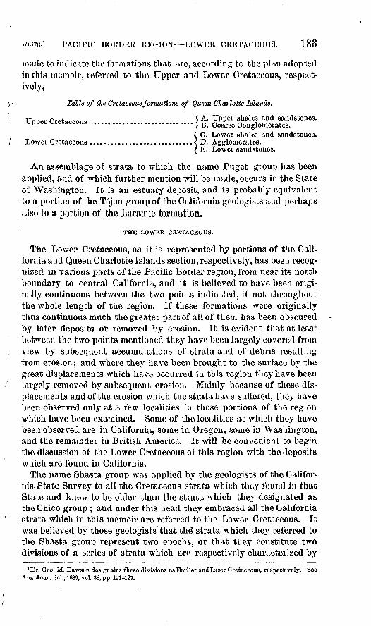
WHITE.] PACIFIC BORDER REGION LOWER CRETACEOUS. 183
made to indicate the formations that are, according to the plan adopted in this memoir, referred to the Upper and Lower Cretaceous, respect ively,
Table of the Cretaceous formations of Queen Charlotte Islands.
i TT««^ rw+ « $ A. Upper shales and sandstones. Upper Cretaceous ............................. j B Coarse Conglomerates.
( C. Lower shales and sandstones. 'Lower Cretaceous ....................... ......< D. Agglomerates.
( E. Lower sandstones.
An assemblage of strata to which the name Puget group has been applied, and of which further mention will be made, occurs in the State of Washington. It is an estuary deposit, and is probably equivalent to a portion of the Tejon group of the California geologists and perhaps also to a portion of the Laraurie formation,
THE LOWER CRETACEOUS.
The Lower Cretaceous, as it is represented by portions of the Cali fornia and Queen Charlotte Islands section, respectively, has been recog nized in various parts of the Pacific Border region, from near its north boundary to central California, and it is believed to have been origi nally continuous between the two points indicated, if not throughout the whole length of the region. If these formations were originally thus continuous much the greater part of all of them has been obscured by later deposits or removed by erosion. It is evident that at least between the two points mentioned they have been largely covered from view by subsequent accumulations of strata and of debris resulting from erosion; and where they have been brought to the surface by the great displacements which have occurred in this region they have been largely removed by subsequent erosion. Mainly because of these dis placements and of the erosion which the strata have suffered, they have been observed only at a few localities in those portions of the region which have been examined. Some of the localities at which they have been observed are in California, some in Oregon, some in Washington, and the remainder in British America. It will be convenient to begin the discussion of the Lower Cretaceous of this region with the deposits which are found in California.
The name Shasta group was applied by the geologists of the Califor nia State Survey to all the Cretaceous strata which they found in that State and knew to be older than the strata which they designated as the Chico group; and under this head they embraced all the California strata which in this memoir are referred to the Lower Cretaceous. It was believed by those geologists that the* strata which they referred to the Shasta group represent two epochs, or that they constitute two divisions of a series of strata which are respectively characterized by
'Dr. Geo. M. Dawson designates these divisions as Earlier andLater Cretaceous, respectively. See Am. Jour. Sci., 1889, vol. 38, pp. 121-127.
184 THE CKETACEOUS. [BULL. 82.
a more or less distinct inolluscan fauna; and they recognized them both together as probably representing the European Cretaceous from the Neocomian to the Gault. 1 In the course of my own field studies of these rocks I have found it convenient to recognize those two divisions, and I designated them respectively as the Horsetown beds and the Knox- ville beds, from the names of the localities at which typical exposures of each division occur.2
These divisions, of which the Knoxville is understood to be the older, are each characterized by a molluscau fauna, of which few or no species are yet known to be common to both within the limits of California, but there is probably no time-hiatus between them. The Knoxville division is characterized by the prevalence of shells of Aucella, which are often abundant, and it is believed that none of those fossil forms occur in the Pacific Border region in strata that are older than the Knoxville division, although northward from California they are now known to. range above it into the equivalent of the Horsetown division. That is, although specimens of Aucella have seldom if ever been found in the Horsetown division within the State of California, they have been found in the equivalents of that division in Oregon, Washington and British Columbia. Cephalopods are the leading fossil forms in th@ Horsetown beds of northern California, the greater part of those which are published in the paleontological reports of that State as coming from the Shasta formation having been in found in those beds.
The foregoing remarks, of course, imply that the Aucella -bearing strata of the Pacific Border region characterize a great paleontological horizon of the Lower Cretaceous. They also imply that this horizon includes not only strata which all geologists agree in referring to the Cretaceous, but certain others that some geologists have regarded as of Jurassic age. Not only is the lower division of the Shasta forma tion especially characterized by Aucella, but while, northward from California, that fossil form ranges higher in the series it is still the northern equivalent of the lower division that is especially character ized by it; that is, strata in which Aucella, is found to prevail abun dantly are regarded as belonging at or near the base of the Pacific Border Lower Cretaceous; but it is believed that these lowest strata of that region do not represent the beginning of Cretaceous time.
The Cretaceous strata just mentioned as having by some geologists been referred to the Jurassic are found in Mariposa County, California,3 and constitute a portion of the so-called auriferous slates. These strata, although greatly altered and much disturbed by orogenic move ments, have been found to bear fossils the Mesozoic age of which has not been questioned, opinion*having differed only as to whether they indicate the earlier or later Mesozoic age of the strata containing them.
1 Paleontology of California, vol. 2, p. xiv.2 Bull. U. S. Geol. Surv., No. 15, vol. 3, p. 19.3 See Gabb, Win. JL, Proc. Cal. Acad. Nat. Sci., vol. 3, pp. 172,173. Also Meek, F. B., Geol. Surv. Cal.
Geology, vol. 1, pp. 477-482, and plates.

WHITE.] PACIFIC BORDER REGION LOWER CRETACEOUS. 185
.Recognizing the specific identity of the Aucella, which these strata bear with those which prevail in the Kuoxville division of the Shasta forma tion, I have referred these slates to that horizon, and therefore regard them as of Lower Cretaceous age. 1 This view is supported by the probable identity of other fossil forms in the auriferous slates with some found in the Shasta formation.
Other strata, which occur in the Coast Eange and in other parts of California, and which are much altered or metamorphosed, have been by Dr. Becker referred to the Lower Cretaceous, although other geolo gists have regarded them as of much greater age.2
The specimens of Auoella which have been obtained from the Creta ceous strata of different parts of California have received various spe cific names from different authors, some of which specimens were re ferred to other genera j but I regard all these, and also all the forms of Aucella which are found in the Kuoxville division, and, in short, all the forms referable to that genus which have yet been found in North America, as belonging to one and the same species, albeit a very varia ble one.3
Aucella-be&iiug strata have been discovered at numerous places in northern California, all of which are referred to the Knoxville division of the Shasta formation. They also have been found in the vicinity of Monte Diablo, in the central part of the State. Those which occur at the most southerly known locality, as already shown, were formerly re ferred to the Jurassic, but they are now referred to the Shasta forma tion of the Lower Cretaceous. The latter locality, which is near the parallel of 37° 30' north latitude, is the most southerly point to which Aucella is certainly known to reach in the northern hemisphere,4 and it is the most southerly known locality of fossil-bearing Lower Cretaceous strata in the Pacific Border region.
All the Lower Cretaceous strata of California have been so much dis turbed, eroded, and covered from view by later formations, that their study has been a matter of much difficulty. Mr. J. S. Diller, of the U. S. Geological Survey, who has done much field work upon these California formations, has lately published a statement concerning some sections
1 See White, C. A., Bull. U. S. Geol. Surv., No. 15, vol. 3, pp. 24,25; and Monog. TJ. S. Geol. Surv., vol. 13, pp. 226-232. See also Becker, Geo, P., in last named volume, and iu Bull. TJ. S. Geol. Surv., No. 19, vol. 5.
2 See Bull. IT. S. Geol. Surv., No. 19; Monog. U. S. Geol. Surv., vol. 3; and Bull. Geol. Soc. Amer., vol. 2, pp. 201-206.
3 See Bull. TJ. S. Geol. Surv., No. 15, vol. 3, p. 23, and Monog. U. S. Geol. Surv., vol. 13, pp. 226-232, pis. 3 and 4.
4 After the foregoing paragraphs were written Prof. S. Nikitin published in the Neues Jahrbnch Jahrgang, 1890, II. Band, drittes Heft, pp. 273,274 the discovery of some fossil shells near San Luis, Potosi, Mexico, which he believes to be identical with forms which I have referred to Aucella concen, trica. Should his determination prove to bo correct it will also prove to be a very important fact in North American geology. It ia probable that an investigation of the strata from which Prof. Nikitin's fossils were obtained, together with that of associated formations, will reveal the true relation of the Shasta formation and its equivalents to Comanche series. It will also add an important fact to our pres ent knowledge of the geographical distribution of Aucella, since this Mexican locality lies upon the twenty-second parallel of north latitude.
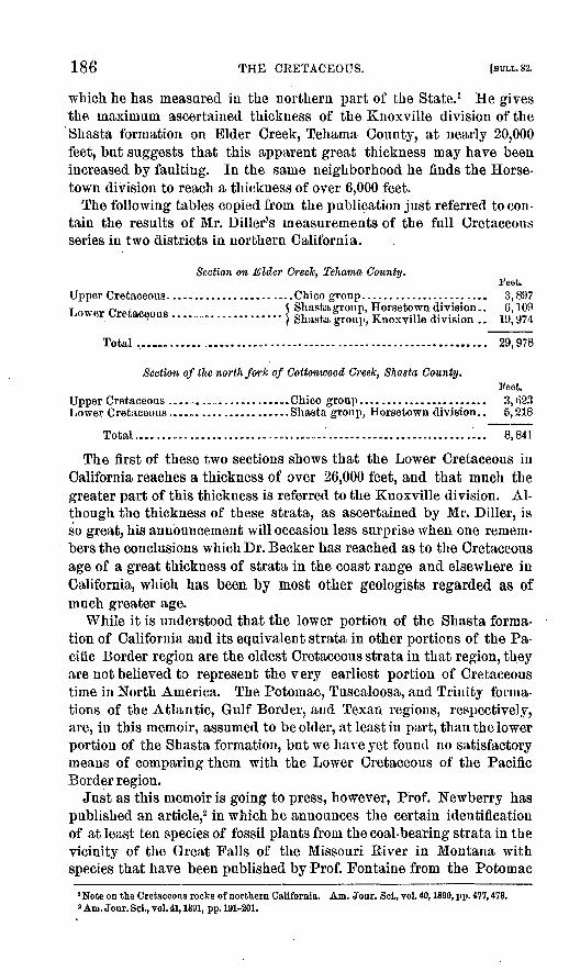
186 THE CRETACEOUS. [BULL.82.
which he has measured in the northern part of the State. 1 He gives the maximum, ascertained thickness of the Knoxville division of the 'Shasta formation on Elder Creek, Tehama County, at nearly 20,000 feet, but suggests that this apparent great thickness may have been increased by faulting. In the same neighborhood he finds the Horse- town division to reach a thickness of over 6,000 feet.
The following tables copied from the publication just referred to con tain the results of Mr. Diller's measurements of the full Cretaceous series in two districts in northern California.
Section on Elder Creole, Tehama County.Feet.
Upper Cretaceous- .................. ....Chico group...... ................. 3,897Lower rrpfapflmiH 5 Shasta group, Horsetown division.. 6, 109 L.O * er Lretaceous .................... j Knoxville divi8ion . . 19, 974
Total ............ ..... ...... ....................................... 29,978
Section of the north fork of Cottonwood Creek, Shasta County.Feet.
Upper Cretaceous ...... .......... ...... Chico group.... ........ . ....... 3,6.23Lower Cretaceous. .. . .......... ......Shasta group, Horsetown division.. 5,218
Total...................................'..............,.............. 8,841
The first of these two sections shows that the Lower Cretaceous in California reaches a thickness of over 26,000 feet, and that much the greater part of this thickness is referred to the Knoxville division. Al though the thickness of these strata, as ascertained by Mr. Diller, is so great, his announcement will occasion less surprise when one remem bers the conclusions which Dr. Becker has reached as to the Cretaceous age of a great thickness of strata in the coast range and elsewhere in California, which has been by most other geologists regarded as of much greater age.
While it is understood that the lower portion of the Shasta forma tion of California and its equivalent strata in other portions of the Pa cific Border region are the oldest Cretaceous strata in that region, they are not believed to represent the very earliest portion of Cretaceous time in North America. The Potoinac, Tuscaloosa, and Trinity forma tions of the Atlantic, Gulf Border, and Texan regions, respectively, are, in this memoir, assumed to be older, at least in part, than the lower portion of the Shasta formation, but we have yet found no satisfactory means of comparing them with the Lower Cretaceous of the Pacific Border region.
Just as this memoir is going to press, however, Prof. Newberry has published an article,2 in which he announces the certain identification of at least ten species of fossil plants from the coal-bearing strata in the vicinity of the Great Falls of the Missouri River in Montana with species that have been published by Prof. Fontaine from the Potomac
1 Note on the Cretaceous rocks of northern California. Am. Jonr. Sci., vol. 40, 1890, pp. 477, 478.2 Am. Jour. Sci., vol. 41, 1891, pp. 191-201.

WHITE.] PACIFIC BORDER REGION LOWER CRETACEOUS. 187
formation. By means of specific identity of fossil plants Prof. New- berry had previously identified the Montana strata referred to with the Kootanie strata of the district of Alberta, as has already been men tioned.
If the specific identification of these fossil plants is held to prove the contemporaneity, as that term is usually employed by geologists, of the respective formations containing them, this discovery is a very remark able one. It is shown in this memoir that in western Alberta Kootanie strata have been found resting upon others which bear marine Creta ceous fossils specifically identical with members of the fauna which characterizes the Shasta and Queen Charlotte formations, which geolo gists generally do not regard as representing the earliest epoch of Cre taceous time. If we admit the contemporaneity of the Kootanie strata of Alberta and of Montana with the Potomac formation, we must admit that the Potomac is of later age than at least a portion of the Shasta and Queen Charlotte formations, notwithstanding the fact that the Potomac formation has been referred to the Jurassic. This matter will be further referred to on a following page, in connection with the discussion of the Potomac horizon.
The oldest of the rocks that have been found immediately to underlie the Lower Cretaceous strata of the Pacific Border region are presuma bly of Archean age. Others are of Paleozoic, and still others are of Triassic age. That is, none of the immediately underlying strata have yet been satisfactorily shown to be of Jurassic age. Indeed, entirely satisfactory proof of the existence of any strata of the latter age in the Pacific Border region has not yet been published.
Although Mr. Diller has found apparent conformity between the Shasta and Chico formations in California l the great difference between their respective fossil faunas indicates that there is a time-hiatus be tween them. The time relation of the Wallala formation to the Shasta and Chico formations, as indicated on page 193, has not yet been demon strated, but its place is understood to be between the two last-named groups. As the comparatively little known Wallala formation is re garded as Upper Cretaceous, it follows that no strata in California of a later age than the Shasta formation are referred to the Lower Creta ceous.
As already indicated, Lower Cretaceous strata have been found at a number of localities in southern Oregon, and some are also known to exist in the State of Washington; but, beyond the commingling there of species which in California characterize the Knoxville and Horsetown beds, respectively, these discoveries have afforded no general facts that have not been mentioned in connection with the California section.
The Lower Cretaceous strata of British Columbia will next be con sidered. The most complete section of those rocks that has yet been investigated in this part of the Pacific Border region is found on Queen
»Bull. TJ. S. Geol. Surv. No. 33, pp. 1-23.

188 THE CRETACEOUS. [BULL.82.
Charlotte Islands, arid a table representing the full Cretaceous series there as studied by Dr. G. M. Dawson has been given on page 183.
This series of formations is found exposed within a comparatively small district embracing a portion of each of the two islands, but they constitute one of the most important Cretaceous sections that are yet known in the Pacific Border region.1 Dr. Dawson found the lowest member to rest unconformably upon Triassic rocks, and the uppermost member to be unconformably overlain by Tertiary deposits. His di visions A and B, which cousitute the upper portion of the section, are referred to the Upper Cretaceous and will be discussed in following paragraphs, while divisions C, D, and E constitute the lower portion and are referred to the Lower Cretaceous.
Dr. Dawson found division 0 to be very fossiliferous, and Mr. Whit- eaves identified a large proportion of its species with those which char acterize the Shasta formation in California. According to Dr. Dawson, division D is of volcanic origin, and yet divisions C and E are closely related to each other by the specific identity of some of their fossils. Indeed, it seems evident that these three members represent in time not only the Shasta formation, but all other Lower Cretaceous strata that are yet known to occur in the Pacific Border region.
Because of this identity of species, notwithstanding the intercalation of the volcanic formation before mentioned, these three members of the Queen Charlotte section will, for our present purpose, be regarded as representing an unbroken epoch of Lower Cretaceous time, and for the sake of brevity they will be referred to as the Queen Charlotte forma tion. The paleontological recognition of these strata, as representing the Shasta formation of California, is of great importance in the corre lation of the different and widely separated exposures of Lower Cre taceous rocks in the Pacific Border region. The extent to which spe cific identification of the fossils of the two series has been made is shown by Mr. Whiteaves.2
Lower Cretaceous rocks have been found by members of the Cana dian Geological Survey at the following localities in British Columbia, which in each case were recognized as equivalent to at least a portion of the Queen Charlotte formation by means of the specific identity of fossils: the northern part of Yancouver Island,Tatlyoco Lake, Jackass Mountain, Skagit Eiver, and Upper Skena River.3
The full series of strata as represented by the Shasta and Queen Charlotte sections appears not to have been found exposed at any of these localities, but one gets the impression from, the reports of the Canadian geologists that their original thickness in that part of the
'See Dawson, G. M., Geol. Surv.Canada., Hep.Prog.for 1878, pp. 1-101. Also, Richardson, James, Ibid., for 1882-'83, pp. 42-65.
2 Greol. Surv. Canada, Mesozoic Fossils, vol.1, parts.3 See Canadian Keports for 1875-76,1876-77,1877-78, 1878-79, 1879-'80. Also, Dawson,G-. M., Am.
Jour. Sci., 1889, vol. 38, pp. 120-127.

WHITE.] PACIFIC BORDER REGION LOWER CRETACEOUS. 189
Pacific Border region was hardly inferior to that which has been re ported by Mr. Diller for northern California.
The Canadian geologists report exposures of presumably Cretaceous rocks on Stikine River, in British Columbia, nearly east from Sitka, 1 and W. P. Blake has suggested that the coal-bearing strata of Sitka Island are of Cretaceous age, but whether they belong to the Upper or Lower Cretaceous, or to both, is not yet known.2
An important discovery, already two or three times referred to, has been made in western Alberta, near Devil's Lake,3 which, although the locality is within the North Interior region, it has been left for special mention in connection with the Lower Cretaceous of the Pacific Border region. At the locality mentioned strata bearing characteristic Koo- tanie species of plants were found resting upon others which contain equally characteristic marine invertebrates of the Queen Charlotte for mation. Furthermore, those Kootanie strata rest so conformably upon the others that they all have the aspect of constituting one formation, and the impression seems to prevail among the Canadian geologists that the Kootanie and Queen Charlotte groups were, at least in part, contemporaneous. However this may be, it is now clear that at least a part of the Kootauie is of later age than at least a part of those strata upon Queen Charlotte Islands, which are regarded as equivalent to the Shasta formation of California.
There are several points of great interest connected with this discov ery, among which are the fallowing: The locality at which it was made, being upon the eastern slope of the Rocky Mountains, lies east of the nominal boundary of the Pacific Border region. It is also the most easterly point at which fossils of the Queen Charlotte and Shasta forma tions have been found, if we except the circumpolar distribution of the Aucella, which occurs so abundantly in those strata and their equiva lents, and the lately reported occurrence of the same near San Luis Potosi, mentioned on page 185.
The fact that these Lower Cretaceous strata, in western Alberta, un derlie a portion, if not all, of the Kootanie formation is of especial importance: first, because the character of the Kootanie flora has here tofore caused that group to be regarded as of the lowest Cretaceous, if not of the Jurassic, age, and, second, the Upper and Lower Cretaceous strata, on Queen Charlotte Islands, are reported to have the aspect of one unbroken series of deposits. If the upper strata of the full section on those islands really are of Upper Cretaceous age it seems necessary to assume that notwithstanding their conformity with the lower portion of the series there is a material time-hiatus between them "similar to,
1 See Dawson, G. M., An. Eep. Geol. Surv. Canada for 1887-'88, pp. 5C and 57 B; also, map accompany ing this report.
2 Seo bibliographical entry onj>. 27.s See Dawson, G. M., Am. Jour. Sci., vol.38, p. 122; McConnell, R. G., Geol. Survey Canada, Eep.
Prog, for 1886, p. 17 D, and Whiteaves, J. F., Cont. Canadian Paleont., vol. 1, part 2, pp. 163-172,
190 THE CRETACEOUS. [BULL. 82. '
but not so great as, that which is assumed to exist between the Shasta and Ohico groups of California. Neither on Queen Charlotte Islands nor in any other part of British Columbia, or in California, has any trace of a formation yet been found which may be understood to represent the Kootanie formation, unless it be represented by a portion of the , Queen Charlotte and Shasta formations, respectively, and of this we yet \ have no definite evidence.
The discovery of the taxonomic relation of the Kootanie to the Queen \ Charlotte formation gives almost the only direct clew yet obtained as to the correlation of the Cretaceous series of the Pacific Border region with that of the Great Interior area; but the opinion of an experienced geologist upon the subject of their general correlation is worthy of con sideration. Therefore the following table by Dr. G. M. Dawsoii1 is reproduced here for the purpose of illustrating his view of the relation of the Lower Cretaceous formations of the Pacific Border region to those of the adjacent North Interior region, and to the Upper Cretaceous of several districts in those regions.
1 Am. Jour. Sci., vol. 38,1889, p. 127.

Table illustrating the relations of the earlier Cretaceous formations of British Columbia and of adjacent parts of the Northwest Territory. (After Daivson.)
Queen Charlotte Islands.
A. Upper shales and
B. Coarse conglom erates............. 2,000'
C. Lower shales and sandstones (with coal) .............. 5,000'
D. Agglomerates ... 3,500'
E. Lower sandstones 1,000'(Local base of Cretaceous.)
Comox, Vancouver Island.
Upper conglomerates 320'
Mid. conglomerates 1, 100' Middle shales ........ 76' Lower conglomerates 900'
Productive coal meas. 739'(Local base of Cretaceous.)
Mainland of British Columbia.
Tatlayoco beds (7,000'), Nechacco beds (6,0000 Skeenabeds, Skagitbeds (4,400' or more), Jackass Mt. beds (5,000'). All sandstones and qnartz- ites, with shales, and generally coarse con glomerates above. "Por- phyrite" series of Utas- youco 10,000' (probably passing up into above) of Tatlayoca, and pos sibly of Nechacco and Skeena.
(Local base of Cretaceous.)
Yukon District. (North of 60th parallel.)
(Intermediate formations pr o b a b 1 y represented but not recognized.
Conglomerates of Rink Rapids, etc.
Fossiliferous shales and sandstones, on Kink Rapid, L. Labarge, etc.
(Local base of Cretaceous.)
Eocky Mountains proper. (Between 49° and 51° 30'.) '
Pierre (including Fox Hill).
Benton (possibly with part of Niobrara, 1,400').
Dakota, apparently repre sented in part by coarse conglomerates, and in cluding on Crow Nest Pass, 2,200', of volcanic ejectamenta.
Kootanie formation, 7,000' or more. Sandstones, shales, etc., with coal.
(Local base of Cretaceous.)
Southern Alberta.
Pierre (incl. Fox Hill) . 830'
Lower dark shales .... 800'
Dakota (probably).(Local base of Cretaceous.)

192 THE CRETACEOUS. [BULL. 82.
In closing the remarks upon the Lower Cretaceous of the Pacific Bor der region it is well to refer to the fact that not only have plant remains been found in the Shasta formation, bat the Queen Charlotte is an im portant coal-bearing formation. This shows that considerable land areas existed in those districts, although the strata referred to are ot marine origin, as is shown by their fossils.
THE UPPER CRETACEOUS.
The Upper Cretaceous of the Pacific Border region, so far as our pres ent knowledge goes, is mainly represented by the Chico-Tejon series of California and the coal-bearing Cretaceous strata of Vancouver and adjacent islands, and by their recognized equivalents elsewhere; but the strata which have received the names of Wallala group and Puget group respectively will also be considered under this head. The names of the divisions of the Upper Cretaceous which have been recognized in California have been given on page 182, and it will be convenient to consider them separately in that order, beginning with the yet imper fectly known Wallala formation.
For many years after the geological formations of California began to be studied the only strata that were recognized as of Cretaceous age were those of the Shasta formation and the Chico-Tejon series. In 1884, however, Dr. Gr. F. Becker discovered exposures of strata near the town of Wallala, in Mendocino County, California, from which he obtained molluscan fossils that are different from any known to occur in either of the two series of strata just mentioned. No stratified rocks were found overlying these Wallala strata, or none that could be re garded as of Cretaceous age. The underlying rocks also were not ob served where the Wallala strata were found exposed, but presumably they rest upon the metainorphic rocks which are known to prevail in that district. 1
Nearly coincident with Dr. Becker's discovery Mr. C. E. Orcutt sent to the Smithsonian Institution a collection of fossil mollusca from the shores of Todos Santos Bay, in Lower California, a part of the species of which are identical with those found in the Wallala strata.2 In general character a part of the fossils from these two localities so much resemble certain of the forms which characterize the European Gosau- gebilde that one naturally infers that the strata containing them are referable to the Upper Cretaceous, especially as none of the species have been recognized in the Shasta formation. None of them having been recognized in the Chico formation or in any other North American Upper Cretaceous strata, I suggested for those in which the fossils referred to were found a place between the Shasta and Chico forma tions and proposed for them the name of Wallala group. This sugges-
1 See White, C. A., Bull. TJ. S. Geol. Surv., No. 15, vol. 3; and JBecker, G. F., ibid., No. 19, vol. 3. 2 P ull. "U. S. Geol, Survey, No. 22, vol. 3,

PACIFIC BORDER REGION UPPER CRETACEOUS. 193
tiou seemed also to be warranted by the generally accepted opinion that there is a considerable time-hiatus between the Shasta and Ohico formations.
The localities at which these strata have been recognized by means of their peculiar fossils are only two, and these are fully 500 miles apart. If these strata are to be regarded as representing a separate, formation, it is reasonable to infer that originally they were continuous between those localities, and that they constituted a distinct Upper Cretaceous horizon which probably extends far down into Mexico. Since, however, these strata have yet furnished only a few species of fossils, and have been discovered only at the two localities mentioned, our present knowledge of them is confined to a few almost isolated facts. Much more, therefore, remains to be learned concerning the Wallala strata before they can take a permanent place in the list of Cretaceousformations of the Pacific Border region.
When the geologists of the California State survey began their work they were disposed to recognize the strata which I have called the Chico Tejon series as constituting three separate formations, namely, the Chico, Martinez, and Tejon; but they afterward suggested the pro priety of abandoning their name, Martinez group, because they recog nized those strata.which occur between the Chico and T6jou divisions as transitional in character. 1 They also recognized the fact that the two last-named divisions are intimately connected with each other by spe cific identity of a large proportion of the fossils found in each.
While most, but not all, of the geologists who have written concern ing this series of strata have admitted the Cretaceous age of the lower or Chico portion, some have contended earnestly that the upper or Tejon portion is of Eocene age.2 The geologists of the California State survey referred the whole series to the Cretaceous, evidently assuming that being an unbroken series, and containing unmistakable Cretaceous fossils in certain parts of it, the whole must be Cretaceous.
In former publications 3 I have shown that the Chico-Tejon strata form an unbroken series, the lower portion bearing characteristic Cre taceous forms, and the upper portion bearing equally characteristic Eocene forms. In short, I regard the deposition of this series as having been begun in Cretaceous time and continued without interruption to its termination in Eocene time. While the upper or Tejon division of this series is regarded as probably referable to the early Tertiary, it is, like the Laramie formation, discussed in this memoir among the Cre taceous formations because it is impracticable or inexpedient to sepa rate it by definable limits from the lower or Chico division of the series, either upon stratigraphical or paleontological grounds. Because of this indivisible character of the series I have adopted the compound
1 Paleontology of California, vol. 2, pp. xii, xni.3 See for example, Conrad, T. A., Am. Jour. Sci., 1867, vol. 44, pp. 376,377.3 Bull. TJ. S. Geol. Survey, No. 15, voj. 3, and No, 51, vol. 8.
Bull. 82 13 '

194 THE CRETACEOUS. tsuLL.82.
term, Chico-Tejon, to designate the whole of it as it is known in Cali fornia.
The most southerly known limit of this series of strata is in Santa Barbara County, southern California, where, however, only the upper or Tejon division seems to have been recognized. In Fresno County both divisions are well developed and they are to some degree sepa rately recognizable in other parts of central California, but northward from those districts the strata which represent the upper division appear to diminish, or at least they do not appear to reach as far northward as do the equivalent strata of the lower division, as will be shown when the Vancouver Island strata are discussed.
With the exception of a locality in eastern Oregon which lies approx imately upon the intersection of the one hundred and twentieth meri dian and the fortieth parallel of north latitude, where strata equiva lent to those of the Chico division have been found,1 all the known strata referable to, or representing any part of, this series lie west of the Sierra Nevada and Cascade ranges.
The known exposures of equivalents of the Chico-Tejon strata in Oregon and Washington are few, and the limits of the areas occupied by them have not been fully determined.2 While sorne of them are plainly referable to the lower division of the series, others represent a part of the upper, or Tejon division, among which are probably some that have by some authors been referred to the Eocene and Miocene Tertiary3 respectively.
Aside from the Chico-Tejon series in California, which in some places is coal-bearing, the coal-bearing series of the southern part of Van couver Island and the adjacent smaller islands of the Gulf of Georgia constitutes the best representation of th e Upper Cretaceous that is known to occur in the Pacific Border region. In the Vancouver dis trict, however, the strata are apparently all referable to the Chico division, no representative strata of the Tejon division having yet been recognized there; that is, no fossils have been found in the Vancouver strata or in any strata northward from the Vancouver district which are understood to be restricted to the Tejon division in California.
The section of these Vancouver rocks has been made known mainly through the publications of Mr. James Eichardson and Dr. G. M. Daw- son, references to whose works have been made on preceding pages; but a number of other authors have written upon their paleontology. In one of my own publications concerning the fossils of this series of strata I proposed the name Vancouver group 4 for those which are known to bear many of themolluscan species that characterize the Chico strata in- California, intending that the name should be only of restricted geo graphical application. I then overlooked the fact that Dr. G. M. Daw-
1 See Bull. TJ. S. Geol. Surv., No. 15, p. 8, and Bull. TJ. S. Geol. Surv. Terr., vol. 2, p. 359.2 For references to these localities see Bull. TJ. S. Geol. Surv. t N.o.,51, vol. 8, pp. 28.-S2..3 Bull. TJ. S. Geol. Surv., No. 51, vol. 8, pp. 30-32. A Bull, TJ, S. Geol. Sury,, No. 51, p. 33.

WHITE.I PACIFIC BOEDER REGION UPPER CRETACEOUS. 195
son had in 1886 applied the same name to another assemblage of strata which he regarded as of Triassic age and had suggested the name Na- naimo group for the Upper Cretaceous strata in question.1
Subsequently Dr. Dawson confirmed his selection of the name Na- naimo group for those Cretaceous strata, and briefly discussed their relations and characteristics.2 I have therefore abandoned the name Vancouver group for the Upper Cretaceous strata of the Vancouver district, and adopted the name Nanaiino in its stead.
The occurrence of certain Lower Cretaceous strata near the northern end of Vancouver Island has been referred to, but no Upper Creta ceous strata appear to have been found in connection with them, and no Lower Cretaceous strata have been found in the Vancouver district in connection with the Nanaimo formation. The latter formation, as already stated, is understood to embrace no strata that are not refera ble to the epoch of the Chico group of the California geologists exclu sive of the Tejou; and, as defined by Dr. Dawson, it seems to embrace all the strata of Vancouver district which are referable to, or that need be discussed in connection with, the Upper Cretaceous.
The invertebrate fossils of the Nanaimo formation have been pub lished by Mr. Whiteaves,3 Mr. Meek,4 Mr. Gabb,5 and by myself,6 and the plants have been published mainly by Dr. J. S. Newberry, Sir William Dawson, Dana, Lesquereux, and Heer.7
Because of the paucity of exposures of Upper Cretaceous strata north of the Vancouver district, the next and only other section that will be considered on this occasion is that of Dr. G. M. Dawson on Queen Charlotte Islands, which has already been referred to as embracing both Upper and Lower Cretaceous strata, the former division reaching a thickness there of 3,500 feet.
It appears that very few fossils have been obtained from these upper strata, but Mr. Whiteaves regards those which have been found as establishing their equivalency to certain of those which I have desig nated as of Upper Cretaceous age.8 They perhaps represent in part the Nanairno formation of Vancouver Island, but I am at present dis posed to regard them as referable to a somewhat earlier Upper Creta ceous horizon. These strata are not reported to contain any coal al though the Nanaimo formation contains very important beds, and coal is known to exist in both the upper and lower divisions of the Chico- Tejon series in California.
Aside from the important formations that have already been discussed little or nothing appears to be known of strata in all the Pacific Border
1 See Geol. Surv. Canada, Ann. Rep., 1886, p. 10B.* Am. Jour. Sci.. vol. 39,1P90, pp. 180-183.3 Geol. Surv. Canada, Mesozoic Fossils, vol. 1, part II.*Bull. U. S. Geol. Surv. Terr., vol. 2, pp. 351-374, and 6 plates, and Trana. Albany Inst., vol. 4, pp. 37-49.6 Paleontology of California, vols. 1 and 2.6 Bull. TJ. S. Geol. Surv., No. 51, vol. 8, pp. 33-48, plates 6 and 7.7 For Newberry's publication, see Jour. Boston Soc. Nat. Hist., vol. 7, pp. 506-525.8 Geol. Surv. Canada, Mesozoic Fossils, vol. 1, part 3, pp. 193,194.

196 THE CEETACEOUS. [BULL.82.
region, which may confidently be referred to the Upper Cretaceous, and we are especially in want of knowledge concerning strata to represent Cretaceous time between the close of the Shasta and the beginning of the Chico epoch. This lack of knowledge is perhaps largely due to the great displacements and to the immense erosion which all the forma tions of that region have suffered, but it is doubtless in part due to the fact that the region has yet been only partially examined.
All the Cretaceous formations of the Pacific Border region which have been discussed on the preceding pages are shown by their fossils to have been of marine origin, except that some fresh water molluscan forms have been found in layers connected with the coal beds of the Nanaiino formation. One important formation of non-marine origin, however, occurs in this region which it is desirable to notice in this connection although its Cretaceous age may well be questioned. This formation, to which I have applied the name of Puget group,1 is found occupying a considerable district which embraces a part of the eastern side of Puget Sound basin and extends upon the flanks and among the mountains of the range which borders the basin on the east. Comparatively little is yet known as to the relation of this formation to those which under lie it, but it has been observed in one or two localities to overlie strata which are evidently equivalent to a portion of the Nanaimo formation.
The only fossils that have yet been obtained from these strata are a few inolluscan forms and remains of a considerable number of plants. The flora to which the latter belong is regarded by Dr. Newberry as probably identical with that of the Laramie formation, a part at least of the species being identical. None of the molluscan species have been found in any other formation, and their character indicates their estuarine origin, besides which no associated trace either of true marine or of purely fresh-water forms has been observed. According to the original estimates of Mr. Bailey Willis 2 the Puget formation reaches a maximum thickness of 12,000 feet, but his later observations have led him to reduce this estimate.3 Still there can be no reasonable doubt that this formation is a remarkably thick one for a deposit of that kind.
The Puget formation has been definitely recognized only in the dis tricts already indicated, and its geographical limits are not yet known, but Dr. Dawson has observed a formation in the district around the mouth of the Frazer Eiver, in British Columbia,4 which reaches a thick ness of several thousand feet. It seems to possess the general charac teristics of the Puget formation and to occupy a similar taxonomic position, but no fossils have yet been found in its strata by which the two series of strata may be identified with each other. Still, it is thought probable that the British Columbian deposit was contempo raneous with the Puget formation and it is possible also that the two were originally continuous. The Puget formation in Puget Sound
1 SeeBull. U. S. Geol. Surv., No. 51, vol. 8. pp. 49-63. 3 See Bull. U". S. Gcol. Surv. No. 51, vol. 8, p. 52. *§ee Kep. Tenth Census TJ. S., voL 15, pp. 759-771, * See 4.TO- Jour. Sci,, 1890, vol. 39, pp. 182,183,

WHITE.] PACIFIC BORDER REGION THE PUGET GROUP. 197
basin bears several coal beds, a part of which are of great commercial importance, but no coal has yet been reported to exist in the similar deposit near the mouth of JFrazer Eiver.
In my publication of the Puget formation, I suggested that it was probably synchronous in its origin with a part of the Tejon group of California, but no direct evidence on this point has yet been obtained. As already mentioned, the Puget formation has furnished very little in trinsic evidence which bears upon the question of its geological age; but, as it is supposed to have been contemporaneous with at least por tions of the Laramie and Tejon formations, respectively, it is in this memoir briefly referred to in connection with the Upper Cretaceous of the Pacific Border region. It is of some importance also as still further indicating the indefiniteness of the upper delimitation of the North American Cretaceous.
In the table which is copied on page 191, Dr. Dawson has given his view not only of the correlation of the Lower Cretaceous formations in the Pacific Border au'd North Interior regions, but of certain of the Upper Cretaceous deposits also. These and other assumed correla tions will be further shown in tables on following pages, but it cau not be denied that the correlation of any of the Cretaceous formations of the Pacific Border region with any of those of all other regions is still a matter of much uncertainty. The discovery of Kootanie strata superimposed upon others which bear characteristic fossils of the Queen Charlotte group, which has been several times mentioned on preceding pages, is of great importance, but it is not yet conclusive as to the full correlation of any of the formations in question.
The Kootanie being a non-marine formation, its true equivalency to other Lower Cretaceous formations may never be known, but one natu rally indulges a hope that marine faunas may yet afford a clew to the correlation of the different Lower Cretaceous formations of the conti nent. As a matter of fact, however, the abundant marine fauna of the Shasta and Queen Charlotte formations of the Pacific Border region contains no form that has yet been satisfactorily identified with any form found in any other North American formation, not even with auy member of the abundant marine fauna of the Comanche series. 1 This is all the more noteworthy because it is now known that the latter fauna extended westward in the North Mexican region to a point within the drainage area of the Gulf of California.
In the case of the Atlantic Border, Gulf Border, Texan, North Mex ican, and the two Interior regions, the correlation of certain of the Upper Cretaceous formations of each with certain of those or all the others has been confidently determined by specific identity of fossils, and in many cases by geographical continuity of strata also. But while one can not doubt that the Upper Cretaceous deposits of the Pacific Border region were contemporaneous with some of those which occur
1 See foot-note relative to certain Oatreid forms, on page 121.

198 THE CRETACEOUS. [BULL.82.
in all the other regions, no geographic continuity of their strata has yet been observed and no satisfactory recognition of their faunal re lationship has been made. It is, however, true that a large number of specific forms in the molluscan fauna of the Chico formation are repre sented by closely similar forms in the Upper Cretaceous of those more eastern regions, especially in the Eipley formation of the Gulf Border and Texan regions.
General remarks concerning the Cretaceous of the seven North Americanregions.
In the course of the foregoing discussion of the Cretaceous formations of the different regions, the coal-bearing character of a large part of them has been several times referred to. The presence of coal among these strata is important from an economic view, and it has much significance with reference to the physical conditions which prevailed during Cre taceous time in North America.
The vegetal substance of which the coal is composed having orig inated upon land or marsh surfaces implies that, although it may be, as it in some cases is, intercalated between marine strata, non-marine con ditions prevailed when and where its material was produced, although marine conditions immediately preceded and followed its production. It is true, however, that much the greater part of the coal and so- called lignite of the Cretaceous formations of Nortk America, which in the aggregate probably exceeds the coal of the Carboniferous Coal Measures of the continent, has been accumulated among the strata of wholly non-marine formations, which implies the existence of broad continental areas.
Thus the coal of the Colorado, Montana, Chico, Nanaimo, and Queen Charlotte formations being both overlain and underlain by marine strata indicates the preponderance of marine over land conditions when and where those formations were accumulated. But the coal of the Kootanie, Dakota, Belly Eiver, Laramie, and Puget formations occur ring among strata of wholly non-marine origin implies that marine waters had retired from the districts or regions where they were de posited and that broad continental conditions prevailed.
These facts, together with the evidence of the existence of various breaks in the order of succession of the formations which has been pointed out, show that during the whole of Cretaceous time continental conditions prevailed over large portions of what is now the North American continent. Therefore, the study of its Cretaceous geology ought to have large reference to continental conditions.
Closing the discussion of the formations of each of the Cretaceous regions of the continent, remarks were made upon the upper and lower delimitations of the full Cretaceous series as found within its borders, but the following summary will give a more comprehensive view of the

winm] GENERAL REMARKS ON NORTH AMERICAN CRETACEOUS. 199
relation of the North American Cretaceous as a whole to the earlier Mesozoic and to the Eocene.
The entire absence of Lower Cretaceous formations from large, geo graphical areas where Upper Cretaceous formations prevail and the comparatively slight development of them in other areas, together with the great paleontological differences between the characteristics respec tively of the Lower Cretaceous formations which are now known, indi cate the existence of large continental areas during Lower Cretaceous time, of which no record has yet been discovered, and necessarily ren der the lower delimitation of the Cretaceous system in North America as a whole a matter of much uncertainty. Besides this the Triassic and Jurassic systems are nowhere well represented, in North America, particularly as regards their paleoiitological characteristics.,
At no known place in North America where Jurassic strata have been recognized do their fossil contents give any clear indication of an im pending change to Cretaceous characteristics, and in no case have Lower Cretaceous strata been found to bear fossil remains which indi cate a gradual transition from the Jurassic, unless the Potomac forma tion and its equivalents shall prove to be an exception. Moreover, with that possible exception, no Lower Cretacous strata have been found resting upon those which may satisfactorily be referred to the Jurassic.1 Admitting the possible exception just mentioned, the Poto- mac formation is, in the tables on following pages, represented as occu pying a transitional position between the Jurassic and Cretaceous j but this question is not regarded as by any means a settled one. In all other cases the facts hitherto- observed indicate on the one hand that the lowermost known Cretaceous strata do not represent the very earliest portion of Cretaceous time, in North America, and on the other that no strata yet discovered represent the close of North American Jurassic time.
It will thus be seen that, with the possible exception referred to, the lower delimitation of the North American Cretaceous is everywhere marked by a hiatus which is an important one even where the shortest interval of time is indicated, and which over a great geographical area is so great as to reach upward to the base of the Dakota formation, which is regarded as the base of the Upper Cretaceous. Moreover, this hiatus is, in many places, extended downward by the absence of older formations, so that Cretaceous strata, even as late as those of the Dakota formation, are found resting upon Paleozoic, and even upon Archean rocks.
The lower delimitation of the North American Cretaceous system is in definite because of the facts just mentioned, and because of the imprac ticability of correlating with one another those formations that in the
'It is possible that the Trinity formation of tlio Texan region, upon which the Comancho series rests there, may yet prove to be of Jurassic age, but it is in this memoir referred provisionally to the Lower Cretaceous.
200 THE CRETACEOUS. [HULL.82.
different regions of the continent constitute the local base of the full series of Cretaceous formations. The upper delimitation of the system is frequently the result of removal of strata that have been deposited, or that of a failure of their deposition, but in certain cases it is indefinable because of the blending of the uppermost strata of the Cretaceous with those the Eocene age of which can not reasonably be doubted.
The plainest and most unmistakable case of blending of Upper Cre taceous with Eocene strata is that of the Chico-Tejon series in Cali fornia, where it is both paleontological and stratigraphical. This series is known to reach an aggregate thickness of not less than 10,000 feet, through which ranges a marine molluscan fauna embracing both Cretaceous and Tertiary types. In the lower portion of the series the Cretaceous types are so numerous that one is not justified in referring it to other than the Cretaceous system j and in the upper portion the fauna, a large proportion of the members of which are also found in the lower portion, is equally characteristic of the Tertiary, the Creta ceous forms having gradually disappeared.
It seems to be unquestionable that the passage from Cretaceous to Tertiary time was accomplished while the marine area in which the Chico-Tejon series of strata was deposited was undisturbed by any movements of the earth's crust which resulted disastrously to its fauna or in any general interruption of its sedimentation.
Another case of the blending of the Cretaceous and Tertiary is understood to have occurred within or iu connection with the Laramie formation, which subject has been discussed on preceding pages. In this case, however, while the stratigraphical evidence is quite as good as it is in the case of the Chico-Tejon series the paleontological evi dence is not so direct. That is, in the case of the Chico-Tejon series, unbroken marine conditions existed, but in the other case there was, near the close of Cretaceous time, a change from marine to non-marine conditions, while there was evidently no general interruption of sedi mentation within the great area where the evidences of that transition from marine to non-marine conditions have been observed.
It is probable also that the Puget formation represents the Laramie, and therefore a transitional epoch between Cretaceous and Tertiary time; but the Puget formation occupies a comparatively small area, while the aggregate area occupied by the Chico-T6jon series 'and by the Lar amie formation are each many thousands of square miles in extent.
These facts are sufficient to show the indefinable character of the upper delimitation of the North American Cretaceous system, at least in two important regions, a condition that must necessarily have ex isted in many other parts of the world, but evidence of which has sel dom been recognized.
One can not review the facts that have been ascertained concerning the North American Cretaceous without being impressed with the evi dence already referred to of the prevalence of continental conditions at different epochs during the whole of Cretaceous time, some of them

WHITE.] EXTRA-REGIONAL DISTRICTS. 201
having been contemporaneous with those in which important marine formations were deposited; and he is still farther impressed with the diet that continental conditions prevailed in North America even more extensively during the earlier Mesozoic.
It is true that, upon at least the western border of the continent, we find the marine Cretaceous merging into the marine Eocene, but within a large part of its great interior portion we find the marine Cretaceous formations immediately succeeded by those which were deposited in either brackish or purely fresh waters, all of which necessarily were more or less completely landlocked. The prevalence of such bodies of water implies the contemporaneous existence of surrounding continental conditions which we have reason to believe never afterward suffered from marine invasion. The subsequent continental changes involved the final draining away of those uon-marine waters, and the elevationof the principal now existing mountain ranges, but the occurrence of those changes was evidently coincident with, or after the close of, Cre taceous time.
EXTRA-REGIONAL DISTRICTS.
Reference has already been made to the existence of Cretaceous deposits in certain portions of North America which are not included within the limits of any one of the seven regions which have been defined and discussed on preceding pages. These deposits have been left to be discussed or referred to under the head of extra-regional dis tricts, because their known exposures are small and it is impracticable to clearly define the respective areas which they occupy, or because little has yet been learned of their character or extent.
From a few desultory publications and from casual items of informa tion which have from time to time reached geological investigators there is reason to believe that large portions of central and southern Mexico and of Central America are occupied by Cretaceous forma tions. The Upper Cretaceous doubtless prevails in that great southern area, and it is probable that the marine Lower Cretaceous has there a more important development than it has elsewhere upon this continent. This is indicated by the increase in thickness of the Comanche series toward the west and southwest from the Texau region, which has been noted, as has also the evidence that the whole series thins out toward the north and east within the Texau region. The little that is yet known of the geology of this great southern portion of the continent makes it probable that when it has been systematically investigated it will be found to constitute one of the most important Cretaceous regions within its limits in North America.
The following publications, besides those which have already been referred to, contain the most that Iras yet been made known concerning the Cretaceous geology of Mexico:CASTILLO, ANTONIO DEL.. Bosquejo de una Carta de la Repiiblica Mexicana, for-
mado por disposicion del Secretario de Foruento.

202 tHft CRETACEOUS. iwiLL.82.
GALEOTTI, H. Notice sur le Calcaire Cretace des environs de Jalapa au Mexique.Bull. Soc. g6ol. de France, vol. 10,1838 a 1839, pp. 32-39.
RAMIREZ, SANTIAGO. Informe que como resultado de su Exploracion en la SierraMojada. Anales del Ministerio de Foraento de la Republica Mexicana, vol. 3, pp.G'27-687.
. Informe sobre el Mineral de Guadalcazar en el Estado de San Luis Potosi, ibid, pp. 339-404
. Mernoria para la Carta Geologica del Distrito de Zumpango. BARCENA, MAKIANO. Noticia cientih'ca de una parte del Estado de Hidalgo. Anales
del Ministerio de Fomento de la Repitblica Mexicana, vol. 1, pp. 331-351. . Materiales para la Formaciou de una Obra de Paleontologia Mexicana.
Anales del Museo Nacional de Mexico, vol. 1, pp. 85-87,195-202, 283-286. URQUIZA, MANUEL. Exploracion del Distrito de Coalcoman, Estado de Michoacan.
Anales del Ministerio de Fomento de Republica Mexicatia, vol. 7, pp. 195-261. WHITE, CHARLES A. Descripcion de un gran fossil Gasteropodo del Estado de
Puebla. La Naturaleza, vol. 6, pp. 219-221. HEILPRIN, ANGELO. The Geology and Paleontology of the Cretaceous Deposits of
Mexico. Proc. Acad. Nat. Sci., Phila., for 1890, pp. 445-469, and 3 plate?. NIKITIN, S. Eiuiges ueber den Jura in Mexico und Ceutralasieu. Neues Jahrbnch
fur Min., Geol. u.Palaeont., Jahrgang, 1890, II Baud, drittes Heft, pp. 273-274.
Just as the manuscript of this memoir is going to press an article by Prof. Angelo Heilprin has appeared, entitled The Geology and Paleon tology of the Cretaceous Deposits of Mexico. 1 He says :
Cretaceous deposits cover, or are scattered over, the greater part of Mexico, from the Atlantic plains to the Pacific, and from the Rio Grande to (or through) the States of Colima, Michoacan, Guerero, and Oaxaca. These deposits are continuous with the Cretaceous area of the interior basin of the United States, and are largely the equiva lents in age of the deposits which are represented in Texas and in the other Gulf States.
The geological map by Prof. Castillo is also received while this memoir is in press. It is an important contribution to the knowledge of the geology of the Mexican Bepublic, and contains much matter hithertounpublished, but it is accompanied by no descriptive text.
Several authors have published reports of the existence of Cretaceous deposits upon certain of the West India Islands, namely, upon Jamaica, St. Thomas, San Domingo, and Trinidad.2 For the present purpose, however, these discoveries are comparatively unimportant, and the re ported characteristics of the deposits afford few if any data by which they may be correlated with any of the North American Cretaceous formations. Indeed, a part of them, especially those of the Island of Trinidad, appear to have less affinity with these than with those of South America.
Naturalists connected with the various expeditions to the far north have brought back collections of fossils, comprising both invertebrate and plant remains, which indicate the existence of Cretaceous deposits
'Proc. Acad. Nat. Sci. Phila., Doc., 1890, pp. 445-469; Plates xi-xiii.2 See Barrett: On some Cretaceous Rocks in the Southeastern portion of Jamaica. Quart. Jour.
Geol. Soc. Loncl. for 1860, pp. 324-320.Duncan, P. M., and G. P. Wall: A notice of the Geology of Jamaica. Quart. Jour. Geol. Soc. Loud,
for 1884, pp. 1-15.Sawkins, J. G.: Report on the Geology of Jamaica, or Part 2 of the West Indian Survey.

WHiTK.1 EXTRA-REGIONAL DISTRICTS. 203
in different portions of Arctic North America. The best known collec tions of plant remains were obtained in western Greenland, and these represent floras that are respectively referable to the Upper and Lower Cretaceous of North America.1 The collections that have been obtained at the two localities, respectively designated as Atane and Patoot, are each regarded as representing a separate stage of the Upper Cretaceous, that of Atane being the older, and probably equivalent to the Dakota formation. The collections made at the Kome locality are referred to the Lower Cretaceous.
The second North Pole expedition obtained a collection of inverte brate fossils on Kuhn Island, off the east coast of Greenland,2 which contained among other forms numerous examples of the Aucella, which is found so plentifully at various places in the Pacific Border region and in northwestern North America north of the sixtieth parallel of north latitude. The strata from which these Greenland fossils were obtained are therefore referred to the Lower Cretaceous and not to the Jurassic.
There is in the central portion of the continent, and not included within any of the regions that have been defined on preceding pages, a large district which has been already referred to as one within which Creta ceous deposits formerly prevailed, but which have been mostly removed by erosion or obscured by glacial action. This district lies east of and adjacent to the eastern boundary of the Great Interior area as denned on page 141, and north of the Texan region. The eastern boundary is not clearly definable, but it may be designated as passing northward through the western border of Illinois and that of Wisconsin to the northeast corner of Minnesota, and thence northwestward through Mani toba. That is, it is assumed that the sea in which the Cretaceous de posits of the Great Interior area were formed originally extended east ward nearly or quite as far as the boundary just indicated.
Small outliers or local exposures of Cretaceous strata have been found at numerous localities in Minnesota, and a less number in Iowa, the principal of which are shown upon the map accompanying this memoir. In the former State these discoveries range from its southern to near its northern boundary, but in the latter they are confined mainly to the western and northern portions.3
1 Oswald Heer, Flora Fossils Arctica.2 Toula, F.: Die zweite deutsche Nordpolarfahrt, vol. 2, pp. 497-507.s For the various published accounts of these exposures and of the discovery of Cretaceous fossils in
the drift, consult the following -works:Hall, James, U. S. and Mexican Boundary Survey, vol. 1, pp. 101-140, 4 maps. Hall, James, Trans. Am. Philos. Soc., vol. 13 (n. s.), pp. 329-339. White, C. A., Rep. Geol. Surv. Iowa, vols. 1 and 2. White, C. A., Proc. Am. As'n Adv. Sci., vol. 21, pp. 187-192. Wmchell, N. H., Geol. and Nat. Hist. Surv. Miiin., Rep. for 1873, pp. 127-212. Winchell, N. H., Minn. Acad. Sci. Bull., vol. 1, pp. 347-350."Winchell, N. H.,and Warren Upham, Geol. and Nat. Hist. Surv. Minn., Final Report, vol. 2. Kloos. J. H., Am. Jour. Sci., 1872, vol. 3, pp. 17-26. Worthen, A. H., Rep. Geol. Surv. Dlinois, vol. 8, pp. 3-7.

204 l£HE CRETACEOUS.
Besides these discoveries in Iowa and Minnesota, Cretaceous fossils and material believed to have been derived from Cretaceous deposits have been found in the drift of western Illinois [ and the drift of certain portions of western Wisconsin is believed by some geologists to contain similar material. The character of these latter discoveries is such as to indicate that original deposition of Cretaceous deposits occurred in the neighborhood where the observations were made.
No such deposits, or unmistakable traces of them, are yet known to have been discovered in Missouri, but it is thought not improbable that they may yet be found at least in the northern part of that State. In deed it seems probable that the waters in which the interior Cretaceous deposits were made were continuous with those in which were deposited the Cretaceous formations of the Gulf Border region, by way of a nar row strait passing through what is now a portion of southwestern Illinois. That the Cretaceous sea extended eastward as far as has just been indicated seems to be unquestionable, but that a narrow strait connected it with the southern sea has not yet been proved.
The exposures of Cretaceous deposits in situ that have been dis covered in this district are all so small that they are represented only by mere dots on the accompanying map, but there are trustworthy in dications that in certain parts of the district they really occupy con siderable unbroken areas beneath the drift, especially in Iowa and Minnesota, and that in some of those places they reach several hundred feet in thickness. There is no reason to doubt that this is the case within a considerable area in northwestern Iowa and within similarly important areas in southern Minnesota. So fully convinced was I, while investigating the geology of northern and western Iowa, that Cre taceous deposits occupy a large area beneath the drift that I so repre sented it upon the maps of my reports.3
All the Cretaceous deposits which have been recognized within this district belong to the Upper Cretaceous, remnants of the Dakota, Col orado, and Montana forma'oions having been recognized in different parts of it by means of characteristic fossils, but no evidence has been observed that the Laramie ever existed within it, and none that this formation ever extended so far eastward as its western border. Because these deposits are generally found resting upon Paleozoic and older rocks it is not thought probable that any Lower Cretaceous strata were ever deposited within the limits of the district.
It is probable that the Cretaceous formations of this district never reached so great a thickness as did their representatives in the regions to the west of it, and this may in part account for the small bulk of the remnants which now exist there. But evidently this paucity of Creta ceous deposits there is largely due to the fact that they were not only exposed to erosion during Tertiary time, but they were still further
1 Geol. Sui-v. Illinois', vol. 8, pp. 3-7.2 See Eep. Geol. Surv. Iowa, 1870, vola. 1 and 2, with maps.

WHITE.] EXTRA-REGIONAL DISTRICTS. 205
removed and obscured by glacial action. Tbese causes together have left the record of Cretaceous history for this part of the interior of the continent ill a very fragmentary condition.
The other extra-regional districts which remain to be noticed embrace Alaska and other portions of the northwestern part of the continent, north of the 60th parallel. The discovery of Cretaceous deposits in western Alaska and adjacent islands have been made by persons con nected with several different expeditions. These discoveries have given comparatively little information concerning the general Cretaceous geology of the district, and therefore our knowledge of it is mainly confined to the inferences which properly may be drawn from the char acter of the fossils collected there. This information is scattered through a considerable number of publications in different countries. 1
The localities at which the fossils referred to were discovered are nearly all indicated upon the accompanying map by spots of the color used to designate other Cretaceous areas, but the following statements indicate the localities that were visited by each discoverer.
The fossils published by Grewiugk were collected by Ilia Wosness- ensky at the bay of Katmai on the southern coast of the Alaskau peninsula, approximately upon 58° north latitude and 155° west longi tude. It was near this locality that some Mesozoic fossils were obtained that were published by myself, but which I could not then confidently refer to the Cretaceous.2 It is now thought probable that these fossils belong to the same general horizon as the Aucella-bearing beds, and if so they ought to be referred to the Cretaceous.
The few fossils that were published by Fischer were obtained by Alph. Pinart at " le baie d'Amakshak, pres de Soutkhouni, et le baie Nokkhalilik, pres du volcan Chigihinagak." The former locality is approximately upon north latitude 56° 58' and longitude 159° 40', and the latter upon 56° 58' north latitude and longitude 159° 10' west, both localities being upon the north side of the Alaskan peninsula.
The few species which were published by myself and collected by W. H. Ball at Fossil Point, Port Miiller, were found approximately upon longitude 160° 31' minutes west*and latitude 55° 14' north, the locality being upon the north side of the Alaskan peninsula, and not far distant from the localities which were visited by Pinart.
Eichwald's fossils were obtained by Peter Doroschin from several localities upon both sides of the Alaskan peninsula, the principal of which may approximately be indicated as follows by north latitude and west longitude: lat. 59° 20', long. 152°; lat. 60° 32', long. 152° 25'; lat. 58°, long. 155° 25'; lat. 56° 30' long 157° 30'.
1 Eicliwald, E., Geognost. Palaeout. Bemerkungen ii. d. Halbinsel Mangischlak u. d. Aleutischen In- seln, pp. 88-200; White, C. A., Bull. TJ. S. Geol, Surv. No. 4, pp. 1015; Grewingk, C., Kuss. Kais. Min. Go- Bollsch., St. Petersburg, 1848-'49, pp. 344-347; Fischer, P., Voyage Ma cote nordouest de I'Ameriqne, par M. Alph. Pinart, pp. 33, et seq. For a brief sketch of the geology of the Alaskan Peninsula, see W. H. Uall in Am. Jour. Sci. for July, 1882. pp. 67-68. Compare also White, C. A., Mesozoic Mollusca from the Southern Coast of tbo Alaskan Peninsula, Bull. TJ. S. Geol. Surv. No. 51, vol. 8, pp. 494-500, and plates 12-14.
*See Bull. TJ. S. Geol. Surv. No. 51, vol. 8, pp. 494-500 and Plates 12-14.

206 THE CEETACEOUS. [DULL.82.
The fossils found at all the localities which have been mentioned in the foregoing paragraphs are all invertebrates, and all are referred to the Lower Cretaceous, although Eichwald refers a part of his species to the Gault. Furthermore, I have little or no doubt that the strata from which all these fossils were obtained belong to the great horizon of the Shasta group of California, and of the Queen Charlotte group of British Columbia.
The only other published evidence of the existence of Cretaceous strata in the western Alaskan district of which I have any knowledge consists of some fossil plants which have been discovered at Cape Lis- burue, and which have been referred to the Neocomian by Lesquereux. 1 These plants probably represent a portion of one of the Greenland floras, but direct evidence upon that point is wanting.
The discoveries of Cretaceous deposits, which have been made in British America north of the sixtieth parallel of north latitude and in the adjacent parts of eastern Alaska, are among the results of explora tions undertaken by the Canadian geological survey, only a part of which are yet published.2 Besides the information derived from the published reports of that survey, I have been favored with notes from reports by Dr. G. M. Dawson and Mr. E. G. McConnell, which are yet unpublished. The following statements, as well as the outlines of the areas which are colored as Cretaceous upon the map at the end of this bulletin, are in part made in accordance with those notes and in part from the published reports referred to.
The color upon the map includes all deposits, from those of the Shasta horizon to the Laramie, inclusive, and the observations that have been made have not yet been sufficient to define all the intervening forma tions which presumably exist in that northern region. It is certain, however, that strata of the Shasta horizon originally extended over a large part of it, especially in the area drained by the Yukon. It ap pears also that marine Upper Cretaceous deposits also occur nearly or quite as far north as the mouth of Mackenzie Eiver. These latter de posits presumably are, or originally were, continuous with those farther south, in the Great Interior area, but it does not necessarily follow that those deposits which, in the valley of Mackenzie Eiver, have been found to contain Laramie species of plants were originally continuous with the great Laramie formation. It is more probable that they were contem poraneously deposited in separate bodies of water and that the leaves of then existing deciduous plantr. were cast into those waters on either hand, as has been intimated by L>r. G. M. Dawson.3
1 Proc. U. S. Nat. Mas., vol. 11,1888, pp. 31-33, ard plates 10 and 16.2 See Dawson, G. M., Report on an Exploration in the Yukon District, N. W. T., etc., Geol. Surv. Can
ada, Ann. Kep. Prog, for 1887-'88, pp. 5-178 B; also. Notes to accompany a geological map of the northern portion of the Dominion of Canada east of the Rocky Mountains. Ann. Rep. Geol. Surv. Canada for 1886, pp. 1-62 E, and map.
Mr. R. G. McConnell, of the Canadian geological survey, has now in press an important report con cerning his explorations in the valley of Mackenzie River and that of the Yukon,
3 Trans. Roy. Soc. Canada, vol. 8, sec. 4, sketch map 3, following page 74,

WHITE.] CORRELATION AND TAXONOMY. 207
CORRELATION AND TAXONOMY ILLUSTRATED BY TABLES.
The relation of the Cretaceous formations in each of the seven recog nized regions of the continent to those which lie adjacent to it and the known or supposed taxouomic position of each of those formations with relation to a recognizable scale, have to some extent been shown upon preceding pages, but it is desirable that the subject of the correlation and taxonomy of the North American Cretaceous formations should be presented somewhat more concisely. Therefore, the principal sections, 18 in number, that have been published from time to time by different authors have been selected for tabular arrangement in such a manner as to be synoptically comparable with one another, and these tables are presented on following pages. This tabular presentation of the subject not only gives my own views as to the correlation and taxo-nornic position of each formation, but it shows the limitation of the formations which other authors have recognized and the identity of certain formations that have received different names from different authors. The spaces which in each table are inclosed by lines respect ively represent the formations which have been recognized and also the position in the scale to which each is assigned. The spaces which are open at the right-hand side represent the assumed absence of strata necessary to make the section complete.
One always finds it more or less difficult to present satisfactorily in tabular form his views as to the correlation of formations which occur in different and widely separated portions of a continent, but perhaps one of the best methods is to tabulate them by name in parallel columns upon a single sheet. In the present case a sheet would be inconven iently large, especially as explanations are deemed necessary for each section to be represented. I have therefore devoted one table to each section, a whole page to each table, and the whole of the opposite page to its explanation.
To show the actual or supposed relation of each section with the others I have adopted for each table a graduated scale, the unitary di visions of which are represented by the letters of the alphabet, a full alphabet being devoted to both the Upper and Lower Cretaceous. Thus " a" of the Upper Cretaceous division of the scale represents the terminal portion of Cretaceous time; and " z " of the Lower Cretaceous division, the initial portion of the same.
The scale for each table being an exact counterpart of all the others, the position, with reference to its unitary divisions, of the space which in each table is devoted to each formation of the section represented approximately expresses my views as to its correlation with, or its taxo- nomic position with reference to, the formations represented in all the other tables.
Conspicuous among the objections that may be made against the use of this scale is the aspect of mathematical exactness which is produced

208 THE CRETACEOUS. [BULL.82.
by the equal spacing of the unitary divisions; but this objection would apply i;o any scale the purpose of which is to express subdivisions of geological time. I therefore wish distinctly to-state that the correlation aud taxouomic arrangement of formations which are shown in the tables in connection with the use of this scale are intended only to represent my present views, a part of which, at least, are likely to be changed by further investigation.
In some cases, for example in the case of the Lower Cretaceous forma tions represented in the following tables, it is likely that the true posi tion of each formation with reference to the base and top of the series and also with reference to the other formations may not be accurately represented, but their present assignment in the scale has been made in accordance with my present interpretation of ascertained facts. In other cases, however, the correlation and taxonomy represented in the tables are regarded with much confidence, and in certain cases the cor relation is necessarily correct because similar or identical sections are compared, the formations of which have received different names from different authors; that is, the differences in the latter cases are only or mainly those which relate to their momenclature.
In the discussion of the formations of the Pacific Border region it has beeu shown that the correlation of separate formations there with those of any of the other regions is a matter of much uncertainty, although one can not doubt that at least the Upper Cretaceous formations of that region were really contemporaneous with some of those of the other re gions. It will therefore be understood that the correlation which is implied in the tables embracing those formations has not yet been directly demonstrated.
Other cases, in which I have only indicated 'my present views rather than given expression to established facts, are the placing of the Da kota formation and its equivalents at the base of the Upper Cretaceous, and of the Potomac formation and its real and supposed equivalents at the base of the Lower Cretaceous, with a partial extension of them into the Jurassic.
The student of European geology will doubtless be disappointed by not finding in these tables an attempt to correlate the subdivisions of the American with those of the European Cretaceous, but, as was stated in the introduction, I believe that much more extensive studies of these formations ought to be made before any such correlation can be satis factorily established. It has already been shown that North American Cretaceous geology is not a continental unit, and until we are able to satisfactorily correlate the Pacific Border formations with those of the other regions of this continent, it is well to hold in abeyance any defi nite attempt at the correlation of the subdivisions of the North Ameri can Cretaceous with those of any other continent.
It may not be amiss, however, to say that the time-scope of the Amer- can scale which I have here introduced being regarded as jdeallv equl^

WHITB.J CORRELATION AND TAXONOMY. 209
aleut to that of the European scale, it is thought that the plane of "c" in the Upper Cretaceous portion of tbe former corresponds to a plane that will fall within the approximate homotaxial equivalent of the sub division of the European scale known as the Upper Chalk. This some what indefinite statement and the general inferences that may be drawn from it as to further correlation of the North American with the Euro pean Cretaceous constitute all that I feel warranted in saying upon that subject in this connection.
It is in part my belief that the time has not yet arrived for a full cor relation of the subdivisions of the American with those of the European Cretaceous, but it is mainly the inherent characteristics of the various formations which constitute our North American Cretaceous that has caused me to recognize only two general divisions of the system, an upper and a lower, instead of upper, middle, and lower divisions which are usually recognized in Europe.
Bull. 82 14

210 THE CRETACEOUS. | BULL. 82.
MEEK & HAYDEN'S UPPEK MISSOURI RIVER SECTION.
The section which for many years has been known as Meek & Hay- den's Upper Missouri Eiver section is represented by the table on the opposite page. It embraces all the Cretaceous formations that were recoguized by those authors as existing in the region which is traversed by the Missouri Eiver from Fort Benton in Montana to the mouth of Big Sioux Eiver in western South Dakota. By most geologists this section has been recognized, with or without modification, as a. standard for the classification of the formations of the interior portion of the continent, which in this memoir are referred to the North American Cretaceous.
The modifications which have been proposed by different authors are shown in the tables upon pages 213, 226, 231, 233, 235, and 237. For discussions of the section and tables representing it see pages 144,145, 155 and 158.
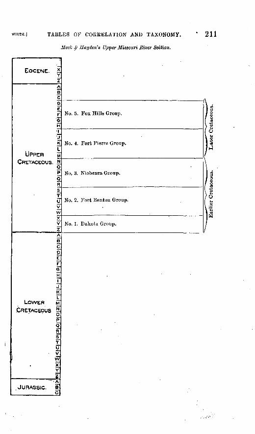
TABLES OF CO1UIELATION AND TAXONOMY.
fc c)1- Hayden'a Upper Missouri Eiver Section.
211
EOCENE.
UPPERCRETACEOUS
LOWERCRETACEOUS
.
JURASSIC.
XYzABCO
F
§H
\_'J
HrFopCRSTUV
wXYz"ABCD
£FGH
J~
KLMNOPORs"TUVWXY
'A
BC
9?
No. 5. Fox Hills Group. gS
> ^O0
No. 4. Fort Pierre Group. SH
No, 3. Niobrara Group. go
%\ ~9
/ ONo. 2. Fort Benton Group. M
.2fucS
WNo. 1. Dakota Group.

212 THE CRETACEOUS. |uuLL.82.
GENERAL SECTION OP THE UPPER CRETACEOUS FOR THE GREAT INTERIOR AREA.
The opposite table represents the general section of the Upper Cre taceous formation of the Great Interior area in the form which was pro posed and published by Mr. George H. Eldridge as a modification of the classification and nomenclature of the strata and their equivalents which were embraced in the Upper Missouri River section of Meek and HaydeD, and not as being exclusively applicable to any particular one of the several districts in which the strata referred to occur.
This modified classification has the same scope and is essentially the same as that which was used by Newberry, Powell, and White respec tively, the difference being only or mainly that of nomenclature. Both the nomenclature and classification proposed by Mr. Eldridge are in this memoir adopted for general use in those districts where the forma tions in question are known to occur. See pages 144 and 158.

WHITE.) TABLES OF CORRELATION AND TAXONOMY. 213
General Section of the Upper Cretaceous for the Great Interior Area.
EOCENE. *Y
UPPER
Laramie Formation.
Mouta.ua Formation.
Colorado Formation.
Dakota Formation.
CRETACEOUS.
.JURASSIC: H C

214 THE CEETACEOUS. (BULL. 82.
THR NEW JERSEY SECTION.
The section which is represented by the table upon the opposite page is that which has been described and illustrated by Prof. Geo. H. Cook in several of the publications of the New Jersey State Geological Sur vey, but which was first defined by Prof. H. D. Rogers. The tabular arrangement of the formations with reference to the scale adopted for this memoir shows that the Potomac formation proper is supposed to belong in part to the Jurassic, and also that the Earitan and Amboy clays are thought to be equivalents, at least in part, of the Dakota formation. See tables on pages 211 and 213. The arrangement of the formations in this table also shows that there is understood to be a time- hiatus between the lower and upper parts of the Upper Marl bed equal to at least the greater part of the epoch of the Laramie formation, the taxonomic position of which is shown in the tables on pages 213, 223, 225, 233, 237 and 239, where it occupies essentially the same portion of the scale that the hiatus does in this. For description of the members of the New Jersey section, see pages 80-83.

WHITE.] TABLES OF CORRELATION AND TAXONOMY.
The New Jersey Section.
215
EOCENE. *YZ
UPPERCRETACEOUSN .- H
qp Q
Middle Marl Bed,
Lower Marl Bed,
Clay Marl,
and
Raritan and Amboy Clays.
,/Z ""A
LOWER CRETACEOUS.
Potomac Formation.
JURASSIC.

216 THE CRETACEOUS. [BULL. 82.
SMITH AND JOHNSON'S ALABAMA SECTION.
The greater part of this section, which may be taken to represent the full Cretaceous series of Alabama, was published many years ago by Prof. M. Tuomey aod by Prof. A. Winchell, but as it is presented in this memoir it has been compiled mainly from Bulletin No. 43 of the U. S. Geological Survey, of which Prof. E. A. Smith and Mr. L. O Johnson are the authors. The section, as a whole, is understood to be equivalent to that of New Jersey and also to that of Mississippi, which are shown in the tables on pages 215 and 219 respectively.
The time-hiatus which is shown in the opposite table to occur above the Ripley group of those authors occupies the same part of the scale that the corresponding hiatus does in that of both the New Jersey and Mississippi sections, and like the hiatus represented in the two latter sections it is understood to represent the whole or nearly the whole of the epoch of the Laramie formation of the Interior regions, the position of which formation is shown in the tables on pages 213, 223, 225, 233, 237 and 239.
Immediately above this hiatus certain beds occur in Wilcox County which contain numerous specimens of the uautiloid genus Enclimato- ceras of Hyatt, which beds are represented here because they and their equivalents near Little Bock, Arkansas, have been erroneously referred to the Cretaceous. See also table on page 221.
The upper portion of the Eutaw group of Alabama is understood to be equivalent to the Tombigbee sands of the Mississippi section and, like the latter, to be not properly separable from the Eotteu limestone. The horizon of the Tombigbee sands is believed to be approximately the same as that of the Dakota formation, as will be seen by com paring its tabular position with that of the latter formation upon pages 211, 213, 229,231, 233, 237 and 239. For discussions of the form ations of the Alabama section and a figure representing it see pages 105-108.

WHITE.] TABLES OF CORRELATION AND TAXONOMY.
Smith and Johnson's Alabama Section.
217
EOCENE.
UPPERCRETACEOUS.
fli
LOWERCRETACEOUS.
JURASSIC._
>
BCDiF_Gt-
J
P
LM
4 tT; opcF
TUV
wXY
zAiC0EFGH1JKLMN
OP
QRSTUVW
Xz"ABC
Enclimatocerae Bed.
Ripley Group.
Rotteu^Limestoue Group.
Upper portion of Entaw Group.
s
,
Lower portion of Entaw Group and Tuscaloosa Group.
218 THE CRETACEOUS. [BULL. 82.
HILGARD'S MISSISSIPPI SECTION.
Prof. B. W. Hilgard, in his Geological Survey of the State of Mis sissippi, found there essentially the same section of Cretaceous rocks that exists in the adjoining State of Alabama, and these are assigned to similar positions with reference to the scale, as will be seen by compar ing the table on page 217 with this. The same time-hiatus also is recog nized in the Mississippi section which has been indicated in the tables representing the New Jersey and Alabama sections as having occurred between the deposition of the uppermost Cretaceous strata and that of the overlying Eocene. Furthermore, it is understood that this hiatus, as in the other cases referred to, represents either the whole or much the greater part of the Laramie epoch.
The Eutaw group of the Mississippi section is understood to repre sent the Tuscaloosa group and the lower, greater part of the Eutaw group of the Alabama section, and to be equivalent to the Potomac formation of the Atlantic Border region.
The Tombigbee Sand is understood to be not properly separable as a distinct formation from the Kotten limestone, and, like the upper part of the Eutaw group of Alabama, to belong to approximately the same horizon as that of the Dakota formation. See tables on pages 211, 213, 229, 231, 233, 237 and 239; and for discussions of the formations, see pages 105,106.

WHITE.] TABLES OF CORRELATION AKD TAXONOMY.
Hilgard's Mississippi Section.
219
EOCENE. 21Y
UPPER CRETACEOUS.
Kipley-Group.
Eotten Limestone Group.
Tombigbee Sand.
B C0E
F G
H T
J K L
LOWERCRETACEOUS.' - o
p oF
S T
U
Eutaw Group.
JURASSIC,.

220 THE CRETACEOUS, [BULL. 82.
THE EAST TEXAN SECTION.
Aside from the Coinanche series the Cretaceous section of the eastern part of the Texan region is regarded as essentially equivalent to those of New Jersey, Alabama, and Mississippi, respectively, which are repre sented in the tables on pages 215, 217 and 219.
The time-hiatus above the Eipley formation is understood to be ap proximately identical with that which is shown in those three sections, and to represent at least the greater part of the epoch of the Laramie formation, the position of which is shown in the next and other tables. The Enclimatoceras bed of the Eocene is shown in the opposite table for the reason given on page 112. It is not known whether this bed really constitutes the base of the Eocene, as it is represented to do in these two tables, but its position is evidently not far from the base.
The true position of the Comanche series in the Lower Cretaceous scale is not known, and it is only provisionally placed in the position shown iu the opposite table, as well as in the two next following tables.
The true place of the Trinity formation is a matter of much doubt. It is perhaps equivalent to the Potomac formation of the Atlantic Border region, the assumed position of which is shown in the table on page 215, and upon that supposition the Trinity is given a similar place in the opposite table. For references to the Potoinac formation, see pages 80, 90; and to the Trinity, pages 118,119.

WHITE.] TABLES OF COKRELATION AND TAXONOMY.
The East Texan Section.
221
EOCENE. *Enoliuiatoceras Bed, near Little Kock, Ark.
j^j hL
UPPERCRETACEOUS. , N
9. p_9
sTu
wX Y Z
Eipley Formation, "Ponderosa Marls," and Austin For mation.
Eagle Ford Formation.
Timber Creek Formation.
Couianche Series.
f LOWER CRETACEOUS.|-
Trinity Formation.
JURASSIC. s!

222 THE CEETACEOUS. [BULL. 82.
THE WEST TEXAN SECTION.
In the western part of theTexau region the Cretaceous series is capped by the Larainie, which formation there reaches its most southeasterly known extension. Beneath the Laramie, this section as a whole is re garded as equivalent to the EastTexan section, but all of the separate formations of the eastern section have not yet been satisfactorily rec ognized in the western one. The Comanche series and the Trinity for mation, however, have been recognized in the "western section, which fact is shown in the opposite table. The thickness of the Trinity is less in this section than in the preceding one.
In this table also it is shown that marine Eocene beds overlie the Laramie, which fact is recorded on page 126,
For discussion of these formations, see pages 125-127.

WHITE.] TABLES OF CORRELATION AND TAXONOMY.
The West Texan Section.
223
EOCENE. *.Yz
BcO
£ F_ G M
J_ J^ IK
UPPER 5CRETACEOUS. . !
>° pQR
T U_
y^ wX Y
Z
Marine Eocene Beds.
Larauiie.
Eale Pass Beds.
Equivalents of the " Ponder- Osa Marls," aud of the Aus tin, Eagle Ford, aud Timber Creek Formations.
LOWER
cDC
FG
r j.K L^M
CRETACEOUS..>- o p o n s.,T_
y_ v w x,Y
2. . ..._ ^
JURASSIC, e^ c
Cornauche Series.
Trinity Formation.
224 THE CRETACEOUS. |uuLL.82.
THE NORTH MEXICAN SECTION.
Too little is definitely known of the Cretaceous geology of the North Mexican region to enable one to construct a satisfactory section of those formations. Enough, however, is known to indicate that all the Upper Cretaceous series, from the Dakota to the Larainie formation inclusive, is represented in that region as shown in the opposite table. The sep arate formations of the series, as they exist in the interior regions, have, however, not yet been recognized in the North Mexican region.
The Comanche series here reaches its greatest known development, but no other Lower Cretaceous strata have yet been recognized in that region.
For discussions of these formations, see pages 134-140.

TABLES OF COREELATION AND TAXONOMY.
The North Mexican Section.
225
EOCENE. *.'" Iz
UPPER CRETACEOUS.
Laruniie Forinatiou.
Equivalents of the Montana, Colorado, and Dakota For mations.
'LOWER
CRETACEOUS. .
JURASSIC.
j R L
N
g p o
s
Iw 'xY
JL_ A B_ C
Coruanche Series.
Bull. 82 15
226 THE CKETACEOUS. [BULL, 82.
NEWBEKRY'S NEW MEXICAN SECTION.
The opposite table represents the three divisions of the Upper Cre taceous series which Prof, Newberry recognized iu New Mexico. This section agrees with that which is adopted in this memoir for general use in the Great Interior area, and with the sections of White and Powell, respectively, as shown on pages 235 and 237, except that it differs in nomenclature, and his upper division seems to include a portion of the Laramie formation. The terms upper, middle, and lower are relative only as applied to the portions of the series which they represent, and were not used by Newberry as applicable to the whole Cretaceous sys tem. For references to the work of Prof, dewberry in New Mexico see page 155.
In his first geological work in New Mexico, Prof. J. J. Stevenson used substantially the same classification as that of this section of Dr.Newberry's, but in his later work there he adopted the classification which was used by King in his survey of the fortieth parallel, so far as the marine Cretaceous formations are concerned. See page 157.

WHITE./ TABLES OF CORRELATION AND TAXONOMY.
Newbcrry'a New Mexican Section.
227
EOCENE. *Yz
A
B C
peF OH
UPPERCRETACEOUS. ' il
o pQJ
sT U V W
X Y
Upper Cretaceous.
Middle Cretaceous.
Lower Cretaceous.
LOWERCRETACEOUS. -
op oR
S T
MVwXYZ
JURASSIC.
THE CRETACEOUS. lBULL.82.
COPE'S GENERAL SECTION.
The opposite table is constructed mainly from an article by Prof. E. D. Cope, entitled " The Mesozoic and Cenozoic Kealrns of the Interior of North America," in the American Naturalist, volume 21, page 445- 459 inclusive. Prof. Cope does not therein present a formal section but adopts the Upper Missouri Eiver section of Meek & Hayden with the addition of subsequently discovered or recognized formations. It is introduced here mainly for the purpose of showing the relation to the Laramie of the assemblage of strata to which ho gave the name Puerco group, and its taxonouaic position with relation to the other formations. See page 149,

WHITE.] TABLES OF CORRELATION AND TAXONOMY.
Cope's General Section.
229
EOCENE. *Y
,zA
B
£ D
e_
GH
'7lit
UPPER gCRETACEOUS.; '!L
va]
Puerco and Laramie Groups.
Fox Hills Group.
Fort Pierro Group.
Niobrara Group.
Dakota Group.
Comanche Series.
LOWERCRETACEOUS. -51
op o R s,T U VW X ,Y
^_____ , 2 A
JURASSIC. B c

230 THE CRETACEOUS. [BULL. 82.
THE EASTERN COLORADO SECTION.
This table, which is essentially identical with the one on page 213 rep resenting the general section of the Upper Cretaceous of the Great Interior area, but to which is added space representing the Arapaho and Denver deposits, is introduced to exhibit the position of the latter with relation to the other members of the section which occur in the same district.
For discussion of these deposits, see pages 154-160.

WHITK-I TABLES OF COREELATION AND TAXONOMY.
The Eastern Colorado Section.
231
EOCENE. * Yz
UPPER ftCRETACEOUS. M
o p cR
Denver and Arapaho deposits and Laramio Formation.
Montana Formation.
Colorado Formation.
Dakota Formation.
LOWERCRETACEOUS.
oP>S R
JURASSIC.

232 THE CRETACEOUS. [BULL.82.
KING'S FORTIETH PARALLEL SECTION.
The vertical range of this section is the same as that of White, which is represented on page 257, and it is also the same as that of Meek and Hayden's Upper Missouri Eiver section, with the addition of the Lara- mie formation. In nomenclature and in the delimitation of a part of the formations, however, King's section differs from the two sections just named, that is, the equivalents of the Fort Benton, JSTiobrara, and Fort Pierre groups of Meek and Hayden are united under the name of the Colorado group, while the equivalents of the Dakota and Fox Hills groups of the latter section are retained as separate groups by King.
In his later geological work in New Mexico Prof. J. J. Stevenson fol lowed Mr. King with regard to those features of his classification of the Cretaceous formations which are here shown to distinguish it from that which is adopted in this memoir.

WHITE.] TABLES OF CORllELATION AND TAXONOMY.
King's Fortieth Parallel Section.
233
EOCENE. * Y
UPPER CRETACEOUS.
F GH
j R
M
N O P
9JR S
,U
LOWERCRETACEOUS. *
_>z
JURASSIC.
Laramie Group.
Fox Hill Group.
Colorado Group.
Dakota Group.

234 THE CEETACEOUS. [BULL. 82.
POWELL'S UINTA SECTION.
The section represented by the opposite table was published by Maj. J. W. Powell in his report on the eastern portion of the Uiuta Moun tains. Its ^ertical range is nearly the same as that of the sections of King and White respectively, which sections are represented by the tables on pages 233 and 237. The only difference as to the vertical range of Powell's section, as compared with the two others just named, consists in the assignment of the extreme upper portion of his Point of Eocks group, that is of the Laramie, to the overlying Eocene formation. With that exception also, the separate formations of Powell's section are exactly equivalent to those of the general section which is repre sented on page 213, and to those of White's section, which is represented by the next following table. That is, PowelPs section, with the slight exception mentioned, differs from those two sections only in nomencla ture. For discussion of Powell's section see pages 155,156.

WHITE.] TABLES OP CORRELATION AND TAXONOMY.
Powell's Uinta Section.
235
EOCENE. *YZA
B_
£
F ,F GST T '7 £
UPPER MCRETACEOUS. £
opaR
TU
Point of Rocks Group.
Salt Wells Group.
Sulphur Creek Group.
Henry's Pork Group.
K U
LOWER MORETACCOWS. tl
orQ R5"
ff y w
;v
JURASSIC, e. c
THE CRETACEOUS. [BULL. 82.
WHITE'S NORTHWEST COLORADO SECTION.
The formations embraced in this section occur in part in the same district as that in which Maj. Powell's section, represented in the im mediately preceding table, was constructed. It is equivalent to that section in all respects except that the Laramie formation extends to a somewhat higher horizon than does the Point of Rocks group as defined by Powell. In this section, however. King's nomenclature, which is shown in the table on page 233, is adopted, but the division into forma tions of that portion of the series which comes between the Dakota and Laramie formations is different from that which was made by King. This portion of the section is medially divided upon the same horizon as that which was recognized by Meek and Hayden, Powell and New- berry, as is shown in the tables on pages 211,235, and 227,
For remarks on this section see page 157.

WHITE.] TABLES OF CORRELATION AND TAXONOMY.
White's Northwest Colorado Section.
237
EOCENE. *YZ
UPPERCRETACEOUS.
"A Laramio Group.
Fox Hills Group.
Colorado Group.
Dakota Group.
LOWER ivfCRETACEOUS. -
op oR
5TU vW
X YZ
JURASSIC. £ c

238 THE CRETACEOUS. [BULL.82.
THE NORTH INTERIOR GENERAL SECTION.
The opposite table represents all the Cretaceous formations which have been recognized in the North Interior region, together with their position with relation to one another. The Upper Cretaceous series there has the same vertical range as have the sections which are represented by the tables on pages 213, 231, 233, and 237, but the non-marine Belly Kiver formation, to which the Dunvegan beds are regarded as equiva lent, is added to the series, its taxonomic position, as shown in the table, being between the Colorado and Montana formations. A non-marine Lower Cretaceous formation also occurs in this region, namely, the Kootanie. Its relative position in the Lower Cretaceous series is repre sented in the table in accordance with my present views. It is known to be later than at least a part of the Queen Charlotte formation, the relative position of which, as at present understood, is shown in the table on page 245. That table also shows that the latter formation is not understood to represent the earliest part of Lower Cretaceous time. In that table also, for reasons just indicated, the Kootanie, as a whole, is placed higher in the scale than js the base of the Queen Charlotte formation. For discussion of the formations which constitute the North Interior section see pages 165-171.

WHITE.] TABLES OF CORRELATION AND TAXONOMY.
The North Interior General Section.
239
EOCENE. *Y
UPPER MCRETACEOUS. tH
Laramie Formation.
Montana Formation.
Belly River Formation.
Colorado Formation.
Dakota Formation.
LOWERCRETACEOUS. «.-
Kootanio Formation.
*A
JURASSIC. £. c

240 THE CKETACEOUS. [nuLu82.
THE CALIFOKNIA SECTION.
The opposite table shows the author's present views as to the relative position of the different Cretaceous groups that have been recognized in California. The Chico-Te"jon series is thus shown to extend upward from a level that is well down in the Cretaceous scale to one that is much above the base of the Eocene, as has been explaineti on page 193.
Too little is yet known concerning the character and relative position of the Wallala formation to confidently assign its place in the scale, but its probable place is represented in'the table. For remarks upon this group, see page 192.
The lower portion of the Upper, and the upper portion of the Lower, Cretaceous are both understood to be absent from California, but the Shasta formation is believed to occupy a place near the base of the Lower Cretaceous scale, and to be equivalent to the Queen Charlotte formation, as is shown by the table on page 245. For remarks upon this subject, see pages 184,188.

WHITE.] TABLES OF CORRELATION AND TAXONOMY.
The California Section.
241
EOCENE. *Y
-Z
UPPERCRETACEOUS.
JURASSIC.
j LOWER M CRETACEOUS.!!-
Chico-Tejon Series.
Probable place of the Wallala Formation.
Shasta Formation.
Bull. 82 16.

242 THE CKETACEOUS. [BULL. 82.
THE NANAIMO SECTION.
The opposite table is presented only for the purpose of representing the position in the scale that the Nanaimo formation, as defined by Dr. G. M. Dawson, and which occurs on Vancouver Island, as well as upon several smaller islands in the adjacent waters of the Gulf of Georgia, is understood to occupy. As is shown by the table, and as stated on preceding pages, those strata are regarded as equivalent to the lower or Chico portion of the Chico-Tejon series of California, which is rep resented in the immediately preceding table. For remarks concerning the name and characteristics of this formation see page 194.

WHITE.] TABLES OF CORRELATION AND TAXONOMY.
The Nanaimo Section.
243
EOCENE. *Y
z
UPPER MCRETACEOUS.* 5 o 1
pojR S
T
y v wX Y
Z A
§ C0E
G
H
J_7Kr
/ LOWER ,M CRETACEOUS. j!l
p oR
s
yV7
wl x"
Yz"
JURASSIC.
Nanaiino Group.

244: THE CKETACEOUS. luuLL.82.
DAWSON'S QUEEN CHARLOTTK ISLANDS SECTION.
Although this is one of the most important Cretaceous sections of the Pacitic border region the opposite table shows definitely little more than that the divisions C, D, and B of Dr. G. M. Dawson are regarded as equivalent to the Lower Cretaceous Shasta formation of California, as is shown by the table on page 241, and that divisions A and B prob ably belong to the base of the Upper Cretaceous.
For references to the Queen Charlotte Islands section, see pages 183, 187, 188, and 189.

WHITE.] TABLES OF CORRELATION AND TAXONOMY.
Daivson's Queen Charlotte Islands Section.
245
EOCENE. *YZ
UPPERCRETACEOUS.}*!
.'P
Q R
Probable place of divisions A and B.
K L
LOWER M CRETACEOUS. ^
Q R sT
V VV
X ,Y
___________ Z
JURASSIC.
Divisions C, D, and E, or Queen Char lotte formation = Earlier Creta ceous of Davvsou.
246 THE CRETACEOUS. [BULL.82.
The foregoing 18 graduated tables representing the principal pub lished Cretaceous sections of North America are intended to exhibit the relation to one another of the formations which they respectively em brace, their taxonomic position with reference to a recognizable general scale, and the identity with one another of certain of those formations to which different names have been applied by different authors.
The folded plate opposite (PI. n), entitled " Summary of the published Cretaceous sections for each region," is intended to represent at a single glance a part of the conclusions that have been expressed in the fore going tables and to form a visible basisfor afew general remarks concern ing them. The scale upon which it is constructed is the same as that of the preceding tables. It is divided into seven columns, each respec tively bearing the name and representing the full Cretaceous sectioa of one of the seven regions which have been denned and discussed upon preceding pages. The upper and lower dotted lines across the table respectively represent, theoretically, the earlier and later limits of Cre taceous time.
The Cretaceous section of each region, omitting all its subdivisions, is represented in its appropriate column by line-shading. The blank spaces indicate the assumed absence of any strata which would repre sent those portions of the scale if the section were complete, and the extension of the shading beyond the dotted lines indicates that in those cases certain Cretaceous characteristics have been recognized, or re ported to exist, beyond the theoretical time-limit of the system.
Thus the deposits which occur at the base of the full Cretaceous series in the Atlantic Border, Gulf Border, and Texaii regions are represented by the shading in the table as extending below the dotted line into the space assigned to the Jurassic, because certain of the vertebrate and plant remains which those strata contain are reported to possess Juras sic characteristics.
Again, the shading in the columns which respectively represent the Texan, North Mexican, and North Interior regions extends above the upper dotted line into the space assigned to the Eocene. This is in ac cordance with the view that has been expressed on preceding pages that the Laramie formation which prevails in those regions is properly referable in part to the Eocene and in part to the Cretaceous.
The shading in the columns which represent the South Interior and the Pacific Border regions, respectively, extends still farther into the space assigned to the Eocene than it does in'the former cases. In the case of the South Interior region the additional extension represents the Puerco beds which rest upon the Laramie, both of which Prof. Cope has referred to the Cretaceous. The extension of the shading in the column representing the section of the Pacific Border region far up into the space assigned to the Eocene, is in accordance with the evidence that has been given and referred to on the preceding pages that the Chico-Tejon epoch extended from Cretaceous far into Eocene time.

U. S. GEOLOGICAL SURVEYBULLETIN NO. 82 PL. II
ATLANTIC BORDER REGION.
EOCENE
CRETACEOUS. N
p QR S
U
X
A
1 IF G H 1 JK j_
LOWER w CRETACEOUS ^
p^
Q RsT U VwXY
JURASSIC. I c
L"
^
GULF BORDER REGION. TEXAN REGION.
-=
IQRTH MEXICAN SOUTH INTERIOR NORTH INTERIOR PACIFIC BORDER REGION. REGSON. REGION REGION
=====
1
- - - -
_
A SUMMARY OF THE PUBLISHED CEOUS SECTIONS FOR EACH REGION.

WHITE. I EXPLANATION OF PLATE II. 247
This plate conspicuously illustrates the fact that much the greater part of the Cretaceous deposits of North America are referable to the Upper Cretaceous according to the classification adopted in this mem oir and it also shows conspicuously that the base of the Upper Cre taceous in each of the seven sections is referred to one and the same horizon. Because the delimitation of formations and series of forma tions must from the nature of the case be more or less indefinite, the last-named feature of this table will doubtless strike the observer as unnatural. It should be explained, however, that the opinion indicated by this tabular arrangement of the formations is the result of a some what definitely ascertained equivalency of the basal member of the Upper Cretaceous section of each region with that of all the others.
For example the basal formation in both the North and South Inte rior regions is the Dakota formation, the identity of which in both regions can not be questioned. Evidence has been presented on preced ing pages that the basal member of the Texan Upper Cretaceous is equiv alent to the Dakota formation, and there are also paleontological indi cations that the base of the North Mexican Upper Cretaceous belongs to the same horizon. The identity of certain plant remains which are found in the Raritan and Amboy clays of the Atlantic Border region wi.th Dakota species, together with the position of those clays with ref erence to overlying formations, is thought to be acceptable proof of at least the approximate equivalency of the former to the Dakota forma tion. The evidence that has been given on preceding pages of the equiv alency of the Gulf Border section to those of New Jersey and Eastern Texas, respectively, seems to make it reasonable to refer the basal por tion of the Gulf Border Upper Cretaceous also to the horizon of the Dakota formation.
These facts seem to warrant the selection of a common horizon for the base of the Upper Cretaceous in each of the six regions designated, 1 ut it can not be denied that the reference of the upper part of Daw- son's Queen Charlotte Islands section to the same horizon has been made on comparatively slight evidence.
The horizon of the Dakota.formation has been chosen as the base of the North American Upper Cretaceous because its marine representa tive has been found to blend both paleontologically and stratigraph- ically. with overlying formations the Upper Cretaceous age of which need not be questioned, and because no older formation, which is not plainly referable to a much lower horizon, has yet been recognized. All the formations above and including the Dakota are referred to the Upper Cretaceous because the character of their respective fossil faunas approximately indicates that age and because their paleonto logical and strati graphical relation to one another is too intimate to admit of their natural separation. That is, all the time from the be ginning to the end of the Upper Cretaceous seems to be represented in North America by a series of formations that was not in any case everywhere completely broken.

248 THE CRETACEOUS. [BUM-82.
HORIZONS OF THE NORTH AMERICAN CRETACEOUS.
The term horizon, aside from its ordinary signification, has been variously used by geologists and paleontologists in its application to their respective branches of investigation. Sometimes this term or others which convey the same idea have been used in a purely biolog ical and sometimes in a purely stratigraphical sense. That is, some paleontologists, confining their studies to a biological basis and pros ecuting them with reference to an erroneously assumed uniform rate of the past secular evolution of all organic forms, recognize the vertical or time range of a given class of faunal or floral types of fossil remains as constituting a sufficiently well defined horizon, and confine their work to that class of remains alone, disregarding the time range of all other associated types and paying little or no regard to the structural geology of the region in which their discoveries are made. Again, it has been the habit of some field geologists to recognize horizons only frorn a physical point of view, and to prosecute their studies in struc tural geology with little or no reference to paleontology.
While a knowledge of certain important facts may be obtained by each of these exclusive methods they are quite insufficient for the ac quirement of the fullest obtainable biological results on the one hand or for acquiring those of general structural geology on the other. Therefore, the recognition of geological horizons for the purposes of general investigation can be rationally made only after due considera tion of all obtainable facts relating.to them. A rational recognition of geological horizons as an indispensable aid to the comprehensive study of structural geology, while always implying their material existence in definable series of strata, is in all cases based, either directly or indi rectly, upon paleontological data. These data, however, are of unequal value, and for obvious reasons preference in such cases should always be given to such of them as relate to the remains of denizens of the waters in which were deposited the strata wherein they are found.
The North American Cretaceous horizons which are thus recogniza ble differ considerably from one another in their character and scope, some embracing no more than a single well defined formation and some embracing a series of more or less distinctly recognizable formations which, to some degree and in some places, blend with one another both paleontologically and strati graphically. The former may be desig nated as simple and the latter as complex horizons. The strata which physically constitute the former are, of course, regarded as having been deposited in a body of water which was geographically unbroken and not materially changed from the beginning to the end of the deposi tion of the strata which now represent it. The sedimentation by which the formations constituting the latter class of horizons was produced is regarded as not having been everywhere wholly broken or interrupted, although it was at times so largely arrested or modified as to mark off

WHITK.] CRETACEOUS HORIZONS. 249
the great series of strata into more or less readily distinguishable formations. Such arrests or modifications of the sedimentation were accompanied by material changes of the fauna which lived in the waters in which the sedimentation took place, but they were not sufficient to produce at any time and in all places a complete break in the nat ural genetic succession of the denizens of those waters. The forma tions constituting the Cretaceous horizons which are discussed in fol lowing paragraphs having been produced under diverse conditions, further definition of the term as here employed will necessarily be ex pressed or implied in the following description of each. 1
The paleontological and physical characteristics of each horizon nat urally convey much information as to the physical conditions which prevailed during the time when and within the area where the deposits which constitute them were accumulated, It is by this means that the respective formations which have been discussed on preceding pages are known to have originated under a wide diversity of conditions, and these facts necessarily have an important bearing upon their paleonto logical investigation. The value of such facts will be enhanced and their character emphasized by the recognition arid study of thehorizous which those formations are found to constitute. Furthermore, because the vertical and geographical limits of such horizons are coincident with our attainable knowledge of both the geographical and time limits of faunas and floras, the advantages to be derived from their recognition and study are very important from a biological as well as a geolog ical standpoint.
By most paleontologists the Cretaceous fossils of North America, especially those of aqueous origin, heretofore have been studied only or mainly with reference to the formations which were recognizable within the respective districts where their collections were made, and not with reference to extended horizons throughout which a greater or less proportion of such species are now known to have ranged with only local variations. Furthermore, those authors often failed to recog nize the fact that certain species range vertically from one formation to another. One result of such a treatment of the subject has been a great duplication of specific names and a burdensome synonymy in our paleontological literature that might in large part have been avoided by a proper recognition of great horizons as representing both the time and geographical range of specific forms.
I am well aware that objection may be raised to this manner of treat ing the subject, especially to the great difference in the relative scope of the horizons that have been indicated and are to be briefly discussed on following pages, but I ana confident that in future paleontological work upon the North American Cretaceous the recognition of such hori-
'It is obvious tbat the term horizon is heroin employed in au unusually extended sense, but even in tbe absence of a bettor one it is believed that the idea intended to bo convoyed will readily bo under stood.

250 THE CRETACEOUS. [BULL. 82.
zons will be indispensable. Such recognition will enable the paleon tologist to correct many of the errors that have been committed either by himself or others and will largely tend to the establishment of both the geology and paleontology of those formations upon a more philo sophical basis than heretofore has been recognized.
Eight horizons and two subhorizons have, with sufficient distinct ness for separate discussion, been recognized among the North Ameri can Cretaceous formations, each of which is more or less clearly distin guishable over a large area, and the following names have been selected to indicate them.
f Laramie horizon.
f Shasta horizon.
. Potomac horizon.
The areas occupied by some of these horizons embrace portions of several of the regions which have been defined and named in this mem oir and some are confined to a single region. Some of them plainly suc ceeded one another in time, but the order of succession of others is not accurately known. Some were probably either wholly or in part con temporaneous with one or more others, but in accordance with the fore going definition they are treated separately because of their geograph ical restriction and of their paleontological dissimilarity to any others.
The formations which physically constitute these horizons have been produced under two classes of conditions, a part of them having been marine and a part non-marine or continental. Those of the former class are naturally more uniform than most of the others and, as a rule, they had greater geographical extent. They therefore generally constitute the best and most distinctive horizons, although some of the lacustrine formations are quite as distinctive as are those of marine origin and a part of them have as great geographical extent as have many marine forma tions. The non-marine formations have various and in some cases quite diverse characteristics, and they also originated under various and di verse conditions. That is, some of the formations of this class were accumulated under littoral, some under estuarine, and some under lacustrine conditions. Some of the latter, as is shown by their mollus- can fossils, were accumulated in fresh waters and others in waters that were in part fresh and in part brackish.
The estuarine deposits have naturally been too limited in geograph ical extent to be profitably discussed as horizons, as that term has been defined for present use> and this is also true to some extent with, the littoral deposits. Most of the lacustrine deposits that have been described on preceding pages us pertaining to the North American Cre taceous, however, are remarkable not only for their great geographical

WHITE.] THE POTOMAC HORIZON. 251
extent but for their general lithological resemblance to marine forma tions, and the horizons which they represent are among the most im portant of those which are to be discussed on this occasion.
THE POTOMAC HORIZON.
Those deposits which occur in the Atlantic and Gulf Border regions respectively, and which, in the discussion of those regions, have been assigned to the non-marine division of the Cretaceous series as it is developed there, may be designated as constituting the Potomac hori zon 5 to which may be provisionally added the Trinity formation of the Texan region, but from which the Earitan and Ainboy Clays of New Jersey and their equivalents evidently must be excluded. So far as this horizon can now be definitely characterized it consists of the Poto- mac formation of the Atlantic Border region and the Tuscaloosa forma tion of the Gulf Border region, together with their known equivalents.
Excluding the Baritan and Auiboy Clays of Few Jersey and their equivalents on Staten, Long, and Martha's Vineyard Islands and else where, as being of later date, and the Trinity formation of the Texan region as being of doubtful equivalency, the Potomac horizon may be traced from central New Jersey through the Atlantic and Gulf States to northern Mississippi, a distance of fully 1,000 miles. 1 It is true that the deposits which physically constitute it are not now continuously visible along the whole distance mentioned, but there is apparently no reason to doubt that they were originally continuous through the whole of that distance, and they perhaps extended much beyond the limits just indicated.
Although this horizon is traceable for so great a distance, its known geographical extent is approximately linear, because its visible width is everywhere very small. There can be no doubt that its original width was somewhat greater than is now discernible, but the deposits which constitute it having been of littoral and estuarine origin, their width must necessarily always have been small, as compared with that of marine and the larger lacustrine deposits.
The lithological characteristics of the deposits which physically con stitute the Potomac horizon have been discussed on preceding pages, but, as has already been intimated, its known paleontological charac teristics are few. Because so few paleontological data which might be used to characterize the Potomac horizon are available we rely upon the general evidence of homogeny which it presents throughout its entire extent, and upon its great physical dissimilarity from the deposits which respectively are known to underlie and overlie it. The few paleontological characteristics which the Potomac horizon presents have not given an entirely satisfactory indication of its geological age. For
1 Deposits belonging to this horizon doubtless extend northward through Tennessee, and probably through Kentucky also.

252 THE CRETACEOUS. [BULL.82.
reasons already stated, however, it is in this memoir provisionally assigned to the base of the Cretaceous system.
The deposits which constitute the Potomac horizon being of non- marine origin, and those which constitute the next overlying horizon being of true marine origin, the discovery of any direct paleontological relationship could not reasonably be expected. Besides this, the next overlying horizon being of Upper Cretaceous age, there is under stood to be a wide time hiatus between them, and there is also a wide time-hiatus between the Potomac horizon and the underlying deposits, the latest of which are regarded as of Triassic age. Therefore this horizon is well defined from both the underlying and overlying horizons. Furthermore, there appear to be no deposits among the other North American Cretaceous formations that are closely similar to the Poto mac and its known equivalents, and none which have afforded any evi dence of contemporaneity with the latter, with the possible exception .of the Kootanie.
In view of the statements that have been made on page 186 concern ing the identification of several species of fossil plants in the Kootanie strata of Alberta and Montana, and iii the Potomac strata of the At lantic Border region, the question may be raised whether the Potomac horizon, as it is recognized "in this memoir, ought not to include the Koo tanie formation, and whether that specific identification of plants does not prove the contemporaneity of the Potomac and Kootanie forma tions. Neither of these questions, however, is regarded as settled by this discovery for the following, among other, reasons: The horizons which are recognized in this memoir are only those which have, besides their biological characteristics a material existence in strata that were deposited in one continuous, or nowhere wholly broken, body of water. Such a definition will not apply to the case in hand, because it is evi dent that although the Kootanie may be shown to contain remains of plants which are specifically identical with some found in the Potomac formation, it is certain that the waters in which the two formations were deposited were geographically widely separated. Again the spe cific identification of fossil plants can not in all cases be accepted as proof of the contemporaneity of origin of the respective formations con taining them. For example, it is claimed that five of the species which constitute the flora of the Dakota formation have been .iden tified as members of the flora which characterizes the Laramie. Sev eral species of the latter flora have been published as identical with Belly Eiver forms, several have been recognized in the overlying Green Eiver Tertiary, and three species from the Upper Laramie have been identified with living species.1 And yet, no one would think of suggesting that the Dakota, Belly Eiver, Laramie, and Green Eiver formations ought to be referred to one and the same hori-
1 Seo Ward, Lester F., Synopsis of the Flora of the Laramie Group. Sixth Annual Report U. S. Geol. Surv., pp. 405-557, plates 31-65.

WHITE.] THE CRETACEOUS HORIZON. 253
zon, even upon purely paleontological ground, and a suggestion that those formations were contemporaneous in their origin would be too absurd for consideration.
In future studies of the characteristics of the Potomac horizon little aid can be expected from invertebrate fossils because of the paucity of such remains in the deposits which physically constitute it, and because of the comparatively slight value of non-marine invertebrates as indi cators of the geological age of the strata containing them. Therefore a knowledge of the paleontological characterization of the deposits which physically constitute the Potomac horizon, and of the upper and lower delimitation of the same must be sought for mainly by means of verte brate and plant remains, which in all cases ought to be specially studied in connection with strati graphical details.
THE COMANCHE HORIZON.
While I have in this memoir assigned the Potomac horizon to the base of the Cretaceous system, I have at the same time admitted the in completeness of the evidence upon that point, and I do not hesitate to admit my inability to indicate more than approximately the taxouornic position of the Comauche horizon, with relation to any of the other North American Lower Cretaceous horizons in the scale which is used in the preceding tables. For example, we do not yet know whether the strata which coustitue the Comanche horizon were deposited before, after, or contemporaneously with any given one of the other Lower Cretaceous formations which have been defined on preceding pages; and therefore the relative place which is assigned to each of these forma tions in the tables referred to must be understood to represent only iny present judgment in this case.
So far as is now certainly known, the Comanche horizon is repre sented only in the Texan and Forth Mexican regions, and only by the strata which, in connection with the discussion of the geology of those regions, have been described under the head of the Comanche series. The area within which strata of this horizon are now known to occur is about 800 miles across from east to west, and about 500 miles from north to south. It can not be doubted, however, that they extend far southward into the central and southern portions of the Mexican Kepublic, and it is even probable that they reach their greatest develop ment there. 1 No sufficient evidence has yet been obtained that strata referable to this horizon were ever deposited to the north or east of the Texan region, if we except some inconspicuous outliers that have been reported to exist in southern Kansas.
The Comauche is a purely marine horizon, and for that reason it can not be compared paleontologically with two of the other Lower Creta ceous horizons, namely, the Potomac and Kootanie, which are of non- marine origin. The Shasta horizon, like the Comanche, is physically
1 See remarks on p. 202 relative to late observations of Prof. Heilprin.

254 THE CRETACEOUS. [BULL. 82.
represented by marine strata, but their faunas are wholly different from each other, not a single species having yet been recognized as common to both. The molluscan fauna as a whole of the Comanche horizon appears to range through the entire thickness of the series of strata which constitute it, and with a few doubtful exceptions consisting of ostreid forms, none of its species has been found in other formations. The Comanche, therefore, is paleontologically one of the most distinctly defined horizons that the geologist is likely to encounter on this conti nent. It is identical in all respects with the Comanche series of strata, and its physical definition is quite as clear as its paleontological.
Up to the present time no plant remains have been discovered in any strata of the Comanche horizon, and few, if any, vertebrate remains, even of fishes, have yet been detected. Invertebrate remains, other than those of mollusks, are also comparatively rare; and it is evident that the paleontological characterization of the horizon must mainly be accom plished by means of its abundant molluscan fauna.
THE KOOTANIE HORIZON.
The Kootanie horizon is represented only by the strata of the Koo- tanie formation, which now are only known to occur in the North In terior region, where there is evidence that they originally occupied an area many hundred square miles in extent. These strata are of non- marine origin, and their blending with, or passage horizontally into, those of marine origin, as the non-marine strata of the Dakota horizon are understood to do in their southern extension, has not yet been dem onstrated, although it seems to be the impression of the Canadian ge ologists that they thus blend with equivalents of Queen Charlotte strata. It is, however, uot unlikely that such a horizontal blending did occur somewhere, but for want of more knowledge upon that point it is HOW necessary to treat the Kootanie strata as forming a geographically isolated horizon.
The upper and lower delimitation of the Kootanie horizon, both phys ically and biologically, is in its typical district the same as that of the Kootanie formation, which has been defined on preceding pages. So far as I am aware, no strata of later age than the Carboniferous have yet been reported as underlying it except in the case which is recorded on page 189, where the immediately underlying strata are found to bear certain characteristic fossils of the Shasta horizon, the lower delimita tion of the Kootanie in Montana not having yet been clearly defined. No strata of earlier age than those of the Dakota horizon have yet been found to overlie those of the Kootanie, and these are reported to lie con formably with them in Alberta. Still, the paleontological character istics of each of these horizons is such that it is necessary to assume that there is an important time-hiatus between them.
Very few invertebrate fossils have yet been found in strata of the Kootanie horizon, and if more were found they would probably be of

WHITE.] THE SHASTA HORIZON. 255
little value in its characterization, because the differentiation incident to the secular evolution of non-marine invertebrates has been so slight as compared with that of marine invertebrates. No vertebrate fossils have yet been reported from Kootanie strata, the most impor tant fossils yet discovered being those of plants, upon the character of which, together with their contrast with those of the overlying Dakota horizon, they have been referred to the Lower Cretaceous. It ought to be remarked in this connection that the identity of the Alberta and Montana Kootanie deposits having been assumed only upon the evi dence afforded by the specific identity of fossil plants, they may have been simultaneously formed in separate bodies of water. This being true would not necessarily disprove their identical taxouomic position, but it would make the Kootanie, as now understood, a paleontologically aud not a physically, continuous horizon.
There is no apparent reason why an important vertebrate fauna may not yet be discovered in the strata of this horizon, but at present we must rely almost alone upon its flora for its paleontological character ization.
The importance of this horizon is not confined to its taxonomic rela tion to the other horizons herein discussed, nor to its paleontologoical re lation to them. It ought to be studied as representing one of the phases of development of the present North American continent and as one of the series of remarkable continental conditions that existed from time to time from the beginning to the end of the Mesozoic era.
THE SHASTA HORIZON.
The Shasta horizon embraces all the strata in the Pacific Border region which have been referred to the Lower Cretaceous. The best known and most characteristic exposures of the strata of this horizon are those which have been described on preceding pages under the head of the Shasta formation of California and of the Queen Charlotte formation of British Columbia. The Shasta formation, as it is devel oped in California, consists of two divisions, which are found to differ from each other paleontologically; but it is now known that a sufficient number of fossil forms are common to equivalents of both divisions which occur in other parts of the region to warrant the placing of both of them in one and the same general horizon. Again, because divisions " C " and " E " of the Queen Charlotte section contain certain identical fossils, they are both referred to one and the same great horizon, not withstanding the presence between them of the eruptive formation " D " of the same section. 1 That is, while these strata and their fossil con tents constitute one great horizon it is to be expected that within cer tain districts more or less distinct paleontological stages may be recog nized within the full vertical range of the strata which physically con-
' See page 188.

256 THE CRETACEOUS. [BULL. J>2.
etitute the whole horizon. This practically has been done in the recog nition of the Horsetown and Knoxville divisions of the Shasta group, and that condition indicates some degree of complexity for this horizon as compared with the simpler ones.
The most constant and most widely distributed of the fossil forms which characterize the Shasta horizon is the variable Aucella which in my writings I have generally referred to the A. concentrica of Keyser- ling, but it is likely that when the fossils of the whole horizon come to be fully studied and catalogued it will be found that other species also have so wide a geographical range as to be equally valuable for such general use.
By means of its characteristic fossils the Shasta horizon has been recognized at numerous places in the Pacific Border region from central California to its northern boundary and from there to points within the Arctic Circle, and also upon the peninsula of Alaska and adjacent islands; but at only one point are its strata yet known to have extended east ward within the designated limits of the Great Interior area.1 If, how ever, we accept the Aucella that has been referred to as indicating the presence of strata belonging to this horizon, it is circurnpolar in its extension,2 and prevails over large areas iu northern Europe and north ern Asia.3 Only the North American strata which have been referred to the Shasta horizon will, however, be considered in this memoir.
The lower delimitation of the Shasta horizon is a matter of uncer tainty, because there is plainly a wide time-hiatus between its earliest known strata and the latest of those upon which they are found to rest, which are regarded as of Triassic age, and also because we do not yet know whether the earliest known strata of this horizon are the earliest that anywhere pertain to it. We also do not know whether the earli est known strata of the Shasta horizon represent the beginning of Cre taceous time in North America, but it is my present opinion that they represent a somewhat later epoch than the earliest one.
The upper delimitation of the Shasta horizon is also a matter of uncertainty because we do not yet know that any of the later Creta ceous strata which have been found resting upon those pertaining to this horizon immediately succeeded them in time. In California the earliest overlying strata seem to be of Upper Cretaceous age j and the local superposition of Kootanie upon Queen Charlotte strata4 is the only known case of other Lower Cretaceous strata resting upon those of this horizon. %
So far as I am aware no vertebrate remains have yet been found in strata referable to this horizon. Numerous fragments of wood and of other plant remains have been found at various localities, but few, if
1 See page 189.'See Monog. TT. S. Geol. Surv., vol. 13, pp. 227,228.* See foot note on page 185 for reference to the probable discovery of this Aucella in southern Mexico.4 See page 189.
WHITE.I THE DAKOTA HORIZON. 257
any, of these are of any paleontological value. The presence of important coal beds, however, indicates that vegetation was abundant during' the epoch in which these strata were deposited, and it is not improbable that collections of fossil plants of taxonoinic value may yet be obtained.
.The strata of the whole horizon are, however, almost entirely of marine origin, and because of the paucity of vertebrate and plant remains we must doubtless rely upon invertebrate fossils for its paleon tological characterization. These at present show a very wide, and apparently an entire, faunal difference between the Shasta and Coman- che horizons, although their geographical separation is not very great toward the south. The other Lower Cretaceous horizons having been of non-marine origin the paleontological difference between them and the Shasta horizon is necessarily very great.
THE DAKOTA HORIZON.
The Dakota horizon, as I now recognize it, is represented only by the Dakota formation, which, as a distinct formation, is known only in the interior parts of the continent. It is believed that certain strata at the base of the Upper Cretaceous series in the Atlantic and Gulf Bor der regions represent this horizon taxonomically, and, being confi dent that it is represented by certain marine strata at the base of the Upper Cretaceous of the Texan and North Mexican regions, I have so treated those strata in this memoir. 1 It is, however, only the non- inarine Dakota formation proper that I shall consider as physically constituting the Dakota horizon, and its real or supposed marine equiva lents will be considered in connection with the strata *which pertain to the great complex Maritime and Interior horizon. Therefore, the de scription of the Dakota formation which has already been given 2 is a description of the Dakota horizon as it is physically constituted.
The Dakota horizon is regarded as constituting the base of the Upper Cretaceous, but the deposition of its strata is not known to have imme diately succeeded that of any of those which are herein referred to Lower Cretaceous. It is true that strata referred by Dr. Dawson conformably overlie the Kootanie in western Alberta, but he is apparently not yet satisfied that certain of those strata which intervene between the char acteristic underlying Kdotanie and the overlying Dakota do not repre sent all the intervening time between those epochs. Marine equivalents of Dakota strata rest upon those of the Comanche horizon in the Texau region, and elsewhere the characteristic strata of the Dakota horizon have been found to rest upon both Jurassic and Paleozoic rocks. There fore, while the base of the Dakota formation apparently everywhere represents the beginning of the sedimentation which produced it, the lower delimitation of the horizon is, in different districts, by formations
1 Seo page 122. * See pages 159 and 171.Bull. 82 17

258 THE CRETACEOUS. [BULL.82.
of widely different ages. Its upper delimitation, where any strata have been found to rest upon it, is always by the marine Upper Cretaceous strata of the Colorado formation and of its equivalents.
The character of the strata which constitute the Dakota horizon is such as to indicate conditions favorable to vertebrate life during their deposition, but they have yet furnished few or no vertebrate fossils. Invertebrate fossils also are rare, and, being of non-marine origin, they are of little value as indicating the geological age of the strata which bear them. At present, therefore, we must rely almost alouo upon fossil plants for the paleontological characterization of this horizon; and, in this, great caution is necessary because several of its species have already been identified in later horizons.1
Although this horizon is now known to occupy a position at what in this memoir is treated as the base of the Upper Cretaceous, certain paleontologists have insisted on referring it to the Tertiary because of the character of its flora.2 While, therefore, this flora as a whole may be relied upon to distinguish the horizon,3 a true understanding of its geological age has been arrived at only by means of its ascertained stratigraphical relation to other formations, the age of which has been determined by their invertebrate marine fossils.
THE MARITIME AND INTERIOR HORIZON.
This is one of the most important of the North American Cretaceous horizons, because of its great geographical extent and because it com prises the greater part of the Upper Cretaceous strata of the interior and eastern portions of the continent. Some of the other horizons are simple or they embrace only one recognizable formation, but this, the most complex of them all, embraces several formations, each of whichis characterized by certain stratigraphical and paleontological peculiari ties. Still all of those formations are more or less directly connected by the ranging of certain species of fossil mollusks from one to another, except where this great horizon becomes differentiated and finally divided into two subhorizons, as will presently be shown. That is, while certain formations are distinguishable, no complete biological break took place within the vertical range of the series of strata which repre sents this horizon in the two eastern maritime regions, namely, the At lantic and Gulf Border regions; but the upper and lower portions of the series which represent it in the Great Interior area are respectively characterized by a greater degree of paleoutological difference than ob tains between any of the other distinguishable formations. Therefore
1 See Ward's tables, Sixth Ann. Kep. TT. S. Geol. Survey, pp. 443-514.8 See pages 36 and 70.3 There is now passing through tha press an important work, entitled " The Flora of the Dakota
Group," which flora is shown to consist of 460 known species, the larger part of them being published therein for the first time. See Mon. TJ. S. Geol. Survey, vol. 17, pp. 1-400, pis. I-LXVI. A posthumous work by Leo Lesquereux, edited by P. H. Knowlton.
WHITE.] THE MARITIME AND INTERIOR REGION. 259
those upper and lower portions of this great horizon are, in that part of the continent, respectively designated as subliorizous.
The strata which constitute this great horizon are all of marine origin. Those which represent it in the Atlantic Border region are the New Jersey rnarl beds and their equivalents, and those which represent it in the Gulf Border region are the Rotten limestone and the Kipley formations, all of which have been defined on preceding pages. In the eastern part of the Texan region this horizon is represented by all the Upper Cretaceous formations, from the top of the Eipley down to the base of the Eagle Ford formation, inclusive. To these should doubtless be added the Timber Creek formation, which, although re garded as the time representative of the Dakota, is of marine origin and paleontologically related to the formations which immediately over lie it. In the western part of the Texan region and in the North Mexican region this horizon is represented by all the Upper Cretaceous strata which are now known to occur there between the top of the Comaueue and the base of the Laramie horizon. In the South Interior region the Colorado and Montana formations constitute the full equivalent of all the Upper Cretaceous strata just referred to, and while they were evi dently produced by continuous sedimentation from the lower to the higher of these two formations, their paleontological relation to each other seems less intimate than is the relation to one another of the formations which constitute the full horizon in the more southern and eastern regions.
Upon going northward into the .North Interior region we find the Colorado and Montana formations to be as well developed there as they are in the South Interior region, and also that the before-mentioned paleontological difference between them continues, but it does not in crease to such an extent as to materially change the faunal character of each of those great formations. Furthermore, upon passing the northern boundary of the United States we find that the interposition of the non-marine Belly River between the Colorado and Montana formations, in quite a large district there, has divided the great horizon into the two subhorizons which have just been referred to, the lower being represented by the Colorado and the upper by the Montana formation. They are designated as subhorizons because they are so separated, and are not treated as distinct horizons because each por tion there largely retains the paleontological features that characterize it farther southward and eastward, where the two portions are in con formable contact, where their paleontological relation to each other is recognizable, and where their lithological character indicates that they were produced by continuous sedimentation from the lower to the higher strata.
The geographical extent, the vertical range, and the stratigraphical diversity of this complex horizon, as it has just been defined, are so great that it is difficult to characterize it as a whole. It is, however, treated

260 THE CRETACEOUS. [BULL.82.
as a single horizon, because all its stratigraphical subdivisions are un derstood to be paleontologically more or less intimately related to one another, and because of the evidence we have that marine conditions prevailed continuously in time from the deposition of its earliest to that of its latest strata. It is true that the evidence of direct continuity of sedimentation is lacking in many places, and in many places it is plain that such continuity was broken, but the result of extended observa tions leaves no room for reasonable doubt that it was never everywhere wholly interrupted within the vertical range indicated.
The strata of this horizon are, in many places, very fossiliferous, and a great number of species have been published by various authors, the most important of whose publications are mentioned in the bibliograph ical list which is given in the introductory part of this memoir.
Although vegetation was abundant over a large part of the great area which is occupied by the strata of this horizon, as is indicated by the presence of numerous and important coal beds, comparatively little is yet known of the character of the floras that existed during the time which is represented by them. Judging from the character of the re mains that have been discovered in the Montana formation, however, vegetation seems to have been similar to that which existed during both the Dakota and Larainie epochs.
Important discoveries of vertebrate remains have been made at vari ous localities and in various strata of this horizon from, its base to its top, the greater part of which have been published by Profs. Leidy, Marsh, and Cope.
The abundant invertebrate fossils of this horizon are, and doubtless always will be, the most important for its characterization, and for this purpose a thorough revision of all the known species from the va rious recognized formations of this great horizon is greatly needed- When this revision is made it will appear that there are within the vertical range of the horizon several more or less distinct faunal stages, the greater part of the species of which are unlike those of the other stages, while some of them will be found to be common to two or more of them. No one species, or any set of species can yet be selected as characteristic of this horizon throughout its entire geographical extent, or through its entire vertical range, but enough is now known upon this point to show that it will always be unsafe to assume that any given marine molluscan species obtained from any formation belonging to this horizon will not be found in any overlying or underlying one which pertains to it. This last mentioned fact is a significant one in its bearing upon the subject of a connected history of geological events within the present limits of the North American continent during Upper Cretaceous time, and with reference to the interdelirnitation of the Upper and Lower Cretaceous of this continent.
The lower delimitation of this great horizon is the same as that of the whole Upper Cretaceous of the interior and eastern portions of the

WIIITB.I SUBHORIZONS. 261
continent except where the Dakota formation and its non-marine equiv alents prevail. Its upper delimitation is by a time-hiatus between it and the Tertiary in the Atlantic and Gulf border regions and in the eastern part of the Texan region; but elsewhere, that is, in the western part of the Texan region, in the North Mexican region, and in the two Interior regions, its upper delimitation is by the Laramie horizon, the aqueous fauna of which is wholly different, although the stratigraphical relation between the two horizons is remarkably intimate, as has already been pointed out.
THE COLORADO SUBHORIZON.
If it were not that in the North Interior region the non-marine Belly liiver formation intervenes between the Colorado and Montana forma tions, the propriety of considering the two latter formations as sub- horizons might well be questioned. In any case paleontological study of these two subhorizons should always be prosecuted with direct ref erence to all other portions of the great complex Maritime and Interior horizon, especially to the lower portion of the Upper Cretaceous series in the North Mexican, Texan, Gulf Border, and Atlantic Border regions. That is, a large proportion of the species constituting the fauna of this subhorizou are believed to be geographically distributed in all those regions, and it will be unsafe to assume that any one of its species may not be found in more than one district within which strata of this sub- horizon occurs. -
Within limited districts more or less distinct paleontological stages are recognizable in this subhorizou, such, for example, as those of Meek and Hayden's Fort Benton and Niobrara groups, but even in such cases certain species may be expected to range from one stage to another. Besides this, considerable modifications of its invertebrate fauna are observable in different districts, such, for example, as those which have been noticed as occurring in Colorado and Utah. ]
THE MONTANA SUBHOR1ZON.
The Montana, like the Colorado subhorizon, is physically repre sented by a single great formation of that name, which has been dis cussed on preceding pages. As in the case of the Colorado subhorizon, certain stages are recognizable in portions of the Montana subhorizon, such, for example, as the Fort Pierre and Fox Hill stages, which were regarded as separate formations by Meek and Hay den.
Besides this, it is now known that a considerable number of the in vertebrate species of fossils which characterize this subhorizon occur in the upper part of the Upper Cretaceous series in the North Mex ican, Texan, Gulf Border, and Atlantic Border regions. Therefore, the invertebrate fauna of this subhorizou ought always to be studied with direct reference to that of those formations.
1 See page 162.

262 THE CRETACEOUS. [DULL. 82.
In some respects the character of the Belly River formation is such as to suggest its designation as a separate subhorizon, but too little is yet known of its geographical extent and of that of its assumed equiva lents to enable one to satisfactorily define the physical limits of a sepa rate subhorizon that shall include them. The Dunvegan series, while it is assumed to have been contemporaneous with the Belly Eiver for mation, was perhaps deposited in a separate body of water. Originally the Belly Eiver formation proper doubtless had a large geographical extent. It seems to occur at several places in Montana1 as well as at the typical localities in the adjacent part of British America, yet little or nothing is definitely known of its presence at intervening localities.
Besides this there are peculiar difficulties in defining this subhorizon paleontologically, mainly because so considerable a number of Belly Eiver species of vertebrates, invertebrates, and plants have been recog nized in the Laramie. Therefore, it is doubtful whether an attempt to recognize these deposits as constituting a separate subhorizon will lead to results as valuable as those to be obtained in the other cases referred to. This brief reference to the question is, however, herewith pre sented, because of the fact that the Belly Eiver formation, where it is known to occur, distinctly separates the Colorado and Montana sub- horizons from each other, as has been already shown.
THE LARAMIE HORIZON.
This horizon physically consists of the Laramie formation alone, but it is probable that the Denver and Arapaho deposits" are not clearly separable from it on paleoutological ground. Its abundant flora has been published by Profs. Newberry, Lesquereux, and Ward, and Sir J. Win. Dawson; and its vertebrate fauna mainly by Profs. Leidy, Cope, and Marsh. Its invertebrate fauna has been published by Mr. Meek, Mr. Wbiteaves, and myself. It is wholly composed of such forms as either characterize, or are known to occur in brackish and fresh waters, no remains of forms like those which occur only in the open ocean having been discovered in any of its strata. This horizon is therefore, like the Potornac, Kootanie, and Dakota horizons, a non- marine one; and although nearly or quite as distinct in its character as any of the horizons herein recognized, it is held to represent both the close of Cretaceous and the beginning of Tertiary time.
It has been explained on preceding pages that wherever the Lara mie strata have been found resting upon the uppermost of those which belong to the Maritime and Interior horizon, there is the appearance not only of strict conformity, but of vertical continuity of sedimenta tion also. It has been shown that in consequence of this intimate stratigraphical relation between the two horizons the plane of separa tion between them can be determined only by means of invertebrate
1 See page 174.

WHITE.] THE LARAMIE HORIZON. 263
fossils, and this plane has been designated as that at which exclu sively marine forms ceased, and brackish water forms began to ap pear. It is regarded as certain that some of the characteristic Lara- mie species of plants and of air-breathing vertebrates began their existence before the beginning of the Laratnie epoch as thus physi cally limited, even as early as the Belly Eiver epoch. Therefore it is likely that remains of certain plants and of vertebrate species are to be found in both Montana and Laramie strata, but this fact does not make the lower delimitation of the Laramie horizon which I have adopted an unnatural one. for it has never yet been recognized except in contact with the Montana horizon. My reasons for selecting this plane of separation between the two horizons are based upon the phys ical changes in the surrounding portions of the continent which the observed strati graphical and paleontologieal conditions imply. It may be that we shall yet discover the physical blending of the Laramie and Belly Eiver formations, in which case the foregoing statement of the lower delimitation of the Laramie horizon will not be applicable, but this does not affect the definiteness of that delimitation in all the cases yet known.
The Laramie sea is understood to have occupied a very large portion of the area which in the immediately preceding epoch was occupied by the marine waters in which the Montana formation was deposited, and that at its close the waters of the Laramie area became more or less completely surrounded by land resulting from an elevation of sea bottom above water level. Its waters consequently became partially freshened by the surrounding surface drainage, producing a habitat in which it was impossible for true marine forms to live, but which was a congenial one for those whose remains we find there. Thus was recorded a great physical, as well as a great biological, event in the geological history of the continent, our estimate of the importance of which is enhanced when we remember how great was the geographical area over which it occurred.
It is reasonable to assume that the habitat of many of the vertebrate and other land animals which existed within and around that area be fore the event referred to occurred was not made uncongenial by its oc currence. But be that as it may, the strata which physically constitute such geological horizons as I have defined in this case are the result of sedimentation in great bodies of water, and physical changes which altered the conditions relating to those bodies of water and materially affected the character of their denizens, were leading events in geolog ical history. As such they are more properly used to mark its subdi visions than are those which have, or which are assumed to have, only produced certain changes in land faunas and floras.
A part of the foregoing remarks have special reference to the lower delimitation of the Laramie horizon which, so far as it is yetknown, has been shown to be clearly definable only upon paleontological ground,

264 THE CRETACEOUS. [BULL.82.
and apparently only by means of invertebrate fossils. Its upper delim itation is usually by the unconformity of overlying formations and by a material change in the character of its invertebrate fossils, but at certain places neither of these two conditions are complete. That is, at certain places, which have been mentioned on preceding pages, the immediately overlying fresh-water Tertiary strata are conformable and vertically continuous with those of the Laramie, and a few of the fresh water rnolluscan forms of the latter pass up into those of the former for mation. In such cases the chosen plane of separation between them is that upon which all the brackish water forms, which prevail at frequent levels in the Laramie, finally cease to appear, which plane also is appar ently identical or nearly so, with the upper limit of the range of dino- saurian remains.
As has already been intimated, the Denver and Arapaho deposits perhaps ought to be referred to the Laramie horizon upon paleontologi- cal, although not upon structural, grounds, but it does not follow that the Puerco beds ought to be so referred, although Prof. Cope assigns them to the Cretaceous system. These beds, as well as the Denver and Arapaho deposits, are of comparatively small geographical extent, and they therefore can not be profitably discussed as constituting separate horizons. The Laramie strata therefore constitute the latest horizon which will be defined as belonging to the series of Upper Cre taceous formations in the great interior portion of the continent.
Although much is known concerning the strata which constitute the Laramie horizon, the limits of the great area which it occupies, and those which distinguish it from underlying and overlying formations have not, as a rule, been well defined by the field geologists who have reported upon the regions in which its strata occur. It is true thatthe Canadian geologists have defined with considerable clearness thatpart of the Laramie horizon which lies within their domain, but in many of the reports which have been made upon that part of the United States within which the horizon occurs the lack of discrimina tion in the matter referred to is especially noticeable. These omissions have much retarded the acquirement of a comprehensive knowledge of one of the most interesting phases in the geological history of the North American continent.
THE CHICO-TEJON HORIZON.
It has been shown that although the Laramie horizon is paleontolog- ically an indivisible one it represents both the close of Cretaceous and the beginning of Tertiary time. A similar statement may be made con cerning the Chico-Tejon horizon, and with even greater force because the evidence is clearer and more abundant.
This horizon is physically represented by the Chico-Tejon series of strata as they are developed in California, and by its equivalents in Oregon, Washington, and British Columbia. It comprises all the

WIIITE.J THE CHICO-TEJON HORIZON. 265
Upper Cretaceous deposits of the Pacific Border region with the prob able exception of the strata which have been designated as the Wallala group, 1 and the possible exception of the upper members of the Queen Charlotte Islands series. The strata constituting the Chico-Tejou series have been discussed on preceding pages, where it is shown that, with unimportant exceptions, they are all'of marine origin, but these excep tions show only local breaks in the direct succession of marine deposits which was complete elsewhere.
Among these strata at different localities continuity of deposition and unbroken faunal succession may be traced from the base to the top of the series, although the observations must be made at favorable locali ties, owing to the great disturbance that all the strata have suffered. This shows that the whole series was all deposited in a comparatively undisturbed marine area, and the character of its fossil fauna plainly indicates the Cretaceous age of its lower, and the Tertiary age of its upper, portion.
The presence of important coal beds in this series indicates that an abundant flora existed during the time of its deposition, but few clas sifiable remains of it have yet been found except in those strata which occur on Vancouver Island. Few or no vertebrate remains have been discovered in its strata, although it can not be doubted that an abun dant vertebrate fauna existed while they were deposited. We are therefore now under the necessity of relying upon invertebrate fossils for the paleontological characterization of the horizon.
The invertebrate fauna of this horizon is so varied and abundant, and so different from that of the Tertiary strata which overlie and the Cre taceous strata which underlie it, that little difficulty need be experienced in its identification. Such a difficulty is still further obviated by the geographical separateness of the strata of this horizon from all others which were presumably contemporaneous with them, and by the fauual difference between the latter strata and those which physically consti tute this horizon.2
The geographical area which the Chico-Tejori horizon originally occu pied was very long, but comparatively narrow. Its present known northern and southern limits are fully 1,000 miles apart, but with the exception of a limited area in Oregon 3 its strata have not been discov ered east of the Sierra Nevada, or of the Cascade Mountains.
GREAT DISPLACEMENTS OF, AND VOLCANIC MATERIAL IN, THE NORTH AMERICAN CRETACEOUS.
The Cretaceous strata of the continent have suffered important dis placements which occurred at different epochs of Cretaceous time, be sides those which occurred at and after its close. The results of these displacements affecting the questions concerning correlation which are discussed in this memoir, are especially noticeable among the Lower
1 See page 192. »See page 190. 8 See page 194.

266 THE CRETACEOUS. [BOLL. 82.
Cretaceous horizons as they have been denned on preceding pages. That is, they have resulted in the nearly or quite complete geographical isolation of those horizons from one another, while the Upper Cretaceous formations have not been thus isolated, but have all been equally in volved in the great post-Cretaceous displacements. It is at present im practicable to discuss these displacements and the phases of continental history with which they were connected, but it is to be expected that a careful general study of them will throw much lighfupon the taxonomic relation to one another of the different Lower Cretaceous horizons, which in all cases is now more or less obscure.
It is well known that immense outflows of volcanic material took place in many and widely separated districts after the close of Creta ceous time; that this material was erupted through the Cretaceous for mations, and that in many cases it covered the later Cretaceous strata over great areas. It is also true that much volcanic material was erupted at various intervals between the opening and close of the Cre taceous time, and that much of this material is found in approximately horizontal beds alternating with sedimentary Cretaceous strata. It is probable that a comprehensive investigation of these last mentioned phenomena would afford some aid-in an attempt to correlate with one another the horizons of the Lower Cretaceous. Too little is yet known upon this subject, however, to allow of its satisfactory discussion in this memoir, but a considerable number of publications, mainly the work of Canadian geologists, contain accounts of or reference to the most that is now known upon this subject.1 Evidence of such outflows seems to be abundant in the Cordillera belt north of the forty-ninth parallel of north latitude, where such rocks form great intercalations among Cretaceous deposits. Similar intercalations have also been observed in Montana and elsewhere.
1 See Ann. Rep. Geol, Surv. Canada for 1880-'82, part 2, p. 2 B. tb. for 1882-'84, p. 109 0. Ib. for 1885, pp. 164-166 B. Ib.for 1876-'77,p.90. Ib. for 1878-79,p.66 B, et seq. Geol.Mag., London, vol.4, decade 2. Ib. vol. 8, decade 2. Also Bailey Willis, Tenth TJ. S. Census, vol. 15, p. 768.

WHITE.J EXPLANATION OF THE MAP. 267
EXPLANATION OF THE MAP.
The following map is intended to show by means of the color applied to it the areas within and the localities at which those rocks appear at the surface which have been discussed upon preceding pages, all other parts of the map being left uncolored. The vertical range of the strata thus represented embraces not only those the Cretaceous age of which has never been questioned, but those groups which have been recognized as lying at the base and top respectively of the Cretaceous system, concerning which there exists a difference of opinion as to their true geological age. Thus the color upon the map represents not only the areas occupied by the fully characteristic Cretaceous formations, but those within which the Potomac, Tuscaloosa, and Trinity forma-. tions occur on the one hand, and the Laramie, Tejon. and Puget forma tions, etc., on the other. The size of the map is too small to allow such a modification of the color as would show a distinction between those doubtful formations and the others, even if we were able to point them out, and too small also to admit of any such distinction between the separate formations, or even between the Upper and Lower Cretaceous. Therefore only one color is used.
Although the colored spaces upon the map indicate only those areas where the Cretaceous rocks are found at the surface or immediately beneath the soil, those rocks without doubt extend beneath other forma tions within adjacent areas, some of which areas are perhaps as great as some of those within which they are visible; but it is of course impracticable to represent even approximately the areas occupied by those hidden deposits. Again, it cannot be questioned that Cretaceous deposits once occupied large areas where they do not now exist, because they have been removed by erosion.
It will thus be seen that the outlines of the present areas within which Cretaceous deposits are known to occupy the surface bear no necessary relation to those of the areas within which they were originally depos ited. These outlines are necessarily only approximately correct, be cause of the small size of the map and also because of the incomplete ness of the details of the surveys that have been made of many of those areas. This is especially true of the small areas or localities which are represented by mere dots, for even the size of those dots are exaggera tions of the real areas they are intended to represent. Therefore the principal use of this map will be to indicate in a general way the parts of the continent in which occur the strata that are discussed in this memoir.

268 THE CRETACEOUS. [ButL.82.
The sources from which the information concerning the outlines of those areas has been derived are the various reports which have been quoted in their discussion, the geological maps of the United States by Mr. McGee and Prof. 0. H. Hitchcock, respectively, personal observa tion, and information personally communicated by different geologists. Among the latter are Dr. George M. Dawson, to whom I am indebted for information, concerning portions of the Dominion of Canada, Dr. G. F. Becker, Mr. J. S. Diller, Mr. H. W. Turner, concerning California, and Prof. N. H. Winchell, concerning the Cretaceous outliers of Minne sota.

u.S.GEOLOGICAL SURVEY. BULLETIN N9 82. PL.m.
MAPSHONVING THE DISTRffiUTION
CRETACEOUS FORMATIONS
NORTH AMERICABY
C. A. WH !TE.

INDEX.
A.Page.
Alabama, Cretaceous deposits of .........104-108Tuomey, M., on........................ 104"Wiuchell, Alexander, on .............. 104section of, by Smith and Johnson..... 105,108graduated table of section of.......... 217
Alaska, Cretaceous of ..................... 205Albirupean formation of Uhler ............ 89Arnpaho group of G. H. Eldridgo, remarks
ou ................................. 150Arctic regious, Cretaceous of.............. 202Artesian water from Dakota formation.... 171Atlantic Border region, boundaries of..... 74
Cretaceous series of................... 76geological features of.................. 76-78general description of ................. 77marine and non-marine divisions of.... 77concluding remarks on ................ 92table of formations of.................. 100
B.
Bear Ki vor Laramie, so called ............. 153Becker, Or. F., publications on California
, Cretaceous......................... 26discovery of Wallala Cretaceous strata
by ................................. 192aid received from...................... 268
Belly Eiver formation, district occupied by. 173 discussion of..........................174-177physical relation to the Laramio. ...... 174biological relation to the Laramie...... 175
Bibliographical list, annotated............. 26-60Biological evolution, propositions concern
ing................................. 20Blake, W. P., Cretaceous age of Sitka coal
suggested by ...................... 189British America, Cretaceous of north...... 206
C.
California Cretaceous, W. M. Gabb's publi cations on.......................... . 36
J.D. Whitney's section of ............. 182general section of ..................... 182first noticed by J. S.Newberry......... 182J. S.Diller's sections of................ 186graduated table of.........._........ 241
Page. Castillo, Antonio del, geological map of
Mexico by......................... 132Chalk in the Cretaceous of Kansas......... 160Chico-Tejon series, controversy concerning
age of.............................. 68defined ................................ 193geographical limits of ................. 194transition from Cretaceous to Tertiary
in.................................193, 200Chinate Mountains, Cretaceous strata in .. 136 Clark, W. B., on the Maryland Cretaceous. 88
ou commingling of Cretaceous and Ter tiary fossils.......................... 98
Comanche series, of Texas................. 120of the Sierra San Carlos................ 134
Conrad, T. A., writings of, on the Creta ceous .............................. 28
on commingling of Cretaceous and Ter tiary fossils........................ 98
Contemporaneity of formations, F. J. Pic-tet quoted on...................... 20
W. Ph. Schiniper quoted on............ 20Cook, G. H., on the New Jersey Cretaceous 78-83 Cope, E. D., writings on the Cretaceous ... 29-30
early reference of the Laramie to theCretaceous......................... 147
on the Puerco group................... 149graduated table of Cretaceous section
by ................................. 229Correlation, criteria of, discussed ......... 17
of American and European Cretaceousuncertain..........................11, 208
Correlation and Taxonomy, statement ofmethods of illustrating............. 207
graduated tables of, for N. AmericanCretaceous........................210-245
Cozzens, Issachar, on the Cretaceous ofLong Island........................ 85
Credner, Hermann, on the New Jersey Cre-' taceons ............................ 71
Cretaceous system of North America, rec ognition of......................... 15
subdivisions of, nnlike those of Europe 15 regions of, defined ..................... 72
Cross, Whitman, publications on Denvergroup.............................. 30
Cummins, W. F., information obtainedfrom............................... 117
269

270 INDEX.
D.Page.
Dakota formation, controversy concerningage of.............................. 66
Timber Creek formation, equivalent to. 122 in South Interior region............... 159in North Interior region............... 170artesian water in ...................... 171
Dawson.G. M.,aid received from..........14,268on terms earlier and later Cretaceous .. 16 Belly River formation named by....... 174Queen Charlotte Islands section by.... 183table of Cretaceous formations by...... 191Nanaimo section by.................... 195on a probable equivalent of the Puget
group.............................. 196graduated table of Nanaimo section... 243 graduated table of Queen Charlotte Is
lands section....................... 245Dawson, J. W., Kootanie formation named
by ................................. 168on the character of the Kootanie flora. 170
Delaware, Cretaceous deposits of.......... 87J.C. Booth on.......................... 88
Denver group, publications of WhitmanCross on........................... 30
remarks on ............................ 150Diller, J. S., sections of California Creta
ceous by........................... 186aid received from ...................... 268
Displacements of the Forth American Cre taceous ............................ 265
District of Columbia, Cretaceous deposits of 88 Dunvegan aeries, probably equivalent to
the Belly Kiver.................... 174
E. Earlier and later Cretaceous...............16,145East Texan section, graduated table of.... 221Eastern Colorado section, graduated table of 231 Eichwald, E., refers Aucella-bearing Alas-
kan strata to the Neocomian....... 71Eldridge, G. H.. on Cretaceous coal fields of
Montana........................... 35modified Cretaceous section by....... .145-158
Enclimatoceras beds referred to the Terti ary ................................ 112
Extra-regional districts, Mexico........... 201Arctic regions ......................... 202Westlndies ........................... 202Upper Mississippi Valley States....... 203Alaska........................ .... 205North British America................. 206
F.
75Fall line defined............................Finch, John, first recognition of American
Cretaceous by ..................... 61Fischer, P., on Alaska fossils.............. 205Fontaine, ~W. M., work on Potomac fossil
flora .......... .................. 90
G.
Gabb, "W. M., publications on CaliforniaCretaceous......................... 36
Aucella-bearin;* strata referred to Ju rassic by........................... 68
Page.Gabb, W. M. Continued.
Tejon strata referred to Cretaceous by. 68,193 Mexican Cretaceous fossils published by 69
Gardner, J. S., on the age of the Dakota for mation............................. 172
Gardner, James T., discovery of Mexicanfossils by .......................... 133
Graduated table, Meek & Hayden's section 211 Great Interior section.................. 213New Jersey section.................... 215Alabama section....................... 217Mississippi section .................... 219East Texan section .................... 221West Texan section .................... 223North Mexican section................. 225New Mexican section .................. 227 iCope's general section ................. 229Eastern Colorado section............... 231Fortieth parallel section....... ........ 233TJinta section .......................... 235Northwest Colorado section ........... 237North Interior section ................. 239California section...................... 241Nanaimo section....................... 243Queen Charlotte Islands section........ 245
Great Interior area, general description of. 140 > boundaries of.......................... 141
Grewingk, C., on Alask an foss ils.......... 205Gulf Border region, boundaries of......... 100
general description of.................. 102Cretaceous series of ................... 103Marine and non-marine divisions of
Cretaceous. ........................ 106
H.
Hall, James, on Cretaceous deposits inMinnesota......................... 37, 203
early studies of Western Cretaceous... 65 on correlation of Eastern and Western
Cretaceous......................... 65Hay, Robert, on artesian water in the Da
kota formation................. 171Hicks, L. E., non-marine invertebrates
found by, in the Dakota formation . 159 Hilgard, E. W., Mississippi Cretaceous sec
tion by............................. 105graduated tabloof...................... 219
Hill, E. T., on the Texan Cretaceous...... 116-123on the Arkansan Cretaceous........... 119
Hind, Henry Yule, early observations onWestern Cretaceous ............... 66
Hitchcock, C. H., geological map by....... 40Hitchcock, E., on Cretaceous of Martha's
Vineyard.......................... 63,86Homogeny a means of identifying forma
tions..... .......................... 24Homotaxy, T. H. Huxley q uoted on........ 20Horizon, unusual use of the term explained 248
Potomao defined....................... 251 >Comanche defined ..................... 253Kootanie defined....................... 254Shasta defined ......................... 255Dakota denned......................... 257Maritime and Interior defined ......... 258Laramie defined ............. ....... 262Chico-Tejon defined.................... 264

INDEX. 271
Page. Horizons of North American Cretaceous,
necessity for recognizing .......... 249names of............................... 250
Horsetown beds of the Shasta group....... 184Huxley, T. H., quoted on homotaxy ....... 20
I.
Irving, K. D., lithological classification offormations by........... .. .. 24
K.
Kerr, "W. C., on the North Carolina Creta ceous .............................. 91
King, C., Cretaceous section of the fortiethparallel by........... -...-- -- 157
graduated table of..................... 233Knoxvillo beds of the Shasta formation..... 184Kootanio formation, named by J.W. Dawson 168
original discovery of................... 168casts of TJnio found in............ . 169identified in Montana.................. 169coal-bearing ..........................170,181identified in Pacific Border region .... 189strata of, found resting on marine Cre
taceous .................. ....... 189
L.
Larimie formation, controversy concerningage of.............................. 66
in Texan region........................ 125a transitional series of strata........127,148in North Mexican region............... 138general discussion of................... 145fossil plants of, in far northern districts 146 name proposed by King and Hayden... 147 name previously used by King......... 147Bear River, so called, an older forma
tion................................ 153in South Interior region............... 163in North Interior region............... 178fossil plants of, in Puget formation.... 196
Lea, Isaac, description of TJuiones from theCamden clays...................... 81
Lesquereux, Leo, list of publications of.... 42on Alaska fossil plants................. 206posthumous report on Dakota flora by. 258
Lindgrcn, W., on great thickness of theLaramie in Montana............... 146
Lithological criteria of correlation, remarkson.................................. 24
Long Island, Cretaceous deposits of........ 84Lower Cretaceous of North America des
ignated ........................16,246,247Gulf Border region...................114,217Texan region .........................118,127North Mexican region.................. 132North Interior region.................. 168Pacific Border region .................. 183Atlantic Border region................ . 215
Lyell, Charles, on the Atlantic Border Cre-taceoujj............................. 63
M.Pago.
Map, explanation of, colored............... 267Marcou, Jules, on American Lower Creta
ceous............................... 16on the Texan Cretaceous section.......68,116
Marine Tertiary deposits in Colorado, erro neous report of..................... 152
Marsh, 0. C., publications by .............. 43,44on the age of the Potomac formation... 89
Martha's Vineyard, Cretaceous deposits of. 80,87 Maryland,Cretaceous series of. ........ 88
Clark, TV.B.,on ........................ 88Tyson, P.T., on ........................ 88Uhler, P.E.,on......................... 88
Mather, "W. W., on Cretaceous of Long andStaten Islands ..................... 63
McConnell, E. G., quoted................... 174important work of, now in press........ 20(5
McGee, W. J., geological map by .......... 44publications of, on the Potomac forma
tion ................................ 44,45on the Maryland Cretaceous ........... 89
Meek, P. B., publications of, on the Creta ceous........................... .... 45,46
Meek & Hayden, earlier and later Creta ceous proposed by.................. 16,145
early studies of "Western Cretaceous... 65 Upper Missouri Cretaceous section by. 141 tables representing Upper Missouri sec
tion of ........................145,156,158graduated table of Upper Missouri sec
tion of.............................. 211Merrill, F. J. H., on the Cretaceous of Long
Island.............................. 86Mexico,Cretaceous of south ............... 201Morton, S. G., publications of, on American
Cretaceous.......................... 47L. Vanuxem's first announcement of
American Cretaceous, published by 61
N.
Nanaimo group, Dr. Dawson's name usedfor................................. 195
graduated tableof...................... 243New Jersey, Cretaceous series o'f.......... 78
figures of sections of.................79,80, 82Non-marine division of................. 80Marine division of...................... 82origin of materials of.................. 95graduated table of...................... 215
Newberry, J. S., early observations of theCretaceous by...................... 64
summary of Raritan and Amboy fossilfloras by............................ 94
New Mexican section by............... 155on identity of Kootanio and Potomac
fossil plants....................... 186, 252graduated tableof New Mexican section
by.................................. 227Nikitin, S., announcement of Aucella in
Southern Mexico by................ 185North American Cretaceous, two divisions
of.................................. 11abundantly coal-bearing................ 198general delimitation of................. 199

272 INDEX.
Page.North American Cretaceous Continued.
great displacements of.. ............ 265 volcanic materials in................... 265
North Carolina, Cretaceous deposits of..... 91 W.C.Kerr on.......................... 91
North Interior region, boundaries of....... 165general Cretaceous section of.......... 166tables of Cretaceous formations of ... .166,179Kootanie formation of.................. 168Lower Cretaceous of................... 168Dakota formation of.................... 170Colorado formation of.................. 172Belly River formation of............... 173Dunvegan series of..................... 174Montana formation of.................. 177graduated table of, Cretaceous section
of.................................. 239North Mexican region, boundaries of ...... 131
general description of.................. 131Comanche series of..................... 134formations of, not yet well defined..... 137Upper Cretaceous fully represented in. 137 graduated table of formations of....... 225
0.
Orcutt, C. R., discovery of "Wallala fossils atTodos Santos Bay by............... 192
P.Pacific Border region, boundaries of.. . 181
Lower Cretaceous of................... 183Shasta formation of.................... 183Queen Charlotte formation of.......... 188Tipper Cretaceous of................... 192"Wallala group of....................... 192
Pacific railroad surveys authorized ........ 64Parry, C. C., on Cretaceous rocks in San
Carlos Canon ...................... 133Pennsylvania, Cretaceous deposits of ...... 87Pictet, F. J., on contemporaneity of forma
tions ............................... 20Potomac formation in Virginia............. 90
referred to the Jurassic, by 0. C. Marsh. 89flora of, published by W. M. Fontaine .. 90W. J.McGee on........................ 90fossil plants of, in the Kootanie .......186,252
Powell, J. W., Uinta Cretaceous section.... 156graduated table of TTinta section....... 235
Presidio del Norte, Cretaceous section near. 136Puerco group, E. D. Cope's designation of.. 149
relation to other formations shown ...149,164Pugot formation, Bailey AVillis on.......... 196
J.S.Newherry on fossil plants of ...... 196probable relation to other formations of. 197
Q.Queen Charlotte Islands, Cretaceous sec
tion of,by G. M. Dawson .......... 183graduated table of..................... 245
R.
R6mond, A., discovery of Comancho fossilsin Sonora by ....................... 133
Roeiner, Ferdinand,on Texan Cretaceous.. 63 Rogers, H. D., New Jersey Cretaceous sec
tion, first published by............. 62
Page.Safford, J. M., on the Cretaceous of Tennes
see................................. 104Saint John, 0., fossils from artesian borings
at Lazarra obtained by............. 139Schimper, "W. Ph., on contemporaneity of
formations......................... 20Shaler, N. S., on Martha's Vineyard Creta
ceous .............................. 87Shunmrd, B. F.,on Texan Cretaceous ...... 67Sierra San Carlos, section in ............... 134
Cretaceous strata of ................... 135Sitka, coal-hearing strata of probably Creta
ceous .............................. 189Smith and Johnson, Alabama Cretaceous
section by.......................... 105graduated table of ..................... 217
South Carolina, Cretaceous deposits of..... 92M. Tuomey on......................... 92
South Interior region, d escription of....... 154work of various geologists in .......... 154J. S. Newberry's section in ............. 155J."W.Powell's section in .. ......... 156C. King's section in ................... 157C. A. White's section in ............... 157general section of ...................... 158tables of formations of................. 164
Stanton, T. "W., comparison of New Jersey and Gulf States Cretaceous faunas, by................................. 84
Staten Island, Cretaceous deposits of ...... 84Stevenson, J. J., on New Mexican Creta
ceous ...........................157,226,232Stimpson, W., on the Martha's Vineyard
Cretaceous......................... 86Subhorizon,term explained ................ 258
Colorado............................... 261Montana............................... 261
T.
Table of Alabama and Mississippi Creta ceous formations................... 106
Atlantic Border and Gulf States Creta ceous formations................... 114
Texan Cretaceous formations .......... 127California Cretaceous formations ...... 182Queen Charlotte Islands formations.... 183
Taxonomy discussed....................... 17illustrated by tables ................... 207
Terms and methods, explanation of........ 72Texan region, boundaries of................ 114
general description of.................. 115Cretaceous series of... .............. 116figure of, Cretaceous section of......... 118
Timber Creek formation, equivalent to theDakota .............................. 122
Time-hiatus between Cretaceous and Ter tiary in Atlantic Border region...... 83, 97
in Gulf Border region....... .. . 109in eastern Texas....................... 124
Toula, F., refers Aucella-bearing strata ofGreenland to the Jurassic............ 71
Tuomey, M., on commingling of Cretaceousand Tertiary fossils............. .. 98
on the Alabama Cretaceous..... .. 104Turner, H. "W"., aid received from...,....,. 268

ti.Ubler, P. R., on Maryland Crotaceons..... 88Upham, Warren, on artesian waters from
theDakota........................... 171Upper Cretaceous, Atlantic Border region.. 82,83
114 Gulf Border region ...................113,114Texau region .........................121,1:7North Mexican region ................. 13i>North Interior region .................. 170formations of the interior all coal-bear
ing ...... ............................ 180Pacific Border region.................. 192North America, defined ...........11,246,247
Upper Mississippi Valley, Cretaceous of... 203
V.
Vanux<»m, Lardner, early recognition ofA merican Cretaceous by............. 61
Vertebrate remains erroneously reportedfrom the Dakota..................... 159
Virginia, Cretaceous deposits of........... 90W. J. McGeeon ....................... 90
Volcanic materials in the North AmericanCretaceous........................... 265
INDEX. 273
w.Page.
Ward. Lester F., views of, on the age of thePotomac fossil flora...... ............ 90
West Indies, Cretaceous deposits of....... 202White, C. A., Cretaceous section by....... 157
on Alaskan fossils ..................... 205graduated table of Cretaceous section.. 237
White, David, 011 Maltha's Vineyard Cre taceous .............................. 87
Whiteaves, J. I\, Belly River and Laramiefossils................................ 175
republication of G. M. IJawsou's sec tion by....................... ...... 182
on identity of Queen Charlotte andShastafossils....................... 188
Whitfield, R. P., description of Uuionesfrom Cirtnden clays by ............... 81
Jurassic age of Raritau clays suggested by ................................. 81
summary of New Jersey fossils by..... 83Whitney, J. D., publication of California
Cretaceous section by................ 182Willis, Bailey, on the Puget. group......... 196Wiuchell, Alexander, on the Alabama Cre
taceous .............................. 104Wiuchell. N. H., aid received from........ 268
Bull. 82 18