CEMENT MATERIALS AND INDUSTRY - USGS Publications ...
410
Bulletin No. 243 SB I A ' Economic Geology, 39 benes < B, Descriptive Geology, 50 DEPARTMENT OF THE INTERIOR UNITED STATES 'GEOLOGICAL SURVEY CHARLES .D. VVALCOTT, DIRECTOR CEMENT MATERIALS AND INDUSTRY OF THE UNITED STATES BY EDWIN C. ECKEL WASHINGTON GOVERNMENT PRINTING OFFICE 1905
-
Upload
khangminh22 -
Category
Documents
-
view
0 -
download
0
Transcript of CEMENT MATERIALS AND INDUSTRY - USGS Publications ...

Bulletin No. 243 SB I A ' Economic Geology, 39 benes < B, Descriptive Geology, 50
DEPARTMENT OF THE INTERIOR
UNITED STATES 'GEOLOGICAL SURVEY
CHARLES .D. VVALCOTT, DIRECTOR
CEMENT MATERIALS AND INDUSTRY
OF
THE UNITED STATES
BY
EDWIN C. ECKEL
WASHINGTONGOVERNMENT PRINTING OFFICE
1905

°Ty

CONTENTS.
Page.LETTER OF TRANSMITTAL. .................................................. 13INTRODUCTION ............................................................ 15
Literature on cements ................................................ 17Definition of Portland, natural, and puzzolan cements .................. 18
PART I. MATERIALS AND MANUFACTURE OF PORTLAND CEMENT.
Definition of Portland cement......... .\ ................................. 21Composition-and constitution ......_._...__..__...........-.....---- - - - 23Raw materials for Portland cement........................................ 25
Limestones ....................-......................-....---.....'.. 26Origin....................................................... 26Varieties..................................................... 27Chemical composition........................................ 27
Magnesia............................................ 27Silica, iron, and other impurities...................... 28
Silica........................................ 29Silica with alumina........................... 29Iron.......................................... 29
Physical characters............................................ 29Effect of heat................................................ 30Argillaceous limestone (cement rock)........:........'......... 30
Cement rock of the Lehigh district.................... 31. Cement rock in other parts of the United States ........ 32
Pure hard limestones......................................... 32Soft limestones (chalk)....................................... 33
Origin and general character.................. 33Geographic and geologic distribution in the
United States .............................. 33Composition.................................. 34
Fresh-water marls............................................ 34Origin of marls............................... 35Geographic distribution of marl deposits....... 35Composition.................................. 36
Alkali waste ......... ..........................................'...... 36Blast-furnace slag .................................................... 37Clays and shales ..................................................... 38Slate ................................................................ 38Value of deposits of cement materials.................................. -39Methods and cost of excavating raw materials............./............. 41
Quarrying'................................... 41Mining...................................... 41Dredging.................................... 42Cost of raw materials at mill.................. 42
3

CONTENTS.
Methods of manufacture of Portland cement.........................._.... 43Preparation of the mixture for the kiln ....._...._-.......-..........._ 44
Percentage of water in raw materials .......................... 44Methods and costs of drying .................................. 45Grinding and mixing......................................... 46
Dry methods ........................................ 46Slag-limestone mixtures .............................. 47
General methods............................. 47Composition of the slag....................... 48Granulation of slag........................... 49Drying the slag .............................. 49Grinding the slag ............................ 49Composition of the limestone ................. 49Advantages of using slag-limestone mixtures ... 50
Wet methods ........................................ 50Burning the mixture ..............................__..........,....... 53
Summary of burning process ..'........-....................... 54Theoretical fuel requirements ................................. 54Losses of heat. ... .1.................. .1...................... 55Actual fuel requirements and output............................ 55Effect of composition on burning.............................. 56Character of kiln fuel......................................... 56Drying coal................................................... 57Pulverizing coal.............................................. 57Total cost of coal preparation.................................. 57
Clinker grinding ..................................................... 58Addition of gypsum .................................................. 58
PART II. PORTLAND-CEMENT EESOUKCES OF THE UNITED STATES.
Introduction...... ....................................................... 60Alabama .:.............................................................. 60
Portland-cement materials, by Eugene A. Smith........................ 60Northern Alabama ............................................... 61
General geology.............................................. 61Limestones :...........-...-..... ..._.......-..-.............. 61
Chickainauga limestone. .....j............................ 61Mississippian ('' Lower Carboniferous'') limestones ........ 64
Clays and shales ............................................. 65Ordovician ("Lower Silurian") and Cambrian shales....... 65Mississippian ('' Lower Carboniferous'') shales............. 65Pennsylvanian ("Coal Measures") shales ................. . 66Cretaceous clays.......................................... 66
Analyses .................................................... 68Central and southern Alabama..................................... 71
Selma chalk or "Eotten limestone" ....................... 72St. Stephens or Vicksburg limestone....................... 77Analyses .................................................. 82
Portland-cement industry.......... J.................................. 84Bibliography ................-.........'............................... . 86
Arizona .................................................................. 86Portland-cement materials............................................ 86Bibliography ........................................................ 88

CONTENTS. 5
Page,Arkansas ........................................................ 1....... 88
Portland-cement materials............................................ 88Izard limestone .......................................... 89Polk Bayou and St. Clair limestones....................... 91St. Joe limestone......................................... 93Limestones of the Boone chert............................ 94Pitkin or "Archimedes" limestone ......................... 98Cretaceous chalk beds.................................... 99
Whitecliffs formation................................. 99Eocky Comfort area.............................. 99Whitecliffs area.................................. 101
. . .Saline Landing area.............................. 102Saratoga formation .................................. 104
Washington area................................. 105Okolona area..................................... 107Deciper area..................................... 109
Analyses ............................................ illTertiary and Carboniferous clays and shales................ 112
Location of clays...................................... 113Composition......................................... 113
Portland-cement industry............................:................ 115Bibliography ............... I............-.....-...-...---..--.-.-.-. 116
California............................................................o.... 116Portland-cement materials ............................................ 116
Distribution ................................................. 116San Diego County .................................... 116Orange County........................................ 117Los Angeles County .................................. 117.San Benito County ................................... 118Santa Cruz region .................................... 118Solano and Contra Costa counties...................... 118Sonoma County...................................... 119Bedding district....'...:.............................. 119
Portland-cement industry............................ . ................ 120Bibliography ........................................................ ' 121
Colorado ................................................................. 122Portland-cement materials............................................ 122
Distribution and composition.....:............................ 122Limestones west of the Front Range................... 122Limestones east of the Front Range ................... 123
Portland-cement industry............................................. 124Bibliography .................,...;............................ . s..... 124
Connecticut............................................................... 124Delaware................................................................ 125Florida................................................................... 126Georgia................................................................... 126
. Portland-cement materials ............................................. 126Metamorphic limestones or marbles ....... ................ 127Chickamauga limestone 1.................................. 128Bangor limestone ........................................ 129Cretaceous and Tertiary limestones ........................ 130
Portland-cement industry............................................. 130Idaho ..................................... '. ............................... 131

O CONTENTS.
Page.Illinois ................................ ̂ ................................. 132
Portland-cement materials ............................................ 132Trenton limestone........................................ 132Mississippian ("Lower Carboniferous'') limestones......... 133Pennsylvanian (" Coal Measures ") limestones............. 134
Portland-cement industry............................................. 135Bibliography ........................................................ 137
Indiana ..---.-.............................._._......_................-. 137Portland-cement materials .......... ̂ ................................. 137
Ordovician shales and limestones.............................. 137Cincinnati shales and limestones .... ...................... 137
Mississippian ('' Lower Carboniferous'') limestones and shales... 138Kaskaskia or Huron group................................ 138Mitchell formation ............ J.......................... 138
. Bedford oolitic limestone ................................. 138Plarrodsburg limestone ................................... 138Knobstone group......................................... 139Composition .............................................' 139
Limestones of the Pennsylvanian series (Coal Measures)........ 140Fresh-water marls of Quaternary .age........................... 140
Portland-cement industry............................................: 142Bibliography ......................................................... 144
Indian Territory, by J. A. Taff............................................ 144Cambrian, Ordovician, and Silurian limestones..................... 145
Arbuckle limestone........................................... 145Viola formation.............................................. 145Sylvan shale ................................................. 145Hunton limestone............................................ 146
Carboniferous limestones ......................................... 146Cretaceous limestones ................................^........... 146
Iowa, by H. Foster Bain.................................................. 147Calcareous marls................................................. 147Chalk deposits................................................... 147Limestones ...................................................... 149
Ordovician limestones ........................................ 149Devonian limestones. ................^........................ 151
Wapsipinnicon formation ................................. 151Cedar Valley limestone. .................................... 152Lime Creek shales........................................ 153
Carboniferous limestones .....:............................... 154Kinderhook limestone.................................... 155Osage formation. ..................................i...... 156St. Louis limestone....................................... 157Des Moines formation .................................... 160"Missourian" formation........................:.....-... 161
Economic conditions .............................................. 163Available materials........................................... 163Fuel......................................................... 164Transportation..............;...................-..-........- 165
Kansas.................................................................. 165Portland-cement materials ............................................ 165
Mississippian ('' Lower Carboniferous'') limestones............. 165Pennsylvanian (' 'Coal Measures'') limestones.................. 166

CONTENTS. 7
Page. Kansas Continued.
Portland-cement materials^Continued.Permian limestones........................................... 169Cretaceous limestones. ........................................ 169
Portland-cement industry............................................. 170Kentucky......................................._............,.^......... 171
Trenton limestone............................................ 171Cincinnati or Hudson group ................................... 172Mississippian ('' Lower Carboniferous'') limestones ............ 173Pennsylvanian (" Coal Measures") limestones...............'... 174
Louisiana................................................................ 175Maine................................................................... 176Maryland................................................................ 179
Trenton limestones and adjacent clays ......................... 179Helderberg limestone and adjacent clays....................... '183Greenbrier limestone and adjacent shales ...................... 186
Massachusetts........................... A- ............................... 189Michigan................................................................ 189
Portland-cement materials ^..........^................................ 189Limestones ..................................................j 190
Dundee limestone...................................;.... 190Traverse group........ i. ..I.............................. 192"Michigan series" ....................................... 193Marl deposits ............................................ 194
Shales and clays ............................................. 198Coldwater shales ......................................... 199Antrim Shales............................................ 200Saginaw formation ....................................... 201Clays.,.................................................. 202
References ...... ....^...................... : ........................ 205Minnesota ..................................\............................ 206Mississippi .............................................................. 206
Mississippian ('' Lower Carboniferous'') limestone ..................... 206Cretaceous (Selma chalk "Rotten limestone")......................... 207Tertiary limestones (Vicksburg limestone)............................. 218
Missouri................................................................. 219Portland-cement materials .......-.-....-.....'........................ 219
Trenton limestone....... _'................................ 221Late Ordovician shale ...................... ............. 222Devonian formations...................................... 222Mississippian ("Lower Carboniferous") limestone and shales. 222Pennsylvanian (" Coal Measures") limestones and shales.... 225Loess and surface clays.................................... 226
Portland-cement industry............................................. 227Montana by W. H. Weed................ r ................................. 227Nebraska................................................................ 229
Carboniferous formations ... .1.................. '. ......... 229Niobraraand Bentonformations ................^.......... 230Pierreclay............................................... 230
Nevada.........:..............-.................-.-......-.............. 231New Jersey ..............................................................
Portland-cement materials ..................................^.......... 231Limestones of Warren and Sussex counties..................... 232
Hardyston quartzite...................................... 232
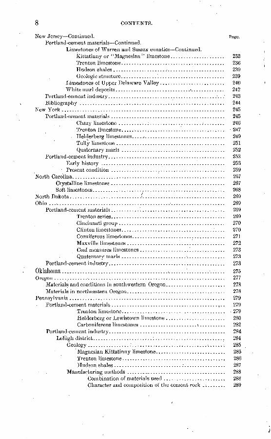
8 CONTENTS.
New Jersey Continued. Page. Portland-cement materials Continued.
Limestones of Warren and Sussex counties Continued.Kittatinny or '' Magnesian'' limestone ̂ .................... 233Trenton limestone........................................ 236Hudson shales ............................................ 239Geologic structure.............. '.......................... 239
Limestones of Upper Delaware Valley......................... 240White marl deposits........................................... 242
Portland-cement industry.............................................. 243Bibliography ........................................................ 244
New York............................................................... 245Portland-cement materials............................................ 245
Chazy limestone ...........:..................... ........ 246Trenton limestone........................................ 247Helderberg limestones..................................... 249Tully limestone .......................................... 251Quaternary marls ......................................... 252
Portland-cement industry..................................... t ....... 253Early history ................................................ 253Present condition ............................................ 259
North Carolina. .......................................................... 267Crystalline limestones ............................................ 267Soft limestones................................................... 268
North Dakota.........................../................................ 269Ohio ...................................................................... 269
Portland-cement materials ........... 1................................ 269Trenton series.. .......................................... 269Cincinnati group ......................................... 270Clinton limestones........................................ 270Corniferous limestones................................. *.. 271Maxville limestones ....................................... 272Coal measures limestones ................... 1............. 273Quaternary marls ........................................ 273
Portland-cement industry............................................. 273
Oklahoma.........................................c ......'......... .. .... 275Oregon ...................... ̂ ............................................. 277
Materials and conditions in southwestern Oregon....................... 278Materials in northeastern Oregon...................................... 278
Pennsylvania ............................................................ 279Portland-cement materials ..........-..-..--...--..............-..-.,.. 279
Trenton limestone........................................ 279Helderberg or Lewistown limestone ....................... 280Carboniferous limestones .................................. 282
Portland-cement industry. .._.........................................' 284Leh'igh district.......................:........................... 284
Geology ............................................. ̂ ....., 285Magnesian Kittatinny limestone............................ 285Trenton limestone........................................ 286Hudson shales..........................:................ 287
Manufacturing methods ..............:......................... 288Combination of materials used ........................ 288Character and composition of the cement rock ......... 289

CONTENTS. 9
Pennsylvania Continued. Pase- Portland-cement industry Continued.
Lehigh district Continued.Manufacturing methods Continued.
Character and composition of the pure limestones ...... 289Quarry practice .............. ........................ 290Mill practice......................................... 290Character and composition of the product.............. 291
Future extensions..:......................................... 293Western Pennsylvania............................................ 294
Rhode Island .......................'..................................... 294South Carolina.....:.......'.........................,..................... 295South Dakota.............................................................. 296
Portland-cement materials ............................'......:......... 296Limestones of'the Black Hills district...................... 296Niobrara (Cretaceous) chalk of eastern South Dakota....... 301
Portland-cement industry ............................................. 301Tennessee, by E, 0. UMch ............................................... 301
; Cambrian and lower Ordovician limestones of East Tennessee. 302Upper Ordovician limestones of eastern part of Great Valley. 302Upper Ordovician limestones of western part of Great Valley. 304Ordovician limestones of middle Tennessee... J.............. 305Silurian limestones....................................... 306Mississippian limestones................-.;............... 306
Texas, by J. A. Taff...................................................... 3071 Portland-cement .materials .......;.................................... 307
Austin chalk............................................. 308Goodland limestone .............'....................'..,... 309
Portland-cement industry........_'.................................... 310Utah .................................................................... 310Vermont. ................................................................ 311Virginia, by E. S. Bassler ............. j.... .............:............... 312
Portland-cement materials ............................................ 312Shenandoah limestone.................................... 31.2
Cambrian limestones ..........:-....................... 314Beekniantown limestone....................^......^.. 314Trenton limestones ....-I.............................. 315
Martinsburg shale........................................ 317Calcareous marls......................................... 318Details of localities ....................'................... 318
^Portland-cement industry............................................. 323Washington................................................................. 323
San Juan Islands......................................... 323Northeastern Washington................................. 324
West Virginia............................................................ 325Portland-cement materials ......... ..:...'............................. 325
Ordovician limestones .................................... 325Lewiston (lower Helderberg) limestones................... 326Greenbrier limestone..................................... 327Coal Measures (Pennsylvanian) limestones................. 327
Portland-cement industry..........................'................... 328Wisconsin .......................................:....................... 329
Ordovician and Silurian limestones ........................ 329Quaternary shell marls.................................... 330-
Wyoming........................i.........................i............. 331
10 CONTENTS.
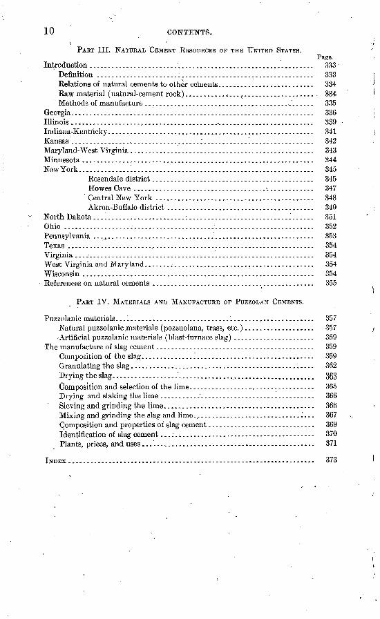
PART III. NATURAL CEMENT RESOURCES OP THE UNITED STATES.
Introduction............................................................. 333Definition ........................................................... 333Relations of natural cements to other cements.......................... 334Raw material (natural-cement rock)........... ......................... 334Methods of manufacture ............................................... 335
Georgia.................................................................. 336Illinois .................................................................... 339Indiana-Kentucky........................................................ 341Kansas ..-................................:............1................. 342Maryland-West Virginia .................................................. 343Minnesota............................................................... 344New York................................................................ 345
Rosendale district............................................ 345Howes Cave .... *.............................. . >............. 347Central New York ........................................... 348Akron-Buffalo district ........................................ 349
North Dakota .........................^........................... i...... 351Ohio .................................................................... 352Pennsylvania ..._.................._...................................... 353Texas ......... '... ....................................................... 354Virginia................................................................. 354West Virginia and Maryland- ......^...................................... 354Wisconsin ................................................................ 354References on natural cements ............................................ 355
PART IV. MATERIALS AND MANUFACTURE OP PUZZOLAN CEMENTS.
Puzzolanic materials ...................................................... 357Natural puzzolanic materials (pozzuolana, trass, etc.)................... 357-Artificial puzzolanic materials (blast-furnace slag) ...................... 359
The manufacture of slag cement........................................... 359Composition of the slag.............. '. ................................ 359Granulating the slag.................................................. 362Drying theslag....................................................... 363Composition- and selection of the lime................................... 365Drying and slaking the lime .......................................... 366Sieving and grinding the lime......................................... 366Mixing and grinding the slag and lime.................................. 367Composition and properties of slag cement............................. 369identification of slag cement...;....................................... 370Plants, prices, and uses ...'............................................ 371
INDEX ................-....------.-------- -------------------- -- - 373

ILLUSTRATIONS
Page PLATE I. Map of the United States, showing location of cement plants....... 15
II. Geological map of Alabama. Mississippi, and part of Georgia....... 62III. Map of the chalk region of southwestern Arkansas ................ 100IV. Map of California, showing areas of limestone..................... 116V. Geological map of Iowa .........-.'.............................. 148
. VI. Geological map of Kentucky and Tennessee....................... 172VII. Geological map of the lower peninsula of Michigan................ 190
VIII. Map of Michigan, showing location of cement plants and marl de posits .................................................:....... 194
I.. Geological map of northeastern Missouri and southwestern Illinois. 220 X. .Map of- New York, showing distribution of limestones ............. 246
XI. Map of the Hudson River cement district, New York .............. 254XII. .Geological map of Ohio and Indiana.............................." 270
XIII. Map of the Lehigh district, Pennsylvania-New Jersey, showing dis tribution of cement rock....................................... 284
XIV. Map of parts of Texas, Oklahoma, and Indian Territory ........... 308XV, Map of Virginia, West Virginia, Maryland, and part of Pennsyl
vania. ........................................................ 314FIG. 1. Portland-cement production of the United States, 1888-1903.......... 16
11


LETTER OF TRANSMITTAL.
DEPARTMENT OF THE INTERIOR, UNITED STATES GEOLOGICAL SURVEY,
Washington, D. C., May 11, 1904.
SIR: I have the honor to transmit herewith the manuscript of areport on the cement materials and industry of the United States, by Edwin C. Eckel, and to recommend its publication as a bulletin.
This report has been prepared in accordance with the policy of sum marizing existing information concerning one or more of the non- metalliferous mineral products each year. It contains, however, an exceptionally large proportion of entirely new information. In its preparation Mr. Eckel has visited every district in which cement was being produced and has examined nearly every plant in operation. Information relating to undeveloped deposits of cement materials has been obtained by personal examination and from the published and unpublished work of other geologists.
The object has been to treat the subject from the geological rather than the technical standpoint, although the technology of cement man ufacture is also discussed with sufEcient fullness for the purpose of the report. In view of the phenomenally rapid growth of the cement industry within recent years, the publication of this report will be exceptionally timely,
Very respectfully,C. W. HAYES,
Geologist in Charge of Geology. Hon. CHARLES D. WALCOTT,
Director U. S. Geological Survey.13


U.S. GEOLOGICAL SURVEY BULLETIN NO 243 PL
( ^>\, i . ' ' ' ' ^-'
: MAPOF THE
pffrr-x UNITED STATES'W jl i SHOWING LOCATIONS OF CEMENT PLANTS,.iii|... i.i ' Scale
yy»________p _______100_______aop______300 ______WK>_______Sop _ 600 nlil*>s
/ Pordand-cemen / Natural-cement plants
j A Sla£-cement plants,"K^
-%The symbols indicate the ", -asix-' v Ǥ%^
locaUOn of individual plants *SW ° ^1!*:'^^^ / except in theLehi£>h.(PaiLoiiisviIler * '* J, ' : i < (Ind-Ky.), and Tiosenda.le(>K)clistricts ,\? t» * '& -w-hei'e the, plants are too numerous ;;8
I to be shovsTi separately

CEMENT MATERIALS AND INDUSTRY OF THE UNITEDSTATES.
By EDWIN C. ECKEL.
INTRODUCTION.
The marvelous growth of the American Portland-cement industry during the last decade has created a widespread interest in the raw materials and in the methods of manufacture of Portland cement the most important of the cementing materials. This interest is not confined to those who have a direct financial stake in the industry, as the product is so widely used, and its'uses are so rapidly increas ing, that some knowledge of its manufacture and properties is of advantage to everyone connected, directly or indirectly, with engi neering or building operations. In its importance to our present civilization cementls surpassed among mineral products only by iron, coal, and oil; in rate of increase in annual production during the last decade even these three products can not be compared with it. In 1890 the total production of Portland cement in the United States was 335,500 barrels, valued at $439,050; in 1903 it exceeded 22,000 000 barrels, while the value was over $27,000,000.
The rate of growth of the industry is shown graphically by fig. 1. The value of the annual production of Portland cement in the United States -has been plotted on this diagram for the sixteen years 1888-1903, inclusive. During the sixteen years which witnessed the development of the American Portland-cement industry two of the greatest gold discoveries in the world's history were made in Colo rado and Alaska. The annual gold production of Alaska and of the Cripple Creek district in Colorado have been accordingly placed on the diagram. Tiiese two great gold strikes impressed themselves on every citizen of the United States, while the Portland-cement industry has attained its growth in comparative obscurity. Yet on comparison it will be seen that the gold production of Cripple Creek is. only slightly greater than the output of Portland cement, while the pro duction of Alaska sinks into comparative insignificance. On examin ing the diagram it will be seen, moreover, that the greater part of this
15

16 CEMENT MATERIALS AND INDUSTRY. [BULL. 243.
increase has been within the last decade. The production of Portland cement has risen from a little less than $2,500,000 in 1896 to over $27,000,000 in 1903.
13,000,000
11,000,000
10,000.000
9,000,000
8,000,000
5,000,000
3,000,0002,000,000
!
-----
f-
>
' I'
_.^.
-r -4-i
1
/-
-
//
<.
'
/'/
/ "" ->.
//
;.
,'
--
//
4-
,'
/
f 1
1
//
/1
I
11
I'
!
\ \
';
',
',
:;
:;
/
.
/
........ Portland cement production of The United States Gold production of Alaska Gold production of Cripple Creek district, Colorado
FIG. 1. Portland cement production of the United States, 1888-1903.
This report, has been prepared in order to give information on cemest materials, which is desired by two classes of persons. First, owners of lands on which marl, limestone, or clay deposits are found often inquire whether a given material is suitable for Portland-cement manufacture. In response to such questions the writer has attempted,

KCKKL.J * LITERATURE. 17
; in the preliminary chapters, to describe the chemical and physical properties which a Portland-cement material must have, and also to show that the value of cement material depends almost entirely upon location with respect to fuel supply, transportation routes, and markets. Second, cement manufacturers or those wishing to engage in the cement industry often inquire concerning the localities in some given State or group of States where cement materials will probably be found and desire information in advance of actual testing concerning the physical and chemical character of the materials. The latter portion of this report, dealing with the cement resources of the separate States, is designed to furnish information of this type.
The scope of the report is fairly well denned by the preceding state ments. It is intended to be primarily a discussion of cement mate rials, not a manual of cement manufacture or a guide to cement testing or utilization. A brief sketch of the processes of Portland-cementmanufacture is presented on pages 21-59, in order to make the subject clear to the great number of people who are interested, in one way or another, in the condition and growth of this important industry.
In Parts III and IV of the bulletin, on pages 333 to 372, will be found a comparatively brief discussion of the raw materials and manufacture of two classes of cements allied to Portland cement, i. e., natural cements and puzzolan (slag) cements.
It is with pleasure that the writer acknowledges his indebtedness to the managers and chemists of the various Portland, natural, and slag
;nent plants throughout the United States. Most of these' plants, wjV.i their quarries or mines, have been personally examined by the writer, and in every case all possible facilities have been afforded for making the examination as thorough as was necessaiy. A considerable part of the information obtained in this manner can, of course, for obvious business reasons, be only stated in a general way; but in most cases permission to publish the data obtained has been freely given.
LITERATURE ON CEMENTS.
Frequent references have been given, in the text or in footnotes, to reports or papers which give more detailed information in regard to various phases of the subject. It is a matter of regret that no single book has been published which adequately summarizes the conditions of the modern cement industry in America. This is doubtless due in part to the fact that all our technical industries are in present days subject to such rapid advance that data must be sought in the engineer ing and other technical journals, and not in books. In part, however, the lack of a cement manual is due to the fact that the leaders in the progress of the American cement industry have been cement manu-
Bull. 243 05 2

18 CEMENT MATERIALS AND INDUSTRY. [BULL. 243.
facturers, and have not felt justified in spending their time in sum marizing- the practice for the benefit of competitors. In view of these conditions, the present writer has endeavored, in a volume now in press, ° to describe the technologic and financial features of the lime and cement industries. In the present bulletin, however, considera tion of these features has been subordinated to the discussion of the geology and of the distribution of the raw materials.
Hydraulic Cement; its Properties, Testing, and Use, by F. P. Spald- ing, is without doubt the most satisfactor}^ single volume to serve as an introduction to the general subject of cement testing and properties. As might be inferred from its subtitle, it contains practically nothing relative to raw materials or methods of manufacture, but is devoted almost entirely to a consideration of the finished product.
Cements, Mortars, and Concretes, b}^ M. S. Falk, contains valuable data on the physical properties of these materials.
The Cement Industry, a volume containing a number of papers which original!}7" appeared in the Engineering Record, is of great serv ice as an introduction to the study of cement-manufacturing methods.
The Director};- of American Cement Industries contains, in addition to its lists of plants, many valuable notes on manufacturing and testing methods.
Books devoted to Portland cement exclusively have been written by Jameson and Butler, but they contain nothing relative to rotary kiln practice, and are therefore of little use to American readers.
To one fairly conversant with the French language, two admirable books will be of service. The first of these, Candlot's Ciments et Chaux Hydrauliques, is probably the best single book, in any lan guage, on cement technology. In its treatment of the theoretical questions involved in cement manufacture it is excellent; but its valuefor American readers is lessened because the mechanical side of the cement industry is discussed solely from the standpoint of European practice.
The second, of somewhat different character, is Bonnami's Fabri cation et Controle des Chaux Hydrauliques et des Ciments. This volume contains a very detailed description of the manufacture and properties of the hydraulic limes, so widely used in Europe, but it also contains valuable discussions on the theoretical side of cement manufacture in general.
DEFINITION OF PORTLAND, NATURAL, AND PUZZOLAN CEMENTS.
Before taking up the subject of the materials and manufacture of cements, it is advisable to define the four great classes which are included in the group of "hydraulic cements," as that term is used by
a Cements, Limes, and Plasters: Their Manufacture and Properties. Wiley & Sons, New York. 1905.

ECKEL.] . , DEFINITIONS OF CEMENTS. 19
the engineer. The relationship of the various cementing materials a can be concisely expressed as in the following diagram:
, , ,. , Plaster of Paris, cement plaster. Keene's cement, etc. Nonkydraulic cements..~ ,. r
J Common lime.Hydraulic lime.
Tr , ,. , Natural cements. Hydraulic cements ..... n ., , , Portland cements.Puzzolan cements.
Nonhydraulic cements. Nonhydraulic cements do not have the property of '' setting " or hardening under water. They are made by burning, at a comparatively low temperature, either gypsum or pure limestone. The products obtained by burning gypsum are marketed as "plaster of Paris," "cement plaster," "Keene's cement," etc., according to details in the process of manufacture. The product of burning limestone is common lime. The plasters and limes will notbe further discussed in the present bulletin.
Hydraulic cements. The hydraulic cements are those which set when used under water, though the different kinds differ greatly in the extent to which they possess this property, which is due to the formation during manufacture of compounds of lime with silica, alumina, and iron oxide.
On heating a pure limestone (CaC03) containing less . than, say, 10 per cent of silica, alumina, and iron oxide together, its carbon dioxide (CO2 ) is driven off, leaving more or less pure calcium oxide (CaO) (quicklime or common lime). If the limestone contains much silioa, alumina, or iron oxide, the result is quite different.
Natural cements. .Natural cements are produced by burning a nat urally impure limestone, containing from 15 to 40 per cent of silica, alumina, and iron oxide, at a comparatively low temperature, about that of ordinary lime burning. The operation can therefore be car ried on in a kiln closely resembling an ordinary lime kiln. During the burning the carbon dioxide of the limestone is almost entirely driven off, and the lime combines with the silica, alumina, and iron oxide, forming a mass containing silicates, aluminates, and ferrites of lime. If the original limestone contained much magnesium carbonate the burned rock will contain a corresponding amount of magnesia.
The burned mass will not slack if water be added. It is necessary, therefore, to grind it rather fine. After grinding, if the resulting powder (natural cement) be mixed with water it will harden rapidly. This hardening or setting will also take place under water. Natural cements differ from ordinary limes in two noticeable ways:
(1) The burned mass does not slack on the addition of water.
a For a more detailed discussion see Municipal Engineering, vol. 24, 1903, pp. 335-336, and Ain. Geologist, vol. 29,1902, pp. 146-154.

20 CEMENT MATEEIALS AND INDUSTRY. [BULL. 243.
(2) The powder has hydraulic properties, i. e., if properly pre pared, it will set under water.
Natural cements 'differ from Portland cements in the following important particulars:
(1) Natural cements are not made from carefully prepared and finely ground artificial mixtures, but from natural rock.
(2) Natural cements -are burned at a lower temperature than Portland, the mass in the kiln never being heated high enough to even approach the fusing or clinkeririg point.
(3) Natural cements, after burning and grinding, are usually yellow to brown in color and light in weight, -having a specific gravity of 2.7 to 3.1, while Portland cement is commonly blue to gray in color and heavier, its specific gravity ranging from 3 to 3.2.
(4) Natural cements set more rapidly .than Portland cement, but do not attain so high tensile strength.
(5) Portland cement is a definite product, its percentages of lime, silica, alumina, and iron oxide varying only between narrow limits, while brands of natural cements vary greatly in composition.
Portland cement. Portland cement is produced by burning a finely ground artificial mixture containing essentially lime, silica, alumina, and iron oxide in certain definite proportions. Usually this combination is made by mixing limestone or marl with clay or shale, in which case the mixture should contain about three parts of the lime carbonate to one part of the clayey materials. The burning takes place at a high temperature, approaching 3,000° F., and must therefore be carried on in kilns of special design and lining. During the burning, combination of the lime with silica, alumina, and iron oxide takes place. The product of the burning is a semifused mass called "clinker," which consists of silicates, aluminates, and ferrites of lime in certain fairly definite proportions. This clinker must be finely ground. After such grinding, the powder (Portland cement) will set under water.
Puzzolan cements. The cementing materials included under this name are made by mixing powdered slacked lime with either a volcanic ash or a blast-furnace slag. The product is, therefore, simply a mechanical mixture of two ingredients, as the mixture is not burned at any stage of the process. After mixing, the mixture is finely ground. The resulting powder (puzzolan cement) will set under water,
Puzzolan cements are usually light bluish, and of lower specific gravity and less tensile strength than Portland cement. They are better adapted to use under water than in air, as is explained on later pages.
PART I. MATERIALS AND MANUFACTURE OF PORTLANDCEMENT.
As noted in the Introduction, this bulletin is not intended to be a manual of cement manufacture, but a guide both to those who wish to locate available supplies of cement material and to those who wish to know whether materials occurring on their property are likely to be fit for such use. To persons of the first classy who usually are cement manufacturers, this first part of the bulletin will contain littleof value; but it has seemed probable that such a sketch of cement technology will be serviceable to those who are not so well acquainted with the subject. In the discussion of the manufacture of Portland cement, stress has been laid only upon those processes which are directly influenced by the character of the raw materials used. The section on the mixing and grinding of the raw materials, for example, is much more detailed than the portion devoted to burning and clinker grinding. The subjects of cement testing and the uses of cement have been intentionally omitted.
In the following section, various possible raw materials for Portland- cement manufacture will be taken up and their relative suitability for such use will be discussed.' In order that the statements may be clearly understood it will be necessary to preface this discussion by a brief explanation regarding the composition of Portland cement. This subject will be treated in greater detail on pages 23-24.
DEFINITION OF PORTLAND CEMENT.
While there is a general agreement as to what is understood by the term Portland cement, a few points of importance are still open ques tions. The definitions of the term given in specifications are, in con sequence, often vague and unsatisfactory.
Use of term Portland. It is agreed that the cement mixture must consist essentially of lime, silica, and alumina in proportions which can vary but slightly, and that this mixture must be burned at a tem perature which will give a semifused product a "clinker." These, points must therefore be included in any satisfactory definition. The point regarding which there is a difference of opinion is whether or not cements made by burning a natural rock can be considered true Portlands. The question whether the definition of Portland cement
21

22 CEMENT MATERIALS AND INDUSTBY. [BOLL. 243.
should be drawn so as to include or exclude such products is evi dently largely a matter of convention; but, unlike most conventional issues, the decision has very important practical consequences. The question at issue may be stated as follows:
^If artificial mixture of the raw materials and a very high degree of burning are made the criteria on which to base a definition, there will be excluded from the class of Portland cements certain well-known and very meritorious products, manufactured at several points in France and Belgium by burning a natural rock without artificial mixture and at a considerably lower temperature than is attained in ordinary Portland-cement practice. These "natural Portlands" of France and Belgium have always been considered Portland cements by the most critical authorities, though all agree that they are not of very high-grade.
There is no doubt that there could occur a rock which would contain lime, silica, and alumina in such proportions as to, give a good Port land cement on burning. Actually, however, such a perfect cement rock is of extremely rare occurrence. As above noted, certain brands of French and Belgian "Portland" cements are made from such natural rocks without the addition of any other material, but these brands are not of particularly high grade, and in the better Belgian cements the composition is corrected by the addition of other material to the cement rock before burning.
The following definition of Portland cement is important because of the large amount of cement which is accepted annually under the specifications" in which it occurs, and is of interest as being the nearest approach in this country to an official definition of the material.
By a Portland cement is meant the product obtained from the heating or calcining up to incipient fusion of intimate mixtures, either natural or artificial, of argillaceous with calcareous substances, the calcined product to contain at least 1.7 times as much of lime, by weight, as of the materials which give the lime its hydraulic properties, and to be finely pulverized after said calcination, and thereafter additions or substi tutions for the purpose only of regulating certain properties of technical importance to be allowable to not exceeding 2 per cent of the calcined product.
It will be noted that this definition does not require pulverizing or artificial mixing of the materials prior to burning. It seems probable that the Belgian "natural Portlands" were kept in mind when these requirements were omitted. In dealing with American-made cements, however and the specifications in question are headed "Specifications for American Portland Cement" it is a serious error to omit these requirements. No true Portland cements are manufactured in Amer
ica from natural mixtures without pulverizing and artificially mixing $he materials prior to burning. Several plants, however, have placed on the market so-called "Portland cements," made b}^ grinding up
a Prof. Paper No. 28, Corps of Engineers, U. S. A., p. 30.

ficKEL.1 COMPOSITION OF PORTLAND CEMENTS. 23
together the underburned and overburned materials formed during the burning1 of natural cements. Several of these brands contain fromo
5 to 15 per cent of magnesia; and under no circumstances can they be considered true Portland cements.
In view.of the conditions above noted the writer believes that the following definition will be found more satisfactory than the one above quoted:
Portland cement is an artificial product, obtained by finely pulver izing the clinker produced by burning to seuuifusion an intimate mix ture of finely ground calcareous and argillaceous material, this mixture consisting, approximately, of one part of silica and alumina to three parts of carbonate of lime (or an equivalent amount of lime).
COMPOSITION AND CONSTITUTION.
During recent years much attention has been paid by various inves tigators to the constitution of Portland cement. The chemical com position of any particular sample can, of course, be readily determined ,by analysis, and by comparison of a number of such analyses general statements can be framed as to the range in composition of good Portland cements.
Portland cements may be said to tend toward a composition approx imating to pure tricalcic- silicate (3CaO.SiO2 ) which would nearly cor respond to the proportion CaO, 73.6 per cent,' Si02 , 26.4 per cent. As can be seen, however, from commercial analyses, actual Portland cements differ in composition somewhat markedly from this. Alumina is always present in considerable quantity, forming, with part of the lime, the dicalcic aluminate (2CaO.Si02). This would give, as stated by Newberry, for the general formula of a pure Portland
x (3CaO.Si08) + y (2CaO.A1 203).
The composition is still further complicated by the presence of acci dental impurities or intentionally added ingredients. These last may be simply adulterants, or they may be added to serve some useful purpose. Calcium sulphate is a type of the latter class. It serves to retard the set of the cement and, in small quantities, appears to have no injurious effect which would prohibit its use for this purpose. In dome kilns sufficient sulphur trioxide is generally taken up by the cement from the fuel gases to obviate the necessity for later addi tion of calcium sulphate, but in the rotary kiln its addition to the ground cement, in the form of either powdered gypsum or plaster of Paris, is a necessity.
Iron oxide within reasonable limits seems to act as a substitute fo'r alumina, and the- two may. be calculated together. Magnesium car bonate is rarely entirely absent from limestones or clays, and mag nesia is therefore almost invariably present in the finished cement.

24 CEMENT MATERIALS AND INDUSTRY. [BULL. 243.
Many engineers regard it as positively detrimental in even small amounts, and because of this feeling manufacturers prefer to carry it as low as possible. Newberry has stated that in amounts of less than 3i per cent it is harmless, and American Portlands from the Lehigh district usually reach well up toward that limit. In European practice it is carried somewhat lower. s
It would seem to be firmly established that in a well-burned Port land cement much of the lime is combined with most of the silica to form the compound 3CaO.SiO2 tricalcic silicate. To this compound is ascribed, in large measure, the Irydraulic properties of the cement; and in general it may be said that the value of a Portland cement increases directly as the proportion of 3CaO.SiO2 . The ideal Port land cement, toward which cements as actually made tend in composi tion, would consist exclusively of tricalcic silicate, and would be therefore composed entirely of lime and silica in the following pro portions: Lime (CaO), 73.6 per cent; silica (SiO2 ), 26.4 per cent.
Such an' ideal cement, however, can not be manufactured under present commercial conditions, for the heat required to clinker such a mixture can not be attained in any working kiln. Newberry has prepared such mixtures by using the oxyhydrogen blowpipe; and the electrical furnace will also give clinker of this composition; but a pure lime-silica Portland is not possible under present conditions.
In order to prepare Portland cement in actual practice, therefore, it is necessary that some other ingredient or ingredients be present to serve as a flux in aiding the combination of the lime and silica, and such aid is afforded by the presence of alumina and iron oxide.
Alumina (A1 2O3) and iron oxide (Fe203 ), when present in noticeable percentages, serve to reduce the temperature at which combination of the lime and silica (to form 3CaO.SiO? ) takes place; and this clink-ering1 temperature becomes further and further lowered as the per centages of alumina and iron are increased. The strength and value of the product, however, also decrease as the alumina and iron increase; so that in actual practice it is necessaiy to strike a balance between the advantage of low clmkering temperature and the disad vantage of weak cement, and thus to determine how much alumina and iron should be used in the mixture.
It is generally considered that whatever alumina is present in the cement is combined with part of the\ lime to -form the compound 2CaO.SiO2 dicalcic aluminate. It is also held by some, but this fact is somewhat less firmly established than the last, that the iron present is combined with the lime to form the compound 2CaO. Fe2O3 .. For the purposes of the present paper it will be sufficient to say that, in the relatively small percentages in which iron occurs in Portland cement, it may for coiwenience be considered as equivalent to alumina in its action, and the two may be calculated together.

ECKEL.] CEMENT-MAKING MATERIALS. 25
RAW MATERIALS FOR PORTLAND CEMENT.
For the purposes of the present section it will be sufficiently accurate to consider that a Portland-cement mixture, when ready for burning, will contain about 75 per cent of lime carbonate (CaCO3) and 20 per cent of silica (Si02), alumina (A1203 ) and iron oxide (Fe2O3) together, the remaining 5 per cent including any magnesium carbonate, sulphur, and alkalies that may be present.
The essential elements which enter into this mixture lime, silica, alumina, and iron are all abundantly and widely distributed in nature, occurring in different forms in many kinds of rocks. It can therefore readily be seen that, theoretically, a satisfactory Portland-cement mixture could be prepared by combining, in an almost in finite number of ways and proportions, many kinds of raw material. Obviously, too, we might expect to find gradations in the artificial ness of the mixture, varying from one extreme, where a natural rock of abso lutely correct composition was used, to the other extreme, where two or more materials, in nearly equal amounts, are required.
The almost infinite number of raw materials which are theoretically available are, however, reduced to a very few under existing commer cial conditions. The necessity for making the mixture as cheaply as possible rules out of consideration a large number of materials which would be considered available if chemical composition were the only thing to be taken into account. Some materials, otherwise suitable, are too scarce; some are too difficult to pulverize. In consequence, a comparatively few combinations of raw materials are actually used in practice.
In certain localities deposits of argillaceous (cla}^ey) limestone' or "cement rock" occur in which the lime, silica, alumina, and iron oxide exist in so nearly the proper proportions that only a relatively small amount (say 10 per cent) of other material is required in order to make a mixture of correct composition. In the majority of plants, however, most or all of the necessary lime is furnished by one raw material, while .the silica, alumina, and iron oxide are largely or entirely derived from another. The raw material which furnishes the lime is usually natural a limestone, chalk, or marl but occasionally it is an artificial product, such as the chemically precipitated lime car bonate which results as waste from alkali manufacture. The silica, alumina, and iron oxide of the mixture are usually derived from clays, shales, or slates; but in a few plants blast-furnace slag is used as the silica-aluminous ingredient in the manufacture of true Portland cement.
The various combinations of raw materials which are at present used in the United States in the manufacture of Portland cement may be grouped under six heads: (1) Argillaceous limestone (cement rock)

26 CEMENT MATERIALS AND INDUSTRY [BULL. 248.
:i:id pure limestone; (2) pure hard limestone and clay or shale; (3) soft chalky limestone and clay; (4) marl and clay; (5) alkali waste and clay; (6) slag and limestone.
LIMESTONES.
Limestone is the most important ingredient, in one form or another, in a Portland-cement mixture. Limestones of certain types are employed in the manufacture of hydraulic limes, natural cements, and slag cements. It will thus be seen that limestone-is a very important constituent of all the cementing materials discussed in this bulletin. For this reason it has seemed desirable to discuss in the present section the origin, composition, varieties, and chemical and physical characters of limestone in general. This has been done in considerable detail. The present section will, therefore, serve as an introduction to the discussions of both the Portland and natural cements.
OEIGIN OF LIMESTONES.
Limestones a have been formed largely by the accumulation at the sea bottom of the calcareous remains of such organisms as the foram- inifera, corals, and mollusks. Many of the thick and extensive lime stone deposits of the United States were probably marine deposits formed in this way. Some of these limestones still show the fossils of which they were formed, but in others all trace of organic origin has been destroyed by the fine grinding to which the shells and corals were subjected before their deposition at the sea bottom. It is prob able also that a large part of the calcium carbonate of .these limestones was a purely chemical deposit from solution, cementing the shell frag ments together.
Other limestones, far less extensive, though important in the presentconnection, owe their origin to tjie indirect action of organisms. The "marls," so important to-day as Portland cement materials, fall in this class. As the deposits of this class are of limited extent, however, their method of origin may be dismissed here, but will be described later, on pages 34-36.
Deposition from solution by purely chemical means has undoubtedly given rise to numerous limestone deposits. When this deposition took place in caverns or in the open air it gave rise to onyx deposits and to the "travertine marls" of certain localities in Ohio and elsewhere. When it took place in isolated portions of the sea through the evapo ration of the sea water it gave rise to the limestone beds which so frequently accompany deposits of salt and gypsum.
« For a more detailed discussion of this subject the reader will do well to consult Chapters of Prof. J. F. Kemp's Handbook of Rocks.

BCKEL.] LIMESTONES. 27
VARIETIES OF LIMESTONE.
A number of terms are in general use for the different varieties of limestone, based upon differences of origin, texture, composition, etc. The more important of these terms will be briefly defined.
The marbles are limestones which, through the action of heat and pressure, have become more or less distinctly crystalline, though the term marble is often extended to cover any limestone which will take a good polish. The term marl, as at present used in cement manufac ture, is applied to a loosely cemented mass of lime carbonate formed in lake basins, as described on page 34. Calcareous tufa and traver tine are more or less compact limestones, deposited by spring or stream waters along their courses. Oolitic limestones, so called because of their resemblance to a mass of fish roe, are made up of small rounded grains of lime carbonate having a concentrically lami nated structure. Chalk is a fine-grained limestone composed of finelycomminuted shells, particularly those of the foraminifera. The pres ence of much silica gives rise to a siliceous or cherty limestone. If the silica present is in combination with alumina the resulting lime stone will be clayey or argillaceous.
CHEMICAL COMPOSITION OF LIMESTONE.
A theoretically pure limestone is merely a massive form of the min eral calcite. Such an ideal limestone would therefore consist entirely of calcium carbonate or carbonate of lime (CaCO3) or 56 per cent cal cium oxide (CaO) plus 44 per cent carbon dioxide or carbonic acid (CO2). As might be expected, limestones as quarried differ more or less widely from this theoretical composition. These departures from ideal purit}^ may take place along either of two lines: (1) The presence of magnesia in place of part of the lime; (2) the presence of silica, iron, alumina, alkalies, or other impurities.
It seems advisable to discriminate between these two cases, even though a given sample of limestone may fall under both heads.
MAGNESIA IN LIMESTONE.
The theoretically pure limestones are, as above noted, composed entirely of calcium carbonate and correspond to the chemical formula CaC03 . Setting aside for the moment the question of the presence or absence of such impurities as iron, alumina, silica, etc., it may be said that lime is rarely the only base in a limestone. During or after the formation of the limestone a certain percentage of magnesia is usually introduced in place of part of the lime, thus giving a more or less magnesian limestone. In such magnesian limestones part; of the cal-

28 CEMENT MATERIALS'AND INDUSTRY. [BULL. 243.
cium carbonate is replaced by magnesium carbonate (MgCO3), the general formula for magnesian limestone being therefore x CaCO3 , y MgCO3 . In this formula so may vary from 100 per cent to zero, while y will vary inversely from zero to 100 per cent. Where the two carbonates are united in equal molecular proportions, the resultant rock is called dolomite. It has the formula CaC03 , MgC03 and is com posed of 54.35 per cent calcium carbonate and 45.65 per cent mag nesium carbonate. If the calcium carbonate has been entirely replaced by magnesium carbonate, the resulting pure carbonate of magnesia is called magnesite, having the formula MgCO3 and being composed of 47.6 per cent magnesia (MgO) and 52.4 per cent carbon dioxide (C02).
Rocks of the limestone series may therefore vary in composition from pure calcite limestone at one end of the series to pure magnesite at the other. The term limestone has, however, been restricted in general use to those rocks which have a composition between that of calcite and dolomite. All the more uncommon phases, carrying more than 45.65 per cent magnesium carbonate, are usually described simply as impure magnesites.
The presence of much magnesia in finished Portland cement is con sidered undesirable, 3£ per cent being the maximum permissible under most specifications. Therefore the limestone to be used in Portland cement manufacture should not carry over 5 or 6 per cent of mag nesium carbonate.
Though magnesia is often described as an "impurity" in limestone, this word, as can be seen from the preceding statements, hardly expresses' the facts in the case. The magnesium carbonate present, whatever its amount, simply serves to replace an equivalent amount of calcium carbonate, and the resulting rock, whether little or much magnesia is present, is still a pure carbonate rock. With the impur ities to be discussed in later paragraphs, however, this is not the case. Silica, alumina, iron, sulphur, alkalies, etc., when present, are actual impurities, not merely chemical replacements of part of the calcium carbonate.
SILICA, IRON, AND OTHER IMPURITIES IN LIMESTONE.
A limestone consisting of pure calcium carbonate or of calcium car bonate with more or less magnesium carbonate may also contain a greater or lesser amount of distinct impurities. From the point of view of the cement manufacturer, the more important of these impuri ties are silica, alumina, iron, alkalies, and sulphur, all of which have a marked effect on the value of the limestone as a cement material.
The silica in limestone may occur either in combination with alumina as a clayey impurity, or not combined with alumina. As the effect on the value of the limestone would be very different in the two cases, they will be taken up separately.

HCKBL.1 LIMESTONES. 29
Silica in limestone. Silica, when present in a limestone containing no alumina, may occur in one of three forms, and the one in which it occurs is of great importance in connection with cement manufacture.
(1) In perhaps its commonest form silica is present in nodules, masses, or beds of flint or chert. Silica occurring in this form will not readily enter into combination with the lime of a cement mixture, and a cherty or flinty limestone is therefore almost useless in cement manufacture.
(2) In a few cases, as in the hydraulic limestone of Teil, France, a large amount of silica and very little alumina are present, notwith standing which the silica readily combines with the lime on burning. It is probable that in such cases the silica is very finely divided or occurs as hydrated silica, which is possibly the result of chemical precipitation or of organic action. In the majority of cases, however,a highly siliceous limestone will not make a cement on burning- unlessit contains alumina in addition to the silica.
(3) In the crystalline limestones (marbles), and less commonly in uncrystalline limestones, silica may occur as a complex silicate in the form of shreds or crystals of.mica, hornblende, or other silicate mineral. In this form silica is somewhat intractable in the kiln, and mica and
Lother silicate minerals are therefore to be regarded as inert and useless impurities in a cement rock. These silicates will flux at a lower tem perature than pure silica, and are thus not so troublesome as flint 'or chert. They are, however, much less serviceable than if the same amount of silica were present in combination with alumina as a clay.
Silica ivith alumina in limestone. -Silica and alumina, combined in the form of clay, are common impurities in limestones and are of special interest to the cement manufacturer. The best-known example of such an argillaceous limestone is the cement rock of the Lehigh district of Pennsylvania. Silica and alumina when present in this combined form unite readily with the lime under the action of heat, and an argillaceous limestone, therefore, forms an excellent basis for a Portland-cement mixture.
Iron in limestone. Iron when present in a limestone occurs com monly as .the oxide (Fe2O3) or sulphide (FeS2 ); more rarely as iron carbonate or in complex silicates. Iron in the oxide, carbonate, or silicate forms, is a useful flux, aiding in the combination of the lime and silica in the kiln. When present as a sulphide, in the form of the mineral pyrite, in quantities exceeding 2 or 3 per cent, it is to be avoided.
PHYSICAL CHARACTERS OF LIMESTONES.
In texture, hardness, and compactness the limestones vary from the loosely consolidated marls through the chalks to the hard, compact limestones and marbles. Thej^ differ in absorptive properties and density. The chalky limestones may have a specific gravity as low as
30 CEMENT MATEEIALS AND INDUSTEY. [BOLL. 243.
1.85, corresponding to a weight of 110 pounds per cubic foot, while the compact limestones, commonly used for building purposes, range in specific gravity between 2.3 and 2.9, corresponding approximately to a range in weight of from 140 to 185 pounds per cubic foot.
From the point of view of the Portland-cement manufacturer these variations in physical properties- are of economic interest chiefly in their bearing upon two points the percentage of water carried by the limestone as quarried and the ease with which the rock may be^ crushed and pulverized. To some extent the two properties counter balance each other; the softer the limestone the more absorbent is it likely to be. These purely ̂ economic features will be discussed in more detail on later pages.
EFFECT OF HEAT ON LIMESTONE.
On heating a nomnagnesian limestone to or above 300° C. its car bon dioxide will be driven off, leaving quicklime (calcium oxide, CaO). If a magnesian limestone be similarly treated, the 'product would be a mixture of calcium oxide and magnesium oxide (MgO). The rapidity and perfection of this decomposition can be increased by passing steam or air through the burning mass. In practice this is accom plished either by the direct injection of air or steam or more simply by thoroughly wetting the limestone before putting it into the kiln.
If, however, the limestone contains an appreciable amount of silica, alumina, and iron, the effects of heat will not be of so simple a charac ter. At temperatures of '800° C. and upward these clayey impurities will combine with the lime oxide, giving silicates, aluminates, and related salts of lime. In this manner a natural cement will be produced (see pp. 333-334). An artificial mixture of a certain uniform composition, burned at a higher temperature, will give a Portland cement.
ARGILLACEOUS LIMESTONE (CEMENT ROCK).
An argillaceous limestone containing approximately 75 per cent of lime carbonate and 20 per cent of clayey materials (silica, alumina, and iron oxide) would, of course, be the ideal material for use in the manufacture of Portland cement, as such a rock would contain within itself in the proper proportions all the necessary ingredients. It would require the addition of no other material, but when burnt alone would give a good cement. This ideal cement material is, of course, never found, but certain argillaceous limestones approach it very closely in composition.
The most important deposit of these argillaceous limestones or "cement rocks" is that which is so extensively utilized in Portland- cement manufacture in the Lehigh district of Pennsylvania and New Jersey. As this area still furnishes about two-thirds of all the Portland cement manufactured in the United States, its raw materials are described in some detail on pages 31-32.

ECKBL.] . ' LIMESTONES. ' 31
CEMENT KOCK OF THE LEHIGH DISTRICT.
The Lehigh district of the cement trade comprises parts of Berks, Lehigh, and Northampton counties. Pa., and of Warren County, N. J. Within this relatively small area are located about 20 Portland-cement mills, which produce a little over two-thirds of the entire American output. As deposits of the cement rock used by these plants extend far beyond the present Lehigh district, a marked extension of the district will probably take place as the need for larger supplies of raw material becomes more apparent.
The "cement rock" of the Lehigh district is a highly argillaceous limestone of Trenton (lower Silurian) age. The formation is about 300 feet thick in this area. The rock is very dark gray, and usually has a slaty fracture. In composition it ranges from about 60 per cent lime carbonate with 30 per cent clayey material, up to 80 per centlime carbonate with 15 per cent of silica, alumina, and iron. Thelower beds of the formation always contain -more lime carbonate than those above. The content of magnesium carbonate in these cement rocks is always high, as Portland cement material goes, ranging from 3 to 6 per cent.
Near and in some cases immediately beneath these cement beds are beds of purer limestone, containing from 85 to 96 per cent lime carbonate. The usual practice in the Pennsylvania and New Jersey plants has been, therefore, to mix a relatively small amount of this purer limestone with the low lime "cement rock" in such proportions as to give a cement mixture of proper composition.
The economic and technologic advantages of using such a combina tion of materials are veiy evident. Both the pure limestone and the cement rock, particularly the latter, can be quarried very easily and cheaply. As quarried they carry but little water, so that the expense of drying them is slight. The fact that about four-fifths of the cement mixture will be made up of a natural cement rock permits coarser grinding of the raw mixture than would be permissible in plants using pure limestone or marl with clay. This point is more fully explained on page 47. When natural cement rock is used as part of the mixture less fuel is probably necessary to clinker the mix ture than when pure limestone is mixed with clay.
Such mixtures of argillaceous limestone or "cement rock" with a small amount of pure limestone evidently possess important advan tages over mixtures of pure hard limestone or marl with clay. They are, on the other hand, less advantageous as cement materials than the chalky limestones discussed on pages 33-34. . ,
The analyses in the table below are fairly representative of the materials employed in the Lehigh district. The first four analyses are of "cement rock," the last two are of the purer limestone used for mixing with it.

32 CEMENT MATEKIALS AND INDUSTRY.
Analyses of Lehigh district cement materials.
[BULL. 243.
Silica (Si02 ) ....................
Magnesium carbonate (MgC03 ) ..
Cement rock.
10.02
} 6.26
78.65
4.71
9.52
4.72
80.71
4.92
14.52
6.52
73.52
4.69
16.10
2.20
76.23
3.54
Limestone.
3.02
1.90
92.05
3.04
1.98
0.70
95.19
2.03
"CEMENT ROCK IN OTHER PARTS OF THE UNITED STATES.
Certain Portland-cement plants, particularly in the western part of .the United States, use combinations of materials closely similar to those in the Lehigh district. Analyses of the materials used at several of these plants are given in the following table:
Analyses of "cement rock" and limestone from the ivestern United States.
Silica (SiO,) .....................
Iron oxide (FejOg) ...............
Magnesium carbonate (MgC03 ) ..
Utah.
Cement rock.
21.2
8.0
62.08 3.8'
Lime stone.
6.8
3.0
89.8
0.76
' California.
Cement rock.
20.06
10.07
3.39
63.40
1.54
"Lime stone.
7.12
2.36
1.16
87.70
0.84
Colorado.
Cement, rock.
14. 20.
5.21
1.73
75.10
1.10
Lime stone.
88.0
In addition to these "cement rocks" many of the chalky limestones discussed on pages 33-34 are sufficiently argillaceous to be classed as"cement rocks." Because of their softness, however, all the chalkj^ limestones will be described together.
PUKE HAKD LIMESTONES..
Soon after the American Portland-cement industry had become fairly well established in the Lehigh district attempts were made in New York State to manufacture Portland cement from a mixture of pure limestone and clay. These attempts were not commercially suc cessful, and although their failure was not due to any defects in the limestone used, a certain prejudice arose against the use of the hard limestones. In recent years, however, this has disappeared, and a very large proportion of the American output is now made from mix tures of limestone with clay or shale. The use of the hard limestone is doubtless due in great part to recent improvements in grinding machinery, for the purer limestones are usually much harder than
ECKBL.] LIMESTONES. 33
argillaceous limestones like the Lehigh district "cement rock," and it was very difficult to pulverize them finely and cheaply with the crush ing appliances in use when the Portland cement industry was first started in America.
A series of analyses of representative pure hard limestones, together with analyses of the clays or shales with which they are mixed, is given in the following table:
Analyses of pure hard limestones and clayey materials.
Silica (SiO,) .-...--..
Iron oxide (Fea03 )...
Lime carbonate (CaC08). ..........
Magnesium carbonate (MgC03 ) ..........
Limestones.
1.72
1.63
6.59
90.58
0.86
.63
1.03
97.06
0.56
1.23
.29
97.23
.75
0.40
| .44
97.99
.42
Clays and shales.
63.56
27.32
3.60
2.60
55.80
30.20
2.54
56.30
29.86
60.00 r23. 26 I 4.32
1.70
1.50
The first limestone analysis given in the above table represents a curious type, used in several plants in the Middle West. It is a rela tively impure limestone, its principal impurity being iron oxide. It contains 8.22 per cent of iron oxide and alumina, as compared with 1.72 per cent of silica, and therefore great care is required in selecting a suitable high-silica clay to mix with it.
SOFT LIMESTONES (CHALK).
Origin and general character. Chalk, properly speaking, is a pure carbonate of lime composed of the remains of the shells of minute organisms, those of foraminifera being especially prominent.. The chalks and soft limestones discussed agree, not only in having usually originated in this way, but also in being rather soft, and therefore readily and cheaply crushed and pulverized. As Portland-cement materials they are therefore almost ideal. One defect, however, which to a small extent counterbalances their obvious advantages, is the fact that most of these soft, chalky limestones absorb water very readily. A chalky limestone which in a dry season will not carry over 2 per cent of moisture as quarried may, in consequence of prolonged wet weather, show as high as 15 or 20 per cent of water. This diffi culty can, of course, be avoided if care be taken in quarrying to avoid unnecessary exposure to water and, if necessary, to provide facilities for storing a supply of the raw materials during wet seasons.
Geographic and geologic distribution in the United States. The chalks and chalky limestones are confined almost entirely to certain
Bull. 243 05 3
34 CEMENT MATERIALS AND INDUSTRY. [BULL. 243.
Southern and Western States. They are all of approximately the same geologic ages Cretaceou's or Tertiary and are mostly confined to one division of the Cretaceous. The principal chalk or soft limestone deposits available for use in Portland-cement manufacture occur in three widely separated areas, in (a) Alabama and Mississipppi, (b) Texas and Arkansas, and (c) Iowa, Nebraska, North and South Dakota.
Composition. Jn composition these chalks, or "rotten limestones," vary from a rather pure calcium carbonate, low in both magnesia and clayey materials, to an impure clayey limestone requiring little addi tional clay to make it fit for use in Portland-cement manufacture. The analyses in the table below show the range of composition of the chalky limestones,
Analyses of chalky limestones.
Silica (SiOa>...... ............
Lime carbonate ( CaCOa ) ....... Magnesium carbonate ( MgC03) .
Demopo-' lis, Ala.
12. 13
4.17
3.28
75.07.92
San Anto nio, Tex.
5.77
| 2.12
90.15.15
Dallas, Tex.
23.55
1.50
70. 21
.58
White Cliffs, Ark.
7.97
1.09
88.64.73
Yankton, S. Dak.
8.20
7.07
83. 59
n.d.
Milton, N. Dak.
9.15
( 4.80
\ 2.30
63.751.25
- FRESH-WATER MARLS.
Marls, in the sense in which the term is used in the Portland-cement industry, are incoherent limestones which have been deposited in the basins of existing or extinct lakes. So far as chemical composition is concerned, marls are practically pure limestones, being composed almost entirely Of calcium carbonate. Physically, however, they dif fer greatly from the'compact rocks which are commonly described as limestones, as they are granular, incoherent deposits.' This curious physical character is due to the conditions under which they have been deposited, and accordingly varies somewhat.
The above definition of marl is that commonly used in the cement industry, but in geological and agricultural reports, particularly in those issued before the Portland-cement industry became prominent in this country, the term has been used for several veiy different sub stances. The following three uses of the term have been particularly common, and must be guarded against when such reports are being examined in search of descriptions of deposits of cement materials:
(1) In early days the terms "marls" and "rnarlytes" were applied to calcareous shales and often to shales which were not particularly calcareous. This use of the term will be found in many of the earlier

ECKEL.J MARLS. 35
geological reports issued by New York, Ohio, and other interior States.
(2) In New Jersey and the States southward bordering on the Atlan tic and Gulf of Mexico the term "marl" is commonly applied to deposits of soft, chalky, or unconsolidated limestone, often contain ing considable clayey and phosphatic matter. These limestones are of marine origin and are not related to the fresh-water marl deposits here discussed.
(3) In the same States mentioned in the last paragraph, but par ticularly in New Jersey and Virginia, large deposits of the so-called "greensand marls" occur. This material is in no way related to the true marls, which are essentially lime carbonates, but consists almost entirely of an iron silicate,. with very i small percentages of clayey, calcareous, and phosphatic matter.
Origin of marls. The exact cause of the deposition of marls has been the subject of much investigation and discussion, particularly in the last few years, since they have become of economic importance. The most important papers concerning this question are as follows: .
BLATCHLEY, W. S., and ASHLEY, G. H., The lakes of northern Indiana and their associated marl deposits: Twenty-fifth Ann. Kept. Indiana Dept. Geol. Nat. Kes., pp. 31-321.
DA vis, C. A., A contribution to the natural history of marl: Jour. Geol., vol. 8, pp. 485-497.
DA vis, C. A., Second contribution to the natural history of marl: Jour. Gieol., vol. 9, pp. 491-506.
DAVIS, C. A., A contribution to the natural history of marl: Eept. Michigan Geol. Survey, vol. 8, pt. 3, pp. 65-102.
LANE, A. C., Notes on the origin of Michigan bog limes: Bept. Michigan Geol. Survey, vol. 8, pt. 3, pp. 199-223.
Disregarding the points in controversy, which are of no practical importance, it may be said that marls are deposited in lakes by spring or stream waters carrying lime carbonate in solution. The actual deposition is due in part to purely physical and chemical causes, and in part to the direct or indirect action of animal or vegetable life. The result in any case is that a calcareous deposit forms along the sides and over the bottom of the lake, this deposit consisting of lime car bonate, mostly in a finely granular form, interspersed with shells and shell fragments.
Geographic distribution of marl deposits. The geographic distribu tion of marl deposits is intimately related to. the geologic history of the region in which they occur. Marl beds are the result of the filling of lake basins. Lakes are not common in the United States, except in areas which have been glaciated, since they are in general due to the damming of streams by glacial material. Workable marl deposits, therefore, are confined almost exclusively to those portions of the

36 CEMENT MATERIALS AND INDUSTRY. [BOLL. 243.
United States and Canada lying north of the southern limit of the glaciers.
Marl beds are found in the New England States, where they are occasionally of important size, and in New York, where large beds occur in the central and western portions of the State. Deposits are frequent and important in Michigan and in the northern portions of Ohio, Indiana, and Illinois. They occur in Wisconsin and Minnesota, but have not been as yet exploited for cement manufacture.
Composition. As shown by the analysis below, marls are usually very pure lime carbonates. They therefore require the addition of considerable clay to bring them up to the proper composition for a Portland-cement mixture.
The marls are readily excavated, but necessarily carry a large per centage of water. The mixture, on this account, is commonly made in the wet way, which necessitates driving off a high percentage of water in the kilns. Analyses of typical marls and clays are given in the following table:
Analyses of marls and clays used in cement plants.
Silica (Si02 ) .................. 0.25
} ,0
94.39.38
Marl.
3.0
93.01.5
1.60
1.55
88.9.94
40.48
20. 95
25.80.99
Clay.
52.0
( 17.0I 5.0
20.0
63.7516.406.354.02.1
ALKALI WASTE.
A very large amount of waste material results from the manufac turing of caustic soda. This waste material is largely a precipitated form of calcium carbonate, and if sufficiently free from impurities furnishes a cheap source of lime for use in Portland-cement manu facture.
The availability of alkali waste for this purpose depends largely on what process was used at the alkali plant. Leblanc-process waste, for example, carries a very large percentage of sulphides, which prevents its use as a Portland-cement material. Waste resulting from the use of the ammonia process, on the other hand, is usually a very pure mass of lime, mostly in the form of carbonate, though a little lime hydrate is commonly present. As pyrite is not used in the ammonia process, the waste is usually low enough in sulphur to be used as a cement material. The waste may carry a low or a very high percent-

KCK10L.] SLAG. 37
age of magnesia, according to the character of the limestone that has been used in the alkali plant. When a limestone low in magnesium carbonate has been used the resulting waste is a very satisfactory Portland-cement material.
The folloAving analyses are fairly representative of the waste obtained at alkali plants using the ammonia process: *
Analyses of alkali waste. ,
Silica (Si08 ) .................................
Iron oxide (Fe20.,) ...........................
Lime(CaO) .................... ............Magnesia (MgO) .............................Alkalies (Na20, K20) . ........................
Sulphur (S) .................................
Carbon dioxide (C02 ) ........................
1
0.60
| 3.04
53. 33
0.480.20
n. d.n. d.
42. 43n. d.
._>
1. 75
0.61.
50. GO
5.350.64
n. d.0.10
| 41. 70
«
1.98f L 41.
I 1.38
48.29
1.510.64
1. 26
n. d.
f 39. 60I 3.80
4
0. 98
| 1. 62
50. 40
4.970.50
n.'d.0.06
n. d.n. d.
Of the analyses quoted in the preceding table, those in the first and third columns represent materials which are used in Portland-cement manufacture in England and the United States. The alkali wastes * t , . . ' -»'-.* o
whose analyses are given in the second and fourth columns are too high in magnesia to be advisable for such use.
B^LAST-FURNACE SLAG.
True Portland cements, which must be sharply distinguished from the slag (or puzzolan) cements described on pages 357-372, can be made from a mixture of blast-furnace slag and limestone which is finely powdered, and is then burned in kilns and the resulting clinker pulverized.
The slags from iron furnaces consist essentially of lime (CaO), silica (SiOj,), and/alumina (A12O3), tliough small percentages of iron oxide (FeO), magnesia (MgO), and sulphur (S) are commonly present. Slag may therefore be regarded as a very impure limestone or a very cal careous clay, from which the carbon dioxide has been driven off.
In the United States two plants manufacture true Portland cement from slag, as noted on pages 137 and 294.
38 CEMENT MATEEIALS AND INDUSTRY. [BOLL. 243.
The slag used at a German Portland cement plant has the following range in composition:
Analysis of slag used in Portland-cement manufacture:
Silica (SiOj) ....................................................... 30.0 to 35.0Alumina (A1 20S ) J.................................................. 10. 0 to 14.0Iron oxide (FeO) ... .............................................. . 2 to 1.2Lime (CaO) ................................:...........;.......... 46.0 to 49. 0Magnesium oxide (MgO) ........................................... . 5 to 3. 5Sulphur trioxide (S03 ) ....................'......................... . 2 to .6
CLAYS AND SHALES.
Clays are ultimately derived from the decaj7 of older rocks, the finer particles being carried off by streams and deposited as beds of claj^ along channels, in lakes, or along parts of the seacoast or sea bottom. In chemical composition the claj^s are made up essentially of silica and alumina, though iron oxide is almost invariably present in more or less amount, while lime, magnesia, alkalis, and sulphur occur fre quently, though usually only in small percentages.
Shales are clays which have become hardened by pressure. The so-called "fire clays" of the Coal Measures are shales, as are man)7" of the other "clays" of commerce.
For use as Portland-cement materials clays or shales should be free from gravel and sand, as the silica present as pebbles or grit is practi cally inert in the kiln unless ground more finely than is economically practicable. In composition they should not carry less than 55 per cent of silica, and preferabty from 60 to 70 per cent. The alumina and iron oxide together should not amount to more than one-half the percentage of silica, and the composition will usually be' better the
Q./-V
nearer the ratio Al203+Fe203 =-g-? is approached.Nodules of lime carbonate, gypsum, or pyrite, if present in tiny
quantity, are undesirable, though the lime carbonate is not absolutely injurious. Magnesia and alkalis should be low, preferably not above 3 per cent.
Analyses of clays and shales used in various American Portland cement plants are given on pages 33 and 36.
SLATE.
Slate is, so far as origin is concerned, merely a form of shale in which a fine, even, and parallel cleavage has been developed by pres sure. In composition, therefore, it varies exactly as do the shales considered on previous pages, and so far as composition alone is con cerned, slate would not be worthy of more attention, as a Portland- cement material, than any other shale.

SLATE. 39
Commercial considerations in connection with the slate industry, however, make slate a very important possible source of cement mate rial. Good roofing slate is a relatively scarce and commands a good price Avhen found. In the preparation of roofing slate for the market so much material is lost during sawing, splitting, etc., that only about 10 to 25 per cent of the amount quarried is salable as slate. The remaining 75 to 90 per cent is of no service to the slate miner. It is sent to the dump heap, and is a continual source of trouble and" expense. This very material, however, as can be seen from the analyses quoted below, is often admirable for use, in connection with limestone, in a Portland-cement mixture. As it is a waste product it could be obtained very cheaply by the cement manufacturer. .
Composition of American roofing slates.
Silica (Si02 ) ....................................
Iron oxide (FeO, Fe20,,) .........................Lime (CaO) ....................................Magnesia (MgO) ................................Alkalies (K20, Na20).. .................. ........Ferrous sulphide (FeS2) ..........................
Moisture below 110°C ...........................
Maximum.
68.6224.7110. 665.236.43
8.68
Average.
60.6418.056.871.542.604.74
.381.47
3. 51
.62
Minimum.
54.059.772. 18.00.12
1.93
VALUE OF DEPOSITS OF CEMENT MATERIALS.
The determination of the possible value for Portland-cement manu facture of a deposit of raw material is a complex problem, depending upon a number of distinct factors, the more important of which are as follows: (1) Chemical composition, (2) physical character, (3) amount available, (4) location with respect to transportation routes, (5) loca tion with respect to fuel supplies, (6) location with respect to markets.
Ignorance of the respective importance of these factors frequently leads to an overestimate of the value of a deposit of raw material. Their effects may be briefty stated, as follows:
(.7) Chemical composition. The raw material must be of correct chemical composition for use as a cement material. This implies that the material, if a limestone, must contain as small a percentage as possible of magnesium carbonate. Under present conditions, 5 or 6 per cent is the maximum permissible. Free silica, in the form of chert, flint, or sand, must be absent, or present only in small quan-
40 CEMENT MATERIALS AND INDUSTRY. [BULL. 243.
tity say 1 per cent or less. If the limestone is a clayey limestone, or "cement rock," the proportion between ,its silica and its f alumina and iron should fall within the limits
8109 ,- > 2: < 3.5.AiA+Fe2O3 ' Al2O3 +FeA
A clay or shale should satisfy the above equation, and should be free from sand, gravel, etc. Alkalies and sulphates should, if present, not exceed 3 per cent.
(#) Physical character. Econonry in excavation and crushing requires that the raw materials should be as soft and as dry as possible.
(3} Amount available. A Portland-cement plant running on dry raw materials, such as a mixture of limestone and shale, will use approximately 20,000 tons of raw material a year per kiln. Of this about 15,000 tons are limestone and 5,000 tons shale. Assuming that the limestone weighs 160 pounds per cubic foot, which is a fair aver age weight, each kiln in the plant will require about 190,000 cubic feet of limestone a year. As the shale or clay may be assumed to contain considerable water, a cubic foot will probably contain not over 125 pounds of dry material, so that each kiln will also require about 80,000 cubic feet of shale or clay.
A cement plant is an expensive undertaking, and it would be folly to locate a plant with less than a twent}^ years' supply of raw material in sight. In order to justify the erection of a cement plant, there must be in sight at least 3,800,000 cubic feet of limestone and 1,600,000 cubic feet of clay or shale for each kiln.
(4) location with respect to transportation routes. Portland cement is for its value a bulky product, and is therefore much influenced by transportation routes. To locate a plant on only one railroad, unless
the railroad officials are financially connected with the cement plant,is simply to invite disaster. At least two transportation routes should be available, and it is best of all if one of these be a good water route.
(6) Location with respect to fuel supplies. Every barrel (380 pounds) of Portland cement marketed implies that at least 200 to 300 pounds of coal have been used in the power plant and the kilns. In other words, each kiln in the plant will, with its corresponding crushing machinery, use up from 6,000 to 9,000 tons of coal a year. The item of fuel cost is therefore highly important, for in the average .plant about 30 to 40 per cent of the total cost of the cement will be chargeable to coal supplies.
(6) Location with respect to markets. In order to achieve an estab lished position in the trade, a new cement plant should have (a) a local market area, within which it may sell practically on a noncompetiti\7 e basis, and (Z>) easy access to a larger though competitive market area.

ECKEL.] QUARRYING AND MINING. 41
METHODS AND COST OF EXCAVATING RAW MATERIALS.
The natural raw materials used in Portland-cement manufacture are obtained by one of three methods: (1) Quarrying, (2) mining, and (3) dredging. The method will depend partly on the physical character of the material and partly on the topographic and geologic conditions. Usually, however, there is no opportunity for choice, as one of the methods Avill offer the only possible mode of handling the material. The three dift'erent methods of excavation will first be briefly con sidered, after which the cost of raw materials at the mill will be discussed.
Quarrying. In the following pages the term "quarrying" will include all methods of obtaining raw materials from open excavations quarries, cuts, or pits whether the material be a limestone, a shale, or a clay. Quarrying is the most natural and common method of exca vating the raw materials for cement manufacture. If marl, which is usually worked by dredging, be excluded from consideration, it is probably within safe limits to say that 95 per cent of the raw mate rials used at American Portland-cement plants is obtained by quar rying. If marls be included, the percentages excavated b}^ the different methods would probably be about as follows: Quarrying, 88 per cent; dredging, 10 per cent; mining, 2 per cent.
In the majority of limestone quarries the material is blasted out and loaded by hand onto cars or carts. In a few limestone quarries a steam shovel is emplo^yed to do the loading, and in shale quarries the use of steam shovels is more frequent. In certain clay and shale pits, where the materials are of suitable character, the steam shovel does all the work, both excavating and loading the raw materials,
The rock is usualty shipped to the mill as quarried, without any treat ment except sledging it to convenient size for loading. At a few quarries, however, a crushing plant is installed, and the rock is sent as crushed stone to the mill. At a few quarries driers have been installed, and the stone is dried before being shipped to the mill. Except the saving of mill space thus attained, this practice seems to have little to commend it.
Mining. The term "mining" will be used, in distinction from "quarrying," to include methods of obtaining any kind of raw mate rial by underground workings, through shafts or tunnels. Mining is, of course, rarely emploj^ed in excavating substances of such low value per ton as the raw materials for Portland-cement manufacture. Occa sionally, however, a thin bed of limestone or shale will be overlain by such a thickness of other strata that mining will be cheaper than strip ping and quarrying.
Mining is considerably more expensive than quarrying, but it has a few advantages that serve to counterbalance partly the greater cost per

42 . CEMENT MATERIALS AND INDUSTRY. [BULL. 243.
ton of raw material. A mine can be worked steadity and economically in all kinds of weather, While an open cut, or quarry; is commonly in a more or less unworkable condition for about three months of the year. Material won by mining is, moreover, always dry and clean.
Dredging. The term "dredging" will be'here used to include all methods of excavating soft, wet raw materials. In the United States the only raw material for Portland-cement manufacture extensively worked by dredging is marl. Occasionally the clay used is obtained from deposits overlain by more or less water; but this is rarely done except where the marl and clay are interbedded or associated.
A marl 'deposit, in addition to containing much water diffused throughout its mass, is usually covered by water to a considerable depth. This will frequently require the partial draining of the basin in order to get tracks laid near enough to be of service.
In dredging marl the excavator is frequently mounted on a barge, which floats in a channel resulting from previous excavation. Occa sionally, in deposits which either were originally covered by very little water or have been drained, the shovel is mounted on a car which runs on tracks laid along the edge of the deposit.
A deposit worked by dredging alwa}^s occurs in a basin or depres sion, and at a lower elevation than the mill, thus necessitating uphill transportation, which may be effected in two ways, the choice depend ing largely upon the manufacturing processes in use at the plant. At plants using dome or chamber kilns, or where the marl is to be dried before it is sent to the kiln, the excavated material is usually loaded by the shovel on cars and hauled to the mill by horse or steam power. At normal marl plants using a very wet mixture it is probably more economical to dump the marl from the excavator into tanks, add suffi cient water to make it flow readily, and pump the fluid mixture to the
mill in pipes.Cost of raio materials at mill. The most natural way, perhaps, to
express the cost of the raw materials delivered at the mill would be to state it as being so many cents per ton or cubic yard, and this is the method followed by quarrymen or miners in general. To the cement manufacturer, however, such an estimate is not so suitable as one based on the cost per ton or barrel of finished cement.
It naa,y be considered that hard and comparatively dr}>- limestones or shales lose 33^ per cent in weight on burning, or that 600 pounds of dry raw material willmake about 400 pounds of clinker. Allowing something for other losses in manufacture, it is convenient and suffi ciently accurate to estimate that 600 pounds of dry raw material will give one barrel of finished cement. The raw material must beo »
increased if it carries any appreciable amount of water. Clan's will frequentty contain 15 per cent or more of water; while soft chall^y limestones, if quarried during wet weather, ma}^ cariy over 20 per
COST OF MATERIALS. 43
cent. A Portland-cement mixture composed of a pure chalky lime stone and a clay might, therefore, average 10 to 20 per cent of water; consequently about 700 pounds of such a mixture would be required to make one barrel of finished cement.
With marls the loss on drying and burning is much greater. Rus sell states a that according to determinations made b}^ E. D. Campbell 1 cubic foot of marl, as it usually occurs in the natural deposits, contains about 47£ pounds of lime carbonate and 48 pounds of water. In making cement from a mixture of marl and cla}^ therefore, it would be necessaiy to figure on excavating and transporting over 1,000 pounds of raw material for every barrel of finished cement.
Thus the cost of raw materials at the mill, per barrel of cement, will vary not only with the cost of excavation but with the kind of materials in use. In dealing with hard dry materials extracted from open quarries near the mills the cost of raw materials may range from 8 to 15 cents per barrel of cement. The lower figure is probably about the lowest attainable under good management and favorable natural conditions; the higher figure is probably a maximum for fairly careful management of a difficult quarry under Eastern labor conditions. When it is necessary to mine the materials the cost will be somewhat increased. Cement rock has been mined at a cost equiva lent to 10 cents per barrel of cement, but only under particularly favorable conditions. The cost of mining and transportation may reach 20 cents per barrel.
With regard to wet marls and clays, it is difficult to give even an approximate estimate. It seems probable, however, when the dead weight handled is allowed for, that these soft materials will cost about half as much delivered at the mill per barrel of finished cement as the hard dry limestones and shales.
METHODS OF MANUFACTURE OF PORTLAND CEMENT.
If, as in this bulletin, the so-called "natural Portlands" (see p. 22) are excluded, Portland cement ma}r be regarded as an artificial product obtained by burning to semifusion an intimate mixture of pulverized materials containing lime, silica, and alumina in varying proportions within certain narrow limits, and by crushing finely the clinker resulting from this burning. If this restricted definition of Portland cement be accepted, four points m&y be regarded as being of cardinal importance: (1) The cement mixture must be of the proper chemical composition; (2) the materials must be carefully ground and intimately mixed before burning; (3) the mixture must be burned at the proper temperature; (4) after burning, the resulting clinker .must be finely ground.
x> Twenty-second Ann. Kept. U. S. Geol. Survey, pt. 3, p. 657.

44 CEMENT MATERIALS AND INDUSTRY. [BOLL. 243.
As the chemical composition of the mixture can be more advanta geously discussed after the other three subjects have been disposed of, it will therefore be taken up last.
PREPARATION OF THE MIXTURE FOR THE KILN.
In the preparation of the mixture for the kiln the raw materials must be reduced to a very fine powder and intimately niix'ed. The raw materials are usually crushed more or less finety, then mixed, and then ground to powder. Two general methods of treatment, the dry and the wet, are in use at different plants. Unless the limy constituent of the mixture is a marl, already full of water, the dry method is almost invariably followed. In this the materials are kept in as dry a condition as possible throughout the entire process of crushing and mixing, and if they originally contained a little moisture they are dried before being powdered and mixed. In the wet method^ on the other
. hand, the materials are powdered and mixed while in a very fluid state, the mixture containing 60 per cent or more of water.
PERCENTAGE OF WATER IN RAW MATERIALS.
The percentage of water thus carried by the crude raw material will depend largely on the character of the material, partly on the method of handling and storing it, and partly on weather conditions.
In hard limestones, freshly quarried, the water will commonly range from one-half to 3 per cent, rarely reaching or exceeding the higher figure, except in the very wet quarries or during a rainy season. Such limestones, comparatively dry when quarried, are fre quently sent to the grinding mills without artificial drying.
Soft, chalky limestones, which absorb water very rapidly, usually contain not more than 5 per cent of water in dry weather, while pro longed wet weather may necessitate the handling at the mill of mate rial carrying as high as 15 to 20 per cent of water.
The clays present much more complicated conditions. In addition to the hygroscopic or mechanically held water, there is also always a certain percentage of chemically combined water. The amount of hygroscopic water will depend on the treatment and exposure of the clay, and may vary from 1 per cent in clays which have been stored and air dried to as high as 30 per cent in fresh clays. The chemicalty combined water will depend largely on the composition of the clay, and may vary from 5 to 12 per cent. The hygroscopic or mechanically held water of clays can be driven off at a temperature of 212° F., while the chemically combined water is lost only at a low red heat. The total water, therefore, to be driven off from clays may range from 6 to 42 per cent, depending on the weather, the drainage of the ckiy pit, and the care taken to prevent unnecessary exposure of the exca vated material to moisture. The average total amount of moisture will probably .be about 15 per cent.

ECKEL.] METHODS OF MANUFACTURE. 45
In dealing with shales the mechanically held water rarely amounts to more than about 10 per cent, and is commonly well below that limit. An additional 2 to 7 per cent of water, will be carried by any shale in a state of chemical combination.
At a few plants marl is used with clay in a dry process. As noted elsewhere, the marls as excavated carry usually about 50 per cent of water. These present a more difficult problem than the other raw materials, because the vegetable matter usually present in marls is extremely retentive of water.
It will be seen, therefore, that cement materials may carry from 1 to 50 per cent of water when they reach the mill. In a dry process it is necessary to remove practically all of this water before commencing the grinding. One reason for this is that fine pulverizing can not be economically or satisfactorily accomplished unless absolutely dry material is fed to the grinding machinery, Another reason, which isone of convenience rather than of necessity, is that the presence of water in the raw materials complicates the calculation of the cement mixture.
METHODS AND COSTS OF DRYING.
With the exception of the marls and clays used in the wet method of manufacture, Portland-cement materials are usually dried before the grinding is commenced. This is necessary because the raw materials, as they come from the quarry, pit, or mine, will almost invariably carry appreciable, though often very small, percentages of water, which greatly reduces the efficiency of most- modern types of grinding mills and tends to clog the discharge screens.
The t}rpe of drier commonly used in cement plants is a cylinder, approximately 5 feet in diameter and about 40 feet'in length, set at a slight inclination to the horizontal and rotating on bearings. The wet raw material is fed in at the upper end of the cylinder, and it moves gradually toward the lower end under the influence of gravity as the cylinder revolves. In many driers angle irons are bolted to the interior in such a way as to lift and drop the raw material alternately, thus exposing it more completely to the action of the heated gases and materially assisting in the drying process. The dried raw material falls from the lower end of the cylinder into an elevator boot and is then carried to the grinding mills.
The drying cylinder is heated either by a separate furnace or by waste gases from the cement kilns. In either case the products of combustion are introduced into the cylinder at its lower end, are drawn through it, and escape up a stack set at the upper end of the drier.
The drier above described is the simplest and is most commonly used. For handling the small percentages of water contained in most

46 CEMENT MATERIALS AND -INDUSTEY. [BULL. 243.
cement materials it is very efficient, but for dealing with high per centages of water, such as are encountered when marl is to be used in a dry process, double-heating driers probably will be found more eco nomical. This type is exemplified by the Buggies-Coles drier, a detailed description of which is given in the Mineral Industry, volume 10, pages 84-95. In this drier a double cylinder is employed. The wet raw material is fed into the space between the inner and outer cylinders, while the heated gases pass first through the inner cylinder, and then, in a reverse direction, through the space between the inner and outer cylinders. This double-heating type of drier is employed in almost all of the slag cement plants in the United States, and is also in use in several Portland-cement plants.
When vertical kilns were in use drying floors and drying tunnels were extensively used, but at present they can be found in only a few plants, being everywhere else supplanted by the rotary driers.
The cost of drying will depend on the cost of fuel, the percentage of water in the wet material, and the type of drier. Even under the most unfavorable conditions it may be expected that 5 pounds of water will be evaporated per pound of coal used, while a good drier will usually evaporate 7 or 8 pounds of water per pound of coal.
GRINDING AND MIXING.
DRY METHODS.
Part at least of the grinding is usually accomplished before the dry ing, but for convenience the subjects have been separated in the present paper. Usually the limestone is sent through a crusher at the quarry or mill, and occasionally the raw material is further reduced in a Wil liams mill, etc., before drying, but the principal part of the reduction always takes place after the material has been dried,
After the two raw materials have been separately dried they may tee mixed immediately, or each may be further reduced separately before mixing. Automatic mixers, of which many types are on the market, give .a mixture in proportions determined from analysis of the materials.
The further reduction of the mixture is usually carried on in two stages, the material being ground to 30 mesh in a ball mill, commi- nuter, Griffin mill, etc., and finally reduced in a tube mill. At a few plants, however, single-stage reduction is practiced in Griffin or Hunt- ington mills, while at the Edison plant at Stewartsville, N. J., the reduction is accomplished in a series of rolls.
The majority of plants use either the Griffin mill and tube mill or the ball and tube mills, and there is probably little difference in the cost of operating these two combinations. The ball mill has never been quite so successful as its companion, the tube mill, and has been replaced at several plants by the comminuter.

ECKEL.] METHODS OF MANUFACTUKE.
After the mixture is reduced, and when it is ready for burning, 90 to 95 per cent of it should pass through a 100-mesh sieve. In the plants of the Lehigh district the mixture is rarely crushed as fine as when limestone and clay are used. Newherry a has pointed out in explanation of this that an argillaceous limestone (cement rock) mixed with a comparatively small quantity of purer limestone, as in the Lehigh plants, requires less thorough mixing and less fine grinding than when a mixture of limestone and clay (or marl and clay) is used, for even the coarser particles of the argillaceous limestone will vary so little in chemical composition from the proper mixture as to affect the quality of the resulting cement but little should either mixing or grinding be incompletely accomplished.
A very good example of typical Lehigh Valley grinding of raw material is afforded by a specimen examined b by Prof. E. D. Camp bell. This specimen of raw mix ready for burning was furnished by one of the best of the eastern Pennsylvania cement plants. A mechan ical analysis of it showed the following results:
Mesh of sieve.
50
96.9
3.1
100
85.6
14.4
200
72.4
27.6
The material, therefore, is so coarsely ground that only a trifle over 85 per cent passes a 100-mesh sieve.
SLAG-LIMESTONE MIXTURKS.
While the manufacture of Portland cement from slag and limestone is similar in general theory and practice to its manufacture from lime stone and clay, there are certain interesting differences in the prepara tion of the mixture. In the following paragraphs the general methods of preparing mixtures of slag and limestone for use in Portland-cement manufacture will first be discussed, after which certain processes pecu liar to the use of this mixture will be described separately.
General methods. After it had been determined that puzzolanic cement, made by mixing slag AYith lime without subsequent burning, was not an entirely satisfactory structural material, attention was soon directed toward the problem of making a true Portland cement from such slag. The blast-furnace slags commonly available, while carrying enough silica and alumina for a cement mixture, are too low in lime to be suitable for Portland cement. Additional lime
a Twentieth Ann. Kept. U. S. Geol. Survey, pt. C, p. 645. b Jour. Am. Chcm. Soc., vol. 25, p. 1106.

48 CEMENT MATERIALS AND INDUSTRY. [BULL. 243.
must be added, usually in the form of limestone, and the slag and lime stone must be well mixed and properly burned. The general methods for properly mixing the materials vary in details. It seenls probable that the first method used in attempting to make a true Portland cement from slag was to dump the proper proportion of limestone, broken into small lumps, into molten slag. The idea was that both mixing and calcination could thus be accomplished in one stage, but in practice it was found that the resulting cement was variable in com position and always low in grade. This method has accordingly fallen into disuse, and at present three different general processes of preparing the mixture are practiced at different European and Ameri can plants:
1. The slag and limestone are granulated, dried, and ground sepa rately. The two materials are then mixed in proper proportions, the mixture is finely pulverized in tube mills, and the product is fed in a powdered state to rotary kilns.
2. The slag is granulated, dried, and mixed with slightly less than the calculated proper amount of limestone, which has been previously dried and powdered. Sufficient powdered slaked lime (say 2 to 6 per cent) is added to bring the mixture up to correct composition. The intimate mixture and final reduction are then accomplished in ball-and- tube mills. About 8 per cent of water is then added, and the slurry is made into bricks, which are dried and burned in a dome or chamber kiln.
3. Slag is granulated and mixed, while still wet, with crushed lime stone in proper proportions. This mixture is run through a rotarjr calciner, heated by waste kiln gases, in which the temperature is suffi cient not onl}r to dry the mixture, but also to partly powder it and to reduce most of the limestone to quicklime. The mixture is then pul-verized and fed into rotary kilns.
Of the three general processes above described, the second is unsuited to American conditions. The first and third are adapted to the use of the rotary kiln. The third seems to be the most economical, and has given a remarkably low fuel consumption in practice, but so far has not been taken up in the United States.
Certain points of manufacture peculiar to the use of mixtures of slag and limestone will now be described.
Composition of the slag. The slags adapted to Portland-cement manufacture are of common occurrence in iron-producing districts. The more basic blast-furnace slags are best suited for this use. The slags utilized will generally run from 30 to 40 per cent lime, but the higher the lime the better. The presence of over 3 per cent of mag nesia renders a slag unfit for Portland-cement material, and on this account slags from furnaces using dolomite (magnesian limestone) as a flux can not be used for cement manufacture. The presence of any

ECKEL.] METHODS OF MANUFACTURE. 49
notable percentage of sulphur is also a drawback, though part of the sulphur in the slag will be removed during the processes of manu facture.
Granulation of slag. If slag be allowed to cool slowly, it solidifies into a dense, tough material, without hydraulic properties, which is not readily reduced to the requisite fineness for a cement mixture. If it be cooled suddenly, however, as by bringing the stream of molten slag into contact with cold water, the slag is u granulated" i. e., it breaks up into small porous particles and is much more readily pul verized .than a slowly cooled slag. Sudden cooling intensifies the chemical activity of its constituents so as to give it hydraulic properties, while part of the sulphur contained in the original slag is removed. The sole disadvantage of the process of granulating slag is that the piroduet contains 20 to 40. per cent of water, which must be driven off before the granulated'slag is sent to the grinding machinery,
The granulation of the slag is effected by running the stream of molten slag from the furnace into a sheet-iron trough, in which flows a small stream of water whose rate of flow is so regulated as to give complete granulation of the slag without using an excessive amount of water. The trough may discharge the granulated slag into tanks or into box cars, which are usually perforated at intervals along the sides so as to allow part of the water to drain off.
Drying the slag. As above noted, the granulated slag may carry from 20 to 40 per cent of water. This is removed by treating the slag in rotary driers. In practice such driers give an evaporation of 6 to 10 pounds of water per pound of coal. The practice of slag drying is very fully described in volume 10 of the Mineral .Industry, pages 84-95, where figures and descriptions of various driers are also given, with data on their evaporative efficiency. In one of \the methods the slag is dried by waste heat from the kilns after it has been mixed with the limestone. Kiln gases could of course be used in the slag driers, but they have not been utilized except in plants following the method described.
Grinding the slag. Slag can be crushed with considerable ease to about 50 mesh, but notwithstanding its apparent brittleness it is diffi cult to grind it finer. Until the introduction of the tube mill it was almost impossible to reduce this material to the fineness necessary for a cement mixture, and the proper grinding of the slag is still an expensive part of the process as compared with the grinding of lime' stone, shales, or clay.
Composition of the limestone. As the slag carries all the silica anil alumina necessary for the cement mixture, the limestone to be adclecl to it should be/ simply a pure lime carbonate. The limestone used for flux at the furnace which supplies the slag will usually be found to be- of suitable composition for use in making up the cement mixture.
Bull. 243 05 4

50 CEMENT MATERIALS AND INDUSTRY. [BULL. 243.
Advantages of using slag-limestone mixtures. The manufacture of a true Portland cement from a mixture of slag and limestone presents certain undoubted advantages over the use of any other raw materials, while it has also a few disadvantages.
Probably the greatest advantage is in the fact that the most impor tant raw material the slag can usually be obtained more cheaply than an equal amount of rock could be quarried or mined. The slag- is a waste product, which is hard to dispose of and may be obtained at small expense to the cement plant. Another advantage is due to the occurrence of the lime as oxide, and not as carbonate. The heat necessary to drive off the carbon dioxide from an equivalent mass of limestone is, therefore, saved when slag forms part of the cement mixture, and very low fuel consumption is obtained when slag-lime stone mixture is burned.
Of the disadvantages, the toughness of the slag and the necessitj7 for drying it before grinding are probably the most important. A third disadvantage, not always apparent at first, is the difficulty of procuring a proper supply of suitable slag. Unless the cement plant is closely connected in ownership with the furnaces from which its slag supply is to be obtained this may become very serious. When there is a good market for iron the furnace manager will naturally give little thought to the question of supplying slag to an independent cement plant.
The advantages of the mixture, however, seem to outweigh its dis advantages, for the manufacture of Portland cement from slag is now a large and growing industry in both Europe and America. In this country two Portland-cement plants have used slag and limestone as raw materials for some time; several others are in course of con struction, and it seems probable that in the near future Alabama will join Illinois and Pennsylvania as an important producer of Portlandcement from slag.
WET METHODS OF GRINDING AND MIXING.
Wet methods of preparing Portland-cement mixtures date back to the time when millstones and similar crude grinding contrivances were in use. With such imperfect machinery it was almost impossible to grind dry materials fine enough to give a good Portland-cement material. In this country the advent of good grinding machineiy has practically driven out wet methods of manufacture, except in dealing with materials such as marls, which naturally carry a large percentage of water. Two plants in the United States add Avater to a limestone- clay mixture, but the effect of this practice on the cost sheets of these remarkable plants can hardly be encouraging.
. The location, physical condition, and chemical composition of the marls, and clays used have important effects upon the cost of the wet

BCKEL.] METHODS OF MANUFACTURE. 51
process. Marl deposits of Avorkable size occur only in the Northern States and in Canada, and consequently the climate is unfavorable to continuous working throughout the year, for the marl is usually cov ered Avith water, and in winter is procured with difficult3r . Marl deposits are necessarily and invariably found in depressions, and the mill must be located at a higher level, which involves increased expense in transporting the raw material to the mill.
Glacial clays, which are usually employed in connection with marl, commonly carry a much larger proportion of sand and pebbles than the sedimentary clays found farther south.
The effect of the water carried by the marl has been noted. The material as excavated consists approximately of equal weights of lime carbonate and of water, and more water is often added to permit the marl to be pumped up to the mill.
At the mill the clay is often dried in order to simplify the calcula tion of the mixture. The reduction of the clay is commonly accom plished in a disintegrator or in edge-runner mills, after which the material is further reduced in a pug mill, sufficient water being here added to enable it to be pumped readily. It is then ready for mixture with the marl, which has been screened to remove stones, wood, etc. The slurry is further ground in pug mills or wet grinding mills of the disk type, while the final reduction commonly takes place in wet tube mills. The slurry, now containing 30 to 40 per cent of solid matter and 70 to 60 per cent of water, is pumped into storage tanks, where it is kept in constant agitation to avoid settling. The slurry is analyzed at this point, and the mixture in the tanks is corrected if found to be of unsatisfactory composition. After standardizing, the slurry is pumped into the rotary kilns. Owing to the large percentage of water in the slurry, the fuel consumption per barrel of finished cement is 30 to 50 per cent greater, and the output of each kiln correspond ingly less than in the case of a dry mixture.
It may be of interest, for comparison with the above description of the wet process with rotary kilns, to insert a description of the semiwet process, as carried on a few years ago at the dome-kiln plant of the Empire Portland Cement Company, of Warners, N. Y. The plant has been remodeled since that date, but the processes formerly fol lowed are still of interest, as the}' resulted in a high-grade though expensive product.
At the Empire plant the marl and clay were obtained from a swamp about three-fourths of a mile from the mill. A revolving derrick with clam-shell bucket was employed for excavating the marl, while the clay was dug with shovels. The materials were taken to the works over a private narrow-gage road, on cars carrying about 3 tons each,

52 CEMENT MATEEIALS AND INDUSTRY. [BULL. 243.
drawn by a small locomotive. At the mill the cars were hauled up an inclined track, by means of arable and drum, to the mixing floor.
The clay was dried in three Cummer "Salamander" driers, after which it was allowed to cool, and then carried to the mills. These mills were of the Sturtevant "rock emery" type, and reduced the clay to a fine powder, in which condition it was fed, after being weighed, to the mixer. The marl was weighed and sent directly to the mixer, no preliminary treatment being necessary. The average charge was about 25 per cent clay and about 75 per cent marl.
The mixing was carried on in a mixing pan 12 feet in diameter, in which two large rolls, each about 5 feet in diameter and 16-inch face, ground and mixed the materials thoroughly. The mixture was then sampled and analyzed, after which it was carried by a belt conveyor to two pug mills, where the mixing was completed and the slurry formed into slabs about 3 feet long and 4 to 5 inches in width and height. These on issuing from the pug mill were cut into a number of sections, so as to give bricks about 6 by 4 by 4 inches in size. The bricks were then placed on slats, which were loaded on rack cars and run into the drying tunnels. The tunnels were heated by waste gases from the kilns, and from twenty-four to thirty-six hours were required to dry the bricks.
The bricks after drying were fed into dome kilns, of which there were 20, and which were charged with alternate layers of coke and slurry bricks. The coke charge for a kiln was about 4 or 5 tons. This produced 20 to 26 tons of clinker at each burning, thus giving a fuel consumption of about 20 per cent, as compared with the 40 per cent or more required in the rotary kilns using wet materials. From thirty- six to forty hours were required for burning the charge. After cool ing the clinker was shoveled out, picked o,ver by hand, and reducedin a Blake crusher, Smidth ball mills, and Davidsen tube mills.
The cement mixture ready for burning will commonly contain from 74 to 77.5 per cent of lime carbonate, or an equivalent proportion of lime oxide. Several analyses of actual cement mixtures are given in the table below. Analysis No. 1, with its relatively high percentage of magnesia, is fairly typical of Lehigh Valley practice. Analyses Nos. 2 and 3 show mixtures low in lime, while anatysis No. 4 is proba bly the best proportioned of the four, especially in regard to the ratio between silica and alumina plus iron. This ratio, for ordinary pur poses, should be about 2.5 or 3 to 1, as the cement sets quicker and has less ultimate strength as the percentage of alumina increases. If the alumina percentage be carried too high, moreover, the mixture will give a fusible, sticky clinker when burned, causing trouble in the kilns. i

KCKEL.] METHODS OF MANUFACTURE.
Analyses of cement mixtures.
53
s
Silica (SiOa ) ..................................Alumina ( A.1 20.,) and iron oxide (FeO) .........Lime carbonate (CaCOH ) .......................
l
12.626.00
75.462.65
2
13. 46
CO. 73.66
(?)
a
13. 857.20
73. 93(?)
4
14.774.35
76/841.74
BURNING THE MIXTURE.
After the cement mixture has been carefully prepared, as described in preceding pages, it must be burned with equal care. In the early days of the Portland-cement industiy a simple vertical kiln, much like that used for burning lime and natural cement, was usedfor burning the Portland-cement mixture, These 'kilns, while fairly
o / »'
efficient so far as fuel consumption was concerned, were expensive in labor, and their daily output was small. In France and Germany they were soon supplanted by improved types, but still stationaiy and vertical, which gave veiy much lower fuel consumption. In America, however, where labor is expensive, and fuel is comparatively cheap, an entirely different style of kiln has been evolved. This is the rotaiy kiln. With the exception of a very few of the older plants, which have retained vertical kilns, all American Portland-cement plants are now equipped with rotary kilns.
The history of the gradual evolution of the rotaiy kiln is of great interest, and is discussed in the papers listed below:
DURYEE, E., The first manufacturer of Portland cement by the direct rotary-kiln process: Engineering News, July 26, 1900.
LESLEY, E. VV., History of the Portland-cement industry in the United States. 146 pp. Philadelphia, 1900.
LEWIS, F. H., The American rotary-kiln process for Portland cement: Cement Industry, pp. 188-199, New York, 1900.
MATTHEY, H., The invention of the new cement-burning method: Eng. Min. Jour., vol. 6.', 1899, pp. 555, 705.
STANGER, W. H., and Blount, B., The rotary process of cement manufacture: Proc. Inst. Civil Eng., vol. 145, 1901, ^p. 44-136.
The influence of the rotary kiln on the development of Portland-cement manu facture in America: Engineering News, May 3, 1900.
The design, construction, and operation of the vertical stationary kilns of various types are discussed in man}'' reports on Portland cement, but as the subject is, in America at least, a matter of simply historical interest, no description of these kilns or their operation will be given in the present bulletin. a
"Perhaps the most satisfactory single paper on this subject is that by Stangcr, W. H., and Blount, B., Gilbert, W., and Candlot, E., and others (Discussion of the value, design, and results obtained from various types of fixed kilns). Proc. Inst. Civil Eng., vol. 145, 1901, pp. 44-48,81-82,95-100.

54 CEMENT MATERIALS AND INDUSTRY. I BULL. 243.
At the different American cement plants the process of burning is rapidly approaching uniformity, though differences in materials, etc., will always make variations necessary. The kiln in which the material is burned is now almost invariably of the rotary type, the rotar3r process, which is essentially American in its development, being based upon the substitution of machines for hand labor wherever possible. A brief summary of the process will first be given, after which certain subjects of interest will be taken up in more detail.
SUMMARY OF BURNING PROCESS.
The rotary kiln is a steel c}7 linder about 6 feet in diameter and, for dry materials, 60 or 80 feet long. For wet mixtures a kiln 80 to 100 feet long, or even longer, is frequently emplo}^ed. This cylinder is set in a slightly inclined position, the inclination being approximately one-half inch .to the foot. The kiln is lined, except near the upper end, with veiy resistant fire brick, to withstand both the high tem perature to which its inner surface is subjected and the destructive action of the molten clinker.
The cement mixture is fed in at the upper end of the kiln, while fuel (which may be either powdered coal, oil, or gas) is injected at its lower end. The kiln, which rests upon geared bearings, is slowty revolved. This revolution, in connection with the inclination at which the cylinder is set, gradually carries the cement mixture to the lower end of the kiln. The intense heat generated b}^ the bu'rning fuel first drives off the water and carbon dioxide from the mixture and then causes the lime, silica, alumina, and iron to combine chemically to form the par tially fused mass known as "cement clinker." This clinker drops out of the lower end of the kiln, is cooled so as to prevent injury to the grinding machinery, and is then sent to the grinding mills.
THEORETICAL FUEL REQUIREMENTS.
As a preliminary to a discussion of actual practice in the matter of fuel, it will be of interest to determine the heat units and fuel theo retically required in the manufacturepf Portland cement from a dry mixture of normal composition.' In burning such a mixture to a clinker the heat needed will be the amount required for the dissociation of the lime carbonate into lime oxide and carbon dioxide. A small additional amount of heat will be required to drive off the water that is chemically held by the clay or shale and to decompose any calcium sulphate (gypsum) that may be present. The amount required for these purposes is not accurately known, however, but is probably so small that it will be more or less entirely offset by the heat which will be liberated during the combina tion of the lime with the silica and alumina. We may, therefore, without sensible error, regard the total heat theoretically required for the pro-
ECKEL.] METHODS OF MANUFACTUBE. 55
duction of a barrel of Portland cement as being that which is necessary for the dissociation of 450 pounds of lime carbonate. With coal of a thermal value of 13,500 B. T. U., burned with only the air supply demanded by theoiy, this dissociation will require 25£ pounds of coal per barrel of cement, a fuel consumption of oi\\y 6.6 per cent.
LOSSES OF HEAT.
In practice, however, heat is lost in a number of ways, and the fuel consumption is immensely greater than is theoretically called for. The more important ways in which heat is lost are as follows:
(1) The kiln gases are discharged at a temperature much above that of the atmosphere, ranging from 300° to 2,000° F., according to the type of materials used and the length of the kiln. (2) The clinker is discharged at a temperature varying from 300° to 2,500° JB\, the rangedepending, as before, on materials and the length of the kiln. (3) Theair supply injected into the kiln is always greater, and usually veiy much greater, than that required for the perfect.combustion of the fuel, and the available heating power of the fuel is thereby reduced. (4) Heat is lost b}7 radiation from the ends and exposed surfaces of the kiln. (5) The mixture, in plants using a wet process, carries a high percentage of water, which must be driven off.
It is evident, therefore, that the amount of fuel actualty necessary for the production of a barrel of cement is much above that required by theoiy.
ACTUAL FUEL KEQUIKEMENTS AND OUTPUT.
Rotary kilns .are nominally rated at a production of 200 barrels a day per kiln. Even on dry and easily clinkered materials and with good coal, however, such an output is not commonly attained with a 60-foot kiln. Normally, a 60-foot kiln working on a diy mixture will produce from 160 to 180 barrels of cement each day of twenty-four hours. In doing this, if good coal is used, its fuel consumption will commonly be from 120 to 140 pounds of coal per barrel of cement, though it may range as high as 160 pounds, and, on the other hand, has fallen as low as 90 pounds. An output of 175 barrels a day, with a coal consump tion of 130 pounds per barrel, may therefore be considered as repre senting the results of fairly good practice on dry materials with a 60-foot kiln. In dealing with a wet mixture, which may carry any where from 30 to 70 per cent of water, the results are more variable, though always worse than with dry materials. In working a 60-foot kiln on a wet material, the daily output may range from 80 to 120 barrels, with a fuel consumption of from 150 to 250 pounds per barrel. Using a longer kiln, partly drying the mixture and utilizing waste heat, will of course improve these figures materially.

CEMENT MATERIALS AND INDUSTRY, [BULL. 243.
When the heavy .Western oils are used for kiln fuel, it may be estimated that 1 gallon of oil is equivalent in the kiln to about 10 pounds of coal. . The fuel consumption, using dry materials, will range between 11 and 14 gallons of oil per barrel of cement; but the daily output is always somewhat less with oil fuel than where coal is used.
Natural gas in the kiln may be compared with good Penns}^lvania coal by allowing about 20,000 to 30,000 cubic feet of gas as equivalent to a ton of coal. This estimate is, however, based upon too little data to be as close as those above given for oil or coal.
EFFECT OF COMPOSITION ON BURNING.
The differences in composition between Portland-cement mixture8 are ver}^ slight if compared, for example, to the differences between various natural cement rocks. But even such slight differences as do exist exercise a very appreciable effect on the burning of the mixture. Other things being equal, &ny increase in the percentage of lime in the mixture will necessitate a higher temperature in order to get an equally sound cement. A mixture which will give a cement carrying 59 per cent of lime, for example, will require much less thorough burning than would a mixture designed to give a cement with 64 per cent of lime.
With equal lime percentages, the cement carrying high silica and low alumina and iron will require a higher temperature than if it were lower in silica and higher in alumina and iron. But, on the other hand, if the alumina and iron are carried too high, the clinker will ball up in the kiln, forming sticky and unmanageable masses.
CHARACTER OF KILN FUEL.
The fuel most commonly used in modern rotary kiln practice is bituminous coal, pulverized very finely. Coal for this purpose should be high in volatile matter and as low in ash and sulphur as possible. Russell gives the following analyses of West Virginia and Pennsyl vania coals used at present at various cement plants in Michigan:
Analyses of kiln coals.
Fixed carbon ......... J .......................
Ash..........................................
Sulphur ......................................
1
56.15
35.41
6.36
2.08
1.30
2
56.33
35.26
7.06
1.35
1.34
3
55.82
39.37
3.81
1.00
.42
4
51.6939.526.131.401.46

METHODS OF MANUFACTURE. 57
The coal as usually bought is either "slack" or "run of mine." In the latter case it is necessary to crush the lumps before proceeding further with the preparation of the coal, but with slack this prelimi- naiy crushing is not necessaiy, and the material can go directly to the drier.
DRYING COAL.
Coal as bought may carry as high as 15 per cent of water in winter or in wet seasons. Usually it will run from 3 to 8 per cent. To obtain good results from the crushing machinery this water must be driven off. For coal drying, as for the drying of raw materials, the rotary drier seems best adapted to American conditions. It should be said, however, that in drying coal it is usually considered .inadvisable to allow the products of combustion to pass through the cylinder in which the coal is being dried. This restriction serves to decrease slightly the possible economy of the drier, but an evaporation of 6 to 8 pounds of water per pound of fuel coal can still be counted on with any good drier. The fuel cost of drjnng coal containing 8 per cent of moisture, allowing $2 per ton for the coal used as fuel, will there fore be about 3 to 4 cents per ton of dried product.
PULVERIZING COAL.
Though apparently brittle enough when in large lumps, coalis a difficult material to pulverize finely., For cement-kiln use, the fineness of reduction is extremely variable. The finer the coal is pulverized the better results will be obtained from it in the kiln, and the poorer the qualit)' -of the coal the finer it must be pulverized. The fineness attained in practice m&y therefore vary from 85 per cent, through a 100-mesh sieve, to 95 per cent or more, through the same. At one plant a very poor but cheap coal is pulverized to pass 98 per cent through a 100-mesh sieve, and in consequence gives very good results in the kiln.
Coal pulverizing is usually carried on in two stages, the material being first crushed to 20 to 30 mesh in a Williams mill or ball mill, and finalty reduced in a tube mill. At many plants, however, the entire reduction takes place in one stage, Griffin or Huntington mills being used.
TOTAL COST OF COAL PREPARATION.
The total cost of crushing (if necessary), drying, and pulverizing coal, and of conveying and feeding the product to the kiln, together with fair allowances for replacements and repairs and for interest on the plant, will pi-obably range from about 20 to 30 cents per ton of dried coal, for a 4-kiln plant. This,will be equivalent to a cost of from 3 to 5 cents per barrel of cement. While this may seem a heavy

58 CEMENT MATERIALS AND INDUSTKY. [BULL. 243.
addition to the cost of cement manufacture, it should be remembered that careful drying and fine pulverizing enable the manufacturer to use much poorer, and therefore cheaper, grades of coal than could otherwise be utilized.
CLINKER GRINDING.
The power and machinery required for pulverizing the clinker at a Portland-cement plant using the dry process of manufacture are not much more than those needed for pulverizing the raw materials. This may seem at first sight improbable, for Portland-cement clinker is much harder to grind than any possible combination of raw materials; but it must be remembered that for every barrel of cement produced about 600 pounds of raw materials must be pulverized, while only a scant 400 pounds of clinker will be treated, and that the large crushers required for some raw materials can be dispensed with in crushing clinker. With this exception, the machinery for treating the raw material and that for treating the clinker of a dry -process Portland cement plant are usually almost duplicates.
The difficult}^, and in consequence the expense, of grinding clinker will depend in large part on the chemical composition of the clinker and on the temperature at which it has been burned. The difficult}^ of grinding, for example, increases with the percentage of lime carried b}^ the clinker, and a clinker containing 64 per cent of lime will be very noticeably more resistant to pulverizing than one carrying 62 per cent of lime. So far as regards burning, it may be said in general that the more thoroughly burned the clinker the more difficult it will be to grind, assuming that its chemical composition remains the same.
The tendency among engineers at present is to demand more finely ground cement. While this demand is doubtless justified by the results of comparative tests of finely and coarsel}7 ground cements, it must be borne in mind that any increase in fineness of grinding means a decrease in the product per hour of the grinding mills emplo}red, and a consequent increase in the cost of cement. At some point in the process, therefore, the gain in strength due to fineness of grinding will be counterbalanced by the increased cost of manufacturing the more finely ground product.
The increase in the required fineness has been gradual but steady during recent years.. Most specifications now require at least 90 per cent to pass a 100-mesh sieve, a number require 92 per cent, while a few important specifications require 95 per cent.
ADDITION OF GYPSUM.
The cement produced by the rotary kiln is invariably naturally so quick-setting as to require the addition of sulphate of lime. This sub stance, when added in quantities up to 2^ or 3 per cent, retards the

KCKBL.] METHODS OF MANUFACTURE. 59
rate of set of the cement proportionately, and appears to exert no injurious influence on the strength of the cement. In amounts over 3 per cent, however, its retarding influence seems to become at least doubtful, while a decided weakening of the cement is noticeable.
Sulphate of lime may be added in one of two forms, either as crude gypsum or as burned plaster. Crude gypsum is a natural hydrous lime sulphate, containing about 80 per cent ef lime sulphate and 20 per cent of water. When gypsum is calcined at temperatures not exceeding 400° F., most of its contained water is driven off. The "plaster" remaining carries about 93 per cent of lime sulphate, with only 7 per cent of water.
In Portland-cement manufacture either gypsum or burned plaster may be used to retard the set of the cement, but gypsum is univer sally employed in the United States. This is merely a question ofcost. It is true that to secure the same amount of retardation of setit will be necessary to add a little more gypsum than burned plaster, but gypsum is much cheaper than burned plaster.
The addition of the gypsum to the clinker is usually made before it has passed into the ball mill, comminuter, or whatever mill is in use for preliminary grinding. Adding jt at this point insures much more thorough mixing and pulverizing than if the mixture were made later in the process. At some of the few plants which use plaster instead of gypsum the finely ground plaster is not added until the clinker has received its final grinding and is ready for storage or packing.

PART II. PORTLAND - CEMENT RESOURCES OF THE UNITEDSTATES.
INTRODUCTION.
In this part of the bulletin the States are taken up in alphabetical order and the available Portland-cement materials of each State are described, whether the materials are used or not. When Portland- cement plants are in operation, a brief sketch of the materials used and processes followed is also given. These descriptions are based, in the large majorit}^ of cases, on the results of the writer's field work in 1903 and 1904, in the course of which most of the Portland-cement plants of the United States were visited. Portland-cement plants are in operation in nineteen States (see PI. I). -
The cement resources of the various States can not be described in uniform detail. In some States the limestones have been accurately mapped throughout their extent, and .numerous analyses are available. In such cases a more detailed discussion of the cement resources is pos sible than where geologic mapping is less advanced. For this reason the descriptions of some of the States are unsatisfactoiy, but it would have been impossible to adequately repair these defects of omission in any reasonable length of time.
References are frequently made, in footnotes, to reports of theStates or of the United States Geological Survey. Such reports may usually be obtained, either free or at a nominal price, on application to the officials at the heads of the respective surve}^s.
Maps showing the distribution of cement materials have been inserted wherever sufficient data were at hand to justify their presen tation.
PORTLAND-CEMENT RESOURCES OF ALABAMA.
PORTLAND-CEMENT MATERIALS OF ALABAMA.
By EUGENE A. SMITH.
In Alabama several extensive series of limestones capable of fur nishing excellent raw material for the manufacture of Portland cement occur, while the shales and clays necessaiy to complete the mixture are found in every county in the State. As a matter of convenience,
60

BCKEL.] ALABAMA. 61
the Portland-cement materials of northern Alabama and of central and soiithern Alabama will be discussed separately, because there is a marked geologic as well as geographic distinction between the two portions of the State.
NORTHERN ALABAMA.
The raw materials for the manufacture of Portland cement occur ring in the Paleozoic formations of northern Alabama are limestones, shales, and clays. The limestones belong mainly to the Mississip- pian.(" Lower Carboniferous") and to the Chickamauga formation, the shales to the Pennsylvania!! ("Coal Measures"), and the clays to the Cambrian, Mississippian, and Pennsylvanian. Although these mate rials have 'not yet been utilized for Portland-cement manufacture in Alabama, they have been so used in other States, and there is no reason to doubt that the future will witness their utilization in Alabama.
GENERAL GEOLOGY.
In northern Alabama the combined effects of geologic structure and erosion have resulted in certain definite topographic types with which the geologic outcrops are closely connected.
Structurally, northern Alabama is made up of a series of parallel synclines and anticlines, trending usually a little north of east. The anticlines are sharp, narrow folds; the synclines are Hat, wide basins. The effect of erosion has been to cut away the syncliues, and the streams of the region now run along anticlinal valleys bordered by flat-topped synclinal plateaus.
The plateaus throughout most of northern Alabama are capped by conglomerates, shales, and sandstones of the Coal Measures. The Mississippian limestones commonly outcrop along the sides and at the immediate base of the plateaus. The Ordovician (" Lower Silurian") beds occur as long, narrow outcrops in the valleys. The middle of the valley is usually occupied by Cambrian shales and the Knox dolo mite. The Chickamauga limestones would normally outcrop as two parallel bands in each valley between the middle of the valley and the foothills of the plateaus. Faulting has, however, been so common that only one of these bands is usually present, the other being cut out by a fault.
LIMESTONES.
CHICK A MA VGA LIME.STONE.
The Chickamauga limestones outcrop in Alabama in three principal areas. In the Tennessee River Valley some of the smaller streams which flow .into the river from the north, like Flint River, Limestone Creek, Elk River, Bluewater Creek, and Shoal Creek, have eroded their valleys into the Chickamauga limestone, These areas are crossed

62 ": CEMENT MATEKIALS AND INDUSTEY. [BDLL. 243.
at only a few points by the railroads leading1 out from Huntsville and Florence, and no commercial use has as yet been made of the rock.
In the narrow anticlinal valleys below enumerated erosion has in most cases sunk the floors of the valleys into Cambrian strata, and, as a consequence, the Chickamauga limestone occupies a narrow belt on each side, near the base of the Red Mountain ridges. But since a fault usually occurs on one side of these valleys, the Red Mountain ridges and the accompanying Chickamauga limestone are more fully repre sented on the unfaulted side, which is the eastern side in all except Murphrees Valley. While the Chickamauga forms practically a con tinuous belt along the undisturbed side, extensive areas are sometimes found on the faulted side also. This is the case, for instance, at Vance, on the Alabama Great Southern Railroad, where the rock is quarried for flux for the furnace of the Central Iron Company at Tuscaloosa. Analysis 1 of the table on page 69 shows its composition here. Other series of analyses from lower ledges in the quarry show only 1.22 per cent of silica, but more magnesia.
In cases where erosion has not gone so deep as to.reach the Cam brian the Chickamauga may be found extending entirely across the valleys. This is the case in the lower part of Browns Valley from Brooksville to beyond Guntersville. Above Guntersville" the Chicka mauga is seen mainly on the eastern side of the Aralley. The river touches these outcrops at many points, and at Guntersville the rail road connecting that city with Attalla would afford an additional means of transportation. No developments have y.et been made in this area.
The valley separating the Warrior from the Cahaba coal field is known as Roups Valley in the southern and as Jones Valley in the northern part. In these the Chickamauga limestone occupies a nar-
row, continuous belt, usually near the base of the eastern Eed Moun tain ridge, though in places it is high up on the ridge and even at its summit, as at Gate City, where the quarries of the Sloss Iron Com pany are located. Many analyses of the rock from this quarry have been made, and several are given in the table on page 69 (Nos. 2, 3, 4, 5,6).
In Murphrees Valley the continuous belt of Chickamauga lime stone, as above explained, is on the western side, while the faulted remnants are on the eastern side. No quarries have been opened in the Chickamauga limestone here, but the Louisville and Nashville Railroad goes up the valley as far as Oneonta and would afford means of transportation.
In Cahaba Valley, which separates the Cahaba coal field from the Coosa coal field, the Chickamauga is well exposed on the eastern side for the entire length of the valley from Gadsden down. It expands into wide areas near the southern end, where it has been quarried for

U. S. GEOLOGICAL SURVEY BULLETIN NO.243PL.il.
. , , ..,,, ,_«s . ., ...
I. MU'^Kti IJ'.MjK i ' S H-te"T^ x^^HM.,.Av..x^,.s | u.oi,,,,"-^ vAtK,,s i
"^r \ iJri^Vf-<»- ! "^ VH-;,'-.'_, UVWIIKNCK) '. '<_.''V~\ ,._' >'i "' ^ ! MoiiSon ' ''' OS""" 1 J1"II 1 '-' _~" .-\..
^f^¥*H/$T_./7.*? L; H^i44>-II/V-IJ/CN_* V .-.- ;i
"y!^;.".-jitMJTowj
/v ~ "";' , -V >K' i fJMeEijS? "°\ ',--j^.^..._:.. '
.^/,,'. II ' ' J PlilvKVSj. ^ ; -X'^
'^fc^ ''"^"""J ^'r"-^.''
!._aj.iv .;!
K-H-Vj?s-T-t r-'.--^-\ L (' ' v v - ^.- y f ^^''''/^"^^^^i^io^'^ir----.-'- -.«rC->_^ " r' '"? . - " -iMAiusNCo r \ - ": ; , Kwwnv's \< ,--.^fc H-'~'\ v"-^~^ff--\
l̂--S^t^^8^ K J4^ I- ^S^';: ixr ' « '\t / ,- 1 i v>JT--ir /j
;^fcii2isK'
LEGEND
POST-EOCENE
Sands, clays, etc.
EOCENE AND OLIGOCENE
Jackson and Vlcksburg limestones (cement rock)
EOCENEI i
Claiborne sandstones, marls, etc.
Lagrange and Midway clays, etc.
CRETACEOUS
Kipl'ey marls and sands
Selma chalk (cement rock)
Eutaw sands
Tuscaloosa clays and sand
CARBONIFEROUS
Coal Measures (shales and sandstones, (:oal beds)
Mississippian limestone(cement rock)
DEVONIAN, SILURIAN, AND CAMBRIAN UNSEPARATED
Shales, magnesian limestone, etc.
Trenton limestone(cement rock)
IGNEOUS AND METAMORPHIC ROCKS
Schists, slates, gneisses, etc.
NOTE ; Alabama, from map by Dr. E. A. Smith, 1904. Missieaippi, from mop by E. C. Ecksl and A. F. Cridar, 1904. Georgia, from map by J. W. Spencer, 1893, and S. W. McCallie. 1904.
GEOLOGIC MAP OF MISSISSIPPI, ALABAMA, AND PAET OF GEOKGIAScale
25 5O

ECKEL.] ALABAMA. 63
lime burning at Pelham, Siluria, Longview, Calera, and other places on the line of the Louisville and Nashville road. Analyses 7, 8, and 9 of the table on page 69 show the composition of the rock in this region.
The Central of Georgia and the Southern railroads cross this belt about midway of its length at Leeds, in Jefferson County, and near its northern end it is crossed by the Louisville and Nashville Railroad, where a quarry at Rock Springs, on the flank of Colvin Mountain, supplies the rock for lime burning. Analysis 10 (p. 69) shows the character of the rock at this point.
At Pratts Ferry, on Cahaba River, a few miles above Cejnterville, in Bibb County, the Chickamauga limestone makes high bluffs along the river for several miles, and is in most convenient position for easy quarrying.
Marble works have in former days been established here and should be again put in operation, since the marble is of fine quality and beau tifully variegated. No analyses are available, but there is no doubt that much of the rock is sufficiently low in magnesia to be fit for use in cement making. Cahaba River and a short spur from the Mobile and Ohio Railroad would afford transportation facilities for this deposit.
In Big Wills Valley, which separates Sand and Lookout mountains, the Chickamauga limestone occupies perhaps 25 square miles, but it is crossed only by the railroad connecting Gadsden with Guntersville. No analyses are available.
In the great Coosa Valle}^ region the Chickamauga outcrops are found mostly on the western border, near the base of Lookout Moun tain, as in Broomtown Valley and in other valleys extending south toward Gadsden. While these belts have been utilized in the past for the old Gaylesville, Cornwall, and Round Mountain furnaces, and pos sibly for some furnaces now in blast, no analyses are available.
Similarly, farther south, along this western border of the Coosa Valley, and running parallel with the Coosa coal field in Calhoun, St. Glair, and Shelby counties, there are numerous long, narrow outcrops of Chickamauga limestone. The Calcis quarry of the Tennessee Coal, Iron and Railroad Company, on the Central of Georgia Railroad, near Sterritt, is upon one of these outcrops, and furnishes limestone with a very low and uniform percentage of silica and magnesia. Analyses 11, 12,13,14,15, and 16 exhibit the quality of the rock as received at the Ensley Steel Works, but care is taken at the quarry to select ledges low in silica and magnesia, and the analyses therefore represent only the selected ledges and not the average run of the quarry as a whole.
Near Talladega Springs, Marble Valley, and Shelby are other occur rences of the rock, and a quarry a few miles east of Shelby furnace has for many years supplied that furnace with its flux. The quality of the material here is shown by analyses 17, 18, 19, and 20 (p. 69).

64 CEMENT MATERIALS AND INDUSTRY. [BULL. 243.
The Cambrian limestones contain generally a very considerable pro portion of magnesia, and for this reason are not suited for Portland cement manufacture, though admirably adapted for furnace stone.
Along the eastern border of the Coosa Valley, near its contact with the metamorphic rock, there is a belt of limestone which, in places, is a white crystalline marble of great purity, as is shown by analyses 1 to 7, inclusive, of the table on page 70. The Louisville and Nashville Rail road from Calera to Talladega passes close to this belt at many points. This marble has been quarried at several places for ornamental stone. It is mentioned here because it is near the railroad and its description completes the account of the limestone.
MISSISSIPPIAN ("LOWER CARBONIFEROUS") LIMESTONES.
Limestones of suitable quality for cement manufacture occur in the Bangor limestone of the Mississippian ("Lower Carboniferous"). Perhaps the most accessible occurrences of this rock are in the Ten nessee Valley to the west of Tuscumbia and south of the river and railroad. Here the quarries of Fossick & Co. were formerly located. Their quarries at this time are farther east, but at a greater distance from the river, in Lawrence County north of Russellville. This out crop extends thence eastward along the base of Little Mountain as far as Whitesburg, above which place to Guntersville the river flows through a valley floored with Mississippian limestone. The Southern Railway passes over outcrops of this rock in most of the mountain coves east of Huntsville, and from Scottsboro to the Tennessee line the country rock is almost entirely of this formation. The Louisville and Nashville Railroad south of Decatur nearly to Wilhite is mostly in the same formation. These two lines, together with Tennessee River, would provide ample means of transportation for the rock or for the finished product, An analysis of the rock from the Fossickquarries is given in the table on page 68.
In Browns Valley, south of Brooksville, the Bangor limestone is the prevailing rock across the valley, and at Bangor and Blount Springs, on the Louisville and Nashville Railroad, there are extensive quarries which have been worked for many years to supply rock for fluxing purposes to the furnaces of the Birmingham district. Analyses Nos. 2, 3, 4, 5, 6, 7, 8, and 9, on page 68, show the composition of average samples from these quarries; 5 to 9, inclusive, are of carload samples.
From Brooksville to the Tennessee line a great thickness of this limestone is exposed along the western escarpment and below the top of Sand Mountain, which is capped by sandstones of the Coal Measures. In this area the river runs near the foot of the mountain and would afford the means of transportation.
In similar manner the Bangor limestone outcrops along the western flank of Lookout Mountain in Little Wills Valley, from near Attalla

] ALABAMA. 65
to the Georgia line, and south of Attalla it forms the lower part of the escarpments of Blount and Chandlers Mountain. The Alabama Great Southern Railroad passes very near to the outcrop from.the Georgia line down to Springville, Ala. South of, Springville large outcrops occur in Shades Valley, and at Trtissville are quarries which have sup plied the Birmingham furnaces. Analyses 10 to 17, inclusive, page 68, are of material from Truss ville; and analyses 12 to 17, inclusive, rep resent average samples from carload lots delivered to furnace.
In Murphrees Valley the main outcrop of this rock is on the western side, and quarries at Compton have for many years been worked to supply the Birmingham furnaces. Anatyses 18, 19, and 20 of the rock from these quarries show somewhat varying composition, but by proper selection suitable material could easily be obtained.
In the valleys lying east of Shades Valley and in parts of ShadesValley itself this formation becomes prevailing by shales and sand stones, limestones being of limited occurrence and of inferior quality.
CLAYS AND SHALES.
The most important clays in the Paleozoic region occur in the Coal Measures, in the Mississippian, and in the Ordovician and Cambrian formations. But, inasmuch as a later formation the Tuscaloosa of the Cretaceous borders the Paleozoic on the west and south, and as it contains a great variety as well as abundance of clays, it will be described here, although it is not Paleozoic.
ORDOVICIAN ("LO^yER SILURIAN") AND CAMBRIAN SHALES.
Associated with the cherty limestones and brown iron ores of these formations are beds of fine white clay, much of it china clay. Analysis 7 of the second table on page 70 shows the composition of a white clay from the brown ore bank at Rock Run, in Cherokee County, where the clay is about 30 feet in thickness. Anatyses 8 and 9 are also from Rock Run. No. 10, from near Gadsden, No. 11, from Blount County, and No. 12, from Oxanna, in Calhoun County, are of clays which seem to be adapted to cement making. While no great number of the clays of these formations have been analyzed, they are known to be widely distributed in Calhoun, Talladega, Jefferson, Tus caloosa, and other counties in connection with the brown ore deposits.
MISS1SSIPPIAN ("LOWER CARBONIFEROUS") SHALES.
Associated with the cherty limestones of the lowermost division of the Carboniferous of some of the anticlinal valleys are beds of clay of excellent quality, much of it being of the nature of china clay.
Probably the best exposures of these clays are in Little Wills Val ley, between Fort Payne and the Georgia border, and on the line of the Alabama Great Southern Railroad, where for many years quarries
Bull. 243 05 5

66 CEMENT MATERIALS AND .INDUSTRY. [BUIX. 243.
have been in operation in supplying material for tile works and pot teries. The clays lie near the base of the formation, close above the black shale of the Devonian, -and average about 40 feet in thickness, though in places they reach 200 feet. The clay beds alternate with seams of chert which are from 2 to 8 inches in thickness, while the clay beds vaiy from 12 to 18 inches. The upper half of the clay is more gritty than the lower half, which often contains material suitable for the manufacture of the finer grades of porcelain ware. Analyses 3-6 in the second table on page 70 show the composition of several vari eties of clay from this section.
PENNSYLVAXIAN (" COAL MEASURES") SHALES.
In this group are numerous beds of shale which have been utilized in the manufacture of vitrified brick arid fire brick, but many of them will probably be adapted to cement making. A great body of these shales occurs in connection with the coal seams of the Horse Creek^pr Mary Lee group, in Jefferson and Walker counties, and in position where they are conveniently situated with reference to limestone and coal and also to transportation lines. They are therefore well worth the attention of those contemplating the location of cement plants.
On the property of Mr. W. H. Graves, near North Birmingham, overlying the coal seam mined by him, are two beds of shale one yellowish, the other gra}^. These two shales have been tested and analyzed, and their composition is shown in Nos. 1 and 2 of, the second table on page 70.
Similar shales are used also at Coaldale, in Jefferson County, and at Pearce's mill, in Marion. Of these we have reports of physical tests, but no analyses.
So also most of the coal seams mined in Alabama rest upon clay beds which have not as yet been specially examined as to their fitnessfor cement making; but, in view of the proximity of the coal mines to the limestones, it might be worth while to investigate these underclays of the coal seams.
CRETACEOUS CLAYS.
In many respects the most important formation of Alabama with regard to clays is the lowermost division of the Cretaceous, which has been called the Tuscaloosa, and which is, in part at least, of the same geologic horizon as the Raritan clays of New Jersey. The pre vailing strata of this formation are yellowish and grayish sands, but subordinated to them are great lenses of massive clay, varying in qual ity from almost pure-white burning clay to dark-purple and mottled varieties high in iron.
The formation occupies a belt of country extending from the north western corner of the State around the edges of the Paleozoic forma tions to the Georgia line at Columbus. Its greatest width is at the

ECKEL.] ALABAMA. 67
northwest boundary of the State, where it covers an area, 30 or 40 miles wide in Alabama and of about the same width in Mississippi. The breadth at Wetumka and thence eastward to the Georgia line is only a few miles. The most important part of this belt is where it is widest, in Elmore, Bibb, Tuscaloosa, Pickens, Fayette-, Marion, Lamar, Franklin, and Colbert counties, and the deposits are traversed by the lines of the Mobile and Ohio, the Alabama Great Southern, the Louis ville and Nashville, the Southern, and the Kansas City, Memphis and Birmingham railroads, as well as by the Warrior and Tornbigbee rivers.
These clays have been described in some detail. Many analyses and physical tests have been presented in Bulletin No. 6 of the Alabama Geological Survey. From this bulletin have been selected certain analyses which appear to indicate the fitness of the clays for cement making.
In Elmore County in the vicinity of Coosada, along the banks of the river, about Robinson Springs, Edgewood, and Chalk Bluff, are many deposits of these clays, some of which have been used in potteries for many years. Analyses 13, 14, and 15, on page 70, are of clays from Coosada, Edgewood, and Chalk Bluff, respectively.
In Bibb County clay for fire brick has been quarried very exten sively at Bibbville and near Woodstock. For this purpose the mate rial is carried to Bessemer by the Alabama Great Southern Railroad. Analysis 16, from Woodstock, and 17, from Bibbville, will represent the average quality of the clay from these beds, which are very exten sive both in thickness and in surficial distribution. The Mobile and Ohio crosses other extensive deposits in the southern part of the county, but no analyses are available.
The most important of the clay beds in Tuscaloosa County are trav ersed by the Mobile and Ohio Railroad and by the Alabama Great Southern.
Analysis 18, from Hull's, and analysis .19, from the Cribbs beds, are on the Alabama Great Southern, and 20 and 21 are from cuts of the Mobile and Ohio, a few miles west of the city of Tuscaloosa.
Many large beds are exposed along the Mobile and Ohio road in Pickens County also, but very few have been investigated. Analysis 22 is from Roberts's mill, in this county.
In Lamar and Fayette counties the same conditions prevail as in Pickens and Tuscaloosa. Analysis 23 is of .pottery clay from the Cribbs place, in Lamar; 24 is of clay from Wiggins's, 4 miles west of Fayette; 25 and 26 are clays from W. Doty's place, 14 miles west of that town, in Fayette County.
Marion is one of the banner counties of the State for fine clays, but it is touched by railroads only along its southern border and in the extreme northeastern corner. Although at present not available

68 CEMENT MATEKIALS AND INDUSTEY. [BULL. 243.
because inaccessible, the clays mentioned below (tabulated on page 71) are worthy of consideration: 27, from Bexar; 28, from Briggs Fred ericks', in sec. 8, T. 10, R. 13 W. The last is from the great clay deposit which gives the name to Chalk Bluif and which underlies about two townships; 29 is from a locality about 16 miles southwest of Hamilton, the county seat.
No. 30 is from a locality near the Mississippi line, in sec. 20, T. 8, R. 15 W., in Franklin County, from land of Mr. Thomas Rollins.
Of the numerous fine clays of Colbert County analyses are given of two from Pegram station, on the Southern Railway near the Missis- sippi State line. These are Nos. 31 and 32.
ANALYSES.
Analyses of Mississippian limestones from Alabama.
Number.
]........................
2........................
3........................
4........................5........................6........................7........................
8................ ........9........................10..................;.....ii. ....................12.......................:13........................
14........................
15............. ...........
16........................
17........................
18........................
19........................
20............ ............
Silica (SiOo).
0.50
1.73.77
1.14
1.02
1.40
.68
.81
.822.16
3.12.85
1.08.73
.641.12.42
2.05
4.452.80
Iron oxide and
alumina (Fe2O3 and
Al,0s).
1.45
.78
.35
.341.38
' 1.17
1.02
.89
.602.31
9 39
.65
.61
.65
.62
.90
.37
.76
3.30.70
Lime carbonate (CaCOg).'
96.58
96.5497.6098.5395.2594. 6796. 5497.45
97.3789.15
85.8796.64
96. 9197.60
97.4896.38
97.3289.64
86.3594.59
Magnesium carbonate (MgC03 ).
2.58'
1.732.26
1.26.35.75
4.20
4 201.36
.90
.52'
.761.10
1.39' 8.15
Sulphur(S). '
0.029
.024
01 Q
.018
.020
1. Average sample from Fossick quarry, near Rockwood, Franklin County. Government Arsenal, Watertown, Mass., analyst.
2. Average sample from Blount Springs quarry a compact limestone. Henry McCalley, analyst.3. Average sample from Blount Springs quarry a granular oolitic limestone. Henry McCalley,
analyst.4. Average sample upper 75 feet, Blount Springs quarry. J. L. Beeson, analyst. 5-9. Average sample Blount Springs quarry. .1. K. Harris, analyst.10,11. From Worthington quarry, near Trussville, Jefferson County. C. A. Meissner, analyst. 12-17. From Varins, near Trussville. J. R. Harris, analyst.18. Average of about 150 feet thickness of rock used for flux, Comptou quarry, Blount County. J. L.
Beeson, analyst. 19,20. Stockhouse sample, Compton quarry. Wm. B. Phillips, analyst.

ALABAMA.
Analyse!! of Chickwnmif/a, limestones from. Alabama.
69
Number.
1 ........................
2........................
3........................
4........................
5 .......................
Q...... ..................
7........................
8........................Q
10........................
ii................!.......12... ......................
13........................
14........................
15........................
16........................
17........................
18........................
19........................
20........................
' Silica (SiO,,).
4.48
5.70
2. 43
3.65
3.29
3.82
.39
.15
.781.00
.43
.58
.38
.34
.39
.98
2.50
2.09
1.08
2.25
Iron oxide and
alumina (Fe203 and
Al203).
1.22
1.87
3.3091
1.49
1.96
.13
Tr.
.35
.30
.42
.25
.47
.46
.37
.52
1.40
1.01
.63
.68
Lime carbonate (CaCOa).
88.85
91. 16
89.88'
92. 38
92.61
90.44QQ 11
99.16
97.52
97.0098.49
95.78
98.35
96,53
94.27
96.92
96.70
93.77
98.91
95. 40
Magnesium carbonate (MgC03 ).
3.52
.75
.75
1.27
Tr.
.16
2.89
.30
2.17
4.47
1.08
2.48
.58Q4
Sulphur(S).
Tr.
1. Average of several carloads flux rock from quarry at Vance, Tuscaloosa County, of Central Iron Company at Tuscaloosa. H. Buel, analyst.
2. Gate City quarry, Jefferson County. Average sample from the crusher. Henry McCalley, analyst.
3-6. Gate City quarry. J. W. Miller, analyst.7,8. Longview quarries, Shelby County. Used in lime burning. Report of Alabama State Geolo
gist, 1875.9. Jones quarry, near Longview. Report of Alabama State Geologist, 1875.10. Rock Spring quarry, Etowah County. Used in lime burning and for flux. Wm. B. Phillips,
analyst.11-10. Rock from Calcis quarry, St. Clair County. J. R. Harris, analyst.17-20. Shelby quarry, Shelby County. Used for flux in Shelby furnaces. Report of Alabama States
Geologist, 1875.

70 CEMENT MATEEIALS AND INDUSTEY.
Analyses of crystalline marbles.'
[BULL. 243.
Number.
1 ....................................
2 ....................................
3...... ..............................
4 ....................................
5 ....................................
6...................................
Silica (Si02 j.
Tr.
2.70
2.95
4.65
2.80
1.35
.28
Iron oxide and alumina
(Fe»0.j and A1203).
0.40
1. 15
.75
.48
.30
.28
Lime car bonate
(CaCO3).
99.47
90.80
95.25
94.40
. 95. 60
97.60
99. 19.
Magnesium carbonate (MgCOa).
0.30
Tr.
.62
.41
.66
Tr.
.14
1. Herd's upper quarry, Talladega County. Tuomey's Second Report, Geology of Alabama. ". Herd's quarry, sec. 1C, T. 21, R. 4 E., Talladega County. Wm. B. Phillips, analyst.3. Taylor's mill, Talladega County, white marble. Wm. C. Stubbs, analyst.4. Taylor's mill, Talladega County, blue-marble. Wm. C. Stubbs, analyst.5. Taylor's mill, Talladega County. A. P. Brainerd, analyst.0. Nix quarry, sec. 36, T. 20, R. 4 E., Talladega County, white marble. Wm. B. Phillips, analyst.7. Gannt's quarry, sec. 2, T. 22, R. 3 E., Talladega County, white marble. A. P. Brainerd, analyst.
Analyses of clays Paleozoic and lower Cretaceous.
Number.
1. .........
2. .........
3..........
4..........
5..........
6..........
7..........
8..........
9..........
10..........
11..........
12..........
13..........
14..........
15..........
16..........
17..........
18..........
19..........
20..........
21..........
22.....".....
23:.........
Silica (Si02).
61.55
57.80
79.80
82.04
66.25
82. ll
60/50
72.20
57.00
67.95
61.50
84.21
66.61
62.60
60.38
65. 82
74.25
61.25
65.35
60.03
58.13
68.23
60.90
Alumina (Alo03).
20. 25
25.00
11. 75
12.17
22.90
11. 41
26.55
22.04
17.80
20. 15
26.20
9.75
21.04
26.98
20.21
24.58
17. 25
25.60
21.30
24.66
24.68
20.35
18.98
Iron oxide (Fe203).
7.23
4.00
1.75
Tr.
1.60
1.40
.30
.16
5.60
i.oo2.10
.69
2.88
.72
6.16
1.25
1.19
2.10
2.72
3.69
3.85
3.20
7.68
Lime (CaO).
Tr.
2.10
.75
Tr.
Tr.
Tr.
.90
.50
2.10
1.00
.50
.70
.40
.40
.09
.40
.25
.60
.13
.15
.34
Tr.
Magnesia (MgO).
0.99
.80
Tr.: .33
Tr.
.66
.65
.40
1.20
Tr.
.43
.14
.58
.36
.72
Tr.
Tr.
- .82
.86
.38
.32
Tr.
Tr.
Alkalies (KoO, NaoO).
1.25
1.80
1.50
.60
.75
1.80
2.70.60
6.001.87
.70
.70
.65
1.80
.60
.52
1.35
Tr.
' Tr.
1.78
.74
Tr.
Ignition.
6.19
7.50
- 4.11
4.33
9.05 - 4.00'
7 QO
5.80
9.45
8.00
7.29
4.10
7.00
9.30
10.21
8.16
6.30
8.10
8.79
11.34
11.78
7.16
13.63
Total. .
98.66
99.00
99.16
99.47
100. 55
101. 38
QQ ^fi
101. 70
99.1599.9798.7299.59QQ 91
101.01
99.57
100. 41
99.39
99.47
99.62
100. 23
100. 51
100. 02
100. 92

BCKBL.] . ALABAMA. . ' 71
Analyses of days Paleozoic and lower Cretaceous Continued.
Number.
24
25..........
26..........27..........28..........29..........30..........31. ....... ..32..........
Silica (SlOs).
63.2767. 10
65.5868.1065.49
70.0067.5066.4564.90
Alumina (A1A).
19. 68
19. 37
19.2321. 8924.8421.3119.84
18.5325. 25
Iron oxide (Fe«03 ).
3. 522.88
4.482.01 Tr.2.886.15?. 40
Lime (CaO).
1.30Tr.
Tr..80
1.26.20.12
1.50Tr.
Magnesia (MgO). '
Tr.0.73
Tr..28Tr.Tr..10
1.25Tr.
Alkalies (K20,
NMD).
1.20.67
.40Tr.Tr.
Tr.
Ignition.
9.80
7.79
6.905.757.806.857.65Q 4ft
8.90
Total.
98.7798.54
96.19QQ 9%
99.39101 ?4
101. 3699.5999. 05
Coal Measures.
Mississippian.
Ordovician and Cambrian.
Lower Cretace ous (Tusca-
i. Dark-yellow shale from Coal Measures, W. H. Graves, near Birmingham, Jeffer son County. '
[ 2. Light-gray shale from same locality.3-5. Fire clay, near Valley Head, Dekalb County.6. China clay, Eureka mines, Dekalb County.
' 7. China clay, Rock Run, cherokee County (Dykes ore bank).8. Fire clay, Rock Run, Cherokee County.9. Pottery clay, Rock Run, Cherokee County.
10. China clay, J. R. Hughes, Gadsden, Etowah County.11. .Stoneware clay, Blount County.12. Stevens, fire clay, Oxanna, Ca'lhoun County; probably too much free sand.13. Stoneware clay, Coosada, Elmore County.14. Pottery clay. McLeau's, near Edgewood, Elmore County. '15. Stoneware clay, Chalk Bluff, Elmore County.16. Fire clay, Woodstock, Bibb County.17. Fire clay, Bibbville, Bibb County.18. Fire clay. Hulls Station, Alabama Great Southern Railroad, Tuscaloosa County.19. Pottery clay, H. H. Cribbs, Alabama Great Southern Kail road, Tuscaloosa County.20. Pottery clay, J. C. Bean, Mobile and Ohio Railroad, Tuscaloosa County.21. Fire clay, J. C. Bean, Mobile and Ohio Railroad, Tuscaloosa County.22. Stoneware clay, Roberts's mill, Pickens County.23. Pottery clay, Cribb's place, Lamar County.24. Stoneware clay, H. Wiggins, Fayette County. 25-26. Pottery clay, W. Doty, Fayette County.27. Blue clay, railroad cut near Glen Alien, Marion County.28. China clay, Briggs Frederick, Marion County.29. Pottery clay, 10 miles southwest of Hamilton, Marion County.30. Pottery clay, Thomas Rolling, Franklin County.31. Pottery clay, J. VV. Williams, Pegrani,Colbert County.32. China clay, Pegram, Colbert County.
CENTRAL AND SOUTHERN ALABAMA.
The raw materials suitable for the manufacture of Portland cement which occur in central and southern Alabama are argillaceous lime stones, pure limestones, and clays. '
The limestones valuable as cement materials occur mainly at two horizons, viz, in the Selma chalk or Rotten limestone of the Cretaceous, and in the St. Stephens formation of the Tertiary. The clays available are the residual clays derived from the decomposition of these two limestone formations, the stratified clays of the Grand Gulf formation, and the alluvial clays occurring in the river and creek bottoms. It is possible that later investigation may show that some of the other stratified clays of the Cretaceous and Tertiary .formations are suitable for cement making, and this is especially likety to be the case with the clays of the lowermost Cretaceous or Tuscaloosa formation.

72 CEMENT MATERIALS AND INDUSTRY. [BOM,. 243.
SELMA CHALK OR "ROTTEN LIMESTONE."
GEOLOGIC HORIZON.
The Cretaceous system in Alabama is susceptible of classification into four divisions. These are, in ascending order, the Tuscaloosa, the Eutaw, the Selma chalk, and the Ripley.
The Tuscaloosa is of fresh-water origin and is made up in the main of sands and clays in many alternations. In places the clays occur in deposits of sufficient size and of such a degree of purity as to make them of commercial value. The Eutaw is of marine origin and is com posed of more or less calcareous sands and cla}rs, but nowhere shows beds of limestone properly so called. The Selma chalk is of marine origin and is composed, in part at least, of the microscopic shells of Foraminifera. This formation, throughout the western part of the belt covered by it in Alabama, is about 1,000 feet in thickness, and is made up of beds of chalky and more or less argillaceous limestone. In a general way it ma}^ be said that the lower and upper thirds of the formation contain 25 per cent or more of clayey matters mixed with the calcareous material, while the middle third will hold less than 25 per cent of these clayey impurities. The Ripley, like the preceding, is a marine formation, in which, generally, the calcareous constituents predominate, but in places it contains sandy and clayey beds.
From this summary it wTill be seen that the Selma chalk is the only one of the Cretaceous formations in Alabama which ofi'ers limestone in such quantity and of such composition as to be fit for Portland cement material.
LITHOLOGIC DESCRIPTION.
As has been stated above, the Selma chalk is a calcareous formation throughout its entire thickness, of about 1,000 feet. The rock, how ever, varies in composition between somewhat wide limits; for this reason three divisions may readily be distinguished. The rock of the upper division is highly argillaceous, holding 25 per cent or niore of clayey matters; portions of it are composed of calcareous clays or marls rather than limestone, and in these beds are found great num bers of fossils, mainly oysters. Along Toinbigbee River these beds make the bluffs from Paces Landing down nearly to Moscow, and on the Alabama they form the banks of the river from Elm Bluff down to Old Lexington Landing. The strata exhibited in these bluffs con sist of dark-colored, fossiliferous, calcareous clays alternating with lighter-colored and somewhat more indurated ledges of purer, less argillaceous rock. At Elm Bluff, which is about 125 feet high, the upper half of the bluff is of this character. The lower half of the bluff is composed of rock more uniform in composition and freer from clay, and is the top of the middle part of the Selma formation, which is made up of limestone of more uniform character, containing gener ally less than 25 per cent of clayey material.

HCKHL.] ALABAMA. 73
In this middle division of the Selma formation the fossils are rarer than in either of the others, oysters and anornias being the most com mon forms. This variety of the rock forms the bluffs along; Alabama River from Elm Bluff up to Kings Landing. It is seen in its most typical exposure at White Bluff, where it is at least 200 feet in thick- ness and makes on the right bank of the river an almost perpendicular bank. On Tombigbee River it extends from near Bartons Bluff past Demopolis up to Arcola and Hatchs Bluff. Its lowermost beds, a compact limestone of great purity, form the upper parts of Bartons and Hatchs bluffs. On Little Tombigbee River the same rock makes the celebrated bluffs at Blutfport and at Jones Bluff (Epes), beyond which for several miles it is shown along the stream.
Judging from the width of its outcrop, this division of the Selma chalk must be about 300 feet in thickness. It underlies the most fer tile and typical " prairie " lands of the South. At intervals through- out this region the limestone rock appears at the surface in what are known as u bald prairies," so named from the fact that on these spots there is no tree growth. The disintegration and leaching out of the limestone leaves a residue of yellowish clay, which accumulates some- times to a thickness of several feet in low places. This clay is used at the Deniopolis plant in the manufacture of cement, and in most locali ties where suitable limestone is found the clay is present in sufficient quantity to supply the needs of the cement manufacturer.
At the base of this middle di.vision occurs a bed consisting of several ledges of compact, hard, pure limestone, which weathers into curious shapes, and has received the names -horse-bone rock and bored rock. This bed, as above mentioned, appears at the top of Hatchs Bluff; also at Arcola Bluff, and between Demopolis and Epes, at Jordans Ferry, and other places. Where it outcrops across the country it makes a ridge easily followed and characterized by the presence on the surface of loose fragments of the limestone.
The lower part of the formation, like the upper, is composed of clayey limestone, in many places being rather a calcerous clay. The color is dark gray to bluish, and in most exposures there is a striping due to alternate bands of lighter-colored, purer limestone. Along Alabama River the strata of this division are seen in the bluffs from Kings Landing up to Selma and beyond. On Warrior River they are seen in the bluffs at Arcola, Hatchs, Millwood, and Erie, in the last- named locality occupying the upper part only of the bluff. On the Tombigbee, the bluffs at Gainesville, Roes, and Kirkpatricks are formed mainly of the rocks of this division, while above Roes, at Jordans, occurs the line of junction with the middle division. Near this line of division a veiy characteristic feature is seen at many points. About 10 or 15 feet below the hard ledges of pure limestone forming the base of the middle division the dark-colored argillaceous

74 CEMENT MATEEIALS AND INDUSTEY. [BULL. 243.
rock shows a tendency to flake off and weather into caves, sometimes several feet deep and 20 feet or more in length. These holes extend in some places for great distances along the bluffs, as on Alabama River just above Kings Landing, on the Tombigbee below Roes Bluff, and at Jordans Ferry. The outcrop of the argillaceous rocks of this division gives rise to black prairie soils, in which beds of fossil shells, mainly oysters, are common.
It has been suggested that the argillaceous rocks of this and the uppermost division could be mixed with the purer limestone of the middle division in such proportions as to constitute a good cement material. In this case it would be easy to select localities near the junction of the two divisions where both varieties of the rock could be quarried, if not in the same pits, at least in pits closely adjacent. This would do away with the need of adding other clay to the limestone. Localities of this sort would be found along the borders north and south of the belt of outcrop of the white Demopolis rock.
DISTRIBUTION OP SELMA CHALK.
The general characters of the rocks of this formation have been mentioned above, and it remains to give details of the special localities examined, together with analyses of the limestones collected. In making the collections material from the middle division has been gen erally chosen, since most of the limestone of the form'ation which contains 75 per cent or more of carbonate of lime is to be found in this division. At the same time specimens of the more argillaceous material, especially of the lower division of the formation, have been taken for comparison and analysis, in order to ascertain whether it will be practicable to provide a cement mixture by using the proper proportions of the purer and more argillaceous materials.
Inasmuch as suitable material for cement manufacture can be had in practically unlimited quantity all along the outcrop of the purer lime stone of the middle division, the location of the plants for the manu facture of this product will be determined by other considerations than the quality of the rock. Chief among these will be facilities for transportation, cheapness of fuel, and cost and abundance of labor. Examinations have consequently been confined to those localities which appear to be most favorably situated in these respects, and especially to those localities which are on navigable streams or on north-south railroad lines, or on both.
The first place considered on Tombigbee River is Gainesville, where the limestone, 30 to 40 feet thick, appears on the river bluff beneath a heavy covering of sands and pebbles. A short distance from the river, however, the rock outcrops at the surface and may be quarried without difficulty. Specimens taken from the different parts of the bluff near the ferry show the composition of the limestone here (see

ECKKL.] .ALABAMA. 75
analyses 1, 2, 3, and 4, p. 82). Other specimens are from the .Rob erts place, 3 miles east of Gainesville, one of which was taken from the top of a 30-foot bluff, others from the surface 1 mile and 5 miles from the river (analyses 5 and 6).
At Jones Bluff, on the Tombigbee, near Epes station, on the Ala bama Great Southern Railroad, white limestone of remarkably uni form composition shows along- the river bank for a distance of a mile or so, with an average height of perhaps 60 feet. Here the bare rock forms the surface, so that there would be no overburden to be removed in quarrying. The railroad crosses the river at this locality, which thus has the advantage of both rail and water transportation. From the lower end of this exposure down to Bluffport the white rock is seen at many points e. g., below Lees Island, Martins Ferry, Braggs, etc. It generally has a capping of 15 to 20 feet of red loam and other loose materials,
Specimens have been analyzed from Epes and Hillmans (analyses 7, 8,'and 9, p. 82).
, At Bluffport the white rock in places forms a bluff 100 feet or more in height along the right bank of the river for a distance of a mile or more. This is the counterpart of Jones Bluff, above mentioned, and the character of the material is shown by analysis 10, page 82. As at Epes,-ithe rock extends up to the surface, so that quarrying would be attended with little or no difficulty. Below the Bluffport bluffs the easterly course of the river brings it into the territoiy of the lower strata of the formation, and the white rock does not appear again below Jordans Ferry, except in thin patches at tops of some of the bluffs. The character of the material of these lower beds may be seen from the analyses of specimens taken from Jordans and Belmont and Roes Bluff, Nos. 11, 12, 13, and 14. The two specimens from the last-named locality represent the composition of the prevailing dark- colored argillaceous rock and of the lighter-colored ledges.
At Demopolis there is an important occurrence of the white rock extending along the left bank from a mile above the landing to about 2 miles below, with average height perhaps of 40 or 50 feet. The rock is remarkably uniform in appearance and probably in composi tion (analysis 30, p. 83). At McDowells the main bluff is on the right bank and the rock is of great purity, as shown by analysis 16. The exposures continue down to Paces Landing, 9 miles below Demop olis, and beyond this the bluffs are much darker in color and striped with lighter bands, characteristic of the strata of the upper part of the formation. Thence down nearly to Moscow occur the exposures of these upper beds.
Above Demopolis at Arcola and Hatchs Bluff the bluish clayey lime stones of the Selma division are seen in force, with the lowermost ledges of the middle division the horse-bone rock capping them.

76 CEMENT MATERIALS AND INDUSTRY. * [TOLL. 242.
Two anatyses of tbese varieties at Hatchs will show well the contrast in their chemical composition (analyses 19 and 20, p. 82).
From Demopolis eastward the line of the Southern Railway is located on the outcrop of this white rock, at least as far as Massillon, where it passes into the territory of the lower or Selma division. Two miles from Demopolis on this road is the cement manufacturing plant of the Alabama Portland Cement Company, with six kilns in place. The quarry is on the opposite side of the railroad track from the kilns, but.only a few hundred feet distant. The clay used is residual clay derived from the decomposition of the limestone, and is obtained from the river bank a few yards away. The composition of the rock and of the cla}r used in the manufacture is shown by analyses 15, 18, 46, 100. A specimen taken from Knoxwood station, between the cement works and Demopolis station, shows similar composition (analysis 17). The analyses given (61, 63, p. 84) show the chemical character of the cement manufactured at Demopolis.
At Van Dorn station the white rock outcrops in the fields over considerable territory, and just east of the station there is a deep cut through it. Analyses from about Van Dorn show sufficiently well the character of the material at these points (analyses 21, 22, 47, 48, 49, 50, 51, 52).
About Unioutown the bare rock is exposed at numerous points, and the advantages of this place for the location of manufacturing plants seem to be very great. Specimens have been taken from the Brad- field and Shields places, west of the town, from the Pitts place east of it, and from a point south of the town along the McKinley road. Other specimens have come from plantations near the road for several miles eastward and the analyses are appended (analyses 23, 24, 25, 26).
The composition of the residual clay overlying the limestone at the
Pitts home place is shown by analysis 55. South of Massillon, near the crossing of the Southern and the Louisville and Nashville railroads, in the vicinity of Martins station, the white rock shows in numerous exposures through the fields, making a country somewhat similar to that about Uniontown. At many points the rock has no overburden and is admirably adapted to cheap quarrying. On the banks of Bogue Chitto Creek, near Martins station, on the Milhous place, the rock is exposed in a bluff with a bed of plastic clay overlying, but here it is below a considerable thickness of red loam and sands of the Lafayette formation. The character of the rock at Milhous station, west of Martins, may be seen from analysis 27.
The same rocks make the great bluff of White Bluff, on Alabama River. Specimens were selected from this bluff at two points one about halfway down the bluff, the other 20 feet lower. Generally there is a capping of the red loam and sands of the Lafa}7 ette over the limestone, but near the upper end of the bluff the white rock extends

KCKBL.J , ALABAMA. 77
to the summit, where it has a capping- of plastic clay only. The char acter of the limestone from this locality is shown in analyses 28 and 29.
At Elm Bluff, as has already been shown, the upper and middle divisions of the formation are in contact. At Kings Bluff the middle and lower parts of the formation are in contact. At the other bluffs of the river between Kings Landing and Selma the rock of the lower division is exhibited. No. 31 is an analysis of the material as exposed at Cahaba; No. 53 of the river bluff at the steamboat landing in Selma, and No. 32 at Benton.
To summarize: From Demopolis eastward along the line of the Southern Railway, by Van Dorn, Gallion, Uniontown, Massillon, and thence by Martins and Milhous stations to White Bluff, the white or Demopolis type of rock appears at the surface in clean exposures at almost innumerable points, either immediately on the railroad or ata very short distance from it. So far as the quality, quantity, andaccessibility .of the limestone are concerned, manufactories of cement might be located almost anywhere in this territo.ry. From Demopolis westward the same conditions prevail up the river to Epes, and thence to Gainesville, beyond which point the white rock is to the west of the river at greater or less distance.
East of Alabama River the outcrop of the cement rock is crossed by the Louisville and Nashville Railroad (Repton branch), as before stated, betwe'en Berlin and Pleasant Hill stations. At Benton, on Alabama River and on the railroad, the limestone has the composition shown by analysis 32.
On the Montgomery and Selma road, at the crossing of Pintlala Creek near Manack station, the limestone is exposed in the creek banks and in the open fields, often with little or no overburden. On page 83 is given an analysis of a specimen from the fields along the wagon road (No. 33) and from the creek bank (No. 34).
On the main branch of the Louisville and Nashville Railroad the white rock shows between the city and McGhees switch, and an
, analysis of a specimen from McGhees is given (No. 35).Examinations have not been carried beyond Montgomery, but it is
known that the white prairie rock is crossed by the Central of Georgia Railroad between Matthews and Fitzpatrick stations, and there seems to be no doubt that along this stretch of the road suitable rock will be found convenient to the line.
ST. STEPHENS OR VKJKSBURG LfMESTONE.
GENEUAf, DESCRIPTION.
The St. Stephens or White limestone formation of the Alabama Tertiary, which includes the uppermost of the Eocene strata, is in general equivalent to the Vicksburg and Jackson limestones of the Mississippi geologists.
In Alabama St. Stephens exhibits three rather well-defined phases,

78 CEMENT MATERIALS AND INDUSTRY. [BULL. 243.
which, in descending order, are (1) the Upper or Salt Mountain divi sion, observed at-one locality only in Clarke County, (2) the Middle or St. Stephens division, and (3) the Lower or Jackson division. Of these it is only the St. Stephens limestone with which we are here concerned, since the first is, as far as known, restricted to one locality, and the third is seldom exposed along Alabama rivers and railroads.
The following section of St. Stephens Bluff, Tornbigbee River, will give an idea of the strata of this division:
Section of St. Stephens Bluff.Feet.
1. Red residual clay.................................................... Ito 52. Highly fossiliferous limestone hold ingmainly oysters, and full of holes,
due to unequal weathering ...................................... ,r . 10 to 123. Orbitoideslimestone (chimney rock), a soft, nearly uniform porous lime
stone, making smooth perpendicular face of the bluff except where bands of harder limestone of very nearly similar composition alternate with the softer rock. Both varieties hold great numbers of the circu lar shells of Orbitoides mantelli. These harder ledges are nearly pure carbonate of lime, take a good polish, and are often burned for lime... 60
4. Immediately below 3, for 5 or 6 feet, the strata were not visible, being hidden by the rock falling from above, but the space seems to be occu pied by a bluish clay. Then follows a soft rock somewhat of same consistency as No. 3 above, but containing a good deal of greensand. The fossils are mostly oysters and Plagiostoma dumosa. This bed is in places rather indurated superficially, and forms projecting ledges..... 10 to 15
5. Bluish clayey marl with much greensand, containing the same fdssils asNo. 4. It washes or caves out.from under No. 4, which overhangs it.. 4 to 5
6. Massive joint clay, yellow on exposed surface, blue when freshly broken; no fossils observed. Extends below the water level to unknown depth; exposed..................................................... 3 to 4
The rock of this formation, which seems to be the best suited for cement material, is the soft "chimney rock" or Orbitoides limestoneof bed No. 3 above. This is usuallj7 quarried for chimneys and other constructions by sawing it out and dressing it down with a plane into blocks of suitable size, which are then laid like brick.
The numerous analyses given below will show that this rock is a purer limestone than most of the material of the Selma chalk of the Cretaceous formation above considered. In cement making it will, in consequence, require a larger proportion of clay to be mixed with it, and the question of obtaining suitable clay in sufficient quantity and in close proximity becomes one of some importance. The residual clay left after decomposition and leaching of the limestone seems to be fairly well adapted to the purpose. Besides this residual clay some analyses have been made of the clays of the river and creek bottoms of the country near the limestone outcrops, and of the clays of the Grand Gulf formation, which very generally in this section overlies the limestone. Some analyses of the. last-named clays have been made from material occurring near St. Stephens, and near Manistee June-
KCKGL.] ALABAMA. 79
tion on the liepton Branch of the Louisville and Nashville Railroad. At this last-named locality the clay is present in sufficient quantity to be of value if the composition is suitable.
DISTRIBUTION OF ST. STEPHENS LIMESTONE.
The bluff at St. Stephens, a section of which has been given, is typical of the formation everywhere. Here the whole of the soft orbitoidal limestone or "chimney rock", might be used, as the com position is uniform throughout. The overlying harder limestone has. almost the same composition, but it is less easily crushed and worked. It may be quarried here from the surface down, as it is covered only by a thin layer of residual clay. The characters of the limestone and of the clay from here are sufficiently well shown by the subjoined analyses (36, 56). The character of the clay near St. Stephens at the water level (No. 6 of the St. Stephens section) is shown in analysis 60.Below St. Stephens there is deep water to Mobile, with the exception of one bar, which may be removed without much trouble or expense.
From Hobson's quarry, just above the Lower Salt Works Landing, down to Oven Bluff, a distance of £ miles, the Orbitoides limestone or chimney rock occurs at the base of bluffs of Tertiary age.
At the quarry the hard limestone, which is being taken up for rip rap work, lies, as at St. Stephens, just above the soft chimney rock. Along the stretch of river above'described this chimney lock is seen in a bed 15 or 20 feet in thickness, just above the river bottom, and is easily accessible. As regards clay, three varieties have been examined, a residual clay from over the limestone, a swamp-bottom clay from the low grounds of Leather wood Creek, and clay from strata of the Grand Gulf formation, which here overlies the St. Stephens limestone. The analyses of these clays have not yet been made.
The first shoal in the river above Mobile is a few miles above Oven Bluff, so that from this place down there is a 9-foot channel at all sea sons, which will give to Oven Bluff a certain advantage over other localities in regard to transportation. The shoal mentioned is one which can be removed, so that St. Stephens may be classed with Oven Bluff as regards transportation by water, except that the former is some miles farther from the Gulf than the latter.
Analyses by Doctor Mallett of other specimens of this chimney rock are given on page 83. No. 43 is a clay from Colonel Darrington's place, in the lower part of Clarke County, near Gainestown, and 44 and 45 are from other localities in Clarke County near the rivers.
At Glendon station, a few miles east of Jackson, there is an exposure of the chimney rock close to the track. The rock here is about 20 feet thick, and the limestone is covered by a bed of red residual clay sim ilar to that at St. Stephens and Oven Bluff. The same chimney rock may be seen along the road between the station and Jackson, and no doubt it occurs from Glendon up to Suggsville station, within conven-

80 CEMENT MATERIALS AND INDUSTRY". [KULL. 1'43.
ient reach of the railroad. Near Suggsville station the same rock occurs within a short distance of the railroad along the road leading from the station to the town.
Between Suggsville and Gosport the country rock is the St. Stephens limestone, but no particular attention was given to it for the reason that there is no railroad in this vicinity.
At Perdue Hill the St. Stephens rock outcrops near the base of the hills which descend to the terrace on which the town of Claiborne stands. The bluff at Claiborne Landing shows near the summit the calcareous clays or clayey limestone which lies at the base of the St. Stephens formation, and which is generally thought to be the equiv alent of the Jackson group of the Mississippi geologists. It is possible that this rock, where it occurs in sufficient quantity, may be suitable for cement making, since its composition is not very different from much of the Rotten limestone or Selma chalk. No investigations have yet been made concerning it, for the reason that there are compara tively few points where it appears in adequate thickness and in favor able localities as regards transportation.
At Marshalls Landing, just above the mouth of Randons Creek, is the first exposure of the chimney rock along Alabama River. This occurs at the top of the bluff. It has the usual covering of residual clay. Below the orbitoidal or chimney rock at Marshalls there are 20 feet or more of a porous limestone. In the same bluff there are beds of calcareous clay, which might possibly be used in mixing with the limestone. At the landing these would be difficult to quarry because of overlying strata, but they would certainly be found without cover along the bluffs above Marshalls if they should prove of value.
From Marshalls down to Gainestown Landing the river bluffs show beds of the limestone at numerous points. At Gainestown, the top most bed of the St. Stephens, the hard crystalline limestone occurs not far above the water level in the river. This stone has been cut and polished, and proves to be a first-rate marble, inasmuch as it takes a good polish and shows agreeable variations in color. The soft chimney rock underlies the hard limestone here as at other points.
At Choctaw Bluff, some miles below Gainestown, there is the last exposure of the Tertiary limestones on this river. The material is an argillaceous limestone with numerous fossils, but it seems hardly likely to be of use in cement making.
A few miles east of Marshalls Landing, , at Manistee Mills, the terminus of a sawmill road, there is a quarry of the chimney rock which is conveniently situated as to transportation, since it is on the railroad. Across the county to the Repton Branch of the Louisville and Nashville Railroad the St. Stephens limestone may, of course, be found at thousands of places, but no mention is made of these occurrences where they do not lie on a railroad line.

ALABAMA. 81
Below Monroe station; near Drewry, on the Repton Branch, this road crosses, the line of outcrop of the chimney rock, which at a number of points in the vicinity of Drewry lies within easy reach of transportation.
A few miles below Drewry, at Manistee Junction, there is a fine exposure of Grand Gulf clays in railroad cuts both north and south of the station.
Anatysis is given (No. 59, p. 84) of the clays from three horizons in these cuts, from which their suitability for admixture with the lime stone may be determined.
The chimney rock may be found at many points below Evergreen, in the vicinity of Sparta and Castleberry stations. There are many bluffs of this rock on the banks of Murder Creek in this vicinity, and there are several quarries from which the stone has been obtained for building purposes within short distances of the railroad line, At the foot of Taliaferros Heights the limestone forms high bluffs on the creek, at Ellis Williams Spring there are bluffs with the soft rock at the base and the hard horse-bone rock at the top, and on the creek bank a few hundred yards away is one of the quarries mentioned above. In fact, the localities where the rock may be found within convenient distance of the railroad and in a position favorable to' cheap quarrying are numerous in all this region. No clays were seen except the usual residual clays from the decomposition of the limestone and a clay occurring close to Evergreen in the pits of Wild Brothers. Analyses 40, 41, and 42 will show sufficiently well the character of the limestone in this section.
These Evergreen occurrences have attracted attention because of their location on the line of a great railroad system within short dis tance of tide water.
Farther east this limestone formation extends across Alabama and into Georgia and Florida, but as there is no north-south railroad east of the Louisville and Nashville at this time, the investigations have gone no further.
To summarize: While the St. Stephens limestone outcrops across the State from the Mississippi line to the Chattahoochee River, often occupying' broad belts, attention has been concentrated on those locali ties which lie upon navigable streams or upon railroad lines terminat ing in Gulf ports. As compared with the middle division of the Selma chalk, this limestone is more uniform in composition, higher in lime content, softer and more easily quarried and crushed, and in geograph ical position many miles nearer the Gulf. Its thickness, on the other hand, is much less, although sufficient to supply an indefinite number of cement plants with raw material for cement..
Bull. 243 05 6

82 CEMENT MATERIALS AND INDUSTRY.
ANALYSES.
Analyses of Cretaceous and Tertiary limestones.
[BULL. 243.
Locality.
1. Gaiiiesville Bluff, Tombigbee River, 5 feet from top of bluff;
2. Gainesville Bluff, Tombigbee River, lowerpartof bluff; R. S. Hodges, analyist. ..............
3. Gainesville limestone; F. P.
4. Gainesville limestone; A. W. Dow, analyst ..................
5. Roberts's place, near.Gainesville,
6. Roberts's place, near Gainesville, 5 feet above water; R.S.Hodges.
7. Jones Bluff, at Epes; R. S. Hodges.8. Jones Bluff, 'at Epes; Doctor Mal-
lett ............................9. Hillmans Bluff, below Epes; R. S.
Hodges ........................10. Bluffport Ferrv, Tombigbee
River; R. S. Hodges. ...........] 1. Jordans Ferry , Tombigbee River;
R. S. Hodges ...................12. Belmont Bluff, Tombigbee River;
R. S. Hodges ...................13. Roes Bluff, Tombigbee River,
main partof bluff; R.S.Hodges.14. Roes Bluff, Tombigbee River,
light - colored ledges; R. S..
15. Demopolis, F. P. Dewey; U. S. Mint analyst. ..................
16. McDowells Bluff, below Demop olis; R. S. Hodges ..............
17. Knoxwood, near Demopolis;R. S. Hodges...................
18. Material used in Demopolis Cement Works; 11. S. Hodges, analyst ........................
19. Hatchs Bluff, Warrior River above Demopolis; main part of bluff; R. S. Hodges .........
20. Hatchs Bluff; Warrior River, above Demopolis: ledges at top of bluff; R. S. Hodges. .....
21. At Van Dorn station, from road side; R. S. Hodges .............
22. At Van Dorn station, railroad cut east of station; R.S.Hodges.
23. Uniontown, P. H. Pitts, Home place; R. S. Hodges ............
24. Uniontown, P. H. Pitts, Houston place; R. S. Hodges ............
25. Uniontown, P. H. Pitts, Rural Hill place; R. S. Hodges .......
26. Uniontown, 1 mile south, on McKinley road; R. S. Hodges..
27. Railroad cut, Millions station, Southern Railway, Dallas County; R. S. Hodges. .........
Insoluble mat
ter.
29.50
23.00
18. 42
27.25
19. 10
21. 989.44
16. 69
16.41
11.68
26.26
31. 16
31. 74
14.92
13.32
6.06
15.18
12.50
41. 18
3.02
14. 36
15.63
36.18
19. 20
18.62
12.14
15. 30
Iron oxide and alumina (FeoO3
and AloO3).
5.00
3.14
10.79
15. 96
3.70
4.101. 76
2.22
3.14
1.82
3.06
5.44
4.42
3.46
8.74
1.62
2.22
2.76
4.16
1.10
2.80
2.02
3.08
3.58
3.28
2.44
Lime carbonate (CaCO3).
56.71
67. 67
65. 21
54. 00
75.57
69.7586.28
80.48
77.43
85.10
67.28
55.84
55.82
78.52
73.94
90.40
78.57
80.71
44.78
93.52
80. 47
78.77
75. 35 .
72.21
74.52
83.45
80.10
Magnesium car bonate (MgCCvj).
1.69
2.26
1.57
1.11
1.24
1.501.02
CO
1.30
1.25
1.87
9 19
2.10
1 02
1.40
1.15
1.38
1.05
2.68
1.38
1.30
1.04
1.35
1.98
1.17
.98
Sulphuric tri- oxide (SO3).
1.32
1.97
30
.44
69
L02
.27
.91
1.62
Total sulphur.
0.83
1.23
- "
.64
.......
.......
Water and or ganic matter.
5.78
1.96
1.70
1.651.30
1.99
1.63
5.44
5.92
2.08
.77
1.74
1.36
7.20
Qfi
1.07
2.54
4.04
3.03
2.41
1.18
Alkalies.
.......
.......
.......
.......
3o H
97. 12
99.99
100.00
99 92
100. 27
99.85
100.00
100.00
100.00
100.00
98.31
100.00
100.00
100.00
100. 00
100. 00
100.00
100. 00
100.00
100.00
100.00
100.00

KCKGL.] ALABAMA.
Analyses of Cretaceous and Tertiary limestones Continued.
83
Locality.
28. White Bluff, Alabama River; lower part of bluff; R. S.
30. Demopolis, Tombigbee River;
31. Limestone from Cahaba, Ala bama River; Doctor Mallett,
32. Limestone from Benton, Ala bama River; W. B. Phillips, analyst .. v . ....................
33. Limestone from Manack station,
34. Limestone from Manack station; B. B. Ross, analyst.............
36. St. -Stephens orbitoidal lime stone, St. Stephens, Tombigbee
41. St. Stephens orbitoidal lime stone, near Evergreen; Dr. W. B. Phillips, analyst............
42. St. Stephens orbitoidal lime stone, near Evergreen; Dr. W.
43. St. Stephens orbitoidal lime stone, Colonel Darrington's, near Oven Bluff, Clarke Coun-
44. St. Stephens orbitoidal lime stone, Clarke County, near ri v-
45. St. Stephens orbitoidal lime stone, Clarke County, near riv-
46. Rock used in Alabama Portland Cement Works, Demopolis; analysis sent in by T. G.
47. Limestone from property of J. B. Kornegay, at Van Dorn, sample No. 1; R. S. Hodges,
48. Limestone from property of J. B. Kornegay, at Van Dorn, sam-
49. Limestone from property of J.B. Kornegay, at Van Dorn; sam-
50. Limestone from property of J. T. Collins, at Van Dorn, sample No. 1; dark color; R. S. Hodges,
51. Limestone from property of J. T. Collins, at Van Dorn, sample No. 2; light color; R. S. Hodges, analyst ........................
52. Average of three samples of limestone from near Van Dorn ; L. H. Conard, Demopolis; R. S.
53. Limestone from bluff at steam boat landing, Selma; T. W.
Insoluble mat
ter.
-26. 14
21.81
31.04
19.74
20. 90
13.20
3.38
1. 26
2.75
1.69
2.44
4.15
9.88
16.74
13.19
20.01
16.92
11.44
16.04
10. 11
Iron oxide and alumina (Fe2O3
and A12O3).
2.78
2.23
2.94
11.67
4.06
9.00
1. 04
1.72
2.73
2.12
.27
1.29
6.20
2.09
2.12
2.93
2.94
1.50
2.46
11. 22
Lime carbonate (CaC03).
64.25
75.07
64.37
54.83
67.16
V4.26
92. 85
95.15
93.30
94.84
94.85
93.19
77.12
77.88
81.89
73. 64
75.60
82.61
81.84
65.08
Magnesium car bonate (MgCO3).
0.72
.79
5.14
1.08
1.46
1 92
.65
.23'
.96
1 09
1.08
1.03
1.01
1.78
1.51
2. 42
Sulphuric tri- oxide (SO3) .
-
0.85
1:01
.13
.02
.02
1.10
.90
1.40
Total sulphur.
.......
Water and or ganic matter.
4. 96
5.79
.65
.60
5.72
f) 07
1.77
2. 41
1.66
2.04
3.37
Alkalies.
2.88
.11
.14
30H
99 83
99 14
100. 07
100.00
99 32
99.56
99 77
99. 61
99.13
99 72
100. 00
100:00
100. 00
100. 00
.100. 00
100. 00
100. 34
99.65
84 CEMENT MATERIALS AND INDUSTRY.
Clay (Cretaceous and Tertiary) and cement analyses.
[BULL. 243.
Number of analysis.
55. Residual clay over limestone at P. H.Pitts's home place, Uniontown; R. S.Hodges, analyst.......................
5(i. Residual clay over St. Stephens limestone, St. Stephens Bluff; R. S. Hodges,analyst ................................
59. Grand Gulf clay, Manistee Junction,Monroe County; T. W. Miller, analyst; 'average of bed .........................
60. Clay at water's edge, St. Stephens Bluff:R. S. Hodges, analyst. ..................
61. 'Cement, manufactured by AlabamaPortland Cement Co., Demopolis;A. W. Dow, United States inspector of
asphalts and cements, analyst ........62. Cement manufactured by Alabama
Portland Cement Co., Demopolis;analysis from T. G. Cairns, generalmanager. ..............................
63. Cement manufactured by AlabamaPortland Cement Co., Demopolis;R. S. Hodges, analyst. .................
64. Residual clay overlying orbitoidal limestone, Marshalls Landing; R. S.Hodges, analyst .........'..............
sio;£53
69.57
59.71
66.60
49.23
20.25
19.99
19.99
51.30
c-o83
P <M
*3
03 " *fi O «o
35.9,M ^ <3)
2 ofe 9J
19.04
24.79
25.86
24. 42
13.44
13.74
13.63
33.22
fO
3
0.37-
.48
.34
63.60
61. 36
63. 82
1.37
OMia
*w
abfl
%
.......
0.34
1.03
.61
.83
.96
OJ
20
.20Eco3'-'
A"3
CO
.......
0.89
.41
1.16
.41
^r-g
3a aA '"3
CO
0.99
.......
d .o"G "-1
9.68
14.96
5.11
9.42
0̂3' £H
98.66
99.94
99. 14
99.72
.......
99.35
97. 68
PORTLAND-CEMENT INDUSTRY IN ALABAMA. '
In the preceding section Doctor Smith has given a very detailed account of the character and distribution of the cement materials of Alabama. It will be noted that these Alabama deposits, particularly the chalk beds of the Cretaceous, possess many economic advantages over most of the limestones which occur near the Atlantic seaboard, These may be briefly stated as follows:
(1) The Selma chalk deposits of the Cretaceous are in general of almost exactly proper composition for the manufacture of Portland cement, requiring the addition of little or no clay. This correctness of composition will materially reduce the cost .of manufacture. The St. Stephens limestone of the Eocene is not so near to ideal composi tion as the Selma chalk, but will still prove to be a very satisfactory cement material when used in combination with the overlying Grand Gulf clays.
(2) As shown on the accompanying map, coal of good quality occurs within a reasonable distance of the cement beds. As the coal used in boilers and kilns will amount to 60 to 70 per cent of the weight of cement produced, a supply of fuel at low prices is an important ele ment in the success of a cement plant.
(3) Labor is abundant and cheap in the Alabama cement district.

ALABAMA. 85
(4) in addition to the local market for cement furnished by such cities as Atlanta, Birmingham, Mobile, and New Orleans, cement plants located upon the navigable rivers of Alabama will be enabled to place their product at any point on the Gulf or southern Atlantic seaboard at very low prices, owing to the cheapness of transportation by water as compared with the railroad freight rates which most other plants will be compelled to pay.
In view of these advantages it seems reasonable to expect that in the near future Alabama will take high rank among the States as a pro ducer of Portland cement. At present, however, only one plant is in operation. This is operated by the Alabama Portland Cement Com pany, and is located about 1 mile east of Demopolis, Marengo County, on the line of the Southern Railway Company.
The raw materials used are the soft chalky limestone of the Cretaceous and a residual clay, both occurring in the immediate vicinity of the plant. Analyses 1 and 2 of the following table show the composition of the limestone actually used at the plant, while analyses 3 and 4 are from near-by localities. It will be noted that the limestone actually quarried runs only a little too high in lime carbonate to make a good Portland cement by itself. A small amount of clay is added to reduce the lime to a proper percentage. No analyses of this clay are at present available.
Analyses of limestone from Demopolis, Ala.
Silica (Si02 )........-.... ....................Alumina ( A1 20H ) ............................Iron oxide (Fe203 ) ..........................Lime carbonate (CaCO,) .....................Magnesium carbonate (MgC03) ..............
Total sulphur (S) ...........................Water......................................
i
12. 50
} 2.76
80.711.05
. 1.62n. d.1.36
2
9.88
6,20
77.121.08n.d.n.d.5.72
a
12. 13r 4.17i 3. 2&
75.07.92
n.d.n.d.n.d.
4
13.32
} 8.74
73.941.40.27.64
n.d.
1. Quarry Alabama Portland Cement Company. R. S. Hodges, analyst.2. Quarry Alabama Portland Cement Company. Sen. Doc. No. 19, 58th Congress, 1st session, p. 22.3. Demopolis. Proc. Alabama Industrial and Scientific Soc., vol. 5, p. 44-51.4. Demopolis. F. P. Dewey, analyst.

CEMENT MATERIALS AND INDUSTRY. [BULL. 243.
The following-analyses are of the "Red Diamond" brand'of Portland cement, manufactured at this plant:
Analyses of Portland cement from Demopoiis, Ala.
Silica ( Si02 )-.-.................'......
Alumina (A1203 ) .....................
Iron oxide (Fe2 0,) ...................
Lime (CaO). .........................
Magnesia (MgO ) .....................
Total sulphur (S) .....................
Watdr, etc ............... i ...........
l
20.54
8.55
3.84
63.85
.66
n.d.
n.d.
1.34
2
20.25
| 13. 44
63.60
1.03
.41
.99
n.d.
3
19.99
13.74
61.36
.61
n.d.
n.d.
n. d.
4
19.91
13. 63
63.82
.83
1.16
n.d.
n.d.
5
19.56
12. 16
62.27
.64
.54
n.d.
n.d.
1. Clinker. F. W. Clarke, analyst.2..Cement. A. W. Dow, analyst.3. Cement. Sen. Doc. No. 19,'58th Congress, 1st session, p. 23.4. Cement. R. S. Hodges, analyst.5. Cement. Cement Directory, 2d edition, p. 254.
BIBLIOGRAPHY OF CEMENT RESOURCES OF ALABAMA.
SMITH, E. A. Alabama's resources for the manufacture of Portland cement. Proc. Alabama Industrial and Scientific Society, vol. 5, pp. 44-51. 1895. Tradesman, Dec. 15, 1895. ' .
SMITH, E. A. Cement resources of Alabama. Bull. U. S. Geol. Survey No. 225, pp. 424-447. 1904.
SMITH, E. A., and ECKEL, E. C. The cement resources of Alabama. Senate Docu ment No. 19, 53d Congress, 1st session, 23 pp. 1903.
SMITH, E. A., and ECKEL, E. C. Cement resources and manufacture in Alabama. Bull. Alabama Geol. Survey No. 8, 93 pp. 1904.
SMITH, E. A., and Rico, H. 'Preliminary report on the clays of Alabama. Bull. Alabama Geol. Survey No. 6, 220 pp. 1900.
PORTLAND-CEMENT RESOURCES OF ARIZONA.
PORTLAND CEMENT MATERIALS.
Little detailed information is obtainable concerning either the areal distribution or the character of Arizona limestones. The few analyses of cement materials available, such as those given in the tables below, have been made in the course of examination of isolated districts.
The following analyses of limestones from the Bisbee district of southeastern Arizona are taken from Prof. Paper U. S. Geol. Survey No. 21, p. 52. The analyses were made by W. F. Hillebrand of specimens collected by F. L. Kansome.

ARIZONA.
Analyses of limestonex from Bisbee district, Arizona.
87
Silica (Si02 ) .........................Alumina ( A1203 ) ......................Iron oxide (Fe20,) ...................L i m e ( CaO )..........................Magnesia (MgO) .....................
'11. 802.151.08
45.86.48
'.!
12.531.041.26
27.2817. 41
«
3
8.52
| .64
50.07.55
1
0.06
.12
55.80.13
r»
2.52
' .24
53. 68
.46
1. Abrigo formation, Cambrian.2. Abrigo formation, Cambrian.3. Martin formation, Devonian.4. Escabrosa formation, Mississippian.5. Naco formation, Pennsylvanian.
Though the Portland-cement industry has not been established in Arizona, it seems probable that a cement plant, operated by a Govern ment bureau, will be started there during 1905. This interesting experiment is due to the necessity for procuring large supplies of cement, at a low price, for one of the largest of the projected irriga tion dams, to be located in the Salt River Valley.
A number of raw materials occurring near the dam site were ana lyzed, and the results are given in the following table. Of the analyses there quoted, Nos. 1 and 2 represent the limestone and Nos. 6 and 7 the clay which is to be used at the cement plant. The composition of the limestone seems very good; that of the clay is less satisfactory, and it will probably be difficult to obtain a slow-setting cement from it.
Analyses of limestones and shales from Tonto dam site, Arizona.
Silica (SiOj) ..............Alumina ( A1 203 ) ..........Iron oxide (Fe208 ) ........Lime (CaO ) ..............Magnesia (MgO) ..........Alkalies (K20, Na20) ..... Carbon dioxide (C02 ) ..... Water....................
l
3.30
| .20
53.65.60
n. d. n. d.
' 2
0.51
.20
55.56.10
n. d.43.77
3
50.60
15.80
9.304.07n. d. n. d. 2.80
4
55.70
20.50
6.61
-n. d. n. d.
11.25
5
51.00
16.70
3.394.58n. d. n. d.
20.10
6
51.90
23.70
6.10.97
n. d. n. d. 13.40
7
50.51(14.631 5.03
6.773.005.24
J13. 30
8
67.90
J18. 00
.97n. d.
( n. d.
1. Limestone near dam site. E. Duryee, analyst. Water Supply Paper No. 73, U. S. G. S., p. 48.2. Limestone near dam site. U. S. Geol. Survey Laboratory, analyst. Ibid., p. 49.3. Shale near dam site. E. Duryee, analyst. Ibid., p. 48.4. Clay 1 mile from dam site. E. Duryee, analyst. Ibid.5. Clay from Sallie May Canyon. E. Dnryee, analyst. Ibid.6. Clay 3 miles north of dam site. E. Duryee, analyst. Ibid.7. Clay 3 miles north of dam site. U. S. Geol. Survey Laboratory, analyst. Ibid., p. 49. 8. Shale from canyon below dam site. E. Duryee, analyst. Ibid., p. 48.

CEMENT MATERIALS AND INDUSTRY. [BOLL. 243.
A number of samples of limestone from various points along or near Gila River, near projected dams for irrigation purposes, were exam ined by Mr. E. Duiyee, with a view to determining their value as Port land-cement materials. These analyses are given in the following table:
Analyses of limestone near Gila River, Arizona. [E. Duryee, analyst.]
Silica (SiOa ) .................;?........
Magnesium carbonate (MgC03 ) ........Water ...............................
1. San Carlos, gray. 2. San Carlos, pink.
1
1.4
},,96.65
.65
2
3.7
6.0
55.9231. 001.00
3
4.7
1.4
93.10
4
4.1
5.8
90.10
5
34; 6
1.3
55.50
3. Riverside, blue.4. Queen Creek, blue.5. Queen Creek, gray.
BIBLIOGRAPHY OF CEMENT RESOURCES OF ARIZONA.
DAVJS, A. P., and DUKYEJE, E. Tests of cement materials from Salt River, Arizona. Water Supply and Irr. Paper U. S. .Geol. Survey No. 73, pp. 48-51. 1903.
DURYEE, E. Tests of cement materials from Gila River, Arizona. Water Supply and Irr. Paper U. S. Geol. Survey No. 33, pp. 82-90. 1900.
DURYEE, E. Cement investigations in Arizona. Bull. U. S. Geol. Survey No. 213, pp. 372-380. 1903. .
RANSOME, F. L. Geology of the Globe copper district, Arizona. Prof. Paper U. S. Geol. Survey No. 12. 168 pp. 1903. .
RANSOME, F. L. Geology and ore deposits of the Bisbee quadrangle, Arizona. Prof. Paper U. S. Geol. Survey No. 21. 168 pp. 1904.
PORTLAND-CEMENT RESOURCES OF ARKANSAS."
PORTLAND-CEMENT MATERIALS.
A number of limestone formations occur in Arkansas, six of which seem to be worth considering as possible sources of cement materials. The limestones which will be described are the following:
t Geologic age. Izard limestone......................................................OrdovicianPolk Bayou limestone ............................................... .OrdovicianSt. Clair limestone ............................. ..........................SilurianBoone limestones ............................ Mississippian (Lower Carboniferous)Pitkin or Archimedes limestone...............Mississippian (Lower Carboniferous)White Cliffs chalk.................................................... CretaceousSaratoga chalk .......................................................Cretaceous
a'Phe Silurian and Carboniferous limestones are discussed by T. C. Hopkins in a report on the mar bles and other limestones of Arkansas, published as Vol. IV of the Report Arkansas Geol. Survey for 1890. The Cretaceous chalks, as later noted, have been described in detail by J. A. Taff, in a report issued by the U. S. Geol. Survey. The descriptions of Arkansas limestones given in the following pages are abstracted from the two reports named. Mr. E. O. Ulrich has kindly furnished many data concerning the Paleozoic limestones.

ECKEL.] AEKANSAS. . 89
Southeast of a line drawn through Pocahontas, Powhatau, Jackson- port, Searcy, Little Rock, Benton, Arkadelphia, Prescott, and Tex- arkana, Ark., is covered by clays and gravels, and so contains absolutely no materials for cement manufacture. All the limestones listed occur northwest of the above line.
This distribution of cement materials is unfortunate, because plants working the Arkansas limestones will be brought into direct competi tion with Kansas plants using natural gas for fuel, and also because there is no good local market for cement in that part of Arkansas in which the cement materials occur.
IZARD LIMESTONE.
DISTRIBUTION.
The Izard limestone occurs in Independence, Izard, Stone, Searcy,Marion, and Newton counties, It is found, in quantity on all the mainbranches of Lafferty Creek, and ranging in thickness up to 200 feet. In a few places it occurs in almost perpendicular bluffs, but more commonly in steep, terraced slopes. The finest exposures are along the tributary flowing west from Cushman, known as Blowing Cave Creek; in the ravine in the north part of sec. 13, T. 14 N., R. 8 W., and on the lower part of West Lafferty Creek for 4 miles above its junction with East Lafferty. In sees. 3. and 10, T. 14 N., R. 8 W., are areas especially, noteworthy both for the quantity and quality of the Izard limestone exposed.
At Penters Bluff on White River and in the adjoining region this limestone is in admirable position for quarrying, Penters Bluff is almost perpendicular and is more than 400 feet high, 285 feet of the base being Izard limestone. In .the rear of the lower end of the bluff is a ravine from a fourth to half a mile in length, which penetrates the hill in a direction but slightly divergent from the course of the river, leaving a high .narrow wall, which has an abrupt face riverward and is so close to the river bank that there is scarcely room for the road along its base. The rear of this wall' is a steep, terraced slope facing the ravine. The south end of the wall is tolerably abrupt for 60 to 70 feet from the base, above which the slope is gentler, and one can with a little difficult climbing at the start ascend to the highest point of the bluff by traversing it lengthwise. The rocks have a low dip to the southeast. The south end of the bluff for about a fourth of a mile consists entirely of- the Izard limestone.
West of Penters Bluff, on the north side of White River, the lime stone is covered in a few places by the chert debris, outcropping almost continuously along the hills next to the river and on the lower course of all its tributaries as far, at least, as Mount Olive.
The largest and most conspicuous outcrop of Izard limestone west of Penters Bluff is on Wilson Creek in the northwestern part of the

90 CEMENT MATEEIALS AND INDUSTEY. [BULL. 243.
Batesville quadrangle. At the base of the hill on each side of the creek are from 100 to 200 feet of Izard limestone. The bottom of the bed is not exposed. At some places the limestone outcrops in solid continuous layers, while at others the surface is covered with more or less regular rectangular blocks, the result of weathering. The position of the stone for quarrying is all that could be desired.
In the eastern part of Stone County the Izard limestone is exten sively developed along the south side of White River. Along the river from a point opposite Penters Bluff to the lower end of Round Bottom this limestone forms the base of the hills for a distance of 100 to 200 feet. Up the river from Round Bottom the base of the hills is composed of the saccharoidal sandstone, the Izard limestone lying near the top. Northward the Izard limestone gradually approaches the tops of the hills, until it thins out and disappears entirely in the northern part of the county, being replaced by the underlying rocks. It is exposed in large quantities along Cagen and Dry creeks, Rocky Bayou, Hell Creek, and South Sylamore Creek, and in smaller quan tities on North Sylamore and Livingstone creeks.
In Searcy County the Izard limestone is not nearly so thick as far ther east, as it gradually thins to the west. It occurs in considerable quantities along Big Spring, Bald Knob, Little Rock, Rock, Brush, and Bear creeks, on the south side of Buffalo River, and on the north side of Mill and Jimisons creeks. ,
In the eastern part of Newton County a small quantity of Izard limestone occurs along Buffalo River, the most western outcrop noted being in sec. 26, T. 16 N., R. 21 W., about 1 mile below Jaspar.
THICKNESS OP IZARD LIMESTONE.
The Izard limestone has its maximum thickness on White River at Penters Bluff, Izard County. Here 285 feet are exposed, and the bed extends below the level of the river, so that the total thickness can not be ascertained. From this point it gradually thins eastward to R. 4 W., in Independence County, and westward to ft. 18 W., near the western border of Searcy County. It thus has an east-west extent of more than 80 miles. The limits of its exposure north and south vary from 3 to 10 miles, depending upon the topography. At Rocky Bayou its thickness is 160 feet; at Roasting Ear Creek, 150 feet; at St. Joe, 150 feet; on Jimisons Creek, southwest from St. Joe, 50 feet; at Penters Bluff, the lowest exposure on White River, it is 285 feet, while in sec. 26, T. 15 N., R. 10 W., opposite the lower end of Round Bottom, it is .130 feet. The limestone extends much farther up the river and ends somewhere between the mouth of Livingstone Creek and Rappied Branch. On the east end of the river bluff, above the mouth of Hidden Creek, the limestone is 250 feet thick.
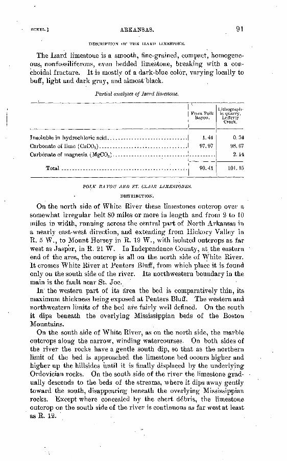
KCKEL.] ARKANSAS.
DESCRIPTION OF THE IZARD UMESTONE.
91
The Izard limestone is a smooth, fine-grained, compact, homogene ous, nonfossiliferous, even bedded limestone, breaking with a con- choidal fracture. It is mostly of a dark-blue color, varying locally to buff, light and dark graj7 , and almost'black.
Partial analyses of Izard limestone.
Carbonate of magnesia ( MgCO,) ............................
Total ............................................. i.
\
From Polk Bayon.
1.44
97.97
99.41
Lithograph ic quarry, Lafferty Creek.
0.34
98.67
2.14
101. 15
POLK BAYOU AND ST. CLATR LIMESTONES.
DISTRIBUTION.
On the north side of White Elver these limestones outcrop over a somewhat irregular belt 80 miles or more in length and from 2 to 10 miles in width, running across the central part of North Arkansas in a nearly east-west direction, and extending from Hickory Valley in R. 5 W., to Mount Hersey in R. 19 W., with isolated outcrops as far west as Jasper, in R. 21 W. In Independence County, at the eastern end of the area, the outcrop is all on the north side of White River. It crosses White River at Penters Bluff, from which place it is found only on the south side of the river. Its northwestern boundary in the main is the fault near St. Joe.
In the western part of its area the bed is comparatively thin, its maximum thickness being exposed at Penters Bluff. The western and northwestern limits of the bed are fairly well defined. On the south it dips beneath the overlying Mississippian beds of the Boston Mountains.
On the south side of White River, as on the north side, the marble outcrops along the narrow, winding watercourses. On both sides of the river the rocks have a gentle south dip, so that as the northern limit of the bed is approached the limestone bed occurs higher and higher up the hillsides until it is finally displaced by the underlying Ordovician rocks. On the south side of the river the limestone grad ually descends to the beds of the streams, where it dips away gently toward the south, disappearing beneath the overlying Mississippian rocks. Except where concealed by the chert debris, the limestone outcrop on the south side of the river is continuous as far west at least as R. 12.
92 CEMENT MATEEIALS AND INDUSTRY. I>ULL. 243.
The eastern limit of the limestone outcrop on the south side of White River is in the NW. i sec. 5, T. 14 N., R. 8 W., just above Penters Bluff. Opposite the bluff the limestone horizon is concealed by chert debris. Upstream from the outcrop in sec. 5 the hills become steeper, and are so close to the river that from Penters Bluff to the mouth of Sylainore Creek they form a river bluff, which is broken by numerous small creeks and ravines and by two short strips of alluvium Jones Bottom, in R. 9 W., and Round Bottom, in R. 10 W. This bluff is not so high nor so prominent as Peuters Bluff, but it consists of the same rocks Izard limestone at the base, overlain by Polk Bajrou limestone, which is capped with chert.
STRATIGRAPHIC POSITION OF POLK BAYOU AND ST. CLAIR LIMESTONES.
Stratigraphic position. TheSt.Clair limestone and Polk Bayou for mations, considered together, form one of the thickest and most impor tant beds of limestone in the State. They are underlain by the blue Izard limestone and overlain by the Sylamore sandstone (Devonian) or the Chattanooga shale, one or both of which are generally present, often in an inconspicuous bed only a few ijiches in thic'kness. In the absence of both the Sylamore sandstone and the Chattanooga shale .the St. Clair-Polk Bayou limestones are overlain by the St. Joe limestone, which forms the base of the Boone formation.
THICKNESS OF THE ST. CLAIR-POLK BAYOU LIMESTONES.
The maximum thickness, which is 155 feet or more, is at Penters Bluff, on White River. The limestone thins out gradually toward the east, west, and north; on Polk Bayou it is probably not more than 100 feet thick, while on Dota Creek, still farther east near the Paleo- zoic border, it does not occur at all, Above the mouth of HiddenCreek, on White river, it is 50 feet thick; but a few miles farther up the river, below the mouth of Twin Creek, there is only a trace of it. On the south side of White River, on Little Rocky Bayou, its thick ness is from 25 to 40 feet; on South Sylamore it is from 25 to 50 feet, and at St. Joe it is from 20 to 30 feet.
DESCRIPTION.
In general both the Polk Bayou and the St. Clair limestones are highly crystalline, being composed of small crystals of nearly uniform size. They are tenacious, easily cut, break with difficulty, and have a slightly conchoidal fracture. In weathering, the crystals are sepa rated, resembling coarse sand.
These formations commonly outcrop in heavy layers from 2 to 4 feet or more in thickness; but in some places the rock is massive, the entire exposure being in one solid bed. '

KCKEL.J ARKANSAS. 93
Except where deeply stained with manganese and iron the St. Clair limestone is a remarkably pure carbonate of lime.
Analyses of St. Clair and Polk Bayou limestones.
Silica (Si02 ) ........ ..A...... ......Iron oxide (Fe20s ) ..................
Lime (CaO) .........................Magnesia (MgO) ....................Potash (KjO). .......... :..... ......Soda ( Na20 )........................
Loas on ignition (CO.,, etc. )..'........
Total.........................Water at 110°-115° ..................
Carbonate of lime (CaCO,,) ...........
Brooks mine.
0.73.11.24
54.82.24.01
.48
43.08
99.86.09
97.88
Hell Creek.
0.32
.30
.10
' 55.74
Trace..17.22
43. 31
100. 65.059
98. 40 .
St. Toe.
0.11
.08
56.22Trace.
.07
.08
43.79
100. 31.04
99.68
St. Clair Springs.
0.54
.19
.18
54.70
;78
43.35
100. 00.04
97.77
Lower Polk
Bayou.
0.69
.27
.10
55.21
!97 .27
Trace.
43. 39
100. 28
98.42
ST. JOE LIMESTONE.
DISTRIBUTION.
St. Joe marble is the name given by the Arkansas geologists to the prominent bed of red limestone which is widely distributed over nearly all the counties of Arkansas north of the Boston Mountains. It is so named from the village of St. Joe, in Searcy County, Ark., where there is a typical exposure and where it was first studied by' the Arkansas geological survey. In the publications of the United States Geological Survey this bed is termed the St. Joe limestone member of the Boone formation.
GEOLOGIC POSITION.
The St. Joe limestone is situated at the base of the Boone chert, of which it forms a part. It is underlain by the Chattanooga shale (Eureka shale in part of Arkansas survey) where that formation occurs, otherwise by the Sylamore sandstone or by Silurian or Ordo- vician rocks. In the eastern part of the marble area of the State it overlies the St. Clair limestone, from which it is separated in most places by a thin bed of Devonian shale or sandstone; west and north of the borders of the St. Clair liniestone it overlies the St. Peter saccharoidal sandstone or the Yellville limestone, with either of which in some places, in the absence of the Chattanooga shale, it may be in direct contact.

94 CEMENT MATERIALS AND INDUSTRY. , BULL. 243.
THICKNESS.
The thickness of the St. Joe bed throughout the greater part of the area in which it occurs is from 25 to 40 feet. But as there is in many places no definite line of demarcation between the marble and the over lying chert, the upper limit of the marble is somewhat arbitrary. In some places in the eastern part of the area the chert rests directly on the Ordovician rocks, showing the entire absence of the St. Joe, while at other places, as at one place in the vicinity, of Marble City, the chert is 100 feet and at another it is 250 feet above the bottom of the marble. In such cases, however, the upper part of the bed is of gray limestone similar to that interbedded with the chert elsewhere, but no sharp line can be drawn between the red marble at the base and the gray limestone overlying it, for the two gradually merge into each other.
COMPOSITION.
The chemical analyses given in the accompanying table show the St. Joe limestone to be a comparatively pure carbonate of lime.
Analyses of St. Joe limestone.
1
Residue insoluble in hydrochloric acid. ........Titanic.oxide (Ti02 ) ...........................Phosphoric acid (P205 ) .......................Alumina ( A1 20,,) .............................
Manganese oxide (Mn02 ) .....................
Zinc oxide (ZnO) present, but not determined .Potash (K20) and soda (Na20) ................
Magnesia (MgO) .............................Lime (CaO) .................................
Loss on ignition (C02 ) ........................
Total..................................
X
Marble City.
0.800
TrRCG.023
.009
.051
.015
.054
. 19055. 390
43. 740
100. 272QQ Q1
Rhodes Mill.
0.835
.009
.024
.058
.071
.005
.16055. 340
43. 630
100. 1 7798.82
Toma hawk Creek.
! 3.03
.18
.70
.32
.4653.46
42.30
100. 3895.46
St. Joe crinoidal.
1.16
98. 73
LIMESTONES OF THE BOONE CHERT.
The Boone chert contains large quantities of limestone, some of the most valuable beds in the State occurring in it. In different parts of the region it varies widely both in quantity and quality. In some places it is made up almost entirely of limestone, while in others it consists almost entirely of chert. For convenience the subject is divided into three parts: (1) The limestone underlying the chert; (2) the

.BCKKL.] AEKANSAS. 95
limestone overlying the chert; and (3) the limestone in the chert bed. The bed underlying the chert has been designated the St. Joe limestone and has been described in detail^on the preceding pages (93-94).
LIMESTONE OVERLYING THE CHERT BED.
'Description. The limestone overlying the chert bed is classed as part of the chert bed, but in many places it is apparently a separate bed. In most places it is dark gray on a fresh fracture, but on exposure the color changes to a light gray on account of the loss of bituminous matter. In some places the rock is almost entirely free from organic matter. It is coarsely crystalline, slightly fossiliferous, homogeneous in texture, and very tenacious; has a conchoidal frac ture, gives out a fetid odor on a fresh surface, and rarely presents sharp edges on weathered exposures, but outcrops in rounded bowl-
ders or prominences through the soil. In places the limestone con tains numerous small fragments of angular chert.
Distribution. The limestone overlying the chert bed was not observed in the eastern part of northwestern Arkansas where, however, limestone does occur in many places near the top of the chert bed, but either contains intercalated chert or is overlain by thin layers of chert, and is distinct lithologically from the bed overlying the chert in the western part of the area.a It occurs in the western part of the State, in Can-oil, Madison, Benton, and Washington counties, where it out crops around the numerous outliers of the Boston Mountains. Com paratively small quantities of it are exposed on Grindstone and Pond mountains, near Eureka Springs, but on Swain Mountain, T. 19 N., R. 26 W., it forms a prominent ledge around the east end of the mountain between the chert and the overlying Batesville sandstone, outcropping in rounded ledges along the Eureka Springs-Huntsville road, where it is very dark, almost black, on a fresh surface. It is exposed in large quantities in Stanley Branch around the borders of the Batesville sandstone areas, in heavy ledges around the base of Keefer Mountain south of Hindsville, about Goshen, in T. 17 N., R. 28 W., on the tributaries of Richland Creek, and on Poor, Ellis, Humphrey, Blansett, and other mountains on the west side of White River.
LIMESTONES IN THE BOONE CHERT.
Description. Though most variable in quantity and quality, the limestones in the Boone chert form some of the largest and most val uable beds in North Arkansas. Instead of a persistent, clearly defined bed of limestone running through the chert, there is rather a bed of chert, with large quantities of limestone variously mixed through it. In some places the limestone occurs in irregular layers, varying from
a Mr. E. 0. Ulrich states that part of this limestone the black variety is a bed in the basal part oC the Fayetteville shale.

96 CEMENT MATERIALS AND INDUSTRY. [BOLL. 243.
1 inch to a foot or more in thickness, intercalated with like irregular layers of chert; in other places it occurs in lenticular massesj again, the chert occurs in lenticular or nodular masses in the limestone; in still others the chert and limestone are so intimately diffused that it is not possible to draw any sharp line between them. It often hap pens, however, that the limestone forms a bed from 20 to 100 feet or more in thickness, almost or entirely free from chert. It is in such places that the stone acquires an economic value. The variability of the Boone formation is largely due to local causes favoring or retard ing replacement of limestone by chert.
Nearly all the limestone in the chert is more or less crystalline, but it is much more so in some places than in others. In a general way it is more crystalline in the central part of the area than either to the east or west, and more crystalline in the east than in the west. While there are many local changes in color, texture, and structure of the limestone in the chert, there are some distinctly marked varie ties of it.
Distribution. The oolitic limestone, which is one of the most valu able varieties, is known to occur at three localities: Northeast of Batesville; near War Eagle Creek, about 4 miles north of Huntsville; and on Brush Creek, in T. 17 N., R. 28 W. The rock at Bates ville a occurs in layers from 3 to 5 feet thick, and can be quarried in as large pieces as can be handled. In color and appearance it resembles the Indiana oolitic stone somewhat, but is harder and more crystalline than most of the Indiana stone and is harder to work. The stone found at the two other localities mentioned above is lighter colored, softer, and more easily wrought.
Another variety occurring in the western part of Independence County is a hard, compact, close-grained, tinely crystalline, slightlyfossiliferous, dark-colored stone, the dark color being due to bitumi nous matter, which in some places occurs only in such small quantities as to give the stone a light-gray color. In some places it develops a shaly structure, but in most places occurs in layers from 2 inches to 3 feet in thickness, which are firm, solid, and resonant.
A variety which is widely distributed over the central part of the area is highly fossiliferous, coarsely crystalline, and varies from light to dark gray in color. The fossils are mostly crinoid stems, though the rock contains numerous brj^ozoans and brachiopods. In some places it contains considerable amorphous matter, but in many places is almost completely crystalline.
Composition. The limestones in the chert vary greatly in composi tion, ranging by close gradations from chert to almost pure calcium carbonate. However, in nearly all places where the large beds of
a According to Mr. E. O. Ulrich this rock overlies the Boone and belongs to the Moorefleld shale.
KCKKL.'J ARKANSAS. 97
limestone occur it is comparatively pure carbonate of lime. Some nodules or lenticular masses of chert occur in the heavy beds of lime stone, but in no instance was there any considerable quantity of silica found diffused through the bed of limestone. The whole series, in fact, might be divided into (1) chert almost free from lime, (2) calcare ous chert or siliceous limestone, and (3) comparatively pure limestone.
Analyses of limestones from the Boone chert.
Lime (CaO) ....................................Magnesia (MgO) ................................Silica (Si02 ) ....................................
Iron oxide (Fe203 ) ..............................Potash (KjO) ........:,.............--...-.-...
Soda (Na20) .............-...'...................
Total .....................................
Water at 100°-115° C. ...........................
i
55.17Trace."
1.61
.00
.14
.14
.09
.1043.13
100. 38
.05798.29
2
55.42.39.68
-.00
00
.19
.19
.17
43. 56
100. 92
.09Q8 5Q
3
56. 14Trace.
. . 30
.00
.06
.12
.08
43.77
. 100. 47
.49100 23
1. Alien's quarry, Polk Bayou, sec. 4, T. 13 N., R. 0 W.2. Near Victor post-office, sec. 10, T. 13 N., R. 7 W.3. Mill Creek, sec. 13, T. 16 N., R. 18 W.
Partial analyses of limestone from the Boone chert.
Lime (CaO) ................Insoluble (silica) ............Magnesia (MgO) ............
Total .................Water at 110-115° C. ........Calcium carbonate (CaC03 ) .. Magnesium carbonate
(Mgco8 ). .:..............
1
54.921.47
56.39.10
98.07
2
53.664.38
58.04.31
95.82
,3
55.06
.03
55.09
98.32
4
54.89
.21
55. 10
98.02
5
55.09.50
43.61
99.20.03
98.37
6
56.15.19
43.58
99. 92
100. 25
7
55.12.28.45
55.85
98.43
Q 1!
1. Loster's spring.2. Jones quarry.3. Pond Mountain, sec. 23, T. 20 N., R. 20 W.4. Limekiln at Rogers.5. Brush Creek, Madison County, sec. 25, T. 17 N., R.-28 W.6. Sec. 15, T. 17 N., R. 20 W.7. Denieville, Independence County.
Bull. 243 05 7

98 CEMENT MATERIALS AND INDUSTRY. [BULL. 243.
PITKIN OR ARCHIMEDES LIMESTONE.
DESCRIPTION.
The Pitkin or Archimedes limestone is impure, generally loose tex- tured, and very fossiliferous, varying from bluish gray to brown in color. In most places it is distinguished by its characteristic fossil, a spiral-shaped bryozoan of the genus Archimedes, from which its former name was derived. The compactness of the stone appears to vary with the size of the fossils. When they are large the texture is open, being often but a loosely aggregated mass; when the fossil frag ments are small they are closely compacted and the rock is firm a'nd durable. In some places the formation graduates into sandstone, the change being so gradual that there is no line of demarcation between the two. In other places it is very argillaceous, and in most places contains 'iron and bituminous matter. In some places it has a loose, shaly struc ture, while in others it occurs in strata 10 feet or more in thickness.
THICKNESS.
The Pitkin or Archimedes limestone varies in thickness from a few inches to 80 feet or more. Its thickness is from 25 to 40 feet in Wash ington County, 80 feet on Pinnacle Mountain, Newton County, and apparently more than this on the face of the Boston Mountains, south of Buffalo Biver, where no measurement was made. Mr. C. E. Sie- benthal reports a thickness of 200 feet in the Boston Mountains, south of Mountain View.
DISTRIBUTION.
This limestone is widely distributed over northern Arkansas, occur ring at nearly all clear rock exposures at the proper horizon, but as it is in some places less durable than the overlying rocks, it is frequently concealed by talus. In some places it is more durable than the over lying rocks and forms a prominent escarpment along the face of themountains. It outcrops along the north face of the Boston Mountains and in many of the northern outliers from .Independence Countjr west into Indian Territory. It outcrops also on the south side of the Bos ton Mountains in several places in Crawford, Franklin, Johnson, and Newton counties. In Limestone Valley, Franklin County, it has a thickness of 100 feet or more.
It is prominently developed in the group of mountain peaks in the southern part of Boone County and the northern part of Newton County. At Fodder Stack it forms the cap rock, about 100 square feet. On Pinnacle Mountain it occurs in a prominent ledge 80 feet thick, 400 feet below the top of the mountain. On Pilot Mountain, at the north end of Boat Mountain, it is 30 feet thick and lies 200 feet below the top of the mountain. It is concealed by talus in many places on both Pilot and Boat mountains.
There are large exposures of the Archimedes limestone on both sides of Buffalo River, in Newton County, on the mountain betAveen

ARKANSAS. 99
Big and Little Buffaloes, and at many places along the north face of the Boston Mountains in Searcy, Stone, and Independence counties. It outcrops prominently on the mountain south of Jamestown, Inde pendence County, as well as at many places on Salado Creek, in the same county, and it skirts the highlands southwest of the Oil Trough bottom.
CRETACEOUS CHALK BEDS. a.
The Cretaceous rocks of Arkansas occur only in the southwestern portion of the State, reaching as far northeast as Arkadelphia (See PI. III. On the north they are bordered by Paleozoic sandstones and shales, while on the south and east they pass out of sight beneath a series of sands, gravels, and clays of later age.
In the present discussion the only part of this series to be consid ered is the chalk formation of the upper Cretaceous. This is geolog ically continuous with the Texas chalk (see pp. 308-309), but is COV- ered in many places by sands, gravels, and river bottoms, so that it occurs as a series of isolated outcrops. It outcrops near Rocky Comfort, in Little River County, and near White Cliffs, Saline Landing, "Wash ington, and Okolona. and on Big and Little Deciper creeks.
While the chalk of all these areas is of upper Cretaceous age, there is a considerable variation in strati graphic position. The chalk beds at Rocky Comfort, White Cliffs, and Saline Landing become more sandy and clayey and less chalky as they are traced northeastward from the last-named area, and soon become worthless as cement materials. At the same time a series of limy clays, situated geologically about 200 feet above this first chalk series, becomes more chalky as it is traced northeastward; and this second chalk bed is worth considering as a cement material in its outcrops near Washington and Okolona, and on the Deciper creeks.
The first or lower series of chalk beds has been called the White- cliffs a formation and the second series the Saratoga formation, both being named from localities at which they are well exposed.
The different areas of outcrop will be discussed separately in order from southwest to northeast, after which a large series of analyses of the chalk will be presented.
WHITECLIFFS (ANNONA & ) FORMATION.
ROCKY COMFORT AREA.
The chalk which outcrops in the vicinity of Rocky Comfort is remarkably uniform in physical appearance. It is massive, white,
«The description of the Cretaceous chalks is taken from a very detailed report, by Mr. J. A. Taff, on The chalk of southwestern Arkansas, with notes on its adaptability to the manufacture of hydraulic cements, in Twenty-second Ann. Rept. U. S. Geol. Survey, pt. 3, pp. 689-742. So far as possible this matter is stated in Mr. Tail's own words.
'' As the term White Cliff had been applied in 1876 to a formation in the Uinta Mountains, the name Annona, from Annona, Red River County, Tex., where the chalk is well exposed, has been adopted for it by the U. S. Geological Survey.

100 CEMENT MATERIALS AND INDUSTRY. I BOLL. 243.
sufficiently friable to soil the fingers, and thin pieces may be broken in the hands, but the hammer is required to pulverize the massive rock. On exposure the chalk breaks into conchoidal fragments, which weather to lumps and finally become chalky dust. In the hillsides south of town the bedding is scarcely preceptible.
The composition of fresh chalk from the bed of the branch at the base of the exposure is given in analysis No. 4 (p. Ill), while No. 3 shows that exposed in the ditches, 55 feet higher. The former is not many feet above the base of the true chalk and the latter belongs near the middle. This chalk is in physical appearance like that of White- cliffs, and a comparison of the anatyses shows that this chalk and that from Whitecliffs quarry have practically the same composition.
The lower beds are exposed by the road in the SE. i of SE. i sec. 21, T. 12 S., E. 32 W., also near the middle of sec. 21, with chalky marl cropping below. These basal beds are more clayey and siliceous than those higher in the formation south of Rocky Comfort.
From the center of sec. 21 to the "line road" in the SW. i sec. 29 the chalk is concealed beneath residual black soil. At the latter locality the chalk is well exposed in ditches and on high ground along the road almost through the SE. i of SW. i sec. 29. The lower beds of the formation are also exposed in the hill and bluff facing the river bottom in the NE. i of NE. i sec. 31.
From the base of the chalk downward there is a transition zone of bluish clayejf chalk which grades down into still less chalky clay. This transition clay chalk is exposed at the contact in the SW. £ sec. 29, and in deep ditches on the hill slopes below the Hopson graveyard, in the NEi i of NE. i sec. 30. '
Analysis No. 2 (p. Ill) is of a specimen of the transition clayey chalk from the latter locality. While the analysis shows that the marl con tains 25 per cent of silica, sand is not visible.
From sec. 30 northward to the Holman place, near the center of sec. 18, the clayey chalk is generally concealed by its residual soil. Grayish-blue, sandy, chalky marl, partially indurated at the surface, outcrops at the Holman House and in gullies 500 feet farther west. This chalkjr marl is perceptibly more sandy than that higher in the section immediately below the true chalk.
The crumbling edges of the chalk deposits outcrop in the low bluff of Walnut Bayou bottom from the NE. i of NE. i sec. 30 southward to the extreme south end of the chalk area, in the SE. i of SW. i of sec. 32.
Excellent exposures of the chalk occur in and near the road in the SW. i of SW. i of sec. 32. The analysis of this chalk is given in No. 1 of the table. The chief difference between this and the other samples of the purer chalk analyzed is that it contains much more

U. S. GEOLOGICAL SURVEY BULLETIN NO.243 PL.Ill
R.32W. R.3IW. K30W. R.£9 w R.28W. R.27W.
MAP OF THE CHALK REGION OF SOUTHWESTERN ARKANSASBY JOSEPH A.TAPF
19O4

KCKHL.J AKKANSAS. 101
clay. The only perceptible physical difference, however, is that it is a little harder.
A rather large exposure of white chalk, of beds near the top of the formation, appears on Col. Henry Hawkins's place, in the NW. i sec. 33. About one-fourth mile southeast of the house, in the SE. i of NW. i sec. 33, the top of the true chalk and the base of the suc ceeding chalk}7 marl is exposed. A thin mantle of gravel conceals, part of both the chalk and the marl. The upper layers of the chalk are also exposed south of the branch, in the SE. £ sec. 28.
There are smaller exposures of chalk in this region, but it is believed that those above described are typical.
WHITECL1FFS AREA.
The chalk here exposed occupies parts of sees. 25, 26, 35, and 36, T. 11 S., R. 29 W., and sees. 30 and 31, T. 11 S., R. 28 W., and covers an area of about 600 acres.
A large part of the chalk of the Whitecliffs area is covered by a thin mantle of gravel and sand. In places this gravel may attain a thick ness of several 'feet, but it is believed that it will nowhere interfere seriously with the removal of the chalk. The chalk is also concealed in places, especially near the border of the the area, by its own resid ual soil, with scattered pebbles or a very thin layer of gravel.
The most noteworthy exposure of chalk in southwestern Arkansas occurs in the cliffs overlooking Little River from the east side, in"the northeast corner of sec. 35, T. 11 S., R. 29 W., immediately above the ferry.
From the brink of the cliff down to the water level is 115 feet, and about 15 feet of chalk is exposed at a higher level by the road which leads from the cement works. The following is a detailed section, beginning at the top of the chalk and marl in the cliff:
Section at Whitecliffs Landing.Feet.
1. Massive, creamy white chalk, in beds from a foot to about 10 feet thick, sep arated by thin partings of very slightly laminated chalk. The variation in the character of the chalk from bed to bed is not perceptible on physical examination, and the stratification planes are not clearly denned except upon partial weathering of the rock. Analysis No. 7 (p. Ill) is of specimens in the lower part of this chalk, while No. 9 is an average of specimens from each bed in the lower half as exposed in the quarry. No. 8 is from about 10 feet below the top as exposed by the road opposite the cliff.......... 60
2. Massive dull bluish-white siliceous chalk. Slightly harder than the pure chalk of 1, practically without indication of bedding, and because of its hardness projects in a steep bench overhanging the less chalky beds below. Analysis No. 6 shows that this chalk contains nearly twice as much silica as the chalk above. This bed occurs in the bench beneath the quarry and passes to the level of the river bottom near the clay pit south of the works. An outcrop occurs also near the middle of the bluffs north of the cliffs, spreading out at the surface in the cultivated fields 1 mile southeast of the village of Whitecliffs.............................. 25

102 CEMENT MATEEIALS AND INDUSTRY. [BOLL. 243.
Feet.3. Massive, very siliceous, dull-blue argillaceous chalk marl. This bed con
tains more than twice as much sand and nearly three times as much clay as the overlying bed No. 2. The rock is quite friable and weathers in recesses beneath the siliceous chalk................................... 8
4. Bluish, sandy, chalky marl, containing great numbers of the fossils shell Gryphsea vesiculfiris. Except for the abundant fossils this rock would be classed with No. 3, though it is probably slightly more sandy .......... 7
5. .Bluish, sandy, chalky marl, gradually increasing in sandiness from the topdownward to the level of the river.................................... 35
The lower 30 to 35 feet of the white chalk of 1 is freshly exposed in Mie quarry.
The top of the bluish-white chalk of 2 forms the bench beneath the quarry and occurs at the base of the bluff southeast of the landing.
The sandy chalk members 3, 4, and 5 rise gradually northward from the lower part of the cliff and are found in the highland between the villages of Whitecliffs and Brownstown.
One-half mile west of Doctor Coats's house, in the NW. i sec. 23, T. 11 S., R. 29 W., bed No. 4 is exposed at the top of the bluff and below it is the following section, well shown in deep gullies down to the level of the valley:
Section of marl below the Whitediffs chalk.Feet.
1. Sandy, chalky marl. Dull bluish when not weathered, becoming grayishor whitish yellow after long exposure. It contains numerous specimens of the large oyster Exogyra ponderosa, besides Ostrea larva and many other ' . fossils common to the Upper Cretaceous, marls. The upper half of this member is No. 5, at the base of the cliff at Whitecliffs Landing......... 60
2. Blue clay marl containing some large oysters as above, and less lime thanNo. ], and much more clay........................................... 30
3. Dark-blue gritty greensand marl with scattering smooth round pebbles ofblack and white quartz 1 inch and less in diameter..................... 10
4. Blue clay marl down to the level of the bottom land, exposed............ , 15This section is about 2 miles north-northeast of the chalk cliff which
is in the NW. i sec. 35, and the sandy marl bed, which is here about 100 feet above the river, is at the water level at the cliff. This marl bed with the associated marls and chalks above, which are conform able with it, dips toward the southeast at the rate of about 50 feet per mile. The base of the chalk at the north side of the chalk area is full}7 50 feet above the river bottom. At the south side, a mile distant, it is at tne level of the bottom. There may be local variations in the dip of the beds, but the general dip is estimated to be nearly 50 feet per mile toward the southeast.
SALINE LANDING AREA.
The chalk of this area extends with practically continuous exposure from the chalk bluff at Saline Landing, in the south half of sec. 35, T. ; 11 S., R. 28 W., to sec. 14, T. 11 S., R. 27 W., and is about T miles in

ECKKL..I ARKANSAS: 103
length and one-third of a mile in width. The map of this chalk area is given as PI. III.
The base of the chalk is not exposed in this area, though the lower sandy member outcrops in sees. 21 and' 22, toward the source of Plum Creek. These outcrops occur in the border of the creek bottom, within less than 1 mile of the exposure of fossiliferous blue marl out cropping on the north side of Plum Creek in sees. 15 and 16. The structure of the rocks shows that this marl belongs not more than 50 feet below the base of the chalk.
The chalk at the top, as exposed in many places in the south side of the area, grades up into blue clay marl through 20 to 30 feet of marly chalk and chalky marl. This gradation is especialty well shown in the chalky barren hill slopes near the Columbus Mineral Springs road, in the south side of sec. 14, T. 11 S., R. 27 W.
The thickness of the chalk in the southwestern part of the area isnot known, as its lower portion is concealed. Near the northeast corner of sec. 22, T. 11 S. 5 R. 27 W., the full thickness of the purer chalk above the lower sandy member will not exceed 25 feet. Near the east side of sec. 14, T. 11 S., R. 27 W., the entire chalk bed passes beneath the bottom of Plum Creek.
The divide between the sources of Plum and South Ozan creeks is flat, and the chalk deposits are entirely concealed beneath the soil. The crop of the chalk, as indicated by the structure of the rocks, would extend northeastward through sees. 7, 8, 5, 4, and 3, in'T. 11 S., R. 26 W., and into Ozan Creek bottom. The location :of this probable outcrop is shown in PL III.
The chalk bluif at Saline Landing is 20 feet in height (above low water) and about 300 feet long. When visited by Mr. Taff the river was at flood, so that less than 10 feet of the rock was exposed to view. The lower portion of the chalk as then exposed is white, massive, and without distinct bedding planes, the ujDper 5 feet being weathered to a chalky earth. Specimens of the chalk were collected from the water level, which would be near the center of the bluff at the usual low stage of the river. Analysis 10 (p. Ill) of this chalk is nearly the same as No. 6, which is of the lower sandy member of the Whitecliffs (Annona) formation, and suggests that the exposure at Saline Landing is in the lower part of the chalk formation in this area.
The chalk has been quarried for building purposes near the top of the formation in the northwest corner of the NE. £ of SW. i sec. 30, T. 11 S., R. 27 W. Analysis 11 (p. Ill) is of fresh chalk from this quarry, and shows it to be of nearly the same composition as that near the top of the chalk at Whitecliffs.
From the top of the chalk in this vicinity there is a gradual change upward through about 10 feet of marly chalk and then through nearly

104 CEMENT MATERIALS AND INDUSTRY. [BULL. 243.
30 feet of chalk marl into the overlying blue-clay marl. The blue: marl is continuous for 175 feet to the base of the Saratoga chalk marl.
The middle portion of this chalk is exposed in the large mound, which is surrounded by the bottom land of Plum Creek, in the center of the SE. i of SW. i sec. 21, T. 11 S., R. 27 W., on Mr. J. E. John son's place. Here also the chalk has been quarried, giving fresh exposures of the rock. Analysis 12 (p. Ill) is of fresh chalk taken from this quarry, and is nearly the same as that from the quarry of the Whiteclifl's Cement Works.
The lower sandy member of the chalk is freshly exposed in the head of the large drainage ditch near the middle of the west side of the SW: i of NW. i sec. 22, T. 11 S., R. 27 W. Analysis 14 of'this chalk is practically the same as No. 6, which is of a specimen from the lower sandy member in the cliff at Whitecliffs Landing.
The upper and purer chalk member is well exposed in the ditches and chalk barrens on the lower ridge across the SW. | of NE. i sec. 22, T. US., R. 27 W.
The easternmost exposure of the chalk south of Plum Creek is in the SE. i sec. 14, T. 11 S., R. 27 W, Here the chalk barrens in the slopes of the hill show the upper edge of the chalk and the succeeding chalk and clay marl for 50 feet above the creek bottom.
SARATOGA. FORMATION.
The Saratoga chalk, as explained previously, occurs nearly 200 feet above the Whitecliffs chalk and is separated from it by more clayey beds. ,
This formation has a maximum thickness of about 50 feet where complete sections have been found. The nature of the deposit varies only slightly f i;om top to bottom, and there is but little change in character along its outcrop from the vicinity of Saratoga near West Saline River, in Hempstead County, to Little Deciper Creek near Arkadelphia, in Clark County. The Saratoga marl is not known in this region west of West Saline River, because of erosion and of con cealment by Neocene gravel and sand in the highlands and by Pleis tocene alluvium and silt in the lowland and river bottoms.
General section of the Saratoga chalk marl.Feet.
1. Continuing upward from 2 the chalky rock becomes more sandy throughimperceptible grades to limy greensand at the top of the formation. Analyses from the chalk near the central part of this member show it to contain from 40 to 50per cent of silica............. ..........._..... 20-30
2. Generally even-textured chalky marl, which contains less sand than the beds higher in the formation. Chemical analyses of chalk from this bed show it to contain about 31 per cent of. siliceous matter. The sand in this marl is perceptibly finer and the rock is more chalky in appearance than in other parts of the formation................................... 10-15

KCKKL.] ARKANSAS. 105
Feet.3. Sandy clayey chalk, which contains great numbers of the fossil oyster
Gryphxa vesicularis. These fossils are found in the marls some distance both above and below this formation, but in no other bed of rock in this region have they been found in such abundance. In natural exposures the chalk weathers from about them so that they usually almost cover the surface of the ground or are scattered in the soil. This shell bed at the base of the formation is such a marked feature that when it is once seen it may be easily recognized again. This shell bed crops at the north border of the Saratoga marl and throughout its extent.................. 3-5
The Saratoga marl is a massive bed of dull-bluish, sandy, chalky rock. Exposures do not usually show distinct bedded structure, though a slight variation in weathered surfaces may indicate the direc tion of the dip of the rock. As the rock weathers it changes in color from dull blue to shades of grayish and creamy white. Its hardness and general physical appearance are almost identically the same as those of the lower sandy member of the Whitediffs chalk. It breaks in rudely conchoidal flakes and crumbles at the tap of the hammer. Small pieces of the fresh rock may be broken by the hand and crum bled to dust between the fingers, but not without some difficulty.
WASHINGTON AKEA.
The rock section is well exposed, as illustrated in the section.
Section north of Saratoga.Feet.
.1. From the level of Saratoga down to Saratoga marl, surficial deposit of fineyellow sand, about................................................... 40
2. Saratoga chalk exposed in brink of hill north and east of Saratoga and inknob one-half mile north of Saratoga, lower beds of the formation ...... 20
3. Limy blue-clay marl................................................... 175This marl is exposed around the base of the hill at Saratoga, and in the
cultivated lands 1^ miles north of the town it becomes gradually more chalky downward from the top to its contact with the chalk marl below.
4. Bluish friable chalk marl............................................... 20-30This is the gradation bed from the blue marl above into the purer chalk
below.5. White chalk in the Saline Landing area.
Thick deposits of sand cap the hill at Saratoga, concealing all of the chalk rock except the lower beds in the slopes east and northeast of the town.
The lower part of the Saratoga chalk outcrops in a considerable area on Mr. Jones's place in the NE. £ sec. 35, SW. i sec. 25, and SW. i sec. 36, T. 11 S., R. 27 W. The chalky oyster-shell bed at the base of the formation is well exposed north, south, and west of the house, which is in the NE. i of NE. i sec. 35.
Samples of the chalk were taken from the.top of the oyster-shell bed near the base of the formation, and are not physically different

106 CEMENT MATERIALS AND INDUSTRY. [HULL. 243.
from the same bed examined at other localities in this area. The fresh rock is grayish white and sandy.
The shell bed at the base of the formation is exposed at the edge of the highland near the Colimibus-Albrook road, 1 mile northwest of Columbus. The same bed is exposed also at the crest of the highland 1 mile north of the town. The chalk marl highest in the formation occurs in the cultivated fields between the outcrop of the shell bed and the town.
From the vicinity of Columbus eastward to the end .of the forma tion in the Washington area the whole of the Saratoga formation outcrops or is covered only lightly by soil. Throughout this extent the basal shell-bed member of £he chalk marl is almost continuously exposed, except in the immediate bases of the valleys, and may be easily located through the open fields by means of the abundant shells weathering upon the surface.
Between Columbus and the railroad north of Washington the chalky marl was not found to outcrop more than 30 feet in thickness, and usually 10 to 20 feet of the lower part was all that was exposed.
The overlying greensand marl is more friable than the Saratoga chalk marls, and its soil descends and conceals the contact between the two as well as the upper part of the latter. A section of the Saratoga marl with better exposures than are usually found occurs along the railroad north of Washington.
The north cut on the railroad is in a blue clay-marl 30 to 50 feet below the base of the Saratoga formation. It is 10 feet deep and about 300 feet long. The marl in this cut, which was originally blue, is weathered a creamy yellow to a depth of about 8 feet. It is tran sected by many joints, which pass nearly vertically across the bedding and continue down below the base of the cut. Along these joints, even below the zone of general weathering, the blue color of the marl is changed to yellow for a distance of several inches.
Anatysis 15, page 111, is of the unchanged blue marl from the base of the cut, 10 feet below the soil. The fresh marl is friable when dry and plastic when wet. It has a very fine texture and contains scarcely perceptible grit, yet the analysis shows it to contain 43 per cent of silica and 6.5 per cent of clay. Nearly 40 per cent of this silica is in the form of impalpable sand.
The shell bed, the base of the Saratoga formation, is exposed in the field southwest of this railroad cut. The middle cut is one-third of a mile south of the north cut and is in the lower part of. the Saratoga chalk above the oyster-shell bed. This cut is. 300 feet long and but a few feet deep, exposing an estimated thickness of 15 feet of rock. The structure of the rock indicates a low inclination toward the south, but is not sufficiently clear to determine the degree of dip. Ditches above the south end of the cut expose about 25 feet of chalk marl
ARKANSAS. ' 107
above that at the railroad, making the whole section of rock exposed at this place nearly 40 feet. Very little change in the nature of the rock could be noted in this section.
Analjrsis 16 is of the fresh chalk rock near the center of the middle cut, from the lower and more chalky part of the formation, and shows that this marl contains less than one-half the amount of silica found in the blue marl 40 feet below, though in physical appearance it is more sandy.
One-half .mile-south of the middle cut and a few hundred feet north of the south cut the top of the Saratoga marl is exposed in a ditch at the railroad. The sandy marl in this exposure is but little above the chalky marl at the top of the exposure opposite the middle cut. It is massive, dull blue, and very sandy, approaching a sandstone in composition.
The south cut, which is about 2 miles north of the town of Wash ington, is in the lower part of the greensand marl which overlies the Saratoga formation. This cut is about 30 feet deep and about 300 feet long. From the surface downward about 20 feet the greensand is weathered from dark blue or greenish blue to shades of dull brownish 3'ellow. Unaltered marl was collected from near the base of the cut, and its composition is shown in analysis 17. Physically it is very sandy, and the analysis shows that it contains 75.77 per cent of silica and 5.72 per cent of lime. Similar greensand marl occurs between this cut and Washington, and its thickness is estimated to be more than 100 feet.
From the railroad eastward to the end of the formation in this area, in sec. 29, T. 10 S., R. 24 W., the Saratoga chalk crops in an irregu lar belt one-half to three-fourths mile wide, making an intermediate upland, marked by projecting ridges and spurs between the high tim bered greensand country on the south and the flat black land of "the clay marls bordering Ozan Creek bottom on the north.
OKOLONA AREA.
This area is in the southwestern part of Clark County, south and east of Okolona, between the bottom lands of Antoine and Terre Noire creeks.
The Saratoga chalky beds at the crest of the ridge south of Okolona are 50 to 150 feet above the lowland to the west and south. The crest of this ridge slopes southward with the dip of the rock, which is nearly 50 feet per mile.
East of Okolona the chalky marl forms a triangular area of rolling upland about 3 square miles in extent.
The stream which rises in the southwest part of the town and flows southeastward past the railroad station separates the area south of the town from that east of it. It is probable that these two areas are

108 . CEMENT MATEEIALS AND INDCISTEY. [BULL. 243.
connected by narrow bands of outcropping marl which extend down the sides of the valley about 2 miles southeast of the village.
The Saratoga chalk-marl is partially 'exposed near the crest of the escarpment north of the Okolona-Dobyville road, from the east side of sec. 30, T. 8 S., E. 21 W., to the edge of the Terre Noire bottom, li miles east of Doby ville.
The Saratoga marl, near the middle of the formation, is well exposed toward the top of the ridge at the forks of the road, 1£ miles south of Okolona. In physical appearance this rock is the same as that at tho middle of the formation in the vicinit}^ of Washington. It is massive and dull blue on fresh exposure and weathers to shades of drab or light yellow. Analysis 19, page 111, shows that the chalk-marl in this locality contains nearly 43 per cent of silica and 49 per cent of calcium carbonate.
Two and one-half miles south of Okolona and one-fourth of a mile west of the road, on the Mat Hardin place, deep gullies expose the lower 20 feet of the Saratoga marl as well as the. blue marl below. The Gryphaea vesicularis bed is well marked, but the fossils are a little less abundant than in the Washington area, 20 miles farther west. In the lower 10 feet of the formation the chalk-marl is finer in texture and more chalky than in the higher beds. The result of an analysis of chalk from this place is given as No. 21, page 111, and shows that the amount of silica is nearly 10 per cent less than in the marl near the middle of the formation.
Numerous other exposures.of the lower part of the formation occur in the gullies and slopes of the hill on the west side of the ridge, where the land was once cultivated. The top of the Saratoga marl passes beneath the bottom land of Little Missouri Kiver, about 3 miles south of Okolona.
Five miles SOUth of Okolona the greensand marl, which belongs above the Saratoga chalk, forms the bluffs from the level of the Little Missouri bottom up to the top of. the ridge. This is the greensand formation which occurs between Washington and the Saratoga chalk in Hempstead County.
About 20 feet of the middle portion of the formation is exposed in the Okolona-Garden road, 1 mile east of Okolona.
In the high rolling country east of Okolona the Saratoga chalk- marl is generally concealed beneath its own soil or beneath sand of Neocene age.
The lower beds of the chalk outcrop in the Okolona-Dob}^ville road, 2 miles west of Dobyyille, and at several other places in the top of the escarpment between Okolona and Dob3^ville.
One-fourth of a mile north of Joseph Doby's house, at Dobyville, the full section of the Saratoga chalk-marl is exposed in an old field.

ECKEL.] ARKANSAS. 109
Following is a section of Saratoga chalk-marl at Dobyville:
Section at Dobyville.Feet.
1. Gravel, reddish and yellow stratified clays .............................. 202. Blue marl.............-...'.......................................-.-.- 153. Dull-bluish chalky marl................................................ 35
This marl is slightly indurated at the top and contains numerous casts of bivalve shells and gastropods. It is a calcareous sandstone at the top. The beds become more chalky downward/ until the lower part of the chalky marl is found to be the same in nature as that described as occur ring south of Okolona and in the Washington area.
4. Even-textured chalk-marl, with Gryphnea vesicularis shells at the base..... 15This member contains more chalk than those above and has finer tex
ture. In places, also, very fine particles of greensand were noted dissem inated through the marl.
5. Fine-textured blue clay marl.This is the upper part of the 150 to 200 feet of blue marl which lies
between the Whitecliffs chalk formation and the Saratoga chalk-marl.
From the vicinity of Okolona eastward, the outcrop of the Saratoga marl descends gradually from the brink of the escarpment to the level of the river bottom, nearly 2 miles east of Dobyville.
DECIPER ARGA.
The next known occurrence of the Saratoga chalk-marl east of Oko lona is on Big Deciper and Little Deciper creeks, 3 to 5 miles west of Arkadelphia.
.The occurrence of the Saratoga chalk on the Deciper creeks is confined to outcrops in the middle and lower slopes of the valley near
r the Arkadelphia-Dobyville and Arkadelphia-Hollywood roads. The general location of the outcrop is shown in PL III.
Near the center of sec. 28, T. 7 S., R. 20 W., on the Bozeman place, one-third of a mile northeast of the house, about 30 feet of the Saratoga chalk-marl is exposed, as follows:
Section of the Saratoga chalk-marl at tlie Bozeman place, beginning at the base.
1. Sandy soil to the top of the ridge. Feet.2. Chalky marl, more sandy than that of 3 ................................ 10-15
The sandy element in this marl increases in quantity upward.3. Even-textured blue chalk-marl ......................................... 15
This clalk contains a sprinkling of fine greensand, and in all respects is the same as the lower 15 feet of the formation at Dobyville and Okolona. Analysis No. 24 shows that this marl contains about 30 per cent of sand and 61 per cent of chalk.
4. Gryphsca vesicularis shell marl........................................... 1-2The limits of this shell bed are not sharply marked. Through 1 to 2
feet of the marl at the base the shells are abundant, and in it is a thin layer of shells indurated by calcareous matrix.
5. The blue marl from the Gryphsea vesicularis shell bed downward; exposed . 15

110 . CEMENT MATEEIALS AND INDUSTRY. [BOLL. 243.
At two points, one of them one-fifth of a mile northeast and the other 500 feet east of the Bozeman house, the chalky marls occur higher in the formation and are still more sandy than that of No. 4 in the sec tion given on page 109. These outcrops are in the heads of narrow gulches which descend to the Deciper Valley. At the locality 500 feet east of the house the marl is very sandy, partially indurated, and con tains numerous casts of fossils similar to those found near the top of the formation at Dobyville. The exposures here show about 10 feet of marl and are just below the springs which flow from the base of the stratified yellow sands and blue clays.
About 10 feet of interstratified sand and clay is exposed above the sandy marl, and then follows an overwashed yellow sandy soil to the top of the hill, 40 feet above.
One-fourth of a mile southeast of Mount Bethel Church, near the northeast corner of sec. 33, T. 7 S., R. 20 W., beds similar to those east of the Bozeman house are exposed. Here a spring issues from the contact between the chalk-marl and the overlying sand and blue clay. The top of the marl is 70 feet below the crest of the hill.
The chalky sand of the upper part of the Saratoga formation is exposed on the Arkadelphia-Okolona road, on the west bank of Big Deciper Creek, near the middle of sec. 34, T. 78., K. 20 W., as well as in the bluff of the creek near by. The top of the sand}' marl, which stands here 20 feet above the creek, contains casts of fossils as at the Bozeman place, and is overlain also by the same kind of interstratified sand and clay.
Twenty feet of the even-textured lower and more chalky member of the Saratoga chalk-marl is exposed in the road cut on the Arka delphia-Okolona road, 100 yards west of Little Deciper Creek.
Sand and clay conceal the higher beds of the chalk-marl. The Gry- fJlCBd Vesiculans bed, with underlying blue marl, outcrops a few feet above the creek bottom.
One-half mile above the road, on the W right place, the lower 30 feet of the Saratoga formation is exposed in the gullies at the west side of the creek bottom. The lower 10 to 15 feet of the marl is identically the same as that found at the road and on the Bozeman place west of Big Deciper Creek, as shown in analysis 26, page 111. The basal member of the chalk-marl, containing the same indurated shell bed, outcrops here at about 10 feet above the creek bottom, and below it is the blue marl. Yellow sandy clays overlie the chalky marl here, as in the exposures noted on Big Deciper Creek.
At the east side of the creek bottom, on. the Arkadelphia-Okolona road, and northward through the Haskins place, the lower part of the chalk-marl is exposed in gullies in an abandoned field.

1DCKET,.] ARKANSAS. Ill
ANALYSES.
A ndlyses of chalk and chalk marl from southwestern Arkansas. a
No.
i..;..........2....... .....3.............4.............5.............6.............7.............
8.............
9.............10.............11.............12
13. ............
14.............
15.............16.............
17.............18.............19.............20.............
21..............22.............23.............24.............25.............26.............
Silica (Si02 ) and insoluble.''
. 6.15
25. 138.537.32
27.2812.676.83
7.86
7.9714.68
4.917.35
34.76 12. 65
43.0921.90
75.7730.6843. 72
35. 16
31.0531. 01
36.1732.2630.8430. 29
Ferric oxide and alumina
(Fe2O3 +Al2Os).
5.79
3.901.221.265.001.93.95
1.30
1.092.15
.931.06
5.181.66
6.552.35
5.464.912.76
2.853.462.935.377.053.733.31
Lime (CaO).
46.81
35.81
48.50
49.94
34. 81
45.56
50.41
49.55
49.64
45.03
51.7849.66
29.1045.85
22.7740.57
5.7232.60
27.9532.75
- 32. 18
34. 6329. 16
' 17. 24
34.3134.77
Magnesia (MgO).
0.33.61.38.32:61
.43
.22
.28
.35
.44
..30
.34
.71
.49
.92
.59
.91
.48
.42
.43..69
.50
.48
.63
.60
.55
Equal to lime
carbonate (CaC03 ).
83.6064.32
86.6089.1762. 15
81.35
90.0188.48
88.6479.40
92.46
88.67
51. 9581. 87
40.6572.41
10.2158.2249.90
58.4857.4161.8352. 0630. 7861. 2662. 08'
Equal to magnesium carbonate (MgCOa ).
0.691.28.78
.671.28
.90
.46
.58
.73
.92
.63
.71
1.491.02
1.931.231 Q1
1.00
.88
.901.441.051.001.321.261.15
aBy chemists of the United States Geological Survey.l>" Insoluble " refers to insoluble in HC1. The other columns refer to the soluble portions only.
References to analyses. Rocky Comfort area.
1. SVV. i of SW. i sec. 32, T. 12 S., R. 32 W., 2 miles southwest of Rocky Comfort. White chalk near the middle of the chalk formation.
2. NE. i of NE. J sec. 30, T. 12 S., R. 32 W., 2 miles west of Rocky Comfort. The chalky marlimmediately below the white chalk.
. 3. Rocky Comfort, Little River County, Ark., near the NE. corner of NE. A sec. 28, T. 12 S., R. 32 W., from lower middle part of the white chalk formation.
4. Same locality as 3, from the lower part of the white chalk formation.Whitecliffs area.
5. NE. J of NE. i sec. 35, T. 11 S., R. 29 W., top of the lower sandy marl bed beneath the white chalk. .
6. Chalk bluff, Whitecliffs Landing, near the middle of the bluff in the lower part of the white chalk.
7. Chalk bluff, Whitecliffs Landing, 15 feet above the base of the purer white chalk. .8. Chalk bluff, Whitecliffs Landing. White chalk 10 feet below the top of the cliff. 9. Cement works, Whitecliffs Landing. Average of the lower 35 feet of the purer white chalk
in the quarry at the cement works.
112 "CEMENT MATERIALS AND INDUSTRY. [BULL. 243./
Saline Landing area.10. Saline'Landing, Howard County, Ark. Sec. 35, T. 11 S., 11.28 W., from the middle of the chalk
bluff.11. NW. corner of the NE. i of SW. i sec. 30, T. 11 S., R. 27 W. White chalk from very near the
top of the chalk formation.12. Near the center of the SE. £ of SW. £ sec. 21, T. 11 S., R. 27 W., from near the middle of the
white chalk. 13. Near the base of the knob 1 mile N. 15° E. from Saratoga, Ark. Chalky blue marl 100 feet
above the top of the white chalk.14. Near the center of the east side of the SW. £ of NW. £ sec. 22, T. 11 S., R. 27 W., from the lower
part of the white chalk.Washington area.
15. North cut on the railroad, about 3 miles north of Washington, Ark. Chalky blue marl 40 feetbelow the base of the Saratoga chalk-marl.
1C. Middle cut on the railroad, about 2£ miles north of Washington, Ark., from the center Of thecut in the lower part of the Saratoga chalk-marl.
17. South cut on the railroad, about 2 miles north of Washington, Ark., from the green sand marl in the center of the cut.
18. SE. A sec. 25, T. 10 S., R. 25 W., head of Morisett ditch, from bluish chalky marl, about 150 feet below the Saratoga chalk-marl.
Okolona area.19. Forks of road, 1J miles south of Okolona, Ark., from middle of Saratoga chalk-marl.20. SE. £ sec. 4, T. 9 S., R. 22 W., about -i- mile southwest of Okolona, from sandy marl bed at base
of the Whitecliffs chalk formation. ,21. 2± miles south of Okolona, on the Mat. Hardin place, from the lower 15 feet of the Saratoga
chalk-marl.22. Same locality as 21. Saratoga chalk-marl 16 feet above the base.23. SE. \ sec. 4, T. 9 S., R. 22 W., about li miles south of Okolona, yellowish chalky marl about
midway between the Whitecliffs and Saratoga formations.
Decider area.24. J. L. Bozeman's place, $ mile northeast of the house, in the NW. £ of sec. 28, T. 7 S., R. 20 W.,
from the bluish chalky marl 4 feet below the base of the Saratoga chalk-marl..25. Same locality as 24, from Saratoga chalk-marl 10 feet above the base.26. Little Deciper Creek at Okoloua-Arkadelphia road, from Saratoga chalk-marl about 10 feet
above the base.
TERTIARY AND CARBONIFEROUS CLAYS AND SHALES.
The information below on clays is from a publication on Cement Materials of Southwest Arkansas, by Doctor Branner/'
In no case are the surface cla}^s found in the immediate vicinity of the chalk deposits to be depended upon. Such clays are, as a rule, too sandy, and are not of uniform composition. Reference is here made especially to the sandy clays overlapping- the chalk beds to the north and east of Rocky Comfort, and the clays of the bottom lands south arid west of Whitecliffs, and those south, north, and west of the chalk exposures at Saline Landing. Fortunately the Tertiary rockswhich overlap the Cretaceous ones'to the south and east contain an abundance of excellent clays available for the manufacture of cement. Some of these clay beds are utilized for the manufacture of pottery at Benton and Malvern (Perla switch). There are many other deposits on and near the railway about Arkadelphia, Malvern, between Mal vern and Benton, between Benton and Bryant, at Olsens switch, and at Mabelvale. At Little Rock there are extensive beds of both clays and clay shales, while beds of shale may be found along the line of the Little Rock and Fort Smith road to Fort Smith and beyond.
The Tertiaiy clays at Benton, Bryant, Olsens switch, Mabelvale, and Little Rock are all Hearty horizontal beds, dipping gentty toward the southeast. They can be had in many places \)j stripping off a few feet of post-Tertiary gravel and soil; but in places the covering is too thick to be removed, and the clays can be obtained only by a system of drifts.
aTrans. Am. Inst. Mill. Eng., vol. 27,1897, pp. 42-03.

BCKKL.J ARKANSAS. 113
LOCATION OF CLAYS.
Only a few of the many known localities are here mentioned. On account of the geographic relations to the chalk beds, only those places convenient to railway transportation along the St. Louis, Iron Moun tain and Southern Railway southwest of Little Rock are spoken of in this paper. Should a factory, on account of fuel or for other reasons, be located 'west of Little Rock, clays derived from the Carboniferous clay shales would have to be used. Of these there is no lack between Little Rock and Fort Smith.
There are two general classes of clays at Little Rock available for cement manufacture: (1) The Tertiary clays that occur in horizontal beds in the southern .and southwestern part of the city; and (2) the Carboniferous clay shales exposed in the railway cuts along the south bank of Arkansas River, in the cuts west of the town, and in otherswest of Argenta.
There are other clays about Little Rock and Argenta, such as the chocolate-colored clays along the margins of the river bottoms, and the pinkish clays forming the high river terraces and used for making bricks on the north side of the river; but these latter two kinds of clays are not available for cement manufacture, partly because they are too sandy, but also because they are not homogeneous. An analysis of the pink clay of Argenta shows it to contain more than 83 per cent of silica.
The Carboniferous clay shales are well exposed in the railway cut near the upper bridge, and where the electric, power house stands. Similar shales may be found here and there over a large part of Pulaski County, within the Carboniferous area.
COMPOSITION OF CLAYS.
The following analyses show the composition of the clays. These analyses are of representative samples. Most of them contain some sand, usually quite fine. In those cases in which the percentage of sand is given the analyses are of the washed clay.
Analyses of Carboniferous shales from Arkansas.
Silica (Si02 ) ........Alumina (A1 20,,) .... Iron oxide (Fe20.|) .. Lime (CaO) ........Magnesia (MgO) .... Soda (NasO). .......
Bull. 243 05
l
53. 3023.29 9.52 .36
1.49 2.76
^8
i>
62. 3625.52 2.16 .51.29 .66
»
58.4322.50 8.36 .32
1.14 1.03
4
65. 1219.05 7.66 .34.31.85
5
57.1224. 32 8.21.72
1.74-
.53
(i
55. 3626. 96
5. 12 .30
1.16 1.03
7
51. 3024.69 10. 57
.32
.63
.72
8
69. 34,22. 56
. 1. 41
Trace. 2.31

114 CEMENT MATEKIALS AND INDUSTRY. [BULL. 243.
Analyses of Carboniferous shales from Arkansas Continued.
Potash (KgO). ......
Total.........Sand in air-dried clay
l
1.365.16
100. 48
2
1.905.32
98.72
3
2.186.87
4
1.236.12
21.88
5
2.07
7.58
c
2.69
7.90
100. 52
7
2.189.11
8
0.045.12
1. Clay shale from railroad cut at south end of upper bridge, Little Rock.2. Decayed shale from Iron Mountain railroad cut at crossing of Mount Ida road, Little Kock.3. Clay shale from Nigger Hill, Fort Smith.4. From Harding & Boucher's quarry, Fort Smith.5. Clay shale from Round Mountain, .White County, sec. G, T. 5 N., K. 10 W.6. From Clarksville, east of college.7. From SE. A of SVV. £ sec. 31, T. 10 N., R. 23 W.8.. FromNW. isec. 23, T. 1N.,R. 13W. . .
Analyses of Tertiary clays from Arkansas.
1 ...........2 ...........3 ...........4...... ....5 ...........6 ...........7......... A8. ..........9...........
10 ...........11 ...........
12...........13 ...........
14 ...........15 ...........16 ...........
17...........
Silica (SiOo).
63.07 72.44 69.95 71.09 65.27 64.38 63.19 64.49
67.90 48.34 62.34
68.03 63.29
76.33 75.99
73.24
45. 28*
Alumina (A1203).
23.92
18.97 22.34 19.86 18.75 17. 29 ,
18. 76 ' 23.86
22.07
34.58 20.63
17.19 18.19
16.04 16. 12
19. 61
37. 39
Iron oxide (Fe203 ).
1.94 1.59 1.44 1.81 7.34 £ 25 7.05 2.11 1.33 1.65
3.34
3.00 6.45
1.24 1.35 1.04
1.71
Lime (CaO).
i 0.23 .18
Trace. .11 .81
1.11 .78 .31
.05
.81
.17
.81
.31
Mag nesia
(MgO)..
Trace. Trace.
-.08
1.26 .80
1.68 Trace.
.59 Trace.
.67
1.00 2.44
Soda (NaoO).
1.08 .91
1.18 .81 .81 .42
1.50 1.82
.38 1.26
.33
.54 Trace.
Potash. (K20).
1.15 1.35 1.28 1.45 1.10 1.41 .21 .11
1.15 .44
.73
1.00 .56
By difference, . 99 By difference, 1. 45 By difference, . 78 '
1.83 .29
Water.
7.07 5.39 5.98 5.67 6.88 6.95 7.57 8.11 6.86
12.94
9.34
6.31
5.40
13.49
Titanic acid.
1.56
1.49
1. Benton, Hick's bed, sec. 12, T. 2 S., R. 15 W.2. Benton, Rodenbaugh, sec. 12, T. 2 S., R. 15 W.3. Benton, Herrick & Davis's bank.4. Benton, Henderson's pit, upper bed.5. Mabelvale, A. W. Norris's well.6. Olsen's switch, "fuller's clay."7. "Fuller's earth," Alexander, SW. J SE. J- sec. 8, T. 1 S., R. 13 W.8. Benton, Woolsey's clay.9. Ridgwood, SW. £ NE. i sec. 25, T. 1 N., R. 12 W
10. Benton, Howe's pottery.11. Clay from sec. 4, T. 8 S., R. 15 W.12. Clay from sec. 5, T. 8 S., R. 15 W.13. Clay from S. £ sec. 13, T. 2 S., R. 13 W.14. John Foley's, NE. | SE. i sec. 18, T. 13 S., R. 24 W.15. Climax pottery, W. £, SE. £ sec. 5, T. 15 S., R. 28 W.16. Atchison's, NE. $ NE. i SGC. 24, T. 4 S., R. 17 W.17. Kaolin, sec. 30, T. 1 N.', R. 12 W., Tarpley's.

ECKEI,M ARKANSAS. 115
PORTLAND-CEMENT INDUSTRY IN ARKANSAS.
A Portland-cement plant was erected at Whiteclitfs Landing, on Little River, 1 mile south of Whitecliffs post-office, and a branch rail road constructed from the river opposite the plant to Wilton, on the Kansas City Southern Railroad, in 1895. On account of litigation between those financially interested the works have been idle since May, 1900. The members of the company and those involved in the litigation Avere scattered, and it was not practicable to obtain a cor rect history of operations. Operations were resumed late in 1901, with the name of the company changed to the Southwestern Portland Cement Company.
Four continuous dome kilns were utilized, and the bricks passed upon cars from the forming machine through the drying plants to theelevators, which conducted them to the kilns. From the kilns' theclinker returned on cars to the crushing plant and mills.
The quarry in the rear of the works is elevated, so the chalk descends by gravity to the reducing machines. Clay silt from the river bottom land near by was utilized as a mixture with the chalk. The use of this material, because of its convenient location, instead of clays of high grade was a mistake, it is believed.
Coal and coke of high grade in large quantity occur in eastern Indian Territory on or near the Kansas City Southern Railroad. This fuel may be transported by rail at small cost directly to the cement works.
Until the year 1900 the nearest cement plant of any nature to the Whitecliffs works was at San Antonio, Tex., a distance of 375 miles. In this year a Portland-cement plant was erected at Dallas, Tex.^ where a mixture of upper Cretaceous chalk from the southern extension of the Whitecliffs formation and undertying clay marl is utilized. The product from this plant will naturally supply a large part of .the North Texas market at least. The Whitecliffs cement should supply all Arkansas, Indian Territory, central Oklahoma, a large part of Loui siana, and possibly western Tennessee and Mississippi. Transporta tion north and south is direct by the Kansas City Southern, northeast and southwest by the St. Louis, Iron Mountain and Southern, and east and west by the Choctaw, Oklahoma and Gulf and the Memphis and Choctaw railroads.
The chalk deposits at Rocky Comfort are within 1 mile of the Arkansas and Choctaw Railroad, which connects with the Kansas City Southern at Ashdown. This road is extending westward to tap the Missouri, Kansas and Texas at Ardmore, Ind. T.
The chalk of the Saline Landing area is more than 10 miles by direct line from the St. Louis, Iron Mountain and Southern and the Arkan sas and Louisiana railroads. Saline Landing, however, which is upon the chalk, may be accessible to the St. Louis, Iron Mountain and

116 CEMENT MATERIALS AND INDUSTRY. [HULL. 243.
Southern Railway at Fulton by West Saline River, which is navigable" to small steamers during a large part of the year.
BIBLIOGRAPHY OF CEMENT RESOURCES OF ARKANSAS.
BRANNER, J. C. On the manufacture of Portland cement. Ann. Kept. Arkansas Geol. Survey for 1888, vol. 2, pp. 291-302. 1888.
BRANNER. J. C. The cement materials of southwest Arkansas. Trans. Am. Inst. Min. Eng., vol. 27, pp. 42-63. 1898.
BRANNER, J. C. Ckys of Arkansas. Bull. U. S. Geol. Survey. 1905.HOPKINS, T. C. Marbles and other limestones (of. Arkansas). Ann. Kept.
Arkansas Geol. Survey for 1890, vol. 4, 443 pp. 1893.TAFF, J. A. Chalk of southwestern Arkansas. Twenty-second Ann. Kept. U. S.
Geol. Survey, pt. 3, pp. 687-742. 1902.
PORTT^AlSrD-CEMENT RESOURCES OF CALIFORNIA.«
PORTLAND-CEMENT MATERIALS.
Few extensive belts of limestone are found in California, but numer ous comparatively small areas occur, and many of them furnish rock suitable for use as a Portland-cement material. Three Portland-cement plants are now in operation, and the prospects seem good for a marked expansion of the California cement industry.' Owing to the lack of good native coals and the abundant supply of petroleum, oil is used as fuel.
DISTRIBUTION.
' Detailed mapping of California geology has been of such a frag mentary character that-few generalizations can be made regarding the occurrence of good cement limestones. The areas in which limestones are known to occur are indicated on the accompanying map (PI. IV),but not *ill of the areas shown will give material fit for Portland cement; and, on the other hand, deposits of good- material probably exist which do not appear on the map. The map will, however, serve as a guide in the location of deposits of available cement materials.
SAN DIEGO COUNTY.
Fine-grained, chalk-like limestone occurs near the coast at Jamul, San Diego County, where it was used about 1888 in a small Portland- cement plant. Its composition is as follows:
a Many of the data in this section, when not otherwise credited, have been abstracted from the valuable reports of the State mineralogist of California. The writer is, however, responsible for the discussion of the cement industry and of the different plants, all of which were visited during the fall of 1903. Mr. J. S. Diller, of the United States Geological Survey, has furnished all the data refer ring to-the limestones of the Redding district, and has very kindly located these Shasta County deposits on the accompanying map.

U.S. GEOLOGICAL SURVEY BULLETIN NO.24-3 PL. IV
MAP OF
CALIFORNIASHOWING DISTRIBUTION 1 ^ I

CALIFORNIA. 117
Analysis of-limestone from San Diego County, CoZ.«
Silica (SiOa ) ............................................................. 1.86Alumina (Al a08 ) .............................:....................-.-,--.-- 1.10Lime carbonate (CaCOB ).................................................. 94. 28Magnesium carbonate (MgCO;1 ) ........................................... 1.19Alkalies (K 2Q, Na20)........'............................................. 1.15
ORANGE COUNTY.
In Orange County a shell limestone is exposed at San Fernando, and outcrops on the mesa at various places, both toward Orange, where there is a large exposure at the Los Alisos ranch, and towardSan Juan.
Analyses of shell limestone from Orange County,
Silica (SiOj) - ....................................................
Magnesium carbonate (MgC03 ) .....................'............Alkalies (K20, Na20) ....................'......................
Watpr
1
1 14. 25
81. 36
.76
1.32
.42
1.25
2
O7 f\Q
65. 26
1.22
2.02
1.02
1.20
LOS ANGELES COUNTY.
On the flat land at the edge of the foothills near Mission San Fer nando, Los Angeles Count}*-, a shell limestone of the following compo sition occurs in extensive deposits:
Analysis of limestone from Los Angeles County, Cal.
Silica (Si02 ) ............................................................. 19. 72' Alumina (A1 203 ) .........................................................1 g 27Iron oxide (Fe203 ) ........................................................ |Lime carbonate (CaC03 ).................................................. 72. 68Magnesium carbonate (MgC03 ) ............................................ 1. 05Alkalies (K20, Na20)..................................................... .67Sulphur trioxide (S03 ) ....................................................Trace.Water. ................................................................. 1. 76
"Ninth Ann. llept. California State Mineralogist, p. 309. b Eighth Ann. Kept. California State Mineralogist, p. 880.
118 CEMENT MATERIALS AND INDUSTRY.
SAN BENITO COUNTY.
[BULL. 243.
The following partial analyses of very pure limestones occurring w.est of Hollister, in San Benito County, are given in the Mineral Resources of the United States for 1889-90, page 383:
Analyses of limestones from San Benito County, Cal.
Silica (SiOg ) ......................... 1 ................
Lime carbonate (CaC03 ) ...............................
l
2.10
96.00
2
0.7
99.2
3
0.5
99.0
SANTA CRUZ REGION.
Extensive deposits of a soft, chalk-like limestone occur near Santa Cruz. These deposits are accompanied by shales and clays of good composition, as can be seen from the following analyses : a
Analyses of cement materials from Santa Cruz, Cal.
Silica (Si02 ) .........................Alumina ( A1 203 ) ....................Iron oxide (Fe203 ) ............ ..."...Lime (CaO) ........................Magnesia (MgO) ............. 1 ......Alkalies (K20, Na20) ...............Carbon dioxide (,C02 ) ...............
Water..............................
Limestone.
2.40
.51
.56
51. 31
1.25
1.45
40. 32
1.21
4.71
1.20
.60
50.02
.75
1.80
39. 25
1.40
Clay.
63.73
22.12 9.01'
2.83
Trace.
.21
n.d.
1.12
60.03
21.76
11.49
3.37
.25
1.36
n.d.
1.45
62.22
20.02
8.25
1.96
Trace.
.81
n.d.
6.52
a Eighth Ann. Kept. California State Mineralogist, p. 881.
' SOLANO AND CONTRA COSTA COUNTIES.
Beds of soft limestone, usually quite high in clayejr matter, are exposed from Vallejo to Goodyears, Solano County, and from Mount Diablo to Pinole, Contra Costa County.

CALIFORNIA. 119
Analyses of limestones from Solano and Contra Costa counties, Ceil. a
Silica (SiO.j ... ̂ ....................
Alumina (A1 20H ) ....................
Iron oxide (Fe.203 ) ..................
Lime (CaO) ........................
Magnesia (MgO) ....................
Alkalies (K,0, Na20) ...............
Sulphur trioxide (SOS ) ..:...........
Carbon dioxide (C02 ) ..............
Water..............................
i
9.05
7.56
5.20
33. 35
1.25
2.05
1.03
28.56
2.05
2
42.61
15. 05
4.10
17. 98
2.60
.26
.84
14.12
.96
' 8
12.89
2.95
40.32
2.26
.37
40. 11
.67
4
6.12
50. 85
.24
.83
n. d.
41.96
n. d.
5
f 0.26
] .20
54.80
.30
.14
n.d.'
43. 38
.50
1, 2, 3. Contra Costa County, between Mount Diablo and Pinole.4. Benicia, Solano County.'6. Port Costa, Contra Costa County.
SONOM'A COUNTY.
The following is an analysis by T. Price of a very pure limestone occurring on Little Sulphur Greek, .4 miles east of Geyserville, Sonoma County:
Analysis of limestone from Sonoma County, Col. &
.43
Silica (Si02).............................................................. 1.27'Alumina (A1 203') ........................................................\Iron oxide (Fe203 ) .^....^................................................\Lime carbonate (CaC03 ) .................................................. 95. 20Magnesia (MgO) _......................:................................. 1. 32Water ................................................................... 1.60
REDDING DISTRICT.
The limestones occurring in the Redding district are described as folloAVS by Mr. J. S. Diller in Bulletin 213, United States Geological Survey, page 365:
More limestone occurs in the copper region of Shasta County, Cal., than in an. equal area of any other part of the State. A thick limestone of Triassic age occurs along the stage road east of Furnaceville, and subordinate masses crop out around the upper slope of Bear Mountain, a few miles northwest of Sherman, but the principal mass of this belt forms Brock Mountain, on Squaw Creek, and may be traced for many miles to the north. This limestone is full of fossils and is especially noted for .the large lizard-like animals it contains. It is generally pure and at Brock Mountain is used for flux in the Bully Hill smelter.
A belt of more prominent limestone ridges and peaks extends from near Lilienthals north by Gray Eock, the Fishery, and Hirz Mountain, along the McCloud for many miles. The limestone where best developed is over 1,000 feet thick, and until recently has been used for flux at Bully Hill. It is cut by numerous irregular dikes
"Eighth Ann. Kept. California State Mineralogist, p. 882. & Eighth Ann. Rept. California State Mineralogist, p. C33.

120 CEMENT MATEEIALS AND INDUSTRY. [BULL. 243.
of igneous rock, which locally interfere with quarrying. If the projected branch railroad up Pit River is ever built, it would pass near this great limestone.
A third belt of limestone occurs near Kennett, within a few miles of the railroad, and furnishes not only flux for the Mountain Copper Company at the Keswick smelter, but also lime, which is burned at Kennett and shipped to many points on the Southern Pacific Railroad. This limestone is of Devonian-age and consequently much older than the others. Although the limestone is not nearly as large as the others and isolated on ridge crests by igneous rocks, it is more valuable because more accessible. Smaller masses occur near Horsetown and at several points on the plain northeast of Buckeye, where lime has been burned, but since the Kennett locality has been opened they are of little importance.
Below are given partial analyses of three of the limestones above described by Mr. Dille'r:
Analysis of limestone from Redding district, California.
Silica (Si02 ) ...........................................Alumina (A] 20-.j) ......................................
Lime (CaO) ..........................................
Magnesia (MgO) ......................................
l
2.0
1 15 f L5
52.5n. d..
._>
4.0
1.5
51.0n. d.
8
4.4
n. d.
53. 3.5
1. Near U. S. Fishery at Baird. Bull. U. S. Geol. Survey No. 225, p. 176.2. Brocks Mountain, 6 miles northeast Delamar. Ibid.3. Kennett. Eighth Ann. Kept. California State Mineralogist, p. 572.
PORTLAND-CEMENT INDUSTRY IN CALIFORNIA.
Until within the past two years only one Portland-cement plant had succeeded in establishing itself in California. This was the California Portland Cement Company, with works located at Colton, in southernCalifornia. During 1903, however, two additional plants went into operation, both located near San Francisco. In consequence of the slight development of a local industry, California has been supplied largely with foreign Portlands, alwa}rs high-priced and frequently of poor quality.
The plant of the Pacific Portland Cement Company is located about 6 miles east of Suisun, Solano County. The. materials used are trav ertine. a very pure lime carbonate deposited from waters carrying it in solution and clay. Eight rotary kilns are in operation, Bakers- field oil being used for fuel. The electric power necessary for running the plant is derived from Marysville. Analyses of the raw materials and of the finished cement, which is marketed as "Golden Gate" brand, follow:

CALIFOBNIA.
Analyses of travertine, clay, and cement.
121
Silica (Si02 ) ....................................Alumina ( A1 20S ) .................... '. .. ........Iron oxide (Fe203 ) ............ ... T ..............
Lime (CaO) ....................................Magnesia (MgO) ................................Alkalies (K20, Na20) ............................Sulphur trioxide (S0,( ) ..........................Carbon dioxide (C02 ) ...........................Water. .........................................
Travertine.
1.21.70.50
53. 62.44
.11
| 42. 98
Clay.
58.2518.567.353.101.282.35.45
8.55
Cement.
22.25
7.653. 35
62. 85.78.69
1. 34
1.00
The Standard Portland Cement Company plant is located -at Napa Junction, Two grades of limestone are used as raw materials, onea very clayey limestone, averaging about 60 per cent lime carbonate; the other a purer rock, carrying 85 per cent or more of lime carbonate. In this respect the materials are closely similar to those used in the Lehigh district of Pennsylvania-New Jersey; but the California lime stones are much softer than those of the Lehigh region. Ten rotary kilns are in use, with Bakersfield oil for fuel. Analyses of the raw materials follow:
Analyses of raw materials of cement made at Napa Junction, Cal.
Silica (SiO,) ...............................................
Lime carbonate (CaC03 ) ...................................
High-lime rock.
7.12
2.36
1.16
87.70
.84
Low-lime rock.
20.87
10. 50
3.50
V 62. 76
1.48
The plant of the California Portland Cement Company is located at Colton. The raw materials used are a pure, very highly crystalline limestone (marble), obtained near the plant, and clay shipped in from Perris, 25 miles away. The limestone will range from 90 to 99 per cent lime carbonate; the clay is relatively low in silica and high in alumina and iron oxide. Three rotary kilns are in operation, using Loe Angeles and Bakersfield oil for fuel.
BIBLIOGRAPHY OF CEMENT RESOURCES OF CALIFORNIA.
DILLER, J. S. Limestone of the Redding district, California. Bulletin U. S. Geol.Survey No. 213, p. 365. 1903.
GRIMSLEY, G. P. The Portland cement industry in California. Eug. & Min. Jour.,July 20, 1901.

122 CEMENT MATERIALS AND INDUSTRY. [BOLL. 243.
JACKSON, A. W. Building stones of California. Seventh Ann. Rep. Cal. State Min eralogist, pp. 206-217. 1888.
JOHNSTON, W. D. Clays of California. Ninth Ann. Rep. Cal. State Mineralogist, pp. 287-308. 1890.
LIPPINCOTT, J. B. Manufacture of Portland cement in southern California. Water- Sup, and Irr. Paper No. 60, .U. S. Geol. Survey, pp. 135-137. 1902.
ANON. California cements. Eighth Ann. Rep. Cal. State Mineralogist, pp. 865-884.ANON. California cements. Ninth Ann. Rep. Cal. State Mineralogist, pp. 309-311.
1890. .
PORTLAND CEMENT RESOURCES OF COLORADO.
PORTLAND CEMENT MATERIALS.
DISTRIBUTION AND COMPOSITION.
For the purposes of the present bulletin the limestones of Colorado may be divided, on a geographical basis, into two groups, those lying west of the Front Range, and those tying east of that range in the plains.
LIMESTONES WEST OP THE FRONT RANGE.
Of the limestones occurring in central and western Colorado, west of the Front Range, those of Mississippian age seem to be of most promise as Portland-cement materials, though limestones occurring in other divisions of the Carboniferous, as well as later and earlier rocks, are occasionally of value for this purpose. Analyses of a number of nonrnagnesian limestones are given in the following table:
Analyses of limestones from Colorado west of tlie Front Range.
No.
1...... ..................
2.......................
3........................4........................
5........................6........................
7........................
8....:.......'............9........................
10.........'.........:.....11........................12........................13........................14........................
Silica (SiOg).
21.45
6.47
3.712.27
.22
.23
.06
.22
.116.541.445.32.51
2.37
Alumina (AlsOj),
iron oxide(FeA).
1.20.77
.55
.14
Trace..09
.20
.10
.92
.13
.91
.10
.19
Lime (CaO).
40.64
46.65
47.4053. 79
55.1755.49
55.8155.45
55.6850.5854.9848. 73
55.5053. 64
Magnesia (MgO).
0.732.644.49
.46
.21
.24
.24
Trace..36
TV;if*p
2.95.17.73
Carbon dioxide (C02).
32. 73
39.5542.15
42.7643.58
43.8743. 85
43.84
43.7540. 18n.d.
41.7143. 8242.93

KCKWL.J COLORADO. 123
Analyses of limestones from Colorado west of the Front Range Continued. '
No.
15.. ......................
16.. .i.. ..................
17........................
18........................
19...................'......
20........................
21........................
22........................
23........................
24....................' .
25........................
26........................
27........................
Silica . (Si02 ).
.33
4.
.75
n.d.
31. 12
2.04
.82
.36
4.42
.627.91
1.75
2.69
Alumina (A1208),
iron oxide (Fe«03 ).
Trace.
13
1.00
n.d.
.55
.15
.07
.17
.10
.25
.3239
.21
Lime (CaO).
55. 81
53. 00
53. 40
53. 20
37. 28
54.62
55. 47
55. 58
52.97
55.2450.83
53.6054, 23
Magnesia (MgO).
.16
.59
.45
n.d.
.54
.25
.22
.37
.40
.24
.70
1.23
.21
Carbon dioxide (C02 ).
44. 03
42.28
42. 46
n. d.
29, 88
43.28
43.86
44.17
42.12
43.8140.90
43.6542. 97
1-9. Glcmvood Springs, Garfield County. George Steiger, analyst. Bull. U. S. Geol. Survey No. 108, p. 273.
10. North Park, Grand County. B. E. Brewster, analyst. Fortieth Par. Survey, vol. 2, p. 115.11. Gunnison County. Ann. Kept. Colorado School Mines for 1887, p. 21-.12. Morrison, JcfTerson County. L. G. Eakins, analyst. Bull. U. S. Geol. Survey No. 168, p. 270.13. Mount Silverheels, Park County. W. F. Hillebrand, analyst. Ibid., p. 272.14. Fairplay, Park County. W. F. Hillebrand, analyst. Ibid.
15. Aspen, Pitkin County. L. G. Eakins, analyst. Ibid., p. 273.10. Aspen Mount, Pitkin County. Reese & Richards, analysts. Rept. Colorado School Mines, 1880,
p. 07.17. Aspen Mount, Pitkin County. F. Bardwell, analyst. Ibid.18. Aspen Mount, Pitkin County. F. Buckley, analyst. Ibid., p. 08.19. Aspen district, Pitkin County. George Steiger, analyst. Bull. U. S. Geol. Survey No. 108, p. 27220. Jacque Mount, Tenmilc district, Summit County. W. F. Hillebrand, analyst. Bull. U. S. Geol.
Survey No. 108, p. 274.21. Near Sabbath Rest tunnel, Tenmile district, Summit County. W. F. Hillebrand, analyst. Ibid.22. Searls Gulch, Tenmile district, Summit County. W. F. Hillebrand, analyst. Ibid.23. North of Sugarloaf, Tenmile district, Summit County. W. F. Hillebrand, analyst. Ibid. 24,25. Pittston tunnel, Tenmile district, Summit County. W. F. Hillebrand, analyst. Ibid. 20. Summit quarry, Tenmile district, Summit County. W. F. Hillebrand, analyst. Ibid. 27. Fletcher shaft, Copper Mountain, Tenmile district, Summit County. W. F. Hillebrand, analyst.
Ibid.
LIMESTONES EAST OF THE FRONT RANGE
In the eastern portion of Colorado the surface rocks are of Creta ceous or later age. While mostly made up of clays and sands, these rocks contain one limestone formation of great importance as a possi ble source of Portland-cement material. This is the Niobrara limestone of the Cretaceous.
The areas in which the Niobrara limestone outcrops in eastern Col orado, as shown on the Hayden map, may be described as follows:
One belt of Niobrara limestone enters Colorado from Nebraska, fol lowing the South Platte and ending between Fort Morgan and Greeley. Another belt enters the State from Wyoming, at a point just west of the Colorado and Southern Railroad, and runs about due south, as a band from 1 to 6 miles in width, the towns of Laporte, Namaqua, and
124 CEMENT MATERIALS AND INDUSTRY. [BULL. 243.
Boulder being near its Avestern edge, while Fort Collins, Big Thomp son, Berthoud, Valmont, and Marshall lie on or near its eastern border. This belt thins out southward near Golden, turns slightly east of south at a point just east of Morrison, and disappears west of Larkspur.
Another belt commences about 10 miles north of Colorado Springs, and covers a wide area east and west of the Denver and Rio Grande Railway. The towns of Colorado Springs, El Paso, Fountain, Pueblo, and St. Charles are located on this limestone belt, while Sunview and Turkey Creek lie on its west border. Arms of this belt are extended up Arkansas River as far as Canyon, and up Huerfano River to Huer- fano Park, reaching almost to Dixon. The stations of Granero, Huer fano, Cucharas, Santa Clara, Placito, Walsenburg, Apishapa, and Trinidad are located on the southern portion of this belt.
PORTLAND-CEMENT INDUSTRY IN COLORADO.
Only one Portland-cement plant is at present in operation in Colo rado, but several attempts have been made to manufacture cement in the State. The materials used at the present plant, as well as at all the previous plants, are limestones of various grades of purit}7 , from the Niobrara formation.
The plant of the Portland Cement Company of Colorado is located about 8 miles east of Florence, Fremont County, south of Arkansas River. The materials used are an argillaceous limestone averaging about 71 per cent of lime carbonate, and a purer limestone carrying about 88 per cent of lime carbonate. The former occurs in several beds, aggregating about 60 feet in thickness; the purer limestone is taken from a 40-foot bed lying about 50 feet below the other. Six rotary kilns are in place, using oil from the Florence field as fuel.
BIBLIOGRAPHY OF CEMENT RESOURCES OF COLORADO.
LAKES, ARTHUR. Building and monumental stones of Colorado. Mines and Minerals,vol. 22, pp. 29-30. 1901.
LAKES, ARTHUR. Sedimentary building stones of Colorado. Mines and Minerals, vol.22, pp. 62-64. 1901.
KIES, HKINRICH. The clays and clay-working industry of Colorado. Trans. Am.Inst. Min. Eng., vol. 27, pp. 336-340. 1898.
PORTLAND-CEMENT RESOURCES OF CONNECTICUT.
While many outcrops of limestone occur within the limits of the State of Connecticut, few of them, unfortunately, are large enough to justify the erection of a cement plant. In addition to this disad vantage, most Connecticut limestones carry entirely too high a percentage of magnesium carbonate to be considered available as

CONNECTICUT. 125
Portland-cement materials. This last statement is particularly true of the thick and extensive limestone beds of western Connecticut, which are so extensively quarried and utilized for lime burning in the vicinity of Danbury, Canaan, etc. Numerous analyses of these lime stones show that they rarely cany less than 20 per cent of magnesium carbonate, while they often run as high as 40 per cent of that constit uent. The nonmagnesian limestones, on the other hand, which occur chiefly in central and eastern Connecticut, are rarely over a few feet in thickness, or else have a very limited area of outcrop.
Of the analyses given below Nos. 2 and 3 are fairly typical of most of the limestones of western Connecticut. They are in general quite pure, carrying usually very low percentages of silica, alumina, iron oxide, etc., but they are at the same time almost invariably high in magnesia, often approaching dolomite in composition. Occasionallybeds are found which show very low magnesia percentages. Anexample of this is afforded by analysis No. 1. Such limestones would of course be serviceable as Portland-cement materials, but the trouble is that these low-magnesia beds are not extensive, nor can they be told, at sight, from high-magnesia rocks occurring in the same quarry. It would therefore be impracticable to separate the two kinds of rock during quarrying, and for- this reason the writer believes, that such occasional occurrences of low-magnesia rocks give no promise of a future Portland-cement industry in Connecticut.
Analyses of-limestones from Connecticut.
Silica (Si02 ) ..........................................Alumina (A1.,0 S ) ......................................
Lime (CaO) ...........................................Magnesia (MgO) .......................................Carbon dioxide (C02 ) ..................................
i
5.83
| 3.90
. 50. 40
.1039. 72
2
.0.08
.25
30.4621.4847.58
a
0.48
.20
31.3121.0346.98
1. Quarry of Dunbury Lime Company, Danbury, Fuidielcl County. Mineral Resources U. S. for 1889- 18'JU, p. 386.
2. Quarry of Canaan Lime Company, Canaan, Litchfiekl County. Twentieth Ann. Kept. U. S. Geol. Survey, pt. 6, p. 370.'
3. Quarry of Canfleld Bros., East Canaan, Litchfiekl County.- Ibid.
.PORTLAND-CEMENT RESOURCES OF DELAWARE,
No limestones occur within the limits of Delaware, with the excep tion of small isolated outcrops in the crystalline rocks of the extreme northern portion of the State. Though some of these furnish rock low in magnesia, the outcrops are entirely too small to be worth considering.

126 CEMENT MATERIALS AND INDUSTRY. [BOLL. 243.
PORTLAND-CEMENT RESOURCES OF FLORIDA.
Though Florida is largely underlain by beds of limestone of Ter tiary and recent age, these are covered,' over great areas, by later deposits of sand and gravels. Owing partly to this, and more largely to the lack of local fuel deposits and cement markets, no attempt has ever been made to manufacture Portland cement in the State. Should commercial conditions ever change so as to render a local cement industry possible there will probably be little difficulty in locating deposits of limestone suitable for use as Portland-cement material, for the St. Stephens limestone, which is so promising a source of cement material in Alabama (see pp. 77-81), covers a large area in northern Florida, while other limestones of equal value as cement 'materials outcrop elsewhere in the State.
The analyses in the following table give some idea of the composi tion of various Florida limestones.
Analyses of limestones from Florida.
Silica (Si02 ) .........Alumina (A] 203 ) .....Iron oxide (Fe20:) ) . . .Lime (CaO). -...'. ....
Magnesia (MgO) .....Alkalies (Na20, K,0) .
Sulphur trioxide (S0g )Carbon dioxide (C02 ).
Water ...............
i
39.011.20'.53
30.99.42.71.33
24.25
307
2
12. 3112. 19
.6626.2816.72
.50n.d.
38..12
2 QQ
. 3
0.17.20'
.0754.03
.29n. d.n.d.
42.52
n (\
4
0.25.17.07
54.01.77.
n. d.n. d.
42.84
n rl
6
0.12
} .08
54.38.86
n.d.n.d.
43.36
n d
(>
0.19
.16
55.12.30
n.d.n. d.
43.28
n. d.
7
0.07
.16
54.021.06n.d.n.d.
43.20
n.d.
8
2.94
.23
51.51.71
n. d.n. d.
41.59
2.64
9
8.50
.73
47.291.51n. d.n.d.
39.00
3.37
1. St. Stephens limestone, Wakulla County. Vol. 6, Tenth Census Reports, p. 193.2. River Junction, Escanibia County. George Steiger, analyst. Bull. U. S. Geol. Survey No. 108,
p. 257.3. Artesian well, Key West, 25 feet down. George Steiger, analyst. Ibid.4. Artesian well, Key West, 100 feet down. George Steiger, analyst. Ibid.5. Artesian Avell, Key West, 150 feet down. George Steiger, analyst. Ibid.6. Artesian well, Key West, 1,400 feet down. George Steiger, analyst. Ibid.7. Artesian well, Key West* 2,000 feet down. George Steiger. analyst. Ibid. '8. Shell rock, near Fort Worth. F. W. Clarke, analyst. Ibid. 9. Shell rock, near Seville. F. W. Clarke, analyst. Ibid.
PORTLAND-CEMENT RESOURCES OF GEORGIA.
PORTLAND-CEMENT MATERIALS.
One Portland-cement plant is already in operation in Georgia, and the prospects for some extension of the industry seem good, though the local maiket, unless it improves materially, will not justify any great expansion

ECKEL.] GEOEGIA. 127
Four series of limestones occurring in Georgia are worth consider ation here. Beginning Avith the oldest formation, these four are:
1. Metamorphic limestones (marbles) of uncertain age.2. Chickamauga limestone of Ordovician (Lower Silurian) age.3. JBangor limestone of Mississippian (Lower Carboniferous) age.4. Cretaceous and Tertiary limestones (so-called "marls").
The distribution of these limestones in the western portion of the St'ate is shown on the geologic map, PI. II.
METAMORPHIC LIMESTONES Oil MARBLES."
DISTRIBUTION.
Highly crystalline limestones, suitable for use as marble, occur in parts of northern Georgia, notably in the counties of Fannin, Gilmer, Pickens, and Cherokee. The principal outcrops in this district occur in a belt closely parallel to the line of the Murphy and North Georgia Railroad, extending from near Canton northward to the Georgia- North Carolina line. Throughout the entire extent of this belt the marble has been quarried more or less extensively.
COMPOSITION.
As shown by the analyses quoted by S. W. McCallie, two quite distinct types of marble occur, so far as chemical composition is con cerned. One of these types rarely carries over 1 per cent, of mag nesia, and is therefore available as a Portland-cement material. The .analyses given in the following table are fairly representative of this type. The other type of marble carries 15 to 22 per cent of magnesia, and is therefore not worth considering in the present connection:
Analyses of metamorphic limestones from Georgia.*)
Silica (Si02 ) .....:.......,............
Iron oxide (Fe20,,) ....................
Lime (CaO) .............'.............
Magnesia (MgO) ......................
i
0.35
\ »55. 00 ,
1.12
44.16
2 '
1.62
.32
54. 41
.75
43. 13
«
2.12'
.10
54.06
.90
42.86
4
1.43
3.28
52.77
.82
41. 85
5
0.76
.42
54.67
1. 01
43. 49
1. "Creole" marble, Georgia Marble Company's quarry, ncarTate, Pickens County.2. 'JStowah" marble, Georgia Marble Company's quarry, near Tate, Pickens County. 8. Coarse white marble, Georgia Marble Company's quarry, near Tate, Pickens County. <l. Haskins property, 1 mile southeast Red Clay, Whitfield County. 5. Ellinger property, 1 mile east Varnells station, Whitfield County.
('The composition, character, and distribution of these valuable building stones are described in Bulletin No. 1, of the Georgia Geological Survey, by S. W. McCallie, entitled " Preliminary Report on the Marbles of Georgia." To this bulletin reference should be made for details concerning the crys talline limestones of Georgia.
& Analyses! to5of the table are from the report by Prof. S. W. McCallie on the "Marbles of Georgia," issued as Bulletin No. 1 of the Georgia Geological Survey. All these analyses were made by Prof, W. H. Emerson.

128 CEMENT MATERIALS AND INDUSTRY. [BULL. 243.
CHICKAMA UGA LIMESTONE.
DISTRIBUTION.
The Chickamauga limestone occurs only in northwest Georgia, appearing as a series of long, narrow bands, which usually trend N. 30° E. The distribution of this limestone is shown on PI. II. page 62. A few of the more prominent areas will be briefly described, beginning in the extreme northeastern portion of the State, particular attention being paid to outcrops located on or near railroads.
A belt of Chickamauga limestone enters Georgia a few miles south west of Chattanooga, the Alabama Great Southern Eailtoad running on this limestone belt from near Chattanooga to a few miles below Trenton; another belt is crossed by the same railroad about 3 miles south of Rising Fawn; a third belt is followed closely by the Southern Railroad from Rossville to Cedar Grove, and another belt is followed by the same road from Bronco to Menlo. The line from Chattanooga to Summerville runs, for 5 miles east of Chickamauga. across one of these limestone belts. An extensive belt of the lime stone borders the western faces of Taylors Ridge and White Oak Mountains, but is crossed by railroads only at two points, near Ring-gold and Lavender, respectively. Other belts are crossed at Dalton and between Dalton and Tunnelhill.
The Chickamauga limestone is very extensively exposed in the northern half of Polk County, being crossed by railroads at or near the stations of Esomhill, Cedartowri, Fish Creek, Rockmart, Davittes, and Taylorsville. As later noted, one Portland-cement plant is already in operation at Rockmart utilizing this limestone.
COMPOSITION.
Throughout its range in Georgia the Chickamauga limestone is com monly a rather pure rock, carrying 90 to 95 per cent of lime carbonate with less than 2 per cent of magnesium carbonate. Analyses 1, 2, and 4 of the following table are fairly representative of the usual composition of the Trenton limestone. Analysis 3, on the other hand, represents a highly inagnesian type of rock that is fortunately uncom mon in this series.

ECKEL.J GEOEGIA.
Analyses of Cliickamauga limestones from Georgia. a
129
V
Silica (Si02 ) .............................. 1....Alumina (Al./)3 ) ..............................
Magnesium carbonate (MgC03 ) ................
1
2.82
1 1.80
91.403.75
2
2.23
94.372.10
8
8.16
9.50
55.4725.33
4
2.30
.40
95. 202.17
1. South of Trenton, Polk County. ,T. M. McCandless, analyst. 2. Cedartown, Polk County. W. ,i. Land, analyst.3. Near Trenton, in valley of Lookout Creek. .1. M. McCandless, analyst. 1. Devitte lime quarry, 5 miles northeast of Rockmart, Polk County. Chemist, Cherokee Iron Com
pany, analyst.
BANGOR LIMESTONE.
DISTRIBUTION.
The Bangor limestone in Georgia occurs only in Dade, Walker, and the northwestern portion of Chattooga counties. In this area it appears as a series of belts from one-half to almost 2 miles in width, following closely the trend of Sand, Lookout, and Pigeon mountains, and usually running up high on the flanks of these mountains, as well as occupying parts of the valleys at their feet.
COMPOSITION.
The Bangor limestone in its Georgia areas varies between 700 and 900 feet in thickness. The greater part of this is a rather heavy- bedded blue limestone, commonly quite pure and low in magnesia. Toward the top of the formation the limestone becomes more clayey, and interbedded shales become more and more frequent.
Analyses of Bangor limestone from Georgia.
Silica (SiO,) ...... .....^.1... .................................
i
0.95
| 1.00
96.132.05
2
12. 70
3.20
80.602.45
1. Rising Fawn, Dade County, ,T. M. McCandless, analyst. " Paleozoic Group of Georgia," p. 271. 2. Side of Sand Mountain, Polk County, J. M. McCandless, analyst. Ibid., p. 271.
aTaken from a report by Prof. J. W. Spencer on the "Paleozoic Group of Georgia," issued by the Georgia Geological Survey. The composition of No. 3 is very different from that of normal Chicka- mauga limestones, and its reference may therefore be erroneous.
Bull. 243 05 9

130 CEMENT MATEKIALS AND INDUSTRY. [BULL. 243.
CRETACEOUS AND TERTIARY LIMESTONES.
DISTBIBUTION. \
The portion of Georgia lying south and southeast of a line drawn through Knoxville to Columbus is occupied by clays, gravels, and soft limestones of Tertiary and Cretaceous.age. The limits of these forma tions have never been accuratel}" mapped, so that the distribution of the soft limestone beds can be stated only in a general way. Several areas of the soft limestones (commonly called " marls" in geological and agricultural reports) are known to occur. One of these areas is the continuation of that described as the St. Stephens limestone of Alabama. A detailed description of the character of this limestone, with numerous analyses from Alabama, localities, will be found on pages 77-83 of this bulletin. In Georgia this limestone occupies most of the counties of Decatur, Miller, Baker, Mitchell, Dougherty, and Lee. The only analysis of it from a Georgia locality is given as No. 6 of the table below. Other limestone^ beds occur in the Creta ceous and Tertiary region, but little is known concerning their distribution.
COMPOSITION.
Such analyses as are available are presented in the following table. They all show the presence of considerable percentages of silica, alumina, and iron oxide, but are at the same time remarkably low in magnesia.
Analyses of Cretaceous and Tertiary limestones from Georgia.
Silica (ffiO,) ...... ..........
Iron oxide (Fe20s ) ..........Lime (CaO) .--..._.........
Magnesia (MgO) ............Carbon dioxide (C02 ) .......
Water......................
1
8.90EC
3.22
50.14.05
37.051.23
a
6.30.41
1.65
49.87
.12
39.21
1.63
3
9.63AO
4.31
46. 76.
.05
36.52
1.31
4
13.86i.ll2.08
45.65
.08
34.87
1.19
5
13. 86
1 *7£
3.02
43.67
.04
34.12
1.45
6
14.441 93
2.65
42.88.15
31.96, 1. 63
1. Keddick's quarry, Scrcven County. Reports Tenth Census, vol. 6, p. 312.2. Washington County. Ibid.3. Shell Bluff, Burke County. Ibid.4. Houston .County. Ibid.5. Near Montezuma, Macon County. Ibid.6. Near Albany, Dougherty County. Ibid.
PORTLAND-CEMENT INDUSTRY IN GEORGIA.
Only one Portland-cement plant is at present operating in Georgia, and this plant is of very recent construction. It is owned by the Southern States Portland Cement Company, and is located about half
ECKKL.] GEOEGIA. 131
a mile east of the village of Rockmart, Polk County, Ga. The Port land cement manufactured here is made from a mixture o-f pure lime stone and slate, both of which materials occur in the immediate vicinity of the plant.
Hard blue slates, which 'have been extensively quarried for struc tural purposes, outcrop on the hills south of Rockrnart. These slates are of Ordovician age and have been described as the "Rockmart slates" by Doctor Hayes. East of the town the surface rock is the " Chickamauga limestone," which here contains beds of pure norimag- nesian limestone which have been quarried at several points in the vicinity and burned into lime.
The cement company purchased the property of the old Georgia Slate Company, about one-half mile southwest of Rockmart, and car ried on extensive operations with the diamond drill. The intentionwas to quarry the slate, sell as slate the portions best suited for thatuse, and utilize the scrap and waste in the manufacture of cement. The quarries from which the limestone is obtained are located one-half mile east of town, near the mill. The president of the cement com pany is Mr. W. F. Cowhan, who is also connected with the Penin sular Portland Cement Company, of Jackson, Midi., and the National Portland Cenlent Company, of Durham, Ontario.
Analyses of slate and limestone from the particular quarries which it is intended.to work could not be obtained. Dr. J. W. Spencer, however, quotes analyses of similar material from the vicinity, and these will serve to indicate the character of the material which will be used:
Analyses of slate and limestone from Rockmart, Georgia.
Silica (SiOa ).......-..--.l .............. ...I. .........
Soda (NajO). ....--.........-..-......-..-......--'..-.Potash (K20) .........................................
Slate.
61.66
19.64
7.54
1.05
1.27
Limestone.
1
2.23
94.37 2.10
2
| 0.40
95.20 2. .1.7
IDAHO.
Small isolated areas of crystalline limestone (marble) occur in the western portion of the State, but no extensive areas of limestone are known to occur.
132 CEMENT MATEEIALS AND INDUSTRY. [BULL. 243.
PORTLAND-CEMENT RESOURCES OF ILLINOIS.
PORTLAND-CEMENT MATERIALS..
Low magnesia limestones, suitable for use in Portland-cement man ufacture, occur in Illinois in three different geologic groups. The limestones of these groups will be discussed in the following order: (1) Trenton limestones, (2) Mississippian limestones, (3) Coal Measures limestones.
Of the three groups named above only one, the Coal Measures, has 3^et been utilized in Illinois as a source of Portland-cement material, though the Mississippian limestones, when their location, thickness, and composition are considered, would seem to be the most promising group of the three. The Trenton group occurs in large areas, but only a small part of the limestones usually included in it are sufficiently low in magnesia to be worth considering.
TRENTON LIMESTONE.
DISTKIBUTION.
Though the so-called Trenton limestone covers a very large part of northern Illinois, it seems, in this part of the State, to be almost entirely a high-magnesia rock, and therefore unavailable as a source of Portland-cement material. In western and southwestern Illinois, however, along the bank of Mississippi River, a number of isolated areas of Trenton limestone occur, and the rock from these localities, to judge from the analyses available, is sufficiently low in magnesia to be used in Portland-cement manufacture.
The geologic map (PI. IX, p. 220) shows the location of four sep arate areas of Trenton limestone in the district considered The first of these areas occurs on the east bank of Mississippi River at and below Thebes for a mile or two. The second area, larger than this, extends along the east bank of Mississippi River from Harrisonville to Smiths Landing, in the northern part of Monroe County. A third area is exposed along both banks of Illinois River, near Hartford, in Jersey County. The fourth area shown on the map occurs along the east bank of Mississippi River, south of Harding, in Calhoun County.
COMPOSITION.
The only available analysis of Trenton limestone from any of these areas in southwestern Illinois is that given below. It shows a very pure nonmagnesian limestone. Similar occurrences of nonmagnesian limestones in the Trenton series across the river in Missouri will be found discussed on page 221, where further analyses are given.

13CKELJ > ILLINOIS. 133
Analyses of Trenton limestone from Thebes, Alexander County, lll. a
[H. Pratten, analyst.]
Silica (SiOs ) ............................................................. 0.06
,20Alumina (A1 203 ) .........................................................\Iron oxide (Fe203 ) ...................... ................................J "Lime carbonate (CaC03 ) .................................................. 98. 01Magnesium carbonate (MgC03)............................................ 1. 59Water.......................:......... ................................. 1.07
MISSISSIPPIN LIMESTONES.
DISTRIBUTION.
The Mississippian limestones occur only in one belt, which extends through western and southern Illinois. The northern end of this belt is near New Boston, in Mercer County. From this point the limestonesextend southward along Mississippi River, in a belt averaging, per haps, 20 miles in width, through Henderson, Hancock, Adams, and Pike counties. A narrow branch of this belt extends up Illinois River as far as Beardstown, and narrower bands border several of the larger tributaries of the Illinois. The main belt continues south- ward, parallel to and usually bordering Mississippi River, and covers the greater part of Scott, Greene, and Jersey counties. Near Alton the limestone belt contracts until it is only'a few miles in width, but widens out again a few miles south of Alton, and covers extensive areas in Madison, St. Glair, Monroe, Randolph, and Jackson counties. Near the southern boundary of Jackson Gounty the belt leaves the Mississippi and turns eastward through Union, Johnson, Pope, and Hardin counties.
COMPOSITION.
As in other States, the Mississippian limestones of Illinois are in general rather well adapted for use as Portland-cement materials. Occasionally they contain beds cany ing too much magnesium carbon ate for this use, but the commonest type is a limestone containing say 90 to 95 per cent of lime carbonate, 1 to 4 per cent magnesium car bonate, and 1 to 6 per cent of silica, alumina, and iron oxide. The analyses given below are therefore fairly representative of the Mississippian limestones of Illinois.
aQeology of Illinois, vol. 1, p. 148.

134 CEMENT MATEEIALS AND INDUSTRY.
Analyses of Mississippian limestones from Illinois.
[BULL. 243.
Silica (SiOj).. ....'........ ............
Iron oxide (Fe20s ) ....................Lime carbonate (CaC03 ) ..............
i
0.05
| .20
94.684.31
2
0.37
.27
92.77
6.75
3
2.72
1.06
90.86
3.18
4
12.50
2.10
82.48
5
0.47
2.18
95.62
.82
1. Quincy, Adams County. H. Pratten, analyst. Geology of Illinois, vol. 1, p. 108.2. Quincy, Adams County. C. G. Hopkins, analyst. Twentieth Ann. Kept. U. S. Geol. Survey,
pt. G, p. 877.3. Rosiclare, Hardin County. H. Pratten, analyst. Geology of Illinois, vol. 1, p. 374.4. Nauvoo, Hancock County. H. Pratten, analyst. Ibid., p. 99.5. Marbleliead, Adams County. N. G. Bartlett, analyst. Twentieth Ann. Kept. U. S. Geol. Survey,
pt. 6, p. 377.
PENNSYLVANIA (" COAL MEASURES") LIMESTONES.
DISTRIBUTION.
The Pennsylvania ("Coal Measures,") rocks of Illinois cover most of the State south of a line drawn through Paxton, Wilmington, Lasalle, Princeton, and Rock Island. The greater part of this thick series of Coal Measure rocks consists of shales and sandstones, but the presence of occasional relatively thin beds of limestone is of interest, for it is from these limestone beds of the Coal Measures that three of the four a Portland-cement plants now operating in Illinois draw their supply of raw material.
The limestones occurring in the Coal Measures of Illinois are usually thin, but fairly persistent. One thick bed, or series of beds, is well exposed near Lasalle and Oglesby, showing a total thickness of 20 to 25 feet of limestone.
The following geologic section at Lasalle, Lasalle County, will serve to indicate the position of one of the principal beds of Coal Measure limestone. The beds are given in descending order, and bed No. 5. is the limestone used by the three Portland-cement plants located at and near Lasalle.
Section at Lasalle, 111. &Feet.
(1) Shales.....'........................................... 37(2) Blue limestone........................................ 1(3) Bituminous shale and coal............................. 2(4) Shales..-.................................:............ 32(5) Limestone .................................... ̂ ....... 20(6) Bituminous shale and coal ............................ 36(7) .Fire clay (sometimes absent).(8) Shale..:..-........................................... 17(9) Limestone ............................................ 2
(10) Shale._____________________________________a The fourth plant uses slag.& Report Illinois Board World's "Fair Commissioners, 1893, p. ]29.

ILLINOIS. 135
In the cut on the Illinois Central Railroad north of the zinc-smelting works at Lasalle the following section is shown:
Section near Lasalle, IU. aFeet.
(1) Green and ash-gray shales ............................. 4(2) Nodular calcareous shale............................... 3
. (3) Greenish shale........................................ 12(4) Impure chocolate-colored limestone..................... 2(5) Eed and green shales .................................. ' 10(6) Green shaly clay ...................................... 8(7) Shaly limestone....................................... - 6(8) Upper main limestone............'..................... 12(9) Green shale......................'..................... 2
(10) Lower limestone ...................................... 12
Beds 8, 9, and 10. of this section, taken together, represent bed No.5 of the preceding section-, The shale parting which here separatesthe two limestone beds increases in thickness farther south, until at Peru 6 or 8 feet of shale intervene between the two beds of limestone. This limestone series occurs at about the horizon of coal'bed No. 9 of the Illinois reports, and is probably the same as the limestones exposed near Carlinville.
COMPOSITION.
The Coal Measures limestones, though usually high in clayey impuri ties, are commonly low in magnesium carbonate. The analyses given in the following table are of the more argillaceous limestones. Anal yses of purer rocks, used at three Portland-cement plants in the State, will be found on pages 136 and 137. °
Analyses of Coal Measure limestones from Illinois.
Silica (SiOj) ..................
Lime (CaO) ..................
Magnesia (MgO) ..............
1
7.54
} 3.43
45.57
4.36
t>
17. 11
1.97
44.44
1.12
:t
18.54
3.91
42. 03
1.54
4
13. 89
2.61
45. 91
1.00
5
19. 49
3.71
41. 75
1.21
(i
10. 27
15. 32
38. 49
2.41
1-5. Lasalle County.G. Sugar Creek, Saugamon County, H. Pratten, analyst. Geology of Illinois, vol. 1, p. 60.
PORTLAND-CEMENT INDUSTRY IN ILLINOIS.
Four Portland-cement plants are at present in operation in Illinois. Three of these plants use limestones and shales from the Coal Meas ures; the fourth utilizes a mixture of blast-furnace slag and limestone.
«Kept. Geol. Survey Illinois, vol. 7, p. 46-47.

136 CEMENT MATEEIALS AND INDUSTEY. [BULL. 243.
The Chicago Portland Cement Company plant is located Lasalle County. The following section is exposed in. their quarry, from above downward:
Section at quarry of Chicago Portland Cement Co., Oglesby, III. Limestones--....-----....---.".----.---.............................. .feet.. 28Black slaty shale...................................................... .do... 6Coal........................................................... .... .inches.. 3Harder gray shale .................................................... .feet.. 9
The raw materials used at the plant are limestone from this quarry and shale from both of the beds noted. Analyses of the raw materials are given in the following table, that of the shale being from the 6-foot bed of black shale:
Analyses at cement materials from Oglesby, 111.
Silica (810,) ................................................Alumina ( Ala03 ) ............................................Iron oxide (Fe20.{ ) ..........................................Lime (CaO) ................................................Magnesia (MgO) ............................................Sulphur trioxide (SOS ) ......................................Carbon dioxide (C02 ) ........................................
Limestone.
6.06
I 3.92
49.46f.91
.10
| 39. 06
Shale.
53.12
( 20. 60
1 4.09
4.02
2.24
n. d.
13.70
The plant of the German-American Portland Cement Company is located just east of Lasalle. The quarry shows 8 to 10 feet of lime stone, underlain by 3 to 3i feet of blue shale, and this in turn is under lain by 11 to 12 feet of limestone. Other shales outcrop beneath the lower limestone, but are not .at present used in the cement plant,Analyses of the raw materials, made by Mr. W. E. Priissi ng, follow.
Analyses of cement materials from Lasalle, III.
Silica (Si02 ) ..........................................
Lime (CaO) ..........................................
Magnesia (MgO) ......................................
Water
Limestone.
5.43
1 1.43
52. 02 1.11
1 40.24
5.06
2.32
48.29 3.66
41.05
Shale.
52.74
21.73
12. 37
2.01
' 11.27
The plant of the Marquette Cement Company is located at Dickin- son, about 5 miles south of Lasalle. The limestone used is derived from the two heavy beds included in the Coal Measures of this district

KCKEL.] INDIANA. 137
and noted in the sections given on pages 134 and 135. Shales occurring below the limestone are mined to complete the mixture. Analyses of the raw materials used are as follows:
Analyses of cement materials from Dickinson, lll.u
Silica (Si02 ) ................................................Alumina ( A1 203 ) ......... .-. .'................................Iron oxide (Fe^03 ) ........................... 1 ...............Lime (CaO ).....:...:......................................Magnesia (MgO) ............................................Sulphur (S) ............................!...................Carbon dioxide (C02 ) .......................................
Limestone.
8.20
| 1. 30
4Q 37
.85,n. d.39. 72
Shale.
54. 30( 19. 33I 5.57
3.292.572.36n. d.
The fourth Portland cement plant in the State is that of the Illinois Steel Company. This is located at Chicago, and uses a mixture of blast-furnace slag and crushed limestone.
BIBLIOGRAPHY OF CEMENT RESOURCES OF ILLINOIS.
In addition to the few papers listed below data on limestones and -clays are scattered through the various volumes of reports issued by the Illinois geological survey.CONOVER, A. D. [Limestones and sandstones of Illinois.] Eeports Tenth Census,
vol. 10, pp. 219-226. 1884. RIKS, HEINRICH. [Clays of Illinois.] Prof. Paper U. S. Geol. Survey No. 11, pp.
94-97. 1903.
PORTLAND-CEMENT RESOURCES OF INDIANA.
PORTLAND-CEMENT MATERIALS.
Three of the geologic groups represented on the map of Indiana (PL XII, p. 270) contain limestones which seem worthy of considera tion as sources of cement materials. These three groups are: (1) Cincinnati shales and limestones; (2).Mississippi limestones and shales; (3) limestones of the Coal Measures.
In addition to the three formations named, whose areas of outcrop are shown on the map, a fourth source of cement is found in the fresh-water marls-of Quaternary age,
ORDOVICIAN SHALES AND LIMESTONES.
CINCINNATI SHALES AND LIMESTONES.
DISTRIBUTION.
The Cincinnati group occurs only in'southeastern Indiana, occupying part or all of the counties of Union, Wayne, Fayette, Franklin, Dear born, Ohio, Switzerland, Ripley, and Jefferson. In this area it is
a Twentieth Ann. Kept. U. S. Geol. Survey, pt. G, p. 54<1. Analyses furnished by company.

138 CEMENT MATEKIALS AND INDUSTRY. [BOLL. 243.
made up of bluish thin-bedded limestones interbedded with soft bluish- green calcareous shales. Toward the top of the series massive sandy limestone beds, brownish in color, occur. a
COMPOSITION. '
No analyses of the limestones and shales of this series from Indiana localities are available, but on pages 173 and 270 will be found a num ber of analyses of similar materials from adjoining areas in Ohio and Kentucky.
MISSISSIPPIAN ("LOWER CARBONIFEROUS") LIMESTONES AND SHALES.
As shown on the geologic map, PI. XII, the Mississippian rocks occur in Indiana in a belt averaging 20 miles or more in width and extend ing from Ohio River in a general northwesterly direction to the Indiana-Illinois line. Another area underlies Elkhart, Lagrange, and St. Joseph counties, in the extreme northern part of the State.
The Mississippian rocks as thus mapped include several distinct formations. Beginning at the top there are (a) Kaskaskia group: sandstones, shales, and limestones; (5) Mitchell limestone; (c) Bedford oolitic limestone; (d) Harrodsburg limestone; (e) Knobstone group: shales and shaly sandstones.
KASKASKIA OR HURON GRO UP.
These rocks are from 100 to 150 feet thick and are immediately overlain by the heavy Mansfield sandstone of the Coal Measures. The group includes several beds of limestone interbedded with sandstones and shales. In view of the nearness of the thick and valuable Mitchell and Bedford limestones it seems improbable that the limestones of the Kaskaskia group will become of importance as cement materials.
MITCHELL FORMA TION.
ThlS formation, lying below the Kaskaskia group and above the Bedford limestone, is a thick series of limestones with occasional thin beds of shale. The series varies in thickness from 150 to 250 feet.
BEDFORD LIMESTONE.
This formation varies in thickness from 30 to 90 feet, or even less, the greater thicknesses being in the area.from Bedford to Salem. The Bedford limestone is the well-known oolitic rock a creamy white limestone, soft when freshly quarried, but hardening rapidly on exposure.
HARRODSBURG LIMESTONE.
Underlying the Bedford limestone is the Harrodsburg limestone, a series ranging from 30 to 100 feet in thickness and made up mostly of limestones, with occasional thin beds of shale.
« These occur so seldom (only locally in Clark and Jefferson counties) that the fact is hardly worth mentioning. The lower 200 feet consist almost entirely of shale, and in the next 200 feet the lime stones are more abundant than in other parts of the series.

ECKEL.] INDIANA. 139
KNOB STONE GROUP.
The lowest member of the Mississippian is the Knobstone group. This is about 400 feet in thickness, and is made up of shales and shaly sandstones. The Knobstone series is of interest in the present connec tion because the shale used at one of the Portland-cement plants of the State is derived from it.
COMPOSITION.
The composition of the Mississippian limestones of Indiana is shown by the following analyses:
Analyses of Mississippian limestones from Indiana. (t
No.
1.............. ..............
2............................
3............................4............................
5.......:....................6............................7............................
S. ...........................9............................10............................11............................12. ...........................13............................14...........................15........... ................. .16............................17............................18............................
Silica (Si02).
0. 50
.70
1.74
1.60
.65
.901.13.31.48.84.86.64.76
1.261.69
. 63
.15
.50
Alumina(AUOa).
iron oxide(FesOs).
0.98
.91
.29
.18
1. 00
3.001.06
.32
.15
.13
.16
.15
.15
.18
.49
.39
.64
.71
Lime carbon- ute (CaC03 ).
96.60
96.79
95. 62
95.55
95. 54
95.0096.04
98. 0998. 91
97.3998. 11
98.2798. 1697.9097.2698.2093.8093. 07
Magnesium carbonate (MgCO,).
0.27
.23
.89
.93
.40
.22
.72
.63'.78
.92
.84
.97«rt
.81
4.014 99
1. Chicago and Bedford Stone Company, Bedford, Lawrence County. Indiana Geol. Snrv., 1878, p. 95.
2. Simpson and Archer quarry, near Spencer. Ibid., p. 94.3. 4, 5. Dunn & Co., Bloomingtqn. Twenty-first Kept. Indiana Dept. Geo!., p. 320. 0. Monroe Marble Company, Stinesville. Indiana Geol. Rep., 1862, p. 137.7. Salem. Idem, 1886, p. 144.8. Stpckslager quarry, Harrison County. Idem, 1878, p. 96.9. Milltown. W. A.'Noyes, analyst. Twenty-seventh Kept. Indiana Dept. Geol., p. 98.10. Acme Bedford Stone Company, Clear Creek, Monroe County. Twentieth Ann. Kept. U. S. Geol.
Survey, pt. 6, p. 881.11. Hunter Brothers' quarry, Hunter Valley. W. A. Noyes, analyst. Twenty-first Kept. Indiana
Dept. Geol., p. 320.12. Indiana Stone Company, Bedford, Lawrence County. W. A. Noyes, analyst. Ibid.13. Twin Creek Stone Company, Salem, Washington County. W. A. Noyes, analyst. Ibid.14. Romona Oolitic Stone Company, Romona, Owen County. W. A. Noyes, analyst. Ibid.15-16. Hoosier Stone Company, Bedford, Lawrence County. F. W. Clarke, analyst. Bull. U. S. Geol.
Survey No. 42, p. 140. '17-18. Indiana Steam Stone Works, Big Creek. L. H. Streaker, analyst. Twenty-first Rept. Indiana
Dept. Geol., p. 320.
"These analyses are mostly of the Bedford limestone.

140 CEMENT MATEEIALS AND INDUSTRY. [BULL. 243.
LIMESTONES OF THE PENNSYLVANIA SERIES (COAL MEASURES).
Limestone beds occur in the Coal Measures of Indiana, but details regarding their distribution and composition are lacking-. On pages 134-135 will be found a discussion of the Coal Measures limestones occurring in adjacent portions of Illinois.
FRESH-WATER MARLS OF QUATERNARY AGE.
A very detailed report on "The lakes of northern Indiana and their associated marl deposits," by W. S. Blatchley and G. H. Ashley, appeared on pages 31-321 of the Twenty-fifth Annual Report Indiana Department Geology and Natural Resources. In this report all the known marl deposits in the State are separately described and detailed maps of the deposits are given. The following data are abstracted from this report:
DISTRIBUTION.
Marl deposits of sufficient size to justify the erection of Portland - cement plants occur in Indiana only in the three northern tiers of counties. The largest of these deposits, so far as area is concerned, is in Lake Wawasee, which contains about 1,700 acres, while the thickest deposit (45 feet) is reported from Turkey Lake, Lag-range County.
A .deposit of marl covering 160 acres and 10 feet thick will supply for thirty years a cement plant producing 500 barrels a day. Thirt}7"- three deposits of this size or greater are described in the report. The names and locations of the lakes containing these workable deposits areas follows: (
Marl deposits in Indiana.
1. Hog Lake, Steuben County, 2 miles west of the village of Jamestown, James town Township.
2. Lime Lake, Steuben County, 1 mile northwest of Orland (Mill Grove Town ship).
3. Clear Lake, Steuben County, in sees. 19 and 20, T. 38 N., R. 15 E. (Clear Lake Township).
4. Shallow and Deep lakes, Steuben County, sees. 6 and 7, T. 37 N., R. 12 E. (Jackson Township).
5. James Lake, Steuben County, 3 miles northwest of Angola.6. Gage Lake, Steuben County, sec. 35, T. 38 N., R. 12 E.7. Silver Lake, Steuben County, 4 miles west of Angola.8. Shipshewana Lake, La-grange County, three-fourths of a mile west of Ship-
.shewana.9. Cedar and Grass lakes, Lagrange County, 3 miles northeast of Lima.
10. Fish Lake, Lagrange County, 8 miles southeast of Lagrange.11. Turkey Lake, Lagrange County, near Stroh. .12. Waldrori Lake, Noble County, 2 miles west of Rome City.13. Eagle Lake, Noble County, sec. 6, T. 34 N., R. 9 E.

INDIANA. 141
14. Deer Lake, Noble County, sec. 25, T. 34 N., R. 8 E. (Sparta Township).15. Crooked Lake,. Whitley County, sees. 3 and 4, T. ,32 N., R. 9 E. (Thorn Creek
Township).16. Loon Lake, AVhitley County, 9 miles northwest of Columbia City.17. Simonton Lake, Elkhart County, sees. 13, 14, 15, 16, and 17, T. 38 N., R. 5 E.
(Osolo Township).18. Indiana Lake, Elkhart County, northwest of Bristol.19. Turkey Lake, Kosciusko County, near Syracuse.20. Syracuse Lake, Kosciusko County,, near Syracuse.21. Milford Lake, Kosciusko County, 4 miles southeast of Milford.22. Tippecanoe Lake, Kosciusko County, three-fourths of a mile southeast of
Milford.23. Barbee Lake, Kosciusko County, 3 miles southeast of Osvvego.24. Little Eagle Lake, Kosciusko County, 3-3 miles northeast of Warsaw.25. Center Lake, Kosciusko County, Warsaw.26. Winona Lake, Kosciusko County, 1 mile southeast of Warsaw.27. Manitou Lake, (Fulton County, 1 mile southeast of Rochester.
28. Maxinkuckee llake, Marshall County, sees. 15,16, 21, 22,27, 28, and 34, T. 32N., R. 1 E^
29. Houghton Lake, Marshall County, sees. 7 and 18, T. 32 N., R. .1 E. (Union Township).
30. Chain Lake, St. Joseph County, 5 miles west of South Bend.31. Du Chemin Lake, Laporte County, 11 miles northeast of Laporte.32. Fish Lake, Laporte County, Fish Lake station.33. North Judson Marsh, Starke County, 3^miles west of North Judson.
A number of other marl deposits are described, which, though of sufficient size, have the larger part of their area covered by 10 feet or more of water, and are, therefore, not workable under present conditions.
COMPOSITION.
The composition of these marls is shown by the following table:
Analyses of Quaternary marls from Indiana.^
No.
1..................
2........:.........
3..................
4..................
5..................
6..................
8.... ..............9..................
10..................11.. ......./........
Silica (Si02).
0.68
1.08
471.164.525.957.941.421.782.004.52
Alumina (Alo03 ).
0.14
.04
.41
1.
.18
Iron oxide
(Fe203).
0.28
1.16.12
. .291.34
42R4
882153
.30
Lime car bonate (CaC03 ).
90.42
86.0093.2992.4184.0082.0782.8988.2188.4992.3584.24
Magne sium car
bonate (MgCOs).
2.889.422.672.386.462.632.044.782.713.542.85
Organic matter.
4.13
2.321.561.973.686.713.672.584.232 12
5.02
CaS04 .
0.15
.22
1.58
a Twenty-fifth Ann. Kept. Indiana Dept. Geol. Nat. Res., p. 321. W. A. Noyes, analyst.

142 CEMENT MATEKIALS AND INDUSTRY. [BULL. 243.
Analyses of Quaternary marls from Indiana ^Continued.
No.
12..................13..............:...14..................15..................16..................17.......'...........18..................19..................20..................21...................22..................23.........:........
Silica. (SiOg).
2.48
2.924.61
6.395.67.6. 40
15.262.02
.193.10.82
2.06
Alumina (A1203 ).
0.06
.15
.19
.12
.0509
.04
.05
.10
.45
Iron oxide
(Fco03 ).
0.26.29.35.30
.33
.33
.51
.20
.07
.20
.08
.74
Liine car bonate
(CaC03 ).
90.67
91.0284.7587.6585.0285.3875.0789. 2291. 62
87.929l! 3089.92
Magne sium car bonate
(MgCOs).
2.42
2.282.842.603.853.504.182.734.02
2.642.902.46
Organic matter.
2.87
2.105.692.883.213.153.654.152.25
4.183.884.51
CaSO4 .
0.17.17.11
.14
.23
.22
1. Hog Lake, Steuben County.2. Lime Lake, Steuben County. 8. Deep Lake, Steuben County.4. .lames Lake, Steuben County5. Silver Lake, Steuben County.6. Loon Lake, VVhitley County.7. Mud Lake, Elkhart County.8. Cooley Lake, Elkhart County.9. Syracuse Lake, Kosciusko County.
10. Dewart Lake, Kosciusko County.11. Dewart Lake, Kosciusko County.12. Tippecanoe Lake, Kosciusko County.
13. Tippecanoe Lake, Kosciusko County.14. Little Eagle Lake, Kosciusko County.15. Manitou Lake, Pulton County.16. Maxinknckee Lake, Marshall County.17. Maxjjikuckee Lake, Marshall County.18. Maxinkuckee Lake, Marshall County.19. Houghton and Moore lakes, Marshall County.20. Notre Dame Lake,'St. Joseph County.21. Chain and Bass lakes, St. Joseph County.22. Kankakee Marsh, St. Joseph County.23. North Judson Marsh, Starke County.
PORTLAND-CEMENT INDUSTRY IN INDIANA.
Three Portland cement plants are now in operation in Indiana.These are the plants of the Sandusky Portland Cement Company, atSyracuse, the Wabash Portland Cement Company, at Stroh, and the Lehigh Portland Cement Company, at Mitchell. Of these, the first two mentioned use a mixture of marl and clay, while the plant last named uses hard limestone and clay.
Analyses of the materials used at these plants and of their product follow: .

ECKEL.I INDIANA.
Analyses of raw materials and cement from Syracuse, Ind.
143
Silica (SiO,) ................................
Iron oxide (.Fe20s ) ..........................Lime (CaO) ................................Magnesia (MgO) ............................
Water ......................................
i.
1.740.900.28
49. 841.751.12
| 46.01
n. d.
' 2.
1.78
1 1.21
49. 551 . 29(«)
40. 36
| 4.23
3.
55.2710.203.409. 125.73
n. d.( n.d.
n.d.1 n. d.
4.
22.064.801.66
65.443.820.90
«CaS04 ,1.58 per cent.
1. Marl. Twenty-fifth Ann. Kept. Indiana Dept. Geol., p. 28.2. Marl. Nineteenth Ann. Kept. U. S. Geol. Survey, pt. C, p. 493.3. Clay. Twenty-fifth Ann. Kept. Indiana Dept. Geol., p. 28.4. Cement. Twenty-fifth Ann. Kept. Indiana Dept. Geol., p. 28.
Analyses of raw materials and cement from Stroll, Ind.
Silica (Si02 ) .................
Iron oxide (Fe203 )..........Lime (CaO) ................Magnesia (MgO) ............Alkalies (K20, Na.,0) ........
Water......................
1.
0.85
} 0.86
51.041.31
n.d.n. d.'40. 10
n.d.n. d.
2.
0.66
0.62
53. 170.47
n. d.n.d.42.35
2.53
3.
61.70
18.00
8.402.91
n.d.n.d.
} 13. 30
4:
57.74
17.76
7.803.52
n. d.n.d.
12.30
5.
56.74( 19.43I 4.83
7.273.05
n. d.n.d.
10.39
.6.
21.787.312.65
62.352.880.47
1.78( 0.23
I 0.55
1. Marl. W. R. Oglesby, analyst. Twenty-fifth Ann. Kept. Indiana Dept. Geol., p. 112.2. Marl. Analysis given by Wabash Portland Cement Company, 1904. 3-4. Clay. Analysis given by Wabash Portland Cement Company, 1904.5. Clay. VV. R. Oglesby, analyst. Twenty-fifth Ann. Rept. Indiana Dept. Geol., p 112.6. Cement. W. R. Oglesby, analyst. Twenty-fifth Ann. Rept. Indiana Dept. Geol., p. 28.

144 CEMENT MATERIALS AND INDUSTRY.
Analyses of raw materials for cement from Mitchell, I
[BOLL. 243.
Silica (Si02 ) ...............................................Alumina (Al a03 )..........................................
Iron oxide (Fe.j03 ) ........................................Lime (CaO) J........ .....................................Magnesia (MgO) ...........................................Alkalies ( K,0, Na,0) ......................................Carbon dioxide (C02 ) .---.---.-.........--........--...."..Water . . .................................................
i.
0.74
| .13
52.491.87n.d.
| 43. 68
2.
59. 64| «19.14{ 7.59
.262.314.33
| .35{ 4.36
a With TiOo, 1.05 per cent.
1. Limestone. F. W. Clarke, analyst. Specimen collected by E. C. Eckel.2. Shale. Twenty-sixth Ann. Kept. Indiana Dept. Geology, p. 276.
BIBLIOGRAPHY OF CEMENT RESOURCES OF INDIANA.
The following papers relate to the raw materials or the manufacture of Portland cement in Indiana:
BLATCHLEY, W. S. Preliminary report on the clays and clay industries of the coal- bearing counties of Indiana. Twentieth Ann. Kept. Indiana Dept. Geology, pp. 24-187. 1896.
BLATCHLEY, W. S. Clays and clay industries of northwestern Indiana. Twenty- second Ann. Kept. Indiana Dept. Geology, pp. 105-153. 1898.
BLATCHLEY, W. S. Portland cement (in Indiana). Twenty-fifth Ann. Eept. Indiana Dept. Geology, pp. 1-30. 1901.
BLATCHLEY, W. S. Oolite and oolitic stone for Portland cement manufacture. Twenty- fifth Ann. Kept. Indiana Dept. Geology, pp. 322-330. 1901.
BLATCHLEY, W. S., and ASHLEY, G. H. The lakes of northern Indiana and their asso ciated marl deposits. Twenty-fifth Ann. Eept. Indiana Dept. Geology, pp. SI- 321. 1901.
HOPKINS, T. C., and SIEBENTHAL, C. E. The Bedford white limestone of Indiana. Twenty-first Ann. Kept. Indiana Dept. Geology, pp. 291-427. 1897.
LATHBURY, B. B., and SPACEMAN, H. S. The Wabash Portland Cement Company, Stroh, Ind. The Rotary Kiln, pp. 128-133. 1902.
SIEBENTHAL, C. E. The Bedford oolitic limestone (Indiana). Nineteenth Ann. Kept. U. S. Geol. Survey, pt. 6, pp. 292-296.
PORTLAND-CEMENT RESOURCES OF INDIAN TERRITORY.
By J. A. TAPF.
Limestones of several different ages occur in Indian Territory, and it is probable that most of them would be suitable for cement mate rials. No complete analyses, however, are available.

ECKKL.] INDIAN TERRITORY. 145
CAMBRIAN, ORDOVICIAN, AND SILURIAN LIMESTONES.
A. large pail of the Arbuckle Mountains in Indian Territory and of the northern foothills of the Wichita Mountains in southern Oklahoma are composed of a great section of Cambrian, Ordovician, and Silurian limestones/' having a total thickness of nearly 8,000 feet. There are three distinct, limestone formations in this section, separated by deposits chiefly of shale.
ARBUCKLE LIMESTONE.
The lowest of these, known as the Arbuckle limestone, consists oflimestone and dolomite of Cambro-Ordovician age 4,000 to 6,000 feet
.thick. Samples from the lower part and from the top downward 600or TOO feet were tested for magnesia and lime and showed a very smallpercentage of magnesia. Beds 2,500 feet below the top contain a smallamount of magnesia. Probably 2,000 fe'et of massive beds in the cen tral part of the formation are dolomitic. A sample from approxi: mately the middle of the formation yielded 29.4 per cent of lime and 19.2 per cent of magnesia, showing it to be a nearly normal dolomite. A sample from the lower part of this dolomitic zone showed contents of 33.1 per cent of lime and 14.3 per cent of magnesia. The Arbuckle limestone outcrops over more than three-fourths of the surface of the central part of the Arbuckle Mountain district, inclosing pre-Cambrian granite and granite-porphyry. Almost all of the limestones of the Wichita Mountains belong to this formation, which is tine-textured and generally hard.
VIOLA FORMATION.
An Ordovician limestone, 500 to TOO feet thick, known as the Viola formation, outcrops in a belt in the border of the Arbuckle Mountains and in small areas in the central part. It makes three small hills near Rainy Mountain Mission, in the Wichita Mountains. This formation is of limestone, with the exception of local deposits of chert. Chem ical tests of samples from this limestone in the Arbuckle Mountains show it to contain very little magnesia; It is h'ne-textured and gen erally hard.
SYLVAN SHALE.
Above the Viola limestones is a deposit of greenish clay 50 to 300 feet in thickness, known as the Sylvan shale. This clay outcrops in narrow belts and has a wide distribution in the Arbuckle Mountains, but in the Wichita Mountains both it and the Hunton are concealed by Permian deposits.
<iThese limestones are described in detail in the Atoka and Tishomingo folios Nos. 79 and 98. Also in the Geology of the Arbuckle and Wichita Mountains: Prof. Paper U. S. Geol. Survey, No. 31.
Bull. 243 05 10

146 OEMEJSTT MATEEIALS AND INDUSTEY. [HULL. 243.
HUNTON LIMESTONES.
Separated from the Viola limestone by about 150 to 300 feet of clay shale is a Silurian formation having an average thickness of about 200 feet. This formation varies in physical character and in composition through its section. A massive bed at the base is in places almost pure limestone and is white, while in others it is in large part silici- fied. In the central part beds of cla}^ and marl are interstratitied with the limestone. Samples of limestone from the lower part of these beds contain a small amount of magnesia. Toward the top the limestone is white to light yellow and becomes more massive. Some of the layers near the top, however, contain local segregations of chert. In the reports above cited this formation is known as the Hun- ton limestone. Like the Viola limestone, it outcrops around the bor ders of Arbuckle Mountains in a narrow belt, besides occurring in many small areas in the central part.
CARBONIFEEOUS LIMESTONES.
In northern Indian Territory are a few belts of Carboniferous lime stones continuations of the areas which are so important in Kansas. These limestones thin out and disappear to the south, however, and are probably of workable thickness only in the Cherokee Nation. Other formations of middle Carboniferous age occur in the eastern part of the Cherokee Nation and extend into Arkansas north of the Boston Mountains. These limestones are thin bedded, and with them are associated deposits of blue to black clajr shales. Analyses of some of the beds from their eastern extension in Arkansas show only a trace or a fraction of a per cent of magnesia.
In central Choctaw Nation and along the southern edge of the coalfield, is a long lentil of Carboniferous limestone of the same age and character as the limestones in eastern Cherokee Nation. In the cen tral part of the exposure many of the beds are massive and the forma tion attains a thickness of nearly 300 feet. The eastern end of these exposures extends nearly to the Arkansas line on the north flank of the Ouachita Mountains, while the west end is in the edge of the Chickasaw Nation, against the Arbuckle Mountains. Judging from physical characters this limestone is essentiall}^ the same in quality as limestones above described in eastern Indian Territory and Northern Arkansas.
CEETACEOUS LIMESTONES.
Cretaceous limestones occur in the southern part of the Territorjr, in several distinct formations associated with the limy clays. These limestones are mostly soft, thin bedded, and are of various shades,
ECKKL.] IOWA. 147
ranging from light blue through cream to white. The lowest lime stone bed is, however, massive, white, and generally homogeneous. These formations continue southward in unbroken exposures from Red River, and, judging from analyses of very similar beds occurring .in Texas, are probably low in magnesia.
PORTLAND-CEMENT KESOUKCES OF IOWA.
By H. FOSTBK BAIN.
It has already been shown that materials capable of furnishing the silica and alumina necessary to the manufacture of Portland cement are widespread, and that the location of new plants is apt to be deter mined, by the presence of suitable calcareous deposits and favorable industrial conditions. Iowa affords no exception to these general rules. In practically all parts of the State are shales or cla}rS which might, if necessary, be used as one of the constituents of a cement mixture. The indurated rocks from the Ordovician to the Cretaceous afford shales of wide distribution and excellent character. The surface formations supplement these resources with loess, alluvium, and cer tain minor bodies of water-laid clay of glacial derivation. Material suitable for use in the manufacture of Portland cement can be found at almost every point in the State (see PL V).
The calcareous constituent of cements may be derived from marls, chalk, and limestone. All these occur within the State, though they are of very unequal importance.
CALCAREOUS MARLS.
Marl occurs in lakes which are particularly characteristic of the area covered by the Wisconsin drift. The north-central portion of Iowa is covered by drift of Wisconsin age, a and is dotted with small shallow lakes resembling in appearance and genesis those of Michigan. From time to time small amounts of marl have been reported from this area, and while so far no bodies of commercial importance have been located it is not impossible that such may be found.
CHALK DEPOSITS.
DISTRIBUTION.
The Cretaceous deposits which cover the western third of Iowa include important bodies of chalk. With but two exceptions, both of which are unimportant, outcrops of the chalk beds are confined to the valley of the Big Sioux River between Sioux City and Ha warden. The chalk beds received some attention in the course of the early geo-
aSee PI. II, Iowa Geol. Surv., vol. 11,1900.

148 CEMENT MATERIALS AND INDUSTRY. [BULL. 243.
logical surveys'of the region, and have been recently restudied by Calvin/' Bain, 6 and Wilder/
The chalk forms prominent bluffs at intervals and may be well seen near Westn'eld, Akron, and Hawarden. It was referred to the Nio- brara formation until Wilder discovered fossils characteristic of the Benton in the shale above. This proves that the Iowa chalk is the equivalent of the "Oyster Shell Rim" of the Black Hills or the Graneros limestone.
THICKNESS.
A thickness of 20 to 30 feet is ordinarily seen in individual expos ures, but a total thickness of 50 feet is probably present. A general ized section may be given as follows:
Section of chalk beds. ' Feet
1. Chalk:................................................................... 4-62. Limestone, soft, splitting into -thin slabs and crowded with shells of
Inoceramus ............................................................. 123. Chalk................................. ................................. 12
COMPOSITION.
The interbanding of thin-bedded limestone with the chalk, as shown in the foregoing section, is quite characteristic. Both materials are soft and grind easily. Almost no magnesia is present, as is shown by the following analyses, and in some instances the chalk beds them selves carry enough or more than enough clay to make a good cement mixture. In all cases excellent clays occur immediately above or below. The clays are now being used at Sioux City and elsewhere in the manufacture of a wide variety of clay products.
Analyses of Iowa chalks.
Silica (Si02 ) and insoluble. ............................
Calcium carbonate (CaC03 ) ............................
Water ................................................
1
22.706.68
64.305.38
2
83.702.48
.08
3
94.39.70.06
1. Chalk rock, Hawarden, Iowa. Newberry, analyst.2. Chalk rock, Westfield, Iowa. Weems, analyst.3. Chalk rock, Lemars, Iowa. Weems, analyst.
aCalvin, S., Cretaceous deposits of Woodbury and Plymouth counties, etc.: Iowa Geol. Survey, vol. 1, 1893, pp. 147-161.
bBain, H. F., Cretaceous deposits of the Sioux Valley: Iowa Geol. Survey, vol. 3,1895, pp. 101-114; Geology of Woodbury County, ibid, vol. 5, 1896, pp. 273-275, 295-296; Geology of Plymouth County, ibid, vol. 8, 1898, pp. 354-360.' c wilder, F. A., Geology of Lyon and Sioux counties: Iowa Geol. Survey, vol. 10,1900, pp. 111-115, 151-152.
U. S. GEOLOGICAL SURVEY BULLETIN NO.243 PL. V
^>^^^Sci&^^CARBONIFEROUS_______________________
CRETACEOUS Permian Missourian OesMoines DEVONIAN SILURIAN ORDOVICIAN CAMBRIAN ALGONK1AN
i:hnlk in .SL.UI/, VullGypsum ami associated Shales. Ihin coal buds Coal measures, clays and Xon-mrtgiiosian lime- red shtilOH oiul non-Tnaj*nfsian limo- sh^lrs wilh Ihiu lime- sloncswith sonif sli<il«>
Non ni.M^'H-^i.ni lime Dolomite willi ch«>i t nohnnito ,md .s..n(lr>1oi\c Siarul nt din1 \villi sonic Sioux quart 7stones in .soulliern parl nodules with shalp nlld ^oino dolooiilo and shah-innenosian to north low-magnesia limostonc
(3EOLOGIC MAP OF IOAVAS c a I e
5O __^ __
Compiled from published sources and from the notes of members of the Iowa Geological Survey

ECKEL.] IOWA. 149
It iy evident that materials suitable for the manufacture of cement are available, and this conclusion is confirmed by the fact that at Yankton, S. Dak., a plant has for many years been in operation in which similar beds belonging to the Mobrara are used. Further more, in tests carried on at Sioux City cement has been made experi mentally from the local material."
LIMESTONES.
Nonmagnesian limestones are found in Iowa in the Ofdovician, Devonian, and Carboniferous. The limestones of the Cambrian and Silurian are without important exception highly magnesian. Those of the Ordovician are predominantly magnesian, though an exception occurs in the case of the beds which it has been customary to map and discuss under the name Trenton. In eastern Iowa the dolomites and magnesian limestones have heretofore attracted more attention thant o
the nonmagnesian rocks, and flourishing lime and building stone industries have been founded upon them. Limestone of one class or the other occurs in all of the eastern and most of the southern coun ties. In the northwest the covering of Cretaceous and Pleistocene deposits limits the outcrops to a few deep stream valleys. ' The general distribution of the geologic formations of the State is shown on PI. V. For details of localites the reader is referred to the various county reports of the Iowa Geological Survey cited in this text. The transportation facilities available at each point may be best learned from the large map of the State published and distributed gratuitously b}7" the railway commissioners.
ORDOVICIAN LIMESTONES.
DISTRIBUTION.
Below the-Devonian but one limestone outcrops in Iowa which is at ^all suitable for Portland cement manufacture. It is known as the Trenton, and occupies portions of Dubuque, Clayton, Fayette, Winneshiek and Allamakee counties/ Under this name has been mapped an aggregate of nonmagnesian limestones and thin shales, varying in thickness from 15 to 350 feet. The variation in thickness is an expression of the fact that the difference between the Galena and Trenton is lithologic and not formational. It is probable that in the future the division will be made upon some other basis, but for present purposes the lithologic difference -is the important one. The strata included on this basis within the Trenton are in the main either non-
aLonsclale, E. H,, Proc. Iowa Acad. Sci., vol. 2,1895, p. 173.6 Reports on the geology of Fayette, Winncshiek, and Clayton counties are now in preparation.
For the geology of Allamakee County see Iowa Geol. Survey, vol. 4, pp. 35-120; for Dubnqne County see ibid, vol. 10, pp. 379-C51.

150 CEMENT MATEEIALS AND INDUSTRY. [BOLL. 243.
magnesian or only slightly magne'sian. In composition as in geologic position they are almost exactly equivalent to the famous cement rock of the Lehigh Valley, from which 60 per cent of the Portland cement of the United States now comes.
Excellent exposures of the Trenton occur along the Mississippi River and its tributaries in the counties named above. At Specht Ferry, in Dubuque County, the following section was observed:
Feet.
335 4 3
18
12
Specht Ferry section.
1. Thin-bedded brown domolite with shaly partings (Galena) ..............2. .Thin-bedded, imperfectly dolomitized limestone, with fossil brachiopod
shells only slightly changed; the limestone brown, earthy, noncrystalline, but evidently of the Galena type .............. 1 ......................
3. Thick, earthy, imperfectly dolomitized beds (Galena) ...................4. Thin limestone beds with much shale in the partings; in part a true shale.5. Limestone, bluish, rather coarse grained, with a few fossils ..............6. Limestone similar to above ............................................7. Limestone similar to above .............................................8. Shale, bluish or greenish, containing occasional thin beds or discontinuous
flakes of limestone; the " Green shales " of the Minnesota geologists ...9. Thin-bedded, bluish, rather coarse-grained limestone, weathering brown
ish in color. .........................................................10. Limestone, in rather heavy layers, which range up to 15 inches in thick
ness; bluish on fresh fracture, but weathering to buff on exposure. -...11. Brittle, fine-grained blue limestone, very fossiliferous, breaking up on
.weathered surfaces into flexuous layers about 2 inches in thickness I ...12. Lower buff beds, exposed, about. ......................................13. Unexposed to level of water in river ...................................
. COMPOSITION.
The "Green shale" No. 8 of the above section and the limestones above and below were sampled and analyzed by Mr. Lundteigen with the results given below:
Analyses of Trenton limestone from Specht Ferry section, Iowa.
Silica (8i02 ) ......................Alumina and iron oxide (Al-jO, and
FeA) -..--.--..---....-.:...-.
Lime (CaO) ...................... Magnesia (MgO) ..................Alkalies by difference .............Sulphur (S) ......................Loss by ignition (H 20, C02 ) .......
1
7.28
. 1. 97
46. 93 2.58
3Q
40.10
99. 25
2
2.25
1.32
49.66 3.24
42.80
99.27
8
46. 34
1Q QO
101 27 2.13
.0113. 90
92. 55
4
8.98
2.5841. 32
5.80
.0040.00
98. 68
~)
5.00
9 07
50. 22
.85
.76
.85
40.25
100. 00
0
54.90
25.50
.41
.30
9.55
.24
9.10
100. 00
1. Beds 5 and C.2. Bed No. 8.3. Bed No. 9.
4. Bed No. 10.5. General sample of limestone.6. General sample of clay.

KCKBL.] IOWA. 151
While the-amount of magnesia in certain of these beds is higher than is desirable, there is still a large amount of rock available which is not higher in that element than that elsewhere used. It is probable that careful search would locate even better beds at the same horizon farther north.
DEVONIAN LIMESTONES.
There are in Iowa beds representative of both upper and middle Devonian. The former includes the State quarry beds in Johnson County a and the Sweetland shale in Muscatine County. 6 The larger portion of the Iowa section belongs to the .middle Devonian, which may be divided into three formations the Lime Creek, Cedar Valley, and Wapsipinnicon. In various counties these formations have been subdivided and individual members have been mapped. The Lime Creek and the Wapsipinnicon formations each include some shale and magnesian rock, but in general the Devonian limestones in Iowa are characteristically free from magnesia.
WAPSIPINNICON FORMATION.
DISTRIBUTION.
This formation was first discriminated by W. H. Norton, who has discussed it inconsiderable detail and has mapped various subdivisions belonging to it in Linn, c Cedar/* and Scott 6 counties. J. A, Udden has discriminated it in Muscatine County/ and Calvin has mapped certain members belonging to it in Johnson? andBuchanan/4 counties. Details of the development of the formation may be learned from the reports cited. In the northern portion of the State there, is an over lap, so that the Wapsipinnicon is not represented.
COMPOSITION.
In general it may be stated that, while the formation includes some .shale and some very pure limestones, the magnesia is apt to be found abundant in almost any section, and careful sampling will be necessary to determine the availability of the rock at any given point. The Fayette breccia, which forms one member of the Wapsipinnicon,
a Calvin, S., Geology of Johnson County: Iowa Geol. Survey, vol. 7, pp. 33-104.b Udden, 3. A., Geology of Muscatine County: Idem, vol. 9, pp. 247-388.c Geology of Linn County: Iowa Geol. Survey, vol. 4, pp. 121-195.d Geology of Cedar County: Idem, vol. 11, pp. 279-390.e Geology of Scott County: Idem, vol. 9, pp. 389-520./Geology of Muscatine County: Mem, vol. 9, pp. 248-388.a Geology of Johnson County: Idem, vol. 7, pp. 33-110.A Geology of Buchanan County: Idem, vol. 8, pp. 201-255.

152 CEMENT MATERIALS AND INDUSTRY. [BULL. 243.
includes near Rock Island a very pure limestone, as is shown by the following analysis:
Analysis of Fayetle breccia. a
Insoluble ................................................................ 0.42Iron (as carbonate)................'................-...................... .36Lime carbonate (CaC03).................................................. 98. 77Loss, alkalies, etc......................................................... .45
Samples of the Otis and Kenwood beds from a railway cut 2 miles north of Cedar Rapids showed so much magnesia as to preclude the use of the rock.
CEDAR VALLEY LIMESTONE.
DISTRIBUTION. «
The most important member of the Devonian of Iowa, as measured either by areal extent or thickness, is the Cedar Valley limestone. It extends from Muscatine County on the Mississippi to the Minnesota line in a broad belt trending northwest. It has an estimated maximum thickness of 300 feet and rests to the southeast on the Wapsipinnicon formation. To the northeast it comes by overlap to rest on the Maquoketa shale/ To the southwest it is in turn covered by rocks of the Mississippian series, while on the northwest the Lime Creek shales intervene between the latter and the Cedar Valley.
COMPOSITION.
In the southern portion of the area of outcrop the Cedar Valley limestone is characteristically a nonmagnesian limestone, which is usu ally fine grained and breaks with a sharp conchoidal fracture. This phase of the formation is excellently exposed in Johnson County, andthe following analysis was made by George Steiger, in the laboratoryof the United States Geological Survey, from an average sample rep resenting the rock quarried at Iowa City. These quarries exposed a total thickness of about 50 feet.
Analysis of Devonian limestone at.Iowa City.
Silica (SiOj) ..................... r ..................'...................... 1 3.08Alumina (A1203 ) -----.--.:......---.--.- -..-..--.----.-.-.-....--.--...-. c l. 24Iron oxide (Fe203 ) ............................. .......................... .73Lime (CaO) ................. ............................................... 50. 30Magnesia (MgO) ..................................................:...... 2. 22Sulphur trioxide '(S03 ) .................................................... .06
Toward the north the limestone becomes more magnesian, until in Howard County it is a massive dolomite which has been mistaken for
a Hall, Geology of Iowa, p. 372.b Calvin, S.., Geology of Howard County: Iowa Geol. Survey, vol. 33, pp. 49-62.c With the A1203 is included any TiO» or P._,0a present.

ECKEL.J IOWA. 153
the Niagara. About midway the rock has been extensive^ quarried, at Independence and Waterloo, where it is a soft, easily crushed lime- "stone, apparently nonmagnesian in character. At Waverly the rock is soft, thin bedded, and exposed to a total thickness of about 50 feet. Analysis of two separate beds, by Lundteigen, gave the following results:
Analyses of Devonian limestone at Waverly.
'
Silica '.(8\QJ...... ....... ........ ...............................
Iron oxide (Fe.203 ) ............................................Lime (CaO) ....................................-...-'.......-..
Magnesia (MgO) . ..............................................
Loss on ignition ...... I........................................
i
46. 34
} 19. 90
10.27
2.00
.0113.90
92.42
2
2.25
1.32
49.66
3.24
.0042.80
99. 27
Still farther north, in Mitchell County, the limestone has attracted attention because certain beds are lithographic." The following anal ysis, made by Mr. A. B. Hoen, suggests that at least some of the stone is sufficiently free from magnesia to be suitable for cement material.
Analysis of Devonian limestone, Mitchell County.
Silica (Si02 ) ............................................................. 0. 78Alumina (AL.03 ) ........................................................... .12Lime (CaO)..............'................................................ 54.91Magnesia (MgO) .......................^................................ .07Soda (Na,0)......'............................................:.......... .18Potash (K aO)............................................................ .11Carbon dioxide (CO.,) ..................................................... 43.16Water (H 2O) ............................................................. .35
There are a number of fine exposures showing a thickness of 10 to 15 feet of the nonmagnesian beds. Not all of this rock is free from cracks and crystals, but it is all similar in composition to the sample analyzed. At the Gable and other quarries there is practically no stripping, while in the vicinity is an abundance of loess clay.
LIME CREEK SHALES.
DISTRIBUTION.
The uppermost member of the Devonian section of Iowa is well dis played in Cerro Gordo County, and has been discussed and mapped in
a Iowa Gcol. Survey, vol., 13, pp. 292-352.

154 CEMENT MATEEIALS AND INDUSTRY. [BULL. 24?,.
Calvin's report on that area/' He gives the following general section of the formations:
General section of the Lime Creek shales.Feet.
1. Calcareous beds, light gray in color..................................... 202. Magnesian shales and argillaceous dolomites............................. 30?j. Limestone with slender Idiostroma ...................................'.. 44. Fbssiliferous calcareous shales.......................................... 205. Yellow nonfossiliferous shales .......................................... 106. Blue nonfossiliferous shales ............................................ 40
Nos. 4, 5, and 6 of this section make up the Hackberry member of the formation, while the remaining beds represent the Owen beds.
. COMPOSITION. . . .
The shales constituting the lower portion of the foregoing section are used at Mason City for the manufacture of clay goods and are rep resented in the following analysis made by G. E. Patrick.
Analysis of Lime Creek clay at Mason City.
Silica (Si02 ) ............................................................. 54. 64Alumina (A1 203 ) .............:........................................... 14. 62Iron oxide (calculated as Fe203 )........................................... 5. 69Maganese oxide (calculated as MnO)...................................... . .76Lime (CaO).............................................................. 5.16Magnesia (MgO) ...................."..-................................... 2. 90Soda (NajO)...................................i......................... 1.12Potash (K/))............................................................ 4.77Carbon dioxide (C02 ) ..............'...............:....................... 4. 80Hygroscopic water (expelled at 100° C.)................................... .85Combined water (expelled by ignition) ................^................... 3. 74
Total............................'.................................. 99.05
This analysis represents only the noncalcareous portion. The beds above contain considerable lime, as noted in the section given. In the vicinity of Mason City, where these beds outcrop, there are extensive exposures of the nonmagnesian beds of the underlying Cedar Valley, and it should be possible to combine the two to advantage.
CARBONIFEEOUS LIMESTONES.
Carboniferous rocks underlie a large portion of Iowa. They include limestones, sandstones, shales, and coals. The limestones are very rarely magnesian, and because of this fact, as well as their excellent situation with reference to fuel and transportation facilities, it seems not improbable that time will see the development of a considerable cement industiy based upon them.
a Geology of Cerro Gordo County: Iowa Geol. Survey, vol. 7, pp. 117-192.

ECKEL.1 ' IOWA. 155
Of .the three series into which the-Carboniferous has been divided, two the Mississippian and the Pennsylvanian are represented in this State. The Mississippian may be divided into the Kinderhook, Osage, and St. Louis, each containing important limestone beds. The Pennsylvanian includes the Des Moines formation (lower Coal Meas ures) and the Missourian (upper Coal Measures). The lower Coal Measures includes most of the coal beds worked in the State, but very little limestone. The formation outcrops in a broad belt between the limestones of the Mississippian series to the east and the calcareous shales and thin limestones of the Missourian formation.
The general distribution of the Mississippian, Des Moines, and Missourian beds is shown on the accompanying general map. The details as to character, thickness, etc., in any area may be learned in the appropriate county reports."
KINDEWOOK LIMESTONE.
DISTRIBUTION.
The Kinderhook forms the lowermost division of the Carboniferous of this State. It consists for the most part of a soft argillaceous shale, which is exposed to a thickness of 60 feet at Burlington/ Above the shale are about 50 feet of sandstone and limestone belonging also to the Kinderhook. In general, the beds are not well exposed, and in the southern area of outcrop are not likely to be of importance in cement manufacture, except as a source of clay to be mixed with the overlying Burlington limestones. Farther north, in Marshall County, there is an extensive development of limestone. The rock is quarried at Le Grande.
COMPOSITION.
The following analyses, by G. E. Patrick, indicate that a consider able portion of the Kinderhook limestone is suitable for cement manufacture.
"Reports upon counties in which the Carboniferous rocks arc important will be found in the vol umes of the Iowa geological survey, as follows:Appanoose, 5, 361-438. Mahaska, 4, 313-380.Boonc, 5, 175-240. Marion, 11, 127-198. Dallas, 8, 51-118. ' Marshall, 7,197-262.Dccatnr, 8, 255-338. . Mills and Fremont, 13,123-183.Des Moines, 3, 409-492. Monroc, 13, 353-433.Fremont and Mills, 13,123-183. Montgomery, 4, 381^152.Gnthric, 7, 413-488. Page, 11, 397-460.Hardin, 10, 241-314. Polk, 7, 203^12.Henry, 12, 237-302. PottaAvattamie, 11,199-278.Humboldt, 9,109-154. ' Story, 9,155-246.Jefferson, 12, 355-438. Van Buren, 4,197-254.Keoknk, 4,255-312. Wapello, 12,439-499.Lee, 3,305-408. ' Warren, 5,301-360.Louisa', 11, 55-120. Washington, 5, 113-174.Madison, 7,489-540. . Webster, 12,62-191.
*>Weller, Stnart, Iowa Geol. Survey, vol. 10, p. 65.

156 CEMENT MATERIALS AND INDUSTRY. [BOLL. 243.
Analysis of Kinderhook limestone from Le Grande, Iowa.
Iron oxide (Fe203 ) ................. T. .........
Iron (FeO) ...................................Manganese oxide (calculated as MnO) ..........Lime (CaO) ..................................Magnesia (MgO) ..............................Carbon dioxide (C02 ) .........................Hygroscopic water (loss at 100° C. ).............Combined water (expelled by ignition) . ........
Phosphoric acid. . .............................
1
0.77.05
" .09
55. 05.28
43. 62.03.13
100. 02
2
0.96.07
.27
.0854.85
.2843.30
.09
.21
100. 11
3
1.24.18
.15
.09
50.563.70
43.79.06.15
Trace.
99.92
4
1.22.14.26.09
Trace.50.423.96
43.85.04.12
. 100.10
PROBABLE COMBINATIONS.
Silica and silicates. ............................Iron, alumina, oxides, etc .....................
Water (H20) .................................
I 0.95
98.30.59.16
100. 00
1.37
97.95.38.30
100.00
1.74
90.287.77.21
100. 00
1.72
90.048.08.16
100. 00
1. Fine-grained oolite.2. Blue limestone.
3. Iowa Caenstone.4. Stratified limestone.
Associated with these beds are certain others which are more nesian, but which happen to be in demand as building stone. Possibly a combination of industries could be based on this association. In Hardin County there is a considerable thickness of the rocks with some associated shale. Still farther to the north and west the Kinder- hook outcrops, but without exposing any great thickness. While much of the Kinderhook limestone is magnesian, it is believed that in localities where other conditions are favorable, the formation warrants prospecting and testing.
OSAGE FORMATION.
DISTRIBUTION.
The Osage includes beds which have been widely known as the Keokuk and Burlington limestones. The formation consists for the most part of coarse crinqidal limestone, white, nonmagnesian, and with chert in nodules along bedding planes. The limestone, in the

ECKEL.] IOWA. . 157
upper portion especially, is associated with abundant argillaceous shale, and often outcrops in steep blufl's, at the foot of which the shales of the Kinderhook are available. The beds are best .exposed in Lee and Des Moines counties, but occupy portions of Louisa, Washington, Hemy, and other counties in the southeast part of the State.
At Burlington, in the south bank of Cascade Hollow, the following section was measured by Mr. T. E. Savage.
Cascade Hollow section.Feet.
1. Fine-grained, homogeneous soil material without pebbles, dark-coloredabove, grading down to yellow below ................................. 4
2. Clay with pebbles and'small bowlders of granite and greenstone, reddishbrown .............................................................. 6
3. Limestone, much decayed, in layers one 1 to 4 inches thick, numerouschert nodules ....................................................... 5
4. Chert................................................................. I5. Limestone, crinoidal, coarse-grained, layers 4 to 8 inches thick ........... 46. Limestone, crinoidal, with chert nodules................................ 17. Limestone, coarse, crinoidal; at places massive, at others weathering into
layers 3 inches to 1 foot thick, containing numerous fossils.............. 10
COMPOSITION. .
An average sample of this limestone was analyzed by George Steiger in the laboratory of the United States Geological Survey with the following results:
Analysis of Burlington limestone.
Silica (SiO,) ... .......'............................:...................... 5.18'Alumina (A1 203 )« } 87Iron oxide (Fe^03)/' -- - -- -- --" - - - - '_
Lime (CaO) ............................................................. 52. 16Magnesia (MgO) ......................................................... .40Sulphur trioxide (S03 ) .....;............................................. .00
The beds outcropping at this point are thoroughly representative of the limestone of this formation. Greater thicknesses are exposed at other points, and the total thickness has been estimated to be about 250 feet.
ST. LOUIS LIMESTONE. .
DISTRIBUTION.
The St. Louis is one of the most widely distributed formations in Iowa. It rests on the Osage and lies unconformably below the Des Moines formation. On account of its- relation to the coal beds it has been carefully mapped and extensively studied. It includes three minor divisions, the Pella, the Verdi, and the Springvale beds. The Verdi and Springvale beds have limited areas of outcrop and are
a This figure includes any Ti02 or PoO5 present.

158 . CEMENT MATERIALS AND INDUSTRY. [BOLL. 243.
usually not suitable in composition for cement manufacture. The Pella beds are more important. They outcrop widely and are, in composition, excellently adapted to cement manufacture. They fringe the productive Coal Measures on the east and occur as scattered inliers within the general area of outcrop of the coal beds. This results from the pronounced unconformity between the Des Moines and the St. Louis, hills of the limestone rising like islands above the lowest coal beds.
The Pella beds usually show an upper portion consisting of calcare ous marl with some thin beds of limestone. This facies is ordinarily 8 to 10 feet thick. Below it are beds of fine-grained blue to gray limestone, breaking with clean conchoidal fracture, and usually thin- bedded. The rock is very rarely magnesian, and the analysis quoted below is quite representative. The sample was taken from the Chil- ton quarry at Ottumwa by Mr. T. E. Savage. The beds exposed at this quarry are noted in the following section:
Chilton quarry section.Feet.
1. Fine-grained, dark-colored, pebbleless soil................................ 12. Clay, reddish brown, with pebbles....................................... 33. Sandstone, brown, iron-stained, mostly incoherent, but in places indurated
(Des Moines)......................................................... 104. Calcareous shale, weathering into small bits, very fossiliferous.............. 35. Limestone, dense, fine-grained, gray .'.................................... 2£6. .Limestone, shaly, soft, weathering readily, similar to No. 4................ 27. Limestone, dense, fine-grained, gray..................................... 1$8. Shale, calcareous ....................................................... 39. Limestone, hard, fine-grained, gray, fossiliferous.......................... 1£
10. Limestone, dense, bluish................................................ 111. Limestone, dense, finer-grained, bluish gray, in part massive, in part thin-
bedded, fossiliferous .................................................. 412. Limestone, hard, gray.................................................... 1J13. Limestone, dense, gray.................................................. 1$
COMPOSITION.
An average sample of the limestone here was analyzed in the labo ratory of the United States Geological Survey by George Steiger with the following results:
Analyses of St. Louis limestone at Ottumwa.
Silica (Si02)...-:.-------.-...-I.-------...---..-.----..--...-.-.-.--.... 6.83Alumina (A1 203 ) -.-----.----.. ---.- - ̂ .---. --- -----.----.-- -- ----- -- a 2.12Iron oxide (Fe.20s ) ......................................................... .54Lime (CaO).......................................;...................... 49. 54Magnesia (MgO)......................................................... .07Sulphur trioxide (S03 )................................................... .13
a This figure includes any Ti02 or P,,O5 present.

ECKEL.j IOWA. 159
Samples of limestone from Pella, Tracey, Oskaloosa,. and Huniboldt have also been analyzed, with the following results:
Analysis of Iowa limestones.
S i 1 i ca ( S i 0, )..................................
Insoluble ................................:...
Lime (CaO) ..................................
Magnesia (MgO) ..............................
Sulphur trioxide (SOS ) ..........-.-- - -- -Carbon dioxide (CO2 ) . ........................
Watpr (Tf O1
1
4.92
} 3.39
47.50
.00
2.09
} 38. 10
2
1.57( .491 .17
94.603.17
a
4.01.13.46
95. 30.00
4
0.91.48
.73
97. 98
1. Limestone, Pella. Lundteigen, analyst.2. Limestone, Tracy. Murray, analyst.3. Limestone, Oskaloosa. Murray, analyst.4. Limestone, Humboldt. Murray, analyst.
Analyses of limestone and interbedded shale from the mouth of Lizard Creek in Webster Co.unty were made by Mr. Lundteigen, with the following results:
Analysis of limestones and shale.
2. Middle, shale, 2 feet ...... N...... ...................... .'....
CaC03 .
88.7553.2588.75
CaS04 .
0.28
2.46
.17
A cement made from this material gave the following analysis, and on test showed satisfactory color, strength, and setting properties.
Analysis of Fort Dodge cement.
Silica (8i02 ) ............................................................. 25.52Alumina and iron oxide (A1208 and Fe203)................................. 8. 80Lime (CaO) ............................................................. 63.48Magnesia (MgO) ......................................................... 1.19
The material from the Pella exposures has been made up into a cement which has good color, is sound on glass, sets very quickly, and has satisfactory strength. The results of these tests, together with the fact that limestone of the same age and character is being exten sively used at St. Louis, Mo., makes it certain that this formation can be relied upon to furnish the calcareous element wherever other conditions are favorable to the establishment of cement plants.

160 CEMENT MATEEIALS AND INDUSTRY. [BULL. 243.
DES MOINES FORMATION.
DISTRIBUTION.
The. Des Moines (lower Coal Measures) contains very little lime stone. Its principal importance in the present connection arises from the coal and clay which make up so large a portion of the formation. The clays and shales are extensively used in the brick-making indus try. They are available over wide areas, and may prove of service in connection with limestones-of the formations above and below.
COMPOSITION.
The following analyses are typical of these clays:
Analyses of Coal Measures shales and clays.
Silica ( Si02 )..........................................
Iron oxide (Fe20s ) ....................................Lime (CaO) ......................... i................Magnesia (MgO) ........................... j ..........
Soda (Na2 CM ...........................................
Potash (KS0) .........................................
Sulphur tfioxide <S03 ) ................................
Carbon dioxide (C02 ) .................................
Water (H20), combined ...............................
Water (H.,0), free. . ...................................
Undetermined and ignitious. ....
i
53.08
17.71
8.64.
4.05
.94
3.70
1.25
2.53
6.77
i w
2
. 64.41
20.43
5.88
.34
1.71
| 1.90
3.93
1.27
3
53.86
26.28
4.32. 19
A Q
( 43 r .46
\ 2.52
1. 22
3.02
8 AC
1. Brick clay, Fort Dodge.2. Brick clay, Des Moines. C. 0. Bates, analyst.3. Brick clay, Ottumwa. J. B. Weems, analyst.
APPANOOSE BEDS.
Near the middle of the Des Moines formation are strata which have been called the Appanoose beds. These have been mapped and dis cussed in connection with the report on Appanoose County, and their outcropping edge is shown on the accompanying map (PL V). They include the Mystic or Centerville coal and certain associated shales and limestones. The latter are known locally, from their relations to the coal, as the "Bottom rock," "Cap rock," "Thirteen-foot limestone," and "Fifty-foot limestone." The limestone bed is thin, usually from 4 to 6 feet in thickness, but near Rathbun andClarkdale it reaches a thick ness of 10 to 15 feet. It is a soft limestone, easily crushed, and because

ECKBL.l IOWA. 161
of its close association with clay and a very good coal bed is probably of value. Analyses show that it is practically free from magnesia and runs from 74 to 93 per cent in calcium carbonate.. The following analysis, by Lundteigen, is representative.
Analysis of Fifty-foot rock, Rathbun.
Silica (Si02 ) ......................... 1.......................... 1......... 9.90Alumina (A1,0S ) .-.--.-..'....-..-..-.-.-.-..-......-...-....-....--...---I 6 4QIron oxide (Fe.,03 ) ......................................................./Magnesia (MgO) ........................................................ ..Trace.Lime carbonate (CaC03 ).......................'.........'................... 83. 37
MISSO URIAN FORMA TION.
DISTRIBUTION.
The southwestern portion of Iowa is underlain by the rocks of the Missourian formation or upper Coal Measures. In contrast with the lower Coal Measures or Des Moines formation, the Missourian includes considerably less sandstone and very little coal. The beds are mainly shales and limestones. The latter are almost entirely free from mag nesia, are occasionally somewhat earthy, are usually free from chert, and are easily ground. They are accordingly well adapted' to cement manufacture, and, indeed, the equivalent beds are now in use at lola. Kans. The individual members of the Missourian formation have not been mapped in Iowa, though they are discussed in the county reports. The most important limestone lies at the base of the formation, and its outcrop is accordingly indicated on the accompanying map by the eastern edge of the -formation. This limestone, which is variously known as the Winterset, Earlham, and Bethany, is.discussed in some detail in the Madison County report.
The Bethany limestone in Madison County includes four separate ledges occurring in the following order and thickness: Fusulina, 25 feet; Winterset, 20 feet; Earlham, 21 feet; Fragmental, 10 feet. These ledges are separated by shale beds, usually 10 to 20 feet in thick ness and in part calcareous. The rocks are quarried at various points, particularly Earlham, Winterset, and Peru, and the same ledges have been recognized as far south as Decatur County, on the Missouri boundary.
COMPOSITION.
Analyses of individual ledges at Peru, made by Lundteigen, show a lime content ranging from 00.50 to 83 per cent. A cement mixture made from them gave T5.50 per cent CaC03 . At Earlham the follow ing section was measured by Mr. T. E. Savage, and an analysis of an average mixed sample of the stone was made in the laboratory of the
Bull. 243 05 11

162 CEMENT MATERIALS AND INDUSTEY. [HULL. 248.
United States Geological Survey by George Steiger. The results are given below:
Section of Robertson quarry, Earlham.
Num ber. Feet. Inches.
1 Dark-colored, fine-grained, pebbleless soil .................... 12 Reddish bowlder clay with pebbles and quartzite fragments.... 1 63 Yellowish-colored, soft, shaly limestone, which disintegrates
readily................................................... 44 Layer of very hard, light-gray, fine-grained limestone............... 75 Narrow layer of softer limestone with less perfectly comminuted
fossil fragments ........................................... ...... 26 Ledge of hard, white limestone, fine-grained, separating in places
into three or four uneven layers............................ 37 Soft, calcareous shale which weathers rapidly into fine bits ......... i 48 Dense gray, fine-grained limestone; fossil fragments abundant -
but indistinct............................................. ...... 6
9 Gray shale like No. 9.......................................10 Layer of hard gray limestone ................................ ...... 2
11 Band of soft shale...................-....................:.. ......12 Dense, fine-grained, light-gray limestone, in places massive,
again separating into two layers of about equal thickness .... 113 Shale, soft, gray in color, and quite calcareous ...................... 614 Layer of impure limestone, grayish yellow in color..........15 Band of soft, gray, calcareous shale ....,._................... |...... 716 Ledge of hard, fine-grained, light-colored limestone, imperfectly
separated into three uneven layers .......................... 1 317 Massive layer, separating in places into two uneven layers with
shaly partings between them and such partings of shale sepa rating No. 3- from No. 4 above and No. 2 below.............. 1 4
. 18 Ledge of gray limestone...................................... 1 319 Layer of gray limestone ..................................... 1
Analysis of Earlham limestone.
Silica (Si02) ............................................................. 10. 92Alumina (A1 20;! ).....'.....................................................»1. 77Iron oxide (Fe203 ).................:...............'.............._..._... .60Lime (CaO) ............................................................. 47.66Magnesia (MgO) ,........... ...................................;......... .75Sulphur trioxide (S03 )..-...-... ...... .................................. None.
The beds above the Bethany have not been as carefully studied, though they are apparently similar in composition and character. The next higher limestones, the Dekalb, yielded the following on partial analysis by J. B. Weems:
a This includes any P2O5 or Ti02 present.

IOWA. 163
Analysis of Dekalb limestone.
Lime carbonate (CaC03).................................................. 91. 96Magnesium carbonate (MgC03 ) ........................................... 1. 99Water (H,0) ........................................................... .07
ECONOMIC CONDITIONS.
AVAILABLE MATERIALS.
It is believed that the data presented bear out the assertion that there are many points in Iowa at which materials suitable for manu facture are available. The marls are not now known to be important and may never prove to be. Chalk suitable in all particulars may be found along Sioux River north of Sioux City. As this is a soft, easy- grinding material, it is a favorite among cement manufacturers. The question of the advisability of establishing a plant in this district must be determined by consideration of manufacturing costs, of market, and transportation facilities.
In regard to the limestones the following general considerations are important. Iowa is largely a drift-covered State, and within the broad areas shown upon the map as underlain by the various limestones there are really only a limited number of outcrops. Even where outcrops occur the overburden is in many cases so thick as to entail prohibitive, stripping costs. The best situations are in the valleys, usually where some important tributary joins the main stream. Fortunately many of the railway lines follow valley routes.
The Trenton limestone, which occurs in the driftless area, is found usually in rather steep bluffs, a fact due to the resistant character of the dolomite usually found above it. As compared with the other limestones of the region, the Trenton is most likely to carry magnesia in excess; but it is, on the other hand, practically free from chert, is often somewhat earth}^ in composition, and is intimately associated with shale. As already noted, the similar and approximately equivalent beds in the Lehigh district of Pennsylvania and New Jersey are a very important source of cement material.
The Devonian limestones are in large measure free from both chert and magnesia, though outcrops in the northern part of the State need careful examination to make sure, of the absence of the latter. As contrasted with both the Trenton and the Carboniferous limestones they are in the main harder, and this will to some extent influence the cost of grinding.
Of the Carboniferous limestones the Kinderhook is in most situa tions too magnesian and the Osage too full of chert for easjr use, though it is probable that some suitable material can be found in each formation. The Pella beds of the St. Louis and the Winterset and other limestones of the Missourian are entirely suitable as regards

164 CEMENT MATEEIALS AND .INDUSTRY. [HULL. 243.
composition, freedom from chert, and grinding qualities. Equivalent beds are now in use in Missouri and Kansas., These limestones are, furthermore, excellently situated as regards fuel and clay. The Pro ductive Goal Measures, Des Moines formation, outcrop in a broad belt between the two, and often the Pella beds and shales of the Des Moines occur in the same section. Where the shales are absent, loess, such as is elsewhere used, is nearly everywhere present.
FUEL.
The area of the Productive Coal Measures, Des Moines formation, is shown on the accompanying map. It will be seen that the coal mines are so situated as to afford cheap fuel to most of the limestone localities. This is important, since the fuel cost forms approximately 30 per cent of the total cost of manufacture. Iowa coal, Avhile not of the highest grade, is still well adapted to cement manufacture. The following analyses indicate the approximate composition of a few of the beds. These analyses and tests were made at the Iowa State College of Agriculture, and are published in the report on Monroe County. a
Analyses of Iowa coals.
Ash............... ..................Sulphur .............................B.T.U. ................... ...........
1
46. 3189.1310.13
4.1011,922
2
37 79' 54.85
92 64
7.363.29
12 681'
a
07 no
47 9885. 9614.04
5.9012, 431
4
45.62rn on
4 09
2.7412, 041
5
46.0646.89
7.052.81
13, 050
6
36. 9454.20
8.86.2.86
7
or -1-1
51.91
10 77
3.02
8
18.2375.0893.31
6.69fiO
1. Average five Monroe County coals.2. Centerville Block Coal Company, Appanoose County.3. Corey Coal Company, Webster County.4. Des Moines C. & M. Company, Polk County.5. Whitebreast Fuel. Company, Pekay, Mrthaska County.6. Carbon Coal Company, Willard, Wapello County.7. Average 22 Illinois coals.8. Pocahontas coal, Virginia. (
In the above tables the Pocahontas coal is quoted for comparison, and the Illinois coals are noted, since, in event of the Trenton lime stone being used, coal would probably be drawn from Illinois rather than Iowa. Many additional analyses will be found in the special report on the coal deposits forming Volume II of the reports of the Iowa Geological Survey, and some additional data in the Twenty- second Annual Report of the United States Geological Survey.**
a Iowa Geol. Survey, vol. 13, p. 414.b The Western Interior coal field; Twenty-second Ann. Rept. TJ. S. Geol, Survey, pt. 3, pp.333-366.
BCKEI,.] KANSAS. 165
TRANSPORTATION.
The relations to transportation lines are perhaps sufficiently indi cated by the map (PI. V). It may be noticed that there are several promising localities along the Mississippi where that river could be utilized directly and would, in addition, act as a regulator to railway lines. The main railway lines of Iowa run either east-west or south east-northwest, and much of the freight originating in the State, aside from agricultural products, moves to the north and west.
Markets. Any cement plant which may be established would find a ready market in the same direction. Iowa itself affords a very con siderable market for cement, and an Iowa cement plant would have considerable advantage in reaching an important and growing market to the north and west.
POKTLAND-CEMENT RESOURCES OF KANSAS.®
PORTLAND-CEMENT MATERIALS.
Limestones of economic importance occur in Kansas in four different geologic groups, as follows: (1) Mississippiau, (2) Coal Measures, (3) Permian, (4) Cretaceous.
Of these, the Coal Measures limestones are at present of most impor tance, and are the only ones now in use as Portland-cement materials. The Cretaceous chalky limestones would be valuable cement materials if fuel supply and markets were nearer. The limestones of the Per mian are of little present or prospective importance; but those of the Mississippian are most promising.
MISSISSIPPIAN ("LOWER CARBONIFEROUS") LIMESTONES.
The Mississippian rocks of Kansas occur only in one small area in the extreme southeastern corner of the State, about 30 square miles in Cherokee County being covered by rocks of this age. The series is made up of limestones, with interbedded cherts, and a few beds of shale. The limestones are usually heavil}7 bedded and low in magnesia.
The limestone quarries in the Lower Carboniferous are described by Ha worth as follows: 6
In the southeastern part of the State a small amount of quarrying is done in the sub-Carboniferous limestone at and near Galena. This limestone is a highly crystalline one, very compact in character, light blue in color, and occurs in heavy layers, so that large dimension stone could be obtained from it were the quarries operated for that purpose. It is the same rock in every respect, both as to geologic age and general character, that is so extensively quarried at Carthage and other
oThe data relative to the distribution and composition of Kansas limestones is quoted, in large part, from descriptions given in the "Mineral Resources of Kansas for 1897," a publication issued by the Kansas State Geological Survey.
l> Mineral Resources of Kansas, 1897, pp. 73-74.

166 CEMENT MATERIALS AND INDUSTRY. [BOLL. 243.
points in Missouri. From the Carthage quarries many thousands of dollars' worth of stone are shipped into Kansas, all of which might be supplied from the Kansas stone if quarries were worked as extensively as might be done. The quarries at Galena are operated to supply local demand, and that only for foundation material in buildings, although considerable dimension stone is shipped from Carthage into Galena for the larger buildings.
Years ago this same stone was quarried at Galena, at Lowell, and elsewhere for the production of lime. It is so abundant in quantity and so easily accessible along the hillsides that it is a great wonder more limekilns are not in operation. The same rock is quarried at different places in Missouri and burnt into lime, producing limeof a good quality, but no better than might be obtained from luinsas quarries.
\
Analyses of Mississippian limestones from Kansas.
Silica (Si02 ) ..................................................Alumina (A1 20S ) ..............................................Iron oxide (Fe203 ) ..^....... ..................................
Lime carbonate (CaCOy) .......................................
Magnesium carbonate (MgC03 ) .........................:......
l
0.32
.17
.20
98.66
.73
2
«8.00
| .69
97.32
.80
" Probably erroneous.
1. Quarry on Short'Creek, near Spring River, Cherokee County. L. G. Eakins, analyst. Bull. U. S- Geol. Survey No. 78, p. 125.
2. Galena, Cherokee County. Mineral Resources of Kansas, 1897, p. 78./
PENNSYLVANIA ("COAL MEASURES 5 ') LIMESTONES.
"The Coal Measures rocks of Kansas covers the three eastern tiers of counties and parts of the counties in the fourth tier. Though made up mostly of shales and sandstones, the series includes a number of beds of limestone. These limestones are of importance as Portland- cement materials because of their usual purity, their proximity to satisfactory shales and to transportation routes and, above all, because they occur, in many places in Kansas, in the vicinity of natural-gas fields.
Ha worth describes the Coal Measures limestones as follows : aTo the northwest of Cherokee County many local quarries in heavy limestone
formations have been operated, some of Avhich are still operated in an irregular manner. The most extensive of these is the quarry at Tola, which has produced large quantities of dimension stone and sawed flagstone for local trade and for ship ment to other points. The limestone at Tola exists in a layer nearly 40 feet thick, from which dimension blocks'of any size or proportion desirable can be obtained.
Still farther to the northwest the next quarries are those along the banks of the Kansas River west of Kansas City, from which large quantities of stone are taken for ballast and for macadamizing streets. Near Kansas Git}' a deposit of fragmentary material exists, from which large quantities have been shipped for making sidewalks, macadamizing streets, and similar purposes.
a Mineral Resources of Kansas, 1897, p. 74-75.

KCKRL.] KANSAS. 167
Other places furnish quantities of stone, the output of which would be greatly increased if the demand were sufficient to justify the extensive operation of quarries. Generally, however, it is principally a local demand, for which no statistics can be gathered, but which in the aggregate amounts to many thousands of dollars.
Still farther west a limestone exists which is remarkable in many of its properties, .permitting it to be successfully quarried for all kinds of dimension stone wherever it comes to the surface. It is known commercially as the Cotton wood Falls lime stone, because such large quantities have been shipped from Cottonwood Falls and Strong City to so many points within and without the State. The same rock has been quarried at a dozen or more places to the north of Cottonwood Falls, such as Eskridge, Alma, Manhattan, Beattie, and a number of other places. This limestone is not very thick, averaging from 5 to 8 feet, and generally consists of two individual layers, known in the markets as the "upper'.' and the "lower." The rock from the two layers differs slightly in quality, the lower one generally producing the best stone. Its most valuable properties are two almost perfect uniformity of texture throughout, and the absence of vertical fissures. It is white or light cream in color, fine and noncrystalline in texture, and well filled with the little rice-grain-like invertebrate fossil, Fusulina cylindrica. The color is so uniform that when the stone is placed in a building the general color effect is very pleasing and satisfactory. The absence of vertical fissures and the uniformity of texture throughout make it possible to obtain dimension, blocks of any size desired, which can be worked with perfect uniformity. These qualities make it by all odds the most desirable and therefore the most extensively used stone in the State. Large buildings are erected from it entirely, and many others partly constructed from the same rock. The different quarries, so .widely separated, make it possible for a large community to use it with out paying excessive freight.
From this Cottonwood Falls limestone the following important buildings are con structed: Snow Hall, and the stone trimmings of the main building, University of Kansas, Lawrence; the Methodist Episcopal Church, Lawrence; the Rock Island depot, Topeka; the Santa Fe depots at Ottawa, Wellington, and elsewhere; and a number of other depot buildings along the lines of the different railways in Kansas.
In addition to the above-mentioned uses, the different railroads in the State use the Cottonwood Falls limestone for bridge building and other construction purposes. This is true to so great an extent that many thousands of dollars' worth of dimension stone are annually supplied the different Kansas lines for use in this State and else where, much of it being shipped outside of the State.
Analyses of Coal Measures limestones from Kansas. a
No.
1...... ..................
2........................
3.......................:
4........................
5........................
6...... .................
7........................
Silica (Si02 ).
1.53
1.99
3.79
2.75
2.63
4.30
.61
Alumina (ALjOJancl iron oxide
(Fe,0:l ).
1.75
1 91
1.07
5 Ql
1.76.81
1.51
Lime car bonate
(CaCO;i ).
94. 12
95.20Q'3 90
Ql 09
94. 10
92.76
97.32
Magnesium carbonate (MgCOs).
2.72
1.10
1.01
.14
.54ne
.32
Sulphur trioxirto
(SOS ).
0.20
90
.43
From Mineral Resources of Kansas, 1897, pp. 77-78.

168 CEMENT MATERIALS AND INDUSTRY. I BOLL. 243.
Analyses of Coal Measures limestones from Kansas Continued.
No.
8........................9........................
10........................11........................12.'.......................13........................14........ .:...'..........15........................
16...'.....................17........................
18........................19........................20........................21 ................'........22........................23........................24........................25........................26........................27 ........................28........................29........................
30........................31........................32........................
34........................
35...............'.........36.........................
37........................38........................
Silica (SiOL.)-
11. 83
8/577.303.53
.2.29
8.02.66
1.183. 82
3.944.791.18
6.988.005. 916.20
12. 9717.498.75
14.0113. 89
1. 501. 352.44
16.1511. 976. 22
9.1210. 373.27
6.80
Alumina (Al,,0:<) and iron oxide
(Fe,,03 )-
5.533.621. 051. 071. 792.052.13
2.38
.771.201.183.091. 041. 352.473. 313.064.092.37J . 34
4.29
951.32.82
1 Ql
3. 591.74.70
2.492.61
2.60
Lime car bonate
(CaCOa ).
81. 9184.7290.0094. 1895. 02
88.5493.49
94. 7794. 21
93.6193. 3092.7190.0190.0089. 8888. 1778.4669.0784.80
80.3180.1096.5096.0995.577Q 9^
81.98
' 89.6888. 55
84. 5392.50
88.03
Magnesium carbonate (MgCOs).
1.56
1. 75
1.60
1.16
.791.29
. 3.04
1. 071.301.201.26
. 2.64
1.66.12
1. 111.881.16
3.062.80
3.871.00
.741. 00
.801 QA
1.20
1.991. 252. 351. 62
2.04
Sulphur trioxicle (80s).
0.05
.90
.03
.36
.02
.38
.282. 32.37
.78
.39
.55
.21
1, 2, 3. Humboldt, Alien County.4, 5. Tola, Alien County.(i, 7. Garnett, Aiidersou County. .8. Horton, Brown County.9. Cottomvopd Falls, Chase County.10. Strong City, Chase County.11. 12, 13. Lawrence, Douglas County.14. Moline, Elk County.15. 16. 17, 18. Lane, Franklin County.19. Greeley, Franklin County.20. Winchester, Jefferson County.
21. Ottawa, Johnson County.22. 23, 24. Lansing, Lcavenworth County.25. Soldiers' Home, Leavenworth County.26. 27, 28. Beattie, Marshall County. 29, 30, 31. Fontann, Miami County.32. Independence, Montgomery County.33. Sabetha, Nemaha County.34. 35, 36. Alma, VVabannsee County.37. McFarland, Wabauusee County.38. Yates Center, Woodson County.
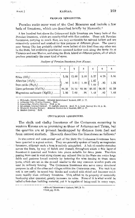
KANSAS.. 169
PERMIAN LIMESTONES.
Permian rocks occur west of the Coal Measures arid include a few beds of limestone, which are described briefly by Ha worth : a
A few hundred feet above the Cottomvood Falls limestone are heavy beds of the Permian limestone, which are usually filled with flint nodules. These soft Permian limestones, carrying so.much flint, are very serviceable for railroad ballast and are extensively quarried and crushed for this purpose at different places. The quarry near Strong City has probably yielded more ballast of this kind than any other one in the State, but extensive quarries are operated farther west along the Santa Fe at Florence and near Marion, and along the Rock Island at different points, all of which produce practically the same kind of stone.
Analyses of Permian limestones from Kansas.
Silica, (SiO,) .......................
Iron oxide (Fe20H ) .................Lime carbonate (CaCOs ) ............
i
5.04
| .96
93.32
1.06
2
13.60
2.55
76.16
7.63
s
3.34
1.69
03 9ft
.94
4
5.27
( 1.071 1. 03
89. 93
1.18
5
4.25
I .85
94.06
.62
(i
5.51
1.24
91. 501.62
1. Eldorado, Butler County. Mineral Resources of Kansas, 1897, p. 77.2. Arkansas City, Cowley County. Ibid.3. Cambridge, Cowley County. Ibid, p. 78.4. Silvcrdale, Cowley County. C. Catlett, analyst. Bull. U. S. Geol. Survey No. 04, p. 4C.5. Winneld, Cowley County.' Mineral Resources of Kansas, 1897, p. 77.6. Marion County. Ibid,
CRETACEOUS LIMESTONES.
The chalk and chalky limestones of the Cretaceous occurring in western Kansas are as promising as those of Arkansas and Texas, but the quarries are at present handicapped by distance from fuel and from cement markets. Haworth describes the limestones as follows:6
In the central and west-central part of the State the Cretaceous limestones have been quarried to a great extent. They are generally spoken of locally as magnesian limestone, although such a term is entirely misapplied. A belt of country stretches across the State, by way of Beloit and Russell, throughout which a fine layer of limestone is quarried and broken into pieces suitable for fence posts. Travelers passing from east to west along almost any railroad line in the State can notice large fields and pastures fenced entirely by fastening the wire fencing to these stone posts, which are set in the ground similar to the way common wooden posts are used in ordinary fencing. The Cretaceous limestones also serve many structural purposes in all of the cities and villages within the Cretaceous area. The rock is so soft it can easily be sawed into blocks and worked with chisel and hammer much more rapidly than ordinary limestone. This, added to its property of materially hardening after quarried, greatly increases its value. None of it is what would be called a first-class building material, yet it is capable of being used in many ways,
((Mineral Resources of Kansas, 1897,'p. 75. f> Ibid, pp. 75-76.

CEMENT MATEEIALS AND INDUSTRY.. [BULL. 243.
and furnishes a convenient and durable structural material for that part of the State, which prevents other stone from being shipped in. Here, as elsewhere, local demands are not so great now as they formerly wrere, but every year thousands of dollars' worth of the rock are quarried and used for various purposes, principally for supplying fence posts.
Analyses of Cretaceous limestones from Kansas.
Silica (SiO,) . ....................'..............................
Iron oxide (Fe203 ) ........................:...................
Lime carbonate (CaCOs ) ........................................
Magnesium carbonate (MgC08 ) .................................
Water.........!........................................:....
1 N
4.81
} 3.07
90.63
.84
.08
2
5.06
2.08
9-1. 30
.87
.44
1. Coolidge, Hamilton County. Mineral Resources of Kansas, 1897, p. 78.2. Jetmore, Hodgeman County. Ibid.
PORTLAND-CEMENT INDUSTRY IN KANSAS.
Two Portland-cement plants are now in operation at or near lola, Alien Count}7-, while a third is in prospect, to be located at Inde pendence, Montgomery County. Both of the present plants (as well as the one projected) use Carboniferous limestones and shales. While the materials are very satisfactory, there is nothing strikingly advan- jtageous in their use. The particular advantage possessed by the Kansas plants is derived not from the use of especially good raw materials, though the limestones and shells are satisfactory enough, but from the fact that the plants are located in a natural-gas area' and are therefore supplied with cheap fuel.
The materials used at the two plants now in operation give the following representative analyses:
Analyses of limestones and shales used for cement making in Kansas.
Silica (SiO,) ........................
Alumina (A1203) ....................
Iron oxide (Fe.,0,) ..................
Lime (CaO) ........................
Magnesia (MgO) ...".............-...
Carbon dioxide (C02 ) ...............
Water..............................
1
| 0.86
.29
55.74
.51
42.76
.04
-
, 1.19
I .95
1.28
53.13
1.36
1 42. 66
3
54. 18
19. 17
6. 11
7.05
1.89
11.95
4
1. 1.
1 1 S/ L8
51.7
2.0
43.3
5
56.0
22. 1
8.0
1.5
10.7
1. Limestone from lola, Kansas.' H. N. Stokes, analyst. Bull. U. S. Geol. Survey No. 78. p. 124.2. Limestone used by lola Portland Cement Company.3. Shale used by Tola Portland Cement Company.4. Limestone used by Kansas Portland Cement Company.5. Shale used by Kansas Portland Cement Company.

BCKHL.] KENTUCKY. 171
POBTI/AND CEMENT RESOURCES OF KENTUCKY."
Limestones prevailingly low in magnesia and otherwise satisfactory as cement materials occur in Kentucky in four different geologic groups. These groups, whose areal distribution in Kentucky is shown on the map forming PI. VI, are as follows, beginning with the oldest:
1. Trenton limestone.2. Cincinnati group limestones.3. Mississippiaivor Lower Carboniferous limestone.4. Pennsylvania or Coal Measures limestones.
TRENTON LIMESTONE.
The Trenton group occupies much of the counties of Franklin, Scott, Bourbon, Woodford, Fayette, Jessamine, and smaller portions of Boyle, Clark, Mercer, Owen, Henry, and Anderson, The lime stones which make up most of this series are usually quite low in magnesia, while their range in lime carbonate is commonly from 90 to 95 per cent.
According to Mr. E. 0. Ulrich the rocks in Kentucky that are referred to this group comprise an exposed thickness of about 700 feet of solid, chiefly nonmagnesian, limestone. The magnesian beds are practically confined to the lower 400 feet, and it is doubtful if these magnesian beds will reach an aggregate thickness of 150 feet. The series is equivalent to the Mohawkian of New York, to the limestones in Middle Tennessee included between the Murfreesboro and Catheys limestones (see Columbia folio), and, in a general way, to the "Trenton " (including Galena) of the Mississippi Valley.
In Kentucky State reports the series is divided, from below upward, into "Chazy," "Birdseye," and "Trenton". The first two are the same as the Stone River group in Tennessee and the High Bridge limestone of Campbell in the Richmond folio. The third embraces the recognizable equivalents of the Hermitage, Bigby, and Cathey limestones of middle Tennessee, and the Lexington limestone (= Her mitage and Bigby), Flanary chert, and lower part of Winchester limestone (together = Cathey) of Campbell.
"For most of the data presentee! in regard to Kentucky cement materials the writer is indebted to Mr. E. 0. Ulrich, of the U. S. Geological Survey
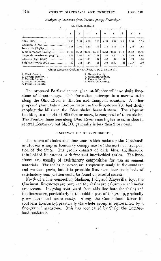
172 CEMENT MATEEIALS AND INDUSTRY. [BULL. 24.3.
Analyses of limestones from Trenton group, Kentucky. (l
[R. Peter, analyst.]
Silica (SiOo).. .;...,.................
Lime carbonate (CaCOa ) ............Magnesium carbonate (MgC03 ) ..... Alkalies (KoO, Na.,0)... '.............
1
5.92
| 3.28
85.56 3.57
.88
.47
2
2.38
3.98
91. 48 1.04
.55
.32
3
2.18
2.42
92. 73 .63 .51.34
4
2.08
.77
95.38 1.51
.14
.58
5
6.94
.12
89.63 .88 .52.68
«
1.88
2.70
90.72 4.61
.35n. d.
7
5.18
1.53
91.33 .56.77.33
8'
1.58
.38
95.68 2.04 .24.17
9
2.18
.63
94.75 1.96 .26.30
1. Clark County.2. Fayette County.3. Fayette County.4. Franklin County. 5. Franklin County.
"From Kentucky Geol. Survey, Kept. A, pt. 2, pp. 123-124.
6. Mercer County. 7. Woodford County.
8. Fayette County.9. Woodford County.
The proposed Portland cement plant at Mentor will use shaly lime stone of Trenton age. This formation outcrops in a narrow strip along.the Ohio River in Kenton and Campbell counties. Another proposed plant, below Ludlow, is to use the limestones (100 feet thick) capping the hills and the Eden shales beneath them. The slope of the hills, to a height of 250 feet or more, is composed of these shales. The Trenton limestone along Ohio River runs higher in silica than in central Kentucky, but MgC03 generally is less than 2 per cent.
CINCINNATI OR HUDSON GROUP.
The series of shales and limestones which make up the Cincinnati or Hudson group in Kentucky occupy most of the north-central por tion of the State. The group consists of dark blue, argillaceous, thin-bedded limestones, with frequent interbedded shales. The lime stones are usually of satisfactory composition for use as cementmaterials. The shales, however, are frequently sandy in the southern and western parts, but it is probable that even here shate beds of satisfactory composition could be found on careful search.
North of a line connecting Madison, Ind., and Maysville, Ky., the Cincinnati limestones are pure and the shales are calcareous and never arenaceous. In going southward from this line both the shales and the limestones, particularly in the middle part of the group, gradually grow more and more sandy. Along the Cumberland River (in southern Kentucky) practically the whole group is represented by a fine-grained sandstone. This has been called by Shaler the Cumber land sandstone.

U. S. GEOLOGICAL SURVEY BULLETIN NO 243 PL. VI
-- -'---. i i rfrlgr'rftT. ET^3 J£T "I? r t!K flOOItCVIlie S. <, v̂ Tb f i ^
TAyj^K-xS^r W^V^; JACK^^VI).'^ Kinli^nKti^it:^,^^ X^ffi^'u)'"^ Xx ^^ ^ 5-"r'"VuHa/iiW.'
jjv.iJiiPtei^vit-"'M4^wK^ 'i''',^"""' "V>' '",:''^ i~ " x^-!*;rMni!Kkw»i'?./
GEOLOGIC MAP OF KENTUCKY AND TENNESSEE Revised from maps of the Kentucky &ncl Tennessee geological surveys
Stale S &*
CARBONIFEROUS LE'SEN D ORDOVICI AN
Coal Measures MissiSSippian limestone Cincinnati shales and limestones Trenton and StonesRiverlimestones

ECKEL.] KENTUCKY. 173
Analyses of limestones from Cincinnati group, Kentucky. a
[R. Peter, analyst.]
Silica (SiO..) .................
Lime carBonate (CaCO;! ) .....Magnesium carbonate
(MgCOa)...................Alkalies (KoO, NaoO) ........Sulphur trioxide (S0;i) ......
1
14. 44
1 3.75
75. 44
4.78 .83.47
2
6.38
2.20
87.98
1.72 .34.37
3
13. 98
3.91
77.30
2. 31 .49
2.43
4 .
10.42
2.03
85. 20
1.24 .79.17
5
1 89
.5-1
90. 51
1.05 .25.18
(i
3.08
1. 19
92. 65
1.54 .43
1. 27
7
7.18
2.84
88. 90
1.47 .22.24
8
16. 64
2.48
78.08
1.57 .35.27
!>
1.72
3.58
92. 92
.50
.32
.34
10
0.78
1.04
96. 24
.94
.87
.18
1. Mason County..2. Mason County.3. Mason County.4. Anderson County.5. Bourbon County.
6. Franklin County.7. Mercer County.8. Nicholas County.9. Owen County.
10. Wooclford County.
Excepting 5 and 10, which are of unusually pure limestones for their respective localities, and 9, which is nearly normal for the north ern part of the Cincinnati outcrop, all these analyses illustrate the increase in silica southward, referred to above. In the central coun ties north of the Maysville-Madison line the limestones contain very little silica and agree closely with those in southwestern Ohio.
MISSISSIPPI AN OR "LOWER CARBONIFEROUS" LIMESTONES.
The Lower Carboniferous limestones are commonly low in magnesia; and in most of the area covered by them in Kentucky they are also high in lime carbonate. As the Tennessee-Kentucky State line is approached, however, interbedded layers of chert become more and more common, until the lower part of the series becomes too siliceous to be of much promise as a source of Portland-cement materials.
The lower Mississippian sandstone, or Waverly sandstone, shown on the map, is limited to the east side of the Cincinnati axis and north of Jackson County, Ky. South of Jackson County and west of the Cincinnati axis the equivalent strata consist, in central Kentucky, principally of shale, in which may occur considerable beds of siliceous limestone; in west Kentucky and middle Tennessee principally of sili ceous limestone, with more or less shale in the lower part (= Tulla- homa), passing southward into the Fort Payne chert.
In the Mississippian group there are two horizons or beds, both oolitic, that are important as future sources of Portland-cement mate rial. The first, occurring at the base of the St. Louis and equivalent to the Spergen Hill (Bedford) limestone of Indiana, forms a generally broad strip passing through Meade, Hardin, Lame, Barren, Warren, Todd, Christian, and Trigg counties. The second is the .Ste. Gene- vieve limestone, which is limited to Christian, Caldwell, Crittenden,
a From Kentucky Geol. Survey, pt. 2, p. 123.

174 CEMENT MATERIALS AND INDUSTRY. [BULL. 243.
and Livingston counties, in western Kentucky. Between the first strip and the border of the western Kentucky coal field there is first a broad strip of St. Louis limestone, which is usually too siliceous and too magnesian for use in making Portland cement, and then, near or just outside of the coal field, the limestones, shales, and sandstones of the Chester group.
The Chester contains several beds of apparently promising lime stone closely associated with beds of shale.
No good limestones occur in west-central Tennessee except in Mont gomery and Robertson counties, where the lower oolite is present. However, the St. Louis limestone here, as also in Kentucky, contains many beds of only slightly siliceous and probably nonmagnesian limestone.
Of thp analyses below, Nos. 1 and 7 are Spergen Hill oolites, Nos. 3, 5, and 6 St. Louis limestone, and 2, 4, and 8 Chester limestones, though the last is extraordinarily pure for a Chester limestone.
Analyses of Upper Mississippian limestones from Kentucky. «
[R. Peter, analyst.]
No.
1.... ...........
2...... .........
3...............
4...............
5. /.............
6...............
8...............
Silica (810s).
1, 06
2.76
3.06- 7.48
9.56
4.46.38
4Q.49
Alumina (A120S );
iron oxide (Fe203 ). '
0.51
.92
1.39
2.56.15
1.49- .46
.22
Lime carbonate (CaC03 ).
98.0593.0295.1585. 6888.15
92.05'98.58
97. 63
Magnesium carbonate (MgCOs).
0.36
2.09
.24
2.50
.38
99
.63
.65'
Alkalies (K20, Na.,0).
0.44
.36
not det..18
not det.
Sulphur trioxide (80s).
0.26
.60Trace.
.84
; .20.27
..34
3. Glasgow Junction, Barren County.2. Barren River, Butler County.3. Iron Hills Furnace, Carter County.4. Grayson County.
5. Old Town Creek, Greennp County.6. Kentpn Furnace, Greenup County.7. Hardin County.8. Litchfield, Grayson County.
PENNSYLVANIA!? OR COAL MEASURES LIMESTONES.
A number of limestone beds occur interbedded with the shales and sandstones of the Coal Measures. These Coal Measures limestones are usually low in magnesia, but rarely carry more than 80 to 90 per cent of lime carbonate. Compared with the thick series of lower Carbo niferous limestones, they are so thin that they would be of but little importance if it were not" for their advantageous location near sup plies of fuel.
"Analyses 1 to 7 from Kentucky Geol. Survey, Kept. A, pt. 2, pp. 119-120; analysis 8 from Twentieth Ann. Rept. U. S. Geol. Survey, pt. 6, p. 545.

MCKKL.] LOUISIANA.
Analyses of Coal Measure limestones from Kentucky.
175
No.
i.............:.2...............3...............4. ..............
5...............
Silica (SiO.,).
14.70
5.963.284.261.15
Alumina(Ai2o:f );
iron oxide (Fe-A,).
6.40
3.761.764.33.65
Lime carbonate (CaCOa).
75.75
88.4188.3882.8897.15
Magnesium carbonate (MgCOj).
0.57
:79
3.684.20
.93
Alkalies (K20,Na20).
n. d.
0.51
.35
.29
Sulphur trioxide (80s).
0.78
.04
.174.72
Analyses 1 to 'I (by R. Peter) from Kentucky Geol. Survey, Kept. A, pt. '2, p. Ill); analysis 5 communicated by F. E. Hay ward. (
1. Mount Savage Furnace, Carter County.2.. l-'ea Kiclgc, Greenup County.3. Henderson County. ,'I. MuhlenbergCounty.5. Hayward, Carter County.
PORTLAND-CEMENT RESOURCES OF LOUISIANA.
The great chalk formations, which seem destined to be such impor tant sources of Portland-cement material in the neighboring States of Texas, Arkansas, Mississippi, and Alabama, fail to occur in Louisiana except as small isolated outcrops. The State is therefore practically devoid of limestone and can hardly be considered as a possible future producer of Portland cement. The few limestone outcrops that appear within its limits are described as follows: a
Cretaceous limestones. The beds of limestone seem to be almost entirely confined to the Cretaceous. Of the three outcrops which occur in the State, the Winnfield limestone is of very doubtful value as a building stone, but the Coochie Brake and Bayou Chicot deposits may be utilized for that purpose.
The Winnfield limestone is a highly crystallized blue arid white banded stone. It is full of cracks and pockets and other flaws, which will render it useless as an ornamental or building stone. -It can doubtless be used to advantage for making lime. The quantity of the stone in. sight is large and it can be very economically quarried. Several kilns of lime have already been burned there.
The purity of the stone is shown by the following analysis by Dr. W. F. Hille- brand, & of the United States Geological Survey:
Analysis of limestone from Winnfield. Silica (SiOj) ............................................................. 0.65Alumina (A1203)...... .................................................. Trace.Iron oxide ('Fe203)....................................................... Trace.Lime (CaO) ........:.................................................... 55.01Magnesia (MgO) ......................................................... .60Sulphur trioxide (S03 ) .................................................... .27Carbon dioxide (CO.j ..................J................................. 43. 43Water................................................................... .13
a Report Geol. Survey Louisiana for 1899, pp. 130-131. bBull. U. S. Geol. Survey No. 60, p. 160.

176 . CEMENT MATERIALS AND INDUSTRY. [HULL. 243.
The Coochie Brake stone is a light-yellow or bluish-yellow, coarse-grained, sandy limestone. . It is of excellent quality for building purposes, but its value is somewhat impaired by the presence of small nodules of iron pyrites. These will restrict its use to situations where a good external appearance is not one of the qualities required of the stone. The pyrite, if the quantity proves to be large, may destroy its value altogether. The quantity of stone at this, locality is large, and it is easily obtained.
The Bayou Chicot stone is the best for building that we have seen in the State. It is a fine-grained dark-gray limestone. Only two very small outcrops of it were seen, and from these no very satisfactory ideas of the extent of the deposit could be gained. In the two outcrops the dip is very great, and the cost of uncovering the stone would probably be large. Borings are needed to show the depth of the deposit. In the early history of the country lime was made at this place. The ruins of the old limekilns are to be seen near the larger outcrop.
Analysis of limestone from Rayborn's salt lick, Bienville Parish. a
Silica (Si02 ) ............................................................. 0.55Alumina (Al a03 ) .......................... .-I......-.-.......-.-......--. .1Iron oxide (Fe20:! ) .-......-...---. - ---...---....----.----.----.--....---. | L 61Lime (CaO) ......................................... 1.................... 54. 09Magnesia (MgO) .......................................................... .06Sulphur trioxide (SOS) ................................................... .05Carbon dioxide (C02 ) .................................................... 44.12
Tertiary limestones. The concretions of limestone in the Tertiary beds ace often of large size and have been used locally for the foundations of houses. At Shreveport large calcareous concretions are crushed and used on the streets and in concrete work. Hopkins reports a place 5 miles from Natchitoches, called the Kilns, where large concretions have been burned for lime.
At Eocky Spring Church lime was burned from a little outcrop of Tertiary lime stone for the masonry of Fort Jessup.
PORTLAND-CEMENT RESOURCES OF MAINE.
Numerous more or less extensive limestone beds are known to occur in various parts of Maine, but few of these will be worth con sidering as possible sources of Portland-cement materials. Most of the outcrops are located far from fuel supply and cement markets, and the transportation question is particularly serious in a State having so low a railroad mileage as Maine. Geologic mapping has not pro gressed sufficiently to give even a fairly accurate map of the limestones of the State, and few satisfactory analyses are available. It is prac tically certain, however, that the only limestones on which a Portland- cement industry can be based, under present conditions, are those which"outcrop along or near the Altantic coast line..
As a source of Portland-cement material, it seems probable that some of the limestones which are now so extensively utilized for lime burning in the neighborhood of llockland, Kockport, and Union, in Knox County, might prove available-. These limestone deposits are of comparatively large size, and are located on or near deep water.
a Bull. U. S. Geol. Survey No. 188, p. 258; analysis by R. B. Riggs.

MAINE.
Glacial clays are abundant in the vicinity of the limestone, and it is probable that some of these clays can be found of suitable composition for a Portland-cement mixture. The Knox County limestones are of very satisfactory composition as cement materials, as is shown by the analyses quoted below.
Analyses of limestones from Knox County, Maine.
Silica (Si02 ) .............................. .i.... ......
Iron oxide (Fe203 ) ....................................
Water ................................................
l
1.08.07.08
98.17.09
n. d.
2
1.00
Trace.
95.201.00
2.70
9
0.43.71?25
97.69.82
n. d.
1. McNamara quarry, Kockland. J. C. Robinson, analyst. Twentieth Ann. Kept. U. S. Geol. Sur vey, pt. 6, p. 398.
2. Bachelder quarry, Union. J. C. Robinson, analyst. Ibid.3. Rockland-Rockport Lime Company. Communicated by G. 0. Smith, 1904.
Limestone beds of considerable extent also occur near Islesboro. A specimen from this locality, collected by G. 0. Smith', was analyzed by W. T. Schaller in the laboratory of the United States Geological Survey, and proved to be a very pure limestone, low in magnesia.
Analysis of limestone from Islesboro, 'Me.
Silica (SiOa ) ..^...:...................................................... 3. 76Alumina (A1 203 ) ......................................................... 1. 03Iron oxide (Fe203 ) -.--.----.---...------------------ --- -- --- ------- -43Lime (CaO)............................................................... 51. 30Magnesia (MgO)......................................................... 1.16
The following analysis, communicated by G. 0. Smith, is of a clay occurring on the preport}' of the.Rockland-Rockport Lime Company, in Knox County. As can be seen from the analysis, it would serve well to mix with the limestones above noted:
Analysis of day from Knox County, Me. Silica (SiO,).............................................................. 61.59Alumina (A1 208 ) -.-----.---------..----..---..---.--------------:------ 19.10Iron oxide (Fe203) ....................................................... 7.53Lime(CaO)..........:.........................................-...-..... 1.68Magnesia (MgO) ......................................... '................ 1. 87Carbon dioxide (C02) .....................................................I ,. Water...................................................................j
The analyses of limestones given in the following table are quoted from an early report, by Professor Hitchcock, on the geology of Maine. They are inserted here, as they may serve to some extent as
Bull. 243 05 12

178 CEMENT MATERIALS AND INDUSTRY. [BULL. 243.
a guide to the limestone prospector. It should be noted, however, that the quality of the analyses is not above suspicion, and also that many of the beds analyzed may prove to be entirely too small to work with profit:
Analyses of Maine limestones.
No.
1
V3
o4
5
6
7
8
9
10
11
1?
13
14
15
16
1718-
19
?0
?1
99
23
?4?5
2697
28
29
30
3132 '
33
34
35
36
37
County.
Androscoggin ......Franklin .._............do .................do .................do .................do .................do .................do .................do . ...............do ..............:. ; do .................do .................do ..................do .................do ............Kennebec ..............do .................do .................do .................do ...........:.'....do ............
Oxford .................do .................do ............
.....do .............
.....do ............
.....do ............Piscataquis .............do .................do ............Somerset ...............do .................do ............ .....do .................do .................do .......'.....
Locality.
Turner ...............
.....do................Farmington ...........
Industry ..............Liver more Falls .......
.....do................
.....do................Phillips....................do.....................do..............;.
Temple ...............Clinton ...............Winslo vv ..............
.....do................
.....do................
.....do................
.....do.................
Dixfield ..............
.....do................Ruin ford Falls ........
Dexter...... ...............do................
.....do................
.....do................Abbot ................
Guilford ..............Athens ....................do................Harmony .............
West Waterville. ...........do................
Insoluble.
25.0
8.8
23.4
6.4
14.4
21.2
34.0
36.0
20.6
10.2
34.4
26.8
34.6
8.4
28.4
17.2
24.2
31.0
16.2
20.6
20.2
29.2
20.020.8
8.69.6
20.014.4
24.825.413. 825.22.8
36.4 10.624.8
9.0
Fc203 .
0.41.4.4
4.81.22.83.2
10.22.4
1.6.8
. 5.6
.41.01.4.6
2.0/
.62.01.61.01.4
.41.2
1.4
1.2
1.8
1.6
1.2
4.0
1.4
4.4
2.2' L2
1.4
1.2
CaCOa.
74.6
89.876.288.884.4
76.062.853.877.088.264.8
67.665.090.570.276.873.868.481.877.878.869.4
79.6
78.0
90.0
89.2
78.284.0
74.070.684.870.472: 661.488.273.889.8
BCKBL.] MARYLAND; 179
POBTLAND-CBMBNT BESOUBCES OF MABTiLAND.
Up to the present time no Portland-cement plants have been built in Maryland, but three limestone formations in the State are so well located and so satisfactory in chemical composition as to give promise of being future sources of supply of Portland-cement materials. Several other limestones occur, but are either too high in magnesia or otherwise not well adapted to cement manufacture. The three avail able limestone formations above noted are, in descending order, as follows:
Name.
Greenbrier limestone. . ..................
Lewiston or Helderberg limestone. .......Trenton limestone ......................
Geologic age.
Mississippian.
Silurian.
The area! distribution of these three limestones in Maryland and the adjoining States is shown on the geologic map, PI. XV, opposite page 314.
TKENTON LIMESTONES. AND ADJACENT CLAYS.
DISTRIBUTION AND CHARACTER.
The Cambro-Ordovician limestones, including the Trenton lime stone, which is the special object of interest here, occur, in three prin cipal areas in Maryland, two of which are in Washington County and one in Frederick.
The westernmost area enters Maryland from Pennsylvania in central Washington County, and runs in a direction slightly west of south to Potomac River, which it reaches between Cherry Run arid Williams- port. The eastern border of this limestone belt lies just west of Con- ococheague Creek, while Little Conococheague Creek lies in the lime stone area. Fairview, Reifl's, Hicksville, and Clear Spring are located on the limestone.
The central limestone belt covers almost all of the eastern third of Washington County. It enters from Pennsylvania as a broad belt, being about 15 miles wide .at the State line. It underlies the Hagerstown Valley, Antietam Creek running down the iniddle of the belt for its entire extent. Hagerstown and Sharpsburg are located near the middle of the belt; Blue Mountain, Edgemont, and Weverton lie on or near its eastern edge, while Williamsport, Salisbury, and Mangansville are on or near the western border of the limestone.
180 CEMENT MATERIALS AND INDUSTRY. [BULL. 243.
The third and easternmost area of these limestones lies in the east- central portion of Frederick County, along Monocac}^ River. Fred erick, Adamstown, Frederick Junction, Woodsboro, and Walkersville are located on this area of limestone.
It must be borne in mind that these limestone belts, as above described and as shown on the map, PL XV, opposite page 314, include two very different types of limestone, one of which is excellent as a Portland-cement material, while the second is absolutely worthless for that purpose, because of the very high percentage of magnesia that it usually contains. This fact is discussed in considerable detail in the descriptions of the Lehigh district cement rocks of Pennsylvania and New Jersey, and the reader will do well to look over the discus sion there given (pp. 284 et seq.)
As a guide to searching for and recognizing the Trenton limestone, which is the one suited for cement'manufacture, it ma}^ be said that the Trenton is usually dark gray to almost black in color, often slaty in appearance; that it frequently contains fossil shells, but rarely includes the beds or masses of chert which are so common in the underlying light-gray or blue magnesian limestone.
As the Trenton limestone is, moreover, the higher of the two limestones, it will usually be found along the contact between the limestone belt and the slates or shales which border it, while the mag nesian limestones commonly occur near the middle of the belt of limestone.
COMPOSITION.
The Trenton limestone is almost invariably low in magnesia, and is therefore suitable for use as a Portland-cement material. In places it carries a high percentage of cla}^ey matter, 'as is instanced by its com position in th'e Lehigh district of Pennsylvania and New Jersey.
The analyses below are fairly representative of the composition of the Trenton limestones of Mary land. It is probable that careful search along the contacts between the limestone belts and the adjoining slates or shales would show the presence of clayey limestones similar to the Lehigh cement rock in composition.

ECKEL.] MARYLAND.
Analyses of Trenton limestones from Maryland.
181
No.
1 . .........................
2..........................
3..........................
4..........................
5..........................
6. .........................
7... .......................
8..........................
9..........................
10..........................
11... ............._'...,........12..........................
13..........................14..........................
15..........................16..........................17............."............'.18..........................
19...............;..........20..........................21..........................22..........................
Silica (SiO.,).
4.73
4. 31
.22
.10
.20
.50
6.00
Alumina.(Al,0;<).
1.
0.29.16
0.27.2 .6X
Trace..5
1.7.3
.91.22.21.5
.01.2
1.3.2
Iron oxide(Fe,0a).
4090
0.25
Trace.1.010
20
Lime car bonate
(CaCOa).
93. 5781. 9797.3296. 7997.0098.5090.7094.686.098.3
99.592.0
92.394.5
90.497.5
95.396.0
99.998.596.299.3
Magnesium carbonate (MgC03 ).
0.3013. 002.032.862.50.80
3.005.26.8
1.1
.57.5
6.05.2
.71.3
2.52.5
.1
.32.5.5
1, 2. Walkersvillc, Frederick County. H. .1. Patterson, analyst. Twentieth Ann. Kept. U. S. Geol. Survey, pt. C, p: 401..
3, 4. Frederick, Frederick County. J. 0. Hargrove, analyst. Ibid.5. Beaver Creek, Washington County. J. Higgins, analyst. Third Kept. Maryland Agric. Chemist,
p. 135.C. Williamsport, Washington County. J. Higgins, analyst. Ibid.7. Pleasant Valley, Washington County. J. Higgins, analyst. Ibid.8. 9. Frederick, Frederick County. J. Higgins, analyst. Fifth Kept. Maryland Agric. Chemist, p. 78.10-12. Unionville, Frederick County. J. Higgins, analyst. Ibid., p. 80.13-15. Woodsboro, Frederick County. ,). Higgins, analyst. Ibid., p. 77.1C, 17. Dollyhide Creek, Liberty, Frederick County. J. Higgins, analyst. Ibid., p. 80.18-22. Near Liberty, Frederick County. J. Higgins, analyst. Ibid., p. 81.
METAMORPHIC TRENTON LIMESTONES.
In eastern Maryland, particularly in Carroll, Baltimore, and Howard counties, a number of areas of highly crystalline limestones or "mar bles " occur. It seems probable that many of these ciystalline lime stones are of the same age as the Cambro-Ordoviciari limestones farther west, having merely assumed a crystalline condition as the result of "being subjected to pressure and heat.
In composition these crystalline marbles vary, just as do the unmet- amorphosed Cambro-Ordovician limestones. The Cockey sville marble,
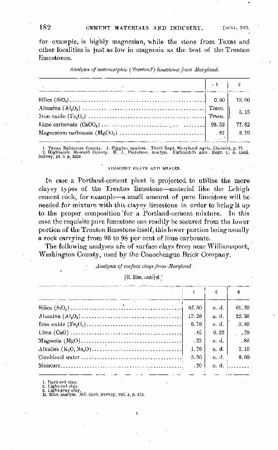
182 CEMENT MATERIALS AND INDUSTRY. [BULL. 243.
for example, is highly magnesian, while the stone from Texas and other localities is just as low in magnesia as the best of the Trenton limestones.
Analyses of metamorphic ( Trenton?)- limestones from Maryland.
Silica ( Si02) ..............................'............:........Alumina (A1203 ) .-..--..-....-...---..--.....................Iron oxide (Fe203 ) ............................................
Magnesium carbonate (MgCOs ) ................................
. i
0.60Trace.Trace.98.53
.87
a
13. 60
| 5.15
77.823.19
1. Texas, Baltimore County. J. Higgins, analyst. Third Kept. Maryland Agric. Chemist, p. 77.2. Highlands, Howard County. H. J. Patterson, analyst. Eighteenth Ann. Kept. U. S. Geol.
Survey, pt. 5, p. 1059.
ADJACENT CLAYS AND SHALES.
In case a Portland-cement plant is projected, to utilize the more clayey types of the Trenton limestone material like the Lehigh cement rock, for example a small amount of pure limestone will be needed for mixture with this clayey limestone in order to bring it up to the proper composition xfor a Portland-cement mixture. In this case the requisite pure limestone can readily be secured from the lower portion of the Trenton limestone itself, this lower portion being usually a rock carrying from 93 to 98 per cent of lime carbonate.
The following analyses are of surface clays from near Williamsport, Washington County, used by the Conocheague Brick. Company.
Analyses of surface clays from Maryland.
[H. Ries, analyst.]
Silica (SiO,) ........ ...'.........'......................Alumina ( A1203 ) ......................................
Iron oxide (Fe20,j) . ...................................Lime ( CaO )............ ......^ .......................
Magnesia (MgO) . ................'.....................Alkalies (K20, Na.,0) ......... .'.-. ......................
1
67.5017.20
6.70
.45
.33
' 1.76
5.90
.20
ft
n. d.11. d.n. d.0.22n. d.
n. d.n. d.n. d.
8
61. 3022.30
3. 80.70.86
2.10
8.00
1. Dark-red clay.2. Light-red clay.3. Light-gray clay.H. Ries, analyst: Md. Geol. Survey, vol.'4, p. 473.

BCKBL.] MARYLAND. 183
If, on the other hand, the purer beds of the Trenton limestone are intended to furnish the principal ingredient, a clay or shale will be required for mixture with it. Surface clays of fair qualit}' occur throughout the area underlain by the Trenton limestones, and some of them will probably be found available for .use. In addition, the shales and slates of the Hudson formation, which borders the lime stone belts, will be serviceable. The composition of some of these Hudson shales in Pennsylvania and Virginia is given in tables on pages 288 and 322.
HELDERBERG LIMESTONE AND ADJACENT CLAYS.
DISTRIBUTION.
The Helderberg or Lewistown limestone outcrops in Maryland in a number of different belts. Most of these are in the west-central por tion of Allegany County, while several occur in western Washington County. The Lewistown limestone occurs only in these two counties. Its distribution in Allegany County is described as follows, by Mr. C. C. O'Harra, in the report on the geology of that county published by the Maryland Geological Survey:
The easternmost and largest area, shaped like a much constricted letter W, lies to the east, west, and south of Tussey Mountain, and by its prominent double bifur cation makes up a large part of Warrior Mountain and Martin Mountain. On the State line east of Tussey Mountain the Helderberg belt is less than one-half mile wide, while the width of the corresponding outcrop on the western side is consider ably greater. Southward, owing to the pitching of the Tussey Mountain anticline, these bands gradually approach each other until, at a point near Rush, the-two coalesce.- Within less than 1 mile southward the area again becomes bifurcated, but this time, owing to the synclinal nature of the fold, the projecting parts are separated by the Oriskany formation, which immediately follows the Helderberg. Of the two southern Helderberg projections, the one farthest east is the more extensive, and includes within it Flakes Knob, the highest point in the county, east of the Alle gany Front. This part of the area narrows southward, but caps Warrior Mountain to within almost a mile of where the mountain ceases to be a distinct topographic feature. The projection lying farther west is much narrower than the one to the east, but continues almost as far south and acts as a capping for Collier Mountain.
The next area of Helderberg lies farther west and flanks the outcrop of Salina around Evitts Mountain in much the same way that the first area does the Saliua around Tussey Mountain. The bifurcation at the north caused by the Evitts Moun tain anticline is quite like that produced by the Tussey Mountain anticline. The formation continues southward in one long, continually narrowing band to within 1$ miles of the Potomac, where the Helderberg ending in a sharp point passes beneath the Oriskany to appear again at the roadside by the canal where the Potomac has cut entirely through the overlying Oriskany and into the Helderberg for a distance of fully a hundred feet. The eastern part of this area forms much of the crest and western,slope of Nicholas Mountain, while the contact line along the western side is clearly marked by a row of hills extending from the State line southward. This row of hills reaches almost as far south as does the Helderberg outcrop, but finally coalesces with Nicholas Mountain.
East of Wills Mountain a belt of Helderberg averaging less than one-half mile in

184 CEMENT MATERIALS AND INDUSTRY. [BOLL. 243.
width comes into the county from the north, and, extending southward along the western slope of Shriver Ridge, passes through the western part of Cumberland and across the Potomac into West Virginia. The Potornac in its very perceptible east ward bend nearly 3 miles above Cumberland, and again in the more prominent eastward bend about 6 miles above Cumberland, has carved out two small portions of this belt from the West Virginia area. These patches are mostly concealed, but their contact with the Salina is fairly well shown. Northward the Helderberg- Salina contact is largely concealed, but the limestone quarries which occur in the lower part of the Helderberg along the western base of Shriver Ridge afford a con venient means of judging the approximate western outcrop of the Helderberg. Shriver Ridge marks the eastern limit, as the contract lies on its western slope a short distance below the top.
West of Wills Mountain there is a band of Helderberg corresponding in position to the eastern belt, but by reason of the perpendicular attitude of the strata this belt is considerably narrower than the one on the eastern side. Following closely the general direction of Wills Mountain, it crosses the Potomac River at Potomac station. Along the belt north of the National Road the Helderberg-Salina contact is usually not well shown, but the Helderberg-Oriskany contact is prominent, the latter being represented by the steep ridges to the north and south of Corriganville. South of the National Road neither contact is well shown, although slight topographic features usually indicate their positions with reasonable accuracy.
Another Helderberg area of considerable extent is exposed south of Rawlings. This forms the body of the steep isolated ridge known as Fort Hill, which extends southward along the Potomac for a distance of about 4 miles.
In addition to the above-mentioned areas, two very slight exposures may be seen along the West Virginia Central Railroad, on the north and south sides of Monster Rock, near Keyser, W. Va. They are of little importance, except in so far as they are of value in helping to work out the structure in that part of the county.
In addition to the areas above described as occurring in the western and central parts of Allegany County, four narrow belts of the Helder berg limestone outcrop in the western portion of Washington County, their location being shown on the map (PI. XV, p. 314). The best exposures of these limestones in the county, so far as location is con cerned, are those near Hancock, on Potomac River.
DESCRIPTION AND STRATIGRAPrtIC POSITION.
The stratigraph}^ of the Lewistown limestone is thus described by Mr. O'Harra in the report previously cited:
Lithologically, the Helderberg is preeminently a limestone formation. Argillace ous materials occur as impurities in some of the beds, but these are not important, and sandstones are almost wholly lacking. Thin bands of chert, which are white or yellowish-white in color, occur sparingly throughout the upper part of the formation. Most of the limestone in the upper part is-heavily bedded, and much of it is highly fossiliferous. The lower part of the Helderberg is a dark-blue thin-bedded limestone, which in breaking gives a decided ring. This corresponds to the Tentaculite lime stone of New York, which in Maryland is over 400 feet thick. In the field the con tact between the Salina and the Tentaculite limestone is very marked because of the different weathering qualities of the two rocks. The Salina rock weathers into soil very completely, while the Tentaculite limestone leaves innumerable small, thin, dark-blue slabs upon the surface.
The thickness of the formation is nearly 800 feet. The two" partial sections given
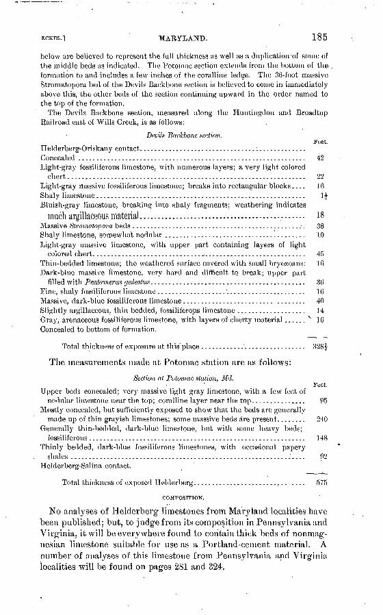
MARYLAND. 185
below are believed to represent the full thickness as well as a cluplicatioirof some of the middle beds as indicated. The Potomac section extends from the bottom of the formation to and includes a few inches of the coralline ledge. The 36-foot massive Stromatopora bed of the Devils Backbone section is believed to come in immediately above this, the other beds of the section continuing upward in the order named to the top of the formation.
The Devils Backbone section, measured along the Huntingdon and Broadtop Railroad east of Wills Creek, is as follows:
Devils Backbone section.Feet.
Helderberg-Oriskany contact................................;.............Concealed ............................................................... 42Light-gray fossiliferons limestone, with numerous layers; a very light colored
chert.................................................................. 22Light-gray massive fossiliferons limestone; breaks into rectangular blocks.... 16 Shaly limestone.......................................................... 1$Bluish-gray limestone, breaking into shaly fragments; weathering indicates
much argillaceous material.............................................. 18Massive Stromatopora beds.................................................. 36Shaly limestone, somewhat nodular ....................................... 10Light-gray massive limestone, with upper part containing layers of light
colored chert............................................................ 45Thin-bedded limestone; the weathered surface covered with small bryozoans: 16 Dark-blue massive limestone, very hard and difficult to break; upper part
filled with Pentamerw galealus. .......................................... 36Fine, shaly fossiliferous limestone ...................'...................... 16Massive, dark-blue fossiliferous limestone......................... ........ 40Slightly argillaceous, thin bedded, fossiliferous limestone ................... 14Gray, arenaceous fossiliferous limestone, with layers of cherty material...... N 16Concealed to bottom of formation.
Total thickness of exposure at this place ............'................. 328J
The measurements made at Potomac station are as follows:
Section at Potomac station, Md.Feet.
Upper beds concealed; very massive light gray limestone, with a few feet ofnodular limestone near the top; coralline layer near the top............... 95
Mostly concealed, but sufficiently exposed to show that the beds are generallymade up of thin grayish limestones; some massive beds are present........ 240
Generally thin-bedded, dark-blue limestone, but with some heavy bed;:;fossiliferous............................................................ 148
Thinly bedded, dark-blue fossiliferous limestones, with occasional paperyshales ............................................................:.... 92
Helderberg-Salina contact.
Total thickness of exposed Helderberg............................... 575
COMPOSITION.
No analyses of Helderberg' limestones from Maryland localities have been published; but, to judge from its composition in Penns}7lvania and Virginia, it will be every where found to contain thick beds of nonmag- nesian limestone suitable for use as a Portland-cement material. A number of analyses of this limestone from Pennsylvania and Virginia localities will be found on pages 2S1 and 324.

CEMENT MATERIALS AND INDUSTRY. [BULL. 243.
GREENBKIEH LIMESTONE AND ADJACENT SHALES.
DISTRIBUTION.
As shown on PI. XV, the Greenbrier outcrops only in Allegany and Garrett counties. A single belt passes through the western part of Allegany, running about S. 30° W., and crossing the Potomac River at a point about midway between Westernport, Md., and Kej^ser, W. Va.
In Garrett County the Greenbrier is better shown, appealing in a number of belts or areas. As described in the report on Garrett County, published by the Maryland geological survey, the six belts occurring in Garrett County are distributed as follows:
The most; easterly of these areas is situated parallel to and about one-half mile west of the crest of Savage and Backbone mountains. It enters the county from Pennsylvania one-half mile west of the northeast corner of the county, and extends in a southwesterly direction to the West Virginia line, 1 mile north of Potomac stone. This belt is about 45 miles long and from one-fourth to one-half mile wide. It occupies a valley between the Pottsville (Savage Mountain) and the Pocono (Little Savage Mountain) ridges. This valley is drained at the north by the headwaters of Laurel Eun and Savage River, and farther south by Little Savage River, Swamp Run, and Pine Swamp Run. Along the northern end of Backbone Mountain the line of outcrop is for a large part of the way up on the mountain side, but farther south it occupies a series of valleys like those along Savage Mountain, but less pronounced.
The second Garrett County area extends along the eastern side of Meadow Moun tain in the valleys of Red Run and Meadow Creek Run as far as the confluence of the latter with Deep Creek, near Thayerville. Thence it extends in the same south westerly direction, in a similar series of valleys between Hoop Pole Ridge and the ridge of Pottsville rocks to the west of it, to the West Virginia line at a point about 7 miles southwest of Oakland. This series of valleys is drained by branches of Deep Creek and of Miller Run and by White Meadow Run and Rhine Creek. The lime stone belt is about 37 miles long and from one-eighth to one-half mile in width.
The third belt extends from a point near Thayerville on the one last describeddown the valley of Deep Creek to the mouth of Marsh Run, thence up the valley of Marsh Run to McHenry, thence in a westerly direction for 1 mile, where it bifurcates. One prong extends down the valley of Hoyes Run for about 1 mile, and then disap pears under overlying formations. The other prong extends in a. northwesterly direction through a valley to Sang Run. From here it extends down the Youghio- gheny River to points 1£ miles north and 2£ miles south of Sang Run, where it dips under the overlying formation.
The fourth area extends from a point on the one last described at McHenry in a north-northeasterly direction in the valley parallel to and about one-half mile west of Negro Mountain as far as across the Pennsylvania line. This belt is about 15 miles long and one-eighth of a mile wide.
The fifth belt extends from a point on the third one, about 1 mile east of Sang Run, in a northerly and northeasterly direction, crossing the Pennsylvania line at Oakton. It occupies a sinuous, line of valleys parallel to and about one-half mile east of the crest of Winding Ridge. The belt is about 13 miles long and one-eighth of a mile wide.
The sixth area enters the county from West Virginia near Cranesville, and extends south along the valley occupied by Pine Swamp and Muddy Creek as far as Brown ing Mill, and thence up the valley lying west of Snaggy Mountain for about'4 miles. Here it extends across the line into West Virginia.

KCKRL.] MARYLAND. 187
OESCRIITION.
The Greenbrier formation, where best developed in Maryland, con sists of three distinct members. The lowest is a series of limestones, usually siliceous near the base, and varying from 27 to 46 feet in thick ness. The middle member consists largely of shales, thin sandstones, etc., and varies from 88 to 98 feet in thickness. The upper member consists almost entirely of veiy pure limestones, and is from 65 to 85 feet thick.
The section below, quoted from the Garrett County report of the Maryland Geological Survey, will serve to illustrate the characters of the various members of .the Greenbrier formation.
Section of Greenbrier formation at Crabtree. Garrett County.
Upper member: - . Feet. Argillaceous limestone.................................................. 4$Massive sandy limestone................................................... 13Red sandy limestone .................................................... 2Gray limestone......................................................... 3 Red calcareous shale............ . '. ...................................... 3 JRed sandy limestone.................................................... 8Gray sandy limestone with red bands.................................... 21Gray limestone ........................................................ 10
65
Middle member:Red shale, with thin bands of gray sandstone ............................. 80Pure white sandstone................................................... 8
Lower member:Gray limestone.......................................'.................. 27
COMPOSITION.
The upper member of the Greenbrier formation consists very largely of thick beds of pure limestone. These limestones have been very extensively used for flux and for lime burning, and their range in composition is fairly well established.
The series of analyses given below is representative of these upper limestones. They are commonly very low in magnesium carbonate, though occasional beds will show a prohibitive percentage of that ingredient. In places they carry sufficient silica, alumina, and iron oxide to approximate to the composition of the Lehigh cement rock, but usually it will be necessary to add a considerable proportion of clay or shale in order to bring the mixture up to correct 'composition for Portland cement.

188 CEMENT MATEEIALS AND INDUSTEY.
Analyses of Greenbrier limestone from Maryland.®
[BOLL. 243.
Silica (SiOs ) .............Alumina ( AljO,) .........Iron oxide (Fe200 ........Lime carbonate (CaC08 )..Magnesium carbonate
(MgC03 ) ..............
l
13.65
J5.44
79.16
1. 21
._>
13. 46
12.48
72.92
1.15
8
8.57
2.38
88.73
.86
4
20.95
41.10
37. 35
.91
a .
17. 00
2.74
64. 12
15. 75
(i
4.47
2.70
86.73
6.38
7
3.65
8.44
85.87
1. 30
8
11.52
3.37
74.48
10.99
!)
5.11
2.56
89.08
'3.17
10
5.24
1.98
84.58
7.49
1. Gerringer'and Inglehart's quarry, Garrett County.2. Offutt's quarry, Garrett County.3. Crabtree, Garrett County.4. South of Negro Mountain, Garrett County.5. Offutt's quarry, Sarrett County. C. 'Findley's quarry, Piney Run, Garrett County. 7-9. Mouth of Stony Run, Allegany County. 10. Barrelville, Allegany County.
ADJACENT SIT ALES.
The following analyses b of Carboniferous shales from near Corinth, Garrett County, will serve to illustrate their range of composition. It will be seen that the}^ often carry high percentages of iron oxide
and that the ratio j , ^ n~~ rarely rises much above 2.5 alumina + iron oxide Jand often falls below 2.
Analyses of Carboniferous shales from near Corinth, 'Md.
Silica (Si02 ) ................
Alumina (A1 20S ) ............
Lime (CaO) ................
Magnesia (MgO) ...........Alkalis (K20,Na.20 ).......';.
Water ......................
l
56.42
20.94
10.60 Trace.
1.32
7.30
2
69. 51
22.27
.80 Trace.
Trace. Trace.
7.45
3
62. 98
18.54
5.70 2.44
.97
8.85 ^,
4
51.53 22.60
6.80 5.40
1.87
11. 77
5
53.4922.83
6.90 2,91
1.84
9.44
c
56.36 24. 18
6.40 .50
.82
7.50
7
61.70 22.24
5.60Trace.
1.44
6.50
8
56. 32
23.00
5.80 1.47
.79
11.08
1. Red clay (bottom).2. Fire clav or flint.3. Buff clay.4. Bottom blue clay.
5. Top blue clay.6. Cistern.7. Railroad clay.8. Black shale, coal mine.
"These analyses are taken from the report by the Maryland geological survey on "Garrelt County," pp. 221-222. All the analyses were made by T. M. Price.
6 Geology of Garrett County, Maryland Geol. Survey, p. 219.

12CK.EL.] MASSACHUSETTS-MICHIGAN. 189
PORTJDAND-CEMENT RESOURCES OF MASSACHUSETTS.
In the western part of Massachusetts extensive quarries are operated for both marble and lime. The stone quarried in this area is a highly crystalline limestone, or marble, of Cambro-Ordovician age. At many points this stone is highly magnesian, but the quarries located in the northwestern portion of the State, in Berkshire County, seem to pro duce almost exclusively a low-magnesia rock. The analyses given below are fairly representative of this product.
Unfortunately for the prospects of a Portland-cement industry in the State no shales occur near, these limestones, while the glacial clays usually contain too much sand and pebbles to be worth considering as cement materials. This fact, taken in connection with the cost of fuel in this district, renders it improbable that Massachusetts will become a successful cement produceiv
Analyses of Um.esl,on^s from Majamclmselts.
Silica ( SiO 2 )..............;...................
Alumina ( A1 203 ) ..............................
Lime carbonate (CaCOs ) .......................
Magnesium carbonate (MgCOs ) ................
i.
0.69
| .06
93.86
5.34
2.
0.31.
.23
98. 80
.37
:{.
n. d.
n. d.
99. 03
.27
4.
0.63
.55
99. 6C.49
1. North Adams Marble Company, North Adams, Berkshire County. W. P. Mason, analyst. Twen tieth Ann. Kept. U. S. Gcol. Survey, pt. 6, p. 406.
'2. Cheshire Manufaeturing Company, Cheshire, Berkshire County. Davenport & Williams, analysts. Ibid., p. 410.
3. C. H. Hastings's quarry, West Stockbridge, Berkshire County. J. B. Britton, analyst. Ibid., p. 411.
4. Adams Marble Company, Kenfrew, Berkshire County. E. E. Olcott, analyst. Ibid., p. 410.
PORTLAND-CEMENT RESOURCES OF MICHIGAN.
PORTLAND-CEMENT MATERIALS.
Michigan now ranks third as a Portland-cement producer, being led only by Pennsylvania and New Jersey, but closely followed by New York. This high standing as a producer is due to the product of a number of cement plants, most of them using a mixture of marl and clajr, but a few utilizing pure limestone with clay or shale.
The description of the cement resources and cement industry of Michigan, given in the following pages, is somewhat abridged from a report by Prof. I. C. Russell on The Portland Cement Industry in Michigan, published in the Twenty-second Annual Report of the United States Geological Survey, part 3, pages 629-685. Reports on the cement materials of the State have also appeared in volume 8 of the Michigan Geological Survey.

190 CEMENT MATERIALS AND INDUSTRY. OULL. 24::.
LIMESTONES.
Of the various limestone formations that outcrop in different parts of Michigan three have been utilized in the manufacture of Portland cement, while another formation yields limestones which have not so far been utilized, though low in magnesia and otherwise satisfactory as cement materials. The four limestone groups above noted will be described separately.
DUNDEE LIMESTONE.
This formation occurs at the base of the Devonian system, and, although usually concealed beneath glacial drift and surficial deposits, comes to the surface, as is indicated on the map (PI. VII), in a belt from about 2 to 9 miles wide, trending northeast and southwest across Wayne, Monroe, and Lenawee counties, in the southeastern corner of the State. The same formation occurs also at the extreme northern end of the southern peninsula and on Mackinac and neighboring islands, as well as in the adjacent portion of the northern peninsula. The purest layer of limestone in the Dundee thus far discovered is extensively quarried at Sibley and Bellevue, near Trenton, in Wayne County, and is used in the manufacture of sodium bicarbonate, soda ash, and caustic soda near Detroit. The n'nety powdered calcium car bonate, resulting as a by-product from the manufacture of caustic soda, is used by the Michigan Alkali Company for making Portland cement at Wyandotte. This same limestone, on account of its unusual purity, is'also extensively used in the manufacture of beet sugar.
The Dundee formation contains several beds of limestone, most of which, however, carry too high a percentage of magnesia to per mit their use in making Portland cement under the standard now required in the composition of the finished product. Thus far onlyone layer, the celebrated 9-foot bed, best exposed at the Sibley quar ries, described below, has been found sufficiently pure to be utilized in the industries mentioned above. The composition, of the rock quarried at Bellevue and used by the Michigan Alkali Company at Wyandotte, is as follows:
Analysis of a limestone, of the Dundee formation at Bellevue.
[Analyst, O. Button.]
Silica (Si02 )............................................................. 0. 60Iron oxide (Fe203 )l o ru Alumina (A120R)/ -------------------------------------------------------
Calcium carbonate (CaC03 ) .......................:..........-.........-.. 95. 24Magnesium carbonate (MgCOs ) ........................................... 1. 00
Total............................................................. 99. 88

U.S. GEOLOGICAL SURVEY BULLETIN NO. 24-3 PL.VII
^O 0 u«^GEOLOGIC MAP
OF THE
LOWER PENINSULA OF MICHIGANREVISED FROM MAPJN VOL.V OFTHK STATE REPORTS
BY ALFRED C.I.ANE
1898
LEGEND
(Numbers refer to county names SecPI.Vll] )
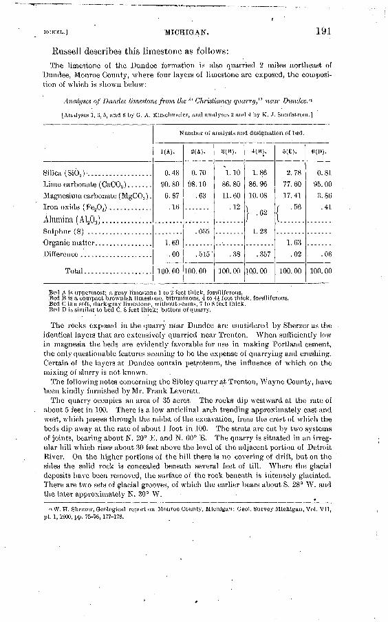
MCKKL.'J MICHIGAN. 191
Russell describes this limestone as follows:
The limestone of the Dundee formation is also quarried 2 miles northeast of Dundee, Monroe County, where four layers of limestone are exposed, the composi tion of which is shown below:
Analyses of Dundee limestone from the " Christiancy quarry," near Dundee.'1
[Analyses 1, 8, 5, and 6 by G. A. Kirschmeier, and analyses 2 and 4 by K. ,i. Sundstrom.]
Silica (SiO,) ...................
Lime carbonate (CaCOa ) .......
Magnesium carbonate (MgC03 ) .
Alumina ( A1 203 ) ..............Sulphur (S) ..................
Organic matter. ...............Difference ....................
Total...................
Number of analysis and designation of bed.
1(A).
0.48
90. 80
6.87
.16
1.69
.00
100. 00
2(A).
0.70
98.10
.63
.055
. 515 '
100. 00
8(B).
\. 10
86.80
11. 60
.12
.38
100. 00
4(B).
1.8,6
86.96
10. 08
| .62
1.23
.357
100. 00
5(0).
2.78
77.60
17. 41
f .56
1.63
, .02
100.00
«(»)
0. 81
95. 00
3. 86
.41
.08
100. 00
Bed A is uppermost; a gray, limestone 1 to 2 feet thick, fossilifcrons.Bed B is a compact brownish limestone, bituminous, 4 to <H feet thick, i'ossiliferous.Bed C is a soft, dark-gray limestone, without scums, V to 8.feet thick.Bed 1) is similar to bed C, 8 feet thick; bottom of quarry.
The rocks exposed in the quarry near Dundee are considered by Sherxer as the identical layers that are extensively quarried near Trenton. When sufficiently low in magnesia the beds are evidently favorable for use in making Portland cement, the only questionable features seeming to be the expense of quarrying and crushing. Certain of the layers at Dundee contain petroleum, the influence of which on the mixing of slurry is not known.
The following notes concerning the Sibley quarry at Trenton, "Wayne County, have been kindly furnished by Mr. Frank Leverett.
The quarry occupies an area of 35 acres. The rocks dip westward at the rate of about 5 feet in 100. There is a low anticlinal arch trending approximately east and west, which passes through the midst of the excavation, from the crest of which the beds dip away at the rate of about 1 foot in 100. The strata are cut by two systems of joints, bearing about N. 20° E. and N. 60° E. The quarry is situated in an irreg ular hill which rises about 30 feet above the level of the adjacent portion of Detroit River. On the higher portions of the hill there is no covering of drift, but on the sides the solid rock is concealed beneath several feet of till. Where the glacial deposits have been removed, the surface of the rock beneath is intensely glaciated. There are two sets of glacial grooves, of which the earlier bears about S. 28° AV. and the later approximately N. 30° W.
« W. H. Shorzer, Geological report on Monroe County, Michigan: Geol. Survey Michigan, Vol. VII, pt. 1,1900, pp. 75-76,177-178.
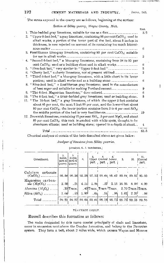
192 CEMENT MATERIALS AND INDUSTRY. [HULL. 243.
The strata exposed in the quarry are as follows, beginning at the surface:
Section at Sidley quarry, Wayne County, Midi.Feet.
1. Thin-bedded gray limestone, suitable for use as a flux................... 3.'52. "Upper 6-foot bed," a gray limestone, containing96 perceritCaC03 ; used in
alkali works; a portion of the lower part of the bed, about 8 inches in thickness, is now rejected on account of its containing too much bitumi nous matter........................................................ 6
3. Fossiliferous blue-gray limestone, containing 90 per cent CaC03 ; suitablefor use in alkali works .............................................. 3
4. "Second 6-foot bed," a blue-gray limestone, containing from 94 to 95 percent CaCOs ; used as a building stone and in alkali works.............. 6
5. '' Five-foot bed,'' very similar to '' Upper 6-foot bed "................... 56. "Cherty bed," a cherty limestone, not at present utilized............... 27. "Third 6-foot bed," a blue-gray, limestone, with a little chert in its lower
portion; used in alkali works and as a building stone ................. 68. "Nine-foot bed," a fossiliferous gray limestone; used in the manufacture
of beet sugar and suitable for making Portland cement................. 99. "The 6-foot Magnesian limestone," dove colored....................... 6
10. "The 8-foot bed," a thick-bedded gray limestone; used as building stone. 811. "The 10-foot bed," a gray limestone, of which the upper 3 feet contains
about 85 per cent, the next 3 feet 95 per cent, and the lower 4 feet about 80 per cent CaC03 ; the lower portion contains from 3 to 4 per cent Si02 ; the middle portion of the bed is very fossiliferous..................... 10
12. Brownish limestone, containing 15 per cent Si02 , .5 per cent MgO, and about 85 per cent CaC03 ; this rock is marked with white spots, thought to be aluminum silicate; used as building stone; opened to a depth of about.. 4
Total .........................^......<....................... 63. 5
Chemical analyses of certain of the beds described above are given below:
Analyses of limestone from Sibley quarries.
[Analyst, K. J. Sundstrom.]
Constituent.5.
Southpart ofquarry.
5. Northpart ofquarry.
Upperpart.
Central part.
Lower part.
10.11.
Central part.
Calcium carbonate (CaCO3 ) ...........
Magnesium carbon ate (MgC03 ) .......
Alumina (Ala03 ) ..... Silica (Si02 ) .........
95.50
2.36
99.26
.21
93.28
4.11
97.33
1.84
30 Trace. 40 Trace.
1.04 .50 1.90 .64
99. 00
.22
Trace..54
95.62
3.15
Trace..96
80.04 89.05
8.0815.96
2. 70 Trace
1. 02 2. 20
95. 00
4.00
Trace.
.56
Total 99.20 99. 97 99.69 99.81 99.76 99.72 99.33 99.56
TRA. VERSE GRO UP.
Russell describes this formation as follows:
The rocks designated by this name consist principally of shale and limestone, occur in succession next above the Dundee formation, and belong to the Devonian system. They form a belt, about 2 miles wide, which crosses Wayne and Monroe

ECKEL.] MICHIGAN. 193
counties, * * * but are there concealed beneath surficial deposits, and also form a broad area which crosses the northern end of the Southern Peninsula from Alpena, on the border of Lake Huron, to Frankfort, on the shore of Lake Michigan. The limestone of the Traverse group comes to the surface at Alpena and is utilized by the Alpena Portland Cement Company. In the quarry where it is well exposed it is a light-colored compact rock, carrying corals and other fossils. Its composition is as follows:
Analyses of limestone from the quarries of the Alpena Portland Cement Company, Alpena.
[Analyst, F. H. Haldeman.]
Constituent.
Silica (SiO,)........Calcium carbonate
(CaCOj).. ........
Magnesium carbo nate (MgCOs ) ----
Iron oxide (Fea03 ) . .
Alumina (A1803 ) ....
Total .........
i
0.36
95. 91
3.63
}..»100. 03
2
1.77
89.10
8.67
.35
99.89
3
0.33
98.37
.92
.18
99.80
4
0.38-
98.03
l;36
.19
99.96
5
1.38
96.35
.94
1.21
99. 88
6
1.64
96.50
1.26
.27
99.67
7.
1.46
96.92
1.46
.54
99.90
8
0.42
98.04
.98
.18
99.72
9
0.68
98.03
1.05
.26
100. 02
1. Quarry C: Shell to be removed on stripping; 1 to 2 feet thick.2. Quarry C: Top stratum, 2 feet thick.3. Quarry C: Second stratum, 2 feet thick.4. Quarry C: Third stratum, 4 feet thick.5. Quarry C: Fourth stratum, 2 feet thick.6. Quarry F: First stratum, 2 feet thick.7. Quarry F: Second stratum, 1 foot thick.8. Quarry F: Third stratum, 2 feet thick..9. Quarry F: Fourth stratum, floor of quarry.All samples show traces of sulphates and phosphates.
The favorable results in the manufacture of Portland cement obtained from the use of the limestones just considered will no doubt stimulate further search for favorably situated outcrops of the same formations, in which the accompanying map, showing where they may be expected to occur, will be of assistance.
1 ' MICHIGAN SERIES."
Russell describes the Michigan series as follows:Another formation containing limestone, present in southern Michigan, is desig
nated as the "Michigan series" on the map [PI. VII], and belongs to the * * * Mississippian * * *. The limestones occur principally in the upper portion of the system and outcrop on the borders of the coal-bearing rocks which form the surface. They are in great part concealed by glacial drift and other surficial rocks over an extensive area in the central part of the southern peninsula.
The limestone of the Michigan series outcrops at Bayport and Sebewaing, in Huron County, on the east side of Saginaw Bay; on the Charity Islands; at Belle- vue, in the southwestern part of Eaton County; and near the Portage River, about 5 or 6 miles north of Jackson-. Other localities where it is accessible no doubt occur. It has been quarried at Bayport, Bellevue, and near Jackson, and calcined to make lime. Its composition, as indicated by the following analyses (stated as published), is such as to make it suitable for use in the manufacture of Portland cement, but up to the present time it has not been utilized for this purpose.
Bull. 243 05 13

194 CEMENT MATERIALS AND INDUSTRY. IBDLL. 243.
Analysis of limestone from BayporL
[Analyst, J. W. Langley.]
^\\fi^.............:.....^.............................................. 3.330Oxide of iron and alumina ............................................... 1. 334Carbonate of magnesia.................................................. .944Carbonate of lime ....................................................... 91.538Phosphorus and sulphur ....................................^........... Trace.Organic matter and loss................................................. 2. 854
100. 000 (Quicklime, 51.29.)
Analysis of limestone from Bellevue.
[Analyst, Carl Rominger.]
Carbonate of lime ........................................................ 96.00Carbonate of magnesia.................................................... 1. 00Hydrate of iron oxide .................................................... .50Insoluble residue......................................................... 1.50
99.00Analysis of limestone from Portage River.
[Analyst, Carl Rominger.] .Carbonate of lime ........................................................ 96.90Carbonate of magnesia. .. ...'.............................................. 1.00Alumina and iron ..................... 1.................................. .70Insoluble residue......................................................... 1.40
99.00
The limestone of the "Michigan series" contains layers that are high in magnesia or are otherwise unfavorable for cement making, but in spite of this the formation is evidently worthy of careful attention from persons interested in the industry under review wherever it occurs near deposits of clay or shale and is suitably situated in reference to transportation facilities, etc.
All of the limestones referred to above are of marine origin and usually contain fossils, among which coral is frequently conspicuous. The rocks are usually com
pact and hard, and if employed in the manufacture of Portland cement must be crushed and ground to a fine powder. Except for the expense thus involved they are in certain instances as favorable for the use indicated as the marls described below.
MARL DEPOSITS.
Russell describes the marl deposits as follows:Some idea of the abundance and wide distribution of marl deposits in the southern
peninsula may be obtained from the map [PI. VIII], on which those it has been convenient to locate are indicated. This is by no means a complete index of the total number of marl deposits that occur in the area represented, as it has not been found practicable to make a detailed survey for the purpose of mapping them. It is safe to say that those shown on the map are probably less than one-fourth of the total number that exists in the southern peninsula. Those indicated on the map, with possibly a few exceptions, have an area in excess of 50 acres, and an average depth of 10 feet or more.« The marl beds of Michigan only are considered in this
a In the compilation of the data shown on the map, I have been assisted by Dr. A. C. Lane, State geologist, Prof. C. A. Davis, of Alma College, and others. [Note by Russell.]

U. S . GEOLOGICAL SURVEY BULLETIN NO. 2-4-3 PL.VI1I
MAP OF MICHIGANSHOWING
MARL DEPOSITSAND
PORTLAND CEMENT PLANTS
° Portland cement plants
1 EMMET Ho. 39 MONTCAL
2 CHE9OVOAN " 36 ORATIOT
3 PHESQUE ISLE " 31 SAOINAW
4 ALPENA " 38 TUSCOLA |
5 MONTMORENCY " i» HURON
S OTSEOO " *0 S*NIUAC
7 CMAHLEVOIX " 41 ST. CLAIfi

ECKEL.] MICHIGAN. 195
report, but deposits of the same character are known to occur in neighboring States, as well'as in the adjacent portions of Canada, but their entire distribution and their precise relation to climatic and geological conditions, etc., have not been determined. In extent the marl beds vary from a few acres up to several hundred acres. Some of the Portland-cement companies, it is stated, have marl beds from 500 to 1,000 acres in area, with an average. depth of 20 feet or more. Im most instances these figures probably refer to two or more separate but perhaps closely adjacent beds. It is safe to say, however, that single beds from 100 to 300 acres in area and with an average depth of 20 feet or more are not rare.
In depth the marl beds vary from a few inch.es up to over 35 feet, as has been demonstated by the writer by actual borings. Other observers report depths up to 50 and even in excess of 70 feet, which are no doubt reliable measures.
The marl beds occur principally in the basins of existing lakes, but frequently extend beyond the present water margins and underlie the bordering swamp. They are present also in many instances beneath beds of peat or muck, from a few inches to several feet thick, on which tamarack and other trees grow. The presence of marl beds about the borders of existing lakes and. at an elevation in some cases of 10 or 15 feet above their surfaces shows that the lakes have been lowered, usually bythe cutting down of their outlets, since the marl began to form. In some examples peat occurs beneath extensive marl beds, and in a few cases two or'three alternations of layers of peat and marl have been discovered. Usually, however, there is but one bed-of marl present, which rests on a sandy or clayey bottom. It is evident in all instances that the marl was deposited in a lake, and that the swamps, or in some instances the now Svell-drained tracts where it is found, were formerly, flooded.

Ana
lyse
s o
f M
ichi
gan
mar
l.
Loc
alit
y.
Bro
nson
.........
Do...........
Do...........
Do........'...
Do...........
Do..
....
....
.
Gra
yli
ng
Lake...
Lim
e L
ake
......
Ludin
gto
n ......
Lup
ton.
...
....
..
Do..........
Anal
yst
.
E.
D.
Cam
pbel
l.....
W.
H.
Sim
mon
s ..
..
E.
D.
Cam
pbell
.....
....
.do
..............
fLath
bury
an
d
[ S
pac
km
an.
E.
D.
Cam
pbell
.....
....
.do
..............
.....d
o..............
....
.do
....
....
....
..
....
.do
..............
R.
C. K
edzie
........
E.
D.
Cam
pbell
.....
(Dea
rbor
n D
rug
and
! C
hem
ical
Wor
ks,
[ C
hica
go.
E.
D.
Cam
pb
ell.
...
fLath
bu
ry
an
d
.....d
o.............
.....d
o.............
Sil
ica
(Si0
2).
8.13
1.75 .5
2
.15
8.60
1.
46 .48
1.36
.5
5
.90
6.66
1.90
2.73
I 1.
30
1.85
} .» .2
5
.70
Alu
m
ina
A12
0S)
. 3.
1.
.51
.27
1.30 .17
.55
.14
.20
3.17
.14
1.21
.65
Iron
oxid
e (F
e20
3).
)6
'
>7
.53
.19
1.54
56
.51
.36
.54
.39
1.36
.10
.46
70
.40
08
19
46
Lim
e (C
aO).
43.0
9
a 49
. 24
51.6
6
46.2
0 54
.69
50.7
5
52. 2
8 50
.03
51.7
6
51.5
7
a 47
. 09
45.1
6
50.5
8
a 53
. 19
51.8
3
52.9
7
52.2
8
60.4
3
Lim
e ca
rbon
ate
(CaC
Os)
.
a 76
. 78
87.9
2
a 92
. 25
a 82
. 51
o 97
. 52
a 90
. 62
a 93
. 25
o 89
. 34
a 92
. 15
o 92
. 09
84.0
9
a 79
. 86
"90.3
2
94.9
8
a 92
. 50
a 94
. 58
a 93
. 53
090.0
7
Mag
ne
sia
(MgO
).
0.54
o.4
4
1.37 .88
2.78
1.46
1.85
1.
95
1.90
1.68
al.7
7
.32
1.61
1.44
1.03
1.13
1.14
1.26
Mag
ne
siu
m
carb
on
at
e (M
gCO
8)
a 1.
13
.92
a 2.
87
ol.
85
a 5.
84
a3.0
7
a 3.
88
04.1
0 a
3. 9
9
a3.5
2
3.72
a. 6
7
03.3
9
03.0
2
a2.1
6
02.3
7
a 2.
39
02.6
6
Sul
phur
trio
x-
ide
(Si0
3).
0.15 .8
9
.55
.69
.46
1.25
.56
(.39
Tra
ce.
.22
.08
.18
Los
s on
ig
ni
tion.
44.9
9
45.0
2
44.4
7 45
.72
45.3
2
' 45.
86
45.4
9
46.0
5
47.0
8
Org
anic
m
atte
r.
7.50 .0
5 10
.50
5.69
Rem
ark
s.
Fro
m l
ake
abo
ut
7 m
iles
no
rth
of
Alp
ena.
/Use
d
by t
he
Bro
nson
P
ort
land
Cem
ent
Com
- \
pan
y.
/Use
d b
y th
e M
ichig
an
Port
land C
emen
t C
om-
t pan
y.
[The
se
two
anal
yse
s sh
ow
the
ex-
CO
2 = 3
6. 3
0 tr
eme
range
in c
om
posi
tion o
f th
e <
mar
l us
ed
by t
he
Mic
hig
an P
ort-
C
O2 =
42.
90
iand
Cem
ent
Co
mp
any
at
C
old-
[
wat
er.
/Furn
ished
by
the
Hec
la P
ort
land C
emen
t an
d
\ C
oal
Com
pany
.(F
rom
Mud
Lak
e, S
hiaw
asse
e C
ount
y.-{
Fur
nish
ed
by
Det
roit
P
ort
land
Cem
ent
Com
- 1
pan
y.
'
(Fro
m S
ilv
er L
ake,
Shi
awas
see
Cou
nty.
< F
urn
ished
by
Det
roit
P
ort
land
Cem
ent
Com
- [
pan
y.
Nea
r C
hels
ea,
Was
hte
naw
Co
un
ty.
rAls
o:
KoO
= 0
.37;
N
a»O
= 2
.65;
C
O.,=
43.1
0;
P2O
5=.
oi.-
IMic
h. A
gr.
Ex
pt.
Sta
. B
ull.
No.
99,
189
3.
Fro
m n
ear
Jack
son.
{Nea
r L
akel
and,
Liv
ingst
on C
ou
nty
. F
rom
Pro
s
pec
tus
of t
he
Sta
ndar
d P
ort
land C
emen
t C
om
pan
y.
/In
O
gem
aw C
ount
y.
Fro
m
Pro
spec
tus
of t
he
\ L
upto
n P
ort
land C
emen
t C
ompa
ny.
Do.
/In O
gem
aw C
ount
y.
Furn
ished
by
Bec
la P
ort-
\
land C
emen
t an
d C
oal
Com
pany
.
C5

Mos
herv
ille
...
..
Do
....
....
...
Ple
asan
t L
ake.
..
Plu
mm
er L
ake
. .
Uni
on C
ity ...
...
Do...........
Wetz
ell
....
....
..D
o..
....
....
.
Whi
te P
igeo
n ...
Woo
dsto
ck .
....
.
Do
....
....
...
fLath
bury
an
d
\ S
pack
mar
i.
....
.do
....
....
....
..
E.
D.
Cam
pbel
l .....
....
.do
..
....
....
...
....
.do
..."
....
....
...
H.
A.
Hus
ton.
:...
..
J. G
. D
ean
..........
Che
mic
al W
orks
, C
hica
go.
.91
.20
} . 1.78 .28
1.95 .50
1.44 .82
.37
.38 96
1.30
?
.50 .'< .6
.65 1.
1 .6
.28
.49
K .6 .E
9
.60
8 1
.67
0 6
.16
.36
6 8
.62
8
a 52
. 15
50.1
2
51.2
8
52.3
8
52.6
6
44 9
5
51.9
3
51 50.7
6
52.9
3
93.1
2
a 89
. 50
a 91
. 57
a 93
. 53
a 94
a 80
. 32
a 92
. 75
a 94
. 63
a 91
. 09
a 90
. 66
d Q3
92
a94.5
2
a 1.
42 .83
1.77
1.49
1.75
1.15 .92
1.02 .86
1 79
1.44
2.98
a 1.
74
a 3.
13
a3.6
7
a2.4
1a
1.93
o2
.14
a 1.
81
o2
.76
a3.0
2
.31
.58
.38
.034
.15
45.6
0
44.3
1
42.4
4
42. 4
0
36.3
0
44 2
544
.50
46.6
2
2.1
3
.........
4.01
{Fur
nish
ed b
y th
e O
meg
a P
ortl
and
Cem
ent C
om-
a pa
ny.
£U
sed
by t
he
Om
ega
Por
tlan
d C
emen
t Com
pany
. ^
{Fur
nish
ed b
y th
e O
meg
a P
ortl
and
Cem
ent C
om-
' '
pany
;U
sed
by t
he O
meg
a P
ortl
and
Cem
ent C
ompa
ny.
(Nea
r T
hree
Riv
ers.
F
urni
shed
by
Thr
ee R
iver
s \
Por
tlan
d C
emen
t C
ompa
ny.
fin
Oge
maw
Cou
nty.
F
urni
shed
by
Hec
la P
ort-
Moi
stur
e an
d o
rgan
ic m
atte
r in
air
-dri
ed s
am
ple,
13.
95 i
n fi
rst a
nd 4
.97
in s
econ
d an
alys
is.
The
se t
wo
anal
yses
sho
w r
ange
in
com
posi
-
' men
t C
ompa
ny.
Do.
.
g
jAls
o: K
20=
0.17
; N
aoO
=0.5
2; C
O2=
40.0
8.
M
I P
ort
lan
d C
emen
t C
ompa
ny.
M
rFro
m G
oose
Lak
e, L
enaw
ee C
ount
y.
P
I pa
ny.
{In
Liv
ings
ton
Cou
nty.
.Com
pany
. D
o.
a C
ompu
ted
-fro
m t
he a
naly
ses
as r
epor
ted.
CO

198 CEMENT MATEEIALS AND INDUSTRY. [BULL. 243.
SHALES AND CLAYS.
Surface clays as well as shales from the Traverse and Coldwater formations have been used in Portland-cement plants in Michigan. In addition, shales from the Antrim and Saginaw formations may furnish supplies in the future.
The following descriptions of shales and clays are taken from Rus sell's report:
The shale of the Traverse group is utilized by the Alpena Portland Cement Com pany in connection with limestone from the same formation, and is obtained from quarries about 7 miles north of Alpena and near the shore of Lake Huron. The strata are nearly horizontal and consist of alternating layers of fine-grained and uni form bluish-black shale alternating with thin-bedded impure limestone. At the locality where the .quarries are located the shale occurs at the surface, being covered only by 2 or 3 feet of peat. The same bed is understood to occur in the low bluff bordering the neighboring portion of Lake Huron. The surface portion of the shale where now exposed is disintegrated to a depth of a few inches, so as to form a stiff blue clay, and both the surface material and the unweathered shale beneath are suitable for cement making. The general composition of the shale is indicated by the following analyses:
Analyses of shale of the Traverse group from near Alpena.®
[Analysts, A. N. Clark (A) and H. Kies (B).]
Constituent. A. B.
Silica (Si02 )..........................;..........'.............. 55.95 58.60Alumina (A1,0S ) ............................................... 17.43 17. 66Ferric oxide (Fe203 ; all iron computed as Fe203 ) ................ 7. 67 7.44Calcium carbonate (CaCOs ) .................................... 2.14 2.14
Magnesium carbonate (MgC03 )................................. 1. 55 2.14Alkalies, as K20............... ................................ 2. 86
Water, organic matter and difference ........................... 12.40 11.97
Total ................................................... 100. 00 100.00
Ferrous iron (FeO) ..................;......................... .50
Another analysis of shale from the same locality as the above, supplied by the Alpena Portland Cement Company, is as follows:
Analysis of shale of the Traverse group from near Alpena.
[Analyst, S. H. Ludlow.]Silica(SiO,).............................................................. 57.96Alumina (A1 203 ) ......................................................... 20. 44Ferric oxide (Fe20s ) -----------------------------.-----.------------------ 3.03Calcium carbonate (CaC03 ) ............................................... 9.12Calcium oxide (CaO)....................,. ̂ .............................. .28Magnesium carbonate (MgC03).....................'........................ 5.02Sulphuric anhydride (S03 ) ................................................. .72Alkalies (Na-O and K.,0) ................................................. 3.40
Total.............................................................. 99.97
aGeol. Survey Michigan, vol. 8, pt. 1, p. 16.

ECKEL.] MICHIGAN. 199
The region in the northern portion of the southern peninsula in which shales of the Traverse group may outcrop on the borders of lakes or along streams, or may be discovered by making small excavations, is indicated on the map.
; COLD WATER SHALES.
The Cold water shales are now being quarried at a locality about 1£ miles east of l Union City and utilized by the Peerless Portland Cement Company. At the quarry referred to the shales are well exposed to a depth of from 20 to 35 feet, are thin
bedded, horizontal, and contain irregular concretions of ferrous carbonate, some of ; which are charged with fossil marine shells. The rocks near the surface are much j weathered and so completely disintegrated that the evenly bedded bluish shales below \ pass upward into yellowish mo'ttled clays near the surface. In the manufacture of J Portland cement an approximately equal mixture of the weathered and unweathered i material is now used. The range in percentage of the several constituents compos- ! ing the shale is as follows:
Analyses of Coldwater shale from near Union pity. ] [Analyst, A. Lundteigen.]
Silica (Si02 ) ..................................................... 67.89 to 59.2.0.Iron and aluminum oxides (Fe203 and A1 203 ) ...................... 29.89 to 23.33Calcium (CaO)................................................... 1.42 to .00Magnesium (MgO j............................................... 2.16 to .26
; Sulphuric anhydride (S03 ) ........................................ Trace to . 00; Alkalies, by difference............................................ 8.55 to 6.00| Moisture, including water of composition .......................... 20.50 to 10.00
! The Coldwater shales are also used at the works of the Michigan Portland Cement Company, near Coldwater, and there present about the same characteristics as" at Union City. Their range in composition is as follows:
Analyses of Coldwater shale from near Coldwater.,' [Analyst, H. E. Brown.]
Silica (SiOg) ..................................................... 57.26 to 61.25/ Alumina (A1 20S)................................................. 18.12 to 21.59
\ Ferric oxide (Fe.,0,) ............................................. 6.53 to 8.30} Calcium (CaO) .................................................. 1.25to 1.50'i Magnesium (MgO)................................................ 1.49 to 2.31
Sulphuric anhydride (S03 ) ....................................... . 65 to 1.34j Carbon dioxide (CO,) ............................................ . 95 to 1.18j Titanium oxide (TiO,) ............................................ .82 to 1.12
Alkalies (Na20 and K2 0) ......................................... 2. 25 to 3. 45Loss on ignition.................................................. 6.19 to 8. 32i e
j The shales of this formation were formerly used, by the Bronson Portland Cement ) Company, but have been superseded by surface clays obtained in northern Ohio,
i The shale formerly used at Bronson is reported to have the following composition:
Analysis of Coldwater shale from near Bronson.^( [Analyst, C. J. Wheeler.J
Silica (SiOj) .............................................................. 62.00Alumina (Al,/)3 ) ........................................................ 20.00Ferric oxide (Fe,08 )..................................................... . 8.00Calcium (CaO)... '. ...................................................... .50
ji Manesium (MgO)........................................................ 1.00Sulphuric anhydride (S03)............................................... .50Organic matter.......................................................... 8.00
Total............................................................. 100.00
"The plant of the Bronson Portland Cement Company, Bronson, Mich., by H. Lewis: Eng. Rec., vol. 37,1898, pp. 470-472; reprinted in The Cement Industry, New York, 1900, pp. 33-44.

200 CEMENT MATERIALS AND INDUSTRY. [BULL. 243.
Other analyses of the shales of this formation occurring near Bronson, Coldwater, and at White Rock, compiled from Ries's report, are as follows:
Analyses of Coldwater shale.
[Analyst, H. Ries.]
Constituent.
Silica (SiOg) ............... ° ....................
Ferric oxide (Fe203 ) .............................Calcium (CaO) ..................................Calcium carbonate (CaC03 ) ......................
Magnesium carbonate (MgC03 ) ..................
Alkalies (Na20 and K20) ........................Water and organic matter .......................
Total .....................................
Bronson.
62.10
20.09
7.81
.65
.96
.49
7.90
100. 00
Coldwater.
53. 44
1 24. 80
.76
.25
20. .75
100. 00
White Rock.
58. 70
18. 31
1.80
.98
3.67
9.35
100. 00
The Coldwater shales occur beneath the surficial deposits throughout an extensive area in the southern peninsula, * * * but are seldom well exposed at. the surface. As noted by Ries, tt however, extensive outcrops occur along the shore of Lake Huron between White Rock and Forsyth, and are favorably situated for shipping by water.
At many localities where suitable surface clays can not be had in connection with extensive marl deposits it may be found practicable to mine the underlying Coldwater shales, as was formerly done near Bronson, for use in cement making.
ANTRIM SHALES.
In addition to the deposits briefly described above, there are two formations in the southern peninsula which contain shales that, in certain instances, at least, are worth investigating in connection with the industry here considered. These are the Antrim shales, which occur at the summit of the Devonian system, and the Saginaw formation, which forms the upper portion of the Carboniferous system as developed in Michigan.
The Antrim shales usually contain a high percentage of organic matter and yield petroleum, gas, etc., on distillation. No attempts have yet been made to utilize them for making cement, although their physical properties (except, perhaps, their toughness, which renders them somewhat difficult to quarry or to reduce to a pow der) and their chemical composition make them worthy of experiment in that con nection. An analysis of probably unweathered Antrim shale, made for the purpose of testing its fuel value, published by Ries, & is as follows:
Analysis of Antrim shale.
[Analyst, W. H. Johnson.]Volatile matter.......................................................... 17.96Fixed carbon............................................................ 6. 49Ash.................................................................... 75.55
Total............................................................. 100.00
aGeol. Survey Michigan, vol. 8, Ft. 1,1900, p. 44. 6 Ibid p. 47.

ECKBL.] MICHIGAN. 201
Analysis of the ash.
Silica (Si02 ) ............................................................ 70.54Alumina (A1 20B ) ........................................................ 15.33Ferric oxide (Fe203)...................................................... 5.31Calcium (CaO).............. ............................................. 2.38Magnesium (MgO) ...................................................... .78Alkalies, etc., by difference .............................................. 5.56
Total............................................................. 100.00
As remarked by Hies, the ratio of silica to alumina in this analysis is unusually high, but so far as can be judged this material is worth careful investigation on the part of cement makers.
The Antrim shales are exposed on the shore of Thunder Bay, and also at several localities in Charlevoix County, where they are associated with marl deposits. The availability of these shales in manufacturing Portland cement and the utilization of the organic matter they contain as a by-product seems to be a possibility worthy ofconsideration.
SA GIN A W FORMA TIO N.
The shales of the coal-bearing rocks which underlie an extensive area in the central portion of the southern peninsula, and are well developed in the productive coal field of the Saginaw Valley, although frequently containing sand, have in some instances approximately the physical and chemical composition desired in cement making. The fact that these shales are frequently removed in the process of coal mining and that facilities for transportation are available claim for them careful attention as a source of material for use in manufacturing Portland cement.
As stated by Kies, a three types of shale in the Saginaw formation may be recog nized, between which there are intermediate gradations. These are
First. A light-gray, sandy, shaly clay, often quite hard, called "fire clay," and not infrequently containing fossil plants. Shale of this character is present beneath a coal seam at the mines of the Standard Mining Company, near Saginaw, and has the following composition:
Analysis of shale from Saginaw.
[Analyst, H. Hies.]
Silica (Si02 ) ............................................................ 55.30Alumina (A1203 ) ........................................................ 14. 20Ferric oxide (FeA) -----.-.--- -------.----------..--- ------.'....-.--.- 3. 62Calcium carbonate (CaC03)|.............................................. .30Magnesium carbonate (MgC03) .................\........................ 2. 61Alkalies (K20,Na20) .................................................... 2.15Water and organic matter................................................ 21. 82
Total............................................................. 100.00Fluxes .................................................................. 8. 68
This shale is evidently too low in alumina and iron in proportion to the silica present to be used to advantage in the manufacture of Portland cement as now practiced.
Second. A black, fine-grained, brittle shale, with dull luster, sometimes termed " cannel coal." It contains much bituminous matter and would not serve well for the manufacture of clay products (Hies).
"Gepl. Survey Michigan, vol. 8, pt. 1,1900, pp. 25-38.

202 CEMENT MATERIALS AND INDUSTRY. [BULL. 243.
Third. A dark, grayish-black, fine-grained, hard, yet brittle, shale, which is appre ciably plastic when ground and mixed with water. Shale of this type is found in several of the mines near Saginaw and Bay.City, and is quarried at Flushing for the manufacture of paving brick. Similar shales are associated with coal seams near Jackson and may be expected to occur throughout the area indicated as being occupied by the Saginaw formation.
The chemical composition of the shales just referred to is indicated by the follow ing analyses: '
Analyses of shales of the Saginaw formation.
Constituent.
Silica (Si02 ) .................
Calcium (CaO). --.... ........
Magnesium carbonate (MgC03 )
Water and organic matter ....
Total..................FeO....... ..................
l
54.5030.753.501.05
1.69
.802.205.51
100. 00
2
52.4523. 277.93
1.82
1.06
| 4.37
9.10
100. 001.57
3
57.1020.028.18
.71
1.47
2.76
9.76
100. 001.47
4
. 61.13
| 26. 90
1.12
.96
1 (?) 1 (?)
6.47
96.58
5
54.93
31.43
.22
1.58
(?)(?)7.44
95.60
6
41.38
27.02
.52
.90
(?)(?)23.11
92.93
1. Fine-grained, black shale from Flushing. Analyst, H. Hies. Geological Survey of Michigan, vol. 3, pt. 1,1900, p. 30.
2 and 3. Shales associated with coal at Bay City. Analyst, A. N. Clark. Ibid., pp. 36-36.4, 5, and 6. Coal mines at Bay City. Analyses furnished by the Hecla Portland Cement and Coal
Company. Analysts, Lathbury and Spackman.
As shown by these analyses, the shales of the Saginaw formation as a rule are lower in silica than is deemed desirable for use in making Portland cement, butcertain beds have been recommended by experts in that industry. Evidently any layer of shale in the Saginaw formation which can be economically mined, and which is free from sand and other objectionable substances visible to the eye, should be carefully tested and experimented with in connection with the industry under review.
CLAYS.
Surface clays deposited during the Pleistocene period of geological history that is, at a late date, and after the land had about its present relief are abundant throughout Michigan. These clays were in part left on the surface of the country directly by the glaciers during the last ice invasion of the Glacial epoch, or in some instances by streams flowing from the glaciers; in part were laid down in small lakes and in the waters of the Great Lakes when more widely expanded in certain direc tions than at present, and in part were spread out in the flood plains of streams. These three varieties may be termed, to adopt the classification used by Eies,« drift clays, lake clays, and river silts.
The drift clays are invariably calcareous and usually contain sand, stones, and bowlders, and show much variation in composition. They are the most abundant of
aGeol. Survey Michigan, vol. 8, pt. 1,1900, pp. 48-62.
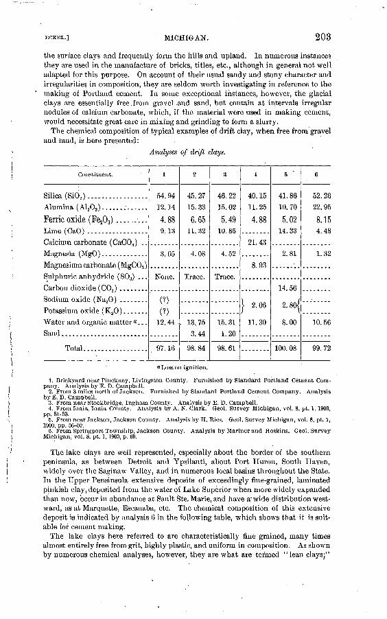
ECKEL.] MICHIGAN. 203
the surface clays and frequently form the hills and upland. In numerous instances they are used in the manufacture of bricks, titles, etc., although in general not well adapted for this purpose. On account of their usual sandy and stony character and irregularities in composition, they are seldom worth investigating in reference to the making of Portland cement. In some exceptional instances, however, the glacial clays are essentially free.from gravel,and sand, but contain, at intervals irregular nodules of calcium carbonate, which, if the material were used in making cement, would necessitate great care in mixing and grinding to form a slurry.
The chemical composition of typical examples of drift clay, when free from gravel and sand, is here presented:
Analyses of drift clays.
Constituent.
Silica (SiO,).. ...............Alumina ( A1 203 ) .............
Ferric oxide (Fe203 ) .........Lime (CaO) .................
Calcium carbonate (CaCO.}) ..Magnesia (MgO) .............
Magnesium carbonate (MgC03 )Sulphuric anhydride (S03) ...
Carbon dioxide ( CO., ) ........Sodium oxide (Na20) ........Potassium oxide (K20) .......Water and organic matter"...
Sand ........................
Total..................
1
54.9412.14
4.889.13
3.65
None.
(?)
(?)12. 44
97.16
2
45. 27
15.33
6 PC .65
11.32
4.08
Trace.
. 13.75 3.44
98.84
3
46. 22
15.02
5.4910.85
4.52
Trace.
15.31 1.20
98.61
4
40.1511.25
4.88
21.43
8.93
} 2.06
11.30
5
41.8610.70
5.0214.33
2.81
14.56
2.80J
8.00
100. 08
6
52.2622.95
8.154.48
1.32
10. 56
99.72
"Losson ignition.
1. Brickyard near Pinckney, Livingston County. Furnished by Standard Portland Cement Com pany. Analysis by E. D. Campbell.
2. From 3 miles north of Jackson. Furnished by Standard Portland Cement Company. Analysis by E. D. Campbell.
3. From near Stockbridge, Ingham County. Analysis by E. D. Campbell.4. From Ionia, Ionia County. Analysis by A. N. Clark. Geol. Survey Michigan, vol. 8, pt. 1, 1900,
pp. 51-53.5. From near Jackson, Jackson County. Analysis by H. Hies. Geol. Survey Michigan, vol. 8, pt. 1,
1900, pp. 56-69.6. From Springport Township, Jackson County. Analysis by Mariner and Hoskins. Geol. Survey
Michigan, vol. 8, pt. 1,1900, p. 60.
The lake clays are well represented, especially about the border of the southern peninsula, as between Detroit and Ypsilanti, about Port Huron, South Haven, widely over the Saginaw Valley, and in numerous local basins throughout the State. In the Upper Pensinsula extensive deposits of exceedingly fine-grained, laminated pinkish clay, deposited from the water of Lake Superior when more widely expanded than now, occur in abundance at Sault Ste. Marie, and have a'wide distribution west ward, as at Marquette, Escanaba, etc. The chemical composition of this extensive deposit is indicated by analysis 6 in the following table, which shows that it is suit able for cement making.
The lake clays here referred to are characteristically fine grained, many times almost entirely free from grit, highly plastic, and uniform in composition. As shown by numerous chemical analyses, however, they are what are termed "lean clays;"

204 CEMENT MATERIALS AND INDUSTRY. [BULL. 243.
that is, not high in alumina and ferric oxide in proportion to the silica present, and not, as a rule, considered favorable for cement making. These properties and,the usual presence of lime, together with the frequent occurrence of sulphuric anhydride, are shown by the following analyses:
___ Analyses of lacustral clays.
Constituent.
Sand........................
Silica (SiO,) .................
Lime (CaO) .................
Sulphuric anhydride (S03 ) ....
Potassium oxide (K20) .......
Water (H,0) ................
Total..................
l
49.75
13.06
5.31
10.86
4.28
(?)
(?)
«15.07
99.13
2
49.34
14.50
5.37
9.75
4.77
.13
(?)
(?)
«15.55
99.25
3
1.51
66.49
9.87
4.87
4.72
1.22
.62
(?)
(?)
«9.36
98.66
4
47.75
17.60
9.13
2.60
.70
} 2X22.01
100. 00
5
(?)
46.40
}l6.4{
25. 36
4.30
7.00
99.46
6
61.62
17.20
5.99
5.62
2.82
.46
«5.34
99.00
a Loss on ignition.
1. From near Chelsea, Washtenaw County. Analysis by E. D. Campbell.2. From near Fenton, Genesee County. Analysis by E. D. Campbell.3. From near Farmington, Oakland County. Analysis by E. D. Campbell.4. From near Saginaw'. Analysis by H. Reis. Geol. Survey Michigan, vol. 8, pt. 1,1900, p. 55.5. From Wyandotte; used in cement making by the Michigan Alkali Company. Analysis by O.
Button.6. Sault Ste. Marie. Analysis by E. D. Campbell.
The river silts occur on the border of many streams, sometimes in terraces a few feet above their surfaces. Although in many instances available for brick and tile
making, they are usually too sandy to be employed in manufacturing Portland' cement without being ground, so as to have the requisite degree of fineness that is, so as to pass through a sieve with 150 to 200 meshes to the linear inch. No analyses of typical examples of the river silts are available, but as the deposits are derived mainly from the drift clays, they no doubt have the same composition, lacking, perhaps, some of the calcium carbonate and alkaline salts.
In general it may be said that the surface clays of the Southern Peninsula are not favorable for .use in making Portland cement, although some of the stony clays, if crushed sufficiently fine, may be employed for that purpose. Reference is not here made to the decomposed outcrop of the shales described in the preceding section, which might perhaps be taken for surface clays, some of which have been used with favorable results. In reference to the surface clays of the Northern Peninsula little accurate information is available, excepting the analysis of a representative sample of the extensive deposit of pink clay near Sault Ste. Marie, given above.
In a summary of the results of Ries's investigations of the shales and clays of Michigan, already referred to several times, A. N. Clark remarks as follows:«
" For use in the manufacture of Portland cement the shales of the Coldwater series are best adapted. The shales of the Michigan series are also good if not too high in
aGeol. Survey Michigan, vol. 8, pt. 1, 1904, p. 64.

ECKBL.] MICHIGAN. 205
soluble salts. Some of the Coal Measure shales, which are often too gritty, and some of the clays derived from the weathering of these shales or the Devonian black shales, may be suitable. Surface deposits of clay of any size are, almost without exception, either too calcareous and irregular in composition or too gritty to be desirable."
The difficulty of obtaining a suitable clay to use in connection with the marl deposits of the southern portion of the Southern Peninsula has led several of the Portland cement companies now in operation in that region to employ clay brought from Ohio. The most of this material comes frorr Milbury and Bryan and is a lacustral clay, deposited from the waters of the Erie basin .(Glacial Lake Warren), when more widely expanded to the southwestward than now. Its composition is as follows:
Analyses of Ohio clays.
Constituent.
Silica (Si02). ---..--.-.-..--.-.-...-..-.----...--.-----.-..-...
Alumina ( A1203 ) ..............................................Ferric oxide (Fe203 ) ...........................................
Lime (CaO)... ................................................Magnesia (MgO) ..............................................
Sulphuric anhydride (S03 ) .....................................Loss on ignition ......... .....i.... ............................
Total ...................................................
1
a 62. 55
17.465.08
2.301.67
Trace.5.55
98.37
2
61.03
18.106.65
1.29.53
1.059.21
89.86
a With the silica is included 3.76 per cent of fine sand.
1. Milbury. Analysis by E. D. Campbell.2. Bryan. Analysis by John G. Dean and N. S. Potter, jr.
REFERENCES ON MICHIGAN CEMENT RESOURCES ANDINDUSTRY.
PAVIS, C. A. A contribution to the natural history of marl. Mich. Geol. Survey,vol. 8, pt. 3, pp. 65-102. 1904.
FALL, DELOS. Marls and clays in Michigan. Mich. Geol. Survey, vol. 8, pt. 3,pp. 343-348.
HALE, D. J. Marl and its application to the manufacture of Portland cement.Mich. Geol. Survey, vol. 8, pt. 3, pp. 1-64, 103-190.
KIMBALL, L. L. Portland cement in Michigan, 1903. Min. Resources U. S., for 1903,U. S. Geol. Survey, 1904, pp. 903-910.
LANE, A. C. Coal of Michigan; its mode of occurrence and quality. ' Mich. Geol.Survey, vol. 8, pt. 2, pp. 1-233. 1902.
LANE, A. C. Notes on the origin of Michigan bog limes. Mich. Geol. Survey,vol. 8, pt. 3, pp. 199-223.
LANE, A. C. List of marl localities and Portland-cement mills in Michigan. Mich.Geol. Survey, vol. 8, pt. 3, pp. 224-342.
LATHBURY, B. B. The development of marl and clay properties for the manufactureof Portland cement. Mich. Geol. Survey, vol. 8, pt. 3, pp. 191-198. 1903.
LATHBURY, B. B. The Michigan Alkali Company's plant for manufacturing Port land cement from caustic soda waste. Engineering News, June 7, 1900.
- LEWIS, F. H. The plant of the Michigan Portland Cement Company, Cold water,Mich. Engineering Eecord, Feb. 25, 1899.

206 CEMENT MATEEIALS AND INDUSTRY. . [BULL. 243.
LEWIS, F. H. The plant of the Bronson Portland Cement Company, Bronson, Mien.Engineering Record, Apr. 30, 1898.'
RIES, H. Clays and shales of Michigan. Mich. Geol. Survey, vol. 8, pt. 1, pp. 1-67.1900.
RUSSELL, I. C. The Portland-cement industry in Michigan. Twenty-second Ann.Rept. U. S. Geol. Survey, pt. 3, 1902, pp. 629-685.
PORTLAND CEMENT RESOURCES OF MINNESOTA.
Of the limestones occurring in Minnesota, only one is usually suf ficiently low in magnesium carbonate to be worth considering .as a Portland cement material. This is the limestone described as "Tren ton " in the section on Iowa, pages 147-165 of this bulletin. Mr. Ulrich states that this nonmagnesian formation is well developed in southern Minnesota, particularly in the vicinity of Wyckoff and Spring Valley. The pure limestone beds in these localities are both underlain and over lain by shale, which might prove available for use in the mixture.
PORTLAND-CEMENT RESOURCES OF MISSISSIPPI.
No cement of any type has ever been manufactured in Mississippi, but several large limestone areas occur in the State, and at least one of these is so well located with respect to fuel supplies and transporta tion routes as to give promise of being of future importance as a source of Portland-cement material.
The available limestones of the State may be grouped and described under three heads, the third being the most promising as the possible basis of a cement industry.
The three groups noted are:(1) Mississippian (Lower Carboniferous) limestones.(2) Cretaceous limestones (Selma chalk or " Kotten limestone").(3) Tertiary limestones (Vicksburg limestone).The distribution of these formations is shown on the geologic map
(PI. II), which is based on recent work by the United States Geological Survey in Mississippi.
MISSISSIPPIAN ("LOWER CARBONIFEROUS") LIMESTONES.
In the extreme northeastern corner of Mississippi, in the counties of Itawamba and Tishomingo, there is a small area of Devonian and Carboniferous rocks. These include shales, thin sandstones, and limestones. The limestones, which are mainly of Mississippian (Lower Carboniferous) age, are frequently low in magnesia, and are otherwise suitable for use as Portland cement materials. At present, however, the most promising localities of these limestones have no adequate transportation facilities. This fact, together with the nearness of the soft and easily crushed Selma chalk, will probably serve to prevent the utilization of the Carboniferous limestones in the near future.

ECKBL.] MISSISSIPPI. ' 207
The following analysis of a limestone from Cypress Pond, Tisho- mingo County, is bjr Dr. E. W. Hilgard:
Analysis of Mismsippian limestone.
Silica (SiOs ) .............................................1............... 1.68Alumina (A120S ) ...........:........................................... .1 rgIron oxide (Fe208 ) ...................................................... |Lime (CaO) ............................................................. 53.49Magnesia (MgO)......................................................... .82Carbon dioxide (CO,) .................................................... 42.03Water.................................................................... 1.34
CRETACEOUS LIMESTONE (SELMA CHALK OR "ROTTEN LIMESTONE").
The Selma formation of the Cretaceous is a thick series of chalks, chalky limestones, and more or less limy clays, which are well exposed in northwestern Mississippi. The area occupied by these limestonesis shown on PI. II, and a very detailed description of the Alabama areas of Selma chalk is given in Doctor Smith's discussion of the cement resources of Alabama in this bulletin (pp. 72-77).
Thickness. The Selma chalk attains its maximum thickness in cen tral Alabama, reaching a total of about 1,200 feet. Westward it decreases slightly in thickness, the well at Livingston, Sumter County, Ala., giving a total of 930 feet, while the well at Starkville, Oktibbeha County, Miss., taken in connection with surrounding outcrops, indi cates a thickness of at least 700 feet. As the belt turns northward toward Tennessee the Selma formation decreases rapidly in thickness, while at the same time the limestone beds contained in the formation become fewer and thinner, until in Tennessee the Selma is a thin series of somewhat calcareous clays, with only occasional beds of chalk.
. /Stratigraphy. Owing to the rapidity with which it disintegrates when exposed to atmospheric action, surface outcrops give compara tively little information in regard to the stratigraphy of the Selma formation. Fortunately a very precise section of the Selma chalk, taken at a point where it is almost of maximum thickness, is in exist ence. This is embodied in the record of a well drilled at Livingston, Sumter County, Ala., and quoted by Dr. E. A. Smith in his Report on the Geology, of the Coastal Plain of Alabama, pages 277-278. The well was located just south of the boundary between the Selma and Ripley formations, and reached a depth of 1,062 feet, so that it passed through the entire thickness of the Selma chalk and into the under lying Eutaw formation.
The section of this well is given below. The upper 20 feet are, according to Smith, probably in part Lafayette and in part Ripley. From a depth of 20 to 950 feet the well was in-the Selma formation, while from 950 to 1,062 feet it was in the Eutaw".

208 CEMENT MATEEIALS AND INDUSTRY.
Section of well at Livingston, Sumler County, Ala.
[BULL, 243.
Thick ness. Depth.
Lafayette and Ripley:
Sandy loam ..........'...............................
Coarse, dry sand .....................................
White quicksand....................................
Selma chalk:
Soft blue limestone, many shells and pyrite nodules ...
White limestone, harder, few shells or pyrite nodules..
Hard blue limestone, no shells or nodules.............
Bluish-white limestone, less hard, no shells or nodules.
White limestone, very hard ...........................
Light-blue limestone, softer................:.........
Bluish-brown rock, small shells, some sand ...........
Hard, white limestone...............................
Soft, reddish-brown rock.............................
Soft, deep-blue rock .................................
Brownish-blue rock, moderately soft...................
Hard, gritty, blue rock...............................
Dark-bluish rock, soft................................
.Soft, whitish limestone...............................
Eutaw sands:
Hard sandstone ......................................
Sand ...............................................
Sand rock. .................J........................
Coarse greensand....................................
Sandstone...........................................Greensand ..---..-....-.......---......--.-.----....
Sandstone............................................
Coarse greensand.-..........--....--....---.---..-..
Flint rock...........................................
Very fine greensand .................................
Feet.
1
12
7
250
6
10
1
38
2
25
2
18
1
9
Feet.
1 -
13 -
20
200
250
257
325
380
427
485
590
592
612
690
700 -
13
20
200
250
257
325
380
427
485
"590
592
612
690
690*
700
950 .
950
956
966
967
1,0051,007
1,032
1,034
1.052
1.053
- 956
- 966
- 967
-1,005
-1,007-1, 032
-1,034
-1,052
-1,053
-1, 062
Descriptions of localities. During 1904 the Selma chalk was care fully mapped throughout the Tombigbee River basin by Mr. A. ,F. Crider. The result of this mapping is shown on PL II.
In the following pages descriptions will be given of the various localities visited during this work. Samples were taken from all of these localities, and many of these samples have been analyzed, the results being given below.
The descriptions are' given in order, going up the Tombigbee River from the Alabama-Mississippi line.

MISSISSIPPI. 209
The following four analyses, by Prof. W. F. Hand, State chemist, are of samples of limestone from various points in Oktibbeha County, Miss.:
Analyses of Selma limestone from Oktibbeha, County, Miss.
Silica (SiO,) ..........................
Iron oxide (Fe203 ) ...................Lime carbonate (CaC03 ) ..............Magnesium carbonate (MgC03 ) ........Water ...............................
1
2.89
1 1.53
94.10
1.84
.36
±4
2.33
1.72
94.35
1.82
.44
3
3.03
1.92
93.601.64.42
4
2.55
1.96
94. 072.12.52
Average.
2.70
1.78
94.03
1.85'.44
At the big elbow-bend in Oaknoxubee River, a quarter mile below the wagon bridge at Macon, the river has formed a bluff 75 feet high on the south side of the stream. The entire cliff is made up of the Selma chalk. It is a solid mass of white chalk, nonfossiliferous, and apparently without bedding planes, but viewed at a distance the stratification of the material is shown by the unequal hardness of the strata, causing some to weather more rapidly than others. There is a marked dip to the south. All the smaller streams flowing into Oak noxubee have channeled their beds into the pure white limestone. A sample was collected from the bluff on the Oaknoxubee River.
The following analysis of this sample was made by H. C. McNeil in the laboratory of the United States Geological Survey:
Analysis of Selma limestone from near Macon, Miss. Silica (Si02 ) ............................................................. 9.09Alumina (A1 20S ) .........................................................\ ~ .~Iron oxide (Fe203) .............................--..'.-..----...-..-.... -../Lime carbonate (GaC03 ).................................................. 80. 99Magnesium carbonate (MgC03)...-....-.-..-......-..-...-.-. ............ .00Water................................................................... 1.08
The town of Scooba is in the Platwoods area, which is underlain by clays of the Midway group. The road from Scooba to Dekalb is through the Midway until Sucarnooche Creek is reached, 2 miles east of Dekalb. The hills of the Laramie formation begin just west of the creek and rise 250 feet above the creek, barometric reading.
The material here forming the Midway is a gray, plastic, nonfos siliferous clay ("popping clay"). It makes a cold soil, very sticky and plastic when wet, and when it dries out it cracks open so that one can thrust his hand 6 or 8 inches into the opening.
But little of the Flatwoods area is cleared and put in cultivation, and this only where there is a little remnant of Lafayette sand left. The Lafayette formation is practically wanting over the entire area of the Flatwoods.
Bull. 243 05 14

210 CEMENT MATERIALS AND INDUSTRY. [BULL. 243.
The timber is short-leaf pine, post oak, scrub hickory, black-jack, and black gum, with an occasional white oak and holly.
The town of Dekalb is near the east edge of the Lagrange forma tion. One and a half miles northeast of the town, on Sucarnooche Creek, is a bed of lignite 3 feet thick, which outcrops a few feet above the bed of the creek. This bed has been opened up with a view of developing the vein. A level was run 20 feet into the hill and consid erable lignite taken out. It was found to be of excellent quality, and was burned in the office of the chancerjr clerk, Mr. S. O. Bell, at De kalb. The following analyses were made, No. 1 by J. C. Long and No. 2 by K. T. Pittman.
Analyses of lignite from Dekalb, Miss.
'
Volatile matter... ..............................................
Ash..........................................................Moisture ..................................................;...Sulphur. ............................................... ......
l
41. 8346. 82
7.942.131.28n. d.
2
40.8041.4817.64n. d.1.571.33
The lignite is overlain by a bed of gray clay and this by stratified red, yellow, and white sand, with occasional bands of ferruginous sandstone in the sand. On these hills there is a deposit of Lafayette that reaches in places a thickness of 20 feet, and in this there is con siderable sandstone.
The Lagrange around Dekalb the eastern edge of the formation and therefore made up of its basal beds is a mass of unconsolidated sand and sand}7 clay, which is easily eroded. The country is rough, being cut up into deep ravines and narrow valleys.
The hillsides, when properly taken care of, are fertile, and the un cleared land has a fine growth of pine, poplar, white oak, and hickory.
Two and one-half miles east of Scooba, on the west bank of the creek shown on the map (PL II), is the first outcrop of Selma chalk on the Scooba and Gainesville road.
A sample of limestone was taken from this outcrop by A. F. Crider and was analyzed- by W. S. McNeil, in the laborator}^ of the United States Geological Survey, with the following result:
i Analysis of Selma limestone from near Scooba, Miss. Silica (Si02 ) ............................................................. 16. 48Alumina (A1 203 ) ............................................-...-.-....-.]Iron oxide (Fe203 ) .......^...............................................\Lime carbonate (CaCo3 ) ............................................ ̂ ..... 74. 34Magnesium carbonate (MgCo3)............................................ .67Water................................................................... .67

'MISSISSIPPI. 211
There is a change in the character of timber as soon as the Selma area is reached. Short-leaf pine, which occurs so abundantly in the Flatwoods, is wanting except in the old "turned-out land." Black oak is the principal timber in the Selma chalk. Some post oak and hickory occur. The pine is wanting at a distance of 2 miles east of Scooba, which would perhaps bring the' contact between the Selma and Midway one-half mile west of the Selma outcrop.
Two miles east of Scooba and one-half mile south is another outcrop of limestone, more sandy than that 2£ miles east of Scooba. This is perhaps of Ripley age.
Between Portersville and Oakgrove, in southern Kemper County, on the west side of Pittiefaw Creek, the Lagrange hills begin and extend westward. On land belonging to Mr. M. L. Nailer a bed of lignite, reported to be 4 feet thick, has been opened.
Sucarnooche Creek marks the west edge of the Midway group from2i miles due east of Dekalb to abou£ 3 miles north of Oakgrove. Here the Porters Creek area widens and its west edge swings in to within 2i or 3-miles east of Oakgrove, then follows a southeasterly direction and crosses the Kemper and Lauderdale County line about 3i miles west of the State line.
On the west side of Quilby Creek, where it runs south along the State line, 7 miles east of Sucarnooche, the Selma chalk forms a small bluff. The prairie soil extends back for 2 miles farther west. On the east side of the creek, about 100 yards in Alabama, the Selma chalk forms a bluff a little higher than on the opposite bank in Mississippi. Here what is taken to be the top of the Selma chalk is found. The top of the bluff is capped by a coarse-grained sandstone, cemented by lime carbonate. In it are linie concretions the size of a closed hand.
The upper beds of the Selma chalk also appear in the bluff on the east side of Quilby Creek, 7 miles east of Sucarnooche.
An outcrop of Selma chalk shows on Scooba and Fox Prairie road where it crosses Bodea Creek, about 2 miles west of the State line.
A sample collected from this outcrop by Mr. Crider was analyzed in the laboratory of the United States Geological Survey by W. S.McNeil.
Analyses of Selma limestone from Bodea Creek, Mississippi.Silica (Si62 ) ......................... '...... ..--...-..^................... 10. 60Alumina (A1.203 ) ......................-.................:...--........Iron oxide (F203 ) ....................................................... |Lime carbonate (CaC03).................................................. 82.47Magnesium carbonate (MgC03 ) ........................................... Tr.AVater................................................................... .82
Three miles north of Scooba the west border of the Selma chalk outcrops in a series of hills forming the south bank of Wahal'ak Creek. The bottom of the Wahalak is here 1£ miles wide, the south bank retreating more rapidly than the north side. The creek has cut its

212 CEMENT MATEKIALS AND INDUSTRY. [BULL. 243.
channel into the Selma chalk, which outcrops almost continuously throughout its course. The limestone occurs up the creek about 6i to 7 miles northwest of the town of Wahalak, but the Porters 'Creek clay occupies the country on either side of the creek. The hill just east of Wahalak is of Porters Creek clay, which is not over 15 feet thick.
A sample of limestone was collected by A. F. Crider from the bed of Wahalak Creek, about 1£ miles south of Wahalak. This sample was analyzed by W. S. McNeil in the laboratory of the United States Geological Survey, with the following results:
Analysis of Selma limestone from near Wahalak, Miss.
Silica (Si02 ) ................I.............................'............... 20.00Alumina (A1 203 ) .........................................................|Iron oxide (Fe,0s)......................................................./ b' y/Lime carbonate ......................................... .f ............... 68.91Magnesium carbonate..................................................... Tr.Water.......-...-...............:........,.............................. 1.03
A sample of the Selma limestone was taken from the bed of Wahalak Creek, 1£ miles south of the town, and on the range of low hills on the south side of Wahalak Creek, 1^ miles southeast of the point where the Mobile and »Ohio Railroad crosses the creek, another sample was taken.
At the top of the Selma chalk there is about 10 feet of a sand rock cemented with lime carbonate, which contains numerous little bivalve shells. This is the same kind of stone as that found 7 miles east of Sucarnooche. There is no evidence of any Midway limestone any where from Wahalak to the Alabama line, and this is the only place where the sandstone was seen in Mississippi.
The Midway or Flatwoods clay is well shown near. Scooba, Miss.A cample collected by A. F. Crider was anatyzed by W. S. McNeil in the laboratory of the United States Geological Survey. The result is of interest because clays of this type occur everywhere near the west ern edge of the Selma limestone area, and such clays will be needed to reduce the percentage of lime carbonate found in some of the purer samples of Selma chalk.
Analysis of Midway clay from Scooba, Miss.
Silica (Si02 )................................................ ............. 61.92Alumina (A1203)...............................:....................-..... 19. 47Iron oxide (Fe203 )....................................................... 2.81Lime (CaO).............................................................. .00Magnesia (MgO)......................................................... 1.98Soda (Na,0).......................................'...................... .50Potash (KjO)............................................................ .00Loss on ignition................................ .......................... 12.29

ECKEL.] MISSISSIPPI. 213
A sample of Selma chalk was taken from an old rock quarry situated on the southwest side of Bogue Chitto Creek, one-half mile east of Prairie Rock. This limestone differs from that along- Oaknoxubee River, in the vicinity of Macon, in that it is much harder. In the unweathered state of the Macon rock, it is very soft and noncrystal- line. One can easily stick a pick into it. But the limestone at Prairie Rock is a hard so-called "flint rock," crystalline in character, and is used for building purposes. The rock at Macon, when exposed to the weather, becomes white as chalk, that at Prairie Rock weathers to a dirty gray and contains some traces of iron stain on the weathered surfaces. This is due to the oxidation of the iron sulphide (pyrite), which is found in small concretions in the fresh rock.
An analysis of this Prairie Rock limestone, made by W. S. McNeil, in the laboratory of the United States Geological Survey, follows. Itwill be seen that the stone is a very pure limestone, in spite of the man-nerin which it discolors on weathering.
Analysis of Selma limestone from Prairie Rock, Mississippi.
Silica (SiO,) ................................... ........................ 1.13Alumina (A1 203 ) .......................................................\Iron oxide (Fe.203 ) ....-.--.-.-...--.---.----...-----...---.-----.- ----/Lime carbonate (CaCOs) ....................................:........... 98. 36Magnesium carbonate (MgC03).......................................... tr.Water...........-.............................:....................:.. .40
The rock breaks down easily when exposed to the weather, and hence is not now used for extensive building purposes. It is, however, the only road material found in this section of the country. It has been used on the road across Bogue Chitto swamp, but is unsatisfac tory.
Men familiar with the country say that this hard limestone is very thin only about 4 feet thick and occurs near the surface. Below this hard stratum comes the soft, whiter "rotten limestone," which is, on an average, 20 feet thick. Below this comes the, "blue rock," which holds water. In digging cisterns, the farmers always dig down to the " blue rock," which requires no curbing.
There are two kinds of soils in the prairie section, the "post-oak" land and the "prairie" proper. The former is the highest land between the stream divides, which has suffered but little erosion. It is veiy level, sloping gently to the streams. This post-oak land is covered with a thin coating of Lafayette, clayey sand, never over 10 feet thick, which has never been all carried away by erosion. The uncleared land produces post-oak and some black-oak timber.
The "prairie" land is that from which the Lafayette has been removed, and the black, rich loam, formed from the decomposition

214 CEMENT MATEEIALS AND INDUSTBY. [BULL. 243.
of the Selma chalk, comes to the surface. The limestone never comes to the surface except along the streams.
When the country was first settled this black prairie soil was too strong- for cotton. It produced a large stalk, but very little cotton. Until recent years all the cotton was planted on the poorer "post-oak" lands, and the prairie lands were put in corn. But after years of con tinuous crops of corn the prairie land became the best cotton land, and now the finest cotton grows on the prairie land,s. Later investigation around Columbus and Aberdeen has verified the fact that the land known by all as the "post-oak land," as distin guished from the black "prairie soils," is the land from which the entire Layfayette has not been removed. The soil is not so rich as the prairie soils, and has been largety abandoned for cultivation.
The following well sections are of interest in this connection:
Well at Ravine, on land of J. Q. Poindexter.Feet.
Selma chalk .......'..I..................................................... 250Sand, water bearing, and principal source of water..._...._.._ _............... 475,Bed clay.................................................. J................ 50Depth..................................................................... 725
Water rises within 26 feet of surface. Water soft.
Well g miles due east of Ravine, on Sebe Gavin's land.Feet.
Depth of well.............................................................. 431Water flows 16 feet above surface.
Well on Doctor Patty's land, near Bigbee Valley post-office.Feet.
Depth of well...........................................'................... 431Water flows 20 feet above surface. Water found in sand, and soft.
Well at Bigke Valley post-office, sec. 16, T. 16, JR. 19 E.Feet.
Depth of well............................... .......................-.......'. 460Thickness of Selma chalk.. ....................:............................ 200Water flows 20 feet above surface. ,- <
Well in sec. 81, T. 16, R. 19 E.Feet.
Depth of well.............................................................. 444Thickness of sand .......................................................... 200Flows. '
Well at Cliftonville.Feet.
Limestone ................................................................. 300Dark sand, dry............................................................. 20White sand, water-bearing.................................................. 20Dark sand, dry ............................................................ 10White sand, water-bearing... 1.............................................. 40Ferruginous sandstone...................................................... 1Depth of well, 450 feet; 300 feet in limestone, 150 feet in sand. Source of water, green sand.

ECKEL.] MISSISSIPPI. 215
Well on A. G. Canningham's land, 1$ miles west of mouth of James Creek.Feet,
Depth of well.............................................................. 500Thickness of limestone...................................................... 100Well is 75 feet above Tombigbee River. Water overflows.
Well at Pickinsville, Ala., on land of Will Rodgers.Feet.
Thickness of limestone. .......... .............'...... ......................... 100Depth of well........................'....................................... 400Flows.
All wells mentioned above except the first one were drilled by J. B. Cunningham, Cliftonville, Miss., and the records were obtained from him. The well drillers fail to make any distinction between the lower Selma and the upper Eutaw, so that their records can not be depended upon for determining the thickness of the Selma.
A sample of sandy limestone was obtained from the mouth of James Creek, on Tombigbee River. Along the Tombigbee at the mouth of James Creek thfere is an exposure of a green-sand clay containing a large amount of lime. Fifty feet above the river, 1£ miles west of the mouth of James Creek, another sample of limestone was collected. The limestone here is similar in color and general aspect to that on Tombigbee, except that it has less green sand.
Farther west the limestone rarely shows at .the surface. It is clayey in character and easily dissolved by the weathering agents, so that it breaks down into soil faster than it is carried away by erosion.
At Cliftonville, which is 75 feet above Tombigbee River (barometric reading), there is a hard cap rock, 2 to 4 feet thick, found on top of the hills in the vicinity of .the town. This a hard "lime" rock, sim ilar to that found at Prairie Point.
Below this hard cap rock comes what is called the " blue rock." A sample of it seen at a well dug years ago shows that it is similar to the rock at Cunningham Hill, except that it contains no sand. Where the blue rock comes to the surface it forms a belt of the richest soil in the prairie region. The soil is very deep, black, and loose. More cotton and corn are raised to the acre here than in any other section of the State.
West of this region the land becomes higher, and the Lafayette occupies the surface on the ridges.
Six miles north of Macon, on the Macon and Columbus road, the limestone begins to show at the surface in small gullies. The rock is harder than the blue rock along the Tombigbee, and therefore occurs more frequently.
A sample collected from this locality by A. F. Crider was anatyzed by W. S. McNeil in the laboratory of the United States Oreological Survey.

216 CEMENT MATERIALS AND INDUSTRY. [BULL. 243.
Analysis of Selma limestone from locality north of Macon, Miss.
Silica (SiO,) ................................... .......................... 8.52Alumina ( Alj,0s ) . 1 ---------.--..--. - --.-.-..-.. ..-.---- - - - '.-.-- \ 6 60Iron oxide (Fe203 ). ..................................................... ^Lime carbonate (CaC08 ).... ...................................... v ...... 83.88Magnesium carbonate (MgCOs ) ............................................ .00Water.................................................................... 1.00
Farther south, along the Macon and Columbus road, the limestone begins to show in eveiy gully and on every hillside. At some places on level ground the soil is not over 12 inches deep. In this vicinity are the bald prairies, where large areas of this Avhite limestone are exposed without a particle of soil or a blade of grass. A sample of the rock was taken 3 miles north of Macon.
A sample of Selma limestone was taken at a point north of Lime Rock, 5 miles east of Shuqualak, on Oaknoxubee River, where a bluff 50 feet high is composed of typical Selma chalk. The following anal ysis of this sample was made by W. S. McNeil, in- the laboratory of the United States Geoloical
Analysis of Selma limestone from near Shuqualak, Miss.Silica (Si02 ) ....:...............;........................................ 8.06Alumina ( Al,03) .......................:................................. 1 g Q4Iron oxide (Fea03 ) .----..-.-----.-...-........................-........../Lime carbonate (CaC03 )........-......................................... 84. 61Magnesium carbonate (MgC03 ) ................. .....^..... ................ .06Water..................---............................................:. 1.32
The Tombigbee River at Columbus has cut its channel into the Eutaw sands, forming a bluff on the east side 90 feet high. The material composing the bluff here is a sand that is greenish when wet and gray when dry. It contains a small amount of lime carbonate. At theupper part of the bluff the sands are of lighter color, and at the top are of a light golden yellow. This was the color of sand when depos ited, and is not due to oxidation. Numerous little branching concre tions, which are perhaps some kind of badly preserved fossils, occur in the lower portion near the water. The upper vpart of the sands contain two species of large oysters, which also occur in the Selma. The river at the town is now hugging the east bluff, and the bottom, which is 3 miles wide, is all on the west side. A short distance above the town, however, the reverse is true, the bluff being on the west side and the bottom on the east. . .
At the west edge of the bottom the heavj7 , black prairie soils of the Selma chalk appear as soon as the little hills are reached. The bottom extends northward to the little creek that flows northeastward into the river 3 miles above the town.
At a distance of 4 miles above town the bluff on the west side of the river reaches about the "same height above the stream as the bluff at

ECKEL.] , MISSISSIPPI. 217
Columbus. It extends for 1 mile along the river as a perpendicular cliff that affords a fine section of the upper Eutaw and the base of the Selma. At the top of the bluff, the low hills on the west come down to the river. The same heavy, black prairie soils which come within 3 miles of the river due west of Columbus, here come down to the edge of the bluff.
The following is a section of the bluff obtained where the road comes down to the river:
Section of bluff of Tombigbee &iver 3 miles west of Columbus, Miss.
Lafayette at top.Selrna: , Feet. In.
"Blue rock" of the Selma; a white to gray joint clay containing less sand at top than at bottom. In its unweathered condition the clay is pale blue, with green and black sand ............................... 10 8
Eutaw:Green sand, highly calcareous, and containing numerous large oysters.. 9 5 Indurated ledge of greensand, calcareous, and containing same fossils
as No. 9 .....................i................................... 8 12Lighter colored sand, containing very few small fossils but no large
ones............................................................. 7 14Green sand, noufossiliferous........................................ 6 6Slightly fossil if erous, gray micaceous sand............................ 5 5Indurate ledge, slightly fossiliferous sand ............................ 4 10Green sand, containing same large oysters as No. 9................... .3 4Indurate ledge..................................................... 2 8Fossiliferous greensand to the water's edge........................... 1 4
The prairie soil of the Selma extends to the river north of Columbus, but is not found east of the river. From Columbus south to the south side of M. C. Gower's creek on the west side of the river the Tombigbee bottom ranges in width from 2 to 4 miles. South of this creek the bottom changes again to the east side, and the Selma extends to the river.
At the mouth of James Creek the same joint clay that is seen above Columbus occurs-on- the east bank of the creek, about 10 feet above the water's edge.
Eight miles east of Columbus, on the Columbus and Tuscaloosa road, the hills of the Tuscaloosa formation first appear. On the hill near the 8-mile post the highly stratified clay, interbedded with various colored sands, outcrops on the side of the road.
At Stiens Station the creek is cutting into the Eutaw sands.Where the road crosses Yellow Creek the foundation of the bridge
is built on the compact sand, which here is of a deep-gray color and very homogeneous in character.
One mile south of Strongs, on the Illinois Central Railroad, on the Monroe and Clay line, the railroad has cut into the Selma clay to a depth of 15 feet. ^

218 CEMENT MATEKIALS AND INDUSTBY. [BULL. 243.
Eiitaw sands extend west of the town of Aberdeen for 2 miles. Here the post-oak lands begin, and the regular prairie soils one-half mile farther west. There are no outcrops of Selma from Aberdeen to Prairie Station. The-first outcrop found northwest of Aberdeen is at Strongs. Outcrops of Selma here, as farther south, are very few on the east edge of Selma.
The following analysis of a sample of the Selma chalk from near Okolona, Chickasaw County, Miss., is an old one, made by Doctor Hilgard/' Of the material reported as "insoluble," probably about two-thirds was silica, the remainder being alumina and iron oxide.
Analysis of limestone from Okolona, Miss;
Insoluble (mostly silica, Si02 )........................................... 10. 90Alumina (A1 203 ) -.--- .---.-----.---.---..-..--. . -..-..-'--.---...' -.- 1-96Iron oxide (Fe203 ) .................................................^... 1.42Lime (CaO)-..-.-...-....i.........-...............-.....--.....--..--. M5.79Magnesia (MgO) ....................................................... c. 88Alkalies (K,0, Na20)................................................... .57Carbon dioxide (CO,) .................................................. 35. 73Water and organic...................................................... 2. 84
TERTIARY LIMESTONES (VICKSBURG LIMESTONE).
A narrow belt of limestone of Tertiary age crosses the State in a direction a little north of west, from near Waynesboro to Vicksburg. This is the Vicksburg limestone, which is equivalent to the upper part of the St. Stephens limestone of Alabama. The relations which exist may be indicated as follows:
Mississippi. Alabama.Vicksburg limestone .....I 0 , Oi , n . , T . . , , }=St. Stephens limestone. Jackson marls and clays.-J
A very detailed description of the characters and composition of theSt. Stephens limestone, as sh'own in its Alabama outcrop, is given by Doctor Smith on pages 77 to 81 of this bulletin, while on PI. II the outcrop across Alabama and Mississippi of the St. Stephens and the Vicksburg-Jackson is indicated.
In Mississippi the Vicksburg limestone usually outcrops in a low ridge that trends generally a little north of west. The southern slope of this ridge is gentle, but its northern face is a sharp declivity, which makes it easy both to locate the outcrop and to quarry the limestone.
The Vicksburg limestone carries usually from 80 to 95 per cent of lime carbonate, with veiy little magnesium carbonate. Occasionally, however, , more clayey phases are encountered, but in general this formation may be everywhere regarded as a possible source of Port land cement material.
a Report on the Geology of Mississippi, p. 101. 1860.6Equals lirne carbonate (CaC03 ), 81.77.c Equals magnesium carbonate (MgC03), 1.84.
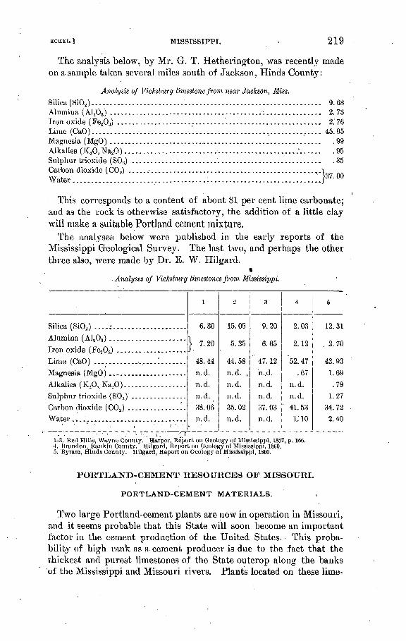
BCKEL.] MISSISSIPPI. 219
The analysis below, by Mr. G. T. Hetherington, was recently made on a sample taken several miles south of Jackson, Hinds County:
Analysis of Vicksburg limestone from near Jackson, Miss.
Silica (SiOj).........................'..................................... 9. 63Alumina (AL_03 ) ..................................... ....^................ 2. 73Iron oxide (FeA) -----------.---------------.------.-----------------.- 2. 76Lime (CaO).................................................; ............... 45.95Magnesia (MgO) .......................................................... .99Alkalies (K20,Na20) ........................ s.....................:...... .95Sulphur trioxide (S03) ................................................... .35Carbon dioxide (COo^VXC** K/VAl ^.HV^-^-A^*^ ^ V^V^g/ --.--.--.-.-----..------------- ~ . ------------.---- ̂ - i nfmf
This corresponds to a content of about 81 per cent lime carbonate; and as the rock is otherwise satisfactory, the addition of a little clay will make a suitable Portland cement mixture.
The analyses below were published in the early reports of the Mississippi Geological Survey. The last two, and perhaps the otherthree also, were made by Dr. E. W. Hilgard.
t Analyses of Vicksburg limestones from Mississippi.
Silica (SiCy ....;. ...................
Alumina ( A1203 ) .....................
Iron oxide (Fe203) ...................Lime (CaO) ..................I.......Magnesia (MgO) .....................Alkalies (K20, Na,0)..... ............Sulphur trioxide (S03 ) ...............Carbon dioxide (C02 ) ................Water...............................
l
6.30
| 7.20
48.44
n.d.
n. d.
n.d.
38.06
n.d.
o
15.05
5.35
44.58
n.d. .
n.d.
n.d.
35.02
n.d.
a
9.20
6.65
" 47. 12
n..d.
n.d.
n.d.
37.03
n.d.
4
2.03
2.12
'52. 47
.67
n.d.
n.d.
41.53
I.'IO
5
12.31
. 2.70
43.93
1.69
.79
1.27
34.72
2.40
1-3. Red Hills, Wayne County. , Harper, Report on Geology of Mississippi, 1857, p. 166.4. Brandon, Rankin County. Hilgard, Report on Geology of Mississippi, 1860.5. Byram, Hinds County. Hilgard, Report on Geology of Mississippi, 1860.
PORTLAND-CEMENT RESOURCES OF MISSOURI.
PORTLAND-CEMENT MATERIALS.
Two large Portland-cement plants are now in operation in Missouri, and it seems probable that this State will soon become an important factor in the cement production of the United States. This proba bility of high rank as a cement producer is due to the fact that the thickest and purest limestones of the State outcrop along the banks of the Mississippi and Missouri rivers. Plants located on these lime-
220 CEMENT MATERIALS AND INDUSTRY. [BOLL. 243.
stones are .therefore assured of cheap fuel and water and rail trans portation to a number of important cement markets.
The Missouri limestones which are best adapted for use as Portland- cement materials are of Mississippian and of Trenton (Ordovician or Lower Silurian) age. The Cambrian limestones, which cover nearly all of southeastern Missouri, are almost always too high in magnesia to be worth considering in this connection. The nonmagnesian Silurian limestones occurring along the Mississippi between Chester, Jll., and Cape Girardeau, Mo., however, are worth investigation.
The geologic relations of these limestones, and of the shales and clays which will, be required for mixture with them, are indicated in the following table. This table shows the portion of the geologic column of Missouri that is of interest in this connection, the oldest rocks being those placed at the bottom.
Portion of geologic column of Missouri.
Quaternary ....................................... Loess and surface clays.Upper Coal Measures .......... Shales, sandstones, etc.
Carboniferous. Lower Coal Measures .......... Coal beds, shales, etc.Mississippian.................. Limestones, sandstones, and
shales. Devonian ......................................... Darl?-colored shales.Silurian........................................... Magnesian limestones in part.
Girardeau limestone............ Shale and sandstone.Upper Ordovician.. Thebes formation, or late Ordo
vician shale ................. Shale and sandstone.Trenton....................... Limestone.
Lower Ordovician and Cambrian ................... Magnesian limestones, sand-1 stone, etc.
The formations listed above will now be described .in order, fromthe Trenton upward, attention being paid mainly to the Trenton andMississippian, which contain most of the nonmagnesian limestones occurring in the State. A detailed map showing the geology of. north eastern Missouri is given as PI. IX. In the following descriptions attention will be paid chiefly to their distribution and composition of the formations in the area covered by this detailed map, for it is in this portion of Missouri, along or near Mississippi River; that the best prospects for a Portland-cement industry exist. Southeastern Missouri, as already noted, has practical^ no limestones fit for use as Portland-cement materials, except along the Mississippi River to Cape Girardeau. The western half of Missouri contains extensive areas of Mississippian limestones, but a cement plant located in that portion of the State would be brought into'direct competition with the existing Kansas plants, which have the advantage of a cheap fuel natural gas.'

U. S. GEOLOGICAL SURVEY BULLETIN NO.343 PL. IX
~V.i N / H A -K/Q (.1 (* Ijt 1 yl
GEOLOGIC MAP OF WOETHEASTEEJST MISSOUKI AND SOUTHWESTERN ILLINOISGeology compiled from maps by the Missouri and Illinois geological surveys
Scale<> 10 20 so *o 50 GO miles
CARBONIFEROUS DEVONIAN SILURIAN AND ORDOVICIAN
Coal Measurestshales and coal beds with occasional
thin limestones/
Limestones and shalesf limestones with Intsrbadded

ECKEL.] MISSOUEI. 221
TRENTON LIMESTONE.
DISTRIBUTION.
The Trenton limestone occurs in two separate areas in eastern Mis souri, both of which are well located with regard to railroad and water transportation.
The smaller of these areas lies in Rails, Pike, and Lincoln counties, the limestone outcropping as a belt 1 to 3 miles wide, commencing near Spalding, Rails County, and running southeastward to Missis sippi River, which it reaches at a point near Busch, about 10 miles south of Hannibal. From this point southward the Trenton lime stone belt follows the river to near Cap au Gris, Lincoln County, where it turns sharpty back in a northwesterly direction to within a few miles west of Edgewood, Pike County.
The second and much larger belt commences in southern Callaway County, and runs eastward parallel to and a few miles north of Mis souri River, through Montgomery, Warren, and St. Charles counties. This belt reaches the Missouri River at Hamburg, St. Charles County, and turns southeastward through. St. Louis and Jefferson counties, reaching the Mississippi River at Kiinmswick. From this point south to Cape Girardeau the limestone follows the river closely, appearing either in the bluffs or only a few miles west of them.
COMPOSITION.
The Trenton limestones are usually bluish to gray colored in the lower part, and light colored sometimes almost white in the upper part, with occasional thin becls of shale or earthy limestone between' these two parts. As ,shown by the analyses in the following table, they are usually low in magnesia, and though occasional beds may show 5 to 10 per cent of magnesium carbonate the mass of the forma tion may be regarded as being suitable for use as a Portland-cement material.
Analyses of Trenton limestone from Missouri. a
Silica (SiOa ) .............
Lime carbonate (CaC03 ) . .Magnesium carbonate
(MgCO.) ..............
i
0.35
}.»97.75
.45
2
12.15
.45
86.00
.46
3
2.25
.30
89.40
6.96
4
0.45
.65
97.20
.46
5
6.00
1.05
82.55
9.27
6
1.00
.55
96.40
.42
7
0.46
.40
98.60
.34
8
0.70
..25
97.40
.42
9
0.35
.30
97.75
.27
10
0.55
.60
96.75
.27
1. Dorenheim quarry, St. Paul, St. Louis County. 2. Thorn & Hunkin quarry, Minck station, St. Louis County.3. Glencoe Company, south quarry, Glencoe, St. Louis County.4. Glencoe Company, middle quarry, Glencoe, St. Louis County. 5-10. Glencoe Company, north quarry, Glencoe, St. Louis County.
aThese analyses are from Bulletin No. 3, Missouri Geol. Survey, pp. 77-79,1890. The quarries art named according to their owners at that date. The analyses were all made by A. E. Woodward.

222 CEMENT MATEEIALS AND INDUSTRY. [BOLL. 243.
LA TE ORDO VICIAN SHALE.
This-formation is composed largely of bluish to greenish shales, often containing a large precentage of lime. North of Lincoln County thin bands of pure limestone, varying from a few inches to a few feet in thickness, are usually inter bedded with the shales. These limestone bands become more numerous and thicker as the base of the formation is approached. The formation varies from 0 to over 100 feet in thick ness, and immediately overlies the Trenton limestones. In its expo sures near Mississippi River, in Kails, Pike, and Lincoln .counties, it is usually overlain either by Devonian shales or by the great series of Mississippian limestones described on a later page. The following analysis is of a specimen of this shale from near the base of the river bluff at Louisiana, Pike County:
Analysis of Hudson shales from Louisiana, Pike County, No. a
Silica (SiOj) .....................................'........................ 57.01Alumina (Al,08 ) ------------------ ---- ------ ----------..------------ 24.43Iron oxide (Fe203 )....................................................... 5.77Lime (CaO) .............................................................. 1.40Magnesia (MgO) ........................... '.............................. .49Alkalies (K20, Na,0)........................:............................. 3.81Combined water ......................................................... 7. 20Moisture.................................................................. .43
DE VONIAN FORMA TIONS.
In the northeastern portion of Missouri (see PL IX) a series of dark-colored shales of Devonian age appears in places above the Hudson shales and below the Mississippian limestones. These Devo nian shales vary from 10 feet or less to 50 feet in thickness. At Louisiana, Pike County, 8 feet of Devonian shales appear in the riverbluffs, overlying the Hudson shale, whose anatysis is given in the preceding table. In Jefferson County, as at Sulphur Springs, similar shales occur resting on the Trenton limestone, but their distribution is very irregular.
MISSISSIPPIAN ("LOWER CARBONIFEROUS") LIMESTONES AND SHALES.
DISTRIBUTION.
The Mississippian limestones are the surface formations over almost one-fourth of the entire area of Missouri. Their three most promi nent areas of outcrop are along the Mississippi and Missouri rivers and in southwestern Missouri. These three areas are connected by narrow bands of outcrop so as to really form portions of one large area, but, for convenience, they will be discussed separately.' The
a Missouri Geol. Survey, vol. 11, p. 404.

KCKBU] MISSOURI. 223
Mississippi River area, which is the most promising of the three as a source of cement material, will be discussed last and in greater detail than the others.
In southwestern Missouri the Mississippian limestones form the surface of the greater part of McDonald, Newton, Jasper, Barry, Lawrence, Stone, Christian, Greene, Dade, and Cedar counties, and also the southwestern half of Polk and smaller portions of Barton, St. Clair, Hickory, and Bentori counties. This extensive limestone area is traversed by numerous railroads, but the competition of Kansas plants using natural gas for fuel would probably make a cement plant located in southwestern Missouri unsuccessful.
Another area of Mississippian limestones is on and near the Missouri River. In this area the limestones cover most of Pettis, Saline, and Cooper counties, on the south side of the river, while they outcrop continuously along the north bank of the river from Miami station,Carroll County, through southern Howard County, to below Roche- port, Boone County. The limestone belt then leaves Missouri River and turns northeastward, through Boone, Callaway, and Montgomery counties, to join the Mississippi River limestone belt discussed below.
A very extensive and important area of Mississippian limestones occurs in northeastern and eastern Missouri, along Mississippi River. This belt covers the eastern half of Clarke, all, or almost all, of'Lewis, Knox, Shelb}7 , Marion, Monroe, Rails, Pike, Lincoln, and St. Charles counties, and portions of Montgomery, Warren, St. Louis, Jefferson, Ste. Genevieve, and Perry counties. The distribution of the lime stones in these counties is shown in detail in the geologic map of northeastern Missouri (PL IX).
The limestones appear continuously in the river bluffs or in stream cuts along the west bank of the Mississippi, from the Iowa State line to a point about 10 miles south of Hannibal. Here the Mississippian limestones leave the river for some distance, Silurian rocks appearing in the bluffs from below Saverton to Cap au Gris. At Cap au Gris the limestones again appear, and form the river bluffs as far south as Kimmswick, in Jefferson County. Ordovician rocks then appear on the river bank for a space of about 12 miles, but about 5 miles below Crystal City the Mississippian limestones reappear in the bluffs and show almost continuously to a point less than a mile south of Witten berg, Perry County, where they finally disappear.
COMPOSITION.
The Mississippian rocks of Missouri include several thick limestone formations, with at least one thick series of shales. The limestones, as shown in a table of analyses below, are almost invariably good Portland-cement materials..
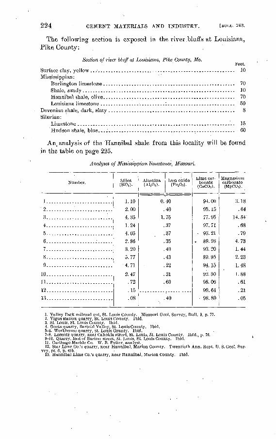
224 CEMENT MATERIALS AND INDUSTRY. [BULL. 243.
The following section is exposed in the river.bluffs at Louisiana, Pike County:
Section of river bluff at Louisiana, Pike County, Mo.Feet.
Surface clay, yellow ..............................--.....---.....--.--...--.- 10Mississippian:
Burlington limestone................................................... 70Shale, sandy........................................................... 10Hannibal shale, olive.................................................... 70Louisiana limestone ...................................................... 50
Devonian shale, dark, slaty ................................................. 8Silurian:
Limestone............................................................. 15Hudson shale, blue. ..:.....................-............................ 60
An. analysis of the Hannibal shale from this locality will be found in the table on page 225.
Analyses of Mississippian limestones, Missouri.
Number.
1.......... ................
'2.....:.....'............:..3....... .I...............'..4..........................
5..........................6..........................7........ ..................8..........................9..........................
10..........................11..........................12..........................13..........................
Silica (Si02 ).
1.10
2.004.351.244.052.86
3.205.774. 71
2.47.72
.15
.08
Alumina Iron oxide (A1203 ). (Fe2O3 ).
0.40.40
1.75.37.37.35.40.43
.22
.31
.60
.40
Lime car bonate
(CaCOg).
94.00
95. 15
77.9597.71
- 93.21. 89. 26
93. 20
89.95
94. 15
92. 3098.06
99.64 98.80
Magnesium carbonate .(MgC03).
3.18
.6414. 84
.68
.794.731.442.23
1.48
1.88.61
.21
.05
1. Valley Park railroad cut, St. Louis County. Missouri Geol. Survey, Bull. 3, p. 77.2. Vigus station quarry, St. Louis County. Ibid.3. St. Louis, St. Louis County. Ibid.4. Goetz quarry, Bartold Valley, St. Louis County. Ibid.5-6. Workhouse quarry, St. Louis County. Ibid.7-8. Lorentz quarry, near Cahokia street, St. Louis, St. Louis County. Ibid., p. 76.9-10. Quarry, foot of Barton street, St. Louis, St. Louis County. Ibid.11. Carthage Marble Co. W. B. Potter, analyst.12. Star Lime Co.'s quarry, near Hannibal, Marion County. Twentieth Ann. Kept. U. S. Geol. Sur
vey, pt. 6, p. 415.13. Hannibal Lime Co.'s quarry, near Hannibal, Marion County. Ibid.

ECKBL.] MISSOURI.
Analyses of Mississippian shales, Missouri.
225
Silica (SiO,) ........................Alumina (A1 20,) ....................Iron oxide (Fe20s ) ..................Lime (CaO) ........................Magnesia (MgO) ....................Alkalies (K 20, Nap) ................Combined water ....................Moisture ...........................
l
75.709.611.792.54
2.112.656.16n. d.
2
56.8224.483.82
.83
1.813.808.16-n. d.
3
46.26
10.262.65
11.087.84'3.17
«18. 02n. d.
4
49.6917.404.018.074.162.73
13.371.16
5
59.9721. 155.20
1.551. 103.885.711.25
(i
55.8422.78
5.24
.731.264.1.09.84n..d.
a Probably includes C02 . E. C. E.
1. Hannibal, Marion County. Missouri Geol. Survey, vol. 2, p. 400.2. Huinansville, Folk County. Ibid., p. 406.3. Aldrich, Polk County. Ibid., p. 407.4. Barrett, St. Louis County. Ibid., p. 422.6. Ste. Genevieve, Ste. Gen'evieve County. Ibid., p. 417.6. Joplin, Jasper County. Ibid., p. 392.
PENNSYLVANIAN ("COAL MEASURES"} LIMESTONES AND SHALES.
Almost all of northern and western Missouri is covered by the Pennsylvanian series ("Coal Measures"), which overlie the Mississip- pian rocks last described. The Pennsylvanian series consists of thick series of shales and sandstones, with occasional thin beds of limestone and numerous coal seams. In the present connection this geologic seriesjs of interest chiefly as a source of fuel and shales, though it is possible that some of its limestones may be also of value as cement materials.
The following analysis is of a limestone which overlies theJMeadows coal seam in Lincoln County. This limestone bed varies in thick ness from 4: to 6 feet. As shown by the analysis, it is highly sili ceous, though very low in magnesia. Judging from experience else where, the Pennsylvanian limestones will probably be found in most cases sufficiently low in magnesia to be available for use as Portland- cement materials. They occur almost invariably in thin beds, how ever, and it is usually necessary to excavate them by mining. Their common advantage is, of course, that they are found in close proximity to coal beds and to shales.
Analysis of Pennsylvanian limestone, Missouri.® Silica (Si02 ) ............................................................. 21. 35Iron oxide (Fe.203 ) ....................................................... 1. 79Lime (CaO) ............................................................. 42. 1.6Magnesia (MgO) ......................................................... .66Carbon dioxide (C02 ) ........... J....................................... 34.14
( Lincoln County. Chauvenet, analyst. Kept. Missouri Geol, Survey, 1872, p. 2S7,
Bull. 243 05 15
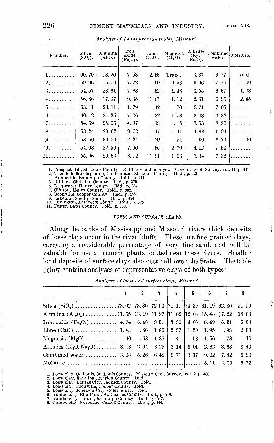
226 CEMENT MATEEIALS AND INDUSTRY.
Analyses of Pennsylvanian shales, Missouri.
v [BULL. 243.
Number.
1..........
2..........
3..........
4..........5..........6..........7..........8...........9..........10..........11..........
Silica (SiOo).
60.7059.9654. 57
56.8663.1160.1254.6953.2458.5054. 0355.96
Alumina (ALA,).
18.20
15.76 23.6117. 9723.1121.3525.9623.6230.5022.5020.63
Iron oxide
(FesOs).
7.587.72
7.889.351. 797.064.979.022.347.908.12
Lime (CaO).
2.68
.60
.52
1.67.42.82
.181.171.20.85
1 Q1
Magnesia (MgO).
Trace.0.93 1.481.12
.701.08.15
1 41
.512.701 Qfi
Alkalies (K.,0,
]ST a20).
3.67
3.66 3.55
2.613.713.433.584.38-.30
4.123. 34
Combined water.
6.77'
7.70 6.676.967.056.328.906.946.747.547.32
Moisture.
n.d.4.00 1.032.45
.40
1. Prospect Hill, St. Louis County. R. Chauvenet, analyst. Missouri Geol. Survey, vol. 11, p. 419. 2,3. Laclede fire-clay mine, Cheltenham, St. Louis County. Ibid., p. 421.4. Huntsville, Randolph County. Ibid., p. 411.5. Billings, Christian County. Ibid., p. 375.6. Deepwater, Henry County. Ibid., p. 387.7. Clinton, Henry County. Ibid., p. 382.8.'Boonville, Cooper County. Ibid., p. 377.9. Lakenan, Shelby County. Ibid., p. 424.
10. Lexington, Lafayette County. Ibid., p. 395.11. Foster, Bates County. Ibid., p. 369.
LOESS AND SURFACE CLAYS.
Along the banks of Mississippi and Missouri rivers thick deposits of loess clays occur in the river bluffs. These are fine-grained clays, carrying a considerable percentage of very fine sand, and will be valuable for use at cement plants located near these rivers. Smaller local deposits of surface clujs also occur all over the State. The table below contains analyses of representative clays of both types:
Analyses of loess and surface clays, Missouri.
Silica (Si02 )... .............Alumina (A1203 ) ............
Iron oxide (Fe203 ) ..........Lime (CaO) ................
Magnesia (MgO) ............Alkalies (K20, Na,0 )........
Moisture ...................
1
73.9211.65
4.741.43
.603.13
3.08
2
73.8013. 19
3.43.86
.682.945.26
3
72.0011.973.511.80
1.353.256.42
4
71.1111.62
3.902.37
1. 473.146.71
5
74.3912.03
4.061.50
1.533.013.17
6
61.19"15.485.49
1.951.562.829.023. 11
7
62.8017.22
5.21.98
.78 3. 63
7.822.06
8
54.9018.03
6.032.88
1.103.406.906.72
1. Loess clay, St. Louis, St. Louis County. Missouri Geol. Survey, vol. 2, p. 486.2. Loess clay,.Hannibal, Marion County. Ibid.3. Loess clay, Kansas City, Jackson County. Ibid.4. Loess clay, Boonville, Cooper County. Ibid.5. Loess clay, Jefferson City, Cole County. Ibid.6. Gumbo clay, Elm Point, St. Charles County. Ibid., p. 548.7. Gumbo clay, Clifton, Randolph County. Ibid., p. 547.8. Gumbo clay, Norborne, Carroll County. Ibid., p. 546.

BCKHL.] MISSOURI, MONTANA. 227
PORTLAND-CEMENT INDUSTRY IN MISSOURI.
Prior to the year 1902 no Portland-cement plants existed in Mis souri. In that year, however, the St. Louis Portland Cement Com pany commenced operations, while in 1903 the Atlas Portland Cement Company began shipping. Several other plants have been planned, but at present the two above named are the only ones in operation.
The plant of the St. Louis Portland Cement Company is located at Prospect Hill station, near the northern limits of the city of St. Louis. The limestone used is of Mississippian age, and is quarried at Fort Beilefontaine.
Shales of Coal Measures age are quarried near the plant and, together with the loess clays which overlie them at this locality, are used for mixing with the limestone.
The plant of the Atlas Portland Cement Company is located at Jlasco, Pike County, a few miles south of Hannibal. The materials used are a Mississippian limestone, from a quarry adjoining the mill, and a shale quarried near Severton. This shale is probably of Ordo- vician age, the Hannibal (Mississippian) shales near the plant being apparently unfit for use. Selected specimens of the limestone used analyze as follows:
Analyses of Mississippian limestone, llasco, Mo.
Silica (SiO.,) ..................................................Alumina ( A1203 ) ..............................................Iron oxide (Fe203 ) ............................................
Magnesium carbonate (MgC03 ) ................................
'0.40
1 .44
97. 99
.42
2
0.54
.42
97.74
.40
CEMENT RESOURCES OF MONTANA.
By W. H. WKED.
Limestone is confined practically to the western, mountainous part of the State, where it is found in great abundance along the flanks of the mountain ranges. In the Plains region, which comprises the east ern two-thirds of the State, only Cretaceous rocks are found, except in the local dome-shaped uplifts of the Little Rock, Judith, and Snowy mountains. The Cretaceous formations hold lenses and concretions of limestone, which are locally available for burning to quicklime where better material is too far distant for economic use.
All the Paleozoic formations contain limestone beds, but the great limestone series is that of the Carboniferous (Mississippian), whose

228 CEMENT MATERIALS AND INDUSTRY. [BULL. 243.
massive beds Hank the great ranges of the State and form its most picturesque scenery. The-overlying Jurassic limestone is argillaceous and of uncertain development. The Devono-Silurian limestones are impure, while the Cambrian limestones are thin bedded and usually not uniform in composition.
The limestones are found along the northern slope of the mountain front from Red Lodge, in Carbon County, westward to Livingston, northward about the flank of the Bridger and Little Belt and Belt ranges to the Main range west of Great Falls. Practically all the southern ranges of the western part of the State are uplifts with cores of gneiss or granite mantled by limestones of various ages. Such rocks occur westward almost to the Bitterroot Valley.
North of the line of the Northern Pacific Railroad the Carboniferous limestones soon disappear, though the Cambrian rocks form the moun tain summits almost to the Canadian line. The northwestern part of the State, however, is composed mostly of Algonkian rocks, mostly argillaceous. A series of oolitic limestones, the Newland limestone, forms a constant feature of this Belt terrane, but nothing is known of the composition of these rocks save that, they are usually quite argillaceous.
The following analyses of Montana limestones are on record:
Analyses of limestones, Montana.
Silica (SiO,) .............................'.................'....Alumina ( A1 203 ) ..............................................Iron oxide (Fe203 ) ............................................
Lime (CaO).................. '.................................Magnesia (MgO) ..............................................
Carbon dioxide (C02 ) .........................................
i
1.45.16.76
49.422.74
41. 73
-'
0.404.45.20
52.151.02
42.07
1. Persell Limestone Company, near Helena. E. Stare, analyst.2. Montana Marble and Mining Company, near Helena. C. M. Fassett, analyst.
Both of the above analyses, but particularly the first, represent limestones whose composition would be very satisfactory from the Portland cement manufacturers' point of view.

Carboniferous..
ECKEL.J . NEBRASKA. 229
PORTLAND-CEMENT RESOURCES OF NEBRASKA.
The possible sources of cement materials in Nebraska are confined to the formations of Carboniferous and Cretaceous age. Named in order, from above downward, these include the following:"
Laramie formation ....... Yellowish and greenish sandstone andshale.
Pierre clay ............. . Dark-gray clay or soft shale.Cretaceous.... .< Niobrara formation....... Chalky limestone.
Benton shale............. Dark-gray or black shale or clay.(Greenhorn limestone)... (Limestones in Benton shale.) Dakota sandstone ........ Brown sandstone.
rPermian limestone ....... Buff limestones and shales.Cotton wood limestone.... Massive light-colored limestone.Wabaunsee formation .... Limestones, shales, sandstones, and thin
coal beds.
CARBONIFEROUS FORMATIONS.
The Carboniferous limestones, shales, and sandstones underlie all of Nebraska, rising to the north and northwest about the Black Hills and and on the slopes of the Rocky Mountains. The outcrops in eastern Nebraska are in Douglas, Sarpy, Cass, Lancaster, Otoe, Gage, John son, Pawnee, Nemaha, and Richardson counties. The rocks are hard and would give rise to more prominent features in this region if it were not for the heavy covering of glacial drift and loess. As it is, the exposures constitute cliffs along Platte River from Ashland to Plattsiuouth, and thence at intervals along Missouri River to the southeast corner of the State, an,d occur in scattered outcrops along the valleys of Big Blue, Nemaha, and Little Nemaha rivers and Weep ing Water, Turkey, and Southeast Salt creeks and their branches.
The Upper Carboniferous rocks in this region comprise formations of Permian and Upper Coal Measure or Pennsylvania age. The Per mian outcrops are probably restricted to the valley of Big Blue River from Beatrice southward. The rocks are mainly magnesian limestones of light color, with interbedded shales. They are extensively exposed south of Beatrice, at Rockford, Bluesprings, Wymore, and Holmes- ville. The other Carboniferous members appear to comprise the Cot- tonwood and Wabaunsee formations of the Kansas geologists. They consist of limestones, shales, and sandstones, which contain thin coal beds in some localities. Professor'Prosser has made a preliminary examination of the Carboniferous formations of Nebraska, and identi fies as Wabaunsee the exposures about Peru, Aspinwall, Nebraska City,
a Barton, N. H., Preliminary report on the geology and water resources of Nebraska west of the One hundred and third meridian: Prof. Paper U. S. Geol. Survey No. 17, pp. 14-20. A colored geologic map of Nebraska, showing the surface distribution of all the formations, forms PI. IX of the report cited. The data concerning Nebraska cement material have been obtained from Mr. Darton's report, which is in part cited verbatim.

230 CEMENT MATERIALS AND INDUSTRY. [BULL. 243.
Auburn, Tecumseh, Dun bar, Nehawka, Weeping Water, and along Platte River near Louisville. The Cottonwood limestone, a massive bed full of Fusuli/na, was recognized west of Auburn about Glen- rock and Johnson, and the same beds extend over the higher lands of western Richardson and Pawnee counties. 01 In the deep borings which have been made at various points in the southeastern corner of the State it has been found that the Carboniferous formations have a total thickness of about 1,200 feet, of which about 200 feet are Permian.
NIOBTtARA AND BENTON FORMATIONS.
Underlying the Pierre clay is a series of shales and chalky limestones. The shales are known as the Bentori formations and the limestone, as .the Niobrara formation. They have a thickness of about 450 feet to the east, but thicken to the west. At the base there are about 200 feet of dark shales, overlain by slabby limestones of the Greenhorn formation containing Inoceramus, which are followed by a series of shales with few thin sandy layers, and at the top the Niobrara for mation with its chalky deposits, characterized by thin, hard beds filled with Ostrea congesta. The formations cross the eastern part of the State, and underlie all of the area west of the vicinity of the ninety- seventh meridian, but are so deeply buried under drift and loess that outcrops are rarely visible. The most extensive exposures are along the Missouri River, extending from near the ninety-seventh to the ninety-ninth meridian, and along the Republican Valley from Alma to near Superior. The formations are exposed at intervals across the eastern portion of the State in each of the larger valleys and some of the branches. The more notable of these small outcrops are at Genoa, north of German town,, near Crete, at Pleasan thill, and in Beaver Creek north of Dorchester. There is an exposure of dark shales under some ledges of Greenhorn limestone in Big Blue River atMilf ord, which are Benton. Benton and Niobrara beds also occur in a promi nent anticline along White River in the vicinity of Beaver and Alkali creeks, in the northwestern portion of the State.
PIERRE CLAY.
All of Nebraska west of the ninet}7-eighth meridian is underlain b}^ the Pierre clay. Its surface outcrops are in the lower portion of the Niobrara Valley, the Republican-Valley, and the extreme northwest corner of the State, but it is probable that careful search will reveal outcrops in the valley of the Platte River in the vicinity of the ninety- sixth meridian. The formation is a thick mass of dark-gray or bluish clay or soft shale. Its thickness is probably at least 2,000, feet in the west-central portion of the State.
"Jour. Geol., vol. 5,1897, pp. 1-1G.

NEVADA, NEW JERSEY. 231
NEVADA.
Nevada contains numerous areas of low-magnesia limestone, mostly of Carboniferous age, though pure limestones of later date also occur within the State. The principal outcrops of the Carboniferous lime stones are in the eastern third of the State. Much of this material would be suitable for use in a Portland cement plant, if commercial conditions should justify the erection of such a plant. At present, with a scanty population, expensive fuel, and practically no local demand for cement, it is evident that such an industry could hardly be even moderately successful.
The following analyses of limestones from different localities in Nevada will serve to indicate the character of the limestones above referred to. It will bo noted that many of them, while low in mag nesia, are very siliceous.
Analyses of Nevada limestones. .
Silica (SiOj) .............Alumina ( A1 203 ) .........
Lime(CaO)..............
Magnesia (MgO) .........Alkalis (K20,NaaO )......Carbon dioxide (CO.;) ....Water ...................
i
31. 51
J3.79
34.331 1?
n. d.27.771.25
2
20. 99
1.09
39.77
?, 80
tr.
32. 80
1.06
!{
1. 35
.36J
54.519,7
tr.
43.13
.11
4
0.04
.05 n.d.
55.1676
.6143. 54n. d.
5
4.53
}. 51.69
1 04
n.d.41. 75n. d.
r>
1.61
.26J
52. 169 47
n. d.
43. 70
n.d.
7
7.38.80 68
48.529 46
n.d.
40.84
n.d.
8
31.12
w35. 82
86
n.d.
29.16
2,10
i)
12.07
1.28
57
45.29
1 86
.90
36. 23
2.65
10
22.005.14? 04
37.221 89
n.d.
28. 533.32
1. Limestone from Lower Coal Measures, Grand Peak, Nev.2. Limestone from Upper Coal Measures, Tenabo Peak.3. Carboniferous, Fremonts Pass.4. Triassic, between Pyramid Lake and Winnemucca Lake.5. Triassic, Star Canyon.6. Triassic, Cottomvood Canyon.7. Miocene, Fossil Hill.8. Miocene, Valley Wells.9. Pliocene, Pine Valley.10. Recent, shore of Pyramid Lake.Analyst of Nos. 1-9, B. E. Brewster, Fortieth Parallel Survey, vol. 2.Analyst of No. 10, T. M. Clmtard, Bull. 168, U. S. G. S., p. 770.
PORTLAND-CEMENT RESOURCES OF NEW JERSEY.
PORTLAND-CEMENT MATERIALS."
New Jersey at present ranks second in the production of Portland cement in the United States. This high rank is due to the amount manufactured by relatively few, but very large, cement plants. All of these plants, which are located in Warren County, employ the same
a A very detailed description of the limestones of New Jersey available for use in Portland-cement manufacture, with maps showing their distribution and outcrops, is given in the Annual Report of the State Geologist of New Jersey for 1900, pp. 1-101. This valuable report has been freely used in the preparation of the present sketch, and many of the details regarding the formations are stated in Doctor Kiimruel's words.

232 CEMENT MATERIALS AND INDUSTRY. FBUIX. 243.
materials that are used in the Lehigh district of Pennsylvania, i. e., an argillaceous limestone mixed with a relatively small amount of pure limestone.
Limestones suitable for Portland-cement manufacture occur in sev eral different geologic formations. The deposits of argillaceous lime stone of Trenton age are, however, the principal source of cement material, and in view of the great extent of these deposits, it seems probable that the bulk of the New Jersey production will alwa}7s be derived from these Trenton rocks. For this reason the distribution and character of the Trenton argillaceous limestones (Lehigh cement rock) of Warren and Sussex counties will be discussed in considerable detail, while the other limestones of the State occurring in the upper Delaware Valley will be described somewhat briefly on a later page (p. 240). The shell-marl deposits are also described (p. 242).
LIMESTONES OF WARREN AND SUSSEX COUNTIES.
In order that the descriptions of the character, thickness, etc., of the Trenton limestone may be readily comprehended, it will be necessary to pay some attention to the rock formations above and below it. That part of the geologic column in the New Jersey cement district which is now under .discussion contains four formations. These are, reckoning from the .top downward:
1. Hudson shales.2. Trenton limestone.3. Kittatinny limestone.4. Hardyston quartzite.
In order to understand the respective bearing of these three forma tions on the cement industry, it is well to recollect that the Trenton limestone formation furnishes all the "cement rock," while the pure limestone used for mixing with the cement rock is obtained partly from the Kittatinny limestone, though the Kittatinny beds are in general highly magnesian. The Hudson shales, though not at pres ent used in the cement industry, could well be utilized for mixing with a "cement rock" that is too high in lime. As these three for mations, therefore, are worthy of consideration in connection with the cement industry, they will be described separately in some detail. The Hardyston quartzite, while not directly connected with the cement industry, is an easity recognized formation whose outcrops usually limit the Kittatinny limestone belt on the south.
IIARDYSTON QVAKTZITE.a
At the base of the great limestone formation of the Kittatinny Valley a thin bed of sandstone or quartzite is found at many points.
"These descriptions of the formations are quoted almost verbatim from Doctor Kummers report, previously referred to.

NEW JERSEY. 233
It rests upon the crystalline rocks (gneisses, schists, etc.) which form the highlands, and is the earliest of the Paleozoic formations in this region. It varies considerably in composition and in thickness. In many places it is apparently only a coarse and more or less friable sandstone, the grains of which are cemented together by lime carbon ate. When fresh its color is steel-blue, but the weathered por tions are always a rusty brown from the staining of iron oxide. It usually, but not always, contains considerable feldspar. In other localities it is a true quartzite, made up of sand grains with siliceous cement. Elsewhere it is a conglomerate, usually of pebbles less than an inch in diameter, but sometimes containing well-rounded fragments 2 to 4 inches in size. The pebbles are chiefly of quartz, feldspar, granite, gneiss, and slate; and bits of mica also occur. Locally the conglomerate, where it approaches the gneiss, can be distinguished only with great difficulty from it by the naked eye. It is simply adecomposed gneiss or granite, slightly reasserted and cemented to form a conglomerate.
The thickness of the quartzite varies from a few feet or less to 200 feet or more. Where the rock is thick it is a conglomerate or a coarse pebbly quartzite. Where thinner it is usually a calcareous sandstone, grading upward into a limestone, and, perhaps, having near its base one or more thin layers of siliceous sandstone or even quartzite. The crystalline foundation on which the quartzite rests was somewhat irregular, so that the formation varied greatly in thickness and litho- logical character, and at the time of its deposition the land lay not far to the southeast of the present outcrop of this rock. .
KITTATINNY MAGNESIAN LIMESTONE.
The quartzite grades upward into a highly magnesiau limestone for mation of great thickness. This is commonly called the ''blue" lime stone to distinguish it from the white, coarsely crystalline limestone found near Franklin Furnace and other localties in Sussex and north ern Warren. Its color, however, is not always blue. It is frequently gray, sometimes almost white, also drab, or even black. It is fine and even grained. Many of the beds are minutely crystalline, so that the freshly broken surface has a close resemblance to fine-grained lump sugar. But it is never coarsely crystalline or marble-like.
This formation occurs in beds which vary greatly in thickness and regularity. In part it is made up of thin leaf-like layers of limestone alternating with thin sheets of greenish shale. In other beds the lay ers of limestone are an inch or more in thickness, and are separated by thinner partings of shale or sandstone. Locally the limestone layers are apparently discontinuous, and the shale or sandy layers not only separate but inclose the more limy messes. In great part, how ever, this formation is composed of regular beds, one, two, three, or

234 CEMENT MATEEIALS AND INDUSTRY. [BULL. 24ii.
even more feet in thickness. Locally they are so massive and the for mation is so regularly jointed that it is extremely difficult'to deter mine the true position of the beds. Some layers, also, are oolitic, i. e., made up of minute round particles somewhat closely resembling fish roe. The oolitic layers are apparently confined to the lower por tion of the formation.
A marked feature of this formation is the chert, or black flint, which occurs either as seams, sometimes 8 or 10 inches thick, or as separate masses. The chert layers are usually, but not always, paral lel to the bedding planes. Owing to the large percentage of magnesia nearly everywhere present in this limestone it is of no value in the manufacture of Portland cement. In some localities, however, it has been extensively burned for lime.
Its thickness is apparently between 2,500 and 3,000 feet, but accu rate measurements can not be obtained. More than 99 per cent of the limestone of Sussex, Warren, and Hunterdon counties belongs to this formation.
Analyses of magnesian Kittatinny limestones, New Jersey. a
1...... ..................2........................
3..... ...................
4........................
5.......................
6.........................
7........................8........................
9........................
10........................
11........................
12........................
13........................
14........................
15........................
16........................
17...... ...................
18. ..'.....--.- -..-..-..-..
19........................
20........................
Lime (CaO).
27.6
30.4
30.0
29.3
29.1
27.9
' 30.3
23.6
26.5
29.4
28.6
29.0
28.5
29.6
29.6
29.2 .
30.1
30.8
29.8
28.2
Magnesia (MgO).
17.9
19.1
19.4
19.5
19.3
17.7
16.2
16.2
18.4
20.3
18.1
20.2
17.3
20.0
19.2
18.8
. 20.1
19.2
19.9
17.7
Carbonic acid (C02 ).
41.9
44.9
44.9
44.6
43.6
41.4
41.6
36.04
40.4
45.7
34.5
44.9
41.5
45.4
'46.2
43.6
44.4
45.4
45.4
41.7
Alumina and iron oxide
(Al 203,PeoOa).
1.7
.8
2.7
2.2
1.2
.9
.66.0
5.43.6
.9.
.9
i. r1.4
1.4
2.4
.8
1.1
1.0
.9
Silica and insoluble material (SiOs),
9.9
3.6
2.3
4.0
6.4
"11. 2
9.8
15.7
7.01:89.34.8
9.9
2.32.-,
3.6
3.5
3.6
3.4
. 10.8aAnalyses 1-7,10-21, 27-33 are from the Geology of New Jersey, 1808. Analyses 8 and 9 are from
the Annual Report of the State Geologist for 1873; Nos. 22-25 from'thc report for 1878; No. 26 from the report for 1876, and Nos. 34-39 were made by Mr. Myers, of Rutgers College, for the Annual Keport for 1900, New Jersey State Geologist. The entire table is-taken from page 33 of the last-named report.

ECKEL.I NEW JEESEY. 235
Analyses of magnesian Kiltatinny limestone.?, New Jersey Continued.
21.........:..............22........................23........................24........................
25........................26........................27........................28........................29........................
30........................31........................
39Q'3
34....,.........:.........35........................
36........................37........................
38........................39........................
Lime (CaO).
29.4
29.9
29.625.7
26. 628.227.726.4
27.3
3'2. 426.3
30.331. 6
28.2228. 61
29. 62
30. 13
28.2729. 8
Magnesia (MgO).
17.8
Undet.Undet.Undet.
Undet.20.217.415.114.6
15.5
17.4
18.3
18. 3
19. 0720.52
20.6321 71
15. 3019. 93
Carbonic acid(C02 ).
42.8
Undet.
Undet.Undet.
Undet.44.343.045.044.8
42.5 '
41.1
44.1
45.2
44. 88
38.88
Alumina and iron oxide
(Al208,FeaOs).
0.8
' Undet.
Undet.Undet.Undet.
1.31.93.76.58.4'
5.31.6
3.0
1.901.10
1.061.40
.98
.84
Silica and insoluble material
(SiOj).
8.8
2.0'2.8
1.9
4.1
5.5
7.2
9.84.9
2.08.0
4.1
1.6
8.135.90
4.921.95
16.9
7.23
1. Chandlers Island, Vernon Township, Sussex County. ' 2. Near William Kichey's, Vernon Township, Sussex County.
3. Near David Perry's, Wantage Township, Sussex County.4. Near Samuel Vaiiderhoof's, Wantage Township, Sussex County.5. Near William Dewitt's, Wantage Township, Sussex County. 6,7. On property of Edward Lewis, Wantage Township, Sussex County.8,9. Railroad cut one-fourth mile northwest of Hamburg station, on the New York, Susquehanna
and Western Railroad. 10,11,12. Moore & Cutler's quarry, Newton, Sussex County.13. Near Sparta, Sussex County.'14. East of Van Kirk's tavern, Columbia, Warren County.15. Quarry in the town of Belvidere.16. Robert Shirner's quarry, Springtown, Warren County.17. Henry 11. Kennedy's quarry, Springtown, Warren County.18. Charles Twinning's quarry, south of Phillipsburg.19. James Riddle's quarry, New Hampton, Warren County.20. Railroad cut east bank of creek, Changevvater, Warren County.21. Mahlon Fox's quarry, 1 mile southwest of Asbury, Warren County. 22-25. Quarries at Penmvell (Penville), Musconetcong Valley. 2fi. Quarry at Oxford furnace. 27. S. H. Leigh's quarry, near Hoffman's mill, south of .Lebanon, Huuterdon County.28. Near Clinton, Hunterdon County.29. T. Mulligan & Brothers' quarry, Clinton.30. Pottersville, Somerset County.31. Henry Hilliard's quarry, north of Peapack.
32. Moses Craig's quarry, Peapack.33. Peapack.34. O'Donnell & McManniman's quarry, Newton. Middle of a thick, dense, even-textured, blue
limestone 3 feet from the top.35. The same. Middle of a massive blue layer 8 feet thick, 7 feet below specimen 34. 30. The same. Layer 3 inches thick, 4 feet below specimen 35. Rock a pale blue, with faint streaks
of pale yellow.37. The same. Granular layer 8 feet below No. 36.- Rock dark colored and semicrystalline.38. Ganq's quarry, Anuandale.39. Mulligan Brothers' quarry, Clinton.

236 CEMENT MATERIALS AKU INDUSTRY. [BULL. 243.
TRENTON LIMESTONE.
Above the magnesian Kittatinny limestone and resting on it is a dark-blue or black fossiliferous limestone. In the early reports of the New Jersey geological survej^ it is called the "fossiliferous" lime stone, in distinction from the Magnesian or Kittatinny limestone, in which fossils had not been found at that time. In age it is to be corre lated with the basal portion of the Trenton series of New York.
A continuous section of this formation is nowhere exposed, but in general the succession of beds is about as follows:
Section of black fossiliferous limestone of New Jersey.Feet.
(a) Black calcareous shales or earthy limestone, gradually becoming less cal careous and more siliceous or clayey and grading into the overlying slate. Thickness is apparently variable.............................. 40
(b) A rough, irregularly bedded, dark-blue limestone, breaking into knottyslabs .......................-...-.-......:...................... 43
(c) Probably calcareous shale, usually not exposed......................... 32(d) Blue-black, earthy limestone, rather evenly bedded, weathering to alight
blue gray.......................................................... 32
In Sussex Count}'- the total thickness is uniformly about 135 to 150 feet, except where faults have probably repeated some layers. The formation, however, thickens to the southwest, being probably at least 300 feet at the Delaware, and possibly even more than this in the Lehigh Valley region, Pennsylvania. The increase in thickness is apparently in the upper calcareous shaly beds.
The Trenton rests upon the eroded surface of the Kittatinny lime stone, so that there is here a break in the geologic record. At m&ny places the lowest Trenton beds form a conglomerate composed solely of pebbles and bowlders of the underlying magnesian limestone* and chert. Elsewhere pebbles of magnesian limestone and chert areincluded in a matrix of pure limestone, which is sometimes fossiliferous.
Many analyses have been made of specimens both of the limestone and of the calcareous shales of the Trenton formation. The more massive beds contain from 85 to 95 per cent of carbonate of lime and only small amounts of magnesia. Some of the more shaly layers con tain 65 to 75 per cent of carbonate of lime, with sufficient alumina and silica to make a good cement rock. It is this rock which is used with such success in manufacturing Portland cement near Phillipsburg, Warren County, N. J., and in Berks, Lehigh, and Northampton counties, Pa. The purer limestone beds can be used to mix with the "cement rock" in order to raise the percentage of lime to the neces sary figure.

BCKBL.] NEW JERSEY. 237
Analyses of Trenton limestone, New Jersey, 0
1.... ...................2
3.......................
4. ......................
5.......................Q...... .................7. ........... .....I......
B. ...I. .................
q
10.......................
11..... .................
12.......................
13.......................
14...:................:...15........................
16.........'...............
17........................
IS: ......................
19........................20.........................21.......................22.......:.......:........23.........................
24........................
25........................
26........................
27........................
28........................
29........................
30........................
31.......................
32........................
33........................
34........................
35........................
36....!...................
37........................
38........................
39........................a from
Silica (SiO...
17.71
14.59
10.71
10.26
20.58
8.42
18. 60
2. 27
11.86
43. 38
10. 49
1.8
15.8
.97
8.10
4.30
2.62
. 14. 27
13.00
2.54
10.67
26.51
9.53
13.41
13.52
17. 23
8.48
24. 91
5.. 8
4.33
3. 19
2.87
13. 05
11. 96
5.50
14.85
1.70
6.6
' 7.83 Ana, Kep. fo
Alumina (Alo08 ),
iron oxide (Fe203 ).
7. 91
6.86
5.98
7.19
5.44
2.30
5.80
.46
1.09
4.37
.75
.2
1.6
.86
2.38
1.23
.38
1.48
1.03
1. 14
1.49
1.63
1.81
1.46
.61
2.' 44
1. 04
2.37
4.7
1.1.
1.27
1.82
1.42
1.60
1.94
1.41
.81
.80
1. 191000, N. J. Sta
Lime (CaCV
41.79
40.30
40.00
44.72
39.84
44.64
38.76
54.98
48. 36
24.89
49.10
54.7
43.2
55.70
48.04
52.58
54.00
46.66
47.80
53.64
49.03
43.09
49. 11
49. 13
39. 12
41.12
37.95
30.46
49.00
52.76
52.85
54.04
47.95
46.88
50.16
47.55
54.26
49.04
50.65 ,e Geologist,
Magnesia (MgO).
0.38
.67
.65
1.40
.63
.36
. .66
' .84
.56
3.74
1. 13
2.2
.45
2.84
.65
1.00
. 31
1.35
.81
.70
.78'
.65
.34
8.21
3.78
11. 68
9.82
.9
.84
.76
.81
.57
.40
1.67
.65
1.09
1.00
.55
Carbon cli- oxide(CO3 ).
33.25 32.50 32.15
36.68 32.00 34.47 31.20
43. 00 31. 4
.
42.72
,
40. 1
40.41

238 CEMENT MATERIALS AND INDUSTRY. LBOLL. 243.
Analyses of Trenton limestone, New Jersey Continued.
-
40........................
41........................
42........................
43........................
44........................
45........................
Silica (Si02 ).
29. 78
2.64
27.08
11.72
5.46
22.72
Alumina (AljO,),
iron oxide (Fe«03 ).
8.29
.82
8.76
1.00
1.83
8.15
Lime (CaO).
30.10
53. 88
31. 00
47.37
49.38
35.78
Magnesia (MgO).
2.13
.72
1.83
2.06
2.26
1.86
Carbon di oxide (CO2 ).
1-5. Murphy farm, near Carpentersville.6-7. One mile southwest of Pattenburg. '8. Near Branchville.9. Near Myrtle Grove.10. Near Swarts'wood station.11. Swartswood village. 12-13. Northwest of Stillwater.14. Near Jacksonburg.15. Hainesburg.16. Columbia.17-20. Near Beaver Run.21-22. Near Monroe Corners'.23-25. Near Lafayette.26-30. Near Newton.31-33. Near Drakes Pond.34! Three miles, southwest of Newton.35-36. Near Huntsburg (Hunt's mills).37-40. Springdale.41. Swayze's mills.42. Near Hope. 43-44. Sarepta. 45. Near Belvidere.
The Trenton limestone can be readily distinguished from the mag- nesian Kittatinny limestone by the following points: (1) The Tren ton is usually fossiliferous. Some surfaces are covered entirely with imprints of shells. Beds otherwise unfossiliferous usually contain crinoid stems, which are best seen on weathered surfaces as small disks, often with a hole in the center. The fossils of the Kittatinny limestone are so few and so obscure that only an expert can detect them, so for practical purposes the formation can be considered unfos siliferous. (2) The dark blue or black color of the Trenton weathers to a light gray-blue, entirely unlike most of the Kittatinny beds. So, too, the rough, knotty character of the bedding and of the weathered slabs is characteristic of the Trenton limestone. (3) A drop of hydro chloric acid will cause the Trenton limestone to effervesce vigorously, whereas the cold acid dropped on the Magnesian limestone acts weakly or not at all. (4) The Trenton may usually be recognized by its posi tion. It lies on top of the Kittatinny limestone and beneath the slate, which is the next higher formation, so that its outcrop forms a narrow strip between the wider belts of these rocks. It is not found, how ever, in this position where faulting has brought the slate against the Magnesian limestone, and it is sometimes faulted into the midst of the

KCKEIj.] NEW JERSEY. 239
Magnesian limestone areas, as will be'explained below. (5) The Mag- nesian limestone contains frequent masses of black flint or chert. This is never found in the Trenton limestone in New Jersey, except as water-worn pebbles in the basal conglomerate.
HUDSON SHALES.
The shaly limestones of the Trenton become more clayey and less limy, and gradually pass into a series of shales, slates, and sandstones. This formation has usually been known as the Hudson shales. The shales are commonly black or dark gray, although green and red beds occa sionally occur. Much of this rock has a marked-tendency to split into thin sheets. This cleavage is not along the bedding planes or layers in which the slate was deposited, but cuts across them at various angles. It is in virtue of this tendency to split smoothly and regularly into thin layers that SODie zones of this formation yield excellent roof ing slates; and in some localities, as at Newton, N. J., and Slatington, Pa., they are largely quarried for this purpose.
There is considerable difference in the chemical constitution of vari ous members of this formation, owing to the variations from shale and slate to sandstone.
Analyses of Hudson shales and slates, New Jersey.
Silica (Si02 ) .................Alumina (A1 203 ) .............Iron oxide (Fe203 ) . ..........
Lime (CaO) ..................Magnesia (MgO) .............Alkalies (KO,, Na20) .........Sulphur (S) .................Carbon dioxide (C02) ........Water.......................
1
56.6021.00
5.653.422.30
.50
.572.203.00
2
68.0014. 405.402.681.51.11
2.302.70
3
«77.53
| 10. 10
3.564.28
4
«76.22
1.3. 05
2.67.93
5
«79.36
10. 73
2.072.57
6
«81.17
9.80
1. 132.48
"Insoluble.
1. Delaware Water Gap. Geology New Jersey, 1808, p. 130.!i. One mile northwest of Colevllie. Ibid.3. Near Annaiidale. Ann. Rcpt. New'Jersey State Geol. for 1 (JOO, p. 52.'I. Near Lafayette. Ibid., p. 74.5. Newton slate quarry. Ibid., p. 77.6. Near Drakes Pond.' Ibid., p. 78.
GEOLOGIC STR UCTURE.
The general relations of these formations the Hardyston quartzite, the Kittatinny limestone, the Trenton limestone, and the Hudson slate are usually very simple and easily understood. They have

240 CEMENT MATEEIALS AND INDUSTRY. TBULL. 243.
been bent into great folds, which originally formed a succession of arches and troughs. During the enormously long period which has elapsed since the folding occurred, hundreds, perhaps thousands, of feet of strata have been worn off from the arches, so that beds which were once deep below the surface are now exposed to view. The axes of these folds extend in a northeast-southwest direction, so that the formations lie in long and comparatively narrow belts that extend in the same direction. Along the central line of an upfold of the strata or anticline the older rock is exposed. The beds slant or dip away from the axis, and younger and higher beds are found toward the flanks. The Kittatinny limestone, being older than the Trenton and Hudson, occurs along the central line of the anticlines.
The reverse relations are true where the strata are downfolded, i. e., at the sj^nclines. Here the younger beds are found along the medial line, toward which the strata dip, and the older beds are found on the flanks.
The simple structure of anticlinal and synclinal folds is often com plicated by faults or fractures, along which the strata have moved past one another. The fault planes may be inclined at various angles, and the motion may have been in any direction along them. As a result of faulting a given bed ma}r not appear at the surface, or it w&y be repeated and form a double line of outcrops. Consequently the Trenton limestone does not occur everywhere between the outcrops of slate and Kittatinny limestone where it is expected, and it sometimes does occur apparently in the midst of the older limestone formation where it is not expected. Again for long intervals the rock may be buried beneath thick accumulations of glacial drift, which conceal its outcrop, but in these cases it can always be found by digging.
LIMESTONES OF UPPER DELAWARE VALLEY.
Limestones and calcareous shales of various kinds are found along Wallpack Ridge, f rom Tristates to Wallpack Bend, on Delaware River. With the exception of that part of the ridge near Tristates all this area is so far removed from any railroad that for lack of transporta tion facilities any deposits of cement rock and limestone within it must remain undeveloped for many years. For this reason these lime stones were not studied with the same care as those of the Kittatinny
. Valley.Doctor Cook published in 1868 analyses of specimens from various
horizons, which indicate that many of the beds have a high percentage of carbonate of lime, and are practically free from magnesia. Finely ground and mixed with clay in the right proportion they would make good Portland cement, 6r the rock could be used to raise the percent age of lime in a cement rock deficient in it. These formations were described by Mr. Weller in the annual report for 1899, pages 1-46.

ECKEL. I NEW JERSEY. 241
\.
A specimen of the Bossardville limestone (Cook's ribbon limestone) from Richard Stoll's farm near Wallpack Center had the following- composition:
Analysis of Bossardville limestone from near Waltpack Center.
Silica (SiO.,) ............................................................ 12. 80Alumina and iron oxide (AI./}, and Fe.j03 )................................. 2.10Lime(CaO)...................................... 1....................... 44. 85Magnesia (MgO) ......................................................... 2.18Carbon dioxide (CO,) .................................................... 37. 68
Outcrops of the Bossardville limestone are numerous from Flat- brookville to Peters Valley, along the eastern foot of the ridge. At the Nearpass quarry, near Tristates, it is exposed just above the base of the section there shown, and lias a thickness of 12 feet 4 inches.
Specimens from other limestone formations exposed in Sandford Nearpass's quarry, near Tristates, were analyzed by Cook, with the following results:
Analyses of limestones from Nearpass quarry, near Tristates, 'N. J.
Silica ( SiO.,) ..................................
Oxide of iron (Fe.203 ) ..........................Lime (CaO) ..................................Magnesia (MgO) '.............................Carbon dioxide (CO.;) ........................
1
8.50
| 16. 90
39.871.42
33.31
»
4.00
1.10
52.52
.3341.80
«
22.80t 8.94
I 2.57
20. 4412.0831. 06
4
4.10
1 .90
52.92
41. 58
No. 1 is Cook's "firestone," a part of the Decker Ferry formation. No. 2 is Cook's "old-quarry stone," the identification of which is somewhat indefinite, but it is probably the top of the Rondout water- lime formation. No. 3, the so-called "pethstone," is No. 7 of the Waterlime formation (p. 20, Annual Report for 1899). No. 4, the "quarry stone," is the Tentaculite limestone. Another specimen of the Tentaculite limestone had 51.5 per cent of lime and 5.5 per cent of silica and quartz..The Nearpass quarry is not so far removed from'the railroad at
Port Jervis but that some of these beds may be profitably utilized. Analyses 2 and 4 above show that the "old-quarry stone" and the "quarry stone" are high-grade limestones. Analysis of the shaly layers in the quarry may show a rock with the right proportions of alumina and silica. In Mr. Weller's paper, in the report for 1899, some of the important exposures of these formations are noted.
Bull. 243 05 16

242 CEMENT MATEEIAL8 AND INDUSTRY. [HULL. 243.
Doctor Cook also gives the following analyses of specimens, the exact geologic horizon of which can not be determined from the record:
Analyses of Silurian limestones.
Silica (SiOj,) ..........................................
Lime (CaO) .................................'.......I.Magnesia (MgO) . ......................................Carbon dioxide (C02 ) .................................
i
9.802.10
48.88.35
38.90
.2
8.701.50
49.67.69
40.00
3
10.802.60
45.19.80
36. 75
1. Limestone from John Schooley's farm, near Peters Valley.2. Limestone from farm of Joshua Cole, Montague.3. Limestone from farm of Calvin Decker, Wallpeck Ridge.
WHITE MAUL DEPOSITS.
In addition to the limestones described in the previous part of this report, there are in Sussex and Warren counties shell-marl deposits, often of considerable extent, some of which may be sufficiently pure to be used for Portland cement in combination with claj^. No recent study of these deposits has been made, but the following data, from the earlier reports of the New Jersey Geological Survey, particularly from the annual report of 1877, may be of value in this connection. These partial analyses were published in 1877:
Analyses of Neiv Jersey marls.
1...
2...
3...
4...
5...
6...
7...
8...
9...
Calcium carbon-
. ate (CaCOa).
98.33
88.86
97.73
95. 34
96.32
92. 25
89.87. (
96.54
84.52
Magne sium car
bon ate (MgCOg).
.......
.......
2.18
1.57
2.98
2. 29
1..47
L 76
Sand and clay.
0.90
9.96'
.60
.98
1.16
1.56
.97
2.05
8.46
Water, vegeta
ble mate rial, etc.
0.67
2.16
1.59
1.50
.96
3.21
6.87
0.00
5.26
Description.
White, pulverulent; no vegetable matter.
Precipitate from water.
White, dense, fine ....
Surface marl, white, solid, fine.
Drab white, fine and with shells.
White, pure, some grass roots.
Ash colored, many shells, light.
White, very fine, medium density.
Surface marl . .........
Location.
A n d o v e r , Sussex County.
Peters Valley, Sussex County.
S h i 1 o h, Warren County.
Do.
Hunt's mill, Sussex County.
Marksboro, Warren County.
Hope, Warren County.
Newton, Sussex County.
Do.

KCKEL.] NEW JERSEY.
Analyses-of New Jersey marls Continued.
243
10
11...
12..
13..
14..
Calcium carbon
ate <CaC03 ).
90.18
99.04
68. 78
94. 75
64.20
Magne sium car bonate
(MgC08 ).
0.00
0.00
0.00
0.00
0.00
Sand and
clay.
9.75
.55
23. 99
.71
36.21
Water, vegeta
ble mate rial, etc.
.41
7.28
4.54
16.( 59
Description.
'thick shells.White, very light, pure.
Dark-colored shells and vegetable matter.
White, very light, pure.
White shells and clay . .
Location.
County.Do.
Montague, Sussex County.
Monroe Corners, Sus sex County.
Centerville, Sussex County.
PORTLAND-CEMENT INDUSTRY IN NEW JERSEY.
Three Portland cement plants are at present in operation in New Jersey, all of them in Warren County, and* all using the Trenton cement rock as their principal raw material. In raw materials and general practice these plants agree with the others of the Lehigh district, described on page 284, to which reference should be made for a general discussion of the subject. The following data on the history and production of the three New Jersey plants are taken from a recent report of the New Jersey Geological Survey:
In 1891 Thomas D. Whitaker commenced the manufacture of Port land cement at Alpha, N. J., establishing what is now the Alpha Portland Cement Company. In 1895 the present operators purchased the plant, which then had a capacity of from 500 to 700 barrels a day. The rock at Alpha produced such an excellent cement that the plant was gradually increased, until in 1900 there were 10 kilns, with a capacity approximating 2,000 barrels a day. In 1901 a new mill of the same capacity was erected, the former being known as mill No. 1 and the latter as mill No. 2. In the summer of 1903, 4 more kilns were added to mill No. 2, making. 14 kilns for this plant. This com pany is now manufacturing at Alpha about 5,000 barrels daily. Since the issue of the New Jersey Geological Survey's report of the Port land cement industry in 1900, in which the distribution of the cement rock was delineated, the company has increased its holdings from 40 acres to 200 acres. The quantity of cement manufactured by this company since its inception is, in round numbers, 6,000,000 barrels.
Production of cement at plant of Alpha Cement Company, Alpha, N. J,
Barrels. Barrels.1894 ........................ ' . 100, 000 1.899........................' 380, 0001895........................ 120,000 1900.... ........... .... . 500,0001896........................ 215, 000 1901........................ 830, 0001897 ........................ 325, 000 1902 ......................... 1,180, 0001898........................ 350,000 1903.............. . ....... 1,400,000
244 CEMENT MATEEIALS AND INDUSTRY. [BULL. 243.
The method of quarrying at the Alpha quarry is to drill across the strata with steam drills and break down the rock with dynamite and load it on mine cars with a steam shovel. These cars are then hauled up an inclined railroad by a cable. Four tracks are in use at Alpha, two for each mill. In practice it is found necessary to bring-.up the lime content by the addition of limestone brought from Pennsylvania.
In 1894 the directorate of the Vulcanite Paving Company, of Phila delphia, in order to be assured of an adequate supply of first-quality cement to use in certain paving work, commenced the erection of a plant close to the Alpha works. The original mill had 5 rotary kilns. Later No. 2 mill, with 6 kilns, was erected. Finally an additional factory of 10 more kilns was installed, and the company has increased its holdings of cement-rock land to 250 acres.
The output to date is given as follows:
Production of cement at plant of Vulcanite Paving Company at Alpha, N. ,T.
Barrels.1895 (6 months).......... A... 14, 0001896.......................... 60,0001897 .......................... 125, 0001898.......................... 218, 0001899.......................... 513, 000
Barrels.1900........................ 690,0001901 ........................ 725, 0001902........................ 975, 0001903 ......<.................. 1,'460, 000
Two quarries, entirely independent of each other, are operated as pits. The rock, broken down by dynamite, is hoisted and conveyed by wire-cable tramways to the mills. Two independent cable ways are operated at each pit.
The plant of the Edison Portland Cement Company was put in operation in October, 1903. The quarries are about 2 miles from the works and are connected therewith by a standard-gage railroad.. The Cement rock and limestone occur in close proxmiit}^. The rock in a general way resembles that of the quarries already mentioned, although of course the excavations are not nearly so extensive as }^et. A rather radical departure from quarrying methods is being inaugurated in the form of a movable roof over each quarry. This is made of corrugated iroh placed on light steel frames resting on wheels which in turn run on a T-rail track. By thus covering the quarry it is intended to work it in all weathers, the roof being moved as quariying proceeds. After the rock is blown down it is loaded into cars with steam shovels.
BIBLIOGRAPHY OF NEW JERSEY CEMENT.
ECKEL, E. C. Cement-rock deposits of the Lehigh district, Pennsylvania-New Jersey. Bull. Q. S. Geol. Survey No. 225, pp. 448-450. 1904.
HAMILTON, S. H. The cement industry [in New Jersey, 1903]. Ann. Kept. State Geologist, N. J. for 1903, pp. 112-118.

KCKF.L.] NEW YORK. 245
KL, B. B. Eeport on the Portland cement industry [in New Jersey].. Arm.Eept. State Geologist for 1900, pp. 9-101.
LEWIS, F. H. The Vulcanite Portland Cement Company's works, Vulcanite, N. J.Engineering Record, May 6, 1899, "Cement Industry," pp. 96-106. 1900.
EIES, H., and OTHERS. The clays and clay industry of New Jersey. Vol. VI, FinalKept. N. J. State Geol., 548 pp. 1904.
[Anonymous.] Edison Portland Cement Company. Iron Age, Dec. 24, 1903. Visit to plant of Edison Portland Cement Company. Engineering News,
May 29, 1902. The works of the Edison Portland Cement Company. Engineering Eecord,
vol. 48, pp. 796-802. Dec. 26, 1903. The Edison Portland Cement Works at New Village, N. J. ' Engineering
News, vol. 50, pp. 555-559. 1903.
RESOURCES OF NEW YORK.
PORTLAND-CEMENT MATERIALS.
The State of New York now ranks fourth in the production of Portland cement in the United States. The extensive series of lime stones which outcrop within its borders, and its excellent local markets for cement and cement products, will probably enable it to improve its rank as a Portland-cement producer very materially within the next few years.
Of the many different limestone formations which outcrop in New York State, five are of such thickness, areal extent, and chemical com position as to, be worth considering as sources of Portland-cement material. Many other limestones occur in the State, but these others may be disregarded here as being usually too thin, of improper chem ical composition, or too badly located with regard to transportation routes, markets, or sources of fuel supply.
The five available limestones noted above, in their geologic order, are as follows:
5. Marls .......................................... Quaternary.4. Tnlly limestone. ................................. Devonian.3. Helderberg limestones .......................... Silurian and Devonian.2. Trenton limestone .............................. Lower Silurian (Ordovician).1. Chazy limestone ................................ Lower Silurian (Ordovician).
All of .these limestones except the first. (Chaz}') are at present utilized in Portland-cement manufacture in New York State.
The character and distribution of -the five limestone groups above noted will now be described separately in the order in which the}7 are listed above. PL X shows the actual distribution in New York State of the first four limestone groups. The Quaternary marls are widely distributed throughout the State, but occur usually in small deposits. For this reason marl deposits are not shown on (his map, except in such cases as are known to be of workable size.

246 CEMENT MATERIALS AND INDUSTRY. 243.
GIT A 7, Y LIMESTONE.
DISTBIBtJMOtf.
The Chazy limestone is confined practical^ to the Lake Champlain Valley. It outcrops on the west shore of Lake Champlain, a fetf miles south of Crown Point village, and is also well shown in Crown Point itself. It appears again on the lake shore about 5 miles south of Westport, near Essex village, and'on Willsboro Point. Its most characteristic and extensive outcrops, however, are in the eastern part of Clinton County. It is shown well on Valcour Island and on Isle la Motte, where it has been extensively quarried. On the main land it occupies large areas north of Valcour and west of Plattsburg, where it is quarried. The largest single area is in the northeastern part of Clinton County, where it has been worked extensively for lime and building stone. This area extends almost without a break from the village of West Chazy to the lake shore and northward to the Canadian line near Rouse Point.
Local details concerning the distribution, thickness, etc., of the Chazy formation will be found in a. paper by H. P. Gushing, entitled " Report on the Geology of Clinton County," in the Thirteenth Annual Report of the New York State Geologist, pages 473-490. This paper also contains geological maps of the county, showing the area covered by the limestone.
COMPOSITION.
The Chazy limestone is usually a very pure limestone, low in both magnesia and clayey matter. It is commonly bluish to grayish in color, and has a slightly crystalline appearance. Occasionally it car ries notable percentages of silica, alumina, etc., but these argillaceous phases are rare. Of the analyses in the following table Nos. 1 and 2 represent the purest type of the Chazy limestone, while Nos. 3, 5, and 6 contain more or less" clayey matter. Analysis No. 4 is included as representing a highly argillaceous type, occurring in the same area as Nos. 3, 5, and 6; but this particular analysis is old and of doubtfulvalue. / .
Analyses of Chazy limestone, New York.
Silica (SiOa ) ..................
Alumina (Al.203 ) ..............
Lime (CaO) ..................
Magnesia (MgO) ..............
l
0.79
.14
.12
54.36
.67
43.45
2
0.72
} .39
53.90
1.44
43.92
:;
2.43
.41
51. 00
1.00
n.d.
4
21.39
3. 61
39.37
.52
31. 51
i>
4.40
( 7.10
\ 3.50
44.35
2.00
37.05
c
4.60
4.10
1.90
49.11
.47
39.10
1. Chazy, Clinton County. Kept. New York State Geologist for 1897, p. 433.2. Chazy Marble Lime Company, Clinton Comity. D. H. Newlaiid, analyst. Bull. New York State
Museum, No. 44, p. 755.3. Willsboro Point, Essex County. T. G. White, analyst. Ibid., p. 782.4-C. Willsboro Point, Essex County. E. C. Boynton, analyst Ibid., pp. 782, 783.

U. S. GEOLOGICAL SURVEY BULLETIN NO.343 PL.X
MAPOF
NEWYORKSHOWING
DISTRIBUTION OF CliMKJVT MATERIALSRevised from map in Bulletin No. 44. New York Slate Museum
By Edwin C.Eckel
Scaleo _____ an _____ 4O _____ eo ______ 60 ____ 100 miles
LEGEND
Tully limestone Helclerberg limestones 'I't-enton limestone Chaxy limestone

BCKRL.] NEW YORK. ' 247
The cost of fuel in the Chaoiplain Valley and the distance from good local markets will probably prevent any great development of the cement industry in the Chazy district, though the limestone itself is well adapted to cement manufacture and good clays are obtainable.
TRENTON LIMES TONE.
DISTRIBUTION.
The Trenton limestone, including the Black River and Birdseye or Lowville limestone, is widely distributed throughout New York State, appearing in the valleys of Lake Chain plain, upper Hudson River, Mohawk River, and Black River, in all of which it is an important quarry stone. It occurs also in the southern part of the State, but the outcrops in that district are so small and scattered that they may be disregarded.
Along the shores of Lake Champlain the Trenton limestone is exposed at various points, being quarried more or less extensively on Isle la Motte, at Plattsburg, and on Larabees Point and Crown Point. The most important series of outcrops, however, are along Mohawk and Black rivers and in the vicinit}7- of Glens Falls. .
The belt which is quarried near Glens Falls enters the State from Vermont, in northern Washington County, and passes southward throuefh West Haven and Whitehall, close to the line of the Delawareo
and Hudson Railroad. A short break in the area occurs at Fort Ann, beyond which the limestone belt passes south to Sandy Hill, then west to Glens Falls, where it again turns south to Saratoga. In all this distance it lies close to railroads, and in places is also near the canal. It is extensively quarried for Portland cement at Glenns Falls and for lime and building stone at Sandy Hill, Glens Falls, and other points.
In the lower Mohawk Valley the areas covered by the Trenton limestone are too irregular to be readity described/' It is sufficient to say that the Trenton outcrops extensively in the vicinity of Cranes- ville, Amsterdam, Tribes Hill, Yosts, Sprakers, Palatine Bridge, St. Johnsville, Dolgeville, and Little Falls. It is quarried at many of these points for lime or building stone. It should be noted, however, that another limestone the Calciferous or Beekmantown limestone also occurs at many of the points named, underlying the Trenton limestone. This Calciferous limestone, however, is usually a very impure rock, high in magnesia, and should therefore be carefully dis tinguished from the Trenton, which is normally very low in magnesia.
The most extensive area of Trenton limestone in the State remains to be described. This area lies mostly in Oneida, Lewis, and Jefferson
n The distribution of the Trenton limestone throughout much of its range in the Mohawk Valley and adjoining regions is described in detail in a paper by N. H. Darton on tlie "Geology of the Mohawk Valley," published in the Thirteenth Annual Report of the.NewYork State Geologist, pp. 407-430.

248 CEMENT MATERIALS AND INDUSTRY.
counties, along the valleys of West Canada Creek and Black River. Commencing as a narrow belt near Middleville, Herkimer County, it passes northwestwal'd, increasing to about 8 to 10 miles in width, and going through Trenton Falls, Prospect, Remsen..Boon ville, Port Ley den, Lowville, and Copenhagen, at many of which points it is extensively quarried. The limestone belt here widens out greatly, being about 20 miles wide at Watertown, and extending along the St. Lawrence-Lake Ontario shore from near Clay ton to near Port Ontario, a distance of over 50 miles. Within this broad area in Jefferson County the Tren ton limestones are quarried at Cape Vincent, Chaumont, Clay ton, Watertown, Theresa, and maivy other points.
COMPOSITION.
The Trenton limestone is usually a pure nonmagnesian limestone, it is dark gray to almost black in color, and is commonly highly fos- siliferous.
The following analyses, which are representative of the various phases of the Trenton limestone, are arranged in geographical order along the outcrop of that limestone, beginning in Washington County, on the east, and ending in Lewis County, on the west.
Analyses of Trenton limestones, New York.
Number.
- 1. ...............
2................
3................
4.........:......
5................6................
7................8... .............
9................
10................
11.................
12..................
13................
14................
15................
16................
17
18................
Silica (Si02 ).
0.971.38
. .72
.70
2.133.30
1.10
6.13
1.25
3.82
5.68
6.70
8.452.593.963.091.446.50
Alumina (AloOa).
0.08
0.
1.
1.00
1.
1.
.80
.793.1.2.
3.032.721.21
1.1. 15
1.67
Iron oxide (FeoOs ).
0.02
58
50
.70
26 .30
.50
.61
00
08
76
.21
.84
.61
70
.49
33
.76
Lime(CaO).
54.15
55.26
54.28
53. 09
53.1952. 15
53. 17
49. 55
. 52. 78
52. 46
52.12
49. 92
47. 38
52.00
51.11
52.70
54. 52
49. 53
Magnesia (MgO).
0.39.72
.801.04
Trace.
1.58.75
1.17
Trace.1.631.04
1,80.78.49
1.28
Carbon diox ide (COo).
42.95
n.d.
44. 00
42.05
41.79
40.98
45.08
40.22
42.97
42.64
39.44
39.23
39. 01
42.00
42. 14
42.26
43.39
40.31
1. Keenan Lime Company, Smith's Basin, Washington County. Twentieth Ann. Kept. U. S. Geol. Survey, pt. (i, p. 427.
2. Keenan Lime Company, Smith's Basin, Washington County. Bull. New York State Mus. No. 44, p. 826.
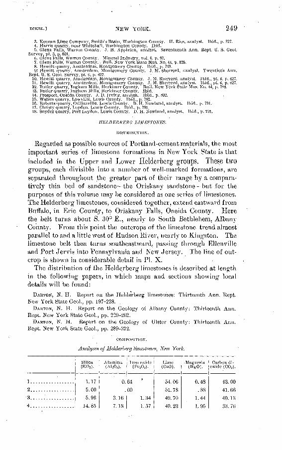
NEW YORK. 249
3. Kcenan Lime Company, Smith's Basin, Washington Comity. H. Ries, analyst. Ibid., p. 827.4. Harris quarry, near Whitehall, Washington Connty. Ibid.5. Glens Falls, Warren County. .). H. Appleton, analyst. Seventeenth Ann. Rept. U. S. Geol.
Survey, pt. 3, p. 801.6. Glens Falls, Warren County. Mineral Industry, vol. (>, p. 97.7. Glens Falls, Warren Connty.. Bnll. New York State Mus. No. 44, p. 825.8. Hewitt quarry, Amsterdam, Montgomery County. Ibid., p. 741).9.' Hewitt quarrv, Amsterdam, Montgomery Connty. J. M. Sherrerd, analyst. Twentieth Ann.
Rept. U. S. Geol. Survey, pt, (i, p. 427.10. Hewitt quarry, Amsterdam, Montgomery County. J. M. Sherrerd, analyst. Ibid., pt. 0, p. 427.11. Hewitt quarry, Amsterdam, Montgomery Connty. J. M. Sherrerd, analyst. Ibid., pt. (!, p. 427.12. Butler quarry, Inghani Mills, Herkimer Connty. Bull. New York State Mns. No. 44, p. 788.13. Butler quarry, Ingham Mills, Herkimer County. Ibid.14. Prospect, Oneida County. J. D. Irving, analyst. Ibid., p. 802.15. Waters quarry, Lowyille, Lewis County. Ibid., p. 792.16. Roberts quarry, Collinsville, Lewis County. D. IT. Newland, analyst. Ibid., p. 791.-17. Christy quarry. Leyden, Lewis Connty. Ibid.; p. 791.18. Snyder quarry, Port Leyden, Lewis County. D. H. Newland, analyst. Ibid., p. 791.
HELDERBERO LIMESTONES.
DISTRIBUTION.
Regarded as possible sources of Portland-cement materials, the most important series of limestone formations in New York State is thatincluded in the Upper and Lower Heldei'bei'g groups. These two groups, each divisible into a number of well-marked formations, are separated throughout the greater part of their range by a compara tively thin bed of sandstone the Oriskany sandstone but for the purposes of this volume may be considered as one series of limestones. TheHelderberg limestones, considered together, extend eastward from Buffalo, in Erie County, to Oriskany Falls, Oneida County. Here the belt turns about S. 30° E., nearly to South Bethlehem, Albany Count}7 . From this point the outcrops of the limestone trend almost parallel to and a little west of Hudson River, nearly to Kingston. The limestone belt then turns southeastward, passing through Ellenville and Port Jervis into Pennsylvania and New Jersey. The line of out crop is shown in considerable detail in PI. X.
The distribution of the Helderberg limestones is described at length in the following papers, in which maps and sections showing local details will be found:
DAHTON, N. H. Report on the Helderberg limestones: Thirteenth Ann. Kept. New York State Geol., pp. 197-228.
DAHTON, N. H. Report on the Geology of Albany County: Thirteenth Ann. Rept. New York State Geol., pp. 229-262.
DARTON, N. H. RepOrt on the Geology of Ulster County: Thirteenth Ann. Rept. New York State Geol., pp. 289-372.
COMPOSITION.
Analyses of Helderberg limestones, New York.
1.... .............2.................
3.................
4.................
Silica (SiOj).
1 .. 17
5.00
5. 96
14. 85
Alumina (Al,0:i ).
0.
3. 16
7.18
Iron oxide(POjA.).
64 '
60
1.34
1.57
Lime (CaO).
54. 06
51. 78
49. 70
40. 23
Mapnesia (MgO).
0.48
.88
1.44
1 . 95
Carbon di oxide (C02 ).
43.00
41.6640'. 13
33. 7('i

250 CEMENT MATERIALS AND INDUSTRY. I BOLL. 243.
Analyses of Helderberg limestones, New York Continued.
5.................
6................
7................
S.... ............
9................
10................
11................
12..........'...:..13................
14................
15................
16.................
17................
18...............
19...............
20.................
21......... .... . .
22.......... ......
23......... .......
24........ .......
25...... ... ....
26..... ....... ....
27........... ....
28................
29... .............
30................31................
Silica (SiOg).
1.6
7.23
1.92
n.d.
n.d.
n. d.
5.53
2.48
5.56
2.57
5.66
5.46
5.82
4.45
4.91
4.31
1.48
4.12
9. 05
5.12
1.1.16
1.27
1.84
1.89
2. 75
7.10
3.87.
Alumina (A1203).
0.
1.
n.d.
n. d.
n. d.
1.
1.
1.. 2.
1.
1.
.48
n.d.
n.d.
6.66
1.45
3.35
.63
1.01
1.50
2.50
1.07
Iron oxide (Fe203 )-
7
64
36
n.d.
n.d.
n.d.
50
95
55
55
14
35
38
30
.53
97
n. d.
n. d.. .99
.74
1.15
73
1.82
.55
1.60
1.65
1.34
Lime (CaO).
54.32 48.68
52.53
35. 2543 99
48.82
50.25
53.52
50. 47
52.69
50.25
50. 80
50.93
50.06*
51.82
51.05
53. 62
52.46
44.72
48.34
44.27
54.51
51.40
51. 35
53.1045.22
54. 11
Magnesia (MgO).
0.53
1.84
.698 Q4
6.08
1.48
1.00
.46
.83
.84
1.11
1.01
.859 74
1.16
1.65
n. d.
n. d.
1.989 Q3
3.17
.669 91
1.67
n.d.Trace.T^VQ f*Ct
Carbon di oxide (COo):
43.26
40.29
42. 03
37.52
40.65
39.9940 4Q
49 <U
40.57
42. 33
40.70
41.02
40.87
42.36
41.90
41. 90
n.d.
n.d.
37. 33
41. 22
38. 27
43.46
41.19
42. 19
n.d.39. 10
40.60
1. Fogelsonger quarry, Williamsville, Erie County. H. Carlson, analyst. Twentieth Ann. Kept. U. S. Geol. Survey, pt. 6, p. 427.
2. Howells quarry, Leroy, Genesee County. Bull. New York State Mus., No. 44, p. 784.3. Strobel quarry, Leroy, Genesee County. 'Ibid.4. Babcock quarry, Waterloo, Seneca County. Ibid., p. 819.5. Alvord quarry, Jamesville, Onondaga County. F. E. Eugelhardt, analyst. Ibid., p. 806. 6-J2. Clinton, Oneida County. A. H. Chester, analyst. Ibid., p. 802.
13-17. Oriskany Falls, Oneida County. A. H. Chester, analyst. Ibid.18. Pntnam quarry, Oriskany Falls, Oneida County. Ibid.,'p- 803.19. Manning quarry, Columbia, Herkimer County. Ibid., p. 788.20. Cobleskill Quarry Company, Cobleskill, Sehoharie County. C. F. McKenna, analyst. Twen
tieth Ann. Kept. U. S. Geol. Survey, pt. 6, p. 427.21,22. Howes Cave, Sehoharie County. C. A. SclmefTer, analyst.23-25. Callanan quarry, South Bethlehem, Albany County. Bull. New York State Mus., No. 44, p. 771.26. Howes Cave, Sehoharie County. C. A. Schaeffer, analyst. Twentieth Ann. Kept. U. S. Geol.
Survey, pt. 6, p. 427.27,28. Hudson, Columbia County. Ibid., p. 427.29. Holdredge quarry, Catskill, Greene County. H. Ries, analyst. Bull. New York State Mus., No.
44, p. 787.30. Turner quarry, Wilbur.'Ulster County. Ibid., p. 822.31. Hondout, Ulster County. Ibid.

ECKEL.J NEW YORK. 251
TULL}' LIMESTONE.
DISTRIBUTION.
The thinness of the Tully limestone would probably allow it to be disregarded as a Portland-cement material if it were not for its advan tageous distribution. It occurs only in central New York, and occu pies a greater area than any other limestone in that part of the State. Its line of outcrop, moreover, crosses all the Finger lakes, on the shores of most of which the limestone is well exposed, and the belt is crossed by numerous railroad lines leading' to the coal regions of Pennsyl vania. With these advantages of position, even a relatively thin limestone bed is worth considering, and one Portland-cement plant that uses the Tully limestone is already in operation.
The most western known exposure of the Tully limestone is near Reed Corners, Ontario County. From this point it runs southeastwardthrough or near Gorham, Stanley, Hall Corners, and Dresden, disap pearing below the waters of Seneca Lake opposite the village of Starke}'. It reappears on the east shore of the lake about 5 miles south of Willard, and is exposed almost continuously along the lake shore as far north as Willard. Here it turns eastward through Hayt Corners, then southeastward near Sheldrake to the Cayuga Lake shore east of Covert, and thence southward along the west shore through Trumansburg to Glenwood. Its most available outcrops are, however, on the east shore of Cayuga Lake, which it follows closely from Portland Point north to opposite Kings Ferry. Turning northeast ward the limestone outcrop leaves the lake and passes through Poplar Ridge. Sherwood, and Scipio. From this point to its most eastern known outcrop, which is near Smyrna, Chenango County, the outcrop of the Tully limestone is too irregular for ready description, as can be seen from the map, PI. X, opposite page 246. It is sufficient here to indicate its course by saying that the principal villages and stations on or near the outcrop are, in order eastward, Cascade, Locke, Moravia, Miles, Glenhaven, Scott, Spofford, Borodino, Otisco Valley, Tully, Truxton, Cuyler, Deruyter, Georgetown, and Smyrna.
COMPOSITION.
The Tully limestone is low in magnesia, rarely carrying over 1£ per cent of magnesium carbonate. It commonly carries a rather large percentage of silica, alumina, and iron oxi^le, at times approximating in composition the Lehigh cement rock. The anatyses given on page 252 are fairly representative of its range in composition.
The limestone is immediately underlain by a series of shales which, as shown by the experience of the Portland-cement plant near Ithaca, are well adapted to mixing with the limestone.
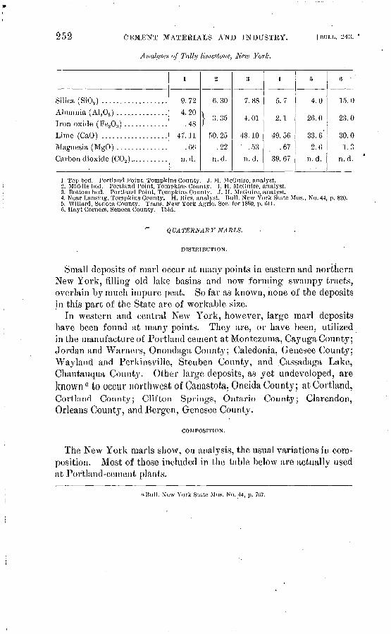
252 CEMENT MATERIALS AND INDUSTRY.
Analyse.!* of Tal/y limestone, Ne.w York.
I BULL. 243.
Silica (Si08 ) ..................Alumnia (Al.,0,) ..............
Lime (CaO) ..................Magnesia (MgO). ..............Carbon dioxide (C02 ) ... ........
L
9.724.20.48
47. il 1
.66n. d.
2
6.30
| 3.35
50. 25.22
n.d.
3
7.88
4.01.
48. 10' .53
n. d.
4-
5.7
2.1
49.56.67
39. 67
5
4.0
. 26.0
33. 6'
2.6n.d.
«
15.0
23.0
30.0L3
n.d.
1. Top bed. Portland Point, Tompkins County. ,T. H. McGnire, analyst.2. Middle bed. Portland Point, Tompkins Comity. I. H. McGnire, analyst.3. .Bottom bed. Portland Point, Tompkins County. J. H. McGuire, analyst.4. Near Lansing, Torapkins County. H. Ries, analyst. Bull. New York State Mus., No. 44, p.5. VVillard, Seneca County. Trans. New York Agric. Soc. for 3850, p. 611.6. Hayt Corners, Seneca County. Ibid.
820.
^ QUATERNARY MARLS.
DISTRIBUTION.
Small deposits of marl occur at many points in eastern and northern New York, filling old lake basins and now forming swampy tracts, overlain by much impure peat. So far as known, none of the deposits in this part of the State are of workable size.
In western and central New York, however, large marl deposits have been found at man}7' points. They are, or have been, utilized in the manufacture of Portland cement atMontezuma, Cayuga County; Jordan and Warners, Onondaga County; Caledonia, Genesee County; Wayland and Perkinsville, Steuben County, and .Cassadaga Lake, Chautauqua County. Other large deposits, as yet undeveloped, are known a to occur northwest of Canastota, Oneida County; at Cortland, Cortlancl County; Clifton Springs, Ontario Count}^; Clarendon, Orleans County, and Bergen, Genesee County.
COMPOSITION.
The New York marls show, on analysis, the usual variations in com position. Most of those included in the table below are actually used at Portland-cement plants.
"Bull. New York State Mus. No. 44, p. 7G7.

ECKKr..] NEW YORK. 253
Analyses of Quaternary mark, New York.
No.
I........
9
3........4........5.....:..6........7... ......8........9........
10........
11........
Silica- (SiO,).
0.40 1.10 .49 .50 .42 .54 .14 .26 .26
6.22
2.10
Alumina (ALA).
0.20
1.
2.
1.
.21
1.70
1.
Iron oxide (Fe203 ).
0.20 50 35 00 08 56 36 10
.01
.86
93
Lime(CaO).
53.50 54. 54 52. 71 52. 70 52. 36 54. 40
53. 16 52.86
. 50.98
47.86
48.78
Magnesia (MgO).
0.30 Trace. Trace.
1.09. 1. 01 2.34 1.50
. 18
. 19
.04
1 . 10
Carbon dioxide(CO,).
n.d.
n.d.
n.d.
42.61
42.26
42.
n
41. 73
40. 26
42. 11
39. 53
Water, organic,
etc.
(a)
(*)
cQ. 86 20 d.
4.64 7.98
(d) '
«S03,1.7 per cent. ^CaS04 , 3.48 per cent. "CaSO.), 2.01 per cent, d Alkalies, 2.20 per cent.J. Irocjuois Portland Cpment Company, Caledonia, Livingston County.2. 3 miles east of Mnmford, Livingston County. Bull. New York State Mus., No. 44, p. 793.3. 1 mile west of Bergen, Genesee County. J. A. Miller, analyst. Ibid., p. 785.4. Muiuford, Monroe County. (Calcareous tufa.) Ibid., p. 797.5. Milieu Portland Cement Company, Wayland, Steuben County.6. Genesee Wayland Portland Cement Company, Perkinsvillc, Stcubcn County.7. American Cement Company, Jordan, Onondaga County. ' ' : 8,9. Empire Portland Cement Company, Warners, Onondaga Comity.10. Montezuma, Cayuga County. .Mineral Industry, vol. 1, p. 52.11. Canastota, Madison County. Bull. New York State Mus., No. 44, p. 794.
PORTLAND-CEMENT INDUSTRY.
EARLY HISTOKY.'
Portland-cement manufacture in New York State started only a few years after cement making1 had been begun in the Lehigh district o.f Pennsylvania. The history of the New York industry was, however, entirely distinct from that of the Lehigh district. Men, materials, and methods were different, and in consequence the early history of the New York industry contains much of interest. A brief sketch of that early history is given in the following pages. For the data con tained in this sketch the writer is indebted to Messrs. J. Gardner San- derson and Edward Duryee, who placed at his disposal much material concerning the early plants with which they were connected.
The earliest experiments in the manufacture of Portland cement in this State appear to have been those carried on in the Rosendale region about 1875-76. They were made by a Mr. Dunderdale at East Kings ton, Ulster County, Messrs. Cornell and Coykendall furnishing the capital. The materials used were marl, brought by way of the Erie Canal from the Montezuma marshes, and a clay obtained near the plant. Cement of a very high grade was manufactured, but the materials and processes used were of too expensive a character to permit the experiment to become financially successful. The details of the experiments are not at present obtainable, but some idea of the
254 CEMENT MATERIALS AND INDUSTRY. [BULL. 243.
methods followed and of the general high quality of the product may be gained from the following extract from the published report of Gen. Q. A. Gillmore, on the cements exhibited at the Philadelphia Exposition of 1876:
It is deemed proper as a subject of general interest to refer briefly to some cements not represented in the exhibition.
The National Portland Cement Company, of Kingston, Ulster County (N. Y.), has recently been organized for making.Portland cement by the fourth .method above described." The materials employed are fuller's earth, kaolin, and lime. They are thoroughly ground and mixed together in suitable proportions by the wet process, although much less water is used than in the English works or in those at Boulogne. The mixture when completed is in a rather stiff seiniliquid state. In this condition it is run out upon a floor underlaid with warming flues, where it is dried to the state of tempered brick clay. It is then passed through a brick machine, and subsequently burnt in common continuous upright kilns with anthracite coal.
Specimens of this cement have been tested several times by the writer with excel lent results. On the last occasion the method adopted with the cements in the exhibition was strictly followed. One and one-half inch cubes seven days old, com posed of equal parts of dry cement and sand, gave a crushing strength of 3,335 pounds per cube as an average of 20 trials, being a little higher than the best Portland cement exhibited, as shown by the table.
Succeeding .this in point of date was a small plant at Low Point, Dutchess County, erected by the engineer and contractor for the first Poughkeepsie bridge. Some cement was made here and used in the tower foundations, but the failure of the bridge project also ended the cement experiments.
During the winter of 1877-78 Messrs. J. Gardner Sanderson and T. T. Crane carried on a series of experiments at Croton-on-the-Hud- son. A small upright kiln was in use, with a Bogardus mill and the power which during the summer was used in brickmaking. These experiments and the analysis of a large number of specimens of possible materials convinced the experimenters that the Hudson River limestones generally contained too high a percentage of magnesium carbonate, and the clays too much free sand, to be suitable ingredients of a Portland cement. Certain strata of limestone, ho wever, belonging to the Helderberg groups 6 (see PL XI), the outcrops of which extend approximately north and south a short distance west of Hudson River, crossing Rondout Creek near South Rondout, were found to be remark ably pure and free from magnesia and well adapted to their purpose. As above stated, most of the clay deposits near Hudson River carried too much sand to be of use. After careful search suitable clays were found away from the river, the best being found in an extensive deposit near Phoenicia, on the Ulster and Delaware Railroad.
a This " fourth method " here noted was, as described on a preceding page of the report, the double- kilning process, in which the calcareous material was burned and slaked before being mixed, with the clay.
& Limestone from the same horizon is now being' used in the manufacture of Portland cement by two companies, the Catskill Cement Company and Alsen's American Portland Cement Company, both plants being situated a short distance south of Catskill.

U.S.GEOLOGICAL SURVEY BULLETIN NO 243 PL.XI
MAP OT THE HUDSON TOVEB PORTLAND-CEMENT DTSTRICT,NET\r YORK °"*£.fS«i?SHOWKTG lul^ATloITS OF CE MKNT PLANTS ANII OF AVAJr^BIJ-T LIMESTONES AND S1IAI.ES Ma WI^f)a«.'

ECKKL.] NEW YOKK. 255
In 1880 the Wall kill Portland Cement Company was organized. The limestone and clay properties above referred to were purchased, and an abandoned flour mill at Carthage Landing, on the Hudson, was leased and equipped with suitable machinery, a drying channel, and two upright kilns. The manufacture of Portland cement was com menced at these works early in 1881. The product, though small in quantity, was of excellent quality and had a ready sale. Tests and reports by Messrs. Clark and Maclay demonstrated the value of the cement, arid the experimenters were satisfied that the manufacture could be made commercially successful on a larger scale. At both the Low Pointand Carthage Landing plants gas-house coke was used for fuel.
Average analyses of the clay and limestone used are given later in this paper in discussing the operations at South Rondout. A typical analysis of the cement made at Carthage Landing follows:
Analysis of cement made at Carthage Landing, N. Y.Lime:.................................................................. 59.43Magnesia............................................................... 1. 72Peroxide iron ........................................................... 5.1.7Alumina................................................................. 8.13Silica...........o .......................................................'. 24.10Water, alkalies, etc...................................................... 1.45
100.00
In the latter part of 1881 work was commenced on a plant located on the limestone property near South Rondout, and works with a capacity of 200 to 300 barrels a day were put in operation in 1883. These works were equipped with Blake crushers, cone grinders, buhrstone mills, mixers, and formers. Sixteen upright dome kilns were in use, with a drying channel connected and heated by the waste gases from the kilns. The limestone and clay were crushed, ground, and mixed dry, then steamed and formed into bricks, which were loaded on iron*cars and run by gravity through the drying channels.
For some time after cement manufacture had been in progress at these works the gas companies of New York and Albany had supplied the coke necessary for burning the material, but the introduction of the water-gas process cut off this source of fuel supply. This left the plant dependent upon Pennsylvania coke, the cost of transportation and handling of which increased the .cost of cement manufacture very largely. Mr. Sanderson therefore commenced experiments on the use of crude Lima oil as fuel, but found that the clinkering of the cement materials in front of the burners prevented the heat from entering the charge. Knowing that this same difficulty had been met in metallurgic operations arid overcome by the use of rotary furnaces, he directed his attention toward such furnaces or kilns as presenting a possible solution of the problem.
The kiln adopted was a form which had been patented in 1681 by

256 CEMENT MATERIALS AND INDUSTRY. IBOLL.-243.
Dr. George Duryee, of New Jersey. In October, 1888, one kiln was put into operation at the South Rondout works. This kiln was 50 feet long and 50 inches in diameter. The upper end was at first made 50 inches higher than the lower end, but later this was reduced to 30 inches. On trial this was found to be a very satisfactory method of burning, the one kiln handling all the material the mill could supply and producing a uniform and high-grade product. Of still greater importance was the fact that it was found possible to charge the mixed and ground raw material directly to the kiln without preliminary wetting, making into bricks, and drying. This was the first American plant at which this practice of direct charging was followed.
In 1889 the plant was entirely destroyed by fire, and Portland cement manufacture in the lower Hudson Valley ceased till 1900.
The foliowing notes from the Rondout records establish some dates:October 25, 1888. Burned about 100 barrels to-day; oil fuel. Ground the lime
stone and clay separately dry, and mixed before feeding to kiln. Mixture clay, 21 pounds; limestone, 80 pounds.
February 25, 1889. Mixture burned clay, 21 pounds; limestone, 100 pounds.
Analysis of resulting cement.
Lime ........................................................ .^......... 65. 96Silica...................................._............................;.. 18. 53Alumina and oxide of iron................................................ 11. 09Potash................................................................... .12Soda .............................................:...................... .62Carbonic acid ............................................................ .97Magnesia and undetermined .............................................. 2. 71
100.00Physical tests of tensile strength.
7 days=253 pounds. 14 days=466 pounds. Second tests:
7 clays=306 pounds.10 days=509 pounds.
Representative analyses of the limestone and chiy used at the Car thage Landing and South Rondout plants are as follows:
Analyses of limestone and clay used for cement making.
Lime ...................... ................. ........Magnesia ... ............. ̂ . .................. ̂ ........ .....
Peroxide iron .................................. ............Alumina.... .......... . . .. ............ ... .......
Silica .......................................................Carbonic acid ................................. ..... .......Water and alkalis .............. '. ............................
Limestone.
52. 295'
.5
.438
.6774.405
41. 515.17'
100. 00
Clay.
1. 2552.379. 144
20. 77154. Oil
.412. 049
100. 00

EC'KBL.] NEW YOEK. 257
In the fall of 1890 operations were commenced at Montezuma, N. Y. The company owned 1,700 acres of land, underlain by a deposit of marl and clay, which varied in thickness from 4 to 20 feet. The deposit lay below the level of Cayuga River and near its shores. It was overlain by several feet of muck, which was first dredged off and used for filling and grading for a railroad. The marl and clay had a rather uniform composition, and it was therefore found practicable to excavate both materials by machinery. The bucket of the steam dredger employed brought up. a ton every three minutes. Cars were run on the track under the bucket of the dredge to receive the material, and the loaded cars were then run on platform scales and weighed.
The marl, containing about 50 per cent water, was drawn by a steam hoist up an incline into the second story of the works and above the upper end of a mixing machine, into which the load was dumpedwithout drying or any other preliminary treatment. At the sametime a weighed and ground portion of clay was added to standard ize the mixture. The materials mixed as they gravitated toward the lower end of the machine. The entire process was practically con tinuous, a fresh charge being added at the upper end of the mixer every ten minutes, while an equal amount was being gradually drawn off from the lower end in the same space of time. The mixture then passed to a stone mill that completed the mixing and ground any coarse materials. From the mill the mixture was introduced directly by a screw conveyer into the rotary kiln, oil being used as fuel. This was unique not only in its length, 75 feet, but in having opposite its lower end a gas retort or combustion chamber; This chamber was heated by a coal fire and vaporized the oil as it was sprayed into it. The air blast also passed into this chamber, coming from a rotary fan blower.
In the first volume of Mineral Industry Mr. W. A. Smith gives the following interesting contemporary account of this kiln:
Duryee's revolving furnace consists of a sheet-iron cylinder, 75 feet long, inclined toward the firing end f inch to 1 foot. The lower hot end is 6 feet in diameter for a length of 20 feet, and is lined 9 inches thick with a mixture of ground fire brick and molasses. The remainder of the cylinder, 55 feet long, has a diameter of 5 feet, and is lined with 6-inch fire brick. Only the lining at the hot end requires renewal, and this can be replaced in ten hours, at a cost of $25. The cylinder revolves on cast-iron rollers three times a minute. The power required is 5 horsepower.
At the lower end a small coal fire is kept up on a grate, but the chief fuel is crude petroleum, introduced in a jet which meets the hot-air blast. The consumption of oil is 8 gallons per barrel of cement clinker produced. Fifteen barrels of oil are required to heat the furnace ready for burning cement.
The clay and marl are mixed wet and run in as a slurry at the upper end. The mixture in drying forms a sand, which moves slowly downward with the turning of the cylinder, and is finally discharged at the lower end as cement clinker of the size of small gravel. It takes two hours to run the particles through. The operation is continuous, and the product is 250 barrels per day. It is claimed that all the mix ture is burned to Portland clinker.
Bull. 243 05 17

'258CEMENT MATERIALS AND INDUSTRY. [BULL. 243.
From a series of analyses and tests, furnished by Mr. Duryee, the following have been selected:
Analyses of materials used and resulting product at Monlezuma.
\
Lime (CaO) .....................................Silica (Si02 ) ....................................
Iron oxide (Fe203) ..............................
Magnesia (MgO) ................................
Marl."
47.68
6.221.70.66.52
42. 11 .
Clay.
59. 22
| 20. 82
3.09
Cement.
62. 2222.51
( 9. 17I 2.54
1.081.86
"Calculated without moisture."
A report by Mr. W. W. Maclay, dated April 28, 1892, gives the average tensile strength obtained, as follows:
Pounds. Neat, 7 days ............................................................... 649Mortar (1:2), 7 days........................................................ 245Mortar (1:2), 28 days ...................................................... 418
The works at Montezuma were entirely destroyed by fire in June, 1893, and have never been rebuilt. The plant is of particular interest because of the advanced technologic methods there employed. It was the first American plant in which wet raw materials were fed, without drying or briquetting, directty into rotary kilns.
Conclusion. The history of the above plants, which bore a certain relationship to each other either in locality or management, overlaps, in point of date, the beginning of the present system of New Yorkcement plants. The destruction by fire of the South Rondout andMontezuma plants terminated the connection of the early experi menters with New York's cement industry, and the early history of that industiy may be said to end in 1893. As early as 1886 another Portland plant had been erected, but this plant was managed by an Englishman, and the problem was attacked in an entirely different manner. The earlier plants had been aggressively original and Ameri can; the plant at Warners, with its dome kilns and wet mixing, was ultra-English. Until within the last few years the typical New York plant has been one using marl and clay/' mixing wet, briquetting and drying, and burning in dome kilns. The Warners Portland Cement Company erected a rotary-kiln plant near Warners, Onondaga County, but it was in operation only a short time, and has been shut down since 1894.
aThere was, in fact, but one exception to this rule. The Glens Falls.Portland Cement Company, at Glens Falls, Warren County, has operated Schofer kilns since 1894 on limestone and clay.

NEW YOKK. 259
PRESENT CONDITION.
Ten Portland cement plants are now in operation in New York State. One employs Trenton limestone and clay, four use Helderberg lime stones with clay or shale, one usesTully limestone and shale, and four employ marl and clay. Another plant, using marl and clay, has been idle for some years, but is described below.
Alsen's American Portland Cement Works are located at West Camp, or Alsen station, Greene County, near the plant of the Catskill Cement Company. The materials used are the Becraft limestone, of the lower Helderberg, and clays of Quaternary age. As usual with these clays along the Hudson River considerable trouble has been encountered in using them for cement material. Excellent shales, however, occur in the immediate vicinity of the plant, and these can be used with the limestone. The latter is of the usual composition of
the Becraft, high in lime carbonate (about 95 per cent) and low both in claj^ey matter and magnesium carbonate.
The plant of the American Cement Company, located 2 miles east of Jordan, Onondaga County, was erected in 1892. The works were operated without interruption until 1900, when they were shut down, owing to new construction by the company at Egypt, Pa.
The materials used were marl and clay, both obtained from a marsh near the works, another bed of marl being owned by the company nearer to Jordan station. The marl is white, and the bed varies in thickness from 8 to 15 feet. It is overlain by a thin bed of muck and underlain by a blue clay. The muck being stripped, the marl and clay were dug and transported to the works by a wire ropeway. The clay was dried and ground separately, after which it was mixed with the marl in pug mills. The resulting slurry Avas spread out on a dry ing floor and-cut into bricks. These bricks were then loaded on plat form cars, dried in tunnels heated by coal fires, and fed to the kilns. Twelve kilns, of the dome type, were in use, coke being used as fuel.
The clinker was reduced, first in Gates and Mosser crushers, and finally in Griffin mills. The cement was marketed as the Giant (Jordan) brand. The following analyses of the raw materials and fin ished product were furnished by the company:
Analyses of cement materials used by American Cement Company, Jordan, N. Y.
Silica (SiOj) ..............................'......Alumina ( A120S ) ................................
Lime (CaO) ....................................
Marl.
0.14
1 .36
53. 161.50
Clay.
65.68
.24.08
2. 011.75
Cement.
21.86
1 7.17 I 3. 73
61. 149 Q4.
1.94
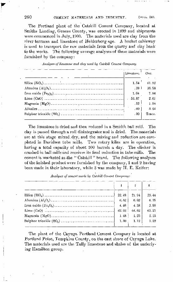
260 CEMENT MATERIALS AND INDUSTRY. [BULL. 24o.
The Portland plant of the Catskill Cement Company, located at Smiths Landing, Greene County, was erected in 1899 and shipments were commenced in July, 1900. The materials used are clay from the river terraces and limestone of Helderberg age. A bucket cableway is used to transport the raw materials from the quarry and clay bank to the works. The following average analyses of these materials were furnished by the com pan}7 :
Analyses of limestone and clay used by Catskill Cement Company.
Silica (BIO,) ..........'...................... ................Alumina ( A1 203 ) . ...........................................Iron oxide (Fe.,03 ) ..........................................Lime (CaO) ....... ......:..................................Magnesia (MgO) .............................................
Sulphur trioxide (S03 ) ......................................
Limestone.
1.54.39
1.04. 53.87
.52' .00
.00
Clay.
61.92
16. 587.842.011.583.64
Trace.
The limestone is dried and then reduced in a Smidth ball mill. The clay is passed through a roll disintegrator and is dried. The materials are at this stage mixed.dry, and the mixing and reduction are com pleted in Davidsen tube mills. Two rotary kilns are in operation, having a total capacitj^ of about 300 barrels a day. The clinker is crushed in ball mills and receives its final reduction in tube mills. The cement is marketed as ,the '" Catskill " brand. The following analyses of the finished product were furnished by the company, 1 and 2 having been-made in their laborator}^ while 3 was made by H. E. Keifer:
\Analyses of cement made by Catskill Cement Company.-
Silica ( Si08 ) ..........................................Alumina ( A1 203 ) ......................................
Iron oxide (Fe203 ) ....................................Lime (GaO) ..........................................Magnesia (MgO) . .....................................Sulphur trioxide (S03 ) ................................
1
22.486.52
4.4662.931.481.30
2
21.94
6.02
4.38
64.62
1.25
1.12
3
23.44
6.35
3.99
63.21
1.15
1.22
The plant of the Cayuga Portland Cement Company is located at Portland Point, Tompkins County, on the east shore of Cayuga Lake. The materials used are the Tully limestone and shales of the underly ing Hamilton group.

ECKEL.J NEW Y.OEK. 261
The following analysis, by J. H. McGuire, chemist of the Cayuga plant, shows the composition of the limestone and shale used here.
Analyses of cement-making material used by Cayuga Portland Cement Company.
Silica (Si02 ). ................
Iron oxide (Fe-jO,) ..........Lime (CaO).. ...... .........Magnesia (MgO) ............
9.72. 4.20
.4847.11
.66
limestone
6.30
| 3.35
50. 25.22
7.88
4.01
48. 10
.53
58.44
27.45
1.162.23
Shale.
57. 82
21 . 76
8.321. 81
60.02
26.60
2.311.62
In 1886 T. Millen & Sons commenced the manufacture of Portland cement at Warners, Onondaga County. In 1890 the plant was pur chased by the Empire Portland Cement Company and the works were almost entirely rebuilt, a much larger output being secured by the improvements then introduced. Since that date the plant has been in constant operation, with the exception of stops aggregating only some five or six weeks in all, caused by fires.
The materials used are marl and clay, obtained from a swamp in the vicinity of Warners, the present workings being located about three- fourths of a mile from the works. The marl bed covers an area of several hundred acres, of which about 100 acres have already been excavated. A revolving derrick with clam-shell bucket is employed for excavating the marl, the clay being dug by hand. The materials are taken to the works over a narrow-gage railway owned by the com pany, on cars carrying from 3 to 5 tons each, drawn by a small locomo tive. At the works the cars are hauled up an inclined track by means of a cable and drum to the mixing floor.
The swamp from which the raw materials are obtained shows sec tions, from top to bottom, approximately as follows:
Section in swamp at Warners, N. Y.
Muck.Feet.
. 1-2Upper bed, white marl ................. . ................................... 4-7Lower bed, gray to brown marl ............................................. 4-7Sand ...................................................................... 0-1Bluish clay ................................................................ 2-5
As might be expected from the relative color of the marls, the material from the lower bed shows on analysis more organic matter than that from, the upper bed, for which reason more of it must be used with the same amount of clay than of marl from the upper bed. This distinction is accompanied by other slight but rather constant differences in chemical composition, which have also to be taken into account in the preparation of the.cement.mixture.

262 CEMENT MATERIALS AND INDUSTRY. [BULL. 2'43.
Anatyses 1 and 3, below, are quoted by Cummings (American Cements, p. 253), while 2 and 4 were furnished by the Empire company.
Analyses of cement-making material used at Warners, N. Y.
Silica (Si02 ) ..................................
Potash (KaO) ..................................Sulphur trioxide (S03 ) ........................Organic ......................................Water-j-loss ..........:.......................
Ms
1
0.26
\ ' 94.39
.38
1.543.10
irl.
2
0.261 911 . /I\ .01
91.03.40
1. 686.30
'at
3
40.48
| 20. 95
25.80.99
3.14
1 8.50
iy-
4
42.85
/ 13.51 \ 4.49
22.666.92
" 3.08
2.85
This clay runs -higher in lime than any other used in the State, the clay showing the nearest approach to it being that used at Way land, which carries a little less than 20 per cent of lime carbonate.
Of the analyses of the Empire brand below, 1 is quoted by Cum- mings (American Cements, pp. 36), 2 by Lewis (Mineral Industry, VI, pp. 99), while 3 was furnished directly by the company.
Analyses of cement made by Empire Cement Company, Warners, N. Y.
Silica (SiOj) ..........................................
Alumina (ALCM ......................................\ L 0 /
Lime (CaO) ............:...............-.............
Magnesia (MgO) ......................................
Sulphur trioxide (S03 ) .................................
1
20.807 3Q
2.61
64.00
2
22.04
6,45"3.41
60.923.53
2. 73 .
3
21. 98
8.203.70
61.83
1.43
.84
1.18
In 1893 the Glens Falls Portland Cement Company commenced the erection of a plant at Glens Falls, Warren County, and its cement was put on the market in 1894, as the "Iron Clad" brand. Six shaft kilns of the Schoefer type were installed, the Glens Falls plant being there fore the second in this country to make use of this type of kiln. Though highly economical in fuel, the kiln is rather expensive in both the quantity and quality of manual labor required to operate it prop erly. A fire in August, 1899, destroyed the plant, which was rebuilt to give a nominal capacit}^ of 500 barrels a day, and the manufacture of cement was recommenced in August, 1900.

ECKBL.J NEW YORK. 263
The materials used are limestone and clay. The former is of Tren ton age, and is obtained from the Glens Falls quarries. Considerable care is required in selecting and mixing the stone from the various layers, in order to obtain a suitable and uniform product. A very clean and uniform clay, overlying the limestone in this area, is the other ingredient. The composition of these materials is shown below.
Analyses of cement-making materials used at Glen Falls, N. Y.
Silica (Si02 ).. ..............................................
Iron <yxide (Fe203 ) ..........................................Lime (CaO) ......................................'..........
Magnesia (MgO) ............................................
Carbon dioxide (C02 ) ........... '. ...........................Organic and water. ..........................................
Limestone.
3.30
| 1.30
52.15
1.58.30
40. 98- 8.37
Clay.
55.27
28.15
5.84
2.25.12
The limestone and clay are separately dried, and crushed in Ellake crushers and rolls. After being weighed on automatic scales, the materials are mixed dry and reduced to a fine powder in Griffin mills. The powder is then fed into wet mixers, where sufficient water is added to allow it to be made up into bricks. These are dried in tun nels heated by waste heat (from the boiler) driven through the tunnel system by blowers. After drying, the bricks are burned in Schoefer kilns, coal being used as fuel. The clinker is passed first through Smidth ball mills and finally reduced in Davidsen tube mills.
An average analysis of the Iron Clad cement is given below.
Analysis of cement made at Glen Falls, N. Y.
Silica (Si02).................. ........................................... 21.50Alumina (Al20a) ......................................................Iron oxide (Fe203 ) ....................................................Lime (CaO) ............................................................. 63.50Magnesia (MgO) .......................................................... 1. 80Potash and soda (K.,0 and Na20) ....:.................................... .40Sulphur trioxide (SOS ) ................................................... 1. 50
HEUDERBERG CEMENT COMPANY.
The plant of the Helderberg Cement Company is located at Howe's Cave, Schoharie County. Quarries in the Salina or Waterlime group at this point have been long used for the manufacture of natural cement, while quarries higher up, both geologically and topographic ally, furnished a very pure limestone, which was burned into lime.

264 CEMENT MATERIALS AND INDUSTRY. [BOLL. 243.
In 1898 the Helderberg Cement Company began to utilize the stone from these latter quarries in the manufacture of Portland cement. Commenced on a small scale, the industry would seem to have prom ised favorable results, as a much larger plant, belonging to the same company, was erected during 1900 and has recently started operations. The new plant has a nominal capacity of 1,500 barrels a day. The materials used are limestone and clay.
As noted below, the limestone used for Portland cement is obtained from the old lime quarries and the clay from a Quaternary deposit in the vicinity. Smidth ball mills and Davidsen tube mills are used for crushing, reducing, and mixing the materials. The wet process is employed, and twelve rotary kilns are in use. The resulting clinker is ground in ball mills and tube mills, and the product is marketed as the "Helderberg" brand.
The limestone used in Portland-cement manufacture is obtained from the Becraft and Manlius beds, exposed in quarries just west of the station, on the northern side of the railroad track. Partial analy ses of these limestones, quoted by Prosser as having been made by C. A. Schaetfer, follow.
Analyses of limestones used at Howes Cave, N. Y.
Manlius limestone .............................................
Si02
1.48
,4.12
CaCOjj
95.75
93.68
Another sample analyzed b}^ Schaeffer gave the results stated below.
Analysis of limestone used for making cement at Howes Cave, N. Y.
Silica (SiO2)............................................................ 1.27Alumina (Al a03 ) ......................................................Iron oxide (Fe,03 ) ....................................................../ * 73Lime carbonate (CaC03 )................................................. 97. 24Magnesium carbonate(MgC03)........................................... 1.39Sulphur trioxide (S03)................................................... Trace.
The plant of the Hudson Portland Cement Company is located in the city of Hudson, Columbia County, and is therefore the only cement plant in the United States situated east of the Hudson River. The limestone used here is obtained a few miles from the plant from, an outlying area of the Becraft (lower Helderberg) limestone, known as Becraft Mountain. Quaternary clays and shales of Hudson (Ordovi- cian) age are used to complete the mixture. The plant itself was recently constructed, and at present ten kilns are operated. Analyses by Herberg and Roney of the clays and shales used here follow.

ECKBL.J . NEW YORK.
Analyses of cement-making materials used at Hudson, N. Y.
265
Silica (SiOj).. ........................Alumina ( A1 203 ) ....'.................
Lime (CaO) ..........................Magnesia (MgO) .....................
Shale.
54.70
| 31.68
1:15
n.-d.
64.30
33. 60
1.46
1.30
Clay.
58.90
27.50
4.08
.79
52.00
31. 00
7.10
3. 33
52. 1.0
35. 56
5.90
3. 33
The Iroquois Portland Cement Company has recently built a plant near Caledonia, Livingston County. Marl from a deposit near the plant is mixed with clay brought from Canawangus, Genesee County. Both materials are dried before mixing. Analyses of the raw mate rials follow:
Analyses of cement-making materials used near Caledonia, N. Y.
Silica (SiO,) ............ x... ...................................
Iron oxide (Fe20s ) .............................................Lime (CaO) . ..................................................
Sulphur trioxide (SOS ) ........................................
Marl.
0.4
.2
.2
53.5
.3
1.7
Clay.
62.5
20.2
7.5
.8
1.8
.4
After; having disposed of their plant at Warners, Onondaga County,. to the Empire Portland Cement Company, T. Milieu & Co. erectedtheir present plant at Wayland, Steuben County, which commencedproducing in October, 1892. The works were destroyed by fire inJuly, 1893, but were rebuilt and began shipping again in October, 1893.
The materials used are marl and clay. The marl is obtained from a swamp near the mill, about 185 acres of marsh land being owned by the company. The marl deposit is about 6 feet thick. Unlike the Onondaga County deposits, however, the marl bed is not underlain by clay, and the latter material has to be brought from a bank near Mount Morris, in Livingston County. The clay deposit there worked is one ot: a series which occur in the terraces bordering Canaseraga Creek and Genesee River, extending more or less continuously from Dansville nearly to Rochester. The clay for cement is worked at a .point about 4 miles south of Mount Morris, and is shipped over the Delaware, Lackawanna and Western Railroad to the works, a distance of about 20 miles.
The clay is dried over steam coils, ground in a Potts disintegrator, and mixed Avith the marl in a revolving mixer. The slurry is then passed through pug mills and made into bricks. These bricks are

266 CEMENT MATEEIALS AND INDUSTEY. [BULL. 243.
dried in tunnels and burned in dome kilns, 16 of which are in opera tion. Blake crushers, Millen crackers, and Sturtevant rock emery mills are used in the reduction of the clinker. The cement is mar keted as Millen's Wayland. .
Analyses of the raw materials and of the finished product, furnished by the company, follow. . '
Analyses of day, marl, and cement, Mount Morris, N. Y.
Silica (SiOs ) ..................................
Iron oxide (Fe203 ) ...... ......................Lime carbonate (CaCO,) .......................Lime (CaO) ..................................Magnesium carbonate (MgC03 ) ................Magnesia (MgO) ..............................Lime sulphatev (CaSOJ ........................Sulphur trioxide (S03 ) ........................
Alkalies and loss ... 1 ..........................
Clay.
45.21
19. 08
6.74 19. 94
3.27
1.55
4.17
Marl.
0.42
| 1.08
93.5
2.13
2.01
.86
,
Cement.
21.08
9.56
64.68
1.85
1.93
.9
22.19
9.72
63.08
2.04
1,75
1.22
The analyses of the clinker were made for the company by Dr. F. E. Engelhardt, of SjTacuse, N. Y.
The plant of the Wayland Portland Cement Company is located at Per kins ville, in the town of Wayland, Steuben County. It was erected in 1896 and has operated continuously to date.
The materials used are a light-colored marl, found in a deposit 2 to 14 feet thick, overlain by 6 inches to 3 feet of muck, which occurs in a marsh near the works, and light-gray (Pleistocene) c\a,y from Mount Morris, Livingston County. The marl, here, as at Millen's, is not underlain by clay. The following analyses of the raw materials were furnished by the company:
Analyses of marl and clay from Mount Morris, N. Y.
Silica (SiO, ).............:............'.........................
Lime (CaO ).................................... ̂ ..............Magnesia (MgO) ............-.......--....-..-...--..---......Loss on ignition .................................... i ..........
Marl.
I 0.54
.56
54.4
2.34
42.2
Clay.
53.5
24.2
5.15
2.15
14.1
The clay is dried over steam pipes, broken to about one-fourth to one-half inch size in a Potts disintegrator, and sent through a
HCKEL.] NEW YORK. 267
Bullock buhrstorie mill, which grinds to about 16 mesh. It is then weighed and mixed with the wet marl as both are shoveled into the chutes leading to the revolving mixer. The mixture then goes to the pug mills and is made into bricks, which are sent to the drying tun nels. ,The lower tier of these tunnels is heated by direct heat, on the Cummer system; the upper tier by exhaust steam. Sixteen dome kilns are in use. From the kilns the clinker goes to an 18 by 30 inch Blake crusher; then to dry pans, receiving its final reduction in Sturtevant rock emery mills. The product is marketed as the Genesee Way land brand.
Two firms in New York State manufacture, in addition to their nat ural cements, brands which are marketed as u natural Portlands." The limestone is fed; without previous grinding or admixture, direct to the kilns. As the limestone used carries, as shown by analyses oftheir natural cements, an amount of magnesia (over 8 per cent in thefinished product), at present considered inadmissible in a Portland, the value of the resulting cements is problematical. From laboratory tests it would seem that they can usualty pass all Portland recjuire- uients, though rather low in tensile strength on short-time tests. Concerning the qualities which they develop when used in actual work, no information has been obtained; but the cements can not be worse than some of the poorer foreign Portlands which are unloaded upon the American market. Cements of this type can, of course, be placed upon the market profitably at a price only slightly above that of "natural" cements, the only additional cost being due to a little extra expense in grinding the clinker.
PORTLAND-CEMENT RESOURCES OF NORTH CAROLINA.
No cement plants have ever been operated in North Carolina, and the State will probably never be an important cement producer, because of the conditions as to fuel and the lack of local markets. If com mercial conditions should justify the erection of a cement plant, how ever, good raw materials are available.
The limestones suitable for cement manufacture in North Carolina fall into two classes, distinct geographically as well as geologically. There are (1) the crystalline limestones of western North Carolina; (2) the soft limestones of eastern North Carolina.
CRYSTALLINE LIMESTONES.
In the extensive area of metamorphic and igneous rocks, that covers the western half of North Carolina, outcrops and beds of ciystalline limestones or marbles are common. Many of these marbles are highly magnesian in composition, but the specimens used for the analyses given below were low in magnesia.

268 CEMENT MATERIALS AND INDUSTRY.
Analyses of crystalline limestones, North Carolina.
[BULL. 243.
Silica (SiOj) ..............................:...................
Lime (CaO) ...................................................
i
1.20
| .82
52. 901.91
-
. 2.93
1.17
49.833.61
1. Culbersori quarry, 11 miles southwest of Murphy, Cherokee County.2. Kinsey quarry, 5 miles southwest of Murphy, Cherokee County. Baskerville, analyst. Bull. North Carolina Geol. Survey No. 1, p. 233.
So far as composition goes, these are certainly satisfactory-enough for use in cement manufacture, but commercial considerations would prevent the erection of a Portland cement plant in this part of the State.
SOFT LIMESTONES.
In the eastern part of North Carolina heav}^ beds of soft limestone occur in the Eocene and Miocene formations of the coastal plain. These soft limestones are the "marls" of early geological reports, but should not be confused with the fresh-water marls now so largely used as cement materials. The North Carolina limestones are usually low in magnesia, but often contain considerable percentages of clayey matter or of sand. A deposit free from sand would be an excellent material for use in making Portland cement, and clays to complete the mixture can readily be obtained in the same formations.
Analyses of soft limestones ("marls"), North Carolina.
No.
1... .......2..........3..........4..........5... .......6..........7..........8..........9 ..........
10..........11..........
Silica (SiOs).
4.887.273.544.566.97
26.3520. 397.271.223.544.95
Alumina (A1203 ):
iron oxide(Fe203 ).
1.605.23.97
1.62.86
5.473.83 1. 631.30.97
2.30
Lime(CaO) .
50. 8048. 5551. 7450.0447.6233. 0339. 96 48.5552. 9051. 7450.59
Magnesia (MgO).
0.671. 39
.501.72
1.03..591.42 1.391.07.50.58
Alkalies (KoO, Nao "0).
1.791.06
1.64.14.52.93.79
1.06.30
1.64.85
Sulphur trioxide
(SOs).
0. 33.2040
.45
.41
.28
.24
.20
.08
.49
.18
Carbon di oxide (COo),
40.6039. 3540. 6140.5538.1524.8932. 46 39.3542.3340. 6140. 29
Water and organic matter.
0.27.45
.16
.584.256.89.52 .45.46.16.26
1. Near Kinston, Neuse River.2. Twenty-live miles north of Wilmington.3. Wilmington.4. Near Newberne.5. Lumber River, Robeson County.6. Cape Fear River, 25 miles north of Wilmington.7. Kenansville, Duplin County.8. 9. Two miles above Rocky Point, New Hanover County.10. One mile northeast of Wilmington, New Hanover County.11. One mile west of Rocky Point, New Hanover County.1 to 6. Bogardus and ITaniia, analysts; vol. 6, Tenth Census Reports, p. 554.7 to 11. Quoted by Kerr, Rept. Geol. Survey North Carolina, vol. 1, pp. 191.

BCKBL.] NORTH DAKOTA, OHIO. 269
PORTLAND-CEMENT RESOURCES OF NORTH DAKOTA.
Only one limestone formation of any importance the Niobrara chalk, of Cretaceous age is found in North Dakota, and even this is almost entirely concealed by a thick covering of drift. The Niobrara chalk is the formation which is now utilized for Portland-cement manufac ture at Yankton, S. Dak., while it gives promise of being a future source of cement material in Nebraska and Iowa.
The physical characters and chemical composition of the Niobrara chalk throughout various portions of its range are fully described in the text relating to deposits in the States above mentioned, and analy ses will be found on pages 148 and 301. It is of peculiar value as a Portland-cement material, both because of its softness,.which permits it to be easily crushed and pulverized, and because of its usual freedom from magnesia and other injurious ingredients. Outcrops of the Nio brara chalk, moreover, are commonly capped by clays of the Pierre group, which furnish admirable materials for mixing with the chalk.
Portland cement manufacture has been attempted at only one point in North Dakota, and here the Niobrara chalk was found to be too low in lime to be used for this purpose. Analyses of the materials at this point will be found in the section on natural cement, page 352.
PORTLAND-CEMENT RESOURCES OF OHIO.
PORTLAND-CEMENT MATERIALS.
The geologic groups which contain low-magnesia limestones in Ohio are the following:
(1) Trenton limestone.(2) Cincinnati series of limestones and shales.(3) Clinton limestone.(4) Corniferons (Devonian) limestone.(5) Maxville (Mississippian) limestone.(6) Ferriferous and other Coal Measure (Pennsylvania) limestones.(7) Quaternary marls.The distribution throughout the State of the first six of these lime
stone groups is shown on the map, PI. XII.
TRENTON SERIES.*
, This series consists of shale and pure limestone. It outcrops as a narrow strip along the.Ohio River from the mouth of the Little Miami to a point a mile or two above New Richmond. This is the formation that the Mentor plant on the south side of the Ohio River has been planned to use.
In view of the cheapness of fuel and transportation, the abundance and its general excellence of material, and the ease with which it may be procured, the strips bordering the Ohio River from Madison, Ind., to Maysville, K}7 ., seem to offer unusually promising locations for Portland cement plants.
a Most of the notes on the Trenton and Cincinnati limestones were contributed by Mr. E. 0. Ulrich of the U. S. Geol. Survey. . >

270 CEMENT MATERIALS AND INDUSTRY. [BULL. 243.
CINCINNATI GROUP.
This series may be separated into three well-marked divisions or groups. The lower division, about 250 feet thick, consists almost entirely of shale; the middle division, 200-250 feet thick, contains numerous layers of limestone from 3 feet to 20 feet thick, the lower, half constituting the "Hill Quarry beds" at Cincinnati. The upper division (Richmond group) consists of numerous alternating beds of soft shale and limestone, with usually a( heavy bed of shale at the base and top.
Analyses of Trenton and Cincinnati limestones, Ohio.
No.
1.. ........................
2..........................3...........................4..........................
Silica (SiO2 ).
23.4810.807.04
12.00
Alumina .(A1203 ); iron oxide
(Fe203).
3.401.40
«3. 787.00
Lime (CaO).
39.9348.5049.2844.41
Magnesia (MgO).
0.91.54.98.44
Carbon dioxide (C02); water.
32.3538.6938.7235.36
a Alumina, 2.48; iron oxide, 1.30.
1. Limestone in Trenton series, river quarries, Cincinnati. VVormley, analyst. Geol. Survey Ohio, vol.1, p. 374.
2. Limestone in Trenton series, New Richmond. Wormley, analyst. Geol. Svrvey, Ohio, vol.1, p. 374.
3. Limestone bed in Cincinnati series, Cincinnati. W. Simonson, analyst.4. Limestone in Trenton series, Point Pleasant. Wormley, analyst. Geol. Survey, Ohio, vol. 1,
p. 374.
CLINTON LIMESTONES.
The Clinton limestones, exposed and quarried at many points in the southwestern quarter of Ohio, are commonly fairly low in magnesia. They range from 80 to .95 per cent in lime carbonate, rarely going above the latter limit. Occasional beds are almost free from magnesium carbonate, while others may carry 10 per cent of this constituent.
Analyses of Clinton limestones, Ohio.
' No.
I......................................
2 ....................................3...... ..............................4....................................5 ....................................6 ....................................7....................................8....................................9....................................
Silica (Si02 ).
1.30
2.00.07.80
2.20.83.45
1.64. .70
Alumina (A1203);
iron oxide (Fe.A).
0.551.60.40
1.202.00.29.26..36.41
Lime car bonate
(CaC03 ).
90.0393.0095.6091.3084.5096.8095.0397.0997.14
Magnesium carbonate (MgCOj).
5.713.043.936.51
11.162.07.4.35.82
1.21
1. Dayton, Montgomery County.2. Adams County.3. New Carlisle, Miami County.4. Smiths quarry, Ludlow Falls.5. McDonald's quarry, Xenia, Greene County.6. New Carlisle, Clarke County.7. Piqua, Greene County.8. 9. Osborn, Greene County.Analyses 1-5 byT. G. Wormley, Kept. Geol. Survey Ohio, 1870, pp. 449-450; analyses 6-9 by N. W. Lord,
Kept. Geol. Survey Ohio, vol. 6, pp. 728-729.

U.S. GEOLOGICAL SURVEY BULLETIN NO.£43 PL.XII
34. BLACKFORD35. JAY
3?! DELAWARE38. MADISON39. HAMILTON40. 8OONE41. MONTGOMER42. FOUNTAIN 48. VERMILION
GEOLOGIC MAPOF
OHIO AND INDIANAcompiled froiu Orton's map of Ohio, 1894, and
Phinney's map of Indiana, U. S. G. S., 1890
Scale
CARBONIFEROUS DEVONIAN ORDOVICIAN
Coal JMeaiures Mlselseipplan limestone and sandstone
Hamilton shale Lo'wer Helderberg and Niaorara, Clinton and Medina Cincinnati shale and limestone and Cornlferota limestone Sal In a limestone limestones and shales and Trenton limestone
ECKEL.] OHIO. 271
CORNIFEROUS LIMESTONES.
The Corniferous limestones, which correspond approximately to the Onondaga or upper Helderberg limestones of New York, contain heavy beds of magnesian limestones, with a smaller amount of lime stones low in magnesia. The variation in this respect that may exist in a single quarry is well shown by the following series of analyses quoted from reports of the Ohio Geological Survey:
Variations in composition of limestone from various quarries.
No.
1 ....................................
2...................................3 ...................................
4...................................
5...................................
6............... ...................7 ...................................8......... ..........................9 ......... .^.. ......................10...................................11 ..................................12. .................................13. ..................................14 ...........................;......
15 ...................................16...............:...................
Silica (Si02 ).
3.20
4.60
2.92
1.35
1.57
1.922.20
1.65
.851.491.05
.1.651.002.651.552.70
Alumina (A1203 );
iron oxide (Fe203).
4.00
1.25
4. 33
6.01
3.05
1.851.972.65.27
.15
.20
.14
.37
.44
.18
3.30
Lime car bonate
(CaC03 ).
88.30
80.40
84.70
92.00
85.55
74.0066.1572.85
97.2887. 1089.1677.2289.2077.2378.60
' 65. 80
Magnesium carbonate (MgC03 ).
2.58
13.80
8.64
.5610.39
21.4627.97
22. 382.00
10.969.48
20.19q «4
18.55
19.79
27.95
Analyses 1-8 are of different beds in a quarry at Owen station, Marion County.Analyses 9-12 are of different beds in the Kelley quarries, on Kelleys Island.Analyses 13-16 are of beds in the Hartshorn quarries, on the Marblehead peninsula near Sandusky.

272 CEMENT MATEKIALS .AND INDUSTRY. [BULL. 243.
The analyses below have been selected as representing the low-mag nesia beds which occur in this formation:
Analyses of Cormferous limestones, Ohio.
No.
1 ..................................
2...................................3 ...................................4...................................5. ................................6 ...... ...........................7 ...................................8..................... .............9.......................:...........10...................................11 ...................................
Silica (Si02 ).
3.20
4.904.955.40
16.0625. 001.413.201.35
.85
Alumina (Alo03) :
iron oxide(FeoOs ).
0.801.74.09
.463.802.801.202.104.006.01.27
Lime car-- bonate
(CaCO:i ).
94.80
93.21
89.6090.7788.4072.8265.8093.2888.3092.0097.28
Magnesium carbonate (MgC03 ).
1.214.704.41
3.261 Qfi
5.998.02
2.692.58.56
2.00
1. Price quarry, Columbus, Franklin County. E. Orton, analyst. Twentieth Ann. Kept. U. S. Geol. Survey, pt. 6 (continued), p. 432.
2. Casparis quarry, Columbus, Franklin County. Chemist of Cleveland Rolling Mills, analyst. Twentieth Ann. Kept. U. S. Geol. Survey, pt. 6 (continued), p. 432.
3,4. Lilley's quarry, Columbus, Franklin County. N. W. Lord, analyst. Geol. Survey Ohio, vol. 6, p. 763.
5,6,7. State quarry, Columbus, Franklin County. C. C. Howard, analyst. Geol. Survey Ohio, vol. 4, p. 617.
8. Stitt quarry, Columbus, Franklin County. C. L. Mees, analyst. Geol. Survey Ohio, vol.4,p.936.9,10. Owen Station, Marion County. N. W. Lord, analyst. Geol. Survey Ohio, vol. 6, p. 769.11. Kelley quarries, Kelleys Island. N. W. Lord, analyst. Geol. Survey Ohio, vol. 6, p. 753.
MAXVILLE (LOWER CARBONIFEROUS) LIMESTONES.
The coal fields of Ohio are encircled by a belt of Lower Carbonifer ous (Mississippian) rocks. Included in this series is a prominent lime-stone formation the Maxvilie limestone. This limestone is usuallylow in magnesia and fairly high in lime. It will usually range from 80 to 90 per cent in lime carbonate, as shown by the analyses below.
Analyses of Maxville (lower Carboniferous] limestone, Ohio.
No. '
1 ....................................
2...................................'.
3 ....................................
4 ....................................
5....................................
Silica (Si02 ).
3.025.919.01
11.584.28
Alumina (Al9O;i ); iron
oxide (Fe203).
1.602.991.182.68
16.09
Lime carbo nate
(CaC03 ).
. 93. 08
89. 31 '
88.71
82.88
79.18
Magnesium carbonate (MgCO,).
1.59
1.52
.54
2.23
1.96
1. Glenford, Perry County.2. Winona Furnace, Hocking County.3. 4, 5. Webb Summit.The analyses are taken from Kept. Geol, Survey Ohio, vol. 4, p. 934.

ECKEL.] OHIO. 273
COAL MEASURES LIMESTONES.
Limestone beds occur at intervals throughout the Coal Measures of Ohio, as in the adjoining area of Pennsylvania. Most of these lime stones are of only local importance, and require no description here. One limestone formation, however :the Ferriferous or Vanport lime stone now furnishes cement material to four Portland cement plants in Ohio and to one just across the border in Pennsylvania. It varies in thickness from 8 to 16 feet or more, and is always low in magnesia. It is usually also low in lime, ranging from 80 to 90 per cent in lime carbonate. The following analyses are representative of its composition:
Analyses of the "Ferriferous" (Coal Measures) limestone, Ohio.
No.
1 ...................................
2 ...................................
3 ...................................
4 ...................................
5..... .............................
6...................................
7 ...................................
8...................................
9 .................................:.
10....... ...........................
Silica(SiO,).
0.60
1.67
.86
1.72
. ' 3. 24
2.90
1.00
1.00
5.40
.56
Alumina (A120,);
iron oxide (Fe203 ).
1.40
1.36« 1. 66
&S.22
2.26
2.71
1.00
6.80
2.00
. ci.52
Lime carbonate(CaCO.,).
97.32
95.40
96. 18
87.07
93. 24
92.02
94.20
88.80
88.00
97.23
Magnesium carbonate(MgCO;,).
0.45
1.38
n.d.
n.d.
2.19
1.85
.76
1.20
1. 51.
.75
"Alumina, 0.63; iron oxide, 1.03. ''Alumina, 1.63; iron oxide, 6.59. (- Alumina, 1.23; iron oxide, 0.29.
1. Eifert, Lawrence County. Twentieth Ann. Kept. U. S. Geol. Survey, pt. 6 (continued), p. 432.2. Iron ton, Lawrence County. N. W. Lord, analyst, Geol. Survey Ohio, vol. 5, p. 1109.3. 4. Jronton, Lawrence County. C. D. Quick, analyst.5. Lowellville, Mahoning County. N. W. Lord, analyst, Geol. Survey Ohio, vol. 6, p. 1109.6. Holmes County. N. W. Lord, analyst, Geol. Survey Ohio, vol 5, p. 1109.7. 8, 9. Star Furnace. T. G. Wormley, analyst, Kept. Geol. Survey Ohio, 1870, p. 450. 10. Texas Hollow. W. S. Trueblood, analyst.
Q UA TERN AH Y MARLS.
Marl deposits occur at various points in Ohio, but apparently are not so extensive as those in Indiana and Michigan. .At present four plants are using marl as a Portland cement material.
PORTLAND-CEMENT INDUSTRY.
As noted above, Ohio'at present ranks seventh as a producer of Portland cement. In 1904 eight Portland-cement plants were in oper ation in the State. Four of these, located in eastern and southeastern Ohio, employed the Ferriferous limestone with shale as raw materials;
Bull. 243 05 18

274 CEMENT MATERIALS AND INDUSTRY. [BULL. 243.
the other four, located in central and northwestern Ohio, used a mix ture of marl and clay. The limestone plants are the Diamond Portland Cement Company, of Middle Branch, Ohio; the Ironton Portland Cement Company, of Ironton, Ohio; the Alma Portland Cement Com pany, of Wellston, Ohio, and the Wellston Portland Cement Company, of Wellston, Ohio. All of these plants, with the possible exception of the new Alma, mix Carboniferous shales with limestone.
Analyses of limestones and shales used in Ohio.
LIMESTONES.
Silica (Si02 )....... ...........Alumina ( A1203) .............
Lime (CaO)... ...............Magnesia (MgO) .............Sulphur trioxide (SOS ) ........Carbon dioxide (C02 ) ........
1
0.86.63
1.03
53.86n.d.n.d.
43.20
2
3.53
1 1.14
54.45
.44
n.d.
38.74
3
0.56
f 1.23
I .29
. 54.45
.36
tr.
43.17
4
4.20
1.61
1.90
50.66
.73
.23
40.60
0
1.30.73
1.1753.34
7K.75
tr.
42.72
SHALES.
Silica (SiO,). ...... ..........Alumina ( A1203 ) .............Iron oxide (Fe203 ) ...........Lime (CaO) .................
Magnesia (MgO) .....'........
Sulphur trioxide (S03 ) .......Carbon dioxide (C02 ) ........
6
60.0023.264.32
.901.12
n.d.
n.d.
7
55.0021.799.26n.d.n.d.
n.d.
n.d.
8
60.1519.789.10.52.10
tr.
11. d.
9
62.6719.99.5.461.25
.72
n.d.
n.d.
10
63.30
| 26. 00
1. 251.25
n. d.
n.d.
11
69.49
16.42
2.29
.78
n.d.
5.43
1. 6. Ironton Portland Cement Company. C. D. Quick, analyst.2. 11. Alma Portland Cement Company. Twenty-first Ann. Rept. U. S. Geol. Survey, pt. 6 (con
tinued), p. 402.3,10. Wellston Portland Cement Company. W. S. Trueblood, analyst. 4, 5, 7, 8, 9. Diamond Portland Cement Company. E. Davidson, analyst.
Tho plants using marl are the Sandusky Portland Cement Com pany, of Bay Bridge, Ohio; the Castalia Portland Cement Company, of Castalia, Ohio; the Buckeye Portland Cement Company, of Rush- sylvania, Ohio, and the Alta Portland Cement Company, of Rushsyl- vania, Ohio.
Of these plants the Buckeye and Alta use marl from wet swamp deposits, while the Castalia uses marl from a deposit which is now, practically dry. The Sandusky, having almost exhausted its marl deposit, is now using limestone as part of its charge and will probably soon use it entirely. The clays used at all these marl plants are obtained from Quaternary deposits in the immediate vicinity of the marl beds.

ECKEL.] OHIO, OKLAHOMA.
Analyses of marls and clays used in Ohw.
275
Silica (SiO,) .................
Iron oxide (Fe203 ) ...........Lime(CaO).. ................
Alkalies (K20, Na,0) .........
Carbon dioxide (C02 ) ........
Marls.
1
1.98
} .97
50.95
.55
.12
.10
40. 03
2
0.26
.20
52.86
n.d.
n. d.
n.d.
ri. d.
Clays.
3
47.45
19.85
17. 80
.09
4.34
1.03
.57
4
59.10
24.01
2.2
2.0
n.d.
n.d.
n.d.
5
51.56
t 14. 50
I 3.84
9.8
n. d.
n.d.
tr.
7.7
1. 3. Buckeye Portland Cement Company. Mineral Industry, YOl. 1, p. 52.2. 4, 5. Castalia Portland Cement Company.
PORTLAND-CEMENT RESOURCES OF OKLAHOMA.
Limestones occur in three distinct areas in Oklahoma, and are of three different geologic ages Cretaceous, Carboniferous, and Ordo- vician (" Lower Silurian"). Little is on recorfl concerning the exact distribution or composition of any of these limestones. In general, it may be said that those of Cretaceous age occur in the extreme west ern part of the Territory; that they are shell limestones and probably low in magnesia. The following description of the Carboniferous and Ordovician limestones is taken from a paper by Mr. C. N. Gould, published in Stone, volume 23, pages 351-354. Though containing no analyses, it indicates the general distribution and value of the lime stones in question.
There are in Oklahoma two localities from which limestone for building purposes may be obtained in large quantities. The first of these is in the northeastern part of the Territory, in Kay, Noble, Payne, and Pawnee counties, and in the Osage, Kaw, Ponca, and Otoe reservations. The second locality is in the newly-opened Kiowa and Comanche Reservation, in the eastern part of Comanche County. It is the purpose of. this article to discuss in some detail the rock of the two localities and to indicate briefly the logical market of the stone of each locality.
The limestone in the northeastern part of the Territory is obtained from the south ern part of the Flint Hills. The Flint Hills extend practically north and south for more than 300 miles, from the Platte to the Cimarron. They are hills of erosion carved out by the action of water from the heavy limestone ledges which occur in the Upper Carboniferous and Lower Permian of the region. Much of the Kansas building stone is obtained from this range of hills. Quarries at Manhattan, Junction City, Cottonwood Falls, Florence. Winfleld, and Arkansas City, Kans., as well as those near the mouth of the Platte in eastern Nebraska, are from the same general horizon. ' .
The Arkansas River on its way from the mountains to the Mississippi strikes the Flint Hills near the Kansas-Oklahoma line. From Pueblo to Arkansas City the river flows over soft yielding rocks that have been hollowed out by water into a

276 CEMENT MATERIALS AND INDUSTRY. [BULL. 243.
broad shallow valley. At Hutchinson or Wichita, Kans.., for example, there are no bluffs, and the valley is from 10 to 20 miles wide. Near Geuda Springs, Kans., the river begins to narrow rapidly. The first ledge of limestone is crossed at the dam 5 miles west of Arkansas City. Near the mouth of the Walnut, just north of the Kansas-Oklahoma line, the heavy bluffs of limestone appear, and from this point to the southeast corner of the Osage Nation the river flows in a series of ox-bow bends, seeking its tortuous way in and out among the Flint Hills. As the crow flies this distance does not exceed 80 miles, but the water of the river flows at least twice that distance. ' In one place two bends of the river approach within a mile and a half of each other, while to follow the channel a person would have to travel more than 9 miles. Throughout the greater part of this course the bluffs are high arid precipi tous. The valley is perhaps 2 miles wide on an average, nearly half of this being occupied by the sandy channel of the stream. In places, however, the distance from bluff to bluff is not more than a mile.
The smaller streams tributary to the Arkansas in this region have usually carved deep channels through the limestone ledges. These ledges follow the sinuous course of the streams, outcropping along the bluffs and forming in many places conspicuous outlines. It is from these ledges, which, as stated above, form the southern exten sion of the Flint Hills, that the limestone is obtained. Half a dozen or more ledges outcrop between the bed of the river and the top of the hills to the west. In the hills in the Osage and Kaw reservations east of the river there are perhaps as many more, each from 5 to 25 feet thick.
The stone is, in general, a rather fine-grained, gray, or nearly white, massive lime stone. For building purposes it is easily the equal of the best stone from the Win- field or Cottonwood Falls quarries. Indeed, it will be a matter of surprise if time shall not demonstrate that the Oklahoma stone will outlast most of that obtained from Kansas. The supply is inexhaustible. Kay County alone can supply.Okla homa with building material for hundreds of years and scarcely know Avhere it came from.
Business blocks in Newkirk, Ponca City, and Pawnee are built of stone obtained from the local quarries. These buildings rival in appearance the finest blocks built from Kansas stone. Throughout the region dressed-stone farmhouses are rapidly springing up. The stone house built by Governor William M. Jenkins while he was yet a Kay County fanner stands on his claim, 2 miles southeast of Newkirk. This is one of the first two-story stone houses ever built in " the Strip."
Dimension stone of all shapes and sizes, flagging, and rubble are obtained from the various quarries. Not long ago a block of 12 feet square and 30 inches thick was shipped. One of the most practical purposes to which the stone is being put, however, is the manufacture of stone posts. The rock splits readily into almost any required size. Advantage is taken of this fact to secure a long, slender* block suitable for a fence post. Posts from 5 to 7 feet long are split down to 6 by 8 inches, and posts 15 feet long are often secured. These posts sell in the quarry for from 20 to 35 cents each, according to the size, and are rapidly replacing the wooden posts for merly used. They are very similar to the limestone posts from the Benton Cretaceous in central Kansas, and seem destined to serve as important a part in the develop ment of the country as do the latter.
Standing upon almost any one of the high hills east of Kildare, or New..~irk, in Kay County, a person may see not only the white stone houses nestled away in the valleys or crowning the knolls, but also the lines of white posts stretching for miles across the country. It seems but a question of a few years till the greater part of the farmhouses of the county will be built of stone, and stone posts will replace the last of the wooden posts throughout the region.
The limestone of the second locality, while more restricted in area than that of the Flint Hills, is still more than sufficient to supply the southwestern part of Oklahoma

HCKHL.] OKLAHOMA, OREGON. .277
with building stone for generations. Oieologically this stone is much older than that I have just discussed, in general, it belongs to the Ordovician, or even the upper Cambrian, and is thus classed among the oldest of the stratified rocks. In this region the limestone occurs as outlying hills, flanking the .Wichita Mountains on the northeast and southeast.
The Wichita Mountains are nothing but the tops of buried mountain ranges stick ing up'out of a sea of plain. They are composed of igneous rocks, chiefly granite, gabbro, and porphyry. These, of themselves, are of course excellent building, stone. At the present time these mountains are full of prospectors and miners. For seventy years reports of gold and silver have been coming from these mountains. 'Whether
. or not anything more tangible than reports will ever be obtained remains to be proven.
The Ordovician outliers trend northwest and southeast, parallel to the main range. From Fort Sill these hills extend for nearly 40 miles to the northwest, and in places are 15 miles across. Southwest of the fort the hills extend for 12 miles or more. The stone is, in general, rather coarse grained, and in places is almost marbleized. it is usually much faulted and folded, often standing on edge, showing that the region hasbeen subjected to great pressure.
The Government buildings barracks, officers' quarters, and stables at Fort Sill have been constructed of limestone taken from a quarry on the reservation a mile southeast of the post, it makes a splendid building stone. The prevailing colors as seen in the building are light gray and brownish or yellowish gray. This fort, perhaps as much on account of the material composing the buildings as upon its loca tion, seems destined to be occupied by Government troops long after all other posts in Oklahoma and the Indian Territory have been abandoned. Forts Gibson, Washita, Arbuckle, and Supply, where the buildings were principally of wood, have all'been vacated by the Government, and it is unlikely that Fort Reno will long remain occu pied. Fort Sill, on the contrary, will probably long remain a monument, in part at least to the.character of the rock composing the buildings.
A word with regard to market and transportation facilities. The Flint Hills region is cut by the Santa Fe Railroad, and, for the present at least, the products of these quarries must be shipped over this road. It is the logical source of supply for such cities as Guthrie and Oklahoma City, in which at the present time there is much building being done. Unfortunately for the Oklahoma stone industry, how ever, there are as yet no spurs to any of the quarries in this locality. It thus hap pens that the stone from many of the buildings in these'cities is obtained from south ern Kansas, at a considerably higher cost than natural conditions warrant. Newkirk stone, however, is already on the market and the demand is steadily increasing.
In the Wichita region the Rock Island Railroad runs within less than a mile of the limestone hills. The resources of the region are as yet practically undeveloped. In time, however, this stone promises to become one of the important factors in the development of this wonderfully rich and fertile region.
PORTLAND-CEMENT RESOURCES OF OREGON."
Little attention has been paid by prospectors to any of the nonmetal liferous mineral resources of Oregon except coal. In consequence, tbe data presented below on the distribution and composition of Ore gon limestones are too scanty to be satisfactory for the purposes of
«For much of the data here given in regard to Oregon limestones the writer is indebted to a report by Mr. Herbert Lang, published in The Resources of the State of Oregon, a handbook issued in 1892 by the State board of agriculture. Dr. ,). S. Diller has also aided him greatly by contributing data on the character and distribution of the limestones of southwestern Oregon, based on his work in that region.
278 . CEMENT MATERIALS A"ND INDUSTRY. [BULL. 243.
the present bulletin. It is probable that workable limestone deposits, other than those described below, exist in various parts of the State. So far as known, however, the more important limestone deposits of Oregon occur in two widely separated disti icts in the southwestern and the northeastern portions of the State.
MATERIALS AND CONDITIONS IN SOUTHWESTERN OREGON.
The limestones of southwestern Oregon are well developed at a number of points in Jackson and Josephine counties, and have been used to a considerable extent for lime burning and flux. These lime stones are generally of uncertain age some are Devonian, others most likely Carboniferous, and a few certainly Cretaceous. They occur as a series of lenses of greater or lesser size in the partially altered rocks of the district.
Several of these lenticular bodies of limestone outcrop in the neigh borhood of Rock Point, on Rogue River, in Jackson County, and have been extensively exploited for various purposes. A small quantit}7 has been burned locally into lime, some has been shipped to the Port land lead smelters as flux, while a larger amount has been shipped to Portland and burned there into lime. Stone for building purposes has also been derived from this series of limestone beds.
An analysis of the Rock Point limestone, made by Mr. J. S. Phillips, follows:
Analysis of limestone from Rock Point, Oreg.
Silica (Si08 ) ................................................ ......^....... 3.1Iron oxide (Fe203 ) .....................:..........:....................... 2.2Lime carbonate' (CaC03 )................................. ̂ ................. 89. 4Magnesium carbonate (MgC03 ) .....................~...................... 5. 3
The belt of limestone lenses extends southwest from Rock Point,with several prominent cutcrops on the tributaries of Applegate, especially on Steamboat, and on Williams Creek, where the massive limestone has celebrated caverns. Similar bodies occur on Sucker Creek, southeast of Waldo, near the California line. Their distribution is extremely irregular, owing to the predominance of igneous rocks. Very large deposits are said to occur near the California line, on Wil liams Creek, in the extreme southeastern corner of Josephine County.
MATERIALS IN NORTHEASTERN OREGON.
Of the limestone deposits of northeastern Oregon the largest and most accessible seems to be on Burnt River, about 3 miles above Hutch- irison, Baker County. The limestone beds at this point are associated with shales, and the entire series is upturned to give a steep dip. The river has cut through the beds, exposing a thickness of about 100 feet of limestone. This stone is remarkably pure, carrying usually less

ECKEL.] OREGON, PENNSYLVANIA. 279
than 1 per cent of silica, alumina, and iron oxide. Its quality, quan tity, and proximity to the railroad and to a series of shale beds make it worth considering as a possible source of Portland-cement material.
The same series of beds outcrop in the hills to the southwest and northeast and continue into Idaho, where they form important deposits. Large limekilns are now in operation at several points on this line of outcrop.
Limestone deposits of considerable size occur in other parts of Baker County, the most important at present being one which is extensively worked for lime about 14 miles from Baker City. Other deposits occur in Grant County, and very thick and extensive beds of blue limestone are said to cover mucK of Union County. In Wallowa County deposits of marbles occur, which may be of service for cement.
POBTLAKD-CEMENT RESOURCES OF PENNSYLVANIA.
PORTLAND-CEMENT MATERIALS.
A number of limestones suitable for use as Portland-cement mate rials occur in Pennsylvania, though only one of them has as yet been extensively used for this purpose. For description these limestones may be conveniently grouped as follows:
(1) Trenton limestone (Ordoyician).(2) Helclerberg or Lewistown limestone (Silurian).(3) Carboniferous limestones.
TRENTON LIMESTONE.
DISTRIBUTION.
The Trenton limestone, which furnishes the well-known " cement rock" of the Lehigh district, occurs in varying development in the counties of Northampton, Lehigh, Berks, Lebanon, Dauphin, Cum berland, Franklin, Lancaster, Center, and Blair, and to a much less extent in several other counties of southeastern Pennsylvania.
Throughout its range it is underlain by a highly magnesian (Kitta- tinnj^) limestone and overlain by a thick series of (Martinsburg and Hudson) shales and slates. Further details concerning its geologic occurrence in its most typical area will be found in the section on cement manufacture in the Lehigh district, on page 284. The distri bution of the Trenton limestone in Pennsylvania is shown in a general way on PI. XIII.
COMPOSITION.
The Trenton limestone, wherever it occurs, is almost invariably low in magnesia, and is therefore almost always an excellent Portland- cement material. At times its value as a cement material is increased

280 CEMENT MATEBIALS AND INDUSTRY. [BULL. 243.
by the presence of a high percentage of clayey matter, as is well shown in the " cement rock" of the Lehigh district.
The following table of analyses shows the composition of samples of Trenton limestone from various localities in Pennsylvania. No analyses from localities in the Lehigh district are given in this table, as this district is discussed in considerable detail below (p. 284).
Analyses of Trenton, limestones, Pennsylvania.®
1...... .................. .........2..................................3.................'.................4.... ..............................5.. .................. .1..... .......6..................................7..................................8..................................
9............................ .....10..................................11..................................^2. .................... ............
13... .....................:.......14..................................15..................................
i
Silica (Si02 ).
0. 91
.4.38
5.88 3.62
.54
.39
.82
.76 4.30
2.512.558.418.84.98
.2.66
Alumina (A1203),
iron oxide (FejOa).
0.26
.64
1.68
.19
.20
.32
.38
.43
.36
.60n.d.
.57
.81
.26
.26
Lime car bonate
(CaCOs).
94.98
91. 8990.3992.12
97.8998.3297.53
97. 65
86.1390. 6392.0086. 36
89.1897. 32
95. 07
Magnesium carbonate (MgC08 ).
3.87
2.882.254.231.29
1.171.211.138.866.174.545.24.96
1.291.04
«From Reports Ml, M2, M3, Second Geol. Survey Pennsylvania A. S. McCreath, analyst.
1. Mount Etna Furnace, Blair County.2. Hodman Furnace, Blair County.3. 4. Tyrone, Blair County.5, 6, 7. Shortlidge quarry, Bellefonte, Center County.8. Campbell quarry, near Bellefonte, Center County.9,10. Rutherford quarry, near Harrisburg, Dauphin County.11. Cumbler quarry, near Harrisburg, Dauphin County.12. Craighead .quarry, Mount Holly, Cumberland County.13. Mont Alto, Franklin County.14. Williamson, Franklin County.15. Rauchs Gap, Clinton County.
HELDERBERG OR LEWJSTOWN LIMESTONE.
DISTRIBUTION.
The Helderberg limestone outcrops in central and eastern Pennsyl vania in a series of narrow bands whose distribution is too complicated to be readily described, but is shown on PI. XIII.

ECKEL.] PENNSYLVANIA. 231
COMPOSITION.
Analyses of Helderberg limestone, Pennsylvania. a
No. SilicaAlumina(A1203 );
Iron oxideLime car-
\ bonate (CaC03 ).
Magnesium carbonate (MgCOj),
Sulphur(S).
1.......................... 2.502.......................... 3.003....'...................... 3.'024.......................... 1.805.......................... 1.626............................ 10.857........................... 1.698.......................... 5.70
9 9 QQ....,............,.;....«. LI* 00
10.................... ...... 5.04
n.........................; 5.3012.......................... 49.03
13.......................... 21.68
14.......................... 15.72
15.......................... 6.5316.......................:.. 2.85
17........................ 7.8618................. 1........ 11.9319........................... 4.2520.......................... 3.9221.......................... 7.6522.......................... 3.02
23..........'....:........... 4.2624............................ 20.2425.......................... 3.6126.......................... 5.94
0.84.64.57.80.65.58.44
1.77
.70
1.14
1.78
1.674.662.55
1.21.70
2.111.36.84
.68
.71
.54.
1.102.971.111.26
95.6695.0995.5795.2596.1684.7896.14
90.90
94.0391.12
89.2947. 30
70.5971.73
89.6494.28
87.9382.73
93. 2793. 8788.8294.2892.2073.4390.1889. 39
1.551.581.522.271.593.861.602.16
1.971.57
2.56
2.01
1.74
7.62
1.82
1.53
1.94
2.83
1.38
1.31
2.34
2.12
2.17
2.65
4. 31
3.25
0.10
.03
.03
.05
.07
.05
.05
.08
.06
.03
'.06 .15
.03n. d.
n. d. .06 .23 .70 .11 .15 .21 .21 .15
n. d. .25 .27
"From Reports Ml, M2, M3, Second Geol. Survey Pennsylvania. A. S. McCreatli, analyst.I, 2, 3. Baker quarry, Altoona, Blair County.4. Creswell quarry, Hollidaysburg, Blair County.5. Manning quarry, Hollidaysburg, Blair County.6. Loop quarry, Hollidaysburg, Blair County.7. Sarah furnace, Blair County.8. 9,10. Hudson quarry, Three Springs, Huntingdon County.II,12. McCarthy quarry, Saltillo, Huntingdon County.13. Jersey Shore, Lycoming County.14. 15. Still quarry,'2 miles northeast Montebello Narrows, Perry County.16-17. Bossardville, Hamilton Township, Monroe County.18-21. Van Aukcn quarry, Middle Smithfield Township, Monroe County.22-23. Brown quarry, Smithlield Township, Monroe County.24. Experiment Mil'ls quarry, near Delaware Water Gap, Monroe County.25-26. Poxono Island, Monroe County.
A deposit of limestone near Kings Rock, on Susquehanna River in Lycoming Count}', belonging to this series, is described by Mr. Uriah Cummings in the Seventeenth Annual Report of the United States Geological Survey, part 3, pages 889-890. He states that

282 CEMENT MATERIALS AND INDUSTRY. [BULL. 243.
a natural cement of the following composition had been made fromthis rock:
Analysis of natural cement, Kings Rock, Pa. Silica (Si02 ).............................................................. 28.14Alumina (A1 203 ) .-..-.-..---.-...-..-.-.-......-..'..---.-.-...-....---.. 9.10Iron oxide (FeO).......................................................... 3. 20Lime (CaO).............................................................. 53.34Magnesia (MgO) ......................................................... 1. 00Alkalies (K20, Na20)..................................................... 2.80Water and loss........................................................... 2.40
Such an analysis of a natural cement would imply that the rock from which it was made was closely similar in composition to the cement rock of the Lehigh district, and that the addition of 10 per cent or so of pure limestone would give a good Portland cement.
CARBONIFEROUS LIMESTONES.
DISTRIBUTION.
Names and stratigraphic position of Carboniferous limestones, Pennsylvania.
Geologic group.
Dunkard formation or Upper Barren meas ures.
Monongahela forma tion or Upper Pro ductive Measures.
Conemaugh formationor Lower Barrenmeasures.
Allegheny formation or Lower Productivemeasures.
Pottsville formation . . .
Mauch Chunk forma tion.
Pocono formation .....
Name of limestone.
Upper Washington limestone.
Waynesburg limestone .
Benwood or Great lime stone.
Sewickley or Fishpot limestone.
Bedstone limestone. . . . .
Pittsburg limestone. ....
Elk Lick limestone. ....
Ames or Crinoidal lime stone.
Upper Freeport lime stone.
Lower Freeport lime stone.
Johnstown limestone . . .
Vanport or Ferriferous limestone.
Upper Mercer limestone.Lo wer M ercer limestone .Greenbrier or Mountain
limestone.Siliceous limestone .....Benezette limestone ....
Thick ness.
Feet. 30
35
73
30
10
12
6
8
28
5
10
20
4
330
607
Stratigraphic position.
At top of Washington formation, 250 to 425 feet above the Waynes burg coal.
20 feet below the Waynes burg coal.
120 feet above the Pitts burg coal.
100 feet or more above the Pittsburg coal.
60 to 100 feet above the Pittsburg coal.
20 feet below the Pittsburg coal.
Between Pittsburg and Upper Freeport coal.
Do. q
Below Upper Freeport coal.
Below the Lower Freeport coal.
Below the Upper Kittan- ning coal.
Below the Lower Kittan- ning coal. ,

ECKEL.] PENNSYLVANIA. 283
COMPOSITION.
Analyses of Ferriferous or Vanport limestone, Pennsylvania,.®
No. Silica (SiOs).
Alumina(AljO,);
Iron oxide(Fe203 ).
Lime carbonate (CaCOa).
Magnesium carbonate (MgCO:t ).
1.."..................................- 2.032..........................!'......-. 1.793.................................. 2.304.................................. 2.115.................................. 2.106.................................. 3.427................................... 3.228.....................'............. 2.199.................................. 1.96
10.................................. ,' 1.7811.................................. 1.1112.................................. ; 1.9113.................................. 2. 0414.................................. 1.30.15.................................. ;' 1.2816.................................. 2.3917..... ...i......................... 7.3718.................................. 3.3719................................:. 1.6320.................................. 2.2021.................................. 2.7922.......'........................... ; 1.9723.........................'......... 3.0724.................................. 2.0825.................................. ' 2.0926................................... ! .3727.................................. ; 2.7728..........'........................ 7.0329.................................. 4. 7830.................................'. < 4.80
1.291.461.38.93
2.091.671. 711.311.051. 53.87
1.311.31.99.78
2.202.61.1.711.641.63.80.63
1.561.192.031.001.822.321.291.59
95. 5396.0194.7295.5794.1893.2593.2995.2395.5395.2096. 4394.39
93.6496.4396.5886.9186. 2191.7894.3694.1194.2195.7793. 3494.7892.8696.7893.4888.4691.6191. 09
0.911.501.'041.421.481.74.97.41.93
1.271.201.701 ft91. Oil
.91
.836.661.78
816337731046
1.371.591.281.541.441.571.59
«From Eeports M, M2, M3, Second Geol. Survey Pennsylvania. A. S. McCreath, analyst.1,2. Stewardson Furnace, Madison Township, Armstrong County.3. Colwell quarry, near Mahoning Furnace, Armstrong County.4. Reynolds quarry, near Kittanning, Armstrong County.5. George quarry, near South Bend, Armstrong County. 0. Rhea quarry, near Greendale, Armstrong County.7. Graff quarry, near Buffalo mills, Armstrong County.8. Long Run, Porter Township, Clarion County.9. Hindman quarry, Clarion Township, Clarion County.10. Sligo Furnace, Piney Township, Clarion County.11. Barger quarry, Perry Township. Clarion County.12. Bovaird quarry, near Brockwayville, Jefferson County.13. Hanna quarry, near Sprankle's Mills, Jefferson County.14. Ehty quarry, near Worthyille, Jefferson County.15. Shields quarry, near Dowlingville, .Jefferson County.16. Winslow property, near Benezctte, Elk County.17. Toby Creek, Fox Township, Elk County.18. Brandy Camp post-office, Horton Towiiship, Elk County. 19,20. Kane quarry, near Wilcox, Jones Tpwnship, Elk County.21. Shinn quarry, Wampum, Lawrence County.22. McCord quarry. Mount Jackson, Lawrence Connty.23. Johnson quarry, Newcastle, Lawrence County.24. Mbfflt quarry, Croton, Lawrence County.25. Simpson quarry, Richmond, Indiana .County.26. Pine Creek Furnace quarry, Kittanning, Armstrong County.27. Severn quarry, near Vanport, Beaver County. 28,29. Powers quarry, near Vanport, Beaver County. 30. Tygart's quarry, near Vanport, Beaver County.

284 CEMENT MATEE1AES AND INDUSTRY. [BULL. 243.
PORTLAND-CEMENT INDUSTRY IN PENNSYLVANIA.
The State of Pennsylvania now produces about half of the total United States output of Portland cement. This enormous production, amounting to about 10,000,000 barrels annually, comes almost entirely from plants located in the so-called Lehigh district, in Berks, Lehigh, and Northampton counties. Seventeen plants are located in the Penn sylvania portion of this important district, while the two remaining Portland-cement plants in Pennsylvania are located in the extreme western part of the State.
The following list of Portland-cement plants operating in Pennsyl vania in 1904 has been corrected by Mr. R. W. Lesley, president of the American Cement Company, to whom the writer's acknowledgments are due for this and other courtesies.
Name' and location of Portland-cement plants in Pennsylvania, 1904-
American Cement Company of Pennsylvania ....... .... Egypt.Atlas Portland Cement Company ...................... Northampton and Coplay.Bath Portland Cement Company .............:........ Bath.Bonneville Portland Cement Company................. Siegfried.Central Cement Company« ........................... Egypt.Clinton Cement Company............................. Pittsburg.Coplay Cement Manufacturing Company............... Coplay.Crescent Portland Cement Company................... Wampum.Dexter Portland Cement Company .................... Nazareth.Lawrence Cement Company of Pennsylvania........... Siegfried.Lehigh Portland Cement Company .................... Ormrod, West Coplay.Martins Creek Portland Cement Company 6 ............ Martins Creek.'Nazareth Cement Company ........................... Nazareth.Northampton Portland Cement Company .............. Stockertown.Penn-Allen Portland Cement Company................ Penn-Allen. .Pennsylvania Cement Company ....................... Bath.Phoenix Cement Company............................ Nazareth.Reading Cement Company ............................. Molltown.Whitehall Portland Cement Company ................. Cementon.
In describing the Portland-cement industry of the State, the Lehigh district will first be discussed in considerable detail, after which the isolated plants in western Pennsylvania will be briefly described (p. 294).
LEHIOH DISTRICT.
The following description of the cement-rock deposits and cement industry in the Lehigh district is based largely upon field work by the writer during the early summer of 1903. Acknowledgments are due to the managers and .chemists of various cement plants in'the Lehigh district, who have aided the writer greatly in this work. Use has also
"Owned by same interest as American Cement Company of Pennsylvania. .*0wned by same interest as Alpha Portland Cement Company. (See New Jersey, p. 243.)

U. S- GEOLOGICAL SURVEY BULLETIN NO. 243 PL.XIII
40
CEMENT PLANTS
t. LEHIGH P. C. CO. (MILL F)2. " " " " t " D)3. - - - - ( A)4 AMERICAN C. CO. (EGYPT WORKS)5. :: :; ;: <,««< ' :; >« (,"»«A - !7. (COLUMBIAN8. CENTRAL P. C. CO.9. LEHIGH P. C. CO. (MILL B)
10 COPLAY C. CO. (KILL C)11 WHITEHALL P. C. CO.12 ATLAS P. C. CO.13 COPLAY C. CO. (MUL A) 14. ' " ' " B) 15 LAWRENCE C. CO. 1C BONNEVILLE P. C. CO.17. ATLAS P. C. CO.18. " " " "19. PENNSYLVANIA C. CO.20. PENN ALLEN P. C. CO.21. DEXTER P. C. CO.22. PHOENIX C. CO.23. NAZARETH C. CO.24. NORTHAMPTON P. C. CO.25. QUAKER P. C. CO.26 NATIONAL P. C. CO.27 ALPHA (NO. 3) P. C. CO. 28. ALPHA P. C. CO. 29 VULCANITE P. C. CO. 30. EDISON P. C. CO.
MAP OS' THE
DISTRICT,! T'ETvnSTSYI., VANI JV - NEW JERSEYSHO'WINCJ DISTRIBUTION OI" CEMENT ROCK
BY 3SmvIN C. KCKKL ANr> KAY S.
18O4
Scale
Trenton limestone Klttatinny limestone Hardyston quartzite Pre-Carabrian (cement roqk) gneisses and limestone
V Cement rock quarriesM Portland cement plants Limestone quarries
F : O I? K S ,:
' li ! ; !, N \\' I C
H A X O V
! .L i, I A
!/ Vx s * > I^'-T. i f'-.i*V HIT

ECKEL.] PENNSYLVANIA. 285
been made of the report by Professor Kummel, on the Portland-cement industry in New Jersey," and of an unpublished report by Prof. T. N. Dale, on the geology of the Slatington quadrangle.
GEOLOGY.
The "Lehigh district" of the engineer and cement manufacturer has been so greatly extended in recent 3^ears that the name is now hardly applicable. Originally it included merely one small area about 4 miles square, located along Lehigh River, partly in Lehigh County and partly in Northampton Count3'- , containing the villages of Egypt, Coplay, Northampton, Whitehall, and Siegfried. The cement plants which were located here at an early date secured control of most of the cement-rock deposits in the vicing, and plants of later estab lishment have therefore been forced to locate farther and farther awayfrom the original center of the district. At present the district includes parts of Berks, Lehigh, and Northampton counties, Pa., and Warren County, N. J., reaching from near Reading, Pa., at the southwest, to a point a few miles north of Stewartsville, N. J., at the northeast. It forms, therefore, an oblong area about 25 miles long from southwest to northeast and about 4 miles wide. Within this area twenty Port land-cement plants are now in operation, and the Portland cement produced in this relatively small district amounts to almost two-thirds of the entire United States output.
Within the "Lehigh district," as above defined, three geologic formations occur, all of which must be c6nsidered in attempting to account for the distribution of the cement materials used there. These formations, named in descending order, are (1) Hudson shales, slates, and sandstones; (2) Trenton limestone (Lehigh cement rock); (3) Kit- tatinny limestone (rnagnesian). As all these rocks dip, in general, northwestward, the. Hudson shales occupy the northwestern portion of the district, while the Trenton cement rock and magnesian Kit- tatinny limestone outcrop in succession far-ther southeast.
MA GNESIAN KITTA TINN Y LIMES TONK.
Underneath the cement-rock series lies a very thick formation con sisting of light-gray to light-blue massive-bedded limestone, with frequent beds of chert. These Kittatinny limestones are predomi nantly highty magnesian, though occasional^ beds of pure nonmag- nesian limestone will be found in the series. The magnesian beds are, of course, valueless for Portland-cement manufacture, but the pure limestone beds furnish part of the limestone used in the Lehigh district for addition to the cement rock. An excellent example of this is furnished by the quariy near the east bank of Lehigh River,
a Ann. Kept. New Jersey State-Geologist, 1900, pp. 9-101.

286 CEMENT MATEEIALS AND INDUSTRY. [BUM.. 243.
just above Catasauqua. In this quarry most of the beds are highly magnesian, and are therefore useful only for road metal and flux; but a few pure limestone beds occur, and the material from these low- magnesia beds is shipped to a neighboring cement mill.
Numerous analyses of the highly magnesian limestones are available, from which a few typical results have been selected for insertion here. Analyses of the purer limestone, used to add to the cement rock, will be found in table on page 289.
Analyses of magnesian Kittatinny limestone.
Silica (SiO,) ....Alumina (A1 203 )Iron oxide
(Fe203 ) ------Lime (CaO) ....Magnesia (MgO).Carbon dioxide
(CO,)........
1
9.9
I-27.617.9
41.9
2
9.9
1-7
28.517.3
41.5
3
8.8
.8
29.417.8
42.8
4
5.5
1.3
28.220.2
44.3
b
9.8
3.7
26.415.: 1
45.0
6
4.9
6.5
27.314.6
44.8
7
2.0
8.4
32.415.5
42.5
8
8.0
5.3
26.317.4
41.1
9
4.1
.1.6
30.318.3
44.1
10
16.9
1.0
28.315.3
38 9
1. Chandlers Island. Sussex County, N. J.2. Sparta, Sussex County, N. J.3. Asbury, Warren County, N. J.4. Oxford Furnace, Sussex County, N. J.5. f>. Clinton, Hunterdon County, N. J.7. PottersviMe, Somerset County, N, J.8. 9. Peapack. N. J. 10. Annandule, N. J.
While all of the above analyses are from New Jersey localities the magnesian limestone of the rest of the Lehigh district would give closely similar results.
TRENTON LIMESTONE.f
The Lehigh cement rocks, which are approximately equivalent inage to the lowest Trenton beds of New York, are made up of a series of more or less argillaceous limestones. The formation appears to vary in thickness from 150 feet in New Jersey to 250 feet or even more at Nazareth and on Lehigh River. Its upper beds, near the contact with the overlying Hudson shales, are very shaly or slaty black limestones, carrying approximately 50 to 60 per cent of lime carbonate and 40 to 50 per cent of silica, alumina, iron, etc. Lower in the formation the percentage of lime steadily increases, while that of clayey material decreases correspondingly, until near the base of the formation the rock may carry from 85 to 95 per cent of lime car bonate with only 5 to 15 per cent of impurities. This change in chem ical composition is accompanied by a change in the appearance and physical character of the rock, which gradually loses its slaty fracture and blackish color as the percentage of lime increases, until near the
ECKEL.] PENNSYLVANIA. 287
base of the formation it is often a fairly massively bedded dark-gray limestone. Even so, it can usually be readily d ; stinguished from the magnesian Kittatinny limestone, described below, for the cement rock is always darker than the magnesian limestone and contains none of the chert beds which are so common in the magnesian rock.
The Lehigh cement rock is never nearly so high in magnesia as is the underlying Kittatinny limestone. It does, however, carry consid erable magnesia (as compared with other Portland-cement materials) throughout its entire thickness, and few analyses will show less than 4 to 6 per cent of magnesium carbonate. The following series of analyses is fairly representative of the lower, rniddle, and upper beds of the formation. The specimens from the upper beds, near the Hud son shales, show considerably less lime and more clayey matter than those from the lower parts of the formation.
Analyses of Trenton limestone (Lehigh cement rock). a
Silica (Si(\) ....Alumina (A1203 )
Iron oxide (Fe.2 0,) ..........
Lime (CaO) ....Magnesia (MgO)Carbon dioxide
(CO.)........
1
1.86.60
.5153. 64
.81
43. 03
2
5.032.06
1.23
49.731.02
40. 19
3
8." 384.03
1.3245.451.34
37.18
4
11.904.42
1.7044. 18
1.18
36. 01
5
11.71,4.36
1.62
43.471.82
36.15
(\
11.114.40
1.9142.51
2.89
36.57
7
17.046.90
2.13
37.532.17
32.88
:
22.71
5.84
2.13
36. 50
1.69
30.52
9
19. 53
6.03
1. 7035.71
3.33
32. 73
10
24.45
5.68
1.57
35.002.21
29 89
« Ann. Kept. New Jersey State Geologist, 1900, p. 95.
The specimens whose analyses are given above were mostly from the vicinity of Belvidere, N. J., and, though representative in other respects, seem to have been rather lower in magnesia than the usual run of the Trenton limestone in the Lehigh district.
HUDSON SHALES.
This series includes very thick beds of dark-gray to black shales, with occasional thin beds of sandstone. In certain localities, as near Slatington and Bangor, Pa., and Newton, N. J., these shales have been so altered by pressure as to become slates, the quarrying of which now supports a large roofing-slate industry.
The geographic distribution of the Hudson shales and slates in the Lehigh district can be indicated only approximately without the pre sentation of a geologic map of the area. It may be said that they cover practically all of Northampton, Lehigh, and Berks counties north of a line passing through Martins Creek, Nazareth, Bath, Whitehall, Ironton, Guthsville, Monterey, Kutztown, Molltown, and Leesport. ;

288 CEMENT MATEKIALS AND INDUSTRY. [BULL. 243.
The composition of the typical shales and slates of the upper part of the Hudson formation is well shown by the following analyses:
Analyses of Hudson shales and slates in Pennsylvania and New Jersey.
Silica (SiO,) - ..... 1 ...........................Alumina (AJ 20S ) .............................Iron oxide (Fe.203 ) ...........................Lime (CaO) ..................................Magnesia (MgO) .............................Alkalies .....................................Carbon dioxide (C02 ) .........................Water (H20) .................................
l
68.6212.684.201.311.793.733.004.47
2
68.0014.405.402.681.51
.112.302.70
:t
56. 6021.005.653.422.30
.502.20
3.00
4
« 76. 22
\ 13.05
2.67.93
n. d.n. d.n. d.
a Insoluble.
1. East Bangor, Pa. Twentieth Ann. Kept. U. S. Geol. Survey, pt. 6, p. '130. 2. 1 mile northwest Colemnnville, N. J. Geology New Jersey, 1868, p. 136.
3. Delaware Water Gap, N. J. Geology New Jersey, 1868, p. 136.4. Lafayette, N. J. Kept. New Jersey State Geol. for 1900, p. 74.
As above noted, the rocks of the Lehigh district have a.general dip to the northwest, though there are numerous local exceptions to this rule. The lowest beds of the Hudson series, therefore, are those which outcrop along the southern boundary of the formation, as above outlined. These lowest beds carry much more lime and less silica, alumina, and iron than the higher beds whose analyses are given above. The lowest beds of the Hudson shales become more cal careous and form a natural transition' into the underlying cement rock or Trenton limestone.
MANUFACTURING METHODS.
COMBINATION OF MATERIALS USED.
Throughout most of the Lehigh district the practice is to mix with a relative!y large amount of the "cement rock" or argillaceous lime stone a small amount of pure limestone, in order to bring the lime carbonate content up to the percentage proper for a Portland-cement mixture. As above rioted, all of the "cement rock" is derived from the middle part of the Trenton formation, where the beds will run from 60 to 70 per cent of lime carbonate. The pure limestone which is required to. bring this material up to the necessary percentage of lime carbonate (about 75 per cent) is obtained either from the lower portion of the Trenton itself or from certain low-magnesian beds occurring in the Kittatinny formation.
In the plants located near Bath and Nazareth, however, the practice has been slightly different. In this particular area the cement-rock

KCKKL.] PENNSYLVANIA., 289
quarries usually show rock carrying from 70 to 80 per cent of lime carbonate. The mills in this vicinity, therefore, require practically no pure limestone, as the quarry rock itself is sufficiently high in lime carbonate for the purpose. Indeed, it is at times necessary for these plants to add clay or slate instead of limestone to their cement rock in order to reduce its content of lime carbonate to the required figure. In general, however, it may be said that Lehigh practice is to mix a low-carbonate cement rock with-a relatively small amount of pure limestone, and analyses of both these materials, as used at various plants in the district, are given below.
Analyses of materials used in the Lehigh district.
Silica (SiO-.)...........
Iron oxide (Fe20a ) .... Lime carbonate
Magnesium carbonate (MgCOa).-..-.. ......
Cement rock.
15.059.02
1.27
70.10
3. 96
19.064.4-1
1.14
69. 24
4.21
19.08
1 7.92
67.07
4.06
22.22J 7.24
I .92
63.45
4.56
13.80
] 6.08
76.08
4.51
9.52
4.72
80.71
4.92
19. 62
5.68
69. 78
4.90
14.20
6.11
74.30
3.24
Pure limestone.
2.14
1.46
94. 35
2.18
3.02
1.90
92.05
3.04
1.98
.70
95.19
2.03
CHARACTER AND .COMPOSITION OF THE CEMENT HOCK.
The cement rock is a dark-gray to black slaty limestone, breaking with an even fracture into flat pieces, which usually have smooth, glistening surfaces. As the percentage of lime carbonate in the rock increases i. e., as the lower beds of the formation are reached the color becomes a somewhat lighter gray, and the surfaces of the frag ments lose their slaty appearance.
The range in composition of the cement rock as used at various plants is well shown .in the first eight columns of the above table. The nearer the material from any given quarry or part of a quarry approaches the proper Portland-cement composition (say 75 to 77 per cent lime carbonate) the less addition of pure limestone will be neces sary. In by far the greater part of the district, as above noted, the cement rock is apt to run about 65 to 70 per cent of lime carbonate, therefore requiring the addition of a proportionate amount of lime stone. Most of the quarries near Bath and Nazareth, however, have been opened on beds of cement rock running considerably higher in .ime carbonate, and occasionally running so high (80 per cent, etc.) as to require the addition of shale or clay rather than of pure limestone.
CHARACTER AND COMPOSITION OF THE PURE LIMESTONES.
The pure limestones added to the cement rock are commonly gray, and break into rather cubical fragments. The fracture surfaces show
Bull. 243 05 19

290 CEMENT MATEEIALS AND INDUSTRY. I BULL. 243.
a finely granular structure, quite distinct in appearance from the slaty cement rock.
In composition the limestones commonly used will carry from 90 to 96 per cent of lime carbonate, with rather less magnesium carbonate than is found in the cement rock. All of the cement plants own and operate their own cement-rock quarries, but most of them are com pelled to buy the pure limestone. When this is the case only veiy pure grades of limestone are purchased, but when a cement plant owns its limestone quarry materiarrunning as low as 85 per cent of lime carbonate is often used.
QUARRY PRACTICE.«
In most of the cement-rock quarries of the Lehigh district the rock clips from from 15° to 25°, usually to the northwest. At a few quar ries, particular^ in New Jersey, the dip is much steeper. The quar ries are opened, preferably, on a side hill, and the overlying stripping, which consists of soil and weathered rock, is removed by scrapers or shoveling. The quarry of the Lawrence Cement Compan}^ has been extended in its lower levels so as to give a tunnel through which the material is hoisted to the mill. Several other quarries have been car ried straight down, until now they are narrow and deep pits, from which the material is hoisted vertically. The Bonneville Portland Cement Company quarry is an extreme example of this type.
In quarries opened on a side hill, so as to have a long and rather low working face and a floor at the natural ground level, the rock is commonly blasted down in benches, sledged to convenient size for handling and crushing, and carried by horse carts to a point in the quarry, some distance from the face, where the material can be dumped into cars, which are hauled by cable to the mill. Occasionally the material is loaded at the face into small cars running on temporary tracks. The loaded cars are then drawn by horses or pushed by men to a turntable, where they are connected to the cable and hauled to the mill. While these methods seem clums}r at first sight, they are capable of little improvement. The amount of rock used every day in a large mill necessitates very heavy blasting, and this prevents per manent tracks and cableways from being laid near to the working face.
At several quarries the loading into the cars or carts is accomplished by means of steam shovels. The cement rock seems to be well adapted for handling by steam shovels, but even then much sledging is necessary, and the blasting operations are interfered with.
MILL PRACTICE.
What may be considered as t}^pical American practice in the manu facture of Portland cement from dry materials owes its present suc cess largely to the works of the Lehigh district. Previous to the

HCKBL.] PENNSYLVANIA. ' 291
commencement of Portland-cement manufacture in Pennsylvania, dry processes had not been looked upon with favor. The European plants then in existence used wet processes exclusively, differing only in the amount of water that was used.
A dry process can not well be used in stationary kilns, whether of dome or chamber type, for even if the mixing be done dry it will be necessary to add water in making the mixture into bricks. The nat ural result was that these early plants used water very liberally almost as freely as the Michigan marl plants of to-day, and with far more Qxcuse for doing so.
With the introduction of the rotary kiln a dry process became not only possible but advisable, and the Lehigh practice of to-day is t^e result. The usual Lehigh practice may be summed up as follows:
The cement rock is crushed and dried, the first of these operations often taking place in the quarry. Large gyratory crushers are com monly used for this work, while the 'drying is usually done in votary driers. The necessary amount of limestone, also previously crushed and dried, is added, and the two materials are mixed and further reduced together. Occasionally a smaller gyratory crusher, breaking to say one-half inch, is the next step in the process of reduction. Commonly, however, the mixture goes to ball mills, comminuters or Williams mills, and then to tube mills. Some of the plants use Griffin mills in place of those noted, while the Atlas plant uses the Hunt ingdon mill.
The raw mixture is ground to a fineness usually not exceeding 85 per cent through a 100-mesh sieve, and often falling much lower. Compared with the practice at plants using limestone-clay mixtures, this is coarse work. It is less harmful than might be expected, how ever, owing to the fact that most of the mixture is made up of. cement rock which is already naturally well mixed.
The mixture is usually dampened (to prevent too much of it being blown out of the kiln) and fed to rotarj^ kilns. Except at the new Edison plant at Stewartsville, these kilns are commonly 6 feet in diameter and 60 to 110 feet in length.
CHARACTER AND COMPOSITION OP THE PRODUCT.
The anatyses given in the following table will serve to show the composition of the product of the Lehigh district. Of the 10 analyses quoted, those numbered 1 to 8, inclusive, are fairly representative cements. Analyses 9 arid 10, on the other hand, are of a brand carry ing a very low content of alumina and iron oxide and a correspondingly high percentage of silica.

292 CEMENT MATERIALS AND INDUSTRY.
Analyses of Leliigli district cements.
[BULL. 243.
Silica (Si02 ) ---.Alumina (A1203 )Iron oxide (Fe2 -
08 ) ..........Liine(CaO) ....Magnesia (MgO)Alkalies (K,0,
Na,0). ..---..Sujphur trioxide
(SOS ) ........
1
21.307.65
2.85
60.952.95
1.15
1.81
. 2
21.968.29
2.6760.523.43
(«)
1.49
3
21.18.0
2.5
65.62.4
(«)
' (a)
4
20.877.60
2.66
63.042.80
(«)
1.50
5
19.067.47
2.2961.232.83
1.41
1.34
6
21.658.09
2.93
63.102.00
(a)
1.02
7
22.686.71
2.35
62.30.3.41
(a)
1.88
8
21.087.86
2.48
63.682.62
(a)
1.25
9
24. 234.80
1.8663. 013.20
(a)
1.20
10
24.48
4.51
9, 68
64.332.59
(°)
1.41
a Not determined.
The characteristics of the Lehigh district Portland cements are best brought out by the following summary of the range and average of the various constituents. In making up the average the silica, alumina, and iron oxide contents of analyses Nos. 9 and 10 have not been used, and the lime percentage of No. 3 has also been excluded. For com parison, 9 and 10 have been averaged for the first three constituents, and the results are placed in the fourth column.
Range and average of Lelrigh district Portland cement.
Silica (SiO,) ...... . '.............'......
Alumina ( AlaOs ) ......................
Iron oxide (Fe203) ....................Lime (CaO) ..........................
Magnesia (MgO) ........ '. .............Alkalies (Na2O, K20) . . . . . . '. ...........
Sulphur trioxide (S03 ) ................
Maximum.
22.688.29
2.9364.33
3.431.41
1.88
Average.
21 21
7.71
2.5962.46
2.821.28
1.43
Minimum.
19.06
6.71
2.2960. 52
2.001.15
1.02
Average of 9 and 10.
, 24. 355
4.565
2.270

ECKEL.] PENNSYLVANIA.
Portland cement production of the Lehigh district, 1890-1902.
293
Year.
1890..........1891..........1892..........1893..........1894..........1895.......... 1896..........1897..........
1898.......:..
1899..........1900..........
1901..........1902..........
1903 « ........
Lehigh district.
Number of plants.
5 5 5 5 7 8 8 8
9
11 15
16 17
17
Number of barrels.
. 201,000 248, 500 280, 840 265, 317 485, 329 634, 276
1, 048, 154
2, 002, 059
2, 674, 304
4, 110, 132 6, 153, 629
8, 595, 340 10, 829, 922
11, 400, 000
Entire United States.
Number of plants.
16 17 16 .19 24 22 26 29
31
36 50
56 65
68
Number of barrels.
335, 500 454, 813 547, 440, 590, 652 798, 757 990, 324
1, 543. 023
2, 677, 775
3, 692, 284
5, 652, 266 8, 482, 020
12, 711, 225 17, 230, 644 .
19, 000, 000
Value.
$439, 050 1, 067, 429 1, 152, 600 1, 158, 138 1,383,473 1, 586, 830 2, 424, Oil
4,315,891
5, 970, 773
8, 074, 371 9, 280, 525
12, 532, 360 20, 864, 078
Percentage of total prod
uct manufac tured in Le high district.
60.0 54.7 51.3 44.9 60.8 64.0 68.1
74.8
72.4
72.7 72.6
67.7 62.8
60.0
« Estimated.
<
FUTURE 'EXTENSIONS.
As noted in the earlier portion of this paper, the cement deposits have been developed only from near Reading, Pa., to a point a few miles from Stewartsville, N. J. Most of the readily accessible cement land between these points has been taken up by the cement companies or is being held at impossible prices by the owners. Under these cir cumstances it seems probable that few additional plants can be profit ably established in'the district now developed, and that the growth of the industry here will be brought about by extending the district. A few notes on the distribution of the same cement beds in adjoining areas may therefore be of interest to those desiring to engage in the manufacture of Portland cement from materials of the Lehigh district type.
Northeast of Stewartsville, N. J., the cement beds outcrop at fre quent intervals in the Kittatinny Valley all the way across New Jersey, and a few miles into Orange County, N. Y. The exact locations of these deposits, with numerous analyses of the cement rocks, are given in the Annual Report of the State Geologist of New Jersey for. 1900, pages 41-95. Many detailed maps in that report show the outcrops very precisely.
Southwest of Reading the Trenton beds outcrop in a belt that crosses Lebanon, Cumberland, and Franklin counties, Pa., passing

294 CEMENT MATEEIALS AND INDUSTRY. [BULL. 243.
near the towns of Lebanon, Harris burg, Carlisle, and Chambersburg. In Maryland the Trenton rocks occur in Washington County, while in West Virginia and Virginia they are extensively developed.
Throughout this southern extension of the Lehigh rocks the Tren ton is not everywhere an argillaceous limestone, but it is frequently so, and it is always very low in magnesium carbonate. It is therefore probably safe to say that in southern Pennsylvania, Maryland, West Virginia, and Virginia the Trenton rocks are everywhere good Port land-cement materials, though in some places they will require pure limestone, and in other places cla}', to bring them to proper composition.
WESTEKN PENNSYLVANIA.
Two small Portland cement plants are in operation in western Pennsylvania, each of which presents certain features of interest.
The Portland cement plant of the Clinton Iron and Steel Company, located at Pittsburg, was the first plant to utilize a mixture of blast furnace slag and limestone in the manufacture of a true Portland cement, having commenced this industry several years before it was taken up by the Illinois Steel Company at Chicago.
The Crescent Portland Cement Company, located at Wampum, Lawrence County, is one of the oldest Portland cement plants in the United States, having gone into operation when the Saylors were the only operators in the Lehigh district. The material used here is the Ferriferous (Vanport) limestone, of Carboniferous age, and a shale overlying this limestone.
Analyses of Portland cement materials, Wampum, Pa.
Silica (SiO2 ) ...............................................
Alumina (A120S) ..........................................
Lime (CaO) ........................ 1 .'....".................Magnesia (MgO) ..........................................
Limestone.
5.52
} 2. 97
49. 66
.78
n. d.
Shale.
65. 99
( 21. 57
I 6.07
.47
.82
n. d.
PORTLAND-CEMENT RESOURCES OF RHODE ISLAND.
The only limestone beds in this State large enough to be of economic importance occur on the Lime Rocks, two small islets lying between Newport and Fort Adams. The limestones occurring at this locality have been rather doubtfully referred to the Cambrian in the latest dis cussion a of Rhode Island geology. Though commonly referred to as
a Foerste, A. F., Geology of the Narragansett Ba.sin, Mon. U. S. Geol. Survey, vol. 33, p. 318, 1899.

SOUTH CAROLINA. 295
dolomite the Lime Rock stone is not a very highly magnesian rock, as is shown by the following analysis a by J. H. Appleton of a specimen from the Harris quarry.
Analysis of Rhode Isl(md limestone.
Silica (Si02 ) ...............,:.......................................... 2.748Alumina (AL,08 ) -....-.-.-..--..-- ............-. ........................ .309Iron oxide (Fe203 ) ......... I............................................. .011Lime carbonate (CaCOa ) ................................................. 88.28Magnesium carbonate (MgCOa ) ........................................... 8. 80Moisture.................................. r . r ........................... .04
This rock carries too much magnesia to permit its use in Portland- cement manufacture under the present standards, and its amount and location with respect to fuel and market are not particularly advantageous.
Small beds of limestone occur at other localities in the State, but none of these are of sufficient extent to be workable, whatever may be their chemical composition.
PORTLAND CEMENT RESOURCES OF SOUTH CAROLINA.
Limestones occur at many points in South Carolina, but no good geological map of the State is in existence and no recent report has been issued on these rocks. The analyses given below are, with one exception, very old, but they will give some idea of the composition and location of the limestones.
The western portion of the State contains a number of beds of metamorphosed limestone or marble that seem to be satisfactory in composition, but fuel supply, local markets, and cheap transportation are all lacking.
Analyses of metamorpliic limestones, western South Carolina.
Silica (SiO,) ....................
Alumina ( Al.j03 ) ................
Iron oxide (Fe.,03 ) ..............
l
25.0
| 5.0
70.0
2
}
\ 7.00
92. 00
1.00
!{
16.0
j- 9.0
75.0
Tr.
4
10.0
} 4.50
85.00
.50
5
11. 0
h°86.0
.5
c>
,
13. 5
86.0
.5
7
6.40
3.14
90.56
Tr.
1. Brasstown Creek, Pickens district.2. Saluda River, Laurens district.3. Highest limestone bed, York.4. Lower limestone bed, York.6. Hardin's limestone bed, York.fi.-Garlington's quarry, Laureus district. ;7. Limestone Springs, Spartanburg.Analyses by Tnouiey, Kept. Gcol. South Carolina, 1848, pp. 202-261.
"Twentieth Ann. Kept. U.'S. Geol. Survey, pt. C, p. 442.

296 CEMENT MATERIALS AND INDUSTRY. [BULL. 243.
In the Coastal Plain soft limestones of Tertiar}^ age, the so-called "marls," outcrop at many points. Much of these materials would be very satisfactory for Portland cement manufacture.
Analyses of Tertiary limestones, eastern South Carolina.
Silica (Si02 ) ........................
Iron oxide (Fe,,0s ) ............'......
l
12.90
V 7. 02
78.52.15
o
16.20{ Tr'I Tr.
76.881.41
3
16. 004.75
Tr.63.507.00
4
18. 60.40Tr.
68.001.20
5
10. 201.00.Tr.
66.042.56
1. Strawberry station, Berkeley County. <2. El wood plantation, Cooper Kiver.3. Dixon's plantation, Cooper River.4. Goose Creek, 15 miles from Charleston.5. Dray ton Hall.Analysis 1 by Crowell and Peck; analyses 2-5 by C. U. Shepard.
The analyses given above, while showing well the amount of free sand carried by many of these soft Tertiary limestones, hardly repre sent their percentages of lime carbonate. Much purer beds than these are known to occur near Charleston, but no good analyses are available.
PORTLAND-CEMENT RESOURCES OF SOUTH DAKOTA.
PORTLAND-CEMENT MATERIALS.
The limestone formations of South Dakota which give any promise of supporting a Portland-cement industiy occur in two different por tions of the State. They are thus separated geographically as well as geologically into the two following groups, which will be discussed in the order named: (1) The limestones of the Black Hills district; (2) the Niobrara (Cretaceous) chalk of eastern South Dakota.
LIMESTONES OF THE BLACK HILLS DTSTKICT.
Darton has described the stratigraphy and rocks of the Black Hills district a as follows:
The Black Hills uplift is an irregular dome-shaped anticline, embracing in its. more obvious features an oval area 125 miles in length and 60 miles in breadth, with its larger dimension lying nearly northwest and southeast. It is situated in a wide area of almost horizontal beds underlying the great east-sloping plain that extends from the Rocky Mountains to the Mississippi River. It has brought above the general surface level an area of pre-Cambrian crystalline rocks about which there is upturned a nearly complete sequence of the Paleozoic and Mesozoic rocks from Cambrian to
« Darton, N. H., Twenty-first Ann. Kept. U. S. Geol. Survey, pt. 4, pp. 502 et seq.

SOUTH DAKOTA. 297.
Laramie, all dipping away from the central nucleus. There are also extensive over laps of the Tertiary deposits, which underlie much of the adjoining plains area. The region is one of exceptionally fine exposures, which afford rare opportunity for a study of stratigraphic relations and variations. Many of the rocks are hard, and the streams flowing out of. the central mountain area have cut canyons and gorges, in the walls of which the formations are often extensively exhibited. The structure presented locally is that of a monocline'dipping toward the plains. The oldest sedi mentary rocks constitute the escarpment facing the crystalline rock area, and each higher stratum passes beneath a newer one in regular succession outward toward the margin of the uplift. The sedimentary formations consist of a series of thick sheets of sandstones, limestones, and shales, all essentially conformable in structure. The overlapping areas of the Tertiary deposits extend across the edges of the older forma tions. The stratigraphy presents many features of similarity to the succession of rocks in the Rocky Mountains of Colorado and Wyoming, but it possesses numerous distinctive local features.
The following is a list of the formations which are exhibited in the uplift, with a generalized statement as to the thickness, characteristics, and age:
»
Generalized section in the Black Hills region.
Formation. ^
Fox Hills....... ......Pierre shale ..........
Niobrara .............
Benton group: Carlile formation ....
Greenhorn limestone
Dakota sandstone ..... Fuson .................
Minnewaste limestone .
1 i
/ Beulah shale ..........Unkpapa sandstone . . .
Character.
Massive sandstone and shale.
Sandstone and shale. . . .
Chalk and calcareousshale.
Gray shales with thin sandstones, lime stones, and concre tionary layers.
Impure slabby limestone
of massive sandstone in its lower part at some places.
Massive buff sandstone. .
stone and massive shales. White to pur ple color.
Gray limestone ........
with some interca lated shale.
Pale grayish-green shale .Massive sandstone;
white, purple, red, buff.
Average thickness.
Feet. 2,500
250-5001, 200
. 225
500-750
50 900
35-150 30-100
0-30
200-350
0-1500-250
Age.
Cretaceous.
Do.
Do.Do.
Do.
Do. Do.
Do. Do.
Do.. Do.
Jurassic.Do.

298 CEMENT MATEEIALS AND INDUSTRY. [BULL, 243.
Generalized section in the Black Hills region Continued.
Formation.
Sundance. ............
Spearfish .............1
Minnekahta limestone.
Mhmelusa ............
Pahasapa limestone. . . .
Englewood limestone..
Character.
Dark-drab shales andbuff sandstones; mas sive red sandstone at base.
Red sandy shales withgypsum bed.
Thin-bedded gray lime stone.
and sandy shale.
Sandstones, mainly buffand red; in greater part calcareous. Some thin limestone in cluded.
Massive, gray limestone.
Pink slabby limestone..
and sandstone, locally conglomeratic, partly massive.
Average thickness.
Feet.
60-400
350-500
30-50
90-130
400-450
250-500~25
4-150
Ape.
Jurassic.
Triassic.
Permian.
Carboniferous.
Do.
Do.
Cambrian.
Of the various formations named in the above tables, the limestones are described b^ the same writer."
ENOLEWOOD LIMESTONE.
In the southern Black Hills the Dead wood formation is overlain by a series of thin- bedded, pale pinkish-buff limestones. On the suggestion of Mr. Jaggar, it is proposed to designate this formation the Englewood limestone, from a locality iii the northern Black Hills where it is extensively exposed. It appears to extend continuously around the Black Hills, everywhere immediately underlying the Pahasapa limestone. It averages 20 to 30 feet in thickness and presents frequent outcrops in the lower slopes of the limestone escarpment and in numerous canyons. It merges rapidly into the overlying limestone, occasionally with a few feet of impure buff limestone intervening. It is usually sharply separated from the Dead wood formation, but only by a sudden change in the .nature of the materials. The Englewood limestone is usually fossiliferous, containing numerous corals and occasional shells. The follow ing forms have been reported: Fenestella, Orthothetes, Leptcena, Spirifer, Chonetes logani, Reticularia peculiaris, Syringothyris carteri, and crinoids. It is correlated with the Chouteau or Kinderhook of the Mississippi Valley.
PAHASAPA LIMESTONE.
This prominent member, heretofore known as the gray limestone, has an extensive outcrop area in the Black Hills uplift. It constitutes much of the high, wide plateau
«Ibid., pp. 509, etseq.

KCKBL.] SOUTH DAKOTA. 299
west of the central region of crystalline rocks, and is most characteristically exhibited in the great lines of cliffs in the inl'acing escarpment surrounding that region. Mr. Jaggar has suggested that there be applied to it the Dakota Indian name for the Black Hills Pahasapa. The formation consists of a thick deposit of massive gray limestone, usually outcropping in precipitous cliffs with many picturesque irregulari ties of form, or with wide, fiat surfaces. Caverns are of frequent occurrence, some of them being of large si/e. One, having several miles of galleries, is known as Wind Cave, from the strong current of air which usually issues from its mouth. It is situ ated 8 miles north of the Hot Springs and attracts thousands of visitors. Crystal Cave, in the northern Black Hills, is also a very interesting cavern, with many large deposits ol: dog-tooth spar on its walls.
The most extensive exposures of the Pahasapa limestone are in the great plateau west of Custer. Here the formation begins in a line of high cliffs surmounting slopes of crystalline schists and the relatively thin sheets of Englewood limestone and Deadwood sandstone. A view of one of these cliffs is shown in fig. 274. In Penningtan County the plateau has a width of 10 miles of continuous limestone out crop, constituting the most elevated area in the Black Hills excepting the small summit of Harney Peak. To the west the limestone passes beneath, the sandstoneof the Minnelusa formation, but it is exposed again in the arch of the steep anticline near the Wyoming-South Dakota line. Hell Canyon cuts deeply into the Pahasapa limestone, as does also the wider canyon known as Pleasant Valley. East of the crystalline rock area the limestone stands out on many conspicuous knobs, or lies on the eastern slopes of ridges due to the Deadwood quartzite, but it does not attain the high altitude which it has farther west. With decreased thickness, the more rapid dip to the east soon carries the formation below the surface in that direction, but it constitutes the walls of many of the canyons of the streams from Beaver Creek northward, French Creek has extensive cliffs of the limestone, and Spring Creek has cut a long, deep canyon through it.
The thickness of the Pahasapa limestone in the central and southern Black Hills varies from, about 500 feet at the northwest to 225 feet on the east and southeast. All along the eastern side of the hills it appears to have the latter thickness, with slight local variations. It does not present any noteworthy lithologic subdivisions, but its upper part is often siliceous and flinty and stained red to a greater or less extent from the overlying red beds of the Minnelusa formation. At its top there is usually a red shaly bed of slight thickness, containing oval concretions of hard silica from 6 inches to 2 feet in diameter in greater part. Fossils occur sparingly through out the formation, including Spirifer rockymontanus, Seminula dawsoni (Athyria sub- (ilita), Productus, and Zaphrenlis, a fauna which indicates lower Carboniferous age.
MINNEKAHTA LIMESTONE.
This formation, known in previous geological reports as the purple limestone, is a prominent member of the Black Hills series. It is thin, averaging less than 50 feet iiV thickness, but it is hard and flexible and covers moderately extensive areas of the outer slope-s of the Minnelusa formation. _ Southwest of Hot Springs it constitutes a prominent anticlinal ridge, which extends south to Cascade Spring. It is proposed to designate this formation the Minnekahta limestone, because a distinctive geo- raphic name is required, and the region near the hot springs, originally known as
the "Minnekahta" by the Indians, is a typical locality. The springs rise through crevices in the formation just west of the town of Hot Springs, and the exposures in the vicinity show all the characteristic features which the formation presents. The prominence of the Minnekahta limestone outcrops is due largely to the fact that the overlying formation is soft, red shale, which lias been deeply eroded, leaving the underlying limestone bare on slopes up which the red shale originally extended.
300 CEMENT MATERIALS AND INDUSTRY. [BOLL. 243.
The underlying formation, the Opeche, also being soft, the limestone nearly every where presents an escarpment, and the many canyons which are cut through it have vertical walls of the limestone.
The Minnekahta limestone presents more details of structure than any other for mation of the Black Hills. Normally it dips outward away from the central area at from 5° to 30°, but there are frequent variations in the amount and direction. These variations are due to the fact that the formation is a relatively hard bed of homoge neous rock lying between masses of soft, red shales, so that it was free to flex wher ever pressure waso exerted, the plasticity of the inclosing beds favoring local flexing and warping. Its beds are sometimes traversed by small faults and minute crum- plings, but considering the large amount of deformation to which the formation has been subjected the flexures are but little broken. The formation is uniform in character throughout, being a thin-bedded, light-colored limestone containing mag nesia and more or less clay as an impurity. Its thin bedding is a characteristic feature, although the thin layers are so cemented together that the formation pre sents a massive appearance. On weathering and through the action of frost it breaks into slabs usually 2 to 3 inches in thickness. On the western side of the Black Hills, notably in the region from east of Clifton northward, its coloring is slightly darker, varying from dove color to lead gray, and some of the beds present a seminodular structure. An increased admixture of clay is also observed in some layers. The general appearance of the formation is always slightly pinkish, with a tinge of purple, from which the term "purple limestone" originated. The thickness of the formation was measured at many points; a few representative measurements are as follows:
Thickness of Minnekahta limestone.Feet.
Spring Creek............................................................. 45Battle Creek ............................................................. 40Hot Springs.............................................................. 50Stockade Beaver Creek .................................................... 28-33Cambria well ............................................................. 34
This relatively uniform thickness indicates very uniform conditions of deposition during the accumulation of the red bed deposits, the Opeche formation below, and the Spearfish formation above. 'An analysis of a typical sample of the Minnekahta limestone is as follows:
Analysis of Minnekahta limestone.
Constituent.
Lime .............................Magnesia .........................Alumina, iron, etc. ................Water ............................
Silica ............:............:...Manganese, soda, and potash .......
Per cent.
31.5119.85
.361.25
44.66.07-
1.12
SOUTH DAKOTA, TENNESSEE. 301
NIOBKAKA CHALK.
In the eastern part of South Dakota, and more particularly in the extreme southeastern part of the State, the Niobrara chalk furnishes an excellent raw material for Portland cement manufacture. The composition and stratigraphy of these rocks have been discussed in detail under Iowa (p. 147), and need not be taken up again here. Todd states that the chalk is well exposed in numerous bluffs along the Missouri River from Yankton to Chamberlain, while it also outcrops in smaller isolated elsewhere in the district.
PORTLAND CEMENT INDUSTRY IN SOUTH DAKOTA.
The Western Portland Cement Company, whose plant is located a few miles from Yankton, has emplo}7 ed the Niobrara chalk and the overlying Pierre clay as raw materials. The original plant was a wetprocess mill, with stationary kilns of the Johnson type, but these have been replaced by rotary kilns. Analyses of the raw materials follow:
Analysis of Portland cement materials, Yankton, 8. Dak.
Silica (SiO.,) ..................................Alumina (Al.^0,,) .................. * . ..........
Iron oxide (Fe^Os) ............................
Lirne ( CaO )..................................
Magnesia (MgO) ....... ................'.......
Carbon dioxide (C02 ) . ........................
Water .......................................
Chalk.
1
3.83
2.31
52.16
.14
.20
41.64
2
4.14
1.81
2.72
51,00
Tr.
.50
37.99
n. d. .
Clav.
3
61.53
20.74
4.01
5.28
1.72
1.26
3.09
n. d.
4
57.98
18.26
4.57
1.57
1.83
1.28
n. d.
12. 08
1. C. B. MoVtiy, amilyist.2. 3. Mineral industry, vol. 1, p. 52. 4. Mineral industry, vol. 6, p. 97
PORTLAND CEMENT RESOURCES OF TENNESSEE.
By E. 0. ULRICH.
Limestones and shales that probably have the chemical composition and other properties required in the manufacture of Portland cement occur abundantly in eastern and middle Tennessee. In eastern Ten nessee the more promising materials and localities are confined to the great Appalachian Valley, in which numerous large and easily quarried outcrops of nonmagnesjan upper Ordovician limestones and .shales alternate with generally much wider bands of dolomitic lower Ordo vician limestone and Cambrian shales, sandstones, and limestones.

302 CEMENT MATERIALS AND INDUSTRY. [JJULL. 248.
Very few analyses of Tennessee limestone have been published except of the phosphatic limestones of middle Tennessee. This is to be regretted, since the decision as to which limestones have, and which have not, too great a percentage of magnesia to make them available as Portland cement materials is necessarily left to the judg ment of the observer. However, with exact correlations and careful comparisons with limestones of known composition it is possible to attain results sufficiently reliable for the present purpose.
The bands of limestone in the vallev in which the magnesian con- ^ o
stituent is low enough to permit them to be classed as possible factors in the manufacture of Portland cement lie mostly above the Knox dolomite. They are divisible into two series, one occurring in the eastern half, the other in the western half, of the valle}7^. Though probably contemporaneous, the deposits comprised^ in each of these two series are sufficiently different in Jithologic characters and fossil contents to induce the belief that they were laid down in distinct basins or troughs. The beds composing the two series should there fore be considered separately and under distinct names.
CAMBRIAN AND LOWER ORDOVICIAN LIMESTONES OF EAST TENNESSEE.\
Limestones form but a small part of the lower Cambrian rocks in this State. Furthermore, it does not seem probable that &ny of these beds will have the chemical composition now deemed necessary in a Portland cement material. Certain layers of the Maryville limestone, described and mapped in folios Nos. 12, 16, 25, 27, 33, and 59, pub lished by the U. S. Geological Survey, probably are more promising for the purpose than any other Cambrian limestone in the State. Other limestone beds, ranging in thickness from a few feet to nearly400 feet, have been described under the names of Beaver and Rutledgelimestones. Others again are included-as calcareous members in the Nolichucky and Conasauga shale formations.
The great bed of limestone known as the Knox dolomite overlies these lower Cambrian formations. According to classifications now in vogue, the lower half of the Knox is referred to the Cambrian sys tem while the upper half is placed in the Ordovician. So far as known, the percentage of magnesia in no part of the 3,500-4,000 feet of lime stone comprised in the formation is low enough to permit the rock to be classed as a possible source of Portland cement material.
UPPER ORDOVICIAN LIMESTONES OF THE EASTERN PART OF THE
GREAT VALLEY OF EAST TENNESSEE.
.Lenoir limestone. At the base of the series of Ordovician lime stones, shales, and sandstones that overlies the lower Ordovician Knox

BCKKU] TENNESSEE. . 303
dolomite is a rather persistent bed of more or less argillaceous lime stone to which Safford long ago applied the name Lenoir limestone. This bed varies greatly in thickness and reaches in some places a thickness of several hundred feet. It corresponds in position, and in a considerable degree also in its lithologic features, to the so-called "Trenton" limestone that is employed in the manufacture of cements in more northern parts of the Appalachian Valley.
The Lenoir outcrops in bands trending approximately parallel with the margins of the valley. In most of these it is overlain by a thick bed of shale that has been mapped in folios issued by the national Surve.y as the Sevier shale. In the bands found near the eastern edge of the valle\r, in which the limestone is thin and locally wanting, the lower part of the overlying beds is a dark shale, to which the name Athens shale has been applied. In these bands the shale,is overlain by the Tellico sandstone. Where the Athens shale is absent, as inthe bands outcropping between Knoxville and Bays Mountain, lying about 8 miles east of that city, the Lenoir limestone is much heavier and extends upward to the base of the Tellico sandstone.
In the folios and other publications of the United States Geological Survey relating to East Tennessee the Lenoir limestone is erroneously regarded as a thin representative, or rather as an extension, of the basal part of the Chickamauga limestone of the western side of the valley,. Nearly all the areas of Lenoir limestone in East Tennessee have been mapped as Chickamauga limestone in the folios describing the geology of the Chattanooga, Cleveland, Kingston, Loudon, Knox ville, JVIaynardville, Briceville, and Morristown quadrangles. In these folios the Lenoir Chickamauga limestone bands may be distinguished from the true Chickamauga areas by the association of one, two, or all of three formations viz, the Athens shale, Tellico sandstone, and Sevier shale with the limestone in the former areas and their absence in the latter. The distribution of the Silurian (iron-bearing) Rock- wood formation ma}^ also be used in discriminating these areas, the easternmost bands of-the Rockwood corresponding approximately to the western border of the area to which the Lenoir limestone, Athens shale, Sevier shale, and other formations pertaining to the eastern province are confined.
Locally, especially in the bands that correspond, with respect to the width of the valley, to those occurring in the vicinity of Knox ville, the upper part of the Lenoir contains or consists of heavy beds of red and gray marbles. As shown by the accompanying analyses, these marbles are very pure limestones, being especially low in.mag nesia. As the outcrops are of teruclose to beds of shale, some of those that for one reason or another have proved unfit to work for marble might still, if found suitable, be utilized in the manufacture of cement.
304 - CEMENT MATEEIALS AND INDUSTRY. I BULL. 243.
Analyses of Tennessee marbles from the upper part of Ike Lenoir. limestone.
Silica (Si02 ) ..................................................
Lime (CaO) ..................................................Magnesia (MgO) ......'.........................................Sulphur (S)..l. ...............................................
l
0.17.04.23
55.47.30
43.63
.21
2
0.13Tr.
.26
55.32.21
.00543.51
.125
1. Knoxville, Knox County, L. G. Eakins, analyst. Bull. U. S. Geol. Survey No. 168, p. 258.2. Hawkins County, A. L. Colby, analyst. Eighteenth Ann. Kept. U. S. Geol. Survey, pt. 5, p. 983.
Ordovician limestones above the Lenoir, Similar and occasionally extensive beds of crystalline and other limestones occur locally in the Sevier shale. Such limestone beds are especially well developed in the bands striking southwest from Knoxville to Athens. Thinner and more earthy beds of limestone occur, though less commonly, also in the Athens shale. In the region between Holston and Clinch rivers the Lenoir limestone is generally overlain by the Moccasin limestone, a reddish argillaceous limestone several hundred feet thick.
UPPER ORDOVICIAN LIMESTONES OF THE WESTERN PART OF THE GREAT
VALLEY OF EAST TENNESSEE.
The upper Ordovician limestones of the western half of the valley are all included in a single comprehensive formation, described in pub lications of this Survey as the Chickamauga limestone. This greatmass of rocks, aggregating from 1,200 to 2,000 feet in thickness, con sists almost entirely of limestone. Locally and in certain parts of the section, especially toward the top, the limestone becomes shaly, or it may include many thin beds of shale. Though the greater part of the formation may be classed as a pure limestone, it is nevertheless true that many layers contain considerable clayey matter, while a few are siliceous and on decomposition give rise to chert. The percentage of magnesia, however, is almost certainly always low, although analyses establishing the fact are wanting. Highly argillaceous limestones, usually mottled with red, occur in the lower half of the formation, especially in the Chattanooga belt. Many localities in the western half of the valley doubtless would afford materials for a proper mixture in the same quarry.
The Chickamauga limestone contains representatives of practically each and all of the formations into which the Ordovician rocks of

KCKEL.] TENNESSEE. 305
middle Tennessee have been divided. The succession of the various bedsi, and of the faunas characterizing each, is exactly the same in the two areas, so that there can be little or no doubt respecting the continuity of the beds beneath the later rocks making the.interven ing Cumberland Plateau.
ORDOVICIAN LIMESTONES OF MIDDLE TENNESSEE.
Limestones of the Stonqs River group. The nearly horizontal lime stones of this group form the floor of the basin, the lowest formation outcropping at Murfreesboro. They are all essentially nonmagnesian, and hence deserve mention as possible or promising materials. The Murfreesboro limestone, with an exposed thickness of 70 feet, is light blue, usually heavy bedded, occasionally rather earthy, and often very cherty. Murfreesboro is situated near the center of the area in which this limestone comes to the surface. The diameter of the area, which includes, also, small outliers of later formations, ranges from 12 to 14 miles.
Tine Fierce limestone, having a maximum thickness of scarcely 30 feet,, rests on the Murfreesboro limestone and forms a narrow belt around the outcrops of that formation. It consists chiefly of thin layers of highly fossiliferous pure or somewhat argillaceous limestone interbedded with thin seams of calcareous shale.
The next formation, the Kidley limestone, having a thickness of from 80 to 100 feet, consists of thick-bedded, light-blue, sparsely cherty limestone. The Ridley, like the Pierce, outcrops in an irregular cir cular band around the Murfreesboro area. Limited exposures of its upper beds occur also in Bedford and Marshall counties.
The Lebanon limestone has litbologic characters similar to those of the Pierce limestone. It is the fourth formation from the base of the Stories River group, has a thickness of 100 feet or'more, and occupies a larger area than the preceding limestones. The towns .of Lebanon, Lewisburg, Shelbyville, La Vergne, and Fosterville are located on this limestone. It is shown also in the bluffs of Duck River at Colum bia. A considerable proportion of the bed consists of argillaceous limestone.
The Carter limestone, the uppermost division of the Stones Rivergroup, is a very light blue, compact, heavy-bedded limestone, 40 to 80
feet thick. It occurs in all of the counties in the central basin, and ismore ofteil burned for lime than any other of the Ordovician limestonesof the basin.
Trenton group. The Trenton limestones, including the Hermitage, Bigby, and Catheys limestones, as defined in the Columbia folio, a form a wide but irregular belt, completely encircling the central Stones River limestone areas of the basin.
Bull. 243 05 20

306 CEMENT MATERIALS AND INDUSTRY. [BULL. 243.
These Trenton formations, though consisting1 almost entirely of lime stone, still vary greatly from place to place in their lithologic charac ters. The Bigby limestone, for instance, is granular and phosphatic on the west side of the basin. Both of these peculiarities are lost on tracing the formation around the northern and southern sides to the eastern border. Here a large part of the formation, which has, more over, increased in thickness, consists of compact earthy limestones.
The Trenton limestones in the counties bordering the Cumberland River, if the present local scarcit}^ of fuel is not prohibitive, are par ticularly promising materials. Coal was formerly boated down from eastern Kentuclry mines, and these shipments might be resumed if there was sufficient reason. At present only points in the vicinity of Nashville and Carthage have access to coal brought in by railroads. At both of these places, however, there is such a variety of limestone and shales that it is scarcely to be doubted that abundant materials affording the proper mixture are available at either.
Leipers formation. This formation consists, as a rule, of interbedded shales and apparently nonmagnesian, thin, knotty limestones. It varies considerably in composition from place to place, and even in the same outcrop, and on this account is not deemed so promising as most of the underlying Trenton and Stones River formations. The Leipers outcrops chiefty in the slopes of the highland rim. Stratigraphically it is equivalent to the formation in the hills about Cincinnati, Ohio.
SILURIAN LIMESTONES.
The Silurian rocks of Tennessee embrace three limestone formations containing beds sufficiently low in magnesia to be considered available as Portland cement materials, viz, the Clifton limestone (Niagara), the Linden limestone (Helderberg) of middle and western Tennessee,and the Sneedville or Hancock limestone (Helderberg) of northeastern Tennessee. The Clifton and Linden limestones outcrop chiefly along the Tennessee River, and both, the Linden especially, contain inter- stratified beds of shale. Locally, the Clifton contains beds that are more or less highly argillaceous. These argillaceous limestones occur principally in the lower part of the formation. Locally, as in the blufl's opposite Centerville, in Hickman County, they nuiy afford material suitable for so-called natural Portland cements.
MISSISSIPPIAN LIMESTONES.
Nonmagnesian limestones occur in three Mississippian formations in Tennessee. The lowest of these is the Tullahoma formation, in which the limestones are prevailingly very siliceous and cherty, and for this
a Geologic Atlas U. S.', folio 95, U. S. Geol. Survey, 1903, pp. 1-2.

HCKHL.J TEXAS. . « 307
reason probably not of importance in this connection. The principal outcrops of the Tullahoma form the barrens of the highland rim and occur in the counties immediately surrounding the.central basin.
The next division is the St. Louis limestone.. This formation covers the higher points of the highland rim'and forms the surface rock over a wide belt of country along the western base of the Cumberland table-land. Livingston, Sparta, Cookeville, and McMinnville are among the towns located on this belt. Another large outcrop covers the greater parts of Robertson, Montgomery, and Stewart counties, which adjoin counties in southwestern Kentucky in which the same formation,prevails. The St. Louis limestone is from 200 to 300 feet thick and consists mainly of gray and blue, thick-bedded, cherty lime stone. Near its base, however, especially in Montgomery County, the formation often includes many beds of high-grade limestone. Where such beds occur they are sometimes underlain by oolitic andsemioolitic limestone regarded as of the same age as the Spergen limestone of Indiana.
In Tennessee the Chester group consists largely of limestone, which, as it rests directly upon the St. Louis limestone, has been described together with that formation by Hayes arid others as a single formation under the name Bangor limestone. In his reports Stafford usually refers to the Chester as the "Mountain limestone."
The Chester is limited to the eastern half of the State. It forms the base or part of the slopes of the Cumberland table-land on all its sides. Interbedded with the limestone are numerous beds of often highly-colored shales and several comparatively unimportant sand stones. .The shales grow relatively more abundant toward the top of the formation.
POKTLAND-CEMENT RESOURCES OF TEXAS.
By J. A. TAFF.
PORTLAND-CEMENT MATERIALS.
A number of limestone formations occur in the Carboniferous and older Paleozoic rocks in north-central Texas and in the Trans-Pecos region, and a limestone has also been located near the base of the Tertiary in Limestone County. These limestones may prove to have compositions adapted to the production of. certain classes of cement, but the constituents have not been determined.
Of the many limestone formations in the geological column of Texas those of widest extent and greatest purity and therefore those -best adapted for use in making Portland cement are of Cretaceous age.
The Cretaceous of Texas occurs in a wide belt of country, extending across the central part of the State in a north-south direction from Red River to the Rio Grande. It makes the most fertile lands in the

308 CEMENT MATEKtALS AND INDUSTRY. [BULL. 243.
most densely populated portion of the State. The cities of Sherman, Dallas, Fort Worth, Waco, Austin, and San Antonio are located upon it. Facilities of transportation are ample, for railroads extend from the principal cities to other centers of population in the State and beyond.
Two formations in the Cretaceous system contain limestone deposits of remarkable purity that are well adapted to the manufacture of Portland cement. These formations are the Austin chalk and Good- land or Comanche limestone.
AUSTIN CHALK.
The Austin chalk is situated in the lower part of the Gulf series (Upper Cretaceous). Its exposed area is shown in the sketch map (PI. XIV). From a point on Red River near the northeast corner of the State its outcrop bears westward, passing near Clarksville, Honey- grove, and Paris, to Sherman. From Sherman its course bears south- westward beneath Dallas, Waco, Austin, and San Antonio. Besides these, numerous other but smaller cities are situated upon it, from San Antonio its course westward paralleling the Southern Pacific Railway to the Rio Grande near Del Rio.
The rock is a jnassive white friable limestone or chalk. Through several hundred feet from near the base to the top the rock varies from 70 per cent to 90 per cent carbonate of lime, as shown in the table of analysis of Texas chalk. Massive beds of manjr feet in thick ness are remarkably uniform in texture and composition.
Analyse* of Texas chalk and marl.
No.
1. .............
9
3...............4...............
5......... .....6...............7...............8........:......
Silica, SiOo, and insoluble.
5.775.94
. 10. 32
11.31
15. 98
48.02
60.82
23.55
Ferric oxide and alumina,
Fe2O3 and A1 203 .
2.14
1.72
6.56
7.50
8.4720.95
21.30
1.50
Lime.CaO.
50.4548.73
45.30
42.61
. 38. 86
14.26
3.66
39.32
Magnesia MgO.
0.28
.28
Carbonate of lime, CaC03 .
90.15
86.57
79.75
76.47
70.60
24.62
6.51
70. 21
Carbonate of magnesia
MgC03 .
0.58
.58
1. Fresh rock from quarry, average material used in the manufacture 'of cement, Alamo Cement Works, 3 miles north of San Antonio, Tex.
2. Brushy Creek, Williams County, Tex., 100 feet above base of chalk. ..3. Brushy Creek, Williams County, Tex., middle part of chalk.4. Brushy Creek, Williams County, Tex., upper part of chalk.5. San Gabriel River, Williams County, Tex., chalk marl at top of white chalk.
. 6. Williams County, Tex., lower part of blue marl above the white chalk.7. Williams County, Tex., greensaud marl, central part above blue marl.8. Average fresh rock from quarry, Texas Portland Cement Works, 3 miles west of Dallas, Tex.,
lower 20 feet of white chalk.
Near Red River, east of Sherman, the chalk probably does not exceed 400 feet in thickness and it is interbedded with chalk marls. Here, however, there are thick beds of nearly pure chalk. Between Sher-

U.S. GEOLOGICAL_SURV£Y
MAP OP PARTS OF TEXAS, OKLAHOMA,AND INDIAN TERRITORY
chalkCarboniferous limestone
Cambrian, Ordovleum, und Sjlurirtii liinosloiies

ECKGL.] TEXAS.. ' 309
man and Austin the formation is approximately 600 feet thick, and is generally uniform in texture and composition. From Austin south- westward the chalk probably increases in thickness, but it is broken and in part concealed by faulting.
The chalk has clay marls in contact both above and below. It grades upward into chalk marl, which in turn is followed by limy clay, bringing into close relations all of the elements essential to the production of Portland cement.
The Austin chalk is structurally well situated for quarrying. East of Sherman it is inclined southward and south of Sherman southeast ward at approximately 40 feet per mile.
GOODLAND LIMESTONE.
The Goodland limestone is near the middle of the Comanche (Lower Cretaceous) series in Texas and southern Indian Territory. It is situ ated west of and generally parallel with the outcrop of the Austin chalk. It crops out in southern Indian- Territory east of Ardmore. Near Ardmore the outcrop turns southward, crossing into Texas in Cooke County. It occurs in large areas in Wise, Parker, Hood, Erath, Bosque, Hamilton, Coryell, Lampasas, Burnet, Blanco, Kendall, Comal, and Bexar counties. Still larger areas are exposed in the Edwards Plateau west of San Antonio.
In Indian Territory and in Texas north of the Brazos River Valley the formation is a massive, semicrystalline white limestone 30 to 50 feet thick. From Brazos River Valley southward it gradually increases in thickness, reaching 300 feet on Colorado River. In this central Texas region the formation divides into - two parts. The lower part consists of a massive white chalky limestone nearly 100 feet thick. This member has been described in Texas and United States Geologi cal Survey reports as the Comanche Peak limestone. The upper member, which has been described as the Edwards limestone, consi'sts of thick beds of nearly pure chalky and siliceous limestone beds alter nately stratified. They contain quantities of nodular and almost pure flints. The flints occur in both classes of rock, but are rather more abundant in the pure limestones. Near Austin and elsewhere in the central part of the State these purer limestones are manufactured into a high grade of'white lime.
The Goodland limestone and its southern equivalents are found cap ping escarpments overlooking the timbered lands of the Trinit}^ sands in northern Texas and Indian Territory. In central Texas these lime stones occur in a region of strongly incised drainage channels, and cap local table lands in the western part of -their area of outcrop and occur in escarpments, bluffs, and low lands in the eastern part.
Like the Austin chalk, the Goodland limestone lies almost flat, being inclined at low angles toward the south in Indian Territory and toward the east and southeast in Texas.

310 CEMENT MATEEIALS AND LNDUSTBY. I. BULL. 243.
PORTLAND-CEMENT INDUSTRY IN TEXAS.
Three cement mills have been started in Texas, located at Austin, Dallas, and San Antonio, respectively. All of these mills have set limestone from the Cretaceous beds. The Austin plant has been shut down for some time; the Dallas plant has recently been purchased by the lola Portland Cement Company of Kansas.
PORTLAND-CEMENT RESOURCES OF UTAH.
Limestones, usually low in magnesium carbonate, occur at many points in the Wahsatch Mountain area in Utah. Most of these lime stones are of Carboniferous age. Frequently they contain so much clayey matter as to fall below 75 per cent in lime carbonate, in which case they are to be regarded as approaching the Lehigh cement rock (see Pennsylvania) in composition. A rock of this type would require the addition of a purer limestone in order to bring it up to the proper percentage of lime for a Portland-cement mixture.
In the Plateau district softer limestones, of Eocene and later age, occur.
Analyses of limestones from Utah.
Silica (SiOj). ---..-.-.Alumina ( Al,03 ) ......Iron oxide (Fe20;i )Lime (CaO).. ........Magnesia (MgO) ......Alkalies (K,0, Na,0) .
Sulphur trioxide(iS03 ) .Carbon dioxide (C02 ).
Water ................Organic matter .......
1
0.57
n. d.
.90
55. 22.41
n. d.
n. d.
43. 84
n. d.
2
17. 19
n. d.
.48
43. 78
.91
n. d.
n. d.
35. 40
n. d.
8
4.33
n. d.
.63
52. 34
.60
n. d.
n. d.
41. 78
n. d.
4
2.37
} 25J . ^O
53.091.20n. d.n. d.
42.88.22
5
27.94
.35
39.54
.29
n. d.
n. d.
31. 69
.25
G
13.61
3.72
43 9q
2.18n. d.n. d.
36. 201.17
7
5.89
1.09
42.49
8.50
n. d.
......
n. d.n. d.
8
4.03
.2o{
51.33.72.63.89
41.07.83
.27
»
19. 243.26
1.0938.942.75Tr...53
29.571.67
2.96
1. Carboniferous limestone, Mammoth Peak, Tin tic district, Nineteenth Ann. Rept. U. S. Geol. Sur vey, pt. 2, p. 025.
2. Carboniferous limestone, Sioux Peak, Tin tic district, Nineteenth Ann. Rept. U. S. Geol. Survey, pt. 2, p. 620.
3. Carboniferous limestone, Eureka Peak, Tintic district, Nineteenth Ann. Rept. U. S. Geol. Survey, pt. 2, p. 623.
4. Carboniferous limestone head of Mill Canyon: B. E. Brewster, analyst. Rept. Fortieth Parallel Survey, vol. 2, p. 376.
5. Carboniferous limestone, Ute Peak: B. E. Brewster, analyst. Rept. Fortieth Parallel Survey, vol. 2, p. 288.
6. Silurian (?) limestone, base of Ute Peak: B. E. Brewster, analyst. Rept. Fortieth Parallel Sm vey, vol. 2, p. 411.
7. Eocene limestone, Manti: Geo. Steiger, analyst.8. Oolitic sand, shores of Salt Lake: T. M. Chatard, analyst. Bull. U. S. Geol. Survey No. 27, p. 09.9. Calcareous adobe soil, Salt Lake City: L. Or. Eakins, analyst. Bull. U. S. Geol. Survey, No. 04,
p. 51.
One cement plant is at present in operation in Utah. This is the mill of the Portland Cement Company of Utah, located in Salt Lake City. The quarry from which the raw materials are obtained is in Parleys Canyon, several miles southeast of the city. Two types of

VERMONT. 311
limestone are obtained here, one a cement rock, high in.clayc}^ matter, the other a 'relatively pure limestone. These are mixed in proper proportion for Portland cement.
Analyses of Portland cement materials used in Salt Lake City, Utah,.
Silica (Si02 ) .................................Alumina ( Al.,0,,) ............................ .Iron Oxide (Fe,0,) ...........................Lime (CaO) ..................................Magnesia (MgO) .............................
High-lime rock.
4.70
1.73
1.42
50.96
.58
6.8
| 3.0
50.3 .36
Low-lime rock.
18.90 f 7.05 1 2.85
36. 74 2.70
}21.2
8.0
35. 2 1.8
PORTLAND CEMENT RESOURCES OF VERMONT.
Vermont, unlike the other New England States, contains extensive and important deposits of nonmagnesian limestones arid marbles. These deposits are worked at present for building stone and lime burning.
The limestones quarried in "Vermont fall, into two distinct groups. The first group contains the crystalline limestones (marbles), worked extensively in the vicinity of Rutland, West Rutland, Dorset, and Brandon. The material obtained in this area is well known commer cially as the "Vermont marble." The second group of limestones includes those quarried in northwestern Vermont, the principal work ings being near Swanton, Highgate Springs, Winooski, and Leicester Junction. These limestones are mostly of Ordo'vician age (Chazy and Trenton), are not markedly crystalline, and commonly range in color from dark gray or blue .to almost black.
Both types the marbles and the black limestones are usually very low in magnesia, as may be seen from the analyses below.
Analyses of Vermont limestones.
Silica (SiO,).. ........Alumina (A1 20S ) ..... Iron oxide (Fe20it) ...
Magnesia (MgO) .....Carbon dioxide (C02 ).
i
0.35
\ .20
55.00.25
44. 0.2
2
0.63
I .05,53.931.47
43.96
!$
0.63..05 .34
55.09.37
43.68
4
0.40
}.,.
55.83Tr.
43.65
5
0.28
..30
55. 27.28
43. 82
(i
0.40
.20
55.26.15
43. 66
7
0.70
.15
55. 50Tr.
43. 65
8
1
>0. 22
55. 15.57
44.00
»
0.62
54.95.59
43. 80
1, 2. Proctor, Rutland County. Seventeenth Ann. Kept. U. S. Geol. Survey, pt. 3, p.-809.3. Columbian Marble Company, Proctor.' Penfield, analyst. Twentieth Ann. Kept. U. S. Geol.
Survey, pt. 6, p. 447.4. Felton Quarry, Highgate Springs. S. P. Sharpies, analyst. Twentieth Ann. Kept. U. S. Geol.
Survey, pt. C, p. 456.5. 0, 7. Vermont Marble Company, West Rutland. Seventeenth Ann. Kept. U. S. Geol. Survey, pt. 3,
p. SOS.8, 9. VermontMarbleCompany,WestRutland. J. N. Harris, analyst. Seventeenth Ann.Rept. U.S.
Geol. Survey, pt. 3, p. 808. »

312 CEMENT MATEEIALS AND INDUSTRY. [BOLL. 243.
So far as composition is concerned, both the marbles and the ordi nary limestones are well suited for use as Portland cement materials. Fuel, however, is expensive; there are no good local markets for cement and cement products, and satisfactory clays are rather difficult to obtain. Commercial conditions, therefore, seem to rule these other wise excellent Vermont limestones out uf consideration. If conditions were different, a flourishing Portland-cement industry might be estab lished, as a cement plant could utilize the enormous amount of waste material from the marble quarries.
PORTLAND CEMENT RESOURCES OF .VIRGINIA.
By R. S. BASSLER.
PORTLAND CEMENT MATERIALS.
Four prominent sources of Portland cement material appear in Vir ginia. Listed in geologic order, these are:
4. Tertiary soft limestones ("marls").3. Greenbrier (Lower Carboniferous) limestone.2. Lewistown (Lower Helderberg) limestone.1. Ordovician (Trenton, etc.) limestones.
The Tertiary limestones, often called "marls," but entirely different from the fresh-water marls of northern States, occur in eastern or tidewater Virginia. At present their distribution and composition are not sufficiently known to justify discussion. The remaining three groups occur in western Virginia, in the Great Valley and its foothills. Of these three the Lewistown limestone is now used in Portland cement, manufacture at Craigsville, while the Greenbrier limestone \vill probabty be an important source of cement material in south western Virginia. The general distribution of both these formations is shown in the accompanying map (Pi XV), but little is known concern-
'ing the details of their composition and local distribution. With regard to the fourth and most important group the Ordovician lime stone the case is different, for a very careful examination has been made of the Trenton and other Ordovician limestones in the valley of Virginia. '
For many years the argillaceous Trenton limestones of the Lehigh district of Pennsylvania have furnished the raw material for the manu facture of the greater part of the Portland cement output of the United States. Because of this enormous output the argillaceous limestones of this relatively small district have assumed a great eco nomic importance, and the occurrence of the same rock in other sec tions of the country is not without considerable interest.
in the early part'of the field season of 1904 the writer spent six weeks in the Lehigh and Lebanon valleys of Pennsylvania in a general study of the paleontologj^ and stratigraphy of the Ordovician strata, but particularly in mapping the distribution of the Trenton limestone or cement rock. Later in the season about three weeks were devoted

BCKHL.] VIRGINIA. 313
to similar work in the southern half of the Valley of Virginia. The following preliminary report is based largely upon this later field work, but in its preparation free use has been made of the Staunton folio" by N. H: Darton, and-of an article by Charles Catlett, entitled "Cement Resources of the Valley of Virginia."^ Acknowledgments are-also due to Prof. H. D. C'tmpbell, of Washington and Lee Uni versity, for the use of manuscript geologic maps prepared by him, covering the region about Lexington and Natural Bridge, Va. Mr. Catlett has also kindly allowed the writer to make use of notes and .preliminary analyses made by him.of the rocks in the vicinity of Harrisonburg and Staunton, Va.
A somewhat more detailed report, w,ith maps, by the present writer, will be found in Bulletin U. S. Geol. Survey No. 260. During the season of 1905 further investigations will be made in the field, incooperation with. the Virginia Geological Survey, and a complete report on the cement resources of Virginia will be published at the clc$3 of this field work. . '
In the present report only that part of the valley lying between Woodstock, in Shenandoah County, on the north, and Natural Bridge, in Rockbridge County, on the south, is considered.
The raw materials occurring in the valley of Virginia that are suit able for the manufacture of cement are argillaceous limestones, pure limestones, shales, and calcareous marls. Of these the more impor tant are the argillaceous and pure limestones.
The principal rock formations in the Valle}7 of Virginia are a great series of limestones termed the Shenandoah limestone and a series of shales named the Martinsbnrg shales. In'general the entire valley is underlain by the Shenandoah limestone, while the shales usually out crop along the base of the mountains bounding it. Both of these formations yield an abundance of the raw materials required in the manufacture of Portland cement.
SHENANDOAH LIMESTONE.
This is a very great, thick formation, composed of several members. The chemical composition of its several divisions varies greatly. Some of the limestones are highly magnesian; others are almost pure cal cium carbonate; while one group contains a considerable amount of clayey material. In the Shenandoah limestone four divisions may be recognized, based on character of the rock and its fossils. These, named in ascending order, are as follows: (1) A series of dolomitic limestones from 1,000 to 2,000 feet thick, of Cambrian age; (2) 300 or more feet of cherty limestone bearing fossils of Beekmantown (Cal- ciferous) age; (3) 60 to 100 feet of a coarsely crystalline light-colored highly fossiliferous limestone, and (4) 200 to 350 feet of dark-colored
"Geologic Atlas, U. S., folio 14, U. S. Gcol. Survey, 1X94. '-Bull. U. S. Gcol. Survey No. 225, 1904, pp. 457-461. .

314 CEMENT MATERIALS AND INDUSTRY. [BULL. 243.
argillaceous limestone, the Trenton cement rock. Members 1 and 2 are apparently uniformly developed throughout the valley, but 3 and 4, although widely distributed, are sometimes absent.
C A MB RI"A N J -1MESTONES.
On account of the lack of continuous exposures and the difficulties in distinguishing the various beds the thickness of this division has not been definitely ascertained, but it is certainly not less than 1,000 and may exceed 2,000 feet. Fossils are practically absent in these rocks in this part of the valley, but farther north, notably at several localities in Pennsylvania and New Jersey, a sufficient number oj determinative fossils have been found to indicate that probably the entire division is of Upper Cambrian age. These limestones are underlain by a quartzite containing Lower Cambrian fossils, so that although the two formations are apparently conformable there is a great time break between them.
These Cambrian limestones are massive bedded, vary from dark gray to light gray or light blue in color, and are nearly always highly magnesian in composition. ' Toward the base purple or silvery shales are sometimes seen, but as a rule the entire formation-is one of heavily bedded magnesian limestones.
On account of the high percentage of magnesia these limestones are of no value for the manufacture of Portland cement, but their compo sition does not preclude their use in making natural cement. At the plant at Glasgow, in Kockbridge Count}-, natural cement has been burned for many years from the magnesian limestones of the lower part of this division. Cement from this plant was used In building the locks of the James River and Kanawha Canal.
Occasionally, however, strata of pure nonmagnesian limestone are interbedded with the more typical magnesian rock, and it is these strata that will prove valuable in Portland-cement manufacture. Such strata have been-observed in various parts of the valle}r , but their outcrops are more or less scattered. On account of this fact and of the geologic structure of the entire formation and the small per cent the pure limestones contained in it, these nonmagnesian strata can not be definitely mapped and must be determined in the' field. In New Jersey and Pennsylvania there is the same arrangement of a few strata of nonmagnesian limestone with a great series of dolomite, and the former is the source of part of the limestone used in the Lehigh district to bring to the cement rock the required percentage of calcium car bonate. Near Annville, Pa., these nonmagnesian limestones occur in greater quantities than usual, and here much of this limestone is quarried for shipment to cement plants.
BEEKMANTOWN LIMESTONE.
The Cambrian dolomitic limestones grade upward imperceptibly into another series of strata that have essentially the same chemical composi-

MAP SHOWING DISTRIBUTION OT LIMESTONES IN VIRCrlNIA, "WEST VIR&1NIA, MARYLAND, AND PART 07 PENNSYLVANIAByJidvvin C. IKcJte!
Scale

ECKEL.] VIKGINLA. 315
tion, but differ in that extensive layers of chert are interbedded with the usual dolomites. The, areas occupied by this division may usually be recognized by their topographic features, for the cherts give rise to conspicuous hills or ridges. Chestnut Eiclge, Sugar Loaf, and Bet-; sey Bell are examples of this topography in the vicinity of Staunton, but similar ridges and knolls are encountered throughout the valley. The Beekmantown age of this series has been determined from gas- teropod and cephalopod remains found at various points in the val- ley, particularly in the vicinity of Lexington, Va. On account of this gradual passage of the Cambrian into the Beekmantown, the determi- nation of the thickness of the latter division is difficult. However, the characteristic fossils have been found 300 to 400 feet below the top of the cherty layers, so that their thickness is not less than the figures mentioned. The difficulty of separating these two divisions without evidence furnished by fossils is in accordance with a fact that has often been noted, namely, that wherever both are made up of limestone sedimentation has apparently continued through Upper Cambrian and Beekmantown times without interruption.
Usually no important pure limestone layers have been noticed in this division, and for this reason, as well as for the reason that the topography often accompanying its exposures is unfavorable to quar rying, the rocks of this age are of little value as a source of Portland- cement rock. In a few instances, however, lenses of comparatively pure limestone have been found in this, formation as well as in the underlying Cambrian. The following analysis of a sample of this rock from the vicinity of Staunton is typical:
Analysis of pure limestone from vicinity of Staunton, Va.
[Charles Catlett, analyst.] Silica (Si02 ) .............................................................. I. 79Alumina (A1 203 )................ ........................................ "1Iron oxide (Fe20;! ) ....................................................... JLime (CaO) ........................................... ....:............. 50.36Magnesia (MgO)......................................................... 1. 79Carbon dioxide (C02 ) ..................................................... 41. 36 'Alkalis, etc .............................................................. 3.97
TBENTON LIMESTONES.
. Under this general name two distinct series of limestones are here recognized, the older being, a coarsely ci'37 stalline highly fossiliferous rock and the younger the well-known black argillaceous limestones or cement rock. The first series is well developed in the area south of Staunton, where it varies from 60 to 100 feet in thickness, while north of Staunton it is apparently missing altogether, for here only the cement rocks occupy the interval between the Beekmantown lime stones and Martinsburg shales. At first sight these two would appear to be but phases of one and the same formation, but this idea is dis-

316 CEMENT MATEEIALS AND INDUSTBr. [BULL. 243.
proved by the development of both series in the vicinity of Lexington, Va. Fossils are abundant throughout both series, the first often being- crowded with ramose bryozoa and masses of Solenopora, while brachio- pods, ostracods, and trilobites of Trenton age predominate in the second. Although samples of the coarsely crystalline limestones run high in lime, the strata as a whole contain so much chert that they are ( of little value for mixture with the cement rock. I
Character of cement rock in valley. The youngest member of the \ Shenandoah limestone, the argillaceous Trenton, or "cement rock," / usually resembles the corresponding strata in'the Lehigh district more ' in chemical composition than in physical aspect. In Pennsylvania the ; cement rock is usually a dark-gray or black, slaty limestone, which, on '; account of the shearing to which it has been subjected, breaks under the hammer into flat pieces with smooth, glistening surfaces. As the rock loses its argillaceous character i. e., as the percentage of lime carbonate in it increases, it loses the slaty appearance and becomes a light-gray crystalline limestone. In the valley, however, the meta- morphism seems not to have been so great and the aspect of the lime stones Varies according to their composition. For example, the rocks of the formation outcropping near Woodstock are little more than compact hardened strata of calcareous mud while, on the other hand, the same horizon on the western side of the valley is occupied by tough, crystalline dark blue or black limestones.
South of Staunton, especially in the vicinity of Lexington, the Trenton strata have been closely folded and compressed and show considerable metamorphism. The result is that the argillaceous lime stones in that locality resemble those of the Lehigh district more than I at any other point in the valley. ,'
Analyses of these rocks are given under the discussion of the \ localities in detail. . j
General distribution of argillaceous .Trenton limestone. On account } of the geologic structure of the valley, the argillaceous limestones \ are found in three well-defined belts. Two of these belts are formed \ by the outcropping edges of the syncline that forms Massanutten Mountain, while the third .follows the western edge of the valley. \ Exposures of the easternmost belt are found at numerous places along . / a northeast-southwest line extending from a point about 5 miles east f of Woodstock to Fishersville. The next belt to the west parallels this : and shows many outcrops along a similar line from Woodstock to Staunton. At several places along these lines of outcrop the argilla ceous limestone is missing. The arrangement indicated is most pro nounced (1) in the region just south of Massanutten Mountain, having McGaheysville on its eastern edge; and (2) in the area south of Staun ton, bounded by Staunton, Barter Brook, and Fishersville. The third belt occurs along the western edge of the valley and parallels the other

VIRGINIA. 317
two. Here, however, these limestones are often cut out by the 'great overthrust fault of this portion of the valley.
In this section the best exposures of these rocks are found along the eastern edge of Little North Mountain, especially in the vicinity of Dry River north of Stokesville. The valley proper, as has been remarked before, is visually occupied by the dolomitic limestones, but occasionally synclines exposing the argillaceous limestones and shales are found. The most important of these from an economic standpoint occurs just west of Harrisonburg. In the region near Lexington and Natural Bridge these limestones have been compressed into close folds and cover much wider areas than they occup}^ in regions lying farther north. Among these wider areas that in which Lexington is located is most favorably situated for cement making; the rest, as a glance at the map will show, being too far away from railroad facilities.
MAKTINSBURG SHALE.
The highest formation in the valley proper, geologically speaking, is a great series of gray, light brown or black shales varying in thickness\ from 1,000 to 1,500 feet. When the Trenton limestones underlie the . shales the passage from the one formation to the other is often so gradual that no marked distinction can be observed. Even when the shales rest upon older formations than the Trenton argillaceous lime stone, their lower beds are often calcareous and may include thin layers of impure limestone. Although the calcareous portion of the shales may burn to cement when mixed with other materials, it is probable that the main value of this series will be found in its noncalcareous portions, which may be used for mixture with high lime argillaceous rock. The following analyses show the composition of the lower cal careous part and also of the higher, more typical shales:
Analyses of Martinsburg shales in Virginia, New Jersey, and Pennsylvania.
Silica (SiO,) .................'
Lime (CaO) .................
Magnesia (MgO) ............
Alkalis .....................
Water CH ()]
1
68.6212. 68 -
4.20
- 9 QA
3.76
3.73
4.47
2
68.00
14.40
5.40
2.68
1.51
.11
2.30
2.70
3
56.6021.005.653.42
2.30
.50 2.203.00
4
76.22
|l3. 05
2.67
.93
5
23.08
11.08
35. 89
.94
(l
19.92
10. 76
37.05
1.72
1
19. 28
9.86
36.42
1.08
31. 70
\. East Bangor, Pa., Twentieth Ann, Kept. U. S. Geol. Survey, pt. G, p. 430.2. 1 m. northwest of Colemanville, N. J., Geology New Jersey, 1868, p. 130.3. Delaware Water Gap, N. J., Geology New Jersey, 1868, p. 136.4. Lafayette, N. J., Kept. New Jersey State Geol. for 1900, p. 74.5-7. Calcareous Martinsburg shale, Staunton, Va. (Charles Catlett, analyst.)

318 CEMENT MATERIALS AND INDUSTRY. [BOLL. 243.
CALCAKEOUS MARLS.
Small deposits of calcareous tufa have been noticed in various parts of the valley, and these, if favorably located and sufficiently large, would undoubtedly be of much value in cement manufacture. Of nib re importance, however, are the deposits of calcareous fresh-water marl which have been found scattered throughout this region. In certain portions of -Staunton, as has been noted by Mr. Catlett, the foundations of houses are cut in marl. 10 to 12 feet deep. The surface indications of these marls are usually so meager that no estimate of their quantity or extent can be determined from these alone.
DETAILS OF LOCALITIES.
An exploration starting at Woodstock, in the northernmost part of the valley visited, and ending in the vicinity of Natural Bridge, dis closed the more favorable localities showing good exposures of the argillaceous limestone, which are briefly discussed below. In indicating advantageous sites for cement plants, the writer means to imply simply that the cement rock and pure lime deposits occur at the places men tioned and that the transportation and.other necessary facilities are at hand. Whether a good cement can be made from the raw materials found at these places is a matter which can be determined only by experimentation on a commercial scale. The argillaceous limestones in most instances have a composition very similar to good cement materials of other regions, but this does not necessarily indicate that they also will make a first-class cement.
Woodstock and vicinity. About 350 feet of argillaceous Trenton limestones are exposed just east of Woodstock, the town itself being situated upon cherty limestones of Beekmantown age. These lime stones and the overlying shales dip southeastward at an angle of about /45°. and lie on the outcrops of the western edge of the great syncline ( forming Massanutten Mountain. Practically the same thickness of ! cement rock is exposed northeast and southwest of Woodstock. As this line of outcrop is paralleled by the Southern Railroad, which is at no place more than 3 miles distant, numerous sites favorable for ) cement plants are available. The most prominent location, however, is the immediate vicinity of Woodstock; since here the cement rocks ' outcrop on the western side of the North Fork of the Shenandoah \ River. Farther south the river flows between the railroad and the line of cement rock outcrop and would thus greatly increase the cost of a spur line.
Pure limestone for mixture with the cement rock can be found in the immediate vicinity, more probably in greatest quantity just west of the town. Limestone strata, high in calcium carbonate and low in magnesia, were found interbedded with the dolomites west of Wood-

KCKHL.] ' VIRGINIA. 319
^ stock, and more extended search will no doubt reveal an ample supply i, of such stone.) Good railroad facilities, both for obtaining the fuel supply and for
shipping the finished material, are found at this place. Coal could be had from the north via the Baltimore and Ohio and Southern railroads, and from the south over the Chesapeake and Ohio, the Valley Branch
of the Baltimore and Ohio and the Southern railroads. By the same( railroads the finished product could be shipped to the east and to tide-
' water.) Some miles east of Woodstock this same succession of rock is
encountered along the eastern edge of Massanutten Mountain. The cement rocks here occur along a northeast-southwest line paralleling the belt along the.western side of the mountain. Along this eastern belt the argillaceous limestones have practically the same composition as those exposed near Woodstock.
j ' The following analysis is typical for this eastern belt:I
Analysis of typical limestone near Woodstock.
Calcium carbonate (CaCOJ ............................................... 74.14Magnesium carbonate (MgCOs)............................................ 1. 00Silica (Si08 ) ............................................................. 16.34'
} Oxides (R203 ) -..-..--....-..----.....-..---.............................. 7.49j Water (H,0) ............................................................. 2.00
'. J3roadioay and Timberville. Cuts along the Southern'Railroad in the vicinity of these two towns show the presence of small s.ynclines
j of shales and argillaceous limestones very similar in texture and corn- J position to the same rocks found farther south about Harrisonburg. \ Harrisonburg and vicinity. A syncline showing the Trenton argil- \ laceous limestones and Martinsburg shales occurs just west of Har- | risonburg, and extends northeast and southwest for a distance of i several miles. The cement rock is especially well shown along the
) street just west of the Southern Railroad depot, but exposures of the \ shales and of the underlying argillaceous rocks may be seen along the 1 country roads going northwest, west, and southwest from the town.
' The thickness of the argillaceous limestones in this vicinity could not { be determined with certainty because of the lack of continuous expos
ures, but it probably does not fall short of 200 feet. Fossils indicating the Trenton age of the strata were not uncommon in the rocks shown along the western edge of the town.
Pure limestone deposits are found east and southeast of Harrison burg in considerable quantity. Exposures of this rock may be seen in a cut on the Chesapeake and Western Railroad just east of the crossing with the Southern Railroad. Here a pure gray limestone is found having a composition shown in analysis No. 1 of the table given below.

320 CEMENT MATEEIALS AND INDUSTRY. [HULL. L'
From 75 to 100 feet of argillaceous limestones and calcareous slates are exposed in a cut oh the Chesapeake and Western Kailroad south west of Harrisonburg and just west of the Southern crossing. Sam ples from this cut were analyzed by Charles Catlett, with the result shown in No. 2, below.
About li miles north of Harrisonburg the Southern Railroad passes through a cut about 20 feet high and 400 to 600 feet in length, expos ing comparatively horizontal slaty limestones. Upon analysis this was found to have the composition shown in No. 4.
Analyses of cement materials in the vicinity of Harrisonburg, Va.
' [Charles Catlett, analyst.]
Magnesia (MgO) .............................
Oxides (KaO,) ................................
l
54.24 .60
.60
2.08
2
35.791.42
3.3227.06
3
49.002.36
.707.00
4
38.321.67
1.5825.24
1. Pure gray limestone from cut on Chesapeake and Western Railroad just east of crossing of Southern Railroad.
2. Calcareous slates exposed in cut on Chesapeake and Western Railroad just west of crossing of Southern Railroad.
3. Dark, friable limestones exposed at crossing of Chesapeake and Western and Southern railroads just south of Harrisonburg.
4. Calcareous slates from cut along Southern Railroad, 1£ miles north of Harrisonburg.
Mount Jackson and Newmarket. Numerous exposures of argil laceous limestones may be seen in the foothills of Short Mountain several miles east of Moun.t Jackson, and also in the immediate vicinity of Newmarket. Practically the same thickness of rock is found here as that shown at Woodstock and vicinity, while the analysis of the rocks at both of these places indicates that in chemical composition at least they are similar to the best of Lehigh rock.
Analysis of Trenton limestone from near Mount Jackson, Va.
Calcium carbonate (CaCO:1 ).............................................t. 70. 00Magnesium carbonate (MgCOs ) ............................................ 2.00Silica (Si02 ) ............................................................. 18. 20Oxides (K-jOg) -........................................ 1..'................ 8.00Water (HaO).. .......................................................... 3.00
Western edge of valley north of Staunton. Most of the outcrops of the Trenton limestones along the western edge of this part of the valley are remote from railroads, so that in spite of the excellent rock shown at a number of places exploitation of these limestones is not possible at present. Furthermore, throughout a considerable portion of this region the argillaceous limestones are cut out by overthrust faulting, the magnesian limestones resting upon the shales or still higher formations. But a single area can be mentioned in which the

BCKEL,] ' VIRGINIA. 321
cement rocks are exposed within a reasonable distance of a railroad. Several miles north of Stokesville, the terminus of the Chesapeake and Western Railroad, and a few miles south of Little North Mountain good outcrops of the rock are encountered. These limestones occur here in quantity and quality favorable to cement making, and as the railroads are near at hand the rock will undoubtedly prove to be of economic importance. Shales are available for mixture with the cement rock when its percentage of lime is too high, and pure lime stones to increase this percentage when necessary are found in the valley just east of this point in sufficient quantity, so that, even with the present facilities, this is one of the most promising cement locali ties in the valley.
The composition of an average sample of this rock is shown by the following analysis:
Analysis of Trenton limestone from exposure several miles north of Stokesville, Fa.Calcium carbonate (CaC03 )............................................... 73,14Magnesium carbonate (MgCO:i)............................................. 2.90Silica (SiO,).............................................................. 14.34Oxides (K203)------------.'........-.....-.-.----.-..- -.---------.--..--.. 6.49Water (R^))............................................................. 4.00
Mount Sidney and vicinity. From Staunton to Mount Sidney and thence for several miles northeastward the Valley Branch of the Balti more and Ohio Railroad either closely parallels or cuts through the belt of argillaceous limestones brought up on the western flank of the Massanutten Mountain syncline. The same rocks reappear on the eastern flank, 3 to 4 miles distant. The intervening country is occu pied by Martinsburg shales, all of the younger rocks found on Massa nutten Mountain having been removed by erosion. The favorable composition of the rock and the proximity of these two belts to rail roads, the western to the Baltimore and Ohio, as mentioned above, arid the eastern to the Shenaridoah Valley Railroad, make them worthy of attention. The following analysis of specimens from the eastern belt in the vicinity of We}^ers Cave shows more magnesia than the average.
Analysis of Trenlon limestone from near Weyers Cave, Fa.
Calcium carbonate (CaCo3 ) ............................................... 69. 72Magnesium carbonate (MgCo3)............................................. 4. 69Silica (SiO,) ............................................................. 14.62Oxides (RA) --- ----.....-.----.--- .----..----.----,--.--..---.-.----- 6.90Water (H,0) ............................................................ 3. 94
'Staunton. East and northeast of this place the Trenton limestones are well developed and, together with the shales and pure limestones near by, offer abundant raw materials for the manufacture of cement. The railroad facilities at Staunton are exceptionally good, for a plant
Bull, 243 05 21
322 CEMENT MATERIALS AND INDUSTRY. [B0LL. 243.
here could obtain coal and ship its products over several lines. Ordinarily coal could be had on the most favorable terms over the Chesapeake and Ohio, but in times of labor disturbances in the New River field, coal could still be obtained from tho Fairmont region. The Trenton limestones in the vicinity of Staunton as a rule run unusually high in lime, so-that it will be necessary to mix shales or clays with them. Unlimited quantities of shales occur with the lime stones, but deposits of good clays are not so common. The shales in the lower part of these beds are unusually calcareous, as the following analyses show, but those in the higher part of the series contain only a very small percentage of lime.
Analysis of shales in the vicinity of Staunton, Va. [Charles Catlett, analyst.]
Lime (CaO) ...........................................Magnesia (MgO) ......................................
Silica (Si02 ).-.........................................Oxides ( Alj08 » Fea03 ) .................................Ignition ( C0a )...................................:.. .'.
i
35. 87 .
.94
23.0810.08
2
37.051.72
19.9210.76
'
s
36.42
1.0819.289.86
31.70
Lexington. Lexington is favorably placed for cement manufacture, for it is situated in the midst of a broad area of argillaceous lime stones. In this part of the valley the Trenton limestones have been closely folded and overturned to the west, so that they show an extraor dinary thickness. Occasionally the core of an anticline or syricline may be noted, and whenever it is possible to make accurate measure ments the thickness of the limestones is found not to exceed 350 feet. This rock is theoretically of proper composition to make a high-grade Portland cement, but, as noted by Catlett, it is a question whether the relatively high ratio of silica to iron and alumina, tending to increase the refractory character of the clinker, is offset b}^ the finely divided con dition and intimate mixing of the natural material. The following analyses show variations in the composition of this rock.
Analyses of Trenton limestone, Lexington, V*. [Charles Catlett, analyst.]
Silica (Si02). ................
Iron oxide (Fe203 ) ...........Lime (CaO) .................Magnesia (MgO) .............JgnitteB. ........ ............
i
0.73
\ -»53.71
.83
o
9.31
3.47
46.30.86
3
11.86
1.76
46.64.74
38.82
4
12.92
3.88
45.141.37
37.20
5
17.42
4.70
42.441.68
35. 62
6
22.60
7.06
36.721.69
32.52
ECKBL.] WASHINGTON. 323
PORTLAND CEMENT INDUSTRY IN VIRGINIA.
One plant is in operation in Virginia, that of the Virginia Portland Cement Company, at Craigsville. The materials used are limestones and shales of Lewistown (lower Helderberg) age. Analyses of these materials follow, quoted from the Cement Industry.
Analyses of cement materials used at Oraiysville, Fa.
Silica (Si02 ) ..................................................
Iron Oxide (Fe,0,) ............................................Lime(CaO) ............-..-.------.-Magnesia (M'gO) ...............................................Carbon dioxide (C02 ) .......................... ̂ ..............
Water.... ....................................................
Lime stone.
n. d.
} 11. d.
54.30
.66
I 43. 63
Shale.
53. 63
24.47
5.94
1.79
10. 03-
PORTiL^ND-CEMENT RESOURCES OF WASHINGTON.
The geology of the State of Washington is not sufficiently well known to permit a very detailed statement regarding its cement resources. It must therefore be borne in mind that deposits of lime stone available for Portland-cement manufacture, in addition to those discussed below, may exist in parts of the State which have not been carefully surveyed. .
Limestones are known to occur in large quantity in two widely separated areas in Washington, and it is from these two areas that the State's principal supplies of limestone (and marble) for building, lime burning, and cement are now being obtained. The two areas are: (1) The San Juan Islands in northwestern Washington and (2) .Stevens County in northeastern Washington.
. SAN JUAN ISLANDS.
Large limestone deposits, probably, of Cretaceous age, occur on various islands of the San Juan group, in the Strait of Juan de Fuca. These limestone beds are surrounded by igneous rocks, by which the limestones have been metamorphosed, occurring in consequence in the form of crystalline limestone or marble.
The limestone deposits on these islands vary greatly in size. The largest bed known is that of the Roche Harbor Lime Works, on San Juan Island. This extends a all the way across the peninsula from
n Ann, Kept. \Vtfishingon Geo}. Survey for 1901, pt. 3, p. 25.
324 CEMENT MATERIALS AND INDUSTRY. [BULL. 243.
Koche Harbor to Westcott Bay, a distance of half a mile. The width of the belt, as exposed at the outcrop, is 850 feet, and its average thick ness above water level is 250 feet. This deposit is now extensively worked, the product being used both for lime burning and for smelter flux. An analysis a of the limestone gave the following result:
Analysis of limestone, Koche Harbor Lime Works quarry.
Silica (SiOg) ......................................'......- ................ 0.25Alumina (Al,08 ) .........................................................\Iron oxide (Fe203) -----.---.------------------.---.---------------.-----./Lime carbonate (CaC03)...................................:. i............ 98. 85
Other smaller deposits of limestone occur on various islands of the San Juan group. One of these deposits, located on the Avest coast of San Juan Island, about 7£ miles from Friday Harbor, now supplies material for a 2-kiln lime plant. On Orcas Island, near East Sound and Deer Harbor, similar deposits exist, and several are being worked, the product being burned into lime by two 1-kiln lime plants.
NORTHEASTERN WASHINGTON.
The Okanogan Highlands of northeastern Washington are largely made up of a series of crystalline rocks, most of which are of unknown age and origin. At various points in this crystalline area, particularly in portions of Stevens County, deposits of crystalline limestone or marble occur. The age of these limestones is not certainly known, but it is supposed that they are, in part at least, Carboniferous.
A number of these deposits have been worked as marble quarries, and a considerable amount of beautiful material is annually obtained from them. The deposits are of equal, or perhaps even of greater, value as sources of Portland-cement material, for rocks that are too much jointed and seamed to furnish decorative stone, or are of unsat isfactory color, will be available for cement plants.
Some of these rocks carry a high percentage of magnesium car bonate or else contain a large proportion of various silicate minerals. These are, of course, worthless as cement materials. A large propor tion of them are, however, very low in magnesia, and can be consid ered available for Portland-cement material. A few. of them^ accord ing to reports, carry a large percentage of argillaceous matter, thus approaching in composition the Lehigh "cement rock" of Pennsyl vania and New Jersey.
a Ann. Kept. Washington Geol. Survey for 1901, pt. 3, p. 25.
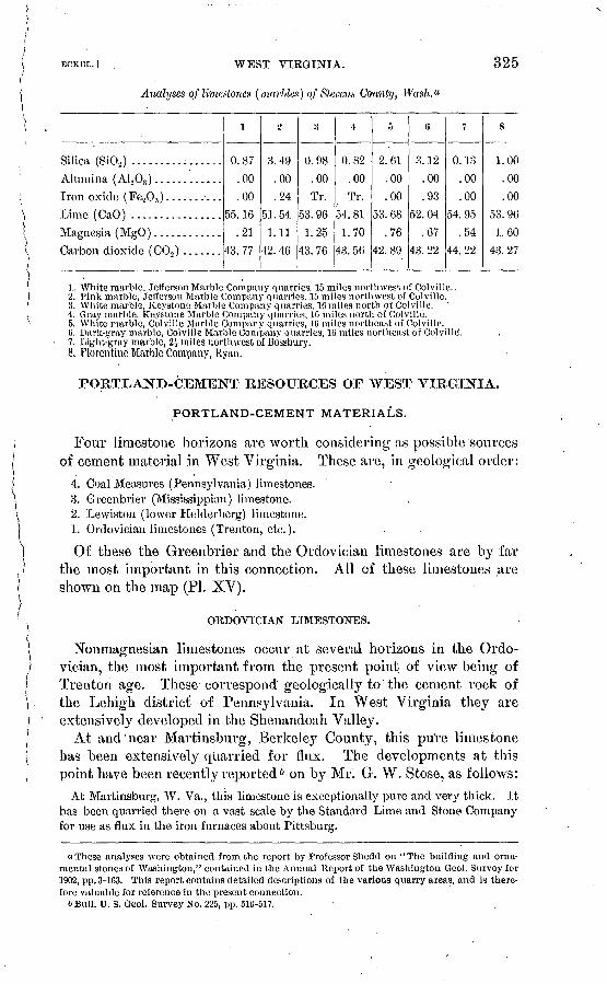
WEST VIRGINIA.
Analyses of limestones (marbles) of Slevens County, Wash.
325
Silica (SiO») ................
Lime (CaO) ................
Magnesia (MgO) ............
Carbon dioxide (C02 ) .......
'0.87
.00
.00
55.16
.21
43. 77
t»
3.49
.00
.24
51. 54
1. 11
42.46
:t
0.98
.00
Tr.
53.96
1.25
43.76
+
0.82
.00
Tr.
54.81
1.70
43. 56
ft
2. 61
.00
.00
53.68
.76
42.89
c,
3. 12
.00
.93
52.04
.67
43. 22
7
0. 13
.00
.00
54. 95
.54
44.22
8
1. 00
.00
.00
53. 96
1.60
43.27
1. \Vhite marble, Jefferson Marble Company quarries, 15 miles northwest of Colville.2. Pink marble, Jefferson Marble Company quarries, 15 miles northwest of Colville.3. White marble, Keystone Marble Company quarries, 10 miles north of Colville.4. Gray marble, Keystone Marble Company quarries, 1C miles north of Colville.6. White marble, Colville Marble Company quarries, 10 miles northeast of Colville. 0. Dark-gray marble, Colville Marble Company quarries, 10 miles northeast of Colvillcf.7. Light-gray marble, 2£ miles northwest of Bossbury.8. Florentine Marble Company, Ryan.
PORTLAND-CEMENT RESOURCES OF WEST VIRGINIA.
PORTLAND-CEMENT MATERIALS.
Four limestone horizons are worth considering as possible sources of cement material in West Virginia. These are, in geological order:
4. Coal Measures (Pennsylvania) limestones. 3. Greenbrier (Mississippian) limestone. J2. Lewiston (lower Helderberg) limestone. 1. Ordovician limestones (Trenton, etc.).
Of these the Greenbrier and the Ordovician limestones are by far the most important in this connection. All of these limestones are shown on the map (PL XV).
ORDOVICIAN LIMESTONES.
Nonmagnesian limestones occur at several horizons in the Ordo vician, the most important from the present point of view being of Trenton age. These correspond geologically to the cement rock of the Lehigh district of Pennsylvania. In West Virginia they are extensively developed in the Sheuandoah Valley.
At and'near Martinsburg, Berkeley County, this pure limestone has been extensively quarried for flux. The developments at this point have been recently reported & on by Mr. G. W. Stose, as follows:
At Martinsburg, W. Va., this limestone is exceptionally pure and very thick. It has been quarried there on a vast scale by the Standard Lime and Stone Company for use as flux in the iron furnaces about Pittsburg.
"These analyses were obtained from the report by Professor Shedcl on "The building and orna mental stones of Washington," contained in the Annual Report of the Washington Geol. Survey for 1902, pp. 3-163. This report contains detailed descriptions of the various quarry areas, and is there fore valuable for reference in the present connection.
b Bull. U. S. Geol. Survey No. 225, pp. 610-517.

326 CEMENT MATEEIALS AND INDUSTBY. [BULL. 243.
The limestone outcrops in a belt extending southward from the town. On the east side is a low ridge of Hudson shale containing graptolites of.Utica age near the base. Dipping at an angle of 20 degrees under these beds are 90 feet of dark, com pact, crystalline and shaly limestones bearing fossils of Trenton age. Below this are three or four heavy beds of pure limestone averaging 15 to 20 feet in thickness, with a total of about 80 feet. This is the deposit that is quarried. The upper bed is a very massive, compact, light-gray limestone, weathering chalky white on the surface, with smooth fracture and but slight indications of bedding'. The lower beds are darker, coarser grained, not so homogeneous, and have a rough fracture, and at the base are thinner bedded. The only fossils observed in these beds are a few Leper- ditia found in the upper layers, indicating Lowville (Birdseye) age.
The whole of this mass is quarried, and is stated to average 98 per cent carbonate of lime. The two samples tested by the Geological Survey contained 96.2 and 97.7 per cent. The limestone is quarried in an open cut-200 to 250 feet wide and 80 to 100 feet deep, the workable depth depending upon the amount of stripping that is profitable. The open cut extends for over 1J miles along the strike and is being worked along its entire length. The same beds apparently continue beyond, to the south, and there is every reason to believe that they also occur along the strike north of the town. The rock is taken out on train cars, is crushed to 5-inch size, and is loaded directly into the railway cars on the track. The reason that the stone can be profitably shipped such a distance is that the cars which transport the coal from the Pennsylvania mines to the south return loaded with limestone, thus avoiding an empty return run, and the freight rates are reduced to a minimum. It is reported that from 20 to 50 carloads a day of the crushed rock are shipped. With a quarry face of 80 feet and the dip of the rocks 20 degrees, the estimated output of the quarry per rnile is about 3,000,000 tons.
An analysis by. Rogers a is given below. It is of a specimen from a point 4 miles from Harpers Ferry, on the road to Martinsburg.
Analysis of limestone from near Harpers Ferry,, W. Va.
Silica (SiO^) ............................................................. 1.83Alumina (A1203)..................................... ....................\ ^Iron oxide (Fe203)...................................................... JLime carbonate (CaC03)................................................... 95. 86Magnesian carbonate (MgC03 )...................... .................--... 1.46
LEWISTON (LOWER HELDEBBEKG) LIMESTONE.
The Lewiston limestone, although occurring in West Virginia, is not so available a source of cement material as the Trenton and Greenbrier limestones. The only obtainable analysis of rock from this location is given below, quoted from Rogers. The specimen analyzed was from Pattersons Creek, near Hampshire Furnace.
a Geology of the Virginias, p. 170.

ECKEr,.] WEST VIRGINIA. 327
Analysis of Limestone from Pattersons Creek, West Virginia.
Silica (Si02).........-.-.-.-.-........-..-............................... 4.96Alumina (Al^Oa) .....:................................--.................\Iron oxide (Fe203 ).......-............--.-.-..-...-............--.-.-..--/Lime carbonate (CaC03 )...................... ............................ 92.44Magnesian carbonate (MgC03 ) ............................................ 1.40Water.................:..................,.............................. .52
GREENBRIER LIMESTONE.
As shown on the accompanying geological map the Greenbrier (Mississippian or Lower Carboniferous) limestone is well developed in West Virginia, reaching its maximum thickness in its type area in Greenbrier County. At Manheim, on Cheat River, east of Grafton, this limestone is now used b}^ the Buckhorn Portland Cement Company.
Throughout its entire range the Greenbrier limestone is mainly a very pure nonniagnesian limestone, though occasionally shaly 01' mag- nesian beds occur. Because of its thickness, its favorable composi tion, and its location with respect to fuel supplies and transportation routes, it is a very promising source of Portland cement material.
Analyses of Greenbrier limestone, West Virginia.
Silica (SiOj) ........Alumina (A1203 )....
Iron oxide (Fe208 ) . .Lime carbonate
(CaC03)..........Magnesium carbon
ate (MgCOs)......Water..............
i
0.97
jl.46
96.46
1.11 n.d.
2
19. 87
4.09
74.56
1.95 n.d.
;t
6.20
1.20
89.92
Tr..44
4
1.88
.56
95.92
Tr..40
&
6.04
.88
89.44
2.80 .84
6
0.40
.48
98,20
.24
7
5.80
1.16
89.76
2.32 .92
8
27.00
.88
67.40
2.32 .56
»
7.24
2.52
88.32
.72
10
6.00
1.52
88.52
3.24.72
n
26.96
1.60
64.00
6.76 .66
1. Huddleston quarry, Snow Flake, Greenbrier County. J. B. Britten, analyst. Twentieth Ann. Kept. U. S. Geol. Survey, pt. 6, p. 460.
2. Shavers Mountain, Randolph County. E. Whitfield, analyst. Bull. U. S. Geol. Survey No. 27, p. 74.
3. Near Red Sulphur Springs, Monroe County. Hogers, "Geology of the Virginias," p. 396.4. Near Union, Monroe County. Rogers, "Geology of the Virginias," p. 397.5. Two miles south of Kingwood, Preston County. Rogers, " Geology of the Virginias," p. 398.6. Muddy Cre,ek Mountain, near Blue Sulphur Springs. Rogers, "Geology of the Virginias," p. 396. 7,8. Cheat River, be'low Gum Camp Run, Preston County. Rogers, "Geology of the Virginias,"
p. 397.9. East side Laurel Hill, Monongalia County. Rogers, "Geology of the Virginias," p. 397.10. Front ridge, opposite Petersburg, Tucker County. Rogers, "Geology of the Virginia's," p. 398.11. East side Briery Mountain, Preston County. Rogers, " Geology of the Virginias," p. 398.
COAL MEASURES (PENNSYLVANIAN) LIMESTONES.
As in Pennsylvania and Ohio, thin limestone beds occur at many horizons in the Coal Measures of West Virginia. These limestones are usually low in magnesia, but are also quite low in lime carbonate, commonly ranging from 80 to 90 per cent in that constituent. As

328 CEMENT MATEEIALS AND INJDUSTBY. [BULL. 248.
Portland-cement materials their value depends entirely upon their nearness to fuel supplies, for they are neither thick enough nor pure enough to compare favorably under equal conditions with the Green- brier or Trenton limestones.
Analyses of Coal Measures limestones, West Virginia.
SUica(SiOj).. ........
Iron oxide (Fe203 ) ...Lime carbonate
(CaC08 ). ..........Magnesium carbonate
(MgC03 ) ..........
i
10.24
k 52
81.40
3.32 1.24
jj
10.88
1.92
86.80
Tr.
.60
3
13.28
1.68
84.40
Tr.
.64
4
32.04
7.00
56.48
2.48 2.00
5
0.92
.96
95.52
1.88 .76
6
10. 33
.90
[85. 75]
[2. 26] .05
7
1.53
.96
[95. 10]
[1.95] .10
8
1.60
1.60
96.20
Tr..60
9
7.20
2.00
89.72
Tr.
1.08
10
1.76
.80
83.92
2.80.72
1. Two and one-half mile southeast of Kingwood. Rogers's " Geology of the Virginias," page 400.2. 3. Ten Mile Creek, 1 mile from mouth, Kanawha County. Rogers's "Geology of the Virginias,"
page 524.4. Hughes Creek, Kanawha County. Rogers's "Geology of the Virginias," page 400.5. Clarksburg. Rogers's "Geology of the Virginias," page 401.6. 7. Moundsville Narrows, 12 miles below Wheeler. Bull. U. S. Geol. Survey, No. 9, page 17. 8, 9,10. Two Mile Creek, Kanawha County. Rogers's "Geology of the Virginias," page 525.
PORTLAND CEMENT INDUSTRY OF WEST VIRGINIA.
West Virginia has at present only one Portland-cement plant. This is the mill of the Buckhorn Portland Cement Company, located on the Cheat Biver at Manheim.
The materials used are the Green brier limestone, shales of the same series, and Quaternary clays from the river-flats. ' Analyses of these materials, by K. L. Humphrey, follow, and are quoted from Engi neering News, volume 50, page 409.
Analyses of cement materials, Manheim, W. Va.
Silica (Si02 ) ..........Alumina ( A1 203) ...... Iron oxide (Fe20;J ) ....
Limecarbonate(CaCOij)Magnesium carbonate
(MgCOs). ..........
Lower.
23. 40-20. 20
| 9. 10- 8. 80
60. 31-68. 89
Tr.
Limestone.
Middle.
18. 60-13. 08
7. 60- 6. 12
72. 27-80. 09
Tr.- .61
Upper.
8. 84- 2. 92
5. 04- 1. 82
85. 00-94. 00
. 72- 1. 10
62.74
19.40
.38
1.41
Clay.
68. 16
16. 18
.42
1.04

ECKEL,.] . WISCONSIN. 329
PORTLAND CEMENT RESOURCES OP-WISCONSIN.
OKDOVICIAN AND SILURIAN LIMESTONES.
The Ordovician and Silurian deposits in Wisconsin contain heavy and widely distributed beds of limestone. It is necessary, however, to warn the prospector that the chances for obtaining a well-located limestone sufficiently low in magnesia to be serviceable for this use seem to be very poor. Of the numerous analyses of Wisconsin lime stones that have been examined by the writer, only three show a limestone carrying less than 30 per cent of magnesium carbonate. Low-magnesia limestones exist in the State, but the chances seem to be against securing a satisfactory deposit of such material. So far as known, the only fairly thick and extensive bodies of low-magnesia limestone in Wisconsin-occur in the lead region in the upper part of the Platteville limestone, 0 heretofore referred to the Trenton series.
Mr. E. 0. Ulrich states that in the southwestern part of the State a generally thin and rather locally developed bed of relatively pure limestone forms the top of the Platteville. The "glass rock," as this bed is called, is probably better developed at Mineral Point and Platteville, Wis., than anywhere else in the lead district. At these localities it is filled with a highly characteristic fauna of late Stones Kiver age. The rocks deposited, upon it the Galena limestone are Black River and Trenton in age.
Farther east, as at Beloit, and thence northward to Escanaba, Mich., the "glass rock" is not represented in the sections. The ''upper buff" and "blue," however, occur continuously east and north of Janesvilie and Beloit, Wis., while they are wanting, at least locally, in the lead region. Both the "upper buff and blue" probably the latter certainly represent a horizon intermediate between the lowest Galena and the "glass rock."
Grant 6 has recently described this particular limestone as follows:
The "glass rock" belongs near the top of the Trenton limestone. This term has been applied to a number of varieties of limestone in this general horizon. It may be said that thevnaine is used for very fine grained, compact, and hard beds of lime stone which occur near the top of the Trenton. This is about as accurate a general definition of the term as can be given. There is, however, one particular phaseof this rock which may be called the typical glass rock and which is apparently the rock to which the name was first applied. This is a very fine grained, very compact limestone, which breaks with a conchoidal fracture and which when fresh is of a light-brown or chocolate color. On exposure to the air, however, this color changes to a bluish gray. This phase of the glass rock is found in many places throughout the western two-thirds of the lead and /inc district. It usually occurs in thin beds, and in some places, especially at Platteville, is an important building material, the normal school building at this place and one of the high.school buildings being constructed almost
aBain, H. F., Zinc and lead deposits of northwestern Illinois: Bull. U. S. Geol. Survey No. 240, l'J05, pp. 18-20.
bGrarit, U. S., Geol. Wisconsin, vol. 2, p. G8.i, 1877.

7
330 CEMENT MATEKIALS AND INDUSTKY. [BULL. 243.
entirely of this rock. The fact that it does not occur in thicker beds prevents its universal use as a building stone. Very frequently this glass rock is packed full of fossils. It is a comparatively pure limestone, containing only a small amount of magnesia, the chief impurities being silica and clay.
The composition of this rock is shown by the following analyses.
Analyses of Platteville limestones, Wisconsin.
Silica (SiOa ) .......I.'............................:....Alumina ( A1 208 ) ......................................Iron oxide (-Fe20s ) ....................................
Magnesium carbonate (MgCOs) ........................Water ...... 1 .................... ̂ ....................
1
1.10
97.921.60n. d.
a
f 6.16
2.261.90
85.54
3.98.93
3
7.032.211.22
84.025.33.61
1. Near Benton, on the Fever River, Geol. Wisconsin, vol. 2, pp. 560-501.2. Mineral Point, Geol. Wisconsin, vol. 2, pp. 5CO-5G1.3. Bristol, Dane County, Geol. Wisconsin, vol. 2, pp. 560-561.
QUATERNARY SHELL MARLS.
As in Michigan, Ohio, New York, and other States north of the glacial limits, many lakes occur in Wisconsin, and some of these con tain deposits of marl. Little attention has yet been paid to these marl deposits and practically nothing can be said as to their occurrence and character. One noteworthy feature, however, should be borne in mind. As already shown, almost all of the limestone deposits of the State are highly.magnesian. As the marls are ultimately derived from local limestones,'it is to be expected that Wisconsin marls will Cany larger percentages of magnesia than marls occurring in areas of pure limestones. This seems to be indicated by the following analysis:
Analysis of shell marl, Wisconsin.
Silica (Si02 ) -........-................'.........-......................... 1.48Alumina (A1203 ) .................^.......................................\Iran oxide (F203 ) ...I...................................................J ' 19Lime carbonate (CaCOr).................................................. 86.09Magnesium carbonate (MgC03 ) ........................................... 7.18Sulphur trioxide (S0;,).......................... v......................... .44Water................................................................... 1. 67Organic matter........................................................... . 952
Sections 17,18, 19, and 20; town of Pierce, T. 24, R. 35. Kewaunee County. G. Bode, analyst. Geology of Wisconsin, vol. 2, p. 239.

fECKEL.] WYOMING. 331
PORTLAND-CEMENT RESOURCES OF WYOMING.
Limestones are extensively distributed throughout the State of , Wyoming, but little attention. has yet been paid to their economic value. The following analyses may prove serviceable in locating deposits that may be of use for lime or cement making:
Analyses of limestones, Wyoming.
Silica (Si02 ) .........
Iron oxide (Fe.203 )Lime (CaO) ..........
Magnesia (MgO) .....Alkalies (K2O,Na.,O) .
Carbon dioxide (C02).Water ...............
l
2.02
1 571 ' J<
54. 06
34n. d.42. 85
.42
2
22.22
.21
43.24
.15
n. d.
33. 94
.14
3
31. 28
J 1.83
1 .22
34. 20
.11
. 51
26.794.64
4
31. 451.58.21
34. 18
.08
.61
26.824 fi4
r>
23. 496.172.16
33. 79
.62
.38
27.086.27
0
23.476.272.20
33. 83.74
.38
27. 03
6.20
7
6.49
.37
54.16
.15
11. a.
J43. 68
8
1.52
. 31
54. 18
.15
n. d.
43. 69
9
0.43
.10
.12
55. 34
.21
n. d.J43.73
1 .05
1. Vermilion Creek Canyon. Upper Coal Measures.2. Near-Keel Buttes. Jurassic?3,4. Turtle Bluffs, north side of Menrys Fork. Eocene. 5,(1. Green River City. Eocene. 7,8. Five miles south of Cheyenne. Pleicene. 9. Three miles east of Liiramie. Carboniferous.Analyses 1-8 by B. E. Brcwster, Rept. U. S. Geol. Expl. 40th par., vol. 2; analysis 9 from Report
Territorial Geologist for Wyoming for 1888-89, p. 78.


! PART III. NATURAL-CEMENT RESOURCES OF THE UNITED) STATES.i
INTRODUCTION.\'i'i On the following1 pages an attempt will be made to discuss the natural
N cements as a class, emphasis being laid upon the points of resemblance of the various brands, their many points of difference being for a time disregarded. The difficulties encountered in such an attempt are greaterthan the reader at first sight may imagine, for few engineers realize what a heterogeneous collection of products is included under the well- known name of "natural cement." This lack of knowledge is easily explained. Under ordinary circumstances, natural cements are too low in value to be shipped far from their points of production. The
1 natural cement made at any given locality has usually, therefore, a well-defined market area, within which it is well known and subject to little competition. The engineer practicing within, such an area forms his idea of natural cements in, general from what he knows of the
; .brands encountered in his work, and as all the brands from one ceinent- i producing locality are apt to resemble one another closely he is likely ( to conclude that natural cements form a homogeneous class, with many \ points of resemblance and few of difference. On the contrary, there
} may be as much difference in strength, rate of set, composition, etc., between natural cements from two different localities as between any
; given brand of natural cement and a Portland cement.
DEFINITION OF NATURAL CEMENTS.
i The term "natural cements" is here used to include all cements pro- j duced by burning a natural limestone rock without previous grinding } or mixing. As so used it includes the class of doubtful products com-
\ } monty known as " natural Portlands," which are so largely made in i France and Belgium. The reasons for including these " natural Port
lands" with the natural cements instead of with the true Portlands are stated in considerable detail on pages 21-23.
Natural cements are produced by burning a natural clayey limestone, containing 15 to 40 per cent of silica, alumina, and iron oxide, without preliminary mixing and grinding. This burning takes place at a tem perature that is usually little, if any, above that of an ordinary lime-
. kiln. During the burning the carbon dioxide of the limestone is333

334 CEMENT MATEEIALS AND INDUSTEY. [BULL. 243.
almost entirely driven off, and the lime combines with the silica, alumina, and iron oxide, forming a mass containing silicates, alumi- nates, and ferrites of lime. In case the original limestone contained any magnesium carbonate the burned rock will contain a corresponding amount of magnesia and magnesian compounds.
The burned mass will not slake if water be poured on it. It is nec essary, therefore, to grind it rather fine; after it is ground, if the resulting powder (natural cement) be mixed with water, it will harden rapidly. This hardening or setting will take place either in air or under water.
RELATIONS OF NATURAL CEMENTS TO OTHER .CEMENTS.
Natural cements differ from ordinary limes in two very noticeable ways: (1) The burned mass does not slake when water is poured on it.(2) Natural cement powder has hydraulic properties; i. e., if properly prepared it will set under water.
Natural cements are closely related to hydraulic limes on the one hand and to Portland cement on the other, agreeing with both in the possession of hydraulic properties. They differ from hydraulic limes, however, in that the burned natural cement rock will not slake when water is poured on it.
Natural cements differ from Portland cements in the following important particulars: (]) Natural cements are made by burning masses of natural rock, not by burning carefully prepared and finely ground artificial mixtures. (2) Natural cements, after burning and grinding, are usually yellow to brown and light in weight, their specific gravity being about 2.7 to 2.9; Portland cement is commonly blue to gray in color and heavier, its specific gravity ranging from 3.0 to 3.2.(3) Natural cements are always burned at a lower temperature thanPortland, and commonly at a much lower temperature, the mass of rock in the kiln never being heated high enough to even approach the fusing or clinkering point. (4) Natural cements set more rapidly than Portland cement, but do not attain so high ultimate strength. (5) Various brands of natural cements will show very great differences in composition, while Portland cement is a definite product whose per centages of lime, silica, alumina, and iron oxide vary only between narrow limits.
RAW MATERIAL (NATURAL-CEMENT ROCK).
The material used in the manufacture of natural cement is invariably a clayey limestone, carrying from 13 to 35 per cent of clayey material, of which 10 £o 22 per cent or so is silica, while alumina and iron oxide together may vary from 4 to 16 per cent. These claye}^ materials give the resulting cement its hydraulic properties. Stress is often care-

HCKHL.] NATURAL CEMENTS. 335
lessly or ignorantly laid on the fact that many of the best-known nat ural cements carry large percentages of magnesia, but magnesia (in natural cements at least) may be regarded as being almost exactly interchangeable with lime, so far as the hydraulic properties of the product are concerned. The presence of magnesium carbonate in a natural-cement rock is then merely incidental, while the silica, alumina, and i<ron oxide are essential. The 30 per cent or so of magnesium car bonate which occurs in the cement rock of the Rosendale district, New York, could be replaced by an equal amount of lime carbonate and the burnt stone would still give a hydraulic product. If, however, the clayey portion (silica, alumina, and iron oxide) of the Rosendale rock could be removed, leaving only the magnesium and lime carbonates, the burnt rock would lose all of its hydraulic properties and would yield simply a magnesian lime.
This point has been emphasized because many writers on the sub ject have either explicitly stated or implied that it is the magnesian carbonate of the Rosendale, Akron, Louisville, Utica, and Milwaukee rocks that causes them to yield a natural cement on burning.
Since within very wide limits of composition any clayey limestone will give a natural cement on burning, it can readily be seen that sat isfactory natural-cement materials must be widely distributed and of common occurrence. Hardly a State is entirely without limestones sufficiently clayey to be available for natural-cement manufacture. The sudden rise of the American Portland-cement industry, however, has acted to prevent any great expansion of the natural-cement indus try. It would be difficult to place a new natural cement on the market in the face of competition from both Portland cement and from the older and well-established brands of natural cement. Such new nat ural-cement plants as have been started within recent years have mostly been located in old natural-cement districts, where the accu mulated reputation of the district would help to introduce the new brand. The only exceptions to this rule, indeed, were the Pembina plant in North Dakota, the Rossville plant in Georgia, and a plant in the State of Washington. Of these, the Pembina plant was estab-. lished with the intention of making Portland cement, but the raw ma terials soon proved to be unsuitable and the plant was converted. The plant in Washington is located in an area where any kind of cement is readily salable. The JRossville plant was built by an Akron, N. Y.j cement manufacturer to utilize a peculiarly satisfactory natural-cement rock.
METHODS OF MANUFACTURE.
The manufacturing methods at a natural cement plant are of the simplest kind, including merely the burning Q| the cement) rock and the pulverizing of the product.
336 CEMENT MATEEIALS AND INDUSTRY. [BOLL. 243. '(
The burning is carried on in vertical kilns, closely resembling linie l kilns in shape, size, etc. The limestone and fuel are usually fed into /' the kiln in alternate layers, though at a few plants more advanced j types of kilns are in use. The burned product is crushed and then ' reduced to powder, commonly in buhrstone mills. Recently advances have been made in crushing practice, and several plants now reduce their product in tube mills. The manufacturing processes have been , purposely stated briefly here, because further details concerning them will be found in the descriptions of the various natural-cement produc- ^ ing districts, which follow.
NATURAL-CEMENT RESOURCES OF GEORGIA. i
Two natural cement plants located in northwest Georgia use cement < rocks from two .different geological formations. '
The plant of the Chickamauga Cement Company is located at Ross- ville, Ga., a few miles south of Chattanooga. The slaty material used is a thin-bedded raw limestone of the Chickamauga (Ordovician) age, which is. here exposed over a considerable area. In geologic age, as well as in chemical composition, this rock is closely similar to the ' cement rock of the Lehigh district of Pennsylvania. The rock is ( quarried and carried up to four vertical sheet-iron kilns of a patented (Cummings) design, fired with coal. The burned rock is sent through a Cummings vertical crusher, and then finally reduced under three runs of 42-inch Esopus millstones. ' .
The product is marketed under the brands of Dixie (natural) and .' New South ("Portland"). Jt is, of course, all a natural cement, accord- j ing to present-day definitions of Portland cement, as it is not artifi- J cially mixed prior to burning, and the burning is conducted at too low j a temperature to give a true Portland. That a real Portland cement I could, however, be readily made from some of this material is proved / by the folloAving analysis of the burned product. This analysis, by Cummings, is quoted from the Twenty-first Annual Report of the United States Geological Survey, part 6, page 410:
Analysis of cement rock from Rossville, Ga. Silica (Si02 ) ......^...................................................... 22.^7Alumina (A1203)......................................................... 8.20Iron oxide (Fe203)....................................................... 2.50Lime(CaO)............: ................................................. 65. 68Magnesia (MgO)......................................................... 1.45
The Conasauga formation of the Cambrian is described by Dr. C. W. Hayes as "normally composed, at the base, of thin limestones, inter- bedded with shales, then of yellowish or greenish clay, shales, and at the top of calcareous shales, grading into blue seamy limestones."
The Western and Atlantic Railroad, now operated under lease by the Nashville, Chattanooga and St. Louis system, Gl'Q^es the outcrop

ECKBL.] GEORGIA. 337
of these rocks from above Adairsville to within a mile of Kingston. At one point near the southern end of this belt limestone obtained from beds lying near the top of the Conasauga formation has long been utilized in the-manufacture of natural cement at the plant of the Howard Hydraulic Cement Company, at Cement, Bartow County, Ga., about 2 miles north of Kingston.
In the low ridge east of the railroad at Cement station, a section of these Conasauga limestones has been measured by Dr. J. W. Spencer." The series shown, from the top down, was as follows:
Section near Cement Station, Ga.Feet.
Bine limestone............................................................. 8Slaty limestone (cement rock) ..'............................................ 4Blue limestone..................'....... .-............_..................... 6* Argillaceous limestone..................................................... 2
^Siliceous limestone (hydraulic) ............................................ 4^Siliceous limestone (cement rock).......................................... 7
1 Fine black limestone ....................................................... 12Earthy limestone........................................................... 3
When the plant Avas visited by the writer, in the fall of 1902, the three beds marked with asterisks were being worked for natural cement, and together constitute the "main cement bed" later mentioned in this article. Doctor Spencer quotes the following analyses, made by Mr. W. J. Land, of the cement rock:
Analyses of cement rocks from Georgia.
Magnesium carbonate (MgC03 ) .................................
Silica (Si02) ...................................................
Iron oxide (Fe203 ) ............................................
Alumina (A120S ) ..............................................
Water ........................................................
l
43.50
26.00
22.10
1.80
5.45
.15
1.00
2
55. 00
26. 10
10. 00
2.00
6.10
.50
.30
The mill is located at the side of the railway, the farthest quarry being only a few hundred feet away. The main cement bed at the quarry now worked is about 15 feet thick. In common with the other beds it dips eastward at an angle of about 20°. It is overlain and underlain l»y limestone beds of various composition, but none fit for the manufacture of natural cement. A thinner cement bed lay about 8 feet above the bed now worked, but was worked out by stripping and quarrying over a considerable area early in the history of the plant.
"The Paleozoic group of Georgia, p. 100.
Bull. 243 05 22

338 CEMENT MATEEIALS AND INDUSTBY. [BULL. 243.
All the cement rock used is now obtained by mining. Two inclines have been run in. on the dip of the beds. These inclines are, at and near their entrances, entirely in the cement bed, several feet of cement rock being left above and below them to serve as floor and roof. Farther in, however, the height of the passages is increased, and almost the entire thickness of the cement bed is taken out Pillars of cement rock are left at intervals to support the roof.
The cement rock is blasted out, sledged when necessary to a size convenient for the kilns, and loaded onto cars carrying about 1^ tons each. These cars run on narrow-gage tracks, which extend from near the heads of the workings to the kilns. As the grade in the inclines is heavy the cars are hauled out of the mine by wire cables, power being supplied by the crusher engine. Outside of the mine, how ever, the grade to the kilns is sufficiently light to permit the cars to be run by hand to the level from which the rock is fed to the kiln.
The kilns are of the familiar dome type commonly used in litne and natural-cement burning, and are six in number. Four are .jacketed with steel and lined with fire brick, the space between the jacket and the lining being filled with clay. The two remaining kilns differ from these only in the fact that in place of the steel jacket their exterior surfaces are laid up with rock. These rock-jacketed kilns are said to be somewhat more satisfactory than those of the steel-jacketed type.
All the kilns are 25 feet in height, and have an output of 60 barrels of cement each. The kilns are charged to the top with fuel and cement rock, in the proportions of about 300 pounds fuel to 2,500 pounds rock. . The fuel used is coal, the sizes being nut, pea, and slack, in about equal amounts. Seven or eight days are required, on the aver age, to "turn a kiln," including charging, burning, and drawing.
When the kilns are drawn the clinker is picked over and then car ried by a Jeffreys elevator to pot crushers of special design. On issuing from the crushers the material encounters revolving screens of about i-inch mesh. All material that does not pass these screens is sent back to be recrushed. The finer material which passes through this i-inch screen meets another revolving screen of about 50 mesh. Everything that passes through this fine screen is sent direct by a conveyor to the packing machines, while the material failing to pass the 50-mesh screen is sent to buhrstone mills, where it is ground, screened, and sent to the packers.
The Howard cement is marketed as the "Eed Keystone" brand, and is favorably known to the southern cement trade, having been extensively used in engineering work. It has certain properties which serve to differentiate it from other natural cements. In color it is lighter than any other natural cement known to the writer, the set cement being very light gray or yellowish gray. Its specific gravity

ECKHL.] ILLINOIS. 339
is low, so that cement barrels of the usual size will contain only about 240 pounds of Howard cement. Most of the product is, however, marketed in bags containing 80 pounds each. It is said not to stain masonry and to resist well the action of salt air and spra}^. Its final hardening is slow relative to the Louisville cements, and for this rea son it does not show up well in short-time comparative tests for ten sile strength, though at periods longer than a month it gives excellent results.
The Howard cement is high in both lime and magnesia, compared with the Louisville cements. Two analyses are given below, the first quoted in Cummirigs's American Cements and the second by W. M. Bowron. To these have been added the average of five analyses of typical Louisville cements.
Analyses of natural, cements.
Silica (SiO,) ..........................................
Alumina ( A^O,) .......................................
Lime (CaO) ..........................................
Magnesia (MgO )..........................-...'........
Howard cement.
1
22.58
7.23
3.35
48. 18
15.00
2
19. 60
} 11. 60
48.86
18. 14
Average Louisville cement.
23.72
8.51
43.57
9.26
NATURAL-CEMENT RESOURCES OF ILLINOIS.
Three natural-cement plants, operated by two companies, are now working in Illinois, near Utica, La Salle County. The rock used is a limestone belonging to the so-called "Lower Magnesian" group of early western geologists. It is of Ordovician age and underlies the St. Peters sandstone.
The section exposed in the neighborhood of the Utica cement plants is as follows, from the top downward: .
Section of cement rock beds exposed at Utica, 111.> Feet.
Cement rock............................................................. 7Limestone............-...............---....---------....-.--.-..-.-.-.. 16-22Cement rock............................................................. 6Sandstone ......................-.........--....---......-.---..-.--..--- . 2-4Cement rock............................................................. 5
Of the three cement rock beds shown in this section, the uppermost bed gives a very quick-setting cement while the two lower beds fur nish products of much slower set.

340 CEMENT MATERIALS AND INDUSTRY. [BULL. 243.
Analyses of natural-cement rocks, Utica, III.
Silica (SiOa ) ..........................Alumina ( A1.20,) ......................
Lime (CaO) ..........................Magnesia (MgO) ......................Alkalies (K20, Na,0) ..................
Carbon dioxide (C02) .................Water... ........ .....................
l
12. 229.393.90
24.4010. 43n.d.
. n.d.
38.48
2
17.013.352.39
32.858.45n.d.1.81
34.12
3
11 21.00
2.0024.3614.31
.18n. d.
f 34.90i« 3.00
4
21.12.
1.1223. 6615.22n. d.n.d.
35. 351.07
5
1 14.151 6.37
2.3526.3212. 10o . 181.81
34.702.03
(i Far too low; true value is probably over 4 per cent.1. F. W. Clarke, analyst. Sample collected by E. C. Eckel.2. C. Richardson, analyst. Brickbuilder, July, 1897.3. Blaiiey & Mariner, analysts. Quoted by Worthen, Geology of Illinois, vol. 1, p. 151.4. Blaney, analyst. Trans. Am. Inst. Min. Eng., vol. 13, p. 180.5. Average of preceding four analyses.
The kilns in use in the Utica district in Illinois are elliptical in cross section (plan) with vertical walls. The largest kilns of this type are 30 feet in their longest inside diameter artd 12 feet wide. Their total height, with foundation, is 50 feet, giving a clear height of 45 feet from bottom of draw hole to top of kiln. These kilns turn out 400 barrels (265 pounds each) of cement a day, taking 18 to 20 pounds of coal per barrel of cement. This corresponds to a fuel consumption of only 6.8 to 7.5 per cent.
The second size of Utica kilns is 20 feet by 9 feet in its inside diame ters. The smallest size is, like the others, elliptical, with inside diam eters of 14 and 7 feet, respectively, and a height of 32 feet from top of bridge wall to top of kiln. These kilns turn out 300 to 375 barrels per day.
All the diameters quoted above are internal measurements. Thekiln shell proper is of one-fourth-inch sheet iron. This is lined, suc cessively, with an 18-inch layer of ashes, 18 inches of stone or common brick, and 9 inches of fire brick.
Analyses of natural cements, Utica, 111.
Silica (SiOj) ..........................Alumina ( A.1 208 ) .......................Iron oxide (Fe203 ) ....................Lime (CaO) ..........................Magnesia (MgO) ......................Alkalies (K20, Na20) . .................
Water ....:...........................
1
19.8911.611.35
29.5120.385.96
| n.d.
a
27.6010.60
.8033.0417. 267.42
2.00
3
34.665.101.00
30.2418. 006.16
4.84
4
35.43
| 9.92
33.6720.98n.d.
n.d.
. \29.39
f 9.04\ 1.05
31. 6119. 15
6 C1
3.42
1. Haas and McGraw, analysts. Engineering News, April 30,1S96. 2,3. Quoted by Cummiiigs. American Cements, p. 36.4. J. V. Blaney, analyst. Trans. Am. Inst. Min. Eng., vol. 13, p. 180.5. Average of preceding four analyses.

KOKUL.'I INDIANA AND KENTUCKY. 341
NATUTCAIj-CEMENT RESOURCES OF KENTUCKY.
INDIANA AND
The plants of the " Louisville district " are mostly located in Indi ana, though one or two mills are in operation on the Kentucky side of the Ohio River. The rock is a fine-grained, clayey limestone of the Devonian age. In color it varies from light drab to dark or bluish drab, when fresh, weathering to a dull buff on long exposure. The cement bed varies from 10 to 16 feet in. thickness in the different quarries.
Analyses of natural-cement rock, Louisville district, Indiana-Kentucky.
Silica (8i02 ). ..-...-... ............
Iron oxide (Fe20,,) .................Lime (CaO) .......................
Magnesia (MgO) ....................Carbon dioxide (C02 ) ..............
I
9 fi92.77
1. 9529. 09
15.69
40. 14
2
9.802.03
1 . 40
29. 4.0
16.70
41. 49
s
13 (ft3.46
1.4534. 55
7.9735.92
4
15.214.07
1.44
33. 99
7.5735.03
5
18 334.98
1.6730. 41
8.0432.76
G
13.363.46
1.58
31. 49
11. 19
1 37.07
Analyses 1 to 5, inclusive, are by W. A. Noyes. Quoted-by Siebentlial, Twenty-fifth Ann. Kept. Indiana Dept. Geol. Nat. Res., pp. 380-3SG.
1. Hayisdalemill, New Albany Cement Company; used for "Crown" brand.2. Ohio Valley mill, Ohio Valley Cement Company; used for "Fern Leaf" brand.3. Falls City mill, Union Cement and Lime Company; used for "Diamond" brand.4. Speed mill, Louisville Cement Company; used for " Star" brand.5. Black Diamond mill, Union Cement and Lime Company; used for " Black Diamond" brand. 0. Average of the preceding five analyses.
Two st}T les of kiln are in use in the Louisville district. The older and smaller kilns are 36 feet in height, 8 feet in diameter at the top, enlarging to 12 feet at a point 24 feet above the base, and again con tracting to 4 feet at the base. These are drawn from a chute by use of a swinging gate or apron. Coal and rock are charged in alternate layers. About a week suffices for the passage through the kiln of any particular mass of material. These small kilns produce about 100 to 125 barrels (265 pounds each) of cement a clay.
The larger kilns are 54 feet from extreme base to top. Viewed from the outside they appear to be cj'linders 54 feet high and. 16 feet in diameter. Their interior space, however, is 10 feet'in diameter at the top, enlarging to 12 feet at a point 18 feet above the base. Below this level, though the interior walls still slope outward, the space is really contracted by the occurrence of a conical mass of brickwork in the center of the kiln. This cone throws the downcoming clinker toward the draw gates at the sides. A 9-inch lining of fire brick is set around the kiln space proper. This is followed by 9 inches of common'brick, and the space between the common brick lining and the exterior kiln

342 CEMENT MATERIALS AND INDUSTRY. [BULT,. 243.
shell (which is one-fourth inch iron) is filled with clay. A kiln of this size and type will produce 150 barrels of cement a day.
The coal used in these kilns-is bituminous nut and slack mixed, from Pittsburg or Jellico. About 25.6 pounds of coal are required to burn a barrel of cement (265 pounds), equivalent to a fuel consumption of about 9.5 per cent of the weight of cement produced.
Analyses of natural cements, Louisville district, Indiana and Kentucky.
Silica (Si02 ) .....'...........
Lime (CaO) ................
Magnesia (MgO) ............Alkalies (Na20,KaO) ........Carbon dioxide (C02 ) ........Water ......................
l
18.9211.02
1.9146.90«.97
n. d.11. d.n. d.
2
21.10
J7.50
44.40
7.00.80
11.181.16
3
22.54r-8. 24
12.14
42.315.392.82n. d.n. d.
4
23.295.962.16
41.2815. 391.98n. d.n. d.
(1
24.40
J6.20
41.8016.291.52
J9.89
(i
25. 28
(T. 8511.43
44.659.50n. d.
7.04
7
26.406.28
1.0045.229.004.00
7.86
8
23. 137.871.73
43.7910. 432.22
9.28
"Probably erroneous.
1. Quoted by Jameson, Portland Cement, p. 177.2. Quoted by Smith, Mineral Industry, vol. 1, p. 50.3. Diamond brand. Haas and McGraw, analysts. Engineering News, April 30, 189li.4. Star brand. Haas and McGraw, analysts. Ibid.5. Lord, analyst. Kept. Ohio Geol. Survey, vol. (>, p. 074.0. Hulme Star brand. Quoted by Cummings, American Cements, p. 35.7. Fern Leaf brand. .Quoted by Cummings. Ibid*8. Average of preceding seven analyses.
'NATURAL-CEMENT RESOURCES OF KANSAS.
The natural cement district of Kansas is located around Fort Scott, where a 4^-foot bed of natural cement rock outcrops. The rock is a dark-colored, fine-grained, compact limestone of Carboniferous age.It extends for a considerable distance throughout the State, but has been worked for natural cement only in the immediate vicinity ofFort Scott.
Analyses of natural-cement rock, Fort Scott, Kans.
Silica (SiOa ) ..................................Alumina ( A1 20S ) ..............................
Iron oxide (Fe203 ) .........................'..Lime ( CaO )..................................Magnesia (MgO) .............................
1
15. 214.56n. d.
36. 525.07
34. 27
2
17.262.05
5.4534. 455.28
32. 87
8
81.: F3 ",
3 1
35. C3 f
33 f
18. 093.444.27
35. 324.62
33. 38
1. Smith, Mineral Industry, vol. 1, p. 49.2. Brown, Cement Directory, 2d ed., p. 27C. S.'Riclmrdson, Brickbuilder, July, 1897. 4. Average of preceding three analyses.

HCKBL.] MARYLAND AND WEST VIRGINIA. 343
Two types of kilns are in use in the Fort Scott district, Kansas. The more common type is cylindrical, 10 to 12 feet in diameter and 30 to 40 feet in total height. The lower 10 feet or so is of stone, on which is set the kiln proper. This is constructed of one-sixteenth inch sheet iron, lined with successive layers of coal ashes, clay, common brick, and fire brick. These kilns are drawn daily, and yield 60 to 75 barrels of cement each a day. The fuel used is slack coal, either Arkansas semibituminous from Poteau or Huntingdon or a very sul phurous local coal which underlies the cement rock at Fort Scott. The coal is fed with the rock, and is used at the rate of 30 to 35 pounds per barrel of cement, equal to a fuel consumption of 11.3 to 13.2 per cent of the weight of cement produced. At a three-flame kiln the burning is managed by five men two feeding and three draw ing the kilns.
At one of the Fort Scott plants four-flame kilns are also in use. These have separate fire places, so that the fuel and cement do not come into contact. Lump coal must be used for these kilns, and they are said to be more expensive, both in labor and fuel, than the type above described.
Analysis of natural cements, Fort Scott, Kans. a Silica (Si02 ) ...........'...'.................'.....--.......-............... 23. 32Alumina (Al./^) ......................................................... 6.99Iron oxide (Fe-jO.,) -.--------.--.--------------.--.------.---..---------- 5. 97Lime (CaO) ............................................................. 53.96Magnesia (MgO).....................'..........................-.......'... 7.76Carbon dioxide (C02 ) ................................................... - * f 2 - °° Water
NATURAL-CEMENT RESOURCES OF MARYLAND AND WEST ) VIRGINIA.
1 The natural-cement industry of Maryland has been carried on in \ three separate areas. One of these areas includes the old plants at i Antietam and Shepherdstown. The other two areas include respec- | tively the plants at Cumberland and Potomac, in Allegany County, ! and that at Round Top, or Hancock, in Washington County. In both | of these areas the limestones used are of the same geologic age and
,' approximately of the same composition, so that they will be described together.
In geologic age the natural-cement rock of the Cuuiberland-Hancock district corresponds closely to that used in the various New York dis tricts, being assigned by geologists to the Salina group of the Silurian. It is a shaly limestone, varying in color from dark bluish gray to dull black. In the Cumberland area it is exposed in four beds of sufficient thickness to be worked, these cement beds being separated by shales and limestones. The separate beds vary from 6 to 17 feet in thickness.
aBrocke.tt's Double Star brand. Quoted by Cnmniings, American Cements, p. 35.

344 CEMENT MATERIALS AND INDUSTRY. [BOLL. 243.
.Analyses of natural-cement rocks, Cumberland and Hancock, Md.
Silica (Si02 ) ..........................'
Iron oxide (Fe203 ) ....................Lime (CaO) ..........................Magnesia (MgO) ......................Alkalies (Na.,0, K20) ..................Sulphur trioxide (S03 ) ................Carbon dioxide (C02 ) ...---.-......:..Water ................................
1
19.817.352.41
35.762.18n. d.a. d.
| 31. 74
t>
24.7416.746.30
23.414.096. 182.22
f 22.901 n.d.
«
} 27. 10
1.5036.402.52.30
n.d.31.38n. d.
4
f 28. 721 12.28
5.2225.541.10n.d.1.53
I 24.40
5
22.0712. 123.86
30.282.47
(«)(a)
27.60
"Data insufficient for averaging.1. Hancock, Md. C. Richardson, analyst. Brickbuilder, July, 1897.2. Cumberland, Md. E. C. Boynton, analyst. Quoted by Gillmore, Limes, Cements, and Mortars,
p. 125.3. Hancock, Md. C. Husc, analyst. Quoted by Gillmore. Ibid.4. Cumberland, Md. C. Richardson, analyst. Brickbuilder, July, 1897.5. Average of preceding four analyses.
Analyses of natural cements, Cumberland and Hancock, Md.
Silica (Si02 ) .....-.-.
Iron oxide (Fe203 ) . . . Lime (CaO) .........Magnesia (MgO) .....
l
25.7012.284.22
52.691.44
2
28.0210. 208.80
44.481.00
3
28.3010.124.42
49.603.76
4
28. 369.853.07
45.042.82
5
28. 3811.712.29
43.972. 21
6
30.0213.553.00
44.582.76
7
36. 6014. 585.12
37.502.73
8
29.3411.764.42
45.412.39
1. Cumberland, Md. A. W. Dow, analyst. Mineral Industry, vol. C, p. 90.2. Hancock, Md. Quoted by Cunimings, American Cements, p. 36.3. Cumberland, Md. A. W. Dow, analyst. Mineral Industry, vol. 6, p. 96.4. Hancock, Md. A. W. Dow, analyst. Ibid.5. Cumberland, Md. Quoted by Cummings, American Cements, p. 36.6. Hancock, Md. A. W. Dow, analyst. Mineral Industry, vol. 0, p. 96.7. Cumberland, Md. A. W. Dow, analyst. Ibid.8. Average of preceding seven analyses.
NATURAL-CEMENT RESOURCES OF MINNESOTA.
Two natural-cement plants are in operation in Minnesota. One. of them is located at Mankato, Blue Earth County, and uses a limestone of Lower Magnesian (Ordovician) age. The following- analyses of the raw material used at this plant have been published:
Analyses of natural-cement rock from Mankato, Minn.
Silica (Si02) ........................Alumina ( Al20,j) ....................Iron oxide (Fe^O,,) ..................Lime (CaO) ........................Magnesia (MgO) ....................Alkalies (K,0, Na20) ................Sulphur trioxide (SO,) ..............Carbon dioxide (C02 ) ...............
1
16. 005.852..7S
'22. 4014.99
.76n. d.
34. 11
2
12.144 fi^
1.8422.6616.843.52.13
39.07
3
1.0. 102.781.34
25.9614. 913.50.26
41.29
4
16.808.76Tr.
22.2011. 994.75.22
35. 90
5
8.903.301.02
24.8518. 491.53.18
41.80
6
11. 803.46Tr.
24.6416. 612.59.22
40.85
1. C. P. Sidener, analyst. Eleventh Ann. Kept. Minn. Geol. Survey, p. 179. 2-6. Clifford Richardson, analyst. Cement Directory, p. 206.

NEW YOEK. 345
The following analysis of the rock used by a natural-cement plant at Austin has also been published.
Analysis of natural cement rock from Austin, Minn.
Silica (SiO,) .................................................. ...........Alumina ( A1 S0S ) ........................................................ JIron oxide (Fj,03J --.---.--.-.------..----.-----.-----------.--.---.----- 2. 09Lime (CaO) ............................................................ 27. 55Magnesia (MgO) ........................................................ 13. 80Sulphur tri oxide (S08 ) .................................................. .06Carbon dioxide (C02 ) ................................................... 3(i. 84
NATURAL-CEMENT' RESOURCES OF NEW YORK.
In the State of New York natural cement is now manufactured in four distinct localities. These are, in order of importance, (1) theRosendale district in Ulster County, (2) the Akron- Buffalo district inErie County, (3) the Fayetteville-Manlius district, mostly in Onon- claga County, and (4) Howes Cave, in Schoharie County.
The clayey limestones used in these four districts occur in three different but closely related geological formations, all in the Upper Silurian group. The sequence and relation of these formations, from the top downward, is shown in the following table:
Formation.
(cement rock).
(cement rock).
Cobleskill limestone(not used for ce ment).
meut rock).
Ulster County.
bed of the Rosendale district.
bed of the Rosendale district.
Sclioharie County.
cement at H owes Cave.
Onondaga County.
Worked forcement at Manlius, etc.
Present inOnondaga County but rarely used for cement.
Erie County.
cement at Akron and Buffalo.
For convenience, these districts will be described not in the order of their relative importance, but in geographic order, from east to west.
ROSENDALE DISTRICT.
Rosendale district lies entirely in Ulster County, the principal cement-rock quarries being located at East Kingston, Rondout, Rosen dale, Burnewater, Laurenceville, and High Falls. Two distinct beds
346 CEMENT MATEEIALS AND INDUSTEY. [BULL. 243.
are worked at most of these points, differing in chemical composition as well as in geological age. Darton states" that at Rosendale the lower bed, or dark cement rock, averages about 21 feet in thickness, and the upper, or light cement rock, about 11 feet, the two cement beds being here separated by 14 or 15 feet of worthless limestone. The lower bed lies directly on the Clinton quartzite, the even upper sur face of which affords an admirable floor for the galleries. For about 18 inches at the bottom the dark cement rock is too sandy for use. With this exception, and a few small layers of chert, it is all available. At Whiteport the upper bed is 12 feet thick and the lower 18 feet, while they are. separated by 17 to 20 feet of limestone.
Analyses of natural-cement rock, Rosendale district, New York.
Silica (Si02 ) ................
Iron oxide (Fe203 ) ..........Lime (CaO) ................Magnesia (MgO) ............Alkalies (K20,Na20) ........
Carbon' dioxide (C02 ) .......
i
10.903.402.28
29.5714.04n. d.
.61
37. 90n. d.
2
15.379.132.25
25.5012.35
« n. d.
n. d.34.201.20
3
18. 11
4.643.00
24. 3014. 26n. d.
34. 01n.d.
4
18.768.341.85
25.9611. 00n. d. 1.35
32. 0011. d.
5
21.32
7.391.71
23. 7511.0711. d.
1.9030.74n.d.
0
21.41
}lO. 09
25.8010.09n. d.
.66
J30. 93
7
23.80c 4.17I 4.7122. 2712. 09
n. d. .90
r31.00I n. d.
8
18. 52
6.342.63
25.3112. 13
n.d. .90
j-33. 31
1. Lawrenceville. J. 0. Hargrove, analyst. Letter to writer, October 4,1900.2. Rondout. L. C. Beck, analyst. Mineralogy of New York, p. 78. 3-5. Lawrenceville. J. 0. Hargrove, analyst. Letter.6. Rosendale district. C. Richardson, analyst. Brickbuilder, July, 1897.7. Lawrenceville. J..O. Hargrove, analyst. Letter.8. Average of preceding seven analyses.
In the Rosendale district cylindrical kilns are used. These vary from 8 to 12 feet in diameter and from 20 to 36 feet in height. A kiln fed with one-half ton of anthracite, pea size, will give 75 to 80 barrels of cement a day. This is equivalent to a fuel consumption of about 7 per cent on the weight of cement produced. From one- fifth to one-third of the total product of the kiln may be overburned clinker or underburned rock. This item, however, depends largely upon the skill of the burners, though it is also affected by uncontrolla ble factors, such as temperature, weather conditions, force and direc tion of the wind.
«Thirteenth Ann. Rept. N. Y. State Geologist, vol. 1, 1894, p. 334.

ECKEL.] NEW YORK. 347
Analyses of. natural cements, Rosendale district, New York.
Number.
1.. ........
2..........3..........4..........5..........6.......... 7..........S.... .......9..........10..........11..........12..........
13..........1.4..........15..........
Silica (SiO,).
25. 91 27.98 24.30 27.75 30.84 29.00 30.50 24.42 22.77 17.17 21. 73 27.30
29.9822. 7528. 87'
Alumina (ALjOa).
6.20
7.28 7.22
5.50 7.75
10. 6.84 8.16
10. 10.
11. 18 7.1.4
6.88 13. 40 7.96
Iron oxide
(Fe.20;i ).
3.81 1.70 5.06 4.28 2.11
40 2.42 3.96
43 80
4.14 1.80
2.50 3.30 3.19
Lime (CaO).
34.62 37. 59 33'. 70 35.61 34.49 32.35 34.38 36.30 34.54 48.28 33.77 35.98
33. 23 37.60 35.89
Mag nesia
(MgO).
20.92 15.00 20.94 21.18 17. 77 19. 92 18.00 16. 93 21.85 19. 13 21.20 18.00
17.80 16.65 18.95
Alkalies (K,0,
Na»"0).
n. d. 7.96
n. d. Tr.
4.00 n. d. 3.98 n. d. 3.63
Tr. 2.99 6.80
7.10 n. d.
Sulphur trioxide
(S03 ).
n: d. n. d. n. d. 0.50 n. d. n. d. n. d. n. d. 1.44 1.20
n. d. n. d.
n. d. n. d.
Carbon dioxide (CO,,).
5.09. 2.
n. d. 4.05
3. n. d.
3. n. d. 2.84 3.38 n. d.
2.
3.5.00
Water.
2.80 49
n. d. n. d.
04 n. d.
78 n. d. 1.59
n. d. n. d.
98
13 1.36
1. " F. 0. Norton." Private communication.2. "F.O.Norton." Cummings, American Cements, p. 35.3. " F. 0. Norton." Lewis, Mineral Industry, vol. (i, p. 96.4. Bench's. ,1. 0. Hargrove, analyst: Private communication.5. Brooklyn Bridge. Cnmmings, American Cements, p. 35.(i. Lawrcnceyille, A. \V. .Dow, analyst. Mineral Industry, vol. G, p. 90.7. Newark Lime and Cement Company. Cummingsi American Cements, p. 35;8. " Old Newark." Booth, Garrett & B.lair, analysts. Mineral Industry, vol. C, p. 96.9. ' Lawrence," Rosendale Cement Company. Mineral Resources United States for 1883-4.
K). " Kolfman," Lawrence Cement Company. Ibid, (very exceptional analysis).11. "HolYinan," Lawrence Cement Company. Haas & McGrnw, analysts, Engineering News, April
30, 1890.12. " HofTman," Lawrence Cement Company. Cummings, American Cements, p. 35.13. " flock Lock." Cummings. Ibid.I'l. Rondout. L. C. Beck, analyst. Mineralogy of New York," p. 78.15. Average of preceding fourteen analyses.
HOWES CAVE.
In the region north and northwest of the Rosendale-Rondout district no natural cement plants are to be found until Schoharie County is reached. Here, at Howes Cave, a single plant has long been engaged in the manufacture of cement from a 7-foot bed of rock.
Analyses of natural cement rock, Schoharie County, N. Y.
Silica (SiO,) ....................................:.....
Iron oxide (Fe/).j) ..............'.......................
Lime (CaO) ...........................................Magnesia (MgO )..........-...........................
Carbon dioxide f CO.,} .................................
l
12. 89
| 11. 15
30. 90
9.38
34.60
-
9.92
n. d.
n. d.
38. 26
9.00
39. 96
:j
\ 11.50
1.50
31.75
14. 91
40. 34
1. Bottom.' of cement bed, Howes Cave. C. 0. Sclmeffer, analyst. Eighteenth Ann. Kept. N. Y. State Geologist, p. 69.
2. Top of cement bed, Howes Cave. C. 0. SchaefTer, analyst. Eighteenth Ann. Kept. N. Y. State Geologist, p. 69.
3. Howes Cave. L. C. Beck, analyst. "Mineralogy of New York," p. 79.

348 CEMENT MATERIALS AND INDUSTRY. [BOLL. 243.
The following- anatysis is of the natural cement made at Howes Cave by the Helderberg Portland .Cement
Analysis of natural cement, Schoharie County, N. Y.
Silica ( Si02 )............................................................. 26. 54Alumina ( A1203) ....................... 1 ................................ .|Iron oxide (Fe2Qs ) ........................... ̂ ............... ........ .....f ^^Lime (CaO ) .......................................'...................... 45. 30Magnesia (MgO) ................."........................................ 17. 06
CENTRAL NEW YORK.
The cement industry in central New York is at present practically confined to Onondaga County, though, as a matter of historical interest, it may be noted that the first natural cement made in the United States was manufactured in 1818 in Madison County.
The natural-cement rock of this central district occurs in two beds, which are usually separated by 1 to 4 feet of blue limestone. The upper cement bed is a little over 4 feet thick at the eastern border of Onondaga County, becoming thinner to the west until it pinches out entirely in the Split Rock quarries, but reappearing again at Marcellus Falls, where it is almost 3 feet thick, and showing a thickness of slightly over 4 feet at Skaneateles Falls. At this point it is separated from the lower cement bed only by a shaly parting a few inches thick, so that the two are worked together as practically one bed, 9i feet thick. The lower bed is less variable in thickness, ranging from 4 to a trifle over 5 feet.
The entire cement series is overlain by purer limestones, but the cement rock quarries are usually located at points where these over lying limestones are thin and can be readily stripped.
Analyses of natural-cement rock, central New York.
Silica (SiOa )..--- - --.-.-.---.
Alumina (A1 203 )... ..........
Lime (CaO) .................Magnesia (MgO) .............
Carbon dioxide (C02 ) . .......Water. ......................
i
10. 97
4.461.54
27.51
16.90
37. 94
n. d.
2
10.95
5.32
1.30
30.92
13.64
38.31
n.d.
:t
| 13. 50
1.25
25.24
18.80
39. 80
1.41
4
f 8.95
I 4.90
1.75
27.35
16.70
38.65
1.70
5
11.76
2.73
1.50
25.00
17.83
39^33
1.50
t;
10.66
4.35
1.47
27.20
16.77
38.81
1.53
1. Upper cement bed, E. B. Alvorcl quarry, Jamesville, Onondaga County. Bull. 44, N. Y. State Mas., p. 80C.
2. Lower cement bed, E. B. Alvord quarry, Jamesville, Onondaga County. Bull. 44, N. Y. State Mus., p. 806.
3. One and one-half miles west of Manlius, Onondaga County. L. C. Beck, analyst. "Mineralogy of New York," p. 81.
4. One and one-half miles southwest of Chittenango, Madison County. L. C. Beck, analyst: " Min eralogy of New York," p. 80.
5. Chittenango, Madison County. Seybert, analyst. Trans. Am. Philos. Soc., vol. 2, n. s., p. 229.6. Average of preceding five analyses.

ECKBL.] NEW TOBK. 349
The kilns in the central New York district are described a as egg- shaped, 10 feet in diameter at the top, 12 feet at the middle, and 3£ feet at the bottom, with a height of 28 to 42 feet. There are usually several kilns built together in an embankment of very heavy masonry, so constructed against a hillside that the raw material can be conven iently conveyed there from the quarry and the burned cement easily removed from the bottom of the kiln. The kilns are built of lime stone and lined either with sandstone or fire brick.
When a kiln is ready to be filled a cord of dry, hard, 4-foot wood is put into the bottom and covered 4 inches deep with coarse anthracite coal, then a layer 1 foot thick of cement rock, succeeded by another layer of coal, partly coarse and partly fine. This is repeated till the kiln is filled to the top, which required about 10 tons of coal and 15 cords of stone, equal to 1,500 bushels of cement. Then the fire is started at the bottom and gradually works its way upward until the whole mass is glowing with heat. After two or three days the gate or door in the bottom is openedand through it the burned cement rock is drawn to the amount of 250 to 300 bushelsper day, fresh coal and rock being constantly added to keep the kiln full to the top. One cord of cement rock makes 100 bushels of cement.
Analyses of natural cements, central Neiv York.
-
Silica (Si02 ) .................................
Alumina ( A1 20S ) .............................
Lime ( CaO) ..................................
Magnesia (MgO) .............................
i
20. 30
j. 13. 67
47.4818. 55
k>
16. 56
10.77
39.5022.27
3
35. 43
9.92
33.6720.98
4
94 in
11. 45
40. 22
20.60
1. Brown Cement Co., Manlius, Onondaga County. W. M. Smith, analyst. Twentieth Ann. Kept. U. S. Gcol. Survey, pt. G, p. 428.
2. NearChiltenango, Madison County. L. C. Beck, analyst. "Mineralogy of New York," p. 80.3. South of Utica, Oneida County. Gillmore, " Limes, Cements, and Mortars," p. 125.4. Average of preceding three analyses.
AKRON-BUFFALO DISTRICT.
In Erie County natural-cement plants have long been established at Akron and Buffalo. The bed of cement rock used varies in thickness from 5 to 8 feet. It is a firm, fine-grained, compact rock of a blue- gray color, weathering to a yellowish white. The Buffalo plant works its cement rock by quarrying methods, stripping off the overlying limestones, but the plants at Akron all obtain their raw material by mining.
None of the analyses given below are entirely satisfactory. Accord ing to Mr. Uriah Cummings these analyses represent the composition of a bed of limestone occurring in the same.,quarries with the cement rock, but not actualty used for cement.
« Luther, D. D. The economic geology of Onondaga County, N. Y. Fifteenth Ann. Kept. N. Y. State Geologist, vol. 1, pp. 241-303. 1897.

350 CEMENT MATEEIALS AND INDUSTRY. [BULL. 243.
Analyses of natural-cement rocks, Akron-Buffalo district, New York.
Silica (Si02 ) ..................................
Iron oxide (Fe203 ) ............................Lime(CaO) ..................................
Alkalies (K,0, Na,0). .........................
Water ........................................
1
9.032.25.85
26.8418. 37
.85n. d.40. 33
.98
a
10.68
| 4.61
25.6517.93n. d.n. d.
| 41. 13
3
« 33. 80( 3.96
I .88
19.939.17n. d.
.50
25.90
4
9.853.10.87
26.2518.15
« Called " Silica, clay, and insoluble silicates."
1. G. Steiger, analyst. Bulletin U. S. Geol. Survey, No. 168.2. Lath bury and Spuckman, analysts. Letter from manufacturers to writer, 1901.3. E. Boyriton, analyst. Gillmore, Limes, Cements^ and Mortars, p. 125.
Mr. Heinrich Ries states that two types of kilns are in use at the Cummings plant at Akron, Erie County, N. Y. Of 17 kilns in use there at the time of his visit 8 were of rectangular cross section, 9 by 22 feet in area, with a height of 34 feet. The remaining 9 were cir cular in cross section, with a diameter of 9 feet and a height of 34 feet.
The crushing practice at the Cummings plant at Akron, N. Y., is stated a to include the following processes:
At this works a general system of reduction is used, consisting of (1) Sturtevant crushers, (2) Cummings pulverizers, (3) ten run of 42-inch underrunner millstones faced with chilled-iron plates, and (4) ten run of 42-inch Esopus underrunner mill- stQnes. The material, as it is conveyed from one to another of these sets of crushers,
is made to pass over screens, whereby such material as has been reduced to properfineness is separated from the mass and is spouted to a general conveyor, which finally receives the product from all the grinding machines and conveys it to the packing house.
Each set of crushers, while it furnishes a certain percentage of fin ished product, reduces the entire material to such fineness that what is fed to the fourth series is about the size of wheat kernels and very hard to reduce. These harder-burned portions make a cement which has a much higher tensile strength than the normally burned product.
The practice at the Buffalo plant, in Erie County, N. Y., is thus described by Ries: :
Both the normally burned and the clinkered material are fed into the grinding machinery. The first set of machines are Stedrnan disintegrators, and the product from these is passed over a screen, all that passes through representing the normally
" Ries, H. Lime and Cement Industries of New York, Bulletin 44, New York State Museum, pp. 836-837.
ECKKL.] NORTH DAKOTA. 351
burned cement rock. The clinkers which are not broken fine enough by the disin tegrators to pass the screen are conveyed to a Griffin mill, where they are ground to make "Portland" cement.
Analyses of natural cements, Akron-Buffalo district, New York.
Silica (Si02 )... .......Alumina ( Al^O^) .....Iron oxide (Fe203 ) ...
Magnesia (MgO) .....Alkalies (KZ0, NaaO) . Carbon dioxide (C02 ).Water ...............
l
17. 147.61'2.00
36. 8325. 09
3.64 n. d.n d
2
22.70
J7.40
36. 3.1.
25. 72
n. d.
J4.00
:i
22.62
r7. 44
11.40
40. 68
22.00
2.23
3. 63
4
26. 697.211.30
4.q 19
19. 551.13
1.00
5
24. 30
2.61
6.20
39. 45
6.16
5.30
15. 23
<;
26.697.211. 30
KO 1 0
9,551. 13
7
33. 804.66
52.289.26
8
29. 64
6.42
54.77
9. 17
!)
22.29
7.32
1.57qq oq
23. 12
2.33
? 88
' Union Akron" brand. Haas and McGraw, analysts. Engineering News, April 30,1896. Buffalo Portland" brand. Lord, analyst. Report Ohio Geological Survey, vol. 0, p. 074.
American Cements, p. 35.'Newinan Akron" brand. Quoted by Cummings.'Obelisk" brand. Quoted by Cnmmings. Ibid. 'Buffalo Hydraulic" brand. Quoted by Cummings. Ibid.
6-8. Quoted by Uriah Cummings in letter to writer, January 30,1901, as analyses of various cements made at Akron. Compare No. 6 with No. 4.
9. Average of analyses Nos. 1, 2, 3, and 4.
RESOURCES OF NORTH DAKOTA.
The single natural-cement plant operating in this State is located about 10 miles east of Milton, Cavalier County. The rock used is a soft, chalky limestone of Cretaceous age, and outcrops in a bluff sev eral hundred feet high. At present, however, only a 10-foot bed is being worked by mining.
Analyses of natural cement, North Dakota.
Silica (SiO,) ........
Alumina (Al^Oj) ....
Iron oxide (Fe203 ) ..
Lime (CaO) ........
1
24.62
J15. 12
52. 30
'2
23.60
16. 50
51.40
3
23.90
15.90
51. 4.0
4
24.72
15.00
51. 30
5
24.40
15.26
52.07
<>
24.40
15.38
51. 96
7
24.06
15. 00
51.96
8
24. 46
15. 30
52. 37
«
......
1-8. Analyses of natural cement, Pembina Cement Company, Milton, N. Dak. 9. Average of preceding eight analyses.
At the Penibria plant a kiln 40 feet high and 10 feet in external diameter is used. The shell is of one-eighth-inch No. 14 boiler iron. The kiln space is broadest at the top, narrows down to a throat about 6 feet in diameter, below which it again enlarges, reaching almost to the kiln shell at 15 feet above the1 base. Below this it is again.some-

352 CEMENT MATERIALS AND INDUSTRY. [BULL. 243.
what contracted to the drawing level. The kiln space is lined with 8- inch fire brick, and the space between these brick and the kiln shell is filled with ashes. This kiln produces about 50 barrels of 265 pounds each a day, with a fuel consumption of 1 ton of Youghiogheny slack. Lignite slack, mixed half and half with Youghiogheny slack, has been used at times, and apparently gives almost as good results as the bitu minous slack alone. About 10 per cent of the total product is under- burned or clinkered. This record is about equivalent to a fuel con sumption of 40 pounds per barrel, or 15.1 per cent on the weight of cement produced. This is rather high fuel consumption: for natural cement; but, on the other, hand, the product is of peculiarly high grade, passing most Portland standards.
Analysis of natural cement rock, North Dakota.
.
Silica (Si02 ) .............
Sulphur trioxide (S03 ) ....
Sulphur (S). .............
l
14. 00
J6. 70
37.60'.58 1:45
2
16.60
7.10
35.50 .60
1.38
3
13.10
7.60
37. 80
n. d.
n.d.
4
16.20
7.56
35.10 n. d. n. d.
5
16. 54
8.20
35. 20
n.d.
n. d.
G
14.90
8.28
36.90
n.d.
n. d.
1
15.24
7.26
36.70
.40
1.99
8
19.20
8.90
32.60
li. d.
n.d.
0
17.36
8.78
34.90 n.d. n.d.
10
16.00
7.50
35.60 .67
1.61
NATURAL-CEMENT RESOURCES OF OHIO.
Small natural-cement plants have, been established at various points in Ohio, those at Defiance and New Lisbon being worthy of some notice. The Defiance plant used a black calcareous shale of Devonian age. If published analyses be correct (see Nos. 1 and 2 in the follow ing table), this rock is by far the most argillaceous material used any where for this purpose.
Analyses of natural-cement rocks, Ohio.
Silica (Si02) .........................
Alumina ( A1203 ) .....................
Lime (CaO) ..........................Magnesia (MgO) .....................Carbon dioxide (C02 ) ................Water and organic. ...................
1
39.95
| 20. 22
10.062.92
} 24.03
2
42.00( 7.001 7.10
9.915.81
c 14.181 14.00
3
16.41
5.44
3.38
26.05
12. 55
34.32
n.d.
4
30.60
} 13. 00
22.74
7.23
25.81
n.d.
5
15.65
( 6.80
I 2.50
38.64
1.62
32.14
n.d.
1. Defiance. J. E. Whitfield, analyst. Bull. U. S. Geol. Survey No. 55, p. 80.2. Defiance. E. C. Ked/ie, analyst. Cement Directory.3. Bellaire. N. W. Lord, analyst. Repts. Ohio Geol. Survey, vol. C, p. 673.4. Warnock. Wormley, analyst. Kept. Ohio Geol. Survey, 1870, p. 451.5. New Lisbon. N. VV. Lord, analyst. Kept. Ohio Geol. Survey, vol. 6, p. 673.

PENNSYLVANIA. 353
NATURAL-CEMENT RESOURCES OF PENNSYLVANIA.
A fairly large production of natural cement has always, been main tained in the Lehigh district of eastern Pennsylvania, though at pres ent natural-cement manufacture there is merely incidental to the great Portland cement industry of the district.
The analyses following purport to be representative of the rock used at various Lehigh district natural cement plants. It is hardly necessary to .say that Nos. 1 and 3 are absolutely unfit for such use. No. 2, on the other hand, is quite satisfactory. It is regrettable that these very untrustworthy analyses are at present the- only ones available.
Analyses of natural-cement rock, Lehigh district, Pennsylvania.
.Silica (SiOa ) ..................................Alumina ('Al^OO ..............................
Lime (CaO) .................'. .'. .............Magnesia (MgO) .........................'. ...
Water. . ......................................
1
11: 62
} 6.25
44.201.27
36. 11n. d.
^
18.34
7.49
37.601. 38
31.063.94
»
27.77
14. 29
29.941.55
1 26. 30
4
19. 24
9.34
37. 251.40
32.47
1. Siegfried, Pa. Mineral Industry, vol. 1, p. 49.2. Ooplay, Pa. Ibid.8. Lehigh district. Quoted by C. Richardson. Brickbnilder, July, 1897.4. Average of preceding three analyses.
The natural-cement kilns at one of the prominent Lehigh district plants are about 30 feet in height, and of circular cross-section. Inter nally they are almost exactly cylindrical, being 10 feet in diameter at the top and 9£ feet in diameter at the base. The cement rock and fuel are fed in alternate layers, the fuel being anthracite coal broken to about one-half inch size. From 35 to 50 pounds of coal are required to burn one barrel (300 pounds) of cement, corresponding to a full consumption of ll.fi per cent to 16.7 per cent of the weight of cementproduced.
Analyses of natural cements, Lehigh district, Pennsylvania^
Silica (Si02 ) . .............. ̂ ........... ........................Alumina ( Al20n) ..............................................Iron oxide (Fe203 ) ............................................Lime (CaO) . ...................:..............................Magnesia (MgO) ..............................................Alkalies (K 20, Na20) . ..........................................
Carbon dioxide (C02 ) ..........................................Water ........................................................
l
18. 18
| 9.78
69.181.98
n. d.n. d.n. d.n. d.
a
18.28,
7.43
' 51.532.071.50n. d.
} 16.26
Bull.. 243 05-' Quoted by Smith. Mineral Industry, vol. 1, p. 5.Q.. 23.

354 CEMENT MATEEJALS AND INDTJSTBY. TBULL. 243.
NATURAL-CEMENT BESOUBCES OF TEXAS,
The analysis below has been published" as representing the average of the material used in making natural cement by a Texas natural- cement plant. It is obvious that, if this statement be correct, the product obtained by burning a rock of such composition can not be a natural cement in an}^ proper use of the term. It would, in fact, be merely a very weak hydraulic lime.
Analysis of natural cement rock, Texas. Silica (Si02 )...............'....'.......................................... 5. 77Alumina (A1 203 )......................................................... 2.14Iron oxide (Fe203 )....................-....-.....---..-...;.......-.-....Lime (CaO)...................-................--.--........-........... 50. 45Magnesia (MgO).. .............I.......................................... .28
NATURAL-CEMENT BESOUBCES OF VIBGINIA.
For many years natural cement has been burned near Balcony Falls, Kockbridge County, Va. The rock used is a clayey magnesian lime stone of Cambrian age, closely related geologically to that used inWest Virginia, and described below. *
Analyses of natural-cement rock, Virginia.
Silica (SiOa ) ..........................................Alumina (A1 20S ) ......................................Iron oxide (Fe203 ) ....................................Lime (CaO) ..........................................
Carbon dioxide (C02 ) .................................
i
17.38
| 7.80
34.239.51
30.40
2
17.21f Tr.I 1.62
24.8516.58
37.95
3
17. 306.181.62
29.5413.05
34.17
1. Balcony Falls. E. C. Boynton, analyst. Gillrnore, "Linies, Cements, and Mortars," p. 125.2. Balcony Falls. C. L: Alien, analyst. "The Virginias," vol. 3, p. 88.3. Average of preceding two analyses.
NATURAL-CEMENT RESOURCES OF WEST VIRGINIA ANDMARYLAND.
A wide belt of magnesian limestones of Cambrian age crosses Mary land into the eastern part of West Virginia. Several small natural- cement plants have been established at various times in this district, particularly near Antietam, Md., and Shepherdstown, W. Va.
NATURAL-CEMENT BESOUBCES OF WISCONSIN.
Two plants in Wisconsin are engaged in the manufacture of natural cement from a clayey magnesian limestone of Devonian age. These
a Twenty-second Ann. Kept. U. S. Geol. Survey, pt. 3, p. 737.

ECKEL.] WATUKAL CEMENT LITERATUBE. 355
plants are located north of Milwaukee, near the lake. The cement rock deposit is very thick compared to most deposits of similar rock, a quarry face 22 feet high being worked by the Milwaukee Cement Company.
Analyses of natural-cement rocks, Milwaukee district, Wisconsin.
Silica (SiOs ) .......:..........................
Iron oxide (Fe^03 ) ............................
Lime (CaO) ..................................
Magnesia (MgO) .............'.................
Carbon dioxide (C02 ) .........................
l
17.00
4.25
1.25
24.64
11.90
32.46
2
17.56
L41
3.03
25.50
15.45
37.05
8
17.56
1.40
2.24
27.14
13.89
36.45
4
16. 99
5.00
1.79
23.15
16.60
" 36.47
]. Mineral Industry, vol. 6, p. 95.2-4. Trans. Am. Inst. Min. Eng., vol. 8, p. 507.
The Campbell kilns in use at the plant of the Milwaukee Cement Company hold a charge equivalent to about 400 barrels (265 pounds each) of cement. This is drawn at the rate of 125 to 130 barrels a day, all the drawing for the day being done in ten hours. Nut and slack coal, mixed, are used for fuel. The fuel consumption amounts to about 30 pounds per barrel of cement, equivalent to 11.3 per cent of the weight of the cement produced.
Analyses of natural cements, Milwaukee district, Wisconsin, a
Silica (SiO,) ............................................................. 23.16Alumina (A1808 ) -----.----.------.--------.---------------.----..-.-..--- 6. 33Iron oxide (Fe203 ) ....................................................... 1.71Lime (CaO) .....^...................................................... 36.08Magnesia (MgO) ......................................................... 20. 38Alkalies (K20, Na,0)......,.............................................. 5.27Sulphur trioxide (S03)............................. .......:.............. n. c1 .Carbon dioxide (CO.,) ....................................................\ 7 QJWater.................................................................../
REFERENCES ON NATURAL CEMENTS.
CALIFORNIA.»
GRIMSLEY, G. P. The Portland cement industry in California: Eng. and Min. Jour., July 20, 1901.
CONNECTICUT.
LOWHEY, T. Water cement of Southington, Conn.: Am. Jour. Sci., vol. 13, 1828,pp. 382-383.
FLORIDA.
CUMMINGS, URIAH. [Natural cernent'rock in Florida]: Twentieth Ann.. Kept. U. S.Geol. Survey, pt. 6, 1899, pp. 549-550.
Cement rock in Florida: Brick, Nov. 1, 1899.
a Quoted by Cummings. American Cements, p. 35.

356 CEMENT MATEEIALS AND INDUSTRY. [BOLL. 243.
GEORGIA.
CUMMINGS, .URIAH. [Natural cement rock at Rossville, Ga.]: Twenty-first Ann.Kept. U. S. Geol. Survey, pt. 6, 1901, pp. 410-411.
SPENCER, J. W. Paleozoic group of Georgia: Ga. Geol. Surv., 18.
INDIANA-KENTUCKY.
LEWIS, F. H. The natural cement plant at Speeds, Ind.: Eng. Rec., Sept. 10, 1898;reprinted in Cement Industry, 1900, pp. 178-183.
SIEBENTHAL, C. E. The Silver Creek hydraulic limestone of southeastern Indiana:Twenty-fifth Ann. Rept. Indiana Dept. Geol. and Nat, Res., 1901, pp. 331-389.
KANSAS.
HA WORTH, ERASMUS. Hydraulic cement [in Kansas]: Mineral resources of Kansas for 1897 (1898), pp. 66-69.
NEW YORK.
BISHOP, I. P. The structural and economic geology of Erie County [N. Y.]: Fif teenth Ann. Rept. N. Y. State Geologist, vol. 1, 1.897, pp. 305-392; reprinted Forty-ninth Ann. Rept. N. Y. State. Mus., pt. 2, 1898, pp. 305-392.
GEDDES, G. Survey of Onondaga County, N. Y.: Trans. N. Y. Agric. Soc. for 1859 (1859), pp. 219-352. ,
LEWIS, F. H. ' The plant of the Lawrence Cement Co., Binnewater, N. Y.: Cement Industry, 1900, pp. 151-160.,
LEWIS, F. H. The plant of the New York and Rosendale Cement Co., Rondout, N. Y.: Cement Industry, 1.900, pp. 161-168.
LUTHER, D. D. The economic geology of Onondaga County, N. Y.: Fifteenth Ann. Rept. N. Y. State Geologist, vol. 1, 1897, pp. 241-303; reprinted Forty-ninth Ann. Rept. N. Y. State Mus., vol. 2, 1898, pp. 241-303.
NASON, F. L. Economic geology of Ulster Co., N. Y..: 13th Ann. Rept. N. Y. State Geologist, 373-407.
POHLMAN, J. Cement-rock and gypsum deposits in Buffalo: Trans. Am. Int. Min. Engrs., vol.'17, 1889, pp. 250-253.
RIES, HEINRICH. Limestones of New York and their economic value: Fifty-first Ann.1 Kept. N. Y. State Mus., pt. 2, 1899, pp. 355-467.
RIES, HEINRICH. Lime and cement industries of New York: Bull. 44 N. Y. State Mus., 1903, pp. 640-848.
OHIO.
LORD, N. W. Natural and artificial cements [of Ohio]: Rept. Ohio Geol. Survey, vol. 6, 1888, pp. 671-695.
VIRGINIA.
ANONYMOUS. James River, Va., Cement Co.: Engineer [London], Sept. 29, 1899.
WASHINGTON.
ARMSTRONG, L. K. Portland and natural cements of the Pacific Northwest: Mining, vol. 9, June, 1902, pp. 134-141.
WISCONSIN.
LEWIS, F. H. The plant of the Milwaukee Cement Co., Milwaukee, Wis.: Engr. Rec., Apr. 2, 1898; reprinted Cement Industry, 1900, pp. 169-177.

PART IV. MATERIALS AND MANUFACTURE OF PUZZOLAN CEMENTS.
PUZZOLANIC MATERIALS.
Puzzolanic materials include all those natural or artificial substances that are capable of forming hydraulic cements on being simply mixed with lime, without the use of heat. Many materials possess this prop erty, but relatively few have ever attained sufficient commercial importance to be discussed here. In composition the puzzolanic materials are largely made up of silica and alumina, usually with more or less iron oxide; some, as the slags used in cement manufacture, -carry 'also notable percentages of lime. As might be inferred from this com position, most of the puzzolanic materials 'possess hydraulicity to a greater or less degree, but the addition of lime usually greatly increases their hydraulic power.
NATURAL PUZZOLANIC MATERIALS.
Natural puzzolanic materials are widely distributed, though they have never attained much commercial importance save in Europe. They may be divided into two classes, according to origin. In the first class may be included all those which are the direct products of vol canic action, the material being a fine volcanic ash or dust deposited either on the slopes of the volcano or carried by the wind to lakes or streams in which the ash is deposited. This group includes the more active puzzolanic materials, its chief i epresentatives being pozzuolana proper, santorin, tosca, tetin, and trass. It may be noted that in origin materials of this class resemble closely the granulated slags used in slag-cement manufacture, both volcanic ashes and granulated slags' being due to the two processes of (1) fusion of a silico-aluminous material, and (2) rapid cooling of the resulting product by ejection i'nto air or immersion in water. The second class includes a number of less important (because less active) hydraulic materials, such as arenes, psammites, etc., which are materials resulting from the decay of certain igneous rocks.
Pozzuolana derives its names from the little town of Pozzuoli, located .a few miles west of Naples, at which point the material was first
.357

358 CEMENT MATERIALS AND INDUSTRY. [BOLL. 243.
obtained by the Greek colonists, and at a later date by the Romans. The material has also been exploited at other points near Rome and Naples.
Most of the Italian pozzuolana is obtained from small open cuts or pits, though some of these workings are now of great depth. Those of Trentaremi, for example, are about 600 feet deep. The various deposits differ greatly in the quality of the materials obtained from them. Care should therefore be exercised in selecting* a spot for exploitation, and sorting of the material dug would be advisable 'in order to keep the product of uniformly high grade. After extraction the material is screened and ground. In addition it is occasionally slightly roasted to increase its hydraulic properties. Carelessness, both in the mining and in the later preparation of the pozzuolana, has brought the Italian article somewhat into disrepute among European engineers. In consequence it is losing ground with respect both to pozzuolana from the Azores and to trass from Rhenish Prussia.
Pozzuolana has been shipped from San Miguel, in the Azores, to Portugal for over a hundred years, and has been used with veiy satis factory results in many important buildings, harbor works, etc. The Azores pozzuolana varies in color from yellowish to brownish, and sometimes to greyish. It is frequently so fine grained as not to require screening or grinding before use. A reddish-colored variety from the same islands is termed tetin.
The following analyses of pozzuolana are fairly typical of its range in composition:
Analyses of pozzuolana, Italy.
Silica (Si02 ).... ..............................Alumina (Al^OO ..............................
Iron oxide (Fe20s ) .............................Lime (CaO) . ..................................
Magnesia (MgO) ..............................Alkalies (K20, Na.,0) ..........................
Water, etc ....................................
l
52.6614.33
10. 33
7.66
3.864.13
7.03
2
60.9121.28
4.76
1.90
.0010.60n. d.
8
56.3115.23
7.11
1.74
1.3611. 38
6.12
4
44.5 15. 0
12.0
8.84.7
5.4
9.2
Trass, another puzzolanic material of commercial importance, is found in the districts bordering the Rhine in Rhenish Prussia. The towns of Brohl, Kruft, Plaidt, and Andernach, all about 10 to 15 miles southwest of Coblenz, are the principal points near which the material is worked. Trass is an ancient volcanic mud composed of a ground- mass of volcanic dust, in which fragments of pumice, volcanic rocks, etc., are embedded.

HCKBL.] PUZZOLAN CEMENTS. 359
In composition trass varies between the following extremes: Silica, 45 to 65 per cent; alumina, 10 to 23 per cent; iron oxide, 3 to 12 per cent; lime, 1 to 8 per cent; magnesia, 0 to 3 per cent; alkalies, 1 to 7 per cent; Avater, carbon dioxide, etc., 3 to 12 per cent.
Santorin, another puzzolanic material, is obtained from the island of Santorin, or Thera, one of the most southeasterly of the islands of the Grecian Archipelago.
ARTIFICIAL PUZZOLANIC MATERIALS.
By far the most important of the puzzolanic materials is blast furnace slag, especially in the United States, where natural puzzolanic materials of domestic origin have never come into use, though trass and puzzolanic cements made from it are imported to a small extent. Slag, on the other hand, is the basis of an important industry themanufacture of slag (puzzolan) cement. The materials and' processesused in making this product will be described in some detail on the following pages.
THE MANUFACTURE OF SLAG CEMENT.
Slag (puzzolan) cement is made by intimately mixing granulated blast-furnace slag of proper composition with slaked lime, and reduc ing this mixture to a fine powder. This product, though usually called a Portland cement by the manufacturers, is different from a true Portland in both its rational and ultimate compositions and in its processes of manufacture. Further than this and more important from the purchasers' standpoint, a cement of this class has certain qualities which prevent its being used as an exact substitute for Port land cement, though it is a good enough material for certain uses.
COMPOSITION OF THE SLAG.
The slag used in cement manufacture must be basic blast-furnace slag. Tetmajer, the first investigator of slag cements, announced as the results of his experiments (a) that the hydraulic properties of the slag increased with the proportion of lime contained in it, and that
slags in which the ratio r^- was so low as to approach unity were val-
ueless for cement manufacture; (J) that, so far as the alumina content of the slag was concerned, the best results were obtained when the ratioAl 0 .-L 3 gave a value of 0.45 to 0.50; and (c) that with any large increase
of alumina above the amount indicated b}^ this value of the alumina- silica ratio the tendency of the cement to crack (when used in air) was increased.

.360 CEMENT MATERIALS AND INDUSTRY. [BULL. 243.
Prost, at a later date, investigated the subject, using for experiment several commercial slags and also a series prepared from pure CaO, SiO2 , and A12 O3 . He decided that the hydraulic properties (both as regards rapidity of set and ultimate strength) of the slag increased as the proportions of lime and alumina increased, and failed to find any indication that a high alumina content causes disintegration. His best results were obtained from slags having the compositions respectively of 2Si02 , Al A, 3CaO and 281.0,, A1 8O8 , 4CaO.
Mahon in 1893 made a series of experiments to determine the value (for cement manufacture) of a large series of ; the slags produced by the furnaces of the Maryland Steel Company, and found that the slags giving the best results were two, having respectively the following compositions:
(1) SiO2 , 30 per cent; A1 2O3 , 17 per cent; CaO, 47.5 per cent; S, 2.38 per cent; and (2) Si02 , 25.3 per cent; A1 2O3 , 20.1 per cent; CaO, 48 per cent; MgO, 3.28 per cent; S, 2.63 per cent.
The ratios of ^-- and ' z % calculated for these slags are
, AlaO, , ,,,, CaO 1n Al,0, .'=1 - 58; =a57; !md w 1 - 9 ' =°- 79 -sio- si sio- siAt the close of the experiments Mahon recommended that slags be
used even slightly higher in alumina than those above quoted.The specifications under which slag from the furnaces is accepted
by the cement department of the Illinois Steel Company are as follows:(1) Slag must analyze within the following limits: SiO2 +Al203 not over 49 per cent; A1 2O3 , from 13 to 16 per cent;
MgO, under 4 per cent.(2) Slag must be made in a hot furnace and must be of a light-giuy
color! .(3) Slag must be thoroughly disintegrated by the action of a large
stream of cold water directed against it with considerable force. This contact should be made as near the furnace as is possible.
A series of over 300 analyses of slags used by this company in their slag (puzzolanic) cement, show the following range in composition:
Si02 , 29.60 to 35.60 per cent; A1203 and Fe203 , 12.80 to 16.80 per cent; CaO, 47.99 to 50.48 per cent; MgO, 2.09 to 2.81 per cent.
The requirements of the Birmingham Cement Company as to the chemical composition of the slags used for cement are as follows: The lime content shall not be less than 47.9 per cent; the silica and lime together shall approximately amount to 81 per cent; and the alumina and iron oxide together shall equal from 12 to 15 per cent.
Analyses of a number of slags used in cement manufacture are shown in the table below. The analyses of foreign slags are quoted from various reliable authorities and the five analyses of the Illinois

PUZZOLAN CEMENTS. 361
Steel Company slags have been selected from a large series to show
the extreme ranges of the different elements. The ratios n-^Si
Al 033 have been calculated for each slag and are shown in this table. 2
From these data it can be seen that the ratio of alumina to silica is carried veiyhigh atChoindez; and is rather low at Chicago, relatively to most of the European plants. It must be remembered, however, that one reason for carrying a high alumina-silica ratio does not apply at Chicago, as there rapidity of set is gained by:the use of the Whiting process. Taking these two plants as representative of the best Euro pean and American practice, the average of the analyses given shows
CaO the ratios actually used to be: Choindez, Switzerland, -q^sr =1.71,
|j(j-=0.90; and Chicago, 111.
These results may be compared with the theoretical ratios advised by Tetmajer, Prost, and Mahon.
Analyses of slags used in slag cements.
1 ........2
« ........
4 ........
5 ........
0 ........
7 ........
8 ........
10 ........11 ......\
Silica(SiOn).
30. 00
31. 50
82. 90
31.50
20.88
27.339fi 9J
32.2033. 10
31.: 80S'l SO
Alu mina
(Al aOs).
28. 00
18. 50
13.25
1.6. 62
24.12
23.81
24.74
15. 50
14.80
14. 76
Iron oxides (FcO,
FeoOs).
0.75
.46 .62
.44
.63
.49
Lime (CaO).
32.75
42. 22
47.30
46.1045.11
45. 83
46. 83
48. 14
49.7448. 11
Mag nesia
(MffO).
5.25
3. 18
1 1.37
1.09. 92
.88
2.27
2.29
2.66
Lime sul
phide (CaS).
1.90
3.42
1.861.34
59
Lime sulphate (CaS04 ).
0.17OO
Sul phur (S).
0.45
Sul phurtriox- ide
(SO,).
2.21
Ratio, CnOSiOo'
1.09
1.3<l 1 . 44
.1.46
1. 68
1. 07
1.491 . 51
1. 5(1
Kii.Ho, Al._08 Si 02
0.93.59 .41. 52
.89 .87
93
.48
.38
.40
2. Middlcsborough, England.Bilbao, Spain.Saulncs, France.6, 7. Choindez, Switzerland.9, 10, 11. Chicago, 111.
The erection of a slag-cement plant in connection with any given furnace is not justified unless a sufficient amount of the slags usually produced will fall within the slag-cement requirements, which have been outlined above in the section on chemical composition of the slag (?). In a large plant it will usually be easy to secure a constant supply of slag of proper composition without interfering with the proper running of the furnaces. In a small plant, however, or in one running on a number of different ores, such a supply may be difficult

362 CEMENT MATERIALS AND INDUSTRY. [BOLL. 243.
to obtain. These points, of course, should be settled in advance of the erection of the cement plant.
In the case of any given furnace running on ores and fluxes which are fairly steady in composition and proportions, the selection of the slag used for cement making may often be largely based on its color, checked by determinations of lime. The darker-colored slags are generally richest in lime, except when the depth of color is due to the presence of iron; the lighter-colored slags are usually higher in silica and alumina. Candlot states further" in this connection that the slag issuing at the commencement and toward the end of a discharge should be rejected because of the chilling which attends its, slow movement.
GRANULATING THE SLAG.
Assuming that a slag of proper composition has been selected, the first step in the actual manufacture of slag cement will be the "gran ulation" of the molten slag. Granulation is produced by bringing molten slag into contact with a sufficient amount of cold water. The physical effect of this proceeding is to cause the slag to break up into porous particles (slag "sand"). Granulation has also certain chemical effects, highly important from an economic point of view, which will be discussed later (p. 363).
Methods of granulating the slag. The success of the granulation depends on bringing the slag into contact with the water as soon as possible after it has left the furnace. The effects of the process will be found to vary with (a) the temperature of the slag at the point of contact, (J) the temperature of the water, (G) the amount of water used, and (d) its method of application.
Taking up the last point first, it may be noted that two general methods of application of the water have been used. In one the stream of slag as it issued from the furnaces is struck by a jet of steam under pressure. This method, which was used at one time in the Middle- boro district, England, blows the slag into fine threads, with attached globules. It is, in fact, much the same as the process still used in the manufacture of mineral wool, which is elsewhere discussed. From an economic point of view it has the advantage of putting the slag in a condition in which it is easily pulverized by the grinding machinery; but it has certain incorweniences, and has been almost or entirely superseded by the method now to be mentioned.
The second way in which the water may be applied is to allow the stream of slag as it issues from the furnace to fall into a trough con taining a rapidly flowing stream of cold water. Care must be taken that the fall into the trough is not too great, and that the stream of water is deep enough and fast enough, for otherwise the slag will
aliments et chaux hydrauliques.

ECKBL.] PUZZOLAIST CEMENTS. 363
acquire sufficient momentum in its fall to solidify in a mass on the bottom of the trough. This method is in use at all slag-cement plants of the present day, being occasionally modified by the use, in addi tion to the "flowing stream of water in the trough, of a jet of water playing on the slag before it strikes the trough.
Effects of granulating the slag. The physical effect of causing hot slag to come in contact with cold water, is to break the slag up into small, porous particles. As this materially aids in pulverizing the slag, it is probable that granulation Avould be practiced on this account alone. But as a matter of fact granulation has, in addition to its purely physical result, two important chemical effects. One is to make the slag, if it be of suitable chemical composition, energetically hydraulic; the other is to remove a portion of the sulphides (con tained in the slag) in the form of hydrogen disulphide.
Le Chatelier states that the hydraulic properties of granulated slag are due to the presence of a silico-alumino ferrite of calcium corre sponding in composition to the formula 3CaO, A1203 , 2Si02 . This compound appears also in Portland cements, but in them it is entirely inert, owing to the slow cooling it has undergone. When, however, as in the case of granulated slags, it is cooled with great suddenness, it becomes an important hydraulic agent. When so cooled "it is attackable by weak acids and also by alkalies. It combines particu larly with hydrated lime in setting, and gives rise to silicates and aluminates of lime identical with those which are formed, by entirely different reactions, during the setting of Portland cement. It is upon this property that the manufacture of slag cements, which assumes daily greater importance, is based."
DRYING THE SLAG.
The slag as it is brought to the cement mill from the granulating tanks carries from 15 to over 40 per cent of wate.r absorbed during granulation. As will be noted later (p. 366) attempts have been made to utilize this contained water in the slaking of the lime, but these attempts have hitherto proved unsuccessful. As the manufacture is at present conducted, therefore, the large percentage of water carried by the slag is of no service, and in order to get good results from the grinding machinery the water must be removed as completely as pos sible before pulverization is attempted.
Before the various types of dryers in use are described, a few words may be said on the general problem. The slag may carry, as above noted, from 15 to over 40 per cent of water, the percentage varying with the method of granulation, the fineness of grain, etc. As the slag must be reduced to extreme fineness, it is necessary that this moisture be reduced as much as possible. With a well-conducted rotary drier it

364 CEMENT MATEEIALS AND INDUSTEY. ' [BOLL. 243.
is possible to economically reduce the percentage of moisture in the dried product to about one-fourth of 1 per cent.
The temperature to which the product is carried in drying is not a matter of serious moment so long as it does not pass the point at which the slag begins to recrystallize. Theoretical!}', of course it is unneces sary to carry the temperature above 212° F., but in practice it is economically impossible to keep it as low as this. It may be carried as high as a dull-red heat without injury to the slag. Indeed, it is probable that drying at relatively high temperatures improves rather than impairs the hydraulic properties of the slag, as it is well known that the natural pozzuolanas are improved by roasting. It would not,, therefore, be a matter of surprise if drying the slag at a higher tem perature than is actually necessary should result in materially acceler ating the set of the resulting cement, and also in increasing the strength of briquettes made from it.
The Kuggles-Coles. dryer consists of two concentric hollow cylin ders bolted together and revolving on an axis slightly inclined from the horizontal. The outer cylinder is made of steel plates, the longi tudinal seams having butt joints with inside lapping straps. The inner cylinder, which is also made of steel, is connected with the outer cylinder at the center by heavy cast-iron arms solidly riveted to both cylinders, and at each end by two sets of adjustable or swinging arms, which prevent expansion and contraction from affecting the rivets or joints. At the bead or upper end the inner cylinder projects beyond the outer cylinder, passing into a stationary head or air chamber to the hot-air flue of the furnace with which it is connected. At the lower or discharge end is another stationary head, forming an air chamber, through an opening in the bottom of which the dried material is discharged. This head is provided with a damper to regu late the temperature.
The outer cylinder is set at an inclination of about 0.375 inch to- the foot. It is secured to two heavy rolled-steel bearing rings which rest and revolve upon eight bearing wheels supported by oscillating arms or rockers. The lateral motion of the cylinder is taken up by four thrust wheels. The dryer is revolved by a cast gear secured to the outer cylinder, and this is driven by a shaft and pinion extended beyond the end of the machine and supported in two babbitted jour nal boxes fitted'to the frame. The entire machine is fitted and secured to a heavy frame of 8-inch I beams braced and framed together and usually set on a concrete foundation. The exhaust fan is placed where most convenient to drive and is connected with the outer cylin der by suitable flue. The furnace is built independent of the machine and connected with the head end of the inner cylinder by an iron flue built with fire brick. A specially designed burner is substituted for the furnace for the use of oil, gas, or powdered coal.

KCKEL.] PUZZOLAN CEMENTS. 365
The heated air passes through the inner cylinder and returns between the inner and outer cylinders to the fan. The slag is fed into the space between the inner and outer cylinders through a spout in the stationary head at the upper end of the machine. It is picked up by buckets or carriers fastened to the inner surface of the outer cylinder, and carried partly around during the rotation of the dryer. On dropping from these buckets it falls and is caught on the flights fastened to the outer surface of the inner cylinder, which carry it partly around and then drop it to the bottom of the outer cylinder, when the cycle commences again. While these movements of the slag are occurring it is being dried both by the heated air in the space between the two cylinders and by contact with the warm outer sur face of the inner cylinder, and it is also being carried slowly toward the lower (discharge) end of the machine.
The following table shows working results in the use of the Ruggles-Coles dryer on granulated slag:
Results of use of Rugrjlea-Coles dryer.
User.
Knickerbocker Cement Co. . . .
Birmingham Cement Co ......
Original moisture.
Per cent.
41. 82
20. 32
45.00
40.00
Final moisture.
Per cent.
0.20
.25
Water evapo
rated per hour.
Pounds.
4,401
4 114
4, 181
4 707
Dry material delivered per hour.
Pounds.
6,399
16, 173
4,987
7,061
Coal vised per hour.
Pounds.
. 560
542
^537
550
Water evapo
rated per pound of
coal.
Pounds.
7.87
7 'iQ
7.60
8.56
COMPOSITION AND SELECTION OF THE LIME.
The lime used for admixture with the slag may be either a quick lime (common lime) or a hydraulic lime. In usual American practice, and also at most European plants, a quicklime is used. At a few American, French, and German plants, however, limes which have more or less hydraulic properties are employed. Prost has carried on experiments touching this point and decided that the use of a hydraulic lime did not noticeably increase the tensile strength of the resulting cement, but that it did increase the value of the product in another way. This incidental advantage is that slag cements made by using hydraulic lime are less liable to fissure and disintegrate when used in air or in dry situations than cement in which common quick lime is used. This method of improving the product has been tried, to the writer's knowledge, at only one of the American slag cement plants. At Ko'nigshof, Germany, a somewhat Irydraulic lime is used, whose analysis will be fairly representative of materials of this type, though most hydraulic limes would run higher in silica and alumina..

366 CEMENT MATERIALS AND INDUSTRY. | BULL. 243.
Analysis of hydraulic lime, Konigsliof, Germany.Lime (CaO) .....................1..............;......,......,........ 81.546Magnesia (MgO) ....................................................... :i. 751Soda (NagO)....-......... -................- ...-....-.---....-...-...-. ..211Silica (SiOj) ................"........................................... 12. 421Alumina (A1203)....................................................... 2-. 620Iron oxide (Fe203)..................................................... .883Manganese oxide (Mn02 ) ............................................... Trace.Carbon dioxide (C02 ) .................................................. .194Moisture (H,0)........................................................ .425
DRYING AND SLAKING THE LIME.
The granulated slag, as it comes to the mill from the tanks to which it is carried in granulating it, holds a very large percentage of water. The amount of water carried will vary in practice at different plants between 25 and 50 per cent as limits. Early in the history of slag- cenient manufacture attempts were made to utilize this surplus water. To this end the wet slag was mixed with dry unslaked lime, the expec tation being that the water in the slag would serve to slake the lime. In practice, however, it was soon found that this plan was not success ful. The lime was only partially and very irregularly slaked, and the mixture was not left in such a condition as to be economically handled b}^ the pulverizing machinery. In present-day practice, there fore, the lime is slaked before it is mixed with the slag.
The slaking is done with the minimum possible amount of water, so as to leave the slaked lime in the form of a fine, dry powder.
SIEVING AND GRINDING THE LIME.
If lime has been thoroughly burned and carefully slaked it will all be in the form of a very fine powder, much finer than can be obtainedby any economically practicable grinding machinery. In practice, however, it will, be found that the lime after slaking has not all fallen to powder but still contains a certain proportion of hard lumps. The degree of carefulness with which the burning and slaking have been conducted may be roughly judged by observing the relative proportions of lumps and powder.
The material remaining as lumps is of three different kinds. First and in greatest proportion, are fragments of 1 limestone which have not been thoroughly burned in the kiln. Such unburned pieces would be inert if used in the cement. Second, part of the lumps represent fragments of limestone which have been overburned in the kiln, and have therefore partly clinkered. This is particularly likety to happen if the limestone contained any large proportion of silica or alumina. These partly clinkered lumps, being really poor-grade natural cements, can,'if pulverized, do no particular harm to the slag
ECKEL.] PUZZOLAN CEMENTS. 367
cement, but, on the other hand, they can not do as much good as an equal amount of lime. The third kind of material that may be present
. in lump form consists of fragments of Avell-burned lime which, through accident or carelessness, have not been well slaked. These lumps of quicklime would, if incorporated in the cement, be actively injurious.
The preceding description and discussion of the three classes of material which are likely to remain as lumps in the slaked lime has been intentionally made detailed, in order to point out an error in practice committed occasionally at slag-cement plants. It has been seen that the materials composing these lumps are of such a char acter as to be either useless or actively injurious if used in a slag cement. It should be obvious, therefore, that the only rational method of treatment is to sieve the slaked lime and to reject entirely all the material failing to pass through the sieve. This is the" best practice and the method usually followed. Occasionally, however, urged by. a false idea of economy or by inaccurate reasoning, the manufacturer saves the material failing to pass the sieve, crushes it, and adds it to the cement at a later stage in the manufacture.
MIXING AND GRINDING THE SLAG AND LIME.
Prost, in consequence of his experiments with various proportions of lime, advocated the proportion, to secure the best results, of from 35 to 40 parts of lime to 100 parts of slag. He also stated that the amounts of lime used in actual practice for each 100 pounds of slag were: At Choindez, 40 to 45 pounds; at Donjeux, 40 pounds; at Bruns wick, 33 pounds, and at Cleveland, 33 pounds. Mahon, in reporting his experiments for the Maryland Steel Company, states that the best results were secured by the use of 25 parts of lime to 100 parts of slag, by weight. In the manufacture of slag brick, which is in reality merely a branch of the slag-cement industry, the amount of lime added may fall as low as 10 pounds to 100 pounds of slag.
In actual American practice the proportions are usually about 20 pounds lime to 100 pounds slag. This difference in proportions between the American and European plants corresponds to a difference in the composition of the slags used, for in this country the slags employed in slag-cement manufacture are usually somewhat higher in lime than are the slags used at European plants.
The greatest differences in practice exist in the processes for grind ing and mixing the slag and lime. The statement has been made in several publications that the differences in hardness between dry granulated slag and slaked lime is so great that it is impracticable to pulverize them together in a continuously operated mill. A number of plants, therefore, have installed small discontinuous mills, each of

368 CEMENT MATEEIALS AND INDUSTRY. [BULL. 243.
which is charged, locked, operated for a sufficient time to pulverize both constituents of the mixture, and discharged. The disadvantages of this intermittent system are obvious and it seems especially unfitted for American conditions. The statement that no continuously operated mill was able to handle the mixture seemed improbable in view of the great variety of material successfully handled by the modern ball and tube mills when operated continuously in Portland-cement prac tice. Several years ago the writer referred the question to a lead ing firm of manufacturers, and was informed that nothing in their experience justified the unfavorable conclusion; and that their contin uously operated tube mills had successfully pulverized mixtures of slag and lime. It seems probable that the most economical practice, followed at several of the American plants, would be to send the dried slag through a Griffin mill or ball mill, mix the crushed slag with lime, and complete the mixture and reduction in continuously oper ated tube mills. Whatever system of reduction is employed it is necessary that the slag be dried as completely as possible, and with modern driers the amount of moisture in the dried slag can be eco nomically kept well below 1 per cent.
Slag cements normally set very slowly, relative to Portlands. As this interferes with their use for certain purposes, many attempts have
' been made, by various treatments, to reduce their setting time. There is, unfortunately, another reason why the manufacturer should desire to hasten the set of his product. Most of the slag cements sold in this country masquerade as Portland, and it is desirable to the manufac turer therefore to make such of their properties as are brought out in ordinary tests or analyses approximate to those of true Portland cement. The set of slag cements can be hastened, by the addition of puzzolanic materials. Of these burned clay, certain active forms of silica, and slags high in alumina are the cheapest and most generally obtainable. The most important method of regulation is, in this coun try at least, the Whiting process, which is followed at two large American plants.
United States Patent No. 544706, issued in 1895 to Jasper Whiting, covers the use of "caustic soda, potash, sodium chloride or equiv alents, or any substance of which the latter are ingredients," added either as aqueous solutions or in a dry state at any stage of the process of slag-cement manufacture. In the specifications accompanying the application for this patent, the patentee states that in the case of dry caustic soda the amount added will vary from 0.125 to 3 per cent, "depending chiefly upon the use for which the cement is intended." The patent was subsequently conveyed to the Illinois Steel Company, and the process covered by it is used by that company in the manufac ture of its " Steel Portland " cement. A license has been issued to the

KCKKL.] PUZZOLAN CEMENTS. 369
Brier Hill Iron and Coal Company, of Youngstown, Ohio, under which license this company manufactures its " Brier Hill Portland" cement.
The process, as practiced in the slag-cement plant of the Illinois Steel Company, Chicago, 111., is as follows: The quicklime used is obtained from the calcination of Marblehead or Bedford limestone, and carries less than 1 per cent MgO. On its arrival at the mill it is unloaded into bins, beneath which are placed two screens of different mesh, the 1 coarser at the top. A quantity of lime is drawn upon the upper screen, where it is slaked by means of the addition of water con taining a small percentage of caustic soda. As the lime is slaked it falls through the coarse screen onto the liner screen, through which it falls into a conveyor which carries it to a rotary drier. After heating, the resulting slaked and dried lime is carried by elevators to hoppersabove the tube mills, where it is mixed in proper proportions withthe granulated slag, which has been dried and powdered.
COMPOSITION AND PROPERTIES OF SLAG CEMENT.
Slag cement when ready for sale is a mechanical mixture of lime hydrate(Ca2 (OH)2) and a calcium-aluminum silicate (^SiO2 ,Al203 ,?/CaO). In addition to the essential ingredients noted above, certain others of less amount usually occur. The most important of these in the effect it produces on the quality of the product is sulphur, which is obtained from the slag in the form of sulphides of lime or iron. To the presence of these sulphides is due, in large part at least, the disin tegration of slag cements when used in dry air. If the cement be used for construction in water, their presence is of much less impor tance, and the total sulphides may run as high as 5 per cent without seriously impairing the quality. Several per cent of iron oxide obtained from the slag are commonly present. Magnesia also occurs, derived from the slag or the lime. It is inert, if not positively detrimental, and the amount therefore should be kept as low as possible.
In addition to the ingredients mentioned above, a percentage, usually small, of other compounds may be found, which have been added by the manufacturer during some stage of the process for the purpose of increasing the rapidity of set of the cement.
The table below contains the analysis of a number of American and European slag cements, as given by various authorities. It will be seen that, despite the apparently great variations in practice, the ulti mate composition of the finished cement falls within quite narrow limits. The range in composition of a good slag cement may be con sidered to be about: SiO2 , 22 to 30 per cent; Al203 +Fe2O3 , 11 to 16 per cent; CaO, 49 to 52 per cent; MgO, less than 4 per cent; S, less than 1.5 per cent; ignition loss, 2.5 to 7.5 per cent.
Ball. 243 05 24

370 CEMENT MATERIALS AND INDUSTRY.
Analyses of slag cements.
[BOLL. 243.
Silica (Si02 ) ..........
Iron oxides (FeO,Fe203 ) Lime (CaO) ..........
Sulphur (S) ..........Sulphur trioxide (S03 ) .
1
19.5 17.5 n.d. 54.0 n.d. n d
n.d, n.d.
2
30.56 13.' 31 0.25
45.01 2.96
«4. 63
n. 41n.d.
3
22.45
13.95 3.30
51.10 1.35
0.35 7.50
4
27.20
J14. 18
50.03 3.22
0.15 4.25
5
28.40
12.80
51.50 n.d.
1.40
n.d.
G
28.95 rll. 40 I 0.54 50.29 2.96 1.37
3.39
7
29.80
J12. 30
51. 14 2.34 1.37
2.60
8
27.80
11.10
50.96 2.23 1.18
5.30
9
27.0
12.0
55.0 n.d. n.d.
n.d.
10
27.78
11.70
51.71 1.39 1.31
n.d.
« Equals CaS. 6 Equals CaS04 .
1. Choindez, Switzerland.2. Bilbao, Spain.3. Saulnes, France.4. 5, 6, 7, 8, Chicago, III.9. North Birmingham, Ala.10. Ensley, Ala. .
IDENTIFICATION OF SLAG CEMENT.
Slag cements may usually be distinguished from Portland cements by their lighter color, inferior specific gravity, and slower set. They show on analysis lower lime and higher alumina percentages than Port lands, and usually contain .an appreciable amount of calcium sulphide. Owing to the presence of this last-named constituent, a briquette of slag cement -left for some days in water will show upon fracture a decided greenish tint. If it has been exposed to salt water, this tint will be much more marked and the odor of hydrogen sulphide will be observed'. , Two things should be noted, however, in this connection: Though sulphides are usually present in slag cements they are not necessary constituents of them, and, on the other hand, sulphides are occasionally present in Portland cements, being formed from the sul phates in case the flame of the kiln is not sufficiently oxidizing.
Color. Slag cements are usually much lighter in color than the Portlands, varying from a bluish white to a light yellow. The color of the cement depends partly upon the color of the slag and the lime, but more largety upon the relative proportions of the two ingredients. Slag cements do not stain masonry, in which respect they have an advantage over Portlands for certain uses.
Specific gravity. Cements of this class are lighter than Portlands, their specific gravity usually ranging from 2.7 to 2.8. This gives a greater bulk for the weight, but, on the other hand, it reduces the density of the set cement, which is not desirable for some purposes.
Sapidity of set. Normally slag cements are slower setting than Portlands. Whether this property is a disadvantage or not will

PUZZOLAN CEMENTS. 371
depend on the use to which the cement is to be applied. As before mentioned, the rapidity of set increases naturally with the amount of alumina in the slag. Set can be artificially hastened by the addition of puzzolanic material to the cement. Burned clay, certain active forms of silica, slags high in alumina, etc., are additions which are both effective and cheap. The treatment of the cement during manu facture with alkalies to accelerate the set has already been discussed.
, Strength. While slag cements fall below high-grade Portlands in tensile strength, good American slag cements develop sufficient strength to pass the usual specifications for Portlands. Tested neat, they do not approximate so closely to the Portlands as they do if tested in 2:1 or 3:1 "mortars. Part of this property may be due to the fact that they are, in general, ground, finer than Portlands, especially than foreign Portlands. A few years ago Prof. W. K. Hatt made a series of tests on American slag cements, and reported that there was no noticeable deficiency in strength of briquettes kept in air as com pared with those kept in water. Other investigators have arrived at opposite conclusions, and it is probable that these conflicting results arise from differences in the chemical composition of the various brands tested.
Resistance to mechanical luear. Slag cements are notably deficient in this property, and are therefore not available for use for the sur faces of pavement, floors, etc., where this quality must be highly developed; they seem to be well fitted, 'however, for pavement foun dations, or indeed for any work which will not be exposed to dry air and in which a high strength is not necessary.
PLANTS, PRICES, AND USES.
Of the seven slag-cement factories now in operation in the United States, two each are located in Alabama and ,0hio, and one each in Illinois, New Jersey, and Pennsylvania. Most of the plants now in operation are connected closely in ownership with the furnaces from which the slag is obtained. This condition is almost a necessity, since common ownership or control furnishes the only possible guaranty that a sufficient supply of slag, of proper quality, will be always available.
The selling, price of slag cements is highly variable, as can be under stood from statements made on previous pages. Whenever possible, they are sold as Portlands, and in that case approximate in price to cements of that class. When necessary, however, they are marketed at prices below those of natural cements. Taking the entire annual product into consideration, its price per barrel will probabl}r average about 20 to 25 per cent higher than the best brands of natural cements

CEMENT MATERIALS AND INDUSTBY. [BOLL. 243.
(New York Rosendale). The industry affords very fair profits, and the output in the United States is increasing steadily.
American slag cements are certainly superior in strength, uni formity, and rapidity of set to European slag cements. Slag cements are not, however, Portland cements, and the sooner this fact is recog nized and publicly admitted by their manufacturers the better will be the prospects of the industry. For, though slag cements are entirely unfitted for many uses to which Portland cements may be applied, tliere are certain uses for which the}7 are well adapted, and if, for any particular use, a slag cement is as good as a'Portland, its lower price will of necessity remove any danger of Portland competition.

INDEX.
A. Page.
Abbot, Me., limestone near, analysisof_____________ 178
Acknowledgments to those aiding 17 Akron, N. Y., plant at_________ 350 Akron-Buffialo district, cement rock
in, analyses of 350cements of, analyses of_______ 351
Alabama, cement in, market for 85 cement of, bibliography of 86 chalks in, occurrence and analy
ses of ______.-____- 34 clays and shales in, occurrence
and analyses of__ _ G5-68,70-71, 84
coal in_____________ 84geological map of_____ _ _ 6Vgeology of _ 61 labor in _______________ 84 limestones in__ 61-65, 71-81,85-86
analyses of _____ .68-70, 82-83 marble of, occurrence and analy
ses of________ 70 Portland-cement industry in _ 84-86 Portland-cement resources of __ 60-86
literature of ___ '.___ 86 slag cement in___ _ _ 371 transportation from 85
Alabama Portland Cement Co., cementof, analysis of ___ 86
plant of ______________ 76, 85 Albany, Ga., limestone near, analy
ses of_______,._ _ 130 Aldrich, Mo., shale near, analysis of_ 225 Alkali waste, analyses of-_ 37
-origin and use of_________ 36-37 Allegheny formation, occurrence and
character of _______ 282 Alma, Kans., limestone near, analy
ses of__________ 168 Alma Portland Cement Co., plant of_ 274 Alpena, Mien., limestone near., analy
ses of_________ 193,196 plant at_____________ 193 shale near, analysis of 198
Alpena Portland Cement Co., plant » of, production of __ 243-244
quarry of__________ 193, 198 Alsen's American Portland Cement
Co., materials of____ 254plant of _____ _ 259
Alta Portland Cement Co., plant of__ 274
Page.Altoona, Pa., limestone near, analy-
.ses of__________ 281Alumina in Portland cement, occur
rence of_______ 24-25, 29American Cement Co., cement of,
analysis of _______ 259American Portland Cement Co. of
Pennsylvania, plant of- 284Ames limestone, occurrence of____ 282 Ammonia soda waste, character of_ 36 Amsterdam, N. Y., limestone near,
analysis of ______ 248-249 Analyses. See names of places and
substances.Andover, N. J., marl near, analysis of_ 242 Annandale. N. J., limestone near,
analysis of___ 235, 239, 280Aunona formation, analyses of__ 111 112
occurrence and character of_ 99-104sections of_____________ 101-102
Antietam, Md., plant at______ 343, 354Antrim shales, occurrence, character,
and analyses of___ 200-201 Appanoose beds, occurrence, charac
ter, and analysis of- 160-161 Arbuckle limestone, character and oc
currence of _______ 145 Archimedes limestone. See Pitkin
limestone.Arizona, limestones in, analyses of_ 86-87
Portland-cement industry in__ 87Portland-cement resources of_ 87-88
bibliography of ________ 88shale in, analyses of_______'. 87
Arkansas, cement in, market for__ 89, 115cement in, bibliography of___ 116chalk in_________1_____ 99-110
analysis of________ _ 34chalk region of, map of_____ 100clay and shule in_______ 112-113fuel in _________________ 89limestone in, occurrence and
analyses of______ 88-112Portland-cement industry in_ 115 116Portland-cement resources of _ 88-116transportation in _______ _ 115
Arkansas City, Kans., limestone near,analyses of ____ _ 169
Asbury, N. .T., limestone near, analy sis of __________ 235,286
Aspen, Colo., limestone near, analy ses of________ 123
373

374 INDEX.
Page.Athens, Me., limestone near, analyses
of___:__ _____ 178Athens shale, occurrence of___ . 303Atlas Portland -Cement Co., plant
of ___'________ 227,284Austin, Minn., cement rock at, analy
sis of__________ 345Austin, Tex., plant at__________ 310Austin chalk, occurrence, character,
and analyses of__ 308-309Azores Islands, poz/uolana and tetin
, from _________ i. 358
B.
Bain, H. Foster, on Portland cementresources of Iowa___ 147 165
Bakersfleld, Cal., oil from, use of__ 120, 121 Balcony Falls, Va., cement rock at,
analyses of _ . 354Bangor limestone, analysis of . 129
character and occurrence of 64,129,307
Barrelville, Md., limestone near, anal ysis of__________ 188
Barren Measures, occurrence andcharacter of ______ 282
Barren River, Ky., limestone near,-analyses of ______ 174
Barrett, Mo., shale near, analysis of- 225 Bartold Valley, Mo., limestone near,
analyses of _ - 224 Bass Lake, Ind., marl at, analyses of- 142 Bassler, It. S., on Portland cement
resources of Virginia- 312-323 Bath, Pa., plant at______,___ 284 Bath Portland Cement Co., plant of- 284 Bay Bridge, Ohio, marl near, analyses
of______________ 274 plant at____ _ 274
Bay City, Midi., shale near, analysesof _____________- 202
Bayport, Midi., limestone near, anal yses of______ 194
Beattie, Kans., limestone near, anal yses of_ _ _ __ .168
Beaver Creek, Md., limestone near,analysis of - 181
Beaver Run, N. .!., limestone near,analyses of ____ 238
Bedford, Ind., limestone near, analy ses of___________ 139
Bedford limestone, character, occur rence, and analyses of___________. 138-139
Beekmantown limestone, occurrence, character and analysis of____________ 313-315
Belgium, Portland cement of___ 22Bellaire, Ohio, cement rock at, anal
ysis of________.._- 352Bellefonte, Pa., limestone near, anal
yses of__________ 280Bellevue, Midi., limestone near, anal
yses of ______- 190,194Belmont, Ala., limestone at and near,
analyses of 75; 82
Page.Belvidere, N. .T., limestone near, anal
yses of______ 234-235,238Benezette, Pa., limestone near, anal
ysis of__________ . 282Benezette limestone, occurrence of ._ 282Benton, Ala., limestone at, analysis
of ______________ '77, 83Benton, Ark., clay from, analyses of- 114Benton,, Wis., limestone near, analy
sis of___________ 330Benton group, occurrence and char
acter of _____ 229-230, 297Benwood limestone, occurrence of__ 282Bergen, N. Y.,'limestone near, analy
sis of_________ 253Bertie limestone, occurrence of ___ 345Bethany limestone, occurrence and
analysis of______,_' 161-162 ' See also Winterset limestone.
Beulah shale, occurrence and char acter of__________ 297
Bibbville, Ala., shale near,. analysisof __________ 67,70
Big Creek, Ind., limestone near, anal yses of__________ ' 139
Bigbee Valley, Miss., section near __ 214Bigby limestone, occurrence and char
acter of ________ 305-306Billings, Mo., shale near, analysis of_ 226Birdseye limestone, occurrence and
character of _____ 171, 247Birmingham, Ala., clay near, analy
sis of _________ .__ - 71Birmingham Cement Co., methods of_ 365
slag of, analysis of ________ 370 character of _________ 360 ,
Bisbee quadrangle, limestone from,analysis of _______ 87
Black Hills, limestones of_____. 296-300 section of_____________ 297-298
Black River limestone, occurrence
, and character of___ 247Blast furnace slag. Sec Slag.Blatculey, W. S., and Asliley, G. I-L,
on Indiana marls___ 140Bloomingtou, Ind., limestone near,
analyses of_______ 139Blount Springs, Ala., limestone at,
analysis of______ 68Blue Sulphur Springs, W. Va., lime
stone near,analysis of_ 327Blnffport, Ala., limestone at and
near, analyses of___ 75,82Bodea Creek, Miss., chalk near, anal
yses of__________ 211Bonnami, IT., on cements_______ 18Bonneville Portland Cement' Co.,
plant of__________ 284Boone formation, limestones of, oc-
c 11 r r e n ce, character, and analyses of____ 94-97
oolitic member of, occurrenceof_____________ 96
Sec also St. .Toe limestone.Boonville, Mo., shale near, analysis
of_____________ 226

INDEX. .375
Fage. Bossardville, Fa., limestone near,
analysis of ______ 281 Bossardville limestone, analysis of 241 Bossburg, Wash., limestone near,
analysis of ______ 825 Branchvllle, N. ,T., limestone near,
analysis of ______ 288 Brandon, Miss., limestone near,
analyses of_______ 219 It randy Camp, Fa., limestone near,
analysis of _____ 282 i Brainier, J. C., on clays and shales- 112 Brnsstown Creek, S. C., limestone
near, analysis of_ 205 Brier mil Iron and Coal Co., cement
of HO); Briery Mountain, W. Va., limestone
on, analysis of_____ 327 Bristol, Wis., limestone near, analy
sis of - 880Broadway, Va., limestone near 819Brockwayvllle, Pa., limestone near,
analysis of _ 282Bronson, Mlch., limestone near, anal
ysis ofZ_ ___- 190 shale near, analysis of 19!), 200
Bronson Portland Cement Co., plantof ____ _____ 109
Brooks Mine, Arlz., limestone at,analyses of _____ 93
Brush Creek, Ark., limestone at,analyses of ____ 97
Brushy Creek, Tex., limestone near,analyses of _ 808
Bryan, Ohio, shale near, analysisofl_____________ 205
Buckeye Portland Cement Co., plantof ______ 274
Buffalo, N. ?., plant at _____J 850Buffalo, Fa., limestone near, analysis
of ____________- 282Burlington, Iowa, limestone near,
analyses of . 157 section at _ _ _ _ 157
Burlington limestones, occurrence andcharacter of _____ 156-157
Byram, Miss., limestone near, analy ses of _________ 210
C.
Cahaba, Ala., limestone at, analysisof ______ 77,88
Calais, Ala., limestone at, analysis of- 63, 69 Calcium sulphate In Portland cement,
occurrence of ____i__ 28 Caledonia, N. Y., clay near, analysis
of-____ ____ 265limestone near, analysis of___ 253
California, cement rock In. analysis of 32clay In, analysis of _ 121limestone In, analyses of_ 32,117-120
location of, map showing 110occurrence of______ 32,116-120
natural cement In, bibliographyof____________ 855
P^ge.California, oil as fuel In, nse of__ 11G, 121
Portland cement In, analysis of_ . 121bibliography of 121-122
Portland-cement Industry ln__ 116,120-121
Portland-cement resources of_ 110-122 California Portland Cement Co., plant
of, location of "120,121 Calvin, S., on Iowa geology 148,152-154 Cambrian limestones, occurrence and
character of - 64,179-182 180,228,294,802;854
gee aZao Arbuckle limestone; Trenton limestone; Knox dolomite; Shen- andoah limestone; Con- asauga, formation.
Cambrian shales, occurrence of _ 61, 65 Cambridge, Kama., limestone near,
analyses of 169Cnmpbell, E. D., on rnnrla 48
on Portland cement 4?Campbell, H. D., acknowledgments to_ 818 Canaan, Conn., limestone near, anal
yses of 125 Canastota, N. Y., limestone near, an
alysis of__ ______ 2R8Candlot, B., on cements 18 Cape Fear River, North Carolina,
limestone on, analysis of___________ 268
Carboniferous limestones, analysisof-_!_________ 122-128,
281,810,842 occurrence of ____ _ '122,
146, 281, 275, 278, 282, 810, 842 gee »Zao Mlsslsslpplan, Pennsyl-
vanlnn, (md Permian limestones.
Carboniferous shales, analyses of_ 113-114,188
occurrence of _ 112-114, 229 gee also Mlsslsslpplan and Penn
sylvania n shales. Carllle formation, occurrence and
character of _ ___ 297 Carpentersvllle, N. J., limestone near,
analyses of ___ 288 Carter limestone, occurrence and
character of ____ _ ___ 805 Carthage, Me., limestone near, anal
yses of __ _______ 178Carthage Landing, N. Y., cement of,
analysis of _ 255 plant at_ _____ ______ 255
Castalla, Ohio, marl and clay near,annlyses of _ _ 274-275
plant, at ____ _ 274Castalla Portland Cement Co., plant
of-____________ 274Cathcys limestone, occurrence and
character of ______ 305Catlett, Charles, acknowledgments
to _____________ 818, 818Catsklll, N. Y., limestone near, anal
ysis of __________ 250

376 INDEX.
Page.Catskill Cement Co., materials of-__ 254
plant of_~______'_____ __ 260Caynga Portland Cement Co., lime
stone and shale near, analyses of_______ 261.
plant of______________ 260 Cedar Valley limestone, character,
occurrence, and analy sis of_________ 152-153
Cedartown, Ga., limestone near,analysis of ______ 129
Cement, Ga., limestone near, natu ral cement from____ 337
limestone near, analysis of__ 339 section at_..___________ 337
Cement rock, analyses of______ 289, 336 occurrence and character of_ 25, 232,
236, 288-289, 315-317, 336 Cementon, Fa., plant at____ ___ 284 Cements, analyses of. See particu
lar States and dis tricts.
classes of ___.__________ 18-20 comparisons of_.______ 19
21-23, 334, 339, 368, 370-372 See also Portland cement;
Natural cement; Puz- .zolan cements; Slag cement; Natural Port land cement.
Centerville, N. J., marl near, analy sis of__________ 243
Central Cement Co., pla.nt of____ 284 Chain Lake, Ind., marl at, analyses
of ______________ 142Chalk, analysis of__________ 111, .148
occurrence and character of__ 99,147-149, 163
section of heels of__ _____ 148 Sec also Niobrara chalk; Selma
chalk. Chalk Bluff, Ala., clay at, analysis
Of _____________ 68,71 Chandlers Island, N. J., limestone
near, analysis of_ 234-235, 286 Changewater, N. J., limestone near,
analysis of ______ 234-235 Chazy, N. .Y., limestone near, analy
sis of__________ 246 Chazy formation, analyses of____ 246
occurrence and character of__ 17-1, 24G-247, 311
Cheat River, W. Va., limestone on,analysis of ___,.__ 327
Chelsea, Mich., shale nearj analysisof_____.._______ 204
Cheltenham, Mo., shale near, analy ses of__________ 226
Cheshire, Mass., limestone near,analysis of _______ 189
Chester group, limestone of, analysisof_____________ 174
occurrence and characterof____________ 174,307
Page.Chester group. See also Ste. Gene-
vieve limestone; Ban- gor limestone.
Cheyenne, Wyo., limestone near,analysis of _______ 331
Chicago Portland Cement Co., plantof_____________ 136
Chickamauga Cement Co., plant of_ 33(5Chickamauga limestone, analyses of_ 69, 129
occurrence and character of___ 61 64,128,303-305, 336
Chittenango, N. Y., cement rock near,analyses of ______ 348
natural cement of, analysis of_ 349 Cincinnati, Ohio, 'imestone near,
analyses of ______ 270Cincinnati group, analyses of___ 173-270
occurrence and character of_ 172-205.270
Clark, A. N., on Coldwater shales- 204-205 Clarksburg, W. Va., limestone near,
analysis of ________ 328 Clarksville, Ark., shale from, analy
ses of_________ 113-114 Clays and shales, analyses of. Sec
particular localities and formations.
Clear Creek, Ind., limestone near,analyses of ______ 139
Clifton, Mo., clay near, analysis of_ 22G Clifton limestone, occurrence and
character of ______ 306 Cliftonville, Miss., section at_____ 214 Clinker, grinding of________.._ 58 Clinton, N. J., limestone near, analy
ses of__________ 235,286 Clinton, Me., limestone near, analysis
of_____________ 1.7S Clinton, Mo., shale near, analysis of_ 226 Clinton, N. Y., limestone near, analy
sis of__________ 250 Clinton Cement Co., plant of ____ 284 Clinton Iron and Steel Co., plant of _ 204 Clinton limestones, occurrence, char-
. acter, and analyses of _ 270 Coal, analyses of___________ 56.104
crushing and drying of ___-__ 57 58 occurrence of_________ 84,115, 164
Coal Measures. See I'ennsylvanian limestones and shales.
Cobleskill, N. Y., limestone near, anal ysis of __________ 250
Cobleskill limestone, occurrence of_ 345 Coke, use of_______________ 255 Coldwater, Mich., limestone near,
analyses of _._____ 196 shale near, analyses of ___ - 199, 200
Coldwater shales, occurrence, char acter, and analyses of____________ 199-200
Colemanville, N. .T., shale near, anal ysis of ________ 288, 317
Collinsville, N. Y., limestone near,analysis of _____.- 248-249
Colorado, cement in, bibliography of 124

INDEX. 377
Page.Colorado, cement rock in, analysis
of ____________ 32 limestones in, occurrence and
analyses of ___ 32, 122-123 Portland-cement industry in 124 Portland-cement resources of- 122-124
Colton, Cal., plant, at__________ 121Columbia, N. J., limestone near, anal
yses of______ 234-235,238Columbia, N. Y., limestone near, anal
ysis of ________ 250Columbus, Miss., section at _ 217Columbus, Ohio, limestone near, anal
yses of__________ 272Colville, Wash., limestone near, anal
yses of_______ -.__ 325Compton, Miss., limestone at, analy
sis of__________ G8Conasauga formation, occurrence and
character of _____ 33GConemaugli formation, occurrence
and character of____ 282Connecticut, limestone in, analyses
of____________ 124-125 natural-cement industry in,
bibliography of_____ 355Cook, G. I-I., on New .Tersey lime
stones_________ 240-242Cooley Lake, Ind., marl at, analysis
of___________ 141-142Coolidge, Kans., limestone near,"
analyses of___ ___ 170Cooper River, S. C., limestone near,
analyses of______ 290Coosada, Ala., shale near, analysis
of _____________ G7, 70Coplay, Pa., cement rock at, analy
sis of__________ 353 plant at_______________ 284
Coplay Cement Mfg. Co., plant of___ 284Copper Mountain, Colo., limestone
near, analyses of___ 128Corinth, Md., shales near, analyses
of ___________" 188Corniferous limestones, occurrence,
character, and analysis of ____________ 271-272
Cottonwood Falls, Kans., limestonenear, analyses of___ 1GS
Cottonwood limestone, occurrence" and character of__ 229-230
Crabtree, Md., limestone near, analy sis of '_________ 188
- section at_____________ 187Craigsville, Va., limestone and shale
near, analyses of_._plant at______ ____ ____
Crane, T. T., "experiments by _' _Crapo Lake, Midi., limestone near,
analysis of _______ 100Creole marble, analysis of______ 127Crescent Portland Cement Co., plant
of _______ - _ 284,294Cretaceous clays, occurrence, char
acter, and analyses of________ 05-68,72,84
Page.Cretaceous clays. See also Tusca-
loosa shale; Butaw formation ; Ripley for mation.
Cretaceous limestones, analysis of_ 130,170 occurrence and character of_ 130, 146-
147, 169-170, 275, 278, 351 Sec also Selma chalk; White-
cliffs formation; Sara toga formation; Nio- brara limestone; Winn- field limestone; Coo- chie Brake limestone; Bayou Chicot lime stone ; Austin chalk; Goodland limestone.
Crider, A. F., on Selma chalk____ 208Crinoidal limestone.' See Ames
limestone.Croton, Pa., limestone near, analysis
Of____________ 282Croton-on-Hudson, N. Y., -plant at_ 254Cumberland, Md., cement rock at__ 344
plant at_______________ 343Cumberland sandstone, occurrence.
of__________ __ 172Cummings, Uriah, on New York
natural cement_____ 349 on Pennsylvania natural ce
ment__________ 281Gushing, I-T. P.. on Chaxy formation. 240Cypress Pond, Miss., limestone near,
analyses of 207
D.
Dakota sandstone, occurrence andcharacter of______ 297
Dallas, Tex., limestone near, analy sis of__________ 34, 308
plant at _____________ 11.5, 310Danbury, Conn., limestone at, analy
ses of___________ 125Darton, N. H., on Black Hills geol
ogy__________ 296-301 on Held'erberg limestone____ 249 on Nebraska geology_______ 220 on Mohawk Valley.-_______ 247 on Virginia geology'________ 313
Davis, C. A., acknowledgments to__ 194Dayton, Ohio, limestone near, analy
sis of ___________ 270Dcadwood formation, occurrence and
character of ______ 297Deciper '-area, Ark., location and
character of _________ 109Deep Lake, Ind., -marl at, analysis
of______'_____ 141-142Dcepwater, Mo., shale near, analy
sis of___________, 226Defiance, Ohio, cement rock at,
analysis of _______ 352 plant at_______________ 352
Dekalb, Miss., lignite near, analysesOf_____________ '210
Dekalb limestone, analysis of____ 103

378 INDEX,
Page.Delaware, limestone in _____ _ 125Delaware Water Gap, N. .!., clay
near, analysis of_ _ 239288;317
limestone near, analysis of___ 281Demopolis, Ala., chalk from, analy
sis of___________ 34 limestone at and near, analy
ses of ____ 75-76, 82, 83, 85Denieville, Ark., limestone at, analy-.
ses of __________ 97Des Moines, shale at, analysis of___ 160Des Moines formation, occurrence,
character, and analy ses of______ 160-161, 1G4
Devils' Backbone, Md., section at__ 185Devonian clays, occurrence and char
acter of__________ 222Devonian limestones, analyses of- 152-153
occurrence and character .of__ 163,228, 278
See also State Quarry beds; W a p s i n n i con lime stone ; Cedar Valley limestone; Lime Creek limestone; Traverse group.
Dewart Lake, Ind., marl at, analysisof ____________ 141-142
Dexter, Me., limestone near, analysesof r ____________ 178
Dexter Portland Cement Co., plantof_____________ 284
Diamond Portland Cement Co., plantof____________ 274
Dickinson, 111., limestone and shalenear, analyses of___ 137
Diller, .T. S., on California lime stone _______ 116,119-120
on Oregon limestone_______ 277Dixie brand, manufacture of _____ 336Dobyville, Ark., section near _;____ 109Dollyliide Creek, Md., limestone near,
analyses of _ ____ 181 Dover, Me., limestone near, analysis
of_______ _____ 178 Dowlingsville, Pa., limestone near,
analysis of________ 282 Drakes Pond, N. ,L, limestone near,
analyses of ______ 238, 239 Drayton Hall, S. C., limestone near,
analysis of _______ 296 Dredging, methods and cost of____ 42 Drying, process of___________ 45-46 Dundee, Mien., limestone near, analy
ses of___________ 191 Dundee formation, occurrence, char
acter, a n d analyses of___________ 190-192
Dunkard formation, occurrence of_ 282 Duryee, ID., analyses by________ 88, 258
kiln invented by__________ 256. on Portland cement history in
New York________ 253
E. Page.
Earlham, Iowa, limestone near, anal ysis of__________ 162
section at _ _ _ ___-__ 162 Earlham limestone, occurrence and
analysis of _______ 161 See also Bethany limestone.
East Bangor, Pa., shale near, analy sis of_________ 288,317
East Kingston, N. Y., plant at____ 253 Edgewood, Ala., clay at, analysis of_ 7J Edison Portland Cement Co., plant
of_____________ 244 Egypt; Pa., plant at__________ 284 Eldorado, Kans., limestone near, anal
yses of _________ 169 Elfert, Ohio, limestone near, analysis
of______________ 273 Elk Lick limestone, occurrence of__ 282 Elm Point, Mo., clay near, analysis
of_____________ 22G Empire Portland Cement Co., cement
of, analysis of_____ 262methods of __________ 51-53, 261mixtures of, analyses of____ 53, 262
England, slag from, analyses of__ 361Englewood limestone, occurrence and
character of _____ 297-298 Eocene limestones, analysis of____ 310
character of __________:_ 84 Epes, Ala., limestone at, analysis of_ 75,82 Etowah marble, analysis of_____ 127 Eureka'Peak, U.tah, limestone near,
analysis of_______ 310 Eutaw formation, character of___ 72
F.
Pairplay, Cclo., limestone near, anal yses of________ 122
Falk, M. S., on cements, mortars, and concrete_________
Farmington, Mich., shale near, anal ysis, of -
Farmington, Mo., limestone near, analyses of_______ 178
Fayette breccia, analysis of-__-___- 152Fenton, Mich., limestone near, analy
ses of___________ 196 shale near, analyses of____ 204
Fern Leaf brand, analysis of____ 342Ferriferous limestones, occurrence,
character, and analy ses of ______ 273, 282-283
Fishpot limestone. See Sewickley limestone.
Florence, Colo., oil at and plant near_ 124Florida, natural cement in, bibliog
raphy of_________ 355 limestone in, occurrence and
analyses of_______ 126 Portland-cement resources of _ 120
Flushing, Mich., shale near, analy sis of___________ 202

INDEX. 379
Page.Poerste, A. F., on Rhode Island geol
ogy ____ _ 294Fontaua, Kans., limestone near,
analyses of_______ 168Fort Dodge, clay at, analysis of___ 160Fort Scott, Kans., cement rock at,
analyses of_______ 342 natural cement at, analyses of_ 343 plants at__ _______ ____ 342
Fort Smith, Ark., shale from, analy ses of_________ 113-114
Fort Worth, Fla., limestone near,analyses of_______ 126
Fossil Hill, Nev., limestone near,analysis of_______ 231
Foster, Mo., shale near,, analysis of_ 226Fpurmile Lake, Mich., limestone near,
analysis of _____ 196Fox Hills sandstone, occurrence and
character of ________ 296France, Portland cement of, char-.
acter of_______ 22slag in, analyses of 301, 370
Frederick, Md., limestone near, anal yses of_________ 1S1
Freeport limestone, occurrence of_ . 282 Fremonts Pass, Nev., limestone near,
analysis of _______ 231 Fuel, availability of, relation of
Portland cement indus try and_________ 17, 30
requisite amount of_______ 54Fuller's earth, analyses of______ 114 Fuson formation, occurrence and
character of ______ 297
G.
Gadsden, Ala., shale at, analysis of_ 65, 71 Galnesville, Ala., limestone at and
near, analysis of__ 74-75,82 Galena, Kans., limestone'near, analy
ses of________-. 166 Galena limestone, ' occurrence and
character of ______ 329 Garnett, Kans., limestone near, analy
ses of_________. 167-168Gas as fuel, use of__________ 56 Gate City, Ala., limestone at, analy
sis of________'___ 69 Georgia, cement rock in, analyses of- 337
geological map of part of____ 62limestone in, occurrence and
analyses of__ 127-131, 336 marble in ________________ 127marls in_ 130 natural cement in, analyses of_ 336, 33!) natural-oement industry in__ 336-339
bibliography of_______ 356 natural-cement resources of___ 336 Portland cement in, market f6r_ 126 Portland-cement industry in__ 126.
130-131.Portland-cement resources of_ 126-131
German-American Portland CementCo., plant of______ 136
Gila River, limestone on, analysesPage.
88Gillmore, Q. A., on Portland cement
history at Rosendale,N. Y _________ __ 254
Girardeau limestone, occurrence andcharacter of ______ 220
Glasgow Junction, K'y., limestonenear, analyses of___ 174
Glen Alien, shale near, analysis of _ 71 Glencoe, Mo., limestone near, analy
ses of __________ 221 Glenford, Ohio, limestone near, analy
sis of ___________ 272' Glens Falls, N. Y., limestone near,
analyses of __ 248-249, 263 plant at ___________ 258, 262r263 shale at, analysis of _______ 263
Glens Falls Portland Cement Co., cement. of, analysis of_ 2G2-2G3
Glenwood Springs, Colo., limestonenear, analyses of___ 1.22 123
Gold, production of, comparison ofPortland cement production and _ _ _ ___ 15-16
Goodland limestone, occurrence andcharacter of ____ _ 309-310
Goose Creek, S. C., limestone near,analysis of _______ 290
Grand Gulf formation, clays of,occurrence of_ _____ 78-79
Grand Peak, Nov., limestone near,analysis of__ ___ .. __ 231
Graneros shale, occurrence and char-. acter of ___ _ ___ 148, 297
Grant, U. S., on Wisconsin glassrock ____________ 329
Grayling Lake, Mich., limestone near,analysis of _______ 196
Great limestone. Sec Benwood limestone.
Greeley, Kans., limestone near, analy-' ses of ____ . _____ 168
Green River City, Wyo., limestoneo near, analysis of __ __ 331
Greenbrier limestone, occurrence,character, and analysesof _________ 186-188,282
section of_ _____________ 187 Greendale, Pa., lim'estone near, analy
sis of ____ ______ 282Greenhorn limestone, analysis of __ 327
occurrence and character of __ 230,297, 312, 327
Greensand marls, character of _ _ _ 34Grinding, of limestone, processes of_ 47,
336, 362-363, 366-369Grinding and mixing, machines for_ 40 Guilford, Me., limestone near, analy
sis of ___________ 17$ Gypsum, use of _ _ ____ _ __ 58-59
H.
Hainesburg, N. ,T., limestone near, analysis of ______

380 INDEX.
Page.Hall, .T., on Iowa geology.-_____ 152Hamburg Station, N. J., limestone
near, analyses of--- 234-235Hancock, Md., cement rock at____ 344Haucock limestone, occurrence and
character of______ 300Hannibal, Mo., limestone and shale
near, analyses of__ 224-226Hannibal shale, analysis of__ _ 224Hardyston quartzites, occurrence and
character of_____ 232-233Harmony, Me., limestone near, analy
sis of___________ 178Harpers Ferry, W. Va., limestone
near, analysis of ___ 326Harrisburg, Pa., limestone near,
analyses of _______ °280Harrisonburg, Va., limestone near,
analyses of _____ 319-820Harrodsburg limestone, character and
occurrence of _____ 138Hatchs Bluff, Ala., limestone at,
analysis of __ __ 75, 82Halt, W. K., tests by_________ 371Hawarden, Iowa, limestone near,
analyses of _______ 148Haworth, E., on Kansas limestones- 165,
166, 169llayes, C. W., letter of transmittal
by____________ 13 on Conasauga formation_____ 336
Hayt Corners, N. Y., limestone near,analyses of _______ 252
Hay ward, Ky., limestone near, analy ses of__________ 175
Heat, effect of, on limestone____ 30Helderbcrg Cement Co., limestone
near, analyses of___ 264 natural cement of, analysis of_ 348 plant of_____________ 263-264
Helderberg limestone, analyses of__ 250.281, 327
occurrence and character of_ 183-185, 249, 254, 280-282, 312, 326-327
sections of____________ 185Helena, Mont., limestone near, analy
ses of__________ 228Hell Creek, Ariz., limestone at, analy
ses of___________ 93Henrys Fork, Wyo., limestone near,
analysis of_____ __ 331Hermitage limestone, occurrence and
character of ______ 305Highgate Springs, Vt., limestone near,
analysis of _______ 311Highlands, Md., limestone near,
analyses of ______ 182Hillebrand, W. F., analyses by___ 86Hillsman, Ala., limestone at, analy
sis of ___________ 75,82Hog Lake, Ind., marl at, analyses
of____________ 141-142Hollidaysburg, Pa., limestone near,
analyses of 281
Page.I-Iollister, Cal., limestone near, analy
ses of___________ 118 Hope, N. J., limestone near, analyses
of ___________ 238,242 Horton, Kans., limestone near, analy
ses of___________ 168 Hough ton Lake, Ind., marl at, analy
ses of _______'- 142 Howard Hydraulic Cement Co., plant
of ___________ 337-339 Howes Cave, N. Y., cement rock at,
analyses of _______ 347jimestone near, analyses of_ 250, 264natural cement of, analysis of 348plant at___________ 263-264, 348
Hudson, N. Y., clay and marl at,analyses of _______ 205
limestone near, analysis of___ 250 Hudson Portland Cement Co., clay
and shale at, analyses of____________ 265
plant of______________- 264 Hudson River district, map of- 254 Hudson sbale, analysis of 222,
239,288occurrence and character of_ 183,
222,239, 287-288 Hughes Creek, W. Va., limestone
near,-analysis of____ 28 Hulls station, clay at, analysis of__ 71 Humansville, Mo., shale near, analy
sis of___________ 225 Humboldt, Iowa, limestone near,
analyses of,______- 159 Humboldt, Kans., limestone near,
analyses of_____ 167-168 Hunter Valley, Ind., limestone near,
analyses of_______ 139 Hunton limestone, character and oc
currence of__ _ 146 Huntsville, Mo., shale near, analysis
of_____________ 226 Huntsville, N. J., limestone near,
analyses of__-__ '._____ 238 Huron group. Sec Kaskaskia group.
I.
Idaho, marble in 131 llasco, Mo., limestone near, analyses
of_____________ 227 plant at_______________ 227
Illinois, cement rock in, section and .analyses of_____ 339-340
clay and shale in, occurrence'and analyses of__ 130-137
coal of, analysis of________ 164 geological map of ________ ' 220 limestone in, occurrence and
analyses of______ 132-137 natural cement in, analyses of_ 340 1 natural-cement industry 1 in___ 340' natural-cement resources of_ 339-340' Portland cement in, bibliogra
phy Of___________ 1ST

INDEX. 381
Page. Illinois, Portland-cement industry
in __________ 135-137 Portland-cement resources of- 132-137 slag cement in_ _____ '371
Illinois Steel Co., methods of____ 369 plant of____________ 137
- slag of, analyses of___ 360-361, 370 Independence, Kans., limestone near,
analysis of _____ 168, 170Indian Territory, limestone in___ 144-147
map of part of________ 308Portland-cement resources of- 144-147 shale in_____ 145
Indiana, cement rock in, occurrenceand analyses of 341
clays and shales in, occurrenceand analyses of- _ 137-139,
143-144 limestone in, occurrence and
analyses of__ 137-139, 144 marls in, occurrence and analy
ses Of_________ 140-144 natural cement in, analyses of- 342 natural-cement industry in__ 341-342 natural-cement resources in _ 341-342
bibliography of_______ 350 Portland-cement industry in_ 142-144 Portland cement in, analyses
of __________ 143-144 bibliography of________ 144
Portland-cement resources of_ 137-144 Industry, Me., limestone near, analy
sis of________ 178 Ingham Mills, N. Y., limestone near,
analyses of______ ,248-249lola, Kans., limestone near, analyses
of________ 167-168,170 plants at and near 170
lola Portland Cement Co., plantsof___________ 170-310
Ionia, Mich., shale near, analysis of_ 203Iowa, cement in, analysis of 159
cement in, market for 165chalk iu_________ 34,147-149, 163
analyses of- 147clay and shale in, occurrence
and analyses of- 153-154, 160 coal of, analyses of 164 geological map of 148 limestone in__________ 149-163marls in______ 147Portland-cement resources of_ 147-165 transportation in______ 165
Iowa City, Iowa, limestone near,analyses of __ 152
Iron Hills Furnace, Ky., limestonenear, analyses of_ 174
Iron oxide in Portland cement, occur- ..rence of _____ 23-25, 29, 33
Ironton, Ohio, plant at______ _ 274 shale and limestone near, analy
ses of__________ 273-276 Ironton Portland Cement Co., plant
of___________ 274 Iroquois Portland Cement Co., plant
of_, . , , 265
Page.Islesboro, Me., limestone near, analy
sis of_______,__ 177 Italy, pozzuolana from _____ 357-358 Ithaca, N. Y., plant near ______ 251 Izard limestone, occurrence, charac
ter, and analys.es of 89-91
J.
Jackson, Mich., limestone near, analy sis of____.______ 106
shale near, analysis of_____ 203Jacksonburg, N. J., limestone near,
analysis of_______ 238Jacque Mount, Colo., limestone near,
analyses of_______ 123Tames Creek, Miss., section near___ 215James Lake, Ind., marl at, analysis
of___________ 141-142Jameson and Butler, on Portland ce
ment. ______ 18Jamesville, N. Y., limestone near,
analysis of______ 250, 348Jauiul, Cal., limestone at, analyses
of___________ 116-117Jefferson City, Mo., clay near, analy
sis of__________ 226Jersey Shore, Pa., limestone near,
analysis of______ 281.Tetmore, Kans., limestone near,
analyses of_1____ 170Johnstown limestone, occurrence
of ____________ 282'Jones Bluff, Ala., limestone at, analy
sis of_ _______ 75, 82Joplin, Mo., shale near, analysis of_ 225Jordan, N. Y., limestone near, analy
sis of__________ 253 marl, clay, and cement at,
analyses of_____ _ 259 plant at_____ ______ 259
Jordans Ferry, Ala., limestone atand near, analyses of_ 75, 82
Jurassic limestones, occurrence andcharacter of______ 228
K.
Kankakee Marsh, Ind., marl at,analyses of_______ . ]42
Kansas, cement rock in, analyses of- 342 limestones in, occurrence and
analyses of______ 165-170 natural cements in, analyses of_ 343 natural-cement industry in__ 343
bibliography of_,_______ 356 Portland-cement industry'in__ 170 Portland-cement resources of- 165-170
Kansas City, Mo., clay near, analy sis of __________ 226
Kaolin, analyses of__ ______ 114 Kaskaskia group, character and oc
currence of _______ 138 Kelleys Island, Ohio, limestone on,
analyses of _____ 271-272 Kemp, J. F., on limestones______ 26

382 INDEX.
Page. Kenansville, N. C., limestone near,
analysis of _______ 268 Kenton Furnace, Ky., limestone near,
analyses of _______ 174 Kentucky, cement rock in, analyses
of____________ 341 geological map of _______ 172 limestones in, occurrence and
analyses of _____ 171-175natural cements in, analyses of_ 342natural-cement industry in.,.__ 342natural-cement resources of_ 341-342
bibliography of_______ 356Portland-cement resources of- 171-175
Keokuk limestone, occurrence 'andcharacter of _____ 156
Key West, Fla., limestone on, analy ses of___________ 126
Kiln coal, analyses of _______ 56 Kilns, types of_ _ _______ 53-54 Kilns, rotary, coal for, character of_ 56-58
description of________ 54, 255-258 fuel needs of _______ -- 54-56, 255 production of____________ 55
Kiuderhook limestone, character, oc currence, and analyses of_________ 155-156,163
Kings Rock, Pa., natural cement at__ 282 Kingston, N. Y., plant at______ 254 Kiugwood, W. Va., limestone near, !
analysis of _____ 327, 328 Kinston, N. C., limestone near, analy
ses of_:__________ 268 Kittanning, Pa., limestone near,
analyses of _______ 282 Kittatinny limestone, occurrence,
character, and analyses of ______ 233-235, 285-286
Knickerbocker Cement Co., methodsof______________ 365
Knobstone group, character and oc-currence of _ 139
Knox dolomite, occurrence and char acter of __________ 302
Knoxville, Tenn., marble near, analy sis of___________ 304
Knoxwood, Ala., limestone and shale. at, analyses vof_____ 76, 82
Kummel, H. B., on New Jersey lime stones________ '231-232
L.
Lafayette, N. ,T., limestone near,analyses of _______ 238
shale near, analyses of__ 230, 288, 317Lafferty Creek, Ark., limestone from,
analysis of __ ____ 91Lakenan, Mo., shale near, analysis
of______________ 226Tiakota formation, occurrence and
character of ______ 297Lane, A. C., acknowledgments to _ 194Lane, Kans., limestone near, analy
ses of___________, 168
Page. Lang, Herbert, on Portland cement
resources of Oregon__ 277 Lansing, Kans., limestone near,
analyses of_ _ __ 168 Lansing, N. Y., limestone near,
analyses of_______ 252 Laramie, Wyo., limestone near, anal
yses of__________ 331 Laramie formation, occurrence and
character of ______ 297 Lasalle, 111., plants at and near__ 134,136
sections at and near_____ 134-135 " limestone and shale near, analy
ses of___________ '136 Laurel Hill, W. Va., limestone on,
analysis of _______ 327 Lawrence, Kans., limestone near,
analyses of_______ 168 Lawrence Cement Co. of Pennsylva
nia, plant of______ 284 Lawrenceville, N. Y., cement rock
near, analyses of___ 346 Le Chatelier, H., on slag_______ 363 Le Grande, Iowa, limestone near,
analyses of_______ 156 Lebanon, N. J., limestone near,
analysis of _^_____ 235 Lebanon limestone, occurrence and
character of ______ 305 Lehigh district, cement rock in,
analyses of______ 31-32, 286-287, 353
cement rock in, description of_ 284 geology of _ 285 grinding In_____________i 47 limestone from, occurrence and
analyses of__ 31-32, 284-287 methods of manufacture in__ 288-293 natural cement in, analyses of_ 353 natural-cement industry in___ 353 map of, showing distribution of
cement rock ___ _ 284 plants in, list of__ 284Portland-cement industry in _ 288-294 Portland cement of, analyses of_ 292
production of____ 31, 284, 293 Portland-cement resources of- 284-288 shales in, analyses of_____ 287-288
Lehigh Portland Cement Co., ce ment of, analysis of_ 144
plant of ____________ 142,284 Leipers formation, occurrence and
character of ______ 306 Lemars, Iowa, limestone near, analy-
ses of__:________ 148 Lenoir limestone, occurrence, char
acter, and analyses of___________ 302-304
Leroy, N. Y.,. limestone near, analy ses of__________ 249-250
Lesley, R. W., acknowledgments to _ 284 Lewiston limestone. See Helderberg
limestone. Lexington, Mo., shale near, analysis
Of_=,.._____ - 226

383
Page. Lexington, Va., limestone near,
analyses of ___ 822 Leyden, N. Y., limestone near, analy
sis of _____ 248-240 Liberty, Md., limestone near, analy
ses of ______ 181 Lignite, occurrence and analyses of- 210
use of 852 Lime, for slag cements, character
and analysis of __ 860-866 for slag cements, drying and
slaking of _______ 866 grinding, mixing, and sink-
Ing of 866-869 use of ________ 865
Lime, hydraulic, analysis and useof_ __________ 865-866
Lime Creek shales, character, occur- . rence, and analysis of ____________ 158-154
section of ________ _ 154Lime In Portland cement, percentage
of ________ 24-25 Lime Lake, Ind., marl at, analysis
of __ - _____ 141-142 Lime Lake, Mlch., llniustone near,
analysis of___ 196 Lime Hocks. It. 1.. limestone near,
analysis of : 295 Limestone, analyses of. $cc ?)(M'Mc»- /
»d Zo-
Limestones,
Limestones,
composition of 26-84 heating of, effect of _____ 80 origin of ____ 26 physical properties of __ 1 29-80 use of _ _ _____ ____ _ 25-26 varieties of 27 water In _ 44
Limestones, argillaceous, characterand uses of __ 80-82
Limestones, chalky, character anduses of_ ______ __' 33-84 magneslan, character
and uses of .1 __ 27-28, 48-49 pure hard, character and uses of ____ 82-38, 44
Limestones of California, location of,map showing __ _ 116
Limestones of New York, location of, map showing _
Lincoln, N. J., marl near, analysis of Linden limestones, occurrence and
character of _____ -_ Lltchdcld, Ky., limestone near, anal
yses of ___ j. __ Literature on cements ____ ! ___ 17-18,
85, 58. 855-856 Little Eagle Lake, Ind.. marl at,
analysis of _ _ 142 Little Bock, Ark., shale from, analy
ses of 118-114 Little Sulphur Creek, limestone on,
analyses of __ _ 119 Llvermore Falls, Me., limestone near,
analysis of ___ _ 178
24G 248
806
174
rage.Llvlngston, Miss., section at _ 208Lizard Creek, limestone and shale
near, analyses of 159Long Run, Pa., limestone near, anal
ysis of 282Longvlew, Ala., limestone at and
near, analysis of 69Lonsdale, E. H., on Sioux City ce
ment _ 149.Loon Lake, Ind., marl at, analysis
of__ __-____ 141-142Losters Spring, Ark., limestone 'at,
analyses of _______ 97Louisiana, limestone In, occurrence
and analyses of __ 175-176 Portland cement resources of_ 175-176
Louisiana, Mo., limestone and shalenear, analyses of __.. 222, 224
Louisville Cement Co., plant of ___ 341Louisville district, cement rock In,
occurrence and analysesof _____ .. 841
location of___-J. __i___ 341 natural-cement Industry In__ 841 natural cements of, analyses
of __,__ 889,841Low 1'olnt, N. Y., plant at ___.. 254-255Lowellvllle, Ohio, limestone near,
analysis of ___ __ '. 273Lowvllle, N. Y., limestone near, anal
ysis of ______ 248-249Lowvllle limestone, occurrence and
character of _ ___ 247Ludlngton, Mlch., limestone near,
analysis of _______ 190Ludlow, Ky., plant near_______ 172Ludlow Falls, Ohio, limestone near,
analysis of _______ 270Lumber River, N. C., limestone on,
analysis of _______ 268Lupton, Mlch., limestone near, anal
yses of_________ 190.Luther, D. D., on New York geology. 349
M.
Mabelvllle, Ark., clay from, analysesof 114
McCallle, S. W., analyses quoted by_ 127McDowells, Ala., limestone near,
analyses of_______ 75,82McFarland, Kans., limestone near,
analyses of__ _ 168McGhees, Ala., limestone at, analy
sis of - _______ 77, 83Maclay, W. W., on strength of ce
ment _______ "258Macon, Miss., chalk near, analyses
of _ _______ 209, 216Magnesia In Portland cement, allow
able percentage of 28-25, 28,48
Mahon, R. W., on slag cements___ 360Mahonlug Furnace, Pa., limestone
near, analysis of ____ 282Maine, cement (n, market for ___ 17(1

384 INDEX.
Page.Maine, clay in, occurrence and analy
sis of __________ 177 limestone in, occurrence and
analyses of _____ 176-178 Portland-cement resources of_ 176-178 transportation from________ 176
Mammoth Peak, Utah, limestone near,analysis of __ ___ 310
Manack, Ala., limestone near, analy sis of __________ 77,83
Manitou Lake, Ind., marl at, analy sis of___________ 142
Mankato, Minn., plant at __ ___ 344 Manlius, cement rock near, analysis
of_____________ 348 natural cement of, analysis of_ 349
Manlius limestone, occurrence of__ 345 Manti, Utah, limestone near, analysis
of____________ 310 Map of Arkansas chalk region____ 100
of California limestone areas__ 116 of Hudson River district-___ 254 of Indian Territory________ 308 of Lehigh district, showing loca
tion of cement rock__ 284 of New York, showing distribu
tion' of limestones __ 246 of Maryland _____________ 314 of Oklahoma____________ 308 of Pennsylvania_________ 314 of Texas ______________ 308 of United States, showing loca
tion of cement plants- 15 of Virginia ____________ 314 of West Virginia _________ 314
Map, geological, of Alabama- __ 62 . of Georgia_____________ 62
of Illinois _____________ . 220 of Indiana_____________ 270 of Iowa _______________ 148 of Kentucky ____________ 172of Michigan____ 190of Mississippi ___________ 62of Missouri ______________ 220 Of Ohio_________________ 270
Marble City, Ark., limestone at, anal yses of _________ 94
Marble Valley, Ala., limestone near,.analysis of ___^____ 63,69
'Marble, analyses of______ 127, 182, 304 occurrence and character of___ 29,
64, 127, 181-182, 189, 304 Marblehead, III., limestone near,
analyses of_______ 134 Markets, proximity of, relation of
Portland-cement indus try and _ _ __ 17
39, 40Marksboro, N. ,T., marl near, anal
ysis of __________ . 242 Marls, analyses of __________ 36
111, 130, 141-142, 196- 197, 242-243, 253,, 259
literature on _ _ _ __ 35
Page.Marls, occurrence and character of- 35-36,
130, 140-141, 147, 194- 195; 242, 252, 273, 3.12, 318
origin of ______________ 26, 35use of _______________ 26, 51wafer in ___________:__ 45See also particular localities.
Marlytes, character of____.__ 34 Marquette Cement Co., plant of___ 136 Martins Creek, Pa., plant at_____ 284 Martins Creek Portland Cement Co.,
plant of_________ 284Martinsburg, W. Va., quarries at_ 325-326Martinsburg shale, analyses of___ 317
occurrence and character of___ 317Maryland, cement rocks of, analyses
of_____________ 344 Maryland, clays and shales in, oc
currence and analyses of___________ 182-187
limestones In __ -______ 179-187map of________________ 314 marble in, occurrence and anal
yses of________: 181-182 natural cement in, analyses of- 344 natural-cement industry in 343 natural-cement resources of_ 343-344 Portland-cement industry in__ 179 Portland-cement resources of- 179-187
Maryland Cement Co., slag dryingby_____________ 365
Mason 'City, Iowa, limestone near,analyses of____.___ 154
Massachusetts, limestones in, occur rence and analyses of_ 189
Materials, raw, occurrence of____ 25 Maucb Chunk formation, occurrence
and character of__- 282 Maxinkuchee Lake, Ind., marl at,
analysis of _______ 142Maxville limestones, occurrence,
character, and analy ses of_________ 272
Mentor, Ky., plant at________ 172, 269 Mercer limestone, occurrence of_ 282 Michigan, cement of, bibliography
of____________ 205-206 cement plants in, location of,
map showing_____ 190 clay and shale in_ ___ _ 198-205 geological map of 190 limestone in, occurrence and
analyses of_____ 190-197 marls in, analyses of-_ 196-197
location of, map showing 190 occurrence and character
of___________ 194-195 Portland-cement industry in 189 Portland-cement resources of- 189-206
Michigan Alkali Co., cement of_ - 190 Michigan series, occurrence and char
acter of_______ 193-194 Middle Branch, Ohio, plant at____ 274 Milbury, Ohio, shale near,analysis of, 20§
\

INDEX. 385
Page.Millions, Ala., limestone near, analy
sis of__________ 82Mill Canyon, Utah, limestone near,
analysis of ______ 310Mill Creek, Ark. x limestone at, analy
sis of__________ 97Mills Lake, Midi., limestone near,
analysis of ___ ±__ 19GMilton, N. Dak., chalk from, analy-
sis of _ ___ 81 plant at____________t__ 351
Milltown, Ind., limestone near, anal yses of_________ . 139
Milwaukee, Wis., cement rock near,analysis of __ __,_ 355
plants near _____________ 355Milwaukee Cement Co., plant of____ 355Minck Station, Mo., limestone near,
analyses of_______ 221Mineral Point, Wis., limestone near,
analysis of _______ 330Mining, methods and cost of____ 41-42Minnekahta limestone, occurrence
and character of- __ 297. 299-300
section of and analysis of __ 300 Minnelusa formation, occurrence and
character of ______ 297 Minnesota, cement rock in,- occur
rence and analyses of _ 344-345 limestone in __________ 206 natural cement industry of___ 344
Minnewaste limestone, occurrence andcharacter of _ _ 297
Miocene limestones, analyses of___ 231 Mississippi, clay and shales in___ 209
chalk in____________ 84, 207-218 geological map of_ T 62 lignite in, occurrence and analy
sis of___________ 210 limestones in___________ 206-219
'Portland-cement resources of_ 206-219 transportation in 206
Mississippian limestones, analyses of_ 68. 122-123, 134, 139, 166,174, 207, 224
occurrence and character of_ 61, 122. 133, 165-166. 206-207, 220-224, 227-228, 282
See also Greenbrier limestone; Bangor limestone ; Kas- kaskia group; Mitchell limestone; Bedford limestone ; Ha r r o d s - burg limestone; Knob- stone group; Kinder- hook limestone; Osage formation ; St. L o u i s limestone: Spergen Hill limestone; Ste. Gene- vieve ' limestone ; Max- ville limestone; Tulla- homa formation.
Mississippian shales, analyses of 225
Bull. 243 05 25
. Page. Mississippian shales, occurrence and
character of ____ 61, 65-66 See also Knobstone group ; Kas-
kaskia group; Hannibal shale.
Missouri, cement of, market' andtransportation for_ 219-220
clay and shale in, occurrence andanalyses of __ 222, 225-220
geology of_________.1___ 220 geological map of_________ 220 limestone in, occurrence and
analyses of_____ 221-226 Portland-cement industry in_ 219, 227 Portland-cement resources of_ 219-227
Missourian formation, occurrence, character, and analyses of___________ 161-163
Mitchell, Ind., limestone and shaleat, analyses of____ 144
plant at___________ 142Mitchell formation, character and oc
currence of_______ 138Moccasin limestone, occurrence and
character of ______ 304Moline, Kans., limestone near, analy
ses of__________ 168Molltown, Pa., plant at_________ 284Monongahela formation, occurrence
and character of___ 282Monroe Corners, N. J., limestone
near, analyses of__ 238, 243Mont Alto, Pa., limestone near, anal
ysis of_____ ___ 280Mont Jackson, Pa., limestone near,
analysis of _______ 282Montague, N. .T., limestone near, anal
yses of_________ 242,243Montana, limestones of, occurrence
and analyses of__ 227-228 Portland-cement resources of_ 227-228
Montebello Narrows, Pa., limestonenear, analysis of-_ _ 281
MontezAima, Ga., limestone near, anal yses of ____--___ 130
Montezuma, N. Y., limestone near,analysis of _ 253
plant at______________ 257-258Moore Lake, Ind., marl at, analyses
of________ 142Morrison, Colo., limestone near, anal
yses of_________ 122-123Moshen'ille. Mich., limestone near,
analyses of__ ___ 197Moundsville Narrows, W. V'a., lime
stone near, analysis of_ 328Mount Etna Furnace, Pa., limestone
near, analysis of __ '._ 280Mount Holly, Pa., limestone near,
analysis of ______..__ 280Mount Jackson, Va., limestone near,
analysis of 320Mount Morris, N. ,Y., marl and clay
from, analysis of _ 266

386 INDEX.
Page.Mount Savage Furnace, Ky., lime
stone near, analyses of_ 175Mount Sidney, Va., limestone near 321ILount Silverheels, Colo., limestone
near, analyses of _ 122-123Mountain limestone. See Chester
group; Greenbrier lime stone.
Mud Lake, Ind., marl at* analysis of_________:__- 141-142
Mumford, N. Y., limestone near, anal yses of- - 253
Murphrees Valley, limestone in, anal ysis of_ 68
Murphreesboro limestone, occurrenceand character of ____ 305
Murphy, N. C., limestone near, anal yses of_ 268
Myrtle Grove, N. J., limestone near,analysis of 238
N.
Napa Junction, limestone at, analy ses of - 121
plant at_____ 121 Natural Portland Cement Co., plant
of_______ - 254Natural cements, analyses of 282
bibliography of__ 355-356character of - 333burning of_____________ 336, 342definition of _______19-20, 333-334differences between hydraulic
limes and Portland ce-.ments and __ 21-23,334
' fuel for_______________ 342hydraulic properties of 334manufacture of, beginning of 348
methods of ________ 335-336occurrence of __ 333-356raw materials of 334-335
Natural Portland cements, manufac ture of- ______ 267
occurrence of ________ 21-23, 333 Nauvoo, 111., limestone near, analyses
of____'. 134Nazareth, Pa., plant at _ 284Nazareth Cement Co., plant of____ 284Nebraska, chalk in__ __ 34
clays and shales in ___ __ 229-230limestones in __________ 229-230Portlandrcement resources of_ 229-230
Negro Mountain, Md., limestone near,analysis of _____ 188
Nevada, limestones in, occurrenceand analyses of _ 231
New Albany Cement Co., plant of-_ 341 New Carlisle, Ohio, limestone near,
analyses of _ 270 New Hampton, N. J., limestone near,
analysis of ______ 234-235 New Jersey, cement rock of, map
showing distribution of 284 clay and shale in, occurrence and
analyses of _______ 239
Page.New Jersey, geology of_: 232, 236, 239-240
limestone in, occurrence andanalyses of_______ 232,
234-235, 237-238, 241-242 marls in, occurrence a.nd analy
ses of__________ 242-243 Portland cement In, bibliography
. of____________ 244-245 production of __ 231-232, 244-245
Portland-cement industry-in_ 243-244 Portland-cement resources of- 231-245 section in ______________ 236 slag cement in___________ 371
New Lisbon, cement rock at, analy sis of___________ 352
plant at____________ 352New Richmond, Ohio, limestone near,
analysis of _______ 270 New Sharon, Me., limestone near,
analyses of_______ 178 New York, cement rock in, occur
rence and analyses of_ 346 351
clays and shales in, occurrenceand analyses of____ 256,
258-263, 265-266limestones in_____'. _______ 245-253
analyses of________ 246, 248- 250, 252, 256, 260-261, 264
location of, map showing_ 246 marls in, occurrence and analy
ses of___________ 245. 252-253, 258-259, 265-260
natural-cement industry in__ 345- 346,348-350
bibliography of________ 35b natural cement of, analyses of- 347-
249, 351natural-cement resources of_ 345-351natural Portland cement in__ 207
manufacture of _____ 255-256market for __________ 247
Portland-cement Industry in 245,253-267
history of__________ 253-258 Portland cement of, analyses
of ________ 1__ 255- 256,258-260, 262-264, 266
Portland-cement resources of_ 245-267 Newbern, N. C., limestone at, analy
sis of___________ 26S Newberry, S. B., on allowable per
centage of magnesia _ 24 on grinding and mixing_____ 47
Newcastle, Pa., limestone near, anal ysis of__________ 282
Newland limestone, occurrence andcharacter of ______ 228
Newmarket, Va., limestone near__ 320 'Newton, N. J., limestone near, anal
yses of ___ 234-235, 238, 242 shale near, analyses of_____ 239
Niobrara formation, occurrence andcharacter of___.__ 123,
148,229-230, 269, 296, 301Norborne, Mo., clay near, analysis of_ 226

INDEX. 387
Page.Norridgewock, Me., limestone near,
analysis of _______ 178North Adams, Mass., limestone near,
analysis of _______ ISONorth Birmingham, Ala., shale near,
analysis of-____ 00,70-71North Carolina, limestones in, oc
currence and analyses of ___________ 2G7-2G8
marls in, occurrence and analy ses of___________ 208
Portland-cement resources of_ 267-268North Dakota, cement rock in, oc
currence and analyses of ____ _____ 34,209,352
clay in_________________ 209 natural cement in, analyses of_ 351
North Judson Marsh, Ind., marl at,analysis of _.____ 142
North Park, Colo., limestone near,analyses of_____ 122-123
Northampton, Pa., plant at_____ 284Northampton Portland Cement Co.,
plant of__ -______-_ 2S4Norton, W. H., on Wapsinnicon for
mation__________ 151Notre Dame Lake, Ind., marl at,
analysis of __ 142
O.
Oglesby, 111., limestone and shalenear, analyses of_ _ 136
section at _____ 130Ohio, cement rock . in, occurrence
and analyses of 352 clays and shales in, occurrence
and analyses of_ 205, 274 275 fuel in________________ 269 limestones in, occurrence and
analyses of_____ 209-274 marls in, occurrence and analy
ses of__________ 273,275 natural-cement industry in 352 Portland cement in, market for_ 209 Portland-cement industry in _ 273-275 Portland-cement resources of- 269-275 slag cement in 371.
Ohio Valley Cement Co., plant of__ 341 Oil, as fuel, use of 50, 110, 121, 124, 255 Okanogan Highlands, Wash., lime
stone in, analyses of_ 324-325 Oklahoma, cement in. x market and
transportation for ___ 277 limestone in ___________ 275-277 map of part of__________ 308
Okolona, Miss., limestone near, analyses of__________
Okolona area, Ark., location andcharacter of __ 107-
Old Town Creek, Ky., limestonenear, analyses of___ 174
Olsen's switch, Ark., clay at, analy ses of__________ 114
Opeche formation, occurrence andcharacter of 297
Page. Ordovician clays, occurrence and
character of____ '.- 61, 65See clso Rockmart slates; Cin
cinnati group; Hudson shale.
Ordovician limestones, occurrenceand character of___ 189,
275,277, 325-320, 329, 344See also Viola formation ; Cin
cinnati group ; Trenton limestone; Knox do lomite ; Lenoir lime stone ; Sevier shale; C h i c k a m a uga lime stone/; Stones River group; Leipers forma tion ; Chaxy forma tion ; Shenandoah lime stone; Lower Magne- sian limestone ; Platte- ville limestone.
Oregon, limestones in________.*_ 278-279Oriskany Falls, N. Y., limestone
near, analyses of___ 250Ormrod, Pa., plant at__________ 284Osage formation, occurrence, char
acter, and analysis of _________ .150-157, 103
section of _____________ 157Oshorn, Ohio, limestone near, analy
ses of___________ 270Oskaloosa, Iowa, limestone near,
analyses of__ _ 159Ottawa, Kans., limestone near,
analyses of_______ 168Ottumwa, Iowa, limestone near,
analyses of__ _ 158 shale near, analyses of____ 160 section at __ __________ 15S
Oven Bluff, Ala., advantages of__ 79 clay at, analysis of________ 82
Owen station, Ohio, limestone near,analyses of_____ 271-272
Oxanna, Ala., shale at, analysis of_ 05, 71Oxford, N. J., limestone near, analy
sis of__________ 235, 2S6
P.
Pacific Portland Cement Co., plantof, location of____ 120
Pahasapa limestone, occurrence andcharacter of_____ 297-299
Paleozoic shales, analyses of____ 70-71Parleys Canyon, Utah, limestone in,
analyses of________ 310-311Pattenburg, N. .!., limestone near,
analyses of,.____._ 238Pattersons Creek, limestone near,
analysis of _______ 326Pea Ridge, Ky., limestone near,
analyses of_______ 175Peapack, N. .1., limestone near, anal
yses of________ 235, 280-Peerless Portland Cement Co..
quarry of 199

INDEX.
Page.Fella, Iowa, limestone near, analy
ses of__. ________ 150 Fella, beds, character and occurrence
of___________ 163-164 Pembina, N. Dak., plant at_____ 330 Penn-Allen Portland Cement Co.,
plant of__________ 284 Pennsylvania, cement rock in, loca
tion of, map showing- 284 cement rock in, occurrence and
analyses of__ 287, 289, 352 clays and shales in, occurrence
and analyses of__ 287-288 kiln coals in, analyses of - 56 limestone in, occurrence and
analyses of _____ 279-283, 285-287, 289-290
map of _ 314natural-cement industry in _ 352Portland-cement industry in _ 284-294Portland cement of, analyses of_ 292
production of____:__ 284, 293Portland-cement plants in 284Portland-cement resources of_ 279-294sing cement in _ 371
Pennsylvania Cement Co., plant of- 284Pennsylvanian limestones, analyses
of ____________ '' 135, 141-142, 175,225,328
occurrence and character of__ 61,134, 140-141, 174-175, 225, 327-328
Sec also Des. Molnes formation; Missourian formation ; B e t h a n y limestone ; Cotton wood Falls limestone; Ferriferous limestone.
Pennsylvanian shales, analyses of__ 136,160, 225
occurrence of __ 61, 66,135-136, 225 Penville, N. .7., limestone near,
analysis of _____ 235Perkinsville, N. Y., limestone near,
analysis of _____ 253Permian limestones, occurrence, char
acter, and analyses of____________ 169,229
Perris, Cal., clay of, analysis of__ 121 Peters Valley, N. J., limestone near,
analysis of _______ 242 Petersburg, W. Va., limestone near,
analysis of _______ 327 Phillips, Me., limestone near, analy
ses of__________ 178 Phillipsburg, N. J., limestone near,
analysis of'______ 234-235 plant at____________!___ 236
Phoenicia, N. Y., clays near_____ 254 Phoenix Cement Co., plant of____ 284 Pickensville, Ala., section at__'. _ 215 Pierce, Wis., limestone near, analy
sis of____________ 330Pierce limestone, occurrence and
character of ______ 305
Page.Pierre shale, occurrence and char
acter of __ 229-230, 269, 296Finckney, Mien., shale near, analy
sis of___________ 203Pine Valley, Nev., limestone near,
analysis of _______ 23.1.I'iney Run, Md., limestone near,
analysis of ________ 188Piqua, Ohio, limestone near, analy
sis of____'______ 270Pitkin limestone, occurrence and
character of ______ 98-99Pittsburg, Pa., plant at______ 284, 294Pittsburg limestone, occurrence of_ 282Plaster, burned, use of _____'.__ 58-59Platteville limestone, occurrence and
analysis of _____ 329-330Pleasant Lake, Mien., limestone near,
analysis of _- - _ 197Pleasant Valley, Md.,. limestone near,
analysis of _ _ 181Pleistocene clays, occurrence, char
acter, and analyses > of_________ 202-205,226
Pliocene limestone, analysis of _.._ 231Plummer Lake, Mien., limestone near,
analysis of _______ 197Pocahontas coal, analysis of_____ 164Pocono formation, occurrence and
character of -_____ 282Point Pleasant, Ohio, limestone near,
analysis of--_-___ 270Polk Bayou, Ark., limestone at, anal
ysis of _:__- ___ 91,93,97Polk Bayou limestone, occurrence,
character, and analyses of _____________ 91-93
Pond Mountain, Ark., limestone at,analyses of ___ _..-_ 97
Portage River, Mich., limestone near,analyses.of_______ 194
Portland cement, analyses of____ . 82,86, 255, 25G, 259, 292
barrel of, weight of ________ 40 burning of__________ 43, 53-58 comparison of- natural cements
and_____________ 21-23 composition and character of_ 23-24,
39-40composition of, relation of burn
ing and _________ 56 definition of-__________ 20-23,43 grinding of ______________ 43,58 ingredients of___________ 25-26 literature of_______ 17-1.8, 35, 53,
86, 116, 121, 124, 137, 144, 244 manufacture of, dry process of _ 44-50
fuel requirements of __._ 54-56 growth of __:_______ 15 materials necessary for,
quantity of _______ 40methods of 1___ 43-59, 288-291wet process of____:_ 44, 50-53
materials for, analysis of____ 53character of ________ 16-17

INDEX. 389
Page. Portland cement Continued.
materials for, drying of____ 45-40 excavating of, methods and
cost of_______.. 41-43 grinding and mixing of- 43, 46-53 location.of______i_:__ 17 value of____________ 16-17 water in _____________ 44-46
production of, comparison ofgold production and.._ 15-16
diagram showing _____ 16 value of____________ 15-16
Portland cement, natural. See Nat ural Portland cement. ,
Portland Cement Co. of Colorado,plant of__________ 124
Portland Cement Co. of Utah, plant-of____________ 310-311
Portland-cement plants, location of _ 60location of, map showing ..__ 15
Portland Point, N. Y., limestone near,analyses of _-_ ____ 252
plant at_____________ 260-261Potomac, Md., plant at_______ 343
section near ____________ 185Pottcrsville, N. .T., limestone near,
analysis of ______ 235, 286Pottsville formation, occurrence and
character of______ 282 Poxono Island, Pa., limestone near,
analysis of _______ 281Prairie Kock, Miss., chalk near,
analyses of_______ 213 Proctor, Vt., marble near, analyses
of_____________ 311 Productive Coal Measures, occurrence
. and character of_____ 160-101,164,282
Prospect, N. Y., limestone near,analysis of _____ 248-249
Prospect Hill, Mo., plant at_____ 227 shale near, analysis of__ 226
Prosser, C. S., on Nebraska forma tions __.,___-__ 229-230
Frost, M. A., on slag cements ____ 360 Prussia, trass from ___________ 358Fir/zolan cements, definition of__ 20, 357
manufacture of _________ 359-872materials for __________ 357-359 Bee also Slag cement.
Pozzuolana, occurrence, character,and analyses of _ 357-358
Pozxuoli, Italy, pozzuolana from_ 357 Pyramid Lake, Nev., limestone near,
analysis of _______ 231
Q.
41Quarrying, methods and cost of-___ Quincy, 111., limestone near, analyses
of.____________ 134
R.
Rathbun, Iowa, limestone near, anal ysis of . :_
Page.Rauchs Gap, Pa., limestone near,
analyses of__ 1 280Ravine, Miss., sections at and near_ 214Raw materials', cost and methods of
excavation of ______ 41-43Reading Cement Co., plant of____ 284Red Buttes, VVyo., limestone near,
analysis of^_________ 331Red Clay, Ca., limestone near, analy
sis of___________ 127Red Hills, Miss., limestone near,
analyses of.._i____ 219Red Sulphur Springs, W. Va.. lime
stone near, analysis of 327Redding, Cal., limestone near, analy-
. sis of_________ 119-120Keclstone limestone, occurrence of_ 282Renfrew, Mass., limestone near, anal
ysis ol'______________ 189Rhode Island, limestone in, occur
rence and analysis of. 294-295
Rhodes^ Mill, Ark., limestone at,analyses of____ > 94
Richmond, Pa., limestone near, anal ysis of_____-___ 282
Ridgwood, Ark., clay from, analysesof____________ 114
Ridley limestone, occurrence andcharacter of ______ 305
Ries, I-Ieinrich..on Michigan shales. 200-205on New York cement industry.- 350
Ripley formation, character of___ 72Rising Fawn, Ga., limestone near,
analyses of _____ 129 River Junction, Fla., limestone at,
analyses of________ 126Roberts Mill. Ala., shale at, analyses
.of__________ 67,70-71 Roche Harbor, Wash., limestone near,
analysis of ________ 324 Rock Point, Oreg., limestone near,
analysis of ______ 278 Rock Run, Ala., shale at, analyses of- 65, 71 Rock Springs, Ala., limestone at,
analyses of______ 63, 69 Rockland, Me., limestone and clay
near, analyses of__ 177 Rockmart, Ga., limestone and shale
near, analyses of_ .129,131 plant at______________ 127,131
Rockmart slates, occurrence andanalysis of ______ 131
Rockvvood formation,-occurrence of__ 303 Rocky Comfort area. Ark., chalk and
marl from, analysesof___________ 111-112
location and character of_ 99-101, 115 Rocky Point, N. C., limestone near,
analyses of_-____ 208 Rodman Furnace, Pa., limestone
near, analysis of___ 280 Roes Bluff, Ala., limestone near, anal
yses of_________ 75,82 Rogers, Ark., limestone at, analyses
of_____________ 97

390 INDEX.
1'age.Komona, Ind., limestone near, analy
ses of- _____ 139Kondout, N. Y., limestone near, anal
ysis of -____ 250, 346, 347 Kondout limestone, occurrence of__ 345 Rosendale district, cement rock in,
analyses of ___ 346 natural cement industry in__ 346-347 natural cement of, analyses of_ 347
Kosiclare, 111., limestone near, analy ses of__________ 134
Kossville, Ga., plant at______ _ 335 Kotten limestone. Sec Selma chalk. Kound Mountain, Ark., shale from,
analyses of ____ 113-114Hound Top, Md., plant at_______ 343I;uggles-Coles drier, account of 46
use of_________-__---__-__ 364-365Kuniford Falls, Me., limestone near,
analysis of -___ - 178 lUmyon Lake, Midi., limestone near,
analysis of - _ 197 Kushsylvania, Ohio, marl and clay,
near, analyses of 274-275 plants at.____ 274
Russell, 1. C., on cement industry ofMichigan 189-194, 198-205
on kiln coals__ ______ 56on marls _________ __ ___ 43
Ryan, Wash., limestone near, analy sis of_ 325
Sabetha, Kans., limestone near, anal yses of_ 168
Saginaw, Midi., shale near, analysesof ________ ___ 201
Sagiuaw formation, occurrence, char acter, and analysis of- 201-
202St. Clair limestone, occurrence, char
acter, and analyses of_ 91-93St. Clair Springs, limestone at, anal
yses of__ _ 93 Ste. Genevieve, Mo., shale near, analr
ysis of___________! 225 Ste. Genevieve limestone, occurrence
of_____________ 173 St. Joe, Ark., limestone at, analyses
of _____________ 93,94 St. Joe limestone, occurrence, char
acter, and analyses of- 92-94 St. Louis, Mo., clay near, analyses
of______________ 226limestone near, analyses of___ 224
St. Louis limestone, analyses of__ 158-159,174
occurrence and character of 157- 159, 163-164, 174, 307
section of ___ ____ _ -_ 158 St. Lonis Portland Cement Co.,'
plant of__________ 227 St. Paul, Mo., limestone near, analy
ses of__________ 221
Page.St. Stephens, clay at and near, anal
yses of ______ 78-79, 84'St. Stephens Bluff, section of_____ 78St. Stephens formation, occurrence
and analyses of____ 71, 77-81, 83-84, 126, 218-219
Salem, Ind., limestone near, analysesof_____________ 138
Salina group, occurrence and char acter of_________ 343
Saline Landing area, Ark., locationand character of ___ 102-
104, 115-116Salt Lake, Utah, limestone near,
analyses of_______ 310 plant at._____________ 310-311
Saltillo, Pa., limestone near, analysisof_________.:__ 281
Saluda River, S. C., limestone near,analysis of _______ 295
San Antonio, Tex., limestone near,analysis of ______ 34, SOS
plant at_____________ 310San Fernando, Call, limestone near,
analysis of _______ 117San Francisco, Cal., cement plants
near _____________ 120San Gabriel River, limestone on,
analysis of _______ 308San Juan Island, Wash., limestone
on, analysis of___ 323-324Sand Mountain, Ga., limestone near,
analyses of_______ 129Sandersou, J. Gardner, experiments
by________________ 254on Portland cement history in
New York____.___ 203Sandusky, Ohio,' limestone near,
analyses of_______ 271Sandusky Portland Cement Co., ce
ment of, analysis of_ 14,3 plant of___________ 142. 274
Santa Cruz, Cal., limestone near,analyses of 118
Santorin, occurrence of_______ 359 Santorin, Greece, santorin from____ 359 Saratoga formation, occurrence, char
acter, and analyses of_ .104-112
section of __-_!_______ 104-105, 109 Sarepta, N. J., limestone near, analy
ses of__:_________ 238.Sault Ste. Marie, shale near, analysis
of_____________ 204 Scooba, Miss., chalk near, analyses of 210
clay near, analyses of______ 212 Searls Gulch, Colo., limestone near,
analyses of-_____ 123Selma, Ala., limestone at, analyses of_ 77, 83Selma chalk', analyses of- 209-214, 216-218
occurrence and character of___ 71-77,84.207-218
Set of cements, time and compari sons of__- 19,334,370-371
Sevier shale, occurrence of_ _- 303-304

INDEX. 391
Page. Seville, Fla., limestone near, analyses
of_____________ 120 Se\vickley limestone, occurrence of_ 282 Shales and clays, analyses of. See
particular localities and formations.
Shavers Mountain, W. Va., limestonenear, analysis of __ _ 327
Shedd, S., on Washington stones _ 325 Shelby, Ala., limestone near, analyses
of ________'____ 63, 6!) Shell Bluff, Ga., limestone near, anal
yses of__________ 130 Shenancloah limestone, occurrence,
character, and analyses of___________ 313-317
Shepherdstown, W. Va., plant at_ 343, 354 Sherzer, W. H., on Michigan geology_ 191 Shiloh, N. J.y marl near, analysis
Of_________-:__ 242Short Creek, Kans., limestone near,
analyses of ________ 166.Shuqualak, Miss., chalk near, analy
ses of__________' 216 Siebenthal, G. E., on Pitkin lime
stone __________-. 98 Siegfried, Pa., cement rock at, analy
sis of____________ 353 plant at______________ 284
Silica in Portland cement, occurrenceof ______'_______ 28-29
percentage 1 of _______ _ 24-25 Siliceous limestone, occurrence of__ 282 Silurian clay,, occurrence of____ _ 61, 65 Silurian limestones. See Hun ton
limestone; I-Ielderberg limestone; Clifton lime stone ; Niagara group; Linden limestone; Han cock limestone; Galena limestone.
Silver Lake, Ind., marl at, analysisof____________ 141-142
Silverdale, Kans., limestone near,analyses of _______ 169
Sioux Peak, Utah, limestone near,analysis of _______ 310
Slag, analyses of___________ 38, 361character of ________ 37, 359-362cost of _ 50drying of___________ 49,363-365granulation of _______ 49,362-363use of______ 25-26, 47-50, 135, 359
Slag cement, analyses of______ 370character of _________ 369-371comparison of Portland cements
and_____ 359, 368, 370-372identification of________ 370-371manufacture of______'. __ 359-372
plants for, location of___ 371materials for ___________ 359prices and properties of.__ 371-372
Slate, character, occurrence, andanalyses of____ 38-39, 131
use of _____________ 39
Page. Sligo Furnace, Pa., limestone near,
analysis of ___-__ 282 Smith, K. A., on Portland cement re
sources of Alabama 60-84 on Selma chalk________ 207-208
Smith, W. A., on Duryee's kiln__ 257 Smith's basin, N. Y., limestone near,
analyses of_____ 248-249 Smiths Landing, N. Y., limestone and
clay near, analyses of- 260 plant at________________ 260
Sneedville limestone. Sec Lindenlimestone.
Snowflake, W. Va., limestone near,analysis of _______ 327
Soda waste, character of_ 36 Soldiers Home, Kans., limestone near,
analyses of __ 168 South Bend, Pa., limestone near,
analysis of _ 282 South Bethlehem, N. Y., limestone
near, analysis of_____ 250South Carolina, limestone and mar
ble in, ocurrence and analyses of______ 295-296
South Dakota, chalk in_______''34,301 clay in, occurrence and analy
sis of__________ 301 limestone in, occurrence and'
analysis of _____ 296-300 Portland-cement industry in ___ 301 Portland-cement resources of_ 296-301
South Roudout, N. Y., cement at,analysis of __ _ _ 256
plant at_:____________ 255shale and limestone near, analy
ses of__________ 256 Southern Cement Co., methods of __ 365 Southern States Portland Cement
Co., plant of ____ 130-131 Southwestern Portland Cement Co.,
plant of__________ 115 Spain, slag from, analysis of___ 361, 370 Spalding, F. P., on hydraulic cement- 18 Sparta, N. J., limestone near, analy
sis of ______ 234-235, 288 Spartanburg, S. C., limestone near,
analysis of __ __ 295 Spearflsh formation, occurrence and
character of _ L __ 297 Specht Ferry, Iowa, section at___ 150
limestone from, analyses'of___ 150 Spencer, J. W., on Conasauga forma
tion_____________ 337 on Georgia limestone__-__ 129-131
Spencer, Ind., limestone near, analy ses of______-___ 139
Spergen Hill limestone, occurrenceand analyses of 173-174
Springdale, N. ,T., limestone near,analyses of___ _ 238
Spriugtown, N. J., limestone near,analysis of ______ 234-235
Springvale heds, occurrence andcharacter of ____ 157-158
392 INDEX.
Page.Standard Portland Cement Co., plant
of, location of_____ 121Star Canyon, Nev., limestone near,
analysis of __ __ 231Star Furnace, Ohio, limestone near,
analysis of _: _____ 273Staunton, Va., limestone and shale
near, analyses of 315, 317,320-322
State quarry beds, occurrence andcharacter of ______ 151
Stewardson Furnace, Pa., limestonenear, analysis of ___ 283
Stillwater, N. ,T., limestone near,analyses of _ ___ 238
Stockbridge, Mich., shale near, anal ysis of_________ 203
Stockertown, Pa., plant at ______. 284Stokesville, Va., limestone near, anal
ysis of_____-____ 321Stones River group, occurrence and
character of ______ 305Stony Run, Md., limestone near,
analysis of _______ 188Stose, G. W., on West Virginia lime
stones__.._____ 325-320Strawberry station, S. C., limestone
near, analysis of ___ 206Stroh,'Ind., clay and marl at, analy
ses of_________ 143 plant at_______________ 142
Strong, Me., limestone near, analysisof__.___________ 178
Strong City, Kans., limestone near,analyses of ____ _-._ 168
Sugar Creek, limestone near, analy ses of__________ 135
Sugarloaf, Colo., limestone near,analyses of ___ 123
Suisun, Cal., plant at __________ 120Sulphur, occurrence of ________ 49Sundance formation, occurrence and
character of _______ 298 Swartswood station, N. J., limestone
near, analysis of _.__ 238 Sweetland shale, occurrence and
character of ________ 151Switzerland, slag from, analyses of- 361, 370 Sylvan shale, character and occur
rence of________ 145-146 Syracuse, Ind., clay and marl at,
analyses of _______ 143 plant at________________ 142
Syracuse Lake, Ind., marl at, analy ses of__________ 141-142
T.
Taff, J. A., on Cretaceous chalks__ 99 on Indian Territory cement re
sources- _____ 144-147 on. Texas Portland cement re
sources________ 307-310 Talladega Springs, Ala., limestone
near, analyses of ____ 63, 69 Tate, Ga., marble near, analyses of_ 127
Page.Tell, France, limestone of_ _-__ 29 Tellico sandstone, occurrence of __ 303 Temple, Me., limestone near, analysis
of_____________ 178 Tenabo Peak, Nev., limestone near,
analysis of _______ 231 Tenmile Creek, W. .Va., limestone
near,- analysis of -___ 328 Tenmile district, Colo., limestone
near, analyses of--__ 123 Tennessee, geological map of_ __ 172
limestones and marbles in, oc currence arid analyses of________ 174,301-307
Portland-cement resources of_ 301-307 Tennessee Coal, Iron and Railroad
Co., quarry of--- - 63Tertiary clays, analyses of_____ 84, 114
occurrence of ______^___ 112-114Tertiary limestones, analyses of__ 130,
295-296occurrence and character of-__ 130,
176,295-296, 312 See also St. Stephens formation ;
Vicksburg limestone. Tetin, occurrence of_________ 358
use of __'____,_____ __ 357 Tetmajer, L., on slag cement______ 359Texas, cement rock in, occurrence
and analysis of____ 354chalk and marl in, occurrence
and analyses of_ 34, 308-309 limestones in, occurrence and
analyses of_____ 307-310 map of part of____-__ _ 308 natural-cement resources of _ 354 Portland-cement industry in __ 310 Portland-cement resources of_ 307-310
Texas, Md., limestone near, analysesof_____________ 182
Texas Hollow, Ohio, Ijmestone'near,
analysis of _____ 273Thebes, 111., limestone near, analyses
of______________ . 133Thebes formation, occurrence and
character of _______ 220Three Springs, Pa., limestone near,
. analysis of ____ 281Timberville, Va., limestone near __ 319Tippecanoe Lake, Ind., marl at, anal-
v yses of________ 141-142Toby Creek, Pa., limestone near,
analysis of _____ 282Tomahawk Creek, Ark., limestone at,
analyses of__ __ 94Tombigbee River, Miss., section on_ 217Tonto dam site, limestone and shale
near, analyses of _____ 87Tracy, Iowa, limestone near, analy
ses of___________ 159Transportation, relation of Portland
cement and_ __ 17, 39, 40Trass, occurrence and character of _ 358-359
use. of____..__________ 357Traverse group,, occurrence and char
acter of__ 192-193, 198-199

IISTDEX. 393
Page.Travertine, occurrence of_______ 120 Trentaremi, Italy, pozzuolana from _ 85$ Trenton, Ga., limestone near, analy
ses of__________ 129 Trenton, Mien., limestone at, analy
ses of__________ 102 quarry at, section of_______ 192
Trenton limestone, analyses of___ 133, 150, 172, 181-182, 221, 237-238, 248-249, 270, 280, 287, 32G, 330
occurrence and character of__ !£..', 163, 171-172, 179-182, 206, 221, 232, 236-239, 247-249, 269, 279-280, 286-287, 305- 306, 311, 315-317, 325-326
Triassic limestones, analyses of___ 231 Tristates, N. .T., limestone near, anal
yses of__________ 241 Trussville, Ahi., limestone near, anal
yses of_________ G5, 68 Tullahoma formation, occurrence and
character of _____ 306-307 Tully limestone, occurrence, charac
ter, and analyses of _ 251-252 Turner, Me., limestone near, analysis
of____.-_______ 178 Tuscaloosa clay, character of____ 72
occurrence of___________ 65-6S Two Mile Creek, W. Va., limestone
near, analysis of___ 328 Tyrone, Pa., limestone near, analyses
of _____________ 280
U.
Ulrich, E. 0., on Boone formation_' 95 on Cincinnati group-_ ____ 270 on Kentucky limestones-____ 171on Tennessee Portland-cement
resources ________ 301 on Trenton limestones____ 206, 269 on Wisconsin rocks-___.____ 329
Union, Me., limestone near, analysisof _______________ 177
Union, W.-Va., limestone near, analy sis of ___________ 327
Union City, Mien., limestone nearanalyses of __1___ 197
shale near, analyses of-____ 199 Union Cement and Lime Co., plant
of______________ 341Uniontown, Ala., limestone at and
near, analyses of_ 76,82,84 Unionville, Md., limestone near, anal
yses of_________ 181 United States, map of, showing loca
tion of cement plants, 15 Unkpapa sandstone, occurrence and
character of _______ 297 Utah, cement rock in, occurrence and
analysis of ______ 32,311 limestones in, occurrence and
analyses of___ 32, 310-311 Portland-cement industry in _ 310-311 Portland-cement resources of- 310-311
Page.Ute Peak, Utah, limestone near, anal
yses of ________ 310 Utica, N. Y., cement rock at, analysis
of_____________ 340 natural cement of, analysis of_ 349 plants near._ _ ____ 339 section at --_____:__i___ 339
V.
Valley Head-, Ala., clay at, analyses of- 7.1 Valley Park, Mo., limestone -near,
analyses of ______ 224 Valley Wells, Ney., limestone near,
analysis of -__- - 231 Van Dorn, Ala., limestone at, analy
ses of -__ _-___ 76, 82 Vance, Ala., limestone at, analyses of- 69
quarry at_ __ _ - 62 Vanport, Pa., limestone near, analy
sis of 282Vanport limestone. See Ferriferous
limestone. Varnells station, Ga., limestone near,
analysis of _-____- 127Verdi beds, occurrence and character.
of__________ 157-158 Vermilion Canyon, Wyo., limestone
near, analysis of _ 331 Vermont, fuel and markets in _ 312
limestone and marble in, occur rence and analyses of- 311-
.312Vicksburg limestone. Sec St. Ste
phens limestone.Victor, Ark., limestone at, analysis of-. 97 Vigus station, Mo., limestone near,
analyses of _ 224 Viola formation, character and oc
currence of '.- 145 Virginia, cement rock in, occurrence
and analyses of-___ 354 limestones, in, occurrence and
analyses of______ 312-317, 1 . 319-323
map of ___________.___- 314 marls in__________________ 318natural-cement resources of__- 354
bibliography of__-_____- :^o6 Portland-cement industry in ___ 323 Portland-cement resources of_ 312-323 shales in, occurrence and analy
sis of______ 317, 320, 322 Virginia Portland Cement Co., plant
of_____________ 323 Vulcanite Paving Co, plant of____ 244
W.
Wabash Portland Cement Co., ce ment of, analysis of_ 143
plant of_______________ 142Wabaunsee formation, occurrence
and character of___ 229-230Wahalak Creek, Miss., chalk near,
analyses of _.___ 212

394 INDEX.
Page.Walkersville, Md., limestone near,
analyses of____ 181Wallkill Portland Cement Co., plant
of_____________ 255"Wallpack Center, limestone near,
analysis of ________ 241Wallpack Ridge, N. .7., limestone on,
analysis of _______ 242Wampum, Pa., limestone near, anal
ysis of________ '282 ' plant at_____________ 284,294
Wapsinnicon formation, character, oc currence, and analysis of ___________ 151, 152
Warners, N. Y., limestone and claynear, analysis of__ 253, 262
plant at______________ 258, 261 section at ___________ 261
Warnock, Ohio, cement rock at,analysis of _______ 852
Washington, limestones and mar bles in, occurrence and analyses of_____ 323-320
natural cements of, bibliogra phy of_______ __ 356
Portland-cement industry in __ 323Washington area, Ark., location and
' character of _____ 105-107Washington limestone, occurrence
of_____________ 282Water in raw materials, occurrence
and removal of_____ 44-46Waterloo, N. Y., limestone near,
analysis of _____ 249-250Waverly, Iowa, limestone at, analy
sis of__________ 153Waverly sandstone, occurrence of_ 173Wayland, N. Y., limestone near,
analysis of _______ 253 marl, clay, and cement at, analy
ses of__________ 266plant at _______.... 265-267
Waynesburg limestone, occurrenceof__'____________ 282
Webb Summit, Ohio, limestone near,analyses of______ 272
Weed, W. H., on Montana cementresources_______ 227-228
Weller, S., on New Jersey limestones- 240Wellston, Ohio, plant of_______ 274
shale and limestone near, analy ses of___________ 274
Wellston Portland Cement Co.,Ohio, plants of____ 274
West Camp, N. Y., plant at_____ 259West Rutland, Vt, marble near,
analyses of_i______ 311West Stockbridge, Mass., limestone .
near, analysis of ___ 189West Virginia, cement rock in, oc
currence and analyses of_____________. 344
clays and shales in, occurrenceand analyses of ____ 328
kiln coals in, analyses of ____ 56
Page.West Virginia, limestone in, occur
rence and analyses of __________ 325,328
map of_____________-._ 14 natural-cement industry in _ ' 343 natural cement of, analysis of_ 344 natural-cement resources of-- 343-344 Portland-cement industry in __ 328
West Waterville, Me., limestone near,analyses of ___--_ 178
Western Portland Cement Co., plant of. 301 Westfleld, Iowa, limestone near, anal
yses of________ 148 Wetzell, Mich., limestone near, anal
yses of________ 197 Weyers Cave, Va., limestone near,
- analysis of _______ 321 White Bluff, Ala., limestone in, anal
yses of_______ 73,76,83 White limestone. See St. Stephens
limestone. White Pigeon, Mich., limestone near,
analysis of _______ 197 White Rock, Mich., shale near, analy
sis of__ '______ 200 Whitecliffs, Ark., chalk from, analy
sis of___________ 34 cement plant at_________ 115
Whitecliffs area, Ark., chalk and marlfrom, analyses of _ 111-112
location and character of __ 101-102 Whitecliffs formation. Sec Annona
formation.Whitecliffs Landing, Ark., section at_ 101 Whitehall, N. Y., limestone near,
analysis of _____ 248-249 Whitehall Portland Cement Co., plant
of_____________ 284 Whiting, Jasper, patent of _'____ 368-369 Wilbur, N. Y., limestone near, analy
sis of ___________^ 250Wilcox, Pa., limestone near, analysis
of_'_____________ 282Wilder, F. A., on Iowa geology-- 148Willard, N. Y., limestone near, anal
yses of__________ 252Willianison, Pa., limestone near; anal
yses of__________ 280Williamsport, Md., limestone and clay
near, analysis of __ 181-182Williamsville, N. Y., limestone near,
analysis of ______ 249-250Willslioro Point, N. Y., limestone
near, analyses of _ _ 246Wilmington, N. C., limestone at and
near, analyses of ___ 268Winchester, Kans., limestone near,
analyses of ______,_ 168Winnemucca Lake, Ncv., limestone
near, analysis of___ - 231Winfield, Kaus., limestone near, anal
yses of_________.. 169Winfield limestone, occurrence, ch.ii--
acter, and analysis of 175-170Winnfleld, La., limestone near, anal
yses of 175

INDEX. 395
Page. Winslow, Me., limestone near, analy
ses of__________ 178 Winterset beds, character of _ ____ 103
See also Bethany limestone. Wisconsin, . cement rock in, occur
rence and analyses of_ 355 limestones in, occurrence and
analyses-of _____ 329-330 marls in, occurrence and analy-.
sis of__________ 330natural-cement industry in__ 354-355natural cement in, analyses of_ 355
bibliography of_____ _ 350Portland-cement resources'of _ 329-330
Woodsboro, Md., limestone near-,analyses of_j_____ 1S1
Woodstock, Ala., shale near, analy ses of __________ 67, 71
Woodstock, Mien., limestone near,analysis of _____ 197
Woodstock, Va., limestone near,analysis of _____ 318-310
"Worthville, Pa-, limestone near, anal ysis of__________ 282
Page.Wyandotte, Mich., plant at_____ 190
shale .near, analysis of_____ 204 Wyoming, limestones of. occurrence
and analyses of 331
Xenia, Ohio, limestone near, analy sis of __ _ ______ 1- 270
Yankton, S. Dak., chalk from, analy sis of__________ 34
plant at______________ 209, 301Yates Center, Ivans., limestone near,
analyses of_______ 108York, S. C., limestone near, analy
ses of___________ - 29.")Youngstown, Ohio, plant at___'__ 369
7/.:key Lake, Mich., limestone near,analyses of __ 197
0