DESCRIPTION OF THE JOPLIN DISTRICT.1 - USGS ...
20
Click here to load reader
-
Upload
khangminh22 -
Category
Documents
-
view
1 -
download
0
Transcript of DESCRIPTION OF THE JOPLIN DISTRICT.1 - USGS ...

DESCRIPTION OF THE JOPLIN DISTRICT. 1
By W. S. Tangier Smith and C. E. Siebenthal. 2
INTRODUCTION.
The Joplin district lies between 94° 15' and 94° 45' west longitude and 37° and 37° 15' north lati tude, thus including two 15-minute quadrangles. The average length from east to west is about 27.6 miles and the width from north to south is 17.2 miles. The total area is about 476 square miles.
The Joplin district was surveyed during the field season of 1901 and parts of the field seasons of 1902 and 1903. Some time has unavoidably elapsed between the field investigation and the preparation of the folio, and in the meantime many minor changes have, of course, taken place in the district. These, however, are of such a nature that the omission of any mention of them will not, it is believed, materially affect the value of the text.
Unless otherwise noted, the determinations of fossils and the correlation of formations are given on the authority of Dr. George H. Girty.
Literature. The number of published papers dealing with the Ozark region, especially with the ore deposits of the Joplin district, is considerable. Bibliographies, including the earlier works relating to the region, are given in the following papers, that of Keyes bringing the record down to 1896:
SAMPSON, F. A., Bibliography of the geology of Missouri:Bull. Missouri Greol. Survey No. 2, 1890.
WINSLOW, A., Lead and zinc deposits: Missouri Greol. Survey,vol. 7, 1894, pp. 743-753.
KB YES, C. R., Bibliography of Missouri geology: MissouriGreol. Survey, vol. 10, 1896, pp. 221-523.
The most important publications bearing on the Joplin district are the following:
SCHMIDT, A., and LEONHARD, A., Lead and zinc regions ofsouthwestern Missouri: Missouri Geol. Survey, vol. 1,1874, pp. 381-502.
WINSLOW, A., Lead and zinc deposits: Missouri Geol. Survey,vols. 6, 7, 1894.
JKNNEY, W. P., Lead and zinc deposits of the Mississippi Val ley: Trans. Am. Inst. Min. Eng., vol. 22, 1894, pp. 171-225, 642-646.
BAIX, H. F., VAX HISE, C. R, and ADAMS. Gr. I., Preliminaryreport on the lead and zinc deposits of the Ozark region:Twenty second Ann. Kept. U. S. Geol. Survey, pt. 2,1901, pp. 23-228.
SMITH, W. S. TANGIER, Lead and zinc deposits of the Joplindistrict, Missouri-Kansas: Bull. U. S. Geol. Survey No.213, 1903, pp. 197-204.
BUCKLEY, E. R., and BUEHLER, H. A., Geology of the Granbyarea: Missouri Bureau Geology and Mines, 2d ser., vol. 4,1906.
HAWJORTH, ERASMUS, CRANE, W. R., ROGERS, A. F., ANDOTHERS, Special report on lead and zinc: Univ. Geol.Survey Kansas, vol. 7, 1904.
General relationships. The lead and zinc deposits of the Mississippi Valley occur in three groups (1) those of the Ozark region; (2) those of the upper Mississippi Valley, including the deposits of southern Wisconsin, eastern Iowa, and northern Illinois; and (3) those of outlying districts, includ ing chiefly southern Arkansas and the Kentucky- Illinois districts. The deposits of the Ozark region are by far the most important.
The Ozark region contains four districts: the southeastern Missouri district, essentially lead pro ducing; the central Missouri district, characterized by small ore bodies yielding both lead and zinc; the Missouri-Kansas or southwestern Missouri district, the main zinc-producing area; and the northern Arkansas district, producing chiefly zinc, with a minor proportion of lead. These four dis tricts are arbitrarily chosen so as to include the chief ore-producing centers. If all the scattered deposits known in the region were included a con tinuous zone would be outlined, beginning with the southeastern Missouri district on the east, circling
1 The Joplin district folio, which was published in 1907, is reprinted without revision. The district has not been reexamined in order to bring the statement of mining devel opment up to date.
*The survey of the Joplin district was made by Messrs. Smith and Siebenthal jointly. Mr. Smith, who was in charge of the work, devoted his studies chiefly to the mines and ore deposits. The description of the geography, geology, and nonmetalliferotis deposits is largely by Mr. Siebenthal. The description of the ore deposits is by Mr. Smith; his sections on the forms and relations of ore bodies, however, have been rewritten by Mr. Siebenthal in the light of later studies, par ticularly with reference to the interpretation of structural features. All petrographic work was done by Mr. Smith.
to the northwest, then to the south not far from the margin of the Ozark uplift, and finally eastward along the northern slopes of the Boston Mountains.
The ore deposits of the several districts of the Mississippi Valley are distinguished from one another by certain differences both in the form and structure of the ore bodies and in the mode of occurrence and character of the ore. The Missouri- Kansas district is characterized by the absence of well-defined fissures and by the common occurrence of the ores in large bodies of slight horizontal extent known as " runs," or in comparatively thin tabular bodies of great horizontal extent, known as "blanket veins" or "sheet ground." The ores consist of lead and zinc sulphides, occurring in the runs mainly as a cement to Mississippian chert breccias and in the sheet ground mainly as hori zontal layers between only slightly disturbed beds of Mississippian chert.
The Joplin subdistrict as considered herein com prises a part of the Missouri-Kansas district lying near its western margin, partly in Kansas and partly in Missouri. In local usage the name is somewhat loosely applied, generally to about the area here indicated, but at times to a much more extensive region, in some cases even including the whole of the southwestern Missouri and northern Arkansas districts and portions of the central Mis souri district.
Topography of the Ozark uplift. The Joplin district is an integral part of the Ozark region, which has been described in an earlier report (Twenty-second Ann. Kept. U. S. Geol. Survey, pt. 2,1901, pp. 69-75), so that only an outline of its physical features will be presented here, the reader being referred to that report for details.
Topographically, the Ozark uplift is a low asym metric dome with rudely elliptical outline lying in southern Missouri and northern Arkansas. It is approximately bounded on the north and northeast by Missouri and Mississippi rivers, on the west by Spring and Neosho rivers, on the south by Arkan sas River, and on the southeast by Black River and some of its tributaries. To the north and west it merges into the Prairie Plains; to the east and southeast it passes into the low-lying Gulf Plains; on the south it is separated from the Ouachita Mountains by the Arkansas River valley. The uplift as a whole is a table-land bounded by
the harder formations, with scattered outliers rising above the general level. Over much of the region, especially on the northern and western slopes, these broad uplands are cut by moderately shallow, open valleys, whose depth does not exceed a few hundred feet. Toward the south and east the dis section is greater, the forms are more rugged, and the plateau character is somewhat less evident, especially near the east end of the Boston Moun tains. The drainage of the uplift is radial, there being many important streams which flow outward to the marginal rivers. Of these Spring River is the largest within the Joplin district.
While it is probable that the drainage of the Ozark region is in part consequent, the streams following the normal surface and marginal slopes of the dome, it seems to be in part also subsequent, many of the stream courses having been deter mined rather by the underlying rock structure and texture. Except along the short southern slope of the uplift, all the important streams of the region have developed meanders.
Geology of the Ozark uplift. The Ozark uplift is structurally, as well as topographically, a broad, low dome of elliptical outline. The structural crest lies north of the Boston Mountains, which form the topographic culmination. This crest follows a curved line from the St. Francis Mountains to Cedar Gap. It is not marked by any conspicuous topographic feature, but falls within the great cen tral upland. From the crest the rocks slope gently outward, with dips slightly greater than the top ographic slopes. Near the edge of the uplift the dip commonly increases, and along the southern border in particular there is a pronounced mono- clinal structure.
The rocks of the region are in the main of sedi mentary origin. In the St. Francis Mountains certain pre-Cambrian peaks of granite and por phyry project from beneath the later beds, while in Camden County there is a dike of graphic granite thought to be of post-Carboniferous age (Missouri Geol. Survey, vol. 7, 1894, pp. 432-434; Water-Sup, and Irr. Paper No. 110, U. S. Geol. Survey, 1905, pp. 113-125). The Cambrian and Cambro-Ordovician dolomites, limestones, and sand stones which underlie the central portion of the. Ozarks are distributed in concentric bands around the St. Francis Mountains; these mountains, how-
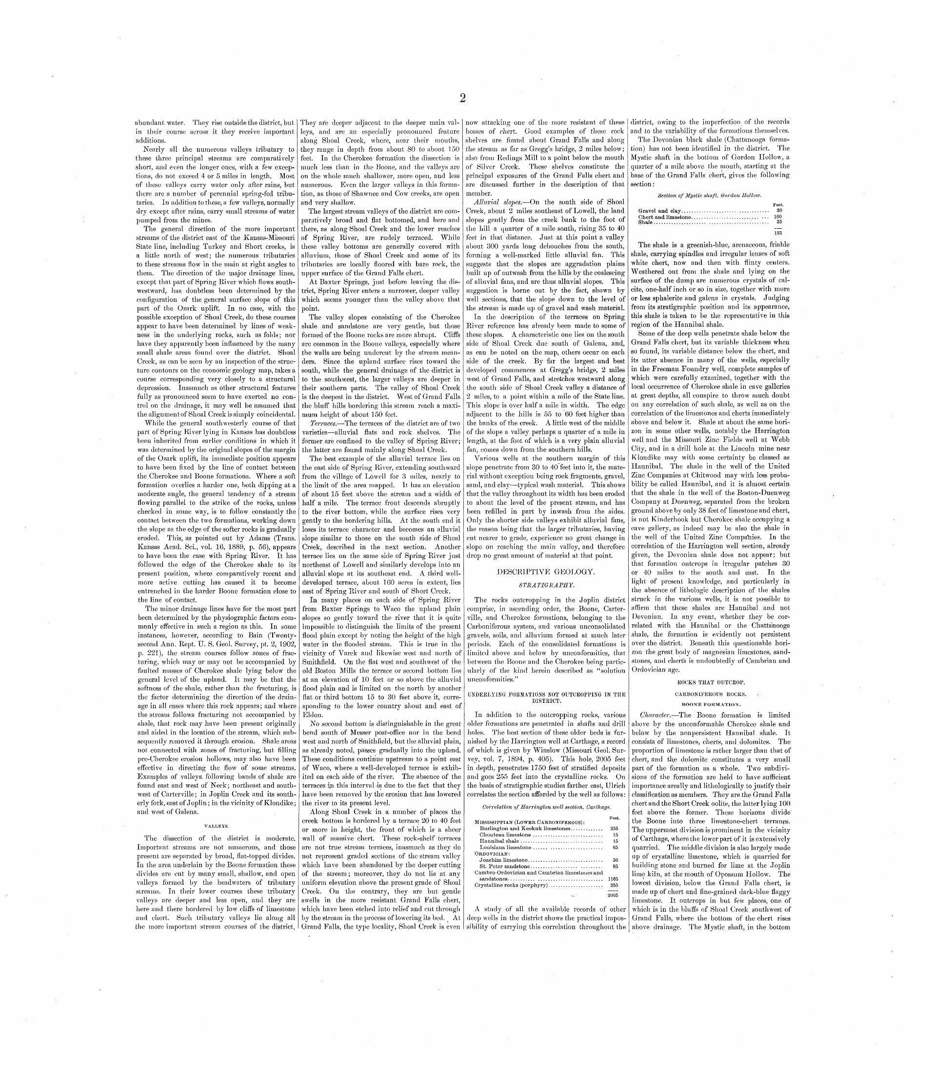
FIG. 1. General south-north section through Springfield and Sedalia. Showing the flat-topped dome of Cambrian and Ordovician limestones overlain by thin Devonian shale and Carboniferous sediments.
long, low northern and western slopes, with a sur face inclination generally imperceptible to the eye, and for much of its extent by an abrupt southern slope, facing the open valley of Arkansas River (figs. 1 and 2). Near and parallel to its southern margin the uplift culminates topographically in the Boston Mountains, a long, narrow plateau rising to an elevation of'2000 feet. The plains which sur round the uplift have a general altitude of 500 to 750 feet. The central portion of the Ozarks is an upland lying somewhat below the crest of the Boston Mountains.
ever, lie in an eccentric position as regards the whole uplift, the result being that each formation occupies a belt that is narrow east of the moun tains and wider on the west.
In Camden County, where the granite dike already mentioned occurs, there is a second but subordinate dome around which circle the forma tions of the Cambrian and lower Ordovician.
Outside of the area of these older sediments Devonian, Mississippian, and Pennsylvanian rocks outcrop in turn, except on the southeast, where they are covered by the overlapping Tertiary of the
OZARK P L A T E A U
FIG. 2. General west-east section through Joplin and the St. Francis Mountains.Showing the flat-topped dome of Cambrian and Ordovician limestones and pre-Cambrian crystalline rocks overlain by thin Devonian shale and Carbon
iferous sediments.
The erosion forms throughout most of this area are those characteristic of an early mature topogra phy in a region of nearly flat-bedded rocks of varying degrees of hardness, in which the dip dif fers but slightly from the general surface slope; and the entire northern slope of the uplift consists of a succession of broad plateaus separated by more or less ragged escarpments which mark the margins of
Gulf Plains, and with the further exception that, owing to unconformity around most of the uplift, the continuity of the Devonian outcrop is here and there interrupted.
The Mississippian (Lower Carboniferous) deposits outcrop only in a narrow belt, except on the south west, where they form the surface rock over a great area approximately 80 miles wide from northwest
to southeast and twice as long from northeast to southwest. They extend from Cedar Gap, Mo., well up on the crest of the the dome, to Fort Gibson, Okla., at the edge of the Prairie Plains. Within this great area are all the important zinc camps of the southwestern Missouri district The rocks consist mainly of limestones, with subordinate amounts of shale. The limestones are nonmagne- sian, in contrast with the older and underlying rocks outcropping to the east. The Boone, the principal formation of the area, contains large amounts of chert, in part in small nodules in the limestone and in part segregated in distinct beds.
The Pennsylvanian ("Coal Measures") series of of rocks consists mainly of shales and sandstones, with coal beds and thin limestones. The outcrop of these rocks marks the outward limit of produc tive territory and they have therefore been but little studied in this connection.
Both Mississippian and Pennsylvanian rocks outcrop within the Joplin district and are described under the heading "Stratigraphy" (p. 2). The older rocks are found only in deep drill holes.
TOPOGRAPHY.
GENERAL STATEMENT.
The Joplin district lies on the northwestern slope of the Ozark uplift, not far from its margin, and is included in the more plateaulike, less dissected portion of the region. Throughout the district the physical features are closely related to the geology. The rocks are wholly sedimentary and those out cropping at the surface belong (with few and rela tively unimportant exceptions) to two formations the Boone and the Cherokee. The Boone, com posed of limestone and interbedded chert, is the more resistant of the two and covers the larger part of the district. The Cherokee, stratigraphically higher than the Boone, consists of shale and sand stone and is confined largely to the western and northwestern portions, though small patches are abundant all over the district and there are a few larger isolated areas. These scattered outcrops are outliers of the main area on the west, having been left as remnants in the erosion of this formation, which formerly covered the entire district. Both these formations have been important factors in the development of the topography of the district.
UPLAND PLAINS.
The upland surface of the district is on the whole almost flat, with a very low general slope to the northwest, having an average fall of 5 feet to the mile between the southeast and northwest cornel's. Seen from favorable points the surface presents nearly everywhere an apparently horizontal, unbro ken sky line. The general slope of the upland is due to the structural slope of the underlying rocks, modified by orographic movement and peneplaned.
The height of the upland surface of the district above sea level is not great, and the difference in 'elevation between the highest and lowest points in the district amounts to little more than 400 feet. The highest point of the upland, about 1210 feet above tide, is near the southeast corner, while the lowest point, about 775 feet in altitude, is on Spring River where it leaves the district near the south west corner.
The upland surface is broken here and there by low hills rising somewhat above the general level. Those about a mile south of Webb City, and the broad, flat-topped, mesalike Timbered Hills south west of Crestline, are excellent examples. They are hills of circumdenudation and remnants of the once continuous Cherokee formation.
DRAINAGE.
STREAMS.
The important streams of the district are Spring River and its two main tributaries, Center Creek and Shoal Creek. These streams are perennial and carry
abundant water. They rise outside the district, but in their course across it they receive important additions.
Nearly all the numerous valleys tributary to these three principal streams are comparatively short, and even the longer ones, with a few excep tions, do not exceed 4 or 5 miles in length. Most of these valleys carry water only after rains, but there are a number of perennial spring-fed tribu taries. In addition to these, a few valleys, normally dry except after rains, carry small streams of water pumped from the mines.
The general direction of the more important streams of the district east of the Kansas-Missouri State line, including Turkey and Short creeks, is a little north of west; the numerous tributaries to these streams flow in the main at right angles to them. The direction of the major drainage lines, except that part of Spring River which flows south- westward, has doubtless been determined by the configuration of the general surface slope of this part of the Ozark uplift. In no case, with the possible exception of Shoal Creek, do these courses appear to have been determined by lines of weak ness in the underlying rocks, such as folds; nor have they apparently been influenced by the many small shale areas found over the district. Shoal Creek, as can be seen by an inspection of the struc ture contours on the economic geology map, takes a course corresponding very closely to a structural depression. Inasmuch as other structural features fully as pronounced seem to have exerted no con trol on the drainage, it may well be assumed that the alignment of Shoal Creek is simply coincidental.
While the general southwesterly course of that part of Spring Hiver lying in Kansas has doubtless been inherited from earlier conditions in which it was determined by the original slopes of the margin of the Ozark uplift, its immediate position appears to have been fixed by the line of contact between the Cherokee and Boone formations. Where a soft formation overlies a harder one, both dipping at a moderate angle, the general tendency of a stream flowing parallel to the strike of the rocks, unless checked in some way, is to follow constantly the contact between the two formations, working down the slope as the edge of the softer rocks is gradually eroded. This, as pointed out by Adams (Trans. Kansas Acad. Sci., vol. 16, 1889, p. 56), appears to have been the case with Spring River. It has followed the edge of the Cherokee shale to its present position, where comparatively recent and more active cutting has caused it to become entrenched in the harder Boone formation close to the line of contact.
The minor drainage lines have for the most part been determined by the physiographic factors com monly effective in such a region as this. In some instances, however, according to Bain (Twenty- second Ann. Rept. U. S. Geol. Survey, pt. 2, 1902, P. 221), the stream courses follow zones of frac turing, which may or may not be accompanied by faulted masses of Cherokee shale lying below the general level of the upland. It may be that the softness of the shale, rather than the fracturing, is the factor determining the direction of the drain age in all cases where this rock appears; and where the stream follows fracturing not accompanied by shale, that rock may have been present originally and aided in the location of the stream, which sub sequently removed it through erosion. Shale areas not connected with zones of fracturing, but filling pre-Cherokee erosion hollows, may also have been effective in directing the flow of some streams. Examples of valleys, following bands of shale are found east and west of Neck; northeast and south west of Carterville; in Joplin Creek and its south erly fork, east of Joplin; in the vicinity of Klondike; and west of Galena.
VALLEYS.
The dissection of the district is moderate. Important streams are not numerous, and those present are separated by broad, flat-topped divides. In the area underlain by the Boone formation these divides are cut by many small, shallow7, and open valleys formed by the headwaters of tributary streams. In their lower courses these tributary valleys are deeper and less open, and they are here and there bordered by low cliffs of limestone and chert. Such tributary valleys lie along all the more important stream courses of the district.
They are deeper adjacent to the deeper main val leys, and are an especially pronounced feature along Shoal Creek, where,, near their mouths, they range in depth from about 80 to about 150 feet. In the Cherokee formation the dissection is much less than in the Boone, and the valleys are on the whole much shallower, more open, and less numerous. Even the larger valleys in this forma tion, as those of Shawnee and Cow creeks, are open and very shallow.
The largest stream valleys of the district are com paratively broad and flat bottomed, and here and there, as along Shoal Creek and the lower reaches of Spring River, are rudely terraced. While these valley bottoms are generally covered with alluvium, those of Shoal Creek and some of its tributaries are locally floored with bare rock, the upper surface of the Grand Falls chert.
At Baxter Springs, just before leaving the dis trict, Spring River enters a narrower, deeper valley which seems younger than the valley above that point.
The valley slopes consisting of the Cherokee shale and sandstone are very gentle, but those formed of the Boone rocks are more abrupt. Cliffs are common in the Boone valleys, especially where the walls are being undercut by the stream mean ders. Since the upland surface rises toward the south, while the general drainage of the district is to the southwest, the larger valleys are deeper in their southern parts. The valley of Shoal Creek is the deepest in the district. West of Grand Falls the bluff hills bordering this stream reach a maxi mum height of about 150 feet.
Terraces. The terraces of the district are of two varieties alluvial flats and rock shelves. The former are confined to the valley of Spring River; the latter are found mainly along Shoal Creek.
The best example of the alluvial terrace lies on the east side of Spring River, extending southward from the village of Lowell for 3 miles, nearly to the limit of the area mapped. It has an elevation of about 15 feet above the stream and a width of half a mile. The terrace front descends abruptly to the river bottom, while the surface rises very gently to the bordering hills. At the south end it loses its terrace character and becomes an alluvial slope similar to those on the south side of Shoal Creek, described in the next section. Another terrace lies on the same side of Spring River just northeast of Lowell and similarly develops into an alluvial slope at its southeast end. A third well- developed terrace, about 160 acres in extent, lies east of Spring River and south of Short Creek.
In many places on each side of Spring River from Baxter Springs to Waco the upland plain slopes so gently toward the river that it is quite impossible to distinguish the limits of the present flood plain except by noting the height of the high water in the flooded stream. This is true in the vicinity of Varck and likewise west and north of Smithfield. On the flat west and southwest of the old Boston Mills the terrace or second bottom lies at an elevation of 10 feet or so above the alluvial flood plain and is limited on the north by another flat or third bottom 15 to 30 feet above it, corre sponding to the lower country about and east of Eldon.
No second bottom is distinguishable in the great bend south of Messer post-office nor in the bend west and north of Smithfield, but the alluvial plain, as already noted, passes gradually into the upland. These conditions continue upstream to a point east of Waco, where a well-developed terrace is exhib ited on each side of the river. The absence of the terraces in this interval as due to the fact that they have been removed by the erosion that has lowered the river to its present level.
Along Shoal Creek in a number of places the creek bottom is bordered by a teri;ace 20 to 40 feet or more in height, the front of which is a sheer wall of massive chert. These rock-shelf terraces are not true stream terraces, inasmuch as they do not represent graded sections of the stream valley which have been abandoned by the deeper cutting of the stream; moreover, they do not lie at any uniform elevation above the present grade of Shoal Creek. On the contrary, they are but gentle swells in the more resistant Grand Falls chert, which have been etched into relief and cut through by the stream in the process of lowering its bed. At Grand Falls, the type locality, Shoal Creek is even
now attacking one of the more resistant of these bosses of chert. Good examples of these rock shelves are found about Grand Falls and along the stream as far as Gregg's bridge, 2 miles below; also from Redings Mill to a point below the mouth of Silver Creek. These shelves constitute the principal exposures of the Grand Falls chert and are discussed further in the description of that member.
Alluvial slopes. On the south side of Shoal Creek, about 2 miles southeast of Lowell, the land slopes gently from the creek bank to the foot of the hill a quarter of a mile south, rising 35 to 40 feet in that distance. Just at this point a valley about 300 yards long debouches from the south, forming a well-marked little alluvial fan. This suggests that the slopes are aggradation plains built up of outwash from the hills by the coalescing of alluvial fans, and are thus alluvial slopes. This suggestion is borne out by the fact, shown by well sections, that the slope down to the level of the stream is made up of gravel and wash material.
In the description of the terraces on Spring River reference has already been made to some of these slopes. A characteristic one lies on the south side of Shoal Creek due south of Galena, and, as can be noted on the map, others occur on each side of the creek. By far the largest and best developed commences at Gregg's bridge, 2 miles west of Grand Falls, and stretches westward along the south side of Shoal Creek valley a distance of 2 miles, to a point within a mile of the State line. This slope is over half a mile in width. The edge adjacent to the hills is 55 to 60 feet higher than the banks of the creek. A little west of the middle of the slope a valley perhaps a quarter of a mile in length, at the foot of which is a very plain alluvial fan, comes down from the southern hills.
Various wells at the southern margin of this slope penetrate from 30 to 40 feet into it, the mate rial without exception being rock fragments, gravel, sand, and clay typical wash material. This shows that the valley throughout its width has been eroded to about the level of the present stream, and has been refilled in part by inwash from the sides. Only the shorter side valleys exhibit alluvial fans, the reason being that the larger tributaries, having cut nearer to grade, experience no great change in slope on reaching the main valley, and therefore drop no great amount of material at that point.
DESCRIPTIVE GEOLOGY.
STRATIGRAPHY.
The rocks outcropping in the Joplin district comprise, in ascending order, the Boone, Carter ville, and Cherokee formations, belonging to the Carboniferous system, and various unconsolidated gravels, soils, and alluvium formed at much later periods. Each of the consolidated formations is limited above and below by unconformities, that between the Boone and the Cherokee being partic ularly of the kind herein described as "solution unconformities."
UNDERLYING FORMATIONS NOT OUTCROPPING IN THE DISTRICT.
In addition to the outcropping rocks, various older formations are penetrated in shafts and drill holes. The best section of these older beds is fur nished by the Harrington well at Carthage, a record of which is given by Winslow (Missouri Geol. Sur vey, vol. 7, 1894, p. 405). This hole, 2005 feet in depth, penetrates 1750 feet of stratified deposits and goes 255 feet into the crystalline rocks. On the basis of stratigraphic studies farther east, Ulrich correlates the section afforded by the well as follows:
Correlation of Harrington well section, Carthage.
Feet.MISSISSIPPIAN (LOWER CARBONIFEROUS):
Burlington and Keokuk limestones............. 355Chouteau limestone ............................ 15Hannibal shale ................................. 15Louisiana limestone ...... ..................... 65
ORDOVICIAN: Joachim limestone.............................. 50St. Peter sandstone................... ......... 85
Cambro-Ordovician and Cambrian limestones and sandstones........... .......................... 1165
Crystalline rocks (porphyry)...................... 255
2005
A study of all the available records of other deep wells in the district shows the practical impos sibility of carrying this correlation throughout the
district, owing to the imperfection of the records and to the variability of the formations themselves.
The Devonian black shale (Chattanooga forma tion) has not been identified in the district. The Mystic shaft in the bottom of Gordon Hollow, a quarter of a mile above the mouth, starting at the base of the Grand Falls chert, gives the following section:
Section of Mystic shaft, Gordon Hollow.
Feet.Gravel and clay.................................. 20Chert and limestone........................... ... 100Shale..................... ........................ 35
155
The shale is a greenish-blue, arenaceous, friable shale, carrying spindles and irregular lenses of soft white chert, now and then with flinty centers. Weathered out from the shale and lying on the surface of the dump are numerous crystals of cal- cite, one-half inch or so in size, together with more or less sphalerite and galena in crystals. Judging from its stratigraphic position and its appearance, this shale is taken to be the representative in this region of the Hannibal shale.
Some of the deep wells penetrate shale below the Grand Falls chert, but its variable thickness when so found, its variable distance below the chert, and its utter absence in many of the wells, especially in the Freeman Foundry well, complete samples of which were carefully examined, together with the local occurrence of Cherokee shale in cave galleries at great depths, all conspire to throw much doubt on any correlation of such shale, as well as on the correlation of the limestones and cherts immediately above and below it. Shale at about the same hori zon in some other wells, notably the Harrington well and the Missouri Zinc Fields well at Webb City, and in a drill hole at the Lincoln mine near Klondike may with some certainty be classed as Hannibal. The shale in the well of the United Zinc Companies at Chitwood may with less proba bility be called Hannibal, and it is almost certain that the shale in the well of the Boston-Duenweg Company at Duenweg, separated from the broken ground above by only 38 feet of limestone and chert, is not Kinderhook but Cherokee shale occupying a cave gallery, as indeed may be also the shale in the well of the United Zinc Companies. In the correlation of the Harrington well section, already given, the Devonian shale does not appear; but that formation outcrops in irregular patches 30 or 40 miles to the south and east. In the light of present knowledge, and particularly in the absence of lithologic description of the shales struck in the various wells, it is not possible to affirm that these shales are Hannibal and not Devonian. In any event, whether they be cor related with the Hannibal or the Chattanooga shale, the formation is evidently not persistent over the district. Beneath this questionable hori zon the great body of magnesian limestones, sand stones, and cherts is undoubtedly of Cambrian and Ordovician age.
ROCKS THAT OUTCROP.
CARBONIFEROUS ROCKS.
BOOSTE FORMATION.
Character.- The Boone formation is limited above by the unconformable Cherokee shale and below by the nonpersistent Hannibal shale. It consists of limestones, cherts, and dolomites. The proportion of limestone is rather larger than that of chert, and th,e dolomite constitutes a very small part of the formation as a whole. Two subdivi sions of the formation are held to have sufficient importance areally and lithologically to justify their classification as members. They are the Grand Falls chert and the Short Creek oolite, the latter lying 100 feet above the former. These horizons divide' the Boone into three limestone-chert terranes. The uppermost division is prominent in the vicinity of Carthage, where the lower part of it is extensively quarried. The middle division is also largely made up of crystalline limestone, which is quarried for building stone and burned for lime at the Joplin lime kiln, at the mouth of Opossum Hollow. The lowest division, below the Grand Falls chert, is made up of chert and fine-grained dark-blue flaggy limestone. It outcrops in but few places, one of which is in the bluffs of Shoal Creek southwest of Grand Falls, where the bottom of the chert rises above drainage. The Mystic shaft, in the bottom

of Gordon Hollow near its mouth, went through 100 feet of this division and into the Hannibal shale. This limestone crops out in the bank of Shoal Creek near the Kansas-Missouri line and is struck in shafts 1£ miles south of east, near the mouth of Lee Hollow, where it is reported to be 130 feet thick.
ive character. At these places there is usually an intersecting network of veins of crystallized dolo mite or pink spar. Its position in the section is inconstant, being here above, there below the Short Creek oolite. Owing to the nature of the outcrop,- the dolomite can not be traced laterally for long distances, and dn all probability it does
SYSTEM.
CARBONIFEROUS
SERIES.
PENNSYLVANIAN
>IPPIAN
MISSISS
FORMATION NAME.
Cherokee formation.
Carterville formation.
(.Short Creek oolite member. .)
Boone formation.
(Grand Falls chert member.)
SYMBOL.
Cck
Cc
Cb
(Cgf)
COLUMNAR SECTION.
^Q3tiAM4&ji<SM6g&ffiJM6&KXX>Qga9$
l^i^j^-^T * I\.:VV'.: :
jfeffi I' ^_' TpiTTfg?^SIiyT^^nj^fes
73±5Stet:iniSbidj^r^-3 r r-^,,!_, Up-- 1 , , .
i i i iii i i
i i i i-V^=r-V^==>! C.,B I «=£» 1 co er- | c=o
-f=b pi^^-pbr^r^j a ' -. 5 ̂r7.tjr. * f ,gg_/_y^. /^ {T. y. f >, <
~! J*"~l -7
SSteSr^f?1,1 1 1
THICKNESS IN FEET.
150+
/0-50
(2-8)
140-485
(15 120)
CHARACTER OF ROCKS.
Drab to black shale and gray to" buff sand stone with occasional beds of coal.
Light to dark shales and shaly and oolitic limestones with some massive soft to hard sandstones.
Massive homogeneous bed of oolitic lime stone.
Limestone, in large part crystalline, with interbedded chert.
Heavy-bedded, solid chert.
FIG. 3. Generalized section for the Joplin district. Scale: 1 inch = 100 feet.
The stratigraphic constitution of the Boone as a whole is variable from place to place. Records of borings in the neighborhood of Grand Falls indi cate much variability in the rocks below the Grand Falls chert; locally a second horizon of massive cherts occurs a short distance below that mem ber, being separated from it by bedded lime stone and chert. Where there is a local decrease in the amount of limestone in this interval there may be 100 feet or more of massive cherts, includ ing the Grand Falls member and the cherts of the lower horizon, together with the intervening beds.
The limestone of the Boone formation is a fossil- iferous granular crystalline rock which varies from fine-grained bluish limestone to light-gray, coarsely crystalline limestone or white marble, such as is quarried in the Carthage district. The individual strata range from sheets a few inches thick to massive beds 20 to 30 feet thick, with no indication of a parting on the weathered surface. These massive beds scale off under the action of frost, leaving an unbroken vertical or inclined, perhaps overhanging, face. In favorable localities the action of frost reaches to a depth of 3 feet and results in peripheral joints parallel to the exposed surface and cutting across the bedding planes. The massive beds traced horizontally are usually found to split up into smaller beds, perhaps with the intercalation of sheets and lenses of chert along the bedding planes The occurrence of stylolites, or "crowfeet," is common.
The crystalline limestones of the Boone are nearly pure carbonate of lime and very soluble in meteoric water, and in these rocks underground drainage systems and caves have existed in the past and are found at present. Quarries in this part of the^ibrmation exhibit the usual number of crevices and enlarged joints filled with red clay and bowlders of residual chert. The upper surface of the limestone is likewise covered with a mantle of red clay and residual chert, In many places where the formation at the surface originally con sisted of thin-bedded limestone with thin inter calated chert beds the limestone has been carried away by solution, leaving the chert in broken and wavy but clearly perceptible beds, separated by sheets of red clay. The sinuosity of the chert beds corresponds to the irregular decomposition surface of the solid limestone beneath, and in places the chert is sharply tucked downward over a clay joint, as if sucked into it. Here and there the sides of clay seams and the walls of sink holes exhibit a fluted columnar style of weathering.
The bedded dolomite is confined to the eastern part of the Joplin area. It is bun0 in color, massive, finely granular, and nonfossiliferous. In appear ance of outcrop and texture it very closely resem bles a fine-grained sandstone. In places the bedding seems to be lost and the rock has a mass-
Joplin.
not so extend. The indications are that it is a result of local dolomitization. As pointed out by Broadhead (Missouri Geol. Survey, vol. 1, 1874, p. 81), referring to localities several miles farther east, the alteration has usually been so complete as to entirely obliterate any traces of fossils. The eastern portion of the district is unusually free from deformation and dislocation, so that here the dolomitization does not seem to be associated with faulting.
The chert of the Boone formation occurs in beds or in lenses and nodules in the limestone. Where in beds, the chert is either intercalated with the limestone or occurs massive with more or less lime stone interbedded or in lenses. Locally there is little or no interbedded limestone.
The chert varies considerably in physical charac ters, both in different beds and in the same bed under different conditions, such as above and below ground-water level. It is in general, when fresh, a light-gray (in places dark-gray) to nearly white, highly siliceous, compact rock, and as a rule its luster is dull, or nearly so. Locally it is light to moderately dark bluish gray in color, with a waxy luster, this type being popularly known as "live flint," Most of it is rather brittle, some beds more so than others. "Butcher-knife" and "hog- chawed" flints are extremely brittle, the former breaking, like glass, into thin or very angular fragments with sharp edges. The chert in general has a more or less pronounced conchoidal or sub- conchoidal fracture, and the fracture surfaces are usually smooth. Here and there in the mines, adjacent to 'some disturbance, as, for instance, along the Cornfield " bar," the chert, especially that of the sheet ground, is affected by a system of close- set, parallel fractures more or less nearly at right angles to the bedding, which in many places com pletely obscure the stratification and break up the heavy strata into highly inclined sheets. This type will be hereinafter referred to as "sheeted chert."
On weathering the rock often whitens, becoming dull and chalky, as in "cotton flint," sometimes being stained more or less with iron oxide to a buff color; it grows gradually less brittle and tougher and finally more or less incoherent; its fracture, instead of being conehoidal, becomes more or less rough and uneven, like that of a moderately fine grained rock; it also becomes gradually softer, so that, as cotton flint, it may be readily grooved with a knife, though the groove still shows the color of the steel. Much of the chert, even where consid erably weathered, appears to be compact, though in many instances it contains numerous and usually minute cavities due to solution. Molds of fossils are often found in partially weathered chert, and are locally abundant. The weathering of the cherts is not confined to the narrow zone above ground- water level, but more or less altered chert is found
in most of the mines and at all depths which have been reached by mining. Chert approaching cotton flint has been noted in the cuttings from the Free man Foundry well, Joplin, at intervals to a depth of over 300 feet.
Many of the cherts, both fresh and weathered, are somewhat calcareous, the calcite, in minute or microscopic grains, being either distributed through the rock or concentrated in small areas, many of which are of irregular shape, which mottle or streak the light gray of the chert with darker gray. In places the calcite is limited largely to the mega scopic fossils of the rock, and doubtless to the leaching of the calcite in these fossiliferous rocks some of the cavities in such chert are due. Some of the calcite found in the chert is undoubtedly original, but in other instances it is as unques tionably secondary, having either replaced the chert metasomatically or filled cavities formed in the chert by solution.
Microscopically the cherts of the Joplin district consist mainly of a microgranular to eryptocrys- talline aggregate of silica in the form of both quartz and chalcedony. The grain is fairly uni form in some specimens, both fresh and weathered, but as a rule it shows more or less variation, which appears to be due largely, if not entirely, to recrys- tallization. To a considerable extent such recrys- tallization is selective, occurring in the fossils or in certain parts of the fossils contained in the rock. It is often found also bordering the minute cavities common in many of the more or less weathered cherts. The recrystallized portion varies from a rock with the grain of the normal chert to a fine- granular quartz aggregate. These recrystallized portions, both coarser and finer, consist, like the original rock, of quartz and chalcedony, the coarser grained parts, however, being more commonly made up of quartz alone, though in some instances they consist almost wholly of chalcedony aggregates. Many of the cherts also contain minute opaque grains, for the most part iron sulphide.
As shown both by the microscope and by chem ical analyses, the greatly weathered cotton flints do not differ essentially in chemical composition from the unaltered rock, the differences between the two being chiefly physical. Cotton flint, as seen under the microscope, contains many minute cavities and shows on the whole a greater amount of recrystalli- zation. Some of the cotton flints are uniformly granular, though most of them show the variation in grain which usually characterizes recrystallization. Some of the slides of cotton flint examined were almost free from cavities and not noticeably differ ent from unaltered chert. Some of cavities are molds of fossils, but many of them are due to general solution of the rock. In most of the cotton flint examined no calcite was observed, and where found it occurred only in scattered grains.
Distribution and thickness. The Boone is the surface formation over much the larger part of the district, occupying, with the exception of a few large and numerous very small outliers of Cher okee, all the country east of Spring River and some territory west of the river and adjacent to it. The best exposures are found along Shoal Creek, where some of them reach into the portion of the formation lying below the Grand Falls member. Exposures of the rocks lying above the Grand Falls chert are found along Turkey Creek, Center Creek, Spring River, and the various tributaries of those streams.
The thickness of the Boone is difficult to estimate accurately. The base of the formation is usually taken at the first shale or shaly limestone which occurs below the Grand Falls member. But many of the drill records fail to note any shale whatever. This may be explained in several ways. The shale may really be absent in these localities, since it is known to have an intermittent Outcrop farther east. On the other hand, it may be so calcareous as t'o be confused with limestone, or the driller may have failed to recognize it owing to its thinness. In the deep well on the Missouri Zinc Fields land at Webb City it is but 12 inches thick. When it is not especially watched for, such a thickness might very well be overlooked in working with a churn drill at a depth of 350 feet, the more so when surface shale has been previously penetrated.
Estimated on this basis, the Boone formation in the Carthage well is 355 feet thick, and this is the maximum thickness of the formation penetrated
anywhere in this district, The greatest known thickness of the limestone and chert series overlying the Grand Falls chert member and including the Short Creek oolite is 208 feet, found in a well on the land of E. B. Alien, 2 miles southeast of Jop lin, in the NE.J NW.J sec. 13, T. 27 N., R. 33 W. At the Freeman Foundry well in Joplin the thick ness is 207 feet. These figures inay be taken to represent the maximum thickness of the formation above the Grand Falls chert now remaining in the district. The normal thickness of the Grand Falls chert ranges from 50 to 60 feet, but in some dis tricts it is recorded as low as 15 feet and in others as high as 120 feet. The excessive thickness is to be explained by the fact that, owing to the pre ponderance of chert in the beds between the Grand Falls member and the chert stratum some distance below it, the whole series has been recorded, as Grand Falls. The thickness of the alternating bluish limestones and cherts which underlie the Grand Falls member is variable, ranging apparently from 25 to 150 feet.
Generalized section of Boone formation.Feet-
Upper limestone (containing Carthage quarry beds)....................................... 100
Short Creek oolitic limestone member...... 2 to 8Middle limestone (containing Joplin limekiln
quarry beds).............................. 100Grand Falls chert member.............. ... 50 to 60Lower limestone....................... v .... 25 to 150
Relations. At the contact of the Boone with the Cherokee above there is a double unconformity, or rather an unconformity which is a result of two distinct cycles of erosion and solution the post- Boone-pre-Carterville and the post-Carterville-pre- Cherokee (see columnar section fig. 3). Elsewhere the Boone outcrop has suffered in addition the Ter tiary peneplanation and the post-Lafayette erosion. This solution unconformity is complicated to a cer tain extent by minor faulting. It is discussed Somewhat more in detail in the description of the Carterville and Cherokee formations.
The greatest variation in thickness and character arid the greatest difficulty in correlation are found in that portion of the Boone below the Grand Falls chert. This variability is but natural in beds over lying a nonpersistent formation, the irregularities of which are probably due in part to erosion. The Hannibal shale, which presumably limits the for mation below, comes to the surface nowhere in the district and, except in drill holes, is penetrated at but one place in the Mystic shaft, a section of which has been given. The difficult correlation of shales struck in drilling below the Grand Falls member and the consequent uncertain recognition of the lower limit of the Boone have already been mentioned.
Name and correlation. The Boone formation derives its name from its typical development in Boone County, Ark. (Ann. Rept. Geol. Survey Arkansas, 1890, vol. 1, p. 129), where it displays many of the characteristics which it exhibits in the Joplin district. Jenney (op. cit., p. 178) proposed the name Cherokee for the limestones of the dis trict, but that term has since been generally used for the Pennsylvanian shale of the region, and such usage has the preference. Elsewhere these limestones have generally been called Burlington.
The formation as a whole belongs to the Osage group of the Mississippian series. It includes por tions of the Keokuk and the Burlington, the divi sion line coming probably below the Grand Falls chert. A fauna with Keokuk affinities is-described from the Grand Falls chert in the discussion of that member. No paleontologic collections are available from the blue limestones below the Grand Falls chert, or from the Hannibal shale.
A collection obtained near Grand Falls, about 20 feet above the chert, yielded the following species:
Fossils collected near Grand Falls.
Cyclopora fungia. Fistulipora sp. Stenopora sp. Leioclema punctatum. Rhombopora sp. Cystodictya cf.C. lineata. Polypora sp. Chonetes aff. C. illinois-
ensis. Productus punctatus.
Spirifer keokuk. Spirifer tenuicosta. Syringothyris ? sp. Spiriferina sp. Euuietria marcyi. Aviculopecten amplus. Myalina ? sp. Conocardium sp. Pleurotomaria sp. Griffithides bufo.
A collection from the southwest corner of the SE. J- sec. 34, T. 28 N., R. 31 W., near the mouth of Jones Creek, 10 feet below the Short Creek

oolite and consequently about 70 feet higher than the beds from which the collection was made near Grand Falls, afforded the following species:
Fossils collected near
Zaphrentis centralis ? Zaphrentis carinatus. Stenopora sp. Cystodictya lineata. Rhipidomella dubia. Derbya keokuk. Chonetes aff. 0. illiiiois-
erisis.Productus lajvicosta. Productus magnus.
mouth of Jones Creek.
Productus setiger. Productus alternatus. Productus mesialis. Productus wortheni. Spirifer tenuimarginatus. Syringothyris sp. Composita cf. G. humilis. Rhynchopora aff. R. pus-
tulosa. Grifflthidcs bufo.
The following species were collected at the Car thage quarries, in beds ranging from about 20 to about 60 feet above the Short Creek oolite:
Fossils from Carthage quarries.
Monilopora sp. Fenestella tenax. Hemitrypa proutana. Polypora halliana. Archimedes n. sp. Archimedes n. sp. aff. A.
owenanus.Archimedes owenanus? Meekopora 2 n. sp. Stenopora sp. ? Cystodictya cf. C. lineata. Leiocleimi punctatuiu. Bhipidomella dubia. Chonetes aff. C. illinois-
ensis.Productus magnus. Productus setiger. Productus n. sp. Productus punctatus.
Productus Isevicosta.Spirifer keokuk.Spirifer rostellatus.Spirifer tenuimargina
tus.Spirifer neglectus.Spirifer subcardiiformis.Spirifer lateralis.Reticularia pseudoline-
ata.Spiriferina? sp.Composita aff. C. humilis.Eumetria marcyi.Dielasma gorbyi.Myalina keokuk.Aviculopecten amplus.Aviculopecten sp.Fish tooth.
The highest recognizable horizon in the Boone is in the vicinity of Waco. At the bridge over Spring River, 2 miles east of Waco, limestone approximately 100 feet above the Short Creek oolite gave the following forms:
Fossils collected near Waco.
Stenopova sp. Productus magnus. Productus sp.
Syringothyris texta. Composita aff. C. humilis. Camarotoechia sp.
These faunas, representing the Boone very closely from the upper part of the Grand Falls chert to the top of the formation as exposed in the Joplin district, are essentially the same and are evidently of Keokuk age.
GRAND FALLS CHERT MEMBER.
Character.^ The Grand Falls member of the Boone lies about 100 feet below the Short Creek oolite and is made up almost wholly of heavy beds of solid chert. As a rule, where there is locally a heavy development of chert in the Boone more or less limestone is interstratified with it; but in the typical development of the Grand Falls member thWe is a comparatively small amount of limestone in thin beds and lenses, and locally even this is replaced by jasperoid or has been removed to a greater or less extent by solution. As all occurrences of chert are more or less localized, and heavy developments especially so, it happens that the Grand Falls member can not be traced per sistently to every place where, from the stratigraphic position, it would naturally be expected to appear. For instance, in the section of the west bluff of Shoal Creek half a mile west of Grand Falls, the type locality, a 15-foot bed of chert and limestone appears at the proper horizon of the Grand Falls. The chert is not massive and heavy bedded, the limestone occurs in irregular patches, and altogether, but for its position, this bed would not be taken to represent the Grand Falls chert.
The typical chert of this member is of the splin tery, fresh, unaltered-appearing type known as "live" or "butcher-knife" flint. Much of it has been thoroughly crushed in place and recemented with a darker, bluish siliceous cement, the original bedding remaining practically undisturbed. Brec cias of this sort occur both in the mines, especially those operating in the sheet ground, and at the surface, having been noted at several points along Shoal Creek. Where the chert lias been sub jected to rather sharp deformation, instead of suffer ing simple brecciation it loses its bedded character and becomes gnarled and knotted in structure, weathering with a very rough surface. A typi cal example of the transformation of the bedded breccia ted chert into the massive gnarled and twisted chert is seen at Gregg's bridge, \\ miles west of Grand Falls. Isolated outcrops of massive breccia ted and gnarled cherts occur in different localities, but as there is no way of correlating them with the Grand Falls member they have not
been distinguished on the geologic map from the Boone in general.
Here and there the chert contains small, scattered, dark-colored, though still siliceous spots or areas which are rounded, oval, or irregular in shape, some of the rounded spots being half an inch or more in diameter. Most of these areas are zoned, usually with a dark-gray, nearly black, jasperoid- like nucleus with sharp boundaries, surrounded in many instances by a lighter gray, sharply marked zone that is as a rule nearly the color of the main rock. This in turn is bordered by a zone of nearly white chert, approaching cotton flint, 'this outer zone being commonly narrow, with an indefinite outer margin. While such spotting is not limited to any particular horizon, it appears to be most abundant in the chert of the sheet ground, form ing one of its marked characteristics. As shown by the microscope, the spotting is due to recrystal- lization of the chert and is in places accompanied by more or less solution, both in the nucleus and in the outer zone.
The distinctive characteristics of the Grand Falls chert are, therefore, heavy bedding, "live" splin tery texture, fine brecciation and cementation, and spotting.
Thickness and distribution. With one excep tion, the recognized outcrops of the Grand Falls are confined to Shoal Creek or its tributaries.. The exception is a small patch of the typical chert which forms the surface over a portion of the Turkey Creek bottom just north of the mouth of Leadville Hollow. Fresh exposures here show the characteristic white spotting of the blue flint, the brecciation, and the splintery texture. The thick ness, as revealed by drill holes over the bottom, ranges from 30 to 35 feet, though probably some lias been eroded from the surface. The identifica tion of this chert with the Grand Falls member is corroborated by the stratigraphic position of the Short Creek oolite in the neighboring hills. The outcrop has the rough hummocky appearance usual where this formation is exposed as a rock floor.
The cause of the hummocks is not clear. They are probably due to irregular weathering, but pos sibly to irregularities in the silicification of the upper surface of the formation. An instance of the latter kind can be seen along the Grand Falls branch of the Missouri Pacific Railway on the west bluff of the small creek flowing southward from Joplin, about half a mile above its mouth. Here the bedded chert crops out 25 feet in thickness, but in one place it extends 15 feet higher. As there is no break in the rocks below, this seems a clear case of local silicification.
In ascending Shoal Creek the first outcrop of undoubted Grand Falls is encountered near the middle of the south side of sec. 27, 2 miles south west of Galena. The chert forms a bluff about half a mile long, facing the east, reaching almost across the creek bottom, and varying from 5 to 23 feet in height. The chert is exposed back from the top of the bluff for 100 yards, beyond which it is covered by the alluvium of the valley. A section of the bluff at the point where Shoal Creek swings against it is as follows:
Section on Shoal Creek 2 miles southwest of Galena.Ft. In.
Massive chert, showing local brecciationin horizontal sheets and recementation.
Breccia....................................Massive chert .............................Breccia ...................................Massive chert .............................Weathered jasperoid..........'........... 0Massive chert, shattered but not brec-
ciated.................................. 6 0
24 0
The uppermost chert is fossiliferous at the top, yielding the brachiopod fauna hereinafter described. The first breccia band has a level definite upper limit, probably slickensided, but the bottom is very irregular, in places reaching down from 8 to 12 inches into the flint below, the whole space being filled with finely shattered chert in horizontal sheets, cemented with jasperoid. This brown jasperoid cement here and there contains cavities where crys tals of blende have been leached out and other smaller cavities which may have held dolomite. Though ordinarily following the bedding planes, in places the brecciation also follows angling frac ture planes. It seems reasonably certain that the brecciation along the bedding has been caused by lateral movement along these planes.
The Short Creek oolite is found in the bluff west of Harmon Branch at an elevation of 132 feet above Shoal Creek, but the lower portion of the section, at the horizon of the Grand Falls chert, is con cealed, though chert fragments are strewn over the interval. Limestone and chert interstratified out crop near the mouth of Harmon Branch, although about three-fourths !of a mile to the south, up the branch, the chert is characteristically exposed with a thickness of 10 feet in sight.
Half a mile east of the State line Shoal Creek makes an abrupt bend to the north, being deflected by a bluff of Grand Falls chert which extends northwestward nearly to the north edge of the creek bottom. The chert follows the bluff south eastward and outcrops in the mouths of two small branches which enter the valley from the south at this point. The chert also crops out in severals places up these branches where slight anticlines bring it to the surface.
The chert is next exposed in the vicinity of Gregg's bridge, where it forms a bench or rock shelf 25 or 30 feet in height. Just west of the bridge the chert has been flexed and subjected to some torsion, the axis, along which there has been considerable brecciation and recementation, bearing N. 52° E. Two sets of joints have resulted and cut the rock up into "butcher-knife" flint. One of these systems bears N. 42°-56° W., and the other N. 10°-14° W.
The chert underlies the flat bench adjacent to Shoal Creek between Tanyard and Gordon hollows. As shown on the geologic map, it outcrops in two irregular patches in Tanyard Hollow. At the southern outcrop it rises into a 20-foot bench on the east side of the road. A little farther south a shallow shaft at the level of the road struck the underlying limestone a short distance from the sur face. At the northern exposure the chert forms a rock floor with characteristic hummocky appear ance. A strongly marked system of jointing bear ing N. 62° W. cuts the rock at intervals of 1, 4, and 8 inches. Another less pronounced system bears N. 38° W. and, intersecting the first system, produces rhombic and wedge-shaped blocks. A very faint system bears due east and west. Though more or less covered by soil and alluvium, the chert is the underlying rock from Tanyard Hollow to Grand Falls, where the bench coincides with the creek bottom above the falls. At the falls the drop is 24 feet, and adding 10 feet of chert above the water at the top of the falls gives a thickness of 34 feet of the chert in sight at the type locality.
Northward along the railway from Grand Falls the chert maintains a uniform level for half a mile, then disappears, reappearing in a small roll at a distance of a quarter of a mile, and again rising with a dip of 3° S. at the mouth of the hollow by the waterworks. It crops out on both sides of this hollow for a distance of half a mile to the north, then spreads out over the bottom of the hollow and disappears below drainage. Just south of the mouth of the main hollow from the east, in a 6-foot railway cut, the chert affords one of the best illus trations of close jointing in the district. The prin cipal system bears N. 30° W., and dips 70° NE., and the cracks are one-fourth inch to 3 or 4 inches apart. Less numerous but larger joints strike N. 50° W. and dip 45° to 50° SW: The intersection of these systems produces characteristic "butcher- knife" flint. Along horizontal planes the chert is finely brecciated and cemented with a reddish leached jasperoid.
Southeast of the waterworks the chert crops out along the base of the hills, rising into a bench or rock shelf just below the mouth of Silver Creek, and forming the flat valley of that creek as far up as the road crossing. Still farther southeast, in the vicinity of Redings Mill, the chert forms bluffs on each side of Shoal Creek, with a level flat above reaching back to the hills. The chert here displays the common characteristics of spotting, breccia tion, and recementation with undisturbed bedding. Southwest of Redings Mill the Grand Falls mem ber outcrops along Spring Creek for a distance of a mile and a half and the various exposures are emi nently characteristic. A shaft in the NW. \ NW. \ sec. 3, T. 26 N., R. 33 W., shows 32 feet of "live," spotted Grand Falls chert, the top of which is near the bottom of the valley, A quarter of a mile farther south the chert rises 10 feet above the valley in a little roll, dipping under the surface
both to the north and to the south within 200 yards. The chert crops out along the foot of the hill south ward from Redings Mill for half a mile, to a point where, dipping 2° S., it disappears beneath the alluvium of the valley.
About \\ miles south of east of Redings Mill, in the SW. \ sec. 36, T. 27 N., R. 33 W., on the north side of the creek, the Grand Falls member rises in a small anticline and shows a thickness of 35 feet in the bluff just east of the house. A well at the foot of the bluff went through 18 feet of chert, making the total thickness 53 feet. The chert outcrops along the hill for a distance of half a mile, dipping beneath the overlying limestone at either end.
The Joplin anticline brings the Grand Falls chert to the surface at several points where its axis is cut by tributaries of Shoal Creek. The principal outcrop is 2 miles due east of Saginaw station, on the Kansas City Southern Railway, and others occur 1 mile west of north and \\ miles southeast of that one. The chert rises to a height of 30 feet near the house in the middle of the SW. | sec. 28, T. 27 N., R. 32 W., and to about the same height half a mile due northeast, on the north side of the hollow. The chert is bedded, but brec ciated and recemented with weathered reddish jas peroid cement.
Owing to the variability of the Grand Falls member from place to place, as already pointed out, the recognition of this formation in drill records, unless corroborated by the harmonious occurrence of the Short Creek oolite in the vicinity, is always accompanied by more or less uncertainty. But in the sheet-ground region its recognition is a matter of ease, and while only the top portion of the member is exploited for ore, its thickness can readily be determined from drill records. The top of the upper ore horizon as a rule is only a few feet from the top of the formation, and these two horizons have been used indiscriminately in drawing the structure contours, which show the elevation above mean tide level of the top of the chert.
The thickness of the Grand Falls member about Duenweg ranges from 35 to 55 feet, about Pros perity it has a maximum of 55 feet, and from Webb City to Oronogo it ranges from 35 to 45 feet. At Carl Junction the thickness is 55 feet and west of Joplin it is about the same. At Carthage the thickness is something less than 80 feet, at Alba it is 60 feet, and at Waco the chert has been penetrated for 25 feet without getting through it.
Name and correlation. As long ago as 1855 Swallow (First and Second Ann. Repts. Geol. Survey Missouri, 1855, p. 95) described the heavy cherts about Grand Falls, but no name was applied to them until 1893, when Jenney (op. cit., p. 178) alluded to the upper beds of the Mississippian as "Cherokee limestone" and "Seneca chert," meaning by the latter presumably the chert which has herein been called the Grand Falls member. This reference is entirely too indefinite to satisfy the demands of geologic terminology. The chert at Seneca is not to be correlated with the Grand Falls, and moreover the term Seneca has been used for many years as the name of a Devo nian formation in New York. Winslow (op. cit., pp. 407-419) described the chert about Grand Falls and referred to other outcrops of the chert as equivalent to the "Grand Falls chert." Thus while he did not name the member, because he considered that it was not persistent but simply a series of chert lenses, for all practical purposes he used this term as a geologic formation name, and the senior author (Smith, op. cit., p. 198) has recently adopted it as such.
A single collection of fossils was obtained from the Grand Falls chert member. This was from the upper part of the bluff on the north bank t of Shoal Creek in sec. 27, 2 miles southwest of Galena, a section of which has already been given. The following list comprises the species found at this locality: Fossils collected on Shoal Cr'eeK 2 miles southwest of Galena.
Derby a keokuk ? Produotus mesialis ? Productus setiger ? Spirifeir sp.Reticularia pseudoline-
ata.
Cliothyris hirsuta ? Spiriferina aff. S. solid-
irostris. Camarophoria subtri-
gona. Dielasma sp.
There is nothing in this fauna which is particu larly suggestive of the Burlington, whereas some

of the species, as, for instance, Camarophoria sub- trigona, are distinctively Keokuk.
SHORT CRBKK OOLITE MEMBER.
Character. The Short Creek member is a thin but very persistent bed of oolitic limestone. Gen erally it forms a single, massive, homogeneous bed which in the Joplin area ranges from 18 inches to 8 feet in thickness. Exceptionally it divides into two beds which may have slightly different char acteristics. The spherules are round, never flat tened, though some are concave where they touch, as if pressed into one another or as if they had interfered with one another in the process of con centric growth. One of the most constant charac teristics of the Short Creek oolite is the regularity in size of the spherules in a hand specimen, though they vary somewhat in size from place to place. They are uniformly smaller than those of the Car- terville formation, averaging perhaps one-fiftieth of an inch in diameter, while the Carterville spherules are about one-twenty-fifth of an inch. The indi vidual spherules in the Short Creek are solid and, though apparently formed by concentric growth, rarely show the center darker than the shell, as is common in those of the Carterville. The ShortCreek spherules are embedded in a calcareous matrix which in places is coarsely crystalline. On a freshly broken surface the matrix gives a patchy reflection from* cleavage surfaces one-fourth to one-half inch across, in which the embedded spherules appear as dark spots, a variety of poikilitic structure. In most cases the rock has a slightly splintery fracture, and this character is more pronounced the more com plete the cementation. The Short Creek has two characteristics methods of weathering. In one it scales off in flakes parallel to the surface, and, being softer than the crystalline limestones above and below it in the bluff, it generally forms a slightly retreating gallery. A somewhat harder variety is found locally on sloping hillsides, where it usually breaks into rhomboid blocks which weather away along the cracks, leaving the blocks firmly fastened together and standing out somewhat in the fashion of irregular paving blocks; or the loose blocks may be strewn over the surface. In a few instances about Lowell and on Killibrew Branch the oolite is silicified into chert, but this was not noticed elsewhere. In the eastern part of the area the limestones above and below are in places altered to dolomite, but the oolite was nowhere observed to be so altered.
Thickness and distribution. The Short Creek oolite, though thin, is a very persistent bed and outcrops all over the area where it is not carried below drainage by the dip of the rocks and where it has not been removed by erosion. Even where it lies slightly below drainage its presence is usually revealed by some of the numerous prospect shafts. The exposures along Shoal Creek show that south and southeast of Joplin the member lies from 100 to 150 feet above the water level, and that to the west it gradually drops until, in the vicinity of Lowell, it disappears. ^The thickness of the mem ber increases through- the same distance from 2^ feet at the east to 5 feet west of Grand Falls and 8 feet near the mouth of Harmon Branch, from which point it thins again to 2^ feet at Lowell.
Along Short Creek it crops out at Cave Springs with a thickness of 3 feet, which is increased to 8 feet at the type locality west of Empire, thinning to 6 or 7 feet at the westernmost bluff on the south side of Short Creek and to. 6^ feet in the east bluff of Spring River near the Boston Mills bridge, which is 1£ miles northwest of Empire. To the west the member is below drainage except at two points along the lower mile of Shawnee Creek. At the ford a mile above the mouth of Shawnee Creek the oolite rises to the surface for a short distance in the bed of the creek. A quarter of a mile above the mouth of the creek, in the bluff forming the west bank, a bed of oolite 5 feet thick rises in a small anticline to a height of 25 feet above the creek, but goes below water level within a quarter of a mile both to the north and to the south.
Along Turkey Creek it outcrops northeast of Villa Heights, and at Midway station, on the elec tric line, it forms the top portion of the pinnacle known as Castle Rock. It also occurs in the bluff on the north side of the creek a mile to the east. The thickness at Midway is 6 feet. On each side of Joplin Creek north of Joplin it is 5 feet thick,
Joplin.
and at the quarry of the Joplin Lime Company, near the mouth of Opossum Hollow, it is 72 feet above the creek and 4 feet thick. Near the mouth of Leadville Hollow, half a mile west of the quarry, the Grand Falls chert comes to the surface in the valley of Turkey Creek and the Short Creek oolite horizon should be 100 feet above drainage. Half a mile west of the mouth of. Leadville Hollow the thickness is reduced to 3 feet and the height above drainage to 50 feet. Within a mile or so below this point the oolite disappears beneath the water level and is not seen again except in shafts until the vicinity of Belleville is reached; at the Davison Cave Spring, half a mile southwest of the village, it has a thickness of 4 feet and an elevation of 45 feet above the creek. At the bridge over Spring River a quarter of a mile north of the mouth of Turkey Creek the oolite is typically developed, fossiliferous, very white, 4 feet thick, and about 35 feet above the river. Toward the west it dips below drainage and in the vicinity of Badger is found at depths of 40 or 50 feet.
The oolite is found all along the course of Cen ter Creek through the district, alternating above and below water level. In the south bluff of the creek 1 mile due southeast of Smithfield the axis of the Joplin anticline raises the oolite 14 feet above-the creek and it is here 2| feet thick. A short distance to the east along the creek it sinks below drainage, and in the bottom near Lehigh and south of Carl Junction it lies at the base of the gravel, about 20 feet below the surface of the ground. It maintains this level nearly to the crossing of the Kansas City Southern Railway, beyond which it sinks deeper. In the vicinity of the mines in the creek bottom south of Oronogo it is about 20 feet below the surface, but it outcrops just at the water level by the bridge a mile south east of Oronogo. It is exposed again under the railway bridge over the small brook a quarter of a mile west of Lakeside station, where it is 2 feet thick and 10 feet above the water. The spherules here are exceptionally small and the rock is so firmly and thoroughly cemented that only on a weathered surface or by the aid of a hand lens can its oolitic character be made out. The bed dips northward a degree or more and within a short distance goes below drainage. The next outcrop to the east is at the Scot Big Spring, 600 yards south of the Independent Powder Works, where it is 22 inches thick and 8 feet above the water level. From this point the creek bends to the south and the oolite rises higher in the bluffs, reaching an elevation of 30 to 35 feet near the mouth of Grove Creek, where it has a thickness of about 2 feet. At the Scotland Spring, on Grove Creek the oolite is 3 feet thick and about 25 feet above the creek. It goes below water at the sharp bend in the creek 1^ miles east of south of Scotland. Along Center Creek above the mouth of Grove Creek the oolite, about 2 feet thick, is found in the bluffs on either side, somewhat higher on the south side, as far as the mouth of Jones Creek, above which it lies at an unknown depth, though in the small drain near the eastern limit of the district, a quarter of a mile east of the American Mill bridge, it was struck at about 10 feet below drainage. The member is exposed at several points in the bluffs of Jones and Jenkins creeks at a height of about 20 feet above the water, but, dipping 4° SW., it goes below water level on the small branch which flows northeastward through the S. f sec. 24, T. 27 N., R. 31 W., about 600 yards above its junction with Jones Creek.
On Spring River, at the eastern edge of the dis trict, the Short Creek oolite crops out in the bluffs on both sides 20 feet above the river, with a thick ness of 2£ feet. Within a short distance down stream, however, it drops below water level, reap pearing half a mile west of Carthage, in the bank and bed of the small stream near the bridge 200 yards east of Knell's. The bed here is 40 inches thick. At the Gaston Spring, in the bluff of Spring River at the mouth of the branch three- fourths of a mile west of Knell's, it is 30 inches thick and lies but 4 feet above the water. The oolite does not outcrop on Spring River between this point and Badger Camp, but it was struck in a shaft at Alba at a level about 60 feet below that of Spring River.
Value as a datum plane. The Short Creek oolite, owing to its persistency, its wide distribution, and its lithologic distinctness from the other formations
of the region, is a most valuable stratigraphic datum, not the least advantageous feature of which is the fact that it can be easily recognized and fol lowed by one without paleontologic knowledge. It has been noted at Granby, Neosho, and Seneca, Mo., and in Indian Territory nearly 50 miles southwest of the Joplin area; and Weller, as is shown more fully in the next section, has described a fauna from it at Springfield, Mo., over 50 miles northeast of this district; so that it seems probable that this oolite bed is a persistent feature of the Boone throughout southwestern Missouri.
The oolite has been found by many measure ments to lie just about 100 feet above the ore- bearing sheet-ground horizon of the Grand Falls chertyand this horizon is known to lie near the top of that member. This fact has been made use of in drawing the structure contours on the economic geology map, and elevations of the two horizons have been used indiscriminately, the oolite being given the preference, however, as less liable to error in recognition.
Name and correlation. The member is named from Short Creek, a stream flowing westward between the cities of Galena and Empire, Kans., and the type locality is the north bluff of the creek half a mile south of west of the Empire depot and a hundred yards north of the crossing of the Mis souri, Kansas and Texas and the Frisco railways. Here the formation reaches its greatest thickness and here the appearance is characteristic.
A collection made at the type locality yielded the following species:
Fossils collected near Empire.
Rhipidomella dubia. Derbya keokuk (small
variety).Productus Ifevicosta. Productus sp. Composita aff. C. humilis.
Dielasma formosuni ? Camarophoria subcune-
ata.Aviculopecten sp. Orthonychia acutirostris.
Fossils were collected near the mouth of Jones Creek, in the southwest corner of the SE \ sec. 34, T. 28 N., R. 31 W., as follows:
Fossils collected near the mouth of Jones Creek.
Fenestella sp. Rhipidomella dubia. Derbya kaskaskiensis. Derbya keokuk (small
variety).
Composita aff. C. humilis. Eumetria inarcyi. Camarophoria subcune-
ata. Pelecypod indet.
Weller (Am. Jour. Sci., 3d ser., vol. 49, 1895, p. 195) gives a section at Mackey's quarry near Springfield, Mo., as follows:
Section at Mackey's quarry, near Springfield.
Shaly gray limestone............................... 6Gray limestone.................................... 3Gray limestone, stylolite band...................... 1White oolitic limestone............................. HHard gray limestone ............. .................. 2Limestone and chert ............................... 1Coarse crystalline gray limestone................... 5Chert nodules in limestone......................... £Coarse crystalline gray limestone...... ............ 6
26
The shaly limestone at the top of the section yielded an abundant Keokuk fauna, and the follow ing fossils were obtained from the oolite bed, which is without doubt the Short Creek oolite:
Fossils from oolite at Mackey's-quarry, near Springfield.
Rhynohonella mutataHall.
Orthis dubia Hall. Eumetria verneuiliana
Hall. Derbya keokuk Hall.
Platyceras acutirostrisHall.
Conocardium meekanumHall ?
Batocrinus sp. Pleurotomaria sp.
It is interesting to note the similarity between this fauna and that o£,Spergen Hill, Ind. Both faunas are made up, to a very great extent, of diminutive forms, most of the species occurring at Springfield being also present at Spergen Hill. In both localities the rock is an oolitic limestone, and the similarity of the fauna is probably due to the similarity of the environment during deposition. In Indiana these conditions were present at the beginning of the St. Louis period, but in southwest Missouri this diminutive fauna is followed by a good Keokuk fauna [Weller, op. cit.,pp. 195, 196],
Considered by itself, the fauna of the Short Creek oolite might easily be mistaken for a younger fauna; however, not only does a Keokuk fauna occur above it, but most of the species which lend this Genevieve color have at other points in the Joplin district or elsewhere been found in association with Keokuk faunas.
CARTERVILLE FORMATION.
Character. The Carterville formation occurs in isolated patches and has a most heterogeneous char acter. It consists of shaly, lumpy, somewhat con glomeratic, and usually oolitic limestones, calcareous shale, light to dark argillaceous shale, arenaceous shale and shaly sandstone, massive unindurated sandstone, massive hard sandstone, and quartzite; in short, the whole category of sedimentary rocks, with the exception of chert and quartz conglomerate. The limestone is in some places shaly, but in others is firm and lumpy, the lumps ranging in diameter from a few inches to several feet. These lumps occur embedded in calcareous or argillaceous shale, and their rounded shape seems due not to water action, but to the circumstances of their deposition or consolidation. Where embedded in a calcareous matrix, the lumps are usually light gray in color, and the spherules are large, up to one twenty-fifth of an inch in diameter, or large and small mixed, some elongated, but most of them spherical, having a white shell with a darker filling. . Some of the more solid chunks are rounded and smoothed as if waterworn, and clinging to them is disintegrated oolitic material which breaks away easily, leaving a continuous rounded surface. In places these harder oolitic central chunks are more or less frac tured, probably owing to mud cracks in the original deposition, and these interstices are filled with fine grained calcareous or clayey material. Where the matrix is argillaceous the limestones are very dark and the spherules are smaller and for the most part flattened or elongated. In fact, at every point this oolite presents the most obvious contrast to the even, homogeneous texture and regularity of bedding of the Short Creek oolite. The limestones, particu larly the calcareous shales, and here and there the sandstones, contain an abundant, well-preserved, and characteristic fauna. The limestones occur with calcareous and argillaceous shale, and the sandstones with agillaceous shale, but in one or two instances both limestones and sandstones have been found in the same outcrop or deposit. In such cases the sandstone and arenaceous shales occupy lower strati- graphic positions than the limestone, the significance of which will appear later.
Relations. The Carterville formation outcrops in several localities, but by far the greater number of known occurrences have been discovered in sink ing prospect shafts. These deposits are in places of comparatively great thickness, but everywhere of limited area! extent, and occupy depressions in the Boone. The depth of these depressions, as compared with their areal extent, and the fact that they are surrounded by a continuous rim wall of the Boone, show that they are due to solution rather than to erosion, in other words, are sink holes. The Carterville possibly never covered the region in a continuous sheet, but if it once did so it has since been completely moved except for those deposits which were protected by their posi tion in depressions". For this reason the outcrops are as numerous on slopes or in hollows as in other situations, and nowhere occur capping the high hills.- The fossiliferous limestone and sand stone of the Carterville are in many places under lain by unfossiliferous black fissile shale, in all respects similar to the Cherokee shale. Occupying such a position, the shale is plainly Carterville* But in numerous instances such shales or sand stones, having identical stratigraphic relations, are not associated witK fossiliferous rocks, and their proper reference is a difficult question. The great majority of the shale and sandstone patches scat tered over the district are known to be of Cherokee age by fossils or by the occurrence of coal. The law of probabilities being followed, any doubtful case is referred to that formation. An illustration of the difficulties of Carterville stratigraphy may be seen 3 miles south and 1^ miles east of Carthage, on the farm of W. H. Black, in the E. £ SW. \ sec. 23, T. 28 N., R. 31 W. On this quarter sec tion and extending southward across the road into section 26 is the most extensive outcrop of the Carterville formation in the Joplin area. It covers a space of about 70 acres and is surrounded by a rim of the Boone. This rim in places pro jects a foot or so above the adjacent shale area, and is easily traced by a limiting line of residual chert bowlders. The Carterville rises 30 feet above the lowest point in this rim and is known in one part of the area to reach a depth of over 200 feet. At

6
this point, which is near the north end of the out crop, three small domes of sandstone, each about 200 feet in diameter, display quaquaversal dips of 15° to 20° on their sides. In the trough between the two western domes a shallow shaft has exposed a ledge of oolitic limestone apparently conformable with the sandstone and , certainly overlying it. Both the limestone and the sandstone are fos- siliferous. A number of drill holes and shafts near by show that the shale reaches a depth of 217 feet at least, and how much more is not known. A list of the fossils from the sandstone is as follows:
Fossils from sandstone on the Slack place, near Carthage.
Spirifer increbescens. Spiriferina subelliptica? Composita subquadrata. Eumetria mareyi.
Aviculopecten sp. Myalina near swallow!
and arkansana.
This list and the lists which follow demonstrate the Chester age of the formation.
Distribution. The Carterville formation is known in twenty-three occurrences, the locations of which are shown on the accompanying geologic map. Some of the more important and interesting of these are described below.
In the NW. i NE. i sec. 3, T. 27 N., R. 31 W., fossiliferous Carterville shale and oolite were found in sinking a 50-foot shaft and digging a cellar. The dump around the shaft is made up almost altogether of oolitic rock.
Several patches of Carterville are noticed on the east side of Jenkins Creek, the northernmost one of which was discovered in sinking a shaft on the Hofnagle place, in the NW. £ Sfi. £ sec. 1, T. 27 N., R. 31 W. Large bowlders of black oolitic limestone with flattened and elongated spherules occur in a soft dark shale, both shale and lime stone being fossiliferous and holding the following fauna:
Fossils from Hofnagle place, near Jenkins Creek.
Zaphrentis sp. Pentremites sp. Fenestella ef. tenax. Polypora cf. cestriensis. Archimedes swallowanus. Archimedes cotnpactus. Archimedes communis. Rhombopora sp. Fistulipora sp. Stenopora sp. Derbya sp.
Productus adairensis. Spirifer increbescens. Spiriferina spinosa. Spiriferina subelliptica. Composita subquadrata. Eumetria mareyi. Pugnax grosvenori. Bellerophon sp. Dentalium (?) sp. Phillipsia sp.
In the NW. J SE. | sec. 18, T. 27 N., R. 31 W., several prospect holes were sunk in a small area of shale and sandstone, and a small amount of ore was taken out. The dump shows large blocks of soft yellow sandstone which are highly fossiliferous. A list of the species is given herewith:
Fossils from sec. 18, T. 27 N., R. 31 W.
Fenestelloid, very abun dant but indetermin able.
Spirifer increbescens.Spiriferina subelliptica.
Composita subquadrata. Eumetria mareyi. Myalina near swallowi
and arkansana. Phillipsia sp.
A characteristic occurrence of the Carterville is seen on the land of Stephen Kibler, in the SW. J- NW. £ sec. 16, T. 27 N., R. 32 W., 2 miles south west of Duenweg. In a 20-foot shaft Cherokee shale and sandstone were encountered on top, with Carterville shale beneath, inclosing large bowlders and small lumps of limestone. Both shale and limestone are fossiliferous. This occurrence seems to be a sink-hole deposit, covered later by the Cherokee formation, which spread out over most of the 40-acre tract.
On tbt Center Creek Mining Company's land, lying between Carterville and Webb City, a num ber of occurrences of the formation have been dis closed by shafts and cave-ins. They are within a short distance southwest, south, southeast, north east, and north of the Missouri Pacific station. With the exception of the last mentioned, they show calcareous shale and the usual fossiliferous oolitic limestone with elongated spherules. The occurrence just west of the railway and 800 feet north of the station is more interesting. It is exposed by a cave-in, the west wall of which shows well the characteristic stratigraphic features of the formation. The north wall of the cave-in exhibits the section given in the next column.
While otherwise typical of the stratigraphic con stitution of the Carterville, the quartzitic portion of the section is, so far as known, confined to this one locality, and the shale, which here makes
up but a small part of the section, is usually the predominant material.
Section at cave-in between Webb City and Cartermlle.
Feet. Chert bowlders, clay, and soil..................... 8Shale and shaly limestone......................... 1Oolitic limestone................................... 2Bluish mottled clay shale.......................... 2£Arenaceous shale .................................. 1Massive quartzitic sandstone ...................... 6Bluish clay shale .................................. 4Arenaceous shale and sandstone bowlders......... 4Quartzite, grains secondarily enlarged............. 18
Two miles southeast of Joplin, on the Williams land in the N. E. } sec. 23, T. 27 N., R. 33 W., Cherokee black shale covers about 40 acres of the bottom. Beneath the shale, near its southern mar gin, the. Carterville is present, as shown in the dump of a shallow shaft. The calcareous shale and limestone yield these fossils:
Fossils from the Williams land, % miles southeast of Joplin.
Zaphrentis sp. Stenopora sp. Productus semireticulatus. Productus cestriensis.
Spirifer increbescens. Spiriferina spinosa. Composita subquadrata.
A mile southeast of Central City there is an occurrence of the Carterville on the highest point in this vicinity. A shaft about 60 feet in depth pene trated yellow clay shale with a few 24-inch lime stone bowlders in the upper half and soft shale weathering into fine flakes, blue to olive-green in color, in the lower half. Embedded in the lime stone bowlders and clinging to them are blue clay- stone lumps with typical Carterville fossils. Other shafts 100 yards east and west of this and at the same elevation show nothing but the chert and limestone of the Boone.
A mile north of Central City, in the southwest corner of sec. 6, T. 27 N., R. 33 W., a shaft exhib ited the following arrangement of the Carterville, as well as can be judged by an inspection of the dump and the upper part of the shaft:
Section of shaft 1 mile north of Central City.
Feet.Soil and shale ...................................... 5Limestone bowlders, large spherules ............... 5Fossiliferous oolitic limestone and calcareous shale. 20Solid, fine-grained, crystalline oolitic limestone.... 10
40
A mile east of Galena, in the southwest corner of the NW. J sec. 11, T. 27 N., R. 34 W., several shafts in the hollow went into the Carterville for mation. From a shaft not over 15 feet in depth much elongate oolitic limestone and yellow shale were thrown out, the whole rich in characteristic fossils. A deep shaft near by brought up bowlders of the black elongate oolitic limestone and much black shale. A list of the fossils found at this locality is given herewith:
Fossils from shaft 1 mile east of Galena.
Palgeacis obtusa. Lophophyllum cf. profun-
dum.Pentremites sp. Fenestella cf. tenax. Polypora cf. cestriensis. Archimedes swallowanus. Archimedes n. sp. ? Stenopora sp. Derbya sp. Chonetes near flemingi.
Productus adairensis. Productus pileiformis. Spirifer increbescens. Reticularia ? sp. Spiriferina spinosa. Spiriferina subelliptica. Composita subquadrata. Platyceras sp. (2). Chiton sp. Phillipsia sp.
Winslow (op. cit.., p. 408) notes the occurrence of Chester fossils near the Henry Tucher shaft, in the northwest corner of sec 34, T. 28 N., R. 33 W., on Turkey Creek, 1^ miles northwest of Joplin, and lists the following species on the authority of R. R. Rowley:
Fossils collected near Henry Tucher shaft, on Turkey Creek.
Synocladia rectistyla. Chsetetes sp.? Archimedes sp.? (Chester
form).
Spirifera setigera. Chonetes sp.? Agassizocrinus sp.?
Keyes (Am. Geol., vol. 16, 1895, p. 89) notes the occurrence of Chonetes, Terebratula, Rhyncho- nella, Retzia, and Phillipsia at the same locality and gives Ulrich as authority for the species listed at the top of the next column.
Name and correlation. The formation is named from the village of Carterville, just west of which there are a number of occurrences. One of these, shown in the cave-in 800 feet north of the Mis souri Pacific station, gives the best notion of the stratigraphic arrangement and relations of the for mation.
Fossils collected near Henry Tucher shaft, on Turkey Creek.
Agassizocrinus dactyli-formis.
Agassizocrinus gibbosus. Spiriferina spinosa. Athyris sublamellosa. Productus parvus. Productus setigerus. Stenopora ramosa. Anisotrypa solida. Anisotrypa fistulosa
(Kaskaskia variety). Batostomella abrupta. Rhombopora persirnilis.
Meekopora approximata. Prisrnopora serrulata. Prismopora n. sp. Streblotrypa nicklesi. Streblotrypa subspinosa. Septopora subquadrans. Polypora corticosa. Fenestella cestriensis. Fenestella flexuosa. Archimedes compaetus. Archimedes intermedius. Archimedes invaginatus.
The age of the formation is indubitably Chester, as shown by the fossils which have been listed in the foregoing paragraphs. The formations nearest related, faunally, to the Carterville are the Fayette- ville shale and the underlying Batesville sandstone of northern Arkansas. The arenaceous phases of the Carterville, as has been noted, occupy a lower stratigraphic position than the calcareous phases and seem to have closer faunal affinities with the Batesville, while the limestones and calcareous shales seem to be more nearly related to the Fay- etteville. Certain outliers of the Batesville in Ben ton County, northwestern Arkansas, which have been described in the Fayetteville folio (Geo logic Atlas U. S., folio 119, 1905, p. 4), betray a very striking resemblance lithologically and strati- graphically to the occurrences of the Carterville in the Joplin district.
CHEROKEE FORMATION.
Character. The Cherokee consists chiefly of shale with included sandstones and occasional beds of coal. The flatness of the surface, the irregu larity of the base of the formation, and the local deformation, preclude a perfect understanding of the stratigraphy without a more detailed study than the importance of the formation warrants. In character, the shale is in general the common drab to black fissile variety which is usually associated with the coals of the Carboniferous. Local varia tions are the beds of "coal bone" or "coal rash" and the fire clays beneath the coal. The sand stones are in few places persistent for any great distance, in either thickness or quality, and range from an indurated massive rock, through flagstones, to shaly sandstone and arenaceous shales. Cross bedding is very prominent and with the strati- graphic relations indicates erratic deposition along a shifting and encroaching shore line. Differences in the amount of cementation and induration have resulted in all varieties between a firm sandstone and an almost incoherent sand bed. No limestone is included in the Cherokee in the Joplin district, although elsewhere a few thin beds occur higher up in the formation.
Thickness and distribution. Though the full thickness of the Cherokee ranges from 400 to 500 feet (Univ. Geol. Survey Kansas, vol. 3, 1898, p> 23), the lower portion, of it, with which this folio has to deal, does not exceed 150 feet, except in some of the shale patches occupying depressions in the Boone. A section on the land of Frank Betty, in the NW. \ SW. \ sec. 19, T. 33 S., R. 25 E., commences on a level with the top of the Timbered Hills, and is as follows:
Section at Betty place, sec. 19, T. 33 8., R. 25 E.
- Ft. In.Sandstone.................................... 13 0Shale......................................... 6 0Coal.......................................... 0 10Fire clay...................................... 3 0Shale......................................... 15 0White sandstone.............................. 5 0Shale......................................... 9 0Sandstone.................................... 18 0Shale......................................... 2 0Coal.......................................... 1 2Fireclay...................................... 2 0Sandstone.................................... 3 0Shale......................................... 2 0Coal.......................................... 0 11Fireclay...................................... 1 0Shale......................................... 14 0Fire clay...................................... 4 0Shale......................................... 13 0
112 11
A well a quarter of a mile farther north went about 40 feet lower than the bottom of this section and struck the Mississippian cherts. A log of the well is unobtainable, but it is highly probable that in the lower 40 feet another bed of sandstone and one of coal were encountered, for a bed of each was struck at that elevation in a well half a mile south east of the Betty well. It is probable also that elsewhere there is a bed of coal above the 4-foot
bed of fire clay appearing in the section at Frank Betty's. This would make a total of five coals in the general section of the Cherokee, with thick nesses of 10, 14, 11, 8, and 6 inches respectively, named in order from the top down.
The sandstone which occurs in the Betty section would all be embraced in the "Columbus sandstone" (Kansas Univ. Quart,, vol. 2, 1894, p. 106; Univ. Geol. Survey Kansas, vol. 3, 1898, p. 25. The term Columbus as a formation name is preoccu pied), a member of the Cherokee, which is defined, rather loosely, as including the sandstones out cropping along Brush Creek east of Columbus, cap ping the hills (Timbered Hills) about Tehama, and passing near Baxter Springs, Crestline, and Pleas ant View, and which is stated to be about 150 feet above the base of the Cherokee, with shale in the interval. This definition would undoubtedly include all the Pennsylvania!! sandstones in the Joplin district and probably all which occur in the Cherokee in the type region. The thickness of shale below the sandstone becomes much less as the margin of the Cherokee is approached. The following is a section on the south slope of the hill 1 mile south of Baxter Springs:
Section of hill 1 mile south of Baxter Springs.Ft. In.
Soil, gravelly................................... 1 3Gravel, waterworn ............................. 0 10Sandstone, shaly ............................... 1 3Sandstone, heavy, buff......................... 5 0Shale to base of hill............................. 30 0Chert and limestone.
38 4
Not all the sandstone appears in this section, however, for a well on the higher part of the hill shows the sandstone to be 35 feet in thickness. A well half a mile east of Eldon shows 8 feet of sandstone, separated from the chert by 6 feet of shale. At Eldon the sandstone ranges from 25 to 30 feet in thickness.
The same sandstone crops out on the river hills 2 miles east of Eldon and skirts the west slope of Shawnee Creek to a point within a mile of Crest line, where it swings eastward to Messer post-office, thence follows the west bluff" of Spring River to the mouth of Cow Creek and the west bluff of Cow Creek from the mouth nearly to Pleasant View, and thence swings southeastward to and beyond Lawton and northeastward to Waco,. This bed of sandstone seems to be fairly persistent along its eastern margin, but to the west it becomes erratic in thickness and less persistent. It is probably to be correlated with the heavy bed which shows in the Betty section and is the same bed that is struck in the well near the middle of the north side of the NE. i- sec. 35, T. 33 S., R. 24 E., south and west of the Timbered Hills, and that caps the hill half a mile still farther south. At the southern foot of this latter hill a shaft 70 feet deep penetrates shale, with three beds of coal, but no sandstone an illustration of the thickening of the underlying shale toward the west. North of the Timbered Hills the country is almost flat. Coal crops out in almost all the streams and is reached in the wells of the interstream areas. If there' is more than one bed, the interval between them must be small. The sandstone described above appears in many of the sections and occurs here above, there below, the coal. Apparently the sandstone lies about on a level with the surface of the country. A section of a drill hole at F. J. Lamp- ton's, half a mile east and a quarter of a mile north of the northwest corner of the district, starting below the sandstone, is as follows:Section at Lampton place, near northwest corner of Joplin
/ district.Ft. In.
Soil ........................................... 5 0Shale.......................................... 15 0Coal........................................... 0 4Shale.......................................... 26 0Coal........................................... 1 9Shale.......................................... 23 0Fireclay....................................... 6 0Shale.......................................... 14 0Coal........................................... 1 0Shale.................. ....................... 23 0Coal rash...................................... 5 0Flinty rock.................................... 0 2Coal........................................... 0 4Shale........................................... 15 6
135 4
This section is a further illustration of the ten dency of the underlying shale to thicken toward the west.
East of Spring River the Cherokee occurs as outliers on the Boone and as patches occupying
depressions in it. A series of large outliers occurs between Spring River and Center Creek and extends from Smithfield to Neck. The "Mound," on the State line a mile northwest of Smithfield, is a sandstone remnant, capped by a heavy bed of sandstone, with more massive sandstone at the base. It is probable that these beds correspond to the two main beds in the Timbered Hills and that they are here below their normal level, having been down- thrown on the west side of the Joplin anticline. There is an outlier a mile northeast of Smithfield; another and larger one, 4 miles in diameter, north and east of Carl Junction; a third between Carl Junction and Oronogo: and a fourth north of Oro- nogo and west of Neck. Sandstone is found in the little knolls that dot these outliers, being somewhat more abundant in the western ones.
South of Center Creek there are several similar but smaller outliers one 2 miles south of Webb City which has a length of 14- miles, another, just southwest of Chitwood, and a third a little southwest of Lodi.
The remaining areas of Cherokee shown on the map consist largely of shale occupying depressions in the Boone and in places reaching to considerable depths. Owing to their softness they are usually eroded slightly lower than the general level of the country.
Relations. Throughout the western interior coal field there is a stratigraphic break of erosional unconformity and overlap between the Pennsyl vanian and the underlying rocks. In the Joplin district the Cherokee formation lies unconformably, though without stratigraphic discordance, upon the irregular surface of the Boone limestone. As has been already pointed out in the description of the Boone formation, this unconformity, more or less complicated by minor faulting, is the result of two distinct cycles of erosion and solution. It is else where discussed as a solution unconformity because the degradation of the Boone limestone was largely accomplished by underground solution. For this reason there is a general absence in the Cherokee of a basal sandstone or conglomerate, such as would naturally be expected; in its place is a basal breccia of residual chert blocks embedded in shale. In only one or two places some slightly rounded and abraded fragments of chert were observed in a matrix of yellow sandy clay, separating the Chero kee shale from the Boone chert.
In general the relation of the shale boundaries to the topography is such as can be interpreted only on the assumption of an extensive unconformity largely due to solution.
A typical manifestation of the unconformity is seen at many places along the eastern limit of the Cherokee formation where it caps the hills on the west side of Spring River. Tongues of Cherokee shale and sandstone extend down into the eastward- sloping valleys much below the normal level of the upper surface of the Boone formation. Typical occurences of this sort may be seen in the south eastern part of Baxter Springs; near the Ryan bridge, 2 miles west of Galena; and at the Howard coal bank a mile northwest of Badger.
Baxter Springs is situated on a plain formed of the Boone limestones and cherts, which extends southward on a level and is surmounted by the sandstone knoll a section of which has already been given. In the southeastern portion of the city a branching gully has been cut out which leads northeastward to Spring River. Occupying the two branches of the little valley is a bed of shale at a level more than 40 feet below the sur face of the limestone plain. A drill hole shows that the shale has a thickness of 60 feet, its bottom being 10 feet below the bed of Spring River and 100 feet below the normal limestone surface, thus showing solution as well as erosion.
One mile northwest of Eldon the chert comes to the surface over an area of perhaps 80 acres, and down a branch of Brush Creek 50 yards from the western margin of this area a shaft shows 25 feet of shale. In the southeast corner of sec. 19, T. 33 S., R. 25 E., 1£ miles south of Crestline, two drill holes in the space of 1 acre struck the Boone at 40 feet, and a third, less than 100 yards distant, is reported to have gone 125 feet through shale and sandstone without striking chert. A shaft south east of the crossroads half a mile north of Crestline struck the chert at 90 feet. In a boring 300 yards farther north it was 1GO feet to the chert; and three-
Joplin.
fourths of a mile southeast, at the point where the railroad crosses Shawnee Creek, a drill hole went 138 feet in shale. Three-fourths of a mile farther southeast, down the creek, the Boone comes to the surface. Of two borings at nearly the same eleva tion and about 400 yards apart on the George Rogers place, 1 mile east and half a mile north of the northwest corner of the district, the western one struck the chert at 30 feet and the eastern one went 60 feet without striking it. '
The outliers of the Cherokee partake of the same unconformable character as the main body of the formation. The sandstone hill 1| miles south of Webb City may serve as an example. The Boone forms the flat just north of this hill, the junction with the Cherokee coming at the intersection of the northern margin of the hill and the electric railway line, and likewise at the western margin. But between these two contacts a tongue of shale extends a quarter of a mile in a northwesterly direction from the northwest portion of the hill, and a shaft halfway between the hill and the Frisco Railroad shows 100 feet of shale. A shaft near the road at the southwest extension of the hill goes 105 feet in shale, but a quarter of a mile to the east, at the crossroads just south of the point where the street railway cuts through the hill, there is a shallow prospect hole entirely in the Boone. Two hundred yards southeast of the shaft with 105 feet of shale there is another one showing 175 feet of shale and 4 feet of sandstone, while 200 yards southwest of this shaft the Boone limestone was struck at a depth of 20 feet. The shale forms a forked tongue reaching to Oakland and extending thence eastward to the railroad, bearing such relation to the topography, as may be seen from the map, that unconformity is the only logical conclusion.
The shale patches have already been described as occupying depressions in the Boone, thereby implying unconformity. These depressions are of two kinds, being due either to subterranean solu tion or to subaerial erosion. Most of the smaller, more or less circular patches seem to belong to the former class, the origin of which is taken up under the heading "Structure." But some of the out crops of shale are so long, narrow, sinuous, and bifurcating that no explanation other than stream erosion seems adequate. Yet in most cases the channels filled by the shale were not simple ero sion channels, but had been subjected with the rest of the district to the processes of underground solution, with the result that the bottoms of the channels were very uneven, descending here and there to relatively great depths, analogous to the "lost rivers" of modern cave regions. Perhaps the best example of this form is seen in the bifur cated patch north of Webb City, which sends one branching arm to the southwest and another long, slender arm directly across the present drainage in a southeasterly direction to and beyond Prosperity Junction on the electric line. It also exhibits the irregularity of bottom in a marked way.
Other examples of this form are seen at Pros perity, extending northwestward, at Neck, at Car thage, at Oronogo, and near Rise post-office. Just east of Joplin a strip of shale 4 miles long in a northwest-southeast direction and several smaller strips to the south seem to mark channels formed by stream erosion combined with solution. Several good examples are found about Galena and Klon dike. One mile northeast of Klondike there is a peculiarly arborescent patch whose branches corre spond very closely to hollows in the present topog raphy. Whatever erosion of the shale has taken place here has served merely to uncover and restore more and more of the pre-Pennsylvanian topog raphy. Considerations of this nature led Ball (Jour. Geol., vol. 12, 1904, p. 339) to refer to the topog raphy of Miller County, Mo,, 150 miles northeast of the Joplin district, as "resurrected." For limited areas the drainage of the district is unquestionably in part a resurrection of the former drainage system, but a study of the relation of the topography to the areal geology of the Joplin region will show that the present system intersects the former system at angles varying from 45° to 90°. Anything more than minor readjustments of the two systems by erosion of the softer shale could not reasonably be expected when it is remembered that between the pre-Pennsylvanian and the present erosion cycle there have intervened Cherokee deposition, base-
leveling, and an epeirogenic movement which shifted the direction of the drainage from north west to southwest. From the general direction of the old valleys, as well as from the manner of their bifurcation, it can be seen that the streams of the old Boone highland flowed northwestward into the Pennsylvanian sea.
Name and correlation. The Cherokee shale was named by Haworth and Kirk (Kansas Univ. Quart., vol. 2, 1894, p. 105) from Cherokee County, Kans., the southeastern portion of which is included in the area discussed in this folio. The name Cherokee was preoccupied, for Jenney, as already remarked, had applied the term to the upper limestone of the Mississippian. The usage of the Kansas geologists, however, has so far sup planted the prior usage that it must stand as the accredited one.
The age of the formations of the western interior coal field has not yet been thoroughly studied. Collections have been studied by David White from a shaft in a shale pocket in sec, 31, T. 28 N., R. 33 W., near Belleville, in the Joplin area (Bull. U. S. Geol. Survey No. 98, 1893); from Henry County, Mo. (Mon. U. S. Geol. Survey, vol. 37, 1899); and from the Hartshorne coal beds, Indian Territory (Nineteenth Ann. Rept. U. S. Geol. Survey, pt. 3, 1899, pp. 457-538); arid by Fair- child and White, from Washington County and from the Spadra and other coals of Arkansas (op. cit., p. 470).
Mr. White's correlation of these localities is as follows:
The coal measures of Washington County, Ark., are much older than the coal at Spadra, Ark., which is provisionally correlated with the Hartshorne coal of Indian Territory. The Hartshorne coal belongs at the very base of the Allegheny ("lower Coal Measures"), or more probably below that formation. The Henry County, Mo.., plants are regarded as younger than the Hartshorne and probably not far from the middle of the Allegheny ("lower Coal Measures"). The plants collected near -Belleville are rather younger than the Henry County flora. This is interpreted to mean that the sandstones and shales at the eastern margin of the Pennsylvanian area were laid down in a sea which transgressed diagonally from the Indian Territory locality to Henry County, and that the Belleville plants grew at a higher level which was not reached by the sea until after deposits equivalent to the Henry County beds had been laid down to the west.
The increase in thickness of the shale under lying the "Columbus" sandstone and the pro gressive thinning of that sandstone westward from the eastern margin of the coal measures, as already pointed out, are in strict accord with such an inter pretation.
Fossil invertebrates of Pennsylvanian age have been found in two localities in the district. On the Bingo land, at the southeastern edge of Joplin, the dump from a shale shaft gave the following species:
Fossils from the Bingo land, southeast of Joplin.
Lophophyllum profundum. Stenopora sp. Derbya crassa. Spirifer increbescens? Ambocoelia plan icon vexa. Composita subtilita.
Hustedia mormoni. Astartella vera. Nucula sp. Pleurophorus ? sp. Naticopsis sp. Pleurotomaria sp.
A miscellaneous dump of limestone bowlders and shale from a shaft near the northwest corner of the NE. i SE. i sec. 20, T. 28 N., R. 32 W., on the Burgner land, 1^ miles south of Carterville, yielded the following species from the disintegrated lime stone bowlders:
Fossils from the Burgner land, 1| miles south of Cartermlle.
Zaphrentis sp. Schizophoria ? sp. Derbya crassa? Productus semireticulatus. Marginifera n. sp?
Spirifer oameratus. Squamularia perplexa. Spiriferina kentuckyensis? Composita subtilita. Euomphalus catilloides.
These faunas are both Pennsylvanian, more refined correlation not being possible at this time. They are thus in substantial agreement with the testimony of the plants as to the age of the shales, which may be assigned to the middle of the Alle gheny ("lower Coal Measures"). '*"'
TERTIARY ROCKS.
LAFAYETTE GRAVELS.
Character. Gravels occur widespread over the flat upland of the Joplin area, except where removed by erosion. These gravels are of chert, the occur
rence of other material, except in the northwestern part of the area, being very rare. The pebbles are somewhat rounded by water action, though many of the rounded faces are doubtless due to the original concretionary shape of the flint nodules. They are ordinarily glazed and stained a yellowish or reddish brown and resemble so much -the gravels found along the present streams (contributing doubtless to them) that drillers record them as "creek gravel." In size the pebbles range from 2 or 3 inches (in a few instances more) in diameter down to coarse sand, though the larger sizes are exceptional, and the average diameter is about 1 inch. They are embedded in a matrix of variegated but prevail ingly red sand which alternates locally with reddish or yellowish ocherous clay.
Thickness and distribution. Ordinarily, where not disturbed by a rehandling of material, the gravels are found beneath the soil in a bed varying from a few inches to several feet in thickness, but on slopes the soil and gravel are commonly mixed. The bedding of the gravel has the usual character istics of fluviatile deposition.
Within the Joplin area these deposits are best developed along Spring River or within a few miles of it. They are well exposed all over the ridge lying between Spring River and Center Creek. There is a fine exposure 2 miles due west of Car thage, where a number of old shafts show a thick ness of 6 to 18 feet of bedded gravel. This was the maximum thickness noted in the district, except in valleys where there has been reworking and accu mulation of material. In the hills 3 miles north of Oronogo the gravel is cemented by iron oxide into a conglomerate which forms slabs of rock several feet in length and a foot or two in thickness. Good exposures of the gravel are also to be seen beside the road 2 miles due north of Carl Junction and near Spring River 2^ miles east of Waco.
The gravel occurs more sparingly over the ridge between Center Creek and Turkey Creek. The best exposures are on the sandstone knoll south of Webb City, where in places it has a thickness of 10 feet. It is well developed about Joplin and Galena and especially good outcrops are shown on the sandstone remnant a mile west of Lodi and on a similar hill a mile south of Chitwood, the latter exposure showing the contact of the gravel with the underlying Cherokee sandstone. Gravel is found over the high flats south of Shoal Creek and to a less extent over the high prairie in the south eastern part of the area, where the excessive thick ness of soil, from 10 to 50 feet, buries the gravel so deeply that it is exposed only in excavations or gullies.
Good exposures of the gravel are found on the hills just west of Messer post-office, on the high, narrow ridge between Shawnee Creek and Spring River 3 miles southwest of Messer, and farther south on the hills north of Varck station. The higher points about Baxter Springs, especially the high sandstone knoll south of town, are covered by gravel.
The extreme northwestern part of the district, west of a line drawn from Pleasant View through Crestline to the Timbered Hills, shows no gravel. This area is entirely underlain by the Cherokee formation. On the top of the Timbered Hills the gravel is very scanty, only a few small pebbles of concretionary ironstone being present. Careful search showed but one or two small chert pebbles, which may, indeed, have found their way there adventitiously. At the eastern base of the hills genuine waterworn chert gravel occurs, but not plentifully. Along the roadside a mile north west of Eldon there is an outcrop of waterworn gravel of local materials, concretionary ironstone and sandstone, but no chert.
Origin and correlation. There can be no rea sonable doubt that the source of the gravels is the chert of the Paleozoic limestones. In the region under consideration the gravels were certainly fur nished by the cherts of the Mississippian series, because they are nearest at hand and because Mis sissippian fossils have been found in the chert of the gravels. That they have not been moved a great distance is true, as pointed out by Haworth (Kansas Univ. Quart., vol. 2, 1894, pp. 136-142); but it is also clear that they are not in place. True residual cherts are found in many places and in no case are they like these gravels, either in uniformity of size or in waterworn character. Some of the

8
residual blocks are in a measure finely shattered in weathering, yet many large pieces remain, and the smaller broken pieces preserve each sharp edge. Moreover, the binding material of residual cherts is reddish clay, whereas the gravels under consid eration are interbedded with and embedded in deep-red sand. It is further to be noticed that many of the best exposed beds of gravel lie upon the Cherokee sandstone outliers, which at the time the gravels were deposited were parts of a continu ous sandstone terrane. The height at which the gravels occur upon these outliers is in places 50 feet above the limestone plains below. Such gray- els can have been derived only from limestone areas at a higher level than the gravels now *are. The gravels on the knoll south of Baxter Springs, for instance, can not have originated at any nearer place than the hilltops across the river, at least 3 miles away, and may have traveled much farther than that. Their occurrence on this high point near Baxter Springs and elsewhere to the east and their absence at similar levels in the neighborhood of the Timbered Hills, as well as the facts cited in the preceding section, show that the limit of their distribution was determined by the limit of the current which bore them, rather than by the nature of the underlying rocks.
They were slowly etched out of their limestone matrix, reduced to the small size they now have, and perhaps partly rounded as well, in the long period of peneplanation following the post-Carboniferous diastrophism. In the latter part of this period, particularly, when the land was near base-level, they must have covered much of the surface with a heavy mantle, and lain deeply in the wide, shallow waterways and drainage basins. When the uplift followed the base-leveling the streams were quick ened and the gravels swept down the sides of the dome and, in a southeastward direction, far out onto the Mississippi delta plain.
The gravels were deposited as a result of the chief uplift which followed the main period of base-leveling and which also followed more or less closely the deposition of the lignitic Eocene of southeastern Missouri. The Lafayette gravels of the Atlantic Coastal Plain and their westward con tinuations in the Mississippi embayment were like wise deposited at this time, as well as can be judged, and otherwise in the facts of their occurrence and distribution display such a similarity to these gravels that there can be no hesitation in correlating them as one formation.
While it is undoubtedly true, as Harris claims (Ann. Kept. Geol. Survey Arkansas, vol. 2, 1892, pp. 61, 62), that similar gravels in Arkansas are embedded in a Cretaceous matrix, this in nowise militates against the assignment of the gravels of southwestern Missouri to the Lafayette when all the facts point to such correlation and none are against it.
Hershey (Am. Geol., vol. 17, 1896, p. 38), correlates the terrace gravels of Spring River valley with the Lafayette, but takes no note of the upland gravels. It seems more in accord with the facts to make the upland gravels equivalent to the Lafay ette. To do otherwise is to assign the Lafayette to the slight subsidence at the close of the main period of canyon cutting following the uplift of the peneplain, which is not the succession as traced out at other points in the Mississippi Valley.
Marbut (Univ. Missouri Studies, vol. 1, No. 3, 1902, p. 27) has called the equivalent deposits of southeastern Missouri the Piketon gravels, but until the stratigraphic relations of the gravels in the Jop- lin district are more thoroughly investigated no title can be assigned to them.
QUATERNARY DEPOSITS.
The deposits of the Joplin area which may be referred, to the Quaternary period are the soils, alluvium, and terrace deposits. The soils and terrace deposits have already been discussed to some extent in connection with the Lafayette gravels.
SOILS.
The soils are in the main a thin deposit, but in the southeastern flat upland portion of the district they reach surprising thicknesses. Numerous wells on the prairie here go through 40 to 50 feet of soil and clay before striking rock. The gravel nullities the bed rock, so that this amount of soil
can not be wholly residual, but must be largely transported.
ALLUVIUM.
The alluvium as delineated on .the map includes both the terraces and the present flood plains of the streams, the two, indeed, being .in places well- nigh indistinguishable except during the prevalence of high water. It occupies the valleys of the larger streams and varies in width from a quarter of a mile in the smaller of these valleys to half a mile along Center Creek and three-fourths of a mile in Spring River valley at Carthage. Lower Spring River valley from the mouth of Cow Creek to Baxter Springs averages 1^ miles in width; below that point it closes in again.
In depth the alluvium varies greatly from place to place. In some places the streams run over rock floors with banks of alluvium from 5 to 10 feet in height, while in others the valleys have at an earlier period been cut some distance below the present level and are now filled with alluvium and gravel, thus indicating differential movement at the time of the Columbia subsidence or the eleva tion which followed the Columbia. Along Center Creek from Oronogo to Carl Junction the depth to bed rock seems to average about 20 feet. On Spring River near Neck wells show from 30 to 35 feet of .gravel and alluvium. On the same stream from Waco to the south side of the district the depth seems to run between 15 and 25 feet. These depths are for wells in the flood plain. Wells in the terraces would show a greater depth.
.A good section of the alluvium and basal gravel can be seen in the west bank of Spring River at the railway bridge just east of Varck and is as follows:
Section on Spring River near Varck.Feet.
Soil, loam..................................... 1 to 1£Clay, reddish, leached white along cracks and
rootlets. ..................................... 4 to 5Clay, light and dark blue ..................... 6 to 8Gravel, white chert.. ........................ 2 to 4Massive chert to water level .................. 8 to 10
The top of the section is just about the upper limit of modern overflow.
Two miles farther up Spring River, near the crossing of the Missouri, Kansas and Texas Rail way, this section is exposed:
Section on Spring River 2% miles northwest of GaUna.
Feet. Soil, gray..................................... iLoam, light orange........................... -JLoam, red clay............................... 1Loam, red, gravelly, gravel increasing toward
bottom.........:........................... 4 to 5Gravel, chert................................. 4 to 5Limestone, gray, crystalline.................. 10 to 12
The top of this section is likewise slightly above the level of overflow and is not typical of the alluvial bottoms.
TERRACES.
The occurrence and topographic aspect of the terraces have been described. The materials of the terraces have been derived by transportation and rehandling from the soils and gravels of the uplands. These either lie as a veneer upon a rock shelf or constitute the body of the terrace. The upper portion of the typical terrace consists of loam which lies upon a bed of gravel of variable thick ness. The soils of the terraces are less arenaceous that those of the present alluvial flood plains.
Hershey, as before noted, places the gravels of the terraces in the Lafayette and assigns the gravels beneath the alluvial bottoms to the Columbia. It has been shown that the upland gravels should preferably be assigned to the Lafayette. The ter race deposits, being later and separated from them by an erosion interval, may, with some degree of probability, be referred to the later period, the Columbia. The white, washed gravels underlying the modern alluvium belong to a still later period.
STRUCTURE.
GENERAL STATEMENT.
The structural processes which have been opera tive in this district are regional uplift, resulting in the Ozark dome; orogenic deformation, producing the folds upon and bordering the dome; and under ground solution, with accompanying brecciation and minor faulting. The first uplift which involved the region occurred in mid-Ordovician time, but as
the surface rocks are of later age its effects are not now apparent, though it is conceivable that these may have predetermined the lines which were fol lowed by the structural effects of later elevations. The next uplift with which we are here concerned occurred at the close of Boone deposition, when the Ozark highland assumed somewhat its present out line but had at the west end an elevation relative to the underground-water level approximately 200 feet higher than at present. This uplift resulted in a torsion, possibly in part due to differential eleva tion and in part to the twist which must occur at the curved margin of a quaquaversal dome formed from level rocks. The joint systems resulting from this torsion served as channels for the ensuing underground drainage and predetermined the direc tions of the zones of ore-bearing breccias which were formed at a later period. A similar elevation occurred also at the close of the Carterville, the effects of which are indistinguishable from those of the post-JBoone uplift.
Another differential movement occurred in Pennsylvanian time prior to and during the depo sition of the Cherokee formation. The Joplin district was above water, while thousands of feet of strata of Pottsville age were being laid down in Arkansas to the south. By a warping of the west end of the Ozark uplift the area in Arkansas became land, while the sea expanded northeastward until the Joplin area was under water. The last uplift of structural importance in the Joplin district was the one which terminated the period of pene planation and initiated the period of canyon cut ting, the early part of which was contemporaneous with the deposition of the Lafayette gravels.
The joints and fissures produced by the post- Boone elevation, enlarged by underground solution, are largely filled with ore-bearing breccias, cemented by jasperoid, dolomite, and secondary limestone. The joints and fissures resulting from the much later Lafayette elevation are largely open or filled by uncemented crushed chert. They cut across the ore horizons of the sheet ground and therefore are of later age. They are responsible for much of the "butcher-knife" flint of the drillers and probably for some of the sheeted chert in the mines. Possi bly the calcite-filled seams that cut the ore in places in the Oronogo region are to be correlated with the fractures of this period. Faults of small displacement, likewise cutting the ore deposits, may also date from this time.
The chief, and probably the only, period of decided orographic movement involving the Joplin district was the one which affected the whole Missis sippi Valley at the close of the Carboniferous. The orogenic character of the deformation at this time was much more pronounced to the south of the Ozark region, where it resulted in the Ouachita system of mountains. The deformation of this period is entirely independent of the earlier system of jointing, as is clear from the discordance of the ore belts representing that jointing and the struc tural axes of the deformation as shown by the deformation contours. It has been shown by Van Hise that the joints caused by folding are arranged in a single system parallel to the axis of folding, whereas the ore belts, as hereinafter shown, display several systems, all of them at angles to the defor mation axes.
UNDERGROUND DRAINAGE.
By far the most important process which has operated to bring about the present structural fea tures of the district is underground solution, and any attempt to give an adequate description of those features necessitates a general discussion of the sub ject of underground drainage.
All regions which are made up of limestone rocks have developed more or less complete systems of underground drainage. The disappearance and reappearance of the water at intervals along the courses of the smaller streams in such regions is a familiar fact. The underground stream in such cases closely parallels the surface drainage. But in many places the underground waterways are en tirely independent of the topography. A sturdy of such a system can best be made in a cave region in a district of horizontally bedded rocks, like that about Mammoth Cave in Kentucky and Wyan- dotte Cave in Indiana. Maps of these cave groups show that there is a more or less regular arrange ment of the larger galleries intersecting more or less
nearly at right angles. These galleries owe their origin to the widening by solution of the intersect ing systems of joints and crevices in the limestones of the region. The tensions, torsions, and thrusts incident to the elevation and deformation of the land are generally assigned as the causes of these systems of joints. The joints which served to ini tiate the systems of underground channels of the Joplin district were formed during the elevation of the land at the close of deposition of the Boone for mation. As reconstructed from the ore belts, these systems of underground channels are seen to have had various trends, the most pronounced of which was about N. 25° W., followed in order of impor tance by N. 50° E., N. 5° W., and N. 55° W. These joints are believed to be due to stresses, chiefly torsions, developed by the post-Boone up lift, for the reason that thrust movements are not known to have accompanied that uplift and for the further reason that joints due to the simple tension of uplift would comprise but a single system par allel to the axis or tangential to the margin of the uplift, whereas the joints of this area exhibit the different trends already noted, none of which is tangential to the uplift. It is to be remembered, however, that the uplift as it exists today may not coincide with the one produced by the post-Boone movement.
Cave-region topography. Such an underground drainage system as has been described manifests it self surficially in a characteristic set of topographic features which, from its typical development in the region of the Karst, on the north coast of the Adriatic Sea, has come to be known as Karst topography. Among these features are sink holes, closed valleys, lost rivers, and cave springs. Sink holes are the commonest feature of a limestone region. They may be hopper-shaped depressions, connect ing by a narrow throat with cave galleries below, or they may be gateways to the underground system through which enter streams draining considerable territory. When such a stream has its origin near by in a large spring the depression is a closed val ley, or popularly a "gulf," and has been caused by the collapsing of a section of the roof of an under ground stream. A large underground stream may be traceable for miles across country by a succes sion of such "gulfs," at greater or less intervals, and is known as a "lost river." Nearly all the larger springs in such a region emerge from some sort of a subterranean passage, which may increase in size upward -until the "cave spring" becomes a stream flawing from the mouth of a cave.
Collapsed caves. When a cavern collapses, as a result of enlargement beyond the self-supporting strength of the roof, or from any other cause, it is locally called a "natural cave," in contradistinction to the "cave-ins" which occur when the roof of a mine drift gives way. Where caverns are below the ground-water level and full of water the water helps support the weight of the roof. Where the balance is nicely adjusted and the roof is only just self-sustaining, if the water be withdrawn the cave will collapse. In a number of cases in the Joplin district such collapsing has followed the lowering of the ground-water level by pumping in the deeper mines. Without doubt many "natural caves" have in the geologic past resulted from the draining of caverns by elevation of the land and other causes, and have developed into closed valleys.
SOLUTION UNCONFORMITY.
At the time the post-Carterville land was depressed beneath the Cherokee sea it exhibited a typical Karst topography of sink holes, caves, "lost rivers," closed valleys, and here and there valleys of surface erosion. With the incursion of the sea, shale and sandstone filled the sink holes and valleys, and the finer sediments, seeking out the cave galleries, filtered and sifted through the crevices and passages until these too were mostly filled. These sediments, filling in and around the limestone and chert debris in the floors of val leys and caves,.formed the matrix of much of the basal breccia, the familiar "mixed," "confused," or "broken" ground. This sort of unconformity, where the degradation interval is largely a period of underground solution, differs from the usual erosional unconformity in two respects in the substitution of basal breccia for waterworn basal conglomerate and of Karst topography for erosional configuration of the degraded surface.
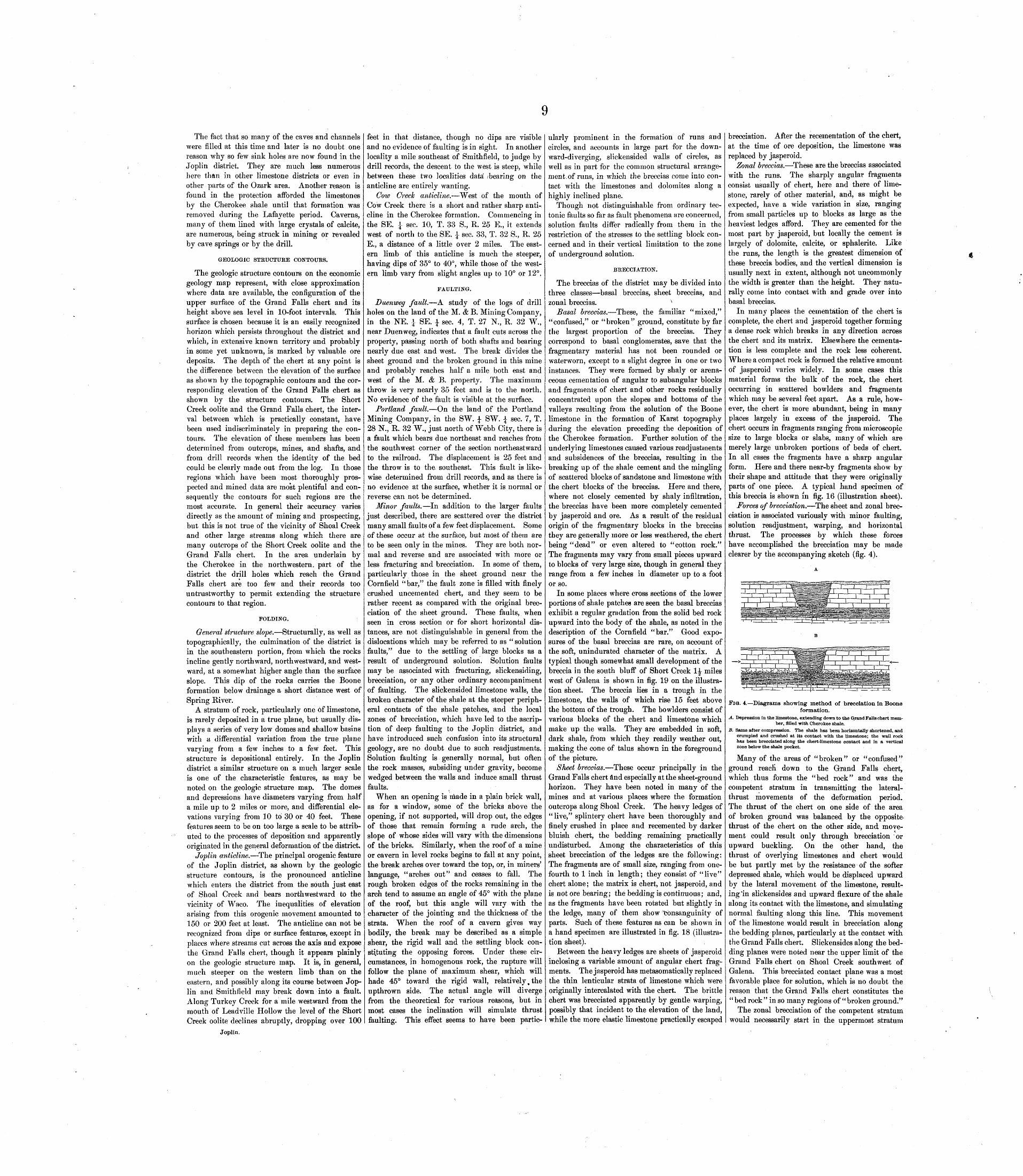
9
The fact that so many of the caves and channels were filled at this time and later is no doubt one reason why so few sink holes are now found in the Joplin district. They are much less numerous here than in other limestone districts or even in other parts of the Ozark area. Another reason is found in the protection afforded the limestones by the Cherokee shale until that formation was removed during the Lafayette period. Caverns, many of them lined with large crystals of calcite, are numerous, being struck in mining or revealed by cave springs or by the drill.
GEOLOGIC STRUCTURE CONTOURS.
The geologic structure contours on the economic geology map represent, with close approximation where data are available, the configuration of the upper surface of the Grand Falls chert and its' height above sea level in 10-foot intervals. This surface is chosen because it is an easily recognized horizon which persists throughout the district and which, in extensive known territory and probably in some yet unknown, is marked by valuable ore deposits. The depth of the chert at any point is the difference between the elevation of the surface as shown by the topographic contours and the cor responding elevation of the Grand Falls chert as shown by the structure contours. The Short Creek oolite and the Grand Falls chert, the inter val between which is practically constant, have been used indiscriminately in preparing the con tours. The elevation of these members has been determined from outcrops, mines, and shafts, and from drill records when the identity of the bed could be clearly made out from the log. In those regions which have been most thoroughly pros pected and mined data are most plentiful and con sequently the contours for such regions are the most accurate. In general their accuracy varies directly as the amount of mining and prospecting, but this is not true of the vicinity of Shoal Creek and other large streams along which there are many outcrops of the Short Creek oolite and the Grand Falls chert. In the area underlain by the Cherokee in the northwestern, part of the district the drill holes which reach the Grand Falls chert are too few and their records too untrustworthy to permit extending the structure contours to that region.
FOLDING.
General structure slope. Structurally, as well as topographically, the culmination of the district is in the southeastern portion, from which the rocks incline gently northward, northwestward, and west ward, at a somewhat higher angle than the surface slope. This dip of the rocks carries the Boone formation below drainage a short distance west of Spring River.
A stratum of rock, particularly one of limestone, is rarely deposited in a true plane, but usually dis plays a series of very low domes and shallow basins with a differential variation from the true plane varying from a few inches to a few feet. This structure is depositional entirely. In the Joplin district a similar structure on a much larger scale is one of the characteristic features, as may be noted on the geologic structure map. The domes and depressions have diameters varying from half a mile up to 2 miles or more, and differential ele vations varying from 10 to 30 or 40 feet. These features seem to be on too large a scale to be attrib uted to the processes of deposition and apparently originated in the general deformation of the district.
Joplin anticline. The principal orogenic feature of the Joplin district, as shown by the geologic structure contours, is the pronounced anticline which enters the district from the south just east of Shoal Creek and bears northwestward to the vicinity of Waco. The inequalities of elevation arising from this orogenic movement amounted to 150 or 200 feet at least. The anticline can not be recognized from dips or surface features, except in places where streams cut across the axis and expose the Grand Falls chert, though it appears plainly on the geologic structure map. It is, in general, much steeper on the western limb than on the eastern, and possibly along its course between Jop lin and Smithfield may break down into a fault. Along Turkey Creek for a mile westward from the mouth of Leadville Hollow the level of the Short Creek oolite declines abruptly, dropping over 100
Joplin.
feet in that distance, though no dips are visible and no evidence of faulting is in sight. In another locality a mile southeast of Smithfield, to judge by drill records, the descent to the west is steep, while between these two localities data! /bearing on the anticline are entirely wanting.
Cow Creek anticline. West of the mouth of Cow Creek there is a short and rather sharp anti cline in the Cherokee formation. Commencing in the SE. i sec. 10, T. 33 S., R. 25 E., it extends west of north to the SE. \- sec. 33, T. 32 S., R. 25 E., a distance of a little over 2 miles. The east ern limb of this anticline is much the steeper, having dips of 35° to 40°, while those of the west ern limb vary from slight angles up to 10° or 12°.
FAULTING.
Daenweg fault. -A study of the logs of drill holes on the land of the M. & B. Mining Company, in the NE. 1 SE. | sec. 4, T. 27 N., R. 32 W., near Duenweg, indicates that a fault cuts across the property, passing north of both shafts and bearing nearly due east and west. The break divides the sheet ground and the broken ground in this mine and probably reaches half a mile both east and west of the M. & B. property. The maximum throw is very nearly 35 feet and is to the north. No evidence of the fault is visible at the surface.
Portland fault. On the land of the Portland Mining Company, in the SW. \ SW. \ sec. 7, T. 28 N., R. 32 W., just north of Webb City, there is a fault which bears due northeast and reaches from the southwest corner of the section northeastward to the railroad. The displacement is 25 feet and the throw is to the. southeast. This fault is like wise determined from drill records, and as there is no evidence at the surface, whether it is normal or reverse can not be determined.
Minor faults. In addition to the larger faults just described, there are scattered over the district many small faults of a few feet displacement. Some of these occur at the surface, but most of them are to be seen only in the mines. They are both nor mal and reverse and are associated with more or less fracturing and brecciation. In some of them, particularly those in the sheet ground near the Cornfield "bar," the fault zone is filled with finely crushed uncemented chert, and they seem to be rather recent as compared with the original brec ciation of the sheet ground. These faults, when seen in cross section or for short horizontal dis tances, are not distinguishable in general from the dislocations which may be referred to as " solution faults," due to the settling of large blocks as a result of underground solution. Solution faults may be associated with fracturing, slickensiding, brecciation, or any other ordinary accompaniment of faulting. The slickensided limestone walls, the broken character of the shale at the steeper periph eral contacts of the shale patches, and the local zones of brecciation, which have led to the ascrip tion of deep faulting to the Joplin district, and have introduced such confusion into its structural geology, are no doubt due to such readjustments. Solution faulting is generally normal, but often the rock masses, subsiding under gravity, become wedged between the walls and induce small thrust faults.
When an opening is made in a plain brick wall, as for a window, some of the bricks above the opening, if not supported, will drop out, the edges of those that remain forming a rude arch, the slope of whose sides will vary with the dimensions of the bricks. Similarly, when the roof of a mine or cavern in level rocks begins to fall at any point, the break arches over toward the top, or, in miners' language, "arches out" and ceases to fall. The rough broken edges of the rocks remaining in the arch tend to assume an angle of 45° with the plane of the roof, but this angle will vary with the character of the jointing and the thickness of the strata. When the roof of a cavern gives way bodily, the break may be described as a simple shear, the rigid wall and the settling block con stituting the opposing forces. Under these cir cumstances, in homogenous rock, the rupture will follow the plane of maximum shear, which will hade 45° toward the rigid wall, relatively, the upthrown side. The actual angle will diverge from the theoretical for various reasons, but in most cases the inclination will simulate thrust faulting. This effect seems to have been partic
ularly prominent in the formation of runs and circles, and accounts in large part for the down ward-diverging, slickensided walls of circles, as well as in part for the common structural arrange ment, of runs, in which the breccias come into con tact with the limestones and dolomites along a highly inclined plane.
Though not distinguishable from ordinary tec tonic faults so far as fault phenomena are concerned, solution faults differ radically from them in the restriction of the stresses to the settling block con cerned and in their vertical limitation to the zone of underground solution.
BRECCIATION.
The breccias of the district may be divided into three classes basal breccias, sheet breccias, and zonal breccias. v
Basal breccias. These, the familiar "mixed," "confused," or "broken" ground, constitute by far the largest proportion of the breccias. They correspond to basal conglomerates, save that the fragmentary material has not been rounded or water worn, except to a slight degree in one or two instances. They were formed by shaly or arena ceous cementation of angular to subangular blocks and fragments of chert and other rocks residually concentrated upon the slopes and bottoms of the valleys resulting from the solution of the Boone limestone in the formation of Karst topography during the elevation preceding the deposition of the Cherokee formation. Further solution of the underlying limestones caused various readjustments and subsidences of the breccias, resulting in the breaking up of the shale cement and the mingling of scattered blocks of sandstone and limestone with the chert blocks of the breccias. Here and there, where not closely cemented by shaly infiltration, the breccias have been more completely cemented by jasperoid and ore. As a result of the residual origin of the fragmentary blocks in the breccias they are generally more or less weathered, the chert being "dead" or even altered to "cotton rock." The fragments may vary from small pieces upward to blocks of very large size, though in general they range from a few inches in diameter up to a foot or so.
In some places where cross sections of the lower portions of shale patches are seen the basal breccias exhibit a regular gradation from the solid bed rock upward into the body of the shale, as noted in the description of the Cornfield "bar." Good expo sures of the basal breccias are rare, on account of the soft, unindurated character of the matrix. A typical though somewhat small development of the breccia in the south bluff of Short Creek 1|- miles west of Galena is shown in fig. 19 on the illustra tion sheet. The breccia lies in a trough in the limestone, the walls of which rise 15 feet above the bottom of the trough. The bowlders consist of various blocks of the chert and limestone which make up the walls. They are embedded in soft, dark shale, from which they readily weather out, making the cone of talus shown in the foreground of the picture.
Sheet breccias. These occur principally in the Grand Falls chert and especially at the sheet-ground horizon. They have been noted in many of the mines and at various places where the formation outcrops along Shoal Creek. The heavy ledges of "live," splintery chert have been thoroughly and finely crushed in place and recemented by darker bluish chert, the bedding remaining practically undisturbed. Among the characteristics of this sheet brecciation of the ledges are the following: The fragments are of small size, ranging from one- fourth to 1 inch in length; they consist of "live" chert alone; the matrix is chert, not jasperoid, and is not ore bearing; the bedding is continuous; and, as the fragments have been rotated but slightly in the ledge, many of them show Consanguinity of parts. Such of these features as can be shown in a hand specimen are illustrated in fig. 18 (illustra tion sheet).
Between the heavy ledges are sheets of jasperoid inclosing a variable amount of angular chert frag ments. The jasperoid has metasomatically replaced the thin lenticular strata of limestone which were originally intercalated with the chert. The brittle chert was brecciated apparently by gentle warping, possibly that incident to the elevation of the land, while the more elastic limestone practically escaped
brecciation. After the recementation of the chert, at the time of ore deposition, the limestone was replaced by jasperoid.
Zonal breccias. These are the breccias associated with the runs. The sharply angular fragments consist usually of chert, here and there of lime stone, rarely of other material, and, as might be expected, have a wide variation in size, ranging from small particles up to blocks as large as the heaviest ledges afford. They are cemented for the most part by jasperoid, but locally the cement is largely of dolomite, calcite, or sphalerite. Like the runs, the length is the greatest dimension of these breccia bodies, and the vertical dimension is usually next in extent, although not uncommonly the width is greater than the height. They natu rally come into contact with and grade over into basal breccias.
In many places the cementation of the chert is complete, the chert and jasperoid together forming a dense rock which breaks in any direction across the chert and its matrix. Elsewhere the cementa tion is less complete and the rock less coherent. Where a compact rock is formed the relative amount of jasperoid varies widely. In some cases this material forms the bulk of the rock, the chert occurring in scattered bowlders and fragments which may be several feet apart. As a rule, how ever, the chert is more abundant, being in many places largely in excess of the jasperoid. The chert occurs in fragments ranging from microscopic size to large blocks or slabs, many of which are merely large unbroken portions of beds of chert. In all cases the fragments have a sharp angular form. Here and there near-by fragments show by their shape and attitude that they were originally parts of one piece. A typical hand specimen of this breccia is shown in fig. 16 (illustration sheet).
Forces of brecciation. The sheet and zonal brec ciation is associated variously with minor faulting, solution readjustment, warping, and horizontal thrust. The processes by which these forces have accomplished the brecciation may be made clearer by the accompanying sketch (fig. 4).
FIG. 4. Diagrams showing method of brecciation in Booneformation.
A. Depression in the limestone, extending down to the Grand Falls chert mem ber, filled with Cherokee shale.
B. Same after compression. The shale has been horizontally shortened, and crumpled and crushed at its contact with the limestone; the wall rock has been brecciated along the chert-limestone contact and in a vertical zone below the shale pocket.
Many of the areas of "broken" or "confused" ground reacn down to the Grand Falls chert, which thus forms the "bed rock" and was the competent stratum in transmitting the lateral- thrust movements of the deformation period. The thrust of the chert on one side of the area of broken ground was balanced by the opposite- thrust of the chert on the other side, and move ment could result only through brecciation or upward buckling. On the other hand, the thrust of overlying limestones and chert would be but partly met by the resistance of the softer depressed shale, which would be displaced upward by the lateral movement of the limestone, result ing'in slickensides and upward flexure of the shale along its contact with the limestone, and simulating normal faulting along this line. This movement of the limestone would result in brecciation along the bedding planes, particularly at the contact with the Grand Falls chert. Slickensides along the bed ding planes were noted near the upper limit of the Grand Falls chert on Shoal Creek southwest of Galena. This brecciated contact plane was a most favorable place for solution, which is no doubt the reason that the Grand Falls chert constitutes the "bed rock" in so many regions of "broken ground."
The zonal brecciation of the competent stratum would necessarily start in the uppermost stratum

of the chert, presumably at the joint which con trolled solution originally. The broken chert resulting from this brecciation, necessarily occu pying more space than in its original unbrecclated condition, would be forced upward, displacing the shale. Then the next lower stratum of chert, no longer confined by the chert above it, would be likewise brecciated, the broken chert pushing upward against the broken chert of the first stratum and further displacing the shale above. Then the third stratum would be subject to brec ciation, and in time the fourth, and so on, the brecciation progressing downward until the crush ing strength of the chert, added to the friction encountered by the upward movement of the loose chert, plus the weight of the superimposed shale, together balanced the force of the lateral thrust. In places along Shoal Creek where the Grand Falls chert has been subjected to rather sharp deformation it has lost its bedded character and become gnarled, knotted, and brecciated, apparently by some such process as has just been, described.
Localization of brecciation. The sheet breccia tion in the Grand Falls chert took place presum ably wherever there was warping, but the fracture and breccia zones are largely limited to the areas of underground solution, which, being weakened by jointing and further weakened by underground drainage, more readily yielded to the stresses of deformation. This accommodation to the stresses of the time apparently accounts for the absence of a definite and harmonious system of faulting in the district.
DISCUSSION OF SPECIAL AREAS.
The structure of the Joplin district, more particularly in the mining areas, appears at first sight to be bewilderingly complicated owing to the confusion arising from the solution unconformity and later readjustments of the underground drain age. This will be made plain in the following discussion of certain areas of typical difficulty.
Cornfield "bar"- Through the Cornfield tract of the American Zinc, Lead, and Smelting Company and neighboring tracts, a mile south of Carterville, runs a line of disturbance which throws much light on the structural features of the district. This region, which has elsewhere (Economic Geology, vol. 1, 1905, pp. 119-128) been considered some what in detail, will be but briefly described here.
On this tract both the upper broken ground and the sheet ground are mined, the former in many places reaching down almost to the latter, being separated from it by a few feet of barren chert, or here and there cutting into or through it. The " bar" is so called because it is a barren strip, for the most part of more or less broken and confused ground, occurring in otherwise well-developed sheet ground, which has a working face of 10 feet and is reached at a depth of about 170 feet from the sur face. The width of the bar varies from 50 to 300 feet, and its length, with its extension beyond the Cornfield tract, is nearly three-fourths of a mile. The relation of the bar to the surficial distri bution of the Cherokee shale can be seen on mine map B, which also shows the location of the cross sections given in fig. 5.
As one approaches the bar from either side along a mine drift the first manifestation is a slight dip of the rocks toward it. Next, long cracks make their appearance in the roof parallel to the-face of the bar, the dip increases, the fractures come at closer intervals and hade in inverse direction and propor tion to the dip, until the chert has a sheeted structure. At this point the mining usually stops because of lean ore and bad roof. Beyond, the dip may be reversed and the rocks may resume their normal position as sheet ground, or the trough of the bar may be occupied by a -confused mass of limestone and chert bowlders mixed with mud or masses of contorted shale. An instance of the latter sort is shown in section A-A (fig. 5), the location of which is indicated on mine map B. The broken and contorted shale, in the form of a closely appressed syncline, is flanked on either side by confused ground consisting of broken shale and chert bowlders. This lies unconforaiably on the chert, which is more or less faulted, jointed, and sheeted, and the dip gradually flattens out in both directions from the center of the bar until the level sheet ground is reached.
In sections B-B and C-C, 300 and 500 feet
respectively from section A-A, the synclinal defor mation varies from about 10 feet in the former to about 2 feet in the latter, accompanied in both cases by fracturing, sheeting, and some minor faulting.
In section D-D the central part of the bar is occupied by a mass of red clay containing blocks and bowlders of limestone. On either side of the broken area large inclined slabs of limestone lean toward walls of chert, but rest in part on masses of crushed and brecciated chert. As in the other sec tions, the chert dips toward the center of the bar, but away from the center the dip lessens until the chert resumes its normal level position as sheet ground.
is probable that the thrusts of the post-Carbonif erous deformation period may have found relief in appressing the syncline, in reverse faulting, in hori zontal slickensiding, and in sheet brecciation.
Missouri Pacific Railway cut at Carthage. In the northwestern portion of the city of Carthage there is a patch of shale 250 yards wide and three- fourths of a mile long in an east-west direction. Near the east end, where the shale reaches a depth of 150 feet, with 30 feet or more of mixed ground below, some very rich ore was found beneath the shale. Near the west end the shale is 225 feet thick, including some basal breccia.
The cut for the Missouri Pacific Railway strikes diagonally across the shale patch, displaying the
c-c
D-D
FIG. 5. Cross sections of Cornfield "bar," on American Lead, Zinc, and Smelting Company's property.Showing the synclinal character of the bar, the shale pocket, and divergent fracturing in the chert at the edges of the fold. Location of section lines is
indicated on mine map B. Horizontal scale: 1 inch=50 feet. Vertical scale: 1 inch=25 feet.
At the westernmost cross drift on the Homestead tract, about 450 feet northwest of section D-D, the chert dips l°-2° S. on the north side of the bar and 4° N. on the south side. There are very few frac tures and the bedding is not disturbed except for the gentle syncline.
On the Richland tract, 1500 feet southeast of section A-A, the continuation of the bar consists simply of a strip of barren sheet ground without fractures or dips. Where both the sheet ground and the broken "upper" ground are mined the two horizons are separated by a 4-foot ledge of white chert. Above this ledge shale is found in the cracks of the chert, then more shale with flat chert bowl ders, then more and more shale with irregular bowlders until it becomes typical basal breccia, the shale constituting a third of the mass. In various places on the Richland and Alexandra tracts this mixed ground reaches down into the sheet ground, forming a caving spot in the roof. Depths of 100 feet or more of shale with more or less mixed ground below have been noted at various points in the shale area of this region, both in the bar and outside of it.
After noting the surface distribution of the shale and the linear shape of the bar, a study of section A-A would logically lead to the conclusion that the shale was thrown down here 185 feet from the surface as the result of faulting, probably a double fault, letting down a long, narrow block of shale. The evidence is the most decisive for deep faulting that the district affords. Section D-D likewise shows disturbance which might be interpreted as extensive faulting. But the absence of shale over the bar in this vicinity and the substitution of red clay for shale in the section argue against the pres ence of extensive faulting. The lack of deforma tion on the Richland tract, in the eastern part of the bar, and the limited deformation shown in sections B-B and C-C and in the west drift on the Homestead tract prove conclusively <that the amount of deformation by both folding and fault ing is small not over 20 or 25 feet and probably not so much.
As has1 been seen, the unconformity alone suf fices to account for the depressed position of the shale in the section. The steeply dipping lime stones and cherts in section D-D and the flexed shale in section A-A are strongly suggestive of the synclinal attitude usually assumed by strata which have sunk into cavities due to solution. The gen eral synclinal habit of the bar argues a cavity beneath, since a syncline without attendant anti clines, as we have here, would, if due to lateral thrust, increase the stress rather than relieve it. The dipping cherts, the slickensides, the normal faults, and to some extent the reverse faults, are natural incidents in-the development of an under ground-drainage tract such as this seems to be. It
section shown in fig. 6. The clay and gravel at the north end of the section are underlain by lime stone, the rim wall of limestone coming just under the crumpled shale shown in the cut. From that point to the hollow on the south the shale exhibits a syncline with thin beds of coal and sandstone. The downward extension of the shale, shown in the figure, is determined from records of shafts near the line of the cut. Beyond the hollow the lime stone is struck again, and near the end of the sec tion there is a cleft in the limestone 30 feet wide, which is filled with yellow clay, flint fragments, and sandstone chunks. The limestone walls of the cleft have a weathered surface, not slickensided, and the material immediately in contact with them is a waxy red clay, such as results from the decom position of limestone.
section the Short Creek oolite is 8 feet thick and lies upon 20 feet of interbedded limestone and chert. About 100 feet farther west the middle portion of the limestone and chert is replaced by irregular bowlders of shaly sandstone embedded in black shale and lying unconformably upon the limestone. Higher in the bluff, however, the oolite is uninterrupted, though at the west edge of the shale the oolite is about 6 feet below its normal height, a result probably of settling con sequent on solution of limestone beneath. It seems clear that the whole shale and sandstone mass lies in a pocket in the face of the bluff. About the middle of the section solid chert reaches up to 30 feet from the level of Short Creek. The lower half as exposed in the creek bluff is massive, while the upper half exposed in the cut is heavy bedded and dips 20°-30° W., the dip dying out to 4° within 300 feet. The steeply dipping por tion is highly fractured, the fractures being nearly at right angles to the stratification. At this point there is a vertical, open, slickensided fracture with a width of 6 inches between its walls. A hundred feet farther west the chert is interrupted for a hori zontal distance of about 10 feet by a vertical band of drab to yellow clay shale with embedded bowl ders of chert. A shaft, perhaps 150 feet to the northwest, went down in heavy limestone, but the drifts show considerable shale. About 250 feet west of the vertical shale band cherty limestone similar to that beneath the oolite at the east end of the section crops out in the bank of the creek, dipping 10° W. At the west end of the section the Short Creek oolite appears immediately over this limestone, dipping uniformly with it. Viewed from the south across the creek the outcrops of oolite with, one exception are seen to fall into alignment with a dip of slightly more than 1° W.
The problem here is to explain the occurrence of the massive and bedded cherts at the horizon of the oolite. The first suggestion is that the Grand Falls chert has been thrown up by a double fault. But several facts are opposed to this explanation: (a) Here, as in almost every other such case, the fault postulated is necessarily double. Even though dis placement be granted, the faults cap not be traced away from this point in any direction, (b) The synclinal shape of the chert and its upturned east ern edge are antagonistic to the theory of an upward- thrust movement; with such a movement the bed should be bent the reverse way. (c) To explain
NW.
SCALE OF FEET IOO 2OC 30C
FIG. 6. Missouri Pacific Railway cut at Carthage, Mo.Shows synclinal structure of the shale outcrop, crumpling and brecciation at its northwestern margin,-and basal breccia at the bottom of the shaft.
The conjectured outline of the shale pocket is suggested.
The shale patch occupies a relatively long area under which there has been extensive solution and removal of the limestone, with the dropping of masses of shale and sandstone, which have taken, in places, the characteristic synclinal shape. What part of the shale in the depression is due to depo sition in the trough and what part to subsidence into it is debatable, though the amount of solution
the position of the oolite just to the east and the occurrence of shale shown in the section and in the drifts noted, it is necessary to suppose either down ward faulting or solution channels.
Another interpretation might be that the beds above the oolite have been faulted down. The dis placement need not have been more than 15 or 20 feet. This would account for the upturned edges
PIG. 7. Missouri, Kansas and Texas Railroad cut one-half mile west of Empire, Kans.The Short Creek oolite in the Boone limestone at each end of the section is practically undisturbed. The middle of the section is occupied by chert, presum
ably from a higher horizon, filling a depression in the limestone. At the right a smaller depression is filled with Cherokee shale.
necessary is the same in either case. The compres sion resulting from subsidence into the V-shaped cavity has more or less crushed, crumpled, and brecciated the shale near the north end of the sec tion, and probably the same effects would be seen at the south end also, were that visible.
Empire cut. The Empire cut begins half a mile south of west of the Frisco station at Empire, just west of the crossing of the Frisco and the Missouri, Kansas and Texas railways. From this point westward for 1500 feet the latter railroad, skirt ing the north bluff of Short Creek, exposes the section shown in fig. 7. At the east end of the
of the chert. But nowhere in the neighborhood where the rocks demonstrably above the oolite are in place is there such massive chert. We are in a manner compelled to resort to local silicification to explain its occurrence here. Furthermore, solution is still necessary to account for the shale in the drifts. The same difficulty as in the first supposi tion is encountered in trying to outline the fault block.
A third interpretation is that solution has allowed an irregular-shaped area of the overlying rocks to settle below the level of the oolite. This accounts for the stratigraphic break and the difficulty of

11tracing it, the upturned edges, and the shale in the drifts, and puts this occurrence in the same category with neighboring sink-hole deposits of sandstone and shale. The slight anticlinal structure and the spreading apart of the walls of the cleft in which the yellow shale occurs are also readily intelligible in the light of irregularities in the floor of the solution chamber. For the reason indicated in the preceding paragraph it is necessary to suppose more or less local silicification to account for the massive cherts. However, the conditions accompanying such structural relations are those most favorable to silicification extensive water channels, shattering accompanying the settling into the basins, and the presence of shale and sandstone at close range. It is a significant fact that the heavy cherts, where identification with the Grand Falls member is diffi cult, are prone to occur in this fashion i. e., the stratigraphic order is broken up, blocks of shale and sandstone are in close proximity or even min gled with the chert, and there is a difference scarcely definable between the chert and the true Grand Falls variety.
Gimlet circle. In Jackson Hollow, in the NE. ^ SE. ± sec. 24, T. 27 N., E. 34 W., on the Gimlet lease, between the Gimlet mill and the Columbus mill, there are several "cave-ins" located in a roughly elongated circle 400 feet wide and 600 feet long. These openings show that there is an overhanging rim wall of horizontally bedded bluish cherts, facing inward, against which the broken shale, with included masses of chert, as shown in fig. 8, lies
FIG. 8, Section of wall of Gimlet cave-in, Jackson Hollow. Confused broken shale, with chert and shale masses on the margin of the cave-
in, lying against an overhanging rim wall of horizontal chert.
topsy-turvy. At the west end of the cave-in east of the Gimlet mill the contact face of the chert is 18 feet in height. Below this is a drift 30 feet in height which follows the contact. Near the bottom of the drift, on the outer or chert side, a seam of shale 12 inches thick extends back 10 or 12 feet in a gallery between the level chert strata. Similar seams occur farther east in the same cave-in, and southeast of the Columbus mill and east of the cir cle several shafts 150 to 200 feet distant from the cave-in go through 35 to 50 feet of solid chert and strike shale beneath. The shale is thin in the center of the circle, but thickens to 15 or 20 feet nearer the rim wall. The broken shale mass extends down the contact as far as mined, about 50 or 60 feet. The ore makes against this shale mass on both sides and extends outward and inward until cut off by dead walls. The chert wall shows no fracturing parallel to the contact face, but is brec ciated in horizontal planes without destroying the bedding and is recemented by black jasperoid from which the blende has been leached. The contact face is not slickensided and the shale seems to be mashed into it. All the cave-ins of the circle dis play similar features, but they are best seen in the one just described.
Circle deposits are not uncommon in the district. The case in hand allows better opportunities for study of the surface relations than any other known to the writer.
ORIGIN OF CIRCLES.
The origin of circles has excited a lively interest from the time of the first geologic exploration of the ore deposits. Meek (Geol. Survey Missouri, 1855, pt. 1, p. 159; pt. 2, pp. 117-119), in describing the High Point lead mine of Moniteau County, Mo., a circle deposit, with brecciated central core and downward-diverging, slickensided walls, ascribes the origin to an upward thrust of the central brec ciated mass. Sehmidt (Geol. Survey Missouri,
Joplin.
1873-74, pp. 487, 522) attributes circles to the dis integration and solution of a circular mass of lime stone, with the precipitation or settling of the overlying strata, resulting in many cases in the syn clinal shape of the 'central portion. Winslow follows Sehmidt in attributing the origin to under ground solution. Bain, admitting that some of the smaller circles may be so formed, found that there was a close relation between the larger circles and certain definite intersecting fault planes, which, he thought, made it impossible to ascribe their origin to solution. It has also been suggested that circles are due to intersecting parallel pairs of faults in which the opposing lateral thrusts have by simul taneous rupture resulted in a single curved fault rather than in a series of intersecting faults.
The general coincidence of circles with corre sponding depressed patches of shale and the down ward-diverging walls argue for thrust faulting. The occasional quaquaversal structure of the cen tral portion of the circles and the orientation of slabs in the breccia parallel to the outer wall favor the explanation by normal faulting and upthrust of the center of the circle. The slickensided walls, the brecciation, and the numerous observed dis placements are all in harmony with the origin by faulting, either normal or reverse.
But there seems to be an insuperable dynamic objection to circular thrust faulting in the fact that, by itself, it relieves no stress. Even if it be granted that the thrusts from all directions were so nicely balanced as to produce a circular fault, as suggested, there must of necessity be radial faults and breccia zones to take up the surplus which would result when the rocks of an area moved bodily toward a common point. Such radial breccia zones are not found in connection with characteristic circles.
The upward thrust of the central mass, as suggested by Meek, assumes a condition (lacco- lithic) so unusual in the Mississippi Valley as to require strong corroborative evidence to substantiate it. With a hade varying much from the vertical, such a circular normal fault of any considerable displacement must inevitably result in the radial disruption of the hanging wall and the upward deflection of its strata. These have not occurred.
Less easily understood is the genetic relation of the circles to the linear zones of fracturing and faulting, as suggested by Bain.
The theory of the origin of circles by under ground solution, as advanced by Sehmidt and fol lowed by Winslow, somewhat amplified to fit more extended developments, offers at all points the most satisfactory explanation of this form of ore body.
In caves circular rooms are not uncommon. Many are due to simple enlargement at the inter section of two solution channels. Circular passages are also more or less common. While the solution channels in a general way follow the joints in the limestone, they do not do so exactly. When two parallel channels intersect two parallel channels, the quadrangular block inclosed will show a ten dency to have the angles rounded off and in time develop a more or less circular shape, the passage assuming an annular form.
To these more or less circular openings, collapsed or otherwise, is attributable the form of the circu lar ore deposits. Where the collapsed opening is a circular room, the attitude taken by the subsiding rocks depends on the amount of debris on the cav ern floor: (a) "V\fhen the cave has been one of pure solution and the floor of the room is clear of debris, the settling may take place evenly over it, leaving the edges of the sunken strata upturned at the rim and more or less'shattered and crushed, (b) Some large circular rooms, however, have a central open ing connecting with a sink hole at the surface, through which enters debris that piles up in the center. The Jack Johnson mine at Chitwood is reported to have been of this character. The shaft went down through solid rock into the center of a circular room almost completely filled with ore- bearing basal breccia. When the rocks above settle onto a central cone of debris breccia or onto a rem nant of the original bedded rock they assume an anticlinal or dome shape, with the outer edges brecciated, and the rim wall, in some instances slick ensided, diverges downward, as has been explained in the discussion of "solution faults." The Gimlet circle in Jackson Hollow which has just been described seems to be of this class. The thin shale
at the center of the circle, thickening toward the rim, the shale breccia in contact with the outer wall, and, so far as may be determined, the quaquaversal structure of the shale area all point to this origin. (c) As annular passages are narrower than circular rooms, their collapse and the resultant sinking of the superincumbent strata produce an annular syncline.
HISTORICAL GEOLOGY.
Pre-Carboniferous land areas. Through the Cambrian and early Ordovician periods the Ozark region, with the exception of the comparatively small crystalline area to the east, was, barring brief intervals, under continuous sedimentation. From early Ordovician until early Carboniferous time the region was for the most part above water. The irregularity of the Silurian deposits at the contact of the Ordovician and Carboniferous on the south eastern edge of the uplift, arid their entire absence on the western border, indicate that the land area of that period corresponded approximately to the present area of Cambrian and Ordovician rocks, perhaps restricted somewhat on the north and south and extending an unknown farther distance to the west. The Devonian outcrop follows very closely that of the Silurian rocks except that it continues across the west end of the uplift, where the Silurian is wanting, indicating probably a restriction of the land in that direction. The patchy, nonpersistent nature of the Chattanooga shale along the southern and western sides of the uplift shows that the shore of the Devonian sea was not far inland from the present outcrop of this formation.
Boone deposition. In the type locality on the southern border of the uplift the Boone formation was the first member of the Mississippian to be deposited, but on the western border the Boone was preceded by the Choutoau and the Hannibal, whose irregular and intermittent outcrops indicate a con tinuation into the early Mississippian of the condi tion of gentle oscillation of the land near sea level which was characteristic of the border of the uplift during the Silurian and Devonian time.
With the initiation of the Boone there was a uniform subsidence of the Ozark area, conditions became settled, and 250 to 350 feet of limestones and cherts were then deposited all along the south ern and western edges of the area, with correlative formations to the north and east. The formation presents its full development everywhere at the outcrop, so that its former extent landward upon the uplift, while problematical, certainly was exten sive. Chert bowlders with impressions of indeter minable Mississippian invertebrate remains have been found in caves in the Ordovician far up on the dome, within 20 miles of the crystalline nucleus. It is not to be understood, however, that cave deposits such as these or such as those of the Carterville imply complete submergence or the deposition of a continuous sheet of sediments, but they unquestionably prove that the subsidence was such that the waters of the Boone sea reached to that distance.
Post-Boone emergence. During the period be tween the close of Boone deposition and the beginning of the Carterville the land at the west end of the uplift stood at an elevation above the underground-water level approximately 200 feet higher than now, as is shown by cave deposits of shale at that depth below the present drainage, though probably, owing to the proximity of the Pennsylvaiiian sea to the northwest, the actual alti tude above sea level was considerably less than at present. Caves are formed at or near the level of underground drainage, which is practically that of the master streams of surface drainage. Numerous pockets of shale in the limestones of the Boone for mation in the Joplin area lie in such fashion that they could have been formed only as deposits in cave galleries, and many others resulted appa rently from the roof giving way over caves and allowing the overlying shale and sandstone to drop into the openings. The force which elevated the Boone further manifested itself in the formation of an intersecting system of jointing. The surface waters, taking advantage of these openings, pene trated the rocks and developed an underground drainage system, while at vine surface a simplified Karst topography was formed.
Carterville deposition. This old land surface, in Chester time, was depressed beneath the sea and the heterogeneous deposits of the Carterville formation
were laid down upon it. The deposits of this age are comparatively thick in a few depressions, but altogether absent over the remainder of the district, Since all the known occurrences of the formation yield rich faunas there must have been marine connection between them, but the connecting sedi ments, being thin, have since been eroded.
Post-Carterville emergence. After the deposition of the Carterville the land resumed the elevation it had during the post-Boone emergence, and those portions of the Carterville which were not pro tected by their position in depressions were carried away. At the same time the subterranean drain age system was carried to a much higher degree of development than during the preceding emergence, and the surface was wrought into a Karst topog raphy of great detail.
Judged by its effects, the post-Carterville emer gence was of much longer duration than the post- Boone emergence, and with this the faunal record is in entire agreement. The post-Boone emergence persisted during the whole of the St. Louis, while the post-Carterville lasted from the latter part of the Chester into the Pennsylvanian. The paleo- botanic record is more definite, and from this point of view the period lasted from the Chester well on into the middle of the Allegheny ("lower Coal Measures"), during which interval thousands of feet of shales and sandstones were deposited to the south in the Arkansas Valley.
Cherokee deposition. In middle Allegheny or "lower Coal Measures" time the sea encroached from the west, covered the Joplin district, and extended far eastward. Over the western part of the district, at present covered by the Cherokee formation, shale was first laid down; then, over this, sandstone; and with the widening of the sea and the oscillation of the shore line sandstones and shales were indiscriminately deposited, with here and there thin beds of coal. The surficial depres sions were all filled up and the subterranean open ings largely so, resulting in the formation of much of the basal breccia, which was mineralized at a later date. The Cherokee in a continuous mantle covered all the district and, transgressing the Boone, reached far up toward the center of the dome, though now almost altogether removed, remaining only in protecting depressions or as a few scattered outliers.
Post-Carboniferous deformation. About the close of the Allegheny or middle of the "lower Coal Measures," an uplift raised the region of southwest ern Missouri above water, in which position it has since remained. At the close of the Carboniferous period the region shared in the general diastrophic and orogenic movements of the time and suffered various forms of deformation that produced inequal ities of surface from 150 to 200 feet in magnitude, which have been described on a preceding page.
Cretaceous-Tertiary peneplanation. After the close of the Carboniferous the region was subjected for a long period to the processes of subaerial and subterranean erosion, which eventually left it in the condition of a peneplain. If the present topography of the region be generalized by omitting the recent erosion and canyon cutting, and taking only the flat-topped uplands, the old peneplain may be practically reproduced, and this has been done in fig. 9. This surface east of Spring River corre sponds approximately to the surface of the Boone
PIG. 9. Sketch map of the Cretaceous-Tertiary peneplain inthe Joplin district.
Shown by contours on the restored surface of the peneplain.
formation, except that the orographic features have been entirely effaced -in other words, reduced to a base plane. West of Spring River the Timbered Hills stand as a monadnock. The gorge on Spring River below Baxter Springs and the lower country to the west show that at the time of the formation of this plain the drainage passed westward north of Baxter Springs and then southwestward to the

12
Neosho. The elevation of the divide between Neosho and Spring rivers in this direction is about 850 feet above tide. A description has already been given, under the heading "Tertiary rocks/*' of the manner in which the chert gravels were being shaped and accumulated until they mantled the low- lying surface to the east.
Post-Eocene (Lafayette] elevation. More or less closely folio wing the deposition of the lignitic Eocene of southeastern Missouri came the uplift of the Ozark region nearly to its present elevation, which quickened the sluggish streams of the peneplain and swept the accumulated gravel down the sides of the uplift and out onto the Mississippi delta plain. The rejuvenated streams attacked the pene plain with renewed energy, cutting canyons such as that of Shoal Creek, 150 to 200 feet in depth, and removing the Cherokee mantle from the greater part of the district, leaving only outliers standing here and there. At some time within this period was established the new direct southerly course of Spring River below Baxter Springs.
Post-Lafayette deposition. When the Lafayette erosion 'had reached an early mature stage there occurred a slight subsidence which resulted in the deposition of sand and gravel in the valley of Spring River and, to a minor extent, in the valleys of its larger tributaries. These sediments now exist in the form of terraces fringing the valleys of the streams. Their reference to the period of deposition of the Columbia formation of the Atlantic Coastal Plain has already been suggested.
Recent elevation. After the deposition of the terrace gravels the streams were again rejuvenated by a slight elevation. At the present time most of the terrace material has been removed from the val^ ley of Spring River. The interterrace width of the valley varies from half a mile to a mile, the whole, with the exception of the river channel, which averages 200 yards in width, being occupied by the alluvial flood plain.
ECONOMIC GEOLOGY.ORE DEPOSITS.
GENERAL CHARACTER.
The ore deposits of the Joplin district occur in large but very irregular bodies of chert and lime stone, which'are usually brecciated and cemented by or impregnated with dolomite, jasperoid, cal- cite, or sphalerite, and which carry important amounts of sphalerite, galena, and iron sulphide. They contain unimportant amounts of ehalcopyr- ite, greenockite, barite, and other minerals, and on weathering give rise to a wide variety, of oxides, carbonates, sulphates, and silicates. They occur in the Boone formation, associated with cer tain forms of fracturing and brecciation, and have two general forms the breccias proper and the blanket-vein or sheet-ground deposits. In the lat ter the brecciation is relatively unimportant, the" ore occurring in thin sheets intercalated between nearly horizontal beds of chert.
COMPOSITION OF THE ORE BODIES.
MINERALS OF THE ORE DEPOSITS.
From the standpoint of relative abundance and economic importance the minerals of the district may be classed as follows: (1) Those valuable minerals which occur in sufficient' amount to ren der their extraction profitable and which therefore constitute the ore minerals of the district; (2) those associated minerals which, though of common occurrence, are economically unimportant either in themselves or because they are not found in sufficient abundance to constitute ores; (3) those minerals which are found but rarely and in small amounts.
The first class includes both lead and zinc min erals. The lead-ore minerals comprise galena, in the belt of cementation below ground-water level, and a limited amount of cerussite, in the belt of weathering above that level. The zinc ores con sist chiefly of sphalerite, in the belt of cementation, with a minor proportion of smithsonite and cala- mine above ground-water level.
In the second division may be included marcasite, pyrite and chalcopyrite, calcite and dolomite, and quartz, all occurring within the belt of cementa tion; also, as products of weathering, greenockite, limonite, gypsum, and epsomite.
To the third division belong wurtzite, millerite,
and barite, all original minerals; also pyromorphite and'anglesite, due to weathering of galena; hydro- zincite arid goslarite, from the weathering of sphal erite; and various other rare and unimportant minerals.
Sphalerite. Zinc sulphide (ZnS) is the principal ore mineral of the district. It is popularly known as "jack," a number of varieties being recognized. These depend chiefly on differences in color or transparency and include among others "black," "rosin," "steel," and "ruby jack." The mineral occurs in crystals and crystal aggregates lining cavities; in crystals and grains disseminated 'in various gangues, especially in jasperoid; and in massive granular form in seams and as a cement for chert breccia. It crystallizes in more or less distorted, isometric-tetrahedral forms, most of the crystals with similar distortion, in two unsym- metrical parts, suggesting hemimorphic types. The tetrahedral faces are usually small, minutely pitted, and rough, the other faces being lustrous and commonly united to produce low subcbnical forms (fig. 20, illustration sheet). Many of the crystals are twinned according to the spinel law, and repeated twinning is not uncommon. The crystals vary in size from those which are micro scopic to those 3 inches or more in diameter.
The luster of the mineral is usually resinous or resino-vitreous, though in some cases adamantine. Some° of the sphalerite crystals are iridescent with a thin film of what is perhaps chalcopyrite or iron sulphide. The color of the mineral is in most places brownish yellow ("rosin jack"), ranging from this to a very dark brown, nearly black ("black jack"). Most of it transmits light readily only on the thin edges of fragments; however, some crys tals as much as half an inch in diameter are semi- transparent. The most transparent variety is the "ruby jack," which characteristically occurs in small subtransparent crystals, usually of a rich brownish- red or dark-amber color by transmitted light.
Sphalerite as seen in thin section under the microscope occurs in two colors deep yellow and gray with a tinge of yellow in places. The two colors generally occur together, usually as a mot tling without any well-defined arrangement, though in many specimens imperfectly zoned, the yellow in narrow bands along the margin of or within the crystal or grain.
Theoretically pure sphalerite contains 67 per cent of zinc and 33 per cent of sulphur, but as found in nature it contains impurities, generally slight and consisting chiefly of iron and cadmium. The sphalerite of the Joplin district is remarkably pure, containing very small amounts of cadmium and iron. The milled sphalerite averages about 57 per cent zinc, with about 1 per cent of iron, but varies considerably in different parts of the district, partly on account of variations in the abundance of marcasite or other deleterious min erals associated with the ores, and partly on account of imperfect milling.
Smithsonite. Zinc carbonate (ZnCo 3 ), next to sphalerite, is probably the most abundant zinc ore in the district. Much of the ore mined and sold as "silicate" is smithsonite, although most of the mines yielding the carbonate have also more or less associ ated zinc silicate. At a few mines the carbonate has been recognized and mined as such. Although both the carbonate and the silicate are important ores of zinc, they do not occur in large amount, as compared with sphalerite, and they are generally limited to a narrow vertical interval1 in the belt of weathering. They are not usually found in paying quantity below a depth of 50 feet, and on account of their solubility in surface waters they are seldom found at less depths than 15 or 20 feet.
Smithsonite occurs crystallized, either in individ ual crystals or crystal aggregates, or in massive, fine-granular condition. The crystals.are uniformly small, averaging about 1 mm. in diameter. They occur in rhombohedral form, with more or less curved faces, some of them so rounded as to be almost spherical, and also in elongated, club-shaped form, They are subtranslucent or translucent, some nearly colorless, many with a characteristic greenish-gray color, and a few brown. The luster is usually vitreous to pearly, in some cases velvety. The crystals and aggregates, many of the latter having botryoidal surfaces, are found coating other min erals, especially sphalerite, or lining cavities.
Smithsonite is most abundant, however, in the
massive granular condition, mainly as a metasomatic replacement of limestone. Here and there it occurs in small amount as a replacement of other sub-' stances- jasperoid, less commonly other minerals, and rarely chert. The form and structure of the more massive smithsonite are varied, depending in part on the substance replaced and the mode of replacement. A lamellar or platy form, with open ings between the layers lined with crystal aggregates of smithsonite, is one of the common varieties where limestone has been replaced, though much of the ore replacing limestone is considerably less open and more compact than this. Locally hollow shells are formed as a result of the partial replacement of limestone. A cellular structure, produced in the process of weathering of the ores, by solution and the partial replacement of jasperoid, calcite, or galena by the zinc carbonate, is not uncommon. The massive carbonate is usually gray in color, and much of it resembles limestone in general appear ance. It is commonly compact, though here and there rather porous.
Much of the smithsonite as sold is impure, as a result of admixture with rock and other substances, especially with limestone, which has been only par-' tially replaced by the zinc carbonate.
Calamine. There is some confusion in literature regarding the use of the term calamine, but in the United States it is generally applied to a basic sili cate of zinc having the composition H 2 Zn 2 SiO 5 . It is commonly known as "silicate." It is 'an important but, as already noted, minor ore of zinc. It is found in the zone of Oxidation as a product of the weathering of sphalerite, usually associated with more or less smithsonite and occurring under some what similar conditions. When pure, calamine contains 54.2 per cent of metallic zinc, but the ore as marketed falls considerably short of this, being more or less contaminated with gangue material.
It occurs in both crystal and crystalline aggregates. The crystals are invariably small, orthorhombic- hemimorphic in form, and many of them tabular parallel to the braehypinacoid. Many of the aggre gates are hemispherical or globular, locally in scat tered sheaf-like forms. The mineral also occurs in druses or in botryoidal aggregates,, coating surfaces, especially the walls of cavities. The small globular or botryoidal aggregates are commonly known as "buckshot silicate." The crystals are usually color less, and. generally show a vitreous luster; in places they are stained yellow by cadmium sulphide or red by clay. Crystal aggregates are abundant on chert and jasperoid, and not uncommon on sphal erite, calcite, and other associated minerals of the ore deposits.
The massive mineral is usually grayish, much of it with more or less of a yellow tinge, and in many places somewhat stained with clay. It is as a rule composed of small, fine-grained, spherulitic radial aggregates. In the massive form the min eral is found chiefly filling cavities in and metaso- matically replacing jasperoid, and therefore much of it occurs cementing chert breccia, associated in many places with more or less unreplaced jasperoid (fig.15, illustration sheet). Less commonly it re places limestone; also, to a limited extent, galena or calcite, after which latter it here and there forms pseudomorphs. Rarely, calamiue is found replac ing chert.
In connection with calamine may be mentioned the tallow clays, which from their chemical compo sition appear to be merely residual clays containing more or less basic zinc silicate that has not crystal lized. The amount of zinc is variable, the oxide in analyses ranging from 2 to 56 per cent, but in most cases being between 20 and 40 per cent. The chief remaining constituents are silica and water.
In color these clays are light reddish to brownish, locally yellowish, or light to dark gray. As seen in the mines, they are soft and perfectly plastic and have a peculiar, characteristic feel. They show a tendency to crumble on drying. In dry specimens they do not differ essentially in general character from surface clays. They are fine grained and rather soft they can be scratched with the finger nail, though not easily and have a conchoidal fracture.
Goslarite.- The hydrous zinc sulphate (Zn SO 4+ 7H 2 O) is* the first product of the weathering of sphalerite, but is seldom found on account of its ready solubility in water. It has been noted here
and there on the walls of old drifts, as small trans lucent stalactites and stalagmites, as white opaque globular or botryoidal forms, and as an efflorescent growth of small white crystals.
Greenockite. Cadmium sulphide (CdS) is not uncommon near the lower limit of the zone of weathering, where it occurs as a product of second ary enrichment. It is most" abundant on the surface of sphalerite crystals or on fracture surfaces within them, but is also found on galena, calcite, chert, and calamine. It is present rarely as a pig ment in smithsonite crystals. As a coating it forms very thin, dull films, easily rubbed off with the finger, and with a color ranging from grass- green through yellowish green to citron-yellow.
Galena. Lead sulphide -(PbS) is the most important lead ore of the district and is commonly known as " lead." It is characterized by its lead- gray color and metallic luster, its perfect cleavage, and its high specific gravity. It occurs in crystals and crystal aggregates on the walls of cavities; in crystals, less commonly in grains, disseminated in jasperoid, selvage, limestone, or shale; and massive, in seams in fractured rocks, especially chert; also as a cement to chert breccia, at many places in asso ciation with other minerals. Its crystal form is generally a combination of the cube and the octa hedron, the octahedral faces most commonly merely replacing the solid angles of the cube (fig. 22). This form characterizes the mineral both where crystallizing freely, as in cavities (pockets), and where crystallizing against resistance, as dissemin ations. Rarely the form is chiefly octahedral, with 6nly very slight development of the cubic faces.
The crystals vary considerably in size, though as a rule they are medium sized or small, a diameter of 2 inches or more being unusual. Skeleton forms of galena occur locally, though they are rare. Intri cate skeleton intergrowths in stalactitic form of fine-grained galena and fine-grained radial sphal erite are common at the Combination mine, east of Joplin, forming what is called " combination ore," impossible to mill satisfactorily. In places marca- sijte coats the outside of these galena-sphalerite stalactites ; and stalactites formed chiefly of marca site, with a small central core of granular galena, are also seen.
Pure galena contains 86.6 per cent of lead and 13.4 per cent of sulphur. The galena of the Joplin district contains as a rule only trifling impurities, but the ore as marketed has a somewhat larger pro portion owing to imperfect milling. The marketed ore contains about 80 per cent of lead, the impurities consisting chiefly of gangue material and small amounts of the associated heavier minerals, iron sulphide and sphalerite. The galena of the Joplin district is nonargentiferous, silver, as shown by assay, being absent or ranging up to only If ounces per ton.
Cerussite. Lead carbonate (PbCO 3 ), or "dry bone," is one of the lesser ores of the district and aside frqm galena is the only important ore of lead. Although very small amounts have been found at all depths thus far reached in mining, it is found in quantity only near the surface. The deposits of cerussite were largely ̂ exhausted in the earlier days, though bodies of it are still occasionally encountered, and it is at present being mined, with shallow deposits of galena, in several parts of the district.
Cerussite occurs locally in small amount in tabular orthorhombic crystals or in crystal aggre gates in cavities, usually associated with other minerals. In crystals it is usually colorless and transparent or subtransparent, with a greasy- vitreous or greasy-adamantine luster. It also replaces galena to a greater or less extent, in many instances forming complete pseudomorphs after it. In such cases it is usually earthy and of a light- to dark-gray or nearly black color, form ing the "ash mineral" and "wool mineral" of the miners.
Cerussite is found chiefly as fine-granular mass ive aggregates, generally more or less cellular and associated with decomposing galena in such a way as to indicate that it has replaced to a greater or less extent the matrix in which the galena origi nally occurred. "Much'of this massive cerussite is soft and earthy, though in places it is moderately hard and compact. In color it is locally light gray, though most commonly yellow or reddish, chiefly from admixed clay.
Pure cerussite contains 77.5 per cent of lead,
13
but the ore as marketed is in all cases impure, mainly from admixture with gangue materials.
Pyrite and marcasite. The two iron disulphides (FeS 2 ), familiarly known as "mundic," are common throughout the district, though they usually occur in small amount. They are locally abundant and so mixed with the zinc ores as to be detrimental or even to render mining unprofitable. In addition to its occurrence with the ores, iron sulphide is occasionally found in small amount in the country rocks, not only near but also at a distance from any known ore deposit. It is common or. even abundant in some of the surface shale patches of the mining camps, and is in fact the most abun dant of the sulphides occurring in shale. As shown by drill records and samples, it is also found at various depths down to at least 850 feet, the deeper occurrences consisting of minute ro microscopic crystals disseminated in small amounts in the rock.
The two minerals occur under generally similar conditions, being in many places intermixed. Of the two the marcasite apparently predominates. Both are found in crystals and crystal aggregates, also massive and usually microgranular. The crys tals of pyrite are nearly everywhere minute or microscopic. Those of marcasite which occur in cavities are usually much larger, many of them reaching a length of one-half inch or more, though numbers of these also are minute; where dissem inated in rocks, they are generally microscopic. The isometric pyritohedral crystals of pyrite are usually in the form of the cube with striated sur faces, though the pyritohedron is also found. The orthorhombic forms of marcasite are somewhat more varied, much of the mineral occurring in twins, among them cyclic fivelings. Iron disulphide is an almost constant constituent of jasperoid, usually in scattered microscopic crystals. It is also found either alone or associated with other minerals of the ore bodies, as a cement to chert breccia, and locally replaces to a greater or less extent chert, limestone," dolomite, jasperoid, and coal, or any carbonaceous matter, especially that adjacent to the ores.
Chalcopyrite. This sulphide of copper and iron (CuFeS 2 ) is one of the accessory primary sulphide minerals and the only primary copper-bearing mineral noted in the district. Though rather common, it is always found in small amount. It occurs in small, well-defined tetragonal sphenoids with tetrahedral aspect and a length in few indi viduals, perhaps in none, exceeding 1 cm. These crystals are sometimes spoken of as "copper points" by the miners, though in general the mineral is not differentiated by them from iron sulphide. When chalcopyrite cccurs in small crystals on sphalerite all those on a single crystal of sphalerite have parallel orientation i. e., all similar faces give a reflection at the same time (fig. 23, illustration sheet).
The color of the chalcopyrite crystal faces is rarely, if anywhere, the brass-yellow characteristic of the freshly broken surface; they are usually more or less tarnished, in many places somewhat iridescent, and here and there frosted by corrosion to a dull, almost golden-yellow color.
Calcite. Calcium carbonate (CaCO 3 ), or "tiff," in addition to its occurrence as the essential con stituent of limestone, is one of the most abundant of the minerals associated with the ores. It occurs in granular form as a cement to chert breccia, par ticularly in the mines east of Joplin; and also in crystals or crystal aggregates lining cavities, coat ing other minerals, or locally in the mud filling of cavities in the ore deposits.
The crystals vary greatly in size, ranging from minute forms to those 3 feet or more in length. These larger crystals are found lining cavities or caverns which are formed in some places adjacent to the ore deposits, especially northwest of Joplin.
Gypsum. Hydrous calcium sulphate (CaSO 4+ 2H 2 O) occurs as a product of the weathering of calcium carbonate. It is seldom found in more than very small amount, owing to its ready solu bility in water. It is seen most commonly in old drifts, in small fractures, and on the surface of various rocks, especially chert, also on and in more or less hardened clays. It usually occurs in minute prismatic or acicular crystals, or in flat stellate aggregates, locally forming a thin coating over the surface of the rock. It is sometimes found in sim-
Jopliri.
ilar forms along the parting planes of shale, and rarely in larger crystals disseminated in the shale.
The amount of calcium sulphate contained in the mine waters is rarely so great as to approach the point of saturation. This is reached, however, in the water from the Missouri Zinc Fields pump shaft, southeast of Webb City. Notwith standing the strong flow of water here 1000 gal lons a minute gypsum crystals are forming in the chert breccia from which the water issues at the base of the shaft. There is also a grayish efflorescent coating, formed of small arborescent growths of gypsum, on the bottom and sides of the wooden trough carrying water from this shaft.
Dolomite. -The double carbonate of calcium and magnesium ([CaMg] CO 3 ), or "spar,"is a common mineral throughout the district, but is variable in its occurrence, being abundant in some of the min ing camps and almost absent from others. It occurs in massive granular form and also in crystal aggre gates lining cavities, in both forms almost invari ably associated with or adjacent to the ore deposits. So close is this relation of dolomite and sphalerite that the saying is current in the mines about Jop lin that "spar is the mother of jack;" and dolomite is rarely found outside the mining camps, especially at the surface. Several outcrops of massive dolo mite, however, occur in the eastern part of the district, on Center Creek and its tributaries, Jenkins and Jones creeks. These are not known to be associated with any ore. They are, in general, much finer grained than the massive dolomites of the ore deposits, and on the whole better crystallized.
The color is usually light gray or pale buff with a reddish tinge. The massive granular variety asso ciated with the ore deposits is as a rule characterized by a general gray color, being the " gray spar" of the miners, while the crystal aggregates are either a delicate pink, in which case they are known as "pink spar," or nearly white with pearly luster. Patches of pink dolomite, usually representing filled cavities, occur abundantly in the massive gray variety. Where weathered, both varieties are in many places more or less yellowish. The dolomite crystals in cavities do not vary greatly in size, being nearly everywhere a' few millimeters in greatest diameter, usually approximating half a centimeter. The grain of the massive dolomite is somewhat vari able, but usually medium and coarser than that of the Boone limestone, from which it has been derived.
Barile. Barium sulphate (BaSO 4 ) is relatively rare. It occurs at only a few mines within the dis trict, and generally in small amount.
Quartz. While silica (SiO 2 ) is an important constituent of the underground waters, as shown by analysis, and quartz is one of the most abundant minerals in the district occurring massive in cryp- tocrystalline form as chert and in granular aggre gates in jasperoid and while druses of minute or microscopic crystals coating siliceous surfaces, either chert or jasperoid, are common in many mines of the district, larger crystals are rare and none over an inch in length were observed.
Chalcedonic silica, bluish gray when fresh, has been noted here and there in the Grand Falls chert, both at the surface near Shoal Creek and in the sheet 'ground south of Oronogo, occurring mainly in small stalaetitic forms in cavities in chert and jasperoid.
Hydrocarbon compounds. The hydrocarbon compounds, although not definite minerals, are included here for the sake of convenience. The chief members of this group found in the Joplin district are bituminous coals, bitumen, and a little petroleum. The coals form an integral part of the Cherokee formation and are only indirectly con nected with the ore deposits. They are found in smalhquantity in many of the shale patches dotted over the district, and locally in large enough amount to be of economic importance. Coal occurs in frag ments in many of the small masses of Cherokee shale which are found in or associated with the ore bodies.
Bitumen, known as "tar" by the miners, is found in greater or less amount in all the rocks of the district. Its occurrence in appreciable quantity, however, is generally limited to the vicinity of the ore deposits, where it is usually found as a black viscous liquid (brown in films and by transmitted light) oozing from cavities, especially those in chert or dolomite. Though usually in small quantity, it is locally sufficient in amount to interfere with the
milling of the ores and in a few places to clog the pumps. It also occurs in scattered particles or films between the component grains of the dolomite, and, usually in similar form, is an almost constant .con stituent of jasperoid and is found in selvage, in which it is locally abundant.
The source of the bitumen seen in the mines is probably the Boone limestone, for bitumen is most abundant in the ores where limestone predominates in the adjacent country rocks. Whether the hydro carbons included in the limestones are principally in the form of petroleum or of bitumen is not definitely known, though it is probably the latter.
FARAGENESIS OF THE MINERALS.
Paragenesis, the order of mineral deposition, is in few places more definitely shown than in the Joplin, district for the reason that this succession is most clearly evident where the minerals form the lining or filling of cavities, and here this is one of the principal modes of mineral occurrence. The order is in most cases the same, although it is not invariable, owing to the local occurrence of two or more generations of the same mineral formed at different times.
The observed order of deposition of minerals of the ore deposits is as follows: Dolomite, chalcopyr ite, galena, sphalerite, galena, chalcopyrite, marca site, pyrite, calcite, barite, marcasite. Of these minerals, dolomite, where it occurs, is invariably the first formed in the cavities. Chalcopyrite, though sometimes found disseminated in small quantity in massive dolomite, has, wherever it occurs in cav ities, formed on dolomite crystals. Sphalerite and galena have both formed over chalcopyrite, as is well shown in the Franklin mine :of the Kohinoor group, west of Joplin, where some of the galena is so corroded as to show the projecting crystals of chalcopyrite which underlie it. The chalcopyrite formed on sphalerite with parallel orientation is of a later generation, and both generations have been seen, the one on, the other beneath, the same crys tal of sphalerite. No chalcopyrite has been noted in sphalerite, nor on nor in galena.
As a general rule, galena has formed before sphalerite, though occasionally aggregates are found in which this order is reversed. Sphal erite belonging to different generations has often been noted. A second generation, much of it with calcite, occurs filling fractures in jasperoid at the Oronogo circle, the jasperoid itself containing dis seminated sphalerite of the first generation.
Small sphalerite crystals are seen, though rarely, on larger ones of an earlier generation. Sphalerite of a late generation has .been noted at the Audrain mine, west of Joplin, in a few small crystals on crystals of calcite, near their terminals; also at the Combination mine, Empire, in very small crystals in calamine and with smithsonite, apparently formed at the same time as or later than the oxi dation products with which it is associated.
Iron sulphide formed earlier than galena or sphalerite has not been noted. When occurring with these minerals, it is in all cases superposed on them, showing locally a preference for one or the other, especially galena. Both marcasite and pyrite have been seen on chalcopyrite, while minute crystals of pyrite have been noted on marcasite crystals. Where these sulphides occur as metasomatic replacements they appear to have been developed simultaneously. A second generation of marcasite is sometimes seen, and in one instance was noted as occurring in the surface layer of cal cite crystals. At the Mildred mine, west of Joplin, chalcopyrite and marcasite crystals are covered with calcite crystals, which in turn show hemispherical and botryoidal marcasite on their surfaces. In a number of instances in the sheet ground about Webb City marcasite has been noted in corrosion cavities in galena.
GANGTJE AND ASSOCIATED MATERIAL.
The ore minerals of the district, sphalerite and galena, occur in three ways cementing chert brec cias, disseminated in other cements and gangue materials, and lining or. filling cavities in the gangue or country rock.
Thus the ore bodies include not only the ore minerals and the gangue material, but also large amounts of country rock, both altered and unaltered. Probably the most abundant material is chert, and indeed the greater number of the ore deposits
are essentially chert breccias, the chert fragments being practically unaltered pieces of country rock. Limestone and shale fragments are also common. Along with these unchanged materials are large quantities of other materials, either introduced from outside or derived from the country rock through a complete process of recrystallization. These mate rials, which form the gangue, consist of jasperoid, dolomite, calcite, secondary limestone, selvage, and mud. .
Jasperoid. This is by far the most important gangue material. It occurs chiefly as the cement of chert breccias or intercalated with practically undis turbed beds of chert in sheet ground. When fresh it is a dark-gray to nearly black rock (occasionally medium or light gray), very fine grained and com pact, not unlike a dark-colored chert, and much of it suggestive of an extremely fine-grained quartzite. It is rather brittle, breaking like chert with a con- choidal or subconchoidal fracture, but with fracture surfaces less smooth than those of unweathered chert.
This rock has been variously called quartzite by Schmidt, cherokite by Jenney, jasperite by Jenney and Shepard, and secondary chert by Winslow and Bain. It is herein called jasperoid on account of its similarity to rocks from the Aspen district, Colorado, described under that name by Spun*.
The ore which occurs in the jasperoid is mainly sphalerite. Galena is found in places, but generally in very limited amount and in small crystals. The sphalerite occurs in crystals and anhedra, some of which are of microscopic size, others ranging up to 2 inches or more in diameter. The amount of sphalerite contained in the jasperoid is extremely variable. In some places it is found only in scattered grains or not at all; elsewhere it may be so abundant as to conceal the jasperoid matrix except on careful examination.
In addition to its ore minerals, much of the jasperoid shows minute, in places numerous, grains of calcite or disseminated grains of iron sulphide. But more'important than either of these is dolomite, the disseminated rhombohedra of which are locally quite as abundant as the crystals of sphalerite. Small patches of dolomite, both pink and gray, also occur. These are found not only on the surface of included chert, but also isolated, many of them with angular outline, resembling fragments, of chert included in jasperoid. Some of the patches are bordered in part by aggregates of pink dolomite crystals which project into the jasperoid. Jasperoid grading into dolomite, shown in fig. 14 on the illus tration sheet, is of common occurrence in some mines, having been especially noted in those on the 'United Zinc Companies' land at Chitwood.
While jasperoid is common in most parts of the district and in most kinds of ground, it is not found in all the mines nor in all the mining tracts. In the mines of the Continental land west of Joplin it is one of the principal gangues of ore; it is also abundant in the mines north of Chitwood, though here it is more commonly barren of ore. The dark-colored fresh jasperoid is of rare occurrence on the Missouri Lead and Zinc Company's land east of Joplin, though the weathered rock, nearly every where leached of its ore, is common in the ^hallow mines at the south end of the tract. On this land as a whole the cement of the chert breccias is calcite rather than jasperoid, although cherts predominate in the adjacent country rocks; while west of the city, where jasperoid is the prevailing cement, the coun try rocks appear to consist chiefly of limestone.
Here and there the jasperoid is marked by bands of greater or less width. The coarser banding is due to variations in the amount ef contained sphal erite or dolomite. The finer banding is in lighter and darker shades of gray, and, as shown by the microscope, is due to variations in the amount of interstitial bituminous matter, depending on dif ferences in texture, or to variations in mineral composition, such as the occurrence of calcite in some of the bands. Some of these finer bandings are curved, but most of them are horizontal or nearly so and parallel to the broader bands. Many of them are near and parallel to the upper surface (fig. 21, illustration sheet), and some extend only a part of the way across an exposure of the rock.
Microscopically, jasperoid consists chiefly of a fine-granular allotriomorphic aggregate of quartz, in > places nearly uniform, but more commonly somewhat variable in grain (as shown in figs. 10
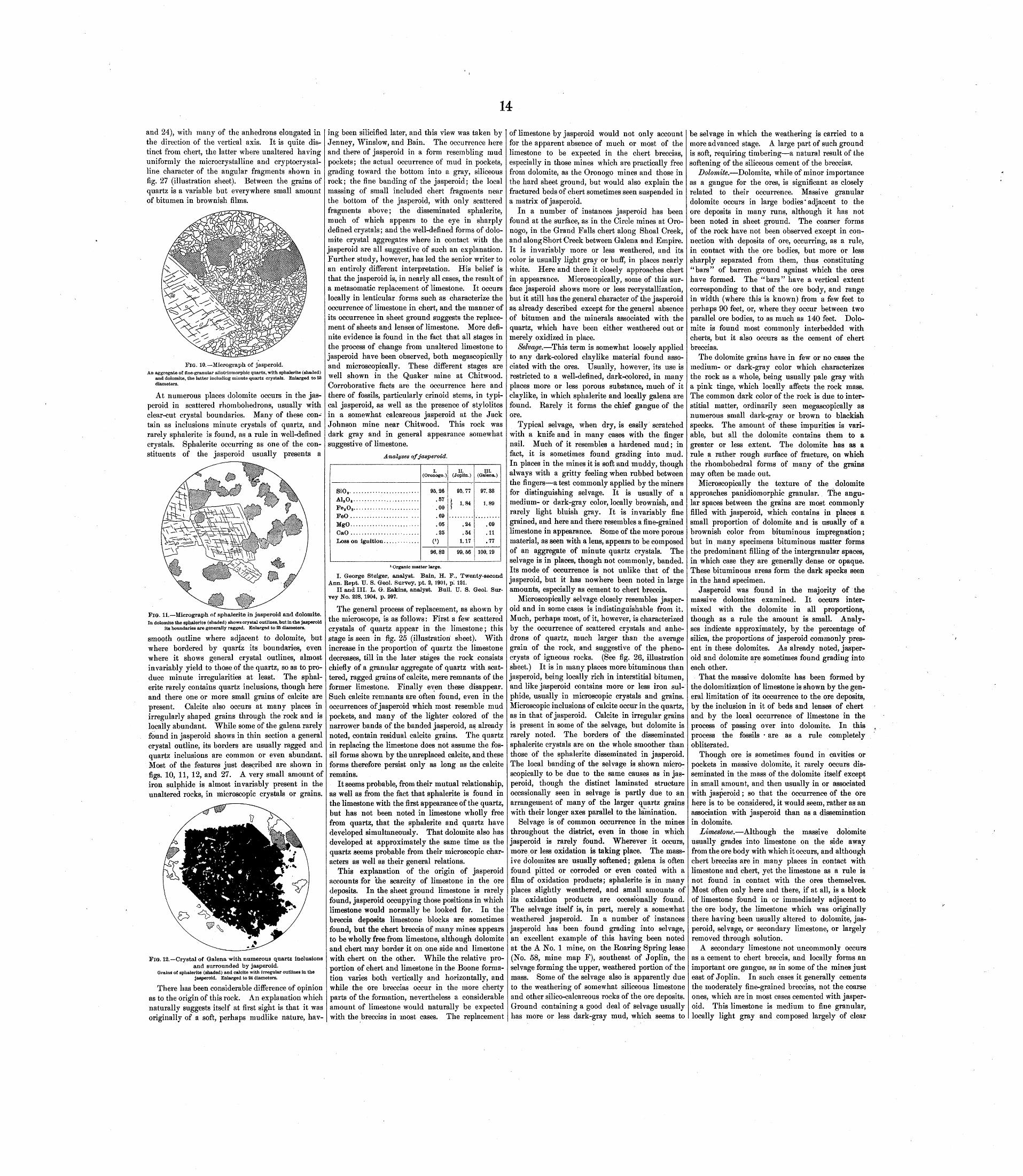
14
and 24), with many of the anhedrons elongated in the direction of the vertical axis. It is quite dis tinct from chert, the latter where unaltered having uniformly the microcrystalline and cryptocrystal- lirie character of the angular fragments shown in fig. 27 (illustration sheet). Between the grains of quartz is a variable but everywhere small amount of bitumen in brownish films.
FIG. 10. Micrograph of jasperoid.An aggregate of fine-granular allotriomorphic quartz, with sphalerite (shaded)
and dolomite, the latter including minute quartz crystals. Enlarged to 53 diameters.
At numerous places dolomite occurs in the jas peroid in scattered rhombohedrons, usually with clear-cut crystal boundaries. Many of these con tain as inclusions minute crystals of quartz, and rarely sphalerite is found, as a rule in well-defined crystals. Sphalerite occurring as one of the con stituents of the jasperoid usually presents a
FIG. 11. Micrograph of sphalerite in jasperoid and dolomite.In dolomite the sphalerite (shaded) shows crystal outlines, but in the jasperoid
its boundaries are generally ragged. Enlarged to 35 diameters.
smooth outline where adjacent to dolomite, but where bordered by quartz its boundaries, even where it shows general crystal outlines, almost invariably yield to those of the quartz, so as to pro duce minute irregularities at least. The sphal erite rarely contains quartz inclusions, though here and there one or more small grains of calcite are present. Calcite also occurs at many places in irregularly shaped grains through the rock and is locally abundant. While some of the galena rarely found in jasperoid shows in thin section a general crystal outline, its borders are usually ragged and quartz inclusions are common or even abundant. Most of the features just described are shown in figs. 10, 11, 12, and 27. A very small amount of iron sulphide is almost invariably present in the unaltered rocks, in microscopic crystals or grains.
FIG. 12. Crystal of Galena with numerous quartz inclusionsand surrounded by jasperoid.
Grains of sphalerite (shaded) and calcite with irregular outlines in the jasperoid. Enlarged to 24 diameters.
There has been considerable difference of opinion as to the origin of this rock. An explanation which naturally suggests itself at first sight is that it was originally of a soft, perhaps mudlike nature, hav
ing been silicified later, and this view was taken by Jenney, Winslow, and Bain. The occurrence here and there of jasperoid in a form resembling mud pockets; the actual occurrence of mud in pockets, grading toward the bottom into a gray, siliceous rock; the fine banding of the jasperoid; the local massing of small included chert fragments near the bottom of the jasperoid, with only scattered fragments above; the disseminated sphalerite, much of which appears to the eye in sharply defined crystals; and the well-defined forms of dolo mite crystal aggregates where in contact with the jasperoid are all suggestive of such an explanation. Further study, however, has led the senior writer to an entirely different interpretation. His belief is that the jasperoid is, in nearly all cases, the result of a metasomatic replacement of limestone. It occurs locally in lenticular forms such as characterize the occurrence of limestone in chert, and the manner of its occurrence in sheet ground suggests the replace ment of sheets and lenses of limestone. More defi nite evidence is found in the fact that all stages in the process of change from unaltered limestone to jasperoid have been observed, both megascopically and microscopically. These different stages are well shown in the Quaker mine at Chitwood. Corroborative facts are the occurrence here and there of fossils, particularly crinoid stems, in typi cal jasperoid, as well as the presence of stylolites in a somewhat calcareous jasperoid at the Jack Johnson mine near Chitwood. This rock was dark gray and in general appearance somewhat suggestive of limestone.
Analyses of jasperoid.
SiOg. ........................A1 S 0 8 . .......................Fe8 08 . .......................FeO ..................... ...MgO.........................CaO .........................
I. (Oronogo. )
95.26.57.00.69
.05
.25C 1 )
96.82
II.(Joplin.)
95.77
[ 1.84
.24fid.
1.17
99.56
III. (Galena.)
97. 38
1.89
.09
.11
.77
100. 19
1 Organic matter large.
I. George Steiger, analyst. Bain, H. F., Twenty-second Ann. Kept. U. S. Geol. Survey, pt. 2, 1901, p! 121.
II and III. L. G. Eakins, analyst. Bull. U. S. Geol. Sur vey No. 228, 1904, p. 297.
The general process of replacement, as shown by the microscope, is as follows: First a few scattered crystals of quartz appear in the limestone; this stage is seen in fig. 25 (illustration sheet). With increase in the proportion of quartz the limestone decreases, till in the later stages the rock consists chiefly of a granular aggregate of quartz with scat tered, ragged grains of calcite, mere remnants of the former limestone. Finally even these disappear. Such calcite remnants are often found, even in the occurrences of jasperoid which most resemble mud pockets, and many of the lighter colored of the narrower bands of the banded jasperoid, as already noted, contain residual calcite grains. The quartz in replacing the limestone does not assume the fos sil forms shown by the unreplaced calcite, and these forms therefore persist only as long as the calcite remains.
It seems probable, from their mutual relationship, as well as from the fact that sphalerite is found in the limestone with the first appearance of the quartz, but has not been noted in limestone wholly free from quartz, that the sphalerite and quartz have developed simultaneously. That dolomite also has developed at approximately the same time as the quartz seems probable from their microscopic char acters as well as their general relations.
This explanation of the origin of jasperoid accounts for the scarcity of limestone in the ore deposits. In the sheet ground limestone is rarely found, jasperoid occupying those positions in which limestone would normally be looked for. In the breccia deposits limestone blocks are sometimes found, but the chert breccia of many mines appears to be wholly free from limestone, although dolomite and chert may border it on one side and limestone with chert on the other. While the relative pro portion of chert and limestone in the Boone forma tion varies both vertically and horizontally, and while the ore breccias occur in the more cherty parts of the formation, nevertheless a considerable amount of limestone would naturally be expected with the breccias in most cases. The replacement
of limestone by jasperoid would not only account for the apparent absence of much or most of the limestone to be expected in the chert breccias, especially in those mines which are practically free from dolomite, as the Oronogo mines and those in the hard sheet ground, but would also explain the fractured beds of chert sometimes seen suspended in a matrix of jasperoid.
In a number of instances jasperoid has been found at the surface, as in the Circle mines at Oro nogo, in the Grand Falls chert along Shoal Creek, and along Short Creek between Galena and Empire. It is invariably more or less weathered, and its color is usually light gray or buff, in places nearly white. Here and there it closely approaches chert in appearance. Microscopically, some of this sur face jasperoid shows more or less recrystallization, but it still has the general character of the jasperoid as already described except for the general absence of bitumen and the minerals associated with the quartz, which have been either weathered out or merely oxidized in place.
Selvage. This term is somewhat loosely applied to any dark-colored claylike material found asso ciated with the ores. Usually, however, its use is restricted to a well-defined, dark-colored, in many places more or less porous substance, much of it claylike, in which sphalerite and locally galena are found. Rarely it forms the chief gangue of the ore.
Typical selvage, when dry, is easily scratched with a knife and in many cases with the finger nail. Much of it resembles a hardened mud; in fact, it is sometimes found grading into mud. In places in the mines it is soft and muddy, though always with a gritty feeling when rubbed between the fingers a test commonly applied by the miners for distinguishing selvage. It is usually of a medium- or dark-gray color, locally brownish, and rarely light bluish gray. It is invariably fine grained, and here and there resembles a fine-grained limestone in appearance. Some of the more porous material, as seen with a lens, appears to be composed of an aggregate of minute quartz crystals. The selvage is in places, though not commonly, banded. Its mode of occurrence is not unlike that of the jasperoid, but it has nowhere been noted in large amounts, especially as cement to chert breccia.
Microscopically selvage closely resembles jasper oid and in some cases is indistinguishable from it. Much, perhaps most, of it, however, is characterized by the occurrence of scattered crystals and anhe drons of quartz, much larger than the average grain of the rock, and suggestive of the pheno- crysts of igneous rocks. (See fig. 26, illustration sheet.) It is in many places more bituminous than jasperoid, being locally rich in interstitial bitumen, and like jasperoid contains more or less iron sul phide, usually in microscopic crystals and grains. Microscopic inclusions of calcite occur in the quartz, as in that of jasperoid. Calcite in irregular grains is present in some of the selvage, but dolomite is rarely noted. The borders of the disseminated sphalerite crystals are on the whole smoother than those of the sphalerite disseminated in jasperoid. The local banding of the selvage is shown micro scopically to be due to the same causes as in jas peroid, though the distinct laminated structure occasionally seen in selvage is partly due to an arrangement of many of the larger quartz grains with their longer axes parallel to the lamination.
Selvage is of common occurrence in the mines throughout the district, even in those in which jasperoid is rarely found. Wherever it occurs, more or less oxidation is taking place. The mass ive dolomites are usually softened; galena is often found pitted or corroded or even coated with a film of oxidation products; sphalerite is in many places slightly weathered, and small amounts of its oxidation products are occasionally found. The selvage itself is, in part, merely a somewhat weathered jasperoid. In a number of instances jasperoid has been found grading into selvage, an excellent example of this having been noted at the A No. 1 mine, on the Roaring Spring lease (No. 58, mine map F), southeast of Joplin, the selvage forming the upper, weathered portion of the mass. Some of the selvage also is apparently due to the weathering of somewhat siliceous limestone and other silico-calcareous rocks of the ore deposits. Ground containing a good deal of selvage usually has more or less dark-gray mud, which seems to
be selvage in which the weathering is carried to a more advanced stage. A large part of such ground is soft, requiring timbering a natural result of the softening of the siliceous cement of the breccias.
Dolomite. Dolomite, while of minor importance as a gangue for the ores, is significant as closely related to their occurrence. Massive granular dolomite occurs in large bodies' adjacent to the ore deposits in many runs, although it has not been noted in sheet ground. The coarser forms of the rock have not been observed except in con nection with deposits of ore, occurring, as a rule, in contact with the ore bodies, but more or less sharply separated from them, thus constituting "bars" of barren ground against which the ores have formed. The "bars" have a vertical extent corresponding to that of the ore body, and range in width (where this is known) from a few feet to perhaps 90 feet, or, where they occur between two parallel ore bodies, to as much as 140 feet. Dolo mite is found most commonly interbedded with cherts, but it also occurs as the cement of chert breccias.
The dolomite grains have in few or no cases the medium- or dark-gray color which characterizes the rock as a whole, being usually pale gray with a pink tinge, which locally affects the rock mass. The common dark color of the rock is due to inter stitial matter, ordinarily seen megascopically as numerous small dark-gray or brown to blackish specks. The amount of these impurities is vari able, but all the dolomite contains them to a greater or less extent. The dolomite has as a rule a rather rough surface of fracture, on which the rhoinbohedral forms of many of the grains may often be made out.
Microscopically the texture of the dolomite approaches panidiomorphic granular. The angu lar spaces between the grains are most commonly filled with jasperoid, which contains in places a small proportion of dolomite and is usually of a brownish color from bituminous impregnation; but in many specimens bituminous matter forms the predominant filling of the intergranular spaces, in which case they are generally dense or opaque. These bituminous areas form the dark specks seen in the hand specimen.
Jasperoid was found in the majority of the massive dolomites examined. It occurs inter mixed with the dolomite in all proportions, though as a rule the amount is small. Analy ses indicate approximately, by the percentage of silica, the proportions of jasperoid commonly pres ent in these dolomites. As already noted, jasper oid and dolomite are sometimes found grading into each other.
That the massive dolomite has been formed by the dolomitization of limestone is shown by the gen eral limitation of its occurrence to the ore deposits, by the inclusion in it of beds and lenses of chert and by the local occurrence of limestone in the process of passing over into dolomite. In this process the fossils are as a rule completely obliterated.
Though ore is sometimes found in cavities or pockets in massive dolomite, it rarely occurs dis seminated in the mass of the dolomite itself except in small amount, and then usually in or associated with jasperoid; so that the occurrence of the ore here is to be considered, it would seem, rather as an association with jasperoid than as a dissemination in dolomite.
Limestone. Although the massive dolomite usually grades into limestone on the side away from the ore body with which it occurs, and although chert breccias are in many places in contact with limestone and chert, yet the limestone as a rule is not found in contact with the ores themselves. Most often only here and there, if at all, is a block of limestone found in or immediately adjacent to the ore body, the limestone which was originally there having been usually altered to dolomite, jas peroid, selvage, or secondary limestone, or largely removed through solution.
A secondary limestone not uncommonly occurs as a cement to chert breccia, and locally forms an important ore gangue, as in some of the mines just east of Joplin. In such cases it generally cements the moderately fine-grained breccias, not the coarse ones, which are in most cases cemented with jasper oid. This limestone is medium to fine granular, locally light gray and composed largely of clear

15
calcite grains, but more commonly a medium or moderately dark gray. The calcite grains are as a rule less coherent than those of ordinary lime stone. These rocks usually contain small, scattered cavities lined with calcite.
As shown by the microscope, these secondary limestones uniformly contain more or less quartz in crystals or grains or in small crystal aggregates, the quartz being mainly interstitial, but also occurring as inclusions in the calcite grains. Iron sulphide in minute or microscopic grains is present in many places and locally abundant. Bitumen is some times seen in brownish films or scattered specks. No fossils have been noted in any of these secondary rocks. While the coarser grained examples are in many cases merely aggregates of calcite. which has crystallized directly as a cement to the breccias, it is probable that many if not most of the occurrences are due to the recrystallization of original limestone. The ore occurring disseminated in this gangue is both sphalerite and galena, the latter predominating in some places.
Shale. In addition to the surface occurrences already described, small bodies of Cherokee and Carter ville shales, in places containing fragments of coal, are often encountered in the ore deposits or adjacent to them, having been dragged down along planes of faulting or entrained by underground water. Many of these bodies show by slickensided surfaces the effects of crushing. Chert fragments and other foreign materials are not uncommonly found mixed with the shale.
The surface shales when fresh are very fine grained to aphanitic, dark-gray, nearly black, and usually very fissile rocks, breaking easily into small, thin flakes. Much of the shale or "soap- stone" as found in the mines, however, is so com pacted that its fissile character is lost and it fractures across the lamination as readily as parallel to it.
Iron sulphide. The occurrence of iron sulphide as a gangue is rare. It has been noted, however, in two mines, the Combination and the Walcott, near the north end of the Missouri Lead and Zinc Company's land, just east of Joplin. The mineral is abundant at both of these mines, and occurs locally in a very fine granular form, in which sphal erite is disseminated. This gangue has been formed as a replacement of original limestone, probably siliceous, and also of a silico-calcareous cement of chert breccia, in both of which the sphalerite was originally disseminated.
Mud. Small amounts of sphalerite and galena are sometimes found as disseminated crystals in mud pockets, though few of the occurrences are of any importance. Where it contains ore the mud is dark gray or blackish in color and near the lower limit of oxidation in position. .
WEATHERING.
While the general weathering of the rocks of the district does not extend to any considerable depth, surface waters are in many places carried by favor able channels to depths of several hundred feet before losing their power of oxidation, and along their courses more or less weathered ores and rocks are found. Chert approaching cotton flint has been noted in drill cuttings to a depth of more than 300 feet.
The first effect of the action of descending sur face waters, as seen in the mines, is on the dolomite. The massive forms gradually soften through gen eral solution, becoming in many cases a mass of slightly coherent grains, while the dolomite dissem inated in the jasperoid is removed by solution, leaving the jasperoid filled with the sharp molds'of the dissolved dolomite crystals. This leaching of the dolomite is seen in many places where the ores themselves show no sign of oxidation; the same jasperoid may contain fresh, unaltered crystals of sphalerite. Dolomite is rarely seen nearer the sur face than at a depth of 20 feet. Calcite, the other principal carbonate of the ore deposits, apparently weathers less readily than the dolomite, and crystals of calcite have been found forming in mud pockets within dolomite which is in process of weathering. Where calcite occurs as a cement to breccias it is in places unaltered, while the dolomite is very soft, although in other similar instances the calcite also may be more or less dissolved. The solution of limestone begins at the surface and along fractures, and does not result in general softening as soon as in the case of the more porous dolomite.
Joplin.
The other important rocks of the ore deposits are siliceous, including chiefly chert and jasperoid. These also weather by solution, though as a rule much more slowly than the calcareous rocks; and even where active weathering is taking place both are frequently found, little altered, close to the surface, though the jasperoid is changed from dark gray to light gray or buff, and usually more or less colored with clay.
Jasperoid weathers more readily than chert, owing partly to its less compact texture and partly also to the porosity resulting from the early weathering out of its disseminated sphalerite, dolomite, calcite, and iron sulphide. At a number of points along Shoal Creek jasperoid may be seen more or less softened or in places partially dissolved, while the associated Grand Falls chert is still very fresh. Under ground, the first stage in the weathering of the jasperoid is the production of selvage, and the final stage results in the black mud so commonly seen in the mines.
In many places chert shows more or less altera tion at the same depth at which dolomite begins to weather. The alteration of chert is in some instances selective, and one bed may be in the con dition of cotton flint while adjacent ones are still fresh, the difference being due in part to difference in texture. The tallow clays of the ore deposits are for the most part the result of the weathering of chert, and cherts have been noted in the process of altering to such clays. These clays are usually limited to the zone in which sphalerite is weather ing, where they occur in layers up to several feet in thickness, also in pockets, or intermixed with the oxidizing ores.
Of the principal metallic sulphides, sphalerite appears to be the most readily weathered, though the general oxidation of marcasite and sphalerite occurs at approximately the same level. Sphalerite readily oxidizes close to the level of ground water. Where it occurs in jasperoid the line of oxidation is locally so sharply marked that fresh, unaltered sphalerite may be seen within a distance of 1 inch from a part of the rock entirely leached of its ore. In the zone between the two, in one case noted, the color changes from that characteristic of rosin jack to a dark steel blue. More or less oxidized sphal erite occurs at all depths which have been reached by mining. In the regions of extensive oxidation sphalerite is rarely found in quantity above a depth of 50 feet and is usually absent above 20 feet.
Zinc sulphate, the first product of the oxidation of sphalerite, taken into solution by underground waters, is in part carried deeper and in part reacts with substances in solution in the waters and with the adjacent rocks.' With limestone it forms zinc carbonate, which to a large extent replaces the limestone metasoriiatically; with the siliceous rocks, chiefly jasperoid, it forms calamine, which also occurs largely as a replacement of the rock with, which the reaction takes place. With the continu ance of the process of weathering, the calamine and smithsonite are gradually dissolved and carried downward. The comparative readiness with which they dissolve in descending waters is shown by the fact that they are seen in but few places near the surface.
On.the weathering of the sphalerite its impurities are also oxidized, the cadmium sulphide contained in it being thus changed to the sulphate. This, carried downward as the sulphate or other salt, reacts in part near ground-water level with the zinc sulphide of unoxidized deposits, resulting in the precipitation of cadmium as greenockite, with the oxidation of a corresponding amount of the sphalerite. The reaction is as follows: CdSO 4+ ZnS=ZnSO 4 +CdS. The greenockite films so often seen on the ores are the result of this reaction.
Although galena is frequently found corroded and is in many places accompanied by small amounts of oxidation products close to the lower limits of oxidation, on the whole it weathers much less readily than the other sulphides of the ore bodies, and it is often found little or not at all altered close to the surface, or, as popularly expressed, "at the grass roots." In weathering, much of the galena shows at first only a simple pitting or corrosion. This etched and corroded galena is in many instances lustrous, locally iri descent or tarnished, and here and there the crys tals are merely rounded, with a velvety surface due to slight differential corrosion along cleavage lines.
Galena, like sphalerite, is probably first oxidized to the sulphate, although as lead sulphate is only rarely found as a mineral, in spite of its difficult solubility, it is probable that most of the sulphate formed is immediately changed to the carbonate, cerussite, which is the principal product of the weathering of galena.
The sulphides' of iron, marcasite and pyrite, both weather readily, the marcasite somewhat more so than the pyrite. The products of their weathering are principally limonite and various hydrous and basic sulphates of iron, the limonite being the final product, the least soluble, and the one most often seen.
Unusually rapid oxidation of the zinc and iron sulphides takes place on their exposure to atmos pheric action in some poorly ventilated drifts. This' is sometimes shown by the formation of secondary products on the walls of the drifts, also by an increased amount of zinc and iron sulphates in the mine waters. Some of these, formerly potable, become heavily charged with both sulphates. Among the characters favorable to such oxidation are, apparently, an open, porous gangue, as for example some forms of selvage; an abundance of ore, for the most part moderately fine grained; and a moderate amount of iron disul- phide, the ferric sulphate from the oxidation of which probably aids materially in the unusually rapid oxidation of the sphalerite. To such oxida tion of sphalerite and marcasite, particularly ,of the former, the "hot ground" seen in some .mines appeai-s to be largely due, and the heat in turn, together with the close, moist atmosphere, tends to make the rate of oxidation still more rapid. In the hottest of these mines the temperature is such that the miners can not work in them for more than five or ten minutes at a time. In one of the hot drifts of the Norsworthy mine, east of Joplin, the temperature (taken in midwinter) is reported to have been 120° F.
FORMS OF THE ORE BODIES.
The forms of the ore bodies, some simple, others complex, all fall into two general groups, the first including runs and their modifications; the second consisting of blanket veins, or, as they are gener ally known in this district, sheet-ground deposits.
BUNS.
Runs are irregular but usually elongated, in places tabular and inclined, bodies of ore, uni formly associated with disturbed strata which have been subjected to brecciation, slickensiding, and moderate displacement as the result of minor faulting or of dislocation due to underground solution. Simple runs are linear and continuous, straight or simply curved ore bodies," usually at nearly the same level throughout their extent. On account of the complication of minor fault ing, underground solution, and general deforma tion in the ore-bearing areas of the district, such runs are rare. Many runs which have a simple structure in cross section and which for short dis tances appear to be simple runs are found on further exploration to be compound. Even the few instances of simple runs which have been noted may present more complex features as the development of the ore body proceeds. It thus happens that there are all ^gradations from simple runs to complicated compound runs. Among the latter are those formed by the lateral connection of two nearly parallel simple runs so as to form a single ore body. . Another class, comprising by far the larger number of runs in the district, consists of the irregular ore bodies formed in disturbed areas that are due to complicated underground drainage. Combinations of these give runs of great complexity, among them, here and there, circular or subcircular deposits. It will be seen, therefore, that while theoretically the different types of ore deposits are distinct, practically they grade into one another, with no hard and fast lines between them.
The greatest dimension of the runs is horizontal, although as compared with that of ore bodies in other regions this linear extent is generally short, as a rule not exceeding a few hundred feet. The Arkansas run at Belleville, with a length of over one-fourth of a mile, described by Bain (op. cit., pp. 139-140), is exceptionally long. It does not, however, preserve a uniform direction, but varies
from southeast to east, then to south, and finally to west. The runs have a maximum width of 300 feet, but as a rule are between 10 and 50 feet wide. The average vertical extent is about the same, but in some cases reaches 150 feet.
In the most common structural phase of the runs about Joplin the ore-bearing breccias and the mass ive secondary dolomite come into juxtaposition along a highly inclined contact plane, the breccias usually forming the overhanging side. This rela tion is the result of a dislocation due in most cases to underground solution, as has been explained in the discussion of "solution faults." Behind the irregular zone of dolomite is unreplaced limestone and chert country rock, and behind the chert brec cia are bedded cherts and subordinate limestones.. The contact of the dolomite and chert breccias is usually sharp, and in many places some slicken siding is seen; locally, however, there is more or less diffusion, patches of jasperoid being found in the dolomite and patches of dolomite in the
, breccias. The dolomite zone has been formed by metasomatic replacement of the limestone; hence the width of the dolomite and its contact with the limestone are irregular, the limestone itself in rare instances forming the wall. In many places the dolomite is nearly horizontally bedded, and locally it shows fractures or is brecciated near the contact, giving rise where associated with interbedded chert to chert breccia with a dolomite matrix. , Both coarse and fine ore-bearing breccias occur. Their cementation is as a rule most complete close to the contact; farther from it much of the ground is open or bowldery. Large slabs of chert are common in these breccias, dipping usually in the same general direction as the contact and in many instances parallel to it, while farther from the con tact the dip of the slabs flattens out and the brec cias grade over into horizontally bedded cherts, generally more or less crushed. Aside from ore the cement of this breccia is chiefly jasperoid or calcite. Jasperoid metasomatically replacing lime stone is more plentiful in the coarser, more open breccias, because of the original greater abundance of limestone in those rocks.
The ore is.most abundant close to the dolomite wall (which is usually barren or nearly so), little or no.ore being found in the breccias at a distance from it. This is true not only of the finer' brec cias, but also of the more open bowldery ground, although as a rule the ore-bearing solutions could circulate here most freely. Even in the scattered occurrences of gray granular dolomite in the jas peroid of the chert breccia, sphalerite is in many places more abundant close to the dolomite than a short distance away from it. The ore of the runs is principally sphalerite. Galena is found spar ingly in the coarse breccias, but tends to form a cement to the finer breccias, and is often found in cherts, which are fractured but not greatly brecci ated on the margin of the ore body away from the dolomite. ' 1
As examples of sjmple runs showing this type of structure may be .cited the Excel mine (Nos. 61 and 62, mine map A), on the Murphy and Conner land west of Joplin, and theOlympia(Nos.43 and 45, mine map F), east of Joplin, the latter compris ing two parallel but disconnected runs. The Arkansas run at Belleville has already been men tioned. The Markanpax and Cumberland mines (Nos. 88 and 89, mine map F), on the Missouri Lead and Zinc Company's land east of Joplin, are simple and well defined toward the north end, but more complex toward the south, illustrating the gradation from simple runs into compound runs. The B & C mine (No. 5, mine map A), on the Boqua land, is a remarkable (0-shaped compound curved form, entirely simple in cross section. Other types of runs, as the Pelican and King Jack (Nos. 11 and 12, mine map C), near Chitwood, approach circles in portions of their extent and illustrate the transi tion from compound runs into circular deposits.
CIRCLES.
Circular, subcircular, and roughly elliptical closed runs, commonly known as "circles," consti tute one of the most distinctive and constantly recurring types of ore bodies in the:district. They have been noted in almost all the more important mining camps Neck, Oronogo, Webb City, Jop lin, and Galena and outside the district examples are found at Granby, Aurora, and elsewhere. They
16
occur both east and west of Joplin, being especially numerous on the Missouri Lead and Zinc Com pany's land, where they form one of the principal types of deposit. Fine examples occur also in the valley between Carterville and Webb City on the southern part of the Center Creek Mining Com pany's land and on the northern part of the Mis souri Zinc Fields Company's land (mine map B).
The circles vary greatly in size. The smallest one noted is that forming the 58-68 foot level northeast of the Gretchen shaft (No. 96, mine map F), on the Missouri Lead and Zinc Company's land. The longest diameter of this circle is 110 feet. The largest circle mapped is one with an elliptical form on the northern portion of the New York Zinc Company's land (see mine map D), near Galena, the greatest dimension of which is a quarter of a mile. The oldest and best-known circle in the district is that at Oronogo (mine map E), first described by Schmidt. This circle has a diameter north and south of about 800 feet and an east-west dimension of 650 feet.
The common structural relations that have been described for the simple runs likewise prevail in the circle deposits, though, owing to variation in texture and perhaps in initial structure of the rocks; the circles are not as a rule equally developed through out, the width, vertical extent, and general character of the brecciated zone and the associated ore deposit varying more or less in different parts of the circle. The circular zone of ore-bearing chert breccia, grading into the country rock on the out-side, is separated from the dolomite zone, which either forms a ring inside of this ore body or more or less completely fills the central mass or core of the circle, by a more or less sharp plane of demarcation which hades outward all around the circle. The larger slabs of chert in the breccias usually have an outward radial or quaquaversal dip, and in places the same is true of the limestones and dolomites making up the central barren core, which in such instances has a dome structure.
Thus the ore ,body has generally the form of a cylinder, dome, or truncated cone, and a horizontal section except near the top of the dome has the shape of a circular or elliptical ring. In vertical extent, mode of occurrence, and character of their ore deposits circles do not in general differ essentially from the simplest runs, and like them are associated in many places with an irregular overlying area of shale. From the hooked and curved forms of runs all gradations to typical circles can be observed, and manifestly they should be ascribed to a com mon origin. As previously set forth, they are believed to be but special cases of the effects of underground solution.
SHEET GROUND OR BLANKET VEINS.
Blanket veins, or, as they are more commonly known, "sheet-ground" deposits, are nearly hori zontal, tabular ore bodies, many of them of great lateral extent, developed parallel to the bedding planes of the rocks. They are to a certain degree limited, much as the runs are, to valleys and to areas of brecciation and solution.
The ores of the sheet ground are both galena and sphalerite, occurring in part along the bedding planes of cherts and in part in breccias resulting from slight folding or faulting of the bedded rocks or from slight differential horizontal movements between the beds. In the breccias the ores occur either directly as cement or disseminated in jasper- oid. As found along the bedding planes, the ores are either in cavities formed by solution, chiefly of thin intercalated beds or lenses of limestone, or else in jasperoid, which results from a metasomatic replacement of this limestone. The jasperoid thus occurs in sheets or lenses of variable thickness, from a fraction of an inch to 6 inches or more. Locally it completely fills the interval between the beds of chert; in many places, however, there are open spaces here and there between it and the chert above.
In these cavities more or less ore has crystallized and either lines or completely fills the cavity. Sphalerite usually forms on the bottom of the cav ity, while galena, in places with marcasite on or about it, tends to form on the roof. Where the cavities have been completely filled the filling may consist wholly of sphalerite or galena, or of sphaler ite in the lower part and galena, with or without marcasite, above. Locally a bed of limestone, espe cially where thin, may be completely removed
without replacement by jasperoid, the filling of the cavity thus formed resulting in a sheet cotaposed wholly of granular sphalerite or galena or of both.
The ore of the cavities locally occurs in two or more generations (fig. 17, illustration sheet). A first generation of sphalerite with galena may be coated with a later generation of sphalerite, both generations of this material consisting essentially of ''rosin jack." A still later generation of both sphalerite and galena is often seen, the crystals usually small, or at least smaller than those of earlier growth, the galena in many cases of different habit, and the sphalerite largely of the variety known as "ruby jack." Figs. 20, 22, and 23 show the general character of some of the ores found in the cavities in sheet ground.
The horizons of the sheet ground, unlike those in which the runs occur, appear to be well defined. Small deposits of this character occur, in association with runs, at various horizons throughout the Boone formation, and in particular just above the Grand Falls chert, but the typical sheet ground seems to be developed invariably in the Grand Falls chert.
The sheet ground, as a rule, is firm, requiring for the support of the roof only scattered pillars which are left at irregular intervals, usually in the leaner parts of the ore body. In at least two mines, however, the Portland and the Golden Rod, both north of Webb City, pillars of regular size and shape are left according to a definite system.
The sheet ground is fairly uniform in its ore percentages for considerable distances, such as might be included within the limits of a single mine, but it varies considerably at greater intervals. The percentage of ore is on the whole considerably lower than the average in the runs, but this is to a certain extent offset by the lateral extent of these deposits, by their occurrence at a single horizon, nearly level, and by the usual ready separation of the rocks along the bedding planes, all of which conduce to ease and rapidity of ore extraction. Another advantage is that the dead expense of prospecting in following the ore of runs is practi cally eliminated in sheet ground. The ground requires blasting, however, and on account of the predominance of siliceous material the drills are rapidly worn down and the rolls worn out in mill ing. With 2 or 2| per cent ore, the mines in sheet ground, as worked at present and at current ore values, scarcely more than make expenses. From this percentage the yield of the ground as worked ranges locally up to 25 per cent or more of ore. The best sheet ground between Webb City and Prosperity averages about 6 per cent.
In the district as a whole by far the most exten sive development of sheet ground is between Webb Cit}r and Prosperity and to the northwest and southeast of that area. From the Nevada mine (mine map B), between Webb City and Carterville, it is found at short intervals as far as Oronogo, while southeast of Prosperity it has been found at many mines and in drill holes as far as Duenweg, so that there appears to be a well-defined belt of these deposits all the way between Duenweg and Oronogo, and further prospecting may show it to extetrd beyond these limits. Sheet deposits are possibly not continuous throughout this belt, since the ores, as in the case of runs, may have been deposited only locally, where the conditions were favorable. Some of the sheet deposits are too thin to be of economic importance.
Outside the belt just outlined similar deposits have been found in several other parts of the dis trict. Sheet ground is known to occur in some of the Neck mines, in the Pleasant Valley mines southwest of Carthage, in one mine southeast of Chitwood, in several mines a little over a mile south of west of Chitwood, in a number at Lehigh and at Cave Springs, in two in the region of Lodi, and in another near Riceville. Deeper drilling and mining may discover sheet ground in still other -parts of the district, and possibly disclose one or more additional definite belts, as,, for exam ple, southeastward from Alba and Neck, following already known lines of runs. Such deposits do not appear to occur in all parts of the district where runs are present, and on the other hand it is not impossible that they may be found where no runs occur, since the conditions favorable to the develop ment of one are not in every case favorable to the development of the other.
The ordinary occurrence of ore in drill cuttings from sheet ground, if not recognized as from that horizon, would not be deemed rich enough to justify sinking a shaft. When the drilling is being done in the undisturbed rocks, not in "open ground," the sheet-ground horizon ought to be readily determined. Careful scrutiny will reveal the horizon, of the Short Creek "Oolite, which may be easily recognized by comparing the cut tings with a specimen from any of the many out crops of that bed. If a hundred feet or so below that horizon a heavy "live" flint which shows ore is encountered it may very safely be concluded that sheet ground has been reached.
RELATIONS OF THE OKE BODIES.
GEOGRAPHIC RELATIONS.
The linear shape of runs has already been described. Their parallelism in systems and the zonal prolongation of the systems into belts are characteristic features of any extensive mining tract and are well illustrated in the maps herein. The known extent of these zones which have yielded ore in commercial quantities is shown on the eco nomic geology sheet. The intervals between these ore-bearing zones have not been thoroughly pros pected, but the facts, so far as developed, do not encourage the hope that other than individual ore bodies or small groups will in the future be found in the Boone formation outside of the known zones or their extensions. It is possible that farther west, in the area of Cherokee rocks, an entirely new belt of lead and zinc deposits may be disclosed by drilling.
A striking feature of the zonal arrangement of the ore bodies is their trend, as shown on the economic geology and mining maps. The majority of the zones have trends approximately west of north, and the individual deposits are popularly termed "ten o'clock" or "eleven o'clock" runs, in allusion to their coincidence with the direction of the shad ows cast by the sun at those hours. Others trend to the north, and still others to the northeast, but no well-defined zones have an east-west trend. The trend of these zones, marking as they do zones of brecciation and solution, bears an intimate relation to the geologic structure.
The Joplin belt, the central and most important one of the district, is double, the western zone extending from Carl Junction and Lehigh through Old Sherwood, Chitwood, and the Eagle tract south of Blendeville to the area near Redings MilL The eastern zone, extending from Tuckahoe through Turkey, is largely confined to the troughs of Lone Elm Hollow and Joplin Creek, but southeast of Joplin becomes-somewhat diffused. The farther prolongation is probably to be found in the region of Thurman. These two zones are not absolutely separated throughout their length, but in places, particularly just northwest of Joplin, they approach each other and are connected by mined areas. The Joplin belt as a whole is characterized by the common association of sphalerite and dolomite.
The Webb City belt, as long as the Joplin belt and nearly as wide, is practically parallel to it, extending from Oronogo to Duenweg. The old Sheep Ranch diggings and others west of Diamond station are on its direct prolongation. This belt coincides approximately with the largest known area of sheet ground, which type of deposit may be said to characterize it, the sheet-ground deposits elsewhere being of much less importance.
The Galena belt differs from the two preceding in having a northeasterly trend, extending from a point near Shoal Creek through Galena and Cave Springs to East Hollow and Belleville, intersecting a north-south belt at the latter point. Though there are no mines on this belt south of Shoal Creek in the Joplin district, yet a rapidly growing camp in Indian Territory 1 a few miles south of Baxter Springs is in line with the belt and possibly a prolongation of it.
The Central City belt extends from Tanyard and Jackson Hollow through Central City to East Hollow and Belleville, where it is intersected by the Galena belt, extending onward, however, to the vicinity of Klondike, and possibly veering a little farther to the northwest to take in Badger.
East of Joplin the rather poorly defined Villa Heights belt extends from the Newton County line through Villa Heights in a northerly course for a distance of 4 miles. In a direct line with this are
the old Sucker Flat diggings south of Webb City and the Center Creek and Oronogo mines, an indi cation that the Webb City belt has been merged with this belt, taking more or less its trend.
The Neck-Alba belt has an east-southeasterly course and includes the mines between those vil lages, as well as those immediately east and west of them. It continues, marked by a few isolated but rich deposits between Alba anil Carthage, through the latter place to and beyond the limits'of'the area- mapped, and, including the mines northeast of Knight station, extends to those in the vicinity of Reed station, on the Frisco Railroad.
These are the main ore belts as known. In other cases groups some distance apart may show indica tions of being in alignment, and th discovery of a strong camp at an intermediate point may make an easily recognizable belt. In this way it is pos sible that other belts will be added to those already known.
GEOLOGIC RELATIONS.
TOPOGRAPHIC AND STRUCTURAL.
A study of the maps of the mining areas will show the close and fairly constant association of the ore deposits with the valleys, and likewise with the depressed patches of shale. These are but phases of the structural relations of the ore bodies and manifestations of the genetic dependence of the topography, areal geology, and economic geology on the geologic structure.
The ore deposits are in places limited to the val leys, in places to their marginal slopes, and locally they are found along both. Where the ore deposit has a pronounced elongation it is usually aligned with the direction of the valley.
In the discussion of the relations of the Cherokee formation, attention was called to the association of the valleys and shale patches. These patches occur in the valleys or on the slopes or along both, in much the same relation as the ore deposits, though, of course, more extensive areally. The shale occu pies a depressed position as a result of unconform ity, minor faulting, and underground solution, the latter influenced by and in turn influencing the brecciation. The shale, being itself a softer rock and occupying these lines of weakness, is more easily eroded than the rocks of the Boone forma tion, and so has largely come to mark the hollows, which are thus, to a certain extent, resurrected. As has been made plain in the foregoing discussion, the ore deposits are confined to the same zones of solution and brecciation, hence the coincidence of ore deposits with valleys and shale patches. Thus these zones have largely controlled the topography, the distribution of the shale patches, and the depo sition of the ores. The isolated and exceptional ore bodies on the, highlands are to be explained probably as the result of conditions which did not influence the topography. The zones of breccia tion and solution are plainly independent of the deformational features represented by the structure contours on the economic geology map. As has been pointed out," these zones were located and initiated possibly at the uplift of the Ozark region in early Ordovician time, and certainly not later than the post-Boone uplift, while the deformational features were instituted near the close of the Car boniferous. The former controlled the location and to a certain degree the direction of the breccia tion and faulting that took place in the period of deformation, but the open folding represented on the structure sheet was entirely the result of the directive forces of the orographic movement at the end of'Carboniferous time.
The common structural relations of the individ ual run have already been shown in the discussion of the form of those bodies, though the runs, both as individuals and in groups, have characteristic habits in different localities. These habits are merely the expression in the ore deposits of the differences in the rocks of the Boone formation at different localities, as well as of the different ways in which deformation has affected these rocks. For instance, the breccias in different localities vary in average texture, in degree of openness, and in amount and character of the cementing material.
No association of ore deposits and structural synclines, as has been found true for the upper Mississippi Valley and as has been suggested for other parts of the Ozark region, has been observed in the Joplin district. The ore areas as developed

17
lie in the basins or on the slopes, or cross over the crests of anticlines with equal indifference. The controlling factor in the location of the ore deposits has been the existence of breccias.
CHEMICAL ANT) PHYSICAL.
Relation of ores to shale patches. Aside from the incidental, indirect relation of the shale to the ores due to their common relation to the geo-ologic structure, the shale may also exercise a posi tive precipitant effect on the ore solutions. In many deposits the ore " makes against the shale." This localization may be accomplished in several possible ways:
(«) The shale, being relatively impervious, acts as a barrier to interrupt the circulation of the ore solutions, with consequent mingling of the waters of various trunk channels and resulting precipitation.
(b) The shale, being relatively rich in carbo naceous organic matter, precipitates the metals by reduction of the salts in solution.
(c) As shown by Sullivan's experiments (Eco nomic Geology, vol. 1, 1905, p. 69) on the precip itation by shale of copper from solution of the sulphate, the shale may act directly as a precipi tant by exchange of bases.
(d) Finally, the shale may act as a dialyzer, with resulting concentration of certain solutions at the surface of the shale body, as suggested by Becker (Mineral Resources U. S. for 1892, p, 156), a disturbance of the normal balance of the solution which may result in precipitation of the ores.
Relation of ores to gangue. Sphalerite and galena betray certain important though not well-understood differences in habit in their preference for breccias of different textures and for different gangue mate rials. For instance, the ore in the coarser, more open breccias is as a rule largely sphalerite, with very little galena. On the other hand, where the breccias are finer textured and less open the pro portion of galena is much larger. Where tjhe cement of the breccias is jasperoid the dissemi nated ore is sphalerite with practically no galena, whereas where calcite forms the cementing matrix, galena is more prominent, being locally in excess of the sphalerite. Again, in many places sphal erite occurs adjacent to the massive dolomite almost to the exclusion of galena, even in the finer brec cias, while galena is usually more abundant on the margins of the ore body away from the dolomite.
VERTICAL, RELATIONS.
VERTICAL DISTRIBUTION OF THE ORES.
Aside from the effects of oxidation, the most noticeable feature of the vertical distribution of the ores in runs is the frequently observed abun dance of galena in the upper parts of the deposits, with little or none in the lower levels. This point has been emphasized by both Van Hise and Bain. On the other hand, sphalerite is most abundant in the middle and lower parts of many of the deposits. This vertical relation of galena and sphalerite, though by no means universal, is common throughout the district, and is the same both in runs lying partly within the zone of weather ing and in those lying wholly in the zone of cementation, in which no appreciable amount of oxidation has taken place and which have never, so far as known, been associated with higher ore bodies. For this reason the relation is believed to be that normal to a first concentration of the ores* Even in the ore bodies which extend into the belt of weathering above and in which the galena is limited to a zone extending from the surface to just below ground-water level, the deposition of this mineral, so far as can be determined from its general relations and mode of occurrence, seems to have been by first concentration. Unmistakable evidence of the former occurrence of abundant sphalerite of first concentration associated with the galena in this zone of oxidation strengthens this conclusion. Examples of these relations obtaining in the zone of weathering may be seen in any camp in the district.
One of the best illustrations of the vertical order of ore deposition, unaltered by weathering, is exhibited by the Hegoda mine (No. 95, mine map F), on the Missouri Lead and Zinc Com pany's land, southeast of Joplin. This ore body was of elliptical outline, 90 by 140 feet in size, and reached a depth of 170 feet. The ore occurred in chert breccia adjacent to the dolomite. Oxida-
Joplin.
tion had scarcely more than begun, as is indicated by the softened dolomite, tallow clay, and mud. Here and there an aggregate of sphalerite is found with the cast of a pink spar aggregate on its base, the dolomite having been completely dissolved. There was no ore above the main body, except "shines" of galena and iron sulphide in the shale overlying the deposit. There can be little ques tion that the ore was almost entirely that of pri mary concentration by ascending waters. The record of the relative amounts of galena and sphalerite at various levels is therefore of value as furnishing an example of the normal occurrence of these ores under conditions of primary concen tration. The removal of the ore from this mine began, as usual, at the highest level, and was con tinued outward and downward to the lowest level. The accompanying record of the output from the beginning of work until the deposit was worked out thus represents broadly the relative proportions of galena and sphalerite at the various levels.
Output of the Hegoda mine.
Month.
1900.
August .....September. . October .... November . .
1901. January ....
March ..... April .......May ........June .......July ........August ..... September. .October ....November . .December . .
1902. January ....February . . .
Zinc ore.
Pounds.
22, 860
13,910
13, 940
1,040
61, 340 1,310
20, 850208, 740246, 620163, 080 123, 45027, 27032, 2404,390
4,430 2,480
949, 950
Lead ore.
Pounds.
26, 69048, 670
1,740
14, 37015, 29040, 070
1,67020, 96066, 370AQ 74.0
56, 74047, 69083, 360
106, 15018, 690
2 400
6,780
627, 280
Remarks.
Galena a little in ex cess.
Galena and sphaler ite nearly equal.
> Sphalerite much in excess.
Galena in excess.
1| More or less iron sul
phide with ore.
It will be seen from the above table that galena has been on the whole abundant, two-thirds as much of this mineral having been mined as of sphalerite. At the highest levels it was found only a little in excess of the sphalerite, but with increase in depth the proportion of sphalerite increased, until the output was about three times that of galena. Toward the base of the deposit the sphalerite decreased rapidly, while galena increased, both relatively and absolutely. Finally this also decreased rapidly, and at the lowest level more or less iron sulphide was associated with the ore. The life of the mine was about a year' and a half.
The vertical relations of the galena and sphaler ite seem therefore dependent on the conditions which have governed the deposition of the ores from ascending waters. The relative distribution of the lead and zinc sulphides in the breccias appears to be in many if not in most cases due, in part at least, to differences in physical conditions in different portions of the breccias, as has already been pointed out. The physical conditions appear to be in many instances more favorable for the deposition of galena on the margin of the breccias where the rocks are least disturbed than in other parts, though the fact that this margin is most commonly the upper one would seem to indicate some other factor than those which have been noted. It may be that the explanation here is in part similar to that for the preference shown at many localities by galena and sphalerite for certain parts of cavi ties. Neither change of temperature in the ascend ing waters nor decrease of pressure is sufficient to explain the vertical relations of the sulphides, the difference in these factors between the top and bottom of the ore bodies being too insignificant. Furthermore, in neighboring deposits at different horizons galena may occur at different depths, and it is not only abundant in the lowest mined depos its of the district the sheet ground but has been noted in drill holes at still greater depths. In the sheet ground, aside from the relation of sphalerite and galena in cavities already noted, there is no definite vertical relation of the ores such as has been noted in individual runs. Nor can any simi
lar relation be made out when the ore deposits are considered as a whole. Neither galena nor sphal erite can be said to be dominant in general at any given horizon in the Boone formation, and in the Cambro-Ordovician rocks, as shown by deep drill holes, both ores are found to a depth of at least 700 feet. Sphalerite alone, however, has been found below this, to a depth of about 1100 feet, but knowledge of the occurrence of ores in the rocks beneath the Boone formation is as yet too limited to warrant any general statement as to their relative abundance with increasing depth.
The distribution of marcasite in the runs appears to follow no rule, being here uniform, there irregu lar, and in general variable from point to point. Mareasite and pyrite appear to reach their greatest development in the Cherokee shale, both being locally abundant in these rocks. In view of the relative impermeability of these shales to circula ting waters and their general freedom from lead and zinc sulphides, the concentration of iron sul phides in them is perhaps to be explained on the ground that the iron was not brought from a dis tance, but derived from the shales themselves. The relatively small amount of both marcasite and pyrite in the Boone formation has already been noted. In the drill cuttings from the Freeman Foundry well in Joplin iron sulphide is shown in small amounts of minute or microscopic crystals and grains at many horizons in the Cambro-Ordo vician rocks to a depth of 900 feet. Its occurrence thus in a chance hole would seem to indicate that it is widely distributed, in small amounts, in at least the upper portion of the Cambro-Ordovician series.
VERTICAL. EXTENT OF THE ORES.
Up to the present time mining has been confined to those parts of the Boone formation which lie above the base of the Grand Falls chert, the limit ing depths ranging from a little below the surface to about 250 feet, according to the depth of this chert. Within this interval there appear to be no general increase or decrease in value with depth and no well-defined ore horizons, except that of the sheet ground, the deepest of the deposits mined. Above the sheet ground the occurrence of ore is very variable. In some instances, as at the Oro- nogo circle, the ore is in places practically continu ous from the sheet-ground horizon to the surface. In other instances there may be in the same inter val several ore horizons separated by barren ground, or only a single horizon with a vertical range of but a few feet.
Of the possible ore deposits below the Grand Falls chert comparatively little is known, the data being derived solely from a few widely scattered drill holes. Of the several thousand drill holes which have been put down in the district a large proportion are shallow, limited approximately by the present depth of mining in their vicinity. Few of them go below the Grand Falls' chert; many stop at this member of the Boone formation, which is often referred to as " bed rock," but the majority do not reach it. While there is too little evidence at the present time to warrant a definite and final statement, it seems probable to the writer that but little ore will be found in the Boone for mation below the Grand Falls chert, and that what is found in depth may be expected chiefly in the Cambro-Ordovician rocks. That ore occurs at such depths is shown by drill holes, but how it occurs and whether it forms deposits of economic value must remain for the future to determine.
RELATIONS OF ORE BODIES AS ILLUSTRATED IX MAPS OF MININQ .AREAS.
Examples of such grouping of the ore bodies and such relations to topography and geology as have been discussed in the preceding sections may be seen in the maps of some of the more important mining tracts, descriptions of which are subjoined.
In the Sucker Flat diggings (fig. 13), adjoining Webb City on the south, the correspondence of the developed ore-bearing ground to the overlying area of Cherokee shale is especially close. Shafts out side of the shale area almost without exception show solid limestone, while those within that area show broken chert or mixed ground. The syn clinal structure of the shale patch is well shown where dips are visible, the rocks inclining inward around the border, at angles ranging from 45°
nearly to vertical, and lying horizontal toward the center.
Mine map A shows two zones of ore bodies and of deformation, a northwesterly and a northeasterly, meeting toward the southwest corner of the area which marks approximately the southern limit of both zones. The ore bodies are most numerous at the intersection of the two zones, although the deposits here are not on the whole noticeably richer than those developed at other points. Of the two zones, the northeasterly is the better defined and the broader, having a width of about a quarter of a mile. The northwesterly zone continues beyond the boundaries of the area shown on the map, while the northeasterly zone is approximately lim ited by those boundaries on the northeast. The northeasterly zone follows a shallow valley, as does the northwesterly for at least a part of its length, the association becoming indefinite toward the south end of the zone.
FIG. 13. Map of Sucker Flat area, adjoining Webb City, Mo.Showing relation of ore-bearing ground to shale area.
Ore-bearing ground inclosed by broken line; shale area, by solid One.
Relations similar to those just noted may be seen in mine map F. The association of ore deposits with the valleys is close on the whole, though sev eral of them occur beneath low divides between the valleys. The deposits are found chiefly in in two zones, both with a general northerly trend. These two principal zones, following branches of Joplin Creek, unite north of Swindle Hill and are also connected across a low saddle just south^of that hill. Where shale is present it is usually closely connected with the occurrence of the ores. Many of the runs in this tract are comparatively long. Neighboring and apparently separate runs are in many places connected by ore. The deposits are in part linear, but curved and circular forms are especially common here. The general trend of the ore bodies is variable, following northerly, north westerly, northeasterly, and easterly lines the northerly trend being on the whole apparently the most common.
In mine map D the relation of the ore zones to the valleys and to the occurrence of depressed masses of shale is shown to be exceptionally close. The ore bodies are largely in well-defined connected groups, with general northerly or easterly trend. The group in the northern part of the New York Zinc Company's land forms the largest circular or elliptical deposit or group of deposits in the district; close to the eastern margin of the J. M. Cooper Mercantile and Mining Company's land is a linear group of unusual length and straightness.
Mine map B includes most of the mining tracts between Webb City and Prosperity, the ore deposits

18
shown in the southeast half consisting chiefly of sheet ground, and those in the northwest half almost wholly of runs. Among the chief features to be noted in the runs are the general limitation of the mines to the valleys and the commonly close association of the ore bodies with the occurrence of shale at the surface. The zone in the northern part of the area mapped has a general northwesterly trend. The main structural lines, as seen in the arrangement of the ore bodies, are both northwest erly and northeasterly, the latter being apparently dominant. As in most of the mining tracts already considered, curved runs are common.
The relation of the sheet ground to topography and to the occurrence of surface shale similar to that seen in runs is well exemplified on this map. The ore zone as a whole has a general northwesterly trend, aside from which these deposits can not be said, in their present stage of development, to show any definite grouping, though some of the ore bodies have a general elongation parallel to the local minor surface features.
In mine map C the ore zone is not so well defined as in the examples already considered; it may, how ever, be taken as an unusually broad zone, having a maximum width of about half a mile. The mines are in Chitwood Hollow, on its slopes, and on the adjacent upland, between Chitwood and Leadville hollows. Both linear and curved runs occur. The grouping of the ore bodies is not distinct, though there is a tendency to both east-west and north- south lines.
GENESIS OF THE ORES.
FIRST CONCENTRATION.
The view of the writer as to the genesis of the ores and their different concentrations is similar in substance to those of Van Hise and Bain, differing from them in certain details. The immediate source of the ores is believed to be the various limestone formations of the Ozark region, beneath the Penn- sylvanian rocks. It is thought that there has been a first concentration, or rather, a series of concentrations, of the ores by descending-laterally moving-ascending waters, and finally a moderate though not marked enrichment of some of the ore bodies by waters descending from the surface and bearing in solution lead and zinc compounds from the weathering of ores at higher levels. The waters which concentrated the ores circulated in the sedimentary rocks of the region under ordi nary temperatures and pressures. There are, so far as known, no well-defined horizons of circula tion in the rocks underlying the district, and there is no direct evidence to show from which of the sedimentary formations the ore-bearing solutions were derived. The determination of the exact source of these solutions must therefore be indi rect and, to some extent, a matter of conjecture. The precipitation of the ore solutions is believed to have been effected by the reducing action of carbonaceous matter. The locus of the deposits in the Boone formation is a result of the conjunc tion of chemical and physical environment espe cially favorable to their deposition.
Underground circulation of the district. The broader geologic features of the Ozark region and its general structure have already been sketched. Beneath the thick body of Pennsylvanian shale and sandstone which fringes the uplift are the Mississippian rocks, several hundred feet in thick ness and composed chiefly of nonmagnesian lime stone and chert. To the latter series belongs the Boone formation, characteristically the ore-bearing formation of the Joplin district. The Mississip pian limestones are underlain by thin, nonper- sistent shales of Hannibal or Chattanooga age, or possibly by shales of both these epochs, and these in turn are succeeded below by a series of Cambro-Ordovician and Cambrian rocks, chiefly magnesian limestones and dolomite, with a minor proportion of sandstone. This series has a thick ness in the Joplin region of at least 1300 feet, and rests upon pre-Cambrian crystalline rocks.
Over much of the Mississippian area immediately southeast of the Joplin district the Hannibal or Devonian shales, though thin, probably act as an efficient cover to the circulating waters of the Cambro-Ordovician rocks and limit the down ward movement of water in the overlying Mis sissippian. Not only the shales, but all other relatively impervious rocks as well, serve to retain
and direct the circulation of the waters beneath. Especially do the unfractured cherts confine the motion of waters to movement along the bedding planes. In particular, the Grand Falls chert, as shown under the heading "Water resources," acts as a great horizontal trunk channel.
The catchment area of the artesian circulation in the Joplin district extends toward the south and east, at least as far as the crest of the uplift, and includes extensive exposures of both Mississippian and Cambro-Ordovician rocks. Meteoric water falling over this area sinks downward under the action of gravity, and at the same time flows in the direction of the dip of the rocks toward the northwest.
As the underground water rises, owing to the hydrostatic pressure, fractures encountered in the course of its circulation serve as channels for com munication not only between different beds, but where the fractures are of sufficient extent between different formations as well. The widespread dis locations and brecciations of the Joplin district have allowed a commingling of the waters not only from different parts of the Boone formation, but probably also from the Cambro-Ordovician rocks. Through these openings and through the areas where shale is absent below the Boone, the deep-seated waters rise toward the surface and min gle with the circulating waters of that formation.
/Source of the ores. There is no evidence that the immediate source of the ores is the pre-Cam brian crystalline rocks, or that the underground circulation of the district has ever received impor tant additions from these rocks. The common association of lead and zinc ores with limestone; the known occurrence of these metals in sea water; their probable precipitation, in minute quantities, in limestones laid down in these waters; the actual widespread occurrence of lead and zinc in very small amount in the limestones of the Mississippi Valley, both Carboniferous and Cambro-Ordovi cian; together with the fact, already mentioned, that the general course of the circulation reaching the Joplin district is through such lead- and zinc- bearing calcareous formations, render it not only highly probable but reasonably certain that these formations are the source of the ores. As shown by Winslow and by Van Hise and Bain, the amount of widely disseminated lead and zinc is adequate to account for all the deposits of these metals found in the Mississippi Valley.
There remains finally the question whether the source of the ores of the Joplin district is to be found in the Mississippian or the Cambro-Ordo vician rocks of the Ozark region or in both. Both series of rocks contain widely disseminated lead and zinc, and, as shown by the large-quantity analyses of Robertson, in roughly similar amounts. Fur ther, the underground waters which reach the Joplin district pass through both of these series of rocks. There seems to be no reason, therefore, why the lead and zinc of the Joplin district should not have been derived to a greater or less extent from each; and other facts tend to strengthen this possi bility. If the metals are drawn chiefly from the zone of weathering over the catchment area, then the solution of the question would depend in large measure on the relative areas of surface exposures, past and present, of the two peries of rocks. On the other hand, if the widely disseminated lead and zinc are in such a form as to be readily taken into solution in the belt of cementation, the volume of the dolomites and their greater general permeability to circulating waters would favor these rocks as the source of the greater part of the ores.
The bearing of the dolomitized limestone, so often found with the ores, on the source of the lead and zinc is uncertain. While the magnesium in these dolomites may have come from the Carboniferous rocks, having been concentrated in a manner simi lar to that in which the ores have been concentrated, it seems more reasonable to suppose that it was derived from the Cambro-Ordovician magnesian limestones and dolomites, since waters from the latter are shown by analysis to contain from five to eight times as much magnesium as those from the former. Even if the magnesium is derived from the Cambro-Ordovician, however, it proves nothing with regard to the ores themselves, since whatever the source of the magnesium, it by no means fol lows that the lead and zinc have been derived, either wholly or in part, from the same source.
If hydrocarbon compounds be assumed as the immediate precipitants of the ores, the atten tion of the investigator is first directed to the Pennsylvanian rocks, since these compounds are unquestionably more abundant here than in the Cambro-Ordovician rocks, as shown both bv field7 */
observations and by Robertson's analyses quoted by Winslow. But the amount of hydrocarbons con tained in the Cambro-Ordovician rocks is undoubt edly adequate for ore precipitation where other conditions are favorable, as is suggested by the occurrence of concentrated ores in these rocks in other parts of the Ozark region. Therefore it does not seem probable that the concentration of the lead and zinc took place solely or even principally on account of the mingling of the waters from the two series of rocks, but that other factors were the immediate determining cause; and as a matter of fact the concentrations of lead and zinc are not limited to the localities where the waters do first mingle, nor are they most abundant at or near those localities.
Physical factors of the ore deposition. Ore pre cipitation and concentration are due to both phys ical and chemical causes, and of these the former are believed by the writer to be fully as important as the latter. The physical causes include not only those conditions which direct the general course of underground circulation, but more especially those which prevail immediately at the point of deposi tion of the ores. - In the Boone formation itself the ore is not uniformly distributed, but is found in those parts of the formation which contain a con siderable proportion of chert that is, the parts which are readily brecciated, and it is in the breccias that the ore concentration has taken place. In other words, in the Joplin district the concen tration of the ores has taken place, not where the chemical conditions alone are favorable, as appears to be the case throughout those portions of the Boone formation where limestone is present, nor even where they appear to be most favorable; but only where the physical conditions likewise are especially suitable.
Just how these physical conditions have operated to bring about the concentration of the ores is not definitely known. The physical condition of brec- ciation appears to have been the decisive factor. This may have been effective by bringing about a greater surface exposure of the rocks to the action of the ore-bearing solutions, and by allowing greater freedom of circulation and thereby greater volume of flow.
The physical and chemical conditions in their entirety may have been such as to lead to the pre cipitation of one of the minerals of the ore deposits, and this may have started a train of reactions which resulted in the precipitation of all the others. For example, the dolomitization and silicification of the limestone in and adjacent to the ore deposits appear to have taken place at approximately the same time, the former process probably slightly preceding the latter. In the dolomitization, as shown by the microscopic character of the resulting rock, the hydrocarbon compounds of the limestone were more or less concentrated, and may thus have been rendered more active. The reaction of the hydro carbons with the sulphates of the metals in solution may have caused a precipitation of one or more of these as sulphides, with at the same time the libera tion of carbon dioxide. The CO 3 set free would aid in the solution of the adjacent limestone, a part of which would be replaced by silica. The solution of the limestone would set free the contained hydrocarbons, while in the crystal interstices of that part of the rock replaced by silica there would be a further concentration of these compounds, owing to their exclusion by the replacing silica. This would lead to further sulphide precipitation, the reaction as before resulting in free CO 2 . With the continued limestone solution consequent on this, the waters would become practically saturated with calcium salt, resulting finally in the precipita tion of the calcite. There need not have been any regularity in the succession of these processes in time. The dolomite, jasperoid, and disseminated sphalerite were all evidently in process of formation at the same time, and this continued till the prac tical completion of the dolomitization and silicifica tion of the limestones adjacent to fault planes at the horizon of brecciation. The hydrocarbons concen trated in these processes may have continued to
cause the precipitation of the sulphides formed in cavities or as a cement to breccias long after the completion of the dolomitization and silicification; while the precipitation of the calcite may have occurred in part or even largely-after the completion of the precipitation of the sulphides. This hypo thetical train of reactions serves to illustrate what may actually take place, and at the same time sug gests a possible partial explanation for the paragen- esis of the minerals of the ore deposits.
Solution of galena, sphalerite, pyrite, and marca- site. In the belt of weathering the oxidation of the sulphides of the metals to sulphates may be brought about by any of the active oxidizing agents pres ent in the surface waters. These sulphates may be carried off in solution directly or, through reac tion with substances in solution or with adjacent solids, they may be ultimately carried away chiefly as other salts of the metals. While very small amounts of lead are taken into solution as sulphate, chloride, or other salt, it is probable that it is car ried downward chiefly as the bicarbonate. Zinc appears to be removed from the zone of oxidation mainly as the sulphate, or as a basic sulphate, important amounts also being carried as the bicar bonate. The oxidation of iron sulphide is complex and its oxidation products are various, the iron being carried downward in solution chiefly as fer rous or ferric sulphate. Ferric sulphate is itself an active oxidizing agent, but it is believed to be one of the minor agents here, principally because of the comparatively small amounts of iron sulphide found in the ores in general. Locally, however, its importance is probably greater.
It seems probable that, in addition to the modes already indicated, lead, zinc, and iron are carried into solution in small part directly as the sulphides; for, as shown by Doelter (Tschermak's Min. u. petr. Mittheil., vol. 11,1890, pp. 321-322), pyrite, galena, and sphalerite are all soluble to some extent even in'pure water, and they are probably much more soluble in the dilute underground solutions.
Precipitation of the sulphides of lead, zinc, and iron. The simplest case of the precipitation of lead, zinc, and iron is that in which they are carried in solution in small amounts as sulphides, the ores crystallizing directly from their solvents owing to some physical or chemical change in the solvents.
Where the metals are carried in solution as the sulphate or any other salt, except the sulphide, they may be precipitated by reaction either with some sulphide in solution, as hydrogen sulphide, or with some solid sulphide that holds its sulphur less strongly than the metal with which it reacts; as, for example, the reaction of lead and zinc salts with iron disulphide (marcasite or pyrite), resulting in the formation of ferrous sulphate and the precipitation of lead or zinc as sulphide.
This reaction requires, of course, a previous sul phide precipitation. This mode is believed to be, on the whole, of slight importance for the ores of both first ( and second concentration, though in the latter case the conditions are of course especially favorable, owing to the abundance of the already precipitated sulphides with which reactions may take place.
Where the metals occur in solution as the sul phates or some other sulphosalt, or where the ore- bearing solutions mingle with other solutions,,which contain some sulphosalt, the metals may be precip itated as sulphides by a reduction of their sulpho- salts. Hydrocarbon compounds are known, by observation and experiment, to be active reduc ing agents, and the reduction of sulphosalts of the metals by these compounds appears to be well established. Jenney (Trans. Am. Inst. Min. Eng., vol. 33, 1903, pp. 445-498) has emphasized anew this mode of ore precipitation. He has given some illustrations from the Joplin district, and others might be cited. These compounds are present in all the calcareous parts of the Boone formation in adequate quantities for ore precipitation, so that wherever the breccias occur hydrocarbons are near at hand, in the adjacent or inc uded rocks. They also probably occur in small amounts in the water circulating in these breccias. Furthermore, as shown by the microscope, they are present in dolomite, jasperoid, and selvage; also in the shale and some of the sandstone of the Cherokee, in more than sufficient amount to account for ore pre cipitation. In short, so far as the writer's observa tions show, these compounds probably occur in
19
quantity adequate for sulphide precipitation in all the sedimentary formations from the Cherokee to the base of the series. It seems most probable from all these facts that in this district the hydro carbon compounds have been the chief precipitant of the ores, and that the reduction has been in large measure from sulphosalts, sulphates in par ticular. All the ascending nonoxidizihg waters of the district of which analyses are available contain some sulphate, and whether the metals have been carried into solution as the sulphate or some other salt, the sulphate ions present in the solutions at the time of the ore precipitation are available for this deposition, since mixed solutions of two or more salts will contain all the salts that can be made by the combination of the ioijs of the orig inal salts together with the free ions. Moreover, as shown by the analyses, sulphates are present in more than sufficient amount to furnish all the sul phur needed for such precipitation.
It is therefore concluded that while a small pro portion of the ores may have been precipitated in other ways, the principal part of the ore of first concentration has been deposited by a reduction of the sulphates of the metals to sulphides by reaction with hydrocarbon compounds. J
SECCWD CONCENTRATION.
The secondary enrichment of the lead and zinc ores of the Ozark region has been divided by Bain into oxide enrichment and sulphide enrichment, the former occurring in the belt of weathering and the latter in the belt of cementation.
The residual concentration of galena (the only sulphide ore found at the surface), while important in some parts of the Ozark region, is insignificant in this district, both because of the slow disinte gration of the chert, which is the chief gangue of the galena, and also because comparatively so few of the ore bodies have yet been brought to the surface by erosion.
Oxide enrichment. Under this head is considered the accumulation of the products of oxidation of the lead and zinc ores, in the form of carbonates or silicates, within the belt of weathering. Zinc sul phate, taken into solution by underground waters, as noted in describing the weathering of sphalerite, is in part carried deeper and in part reacts with substances in solution in the waters and with adja cent rocks. The reaction with substances already in solution is principally with calcium bicarbonate and silicic acid, resulting in the formation of a small proportion of the zinc carbonate and silicate of the ore deposits, especially those coating sphal erite or other minerals in cavities. The massive smithsonite is a replacement of limestone, as is shown by the fossils seen at many places in the smithsonite and also by the local occurrence of limestone blocks replaced by smithsonite on the outside, but with the inner portion of unchanged limestone. As has recently been pointed out by the senior writer (Prof. Paper U. S. Geol. Survey No. 36, 1905, p. 140), the replacement of limestone by smithsonite is probably the most common mode of deposition of this ore. Where this replacement of the limestone has occurred it has been practically complete, not a mere impregnation of the rock with the zinc salts. None of the chemical analy ses of smithsonite from the Ozark region show more than 2.59 per cent of lime. Zinc carbonate has also been observed replacing, to a limited extent, calcite, jasperoid, or even galena.
Wherever calamine was noted in quantity it occurred chiefly as a replacement of jasperoid. The process of replacement usually begins about the walls of cavities, the calamine gradually work ing farther into the rock until the whole is replaced. The calamine thus formed is fine grained and in aggregates with more or less spherulitic texture. The replacement is locally very irregular, the jas peroid being completely replaced at one point and remaining unchanged at another an inch or two away. Calamine has been noted replacing lime stone to a limited extent, occurring in globular forms with a maximum diameter of about 1.5 cen timeters. These Avere seen in the process of for mation in weathering limestone.
Cerussite, formed from the weathering of galena, as already mentioned, occurs abundantly as pseudo- morphs after galena, in some places as a mere film on the surface, elsewhere completely replacing the original mineral. In other cases the products of
Joplin.
the oxidation of galena tend to migrate, being either deposited near by or carried downward in solution. These migrating lead salts in part form crystal aggregates and in part tend to replace some of the' gangue material of the galena, especially jasperoid and chert. Since the solution of cerussite, as of other oxidized lead minerals, is extremely slow, the weathered products of galena are gener ally abundant only close to the surface and to the original deposit of galena, very little being found, as a rule, below a depth of 30 or 40 feet. These oxidation products are commonly associated with more or less unaltered galena.
The oxidized ores of the district are invariably found in or close to the position originally occupied by the sulphide ores. Whatever migration there has been is in general vertical rather than lateral, chiefly because the same channels that have been followed by the waters that deposited the sulphides likewise furnish the easiest course for the descend ing oxidizing solutions. No instance has been observed in which the solutions of oxidized ores have wandered laterally to any appreciable extent.
Sulphide enrichment. The term sulphide enrich ment as applied to the ores of the Joplin district is made to include the oxidation of the ores within the belt of weathering, their removal in solution by descending waters, and the reprecipitation of more or less of this dissolved ore as sulphides, below ground-water level, at a horizon where ore already exists, thus enriching the deposit by adding to the amount of the ore.
The course followed by the oxidized ore-bearing solutions will generally be that taken by the ascend ing waters that originally deposited the ores of first concentration, the direction of flow being reversed. Therefore as a rule the flow will, except in sheet ground, follow planes or zones of brecciation from the oxidized to the unoxidized ores. In what form the ores are transported (whether as sulphate, bicar bonate, or other salt) is of no more importance than in the first concentration. Not all of the lead and zinc carried downward in solution by surface waters is immediately reprecipitated as an enrich ment of the sulphide deposits below ground-water level, but most of it is probably carried into the general circulation, to be precipitated elsewhere, perhaps at some point entirely outside the district.
As regards the cause of deposition of the ores of second concentration, Van Hise (Genesis of Ore Deposits, pp. 360-362) has suggested, in addition to their precipitation by organic matter, a general explanation based on the relative affinity of lead, zinc, and iron for sulphur. Lead, since it has the strongest affinity for sulphur, will be precipitated from the ore-bearing solutions as the sulphide, by reaction with sphalerite and marcasite of the first concentration, which are oxidized in the'process. Since zinc, though holding sulphur less strongly than lead, has a much greater affinity for it than iron, it will be concentrated in a zone below the lead, as the sulphide, by reaction with marcasite.
Confirmation of this view is seen in the films of galena which have been noted here and there on surfaces and along cleavage planes of sphalerite, near the lower limit of oxidation. Further evi dence of this general mode of sulphide enrichment in connection with the lead and zinc deposits of this district is found in the films of greenockite so commonly noted close to ground-water level. The method by which these are formed has already been described. Observations indicate that much if not most of the greenockite seen in the mines has been formed in this way, as a secondary con centration. The writer's attention was first called to this as ah illustration of sulphide enrichment by W. George Waring.
From all the evidence obtained, however, it would seem that the amount of secondary lead and zinc sulphides produced in this way could not be large at best, and it is believed that what ever sulphide enrichment has taken place has been almost entirely through reduction by hydrocarbon compounds, as in the case of the first concentration of the ores. Apparently if these compounds have been effective in primary concentration at a given horizon, they may be effective also for secondary concentration, and at the same horizon, provided the physical conditions are still favorable for ore cencentration.
Aside from the small and unimportant amounts of sulphides unmistakably due to second concen
tration, which have just been described, the recog nition of sulphides deposited by descending waters is generally a difficult matter, both because they have been formed in the same way as the ores of first concentration in the same place and by the same reducing agents and because they occur merely as accretions to the older deposits. The difficulty is increased by the fact that, as pointed out by Van Hise and Bain, the ores of first concentration have continued to form ever since their deposition began and are probably still ftmning, so that additions to the deposits are being made by both ascending and descending waters. For this reason little can be determined by paragenesis, since different genera tions of ores might be equally well referred to either the ascending or the descending solutions. Furthermore, the later deposits are probably in many cases, if not usually, formed from a min gling of the two systems of waters, and where this is true, discrimination of the results is of course impossible.
It seems unquestionable that sulphide concen tration from descending oxidizing waters is now taking place in some of the dark-colored muds and soft selvage of certain mines, in both of which gangues hydrocarbon compounds are apparently abundant. The ore, both ruby and rosin jack, where noted, was disseminated in small or minute crystals. Many of these deposits, though they are generally small and found in .scattered pockets, are rich, the matrix being nearly filled with the sphal erite crystals.
In ore bodies which are known to be continuous from the belt of weathering into the belt of cemen tation, the occurrence of ore in more than usual amount just below water level may be presumed in general to be due to enrichment by deposition from descending waters. In the case of the mines of the Oronogo circle, however, the abundance of ore just below ground-water level appears to be largely the result of a second period of concentration by ascending waters.
In all instances noted by the writer where sul phide enrichment had apparently taken place, the amount of this enrichment, so far as it could be determined, was small as compared with the vol ume of the ores of first concentration, and generally of small economic importance. This is believed to be generally true for the district as a whole, although there may be a few ore bodies in which the ores of second concentration form an important part of the deposit near the lower limit of oxidation.
NONMETALLIFEROUS DEPOSITS.
BUILDING STONE.
LIMESTONE.
A white limestone, extensively quarried about Carthage and to a less degree on Center Creek a mile east of Lakeside, is widely known to the trade as "Carthage limestone." At both points the stone lies a short distance above the Short Creek oolite, and though at neither locality can the quarry stone and the oolite be obtained in a con nected section, yet the two quarry beds occupy so nearly the same stratigraphic position that they may be considered identical. These quarries are equipped with complete quarrying and sawing machinery and are operated by the most approved methods. Limestone has been quarried in a small way to supply local demand at various places, in particular near Oronogo, Waco, Belleville, Galena, Joplin, and Thurman. Limestone bluffs with good locations for quarry sites abound along all the principal streams of the district outside of the Cher okee area. Limestone lying above the Short Creek oolite, and thus analogous in position to the Carthage quarry bed, is to be sought only along Center Creek or farther north, but heavy beds of limestone, more or less free from chert, are found below the Short Creek oolite along Turkey, Short, and Shoal creeks and lower Spring River.
The Carthage stone is nowhere absolutely free from chert, which usually occurs in irregular nodules and lenses along the bedding planes, though locally scattered through the body of the rock itself. The latter occurrence is ruinous to a quarry and has led^to the abandonment of several of them. The. chert which occurs in the bedding plane is usually eliminated by making that plane the bottom of a "floor." In common with other limestones and marbles, this stone is infested with
stylolitic seams (the "toe nails" and "crowfeet" of the quarryman). Ordinarily they are not deep, run horizontally, and in sawing up the mill blocks can be easily cut out and sold as flagging.
The Carthage stone is a bright light-gray crys talline rock, fossiliferous but not decoratively so, of firm and relatively impervious texture, with a weight of about 170 pounds to the cubic foot, a crushing strength of over 12,000 pounds to the square inch, and a composition of more than 98 per cent of carbonate of lime. It works with com parative ease, either sawed, tooled, polished, or in rock face. Its firm, enduring texture and chemical purity combine to insure great durability for build ing or other purposes.
The following table gives the production of "Carthage limestone" for recent years:
Production of "Carthage limestone," 1902-1906.
1902........................................... $178,0561903........................................... 212,6351904........................................... 217,8571905........................................... 248,2281906........................................... 296,261
SANDSTONE.
Stone is quarried in a small way from the sandstone members of the Cherokee at several places. The lower of the two main sandstone beds in the Timbered Hills has a tendency to break up into flagstone layers, and this is the one most quar ried. The Pleasant Valley quarry, located near the center of the NE. ± sec. 31, T. 33 S., R. 25 E., 2^ miles south of Crestline, is the largest. A section at this quarry is as follows:
Section at Pleasant Valley quarry.Ft. In.
Soil........................................... 1 0Sandstone, heavy, flaggy..................... 2 6Sandstone, massive, cross bedded ........... 3 6Sandstone, flaggy (1- to 12-inch strata)........ 5 8Sandstone, hard, blue, micaceous............. 0 6
13 2
There are small quarries at Baxter Springs, Waco, Smithfield, Carl Junction, and Chitwood. For fur ther information in regard to building stones, the reader is referred to The Quarrying Industry of Missouri, by E. R. Buckley and H. A. Buehler (Missouri Bur. Geology and Mines, 2d ser., vol. 2, 1904).
LIME.
In the past lime has been burned in a small way in all parts of the district, though at present there are but three kilns in operation, one in the northern part of Carthage, one at the mouth of Opossum Hollow, 2 miles northwest of Joplin, and a third 2 miles south of Galena. The limestone used is all from the Boone formation, and as none of this stone is free from nodules and lentils of chert, it is hand culled before burning. The value of the lime produced annually is from $5,000 to $8,000.
COAL.
Coal is obtained by mining or stripping at a number of places in the Cherokee formation from the Timbered Hills northward, and also from some of the shale patches in the Boone. A bed of coal just under the cap sandstone of the Timbered Hills, opened in half a dozen places or so, ranges from 14 to 18 inches in thickness and is of good quality. Nearer the base of the hills another seam crops out, and this, with perhaps another not far above or below, has been stripped all along Shawnee Creek and its branches, north and west of Crestline. The thickness averages from 14 to 24 inches. Just off the northern edge of the district are several banks which have been extensively stripped, yielding in all perhaps a million bushels. Beyond the western boundary of the district the coal thickens to 4 feet, but is apparently not of good quality; at least it is not being worked anywhere. In many of the hollows and sink holes eroded in the surface of the Boone and filled by the Cherokee, coal pockets were formed, the thickness of coal accumulated being in places very great, though in some deposits it is all, or in large part, incombustible cannel coal. These pockets are usually rounded in outline, syn clinal in structure, and thin abruptly toward the margin. The quality is good as a rule, but the quantity is limited. Such a pocket is the Howard bank, 1 mile northwest of Messer post-office, in a tongue of the "Coal Measures" running down into a hollow in the Boone. The coal has a maximum thickness of 4 feet and lies in places upon chert

20
and limestone, in places upon "cannel slate," by which it is also overlain. Another pocket just west of the railway on the south side of sec. 19, T. 29 N., R. 33 W., was circular, 200 feet in diameter and 6 feet in thickness at the center, thinning abruptly toward the margin. A mile and a half east of south of Carl Junction a shale patch yielded coal from 3 to 4 feet thick. In the shale strip passing through Neck, just west of the road lead ing south of town, is a deposit of coal ranging from 5 to 9 feet in thickness in the middle of the strip, rising and thinning out toward the sides of the more or less circular deposit. On the next 40-aere tract to the west a similar pocket exists, the coal ranging from 2£ to 8 feet in thickness. South of Carterville, on the Homestead Company's ground, coal 6 feet thick was struck; and just south of this point, in the southeastern part of the Missouri Zinc Fields land, two small pockets of coal of a maximum thickness of 6 feet were mined until exhausted. Other similar coal pockets occur over the district, but those mentioned are the most important.
CLAYS.
The clays of the district are of three varieties residual clay, alluvial clay, and shale. Resid ual clays are the red clays resulting from the decomposition and disintegration of the limestone and chert of the region. They crop out in every gully and wash, but are not of economic value, j Alluvial clays are made up of transported residual clay mixed with a variety of foreign material, chiefly sand. They abound along the valleys of the streams and are suitable for the manufacture of bricks. Somewhat similar clays cap the undis turbed deposits of Lafayette gravel upon the high lands. The shales are limited to the areas of| Cherokee and Carterville rocks, either in the exten- j sive territory of Cherokee in the northwestern part j of the district or in the isolated patches lying in deep or shallow basins which dot the remaining parts. Beds of fire clay that is probably suitable for the manufacture of stoneware and fire brick occur in association with beds of coal, but have not yet been put to use. The shale in many of the basins is very deep and richly bituminous, usually so much so as to be unfit for the manu facture of brick, but the character of these deposits is so varied that a suitable clay can readily be obtained.
The Joplin Vitrified Brick Company operates a shale pit on the land of the Missouri Lead and Zinc Company, east of Joplin. Plain brick is made from a mixture of half top soil and half shale. Vitrified pressed brick is made from the shale alone.
Brickyards at Carthage and Midway are using the alluvial clays, as has been done in the past to supply local demands at many other places over the district. Much vitrified brick for paving and other uses comes into the district from the lola and Cherry vale gas fields of Kansas.
CHATS.
In all the mining camps of the district there are large piles of chats or tailings from the steam con centrating mills. These tailings consist largely of finely crushed white chert, but contain a consider able percentage of jasperoid fragments. Where the jasperoid carries much ore the tailings are worked over by the tailings mills, resulting in finer and cleaner chats. The larger-sized chats are in much demand for railroad ballast, and all the railroads of the district have spurs to chat piles, loading thou
sands of cars annually without expense saVe the cost of loading. They are also extensively used in concrete work of all sorts, as bridges, culverts, side walks, curbs, and gutters. They would naturally be used in the construction of cement buildings and would make a much more durable and effective rough finish than small gravel and sand. They have a future use in the manufacture of artificial building stone and brick.
ROAD MATERIAL.
The main roads leading from the principal towns of the district are macadamized, chiefly with crushed limestone and chert of the Boone formation. The chert gravel of the stream beds and the tailings from hand jigs have also been used where available, both making very good macadam. The upland (Lafayette) gravels have been used to a very limited extent,, only where the roadway happened to cut through a deposit. The heavy beds of this gravel, 15 to 20 feet thick, which have been already described as occurring on the upland west of Carthage and in the terraces of Spring River, offer abundant road material of the best quality. A top dressing of chats is often used and forms an excellent binding material.
SOILS.
The upland soils of the Joplin district are for the most part thin, ranging from a few inches to several feet in depth, though on the high prairies in the southeastern portion they are much heavier, attaining a thickness of 25 to 50 feet. In the region underlain by the Cherokee formation its sands and shales have contributed to the constitution of the soils, but over the remainder of the district the soil has been formed chiefly by the decomposition of Boone rocks. Wherever the surface gravels and i sands which have been referred to the Lafayette were deposited, they have aided materially in the formation of the soils, particularly of the trans ported alluvial soils of the stream valleys. Over the area underlain by the Boone the soils and gravels usually rest upon bedded residual chert with red clay partings. Where the soil is thin these cherts are exposed in every little wash, and on slopes the surface is strewn with loose fragments of chert.
The alluvial soils of the district are the most fer tile, the upland prairie soils somewhat less so, and the soils of the hilly country least fertile of all.
WATER RESOURCES.
POWER.
Spring River has an average fall through the district of 3.6 feet to the mile, though locally the fall is considerably greater. The average fall of Center Creek is 6.3 feet and that of Shoal Creek is. 7 feet per mile. At the Grand Falls of Shoal Creek a head of 24 feet is utilized by the Southwest Mis souri Electric Light and Power Company. Just below the confluence of Shoal Creek and Spring River at Lowell, the new concrete dam of the Spring River Power Company gives a head of 24 feet. At many other places on Shoal Creek, Cen ter Creek, and Spring River smaller heads of water are utilized by flouring mills.
MUNICIPAL WATER SUPPLY.
Carthage is furnished with water from Spring River, the intake being located just north of the city. Webb City draws its supply from Center Creek at a point a mile above Oronogo. Joplin and Galena are supplied from Shoal Creek, the pumping plants being almost due south of the
respective cities. Empire gets water from a deep well put down by the town for that purpose. Bax ter Springs is furnished with water from a well which draws its supply from the Grand Falls chert. Ice plants at Webb City, Joplin, and Galena use water from deep wells, as do many of the larger mining camps, which are forced to do so to obtain suitable boiler water.
A number of the streams of the district, most of them otherwise furnishing potable water, have been polluted to a greater or less extent by water pumped from the mines. These waters contain zinc sul phate and other impurities, which, if sufficient in amount, render the water unfit for domestic use and in some cases for other purposes as well. Pollu tion from this source, as well as from sewage, is greatest, of course, immediately in the neighbor hood of the mining camps, and it affects chiefly the smaller streams. Rarely the zinc content of the waters is sufficient, as in the case of Turkey Creek, to destroy the fish once found in the stream. Of the larger streams those principally affected are Turkey and Short creeks, and, to a much less extent, Center Creek below Carterville and Oro nogo. Comparatively few mines contribute water directly to Spring River and Shoal Creek. For this reason and on account of the large volume of these streams their zinc content is small. In Jop lin city water, taken from Shoal Creek, the amount 1 of metallic zinc, as determined at different times by W. George Waring, ranges from a trace to 4.2 parts per million.
DOMESTIC WATER SUPPLY.
Outside of the cities having a municipal water supply, and to a certain extent within them also, the main reliance is on wells, which are either dug, in which case few of them are more than 40 to 50 feet deep, or bored, to depths of 150 to 250 feet. The bored wells are simply some of the drill holes which have been put down over the district in countless number in prospecting; many of them struck a supply of good water and, being conveniently located, are utilized for domestic purposes. Not a few shafts which have been sunk in the more solid formations and which have been adandoned through excess of water or lack of mineral afford great quantities of good water.
Shallow dug wells in the vicinity of active mining camps can not be depended on for an unfailing supply, since in the dry season the pumps at the mines lower the surface of the ground water beyond their reach. The shifting population about the camps is usually served from a water wagon that draws its supply from some spring or abandoned shaft.
Springs are common over the district, and many large ones emerge from beneath the cliffs bordering the principal streams. With a few exceptions these furnish potable water of good quality. The exceptions are certain small springs in the vicinity of Joplin, mostly draining into Shoal Creek, which contain notable quantities of zinc in solution and are known locally as "buttermilk springs," from the fact that the water has a flocculent, milky appearance and, deposits a white or cream-colored precipitate.
MINERAL SPRINGS.
Several chalybeate springs occur in the district, but the only ones of any note are those giving name to the city of Baxter Springs. Two springs in a small park in the northern part of the city have a small flow of weak chalybeate water well charged with sulphates and carbonates. (For further details
and analyses see Kansas Univ. Geol. Survey, vol. 7, 1902, pp. 220-224.)
ARTESIAN WELLS.
Flowing wells. A few small, shallow flowing wells have been struck in the Joplin district, which derive their water from the Boone formation. In the NW. \ NE. | sec. 34, T. 29 N., R. 33 W., two holes 170 feet in depth struck flowing water which in the east hole rose 2 feet above ground and in the west hole more than 22 feet above ground. The flow, which was large, lasted until purposely obstructed. In the SW. -]- sec. 19, in the same township, three bore holes yielded flowing water, one of which was flowing in 1902 at a rate of about 10 gallons per minute. A drill hole near the middle of the north side of the NEJ sec. 11, T. 35 S., R. 24 E., struck a flow of water at less than 50 feet which yields several gallons per minute.
These wells depend for their supply and artesian pressure on certain local conditions, as, for instance, a favorable system of joints and crevices in the limestones and cherts of the Boone formation. They are sporadic in occurrence and there is no no certainty that similar conditions will be found even in the immediate neighborhood of a well.
Deep wells. There are 26 wells in the district which reach the Cambro-Ordovician and penetrate deeply into'it. None of these is flowing, but in all the water rises under hydrostatic pressure to a dis-* tance below the surface varying in extreme cases from 50 to 200 feet, but usually between 70 and 100 feet, the variation in height depending in part on the topographic location of the well.
Aquifers. These deeper wells draw their waters from the various sandstones intercalated in the mag- nesian limestones of the Cambro-Ordovician, and in particular from the St. Peter sandstone. This for mation yields a strong flow at Nevada City, 40 miles north of the district. The water in the well at the Galena ice plant rises within 50 feet of the surface, and the mouth of the well is at more than that elevation above the Short Creek bottom. It seems reasonable to suppose that a well in the bottom reaching the same aquifer would yield flowing water.
The limestones and cherts of the Boone are intersected by many fractures and joints and offer little obstacle to the horizontal passage of the water through them. The Grand Falls chert is especially of this nature, and so frequently is water found in it that when drillers recognize the bed they habitu ally refer to it as "water flint" or "crevice flint." A well on the land of E. B. Alien, in the NE.i NW. J sec. 13, T. 27 N., R. 33 W., struck water in this chert at a depth of 224 feet which rose within 112 feet of the surface; the well yielded 50 gallons per minute without affecting the height of the water. A well at the Frisco station in Baxter Springs struck its principal flow of water in the Grand Falls chert at a depth of 250 feet; the water rises within 14 feet of the surface and the yield is 400 gallons per minute. The well at the water works at Baxter Springs draws from the Grand Falls chert at a depth of 225 feet, the water rising within 25 feet of the surface. If these two wells had started on ground 30 feet lower they would have yielded good flows of water. It seems probable that flows could be obtained from the Grand Falls chert at many places along the lower part of Spring River by judicious selection of sites for boring. Along Shoal Creek the chert rises in fractured bosses which are cut through by the creek, offering excel lent chances for the intake of water.
June, 1906. Reprinted June, 1914.