GEOLOGY AND PALEONTOLOGY OF PALOS - USGS ...
181
UNITED STATES DEPARTMENT OF THE INTERIOR Harold L. Ickes, Secretary GEOLOGICAL SURVEY W. E. Wrather, Director Professional Paper 207 GEOLOGY AND PALEONTOLOGY OF PALOS i VEKDES HILLS, CALIFORNIA BY W. P. WOODRING, M. N. BRAMLETTE, AND W. S. W. KEW UNITED STATES GOVERNMENT PRINTING OFFICE WASHINGTON : 1946 For sale by the Superintendent of Documents, U. S. Government Printing Office, Washington 25, D. C. Price $1.50
-
Upload
khangminh22 -
Category
Documents
-
view
0 -
download
0
Transcript of GEOLOGY AND PALEONTOLOGY OF PALOS - USGS ...

UNITED STATES DEPARTMENT OF THE INTERIOR Harold L. Ickes, Secretary
GEOLOGICAL SURVEY W. E. Wrather, Director
Professional Paper 207
GEOLOGY AND PALEONTOLOGY OF PALOSi
VEKDES HILLS, CALIFORNIA
BY
W. P. WOODRING, M. N. BRAMLETTE, AND W. S. W. KEW
UNITED STATES
GOVERNMENT PRINTING OFFICE
WASHINGTON : 1946
For sale by the Superintendent of Documents, U. S. Government Printing Office, Washington 25, D. C.Price $1.50

CONTENTS
Abstract ________________________________________Introduction _______________________________________
Scope of report. ___-_-________-___---_--________Field work__ _ _._____________________^_. ________Acknowledgments. ___--_-____-___----_-________Early history of region. _-_____--_-_-_-_-_.______Name used for the hills.-. _ ___-_-_.---_____-_____Bibliography. . _________________________________
Geography __________-__--____-_____---_-___-____Geographic relations.----.-..----------.--------Surface features. ________-_-_-_---_-_---___-_-__Land use.__. ___._--_--__-_---- -----_ --------
Stratigraphy and paleontology. _ __--___-------_-____Outline of stratigraphy. _________________________Jurassic (?) system.... ._____...__..__-______.-__
Franciscan (?) schist. ___.._-___---_---._____Distribution and lithology ___---.--______Age__... ._...----.. -..._--------.----.
Miocene series _ ____________-_---------_-_.____Monterey shale.... ______-_-__ _______.______
General relations. --__-___------_-_-__._Lithology. _.__.____. _ _». __-_------______Fossils ___ _________---'_ __---_-_-__.___Altamira shale member.. _ _______________
Lower part, including Portuguese tuff bed... ___.-._---.--------.-----.
Stratigraphy and lithology- ______Portuguese Canyon area_____Miraleste area.... __________Bluff Cove area ___ _______
Fossils ___ -.____- ___ _ . _Foraminifera____ ___________
Middle part, including Miraleste tuff bed. ___--____-_--__.....----_.__
Stratigraphy and lithology _ ______Bluff Cove- Malaga Cove area. Bluff Cove-Lunada Bay area. Lunada Bay-Point Vicente
Altamira Canyon-Portuguese Canyon area. ----__-___-_
Agua Negra Canyon area. . _ _George F Canyon-Miraleste
Canyon area. ____________Miraleste-San Pedro Hill area. San Pedro area. ____________Point Fermin area. _________Whites Point area_ _________
Fossils. _..._-- _ ________ _ ___Foraminifera. ______________
Upper parti _ _____________________Stratigraphy and lithology- ______
Malaga Cove area. _________Lunada Bay area. __________Crest of hills...---..--- __ North slope of hills. ___--___ San Pedro area. ____________Point Fermin-Whites Point
Foraminifera. _____-____-_-_Mollusks -__._- _____--_-__.
Valmonte diatomite member. ____________Stratigraphy and lithology- _ _________
Malaga Cove area. __.__.____-_.Synclinal areas in western part of
hills... -__-----------_:_-----North slope. of hills. ____________San Pedro area. ________________
Page 11
- 1233338888
111112121212131313131616
16171718181919
19202021
21
2122
232424242525252628282829303131
31- 32
3233333434
353535
PageStratigraphy and paleontology Continued.
Miocene series: Continued. . Monterey shale Continued.
Valmonte diatomite member Continued.Fossils. .____...__.._.___..___. 35
Foraminifera- __________________' 35Mollusks. _____________________ 37Vertebrates- ___________________ 37
Malaga mudstone member.i__l__________ 37Stratigraphy an d lithology ___________ 38
Malaga Cove area. _____________ 38North slope of hills_.____-.._._._ 38San Pedro area..________'_______ 39
Fossils...__--------_-_------_-_. 39Foraminifera_ __________________ 39
Environment suggested by fossils._______. 39Age and correlation.___'__._______-______ 40
Pliocene series_________--__---_______-_---___- 40Repetto siltstone.__________________________ 40
General features._______________________ 40Stratigraphy and lithology-______^-_____. 41
Malaga Cove__.____________________ 41Ravine west of Hawthorne Avenue
near Walteria____________________ 41Lomita quarry-Palos Verdes Drive
East area._______________________ 41'Fossils___--_--_-_-_-____---;_-_ -__- 42
Foraminifera- _____________________ _ 42'Mollusks. _________________________ 42'
Environment suggested by fossils.________ 42Age and correlation. ____________________ 42
Pleistocene series.______________________________ 42Principal subdivisions.______________________ 42Lomita marl, Timms Point silt, and San Pedro
sand ____________________________________ 43General features._______________________ 43
Stratigraphic relations_____________ 43General character and distribution.... 43Type region of Stratigraphic units.._._ 44:
Stratigraphy and lithology___--____-_____ 45*Deadman Island..._________________ 45Timms Point.._-_-______.___.___.__ 45Central San Pedro._________________ 46Northwestern San Pedro-_-_-__-_____ 48Eastern part of Gaffey anticline. _____ 48Hilltop quarry and nearby localities. __ 49 Lomita quarry and nearby localities_ 51 Western part of Gaffey anticline. _____ 52North border of hills between Bent
Spring Canyon and Hawthorne Avenue...------____.--__________ 52
North border of hills between Haw thorne Avenue and Malaga Cove___ 53
Malaga Cove ___________________ 53Marine terrace deposits __________________ 53-
General features._______________________ 5£Marine terrace deposits older than Palos
Verdes sand______________-_______.__. 54-Stratigraphy and lithology_---___-___ 54'-
Twelfth terrace..:________-___._. 54' Ninth terrace__.___________'__i_ 54-
Eighth terrace.................. 54lSixth terrace.__________________ 54'-Fifth terrace.__________________ 54-Fourth terrace_____-----____._ 54!Third terrace_._.___________.. 55;
' . Second terrace________________ 55"»m

IV CONTENTS
Stratigraphy and paleontology Continued. Pleistocene series Continued.
Marine terrace deposits Continued.Palos Verdes sand_ _____________________
General features. ___________________Stratigraphy and lithology _ __________
Deadman Island________________Southern San Pedro _ __________Northern San Pedro ___ ________Gaffey anticline and syncline east
of Palos Verdes Drive North. __Gaffey anticline west of Palos Ver
des Drive North.'. ____________North border of hills between Bent
Spring Canyon and Hawthorne
North border of hills between Haw thorne Avenue and Malaga
Malaga Cove
Foraminif era_ Corals _ ____ Echinoids- _ __ Bryozoa. ____ Brachiopods. Mollusks_ _--
Chitons
Pelecypods_ -_____---_-___-_______-_Barnacles.-. ------ _____________________Decapod crustaceans-----.---.. _________Birds .-..---- __----___---__--_------Marine mammals. __--__-___-_-___l_____Land mammals---------------.----.----Calcareous algae__ _ _____________________
Environment suggested by fossils_____-_______Geographic distribution of Pleistocene mol-
lusks that are still living- ______________Depth distribution of Pleistocene mollusks
that are still living--. __________'_______ Lomita marl*. __________________________Timms Point silt. ______________________San Pedro sand__-____--_____--_____-_--Marine terrace deposits older than Palos
Verdes sand-__-_--------------_-__-_-Palos Verdes sand. _-__--___-_-_____-.-_
Age and correlation. ________________________Correlation within Palos Verdes Hills____--
Lower Pleistocene _______Upper Pleistocene- _____
Glacial-interglacial assignments.
Mixed faunal fades _ ________________Effects of changes in outline of coast. _Effects of local temporary changes in
ocean temperature. _______________Possible changes in geographic and
depth range since Pleistocene time.Interpretation of temperature facies in
terms of possible glacial and inter- glacial assignments________________
Page
565656565657
58
59
59
5959606060606060.6061617885858686868686
87
89909292
93959696969899
100101101102
102
102
103
Stratigraphy and paleontology Continued. Pleistocene series Continued.
Age and correlation Continued.Correlation with other areas_-___________
Lower Pleistocene______----___.___Los Angeles Basin subsurface sec
tion. ________________________Signal Hill______. ______________Santa Monica. ._____-____-__-__Ventura Basin________________Santa Barbara and Rincou Point- San Francisco Peninsula. ________
Upper Pleistocene...________________San Diego and nearby localities.__ Capistrano Beach___________.___Los Angeles Basin subsurface sec
tion. _ _______________________Signal Hill-.-.._-_-----_--..._.Playa Del Rey______--_-_-_____Santa Monica._________________Localities northwest of Santa Mon-
Pleistocene to Recent series________________-______Nonmarine terrace cover__________._ .-_______
Stratigraphy and lithology________________Fossils. ________________________________
Pleistocene (?) series.___________________________Stream terrace gravel.____-_-___--_---_-__._
Recent series.--__----___-_________________-____Dune sand_________________________________Alluvium. __-_-___-_-______-___________----
Basaltic rocks of Miocene age________________________Structure.-___-_--__-_---_-_-______________________
Structural history._____________________________Miocene.__________________________^_______Late Pliocene deformation______-__-__---____Middle Pleistocene deformation_______________Late Pleistocene and Recent deformation._____
Regional relations._____________ _________________General features._______________________________North border of hills____.____'___________________Northwestern part of hills.______________________Bluff Cove and nearby areas._______---_------___Area between western San Pedro and Palos Verdes
Drive East___________________________________ Whites Point area._____________________________Remainder of hills._____________________________
Physiography _____________________________'_________Marine terraces_______________ ________________
Rolling upland_____-_______________-_____-____-Minor physiographic features._!__________________'
Landslides._ _---_-_-_______________-_-_____Dune sand_________________________________
Events since emergence of lowest terrace_____---_-_Relations to nearby areas._____________-_-----__-
Mineral resources.-_______________j_________________Oil possibilities-________________________________Diatomite._-_-_-_-_____--___________----______Sand and gravel-_______________________________Other products.____-____-________-__---__---_-_
Fossil localities____________^._______________________Index _______________---_______________-___----___-
Page
103103
103104104104104105105105105
105105105106
106106106106107107107107107108108109109109109109109110110110111111
111112112113113116117117117117117118118119120120120139
ILLUSTRATIONS
Page PLATE 1. Geologic map and sections of Palos Verdes Hills, Los Angeles County, Calif. ___---__________--___-------- In pocket
2. Relief map of California showing location of Palos Verdes Hills ____________-_____-'_______--__--------_--_ 183. Sections of Altamira member of Monterey shale in Palos Verdes Hills_________________-______-_---_--_--_--- 184. View on south slope of Palos Verdes Hills looking northward up Altamira Canyon and tributaries,.---------.--- 185. View on south coast of Palos Verdes Hills looking westward across Inspiration Point and Portuguese Point to
Long Point---.-.....--..--------------- ...-.---------- r ----------------------------------------- 196. Altamira member of Monterey shale and basalt_. ------------------------------------------------------- 347. Altamira member of Monterey shale.___________________________-_--_-_-------_---__--_----------------- 348. Phosphatic and bituminous shale in upper part of Altamira member of Monterey shale at Lunada Bay_____-___- 349. Blue-schist sandstone in upper part of Altamira member of Monterey shale at Point Fermin._________-_---_--. 34
10. Miocene and Pliocene formations'.-_-____________________-___-_---___------__---_---_---------------_--- 3411. Valmonte diatomite and Malaga mudstone members of Monterey shale at Malaga Cove______________-_---_--_ 34

CONTENTS
Page PLATE 12. Miocene, Pliocene, and Pleistocene formations at Malaga Cove.---____-____--_-----_____-_-__--___-________ 50
13. Sections of Pleistocene strata in Palos Verdes Hills______________________________________________________ 5014. Geologic map of northeastern San Pedro____________________________________________________________ In pocket15. Pleistocene formations in San Pedro..______________l___________-________-_-____________________________ 5016. Microscopic organic constituents in unit 6a of Lomita marl in canyon west of Hilltop quarry___--__-_--________ 5117. Lomita marl_________________________________________________________________________________________ 5818. Pleistocene formations on north border of Palos Verdes Hills.______________________________________________ 5819. San Pedro sand in Sidebotham No. 1 sand pit___-_-_____-______------___-______-!________________________ 5820. Pleistocene formations on north border of Palos Verdes Hills.____----_______________-______________________ 5921. Geologic map of north border of Palos Verdes Hills adjoining Hawthorne Ayenue____-___-_-_______________ In pocket22. Topographic map of Palos Verdes Hills showing distribution and designation of Pleistocene marine terraces and
terrace profiles.___-___--_---_-___----_--_-------------------_-_--------------_----_--____-______ In pocket23. Cut on Palos Verdes Drive south, near Point Vicente, showing platforms of fourth and third terraces and inter
vening sea cliff.__________----_-_-_---___-___-_-_-_--_--_---_--__---___-_------_______--____________ 11424. Terrace deposits and structural and physiographic features of the Palos Verdes Hills __________________ _'__-^.___ 11425. Airplane view on west coast of Palos Verdes Hills looking from Bluff Cove southwestward toward Lunada Bay__^_ 11426. View on west coast of Palos Verdes Hills looking southwestward frpm Malaga Cove_----_______.______________ 11427. Rolling upland along crest of Palos Verdes Hills._____._-_--_-----_-__---_--____--_-__-__.________________ 11428. Miocene mollusks from middle part of Altamira member of Monterey shale..._-__----_____---________________ 128
29-31. Pleistocene mollusks from Lomita marl._____-___________-.._-___-_---_-_-_-------_,___-_-_____-_r_.____ 129-13132, 33. Pleistocene mollusks from Timms Point silt.___________________________________________________________ 132, 133
34. Pleistocene mollusks from San Pedro sand- ____________--___-____i--____-________________________________ 13435. Pleistocene mollusks from marine deposits on fourth and second terraces and from Palos Verdes sand._..__-______- -135
36, 37. Pleistocene mollusks from Palos Verdes sand__-_-_---___-----_-_---_-_-------_-----------___-_-_-_-____ 136, 1371. Sketch map of Los Angeles Basin and borders showing location of Palos Verdes Hills with reference to other
geographic features .___-_-_-_-_---__----_-___-_.--__---------___---___---..--------____---_--___- 92. Generalized stratigraphic sections in western part of Los Angeles Basin and its borders.._------___-_____-__-_ 103. Generalized stratigraphic section in Palos Verdes Hills. __-. ....-.--...-..-...-.:..,..........-............ 114. Chart showing relation between lithologic units and foraminiferal zones in Monterey shale of Palos Verdes Hills. _ 155. Sea cliff at Bluff Cove ______________________________________________________________________________ 186. Minor isoclinal anticline exposed in sea cliff a quarter of a mile southwest of mouth of Malaga Canyon ________ 207. Sea cliff at Malaga Cove.__._.-__-_--__--_--__-__--.-_-___-_-_-.____'__---___-__._--_---._____-.-_-___ 348. Valmonte diatomite and Altamira shale members of Monterey shale in sea cliff near mouth of Malaga Canyon. _ _ _ 349. Repetto siltstone in northern syncline at Malaga Cove ________________________________________________ 41
10. Chart showing inferred relations of Lomita marl, Timms Point silt, and San Pedro sand. ____________________ 4411. Lomita marl on southwest face of Hilltop quarry_____________.___._________________________.____________ 4912. Contact between Lomita marl and Miocene mudstone on east bank of Agua Negra Canyon. _________________ 5313. Pleistocene strata in fifth ravine west of Hawthorne Avenue____-_________________________________________ 5314. Fan-shaped anticline at Whites Point___________________________________'______________________'_______ 11215. Marine terrace platforms, marine deposits, and nonmarine cover.__________________________________________ 11416. Stream profiles showing hanging valleys__.____-__--..________-_---._____________________ .--_______.___ 116

GEOLOGY AND PALEONTOLOGY OF PALOS VERDES HILLS, CALIFOKNIA
BY W. P. WOODRING, M. N. BKAMLETTE, AND W. S. W. KEW
ABSTRACT
Stratigraphy and paleontology. A rnetamorphic basement and formations of Miocene, Pliocene, and Pleistocene age are exposed in the Palos Verdes Hills. The Miocene and later deposits, about 3,000 feet thick, are much thinner than strata' of the same age in the adjoining Los Angeles Basin and along the north border of the basin.
The oldest rocks are schists, assigned doubtfully to the Franciscan, and altered basic igneous rocks. Quartz-sericite schist, quartz-talc schist, and quartz-glaucophane schist are the most common rock types. The Franciscan (?) schist is considered of doubtful Jurassic age but may be older.
The Miocene strata are assigned to the Monterey shale, which has an exposed thickness of about 2,000 feet and is divided into three mapped local members in ascending order the Altamira shale, the Valmonte diatomite, and the Malaga mudstone. The Altamira, the thickest of the three members, is divided into lower, middle, and upper parts, characterized, respectively, by the prevalence of silty shale, cherty shale, and phosphatic shale. The Valmonte consists chiefly of diatomite and diatomaceous shale; tlie Malaga is made up principally of mudstone containing Radiolaria. The Altamira shale member includes two named tuffs a thick bentonitic tuff named the Portuguese tuff bed and a thin pumice tuff designated the Miraleste tuff bed. The Monterey overlaps the schist basement northward. According to the foraminiferal faunal zones represented, the Monterey of the Palos Verdes Hills is of late middle to late upper Miocene age, the division between middle and upper Miocene being between the middle and upper parts of the Altamira. Mollusks from sandstone resting on schist include several warm-water genera not found heretofore in the Coast Ranges.
The lower Pliocene Repetto siltstone overlies disconformably the Monterey shale. It consists of glauconitic foraminiferal siltstone having a maximum exposed thickness of about 150 feet. Much thinner than the Repetto of the Los Angeles Basin, it includes, nevertheless, the equivalent of a considerable part of the basin section, according to the foraminiferal zones. The Repetto con tains deep-water fossils.
Lower Pleistocene strata cropping out on the north and east borders of the hills rest unconformably on the Repetto siltstone and lap up on different parts of the Monterey shale. They con sist of 350 to 600 feet of sand, silt, and calcareous strata the San Pedro sand, the Timms Point silt, and the Lomita marl, respectively. Wherever the Lomita marl is found, it is at the base of the section. The Timms Point silt is either at the base of the section or overlies the Lomita marl. The Lomita marl and Timms Point silt are interpreted as essential chronologic equiva lents of each other and of the lower part of the San Pedro sand at localities where the marl and silt are absent.
Marine deposits on the platforms of marine terraces are assigned to the upper Pleistocene. The marine deposits on the extensive lowest terrace the only terrace deposits named constitute the Palos Verdes sand. The Palos Verdes sand rests unconformably on lower Pleistocene strata or on older formations.
The Pleistocene strata are exceptionally fossiliferous, For- aminifcra and mollusks being most abundant in the lower Pleisto cene and mollusks in the upper Pleistocene terrace deposits. The mollusks indicate several depth associations in the lower Pleistocene, ranging from shallow-water to moderate-depth (50 to 100 fathoms). Moderate-depth associations are prevalent in the Lomita marl, are the only associations recognized in the Timms Point silt, and are represented locally in the San Pedro sand. A rock-cliff and tide-pool association is characteristic of terrace deposits older than the Palos Verdes sand. An associa tion indicating protected shallow water is prevalent in the Palos Verdes sand.
The marine Pleistocene strata are assigned to that epoch because their faunas are more modern than those of Coast Range Pliocene formations. The age assignments of the subdivisions of the Pleistocene are somewhat arbitrary. Though the Pleisto cene deposits are presumably contemporaneous with Pleistocene
glacial and interglacial stages, glacial-intergiacial assignments based on the faunas are so involved, owing to possible effects produced by other factors, that such assignments are questionable.
Miocene igneous rocks. Basaltic rocks, generally in the form of sills, penetrate the lower and middle parts of the Alta mira shale member of the Monterey but are not known to occur in younger strata; that is, they are not known to be younger than middle Miocene.
Structure. The structure of the Palos Verdes Hills is in general anticlinal. A deep-seated fault, not exposed at the surface, extends probably along the north border of the hills, and another may lie off shore to the south. The strongest deformation took place during the upper Pliocene, less marked deformation during the middle Pleistocene, and weaker deforma tion near the end of the upper Pleistocene. The effects of middle and upper Pleistocene deformation, other than uplift that took place repeatedly during upper Pleistocene time, are visible only along the north border of the hills, where the lower Pleisto cene strata are moderately or strongly deformed and the upper Pleistocene lowest terrace platform and its deposits are mildly or moderately deformed.
In general the structure is relatively simple with the excep tion of a few areas the north border and adjoining northwestern part of the hills, an area between San Pedro and Palos Verdes Drive East, and a small area near Whites Point where the strata have been deformed by small folds and faults.
Physiography. Thirteen main marine terraces considered of upper Pleistocene age are recognized. They are most clearly defined on the windward west slope, on part of the windward south slope, and on the lower part of the leeward east slope. Along the north border of the hills the lowest terrace has no longer the usual physiographic features of a terrace, owing to deformation since the terrace was formed. In the Palos Verdes Hills the effects on terrace development of lowering and rising sea level produced by Pleistocene glaciation and deglaciation are unrecognized. \
The crest and upper slopes of the hills are characterized by a rolling upland rerpesenting an old erosion surface of moderate relief thought to have been formed during the period between the early Pliocene submergence and the late Pleistocene submergence.
Mineral resources. Oil in commercial quantities has not been found so far in the Palos Verdes Hills. Eighteen wells have been drilled to depths greater than about 1,000 feet in the hills and close to the north border. Most of the wells located in the main part of the hills reached the schist basement at depths of about 900 to 3,900 feet below sea level. Wells drilled along and near the north border encountered greatly sheared steeply dipping Pliocene and Miocene formations, and in two wells part of the stratigraphic succession is reported to be inverted. The oil possibilities have not been tested thoroughly, however, at locali ties where the structure is favorable or where overlap may be effective.
Diatomite from the Valmonte diatomite member of the Monterey shale is mined and processed at a locality near the north border of the hills. The Valmonte diatomite is present along the north and east slopes, but material of the quality of that mined is not found there generally in commercial quantity. Sand and gravel from the San Pedro sand are mined at several localities along the north border of the hills. There are extensive deposits of such material in that area.
INTRODUCTION
SCOPE OF REPORT
During the early years of the present century a general study of the geology of California oil fields was under taken under the auspices of the Geological Survey by G. H. Eldridge and after his death by Ralph Arnold.

GEOLOGY AND PALEONTOLOGY OF PALOS VERDES HILLS, CALIFORNIA
As part of this program a report J was issued on the geology of the east end of the Santa Monica Mountains, the adjoining hills in the city of Los Angeles, and the Puente Hills all along the north border of the Los Angeles Basin. (See fig. 1.) At the time when this program was started development of the oil fields was carried on by small companies, generally with the advice of practical oil prospectors. The intervening years have witnessed the rapid growth of the oil industry and the development of modern oil geology. As oil development progressed in the Los Angeles Basin the geology of the basin and its borders was studied inten sively by many geologists. Inasmuch, however, as the results of the work of commercial geologists are not available for general use, it appeared desirable .for the Geological Survey to continue the investigations begun in this area by Eldridge and Arnold. In 1926 a report 2 was issued on the Puente Hills and adjoining parts of the Sarita Ana Mountains, and in a later publication 3 the geology of the eastern part of the Santa Monica Mountains was described.
The present report on the geology of the Palos Verdes Hills is part of the series of publications dealing with the geology of areas within and bordering the Los Ange les Basin. It describes the geology, paleontology, and mineral resources of the Palos Verdes Hills. The strata that crop out in the hills are penetrated in oil fields in the southern part of the Los Angeles Basin. Special emphasis is devoted to data that may aid in studying the subsurface section in the basin.
The illustrations of fossils from the different forma tions may be useful to both field geologists and labo ratory paleontologists. According to the experience of California geologists, the illustrations of fossils in early reports of the Geological Survey on California oil fields are as useful now as at the time when the reports were issued, despite changes in paleontologic and stratigraphic nomenclature.
The Palos Verdes Hills include the San Pedro district, which has become a classic region in California geology as a result of Arnold's monograph 4 on the Pleistocene paleontology. About 150 collections of Pleistocene mollusks were made during the field work on which the present report is based. It was planned to identify a sufficient number of these collections to show the facies and geographic differentiation of the fossils in the different Pleistocene stratigraphic units. This plan was abandoned, however, for the identification, of about 500 species of mollusks would have involved much work, and such a laborious undertaking would have delayed unduly completion of the report. Se lected species were identified to serve as a basis for a discussion of the faunas. The omission, of long lists of Pleistocene mollusks is not a great loss, as Arnold's collections were exhaustive and other paleontologists have contributed to the Pleistocene paleontology of the San Pedro district since the publication of Arnold's monograph. Arnold's collecting was limited, how ever, to a small area along the water front. One lithologic and faunal unit (Lomita marl) is not repre-
1 Eldridge, G. H., and Arnold, Ralph, The Santa Clara Valley, Puente Hills and Los Angeles oil districts, southern California: U. S. Geol. Survey Bull. 309, pp. 102-198, pis. 10-24, figs. 12-17. 1907.
2 English, W. A., Geology and oil resources of the Puente Hills region, southern California: U. S. Geol. Survey Bull. 768,110 pp., 14 pis., 3 figs., 1926.
s Hoots, H. W., Geology of the eastern part of the Santa Monica Mountains, Los Angeles County, Calif.: U. S. Geol. Survey Prof. Paper 165, pp. 83-134, pis. 16-34, figs. 7, 8,1931.
«Arnold, Ralph, The Paleontology and stratigraphy of the marine Pliocene and Pleistocene of San Pedro, Calif.: California Acad. Sci. Mem., vol. 3, 420 pp., 37 pis., 1903. (Reprint Leland Stanford Jr. Univ., Contr. Biol. Hopkins Seaside Lab., No. 31,1903.)
sented along the water front and consequently was not known by Arnold. Many species not recorded by Arnold have been found in that unit and in others.
FIELD WORK
The field work on which this report is based was started by W. S. W. Kew in 1921-22 and was continued by him at intervals until 1924. The geology of the area controlled at that time by the Palos Verdes Syn dicate, comprising about the western two-thirds of the hills, was mapped on a topographic base (scale, 1:9,600; contour interval, 5 feet) supplied by the company. The geology of the remainder of the area was mapped on the topographic map of the Redondo quadrangle enlarged from a scale of 1:62,500 to a scale of 1:31,250. The geologic map of the entire area was compiled on the same enlarged map of the Redondo quadrangle. Kew completed the first draft of a report in 1925 after his resignation from the Geological Survey.
The topographic map' available for publication at that time was unsuitable on account of the small scale, and the project was laid aside. By 1928 maps pre pared on a scale of 1:24,000 by the Geological Survey in cooperation with Los Angeles County were avail able for the entire area (San Pedro Hill, Wilmington, and Torrance quadrangles). During the summer of 1930 the geology of the area lying outside the original holdings of the Palos Verdes Syndicate was mapped by W. P. Woodring on the new topographic maps enlarged to a scale of 1:12,000. In view of difficulties en countered in transferring the geology from one topo graphic map to another and in view of recent advances in stratigraphy, it later became evident that remapping of the entire area on a scale of 1:12,000 was desirable. This work was carried on by Woodring and M. N. Bramlette during the summer of 1933 and by Woodring during the summer of 1935. During the field season of 1933 particular attention was given to the Miocene Monterey shale, which had been studied previously by Bramlette at many other localities in the Coast Ranges.
The scale used in mapping is adequate for work of moderate detail. The results attained, however, can not be regarded as more than a detailed reconnaissance, at least in the area underlain by Miocene strata. In that area, which embraces the greater part of the hills, exposures are generally poor, except along some of the deep canyons and along the sea cliff. Distinctive lithologic units seem to be rare in the Miocene section, strata evidently of the same age change in facies from place to place, and minor structural complications prevent generally a determination of stratigraphic position on a basis of regional structure. Neverthe less, the broad features of the Miocene stratigraphy and the succession of foraminiferal zones appear to be satisfactorily established.
It is difficult to show adequately on the geologic map (pi. 1) the distribution of rock types along the sea cliff, for at many places the cliff, is vertical or almost vertical. Areas covered by talus along the cliff are not shown on the map, as it would be confusing rather than helpful to plot them.
Owing to more urgent matters, the preparation of the report was delayed until 1939. In the meantime a preliminary account 5 of the Miocene stratigraphy
s Woodring, W. P., Bramlette, M. N., and Kleinpell, R. M., Miocene stratigraphy and paleontology of Palos Verdes Hills, Calif.: Am. Assoc. Petroleum Geologists Bull., vol. 20, No. 2, pp. 125-149, 3 figs., 1936.

INTRODUCTION
and paleontology and a general account 6 of the fossils from the Pleistocene marine terraces were published.
ACKNOWLEDGMENTS
The Miocene Foraminifera, on which the age assign ments and correlations of the Miocene strata are based, wore determined by R. M. Kleinpell while he was .on the staff of the Geological Survey. S. G. Wissler, of the Union Oil Co. of California, furnished notes based on an examination of a series of foraminiferal samples from the lower Pliocene Repetto siltstone at Malaga Cove. The late 11. D. Reed, of the Texas Co. (Cali fornia), offered much assistance dealing particularly with the Pleistocene calcareous strata now assigned to the Lpmita marl. Hampton Smith, of the same organization, gave many helpful suggestions. A sec tion of the Lomita marl in the canyon adjoining Hilltop quarry was measured with the assistance of J. M. Hamill, B. G. Laiming, and Mr. Reed. H. L. Driver, G. C. Ferguson, H. W. Hoots, and Mr. Wissler assisted in measuring and sampling the Repetto silt- stone at Malaga Cove. Photographs were furnished by U. S. Grant, K. E. Lohman, Mr. Reed, and officials of the Palos Verdes Estates.
During construction, of the Whites Point tunnel through the eastern part of the Palos Verdes Hills during 1935 and 1936 J. R. Schultz, then a graduate student at the California Institute of Technology, studied the geology of the tunnel under the auspices of the Geological Survey. Special acknowledgment is duo A. M. Rawn, assistant chief engineer of Los Angeles County Sanitation Districts, and officials of the construction companies for facilities and courtesies that greatly aided Mr. Schultz's studies. The results of his work are included in this report.
During part of the time when this report was written, office and laboratory space in the quarters of the Division of Geological Sciences of the California Institute of Technology at Pasadena was available through the kindness of Prof. J. P. Buwalda.
EARLY HISTORY OF REGION
Juan Rodriguez Cabrillo was the first white navigator to explore the coast of California. During his voyage up the coast in 1542 he sailed past San Pedro Bay, winch he named Bahia de los Fumos, from the smoke of Indian fires. 7 Late in 1602 Sebastian Vizcaino explored this part of the California coast. Many of the names he gave to coastal features are still in use.
One of Vizcaino's ships evidently entered San Pedro Bay, which is designated Ensenada de San Andr6s on a chart based on the results of his voyage. 8 In the manuscript coast-pilot written in 1603 by Franco de Bplafios and Father Antonio de la Ascension, two of Vizcaino's assistants, the bay is called Ensenada de San Pedro the first known usage of that designation. Tho bay and the Palos Verdes Hills are well described
Woodrlng, W. P., Fossils from the marine Pleistocene terraces of the San Pedro Hills, Cnlif.: Am. Jour. Sci., 6th scr., vol. 29, pp. 292-305, 1 flg., 1935.
7 Wagner, H. 11., Spanish voyages to tho northwest coast of America in the sixteenth century: California Hist. Soc. Special Pub. 4, p. 334, 1929; The cartography of the northwest const of America to the year 1800, vol. 1, p. 412, Berkeley, 1937.
Other writers have identified Santa Monica Bay as the Bahia de los Fumos. See Davldson, Ocorco, An examination of some of tho early voyages of discovery and exploration on tno northwest coast of America from 1539 to 1603: U. S. Coast and Geodetic Survey Ropt. Supt., 1880, app. 7, p. 190,1887; Bolten, H. E., Spanish explo ration In tho Southwest, 1542-1706: Original narratives of early American history, p. 7, New York, 1910.
> Wagner, If. R., op. clt. (California Hist. Soc. Special Pub. 4), p. 402; The cartog raphy of the northwest coast of America to the year 1800. vol. 1, p. 412, Berkeley, 1937. For a reproduction of part of the chart see Bancroft, H. H., History of California, vol. 1 (Works of Hubert Howc Bancroft, vol. 18), p. 100, San Francisco, 1884.
in the following extract from Wagner's translation 9 of the manuscript:
From the Punta de la Conversion [Concepci6n] the coast trends east for more than fourteen leagues, very rough and rugged without any trees to a point which the land makes extending north-south, and with a hill, of medium height bare on top which from afar looks like an island. To the east is a very good ensenada with shelter from the northwest, west, and southwest winds. It is named the "Ensenada de San Pedro" in 34^°, and in it there is a small island. Here are friendly Indians.
During the colonial period the open roadstead at San Pedro was used as a port for San Gabriel Mission, founded in 1771, and the village of Los Angeles,'founded in 1781. The hide warehouse described by Dana 10 in chapter 14 of "Two years before the mast" was the first building erected at the port. It stood on the bluff about midway between Point Fermin and Timms Point. Point Fermin was named by Vancouver during his voyage of 1793 in honor of Fermin de Laus6n, who succeeded Junipero Serra as head of the Franciscan missions in California.
The Palos Verdes Hills were used as grazing land for cattle and horses during the colonial period. The entire area of the hills, with the exception of a narrow strip along the east coast reserved for public use, and part of the adjoining Los Angeles Plain were included in the Rancho de los Palos Verdes, embracing an area of about 32,000 acres. 11 Jose" Loreto Sepulveda and Juan Sepulveda, sons of Jose" Dolores Sepulveda, received a provisional grant to this land in 1827 and a final grant from Governor Pio Pico in 1846. The elder Sepulveda was killed by Indians in 1824 during a journey to Monterey to petition for a patent. In 1882 the land was transferred from the Sepulveda family in a debt settlement.
NAME USED FOB THE HILLS
On current maps the hills are generally designated the San Pedro Hills. Most of the local residents, how ever, use the name "Palos Verdes Hills," and that name has been used by several writers and cartographers. In view of local usage and to avoid confusion with the name "San Pedro Hill," which is in usage for the highest hill in full view from the city of San Pedro, the United States Board on Geographical Names has adopted the name "Palos Verdes Hills." 12 This designation is par ticularly fitting, as it commemorates the name of the colonial ranch. The name Palos Verdes is said to have been based on willows growing along the small stream flowing southward into the present Bixby Slough. 13
BIBLIOGRAPHY
Publications dealing with the geology, paleontology, and geography of the Palos Verdes Hills are included in the following bibliography. 'Abstracts covering the same ground as later publications are omitted.1855. Trask, J. B., Report on the geology of the Coast Moun
tains: California Legislature, App. to Jours., 6th sess. S. Doc. 14, 95 pp.
Bituminous shale [Monterey shale] of San Pedro district briefly described (pp. 24-26).
Wagner, H. R., op. cit. (California Hist. Soc. Special Pub. 4), p. 438, 1929. For a description of the manuscript see Wagner's publication, pp. 381-382.
10 Dana, R. H., Two years before the mast, a personal narrative of life at sea, pp; 118-119, New York, 1840.
" For a brief summary of the history of the Palos Verdes Rancho see Robinson, W. W., Ranches become cities, pp. 18-25, Pasadena, 1939.
i* U. S. Board on Oeog. Names, Decisions rendered between July l, 1934, and June 30, 1935,p. 19, 1936.
is Robinson, W. W., op. cit., p. 19.
692787 45-

GEOLOGY AND PALEONTOLOGY OF PALOS VERDES HILLS, CALIFORNIA
1855. Conrad, T. A., Note on the Miocene and post-Pliocene deposits of California, with descriptions of two new fossil corals: Philadelphia Acad. Nat. Sci. Proc., vol. 7, p. 441. (Reprinted in U. S. Geol. Survey Prof. Paper 59, p. 172, 1909.)
Five species of post-Pliocene [Pleistocene] mollusks are listed from localities "near Santa Barbara and San Pedro."
1855. Blake, W. P., Preliminary geological report [Williamson's reconnaissance in California]: In U. S. Pacific R. R. Expl., U. S. 33d Gong., 1st sess., H. Ex. Doc. 129, 80 pp.
Bituminous shale [Monterey shale] of San Pedro district mentioned (p. 69).
1855. Conrad, T. A., Report on the fossil shells collected in California by Wm. P. Blake, geologist of the expedition under the command of Lieutenant R. S. Williamson, United States Topographical Engineers: Idem, app.', pp. 9-20. (Reprinted in U. S. Geol. Survey Prof. Paper 59, pp. 163-171, 1909.)
Twelve species of mollusks described from "Recent formation" at San Pedro .[Palos Verdes sand].
1855. Blake, W. P., Remains of the mammoth and mastodon in California: Am. Jour. Sci., 2d ser., vol. 19, p. 133.
Mammoth tooth from San Pedro [evidently from Palos Verdes sand].
1855. Trask, J. B., [Description of fossil shells from the Tertiary deposits of Santa Barbara and San Pedro, California]: California Acad. Nat. Sci. Proc., vol. 1, pp. 41-43. (2d ed., pp. 40-42, 1873.)
Description of Fusus robustus and Fusus rugosus from strata at San Pedro [presumably San Pedro sand or Timms Point silt].
1856. Blake, W. P., Observations on the physical geography and
§eology of the coast of California from Bodega Bay to an Diego: U. S. Coast and Geodetic Survey Rept.
Supt. 1855, app. 65, pp. 376-398.Geology of San Pedro district described (pp. 393-395).
1856. Trask, J. B., Description of three new species of the genus Plagiostoma from the Cretaceous rocks of Los Angeles: California Acad. Nat. Sci. Proc., vol. 1, p. 86, 1 pi. (2d ed., pp. 93-94, pi. 3, 1873.)
Description of Plagiostoma pedroana, P. annulatus, and P. truncata from strata on east coast of Palos Verdes Hills considered Cretaceous [upper part of Altamira shale member or Valmonte t diatomite member of Monterey shale].
1857. Blake, W. P., Geological report [Williamson's reconnais sance in California]: U. S. Pacific R. R. Expl., vol. 5, pt. 2, 370 pp., 11 pis., maps, sections.
Description of strata at and near landing in San Pedro (pp. 129-130), of post-Pliocene deposits [Palos Verdes sand] and fossils near mouth of Los Angeles River (p. 186), including illustration of mammoth molar, and of Miocene siliceous shale (pp. 178-179). Analysis of siliceous rock from San Pedro (p. 341).
1857. Conrad, T. A., Descriptions of the fossil shells: Idem, app., art.-2, pp. 317-329, pis. 2-9.
Same data as in preliminary report (1855) with addition of illustrations. ],- U. jp \~ %. c \* ^-'j^. \& \ g
1857. Antisell, Thomas, Geological report [Parke's surveys in California and near thirty-second parallel]: Idem, vol. 7, pt. 2, 204 pp., 14 pis., 2 maps, 1856 (1857).
Two sections of terrace deposits at San Pedro (p. 118), one of which is shown graphically (pi. 5, fig. 4). Bitu minous rock at San Pedro mentioned (p. 77).
1865. Gabb, W. M., Description of new species of marine shells from the coast of California: California Acad. Nat. Sci. Proc., vol. 3, pp. 182-190.
Description of, three species from post-Pliocene at San Pedro [evidently Timms Point silt at Deadman Island].
1866. Gabb, W. M., Tertiary invertebrate fossils: California Geol. Survey, Paleontology, vol. 2, sec. 1, pt. 1, pp. 1-38, pis. 1-13.
Description of 6 species of mollusks from post- Pliocene at San Pedro, one of which (Conchocele dis- juncta) is specifically recorded from Deadman Island [Timms Point silt].
1869. Gabb, W. M., Tertiary invertebrate fossils: Idem, sec. 1, pt. 2, pp. 39-63, pis. 14-18.
Pecten pedroanus, considered Cretaceous by Trask, is assigried to upper Miocene (p. 60), as in this report. Three additional species of mollusks are recorded from post-Pliocene at San Pedro.
1869. Gabb, W. M., Synopsis of the Tertiary invertebrate fossils of California: Idem, sec. 1, pt. 3, pp. 65-124.
Earliest comprehensive record of fossils from post- Pliocene [Pleistocene], of San Pedro 86 species of mollusks and one echinoid, many of which were not recorded earlier. Conchocele disjuncta is the only species that has definite locality record Deadman Island [Timms Point silt].
1888. Cooper, J. G., Catalogue of California fossils: California Min., Bur., 7th Ann. Rept. State Mineralogist, pp. 223-308.
Includes records of Pleistocene fossils from San Pedro.1892. Dall, W. H., and Harris, G. D., Correlation papers;
Neocene: U. S. Geol. Survey Bull. 84, 349 pp., 3 pis., 43 figs.
Three formations are recognized on Deadman Island (p. 216), "the uppermost of which [presumably San Pedro sand] is certainly Pleistocene, while the others are Neocene, and the middle layer [Timms Point siltl probably Pliocene."
1893. Lawson, A. C., The post-Pliocene diastrophism of the coast of southern California: California Univ. Dept. Geol. Bull., vol. 1, pp. 115-160.
Marine Pleistocene terraces of Palos Verdes Hills are described (pp. 122-128). Fossiliferous strata assigned to lower Pleistocene in present report considered Pliocene.
1894. Cooper, J. G., Catalogue of California fossils, pt. 3, Addi tions to the catalogue of Californian fossils obtained since 1888: California Min. Bur. Bull. 4, pp. 23-33.
Includes records of Pleistocene fossils from San Pedro.1895. Ashley, G. H., Studies in the<Neocene of California: Jour.
Geology, vol. 3, pp. 434^454, pis. 8-10."Pliocene" [Pleistocene] and Pleistocene strata of
San Pedro district mentioned (pp. 451-452).1895. Ashley, G. H., The Neocene stratigraphy of the Santa
Cruz Mountains of California: California Acad. Sci. Proc., 2d ser., vol. 5, pp. 273-367, pis. 22-25. (Also issued as Leland Stanford Jr. Univ. Pubs., Geology and Paleontology, No. 1.)
Strata in San Pedro district assigned .to Pliocene [Pleistocene] described, and 103 species of mollusks listed (pp. 339-346). The fauna is considered of northern aspect. [Nevertheless one of the localities included in the "Pliocene" is evidently Arnold's Craw fish George's locality, where the Palos Verdes sand is the only fossiliferous formation exposed.] Thirteen species of mollusks listed from Quaternary strata at San Pedro (pp. 355-356) [evidently Palos Verdes sand].
1896. Arnold, Delos, An interrogation regarding the fossil shells of San Pedro Bay: Nautilus, vol. 10, pp. 33-34.
It is pointed out that some of the mollusks of the San Pedro district, which are no longer living there or are scarce, are living or are more abundant farther no^th. [The list includes, however, "Venus" (Chione) gnidia and "Hemicardium" biangulatum, which are southern species.]
1897. Arnold, Delos, Fossils of Deadman's Island: Idem. pp. 140-142.
Fossiliferous strata described and some of the fossil mollusks mentioned. Arnold feared that the island would soon be destroyed by wave erosion. [It has been- destroyed by steamshovel and dredge.]
1898. Dall, W. H., A table of the North American Tertiary horizons, correlated into one another and with those of western Europe, with annotations: U. S. Geol. Survey 18th Ann. Rept., pt. 2, pp. 323-348. (First published as H. Doc. 5, U. S. 55th Gong., 2d sess., 1897.)
The term "San Pedro beds" is proposed for Pleisto cene strata of San Pedro district (p. 335). As proposed, includes probably both San Pedro sand and Palos Verdes sand of present terminology.
1900. Vaughan, T. W., A new fossil species of Caryophyllia from California and a new genus and species of turbinolid coral from Japan: U. S. Nat. Mus. Proc., vol. 22, pp. 199-203, pi. 16.
Caryophyllia arnoldi from the Pleistocene of "San Pedro Hill."
1901. Watts, W. L., Oil and gas yielding formations of California: California Min. Bur. Bull. 19, 236 pp., 26 figs., 35 photo graphs, 13 maps.
Geology of Palos Verdes Hills is described (pp. 53-56, fig. E (map), photographs 10-12).

INTRODUCTION
1902. Arnold, Delos, and Arnold, Ralph, The-marine Pliocene and Pleistocene stratigraphy of the coast of southern California: Jour. Geology, vol. 10, pp. 117-138, pis. 1-5, 6 figs.
Pleistocene strata of San Pedro district are described and terras "lower San Pedro series" and "upper San Pedro series" are proposed (pp. 119-129). [For re marks concerning stratigraphic nomenclature see fol lowing entry.]
1903. Arnold, Ralph, The paleontology and stratigraphy of the marine Pliocene and Pleistocene of San Pedro, Calif.: California Acad. Sci. Mem., vol. 3, 420 pp., 37 pis. (Reprint Leland Stanford Jr. Univ., Contr. Biol. Hop- kins Seaside Lab., No. 31, 1903.)
Monographic treatise on stratigraphy and paleon tology of Pleistocene strata exposed on San Pedro water front and Deadman. Island. Includes descriptions of 4 species of corals, 3 echinoids, undetermined Bryozoa, 2 brachiopods, 395 mollusks, a barnacle, a crab, and a sting ray, many of which are figured. Arnold's Plio cene is Tirnrns Point silt of this report, his lower San Pedro series is San Pedro sand, and his upper San Pedro series is Palos Verdes sand and nonmarine deposits on first terrace.
1904. Rivers, J. J., Descriptions of some undescribed fossilshells of Pleistocene and Pliocene formations of theSanta Monica Range: Southern Calif. Acad. Sci. Bull.,vol. 3, pp. 69-72.
Description and only record of "Chrysodomus" arnoldifrom Arnold's Crawfish George's locality.
1906. Arnold, Ralph, The Tertiary and Quaternary pectens ofCalifornia: U. S. Geol. Survey Prof. Paper 47, 264 pp.,53 pis., 2 figs.
Lists of fossils from Pliocene of Deadman Island[Timms Point silt] and from tlie "San Pedro formation"[San Pedro sand and Palos Verdes sand] (pp. 30-37).Systematic part includes descriptions and illustrationsof the pectens.
1906. Raymond, W. J., The west American species of Pleurotoma, subgenus Genota: Nautilus, vol. 20, pp. 37-39, pi. 2.
Includes records of Pleistocene forms from San Pedro district.
1907. Barfcsch, Paul, The west American mollusks of the genus Triphoris: U. S. Nat. Mus. Proc., vol. 33, pp. 249-262, pi. 16.
Includes Pleistocene species from San Pedro district. 1909. Dall, W. TI., and Bartsch, Paul, A monograph of west
American Pyramidellid mollusks: U. S. Nat. Mus. Bull. 68, 258 pp., 30 pis.
Includes Pleistocene species from San Pedro district.1911. Bartsch, Paul, The Recent and fossil mollusks of the
genus Alabina from the west coast of America: U. S. Nat. Mus. Proc., vol. 39, pp. 408-418, pis. 61-62.
Includes Pleistocene species from San Pedro district. 1911. Bartsch, Paul, The Recent and fossil mollusks of the genus
Cerithiopsis from the west coast of America: Idem, vol. 40, pp. 327-367, pis. 36-41.
Includes Pleistocene species from San Pedro district. 1911. Bartsch, Paul, The Recent and fossil mollusks of the genus
Bittium from the west coast of America: Idem, pp. 383- 414, pis. 51-58.
Includes Pleistocene species from San Pedro district.1911. Bartsch, Paul, The Recent and fossil mollusks of the genus
Alvania from the west coast of America: Idem, vol. 41, pp. 333-362, pis. 29-32.
Includes Pleistocene species from San Pedro district.1912. Bagg, R. M., Jr., Pliocene and Pleistocene Foraminifera
from southern California: U. S. Geol. Survey Bull. 513, 153 pp., 28 pis., 3 figs.
Description of 105 species and varieties of Foramini fera from "Pliocene" at Timms Point [Timms Point silt], 39 of which are figured from San Pedro material.
. Discussion of paleoecology.1912. Miller, L. H., Contribution to avian paleontology from
the Pacific Coast of North America: California Univ. Dept. Geol. Bull., vol. 7, pp. 61-115, 1912.
Three species of birds listed from Arnold's upper San Pedro (p. 115).
1913. Rivers, J. J., A new species of Bathyloma from the upper Pleistocene of San Pedro, Calif.: Southern California Acad. Sci. Bull., vol. 12, p. 29, unnumbered pi.
" Bathytoma" clarkiana, based on worn imperfect specimen, evidently a form of Megasurcula carpen- teriana.
1913. Prutzman, P. W., Petroleum in southern California: California Min. Bur. Bull. 63, 430 pp., unnumbered illustrations, maps.
Wells drilled for oil in and near Palos Verdes Hills described (pp. 327-329), and locations shown on small- scale map of southern California (in pocket).
1914. Martin, Bruce, Descriptions of new species of fossil Mol- lusca from the later marine Neocene of California: California Univ. Dept. Geol. Bull., vol. 8, pp. 181-282, pis. 19-22.
Description and only record of Tritonofusus riversi from Timms Point (p. 190).
1914. Rivers, J. J., A new form of Bathyloma from the upper Pleistocene of San Pedro, Calif.: Nautilus, vol. 28, pp. 64-65, pi. 3, figs. B, C.
Same data as in Rivers, 1913.1914. Miller, L. H., Bird remains from the Pleistocene of San
Pedro, Calif.: California Univ. Dept. Geol. Bull., vol. 8, pp. 31-38.
Sixteen species of birds from Arnold's upper San Pedro at his lumber yard locality [locality 113 of present report.]
1914. McLaughlin, R. P., and Waring, C. A., Petroleum indus try of California: California Min. Bur. Bull. 69, 519 pp., 78 figs., 13 unnumbered illustrations, map folio of IS^pls.
Oil possibilities in Palos Verdes Hills briefly discussed (pp. 366-367). Map folio plate 1 includes 5 species of Pleistocene mollusks from San Pedro; plate 2 includes a small-scale geologic map of Palos Verdes Hills.
1917. Bartsch, Paul, A monograph of west American melanellid mollusks: U. S. Nat. Mus. Proc., vol. 53, pp. 295-356, pis. 34-49.
Includes Pleistocene species from San Pedro district.1919. Chace, E. P. and E. M., An unreported exposure of the
San Pedro Pleistocene: Lorquinia, vol. 2, No. 6, pp. 41-43.
List of mollusks from marine deposits on second terrace near Point Fermin [locality 94 of present report], where chitons were exceptionally abundant; discussion of paleoecology and age.
1919. Smith, J. P., Climatic relations of the Tertiary and Quater nary faunas of the California region: California Acad. Sci. Proc., 4th ser., vol. 9, pp. 123-173, pi. 9.
Includes discussion of cool-water aspect of Arnold's Pliocene (pp. 150-151) and lower San Pedro (pp. 136-137) faunas, and of warm-water aspect of Arnold's upper San Pedro fauna (pp. 137-138).
1919. Nelson, J. W., and others, Soil survey of the Los Angeles area, Calif.: U. S. Bur. Soils Field Operations Advance Sheets, 78 pp., 3 pis., map. (18th Rept., 1916, pp. 2347-2420, 3 pis., map, 1921.)
Includes Palos Verdes Hills.1920. Kew, W. S. W., Cretaceous and Cenozoic Echinoidea of
the" Pacific coast of North America: California Univ.Dept. Geol. Bull., vol. 12, pp. 23-236, pis. 3-42, 5 figs.
Includes Pleistocene species from San Pedro district.1921. Oldroyd, T. S., New Pleistocene mollusks from California:
Nautilus, vol. 34, pp. 114-116, pi. 5,Three forms of mollusks from Arnold's lower San
Pedro, one of which (Vermetus nodosus) is not considered in Oldroyd's 1924 account.
1921. Vander Leek, Lawrence, Petroleum resources of Califor nia, with special reference to unproved areas: California Min. Bur. Bull. 89, 186 pp., 6 pis., 12 figs., 6 unnumbered photographs.
Oil possibilities in Palos Verdes Hills discussed (p. 141).
1922. Berry, S. S., Fossil chitons of western North America:. California Acad. Sci. Proc., 4th ser., vol. 11, pp. 399-526, pis. 1-16, figs. 1-11.
Includes Pleistocene species from San Pedro district, the largest number (350 specimens of 15 species and varieties) being from the Chaces' chiton bed locality on the second terrace near Point Fermin.
1922. Jordan, D. S., Some sharks' teeth from the California Pliocene: Am. Jour. Sci., 5th ser., vol. 3, pp. 338^-342, 3 figs.
Description of shark's teeth, assigned to 4 species, from Pleistocene of Palos Verdes Hills [presumably Lomita marl].
1922. Kellogg, Remington, Pinnipeds from Miocene and Pleis tocene deposits of California: California Univ. Dept. Geol. Sci. Bull., vol. 13. pp. 23-132 6 figs.
Undetermined seal (Phoca sp. B, p. 120) recorded from Arnold's upper San Pedro.

GEOLOGY AND PALEONTOLOGY OF PALOS VERDES HILLS, CALIFORNIA
1923. Jordan, D. S., ami Hannibal, Harold, Fossil sharks and rays of the Pacific slope of North America: Southern California Acad. Sci. Bull., vol. 22, pp. 27-63, 65-68, 11 pis., 4 figs.
Shark t'eeth, assigned to 7 specie^, from Lomita quarry [Lomita marl], a ray from Oldroyd's Nob Hill locality [San Pedro sand], and a ray from Arnold's upper San Pedro [Palos Verdes sand]. Marine and land vertebrates from Lomita quarry.
1923. Hanna, G. D., Results of preliminary examination of seven samples of sediments from near Lomita: Idem, p. 64.
Paleoecology and age of fossils from Lomita quarry.1923. Canu, Ferdinand, and Bassler, R. S., North American
later Tertiary and Quaternary Bryozoa: U. S. Nat. Mus. Bull. 125, 302 pp., 47 pis., 38 figs.
Includes species from Pleistocene of Deadman Island [evidently Timms Point silt].
1924. Oldroyd, T. S., The fossils of the lower San Pedro faunaof the Nob Hill cut, San Pedro, Calif.: U. S. Nat. Mus.Proc., vol. 65, art. 22, 39 pp., 2 pis.
Stratigraphy, paleontology, and paleoecology of alocality in San Pedro now destroyed. Records 242species and varieties of mollusks, 22 of which aredescribed as new.
1924. Oldroyd, I. S., Description of a new fossil species of a clamof the genus Crassatellites: Southern Calif. Acad. Sci.Bull., vol. 23, p. 10, 1 fig.
"Crassatellites" lomitensis from Pleistocene beds nearLomita [Lomita marl].
1924. Woodford, A. O., The Catalina metamorphic facies ofthe Franciscan series: California Univ. Dept. Geol. Sci. Bull. vol. 15, pp. 49^68, pis.'5-7, 2 figs.
Includes description of schist basement in Palos Verdes Hills and its rock types.
1925. Cushman, J. A., and Hughes, D. D., Some later Tertiary Cassidulinas of California: Cushman Lab. Foraminiferal Research Contr., vol. 1, pp. 11-16, pi. 2.
Includes description of species from Timms Point and Lomita quarry.
1925. Stock, Chester, Cenozoic gravigrade edentates of western North America, with special reference to the Pleistocene Megalonychinae and Mylodontidae of Rancho La Brea: Carnegie Inst. Washington Pub. 331, 206 pp., 47 pis., 120 figs. 1
List of land mammals from Arnold's upper San Pedro and brief discussion of relations to Rancho La Brea fauna (pp. 118-119).
1925. Woodford, A. O., The San Onofre breccia, its nature and origin: California Univ. Dept. Geol. Sci. Bull., vol. 15, pp. 159-280, pis. 23-35, 11 figs.
Description of blue-schist sandstone and breccia in Miocene strata at Point Fermin and record of fossils (pp. 210-211).
1926. Kew, W- S. W., Geologic and physiographic features in the San Pedro Hills, Los Angeles County, Calif.: Oil Bull., vol. 12, No. 5, pp. 513-518, 590, 3 figs.
General account of geology and physiography.1926. Rathbun, M. J:, The fossil stalk-eyed Crustacea of the
Pacific slope of North America: U. S. Nat. Mus. Bull 138, 155 pp., 39 pis.
Descriptions of 25 species from Pleistocene at San Pedro, 6 of which are new. Those from Oldroyd's Nob Hill lower San Pedro locality represent San Pedro sand. Horizon of others not designated.
1927. Cushman, J. A., and Grant, U. S., IV. Late Tertiary and Quaternary Elp'hidiums of the west 'coast of North America: San Diego Soc. Nat. History Trans., vol. 5, No. 6, pp.> 69-82, pis. 7, 8.
Includes record of Elphidium crispum? from "Plio cene" [Pleistocene] of San Pedro district.
1927. Galloway, J. J., and Wissler, S. G., Pleistocene Foramini-fera from the Lomita Quarry, Palos Verdes Hills,Calif.: Jour. Paleontology, vol. 1, pp. 35-87, pis. 7-12.
Description of 79 species and varieties of Foraminiferafrom calcareous strata [Lomita marl] at Lomita quarry.
1927. Galloway, J. J., and Wissler, S. G., Correction of names of Foraminifera: Idem, p. 193.
New names for homonyms proposed in preceding account.
1927. Hay, O. P., The Pleistocene of the western region of North America and its vertebrated animals: Carnegie Inst. Washington Pub. 322B, 346 pp., 21 maps, 12 pis.
Arnold's lower San Pedro is assigned to Nebraskan glacial stage and his upper San Pedro to Aftonian interglacial stage (pp. 166-174).
1927. Kellogg, Remington, Fossil pinnipeds from California: Idem, Pub. 346, pp. 25-37, 8 figs.
Description of sea lion radius (Zalophus sp.?) from Arnold's upper' San Pedro at his lumber yard locality (pp. 33-35) [locality 113 of present report].
1928. Hanna, G. D., The age of the diatom-bearing shales at Malaga Cove, Los Angeles County, Calif.: Am. Assoc. Petroleum Geologists Bull., vol. 12, pp. 1109-1111.
The diatoms are considered upper Miocene and 'are thought to furnish conclusive evidence that the material accumulated in shallow water. [It is not known whether the diatoms are from Valmonte diatomite member or Malaga mudstone member of the Monterey shale. A shallow-water depositional environment for either is doubtful.]
1928. Reed, R. D., A siliceous shale formation from southern California: Jour. Geology, vol. 36, pp. 342-361, 4 figs.
Petrology and organic constituents of nonforamini- feral siliceous shale [Valmonte diatomite member and Malaga mudstone member of Monterey shale] and foraminiferal rock [Repetto siltstone] at Malaga Cove.
1929. Crickmay, C. H., On a new pelecypod, Calyptogena gibbera: Canadian Field Naturalist, vol. 43, p. 93, 1 fig.
This species is from the lower part of the strata of Deadman Island now assigned to Timms Point silt.
1929. Crickmay, C. H., The anomalous stratigraphy of Dead- man's Island, Calif.: Jour. Geology, vol. 37, pp. 617-638.
Stratigraphy and paleontology of Pleistocene forma tions of Deadman Island, with special reference to temperature facies of different zones.
1929. Nicholson, G. F., Variations in levels, 1929 to 1927, in Los Angeles harbor: Seismol. Soc. America Bull., vol. 19, pp. 200-205, 3 figs.
Relative uplift of as much as 0.2 foot, attributed to moverrent along inferred fault.
1930. Miller, Loye, Further bird remains from the upper San Pedro Pleistocene: Condor, vol. 32, pp. 116-118, fig. 45.
Ten species from Arnold's upper San Pedro at his lumber yard locality, including the extinct diving goose Chendytcs lawi.
1931. Clark, Alex, The cool-water Timms Point Pleistocene horizon at San Pedro, Calif.: San Diego Soc. Nat. History Trans.,. vol. 7, No. 4, pp. 25-42, 2 figs.
Stratigraphy and paleontology of strata at Timms Point, for which term "Timms Point" is proposed. List of 137 species of mollusks, 2' brachiopods, 13 Bryozoa, an undetermined barnacle, an undetermined crab, and a fish tooth.
1931. Grant, U. S., IV, and Gale, H. R., Catalogue of the marine ' Pliocene and Pleistocene Mollusca of California: San
Diego Soc. Nat. History Mem., vol. 1, 1,036 pp., 32 pis., 15 figs.
Part I (by Gale) includes discussion of stratigraphy and temperature facies of marine Pleistocene formations in San Pedro region and assignment of them to glacial and interglacial stages (pp. 40-45, 60-76). Part II assembles records of marine mollusks from those forma tions and includes illustrations of some species based on material from that region.
1931. Miller, J. M., The landslide at Point Firmin, Calif.: Sci. Monthly, vol. 32, pp. 464-469, 5 figs.
Attributed to seaward sliding along slippery shale on flank of anticline.
1931. Reed, R. D., Petrology of the calcareous beds of San Pedro Hills, Calif, (abstract): Geol. Soc. America Bull., vol. 42, pp. 310-311, 1931.
Petrology of calcareous strata assigned in present report to Lomita marl.
1932. Hadding, Assar, The pre-Quaternary sedimentary rocksof Sweden; IV, Glauconite and glauconitic rocks:Lunds Geol.-Mineralog. Inst. Meddel., No. 51, 174 pp.,73 figs.
Analysis of glauconite from Pleistocene strata atSan Pedro (p. 124) [presumably from Lomita marl].
1932. Woodrin^ W. P., San Pedro Hills: 16th Internat. Geol.Cong. Guidebook 15, pp. 34-40, figs. 4H3.
Geologic features of an excursion in Palos VerdesHills. Designations for Miocene units superseded inlater accounts.
1932. Hoots, H. W., Excursion in Los Angeles Basin and SantaMonica Mountains: Idem, pp. 43-48, pi. 9.
Geologic features of an excursion including PalosVerdes Hills (p. 45).

INTRODUCTION
1933. Davis, W. M., Glacial epochs of the Santa Monica Moun tains, Calif.: Geol. Soc. America Bull., vol. 44, pp. 1041-1133, pis. 40-56, 26 figs.
Marine terraces of Palos Verdes Hills mentioned (p. 1105).
1933. Liyingston, Alfred, Jr., and Putnam, W. C., Geological journeys in southern California: Los Angeles Junior Coll. Pub. 1, 104 pp., 56 unnumbered illustrations.
Includes an enthusiastic account of geologic features in Palos Verdes Hills (pp. 17-21).
1933. Reed, R. D., Geology of California, 355 pp., 60 figs., Tulsa, Am. Assoc. Petroleum Geologists.
Petrology and other features of Miocene (pp. 195- 196), Pliocene (pp. 238-239), and Pleistocene (pp. 258- 261) formations of Palos Verdes Hills.
1934. Eckis, Rollin, South Coastal Basin investigation; Geology and ground water storage capacity of valley fill: Cali fornia Dept. Public Works, Water Resources Div. Bull. 45, 279 p., 24 pis., 6 maps.
Contains much information that has direct or indirect bearing on geologic history of Palos Verdes Hills, especially in discussion of Pleistocene formations and history (pp. 48-62). Geologic map (scale 1:142,560) is largest scale geologic map now available of Los Angeles Basin and borders, including Palos Verdes Hills.
1934. Howe, M. A., Eocene marine algae (Lithothamnieae) from the Sierra Blanca limestone: Geol. Soc. America Bull., vol. 45, pp. 507-518, pis. 52-56.
Mesophyllum(f) recorded from Lomita quarry (pp. 515, 517).
1934. Leypoldt, Harry, Earth movements in California deter mined from apparent variation in tidal datum planes: Seismol. Soc. America Bull., vol. 24, pp. 63-68, 3 figs.
Records of tide gages in outer and inner harbors at San Pedro' indicate relative subsidence in inner harbor from 1922 to 1928, relative uplift from 1928 to 1930, and relative subsidence beginning in 1930.
1935. Miller, Loye, New bird horizons in California: California Univ. at Los Angeles, Pub. Biol. Sci., vol. 1, No. 5, pp. 73-80, 2 figs.
Description of three sea birds from Miocene strata in Palos Verdes Hills [Valmonte diatomite member of Monterey shale] and record of a small cetacean.
1935. Smith, Hampton, Origin of some siliceous Miocene rocks of California (abstract): Geol. Soc. America Proc., 1934, p. 334.
Siliceous cement of cherty shales in Palos Verdes Hills thought to have been derived principally from decomposition of bentonitic clay and perhaps of volcariic ash.
1935. Woodring, W. P., Fossils from the marine Pleistocene terraces of the San Pedro Hills, Calif.: Am. Jour., Sci., 5th ser., vol. 29, pp. 292-305, 1 fig.
Preliminary account of marine terraces and fossils.1936. Raup, H. F.. Land-use and water-supply problems in
southern California; market gardens of the PalosVerdes Hills: Geog. Rev., vol. 26, pp. 264-269, 4 figs.
Factors controlling raising of vegetable crops withoutirrigation.
1936. Reed, R. D.. and Hollister, J. S., Structural evolution of southern California, 157 pp., 9 pis.,,57 figs., Tulsa, Am. Assoc. Petroleum Geologists. (Also issued in Am. Assoc. Petroleum Geologists Bull., .vol. 20, pp. 1529- 1704.)
Palos Verdes Hills included in discussion of geology and structural history of Los Angeles Basin (pp. 112- 135).
1936. Schenck, H. G., Nuculid bivalves of the genus Acila: Geol. Soc. Am. Spec.'Paper 4, 149 pp., 18 pis., 15 figs.
Includes records and illustrations of Acila castrensis from Pleistocene strata in San Pedro district.
1936. Woodring, W. P., Bramlette, M. N., and Kleimpell, R,. M., Miocene stratigraphy and paleontology of Palos Verdes Hills, Calif.: Am. Assoc. Petroleum Geologists Bull., vol. 20, pp. 125-149, 3 figs.
Preliminary account of stratigraphy and paleontology of Monterey shale in Palos Verdes Hills.
1937. Howell, B. F., and Mason, J. F., Reef-forming serpulid from the Pleistocene of San Pedro, Calif.: Wagner Free Inst. Sci. Bull., vol. 12, No. 1, pp. 1-2, 2 figs.
1937.
1937.
Description of "Serpula" saxistructoris, from the San Pedro sand of Deadman Island. Packard (Jour. Paleontology, vol. 16, p. 778, 1942) suggested that this is the Recent cirratulid Dodecaceria fistulicola and implied that the reported occurrence as a fossil needs confirmation.
Reinhart, P. W., Three new species of the pelecypod family Arcidae from the Pliocene of California: Jour. Paleontology vol. 11, pp. 181-185, pi. 28.
Area sisquocensis recorded from Hilltop quarry [Lomita marl].
1937. Thompson, W. O., Original structures of beaches, bars, and dunes: Geol. Soc. America Bull., vol.> 48, pp. 723- 752, 8 pis., 6 figs.
Cross-laminated sand in San Pedro sand at San Pedro interpreted as lower foreshore deposits superimposed on upper foreshore deposits (pp. 742-744).
1937. Walker, E. F., Sequence of prehistoric material culture at Malaga Cove, Calif.: Masterkey, vol. 11, No. 6, pp. 210-214, 2 figs.
Stratigraphy and typology of four human culture levels, the lowest in uppermost 3 feet of alluvium [nonmarine cover on lowest terrace] and the others in overlying dune sand.
Willett, George, Additions to knowledge of the fossil invertebrate fauna of California:. Southern California Acad. Sci. Bull., vol. 36, pp. 61-64, pis. 24-25.
Comments on 19 species of mollusks, 2 of which are new, from lower part of strata exposed at Timms Point heretofore not recorded from that locality.
1938. Natland, M. L., New species of Foraminifera from off the west coast of North America and from the later Tertiary of the Los Angeles Basin: California Univ. Scripps Inst. Oceanography Bull., tech. ser., vol. 4, No. 5, pp. 137-164, pis. 3-7;
Two species (Virgulina seminuda and Cibicides spiralis) .recorded from Repetto siltstone at Lomita quarry.
1938. Grant, U. S., IV, and Hertlein, L. G., The West American Cenozoic Echinoidea: Calif. Univ. at Los Angeles Pub. Math. Physical Sci., vol. 2, 225 pp., 30 pis., 17 figs.
Includes Pleistocene species from San Pedro district.1938. Woodring, W. P., Lower Pliocene mollusks and echinoids
from the Los Angeles Basin, California, and their inferredenvironment: U. S. Geoh Survey Prof. Paper 190,67 pp., 9 pis., 2 figs.
Brief description of Repetto formation in Palos Ver des Hills (pp. 4-5) and records of Lima hamlini from that area (pp. 47-49).
1938. Kleinpell, R. M., Miocene stratigraphy of California, 450 pp., 22 pis., 14 figs., Tulsa, Am. Assoc. Petroleum Geologists.
Includes correlation of Miocene strata in Palos Verdes Hills (see fig. 14), records of Foraminifera from those deposits, and illustrations of 23 species based on material from that area, 13 of which are new.
1938. Lyon, G. M., Megalonyx milleri, a new Pleistocene ground sloth from southern California: San Diego Soc. Nat. History Trans., vol. 9, No. 6, pp. 15-30, pi. 1, figs. 1-7.
Description of ground sloth remains, including skull, from nonmarine cover of lowest terrace at 'Second and Beacon Streets, San Pedro.
Macdonald, G. A., An intrusive peperite at San Pedro Hill,. Calif.: .California Univ. Dept. Geol. Sci. Bull., vol. 24. pp. 329-338, 6 figs.
Structural relations and petrography of basalt near Point Vicente. Intruded on sea floor under thin cover of contemporaneous sediments.
Willett, G., A new species of mollusk from the San Pedrcc Pleistocene: Southern California Acad. Sci. Bull., voL 38, pp. 202-203, pi. 54.
Description of Alabina effiae from strata assigned" hit present report to Lomita marl.
1940. Berry, S. S., New Mollusca from the Pleistocene of San< Pedro, Calif.; I: Bull. Am. Paleontology, vol. 25,. No.. 94a, 18 pp., 2 pis.
Description of 6 species from lower Pleistocene strata*, and one from upper Pleistocene strata.
1941. Berry, S. S., New Mollusca from the Pleistocene of Sam Pedro, Calif.; II: Idem, vol. 27, No. 101, 18 pp_.2 1 pi.
Description of 7 species and 1 subspecies from quarry [Lomita marl].
1939.
1939.

8 GEOLOGY AND PALEONTOLOGY OF PALOS VERDES HILLS, CALIFORNIA
1941. Lyon> G. M., A Miocene sea lion from Lomita, Calif.: California Univ., Pub. Zoology, vol. 47, pp. 23-42, pis. 2-6, 2 figs.
Description of sea lion remains, assigned to Pontolis magnus, from diatomite [Valmonte diatomite member of Monterey shale] at quarry of Dicalite Co.
1941. Wissler, S'. G., Stratigraphic formations [relations] of the producing zones of the Los Angeles Basin oil fields: California Div. Mines Bull. 118, pt. 2, pp. 209-234, pi. 5, figs. 88-94, 1 table.
Includes discussion of Repetto siltstone at Malaga Cove (pp. 217-218) and of correlation of Miocene strata of Palos Verdes Hills with subsurface Miocene section of Los Angeles Basin (p. 222).
1942. Miller, Loye, and De May, Ida, The fossil birds of Cali fornia: California Univ., Pub. Zoology, vol. 47, No. 4, pp. 47-142.
Includes records and discussion of Miocene and Pleistocene birds from Palos Verdes Hills.
1943. David, L. R., Miocene fishes of southern California:Geol. Soc. America Spec. Paper 43, 193 pp., 16 pis.,39 figs.
Includes description and discussion of 5 species offish from the Altamira member of the Monterey shaleat a locality near Whites Point (pp. 81-88).
1943. LeRoy, L. W., Pleistocene and Pliocene Ostracoda of thecostal region of southern California: Jour. Paleontology,vol. 17, pp. 354-373, pis. 58-62.
.Includes descriptions of species from Lomita marl,Timms Point silt, and San Pedro sand.
1943. Reinhart, P. W., Mesozoic and Cenozoic Arcidae from the Pacific slope of North America: Geol. Soc. Am. Spec. Paper 47, 117 pp., 15 pis., 3 figs.
Includes records of Pleistocene species from San Pedro district.
1944. Willett, George, Northwest American species of Gly- cimeris: Southern California Acad. Sci. Bull., vol. 42, pt. 3, pp. 107-114, pis. 11, 12, 1943 (1944).
Specimens of Glycymeris profunda from Hilltop quarry are described and figured.
1944. Campbell, A. S., and Clark, B. L., Miocene radiolarian faunas from southern California: ' Geol. Soc. Am.,
.; Special Paper 51, 76 pp., 7 pis......, , Most of the Radiolaria described are from the
Valmonte diatomite and Malaga mudstone of the Palos Verdes Hills.
GEOGRAPHY
, ,, ( , GEOGRAPHIC RELATIONS
The Palos Verdes Hills constitute an isolated upland peninsula projecting into the .ocean at the southwest border of the Los Angeles Basin, which is a gently sloping- lowland extending seaward from Los Angeles. (See pi. 2.) In general features this peninsula resembles the islands off the coast of southern California; indeed during parts of Pleistocene time it was an island. 'Northwest of the Palos Verdes Hills a belt of irregular dune-sand topography extends inland from the coast and overlaps the lowland and the northwestern border of the hills.
Industrial, agricultural, and residential districts are located throughout the Los Angeles Basin. The oil industry holds an important position. Los Angeles Basin fields have produced almost half of California's oil. 14 In 1936-37 two new fields were discovered in the southern part of the basin, El Segundo and Wilmington. As shown in figure 1, the Wilmington field is in the harbor district close to the northeastern border of the Palos Verdes Hills. The Torrance field occupies, a large area on an ill-defined ridge extending eastward from the belt of dune sand near the coast. The El Segundo field is located farther north at the eastern edge of the dune-sand area. The 'Playa Del Rey field is
W Tor a brief account of oil development in the Los Angeles Basin see Hoots, H. W. Oil development in the Los Angeles Basin: 16th Tnternat.Geol. Congress Guidebook 15, pp. 26-30. pis. 6-8, 1932.
at the seaward end of the wide, flat valley now occupied by Ballona Creek and extends southeastward into the area of dune sand. In stratigraphic succession and in general geologic history these 4 fields resemble the Palos Verdes Hills more closely than other fields in the Los An geles Pasin. They are also the most recently discovered fields in the basin, with the exception of the Torrance, a relatively old field, where, however, new activity has resulted from development of the other 3 fields.
SURFACE FEATURES
The Palos Verdes Hills represent a miniature Coast Range mountainous area of low altitude. They have a maximum northwest-southeast length of about 9}£ miles and a width of 4 to 5 miles. San Pedro Hill, the highest hill, has an altitude of 1,480 feet above-sea level.
The crest and the greater part of the upper slopes of the hills form a rolling upland, characterized by smoothly rounded hills and wide, gently sloping valleys. The lower slopes are marked by a series of coastal terraces. Deep canyons advancing inland across the terraces are destroying the rolling upland.
The west and south coasts are bordered by a sea cliff that has in general a height of 100 to 150 feet. At Long Point, on the south coast, the height of the cliff is exceptionally low, 50 feet, whereas at Bluff Cove and Malaga Cove, on the west coast, it is exceptionally high, 300 and 200 feet, respectively. The sea cliff along the east coast in the city of San Pedro has a height of about 50 feet.
LAND USE
Areas in the Palos Verdes Hills, like those in the Los Angeles Basin, are used for agricultural, residential, and industrial purposes.
San Pedro has grown rapidly since the construction of a deep-water harbor in 1910-14. Shipyards, docks, warehouses, and establishments for handling fish are located along the water front and nearby. Sand and gravel pits and plants for treating the products from them are located along the north border of the hills. A diatomite quarry and plant are located in the same re gion, near the mouth of Agua Negra Canyon. These plants are the only industrial establishments at a con siderable distance from the water front, and they also represent the only industries utilizing the mineral resources of the hills.
The residential district of San Pedro has spread from the flat coastal terrace along the water front westward to the lower slopes of the hills. The Palos Verdes land grant, comprising essentially the western two-thirds of the hills, is being held for residential and estate develop ment. Most of the development so far is in the Malaga Cove, Valmonte, Margate, and Miraleste districts, which are under the control of the Palos Verdes Estates, and in the Rolling Hills district.
Most of the arable land outside the residential and estate districts, both within and outside the Palos Verdes grant, is now used for agricultural purposes. Agriculture as practiced in this region depends on a balance between factors involving topography, soil, and climate, which have been discussed recently by Raup. 16 San Pedro has a mean annual precipitation of 10% inches, and Los Angeles, 20 miles inland, has 15 inches. 16
" Raup, H. F., Land-use and water-supply problems in southern Californ ia; market gardens of the Palos Verdes Hills: Geog. Rev., vol. 26, pp. 264-269, 4 figs., 1936.
10 Los Angeles (length of record 53 years) and San Pedro (length of record 20 years for precipitation and 11 years for temperature) data from Climatic Summary of the United States, section 18: U. .S. Weather Bur., pp. 2-3, 23, 28,1932. Point Vfcente data (length of record 11 years)-from Raup, H. F., op. cit.', p. 266.

GEOGRAPHY
FIOUIIE 1. Sketch map of Los Angeles Basin and borders showing location of Palos Verdes Hills with reference to other geographic features.Hoots and Kew (16th Intcrnat. Geol. Gong. Guidebook 15, pi. 6, 1932).
Adapted from
Crops are grown in the Palos Verdes Hills without irrigation, but farther inland the same crops need irriga tion for successful maturing, despite the greater rainfall. The .maturing of crops without irrigation in the Palos Verdes Hills is.controlled by higher relative humidity and more equable temperatures, owing to proximity of the ocean. Point Vicente on the south coast of the hills has a mean relative humidity of 71 percent; at Los Angeles the noon mean relative humidity is 51 percent. 17 August, the warmest summer month, has a mean tem perature of 66.5° F. at Point Vicente, 67° at San Pedro, and 71° at Los Angeles. The high fogs that are preva lent in the morning along the coast during the spring and early summer are an important factor, as they reduce evaporation during the growing season of most of the crops. The soils under cultivation in the Palos Verdes Huls consist principally of clay loam and clay adobe, 18 Avhich retain moisture. The soil is plowed under proper moisture conditions soon after the first winter rains. In the vegetable-growing districts it is frequently cultivated to reduce evaporation.
The soils of the lower part of the Monterey shale are generally brownish and contain numerous stones, com posed of hard cherty shale, .and larger pieces of lime stone. In cultivated areas the largest pieces of lime-
» The time of day is not specified for the Point Vicentc records, but is presumably noon. At Los Angeles the mean relative humidity is 77 percent at 8 a. m., 51 percent at noon, and 01 percent at 8 p. m.
'« Nelson, J. w., and others, Soil survey of the Los Angeles area, Calif.: U. S. Bur. Soils Field Operations Advance Sheets, 78 pp., 3 pis., map, 1919 (18th Ann. Kept., pp. 2347-2420, 3 pis., map. 1921).
stone are usually gathered and dumped on steep slopes between terrace treads or into ravines. (See pi. 24, D.) The soils of the upper part of the Monterey shale are darker, dark gray to black, and generally contain few stones. The residual basalt soils and the nonresidual terrace-cover soils are reddish brown, but the terrace- cover soil is more sandy than the basalt soil.
The lower part of the southwest, south, and southeast slopes and small areas along the lower course of George F Canyon and on the north slope, east of the Palos Verdes golf course, are leased to tenants living on small tracts. Fresh vegetables, principally tomatoes and squash, but also beans, peas, cucumbers, and corn are. grown in these districts. The lower terrace treads are most ac cessible and most readily -tilled. Some rises that are not too steep and a few terrace treads and flats high on the south slope are under cultivation. The rolling up land along the crest and upper slopes and most of the north slope are leased to tenants living on large ranches. Lima beans, which are dried for the market, are grown on areas of gentle declivity along the western part of the crest and on adjoining parts of the north and south slopes, mostly on the dark soils of the upper part of the Monterey shale. Barley, generally used for hay, is grown on part of the rolling upland and on gentler de clivities of the north slope, and wild oats are cut for hay on some of the steeper slopes.
Part of the northeast slope near San Pedro is used for dairy pasturing. Sheep are grazed during part of the

10 GEOLOGY AND PALEONTOLOGY OF PALOS VERDES HILLS, CALIFORNIA
LOS ANGELES BASIN NORTH OF NEWPORT INGLEWOOD UPLIFT
Middle'MiocenenniiN uiuiiiiiiiiiiiimnTmn
Lower Miocene and Oligocene (?)
.'.' Upper Cretaceous
Vertical scale 1000 0 1000 5000 Feet
FIGURE 2. Generalized stratigraphic sections in western part of Los Angeles Basin and its borders. Santa Monica Mountains section after Hoots (U. S. Geol. SurveyProf. Paper 165-C); Los Angeles Basin sections compiled from various sources.

STRATIGRAPHY 11
year on the north slope, and small areas along or near the crest are used for ranch pasturing.
STRATIGRAPHY AND PALEONTOLOGY
OUTLINE OF STRATIGRAPHY
The stratigraphic section in the Palos Verdes Hills is greatly abbreviated and incomplete as compared with sections along the north border and in the northern part of the Los Angeles Basin. (See figs. 1, 2.) In the Santa Monica Mountains, which lie along the north west border of the basin, and also in the Santa Ana Mountains, at the southeast border, the oldest forma tion consists of argillite, phyllite, and slate intruded by granitic rocks. Triassic fossils have been found in the argillite of the Santa Ana Mountains, but in both moun tain areas the argillite and associated rocks may include deposits of Jurassic age. In both mountain areas these basement rocks are overlain by a thick succession of Up per Cretaceous and Tertiary formations. A similar sec tion underlies presumably the northern part of the Los Angeles Basin. Thousands of oil wells have penetrated the upper part of this section and have revealed a suc cession of Hcistocene and Pliocene formations that are much thicker than corresponding formations along the foot of the Santa Monica Mountains. Many wells in the northern part of the basin have also reached the upper Miocene.
In the southern part of the basin, south of the Ncwport-Inglewood uplift, which extends from New port Beach to and beyond Inglewood, the basement consists of Franciscan (?) schist of doubtful Jurassic ago. Kesting on the schist are deposits of Miocene age, upper Miocene in most of the area and middle Miocono in the Palos Verdes Hills and at the seaward margin of the basin east of the hills; that is, the Upper Cretaceous, Paleocene, Eocene, Oligocene (?), and lower Miocene formations of the Santa Monica and Santa Ana Mountains, representing a thickness of 12,000 feet in the Santa Monica Mountains, are missing. The Pliocene and Pleistocene formations in the southern part of the basin, are similar to those in the northern part but are considerably thinner, and in many areas parts of the Pliocene section are missing. The N'cwport-Inglewood uplift is thought by many geologists to mark a deep-seated fault. It has been suggested that if a deep-seated fault lies along the uplift, the fault probably represents .the boundary between the axeas of schist and granitic basement. 19
The section exposed in the Palos Verdes Hills represented on a larger scale in figure 3, is essentially the same as the subsurface section south of the New- port-Inglewood uplift.- As in the subsurface section, Franciscan (?) schist forms the basement. The Plio cene section is, however, more condensed than the subsurface Pliocene, and parts of the subsurface Plio cene are not represented. The Miocene section is thicker than it is in the Playa del Rey, ElSegundo, and Torrance anticlinal areas north of the hills but is thinner than in the syncline between the El Segundo and Tor- ronco fields and in the Wilmington field an anticlinal area east of the hills. (See fig. 1.) The Miocene sec tion in the hills includes older strata than is found in any of the nearby subsurface area so far explored. On the north slope of the hills, however, the oldest strata
i» Rood, R D., and Holllstcr, J. S., Structural evolution of Southern California. Am Assoc Petroleum Geologists Bull., vol. 20, pp.i'1678-1679, 1936: Am. Assoc: Petroleum Geologists, pp. 132-133, Tulsa, Okla.,i|l936.
are of the same age as those resting on schist in the Wilmington field.
The Miocene of the Palos Verdes Hills has an ex posed thickness of about 2,000 feet. Subsurface data indicate that the maximum thickness of the Miocene
PLEISTOCENE
1 Lov/er 1 Pliocene
UPPER MIOCENE
[ j MIDDLE MIOCENE
IH
0. Q.
3
C
1aa
j Monterey sh
deposi s
San Pedro sand
Jl«Lomita mar
siltstone
jne member
£
as
.0
E
E
1
Ti
1I
5
1E
I §
I I
3 Ji 5
SQ. Q.
^
J
--
Franc scan (?) schist
; ' ;' .' ^i'.'.is.'o;.'-': ' ' ' ' '. ;
;.;.;.-.v.v_.;.;.-.;.;.;.;.;.;.-, .;
; : :^;:^77-;'.:^?.^; :
^-itP^v;-. /v;-;-:^:
iroK5^f~r l~v|~7 IT"' f"1 " ' ~*~ -'~ "'-
3- a. .0. ~ ~ ~ ~
^aj,^ ̂ - « _^o,___.2i
§=^-a_=J&,=i^_r^S_g:~^fi. r^' 's^~ g ~^ ̂ '~0-^rO, ^ OJ. «=
<>~ c> _ 'ff r» __ .0=
^^"^ " " ̂
. .-.- : ,-*,
- ̂ ,_
. *.T7-rr -~
_--«. -«£-=.
iiiiiiniiiiiiiiiiiiimiiiiiiiiHMiiiiiiiiiiiiiiiiii
-~
i:ninnmiiiiiiiniii||iiiiiiiiigiiii!iiiiiiiiiiiiiiiini
--- ~-
iMimiiinuiiiniininiiiniiiiiiiiiuiiiiuiiiiiiin
Subsurface data indicate about 2,000 feet of unexposed
Miocene strata
Vertical scale 100 0 300 Feet
SPECIAL SYMBOLS
Hard siliceous shale (mostly cherty shale i
On north slope of hills strata at about'this horizon rest on schist basement
3. Generalized stratigraphic section in Palos Verdes Hills.
is at least 4,000 feet, but the schist surface is irregular. The exposed part of the Miocene section is assigned to the Monterey shale, which is subdivided into the fol lowing members in ascending order: Altamira shale member, Valmonte diatomite member, and Malaga

12 GEOLOGY AND PALEONTOLOGY OF PALOS VERDES HILLS, CALIFORNIA
mudstpne member. The .lower and middle parts of the Altamira member are assigned to the middle Miocene and the upper part and the Valmonte and Malaga members to the upper Miocene. Basalt, generally in the form of sills, is found in the lower and middle parts of the Altamira.
The Monterey shale is overlain disconformably by the Repetto siltstone of lower Pliocene age. The maxi mum exposed thickness of the Repetto siltstone is about 150 feet, the top being marked by an uncom- formity. It represents a greatly condensed section of parts of the Repetto formation of the Los Angeles Basin, which has a thickness of 2,000 to 5,000 feet. The upper Pliocene, represented in the basin by a thickness of 2,000 to 3,000 feet of strata assigned to the Pico formation, is missing.
Uncomformably overlying the Repetto siltstone and overlapping different parts of the Monterey shale are 350 to 600 feet of deposits assigned to the lower Pleisto cene. In most' areas these strata consist chiefly of sand, designated the San Pedro sand. At places a calcareous facies, the Lomita marl, is at the base of the section. A silt facies, either at the base of the lower Pleistocene strata or between the Lomita and San Pedro is designated the Timms Point silt. These three formations are the thin marginal equivalent of an unde termined lower part of the Pleistocene of the Los Angeles Basin, which has a thickness of as much as 2,000. feet.
Marine deposits, generally a few feet thick, have been found on 9 of the 13 mam marine terraces, all of which are considered younger than the lower Pleisto cene strata and are assigned to the upper Pleistocene. The most extensive marine terrace deposits are those on the lowest terrace. They overlie unconformably the lower Pleistocene or older formations and are desig nated the Palos Verdes sand. Nonmarine deposits, constituting the nonmarine terrace cover, overlie the marine sediments on the terraces or rest directly on the terrace platform. They are considerably thicker than the marine deposits. The marine and nonmarine terrace deposits are the equivalent of an undeter mined upper part of the thick Pleistocene section in the basin. The nonmarine cover on the lowest terrace merges into the upper part of the older alluvium of the basin.
JURASSIC (?) SYSTEM
FRANCISCAN (?) SCHIST
DISTRIBUTION AND IJLTHOLOGY
Schists of doubtful Franciscan age are the oldest rocks that crop out in the Palos Verdes Hills. These rocks were noticed by Watts,20 and some of the litho- logic types have been described by Woodford. 21 They were not examined carefully during the present investi gation, and their structure was not studied.
The metamorphic rocks are exposed along a wide anticline modified by minor folds in George F Canyon and its tributaries and nearby. The upper surface of the schist, which forms the floor on which the Miocene strata rest, is evidently irregular, though it conforms in a general way to the folds in the Miocene rocks. The schistosity or foliation is generally at fairly low angles and is roughly parallel to the strike and dip
ao Watts, W. L., Oil and gas yielding formations of California: California Min. Bur. Bull. 19, p. 54, 1901.
ai Woodford, A. O., The Catalina metamorphic facies of the Franciscan series: California Univ., Dept. Geol. Sci., Bull., vol. 15, pp. 49-68, pis. 5-7, 2 figs., 1924.
of the overlying Miocene strata, as observed by Woodford.22
The metamorphic rocks include a variety of schists. Green to greenish gray quartz-sericite schist, .red- weathering to lavender-weathering quartz-talc schist containing much hematite, and bluish schist consisting principally of quartz and glaucophane or crossite are the most common. Woodford 23 described quartz schist, quartzTalbite schist, and blue schist in which crossite is more abundant than glaucophane.
A saussuritized basic igneous rock is associated with the schists. This rock was probably a diabase or gabbro, but augite is apparently the only unaltered original constituent. Lawsom'te is common in some of this altered rock, and much chlorite and glaucophane are developed along shear planes. iVt places the altered igneous rock is cut by quartz veins.
A small area of quartz schist, exposed on the crest of an anticline in a canyon east of Palos Verdes Drive East, about three-quarters of a mile southeast of George F Canyon, represents an outcrop of schist or an exceptionally large boulder in the Miocene strata close to the schist contact. A little farther down the canyon, but apparently within the outcrop of Miocene sandstone, are two smaller poorly exposed masses of schist, one 5% by 4 feet and the other 4 by 2 feet, that may represent large boulders or small outcrops of schist. Such large boulders were not recognized, however, in the main schist area, where th e relations between Miocene rocks and schist are clearer, and these apparent masses may be a further indication of the irregular schist surface.
Schist was penetrated in the Whites Point tunnel on the crest of an anticline that appears to be the south eastward extension of the anticline just mentioned. (See section E E', pi. 1.)" On the north limb of the anticline the schist is decomposed at the contact with the Miocene strata, forming a layer of green clay about a foot thick. Most of the schist in the core of the anti cline is altered. It contains plates of glaucophane 1 to 2 inches in diameter arid minor amounts of talc and chloritic minerals. Near the contact with the Miocene strata on the south limb of the anticline the schistosity is vertical; 50 feet farther north it is nearly horizontal. On the crest of the anticline the rock is made up of frag ments of micaceous and schistose minerals that form a matrix in which are embedded angular to slightly rounded fragments of quartz. Toward the north this breccia is in contact with a nearly vertical ledge of schist that strikes at right angles to the tunnel line. The breccia may represent material that accumulated along a cliff, but slickensides suggest that the ledge of schist marks a fault and that the breccia is a fault breccia. The schist is cut by two systems'of joints. The joints of one system are virtually vertical and strike almost at right angles to the tunnel line; those of the other sys tem are approximately horizontal. In both systems the joints are spaced about 8 feet apart.
Six wells drilled in the hills penetrated schist. The subsurface altitude of the schist in the Palos Verdes Hills is discussed under the heading "Oil possibilities," page 119.
AGE
The age of the schist is unknown other than that it is obviously pre-Miocene. The occurrence of glauco phane schist and altered basic igneous rocks suggests
» Woodford, A. O., op. cit., p. 52.» Woodford, A. O., op. cit., pp. 54. 57. pi. 7.

MIOCENE SERIES 13
correlation with the Franciscan of the Coast Ranges. The Franciscan, an extensive description of which has been published recently by Taliaferro,24 consists chiefly, however, of arkosic sandstone, shale, radiolari.au chert, limestone, and volcanic rocks. Glaucophane schist and other metamorphic rocks are local and relatively rare rock types associated with intrusive igneous rocks. In view of these relations Woodford 25 designated the metamorphic rocks of the Palos Verdes Hills and the similar more extensive rocks of Santa Catalina Island as the Catalina metamorphic facies of the Franciscan. The absence of unaltered sedimentary rocks indicates that the mctamqrphics of the Palos Verdes Hills and Santa Catalina Island are older than the Franciscan, an alternative considered by Woodford. 26 This matter has been emphasized by Taliaferro,27 who objected to including these metamorphics in the Franciscan. It may be advantageous to designate them as the Catalina schist.
If the .metamorphics of the Palos Verdes Hills are older than Franciscan, they are Jurassic or older. On the basis of strat.igraph.ic relations in southern Oregon and less satisfactory evidence in the California Coast Ranges, Taliaferro 2S concluded that the age of the Fran ciscan can be restricted to narrow limits in the late Upper Jurassic Tithonian (used in the broad sense to include Port!andian) and possibly uppermost Kim- mcridgian.
MIOCENE SERIES
MONTEBEY SHALE
GENERAL RELATIONS
Strata of Miocene age rest directly on the Franciscan (?) schist. The Miocene deposits overlap the schist, basement .northward, the strata overlying the schist on the north, slope of the hills being younger than those on the south slope of the central part of the hills, where the base of the Miocene section is not exposed.
The Miocene deposits include a variety of rocks, but hard silica-cemented shale and soft shale containing siliceous microfossils are the thickest and most con spicuous constituents. Early investigators of the geology of this region recognized that these unusual rocks are similar lithologically to those elsewhere in the Coast Ranges designated at that time the Miocene bituminous shale and later the Monterey shale. The
>« Tnlinferro, N. L., Franciscan-Knoxvillo problem: Am. Assoc. Petroleum Geolo gists Bull., vol. 27, pp. 109-219, 7 pis., 7 figs., 1943.
" Wood ford. A. 0., op. cit., p. 49.'» Woodford, A. 0., op. cit., p. 02.« Tnlinferro, N. L., op. cit., pp. 122-125." Taliaferro, N. L., Geologic history and structure of the central Coast Ranges of
California, in Jenkins, 0. P., and others, Geologic formations and economic develop ment of the oil and gas fields of California: California Div. Mines Bull. 118, pt: 2, pp. 125-120,1941; Geologic history and correlation of the Jurassic of Southwestern Oregon and California: Gool. Soc. America Bull., vol. 53, pp. 85-87, 1942; Franciscan-Knox- villo problem: Am. Assoc. Petroleum Geologists Bull., vol. 27, pp. 190-195,1943.
stratigraphic nomenclature of the Miocene section in coastal southern California became confused, however, at a later date by the introduction of two local forma tion names for Miocene strata including shale of Mon terey type Modelo formation proposed for strata in the Santa Clara Valley in the Ventura Basin northwest of the Palos Verdes Hills, and Puente formation pro posed for strata in the Puente Hills on the north border of the Los Angeles Basin northeast of the Palos Verdes Hills and by the raising of Monterey to group rank to include the underlying Vaqueros sandstone. The Miocene strata in the Palos Verdes Hills have been assigned generally to the Modelo formation and the corresponding Miocene subsurface section in the ad joining Los Angeles Basin to the Puente formation. It has been proposed recently to restore the name "Mon terey shale" as a formation name for Coast Range Miocene strata including shale of Monterey , type regardless of varying stratigraphic position within the Miocene. 29 According to this proposal, the Miocene strata in the Palos Verdes Hills are assigned to the Monterey shale.
The Monterey shale of the Palos Verdes Hills is of middle to upper Miocene age. It has a maximum ex posed thickness of about 2,000 feet. The underlying schist does not crop out, however, in the area where the oldest strata are found. Outcrop data show a southward increase in thickness through the addition of older strata at the base of the section. Subsurface data in the Point Fermin and Long Point areas indicate that the maximum thickness of the Miocene is at least 4,000 feet.
LITHOLOGY
Details of the stratigraphy and lithology of the Monterey ( shale were not determined in many areas, owing to meager exposures, to the apparent absence of distinctive lithologic units throughput hundreds of feet of strata, to minor structural complications that prevent determination of stratigraphic position on a basis of regional structure, and to changes in thickness and facies. The main features of the stratigraphic and lithologic succession seem to be well defined in some areas, but in other areas recognition of the main units is difficult, owing to lateral variations. On the basis of the succession in areas where the relations are fairly certain, the Monterey shale of the Palos Verdes Hills is divided into three named and mapped members, the principal features of which are summarized in the follow ing table:
28 Woodring, W. P., Stewart, Ralph, and Richards, R. W., Geology of the Kettle- man Hills oil field, Calif.; stratigraphy, paleontology, and structure: TJ. S. Geol. Survey Prof. Paper 195, pp. 122-123,1940 [1941]. (The history of the name "Monterey" and the arguments involved in the proposal to use Monterey shale as a formation name are discussed in this publication.) Woodring, W. P., Bramlette, M. N., and Kleinpell, R. M., Miocene stratigraphy and paleontology of Palos Verdes Hills, Calif. Am. Assoc. Peteroleum Geologists Bull., vol. 20, No. 2, pp. 127,131,1936.
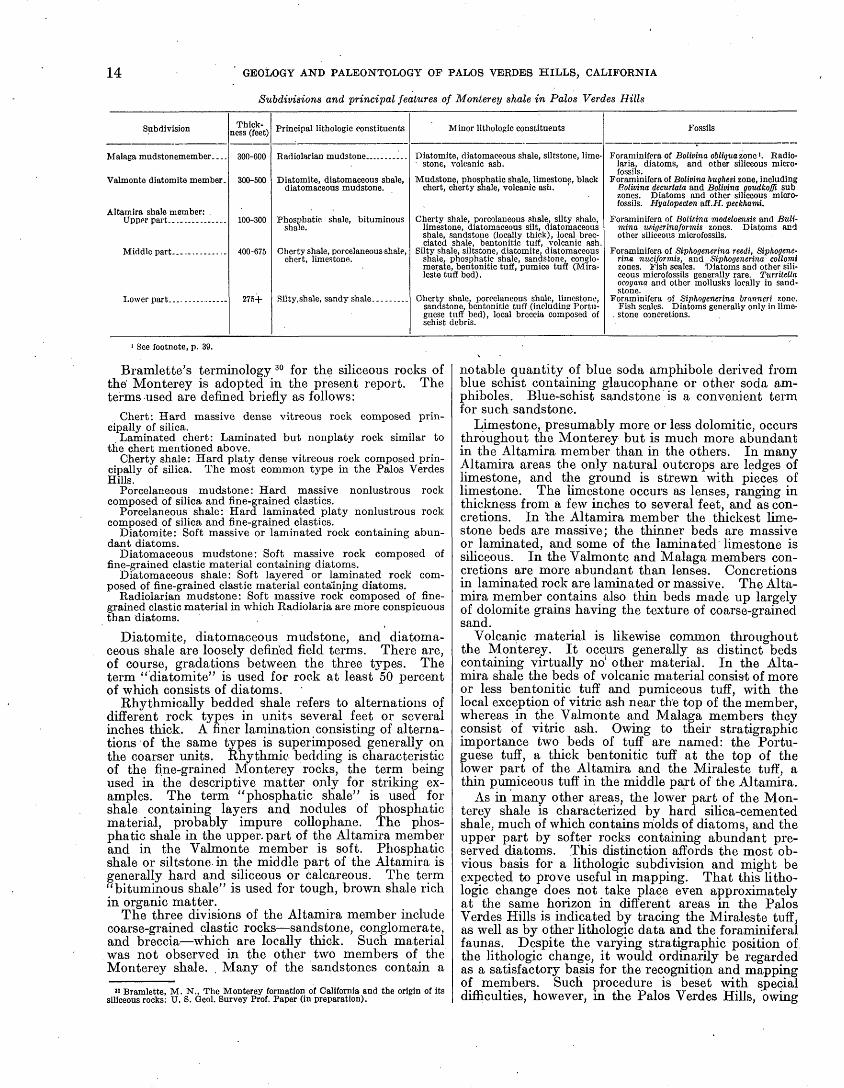
14 GEOLOGY AND PALEONTOLOGY OF PALOS VERDES HILLS, CALIFORNIA
Subdivisions and principal features of Monterey shale in Palos Verdes Hills
SubdivisionThick
ness (feet)
Malaga mudstonemember...
Valmonte diatomite member.
Altamira shale member: Upper part...-------
Middle part-
Lower part.
300-600
300-500
100-300
400-675
276+
Principal lithologic constituents
Radiolarian mudstone.
Diatomite, diatomaceous shale, diatomaceous mudstone.
Phosphatic shale, bituminous shale.
Cherty shale, porcelaneous shale, chert, limestone.
Silty,shale, sandy shale-
Minor lithologic constituents
Diatomite, diatomaceous shale, siltstone, lime- stone, volcanic ash.
Mudstone, phosphatic shale, limestone, black chert, cherty shale, volcanic ash.
Cherty shale, porcolaneous shale, silty shale, limestone, diatomaceous silt, diatomaceous shale, sandstone (locally thick), local brec- ciated shale, bentonitic tuff, volcanic ash,
Silty shale, siltstone, diatomite, diatomaceous shale, phosphatic shale, sandstone, conglo merate, bentonitic tuff, pumice tuff (Mira leste tuff bed).
Cherty shale, porcelaneous shale, limestone, sandstone, bentonitic tuff (including Portu guese tuff bed), local breccia composed of schist debris.
Fossils
Foraniinifera of Bolivina oWii/wazonc 1 . Radio- laria, diatoms, and other siliceous micro- fossils.
Foraminifera of Bolivina hughesi zone, including Bolivina. decurtata and Bolivina goudkoffi sub zones. Diatoms and other siliceous micro- fossils. Hyalopecten &B.H. pecktiami.
Foraminifera of Bolicina modeloensis and Buli- mina unigerinaformis zones. Diatoms and other siliceous microfossils.
Foraminifera of Siphogenerina reedi, Siphogene- rina nuciformis. and Siphogenerina collomi zones. Fish scales. 'Diatoms and other sili ceous microfossils generally rare. Turrilelta ocoyana and other mollusks locally in sand stone.
Foraminifera of Siphogenerina branneri zone. Fish scales. Diatoms generally only in lime-
. stone concretions.
1 See footnote, p. 39.
Bramlette's terminology 30 for the siliceous rocks of the' Monterey is adopted in the present report. The terms used are defined briefly as follows:
Chert: Hard massive dense vitreous rock composed prin cipally of silica.
Laminated chert: Laminated but nonplaty rock similar to the chert mentioned above.
Cherty shale: Hard platy dense vitreous rock composed prin cipally of silica. The most common type in the Palos Verdes Hills.
Porcelaneous mudstone: Hard massive nonlustrous rock composed of silica and fine-grained elastics.
Porcelaneous shale: Hard laminated platy nonlustrous rock composed of silica and fine-grained elastics.
Diatomite: Soft massive or laminated rock containing abun dant diatoms.
Diatomaceous mudstone: Soft massive rock composed of fine-grained clastic material containing diatoms.
Diatomaceous shale: Soft layered or laminated rock com posed of fine-grained clastic material containing diatoms.
Radiolarian mudstone: Soft massive rock composed of fine grained clastic material in which Radiolaria are more conspicuous than diatoms.
Diatomite, diatomaceous mudstone, and diatoma ceous shale are loosely defined field terms. There are, of course, gradations between the three types. The term "diatomite" is used for rock at least 50 percent of which consists of diatoms.
Rhythmically bedded shale refers to alternations of different rock types in units several feet or several inches thick. A finer lamination consisting of alterna tions of the same types is superimposed generally on the coarser units. Rhythmic bedding is characteristic of the fine-grained Monterey rocks, the term being used in the descriptive matter only for striking ex amples. The term "phosphatic shale" is used for shale containing layers and nodules of phosphatic material, probably impure cellophane. The phos phatic shale in the upper, part of the Altamira member and in the Valmonte member is soft. Phosphatic shale or siltstone in the middle part of the Altamira is generally hard and siliceous or calcareous. The term "bituminous shale" is used for tough, brown shale rich in organic matter.
The three divisions of the Altamira member include coarse-grained clastic rocks sandstone, conglomerate, and breccia which are locally thick. Such material was not observed in the other two members of the Monterey shale. . Many of the sandstones contain a
'° Bramlette, M. N., The Monterey formation of California and the origin of its siliceous rocks: U. S. Geol. Survey Prof. Paper (in preparation).
notable quantity of blue soda amphibole derived from blue schist containing glaucophane or other soda am- phiboles. Blue-schist sandstone is a convenient term for such sandstone.
Limestone, presumably more or less dolomitic, occurs throughout the Monterey but is much more abundant in the Altamira member than in the others. In many Altamira areas the only natural outcrops are ledges of limestone, and the ground is strewn with pieces of limestone. The limestone occurs as lenses, ranging in thickness from a few inches to several feet, and as con cretions. In the Altamira member the thickest lime stone beds are massive; the thinner beds are massive or laminated, and some of the laminated limestone is siliceous. In the Valmonte and Malaga members con cretions are more abundant than lenses. Concretions in laminated rock are laminated or massive. The Alta mira member contains also thin beds made up largely of dolomite grains having the texture of coarse-grained sand.
Volcanic material is likewise common throughout the Monterey. It occurs generally as distinct beds containing virtually no other material. In the Alta mira shale the beds of volcanic material consis-t of more or less bentonitic tuff and pumiceous tuff, with the local exception of vitric ash near the top of the member, whereas in the Valmonte and Malaga members they consist of vitric ash. Owing to their stratigraphic importance two beds of tuff are named: the Portu guese tuff, a thick bentonitic tuff at the top of the lower part of the Altamira and the Miraleste tuff, a thin pumiceous tuff in the middle part of the Altamira.
As in many other areas, the lower part of the Mon terey shale is characterized by hard silica-cemented shale, much of which contains molds of diatoms, and the upper part by softer rocks containing abundant pre served diatoms. This distinction affords the most ob vious basis for a lithologic subdivision and might be expected to prove useful in mapping. That this litho logic change does not take place even approximately at the same horizon in different areas in the Palos Verdes Hills is indicated by tracing the Miraleste tuff, as well as by other lithologic data and the foraminiferal faunas. Despite the varying stratigraphic position of the lithologic change, it would ordinarily be regarded as a satisfactory basis for the recognition and mapping of members. Such procedure is beset with special difficulties, however, in the Palos Verdes Hills, owing

MIOCENE SERIES ' 15
LITHOLOGIC UNIT
Malaga mudstone member' Bolivina obliqita zone
Valmonte diatomite member Bolivina hughesi zone
Bolivina goudkoffi subzone
Bolivina decurtata subzone
Upper part
Bulimina uvigerinaformis zone _ 7
Bolivina modeloensis zone
Siphogenerina collomiand Siphogenerinawudformis zones
(stratigraphic relations to each other and ioSiphogcn- erina reedi zone undetermined in Palos Verdes Hills)
Middle part
Siphogenerina reedi zone
Lower part Siphogenerina branneri zone
100Vertical scale
100
FIGURE 4. Chart showing relation between lithologic units and foraminiferal zones in Monterey shale of Palos Verdes Hills.

16 GEOLOGY AND PALEONTOLOGY OF PALOS VERDES HILLS, CALIFORNIA
to intricate minor structural features in areas of the most extensive interfingering of these two main rock types. In. view of these relations an attempt to sub divide and map the formation on the basis of this, lithologic change was abandoned.
In the western" half of the hills and on the south slope the change from hard cherty shale to softer dia- tomaceous rocks takes place approximately at the top of the phosphatic upper part of the Altamira member. The change in that area forms the basis for recognition and designation of the overlying Valmonte diatomite member. In the northeastern and eastern parts of the hills the change takes place at varying horizons in the middle part of the Altamira member. In those areas the Valmonte member was differentiated by the ocur- rence of relatively pure diatomaceous rocks, the dia tomaceous strata in the Altamira member including phosphatic shale, and blue-schist sand and silt.
The Malaga mudstone member is characterized by the prevalence of massive mudstone. That member includes, however, diatomaceous shale, and the Val monte includes mudstone of the massive type. At Malaga Cove, where these members are well exposed, they are well differentiated. Owing to meager expo sures it is not known whether the distinction is as well denned in other areas. It is not known also whether the change from diatomaceous shale to massive mud- stone takes place at the same horizon from place to place.
FOSSILS
Foraminifera were found in the three members of the Monterey, and the age assignments are based on them. The material collected was identified by R. M. Kleinpell,' and the zonal assignments were made by him. A discussion of the foraminiferal zones of the California Miocene recognized by Kleinpell may be found in his publication. 31 The stratigraphic position of some collections of Foraminifera from the Palos Verdes Hills, particularly in the middle part of the Altamira member, was not determined, owing to in sufficient field data. The relation between lithologic units and foraminiferal, zones, according to present interpretations, is shown in figure 4.
Diatoms are more abundant than Foraminifera in the Monterey, especially in the Malaga and Valmonte members and in the diatomite and diatomaceous shale in the middle and upper parts of the Altamira member. They were observed also in limestones and limestone concretions in the lower part of the Altamira. The extensive collections made during the field work have not, however, been examined. Other siliceous micro- fossils Eadiolaria, silicoflagellates, and sponge spicules occur with the diatoms and in some beds are more abundant than diatoms. Radiolaria from the Valmonte and Malaga members have been described recently by Campbell and Clark.32
Mollusks are rare in the Monterey, and none were observed in most of the fine-grained rocks. At a few localities shallow-water forms were found in sandstone in the middle part of the Altamira shale. The deep- water scallop Delectopecten occurs in the Valmonte diatomite but appears to be rare.
Fish scales are the most abundant fossils, or the only ones observed, in much of the hard silica-cemented shale. In some areas they may be found in almost
" Kleinpell, R. M., Miocene stratigraphy of California, pp. 103-135, Am. Assoc- Petroleum Geologists, Tulsa, Okla., 1938.
sa Campbell, A. S., and Clark, B. L., Miocene radiolarian faunas from southern California: Qeol. Soc. Am., Special Paper 51, 76pp., 7 pis., 1944.
any hand specimen. Fish skeletal remains are not abundant, though local collectors have found some well-preserved specimens in both hard cherty shale and soft diatomite. At numerous localities fragmentary cetacean remains, or fragmentary large bones that are presumably cetacean remains, were observed in hard limestone in the middle part of the Altamira member. Those observed include a fragmentary skull suggestive of a whalebone whale, and local collectors have found fragmentary skulls and jaws of toothed whales or dolphins. A small cetacean has been recorded from the Valmonte diatomite, and three sea birds from that member have been described.
ALTAMIRA SHALE MEMBER
The oldest member of the Monterey is designated the Altamira shale member.33 The type region is on the south slope of the hills adjoining Altamira Canyon (see pi. 4). The Altamira is thicker than the overlying members and covers a much larger area. In the type region it has an exposed thickness of about 1,000' feet. On the north slope of the hills the thickness decreases to about 600 feet, owing to overlap on the schist basement.
As shown in the table on page 14, the Altamira is divided into lower, middle, and upper parts character ized, respectively, by the prevalence of silty and sandy shale, cherty shale, and phosphatic shale. Each of these subdivisions, however, includes other rock types, and locally other rock types are prevalent; consequently in some areas differentiation of the three parts is not well defined, and no attempt was made to map them. Each part of the Altamira member has a coarse-grained detrital facies. The lower part includes a breccia com posed of schist debris. Sandstone and conglomerate are included in the middle part in the area where that division rests on the schist basement and elsewhere. At Point Fermin the upper part includes thick beds of coarse-grained blue-schist sandstone.
Basalt, generally in the form of sills, is not known to penetrate strata above the middle part of the Altamira. In areas where basalt is present its distribution, there fore, shows roughly the distribution of the lower and middle parts of the Altamira. In extensive areas on the north slope of the hills, however, basalt is absent in the middle part."
Sections of the Altamira in different parts of the hills are shown on plate 3. The most complete sections are exposed in canyons in the type region inland from Portuguese Point and Inspiration Point. A section including most of the middle part and all of the upper part is exposed in the sea^chS extending from Bluff Cove to Lunada Bay, but in that area the base of the middle part is not certainly identified, and the structure is complicated by minor folds.
LOWER PART, INCLUDING PORTUGUESE TUFF BED
The lower part of the Altamira shale .member is exposed in the Portuguese Canyon area and nearby on the south slope of the central part of the hills, where it has an exposed thickness of at least 280 feet. Strata in the Miraleste arid Bluff Cove areas appear to represent the lower part of the Altamira.
In the Portuguese Canyon area the lower part of the Altamira consists chiefly of silty shale and sandy shale. Highly siliceous rocks are less abundant than in the middle part and consist mostly of silty porcelaneous
33 Woodring, W. P., Bramlette, M. N., and Kleinpell, R. M., op. cit. (Am. Assoc. Petroleum Geologists Bull., vol. 20), p. 131,1936.

MIOCENE SERIES 17
shale and porcelaneous mudstone rather than cherty shale; that is, most of it is less siliceous than that in the middle division of the member. A thick bentonitic tuff is chosen as the top of the lower part of the Altamira. This tuff is designated the Portuguese tuff bed, a name derived from Portuguese Bend. The type region is along Klondike Canyon, near Portuguese Bend. In the preliminary paper 3* Portuguese Canyon was errone ously cited as the type locality. Owing to inadequate exposures and the tendency of the tuff to slump and slide, the tuff was not continuously traced, except in small areas. The strata immediately below and above the Portuguese tuff show no sharp lithologic change. Silty shale and sandy shale are, however, more abundant below that bed, and cherty shale is more abundant above it.
In the Bluff Cove area strata assigned to the lower part of the Altamira consist of silty sandstone, sandy siltstone, and a schist-debris breccia facies not found in any other area in the hills.
STRATIGRAPHY AND LITHOLOGY
PORTUGUESE CANYON AREA
The lower part of the Altamira shale crops out in the area adjoining the extensive landslide inland from Portuguese Point and Inspiration Point. The best exposures were found in Portuguese Canyon and the unnamed canyon between Portuguese and Klondike canyons. Silty shale and sandy shale are the pre1 vailing rocks in that area. Porcelaneous silty shale, porcelaneous mudstone and siltstone, altered tuf- iaceous material, limestone, and sandstone are the principal minor-constituents. Hard cherty shale and sandstone are less abundant than in the middle part of the Altamira.
The following section (column 5, pi. 3) was measured in the unnamed canyon a quarter of a mile east of Portuguese Canyon:
Section of lower part of Altamira shale member of Monterey shale in unnamed canyon a quarter of a mile east of Portuguese Canyon
Ft. in.46. Thin-bedded sijlty shale; upper part not exposed. 5+ 0 45. Sandy tuff.__._.______._.____......... 844. Thin-bedded silty shale.______________________ 1 843. Sandy limestone containing blue-schist shreds._. 8 42. Thin-bedded silty shale --____--__----__-_-___ 641. Lenticular laminated limestone._____________ 1 240. Silty shale________________________________ 439. Rusty fine-grained altered tuff (?).-----_-_-.__ 238. Poorly exposed thin-bedded silty shale.________ 10± 037. Rhythmically bedded silty shale; units of sandy
shale at base and shale at top, each about 2 inches thick._____________________________ 2 0
36. Thin-bedded silty shale including, some sandylenses__-__-____-______---__--____-___._ 8 8
35. Impure altered tuff__________-______!________ . 634. Hard brown imidstone containing altered pumi-
coous fragments and small glass shards; limy concretions about a foot thick in basal part.._ 4 4
33. Poorly exposed thin-bedded silty shale.__'______ 7 832. Thin-bedded silty shale and fine-grained sandy
shale________________________________ 10 1031. Altered tuff containing a few poorly preserved
Foraminifera________________________-._.._ 1 830. Hard porcelaneous mudstone and siltstone con
taining a few molds of Foraminifera; some , x layers tuffaceous.-_________l_-_--_-_______ 3 2
29. Coarse-grained sandy tuff, finer-grained at top; contains "bentonitifeed" glass shards that have a maximum length of a quarter of an inch or more.___________________________________ 2 6
" Woodring, W. P., Bramlette, M. N., and-Kleinpell, R. M., op cit., p. 132.
Section of lower part of Altamira shale member of Monterey shale in unnamed canyon a quarter of a mile east of Portuguese Canyon Continued
Ft. in.28. Hard porcelaneous mudstone.________________ 1027. Thin-bedded silty and sandy shale___________ 2 026. Altered tuff.______.________________ » 625. Hard thin-bedded porcelaneous silty shale; a ,
zone of diatom-bearing calcareous concretions 2}£ feet above base._______________________ 7 8
24. Thin-bedded silty shale-.._-._._____.__ 6 023. Altered sandy tuff; upper 2 inches fine-grained-_ 6 22. Silty shale and mudstone_____________________ 5 ' 721. Altered sandy tuff-__-_--_-------._-_____-_- 1020. Limestone______________-_____-_-___________ 119. Unexposed-_____-__-:__--____-----_-_-_--._ 12± 018. Limestone____._____________-_---____-__-_ 917. Thin-bedded silty shale_--_-_-_-_----_------_ 5 016. Hard limjr siltstone____________-_-_-_--____-_ 1 015. Thin-bedded silty shale.____.---_---_-_-_-_-_ 1 914. Lenticular limestone.._______-_______._-_---_ 813. Hard silty porcelaneous shale.___-_____.___--_ 6 812. Lenticular limestone.________________________ 1 011. Thin-bedded silty shale and clay; lower half hard
and porcelarieous-__-__-_-__-_--_-_--_----_ 7 010. Limestone_______--_--_--------------------- 1 H9. Rhythmically bedded silty and porcelaneous
shale; units of more silty and more porcelane ous shale, each having an average thickne'ss of 1 to 2 inches---------...--------------- 7 2
8. Impure sandy altered tuff._____-___-_-___.____ 2 ± 07. Unexposed._-___--___---_-__--_-----------_ 6± 06. Hard black baked limestone.___-_-_----__-_-_ 1 05. Basaltsill... ....-. '-. ---- ---- . . 5 64. Baked siliceous limestone. _________________ 93. Thin-bedded silty and porcelaneous shale; not
so hard nor so siliceous as unit 9____-_______ 7 42. Limestone____________-_-------------------- 1 31. Thin-bedded silty shale. ___________________ 2 0
Basalt in core of pitching anticline.
Approximate thickness of section, excluding unit 46___--..--_--_-__--_-----------_ 152 0
The following section (column 4, pi. 3), measured in Portuguese Canyon, is an upward continuation of the preceding section. Unit 46 was matched in the two sections by a -comparison of lithology, with special reference to the tuffs and the thickness.
Section of lower part of Altamira shale member of Monterey shale in Portuguese canyon
[Upward continuation of preceding section]Ft. in.
56. Portuguese tuff bed, poorly exposed, thicknessapproximate-_____-_-_____-_-____--------- 40± 0
55. Poorly exposed tuffaceous, sandy, silty, andporcelaneous shale; thickness estimated ______ 25 ± 0
54. Poorly exposed silty shale.___________________ 9± 053. Thin-bedded sandstone; top not exposed.------ 5± 052. Massive sandstone..______-__-_------------- 8 651. Hard sandy limestone or calcareous sandstone. __ 1 10 50. Massive fine-grained to medium-grained sand
stone containing blue-schist shreds.__-_-___- 7 0 49. Rhythmically bedded thin-bedded fine-grained
sandstone at base and silty sandstone at top, each about 2 itnches thick. _________________ 4 0
48. Poorly exposed thin-bedded silty shale and sandyshale, the latter containing blue-schist shreds. 10 ± 0
47. Yellow altered tuff-__--__----_-_-__-----_-__ 646. Thin-bedded silty shale. Foraminifera of Sipho-
generina branneri zone (locality 1) 3& collected from a limy bed lower in section corresponding to unit 34 of preceding section._____________ 14 «(** 0
Approximate thickness of this section. ___._ 125 Approximate thickness of section in canyon
a quarter of a mile east of Portuguese Canyon......._______________________ 152
0
277 0M The fossil localities arc plotted on thc'gcologic maps (pis. 1, 14, 21) and are de
scribed on pp. 120-125.

18
Foraminifera, generally represented by poorly pre served material or molds, were observed at different horizons in this area. The best material, assigned to the Siphogenerina branneri zone, was collected at local ity 1 in Portuguese Canyon, as noted in the preceding section.
The Portuguese tuff bed consists of light-colored bentonitic tuff. As shown in the view on plate 6, A, it is well exposed in the type region, where it has a thick ness of 55 feet. At the landward end of Inspiration Point the tuff is abruptly upturned on the south limb of an anticline" (see pi. 5) and is about 60 feet thick. On the west side of Abalone Cove tuffaceous material is ex posed through a thickness of 30 feet, and the debris, indicates that it continues upward through an additional thickness of about 30 feet. The scattered outcrops of the Portuguese tuff that were recognized are shown on the geologic map (pi. 1). In addition to these outcrops, tuff debris, doubtless. derived from this bed, was found at many localities along the north margin of the exten sive landslide in the Portuguese Canyon district and in stream cuts within the landslide area. Inasmuch as the strata, including the tuff, dip toward the landslide along
NE.
relatively soft porcelaneous shale. Foraminifera from silty shale (locality 2) are assigned to the same faunal zone as that in the lower part of the Altamira in the Portuguese Canyon area.
BLUFF COVE AREA
Strata exposed in the sea cliff at Bluff Cove, at the west end of the eastward-plunging Bluff Cove anticline, appear to represent the lower part of the Altamira shale but are lithologically different from those already de scribed. The Portuguese tuff was not recognized in this region.
A sketch of the sea cliff at Bluff Cove is shown in figure 5. The statigraphic relations of some of the lithologic units are uncertain, owing to extensive slides and talus and to incomplete knowledge of the structural features. The schist-debris breccia forming the high greenish cliff appears to represent the oldest strata. Bedding is not clearly discernible in the breccia, but there is a vague suggestion of anticlinal arching toward the top of the cliff. The breccia consists of a rude mass of schist slabs embedded in an unsorted greenish muddy matrix (pi. 6, B). The schist slabs have a maximum
FIGURE 5. Sea cliff at Bluff Cove, a, Pleistocene terrace deposits; 6, basalt in middle part of Altamira member of Monterey shnle; c, silty shale and cherty shale in middle part of Altamira shale; d, sandstone and conglomerate assigned to middle part of Altamira shale; e, silty sandstone and sandy siltstone in lower part of Altamira shale;
/, schist-debris breccia assigned to lower part of Altamira shale.
its east, north, and northwest margins, this bentonitic tuff probably acted as a lubricant for a mass of rocks that slid down dip into a structural basin and moving seaward overrode the lower marine terraces.
The lower part of the Altamira shale probably crops out in other areas along anticlines on the lower part of the south slope of the Palos Verdes Hills east and west of the Portuguese Canyon area. The stratigraphic re lations in those areas are doubtful, however, as expo sures are generally poor and the Portuguese tuff was not certainly, recognized. Tuff debris, possibly derived from the Portuguese tuff, was found at several localities near the small landslide northwest of the extensive land slide just described. Some of the inadequately exposed rocks along the anticline in the deep canyon west of this small landslide probably represent the lower part of the Altamira.
MIRALESTE AREA
The lower part of the strata underlying the basalt sill on the Miraleste anticline is assigned to the lower part of the Altamira shale. A poorly exposed benton itic tuff on the south limb of the anticline, about 100 feet stratigraphically below the base of the sill, is 25 or 30 feet thick and may represent the Portuguese tuff. The strata underlying the tuff, as exposed in isolated areas, consist of silty shale, thin-bedded sandstone, and
observed length of 3 feet, but most of them are less than half a foot long. Greenish schist is the most abundant rock, pieces of vein quartz are numerous, and blue schist is a minor but conspicuous constituent. Breccia of this type was not found elsewhere in the Palos Verdes Hills. It resembles the San Onofre breccia described by Woodford,36 in the San Jpaquin Hills, 30 miles south east of the Palos Verdes Hills, and farther south along the coast. Like the San Onofre breccia the breccia at Bluff Cove may represent alluvial fan material deposited
"at the foot'of a schist highland, or landslides and ava lanches derived from such a highland. At all events it is composed of rocks similar to those in the Franciscan (?) area in the Palos Verdes Hills.
Thin-bedded, generally fine-grained silty sandstone and sandy siltstone form the lower part of the cliff north of the breccia. These strata are presumably younger. than the breccia and evidently are faulted against the breccia. A coarse-grained sandstone in these thin-bedded rocks contains much angular schist debris. Some layers of silty sandstone contain logs of carbonized and silicified wood as much as \% feet in diameter. Foraminifera from sandy siltstone (locality 2a), found by Dr. Hampton Smith, are interpreted as representing the same faunal zone as that in the lower
^ Woodford, A. O., The San Onofre breccia: California Univ.. Dept. Qeol. Sci. Bull., vol. 15, pp. 182-205, 1925. '

GEOLOGICAL SURVEY PROFESSIONAL PAPER 207 PLATE 2
:^^5g^l'a I o s Ve rd e s H iTis ' ' vftMsds MJj^>
\
_j?;m^f&-^s
RELIEF MAP OF CALIFORNIA SHOWING LOCATION OF PALOS VERDES HILLS.

GEOLOGICAL SURVEY
NW.
PROFESSIONAL PAPER 207 PLATE 3
WEST COAST SOUTHWEST OF MOUTH OF MALAGA CANYON
TRIBUTARY OF MIDDLE FORK OF ALTAMIRA CANYON
Fossil locality 3a (Poorly preserved Foraminifera of uncertain zonal position in Kleinpall's Luisian stage)Fossil locality 10
(Foraminifera suggestive of Siphogcnerina nuciformis zone)
1 Scattered exposures on hillside
PORTUGUESE CANYON
V 4 > V<^>?'J^V 44>
<y4>^*4***<A
UNNAMED CANYON « MILE EAST OF PORTUGUESE CANYON
Fossil locality 1 (Foraminifera of Siphogm erina'tiranneri zone)
Hard siliceous shale (mostly cherty shale)
CREST ROAD 1.8 MILES NORTH WEST OF SAN PEDRO HILL GEORGE F CANYON
.Miraleste tuff bed
Fossil locality 16 (Foraminifera of Bolimna nodelomsit zone)
Miraleste tuff bed
Fossil locality 13 (TurriUUa ocoyana and other mollusks)
' Franciscan (?) schist'^=~
SECTIONS OF ALTAMIRA MEMBER OF MONTEREY SHALE IN PALOS VERDES HILLS.Thicknesa of upper part of Altamira in column 1 possibly exaggerated, owing to duplication by faulting. Column 6 based on isolated exposures in road cuts. Column 7 based on incomplete exposures.
(Face p. 18)
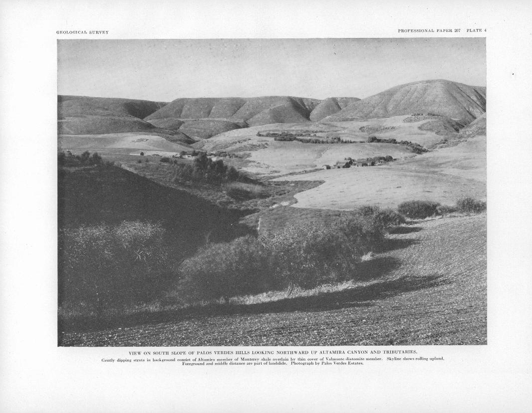
GEOLOGICAL SURVEY
^ HnMMHMHMHBMHMHMMHMBK^:
^ppl^P|^^M| IIP
PROFESSIONAL PAPER 207 PLATE 4
-ff , "'
VIEW ON SOUTH SLOPE OF PALOS VERDES HILLS LOOKING NORTHWARD UP ALTAMIRA CANYON AND TRIBUTARIES.
Gently dipping strata in background consist of Altamira member of Monterey shale overlain by thin cover of Valmonte diatomite member. Skyline shows rolling upland.Foreground and middle distance are part of landslide. Photograph by Palos Verdes Estates.

GEOLOGICAL SURVEY PROFESSIONAL PAPER 207 PLATE 5
VIEW ON SOUTH COAST OF PALOS VERDES HILLS LOOKING WESTWARD ACROSS INSPIRATION POINT AND PORTUGUESE POINT TO LONG POINT.
Portuguese tuff bed at landward end of Inspiration Point shows in middle distance. Irregular topography at right is part of landslide. Photograph by Palos Verdes Estates.

MIOCENE SERIES 19
part of the Altamira shale in the Portuguese Canyon area.
Tho south boundary of the breccia is obscured by talus. Inasmuch as the basalt sill and underlying silty and porcclancous shale exposed at the south edge of the talus are part of a section assigned on faunal and litho- logic grounds to the middle part of the Altamira shnle, it is inferred that the talus conceals a fault.
FOSSItS
K FORAMINIFERA
Foram'mifcra were collected from the lower part of the Altamira shale in Portuguese Canyon at a horizon 110 feet below the base of the Portuguese tuff. Through a,n error the horizon of this collection was cited in the preliminary paper 37 as 95 feet below the base of the Portuguese tuft. According to Kleinpell, these fossils suggest strongly the Siphogenerina branneri zone (zone A of preliminary paper), the upper zone in his Relizian stage. Foraminifcra from locality 2 in the Miraleste area and fr.om locality 2a in the Bluff Cove area are interpreted as representing the same zone. The species from these localities are given in the following table.
Foraminifcra from lower -part of Altamira shale member of Mon- terey shale
[Identifications by R. M. Kloinpell. R, Rnre; F, few; C, common]
Species
Bolivlna ad vena var. striatolla Cushman? _ ....
Vnlvullnorin californica vnr. appressa Cushman. . VulvullMoria cnllforuica var. obosa Cushmnn _ ..
Localities
Siphogenerina branneri zone
1
R R
R
R 0 F C R
2
R C
2a
R
F F F R
F R F F
Bluff Cove '
Cc F
C
C R R
1 Saino locality ns 2a (soo p. 18). Hampton Smith, collector. This collection was .available through the kindness of D. D. Hughes.
Klcinpcll's comments are summarized as follows: The fauna from the lower part of the Altamira shale
suggests that this part of the Monterey in the Palos Verdes Hills is a local correlative of the Siphogenerina branneri zone. The fauna from the Palos Verdes Hills is closely related to that from the Gould shale member of the Monterey shale, the lowest member of the Monterey in the typo region of the Gould shale, on the west side of the San Joaquin. Valley.38 Valvulineria ornata is not known from older horizons. The two varieties of Valvulineria californica, Hemicristellaria beali, and per haps Bolivina, imbricata range downward into the Siphogenerina hughesi zone, which underlies the zone represented by the Gould shale (Siphogenerina branneri zone), but are not known from older horizons. All the Foraminifera found in the lower part of the Altamira
« WooclriiiR, W. P., Bramletto, M. N.. and Kleinpell, R. M., op. cit., p. 132.88 Barbat, W. F., Ago of producing horizon at Kettlcman Hills, Calif.: Am. Assoc.
Petroleum Geologists Bull., vol. 16, pp. G11-G12, 1932. Kleinpell. R. M., Miocene stratigraphy of California, p. 121, Am. Assoc. Petroleum Geologists, Tulsa, Okla., 1938.' Woodring, W. P., Stewart, Ralph, and Richards, R. W., Geology of the Ket- tloman Hills oil field, Calif.; stratigraphy, paleontology, and structure: TJ. S. Geol. Survey Prof. Paper 105, pp. 125, 137, 1940 [1941].
shale range upward into the Siphogenerina reedi zone, overlying the Siphogenerina branneri zone, and all ex cept Valvulineria depressa range still higher. Therefore, the fauna from the Palos Verdes Hills may represent the Siphogenerina reedi zone rather than the Siphogenerina branneri zone. The abundance of Valvulineria califor nica var. appressa and also of typical Valvulineria de pressa suggests strongly, however, a correlation of the lower part of the Altamira with the Gould shale, as neither form is well developed at higher horizons.
MIDDLE PART, INCLUDING MIRALESTE TUFF BED
The middle part of the Altamira shale member is thicker than the other parts, is the most widely dis tributed division of the Monterey shale, and includes most of the cherty shale of the Monterey. In the Por tuguese Cany on-Altamira Canyon area it is 675 feet thick. On the north slope of the hills it overlaps the schist basement and has a thickness of about 400 feet. Beds of sandstone and conglomerate ranging in thick ness from a few feet to 75 feet are found at or near the base of the section in that region.
Bentonitic tuffs are common in the middle part of the Altamira. A distinctive tuff characterized by the abundance of pumice lapillae was mapped on the north slope of the hills at a horizon 125 to 175 feet below the top of the middle part of the Altamira. Despite its thinness, this tuff is named, because it is one of the few distinctive lithologic units in the Monterey. It is desig nated the Miraleste tuff bed,39 a name derived from the Miraleste residential district. The type region is along the west side of upper Agua Negra Canyon. The dark- brown pumice lapillae, commonly an inch or less in diameter, are embedded in a matrix of light-colored impure fine-grained volcanic ash. The pumice (index about 1.54) is more basic than the fine-grained ash of the matrix (index about 1.50). The Miraleste tuff is gener ally 2 to 4 feet thick, but at places is only a few inches thick and has a maximum thickness of 8 feet. Locally, dikelike extensions penetrate overlying and underlying strata. At several localities on the north slope of the hills there appear to be two beds of pumice tuff, but the apparent occurrence of two beds may be due to minor structural complications.
.A zone of ellipsoidal opal concretions, similar to those in the Monterey of central California, 40 was found at scattered localities in the western half of the hills. The Miraleste tuff was recognized in the same section with the concretions at only one locality (column 6, pi. 3), where the concretions are about 100 feet above the tuff. At several other localities, however, there is some evi dence that the zone of concretions is at a uniform hori zon (columns 1, 2, 3, pi. 3). Should this suggestion be confirmed, the zone of concretions may be useful in working out details of the stratigraphy and structure in areas where they are now obscure. The localities where the concretions were recognized are shown on the geologic map (pi. 1).
Characterized in general by the prevalence of cherty shale, the middle part of the Altamira includes, never theless, in some areas a varying thickness of. softer diatomaceous rocks. In the western half of the hills and on the south slope diatomaceous rocks were not found in this division of the Altamira. In the area on the north slope of the hills, extending approximately from Agua Negra Canyon to Miraleste Canyon, the
39 Woodring, W. P., Bramlette, M. N., and Kleinpell, R. M., op. cit., p. 134.40 Taliaferro, N. L., Contraction phenomena in cherts: Geol. Soc. America Bull.,
vol. 45, pp. 194-207, pis. 13-24, 1934.

20 GEOLOGY AND PALEONTOLOGY OF PALOS VERDES HILLS, CALIFORNIA,
Miraleste tuff is in a tongue of diatomaceous strata 50 to 100 feet thick. Farther east, in and northwest of San Pedro, the middle division of the Altamira above the Miraleste tuff and also apparently as much as 200 feet below the tuff consists principally of diatomaceous rocks. That is, there is an eastward and northward change from cherty rocks to softer diatomaceous rocks. That the change is due to iiiterfingering of the two rock types is inferred from the relations near, the crest of the hills south of Agua Negra Canyon, where the Miraleste tuff was traced southward across the crest. Westward on the south slope the tuff is progressively bentonitized, the pumice being the last consituent to be altered. In the area where the change hi character of the tuff takes place the tongue of diatomaceous rocks that includes the tuff in the Agua Negra Canyon district interfingers evidently with cherty shale.
STRATIGRAPHY AND UTTHOL.OGY
BLUFF COVE-MAIAGA COVE AREA
The conglomerate and sandstone exposed near the top of the cliff at Bluff Cove (see fig. 5) are assigned arbitrarily to the middle part of the Altamira. The
middle division of the Altamira. Foraminifera sug gestive of the Siphogenerina nucijormis zone were found in granular limestone at locality 10. The following section shows the lithology of the middle part of the Altamira above the limestone at locality 10 (column 1, pi. 3).
Section of middle part of Altamira shale member of Monterey shale in sea cliff between Malaga Canyon and Flatrock Point
Ft. in.31. Limestone. Overlain by phosphatic shale as
signed to upper part of Altamira shale. For upward continuation of section see p. 29 ___ 3
30. Chert, cherty shale, calcareous shale, and softphosphatic shale._________________________ 8
29. Limestone____________________ _______\. ______ 328. Cherty and calcareous shale___'_______________ 127. Limestone_____________-__-________________- 226. Chert and cherty limestone.____--_--___-____ 625. Soft shale containing a few phosphatic nodules
and harder calcareous shale_'________________ 224. Cherty and calcareous shale.-___.._.____-.___ 523. Limestone________-'___-____-__-_-__---____ 422. Chert, cherty shale, and thin zones of soft shale
containing a few phosphatic nodules; layer of opal concretions 3 feet above base and scat tered concretions at other horizons-.._______ 13
.50 Feet
FIGURE 6. Minor isoclinal anticline exposed in sea clifl a quarter of a mile southwest of mouth of Malaga Canyon.
coarse-grained strata on the north limb of the Bluff Cove anticline, overlying the siltstone and silty sand stone assigned to the lower part of the Altamira, con tinue upward in the section to the thick basalt 'sill. The conglomerate consists principally of schist peb bles, and some beds contain angular pieces of schist in addition to pebbles. Molds of Anadara? and Aeguipecten were found in massive buff sandstone about 150 feet stratigraphically below the basalt sill (locality 2b). Irregularly oriented borings are abun dant in this sandstone.
The strata in the cliff on the north limb of the syn- cline near Flatrock Point, overlying the basalt forming Flatrock Point, consist chiefly of cherty shale and limestone. They appear to be higher in the section than the conglomerate and sandstone just described, for it is improbable that the entire thickness of conglom erate and sandstone grades laterally so abruptly into cherty shale and limestone. The north boundary of the basalt forming Flatrock Point is probably marked by a fault, which, however, was not recognized inland.
An essentially continuous section extending from the upper part of the middle division of the Altamira up ward into the Valmonte diatomite member is exposed in the sea cliff, from the crest of the minor anticline northeast of Flatrock Point northeastward to the mouth of Malaga Canyon. Soft calcareous shale, some of which contains phosphatic layers and nodules, is interbedded with cherty shale and limestone in the
Ft.
21. 20.
19.18.
17.
16.
15.
14.
13. 12. 11. 10.
Limestone.._ ___---________-_-_____-- r ------Chert, cherty calcareous shale, and thin-bedded
limestone. _ _____________________________Brecciated limestone._____-__--___-_______-__Thin-bedded limestone, phosphatic shale, and
cherty shale._____________________________Crushed rock and debris of bentonitic tuff.
Thickness uncertain.______________________Shale containing light-colored phosphatic string
ers, cherty shale and tuff.______-___-_-_-_-_Thin-bedded limestone, calcareous shale, and
cherty shale._____________________________Shale containing light-colored phosphatic string
ers, and cherty shale_______________________Limestone.. _ ________________________________Calcareous and cherty shale__________________Brecciated limestone_______________________Calcareous shale containing light-colored phos
phatic stringers, and cherty shale.___________Thin-bedded limestone.______________________Calcareous and cherty shale__________________Brecciated limestone.________________________Shale containing few phosphatic nodules.______Limestone-_ ________________________________Calcareous and cherty shale._________________Brecciated limestone.________________________Brown bituminous (?) shale___________________Limestone. A granular layer at top contains
Foraminifera suggestive of Siphogenerina nu- ciformis zone (locality 10)____-_____-_-_-_._
239
4 0
15(?) 0
3 0
3906
010
Thickness of section_____________________ 146± 0
The total thickness given for the preceding section is of doubtful value, because unit 17 is represented by

MIOCENE SERIES 21
slide debris that may conceal a fault. A thickness of 15 feet is assigned to unit 17, and it is assumed that there is no gap or duplication in the stratigraphic succession. Immediately north of the slide the strata are folded in a narrow isoclinal anticline (fig. 6). The strong deformation appears to have been localized by be.ntoni.tic tuff, which may have acted as a lubricant. If the opal concretions in unit 22 of the preceding section arc at tnc same horizon as similar concretions elsewhere in undisturbed sections, this tuff, the presence of which is indicated by slide debris, is younger than the Miral- esto tuff.
In the Malaga Cove residential district inland from the coast the middle part of the Altamira shale, con sisting chiefly of cherty shale, porcelaneous shale, and limestone, can be seen in highway cuts and natural exposures. A tuff about 60 feet thick exposed on Del Monte road near La Venta Inn consists of soft benton- itic material in the upper part and hard silicified tuff in the lower part. Opal concretions were observed in a highway cut southeast of the Malaga Cove business district and on the north limb of a steeply folded anti cline in the upper part of Valmonte Canyon.
BLUFF COVE-LUNADA BAY AREA
A virtually continuous section complicated by minor folds extends from a horizon apparently low in the middle part of the Alta,mira shale upward to the Val- monto diatomite in the sea cliff between Bluff Cove and Lun ada Bay. Fo.ramin.if era from limestone immediately overlying the basalt sill, at locality 3, on Palos Verdes Drive West, near Bluff Cove, are assigned to the Sipho- generina reedi zone. Foraminifera were observed also in Imrd baked limestone underlying the basalt sill on the sea cliff. The limestone at locality 3 contains broken large bones, presumably whale remains. Beds of limestone at the same horizon form low-tide reefs at the foo* of the sea cliff, 2,100 feet west-southwest of locality 3. (See pi. 26.) Huge concretionary hard masses weathered out of the reefs contain large bones like those at locality 3. A field sketch of a skull ex posed in longitudinal section suggests, according to Dr. Remington Kellogg, a whalebone whale.
Silty shale and porcelaneous shale overlie the bone- bearing reefs. Still higher in the section is the main cherty shale zone of the Monterey, with which many beds of limestone are interbedded. Toward the top of the section calcareous mudstone and soft shale,, both containing pb.osph.atic nodules, are interbedded with the cherty shale, forming a transition zone to the bituminous and phosphatic shale assigned to the upper part of the Altamira, the base of which is about 2,000 loot northeast of Palos Verdes Point.
LUNADA BAY-POINT VICENTE AREA
The middle part of the Altamira reappears under lying the upper part of the member on the south limb of the main syncline at Lunada Bay. Loose limestone concretions along the beach, on the north side of Resort. Point, contain cetacean remains. These concretions probably weather out of the limestone interbedded with calcareous phosphatic siltstone that forms reefs along the shore. The area southward to Point Vicente and beyond toward the east is characterized by the abundance of basalt. At many places the present sea cliff and also the cliff at the seaward edge of the second terrace inland are capped by hard limestone and cherty shale overlying basalt.
A tuff about 40 feet thick is exposed in the second cove south of Resort Point. It consists of light- colored bentonitic material containing glass shards toward the top. This tuff is evidently in the lower part of the middle division of the Altamira and may correspond to. the 60-foot tuff in the Bluff Cove-Malaga Cove area. Tuff of comparable thickness was not recognized in areas where the stratigraphic succession is more definite, unless the tuff at these two localities corresponds to the Portuguese tuff.
ALTAMIRA CANYON-PORTUGUESE CANYON AREA
The best section of the middle part of the Altamira shale is found along Altamira Canyon and its tribu taries, where the structure is simple and the rocks are generally well exposed. A section measured in the east fork of Altamira Canyon follows. (See column 3, pi. 3, measured in canyon at right edge of view on pi. 4.)
Section of middle part of Altamira shale member of Monterey shale in east fork of Altamira Canyon
Ft. n.102. Laminated siliceous limestone, overlain by soft
silty shale and nodular phosphatic shaleassigned to upper part of Altamira shale. Forupward continuation of section see p. 31-___ 1
101. Porcelaneous shale-_----_________-_.___--__ 4100. Soft, somewhat silty, porcelaneous shale__---_- 4 99. Limestone_--______________________________ 298. Rusty altered tuff (?)-____________-_________97. Silty shale._____-_.:._.._________.__ 196. Laminated limestone.______________________ 295. Porcelaneous shale.________________________94. Altered tuff____._._.________-_______--_93. Soft, somewhat silty, porcelaneous shale_--__ 2 92. Cherty shale____________...__________-.._ 391. Limestone---____----_-_____-___---__--_--- 190. Soft, somewhat silty, porcelaneous shale__-_--- 2 89. Cherty shale; 3 layers of opal concretions. _ _ _ _ 988. Shale, softer and more silty than unit 86______ 287. Siliceous limestone_-----_-______--_____---_ 186. Porcelaneous shale.-_---___--_-_--_-----_-- 385. Siliceous limestone._-________-_---_-_-_-_-_84. Cherty shale_____________________________ 983. Soft, somewhat silty, porcelaneous shale.------ 282. Lenticular limestone._______________________ 281. Rhythmically bedded porcelaneous shale, units
several inches thick_______________________ 780. Reddish altered tuff----__--_--_-------_---- 4 79. Brown phosphatic shale_-________--____----_ 778. Granular limestone.______-_-_-_---_-___-_-_ 277v Soft, somewhat silty, porcelaneous shale__-_-__ 4 76.'Granular limestone.________________________ 175. Soft, somewhat silty, porcelaneous shale.______ 174. Cherty shale__________________--_-_-_---- 173. Soft, somewhat silty, porcelaneous shale-_-_--_ 2 72. Cherty shale-________________________ 271. Altered tuff (?)___-__---_---_-----------_-- 370. Porcelaneous shale_--__-___---------------- 569. Limestone containing poorly preserved Foram
inifera of uncertain zonal position in Klein- pell's Luisian stage (locality 3a)__-_____--__ 3
68. Soft, somewhat silty, porcelaneous shale____-__ 467. Rhythmically bedded porcelaneous shale._____ 766. Soft, somewhat silty, porcelaneous shale __ 2 65. Dense limestone containing Valvulineria. ___.__ 1 64. Alternating soft silty shale and harder porce
laneous shale.__-_----------_--------_--- 863. Limestone.-------------------------------- 362. Alternating soft silty shale and harder porcela
neous shale; 1% feet above base a 2-inch al tered tuff. Fifty feet down canyon 1 foot + of altered mottled tuff at base; probable equivalent of Miraleste tuff bed---_.___-_-_ 19
61. Cherty shale____________.___---_-_.-_---- 360. Silty shale .------------------------- ---- 359. Limestone.-------------------------------- 458. Porcelaneous and silty shale_______._____-_-- 1
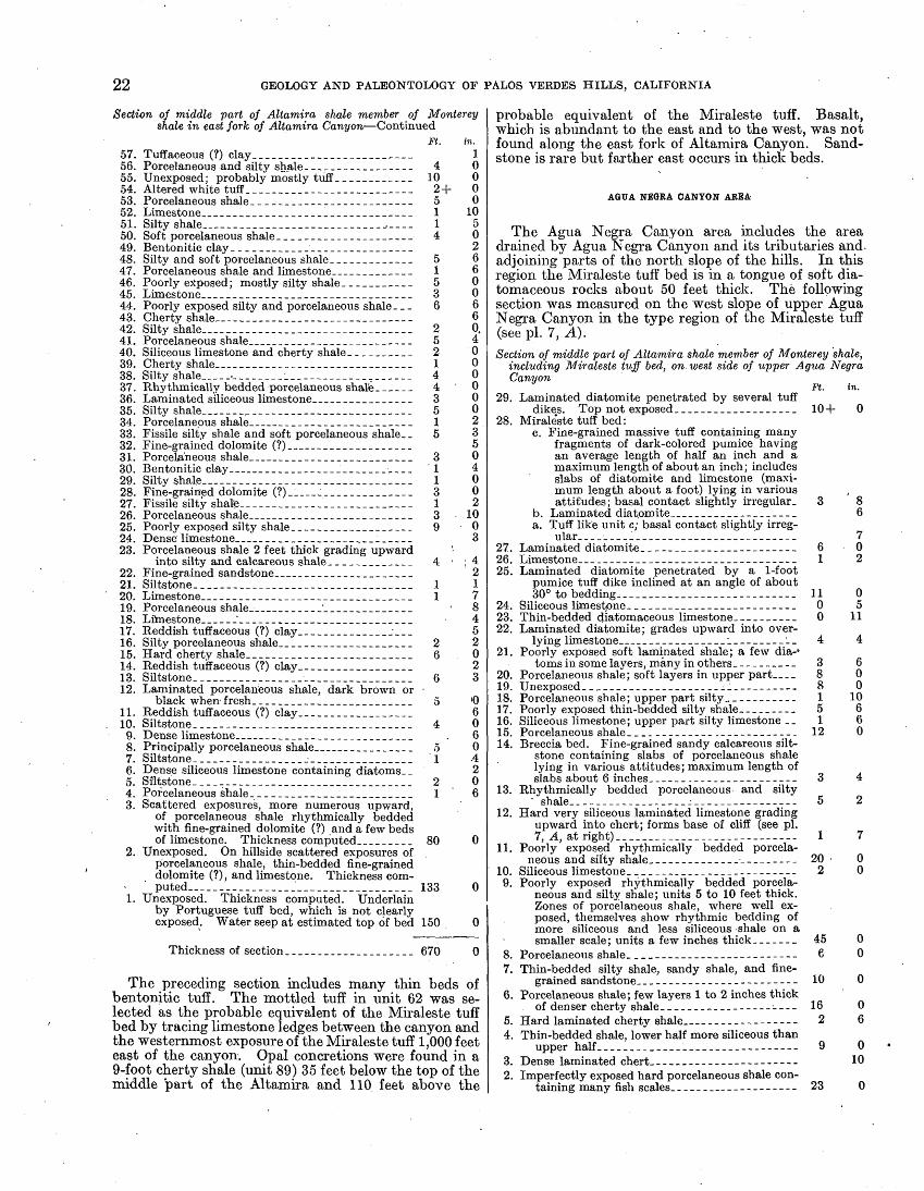
22 GEOLOGY AND PALEONTOLOGY OF PALOS VERDES HILLS, CALIFORNIA
Section of middle part of Altamira shale member of Monterey shale in east fork of Altamira Canyon Continued
Ft. in.Tuffaceous (?) clay_________________________ 1Porcelaneous and silty shale__-__-_______--_- 4 0Unexp.osed; probably mostly tuff ____________ 10 0Altered white tuff______________________ 2 + 0Porcelaneous shale_-__-_-__--_------____-_- 5 0Limestone__-___-____-____-_-___--_-____--_ 1 10Silty shale________________________________ 1 5Soft porcelaneous shale.____--_--_--_____--- 4 0Bentonitic clay___ _________________________ 2Silty and soft porcelaneous shale _____________ 5 6Porcelaneous shale and limestone.____________ 1 6Poorly exposed; mostly silty shale ___________ 5 0Limestone_______________________________ 3 0Poorly exposed silty and porcelaneous shale. __ 6 6Cherty shale________-___-_-_____-_____-_- 6Silty shale___---._____.___________-_____--- 2 0.Porcelaneous shale________________________ 5 4Siliceous limestone and cherty shale __________ 2 0Cherty shale________________________ 1 0Silty shale_____._____________________,______ 4 0Rhythmically bedded porcelaneous shale._____ 4 0Laminated siliceous limestone______________ 3 0Silty shale___________-______..______________ 5 0Porcelaneous shale________________________ 1 2Fissile silty shale and soft porcelaneous shale. .5 3Fine-grained dolomite (?)__________________ 5Porcelaneous shale________________________ 3 0Bentonitic clay_____________________________ 1 4Silty shale.____________________________ 1 0Fine-grained dolomite (?)__________________ 3 0Fissile silty shale.__________________________ 1 2Porcelaneous shale._________________________ 3 10Poorly exposed silty shale.__________________ 9 0Dense limestone____________________________ 3Porcelaneous shale 2 feet thick grading upward
into silty and calcareous shale _____________ 4 ' ;4Fine-grained sandstone____________________ 2Siltstone. _________________________________ 1 1Limestone_________________________________ 1 7Porcelaneous shale__________'______________ 8Limestone______'______^_____.______________ 4Reddish tuffaceous (?) clay.______._______ ___ 5Silty porcelaneous shale_____________________ 2 2Hard cherty shale._________________________ 6 0Reddish tuffaceous (?) clay__________________ 2Siltstone____---___________________________ 6 3Laminated porcelarieous shale, dark brown or
black when fresh.________________________ 5 '0Reddish tuffaceous (?) clay.-_-_-_________-__ 6Siltstone____----____-_____________________ 4 0Dense limestone____________________________ . 6Principally porcelaneous shale______________ 5 0Siltstone_____-____________-________________ '1 -4Dense siliceous limestone containing diatoms. _ 2Siltstone_____-____._______________________ 2 0Porcelaneous shale_________________________ 1 ' 6Scattered exposures, more numerous upward,
of porcelaneous shale rhythmically bedded with fine-grained dolomite (?) and a few bedsof limestone. Thickness computed_________ 80 0
Unexposed. On hillside scattered exposures of porcelaneous shale, thin-bedded fine-grained dolomite (?), and limestone. Thickness com puted_________________________________ 133 0
Unexposed. Thickness computed. Underlain by Portuguese tuff bed, which is not clearlyexposed. Water seep at estimated top of bed 150 0
57. 56. 55. 54. 53. 52. 51. 50. 49. 48. 47. 46. 45. 44. 43. 42. 41. 40. 39. 38. 37. 36. 35. 34. 33. 32. 31. 30. 29. 28. 27. 26. 25. 24. 23.
22. 21. 20. 19. 18. 17. 16. 15. 14. 13. 12.
11.10.
9.8. 7. 6. 5. 4. 3.
Thickness of section_._---_.____________ 670 0
The preceding section includes many thin beds of bentonitic tuff. The mottled tuff in unit 62 was se lected as the probable equivalent of the Miraleste tuff bed by tracing limestone ledges between the canyon and the westernmost exposure of the Miraleste tuff 1,000 feet east of the canyon. Opal concretions were found in a 9-foot cherty shale (unit 89) 35 feet below the top of the middle part of the Altamira and 110 feet above the
probable equivalent of the Miraleste tuff. Basalt, which is abundant to the east and to the west, was not found along the east fork of Altamira Canyon. Sand stone is rare but farther east occurs in thick beds.
AGTTA NEGBA CANYON AREA
The Agua Negra Canyon area includes the area drained by Agua Negra Canyon and its tributaries and- adjoining parts of the north slope of the hills. In this region the Miraleste tuff bed is in a tongue of soft dia- tomaceous rocks about 50 feet thick. The following section was measured on the west slope of upper Agua Negra Canyon in the type region of the Miraleste tuff (see pi. 7, A).Section of middle part of Altamira shale member of Monterey shale,
including Miraleste tuff bed, on west side of upper Agiia Negra Canyon
Ft. in. 29. Laminated diatomite penetrated by several tuff
dikes. Top not exposed___________________ 10+ 028. Mirale'ste tuff bed:
c. Fine-grained massive tuff containing many fragments of dark-colored pumice having an average length of half an inch and a maximum length of about an inch; includes slabs of diatomite and limestone (maxi mum length about a foot) lying in various , attitudes; basal contact slightly irregular. 3 8
b. Laminated diat,omite____________________ 6a. Tuff like unit c; basal contact slightly irreg
ular. _________________________________ 727. Laminated diatomite.__---_----_-__-__------ 6 026. Limestone____________--____--_____--___---_ 1 225. Laminated diatomite penetrated by a 1-foot
pumice tuff dike inclined at an angle of about 30° to bedding..__...____________.________ 11 0
24. Siliceous limestpne. __-______-_-.___---_----_ 0 523. Thin-bedded diatomaceous limestone-_________ 0 1122. Laminated diatomite; grades upward into over
lying limestone____---________L_--_--_-i_ 4 421. Poorly exposed soft laminated shale; a few dia-°
tomsin somelayers, many in others.------.-- 3 620. Porcelaneous shale; soft layers in upper part..._ 8 0 19. Unexposed____-__-_-_----------___--__----. 8 018. Porcelaneous shale; upper part silty____.___-__ 1 1017. Poorly exposed thin-bedded silty shale_-___-__- 5 6 16. Siliceous limestone; upper part silty limestone __ 1 6 15. Porcelaneous shale.__.-----_---.--_--------_ 12 014. Breccia bed. Fine-grained sandy calcareous silt-
stone containing slabs of porcelaneous shale lying in various attitudes; maximum length of slabs about 6 inches._____ _________________ 3 4
13. Rhythmically bedded porcelaneous and silty- shale..._.-_---._..__..-_-..-___-_-__--_ 5 2
12. Hard very siliceous laminated limestone grading upward into chert; forms base of cliff (see pi. 7, A, atright)_______---____--___--__ ___ 1 7
11. Poorly exposed rhythmically bedded porcela neous and silty shale_----__---__------------ 20 0
10. Siliceous limestone.__.----_-----__---------- 2 09. Poorly exposed rhythmically bedded porcela
neous and silty shale; units 5 to 10 feet thick. Zones of porcelaneous shale, where well ex posed, themselves show rhythmic bedding of more siliceous and less siliceous shale on a smaller scale; units a few inches thick_-_---_ 45 0
8. Porcelaneous shale. ___-_-__-_---_-_--------- 6 07. Thin-bedded silty shale, sandy shale, and fine
grained sandstone..._-._____-___---------- 10 06. Porcelaneous shale; few layers 1 to 2 inches thick
of denser cherty shale.___________--_-- ---- 16 05. Hard laminated cherty shale__.____-__-----_ 2 64. Thin-bedded shale, lower half more siliceous than
upper half _______________._.______------- 9 03. Dense laminated chert----------------------- 102. Imperfectly exposed hard porcelaneous shale con
taining many fish scales. ___-___-_---------- 23 0

MIOCENE SERIES 23
Section of middle part of Altamira shale member of Monterey shale, including Miraleste tuff bed, on west side of upper Agua Negra Canyon Continued
1. Thin-bedded silty and porcelaneous shale; ex posed .in cut bank at canyon floor,
e. Rhythmically bedded shale; units ofsandy shale grading upward into por- Ft. in. celaneous shale...------------------ 2 10
d. Silty shale....--.-------------------- 1 0c. Porcelaneous shale_______--___--_----_ 1 7b. Medium-grained sandstone ____________ 1 6a. Porcelaneous shale.__..________________ 7
Thickness of section...______--__-_--_____ 230 10
As shown in the preceding section, the strata in this area underlying the tongue of diatomaceous shale and diatomite associated with the Miraleste tuff, comprising an exposed thickness of about 200 feet, consist chiefly of porcelaneous shale. Sandstone is rare and is gen erally absent.
The Miraleste tuff varies in thickness from a few inches to several feet within short distances. The max imum thickness is generally 3 to 4 feet, exceptionally 6 to 8 feet. The dark-colored pumice lapillae embedded in the light-colored matrix vary in length from a fraction of an inch to 2 inches. At many localities the tuff has been squeezed into cracks and along bedding planes in the underlying and overlying soft rocks, dike-like and sill-like bodies of tuff extending through a thickness of as much as 15 to 30 feet. As may be seen on plate 7, A, the soft diatomite interbedded with the Miraleste tuff is irregularly deformed toward the south end of the cliff where the preceding section was measured, whereas the underlying harder strata have a uniform gentle dip. Locally the matrix of the tuff is calcified, forming a hard limy bed speckled with pumice.
The strata in the middle part of the Altamira shale overlying the diatomaceous rocks interbedded with the Miraleste tuff are about 125 feet thick. They include porcelaneous shale and cherty shale as well as softer shale that is generally poorly exposed, but the propor tion of hard siliceous shale decreases eastward. Opal concretions were found in cherty shale about 100 feet above the Miraleste tuff on the Crest Road at the head of Sopulvcda Canyon (column 6, pi. 3) and at scattered localities west of Agua Negra Canyon. They were not observed farther to the north or east, but at many places a conspicuous zone oi; chert and cherty shale is in the same part of the section approximately 100 feet above the Miraleste tuff. Fragmentary large bones, presum ably cetacean remains, occur in limestone 25 feet above the Miraleste tuff at a locality 0.4 mile west of Agua Negra Canyon.
GEORGE F CANYON-MIRALESTE CANYON AREA
Along George F Canyon and its tributaries strata assigned to the middle part of the Altimira shale rest on the schist basement (column 7, pi. 3), conglomerate and sandstone of varying thickness lying on the schist surface. The conglomerate contains slightly rounded or angular pieces of schist that have a maximum length of 6 to 12 inches. The sandstone is buff on fresh sur faces and reddish brown on weathered surfaces. Oh the 862-foot hill on the west side of George F Canyon a thickness of about 10 feet of conglomerate is exposed. At places in the main schist area the conglomerate and sandstone are evidently thin, as cherty shale is exposed within a few feet of the schist. Sandstone about 75 feet thick overlies the small area of schist exposed along the crest of an anticline in the first canyon east of Palos Verdes Drive East. Other outcrops of sandstone were
found along this anticline in the next canyon to the south, a tributary of Miraleste Canyon. The schist is not far below the surface in this region, for it was pene trated in the Whites Point sea-level tunnel on the crest of the same anticline 470 to 500 feet below the surface (section E E', pi. 1). In the tunnel conglomerate having a thickness of 50 to 60 feet and consisting of imperfectly rounded green schist pebbles 1 to 6 inches long overlies the schist on the north limb of the anti cline. On the south limb similar conglomerate is about 50 feet thick and is overlain by about 25 feet of massive greenish sandstone containing a few angular pieces of schist.
The schist is probably close to the surface also west of George F Canyon. Conglomerate containing schist cobbles and slabs as much as a foot long is exposed along Crenshaw Boulevard in the Rolling Hills district, 800 feet south of the syncline containing the Miraleste tuff.
Turritella ocoyana and other mollusks were collected from sandstone overlying schist at locality 13, on the west slope of George F Canyon, 20 feet above the canyon floor. The fossiliferous strata are estimated to be 40 feet above the top of the schist and 225 feet below the Miraleste tuff. A few mollusks were found also near the top of the sandstone along the first canyon east of Palos Verdes Drive East (locality 13a).
The exposed strata between the coarse-grained detri- tal rocks at the base of the section and the soft diatoma ceous rocks interbedded with the JVfiraleste tuff consist generally of cherty shale and limestone. Light-colored bentonitic tuff is exposed about 150 feet below the Mira leste tuff on the west slope of George F Canyon. Similar material is found on the 918-foot hill west of the canyon. The rocks penetrated in the Whites Point tunnel show that soft shale and siltstone are more abundant in this part of the section than is apparent from surface exposures. Some of the siltstone contains phosphatic nodules, and a few thin layers of blue-schist sandstone are interbedded with the siltstone Along Miraleste Canyon outcrop relations between cherty shale and overlying diatomaceous rocks were interpreted as indicating a fault with downthrow to the north. 41 According to observations in the tunnel the strata are in normal sequence. The outcrop relations are probably to be attributed to sharp folds and minor displacement.
Owing to inadequate exposures and minor structural cpihplications, the Miraleste tuff was not mapped con tinuously east of George F Canyon. On the north limb of the minor anticline extending across George F Canyon and at localities farther southeast there appear to be two beds of pumice tuff, possibly due to dike-like and sill-like extensions of the tuff or to duplication by minor folds or faults.
As in the Agua Negra Canyon area, the Miraleste tuff is interbedded with diatomaceous rocks. Lenses of limestone in the diatomaceous rocks contain molds of Siphogerierina and Valvulineria. In the district between Palos Verdes Drive East and Miraleste Canyon diatomaceous strata, with which some cherty shale is interbedded, extend evidently both higher and lower in the section than in the area farther west. Though the Miraleste tuff was not observed in the Whites P.oint tunnel, the stratigraphic relations of the diatomaceous shale penetrated in the .tunnel indicate that the division between hard cherty shale and softer diamaceous rocks is about 200 feet below the projected horizon of the
<i Woodring, W. P., Bramlette, M. N., and Kleinpell, R. M., op. cit. Petroleum Geologists Bull., vol. 20), pp. 128-129, fig. 1.
(Am. Assoc.

24
Miraleste tuff. On the preliminary geologic map 42 part of the diatomaceous rocks overlying the Miraleste tuff was assigned to the Valmonte diatomite. That member is now thought to be overlapped by the Plei stocene San Pedro sand and Lomita marl.
MIBALESTE-SAN PEDRO HHI AREA
In the deep canyons on the south slope of San Pedro Hill and in Averill Canyon beds of sandstone, some of which contain lenses of conglomerate made up chiefly of schist pebbles, are conspicuous constituents of the middle part of the Altamira. Altered diatoms occur in a thin zone included in moderately soft laminated shale exposed on Palos Verdes Drive East, about 40 feet stratigraphically above the thick basalt sill on the south limb of the Miraleste anticline. Foraminifera from silty- shale at locality 4, on Crest Koad, are assigned doubtfully to the Siphogenerina reedi zone. A Collection from buff siltstone at locality 11, south east of San Pedro Hill, is assigned to the Siphogenerina nuciformis zone.
East of the Cabrillo fault the Miraleste tuff is exposed on the road leading from Ninth Street to Miraleste and at two nearby localities in a tributary of San Pedro Canyon, where there are many minor folds. Diatomaceous silt at locality.5 contains Foraminifera of the Siphogenerina reedi zone. In San Pedro Canyon and its tributaries isolated outcrops show cherty shale and limestone dipping in various directions. The structure and stratigraphy are obscure, but presumably these strata underlie the Miraleste tuff.
The rocks penetrated in the Whites Point tunnel in the Miraleste area north of the Cabrillo fault, consist of shale containing many thin beds of greenish sand and siltstone containing scattered phosphatic nodules. Two thin sills of altered basic igneous rock, one of which is too thin to be shown on the structure section (section E E', pi. 1),, were encountered. South of the Cabrillo fault, beds of greenish sandstone and conglom erate several feet thick, containing schist pebbles as much as 6 inches long, are interbedded with silt- stone. Higher in the section phosphatic siltstone, thin beds of sandstone, cherty shale, and limestone were encountered.
SAN PEDRO AREA
The Miraleste tuff was .recognized in a ravine ad joining the west edge of Peck Park in the northwestern part of San Pedro and also in the next canyon to the north. At both localities there appear to be two beds of tuff. Foraminifera of the Siphogenerina reedi zone were found in steeply dipping calcareous sandstone at locality 7, on the north side of the main ravine in Peck Park, opposite a great mass of chert on- the south side. The steeply dipping strata are probably faulted against flat-lying diatomaceous shale cropping out upstream. Downstream diatomaceous shale and limestone are presumably in the same part of the section as the diatomaceous shale upstream.
Along San Pedro Canyon and its main tributary, just north of Seventh Street, the complexly folded cherty shale and limestone mentioned under the head ing "Miraleste-San Pedro Hill area" are overlain by diatomaceous silt and limestone, with which some cherty shale is interbedded. The lower part of the diatomaceous silt contains pebbles and slabs of schist. The largest pebble observed has a length of 10 niches,
«Idem. «
but an occasional slab of schist is as much as 2 feet long. Even as far east as a locality in San Pedro Canyon 300 feet upstream from the projection of Leland Avenue diatomaceous silt contains pieces of schist a foot long. Foraminifera from the lower part of the diatomaceous silt at locality 6 represent a fauna of small, possibly immature forms assigned doubtfully to the Siphogenerina reedi zone. The diatomaceous silt at locality 6 is estimated to be at about the horizon of the Miraleste tuff, which, however, was not found in this area nor farther south.
Diatomaceous silt, limestone, and thin beds of blue- schist sandstone exposed along Averill Canyon and nearby in western San Pedro represent presumably the same part of the section as that just described.
The relative abundance in the San Pedro. area of diatomaceous silt in strata now assigned to the middle part of the Altamira led to the assignment of part of. this section to the Valmonte diatomite.member on the preliminary geologic map.43
POINT FERMIN AREA
In the Point Fermin area the upper part of the Altamira shale includes a coarse-grained detrital facies, less phosphatic shale, and more cherty shale than elsewhere. Consequently lithologic differentiation between the middle and upper parts of the member is indefinite. One lithologic type, however, may serve in distmg-ukhirig the two parts of the Altamira. Wherever!massive siltstone was found it is referable to the middle part on both stratigraphic and faunal grounds. In the sea-cliff section on the east side of Point Fermin the base of the upper part of the Altamira is drawn, arbitrarily at the base of the lower of the two thick units of blue-schist sandstone.
The strata along the Point Fermin anticline inland from the coast consist of thin-bedded blue-schist sandstone, silty shale, siltstone, cherty shale, and thin beds of phosphatic shale. The sandstone is generally medium-grained. Locally, however, it is coarse-grained and conglomeratic, as at Thirty-fifth Street and Patton Avenue, where a 1-foot bed contains pebbles and angular pieces of schist half an inch long. Foraminifera assigned to the Siphogenerina collomi zone were collected from massive buff siltstone at locality 12, on Alma Street.
Porcelaneous shale, silty shale, calcareous phosphatic shale, and minor beds of blue-schist sandstone form the 100-foot cliff along the crest of the Point Fermin anti cline where it emerges on the coast. A thin layer of silty shale about 4 feet above the foot of the cliff (locality 8) yielded a collection of small, possibly immature, Foraminifera assigned doubtfully to the Siphogenerina reedi zone. The stratigraphic relations of these strata to those in western San Pedro north of the Cabrillo fault are doubtful, but they are presum ably the equivalent of part of the section in western San Pedro that includes much diatomaceous silt. A local discontinuity or a bedding-plane fault was visible formerly at the foot of the cliff, about 100 feet east of the abandoned oil well (pi. 7, B).
The Cabrillo fault is well exposed in the sea cliff (pi. 6, .D). South of the fault are massive buff silt- stone and lenticular limestone in the middle part of the Altamira; to the north are porcelaneous shale, phos-
« Woodring, W. P., Bramlette, M. N., and Kleinpell, B. M., op. cit. (Am. Assoc. Petroleum Geologists Bull., vol. 20), pp. 128-129), fig. 1.

MIOCENE SERIES 25
pi) a tic shale, and limestone in the upper part of the Altamira. The buff siltstone contains Foraminifera typical of the Siphogenerina reedi zone (locality 9). The relations between the buff siltstone and the strata on the crest of the Point Fermin anticline at locality 8 arc obscured by talus in the intervening area, but the siltstone is presumably younger.
In San Pcdro, north of the Fort McArthur Upper Reservation and north of the Cabrillo fault, blue- schist sandstone, porcelaneous shale, and silty shale are exposed irt street cuts. These strata appear to grade northwestward into those including diatomaceous silt, described on page 24.
WHITES POINT AREA
No satisfactory lithologic basis for separating the middle and upper pa.rts of the Altamira was discovered in the Whites Point area. In the preliminary paper 44 pprcelaneous shale and silty shale containing Forami nifera of the Holivina modeloensis zone at localities 14 and 15 were referred on lithologic grounds to a posi tion near the top of the middle part of the Altamira. According to the classification now adopted, however, the strata are assigned to the upper part on the basis of the faunal data.
Stratigraphic relations in the strongly deformed rocks at Whites Point and0 nearby are obscure. The schist conglomerate, sandstone, and silty shale in the core of the fan-shaped anticline near Whites Point, shown in figure 14, and in the anticlinal reefs at the point probably represent the middle part of the Alta mira. An incomplete mold of Aeguipecten was col lected from sandstone overlying, schist conglomerate on the north limb of the anticline (locality 12a). In the reefs 2,000 feet northwest of Whites Point rounded masses of basalt are embedded in a limy matrix con taining basaltic .debris and fragments of pectens. This material represents intrusion under a thin cover of unconsolidated sediments or a submarine flow.
The oldest rocks exposed on the anticline emerging on the coast half a mile northwest of White"s Point consist of siltstone, mudstone, limestone, and a little porcela- neous shale. These strata, about 100 feet thick, and an overlying unit about 25 feet thick, mostly porcelaneous shale, are thought to represent the middle part of the Altamira. Foraminifera suggestive of the Siphogenerina nuciformis zone were found in calcareous mudstone exposed at low tide 1.2 miles northwest of Whites Point (locality 12b). Loose limestone masses among the reefs at that locality contain cetacean remains. Well- preserved Foraminifera, including Siphogenerina and Valvulineria, were found recently on the extension of Twenty-fifth Street, 0.45 mile southeast of the junction with Palos Verdes Drive South..
In the Whites Point area the WThites Point tunnel penetrated strata consisting of siltstone, some of which contains hard phosphatic nodules, cherty shale, lime stone, and thin beds of clay. The rocks are strongly deformed in the part of the tunnel between the coast and a locality 0.3 mile inland. Poorly preserved Foraminifera of uncertain zonal position in Kleinpell's Luisian stage were collected 250 and 355 feet north of the south portal (localities 12c and 12d, respectively). At the outermost edge of the offshore reefs the open cut exposed buff sandstone underlying basaltic rocks. A diver brought up schist conglomerate about 100 feet beyond the edge of the reefs.
« \Voodrinjt, W. P., Bramlctte, M. N., and Klcinpoll, R. M., op. cit., pp. 135,142.
FOSSILS
FORAMINIFERA
Foraminifera were collected from the middle part 6f the Altamira shale at the localities given in the following table. At many other localities molds of Siphogenerina and large Valvulineria were observed, particularly in limestone interbedded with soft rocks near the horizon of the Miraleste tuff. These forms may be recognized in the field and. are not known to occur in the upper part of the Altamira shale or at higher horizons.
The collections from the middle part of the Altamira are assigned by Kleinpell to his Luisian stage. The preservation of much of the material is poor, and the zonal position at many localities is uncertain. According to Kleinpell's identifications, however, the three zones in his Luisian stage in ascending order the Siphogenerina reedi, S. nuciformis, and S. cotlomi are represented. No evidence is apparent for the relative Stratigraphic position of the three zones in the Palos Verdes Hills. The S. reedi zone appears to extend up to about the Miraleste tuff. Foraminifera character istic of that zone were found at locality 5 in diatomace ous silt, evidently near the horizon of the Miraleste tuff. It may be expected that the S. nuciformis and S. collomi zones are in the uppermost part of the middle division of the Altamira. Stratigraphic control at the localities where these two zones are identified is lacking. Locality 10, where a few species suggestive of the S. nuciformis zone were found, appears to be rather low in the section for that zone. (See pi. 3.) The Stratigraphic data at that locality are, however, uncertain.
The species identified by Kleinpell are given in the table on the following page.
Kleinpell's comments on these fossils are summarized as follows:
The Foraminifera from the middle part of the Alta mira shale are generally poorly preserved. The preser vation of the Siphogenerinas, which might give a clue to zonal position, is particularly poor in most of the collections including that genus. The best preserved material may be referred to the Luisian stage (group 2 of preliminary paper) ,45 which corresponds to the unde fined Valvulineria californica zone in its most restricted sense.
The collections from localities 3a, 12c, and 12d con sist of a few poorly preserved species. Their zonal position in the Luisian stage is uncertain. Foraminifera from localities 4, 6, and 8 are assigned doubtfully to the Siphogenerina reedi zone (zone B of preliminary paper). Localities 6 and 8 are referable to the S. reedi zone or the underlying S. branneri zone, or possibly to even somewhat older zones. Locality 4 may be referred to either zone just mentioned but hardly to any older horizon. All three localities appear to be referable to the S. reedi zone rather than to older zones on the basis of rather indefinite field relations. A peculiar faunal facies, in which all the species are represented by very small possibly immature specimens, occurs at localities 6 and 8. Assemblages from localities 5 and 9 are typical of the S. reedi zone, and the assemblage from locality 3 appears to represent that zone. A sample that seems to be a duplicate of that from locality 3 contains Valvulineria californica. The assemblages from localities 3, 5, and 9 may be correlated with the typical fauna of the S. reedi zone of the Monterey
« Wooclring, W. P., Braralotco, M. N., and Kleinpell, R. M., op. cit., pp. 125-149.

26 GEOLOGY AND PALEONTOLOGY OF PALOS VERDES HILLS, CALIFORNIA
Foraminifera from middle part of Allamira shale member of Monlerey shale [Identifications by R. M. Kleinpell. R, rare; F, few; C, common; A, abundant; cf., not certainly identified but resembles the species listed]
Species
Buliminella brevior Cushman...... __ . ______ ......
Buliminaovatad'Orbigny?-... __ . _ . __ .... __ ....
Bolivina advena var. ornata Cushman (including Boliv-
Bolivina advena var. striatella Cushman........ _ . __ .
Bolivina floridana Cushman...... _ __ . ________ .
Uvigerinella californica var. ornata Cushman. ..-.--.-....Uvigerinella californica var. parva Kleinpell (Uvigerinella
cf. U. californica Cushman) .. . __ ...... __ .......
Siphogenerina collomi Cushman _ . ........... _ ........Siphogenerina nuciformis Kleinpell (Siphogenerina aff.
Valvulineria californica var. appressa Cushman-. --------
Valvulineria miocenica Cushman? _ . __ ...........Valvulineria depressa Cushman..... _ ..................Valvulineria ornata Cushman (including Valvulineria?
Pulvlnulmella subperuviana Cushman? (Pulvinulinella?
Cassidulina panzana Kleinpell (Cassidulina aff. C. crassa d'Orbigny) __ ...-..--.......-...-..-... .. ..
Cassidulina williami Kleinpell (Cassidulina cf. C. sub- globosaH. B. Brady). .................................
Pullenia miocenica Kleinpell (Pullenia aff. P. sphaeroides
Pullenia miocenica var. globula Kleinpell (Pullenia aff.
Planulinacf. P. arimincnsis d'Orbigny. ....... _ ........
Localities
Siphogenerina reedi zone (?)
4
F
R
F
R
(?)
R
6
R C
F
F
F
C
8
F
R R
(?)
R
F .R
A
F
Siphogenerina reedi zone
3
R
(?) (?)
R
(?)
R
SPH9"
R
(?)
F (?)
R"
R C R
cf.
5
R
R
F
R
C
R C
F
A
F
A
F R
C
F
A
RR
9
CF
R
A
F
F
Siphogenerina nuciformis zone (?)
7
R
R
R
$C
R
R
R
SPH12"
cf.
C
F
(?) .
F
10
R
F R A
R
F
R
12b
(?) F R
R
R
F
R
Sipho gener ina
nuci formis zone
11
F
A
C C
(?) A
RF
Sipho gener
ina collomi
zone
12
F' C
R C R A
F
R
Zonal position uncertain
3a
R
F
R
12c
R
(?)
(?)
F
F
R
12d
(?)
F
F
' Apparently same as locality 3. 2 Apparently same as locality 7.
shale in Reliz Canyon in Monterey County,46 with, the fauna from Santa Clara County described by Chap man,47 and with the fauna of the Claremont shale in the Monterey group of Contra Costa County. 48
Locality 11 represents the S. nuciformis zone (zone C of preliminary paper), which overlies the S. reedi zone. The S. nuciformis zone is particularly well developed in the Monterey on Chico Martinez Creek, on the west side of San Joaquin Valley, where it is known locally as " the Valvulineria flood zone." 49 The assemblages from localities 7, 10, and 12b are suggestive of the S. nuci formis zone rather than the S. reedi zone. A sample that appears to 'be a duplicate of that from locality 7 contains a Siphogenerina that may be S. nuciformis.
Locality 12 represents a still higher zone, the S. collomi zone (zone D of preliminary paper). The as semblage from locality 12 may be correlated with that from the frequently cited locality in the lower part of the Monterey shale in the type region near Monterey,
« Kleinpell, R. M., Miocene Stratigraphy of California, p. 125, Am. Assoc. Petro leum Geologists, Tulsa, Okla., 1938.
«' Chapman, Frederick, Foraminifera from the Tertiary of California: California Acad. Sci. Proc., 3d ser., vol. 1, pp. 241-260, pis. 29, 30,1900.
« Kleinpell, R. M., op. cit., p. 56.<» Kleinpell, R. M., op. cit., p. 125.
' Names in parentheses were used in preliminary paper (Am. Assoc. Petroleum Geologists Bull., vol. 20, No. 2, pp. 125-149, 1936).
on Sevent'een-mile Drive, three-quarters of a mile toward Pebble Beach from the tollhouse (Leland Stan ford Junior University locality 333). 60
MOLLUSKS
Mollusks are rare in the middle part of the Altamira shale but are more abundant than in other divisions of the Monterey in the Palos Verdes Hills. Those that were found occur in sandstone and are of shallow-water facies. A mold of a small right valve of Aequipecten andersoni 51 (pi. 28, fig. 11) and an incom plete mold 6iAnadaral were collected from sandstone at locality 2b, on the north limb of the Bluff Cove anti cline. An incomplete mold from sandstone on the north limb of the fan-shaped anticline near Whites Point (locality 12a) is identified as Aequipecten cf. A. andersoni. A lens of hard concretionary sandstone at locality 13, on the west side of George F Canyon, yielded the only large collection. The fossiliferous lens
50 Kleinpell, R. M., op. cit., p. 127.41 The type material of this species, which has recently been recorded as "lost (?)"
(Grant, U. S., IV, and Gale, H. R., Catalogue of the marine Pliocene and Pleistocene Mollusca of California: San Diego Soc. Nat. History Mem., vol. 1, p. 203,1931), is in the National Museum (catalog No. 164932).

MIOCENE SERIES 27
is in the upper part of the sandstone overlying the schist basement. Most of the specimens are in the form of molds and impressions, some of which yield satisfac tory guttaperciia squeezes. A few similarly preserved
species were found at a nearby locality (locality 13a), also near the top of sandstone resting on schist.
The species collected from the middle part of the Altamira shale are given in the following table:
Mollusks from middle part of Altamira shale member of Monterey shale
[Identifications by W. P. Woodring. E, rare; F, few; C, common; A, abundant; cf., not certainly identified but resembles the species listed]
Gastropods:
Diodora aff. D . aspera ("Eschscholtz" Rathke) ....:.....--.--------.-----.-.-.-.
Homalopoma? sp.. ........ ______ . _____ . _ , . __ ...-....--.... __ ...
\ Stronibnscf. S. gatunonsis Toula(pl. 28, flgs. 3, 4)..... .......'......... .... . ... ...
Ncvorita? of. N. rcclusiana (Deshayes) (small specimens) (Neverita cf. N. reclusiaj
"Phos" dumblcanus Anderson (Tritiaria (Antillophos) dumblei (Anderson)) (pi. "Miurox" cf. "M." wilkesanus (Anderson) ("Murithais" wilkesanus (Anderson)?)
Tritonalla?sp._ _ ..... _ . _ . ___ ............ __ . _____ . ___ . .........
Mitrolla cf. M. tubcrosa (Carpenter).... ______ ... __ ... _ ....... ___ ...
Kncfastia cf. K. funiculata (Valenciennes) (pi. 28, flg. 13) ......................Crassispira sp. (cf. undescribed species from Gulf of California in U. S. Nat. Mus.
"Clavatula" cf". "C." iablata Gabb (pi. 28, ~fig.~9).. _ .............................Torebra (Paratorobra) cf. T. (P.) lepta Woodring..... ___ . _ ..... ___ . ....
Conns cf. C. forgusoni Sowerby (small specimen) _ .......'.... ---__.__- __ ...
ficaphopod:
Pelocypocls:
Tellina cf. T. idae Dall. ...........................................................Tolllnacf. T. rcclusa Dall. ....-..-.-..........-.-.-.... ..--..-----...-.......-..
Macrocallista cf. M. maculnta (LinnC) (pi. 28, flg. 19) _ . __ .... _ . _ . ___ . ...
Chiono cf. C. succincta (Valenciennes)
28, flgs. 5. 6)...........-....,...............
) ... ... ... 1 ... - ................. _....
Chionc (Lirophora) aft. C. mariae (d'Orbigny) (Chione (Lirophora) aff. C. latilaminosa Anderson and Martin, (pi. 28, flg. 23). . Oallitliaca? cf. 0. staminoa (Conrad) . . ... ....
Trigoniocardia all. T. antillarum (d'Orbigny) (Trigoniocardia cf. T. haitensis (So sverby)) (pi. 28, figs. 24, 25)--..-...-.......
13
R F R RA C F R F R F A C F R F R R R C C C R R R F
F A R R A
C
- R
R R R A A F R F A A R C C R R C A A C
13a
Ri
(?)
R
R
R
R
(?)
F
2b
(?) sp.
R
12a
cf.
Localities
1 .Impression of largo carlnate specimen. Not collected.3 Names in parentheses were used in preliminary paper (Am. Assoc. Petroleum Geologists Bull., vol. 20, No. 2, pp. 125-149,1930).
Though the material from localities 13 and 13a is poorly preserved, it represents an essentially new fauna .for the Coast Ranges. Strombus (pi. 28, figs. 3, 4), Costoanachis (pi. 28, fig. 7), Knefastia (pi. 28, fig. 13), ''Clavatula," (pi. 28, fig. 9), Paratereba in the restricted sense, Crassinella (pi. 28, fig. 12), Divaricella (pi. 28, figs. 17, 20, 21), and Trigoniocardia (pi. 28, figs. 24, 25) have not been recorded from the Miocene of coastal California and the San Joaquin Valley; "Phos" (pi. 28, figs. 5, 6) and Lirophora (pi. 28, fig. 23) have not been found heretofore in the Coast Ranges. The three following factors may have a bearing on the composi tion of this fauna location, horizon, and preservation of small species. (1) The genera and subgenera con stituting new i-Qcords are tropical migrants that may not have ranged much farther northward during Miocene time. (2) According to the stratigraphic position of the fossiliferous sandstone with reference
592787 45 3
to the Miraleste tuff, the fauna is evidently approxi mately in the Siphogenerina reedi zone; that is, near the base of the Valvulineria californica zone in the restricted sense. The fossiliferous sandstone may be older than the S. reedi zone, as it may represent long- continued deposition on a schist ridge. The field relations suggest, however, that the sandstone is as young as the S. reedi zone. Mollusk faunas of comparable size have not been found elsewhere in California in the .approximate position of the S. reedi zone. In the Coast Ranges strata in that part of the Miocene section consist generally of fine-grained rocks in which mollusks are absent. (3) Small species of mollusks are generally rare in the California Miocene. "Phos" and Lirophora are .recorded from the Bakers- field region on the east side of the San Joaquin Valley but not from other localities.
28 GEOLOGY AND PALEONTOLOGY OF PALOS VERDES HILLS, CALIFORNIA
Turritella ocoyana (pi. 28, figs. 1, 2), "Nassa" aff. "N.'\ arnoldi, "Phos" dumbleanus (pi. 28, figs. 5, 6), Cancellaria cf. C. condoni (pi. 28, fig. 8), Conus oweni- anus (pi. 28, figs. 14, 15), and Aeguipecten andersonit suggest the Temblor fauna as that term is generally used. According to Kleinpell's interpretation of the succession of foraminiferal zones, the fauna from the Palos Verdes Hills is younger than the Barker's Ranch fauna 52 in the Bakersfield region a fauna that has a comparable proportion of small species and is considered characteristic of the Temblor. Mollusks from the Topanga formation in the Santa Monica Mountains M and from strata assigned to the Temblor along the coast southeast of the Palos Verdes Hills 54 consist principally of large species. Foraminif era from the lower part of the Topanga formation are assigned by Kleinpell to the Siphogenerina branneri zone, which is identified in the lower part of the Altamira shale. The upper part of the Topanga formation may, however, include deposits of the same age as the middle part of the Altamira. The fauna of the Oursan sandstone and Hambre sandstone of the Mpnterey group in the San Francisco Bay region also consists principally of large species.55 These sand stone formations in the Monterey group are referred by Kleinpell to horizons higher than the middle part of the Altamira shale.
Strombus and Divaricella are found in the Imperial formation of the Colorado Desert.56 The Imperial fauna includes species that are more similar to Carib bean Miocene fossils than to fossil or riving species from the Pacific coast. The following species from the Palos Verdes Hills appear also to show that relation: Strombus cf. S. gatunensis (pi. 28, figs. 3, 4), "Clavatula" d."C." labiata (pi. 28, fig. 9), Terebra cf. T. lepta, Terebra cf. T. wolfgangi, Macrocallista cf. M. maculata\(pl. 28, fig. 19), and Trigoniocardia aff. T. antillarum (pi. 28, figs. 24, 25).57 The preservation of some of these species is so poor, however, that their affinities are not certain. The similarity between the Imperial fauna and the fauna from the Palos Verdes Hills may have no age significance, as it may be the result of derivation from the same source. The Imperial formation isQ considered of Miocene age by some paleontologists and of Pliocene age by others.58
UPPER PART,
The upper part of the Altamira shale is characterized generally by abundance of phosphatic shale, the phos phate material forming thin light-colored or brownish layers or nodules. In many areas, particularly in the western part of the hills, brown bituminous shale is in-
" The Barker's Eanch species have been described or recorded in the following publications: Anderson, F. M., A stratigraphic study in the Mount Diablo Range of California: California Acad. Sci. Proc., 3d ser., vol. 2, pp. 187-188, 195-206, pis. 14-16, 1905; The Neocene deposits of Kein River, Calif., and the Temblor Basin: Idem, 4th ser., vol. 3, pp. 99-100, 1911. Anderson, F. M., and Martin, Bruce, Neocene record in the Temblor Basin, Calif., and Neocene deposits of the San Juan district, San Luis Obispo County: Idem, 4th ser., vol. 4, pp. 41-44, 52-96, pis. 1-8,1914.
« Arnold, Ralph, New and characteristic species of fossil mollusks from the oil- bearing Tertiary formations of southern California: TJ. S. Nat. Mus. Proc., vol. 32, pp. 525-526, 528-534, pis. 40^6,1907. Arnold, Ralph, in Eldridge, Q. H., and Arnold, Ralph, The Santa Clara Valley, Puente Hills, and Los Angeles oil districts, southern California: U. S. Geol. Survey Bull. 309, pp. 147-148, pis. 27-33,1907. Kew, W. S. W., Geology and oil resources of a part of Los Angeles and Ventura Counties, Calif.: U. S. Geol. Survey Bull. 753, pp. 50-51, 1924. Woodring, W. P., in Hoots, H. W., Geology of the eastern part of the Santa Monica Mountains, Los Angeles County, Calif.; U. S. Geol. Survey Prof. Paper 165, pp. 100-101,1931.
«> Woodford, A. O., The San Onofre breccia: California Univ., Dept. Geol. Sci., Buil., vol. 15, p. 208, 1925.
" Merriam. J. C., in Lawson, A. C., U. S. Qeol. Survey Geol. Atlas, San Francisco folio (No. 193), p. 11, 1914.
« Hanna, G. D., Paleontology of Coyote Mountain, Imperial County, Calif.: California Acad. Sci. Proc., 4th ser., vol. 14, pp. 454-455, 464-465, pis. 20, 26, 1926.
" Macrocallista maculata has a range from Miocene to Recent in the Caribbean region. Trigoniocardia antillarum is a Recent Caribbean species, the Caribbean Miocene allies- of which have been overnamed.
M Woodring, W. P., Lower Pliocene mollusks and echinoids from the Los Angeles Basin, Calif., and their inferred environment: U. S. Geol. Survey Prof. Paper 190, pp. 46-47,1938.
terbedded with the phosphatic shale. Phosphatic shale is a minor constituent of the middle part of the Altamira, and the Valmonte diatomite member in cludes locally thin layers of phosphatic material.
In the western half of the hills the top of the upper division of the Altamira corresponds approximately to the transition from hard cherty to soft diatomaceous rocks. On the northeast and east slopes the upper division includes, however, diatomaceous strata that contain blue-schist debris and that are interbedded with fine-grained blue-schist sandstone and phosphatic shale. In the Whites Point area cherty shale is more abundant than elsewhere.
A peculiar litholpgic facies, consisting of thick blue- schist conglomeratic sandstone and brecciated shale, is represented in the Point Fermin area. In that area the thickness and grain size of the sandstone decrease north ward. The thin layers of fine-grained blue-schist sand stone and the diatomaceous silt containing schist debris farther north are thought to be the equivalent of the coarse-grained sandstone of the Point Fermin area. The schist debris was derived. evidently from a schist area farther south, now covered by the ocean, as was inferred for the San Onofre breccia, a Miocene formation in the coastal district southeast of the Palos Verdes Hills. 59
Natural exposures of the soft shale constituting a large part of the upper division of the Altamira in most areas are found only along the sea cliff and in some of the deep canyons. The best exposures are in the Lunada Bay and Malaga Cove areas, in the cliffs near the head of Altamira Canyon and its tributaries, and at Point Fermin. The thickness appears to be as much as 300 feet, possibly even as much as 400 feet, in the Malaga Cove area and 250 feet in the Lunada Bay area. In a tributary of the middle fork of Altamira Canyon the thickness is 185 feet, and in the east fork of Altamira Canyon, 1,500 feet to the southeast, it diminishes to 95 feet. In the Point Fermin area the thickness is at least 300 feet, and the top is not exposed. In that area, however, sandstone forms two thick units.
Foraminifera assigned to the Bolivina, modeloensis zone and the overlying Bulimina uvigerinaformis zone were found in strata referred to the upper part of the Altamira.
Strata assigned to the upper part of the Altamira shale are exposed in the sea cliff southwest of the Malaga Cove beach clubhouse, near the mouth of Malaga Canyon. They consist of phosphatic shale with which cherty shale and limestone are interbedded. The pro portion of cherty shale and limestone decreases upward in the section. The lithology in this area is shown in the following sections (column 1, pi. 3). The excep tionally great thickness suggests some duplication in the two sections; however, the thickness is at least 270 feet and may be as much as 400 feet, the combined thickness of the two sections. If the opal concretions in the underlying middle part of the Altamira are at the same horizon as in the Altamira Canyon area (columns 2, 3, pi. 3), the base .of the v upper part of the Altamira is drawn at essentially the same horizon in the two areas.
" Woodford, A. O., The San Onofre breccia: California Univ., Dept. Geol. Sci. Bull., vol. 15, p. 140, 1925.

MIOCENE SERIES 29
Section of upper part of Altamira shale member of Monterey shale in sea cliff southwest of mouth of Malaga Canyon
30.
29. 28.
27.
26. 25.
24. 23. 22. 21. 20. 19.
18. 17. 16. 15. 14. 13. 12. 11. 10.
9.8.7.6.
Phosphatic shale and thin zones of cherty shale. Overlain 60 feet southwest of beach clubhouse by laminated diatomaceous and phpsphatic shale mapped as base of Valmonte dlatomite member of Monterey 'shale.___'________'_______
Limestone..--________________________________Unexposed, except occasional beds of limestone
and cherty sliale. Evidently mostly soft shale Phosphatic shale and a few thin zones of cherty
shale. _-------_- __---_-_-------------------Limestone... ....'...............-.-.-.-.'......Phosphatic shale and a few thin zones of cherty
shale, especially in lower part___--------------Brecciated limestone. - ....................^.....Phosphatic shale and cherty shale.__--______-___Limestone._ ..........................1.......Phosphatic shale. . _____ _______-_--_------__--_Limestone... ---------------------------------Unexposed, except few beds of phosphatic shale and
limestone.___________________-__-_-------__Phosphatic shale. -----------------------------Limestone..._____-----_-__------------------_Phosphatic shale._ ----------------------------Limestone... ..................... r ...........Phosphatic shale.____----_------------------_--Limestone_ _'__...._._-____---.-..----._-.--_Phosphatic and cherty shale.-------------------Limestone....---__----._--__----_-----------_Phosphatic shale___-_-__----__----------------Limestone... ---------------------------------Poorly exposed phosphatic shale.___--------__-_Limestone.-.._-_____------_-_-_----:_---_--__Phosphatic shale containing crushed and leached
Foraminifera. Thin zones of cherty shale near top _._.._._._....._._........___.__._1
Limestone_.---._--_--.------_-----_---_--_.Phosphatic and calcareous shale ^including thin
zones of cherty shale----_-_--------_----__-_Limestone_ ____-_-__.-----_--.---_-__--____.Unexposed____-_---_---------_---_-____---___Limestone....___..--------___________________
Ft. in.
9 02 6
46 0
221
352
15141
3015
115
318
1121141
71
42
183
Thickness of section......-.____._...__.._-.. 272 2
The following section is a continuation of the preced ing section southwestward along the sea cliff. There is some evidence of faulting, however, at the locality where the sections join.Section of upper part of Altamira shale member o ] Monterey shale
in sea cliff immediately southwest of preceding section
28. Phosphatic shale.__-_--.-__.--_--__-_---_--.__ 27. Limestone..__________________________________26. Phosphatic shale__--------_-------_------_---_25. Limestone.__________-_-___---_'--__-_-_-______24. Phosphatic shale and thin zones of .cherty shale. __ 23. Limestone... ..........................1......22. Cherty shale, calcareous phosphatic shale, and
limestone. A 5-inch layer of sandy bentonitic tuff 10 inches*from top_____----__---------_--
21. Limestone_-_-_---_------_--___---------_-__20. Cherty and calcareous shale._---_____----___-_-19. Limestone__.---_--------_--------------_---18. Cherty and calcareous shale..------------------17. Limestone__________________________________16. Cherty shale, calcareous shale, phosphatic shale,
and limestone____-_-_---------_-_-----_.--15. Limestone .-._-__--------.----_-_------_--__14. Limestone, calcareous shale, phosphatic shale, and
cherty shale__-_--_-______-----_-----_--_-_-13. Limestone.-.__-___-_----______-_----__.___-__12. Laminated chert.____.______._____.-_-___.____11. Thin-bedded limestone_____---_-----_---__.__.10. Phosphatic and cherty shale.-----_--------__-__
9. Concealed by retaining wall at pier,_____________8. Phosphatic and cherty shale._-----__----------.7. Limestone..._________________________________6. Phosphatic and cherty shale.-------------------5. Limestone.__________________________ _________4. Phosphatic shale..----.-----------------------
Ft. in.3 61 ' 42 61 6
1015352
111
8 01 0
1010
4 633 0
9 01 105 05 103 6
Section of upper part of Altamira shale member of Monterey shale in sea cliff immediately southwest of preceding section Continued
Ft. in. 3. Calcareous, phosphatic, and cherty shale.-..----- 2 62. Limestone..-.---__-____------------_--------- 2 01. Phosphatic shale. Underlain by strata assigned to
middle part of Altamira shale. For downward continuation of section see p. 20_____________ 5 6
Thickness of section.---__._-__.._-._____.- 139 2
Phosphatic shale is exposed in road cuts on the flanks of the syncline on the upper slope of the hills in the southeastern part of the Malaga Cove residential" district inland from Bluff Cove.
IUNADA BAY AREA
Bituminous and phosphatic shale crop out along Lunada Bay on the soilth limb of the syncline emerging on the coast on the south side of Palos Verdes Point (pi. 8). The fresh bituminous shale is dark brown; weathered surfaces are light buff-gray. The phosphatic layers are grayish-brown on unweathered surfaces and greenish yellow on weathered surfaces. The shale in the sea cliff at Lunada Bay, north of the mouth of Agua Amarga Canyon, is reddish and black, owing to com bustion of organic -matter in the bituminous shale. A section that includes strata in the middle and upper parts of the Altamira, as exposed in Agua Amarga Canyon at the head of Lunada Bay, is as follows:
Section of upper and middle parts of Altamira shale member of Monterey shale in Agua Amarga Canyon at head of Lunada Bay
Upper part:41. Limestone-.-_____________________________40. Bituminous phosphatic shale, weathering like
unit 35. A few. thin beds of harder shale. _ _39. Concretionary limestone containing pieces of
large bones, presumably cetacean remains _.38. Bituminous phosphatic shale, .weathering like
unit 35, and zones 2 to 3 inches thick of harder somewhat porcelaneous shale. _____
37. Platy limestone and calcareous siltstone--.-__36. JPprcelaneous shale__-- - ------------------35. Bituminous phosphatic shale. Main part of
shale weathers light buff gray; phosphatic layers weather greenish yellow.-----------
34. Blocky-weathering limestone.____--_-______.33. Tuffaceous (?) sandstone stained greenish....32. Mostly porcelaneous shale______.__-_.-___31. Poorly exposed siltstone, bituminous shale,
and harder porcelaneous shale.___________Fresh brown bituminous phosphatic shale,
somewhat porcelaneous-_________________Chert lens._______________________________
28. Fine-grained calcareous (?) sandstone; includes 3-inch chert lens.___.---_____________ __.
27. Fissile brown bituminous phosphatic shale....26. Siltstone and fine-grained calcareous (?) sand
stone ____.._____--__________-_____-___-25: . Platy somewhat porcelaneous brown shale....
Brown bituminous shale containing a few phosphatic nodules.___-______'___________
Limestone._ ______________________________Brown bituminous shale. Lower foot some
what harder than remainder._____________Limestone._______________________________
20. Brown bituminous phophatic shale.---------19. Limy siltstone and limestone. Includes a
half-inch bentonitic (?) clay.__-_-_____-..18. Brown bituminous phosphatic shale contain
ing leached Foraminifera.________________Middle part:
17. Laminated silty limestone.___________^___..16. Fissile, somewhat porcelaneous shale contain
ing phosphatic nodules.__._.. ...........L15. Alternating porcelaneous and softer shale___14. Porcelaneous shale______________________
Ft. in. 1 5
30.
29.
24.
23. 22.
21.
10 0
1 102-4
102 3
11
41
21
16
2
12
2
361
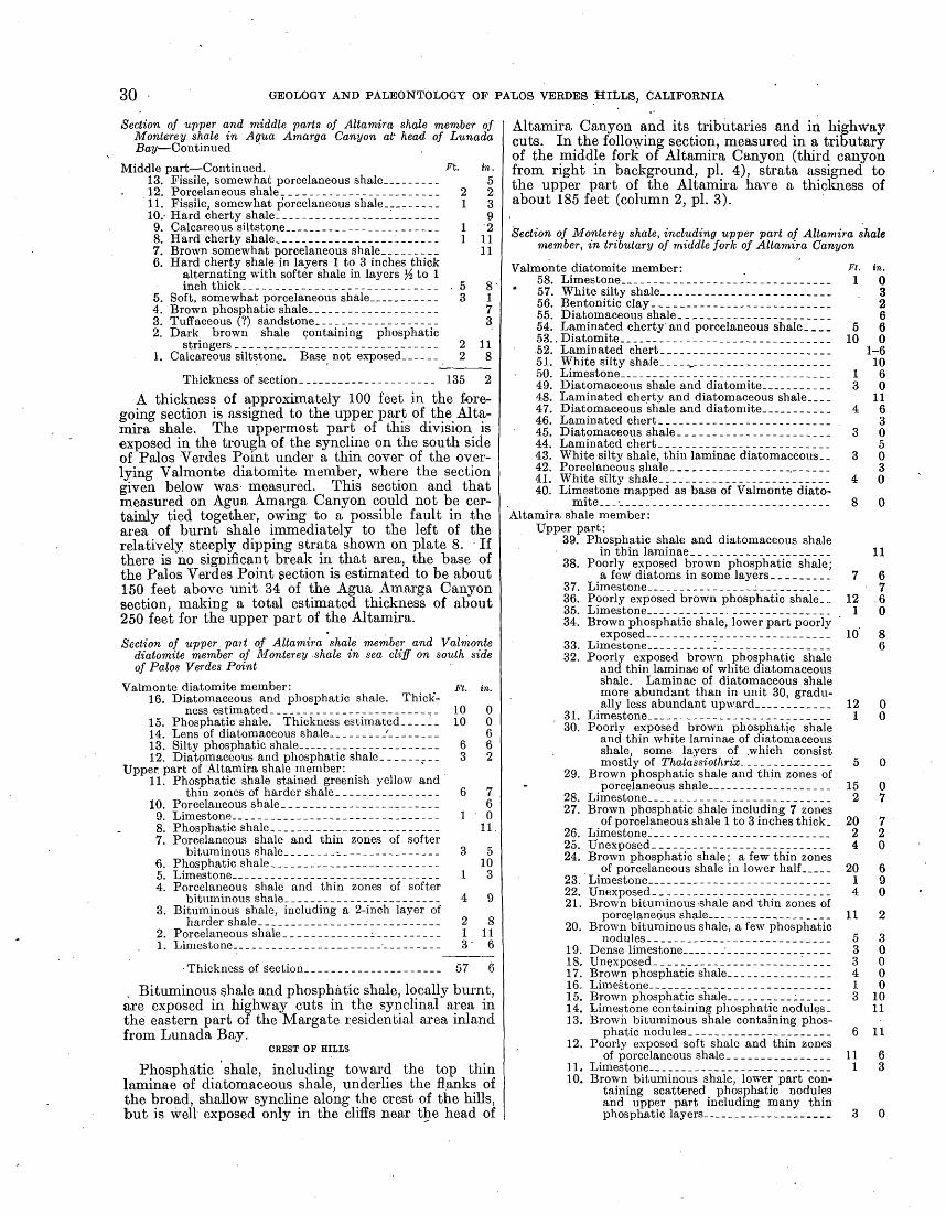
30 GEOLOGY AND PALEONTOLOGY OF PALOS VERDES HILLS, CALIFORNIA
Section of upper and middle parts of Altamira shale member of Monterey shale in Agua Amarga Canyon at' head of Lunada Bay Continued
Middle part Continued. A. in. 13. Fissile, somewhat porcelaneous shale___--____ 512. Porcelaneous shale.___-_----------___-_-_. 2 211. Fissile, somewhat porcelaneous shale___-_-__- 1 3 10.- Hard cherty shale._______________ _______ 99. Calcareous siltstone---------------.-.------- 1 28. Hard cherty shale._________________1______ 1 117. Brown somewhat porcelaneous shale____-_-__ 116. Hard cherty shale in layers 1 to 3 inches thick
alternating with softer shale in layers Yz to 1 inch thick__---___-________-________-___ , 5 8
5. Soft, somewhat porcelaneous shale_._____-_-_- 3 14. Brown phosphatic shale.____________________ 73. Tuffaceous (?) sandstone.------------------ 32. Dark brown shale containing phosphatic
stringers ____--_--_-_---__----__---.---- 2 111. Calcareous siltstone. Base not exposed------ 2 8
Thickness of section__-_____-_---_------- 135 2
A thickness of approximately 100 feet in the fore going section is assigned to the upper part of the Alta mira shale. The uppermost part of this division is exposed in the trough of the syncline on the south side of Palos Verdes Point under a thin cover of the over lying Valmonte diatomite member, where the section given below was measured. This section and that measured on Agua Amarga Canyon could not be cer tainly tied together, owing to a possible fault in the area of burnt shale immediately to the left of the relatively steeply dipping strata shown on plate 8. If there is no significant break in that area, the base of the Palos Verdes Point gection is estimated to be about 150 feet above unit 34 of the Agua Amarga Canyon section, making a total estimated thickness of about 250 feet for the upper part of the Altamira.
Section of upper pait of Altamira shale member and Valmonte diatomite member of Monterey shale in sea cliff on south side of Palos Verdes Point
Valmonte diatomite member: _ Ft. in. 16. Diatomaceous and phosphatic shale. Thick
ness estimated. ____________--_____-__-.,_ 10 015. Phosphatic shale. Thickness estimated-__-__ 10 0 14. Lens of diatomaceous shale-.----.-/-----.-- 613. Silty phosphatic shale.___________________ 6 612. Diatomaceous and phosphatic shale.________ 3 2
Upper, part of Altamira shale member:11. Phosphatic shale stained greenish yellow and
thin zones of harder shale________________ 6 710. Porcelaneous shale ________________________ 6
9. Limestone__________________--_-_____---_ 1 08. Phosphatic shale__._______________________ 11,7. Porcelaneous shale and thin zones of softer
bituminous shale--_-_--_s.__-____-_---___ 3 56. Phosphatic shale________-___--___--_---_-_ 105. Limestone--.---..---_____________________ 1 34. Porcelaneous shale and thin zones of softer
bituminous shale._______ ______..__-____ 4 93. Bituminous shale, including a 2-inch layer of
harder shale_____________________________ 2 82. Porcelaneous shale. ____--_----_---__------ 1 111. Limestone-
Thickness of section.__-_-_--__-___--_-__ 57 6
Bituminous shale and phosphatic shale, locally burnt, are exposed in highway cuts in the synclinal area in the eastern part of the Margate residential area inland from Lunada Bay.
CREST OF HILLS
Phosphatic shale, including toward the top thin laminae of diatomaceous shale, underlies the flanks of the broad, shallow syncline along the crest of the hills, but is well exposed only in the cliffs near the head of
Altamira Canyon and its tributaries and in highway cuts. In the following section, measured in a tributary of the middle fork of Altamira Canyon (third canyon from right in background, pi. 4), strata assigned to the upper part of the Altamira have a thickness of about 185 feet (column 2, pi. 3).
Section of Monterey shale, including upper part of Altamira shale member, in tributary of middle fork of Altamira Canyon
Valmonte diatomite member:58. Limestone____---__-----------_---_-_..___
* 57. White silty shale______-__-._. _____________56. Bentonitic clay. ____---_-__-_-_-__________55. Diatomaceous shale. ______________________54. Laminated cherty and porcelaneous shale. ___ 53. .Diatpmite.------. ---------------.-__.____.52. Laminated chert.---.-.--... _.-_-._.______51. White silty shale.----,---------.. -.__-._...50. Limestone.... ------ ______________________49. Diatomaceous shale and diatomite..__ _______48. Laminated cherty and diatomaceous shale____47. Diatomaceous shale and diatomite_____ ______46. Laminated chert_ ___-_----__--__-___.__.__45. Diatomaceous shale. ____---------._.--._..44. Laminated chert. _ __-_----__.-.--_________43. White silty shale, thin laminae diatomaceous-- 42. Porcelaneous shale. ________________________41. White silty shale. _________________________40. Limestone mapped as base of Valmonte diato-
rnite. __ ________________________________Altamira shale member:
Upper part:39. Phosphatic shale and diatomaceous shale
in thin laminae. ____________________38. Poorly exposed brown phosphatic shale;
a few diatoms in some layers. ________37. Limestone----------------------.---..36. Poorly exposed brown phosphatic shale... 35. Limestone.... ---_-__- _______________34. Brown phosphatic shale, lower part poorly
exposed-- .----_-- --.----.---.--...I33. Limestone _ ____-___l____-____________32. Poorly exposed brown phosphatic shale
and thin laminae of white diatomaceous shale. Laminae of diatomaceous shale more abundant than in unit 30, gradu ally less abundant upward- ___- _______
31. Limestone.--------------------------.30. Poorly exposed brown phosphatic shale
and thin white laminae of diatomaceous shale, some layers of .which consist mostly of Thalassiothrix.. _________'____
29. Brown phosphatic shale and thin zones of porcelaneous shale___--------_-___.__
28. Limestone _ _________________________27. Brown phosphatic shale including 7 zones
of porcelaneous shale 1 to 3 inches thick.26. Limestone-... --_------.--------_---.-25. Unexposed. __--------__.-----_--.----24. Brown phosphatic shale; a few thin zones
of porcelaneous shale in lower half _____23. Limestone.^.. _-__------_--------.--.-22. Unexposed- __---_-----_--_-----___-__21. Brown bituminous -shale and thin zones of
porcelaneous shale_____-______ _______20. Brown bituminous shale, a few phosphatic
nodules ______-_-_-____---_____-____19. Dense limestone __ _ __ ________________1 8. Unexposed __________ _________-__l-___1 7. Brown phosphatic shale. _______________16. Limestone. -___-____-___----_._____.--15. Brown phosphatic shale_-__-_______.___14. Limestone containing phosphatic nodules.13. Brown bituminous shale containing phos
phatic nodules. _____________________12. Poorly exposed soft shale and thin zones
of porcelaneous shale_ ___-__-_-_-__-.11. Limestone----____----_--_------_--___10. Brown bituminous shale, lower part con
taining scattered phosphatic nodules and upper part including many thin phosphatic layers_-_______.__________
ft- 1 0
3 2 6
5 610 0
1-610
1 63 0
114 6
33 0
53 0
34 0
11
7 67
12 .61 0
10 86
121
152
2024
2014
11
111
30000
3 1011
6 11
MIOCENE SERIES 31
Section of Monlerey shale, including upper part of Altamira shale member, in tributary of middle fork of Allamira Canyon Con.
Altamira shale member Continued. Ft - < fl - Middle part:
. 9. Rhythmically bedded porcelaneous shale. 3 5 8. Limestone.-.-.-_________-_____._._.__ 1 87. Poorly exposed hard cherty shale______ 3 06. Rhythmically bedded cherty and por
celaneous shale including 3 layers of opal concretions \%, 6, and 9 feet, re spectively, above base. ___._--_______ 10 7
5. Soft porcelaneous shale________________ 1 64. Limestone..._________________________ 1 83. Porcelaneous shale.-------_----_--_-__ 82. TJncxposed___________________._______ 6 01. Rhythmically bedded cherty and porce
laneous shale including 3 layers of opal concretions 4, 6%, and 8 feet, respec tively, above base------...-...------ 12 0
Thickness of section.______________ 265 2
A section measured in the east fork of Altamira Canyon (first canyon from righ^ in background, pi. 4), 1,500 feet southeast of the preceding section, is as follows (column 3, pi. 3):
Section of upper part of Allamira shale member of Monterey shale in east fork of Allamira Canyon
Ft. in.-15. Unexposed. Overlain by limestone, apparently the
' bed mapped farther west as base of Valmonte diatomite member, which, however, is not ex posed here__-_-----____-_--_--_-_--___.-__ 16 6
14. Limestone..__________________________________ 3 913. Unexposed.___________________________ _______ 14 012. Limestone-_-__---_--_____-_-_---------_-.____ 2 611. Poorly exposed phosphatic shale..______________ 18 010. Limestone____________________________________ 2 10
9. Unexposed___________________________________ 4 08. Brown nodular phosphatic shale_______________ 6 07. Sandstone containing blue schist shreds._________ 36. Soft porcelaneous shale_______-_____------__.-_ 1 116. Poorly exposed soft shale____-.-_-____-_______ 5 04. Limestone______________________ ____________ 3 63. Poorly exposed phosphatic shale.____----___-__. 10 02. Limestpne___--_------_.._____________________ 1 01. Soft silty shale and nodular phosphatic shale.
Underlain by strata assigned to middle part of Altamira shale member. For downward con tinuation of section see p. 21___'_______________ 6 ,6
Thickness of section.__________._---____.__ 95 9
Whether the apparent eastward thinning shown by the preceding two sections represents actual thinning or lateral gradation is uncertain. It is reasonably certain, however, that the top of the upper part of the Altamira is placed at the same horizon in the two sections, and the opal concretions suggest that the base is also. The less definite sections in the Malaga Cove and Lunada Bay areas suggest a southward thinning.
NORTH SLOPE OF HIILS
The upper part of the Altamira shale is poorly exposed on the north slope of the hills. Scattered highway cuts suggest that phosphatic shale is less abundant than in the areas already described and that diatomaceous silt and diatomaceous shale are more abundant. A cut on Palos Verdes Drive North, 700 feet southeast of locality 88, exposes soft shale, including phosphatic shale and diatomaceous shale, overlying cherty shale. The soft shale is thought to represent the base of the upper part of the Altamira. On the abandoned road from the Valmonte residential district to the plant of the Dicalite Co., on the north side of Valmonte Canyon, a bed of vitric volcanic ash 4 }/4 feet thick is interbedded
with limestone, diatomaceous shale, and cherty shale apparently near the top of the Altamira. This is the greatest thickness of unaltered volcanic ash observed hi any part of the Monterey. Phosphatic shale was not found on the north side of Valmonte Canyon, but soft white shale in that area may represent leached phosphatic shale. Cuts on Palos Verdes Drive East south of George F Canyon show diatomaceous silt, a little phosphatic shale, and beds a fraction of an inch to 2 inches thick of fine-grained silty sand containing much blue-schist debris.
SAN PEDRO AREA
The upper part of the Altamira, as now identified, crops out in western San Pedro. In that area two poorly defined units are recognized, a lower unit con sisting of diatomaceous shale and fine-grained blue- schist sandstone and an upper unit consisting of dia tomaceous' shale and phosphatic shale. The lower unit is thought to correspond to the thick blue-schist sand- stone of the Point Fermin area, including shale contain ing Foraminifera of the Bolivina modeloensis zone. The upper unit is correlated with cherty and phosphatic shale at Cabrillo Beach containing Foraminifera of the Bulimina uvigerinqformis zone. Owing to the preva lence of diatomaceous rocks, part of the strata in western San Pedro was grouped formerly with the overlying Valmonte diatomite member.60
In Peck Park the upper part of the Altamira is made up of diatomaceous silt and fine-grained blue-schist sandstone overlain by diatomaceous shale and phos phatic shale. Limestone occurs throughout but is less abundant upward. Toward the top of the section a few beds of vitric volcanic ash an inch or two thick are interbedded with the shale. In one bed the glass shards are stained black with a film of organic matter. Phos phatic shale is well exposed on Twenty-first and Twenty second Streets between Meyler and Cabrillo Avenues. On Twentieth Street, 120 feet east of Meyler Avenue, phosphatic shale appears to be faulted against diato maceous shale mapped as the Valmonte member.
On the north side of the' Cabrillo fault at Cabrillo Beach (pi. 6, D), limestone, porcelaneous shale, and phosphatic shale underlie the Valmonte diatomite member. Though these strata are near the top of the upper part of the Altamira shale, they include porcela neous shale, which was not observed in the area just described. Foraminifera of the Bulimina uvigerina formis zone were collected 200 feet north of the fault (locality 17).
POINT FERMIN-WHITES POINT AREA
A facies quite different from any so far described is- represented at Point Fermin. In that area the upper part of the Altamira includes thick beds of blue-schist sandstone and breccia (column 8, pi. 3). The total thickness is difficult to estimate but is at least 300 feet.
On the east side of. Point Fermin these strata consist of two sandstone units and an intervening shale unit. The base of the lower sandstone is selected arbitrarily as the base of the upper part of the Altamixa. This unit (right foreground, pi. 9, B) is about 100 feet thick but thins northeastward. It is composed of blue-schist sandstone, minor beds of breccia, and interbedded silty and phosphatic shale. The overlying shale, made up
60 Woodring, W. P., Bramlettc, M. N., and Klcinpnll, R. M.,.op. cit. (Am Assoc. Petroleum Geologists Bull., vol. 20), pp. 12S-129, HIT. 1.
32 GEOLOGY AND PALEONTOLOGY OF PALOS VERDES HILLS, CALIFORNIA
chiefly of rather soft porcelaneous shale and silty shale, is almost 100 feet thick at the top of the cliff but thins south westward down the cliff, evidently through grada tion into the sandstone forming the overlying unit.
The upper sandstone forms the 100-foot sheer cliff at the Point (pi. 9) and has approximately that thick ness. It consists of blue-schist sandstone, bituminous and phosphatic shale, and breccia. The sandstone is of coarser grain than that in the lower unit and contains pieces of schist generally a few inches long but excep tionally as much as 7 feet long. The beds of sandstone are as much as 5 to 10 feet thick. Some contain bone fragments, one of which was observed to have a brilliant blue coat, presumably viyianite. The bituminous and phosphatic shale is thin-bedded, and some layers contain diatoms. The thickness of the beds of breccia ranges from a fraction of a foot to several feet.- Most of the beds consist of shale fragments ranging in length from a few inches to several feet (pi. 10, B). Layers of shale can be traced into breccia composed of shale fragments of identical composition and embedded in a sandstone matrix like that interbedded with the shale. Breccia composed of sandstone or of mixtures of shale and sandstone is relatively rare. The breccias were formed evidently while the sediments were being deposited; that is, they are evidently penecontem- poraneous, and the shale and sandstone were consol idated enough to form fragments when they were ruptured. The rupturing may have been due to earthquake jars and submarine sliding. The entire upper sandstone has other curious depositional features. At the base of many of the beds of sandstone is a scour discontinuity, as may be seen on plate 10, B. Discord ant contacts, including truncation of minor folds, are common. Isolated fragments of shale occur hi sand stone, and sandstone grades laterally into shale.
On the west side of Point Fermin (pi. 9, A) the shale underlying the upper sandstone appears to be thicker than on the east side, but much of it is obscured by talus. As exposed on the cliff it consists of porce laneous and silty shale underlain by silty shale, phos phatic shale, and thin beds of fine-grained blue-schist sandstone. A 3-foot bentonitic tuff is included in the shale 15 feet below the irregular contact at the base
of the upper sandstone. Foraminifera of the Bolivina modeloensis zone were found in silty shale at the foot of the cliff about 65 feet stratigraphically below the base of the upper sandstone (locality 16).
-Half a mile to a mile northwest of Point Fermin blue-schist sandstone including a few beds of brecciated shale is exposed along the sea cliff. This sandstone corresponds apparently to the lower sandstone on the east side of Point Fermin. The mineralogy of a sample of sandstone from this area was described by Wood- ford. 61 Silty shale at the top of the cliff, along the road leading to Whites Point, contains Foraminifera of the Bolivina modeloensis zone (locality 14). This shale appears to overlie the sandstone just mentioned.
The upper and middle parts of the Altamira are not satisfactorily differentiated in the area inland from Whites Point. Silty shale interbedded with cherty shale at locality 15 contains Foraminifera assigned doubtfully to the Bolivina modeloensis zone. Phos phatic shale was not observed in this region.
FOSSILS
FORAMINIFERA
Identifiable Foraminifera were found in the upper part of the Altamira shale only at localities near Point Fermin and Whites Point. Leached and crushed Foraminifera were observed in the more typical phos phatic and bituminous shale of other areas. The material collected is assigned by Kleinpell to his Mohnian stage, the base of which corresponds to the base of the upper Miocene according to current Coast Range usage. The faunas from localities 14 and 16, and doubtfully from locality 15, are referred to the' Bolivina modeloensis zone (zone E of preliminary paper) 62 and that from locality 17 to the overlying Bulimina uvigerinaformis zone (zone F of preliminary paper). Locality 17 is close to the top of the Altamira shale according to the stratigraphic classification adopted.
The following species were identified by Kleinpell:
81 Woodford, A. O., The San Onofre breccia: California Univ., Dept. Qeol. Sci.. Bull., vol. 15, p. 210, 1925.
62 Woodring, W. P., Bramlette, M. N., and Kleinpell, R. M., op. cit. (Am. Assoc. Petroleum Geologists Bull., vol. 20), pp. 125-149.
Foraminifera'from upper part of Altamira shale member of Monterey shale [Identifications by R. M. Kleinpell. R, rare; F, few; C, common; A, abundant]
Species
Elphidium granti Kleinpell (Elphidium aff. E. crispum (Linne))(Kleinpell, pi. 1$, figs 1, 11) '.... ..-..-....-...--..-.--..-..
Bolivina fioridana Cushman.. _ .................................... -.... ... ... ..........................................
Bolivina modeloensis zone
' 15
F
R
R
R
F
C
14
(?)
R
F R
C
C
R
A R R
16
R
F R
R R
R
C R
F R F R
Bulimina uvigerina
formis zone
17
RF R
R
R R
(?)
C
R
Localities
Seo footnotes at end of table.

MIOCENE SERIES
Foraminifera from upper part of Altamira shale member of Monterey shale Continued
33
Species
Cibicldcs nltftiniraonsis Kleinpell (Cibicidcs sp.) (Kloinpell, pi. 19, figs. 4, 5, 8) '............................-.................Clbicicles illingi (Nuttall) (cf.) ---------..--.------------ - - ----- - ------------
Localities
Bolivina modeloensis zone
' 15
C F
14
F R
C
A
C
R R R R A F R R
R R R R R R R
16
R R
F
R
R
F R
R R R F R
R
Bulimina uvigerina-
formis zone
17
CF
R R
R R F C
R
R
R
1 Zonal position uncertain.3 Names in parentheses were used in preliminary paper (Am. Assoc. Petroleum Geologists Bull., vol. 20, No. 2, pp. 125-149,1936). KIclnpell, R. M., Miocene stratigraphy of California, Am. Assoc. Petroleum Geologists, Tulsa, Okla., 1938. The citations in the table refer to illustrations of specimens
from tho Palos Vordcs Hills.
Kleinpell's comments on the foraminiferal faunas are summarized as follows:
Assemblages from localities 14 and 16 are character istic of the Bolivina modeloensis zone, which immediately overlies the Siphogenerina collomi zone at several widely separated localities in California. Bolivina modeloensis, Cassidulina monicana, and Virgulina californiensis var. ticensis are restricted to this zone. It is further charac terized by the earliest appearance of Uvigerina hootsi, Uvigerina segundoensis, Uvigerina subperegrina, and Valvulineria araucana. Though a number of species, particularly those belonging to the Buliminidae, are held over from the preceding Luisian stage, stocks like those of Valvulineria californica, Valvulineria miocenica, and Siphogenerina, which dominate the Luisian faunas and are tropical in their affinities, are lacking in the Bolivina modeloensis zone. Faunas very close to those from localities 14 and 16 occur in the typical Bolivina modeloensis zone at the base of the Modelo formation (Monterey shale of some geologists) near Mohn Spring in the Santa Monica Mountains °3 and in the Tice shale of the Monterey group in Contra Costa County. 64
The relatively meager collection from locality 15 lacks stratigraphically diagnostic elements other than Virgulina miocenica and Bolivina subhughesi, both of which, are known to range from the Bolivina modeloensis zone up into the lower part of the Bolivina hughesi zone. Field relations indicate that the strata at locality 15 are not younger than those at localities 14 and 16.
Locality 17 represents a distinct zone, the Bulimina uvigerinaformis zone. Bolivina sinuata var. alisoensis and Bulimina uvigerinaformis appear to be character istic of that zone. The faunas from the Bulimina uvigerinaformis and Bolivina modeloensis zones are
M Kleinpell, R. M., Miocene stratigraphy of California, p. 129, Am. Assoc. Petro leum Geologists, Tulsa, Okla., 1938.
8< idem.
closely related, and some paleontologists group them in one zonal unit designated the Baggina californica zone. Assemblages with which that from locality 17 may be correlated are found near the base of the McLure mem ber of the Monterey shale along Reef Ridge in the Coalinga district,65 250 feet above the base of the Modelo formation near Mohn Spring in the Santa Monica Mountains,66 and at the type locality of the Bulimina uvigerinajormis zone east of the mouth of Dos Pueblos Canyon, Santa Barbara County. 67
MOLLUSKS
Kew found poorly preserved remains of an Aegui- pecten, suggestive of A. andersoni, and an oyster in sandstone in the Point Fermin area. Fragmentary remains from sandstone in the same area were recorded by Wood ford 68 as Lyropecten crassicardo? ["Pecten"], and Ostrea titan?. An incomplete mold of a large. Lyropecten from conglomeratic sandstone in the Fort McArthur Upper Reservation is identified as L. cf. crassicardo.
VALMONTE DIATOMITE MEMBER
The Valmonte diatomite member 69 overlies the Altamira shale member. The type region is along the lower course of Agua Negra Canyon, southeast of the Valmonte residential district, where diatomite ̂ is quarried and processed. The Valmonte includes the relatively pure diatomaceous strata of the Monterey.
8» Kleinpell, R. M., in Woodring, W. P., Stewart, Ralph, and Richards, R. W., Geology.of the Kettleman Hills oil fields, Calif.; stratigraphy, paleontology, and structure; U. S. Geol. Survey Prof. Paper 195, pp. 127-128,1940 [1941].
88 Kleinpell, R. M., Miocene stratigraphy of California, p. 129, Am. Assoc. Petro leum Geologists, Tulsa. Okla., 1938.
67 Idem.8S Woodford, A. O., op. cit., p. 211.8» Woodring, W. P., Bramlette, M. N., and Kleinpell, R. M., op. cit. (Am. Assoc.
Petroleum Geologists Bull., vol. 20), p. 143.

34 GEOLOGY AND PALEONTOLOGY OF PALOS VERDES HILLS, CALIFORNIA
Owing to the change from cherty shale and phosphatic shale to diatomaceous rocks, the Altamira and Valmonte members are well defined in the western part of the hills. On the northeast and east slopes differentiation of the two members is difficult, as the middle and upper parts of the Altamira include diatomaceous rocks. In those areas only relatively pure, diatoma ceous. strata overlying diatomaceous rocks interbedded with cherty shale, blue-schist sandstone, and phosphatic shale are now assigned to the Valmonte.
Diatomite occurs in the Valmonte as; layers or laminae of varying thickness. In some areas thinly laminated diatomite forms units several feet thick alternating with massive diatomaceous mudstone. In other ,areas the entire exposed thickness of the Valmonte consists of laminated diatomite and diatomaceous shale containing varying proportions of diatoms. Some of the thick units and also some of the thin laminae in areas where thick units are absent consist of a feltlike mass of the pelagic hairlike diatom Thalassio- thrix. In most of the layers and laminae, however, relatively large discoidal diatoms are the most abundant constituents noted in field examination.
N.
, STRATIGRAPHY AND LITHOLOGY
MALAGA COVE AREA
The strongly deformed formations in the sea cliff at Malaga Cove include the Valmonte diatomite (pi. 10, A; fig. 7). The strata at that locality assigned to the Valmonte consist of laminated diatomite and diato maceous shale containing exceptionally abundant layers, stringers, and elongate nodules of soft phos phatic material. A thickness of about 100 feet is. ex posed on the north limb of the syncline containing the overlying Malaga mudstone member and apparently about 200 feet on the south limb. In the faulted areas beyond the limb of the syncline stratigraphic relations are uncertain.
The dry diatomite and diatomaceous shale, including the phosphatic layers, are white (pi. 11, B}. At the base of the cliff, where the rocks are kept wet by waves and spray, the diatomite and diatomaceous shale are almost black and the phosphatic layers are light gray, the two types-of rock being strongly contrasted.. As shown on plate 10, C, many phosphatic layers pinch and swell, and others are broken into minute displaced
FIGURE 7. Sea cliff at Malaga Cove, a, Nonmarine terrace cover and dune sand (Pleistocene to Recent); 6, San Pedro (?) sand (Pleistocene); c, Repetto siltstone (lower Pliocene); d, Malaga mudstone member of Monterey shale (upper Miocene); e, Valmonte diatomite member, of Monterey shale (upper Miocene).
At least locally, thin layers of phosphatic material are interbedded with laminated diatomite and diatoma ceous shale. Perhaps phosphatic material is more prevalent than is apparent, for the. thin layers may be difficult to recognize in weathered outcrops. Lime stone is less abundant than in the Altamira shale. In the lower part of the Valmonte of most areas limestone occurs in lenticular beds, as in the Altamira. In the upper part and in some places throughout the member it occurs-as concretions. In laminated rock laminae pass generally without interruption into the concre-
. tions. Locally zones of cherty shale are included in the Valmonte, but they are rare. Black chert in the form of discontinuous thin layers and stringers parallel to the bedding and as veins cutting across the bedding is found as a" minor constituent in the Valmonte. Vitric volcanic ash in layers a few inches thick, appro priately called silver sand by the diatomite quarrymen, is another minor constituent.
The soft rocks of the Valmonte member are exposed for the most part only in cliffs and artificial excavations. No exposed section of the entire member was found, and the thickness is difficult to estimate. The estimate of 750 feet for the north slope of the hills cited in the pre liminary paper 70 may be excessive, owing to inclusion of soft shale in the upper part of the Altamira; 500 feet is perhaps a better estimate. In San Pedro the thickness is only about 250 to 300 feet according to the classification now adopted.
Foraminifera of the Bolivina hughesi zone were found in the Valmonte at localities in the San Pedro area.
70 Woodriug, W. P., Bramlette, M. N., and Kleinpell, R. M., op. cit.
blocks. The generally consistent relation of offsets suggests that the blocks are the result of shearing pro duced by differential movement during deformation rather than the result of penecontemporaneous breccia- tion. Limestone occurs in the form of concretions,
NE.
25 Feet
FIGURE 8. Valmonte diatomite and Altamira shale members of Monterey shale in sea cliff near mouth of Malaga Canyon, a, Pleistocene terrace deposits; b, Val monte diatomite member of Monterey shale (laminated diatomaceous and .phos phatic shale); c, Altamira shale member of Mouterey shale (phosphatic shale, limestone, and cherty shale).
generally laminated, of varying dimensions. The only hard siliceous rock observed consists of thin lenticular layers, stringers, and veins of black chert. On the south limb of the syncline a 4-inch layer of vitric vol canic ash is interbedded with diatomacepns shale.
The base of the Valmonte is exposed in the sea cliff 200 feet southwest of the mouth of Malaga Canyon. The strata are abruptly upturned at that locality, but

GEOLOGICAL SURVEY PROFESSIONAL PAPER 207 PLATE 6
A. PORTUGUESE TUFF BED AT TYPE LOCALITY IN KLONDIKE CANYON.
Light-colored slope in middle of picture is formed by the tuff. Photograph by R. D. Reed.
C. INTRUSIVE BASALT A QUARTER OF A MILE EAST OF POINT VICENTE.
The basalt shows as dark rock high on cliff.
B. SCHIST-DEBRIS BRECCIA AT BLUFF COVE.
Photograph by R. D. Reed.D. CABRILLO FAULT AT CABRILLO BEACH.
Light-colored cherty and phosphatic shale of upper part of Altamira member oil hanging wall, buff siltstone of middle part of Altamira on footwall.
ALTAMIRA MEMBER OF MOJfTEREY SHALE AND BASALT.

GEOLOGICAL SURVEY PROFESSIONAL PAPER 207 PLATE 7
A. TYPE LOCALITY OF MIRALESTE TUFF BED ON \\ l^'l Ml>l ol I I'PER AGUA NEGRA CANYON.Arrows point to base of luff.
B. LOCAL DISCONTINUITY OR BEDDING-PLANE FAULT.Foot of sea cliff east of Point Fermin.
ALTAMIRA MEMBER OF MONTEREY SHALE.

GEOLOGICAL SURVEY PKOFESSIONAL PAPEB 207 PLATE 8
I'HOSI'HATIC AND BITUMINOUS SHALE IN UPPER PART OF ALTAMIRA MEMBER OF MOiM KliEY SHALE AT LUNADA BAY.
Note the extensive marine terrace. Photograph by Palos Verdes Estates.

GEOLOGICAL SURVEY
FPROFESSIONAL PAPER 207 PLATE 9
A. WEST SIDE OF POINT 1'ERMIN.
. . - . ., . B. EAST SIDE OF POINT FERMIN.i
BLUE-SCHIST SANDSTONE IN UPPER PART OF ALTAMIRA MEMBER OF MONTEREY SHALE AT POINT FERMIN.

GEOLOGICAL SURVEY PROFESSIONAL PAPER 207 PLATE 10
A. SEA CLIFF SECTION AT MALAGA COVE.
a, Nonmarine terrace cover and dune sand (Pleistocene to Recent); b, Repetto siltstone (lower Pliocene); c, Malaga mudstone member of Monterey shale (upper Miocene);d, Valnionte diatomite member of Monterey shale (upper Miocene).
1
'' B. BLUE-SC11IST SANDSTONE AND BRECCIATED SHALE IN UPPER PART OF ALTAMIRA MEMBER OF MONTEREY SHALE.
Highway cut on west side of Point Fermin.
C. BROKEN AND STRETCHED PHOSPHATIC LAYERS (LIGHT-COLORED) IN LAMINATED DIATOMITE AND DIATOMACEOUS SHALE (DARK-COLORED).
Valmonte diatomite member of Monterey shale on north limb of southern syncline at Malaga Cove.
MIOCENE AND PLIOCENE FORMATIONS.

-GEOLOGICAL SURVEY PROFKSSIOXAL PAPER 207 PLATE 11
A. VALMONTE D1ATOMITE MEMBER OF MONTEREY SHALE (b) OVERLAIN BY MALAGA MUDSTONE MEMBER (a).
B. VALMONTE DIATOMITE MEMBER OF MONTEREY SHALE (AT RIGHT) FAULTED AGAINST MALAGA MUDSTONE MEMBER (AT LEFT).
VALMONTE DIATOMITE AND MALAGA MUDSTONE MEMBERS OF MONTEREY SHALE AT MALAGA COVE.
MIOCENE SERIES 35
there appears to be no displacement (fig.'8). Dia tomaceous laminae were not obeserved in the phos- phatic shale at the top of the Altamira, whereas diatoms are abundant in the laminated shale assigned to the Valmonte. As at the top of the Valmonte in the, Malaga Cove section just described, phosphatic layers are interbedded with the diatomite and diatomaceous shale.
SYNCLINAL AREAS IN WESTERN PART OF HILLS
The lowermost part of the Valmonte, representing a thickness of 30 to perhaps 75 feet, was identified in several synclinal areas in the western part of the hills, as shown on the geologic map (pi. 1). It is doubtful, however, whether the base of the Valmonte represents the same horizon in the different areas. In most of these areas thin layers of diatomaceous shale are inter- bedded with the phosphatic shale near the top of the Altamira. (See sec., p. 30.)
Sections of the Valmonte as exposed in the sea cliff on the south side of Palos Verdes Point and in the cliff at the head of a tributary of the middle fork of Altamira Canyon, on the south limb .of the syncline along the crest of the hills, are included in the sections given on page 30. Very little diatomite proper is found in those areas. In the area along the crest of the hills a few thin zones of laminated chert and laminated cherty shale are included in the exposed part of-the Valmonte.
NORTH SLOPE OF HILLS
The open cuts and drifts of the Dicalite Co., along Agua Negra Canyon and farther east, are located in the upper half of the Valmonte. The section exposed in the open cuts consists of alternating laminated diatomite and massive diatomaceous mudstone, both in units 2 to 6 feet thick. In one diatomite unit laminae containing the hairlike Thalassoihrix were observed throughout the entire thickness of 5 to 6 feet. In other units discoidal diatoms are abundant, though some laminae contain Thalassothrix. Vitric volcanic ash occurs in layers a few inches thick. A 4-inch pebble of decomposed schist was found at the base of a bed of diatomaceous mud- stone. The prevailing dip in this area is northeast; however, the strike and the rate of dip change within short distances. The relatively great width of outcrop is due apparently to these structural irregularities.
Elsewhere on the north slope of the hills the Valmonte is poorly exposed, with the exception .of scattered out crops along ravines and highway exposures.
SAN PEDRO AREA
In the San Pedro area the Valmonte appears to be considerably thinner than in the type region. The underlying Altamira shale includes much diatomaceous silt and diatomaceous shale, some layers of which contain so many diatoms that they may be classified as diatomite. Only the part of the section that in cludes thick units of relatively pure diatomaceous rocks is assigned to the Valmonte. The change from the underlying Altamira member takes place, however, in a transition zone.
In Peck Park the diatomite, diatomaceous shale, and diatomaceous mudstone forming the cliff at the north boundary of the park are assigned to the Val monte member. Differentiation from the underlying Altamira member, which includes much diatomaceous material, is, however, not sharp. Thin limestone lenses and concretions are included in the Valmonte.
502787 45 4
Foraminifera of the Bolivina decurtata subzone were found at the foot of the cliff (locality .20). A collection from a horizon 20 feet higher stratigraphically is assigned to the overlying Bolivina goudkoffi sub'zone (locality 20a). At locality 20 a thin layer contains impressions and molds of the thin-shelled scallop Delectopecten.
In the first deep ravine east of Peck Park, imme diately west of Bandini Avenue, a thickness of 225 feet of diatomite and diatomaceous mudstone, including thin limestone lenses and concretions, is exposed. An additional unexposed thickness of 60 feet is estimated to underlie the Malaga mudstone member. As the lowest exposed strata are near the base of the Val monte, the total thickness of that member is not much more than 300 feet. Foraminifera of the Bolivina goudkoffi subzone were collected at horizons 45, 125, and 127 feet above the base of the exposed section (localities 21, 2la, 21b, respectively).
The same lithologic types, representing the upper part of the Valmonte, are exposed on the north side of San Pedro Canyon, between Meyler and Cabrillo Avenues, where Foraminifera of the Bolivina goudkoffi subzone were collected (locality 22). Farther south the Valmonte is found in street cuts along Alma Ave nue between Eighth and Eleventh Streets, on Meyler Avenue between Seventh and Nineteenth Streets, and on Cabrillo Avenue at Twentieth and Twenty-first Streets. On Twentieth Street, 120 feet east of Meyler Avenue, diatomite appears^to be faulted against phos phatic shale in the upper "part of the Altamira. On the geologic map in the preliminary paper 71 a fault was continued .southeastward between the Altamira and Valmonte members. Even if they are in fault contact on Twentietli Street, the displacement is prob ably too small to justify that interpretation.
The transition zone between the Altamira and Valmonte members was formerly visible at Cabrillo Beach but is now concealed by fill. The Valmonte is exposed more or less continuously in the sea cliff from a locality immediately south of the drive to Cabrillo Beach northward to the. Fort McArthur Lower Reser vation. Owing to many minor folds the thickness is uncertain. The strata consist chiefly of diatomite, diatomaceous shale, diatomaceous mudstone, and thin lenses of limestone. Occasional thin layers of volcanic ash are impregnated with asphalt. At a point about 1,000 feet north of the Cabrillo Beach drive a zone 25 feet thick includes cherty shaie. Foraminifera were found in the lower part of the section at locality 18a, immediately south of the Cabrillo Beach drive, and at localities 18, 19, and 19a, north of the drive. All these collections are assigned to the Bolivina decurtata subzone. Locality 18 is now concealed by fill.
FOSSILS
FORAMINIFERA
At various localities in the San Pedro area the Valmonte diatomite contains well-preserved Foraminif era. These collections are assigned by Kleinpell to the Bolivina hughesi zone, both the Bolivina decurtata subzone (zone G of preliminary paper) 72 and the> over lying Bolivina goudkoffi subzone (zone H of preliminary paper) being represented. In the San Pedro area the Bolivina hughesi zone corresponds approximately to
» Woodring, W. P.. Bramlette, M. N., and Kleinpell, R. M., op.cit. (Am. Assoc. Petroleum Geologists Bull., vol. 20), pp. 128-129, fig. 1.
« Woodring, W. P., Bramlette, M. N., and Kleinpell, R. M., op. cit., pp. 125-149.

36 GEOLOGY AND PALEONTOLOGY OF PALOS VERDES HILLS, CALIFORNIA
the Valmonte diatomite, for Foraminifera from imme diately underlying and overlying strata are assigned to other zones. If the section in the deep ravine immediately west of Bandini Avenue may be taken as a guide, the Bolivina decurtata subzone is thinner than
the Bolivina goudkoffi, subzone. At that locality Foraminifera referred to the Bolivina goudkoffi subzone occur 100 feet or less above the base of the Valmonte.
The species identified by Kleinpell are given in the following table:
Foraminifera from Valmonte diatomite member of Monterey shale
[Identifications by R. M. Kleinpell. R, rare; F, few; C, common; A, abundant]
Species
i
Dentalina cf. D. flliformis (d'Orbigny) (Dentalina sp.) (Kleinpell pi. 22, fig. 1) 2 ___.._
Nonioh goudkoffi Kleinpell (Nonion sp.) (Klempell, pi. 20, figs. 2, 5) '. ....... ... .....
Buliminella dubia Barbat and Johnson?.--.-.-. _ ........... _ -_..-.---_---.-_-_._ -
Bulimina inflata Seguenza-.-- ___ .... _ . _ ......... __ ..... _ .................Bulimina montereyana var. delmonteensis Klempell? (Bulimina cf. 'B. affinis d'Or-
Bulimina ovula var. pedroana Kleinpell (Bulimina afi. B. ovula d'Orbigny). -._-_-.-
Virgulina californiensis var. grandis Cushman and Kleinpell ___ ......'..............
Bolivina bramlettei Kleinpell ("Bolivina beyrichi alata (Seguenza)" Rankin) (Klein pell, pi., 21, figs. 9-11) i......................... ....................................
Bolivina decurtata Cushman (cf.) (Kleinpell, pi. 21, figs. 3, 8) 2 . ................ __ .Bolivina girardensis Rankin.- ... _ .......' _ ............... _ ----..--.-.....---.-.-Bolivina goudkoffi Rankin- .... _____ ........ __ ..... ___ ... __ .... _ .. _ .Bolivina hootsi Rankin __ ...... _ ..........._ ................. __ . ........
Bolivina cf. B. interjuncta Cushman... __ .......;.......................... __ ....Bolivina malagaensis Kleinpell (Bolivina aff. B. advena Cushman) _ ...............Bolivina parva Cushman and Galliher ....... _ .......... _ .... ....
Bolivina sinuata Galloway and Wissler _ ............................. ..Bolivina subhughesi Kleinpell (Bolivina sp.) (Kleinpell, pi. 21, figs. 7, 12) 2________...Bolivina subadvena var. spissa Cushman (Bolivina aff. B. subadvena Cushman)
(Kleinpell, pi. 21* figs. 1, 2, 13) 2... ............. .................... ....
Bolivina woodringi Kleinpell (Bolivina c.f. B. argentea Cushman) (Kleinpell, pi. 21, figs. 4, 5) 2 . -.-.-...---.....-..-... ................................
Uvfgerina hannai Kleinpell (Uvigerina aff . U. hootsi Rankin).................. ....Uvigerina hootsi Rankin....... _ ..... ............... ... .......Uvigerina modeloensis Cushman and Kleinpell. .................... _ .....Uvigerina segundoensis Cushman and GallUier....Uvigerina cf. U. senticosa Cushman (Kleinpell, ol. 20, fig. 9) 2 ...... ....Uvigerina sp.? (Kleinpell, pi. 20, figs. 1, 17) 2 . ......Uvigerina subperegrina Cushman and Kleinpell- ..-.-..--..-.--...Valvulineiiaaraucana (d'Orbigny).. __ ... __ .... __ .... __ . __ .Gyroidina soldanii var. rotundimargo R. E. and K. C. Stewart .Eponides multicameratus Kleinpell ("Eponides aff. E. broeckiana (Karrer)" Rankin) Eponides healdi R. E. and K. C. Stewart. ... .Eponides keenani Cushman and Kleinpell.----..-.--.. .. .. .....Baggina californica Cushman... _ 9 .. ...Pulvinulinella capitanensis Cushman and Kleinpell?.Pulvinulinella sp. (Kleinpell, pi. 20, figs. 3, 4, 7) 8 ..." ..Cassidulina delicata Cushman ___ _ ............................Cassidulina barbarana Cushman and Kleinpell..- . ......................Cassidulina crassa d'Orbigny....:.......... .Cassidulina modeloensis Rankin. ........ .................. . .Chilostomella cf. C. ovoidea Reuss. ..........................................Sphacroidina bulloides d'Orbigny. ....!.... ........Globigerina bulloides d' Orbigny _ . ............................ .Anomalina hughesi Rankin . .............Planulina cf. P. ariminensis d'Orbigny.................... .Planulina depressa d'Orbigny. .......... i. ..............................Planulina ornata (d' Orbigny). _.a_ ................................................Discorbinella valmonteensis Kleinpell (Cibicides cf. C. cicatricosa (Schwager) (Klein
pell, pi. 21, figs. 14-16) i.... .......................................Cibicides illingi (Nuttall) (cf.) (Kleinpell, pi. 20, figs. 18-20) 2
Localities
Bolivina hughesi zone
Bolivina decurtata subzone
18
R R
R R
R R
R RA
5F F
F R
A
-F R R
F
C
R CF
R
C C
R R
R R
RF
R F
18a
F
F
F
R
R
R R
A
C F
R
F
R
C
R
R R R
R
19
R
F
R
F R
F C F
A RR
CF
R
R
F
A
F (?) R
R R
R R R
R
A R
19a
R R
R
F R
R
R
R
A R
F R
R
F
FF
FF
R
R
R
R
R R
20
R
R
R
F R
. C
F
A
C F C
R
CA
R
A F R R F
F F R
R
F
F
Bolivina goudkoffi subzone
20a
R
R
R F
R
F.
R
F
R
R RA
R
A R
F F
C
F
R
21
R F
RA
F
F
F
' 21a
F
C
C
R
F F C
F C A
F
F
R
A
R
21b
R
. R
F
F .
C
FF A
C
F
R
R
C
22
R
R
R
F
R A
R
v R R
R
R F A
R
F-
R A
R
R
1 Names in parentheses were used in preliminary paper (Am. Assoc. Petroleum Geologists Bull., vol. 20, No. 2, pp. 125-149, 1936).2 Kleinpell, R. M., Miocene stratigraphy of California, Am. Assoc. Petroleum Geologists, Tulsa, Okla., 1938. The citations in the table refer to illustrations of specimens
from the Palos Verdes Hills.
Kleinpell's comments are summarized as follows: The Foraminifera from the Valmonte diatomite rep
resent the fauna of the typical Bolivina hughesi zone
listed by Rankin from Hoots' lithologic units 7 to 16, inclusive, in the lower member of the Modelo formation (Monterey shale of some geologists) exposed along the

MIOCENE SERIES 37
road from Girard to Mohn Spring in the Santa Monica Mountains. 73 Rankin, Hughes, and GoudkofF4 have cited the same fauna from the upper shale member of the Puente formation as exposed in La Habra Canyon, on .the south flank of the Puente Hills. The fauna is represented by rich assemblages of well-pre served and characteristic forms in the Palos Verdes Hills. Of the species listed by Rankin, Hughes, and Goudkoff as characteristic of the zone, only the two species of Buliminella are missing in the Palos Verdes Hills collections. The fauna from the Valmonte can also be correlated with Galliher's middle Nonion fauna,75 which represents the Bolivina hughesi zone in the Monterey shale of the type region.
Two faunal divisions treated tentatively as subzones76 are recognized in the Valmonte. The differentiation is not as clearly defined as the differentiation between the zones and is based on quantitative more than on qualitative differences. Nevertheless the distinctive features of the two subzones persist at a number of localities in southern California, including the Girard- Mohn Spring section in the Santa'Monica Mountains. So far as now known, Baggina californica, Pulvinu- Linella capitanensis, and Uvigerina modeloensis are not found above the Bolivina decurtata subzone, and Uvigerina hannai is not found below the Bolivina goudkqffi subzone. Bolivina goudkqffi is restricted ap parently to the subzone named for it. A marked in crease in the number of specimens of Bolivina seminuda, Bolivina sinuata, Cassidulina modeloensis, and Planu- lai'ia cushmani and a falling off of Bolivina hughesi seem also to characterize that subzone.
MOLLUSKSImpressions and molds of the small thin-shelled deep-
water scallop Delectopecten were collected at locality 20. They were cited in the preliminary paper 77 as Delec- opecten pedroanus. They are now identified, however, as Hyalopecten (Delectopecten) aff. H. peckhami.''8 Similar material in the collections of the California Academy of Sciences (California-Acad. Sci. No. 1894) from a locality about 220 yards northwest of the end of the breakwater at Cabrillo Beach, close to locality 19a of the present report, appears to represent the same form. 79 In 1856 Trask 80 described three forms of scal lops from the east coast of the Palos Verdes Hills and believed the strata to be of Cretaceous age. The three forms are regarded as one species, which is cited as Hyalopecten^(Delectopecten) pedroanus. Trask's speci mens evidently came from the lower part of the Val monte diatomite or the upper part of the Altamira shale at Cabrillo Beach, for that is the only locality on the east coast where the dip is as steep as recorded by Trask (about 50°). According to his description and figures, H. pedroanus is a relatively large species that has strong concentric undulations and evidently has radial ribs. Specimens that show these characters have not been
" Rankin, W.D., in Hoots, H. W., Geology of the eastern part of the Santa Monica Mountains, Los Angeles County, Calif.: U. S. Oeol. Survey Prof. Paper 165, pp. 103- 104, 113, pi. 27, 1931. Kleinpell, R. M., Miocene stratigraphy of California, p. 130, Am. Assoc. Petroleum Geologists, Tulsa, Okla., 1038.
» Rankin, W. D., Hughes, D. D., and Goudkoff, P. P., in Hoots, H. W., idem, p. 114.
» Gallihor, E. W., Stratigraphic position of theMontcrey formation: Micropaleon- tologv Bull., vol. 2,'No. 4, pp. 71-74, 1931.
"Kloinpoll, R. M., op. cit., p. 130.» Woodring, W. P., in Woodring, W. P., Bramlette, M. N., and Kleinpell, R, M.,
op. cit. (Am. Assoc. Petroleum Geologists Bull., vol. 20)p. 146.» Woodring, W. P., Lower Pliocene mollusks and echinoids from the Los Angeles
Basin, Calif., and their inferred environment; U. S. Geol. Survey Prof. Paper 190, p. 39, 1938.
«Idem.so Trask, J. B., Description of three new species of the genus Plagiosloma from the
Cretaceous rocks of Los Angeles: California Acad. Sci. Proc., vol. 1, p. 86, 4 flgs., 1856.
found in the Palos Verdes Hills since Trask's time. A similar form occurs, however, near the top of the Mio cene in the Los Angeles Basin subsurface section.81
VERTEBRATES
Miller 82 has described three sea-birds found in diat omite assigned in the present report to the Valmonte member. ^A shearwater (Puffinus diatomicus) collected at Cabrillo Beach was described originally from material in the diatomite of the Monterey shale at Lompoc, Santa Barbara County. A gannet (Sula stocktoni) and the oldest recorded albatross from America (Dinmedea? sp.) were collected in the quarry of the Dicalite Co. Miller also recorded the finding in the quarry of several specimens of a small cetacean similar to Lagenorhynchus. Sea lion remains from the quarry of the Dicalite Co. have been referred by Lyon 83 to Pontolis magnus.
MALAGA MUDSTONE MEMBER
The Malaga mudstone member 84 overlies the Val monte diatomite member and is the uppermost division of the Monterey shale in the Palos Verdes Hills. The type region is at Malaga Cove, at the northwest end of the hills, where the lower and upper parts of the member, but possibly not the entire thickness, are exposed. Unlike the other members of the Monterey, the Malaga is found only near the north and east margins of the hills. That it formerly extended over a much larger area, probably the entire area of the hills, is indicated by the absence of a shallow-water facies. Schist pebbles suggest, however, that a schist land area was close by. .
The Malaga mudstone consists chiefly, and in some areas virtually entirely, of massive radiolarian mudstone or fine-grained siltstone. Relatively large globular Radiolaria and scattered diatoms are visible in field examination. Though the term "radiolarian mudstone" is used to differentiate the mudstone from ordinary mudstone, Radiolaria actually are a minor constituent. The mudstone is light chocolate brown or olive gray when dry and almost black when wet. The dry rock is greatly jointed and hackly. At Malaga Cove the Malaga member includes laminated diatomite and dia- tomaceous shale in thin streaks or in well-defined units several feet'thick. Such material was observed else where on the north slope of the hills but not in San Pedro. Limestone occurs as concretions and lenses in both massive mudstone and laminated diatomite. In the laminated rock laminae pass generally without interruption into the limestone. Vitric volcanic ash in thin layers is a minor constituent. Hard siliceous rocks were not observed at outcrop localities.
The litholpgic change from the Valmonte to the Malaga is fairly abrupt at Malaga Cove. Limy phos- phatic nodules and schist and quartz pebbles occur at and just above the base of the Malaga. This material indicates slow deposition or nondeposition during the early period of the subsidence suggested by the deep- water aspect of the Malaga Foraminifera. Assignment of formation rank to the Malaga may be preferable to member rank in the Monterey. The prevailing litho-
'8i Woodring, W. P., op. cit. (U. S. Geol. Survey Prof, paper 190), p. 41, pi. 6, flgs. 1, 2, 1938.
82 M iller, Loye, New bird horizons in California: California Univ. at Los Angeles Pub. Biol. Sci.. vol. 1, No. 5, pp. 73-80, 2 flgs., 1935.
M Lvon, G. M., A Miocene sea lion from Lomita, Calif.: California Univ., Pub. Zoology, vol. 47, pp. 23-42, pis. 2-6, 2 flgs., 1941.
s* Woodrinp, W. P., Bramlette, M. N., and Kleinpell, R. M., op . cit., (Am. Assoc. Petroleum Geologists Bull., vol. 20), p. 146.

38 GEOLOGY AND PALEONTOLOGY OF PALOS VERDES HILLS, CALIFORNIA
logic type in the Malaga is included, however, as a minor constituent in the underlying Valmonte, and some beds of laminated diatomite and diatomaceous shale, like that in the Valmonte, are included in the Malaga.
The thickness of the Malaga mudstone is difficult to estimate. A thickness of about 150 feet above the base
is represented in the southern syncline at Malaga Cove and about the same thickness at the top of the member on the south limb of the northern syncline. It is not known, however, whether these sections overlap. An apparently unbroken section of 325 feet, presumably near the top of the member, is exposed at the north end of Malaga Cove. Along most of the north slope of the hills the thickness is probably not more than.300 feet, but in part of that area the mudstone is overlapped by Pleistocene strata. In Isan Pedro, where the Malaga is overlapped, the thickness is as much, as 600 feet if the average dip is 15° and minor folds and faults are absent. The structure in that area is obscure/ however, and the thickness may be considerably less.
The Malaga is rich in organic matter. Samples from Malaga Cove have a nitrogen content of 0.325 per cent,85 indicating an estimated percentage of organic matter of 7.8 86 the highest nitrogen content for California outcrop samples analyzed by Trask and. Patnode in their study of source beds of petroleum.
STRATIGRAPHY AND LITHOLOGY
MALAGA COVE AREA
The base of the Malaga mudstone is well exposed on the north limb of the southern syncline at Malaga Cove (pis. 10, A; 11, A; fig. 7). As may be 'seen on plate 11, A, there is some minor crumpling along the contact between the Valmonte and Malaga. About 20 feet above the beach a lens of flat limy phosphatic nodules 1% feet thick is 1% feet above the base of the Malaga. Similar nodules are scattere.d between the base of the lens and the base of the member. The nodules are 2 to 4 inches long and many contain leached Foramini- fera. A few pebbles of quartz and rotten schist are included among the nodules. A thicker lens of ap parently similar material higher on the cliff was not examined, owing to inaccessibility. A 3-inch layer of vitric volcanic ash is 15 feet above the base of the Malaga. A few Foraminifera were found in a lime stone concretion 18 feet above the base of the member (locality 23). Laminated diatomite in thin layers is a minor constituent at this locality and also on the south limb of the northern syncline (pi. 11, B}, where the uppermost part of the member is exposed.
The anticlinal crest in the Malaga mudstone farther north along the cliff, shown in an earlier sketch,87 is now concealed by talus. The structure in that area is evidently not so simple as shown on the 1Q32 sketch. If it were, the overlying Repetto siltstone should appear on the north limb of the anticline. -Toward the north end of Malaga Cove the Malaga mudstone consists of alternating units .of massive radiolarian mudstone and laminated diatomite and diatomaceous shale (pi. 12, -A, B}. The massive units are almost invariably thicker than the laminated units. These strata are presumably ne&r the top of the Malaga. A section measured at that locality is as follows:
8' Trask, P. D., and Patnode, H. W., Source beds of petroleum, pp. 176, 177, Am. Assoc. Petroleum Geologists, Tulsa, Okla., 1942.
8« Nitrogen content X 24 (Idem, p. 33). ?" Woodring, W. P., San Pedro Hills: 10th Internat. Geol. Gong. Guidebook 15,
fig. 6, 1932.
Section of Malaga mudstone member of Monterey shale at north end of Malaga Cove
Feet Massive radiolarian mudstone, overlapped by Pleistocene
Sa'n Pedro (?) sand______________________________ 90 'Laminated diatomite and diatomaceous shale, including
a limestone concretion 1}£ feet thick 10 feet below top__ 19 Massive radiolarian mudstone ________________________ 7Laminated diatomite and diatomaceous shale___________ 8J-.Massive radiolarian mudstone________________________ 22Laminated diatomite and diatomaceous shale___-_______ 1Massive radiolarian mudstone.___-_-__-----__________ 23Laminated diatomite and diatomaceous shale, including
a limestone concretion 8 inches thick at middle_______ 4Massive radiolarian mudstone-______ _ _______________ 3Unexposed- __________________________________________ 17Massive radiolarian mudstone, including a limestone con
cretion 1% feet thick 6 feet above base_ _ ____________ 16Laminated diatomite and diatomaceous shale___________ 6Massive radiolarian mudstone__-_-'___---___________._ 10Laminated diatomite and diatomaceous shale, including
a limestone concretion \% feet thick at base__________ 7J_Massive radiolarian mudstone._______________________ 6Laminated diatomite and diatomaceous shale___________ 1Massive radiolarian mudstone-_____-_---_-___________ 8Laminated diatomite and diatomaceous shale_-_________ 1%Massive radiolarian mudstone__-__--_-_--______-_____ 6Laminated diatomite and diatomaceous shale___________ 2}_Massive radiolarian mudstone-_____-__________!______ 6Laminated diatomite and diatomaceous shale, including
a limestone concretion 1J4 feet thick 3 feet above base. 10 Massive radiolarian mudstone____--------_____________ .8Laminated diatomite and diatomaceous silt____________ ' 2Massive radiolarian mudstone________________________ 6Laminated diatomite and diatomaceous shale, including
a limestone concretion 2}_ feet thick at top___________ 4Massive radiolarian mudstone._-___-_--__-__l____-___ 7Laminated diatomite and diatomaceous shale_______-___ 4>_Massive radiolarian mudstone-_______________________ 7%Laminated diatomite and diatomaceous shale_________ 1]4Massive radiolarian mudstone-________L______________ 6Laminated diatomite and diatomaceous shale_---___---_ 12
333K
The "non-foraminiferal siliceous shale" at Malaga Cove described by Reed 88 includes both the Malaga mudstone and the Valmonte diatomite. Reed found that in some samples, presumably from the Malaga mudstone, Radiolaria, silicoflagellates, and sponge spicules are more abundant than diatoms, particularly in the very fine debris. He found volcanic glass hi small fragments to be abundant. He interpreted the small percentage of detrital minerals to indicate ulti mate, perhaps direct, derivation from a Franciscan (?)area.
NORTH SLOPE OF HIL1S
On the north slope of the hills the Malaga mud- stone is exposed in some of the deep, narrow ravines west of Walteria, in Sepulveda Canyon, and at various localities along the Gaffey anticline. At places thin layers of diatomite and diatomaceous shale are inter- bedded with the massive mudstone. Mudstone in a small outcrop in the trough of a steeply folded syn cline, on the east side of Agua Negra Canyon, 85 feet north of the Palos Verdes fence, may represent the Malaga or may be a mudstone unit near the top of the Valmonte.
At a locality half a mile east of Palos Verdes Drive East an apparently steeply dipping limestone ledge that contains a few schist pebbles is thought to re present the base of the Malaga mudstone on the south limb of the Gaffey syncline. The locality is on the
88 Reed, R. D., A siliceous shale formation from southern California: Jour. Geology ol. 36, pp. 345-353, figs. 1-3,1928.

MIOCENE SERIES 39
nose of a spur on the north side of George F Canyon. The Malaga is exposed at nearby localities farther north, and diatomite, possibly representing the Val- monte,- was found on the spur 30 feet south of the limestone ledge.
The Whites Point tunnel penetrated the Malaga mudstone along the Gaffey anticline. The wet rock hi the tunnel consists of black massive mudstone including scattered diatomaceous streaks, A zone of limestone concretions was observed on the south limb of the anticline. A thin band of black chert on the north limb is a minor constituent not seen at outcrop localities.
SAN PEDRO AREA
In San Pedro the Malaga mudstone crops out in ravines and on the sea cliff at the Fort McArthur Lower Reservation. It was formerly visible in the sea cliff at Timms Point, where it is overlapped by Pleis tocene strata, but it is now concealed by fill. The best exposures in San Pedro, however, are in street cuts, such as those on Second Street between Gaffey and Cabrillo Avenues and nearby, where the dip is only a few degrees northeast. In the natural and artificial exposures the Malaga consists of massive mudstone containing limestone lenses and concretions. Bedded mudstone and siltstone are minor constituents. Well- preserved Foraminifera were collected from mudstone near the base of the member, on the north side of Cabrillo Avenue 75 feet north of Fourth Street (locality 24), a locality found by Dr. Hampton Smith. A few Foraminifera were found near the exposed top of the member, in a limestone concretion on the south face of Timms Point at locality 25, now inaccessible.
FOSSILS
FORAMINIFERA
Foraminifera appear to be rare in the Malaga mud- stone. Well-preserved material from locality 24 and a small collection from locality 25, both in San Pedro, are assigned by Kleinpell to the Bolivina obligua zone 89 (zone I of preliminary paper) . 90 A fauna similar to that at locality 24 was found recently on the Gaffey anticline near the Los Angeles city boundary. A few poorly preserved species from locality 23 are grouped with the others on the basis of stratigraphic occurrence. Locality 24 is estimated to be 35 feet above the base of the Malaga, and locality 25 is 25 feet below the base of the overlapping Pleistocene formation at Timms Point. The Bolivina obligua zone, therefore, includes approx imately the entire thickness of the Malaga mudstone in the San Pedro area, where that member appears to be thicker than in other parts of the hills.
The following table gives the list of species identified by Kleinpell:
89 Bramlotto prefers to assign Foraminifera from the Malaga mudstone to the lower part of Kloinpell's Delmontian stage and the Bolivina obliqua zone to the upper part. (See discussion in Woodring, W. P., Bramlette, M. N., and Lohman, 1C E., Stratigraphy and paleontology of Santa Maria district, Calif.: Am. Assoc. Petroleum Geologists Bull., vol. 27, No. 10, pp. 1346, 1349-1350, 1943.)
08 Woodrlng, W. P., Bramlette, M. N., and Kleinpell, R. M., Miocene stratigraphy and paleontology of Palos Verdes Hills, Calif.: Am. Assoc. Petroleum Geologists Bull., vol. 20, No. 2, pp. 125-149,1936.
Foramtmfera from Malaga mudstone member of Monterey shale
[Identifications by R. M. Kleinpell. R, Rare; F, few; C, common; A, abundant]
Species
Bathysiphon? sp.............~ -.-_--_---_-...-.-...-...__....-.Dentalinacf. D. filiformis (d'Orbigny) (Dentalina sp.')........Nodosaria tympaniplectriformisSchwager (cf.) (Kleinpell, pi. 22
flg. 2)3........................................................Frond icularia ad vena Cushman................................Buliminella dubia Barbat and Johnson...._.___...____________Buliminella subfusiformis Cushman? ("Buliminella sp." Rankin Bulimina inflata Scguenza..._.......-.._.........______..Bulimina montereyana var. delmonteensis Kleinpell? (Bulimina
cf. B. affinis d'Orbigny of Brady).__.._._...............Bulimina ovula d'Orbigny__.................................Bulimina ovula var. pedroana Kleinpell (Bulimina aff. B. ovula
d'Orbigny) (Kleinpell, pi. 22, fig. 13) 3_--------------------Virgulina californieusis Cushman...............................Virgulina delmonteensis Cushman and Galliher................Bolivina malagaensis Kleinpell (Bolivina aff. B. ad vena Gush-
man) (Kleinpell, pi. 22, figs. 3, 7) 3_...-__._....................Bolivina seminuda Cushman...................................Bolivina sinuata Galloway and Wissler.........................Uvigerina hannai Kleinpell (Uyigerinaafl. U. hootsi Rankin)... Uvigerina hootsi Rankin .....1. ................................Uvigerina segundoensis Cushman and Galliher.................Valvulineria araucana var. malagaensis Kleinpell (Valvulineria
afl. V. araucana (d'Orbigny)) (Kleinpell, pi. 22, figs. 10-12)3... Gyroidina soldanii var. rotundimargo R. E. and K. C. Stcwart.. Eponides multicameratus Kleinpell ("Eponides aff. E. broeck-
iana (Karrer)" Rankin)--.--.................................Eponides healdi R. E. and K. C. Stcwart. .....................Eponides keenani Cushman and Kleinpell_..................Cassidulina delicata Cushman_.........- ....................'.Cassiduliua modeloensis Rankin................................Chilostomella cf. C. ovoidea Reuss (Chilostomella? cf. C. oolina
Schwager) (Kleinpell, pi. 22, fig. 8) 3...........................Pullenia pedroana Klciupell (Pullcniacf. P. Salisbury! R. E. and
K. C. Stewart) (Kleinpell, pi. 22, figs. 14,15)3.................Globigerina bulloides d' Orbigny...................._.........Planulina ornata (d'Orbigny)._..............................
Localities
Bolivina obliqua zone
23' 24 25
1 Zonal position uncertain.2 Names in parenthesos were used in preliminary paper (Am. Assoc. Petroleum
Geologists, Bull., vol. 20, No. 2, pp. 125-149, 1936).3 Kleinpell, R. M., Miocene stratigraphy of California, Am. Assoc. Petroleum
Geologists, Tulsa, Okla., 1938. The citations in the table refer to illustrations of specimens from the Palos Verdes Hills. /
Kleinpell's comments ere summarized as follows: The assemblages from localities 24 and 25 may be
correlated with the fauna of the typical Bolivina obligua zone in Hoots' lithologic unit 18 of the upper member of the Modelo formation (Monterey shale of some geol ogists) at the north edge of the Santa Monica Moun tains, as listed by Rankin.91 They may also be cor related with the fauna in the upper shale member of the Modelo formation in the type region in Modelo Canyon, Ventura County,92 and with that in the lower part of the Reef Ridge shale of the Coalinga district in the San Joaquin Valley.93
ENVIRONMENT S UGGESTED B Y FOSSILS
Suggestions concerning the environment of the Monterey Foraminifera in the following discussion are based on comments prepared by Kleinpell.
Sandstones in the middle and upper parts of the Altamira shale member contain shallow-water mollusks. That the shale in the upper part of the Altamira between
81 Rankin, W. D., in Hoots, H. W., Geology of the eastern part of the Santa Monica- Mountains, Los Angeles County, Calif.: U. S. Geol. Survey Prof. Paper 165, pp. 113-114, 1931. Kleinpell, R. M., Miocene stratigraphy of California, p. 134, Am.. Assoc. Petroleum Geologists, Tulsa, Okla., 1938.
" Rankin, W. D., op. cit." Kleinpell, R. M., in Woodring, W. P., Stewart. Ralph, and Richards, R. W.,.
Geology of the Kettleman Hills oil field, Calif.: stratigraphy, paleontology, and structure: U. S. Geol. Survey Prof. Paper 195, p. 121,1940 [19411.

40 GEOLOGY AND PALEONTOLOGY.OF PALOS VERDES HILLS, CALIFORNIA
the two thick sandstone units at Point Fermin was de posited in comparatively shallow-water is indicated by the presence of Elphidium and other Foraminifera. The peculiar faunal facies characterized by very small specimens of Foraminifera at localities 6 and 8 in the middle part of the Altamira shale is comparable to the facies shown by species that inhabit seaweed forests in the modern oceans and may indicate a similar habitat. The Foraminifera at other localities in silty shale and siltstone of the three parts of the Altamira shale indicate moderate depth, possibly near the 100-fathom line. The fauna at locality 5, however, suggests somewhat greater depth, perhaps between 300 and 500 fathoms. That locality represents diatomaceous silt in the middle part of the Altamira, evidently near the horizon of the Miraleste tuff.
The Foraminifera of the Valmonte diatomite member point to deposition at depths of 300 to 500 fathoms. Modern forms related to the thin-shelled scallop Hyal- opecten aff. H. peckhami have been dredged along the coast of Oregon and California at depths of 100 to al most 1,100 fathoms.
The mudstone of the Malaga member was deposited evidently in deeper water: than the sediments of the other two members. The abundance of Bathysiphon, Bulimina inflata, Cassidulina delicata, Eponides healdi, and Gyroidina soldanii rotundimargo at locality 24 suggests depths of 500 fathoms or more. It is assumed that lithologically similar mudstone at other localities represents deposition at considerable depths. The abundance of shallow-water bottom-dwelling diatoms in diatomite from Malaga Cove has been cited as evidence for deposition in shallow water.94 It is not known whether the diatomite examined was collected from the Valmonte member or the Malaga member. The abundance of shallow-water attached diatoms is not incompatible, however, with ultimate deposition in deep water. Seaweeds to which such diatoms are attached may be torn loose and float a considerable distance from shore. -It is suggested that a comparitive study of diatoms in the mudstone and laminated dia tomite of the Malaga member and in different laminae in the diatomite of both Malaga and Valmonte members might be useful in attempting to reconstruct environ mental conditions. It appears improbable that the many alternating units of mudstone and diatomite in the Malaga member at the north end of Malaga Cove indicate alternating deep- and shallow water.
The foraminiferal faunas of the lower and middle parts of the Altamira shale are characterized by forms whose modern analogs are found in .subtropical and tropical American waters. These forms are not known to occur in the upper part of the Altamira nor in the younger members. That the difference is not due to difference in depth facies is indicated by the absence of the warm-water forms in both shallow-water and deep- water facies in the upper part of the Altamira. Sand stone in the middle part of the Altamira contains a mollusk fauna including a notable number of tropical genera. Faunas of comparable size have not been found, however, in other parts of the Monterey in the Palos Verdes Hills.
AGE AND CORRELATION
Age assignments and correlation of the Monterey shale of the Palos Verdes Hills are based on Kleinpell's
M Hanna, G. D., The age of the diatom-bearing shales at Malaga Cove, Los Angeles County, Calif.: Am. Assoc. Petroleum Geologists Bull., vol. 12, p. 1111,1928.
identifications of the foraininiferal zones. His views are included in the comments on preceding pages and are summarized in the correlation chart in his publica tion.95 According to Kleinpell's identifications and according to usual Coast Range usage, the M.onterey shale of the Palos Verdes Hills is of late middle to late upper Miocene age, the division between middle and upper Miocene being between the middle and upper parts of the Altamira shale member. Strata in the upper part of the Altamira are correlated with the lower part of the Modelo formation of the Santa Monica Mountains, selected by Kleinpell as the type region of his Bolivina modeloensis zone, the lowest zone recognized in the upper Miocene.
The mollusks found in sandstone of the middle part of the Altamira shale are of no assistance in correlation, as a similar fauna is unknown elsewhere in the Coast Ranges.
Though phosphatic shale is most abundant in the upper part of the Altamira shale, similar material and phosphatic mudstone occur also in the middle part. It is doubtful whether the abundance of phosphatic shale alone is a safe basis for correlation. Foraminifera from the upper part of the Altimira indicate, however, that the phosphate-rich strata in the Palos Verdes Hills are of the same age as phosphatic shale overlying schist in the Torrance, El Segundo, and Playa del Rey oil fields,96 and at the base of the Modelo formation in the Santa Monica Mountains.
PLIOCENE SERIES
BEPETTO SILTSTONE
GENERAL FEATURES
The Pliocene series has a meager representation in the Palos Verdes Hills. A maximum exposed thick ness of about 150 feet of siltstone assigned to that series represents a greatly condensed and incomplete section of the lower Pliocene Repetto formation. In the Los Angeles Basin the Repetto formation has a thickness of as much as 4,000 or 5,000 feet but thins .southward toward the Palos Verdes Hills. In the basin the upper Pliocene is represented by the Pico formation, ranging in thickness from several hundred to 3,000 feet. The Pico formation is missing in the Palos Verdes Hills.
The type region of the Repetto formation is in the Repetto Hills, on the north border of the Los Angeles Basin.'97 In that region the formation consists of 2,000 to 3,000 feet of siltstone and rests conformably on diatomaceous shale referred to the upper Miocene. Farther east in the Puente Hills the Repetto includes thick beds of conglomerate and sandstone. In the subsurface section in the basin it includes the sand stones that yield the oil produced in most of the major fields. Owing to its economic importance the sub surface Repetto has been studied exhaustively. Numer ous faunal subdivisions, based on abundant well- preserved Foramiuifera, are recognized and used in oilfield correlations.
In the Palos Verdes Hills the Repetto consjsts entirely of siltstone, and the term "Repetto siltstone"
85 Kleinpell, R. M., Miocene stratigraphy of California, fig. 14, (in pocket, column under heading "Los Angeles Basin") Am. Assoc.. Petroleum Geologists, Tulsa, Okla., 1938.
w Wissler, S. G., Stratigraphic formations [relations] of the producing zones of the Los Angeles Basin oil fields: California Div. Mines Bull. 118, pt. 2, p. 222, 1941.
87 For a brief description of the Repetto formation in the Los Angeles Basin and on its borders and for citations to literature see Woodring, W. P., Lower Pliocene mol lusks and echinoids from the Los Angeles Basin, Calif., and their inferred environ ment: U. S. Geol. Survey Prof. Paper 190, pp. 3-6,1938.

MIOCENE SERIES 41
is used for the formation in that area. The Repetto siltstone disconformably overlies the Malaga mudstone member of the Monterey shale and is unconformably overlain by Pleistocene strata. Though the contact between the Malaga and Repetto appears to be grada- tional, faim al^ data indicate a discontinuity of consider able magnitude. The Repetto is found at Malaga Cove and at other localities near the north border of the hills, extending eastward to an area straddling Palos Verdes Drive East. At many places between Malaga Cove and Palos Verdes Drive East and in the entire area east and southeast of Palos Verdes Drive East Pleistocene formations rest directly on the Miocene, the Repetto being overlapped. How far south the Repetto orig inally extended is not known, but it covered probably the entire area of the hills. The fossils indicate that the sediments in the Palos Verdes Hills were laid down in deep water. Scattered schist pebbles were apparently derived from a schist area perhaps to the south or west of the present Palos Verdes Hills. It is doubtful whether the original thickness of the Repetto prior to the erosion that preceded the' deposition of Pleistocene strata was much greater than the present thickness at Malaga Cove.
The Repetto consists of soft, massive, glauconitic foraminiferal siltstone. The dry rock is bluish gray on fresh surfaces and buff on weathered surfaces. The coarser grain of the sediments, the abundance of glau- conito grains and Foraminifera, and the scarcity or absence of Radiolaria and diatoms distinguish the Repetto siltstone from the Malaga mudstone. The differences are in general readily apparent, but out crops of small extent may consist of rocks that are not typical, and in such outcrops the two units may be difficult to distinguish.
STRATIGRAPHY AND LITHOLOGY
MALAGA COVE
The best and most readily accessible exposures of the Repetto siltstone are at Malaga Cove, where the Repetto disconformably overlies the Malaga mudstone
S._ _ ... ''''' . . . -.-. V '. V VV '.' '.' isionmarine terrace cover and_ dune sand _ I Pleistocene to Recent) .'. 'y .' - /_.
FIGURE 9. Rot otto siltstone in northern syncline at Malaga Cove.
"member of the Monterey in the northern syncline (pis. 10, A; 12, C; figs. 7, 9). The Repetto consists of soft massive bluish-gray siltstone. Glauconite grains and well-preserved Foraminifera may be found in virtually ,any hand specimen. A thickness of 100 feet is exposed, ;and it is estimated that an additional thickness of about
50 feet in the trough of the syncline is concealed by slump at the top of the cliff. At accessible places on the cliff the contact with the underlying Malaga mud- stone appears to be gradational through a thickness of a few inches. About half way up the cliff, on the south limb of the syncline, a lens 01 sand a foot thick, streaked with siltstone, is at or near the base of the Repetto. Another 1-foot sandy zone is 17 feet above the base. Two thin beds of vitric volcanic ash varying in thickness from 2 to 6 inches are in. the Repetto, the lower bed 39 feet above the base of the formation and the upper bed 33 feet higher. Both beds are at places in the form of discontinuous short stringers. The ash is discernible only at times when the cliff face is clean and fresh. The siltstone contains a few pebbles of schist, quartz, and black basaltic rock 1 to 4 inches long. Limestone occurs as concretions, which are much less abundant than in the Malaga mudstone. The concretions contain glauconite grains and Forami- nifera filled with calcite.
The "foraminiferal rock" at Malaga Cove described by Reed 98 is the Repetto siltstone. He estimated that Foraminifera make up 20 percent of the samples ex amined and echinoid spines and siliceous organisms diatoms, Radiolaria, silicoflagellates, and sponge spic- ules: 5 percent. Glauconite was found to be abundant both as grains and in the fine-grained matrix. The de- trital mineral grams, including blue soda amphibole, were interpreted as indicating ultimate or perhaps direct derivation from avFranciscan (?) area.
Foraminifera were collected from the lower 85 feet of the formation on the south limb and in the trough of the syncline (locality 26). A few specimens of a large thin-shelled clam, Lima hamlini, were collected 5 to 10 feet below the lower bed of volcanic ash on the north limb of the syncline, just north" of the trough (locality 27). A vertebra found by Dr. H. W. Hoots about 10 feet above the base of the formation is identi fied by Dr. Remington Kellogg as a caudal vertebra of a whale.
RAVINE WEST OF HAWTHORNE AVENUE NEAR WAITERIA
The Repetto siltstone crops out in a small area at the head of a ravine on the north slope of the hills, the fourth ravine northwest of Hawthorne Avenue. Frag mentary remains of Lima hamlini as well as Foraminif era were found at this locality. The siltstone is over lain by Pleistocene sandy marl. In other ravines in this area the Pleistocene strata rest on Miocene rocks.
IOMITA QUARRY-PALOS VERDES TRIVE EAST AREA
la the Lomita quarry-Palos Verdes Drive East area the Repetto siltstone is found on the flanks of the Gaffey syncline and locally on the north flank of the Gaffey anticline. Only two exposures were observed near the Lomita quarry, one in the ravine north of the quarry and the .other in a cut along the road leading to the quarry. At both localities the siltstone is over lain by Pleistocene calcareous beds. Several outcrops were found along Palos Verdes Drive East and in nearby ravines, but contacts with overlying and underlying formations are not exposed. Foraminifera are particu larly abundant at locality 28, near Palos Verdes Drive East.
8« Reed, R. D., A siliceous shale formation from southern California: Jour. Geology vol. 36, pp. 353-357, fig. 4, 1928.

42 GEOLOGY AND PALEONTOLOGY OF PALOS VERDES HILLS, CALIFORNIA
FOSSILS
FORAMIWIFEBA
Foraminifera are abundant in the Repetto siltstone. The faunas are the same as those in the Repetto of Los Angeles Basin oil fields, where the general succession of foraminiferal zones was known before Foraminifera were found in the outcrop section along the borders of the basin.
MOLLUSKS
Specimens' of Lima hamlini were collected at Malaga Cove (locality 28), and remains of that species too fragmentary to collect were recognized in a ravine west of Hawthorne Avenue. Lima hamlini " is closely related to L. agassizii, dredged in the Gulf of Panama at a depth of 322 fathoms.
ENVIRONMENT SUGGESTED BY FOSSILS
The Repetto siltstone of the Palos Verdes Hills contains the characteristic Foraminifera of the Repetto formation of the Los Angeles and Ventura Basins. According to Natland's analysis 1 of the Repetto Fo raminifera, they are similar to forms' living at depths of about 6,500 to 8,340 feet off the California coast. Lima hamlini is the most widespread of a group of Los Angeles Repetto mollusks that suggest depths of 300 to 600 fathoms (roughly 2,000 to 4',000 feet). 2
AGE AND CORRELATION
On the basis of a twofold subdivision of the Pliocene of the Los Angeles Basin, the Repetto is lower Pliocene.
The lowermost 85 feet of an estimated thickness of 150 feet of Repetto siltstone at Malaga Cove was sampled for Foraminifera with the assistance of H. L. Driver, G. C. Ferguson, H. W. Hoots, and S. G. Wissler. According to Wissler,3 the entire lower Repetto and the basal part of the middle Repetto are missing, and the missing divisions are represented by 150 feet of strata in the nearby Torrance field and by 500 feet in the Dominguez field.
PLEISTOCENE SERIES
PRINCIPAL SUBDIVISIONS
The Pleistocene deposits of the Palos Verdes Hills are exceptionally fossiliferous, and in part of the area they were studied exhaustively by Arnold, whose great monograph 4 on the stratigraphy and paleontology of these deposits has played an important part hi the de velopment of geologic investigations in the Coast Ranges. Arnold studied the section exposed along the San Pedro water front and on Deadman Island and described the fossils collected during a period of many years by him and his father, Delos Arnold. Arnold's stratigraphic units are still recognized, but the nomen clature adopted in the present report is different from that used by him, as shown in the following table:
«» Woodring, W. P., op. cit. (U S. Geol. Survey Prof. Paper 190), pp. 47-49.i Natland, M. L., The temperature and depth distribution of some Recent and
fossil Foraminifera in the southern California region: California Univ., Seripps Inst. Oceanography Bull., Tech. ser., vol. 3, pp. 225-230,1 table, 1933; in Cushman, J. A., Report of the Committee on Micropaleontology: Nat. Research Council Div. Geology and Geography Rept. 1936-1937, app. E., p. 6,1937.
a Woodring, W. P., op. cit., pp. 13-16.a Wissler, S. G., Stratigraphic formations [relations] of the producing zones of the
Los Angeles Basin oil fields: California Div. Mines Bull. 118, pt. 2, pp. 217-218,1941.« Arnold, Ralph, The paleontology and stratigraphy of the marine Pliocene and
Pleistocene of San Pedro, Calif.: California Acad. Sci. Mem., vol. 3, 420 pp.. 37 pis. 1903. (Reprint Leland Stanford Jr. Univ. Contr. Biol. Hopkins Seaside Lab., No. 31, 1903.)
Stratigraphic nomenclature used by Arnold for formations assigned to Pliocene and Pleistocene and nomenclature used in present report for corresponding units.
Arnold, 1903
Pleistocene]
2 a £8
2CD a(VCa S!
03
Upper San Pedro series
Lower San Pedro series
Sandstone at Deadman Island and Timms Point
This report
Palos Verdes sand
San Pedro sand '
Timms Point silt
CD W r] P. CO 0?
Lower Pleis tocene
The marine strata assigned to the Pleistocene in this report include two principal subdivisions designated lower Pleistocene and upper Pleistocene-. These sub divisions and then: stratigraphic units are shown in the following table:
Marine^Pleistocene deposits in Palos Verdes Hills
Principal subdivisions
Upper Pleistocene.
Lower Pleistocene.
Stratigraphic units
Marine deposits on marine terraces, including those on youngest terrace the Palos Verdes sand.
___________ Unconformity ___________
San Pedro sand.
San Pedro sand.
Timms Point silt.
As explained under the heading "Age and correlation" (p. 96), these deposits are considered Pleistocene in terms of the succession of marine formations on the Pacific coast. The subdivisions of the Pleistocene have, however, only a relative age significance.
Arnold's lower San Pedro series is now designated the San Pedro sand, and the Timms Point silt is his Pliocene. The Lomita marl is a calcareous facies that is not present along the San Pedro water front a,nd, therefore, was not observed by Arnold. The upper Pleistocene terrace deposits older than the Palos Verdes sand also were not included in his studies.
Arnold recognized the unconformity between his lower San Pedro series and his upper San Pedro series, that is, between the San Pedro sand and the Palos Verdes sand. As his work was limited to the water front, he did not recognize evidently the relative mag nitude of the unconformity in terms of the events that took place during the time interval represented by the unconformity. If the geologic history of the Palos Verdes Hills is correctly interpreted, these events in cluded deformation; almost complete submergence or probably complete submergence of the area now con stituting the Palos Verdes Hills; and intermittent emer gence during which the series of marine terraces were formed and the marine deposits now found on most of them were laid down, the Palos Verdes sand constituting the marine deposits on the lowest and most extensive terrace on the landward side of the hills.
The exposures of the Pleistocene formations are described as they were found during the course of field work in 1930, supplemented by observations in 1933 and 1935 and by scattered observations during the

PLEISTOCENE SERIES 43
spring of 1938. Owing to urban and other develop ments exposures change rapidly or are completely ob literated, particularly in San Pedro. Even under natural conditions exposures are rapidly obscured by slump and talus or by growth of vegetation. On the other hand, new and important exposures are contin ually being uncovered. At least along the water front, however, the net result is a distinct loss geologically. Many of Arnold's famous fossil localities are not acces sible, Deadman Island being, for example, no longer in existence. Small areas of fossiliferous San Pedro sand at Second and Beacon Streets, bounded by streets ex cavated to grade, are a few hundred feet inland from Arnold's lower San Pedro locality (now destroyed) at the San Pedro blufi\ By 1943 this entire area was exca vated to grade and exposures of the San Pedro sand, comparable to Arnold's San Pedro Bluff locality, can no longer bo seen. Arnold's upper San Pedro locality at the north end of San Pedro bluff, near the lumber yard (locality 113, on the east side of Harbor Boulevard), has been destroyed recently. His upper San Pedro locality at Crawfish George's (locality 108, at the north bound ary of the Fort McArthur Lower Reservation) and his Pliocene locality at Timms Point were still accessible in 1938, but the point at Timms Point is concealed by fill.
LOMITA MARL, TIMMS POINT SILT, AND SAN PEDROSAND
GENERAL FEATURES
STRATIQKAPHIC RELATIONS
Strata assigned to the lower Pleistocene are found along and near the northeast and north borders of the hills from San Pedro northwestward to Malaga Cove. They lie unconformably on the Repetto siltstone or lap up on different members of the Monterey shale. At many places they are concealed by overlapping terrace deposits. Sections of the lower Pleistocene strata are shown on plate 13.
At most localities the lower Pleistocene deposits con sist chiefly or entirely of the San Pedro sand. At places calcareous beds or silt, or both, of varying thickness are found at the base of the section. The calcareous beds are designated the Lomita marl, and the silt is desig nated the Timms Point silt. In central San Pedro, where the three units Lomita marl, Timms Point silt, and San Pedro sand are superimposed, they are found in upward sequence in the order named. If each unit represents a distinct time interval, discontinuities might be expected to account for the varying thickness of the Lomita marl and Timms Point silt and for their local absence. With the following exceptions, however, no marked discontinuities are apparent. On Deadman Island, which has been destroyed, the San Pedro sand overlay the Timms Point silt along an abrupt and irregular contact. At Lomita quarry sand doubtfully identified as the San Pedro appears to overlie the Lomita unconformably. At other localities where contacts be tween the three units were observed the change in lith- ology is generally gradational. Though continuous exposures along the strike are not extensive, the ob served relations appear to be most satisfactorily ex plained by the inference that the lower part of the San Pedro sand grades laterally into the Lomita marl and Timms Point silt and by the further inference that minor discontinuities are found locally between the three units and also within them, as shown in figure 10. Inasmuch as the Lomita marl and Timms Point silt are
considered facies of a major stratigraphic unit, the San Pedro sand, the view that they are to be assigned member rank under the San Pedro sand may be justified. To avoid violation of current usage and also to avoid cumbersome stratigraphic ramrs, the three units are- assigned formatior rank.
GENERAI CHARACTER AND DISTRIBUTION
The maximum outcrop thickness of the lower Pleis tocene strata is not more than 350 feet; the maximum subsurface thickness is estimated to be about 600 feet. The thickness varies, however, from place to place- owing to the unconformity at the top.
Wherever the Lomita marl was found it is at the base of the lower Pleistocene deposits. It has an extensive- but discontinuous distribution from San Pedro to the- region west of Walteria. It is thickest in the Gaffey syncline and in San Pedro. On the north flank of the- Gaffey anticline it is absent generally or if present is thin. The maximum exposed thickness is 60 to 70 feet. The computed thickness in San Pedro is about 100 feet.. Subsurface sections in the Gaffey syncline show a. thickness as great as 275 feet.
The Timms Point silt is the least extensive of the three units. The only area of considerable size is in San Pedro, where the silt rests oh the Miocene or over lies the Lomita marl. Isolated exposures of strata, assignable to the Timms Point silt were found on the- north flank of the Gaffey anticline and along the north border of the hills near Agua Magna Canyon. The exposed thickness in San Pedro is 30 to 80 feet, but the- maximum computed thickness is about 120 feet.
The San Pedro sand is found throughout the area, where the lower Pleistocene strata are exposed. It rests directly on the Pliocene or Miocene or overlies the- Lomita marl or Timms Point silt. The maximum ex posed thickness is about 175 feet. In subsurface sec tions the thickness is as much as 300 feet.
The Lomita marl consists of a variety of calcareous rocks, principally marl and calcareous sand. The term "calcareous sand" is used for unconsolidated calcareous material of sand or granule size -composed chiefly of calcareous organic remains calcareous algae, Forami- nifera, Bryozoa, small shells, and shell fragments. There appears to be no simple term for such calcareous, sediments. The calcareous sand of the Lomita marl is representative of a particular type hi that the calcareous, material which is its principal constituent is derived from contemporaneous or penecontemporaneous organ isms. The term " calcarenite" 5 has been proposed for clastic limestone or dolomite composed of coral sand, shell sand, or of lime sand derived from the erosion of older limestones. That term is, however, hardly suit able for the unconsolidated sediments under discussion, and a special term such as "biocalcigranulyte" 8 is cumbersone and meaningless to most geologists.
The proportions of different organic constituents in the calcareous sediments change from place to place and from layer to layer. Foraminifera or mollusks are the usual most abundant constituents; locally Bryozoa or calcareous algae are most abundant. Echinoids, represented generally by spines, are less frequent. Corals, brachiopods, ostracodes, barnacles, and decapod crustaceans are relatively rare. At some places the calcareous sediments contain little detrital material, about 10 percent or less; at other places they
6 Grabau, A. W., Paleozoic coral reefs: Geol. Soc. America Bull., vol. 14, p. 349,1903. 6 Grabau, A. W., Principles of stratigraphy, 2d ed., p. 283, New York, 1924.

44 GEOLOGY AND PALEONTOLOGY OF PALOS VERDES HILLS, CALIFORNIA
NW.
GAFFEY SYNCLINE1
GAFFEY STREET, SAN PEDRO
SECOND STREET, SAN PEDRO
SE.
TIMMS POINTi
^.'.Yj^ILl'.:^ >'. ' '
-{ - - ' i* - /.'.*.'.'
. , . . ^j . ...... j_* ........
LOMITA MARL-Y-'.' ' ' ' ' '
4r^j^^-'_2='-:v'sAN'
i^i^S^:uZ^ L^^inf7 - i.^:.-_L-l- ' ' '
0% 0 . oVo 0 0 0 0. .......
/. . 'SAN '. PEDRO -SANI v.- :-\ :.-'.':.':'.-'/.-'.-'.- . : '. . . '. . .-. ::. .-. :'. . . '. '.
^ . ::::::.^^--. . . . . . . . . . . . ,'. :. :::. . . : . . :. . : . . :::. . ::
.v. .-.-. -.v: : : ::. . . .4V-:: : . . . . ::. . . . . . . . . . . . . . . . . . . . . . . . . . .
''.'.' . . .'.'.'.'. .'.'' '-^--rrr ' ' ^ r-r~. V '. ..'. .'.'.'.': .' .' .' .' .'.' '
. . :;.-. .-. . . . .^- - ...- -.... . .v.v.:
. . . . . .-. .-. . . . . . . .'_. ...: -... :-ii ... -^V... flMMS POINf SMT-A
PEDRO'SAND.' '. '. '. '. . . . . '. irf-^fT^-T^- .ZE^.f^- ^-^.^ f^Zli
.'. .'. . .. . . . . .: . -Jz^r LOMITA MARL J. "r . . iu. -r^-r -r^ V- '.
.-'. IX-'-. ' .' .- .'j-i/^r. .'-TT ̂ f Ljrr1 -~rj^"r "=^ i= ; TrT: ~:^P:irriTy_1J -=-= i i.-r-rr- i i r-1- , -1- , J r' ,- i ' > -L~ . ' T- ' -^ ' =-v^
100 Feet
FIGURE 10. Chart showing inferred relations of Lomita marl, Timms Point silt, and San Pedro sand.
sandy or silty. In excavations or fresh outcrops the calcareous sediments are unc'emented or poorly cemented. In most natural outcrops, however, they consist of hard rocks cemented by secondarily deposited calcareous material. At many localities glauconite and limy phosphatic nodules are abundant in some layers. The Lomita marl includes also beds of gravel consisting chiefly or entirely of limestone pebbles and cobbles derived from the Monterey shale. Locally huge boulders of soft Miocene mudstone and Pliocene siltstone are embedded in calcareous strata. The petrology of the calcareous sediments has been studied by Reed,7 but only summaries of the results of his studies have been published.
The Timms Point silt consists of brownish generally, massive sandy silt and silty sand. At Timms Point the silt is marly near the base of the member. At that locality the silt and sand contain pebbles of limestone like that in the underlying Miocene strata.
The San Pedro sand is made up chiefly of regularly bedded and cross-bedded sand, but includes gravel,^ silty sand, and silt. In San Pedro, where the San Pedro sand overlies the Timms Point silt, a transition zone between the two units consists of thin-bedded sand and thin-bedded silt and silty sand. At many localities where the San Pedro overlies the Lomita a transition zone is marked by the gradual addition of
i Reed R D , Petrology of the calcareous beds of San Pedro Hills, Calif, (abstract): Oeol Soc. America Bull., vol. 42, pp. 310-311,1931; Geology of California, pp. 259-260, .Am. Assoc. Petroleum Geologists, Tulsa, Okla., 1933.
detrital material. . The petrology of the sand and gravel in the San Pedro has not been studied. For the most part these sediments consist apparently of granitic debris, derived presumably from granitic areas' north of the Los Angeles Basin. Some of the beds of gravel, however, contain pebbles of limestone, cherty shale, and schist, which are assumed to represent local debris derived from the Palos Verdes Hills.
TYPE REGION OF STRATIGEAPHIC UNITS
The name "San Pedro beds" was used by Dall 8 in 1898. It is not certain but is now immaterial whether the strata briefly described represent the San Pedro sand of this report, the Palos Verdes sand, or both. The term "lower San Pedro series" was used by the Arnolds,9 for the San Pedro sand of this report. When the lower San Pedro series was named particular attention was devoted to exposures on Deadman Island. Localities along the San Pedro water front were mentioned, however, and that general region is regarded as the type region of the San Pedro sand.
The strata assigned to the Timms Point silt were designated Pliocene by the Arnolds 10 and were assigned
8 Dall, W. H., A table of the North American Tertiary horizons, correlated with one another and with those of western Europe, with annotations: U. S. Geol. Survey 18th Ann. Rept., pt. 2, 335,1898.
9 Arnold, Delos and Ralph, The marine Pliocene and Pleistocene stratigraphy of the coast of California: Jour. Geology, vol. 10, pp. 120, 124-126, 1902. Arnold, Ralph, The paleontology and stratigraphy of the marine Pliocene and Pleistocene of San Pedro, Calif.: California Acad. Sci. Mem., vol. 3, pp. 12,18-23,1903.
10 Arnold, Ralph and Delos, op. cit., pp. 120,121-123. Arnold, Ralph, op cit. (Cali fornia Acad. Sci. Mem., vol. 3), pp. 12, 14-17, 1903.

PLEISTOCENE SERIES 45
by Crickmay u to the Santa Barbara formation. The name "Timms Point" as a stratigraphic term of forma tion or lower rank was proposed by Clark, 12 who desig nated Timms Point as the type region.
The name "Lomita formation" has come into local usage and has been mentioned casually hi other printed reports. In this report the term "Lomita marl" is used and refers to the calcareous strata of the Palos Vcrdes Hills assigned to the lower Pleistocene. The type region is near Lomita quarry, in the western part of the Gaffey syncline.
STRATIGRAPHY AND UTHOLOGY
DEADMAN ISLAND
Deadman Island, which is Reservation Point on the current edition of the Wilmington topographic map, was destroyed in 1928 to widen the channel to the innef harbor. The strata formerly exposed there are briefly described, as they played an important part hi early investigations. (See pi. 13, column 16.)
The Timms Point silt (Arnold's Pliocene) dipping northeastward rested without marked discordance on the Malaga mudstone member of the Monterey shale, which was exposed at the south end of the island. The Timms point silt consisted of massive brownish sandy silt and silty sand locally cemented. At the base were pebbles of limestone and hard mudstone. According to Arnold's description. 13 the thickness was 20 to 45 feet, and the dip changed from about 25° at the base to 8° or 10° at the top. Crickmay 14 recognized six zones in the Timms Point silt (his Santa Barbara formation) representing a total thickness of 54 }£ feet. He found that northern fossils, including Patinopecten caurinus and Tfiyasira disjuncta, were most abundant hi zone 5, which was 25 feet thick, the base being 14% feet above the base of the member. Crickmay's zone 5 included Arnold's Cryptodon [Thyasira] bed.
The San Pedro sand l5 overlaid the Timms Point silt along a sharp and irregular contact, as may be seen on Arnold's photographs. 18 It consisted of massive coarse-grained gray sand locally cemented. The sand dipped northeastward at about the same rate as the top of the Timms Point silt, 8° to 10°. Owing to the dip and unconformity along an almost horizontal plane at the top of the formation, the thickness increased from a maximum of 10 feet on the west side of the island to 20 feet on the east side. The basal 2 to 3 feet contained limestone pebbles and cobbles as much as a foot long. Most of the cobbles were riddled with borings, and some had masses of the wormlike gastro pod Aletes sguamigerus attached to them. During the destruction of the island exceptionally well-preserved fossils were found on its east side at locality 30 in loose sand in the basal 6 feet of the formation. The fauna resembles that in the San Pedro sand hi San Pedro but includes some species of moderate-depth facies not found in San Pedro. At locality 30 fossils were scarce or absent more than 8 feet above the base of the formation.
" Oriokman, 0. H., The anomalous stratigraphy of Deadman's Island, Calif.: Jour. Geology, vol. 37, p. 618,1929.
" Clark, Alox, The cool-water Timrns Point Pleistocene horizon at San Pedro, Oallf.: San Diego Soc. Nat. History Trans., vol. 7, No. 4, p. 40,1931.
" Arnold, Ralph, op. cit. (California Acad. Sci. Mom., vol. 3), p. 14,1903.« Orlckmay, 0. H., op. cit., pp. 622-627, table (p. 634).'«Arnold, Ralph, op. cit. (California Acad. Sci. Mem., vol. 3), p. 18,1903. Crick-
may, 0. H., op. cit., pp. 628-630 (zone C).i« Arnold, Ralph, idem, pi. 25.
TIMMS POINT
The geology of the Timms area is shown on plate 14. Timms Point (pi. 15, B) is the type locality of the Timms Point silt. At that locality the Timms Point silt rests on the Malaga mudstone member of the Monterey shale (see pi. 13, column 15). The contact was formerly well exposed at the point but is now concealed by fill. It is exposed or is close to the sur face also at several localities on the east face of the bluff near the point. Bedding is not clearly discernible in the Miocene mudstone nor in the silt at the contact. At and near the point, the contact, which may conform . to the attitude of the Miocene mudstone, dips 30° northeastward, whereas on Harbor. Boulevard, 700 feet northwest of the point, the silt dips 14° northeastward near the contact.
The Timms Point silt at Timms Point has been de scribed by Clark, 17 who recognized three units. The following section, in which the units are the same as dark's, was measured on the east face of the bluff:
Section of Timms Point silt in type region at Timms Point
3. Yellowish brown silty sand. Includes a layer con taining a few fossils, mostly Lucinoma anmdata, Ft. in. 2 feet 8 inches above base..,____.___'_______-__- 16 0
2. Yellowish brown silt and silty sand containing peb bles a few inches long of limestone and hard mud- stone and many shells__-__.____-________-_-- 2-6
1. Yellowish brown silt, marly toward base. Contains scattered small pebbles of limestone and hard mudstone and generally a layer of pebbles at base. Pockets of silty calcareous sand at and near base contain many Foraminifera and small shells. Shells throughout, but scarce in upper 2 l/2 feet. Bryozoa locally abundant in lower part.-.-.-___ 14 0
Maximum exposed thickness____.____..____ 30 6
The estimated total thickness of the formation in this region is 70 feet.
The sediments in the basal foot or two of unit 1 are somewhat calcareous, consisting of marly silt and pockets of silty calcareous sand. Foraminifera and small shells are particularly abundant in the more calcareous material (localities 32, 32b). About 150 feet north of the point an almost pure concentrate of Foraminifera % to 2 inches thick rests on the Miocene. Foraminifera are rare above the basal 2 feet of the forma tion. Small shells and large shells, the latter including Patinopecten caurinus and fragments of Trachycardium guadragenarium, are abundant in unit 1 (localities 32a, 32c). Bryozoa, particularly Idmonea californica, are locally abundant in the lower few feet near the point.
Unit 2, not more than 6 niches thick, is characteiized by the abundance of pebbles. Fossils are less abundant than in unit 1 (localities 32d, 32e, 33). On the east side of Harbor Boulevard, 18 30 feet south of locality 33, unit 2 rests directly on Miocene mudstone, the surface of which is probably irregular. Fossilif erous strata at local ity 34, on the west side of Harbor Boulevard, represent probably unit 2. The fossils include-an almost com plete Trachycardium guadragenarium and Pandora grandis. Poorly preserved fossils, including paired Thyasira disjuncta, a northern species, were found on the west side of Harbor Boulevard at locality 35, in strata higher than any exposed along the bluff.
A retaining wall at the north end of the bluff conceals the strata for a distance of several hundred feet. North
» Clark, Alex, the cool-water Timms Point Pleistocene horizon at San Pedro, Calif.: San Diego Soc. Nat. History Trans., vol. 7, No. 4, pp. 25-42, 2 flgs., 1931.
is Since the current edition of the Wilmington topographic map was Issued Harbor Boulevard has been extended from the business district of San Pedro to Timms Point.

46 GEOLOGY AND PALEONTOLOGY OF PALOS VEBDES HILLS, CALIFORNIA
of the retaining wall sand and silty sand assigned to the Sand Pedro sand form a low arch. Small specimens of Lucinoma annulata and Cerastoderma? were observed in a layer of silty sand. Even before the retaining wall was built Arnold 19 found the stratigraphic relations north of the bluff uncertain owing to inadequate ex posures, but his diagram,20 which may have been drawn with the well-exposed Deadman Island section as a guide shows a discontinuity at the base of the sand.
CENTRAL SAN PEDRO
The most complete exposures of the lower Pleistocene strata in San Pedro are found in the central part of the town, between Pacific Avenue and Harbor Boulevard. In that area, and in no other so far as known, the three lithologic units are in superposition. The total esti mated thickness is about 350 feet. (See pi. 14.)
At the base of the section are calcareous strata as signed to the Lomita marl, the computed thickness of which is about 100 feet. On Eighth Street, between Pacific and Mesa, the calcareous strata consist of fossil- iferous marl (locality 36). More extensive exposures of the marl were found at locality 37, in the alley north of Eighth Street. Fossils, including Bittium rugatum, Turritella cooperi, and Thracia trapezoides, are abundant at locality 37. Bedding was not recognized in the marl, but eastward toward Mesa Street, presumably upward in the section, the marl becomes siity.
The most extensive exposures of the Lomita marl are on Second Street, between Pacific and Mesa (pi. 15, A; pi. 13,.column 14), where the strata dip northeastward at an angle of 22°. The following section was measured at that locality:
Section of Lomita marl on south side of Second Street, between Pacific Avenue and Mesa Street
Ft. in.4. Calcareous sand containing nodular masses of
hard limestone of irregular shape. Overlain by Timms Point silt. For upward continuation of section see opposite column.
b. Calcareous sand containing fewer and smaller limestone nodules than unit a (locality 42h, composite; locality 42i, 3 feet below top)______________________ 6 10
a. Calcareous sand containing many lime stone nodules (locality 42f, 1 foot above base; locality 42g, 1% feet above base)_____________________________ 18 6
3. Calcareous sand, marly calcareous sand, and marl containing coarse-grained calcareous material.
c. Coarse-grained and fine-grained calcareous sand. A coarse-grained layer 10 inches thick at base and moderately coarse grained layers throughout (locality 42d, coarse-grained layer at base; locality 42e, 2 feet 10 inches above base) ______ 6 0
b. Marl containing coarse-grained calcareousmaterial-. ________________ ^ _________ 3 3
a. Marly calcareous sand, basal 10 to 12 inches cemented, forming nodular layer (locality 42c)___________________ 1 2
2. Gray marl and calcareous sand.b. Gray marl (locality 42b)_______________ 7 9a. Gray calcareous sand (locality 42a)________ 5-11
1. Gray marl containing pockets of marly calcareoussand (locality 42). Base not exposed_______ 5 2
Maximum exposed thickness_____________ 49 7
Marl like that in unit 1, presumably part of that unit, is exposed in an excavation along the alley south of Second Street. By tracing the nodular layer at the
i° Arnold, Ralph, op. cit. (California Acad. Sci.Mem., vol. 3), p. 21,1903. "Idem, pi. 22, diagram D.
base of unit 3 on the intervening hillside it is estimated that marl in the excavation extends 17 feet lower stratigraphically than the lowest exposures on the street, .making a total exposed thickness of about 66% feet. Unit 1 in both the excavation and on the street contains small and moderately large shells. Bittium rugatum and Turritella cooperi are abundant, and the fossils include fragments of the northern Thracia trapezoides. The fauna is the same as that in similar marl on Eighth Street and along the adjoining alley. The calcareous sand, and the marl that includes coarse-grained calcareous material contain small and young shells only or small shells, a few moderately large shells, and fragments of large shells, the last group consisting of Lucinoma annulata, Epilucina californica, and Macoma nasuta. The coarse-grained calcareous sand at the base of unit 3c (locality 42d), for example, contains only small and young shells. Turritella cooperi is abundant in that layer, but the specimens collected are minute tips.
Exposures of the Timms Point silt were found on Eighth Street at and near Center (locality 38), where an almost complete large valve of the northern Pati- nopecten caurinus was collected near the top of the forma tion; on Mesa, near Seventh (locality 39); and on Third, near Mesa (locality 40). The computed thickness in this region, based on an assumption of an average dip of 12°, is 120 feet. The best exposures and the only locality where the contact with the underlying Lomita marl was observed are on Second Street (see pi. 15, A), where the formation is considerably thinner and dips northeastward 17° to 22°. A section measured on Second Street (pi. 13, column 14) is as follows:
Section of Timms Point silt on Second Street, between Pacific Avenue and Mesa Street
Ft. in.8. Massive yellowish-brown silty sand. Overlain by
thin-bedded sand and silty sand assigned to San Pedro sand________________________________ 4 0
7. Fossiliferous massive yellowish-brown silty sand(locality 45)_______________________________ 2 0
6. Massive yellowish-brown sandy silt and silty sand,more sandy upward. Contains scattered fossils. 30 0
5. Fossiliferous massive yellowish-brown sandy silt.- 1 2-5 4. Massive yellowish-brown sandy silt_____________ 2 9-103. Fossiliferous massive yellowish-brown sandy silt
(locality 44a)-____-_________.______________ 6-92. Massive yellowish-brown sandy silt_____________ 36 61. Fossiliferous massive yellowish-brown sandy silt
(locality 44). Rests on Lomita marl. Contact apparently slightly irregular but not sharp, lower few inches containing much calcareous material. For downward continuation of sec tion see opposite column ____________________ 7-8
Maximum thickness. 78 2
The subdivisions of the preceding section are based on fossiliferous zones, not on lithologic units. The entire formation consists of massive sandy silt and silty sand, sand increasing in abundance upward. The calcareous material at the base of the member is regarded as a transition zone to the underlying Lomita marl. It might be regarded, however, with equal plausibility as reworked material from the marl. The Timms Point fossils include northern species, notably Mitrella carinata gausapata, Patinopecten caurinus, My a truncata, and a small variety of Panomya beringianus. None of these species were found in the underlying Lomita marl in San Pedro, and with the exception of Patinopecten caurinus they were not found in the overlying San Pedro sand.

PLEISTOCENE SERIES 47
The base of the San Pedro sand is drawn arbitrarily at the base of the lowest bed of sand in a transition zone ;about 30 feet thick consisting of thin-bedded sandy silt and silty sand. These strata dip northeastward 12° to 19°. The transition zone is exposed at the southeast corner of Eighth and Center Streets, on Fourth between Mesa and Center, at the southeast corner of Third and Mesa, and at the northwest corner of Second and Mesa (see pi. 13, column 14). At the last locality a few fossils were found in a bed of sand a few inches thick 7% feet above the lowest bed of sand, which was selected as the base of the San Pedro sand (locality 46). These fossils represent an association like that at higher horizons in the San Pedro.
The transition zone is overlain by apparently unfossiliferous cross-bedded sand. The thickness of the cross-bedded sand is difficult to estimate but is probably about 50 feet. It is exposed on Third Street near Palos Verdes, on First between Mesa and Center, on Center between First and Santa Cruz, 'and in the lower part of the bluff at Second and Beacon and nearby. It was described by Thompson, 21 who interpreted it as lower foreshore deposits superimposed on upper fore shore deposits.
Bedded fossiliferous and unfossiliferous sand about 20 feet thick overlies the cross-bedded sand. These strata, which dip gently northeastward, are well exposed at and near Second and Beacon Streets (pi. 15, <?), but the exposures are being rapidly destroyed by removal of the sand. A section measured on the west side of Harbor Boulevard, immediately south of Second Street (see pi. 13, column 14), is as follows:
Section of Pleistocene strata, including San Pedro sand, on west side of Harbor Boulevard, immediately south of Second Street (locality 47)
Ft. in. Nonmarine terrace cover:
5. Heddish-brown sand. Palos Verdes sand represented at base locally by lenses of gravel containing shell fragments..--.-.-. 10-12 0
San Pedro sand:4. Moderately coarse-giained fossiliferous gray
sand (locality 47a):e. Shells decreasing in abundance up
ward.. _________________________ 7 3d. Shells abundant, particularly at top.
Pupillaria optabilis knechti and Bittium armillatum notably abun- dant....-.....--__-..-__._----_ 1 10
c. Shells scattered__________________ 11b. Shells abundant, notably flat-lying
Macoma nasuta and Macoma secta. _ 2a. Shells scattered___________^________ 1 3
3. Moderately coarse-grained fossiliferous gray sand containing clay pellets (locality 47). Fossils less abundant than in unit 4. Contact at base sharp._-__-_---_--_-__- 1 3
2. Coarse-grained unfossiliferous gray sand. ... 4 4 1. Coarse-grained cross-bedded gray and limo-
nite-stained sand containing limonitic con cretions. Thickness estimated; base not exposed.______________________________ 20 0
Exposed thickness of San Pedro sand... 37 0
The fossils in unit 3 of the preceding section (locality 47) are similar to those in unit 4 (locality 47a) but are less abundant and do not include oysters. Unit 4 is characterized by the abundance of Pupillaria optabilis knechti and Bittium armillatum and by the presence' of oysters.
» Thompson, W. 0., Original structures of beaches, bars, and dunes: Geol. Soc. America Bull., vol. 48, pp. 742-744, pi. 7. fig. 1, 1937.
Nearby, on the west side of Beacon Street between Second and First (pi. 15, CO, where the following section was measured, unfossiliferous sand increasing in thickness northward to 10 feet overlies the fossil iferous sand.
Section of San Pedro sand on west side of Beacon Street, between Second and First Streets
Ft. in.7. Unfossiliferous gray sand increasing in thickness
northward. Overlain by reddish-brown dirty sand of nonmarine terrace cover. __________ 0-10 0
6. Gray sand containing scattered fossils, which aremore abundant toward top._________________ 4 0
5. Gray sand. At top a 2-inch layer of flat-lying Ma coma nasuta and Macoma secta; paired or single valves, convex side down_____._______ _ ...... 3
4. Hard silt--_._-_.._---_--______.-____-_-----. 4-53. Fossiliferous gray sand containing silt pellets.
Most of the pelecypods are single valves, convex side down________--______--__--____-_---__ 9
2. Unfossiliferous gray sand__:--_________--_-_--- 6 61. Cross-bedded limonite-stained gray sand. Thick
ness estimated; base not exposed---.-.-------- 15 '0
Maximum exposed thickness of San Pedro36 11
The fossiliferous San Pedro sand at and near Second and Beacon Streets is all that is left to represent Arnold's San Pedro Bluff locality,22 which was located to the southeast along the edge of the bluff before it was cut back. Since this report was originally prepared even those- exposures were destroyed. The Nob Hill section described by Oldroyd 23 was located between Third and Fourth Streets, where the sand has been completely removed. Oldroyd found in upward suc cession a gravel 2 feet thick containing off-shore shells, an Ostrea-Aletes layer 4 inches thick, and a Macoma layer 4 inches thick, the last corresponding evidently to unit 4 of the Harbor Boulevard section on this page.
Virtually flat-lyyig strata at localities farther north east overlie presumably the fossiliferous sand at Second and Beacon Streets and appear to represent the upper most exposed part of the San Pedro sand hi this area. On Ancon Street, between First and Second, these strata consist of about 15 feet of massive and thin-bedded silt and lenses of sand. At the intersection of Beacon and O'Farrell Streets they include cross-bedded sand as well as silt and silty sand. The following section was measured at that locality:
Section of Pleistocene strata, including San Pedro sand, on west side of Beacon Street at .intersection with O'Farrell Street
Nonmarine terrace cover: Ft. in. 7. Reddish-brown sand. Grades upward into soil- 4-5 0
Palos Verdes sand: - - r£- - 6. Fossiliferous gray sand containing scattered
pebbles.---.--..________________-__:____ 3 05. Brownish-gray silty sand grading upward into
gray sand.______________________________ 3 4
San Pedro sand:4. Gray cross-bedded sand grading upward into
brownish-gray silty sand containing molds of small pelecypods...____________________ 7 0
3. Brownish-gray silty sand and gray sand.-.____ 1 12. Cross-bedded gray sand.____________________ 4 01. Massive silt and laminated limonite-stained
silty sand.______________________________ 16 6
Exposed thickness of San Pedro sand...__ 28 7
« Arnold, Ralph, op. cit. (California Acad. Sci. Mem., vol. 3), pp. 21-22, 1903. M Oldroyd, T. S., The fossils of the lower San Pedro fauna of the Nob Hill cut, San
Pedro, Calif.: U. S. Nat. Mus. Proc., vol. 65, art. 22, pp. 1-2,1924.

GEOLOGY AND PALEONTOLOGY OP PALOS VERDES HILLS, CALIFORNIA
At the Ancon and Beacon Street localities beds of silt are minutely crumpled, probably the result of submarine gliding down relatively steep slopes at the end of underlying lenses of sand.
NORTHWESTERN SAN PEDRO
In the northwestern part of San Pedro the lower Pleistocene strata consist almost entirely of sand and silty sand assigned to the San Pedro sand. The Lomita marl and Timms Point silt are absent or are so thin that they do not appear in natural exposures. The surface of the Miocene strata, on which the Pleistocene deposits rest, is evidently irregular. In a narrow ravine on the bluff opposite the end of Meyler Street Miocene mudstone and limestone are overlain by Pleistocene sandy silt in an exposure 15 feet long and a few feet wide. The limestone is riddled with bore holes, but no fossils were found in the overlying sandy silt.
Cuts along the extension of Gaffey Street into San Pedro (not shown on current edition of Wilmington topographic map) furnish the .best exposures in the northwestern part of San Pedro. (See pi. 13, column 13.) The contact with the underlying Malaga mud- stone member of the Monterey shale is exposed 125 feet north of the Elberon Street overpass. The basal 4 to 6 feet of the Pleistocene strata, dipping 20° northeast ward, consists of marly silt containing Foraminifera, notably Cassidulina and Pyrgo. The marly sediments resemble those at the base of the Timms Point silt at Timms Point and may be assigned to that formation or to the Lomita marl. They are overlain by silty gray sand containing a few bored limestone pebbles. The next overlying strata consist of bluff silty sand and cleaner gray sand about 125 feet thick. A cross- bedded unit, shown on plate 15, D, consists of silty sand and is about 50 feet thick. Fossils were not observed in any of the sand or silty sand.
Strata consisting chiefly of silty sand are exposed at intervals along the bluff at the north edge of San Pedro, east of Gaffey Street. At locality 48, opposite the end of Grand Street, fossils are abundant in a lens of clean gray sand overlying 3K feet of barren silty sand. The fossiliferous sand increases in thickness eastward to a maximum of 3 feet and where it is thickest includes stringers of barren sand. According to tlq.e regional strike, the fossiliferous sand at locality 48 is the equiva lent of the cross-bedded sand in the central part of San Pedro and, therefore, underlies the fossiliferous sand at Second and Harbor.
EASTERN PART OF GAFFEY ANTICLINE
Strata in the upper part of the San Pedro sand are exposed at intervals along Harbor Boulevard, north of San Pedro. In that area the formation is made up of sand, silty sand, and silt. The strata are gently folded on the flanks of the Gaffey anticline and the adjoining Gaffey syncline. A dip of 30° on the south flank of the anticline, in a ravine near Harbor Boulevard, represents presumably cross^bedding or slumping. The San Pedro sand is overlain normally by fossiliferous sand and gravel at the.base of the Palos Verdes sand. At some localities, however, the fossiliferous sand and gravel are absent, and the contact between the Palos Verdes and San Pedro is obscure, though it represents an unconformity.
Fossiliferous cross-bedded sand at locality 49, oppo site the San Pedro Lumber Co. (not to be confused with
Arnold's lumber yard locality in San Pedro), and inter- bedded sand and silty sand are assigned to the San Pedro sand. These beds are estimated to be as high stratigraphically as those at Second and Beacon Streets and may be higher. A section measured at locality 49 is as follows:
Section of San Pedro sand and Palos Verdes sand on Harbor Boule vard, opposite San Pedro Lumber Co. (locality 49)
Palos Verdes sand: Ft. in. 6. Gray silty sand containing few fossils-----.-.. . 8 6 5. Fossiliferous gravel and coarse-grained sand (lo
cality 120). Contact at base irregular_____- 2 7
San Pedro sand:4. Gray silty sand, channeled by overlying gravel,
which at places rests on unit 3___-_________ 2 63. Cross-bedded fossiliferous gray sand (locality
49a)______________-_.____--_--.-._____ 1 22. Gray silty laminated sand___________________ 5 01. Cross-bedded fossiliferous gray sand (locality
49)--------__- T ---__---------_--_-_--_.- 1 0
Exposed thickness of San Pedro sand.____ 9 8
The entire preceding section may represent the'Palos Verdes sand instead of both the Palos Verdes and San Pedro. The collections from the sand assigned to the San Pedro include Cerithidea californica, Macron aethiops kellettii, and Cancellaria tritonidea. These species were not found in the San Pedro sand in the areas already described, whereas they are found in the Palos Verdes sand. Typical Palos Verdes species "Nassa" cerritensis, Crassinella branneri, Crassinella nuculiformis, Diplodonta sericata, and Trachycardium procerum were collected from the sand and gravel iden- .tified as the basal part of the Palos Verdes sand but not in the underlying cross-bedded sand identified as the San Pedro sand. The faunal evidence is not conclusive, however, for typical Palos Verdes species are absent farther west on the Gaffey anticline in a faunal facies interpreted as representing that formation.
Fossils in a poor state of preservation, including Cancellaria tritonidea and large sand dollars (Den- draster}, occur in sand interbedded with silty sand 10K feet belo'w a fossiliferous sand identified as the base of the Palos Verdes along the siding of the Western Oil and Refining Co. (locality 50). A lenticular Ostrea- Anomia-Chione layer is in the San Pedro sand 5 feet above the sand containing^ the sand dollars.
Along the valley followed by Gaffey Street and the Pacific Electric tracks the San Pedro sand consists of sand, some of which is cross-bedded, silty sand, and gravel (pi. 13, column 12). Locally sand and gravel are cemented, forming hard sandstone and conglom erate, probably along joints adjoining faults. A scour discontinuity is generally apparent at the base of gravel layers, as shown in the section on page 58. The gravel consists chiefly of granitic debris but includes also limestone, siliceous shale,. and rarely schist peb bles. The contact with the Miocene mudstone is exposed on the south side of a canyon, near the garbage disposal plant west of Gaffey Street. Fossils are not abundant in this region. A few species were collected from blocks of cemented sand and gravel discarded during excavation of sand at an abandoned sand pit on the west side of Gaffey Street (locality 51). Discontinuous Aeguipecten-Anomia and Ostrea-Chione layers were observed in gravel and sand on the east side of Gaffey Street, west of the tanks at the Union Oil Refinery. At locality 52, west of Gaffey Street, which was found

PLEISTOCENE SERIES 49
by Dr. Hampton Smith, Bryozoa and mollusks, includ ing a fragment of the northern Neptunea tabulata, were found in silty sand. The faunal and lithologic facies suggests the Timms Point silt. Pieces of large bones were observed at several places on the east side of Gaffey Street, and in that area Dr. Smith found a fragmentary mastodon tusk.
HILLTOP QUARRY AND NEARBY LOCALITIES
A.n abandoned quarry between Peck Park and the Standard Oil Co. tank farm is designated "Hilltop quarry" by geologists and local collectors. The quarry was recently filled during construction of a housing project. Calcareous strata in the Lomita marl were formerly excavated in this quarry. Figure 11 is a sketch of the southwest face of the quarry. The sand- filled fissures on the quarry face appear to mark the location of faults along which solution took place followed by filling of the fissures with the reddish-brown sand of the overlying nonmarine terrace cover.
(pi. 13, column 11). In the canyon the lower Pleisto cene strata rest on Miocene diatomite, but the contact is not well exposed. The section given below was measured with the collaboration of J. M. Hamill, B. G. Laiming, and R. D. Reed. The lowest Lomita strata, exposed in a pit on the canyon floor about 200 feet downstream from the site of the loading hopper, are probably close to the base of the formation. By enlarging prospect pits on the east side of the canyon a continuous section was measured.
Section of Lomita marl in canyon west of Hilltop quarry (locality 34)
9.Ft.
Gravel composed of loosely cemented limestone cobbles and pebbles in matrix of calcareous sand. Exposed on northeast face of Hilltop quarry. Thickness approximate. ____________________ 10
8. Light-gray marl. Thickness approximate. _.___. 10
10 Feet
FIGURE 11. Lomita marl on southwest face of Hilltop quarry.
A bed 6 feet thick, composed chiefly of a loose mass of calcareous algae, is in the fault block on the quarry face and also at or near the level of the floor in the southern part of the quarry. An occasional mass of algae is cemented, particularly around pieces of Miocene(?) mudstone. The pieces of mudstone are as much as a foot long, and some are bored. A phospha- tized limestone boulder a foot long was dug out of the algal bed in the floor of the quarry. Large shells, in cluding Bursa califomica, Kelletia kelletii, Glycymeris pi'ofunda, Eucrassetella fluctuate, Cyclocardia aff. C. occidentalis, and Ventricolafordii, are scattered through the mass of algae. Many of the shells are encrusted with Bryozoa, and some have corals attached to them. Many pieces of algae are also encrusted with Bryozoa. Locality 53 represents the algal bed on the quarry face and locality 53a the algal bed on the floor near the west end of the quarry.
The algal bed is overlain by gray marl. In the fault block on the southwest face of the quarry the contact between the two beds is irregular; elsewhere it is not exposed. Small shells are abundant in a 2-inch fossil- iferous lens 18 inches above the base of the marl on the southwest face (locality 53b). Toward the west a thickness of 14 feet of marl, including a bryozoan layer near the top, is exposed on the quarry face. On the northeast face of the quarry a gravel about 10 feet thick composed of limestone cobbles overlies marl, evidently the same bed as that on the south face.
A more complete section of the Lomita marl is accessible in the canyon immediately west of the quarry
Section of Lomita marl'in canyon west of Hilltop quarry (locality 64) Continued
Ft. in.7. Coarse-grained calcareous sand and gravel. Large
and small shells abundant, particularly in some gravel layers. Shells include Cyclocardia aff. C. occidentals, Eucrassatella fluctuata, and Ventri- cola-fordii. Corals, generally attached to peb bles or shells, more abundant in gravel layers than in any other part of section. (Locality 54g.)
d. Alternating layers of gravel and coarse grained calcareous sand containing scat tered pebbles. Contact at base of some gravel layers irregular. ' Shells abundant- 3 5
c. Gray calcareous sand containing few peb-bles...___......_.__________________ 9
b. Gravel consisting of pebbles in matrix ofsandy marl. Contains abundant shells. 4 . 0
a. Coarse-grained calcareous sand contain ing scattered shells.____.__.____-_--- 2 4
6. Calcareous sand:d. Marly gray calcareous sand_...____---_- 7 6c. Marly gray and greenish calcareous sand
containing small shells, including Cyclo cardia barber ensis, and broken' larger shells in upper greenish part (locality 54f)__________________-________----_ 1 6
b. Calcareous sand. Fine grained in upper part, coarse grained toward base; a few pebbles 2 to 3 inches above base. _____ 1 4
a. Gray calcareous sand. Upper part fine grained, lower part coarse-grained glau- conitic, and foraminiferal. Echinoid spines abundant near base. Contains small shells and fragments of larger shells. Cyclocardia barbarensis abund ant (locality 54e). Contact at base irregular____________________________ 1 2-4

50 GEOLOGY AND PALEONTOLOGY OF PALOS VERDES HILLS, CALIFORNIA
8
Section of Lomita marl in canyon west of Hilltop quarry (locality 54} Continued
. Ft. in 5. Foraminiferal calcareous sand:
d. Coarse-grained well-bedded yellowish cal careous sand containing scattered pebbles and a few small shells (locality 54d)______ 3 7
c. Gray calcareous sand. Fine grained in up per part, coarse-grained layer at base. Small shells and a few larger shells mostly in lenticular pockets (locality 54c)_______ 2
b. Yellowish calcareous sand, basal 2 inches of coarser grain than remainder. Contains abundant Foraminifera and a few small
shells (locality 54b) _..--__--__-_-------- 1a. Gray foraminiferal calcareous sand_________ 2
4. Gravel and coarse-grained calcareous sand:b. Coarse-grained calcareous sand containing
pebbles of soft mudstone_______________a. Gravel made up of pebbles of varying size in
matrix of coarse-grained calcareous sand. Some pebbles are phosphatic. Contains small shells and fragments of larger shells (locality 54a)_________________________ 2
3. Glauconitic foraminiferal sand containing scattered pebbles and limy phosphatic nodules. Con tains abundant Foraminifera and a few small shells, including Cyclocardia barbarensis (locality 54).___.___'_. r ..__.._._.___ --_--_-__--_--
'2. Gravel consisting of pebbles and cobbles in matrix of glauconitic foraminiferal sand. Pebbles and cobbles of varying .size, one limestone cobble 16 inches long, and small limy phosphatic nodules. Contains a few small shells, mostly Cyclocardia.
Glauconitic sand, foraminiferal and lighter in color toward top. Base not exposed.___-__-___-__ 3 6-10
0
11 9-11
Thickness of section___.._____-_-_______-__ 60 11
The gravel at the top of the preceding section is ex posed on the northeast face of the quarry. It overlies marl that rests evidently on the algal bed. The coarse :grained calcareous sand and gravel forming unit 7 of the canyon section appears to correspond, therefore, in stratigraphic position to the algal bed and grades south ward presumably into the algal bed. Faunally unit 7 is more similar to the algal bed than any other unit in the canyon section. It, is, however, thicker than the algal bed, contains far less calcareous algae, and in cludes more coarse detrital material. The algal bed is evidently a local feature of small extent, at least across the strike and possibly also along the strike. Forami nifera occur throughout the canyon section, except in the gravel at the top. They are particularly abundant in some layers of calcareous sand, notably in units 6a (pi. 16) and 5b, and in the glauconitic sand forming units 3, 2, and 1. Turritella pearoensis is more abundant in calcareous sand exposed in a pit on the west side of the canyon (locality 55) than in any bed on the east side of the canyon or in the quarry.
Northwest of Hilltop quarry the Lomita marl is ex posed at localities on the flanks of the Gaffey syncline. In natural exposures and in long-abandoned prospect pits it consists generally of hard limestone or calcareous sandstone containing calcareous 'algae, encrusting Brypzoa, and other calcareous organisms. Localty fossils are not discernible, owing to leaching and dep osition of secondary calcareous material. Limestone cobbles at or near the base of the formation are generally riddled with the burrows of boring clams, some of which are preserved in their burrows.
The basal part of the lower Pleistocene strata on the north flank of the Gaffey syncline is well shown in a cut on Western Avenue. The lowermost 5 feet, assigned to the Lomita marl, consists of a mixture of sand and cal careous sand containing calcareous algae, shell frag ments, and bored angular and rounded limestone
pebbles. These calcareous sediments dip 30° south ward and rest on Miocene mudstone of the Malaga member of the Monterey shale that appears to dip southward at a low angle. They grade upward into the San Pedro sand, at the base of which is about 10 feet of silty sand containing small shells and shell fragments. The silty sand in turn grades upward into partly cemented gray sand overlain by cross-bedded limonite- stained gray sand. As shown on plate 17, B, the lower Pleistocene deposits and the overlying terrace cover are displaced by a minor bedding-plane thrust fault along the contact between the Miocene and Pleistocene strata. , At Hilltop quarry and in the area to the northwest the San Pedro sand overlies the Lomita marl. Locally sand appears to extend down to the base of the Pleis tocene section; at least locally no outcrops of the Lomita marl were found. The sand is generally poorly exposed. In an excavation on the Standard Oil Co. tank farm, gray sand, assigned to the San Pedro, con tains fragile shells (locality 56). On the south flank of the Gaffey syncline a cut on Western Avenue exposes about 15 feet of sand and gravel considered ofJSan Pedro age. A collection of fossils from gray sand~at the base of the cut on the east side of the highway includes frag ments of Neptunea tabulata (locality 58). This sand is overlain along an irregular contact by cross-bedded sand, at the base of which is gravel consisting of lime stone and schist pebbles. The cross-bedded sand is as much as 10 feet thick and contains numerous specimens of Anomia and Ostrea (locality 58a). An Anomia- Ostrea layer in a natural outcrop of cemented sand nearby, locality 59, is doubtless' the same layer. A fossiliferous gravel overlying the Anomia-Ostrea layer in the highway cut is selected as the base of the Palos Verdes sand. The contact between the two formations might, however, be placed at the base of the Anomia- Ostrea layer, which represents an association like that in strata assigned to the Palos Verdes sand on the north limb of the Gaffey syncline.
The Whites Point tunnel penetrated the lower Pleistocene deposits on the flanks of the Gaffey anti cline and Gaffey syncline (pi. 1, section E E' ; pi. 13, columns 8, 9, 10). On the north flank of the anti cline the San Pedro sand, about 275 feet thick, rests directly on the' Malaga mudstone member of the Monterey shale, as at the outcrop nearby. It consists of regularly .bedded sand, crossbedded sand, and thin layers of silt and clay. Throughout a considerable thickness layers of sand contain glauconite, a con stituent not observed at outcrop localities. On the south flank of the anticline 15 feet of silty marl rep resents the Lomita marl. The marl grades upward into the San Pedro sand, which includes glauconitic sand. On the south limb of the Gaffey syncline the Lomita marl is about 275 feet thick and rests with marked unconformity on Miocene diatomaceous shale and diatomite. At the base is gravel 25 feet thick composed of limestone cobbles and angular pieces of shale. The conglomerate is overlain by fossiliferous marl and silty marl grading upward into sandy marl. The overlying San Pedro sand consists of gravel over lain by sand and silt. A total thickness of about 175 feet of strata assigned to the San P(edro sand was penetrated, and an estimated additional thickness' of 125 feet is represented in 'the trough of the syncline. The tunnel shaft on the south limb of the syncline penetrated the Lomita marl. Well-preserved fossils,

GEOLOGICAL SURVEY PROFESSIONAL PAPER 207 PLATE 12
A. VIEW \K\K .NORTH KM) OF MALAGA COVE.
For explanation see B.
B. VIEW 200 FEET SOUTH OF A.
a, Dune sand (Recent); b, nonmarine cover of lowest terrace (upper Pleistocene to Recent); c, San Pedro (?) sand (lower (?) Pleistocene); d, massive radiolarian mudstone, Malaga mudstone member of Monterey shale (upper Miocene); e, laminated diatomite, Malaga mudstone member of Monterey shale (upper Miocene).
C. REPETTO SILTSTOJNE (LOWER PLIOCENE) ON SOUTH LIMB OF NORTHERN SYNCLINE.
Arrow points to lower bed of volcanic ash. Note seated men at foot of cliff, which is 150 feethigh.
MIOCENE, PLIOCENE, AND PLEISTOCENE FORMATIONS AT MALAGA .COVE.

GEOLOGICAL SURVEY PROFESSIONAL PAPER 207 PLATE 13
NW.
1
YORTH BORDER OF HILLS MALAGA. COVE
gg;g:-:;g:5:J:-:g;:;
. Malaga mudstone member of Monterey shale
(upper Miocene)
t
Nonmarjne cover of first terrace
San Pedro(?)sand
2JORTH BORDER OF HILLS, FIFTH RAVINE WEST OF
HAWTHORNE AVENUE'. '. '. '.-.' ' ' ' ' ' '. '. ' ' '. ' ' ' ' '. Nonmarine cover .... .-. . . /? ' . . of first terrace!
.'.'.V.V/. '.'.'.'.'.'.'.'.'.'.'.'
' -U r±=^ cj^f^^^r.:-
Faulted against Malaga" mudstone
(upper Miocene)
Palos Verdes sand
3San Pedro sand NORTH BORDER OF HILLS
EAST SIDE OF AGUA NEGRA CANYON
Lomita marl
i
rl^'Tvri-Jv/x'iAd-r.-v:-'.
5St!^It£.^f: *^&&4?tW*&&J
Valmonte diatomite member of Monterey shale,
(.upper Miocene)
,
Nonmarine cover of first terrace
Palos Verdes sand
Lomita marl
"
4 NORTH BORDER OF HILLS, 0.2 MILE SOUTHEAST OF CRENSHAW BOULEVARD
Unexposed
Unexposed
Nonmarine cover of first terrace
San Pedro sand
Timms Point silt i i
5MORTH FLANK OF GAFFES ANTICLINE, SIDEBOTHAM NO. 1 SAND PIT, WEST SIC DF BENT SPRING CANYON
'*$$££$.$£&
Malaga mudstone member of Monterey shale
(upper Miocene)
r
)E (
I Nonmarine cover of first terrace
San Pedrp sand
6
MORTH FLANK OF GAFFEY ANTICLINE, SIDEBOTHAM MO. 2 SAND PIT, EAST SIDE DF BENT SPRING CANYON .'X'XX-X.'XvX'XvX'X Nonmarine cover iXvXX.-'.v.X-XvX.vXv of first terrace vl-lvX v! »'. /. ';';';'
:;:;:;>§:i:j:;:^ggri:i:
Malaga mudstone member of Monterey shale
(upper Miocene)
Palos Verdes sand7
SOUTH FLANK OF GAFFEY SYNCLINE.LOMITA QUARRY Nonmarine cover .v. . . . . . . . . . . . . . . . . . \ of first terrace
_ _, : -'-..'-..'-.'-.'-'.'-.':V/: I.': :': :'.''|:V.'-'.V. :.V San Pedro(?) sand San Pedro sand £ . > : ;.: :: :. ,: > : . . :. . '.
^~ ̂ c-s^r^-^l^o-^I 4 'Lomita marl
Poorly exposed calcareous , strata
Repetto siltstone ilovrer Pliocene)
. .-. .-. & . . . . . . .*. . . ? .
ffi'S^S^-x'?'-':?'
Malaga mudstone member of Monterey shale
(upper Miocene)
Nonmarine cover of first terrace
Palos Verdes sand
San Pedro sand
10SOUTH FLANK OF GAFFEY SYNCLINE,.
SUBSURFACE SECTION WHITES POINT TUNNEL ',
SOUTH
9
1 FLANK OF GAFFEY ANT SUBSURFACE SECTION WHITES POINT TUNNEL
^i=?^+zmMalaga mudstone
member of Monterey shale (upper Miocene)
CLINE,
i
San Pedrosand
lomrla marl
mttmtm
. :-:-:'-:-:: :-:v: :: :x--:: ::':'--->
^r^-^i.^ v-L-.-.-.-
.Xvlv/X* .*.*.*.*' . . '. '.'. '/.'.
I'M'I ', '. ' . '. '. ' * ' '.-I-''*' '.
^^fS^/fiM^
^L^l^^iVfi/fr
'/rr;'..'.'f? '.'.-T^.' : '^ ^frr'^:
-^^r^S^S
-^Zi-t^-Ii^ ' '=='
-jJ-Z-L^r1 -r1 -r^
-^-.-t.^'^-TP.-r
^^'^.^^r:*'.'* '.: v". . * *** ft Iv J J I- T-^ '. i'X'M'!-*'"."Vr'rvi-i-"*'*'-'
Altamira shale member of Monterey shale
'middle <?> Miocene)
San Pedro sand
Lomita marl 11
CANYON WEST OFHILLTOP QUARRY !
. . . . . . - . . . . . . . . . .-. . San Pedro '\-i\-X\-X-X-X .' ." .' ' .' .' .' sand
Unexposed^
4^:-^4S !x54filip: 7"a- .-" ' >- -t.» c Lomita marl -^xSSV^ ' =^(54* »^^z^xsaa £§3c 5^^-.xSAJj.-jtSAaTA.^^ ^4:r-:-:r.-:-:r.v:r..:-:i?f?i?>.:.:^2 3
Unexposed
12WEST SIDE OF GAFFEY STREET NEAR CREST OF GAFFEY ANTICLINE
'.Vila?: ; . : : : : . : : :-; ; -. vlvX-lv.'v'.- '.-'. ; -X-lv
: : : :x: -':-- : :: :'-x^?f!':-::?::
Unexposed
Nonmarine cover of first terrace
Palos Verdes sand
San Pedro sand
13GAFFEY STREET,
SAN PEDRO
iSSSSSS^SSi-x?
:W/:S:':SS^:"': :-1 J'
' £:-^^Z±-f:-777. ' :' Altamira shale membef Malaga mudstone
« Monterey shale member of Monterey shale luppef Miocene I (upper Miocene)
Nonmarine cover of first terrace
San Pedro sand
limms Point silt 'or Lomita marl
MSECOND STREET,
SAN PEDRO
Unexposed
X-x-x*47e:-.x-xx-x-x:'-: : '.v: : : : :-:'-:'-x ::^*?f: :::': : :
-.-. . - _ - . . . . . . .-. . .-. . '.' [ .' Wp^-.'^T^-v'/. ! ;'.' .' ^7^=T^J?<45^r.
.- -T-^rx44ai-- .-.
~"." "^v^-"^"
r=J_X42gJ- TtAZfUV-z-i.
X42^u--._. f̂i;
l^S&SrSS - *--r^*AT--,'*4Z£
--.-r^'^4^^
Unexposed
Malaga mudstone member of Monterey shale
(upper Miocene)
No ,/o(Pal
423
1
,"
6
-54
:4
3 2»
nmarine cover first terrace
}S Verdes sand
San Pedro sand
Timms Point silt
Lomita marl
15*
-TIMMS POINT . --. . . . . . . . . . .-.-. . . . . Nonmarine cover , .: . .: . . . _. . . . . _. . . . of first terrace cr
' ' £&'$'?ft<'X-'^'£ 16::^^:-:<^^:V<-y} ^ Pedro Mnd DEADMAN ISLAND Nonmarine cover. . . . . . . . . . - . . ...../ .........._...._._...... o[ fjrst terrace
! X-".-'.-'-'.-:-X-'.-X.- : '. : ' ' !;>: San Pedrosand nnmpn^i '<?. .-. . . .-. . . . . .-.-. . . X3Q-
rimms Point "" ~rrr '.'.' ~rr ' '.'.' ] Crickma/s zone 5 ... ... : .'. . i s,it _:-_... -... ... 4.- I including Arnold's -^-- ^32a-ef^--f! ... .: T^ . " .--. i "Cnrptoto" bed
Malaga mudstone Malaga mudstone member of Monterey shale member of Mooterey shale
(upper Miocene) (upper Miocene)
50 50 .250 Feet
SECTIONS OF PLEISTOCENE STRATA IN PALOS VERDES HELLS.(Face p. 50)
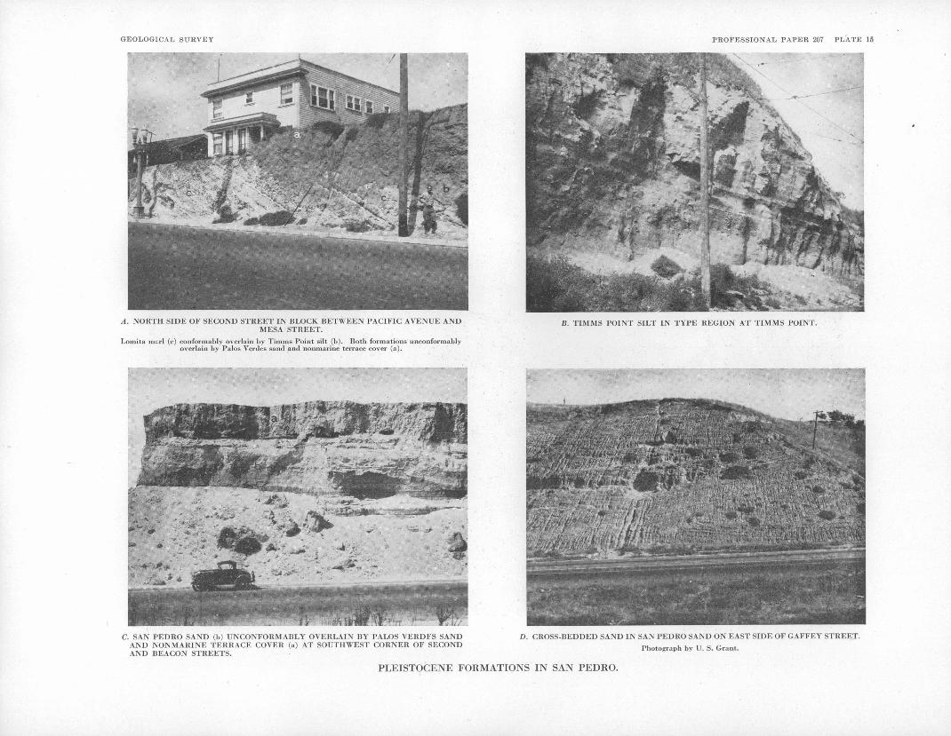
GEOLOGICAL SURVEY PROFESSIONAL PAPER 207 PLATE 15
A. NORTH SIDE OF SECOND STREET IN BLOCK BETWEEN PACIFIC AVENUE ANDMESA STREET.
Loinita marl (c) conformably overlain by Tiinms Point silt (b). Both formations unconformably overlain by Palos Verdes sand and nonmarine terrace cover (a).
B. TIMMS POINT SILT IN TYPE REGION AT TIMMS POINT.
C. SAN PEDHO SAND (b) UNCONFORMABLY OVERLAIN BY PALOS VERDFS SAND AND NONMARINE TERRACE COVER (a) AT SOUTHWEST CORNER OF SECOND AND BEACON STREETS.
D. CROSS-BEDDED SAND IN SAN PEDRO SAND ON EAST SIDE OF GAFFEY STREET.
Photograph by U. S. Grant.
PLEISTOCENE FORMATIONS IN SAN PEDRO.

GEOLOGICAL SUBVEY PROFESSIONAL PAPER 207 PLATE 16
MICROSCOPIC ORGANIC CONSTITUENTS IN UNIT 6a OF LOMITA MARL IN CANYON WEST OF HILLTOP QUARRY.
Unsorted washed residue, a, Globigerina; b, Cassidulina; c, Potymorphina; d, Dentalina; e, Pyrgo; f, Cyclocardia; g, Cadulus?; h, echinoid spine.

PLEISTOCENE SERIES 51
including numerous specimens of Bittium rugatum, Turritella, pedroensis, Olivella biplicata, Conus califor- nicus, and Cyclocardia aff. C. occidentalis, were collected from the dump at the shaft (locality 57).
10 MIT A QUARRY AND NEARBY IOCAIITIES
Thq type region of the Lomita marl is in the area near Lomita quarry in the western part of the Gaffey synclinc. In that a,rca.the Lomita overlies the Repetto silts tone or overlaps the Repetto and rests on the Malaga mudstonc member of the Monterey shale. At the localities where the base of the Lomita is well exposed in the ravine northeast of Lomita quarry and along the road leading to the quarry the under lying formation is the Repetto. Toward the north, that is, toward the crest of the Gaffey anticline, the calcareous strata appear to finger into sand, but there are no excavations to show that relationship. The greatest exposed thickness of the Lomita is about 65 foot, but core holes in the syncline are reported to have penetrated a thickness of 300 feet. A section measured at Lomita quarry (pi. 17, A; pi. 13, column 7), on the north limb of the syncline, is as follows:
Section of Lomila marl in type region at Lomita quarry [locality 6S)
Ft. 4
Nonmarine terrace cover(?): Coarse-grained brown ish sand, grading upward into dirty brownish sand _ .--___-___-_.___-_ _--_-._...__.._____ 6
San Pcdro(?) sand:Gravel, consisting principally of small granitic
pebbles. . -.--_----------_--.--_--__-_____ 2Cross-bedded gray limonite-stained sand in
cluding lenses of gravel consisting principally of small granitic pebbles. _ _________________ 18
m. 0
a.
5.
Lomita marl:7. Fine-grained calcareous sand and foraminif-
eral calcareous sand including partings of glauconitic foraminiferal sand___________ 8 3
6. Glauconitic formainiferal sand:b. Glauconitic foraminiferal sand lighter
in color than unit a_______________. 8Dark-colored glauconitic foraminiferal
sand containing scattered shells, principally Cyclocardia barbarensis (locality 62b)____.._____________ 10
Foraminiferal calcareous sand and glauco nitic foraminiferal sand in layers 2 to 6 inches thick (locality 62a)_-_________---_ 10 7
Fine-grained calcareous sand and foraminif eral calcareous sand. Contains boulders of Miocene Malaga mudstone and of Plio cene Repetto siltstone in lower 9 feet, one boulder measuring 12 by 5 feet, and scat tered limy phosphatic nodules.._________ 21 10
Glauconitic sand_-________--_____________ 11Foraminiferal calcareous sand containing
scattered glauconite grains (locality 62). Base not exposed_____________________ 9
Poorly exposed calcareous strata. In the ravine northwest of the quarry they rest on the lower Pliocene Repetto siltstone and contain limy phosphatic nodules. Thick ness coinputed__----_-__--__---_------- 20 0
1.
Thickness of Lomita marl.____________ 63 10
The glauconitic foraminifei;al sand forming unit 6 of the preceding section can be traced as a dark-colored band across the quarry face. (See pi. 17, A) It shows many minor faults, along which the displacement is down toward the \vest. The huge boulders in unit 4 consist of both Miocene mudstone and Pliocene silt- stone. As both kinds of rock readily disintegrate in water, the boulders were preserved probably by sinking
into soft calcareous sand. .Foraminifera from the Lomita marl at Lomita quarry were described by Galloway and Wissler.24 Mollusks are not abundant. A collection from unit 6 (locality 62b) includes frag ments of Patinopecten caurinusf, but Cyclocardia barbarensis is the most common species, as it is in other mollusk-bearing layers.
Parts of the Lomita marl are exposed in prospect excavations southeast of the quarry. At locality 61 a bed of gravel and coarse-grained calcareous sand, evidently higher in the section than the strata in the quarry, contains large shells of shallower facies than those in the quarry, including Turritella pedroensis, Ostrea mcgodon cerrosensis, and ventricola jordii. Most of the shells are worn and broken. The following section was measured in a prospect excavation at locality 60, near the trough of the Gaffey syncline, 500 feet west of Palos Verdes Drive East:
Section of Lomita marl in prospect excavation 500 feet west of Palos Verdes Drive East (locality 60)
Ft. 18. Foraminiferal calcareous sand, grading upward
into soil. Thickness approximate ___________ 417. Coarse-grained calcareous sand.___-____-___-__16. Foraminiferal calcareous sand-___________ _____ 115. Coarse-grained calcareous sand___.__.-______-- 114. Foraminiferal calcareous sand-________________ , 113. Glauconitic foraminiferal calcareous sand. Cross-
bedded at base, 3-inch dark layer at top. Base extremely irregular (locality 60b)_----_------ 11-19'
12. Foraminiferal calcareous sand and glauconitic sand:
c. Foraminiferal calcareous sand. One angu lar pebble" observed. _ _________________ 16-22
b. Glauconitic sand. ____________________ 1a. Foraminiferal calcareous sand_____.--_- 8-10
11. Fine-grained calcareous sand________________ 2-310. Glauconitic sand and foraminiferal calcareous
sand:b. Glauconitic foraminiferal calcareous sand
containing scattered pebbles. ___________ 7a. Foraminiferal sand.__________________ 1 1
9. Coarse-grained calcareous sand containing many pebbles, including a 5-inch pebble standing on end and projecting above top of bed...------ 4-5-
8. Foraminiferal calcareous sand, including a half inch parting of glauconitic foraminiferal sand at middle. _---_--------__----_-___------- 1 0'
7. Coarse-grained calcareous sand containing many rounded and angular pebbles, broken large shells, and small shells (locality 60a)--------- 5
6. Foraminiferal calcareous sand.__-__-__-----!--- 4-6-5. Coarse-grained calcareous sand.____----------- 74. Foraminiferal calcareous sand (locality 60). _ . _ _ 5 3. Coarse-grained calcareous sand containing many
calcareous algae and Bryozoa and scattered limy phosphatic nodules. One 8-inch pebble extends above top of ;bed_____-_--_--------- 1 2'
2. Fine-grained glauconitic, foraminiferal sand _ . - - - 5 1. Coarse-grained calcareous sand containing many
calcareous algae and Bryozoa. Base not ex posed. ___.___-_______..-__--_-_----------- 10 +
Exposed thickness._-__-_-_------.------- 20 2
The contact at the base of most of the main units in the preceding section is sharply defined and slightly irregular. The base of unit 13 is very irregular, forming angular gutters 5 to 7 inches deep. The glauconitic sand filling the gutters and extending above them is cross-laminated.. Foraminifera are more abundant at this locality in foraminiferal calcareous sand and in glauconitic sand than at Lomita quarry. The coarse grained pebbly calcareous sand forming unit 7 contain s. broken large shells and small shells (locality 60a).
'« Galloway, J. J., and Wissler, S. O., Pleistocene Foraminifera from Lomita quarry Palos Verdes Hills, Calif.: Jour. Paleontology, vol. 1, pp. 35-87, pis. 7-12,1927.

52 GEOLOGY AND PALEONTOLOGY OF PALOS VERDES HILLS, CALIFORNIA
The sand and gravel overlying the Lomita marl at Lomita quarry are assigned doubtfully to the San Pedro sand. (See section above.) At the time when the Lomita quarry section was measured the sand and gravel were excavated back from the quarry face, and the re lations were not clear. From the view on plate 17, A, which was taken soon after the quarry was opened many years ago, it appears that the sand and gravel un- conformably overlie the Lomita. They are similar lithologically to deposits in the San Pedro sand as iden tified nearby on the north limb of the Gaffey anticline. It is improbable that they represent either the Palos Verd6s sand or the nonmarine terrace cover. Strata identified as the Palos Verdes sand at locality 136 are thinner and contain limestone cobbles. The nonmarine cover in this region is not known to be so thick or to include clean sand and granitic gravel. Sand and gravel similar to those at Lomita quarry are exposed in the upper part of the 'ravine northwest of the quarry. At locality 63 silty sand contains Bryozoa, worn opercula of Homalopoma, and pelecypod fragments including Cy- clocardia. . Mudstone at the level of the ravine floor may represent a boulder or outcrop of the Miocene.
According to. the interpretation suggested, the San Pedro sand appears to overlie unconformably the Lo mita marl in the western part of the Gaffey syncline.
WESTERN PART OF GAFFEY ANTICLINE
Outcrops of calcareous strata referable to the Lomita marl were found on the north flank of the Gaffey anticline, along the ravine followed by Palos Verdes Drive East and in the next two ravines to the east. The calcareous strata, consisting of calcareous sand generally cemented, are only a few feet thick. They rest on the Repetto siltstone or Malaga mudstone. In the easternmost ravine, where the calcareous sediments are 6 feet thick, the contact with the Malaga mudstone is well exposed.
At the localities just mentioned the San Pedro sand, which is not well exposed, overlies the Lomita marl. Along Bent Spring Canyon, northeast of Lomita quarry, the sand rests directly on the Malaga mudstone. The contact is plainly exposed at the loading hopper of Sidebotham No. 2 sand pit on the east side of the canyon (pi. 18,^) and along the road leading to Lomita quarry on the west side. At the loading hopper the lowermost 11 feet consist of silty sand, including lenses of gravel. The silty sand is overlain by coarse grained sand and gravel. Between the loading hopper and the water tank the basal silty sand contains a Lomita-like fauna of moderate-depth facies (locality 64). Coarse-grained sand and gravel overlie the silty sand with a sharp contact, but the silty sand itself includes lenses of coarse-grained sand and gravel. Fossils similar to those at locality 64 were observed in the basal part of the sand on the west side of the canyon.
Sidebotham No. 1 pit (pi. 13, column 5; pi. 19), on the west side of the canyon, shows about 100 feet of sand and interbedded layers and lenses of gravel dipping gently northward. The sand is gray or limonite-stained and includes thin cross-bedded units. No. 2 pit (pi. 13, column 6; pi. 18, B] shows steeply dipping sand and gravel overlain by gently dipping sand and gravel. The gravel in both pits consists chiefly of granitic debris but includes limestone and cherty shale pebbles. At the top of the west face of No. 1 pit, immediately underlying the nonmarine
terrace cover shown on plate 18, Bryozoa and Lomita- like mollusks of moderate-depth facies were found in a 21-inch lens of marly, silty sand (locality 65). Uni dentifiable broken organic calcareous particles were observed in a 2-inch layer of sand and gravel in the steeply dipping strata at the south edge of No. 2 pit.
The stratigraphic and chronologic relations of the sand and gravel in this area may be interpreted in different ways. These deposits are assigned to the San Pedro sand. Most or perhaps all of the section is doubtless the detrital equivalent of the Lomita marl. On the west side of the canyon fossils resembling in facies those found at places in the Lomita occur at the bottom and top of the section. Inasmuch, however, as fossils of similar facies occur at places in the San Pedro, the faunal data are inconclusive. The section in No. 2 pit may represent two stratigraphic units or the steeply dipping strata may represent a thick cross- bedded unit. It may be argued that the deposits of steeply dipping sand and gravel in No. 2 pit are the equivalent of the Lomita, whereas the gently dipping sand and gravel are the equivalent of similar deposits that appear to be unconformable on the Lomita at Lomita quarry.
NORTH BORDER:OFLHIIIS BETWEEN BENT SPRING CANYON AND HAWTHORNE AVENUE
The sand and gravel in ravines along the north border of the hills between Bent Spring- Canyon, and Agua Magna Canyon, except a thin cover of nonmarine terrace material, are assigned to the San Pedro sand. These San Pedro strata consist of brownish sand and gray limonite-stained sand, both containing stringers of gra nitic gravel. Toward the top small limestone and cherty shale pebbles are abundant in the gravel stringers. The Palos Verdes sand is not identified in this area. The uppermost few feet, consisting of reddish-brown sand, is assigned to the nonmarine terrace cover, but no' sharp contact with the underlying deposits was recog nized. Fossils, including Mitrella carinata gausapata, a large broken Patinopecten caurinus, My a truncata, a small variety of Panomya beringianus, Foraminifera, and Bryozoa, were collected from silty sand in a ravine at locality 66 (pi. 13, column 4). On lithologic and faunal grounds the strata at locality 66 are referred to the Timms Point silt, the only locality in the western part of the hills where that formation was found. Ex posures are inadequate at locality 66, but the silty beds are evidently at or near the base of the section and are overlain by sand. Sand, containing stringers of gravel consisting chiefly of small limestone and cherty shale pebbles, and silty sand in the two sand pits east of Agua Negra Canyon are assigned to the San Pedro sand. Lay ers of sand in the eastern pit contain Foraminifera and pieces of Bryozoa and shells.
On the east side of Agua Negra Canyon the Lomita marl is represented by marl and gravel. (See pi. 13, column 3.) At the level of the canyon floor rubble and boulders of limestone and cherty shale abut against an ancient cliff face of Miocene mudstone (fig. 12). On the north face" of the' northernmost cut in the workings of the Dicalite Co. near Agua Negra Canyon the marl rests on Miocene diatomite. A few limestone cobbles are at the base of the marl, and a thick gravel composed of limestone cobbles is 30 to 35 feet above the base, underlying fossiliferous gravel and sand of the Palos Verdes sand. Farther north the Lomita marl is esti mated to be about 75 feet thick. It includes beds of

PLEISTOCENE SERIES 53
gravel as much as 20 feet thick made up of limestone cobbles. Fossils are abundant in the marl, particularly Bittium rugatum and Turritella pedroensis (localities 67, 68). '
Miocene diatomite is exposed at the southeast edge of Richard Ball sand pit, immediately east of Hawthorne Avenue. Steeply dipping marl of the Lomita 10 to 15 foot thick rests on the diatomite, a fossiliferous gravel 2 or 3 feet thick being at the base. The marl gradually becomes more and more sandy toward the top and is
FIOURE 12. Contact between Lomita marl and Miocene mudstone on east bank of Agua Ncgra Canyon.
overlain by about 60 feet of sand and gravel assigned to the San Pedro sand. (See pi. 20, A.) Though the dip changes from 55° in the marl to 25° in the upper part of the sand, the change is gradual, and there ap pears to be no unconformity.
On the 461-foot hill south of the sand pit the thin cover of nonmarine terrace deposits has been stripped off, revealing the Lomita marl and at places the under lying Miocene diatomite. Fossils collected from the marl include broken specimens of Eucrassatella fluc- tuata and Mercenaria perlaminosa (locality 69).
NORTH BORDER OF HILLS BETWEEN HAWTHORNE AVENUE AND MALAGACOVE
Steeply dipping lower Pleistocene strata similar to those just described are exposed in ravines northwest of Hawthorne Avenue. The geology of the area adjoin ing Hawthorne Avenue is shown on plate 21. The lower Pleistocene deposits overlie Miocene mudstone
gravel composed of limestone cobbles. The marl grades upward into the San Pedro sand, which includes layers of gravel. The dip of the sand is gradually less upward in the section. Plate 20, B, shows the succes sion in a sand pit on the west side of the fourth ravine west of Hawthorne Avenue. At that locality there is a minor fault between the sandy marl and the sand. The strata exposed in the fifth ravine west of Haw thorne Avenue are shown in figure 13 and on plate 13, column 2. Fossils occur in the Lomita marl, Turritella pedroensis being generally abundant (localities 70, 71, 72, 72a, 73, 73b). They are rare in the San Pedro sand (locality 73a).
MALAGA COVE
At the north end of Malaga Cove, sand and gravel about 75 feet thick unconformably overlie the Malaga mudstone member of the Monterey shale (pi. 12, A, B; pi. 13, column 1; fig. 7). The dip of the sand and gravel changes gradually from 13° at the base to about 8° near the top. The sand is clean and gray or limonite- stained. The gravel is made up chiefly of granitic debris, but the largest pebbles, 2 to 4 inches^long, con sist of cherty shale. A few Foraminifera were found in a 3-inch layer of sand 7 feet-above the base of the sand on the upthrown side of the bedding-plane fault shown on plate 12, A (locality 74). The sand and gravel at Malaga Cove are assigned doubtfully to the San Pedro. Assignment to the San Pedro sand rather than to the Palos Verdes sand is based on the lithology, which agrees with that of deposits identified as the San Pedro to the east. If the Foraminifera at locality 74 are not detrital constituents, they also favor assignment to the San Pedro. Reddish-brown sand 15 to 25 feet thick near the top of the cliff is identified as the nonmarine terrace cover. The contact with the underlying San Pedro (?) sand, however, is generally not well defined.
MARINE TERRACE DEPOSITS
GENERAL FEATURES
The marine terraces are described under the heading "Physiography"" (p. 113), and then- distribution and designation are shown on plate 22. They are desig-
NE.
FIOUHK 13. Pleistocene strata in fifth ravine west of Hawthorne Avenue, a, Nonmarine terrace cover (upper Pleistocene to Recent); b, Palos Verdes sand (upper Pleistocene); c, San Pedro sand (lower Pleistocene); d, Lomita marl (lower Pleistocene); e, Malaga mudstone member of Monterey shale (upper Miocene).
or diatomite, except at the head of the fourth ravine west of Hawthorne Avenue where the underlying for mation is the Repetto siltstone. Fossiliferous sandy marl of variable thickness at the base of the lower Pleistocene deposits represents the Lomita marl. At the base of the marl are scattered limestone cobbles or
nated in numerical sequence in reverse age order, the first terrace being the youngest and lowest, the last to be formed.
Deposits lying on the terraces embrace material of two classes marine sand and gravel and nonmarine debris designated the nonmarine cover. The marine

54 GEOLOGY AND PALEONTOLOGY OF PALOS VERDES HILLS, CALIFORNIA
deposits consist generally of cleanly washed, poorly sorted stratified .coarse-grained sand and gravel but in clude silty sand and rubble. They form a thin veneer on the terrace platform. They are generally only a few -feet thick but toward the seaward edge of a terrace they may be as much as 10 to 15 feet thick. At places they are represented by only a single layer of pebbles and interstitial sand. Owing to inequalities on the platform, to submarine scouring, or to subaerial erosion prior to deposition of the nonmarine cover, marine de posits are at places absent.
The present sea cliff and excavations afford the best' exposures of marine terrace deposits. With few excep tions they were not found on terraces above the first-
-in natural exposures inland from the coast. Inasmuch as marine strata wese recognized at numerous localities in artificial exposures on terraces older than the first, their usual absence in natural exposures is due pre sumably to concealment by surficial debris and soil. Additional localities will be found doubtless as resi dential development continues. Marine terrace de posits that are exposed only in highway cuts and other excavations are not shown on the geologic map (pi. 1), except in San Pedro. Their .outcrop width on steep declivities is necessarily exaggerated on a map of the scale of plate 1. Owing to their thinness and uncon- solidation marine terrace deposits are geologically ephemeral unless protected from erosion. In the Palos Verdes Hills they are saved from destruction by the overlying thick nonmarine cover.
Marine deposits have been found on 9 of the 13 main terraces -recognized. Those on the first or lowest terrace are the only deposits that have received a formal stratigraphic designation. They constitute Arnold's upper San Pedro series, now known as the Palos Verdes sand.
MARINE TERRACE DEPOSITS OLDER THAN PALOS VERDES SAND
Aside from a preliminary generalized account,25 marine terrace deposits older than the Palos Verdes sand have not been recorded, with one exception. As these deposits and their fossils are of exceptional interest, the localities where they were found are described or mentioned under the following heading.
STRATIGRAPHY AND LITHOJLOGY
TWELFTH TERRACE
The oldest and highest marine terrace deposits found are on a remnant of the twelfth terrace at an altitude of 1,215 feet above sea level. They are exposed in a cut on Crest Road, on the southeast slope of San Pedro Hill (locality 75), where the following section was measured:
Section of deposits on twelfth terrace in cut on Crest Road on southeast slope of San Pedro Hill (locality 75)
Nonmarine cover: " . Feet 5. Reddish-brown sand and soil__________________ 1-74. Cliff rubble_____._ . ..__._ ____'___. ' 4-5 3. Cliff rubble containing many abalones (Haliotis
cracherodii) and a few turban shells (Tegula gallina) 26 wedged between stones _____________ 2
28 Woodrlng, W. P., Fossils from the marine Pleistocene terraces of the San Pedro 'Hills, Calif.: Am Jour. Sci., 5th ser., vol. 29, pp. 292-305,1 fig., 1935.
29 Erroneously reported as Te.gula funebralis (Woodring, W. P., op. cit., p. 297).
Section of deposits on twelfth terrace in cut on Crest Road on southeast slope of San Pedro Hill (locality 75) Continued
Marine deposits: ' Feet 2. Coarse-grained sand and gravel composed prin
cipally of rock-cliff and tide-pool shells and fragments; includes pebbles._________________ 1-2
1. Mixture of cliff rubble, pebbles, and cobbles, many of which are bored. Rests on platform of cherty shale, the surface of which is bored at many places _-__----__-__--___--___--______-____ 1 }_-2
Most of the marine deposits of the preceding section may be storm-swept material, for even the lowest unit includes cliff rubble. The marine, shells wedged between the stones of unit 3, assigned to the nonmarine cover but representing talus rubble of the same age as at least the upper part of the marine strata, quitecertainly are storm-driven. i
NINTH TERRACE
At locality 76, on Palos Verdes Drive East, marine fossils were found in deposits near the rear of the ninth terrace at an altitude of 925 feet. The terrace de posits, evidently a mixture of marine material and cliff rubble, are 13 feet thick. The highway cut exposes the cliff, which is apparently slightly overhanging, at the rear of the terrace. Fossils, including large and small specimens of Epilucina calif arnica,; many paired, are in buff calcareous silty sand containing angular bored stones at a place 135 feet southwest of the exposed ancient cliff face. The terrace platform is not exposed. A few small shells and shell fragments are at a higher level in buff calcareous silty sand containing small angular stones 50 feet farther to the southwest, along the highway (locality 76a).
EIGHTH TERRACE
The platform of the eighth terrace (altitude 765 feet) is exposed in a cut on Palos Verdes Drive East in the Miraleste district (locality 77). Gravel 3 to 5 feet thick lying on the platform contains marine fossils.
SIXTH TERRACE
At locality 78, also in the Miraleste district, the plat form (altitude .560 feet) and the vertical cliff face at the rear of the sixth terrace are exposed. Marine fossilif- erous gravel }_ to 2% feet thick lies on the platform. The gravel is overlain by 7 to 8 inches of sand, and above the sand is buff calcareous silty sand 1 to \}{ feet thick containing numerous echinoid spines, small shells, shell fragments, scattered pebbles, and angular rubble.
At locality 79, in the Malaga Cove district near La Venta Inn, gravel and rubble on the platform of the sixth terrace (altitude 550 feet) yielded marine fossils, including numerous specimens of Tegula gallina.
FIFTH TERRACE
Fossiliferous marine, deposits were found on the fifth terrace at two localities. At locality 81, southwest of Flatrock Point, the fossils are in gravel and rubble lying on the platform, which has an altitude of 360 feet. At locality 80 (altitude 370 feet), on Crest Road, fossils are in coarse rubble 1 to 2. feet thick containing a few bored cobbles and boulders.
FOURTH TERRACE
At localities 82 to 89 fossiliferous marine deposits were observed on the fourth terrace. At locality 83 (altitude 200 feet), on Gaffey Street near Point Fermin,

PLEISTOCENE SERIES 55
fossils were found near the seaward edge of the terrace in sand containing angular stones and some cobbles. At locality 82 nearby, on Peck Street, where the section given below was measured, fossils are wedged between ooulders a,ncl rock slabs near the rear of the terrace. At that locality the platform has an altitude of 240 feet.
Section of deposits on fourth terrace on west side of Peck Street 376 feet north of Thirty-sixth Street (locality 82)
Ft. in.Black soil_.........._.........__.._.._... 3 0ISfonmarine cover: Rubble consisting of flat slabs
of blue-schist sandstone and cherty shale in mat rix of sand.________________________________ 5 ' 0
Marine deposits: Gravel consisting of cobbles and boulders mixed with angular rock slabs. Rock- cliff and tide-pool shells and a little sand in in terstices. R.ests on platform of blue-schist sand stone_..______--..-___---_--.--_-------_- 1 5-14
A highway cut near Point Vicente (locality 84) ex poses the platform of the fourth and third terraces and the intervening cliff face, as shown on plate 23. Marine deposits were not recognized on the third terrace, but on the fourth terrace marine fossils occur in sand filling spaces between boulders and blocks of rock, some of which are 3 to 4 feet long. The platform of the fourth terrace is at an altitude of about 250 feet. Farther northwest on Palos Verdes Drive West, at locality 85, at an altitude of 250 feet, fossiliferous gravel and con,rse rubble are 1 to IK feet thick. °
At the localities so far described the marine .deposits consist of clean gray sand, calcareous silty buff sand, gravel, and a mixture of gravel and cliff rubble, and the fossils are rock-cliff and tide-pool species. At Bluff Cove, however, where the present sea cliff has retreated to the fourth terrace, a large fauna including offshore shells in addition to rock-cliff and tide-pool shells was collected from reddish-brown sand and relatively fine-grained rubble (locality 86; altitude 260 feet). The terrace deposits are evidently a mixture of marine and nonmarine constituents, the latter predominating. The offshore shells presumably were swept in over the platform, which, was probably narrow, by storm waves and were mixed with sand and rubble lying at the foot of the cliff backing the platform.
On the north slope of the hills terrace remnants, thought to represent the fourth terrace, are at a higher altitude than the fourth terrace on the west and south coasts. Fossiliferous gravel and calcareous, silty sand are poorly exposed on Campesina Road in the Malaga Cove district (locality 87; altitude 375 feet). On Campesina Road, half a mile southeast of locality 87, gravel at an altitude of 475 feet contains small clusters of the wormlike gastropod Aletes squamigerus. At locality 88, on Palos Verdes Drive North, where no bench is discernible, a foot of fossiliferous gravel (altitude 510 feet).is overlain by black soil, no non- nmrino cover intervening. Farther southeast on Palos Verdes Drive North, at locality 89 (altitude 460 feet), Tegula gallina and Hinnites giganteus were found in sand and gravel containing finely broken shell, frag ments and stones. The deposits at that locality are probably close to the unexposed platform and grade upAyard into the noumarine cover, which includes much schist debris.
THIRD TERRACE
Marine deposits were found at altitudes of 160 to ISO feet on the third terrace, on the slope between the fourth and first terraces, west and southwest of Fort
McArthur Lower Reservation in southern San Pedro. In that area the third terrace forms locally a narrow, steeply sloping bench, but a bench is generally not apparent. At locality 90 the terrace deposits, 2 to 3 feet thick, consist principally of rubble and interstitial fossiliferous sand. A mineralized femur of an immature gopher, possibly Thomomys, and marine fossils were collected from rubble and sand a foot thick at locality 91. Rubble, gravel, and sand a foot thick at locality 92 contain marine fossils.
On the southwest face of Hilltop quarry (locality 93), northwest of San Pedro, a thin veneer of gravel rests on an uneven platform of soft Pleistocene marl at an altitude of 220 feet. The gravel ranges in thickness from a layer-of pebbles to several layers half a foot thick. Worn and broken shells, representing a pro- tected-bay facies like that on the first terrace in this region, were found in a pocket of sand in the gravel.
SECOND TERRACE
The second terrace is the lowest terrace along almost the entire length of the windward side of the hills west and south. In extensive areas the present sea cliff truncates this terrace and exposes the platform 'and overlying marine gravel and sand, which is 1 to 12 feet thick. Here and there angular stones are mixed with the gravel or predominate over gravel. Fossils were collected along the sea cliff at localities extending from the Point Fermin district to Lunada Bay (locali ties 94, 96, 98 "to 103; altitude 100 to 140 feet). Locality 94, near Point Fermin, where chitons are exceptionally abundant, was described many years ago by the Chaces,27 but it is now virtually destroyed, owing to park development. At that locality the fos sils are in 2 to 5 feet of angular rubble, sand, and a few cobbles resting on the platform of blue-schist sand stone. At locality 102, on the south side of Agua Amarga Canyon at Lunada Bay, the fossiliferous sedi ments consist of calcareous silty sand containing minute shells and broken echinoid spines.
Fossiliferous gravel at the top of the cliff at Flatrock Point lies apparently on a small remnant of the second terrace (locality 104; altitude 150 feet).
A cut on Corta Road, at locality 105, in the Malaga Cove district, exposes the platform, of the second ter race at an altitude of 190 feet. At that locality a large fauna, consisting of rock-cliff, tide-pool, and pro- tected-bay shells, was found in granule-gravel that'was trapped by storm waves in a niche and sealed by boulders.
In San Pedro the second terrace forms locally a distinct bench and at other places merges into the first terrace. Mr. E. P. Chace, of San Pedro, reports that gravel and sand containing a fauna like that in deposits on the first terrace in northern San Pedro were pene trated in an excavation for the high school on the south side of Fifteenth Street, between Leland and Alma, at an altitude of about 170 feet. Pockets of fossiliferous gravel are exposed on the north side of Second Street, between Gaffey and Cabrillo. A path in Peck Park exposes fossiliferous gravel on a terrace remnant that represents probably the second terrace but may be the third (locality 106; altitude 200 feet).
27 Chace, E. P., and E. M., An unreported exposure of the San Pcdro Pleistocene: Lorquinia, vol. 2, No. 6, pp. 41-43, 1919.

56 GEOLOGY AND PALEONTOLOGY OF PALOS VERDES HILLS, CALIFORNIA
PALOS VERDES SAND
GENERAL FEATURES
Marine deposits on the youngest or first terrace, which is well developed on the leeward side of the hills in San Pedro, are designated the Palos Verdes sand. They were described by Delos and Ralph Arnold 28 and at greater length by Ralph Arnold 29 under the designa tion "upper San Pedro series." In a manuscript report on the geology of the Palos Verdes Hills Kew restricted the name "San Pedro" to the Arnolds' lower San Pedro series and proposed the name "Palos Verdes formation" for their upper San Pedro series. The designation "Palos Verdes formation" first appeared in print in 1926. 30 Inasmuch as sand is the prevailing lithologic type, the term "Palos Verdes sand" is used in this re port. Arnold 31 recognized that his upper San Pedro series corresponds in areal extent to the "lower or 50- foot terrace." He did not, however, differentiate the marine deposits from the nonmarine cover. Inasmuch as the marine deposits and their fossils were emphasized, the name "Palos Verdes sand" is restricted herewith to the marine deposits in Arnold's upper San Pedro series, that is, to the marine deposits on the lowest terrace.
In the original description of the upper San Pedro series exposures along the water front in the present northern part of San Pedro were described as represent ing the best development of that unit.32 Later Arnold 33 expressly stated that the type locality is "at the north end of the San Pedro Bluff near the lumber yard." Though that locality-is shown on a geologic map in this report (pi. 14, locality 113), it is no longer in existence. The water front and adjoining region in San Pedro are regarded as the type region.
The Palos Verdes sand, like the older marine terrace deposits, consists of a thin veneer on the terrace plat form, which bevels formations ranging in age from lower Pleistocene to Miocene. Also like the older marine terrace deposits, the strata consist generally of coarse grained sand and gravel but include silty sand and silt. Limestone cobbles are the prevailing constituent of the gravel, but granitic and schist pebbles are locally abundant. The Palos Verdes generally ranges in thick ness from a few inches to 15 feet and is usually less than 10 feet. At places it consists of thin lenses, and at other places it is absent. In San Pedro the terrace and the deposits lying on it have the expectable gentle seaward slope. Along the north border of the hills they are de formed, mildly in the eastern part of the area, more strongly in the western part. In the area where they are deformed the deposits were originally terrace de posits, but the platform.on which they rest has no longer the usual form of a terrace. In the eastern part of the area where deformation has taken place the marine deposits are the equivalent of the undeformed deposits, at least so far as can be determined by ordinary strati- graphic methods. Farther west where the deformation is stronger the marine deposits are as much as 30 to 35 feet thick and possibly may be the equivalent of more than one set of terrace deposits in the area where no deformation took place. Nevertheless the term "Palos Verdes sand" is used, even in the area of strong defor-
« Arnold, Delos and'Ralph, The Marine Pliocene and Pleistocene stratigraphy of the coast of Caifornia: Jour. Geology, vol. 10, pp. 120, 126-128, 1902.
s» Arnold, Ralph, op. cit. (California Acad. Sci. Mem.,-vol. 3), pp. 12, 23-30, 1903.80 Tieje, A. J., The Pliocene and Pleistocene history of the Baldwin Hills, Los An
geles County, Calif.: Am. Assoc. Petroleum Geologists Bull., vol. 10, pp. 502-503,1926.»i Arnold, Ralph, op. cit. (California Acad. Sci. Mem., vol. 3), p. 27,1903." Arnold, Delos and Ralph, op. cit., p. 126." Arnold, Ralph, op. cit. (California Acad. Sci. Mem., vol. 3), p. 27,1903.
mation, because equivalents of two or more sets of terrace deposits, if represented, were not differentiated.
The Palos Verdes sand is shown on the geologic maps (pis. 1, 14, 21) only at localities where it was observed and identified by marine constituents. It is doubtless represented at many other places but is covered with a mantle of surficial debris and soil. At other places it may be represented by unfossiliferous sand mapped as part of overlying or underlying units.
In thickness, and presumably also in time duration the Palos Verdes sand represents a small fraction of ordinary formations in the Coast Range. Assignment of formation rank and naming of the marine deposits would be justified as fully for any other terrace as for the marine deposits on the youngest terrace. A formal name is used for the marine deposits on the youngest terrace, because they are extensive and because they have played an important part in descriptions of Coast Range geologic history.
STRATIGRAPHY AND UTHOUOGY
DEADMAN ISLAND
On Deadman Island the Palos Verdes sand con sisted of 2 to 5 feet of gravel and coarse-grained sand containing marine fossils, generally broken and worn. These virtually horizontal strata truncated the gently dipping San Pedro sand. They were locally consoli dated by the addition of calcareous cement. Arnold 34 identified cobbles of -fossiliferous cemented San Pedro sand in the gravel.
SOUTHERN SAN PEDRO
The Palos Verdes sand was found at only a few localities along the coast south of Timms Point. In much of that area, however, the strata at and near the top of the sea cli'ff are poorly exposed or unexposed. The following section was measured along the north side of the ravine, at the north boundary of Fort McArthur Lower Reservation (locality 108) Arnold's Crawfish George's locality.35
Section of Palos Verdes sand at north boundary of Fort McArthur Lower Reservation (locality 108, Arnold's Crawfish George's locality)
Ft. in.Black soil____-___-_________________--______'-_ 3 0Nonmarine terrace cover:
3. Brownish sand, lighter in color toward base.. 4 0
Palos Verdes sand:2. Grayish-brown silty, calcareous sand contain
ing many shells and shell fragments -and scattered small pebbles. Gastropods abun dant, especially "Nassa". _______________ 11-13
1. Grayish-brown silty, calcareous sand, includ ing a 2-inch to 4-inch Macoma layer at base. Contains few pebbles and cobbles. Gastro pods not abundant. Rests on platform of Miocene mudstone__-------------____-_- 1 1-2'
Maximum thickness of Palos Verdes sand_____.________'________________ 2 3.
Fossils from the preceding locality include Fusitriton oregonensis, Exiloidea rectirostris, and other northern species. They represent an unusual faunal facies of the Palos Verdes. The lithologic facies also is unusual.. A similar lithologic and faunal facies is represented, farther south, at locality 107, near Cabrillo Beach.
s< Arnold, Ralph, op. cit. (California Acad. Sci. Mem., vol. 3), p. 23,1903. as Idem, p. 24.

PLEISTOCENE SERIES 57
NORTHERN SAN PEDRO
In the northern part of San Pedro the Palos Verdes sand is exposed in numerous street cuts and in some natural exposures along the seaward edge of the terrace. Wherever a street is cut below the level of the first ter race, the terrace platform and Palos Verdes sand, if present, are exposed. Changes have been so numerous since the current edition of the Wilmington topographic map was issued that it is impractical to make the alter ations that would be necessary to show the present areol geology; furthermore, the areal pattern is continually changing. Alterations have been made at only a few important localities. (See pi. 14.)
At places, even near the seaward edge of the terrace, the Palos Verdes sand is lenticular and is locally absent, as on the east side of Palos Verdes Street near Third and on Ancon Street between First and Santa Cruz. At many places west of Pacific Avenue the nonmarine cover rests directly on the terrace platform. New cuts farther west along First Street, between Grand and Gaffey near the landward edge of the terrace, show, however, pockets of fossiliferous sand and gravel. Those cuts are not shown on the geologic map (pi. 1); neither are outcrops of fossiliferous sand and gravel in cuts along the extension of Gaffey Street into San Pedro at the Elberon Street overpass.
Coarse-grained sand and gravel ranging in thickness from a few inches to 8 feet are the prevailing lithologic types in northern San Pedro. If only part of the forma tion is fossiliferous, that part is generally at the base. On the west side of Beacon Street, northward from O'Farroll, however, 1 to 3 feet of fossiliferous sand and gravel composed of limestone cobbles overlie 3 to 8 feet of barren brownish-gray sand at the base of the forma tion, as shown in the section on page 47. The following section, measured on the west side of Pacific Avenue, between Oliver and Bonita Streets (locality 112), is representative of the sand-gravel facies:
Section of Palos Verdes sand on west side of Pacific Avenue, midway between Oliver and Bonita Streets (locality 112)
Palos Verdes sand:3. Fine-grained gray sand including stringers of
gray silty sand 1 to 10'inches thick. Grades upward into overlying reddish-brown sand & '« of nonmarine terrace cover._____________ 5 6
2. Fossiliferous moderately coarse-grained sand, coarse-grained sand, and gravel (locality 112). Pebbles consist of limestone and cherty shale and have maximum length of 7 inches; many limestone pebbles bored___ __ 12-19
Maximum thickness of Palos Verdes sand____---_-_-_--__-_--------_. 7 1
San Pedro sand:1. Moderately coarse-grained gray cross-bedded
unfossiliferous sand. Base not exposed. __ 9 6Large shells of the gaper clam (Schizothaf.rus imt-
tallii), oriented in life position, siphon end upward, may bo seen in their burrows on the south side of Second Street between Pacific and Mesa and on the west side of Center Street between Santa Cruz and First. At the southeast corner of Third and Mesa Streets transverse sections of burrows filled with Palos Verdes sand and shells are visible in the San Pedro sand 6 to 8 feet below the base of the Palos Vexdes. On the west side of Beacon Street, 150 feet south of Dreifus, a channel-filling lens of gravel at the base of the Palos Verdes is 50 feet wide at the top, 15 feet wide at the base, and 6 feet thick at the middle.
A beach facies, consisting of cross-bedded sand containing worn and relatively small shells and shell fragments, was formerly represented near the north west corner of Palos Verdes and Eighth Streets (lo cality 109), where the section given below was measured. The strata at that locality have been removed recently, and new outcrops nearby to the west represent the usual sand-gravel facies.
Section of Palos Verdes sand in lot at northwest corner of Palos Verdes and Eighth Streets (locality 1Q9)
Nonmarine terrace cover: 4. Reddish-brown sand.
Ft. 6
In.
Palos Verdes sand:3. Shell fragments in matrix of cross-bedded fine
grained sand__-____---___.-____________ 1 11-19Cross-bedded fine-grained gray sand including
two, or locally three, 1-inch to 2-inch layers of small worn gastropods (locality 109). Thickness variable.____________________ 1 1
Maximum thickness of Palos Verdes
San Pedro (?) sand: 1. Gray sand.
In northeastern San Pedro, silty sand containing a Macoma layer or layers overlies the usual fossiliferous coarse-grained sand and gravel. The silty sand indi cates evidently more protected water than does the underlying sand and gravel. MocoTna-bearing silty sand was represented at Arnold's lumber yard locality (locality 113),36 now destroyed. At that locality a basal fossili ferous gravel that varied in thickness but was as much as 6 feet rested on an uneven surface of cross-bedded San Pedro sand having a relief of 1 to 2 feet. Silty sand overlying the gravel included a Macoma layer a foot above the top of the gravel. The following section, measured on the west side of this remnant of the lowest terrace, now destroyed, shows four Macoma layers in a thickness of about 5 feet:
Section of Palos Verdes sand on east side of Harbor Boulevard opposite Dreifus Street
Ft. in. Nonmarine terrace cover:
6. Reddish-brown sand. Thickness estimated.... 20 0
Palos Verdes sand:5. Brownish-gray silty sand including a 3-inch
Macoma layer at base...._________________ 1 74. Brownish-gray silty sand including a 4-inch to
5-inch Macoma layer at base___..___.____ 1 0 3. Brownish-gray silty sand including a 4-inch to
6-inch Macoma-"Paphia" layer at base._._ 1 5-8 2. Brownish-gray silty sanfl containing scattered
shells, mostly Macoma. ____________ _______ 2-61. Fossiliferous gravel.____'____________________ 2 2-7
Maximum thickmess of Palos Verdes sand.._ 7 4
The following section measured nearby, on the west side of Harbor Boulevard at locality 114, also shows a Macoma layer in silty sand.
Section of Palps Verdes sand on west side of Harbor Boulevard near crossing of Pacific Electric tracks (locality 114)
Ft. in. Nonmarine terrace cover:
4. Brownish-sand grading upward into reddish- brown sand____________________________ 12 0
" Arnold, Ralph, op. cit., p. 27.

GEOLOGY AND PALEONTOLOGY OF PALOS VERDES HILLS, CALIFORNIA
Section of Polos Verdes sand on west side of Harbor Boulevard' near crossing of Pacific Electric tracks (locality 114)~Con.
Palos Verdes sand: Ft. in.3. Silty sand and silt containing scattered pelecy-
pods--__-___--_----____--________________ 2 82. Coarse-grained gray sand containing scattered
shells, mostly broken, and shell fragments, grading upward into silty sand of finer grain including a 9-inch to 12-inch Macoma layer, the top of which is 11 inches below top of unit (locality 114)__________--________________ 3 5
1. Brownish silty sand grading laterally into cleangray sand. Base not exposed____________ 1 7 +
Exposed thickness of Palos Verdes sand.._ 7 8
Fossils were collected in the northern part of San Pedro at localities 109 to 114. At localities where they are found in gravel or cross-bedded sand, fragments are more abundant than unbroken shells,, but in large ̂ col lections many specimens are unbroken, and many pele- cypods are paired. Pockets have concentrates .of coarse-grained sand arid small or young shells. The proportion of unbroken shells in silty sand is larger than in gravel and cross-bedded sand. Southern species, including Crassinella brannefi and Trachycardium pro- cerum, were not found south of localities 112 and 113.
GAFFEY ANTICIINE AND SYNCLINE EAST OF PAIOS VERDES DRIVE NORTH
Northwest and north of San Pedro the first terrace and its deposits dip gently northeastward toward the trough of the Gaffey syncline and are gently arched over the Gaffey anticline. The terrace platform and overlying terrace deposits, including here and there the Palos Verdes sand, may be traced, except for gaps due to stream erosion, into the area where they are mildly deformed. In perfect exposures the Palos Verdes sand is seen to be at some places lenticular and locally absent, but its apparent absence in extensive areas is probably due to lack of exposures. In the eastern part of the Gaffey anticline and syncline, as farther south, fossili- ferous coarse-grained sand and gravel are the prevail ing types in the Palos Verdes. They are a few inches to 11 feet thick, generally about 5 feet.
At locality 117, along a cattle trail outside the fence at the south boundary of the Standard Oil Co. tank farm, fossiliferous gravel is made up of limestone pebbles and cobbles, which are not as riddled with holes of bor ing maruie annuals as limestone cobbles in the Lomita marl forming part of the terrace platform. The gravel is identified as the Palos Verdes but may correspond to marine deposits on the second terrace farther southeast.
On Harbor Boulevard, opposite the San Pedro Lum ber Co. (locality 120), strata assigned to the Palos Verdes sand are 11 feet .thick. (See section, p. 48.) The base of the Palos Verdes is drawn at the base of the fossili- ferous gravel and sand that contains southern species and that rests on an imeven surface of sand assigned to the San- Pedro. As explained under the description of the San Pedro, however, the sand assigned to that form ation may represent also the Palos Verdes. ' A formerly accessible locality for the Palos Verdes is on the north side of Anaheim Boulevard, on the bluff overlooking the east edge of Bixby Slough (locality 124). At that locality a lenticular cross-bedded abundantly fossiliferous layer in brownish sand has a maximum thickness of-4% feet and rests on San Pedro silt and silty sand forming the terrace platform.
On the west side of Gaffey Street, 350 feet south of Anaheim Boulevard, an isolated transverse section of fossiliferous Palos Verdes sand, 16 inches long and
7 inches high, is sharply limited by cross-bedded San Pedro sand at a level 3 feet below the terrace platform (locality 129). The -Palos Verdes sand is absent on the platform. Another transverse section nearby, 5 feet below the platform, is at least 6 feet long and 2 feet high. The material in these sections fills openings that are apparently too large for burrows of marine animals. They represent holes of unknown origin filled with debris from the cleanly swept platform.
A section measured farther south on the west side of Gaffey Street at locality 127, where granite pebbles are exceptionally abundant in the Palos Verdes, is as follows:
Section of Pleistocene strata, including Palos Verdes sand, in abandoned sand pit on west side of Gaffey Street (locality 127)
Palos Verdes sand: Ft. in.5. Coarse-grained gray sand grading upward
into reddish-brown sand (nonmarine terrace cover) and soil_--__----__-_____________ 8 - 0
4. Fossiliferous gravel and coarse-grained gray sand (locality 127). Limestone pebbles relatively scarce; granitic pebbles abun- dant. Contact at base irregular,_________ 2 2
Thickness of Palos Verdes sand-_______ 10 2San Pedro sand:
3. Massive gray limonite-stained sand_________ 4 82. Gravel, .consisting of granitic pebbles and
coarse-grained gray sand. Contact at base irregular._____________________________ 1 8
1. Coarse-grained cross-bedded gray sand. Basenot exposed.______________________!___ 10+
Along the greater part of the slope on the east side of Gaffey Street identification of the Palos Verdes is uncertain, as fossiliferous layers were not found in the formation except at localities 122 and 123. Strata thought to represent the Palos Verdes between these localities include gray silt and olive-gray silty sand. Aeguipecten-Anomia and Chione-Ostreal&yers in under lying sand and gravel are assigned to the San Pedro sand.
At localities 125, 131, and 132, on the south limb of the Gaffey anticline west of Gaffey Street, the Palos Verdes is represented by an Anomia-Ostrea facies. The strata consist of brownish-gray cross-bedded sand, % to 2 feet thick, resting on Miocene mudstone or on cross- bedded gray sand referred to the San Pedro. No characteristic Palos Verdes fossils were found at locali ties 125 and 132, but the collection from locality 131 includes a worn fragment of the southern Trachycardium procerum. On the south flank of the Gaffey syncline, at locality 58 on Western Avenue, an Anomia-Ostrea facies is included in strata identified as the. San Pedro sand. At that locality the base of the Palos Verdes is drawn at the base of overlying fossiliferous gravel, 3 feet thick, consisting principally of schist pebbles. Fossils from the schist gravel include a small specimen of Trachycardium procerum. The Anomia-Ostrea facies on opposite flanks of the Gaffey syncline may be of the same age. It appears 'probable, however, that a similar .facies was developed under similar environ mental conditions in an arm of the sea behind the actively growing Gaffey anticline during both Sari Pedro time and Palos Verdes time.
A cut on Palos Verdes Drive East, at locality 133, on the east side of George F Canyon, exposes gravel composed of limestone cobbles and sand resting on the platform at the rear of a terrace (pi. .24, A). A few fossils were found in gravel and sand 100 feet farther north where the platform is not exposed. The platform

GEOLOGICAL SURVEY PROFESSIONAL PAPER 207 PLATE 17
I. I.HMIl \ \IARL IN* TYPE REGION VI I.UMIIA ul \HII1.
Note minor faults H!IOWII by displacement of dark-colored layer of glauconitic sand. The dark-colored strata at top of quarry face consist of sand and gravel assigned toSan Pedro (?) sand.
B. LOMITA MARL RESTING UNCONFORMABLY ON MALAGA MUDSTONE MEMBER OF MONTKH ! : > -II Ml, VS EXPOSED IN HIGHWAY CUT ONSOUTH LIMB OF GAFFEY ANTICLINE.
Note minor thrust fault along contact, shown by displacement of base of terrace cover, a, Nonmarine cover of lowest terrace; b, San Pedro sand; c, Lomita marl; d, Malagamudstone member of Monterey shale.
LOMITA MARL.

GEOLOGICAL SURVEY PROFESSIONAL PAPER 207 PLATE 18
A. SAN 1'EDRO SAND (a) LYING UNCONFOHMABLY ON MALAGA MUDSTONK MEMBER OF MOVI'EKKY SHALE (h) AT LOADING HOPPER OFSIDEBOTHAM NO. 2 SAND PIT.
Photograph by U. S. Grant.
B. CROSS-BEDDED SAN PEDHO SAND (b) OVERLAIN UNCONFORMABLY BY PALOS VKUDES SAND AND NONMAKI.NE TERRACE COVER (a) INSIDEBOTHAM NO. 2 SAND PIT.
Photograph by U. S. Grant.
PLEISTOCENE FORMATIONS ON NORTH BORDER OF PALOS VERDES HILLS.

GEOLOGICAL SURVEY PROFESSIONAL PAPER 207 PLATE 19
SAN PEDRO SAND IN SIDEBOTHAM NO. 1 SAND PIT.
The pit is about 100 feet deep. The little hill has a cap of nonmarine terrace cover.

GEOLOGICAL SURVEY PROFESSIONAL PAPER 207 PLATE 20
.-I. SAN 1'LDUO SAiNU LN KICIIAKU HALL SAM) I'll'.
fi. SAND PIT ON WEST SIDE OF FOURTH RAVINE WEST OF HAWTHORNE AVENUE.
Lomita marl (c), San Pedro sand (b), and unconformably overlying Palos Verdes (?) sand and nonmarine terrace cover (a).
PLEISTOCENE FORMATIONS ON NORTH BORDER OF PALOS VERDES HILLS.

PLEISTOCENE SERIES 59
is at an1 altitude of 365 feet, much higher than the rear of the first terrace in San Pedro. It may represent the second or third terrace, but is identified provisionally as the first. The marine deposits are, therefore, iden tified provisionally as the Palos Verdes.
Fossils wore collected in the eastern part of the Gaffey anticline and syncline at localities 115 to 133. These collections include southern species, notably Crassinella branneri, Dosinia ponderosa, Chione gnidia, and Trachy- cardium procerum, except those from localities 125, 132, and 133. 'Dosinia, ponderosa was not found south of localities 118 and 119, and Chione gnidia was found only at locality 123.
GAFFEY ANTICLINE WEST OF PALOS VERDES DRIVE NORTH
The Palos Verdes sand was identified at localities on the north flank of the Gafl'ey anticline west of Palos Verdes Drive North but was not recognized in the adjoining fyncline.
On the west side of Palos Verdes Drive North, 300 feet south of Anahoim Boulevard (locality 134), where the base of the formation is not exposed, lenses of fossil iferous coarse-grained sand, 8 inches to l^feet thick, are separated- by a foot of silty sand. Float Anomia, Ostrea, and broken sand dollars occur on the slope of overlying silty sand, also considered of Palos Verdes age. One of the best localities for Palos Verdes fossils is in a ravine west of Palos Verdes Drive North, near the head of Senator Street in Harbor City (locality 135). Fossils are scattered through 5% to 6 feet of brownish-gray coarse-grained sand resting on an uneven surface of limonite-stained gray San Pedro sand. Farther up the ravine lenses of fossiliferous sand are overlain by 8 to 15 feet of barren olive-gray silt and sandy silt.
In addition to the localities mentioned, fossils were collected from sand and gravel at localities 136 to 138. Characteristic southern species, including Crassinella branneri, Dosinia ponderosa, Chione gnidia, and Tra- chycardium procerum, were not found in the western part of the Gaffey anticline west of locality 135.
NORTH BORDER OF HILLS BETWEEN BENT SPRING CANYON AND , ' HAWTHORNE AVENUE
The Palos Verdes sand is not recognized on the north border of the hills between Bent Spring Canyon and Agua Magna Canyon. In that area strata identified as the nonmarine terrace cover Test on sand and gravel assigned to the San Pedro sand. In the absence of fossils it is difficult, however, to differentiate the Palos Verdes from the San Pedro and the nonmarine cover.
On the west side of Agua Magna Canyon float Anomia fragments were observed on the surface of a gravel com posed of limestone cobbles that represents probably the Palos Verdes. In the first sand pit (Graham Bros.) west of Agua Magna Canyon 15 feet of coarse-grained sand and limestone cobbles are assigned to the Palos Verdes^ The strata dip 15° to 20° northeastward at approximately the same rate as the underlying San Pedro sand. On the east face of the pit fossils were found at the top of a basal gravel 3. to 7 feet thick (locality 139) and also 5 feet higher at the top of a gravel 1 foot thick (locality 139a). In the adjoining sand pit to the west sand that includes lenses of lime stone cobble gravel may represent the Palos Verdes, but no fossils were observed. Pockets of fossiliferous sand and gravel are exposed in a cut at the workings of the Dicalite Co. (locality 140).
592787 45 6
Strata assignable to the Palos Verdes were not identi fied in the Richard Ball sand pit between Agua Negra Canyon and Hawthorne Avenue. Coarse-grained sand and limestone cobble gravel exposed on Hawthorne Avenue and the adjoining ravine are assigned to the Palos Verdes. Fossils collected from sand at locality 141 include numerous specimens of Donax gouldii.
The small collections of fossils from the area between Bent Spring Canyon and Hawthorne Avenue do not include characteristic Palos Verdes species.
NORTH BORDER OF HILLS BETWEEN HAWTHORNE AVENUE AND MALAGACOVE
Along the north border of the hills, between Haw thorne Avenue and Malaga Cove, deformed strata mapped as the Palos Verdes sand are as much as 30 to 35 feet thick twice as thick as the maximum thiclaiess farther southeast. The upper part of this thick section is considered the equivalent of the Palos Verdes, and perhaps the entire section is. For the geology of the area immediately northwest of Hawthorne Avenue see plate 21.
In the fourth ravine west of Hawthorne Avenue gravel composed of limestone cobbles and sand un conformably overlap the San Pedro sand (pi. 20, J3). Though no fossils were found in these strata, they represent prob- ablyj the Palos Verdes, in view of relations in the fifth ravine. As shown in figure 13, the fifth ravine west of Hawthorne Avenue exposes 30 to 35 feet of sand and gravel dipping 22° to 26° northeastward and resting with marked unconformity on the San Pedro sand and the underlying Lomita marl. The basal gravel, ap parently barren of fossils, consists of relatively small granitic and limestone pebbles. The upper gravel is made up of limestone pebbles, cobbles, and boulders, some as much as 2 feet long. The intervening sand, gray in the lower part and brownish-gray in the upper part, includes stringers of gravel composed of pebbles of cherty shale and limestone. The upper gravel at local ity 142 is sparingly fossiliferous. It contains Trachy- cardium procerum, this locality being the only one west of locality 135 where this southern species was found, Nucella biserialis, and other species. Perhaps only the upper gravel represents the Palos Verdes) the under lying strata corresponding to marine deposits of the second or third terrace, or both.
In ravines farther west along the north border of the hills the Palos Verdes sand was not identified. Some of the gray limonite-stained sand assigned to the non- marine terrace cover may, however, be unfossiliferous Palos Verdes. In the upper part of the ninth and last ravine west of Hawthorne Avenue the platform of Miocene mudstone is bored at many places. Below the falls a pocket of gravel composed of limestone cobbles possibly represents the Palos Verdes.
MALAGA COVE
At the north end of Malaga Cove, as at many other places along the north border of the hills, the Palos Verdes sand is apparently absent, the nonmarine terrace cover resting on sand doubtfully assigned to the San Pedro (see fig. 7). Farther south the nonmarine cover overlaps Pliocene and Miocene formations and is arched over those strongly deformed formations. South of the mouth of Malaga Canyon deposits on the first terrace are as much as 25 to 30 feet thick. The lower few feet include bored cobbles and are probably marine, but no fossils were found.
60 GEOLOGY AND PALEONTOLOGY OF PALOS VERDES HILLS, CALIFORNIA
FOSSILS
FORAJVTINIFERA
Foraminifera are abundant in the Lomita marl, parti cularly in foraminiferal calcareous sand and glauconitic foraminiferal sand, and in parts of the Timms Point silt. They are rare and generally are absent in the San Pedro sand and in the Palos Verdes sand and have not been found in terrace, deposits older than the Palos Verdes sand. Locality 64, where a Lomita-like fauna occurs in silty sand at the base of the San Pedro sand, is an exception, for at that locality Foraminifera are abundant. Bagg 37 described 105 species and varieties from the Timms Point silt at Timms Point. Galloway and Wissler 38 described 79 species and varieties from the Lomita marl at Lomita quarry. Their upper bed 39 is unit 6 of the section on page 51; their middle and lower beds have not been identified.
The numerous collections obtained during the field work for this report have not been identified. The collections represent evidently several different faunal associations.
CORALS
Small solitary corals representing presumably the genus Caryophyllia, three species of which were de scribed in Arnold's memoir, 40 occur in the Lomita marl and are recorded by Arnold from the Timms Point silt. They are relatively common in the algal bed at Hilltop quarry (localities 53, 53a) and in the calcareous sand and gravel nearby (locality 54g), thought to be
vthe equivalent of the algal bed.
ECHINOIDS
Echinoids are rare in the collections at hand. Poorly preserved specimens of a large Dendraster were found in the San Pedro sand at locality 50. The collection from the fourth terrace at locality 84 includes fragments of a small Strongylocentrotus, that from the second ter race at locality 105 includes Dendraster fragments. Echinoid spines are abundant in some layers of the Lomita marl, and collections from some of these layers include also minute fragments of plates. Arnold 41 recorded Dendraster excentricus from the San Pedro sand and Palos Verdes sand, and spines from the San Pedro sand were assigned to Strongylocentrotus -franciscanus and S. purpuratus.
BRYOZOA
Bryozoa are very abundant in the Lomita marl and in the lower part of the Timms Point silt at Timms Point but are rare in the other Pleistocene units. Idmonea californica is the most abundant species. Encrusting Bryozoa occur at numerous localities, being most abundant in the algal bed at Hilltop quarry. Canu and Bassler 42 described 19 species from Deadman Island, presumably from the Timms Point silt.
BRACHIOPODS
Unidentified forms of Terebratalia occur in the Lomita marl. Terebratalia smithi was based on mate rial from the Timms Point silt, and Terebratalia cf. T.
37 Bagg, R. M., Jr., Pliocene and Pleistocene Foraminifera from southern Califor nia: U. S. Geol. Survey Bull. 513, 1912.
38 Galloway, J. J., and Wissler, S. G., Pleistocene Foraminifera from the Lomita quarry, Palos Verdes Hills, Calif.: Jour. Paleontology, vol. 1, pp. 35-87, pis. 7-12,1927.
39 Idem, p. 36.< Arnold, Ralph, op. cit. (California Acad. Sci. Mem., vol. 3), pp. 86-88, 1903. 4 > Arnold, Ralph, op. cit., pp. 90-91.4 > Canu, Ferdinand, and Bassler, R. S., North American later Tertiary and
Quaternary Bryozoa: U. S. Nat. Mus. Bull. 125, p. 14, 1923.
hemphilli and Lagueus jeffreysi also are recorded from that unit. 43
MOLLUSKS
Pleistocene mollusks from the San Pedro district have been described or recorded in numerous publica tions, beginning with Conrad's 1855 account 44 of material collected by Blake during the transcontinental railroad surveys. Since the publication in 1903 of Arnold's monumental memoir 45 the San Pedro dis trict has become a classic area for California Pleistocene mollusks. Arnold described 395 species and varieties of mollusks collected from strata now assigned to the Timms Point silt, the San Pedro sand, and the Palos Verdes sand at localities on Deadman Island, which has been destroyed, and along the San Pedro water front. The most important publications since then are those on deposits lying on the second terrace near Point Fermin, by the Chaces; 46 on the chitons, by Berry; 47 on the San Pedro sand at a locality now destroyed, near Third and Beacon Streets, by Oldroyd;48 on the Timms Point silt, San Pedro sand, and Palos Verdes sand at Deadman Island, by Crickmay;49 and on the Timms Point silt at Timms Point, by Clark; 50 and by Willett. 51 Records up to the early part of 1931 are summarized by Grant and Gale 52 in their indis pensable catalog, and some of the species are illustrated.
Mollusks are generally the most abundant fossils in the marine Pleistocene strata and are represented in all but 4 of the 152 collections of Pleistocene fossils ob tained during the field work on which this report is based. Almost 100 collections were selected to repre sent age, facies,'ando geographic differentiation. About half the gastropods," almost 150 species, were identified in those collections. The plan to complete the identifi cations was abandoned when it became apparent that an attempt to do so would delay unduly completion of the report. Attention therefore was devoted to the stratigraphically and ecologically important forms. It is estimated that about 450 species and varieties of mol lusks are represented in the collections and that addi tional forms not in the collections but recorded from the San Pedro district would bring the total to about 500. Of the species and varieties identified, about 50 were unrecorded heretofore as fossils from the San Pedro district. The collections at hand do not add much to the recorded fauna of the Timms Point silt, San Pedro sand, and Palos Verdes sand, aside from a few notable exceptions. With few exceptions fossils from terrace deposits older than the Palos Verdes sand represent an association like that recorded by the Chaces 53 from the second terrace. The molluscan fauna of the Lomita marl, not represented along the water front but repre-
43 Arnold, Ralph, op. cit., pp. 93-94. Clark, Alex, The coolwater Timms Point Pleistocene horizon at San Pedro, Calif.: San Diego Soc. Nat. History Trans.,"vol. 7, No. 4, table op. p. 30, 1931.
. 44 Conrad, T. A., Report on the fossil shells collected in California by W. P. Blake, geologist of the expedition under the command of Lt. R. S. Williamson, United States Topographical Engineers: U. S. Pacific R. R. Expl., 33d Cong. 1st sess., H. Ex. Doc. 129, app., pp. 11-18,1855. (Reprinted in U. S. Geol. Survey Prof. Paper 59, pp. 165-169, 1909.)
45 Arnold, Ralph, The paleontology and stratigraphy of the marine Pliocene and Pleistocene of San Pedro, Calif.: California Acad. Sci. Mem., vol. 3, 420 pp., 37 pis., 1903.
4« Chace, E. P. and E. M., An unreported exposure of the San Pedro Pleistocene Lorquinia, vol. 2, No. 6, pp. 41-43, 1919.
« Berry, S. S., Fossil chitons of western North America: California Acad. Sci. Proc., 4th ser., vol. 11, pp. 399-526, 16 pis., 11 figs., 1922.
« Oldroyd, T. S., The fossils of the lower San Pedro fauna of the Nob Hill cut, San Pedro, Calif.: U. S. Nat. Mus. Proc., vol. 65, art. 22, 39 pp., 2 pis., 1924.
4 » Crickmay, C. H., The anomalous stratigraphy of Deadman's Island, Calif.: Jour. Geology, vol. 37, pp. 617-638, 1929.
«o Clark, Alex, The cool-water Timms Point Pleistocene horizon at San Pedro Calif.: San Diego Soc. Nat. History Trans., vol. 7, No. 4, pp. 25-42, 2 figs., 1931.
« Willett, George, Additions to knowledge of the fossil invertebrate fauna of Cali fornia: Southern California Acad. Sci. Bull., vol. 36, pp. 61-64, pis. 24-25, 1937.
' Grant, U. S., IV, and Gale, H. R., Catalogue of the marine Pliocene and Pleisto cene Mollusca of California: San Diego Soc. Nat. History Mem., vol. 1, 1931.
M Chace, E. P. and E. M., op. cit.

PLEISTOCENE SERIES 61
son tod by 43 collections in the material at hand, is un recorded. It is hoped that at a future date this defi ciency may bo remedied and that the facies and geo graphic differentiation of the fauna of the Lomita marl and of the other Pleistocene units .may be studied adequately.
The following discussion consists of comments on the stratigrophically and ecologically important species, 80 of which are illustrated on plates 29-37. Inasmuch as; with few exceptions, the different faunas consist of living species grouped in different associations, most of the stratigrapliically important species are also evi dently ecologically important. Unless otherwise speci fied the species mentioned are still living. Dimensions of the figured specimens, including the types of new forms, and National Museum catalog numbers may be found on the explanation of the plates. References that may be found in Grant and Gale's well-indexed catalog M are omitted. References for recent species not* included in that catalog are also generally omitted, as they may be found in Dall's well-known publication.55
The following new names are proposed for Pleistocene mollusks:
Gastropods:Elassum Woodring, n. gen., Cerithiidae. Type Bittium
(Elachista) californicum JDall and Bartsch (p. 68)."Nassa" fossata coiloteva Woodring, n. var. (p. 73)."Nassa" deJosi Woodring, n. sp. (p. 74).Trifconalia coryphaena Woodring, n. sp. (p. 76).
Pelecypods: Chlamys anapleus Woodring, n. sp. (p. 81).
CHITONS
The chitons, 21 species and varieties of which are recorded by Berry 50 from the Pleistocene strata of the San. Pedro district, have not been identified. Repre sented in collections at hand from all the units except the Timms Point silt, they are abundant only in terrace deposits. Mr. and Mrs. Chace 57 found them to be extraordinarily abundant in deposits on the second terrace near Point Fermin (locality 94), where they collected 350 specimens representing 15 species and varieties.
GASTROPODS
Six of the 13 species of limpets of the genus Acmaea represented in the collections examined were not re corded by Arnold, but all except the last have been recorded at later dates A. limatula (Lomita marl (?), San Pedro sand, terrace deposits, 58 and Palos Verdes sand (?)), A. persona (terrace deposits), A. Juniculata (pi. 34, figs. 1, 2; the three lower Pleistocene units), A. asmi (terrace deposits and Palos Verdes sand), A. lepisma 50 (Lomita marl), and A. cf. A. ochracea (Lomita marl). Limpets are most abundant in the terrace de posits, A. scrabra and A. limatula being the most com mon species. A. insessa is the only species found in all the Pleistocene units.
4 Clrnnt, U. S., IV, and Gale, H. R., op. cit." Dall, W. H., Summary of the marine shell-bearing mollusks of the northwest
const of America: U. S. Nat. Mus. Dull. 112,1921.M Berry, S. S., OP- cit.» Ghaco, K. P. and E. M., op. cit.,.pp. 42-43. Berry, S. S., op. cit., p. 409.«> For brevity marine terrace deposits older thau the Palos Verdes sand, the only
marine terrace deposits named, are designated simply terrace deposits. For the pur pose of this account they are treated as a unit, though, of course the deposits on each terrace are as distinct chronologically as the Palos Verdes sand.
' Berry, S.S., New Mollusca from the Pleistocene of San Pedro, Calif., I: Bull. Am. Paleontology, vol. 25, No. 94a, p. 9, pi. i, figs. 3, 4,1940.
HAL1OTIDAE
Abalones, which are rare as fossils, were collected at 13 localities in terrace deposits. The identifiable material represents Haliotis cracherodii, and fragmen tary remains are probably that species. Complete specimens were found' at localities 75 and 84. H. rufescens and H. julgens, as well as H. cracherodii, are recorded as Pleistocene fossils from the San. Pedro dis trict.
FISSXJRELWDAE
, Fissurella volcano- is one of the most abundant gas tropods in the terrace deposits. Virtually all the shells retain fresh coloration, a feature noticed by Arnold, in dicating a thick outer calcite layer.
The Pleistocene species of Puncturella on the Pacific coast represent two groups. 60 One group, Puncturella proper, has a prop on the sides of the internal septum and includes only the northern P. galeata. That species is not in the collections at hand but is recorded from the Timms Point silt and San Pedro sand. The other group, which lacks the props and is apparently unnamed, includes P. cucullata, P. cooperi, and P. delosi. P. cucullata is in collections from the Lomita marl and Timms Point silt and is recorded from the San Pedro sand and Palos Verdes sand. P. cooperi (pi. 29, fig. 1) is abundant in the three lower Pleistocene units but was not recorded from the San Pedro district until recently. 61 P. delosi (pi. 29, fig. 2), the most distinctive of the'three species, occurs in the Lomita marl and San Pedro sand and is recorded from the Timms Point silt. 62 It was based on Pleistocene material from Santa Barbara and was formerly thought to be extinct. As Willett 63 sus pected, the unfigured Recent P. caryophylla 64 is closely related to P. delosi, and represents probably that species. The Recent material in the National Museum consists of three lots dredged off Point Loma, California, by the Albatross at depths of 67 to 81 fathoms. The concen tric threads between the ribs are stronger ori fossils than on most Recent specimens, owing probably to slight abrasion.
TROCHIDAE
Plalistylus pupoideus, heretofore recorded only from the San Pedro sand, was found in the Lomita marl at Hilltop quarry (locality 53) and in deposits on the second terrace at Malaga Cove (locality 105). The specimens from the Lomita marl are exceptionally large.
Tegula Junebralis, which at the present time is rare as far south as San Pedro, occurs in the San Pedro' sand, the Palos Verdes sand, and in terrace deposits up to. the fifth terrace, inclusive. It is differentiated -from T. gallina principally by the presence of puckered sutural lamellae and by the absence of diagonally reticulate sculpture and color banding. As identified it is found in association with T. gattina in terrace deposits at localities 83 and 104. T. gallina is abundant at the present time along the coast of the Palos Verdes Hills. It is likewise abundant in terrace' deposits, especially at localities 75, 79, 84, and 88, is found in the Palos Verdes sand, and is represented-by doubtfully identified fragments from the Lomita marl (localities 53, 53 a, 61). T. brunnea (Timms Point silt (?), terrace deposits, Palos Verdes sand), T. montereyi (Lomita marl, re-
60 Dall, W. H., Notes on West American Emarginulinao: Nautilus, vol. 28, pp.. 62-64, 1914. '
«' Willett, George, op. cit., p. 64,1937.«' Idem.M Idem.
' «< Dall, W. H., op. cit., p.-63:
62 GEOLOGY AND PALEONTOLOGY OF PALOS VERDES HILLS, CALIFORNIA
corded from Timms Point silt, San Pedro sand, terrace deposits, PalosVerdessand), and probably T. marcida 65 ("pulligo") 66 (Palos Verdes sand) appear to be extinct locally, as they are not known to be living along the mainland in the latitude of San Pedro. T. ligulata (San Pedro sand, terrace deposits, Palos Verdes sand) is more abundant than T. aureotincta (terrace deposits, Palos Verd.es sand).
In addition to the five species of Calliostoma described by Arnold, C. supragranosum (recorded from deposits on the second terrace) was found in terrace deposits and may be represented by a worn and broken specimen from the Lomita marl at locality 37, and C. enimium (pi. 35, fig. 7) occurs in the Palos Verdes sand at locality 121. C. eximium is a southern species said to range from Gatalina Island to Mazatlan, Mexico, and has not been reported heretofore as a fossil from California. C. decarinatum 67 (" canaliculatum") is the most abundant Calliostoma, being represented in all the Pleistocene units. The only specimen from terrace deposits is, however, a worn and broken shell. C. ligatum ("cos- tatum ") is likewise found in all the units. C. virgineum 68 (Lomita marl (?), San Pedro sand, Palos Verdes sand) appears to be the name for the species generally known as C. "annulatum." The recently described C. gran- tianum,69 based on material from the Lomita marl at Hilltop quarry, is not recognized in the collections at hand.
Cidarina cidaris is represented by imperfect speci mens in the Timms Point silt .and by a doubtfully identi fied fragment in the Lomita marl at locality 41. Turcica caffea (pi. 32, figs. 1, 2) was found only in the Timms Point silt but is recorded from the San Pedro sand at Deadman Island. The type locality of this species is presumably Monterey, where, as recorded by Gabb, it was dredged at a depth of 20 fathoms. 'Gabb also mentioned, however, fossils from San Pedro and Santa Barbara. No specimens from Monterey are in the National Museum. On the fossils from the Timms Point silt the sculpture and peripheral spiral are of variable strength on the later whorls. None of the few available Recent shells from the California coast (La Jolla, San Diego) are as large as the fossil shown on plate 32, figure 1, and none are as weakly sculptured as the fossil shown on plate 32, figure 2. T. caffea brevis, 70 from the Acila .and Pecten zones of the San Joaquin formation (upper Pliocene) of the Kettleman Hills, is more strongly sculptured than the Timms Point fossils and Recent California shells, and has a stronger peri pheral spiral. In general sculpture it resembles more closely a large specimen (length 30 millimeters), larger than any California fossil or .Recent shell available, dredged off Cape San Lucas, Lower California, at a depth of 66 fathoms. T. caffea brevis has more tightly coiled later whorls than the Lower California form. The strong peripheral spiral suggests that brevis is more closely related to the Recent Japanese T. im- perialis than to T. caffea. The comparison between
' Gould, A. A., Descriptions of shells from the Gulf of California and the Pacific coasts of Mexico and'California: Boston Jour. Nat. History, vol. 6, p. 381, pi. 14, flg. 11,1853 ("Trochus," Monterey).
eo The names in Martyn's "Universal Conchologist" are not accepted in this report. Ralph Arnold recorded this species from his upper San Pedro (The paleontology and stratigraphy of the marine Pliocene and Pleistocene of San Pedro, Calif.: California Acad. Sci. Mem., vol. 3, p. 328, 1903. ("Phorcus pulligo.")
67 Perry, George, Concnology, pi. 47, No. 2, 1811 ("Trochus, New Zealand") Rehder, H. A., Notes on the nomenclature of the Trochidae: Biol. Soc. Washington Proc., vol. 50, p. 116, 1937.
68 Dillwyn, L. W., A descriptive catalogue of Recent shells, vol. 2, pp. 800-801,1817 ("Trochus").
«« Berry, S. S., op. cit., p. 12, pi. 2, figs. 4, 5:10 Stewart, Ralph, in Woodring, W. P., Stewart. Ralph, and Richards, R. W.,
Geology of the Kettleman Hills oil field: U. S. Geol. Survey Prof. Paper 195, p. 84/ pi. 11, figs. 1, 6,1940 [1941].
brevis and caffea in the Kettleman Hills report was based on the large Lower California form, which is doubtless not T. caffea but closely resembles T. imperialis.
Solariella peramabilis occurs in the Timms Point silt (pi. 32, fig. 3) and Lomita marl. Owing to the strong axial .threads between the spirals, fragments are identi fied with reasonable certainty. The much smaller unfigured $. rhyssa n is represented by broken specimens from the Lomita marl. It was based on a shell dredged in Catalina Channel and has not been reported hereto fore as a fossil.
Pupillaria is generally assigned subgeneric rank under Margarites, which, however, is smooth and has a rather narrow umbilicus. Lirularia is considered a subgenus under Pupillaria. The common Pupillaria of the San Pedro district, found in all the Pleistocene units but rare in terrace deposits, is identified as P. optabilis. It has brownish crudely axial blotches visible on fossils, except bleached specimens. The type is a Recent shell from San Pedro. This species has prob ably been reported as P. parcipicta. The type of P. parcipicta from Santa Cruz [Island?! has a higher spire and stronger axial threads on the body whorl. Some of the fossils, especially some from the Lomita marl, have narrow sharp-crested spirals. They are probably P. optabilis acuticostata but are not readily differen- tiable. .The type of u Margarita" parcipicta var. pedroana, based on a worn specimen from the San Pedro sand, is considered P. optabilis. Likewise "Margarita" optabilis var. nodosa, also from the San Pedro sand, is considered P. optabilis, the nodes on the type being principally color markings. A large form, P. optabilis knechti (pi. 34, figs. 3, 4), is abundant in the San Pedro sand, especially at localities 47 and 47a, and is identified in the Palos Verdes sand at localities 112 and 113. The dark blotches cover more of the shell than in P. optabilis proper, and as the whorls enlarge they tend to flatten. Differentiation on a basis other than size is, however, doubtful. Perhaps this large form does not deserve nomenclatorial recog nition, but it is not know to be living.72 "Lirularia" magna, which like P. optabilis knechti is based on fossil material from the San Pedro sand, is a synonym of knechti.
Pupillaria succincta is of the same size as P. optabilis and has the same color markings, but the base is flatter, and the spirals, which are especially noticeable on the base, are more crowded. Found at five localities in terrace deposits, this species was not reported previously as a fossil. The type material, from an undesignated California locality, was collected from an abalone. A Timms Point Pupillaria, P. cf. P. salmonea, is represented by fragmentary and imma ture specimens. It is probably most similar to a form dredged off Point Loma at a depth of 71 to 75 fathoms, possibly a form of P. salmonea. Another Pupillaria from the Lomita marl and San Pedro sand has relatively fine spirals on the base, like P. salmonea, but the spirals above the base are wider. P. salmonea (type locality, Monterey) or forms similar to it are unrecorded as fossils.
The genus Macheroplax is represented by a small, imperfect specimen from the Timms Point silt identi-
71 Dall, W. H.-, Descriptions of new species of Mollusca from the north Pacific Ocean in the collection of the United States National Museum: U. S. Nat. Mus. Proc., vol. 56, p.- 360, 1919.
ra According to a recent communication from George Willett, of the Los Angeles Museum, his collection from Forrester Island, Alaska, includes four Recent specimens of this form.

PLEISTOCENE SERIES 63
fiocl as M. cf. M. varitosa. M. varicosa has been re corded recently at Timms Point. 73
LTOTIIDAB
Two species of Liotid, neither of which has been recorded heretofore as a fossil, are rare in the Pleisto cene collections. They are L. fenestrata (Lomita marl and terrace deposits) and L. acuticostata (terrace de posits and Polos Verdes sand). The type of L. fene strata, occupied by a hermit crab, is from the "Santa Barbara Islands," and most of the other specimens in the National Museum are also hermit crab shelters. The shells from the Lomita marl are unbroken, whereas those from terrace deposits, possibly hermit crab shelters, arc broken. The type of L. acuticostata is from Cotolino Island. The 1 shell from locality 105 has a few faint axials, approaching the variety L. acuticostata radiata. According to local collectors, both L. fenestrata and L. acuticostata appear to be more abundant on the islands than on the mainland.
V1TRINELLTDAE
Vitrinella thomasi, based on material from the San Pedro sand at Oldroyd's Nob Hill locality, is repre sented by two specimens from that formation at locality 48. They are considerably larger than the type (width 2.7 millimeters). The species is not known to be living. V. williamsoni, represented in the National Museum only by the type, a Recent shell from San Pedro, is much larger (width 5.5 millimeters) and flatter. Arnold recorded V. williamsoni from the San Pedro sand and Polos Vcrdcs sand without mentioning the size (jr other characters. V. oldroydi has been recorded from the San Pedro sand 74 and was found in terrace deposits at five localities. The umbilicus is much narrower than in V. thomaxi and V. williamsoni. V. eshnauri, re ported from the San Pedro sand 75 but not in the col lections at hand, has a higher spire than the species already mentioned. Discovery of the heretofore un- figurcd V. salvania 70 (pi. 29, figs. 3-5) in the Lomita marl at locality 4.1 constitutes a new record for that speHos as o fossil. It has a narrow umbilicus for yitrmdla and on one of the three fossils the umbilicus is portly closed by a callus plug. The fossils are a little larger than the type and only Recent specimen, and the umbilicus is slightly wider. V. salvania is somewhat intermediate between Vitrinella proper and Docom,phala, as the umbilical wall along the apertural half of the body whorl is faintly puckered; the spire of V. salvania is, however, higher and the early whorls lack weak oxiol ribs.
One specimen of Cyclostremella coronadoensis from the Son Pedro sand at locality 49 also constitutes a new record for the San Pedro district. The type of that species, from the Pleistocene at Spanish Bight, San Diego, has not been examined. Six specimens from an undes.ign.atcd San Diego Pleistocene locality and several hundred from the railroad crossing at the foot of 23d Street, San Diego (U. S. G. S. locality 2123), are virtual topotypes. 0. californica (type locality San Pedro, Recent) is considered a synonym. The type of Cyclostremella has a deeper anal sinus adjoining the
" Wlllott, George, op. clt., p. 03 ("Solariella").» Oklroycl, T. S., Tlio fossils of the lower San Pedro fauna of the Nob Hill cut,
San 1'otlro, Cnlif.: U. S. Nat. Mus. Proc., vol. 05, art. 22, p. 21,1924." Idem."Pall, W. H., op. clt. (U. S. Nat. Mus. Proc., vol. 56), p. 369, ("Teinostoma
(J'seudoratella"'); South Coronado Island, 3 fathoms).
suture than does C. coronadoensis but is otherwise similar to that species.
The genus Pseudorotella is represented by the two common California species, P. invallata (San Pedro sand, 77 terrace deposits, Palos Verdes sand) and P. supravallata (terrace deposits)'. P. supravallata, here tofore not recorded as a fossil, is more abundant in
. terrace deposits than P. invallata.
TURBINIDAE
In the absence of the characteristic ribbed operculum, adult shells of Pomaulax may be differentiated from Pachypoma by the weakly sculptured base. Pomaulax undosus occurs in the Lomita marl (pi. 29, figs. 6-8), the Timms Point silt (small broken specimen), terrace de posits, and the Palos Verdes sand. It is particularly abundant in the Lomita marl at Hilltop quarry (locali ties 53, 53a). Opercula are as abundant as shells in the Lomita marl and were found also in terrace deposits and the Palos Verdes sand. This species is generally readily distinguishable from Pachypoma gibberosum, with which it is associated, by the strong peripheral keel and weakly sculptured base. Young shells may be difficult to differentiate, however, as young shells of both species are keeled and young shells of Pomaulax undosus have a more strongly sculptured base than adults.
Pomaulax turbanicus petrothauma 78 (pi. 29, figs. 9-12) was found only in the algal bed of the Lomita marl at Hilltop quarry, where it is fairly common. It re sembles closely the Recent P. turbanicus 79 proper, repre sented only by the type dredged off Magdalena Bay Lower California, at a depth of,36 fathoms. The Pleistocene variety has more widely spaced nodes, and the peripheral nodes have a longer base. The figured large fossil operculum is rounded like the operculum of P. turbanicus proper, and also as in that form has a narrow, strongly bent, almost smooth inner rib. The fossil operculum (length 29.3 millimeters) is much too large to fit any shell at hand and is larger than the operculum of the type of P. turbanicus (length 21.8 millimeters).
Pachypoma gibberosum 50 ("inaeguale") is found in the -three lower Pleistocene units and is recorded from the Palos Verdes sand. Like Pomaulax undosus it is most abundant in the Lomita marl at Hilltop quarry (pi. 29, figs. 13-15), where it is represented by shells and the characteristic narrow smooth opercula. The stage at which the peripheral keel of fossil and Recent shells disappears is variable. In the variety Pachypoma gibberosum pacifica the keel persists to an exceptionally late, stage. This variety and the unfigured variety barbarense 81 are of doubtful validity.
Four species of the genus Homalopoma are repre sented in the Pleistocene collections. The largest and most abundant is PI. carpenteri, which has heavy relatively widely spaced spirals, except on the early whorls of some specimens characterized by a few heavy spirals among fine spirals. The rosy color is preserved on many fossils. This species is found in all the
77 Already recorded from the San Pedro sand (Oldroyd, T. S., op. cit., p. 21, 1924 ("Teinostoma").
78 Berry, S. S., New Mollusca from the Pleistocene of San Pedro, Calif., I: Bull. Am. Paleontology, vol. 25, No. 94a, pi. 10, pi. 2, figs. 2, 3,1940.
78 The type of P. turbanicus, minus the operculum, has been figured by Grant and Gale (Grant, U. S., IV, and Gale, H. R., Catalogue of the marine Pliocene and Pleistocene Mollusca of California: San Diego Soc. Nat. History Mem., vol. 1, pi. 31, fig. 2,1931).
soDillwyn, L. W., A descriptive catalogue of Eecent shells, vol. 2, pp. 803-804 1817 ("Trochus, New Zealand").
8" Dall, W. H., op. cit. (U. S. Nat. Mus. Proc., vol. 56), p. 357,1919 (off Santa^Cruz Island, 30 fathoms).
64 GEOLOGY AND PALEONTOLOGY OF PALOS VERDES HILLS, CALIFORNIA
units but is most abundant in the Lomita marl, par ticularly in the algal bed at Hilltop quarry (pi. 29, fig. 16). H. bacula, smaller than H. carpenteri and sculptured with finer spirals, occurs in all the units except the Palos Verdes sand. As in H. carpenteri, the rosy color is preserved on many fossils. H. sub- obsoletum,*2 recently described on the basis of material from Timms Point, is a minute, faintly sculptured form. In the collections at hand it is represented in the Lomita marl and doubtfully in the San Pedro sand. Specimens (maximum length 2.7 millimeters) dredged off Point Loma at depths of 67 to 75 fathoms are identi fied as this form. They have faint spiral striae and a light-brown color, a little darker than the fossils, as Willett inferred. Both the fossil and Recent shells have a grooved but not denticulate inner lip, suggesting that they are not mature. The readily recognized H. paucicostatum,.like H. bacula, occurs in all the units except the Palos Verdes sand but is less abundant than that species. H. paucicostatum jenestratum, character ized by the strengthening of growth threads to form ribs, was found in the Lomita marl and terrace deposits. This variety has not been recorded heretofore as a fossil. It bears the same relation to H. paucicostatum that the variety radiata does to Liotia acuticostata.
TRICOLIIDAE
Exfoliated specimens of Tricolia that show a wide1 umbilicus are likely to be confused with exfoliated specimens of Lacuna, but the inner layer of Tricolia has faint spiral markings. Fossil Tricolia that retain even a small patch of the outer shell layer, presumably calcite, are readily, distinguished from Lacuna, as the outer layer retains traces of the color pattern. Specific differentiation of the fossil Tricoliae is difficult, for differentiation of the Recent species is based princi pally on size and color pattern. Though fossils retain the color pattern, it is bleached.^y^
According to the criteria aclopted, Tricolia pulloides is the most abundant species in the Pleistocene collec tions, being represented in all the units except the Palos Verdes sand. It is of medium size (maximum length of fossils 5.5 to 5.9 millimeters) and has a mottled rosy color pattern; many specimens have oblique dark stripes. The best fossils are in the collection from the Lomita marl from the central shaft of the Whites Point tunnel (locality 57). An operculum that probably rep resents this species and a large lot of shells were col lected from the San Pedro sand at locality 30. The terrace specimens are small, with the exception of a large shell from locality 106, where an operculum was collected. A lot of 9 Recent shells in the National Museum, collected at Santa Barbara by Jewett, is to be regarded presumably as the type lot of T. pulloides.
Tricolia compta is larger and darker colored than T. pulloides, Recent shells being greenish and having ob lique narrow, brownish bands. The greenish color is gone on the fossils identified as T. compta, but traces of the brownish bands remain and are well preserved on some specimens. The fossils have a maximum length of 8.8 millimeters. This species is recognized only in the San Pedro sand and Palos Verdes sand. It is par ticularly abundant in the San Pedro sand at locality 47a, where two isolated opercula were collected. A large lot from locality 48 includes a shell with the operculum in place. Some small shells from the Palos Verdes sand
ra Willett, George, op. cit. (Southern Calif. Acad. Sci. Bull., vol. 36), p. 63, pi. 25 1937 ("Leptothyra").
may possibly be T. pulloides. It has been suggested 83 that Arnold's T. compta from the San Pedro sand and Palos Verdes sand is T. pulloides. Arnold's identifica tions doubtless agree, however, with those adopted in this report. The type lot of T. compta consists of two specimens from Sari Diego.
A minute shell having a naticid spire and open um bilicus, collected from deposits on the fourth terrace at locality 87, represents the subgenus Eulithidium or pos sibly a very young Tricolia pulloides. It is identified as Tricolia rubrilineataf . 84
A small form of Littorina planaxis is abundant in ter race deposits, but it is represented at other horizons by only one worn specimen from the San Pedro sand and two worn specimens from the Palos Ver$es sand. Arnold recorded this species from the Timms Point silt. The fossils have a maximum length of 9.6 millimeters, whereas a large Recent shell from San Pedro has a length of 20.8 millimeters. The fossils may represent a small race, as it is improbable that several hundred shells from 25 localities are all young. It is virtually impossible to determine the number of whorls, however, for the tip of the spire is generally worn and corroded.
Littorina scutulata has a more slender spire than L. planaxis and lacks the flattened area adjoining the inner lip. Both species have spiral striae on at least the early whorls. The fossil L. scutulata retain the brownish, color more uniformly than L. planaxis. L. scutulata is abundant in terrace deposits, being represented in more collections than L. planaxis and being generally more abundant than that species, except at locality 80. It is represented by two very small worn shells in the Lomita marl, is fairly common in the San Pedro sand, and is common in the Palos Verdes sand. The fossils are somewhat smaller than Recent shells, the maximum length being 12.6 millimeters as compared with 14.6 millimeters for a large Recent San Pedro shell. Car penter,85 who had access to the original material, thought that L. pedroana, based on Pleistocene material from San Pedro, is L. "plena," that is, L. scutulata. The type is lost.
LACUNIDAE
Many of the fossil specimens of Lacuna are in poor condition, owing to exfoliation; furthermore, identifica tion of the species is difficult, inasmuch as the charac ters of many named Recent forms are still undescribed. The common Pleistocene species, found in all the units except the Timms Point silt, is identified as Lacuna unifasciata. It is small, relatively slender, and nar rowly umbilicate and has faint slightly wavy micro scopic striae distinguishable only on fresh Recent shells and observed on a few of the best preserved fossils. Large shells are rounded or carinate; small shells are carinate. The carina is generally colored brown, a character preserved on some fossils. Arnold's L. compacta and Oldroyd's L. unijasciata aurantiaca are presumably this species. The type lot of L. unifasciata consists of four shells from Santa Barbara, all somewhat worn. The largest has a length of 5.7 millimeters and
83 Strong, A. M., in1 Grant, IT. S., IV, and Gale, H. R., op. cit. (San Diego Soc. Nat. History Mem., vol. 1), p. 814,1931.
M Strong, A. M., West American Mollusca of the genus Phasianella: California Acad. Sci. Proc., 4th ser., vol. 17, No. 6, p. 197, pi. 10, figs. 8-10, 1928 (Point Loma).
86 Carpenter, P. P., A supplementary report on the present state of our knowledge with regard to the Mollusca of the west coast of North America: British Assoc. Adv. Sci. Kept. 1863, p. 590, 1864.

PLEISTOCENE SERIES 65
a width of 3.3 millimeters. Only the smallest shell shows the brown band on the carina.
Lacuna carinata is larger and stouter than L. unifas- ciata, the body whorl enlarging more rapidly; the umbil ical opening is wider; the microscopic striae are stronger; and the inner lip is effuse. It is identified certainly in only one collection, the Palos Verdes sand at Arnold's Crawfish George's locality (locality 108). It is evi dently closely related to the Atlantic L. divaricate,. Arnold's L. porrecta and Oldroyd's L. solidula are probably this species; if so, it occurs in the San Pedro sand. According to topotype material, "Modelia" striata 80 from the Pleistocene Santa Barbara formation at Santa Barbara is Lacuna carinata, as Carpenter 87 thought. The two specimens in the type lot of L. carinata from Puget Sound were figured by Gould. The larger specimen (fig. 231; length 11 millimeters and width 5.8 millimeters), which is not so distinctly cari- nato as in the .illustration, appears to be exceptional or pathologic, as the body whorl does not enlarge and the umbilicus is reduced to a very narrow opening. The smaller specimen (figs. 23la, 23Ib; length 6.9 milli meters, width 4.4 millimeters) is normal but immature and is faintly carinate. L. porrecta, based on material collected by Swan at Neah Bay at the mouth of the Strait of Juan de Fuca, is considered a synonym of L. carinata. A faintly carinate specimen, collected by Swan at Neah Bay but received through Stearns, has been figured 88 as the type of L. porrecta. It may be regarded as the lectotype, as it was probably in the lot examined by Carpenter. Forty-five additional specimens collected by Swan at Neah Bay are in the collection of the National Museum.
Lacuna variegata 80 has a wide umbilical opening and effuse inner lip like L. carinata but is more slender and has less distinct spiral striae and brown chevrons on the body whorl. Its status is not satisfactorily determined. The typo lot, like the type material of L. porrecta, collected by Swan at Neah Bay, consists of 23 speci mens, the largest having a length of 8.5 millimeters and a width of 5 millimeters. One specimen from the Lomita marl at locality 53a and a few specimens from the Palos Verdes sand at localities 109 and li2 are identified as L. variegata?. They resemble L. carinata but are more slender. The color pattern is not pre served. Arnold's figured L. solidula is exfoliated and unidentifiable on the basis of the illustration. It may be the form identified in this report as L. variegata?.
FOSSARIDAE
Iselica fenestrata occurs in all the units except the Timms Point silt but is rare except in the collection from the San Pedro sand at locality 47a (pi. 34, fig. 5). In Oldroyd's Nob Hill collection from that formation it is represented by an extraordinarily large number of specimens.
VALVATIDAE
The fresh-water gastropod Valvata humeralis cali- Jornica, heretofore unrecorded from the San Pedro
" Oabb, W. M., Descriptions of new species of American Tertiary fossils and a new Carboniferous cophalopocl from Texas: Acad. Nat. Sci. Philadelphia Proc.. vol. 13, p. 368,1861 ("Miocene?").
" Carpenter, P. P., op. cit. (British Assoc. Adv. Science Rpt., 1863), p. 632,1864.«> Dall, W. H., Summary of the marine shell-bearing mollusks of the northwest
coast of America: U. S. Nnt. Mus. Bull. 112, p. 216, pi. 14, fig. 2,1921.' Carpenter, P. P., op. cit., p. 656.
district, is represented by one specimen from the Palos Verdes sand at locality 114.
KISSO1DAE
The genus Amphithalamus , 9D heretofore unrecorded in the fossil state, embraces minute shells less than 2 millimeters in length. A. inclusus, the type of the genus, is rare in the Lomita marl and San Pedro sand (localities 53a, 140). The periphery is angulated or has a low spiral cord. Minute shells (length a little more than a millimeter) from the Lomita marl at locality 42d are identified as "Amphithalamus" lacun atus?. They agree with the type of lacunatus, a Recent shell from San Pedro, in having a narrow umbilical groove, no basal fasciole, and an undetached peristome along the parietal wall. Some of the fossils, however, do not enlarge so rapidly as the type and only available Recent specimen. Most of the fossils are exfoliated and therefore have a misleading deeply sunken suture. The absence of a fasciole and of a detached peristome along the parietal wall indicates that lacunatus is not assignable to Amphithalamus.
Alvania, as currently used for west coast mollusks, is represented by four species and a variety. A. acutelirata 91 is found in all the units except the Timms Point silt but is generally'rare. It is relatively slender and has reticulate sculpture, except on the base, which has only spirals, the axials overriding the spirals. In the original description the general region between San Diego and San Pedro was cited. In the 1866 account the only locality mentioned is San Diego, which there fore is considered the type locality. The type material is not in the collection of the National Museum. A. pedroana, based on 2 fossils from San Pedro,, evidently from the San Pedro sand, is considered a synonym of A. acutelirata. These two specimens have a channeled suture and almost flat whorls. Some Recent and fossil specimens of A. acutelirata have a channeled suture, depending on whether the axials stop at a spiral just above the base of a spire whorl. The degree of infla tion of the whorls of Recent and fossil shells is van-able, some being as flat as A. pedroana.
Alvania rosana is considered a stout form of A. acutelirata. On adult shells the sculpture generally fades out on the body whorl near the outer lip. This feature was observed, however, on some slender fossils identified as A. acutelirata proper. Fossils from the three lower Plesitocene units and the Palos Verdes sand are identified as A. acutelirata rosana. This form is widespread in the Lomita marl and locally is excep tionally abundant in that unit. It is estimated tha't the collection from locality 53b includes more than 1,000 specimens, which is more than the total number of Recent Pacific coast Alvania in the collection of the National Museum. The fossils have more closely spaced ribs than the type of the variety rosana and other specimens from the same dredging (Albatross station 2901, oft" Santa Rosa Island, 48 fathoms). Some specimens from a nearby dredging (Albatross station 2902, off Santa Rosa Island, 53 fathoms) have ribs as closely spaced as on the fossils. A. acutelirata rosana is associated with A. acutelirata proper in the Lomita marl, San Pedro sand, and Palos Verdes sand.
80 For a description of the California species see Bartsch, Paul, The west American mollusks of the genus Amphithalamus: U. S. Nat. Mus. Proc., vol. 41, pp. 263-265 3 figs., 1911.
" Carpenter used the spelling "acutelirata" in the original description (Carpenter P. P., op. cit., p. 656,1864; "Rissoa") and in a later work (Descriptions of new marine shells from the coast of California; pt. 3: California Acad. Sci. Proc., vol. 3, p. 217 1866; "Rissoa"). The generally adopted alteration "acutilirata" is unwarranted.

66 GEOLOGY AND PALEONTOLOGY OF PALOS VERDES HILLS, CALIFORNIA
Inasmuch as some lots contain intermediate doubtful specimens, the identifications are doubtful. A.fossilis, based on a fossil shell from San Pedro, evidently fiom the San Pedro sand, is considered.a synonym of A. rosana. The whorls are a little flatter than on most Recent and fossil shells, but that character is variable.
Alvania montereyensis was found at three terrace localities. It is slender and has strongly constricted sutures, and well-preserved Recent shells have faint spiral sculpture on the nucleus. Oldroyd found this species.to be abundant in the San Pedro sand at Nob Hill. It is the type of Willettia, proposed recently as a subgenus of "Alvania" by Gordon,92 according to whom the Pacific coast species referred to Alvania are not congeneric with the Mediterranean species that is the type of that genus.
The other two species of Alvania have not been recorded heretofore as fossils in the San Pedro district. A. purpurea has a somewhat turreted spire, two or three spirals on spire whorls, and strong axials that form swellings at the intersection with spirals on un worn shells. It is rare in the Lomita marl and terrace deposits. A. almo is represented by two terrace specimens. This minute species has a thickened outer lip, but the peristome is in one plane, not. undulatory as in Rissoina.
The Pleistocene specimens of the minute genus Barleeia, found in all the units but most abundant in the Lomita marl and terrace deposits, are identified as B. haliotiphila. More than one species, however, may be represented." The shells are variable in length, degree of slenderness, degree of whorl inflation, and degree of rounding of the periphery. None of the several hundred fossils are as large as the type of B. oldroydi (length 3.3 millimeters). Stout shells are similar to B. californica, which has more inflated whorls. The faint color banding generally visible on B. cali fornica would presumably be indistinguishable on fossils. The pits on the nuclear whorls described by Bartsch 93 are so minute and so faint that they are generally indistinguishable under high magnification, even on specimens that ordinarily would be considered quite fresh. Both B. haliotiphila 94 and B. oldroydi 9S have been recorded from the Timms Point silt.
RISSOINIDAE . .
Five species of the genus Rissoina are represented in the Pleistocene collections, whereas Arnold recorded none. Rissoina kelseyi has sharply incised spiral striae and heavy ribs that fade put on the penultimate and body whorls. It occurs in the Lomita marl (pi. 29, fig. 17) and in deposits on the second terrace at Malaga Cove (locality 105). The two specimens from- the Lomita marl at locality 42d have slightly heavier ribs and more inflated whorls than Recent shells and the other fossils. The terrace fossils consist of a lot of 35 specimens, including very young shells. The spiral striae are very faint on the terrace shells, though most are quite fresh, and on some the axials persist on the penultimate whorl.
Rissoina pleistocena, not heretofore recorded from the San Pedro district, was found in deposits on the
" Gordon, Mackenzie, Jr., A new subgon Nautilus, vol. 53, p. 31, 1936.' ' "
us and species of west coast "Alvania":
" Bartsch,' Paul, The west American mollusks of the families Rissoellidae and Synceratidae and the rissoid genus Barleeia: U. S. Nat. Mus. Proc., vol. 58, pp. 167-376, 1920.
e< Clark, Alex, op. ci't. (San Diego Soc. Nat. History Trans., vol. 7, No. 4), table op. p. 30, 1931.
«« Willctt, George, op. cit. (Southern California Acad. Sci. Bull., vol. 367), p. 62, 1937.
second terrace at Malaga Cove at locality 105 and in the Palos Verdes sand at locality 140 (pi. 35, fig. 8). It is stout and has heavy slightly protractive ribs. It is not known to be living but is related to the Mexican R. nereina and R. burragei, though it has heavier and more widely spaced ribs. R. coronadoensis, a slender species sculptured with very fine axial ribs, occurs in the Lomita marl (pi. 29, fig. 18), Timms Point silt, and San Pedro sand. Perhaps the records of the more strongly sculptured R. dalli in the Timms Point silt 96 and San Pedro sand refer to R. coronadoensis.
Rissoina aequisculpta has a somewhat turreted spire, strong reticulate sculpture, and spiral sculpture on the nucleus. It is represented by an incomplete specimen, showing the sculptured nucleus, from the Lomita marl at locality 53a and is recorded from the San Pedro sand. The minute R. cosmia, which has a turreted spire and strong reticulate sculpture, is represented by a broken specimen from terrace deposits at locality 84. It has not been, recorded heretofore as a fossil. Both R. aequisculpta and R. cosmia have been assigned to Alvania*7 The characters of the lip in both species suggest, however, Rissoina.
TRUNCATELLIDAE
Both Truncatella stimpsoni and T. californica are identified in collections from terrace deposits, the former being more abundant. T. stimpsoni is stouter than T. californica and is generally strongly sculptured, whereas T. californica is usually smooth or almost smooth. T. californica has been recorded from the San Pedro sand, but T. stimpsoni has not heretofore been recorded from the San Pedro district.
SYNCERIDAE
Syncera translucens occurs in terrace deposits and is recorded from the San Pedro sand. This marine species may be distinguished from the fresh-water amnicolids by the relatively thick parietal callus.
AMNICOLIDAE
An imperfect specimen of the stout fresh-water Amnicola longingua was collected from the Palos Verdes sand at locality 120. This species was based on material collected from sediments of ancient Lake Cahuilla in the Colorado Desert. It is living in southern California. The finding of A. longingua in the Palos Verdes sand constitutes a new record for the San Pedro district.
Hydrobia protea, another fresh-water species, was found in the San Pedro sand at locality 47a and in the Palos Verdes sand at locality 113. Like Amnicola longingua, Hydrobia protea was based on material from ancient Lake Cahuilla. It ajso is living in southern California. As its name implies, it is very variable. In sculpture the range is from smooth to strongly reticulate; in outline from slender, the usual form, to moderately slender. The fossils from the San Pedro district are smooth or faintly sculptured. Paludes- trina curta,gs based on fossils from San Pedro, is a moderately slender form of H. protea. The type shows faint spiral sculpture. Paludestrina stokesi, also
»e Clark, Alex, op. cit. (San Diego Soc. Nat. History Trans., vol. 7, No. 4), table op. p. 30,1931.
" Bartsch, Paul, The Recent and fossil mollusks of the genus Alvania from the west coast of America: U. S. Nat. Mus. Proc., vol. 41,,pp. 352, 358, 1911.
as Arnold, Ralph, op. cit. (California Acad. Sci. Mem., vol. 3), p. 305, pi. 8, fig. 2, 1903.
»«Idem, p. 305, pi. 8, fig. 3.
PLEISTOCENE SERIES 67
based on fossils from San Pcdro, is a slender form and has faint spirals on< the early whorls. Oldroyd 1 re corded Ifydrobia protea as Paludestrina curia and Paludestrina cf. P. stokesi. Alabina io also is considered a synonym of Uydrobia protea. It was described on the basis of a worn fossil from San Pedro that shows subdued axial and faint spiral sculpture. The drawing, therefore, is misleading. The Pleistocene fossils from a locality near Playa del Rey' recently recorded as lUssocUa sp.? 2 are likewise considered as representing slender Hydrobia protea.
ALABINIDAE
Alabina tenuisculpla is represented by a young speci men from the Palos Vcrdcs sand at locality 140 and is recorded from the San Pedro sand.3 The sculpture of this species is evidently variable. The type, from San Diego, has only two widely spaced spirals on the spire whorls. A form that has many fine spirals and relatively weak axials has been named A. diegensis. The slender, slowly enlarging nucleus and slight ever- sion. of the basal lip support assignment of A. tenuis- culpta to the genus Alabina, despite the absence of varices. The type species of Alabina has weak varices or none, but oi.li.erw.ise similar species have strong varices.
The systematic position of the California shells assigned to the genus Viola is uncertain. The varix on the body whorl near the outer lip and the slight ever- sion of the basal lip suggest the family Alabinidae, but the nucleus is much stouter than in Alabina and the shell is heavier. It is improbable that the Cal ifornia Diala is related to Barleeia, with which it is generally placed. It is not known whether the Cal ifornia shells are congeneric with the Chinese and Japanese Diala. 4 Japanese specimens in the National Museum, labeled Diala varia have a similar aperture but lack the varix and. have spiral sculpture on the base of the body whorl.
Fossils from the Lomita marl, San Pedro sand, terrace deposits, and Palos Vcrcles sand are identified as Diala marmorea, and that species is recorded from the Timms Point silt. 5 The best specimens and the largest number are from terrace deposits at locality 96. It is doubtful whether more than one species of this genus is living along the, California coast. The type of D. marmorea from. San Pedro is relatively stout and has a rounded periphery; the typo of D. acuta from Catalina is more slender and has an angulated periphery; and the type oi" Barleeia" dalli from Point Loma (7.1 to 75 fathoms) is stout and has an angulated periphery. Some speci mens arranged under D. marmorea in the collection of the National Museum, have an angulated. periphery; some arranged under D. acuta, have a rounded periph ery. Not all the specimens in the lot from which the type of "Barleeia" dalli was selected are as sharply angulated as the type, and two specimens from the
' Oldroyd, T. S., op. cit. (U. S. tfat. Mus. Proc., vol. 65, art. 22), p. 17, 1924.8 Willott, OcorL'o, An upper Pleistocene fauna from the Baldwin Hills, Los Angeles
County, Calif.: Kan Diego Soc. Nat. History Trans., vol. 8, No. 30, p. 398, 1937. Arnold, Ralph, op. cit. (California Acad. Sci. Mem., vol. 3), p. 296, pi. 6, flg. 14
1003 ("Bittium (Styliferina)"; unrecognizable on basis of figure).4 Adams, A., On some now genera and species of Mollusca from the north of China
and Japan: Ann. Mag. Nat. History, 3d ser., vol. 8, p. 242, 1861. Subsequently designated typo (Cossmann, M.. Essais do palooconchologie comparee, pt. 12, p. 66, 1021), Diala varia A. Adams, China and Japan.
8 Clark, Alox, op. cit. (San Diego Soc. Nat. History Trans., vol. 7, no. 4), table op. p. 30, 1031.
same dredging, evidently, the same form, are arranged under Diala acuta.
CERITHIIDAE
The Pleistocene specimens of the genus Bittium are difficult to identify, owing to the extraordinary number of specimens, the rather variable characters, and the great number of names that have been proposed with out adequate consideration of the range of variation. Six species and a variety are identified. On a basis of nuclear characters two groups are recognized. One group (B. eschrichtii, B. rugatum, and B. rugatum larum) has stout rounded nuclear whorls; the other group (B. armillatum, B. attenuatum, B. interfossa, and B. asperum) has an angulation at the upper edge of the nuclear whorls, the angulation reaching its maxi mum development in B. asperum. The angulation may be regarded as a spiral; a second spiral is introduced below the periphery, either on the nucleus or at the transition between nuclear and postnuclear whorls. The subgeneric name Stylidium has been proposed for a species of the first group (7?. eschrichtii}, and the subgeneric name Lirobittium for a form of the second group (B. catalinense}. It is improbable, however, that. 7?. rugatum is closely related to B. eschrichtii. The relations of B. rugatum to the Eocene Semibittium, to which it is currently assigned, are unknown. B. guadrifilatum has not been recognized among" the fossils. Arnold's B. guadrifilatvm is evidently B. attenuatum. Arnold's phylqgenetic series 6 included species of diverse affinities.
Bittium eschrichtii is represented in terrace deposits by a worn specimen from the Palos Verdes sand at locality 107 and is recorded from the San Pedro sand. The best lot, including small shells that show the nu cleus, is from terrace deposits at locality 87. This species is large, stout, (Joniobasis-like and is sculptured with flat spiral bands separated by narrower interspaces. It is the most distinctive of the fossil species of the genus from the San Pedro district. The fossils are presumably B. eschrichtii montereytMsis, but the charac ters cited to differentiate that subspecies are unrecog nizable in somewhat worn fossils.
The most abundant Bittium in the Lomita marl (pi. 29, fig. 19) and Timms Point silt is identified as B. rugatum. It is less abundant in the San Pedro sand, relatively rare in the Palos Verdes sand, and was not recognized in collections from terrace deposits. The Palos Verdes specimens are generally broken and worn. More specimens are in the collection from Arnold's Crawfish George's locality (locality 108) than .in any other collection from the Palos Verdes sand. The type of B. rugatum is from the lower Pleistocene Santa Barbara formation at Santa Barbara. The sculpture is variable but consists of strong axials and spirals. The axials are wide, closely spaced, and strongly curved on the later whorls. The spirals are slightly swollen on the crest of the axials. Secondary spirals of varying strength are present but may be absent or subdued on the later whorls. An exception ally large coarsely sculptured Pleistocene form from San Diego has been named B. giganteum. None of the fossils from the San Pedro district are quite so large, but some have comparable sculpture. B. subplanatum and B. serra appear to be southern living representa tives of B. rugatum. For the most part the Recent shells are smaller and have finer sculpture. Some large
Arnold, Ralph, op. cit. (California Acad. Sci. Mem., vol. 3), pp. 293-294, 1903

68 GEOLOGY AND PALEONTOLOGY OF PALOS VERDES HILLS, CALIFORNIA
coarsely sculptured shells from southern California, arranged under Tachyrhynchus in the collection of the National Museum, appear to be indistinguishable from Bittium rugatum. Typical representatives of the north ern genus Tachyrhynchus have a wider and less pro nounced canal than Bittium. In the absence of opercula, differentiation of these two genera may, however, be difficult.
Fossils that are generally smaller and more slender than Bittium rugatum proper and that have fewer, more widely spaced, and straighter axials are identified as B. rugatum larum. This form is abundant in the Lomita marl (pi. 29, fig. 20) and Timms Point silt, is rare in the San Pedro sand, is represented b\r a worn broken terrace specimen, and is not recognized in the Palos Verdes sand. The type of B. rugatum larum is from San Pedro Bay. The few Recent shells available are shiny and polished, and many of the fossils have a similar appearance. This form may be a distinct species; among the fossils, however, it appears to inter- grade with B. rugatum proper.
Bittium armillatum is the only form of the genus recognized in all the Pleistocene units. It is generally rare in the Lomita marl, very rare in the Timms Point silt, very abundant in the San Pedro sand (pi. 34, fig. 6), widespread but not common in terrace deposits, and relatively rare in the Palos Verdes sand. This species has coarse reticulate sculpture, the spirals being beaded on the crest of the axials. The type (lectotype?) is a worn broken Pleistocene fossil from Santa Barbara col lected by Jewett. A better specimen, also a Santa Barbara fossil collected by Jewett, arranged under B. ornatissimum in the collection of the National Museum, is doubtless the same species. The type material of B. ornatissimum is from Deadman Island, presumably from the San Pedro sand, and represents the species identified in this report as B. armillatum. B. armillatum proper is not known'to be living, speci mens from San Pedro in the National Museum collec tion being doubtless detrital fossils. B. purpureum (type locality, Monterey) appears to be a small Recent form of B. armillatum. The specimen from the type lot figured by Bartsch 7 has a somewhat turreted spire, but the other three specimens do not. Despite its name, the type of B. catalinense also is a fossil from Santa Barbara. It has the same kind of sculpture as B. armillatum. The nucleus is more strongly angulated by a spiral at the upper edge, the spiral near the base begins at an earlier stage, and the axials begin at a later stage. It is doubtful, however, whether this form deserves nomenclatorial recognition. The Recent shells from Catalina arranged under B. catalinense have a nucleus like the type, but the axials begin at an earlier stage, as early as in B. armillatum. These Recent shells are more slender than the type of B. catalinense and of B. purpureum, and the axials are weaker and farther apart; that is, the sculpture is less strongly reticulate
Bittium attenuatum is a readily recognized small slender species sculptured with relatively weak axials and overriding spirals. The sculpture is subdued on the later whorls, the spirals being more persistent than the axials. Recognized in all the Pleistocene units except the Timms Point silt, it is less abundant than B. armillatum. The specimen from the type lot of two figured by Bartsch 8 is chosen as the lectotype. It is presumably from Monterey.' Bartsch, Paul, The Recent and fossil mollusks of the genus Bittium from the
west coast of America; U. S. Nnt. Mus. Proc., vol. 40, p. 391, pi. 52, fig. 3, 1911. 8 Bartsch, Paul, op. cit., p. 393, pi. 54, fig. 5. .
Bittium interjossa, rare in the Lomita marl and ter race deposits, is unrecorded as a fossil from the San Pedro district. It is Rissoina-like and has a somewhat" turreted spire, coarse reticulate sculpture coarser than the other fossil species and a heavy basal spiral. The type is a worn shell from Catalina.
Bittium asperum is common in the Lomita marl, rare in the San Pedro sand, is represented by a fragment from the Palos Verdes sand, and is recorded from the Timms Point silt. 9 Both young and adult shells are readily recognized. The nucleus is so strongly carinate at the upper edge of the whorl that it appears to be broken. The spirals are weak, especially between the axials, and shelflike, only the upper edge projecting at right angles to the whorl. The type is a Pleistocene fossil from Santa Barbara. Perhaps the Recent form B. asperum lomaense (type locality, off Point Loma, 71-75 fathoms) can be differentiated by its somewhat smaller size and less sharply angulated nucleus.
The new generic name Elassum is proposed for "Bittium (Elachista}" californicum (pi. 29, fig. 21). The preoccupied name Elachista was used inadver tently for that species. 10 It is not congeneric with the Floridian and West Indian "Bittium" cerithidioide, which was intended as the type of Elachista and is the type of Alabina, proposed as a substitute for Elachista. Elassum is more Bittium-like than Alabina; it has a larger, heavier shell, stouter nucleus, coarser sculpture, and a more strongly channeled basal lip. The nucleus is stouter than in Bittium, and the spiral sculpture consists of only a few finely engraved striae. Elassum is not known to be living and so far as known is mqno- typic. It would not be surprising to find it living, however, in moderately deep water off the coast of southern California. The porcelanepus, polished, and finely engraved shells of Elassum californicum are quite distinctive. They are abundant in the Lomita marl and rare in the Timms Point silt and San Pedro sand. The type is from Deadman Island, presumably from the San Pedro sand.
Cerithidea californica, which lives on tidal flats, is locally abundant in the Palos Verdes sand at locality 111 and other localities farther north and northwest. Though recorded from the Timms Point silt of Dead man Island, it was not found in that unit or the Lomita marl. It occurs in the San Pedro sand at localities 48, 49, and 49a.
CEHTHIOPSIDAE
The genus Cerithiopsis is represented by a small number of specimens but apparently by at least eight species. Unless the material is reasonably complete, identification is difficult. The species are readily classi fiable into major groups on the basis of nuclear charac ters, as emphasized by Bartsch. C. fatua (Lomita marl; type from San Pedro sand) is considered a Pleistocene form of the Recent C. pedroana. The fos sils are a little more slender than Recent shells, and the axials are fewer and farther apart; the nucleus is slender and smooth. According to Arnold's illustra tion, C. williamsoni (type froin Palos Verdes sand) appears to be a stout Pleistocene form of the Recent C. berryi. It is recognized in several terrace collec tions. C. cosmia, not heretofore recorded from the San
9 Clark, Alex, op. cit. (San Diego Soc. Nat. History, vol. 7, No. 4), table op. p. 30, 1931.
10 For discussion and citations see Woodring, W. P., Miocene mullosks from Bow- den, Jamaica, part 2, Gastropods and discussion of results: Carnegie Inst. Wash ington Pub. 385, pp. 338-339, 1928.

PLEISTOCENE SERIES 69
Pedro district, is recognized in the three lower Pleisto cene units and in terrace deposits. Some of the fossils show the slender nucleus sculptured with very fine curved axial riblets. Without the nucleus it is diffi cult to distinguish y6ung shells of C. cosmia from young shells of C. pedroana fatua, which have somewhat more inflated whorls. C. antemunda is represented by a specimen from the San Pedro sand. It is probably the species recorded from that unit as C. diegensis, u a species that has more closely spaced axials. The mod erately stout nucleus, sculptured with axials and spirals, is preserved on the fossil. C. necropolitana was based on material from the San Pedro sand at Deadman Island and is not known to be living. In the collections at hand it is represented in the Lomita marl. Some of the fossils show the stout nucleus sculptured with heavy curved axial ribs. Fragmentary material from the Lomita marl and Timms Point silt appears to be similar to the Recent C. gloriosa. Worn or broken specimens from terrace deposits and the Palos Verdes sand are identified as C. arnoldi fossilis, the type of which is a worn incomplete shell from the San Pedro sand of Deadman Island. The Pleistocene form is larger than the Recent C. arnoldi and has coarser sculpture. Neither form is, however, well known. Though the name fossilis has page precedence, arnoldi is arbitrarily given precedence, because it is based on Recent material.
An incomplete large slender shell that has constricted whorls, coarsely reticulate sculpture, and axials that are exceptionally far apart was collected from the Lomita marl at locality 53a. If it is a Cerithiopsis, as appears probable, it is a new species. Two incomplete specimens from the Lomita marl at locality 71 repre sent a Bittium-]\ke Cerithiopsis unlike any species known to be living on the California coast. This form closely resembles the Recent C. willetti from Alaska. The two specimens are a little more slender than the type of C. willetti, the axials are narrower and farther apart, and the spirals are a little wider. Two other Recent specimens of C. willetti show, however, some variation in these characters. The nucleus of C. willetti is like that of C. necropolitana. It "is not pre served on the fossils.
TmrilORIDAE
Triphora pedroana is recognized in several terrace collections and in a Palos Verdes collection and is recorded from the, Timms Point silt. 12 The Palos Verdes specimen is exceptionally large (length 8.6 millimeters). Specimens from the Lomita marl are identified as T. cf. T. pedroana. They taper less rapidly than pedroana. The recently described Timms Point species T. jossilis 13 is characterized by a faint median spiral introduced at a late stage.
VERMETIDAE
" Vermetus" nodosus, from the San Pedro sand, may be the smooth variety of Aletes squamigerus. Speci mens from the San Pedro sand at locality 47a show swellings similar to those of nodosus but are not " septate within," as described by Oldroyd. Two large thick almost straight tubes collected from the Lomita marl in the central shaft of the Whites Point tunnel resemble
1937.
Oldroyd, T. S., op. cit. (U. S. Nat. Mus. Proc., vol. 65, art. 22). p. 15, 1924. "WilloW, Qcorgo, op. oit. (Southern California Acad. Sci. Bull., vol. 36), p. 62,
« Willott, Qoorgo, op. cit., p. 62, pi. 24.
tubes of the mud-boring pelecypod Kuphus. They are identified as the smooth variety of Aletes squamigerus, as one shows the flattened attachment area.
The small strongly sculptured contorted tubes of " Vermetus' 1 anellum are readily recognized. Found in all the Pleistocene units except the Palos Verdes sand, this species is unrecorded as a fossil from the San Pedro district.
CAECIDAE
Caecum californicum (Lomita marl, San Pedro sand, terrace deposits, and Palos Verdes sand), Micranellum crebricinctum (all units), and Fartulum occidentale (San Pedro sand, terrace deposits, and Palos Verdes sand) are recorded already from the San Pedro district. In addition, Caecum grippi is represented by a speci men from the* Lomita marl and Fartulum orcutti from terrace deposits. Caecum grippi has a few coarse annuli, about 15, that are far apart. According to Arnold's figure, his Caecum magnum is probably the young of Micranellum crebricinctum a conclusion reached by Willett. 14 Oldroyd's Fartulum hemphilli is considered F. occidentale. F. orcutti is a short stout, species that has a very oblique somewhat contracted aperture.
TURRITELLIDAE
Two species of the genus Turritella are represented in the Pleistocene strata T. pedroensis and T. cooperi. T. pedroensis is locally abundant in the Lomita marl (pi. 29, figs. 22, 23) and Timms Point silt (pi. 32, fig. 4), is less abundant in the San Pedro sand (pi. 34, .fig. 7), is represented by two worn, broken specimens from de posits on the third terrace at Hilltop quarry (locality 93), and by a -worn, broken specimen in each of two Palos Verdes collections (localities 120, 140). T. cooperi is abundant in the Lomita marl, more abundant in the Timms Point silt, is common in the San Pedro sand (ph 34, fig. 8), and is widespread in the Palos Verdes sand (pi. 35, fig. 9) but is abundant in that unit only at Arnold's Crawfish George's locality (locality 108), where the specimens are worn. Adult shells of the two species are readily distinguishable, T. pedroensis having a larger apical angle, less constricted suture, and heavier spirals. Tips are not so readily distinguishable, as the develop ment of the sculpture is similar; tips of T. pedroensis have generally, however, a larger apical angle. The two species are associated at numerous localities, but both are abundant only at localities 32c (Timms Point silt) and 30 (San Pedro sand).
The recently described Turritella pedroensis 15. is the species for which Arnold used the name T. jewettii. The material on which Carpenter based T. jewettii was from a locality inland from Santa Barbara. The type material has not been found in the-Jewett collection at Cornell University. 16 A small incomplete specimen in the collection of Recent California mollusks in the Na tional Museum (19827; length' 15.1 millimeters, width 5.8 millimeters) labeled " Turritella jewettii Cpr., Santa Barbara, Jewett-Gabb (also fossil)," evidently was 'examined by Carpenter, as the handwriting of the entry in the catalog book is identified by Dr. Paul Bartsch as Carpenter's. It is not certain, however, that this speci men is a fossil or that it was in Carpenter's original ma-
" Willett, George, op. cit. (San Diego Soc. Nat. History Trans., vol. 8, No. 30), p. 399,1937.
is Applin, E. R., in Merriam, C. W., Fossil Turritellas from the Pacific Coast re gion of North America: California Univ., Dcpt. Geol. Sci., Bull., vol. 26, pp. 121-123, pi. 35, figs. 1-9, 1941.
" Merriam, C. W., idem, p. 122, footnote.

70 GEOLOGY AND PALEONTOLOGY OF PALOS VERDES HILLS, CALIFORNIA
terial. That Carpenter had only a small shell or shells is indicated by his description of the sculpture of only the young shell ("t. jun."). The small specimen in the National Museum is large enough to indicate that it is not the flat-whorled T. jewettii of Arnold; it is doubtless T. cooperi, forms of which are the only representatives of the genus found at localities near. Santa Barbara. In view of the uncertain status of T. jewettii, it appears to be preferable to use Applin's name for the species from the Pleistocene strata of the San Pedro district.
As shown by the illustrations, the strength of primary and secondary spirals of Turritella pedroensis is variable. Specimens from the San Pedro sand of Deadman Island at locality 30, one of which is figured (pi. 34, fig. 7), show diffused brownish blotches. This species is one of the few well-defined Pleistocene species of the San Pedro district that is not known to be living. Arnold thought it was extinct, and, despite published range lists to the contrary, its occurrence as^a Recent species has not been confirmed. The Pliocene specimens from a well in San Diego identified by Dall as T. jewettii represent forms of T. cooperi. The few worn specimens of T. pedroensis from late Pleistocene terrace deposits, including the Palos Verdes sand and strata at Playa del Rey 17 correlated with the Palos Verdes sand, may pos sibly be detrital material.
The sculpture of Turritella cooperi is very variable. Specimens from the Palos Verdes sand (pi. 35, fig. 9) are more strongly sculptured than others. Those that have subdued nodes on the spirals, like the figured Palos Verdes shell, resemble the recent T. mariana (type locality near Tres Marias Islands, 80 fathoms), but that species is more slender and has two strong spirals on the early whorls. Shells from the San Pedro sand at Deadman Island (locality 30) have diffused brownish blotches, like Recent shells but lighter (pi. 34, fig. 8).
HIPPONICIDAE
The two species of Hipponix, H. antiquatus and H. lumens, are most abundant in terrace deposits, H. antiquatus being the more abundant. H. antiquatus is represented also by one specimen from the Lomita marl (locality 61) and by one specimen from each of two Palos Verdes collections (localities 107, 108) and is recorded from the Timms Point silt and San Pedro sand. H. tumens is represented in the Palos Verdes sand but is rare in that unit. The shell on which H. antiquatus is based is from Barbados. 18 In general features and sculpture California shells closely resemble West Indian shells. The outline, height, and position of the apex are variable. Lots from California include flatter specimens than lots from the West Indies. The 44 specimens from Neah Bay, Washington, constituting the type material of the variety cranioides, are divided into four lots showing complete gradation from the high marginal apex of the typical form to the flat subcentral apex of cranioides. The type lot of H. tumens consists of four specimens from Monterey. '
CKEPIDTJLIDAE
The large Crepidula collected only from the Timms Point silt is identified as a small variety of Crepidula princeps (p. 32, figs. 5, 6). It has been recorded as C. princeps and C. grandis. The type of C. princeps is
» Willett, George, op, cit. (San Diego Soc. Nat. History Trans., vol. 8, No. 30), p. 399, 1937.
'8 Hanley, Sylvanus, Ipsa Linnaei Conchylia, p. 422. London, 1855.
an incomplete large shell from the lower Pleistocene Santa Barbara formation at Santa Barbara and is in the collection of the National Museum (1839; length 86 millimeters, width 64 millimeters, height 39 milli meters). An exceptionally fine and characteristically large specimen (length 110 millimeters, width 56 milli meters, height 50 millimeters) from the type region was figured by Arnold. 19 In this species the edge of the deck has a wide asymmetric indentation on the adapical side of a median plane. A furrow on the hidden face of the deck, along which the deck is rela tively thin, corresponds to the apex of the indentation; elsewhere the deck is thick. The almost complete Timms Point specimen shown on plate 32, figures 5, 6, is as large as any examined from the Sari Pedro district. It has a length of 55 millimeters, a width of 40.5 milli meters, and a height of 23 millimeters. The edge of the deck is broken or inaccessible on available speci mens. The deck is as thick as on Pleistocene specimens of C. princeps of the same size from Rincon Point, on the coast between Santa Barbara and Ventura, but the furrow on the inner face is less conspicuous. The identification of the Timms Point form as a small variety of C. princeps is based principally on the thickness of the deck. The large typical form of C. princeps is not in any available material from the San Pedro district. It occurs in the lower Pleistocene at Santa Barbara and Rincon Point, is widespread in the Pliocene particularly in the upper Pliocene and is recorded from the Miocene. Arnold recorded C. "grandis 1 ' only from the Palos Verdes sand of Deadman Island, but it has not been found elsewhere in the Palos Verdes sand despite extensive collecting. The dimensions cited by Arnold (length 80 millimeters), based presumably on one of his specimens from the San Pedro district, represent a shell considerably larger than the Timms Point specimens collected. Crepidula grandis is a moderately large Recent Alaskan and Siberian species, comparable in size to the Timms Point form. The largest specimen in the collection of the National Museum has a length of 55 millimeters, a width ot 42 millimeters, and a height of 17 milli meters. The deck is thin and has a very shallow, wide indentation on the adapical side. It is doubtful whether C. grandis and C. princeps are closely related.
Five other species of Crepidula are represented in the Pleistocene strata. C. onyx is rare in the Lomita marl and San Pedro sand, fairly common in terrace deposits, and abundant in the Palos Verdes sand. The deck, which is not far below the aperture, has a narrow indentation on the abapical side and a wider indentation on the adapical side. The rich brown color of the interior below the deck is conspicuous in the fossils, as noted by Arnold. C. adunca is common in the Lomita marl, San Pedra sand, and terrace de posits, is abundant on the Palos Verdes sand, and is recorded from the Timms Point silt. 20 It is small, deeply cup-shaped, and the cavity above the deck ex tends into the apex. The deck is far below the level of the aperture, and its edge is simply curved. Speci mens from a San Pedro sand collection (locality 30) and from a Palos Verdes collection (locality 108) are identified as C. excavata. In this species the apex is at the level of the aperture, and the edge of the deck is almost straight, being slightly arched at the ends.
" Arnold, Ralph, Geology and oil resources of the Summerland district, Santa Barbara County, Calif.: U. S. Geol. Survey Bull. 321, pi 13, figs, la-lc, 1921.
20 Clark, Alex, op. cit. (San Diego Soc. Nat. History Trans., vol. 7, no. 4), table op. p. 30,1931.

PLEISTOCENE SERIES 71
According to Arnold's description of the edge of the dock, his C. rugosa is the species identified in this re port as C. excavaty. The Pleistocene form from the Ventura Basin described as C. saugusensis should be com pared with C. excavata. C. aculeata is recognized in a few terrace collections and is recorded from the San Pedro sand. This species has spiny ribs, and the deck has an indentation on the abapical side and a double indentation on the adapical side. Specimens of this species from the Pacific coast from Panama to southern California closely resemble West Indian shells. The flat variable C. nummaria occurs in all the units but is rare, in the Timms Point silt and is not common in the Palos Verdes sand. Shells are thin or thick, and some exceptionally thick shells are lamellar. Arcuate shells of this species that lived in the aperture of gastropods have a striking outline. The deck has a narrow indentation, at the abapical edge
Crepipatella,'21 characterized by a peculiar deck, is given generic rank. The deck is deeply concave and has an exceptionally deep indentation at the abapical edge and a minor indentation .near the middle that corresponds to a swelling on the outer face. Crepi- patella lingulata is recognized in all the Pleistocene units except the Timms Point silt and is recorded from that unit.22 It is most widespread in terrace deposits and is very abundant at locality 105. The apex is Calyptraea-likQ, and the shell is smooth or roughened either irregularly or to form crude radial ribs. The indentation at the abapical edge of the deck is narrow and deeper than in the type of the genus.
Crcpijmtdla charybdis (pi. 29, fig. 24; pi. 32, figs. 7, 8), for which the generic name Verticumbo 23 has been proposed, is fairly common in the Lomita marl and Timms Point silt and is represented by a specimen from the San Pcd.ro sand (locality 30). It resembles C. lingulata, but the Cahftrtraea-likG apex is larger, and the remainder of the shell is sculptured with weak to strong, irregular, and irregularly swollen radial ribs. The deck is perfectly preserved on only one small Timms Point specimen (pi. 32, fig. 8). The abapical indentation is not so narrow nor so deep as in Crepi- patella lingulata, and' the median indentation is very shallow. The adapical edge is strongly bent toward the aperture, a feature observable even 011 specimens that have an imperfect deck. It is probably most closely related to the unfigured "Crepidula" orbiculata 24 (type locality, Victoria, Vancouver Island). That species lacks, however, the sculpture, and the adapical edge of the deck is not strongly upturned. Crepipate.Ua charybdis is living in moderately deep water off the coast of southern California. The upturned deck edge is preserved on a specimen (224683) in the collection of the National Museum, which was dredged off Santa Cruz Island at a depth of 155 fathoms. On two small specimens (209067)' dredged in 55 to 67 fathoms off Point Loma the upturning is not so strong. These three Recent shells have a large apex and deck indenta tions like the fossils, and the sculpture is moderately strong. This species has recently been dredged by
" Lesson, K. Py Voyage do la Coguille, Zoologie, vol. 2 pt. i, p. 389.1830 (1831, fldo Shorborn). Subsequently designated type (Gray. J. E.. Zool. Soc. London Proc., 1847, p. 57). Caluptraea adolphel Lesson (= Creptdula 'dilatata Lamarck, fide Dall), llccent. Peru. C. dilatata was described from an unknown locality. As figured by Dolossort, it is reasonably similar to Peruvian shells. Neither Lesson's nor Dolcssort's illustrations show the minor indentation near the middle of the deck.
" Clark, Alox, op. cit. (San Diego Soc. Natural History Trans., vol. 7, No. 4), table op. p. 30,1931.
" Berry, S. S., New Mollusca from the Pleistocene of San Pcdro, Calif., I: Bull. Am. Paleontology, vol. 26, No. 94a, p. 8, pi. 1, figs. 6-10,1940.
«< Dall, W. H.. Descriptions of now species of Mollusca from the North Pacific Ocoan in the collection of the United States National Museum: U. S. Nat. Mus. Proc., vol. 56, p. 361,1919.
Messrs. Tom and John Q. Burch .at a depth of 50 fathoms off Redondo Beach, Calif.
CALYPTRAEIDAE
A rather flat large-tipped Calyptraea found in the Lomita marl and' San Pedro sand is identified as C. fastigiata (type locality, Puget Sound.). It is presum ably the species recorded from the Timms Point silt 25 and Palos Verdes sand as C. mamillaris. C. mamillaris is a southern species that has a thicker shell, and the upper part of unbleached specimens is light brown.
The genus Crucibulum is represented by C. spinosum. It is common.in the Palos Verdes sand, present in two terrace collections, and is recorded from the San Pedro sand.
NATICIDAE
The. genus Cryptonatica is common in the Lomita marl, Timms Point silt, and locally in the San Pedro sand. It is represented but rare in the.Palos Verdes sand at two localities (108, 120) and was not found in. terrace deposits^ The collection from the Lomita marl at locality 67 includes an operculum. Identification of species is uncertain, owing to uncertainty concerning . the Recent forms. The fossils represent presumably one species having a spire of variable height. . Some specimens are bleached, but numerous others show a brownish color. The Timms Point Cryptonatica has been identified recently by Willett 26 as C. russa on the grounds that that species has a heavier callus pad and darker color than C. clausa, a name that has been used for Pleistocene fossils from the San Pedro district. The largest fossil at hand is from the San Pedro sand at Deadman Island (locality 30) and has a length of 23.7 millimeters and a width of 24 millimeters. The others are considerably smaller or much smaller, with the exception of one specimen from the Palos Verdes sand at Arnold's Crawfish George's locality (locality 108). The best Lomita marl specimens are from the central shaft of the Whites Point tunnel (locality 57). Many specimens from other Lomita marl localities and from the Timms Point silt are partly exfoliated. Other small exfoliated naticids on which the callus is removed are indeterminable generically.
Neverita is the most abundant naticid genus. It is locally common in the Lomita marl, apparently rare in the Timm.s Point silt, rare in terrace deposits, abundant in the San Pedro sand, and very abundant in the Palos Verdes sand. Two forms are recognized N. reclusiana alta, which occurs in all the Pleistocene, units, and N. reclusiana imperforata, found only in the Palos Verdes sand. As pointed out by Pilsbry,27 Recent specimens of N. reclusiana alta have a brown callus and generally have a tonguelike extension of callus above the groove. The brown coloration of the callus, lighter than on Recent shells, is preserved on a few fossils from the Lomita marl, San Pedro sand, and Palos Verdes sand. The tonguelike extension of callus appears to be the most satisfactory character to differentiate fossil specimens of the variety alta from N. reclusiana proper. Despite the name, fossil and Recent shells have a spire of variable height. Pilsbry designated a specimen from the Palos Verdes sand at locality 112 as a neotype of N. reclusiana alia, a name first published by Arnold for specimens from the Palos
« Clark, Alex., op. cit. ..." Willett, George, op. cit. (Southern California Acad. Sci. Bull., vol. 36), p. 63,193727 Pilsbry, H. A., Neverita reclusiana (Desh.) and its allies: Nautilus, vol 42 DD
109-113, pi. 6,1929. ' pp
72 GEOLOGY AND PALEONTOLOGY OF PALOS VERDES HILLS, CALIFORNIA
Verdes sand. The only large Lomita specimens are from Hilltop quarry (locality 53a). The few Timms Point specimens are small, poorly preserved, and determinable only generically; in fact, most of the Timms Point naticids are indeterminable generically. Aside from a small shell collected at locality 86, the terrace Neveritae are worn or broken, or both (locali ties 93, 106). Some from locality 93 show the tongue- like extension of the callus; the other terrace specimens are not determinable beyond the genus. Only a few specimens of N, reclusiana proper are in the collection of the National Museum. They represent a range from Santa Barbara to Catalina. N. reclusiana alta is represented by many lots and is a southern form, the specimens being from localities ranging from San Diego to Lower California and the Gulf of California. It is recorded by Pilsbry from Newport Bay, between San Pedro and San Diego.
Neverita reclusiana imperforata is characterized by a low spire, generally by a somewhat cylindrical outline, and by a thick callus that fills 'the umbilicus completely or almost completely. The fossils assigned to this form are readily distinguishable, with the exception of some small shells. This form is widespread and locally abundant in the Palos Verdes sand and is asso ciated with N. reclusiana alta at five localities. Arnold's figured N. reclusiana from the Palos Verdes' sand and the Recent specimen figured by Grant and Gale as the variety N. reclusiana callosa represent N. reclusiana imperforata. Recent shells in the National Museum represent forms that range from Crescent City to San Diego; that is, the variety imperforata appears to range farther north than N. reclusiana proper or the variety alta. Observations on the habitats and distribution of the three forms of Neverita, which, as emphasized by Pilsbry, are needed to determine their status, have not been recorded. Among the fossils, N. reclusiana im perforata is more distinct than N. reclusiana alta.
The genus Lunatia,, which has a more northern range than Neverita, is represented by Lunatia lewisii in the three lower Pleistocene units and in the Palos Verdes sand. It is much less abundant, however, than Neverita, unless most of the small and medium-sized indeterminable naticids in the Timms Point silt repre sent Lunatia. L. lewisii reaches a much larger size than the forms of Neverita, and large shells are more strongly shouldered. The umbilical callus is grooved, as in the forms of Neverita, but covers a smaller area. Large or moderately large shells were collected from the Lomita marl at Hilltop quarry (localities 53, 53a), from the San Pedro sand at localities 30 and 48, and from the Palos Verdes sand at localities 112 and 121.
VELUT1NIDAE
A small imperfect shell from the Lomita marl at locality 54g appears to represent the Recent Pacific coast species considered conspecific with the north Atlantic Velutina laevigata. That species has been recorded recently from the Timms Point silt. 28 At the present time it is not known to range south of Monterey.
Lamellaria stearnsii, a representative of the family JLamellariidae, is recorded from the San Pedro sand at Deadman Island. 29
" Willett, George, op. cit. (Southern California Acad. Sci. Bull., vol. 36), p. 63,1937. "Arnold, Ralph, op. cit. (California Acad. Sci. Mem., vol. 3), p. 317, 1903.
CYPRAEIDAE
Cypfaea spadicea, the only species of the genus living on the California coast, occurs in the Lomita marl at Hilltop quarry and in terrace deposits and is repre sented in the Palos Verdes sand by a doubtful fragment. The best specimens are from the fourth terrace at locality 82.
One specimen of Trivia californica was found in deposits on the fourth terrace at locality 84. The larger and more deeply grooved T. solandri occurs in deposits on the second terrace at locality 105, and a fragment from the Palos Verdes sand represents probably that species. Arnold found T. californica in the Palos Verdes sand and T. solandri in the San Pedro sand. T. ritteri, which lacks the dorsal groove, has been recorded recently from the Times Point silt. 30
Erato vitellina (pi. 30, fig. 3), heretofore not recorded from the Plesitocene of the San Pedro district, is repre sented by a specimen from the Lomita marl at locality 57. Owing to the absence of most of the denticles usually present on the inner lip, this specimen was mistaken for a marginellid until its affinities were pointed out by Mackenzie Gordon, Jr. Two fragments from deposits on the second terrace at locality 105 are presumably E. columbella, which Arnold found to be rare in the Palos Verdes sand.
CYMATIIDAE
Fusitriton oregonensis occurs in the Lomita marl at Hilltop quarry and nearby, in the Timms Point silt (pi. 32, fig. 9), is recorded from the San Pedro sand, and is represented in the Palos Verdes sand by a small broken specimen in the collection from Arnold's Craw fish George's locality (locality 108). It is rare except in the Timms Point silt. 'In that unit it is represented in three collections from Timms Point, in a collection from San Pedro (locality. 40), and in a collection from the north border of the western part of the hills (locality 66). The fossils have the strong varices characteristic of Recent shells. The figured specimen is of medium size, but broken shells from the Timms Point silt and Lomita marl are larger, almost as large as shells from Puget Sound. The southernmost specimen in the col lection of the National Museum was dredged at a depth of 1,081 to 1,100 fathoms off San Nicolas Island. Mr. George Willett, of the Los Angeles Museum, dredged a small specimen at a depth of 80 fathoms off Catalina.
BUKSIDAE
Bursa californica was found in the Lomita marl (pi. 29, fig. 25) and Palos Verdes sand and is represented by a doubtful fragment hi a collection from the third ter race at locality 93. It is abundant in the algal bed of the Lomita at Hilltop quarry, where it is represented by well-preserved specimens of different sizes. The only other Lomita marl material consists of fragments from localities 54g and 6 1 . The Palos Verdes specimens consist of a doubtful fragment from locality 112 and a young shell from locality 126.
EPITONIIDAE, PYRAMIDELLIDAE, AND MELANELLIDAE
The numerous epitonids, pyramidellids, and melanel- lids have not been identified. Thirteen species of epitonids, two of which are said to be unknown in the living state, are recorded from the Pleistocene strata of the San Pedro district. Forty-four species of pyra-
» Willett, George, op. cit. (Southern Calif. Acad. fci. Bull., vol. 36), p. 62,1937.

PLEISTOCENE SERIES 73
midellids are on record, half of which are not reported to be living. The large number of species and the large number of forms thought to be extinct, as com pared with other families, strongly suggest that the Pleistocene representatives of this family are over- named. Eleven species of melanellids are recorded, four of which are not reported to be living.
FUS1NIDAE
Three species of the genus Barbarofusus are recog nized, and a third species generally referred to Bar barofusus or "Fusinus" is assigned to Harfordia. Bar- barojusus barbarensis, as identified by Arnold, is large and slender and has a relatively long, narrow canal. On large specimens the axial ribs fade out on the penul timate whorl. This species is identified in the Lomita marl o,nd San Pedro sand and is recorded from Timms Point silt and Palos Verdes sand. A well-preserved specimen from the San Pedro sand of Deadmaii Island (locality 30; pi. 34, fig. 9) is the largest of the fossils. None of the fossils are as large as two exceptionally large shells (length about 130 millimeters) mentioned by Dall, 31 dredged in 30 fathoms off Newport Bay. B. barbarensis was based on fossil material from Santa Barbara. According to a communication from Dr. L. G. Hertlein, of the California Academy of Sciences, the type material of the species of "Fusus" described by Trask in 1855 is no longer in existence. A specimen from the Santa Barbara formation at Santa Barbara should be designated the neotype of B. barbarensis. Inasmuch as no specimens from Santa Barbara are at hand, the usage of the name is based on Arnold's iden tification of San Pedro specimens.
Barbarofusus arnoldi is stouter than B. barbarensis and has strongly shouldered whorls, producing a tur reted spire, and a shorter and wider canal. It is recog nized in the San Pedro sand (pi. 34, figs. 10, 11) and is represented by a small specimen from the Palos Verdes sand, at Arnold's Crawfish George's locality (locality 108). The spirals of well-preserved fossils are colored brown. This species was based on fossil material from San Pedro. The specimen from the San Pedro sand at Deadman Island shown on plate 34, figure 10, is desig nated the neotype. Both B. barbarensis and B. arnoldi have a stout nucleus that has a pointed apex, and near the end of the nucleus a few axial ribs merge into the postnuclear sculpture. The upper edge of the first uucleur whorl appears to be more strongly angulated in B. arnoldi than in B. barbarensis.
The Barbarofusus from the Timms Point silt is relatively small and has brown spirals like B. arnoldi, but the spire is not turreted. This form is identified provisionally as Barbarofusus cf. B. arnoldi (pi. 32, iig. 10).
^Harfordia monksae is widespread in the Lomita marl (pi. 29, fig. 26) and occurs in terrace deposits and the Palos Verdes sand. It is smaller than'the species of Barbarofusus and has a short stout pillar and corres pondingly short wide canal. The primary spirals are heavy and colored dark brown on well-preserved fossils. The only satisfactorily preserved terrace specimens are from tho second terrace at. locality 98. This species also was based on fossil material from San Pedro. The best specimens in the collections gathered during the field work for this report are from the Lomita marl. Inasmuch as the Lomita marl was presumably not
a' Dnll, W. H., Notes on tho west American species of Fuainua: Nautilus, vol. 29, p. 55, 1015.
accessible to Trask, it would be inappropriate to designate a neotype from that unit. The larger of two fossils (124757; length 43.7 millimeters, width 18.5 millimeters) from San Pedro, collected by Miss Monks, in the collection of Recent California mollusks in the National Museum is designated the neotype. These two fossils are labeled "Pliocene," implying the Timms Point silt, but the matrix consists of sand, and they are probably from the Palos Verdes sand, the only unit in which Arnold found this species. Harfordia monksae has the short relatively wide canal and heavy spirals of H. harfordi, the type of that genus. The nucleus of PL harfordi is not known; the nucleus of H. monksae is' like that of Barbarofusus arnoldi.
"Fusinus" luteopictus appears to be represented in terrace deposits by minute young shells from localities 75 and 86 and by an imperfect, presumably adult, shell from locality 77. The nucleus is turreted and near the end is sculptured with a few axial riblets. Arnold found this small species in the San Pedro sand and Palos Verdes sand. It appears to be related to Harfordia.
M1TRIDAE
' The genus Mitra is represented by two species, both of which represent the subgenus Atrimitra. Mitra idae was found in the Lomita marl and in terrace deposits and is recorded from the Timms Point silt, the San Pedro sand, and the Palos Verdes sand. M. fultoni, a southern species not recorded heretofore from the San Pedro district but recorded recently nearby,32 was collected from deposits on the second terrace at locality 105.
"NASSIDAE"
Gastropods of the family "Nassidae" are perhaps the most abundant of the carnivorous gastropods. Seven species and two additional varieties are recog nized. They fall into four genera or subgenera, the distinguishing characters of which are as follows:Outer lip varicose:
Parietal callus thick.____________________ "Nassa" tegulaParietal callus not thick_________________"N." insculpta
Outer lip not varicose:Inner lip lirate______ "N." fossata, "N." fossata coilotera,
"N." delosi, "N." cerritensis, "N." perpj-nguis Inner lip swollen above basal fold but not lirate. .__ "N."
mendica, "N." mendica cooperi
Inasmuch as the generic affinities of the species have not been determined, they are referred to "Nassa." It may be pointed out, however, that the first group represents Nassarius proper and that Schizopyga is available for the third group.
"Nassa" tegula occurs in the Palos Verdes sand and is recorded from the San Pedro sand. "N." insculpta was foimd in^ the Lomita marl (pi. 29, fig. 27), and Arnold found one specimen in the Palos Verdes sand.
"Nassa" fossata, the largest of the nassids, is com mon in the San Pedro sand and the Palos Verdes sand and is recorded from the Timms Point silt and deposits on the second terrace. Specimens from Arnold's Crawfish George's locality are exceptionally large and slender and have an exceptionally wide concave area between the shoulder and the suture, characters mentioned by Arnold 33 for specimens from that locality. The new varietal name "N." fossata coilotera (pi. 35, figs. 10, 11) is proposed for this form. The
"a Willett, George, op. cit. (San Diego Soc. Nat. History Trans., vol. 8, No. 30) p. 395, 1937.
« Arnold, Ralph, op. cit. (California Acad. Sci. Mem., vol. 3), p. 233,1903.

74 GEOLOGY AND PALEONTOLOGY OF PALOS VERDES HILLS, CALIFORNIA
largest specimen (length, not quite complete, 50.7 millimeters) is larger than the type. Immature shells are indistinguishable from "N." fossata proper, except that they are slightly more slender. This variety is not known to be living. The most similar form in the collection of the National Museum is a stouter shell from Oregon (252997).
The recent species that has been designated "N." californiana is presumably not that species and evidently needs a new name. The status of "N." californiana, based on fossil material that is lost, is uncertain, how ever, until a neotype is designated. It is probably the Pliocene species that was later named "N." moraniana. That species is stouter and more strongly noded than the Recent "californiana," and has more closely spaced ribs and more numerous stronger lirations on the inner lip.
"Nassa" moraniana and the Recent "californiana" are not represented in the collections from the Pleisto cene strata of the San Pedro district. Despite records to the contrary, it is doubtful whether the Recent form occurs there. The new name "Nassa" delosi (pi. 35, figs. 12-15) is proposed for Arnold's figured "califor niana" from the Palos Verdes sand. That form was found only in the Palos Verdes sand and is not known to be living. It has more numerous and stronger lira tions on the inner lip than the Recent "californiana," stronger axials, and the axials are farther apart on the later whorls. It is perhaps to be regarded as a form of the Recent "californiana"; very young shells are in distinguishable. It is also similar to "N." cerritensis but is more-slender, and the axials are not so strong on the later whorls. Three specimens of "N." delosi in the National Muesum collection of Recent California mollusks are labeled "Nassa delosi Qldroyd and Herold/ ' evidently a manuscript name. It is appropriate to validate this name in honor of Delos Arnold, for many years an enthusiastic collector of San Pedro Pleistocene fossils.
"Nassa" cerritensis (pi. 35, figs. 16-19) is slender and has very strong axials that are far apart on the later whorls; it has a few lirations on the base of the inner lip. The type is from Los Cerritos, or Signal Hill, near Long Beach. Arnold correlated the strata at that locality with the Palos Verdes sand, a correlation that is justified. In the San Pedro district "N." cerritensis was found only in the Palos Verdes sand by Arnold and also during the field work on which the present report is based. According to numerous speci mens in the National Museum, a small race of "N." cerritensis or a closely related species is living along the Lower California coast at Point Abreojos and Ballenas Bay and in the Gulf of California at Guaymas.
"Nassa" perpinguis is smaller than the Recent "californiana" and has more closely spaced axials and spirals. It is common in the Lomita marl and Timms Point silt, is abundant in the San Pedro sand and Palos Verdes sand, and is recorded from the second terrace.
"Nassa" mendica occurs in the three lower Pleisto cene units and in the Palos Verdes sand and is recorded from the second terrace. It is most abundant in the San Pedro sand. The strength and spacing of the ribs is variable. Grant and Gale cited 1851 as the date of publication of this name. In that event it would be replaced by "N." woodwardi, published in. 1850. The signature of the part of volume three of the Proceed ings of the Boston Society of Natural History contain ing the description of "N." mendica is dated January>
1850. The date is, therefore, doubtless earlier than the date of publication of "N." woodwardi. The characters of "N". mendica indisputabilis have appar ently not been defined. Two fossils under that name from the San Pedro district, received from Mrs. Old- royd, which were evidently from the San Pedro sand, are in the collection of the National Museum. They represent a large slender form of "N." mendica that has closely spaced axials (length 24.5 millimeters, width 10.5 millimeters). Carpenter 34 thought that the species described'as Nassa interstriata (or intastriata), based on Pleistocene material from San Pedro, was "N." mendica. The type material is lost.
"Nassa" . mendica cooperi is the most abundant "Nassa," the only one found in all the Pleistocene units and the only one collected from terrace deposits. It is particularly abundant in the San Pedro sand (pi. 34, fig. 12). It is characterized by heavy widely spaced axials but appears to intergrade with "N." mendica proper. Its widespread occurrence in terrace deposits suggests that its depth range extends into shallower water than that of the other forms of "Nassa."
"Nassa" versicolor hooveri is not represented in the collections at hand. The type, which according to Arnold was placed in the National Museum, appears to be missing. This form is apparently not closely similar to "N." versicolor, which has heavy ribs.
NEPTTJNEIDAE
Neptunea tabulata, the only species of the genus in the Pleistocene strata, is common and widespread in the Timms Point silt (pi. 32, fig. 11) and is rare in the Lomita marl and San Pedro sand. An incomplete large specimen was collected from the Lomita marl at Hilltop quarry (locality 53a). The only other Lomita material consists of doubtful fragments from localities 54e and 71. The material from the San Pedro sand consists of a broken large specimen from Deadman Island and fragments from localities 58a and 65. None of the fossils have the strong axial frills bordering the sutural depression of many Recent shells, and none have a sutural depression so deep as on most Recent shells.
Exilioidea rectirostris, also the only species of the genus in the Pleistocene strata, occurs in the Timms Point silt (pi. 32, fig. 12) and is represented in the Palos Verdes sand by a worn broken specimen from Arnold's Crawfish George's locality (locality 108). Arnold recorded the same distribution for this species, with the exception.that he found it also in the San Pedro sand at Deadman Island. The figured Timms Point specimen and others.are more slender than Recent specimens of the same size; the strength of the spiral sculpture is variable. The type is a partly corroded shell from Puget Sound. The southernmost specimen in the col lection of the National Museum is from a depth of 233 fathoms in the Santa Barbara Channel. Mr. George Willett, of the Los Angeles Museum, has in his collection a specimen that he dredged off Catalina at a depth of 80 fathoms.
Kelletia kelletii represents the monotypic genus Kelletia. It was found in the Lomita marl and is re corded from the Palos Verdes sand. It is relatively abundant in the algal bed at Hilltop quarry (locality 53a), and some of the specimens collected there are fully as large as the largest Recent shells. Calicantharus
s< Carpenter, P. P., A supplementary report on the present state of our knowledge with regard to the Mollusca of the west coast of North America: British Assoc. Adv. Sci. Kept. 1863, p. 500,1864.

PLEISTOCENE SERIES 75
fortis is widespread and locally abundant in the Loraita marl (pi. 29, figs. 28, 29), is represented in the San Pedro sand at Dcadman Island by a partly broken and partly worn, specimen probably the shelter of a hermit crab and is recorded from the Timms Point silt and Palos Vcrdes sand. The type material of C.jortis, apparently lost, was collected from Pleistocene strata near Santa Barbara. Specimens from the Palos Verdes Hills have a :m ore rounded shoulder and a flat or less concave area between, the shoulder and the suture than Pleistocene specimens from Rincon Point, a locality on the coast 12 miles southeast of Santa Barbara; also Palos Verdes Hills specimens are not as large as the largest from Kiucon Point. As may be seen from figures 28 and 29 on plate 29, the degree of differentiation of primary and secondary spirals and the stage at which the axial ribs fade out are variable. This species is the type and last known survivor of the recently proposed Calicantharus.^ The strong spirals, separated by deep narrow inter spaces, arc as characteristic as any feature of the genus, and permit identification of fragments. The genus is closely related to Siphonalia, Kelletia, and the Recent Pacific coast genus currently called Searlesia, but the relationship with Cantharus is probably remote. Cali cantharus is represented by several Pliocene species Siphonalia gilberti from the upper part of the Pico forma tion of Los Angeles (closely related to the Rincon Point form of Calicantharus fortis and perhaps to be regarded as a strongly ribbed form of that species), presumably Chrysodomus diegoensis from the San Diego formation (the/ type and only specimen of which is no longer ex tant), Thais kettlemanensis 30 from, the Etchegoin forma tion, Fusus (Iluccinofusus) portolaensis from the Etche goin, and Naptunea hume?'osa and variety N. humerosa angulata from the Pliocene strata at Elsrnere Canyon. The genus is represented in the upper Miocene by Chry sodomus pabloensis. It is doubtful whether the Eocene species assigned to Calicantharus are congeneric with Calicantharus fortis. The Recent Mexican Cantharus elegans ("insignis") has been cited as a close relative of Calicantharus fortis. Inasmuch as it has a different type of sculpture, weaker and more widely spaced lira- tions on the interior of the outer lip, fewer and weaker lirations on the inner lip, and a wider siphonal fasciole, the relationship is considered remote.
Macron aethiops kcllettii is rare in the San Pedro sand at localities 49 and 49a; Arnold found one specimen in the Palos Verdos sand. An incomplete specimen from the Lomita marl at Hilltop quarry (locality 53a) has strong spiral sculpture on the spire and, therefore, is assigned to M. aethiops proper, which has not been recorded from the San Pedro district. The smaller species M. lividus occurs in the Palos Verdes sand and in deposits on the sixth and fourth terraces.
MtmiCIDAE
Muricid gastropods are common in the Pleistocene strata with the exception of the Timms Point silt, in which they are rare and are represented only by the genus Tritonalia. According to Adanson's illustration of the type of Jaton, it lacks a tooth near the base of the outer lip. That name is used for "Murex" festivus and its allies, as was done by Grant and Gale. Jaton festivus occurs in the Polos Verdes sand, is represented by worn and broken specimens in deposits on the second
« Clark, B. L., Fauna from the Markley formation (upper Eocene) on Pleasant Crock, Calif.: Geol. Soc. America Bull., vol. 49. p. 712.1938.
«« Stowart, Ralph, in Woodring, W. P., Stewart, Ralph, and Richards. R. W.. op. cit. (U. S. Qeol. Survey Prof. Paper 195), p. 87, pi. 31, figs. 1, 7,1940 [19411, ("Siphon, alia").
692787 i5 6
terrace, and is recorded from the San Pedro sand Jaton gemma, not previously reported from the San Pedro district, was found in the algal bed of the Lomita marl at Hilltop quarry (pi. 30, fig. 1) and is represented by poorly preserved shells from deposits on the fourth and third terraces. The figured specimen from the Lomita marl shows the characteristic brown spirals. Characters that differentiate the Pliocene J. eldridgei from J. gemma are not known; the absence of lamellae on the type of J. eldridgei is probably due to poor preser vation. J. santarosanus has a longer canal than J. gemma and lacks brown spirals. Heretofore not recorded from the San Pedro district, J. santarosanus appears to be represented by an incomplete specimen from deposits on the second terrace at locality 105. Both J. gemma and J. santarosanus have been found in late Pleistocene strata near Playa del Rey.37
The genus Pterorytis 38 (emended to the etymologicaUy more correct Pterorhytis by some writers), "Purpura" of current California literature, is similar to Jaton but has a spine near the base of the outer lip. Pterorytis nuttalli was found in deposits on the third terrace and in the Palos Verdes sand and is probably represented by a fragment from the Lomita marl.
Tritonalia is the most abundant of the muricids. T. poulsoni, the largest of the Pleistocene species, occurs in the Palos Verdes sand and is recorded from the San Pedro sand. T. sguamulifera 39 (pi. 34, fig. 13) was found only in the San Pedro sand. As pointed out by Willett, 40 Arnold's figured "Ocinebra" barbarensis, also from the San Pedro, is T. sguamulifera.
Tritonalia interfossa, which has a turreted spire, coarse reticulate sculpture, and somewhat lamellar axials, is the only species of the genus recognized in all the Pleistocene units. If T. barbarensis is represented in the collections, it has not been distinguished from small specimens of T. interfossa that have lamellar ribs and spines on the lamellae at the shoulder. T. keepi, the type of which is a well-preserved shell from the Palps Verdes sand, is evidently a large strongly lamellar variety of T. interfossa. It is represented in the San Pedro sand at locality 58 by an imperfect specimen, but it is not known to be living. Small nonlarnellar shells from the San Pedro sand at other localities are identified as Tritonalia cf. T. interfossa keepi.
A species from the Lomita marl, the fourth and second terraces, and the Palos Verdes sand is identi fied as Tritonalia foveolata. Should that name prove to be unsuitable, T.fusconotata (type locality Monterey) is available. Arnold's T. lurida aspera is the form identified as T. foveolata. The northern T. lurida (+ aspera) is more slender and has more ribs. A form of T. circumtexta from the fifth, fourth, and second terraces is identified as T. circumtexta aurantia. The fossils are smaller and more slender than T. circumtexta proper, and some show the orange color of T. circum texta aurantia. The fossils are .identical with the variety T. circumtexta citrica, which appears to be a synonym of T. circumtexta aurantia. The type of Arnold's Ocinebra lurida var. cerritensis, from the Palos Verdes sand at Crawfish George's locality, is considered a worn T. circumtexta proper. Despite its
37 Willett, Qeorga, op, cit. (San Diego Soc. Nat. History, Trans., vol. 8, No. 30), p. 397, 1937.
M Conrad, T. A., Catalogue of the Miocene shells of the Atlantic slope: Acad. Nat, Sci. Philadelphia Proc., 1862, p. 560. Monotype, Murex umbrifer Conrad, Miocene. Virginia.
88 Carpenter, P. P., in Oabb, W. M., Cretaceous and Tertiary fossils: California Qeol. Survey, Paleontology, vol. 2, p. 44,1869.
40 Willett, George, Remarks on some west American mollusks: Nautilus, vol. 52, p. 10, 1938. .

76
small size and weak ribs on the body whorl, T. gracillima. has a heavily varicose outer lip. Two fragments from the twelfth terrace are doubtfully identified as that species. The weakly ribbed T. -lurida munda wa,s found in the three lower Pleistocene units and in the Palos Verdes sand at Arnold's Crawfish George's locality. Though T. lurida, proper is recorded from the San Pedro district, it is doubtful whether it occurs there.
The new name Tritonalia coryphaena is proposed for a large, stout, round-shouldered species from the Lomita marl at Hilltop quarry (pi. 30, fig. 2), repre sented by two specimens. It is similar to "Eupleura" grippi, from a depth of 15 fathoms off San Diego, but has stronger axials and spirals.
The genus Eupleura is not represented in the col lections at hand. Arnold proposed the varietal name pleistocenensis for a form of Eupleura muriciformis from the Palos Verdes sand. The status of his variety E. muriciformis curta, also from the Palos Verdes sand, is uncertain, as the type is incomplete and badly worn.
A species from the San Pedro sand is identified as Trophonopsis lasia (pi. 34, fig. 14). Though the fossils are small, relatively stout, and have few ribs, they appear to represent that variable species, which is generally known as "Trophon tenuisculptus."*1 Arnold found "Trophon tenuisculptus" in the Timms Point silt. The type of "Trophon" cerritensis, from the San Pedro sand, is probably a worn strongly sculptured form of Trophonopsis lasia.
Small species of the genus Boreotrophon are repre sented by numerous specimens in the Lomita marl and Timms Point silt, are less abundant in the San Pedro sand, and are rare in the Palos Verdes sand. Boreo trophon pedroanus, which is not known to be living, is found in the four units, the Palos Verdes specimens being from localities 108 and 121. It is a small slender species and has moderately strong spirals; some speci mens have a subangular shoulder and others a rounded shoulder. According to Arnold, the type of B. ped roanus, from the San Pedro sand, was placed in the National Museum, but appears to be missing. It is evidently a representative of the round-shouldered form. The type of B. praecursor, from the Timms Point silt, is in the National Museum; it represents the subangular form. B. pedroanus is smaller and more slender than B. orpheus; relatively stout specimens are, however, similar to small specimens of B. orpheus.
A stouter species that has faint spiral sculpture, Arnold's "Trophon" multicostatus and "T." scalari- formis, is identified as Boreotrophon cf. B. pacificus. Smaller and more slender than the Alaskan B. pacificus. it is not known to be living. It was found in the Lomita marl and is recorded -from the Timms Point silt, the San Pedro sand, and the Palos Verdes sand at Crawfish George's locality. A larger species that has a strongly turreted spire, Arnold's "T." gracilis, is identified as B. aff. B. multicostatus. It was found in the Lomita marl, Timms Point silt, and Palos Verdes sand (localities 107 and 108) and is recorded from the San Pedro sand. It may be the same form as a small race of the Alaskan B. multicostatus, which ranges from Puget Sound to northern California but is not known to be living off the coast of southern California.
Boreotrophon aff. B. stuarti, characterized by strong spirals, is represented by an incomplete small specimen from the Lomita marl. Arnold figured a moderately large specimen from the Timms Point silt and recorded
« Willett, George, op. cit.
this form from the San Pedro sand. The fossils are smaller and more slender than the Alaskan B. stuarti, a small race of which is represented in the collection of the National Museum by specimens dredged off the coast of southern California at depths of 59 to 202 fathoms. A fifth species from the Timms Point silt is identified as B. cf. B. raymondi. It is stout stouter than B. avalonensis (Catalina Island, 80 fathoms) and the very similar or identical B. calliceratus (Point Loma, 120-131 fathoms) has a strongly concave area ad joining the suture, and has stronger spirals than B. raymondi from the upper Pliocene of Los Angeles. It is not known to be living.
THAIDIDAE
Gastropods of the family Thaididae are not abund ant, with the exception of Acanthina in the Palos Verdes sand. A nonlamellar form of Nucella lamellom is represented by a worn, broken specimen from the Palos Verdes sand at Arnold's Crawfish George's locality and a doubtfully identified worn small specimen from the second terrace. N. emarginata is probably represented by small specimens from the fifth and second terraces and is recorded from the Palos Verdes sand as. "Purpura sazicola". N. biserialis occurs in the Palos Verdes sand at locality 142, the northwestern- most locality at which fossils were found in that unit. Heretofore unrecorded from the San Pedro district, it has recently been found in late Pleistocene deposits near Playa del Rey.42
Acanthina lugubris (pi. 35, fig. 1), not previously found in the San Pedro district, occurs in deposits on the fourth and second terraces. The mottled brown color pattern is preserved on the fossils. A. spirata is rare in the San Pedro sand, is represented by a few small shells from terrace deposits, and is abundant in the Palos Verdes sand. The variety A. spirata punctu- lata, which has a round shoulder and a reticulate brown color pattern preserved on fossils, is represented by one specimen from the Palos Verdes sand at locality 111 and is recorded from the second terrace.
Forreria belcheri (pi. 35, fig. 20) was found only in the Palos Verdes sand by Arnold and also during the field work for this report. It is rare, however, as only one specimen is in the collections at hand.
CANCELLARIIDAE
Cancellarid gastropods are not abundant. " Cancel- laria" tritonidea, a well-defined species that is not known to be living, occurs in the San Pedro sand and Palos Verdes sand (pi. 35, fig. 21) and may be represented by a worn fragment from the third terrace at locality 93. Poorly preserved specimens from the San Pedro sand at locality 50 are the largest collected. Arnold figured a large specimen from the Palos Verdes sand in his San Pedro memoir and in his report on the geology of the Coalinga district. An exceptionally large specimen in an old collection at the National Museum has a length of about 100 millimeters. This species was based on a loose worn shell from San Pedro that has inconspicuous shoulder nodes. Gabb thought, doubtless correctly, that it was a fossil. No closely related living species has been recognized, "C." cassidiformis, which ranges from Lower California to Panama, being smaller and stouter and having a higher shoulder.
« Willett, George, op. cit. (San Diego Soc. Nat. History Trans., vol. 8, No. 30), p. 397, 1937.

PLEISTOCENE SERIES 77
Progabbia cooperi occurs in the Lomita marl and is recorded from the Palos Verdes sand. Crawfordina craurfordiana, found by Arnold in the Palos Verdes sand, is not in the collections at hand.
A small Admete that shows a considerable range of variation, from slender to moderately stout, occurs in the Lomita marl and Timms Point silt, is recorded from the San Pedro sand, and is represented in the Palos Verdes sand by a worn broken specimen from locality 112. It is presumably A. gracilior, which was based on Pleistocene material, from Santa Barbara. No specimens "from that locality are available. The San Pedro fossils are much smaller than the Alaskan A. couthouyi and have stronger spirals. They appear to be identical with the unfigured A. rhyssa (South Coronado Island, 55 to 155 fathoms) and to be closely related to the unfigured A. woodworthi (Monterey Bay. 10 to 45 fathoms); in fact, specimens from the San Pedro sand were reported by Oldroyd as A. rhyssa.
COI/UMBELLIDAE
Mitrella carinata, M. carinata gausapata, and M. tuberosa are recognized in all the Pleistocene units. Their distribution is, however, uneven. M. carinata is the most widespread form and is the most abundant Mitrella in the San Pedro sand, terrace deposits, and Palos Verdes sand, but it is rare in the Timms Point silt. M. carinata gausapata is rare in every unit except the Timms Point silt (pi. 32, fig. 13). M. tuberosa i? most abundant in the Lomita marl. M. carinata gausapata appears to intergrade with M. carinata proper, but it Lias a more northern range. Specimens of M. tuberosa from the San Pedro sand slightly larger than Recent shells were named M. tuberosa "major" by Oldroyd. Carpenter 43 thought that "Nassa" pedroana, based on Pleistocene material from San Pedro, may be the same as M. carinata gausapata. The type is lost.
An Amphissa that occurs in all the units is identified as A. versicolor. A large stout species, larger and stouter than A. reticulata, was found only in the Palos. Verdes sand at Arnold's Crawfish George's locality and is identified as A. columbiana. It is recorded from other Palos Verdes localities as well as from the Timms Point silt and San Pedro sand. A species from the San Pedro sand described by Arnold as A. ventricosa is considered to be A. undata, though the type is some what stouter than most Recent A. undata. It is not represented in the collections at hand.
Anachis pencillata, which is recorded from the San Pedro sand, was found in deposits on the fourth terrace at locality 86. A. arnoldi ("minima"}, from the Palos Verdes sand, is considered a synonym of A. pencillata. The type of A. arnoldi is, however, rather large and stout.
Aesopus chrysalloides occurs in the San Pedro sand, in deposits on the fourth terrace at locality 86, and in
the Palos' Verdes sand. A. idae, the type and only specimen of which is from the San Pedro sand, is large and thick-shelled and appears to lack spiral sculpture above the lower part of the body whorl. It is not known to be living.
The type of the columbellid that Arnold described as Columbelta solidula var. praecursor is apparently no longer in the National Museum. "Columbella" solidula is considered a Strombina. It is not known whether the fossil from the Palos Verdes sand is related to it.
« Carpenter, P. P., op. cit. (British Assoc. Adv. Sci. Rpt. 1863), p. 590,1864.
OLIV1DAE
Olivella biplicata is abundant, at least locally, in all the units. Specimens from the Lomita marl are larger than others; those from the Timms Point silt are worn or worn and broken.
A small, moderately slender species that has a moderately thick and definitely limited parietal callus is identified as 0. pedroana. There has been much confusion concerning this name, as the type is lost arid the original description and figure are poor. It was based on material from the so-called post-Pliocene or Recent formation near the mouth of the Los Angeles River 44 before the lower course of the river was changed, that is, from the Palos Verdes sand. A specimen 'selected from a lot of 22 collected at locality 113 (Arnold's lumber yard locality) is designated the neotype (pi. 35, fig. 22). It agrees reasonably well with Conrad's description and figure. 0. pedroana occurs in the San Pedro sand but is more abundant in the Palos Verdes sand. The recently described 0. pycna*6 (type locality, Bolinas Bay) is probably a form of 0. pedroana. It is stouter than 0. pedroana and has a thicker parietal callus. Recent shells in the National Museum, representing 0. pycna from localities between Bolinas Bay and San Quentin Bay, are arranged under 0. intorta. The type locality of that species is San Juan, .presumably San Juan del Sur., Nicaragua, and the description indicates that it is quite different from 0. pycna. A slender Olivella that has a thin or moder ately thick parietal callus occurs in all the units. It is the species identified as 0. baetica.
' MARGINELLIDAE
Plyaliiia californica occurs in the Lomita marl, the terrace deposits, and the Palos Verdes sand and is recorded from the San Pedro sand. H. jewettii was found in the San Pedro sand and is recorded from the second terrace and the Palos Verdes sand. Specimens from the San Pedro sand that have minor supplementary columellar folds were given the varietal name H. jewettii nanella by Oldroyd. A smaller and more slender form that occurs in the Lomita marl, the terrace deposits, and the Palos Verdes sand is probably H. regularis.
The minute Cypraeolina pyriformis is the most wide spread and locally the most abundant marginellid, having been found in all the units.
TURR1DAE
Gastropods of the family Turridae, represented by numerous genera and species but by relatively few specimens, have not been identified. Forty-six species and varieties are recorded from the Pleistocene strata of the San Pedro district. Nine of these, or 3, depend ing on the acceptance of questionable synonyms, are not reported to be living. Tun-ids are most abundant in the Lomita marl and Timms Point silt. The genus Propebela ("Beta" or "Lora") is rare except in those units. In the collections at hand Borsonella is repre sented only in those units, but it is recorded from the Sa.n Pedro sand. "Taranis" likewise is represented only in the Lomita marl and Timms Point silt in the collec tions at hand, but it is recorded from the San Pedro
44 Blake, W. P., Geological report [Williainson's reconnaissance in California]: U. S. Pacific R. R. Expl., 33d Cong. 2d sess., 5 Ex. Doc. 78 and H. Ex. Doc. 91, vol. 5, pt. 2, p. 186, 1857.
45 Berry, S. S., An undescribed Californian Olivella: Malacol. Soc. Proc., vol. 21, pp. 262-265, 1 fig., 1935.'

78 GEOLOGY AND PALEONTOLOGY OF PALOS VERDES HILLS, CALIFORNIA
sand and from the Palos Verdes sand at Arnold's Crawfish George's locality.
TEREBRIDAE
Terebra pedroana has a restricted stratigraphic and geographic distribution. It was not found in the Lomita marl or Timms Point silt, occurs in the San Pedro sand only at localities 49 and 49a, is represented in terrace deposits at locality 86 and by a fragment from locality 105, and is widespread and abundant in the Palos. Verdes sand at locality 112 and farther north. Virtually all the specimens have the strong sutural band of the variety T. pedroana ''philippiana."
CON1DAE
Conus californicus, the only species of the genus living on the California coast, occurs in all the units. Timms Point specimens are, however, rare and are worn and broken. The largest specimens were found in the Lomita marl and San Pedro sand. Oldroyd proposed the varietal name C. californicus j'ossilis for large shells from the San Pedro sand. The largest fossils are not quite as large as the largest Recent shell in the National Museum collection (length 42 millimeters).
TECT1BRANCHIATES
Only one of the tectibranchiate gastropods collected has been identified. Acteon breviculus (pi. 30, fig. 4; type locality, off Santa Rosa Island, 53 fathoms), heretofore unreported as a fossil, was found in the Lomita marl at localities 54c and 54g. This species belongs to a group of small moderately deep-water forms for which the name Microglyphis 46 was proposed. This group should doubtless be given generic rank. The recently described but unfigured A. sch^encki^1 from
^marl of the Lomita overlying the algal bed at Hilltop quarry, is presumably the species identified in this report as A. breviculus.
Sixteen other species and varieties of tectibranchs are recorded as Pleistocene fossils from the San Pedro district. One of these, Acteocina tumida, from the San Pedro sand is not reported living, but the specimen on which it \vas based is probably a monstrosity.
Melampus olivaceus, which lives on tidal flats, was found in the San Pedro sand at locality 49 and occurs in the Palos Verdes sand at locality 112 and other localities farther north and northwest.
The high form of Williamia peUoides, heretofore un recorded from the San Pedro district, is represented by an incomplete specimen from the Lomita marl at locality 54g.
The pulmonate limpet Gadinia reticulata, recorded from the second terrace and the Palos Verdes sand,48 is widespread in terrace deposits.
Fresh-water pulmonates of the genera Helisoma, Gyraulus, and Physa are represented by a few specimens from the Palos Verdes sand at Arnold's lumber yard locality (locality 113) and other localities farther north
« Dall, W. H., Illustrations of new, unfigured, or imperfectly known shells, chiefly American, in the U. S. National Museum: U. S. Nat. Mus. Proc., vol. 24, p. 512, 1902. Type, Acteon curtulus Dall, Recent, Magellan Strait.
« Berry, S. S., New Mollusca from the Pleistocene of San Pedro, Calif., II: Bull. Am. Paleontology, vol. 27, No. 101, p. 3,1941.
« Chace, E. P., and E. M., An unreported exposure of the San Pedro Pleistocene: Lorquinia, vol. 2, No. 6, p. 42,1919. Arnold, Ralph, op. cit. (California Acad. Sci. Mem., vol. 3), p. 197, 1903.
and northwest. They are recorded also from the San Pedro sand.49 ,
PELECYPODS
NUCULID A F,
A sculptured Nucula designated by Arnold N. supra- striata was found in deposits on the second terrace at Malaga Cove (locality 105), is abundant and wide spread in the Palos Verdes sand, and is recorded from the San Pedro sand. The fossils appear to be identical with Recent shells from San Francisco, San Pedro Bay, and Catalina Island arranged under N. exigua in the National Museum collection. Schenck 50 considered them to be larger and to have less pronounced radial sculpture than Recent shells from the Pacific coast of North America identified as ^V. exigua, the type locality of which, "Bay of Caracas," is equivocal. - A form from Lower California localities is smaller than the fossils and has generally stronger radial sculpture. Should that form prove to be N. exigua it appears preferable to cite the fossils and the Recent California form as N. exigua suprastriata. Arnold attributed the name suprastriata to Carpenter. A slightly inperfect right valve and a fragment of a left valve dredged at a depth of 30 fathoms at Catalina Island (U. S. Nat. Mus. 23247) are labeled as types of Carpenter's suprastriata. As pointed out by Grant and Gale, Carpenter evidently never published the name, which is to be attributed to Arnold. His figured specimen from Los Cerritos, or Signal Hill, appears to be lost, 51 and a neotype should be selected from that locality.
A small elongate smooth species, Nucula aff. N. cardara, from the San Pedro sand at localities 30 and 48 is probably a small form of N. cardara (type locality, off San Diego, 1,090 fathoms), the type of which has been figured recently. 52 A minute smooth Nucula from the Lomita marl at locality 42d and the San Pedro sand at locality 65 and a shorter form from the Timms Point silt at locality 32a are evidently new species. No smooth Nucula has been recorded hereto fore from the San Pedro district.
Acil'a castrensis, the only species of the genus living on the California coast, is abundant locally in the Lomita marl, abundant in the Timms Point silt, occurs in the San Pedro sand at localities 30, 48, and 64, and is represented by a doubtfully identified fragment at each of two Palos Verdes localities, 111 and 121. A specimen from the Timms Pc/int silt has been illustrated recently. 53
NUCTJLANIDAE
Cyrilla munita, not previously found in the San Pedro district, occurs in the Lomita marl at localities 54g, 57a, 67, and 71 and in the Timms Point silt at locality 32a. The type material, consisting of three valves dredged at a depth of 30 fathoms off Catalina Island, is in the National Museum (23243).- "Nucula" petriola, from 53 fathoms off Santa Rosa Island, is a synonym.54
« Arnold, Ralph, op. cit., pp. 195, 196.s° Schenck', H. G., Revised nomenclature for some nuculid pelecypods,: Jour
Paleontology, vol. 13, pp. 36-37,1939.« Schenck, H. G., op. cit., p. 36.«' Schenck, H. G., op. cit., p. 34, pi. 5, figs. 12,14,18, 21." Schenck, H. G., Nuculid bivalves <Jf the genus Acila: Geol. Soc. America Special
Paper 4, pi. 10, figs. 5,7,1936.« Schenck, H. G., op. cit. (Jour. Paleontology, vol. 13), p. 39, pi. 6, figs. 14,15.

PLEISTOCENE SERIES 79
ANOM1IDAE
The Recent California species identified as Anomia peruviana, occurs locally in the San Pedro sand north and northwest of San Pedro at localities 49a, 56, 58a, and 59, being abundant at localities 58a and 59. In the Palos Verdes sand it was found at locality 112 and ait almost every locality farther north and northwest) being particularly abundant at localities 125, 131, and 132 on the south limb of the Gaffey anticline.
Monia macroschisma, the only other anomid in the collections, is represented in all the units except the terrace deposits.
AKC1DAE
Area sisguocensis, based on material from the upper Pliocene of the Santa Maria Basin, is recorded from the Lomita marl at Hilltop quarry 55 but is not represented in the collections at hand.
Anadara perlabiata (pi. 35, figs. 23, 24), the only arcid in the collections at hand, was found in the Palos Vordes sand during the field work for this report and also by Arnold. It is rare, however, as it is represented by only a small left valve and an umbonal fragment of another small left valve, both from locality 124. This species is assigned to the subgenus Cunearca, Anadara proper being unknown in the latitude of San Pedro after the upper Pliocene. The name A. perlabiata was proposed by Grant and Gale for the more familiar "Area labiata," which is preoccupied by usage in the Portland Catalogue. The names in that publication accompanied by a citation to an illustration are now generally considered valid.
GLYCYMERTDAE
Glycymeris profunda (pi. 30, figs. 5-8) is widespread in the Lomita marl, being abundant in the algal bed at Hilltop quarry, and is represented in the San Pedro sand by a fragment from locality 47 and by numerous specimens in Oldroyd's Nob Hill collection at the National Museum (his Q. septentrionalis}. It is char acterized by strong inflation, pronounced height, narrow full urnbo, and markedly asymmetric ligament area. Some specimens (pi. 30, figs. 5, 6) have a more pronounced posterior truncation than others (pi. 30, figs. 7, 8). Well-preserved specimens, such 'as that shown, on plate 30, figures 7, 8, have microscopic radial striae, slightly worn specimens are smooth, and those that arc more worn or corroded are ribbed, the usual condition. A specimen in the Nob Hill collection shows a faint pattern of irregular zigzag brown color bands. When this report was first prepared Q. prqfunda was thought to be extinct, but it has been found at depths of 25 fathoms off Redondo and 200 fathoms off Catalina Island. 66 Described by Ball 57 in 1879 on the basis of three corroded valves from San Diego (U. S. Nat. M'us. 7935), it has not appeared in lists of California Pleistocene moUusks since then, is omitted in the Grant and Gale catalog, 58 and was not illustrated until the appearance of Willett's recent paper. Two of the specimens in the type lot, the more perfect (lectotype) of which has a length of 30.3 millimeters and a height of 32.2 millimeters, are larger than any from the Lomita
' Rclnhart, P. W., Three new species of the pelecypod family Arcidae from the Pliocene of California: Jour. Paleontology, vol. 11, p. 183,1037.
M Willctt. George, Northwest American species of Flycimeris: Southern California Acad. Sci. Bull., vol. 42. pt. 3, pp. 111-113, pi. 11, figs. 3, 3a, 1943 [1944].
« Dall, W. 11., Fossil mollusks from later Tertiaries of California: U. S. Nat. Mus. Proc., vol. 1. p. 13, 1879.
«' Grant, U. S., IV, and Gale, H. E., Catalogue of the marine Pliocene and Pleisto cene Mollusco of California: San Diego Soc. Nat. History Mem., vol. 1, 1931.
marl but are scarcely larger than the largest from the San Pedro sand. The type material was collected evidently from the Pleistocene strata .overlying the Pliocene San Diego formation at Pacific Beach. 89 The species is presumably rare in the type region, for it is not represented in numerous collections of Pleisto cene fossils from Pacific Beach and other localities in and near San Diego. The high full umbo of Arnold's figure of G. "barbarensis" from the Palos Verdes sand suggests 0. profunda, but the relative height is not great enough for the typical form. The specimen of 6. barbarensis figured in volume 7 of the Pacific Rail road Reports is in the National Museum (13358). It is imperfect and poorly preserved in a matrix of hard sandy limestone and is probably a small specimen of the species Gabb later described as G. veatchii. It therefore is probably Paleocene (Eocene of, Dall's nomenclature), as Dall thought, or Upper Cretaceous. A label glued to the rock reads "Glpssus (Peciunculus) collinus Con., shore between San Luis and Santa Barbara." Antisell, however, recorded it from the Simi Hills. The figured G. barbarensis of volume 6 of the Pacific Railroad Reports is not known to be exant. It was listed from Santa Barbara, is presumably not conspecific with the G. barbarensis of volume 7, as Dall thought, and is presumably from the Pleistocene Santa Barbara formation. It has the relative dimen sions of the Recent G. subobsoleta. The geologic reports, including the paleontology, of both volumes bear the date 1856. Volume 6 was transmitted for publication, however, May 6, 1857, and volume 7 February 9, 1857. Both were issued probably some time during 1857. Until evidence .establishing priority is found the G. barbarensis of volume 6 is herewith arbitrarily given precedence. This action may dispose of the troublesome name, as the G. barbarensis of volume 6 is a probable synonym of G. subobsoleta, and the G. barbarensis of volume 7 is automatically a homonym.
A smaller, less inflated, and more elongate Glycymeris, Arnold's G. septentrionalis, is identified as G. corteziana (type locality, Cortez Bank, 67 fathoms). It occurs locally in the San Pedro saiid at localities 49, 49a?, and 56?, and in deposits on the second terrace at locality 105 and is widespread but uncommon in the Palos Verdes sand. G. corteziana is doubtless a small race of G. subobsoleta, ranging farther south (Forrester Island, Alaska to Magdalena Bay, Lower California) than G. subobsoleta proper (Alaska to Oregon). In the collection of the National Museum G. corteziana is represented by specimens from depths of 8 to 90 fathoms. G. migue- liana (type locality, San Miguel Island, 53 fathoms) is considered a synonym.
Philobrya setosa, heretofore recorded only from the San Pedro sand, occurs in the Lomita marl at Hilltop quarry (localities 53, and 53b), in the San Pedro sand at locality 30, and in deposits on the sixth terrace at locality 78. In each collection it is represented by one valve.
MYTILIDAE
Small broken valves of Mytilus californianus were collected on the fourth terrace at localities 83 and 85 and on the second terrace at locality 95. This species is, however, not as common in terrace deposits as might
" Dall, W. H., Distribution of California Tertiary fossils: Op. cit., p. 29.

80
be expected from its present abundance along rocky coasts in southern California. It was, not found in the other Pleistocene units but is recorded from the San Pedro sand.
A small Botulina 60 ["Gregariella"] is represented by numerous specimens from the second terrace at locality 105. They are identical with a form, dredged at depths of 10 to 50 fathoms along the coast of southern Califor nia, labeled Modiolus opifex in the National Museum collection. That species was based on material from the Island of Minorca, and it is doubtful whether the California species is conspecific. The genus has not been recorded heretofore from the California Pleistocene.
Septifer bifurcatus is one of the few widespread locally abundant pelecypods in terrace deposits. It is not represented in collections from other units but is re corded from the San Pedro sand.
PECTINIDAE
Pecten stearnsii occurs in the' Lomita marl (pi. 30, figs. 9, 10) and in the Timms Point silt (pi. 32, figs. 14, 15) and is probably represented in the San Pedro sand by small left valves from localities 58 and 64. Most of the valves from the Lomita marl and Timms Point silt are broken. This species was based on material from upper Pliocene strata in the San Diego formation at Pacific Beach, near San Diego. It is closely related to P. diegensis from moderate depths (14 to 60 fathoms) off the coast of southern California. The fossils reach a slightly larger size than Recent shells and have a few more ribs. On the interior of right (inflated) valves of P. diegensis the projections corresponding to .the exte rior interspaces are bordered near the margin of the valve by a narrow flange, as on the interior of left (flat) valves. Left valves of P. stearnsii have the interior flange, but on right valves the flange is absent or is weakly developed only near the anterior and posterior ends of the valve. Whether the Recent form is to be assigned specific or varietal rank is a matter of indivi dual preference. If it is assigned varietal rank, it is to be cited as P. stearnsii diegensis , as was done by Grant and Gale, for stearnsii has priority. P. stearnsii sur vived from the Pliocene into the Pleistocene and then appears to have become extinct. These two forms are more similar to Pecten proper than any other California Pleistocene and Recent species. The right valve, how ever, is not so inflated as in Pecten proper, the ribs are more angular, and secondary ribs are absent on the main part of the shell and on the ears.
Three imperfect valves and a fragment of Pecten vogdesi (pi. 35, figs. 2-4) were collected from deposits on the second terrace at Malaga Cove (locality 105). The type of this species is from the Palos Verdes sand, but it is rare in that unit, as Arnold had only one valve, and none was found during the field work for this re port. It has been recorded recently from Pleistocene strata near Playa del Rey. 61 P. vogdesi is' closely re lated to P. cataractes from the Gulf of California and may be indistinguishable from the Recent form. Ac cording to Arnold, the left valve of P. vogdesi has no secondary riblet in the interspaces or has faint riblets. The incomplete left valve shown on plate 35, figure 3, has one strong riblet and several faint riblets. On some Recent shells riblets are faint or absent in some or
«° JDall, W.'H., A preliminary catalogue of the shell-bearing marine mollusks and brachiopods of the southeastern coast of the United States: U. S. Nat. Mus. Bull. 37, p. 38, 1889. Monotype, "Modiola opifex Say," Recent, Cape Hatteras to Cuba (1=Chima coralliophaga Omelin).
«' Willett, George, op. cit. (San Diego Sbc. Nat. History Trans., vol. 8, No. 30), p. 387, 1937.
most of the interspaces. P. coalingaensis,®2 a close relative from the upper Pliocene San Joaquin forma tion of the San Joaquin Valley, lacks -secondary riblets on the left valve. These fossil and Recent pectens do not represent Pecten proper. They are to be assigned to the subgenus Euvola, the type of which has weaker ribs on the right valve and strong secondary ribs on the left valve, or to a minor group under Euvola.
Aequipecten circularis is widespread and abundant in the Pal'os Verdes sand at locality 112 and localities farther north and northwest and is represented by a doubtfully identified fragment from the Lomita marl at locality 61. Whether the California Pleistocene and Recent form is to be distinguished from A. circularis proper" (type locality, Gulf of California) as the variety A. circularis aeguisulcatus appears to be doubtful. The type of "Pecten" newsomi, from Pleistocene strata at Los Cerritos, or Signal Hill, is a young left valve of this species. "P." compactus and "P." subventricosus, both from a locality near Ventura and doubtless of Pleistocene age, are additional synonyms. A. circularis is the type of the subgenus Plagioctenium, which has a more inflated right valve than Aequipecten proper and lacks secondary radial riblets. In coastal California Plagioctenium is unknown before the Pliocene. In tropical America, however, it is widespread in the Miocene. It occurs .in the Imperial formation of the Colorado Desert, of disputed Miocene or Pliocene age.
Chlamys hastatus is abundant in the Lomita marl and Timms Point silt, occurs in the San Pedro sand at localities 64 and 65, and is recorded by Arnold from the Palos Verdes sand at his Crawfish George's locality. Both fossil and Recent shells show perfect gradation between C. hastatus proper, characterized by well-dif ferentiated primary ribs that bear well-developed scaly lamellae, and C. hericius, which lacks those characters.
Chlamys islandicus jordani occurs in the Lomita marl, is abundant in the Timms Point silt (pi. 32, fig. 16), and is represented in the San Pedro sand at local ity 47. Based on material from the Timms Point silt, it is considered a form of C. 'islandicus, of small or medium size, that has split primary ribs, especially on the right valve. It differs from C. islandicus hindsii principally in the. absence of scaly lamellae on the ribs. As in other forms of the C. islandicus group and in other species of Chlamys, part or all of the shell has microscopic punctation. The specimen shown on plate 32, figure 16, is exceptionally large. C. islandicus jordani is living in Puget Sound but is not known to be living farther south.
A small form of the Chlamys islandicus group that has numerous narrow scaly ribs is identified as C. islandicus hindsii (-\-navarchus). It occurs in the San Pedro sand at locality 48 and is represented in the Palos Verdes sand by a worn valve from locality 111 and a young valve from locality 113. C. islandicus hindsii is somewhat intermediate between C. islandicus proper and C. hastatus.
Chlamys opuntia is represented by fragments from the Lomita marl at localities 53 and 54g. Based on material from the upper Pliocene part of the San Diego formation at Pacific Beach, it is characterized by very numerous scaly ribs of almost uniform width formed by splitting and intercalation. It is related doubtless to C. islandicus and might be considered another form of the C. islandicus group. Like Pecten stearnsii, C.
62 Stewart, Ralph, in Woodring, W. P., Stewart, Ralph, and Richards, R. W., Geology of the Kettleman Hills oil field, Calif.: U. S. Geol. Survey Prof. Paper 195, p. 90, pi. 13, figs. 1, 2, 17, 18; pi. 16, fig. 4, 1940 [1941].

PLEISTOCENE SERIES 81
opuntia survived from the Pliocene into the Pleistocene and since then appears to have become extinct.
The new name Chlamys anapleus (pi. 34, fig. 15) is proposed, for a small Chlamys represented by a valve from the Lomita marl at locality 53 and another from the San Pcd.ro sand at locality 30. It has 10 or 11 wide primary ribs, a weak secondary riblet in most .of the interspaces, and is sculptured with microscopic punc- tation. The ventral margin of the type is bent, per haps to form at a later stage a swelling, as in C. parme- leei. On the imperfect Lomita specimen some of the ribs are grooved. This Chlamys also might be con sidered a form of the C. islandicus group at the opposite extreme from C. opuntia in width of ribs. It was iden tified by Arnold as Pecten (Chlamys) hericeus var. strategus. "P. 11 strategus, from Alaska, is considered a synonym of C. islandicus beringianus, a wide-ribbed Alaskan variety of C. islandicus. The ribs of C. anapleus do not enlarge so rapidly as in C. islandicus beringianus, and secondary ribs are weak or absent. The Pliocene C. parmeleei and its close Pliocene relative C. etckegoini have only half as many primary ribs. C. anapleus is not known to be living.
Patinopecten caurinus is one of the widespread and characteristic species of the Timms Point silt (pi. 32, fig. 17, pi. 33, fig. 1). It occurs, however, in the Lomita marl at localities 62b (doubtfully identified fragments) and 67 (small imperfect valve) and in the San Pedi*o sand at locality 30 at Deadman Island (small valves). Though Arnolcl. 63 did not mention material from the Palos Verdes sand in the systematic part of his memoir, he listed P. caurinus from his Crawfish George's locality. In his consolidated list on page 37 it is re corded from his lumber yard locality but is riot included in the fauna! list from that locality 011 page 27. All the largo specimens collected during the field work on which this report is based are broken, the large speci men shown on plate 32, figure 17, being selected from an old collection from the Timms Point silt at Deadman Island. None of the fossils are a large as large Recent shells from Alaska and Puget Sound. Young well- preserved valves show traces of camptonectes sculpture on the smooth umbonal part. At the present time this species ranges from Cordova, Alaska, to Point Rcycs, central California.64
Leptopecten latiauratus, including the variety L. latiauratus monotimeris, is locally abundant in the San Pedro sand, is represented by numerous specimens from the second terrace at locality 105 and by frag ments from the fourth terrace at .locality 86, and is widespread and abundant in the Palos Verdes sand. A small imperfect valve from the Lomita marl at locality 73 and another from the Timms Point silt that lias narrow-crested ribs represent probably this species. The variety L. latiauratus cerritensis ("frag- ilis"), based on material from the Palos Verdes sand, has fewer and wider ribs than L. latiauritus proper. The variety L. latiauratus delosi, based on material from the San Pedro sand, has strong concentric iamei- lae. Neither form is in the collections at hand.
A new species of Pseudamussium is represented by imperfect and young valves from the Lomita marl at localities 54c, 54e, and 62b and probably by worn valves from the Timms Point silt at locality 32d. It is larger than P. bistriatus (type locality, oft' San Diego,
"Arnold, lltvlph, Tho paleontology and stratigraphy of the marine Pliocene and cistocono of San Pedro, Calif.: California Acad. Sci. Mem., vol. 3, pp. 25, 37, 1905. °< Mortlom, L. G., Addition to the range of Pecten caurinus Gould: Nautilus, vol.
64, pp. 68-69,1940.
822 fathoms), and has weaker concentric sculpture. These two species do not represent Pseudamussium proper, which has a thicker shell and coarse radial sculpture on the ears. The genus has not been recorded heretofore from the California Pleistocene.
The genus Hyalopecten, also heretofore unrecorded from the California Pleistocene, is represented by a small species identified as H. vancouverensis. Imper fect valves and fragments were found in the Lomita marl at localities 54e, 54g (identification doubtful), and 62b and well-preserved valves in the Timms Point silt at localities 32c (pi. 33, fig. 2), 32d, and 44 (pi. 33 fig. 3). This species represents the subgenus Delecto- pecten. As in other fossil and Recent species from California, the strength of the radial sculpture is var iable. 65
A weakly sculptured form of Propeamussium alasken- sis occurs in the Lomita marl at Lomita quarry (locality 62b). The Propeamussium from the San'Pedro sand at Deadman Island recorded by Arnold as Pecten (Propeamussium) riversi is doubtless P.' alaskensis, as Grant and Gale thought, but specimens have not been examined.
OSTREIDAE
A falcate plicate oyster represented by a right valve from the Lomita marl at locality 61 is identified as Ostrea megodon cerrosensis (pi. 30, fig. 11). It is rela tively wide and has broad shallow plications. Accord ing to Sowerby's illustrations,66 0. megodon proper (type locality, Peru) is larger and has narrower and deeper plications. A small shell from Peru, the only one available, has such plications, and large shells from Lower California are similar to Sowerby's figures. The Lomita marl specimen has plications like those of 0. megodon cerrosensis from the Pliocene of Cedros Island, Lower California, but the shell is wider. No megodon-likQ oyster is living along the Pacific coast north of Scammon's Lagoon, Lower California, and this is the first record from the California Pleistocene. This oyster is probably not so rare as the collections at hand indicate, for the weighmaster. at Sidebotham sand and gravel pit near Lomita quarry has several specimens.
Ostrea lurida, the Recent California species, occurs in the San Pedro sand, being locally abundant, and was found at almost all Palos Verdes localities. A minute shell from the Timms Point silt at locality 66, another from the third terrace at locality 92, and numerous small shells from the second terrace at locality 105 are presumably that species.
CKASSATELLIDAE
Eucrassatella fluctuata (pi. 31, figs. 1-8) is character istic of the Lomita marl, occurring at localities 53, 53a, 54g, and 69 and being most abundant in the algal bed at Hilltop quarry. It is represented, however, in the Timms Point silt by a small thin broken left valve from locality 33 and probably in the San Pedro sand by a fragment of a small left valve from locality 64 that has more closely spaced concentric lamellae than other specimens. The type of E. fluctuata is a small right valve from Catalina Island (length 8.2 millimeters). There are no large Recent shells hi the National Museum
es Woodring, W. P., Lower Pliocene mollusks and echinoids from the Los Angeles Basin, Calif.: U. S. Qeol. Survey Prof. Paper 190, pp. 35-42,1938.
«« Sowerby, Q. B., Conchologia Iconica, Ostrea, PI. 12, figs. 24a, 24b, 1871

82 GEOLOGY AND PALEONTOLOGY OF PALOS VERDES HILLS, CALIFORNIA
collection. " Crassatellites" lomitensis, based on a large valve from the Lomita marl, is a synonym.
Crassinella branneri (pi. 36, figs. 1-6) is one of the most abundant of the southern species characteristic of the Palos Verdes sand. It was found at 16 localities between localities 112 and 135, inclusive, and is locally abundant. It occurs also in deposits on the fourth terrace at locality 86. As shown by the illustrations, strong concentric undulations are confined to the umbonal part of the shell or cover the entire shell. Faint microscopic radial striae, are visible on unworn specimens. The type material is from the late Pleisto cene strata at Los Cerritos, or Signal Hill, correlated by Arnold with the Palos Verdes sand. The Recent Pacific coast Crassinellas in the National Museum are not satisfactorily determined. C. branneri is repre sented by a typical large bleached valve dredged off Coronado, San Diego, by two worn valves of medium size and a small fresh paired shell from a depth of 7 fathoms in San Diego Bay, and by a small race or a closely related species from Scammon's Lagoon, Lower California. Whether the typical large shell from San Diego is a Recent shell or a detrital Pleistocene fossil may be determined by future dredging. The small fresh paired shell indicates that C. branneri or a closely related species is living at San Diego.
Crassinella nuculiformis 67 (pi. 36, figs. 7-10) is smaller and more elongate than C. branneri. It is the " Gouldia aff. varians" of the preliminary paper 68 on the terraces. This species has concentric undulations on the umbonal area only, or on a larger part of but not the entire shell of adults. Very faint microscopic radial striae are visible on unworn specimens. C. nuculiformis is closely related to a form in the National Museum collection labeled C. varians, from Cape St. Lucas and La Paz, at the south end of Lower California, but it is larger, less elongate, and has a wider lunular area. This Recent form is evidently not C. varians,69 which was based on material from Mazatlan on the Pacific coast of Mexico. The only available specimens from Mazatlan are 3 minute trigonal valves glued to a card by their exterior surfaces. Photographic reproduc tions of Carpenter's drawings in the files of the National Museum also show the interior of 2 small trigonal shells. C. nuculiformis is abundant in the Palos Verdes sand, having been found at 12 localities between localities 114 to 135, inclusive, but is less abundant than C. branneri. It occurs also in deposits on the second terrace at locality 105, where it is represented by numerous specimens slightly smaller than those from the Palos Verdes sand. The C. "varians" recently recorded from late Pleistocene strata near Playa del Rey 70 is this species.
A Crassinella has been reported recently from Coos Bay, Oreg. 71 Discovery of breeding specimens is desira ble to confirm this remarkable 1,000-mile northward extension of the range of the genus on the Pacific coast.
CARDIT1DAE
Glans subquadrata is one of the few widespread and abundant pelecypods in terrace deposits. It is present,
67 Berry, S. S., New Mollusca from the Pleistocene of San Pedro, Calif., I: Bull. Am. Paleontology, vol. 25, No. 94a, p. 3, pi. 1, ftps. 1, 2, 1940.
«> Woodring, W. P., Fossils from the marine Pleistocene terraces of the San Pedro Hills, Calif.: Am. Jour. Sci., 5th ser., vol. 29, pp. 301, 303, 1935.
68 Carpenter, P. P., Catalogue of the Reigen collection of Mazatlan shells, pp. 83-84,1857.
70 Willett, George, op. cit. (San Diego Soc. Nat. History Trans., vol. 8, No. 30, p. 387, 1937.
71 Keen, A. M., New pelecypod species of the genera Lasaea and Crassinella: Malacol. Soc. Proc., vol. 23, pp. 31-32, pi. 2, figs. 11, 12, 1938.
but uncommon, in the Lomita marl, San Pedro sand, and Palos Verdes sand. The only Palos Verdes material consists of one valve from each of two localities, 107 and 108. If this species is not assigned to Cardita, the sub stitute names Cardita carpenteri 72 and C. minuscula are unnecessary, for it is improbable that either Conrad's or Gabb's Cardita subquadrata is to be assigned to Glans. The type material is from Neah Bay, Wash.
Miodontiscus prolongatus occurs in the three lower Pleistocene units but is common only in the algal bed at Hilltop quarry. "Venericardia" yatesi, from the Pleistocene Santa Barbara formation, is a synonym. Though the range of M. prolongatus is cited as Alaska to San Diego, it is not known to be living as far south as San Pedro. The southernmost locality represented in the collection of the National Museum is off the Oregon coast, depth 50 fathoms. The type material of this species also is from Neah Bay, Wash.
Two groups of Cyclocardia are recognized in the Pleistocene strata, one group embracing strongly ribbed forms, the other embracing a weakly ribbed species. The strongly ribbed forms are identified as Cyclocardia aff. C. occidentalis, the weakly ribbed species as C. barbarensis.
The strongly ribbed forms are abundant in the Lomita marl and Timms Point silt, uncommon in the San Pedro sand, and rare in the Palos Verdes sand. Most San Pedro and Palos Verdes specimens are worn, with the exception of those from localities 64 and 65 and one of four specimens from locality 108. At least two forms appear to be represented among the strongly ribbed Cyclocardias, but their relations are uncertain. The common form, which is moderately or strongly inflated, has narrow grooves between the ribs and closely spaced nodes that are weak except on the umbonal part of the shell (pi. 31, figs. 9, 10). The largest specimens are from the algal bed at Hilltop quarry and are only mod erately inflated (pi. 31, fig. 9). A less abundant form, found in the Lomita and Timms Point, generally in as sociation with the form just described, and in the San Pedro at locality 65, has relatively wide grooves be tween the ribs, strong widely spaced nodes, and a heavy right middle cardinal (pi. 33, fig. 4). This form closely resembles Cyclocardia californica, from the upper Plio cene of the Santa Maria Basin, but is smaller, and the largest specimens are wider than Santa Maria shells of the same size. "Cardita" occidentalis, the type of which is not known to be extant, was based on material from the Pleistocene Santa Barbara formation at Santa Barbara. "Cardita" monilicosta,fTom the same forma tion and the same locality, is assumed to be a synonym. The only available specimens from Santa Barbara, one of which was figured by Arnold, 74 are small (length 11.2 milh'meters), strongly inflated, and have strong ribs and closely spaced nodes. Small strongly inflated specimens from the San Pedro district resemble these small Santa Barbara specimens. "Cardita" ventricosa was the first name proposed for Recent Cyclocardias from the Pacific coast of the United States, and that name has been used for Pleistocene fossils from the San Pedro district. The type of Cyclocardia ventricosa, as selected by Dall, con sists of corresponding right and left valves (length 15.1
73 Lamy, Edouard, Eevision des Carditacea vivants du Musfeum National d'His toireNaturellede Paris: Jour. Conchy]., vol. 66, p. 264,1921.
73 Conrad, T. A., Description of eighteen new Cretaceous and Tertiary fossils: Acad. Nat. Sci. Philadelphia Proc., vol. 7, p. 267, 1855; Description of the Tertiary fossils collected on the survey [Williamson's reconnaissance in California and Oregon]: U. S. Paciilc R. R. Expl., 33d Cong., 2d sess., S. Ex. Doc. 78 and H. Ex. Doc. 91, vol. 6, pt. 2, p. 73, pi. 5, fig. 24, 1856 [1857].
74 Arnold, Ralph, Geology and oil resources of the Summerland district, Santa Barbara County, Calif.: U. S. Geol. Survey Bull. 321, pi. 14, fig. 12,1907.
PLEISTOCENE SERIES 83
millimeters) from Puget Sound. The ribs are mod erately strong and the nodes weak. Though it reaches a larger size (length 27 millimeters), the ribs and espe- pocially the nodes of C. ventricosa are not strong. Dall selected corresponding right and left valves from the typo lot of C. ventricosa as the type of C. stearnsii. Those two valves are narrower than C. ventricosa and have higher umbos and stronger ribs and nodes. The relations of the two forms are still unknown, the type of C. stearnsii being evidently exceptional. Strongly ribbed and noded Cyclocardias, resembling fossils from the San Pedro district and like them showing apparently variation in shape and in strength of ribs and nodes, occur along the southern California coast at depths of 25 to 124 fathoins, a form similar to C. ventricosa oc curring apparently in that area at slightly greater depths, Gl to 339 fathoms. 'No Recent specimen avail able is as large as the large shells from the algal bed at Hilltop quarry, the largest having a length of 24.2 mil limeters (Cortez Bank, 90 fathoms). No large Recent specimen examined has the exceptionally strong widely spaced nodes of the californica-\ikG form shown on plate 33, figure 4. "Venericardia>} nodulosa was based on small specimens or a small race that has strong closely spaced nodes. The nodes are generally stronger than on the small Santa Barbara C. occidentalis. The largest specimen in the type lot of C. nodulosa, dredged off Santa Rosa Island at a depth of 48 fathoms, has a length of 10.8 millimeters.
The weakly ribbed Cyclocardia barbarensis (pi. 31, figs. 11, 12) was found only in the lyomita marl and only in. glauconitic foramimferal sand and calcareous sand. It is particularly abundant in the glauconitic foraminiferal sand forming the lower part of unit 6a of the section in the canyon west of Plilltop quarry (locality 54e) and is the only abundant mollusk in the glauconitic foraminiferal-sand forming unit 6a of the section at Lomita quarry (locality 62b). At locality 60a it is associated with C. aff. C. occidentalis. C. barbarensis is more quadrate and thinner than C. aff. C. occidentalis and has a less massive hinge, and the right middle cardinal is more conspicuously grooved. The degree of inflation is variable. It is living off the Channel Islands and off Point Loma at depths of 62 to 276 fathoms, generally 175 to 275 fathoms. The type lot is from a depth of 276 fathoms. Though recorded from'the Timms Point .silt, San Pedro sand, and Palos Verdes sand, (7. barbarensis is not represented in those units in the collections at hand. Perhaps some of the records are based on worn specimens of C. aff. C. occidentalis.
Milneria kelseyi is represented by well-preserved specimens from the fourth terrace at locality 86. The genus has not been reported heretofore from the California Pleistocene.
VES1COMYACIDAE
The genus Calyptogena has been assigned recently to the Vesicomyacidae. 75 Calyptogena gibbera, based on material from the Timms Point silt of Deadman Island, has according to the description, and figure a greater height than C. pacifica. It is not represented in the collections at hand.
» WooclrinK, W. P., op. cit. (U. S. Ocol. Survey Prof. Paper 190), p. 50,1938. » Cricknmy. C. H., On a now pclecypod Calyptogena gibbera: Canadian Field
Naturalist, vol. 43, No. 6, p. 93, 1 flg., 1929.
THYASIRIDAE
The small Recent species identified as Thyasira gouldii is abundant in the Lomita marl and Timms Point silt but is rare in the San Pedro sand, being represented in that unit only by an imperfect specimen from Deadman Island (locality 30). Oldroyd recorded one specimen from the San Pedro sand at his Nob Hill locality.
The relatively gigantic Thyasira disjuncta (pi. 33, fig. 5) is perhaps the most characteristic species of the ' Timms Point silt. It has not been found in any other unit. It is one of the few San Pedro fossils described at an early date and assigned to a definite locality, Deadman Island, where it was abundant in a zone known as the "Cryptodon bed." The figured specimen is from an old Deadman Island collection. This species has not been found recently at Timms Point. The only specimens collected during the field work for this report are paired but poorly preserved and are from locality 35, on the west side of Harbor Boulevard, representing strata in the Timms Point silt that are thought to overlie those exposed at Timms Point. Clark 77 recorded it, however, from unit 2 in exposures on the east side of Harbor Boulevard. Arnold and other paleontologists identified this species as T. bisecta, which was based on material from the Miocene of Astoria, Oreg. T. disjuncta is larger and more quadrate than T. bisecta, and the anterior end is more abruptly truncated. The type of T. bisecta and four other specimens in the Dana collection have an ex tended anterior end. The largest specimen has, how ever, a truncated anterior end, but not so abruptly truncated as in T. disjuncta. At the present time T. disjuncta is not known to be living south of the Oregon coast. The fossils are larger than the largest Recent shell in the National Museum collection (length 65.5 millimeters). T. disjuncta is the type of Con- chocele. The exceptionally large size appears to .be the only shell character to distinguish Conchocele. Whether any anatomical characters are correlated with the large size is not known.
Axinopsis viridis, recorded from the Timms Point silt, 78 is locally common in the Lomita marl and Timms Point silt but like Thyasira gouldii is rare in the San Pedro sand, being represented in that unit only by a few specimens from localities 30, 48, and 64.
LUCINIDAE
Lucinoma annulata is abundant in the three lower Pleistocene units, but is represented in the Palos Verdes sand by only one valve of medium size from locality 111. Well-preserved large valves were collected from the San Pedro sand at Deadman Island. Recent large shells comparable in size to those from the lower Pleistocene strata are not represented in the National Museum collection from localities south of Puget Sound.
Epilucina californica is the most abundant and wide spread of the pelecypods from the terrace deposits older than the Palos Verdes sand. It occurs also in the other Pleistocene units.
UNGTJLINIDAE
The diplodontid ranging southward from San Diego, identified by Carpenter and Dall as Diplodonta sericata,
" Clark, Alex, op. cit. (San Diego Soc. Nat. History Trans., vol. 7, No. 4), table op. p. 30 (locality 322), 1931.
" Clark, Alex, op. cit.

84 GEOLOGY 'AND PALEONTOLOGY OF PALOS VERDES HILLS, CALIFORNIA
is characteristic of the Palos Verdes sand (pi. 36, figs. 11-14). It was found at 12 localities between localities 114 and 142, inclusive, and also occurs in deposits on the second terrace at locality 105. Most of the fossils are smaller than Recent Lower California shells, but a few broken specimens arejabout as large.
LEPTONACEA
The leptonacid pelecypods have not been identified. It may be pointed out that a Lasaea, presumably L. cistula, is fairly common in terrace deposits. The genus has not been reported heretofore from the Pleisto cene of the San Pedro district.
TELLINIDAE
A small Macoma that has a short posterior end is identified as a small variety of Macoma calcarea (pi. 33, fig. 6). It is abundant and widespread in the Timms Point silt and is characteristic of that unit. This small Macoma (maximum length about 31 millimeters) appears to be identical with a small race of M. calcarea ranging from British Columbia to Monterey Bay (13 to 51 fathoms along California coast). Perhaps it has been recorded as M. planiuscula 80 (Ball's M. carlottensis, according to Grant and Gale), but that species is less inequilateral. M. carlottensis (Ball's M. inftatula, according, to Grant and Gale) has been recorded from the Timms Point silt 81 but is not recognized in the collections at hand.
SEMELIDAE
Cumingia lamellosa is locally common in terrace de posits. It also occurs in the other units with the ex ception of the Timms Point silt. The only Lomita specimen however, is a small valve from locality 53b.
VENERIDAE
Dosinia ponderosa (pi. 36, figs. 15, 16), not found previously in the San Pedro district, is a southern species characteristic of the Palos Verdes sand. It was collected at 9 localities between localities 113 to 135, inclusive. All the specimens are broken and more or less worn. Corresponding right and left valves from San Biego, the only specimens in the National Museum collection from the present northern limit of this species, are small (length 61.5 millimeters). 81a
Though Arnold reported Amiantis callosa to be rare in the Palos Verdes sand along the water front, it is widespread and locally abundant in that unit, but it is not known to occur in the other Pleistocene units.
Katherinella subdiaphana (pi. 33, figs. 7-9) is common in the Timms Point silt. It is represented in the Lomita marl by a fragment from locality 54g and in the San Pedro sand by well-preserved specimens from Beadman Island at locality 30. Arnold's variety K. subdiaphana pedroana was based on a small left valve from the San Pedro sand of Beadman Island. No large Recent shells comparable in size to the Pleisto cene fossils are in the National Museum collection from localities south of Oregon, the largest from the California coast being a left valve that has a length of 35.3 millimeters (off Santa Rosa Island, 53 fathoms). This species is the type of the subgenus Compsomyax, which lacks the anterior lateral of Katherinella proper and has a more strongly bifid right posterior cardinal.
79 Keen, A. M., op. cit. (Malacol. Soc. Proc., vol. 23), pp. 25-26, pi. 2, flgs. 7-9, 1938.8» Willett, George, op. cit. (Southern California Acad. Sci. Bull., vol. 36), p. 61,1937.81 Idem.81 a These two valves are bleached, have no epidermis or ligament, and sand grains
are attached to the nymph. They evidently are Pleistocene fossils. The northern most locality for Eecent specimens in .the National Museum collection is Scammon's Lagoon, Lower California.
Ventricola fordii (pi. 31, figs. 13-15) was found only in the Lomita marl. It is very abundant in the algal bed at Hilltop quarry (localities 53, 53a), where it is represented by specimens ranging in length from 8 to 77 millimeters. It is also represented by worn frag ments from localities 54g and 61. The largest Recent specimen in the National Museum collection has a length of 66 millimeters. Aside from Grant and Gale's indefinite record, this species has not been recorded heretofore from the San Pedro district. Ventricola is so closely related to Venus that subgeneric rank may be preferable. It has, however, finer and less distinct radial sculpture than Venus and a stronger anterior lateral pustule.
Mercenaria perlaminosa (pi. 31, figs. 16, 17), already recorded from the Timms Point silt, 82 is represented by fragments from the Lomita marl at localities 60a, 69, 71 and from the Timms Point silt at locality 32a. The figured specimen was collected from the algal bed at Hilltop quarry, where this species was not found - during the field work for this report. All the specimens are corroded, revealing the hidden radial sculpture. This species was based on material from the Pleistocene Santa Barbara formation and is not known to be living. It is closely related to M. kennerleyi, which ranges from Alaska to the Santa Barbara Islands, but is less elongate. M. kennerleyi is not represented in the National Museum collection from localities south of Carmel Bay. It is the type of the subgenus Humilaria, which has a less extended porterior end and a narrower pallial sinus than Mercenaria proper.
Chione gnidia (pi. 37, figs. 1, 2) is another southern species characteristic of the Palos Verdes sand. It is not common, however, as it was found only at localities 123, 134, and 135. The small l( Chione" picta 83 (pi. 37, figs. 3, 4) is likewise a southern species characteristic of the Palos Verdes sand. It is fairly common, having been found at 8 localities between localities 113 and 135, inclusive. Mr. E. P. Chace reports that it is common in deposits of the second terrace on Fifteenth Street near Leland Avenue. Heretofore unrecorded from the San Pedro district, this species ranges from Magdalena Bay, Lower California (the type locality), to Panama. The dark-colored interior blotch on the posterior part of the shell is visible on the fossils. This species is not a typical Chione; it represents apparently a new subgenus or genus.
CARDIIDAE
The essentially northern cardiid Cerastoderma nuttallii occurs in the Lomita marl, Timms Point silt, San Pedro sand (pi. 34, figs. 16, 17), and Palos Verdes sand. It is rare in the Lomita marl, as it was collected only at locality 65. None of the fossils are large, the figured specimen being the largest. All except the figured specimen are more or less corroded, and many are broken. Though moderately large Recent specimens in the National Museum are labeled San Pedro and San Biego, this species has not been found recently at or near San Pedro., according to local collectors. The name Clinocardium 84 has been proposed for the Pacific coast Ceras'todermae, C. nuttallii being the type.
Trachycardium guadragenarium, which ranges from Santa Barbara to Lower California, occurs in the three
83 Clark, Alex. op. cit. (San Diego Soc. Nat. History Trans., vol. 7, No. 4), table op. p. 30, 1931.
w Willett, George, Two new west American pelecypods: Southern California Acad. Sci. Bull., vol. 43, pt. 1, pp. 20-22, pi. 8, 1944.
s< Keen, A. M., A new pelecypod genus of the family Cardiidae:.San Diego Soc. Nat. History Trans., vol. 8, No. 17, pp. 119-120, 1936.
PLEISTOCENE SERIES 85
lower Pleistocene units, in deposits on the second and third terraces, and in the Palos Verdes sand. The specimen shown on plate 34, figures 18 and 19, is from the San Pedro sand at Deadman Island (locality 30). This species is the type of the subgenus Dallocardia.
Trachycardiwn procerum (pi. 37, figs. 5-8) is the most abundant of the southern species characteristic of the Palos Verdes sand. It was found at 20 localities be tween localities 112 and 142, inclusive. Arnold re corded one specimen from the San Pedro sand of Dead man Isla.nd. T. procerum is the type of the subgenus Mexicai'dia.
Trachycardiwn elatum also was found only in the Palos Verdes sand. It is rare, however, being repre sented by fragments of large valves from localities 112 and 130. Though this species has subdued ribs, it is doubtful whether it is closely related to Laevicardium.
Trigoniocardia biangulata (pi. 35, figs. 5, 6) is repre sented by small and medium-sized specimens from deposits on the second terrace at Malaga Cove (locality 105). This species is assigned to the subgenus Ameri- cardia. Heretofore not found'in the Pleistocene of the San. Pedro district, it was recorded recently in late Pleistocene strata near Playa del Rey.85
A small thin-shelled cardiid is identified as Pratulum centifilosum. It is abundant in the Lomita marl and Timms Point silt (pi. 33, figs. 10, 11) and occurs in the San Pedro sand at Deadman Island (locality 30). All the specimens except one of those from the San Pedro sand are more or less corroded, and many are broken. The type material of P. centifilosum from Monterey is not in the National Museum. Characters to differ entiate P. richardsoni, treated as a variety of P. centifilosum by Dall, other than its' larger size are not apparent. P. centifilosum ranges from Forrester Island, Alaska, to Point Abrecjos, Lower California, The fossils are comparable in size to large Alaskan shells (length 26.2 millimeters). Specimens from the Cali fornia coast are smaller than the fossils, the largest in the National Museum (length 19.6 millimeters) being in a lot dredged at a depth of 47 fathoms off the Cortez Bank. The generic assignment of P. centifilosum is not entirely certain, as no specimens of the Australian "Cardium" thetidis, the type of Pratulum,86 are avail able. If the Australian "Cardium" pulchellum is a typical Pratulum, P. centifilosum is at least subgeneri- cally distinct, as "C." pulchellum has minute spines on the posterior part of the shell, whereas P. centifilosum has concentric lamellae.
MYACIDAE
A small elongate form of the circumpolar Mya truncata (pi. 33, fig. 12) is one of the northern species characteristic of the Timms Point silt. It is rare but has been found at localities 44a, 45, and 66 and recorded from imit 2 at Timms Point.87 The fossils are similar to Recent shells from Puget Sound, the present southern limit of this species on the Pacific coast. A small short form of M. truncata occurs in the Pliocene strata at Elsmere Canyon.
PANOPIDAE
A small form of the circumpolar genus Panomya is likewise a northern species characteristic of the Timms Point silt. It is identified as a small variety of Panomya
88 Wlllott, George, op. cit. (San Diego Soc. Nat. History Trans.,' vol. 8, No. 30), p. 389, 1937.
88 Irodalo, Tom, Results from Roy Bell's molluscan collections: Llnnean Soc. New South Wales 1'roc., vol. 49, pp. 182, 207, 1924.
87 Olark, Alox., op. cit. (San Diego Soc. Nat. History Trans., vol. 7, No. 4), table op. p. 30, 1931.
beringianus (pi. 33, figs. 13, 14). The fossils have been reported as P. ampla and have been compared with P. turgida. 8* P. ampla has a triangular irregular outline, whereas P. turgida is more inflated than the fossils and has a less conspicuous central groove. The fossils have the quadrate outline and conspicuous central groove of P. beringianus (type locality, near Pribiloff Islands, 56 fathoms), which reaches a length of 155 millimeters. They are most similar to a pair of small valves (length 58 millimeters) dredged at a depth of 80 fathoms at Port Levasheff, Unalaska. At the present tune Puget Sound is the southern limit of the genus, and P. beringianus is not recorded south of Bering Sea. Grant and Gale figured, however, a similar Puget Sound form under the name P. ampla. Panomya occurs in the Pliocene (?) Empire formation of Oregon, in Pliocene strata near San Francisco and at Los Angeles, and has been identified doubtfully in the transition zone be tween the Repetto and Pico formations in the Repetto Hills on the north border of the Los Angeles Basin.89
THRACI1DAE
The northern Thracia trapezoides occurs in the marl facies of the Lomita in San Pedro (localities 37, 41) and in the Timms Point silt (pi. 33, fig. 15; localities 32a, 44, 45). The fossils are cracked or broken. They are reasonably similar to the type material of T. trapezoides from the Miocene at Astoria, Oreg. (U. S. Nat. Mus. 3604) but are considerably larger, and they closely resemble Recent shells from San Juan Island, Wash. According to the National Museum collection, this species now ranges from Sitka, Alaska, to the Santa Barbara Islands, but the specimens from the islands are small. T. curta, which ranges farther south, is smaller and shorter and has a less distinct posterior angulation.
PANDORIDAE
Pandora grandis (pi. 33, figs. 16-18) is still another northern species characteristic of the Timms Point silt. It was found at localities 34, 44, and 66. The largest fossils are about as large as large Recent Alaskan shells. At the present time this species ranges from the Pribiloff Islands in Bering Sea to Siletz Bay, Oreg.
BARNACLES
Barnacles of the genus Tetraclita, presumably T. sguamosa rubescens, are common in collections from the rock-cliff and tide-pool facies of terrace deposits older than the Palos Verdes sand. Balanus remains, gener ally fragmentary, occur locally in terrace deposits andother strata. ,\
DECAPOD CRUSTACEANS
Rathbun 90 described 25 species of decapod Crustacea from the Pleistocene of the San Pedro district. Those from Oldroyd's Nob Hill locality are from the San Pedro sand. Localities and horizons for other forms are not specified. Numerous fragmentary remains collected during the field work for this report have not been identified.
8' Willett, George, op, cit. (Southern Calif. Acad. Sci. Bull., vol. 36), pp. 61-62,1937." Woodring, W. P., Lower Pliocene mollusks and echinoids from the Los Angeles
Basin. Calif.: U. S. Qeol. Survey Prof. Paper 190, p. 20, 1938.»° Rathbun, M. J., The fossil stalk-eyed Crustacea of the Pacific slope of North
America: U. S. Nat. Mus. Bull. 138, 155 pp., 1926.

86 GEOLOGY AND JPALEONTOLOGY OF PALOS VERDES HILLS, CALIFORNIA
BIRDS
Twenty-one species of birds are recorded by Miller 91 from the Polos Verdes sand at Arnold's lumber yard locality (locality 113), now destroyed. The specimens were obtained by sorting great quantities of material. The species include the extinct diving goose Chendytes lawi, based on material from late Pleistocene terrace deposits near Santa Monica.
A vertebra, determined by Dr. Alexander Wetmore of the National Museum as the eighth cervical vertebra of an extinct species of vulture of the family Cathartidae allied to Coragyps sp., was found at locality 75 in marine deposits on the twelfth terrace.
MARINE MAMMALS
A broken bone from the algal bed of the Lomita marl at Hilltop quarry (locality 53a) is identified by Dr. C. L. Gazin, of the National Museum, as the proximal end of the third metacarpal of a seal. Seal (Phoca sp.)92 and sea lion (Zalophus sp.) 93 remains from the Palos Verdes sand at Arnold's lumber yard locality have been described by Kellogg.
LAJSTD MAMMALS
Blake 94 described and figured a mammoth molar from strata representing evidently the Palos Verdes sand. Fragmentary vertebrate remains from the Palos Verdes sand at Arnold's lumber yard locality were listed and discussed by Stock. 95 This material includes remains of dire wolf(?), felid, rodents, ground sloths, horse, cervids, camelid, and bison. Inasmuch as it-is improbable that a considerable population of large animals lived on the small island formed by the Palos Verdes Hills during Palos Verdes time, most of these remains probably represent carcasses that floated out from the mainland.
Dr. Gazin identified a toe bone of a small undeter mined mammal, possibly a lagomorph,' in the collec tion from the algal bed of the Lomita marl at Hilltop quarry (locality 53). He also identified an immature femur of a gopher, possibly Thomomys, from deposits on the third terrace at locality 91.
The weighmaster at Sidebotham-No. 1 sand pit, on the north border of the hills along Bent Spring Canyon, has a considerable cpllection of vertebrate remains reported to have been collected from the San Pedro sand exposed in the pit. This material includes horse teeth arid cervid remains. Vertebrate remains, includ ing mammoth and horse teeth, are recorded 98 from the "upper beds" (presumably terrace deposits 97 ) at Lomita quarry. Porpoise (Eurhinodelphis) and seal (Allodesmus kernensis) remains said to occur with the land mammals are doubtless Miocene, as Hay 98 thought, and according to a communication from Dr.
' Miller, L. H., Bird remains from the Pleistocene of San Pedro, Calif.: California Univ. Dept. Oeol. Bull., vol. 8, pp. 31-38,1914. Further bird remains from the upper San Pedro Pleistocene: Condor, vol. 32, pp. 116-118, fig. 45, 1930. Miller, L. H., and DeMay, Ida, The fossil birds of California: California Univ., Pub. Zoology, vol. 47, No. 4, pp. 57-58,1942.
" Kellogg, Remington. Pinnipeds from Miocene and Pleistocene deposits of Cali fornia: California Univ., Dept. Oeol. Sci., Bull., vol. 13, p. 120,1922.
83 Kellogg, Remington, Fossil pinnipeds from California: Carnegie Inst. Washing ton Pub. 346, pp. 33-35, fig. 7,1927.
84 Blake, W. P., Geological report [Williamson's reconnaissance in California]: U. S. Pacific R. R. Expl., 33d Cong. 2d sess., S. Ex. Doc. 78 and H. Ex. Doc. 91, vol. 5, pt. 2, p. 186, 1857.
95 Stock, Chester, Cenozoic gravigrade edentates of western North America, with special reference to the Pleistocene Megalonychinae and.Mylodontidae of Rancho La Brea: Carnegie Inst. Washington Pub. 331, pp. 118-119, 1925.
86 Jordan, D. S., and Hannibal, Harold, Fossil sharks and rays of the Pacific slope of North America: Southern California Acad. Sci. Bull., vol. 22, p. 65, pis. 9,10,1923.
w Idem, p. 63.C8 Hay, O. P., The Pleistocene of the western region of North America and its
vertebrated animals: Carnegie Inst. Washington Pub. 322 B, p. 173, 1927.
Remington Kellogg are probably from Sharktooth Hill in Kern County.
CALCAREOUS ALGAE
Calcareous algae are abundant in the Lomita marl and make up a large proportion of the algal bed at Hilltop quarry. Mesophyllum? is recorded from Lo mita quarry. 99
ENVIRONMENT SUGGESTED BY FOSSILS
The Pleistocene marine faunas of the San Pedro district, with relatively few exceptions, consist of species that are still living. They should, therefore, yield information that would permit reasonably certain conclusions concerning the environment in which they lived, provided it be assumed that the species lived in the same environment that they now do. In view of the relatively short lapse of time involved, this assump tion is reasonable and is the basis for the following dis cussion, not only for the species that show no change in morphological characters available to paleontologists but also for species that are not known to be living though closely related to living forms. Nevertheless it should be realized that the assumption does not take into consideration possible changes in physiological characters that may not be correlated with changes in morphological characters but that may affect distribu tion and habits. 1 Furthermore, in a tectonically un stable region such as coastal southern California marked changes in distribution of land and sea may have taken place recently without leaving much clue in the present geographic pattern but affecting the distribution of marine organisms.
The following discussion is based almost entirely on the mollusks, for they are the most abundant fossils and are perhaps better known, than the others.
The shallow-water mollusks of the Pacific coast of North America and their distribution are now fairly well known. The fauna at depths of more than 100 fathoms has been sampled at scattered localities and has been described. The fauna at moderate depths, especially from 50 to 100 fathoms, is less known than either the shallow-water fauna or the deep-water fauna. Collections from dredgings. at moderate depths from, the islands off southern California and an area off San Diego are, however, fairly numerous. Local collectors are continually adding material, particularly from dredgings in the channel between San Pedro and Cata- lina Island. The Albatross occupied well over 100 stations at depths of 10 to 100 fathoms, mostly 25 to 100 fathoms, off the islands a'nd off San Diego. The mollusks from these dredgings by the Albatross are scattered through the systematic west coast collection in the National Museum. Dall described some of the striking species, but for the most part this material is still unidentified. It was used as far as practicable in the identification of the Pleistocene mollusks of the San Pedro district. If the material were worked up and species listed by stations with data covering the depth, temperature, and character of bottom, the results would go a long way toward filling the gap in the knowledge of the moderate-depth fauna of southern California. The hauls from depths of about 50 to 75 fathoms off Point Loma, at the entrance to San Diego Bay, are particularly rich and appear to be significant
89 Howe, M. A., Eocene marine algae (Lithothamnieae) from the Sierra Blanca limestone: Oeol. Soc. America Bull., vol. 45, pp. 515, 517, 1934.
' Woodring, W. P., op. cit. (U. S. Geol. Survey Prof. Paper 190), p. 12,1938.

PLEISTOCENE SERIES 87
in interpreting the Pleistocene paleoecology of the San Pedro district.
Numerous local lists of shallow-water mollusks are available for localities up and down the Pacific coast. They do not help much in paleoecological studies, how ever, for most of them, lack other than geographic data. During recent years intensive ecological studies have boon made at a few localities studies such as those of the San Juan Island region,2 Elkhorn Slough 3 (a marine estuary off Monterey Bay), and a rocky coast at Mon- toroy Bay.4 Studies covering different environments at numerous localities and at the same localities at different times are needed to furnish an adequate basis for paleo ecological interpretations. It may be pointed out that
> Sholforcl, V. 15., and others, Sonic marinebiotic communities of the Pacific coast of North America, parti, General survey of thecommunitesiEcologtcalMonographs, vol. C, No. 3, pp. 249-332, figs. 1-10,1936. Wlsinor, N. M.. and Swanson, J. H., Some marine biotlc communities of the Pacific coast of North America, part 2, A study of the animal communities of a restricted area of soft bottom in the San Juan Channel: Idem. pp. 333-354 figs. M-15, 1935.
« Mac Olnltlo, O.K., Ecological arpccts of a California marine estuary: Am. Mid land Naturalist, vol. 10, pp. 029-705, 21 figs., 3 maps, 1935.
« Howatt, W. O.. Ecological suidies on selected marine intertidal communities of Montcroy Bay, California: idem, vol. IS, pp. 161-200, 2 pis., 15 figs., 1937.
ecological investigations that are aimed at recognition of a complex classification of animal associations without a complete census of the population and without data on the habits and life histories of the animals are of little value for paleoecological interpretations.
GEOGRAPHIC DISTRIBUTION OF PLEISTOCENE MOLLUSKS THAT ARE STILL LIVING
Most of the 500 species 01 Pleistocene mollusks are still living in the latitude of San Pedro. Early investi gators soon realized, however, that some of the species are locally extinct in that area, some now living farther north and others farther south. The distribution of the northern and southern species in the Pleistocene strata is shown in the following table, which includes Pleistocene forms that are not known to be living but that are closely related to living forms. Mollusks that have not been identified, notably chitons, epitonids, pyramidellids, melanellids, turrids, tectibranchs, and leptonacids, are not included in this or other tables.
Pleistocene mollusks locally extinct in the latitude of San Pedro but now living farther north or south, including forms that are not known tobe living but that are closely related to living forms
Species
Northern species
Gastropods:
Triphora fossilis Willott. ...............
Borcotrophon aft. B. ' multicostatus (Eschscholtz).
Polccypods: Chlamys islandicus jordanl (Arnold)...
Mioclontlscus prolongatus (Carpenter).
Mncorna calcarca (Omelln), small va- rinty.
Panoinya bnrlngianus Dall, small va riety.
Southern species
Gastropods: Vitrlnclla salvanla (Dall)...............Pomaulax turbanlcus potrothauma
(Berry).
Mltrafultonl E. A. Smith..............
Euploura inuriclforniis (Brodorlp and Soworby).
Acanthlna lugubrls (Sowcrby).........
Lower Pleistocene
Lomita marl
X
X
X
X X
XX
X
X
a
2 X
<X X
X
X X X X
X
X
San Pedro sand
"X
X«x
X X X
X
"X
Upper Pleistocene
Terrace deposits
12 9 8 6 5 4 3 2
v
«
X
Palos Verdes sand
X
X
X
X
X
«x'X»xX
Present known range
Alaska to Monterey. A form of C. willetti, Forrester Island, Alaska,
to Puget Sound. Related to T. carpenteri, Neah Bay, Wash. Puget Sound to Monterey. Icy Cape, Alaska, to Monterey. Related to B. orpheus, British Columbia to
Oregon. Perhaps identical with a small race of B. multi
costatus, Puget Sound to northern California. Bering Strait to Santa Barbara.
Puget Sound. Cordova, Alaska, to Point Rcyes, Calif. Middleton Island, Alaska, to Oregon. Alaska Peninsula to Oregon. Apparently identical with small race, British
Columbia to Monterey. Arctic Ocean to Puget Sound. Pribiloff Islands, Bering Sea, to Puget Sound.
Pribiloff Islands, Bering Sea, to Siletz Bay, Oreg.
South Coronado Island, near San Diego. Closely related to P. turbanicus proper, Magda-
lena Bay, Lower California. Related to species from Lower California and
, Gulf of California. Off Point Loma, San Diego, to San Martin
Island, Lower California. Lower California. A small race or a closely related species, Point
Abreojos and Ballenas Bay, Lower Cali fornia, and Guaymas, Gulf of California.
Lower California and Gulf of Mexico. Guadalupe Island, Lower California, to Cedros
Island, Lower California. Lower California. Gulf of California to Panama.
Cedros Island, Lower California, to Peru. San Diego to Magdalena Bay, Lower Cali
fornia.See footnotes at end of table.

88 GEOLOGY AND PALEONTOLOGY OF PALOS VERDES HILLS, CALIFORNIA
Pleistocene mollusks locally extinct in the latitude of San Pedro but now living farther north or south, including forms that are not known tobe living but that are closely related to living forms Continued
Species
Southern species Continued
Pelecypods:
Muliniapallida(BroderipandSowerby)-
Lower Pleistocene
Lomita marl
X
-*^
.9'o
P4CO
Sa £
San Pedro sand
-
is y
Upper Pleistocene
Terrace deposits
12 9 8
1
6 5 4
v
3 2
X'
X
X
X
Palos Vp.rdes sand
X "X
10 x
X
X
X11 X12 X
X X X X
Present known range
«
San Diego (?); San Ignacio Lagoon, Lower California, to Costa Rica.
Closely related to P. cdtaractes, Gulf of Cali fornia, and perhaps indistinguishable from that form.
Cedros Island, Lower California, to Ecuador. Closely related to 0. megodon proper, Gulf of
California to Peru. A small race or a closely related species San
Diego (?); Scammon's Lagoon, Lower Cali fornia.
Closely related to C. "varians" from Cape San Lucas and La Paz, Lower California.
San Diego to Panama. Magdalena Bay, Lower California, to Panama. Magdalona Bay, Lower California, to Ecuador. Scammon's Lagoon, Lower California, to Peru. Cedros Island, Lower California, to Peru. Magdalena Bay, Lower California, to Panama . Scammon's Lagoon, Lower California, to Peru.
1 Recorded from San Pedro sand by Oldroyd, T. S., U. S. Nat. Mus. Proc., vol. 65, art. 22, p. 17, 1924. His specimens, which were not examined, should be compared with A. acuteliraia. \
2'Willett, George, Southern California Acad. Sci. Bull., vol. 36, p. 62, 1937.3 Arnold, Ralph, California Acad. Sci. Mem., vol. 3, p. 317, 1903.< Willett, George, op. cit., p. 63.'Arnold, Ralph, op. cit., p. 250 ("gradlis").6 Idem, p. 243. '
7 Idem, p. 246.8 Idem, pp. 248-249 (var. pleistocenensis).8 Idem, pp. 104-105 ("dmtatus"').10 Idem, p. 108.n Idem, pp. 159-160.12 Idem, p. 175 ("exoleta").13 Idem, pp. 139-140.
Species that are how living at or close to the southern or northern limits of their range in the latitude of San Pedro also may be regarded as northern and southern species. They are as follows:
> Pleistocene mollusks now living at or close to southern or northern limits of their range in the latitude of San Pedro or that are related to
such Recent species
Species
Northern species
Gastropods:
v> Tegula montereyi ("Fischer" Kiener)... Tegula marcida (Gould) ["pulligo"].....Calliostoma ligatum (Gould) ["costa-
tum"]. Calliostoma virgineum (Dillwyn) ["an-
nulatum"].
penter) .
Pelecypods: Katherinella subdiaphana (Carpenter).
Southern species
Gastropods:
Lower Pleistocene
Lomita marl
X
(?) i X X
"x"
X
v
'oPH
Ie
. £
1 X(?)
3 X
X
X"X X X
10 x
X X
X
San Pedro sand
"X
X
(?)
X 7 X "X
10 x
X
X12 X
Upper Pleistocene
12
(?)
Terrace deposits
9 8 6 5
X
X
4
'
X
X
3
X
2
X
X
Palos Verdes sand
X
X X <X
X«xX X
"X X
X X
X
Present known rangfi
Aleutian Islands to Santa Barbara Islands. Mendocino County, Calif., to Santa Barbara
Islands. Baulinas Bay, Calif., to Santa Barbara Islands. Sitka, Alaska, to Santa Barbara Islands.
Do.
Victoria, British Columbia, to Santa Barbara Islands.
Port Eches, Alaska, to Santa Barbara Islands . Bering Sea to Catalina Island. Forrester Island, Alaska, to Catalina Island.
Sitka, Alaska, to San Pedro. Chiacha Islands, Alaska, to San Pedro.
Alaska to San Pedro. Related to M. kennerlyi, Alaska to Santa Bar
bara Islands. Sitka, Alaska, to Santa Barbara Islands.
Catalina Island to Mazatlan, Mexico. t' Catalina Island to San Diego. San Pedro to Point Abreojos, Lower California. Catalina Island to San Diego. San Pedro to Coronados Islands, near San
Diego. Catalina Island to-Todos Santos Bay, Lower
California. San Pedro to San Martin Island, Lower Cali
fornia.See footnotes at end of table.
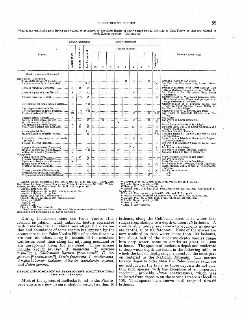
PLEISTOCENE SERIES 89
Pleistocene mollusks now living at or close to southern or northern limits of their range in the latitude of San Pedro or that are related tosuch Recent species Continued
0
Species
Southern species Continued
Gostropods Continued.
Trltonalla clrcumtoxta aurautia (Stoarns).
Polccypods:
Lower Pleistocene
,
Lomita marl
X
X
X
X(?)
X X
X
4-a
.3 oOH
£
X
X ' X
(?)» X
X X
X
San Pedro sand
13 X
X
X
X
">X
16 X
X X
;« xx
21 X
X v
x
Upper Pleistocene v
Terrace deposits
12 9 8 6
XX
X
5
X
X
4
X
v
X
(?)
X
' XX
3
X
X
2
X
X
X
X
X
X
Palos Verdes sand 1
X
X
X
18 X
X X
X
(?)20 X
X
X X
X
X X
X X
Present known range
Catalina Island to San Diego. San Pedro to Magdalena Bay, Lower Califor
nia. Probably identical with forms ranging from
Santa Barbara Islands to Lower California. San Pedro to San Bartolome Bay, Lower
California. Closely related to Ft. asperum lomaense, Cata
lina Island to San Diego, and perhaps indis tinguishable from that form.
Closely related to C. pedroana proper, San Pedro to Point Abreojos, Lower California.
San Pedro to San Diego. Closely related to C. gloriosa, San Diego. San Pedro to Coronado Islands, near San
Diego. San Diego. San Pedro to Lower California.
Do. Santa Barbara Islands to San Diego. Newport Bay, Calif., to Lower California and
Gulf of California. " Catalina Island to Panama. ^ Catalina Island (?); Lower California to Gulf
of California. Santa Barbara Islands to Scammon's Lagoon,
Lower California. San Pedro to Scammon's Lagoon, Lower Cali
fornia. San Pedro to San Diego. San Pedro to Puerto Libertad, Mexico. Catalina Island to Gulf of California.
, Santa Barbara Islands to San Diego. San Pedro to. Peru. Santa Barbara Islands to San Diego. San Pedro to Point Abreojos, Lower California. Santa Monica, Calif., to Gulf of Tehuantepec,
Mexico. San Pedro to Panama.
Do. Do.
i Arnold, llnlph, California Acad. Sci. Mom., vol. 3, p. 341, 1903. Clark, Alex, San DICRO Soe. Nat. History Trans., vol. 7, NQ, 4, table op. p. 30, 1931. Willett, George, Southern California Aoad. Sci. Bull., vol. 36, p. 04,1937.
" Arnold, Ralph, op. cit.' Arnold, Ralph, op. clt., p. 326. Clark, Alex, op. cit.< Arnold, Itulph, op. cit., p. 330.8 Clark, Alox. op. cit. ("mamiUaris").o Arnold, Ralph, op. clt., p. 307 ("mamwillaris.")' Idem, pp. 286-287.8 Idem, p. 228. Idem, p. 245.10 Idem, p. 241 ("corrugata")." Thoro are no specimens In the National Museum from localities between Cata
lina Island and Magdalena Bay, Lower California.
During Pleistocene time the Palos Verdes Hills formed an island. That unknown factors correlated with a marine insular habitat may affect the distribu tion and abundance of some specie's is suggested by the occurrence in the Palos Verdes Hills of species that now are more abundant along the islands off the southern California coast than along the adjoining mainland or are unreportcd along the mainland. These species include Tegula brunnea, T. montereyi, T. marcida ["pulligo"], Calliostoma ligatum ["costatum"], C. vir- gineum ["annulatum"], Liotia jenestrata, L. acuticostata, Amphithalamus indusus, Alvania acutelirala rosana, and Jaton gemma.
DEPTH DISTRIBUTION OF PLEISTOCENE MOLLUSKS THAT AJRE STILL LIVING
Most of the species of mollusks found in the Pleisto cene strata are now living in shallov water, less than 10
» Oldroyd, T. S., U. S. Nat. Mus. Proc., vol. 65, art. 22, p. 21,1924. " Arnold, Ralph, op. cit., p. 296. " Idem, p. 291. Clark, Alex, op. cit.» Bartsch, Paul, U. S. Nat. Mus. Proc., vol. 40, pp. 331-332, 1911. Oldroyd, T. S.
op. cit., p. 15.18 Bartsch, Paul, op. cit., pp. 345-346. Oldroyd, T. S., op. cit. " Willett, George, Southern California Acad. Sci. Bull., vol. 36, p. 62, 1937. > 8 Bartsch, Paul, U. S. Nat. Mus. Proc., vol. 33, pp. 250^251, 1907. i» Arnold, Ralph, op. cit., p. 289. 2° Idem, p. 230. 21 Idem, p. 222 ("varia").
fathoms, along the California coast or in water that ranges from shallow to a depth of about 25 fathoms. A considerable number are known to occur only at moder ate depths, 10 to 100 fathoms. None of the species are now confined to deep water, more than 100 fathoms, but about half of the moderate-depth species range into deep water, some to depths as great as 1,000 fathoms. The species of moderate depth and moderate to deep-water depth are listed in the following table, in which the known depth range is based for the most part on material in the National Museum. The marine terrace deposits older than the Palos Verdes sand are not included in the table, as those deposits do not con tain such species, with the exception of an imperfect specimen,. probably Jaton santarosanus, which was collected from deposits on the second terrace at locality 105. That species has a known depth range of 16 to 82 fathoms.

90 GEOLOGY AND PALEONTOLOGY OF PALOS VERDES HILLS, CALIFORNIA
Pleistocene mollusks now living at moderate depths and at moderate to deep-water depths off the California coast or that are closely relatedto Recent forms having that depth range
Species
Gastropods:
Pelecypods:
Lower Pleistocene
Lomita marl
X
X X X
X X
X X X X
X X
X X X
xxxx
xxxxxxxxxxx
X X
X X
Timms Point silt
XXXXXXXX
xxxxxxxxxxx xxxxx
X
X X
. X
X
X X
xxxxxxx
San Pedro sand
XXXXX
6 X
X X X
X X
xxxxxxxx
X X X'
X
17 xX
X X
X X
Upper Pleisto
cene, Pales
Verdes sand
4 X
X X . X
X
X10 x
X"X
X
8
1
X
Present known depth range off .California coast (fathoms)
30-67. 48. . 34-110. 16-95. Probably identical with P. caryophylla, 67-81. 53-822. 20. 32-239. 81. South of Puget Sound range of genus is 68-243. 67-71. 30-53. Probably identical with forms ranging from 50-181. Closely related to B. asperum lomaense and perhaps indis
tinguishable from that form, which ranges from 20-71. 50-155. 48-795. 32-60. 80-1,081. 30-218. 68-211. 80-389. 71-376. Related evidently to B. pacificus; 67-92. 50-202. Probably identical with A. rhyssa, 53-81. 48-110.
55-1, 090. 16-233. 25-200. 30-80. Closely related to P. stearnsii diegensis, 14-266. 21-110. Related to P. bistriatus, 822. 40-200. 20. 45-48. 25-110. 62-276. Related evidently to C. pacifica. 30-506. 16-167. 30. Apparently identical with a small race, 13-51. 13-270. 16-108. 16-51.
1 Arnold, Ralph, California Acad. Sci. Mem., vol. 3, p. 341, 1903. Clark, Alex, San Diego Soc. Nat. History Trans., vol. 7, No. 4, table op. p. 30, 1931. Willett, George, Southern California Acad. Sci. Bull., vol. 36, p. 64,1937.
2 Arnold, Ralph, op. cit. . ~»Idem. Oldroyd, T. S., U. S. Nat. Mus. Proc., vol. 65, art. 22, p. 21,1924.4 Arnold, Ralph, op. cit.' Arnold, Ralph, op. cit., pp. 327-328.6 Willett, George, op. cit., p. 63, pi. 25.7 Arnold, Ralph, op. cit., p. 291. Clark, Alex, op. cit.8 Willett, George, op. cit., p. 62.
Arnold, Ralph, op. cit., pp.-286-287.10 Idem, pp. 224-225.» Idem, p. 228.13 Idem, p. 253 ("tenuisculptus").18 Idem, p. 252 ("scalariformis")., Clark, Alex, op. cit.14 Arnold, Ralph, op. cit., p. 251 '("multicostatus"), p. 252 ("scalariformis").» Idem, pp. 252-253. Clark, Alex, op. cit.16 Arnold, Ralph, op. cit., pp. 252-253.i' Arnold, Ralph, U. S. Geol. Survey Prof. Paper 47, pp. 126-127, 1906 ("riversi").is Crickmay, C. H., Canadian Field Naturalist, vol. 43, No. 5, p. 93, 1 fig., 1929.
The number of species in the preceding table would be considerably larger if all the mollusks were identified. Turrids of the genera Propebela ["Lora"], "Taranis," and Borsonella occur in the Lomita marl and Timms Point silt but are rare or absent in the other Pleistocene units. At the present time these genera belong to the moderate-depth and moderate-depth to deep-water groups.
LOMITA MARL,
The Lomita marl includes several faunal associations, which are interpreted as different depth associations ranging from shallow water to about 100 fathoms.
A shallow-water facies representing a depth of 10 fathoms or less is identified at locality 61, near Lomita quarry. At locality 61 the. fossils occur in gravel and coarse-grained calcareous sand, many of the specimens being broken and worn. This is the only locality where an'oyster, Ostrea megodon cerrosensis, was found in the Lomita marl, and none of the species characteristic of moderate depths are present. A heavily sculptured form of Turritella pedroensis and Olivella biplicata are abundant.
The algal bed at Hilltop quarry is thought to repre sent a depth of between 25 and 50 fathoms. The following species are particularly abundant in that bed:
Most abundant mollusks in algal bed of Lomita marl at Hilltop quarry (localities 53, 5Sa)
Gastropods:_ (Pupillaria optabilis (Carpenter). Pomaulax undosus (Wood). Pachypoma gibberosum (Dillwyn). Hornalopoma carpenter! (Pilsbry). Bittium rugatum Carpenter. Bittium attenuatum Carpenter. Bittium asperum (Gabb). Bursa californica (Hinds). Kelletia kelletii (Forbes). Mitrella tuberosa (Carpenter). Amphissa versicolor Dall. Conus californicus Hinds.
Pelecypods:Glycymeris profunda (Dall). Cyclocardia aff. C. occidentals (Conrad). Ventricola fordii (Yates).

PLEISTOCENE SERIES 91
There are no shallow-water Littorinas, Anomias, mussels, Aequipectens, oysters, or large chamids in the algal bed, but the following moderate-depth species are present:
Moderate-depth species in algal bed of Lomita marl at Hilltopquarry (localities 58, 5Sa)
Gastropods:Acmaea funiculata (Carpenter)?Puncturella delosi Arnold.Solariclla rhyssa Dall.Homalopoma subobsoletum (Willett).Alvania acutelirata rosana Bartsch.Bittium rugatum Carpenter.Bittum asperum (Gabb).Fusitriton oregonensis (Redfield).Neptunea tabulata (Baird).Admete gracilior (Carpenter).
Pelecypods:Pectcn stearnsii Dall.Kucrassatella fluctuata (Carpenter).Cyclocardia aft. C. occidentalis (Conrad).
The algal bed represents evidently an exceptional environment. Though calcareous algae are abundant in some layers of the Lomita elsewhere, they do not elsewhere play such an overwhelming part among the
.constituents. Seven species of mollusks, notably Pomaulax turbanicus petrothauma and Tritonalia cory- phaena, were not found elsewhere.
The calcareous sand and gravel at locality 54g, con stituting unit 7 of the section in the canyon adjoining Hilltop quarry, is thought to represent the same depth range as the algal bed. For unknown reasons calcareous algae are much less abundant than in the algal bed. The fossils in calcareous sand and marl at other locali ties indicate essentially the same depth range, between 25 and 50 fathoms. All the Lomita moderate-depth species are present in those strata, with the exception of Pseudamussium, Hyalopecten, Propeamussium, and Thracia trapezoides. In some layers of both calcareous sand and marl, such as the calcareous sand at locality 42d, only small and minute shells, particularly herbi vorous gastropods, and young shells are present, suggesting current sorting. The most perfectly pre served fossils were collected from the dump of the central shaft of the Whites Point tunnel (locality 57). Bittium rugatum, Turritella pedroensis, "Nassa" mendica cooperi, Olivella biplicata, Conus californicus, and Cyclocardia aff. C. occidentalis are abundant at locality 57. Three species of Boreotrophon are present.
The glauconitic foraminiferal sand and foramim'feral calcareous sand in the lower part of the section exposed in the canyon adjoining Hilltop quarry and forming the exposed section at Lomita quarry are thought to repre sent a greater depth, between 50 and 100 fathoms. Cyclocardia barbarensis is generally abundant in those strata (localities 54, 54a, 54c,. 54e, 54f, 62b). Cyclo cardia off C. occidentalis occurs, however, in some layers (localities 54a, 54c). In the dark-colored glauconitic sand at Lomita quarry (locality 62b) Cyclocardia barbarensis is the only abundant mollusk, and it is associated with Pseudamussium n. sp., Hyalopecten vancouverensis, and Propeamussium alaskensis, an asso ciation suggesting a depth of about 100 fathoms. The marl in San Pedro containing Thracia trapezoides (localities 37, 41) also represents probably a depth greater than 50 fathoms.
Wherever more than one inferred depth facies is represented in the same section, the deeper facies underlies the more shallow facies. This relation is well shown in the section exposed in the canyon near Hilltop
602787 ,45 7
quarry, where Cyclocardia barbarensis-bQ&rmg glau conitic foraminiferal sand and foraminiferal calcareous sand thought to represent a depth of between 50 and 100 fathoms, is overlain by calcareous sand and gravel characterized by fossils whose depth range is inferred to be between 25 and 50 fathoms. The large-cobble calcareous gravel at the top of the section represents doubtless a shallow facies, but no fossils were found in it. The shallow-water gravel and calcareous sand at locality 61 is younger evidently than the 50-fathom to 100-fathom facies at Lomita quarry; intervening strata are not exposed.
As shown in the tables on pages 87-89, the Lomita marl contains 12 identified northern species, 6 of which are locally extinct, but are living farther north. The northern Fusitriton oregonensis, Chlamys islandicus jordani, Patinopecten caurinus, Thracia trapezoides, and the essentially northern Neptunea tabulata all of which occur in the Lomita marl have been considered characteristic of the Timms Point silt. On the con trary the Lomita contains 20 identified southern species. Of the southern species still living only one, Macron aethiops, is more than 100 miles north of its present range. Pomaulax turbanicus petrothauma and Ostrea megodon cerrosensis, which are not known to be living, are closely related to species living hundreds of miles farther south. An early statement 8 that the Lomita marl includes a fauna of warmer facies than the fauna of the Palos Verdes sand is now considered erroneous. The temperature of the water was probably essentially the same as at the present time in this region. Inas much as the sediments were deposited on the leeward side of an island, the temperature of the shallower water between the island and the mainland may have been higher than at the present time, owing to protec tion from upwelling cold water. It is not known, however, whether the leeward side of Catalina and other nearby islands is so protected. Gale 6 assigned the Lomita marl to the first interglacial stage. This matter is considered under the heading "Glacial-inter- glacial assignments," page 100.
The Lomita sediments at most localities indicate clear water. An environment evidently comparable to that of parts of the Lomita has been found on the lee ward side of Catalina Island, where calcareous sedi ments are accumulating on a shelf at a depth of about 40 to 50 fathoms. 7 A sample of the calcareous sedi ments from a depth of 45 fathoms off Avalon is avail able through the kindess of Professor Shepard. The proportion of detrital nonorganic material, estimated to be 25 percent, is larger than in much of the Lomita. The principal organic constituents in approximate order of decreasing abundance are as follows: Foramini- fera, calcareous algae, mollusks, echinoid spines, Bryo- zoa. Mollusks are represented by about 50 species. With few exceptions, notably some valves of Cyrilla munita, the specimens are bleached, worn, and broken. As hi much of the Lomita, the specimens are small, con sisting of adult small shells and young shells or small fragments of larger species. Species of considerable size, such as "Nassa" mendica cooperi?, Glycymeris sp., Eucrassatella fluctuata?, and Pratulum centifilosum?, are represented, but the specimens are minute young shells or fragments not more than a few millimeters
* \Voodring, W. P., Warm-water faunas of the so-called Pliocene of San Pedro (ab stract): Geol. Soc. America Bull., vol. 41, pp. 211-212,1930.
6 Grant, U. S., IV, and Gale, H. R., op. cit. (San Diego Soc. Nat. History Mem., vol. 1), p. 71,1931.
: Shepard, F. P., and Wrath, W. F., Marine sediments around Catalina Island: Jour. Sedimentary Petrology, vol. 7, pp. 45, 48, 1937.

92 GEOLOGY AND PALEONTOLOGY OF PALOS VERDES HILLS, CALIFORNIA
long. The faunal association resembles that of much of the moderate-depth facies of the Lomita. Boreo- trophon, Admete, Thyasira, and Axinopsis, which are abundant generally in that facies of the Lomita, are, however, not represented.
Along the north border of the Palos Verdes Hills, west of the Gaffey anticline, the Lomita calcareous sediments contain a considerable amount of silty sand and sand. The fauna is, however, essentially the same as in purer calcareous sand farther east.
TIMMS POINT SILT
The Timms Point silt contains several faunal asso ciations that are not strikingly different. They are inferred to represent a moderate-depth range of between 50 and 100 fathoms. .
At Timms Point pockets of calcareous silt at the base of the formation contain a fauna of small and young shells indistinguishable from that in calcareous sand of the Lomita marl. This material may .represent detrital constituents from the Lomita marl, but the fossils are as fresh as those in the undisturbed Lomita marl. It represents more probably a nondetrital facies during the early stage of the marine transgression. The size sorting of the fossils suggests current sorting.
The remainder of the section at Timms Point contains a fauna characterized by the abundance of the moderate- depth and northern species listed on pages 87-89. This association is thought to represent a depth close to 100 fathoms, a conclusion reached by Bagg 8 from a study of the Foraminifera. The northern Thyasira disjuncta and Mya truncata have been found in unit 2 but not in unit 1. The slight faunal distinction between units 1 and 2 is probably of doubtful value, for Trachycardium guadragenarium, formerly thought to be characteristic of unit 1, and Pandora grandis, thought to be charac teristic of unit 2, occur together at locality 34 on Harbor Boulevard. The stratigraphic relations at locality 34 are uncertain, but the strata represent probably unit 2. On Deadman Island Crickmay 9 found Thyasira .dis juncta only in his zone 5, which is therefore faunally similar to unit 2 so far as the occurrence of that species is concerned. The occurrence of Pandora grandis at locality 44 on Second Street likewise suggests unit 2.
The Timms Point silt is identified doubtfully on lithologic grounds at locality 52, immediately west of Gaffey Street. The few fossils collected are inconclu sive, however, as they might represent the Lomita, Timms Point, or San Pedro. A Timms Point fauna at locality 66, on the north border of the hills near Agua Magna Canyon, suggests unit 2 at Timms Point, as it includes Mya truncata and Pandora grandis.
A marked feature of the Timms Point fossils is the prevalence of moderate-depth species, most of which occur also in the Lomita marl, and the scarcity or absence of shallow-water species. The only oyster is a minute shell from locality 66. There are no Anomias, mussels, or large chamids. The specimens of Olivella biplicata, though locally abundant, are worn and broken, and the few specimens of Conns californianus are likewise worn and broken, suggesting transportation from an area of shallow water.
Owing to the relatively large .number of northern species, the northern aspect of the Timms Point fossils
8 Bagg, R. M., Jr., Pliocene and Pleistocene Foraminifera from southern California: U. S. Oeol. Survey Bull. 513, p. 13,1912.
' Crickmay, C. H., The anomalous stratigraphy of Deadman's Island: Jour. Geology, vol. 37, pp. 626-627. 1929.
has been emphasized repeatedly. Arnold 10 considered the fauna boreal, Smith u thought the temperature of the water was about the same as that of Puget Sound, and Gale 12 assigned the Timms Point silt to the second glacial stage. This matter is considered under the heading "Glacial-interglacial assignments," page 100.
The Timms Point silt is inferred to represent the same depth range as the lower part of the Lomita marl. Whether the difference hi faunal associations may be accounted for by the clearer water indietaed by the Lomita is not known. All except one of the locally extinct northern species that give the Timms Point fauna its individuality are pelecypods, the presence or absence of which may be controlled by the character of the bottom.
SAN PEDRO SAND
The San Pedro sand contains several well-marked faunal associations, which like the associations in the Lomita marl are attributed to different depth facies.
A shallow-water facies is recognized along and near Harbor Boulevard at localities 49, 49a, and 50. At these localities the fossils include Cerithidea californica,
.Macron aethiops kellettii,."Cancellaria" tritonidea, Ter- ebra pedroana, Melampus olivaceus, Anomia peruviana, Ostrea lurida, and large sand dollars, most of which were not found in the San Pedro sand in San Pedro. A shal low-water Anomia-Ostrea facies, characterized by the abundance of Anomia peruviana and Ostrea lurida, is represented on the south limb of the Gaffey syncline at. localities 58a and 59 and in less characteristic form at locality 56. Tegula ligulata was found in the San Pedro sand only at localities 58a and 59. All the shallow- water species mentioned and the other species repre sented at those localities occur also in the younger Palos Verdes sand. In fact, this Palos Verdes-like shallow-water facies of the San Pedro sand is so similar to the usual Palos Verdes facies that there is some doubt about the age assignment, the stratigraphic evidence being incon clusive. At localities 49 and 58a, however, fossiliferous sand and gravel containing southern species character istic of the Palos Verdes overlie the strata identified as the San Pedro sand. The Palos Verdes-like facies rep resents evidently protected shallow water lying in the lee of the growing Gaffey anticline. It includes, like the usual Palos Verdes facies, tide-flat species Ceri thidea californica and Melampus olivaceus.
Localities 47 and 47a in San Pedro and Oldroyd's nearby Nob Hill locality 13 are triought to represent shallow water. The water was deeper, however, than at the localities just described, or species from depths greater than 10 fathoms were washed in by storm waves, as Oldroyd 14 inferred. Whether the fresh-water Hy- drobia protea from locality 47a and the fresh-water pulmonates recorded by Arnold lived in streams on the Pleistocene Palos Verdes Hills island or were derived from the mainland is not known. If they lived on the island, the climate was more humid than at present.
At localities 30 on Deadman Island, 48 in north western San Pedro, 58 on Western Avenue, and 64 and 65 on the north border of the hills along Bent Spring Canyon, the San Pedro sand includes moderate-depth species not found elsewhere in that unit. Those
1° Arnold, Ralph, The paleontology and stratigraphy of the marine Pliocene and Pleistocene of San Pedro, Calif.: California Acad. Sci. Mem., vol. 3, p. 16, 1903.
" Smith, J. P., Climatic relations of the Tertiary and Quaternary faunas of the California region: California Acad. Sci. Proc., 4th ser., vol. 9, p. 151, 1919.
12 Grant, U. S., IV, and Gale, H. R., op. cit., p. 71.is Oldroyd, T. S., The fossils of the lower San Pedro fauna of the Nob Hill cut,
San Pedro, Calif.: U. S. Nat. Mus. Proc., vol. 65, art. 22, 39 pp., 2 pis., 1924." Idem, p. l.

PLEISTOCENE SERIES 93
localities therefore are inferred to represent a moderate depth, probably between 25 and 50 fathoms. These species are as follows:
Moderate-depth species found in San Pedro sand at localities SO, 48, GS, 64, and 66 but not elsewhere in that unit
Gastropods:
Puncturolla cooped Carpenter __ ... __ ...
Turoica caffoa (Gabb).........................
Klassurn californictim (Dall and Bartsch) ».-..
Noptunoa tabulata (Baird).. _ .......... _ .Polccypods:
Nucula all. N. cardara Dall. __ . ___ ........
Eucrassatolla fluctuata Carpenter __ ... __ .Thyasira gouldil (Plilllppl).... ................Axlnopsis vlrldls Dall.. . __ . __ ..... _ .
30
X1 X
XXXX
X
X
XXXX
I
48
X
X
jocalit1
58
X
?
64
X
X
65
y
' Arnold, Ralph. California Acad. Scl. Mom., vol. 3, pp. 327-328, 1903.8 Not known to bo living. Associated with intermediate-depth species in Lomita
marl and Timms Point silt.8 A northern species associated with intermediate-depth species in Lomita marl
and Timms Point silt.
At locality 64 the fossils occur in silty sand contain ing lenses of coarse sand and gravel resting on Miocene strata on the north flank of the Gaffey anticline. At locality 65 nearby they occur in marly silty sand over lying about 100 feet of coarse sand and gravel. At both localities the faunal association closely resembles that in the Lomita marl at numerous places. The strata at locality 64 are in the stratigraphic position of the Lomita marl and Timms Point silt; those at locality 65 are at the exposed top of the San Pedro
sand. The sand containing moderate-depth species at locality 58 underlies the shallow-water Anomia-Ostrea facies of locality 58a. The fossils from locality 73a, in the fifth ravine west of Hawthorne Avenue, represent apparently shallower water than those just described.
The San Pedro sand contains 6 locally extinct north ern species but no locally extinct southern species far north of its present range, with the exception of Arnold's, record of Trachycardium procerum, which may perhaps be questioned. It contains both northern and south ern species now at or close to the limits of their range in the latitude of San Pedro. Arnold 15 considered the fauna of the San Pedro sand to be transitional cool- water; Smith 16 considered it cool-water and thought.it corresponded to the time of maximum glaciation; Gale 17 assigned it to the second interglacial period. This matter is discussed under the heading "Glacial-inter- glacial assignments," page 100.
MARINE TERRACE DEPOSITS OLDER THAN PALOS VERDESSAND
Fossils have been found in marine deposits on 8 of the 12 main terraces older than the first or lowest ter race. With the exception of a few localities, the fossils represent a more uniform facies than those already described. The usual facies and the only facies now known from the twelfth to fifth terrace, inclusive, con sists of species that live on rocks and in tide pools but includes species living below low-tide line. This facies has been designated a tide-pool facies. 18 It is more appropriate, however, to designate it a facies that rep resents both rock-cliff and tide-pool environments. The most abundant species in this facies and their present habitat are as follows:
" Arnold, Ralph, op. cit., p. 20.16 Smith, J. P., op. cit., pp. 136-137." Grant, U. S., IV, and Gale, H. B., op. cit. (San Diego Soc. Nat. History Mem.,
vol. 1), p. 71, 1931.18 Woodring, W. P., Fossils from the marine Pleistocene terraces of the San Pedro
Hills, Calif.: Am. Jour. Sci., 5th ser., vol. 29, p. 297,1935.
Most abundant species in rock-cliff and tide-pool facies of marine terrace deposits older than Palos Verdes sand and their present habitat
Species Present habitat
Gastropods:Acnuica limatula Carpenter. Acmaea scabra (Could).... Acrmiea asmi (Middendorff). Haliotis cracherodii Leach..
Fissurella volcano Reeve.____________Tegula funebralis (Adams)______._-_-Tegula gallina (Forbes)______________Pseudorotella invallata (Carpenter)....Pseudorotella supravallata (Carpenter). Homalopoma carpenter! (Pilsbry) _ _ _ _ .Homalopoma bacula (Carpenter) ___... Littorina planaxis Philippi, small form. Littorina scutulata Gould.___________Barleeia haliotiphila Carpenter._______Truncatella stimpsoni Stearns.--..----Truncatella californica Pfeiffer._______Syncera translucens (Carpenter). .__ Spiroglyphus lituella (M6rch)_________Hipponix antiquatus (Linne)________Hipponix tumens Carpenter._________Oadinia reticulata (Sowerby)__.-.____
Pelecypods:Septifer bifurcatus (Conrad)...._-____Glans subquadrata (Carpenter) _______Epilucina californica (Conrad)________
Rock, intertidal. .Rock, from upper edge of spray to low-tide line.On Tegula.In crevices and under rocks, intertidal and below low-tide
line.Rock, intertidal. Rock, intertidal and tide pools. Rock, at high-tide line and intertidal.
; Tide pool, under loose rocks and among eel grass roots.
Tide pool, under loose rocks.Rock, in spray zone.Rock; intertidal.In "moss" on abalones.
"Under loose rocks near high-tide line.In vegetation just above high-tide line. Rocks, interdial.
Tide pool, in rock crevices. Rock, in crevices, intertidal.
Tide pool, in rock crevices and under loose rocks. Attached to under side of rocks, intertidal. Tide pool, in sand between rocks.

94 GEOLOGY AND PALEONTOLOGY OF PALOS VEKDEg HILLS, CALIFORNIA
Gastropods greatly outnumber pelecypods in the rock-cliff and tide-pool facies, the average ratio of pelecypod species to gastropod species in 28 collections being 1 : 5.2. In no collection are there more than 7 species of pelecypods.
The fossils from the twelfth terrace at an altitude of
1,215 feet above sea level are representative of the rock-cliff and tide-pool facies. This collection is: of exceptional interest, as it represents the greatest alti tude at which Pleistocene marine terrace fossils have been found along the California coast. The species are a,s follows:
Fossils from marine deposits on twelfth terrace, altitude 1,215 feet above sea level (locality 75)
Species Abundance and condition
'Gastropods:Acmaea limatula Carpenter______________________Acmaea scabra (Gould)_________________________Acmaea pelta "Eschscholtz" Rathke__L___________Acmaea insessa Hinds?_____-_---_____---______.Haliotis cracherodii Leach.______________________Fisurella volcano Reeve_________________________Lucapinella callomarginata ("Carpenter" Dall)?____Diodora aspera ("Eschscholtz" Rathke)___________Norrisia norrisi (Sowerby)_______________________Tegula gallina (Forbes)_-__-_____-____--_______.'Tegula brunnea (Philippi)?______-_.___--________Pupillaria succincta (Carpenter)__________________Pomaulax undosus (Wood)?_________. ___________Homalopoma carpenter! (Pilsbry)__---__-_______.Homalopoma bacula (Carpenter)__________________Homalopoma paucicostatum fenestratum (Bartscli). Littorina planaxis Philippi, small form____________Littorina scutulata Gould-______________________Bittium armillatum Carpenter___________________Bittium interfossa (Carpenter)______________ ___.Cerithiopsis williamsoni (Arnold)__________________Seila montereyensis Bartsch_____________________'Triphora pedroana Bartsch_ _____________________Aletes squamigerus Carpenter.__--__-_---________Hipponix antiquatus (Linne)___-----___--________Hipppnix tumens Carpenter.______________________Crepidula aculeata (Gmelin) __ ___---_--_____^-___Crepipatella lingulata (Gould)__..-__-__--________Harfordia monksae (Dall)?______..______-________"Fusinus" luteopictus Dall?_ _^-__-______________Mitra idae Melvill___-___-____--_--_-----__-_-_-"Nassa" mendica cooperi Forbes_________________Tritonalia interf ossa (Carpenter) _________________Tritonalia gracillima (Stearns)?___-__-___________Amphissa versicolor Dall____ ______________ ______Olivella biplicata (Sowerby)______________________Pseudomelatoma torosa (Carpenter)?_____________Mangelia cf. M. rhyssa (Dall)_ ________________Mitromorpha filosa (Carpenter)__________________Mitromorpha gracilior ("Hemphill" Tryon)________Mitromorpha aspera (Carpenter)_________________Conus californicus Hinds.____________ __________.Gadinia reticulata (Sowerby)_____________________
Pelecypods:Septifer bifurcatus (Conrad)____..----_--________.Glans subquadrata (Carpenter) _______________Epilucina californica (Conrad) ________________
Common, worn. Abundant, well-preserved. Common, worn- Rare, I worn small.Common, 1 well-preserved, others worn fragments. Abundant, well-preserved. Rare, 1 small fragment. Rare, 1 worn. Common, small, broken. Abundant, apex generally broken. Rare, 1 worn, broken. Rare, well-preserved. Rare, columellar fragments. Common, broken and fragments. Rare, 1 wellrpreserved, 2 broken. Common, broken. Abundant, mostly somewhat worn. Abundant, some' welll-preserved, others broken. Common, worn or broken. Common, 1 well-preserved, others broken.
^Rare, broken or worn. 'Common, broken1 and worn. Common, broken and somewhat worn. Abundant, pieces. Abundant, mostly well-preserved. Abundant, mostly welflr-preserred. Rare, worn. Rare, worn.Rare, 1 worn fragment. Rare, 1 well-preserved!, very small. Rare, 1 broken and worn. Rare, 1 small, broken, worn). Common, small, broken.. Rare, 2 apertural fragments. Common, broken and: worn. Abundant, broken or worn, or both. Rare, 2 small, broken, worm. Rare, 2 somewhat worn. Rare, 1 worn. Rare, 1 broken, worn. Rare, 2 well-preserved,, 1 broken, worn. Abundant, worn, or worn and broken." Rare, somewhat worn.
Abundant, well-preserved.Common, well-preserved, or somewhat worn.Common, well-preserved, or somewhat worn and broken.
The fossils recorded by the Chaces 19 from deposits on the second terrace near Point Fermin (locality 94) also represent the rock-cliff and tide-pool facies. The abundance of chitons is, however, exceptional.
Most of the species that are now abundant along rocky stretches of the coast of the Palos Verdes Hills are present in the rock-cliff and tide-pool facies. Acmaea digitalis and Mytilus adamsianus are notable exceptions, and Mytilus californicus is rare among the fossils. On the contrary, the fossils include shallow-water species that live below low-tide line, species that live at moder ate depths in the latitude of San Pedro (Acmaea mitra, Diodora , aspera), species that are almost extinct locally though abundant a little farther north (Tegula June-, bralis), northern and southern species that are clos.e to
" Chacc, E. P., and E. M., An unreported exposure of the San Pedro Pleistocene: Lorquinia, vol. 2, No. 6, pp. 41-43.1919.
the present limits of their range, a locally extinct northern species, and a locally extinct southern species.
Two localities are notable exceptions to the prevailing terrace facies. At Bluff Cove, 69 species of gastropods and 19 of pelecypods were collected from deposits on the fourth terrace (locality 86). In addition to expectable terrace species this collection includes Terebra pedroana, Bulla gouldiana, Haminoea, Crassinella branneri, Lucinisca nuttallii, Macoma nasuta, Macoma secta, arid Cryptomya californica, all of which are well-pre served. These sp ecies indicate protected shallow wate r. The faunal association is. therefore a mixture of rocl.T cliff, tide-pool, and protected shallow-water facies. The protected shallow-water species were transported presumably from a locality nearby. A similar mixed faunal association was found on the second terrace in the Malaga Cove residential district (locality 105). At that

PLEISTOCENE SERIES 95
locality 70 species of gastropods and 39 of pelecypods were collected from coarse sand trapped in a niche and sealed, by boulders. The fossils include Rissoina kelseyi, R. pleistocene,, Crucibulum spinosum, Trivia solandri, Mitra, fultoni, Jaton santarosanus?, Nucula suprastriata, Sacella taphria, Yoldia, Glycymeris cor- teziana, Anomia peruviana, Botulina "opifex", Crenella, Pecten vogdesi, Ostrea lurida, Crassinella nuculiformis, Diplodonta sericata,, Semele decisa, Chione succincta, and Trigoniocardia biangulata, in addition to usual terrace species. Most of the exceptional species indi cate protected shallow water, but a few suggest water of moderate depth. At Hilltop quarry (locality 93) a few poorly preserved fossils collected from deposits on a terrace identified as the third, but possibly representing the second, include Turritella pedroensis, Bursa cali fornica?, and " Cancellaria" tritonidea?. This is the only locality where those species were found in terrace deposits older than the Palos Verdes sand. All the specimens are broken and battered and may be detrital.
The distribution of northern and southern terrace species is shown in the tables on pages 87-89. The one northern species now locally extinct is from the rock- clift' and tide-pool facies of the fourth and second terraces. The eight southern locally extinct species are, from the fourth and second terraces and with two exceptions arc from the unusual localities 86 and 105 just described. The exceptions are Acanthina lugubris from rock-cliff and tide-pool facies on the fourth terrace at localities 82, 84, and 85, and from the same facies on the second terrace at localities 94 and 106, and " Chione" picta reported orally by Chace from a protected shallow- water facios on the second terrace at Fifteenth Street near Leland. Northern species at or close to the southern limit of their present range were found on the fifth to second terraces, inclusive, and similar southern species on the sixth to second, inclusive. Owing to the presence of several chitons now rare as far south as San Pedro, Berry 20 thought that the deposits on the second terrace near Point Fermin are to be correlated with the San Pedro sand. This matter is discussed under the heading " Glacial-interglacial assignments," page 100.
PALOS VER»ES SAND
The 38 fossil localities representing the Palos Verdes sand, the marine deposits on the first or youngest terrace, are on the leeward (east and northeast) side of the hills. The prevailing faunal association, and the only association from localities 110, 111, and 112 nor-th- ward and northwestward to locality 142, consists prin cipally of species that indicate protected shallow water. Locally extinct southern species, notably CTassinella branneri, Crassinella nuculiformis, and Trachycardium procerum, are characteristic of this facies. During ralos Verdes time shallow-water bays evidently ex tended into the island formed by the Palos Verdes Hills from the strait separating the island from the mainland. Tide-flat species, Cerithidea californica and Melampus olivaceus, occur at numerous localities. Most of the material is not in place and represents current-strewn debris. It is generally necessary to sort great quanti ties of broken shells and fragments to find well-preserved shells. Macoma and Macoma-"Paphia" layers at locali ties 113 and 114 and nearby in northeastern San Pedro represent protected shallow-water species that are essen-
80 Berry, S. S., Fossil chitons of western North America: California Acad. Sci. Proc. 4th ser., vol. 11, pp. 408-409,1922.
tially in place. Rock-cliff and tide-pool species are generally rare, though most of the species in that facies on the older terraces occur also in the Palps Verdes sand. Their scarcity in the Palos Verdes sand is attributed to the prevalence of soft Miocene and Pleistocene rocks along much of the Palos Verdes coast on the leeward side of the hills. Fresh-water snails Valvata humeralis californica, Amnicola longingua, Hydrobia protea, and pulmonates of the genera Helisoma, (jyraulus, and Physa are rare constituents. If these snails lived in streams on the island, the climate was more humid than at present.
The mixed faunal association at Arnold's lumber yard locality (locality 113)., more thoroughly explored than any other Palos Verdes locality, has been discussed by Miller. 21 Marine mollusks, mostly broken shells in a matrix of coarse-grained sand and gravel, form the bulk of the fossil material. Remains of sting rays are fairly common. Fossil shore and ocean birds (loon, grebe, albatross, shearwater, fulmar, cormorant, goose, mallard, teal, surf scooter, diving goose, gull, and murrelet) and mammals (seal, sea lion, and whale), all represented by rare fragmentary remains, are'expect able in marine strata. Fresh-water mollusks and mud turtle are fresh-water constituents. Land animals are represented by rare fragmentary remains of birds (vulture, eagle, quail, and meadowlark) and mammals (canid, felid, rodent, ground sloth, horse, cervid, came- lid, bison, and mammoth). It is inferred that this material was deposited in shallow current-swept marine water. Most of the fresh-water and land animals, except birds, were probably derived from the mainland and represent presumably drift carcasses stranded on the shore of the island formed by the Palos Verdes Hills during Palos Verdes time.
A beach facies, in which fossils occurred in cross- laminated sand, was formerly represented at locality 109 in San Pedro, at Palos Verdes and Eighth Streets. The fossils, all more or less worn and broken, include numerous specimens of small gastropods, "Nassa" perpinguis, Mitrdla carinata, Olivella biplicata, and Olivella pedroana. None of the southern species char acteristic of the protected shallow-water facies were found at this locality, but the collection consists of only 48 species.
An exceptional faunal association occurs at localities 108 (Arnold's Crawfish George's locality) and 107. Both localities are on the east coast, near Cabrillo Beach, and are farther south than other 'Palos Verdes localities. None of the characteristic southern species occur at these localities. On the contrary, the collections include Fusitriton oregonensis, Exilioidea rectirostris, Boreotrophon aff. B. multicostatus, Nucella lamellosa, and Amphissa columbiana, all northern species not found at other Palos Verdes localities. The northern Boreo trophon pedroanus occurs at locality 108 and also at locality 121, where it is associated with the southern Crassinella and Trachycardium procerum. A similar mixed association was represented at Deadman Island, where Crickmay 22 found the northern or essentially northern Fusitriton oregonensis ["Argobuccinum"], Nep- tunea tabulata [" Chrysodomus"], Boreotrophon "pacifi- cus" [" Trophon"], Nucella lamellosa [" Thais"}, and Amphissa columbiana associated with the southern Crassinella branneri.
21 Miller, L. H., Further bird remains from the upper San Pedro Pleistocene: Condor, vol. 32, pp. 116-117, 1930.
M Crickmay, C. H., op. cit. (Jour. Ocol., vol. 37), pp. 631-632, 1929.
96 GEOLOGY AND PALEONTOLOGY OF PALOS VERDES HILLS, CALIFORNIA
Owing to the prevalence of southern species in the Palps Verdes at most localities, Arnold 23 thought that during Palos Verdes time the temperature of the water was as warm as at San Pedro at the present time and probably warmer. Smith 24 estimated that the tem perature was 4° F. higher than at present and that the fauna is probably interglacial, and Gale 2S assigned it to the last interglacial period. This matter .and the exceptional fauna! association at localities 107 and 108 are considered under the heading " Glacial-interglacial assignments," page 100.°
AGE AND CORBELATION
CORRELATION WITHIN PALOS VERDES HILLS
Wherever the Lomita marl and Timms Point silt are found they are at the base of the Pleistocene strata. In one area, central San Pedro, the Timms Point silt overlies the Lomita marl. The Lomita marl is inter preted as representing deposition in clear water during a period of varying duration from place to place begin ning with the early stage of the Pleistocene transgression and resulting in calcareous sediments ranging in thick ness from a few inches to about 275 feet. The greatest thickness of calcereous -sediments is in the Gaffey syncline, which was protected from the flood of granitic sand derived from the north by the growing Gaffey anticline. 26 The Timms Point silt is interpreted as representing deposition in less clear water during a period also of varying duration, beginning with the early stage of the Pleistocene transgression. In central San Pedro the deposition of silt began after the deposi tion of calcareous sediments ended. Though represent ing varying duration and despite the superposition in central San Pedro, the Lomita marl and Timms Point silt are thought to be essentially synchronous on both stratigraphic and paleontologic grounds. The faunas of these two formations have much in common, owing doubtless to the prevailing moderate-depth facies of both formations. The principal faunal differences are attributed to the absence of shallow-water and 25- fathom to 50-fathom facies in the Timms Point silt and to the presence, in that formation of northern pelecypods. The calcareous silt occurring in pockets at the base of the Timms Point silt at Timms Point is lithologically and faunally indistinguishable from parts of the Lomita marl.' The marl in the lower part of the Lomita in central San Pedro is probably the equivalent of the lower part of the Timms Point silt at Timms Point. Both marl and silt contain the northern Thracio, trapezoides, not found elsewhere in the Lomita.
Much of the San Pedro sand is younger than the Lomita marl and Timms Point silt, but locally parts of the San Pedro are clearly of the same age as those formations. Fossiliferous San Pedro sand in San Pedro is younger than the Lomita and Timms Point of that area. Fossils occur, however, at the base of the San Pedro sand immediately above the contact with Mio cene mudstone, at locality 64, on the north flank of the Gaffey anticline, along Bent Spring Canyon. The fossiliferous silty sand at that locality and overlying sand and gravel are without any reasonable doubt the equivalent of calcareous strata of the Lomita marl on
23 Arnold, Ralph, The paleontology and stratigraphy of the marine Pliocene and Pleistocene of San Pedro, Calif.: California Acad. Sci. Mem., vol. 3, p. 29, 1903.
24 Smith, J. P., Climatic relations of the Tertiary and Quaternary faunas of the California region: California Acad. Sci. Proc., 4th ser., vol. 9, p. 137,1919.
2(1 Grant, U. S., IV, and Gale, H. R., op. cit. (San Diego Soc. Nat. History Mem., vol. 1), p. 73, 1931.
28 Reed, R. D., Geology of California, p. 259, Am. Assoc. Petroleum "Geologists. Tulsa, Okla., 1933.
the opposite flank of the Gaffey anticline. Despite the difference in the character of the sediments, the faunal association in the San Pedro sand at locality 64 is virtually indistinguishable from that in calcareous Lomita sediments indicating a depth of between 25 and 50 fathoms. Furthermore, the same faunal association is found nearby at locality 65 in marly silty sand at the very top of about 100 feet of San Pedro sand and gravel. This does not mean necessarily that the intervening 100 feet of sand and gravel were deposited at depths of between 25 and 50 fathoms, for the fossiliferous strata at locality 65 may represent a period when rate of sub sidence outran rate of deposition of sand and gravel. The occurrence of the fossils in silty sand or marly silty sand at localities 64 and 65 indicates a different environ ment from that of the intervening clean coarse sand and gravel.
The marine terrace deposits, even those on the oldest terraces, are thought to be younger than the lower Pleis tocene formations. If it be assumed that the entire present area of the Palos Verdes Hills acted as a unit during the intermittent emergence that produced the ter races, the present east and north borders of the hills, where the lower Pleistocene strata are found at or near sea level, were submerged to a depth of at least 1,300 feet when the emergence began. No sediments in the lower Pleistocene formations are interpreted as representing a depth as great as that. The Timms Point silt and the lower part of the Lomita marl are interpreted, however, as representing depths of between 50 and 100 fathoms (300 to 600 feet). So far as inferred depth is concerned, such sediments qualify as being contemporaneous with some of the intermediate terraces. It may be argued that the terrace deposits are younger than the defor mation assigned to the middle Pleistocene. The absence of deformation of intermediate and oldest terraces is not opposed, however, to this possible correlation, for. the lower Pleistocene strata, aside from tilting resulting probably from uplift, are not deformed except along the north border of the hills, where the youngest terrace itself is mildly or moderately deformed. The presence of large cobbles and boulders in the Lomita marl where it rests on its basement and the occurrence of a shallow-water facies in that formation are opposed to the correlation. In view of these relations it is inferred that the thin veneer of deep-water and moder ate-depth sediments deposited during the relatively brief episodes when the oldest and intermediate terraces were formed was removed by marine erosion during the formation of successively younger terraces.
AGE
The formations in the San Pedro district that are considered of Pleistocene age are assigned to that epoch because they contain a fauna more modern than that of Coast Range formations assigned to the upper Pliocene. The division of Pleistocene into lower, middle, and upper parts is relative and more or less arbitrary. It is adopted for convenience and is based on events in the geologic history of the Palos Verdes Hills. Both lower and upper Pleistocene strata may include deposits of middle Pleistocene age.
It was formerly thought that the marine Pleistocene formations contain no extinct genera of mollusks. Elassum and Calicantharus are, however, not known to be living. Elassum is associated with species of moderate-depth facies and may be found to be living when the moderate-depth fauna of southern California

PLEISTOCENE SERIES 97
is better known. Calicantharus is associated with species of shallow-water 'and moderate-depth facies. Inasmuch as the shallow-water mollusks of southern California and adjoining regions are fairly well known, CaliccLntharus is quite certainly extinct in shallow water. As it is much larger than Elassum, it would probably be known by this time if it were living at moderate depths.
The percentage of species that are not known to be living is low, not more than 5 to 10 percent. The percentage is, however, of little value, for it depends on what is meant by the expression "not known to be living." Many species and varieties generally placed
under that category are so similar to Recent forms that they could readily be rated as still living'. Others are based on only one specimen arid are questionable, as the range of variation is unknown. The number of well- denned apparantly extinct species not closely related to known Recent species is quite small. This group includes Elassum californicum, Turritella pedroensis, Calicantharus fortis, and "Cancellaria" tritonidea. The identified mollusks not known to be living, including well-defined, less well-defined, and doubtful forms, and their stratigraphic distribution, are shown in the fol lowing table. The number would be increased to about 50 if all the species were identified.
Pleistocene mollusks not known to be living
Species
Gastropods:
Pomaulax turbanicus pctrothauma (Berry).
Elassum californicum (Dall and Bartsch).
*
"Nnssa" fossata coilotera Woodring, n. vnr.
Tritonalia coryphaona Woodring, n. sp.
Borcotrophon cf. B. paciflcus (Dall).--- Borcotrophon aft. B. multicostatus
(Eschscholtz).
Borcotrophon aft. B. stunrti (Smith)... Borcotrophon cf. B. raymoudi (Moody).
Pelccypods:
Lower Pleistocene
1 Lomita marl
X
X
X
XX '
X
X
X XXXX
X
X
X
Timms Point silt
"X
X
(?)
"XX
8 X
X11 X
X
'< X
X
(?)i'XX
X 1 San Pedro sand
X
X
X
<X «X
X
X X
X12 X 13 X
i'X
X
Upper Pleistocene
Terrace deposits
12 9 8
'
6 5 4
.
3
(?)
2
X
X
X
Palos Verdes sand
X
X
X
X
X
X
X«x10 X
X
X
X
16 X
X
Remarks
Closely related to Recent P. optabilis proper. Related to Recent V. williamsoni. Closely related to Recent P. turbanicus proper.
Related to Recent species from Lower Cali fornia and Gulf of California.
Closely related to Recent B. asperum lomaense and perhaps indistinguishable from that form.
Genus not known to be living.
Closely related to Recent C. pedroana proper. Closely related to Recent C. gloriosa. Closely related to Recent C. arnoldi proper. Related to Recent T. carpenteri. Not closely related to any known Recent
species. A form of C. princeps proper, which is wide
spread in Pliocene and occurs in lower Pleistocene.
Closely related to Recent "N." fossata proper.
Related to Recent "N. californiana" . Genus not known to be living. Closely related to Recent T. inter fossa proper. Related to Recent T. grippi. Related to Recent B. orpheus. Related evidently to Recent B. paciftca. Perhaps identical with a small Recent race of
B. multicostatus ranging from Puget Sound to northern California.
Closely related to Recent B. stuarti. Related evidently to upper Pliocene
B. raymondi. Not closely related to any' known Recent
species.
Closely related to Recent P. stearnsii diegensis. Closely related to Recent P. cataractes and
perhaps indistinguishable from that form. Related to Recent C. islandicus.
Do. Related to Recent P. bistriatus. Closely related to Recent 0. megodon proper. Closely related to Recent C. "narians" Related evidently to Recent C. paciflca. Related to Recent M. kennertyi.
According to a recent communication from George Willett, of the Los Angeles Museum, his collection from Forrester Island, Alaska, includes four Recent specimens of this form.
a Arnold, Ralph, California Acad. Sci. Mem., vol. 3, p. 291, 1903. Clark, Alex, San Diego Soc. Nat. History Trans., vol. 7, No. 4, table opposite p. 30,1931.
« Bartsch, Paul, U. S. Nat. M!us. Proc., vol. 40, pp. 331-332,1911. Oldroyd, T. S., U. S. Nat. Mus. Proc., vol. 65, art. 22, p. 15, 1924.
« Bartsch, Paul, op. cit., pp. 345-34G. Oldroyd, T. S., op. cit. Bartsch, Paul, op. cit., p. 353.o Wlllott, George, Southern California Acad. Sci. Bull., vol. 36, p. 62, pi. 24,1937.f Arnold, Ralph, op. cit., pp. 309-310. Arnold's record of C. "grandis" in his upper
San Pcclro series of Doadman Island can no longer be verified.
s Clark, Alex, op. cit.» Arnold, Ralph, op. cit., p. 227.m Idem, p. 256.n Idem, p. 252 ("scalariformis"). Clark, Alex, op. cit.12 Arnold, Ralph, op. cit., p. 251 ("multicostatus"), p. 252 ("scalariformis").i' Idem, p. 250 ("gradlis").14 Idem, pp. 252-253. Clark, Alox, op. cit.» Arnold, Ralph, op. cit., pp. 252-253.' 6 Idem, pp. 104-105 ("dentatus")." Crickmay, C. H., Canadian Field Naturalist, vol. 43, No. 5, p. 93, 1 fig., 1929.
More of the apparently extinct forms occur in the lower Pleistocene strata than, in the upper Pleistocene. The difference is probably of little significance, owing to difference in faunal facies. The absence of any apparently extinct species from the twelfth to fifth
terrace, inclusive, their reappearance in deposits on the fourth to first, and the far greater number from the first than from the fourth, third, and second show conclusively the effect of faunal facies and number of species. Fossils from the twelfth to fifth terrace,

98 GEOLOGY AND PALEONTOLOGY OF PALOS VERDES HILLS, CALIFORNIA
inclusive, represent one facies, rock-cliff and tide-pool, and the number of species in that facies is small, not more than about 60. The apparently extinct species from the fourth, third, and second terraces are from the exceptional localities 86, 93, and 105, with the exception of Cerithiopsis arnoldi fossilis. The Palos Verdes sand is the only terrace deposit that has a fauna.of large size, about 250 species, comparable to that of the Lomita, Timms Point, and San Pedro. It includes, however, a much smaller number of moderate-depth species than the lower Pleistocene faunas.
LOWER PIEISTOCENE
The Lomita marl, Timms Point silt, and San Pedro sand are assigned to the lower Pleistocene. They constitute a well-defined stratigraphic and chronologic unit. Owing to the presence of apparently extinct species generally considered characteristic of the Pliocene, Arnold 27 and Smith 28 assigned the Timms Point silt to the upper Pliocene, and Grant and Hert- lein 29 refer the Lomita marl and possibly part of the Timms Point to the upper Pliocene. The species generally considered characteristic of the Pliocene are as follows: ,
Fossils apparently extinct that are generally considered characteristic of Pliocene, which occur in strata of San Pedro district assigned to lower Pleistocene
Species
Pelecypods:
Lower Pleistocene
Lomita marl
(?)
X X X
Timms Point silt
(?) X
X
San Pedro sand
(?)
None of the preceding species are recorded from the Palos Verdes sand, with the exception of'Arnold's record of Crepidula ^princeps ["grandis"], an occurrence not now subject to verification owing to the destruction of Deadman Island.
If the Lomita marl is assigned to the upper Pliocene, it follows, from the interpretations adopted in the pre sent report, that the Timms Point silt and also a varying thickness of the San Pedro sand, depending on the faunal facies, and the entire exposed thickness at Bent Spring Canyon 'also ar'e to be assigned to the upper Pliocene. That is, the division between Pliocene and Pleistocene would have no satisfactory faunal or stra tigraphic basis in the San Pedro district. If, on the contrary, the preceding species are regarded as survivors from the Pliocene and the locally extinct Anadara proper and the extinct Lyropecten are considered char acteristic of the upper Pliocene,30 the division between Pliocene and Pleistocene in the Coast Range marine section has a more satisfactory faunal basis. Faunal criteria for distinguishing marine Pliocene and Pleisto cene strata are necessarily local and may be selected on
» Arnold, Ralph, The paleontology and stratigraphy of the marine Pliocene and Pleistocene of San Pedro, Calif.: California Acad. Sci. Mem., vol. 3, p. 16,1903.
" Smith, J. P., Climatic relations of the Tertiary and Quaternary faunas of the California region: California Acad. Sci. Proc., 4th ser., vol. 9, pp. 150-151,1919.
29 Grant, U. S., IV, and Hertlein, L. Q., Pliocene correlation chart: California Div. Mines Bull. 118, pt. 2, pp. 201-202, 1941.
so Woodring, W. P., Stewart, Ralph, and Richards, R. W., Geology of the Kettle- man Hills oil field, Calif.: U. S. Geol. Survey Prof. Paper 195, p. H4,1940 [1941].
a basis of greatest practical utility. The suggested faunal division has the practical advantage of agreeing with diastrophic history to the extent that as thus de limited the Pleistocene begins with a marine transgres sion both in the San Pedro district and on the borders of the Ventura Basin. In an area of continuous Plio cene-Pleistocene marine deposition such as the western part of the Ventura Basin there are bound to be transi tional strata, and the lower part of the Palos Verdes Hills strata assigned to the lower Pleistocene also is more or less transitional. Regardless of age designa tions paleontologists are in essential agreement concern ing correlation of the faunal zones.
Of the identified mollusks, the following were found only in each of the three lower Pleistocene units:
Mollusks found only in Lomita marl Gastropods:
Acmaea ochracea Dall.Solariella rhyssa Dall.Vitrinella sylvania (Dall).Pomaulax turbanicus petrothaurna (Berry)."Amphithalamus" lacunatus Carpenter?Cerithiopsis cf. C. gloriosa Bartsch.Cerithiopsis willetti Bartsch, n. var.?Caecum grippi Bartsch.Macron aethiops (Reeve).Tritonalia coryphaena Woodring, n. sp. .Acteon breviculus Dall.Williamia peltoides (Carpenter).
Pelecypods:Chlamys opuntia (Dall).Ostrea megodon cerrosensis Gabb.Ventricola fordii (Yates).
Mollusks found only in Timms Point silt Gastropods:
Pupillaria cf. P. salmonea (Carpenter).Macheroplax cf. M. varicosa (Mighels and Adams).Velutina laevigata (Linne") ?Boreotrophon cf. B. raymondi (Moody).
Pelecypods: %Thyasira disjuncta (Gabb).Macoma calcarea (Grnelin), small var.Mya truncata Linne'.Panomya beringianus Dall, small var.Pandora grandis Dall.
Mollusks found only in San Pedro sand Gastropods:
Vitrinella thomasi Bartsch. Cyclostremella coronadoensis (Arnold). Cerithiopsis antemunda Bartsch.
The most distinctive Lomita marl species are appar ently extinct (Pomaulax turbanicus petrothauma, Trito nalia coryphaena, Chlamys opuntia, Ostrea megodon cerrosensis}, belong to the moderate-depth group (Sola riella rhyssa, Acteon breviculus), or represent evidently an exceptional environment (Ventricola fordii). The most distinctive Timms Point species are northern (Velutina laevigata, all the pelecypods) or represent the moderate-depth group (Macheroplax). The three spe cies from the San Pedro sand are not particularly distinctive. The faunal similarity between the Lomita marl and Timms Point silt is shown by the following table, in which species found only in those units are listed:
Mollusks found in Lomita marl and Timms Point silt but not inother Pleistocene units
Gastropods:Solariella peramabilis Carpenter.
Pelecypods:Cyrilla munita Dall.Hyalopecten vancouverensis (Whiteaves).Mercenaria perlaminosa Conrad.Thracia trapezbides Conrad.
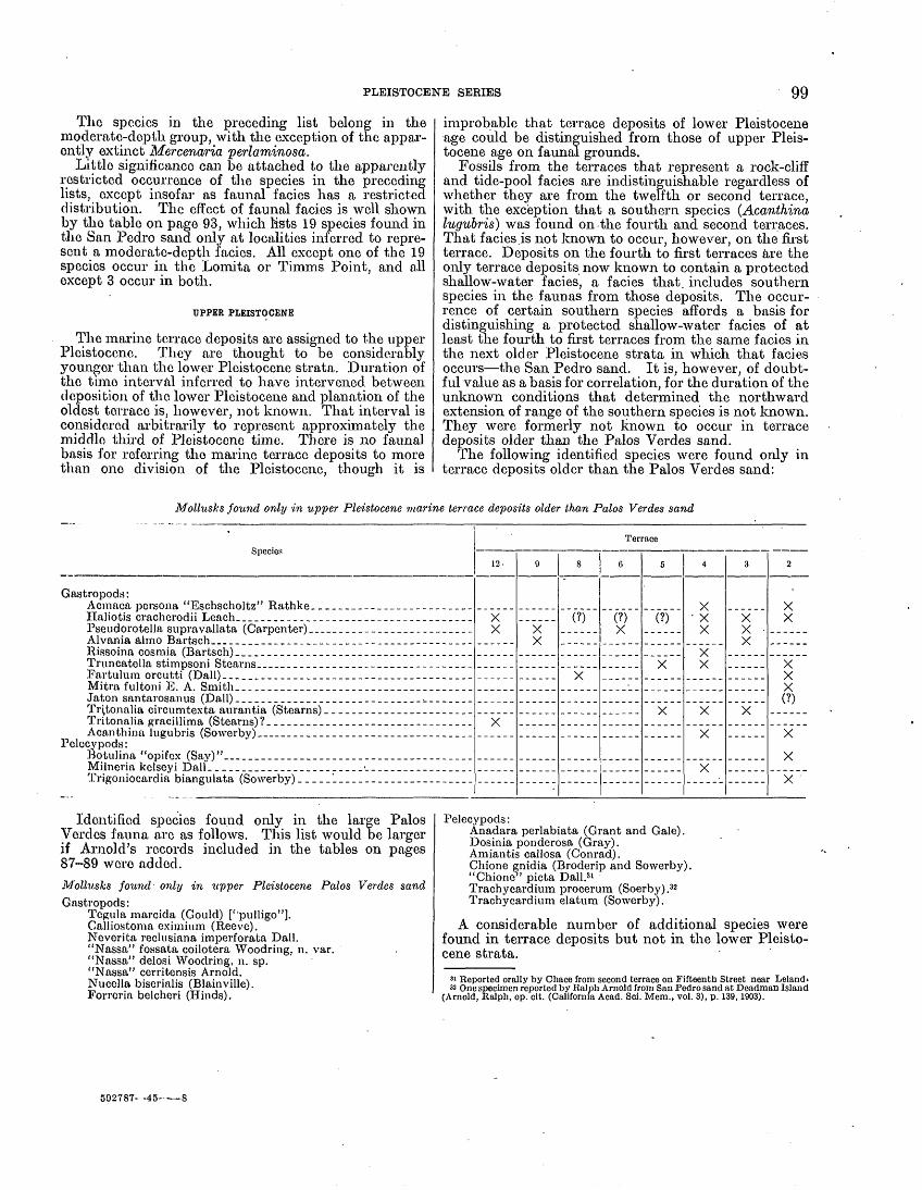
PLEISTOCENE SERIES 99
The species in the preceding list belong in the moderate-depth group, with the exception of the appar ently extinct Mercenaria perlaminosa.
Little significance can be attached to the apparently restricted occurrence of the species in the preceding lists, except insofar as faunal facies has a restricted distribution. The effect of faunal facies is well shown by the table on page 93, which lists 19 species found in the San Pcd.ro sand only at localities inferred to repre sent a moderate-depth facies. All except one of the 19 species occur in the Lomita or Timms Point, and all except 3 occur in both.
UPPER PLEISTOCENE
The marine terrace deposits are assigned to the upper Pleistocene. They are thought to be considerably younger than the lower Pleistocene strata. Duration of the time interval inferred to have intervened, between deposition of the lower Pleistocene and planation of the oldest terrace is, however, not known. That interval is considered arbitrarily to represent approximately the middle third of Pleistocene time. There is no faunal basis for referring the marine terrace deposits to more than one division of the Pleistocene, though it is
improbable that terrace deposits of lower Pleistocene age could be distinguished from those of upper Pleis tocene age on faunal grounds.
Fossils from the terraces that represent a rock-cliff and tide-pool facies are indistinguishable regardless of whether they are from the twelfth or second terrace, with the exception that a southern species (Acanthina lugubris) was found on the fourth and second terraces. That facies.is not known to occur, however, on the first terrace. Deposits on the fourth to first terraces are the only terrace deposits now known to contain a protected shallow-water facies, a facies that, includes southern species in the faunas from those deposits. The occur rence of certain southern species affords a basis for distinguishing a protected shallow-water facies of at least the fourth to first terraces from the same facies in the next older Pleistocene strata in which that facies occurs the San Pedro sand. It is, however, of doubt ful value as a basis for correlation, for the duration of the unknown conditions that determined the northward extension of range of the southern species is not known. They were formerly not known to occur in terrace deposits older than the Palos Verdes sand.
The following identified species were found only in terrace deposits older than the Palos Verdes sand:
Mollusks found only in upper Pleistocene marine terrace deposits older than Palos Verdes sand
Identified species found only in the large Palos Verdes fauna arc as follows. This list would be larger if Arnold's records included in the tables on pages 87-89 wore added.Mollusks found only in upper Pleistocene Palos Verdes sandGastropods:
Tcgula raarcida (Gould) [''pulligo"]. GalJiostoma eximium (Reeve). Neverifca reclusiana imperforata Dall. "Nassa" fossata coilotera Woodring, n. var. "Nassa" delosi Woodring, n. sp. "Nassa" cerritensis Arnold. Nucella biserialis (Blainville). Forreria belcheri (Hinds).
Species
Gastropods: Acmaca persona "Eschscholtz" Rathke. _____________ __________Haliotis cracherodii Leach___________.__ ___________ __________PseudorotelJa supra vallata (Carpenter) __ ___ _ ____ ___________Alvania almo Bartsch_____ ________ ___ ____________________Rissoina cosmia (Bartsch) _____________ _______________________Truncatella stimpsoni Stearns_-----_-__--_-_____- __ __________Fartulum orcutti (Dall) _______________________________________Mitra fultoni E. A. Smith____________________________._.______Jaton santarosanus (Dall) _____________________________^_______Tr.\tonalia circumtexta aurantia (Stearns) ____._---_-___---_-____Tritonalia gracillima (Stearns) ?_______________________________.Acanthina lugubris (Sowerby)___--------_-----------__- _.-___
Pelecypods: Botulina "opifex (Say)"_____ _______ ___________________________Milneria kelseyi Dall. _______________________ ____ _____________Trigoniocardia biangulata (Sowerby) __-_______--__-_-_---_____
Terrace
12-
X X
X
9
X X
8
(?)
X
6
(?)X
5
(?)
X
X
4
X xX
X X
X
X
X
3
X X X
X
2
X X
X X X(?)
X
X
X
Pelecypods:Anadara perlabiata (Grant and Gale). Dosinia ponderosa (Gray). Amiantis callosa (Conrad). Chione gnidia (Broderip and Sowerby). "Chione" picta Dall.31 Trachycardium procerum (Soerby).32 Trachycardium elatum (Sowerby).
A considerable number of additional species were found in terrace deposits but not in the lower Pleisto cene strata.
81 Reported orally by Chace from second terrace on Fifteenth Street near Leland« 32 One specimen reported by Ralph Arnold from San Pedro sand at Deadman Island
(Arnold, Ralph, op. cit. (California Acad. Sci. Mem., vol. 3), p. 139,1903).
592787 45-

100 GEOLOGY AND PALEONTOLOGY OF PALOS VERDES HILLS, CALIFORNIA
Mollusks found in upper Pleistocene terrace deposits, including Palos Verdes sand, but not in lower Pleistocene strata
Species
Gastropods : ' Tegula aureotincta (Forbes) _ _ . ___ _ __ ____ ___
Erato columbella Menke____ ._ _ __ __ _-_
Pelecypods : Nucula suprastriata Arnold __________ __ ____Pecten vogdesi Arnold. ___ __ ___ _________
Crassinella nuculiformis Berry _ _____ __ _.__ ____
12
X
9 8 6
X
X
X
Terrace
5
X
4
.XX
X
X
X
X
3
X
X
2
XXX
(?)
XX
--XX
XX
XX
1 (Palos Verdes sand)
XXXXXXXXXXX
XXXXX
The most distinctive species of the terrace deposits older than the Palos Verdes sand are representative of the rock-cliff and tide-pool facies. Trigoniocardia biangulata is a southern species, close to the present northern limit of its range, from the exceptional second terrace locality 105. The most characteristic Palos Verdes species are southern species either well north of their present northern limit or close to it. Pecten vogdesi, Crassinella branneri, Crassinella nuculiformis, arid Diplodonta sericata are additional southern species of the Palos Verdes found also in deposits on the fourth and second terraces at the exceptional localities 86 or 105. The Palos Verdes list includes one northern species close to the present southern limit of its range (Tegula marcida). The apparently restricted occur rence of terrace fossils, like the occurrence of the lower Pleistocene species, is evidently controlled principally by facies restriction.
GLACIAL-INTERGLACIAL ASSIGNMENTS
If the strata in the San Pedra district are Pleistocene, they are presumably synchronous with Pleistocene
glacial and interglacial stages. There is, of course, no direct evidence of synchroneity, for Pleistocene glaciation is not certainly recognized in southern Cali fornia below altitudes of about 10,000 feet. Eaton's views 33 represent those of geologists who assign glacia tion to the upper Pleistocene and, therefore, consider the lower Pleistocene marine strata preglacial. In the present report Pleistocene time is accepted by definition as beginning with the advance of the first continental ice sheet and ending with the withdrawal of the last, an admittedly unsatisfactory definition for the Coast Range marine section.
The occurrence of northern species, particularly in the Timms Point silt, and of southern species, particu larly in the Palos Verdes sand, has stimulated considera tion of temperature facies and glacial-interglacial assignments. Opinions are summarized in tabular form as follows:
33 Eaton, 'J. E., Divisions and duration of the Pleistocene in southern California: Am. Assoc. Petroleum Geologists Bull., vol. 12, pp. 132-133, 1928.
Estimated temperature facies and glacial-interglacial assignments of Pleistocene strata of San Pedro district
Pleistocene unit
Palos Verdes sand..
San Pedro sand ....\
Timms Point silt
Lomita marl. ......
Arnold, 1903 »
As warm as atpresent timeor warmer.
Cold-water, transitional fromearlier northern.
Assigned to upper Pliocene.Decidedlynorthern orboreal.
Smith, 1919 2
Temperature about 66° F.,about 4° higher than atpresent. Probably inter-glacial.
Temperature probablyabout same as that ofPuget Sound, 50° F.Probably corresponds totime of maximum galcia-tion.
Assigned to upper Pliocene.Temperature probablyabout same as that of Puget Sound, 50° F.
Hay, 1927 3
Aftonian interglacial stage.
Nebraskan glacialstage.
Glacial period wasapproaching.
Crickmay, 1929 *"
Only about 5 percent of speciesin Arnold's upper San Perdoof Deadman Island areautochthonous, and theyindicate a temperature likethat of San Pedro at present.
Arnold's lower San Pedro ofDeadman Island representsclimate as warm as that ofSan Pedro at present orslightly warmer. Cold-water species derived fromolder strata.
6 zones of different temperature facies only 1 of which,zone 5, is decidedly cold-water and doubtless represents a glacial stage.
Gale, 1931 s
Later part of thirdinterglacial stage(Sangamon).
Early part of secondinterglacial stage(Yarmouth).
Second glacial stage(Kansan).
First interglacialstage (Aftonian),assigned to LasPosas zone.
Grant, 1937 «
Mean annual sea surfacetemperature about 63°F. Present mean annual sea surface temperature at San Pedro61° F.
Temperature fluctuating,possibly 50° to 60° F.
Mean annual water temperature possibly 50°to 52° F.
Temperature about 60°to 62° F.
1 Arnold, Ralph, California Acad. Sci. Mem., vol. 3, pp. 16, 20, 29, 1903.2 Smith, J. P., California Acad. Sci. Proc., 4th ser., vol. 9, pp. 136-137, 151, pi. 9,
1919.3 Hay, 0. P., Carnegie Inst. Washington Pub. 322B, pp. 166-173,1927. < Crickmay, C. H., Jour. Geology, vol. 37, pp. 622-632, 1929.
« Grant, U. S., IV, and Gale, H. R., San Diego Soc. Nat. History Mem., vol. 1, pp. 71-74, table 3 (p 75), 1931.
6 Grant, U. S., Am. Assoc. Petroleum Geologists, Program 22d Ann. Meeting, pp. 69, 71,1937.

PLEISTOCENE SERIES 401
It is apparent from the preceding table that opinions concerning the temperature facies vary widely. The writers cited agree, however, that the Timms Point fauna represents cool water, or at least includes a cool-water zone, and is doubtless glacial, and most of them agree that the Palos Verdes fauna represents warm water and is doubtless interglacial. Assignment to definite glacial and interglacial stages is so speculative that it is not considered further.
That interpretation of the temperature facies is not a, simple matter is evident from the varying opinions. If the Timms Point fauna and San Pedro sand fauna represented a southward displacement of the isotherms of 1,500 miles and the Palos Verdes fauna represented a northward displacement of about 650 miles, as Smith thought, there would be no argument about the matter. It is quite clear that the faunas of the Timms Point and the San. Podro are not Puget Sound faunas and that the Palos Verdes fauna is not a Magdalena Bay fauna, despite the presence of species now riving in those areas and not at San Pedro. All the faunas considered by the writers cited contain both northern and southern species. Most of the writers who have considered the matter relied on the preponderance of one group and ignored the other. Crickmay 3V who. protested justly against such treatment, thought the problem could be resolved to at least a certain extent by careful zoning and discrimination of detrital (derived) fossils and fossils that lived at the time the sediments were deposited (autochthonous). Detrital fossils are expectable particularly in the Palos .Verdes sand, which in extensive areas bevels fossiliferous lower Pleistocene strata. Before Deadman Island was destroyed the Pleistocene strata exposed there yielded fossils that were buried in sediments accumulating off shore. Many San Pedro extra-limital records of Recent mollusks are based doubtless on these detrital fossils. Crickmay's criteria for the recognition of detrital fossils are, however, of doubtful value. Should broken and worn specimens be represented in a collection of otherwise well-preserved specimens, the broken and worn specimens may very well be detrital. Unequivocal examples of such occurrence are not recognized in the collections at hand. Crickmay's opinion 35 that 95 percent of the species in the sand and gravel of the Palos Verdes at Deadman Island are detrital because they are represented by wave-worn or broken specimens is considered erroneous. A large proportion of specimens that occur in gravel are cer tain to be worn and broken regardless of whether they are detrital or not. His opinion 30 that all the speci mens of Cerastoderma nuttallii ["Cardium corbis"] in the Timms Point silt and San Pedro sand of Deadman Island arc detrital and derived probably from a hypo thetical cold-water zone does not take into considera tion the corroding of Cerastoderma shells, which is due presumably to peculiarities of shell structure. Fossil Cerastodermae are generally corroded. Nevertheless the uncorroded and perfectly fresh specimen of the essentially northern Cerastoderma, nuttallii shown on plate 34, figures 16 and 17 was collected from the San Pedro sand at Deadman Island in association with the equally well-preserved specimen of the essentially southern Trachycardium quadragenarium shown in figures 18 and 19 on the same plate.
84 Crickmay, C. H., The anomalous stratigraphy of Deadman's Island, Calif.: Jour. Geology, vol. 37, pp. 618-621.
« Idem, p. 632. 8« Idem, p. 630.
A ready solution of the problem of the occurrence of northern and southern species in the same strata is not apparent. Consideration of the following subjects may, however, aid in reaching a solution. It will be observed that none of the writers cited considered the terrace faunas older than the Palos Verdes sand, as those faunas were unknown to them.
FAUNA! FACIES
Comparison of the same faunal facies is an essential requirement for interpretation of temperature facies in terms of latitude. Several faunal facies are repre sented in the Pleistocene strata. A shallow-water facies is recognized in the Lomita marl, San Pedro sand, and Palos Verdes sand. A particular type of shallow- water facies (rock-cliff and tide-pool) is recognized in terrace deposits older than the Palps Verdes sand. The shallow-water facies of the Lomita marl contains an apparently extinct oyster (0. megodon cerrosensis] closely related to a Recent southern species. The shallow-water faunas in the San Pedro sand and in the Palos Verdes sand are so similar that there is some doubt about the age assignments. Nevertheless they have been discriminated, whether correctly or not, by the presence of southern species in the Palos Verdes sand and their absence in the San Pedro sand. The rock- cliff and tide-pool facies of the twelfth to fifth terraces, inclusive, contains no species entirely beyond its present range but includes northern and southern species close to the limits of their range. The same facies on the fourth to second terraces, inclusive, includes northern and southern species of both groups.
A moderate-depth facies is thought to characterize much of the Lomita marl and Timms Point silt and also the San Pedro sand at a few localities. The cool- water aspect of the Timms Point fauna and locally of the faunas of the Lomita and San Pedro is attributed in large measure to this depth facies. The Timms Point silt contains Puget Sound species, but many Timms Point species do not range as far north as Puget Sound, and others are not found in shallow water hi Puget Sound.
MIXED FAUNA! FACIES
Most fossil assemblages, at least most large Tertiary and Pleistocene marine assemblages, represent death associations, not life associations. Though it is fre quently difficult or impossible to recognize members of different life associations in a mixed fossil assemblage, some aspects of this matter deserve consideration.
The shallow-water Olivella biplicata and Conus californicus are represented in Timms Point collections. The. specimens are, however, worn and broken. Inas much as shallow-water to moderate-depth and moder ate-depth species in the same collections also are represented by some broken or worn specimens, the evidence is inconclusive that the shallow-water species did not live with the others.
The rock-cliff and tide-pool facies of terrace faunas older than the Palos Verdes sand includes species that live below low-tide line in the latitude of-San Pedro. For that reason Berry 37 thought that the chiton fauna from the Chaces' locality on the second terrace near Point Fermin is like that living along the shore of Monterey and San Luis Obispo Counties farther north. The Chaces 38> thought, .however, that the species of mollusks now living below low-tide line were carried in by storm waves and mixed with tide-pool species.
a' Berry, S. S., op. cit. (California Acad. Sci. Proc., 4th ser., vol. 11), p. 409,1922. ss Chace, E. P., and E. M., op. cit. (Lorquinia, vol. 2, No. 6), p. 43,1919.

102 GEOLOGY AND PALEONTOLOGY OF PALOS VERDES HILLS, CALIFORNIA
That explanation is preferred to Berry's interpretation. The fauna from the fourth terrace at locality 86 and that from the second terrace at locality 105 represent mixed rock-cliff and tide-pool and off-shore shallow- water associations with the probable addition of some moderate-depth species at locality 105. This mixture is attributed to storm-wave and along-shore current transportation. The off-shore shallow-water species include southern species found also in the Palos Verdes sand. The unusual Palos Verdes fossils from localities 107 and 108 (Arnold's Crawfish George's locality) may represent a mixed shallow-water and moderate-depth association. Inasmuch as these localities faced the open ocean during Palos Verdes tune whereas the localities containing the usual Palos Verdes association faced the strait separating the- island from the mainland, it has been suggested that the northern and moderate-depth species from localities 107 and 108 were transported into shallow-water by storm waves.39 Mollusks that live below low-tide line are washed up frequently on beaches during storms. The usual finds represent species that live just below low-tide line or at depths of a few fathoms. Species that are not known to live at depths of less than 10 fathoms are also found rarely after storms. They represent evidently unusual occurrences, such as those found clinging to the holdfast of long kelp stalks. Jaton santarosanus, which has been dredged at depths of 16 and 82 fathoms but is not known to live at shallower depths, is reported to have been found on kelp washed in by storm waves. That species is repre sented probably by an imperfect specimen from the second terrace at locality 105. Storm transportation could not account, however, for the occurrence at locality 108 of Fusitriton oregonensis and Exilioidea rectirostris, the present known minimum depth of which at the latitude of San Pedro is 80 fathoms, unless these species lived at shallower depth during Pleistocene time. Contrary to expectation on the hypothesis of storm transportation, markedly northern and intermediate- depth forms have not been found in terrace deposits on the exposed south and west coasts. The unusual species from localities 107 and 108 may be detrital fossils derived from the lower Pleistocene strata in which they are known to occur. Nevertheless, in physical condition they are indistinguishable from other species collected at those localities. If they are detrital, they are expect able in greater abundance at localities farther north where the Palos Verdes sand rests on lower Pleistocene strata. A specimen of Boreotrophon pedroanus from locality 121 is the only representative of the northern and moderate-depth group in the Palos Verdes of that area. Arnold 40 realized that the fauna from his Crawfish George's locality is exceptional, but he did not discuss its unusual features. Owing to the unusual faunal association, the deposits at that locality have been referred to the Timms Point silt 41 and San Pedro sand. 42
EFFECTS OF CHANGES IN OUTLINE OF COAST
The Pleistocene elephants found on the Channel Islands,43 off the coast northwest of the Palos Verdes Hills, indicate that during a still undetermined part
" Woodring, W. P., op. cit. (Am. Jour. Sci., 5th ser., vol. 29), p. 304, 1935.40 Arnold, Ralph, The paleontology and stratigraphy of the marine Pliocene and
Pleistocene of San Pedro, Calif.: California Acad. Sci. Mem., vol. 3, p. 26,1903.« Ashley, O. H., The Neocene stratigraphy of the Santa Cruz Mountains of Cal
ifornia: California Acad. Sci. Proc., 2d ser., vol. 5, p. 341,1895.42 Berry, S. S., op. cit. (California Acad. Sci. Proc., 4th ser., vol. 11), p. 411, 192243 Stock, Chester, Exiled elephants on the Channel Islands, Calif.: Sci. Monthly,
vol. 41, pp. 205-214, 10 figs., 1935.
of Pleistocene tune these islands were joined 'to the present western terminus of the Santa Monica Moun tains. During early Pleistocene time northern species, such as Patinopecten caurinus, had a range extending southward at least to the San Pedro district. If the peninsula came into existence after the lower Pleisto cene strata were deposited, the northern species may have become extinct locally owing to changes in oceanic circulation and then were not reestablished in the area of local extinction after disappearance of the peninsula.
The. peninsula would protect coastal-water to the south from southward-drifting cold water, as has been suggested by Gale.44 A land mass farther south a relic of ancient Catalinia joining the islands of Cata- lina, Santa Barbara, San Nicolas, and San Clemente also would have an effect in providing a suitable habitat for the markedly southern species characteristic of the Palos Verdes Hills. Land areas off the coast of southern California are, however, probably not later than middle Pleistocene, for marine terraces on the Channel Islands and on the islands farther south, except Catalina, show partial or complete submergence, presumably during late Pleistocene time. At all events Santa Monica is the northernmost known locality for the occurrence of southern species characteristic of the Palos Verdes sand, indicating that the inferred penin sula was in existence during late Pleistocene time and that it had a profound effect on the distribution of marine animals.
EFFECTS OF LOCAL TEMPORARY CHANGES IN OCEAN TEMPERATURE
The occurrence of northern or of southern species in strata characterized by the preponderance of species of the other group may be due to local changes in ocean temperature caused by, temporary changes in oceanic circulation. Local fluctuations of this character re sult in the distribution of marine animals but not of breeding communities beyond their normal range, particularly in temperate regions. The reported occur- ence of the southern 'Anadara multicostata in Balboa Bay, almost 100 miles north of its usual northern limit, may be an example of a temporary extension of range.
POSSIBLE CHANGES IN GEOGRAPHIC AND DEPTH RANGE SINCE PLEISTOCENETIME
Perhaps paleontologists are mistaken in attempting to interpret these Pleistocene faunas in terms of the present geographic range of the species still living and of closely related Recent forms. If it' be assumed that the range of some species has changed since Pleistocene time owing to changes in physiological characters not correlated with changes in available morphological characters, difficulties would vanish. That this matter is not entirely speculative is indicated by the occurrence in the Pliocene strata at Elsmere Canyon of a form of the circumboreal Mya truncata,*5 a northern species characteristic of the Timms Point silt. At Elsmere Canyon it is associated with the essentially northern Fusitriton oregonensis and with Lyropecten and other forms considered of warm-water aspect. Changes in depth range may also have taken place since Pleistocene time. Extensive changes of that character would in validate conclusions based on present depth range. It is improbable, however, that changes in either geo-
44 Grant, U. S., IV, and Gale, H. R., Catalogue of the marine Pliocene and Pleisto cene Mollusca of California: San Diego'Soc. Nat. History Mem., vol. 1, pp. 39, G4,1931
45 Arnold, Ralph, New and characteristic species of fossil mollusks from the oil bearing Tertiary formations of southern California: U. S. Nat. Mus. Proc., vol. 32 p. 527, pi. 50, fig, 1, 1907.

PLEISTOCENE SERIES 103
graphic or depth range have taken place in many of the species of a large fauna like that of the Timms Point silt and the moderate-depth facies of the Lomita marl.
INTERPRETATION OF TEMPERATURE FACIES IN TERMS OF POSSIBLE GLACIAL AND INTEROLACIAL ASSIGNMENTS
In summary it may be said that interpretation of the temperature facies in terms of possible glacial and inter- glacial assignments is so complicated by other possible factors that assignments are questionable. It is not unreasonable to expect faunal changes in the San Pedro district due to glaciation and deglaciation, even though it is 1,500 miles south of the southern limit of sea-level Pleistocene glaciers. Faunal stratification in the sedi ments of areas as far from glaciated regions as the equatorial Atlantic is interpreted in terms of inter- glacial, glacial, and post-glacial succession. 48 The occurrence in Pleistocene strata at Tom.ales Bay, im mediately .north of San Francisco Bay, of species north of their present range, including Chione undatella and Tr achy car dium quadragenarium," suggests an intergla- cial fauna. The shallow water faunas of the Lomita iriarl, San Pedro sand, deposits on the fourth to second terrace, inclusive, and the Palos Verdes sand may be interglacial despite apparently conflicting evidence. The Timms Point fauna can hardly be interpreted as a shallow-water glacial fauna; it may be a moderate- depth glacial or interglacial fauna. The faunas from the twelfth to fifth terraces, inclusive, might be con sidered interglacial. Inasmuch, however, as they do not include a southern species (Acanthina lugubris) found in the same facies on the fourth and second ter races they might be interpreted as glacial. A shallow- water northern fauna of the character expectable during a glacial stage is not recognized in the entire succession of 12 Pleistocene faunas.
Perhaps the importance of the moderate-depth, association has been overemphasized in the present report because it was undervaluated previously in interpretations of the Pleistocene faunas of the San Pedro district. Some writers have briefly discussed this matter. Crickmay 48 considered the possibility that at least parts of the Timms Point silt represent moderate depths. He thought his zone 3 may have been deposited in water between 50 and 100 fathoms deep and that his zone 4 suggests a depth of 100 fathoms or perhaps more estimates agreeing closely with those for the entire Timms Point silt in the present report. According to Reed,49 most of the Lomita Foraminifera indicate a depth of 50 to 100 fathoms. Grant 60 thought the Lomita fauna indicates a depth of possibly 100 to 300 feet (approximately 15 to 50 fathoms). A marked feature of the Lomita and Timms Point faunas and locally of the San Pedro is the occurrence of species or closely related forms known only from Albatross dreclgings at depths of 67 to 81 fathoms off Point Loma near San Diego (Puncturella delosi, Solariella rhyssa, Homalopoma subobsoletum) and of species from Alba tross dredgings at depths of 55 to 110 fathoms in the same area and 48 to 155 fathoms off the California
«> Schott, \V., DieForaminiferon indem equatorialen Teil des Atlantischen Ozeans: Doutsohen Atlantischen Exped. Meteor, 1925-27, Wiss. Ergebnisse, vol. 3, pt. 3, pp. 1'20- 130.1935.
«' Dlckorson, 11. E.. Tertiary and Quaternary history of the Petaluma, Point Reyes, and Santa Rosa Quadrangles: California Acad. Sci. Proc., 4th ser., vol. 11, pp. 559-570, 1922. 'Mason, H. L., Pleistocene floras of the Tomales formation: Carnegie Inst. AVashington Pub. 415, pp. 85-87,104-105, tables op p. 104,1934.
« Crickmay. C. H., op. cit., pp. 624, 626.<» Reed, R. D., Geology of California, p. 259, Am. Assoc. Petroleum Geologists,
Tulsa, Okla., 1933.«° Grant, U. S., Some observations on the Pleistocene of the Los Angeles region
(abstract): Am. Assoc. Petroleum Geologists, Program 22d Ann. Meeting, p. 71,1937.
islands (Crepipatella charybdis, Acteon breviculus}. These species were formerly thought to be no longer living or were not known heretofore as fossils.
Owing to the tradition of temperature facies result ing from Arnold's and Smith's pioneer work, when only the strata and fossils along the San Pedro water front were known, inferred temperature facies has been and still is used for age assignments. That errors may arise from such assignments is evident from Berry's assign ment of deposits on the second terrace at Point Fermin and the Palos Verdes sand at Arnold's Crawfish George's locality to the San Pedro sand, though they are rela tively speaking much younger than the San Pedro sand. It is unlikely that during the brief period of time repre sented by a terrace deposit different marine inverte brate faunas corresponding to those now living in the same environment at different latitudes were repre sented at different localities in the San Pedro district. Latitude interpretation in terms of the rigid application of present geographic range proposed by Schenck-and Keen 51 is unsuitable for an interpretation of the Pleisto cene faunas of the San Pedro district, as it fails, to take into consideration depth range, which can be evaluated within the limits of present knowledge, and possible changes in geographic and depth range since Pleistocene time, which cannot be evaluated.
CORRELATION WITH OTHER AREAS
LOWER PLEISTOCENE
Los Angeles Basin subsurface section. Pleistocene strata in the Los Angeles Basin have a variable thick ness ranging from a few hundred to perhaps 1,800 feet: Wissler 52 subdivided the Pleistocene section of the basin oil fields into two parts, designated lower Pleisto cene and upper Pleistocene. The lower Pleistocene strata were correlated with the Lomita marl, Timms Point silt, and San Pedro sand; the upper Pleistocene, differentiated principally on the basis of a lignitic zone at the base, were thought to include the equivalent of the Palos Verdes sand. Synclinal areas in the basin contain probably not only the equivalent of the thin marginal deposits of the Palos Verdes Hills, including strata deposited during the plantation of the numerous marine terraces of the Palos Verdes Hills, but also a complete Pleistocene record. In such areas differentia tion of the main Pleistocene divisions represented in the Palos Verdes Hills would be difficult, if not impossible.
The Pleistocene sea evidently covered most, or perhaps all, of the Los Angeles Basin. In a recent discussion of ground water in the basin, Morse 5a mentioned marine Pleistocene strata at outcrop locali ties in the Coyote Hills and at subsurface localities, near Santa Ana, and. near Bell that is, at localities- near the eastern and northern borders of the basin. Some of the localities are designated as Arnold's lower San Pedro, Others as Arnold's upper San Pedro, and still others as either. It may be pointed out that undoubted faunal differentiation of Arnold's two divi sions, corresponding to the San Pedro sand and Palos Verdes sand of the present report, is impossible unless^ southern species characteristic of the Palos Verdes are
81 Schenck, H. G., and Keen, A. M., An index method for comparing molluscani faunas: Am. Philos. Soc. Proc., vol. 77, pp. 161-166, 1937.
42 Wissler, S. G., Stratigraphic formations [relations] of the producing zones of the Los Angeles Basin oil fields:-California Div. Mines Bull. 118, pt. 2, pp. 210 (table). 211-212, 1941.
w Morse, R. R., The nature and significance of certain variations in composition, of Los Angeles Basin groundwaters: Econ. Geology, vol. 38, pp. 478-479 (footnote),. 1943.

104 GEOLOGY AND PALEONTOLOGY OF PALOS VERDES HILLS, CALIFORNIA
represented, and the probability of finding one or more of these few southern species in a small collection of fossils from cores or ditch samples is remote.
Signal Hill. Sand, gravel, and silt underlying strata correlated with the Palos Verdes sand at Sig nal Hill, near Long Beach, have recently been found to be fossiliferous and are correlated with the San Pedro sand. 54
Santa Monica. Pleistocene mollusks, mostly of moderate-depth facies, occur in deformed strata at localities near Santa Monica. 55 The faunal association suggests the Lomita and Timms Point and also parts of the San Pedro sand.
Ventura Basin. An exceptionally thick continuous and uniformly deformed section of 20,000 feet of marine Pliocene and Pleistocene strata is represented in the western part of the Ventura Basin. The part of this .section assigned to the Pleistocene is about 6,000 feet thick and overlies .Angara-bearing upper Pliocene. Various names have been proposed or used for the Pleistocene strata: Santa Barbara formation or Santa Barbara horizon, upper part of Pico formation, Saugus formation, San Pedro formation, Baton's Hall Canyon formation, Pressler's Las Posas formation and Kalorama member, and his Long Canyon horizon. Lists of fossils have been published by Arnold, 56 Eaton,57 Waterfall, 58 and Pressler, 59 and selected species were mentioned by Bailey. 60 According to Bailey's description, 61 the lower part of the Pleistocene strata assigned by him to the Santa Barbara formation, Waterfall's upper Pico, and Pres sler's Santa Barbara horizon and his Kalorama member of his Las Posas formation is 2,900 to 3,500 feet thick and consists principally of muds tone and shale. Locally, lenses of sand and gravel or sandstone and conglomerate are at the base and at higher horizons. The lower part of the section contains northern and moderate-depth species, including Patinopecten caurinus, Thracia trape- zoides, and Pandora glacialis, the first two of which occur in the Lomita marl and Timms Point silt. In view of the recent rinding of sand and gravel at considerable depths off the California coast, the occurrence of these species locally in sandy and pebbly strata cannot be regarded-as conclusive evidence of shallow-water deposition.62 The upper part of the section assigned by Bailey 63 to the San Pedro formation, Kew's and Waterfall's Saugus, Baton's San Pedro and Hall Canyon formations, and Pressler's Las Posas formation and his Long Canyon horizon is 3,000 to 3,500 feet thick and consists principally of coarse-grained sand and gravel, or sand stone and conglomerate, with some sandy silt, silty clay, and clay. It contains a shallow-water fauna essentially like that of the shallow-water facies of the San Pedro sand. Bailey 64 found that toward the north and north east, around' the plunging axis of the Ventura anticline and Ventura syncline, a tongue of sandstone 300 feet
M DeLong, J. H. Jr.,The paleonotolgy and stratigraphy of the Pleistocene at Signal Hill, Long Beach, Calif.: San Diego Soc. Nat. History Trans., vol. 9, No. 25, pp. 229-252, 4 figs., 1941.
" Arnold, Ralph, op. cit. (Calif. Acad. Sci. Mem., vol. 3), p. 56. Hoots, H. W., Geology of the eastern part of the Santa Monica Mountains, Los Angeles County. Calif.: U. S. Oeol. Survey Prof. Paper 165, p. 120,1931.
«6 Arnold, Ralph, op. cit., p. 55.87 Eaton, J. E., Divisions and duration of the Pleistocene in southern California:
Am. Assoc. Petroleum Geologists Bull., vol. 12, pp. 126-129, 1928.58 Waterfall, L. N.. A contribution to the paleontology of the Fernando group,
Ventura County, Calif.: California Univ., Dept. Geol. Sci., Bull., vol. 18, table op. p. 78, 1929.
" Pressler, E. D., The Fernando group of the Las Posas-South Mountain district, Ventura County, Calif.: idem, pp. 336-338,1929.
6(1 Bailey. T. L., Lateral change of fauna in the lower Pleistocene: Geol. Soc. Am. Bull., vol. 46, pp. 495-497, 1935.
.el .Bailey, T. L., op. cit., pp. 492-494.62 Bailey, T. L., op. cit., p. 494.«' Bailey, T. L., op. cit., pp. 490-492.«4 Bailey, T. L., op. cit., pp. 494-497.
below the top of his Santa Barbara formation and another tongue of sandstone and conglomerate 550 feet lower contain fossils characteristic of his San Pedro formation. The close correlation between lithology and faunas shows as conclusively as* such matters can be shown that the faunas represent different environmental associations, and it is reasonably certain that they represent different depth associations, as Bailey 65 thought.
The 6,000-foot section in the western part of the Ventura Basin is considered the essential equivalent of 'the lower Pleistocene formations of the San Pedro district, but it includes probably younger strata. As in the San Pedro district, a moderate-depth facies is prevalent in the lower part of the section and a shallow- water facies in the upper part. Also as in the San Pedro district, the two facies interfinger. Arnold 68 correlated fossiliferous strata in the shallow-water facies of the Ventura Basin with the Palos Verdes sand. Baton's objection 87 to that correlation on stratigraphic and physiographic grounds is justified. The absence of southern species characteristic of the Palos Verdes sand cannot be regarded as an objection to Arnold's correlation, as they are unknown also in younger marine terrace deposits that on stratigraphic and physiographic grounds are the probable equivalent of the Palos Verdes sand.
In the Las Posas Hills, on the south border of the basin, lower Pleistocene strata unconformably overlap the Sespe formation, indicating events similar to those in the Palos Verdes Hills, where lower Pleistocene deposits unconformably lap onto different parts of the Miocene.
Santa Barbara and Rincon Point. Santa Barbara and Rincon Point, between Santa Barbara and Ven tura, are located along the north border of the Ventura Basin. At both localities the Santa Barbara forma tion unconformably overlaps formations older than Pliocene (Monterey shale or Sespe formation). Incom plete lists of fossils from Santa Barbara, the type locality of the Santa Barbara formation, have been published by Arnold. 68 At both localities 69 the for mation may be divided into a lower Pecten bellus zone and an upper Patinopecten caurinus zone. The lower zone indicates a shallow-water facies, the, upper zone a moderate-depth facies, that is, the age relations of the two facies are the opposite of those near Ventura and in the San Pedro district. Santa Barbara is the type locality of many species found in the lower Pleis tocene strata of the San Pedro district, notably Tere- bratalia hemphilli, Pnncturella delosi, Bittium rugatum, Bittium armillatum, Bittium asperum, Crepidula prin- ceps, Barbarqfusus barbarensis, Callicantharus Jortis (type locality inland from Santa Barbara), Admete gracilior, Cyclocardia occidentalis, and Mercenaria perla- minosa. These species occur in the Lomita marl or Timms Point silt, or both; some occur also in the San Pedro sand. Pecten bellus, based on material from Santa Barbara, is not represented in the collections at hand but is reported from the Lomita marl. 70 The Santa Barbara formation is considered the essential equivalent of the lower Pleistocene strata of the San
65 Bailey, T. L.. OD. cit., pp. 496, 499.8« Arnold, Ralph, op. cit., p. 54.« Eaton, J. E., op. cit.. p. 124.68 Arnold, Ralph, op. cit., p. 52. Geology and oil resources of the Summerland
district, Santa Barbara County, Calif.: U. S. Geol. Survey Bull. 321, p. 32, 1907.For a recent discussion of the Santa Barbara formation see Keen, A. M., and
Bentson, Herdis, Check list of California Tertiary marine Mollusca: Geol. Soc. Am., Special Paper 56, pp. 11-15,1944.
8«Bailey, T. L., op. cit., p. 494."Grant, U. S., op. cit., p. 71.

PLEISTOCENE SERIES 105
Pedro district. The close faunal similarity between the Patinopecten caurinus zone and the Lomita, Timms Point, and moderate-depth facies of the San Pedro is doubtless an expression of a similar moderate-depth facies. The Santa Barbara formation is generally assigned to the upper Pliocene, or the. lower part to the upper Pliocene and the upper part to the lower Pleistocene.
San Francisco 'Peninsula. The upper part of the Merced formation of the San Francisco Peninsula 71 is generally considered of Pleistocene age. The fauna is perhaps too small for a satisfactory comparison with the Pliocene .Anarfara-bearing main part of the Merced or for a comparison with the Pleistocene faunas of the San Pedro district.
UPPER PLEISTOCENE
Marino terraces along the California coast are with little doubt the equivalent of terraces in the Palos Vordos Hills assigned to the upper Pleistocene. Simi larity in physiographic history may furnish a basis for correlation. Faunal data are likely to be inconclusive. Terrace deposits containing southern species were for merly and quite naturally correlated with the Palos Verdos sand. At least some of the southern species characteristic of the Palos Verdes sand are now known to have been living in the San Pedro district as early as the time when the fourth terrace was formed. Whether they wore living still earlier in this district is not known now, as a suitable faunal facies has not been found on torraoos older than the fourth. The absence of southern species in the rock-cliff and tide-pool facies on terraces older than the fourth and the presence of a southern species (Acanthina lugubris) in that facies on the fourth and second terraces suggest, however, that the time when southern species lived in this district may have begun when the fourth terrace was formed.
San Diego and nearby localities. Pleistocene terrace fossils from San Diego and nearby localities have been listed and discussed by Arnold, 72 Berry, 73 Stephens, 74 and Webb. 76 Arnold's and Stephens' lists include southern species characteristic of the Palos Verdes sand ("Nassa" cerritensis, Crassinella branneri, Diplodonta sericata, Dosinia ponderosa, and Trachycardium procerum), and Arnold pointed out the faunal similarity. Webb listed 102 species from localities on the windward (western) side of Point Loma, which was an island 78 at the time when the terrace was formed. The Point Loma fossils arc characteristic of a rock-cliff and tide- pool facios, but the fauna is somewhat larger than that in the same facios in the Palos Verdes Hills. As in the Palos Verdos Hills, the fossils include off-shore species, suggested by Webb to have been washed in, and one locally extinct northern species (Tegula montereyi), found on the fifth to first terraces in the Palos Verdes Hills. A southern species (Acanthina lugubris) is listed by Berry from a Point Loma locality. None of the southern species listed by Arnold and Stephens are represented in the Point Loma collections, though the deposits are presumably of the same age. The southern species arc, however, from localities on the leeward
'i For the latest list of fossils see Martin/Bruce, The Pliocene of middle and north ern California: California Univ. Dept. Qeol. Bull., vol. 9, pp. 229-230,1916.
" Arnold, Ralph, op. cit. (Calif. Acad. Sci. Mem., vol. 3), pp. 58-64." Berry, S. S., Fossil cliitous of western North America: California Acad. Sci. Proc.,
4th sor., vol. 11, p. 413,1922.74 Stephens. Frank, Notes on the marine Pleistocene deposits of San Diego County,
Calif.: San Diego Soc. Nat. History Trans., vol. 5, No. 16, pp. 245-250,1 flg.. 1929.M Wobb, 11. W., Paleontology of the Pleistocene of Point Loma, San Diego County,
Calif.: Idem, vol. 8. No. 24, pp. 337-348,1937.'* Stephens, Frank, op. cit., flg. 1.
side of the Pleistocene Point Loma island 77 and represent a different facies.
Capistrano Beach. Willett 78 listed and discussed recently 153 species of Pleistocene mollusks from Cap istrano Beach, between San Diego and Long Beach. He estimated that the fossiliferous strata were deposited in shallow water at a depth of probably less than 5 fathoms. Owing to the presence of a few species not living hi shallow water in this latitude at the present time, he thought that the water was colder than it now is. The fossils may, however, represent a mixed asso ciation. It is not clear from Willett's description whether the fossiliferous strata are terrace deposits, but they presumably are. If they are terrace deposits, his suggestion that they are of San Pedro age may need reconsideration.
Los Angeles Basin subsurface section. Upper Pleisto cene strata in the Los Angeles Basin subsurface section are mentioned under the heading "Lower Pleistocene."
Signal Hill. Arnold 79 described 160 species of mol lusks from Pleistocene strata on Signal Hill, or Los Cerritos, near Long Beach, and the stratigraphy and paleontology of that area have been discussed recently by De Long.80 The fossils described by Arnold and listed by De Long include southern species characteris tic of the Palos Verdes sand "Nassa" cerritensis, Crassinella branneri, Dosinia ponderosa, Chione gnidia, Trachycardium procerum, and Trachycardium elatum Signal Hill being the type locality of the first two spe cies mentioned. The abundance of Amiantis callosa also suggests the Palos Verdes sand. Arnold correlated these strata with the Palos Verdes, and that correlation has been repeated by De Long. Eaton,81 not realizing that the Palos Verdes sand is mildly or moderately de formed along the north border of the Palos Verdes Hills, objected to the correlation on the grounds that the strata on Signal Hill are deformed and was inclined to assign them to the lower Pleistocene. On physio graphic, stratigraphic, and faunal grounds the strata at Signal Hill and the Palos Verdes sand are essential equivalents. The Palos Verdes sand and overlying nonmarine terrace deposits dip down to the level of the Los Angeles Plain at the north border of the Palos Ver des Hills, and the strata at Signal Hill have a similar physiographic position. Whether the fossiliferous strata in the two areas are exactly, synchronous is uncertain, for several terraces may have been formed in the rapidly emerging Palos Verdes Hills area while one terrace was forming in the Newport-Long Beach area. Correla tions of individual Pleistocene terrace deposits would represent a far greater refinement than, ordinary Qoast Range correlations a refinement that may never be attained by ordinary methods,
Play a DelRey. In a recent publication 82 Willett listed and discussed a large and interesting fauna of 296 species of Pleistocene mollusks from a locality on Lin coln Avenue, two miles northeast of Playa Del Hey. The fossils include the following southern species found in the Palos Verdes sand or on the second and fourth terraces: Mitra jultoni, "Nassa" cerritensis, Centrifuga keana, Nucella biserialis, Forreria belcheri, Pecten vogdesi, Crassinella branneri, Crassinella nuculiformis
" Webb, E. W., op. cit., p. 341.'5 Willett, George, Report on Pleistocene molluscan fauna at Capistrano Beach,
Orange County, Calif.: Southern California Acad. Sci. Bull., vol. 36, pp. 105-107,1938." Arnold, Ralph, op. cit., pp. 30-32.so De Long, J. J. Jr., op. cit.«' Eaton, J. E., op. cit., p. 135.« Willett, George, An upper Pleistocene fauna from the Baldwin Hills, Los Angeles
County, Calif.: San Diego Soc. Nat. History Trans., vol. 8, No. 30, pp. 379-406 pis. 25, 26.1937. . .

106 GEOLOGY AND PALEONTOLOGY OF PALOS VERDES HILLS, CALIFORNIA
(" varians"), Mulinia pallida modesta, Trachycardium procerum, Trachycardium elatum, and Trigoniocardia biangulata. They include also two southern species not known to occur in the San Pedro district, Engina strongi and " Cancellaria" bullata. According to Willett's inter pretation, the fossils lived on a sandy bottom at a depth of 10 to 12 fathoms near the mouth of a bay or slough, the source of tide-flat and fresh-water species. Ten northern and mo derate-depth species, represented by more or less fragmentary and much eroded specimens, are interpreted by Willett as detrital fossils. Three of the northern and moderate-depth species are found in the Palos Verdes sand at Arnold's Crawfish George's locality. Aside from the occurrence of northern and moderate-depth species, the fauna from tne locality near Playa Del Rey closely resembles that from Signal Hill, and the strata near Playa Del Key are considered the essential equivalent of the Palos Verdes sand. At the northwest border of the Palos Verdes Hills the first terrace dips down to the Los Angeles Plain and extends northward along the coast to Playa Del Rey under a cover of dune sand. At the northwest border non- marine terrace deposits rest directly on the terrace plat form, marine deposits being absent. Willett correlated the fossiliferous sand with Tieje's Centinela gravel, 83 which Tieje considered younger than strata he identified as the Palos Verdes sand. Inasmuch as Tieje's Centi nela gravel and the strata he identified as the Palos Verdes sand were not found in the same section, they may be of the same age.
Santa Monica. Marine sand lying on the platform (Davis' Dume platf orm)84 of the lowest terrace along the coast of the Santa Monica Mountains contains at a locality near the head of Potrero Canyon,85 2% miles from the Santa Monica business district, a fauna like that described by "Willett from the locality near Playa Del Rey. The southern species Trachycardium pro cerum is recorded from the locality near Santa Monica. An enormous collection from this locality, gathered dur ing a period of many years by Dr. F. C. Clark, is now in the Department of Geology of the University of California at Los Angeles. According to a communica tion from Prof. U. S. Grant, of that institution, the collection includes other southern species, namely, Engina strongi, Nucella bistrialis, Acanthina lugubris, Dosinia ponderosa, and Chione gnidia. The marine terrace deposits at the localities near Santa Monica and Playa del Rey are doubtless of the same age, but in the intervening area the terrace platform is evidently below sea level owing to slight deformation.
Search for marine fossils in deposits lying immediately above the rock platform farther inland along the foot of the Santa Monica Mountains is justified, for the smooth profile of the platform, exposed in street and highway cuts, suggests marine planation.
The fossiliferous gravel in the northwestern part of Palms, 86 4}£ miles east-northeast of the Santa Monica business district, may be of the same age as the fossil iferous sand in Potrero Canyon, but thefaunal evidence is meager and inconclusive.
Localities northwest oj Santa Monica. The southern species occurring in late Pleistocene terrace deposits at San Diego, Signal Hill, the Palos Verdes Hills, Playa
83 Tieje, A. J., The Pliocene and Pleistocene history of the Baldwin Hills, Los Angeles County, Calif.: Am. Assoc. Petroleum Geologists Bull., vol. 10, p. 510, 1926.
8 < Davis, W. M., Glacial epochs of the Santa Monica Mountains, Calif.: Oeol. Soc. America Bull., vol. 44, pp. 1101-1104, 1933.
85 Hoots, H. TV., Geology of the eastern part of the Santa Monica Mountains, Los Angeles County, Calif.: TJ. S. Geol. Survey Prof. Paper 165, pp. 121-122, 1931.
»Idem, p. 122.
Del Rey, and Santa Monica have not been found at lo calities farther north. Grant 87 concluded that mol- lusks from terraces at altitudes of 500 and 700 feet in the Ventura district indicate a temperature environ ment essentially like the present environment at Ven tura. Mollusks from the thin veneer V)f marine sand lying on the platform of the lowest terrace at Carpen teria, 10 miles east of Santa Barbara, are interpreted by Grant and Strong 88 as indicating a marine temperature slightly cooler than the present one along the coast of Santa Barbara County. The nonmarine cover overly ing the marine sand contains fossil vertebrates and plants. It may be essentially contemporaneous with the marine deposits or may be considerably younger. According to Oldroyd and Grant,89 mollusks from marine deposits on the lowest terrace near Goleta, 10 miles west of Santa Barbara, including the northern and moderate-depth Fusitriton oregonensis, indicate a temperature probably cooler than the present one. The age relations of the terrace deposits at these localities, and at localities still farther north, to the Palos Verdes sand appear to be indeterminable. Despite the differ ence in f aunal association they may be of the same age, _ or they may be older or younger.
PLEISTOCENE TO RECENT SERIES
NONMARINE TERRACE COVER
STRATIGRAPHY AND MTHOLOGY
Poorly sorted or unsorted rudely stratified sand, rub ble, and gravel overlie marine deposits on terraces in the Palos Verdes Hills or in their absence lie immediately on the platform. These- deposits are designated the nonmarine terrace cover. They represent cliff talus rubble, stream fan and channel material, and rill and slope wash. This debris was derived from the cliff backing a terrace and the highland farther inland, and it accumulated after emergence of the terrace. The origin and physiographic aspects of the nonmarine cover of terraces along the California coast were first clearly described by Davis 90 in his account of the terraces along the Santa Monica Mountains, the next highland area up the coast from the Palos Verdes Hills. Its physio graphic aspects in the Palos Verdes Hills are discussed under the heading "Physiography," page 113.
Deposits of the nonmarine cover are steeply banked against the cliff at the rear of a terrace, and they slope toward the seaward edge with decreasing dip and thick ness. Toward the rear of a terrace their thickness is as much as 100 feet, but an exposed thickness greater than 50 feet is exceptional. As shown in figure 15, the cover may extend uninterruptedly across more than one ter race and effectively conceal the sea cliff between successive platforms.
The bulk of the cover on a terrace accumulated soon after emergence of the terrace. According to the age classification adopted for the terraces, the cover im mediately overlying marine deposits or resting on the platform is of upper Pleistocene age. Ever since emer gence of the terrace accumulation of nonmarine debris has continued, however, at least at the rear of a terrace, and at places deposits of markedly different
w Grant, U. S., in Putnam, W. C., Geomorphology of the Venjara region, Calif.: Geol. Soc. Am. Bull., vol. 53, pp. 699-700, 1942.
88 Grant, U. S., and Strong,,A. M., Fossil mollusks fron the vertebrate-bearing as phalt deposits at Carpenteria, Calif.: Southern California Acad. Sci. Bull., vol. 33, pp. 7-11,1934.
ss Oldroyd, T. S., and Grant, U. S., IV, A Pleistocene molluscan fauna from near Goleta, Santa Barbara County, Calif.: Nautilus, vol. 44, pp. 91-94, 1931.
90 Davis, W. Mi, Glacial epochs of the Santa Monica Mountains, Calif.: Geol. Soc. America Bull., vol. 44, pp. 1055-1056,1058-1061, figs. 5, 6, 1933.

107
age extend over an entire terrace. There is, there fore, every gradation between Pleistocene deposits and deposits still accumulating. On the other hand, the highest terraces have lost much or virtually all of their original cover through erosion.
The statement that the nonmarine cover on a terrace accumulated after emergence of the terrace needs the following qualification. In the event that talus rub ble accumulated against the cliff formed by marine planation, and was not removed prior to emergence, that part of the cover antedates emergence and is con temporaneous with marine deposits on the terrace. In deed, a mixture of contemporaneous marine deposits and talus rubble was observed at several localities, and marine constituents were found in talus rubble.
The best exposures of the nonmarine cover are along the present sea cliff and in highway cuts. It forms steep or vertical slopes that are rilled and fluted. It is generally characterized by a reddish-brown color, which is due to a coating of iron oxide on sand grains and larger constituents, the result of oxidation of iron compounds. Soil formed by the cover is also reddish- brown. It resembles soil of similar color formed on basaltic rocks but is more sandy than residual basaltic soil. The nonnmrine terrace cover is shown 011 the geologic maps (pis. 1, 14, 21) at localities where, it .is thick enough and of sufficient extent to completely conceal underlying formations!
The greatest observed thickness of nonmarine terrace cover is exposed in the present sea cliff along Portuguese Bend at and near locality 99, where it is about 100 feet thick. The basal foot or two, overlying marine fossilifcrous gravel and shingle a foot or two thick/ consists of small stones, pebbles, and sand. The remainder is made up of reddish-brown sand that in cludes lenses of poorly rounded and angular stones.
. Banking of rudely stratified rubble and sand against the cliff at the rear of the fourth terrace is well shown at the south end of the cut at Bluff Cove, on Palos Verdes Drive West. It is also shown at the rear of the second terrace in a highway cut north of Point Fermin, near locality 94. At that locality about 25 feet of rubble, decreasing in coarseness upward, is banked against the face of the cliff, which has a slope of 60°. The upper surface of the rubble dips 20°. The rubble is overlain by 15 feet of reddish-brown sand. A worn fragment of a marine snail (Olivella) was found in the rubble 10 feet from the face of the cliff.
Examples of a mixture of talus rubble and contem poraneous marine deposits toward the rear of a terrace are described under the heading "Marine terrace de posits," pages 53-55. Marine material derived from earlier terraces or more probably hurled by storm waves far above hightide line 'was observed at the rear of the second terrace at the locality near Point Fermin just described; on the west side of Gaffey Street, near Thirty-ninth (locality 95), a few worn and broken shells were found in rubble 5 to 6 feet thick banked against the cliff at the rear of the terrace; and at lo cality 97, on the north side of Thirty-seventh Street, near Averill, worn and broken shells and echinoid spines were collected from talus rubble 10 feet thick. The rubble lies against the face of the cliff, which has a slope of 60°.
FOSSILS
Marino fossils are rare in the nonmarine terrace cover and are thought to be extraneous. They repre
sent rock-cliff and tide-pool species that are abundant in the marine terrace deposits. Remains of land mam mals were found in the nonmarine cover of the first terrace at two localities. Horse molar teeth fragments were found repeatedly at a locality on the north limb of the Gaffey anticline, 2,000 feet southeast of the inter section of Palos Verdes Drive East and Western Avenue. A bison foot bone, identified by Dr. Chester Stock, was collected in San Pedro, on the north side of Third Street 150 feet west of Pacific, where the nonmarine cover rests directly on the platform of Miocene mud- stone. Ground sloth remains from the nonmarine cover on the first terrace at Second and Beacon Streets have been described as Megalonyx milleri. 91 . Mr. M. Stockton, formerly superintendent of the Dicalite Co., reports that an' elephant tusk and camel bone were found in a lens of gravel and rubble exposed in the workings of that company.
PLEISTOCENE (?) SERIES
STREAM TERRACE GRAVEL
The bench on the east side of Gaffey Street, 2,000 feet north of the intersection of Harbor Boulevard and Pacific Avenue, is underlain by gravel composed prin cipally of flat schist pebbles 1 to 3 inches long. This material is considered as stream gravel deposited by the stream draining the schist area, the present George F Canyon. The contact between the gravel and the nonmarine cover on the first terrace is not exposed. The gravel probably truncates the cover, however, and is therefore probably younger than the cover. The ad joining higher bench is probably a stream terrace, but no stream terrace deposits were recognized on it. The southeastward-sloping bench farther inland on the north side of George F Canyon may also represent a stream terrace, but the strata forming the bench are not exposed.
Stream terrace gravel forms a little bench along the lower course of Agua Magna Canyon about 30 feet above the stream floor. The gravel consists mostly of poorly rounded and angular pieces of cherty shale and sandstone, one sandstone slab being about 15 feet long.
RECENT SERIES
DUNE SAND
The strip of dune sand extending along the coast southward from Playa'Del Rey, 12 miles north of Malaga'Cove, overlaps the northwest end of the Palos Verdes Hills. The limits of the dune sand in the Palos Verdes Hills are uncertain, as it grades into the first terrace nonmarine cover, which underlies it and furnished presumably some, or most, of the material for it. The dune sand has a cover of vegetation, even in areas where the natural vegetation is not greatly dis turbed, and is no longer actively moving except near the edge of the sea cliff, where vegetation is scanty.
E. F. Walker, of the Southwest Museum, has found three human culture levels in' the dune sand at Malaga Cove and a fourth level in the uppermost 3 feet of the underlying nonmarine terrrace cover.92 At that locality the nonmarine cover of the first terrace, 25 feet thick, lies directly on Miocene and Pliocene formations and is
81 Lyon, O. M.. Megalo-nyx milleri, a new Pleistocene ground sloth from southern California: San Diego Soc. Nat. History Trans., vol. 9, No. 6, pp. 15-30, pi. 1, flgs. 1-7, 1938.
M Walker, E. F., Sequence of prehistoric material culture at Malaga Cove, Calif.: Masterkey, vol. 11, No. 6, pp. 210-214, 2 flgs., 1937.
108
overlain by 25 to 30 feet of dune sand (fig. 7). The uppermost 3 feet of the nonmarine terrace cover con taining the oldest culture is contaminated with much black organic material. The first terrace is considered of late Pleistocene age, and the cover on it at this locality, at a considerable distance from the highlands to the south that furnished the debris, is also considered late Pleistocene. As shown in figure 7 and plate 26, the terrace is arched over the strongly deformed Tertiary formations and slopes toward the highland source of the nonmarine cover. The deposition of the cover ante dates, of course, deformation of the terrace and its cover. If the human inhabitants responsible for the lowest cul ture level lived during the deposition of the uppermost 3 feet of the cover, that culture represents a considerable antiquity late Pleistocene according to the age classifica tion adopted in the present report. If, on the contrary, the lowest culture represents human occupancy after deposition of the cover but before deposition of the dune sand, its antiquity is correspondingly less. Dur ing a field conference at the site in the spring of 1938 Mr. Walker and Dr. Hildegarde Howard, of the Los Angeles Museum, reported that the material collected from this culture level includes mineralized bones'of the extinct diving goose Chendytes lawi, which occurs in the Palos Verdes sand in San Pedro, and nonmineralized bones of species of birds and other animals now living. Whether the remains of the extinct goose at Malaga Cove represent an animal that was a contemporary of the human inhabitants or represent older material con centrated at the culture site by natural or human agencies is not known. In view of the occurrence of nonmineralized remains of species of animals . now liying, however, the extinct goose is probably older than the human inhabitants.
The other three culture levels are in the dune sand. Glass trade beads were found a't the top of the up permost level, about 5 feet below the top of the dune sand.
The dune sand is considered of Recent age. All except the uppermost part antedates the historic period. The age of the remainder is a matter of inference based on the succession of geologic events and the uncertain dating of the Pleistocene record. The present inactivity of the dunes suggests that they were formed during a period when the present protective cover of vegetation was lacking. Whether the change from actively moving dunes to inactive dunes is to be correlated with a change from greater to less aridity or is to be correlated with unknown changes resulting in 'cutting off of the supply of sand is a matter that deserves consideration in any attempt to work out a succession of events in the post- Pleistocene history of the Pacific coast and its human inhabitants. The three culture levels in the dune sand at Malaga Cove indicate a considerable time span.
ALLUVIUM
Alluvium, presumably of Recent age, was mapped along the lower course of some streams, especially George F Canyon and the stream that flowed in the valley followed by Gaffey Street. Narrow bands of alluvium, too narrow to be mapped, are found also along many streams at the north border of the hills and elsewhere. As explained under the heading "Physiog raphy," page 117, at the north border of the hills the nomnarine cover lying on the first terrace does not dip under modern alluvium but continues as the upper part of the older alluvium of the Los Angeles -Plain.
BASALTIC ROCKS OF MIOCENE AGE
Intrusive basaltic rocks occur in the lower and middle parts of the Altamira shale member of the Monterey shale but are not known to penetrate younger units. Most of the igneous bodies are sills, ranging in thickness from a foot to several hundred feet, or irregular bodies more or less concordant to the bedding. A thick sill may be seen on the south limb of the Bluff Cove anti cline in a cut. on Palos Verdes Drive West and another on the Miraleste anticline in cuts on Palos Verdes Drive East. At some localities tongues of basalt extend into the sedimentary rocks, as shown on plate 6, C, a view near Point Vicente.
The underlying and overlying sedimentary rocks are generally altered in a zone of variable thickness ranging from less than a foot to several feet. Cherty shale is altered to more dense nearly black chert containing scattered crystals of ankerite, and altered limestone is dark and hard. At many places both basalt and sedi mentary rocks are brecciated, irregular tongues of basalt are numerous, the basalt contains inclusions of cherty shale and limestone, the sedimentary rocks contain inclusions of basalt, and limestone dikes penetrate brecciated basalt. One of these localities, in the sea cliff northward from Point Vicente, was described by Macdpnald,93 who concluded that the relations indicate intrusion near the sea floor under a thin cover of Miocene sediments. Perhaps a better example of intrusion into a thin cover of nearly unconsolidated sediments is afforded by the reefs exposed at low tide 0.35 mile northwest of Whites Point. At that locality masses of basalt are embedded in a limy and sandy matrix con taining poorly preserved marine mollusks, Foraminif era, and small fragments of basalt. Some of the basalt may have reached the surface in the form of a submarine flow.
The b,asalt is generally much weathered and altered. The weathered rock is dark brown and soft and at some localities is powdery and characterized by bright hues of yellow, pink, and lavender. The fresh rock is dark gray to black. A fresh specimen from a highway cut 0.6 mile east of Point Vicente is an almost black basalt composed principally of labradorite and augite, the larger phenocrysts being labradorite. Magnetite is relatively rare, pyrite is common. A thin film of opal lines cavities and fills some of the smaller inter stices. Dolomite fills some of the larger cavities within the opal film. Another specimen collected from mate rial excavated in the highway cut at Bluff Cove is a basalt or diabase. The rock is greenish gray, owing to a large amount of interstitial cmoritic material. Lab radorite and .augite form a more nearly equigranular texture than in the specimen just described, but some of the larger augite crystals show ophitic intergrowth with the labradorite. Pyrite is present, but magne tite is relatively rare. Interstitial opal and cavity- filling dolomite are less abundant than in the other specimen. Part of the chloritic material shows indices of refraction and a birefringence too high for common chloritic minerals and may represent an iron-rich vari ety of chlorite. The petrology of the basalt immedi ately north of Point Vicente was described by Mac- donald.94
The greatly weathered igneous rock resting on the schist or close to the schist in the main schist area in-
« Macdonald, Q. A., An intrusive peperite at San Pedro Hill, Calif.: California Univ., Dept. Geol. Sci., Bull., vol. 24, pp. 329-338, 6 flgs., 1939.
« Macdonald, G. A., op. cit., pp. 332-334.
STRUCTURE 109
eludes volcanic agglomerate or breccia that appears to be in part of andesitic composition.
STRUCTURE
STRUCTURAL HISTORY
Miocene. The pre-Miocene and early Miocene structural history of the Palos Verdes Hills is unknown except insofar as it is inferred from the strati graphic record and the history of nearby regions.95 The ab sence of Cretaceous, early Tertiary, and early Miocene formations suggests that during those periods the present Palos Verdes Hills were part of an extensive schist highland. The northward overlap of middle Miocene deposits indicates progressive subsidence of the schist highland during Miocene tune. The differ ent members of the Monterey shale in the Palos Verdes Hills, of late middle Miocene to late upper Miocene age, are conformable to each other. In the Santa Monica Mountains early upper Miocene deposits (lower part of Modelo formation, or Monterey shale of some geo logists) rest with marked discordance on middle Mio cene deposits (Tppanga formation), aside from, local exceptions.08 This period of deformation has not been recognized in the Palos Verdes Hills.97 In the Point Fennin area the upper part of the Altamira shale mem ber of the Monterey, which, is correlated with the lower part of the Modelo of the Santa Monica Moun tains contains coarse-grained schist debris. Strata of that age are not known to rest on the schist in the Palos Verdes Hills. The decrease in coarseness and thick ness of the schist debris northward from Point Fermin indicates derivation from a now submerged schist area farther south. The great quantity of schist detritus, which is less abundant in underlying strata in the Point Fermin area, suggests deformation of the schist area during early upper Miocene time. These schist- bearing sediments are of the same age as strata resting on schist in the Playa Del Rey and adjoining oil fields. The middle Miocene San Onofre-like schist breccia at Bluff Cove may represent debris derived from a local schist area.
Late Pliocene deformation. At Malaga Cove the lower Pliocene Repetto siltstone disconformably overlies the upper Miocene Malaga mud stone member of the Montorey (pi. 10, A; fig. 7). Elsewhere in the Palos Vordes Hills the relations between those two units are uncertain, owing to difficulty in distinguishing bedding in meager exposures of massive mud stone and equally massive siltstone. Upper Pliocene deposits, represented in the Los Angeles Basin by the Pico formation, are not recognized anywhere in the Palos Verdes Hills. Wherever the relations are clearly shown, the lower Pleistocene strata, consisting of the Lomita marl, Timms Point silt and San Pedro sand, rest unconformably on underlying formations. This relation is particularly well shown in the combined surface and subsurface (Whites Point tunnel) structure section E E' of plate 1. At the only localities where the lower Pleisto cene strata rest on the lower Pliocene Repetto, localities in the western part of the Gaffey anticline and Gaffey
" .For a discussion of the pro-Miocene and Miocene history of the Los Angeles Basin and its borders see Reed, R. D., and Hollister, J. S., Structural evolution of southern California, pp. 115-124, 133-135, Am. Assoc. Petroleum Geologists, Tulsa, Okla., 1930.
'»Hoots, H. W., Geology of eastern part of Santa Monica Mountains, Los Angeles County, Calif.:U. S. Geol. Survey Prof. Paper 165, pi. 17, (structural sections), 1931
w Rood and Hollister (op. cit., fig. 44. p. 119) show an unconformity in the Palos v Vordes Hills at the base of the Valmonte diatomite member of the Monterey and correlate the Valmonte with the lower part of the Modelo formation of the Santa Monica Mountains. .This unconformity was not recognized during the field work on which the present report is based, and the Valmonte is considered younger than the lower part of the Modelo of the Santa Monica Mountains
syncline, the relations are uncertain, owing to the massive character of the Repetto. At Malaga Cove sand doubtfully identified as the San Pedro unconform ably overlies 'the upper Miocene Malaga mudstone.
The well-defined relations at Malaga Cove show that no deformation took place there before deposition of the lower Pliocene Repetto siltstone. The equally well-defined relations of structure section E E' show that strong deformation took place in the northeastern part of the hills before deposition of the lower Pleisto cene formations. In view of the small size of the area involved, these relations are considered representative of the northern part of the hills. It follows then that the deformation took place during late Pliocene time. This was the period of strongest deformation in the known geologic history of the Palos Verdes Hills, at least in the northern part of the hills and also by infer ence elsewhere in the hills where lower Pleistocene strata are not now present.
The subsurface section in the Wilmington oil field.98 a few miles east of the Palos Verdes Hills, also shows a period of deformation during late Pliocene time.
Middle Pleistocene deformation. The lower Pleisto cene formations are deformed and are overlain uncon formably by the upper Pleistocene Palos Verdes sand or by slightly older marine terrace deposits also con sidered of upper Pleistocene age. In San Pedro the lower Pleistocene strata are tilted northeastward at angles ranging from a degree or two to 22° (pi. 15, A, B). Inasmuch as the dip decreases away from the hills, even in single exposures as on Second Street and on the destroyed Deadman Island, and inasmuch as no folds are known in the area covered by Pleistocene strata in San Pedro, the deformation in that area is regarded as the result .of uplift of the hills. Indeed, an undetermined part of the relatively steep dips adjoining and close to the Miocene basement represents probably depositional dips. Along the Gaffey anticline and syncline, however, the lower Pleistocene strata are folded (sections D D', E E', pi. 1) and along the north border of the hills farther west they are strongly deformed (pi. 20; fig. 13; pi. 1, section B B'}.
According to the age assignments of the formations above and below the unconformity, this deformation is middle Pleistocene. It is thought to antedate the oldest marine terraces, which are assigned to the upper Pleistocene.
The middle Pleistocene deformation in the Palos Verdes Hills, which is of the same age as strong defor mation in the Ventura Basin and presumably elsewhere in the Coast Ranges, has been emphasized in recent discussions of Coast Range deformation,99 whereas the stronger pre-Pleistocene, that is, late Pliocene, deforma tion is not considered in those discussions.
Late Pleistocene and Recent deformation. In San Pedro the upper Pleistocene Palos Verdes sand, con stituting the marine deposits on the youngest terrace, and the overlying nonmarine terrace cover have the expectable gentle seaward dip. Along the Gaffey anti cline and Gaffey syncline those deposits are gently folded (pi. 1, sections D Df , E E'}, and along the north border of the hills west of the Gaffey anticline they are moderately deformed, dipping northward at angles of as much as 26° (fig. 13; pi. 1, sections B B',
« Bartosh. E. J., Wilmington oil field. Los Angeles County, Calif.: Am. Assoc. Petroleum Geologists Bull., vol. 22, p. 1056, fig. 3,1938.
" Stille, Hans, Der derzeitige tektonische Erdzustand: Preuss. Akad Wiss., Phys.- math. Kl., Sitzungsber., 1935, pp. 205-206. (Translation under title "Present tectonic state of the earth": Am. Assoc. Petroleum Geologists Bull., vol. 20, p. 868, 1936.) Reed, R. D., and Hollister, J. S., op. cit., p. 49, 1936.
110 GEOLOGY AND PALEONTOLOGY OF PALOS VERDES HILLS, CALIFORNIA
C C'}\ that is, the relative degree of deformation in those areas is the same as for the lower Pleistocene for mations. The post-Palos Verdes deformation along the north border of the hills is of late Pleistocene or Recent age, more probably the former. Elsewhere in the Palos Verdes Hills deformation in the form of successive epi sodes of uplift took place during late Pleistocene time.
A later, presumably not only Recent but quite mod ern, episode of post-Palos Verdes deformation is prob ably represented by slight deformation of alluvium along the crest of the Gaffey anticline. In fact, the anticline may still be growing.
REGIONAL RELATIONS
The Palos Verdes Hills form a conspicuous uplift at the south border of the Los Angeles Basin. In the schist basement and also in the immediately overlying sediments the boundary between the hills and the basin is thought to be marked by a fault. A fault at that boundary is generally shown on small-scale structural maps, 1 and a fault zone is shown on the fault map of California issued in 1922 by the Seismological Society of America. The inferred subsurface fault has been desig nated the San Pedro fault. 2 A major structural feature corresponding to the .inferred subsurface fault has not been found at the surface. The north border of the hills is, nevertheless, the most mobile region in the entire area. Late Pliocene deformation was strong in that region, middle Pleistocene deformation was stronger there than in other parts of the hills, and late Pleistocene and Recent deformation other than uplift are recognized only in that region. Furthermore, wells drilled along the north border of the hills encounter sheared and steeply dipping Pliocene and Miocene strata. Two wells in that area are reported to have penetrated Miocene strata, then Pliocene, and then Miocene again, indicating an anticlinal fold overturned northward or a reverse fault dipping steeply southward.
If the inferred fault along the north border of the hills is a structural reality, it is presumably not pre-Miocene. The Miocene section in the Palos Verdes Hills is some what thinner than that in the part of the Los Angeles Basin between the hills and the syncline immediately south of the Newport-Inglewood uplift but includes strata older than any known in that part of the basin. The northward overlap of successively younger parts of the Miocene on the schist basement in the Palos Verdes Hills continues to the Torrance oil field, where upper Miocene strata rest on the schist. 3 Also in the El Segundo and Playa Del Rey oil fields, farther north, upper Miocene overlies schist. (For location of areas mentioned see fig. 1.) Middle Miocene strata may be present in the syncline between the Torrance and El Segundo anticlines, but that possible exception does not affect the comparative history of the Palos Verdes. Hills and the adjoining part of the Los Angeles Basin. Nor is it probable that the inferred fault is of pre-Pliocene age, as has been claimed. 4 The stratigraphic data on
1 Ferguson, R. N., and Willis, C. O., Dynamics of oil-field structure in southern California: Am. Assoc. Petroleum Geologist Bull., vol. 8, fig. 1 (p. 578), 1924. Clark, B. L., Tectonics of the Coast Ranges of middle California: Qeol. Soc. America Bull., vol. 41, pi. 16 (op. p. 770), 1930 [1931J; Age of primary faulting in the Coast Ranges of California: Jour. Geology, vol. 40, p. 400, fig. 1, 1932; Folding of the Cali fornia Coast Range type illustrated by a series of experiments: Idem, vol. 45, fig. 16 (pp. 314-315), 1937. Willis. Bailey, San Andreas rift in southwestern California: Jour. Geology, vol. 46, fig. 1 (p. 1018), 1938.
* The San Pedro fault zone of Willis (op. cit.) is a different inferred subsurface fea ture generally designated the Newport-Inglewood fault or fault zone.
3 Woodring, W. P., Bramlette, M. N., and Kleinpell, R. M., op. cit. (Am. Assoc. Petroleum Geologists Bull., vol. 20), fig. 3 (p. 140), 1936.
< Clark, B. L., Age of primary faulting in the Coast Ranges of California: Jour.' Geology, vol. 40, p. 400, 1932.
which that opinion was based are erroneous. Though the lower Pliocene section in the Palos Verdes Hills is much thinner than in che adjoining part of the basin, it includes equivalents of a considerable part of the thick basin section and consists of deposits of deep-water facies. The inferred fault does not antedate presum ably the late Pliocene deformation.
The relatively straight steep submarine slope parallel to the trend of the Palos Verdes Hills 2 to 4 miles off the south coast, Shepard and Emery's San Pedro escarp ment, 5 suggests a fault, as indicated on some of the small-scale structural maps already cited. The in ferred fault is more hypothetical than that just described.
GENERAL FEATURES
In general the greater part of the Palos Verdes Hills is characterized by relatively simple structure, the major folds being broad and gentle, but in certain areas the entire north border, the area between western San Pedro and Palos Verdes Drive East, and a small area on the south coast at Whites Point and nearby the struc ture is complex, the folds being narrow, steep, and locally overturned. Apparently simplicity in some areas may be due to lack of adequate exposures. In areas of generally simple structure sea-cliff and highway exposures show an abrupt change to local complex structure. These .local exceptions do not affect, how ever, the broad classification of areas of simple and complex structure.
Only a few of the strike and dip measurements de termined and plotted in the field are shown on the geologic map (pi. 1). It would be confusing rather than helpful to show a great number of these measurements on a map of the scale of plate 1. Local details could not be shown on a map of any scale in areas where the structure is markedly different at different levels in a vertical plane at a single exposure. That there are many such areas is apparent in even a casual examina tion of highway cuts' and natural exposures. The folds shown on plate 1 were selected to represent the trend of folds considered of more than local extent. Some of them may be misinterpreted, and folds of equal extent may be omitted.
Owing to the failure to find persistent recognizable lithologic units through hundreds of feet of Miocene strata, only a few faults are shown on plate 1. Faults and brecciated zones were recognized at numerous other localities in both surface exposures and the Whites Point tunnel. At places the displacement at those localities is demonstrably slight, at other places it may be scores or hundreds of feet.
. The folds and the few faults shown on plate 1 have a general northwestward trend roughly parallel to the trend of the hills. In two areas, however, the trend is notably different. Near the north border in the north western part of the hills the structural features trend westward, in the Bluff Cove and adjoining areas they trend southwestward. The structurally highest anti clines are in the east-central part and at Bluff Cove. In both areas the general direction of plunge is eastward.
NORTH BORDER OF HILLS
The north border of the hills includes the entire area of lower Pleistocene deposits with the exception of the
« Shepard, F. P., and Emery, K. O., Submarine topography ofl the California coast: Geol. Soc. America Special Papers 31, chart 1,1941.-

STRUCTURE 111
San Pedro district, where those strata dip northeast ward, at a rate decreasing in that direction.
The GaiTey anticline and accompanying Gaffey syn- cline are the most extensive structural features along the north, border of the hills. They have a northwest ward trend parallel to the border and plunge south eastward. The relatively wide band of the Malaga mudstone member of the Monterey along Agua Magna Canyon suggests that the anticline and syncline may emerge in that area. They evidently do not affect, however, the nonmarme terrace cover between Agua Magna Canyon and Bent Spring Canyon. Eastward from Bent Spring Canyon the Palos Verdes sand and overlying nonmarine cover are gently folded, the lower Pleistocene Lomita marl and San Pedro sand are more strongly folded, and the Malaga mudstone and presum ably olso the Rcpetto siltstone are still more strongly folded, as shown in structure sections D D' and-E1 E' of plate 1; that is, the anticline and syncline are per sistent structural features, and deformation took place along them during each period of deformation. In the Whites Point tunnel and at nearby outcrop localities the Malaga mudstone is complexly folded and probably faulted in the core of the anticline, more complexly then can be shown on structure section E E' of plate 1. Owing to inadequate exposures it is not known whether the structure is complex in the area represented by structure section D D'. On Western Avenue a minor thrust fault along the contact between lower Pleistocene and Miocene formations on the south lunb of the anti cline displaces the base of the nonmarine cover on the lowest terrace (pi. 17, B). At that locality the lower Pleistocene strata appear to dip more steeply than the Miocene, owing presumably to truncation of a minor fold in the Miocene strata. Between Palos Verdes Drive East and Gaffey Street the surface slope, formed by the nonmarine cover, is virtually a dip slope. East of Gaffey Street the surface slope does not agree with the dip of the youngest formations or there are two anticlinal bulges, one closer to the border of the hills than the crest of the Gaffey anticline farther west.
During construction of the part of the Whites Point tunnel where the Malaga mudstone was penetrated along the Gaffey anticline, particularly on the south limb of the anticline, the floor of the tunnel buckled and less marked movement took place on the walls and roof. The Malaga mudstone is perhaps the most plastic for-
.mation encountered in the tunnel, and the squeezing ground may have resulted from plastic flow due to weight of the overburden. Release of elastically stored energy resulting from deformation along the anticline may have been a contributing or major factor.
West of the Gaffey anticline and Gaffey syncline the Tertiary and Pleistocene formations are strongly de formed. The Miocene and lower Pliocene strata are strongly folded, the lower Pleistocene strata dip north eastward at angles ranging from a few degrees to almost vertical, the upper Pleistocene strata dip in the same direction at angles of as much as 26°, and faults affect the youngest formations (pi. 1, sections B B', C C'; pi. 20, fig. 13). In most of the area between Hawthorne Avenue and the strip of dune sand a fault or series of closely spaced faults dips steeply northward ,(pl- 1, sec. B B'; fig. 13). The vertical displacement, down to the north, is the same as in the hypothetical subsurface fault bordering the hills. The surface fault zone is, however, a minor feature and may not be directly con nected with the hypothetical major subsurface fault. In the sixth and ninth ravines west of Hawthorne
Avenue the Malaga mudstone rests on sand and gravel of the nonmarine terrace cover along a virtually horizon tal contact north of the falls that mark the fault, as though the mudstone were thrust northward over the terrace cover. The relations at those localities are due presumably to flowage of water-soaked mudstone. The upper part of the mudstone south of the fault is lubrica ted by water that seeps through the overlying sand and moves northward along the contact between sand and mudstone.
Strong deformation of Miocene and lower Pliocene formations along the north border of the hills is well shown in the sea cliff at Malaga Cove (pis. 10, A, 11, 12; fig. 7). At that locality, however, doubtfully identified lower Pleistocene strata and the nonmarine cover on the lowest terrace are mildly deformed. Two steeply dip ping faults are visible in the Miocene strata, and a third fault is probably concealed. Farther north three minor faults, two of which are shown on plate 12, A, B, displace the base of the San Pedro (?) sand 10 to 15 feet vertically and extend down'into the Malaga mudstone along bedding planes dipping 75° northward. The hanging wall is displaced upward, but the relative relations of 'hanging wall and footwall may be due to horizontal or oblique movement.
NORTHWESTERN PART OF HILLS
The closely spaced steeply tilted folds characteristic of the northwest border of the hills extend farther south into' the Malaga Cove and Valmonte residential dis tricts (pi. 1, sec. B B'). The folds have a westward trend, and plunge eastward as they approach the south eastward-trending border of the hills. A fault extend ing to the border of the hills may separate these west ward-trending folds from the northeastward-trending and northwestward-tending folds farther south. Until persistent lithologic units are found in the Alta- mira shale member of the Monterey it would be diffi cult, however, to establish a fault on other than doubtful physiographic grounds.
BLUFF COVE AND NEARBY AREAS
At Bluff Cove and nearby .the structural features have a southwestward trend, swinging more toward the west. The northeastward-plunging Bluff Cove anti cline and the basin-shaped syncline farther inland, in which the Valmonte diatomite member of the Mon terey shale is mapped, are examples. The syncline just mentioned is part of a general synclinal area trending almost at right angles to the trend of the hills and bend ing westward near the coast.- Faults are recognized or inferred to be present in the sea cliff in the Bluff Cove (pi. 1, sec. A-A'} and Flatrock Point areas but were not detected inland. The minor isoclinal anticline shown in figure 6 is thought to be due to localization of move ment during deformation along a bentonitic tuff, which may have acted as a lubricant.AREA BETWEEN WESTERN SAN PEDRO AND PALOS
VERDES DRIVE EAST
In the area between western San Pedro and Palos Verdes Drive East the. northwestward-trending folds appear to bend southward and converge. Where they appear to converge, especially along San Pedro Canyon and its tributaries, the structure is very complex and irregular. The Altamira shale is strongly folded and the strata are- crushed and broken. In Averill Canyon they are locally overturned westward. Two faults in

112 GEOLOGY AND PALEONTOLOGY OF PALOS VERDES HILLS, CALIFORNIA
this area shown on the geologic map of the preliminary paper 6 are omitted on the geologic map of the present report (pi. 1), as they are considered too uncertain.
During construction of the Whites Point tunnel, squeezing ground,.manifested by buckling of the tunnel floor and movement of the walls and roof, was encoun tered in the area under discussion. The movement was evidently not due to weight of the overburden, for squeezing ground was not encountered farther north, where the overburden is as great or greater and the rock formations are essentially similar. It was due probably to release of elastically stored energy resulting from unexplained localization of strong deformation. Minor movement detected during construction of the tunnel at localities other than the Gaffey anticline and the area just mentioned appears to have been related to local zones of brecciated rock and fracture planes.
WHITES POINT AREA
In the Whites Point area the structure is complex. The fan-shaped anticline shown in figure 14 and in part
SW.
The main schist area is in the northern part of a broad anticline, on which minor folds are superimposed. The crest of the hills in the San Pedro Hill area is marked by a shallow syncline. A general synclinal area, including the basin-shaped syncline at the head of Altamira Canyon, extends farther west along the crest of the hills. Toward the coast the synclinal area bends westward and merges into the extension of the synclinal area east of Bluff Cove.
The southeastward-plunging Miraleste anticline is a well-defined fold in the Miraleste district. Its exten sion as one fold as far west as shown on plate 1 may not be justified. The southeastward-plunging Point Fermin anticline is not well-defined in the area of apparently irregular structure west of Fort McArthur Upper Reservation.
The Cabrillo fault is the only fault of considerable extent shown on plate 1. At Cabrillo Beach, where the fault emerges on the coast, it dips 50° northeast ward at the base of the sea cliff and more steeply toward the top (pi. 6, D). At that locality cherty and
mmwwm' /A/ /// / '/ ' /.'''u- x vy//j#±£iUll±^
FIGURE .14. Fan-shaped anticline at Whites Point, a, Pleistocene terrace deposits; b, sandstone, conglomerate, and silty shale (middle (?) part of Altamira shale member Monterey shale, middle (?) Miocene); c, silty shale, silty sandstone, porcelaneous shale, and limestone (middle (?) and upper parts of Altamira shalo member of Monterey shale, middle (?) and upper Miocene).
on plate 24, B, is exposed along the road on the east side of the point. A syncline 0.3 mile farther west is overturned southward. Its relations to the southward- overturned syncline south of the anticline shown in figure 14 are uncertain. The warm sulfur water at Whites Point Hot Springs rises presumably along a fracture in this area of complex structure. Sharp folds were observed in the WTiites Point tunnel between the south portal and a locality about 1,600 feet inland from the coast (pi. 1, sec. E E'}. These sharp folds stop abruptly at a series of shear zones that may mark a re verse fault, but that interpretation is uncertain.
REMAINDER OF HILLS
In the remaining parts of the Palos Verdes Hills the structure is relatively simple, the main folds being broad and gentle. Their prevailing trend is north west, but in the western part this trend is more west ward and the folds merge into the southwestward- trending folds of the Bluff Cove and adjoining areas. At many places there are sharp minor folds of local extent, and locally, as at Bluff Cove (fig. 5), sharp minor folds are overturned. An example of local dif ferential deformation is shown on plate 7, A. In the area shown diatomite and diatomaceous shale are more strongly deformed than underlying cherty shale and limestone.
» Woodrlng, W. P., Bramlette, M. N., and Kleinpell, R. M., op. cit. (Am. Assoc. Petroleum Geologists Bull., vol. 20), fig. l (pp. 128-129).
phosphatic shale in the upper part of the Altamira member of the Monterey is exposed on the hanging wall and buff siltstone in the middle part of the Alta mira on the footwall. The displacement at Cabrillo Beach is estimated to be between 100 and 200 feet. The entire blue-schist detrital facies of the upper part of the Altamira, about 300 feet thick at Point Fermin but thinning rapidly northward, and an undetermined thickness of the middle part of the Altamira are cut out. The abrupt termination of the thick basalt sill on the north limb of the Miraleste anticline in the Miraleste district is interpreted as evidence of a fault of similar displacement. No stratigraphic data were observed to substantiate the presence of a fault in the area between Cabrillo Beach and Miraleste, though at least a sharp flexure is evident. A fault of the extent shown on plate 1 is therefore hypothetical. A fault recognized in the Whites Point tunnel is correlated with the Cabrillo fault, as shoAvn in structure section E Er of plate 1. The fault so correlated is thought to cut off the 195-foot basalt sill penetrated in core hole 4.. Other nearby faults recognized in the tunnel might, however, with equal plausibility be correlated with the inferred surface fault. In a considerable part of _the area between Cabrillo Beach and Miraleste the inferred fault is drawn near the foot of a prominent scarp corresponding roughly to the boundary between soft rocks to the north and hard rocks to the south. The scarp is thought to mark hard-rock cliffs formed

PHYSIOGRAPHY 113
during cutting of the Pleistocene marine terraces; that is, it is thought to be a structural inheritance, not a modern fault scarp. Near the coast the scarp is at the boundary of the. lowest terrace. It is improbable that the scarp in that area is the result of recent displace ment of the lowest terrace, for, other considerations aside, at Cabrillo Beach the fault is not at the foot of the scarp. The minor faults along Agua Negra Canyon arc based on mapping of the Miraleste tuff bed. In many 'other areas faults or brecciated zones were observed, but stratigraphic data are lacking at those localities.
PHYSIO GRAPHY
Marine terraces are the most striking physiographic feature in the Palos Verdes Hills. An old surface of considerable relief preserved as a rolling upland along the crest and upper slopes of the hills is thought to have been formed before the submergence and emergence that produced the terraces.
MARINE TERRACES
The marine terraces of the Palos Verdes Hills were described more than 50 years ago by Lawson,7 who on the basis of the inadequate map then available recog nized 11 terraces. Thirteen main terraces are recognized in this report. Their designation is slightly different from that set forth in a preliminary paper,8 owing to differentiation of the lowest terrace on the windward (west and southwest) and leeward (east and northeast) slopes and to consolidation of the terraces designated fourth and fifth in the preliminary paper. At least two other terraces are represented locally, but the total number is uncertain, owing to uncertainty in correla tions.
The distribution, designation, and correlation of the terraces and profiles are shown on plate 22. It is not certain that all the benches so designated on that map represent marine terraces. Fossiliferous marine depos its, however, have been found on the bench platforms at so many localities shown on plates 1 and 22 that the benches are with considerable confidence considered marine terraces or remnants. Ill-defined benches not represented as terraces on plate 22 are doubtless terrace remnants, and at other localities terraces are unrecog nizable, owing to masking of any topographic expres sion. Fossil localities 84, 88, 91, and 92 are known, for example, to represent terraces without definite topo graphic expression.
The terraces arc designated by number in ascending altitudinal order. This is not a logical arrangement, for the first terrace was the last to be formed. Nevertheless it is a convenient arrangement, as the lower terraces are better preserved and are correlated with greater confidence than the upper terraces. Furthermore, the thirteenth or highest terrace recognized may not be the oldest. The gentle slopes on San Pedro Hill above an altitude of 1,425 feet may represent an eroded higher terrace formed during complete submergence of the hills, as suggested by Lawson.9 The 13 main terraces range in altitude from approximately 100 to 1,300 feet. The average interval between them is, therefore, about 100 feet. The apparent intervals, as determined by the surface altitude at the rear of successive terraces, range
' Lawson, A. C., The post-Pliocene dinstrophism of the coast of southern California: California Univ. Dcpt. Gcol. Bull., vol. 1, pp. 122-128, 1893.
8 Woodrlng, W. P., Fossils from the marine Pleistocene terraces of the San Pedro Hills, Calif.: Am. Jour. Sci., 5th ser., vol. 29, p. 295,1935.
' Lawson, A. C., op. cit., p. 127.
from 75 to 200 feet. The actual intervals, as determined by the altitudes of the platforms at the rear of successive terraces, are for the most part indeterminable. A ter race intermediate between the seventh and eighth, designated 7a, is recognized inland from Point Vicente (pi. 22, profile E E'~), and another intermediate between the fifth and sixth, designated 5a, is recognized inland from Flatrock Point.
The terraces are most clearly visible on the windward west coast (pis. 8, 22, profiles A-A' to E-E'', 24tf, 25, 26) and on the windward southwest coast from the south slope of San Pedro Hill to Point Fermin (pi. 22, profile G-G'). In both areas the prevailing platform rock is hard Miocene cherty shale. The continuity of the terraces in the intervening area is broken by the steep greatly eroded slope and by landslides. On the leeward east and northeast slopes the first terrace truncates unconsolidated lower Pleistocene sediments and soft Miocene mudstone and diatomaceous shale and is, there fore, exceptionally wide. On the leeward east slope in San Pedro the fourth and fifth terraces are also wide, as the platforms truncate relatively soft Miocene shale, the scarp from Miraleste to Cabrillo Beach marking in general the boundary between soft rocks and.hard rocks. Elsewhere on the leeward slopes, where the prevailing platform rock is hard cherty shale, as it is on the windward slopes, the terraces, with a few notable exceptions, are less well-defined than on the windward slopes.
The apparent merging of terraces, as shown on plate 22 on both map and profiles, is due to the cover of nonmarine debris, designated the nonmarine terrace cover, that accumulated on the platform and its marine deposits following emergence. This phase of marine terrace development along the mountainous California coast was first clearly described and analyzed by Davis 10 in his description of the terraces along the coast of the western Santa Monica Mountains. Non- marine deposits on marine terraces had been described previously, of course, as by Trask n in his description of the terraces along the coast of the Santa Lucia Mountains and by Hoots 12 in his description of the Santa Monica Plain. The nonmarine cover, described under the heading "Nonmarine terrace cover," page 106, ranges in thickness from a thin veneer near the sea ward edge of a terrace that has not been eroded far back to an observed maximum of about 100 feet near the rear of a terrace. As shown in figure 15, a thick nonmarine cover may extend seaward over the next lower terrace, or still lower terraces, forming a multiple cover and concealing the sea cliff between successive terraces, as was observed by Trask 13 and inferred by Davis. 14 An illustration of a multiple cover that con ceals the sea cliff between the fourth and third terraces may be seen in a highway cut near Point Vicente (plate 23). Depending on the thickness of the nonmarine cover, the surface altitude at the rear of a terrace may be close to the platform or may be 100 feet or more above it. With few exceptions the nonmarine cover on terraces older than the fifth is not shown on the geo logic map (pi. 1). On the upper terraces the coyer is so thin owing to erosion that it was not differentiated from ordinary surficial debris; in fact, at and near the
10 Davis, W. M., Glacial epochs of the Santa Monica Mountains, Calif.: Qeol. Soc. America Bull., vol. 44, pp. 1055-1056, 1058-1061, figs. 5, 6, 1933.
11 Trask, P. D., Geology of the Point Sur quadrangle, Calif.: California Univ., Dept. Geol. Sci., Bull., vol. 16, pp. 158-159,1926.
12 Hoots, H. W., Geology of the eastern part of the Santa Monica Mountains, Los Angeles County, Calif.: U. S. Geol. Survey Prof. Paper 165, pp. 122-123, 1931.
13 Trask, P. D..op. cit.» Davis, W. M., op. cit., pp. 1,086-1,087, figs. 19, 20.

114 GEOLOGY AND PALEONTOLOGY OF PALOS VERDES HILLS, CALIFORNIA
rear of a terrace the uppermost part of the cover is ordinary surficial debris.
Correlations of terrace remnants are doubtful, owing to discontinuity on the windward slopes, to poor de velopment on much of the leeward slopes, and above
tensive area, is visible in many natural exposures. With few exceptions, natural exposures of platforms older than the first were not seen any distance inland from the present sea cliff, even in areas where the ter races were well-defined. All the fossil localities shown
all to the varying thickness of the nonmarine cover and to the masking effect of multiple covers. Terrace platforms are well exposed along the present sea cliff and in canyons as much as a few hundred feet inland. The platform of the first terrace, which covers an ex-
on plate 22 more than a few hundred feet inland from the present sea cliff represent highway cuts or other artificial excavations. In the absence of information on numerous platform altitudes at the foot of the sea cliff at the rear of terrace correlations are dubious.

GEOLOGICAL SURVEY PROFESSIONAL PAPER 207 PLATE 23
Marine deposits \
V.
Fossil locality 84Platform of fourth terrace'
HiP,
Platform of third terrace
' "vesto
I).CUT ON PALOS VERDES DRIVE SOUTH, NEAR POINT VICENTE, SHOWING PLATFORMS OF FOURTH AND THIRD TERRACES AND INTERVENING
SEA CLIFF.
Owing to foreshortening, platform of fourth terrace appears to slope to left.

GEOLOGICAL SUEVEY PROFESSIONAL PAPER 20?" PLATE 24
A. PALOS VEKDES (?) SAND (b) AND OVERLYING NONMARINE TERRACE COVER (a) RESTING UNCONFORMABLY ON MIOCENE SHALE (c) IN CUT ON PALOS VERDES DRIVE EAST, NEAR GEORGE F CANYON.
B. SOUTH LIMB OF F\N-.-M \I'KD ANTICLINE AT WHITES POINT.
C. NORTHWARD VIEW ON WEST COAST SHOWING MARINE TERRACES. FOURTH TERRACE IN FOREGROUND, FIFTH AND SEVENTH ON SKYLINE.
D. HANGING VALLEY AT HEAD OF VALMONTE CANYON.
TERRACE DEPOSITS AND STRUCTURAL AND PHYSIOGRAPHIC FEATURES OF THE PALOS VERDES HILLS.

GEOLOGICAL SURVEY PROFESSIONAL PAPER 207 PLATE 25
AIIil'LANE VIEW ON WEST COAST OF PALOS VERDES HILLS LOOKING FROM BLUFF COVE SOUTHWESTWARD TOWARD LUNAUA BAY.
Numbers represent marine terrace designations. (See pi. 22.) Photograph by Fairchild Aerial Surveys.
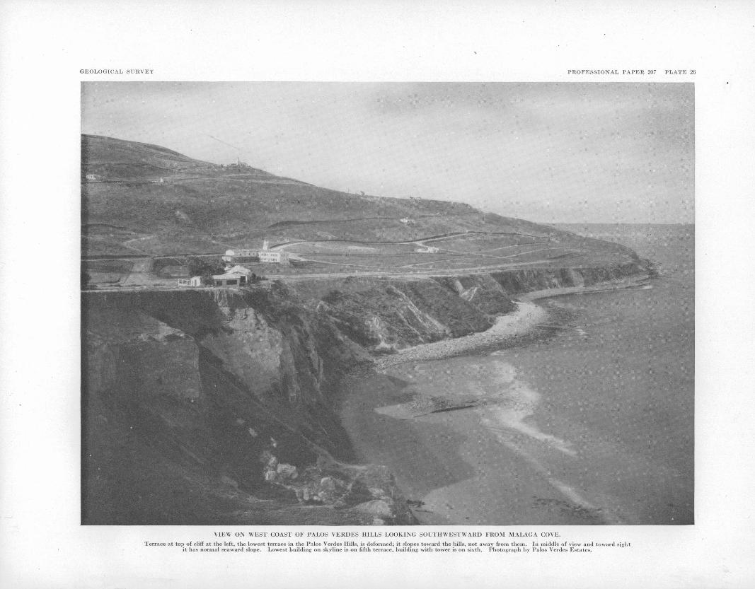
GEOLOGICAL SURVEY PROFESSIONAL PAPER 207 PLATE 26
VIEW ON WEST COAST OF PALOS VERDES HILLS LOOKING SOLTHWESTWARD FROM MALAGA COVE.
Terrace at top of cliff at the left, the lowest terrace in the Palos Verdes Hills, is deformed; it slopes toward the hills, not away from them. In middle of view and toward right it has normal seaward slope. Lowest building on skyline is on fifth terrace, building with tower is on sixth. Photograph by Palos Verdes Estates.

GEOLOGICAL SURVEY PROFESSIONAL PAPER 207 PLATE 27
A. UNDRAINED DEPRESSION ALONG CREST OF WESTERN PART OF HILLS.
B. HANGING VALLEY AT HEAD OF ALTAMIRA CANYON.
Lip of valley is in right middle foreground. Contrary to appearance it drains to right.
C. HEAD OF ALTAMIRA CANYON TAPPING HANGING VALLEY SHOWN IN B.
ROLLING UPLAND ALONG CREST OF PALOS VERDES HILLS.
115
Those shown on plate 22 are based on relative width of terrace treads and on the assumption that the terraces are not deformed to any notable extent except along and near the north border of the hills, an assumption that appears to be justified by benches identified as remnants of the seventh terrace. The correlations are, however, far from satisfactory, others may be equally plausible or more plausible. Recognition of specific terraces and their correlation in the Ventura district also were found by Putnam 15 to be difficult.
The thirteenth, twelfth, and eleventh terraces are identified with reasonable certainty only on the slopes of San Pedro Hill, where they form narrow spur benches. The platform of the twelfth terrace is ex posed at locality 75 in a cut on Crest Road. The marine and nonmarine terrace 'deposits described on page 54 are visible at that locality, and the marine fossils listed on page 94 were collected there. The crest and upper slopes of the hills northwest of San Podro Hill include presumably eroded remnants of these uppermost terraces.
The tenth', ninth, and Seventh terraces are well- defined on the west slope of the hills, and the tenth, ninth, eighth, and seventh are well-represented on the slopes of San Pedro Hill. The tenth and ninth are ident fied locally on the northeast slope, and the eighth and seventh in the greater part of that area. The seventh is the widest terrace on the west slope, dis regarding apparent merging of the second and third, and is the highest terrace identified around the north west end of the hills. At most places on the west slope the eighth evidently was removed during cutting of the wide seventh. On the east and northeast slopes the eighth as identified is wider than the seventh, for example, in the Miraleste district and along Agua Negra Canyon, which cleanly cuts a wide bench cor related with the eighth. Perhaps the eighth terrace of the east and northeast slopes corresponds to the seventh of the west slope, but the correlations adopted appear to agree better with identifications of the seventh around the northwest end of the hills. Another pos sibility is that the eighth and seventh terraces shown on plate 22 represent more than two terraces. An .intermediate terrace (7a) is recognized inland .from Point V:icento. If it is represented on the east and northeast slopes, it has not been differentiated. Ac cording to surface altitudes at the rear of the seventh terrace, it slopes gently southward on the west coast. As the relation is uniform and is shown, though to less marked degree, by the ninth and tenth, it indicates slight tilting.
The sixth terrace is well-defined at the northwest end of the hills (pi. 22, profile A A), is represented by a few remnants on the west slope, and is identified on the ridge extending southeastward from San Pedro Hill and at localities farther west and north,, but is not recog nized on the northeast slope.
The fifth and fourth terraces are well-developed at the northwest end and on the west slope of the hills. There these terraces form treads of moderate width that appear to be tilted slightly southward like the higher terraces in that area. A terrace intermediate between the fifth and sixth (5a) is recognized at the northwest end. On the northeast slope the fourth and fifth as identified rise southeastward until in the central part of that area they reach altitudes 225 and 250 feet higher than at the northwest end. Southeastward and
i» Putnam, W. C., Ooomorphology of the Ventura region, Calif.: Qeol. Soc. Am' Bull., vol. 53, p. 730, 1942.
southward on the northeast and east slopes the altitude drops, and on the southwest coast inland from Whites Point it is the same as at the south end of the west slope. As the altitudes are not based on platform altitudes, misidentifications of terraces and failure to differentiate terrace 5a may be involved. Nevertheless the apparent arching appears to be uniform. Inasmuch as the upper terraces do not show the same relation, the arching is to be correlated presumably with proximity to the mobile north border of the hills, where the first terrace is interpreted as showing similar arching to a more marked extent.
The third is a narrow terrace. It would be grouped probably with the minor terraces 7a and 5a were it not for its younger age and consequently more perfect preservation at more numerous localities on both the west and east slopes of the hills. Along most of the south coast the fourth merges apparently into the second. That this relation is due to a multiple non- marine cover is shown by the exposure at fossil locality 84 near Point Vicente already mentioned (pi. 23). At fossil locality 99, on Portuguese Bend, the nonmarine cover at a location corresponding approximately to the rear of the second terrace is about 100 feet thick, the greatest observed thickness. On the east slope inland from Fort McArthur Lower Reservation in southern San Pedro the third terrace forms a narrow steeply sloping bench northward from fossil locality 90 but no perceptible bench at localities 91 and 92, where the platform and the marine deposits resting on it are exposed in street cuts.
The second terrace js the lowest terrace along the windward coasts except at Long Point, where a land ward remnant of the first terrace represented princi pally by»a bare rock platform is identified, and at Malaga Cove, where the first terrace is well-preserved. In San Pedro the second is differentiated locally from the first, but it generally merges apparently into the first. It is improbable that the second terrace at Point Fermin is the first terrace at Cabrillo Beach uplifted along the Cabrillo fault, for at the coast the fault emerges on the rise between these two terraces.
The first terrace is extensive in San Pedro and on the northeast border of the hills. In areas where mapped marine and nonmarine deposits lie on the platform, the terrace map (pi. 22) agrees with the geologic map (pi. 1). The platform and the deposits lying on it are undeformed in San Pedro. Along the northeast border they are gently folded along the Gaffey anticline and Gaffey syncline. Farther west they are abruptly bent upward at the border of the hills and are at places faulted. In both areas of deformation the platform and the surface have no longer the usual physiographic features of a terrace tread. In fact, the abrupt bending at the border of the hills produces the physiographic effect of a terrace rise. South of the areas where the terrace is deformed the first terrace as identified rises northwestward from San Pedro and southeastward from Malaga Cove, until it reaches altitudes 275 or 300 feet greater than in San Pedro and at Malaga Cove. Perhaps apparently merging terraces representing the second and third as well as the first are confused in this apparent arching. The exceptionally great thick ness of marine sand and gravel along the north border near Hawthorne Avenue (p. 59) may include deposits laid down during cutting of the first and one or more older terraces. At several localities, however, as along Palos Verdes Drive North, only one terrace platform

116 GEOLOGY AND PALEONTOLOGY OF PALOS VERDES HILLS, CALIFORNIA
and only one set of terrace deposits appear to be involved. The second and third terraces are, therefore, inferred to have been removed along most of the north east slope during cutting of the first. The absence of an exceptionally high cliff at the rear of the first may be due to masking by the nonmarine cover. Unfor tunately, in the area between Malaga Cove and Valmonte, where the first terrace is thought to rise east ward about' 300 feet in a distance of IK miles, the terraces are concealed by dune sand. At Malaga Cove the first terrace is plainly arched over the strongly deformed Miocene and Pliocene formations (pi. 26; fig. 7). The platform is, however, not abruptly bent downward at the border of the hills, as it. is east of the dune sand area.
ROLLING UPLAND
The crest and upper slopes of the hills are character ized by wide swalelike valleys of gentle gradient that stand in marked contrast to the narrow steep-gradient canyons at lower levels. The wide valleys and inter vening low smoothly rounded divides form a rolling upland. Plate 4 shows the upland skyline and the deep canyons trenching the upland surface in the area inland fro'm Inspiration Point. Other views of the upland are
-SW.
Furthermore, it is unlikely that terrace platforms and the thin veneer of unconsolidated marine sediments, such as those on the platform of the twelfth ten-ace at locality 75, would escape destruction during develop ment of the surface. The erosion surface was formed presumably during the period between the early Plio cene submergence and the late Pleistocene submer gence. That it was probably the result of erosion of an area larger than the present Palos Verdes Hills is indicated by the stream profiles of figure 16. If the hanging valleys along the upper course of Altamira Canyon and Valmonte Canyon were graded to the same base level, the hanging valley of Altamira Can yon is to be projected a considerable distance to repre sent that base level. The high-level terraces may be the result of relatively brief periods during which the old erosion surface was modified by terracing of exposed headlands. Under that hypothesis the ninth and tenth terraces are exceptionally well developed on the west slope of the hills. That coast of the emerging island was, however, evidently most exposed to marine erosion, as lower terraces are more uniformly well- developed there than in any other part of the hills.
The rolling upland contains several undrained depressions, which are most numerous at the northwest
Mile
FIGUEE 16. Stream profiles showing hanging valleys. A, Valmonte Canyon, north slope of hills. B, Altamira Canyon, south slope of hills.
shown on plate 27. The swalelike valleys are left hang ing where the deep canyons advancing inland tap them. Examples of such hanging valleys are shown on plates 24, D and 27, 5, C. Profiles of Valmonte Canyon and Altamira Canyon, shown in those views, are reproduced in figure 16. In the eastern part of the hills terrace remnants are found at altitudes as great as 1,300 feet above sea level. On the west slope the rolling upland is limited by the tenth terrace, which is at an altitude of 1,050 feet above sea level. On parts of the north slope the upland surface is identified at altitudes corre sponding to the eighth and seventh terraces.
As has already been pointed out, 16 the rolling upland has the features of an old erosion surface. It is im probable that this erosion surface, which has a relief of about 700 feet, was developed on a small island emerg ing after the almost complete, or complete, submergence during which the high-level terraces were formed. An erosion surface of this character is not expectable on a small island emerging at a relatively rapid rate.
"> Kew, W. S. W., Geologic and physiographic features in the San Pedro Hills, Los Angeles County, Calif.: Oil Bull., vol. 12, No. 5, pp. 517-518, 1926.
end of the hills. Plate 27, A, is a view of the largest depression in that area, filled with water after winter rains. 'The hanging valley in plate 27, B, also has a slight closure, evidently less than 5 feet, for after rains water stands in its lower part. One of the depressions is on the tread of the tenth terrace on the west slope, another, \% miles northeast of Long Point, is on a flat surface representing probably an eroded remnant of the twelfth terrace. It has been suggested 17 that these depressions are the result of drainage changes caused by downward tilting toward the east. Some of the depressions support that interpretation, but others, such as that 0.2 mile northeast of the 1,216-foot hill near the northwest end of the upland, appear to indicate tilting in the opposite direction. It is more probable that the depressions are the result of underground solution of thin beds of limestone and settling along the gentle-gradient valleys of the rolling upland. Decrease of the drainage areas and consequently the run-off which resulted from the tapping of the drainage basins of the upland by steep-gradient canyons may have played a
" Kew, W. S. W., op. cit., p. 518.

PHYSIOGRAPHY 117
part in the development of some of the depressions. It is unlikely, however, that drainage modifications had anything to do with the depression on the tenth terrace. The peculiar cirquelikc valley head just north of the crest of the hills, opposite the head of Agua Amarga Canyon, may represent a stage in the development of a depression.
MINOR PHYSIOGRAPHIC FEATURES
Landslides. An extensive landslide area forms the hummocky topography inland from Portuguese Point and Inspiration Point (pi. 5). , As explained on page 18, the landslide is attributed to movement into a structural basin, along a gliding plane formed by water-soaked be.nton.itic tuff. Smaller landslides found elsewhere on steep slopes are not known to be related to particular rock types.
Landsliding or slumping of a different type took place a«quarter of a mile east of Point Fermin in 1929. A semiclliptical area extending 1,000 [feet along the 100- foot sea cliff and 400 feet inland moved seaward as a body, leaving a main fissure 5 to 10 feet wide and an irregularly fissured zone as much as 50 to 100 feet wide. The sliding was attributed by Miller 1S to seaward down- dip movement on slippery shale on the south limb of the Point Fermin anticline. Soon after it was formed, the fissure was filled with fossiliferous San Pedro sand from Second and Beacon Streets. Movement that took place again in 1940 suggests that the slumped mass rotated upward as it moved toward the ocean and that stability has not yet been reached. As a result of exceptionally heavy rains the Point Fermin slide was active again in March 1941.
Dune sand. The extreme northwestern part of the h ills is covered with dune sand and forms the south 'end of a dune-sand strip extending northward along the coast about 10 miles to Playa Del Ray.
EVENTS SINCE EMERGENCE OF LOWEST TERRACE
the north border of the hills the lowest terrace was deformed following emergence and deposition of the nomnarine cover. On most of the west coast and along virtually the entire south coast the lowest terrace has been destroyed by cutting of the present off-shore platform. The valley followed by Gaffey Street was cut across the warped lowest terrace by an antecedent stream or by a stream that breached the Gaffey antiA cli.no by headword erosion and captured a stream for merly draining southeastward north of the anticline. The natural features of the floor of this valley have been altered by construction of a sump. It appears probable, however, that slight recent growth of the Gaffey anticline has resulted in the impounding of water in Bixby Slough north of the anticline. The stream formerly had a greater flow to keep pace with the rising anticline, or recent upwarp was more rapid than formerly.
RELATIONS TO NEARBY AREAS
At the north border of the hills the marine and overlying nonmarine deposits of the lowest terrace dip down to the level of the Los Angeles Plain. The non- marine deposits merge into the older alluvium of the Los Angeles Plain and other parts of the Los Angeles Basin. Lithologically and physiographically the non-
i» Miller. W. J., The landslide at Point Fermin, Calif.: Sci. Monthly, vol. 32, pp. 464-469, 5 flgs., 1031.
marine cover is indistinguishable from the older allu vium of the basin. They are essentially equivalent, though the older alluvium may represent a time interval corresponding to several of the lowest terraces in the Palos Verdes Hills. Eight miles northeast of the Palos Verdes Hills the older alluvium is arched over the Dominguez anticline forming Vickery's Dominguez surface. 19 The famous Rancho La Brea asphalt de posits, on Wilshire Boulevard in western Los Angeles 20 miles north of the Palos Verdes Hills, are in alluvium that is probably of essentially the same age as the older alluvium arched over Dominguez Hill but was de posited north of a valley along a former course of the Los Angeles River. The Rancho La Brea mammals are now generally considered late Pleistocene. The fragmentary mammalian remains from the marine de posits on the lowest terrace in San Pedro are not inconsistent with the view that they are of essentially the same age as the Rancho La Brea mammals. 20 Grant and Sheppard 21 presented arguments indicating that on physiographic grounds the alluvium at Rancho La Brea is of late Palos Verdes or possibly post-Palos Verdes age.
Two marine terraces along the coast of the western Santa Monica Mountains, 20 to 45 miles northwest of the Palos Verdes Hills, were attributed by Davis 22 to the effects of rising sea level during two periods of Pleistocene deglaciation with uplift between the two periods and after the later period. Owing to the great thickness of the nonmarine cover on the lower terrace and to the extensive erosion represented by the present offshore platform, the present platform was attributed to the effects of the last two nonglacial periods (the last being the present period), between which no uplift took place. Davis 23 pointed out that the terraces may be attributed to land movements and that assignment of the present offshore platform to two instead of one period of deglaciation is doubtful. Tilting of the lower terrace downward to the west 200 or 300 feet within a distance of 30 miles shows that uplift took place after the platform was formed. The terraces were attributed by Davis to the effects of delgaciation, because' they are Pleistocene and because, if they were explained by land movement only, no account would be taken of the effects of rising and lowering sea level resulting from Pleistocene^ deglaciation and glaciation.
That the marine terraces of the Palos Verdes Hills are due principally to uplift is suggested not only by their number and great altitude but also by deforma tion of the lower terraces along the north border of the hills. The effects of Pleistocene glaciation and degla ciation are unrecognizable, or at least unrecognized," in this actively emerging area. As pointed out by Davis, 24 uplift may increase, decrease, or neutralize effects of changes of sea level produced by glaciation and deglaciation. He 25 suggested that if a sufficient number of examples of Pleistocene terraces are studied at altitudes of as much as 1,000 feet or more along the California coast a correlation between terraces and periods of glaciation and deglaciation may be evident
" Vickery, F. P., The interpretation of the physiography of the Los Angeles coastal belt: Am. Assoc. Petroluem Geologists Bull., vol. 11, pp. 417-419, flg. 1, 1927. .
>° Stock, Chester, Cenozoic gravigrade edentates of western North America, with special reference to the Pleistocene Megalonychinae and Mylodontidae of Rancho La Brea: Carnegie Inst. Washington Pub. 331, p. 119,1925.
« Grant, U. S., IV, and Sheppard, W. E., Some recent changes of elevation in the Los Angeles Basin: Seismological Soc. Am. Bull., vol. 29, p. 308, 1939.
33 Davis, W. M., Glacial epochs of the Santa Monica Mountains, Calif.: Geol. Soc. America Bull., vol. 44, pp. 1,044-1,048, 1933.
23 Idem, pp. 1,044-1,045, 1052, 1060, 1,067, 1,075.s« Idem, p. 1045.«Idem, pp. 1107-1108.
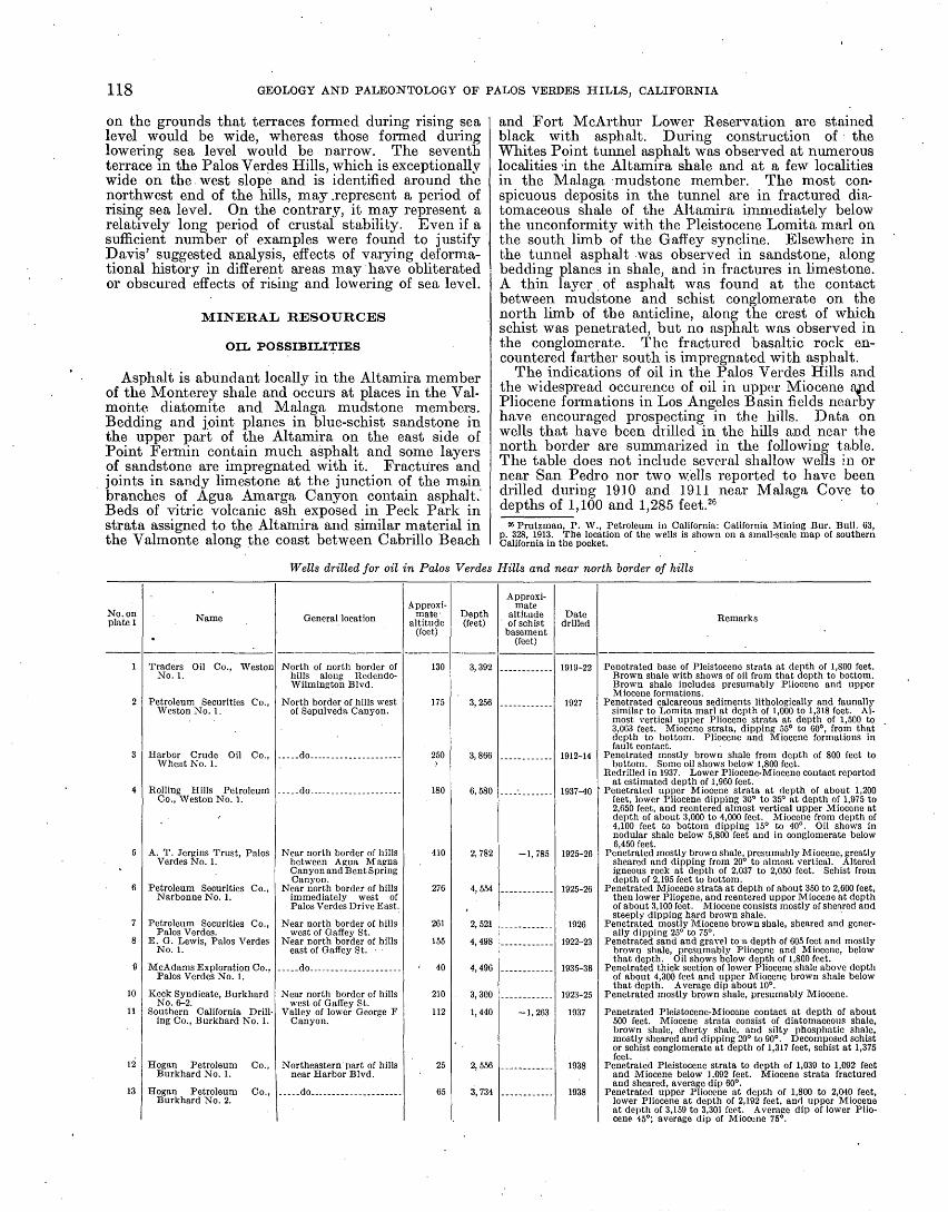
118 GEOLOGY AND PALEONTOLOGY OF PALOS VERDES HILLS, CALIFORNIA
on the grounds that terraces formed during rising sea level would be wide, whereas those formed during lowering sea level would be narrow. The seventh terrace in the Palos Verdes Hills, which is exceptionally wide on the.west slope and is identified around the northwest end of the hills, may .represent a period of rising sea level. On the contrary, it may represent a relatively long period of crustal stability. Even if a sufficient number of examples were found to justify D avis' suggested analysis, effects of varying deforma- tional history in different areas may have obliterated or obscured effects of rising and lowering of sea level.
MINERAL RESOURCES
OIL POSSIBILITIES
Asphalt is abundant locally in the Altamira member of the Monterey shale and occurs at places in the Val- mohte diatomite and Malaga mudstone members. Bedding and joint planes in blue-schist sandstone in the upper part of the Altamira on the east side of Point Fermin contain much asphalt and some layers of sandstone are impregnated with it. Fractures and joints in sandy limestone at the junction of the main branches of Agua Amarga Canyon contain asphalt. Beds of vitric volcanic ash exposed in Peck Park in strata assigned to the Altamira and similar material in the Valmonte along the coast between Cabrillo Beach
and Fort McArthur Lower Reservation are stained black with asphalt. During construction of the Whites Point tunnel asphalt was observed at numerous localities -in the Altamira shale and at a few localities in the Malaga mudstone member. The most con spicuous deposits in the tunnel are in fractured dia- tomaceous shale of the Altamira immediately below the unconformity with the Pleistocene Lomita marl on the south limb of the Gaffey syncline. Elsewhere in the tunnel asphalt was observed in sandstone, along bedding planes in shale, and in fractures in limestone. A thin layer of asphalt was found at the contact between mudstone and schist conglomerate on the north limb of the anticline, along the crest of which schist was penetrated, but no asphalt was observed in the conglomerate. The fractured basaltic rock en countered farther south is impregnated with asphalt.
The indications of oil in the Palos Verdes Hills and the widespread occurence of oil in upper Miocene ajid Pliocene formations in Los Angeles Basin fields nearby have encouraged prospecting in the hills. Data on wells that have been drilled in the hills and near the north border are summarized in the following table. The table does not include several shallow wells in or near San Pedro nor two wells reported to have been drilled during 1910 and 1911 near Malaga Cove to depths of 1,100 and 1,285 feet. 26
26 Prutzman, P. W., Petroleum in California: California Mining Bur. Bull. 63, p. 328, 1913. The location of the wells is shown on a small-scale map of southern California in the pocket.
Wells drilled for oil in Palos Verdes Hills and near north border of hills
No. on plate 1
1
2
3
4
5
6
7
8
e
10
11
12
13
Name
Traders Oil Co., WestonNo. 1.
Petroleum Securities Co.,Weston No. 1-
Harbor Crude Oil Co.,Wheat No. 1.
Rolling Hills PetroleumCo., Weston No. 1.
A. T. Jergins Trust, Palos Verdes No. 1.
Petroleum Securities Co.,Narbonne No. 1.
Petroleum Securities Co.,Palos Verdes.
E. O. Lewis, Palos VerdesNo. 1.
Palos Verdes No. 1.
Keck Syndicate, BurkhardNo. 6-2.
Southern California Drill ing Co., Burkhard No. 1.
Hogan Petroleum Co.,Burkhard No. 1.
Burkhard No. 2.
General location
North of north border ofhills along Redendo- Wilmington Blvd.
North border of hills westof Sepulveda Canyon.
.....do.. ................
....-do. .................
Near north border of hills between Agua Magna Canyon and Bent Spring Canyon.
Near north border of hillsimmediately west of Palos Verdes Drive East.
Near north border of hillswest of Gaffey St.
Near north border of hillseast of Gaffey St.
..do....................
Near north border of hillswest of Gaffey St.
Valley of lower George F Canyon.
Northeastern part of hillsnear Harbor Blvd.
. ....do.... .............
Approxi mate- altitude
(feet)
130
175
250)
180
410
276
261
155
40
210
112
25
65
Depth (feet)
3,392
3, 256
3,866
6,580
2,782
4,554
2,521
4,498
4,496
3, 300
1,440
2,556
3, 734
Approxi mate
altitude of schist
basement (feet)
-1,785
-1.263
Date drilled
1919-22
1927
1925-26
1925-26
1926
1922-23
1923-25
1937
1938
1938
Remarks
Penetrated base of Pleistocene strata at depth of 1,800 feet.Brown shale with shows of oil from that depth to bottom. Brown shale includes presumably Pliocene and upper Miocene formations.
Penetrated calcareous sediments lithologically and faunallysimilar to Lomita marl at depth of 1,000 to 1,318 feet. Al most vertical upper Pliocene strata at depth of 1,500 to 3,063 feet. Miocene strata, dipping 55° to 60°, from that depth to bottom. Pliocene and Miocene formations in fault contact.
Penetrated mostly brown shale from depth of 800 feet tobottom. Some oil shows below 1,800 feet.
Redrilled in 1937. Lower Pliocene-Miocene contact reported at estimated depth of 1,960 feet.
feet, lower Pliocene dipping 30° to 35° at depth of 1,975 to 2,650 feet, and reentered almost vertical upper Miocene at depth of about 3,000 to 4,000 feet. Miocene from depth of 4,100 feet to bottom dipping 15° to 40°. Oil shows in nodular shale below 5,800 feet and in conglomerate below 6,450 feet.
Penetrated mostly brown shale, presumably Miocene, greatly sheared and dipping from 20° to almost vertical. Altered igneous rock at depth of 2,037 to 2,050 feet. Schist from depth of 2,195 feet to bottom.
Penetrated Miocene strata at depth of about 350 to 2,600 feet,then lower Pliopene, and reentered upper Miocene at depth of about 3,100 feet. Miocene consists mostly of sheared and steeply dipping hard brown shale.
Penetrated mostly Miocene brown shale, sheared and generally dipping 25° to 75°.
Penetrated sand and gravel to a depth of 605 feet and mostlybrown shale, presumably Pliocene and Miocene, below that depth. Oil shows below depth of 1,800 feet.
of about 4,300 feet and upper Miocene brown shale below that depth. Average dip about 10°.
Penetrated mostly brown shale, presumably Miocene.
Penetrated Pleistocene-Miocene contact at depth of about 500 feet. Miocene strata consist of diatomaceous shale, brown shale, cherty shale, and silty phosphatic shale, mostly sheared and dipping 20° to 90°. Decomposed schist or schist conglomerate at depth of 1,317 feet, schist at 1,375 feet.
Penetrated Pleistocene strata to depth of 1,039 to 1,092 feetand Miocene below 1,092 feet. Miocene strata fractured and sheared, average dip 60°.
lower Pliocene at depth of 2,192 feet, and upper Miocene at depth of 3,159 to 3,301 fcot. Average dip of lower Plio cene 45°; average dip of Miocene 75°.

MINERAL RESOURCES 119
Wells drilled for oil in Palos Verdes Hills and near north border of hills Continued
No. on pinto 1
14
16
10
17
18
Name
J. K. Wolirman Oil Co...-
Oil and Gas Co. Los Angeles Harbor Devel
opment Co.
voda No. 1.
Palos Verdes No. 1.
General location
West central San Pedro...
Southwestern San Pcdro..
Approxi mate
altitude (feet)
270
15
225
155
70
Depth (feet)
1,054
3,750
2,044
1,480
4,500
Approxi mate
altitude of schist
basement (feet)
-893
-3, 285
-1,800
-3, 830
Date drilled
1931-34
1922-26
1922
1941-42
1941
Remarks
Penetrated mostly brown shale, presumably Miocene. Enter ed schist conglomerate at depth of about 800 feet and schist at depth of 1,163 feet.
Penetrated schist at depth of 3,300 feet.
Penetrated schist at depth of 2,025 feet.
Penetrated schist at depth of 3,900 feet.
Most of the wells located well within the hills pene trated the schist basement. Schist may be expected, except in the extreme northeastern part of the hills, at altitudes ranging from 1,000 feet above sea level to about 5,000-feet below sea level, depending on location. In most of the area depth to the schist basement may be estimated with a reasonable degree of certainty. South of San Pedro Hill and farther west on the south slope estimates are uncertain, owing to the undetermined rate of southward thickening of Miocene strata indi cated by wells drilled near Point Fermin and Long Point. The Burkhard well of the Southern California Drilling Co.. near the trough of the Gaffey syncline, reached solid schist at a depth of 1,263 feet below sea level and decomposed schist or schist conglomerate 58 feet higher. The altitude of the schist basement in this well agrees with the ccmbined surface and Whites Point tunnel structure section E E' of plate 1.
Four wells were drilled along or close to the north border of the hills west of the eastward bend in the border in southern Harbor City. In each of the wells for which adequate records are available strongly deformed strata were penetrated. Two of the wells are reported to have passed from upper Miocene strata into lower Pliocene and then reentered upper Miocene. The abnormal stratigraphic relations show overturning or more probably penetration of a thrust fault.
Six wells are located in the extreme northeastern part of the hills. The McAdams well penetrated a thick gently dipping lower Pliocene section. Drilled to a depth of 4,456 feet below sea level, only about the lowermost 196 feet is reported to represent Miocene. A mile west-southwest of the McAdams well Pleistocene strata rest directly on upper Miocene. The thick lower Pliocene section encountered in this well, there fore, thins rapidly westward, owing presumably to the unconformity at the base of the Pleistocene. It is not known whether, the Lewis well, which reached a depth of 4,343 foot below sea level, penetrated deposits of lower Pliocene age, but it presumably did. The Keck well readied a depth of 3,090 feet below sea level and the Petroleum Securities Palos Verdes well a depth of 2,260 feet below sea level. The Keck well is located near the surface crest of the Gaffey anticline. Accord ing to structure section E E'', plate 1, and the record of the Burkhard well of the Southern California Drilling Co., schist might be expected on the crest of the Gaffey anticline along the line of structure section E E' at a depth of about 1,000'feet below sea level. The record of the Keck well shows, however, that the schist basement is at a greater depth. A subsurface fault of considerable displacement with downthrow to the north corresponding in position approximately to the axis of the Gaffey syncline is indicated by these
relations. The sheared and steeply dipping brown shale reported in the Petroleum Securities Palos Verdes well shows steep dips on the north limb of the anticline close to the crest. Similar features are apparent in the Malaga muds tone at the surface nearby and in the Whites Point tunnel. Steep dips and probable faults were encountered in the two wells drilled by the Hogan Petroleum Co. near Harbor Boulevard. Nich- olson 27 concluded that changes in level in the harbor district indicate a fault in the northern part of the district.
The results of drilling are not encouraging. The possibility of finding oil within the hills in sandstone and conglomerate resting on schist at structurally favorable localities and at localities where overlap may' be effective has not, however, been tested thoroughly. Strongly deformed Miocene and Pliocene strata are to be expected along the north border of the hills at least as far east as the eastward bend in the border. If sandy beds are present in the Miocene or at the contact between Miocene sediments and schist, oil may have moved southward up dip from the syncline between the hills and the Torrance anticline and accumulated at the border of the hills, where the schist basement is abruptly upturned or faulted. Oil showings in the Rolling Hills well indicate that there is some oil in that area. Prospecting in the expectation of fin ding possible accumulation of this type is likely to be uncertain and expensive, at least until the subsurface structure is more definitely determined. The subsurface structure in the extreme northeastern part of the hills is evidently not simple. Sand is reported to be absent in the lower Pliocene Repetto formation of that area and the ad joining part of the Los Angeles Basin. If it is absent, it is improbable that oil is trapped in the Repetto, owing to overlap of Pleistocene deposits. If a subsurface feature, a fol'd or a fault, corresponding to the Gaffey anticline continues southeastward beyond the outcrop area of Malaga mudstone, oil may be found in the Miocene at or above the schist basement, provided suitable reservoir' rocks are present. The record of the Hogan wells shows, however, that in at least part of this area the subsurface structure is complex. East of Gaffey Street the schist basement is estimated to be at depths of 5,000 to 6,000 feet below sea level, according to subsurface data in the nearby Torrance and Wilming- ton fields.
DIATOMITE
Diatomite in the upper part of the Valmonte dia- tomite member of the Monterey shale is mined by the Dicalite Co. in surface and underground workings along
»' Nicholson, G. F., Variations in level, 1919 to 1927, in Los Angeles Harbor: Seismo- logical Soc. America Bull., vol. 19, pp. 200-205, 3 figs., 1929.

120 GEOLOGY AND PALEONTOLOGY OF PALOS VERDES HILLS, CALIFORNIA
the lower course of Agua Negra Canyon and in surface workings between Agua Negra Canyon and Crenshaw Boulevard. The upper part of the Valmonte of this area consists of alternating units of laminated diatomite and massive diatomaceous mudstone. Material from selected diatomite units is processed in the company's plant at the junction of Agua Negra and Valmonte Canyons. The product is used fbr filtration, as filler for paint, rubber, paper, molded plastics, and other products, and for heat insulation.
The Valmonte diatomite member crops out along the north and east slopes of the hills or is inferred to be present in those areas beneath a cover of overlapping Pleistocene strata. Diatomite of the quality mined is, however, not found generally in commercial quantity.
SAND AND GRAVEL
Sand and gravel from the lower Pleistocene San Pedro sand are mined, washed, and screened at several localities along the north border of the hills. The Sidebotham plant on Bent Spring Canyon and the Richard Ball plant immediately east of Hawthorne Avenue are active at the time of writing. At the Sidebotham plant the lighter constituents in the gravel grades, consisting of limestone, cherty shale, and cemented San Pedro sand, are removed by jigging. The product consists of granitic and quartzitic pebbles.
There are extensive deposits of sand and gravel in the San Pedro sand along the entire north and northeast borders of the hills.
OTHER PRODUCTS
Calcareous, material in the Lomita marl was formerly mined at Lomita quarry and Hilltop quarry. The product is reported to have been used for soil dressing and as a source of calcium carbonate for poultry. The Lomita. marl has a thickness of as much as 275 feet in the Gaffey syncline.
Greatly weathered basalt from the Miraleste district and Bluff Cove has been used locally as a dressing for secondary roads. It appears to bind well, but the wearing quality is probably poor.
Porcelaneous shale, cherty shale, and limestone from the Altamira member of the Monterey shale are used locally for garden walls and flagstones. In 1940 the only active operations were on the coast half a mile northwest of Whites Point, where laminated limestone concretions are quarried and split. Most of the hard Miocene shale in the Palos Verdes Hills is brittle, frac tured thin-bedded cherty shale unsuitable for quarry ing. Deposits of more thickly bedded pprcelaneous shale, such as is quarried in the Monterey district, 28 are not extensive.
FOSSIL LOCALITIES
In the following list the fossil localities are described, and the locality numbers used in this report are corre lated with the permanent locality numbers in the Cenozoic register of the Geological Survey and with the field numbers. The fossil localities described, with the exception of a few localities where the maps are con gested, are plotted on plates 1, 14, and 21. Locality and stratigraphic data for the numbers not plotted are sufficient to identify the localities in the field. To avoid confusion, the locality numbers for the collections of Miocene fossils are the same as those in the pre liminary paper.29 Collections not considered in the preliminary paper are intercalated in the numbered series by means of letter designations. The units cited refer to the units of the geologic section given in other parts of the report.
28 Galliher, E. W., Geology and physical properties of building stone from Carmel Valley, Calif.: Mining in California (Div. Mines), vol. 28, No. 1, pp. 21-41, 1932.
2» Woodring, W. P., Bramlette, M. N., and Kleinpell, R. M., Miocene stratig raphy and paleontology of Palos Verdes Hills, Calif.: Am. Assoc. Petroleum Geologists Bull., vol. 20, No. 2, pp. 125-149, 1936.
Fossil localities
No. used in this report
1. _.._.__.
2_. -------
2a- -~--
2b__- -_~ _
3--- --
3a---_- _-
4.--------
Permanent Geological
Survey No.
13123
Field No.
B42_ __________
B45a ___ ________
Wll-31--------
W4-33 ________
W12-31-____.____
B30 _._.__.___..
B45 ___________
Description of locality
MIOCENE
Lower part of Altamira shale member of Monterey shale
Portuguese Canyon area, Portuguese Canyon 2,375 feet northwest of 318-foot benchmark north of Portuguese Bend. Limy layer in mudstone 110 feet below base of Portuguese tuff bed.
Miraleste area, immediately north of Palos Verdes Drive East, 3,275 feet east-southeastof triangulation station on San Pedro Hill. Silty shale underlying basalt sill on south limb of Miraleste anticline.
Bluff Cove area, foot of sea cliff at Bluff Cove, 675 feet northwest of 295-foot benchmark on Palos Verdes Drive West near Bluff Cove. Silty shale in almost vertical strata on north limb of Bluff Cove anticline.
Middle part of Altamira shale member of Monterey shale
Bluff Cove-Malaga Cove area, slope above beach at Bluff Cove, 750 feet north-northeast of 295-foot bench mark on Palos Verdes Drive West near Bluff Cove. Saadstone on north limb of Bluff Cove anticline about 150 feet stratigraphically below base of basalt sill.
Bluff Cove-Lunada Bay area, Palos Verdes Drive West near Bluff Cove, 1,125 feetsouthwest of 295-fopt bench mark. Limestone a foot above top of basalt sill on south limb of Bluff Cove anticline.
Altamira Canyon-Portuguese Canyon area, east fork of Altamira Canyon, 1,325 feetsouth of 1,215-foot hill south of Crest Road. Limestone 48 feet above probable equivalent of Miraleste tuff bed.
Miraleste-San Pedro Hill area, Crest Road on east slope of San Pedro Hill, 1,250 feetsoutheast of triangulation station on San Pedro Hill. Silty shale.

FOSSIL LOCALITIES
Fossil localities Continued
121
No. used iu this report
C
6
7....-...-.
S-... ------
n
10.. -------
11...-.--
12.... ..
12a__---_-
12b
I2c. ------
12d
13--------
13a _ ....
14 -----
15
16------..
17---.--..
18
ISa.. ------19-------.19a----.-_20--------
20a.--_.-_21. -------
21a_..----21b--_--.-22
23 .--.
24---.-.-,25..--.---
Permanent Geological
Survey No.
1
14060
13127
13837
Field No.
W125-30_. .......
W22-33-. ........
W21-33.. ........
W6-33; SPH-14...
W61-30----.-....
W34-33---------.
W130-30-_---__-.
W132-30--------.
B37.. ............
B21._ .........
W26-33------ _ _
W19-29.---.---..
B36... --.-.-.-..
'SPH-ll... .......
B46_. _------.-...
B43... ._..-_'__-__
W60-30-.--......
W2-33-------^--.B44W24-33--.--.--..W9-35; W38-33;
W91a-30. W39-33-... ---...W14-4.. ..__...._
W14-5--. .---.--.W14-6W10-35.---...-.-
W36-33---------.
W49-33; SPH 10. _W59-30-------..-
Description of'locality
MIOCENE Continued
Middle part of Altamira shale member of Monterey shale Continued
Miraleste-San Pedro Hill area, branch of San Pedro Canyon east of Miraleste Drive,5,350 feet east-southeast of triangulation station on San Pedro Hill. Diatomacepus silt, evidently part of soft rocks associated with Miraleste tuff bed.
San Pedro area, south side of branch of San Pedro Canyon 100 feet west of WeymouthSt., in block north of Seventh St. Diatomaceous silt containing pebbles and slabs of schist. ,
San Pedro area, path in Peck Park on north side of main canyon, 1,175 feet east of 406-foot hill. Steeply dipping calcareous sandstone.
Point Fermin area, crest of Point Fermin anticline at foot of sea cliff, 2,000 feet east-northeast of Point Fermin lighthouse. Thin-bedded silty shale interbedded with siliceous shale.'
Point Fermin area, foot of sea cliff at Cabrillo Beach, 50 feet south of Cabrillo fault.Massive buff siltstone.
Bluff Cove-Malaga Cove area, foot of sea cliff 1,450 feet southwest of beach clubhouseat Malaga Cove. Granular limestone.
Miraleste-San Pedro Hill area, ravine near foot of steep slope south of Cabrillo fault,8,375 feet southeast of triangulation station on San Pedro Hill. Buff sandstone,
Point Fermin area, near north end of cut on west side of Alma St., 1,075 feet northeastof Thirty-seventh St. Buff siltstone.
Whites Point area, north limb of fan-shaped fold on east side of Whites Point. Sandstoneoverlying schist conglomerate. (Not plotted on pi. 1.).)
Whites Point area, low-tide reefs 1.2 miles northwest of Whites Point. Calcareousmudstone.
Whites Point tunnel, station 53+56 feet, 250 feet north of south portal. Mudstone.(Not plotted on pi. 1.)
Whites Point tunnel, station 54+58 feet, 355 feet north of south portal. Mudstone.(Not plotted on pi. 1.)
George F Canyon-Miraleste Canyon area, west side of George F Canyon 1,925 feetnorthwest of 732-foot hill near Palos Verdes Drive East. Limy lens in sandstone overlying schist, 20 feet above canyon floor.
George F Canyon-Miraleste Canyon area, west side of first canyon east of Palos VerdesDrive East, 2,000 feet southeast of 732-foot hill near Palos Verdes Drive East. Near top of sandstone overlying schist. California Inst. Tech. invertebrate locality 348.
Upper part of Altamjra shale member of Monterey shale
Point Fermin- Whites Point area, at top of sea cliff along road leading to Whites Point.Silty shale.
Point Fermin- Whites Point area, Dodson Ave. north of Whites Point, 1,000 feet northwest of 371-foot bench mark at southwest corner of military reservation. Silty shale interbedded with porcelaneous shale.
Point Fermin- Whites Point area, foot of path leading down to beach on west side ofPoint Fermin, 1,550 feet northwest of Point Fermin lighthouse. Silty shale about 65 feet below base of upper sandstone unit.
San Pedro area, Cabrillo Beach, 200 feet north of Cabrillo fault. Silty shale interbedded with limestone, porcelaneous shale, and phosphatic shale.
Valmonte diatomite member of Monterey shale
San Pedro area, Cabrillo Beach, 300 feet northwest of driveway. Diatomite. (Nowinaccessible.)
San Pedro area, Cabrillo Beach, 150 feet south of driveway. Diatomite.San Pedro area, Cabrillo Beach, 750 feet northwest of driveway. Diatomite.San Pedro area, Cabrillo Beach, 550 feet northwest of driveway. Diatomite.San Pedro area, Peck Park, foot of cliff on north side of ravine at north edge of park,
12 feet above floor of ravine. Diatomite. Same locality, 20 feet higher stratigraphically. Diatomite.San Pedro area, deep ravine immediately west of Bandini Ave. and east of Peck Park.
Diatomite 45 feet above base of exposed section. Same locality, 80 feet higher stratigraphically. Diatomite.Same locality, 2 feet higher stratigraphically. Diatomite.San Pedro area, north side of San Pedro Canyon, 100 feet east of Meyler Ave. Dia
tomite. Malaga mudstone member of Monterey shale
Malaga Cove area, north limb of southern syncline about 30 feet above beach. , Limestone concretion 18 feet above bas'e of Malaga mudstone. QSfot plotted on pi. 1.)
San Pedro area, west side of Cabrillo Ave. 75 feet north of Fourth St. Mudstone.San Pedro area, south face of cliff at Timms Point, 100 feet west of point. Limestone
concretion. (Now inaccessible.)

122 GEOLOGY AND PALEONTOLOGY OF PALOS VERDES HILLS, CALIFORNIA
Fossil localities Continued
No. used in this report
26--
27
28-
30. _._----
31. -------
32. __-----
32a_ -_
32b
32c
32d
32e_ _
33. -------
34. __--_-_
35 -
36 -37. -------
38 39.. ------
40____---_
41
42 -
42a-._----
42b__-_-_-42c__ 42d_--_.-_42e -
42f_-_---.d.9tr
42h--____42i_______43_ ___
43a__ .
44 _____
44a. .--....45
46 __._
47 _
Permanent Geological
Survey No.
13838
12530
12529
12269
12203
12214
12213
12215
12204
12211
12205
12212
1224112242
1221012209
12208
12239
12229
12230
12231122321223312234
1223512236122371223812240
12247
12206
1220712216
12202
12196
Field No.
W19-35-. -----
W100-30-----____
W50-28-.
W5-27--_.__. _
W7-30__.________
W4-30.. .--.....
W50-30______..__
W49-30-__.--_...
W51-30. ._--._. ._
W5-30_________._
W47-30-. .. __--__
W6-30__-________
W48-30________-_
W43-30__________W44-30. -.....___
W42-30__. _______W39-30-_________
W38-30- ____'_____
W29-30-. ....-_-_
W21-30. -._..__. _
W22-30-.. ....__.
W23-30_-________W24-30-. _. ______W54-30.. __.____.W55-30. _________
W25-30-. ________W26-30_--_------W56-30._ ________W27-30__. ...__..W30-30.________.
W62-30_--__-__-_
W27a-30-.--_----
W28-30_-_..- _ .W63-30----.__-_-
W94-30__l___-.--
W2-30. .-__..----
Description of locality
PLIOCENE
Repetto siltstone
Malaga Cove, south limb and trough of northern syncline. Twenty-five samples fromlower 85 feet of the Repetto siltstone, each sample representing a thickness of about 3 feet. ' (Not plotted on pi. 1.)
Malaga Cove, north limb of northern syncline just north of trough, 5 to 10 feet belowlower bed of volcanic ash. (Not plotted on pi. 1; see fig. 9.)
Road leading from Palos Verdes Drive East to prospect excavation in marl, 1,050 feetwest of 367-foot hill east of Palos Verdes Drive East.
PLEISTOCENE
' Lomita marl, Timms Point silt, and San Pedro sand
Deadman Island, east side. Basal part of San Pedro sand. (Same as California Inst.Tech. invertebrate locality 130; not plotted on pi. 1; now inaccessible.)
Deadman Island, west side. Basal pait of San Pedro sand. (Same as California Inst.Tech. invertebrate locality 31; not plotted on pi. 1; now inaccessible.)
Timms Point. Base of unit 1 of Timms Point silt at point. (Not plotted on pi. 14;coincides with geologic boundary; now inaccessible.)
Timms Point, from point northwestward along bluff to within 50 feet of retaining wall.Unit 1 of Timms Point silt. <
Timms Point, foot of bluff 100 feet south of shanty. Pocket of rich calcareous materialnear base of unit 1 of Timms Point silt.
Timms Point, foot of bluff from retaining wall to locality 100 feet southeast of retainingwall. Unit 1 of Timms Point silt.
Timms Point, about 175 feet north of point on north and south sides of stairs. Unit 2of Timms Point silt.
Timms Point, at drain pipe about 150 feet southeast of retaining wall. Unit 2 of TimmsPoint silt.
Timms Point area, east side of Harbor Blvd., 150 feet south of projection of FourteenthSt. Unit 2 of Timms Point silt. (Since current edition of Wilmington topographic map was issued Harbor Blvd. has been extended from business district of San Pedro to Timms Point.)
Timms Point Area, west side of Harbor Blvd. about 100 feet north of Fourteenth St.Unit 1 (?) of Timms Point silt. (See note under locality 33.)
Timms Point area, west side of Harbor Blvd. about 150 feet north of projection ofThirteenth St., along path leading to Beacon St. Timms Point silt. (See note under locality 33.)
Central San Pedro, north side of Eighth St;, 100 feet west of Mesa St. Lomita marl.Central San Pedro, south side of alley between Seventh and Eighth Sts., about 150 feet
west of Mesa St. Lomita marl. Central San Pedro, south side of Eighth St., 25 feet east of Center St. Timms Point silt.Central San Pedro, east side of Mesa St., 50 feet north of Seventh St., excavation along
sidewalk. Timms Point silt. Central San Pedro, south side of Third St., at southwest corner of Third and Mesa Sts.
Timms Point silt. Central San Pedro, abandoned quarry off alley 150 feet east of Pacific Ave. and 50 feet
south of Second St. Lomita marl. Central San Pedro, south side of Second St., 150 feet east of Pacific Ave. Unit 1 of
Lomita marl. Same locality. Unit 2a of Lomita marl. (Localities 42a to 42i are on progressively
younger strata and progressively farther east on Second St. between Pacific Ave. and Mesa St.,42i being 350 feet east of Pacific Ave. They are not plotted on pi. 14.)
Same locality. Unit 2b of Lomita marl.Same locality Unit 3a of Lomita marl.Same locality. Coarse-grained calcareous sand at base of unit 3c of Lomita marl.Same locality. Coarse-grained calcareous sand 2 feet 10 inches above base of unit 3c
of Lomita marl. Same locality. A foot above base of unit 4a of Lomita marl.Same locality. . 7)4 feet above base of unit 4a of Lomita marl.Same locality. Unit 4b of Lomita marl.Same locality. 3 feet below top of unit 4b of Lomita marl.Central San Pedro, north side of Second St., 150 feet east of Pacific Ave. Coarse
grained calcareous sand 6 feet above base of Lomita marl. Same locality, 125 feet east of Pacific Ave., and in adjoining alley. Lomita marl.
(Not plotted on pi. 14.) Central San Pedro, south side of Second St., 350 feet east of Pacific Ave. Unit 1 of
Timms Point silt. (Not plotted on pi. 14; coincides with geologic boundary.) Same locality. Unit 3 of Timms Point silt. (Not plotted on pi. 14.)Central San Pedro, north side of Second St., 150 feet west of Mesa St. Unit 7 of Timms
Point silt. Same locality, 100 feet west of Mesa St. Thin bed of sand 7y2 feet above base of San
Pedro sand. (Not plotted on pi. 14; coincides with geologic boundary on map of that scale.)
Central San Pedro, west side of Harbor Blvd. at southwest corner of Harbor Blvd.and Second St. Unit 3 of San Pedro sand..
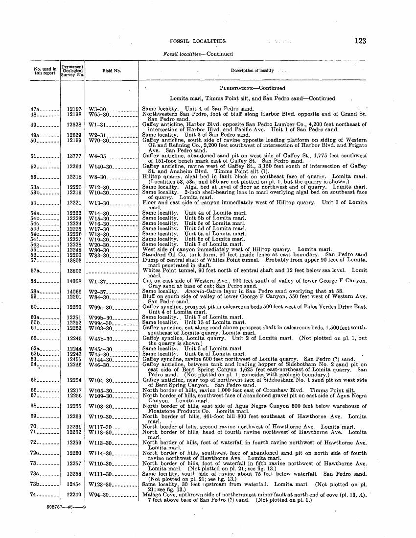
FOSSIL LOCALITIES
Fossil localities Continued
123
No. used in this report
47a.___.__48--.-----
49.. ......
49a_____--50........
51--------
52. ... _...
53-...-...
53a_______53b.......
54........
54a______.54b. _ ...54c. ......54d-__--_-54e-_.....54f_____.-54g.......55........56..........57........
57a.......
58........
58a.......59........
60........
60a..._...60b.......61.........
62........
62a_______62b......_63........64........
65........
66........67........
68........
69........
70.........71........
72........
72a,....._.
73........
73a.......
73b.......
74........
Permanent Geological
Survey No.
1219712198
12628
1262912199
13777
12264
12218
1222012219
12221
12222122231222412225122261222712228122481220013803
13802
14068
1406912201
12250
122511225212253
12245
12244122431245512246
12254
1221712256
12255
12263
1226112262
12259
12260
12257
12258
12454
12249
Field No.
W3-30.... .......W65-30... .......
Wl-31. _______ __
W2-31_____W70-30... ..._.__
W4-35
W140-30________.
W8-30._._. ______
W12-30W10-30..... _ .
W13-30. .. _
W14-30.. ________W15-30W16-30. __ .. .W17-30 .W18-30__________W19-30... ._.....W20-30... _______W80-30.. .._._.__W83-30.___..___.
Wl-37.. ..____.__
W2-37 ____ __..WR4 3fl
W99a-30._ ____
W99b-30_________wqq/._QnW103-30.. _....._
W45b-30__ _______
W45a-30...______W45-30__________W144-30. ________W46-30__. ...____
W104-30.. .......
W105-30.. .......W109-30___....__
W108-30.. _______
W119-30_.__._._.
W117-30.. _._.__.W118-30_____.._.
wi 13 3n
W114-30-_-.-.-_.
W110-30_--__-___
Wlll-30--------.
W123-30.... _ ..
W94-30... -._-...
Description of locality ...
PLEISTOCENE Continued
Lomita marl, Tiinms Point silt, and San Pedro sand Continued
Same locality. Unit 4 of San Pedro sand.Northwestern San Pedro, foot of bluff along Harbor Blvd. opposite end of Grand St.
San Pedro sand. Gaffey anticline, Harbor Blvd. opposite San Pedro Lumber Co., 4,200 feet northeast of
intersection of Harbor Blvd. and Pacific Ave. Unit 1 of San Pedro sand. Same locality. Unit 3 of San Pedro sand.Gaffey anticline, south side of ravine opposite loading platform on siding of Western
Oil and Refining Co., 2,200 feet southwest of intersection of Harbor Blvd. and Frigate Ave. .San Pedro sand.
Gaffev anticline, abandoned sand pit on west side of Gaffey St., 1,775 feet southwestof 151-foot bench mark east of Gaffey St. San Pedro sand.
Gaffey anticline, ravine west of Gaffey St., 3,150 feet south of intersection of GaffeySt. and Anaheim Blvd. Timms Point silt (?).
Hilltop quarry, algal bed in fault block on southeast face of quarrv. Lomita marl.(Localities 53, 53a, and 53b are not plotted on pi. 1, but the quarry is shown.)
Same locality. Algal bed at level of floor at northwest end of quarry. Lomita marl.Same locality. 2-inch shell-bearing lens in marl overlying algal bed on southeast face
of quarry. Lomita marl. Floor and east side of canyon immediately west of Hilltop quarry. Unit 3 of Lomita
marl. Same locality. Unit 4a of Lomita marl.Same locality. Unit 5b of Lomita marl.Same locality. Unit 5c of Lomita marl.Same locality. Unit 5d of Lomita marl.Same locality. Unit 6a of Lomita marl.Same locality. Unit 6c of Lomita marl.Same locality. Unit 7 of Lomita marl.West side of canyon immediately west of Hilltop quarry. Lomita marl.Standard Oil Co. tank farm, 50 feet inside fence at east boundary. San Pedro sandDump of central shaft of Whites Point tunnel. Probablv from upper 90 feet of Lomita.
marl penetrated in shaft. Whites Point tunnel, 90 feet north of central shaft and 12 feet below sea level. Lomit
marl. Cut on east side of Western Ave., 900 feet south of valley of lower George F Canyon.
Gray sand at base of cut; San Pedro sand. Same locality. Anomia-Ostrea layer in San Pedro sand overlying that at 58.Bluff on south side of valley of lower George' F Canyon, 550 feet west of Western Ave.
San Pedro sand. Gaffey syncline, prospect pit in calcareous beds 500 feet west of Palos Verdes Drive East.
Unit 4 of Lomita marl. Same localitv. Unit 7 of Lomita marl.Same locality. Unit 13 of Lomita marl.Gaffey syncline, cut along road above prospect shaft in calcareous beds, 1,500 feet south-
southeast of Lomita quarry. Lomita marl. Gaffey syncline, Lomita quarry. Unit 2 of Lomita marl. (Not plotted on pi. 1, but
the quarry is shown.) Same locality. Unit 5 of Lomita marl.Same locality. Unit 6a of Lomita marl.Gaffey syncline, ravine 600 feet northwest of Lomita quarry. San Pedro (?) sand.Gaffey anticline, between tank and loading hopper of Sidebotham No. 2 sand pit on
east side of Bent Spring Canyon 1,625 feet east-northeast of Lomita quarry. San Pedro sand. (Not plotted on pi. 1; coincides with geologic boundary.)
Gaffey anticline, near top of northwest face of Sidebotham No. 1 sand pit on west sideof Bent Spring Canyon. San Pedro sand.
North border of hills, ravine 1,000 feet east of Crenshaw Blvd. Timms Point silt.North border of hills, southwest face of abandoned gravel pit on east side of Agua Negra
Canyon. Lomita marl. North border of hills, east side of Agua Negra Canyon 500 feet below warehouse of
Floatstone Products Co. Lomita marl. North border of hills, 461-foot hill 800 feet southeast of Hawthorne Ave. Lomita
marl. North border of hills, second ravine northwest of Hawthorne Ave. Lomita marl.North border of hills, head of fourth ravine northwest of Hawthorne Ave. Lomita
marl. North border of hills, foot of waterfall in fourth ravine northwest of Hawthorne Ave.
Lomita marl. North border of Mils, southwest face of abandoned sand pit on north side of fourth
ravine northwest of Hawthorne Ave. Lomita marl. North border of hills, foot of waterfall in fifth ravine northwest of Hawthorne Ave.
Lomita marl. (Not plotted on pi. 21; see fig. 13.) Same locality, south side of ravine about 75 feet below waterfall. San Pedro sand.
(Not plotted on pi. 21; see fig. 13.) Same locality, 30 feet upstream from waterfall. Lomita marl. (Not plotted on pi.
21; see fig. 13.) Malaga Cove, upthrown side of northernmost minor fault at north end of cove (pi. 13, A).
7 feet above base of San Pedro (?) sand. (Not plotted on pi. 1.)502787 45-

124 GEOLOGY AND PALEONTOLOGY OF PALOS VERDES HILLS, CALIFORNIA
Fossil localities Continued
No. used in this report
75 _-_
76- ...
76a_ 77-
78
79-
80 81
82
.83.:
84
85
86___-_-_-87
88 ------
oq
90
91-
92--_--__-
93
94
95 --_-_
QR-
97
98_____---99HHL_____-101 102-_____103 104_ _ 105
106
107 108_ _ -
109
110 111 112 113
114
115 c
116
% il7
Permanent Geological
Survey No.
13126
12186
' 1218713137
12184
12194
1313612193'
12182
13782
12189
13135
1313412195
13796
13780
13783
13784
13785
12133
12190
13781
1313112185
1313012188131321313313129121911219212183
13125
1216212138
12137
13779121341213212135
12136
12148
12147
12149
Field No. '
i
W25-33--.. __---.
W131a-30
Wl31b-30-.-_-_-.W50-33__-__-_-_-
Wl24-30i _ .
W141-30 _1
W48-33- -----W139-30- __
W53-30- _ --
W12-35_-_--____
W135-30 _ __--
W47-33-
W46-33__-_ -__-W142-30- __ _
W8-35 __ __ __
-W7-35 _ _
" W13-35-. _ ..
W14-35____- ____
W15-35_ __ - ___
W11-30- _ __
W136-30
Wll-35 __ __ -
W42-33W126-30- __ __ _: _ _
W43--33 W133-30- -_--____W44-33-__-.___.W45-33 __W31-33 _.W137-30- -. __W138-30 ...W122-30- _ _
W19-33
W127-30- :_ . W52-30_--.._____
W41-30_..--._-
W6-35 W35-30- ___, Wl-30 _'___ .-_W37-30 ._
W40-30__. __"._ _
W77-30
W76-30
W81-30
Description of locality
PLEISTOCENE Continued
Marine terrace deposits older than Palos Verdes sand
Southwest slope of San Pedro Hill, Crest Road 1,750 feet southest of triangulationstation on San Pedro Hill. Twelfth terrace.
Palos Verdes Drive East, 1,300 feet northeast of intersection of Crest Road, foot of cut.Ninth terrace. ^
Same locality, top of cut 50 feet to southwest. Ninth terrace.Palos Verdes Drive East, Miraleste district, 900 feet northwest of intersection of Miral
este Drive. Eighth terrace. . Miraleste district, Colinta Road, "300 feet southwest of intersection of Miraleste Drive.
Sixth terrace. Malaga Cove district, Del Monte Road, 500 feet southwest of La Venta Inn. Sixth
terrace. ' s Crest Road, 2,550 feet northeast of Point Vicente lighthouse. Fifth terrace.Malaga Cove district, Montemar Road, 1,125 feet southeast of 278-foot bench mark near
Flatrock Point. Fifth terrace. Southern San Pedro, west side of Peck St., 375 feet north of Thirty-sixth St. Fourth
terrace. , Southern San Pedro, west side of Gaffey St., 50 feet north of Thirty-eighth St. Fourth
terrace. Palos Verdes Drive South, 1,950 feet east-northeast of Point Vicente lighthouse, about
50 feet above level of highway. Fourth terrace. Palos Verdes Drive West, 1,050 feet east of 157-foot bench mark between Resort Point
and Point Vicente. Fourth terrace. Bluff Cove, near top of sea cliff 475 feet north of 295-foot bench mark. Fourth terrace.Malaga Cove district, Campesina Road at intersection of Segunda Road. Fourth ter
race. , Palos Verdes Drive North, 4,400 feet southeast of Palos Verdes Golf Club. Fourth
terrace. v Palos Verdes Drive North, 3,500 feet west-southwest of intersection of Palos Verdes Drive
East. Fourth terrace. Southern San Pedro, west side of Gaffey St., 100 feet north of Thirty-first St. Third
terrace. . ' > Southern San Pedro, south side of Hamilton Place, 100 feet southeast of Gaffey St.
Third terrace. Southern San Pedro, south side of Twenty-first St., 200 feet west of Cabrillo St. Third
terrace. Southwest face of Hilltop quarry. Third terrace. (Not plotted on pi. 1 ; coincides with
geologic boundary at southeast end of quarry.) Southern San Pedro, top of sea cliff 950 feet northwest of Point Fermin lighthouse.
.Second terrace. (Chaces' chiton bed locality.) Southern San Pedro, west side of Gaffey St., 100 feet north of Thirty-ninth St. Non-
marine cover banked against cliff at rear of second terrace. South coast, 3,600 feet northwest of Point Fermin lighthouse. Second terrace.
. Southwestern San Pedro, north side of Thirty-seventh St., 225 feet east of Averill St.Nonmarine cover banked against cliff at rear of second terrace. .
South coast, 2,800 feet northwest of Whites Point. Second terrace.South coast, Portuguese Bend, 3,500 feet east of Inspiration Point. Second terrace.'South coast, 3,600 feet northeast of triangulation station at Long Point. Second terrace.West coast, 3,750 feet northwest of Point Vicente lighthouse. Second terrace.West coast, Lunada Bay, south side of Agua Amarga Canyon. Second terrace.Same locality, north side of Agua Amarga Canyon. Second terrace.West coast, near Flatrock Point. Second terrace.Malaga Cove district, Corta Road 900 feet northwest of Malaga Cove business district.
Second terrace. Northwestern San Pedro, path in Peck Park 650 feet south-southeast of 252-foot hill.
Second terrace. Palos Verdes sand
San" Pedro, Cabrillo Beach, 500 feet northwest of driveway.San Pedro, north side of ravine at north edge of Fort McArthur Lower Reservation.
(Arnold's Crawfish George's locality.) - San Pedro, vacant lot near northwest corner of Palos Verdes and Eighth Sts. (Now in-
fLCCGSSlfolG 1 ' 'San Pedro, west side of Mesa St., 100 feet south of Third St.San Pedro, east side of Palos Verdes St., 75 feet north of Third St.Sari Pedro, west side of Pacific Ave., midway between Oliver and Bonita Sts.San Pedro, east side of 48-foot mesa, 1,000 feet southeast of intersection of Harbor
Blvd. and Pacific Electric tracks. (Arnold's lumber yard locality; now inaccessible.) San Pedro, south side of Harbor Blvd. immediately south of crossing of Pacific Electric
tracks. - San Pedro, north side of street leading westward from Gaffey St., at north edge of town,
1,000 feet west of Gaffey St. South limb of Gaffey syncline, 3,200 feet northwest of intersection of Harbor Blvd.
and Pacific Ave. ' South limb of Gaffey syncline, cattle trail 50 feet south of fence at south boundary of
Standard Oil Co. tank farm.
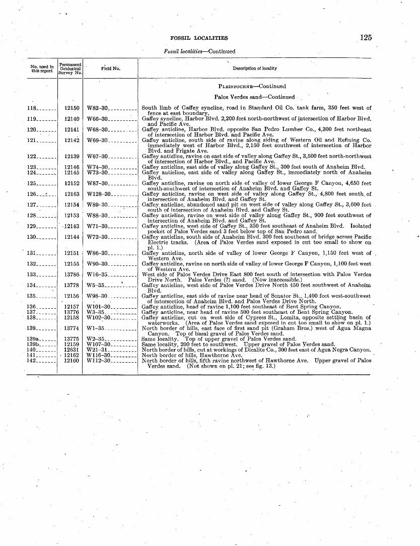
FOSSIL LOCALITIES
Fossil localities Continued
125
No. used in this report
118_._____
119_______
120_._..__
121. ______
122 __ __
123_______124_______
125_______
126 _ - _
127. ._ _
128__ ____
129_______
130_______
131_______
132 _ ___
133_._____
134_______
135-. .
136_______137_______138_______
139_._____
139a_:.____139b______140. _ __141-______142. __
Permanent Geological
Survey No.
12150
12140
12141
12142
12139
1214612145
12152
12163
12154
12153
-12143
12144
12151
12155
13786-
13778
12156
121571377612158
13774
137751215912631
1216212160
Field No.
W82-30____._____
W66-30_ _________
W68-30__________
W69-30__________
W67-30__________
W74-30__________W73-30__________
W87-30__________
W128-30_________
W89-30__________
W88-30__________
W71-30___. ______
W72-30______.___
W86-30___.______
W90-30__________
W16-35__ _______
W5-35-.__-A____
W98-30__________
W101-30_________W3-35-_--l______W102-3Q_________
Wl-35_--_-._____
W2-35___________W107-30_________W21-31__________W116-30. ____ __W112-30__ __ ___
\ ' ,
Description of locality
PLEISTOCENE Continued
Palos Verdes sand Continued
South limb of Gaffey syncline, road in Standard Oil Co. tank farm, 350 feet west offence at east boundary.
Gaffey syncline, Harbor Blvd. 2,200 feet north-northwest of intersection of Harbor Blvd.and Pacific Ave.
Gaffey anticline, Harbor Blvd. opposite San Pedro Lumber Co., 4,300 feet northeastof intersection of Harbor Blvd. and Pacific Ave.
Gaffey anticline, south side of ravine along siding of Western Oil and Refining Co.immediately west of Harbor Blvd., 2,150 feet southwest of intersection of Harbor Blvd. and Frigate Ave.
Gaffey anticline, ravine on east side of valley along Gaffey St., 3,500 feet north-northwestof intersection of Harbor Blvd., and Pacific Ave.
Gaffey anticline, east side of valley along Gaffey St., 300 feet south of Anaheim Blvd.Gaffey anticline, east side of valley along Gaffey St., immediately north of Anaheim
Blvd. Gaffey anticline, ravine on north side of valley of lower George F Canyon, 4,650 feet
south-southwest of intersection of Anaheim Blvd. and Gaffey St. Gaffey anticline, ravine on west side of valley along Gaffey St., 4,800 feet south of
intersection of Anaheim Blvd. and Gaffey St. , Gaffey anticline, abandoned sand pit on west side of valley along Gaffey St., 3,600 feet
south of intersection of Anaheim Blvd. and Gaffey St. Gaffey anticline, ravine on west side of valley along Gaffey St., 900 feet southwest of
intersection of Anaheim Blvd. and Gaffey St. Gaffey anticline, west side of Gaffey St., 350 feet southeast of Anaheim Blvd. Isolated
pocket of Palos Verdes sand 3 feet below top of San Pedro sand. Gaffey anticline, south side of Anaheim Blvd. 300 feet southeast of bridge across Pacific
Electric tracks. (Area of Palos Verdes sand exposed in cut too small to show on pi. 1.)
Gaffey anticline, north side of valley of lower George F Canyon, 1,150 feet west ofWestern Ave.
Gaffey anticline, ravine on north side of valley of lower George F Canyon, 1,100 feet westof Western Ave.
West side of Palos Verdes Drive East 800 feet south of intersection with Palos VerdesDrive North. Palos Verdes (?) sand. (Now inaccessible.)
Gaffey anticline, west side of Palos Verdes Drive North 450 feet southwest of AnaheimBlvd.
Gaffey anticline, east side of ravine near head of Senator St., 1,400 feet west-southwestof intersection of Anaheim Blvd. and Palos Verdes Drive North.
Gaffey anticline, head of ravine 1,100 feet southeast of Bent Spring Canyon.Gaffey anticline, near head of ravine 500 feet southeast of Bent Spring Canyon.Gaffey anticline, cut on west side of Cypress St., Lomita, opposite settling basin of
waterworks. (Area of Palos Verdes sand exposed in cut too small to show on pi. 1.) North border Of hills, east face of first sand pit (Graham Bros.) .west of Agua Magna
Canyon. Top of basal gravel of Palos Verdes sand. Same locality. Top of upper gravel of Palos Verdes sand.Same locality, 200 feet to southwest. Upper gravel of Palos Verdes sand.North border of hills, cut at workings of Dicalite Co., 300 feet east of Agua Negra Canyon.North border of hills, Hawthorne Ave.North border of hills, fifth ravine northwest of Hawthorne Ave. Upper gravel of Palos
Verdes sand. (Not shown on-pl. 21; see fig. 13.)


PLATES 28-37
127
G92787 45 10
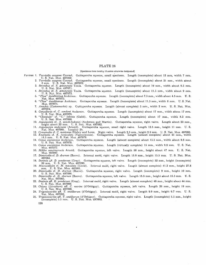
PLATE 28[Specimens from locality 13 unless otherwise designated]
FIGURE .1. Turritella ocoyana Conrad. Guttapercha squeeze, small specimen. Length (incomplete) about 13 mm, width 7 mm. U. S. Nat. Mus. 497069.
2. Turritella ocoyana Conrad. Guttapercha squeeze, small specimen. Length (incomplete) about 21 mm., width about 6 mm. U. S. Nat. Mus. 497070.
3. Strombus cf. S. gatunensis Toula. Guttapercha squeeze. Length (incomplete) about 19 mm. width about 9.5 mm. U. S. Nat. Mus. 497071.
4. Strombus cf. S. gatunensis Toula. Guttapercha squeeze. Length (incomplete) about 11.5 mm. width about 9 mm. TJ. S. Nat. Mus. 497072.
5. "Phos" dumbleanus Anderson. Guttapercha squeeze. Length (incomplete) about 7.5 mm., width about 4.5 mm. U. S. Nat. Mus. 497075.
6. "Phos" dumbleanus Anderson. Guttapercha squeeze. Length (incomplete) about 11.5 mm., width 6 mm. U. S. Nat. Mus. 497074.
7. Anachis (Costoanachis) sp. Guttapercha squeeze. Length (almost complete) 5 mm., width 2 mm. U. S. Nat. Mus. 497073.
8. Cancellaria cf. C. condoni Anderson. Guttapercha squeeze. Length (incomplete) about 17 mm., width about 17 mm. U. S. Nat. Mus. 497076.
9. "Clavatula" cf. "C." labiata (Gabb). Guttapercha squeeze. Length (incomplete) about 17 mm., width 8.3 mm. U. S. Nat. Mus. 497080.
10. Aequipecten cf. A. sancti-ludovici (Anderson and Martin). Guttapercha squeeze, right valve. Length about 23 mm., height about 22 mm. U. S. Nat. Mus. 497082.
11. Aequipecten andersoni (Arnold). Guttapercha squeeze, small right valve. Length 12.5 mm., height 11 mm. U. S. Nat. Mus. 497081. Locality 2b.
12. Crassinella cf. C. mexicana Pilsbry and Lowe. Right valve. Length 2.5 mm., height 2.3 mm. U. S. Nat. Mus. 497083.13. Knefastia cf. K. funiculata (Valenciennes). Guttapercha squeeze. Length (almost complete) about 41 mm., width
14.5 mm. U. S. Nat. Mus. 497079.14. Conus owenianus Anderson. Guttapercha squeeze. Length (almost complete) about 15.5 mm., width about 9.8 mm.
U. S. Nat. Mus. 497078.15. Conus owenianus Anderson. Guttapercha squeeze. Length (virtually complete) 15 mm., width 9.8 mm. U. S. Nat.
Mus. 497077.16. Miltha sanctaecrucis Arnold. Guttapercha squeeze, left valve. Length 50 mm., height about 47 mm. U. S. Nat.
Mus. 497087.17. Divaricella cf. D. eburnea (Reeve). Internal mold, right valve. Length 15.8 mm.j height 15.5 mm. U. S. Nat. Mus.
497084.18. Dosinia aff. D. ponderosa (Gray). Guttapercha squeeze, left valve. Length (incomplete) 32 mm., height (incomplete)
23 mm. U. S. Nat. Mus. 497090.19. Macrocallista cf. M. maculata (Linne"). Internal mold, right valve. Length (almost complete) 41.2 mm., height 27.8
mm. U. S. Nat. Mus. 497091.20. Divaricella cf. D. eburnea (Reeve). Guttapercha squeeze, right valve. Length (incomplete) 9 mm., height 10 mm.
U. S. Nat. Mus. 497086.21. Divaricella cf. D. eburnea (Reeve). Guttapercha squeeze, left valve. Length 15.5 mm., height about 15.5 mm. U. S.
Nat. Mus. 497085.22. Dosinia aff. D. ponderosa (Gray). Internal mold, right valve. Length (almost complete) 48 mm., height about 44 mm.
U. S. Nat. Mus. 497089.23. Chione (Lirophora) aff. C. mariae (d'Orbigny). Guttapercha squeeze, left valve. Length 26 mm., height 19 mm.
U. S. Nat. Mus. 497088.24. Trigoniocardia aff. T. antillarum (d'Orbigny). Internal mold, right valve. Length 9.9 mm., height 9.7 mm. U. S.
Nat. Mus. 497092.25. Trigoniocardia aff. T. antillarum (d'Orbigny). Guttapercha squeeze, right valve. Length (incomplete) 5.5 mm., height'
(incomplete) 5.5 mm. U. S. Nat. Mus. 497093.128

GEOLOGICAL SUEVEY PROFESSIONAL PAPER 207 PLATE 28
22 L "" 23 24 x4MIOCENE MOLLUSKS FROM MIDDLE PART OF ALTAMIRA MEMBER OF MONTEREY SHALE.

GEOLOGICAL SURVEY PROFESSIONAL PAPER 207 PLATE 29
26 25 27
PLEISTOCENE MOLLUSKS FROM LOMITA MARL.

PLATE 29[Species and varieties illustrated are still living unless otherwise specified]
FIGURE 1. Puncturella cooperi Carpenter. Length 6.8 mm., width 5.6 mm., height 4.5 mm. U. S. Nat. Mus. 498562. Locality54g. Found also in Timms Point silt and San Pedro sand.
2. Puncturella delosi Arnold. Length 2.5 mm., width 1.8 mm., height 2.3 mm. ' U. S. Nat. Mus. 498563. Locality 54g.Found also in Timms Point silt and San Pedro sand.
3-5. Vitrinella salvania Dall. Length 1.1 mm., width 1.9 mm. U. S. Nat. Mus. 498564. Locality 41.6-7. Pomaulax undosus (Wood). Length 44.5 mm., width 54.5 mm. U. S. Nat. Mus. 498565. Locality 53a. Found also
in Timms Point silt, marine deposits on twelfth (identification doubtful), ninth, fourth, and second terraces, and Palos Verdes sand.
S. Pomaulax undosus (Wood). Operculum. Length 24 mm., height 31.7 mm. U. S. Nat. Mus. 498566. Locality 53a. 9, 10. Pomaulax t'lirbanicus petrothauma (Berry). Length 26.7 mm., width 30 mm. U. S. Nat. Mus. 498567. Locality 53a.
Not known to be living.11. Pomaulax turbanicus petrothauma (Berry). Length 32.5 mm., width (incomplete) 36 mm. U. S. Nat. Mus. 498568.
Locality 53a.12. Pomaulax turbanicus petrothauma (Berry). Operculum. Length 24.8 mm., height 29.6 mm. U. S. Nat. Mus. 498569.
Locality 53a..1.3, 14. Pachypoma gibberosum (Dillwyn). Length (not quite complete) 40 mm., width 43.5 mm. U. S. Nat. Mus. 498570.
Locality 53a. Found also in Timms Point silt and San Pedro sand, and reported from Palos Verdes sand.15. Pachypoma gibberosum. (Dillwyn). Operculum. Length 14 mm., height 23 mm. U. S. Nat: Mus. 498571. Locality
53a.16. Homalopoma carpenteri (Pilsbry). Length 7.8 mm., width 8 mm. U. S. Nat. Mus. 498572. Locality 53a. Found
also in Timms Point silt, San Pedro sand, marine deposits on twelfth, ninth, and fifth to second terraces, inclusive, and Palos Verdes sand.
17. Rissoina kelseyi Dall and Bartsch. Length 5 mm., width 1.9 mm. U. S. Nat. Mus. 498573. Locality 53a. Found also in marine deposits on second terrace.
18. Rissoina coronadoensis Bartsch. Length 2.8 mm., width 1.2 mm. U. S. Nat. Mus. 498574. Locality 42d. Found also in Timms Point silt and San Pedro sand.
19. Bittium rugatiim Carpenter. Length 11.8 mm., width 4.3 mm. U. S. Nat. Mus. 498575. Locality 37. Found also in Timms Point silt, San Pedro sand, and Palos Verdes sand.
20. Bittium rugatum larum Bartsch. Length 10 mm., width 3 mm. U. S. Nat. Mus. 498576. Locality 37. Found also in Timms Point silt, San Pedro sand, and marine deposits on fourth terrace.
21. Elassitm californicum (Dall and Bartsch). Length 5 mm., width 1.9 mm. U. S. Nat. Mus. 498577. Locality 53b. Found also in Timms Point silt and San Pedro sand. Genus not known to be living.
22. Turritelia pedroensis Applin. Heavily sculptured form. Length (incomplete) 56 mm., width 24 mm. U. S. Nat. Mus. 498578. Locality 57. Found also in Timms Point silt, San Pedro sand, marine deposits on third terrace, and Palos Verdes sand. Not known to be living.
23. Turritelta pedroensis Applin. Length (not quite complete) 66 mm., width 18.5 mm. U. S. Nat. Mus. 498579. Locality 73.
24. Crepipatella charybdis (Berry). Length 14.3 mm,, width 12.4 mm., height 4.2 mm. U. S. Nat. Mus. 498580. Locality 67. Found also in Timms Point silt and San Pedro sand.
25. Bursa californica (Hinds). Length 84 mm., width 53 mm. U. S. Nat. Mus. 498581. Locality 53a. Found also in marine deposits on third terrace (identification doubtful) and Palos Verdes sand.
26. Harfordia monksae (Dall). Length (not quite complete) 43.7 mm., width 18.5 mm. U. S. Nat. Mus. 498582. Locality 53a. Found also in marine deposits on fifth (identification doubtful), fourth, and second terraces, and Palos Verdes sand.
27. "Nassa" insculvta (Carpenter). Length 18.8 mm., width 11.4 mm. U. S. Nat. Mus. 498583. Locality 53a. Reported from Palos Verdes sand.
28. Calicantharus fortis (Carpenter). Length (not quite complete) 50.5 mm., width 30 mm. -U. S. Nat. Mus. 498584. Locality 53. Found also in San Pedro sand and reported from Timms Point silt and Palos Verdes sand. Genus not known to be living.
29. Calicantharus fortis (Carpenter). Strongly sculptured form. Length (not quite complete) 48 mm., width 28 mm. U. S. Nat. Mus. 498585. Locality 57.
129
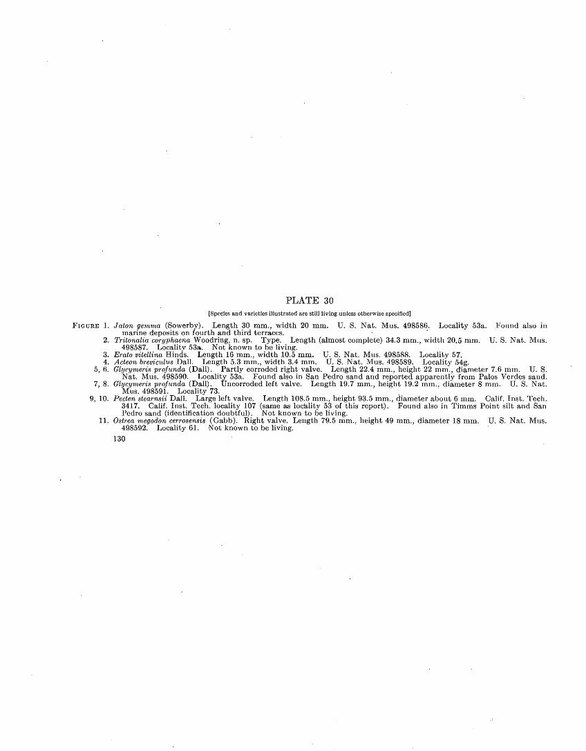
PLATE 30[Species and varieties illustrated are still living unless otherwise specified]
FIGURE 1. Jaton gemma (Sowerby). Length 30 mm., width 20 mm. U. S. Nat. Mus. 498586. Locality 53a. Found also in marine deposits on fourth and third terraces.
2. Tritonalia coryphaena Woodring, n. sp. Type. Length (almost complete) 34.3 mm., width 20.5 mm. U. S. Nat. Mus. 498587. Locality 53a. Not known to be living.
3. Erato vitellina Hinds. Length 16 mm., width 10.5 mm. U. S. Nat. Mus. 498588. Locality 57.4. Acteon breviculus Dall. Length 5.3 mm., width 3.4 mm. U. S. Nat. Mus. 498589. Locality 54g.
5, 6. Glycymeris profunda (Dall). Partly corroded right valve. Length 22.4 mm., height 22 mm., diameter 7.6 mm. U. S.Nat. Mus. 498590. Locality 53a. Found also in San Pedro sand and reported apparently from Palos Verdes sand.
7, 8. Glycymeris profunda (Dall). Uncorroded left valve. Length 19.7 mm., height 19.2 mm., diameter 8 mm. U. S. Nat.Mus. 498591. Locality 73.
9, 10. Pecten stearnsii Dall. Large left valve. Length 108.5 mm., height 93.5 mm., diameter about 6 mm. Calif. Inst. Tech. 3417. Calif. Inst. Tech. locality 107 (same as locality 53 of this report). Found also in Timms Point silt and San Pedro sand (identification doubtful). Not known to be living.
11. Ostrea m.egodon cerrosensis (Gabb). Right valve. Length 79.5 mm., height 49 mm., diameter 18 mm. U. S. Nat. Mus. 498592. Locality 61. Not known to be living.
130

GEOLOGICAL SURVEY PROFESSIONAL PAPER 207 PLATE 30
11
X 2
1'LEISTOCENE MOLLUSKS FROM LOMITA MARL.

GEOLOGICAL SURVEY PROFESSIONAL PAPER 207 PLATE 31
PLEISTOCENE MOLLUSKS FROM LOMITA MARL.

PLATE 31[Species and varieties illustrated arc still living unless otherwise specified]
FIGURES 1, 2. Eucrassatella fluctuata (Carpenter). Large, thick-shelled corroded left valve. Length 41 mm., height 37!5 mm.,diameter 11.5 mm. U. S. Nat. Mus. 498593. Locality 53a. Found also in Timms Point silt and San Pedro sand(identification doubtful).
3, 4. Eucrassatella fluctuata (Carpenter). Small right valve similar to type. Length 6.6 mm., height 5 mm., diameter1 mm. U. S. Nat. Mus. 498594. Locality 53a.
5, 6. Eucrassatella fluctuata (Carpenter): Large right valve. Length 39.8 mm., height 32 mm., diameter 9 mm. U. S.Nat. Mus. 498595. Locality 54g.
7, 8. Eucrassatella fluctuata (Carpenter). Small left valve. Length 21.7 mm., height 18.3 mm., diameter 5 mm. U. S.Nat. Mus. 498596. Locality 54g.
9. Cyclocardia aff. C. occidentalis (Conrad). Large right valve. Length 30.3 mm., height 28.9 mm., diameter 8.7 mm. U. S. Nat. Mus. 498597. Locality 53a. Found also in Timms Point silt, San Pedro sand, and Palos Verdes sand.
10. Cyclocardia aff.. C. occidentalis (Conrad). Moderately large left valve. Length 26.2 mm., height 24.1 mm., diameter9.7 mm. U. S. Nat. Mus. 498598. Locality 71.
.11. Cyclocardia barbarensis (Stearns). Elongate strongly inflated left valve. Length 16 mm., height 15.5 mm., diameter 6.3 mm. U. S. Nat. Mus. 498599. Locality 54e. Reported from Timms Point silt, San Pedro sand, and Palos Verdes sand.
12. Cyclocardia barbarensis (Stearns). Short right valve. Length 17.7 mm., height 16.6 mm., diameter 5.5 mm.U. S. Nat. Mus. 498600. Locality 54e.
13, 14. Ventricola fordii (Yates). Left-valve. Length 70 mm., height 65 mm., diameter 28 mm. U. S. Nat. Mus. 498601.Locality 53a.
15. Ventricola fordii (Yates). Right valve. Length 50 mm., height 48.5 mm., diameter 19.7 mm. U. S. Nat. Mus.498602. Locality 53a.
16, 17. Mercenaria perlaminosa (Conrad). Right valve. Length 67 mm., height (incomplete) 53 mm., diameter 18 mm. Calif. Inst. Tech. 3414. Calif. Inst. Tech. locality 316 (same as locality 53 of this report). Found also in Timms Point silt. Not known to be living.
131

PLATE 32[Species and varieties illustrated are still living unless otherwise specified]
FIGURE 1. Turcica caffea (Gabb). Length 23.6 mm., width 18.5 mm. TJ. S. Nat. Mus. 498603. Locality 32a. Reported also from San Pedro sand.
2. Turcica caffea (Gabb). Length 17.3 mm., width 15.2 mm. U. S. Nat. Mus. 498604. Locality 32c.3. Solariella peramabilis Carpenter. Length 12.8 mm., width 13.7 mm. U. S. Nat. Mus. 498605. Locality 32d. Found
also in Lomita marl.4. Turritella pedroensis Appliu. Length (not quite complete) 63.7 mm., width 17.5 mm. U. S. Nat. Mus. 498606. Locality
66. Found also in Lomita marl, San Pedro sand, deposits on third terrace, and Palos Verdes sand. Not known to be living.
5, 6. Crepidula princeps Conrad, small var. Length (not quite complete) 55 mm., width 40.5 mm., height 23 mm. Calif. Inst. Tech. 3413. Calif. lust. Tech. locality 136 (Timms Point). Reported also from Palos Verdes sand. Not known to be living.
7. Crepipatella charybdis (Berry). Length 10.6 mm., width 11.5 mm., height 3.4 mm. U. S. Nat. Mus. 498607. Locality 32c. Found also in Lomita marl and San Pedro sand.
8. Crepipatella charybdis (Berry). Length 5.3 mm., width 4.9 mm., height 2.3 mm. U. S. Nat. Mus. 498608. Locality 32c.9. Fusitriton oregonensis (Redfield). Length (incomplete) 47 mm., width 26 mm. XI. S. Nat. Mus. 498609. Locality 32c.
Found also in Lomita marl and Palos Verdes sand, and reported from San Pedro sand.10. Barbarofusus cf. B. arnoldi (Cossmann). Length 51.3 mm., width 18.5 mm. U. S. Nat. Mus. 498610. Locality 32c.11. Neptunea tabulata (Baird). Length 70.3 mm., width 30.5 mm. U. S. Nat. Mus. 498611. Locality 32c. Found also
in Lomita marl and San Pedro sand.12. Exilioidea rectirostris (Carpenter). Length (not quite complete) 24 mm., width 16.3 mm. U. S. Nat. Mus. 498612.
Locality 32c. Found also in Palos Verdes sand and reported from San Pedro sand.13. Mitrella carinata gausapata (Gould). Length 10.2 mm., width 4.7 mm. U. S. Nat. Mus. 498613. Locality 32c. Found
also in Lomita marl, San Pedro sand, in deposits on fourth and second terraces, and Palos Verdes sand.14,15. Pecten stearnsii Dall. Small right valve. Length 47.8 mm., height 43.6 mm., diameter 10 mm. U. S. Nat. Mus. 498614.
Locality 32c. Found also in Lomita marl and San Pedro sand (identification doubtful). Not known to be living.16. Chlamys islandicus jordani (Arnold). Exceptionally large right valve. Length 53.5 mm., height 53.7 mm., diameter 9
mm. U. S. Nat. Mus. 498617. Locality 32a. Found also in Lomita marl and San Pedro sand.17. Patinopecten caurinus (Gould). Large left valve. Length 141 mm., height (almost complete) 139 mm., diameter 11 mm.
U. S. Nat. Mus. 498615. U. S. Geol. Survey locality 7333, Deadman Island. Found also in Lomita marl and San Pedro sand.
132

GEOLOGICAL SURVEY PROFESSIONAL PAPER 207 PLATE 32
13 12 ^W-«^^V 17
PLEISTOCENE MOLLUSKS FROM TIMMS POINT SILT.

GEOLOGICAL SUBVEY PROFESSIONAL PAPER 207 PLATE 33
PLEISTOCENE MOLLUSKS FROM TIMMS POINT SILTi

PLATE 33[Species and varieties illustrated are still living unless otherwise specified]
1. Patinopecten caurinus (Gould). Small right valve. Length 49.5 mm., height 49 mm., diameter 5 mm. U. S. Nat. . Mus. 498616. Locality 32c. Found also in Lomita marl and San Pedro sand.
2. Hynlopecten vancouverensis (Whiteaves). Right valve with weak radial sculpture. Length 7.2 mm., height 7.1 mm. U. S. Nat. Mus. 498618. Locality 32c. Found also in Lomita marl.
3. Hyalopecten vancouverensis (Whiteaves). Right valve with strong radial sculpture. Length 5.9 mm., height 5.7 mm. U. S. Nat. Mus. 498619. Locality 44.
4. Cydocardia aff. C. occidenlalis (Conrad). Strongly noded form similar to C. californica (Dall), right valve. Length 18.7 mm., height 17.7 mm., diameter 8.2 mm. U. S. Nat. Mus. 498620. Locality 66. Found also in Lomita marl and San Pedro sand.
5. Thyasiia disjuncta (Gabb). Left valve of paired specimen. Length 82 mm., height 68 mm., diameter (both valves) 48.5 mm. U. S. Nat. Mus. 498621. U. S. Geol. Survey locality 2481, Deadman Island.
6. Macoma calcarea (Gmelin), small var. Left valve. Length 25.6 mm., height 18.9 mm., diameter 4.3 mm. U. S. Nat.Mus. 498622. Locality 40.
7, S. Kathcrinella subdiaphana (Carpenter). Right valve. Length 49.5 mm., height 39.5 mm., diameter 13.5 mm. U. S.Nat. Mus. 498623. Locality 40. Found also in Lomita marl and San Pedro sand.
9. Katherinella subdiaphana (Carpenter). Left valve. Length (incomplete) 32 mm., height 30.5 mm., diameter 10.2 mm.U. S. Nat. Mus. 498624. Locality 40.
10, 11. Pralulum centifdosum (Carpenter). Left valve. Length 24.9 mm., height 22.8 mm., diameter 8 mm. U. S. Nat. Mus. 498625. Locality 32a. Found also in Lomita marl and San Pedro sand.
12. Mya truncata Linn'6. Right valve. Length 50 mm., height 33.7 mm., diameter 10.7 mm. U. S. Nat. Mus. 498626. Locality 45.
13. Panomya beringianus Dall, small var. Left valve. Length 58.7 mm., height 42.8mm., diameter 11.8 mm. Calif. Inst. Tech 3416. Calif. Inst. Tech. Locality 78, Timms Point.
14. Panomya berinqianus Dall, small var. Left valve of sheared paired specimen. Length 47.5 mm., height 33.5 mm. U. S.' Nat. Mus. 498627. Locality 44a.
15. Thracia trapezoides Conrad. Right valve of paired specimen. Length 57.8 mm., height 42.7 mm., diameter (both valves)18.3 mm. Calif. Inst. Tech. 3415. Calif. Inst. Tech. locality 320, Timms Point. Found also in Lomita marl.
16, 17. Pandora grandis Dall. Right valve. Length (incomplete) 35.5 mm., height 32.8 mm., diameter 3 mm. U. S. Nat. Mus. 498628. Locality 44.
18. Pandora qrandfs Dall. Left valve of paired specimen. Length 33 mm., height 26.5 mm., diameter (both valves) 7.7 mm. Calif. Inst. Tech. 3412. Calif Inst. Tech. locality 77, Timms Point.
133

PLATE 34[Species and varieties illustrated are still living unless otherwise specified]
FIGURES 1, 2. Acmaea funiculata (Carpenter). Small form. Length 6.3 mm., width 5.5 mm., height 3.7 mm. U. S. Nat. Mus 498629. Locality 30. Found also in Lomita marl and Timms Point silt.
3. Pupillaria optabilis knechti (Arnold). Length 8.3 mm., width 7.7 mm. U. S. Nat. Mus. 498630. Locality 47a. Found also in Palos Verdes sand. Recently reported to be living at Forrester Island, Alaska.
4. Pupillaria optabilis knechti (Arnold). Length 6.3 mm., width 6.2 mm. U. S. Nat. Mus. 498631. Locality 47a.5. Iselica fenestrata (Carpenter). Length 8 mm., width 5.2 mm. U. S. Nat. Mus. 498632. Locality 47a. Found also
in Lomita marl, deposits on second terrace, and Palos Verdes sand.6. Bittium armillatum Carpenter. Length 12 mm., width 3.9 mm. U. S. Nat. Mus. 498633. Locality 47a. Found
also in Lomita marl, Timms Point silt, in deposits on twelfth, ninth, sixth (identification doubtful), and fifth to second (inclusive) terraces, and in Palos Verdes sand. B. armillatum proper is not known to be living.
7. Turritella pedroensis Applin. Length (not quite complete) 56 mm., width 15.7 mm. U. S. Nat. Mus. 498634. Locality 30. Found also in Lomita marl, Timms Point silt, deposits on third terrace, and Palos Verdes sand. Not known to be living.
8. Turritella cooperi Carpenter. Length 46.8 mm., width 12.3 mm. U. S. Nat. Mus. 498635. Locality 30. Found also in Lomita marl, Timms Point silt, and Palos Verdes sand.
9. Barbarofusus barbarensis (Trask) of Arnold. Length 71.7 mm., width 25 mm.. U. S. Nat. Mus. 498636. Locality 30. Found also in Lomita marl and Timms Point silt and reported from Palos Verdes sand.
10. Barbarofusus arnoldi (Cossmann). Neotype. Length 65.3 mm., width 27 mm. U. S. Nat. Mus. 498637. Locality 30. Found also in Timms Point silt (identification doubtful) and Palos Verdes sand.
11. Barbarofusus arnoldi (Cossmann). Length 42.2 mm., width 18 mm. U. S. Nat. Mus. 498638. Locality 30.12. " Nassa" mendica cooperi Forbes. Length 15.5 mm., width 7.8mm. U. S. Nat. Mus. 498639. Locality 30. Found
also in Lomita marl, Timms Point silt, deposits on twelfth (identification doubtful) and sixth to second (inclusive) terraces, and in Palos Verdes sand.
13. Tritonalia squamidifera (Carpenter). Length 34.6 mm., width 18 mm. U. S. Nat. Mus. 498640. Locality 30.14. Trophonopsis lasia (Dall). Length (almost complete) 27.2 mm., width 14 mm. U. S. Nat Mus. 498641. Locality
48. Reported from Timms Point silt and Palos Verdes sand.15. Chlamys anapleus Woodring, n. sp. Type, incomplete left valve. Length 23.2 mm., height 19.5 mm., diameter 4 mm.
U. S. Nat. Mus. 498642. Locality 30. Found also in Lomita marl. Not known to be living. 16,17. Cerastoderma nuttallii (Conrad). Left valve. Length 56.5 mm., height 50.5 mm., diameter 17 mm. U. S. Nat Mus.
498643. Locality 30. Found also in Lomita marl, Timms Point silt, and Palos Verdes sand. 18, 19. Trachycardium quadragenariutn (Conrad). Small right valve. Length 62 mm., height 57 mm., diameter 21 mm.
U.S. Nat. Mus. 498644. Locality 30. Found also in Lomita marl, Timms Point silt, deposits on third and secondterraces, and Palos Verdes sand.
134

GEOLOGICAL SURVEY PROFESSIONAL PAPER 207 PLATE 34
X 2
PLEISTOCENE MOLLUSKS FROM SAN I'EDRO SAND.

GEOLOGICAL SURVEY PROFESSIONAL PAPER 207 PLATE 35
23 24
PLEISTOCENE MOLLUSKS FROM MARINE DEPOSITS ON FOURTH AND SECOND TERRACES AND FROM 1'ALOS VERDES SAND.

PLATE 35
[Species and varieties illustrated are still living unless otherwise specified]
FIGURE 1. Acanthina lugubris (Sowerby). Length 34 mm., width 23.5 mm. U. S. Nat. Mus. 498645. Locality 82, fourth terrace.Found also in deposits on second terrace.
2. Pecten vogdesi Arnold. Worn broken right valve. Length 59.5 mm., height 56.5 mm., diameter 20 mm. U. S. Nat.Nat. Mus. 498646. Locality 105, second terrace. .Reported from Palos Verdes sand.
3, 4. Pecten vogdesi Arnold. Broken left valve. Length (incomplete) 53.5 mm., height 55.5 mm. diameter 6.5 mm. U. S.Nat. Mus. 498647. Locality 105, second terrace.
5, 6. Trigoniocardia biangulata (Sowerby). Right valve of medium size. Length 26.4 mm., height 24.3 mm., diameter 9.5 mm. U. S. Nat. Mus. 498648. Locality 105, second terrace.
7. Calliostoma eximium (Reeve). Length 7.6 mm., width 8 mm. U. S. Nat. Mus. 498649. Locality 121, Palos Verdes sand.8. Rissoina pleistocena Bartsch. Length 4 mm., width 1.8 mm. U. S. Nat. Mus. 498650. Locality 140, Palos Verdes sand.
Found also in deposits on second terrace. Not known to be living.9. Turritella cooperi Carpenter. Length (incomplete) 41.7 mm., width 10.5 mm. U. S. Nat. Mus. 498651. Locality 112,
Palos Verdes sand. Found also in Lomita marl, .Timms Point silt, and San Pedro sand.'10, 11. "Nassa" fossata coilotera Woodring, n. var. Type. Length (almost complete) 48 mm., width 25 mm. U. S. Nat.
Mus. 498652. Locality 108, Palos Verdes sand. Not known to be living.12,13. " Nassa" delosi Woodring, n. sp. Type. Length (incomplete) 34mm., width 19mm. U. S. Nat. Mus. 498653. Locality
113, Palos Verdes sand. Not known to be living.14, 15. "Nassa" delosi Woodring, n. sp. Length (almost complete) 30.7 mm., width 17.7 mm. U. S. Nat. Mus. 498654. Lo
cality 120, Palos Verdes sand.16, 17. "Nassa" cerritensis Arnold. Length (almost complete) 25.6 mm., width 13.6 mm. U. S. Nat. Mus. 498655. Locality
120, Palos Verdes sand.18, 19. "Nassa" cerritensis Arnold. Length (almost complete) 21.5 mm., width 12 mm. U. S. Nat. Mus. 498656. Locality
120, Palos Verdes sand.20. Forreria belcheri (Hinds). Length (incomplete) 103.5 mm., width (not including spines) about 63 mm. U. S. Nat.
Mus. 4,98657. Locality .123, Palos Verdes sand.2.1. " Cancellaria" tritonidea Gabb. Length (almost complete) 49 mm., width (not including nodes) about 30 mm. U. S.
Nat. Mus. 498658. Locality 120, Palos Verdes sand. Found also in San Pedro sand and in deposits on third terrace (identification doubtful). Not known to be living.
22. Olivella pedroana (Conrad). Neotype. Length 12 mm., width 5.7 mm. U. S. Nat. Mus. 498659. Locality 113, PalosVerdes sand. Found also in San Pedro sand.
23, 24. Anadara perlabiata (Grant and Gale). Small left valve. Length 12.9 mm., height 11.7 mm., diameter 5.3 mm. U. S. Nat. Mus. 498660. Locality 124, Palos Verdes sand.
135
502787 45 1.1.

PLATE 36
[Species illustrated are still living unless otherwise specified]
FIGURES 1-4. Crassinella branneri (Arnold). U. S. Nat. Mus. 498661. Locality 120. Found also in deposits on fourth terrace.1. Right valve. Length 9.8 mm., height 8.3 mm., diameter 2 mm.2. Right valve. Length 8.9 mm., height 8.4 mm., diameter 2 mm.3. Right valve. Length 8.8 mm., height 7.7 mm., diameter 2.6 mm.4. Left valve. Length 8.8 mm., height 8.2 mm., diameter 2 mm.
5, 6. Crassinella branneri (Arnold). U. S. Nat. Mus. 498662. Locality 124.5. Right valve. Length 8.7 mm., height 7.9 mm., diameter 2 mm.6. Left valve. Length 8.6 mm., height 7.2 mm., diameter 1.8 mm.
7, 8. Crassinella nuculiformis (Berry.) Right valve. Length 4.5 mm., height 4mm., diameter 1.1 mm. U. S. Nat. Mus.498663. Locality 124. Found also in deposits on.second terrace.
9, 10. Crassinella nuculiformis (Berry.) Left valve. Length 5 mm., height 4.6 mm., diameter 1.1 mm. U. S. Nat. Mus.498664. Locality 124.
11-14. Diplodonta sericata (Reeve). U. S. Nat. Mus. 498665. Locality 135. Found also in deposits on second terrace. 11, 12. Right valve. Length 13.7 mm., height 13 mm., diameter 3 mm. 13, 14. Left valve. Length 10.8 mm., height 10.3 mm., diameter 2.5 mm.
15, 16. Dosinia ponderosa (Gray). Broken right valve. Length (incomplete) 113 mm., height (incomplete) 97 mm., diameter 30 mm. U. S. Nat. Mus. 498666. Locality 135.
136
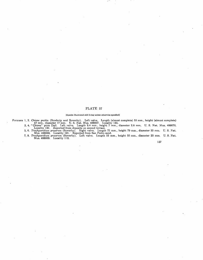
PLATE 37
[Species illustrated still living unless otherwise specified]
FIGURES 1, 2. Chione gnidia (Broderip and Sowerby). Left valve. Length (almost complete) 55mm., height (almost complete)47 mm., diameter 17 mm. U. S. Nat. Mus. 498667. Locality 135.
3, 4. "Chione" picta Dall. Left valve. Length 9.4 mm., height 7 mm., diameter 2.6 mm. U. S. Nat. Mus. 498670.Locality 121. Reported from deposits on second terrace.
5, 6. Trachy car dium procerum (Sowerby). Right valve. Length 75 mm., height 79 mm., diameter 33 mm. U. S. Nat.Mus. 498668. Locality 121. Reported from San Pedro sand.
7, 8. Tr achy car dium procerum (Sowerby). Left valve. Length 55 mm., height 55 mm., diameter 23 mm. U. S. Nat.Mus. 498669. Locality 112.
137


INDEX
A PageAcanthina.____...................__.. ........._.... .... . 76
lugubrls.............................................................. 76, pi. 35splrata. .. ....... ... .... ................ 76
punctulata........................................................... 76Aclla castronsls.___...................... ..........__................ 78Acknowledgments..-.-....--.-.--...-..-.-.-.--.---..-----....-.--.--.-.----- 3Acmftoa................................................................__. 61
asml...........I.........-..-...........-------....-..-....-..........--.. 61funiculata........................._................................. 61, pi. 34inscssa______........................................................ 61loplsina.. llmatula. persona., scabra.of. A. ocbracoa.
Acmaoldao........Actcoclna tumicla.. Actoon.
...................................................... 61
.... 61
..................................................... 61
..................................................... 61
..................................................... 61
..................................................... 61
..................................................... 78
..................................................... 78brovlculus...................................:.. - - - -........ 78, pi. 30schonckl. ... ...... . ........ ............__.........._ 78
nculoatn, Oropldula_...................... ............................... 71aonta. Dlala......_____.........____._........._................. 67acutollrata, Alvanla......._-----_.__...............__..__......... »65aeuticostata, Liotia.-_...............__.................................. 63
Puplllarlaoptabills. ..--.-. -.- -.-------....._-...-..-...-......:.- . 62Ad mote........ _........................................................ _ 77
couthouyl................................................................ 77graclllor.._-----_................................................. ..'.. ' 77rhyssa._.__...... . ._......................................._ 77woodworthi.............................................................. 77
adunca, Oropldula_.___._.....................................__... 70Aoqulpecton.............................................................. 26, 27, 80
andorsoni....__......____..._................................ 26, pi. 28circularls.............._................................................ 80
aoquisulcatus. .. -.._......._-..__".._..___.______........... 80cf. A. sanctl-ludovlcl......_......................._.............. 27, pi. 28
aoqulsculpta, Klssolna._....................................._........_ 66aoqufsulcatus, Aoquipecten clreularis.......---.---..........-...-.......-.... 80Aesopus.........._......_.........................................._... 77
cnrysalloldos__........................................................ 77Idao...................................................................... 77
aothlops, Macron...____.........................................___.. 75Agriculture in tho area.....__......................................_.... 8-9,11Agua Nogra Canyon area.. .......................................:. ...... 22-23Alabina...................................................................... 67,68
dlogonsls. tonulsculpta.. _ ....
Alabinlclno__............alaskonsls, Propoamusslum. Aloios squamigorus.........Algao.Alluvium_.................................................................almo, Alvanla........_ ............ ... ... . __...alta, Novorita roclusiana_....................................................Altamira Canyon area........................................ 21-22, pis. 4, 27,Altamlra shale member.......................... 16-33, 39-40, pis. 3, 4, 6-9,10,Alvanla__..................................................................
acutollrata........................................................_.....rosana......._.... 1 .................................................
almo._............ .......... . . ._ __.. __fOSSillS....__.............................................................montoroyonsls.......................................................__.pod roana.................................................................purpuroa. .............................................^...............^..rosana.................... ... ... ..........................................
Amorlcardla.............._. .... . ........................ ....................Amlantis callosa.................... ................... .........................Ainnlcola longlnqna................ . ...... .... .... .........-...._..ATTinlcoliclao_....................... ..... ...-...........................'.....Amphlssa..._................................................................
col u in b iiuin_............................................................rotlculata.................................................................undata...................................................................von tr Icosa................................................................vorsicolor.................................................................
Amphithalamus Inclusus.......'......-.........-.............................lacunatus_..............................................................
ampla, Panomya......_...................................................Anachis.
nrnoldI...................................................................minima............................................ ._-._____......_.__..._.ponclllata.......................................... .......... ......... ...(Costoanachls) sp_.__......................... ... .. ............. 27,
Anadara perlabiata.__................................................... 79,unaplous, Clilamys_....................................................... 8liandorsoni, Aociuipocten................................ .................. 26,anollum, Vormotus...........................................................angulata, Noptuncahumerosa................................................annulata, Lucinoraa..........................................................annulatum, Calliostoma......................................................Anomia poruviana_ ......-.-.._.._.._.___ ..___ .._._ .____ _ _Anomlidao..._.._._.......____ .^..................................antomunda, Corithlopsis__.................................................antlllarum, Trigoniocanjia aff.______................................... 27,antlquatus, Hipponlx.._......___..._.__..................._......Area lablata..................................._............................
sisquoconsls__....... -.-._ _____.- -._ _. .. ___.....Arclclao_.----... -.. .. ...................__ __.. _..armillatum, Bittium................................._........_.... 67, 68,
108 66
71,72 B, C J3.2865-66
65656666666566 65
" 85 84 66
66-67 77 77 77
' 77 77 77 65 65 '85
77 77 77 77
pi. 28pi. 35pi. 34pi. 28
69758362797969
pi. 2870 79 79 79
pi. 34
Page amoldi, Anachis......_.._._._.................. .-.--.-................i.-.-- / 77
Barbarofusus_ ..................................'.:..........:..... r .: 73, pi. 34cf-................................................................ 73, pi. 32
Cerithiopsis....-..-.....-......----------..-...-----.-.-.........-......... 69asmi, Acmaea........__-...-......-.-..._....-..-....-....-.._.._. 61aspera, Tritonalia lurida....-..-....--.--...-.......-..-............-__... 75asperum, Bittium..___...__...__... .__... .... .._.....__.. 67-68Atrimitra..............__...__................_...._....._........... 73attenuatum, Bittium______....._.............__.._.___.___ 67-68aurantia, Tritonalia circumtexta.. ...--..........--..-..-._............._ 75aurantiaca, Lacuna unifasciata__........................................... 64aureatincta, Tegula_.........__._...................................... 62avalonensis, Borcotrophon .. .................................. p _. 76
Bbacula, Homalopoma..__..._............................................ 64baetica, Olivella........................................'....-.................. 77barbarensis, Barbarofusus........__...................._....._...... 73,pi.34'
Cyclocardia.--....-._---_-._..__._......-.._....-._................... 83,pi.31Glycymeris____ ..._.-._- _. ._..---. -....__. __..__._ 79Ocinebra.._____...._........_..__......._................... 76
Tritonalia................................................................ 75Barbarofusus-__.............._.... ......... .........__..... 73
- arnoldi.-. -_...--.---_-.-------------_----.---------.-----..---.. 73,pi.34barbarensis.......-...---.-...--.-.------.-................. ............ 73,pi.34cf. B. arnoldi-.....-...-------------------..--..-----.----.------..--.. 73,pi.32
Barleeia..._____............-....... ........ .......___.. -., 66californica.. dalli. .... haliotiphila. oldroydi....
Barnacles.
........ ............. .................................. 66
............. .. . . . .- 67
............. ... .-.... - ...-. ....... 66
......-.......---.-- -...... --..-.-..........-... 66
....................................................... 85Basaltic rocks....................................................... 108-109, pi. 6, CBela ....... -1 77belcheri, Forreria.'____._.._.._.......__........ ._......... 76,pi.35berlngianus, Chlamys islandicus_........................................... 81
Panomya.______._.__.............._.,.._._............. 85,pi.33berryi, Cerithiopsis.____.__...... ......... . ._.___... 68biangulata, Trigoniocardia............ . _... . _____ 85, pl/35Bibliography.................. . .. ,. __________._ 3-8bifurcatus, Septifer....:___........... .. _. ......._......... . 80biplicata, Olivella...................-............-.- -. -..... ... 77Birds...-.........-.....---.-..-----.--.--------..-----.---------.---.-......- 86bisecta, Thyasira._____.............. .___. ...__._._... 83biserialis, Nucella....__ ........ .................................. 76bistriatus, Pseudamussium. ......... . . .... ..... 81Bittium........................--.....................-------.-----...-..... 67-68
armillatum..-__...--.------..................................... 67, 68, pi. 34asperum......__........................................................ 6.7-68
lomaense.------------------------------------------------------------ 68attenuatum. __...^........................... .. ............._.. 67-68catalinense.___ ....................................^.................. 67-68cerithidioide.............. .............................................eschrichtii.
montereyensis. giganteum:........interfossa.
................................................. 67
................................................. 67 -, . :-.- 67.__.... .-. .-......-- .--....-....... -... 67
ornatissimum...__. ..._ - . _ . . . .... 68purpureum....___.--...-..-...-..-.--.....-...--..-.......--.._..... 68quadrifllatum..-.__.........-........................-............'. ._ '67rugatum.......................................................... 67, 68, pi. 29
lanun--. - .- .67, 68, pi. 29serra_........._......__.. .-.._ ._.-. . ._.-_-.-. .._. 67subplanatum...._..-....-........-----......-....--....-......'.---..-.. 67(Elachista) californicum._.......... ................._............ 68
Bluff Cove area...........:.........-----..----......--.... 18-19,20-21, lll.pl 6, BBoreotrophon.
avalonensis.......... calliceratus.__.....orpheus.____....pedroanus...........praecursor...........aff. B. multicostatus.aff. B, stuarti_..__- r -cf. B. paciflcus.......cf. B. raymondi._.
Borsonclla........._...Botulina.
76767676
.76767676767677 80
Brachiopods___............._..............._. ....... . 60branneri, Crassinella...._. . ... . _. . -. , 82, pi. 36breviculus, Acteon.._......_....._.___.___ ................ 78, pi. 30brevis, Turcica caflea.._................ .__........................... 62brunnea, Tegula_....................^..................----....,.----.-....- 61Bryozoa................................... ......,............._........... 60burragei, Rissoina.. ...........-...-....-.........-...--.----......-.--------- 66Bursa californica. ................................................... 72, pi. 29Bursidae.-...._._......-.....-.-- . . . . . ----- 72
592787 4.5-
Cabrillo fault..... ... PCaecidae........_.................. ....................... .Caecum...__..__._........... . ....... .......
californicum__...._.._..... ..... .............. . ....grippi...._ ..magnum...._.. ................... ............ .....
caffea, Turcica.......__...-.-..-................-.....------..---..---- - 62,calcarea, Macoma_......----....-.------- -.... ...i.. 84,
-.-- 139
69 69 69 69
pi. 32 pi. 33
-12

INDEX
Page Calicantharus fortls.................................................... 74-75, pi. 29californiana, "Nassa".....................................................___ 74californianus, Mytllus.................................................___. 79californica, Barleeia...............................1....__.............___ 66
Bursa..,..____..................................................... 72, pi. 29Cerithidea..-....----..-.-.-----.--.-......-.-.-..-.----.-..-..-......... 68Cyclocardia. ..................................................._ 82Epilucina.___._____....................._."..'..... .............. 83Hyalina................................... .............................. 77Trivia.................................................................... 72Truncatella......________......._...._ .................^........ 66Valvatahumeralis..-.._-...--....____................__...___ 65
californicum, Bittium (Elachista)........__......._......__.........__ 68Caecum._........___ ................................................ 69Elassum.._________..........._......................___ 68, pi. 29
californicus, Conus..... --.-..,..---.-... ------.--.-------...-.-..--.-..... 78calliceratus, Boreotrophon............................................._._ 76 Calliostoma._______................._.........._...........____ 62
annulatum.. .. ---.........-....----.--.......-..-..........-...__ 62canaliculatum. _.._........__....................._______ 62costatum..... .................v..................._.___....__ 62dccarinatum_..-.-...--...---.......--.......--....---............_.. 62eximium.__.__................................................... 62, pi. 35grantianum_------....---------.--.---.----..----------.--....-...--.... 62ligatum..... ..............................._........._......__ 62supragranosum. ..................................................__ 62virgineum..... -.-...---....--.--.---........--.----.--.....-..--.... 62
callosa, Amiantis-.. ....f .......... .-....-..-.--.-..-........-....__ 84Neverita reclusiapa. ......... ................................ 72
Calyptogena_. ...--.-.-...--...-.-..----...-.--.------. -....--.--..... 83gibbera................................................................... 83paciflca._______.........-..--..-.._...................__.___ 83
Calyptraea._... ......-...........----.'-.-...-.--.-..-.......-.-.-..... 71fastigiata__ .................................. .................... 71mamillaris__ .....................^.................................... 71
Calyptraeidae.__ ___..........................................___ 71canaliculatum, Calliostoma....-..-----..-.---......--.....-.........-...-__ 62Cancellaria___.___.:........--...-.._.........._...........__.__ 76
cassidiformis_-.--.....--------..-.--..-........-.............._.__ 76tritonidea........-.....-..-.;--...... ..-........................._ 76, pi. 35cf. C. condoni. ....--...-. ...............__.__...____ 27, pi. 28
Cancellariidae..-.-------------------.--...-.......:....................._ 76-77Cantharus elegans........................................................ _. 75
insignis...... ...................................................._ 75Capistrano Beach..--.-.....-.-..-......-.-...-...- ...-................._ 105cardara, Nucula afl......----................................................. 78Cardiidae.....-..-----------------------------.I----.-.------._._.-------._.-_ 84-85Cardita......-. .--.--.......---.......---.......-......-....-.-..-....... 82
carpenterl..___._.................................................... 82minuscula..--. -.....-.-...-..--.. .-.-......---.-..................... 82monilicosta.---------------------------------------------.--..-.--.---...- 82occidentalis..---------.----------.--------------.-.-..-....-.---------.-.- 82subquadrata-. ....................................................__ 82ventricosa'......--.-----.-.-.-------.-.---.-......-..............--...._ 82
Cardltidae....... -. -- - ---- ..... .-.-.-..._.-._.- 82-83carinata, Lacuna--..---.-----.-.----.--.--.---.-....-.---.--..-.....-.-_:.. 65
Mitrella.................................................................. 77carlottensis, Macoma...__............................................___ 84carpenter!, Cardita... __._.....-..._...._.._.._...____ __....__._______ 82
Homalopoma..._................................................ 63-64, pi. 29caryophylla, Puncturella............................................_.__ 61cassidiformis, Cancellaria..................................................... 76castrensis, Acila....- __.................._.......................__ 78catalinense, Bittium_____...............................___...:..._.. 67-68cataractes-Pecten ...-.....--. .-.-.-...--..--...-..--.-....................... 80caurinus, Patinopecten__..--............................'........... 81,pis.32,33centifllosum, Pratulum._................_........................._ 85, pi. 33Cerastodenna nuttallii___._.-.--.-.---.-.-........................... 84, pi. 34Cerithidea californica.__...................................... . ....... 68eerithidioide, Bittium....................................................__ 68Cerithiidae....___._....................................... ......... . . 67-68Cerithiopsis....._._...............................................___ 68-69
antemunda..._...................................................__ 69arnoldi..._............................................................. 69
fossilis_-------------------------...--_.-............_______-...-._ 69berryl..._.._--..__._._.....__..._...._. .._....._......_..__.............. 68cosmia.-__._......................................................._ 68-69diegensis. . .......................................................... 69fatua _ ......................................................_ 68gloriosa.__.___............................. .............I:.....__ 69necropolitana.------..----.-.-.-.-..-.-....-.....................--....--. 69pedroana...--- . ................................................. 68
fatua-___--___..----.-.-..-...........-....... ...... . 69willetti.__...-.-.-...._........-.__..........._.___.____.____............. 69williamsoni...-..--.....__............................................. 68
cerritensis, Leptopecten latiauratus........................................... 81"Nassa"..___...____--.-...-.-.-.--....-.....-.-...............74, pi. 35Ocinebra lurida._....___......................................._ 75Trophon.....___._____...........-..........................:..... 76
cerrosensis, Ostrea megodon__.-.--...-..-..........-.-.-..-.....-........ 81, pi. 30Certhiopsidae......_______........................:...........^........ 68-69charybdis, Crepipatella_____..................................... 71, pis. 29,32Chionegnidia.... .______............................... ... ...... 84,pi.37
picta......._....,.._________._.____!._________...____._.._.__.__.___._ 84, pi.37(Lirophora) aft. C. mariae..._........................................ 27,pi.28
Chitons...._..._........._............................................. 61Chlamys..-.-..-.-...--.--.----.-.-.-..-.-.-,._............... . ........ 80
anapleus....._...................................................... 81, pi. 34etchegoinl.,___....................................................__ 81hastatus_.__......................................................... 80hericius__.__.-I-.-.-.-.-.---.----.--.-.-......--..................... 80islandicus____...................................................__ 80
beringianus_......................................... ... .. 81hindsii. -----------_-_..---.___._...._._._.._._____.___ ...... 80jordani____.................................................. 80, pi. 32
navarchus.._........................................................... 80opuntia..__..__...................................... ... ....... .. 80parmeleei.....____..............................__.............__ 81
chrysalloides, Aesoptls........................................................ 77Chrysodomus........ ......................................... . ...... 75
diegoensis....-----__... ............................... . ........ . 75pabloensis___............i.......................................... . 76
PJdariQacidarls.........................,.,..,..,.,,,.....................;., .52
cidaris, C idarina_ ......^...................................................circularis, Aequipecten.......................................................circumtexta, Tritonalia__.......................................... .....cistula, Lasaea_.-..._....................................................citrica, Tritonalia circumtexta................................................clausa, Cryptonatica.._...._..............................................Clavatulacf. C. labiata................................................ 27, 28,Climate of the area.__._._........................................._..Clinocardium.-.-.._.___.................................. ...........coalingaensis, Pecten....... __....___...................i...................coilotera, "Nassa" fossata_.............................................. 73,collinus, Qlossus (Pectunculus)_ ...............................^...........columbella, Erato ------- _ --...--.....-..................-..-..--....-......
solidula_------------_..-----_--_---_------.-.-.------.-.....--.--.._.._praecursor____...__ ......................^.....................
Columbellidae.. .......................... ....................................columbiana, Amphissa.......................................................compacta, Lacuna.--.......-.--------.....------.-.-..---.-..........-........compactus, Pecten__.____.__-.--.-.-.------.---_--__-_.--_____........_....Compsomyax.----------..---------.--------.----.-----.-.-..--.-.---......-..compca, Tricolia..----.._.._._-----------_------------.------.__._-----.._.-..Conchocele.----------------.------.--------------------.---.-----------.-.-.-condoni, Cancellaria cf. _..--_---.------------------.....--..-..-------.. 27,Conidae.--------..-.-----.-..------.----------....---------.-----.--.-.-.-.-..Conus.. --.-.---- --.----.---.--.--------..-.---...----....--.-.-.....-.-
californicus--.--.--.-----_.--......---.-.----..-..-.....-..........._.fossilis.-..---.-----.--.----..----- --------...---.-----.----.-.-.....-.
owenianus..---------.-------------------------------------..--.-.-_ 28,cooper!, "Nassa" mendica.__ ....--....-...-.........-.-...-...-.-.. 74,
Progabbia.._.______ _........ ..... ,...................Puncturella.-.-._____.. ..........................._......... 61,Turritella....---..--....-.--..-..--..-..--..-......--.-........ 69-70, pis.
Corals...................._.-.._.._........_..............._......coronadoensis, Cyclostremella-..__...._............................_..
Rissoina..__..___.__________.....____ ....r ........ .. 66,Correlation of formations, Miocene series................._._.......
'Pleistocene series._____ ____.._............_........Pliocene series..._._._ ................^......^..............
cortezlana, Glycympris...___.....--.---.---...............................coryphaena, Tritonalia_____..__.._ .............^.^ ...............76,cosmia, Ceritblopsis._____._____......--.-....__._..............
Rissoina.----._._.___....._._._.........._..................costatum, Calliostoma.....__.._ .........^.............................^^couthouyl, Admete...-.........-......----..-......-....-----...;.----.....-.cracherodii, Haliotfe____.__........___..-.-...-. ...... .........cranioides, Hipponix antlquatus...-....-.....-..------.-.-..--...............Crassatellidae_...-----.._...-..........--....--...-..--.--......-.-..---.Crassatelliteslomitensis....--__..__...-......-...------_...............Crassinella...----__.._....--....---.-..--..-......---........-----.. .
brannerl......_...-..-...----_....----.....---.-- ...............82,nuculiformis.._____________. . .. .. ---- 82,varlans..._.._____.......... .... . ........ ...........cf. C. mexlcana....__.................................._......... 27,
crawfordiana, Crawfordma....-----..- ....................... .........Crawfordina crawfordiana._. .. _--.-_.-..-...-.-.- .... -----crebrlcinctum, Micronellum.............-.---.-...................-.-.-....--Crepidula..________..........__...--....__._.:.-.._........,--.-...-
aculeata.... .....................................^,.^...^. ...........adunca.... _____...___...______._..._.__.. _-..__..._............excavata_._.._---.--..-.-.--.-..--.-.......--------.-. ...........grandis.._________........___....... ......................nummaria.__.-..-....-.....--.._.--.---. -...__..............onyx.orbiculata.---------------------_.....---..----.... -.-.-.........-..-.--princeps___ .........................^.............................. 70,rugosa..__.---------_--.-._,---.---_---.----_-.-----_----.---------------.saugusensis.__--..............-.-...--.-.-......--------....------- .-
Crepldulidae..--.----------.---- ----.------------------------------- ------Crepipatella____-....___......... .......... .... . ..--
charybdis.-.-.:-.-..-..-....................-..----------- .......... 71, pis.llngulata__-..........--..--.-......-----...-..-..--.-,..------.--.-----
Cruclbulumsplnosum.._.... ........................... ...........Crustaceans...--------_.--....-..-...........------.--. ...........Cryptonatica.--.-..-----.--......--..-.......--..-------------.---------------
clausa...._______.................. .... .................russa.
cucullata, Puncturella.. ___ ...--..-.....-..-..-- ........ ............Cuminpia lamellosa _ . ___ ..... __ ... .............-..---.----. ..Cunearca. .. _ . _ .---..---...--..--.---...-.-. ..........................curta, Eupleuramurlciformis...- .......... ..... ........................
Paludestrina ..... _ ....-.......-.....-.-.....-..-........----..-.---Thracia _ ___ ...... _ ........................ ............. ......
Cyclocardia...-- ...... _ .................... .................... .....barbarensis .... ..... ".....-...-.......--......-...-.. 83,californica- ___ . __ ..-. __ .... __ .. __ -- -- ---- - nodulosa ..----.....-....-...-.-...--. .. ...---..--.-- .. ..stearnsil __ .... ____ ---. ............. . . ventricosa.---.--- _ .- __ ...... ......-..-..----.-... --afl. C. occidentalis-.......- -...-..- -..-...- ---- -- 82-83, pis.
Cyclostremella----. _____ .... __ ... ----- - coronadoensis . ___ ........ ..... . ........ ......
Cymatiidae. . . . . . ..... .. . . .... ...... Cypraeaspadicea --....-.. _ ----- _ .---..-.........- .....--- ....Cypraeidae.. ----------------- .......--.----.-..-.--.-..-.---.------------Cypraeolina pyriformis . .. ---- -Cyrillamunita.---- . ___ ... --- ..-.....-----.-..---.-.--...
Page 62 80 75 84 75 71
pi. 288-9
8480
pi. 36 79 72 77 77 77 77 64 80 84 64 83
pi. 28 78 78 78 78
pi. 28pi. 34
77pi. 2934,35
60 63
pi. 29 40
96-106 42 79
pi. 3068-69
68 63 77 61 70
81-82 82 82
pi. 36pi. 36
82pi. 28
77 77 69
70-71 71 70
70-7170717071
pi. 32 71 71
70-71 71
29,32 71 71 85 71 71 71 61 84 79 76
66-67 85
82-83 pi. 31
8283 83
82-83 31,33
63 63 72 72 727778
D
dalli, Barleeia... . - Rissoina ---------.... _ _ ... ---------- ---..-....
Dallocardia _ .. _ . -- ----- ...- -... ------------Deadman Island .. __ .. _ .... . ... ---- decarinatum, Calliostoma-.... --...-----.-...- ......... ̂ ......... ...... ...Delectopecten. -.--.-.-.- _ ....---......----..-..-.----..--.--.-.-------.----delosi, Leptopecten latiauratus... ...... ... ...- ...------.. ....... .
"Nassa" .-------".-.- __ - . - ...... 74,Puncturella __ . ____ --.---....-.---..-..-.----- - ------------ 61,
Diala.acuta.__. marmorea. varja......
67 66 85
45,56 62 81 81
pi. 35 pi. 29
67 67 67 67

INDEX 141
Page Diatomlto...... -...... . . .-- - 119-120(llogonsls, Alabina.. . ........... .............. ....... ... 67
Ccrithlopsls........................-...-.---.-.--------- ----.......-..-. 69Pocton...........--........-..........----.-.-------------------.--.--.._ 80
Stoamsll. .... .... . . -----..-_-... 80dlogoonsls, Chrysodomus...........__................... .......___ 75Dlplodontasericata........................-.-.--------.--------------. 83-84, pi. 36dlsjuncta, Thyaslra....................................................... 83, pi. 33dlvarlcata, Lacuna......__.._...._................... ......___ 65Divaricolla of. D. oburnoa.................... ............................ 27, pi. 28Dooomphala . . ... . ----- ... .. 63Dosinia pondorosa.._._......_......... ......................... 84, pi. 36
afT. D. pondorosa............................-.-....--.------.-.....-. 27, pi. 28clumbloanus, Phos............ ............ ................ 27, pi. 28Dunesand......... ....- . .-. - -. - - 107-108,117
E eburnoa, Divarlcolla cf..........-............--------.-- .---.-.-.......-- 27, pi. 28Echlnolds..---.-..-----.--..----------------------------.-------------------- 60El Scgundo ollfleld, location of.___....... . ... ...._..._ 8Elachlsta................._................................................. 68Elassum callfornlcum........_.............................. ._.... 68, pi. 29olatuin, Trachycardlum.-............--..----.--.-...-..---------..-.-------- 8floldrtdgoi,Jaton... .... .-. .......... .......... 75ologans, Cantharus.. . ..-..._.. . 75 omarginata, Nucolla._..____._..._.._.........-.--.-.______.__ ....... 76Environment suggested by fossils...--.-----.-.-.-.-------------. 39-40,42,86-96,102Eplluclnacallfornlca._______.......................... ___..__ 83Epitonlldao.....- - ----- -- --- - 72-73Erato...... . .. . -- -- - 72
columbolla_ ...................................................... 72vltolllna. ...................-... -..- - .. . 72, pi. 30
oschrlclitll, Blttlum....-............-....-..---.....-------------.....-......- 67oshnaurl, Vltrlnolla...............................-.--------..-.............. 63otchogoinl, Chlamys.. ................ ................. -..--. .. 81Eucrassatollafluctuata.......... ..... . .... ..._._ 81-82, pi. 31Eullthldium................-..-.-.-.-...----.-.-.--------------------- 64
..........................^................................... 76Euploura.grlppl.......-.. niurlciformfs curta.
ploistocononsis.Euvola.
....... .-.-.......-....--.-..--.... ... .. 76
......... -..---....--.......-..-.-.-.------ 76
..............-...--.-.-----..-------.-.--- . 76
................................................. 80oxcavata. Oropidula.. . .... ..... ..-.--. ................. 70-71oxlgua, Nucula.... . ..................... ....... .............. 78Exllloldoaroctlrostrls...__...... . ...... ................. 74,pi. 32oximium. Oalliostoma..... . ........ ... ................... 62,pi. 35Exploration In the area ......... ._.__.__.._, 3
Fortulum..__... .... . . .......................... .. 69homphllll..... --.--.-. -.-.------------------------,------...--.--- 69occidoutalo.._. _...--.-.....-..-.-----.-------...-------------.--.- 69orctittl.......... _.........-.............-.-.-----------..-.......... 69
fastlglata, Calyptraoa. ........ .......... .................. 71fatua, Gorithiopsls. _...... .... .. ...... .__.......... 68
Corlthlopsfs podroana..................................... . . ... 69fonostrata, Isollca... . ... ................. ............ 65,pi. 34
Llotla................... .. .. -- - -. ... .. 63fonostratum Honialopomapauclcostatum..................................... 64fostlvus, Jaton. ... ........................... ... 75Field work..__________..... ....'........... .................._ 2-3jTissurolla volcano... ___ ................... .. ... ....... 61Flssurollldao..... .- . ..-----.--.-------.--.--.-- --. --.. 61fluctuata, Eucrassatolla.__.....__......... ..................... 81-82,pi. 31Foraminlfora......................................... 19,25-26,32-33,35-37,39,42,60fordll, Vontrlcola ....................................................... 84, pi. 31Forrorlabolchorl...................-..-..-----.----------.-----....-..-... 76,pi. 35fortls, Calicantharus.__...._......._......................__ 74-75,pi. 29Fossarldao......... _______...................................__ 65fossata, "Nassa"...... ..... .....................................__ 73Fossil localities..-........ ..........-................... .............. 120425fossills, Alvanla.___.._____................................__....__ 66
Oorithlopsls arnoldl_._... ...... ......................___.._ 69Conus callfornlcus. . .............................. 78Trlphora..._._____._____......_...__.__._............ 69
Fossils, environment suggested by............................... 39-40,42,86-96,102Miocene.................................... 16,19, 25-28,32-33,35-37,39^0, pi. 28Pleistocene................................................... 60-96,pis. 29-37Pleistocene to Recent____.___........... ... ___._.. 107Pliocene.................................................................. 42See also names of fossils.
fovoolata, Tritonalla...._____....... ......... ......._._._ 75fragills, Pocton (Cblamys) latiauratus................_.....__.__.__ 81fulgcns, Hallotis........................................ ................... 61fultonl, Mltra.......-.............-.--..-.--................................. 73funobralls, Tegula.._____........_...................._.._._.... 61funlculata, Acmaca____.........___............_ ............^..... 61, pi.34
Knofastiacf........................................................... 27,pi.28fusconotata, Trltonalia.........................................__........_ 75Fusinidao...........___ ._.__..........._....._............ 1_._ 73Fuslnus lutoopictus.._____.............................................. 73Fusltrlton orogonensls..___....____.........._............_.... 72,pi.32Fusus (Bucclnofusus) portolaensls.__....... .......... ____._ 75
O Gadiniaroticulata..___.__................. . . ......... 78Gaffoy anticline and synollne.............................. 48-49,52,58-59, pi. 17, Bgalcata, Puncturella..__________......_.... ... ______ 61gallina, Togula............................................................... 61Gastropods....__......_.____.__.........____....._._.__ 61gatunonsis, Strombuscf...._._.__........._............._. 27,28,pi.28gausapata, Mitrolla carlnata_........_............. ......__..._ 77,pi.32gemma, Jaton......____......................................_... 75,pi.30Geography of the area....._..........___.........._._-...-.-...-.-.. 8-11George F Canyon area__.._.._.__......................_ 23-24, pi. 24, Agibbora, Calyptogona....______.........._......... .....___.... 83glbberosum.Pachypoma....._......................................._ 63,pi.29gigantcum, Bittiuin....____....._.........__._......_____.. 67gllbcrtl, Slphonalla.............^.....-....-.-......------------..-..._..--.. 75Glacial-1 ntorglacial assignments...__........._.................__._ 100-103Glanssubquadrata..._.___.._......................................... 82
Page gloriosa, Cerithiopsis......................................................_ 69Glossus (Pectunculus) collinus._........................................... 79Glycymeridae.-_._____________.-____....____._--_._-_.---._..--__..--___... 79Glycymeris_................................................................ 79
barbarensis..__............_..............._...______....._ 79corteziana...______....................................................... 79migueliana............................................................... 79profunda...____...__................__....._._..._I.!__ 79, pi. 30septentrionalis_........................................................1 79subobsoleta_............................................_.-.........".. 79veatchii....__.............__.............__._.......____.. 7&
gnidia, Chione........................_.........._..........._.___ 84,pi.37Gouldiaaff. varians....._....._ ......'........ .........__...__.__ 82gouldii, Thyasira............................................................. 83gracilior, Admete._...__...._.__....__...................__...... 77gracilis, Trophon.......................................___............... 76gracillima. Tritonalia............................................._.......... 76grandis, Crepidula__...................................._........_;.. 70
Pandora.............................................................. 85, pi. 33grantianum, Calliostoma...__................................___._ 62Gravel........................................................................ 120Gregariella.grippi, Caecum.
Eupleura...Gyraulus.......
HHaliotidae... _. __. haliotiphila, Barleeia. Haliotis.
cracherodii......................................................._.....fulgens...._____...__..........__.........____._____..
. rufescens.........._.........._........................._...........Halistylus pupoideus.-.......................................................harfordi, Harfordia.._......_......___...___............_.__....Harfordia ..........................................................__..
harfordi...___.._..._....__.....__.__.__...___.__..monksac_.......................................................... 73,
hastatus, Chlamys__.......................................'......_.......Helisoma___.. __________...____... __....__._.__......hemphilli, Fartulum_____....................................._......hericius, Chlamys.._.....____.........................................Hilltop quarry and nearby localities................................... 49-51,hindsii, Chlamys islandicus_...--...-.-...........- ......................Hipponicidae._________..........___._......_......_.___..Hipponix..__.______..............._....... .....___ .
antiquatus____..........................................__........cranioides.-__-------.-------,.._.--.--.-..-.-----.----_._...._.
tumens..______........___.___.......______...........History of the region_____.........__.___.. _____..........Homalopoma......___............ ............. .._.._...............
bacula.........___............... ......-.......-..-.-..--.-...--....carpenter!.......................................................... 63-64,paucicostatum____...................................................
fenestratum......_....................._.........................subobsoletum_______._.................._._____.__......
hooveri, "Nassa'' versicolor..-.....................:......................_humerosa, Neptunea.........-.-.-...-..-.....-....-..-.....-...__........Humilaria......__.___.....................__........__._.......Hyalina......................................................................
californica.--.__________-__.___...____.-..-..------------_----_-_. .......jewettii. __...____......................................................
nanella..______.......__......_...._................_..regularis......__.__............................. ....................
Hyalopectenvancouverensis.-..--.-.-..__............ .................. 81,Hydrobia protea.__________._____ .__... *--.-....______.
80697678
61 66 61 61 61 61 61 73 73 73
pi. 29 80 78 69 80
pi. 16 80 70 70
. 707070
363-64
64pi. 29
64 64 647475 84 77 77 77 77 77
pi. 33 66-67
idae, Aesopus......._.__........____..._ ._............._.... 77Mitra.................................................................... 73
Igneous rocks.....--..-----.--.---.-............--.-..-...-........--....-.. 108-109imperforata, Neverita reclusiana.............................................. 71,72imperialis, Turcica.-...---.-----..............--.-.-......-.-.--...-.-....... 62inaequale, Pachypoma.-.___......................................._.... 63inclusus, Amphithalamus__................................................ 65indisputabilis, "Nassa" mendica... ..........................................'. 74inflatula, Macoma.....__................................................... 84insculpta, "Nassa"._......-.-.... -.........-..-..............-...- -.-... 73,pl. 29insessa, Acmaea.._______........___........__.___.......__ 61insignis, Cantharus____-.--...----........-..----....--.--..........-..... 75intastriata, Nassa.:......__--..._.......................................... 74interfossa, Bittium.._ ....................................^................. 67
Tritonalia................-.-..-.-.......--....-...-.I.................... . 75interstriata, Nassa_..._.................................................. 74intorta, Olivella..-.-.-.__................................................. 77invallata, Pseudorotella.__........___..........................__.... 63Iselica fenestrata___.............................................. 65, pi. 34islandicus, Chlamys..-.-...-------------..-.-------------...---------___-- 80
Jaton_._.................................................................... 75eldridgei.______._.-..-__.....................__.........; 75festivus._.____--...__.........._._........................ 75gemma.______._...........__........__...._._........ 75, pi. 30santarosanus.__._.................................................... 75
jewettii, Haylina...__...................................................... 77Turritella. ............................................................. 69-70
jordani, Chlamys islandicus..___........__...__._____..__ 80, pi. 32Jurassic system______-.---_-.-_...__................._---------- 12-13
K Katherinella_.....__......__...___................................ 84
subdlaphana___....__________...____.____.___ 84, pi. 33pedroana.
keopi, Tritonalia__._...Tritonalia interfossa cf.
Kelletia kelletii.............kelletii, Kelletia............
Macron aethiops_.... kelseyi, Milneria-
847575747475 83
Rissoina--...-...-....---.------..........-.....-..........-..--__.. 66, pi. 29
142 INDEX
Page kennerlyi, Mercenaria____ -. - - -_- -_- 84kettlemanensis, Thais.-----___---- - . 75knechti, Pupillaria optabilis_____...-..-.-....__.-.-___-..___ 62, pi. 34Knefastia cf. K. funiculata______._______.--.__.______ 27, pi. 28
T, .
labiata, Area......_____ _,____-_...............................__ 79Clavatulacf. .--------.----------_..-._.. ----------. 27, 28,pi. 28
Lacuna___ ___.....................................................__ 64-65carinatacompacta__......__.--... - ... ._ ... . divaricata___________ _..._ ----._ . .---_-_._....porrecta... __.___.__ -....-. ._ __. _ ... ....solidula_......______ ___,.___.___----____._._.........__...-..-.__unifasciata_._............_.........................................
aurantiaca____.............................. --------------------variegata.......__...._._............................... ----------
acunatus, Amphithalamus..___..__. -_ _ . . - Lacunidae._______________........-.......-'-..---.-..-.I.--..'-.....Laeyicardium.._____._...... ......................................laevigata,Velutina.......^................................................-..Lamellaria stearnsii__ ........-----.... ...-..-.....-.-.. --.-..---------...lamellosa, Cumingia....___.................._......................_...
Nucella___________.__._.............__..............__....Landslides__.__._...-.---. --.-.-.-..-..-..--..------------..--.-----larum, Bittium rugatum._______...............................__ 67,68,Lasaeacistula.__________.__..............................____lasia, Trophonopsis...._______........-.-.................---.-..:.- 76,latiauratus, Leptopecten_.__^.........................................lepisma, Acmaea. __.__ ___..............--...............--. --.-------.-..lepta, Terebra (Paraterebra) cf.....-.-.-...-..-.....-...:..-...........27, 28,Leptonncea........._____......_................................ Leptopccten.... __: __._............................... ...
latiauratus..._._____.... _............ _...................__cerritensis....-_.__..........-...-...-.......-..-...-...-.....-.. delosi- .-__......................................................inonotimeris_..___ _... ....__
lewisii, Lunatia...______.....__ ... ...__...--..........--.-.-.-ligatum, Calliostoma._. . . --_.- -- . ligulata, Tegula....____._...._.............._...'........-._-----limatula, Acmaea__._....-.-.-.-.-----.--------.--..------.-.--.---.-----.lingulata, Crepipatella__.__.........................._____...... .Liotia..-......- _._....____ . ... .__...............
acuticostata......_.....................................................radiata.._______.__.....................____.........
fenestrata_____.....___.........................___....__. Liotiidae.._-.__---------_ - --- -Llrobittium.____.......__.............._..__.______-----__Liralaria...____..._.__....._ __......._..__........._.......
magna.______...__................. _...__._......:..- ..-Littorina.
65
6565646465 65
64-65 85 72 72 84 76
117 pi. 29
84pi. 34
81 61
pi. 28 84 81 81 81 81 81 72 62 62 61 71 63 63 63 63 63 67 62 62 64 64 64 64
scutulata.__..__._..................._ ._.____..._. 64Littorinidae-______.___...-- _.....________.__I__.. 64Hvidus, Macron...._._...___..._.___.________......__... 75lomaense, Bittiumasperum_._ ............................................ 68Lomita marl..... ......... 43-46,49,53,90-92,96,98-99, pis. 15, A, 16,17,29-31Lomita quarry and nearby localities-__..__._....____ 41,51-52, pi. 17, Alomitensis, Crassaftellites_.._____-... .. . .-._........__.... 82longinqua, Amnicola______..__.............'............---.--.-.-..-. 66Lora...__..____.______._.........___._. _ - 77Los Angeles Basin, correlation of formations in.. .... _._......... 103-104,105
oil fields of .___. .._ . 8Lucinidae...__.____________.............._.._...._.__... 83Lucinoma annulata____.............-.............-...--'----_...._... 83lugubris, Acanthina.____.....__.__...............__.___._ 76, pi. 35LunadaBay area..........-.-.-....---..-............--.-- 21.29-30, pi. 8Lunatia lewisii-..__.__.. .._ _.____ ._.......................-...-.- 72lurida, Ostrea_____.___...___ ................._-.___._... 81
Trttonalla...... .."............ . .... 75,76luteopictus, Fusinus.__________..........._____. ... ___ 73
pedroana. planaxis.. plena.
MMacheroplax.......
varicosa........cf. M. varicosa.
Macoma.calcarea__________.___.................................... 84,carlottensis______ __.___............................. ........inflatula._________..._..__ __ . - .. --. -- .planiuscula____...__ _____......................._..--......-
Macrocallista cf. M. maculata_.___... ._._..__ ....... 28,Macron.._.____.._..................................................
aethlops..___...._...........-.:-.. --........-----.....-.---.-..---.kelletU.-- - .- - -. - -- -
lividus_.___._________ ._. . _ _ --- -- macroschisma, Monia.--.------. .. . -- -- maculata, Macrocallista cf.............-.....'...-............-....-....-... 28,magna, Lirularia...__.__.__............-..-....-.--...--...-.--. ..-magnum. Caecum._..__ ..................................................major, Mitrella tuberosa__.....---.-.--..-.--..---.-.-.--...--...--._....Malaga Cove area................ 20-21,28-29,34-35,38,41,53,59, pis. in, A, C.Malaga mudstone member...._.._.__.....___ 37-39,40, pis. 11,17, B,mamillaris, Calyptraea...__....................______... .. ... Mammals......____._ ..........................^.......................marcida, Tegula._____. __ ..----- . _._. -.-. -.-.- --Margarita...-...--.__._._ ..._ _ _ . _ .
optabilis nodosa.__'__.._.......___........._.................parcipicta pedroana_.__.....---._......._.........-.-......--.-...
Margarites.....______-.......-.-.----.---..-.-.-.-..-----......-----Marginellidae..._______.__.......-..-..-..-...... _..-.-..-........mariae, Chione (Llrophora) aff______............- .-..-..-'.-.-..-.... 27,mariana, Turritella ..__....--.-.--.-...--....-.....--.-..-..... _* ._-.Marine terrace deposits.... - 53-59,93-95,96,99-100,Marine terraces.......__............................. 113-116, pis. 23, 24, C,marmorea, Diala.______... .- .-..- ...........__...... ......megodon, Ostrea.....__ __ __ ........ - ...... ....Melampus olivaceus___.--.--..._.-.---....-....--.-..--.....---.--..--.Melanellidae._______________--..-......_..........____....
62-63 63 63 84
pi. 33 84 84 84
pi. 28 75 75 75 75 79
pi. 286269
' 7711,1218, A
71 86 62 62 62 62 62 77
pi. 28 70
pi. 3-525, 26
67 81 78
72-73
mendica, "Nassa".._---_.--------.-.---_..-..-......-....-...--.-.___. 74Mercenaria......_.._.._..--..--.......----....-........-.--._..__.. 84
kennerlyi.._________..........._.......__.......______.. 84perlaminosa.-. .____.__...._____............______ 84, pi. 31
Metamorphic rocks.______..........._.-.-....--_............__... 12-13mexicana, Crassinella cf__.._...-....-.-..._.------.-.-.-...__.._ 27, pi. 28Mexicardia._______................._.................__.___.__ 85Micranellum crebricinctum._............-.....-..--..-.---.--..-.....___ 69Microglyphis............._._ ._. -. _. ___.__......._.. 78migueliana, Glycymeris.._---------.-------.-----. ......__.-..__.... 79Milneriakelseyi.____________.______.______________ 83 Milthasanctaecrucis.--..____..__.-....... _________-_.. 27, pi. 28Mineral resources....__._----------------------______........... 118-120minima, Anachis. ____....__......_._________________ 77minuscula, Cardita___._....._........._____........______ 82Miocene rocks, igneous..._.....I------.-....--.___......_.____ 108-109
sedimentary.-._..__........__._...___ 13-40, pis. 10, 12, A, B, 24, AMiocene structural history.--.._..-------..._......__..........._.... 109Miodontiscus prolongatus......-.....-.-._..-.--...__._........__.... 82Miraleste area.........................................._............_.... 18,24Miraleste Canyon area..........................._ ...-.___......____ 23-24Miraleste tuff bed..__._............ ..._..... .. 19-20, 22-24, pi. 7, AMitra
fultoni. idae...
Mitrella carinata...__ .--..-....-.-.......___.._...._...................
gausapata.__......__........_______...________. 77,tuberosa . ..-.--..-..-.-.........-_------------.--._..............
major.----........-..-......-....._._.........._.....__......Mitridae......_...----........-........-.._._.....___........_...Modelia striata................_....--..--..-..-.__..._..__._._...Modiolus opifex.__..____.................._._____......__......Mollusks.................................... 26-28, 33, 37, 42, 60-85, 87-90, pis.Monia macroschisma._......................_ .. _..___..._ _.---. monilicosta, Cardita.__....'......-..-..--.-....--..-............--..........monksae, Harfordia................-..-.--....-.--.-.-....-.............I. 73,monotimeris, Leptopecten latiauratus--....--..---.---.-...--..-._.-.-...--Monterey shale, age and correlation of......-.--.-.-.-.--.---..---.------.__
Altamira shale member of.--------.__...___ 16-33, pis. 3, 4, 6-9,10,fossils in.................................. 16, 19, 25-28, 32-33, 35-37, 39-40,general relations of......_-.--.-------.-.-.....-.._.._...___....lithology of---....__.......-.....--.------..___..........._.......Malaga mudstone member of.-.. ._-.----..__.. 37-39, pis. 11, 17, B,Valmonte diatomite member of......_......._______ 33-37, pis. 10,
montereyensis, Alyania__-------.-.---------...__......__..__.......Bittium eschrichtii.......___............____.....____...
montereyi, Tegula..___..._____..-----.---_._._..._..__...moraniana, "Nassa"-__.....................................................multicostatus, Boreotrophon aff.___.._.. .-- ._._..._.................
Trophon_________._____........................................munda, Tritonalia lurida._______....__...............- - -........munita, Cyrilla___--.---.-...-.------.-.--.-______.......__...Muricidae.._____..........._.--.-.---.-.-.____________.Mya truncata_..._....... .'........................................... 85,Myacidae.-______--.-..__--..------.---.-..--.--__..--.-.---..-_.Mytilidae.-----------_----- __-------...................._-....___.Mytilus californianus_____..........._..........________.........
N
nanella, Hyalina jewettii.____.__.. __----- -----.. .... "Nassa"________________ . - .___--.----.. ..
californiana ___---------__..... .-.----.--. ... ... .cerritensis____...-..-.__.__..._---------------- . ..... 74,delosi__----.-.-'.--.-..._---._. -----..--..-.-... ...... 74,fossata...________.__-.--._.__--...-.._..... .._....
coilotera___-.--.-.-.-------_-----.-----.--..---.-----._..__ 73,insculpta...- __ -.. - - .--- .. ... 73,intastriata___.___....__.. ..__-.-......_....________interstriata..___...___._....... . ....................mendica..._____....._-.-...---.---.----.-.---._______...
cooperi.......___.._.-.--------.-..--.----.._... . . 74,indisputabilis___.---------..-.. ------...... ..---.--.-. ...
moraniana_.__...............__...-..---.--.__.-.--.--.-...-.....pedroana--.-_____-------__---.-.------..;---.._-------__......perpinquis.- ___-------------------------- ....................tegula.------ ------ -----------...---... ----- - -----versicolor....____.._------..-...-.--.----.--_...__.'___.....
hooveri... ..___..._ ...........................:...............woodwardi.._________________. ___... ...__.__.
Nassarius . ..__....---___ - _._ "Nassidae"--------__-----------------_... .-.. . Naticidae..-.- ----........-----.- --.--- ... ....-.- ....... .......navarchus, Chlamys -.---.-....--...-------.-------.--..-_._ ... ....necropolitana, Cerithiopsis.---.-.---.-...- --------- ......Neptunea.. ------..-.-------.--------.------ ... -..-..
humerosa..._..__.._.---...-----..._-.---.-._.--....---...--.-. angulata...--____.-----.-.-...-.- ..-------.--. ....- .....
tabulata.___________.__.--... ..__.. . 74, Neptuneidae.. _.. . nereina, Rissoina......._____.--.----.--------...___ .....Neverita___----.-.-.-.------ ...
reclusiana.- ..__.____.. _... . alta.______..._-.-____--._____.... ...callosa..__...____-...-.- __--.-. ..imperforata_.............-...------------......----.-..------.......
newsomi, Pecten._.....-----.-...-..__-.. ._____.. .nodosa, Margarita optabilis_....--.----. ........... . . ....nodosus, Vermetus.-..__ --...-. . . .:..........nodulosa, Cyclocardia.____.__.._ __ .'
Venericardia_______-..._._..-.. ..._..-.--.. --..- . Nonmarine terrace cover_________._.___ 106-107, pis. 15, C, 18, B, Nucella_.. __ . .. . ..
biserialis . ..... . emarginata.. _ _____.. . ---... .lamellosa----- _.--.... - __ _.- -...--.. . ... --
Nucula..- ... __-. -.-.-.-.- -------- . .: .. .....exigua.--..--___...___._.--.-----.--.__.. '................
suprastriata-___-.-.. .----...-..---- ......petriola.-.-. .-.-.---.-----.-----.-----.... ..... .............suprastriata.. -_ .'.. ... ........ . . . . .aff. N. cardara________... __..... ;..
73 73 73 77 77
pi. 32 77 77 73 65 80
28-37 79 82
pi. 29 81 40
B, 28pi. 28
1313-16 18, ,4 (7,11
6667
61-62 73 76 76 76 78
75-76pi. 33
8579-80
79
77 73-74
74pi. 35 pi. 35
73pi. 35 pi. 29
74 74 74
pi. 34 74 73 77 747374 74 74 73
73-7471-72
8069
74,75 75 75
pi. 3274-75
6671-7271,7271,72
7271,72
80 62 69 83 83
24, A 76 76 76 76 78 78 78 78 78 78

INDEX 143
Page Nuculanidao___.._____.........._....._____.....____ 78Nuculldao........--.--._.--------<--.---_-----------_---_..-----------------. 78nucullformis, Orassinolla....__._....._..._.__...__.____ 82, pi. 36nuinmarla, Cropldula.... . .............. . . 71nuttalll, Ptcrorytls........................................................... 75uutttillli, Corastodorma...._____________________^_... 84, pi. 34
O occldontnlo, Fartulum.______....... ...... ............ 69oocidontalis, Cardlta....... ................................................ 82
Oyclocardlaafl.._............................................. 82-83,pis.31,33ochracoa, Acmaoacf.____.............. ' ... .... . 61Oclnobra barbaronsls.............. ... . . . 75
lurlda corrltonsis__.......................... ............. ..... 75ocoyana. Tnrrltolla___.................. _ . .._..... 28,pi.28Oil possibilities............................................................. 118-119oklroydl, Barloola.._..............._._____._____.__.. 66
Vltrlnolla..............................-.-.... .......... . . . 63ollvacons, Molamous..........__.....____.______....._____.. 78Ollvolla....................................................................... 77
baotlca..____.__..._.._.____.______________ 77 bipllcata.........................._-.___._._....___....._.._-_____-_ ... 77Intorta..___.............__________..._________.__ 77podroana............... . . ... . . 77, pi. 35pycna....__...._................................................. 77
Ollvldao..........-......----.-----..-...--------.------.-.-...-..--..---- 77onyx, Cropldula ........:... . . 70oplfpx. Modlolus...-..........---.--.-.-.-----------.--.----..-.----.-.--__ 80optabllls, Pupllloria.................................-.-........... . . 62opuntla, Ohlarnys..............._.........__...................... 80orbiculata, Cropldula.................................. ......... .. 71orcuttl, .Fartulum...__......_.____..__.......... 69orcgononsis, Fusltrlton.... .... ... ....... ... 72, pi.32ornatlsslmuin, Blttlum.........._................ ......... .. 68orphous, Borcotrophon..._...................... ........... .. . 76Ostroa...._..._._.................................................. .. 81
lurlda...........................................................^........ 81megodon......____.............._................................. 81
ccrrosonsls...................................................-- 81, pi. 30Ostroldao.....................__....;......-....-......-..-................. 81owonlanus, Conus.._____:___________........____.... 28, pi. 28
pabloonsls, Ohrysodomus.. . ................... ___ .. .. 75Pachypoma.... ___ _________ . _ .. _ . _____ . __ _ . ____ 63
gfbborosum..... .............. _ .......................................63, pl.29paolflca. ______________________ . ___ . _______ 63
Inaoqualo. _________________________________ 63 Paclflca, Calyptogona .. ______ .. _______ . _ . __ ... ..... 83
pachypoma glbborosurn...... _ _ _ .. _ . __ ____ . ____ .. 63paciflcus, Borcotrophon of. ____ . ________________________ 76 Palos Vordcs Hills, description of.. ............. ._..__._. ............... 3,8, pis. 1,2
early history of................... _ ....... __ .. ___ ..-..-.---.--.-.. 3Palos Vordos sand..................... 56-59,' 95-96, 100, pis. 15, C, 18, B, 24, A, 35-37Paludcstrina.. ................................................................ 66-67
66-67stokosi..... __ ........................................................... 66-67
Pandora grandls............. ....-..--..--------.--.--.-----...---..----- 85, pi. 33Pandorldao.. _ ................... _ ...........-.-.....-...-...-----.. 85Panomya. ____ ................. ___ .. _____ ... __ . ___ . _ .... 85
ampla.. _ .................................................... __ __ .. 85boringlanus _ ..........................--......-..........-.-... .. 85, pi. 33turglda. ___ . _ .............. __ . ___ . __ . ___________ . 85
Panopidao __ ..................... _ .. _ . _ ... ___ .... ... ... ......... 85parclplcta, Pupillaria _ ...... ___ .. _______ . ____ . ________ 62parmolooi, Ohlarnys...- __ .... ___ . _________ . __ . ___ . __ 81Patlnopcctcn caurluus. __ ... _____________________ 81, pis. 32, 33 paucicostatum, Hoinalopoma... __ .. _ .. ___ ...... ___________ 64Pooton...... ............--.....----__.....--.--.-.----_-----._-------_-.-.-.-- 80
cataractos ___ ... _ ................................ _ -.-....-. ___ 80coallngaonsls. __ ... _ .. ___ . __ .... _____ .. ___ . _____ 80corapactus.. ...... ____ . __ ... ___ ... ___ ... __ . ____ ... 80dlegonsls....... ..... ..... ..... .. . 80nowsoml ___ ... ___ ................................ .-..-.....-.... 80stoarnsll... _________ ... __ ................ ____ ..... 80, pis. 30, 32
diogonsis... __ . _____ ... ___ ---. . .- ----- 80subvoutrlcosus __ _ ___ ......----....-.-...-.............-.. _ .... 80vogdosl.. ....... __________ . ___ . __ .... _ . _ . ____ 80, pi. 35(Ohlarnys) horlceusstratogus. ______ .... _ . __ - __ .... _____ 81
latiauratus fragllls. . ..... ... 81(Propcamussium) rivers!. ___ ........... ....--...--...-..-......-. 81
Poctinldao.. -----.---------.--------------------.---------------------.------- 80-81podroana. Alvanla _ .... ___ ............................. _ .... _ ... _ 65
Oorlthlopsis.--. .--.-.......---------------------------------------------. 68Kathorlnclla subdiaphana ........ ________ ...... __ ........ _ .. 84Littorina..... ......-.-_......-.._.:... ..-...---------.I------- ------------ 64Margarlta parciplcta __ ...... __ .-.-.-...-..-.-....-.--.--.---.- _ .. 62"Nnssa"... ___________________ ........ _ .. _ . ____ 77Olivolla. ............ .................................................. 77, pi. 35Torobra..... _ ...................... .......... . 78Triphora............................................... ----..--.-.--..... b9
pedroanus, Borootrophon........ _ ....... ___ ....... ____ ... _ --...-.. 76podroensis,Turritolla.. .-..._._...._..-.. ...................... 69-70, pis. 29,32,34Pelecypods................................................... ---------------- 78-85peltoidos.Williamla.. ..........-.--.--.--. --------- --------- ---- -. 78ponclllata, Anachls.... _________ ...... ____ __ . ___ .. ____ 77peraniabills, Solariella. ____ ...... __ . __ ......... ___ ... 62, pi. 32porlablata, Anadara... ____ ....... ____ ..... .. .......... 79, pi. 35porlamlnosa. Merconarla......... .............-.........---.-.-.-..--..-.. 84, pi. 31porpinquis, "Nassa"..... ___ . _ ... ____ ..... ____ ...... ___ . _ 74persona, Acamaoa..... ____ ... _____ . ___ . _ . __ -...-.. _ . __ . 61poruvlana, Auomia _ ... _ ...............-...--.-......-.-.-...--.-.-.--.. 79potrlola, Nucula. __ ..... _ ..... __ . ___ .. _ ' ..' ..... ... __ ....... __ 78potrothauma, Pomaulax turbanlcus.--..-- ________ ... _ - __ . __ 63, pi. 29 phlHpplana, Terobra pedroana. _ ......... _ ...... ...' 1 .... 78Philobryasotosa..... ___ . ____ .... ____ ....... ___ __ .... .... .... 79Philobryldae.. --...-.-...._.........--.-.----.----------... - .-.-_:.._.-__.._. 79Phos dumbloanus. ...... ______ .. ___ ..... ___ . _________ 27, pi. 28Physa. _ ... _______ . ______ . ___ . _ ... ___ ... _ . _______ 78 Physiography. ............................................ 113-118, pis. 24, C, D, 27plcta, Chione. ________ ... _ ...... ___ ... ______ . _____ 84, pi. 37Flagioctenium.... __ ...... _____ .... __ . _ .. _ ..'.. _.: _ . ____ ;.. "80
Page planaxis, Littorina...___...._...........___....._._...._____ 64planiuscula, Macoma...__.___.__..__.._....'..._.._._..____._.._ ________.... 84PlayaDel Key... ...__............_..........._..........____ 105-106PlayaDel Eey oil field, location of___......__._.__________ 8pleistocena, Rissoina...______-......--.._."...____...___.. 66, pi.35Pleistocene deformation...._...................._...............___ 109-110Pleistocene series, age and correlation..................I ...__......._ 96-106.
fossils in.......................:................................ 60-96» pis. 29-37Lomita marl......-........--. 43-46, 49, 53,90-92,96, 98-99,.pis. 15, X, 16,17,29-31marine terrace deposits...--..-...--..-........-...- 53-59, tfS-^S, 96,99-100, pi. 35principal subdivisions of....__....____..__..__ ________ 42-43San Pedrosand.-..---.-.--.....---.--..---.-.-..-..-.-.......--...... 43-48,
50-52, 53,92-93,96, 98-99, pis. 12, A, B, 15, C, D, 18-20,34 sections of......__________.___________________. pi. 13Timms Point silt........................ 43-46, 52,92,96, 98-99, pis. 15, A, B, 32,33
Pleistocene to Recent series......_--..-_____.._.___ 106-107, pi. 12, A, Bpleistocenensis, Eupleura muriciformis__......__..._______.... 76plena, Littorina...-- _...._...................._.._..___.._.. 64Pliocene deformation.._......_.........._..............._._...... 109Pliocene series................--...---......-...--.-.......... 40-42, pis. 10, A, 12, CPoint Fermin area.____............._...._.._......__.. 24-25,31-32, pi.9Point Vicentearea...__............__.._..........._____ 21, pis. 6, C, 23Pomaulax.... __..-....-.-.-.-.- ..-......-......_...________ 63
. turbanicus__ .........................i........................ ......... 63petrothauma..------..-----............._..___...._____ 63,pi.29
undosus----.__..........._............._......._.....____ 63, pi.29ponderosa. Dosinla...--.--..----....-......_...................._..... 84,pi.36
Dosimaafl...__________.____.___..____......___ -27, pi. 28porrecta, Lacuna... .... ..-.......--_....._____._______ 65Pprtolaensis, Fusus (Buccinofusus)..._.............._.._....____.. 75Portuguese Canyon area._..._............._.______.___ 17-18,21-22Portuguese tuff bed..__...'_...............__.______._ 17-18, pis. 5,6, Apoulsoni, Tritonalia......____._____.....__...__.________ 75praecursor, Boreotrophon.............................._.......___._.. 76
. Columbellasolidula...___.................._.____..._____ 77Pratulum......__..__ ..._.............................._______ 85
centifllosum.._____............................__...........__ 85,pi.33richardsoni.. __.___.__...........................................__.. 85
Precipitation in the area__.........................................._.... 8princeps, Crepidula...___._.....................____._....__ 70,pi.32procerum, Trachycardium__............_....._.__....__..___ 85, pi. 37profunda, Glycymeris.....__.-.. ......................__.____ 79,pi.30Progabbia cooperi......-...J......._..................................__. 77prolongatus, Miodontiscus_.....-..-......-....--...-._..............__ 82Propeamussium alaskensis.._..........__.__._.___________ 81Propebela....._._._ ..................^.......^....................... 77protea, Hydrobia___-........---.....-.........:.....................__ 66-67Pseudamussium ........................................_._...._ 81
bistriatus..:___............._..._ ....___...._______ 81n. sp.
Pseudorotella.____._....invallata....___.__..supravallata............
Pterorytis__................Pterory tis nuttalli_:.. __ pulligo, Tegula..______. pulloides, Tricolia......._...Pulmonates..__.._.......punctulata, Acanthina spirata. Puncturella..____.__.....
caryophylla.
......................................... 81
......................................... 63
......................................... 63
......................................... 63
......................................... 75
......................................... 75
......................................... 62
......................................... 64
......................................... 78
......................................... 76
......................................... 61- . ._ .-,.-...-.........__.____.__ 61
cooperi...___.......................... . ......_........ 61, pi. 29cucullata.....__.._....-.-.....-..-.---.-..__.................... 61delosl.... ... ........ .. . .... ............. 61, pi. 29galeata.--..--.---.-..-^............... ................................ 61
Pupillaria.................................................................... 62optabilis.___.___........... ....... .......................... 62
acuticostata.-.--......-...-...-.-...-.----.-.--...................... 62knechti..____.__.........._.__..-.-.-..__........._ 62, pi. 34
parcipicta...____...._.............._____._........____ 62salmonea.-.....--....-.--......--.-..-.......-.....-..-....-........_.. 62succincta--.--............................................................ 62cf. P. salmonea.-....--.-...-.-....-..-.-....-............-.--..-...._.. 62
pupoideus, Halistylus......_____.............. ..___._____._ 61Purpura.______...................................... ..____.__ 75
saxicola....................... .........................._._........ 76purpurea, Alvania................................................._........ 66purpureum, Bittium....................__._.........__________ 68pycna, Olivella___.____...._....._....._..___________ 77Pyramidellldae..---.._---_-.---...-------- -_---------------.-...__._-_-..__ 72-73pyriformls, Cypraeolina.. . . . ... . ...__ 77
Q quadragenarium, Trachycardium..__..___._.__....__...... 84-85, pi. 34quadrtfllatum, Bittium....__.....................__..............____ 67
R radiata, Liotia acuticostata........--...-.-.-.-.-............._.._.._.. 63raymondt, Boreotrophon cf....................................___......... 76Recent deformation...._................................... ........... 109-110Recent series._..........................................._.........._ 107-108reclusiana, Neverita... ............... . ... .....__._.. 71,72rectirostris, Exilioidea.____.____...__........._.__..___74. pi. 32regularis, Hyalina.... .......-...-....-......-..-.--..-..-. ........._ 77Repettosiltstone...____._.... ... _.._.........__ 40L42, pi. 12; Creticulata, Amphissa ......... ....... .. . . ..__ 77
Gadinia. .____._.............._.......______._______ 78rhyssa, Admete___..........-...-..-...-.-..-.-.--....--.-......-......._ 77
Solariella._.....___._.__._____....____.___...___ 62richardsoni, Pratulum._.__-....__..___....__.__.. ........_ 85Rincon Point............................................................... 104-105Rissoellasp.___....... ............................ .. 67Rissoidae.....-..-......-..---............................................ 65Rissoina..___.__......_____.................__....____.__ 66
aequisculpta..___.._........__.__........________..___ 66burragei.............. ......___......___________.___._ 66coronadoensis..........__......-...--..-.........,'.................. 66. pi. 29cosmia____......._........'....................................._. 66dalll...................................................................... 66kelseyi....-.-_--_.-..__--.-._.-__.......__..____---__.-_.._._.-____._. 66, pi. 29nereina..........___....---. ......---._........._........_...... 66pleistocena__. ___________. ___. _________.____ 66. pi. 35

144 INDEX
PageRissoinidae______________._._____________.______. 66 ritteri, Trivia..____.______________________________ 72 riversi, Pecten (Propeamussium)....._........._....._..___......... 81rosana, Alvania.-.-----.....-_............._.....__.._..__......._ 65
Alvania acutelirata__.__.___________ . L_______.___ 65 rubrilineata, Tricolia...__......._.._....................__.._._. '64
.rufescens, Haliotis..___......---..--..........-_.........___....._. 61rugatum. Bittium.______.____.___.___....__._____67,68, pi. 29rugosa, Crepidula.-.__._...._.___.__ ....____.___._____ 71russa, Cryptonatica._____..____________________:___ 71
S salmonea, Pupillaria_____.---.--.---.--._.--.________... _ 62
Pupillaria cf.__.__._... .. . . . .___.__...... 62salvania, Vitrinella___________________...__________ 63, pi. 29 San Diego and nearby localities..__._._...__.____._______ 105 San Francisco Peninsula_.....-..---_..__ -....___________... 105San Pedro, early history of..,-..-_..........___.___________... 3
industries of.. _________...______ ___________ - 8 San Pedro area 24, 31, 35, 39, 46-48, 56-58, pis. 14, 15San Pedro Hills, name of._______-____.__________....___ 3San Pedro sand.-. 43-48, 50-52, 53, 92-93, 96, 98-99, pis. 12, A, B, 15, C, D, 18-20, 34 sanctaecrucis, Miltha_____..._..__________________. 27, pi. 28 sancti-lucovici, Aequipectencf-..--.____________._______ 27, pi. 28 Sand.........__........................__...-.____.....__...... 120Santa Barbara. - rl 104-105,106Santa Monica..'___..__....-.-.-.....____..._.-..--..-____ 104santarosanus, Jaton....___......_.__._________.___..___ 75saugusensis, Crepidula__ -- - _-..--.....__.._-----------_. 71saxicola, Purpura.____.____..__.- .__ ................................. 76scabra, Acmaea. --------------__-...-..__.- ._ --._.._....-- 61scalariformis, Trophon___......_...................._...______... 76schencki, Acteon.--.-....__....._.---....-.-.--________.__ .78Schizopyga.__.____..__._...________-_________-___ 73 scutulata, Littorina______....__....___.__.____________ 64Searlesia___.__________..........____._____________ 75Semelidae... ................................................................. 84Semibittium._______._____.......________.___________ 67septentrionalis, Glycymeris..___......___________.________ 79Septifer bifurcatus..____.__....___._____.__._________ 80sericata, Diplodonta_______________.__._________ 83-84, pi. 36 serra, Bittium_______._...._______._______________ 67setosa, Philobrya.. __......__________..___._________ 79Signal Hill..........._ __ 104,105Siphonalia.._________._________._______________ 75
gilbert! . . = . . 75sisquocensis, Area...___.-.. .___-.-__.".___------.-.--..---_. 79Soils of the area._______________________._____.-.__ 9 solandri, Trivia. -._ __...._..__.__....__.___ 72Solariella.....__._ ......... .. .. 62
peramabilis. __._____....______ __________ 62, pi. 32rhyssa________.__.._._______._______________ 62
solidula, Columbella______......___.______.____._____ 77Lacuna.... .._____._.___________...._________ 65
spadicea, Cypraea __...___..____.__._._.__._ __ 72 spinosum, Crucibulum-.. _......._..........--..... ......,.-.-.-. 71spirata, Acanthina.._____......__...__...._________._ 76squamigerus, Aletes....__.__._____.__...-- ...___ ..... 69squamulifera, Tritonalia __ __... .. . 76, pi. 34 stearnsii, Cyclocardia -..._..__..._.--._ . --....---- -.. . 83
Lamellaria.._._________ _...... . ....__ . .. 72Pecten..__ ........_ .............L.................. 80, pis. 30, 32
stimpsoni, Truncatella.--__..___.____..... ----.----....... 66stokesi, Palude'strina.__________._____ ....-... .__ 66-67strategus, Pecten (Chlamys) hericeus----.____ __-----__ 81Stratigraphy, outline of __. __ __. .. __. . .. 11-12 Stream terrace gravel....____.......___....__.__...... __ 107striata, Modelia.-__________-__________________-__ 65 Strombina___ _..._____....._.___ __ __.__ __ 77Strombus cf. S. gatunensis______...._._____________ 27, 28, pi. 28Structure . 109-113, pi. 24, A, Bstuarti, Boreotrophon aff ______.....____._______... __ 76Stylidium. . .... - . .... 67subdiaphana, Katherinella.. ______________________._ 84, pi. 33 subobsoleta', Qlycymeris ______-_.___ ... 79subobsoletum, Homalopoma_....-.--..--..-.-..--.--------__-.-..-.--.-- 64subplanatum, Bittium._.....,_ .......................................... 67subquadrata, Cardita __._.....___...__. __ .. . 82
Qlans.. -.-- :-- 82subventricosus, Pecten....__. ..-.-------..-.. -...---. 80succincta, Pupillaria__--...__.. ._...... .._ ... .. _. 62supragranosum, Calliostoma . . .._ .. .. 62 suprastriata, Nucula ... . . . .... .. 78
Nuculaexigua . . .. .. . . 78 supravallata, Pseudorotella.__.. .. .__ .. 63 Syncera translucens . 66 Synceridae. .. - - 66
T tabulata, Neptunea 74, pi. 32Tachyrhynchus- __._____ - ... . - 68 Taranis...- - - 77,78Tectibranchiates. 78Tegula-.... _. -.- . 61-62
aureotincta.. ........... ...- .. . - 62brunnea....----------.------..-------------_..-..... ..... ..-- ._.. 61funebralis.. . . . . . - 61 gallina 61ligulata - - ------- 62marcida...... - ----- --... .. 62montereyi._____.._.. ... - 61-62pulligo .... -. 62
tegula, "Nassa". _ . . - --- 73 Telluiidae.. . . --- ------------- 84Temperature facies, interpretation of. .. .. - . .... 103Temperature in the area..___... .... . 9tenuisculpta, Alabina __ v- - 67 tenuisculptus, Trophon . 76 Terebra. 78
pedroana.-.. . 78phllippiana . - 78
(Paraterebra) cf. lepta. ............ ... .............. 27,28, pi. 28
PageTerebridae.____. ___..________________._______.. 78 Terrace deposits.. _. ___ 53-59,93-95,96,99-100,106-107, pis. 15, C, 18, B, 24, A, 35 Terraces. 113-116, pis. 23, 24, C, 25, 26Thaididae ........ _ _ ..I ...... 76Thais kettlemanensis.--........--.--..........--.. ...........__..._. 75thomasi, Vitrmella.'..........................................._.__.. .. 63Thracia ...- ......- ....-. ....-... ............ . _..... 85
curta.........._......................................................... 85trapezoides......._......"................................ ........ 85,pi. 34
Thraciidae.... .- ........... ...............- .................... 85Thyasira.-... __...... ___.........___ ......__... ...___ 83
bisecta__-..-.-.-............---..............................'......._. 83disjuncta.. ..... __. _ ._............................. ...-,-- 83",pi. 33gouldii ------.----................... .--..... ...............--__ 83
Thyasiridae..__.-.-___.. _........_.___....._.... __..._ 83Timms Point 45-46,pi. 15,BTimms Point silt. .. ............ 43-46,52, 92,96,98-99, pis. 15, A, B, 32,33Torrance oil field, location of_....._______.......______. ____ 8Trachycardium __.. .._...____.________.'__.____....... 84-85
elatum... ---.....-.......-.---....... -..-.........__.__.__.. 85procerum.----..---.---.---------------.-----.---.------. -__- __. 85,pi. 37quadragenarium-----------..----------.....--- ---...---. .....- 84-85,pi. 34
translucens, Syncera.-.._ .... ... . .... .___...._._ - ___. 66trapezoides, Thracia __..._....._ ... ..___._______... 85,pi. 33TriCDlia - .---.. .. ..... ...---..--. ....-...- .. 64
compta_..--- ---..-----.-.---..---.-....---.-..-.....--.._......._ 64pulloides- .......__. . -.......... ...... .. ....... ....__ 64rubrilineata ....._._. _ ._ - ... ._..._ _ _ 64
Tricoliidae - --..-.. ----- ...-.- -....-. -...-.... -........ 64Trigoniocardia .....__ _.._ ... ...__..___.. 27,85
biangulata.----. ... - ....--...-.. ..-.- ._......_.__ 85,pi. 35aff. T. antillarum . . _ _ 27, pi. 28
Triphora.""[-_ . _ -. .--..--- ----------.-.-......--.....--- ....-
69 69 69
75-76 75 75 75 75
pi. 30 7575767575
75,767576 75
pi. 34 75
pi. 35. 72 72 72 72
61-63 76 76 76 76 76 76
pi. 34 pi. 33
66 66 66 66 77 70 78 63
63-64 62
pi. 32 62 62 85
77-78 69-70 34,35 69-70
. 70 pi. 28 32,34 69-70
fossilis. _ .. _ ... ..... ..-...--.......- ___ .... ____ --_. pedroana... ........ . . . ____cf. T. pedroana...- ___ ___ ... ... ._ _ ...... ___ ...... _ . _ .... __ .
Triphoridae -_ ------ - .......... _ . _ .............. ............Tritonalia. .... .---.-... -....-.... ............. ..:...............-....,.
barbarensis -.... _ - -- - ... ... ...... ... ... __circumtexta __ .........................:................................
aurantia. .......................................................... ..^. citrica.-.. ._ .. . . . - -- --- _ .
coryphaena. ___._. , . . ... ....... . ........ .... ..... 76,foveolata. ---, - - - - _ . ._fusconptata. ...-.--... .......-..............--.. -.................-. . ...gracillima __ ................---......... .......-....;.....-..-........interfossa. .-------......-.......-...--.......-....--...........-.-........keep!.. - - - -- - - i ..lurida..... ...... ......- . ...... ... _ . ,... . ......... ...
aspera ................................................................munda... _ _ -..---..-...-.-- -. ..--...---.-.---....-- ....-...
poulsoni..-.. ___ . - .squamulifera _ ......................... ... ........................... 75,cf . T. interfossa keepi. . _ . _ __.- .- . - _ _
tritonidea, Cancellaria. .................. .-.....--..----.......-.--.-..... 76,Trivia.---...-----.------.---...------------.-.-.-.--..--.----.-..-------.....
ritteri..solandri.
Trochidae- Trophon.
cerritensis.--...-.--........-----..-...--.--........-...-.......-.........gracilis.. _J---.-...---.----.-...--.--.----....---....-..---..-.-.---.-.....multicostatus... . .... . . .. -_ . ._scalariformis...............-......... ......-...--.... .. ....-.-.-.....tenuisculptus.....-.........-.--...-....-...--..--.---..----.---------.--..
Trophonopsislasia.--.-...--...---..-.-.-------.----.-..------.-----.--... 76,truncata, Mya . - . - ----- - - 85,Truncatella_ _ - -- - - ---
calif ornica.. _ ._ - - -- .-stimpsoni _ ...................-..-.......-.----.-....- .--.-.--..- -...
Truncatellidae- _ . . _.. - _ ---- - - tuberosa, Mitrella.__ ......__- . - - -- -.. - -- -tumens, Hipponix.. ....._.......................-....--...........---........tumida, Acteocina. ......1....................................................turbanicus, Pomaulax ..............................................:.........Turbinidae. -.-----.-------..-----------------.-.----.---.---.--.------------:Turcica_..........-.-.........--...-...---..---------....--..-.--.
ore vis.. -imperialis-. .
turgida, Panomya.Turridae--. -----
62,
Turritella....... __ ..--... . ....... ...... ... - .-.. .-..-..-.-....cooperi . - 69-70, pis.jewettil --. - -- - -- - --- -- -- ---mariana;... ----------- ...---.------------..---..-...-.-.-- ...ocoyana.. - --.--.----.--.-------- _. . ... : - 28,pedroensis----.--.------.-- -- ---- -.--- . 69-70, pis. 29,
Turritellidae.." .--.----------..---.--------------
undata, Amphissa..... ..--..- .. ... ...- . .--- --.. 77undosus, Pomaulax.--.... ..--.--.---..-.-...-..-----. ...-- 63, pi. 29Ungulinidae.- 83-84unifasciata, Lacuna... ... __ .. ..... .--... 64
V Valmontediatomite member... ...-... .... .. ... .-- 33-37, 40, pis. 10, C, 11Valvata humeralis calif ornica-. _ ....... ........ . .. ..-. 65Valvalidae.. ------- ........ -- - --- 65vancouverensis, Hyalopecten. ...... .-...--...... 81, pi. 33varia, Diala _ ..... -. ... ................................... ... . ---- .......... 67varians, Crassinella.. ... .. . - ----- 82
Qouldiaafl.. 82varicosa, Macheroplax..... ...... ...... . ... .-.. 63
. Macheroplax cf . ----- - - - : ----- --- 63variegata, Lacuna. ............... ... . - -- 65veatchii, Qlycymeris _ .... 79

INDEX 145
Page Velutlna lacvlgatu............................................................ 72Vclutlnldao................................................................... 72Vonericardla............-....-....-.-.--..-...-.--!---.------.-..-----.-..---- 82,83
nodulosa...._ . ...... .. .............. .. ........... 83yotosl...............................-.. ...-.-..-..-.....-...--.... 82
Vonorlclno-...--.._____._......................._._.....___... 84Vontrlcolafordll......................--........ ........................ 84,pi.31vcntrlcosa, Amphlssa................. ^ .......... ............ .77
Oardlta........................................................... ... 82Gyclocardla............................................................... 82-83
Vontura Basin_...._......_..................................... 104Venus.._....._........_ ............................... ........ . 84Vormotlclao_._..Vormotus____...
anellum.._._. nodosus....__.
vcrsloolor, Amphlssa "Nassa"___..
Vertebrates..........Vortloumbo_._...Vcslco myanidao__.virglnoura, CalllostomaVII^IUUUIU, VXMJIV/AIAM'IU... ....-----...-----»-----.--------------------.....--- \IG
vltolllna, Erato.......................-..-...--.-........;-. ........... 72, pi.30
Page Vltrinella..................................................................... 63
eshnauri...__..__.........................................__.__ 63oldroyd,!.....______....................___._._____.___ 63salvania..--......-..........-..........---..-...-....-..-.-......-._ 63,pi.29thomasl................................................................... 63wllliamsoni_................__.................______...____ 63
Vitrinellidae.......J.......................................................... 63vogdesi, Pecten...._.....__.__ ............. ........ ...___ 80,pi.35volcano, Fissurclla_...___.._____..................____...... 61
W Whites Point area._.....-..............-....---.-.-....----.. 25,32,112, pi. 24, Bwillettl. Cerithlopsls...-.........:.........-.---..........-----....-.......... 69Wlllettia.Williamia peltoides..............williamsoDi, Ccrithlopsis___...
Vitrinella....................Wilmington oil field, location of. woodward!, "Nassa" ..._....-woodworthi, Admete...._.....
yatesi, Venericardia.
786863
87477
82
o