Canadian Paleontology Conference Field Trip Guidebook No. 11
73
ISSN 1183-0298 ISBN 1-897095-20-1 Canadian Paleontology Conference Field Trip Guidebook No. 11 Compiled by Hans J. Hofmann and Michel D. Chartier Canadian Paleontology Conference CPC 2006 Redpath Museum, McGill University Montreal (QC) October 13–16, 2006
-
Upload
mpe-fossils -
Category
Documents
-
view
0 -
download
0
Transcript of Canadian Paleontology Conference Field Trip Guidebook No. 11

ISSN 1183-0298 ISBN 1-897095-20-1
Canadian Paleontology Conference
Field Trip Guidebook No. 11
Compiled by Hans J. Hofmann and Michel D. Chartier
Canadian Paleontology Conference CPC 2006
Redpath Museum, McGill UniversityMontreal (QC)
October 13–16, 2006


ISSN 1183-0298 ISBN 1-897095-20-1
Canadian Paleontology Conference
Field Trip Guidebook No. 11
Compiled by Hans J. Hofmann1 and Michel D. Chartier2
1Department of Earth and Planetary Sciences, and Redpath Museum, McGill University2 Musée de Paléontologie et de l’Évolution
Canadian Paleontology Conference CPC 2006
Redpath Museum, McGill UniversityMontreal (QC)
October 13–16, 2006
© Geological Association of Canada - Paleontology Division 2006GAC Publications, Department G232
c/o Department of Earth SciencesMemorial University of Newfoundland
St. John’s, NewfoundlandCanada A1X 3X5
Fax: (709) 737-2532 Telephone: (709) 737-7660
www.gac.ca [email protected]

Safety notice
Sites visited on these excursions are mostly near populated areas, and are of easy access.While risk to injury is low, the possibility of injury nevertheless exists in some places. Participantsshould exercise caution and good judgment at all times to minimize risk to themselves and to otherswhile at the stops. Precautions have been taken to avoid hazardous conditions, but unpredictabletraffic situations may present themselves on the highways. Your participation on either field trip is atyour own risk, and you are required to sign a release-of-liability form. Some stops are in parkswhere the use of hammers is not allowed.

TABLE OF CONTENTS
FIELD TRIP A - Stratigraphy of the Montreal area - H.J. Hofmann . . . . . . . . . 3
ABSTRACT / RÉSUMÉ . . . . . . . . . . . . . . . . . . . . . . . . . . . . . . . . . . . . . . . . . . . . . . . . . . . . . 4
INTRODUCTION . . . . . . . . . . . . . . .. . . . . . . . . . . . . . . . . . . . . . . . . . . . . . . . . . . . . . . . . . . 4
STRATIGRAPHIC UNITS . . . . . . . . . . . . . . . . . . . . . . . . . . . . . . . . . . . . . . . . . . . . . . . . . . 8 Precambrian . . . . . . . . . . . . . . . . . . . . . . . . . . . . . . . . . . . . . . . . . . . . . . . . . . . . . . . . . . . 8 Cambrian . . . . . . . . . . . . . . . . . . . . . . . . . . . . . . . . . . . . . . . . . . . . . . . . . . . . . . . . . . . . . . 8
Potsdam Group . . . . . . . . . . . . . . . . . . . . . . . . . . . . . . . . . . . . . . . . . . . . . . . . . . . . . 9 Ordovician . . . . . . . . . . . . . . . . . . . . . . . . . . . . . . . . . . . . . . . . . . . . . . . . . . . . . . . . . . . . . 9 Beekmantown Group . . . . . . . . . . . . . . . . . . . . . . . . . . . . . . . . . . . . . . . . . . . . . . . . . 9 Chazy Group . . . . . . . . . . . . . . . . . . . . . . . . . . . . . . . . . . . . . . . . . . . . . . . . . . . . . . . 9 Black River Group . . . . . . . . . . . . . . . . . . . . . . . . . . . . . . . . . . . . . . . . . . . . . . . . . . . 11 Trenton Group . . . . . . . . . . . . . . . . . . . . . . . . . . . . . . . . . . . . . . . . . . . . . . . . . . . . . . 11 Utica Group . . . . . . . . . . . . . . . . . . . . . . . . . . . . . . . . . . . . . . . . . . . . . . . . . . . . . . . . 12 Lorraine Group . . . . . . . . . . . . . . . . . . . . . . . . . . . . . . . . . . . . . . . . . . . . . . . . . . . . . 12 Queenston Group . . . . . . . . . . . . . . . . . . . . . . . . . . . . . . . . . . . . . . . . . . . . . . . . . . . . 13 Devonian . . . . . . . . . . . . . . . . . . . . . . . . . . . . . . . . . . . . . . . . . . . . . . . . . . . . . . . . . . . . . . 13 Cretaceous - Monteregian Intrusions . . . . . . . . . . . . . . . . . . . . . . . . . . . . . . . . . . . . . . . . 14 Neogene . . . . . . . . . . . . . . . . . . . . . . . . . . . . . . . . . . . . . . . . . . . . . . . . . . . . . . . . . . . . . . 14
ITINERARY . . . . . . . . . . . . . . . . . . . . . . . . . . . . . . . . . . . . . . . . . . . . . . . . . . . . . . . . . . . . . . 14 STOP 1 - Laval, Nature Centre - Centre de la Nature . . . . . . . . . . . . . . . . . . . . . . . . . . . . 17 STOP 2 - Île Bizard, Pointe-aux-Carrières, Bois-de-l’Île Bizard Nature Park . . . . . . . . . . 24 STOP 3 - Île Perrot, Plaza Don Quichotte shopping centre. . . . . . . . . . . . . . . . . . . . . . . . 27 STOP 4 - Côteau-du-Lac National Historic Site . . . . . . . . . . . . . . . . . . . . . . . . . . . . . . . . 29 STOP 5 - Melocheville, Pointe-du-Buisson . . . . . . . . . . . . . . . . . . . . . . . . . . . . . . . . . . . . 31 STOP 6 - Beauharnois locks, St. Lawrence Seaway . . . . . . . . . . . . . . . . . . . . . . . . . . . . . . 36 STOP 7 - La Prairie, Hanson Brickyard . . . . . . . . . . . . . . . . . . . . . . . . . . . . . . . . . . . . . . . 39
ACKNOWLEDGMENTS . . . . . . . . . . . . . . . . . . . . . . . . . . . . . . . . . . . . . . . . . . . . . . . . . . . 42
REFERENCES . . . . . . . . . . . . . . . . . . . . . . . . . . . . . . . . . . . . . . . . . . . . . . . . . . . . . . . . . . . 42
FIELD TRIP B - Fossils of the Champlain Sea: the Redpath Museum, and the Saint-Nicolas site - M. D. Chartier and M.E. Cournoyer . . . . . . . . . . . . . . . . . . . . . . . . . . 47
ACKNOWLEDGMENTS . . . . . . . . . . . . . . . . . . . . . . . . . . . . . . . . . . . . . . . . . . . . . . . . . . . 48
INTRODUCTION . . . . . . . . . . . . . . . . . . . . . . . . . . . . . . . . . . . . . . . . . . . . . . . . . . . . . . . . . 49
ITINERARY . . . . . . . . . . . . . . . . . . . . . . . . . . . . . . . . . . . . . . . . . . . . . . . . . . . . . . . . . . . . . 50 STOP 1 – Redpath Museum, McGill University . . . . . . . . . . . . . . . . . . . . . . . . . . . . . . . 51 STOP 2 – Saint-Nicolas sandpits, Saint-Nicolas . . . . . . . . . . . . . . . . . . . . . . . . . . . . . . . 52
Fossil collecting in Saint-Nicolas: a brief historical sketch . . . . . . . . . . . . . . . . . . 52Stratigraphy and sedimentology . . . . . . . . . . . . . . . . . . . . . . . . . . . . . . . . . . . . . . . 55Faunas, paleoenvironments and paleoecology . . . . . . . . . . . . . . . . . . . . . . . . . . . . 57
OPTIONAL STOP – Laboratoire de conservation et recherche/MPE . . . . . . . . . . . . . . 59
REFERENCES . . . . . . . . . . . . . . . . . . . . . . . . . . . . . . . . . . . . . . . . . . . . . . . . . . . . . . . . . . 59PLATES . . . . . . . . . . . . . . . . . . . . . . . . . . . . . . . . . . . . . . . . . . . . . . . . . . . . . . . . . . . . . . . 61

2

3
GUIDE FOR
Field Trip A
October 13, 2006
STRATIGRAPHY OF THE MONTREAL AREA
H.J. Hofmann
Leaders: H.J. Hofmann, McGill UniversityMario Cournoyer, Musée de la Paléontologie et de l’Évolution
Canadian Paleontology Conference CPC 2006
Redpath Museum, McGill UniversityMontreal (QC)
October 13–16, 2006

4
ABSTRACT
Montreal is located in the St. Lawrence Lowland, a broad northeast-trending synclinalarea of Early Paleozoic rocks wedged between the Precambrian exposures of the CanadianShield in the northwest and highly deformed Paleozoic rocks of the Appalachians to thesoutheast. The sequence, up to 2.6 km thick, overlies crystalline basement belonging to theGrenville structural province, and is cut by easterly trending faults, intrusive complexes, anddiatreme breccias that constitute the Monteregian petrographic province, of Cretaceous age. Thisigneous and tectonic activity is related to the opening of the Atlantic. Mount Royal, the remnantof one of these Cretaceous alkaline intrusive bodies, dominates the skyline of the metropolis.
The excursion affords the opportunity to examine quarry and roadside sections of severalof the Lower Paleozoic formations near Montreal. Units included are Cambrian alluvialsandstones, fossiliferous platform clastic rocks and carbonates of Early and Middle Ordovicianage, and fossiliferous Late Ordovician deeper basinal clastic sediments. Evidence of Cretaceousigneous and tectonic activity is evident at most stops.
RÉSUMÉ
Montréal est située sur les Basses Terres du St-Laurent, où un synclinal, orienténord-est, composé de roches du Paléozoïque ancien, s'étend entre les roches précambriennes duBouclier canadien situées au nord-ouest et les roches paléozoïques déformées des Appalachesau sud-est. Une séquence pouvant atteindre jusqu'à 2,6 km d'épaisseur, qui recouvre les rochescristallines dusocle appartenant à la province structurale du Grenville, est recoupée par des failles, descomplexes intrusifs, et des diatrèmes bréchiques qui représentent la province pétrographiquedes Montérégiennes, d'âge Crétacé. Cette activité ignée et tectonique est liée à l'ouverture del'Atlantique. Le Mont-Royal, qui surplombe la métropole, est le vestige de l'une de ces intrusionsalcalines crétacées.
Lors de cette excursion, nous visisterons, près de Montréal, plusieurs formations duPaléozoïque Inférieur affleurant dans des carrières ou le long des routes. Parmi les unités quenous rencontrerons, il y a des grès alluviaux du Cambrien, des sédiments fossilifères clastiqueset carbonatés de plate-forme de l'Ordovicien ancien et moyen, et les roches clastiques du bassinplus profond de l'Ordovicien récent. L'activité ignée et tectonique du Crétacé s'observe àpresque tous les arrêts.
INTRODUCTION
The purpose of this one-day excursion is to give participants the opportunity to examinesections of some of the Early Paleozoic stratigraphic units, and evidence of Cretaceous igneousand tectonic activity in the vicinity of Montreal (Figs. 1-3). The following general summary ofthe geology, paleontology, and stratigraphy is taken in great part from field guides prepared forthe 24th International Geological Congress (Hofmann, 1972), the 3rd North American

5
Paleontological Convention (Hofmann, 1982), and the 1989 GAC-MAC Annual Meeting(Hofmann, 1989). For a full description and detailed geologic maps of the area visited by tripparticipants, the reports by Clark (1952, 1972) and Globensky (1982) can be consulted. Acomprehensive work with description, fossil illustrations, and a 1:250,000 geologic map of theSt. Lawrence Lowland as a whole was published by Globensky (1987). Recent revisions ofMontreal area stratigraphy appear in papers by Salad Hersi and Lavoie (2000a,b; 2001) andSalad Hersi et al. 2002, 2003)
Montreal lies within easy reach of three of North America's major geological provinces(Fig. 1): the St. Lawrence Lowland of the Interior Lowlands; the Laurentian and AdirondackHighlands of the Canadian Shield; and the Appalachian Orogen. The Monteregian Hills, ofwhich one, Mount Royal, dominates the venue of this year's GAC-MAC meeting, are strikingtopographic features southeast of Montreal; they constitute a minor, but distinct petrographicprovince.
Figure 1. General geologic setting of the Montreal area. Stippled pattern shows extent of Lower Paleozoiccratonic cover on Precambrian basement (Hofmann, 1982).

6
Figure 2. General geology of the St. Lawrence Lowland (slightly modified from Globensky andRiva, 1982).
The metropolis is situated in the St. Lawrence Lowland, an area underlain by a series ofCambrian to Late Ordovician sedimentary rocks up to 2.6 km thick (Figs. 2-3). They form anearly flat-lying shelf assemblage over a Precambrian basement of irregular paleotopographicrelief; westward extensions of units characteristic of the Appalachian belt to the east also occur.
There is no record of Silurian rocks, but fossiliferous Lower Devonian platformcarbonates are preserved in a diatreme breccia on St. Helen's Island, the site of the 1967 WorldExhibition (EXPO 67), indicating that the Early Devonian seas once extended over the Montrealarea. The Paleozoic rocks of the Lowland are folded into a long asymmetric synclinal fold with acurved, northeast-trending axis that roughly parallels the St. Lawrence River.
The Precambrian rocks forming the basement crop out to the northwest of a majorNE-trending, en échelon fault system that marks the northwestern border of the St. Lawrence

7
Figure 3. Generalized stratigraphic column for the Montreal area, showing position of localitiesto be visited (modified from Hofmann, 1972, p. 5.)
Lowland with the Laurentian Upland. They are also exposed to the south in the AdirondackHighlands. These uplands are underlain by rocks that experienced an episode of high-grademetamorphism during the Grenville Orogeny (about 1000 m.y. ago).
The eastern limit of the Lowland is formed by a complex zone of deformed sedimentaryrocks. It is the zone where westward-directed thrust sheets from the Appalachian belt met andoverrode the subhorizontal shelf assemblage of the Lowland region during the Taconic Orogeny(about 440 m.y. ago). In the vicinity of Quebec City, this deformation brought Appalachianrocks as far west as the Laurentian Upland. The Taconic mountains yielded westward-spreadingclastic wedges. Then, during the Cretaceous, westerly, and northeasterly trending, high-anglefaults formed, accompanied by intrusion of alkaline complexes and formation of diatremebreccias. Erosional remnants of these intrusives form the ESE-trending chain of MonteregianHills.
Pleistocene and Late Cenozoic glacial, marine, lacustrine, fluvial, and eolian erosion andsedimentation were the final stages in creating the present geological relationships.

8
STRATIGRAPHIC UNITS
PRECAMBRIAN
The oldest rocks exposed to the west and south of the Montreal area belong to theGrenville Province of the Canadian Shield. They constitute a metasedimentary assemblageusually referred to as the Grenville Supergroup, and a diverse younger assemblage of plutonicrocks, including the Morin Anorthosite. These rocks were involved in a mountain-buildingepisode, termed the Grenville Orogeny, at about 1000 Ma. Minor post-orogenic events producedsmall stocks and an E-trending diabase dyke swarm.
The Precambrian rocks do not crop out in the immediate vicinity of Montreal, exceptperhaps for two small former exposures of anorthosite at Cartierville on the NW side of theisland of Montreal. The relationships of these are still uncertain inasmuch as they can beinterpreted either as basement outcrops or as huge glacial erratic boulders. Another localitywhere basement rocks appear at the surface as blocks is in the diatreme breccias, such as on St.Helen's Island (Île Ste-Hélène), brought up during explosive volcanic activity associated with theemplacement of Mount Royal during the Cretaceous.
CAMBRIAN Potsdam Group
A lengthy period of erosion followed the Grenville Orogeny, and the mountain chain wasreduced to its roots, leaving an irregular paleotopography. This surface was buried under alluvialplain deposits of the lowest units of the Potsdam Group, the Covey Hill Formation. This unit istypically composed of unfossiliferous coarse, trough cross-bedded reddish and greyishfeldspathicsandstones, quartz sandstones and conglomeratic sandstones. The group ranges in thickness from0 to probably as much as 600 m. It is usually considered to be of Cambrian age, but may be asold as Late Proterozoic in view of the absence of paleontologic and radiometric control.
The Covey Hill Formation is disconformably overlain by the Cairnside Formation,altogether about 230 m thick. It is a well-sorted quartz arenite; its light color, more evenbedding, substantially lower content of feldspar, marine fossils, and abundant ripple marks serveto distinguish it from the Covey Hill beds. Besides the trace fossils Climactichnites, Protichnites,Skolithos, and Palaeophycus, the inarticulate brachiopod Lingulepis acuminata has been found.The sedimentary and biologic features of this unit suggest a subtidal, shallow-water shelfenvironment, resulting from a marine advance over, and reworking of, the earlier accumulatedterrigenous units.
The paucity of shaly material in the Potsdam Group as a whole in the Montreal area is anoteworthy feature.

9
ORDOVICIANBeekmantown Group
The clean quartz sandstones of the Cairnside Formation give way to interbedded quartzsandstones and dolomitic sandstones of the Theresa Formation, formed in an environmenttransitional to the succeeding Beekmantown dolostones. The lithostratigraphy of theBeekmantown Group was revised by Bernstein (1992), and modern biostratigraphic studies havemade an age assignment more secure. The Theresa, known as the March Formation in theOttawa Valley, is now considered to be the lowest unit of the Lower Ordovician in southernQuebec, and is placed in the Ibexian (Tremadocian-Arenigian), based on conodonts (Salad Hersiet al., 2003).
With the spreading of the sea to the northwest in Early Ordovician time, the Montrealarea became the site of carbonate sedimentation. Many varieties of evenly bedded dolostonesand dark brown dolomitic shales, with thin beds of sandstone and fossiliferous limestone,accumulated up to a thickness of about 250 m, to form the Beauharnois Formation, also ofIbexian age, and the overlying Carillon Formation, which has yielded Whiterockian conodonts(Salad Hersi et al., 2003), and is thus Middle Ordovician in age. To the east, the dolostones ofthe Beldens Formation were deposited.
In the Montreal area, the Beekmantown dolostones include stromatolitic varieties(Cryptozoon), breccia beds, and beds with evaporite minerals (pockets of gypsum, halite crystalcasts) and mudcracks, suggesting restricted lagoonal, intertidal, and supratidal deposition. Shellyfossils are found only in some of the limestone beds of lower intertidal to subtidal lithotopes; thefauna is principally a molluscan-trilobite association in the lower parts. Among others, thegastropod genera Ophileta, Lecanospira, and Hormotoma. and the trilobites Hystricurus andBellefontia have been recorded. In the Carillon Formation are some arthropod coquinas,comprised of the trilobite Bathyurus angelini and leperditid ostracods, as well as limestone bedswith gastropods and brachiopods (Hofmann and Bolton, 1998).
The Beekmantown Group is part of the widespread passive margin succession of LowerOrdovician carbonates that forms the platform cover over much of the eastern midcontinent ofNorth America, constituting the final deposits of the Sauk Sequence.
Chazy Group
The ~100 m thick Chazy Group (Laval Formation) lies disconformably on theBeekmantown, commencing with a westward-thickening basal sandstone and shale unit, calledthe Ste. Therese Member in the Montreal area, and the Rockcliffe Formation in the Ottawa area.These beds represent renewed influx of terrigenous detritus from alluvial and deltaic complexesin the west to shallow marine environments in the Montreal area (Fig. 4). The Laval Formationcontrasts sharply with the underlying Beauharnois Formation of the Beekmantown, lithologicallyin the variety of fossiliferous lithofacies in beds of highly variable thickness, andpaleontologically in its diverse fauna, including for the first time, in the local section,Scyphozoa, Anthozoa, Bryozoa, and echinoderms belonging to the Cystoidea, Blastoidea, andParacrinoidea.

10
The middle and upper parts of the Laval Formation contain shaly calcarenites, greenishshales and dolomitic shales, andlenses of cross-bedded calcarenites(St. Martin lithofacies). In the upperparts are found some of the earliestcoral bioherms in North America.The cross-bedded calcarenite unitsexhibit bimodal current patterns,trending SSE and NW to W, and areinterpreted as being at least in parttidally controlled. A hardgroundsurface with Trypanites borings isdeveloped locally on top of theuppermost Laval calcarenite,succeeded by calcisiltite and shalydolomitic, which are in turn overlainby sandy peritidal dolostones of thePamelia Formation of the BlackRiver Group.
The Laval Formation carriesan abundant early Middle Ordovicianmarine biota. In the lowerterrigenous beds a variety of tracefossils occurs (Hofmann, 1979). Inthe middle parts a variedbrachiopod-bryozoan-pelmatozoan-trilobite-ostracod faunapredominates and includes the generaOrthambonites, Mimella,Sphenotreta, Rostricellula,Palaeocystites, Malocystites,Blastoidocrinus, Cheirocrinus andBolboporites (Hofmann, 1962). Thebioherms contain the colonialtabulates Eofletcheria andBillingsaria (amongst the oldestknown corals from the geologicrecord), and trepostome bryozoans;associated beds have yielded thealgae Solenopora, Girvanella, andNuia.
Figure 4. Paleogeography, and facies relationships of Chazy Group (after Hofmann, 1963, 1979).

11
Black River Group
With a thickness of only 20 m, this is the thinnest of the major stratigraphic units. Itincludes, in ascending order, the Pamelia Dolostone, and the Lowville and Leray Limestones.
The Pamelia was formed in a peritidal setting as the initial deposit before the majorOrdovician submergence of the North American continent. It formed at a time when the sea,which was restricted during Chazy deposition to the Ottawa-St. Lawrence-Champlain Valleys,began to transgress the Frontenac Arch to join up with the great sea of the interior of NorthAmerica. The Pamelia of the Montreal area is made up of a few thick dolostones and dolomiticshales and sandstones, with ripplemarks and mudcracks and a very sparse fauna and rare, poorlydeveloped, small stromatolite mounds, reflecting a restricted sedimentary environment. Thegradual deepening of waters during Lowville accumulation permitted development of ooidshoals and coral reef flats with lithotopes of fine carbonate-mud, as well as a diversifying MiddleOrdovician fauna. During Leray deposition, the still somewhat restricted conditions gave way tomore normal, shallow water marine conditions supporting an abundant fauna of corals,brachiopods, gastropods, cephalopods, and trilobites; burrowing activity in the muds wasextensive. The rocks of this interval are light grey weathering, fine-grained, dark grey limestones(mainly biomicrites) in uniformly thick beds. Typical fossils found in the Lowville and Lerayare:
Algae: Lowvillia, Pseudochaetetes, Dimorphosiphonoides, Ortonella, Hedstroemia,Garwoodia
Corals: Lambeophyllum, Tetradium, Foerstephyllum
Brachiopods: Rafinesquina, Strophomena, Rhynchotrema, Zygospira
Gastropods: Hormotoma, Liospira, Lophospira
Cephalopods: Cycloceras, Spyroceras
Trilobites: Isotelus, Bathyurus, Ceraurus
Trenton Group
The Trenton carbonate beds, about 250 m thick, and the most fossiliferous assemblage ofthe St. Lawrence Lowland, were formed under normal marine, shallow, open water conditions ona carbonate shelf or ramp, the classical miogeosyncline. These rocks can be traced over most ofeastern North America west of the Appalachians. In the vicinity of Quebec City they lie directlyon the Precambrian erosion surface. Toward the southeast, the upper parts of the Trentonlimestones grade into the black shales of the Utica Group, which eventually succeeded thelimestones in the Montreal area as well. Some typical fossils of the Trenton Group are:

12
Algae: Solenopora
Brachiopods: Lingulella, Trematis, Platystrophia, Dalmanella, Triplesia, Sowerbyella,Strophomena, Rafinesquina, Zygospira
Bryozoa: Prasopora
Gastropods: Sinuites, Hormotoma
Trilobites: Isotelus, Bumastus, Ceraurus, Cryptolithus, Flexicalymene
Utica Group
The black shales overlying the Trenton belong to the Lachine Formation (Utica Group)and represent deposition during the deepest subsidence of the Montreal area. Their thickness isabout 100 m at Montreal. To the south and east the formation becomes thicker and its base older:deposition of the Trenton carbonates on the shelf in the west was contemporaneous with blackmud deposition in the deep parts of the Appalachian geosyncline. Minor beds of fine-grainedsandstone, thin dolostones, and carbonate concretions accumulated episodically.
The fauna is mostly pelagic and sparse, although burrowing animals at times populatedthe bottom. species of the graptolites Climacograptus and Orthograptus, the small inarticulatebrachiopod Leptobolus, and some trilobites and cephalopods (Geisonoceras) are fossils found inthese rocks.
It was during the latter part of Middle Ordovician time that the Taconic orogenic activitybecame pronounced, with the emplacement of westward-sliding slump blocks, furnishing themelanges now found at the western limit of the Appalachian fold belt.
Lorraine Group
The youngest superimposed units cropping out in the vicinity of Montreal belong to theapproximately 900 m thick Nicolet River Formation, which is in a gradational contactrelationship with the underlying Lachine Formation. They constitute an assemblage ofinterbedded dark to medium grey shales, sandstones, siltstones, and some limestones, and mark areturn to shallower water and more energetic current conditions. These environments weresufficiently oxygenated to support a varied benthic fauna of detritus and suspension.
Increasing amounts of coarser, easterly derived terrigenous material, and abundant solemarks in the higher units as a result of density currents, attest to a rising land mass to the east.The filling up of the basin is also reflected in the makeup of the faunal communities. The fossils,described and illustrated by Foerste (1924), are predominantly mollusks, brachiopods, andtrilobites assignable to the Maysvillian Stage.

13
A 55 m thick unit (Pontgravé River Formation) at the top of the Lorraine Group has beencorrelated with the Waynesville (Late Ordovician - Richmondian) of the American midwest. It isthe youngest fossiliferous Ordovician unit in the area.
Typical genera found in the Lorraine Formation include the following:
Brachiopods: Dalmanella, Sowerbyella, Strophomena, Rafinesquina, Leptaena, Rhynchotrema,Zygospira, Catazyga
Gastropods: Sinuites, Hormotoma
Bivalves: Ctenodonta, Nuculites, Ambonychia, Pterinea, Modiolopsis, Pholadomorpha,Rhytimya
Trilobites: Triarthrus, "Proetus"
Echinoderms: Crinoid columnals Miscellanea: Cornulites
Queenston Group
With the displacement of the marine lithotopes by the influx of terrigenous materialfurnished by the rising land mass in the east, the red sands and muds of the Queenston deltaic,alluvial, and floodplain complexes finally buried the region to a depth of at least 600 m. Theserocks are not preserved at Montreal, but occur in the central part of the St. Lawrence Lowland tothe northeast, where they are named the Bécancour River Formation. A grey, nonmarine shale(Carmel River Member) occurs at the base.
DEVONIAN
There is no definite record of Silurian rocks, although one could consider the possibilitythat the unfossiliferous Queenston redbeds are in part of that age. However, there is excellentevidence of Early Devonian sedimentation in the Montreal area. Blocks with Helderberg andOriskany fossils are found in the St. Helen's Island diatreme breccia, together with blocks ofmost other local formations. The overwhelming majority of the fossils in these Devonianlimestone blocks are brachiopods, including "Spirifer" concinnus, Gypidula pseudogaleata, andCostispirifer arenosus.

14
CRETACEOUSMonteregian Intrusives
The last bedrocks to form belong to the Monteregian alkaline intrusions - dykes, sills, anda SSE-trending chain of plugs, the erosional remnants of which form the Monteregian Hills (andthe Oka ring complex). Their emplacement is thought to have been induced by rifting in EarlyCretaceous time, in connection with the opening of the Atlantic during the breakup of Laurasia.At the same time the development of diatremes and their chaotic backfill took place. Some ofthese breccia pipes have been prospected for diamonds, but no commercial find has been made.Radiometric age determinations on Monteregian rocks fall in the range of 90-125 Ma, averaging100 Ma. The most westerly of the intrusions, near Oka, is now a man-made topographicdepression within the more resistant Precambrian gneisses, gabbros, anorthosites, and granulites:it is a double-ring carbonatite complex from which niobium deposits were mined.
NEOGENE
Unconsolidated glacial, glacio-lacustrine, marine, fluvial, lacustrine, eolian, and landslidedeposits constitute the most recent geologic record. The Cenozoic history is complex, andbeyond the scope of the present excursion.
ITINERARY
Figure 5. Map showing route and locations of stops.

15
The excursion departs from the McGill Campus and proceed to the first stop in MiddleOrdovician carbonates at the Nature Centre in Laval, northwest of Montreal (Fig. 5). The tripthen continues southwestward across strike to stops in older rocks, before ascending thestratigraphic section again as the the trip proceeds in an easterly direction on the south side of theSt. Lawrence River towards the last stop in Late Ordovician flysch sediments. The effects ofCretaceous rifting and igneous activity will be evident at most of the localities. Scenic stopsalong the way will complement the scientific portion of the excursion.
Leave your hammers in the vehicle at the stops that are in parks (Stops 1, 2, 4, 5).
Details of route: Distance Total km
Leave Roddick Gates, going W on Sherbrooke St. to Peel St. 0.3 0.3Turn left on Peel St. and go S to Notre Dame St., just past Planetarium 1.3 1.6Turn left on Notre Dame St., go E for 1 block, turn left (entrance to Autoroute 720) 0.1 1.7Take Ville-Marie Autoroute 720 E (becomes Notre Dame St.) to Pie IX Blvd. 5.8 7.5Turn N on Pie IX and follow it till just after you cross the bridge across the river 11.0 18.5Take exit for de la Concorde Blvd. in Laval and turn left (W) at first traffic lightProceed W on de la Concorde Blvd. to du Parc Ave.; turn right (N) 0.6 19.1Continue N to entrance of Laval Nature Centre; turn right into a parking lotfor STOP 1 0.5 19.6
Exit parking lot and turn N on du Parc Ave.; then turn right onto Lesage Blvd. 0.5 20.1At St. Martin Blvd., turn right (E) and go to entrance to Autoroute 25N 0.5 20.6Travel N on Autoroute 25 to exit for Autoroute 440W 1.6 22.2Go W on Autoroute 440 to exit for Autoroute 13S towards Montreal 13.3 35.5Go S on Autoroute 13 to exit for Autoroute 40 W (towards Toronto) 8.7 44.2Go W on Autoroute 40 to St. Jean Blvd. 7.3 51.5Go N on St. Jean Blvd. to Pierrefonds Blvd.; turn left 3.7 55.2Go W on Pierrefonds Blvd. to Jacques Bizard Blvd.; turn right 1.3 56.5Go N on Jacques Bizard Blvd., across bridge, to Chèvremont Blvd.; turn left 1.7 58.2Go W on Chèvremont Blvd. to Rue de l’Eglise; turn right 0.8 59.0Go N to Chemin Bord-du-Lac; turn right 2.5 61.5Go E on Chemin Bord-du-Lac to entrance of nature park at left 1.0 62.5Go N to parking lot for STOP 2 0.2 62.7
Exit parking lot and retrace route to Pierrefonds Blvd.; turn right 6.2 68.9Go W on Pierrefonds Blvd. to St. Charles Blvd.; turn left 1.8 70.7Go S on St. Charles Blvd. to Autoroute 20W; turn right at the underpasses 4.4 75.1Go W on Autoroute 20 to Don Quichotte Blvd. in Ile Perrot; turn left 10.9 86.0Go SE on Don Quichotte Blvd. to entrance of Plaza Don Quichotte; turn right 0.8 86.8Go to SE corner of parking area for STOP 3 0.2 87.0

16
Retrace way to Autoroute 20W; turn left 1.0 88.0Go W on Autoroute 20 to exit for Hwy 201S to Côteau-du-Lac; go S on 201 19.5 107.5Follow Hwy 201 S into Côteau-du-Lac; turn right at Chemin du Fleuve 1.2 108.7Go SW on Chemin du Fleuve to entrance of parking lot at Côteau-du-Lac 0.5 109.2National Historic Site; STOP 4
Leave parking lot, turn left, follow Chemin du Fleuve to turnoff for Valleyfield 1.9 111.1Go SE on Hwy 201, across Mgr. Langlois Bridge, to junction with Hébert Blvd. 8.0 119.1Turn obliquely left onto Hébert Blvd. (Hwy 132), and go to Melocheville 11.6 130.7At 8th Ave. in Melocheville turn left and go to parking lot of Pointe-du-Buisson 0.2 130.9Archeological Park located at 333 Rue Émond; STOP 5
Return to Hwy 132; turn left 0.2 131.1Go E on Hwy 132 to just beyond tunnel under Seaway locks; turn sharp right 4.0 135.1Go W on service road leading to locks above tunnel; STOP 6 0.8 135.9
Retrace route to Hwy 132; turn right 0.8 136.7Go E on Hwy 132 past Quebec Hydro dam, through Beauharnois to Hwy 138/30 12.0 148.7Turn E on Hwy 138/30 and proceed to junction with Hwy 132; turn right 16.9 165.6Go E on Hwy 132 to take exit for Autoroute 15 N 7.1 172.7Go N on Autoroute 15 and take exit for Taschereau Blvd. 2.3 175.0Follow Taschereau Blvd. to Chemin Saint-José; turn right 1.6 176.6Go SE on Chemin Saint-José to entrance of Hanson brickyard and quarry on left 0.5 177.1Proceed through brickyard to STOP 7 0.8 177.9
Retrace route to quarry entrance; turn right on Chemin Saint-José 0.8 178.7Go N on Chemin Saint-José to Salaberry Rd.; turn left 1.1 179.8Go W on Salaberry Rd. to entrance for Autoroute 15 N; turn right 0.1 179.9Go on Autoroute 15 to take exit for Autoroute 20 W 6.8 186.7Go W on Autoroute 20 over Champlain Bridge and take exit for Autoroute 10 4.4 191.1Follow Autoroute 10 into Montreal; autoroute merges with University St. 4.9 196.0Continue N on University St. to Sherbrooke St.; turn left 0.5 196.5Go W on Sherbrooke St. to Roddick Gates; end of field trip 0.1 196.6

17
STOP 1 - LAVAL NATURE CENTER (former ST. VINCENT DE PAUL QUARRY)(45.6047°N 73.6596°W) (Please, no hammering)
http://www.ville.laval.qc.ca/pls/portal30/docs/FOLDER/PUBLIC/En/CentreDeLaNature/index.html
The nature center and recreational area is located at the site of a former quarry, operatedby the Montreal Crushed Stone Company in the early part of the 20th century (Fig. 6). About 30m of very gently SE-dipping fossiliferous Middle Ordovician carbonates and shaly beds areexposed, including the uppermost part of the Chazy Group, the whole of the Black River Group,and the lowermost part of the Trenton Group. Also visible are dykes and a camptonite compositesill belonging to the Monteregian suite of alkaline intrusions of Cretaceous age. Small high-anglefaults occur at several places; the most prominent one runs easterly across the middle of the oldquarry, with the south side down about 1 m (as seen on the west wall). The quarry affords aglimpse of rocks formed at the beginning of the major marine transgression of North Americaduring the Middle and Late Ordovician. A detailed description of the beds in this quarry waspublished by Okulitch (1936), and some of his numbered beds are identified in the columnarsection in Fig. 7.
Figure 6. Location map for Stop 1, Laval Nature Center, showing points of interest (A-R);(after Hofmann, 1972).

18
Figure 7. Columnar section for St. Vincent de Paul Quarry (Laval Nature Centre) (afterHofmann, 1972). Numbers refer to units identified by Okulitch (1936, p. 124-126.)

19
Figure 8. Thin section views of typical carbonate lithologies at Laval Nature Centre. See Fig. 7for stratigraphic levels, identified by corresponding letters.
20
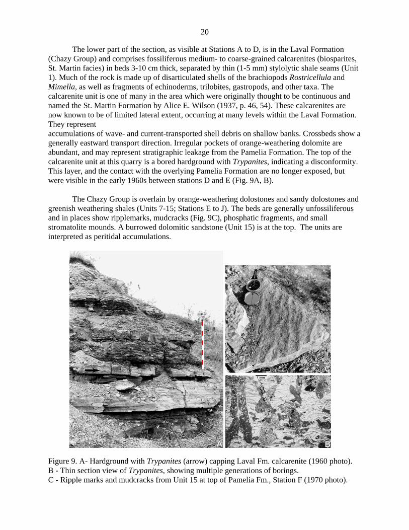
The lower part of the section, as visible at Stations A to D, is in the Laval Formation(Chazy Group) and comprises fossiliferous medium- to coarse-grained calcarenites (biosparites,St. Martin facies) in beds 3-10 cm thick, separated by thin (1-5 mm) stylolytic shale seams (Unit1). Much of the rock is made up of disarticulated shells of the brachiopods Rostricellula andMimella, as well as fragments of echinoderms, trilobites, gastropods, and other taxa. Thecalcarenite unit is one of many in the area which were originally thought to be continuous andnamed the St. Martin Formation by Alice E. Wilson (1937, p. 46, 54). These calcarenites arenow known to be of limited lateral extent, occurring at many levels within the Laval Formation.They representaccumulations of wave- and current-transported shell debris on shallow banks. Crossbeds show agenerally eastward transport direction. Irregular pockets of orange-weathering dolomite areabundant, and may represent stratigraphic leakage from the Pamelia Formation. The top of thecalcarenite unit at this quarry is a bored hardground with Trypanites, indicating a disconformity.This layer, and the contact with the overlying Pamelia Formation are no longer exposed, butwere visible in the early 1960s between stations D and E (Fig. 9A, B).
The Chazy Group is overlain by orange-weathering dolostones and sandy dolostones andgreenish weathering shales (Units 7-15; Stations E to J). The beds are generally unfossiliferousand in places show ripplemarks, mudcracks (Fig. 9C), phosphatic fragments, and smallstromatolite mounds. A burrowed dolomitic sandstone (Unit 15) is at the top. The units areinterpreted as peritidal accumulations.
Figure 9. A- Hardground with Trypanites (arrow) capping Laval Fm. calcarenite (1960 photo). B - Thin section view of Trypanites, showing multiple generations of borings. C - Ripple marks and mudcracks from Unit 15 at top of Pamelia Fm., Station F (1970 photo).

21
Fossiliferous thin-bedded, micritic limestones, megarippled oolites, and thin shaly bedswere assigned by Okulitch (1936) to the Lowville Formation (Units 16-38); Stations E-N; Figs.10A). Several layers contain the colonial, tabulate coral Tetradium. The rocks indicate thebeginning of slowly deepening waters.
Two prominent burrowed, fine-grained limestone layers (Units 42 and 43), separated by ashaly layer, mark the base of the Leray Formation (Stations J-N), followed by additional ledgesof thick-bedded, uniform, fine- to medium-grained limestones with abundant fossils (Fig.10B).These beds were quarried for dimension stone. Characteristic fossils of this interval are thesolitary rugose coral Lambeophyllum and the colonial, tabulate corals Foerstephyllum andTetradium, together with various brachiopods, cephalopods, gastropods, and trilobite fragments.Some of the coral colonies, 20-30 cm across, are in an inverted position, attesting a ratherenergetic physical environment of the reef flat on which they accumulated (Fig. 11A-B). Thesethick-bedded fossiliferous layers give way to darker, thin-bedded limestones (Stations M, O, P,R), which were originally included in the Leray Formation by Okulitch (1936). The LerayFormation is equivalent to the Chaumont (Watertown) Formation in New York State.
The Black River - Trenton nomenclature is not entirely satisfactory, both terms havingbeen used in a lithostratigraphic and a chronostratigraphic (biostratigraphic) sense; moreover,different authors have introduced a multitude of named lithostratigraphic units in neighboringareas in Ontario and New York State. The main lithologic break around the boundary at thisquarry is at the top of Unit 57, with the introduction of thick beds of conglomeratic calcarenitesand calcarenites (Fig. 12). At this quarry, the contact is also marked by a thin rusty-weatheringpyrite seam (visible at stations M, O, P, R). Faunally, the change takes place over the intervaloccupied by Units 52-57. Okulitch (1936) assigned beds up to Bed 57 to the Leray Formation,thus placing the Black River-Trenton contact at the top of this bed. Clark (1972) favouredincluding Beds 52-57 with the Trenton on paleontologic grounds. In the Montreal area, Clarkmapped this interval as Mile End Formation, a correlative of the Ouareau Formation in theJoliette area to the NE; both are here considered to be the basal units of the Trenton Group; theOuareau-Mile End interval corresponds approximately to the Rockland Formation of Wilson inthe Ottawa area..
The Trenton beds represent a return to deeper water, open marine environmentssupporting a prolific benthic fauna. At the same time, black muds with a predominantly pelagicfauna were accumulating in the Appalachian basin to the east and southeast.
A 2.65 m tick, basic sill (camptonite, with ocelli of feldspar; see Philpotts, 1976, p. 1154)of the Monteregian suite occupies the section between Units 52 and 53 at Station M (Fig. 10B),where contact metamorphic effects and composite intrusive layering can be observed. Dykestransect the beds at Stations K and L, and between F and G and G and N.

22
Figure 10. A - Section of Black River Group at Station F.B - Section of Black River and Trenton Groups, and Monteregian sill at Station M (1970 photo).

23
Figure 11. A - Overturned Tetradium colony in upper part of Leray Fm. B - Overturned colony of Foerstephyllum. C - Phycodes burrows at top of Lowville Fm. D - Black chert nodules in Unit 51.
Figure 12. Section of Trenton Group at Station P (1970 photo).

24
STOP 2 - ÎLE BIZARD, POINTE-AUX-CARRIÈRES (Bois-de-l’Île Bizard Nature Park) (45.5172°N 73.9025°W) (Please, no hammering)
http://ville.montreal.qc.ca/portal/page?_pageid=175,1722213&_dad=portal&_schema=PORTAL
This stop is at the former sites of small limestone quarries in the Laval Formation (ChazyGroup) that give the name to the point that juts into the Lake of Two Mountains. It is at thewestern extremity of one of three arms of a municipal park, shaped like a 3-pronged star, that hasmany kilometres of trails for hiking, bicycling, and cross-country skiing; along some of thesetrails are more small limestone quarries. Looking W across the lake from the lookout, one cansee the hills at Oka, underlain by Precambrian gneiss and anorthosite, and a Cretaceouscarbonatite complex formerly mined for its niobium.
The main locality forming the object of the visit are notably fossiliferous Chazylimestone exposures (Stations C-H, Fig. 13A) along the south side of the Ile Bizard Fault, one oftwo easterly trending dislocations in the area. The faulting juxtaposed the lower part of theTrenton Group on the N side against the Chazy Group, indicating a vertical displacement ofseveral scores of metres. The fault itself is covered by overburden, but a prominently developedset of vertical joints trending ~105° parallel to the fault is well developed on the shore nearStations G-H.
The Trenton beds are chiefly units of calcarenite (Station A). The Chazy is representedby thick beds of grey, cross-bedded calcarenites (Fig. 13B) and greyish-orange-weatheringcalcilutite associated with incipient biostrome or subtle bioherm developments (e.g., Stations E-G). A loose block of Leray Formation with Tetradium is located at Station B.
The outcrops and former quarries in this area have yielded the following fossils(Hofmann, 1961, fig. 20):
Bryozoa:Stictopora sp.branching Trepostomataencrusting Trepostomata
BrachiopodsMimella borealisM. vulgarisOrthoidea spp. indet.Rostricellula raymondi
TrilobitesPliomerops canadensis
Ostracodssmooth ostracods
CystoidsPalaeoanacystis tenuiradiatus
ParacrinoidsMalocystites murchisoni

25
Figure 13. A - Stations at Pointe-aux-Carrières, Île Bizard (base from Google Earth). B - Section of cross-bedded Laval Fm. calcarenites below Lookout at Station F.

26
Figure 14. Fossil beds in Laval Fm. at Pointe-aux-Carrières near Stations E and F.A - Calcarenite bearing bryozoan, brachiopod, and echinoderm fragments, includingMalocystites murchisoni, and Mimella sp. B - Brachiopod coquina.

27
STOP 3 - ILE PERROT (Plaza Don Qichotte shopping centre) (45.3861°N 73.9611°W)
This locality provides one of the best exposure near Montreal typical of the oldestsedimentary unit in the St. Lawrence Lowland, the Covey Hill Formation of the Potsdam Group(Figs. 15-16). About 4 m of trough cross-bedded arkosic sandstone is exposed on the SE side ofthe shopping center parking lot. Near the middle of the NE trending cliff is a lens of fissile black, micaceous fine-grained sandstone (Fig. 16C); the latter constitutes a rare occurrence in thePotsdam Group and has potential as a source of organic-walled microfossils in this otherwiseunfossiliferous Covey Hill Formation.
Figure 15. Location map for outcrops of Covey Hill Fm., Stop 3, Ile Perrot (Google Earth).A - Section on SE side of parking lot of Don Quichotte shopping center. B and C - Road cutexposures on Don Quichotte Boulevard, a composite section of which is illustrated in Fig. 16A.
Another 20 m of section stratigraphically above the cuts at the parking lot are accessiblein the newly widened road cut along Don Quichotte Boulevard 350 m to the ESE (B and C). Inthe lower half, seen on the SW side of the road halfway up the hill, the beds are medium- tocoarse-grained, pink and reddish feldspathic quartz sandstones, and white quartz pebble andmaroon mudchip conglomerate lenses and beds. The sandstones are in thin to thick beds andcharacteristically show small- to medium-scale trough cross-bedding (30 cm to 2 m wide), withunimodal transport directions of 030°-040°. Intercalated are a few thin silty sandstone layers thatweather more recessively.

28
In the upper part of the road cut (near C) is a section of about 9 m of grey quartzsandstone and quartz-pebble conglomerate, in part pyritic, with some thin, distinct shalysandstone layers that are more easily eroded. Rare pebbles of light blue quartz occur. Thesandstone beds exhibit trough cross-bedding on a larger scale than those in the reddish unitsbelow, having troughs of the order of 2 to 15 m. The transport directions in these upper units arealso unimodal, but have a more easterly orientation, averaging 075°. The paleocurrents measuredhere diverge somewhat from the regional easterly and southeasterly pattern within the overlyingCairnside Member in the area to the south.
Both the reddish and the grey facies are interpreted as fluvial braidplain deposits. Nofossils, microscopic or otherwise, have ever been reported from the Covey Hill Formation, andits age here could be as old as Late Proterozoic and as young as Late Cambrian.
Looking towards the northwest from the top of the escarpment, one can again see theLake of Two Mountains and the hills at Oka.
Figure 16. A - Composite section of cross-bedded arkosic sandstones in road cut on DonQuichotte Boulevard (Locs. B and C in Fig. 15A; after Hofmann, 1972). B - Trough cross-bedding at Locality A. C - Channel fill of black fine-grained sandstone (arrow) at Locality A inshopping centre is ~15m below base of road cut section.

29
STOP 4 - COTEAU-DU-LAC (Parks Canada - National Historic Site)(45.2873°N 74.1761°W) (No hammering or collecting allowed)http://www.pc.gc.ca/lhn-nhs/qc/coteaudulac/visit/index_e.asp
“The Coteau-du-Lac National Historic Site is located 40 km southwest of Montreal on the shoresof the St. Lawrence River, and offers a window on a particularly rich history going back severalmillennia in time. Owing to its strategic position on the River, the main route into inland NorthAmerica, this site has played a major role in the development of river transportation in Canada.At first a portage for nomadic Aboriginal peoples, Coteau-du-Lac later became a genuine bypassfor travellers from Great Britain and France. By the late 18th century [1779-1780], a lock canal isconstructed on this location. It was the first work of its kind in North America and was to serve asa forerunner of the modern-day St. Lawrence Seaway.” (Parks Canada web site)
In addition to being of historical interest, the site, and the surrounding area, offer anopportunity to examine outcrops of the Early Ordovician Beauharnois Formation (BeekmantownGroup). A section in the former canal displays about 3 m of section of dolostone (Fig. 17), somewith stromatolites, and others with chert nodules and lenses. Bedding surface exposures near theshore of the St. Lawrence River show decimetric mound-shaped structures, most likelymicrobially mediated (Fig. 18). Shelly fossils are uncommon here.
Figure 17. Côteau-du-Lac National Historic Site. Section of Beauharnois Formation exposedinside fort along historic canal built in 1779-1780. British blockhouse dates from 1812. (1979photo)

30
Figure 18. Microbial mounds in Beauharnois Fm. at Stop 4.

31
STOP 5 - MELOCHEVILLE, POINTE-DU-BUISSON (Buisson Point Archeological Park)333 rue Émond, Melocheville, QC J0S 1J0 (Please, no hammering)(45.3153°N 73.9661°W and 45.3180°N 73.9680°W) http://www.pointedubuisson.com/e-0101.html
The park encompasses an Amerindian fishing and portage site on the shore of the St.Lawrence River, near the rapids that presented an obstacle to travel by canoe between Lake St.Louis and Lake St. Francis (Fig. 19). The museum near the park entrance has assembled a broadcollection of artifacts that illustrates more than 5000 years of Amerindian history. Coveringabout 0.2 km2, the park is also of ecological and geological interest.
In 2005, a Fossil Garden (Parc des Galets) was officially opened, largely due to theefforts of Pierre Groulx of Valleyfield, and James “Whitey” Hagadorn of Amherst College, withcontributions from several enterprises and organizations that are commemorated on a plaque atthe site. On display is a collection of large blocks of Cambrian quartz sandstone of the upper,marine part of the Potsdam Group, derived from a rock pile 3 km to the east that was used fordumping material excavated in 1956-1958 during the construction of the St. Lawrence Seawaynearby. (We will pass by both of these localities on our way to Stop 6).
Figure 19. Buisson Point Archeological Park (A), and outcrops of Cairnside Formation withtrace fossils and enigmatic breccias (B) (base from Google Earth)

32
Figure 20. Trace fossils and sedimentary structures on Cairnside Formation blocks at the FossilGarden at Buisson Point Archeological Park. A - Climactichnites. B - Climachtichnites resting trace in mudcrack field. C- Very largeClimactichnites. D - Protichnites passing across ripples. E - Arenicolites. F - block withSkolithos still in rock dump 3 km E of park.The trace fossils are presently under study for a master’s thesis by Patrick Getty of theUniversity of Massachusetts, Amherst.

33
The blocks present spectacular surfaces of trace fossils and sedimentary structures thatare of interest to us (Fig. 20). Trace fossils include Arenicolites, exceptionally largeClimactichnites, and Protichnites, with Skolithos soon to be added to the collection. Some of theClimactichnites specimens are preserved three-dimensionally, and another represents the restingtrace of one. Among the sedimentary structures are channel fills, ripple marks, and largedesiccation cracks, indicating settings under the influence of waves and tides, and intermittentexposure to the atmosphere on tidal flats.
Time permitting, we will examine the broad exposures of Cairnside orthoquartzite at therapids below the dam (Station B in Fig. 19). These beds bear a number of interesting structuresof primary and secondary origins, including trace fossils, desiccation crack fillings, andevidences of disruption, such as sandstone dikes and sills (Fig. 22A), patches of breccias (Fig.22D), and diverse systems of what are labelled as ‘stromatolite-like strain patterns’ on Fig. 21,and illustrated in Fig. 22B-C. Also evident is a well developed set of joints trending NW relatedto Cretaceous rifting, as well as evidence of Pleistocene glaciation in the form of polishedsurfaces, glacial striae, and trains of crescentic gouges and chatter marks.
The trace fossils Protichnites and Skolithos occur near Station 42, which may not beaccessible if the water level is high at the time of the visit. Of special interest are the featuresindicating disruption of the sediment - the breccias and the peculiar large and small strainpatterns brought out by sets of curved, rhythmically spaced, quartz rich veinlets, some setsintersecting one another.
The breccias have long posed a problem as to their genesis, and various interpretationshave been advanced in the past: sedimentary breccia, diatreme breccia, brecciation due tovolcanic explosion, or to meteorite impact (Clark, 1963, p. 101), but none of the explanationshave been found convincing. A hypothesis that now appears more likely to account for thecombination of features present is that the structures were produced by the direct or indicrectaction of seismic activity that disrupted unlithified or partly lithified sand beds, which wouldallow the rocks with the various secondary structures to be regarded as seismites or tsunamites.

34
Figure 21. Map of outcrop of Cairnside Formation/March Formation transition beds, below damat Buisson Point (Hofmann, in Clark, 1963).

35
Figure 22. Dolomitic quartz sandstone beds in Cairnside Fm.- March Fm. transition beds, withstructures indicating their seismite or tsunamite affinities. A - Mudcracked sandstone intruded bysandstone dike. B - Plan view of ‘stromatolite-like’ strain patterns. C - Intersecting strainpatterns in vertical section. D - Oligomict sandstone breccia with sandstone clasts and sandmatrix.

36
STOP 6 - BEAUHARNOIS LOCKS (St. Lawrence Seaway Authority)(45.3158°N 73.9174°W)
This stop is located between the west end of the Hydro Quebec power generating plantand the Beauhamois Locks of the St. Lawrence Seaway Authority.
The roadcut along the Hwy 132 entrance into the tunnel below the St. Lawrence Seawayis in a 10-m-section of sandstones of Cambrian age, about 500 million years old. The rocksbelong to the Cairnside Formation of the Potsdam Group (Fig. 23). They are similar to thesandstones seen in Ausable Chasm in New York and in roadcuts on Hwy 417 west of Ottawa, aswell as in some areas of the midwestern USA. They form an extensive blanket of sandstone thatformed over much of the continent in shallow marine, nearshore and intertidal environmentalsettings, as attested by a variety of sedimentary features such as those seen at the Fossil Gardenat Stop 5. At the top of the eastern end of the cut there are dolomitic horizons, suggesting that thebase of the overlying March Formation is located in this section.
Figure 23. Section of Cairnside Formation on N side of Highway 132, at eastern entrance totunnel under St. Lawrence Seaway locks, and below Stations AA to V in Fig. 24.

37
These interesting primary sedimentary structures, including several varieties of mudcrackfillings and trace fossils, can be seen to good advantage on the flat beds at the top of the cut(lettered stations in Fig. 24), and particularly well in some of the large slabs protecting theSeaway canal embankment at the west end of the outcrop.
Figure 24. Outcrop along Hwy 132 at eastern entrance of tunnel under St. Lawrence Seawaylocks (base from Google Earth)
The St. Lawrence Seaway opened in 1959, and is closed each year during freeze-up. It isa deep waterway with 15 locks, providing ocean-going vessels with access to the heart of NorthAmerica, 3700 km from the Atlantic Ocean. Ships up to 217 m in length and 29 m in width canbe accommodated. The minimum channel depth is 8.2 m. At this particular locality there are twolocks, the third and fourth from the lower end of the Seaway at Montreal, lifting the ships a totalof 25 m from Lake St. Louis to the level of Lake St. Francis. The time to raise or lower a ship ineach lock is about 7 minutes. The 25-m drop in water level is also utilized for hydroelectricpower, generated in the nearby Beauhamois Power Station.

38
Figure 25. Trace fossils and primary and secondary structures on large outcrop of Cairnside Fm./March Fm. at Stop 6. Letters refer to corresponding labeled stations on Fig. 24. C - Arenicolites. N - Palaeophycus. D - Curvilinear crack fillings. S - Rectilinear crack fillings. X - Quartz-filled veinlets similar to strain patterns at Stop 5B. Y - Chaotic bed indicating pre-lithification deformation, possibly as microbially bound sand (microbialite).

39
STOP 7 - LAPRAIRIE (HANSON QUARRY; formerly St-Laurent quarry and Domtarquarry) 955 Chemin Saint-José, La Prairie, QC J5R 3Y1
45.4054°N 73.4887°W
This shallow quarry covers about 0.8 km2 and furnishes material for brickmaking. The pitis worked as a rip-operation during 8 months of the year when no snow is on the ground. Thequarry bottom is ploughed up twice a year, and the material is allowed to weather for about 3months. In this way, the active part of the quarry is deepened about 30-45 cm each year andprovides ~100,000 tons annually.
A section of about 9 m is exposed, mainly in the walls, and particularly in low cliffs inthe western and southern parts of the quarry (Stations B,H, Fig. 26 ). The dark grey shales,siltstones, and fine- to medium-grained sandstones belong to the lower part of the Nicolet RiverFormation (Lorraine Group). The very gently SE dipping sequence is cut by small basic dykesand sills of the Monteregian suite, emplaced during the Cretaceous.
Figure 26. Location map for Stop 7, Hanson brickyard and quarry at La Prairie. Monteregianintrusion forming ridge between Stations C and G (base from Google Earth)

40
Figure 27. Section of the Nicolet River Formation near Station B in Fig. 26.
The beds of the Nicolet River Formation contain a diverse shelly benthic fauna, as wellas some nektonic and planktonic forms. The limy beds carry elements of an infralittoralbrachiopod- trilobite-crinoid community, and the terrigenous beds are characterized by abundantbivalves, gastropods, and, more rarely, the odd cephalopod and graptolite. The best collecting isfrom the larger unweathered slabs strewn all over the ploughed quarry floor and in the talusbelow the walls of the cliffs.
The following taxa have been recorded from this quarry (Clark, 1955, p. 23; Hofmann,1982, p. D38; Globensky, 1985, p. 19):
Conoidal shells: Cornulites sp., cf. C. progressus
Brachiopods:Lingula sp., cf. L. westonensisDalmanella rogataSowerbyella sericeaLeptaena moniquensisCatazyga sp., probably C. erratica
Bivalves:Ctenodonta pectunculoidesC. sp., C. filistriata
Clidophorus planulatusC. brevisC. sp., cf. C. neglectusColpomya faba var. intermediaCymatonota pholadia
GastropodsHormotoma gracilis var. sublaxaSinuites cancellatus
Cephalopods:Geisonoceras sp.Michelinoceras sp.

41
Trilobites:Cryptolithus bellulusC. recurvusIsotelus sp.Calymene sp.Triarthrus sp.
Echinoderms:Lepidocoleus jamesi
Crinoid columnals
Graptolites:Orthograptus sp.
Trace fossils:Planolites sp.Teichichnus sp., cf. T. venosum
The middle and upper parts of the Lorraine Group represent progressively shallowerenvironments and are accompanied by corresponding faunal changes that form part of theregressive sequence leading eventually to the nonmarine Queenston redbeds cropping out to thenortheast of here.
Figure 28. Some representative fossils from the Hanson Quarry: brachiopods (Dalmanella[Paucicrura] rogata) and bivalves (Clidophorus).

42
ACKNOWLEDGMENTS
Daniel Renaud of Briques Hanson Ltée kindly gave permission to access the HansonBrick quarry in La Prairie. Pierre Groulx made information available about the source of theblocks as well as the history of the Rock Garden he helped create at the Pointe-du-BuissonArcheological Park.
REFERENCES
Bernstein, L., 1992. A revised stratigraphy of the Lower - Middle Ordovician BeekmantownGroup, St. Lawrence Lowlands, Quebec and Ontario. Canadian Journal of EarthSciences, 29: 2677-2694.
Clark, T.H., 1952. Montreal area. Quebec Department of Mines, Geological Report 46, 159 pp.Clark, T.H., 1955. St. Jean-Beloeil area. Quebec Department of Mines, Geological Report 66,
pp. 83.Clark, T.H., 1963. Field Trip 10 - Breccia localities. In: T.H. Clark (Editor), Guide Book.
Geological Association of Canada, 16th Annual Meeting, Montreal, pp. 95-104.Clark, T.H., 1972. Région de Montréal - Montreal area. Quebec Department of Natural
Resources, Geological Report 152, 244 pp.Clark, T.H., Globensky, Y. and Hofmann, H.J., 1979. Paleozoic stratigraphy of the St. Lawrence
Lowland of Quebec - Stratigraphie paléozoïque des basses-terres du Saint-Laurent duQuébec. Geological Association of Canada - Mineralogical Association of Canada,Annual Meeting, Quebec, Guidebook for Excursion A7: 1-35.
Elson, J.A., 1960. Littoral mollusks of the Champlain Sea. American Malacological Union, FieldTrip Guide (Excursion to Mount St. Hilaire, Quebec, August 12, 1960): reprint, 7 pp.
Foerste, A.F., 1924. Upper Ordovician faunas of Ontario and Quebec. Geological Survey ofCanada, Memoir 138, 255 pp.
Globensky, Y., 1982. Région de Vaudreuil. Ministère de l'Énergie et des Ressources du Québec,Service des Levés Géologiques, Geological Report 199, 63 pp.
Globensky, Y., 1985. Géologie des régions de Saint-Jean (partie nord) et de Beloeil. Ministèrede l'Energie et des Ressources du Québec, Report MM 84-03, 99 p.
Globensky, Y., 1987. Géologie des Basses-Terres du Saint-Laurent, Ministère de l'Énergie et desRessources du Québec, Service de la Géologie, Report MM 85-02, Quebec.
Globensky, Y. and Riva, J., 1982. Ordovician stratigraphy and paleontology of the St. LawrenceLowlands and the frontal Appalachians near Quebec City. In: Y. Globensky (Editor),Field Trips Guidebook. North American Paleontological Convention, Montreal, Canada,Montreal, pp. C1-C47.
Hofmann, H.J., 1961. Chazy Group in the St. Lawrence Lowland. Ph.D. Thesis, McGillUniversity, Montreal, 202 pp.
Hofmann, H.J., 1972. Stratigraphy of the Montreal area. - Stratigraphie de la région de Montréal.International Geological Congress, 24th Session, Montreal, Guidebook for FieldExcursion B-03: 1-32.
Hofmann, H.J., 1979. Chazy (Middle Ordovician) trace fossils in the Ottawa-St. LawrenceLowlands. Geological Survey of Canada, Bulletin 321: 27-59.

43
Hofmann, H.J., 1982. Middle and Late Ordovician fossiliferous rocks of the Montreal area. In:Y. Globensky (Editor), Field Trips Guidebook. North American PaleontologicalConvention, Montreal, pp. D1-D41.
Hofmann, H.J., 1989. Stratigraphy of the Montreal area, Geological Association of Canada -Mineralogical Association of Canada, Guidebook for Field Trip A4, pp. 1-36.
Hofmann, H.J. and Bolton, T.E., 1998. Middle Ordovician (Whiterockian) trilobite Bathyurusangelini Billings 1859 from the Carillon Formation (uppermost Beekmantown Group) atKahnawake, Quebec, and correlative trilobites from Eastern Canada. Canadian Journal ofEarth Sciences, 35(1): 76-87.
Lewis, T.L., 1963. A paleocurrent study of the Potsdam Sandstone of New York, Quebec, andOntario. Ph.D. Thesis, Ohio State University, 174 pp.
Okulitch, V.J., 1936. The Black River Group in the vicinity of Montreal, Geological Survey ofCanada, Memoir 202, pp. 119-130.
Philpotts, A.R., 1976. Silicate liquid immiscibility: its role, probable extent and petrogeneticsignificance. American Journal of Science, 276: 1147-1177.
Salad Hersi, O. and Lavoie, D., 2000a. Pre-Cairnside Formation carbonate-rich sandstone:evidence for a Cambrian carbonate platform in southwestern Quebec? Geological Surveyof Canada, Current Research 2000-D3: 1-8.
Salad Hersi, O. and Lavoie, D., 2000b. Lithostratigraphic revision of the Upper CambrianCairnside Formation , upper Potsdam Group, southwestern Quebec. Geological Survey ofCanada, Current Research 2000-D4: 1-8.
Salad Hersi, O. and Lavoie, D., 2001. The unconformable character and paleogeographicsignificance of the Chazy–Black River group contact, Montreal area, southwesternQuebec. Geological Survey of Canada, Current Research 2001-D10:1-17.
Salad Hersi, O., Hilale Mohamed, A., Lavoie, D. and Nowlan, G.S., 2002. Subaerialunconformity at the Potsdam-Beekmantown contact in the Quebec Reentrant: regionalsignificance for the Laurentian continental margin history. Bulletin of CanadianPetroleum Geology, 50(3): 419-440.
Salad Hersi, O., Lavoie, D. and Nowlan, G.S., 2003. Reappraisal of the Beekmantown Groupsedimentology and stratigraphy, Montreal area, southwestern Quebec: implications forunderstanding the depositional evolution and the Lower-Middle Ordovician Laurentianpassive margin of eastern Canada. Canadian Journal of Earth Sciences, 40(2): 149-176.
Wilson, A.E., 1937. Erosional intervals indicated by contacts in the vicinity of Ottawa, Ontario.Royal Society of Canada, Transactions, 3rd Series, Section 4, 31: 45-60.

44
Figure 29. Sketches of Montreal area paleogeography.

45
NOTES

46

47
GUIDE FOR
Field Trip B October 16, 2006
FOSSILS OF THE CHAMPLAIN SEA :
THE REDPATH MUSEUM COLLECTIONS, AND THE SAINT-NICOLAS SITE
by M.D. Chartier and M.E. Cournoyer
Musée de la Paléontologie et de l’Évolution

48
ACKNOWLEDGMENTS The authors are grateful to the operators of the Saint-Nicolas sandpits for providing access to the locality, as well as to the numerous colleagues, both professional and avocational, who have shared their expertise, collected specimens and data, and collaborated in the study of this exceptional fossil site. Mrs. Ingrid Birker and Virginie Millien, of the Redpath Museum, McGill University, are also thanked for giving participants of this field trip access to the wonderful fossil specimens under their care. Finally, the plates could not have been completed without help from Steve Cumbaa, Canadian Museum of Nature.
Bone of an oldsquaw duck found in situ in fossiliferous cross-bedded sands exposed at the Saint-Nicolas site, September 23, 1995. Photograph by M. Cournoyer.

49
INTRODUCTION Whereas the object of the pre-conference field trip (Stratigraphy of the Montreal area) is an examination of the Lower Paleozoic stratigraphy of the St. Lawrence Lowland in the vicinity of Montréal, this excursion will concentrate on the much younger marine clays and sands, commonly known as the Champlain Sea deposits, which overlay much of these rocks in southern Québec. The Champlain Sea was an epicontinental sea of glacial isostatic origin which lasted approximately 2000 years (Parent and Occhietti, 1988). At its maximum extent, it covered an area of about 55,000 km2 (Elson, 1969), and submerged parts of the St. Lawrence, Ottawa, and Lake Champlain valleys (Figure 1).
Figure 1. Maximum diachronic extent of the Champlain Sea (slightly modified from Parent and Occhietti, 1988). The latest research on the chronology of deglaciation in southern Québec indicates that marine invasion in the central St. Lawrence Lowland occurred approximately 11,100 ± 100 14C years B.P. (Richard and Occhietti, 2005). The last phase of the Champlain Sea is best represented by deposits found in the Québec City Strait. Radiocarbon dating of fossil wood collected in situ at the Saint-Nicolas site has yielded an age estimate of 9400 14C years B.P. (see Occhietti et al.,

50
2001; also Cournoyer et al., 2006), which corresponds to the last episode of marine sedimentation in the area. The reader is referred to the paper by Richard and Occhietti (2005) for an overview of various hypotheses on the chronology of ice retreat in the St. Lawrence Lowland. The occurrence of fossil shells in Champlain Sea sediments has been known since at least the middle part of the 19th century. Invertebrate fossils are very abundant and taxonomically diverse at numerous localities throughout the St. Lawrence Lowland. Vertebrates, however, are more often than not characterized by isolated discoveries, usually a single partial or, in rare instances, nearly complete individual (see for example Harington and Occhietti, 1988). Several of these specimens are now kept in the collections of the Redpath Museum, which is Stop 1 in our itinerary.
The paleoecological information that can be gathered from these isolated but otherwise important vertebrate fossils is necessarily more limited than is the case with multispecific faunal assemblages. Only a handful of localities have yielded such multispecific assemblages: the Ottawa area nodule sites (about fifteen species) (Harington, 2003), the Saint-Césaire sandpit (four species), and the Saint-Nicolas site (at least thirteen species) (Cournoyer et al., 2006). Of these, the Saint-Nicolas site has produced the most diverse macrofaunal assemblage so far recorded from Champlain Sea deposits, with a total of 51 species. This exceptional fossil locality will be Stop 2 in our itinerary for this field trip.
ITINERARY Participants will meet at the Redpath Museum, on the campus of McGill University, at 9:30 AM, to examine some of the historically significant Champlain Sea vertebrate specimens housed at that institution (Figure 2). Departure for Saint-Nicolas will be at 11 AM, with arrival at the site around 2:30 PM. The distance between Montréal and Saint-Nicolas is approximately 230 kilometres. Highway 20 (Trans-Canada Highway) is the easiest route to get to Saint-Nicolas. The party will take exit 305 (Route 171), and head north towards the town of Saint-Nicolas. The sandpit is located on the west side of the road, about 3.5 kilometres from Highway 20, and less than a kilometre from the town of Saint-Nicolas. Participants will get an opportunity to observe the local physiographic features and topography before stopping at the sandpits.

51
Figure 2. Map showing location of stops. STOP 1 – REDPATH MUSEUM, MCGILL UNIVERSITY The Redpath Museum, location of the 2006 Canadian Paleontology Conference, was inaugurated in 1882, and is one of the oldest museums in Canada. Its first director was Sir John William Dawson, a well-known natural scientist and Principal of McGill College (which later became McGill University). This venerable institution is home to large collections of invertebrate and vertebrate fossils, including many scientifically and historically important specimens. Worthy of mention are the approximately 30,000 Early Paleozoic fossils collected by Dr. Thomas H. Clark during his geological survey work of the St. Lawrence Lowland in the middle part of the 20th century. Among the most significant Champlain Sea vertebrate specimens kept at the Redpath Museum are a nearly complete skeleton of a white whale (Delphinapterus leucas; Figure 3), excavated in 1895 in Smith’s Brickyard (now the site of Molson’s Brewery near Downtown Montréal), three vertebrae and a rib from a humpback whale (Megaptera novaeangliae) found in Smiths Falls, Ontario (one of only a few specimens of large whales known from Champlain Sea deposits), and a partial skeleton of a seal (Phoca sp.) collected in Montréal (see Harington and Occhietti, 1988, for a complete list of specimens).

52
Figure 3. Almost complete skeleton of a white whale found in Champlain Sea deposits, exposed in Redpath Museum galleries. Taken from Hekimi (unpublished manuscript). STOP 2 – SAINT-NICOLAS SANDPITS, SAINT-NICOLAS The Saint-Nicolas sandpits (or Saint-Nicolas site; 46o 42’ N and 71o 23’ W) are located southeast of the town of Saint-Nicolas (now a district within the city of Lévis since the municipal fusions of 2002). Excavation at the site was initiated some time in the 1960s, to supply fill material for construction of the nearby highway. Parts of the sandpits are still being exploited today, with dramatic changes to the morphology of the site occurring in the last five years. Past and ongoing excavation work has undoubtedly resulted in the loss of countless scientifically valuable specimens. Fossil collecting in Saint-Nicolas: a brief historical sketch As early as 1857, Sir William Dawson described the first Champlain Sea fossils found in the Saint-Nicolas area. Based on his description of the locality, it appears that the seven types of shells were collected a short distance from the St. Lawrence River, along the Auneuse River (Figure 4). Reconnaissance work by the authors and colleagues in the late 1990s showed that rare fossil shells do indeed occur in the sands exposed along the steep cliffs of that river. After a lengthy hiatus, work on the Champlain Sea deposits of Saint-Nicolas resumed in the 1950s when Frances Wagner carried out systematic field mapping and collecting for the Geological Survey of Canada. Wagner (1970) studied two outcrops, one of which yielded numerous species of mollusks and other shelly invertebrates. These probably came from deposits exposed along the Auneuse River near Route 171. The first vertebrate fossil found in the Saint-Nicolas area was the tibia of a small seal recovered in 1964 by Léo Labrie in a well excavation (Harington, 2003). Harington (1977) later described a white whale caudal vertebra collected in 1972 by Michael Bozozuk from stratified sands exposed in one of the local sandpits.

53
Figure 4. Map of the Saint-Nicolas area, showing the probable site discussed by Dawson (1857), and location of the sandpits described in the text, surrounded by Appalachian rocky ridges (in gray). Taken from Occhietti et al. (2001). Detailed stratigraphic, sedimentologic and geochemical investigations were carried out by researchers from Université du Québec à Montréal in the late 1970s. The Saint-Nicolas sandpits have been frequently visited by local college and university professors, their students, as well as avocational collectors since that time. Our own research project on the Champlain Sea fauna of the Saint-Nicolas site was initiated quite by accident in 1994, when Mr. Normand Pineault, an avocational fossil hunter, came upon two small bones (Plate IV, figures 1 and 2) lying at the surface of a butte located in an abandoned part of the sandpits. The remains were submitted to Dr. C.R. Harington, of the Canadian Museum of Nature, who identified them as belonging to a thick-billed murre (Uria lomvia), a marine bird previously unknown in Champlain Sea deposits. A year later, the second author, accompanied by Ms. Nathalie Daoust, found four isolated bones while prospecting the site for fossil shells. Again, these were shown to C.R. Harington: three of the bones pertained to seals, whereas the fourth was later identified by Dr. Steve Cumbaa (also of the CMN) as belonging to an eelpout (Lycodes sp.), a bottom-dwelling fish which, like the thick-billed murre, turned out to be new to the Champlain Sea fauna. It was then that the full significance of the Saint-Nicolas deposits began to be understood and appreciated, in terms of the numerical and taxonomic richness of the vertebrate fossils found at the site.

54
Several collecting trips to the sandpits later in 1995 and in succeeding years have resulted in the recovery of many additional vertebrate specimens, including other new records of fish and birds. Specimens collected during those early years were discussed in a paper published by Occhietti and colleagues in 2001. More recently, ongoing excavation in the sandpits has considerably reduced the extent of the most fossiliferous deposits (compare Figures 5 and 6). Consequently, vertebrate remains have become more rare, but the 300 or so specimens collected over a ten-year period bear witness to the exceptional character of this fossil locality.
Figure 5. View of part of the Saint-Nicolas sandpits. The shell-covered bluff nicknamed ‘Santa’s Hideout’, which has yielded numerous vertebrate fossils, is visible at right. The second author can be seen (and used for scale) in the left center. Photograph taken by M. Chartier on August 21, 1999.

55
Figure 6. View of part of the Saint-Nicolas sandpits, taken from the same location and angle as Figure 5. The bluff nicknamed ‘Santa’s Hideout’, seen in Figure 5, has been almost completely excavated. Photograph taken by M. Chartier on July 7, 2001. Stratigraphy and sedimentology The outline of the stratigraphy and sedimentology of the Saint-Nicolas site presented here is based in large part on work published by Occhietti et al. (2001). The reader is referred to that paper for further details. A succession of three geological units is observed throughout the sandpits (Figure 7). At the base, Unit 1 is composed of massive clays with diamictite inclusions. The upper part of this unit shows a rough stratification, and has yielded shells of a few species of mollusks. It is best exposed along drainage ditches as well as along a small creek flowing into the nearby Auneuse River. Unit 1 was deposited at depths of approximately 100 metres. The diamictites and pebbles were probably dropped by floating icebergs which had detached from the ice front to the north. A pebble pavement overlying Unit 1 indicates an erosional gap between the latter and Unit 2. Unit 2 reaches a thickness of ten metres, and is composed of clayey, stratified sand at the base, and medium to fine, cross-bedded sand at the top. The sedimentary structure and dip of these beds indicates that they were deposited in tidal channels which flowed westerly. These channels were formed by rising tidal currents. During the latter phases of the Champlain Sea,

56
tides in the Québec City Strait reached heights on the order of five to ten metres. The cross-bedded sands of the upper part of Unit 2 preserve a rich thanatocoenosis composed of slightly to moderately transported faunal elements. Most of the vertebrate fossils found at the site come from the middle to upper part of Unit 2. This unit was deposited in the earliest Holocene, between ca. 9650 and 9400 years B.P. (wood equivalent 14C ages), within the interval 11.2-10.7 ka Cal B.P. (calibrated 14C ages using CALIB 5.0.1) (Cournoyer et al., 2006).
Figure 7. Composite section of the Saint-Nicolas site, showing the three geological units as defined by S. Occhietti. Taken from Occhietti et al. (2001).

57
Unit 3 is composed of alternating silts and sands which were deposited in shallow, very wide channels crossing a tidal flat. These sediments accumulated in shallow, marginal bays during the last phase of the Champlain Sea. Casts of shells belonging to two species of pelecypods are observed in the unit. Faunas, paleoenvironments and paleoecology The fossiliferous sands of Unit 2 have drawn the most interest because of the exceptionally rich and diverse faunal assemblage recovered from these beds. More than 50 species have so far been identified (Table 1), and this does not include microfossils and plant remains. Table 1. Taxonomic list of macroinvertebrates and vertebrates found in tidal current sands of the Saint-Nicolas site. Slightly modified from Cournoyer et al. (2006). Bryozoa Gen. et sp. indet. 1 (encrusting form) Gen. et sp. indet. 2 (branching form) Brachiopoda Hemithiris psittacea parrot-beak lamp shell Polyplacophora Gen. et sp. indet. Gastropoda Acirsa borealis chalky wentletrap Boreotrophon truncatus bobtail trophon Buccinum glaciale glacial whelk Buccinum plectrum sinuous whelk Buccinum scalariforme ladder whelk Buccinum undatum waved whelk Colus sp. spindle shell Epitonium cf. E. greenlandicum Greenland wentletrap Haminoea solitaria solitary glassy-bubble Lepeta caeca northern blind limpet Littorina cf. L. saxatilis rough periwinkle Cryptonatica affinis arctic moonsnail Neptunea despecta common northern neptune Oenopota sp. Puncturella cf. P. noachina diluvian puncturella Piliscus commodus widemouth lamellaria Trichotropis borealis boreal hairysnail Velutina cf. V. velutina smooth lamellaria Volutopsius cf. V. norwegicus Norway whelk

58
Table 1. Continued. Pelecypoda Astarte montagui narrow-hinge astarte Axinopsida orbiculata orbicular axinopsid Chlamys islandica Iceland scallop Crenella faba bean crenella Hiatella arctica arctic hiatella Macoma balthica Balthic macoma Macoma calcarea chalky macoma Mya arenaria softshell Mya truncata truncate softshell Mysella planulata plate mysella Mytilus edulis blue mussel Serripes groenlandicus Greenland smoothcockle Cirripedia Balanus crenatus notched acorn barnacle Balanus hameri turban barnacle Echinoidea Strongylocentrotus sp. green sea urchin Osteichthyes Acipenser sp. sturgeon Cryptacanthodes maculatus Atlantic wrymouth Lycodes sp. eelpout Mallotus villosus capelin Salmonidae gen. et sp. indet. Aves Clangula hyemalis oldsquaw duck Uria lomvia thick-billed murre Somateria mollissima common eider Sterna paradisaea Arctic tern Mammalia Phoca hispida ringed seal Erignathus barbatus bearded seal Odobenus rosmarus Atlantic walrus Delphinapterus leucas white whale In the earliest Holocene, sands and organic debris were transported by the strong rising tides and deposited in tidal channels which flowed between elongated rocky islands. These islands formed an archipelago (see Figure 4) located at the entrance of the Champlain Sea. Locally, the mixing of fresh and salt water and the presence of large and relatively stable

59
expanses of sand favored high marine productivity which, in turn, permitted the establishment of a rich ecosystem. The most recent paleoecological assessment of the faunal assemblage from Unit 2 is that of Cournoyer et al. (2006). OPTIONAL STOP – LABORATOIRE DE CONSERVATION ET RECHERCHE/MUSÉE DE PALÉONTOLOGIE ET DE L’ÉVOLUTION The Musée de Paléontologie et de l’Évolution (MPE) was incorporated as a non-profit organization in the fall of 1995. Although it has conceived several temporary and travelling fossil exhibits, and organized various paleontological field trips and lectures for the public, it is still in the planning stages and has no permanent fossil galleries. In the spring of 2004, the MPE inaugurated a small lab unofficially called the Laboratoire de conservation et recherche. Located at 541 de la Congrégation Street, in the Pointe-Saint-Charles district, south of Downtown Montréal, it serves as a repository for the museum’s collections. The lab houses the largest well-documented sample of fossils from the Saint-Nicolas site: approximately 3000 macroinvertebrate fossils and 300 vertebrate specimens have been collected by the museum’s members and collaborators over the last ten years. These fossils have been the subject of two technical papers (Occhietti et al., 2001; Cournoyer et al., 2006), and a thorough study of the taxonomy, taphonomy, and paleoecology of this important faunal assemblage is in progress.
REFERENCES Cournoyer, M.E., Chartier, M.D., Dubreuil, M. and Occhietti, S. 2006. Additions to the Champlain Sea faunal assemblage from Saint-Nicolas, Québec, with remarks on its paleoecology. Canadian Paleontology Conference Proceedings No. 4 : 12-16. Dawson, J.W. 1857. On the Newer Pliocene and Post Pliocene deposits of the vicinity of Montreal, with notices of fossils recently discovered in them. The Canadian Naturalist and Geologist, 2 : 401-426. Elson, J.A. 1969. Late Quaternary marine submergence of Quebec. Revue de géographie de Montréal, 23 : 247-258. Harington, C.R. 1977. Marine mammals in the Champlain Sea and the Great Lakes. Annals of the New York Academy of Sciences, 288 : 508-537. Harington, C.R. 2003. Quaternary vertebrates of Québec: a summary. Géographie physique et Quaternaire, 57 : 85-94. Harington, C.R. and Occhietti, S. 1988. Inventaire systématique et paléoécologie des mammifères marins de la Mer de Champlain (fin du Wisconsinien) et de ses voies d’accès. Géographie physique et Quaternaire, 42 : 45-64. Hekimi, M. The Dawson Gallery Guide. Unpublished manuscript.

60
Occhietti, S., Chartier, M., Hillaire-Marcel, C., Cournoyer, M., Cumbaa, S.L. and Harington, C.R. 2001. Paléoenvironnements de la Mer de Champlain dans la région de Québec, entre 11 300 et 9750 BP : le site de Saint-Nicolas. Géographie physique et Quaternaire, 55 : 23-46.
Parent, M. and Occhietti, S. 1988. Late Wisconsinan deglaciation and Champlain Sea invasion in the St. Lawrence valley, Québec. Géographie physique et Quaternaire, 42 : 215-246. Richard, P.J.H. and Occhietti, S. 2005. 14C chronology for ice retreat and inception of Champlain Sea in the St. Lawrence Lowlands, Canada. Quaternary Research, 63 : 353-358. Wagner, F.J.E. 1970. Faunas of the Pleistocene Champlain Sea. Geological Survey of Canada, Bulletin 181 : 1-104.

61
PLATES

62 Plate I Gastropods from the Saint-Nicolas sandpits, Québec, Canada: (1) Volutopsius cf. V. norwegicus, oral view, X 1; (2) Neptunea despecta, oral view, X 1; (3) Colus sp., fragmentary specimen displaying three whorls, X 1; (4) Buccinum glaciale, oral view, X 1 ; (5) Buccinum plectrum, oral view, X 1; (6) Buccinum undatum, oral view, X 1; (7) Epitonium cf. E. greenlandicum, oral view, X 1.5; (8) Cryptonatica affinis, oral view, X 1; (9) Acirsa borealis, oral view, X 2 ; (10) Buccinum scalariforme, oral view, X 2; (11) Trichotropis borealis, oral view, X 2; (12) Velutina cf. V. velutina, aboral view, X 2; (13) Lepeta caeca, (a) dorsal view, (b) lateral view, X 2; (14) Piliscus commodus, dorsal view, X 2; (15) Littorina cf. L. saxatilis, oral view, X 3; (16) Puncturella cf. P. noachina, (a) dorsal view, (b) lateral view, X 3; (17) Boreotrophon truncatus, oral view, X 4 ; (18) Oenopota sp., oral view, X 4; (19) Haminoea solitaria, oral view, X 4. Photographs by M. Cournoyer.

63

64
Plate II Pelecypods and other invertebrates from the Saint-Nicolas sandpits, Québec, Canada: Bivalvia (1) Mytilus edulis, right valve, X 1; (2) Chlamys islandica, right valve, X 1; (3) Macoma calcarea, right valve X 1; (4) Macoma balthica, right valve, X 2; (5) Mya arenaria, left valve, X 1; (6) Mya truncata, right valve, X 1; (7) Hiatella arctica, left valve, X 1; (8) Astarte montagui, right valve, X 1.5; (9) Crenella faba, right valve, X 3; (10) Axinopsida orbiculata, left valve, X 4; (11) Mysella planulata, right valve, X 10; (12) Serripes groenlandicus, left valve, X 1; Cirripedia (13) Balanus crenatus, (a) top view, (b) side view, X 1; (17) Balanus hameri, internal view of an isolated plate, X 1; Bryozoa (14) Gen. et sp. indet. 1 (encrusting form), view of two colonies on a stone, X 5; (15) Gen. et sp. indet. 2 (branching form), side view of a colony, X 4; Brachiopoda (16) Hemithiris psittacea, (a) lateral view of a complete specimen, (b) anterior view and (c) posterior view of same, X 1.5; Polyplacophora (18) Gen. et sp. indet., (a) articular view of an isolated plate, (b) dorsal view of same, X 3 ; Echinoidea (19) Strongylocentrotus sp., (a) isolated spine, (b) fragmentary plate, both X 5. Photographs by M. Cournoyer.

65

66
Plate III Marine mammals from the Saint-Nicolas sandpits, Québec, Canada: (1) Delphinapterus leucas, (a) ventral view of a caudal vertebra, (b) articular view of same, X 1; (2) Delphinapterus leucas, (a) dorsal view of an edentulous right mandible, (b) medial view of same, scale bar is used for size comparison; (3) Erignathus barbatus, left second rib in posterior view, X 1; (4) Phoca hispida, partial left auditory bulla, internal view, X 1.5; (5) Phoca hispida, right femur of a juvenile individual, lacking epiphyses, in posterior view, X 1; (6) Odobenus rosmarus, left second metatarsal of a juvenile individual in medial view, X 1; (7) Odobenus rosmarus, right innominate in lateral view, scale bar is used for size comparison; (8) Odobenus rosmarus, right ulna in medial view, scale bar is used for size comparison. Photographs by M. Cournoyer.

67

68
Plate IV Seabirds and fishes from the Saint-Nicolas sandpits, Québec, Canada: Seabirds (1) Uria lomvia, left humerus, caudal view, X 1; (2) Uria lomvia, anterior part of sternum, cranial view, X 1; (3) Somateria mollissima, cervical vertebra, ventral view, X 1; (4) Clangula hyemalis, left humerus, caudal view, X 1; (5) Sterna paradisaea, right carpometacarpus, ventral view, X 2; Fishes (6) Mallotus villosus, articulated vertebrae resting on consolidated sand, X 3; (7) Acipenser sp., isolated dermal plate, external view, X 10; (8) Salmonidae gen. et sp. indet., (a) articular view of an anterior vertebra, (b) dorsal view of same, X 2; (9) Lycodes sp., anterior abdominal vertebra, articular view, X 6; (10) Lycodes sp., left ceratohyal, lateral view, X 2; (11) Lycodes sp., vomer, ventral view, X 3; (12) Lycodes sp., frontal, dorsal view, X 3; (13) Cryptacanthodes maculatus, (a) braincase in ventral view, (b) posterior view of same, X 1.5. Photographs by M. Cournoyer.

69