The Evolution of the Lower Missouri River - USGS ...
23
uses science fora changing world The Evolution of the Lower Missouri River: A Discussion of the Geology and a Proposal for Research at Lisbon Bottom By Jeffrey Spooner Open-File Report 01-176 U.S. Department of the Interior U.S. Geological Survey
-
Upload
khangminh22 -
Category
Documents
-
view
2 -
download
0
Transcript of The Evolution of the Lower Missouri River - USGS ...
usesscience fora changing world
The Evolution of the Lower Missouri River: A
Discussion of the Geology and a Proposal for Research
at Lisbon Bottom
By Jeffrey Spooner
Open-File Report 01-176
U.S. Department of the Interior
U.S. Geological Survey
The Evolution of the Lower Missouri River: A Discussion of the Geology and a Proposal for Research at Lisbon Bottom
Jeffrey Spooner, GeographerUSGS Mid-Continent Mapping Center
Rolla, Missouri
ABSTRACT
Before 1800, the Missouri River was one of North America's most diverse and
dynamic ecosystems. Since 1800, it has been transformed into a navigation system
regulated by reservoirs and flood control structures. Flooding in 1993 and 1996 has had a
profound effect on the physical and political landscape of the lower Missouri River. The
purpose of this research is to determine the spatial and temporal distribution of wetlands
at Lisbon Bottom in order to develop a model of the distribution of wetlands along the
lower Missouri River. The project focuses on three questions: (1) What is the Quaternary
history of the lower Missouri River Valley? (2) Can a general model of the lower
Missouri River Valley alluvium be developed? (3) What is the relationship between the
valley's alluvial architecture and the hydrogeology of its wetlands? A variety of
techniques and technologies will be used to answer these questions. Principal among
these will be geographic information and image processing systems, which will be used
to analyze and interpret photographic, topographic, and geophysical data.
INTRODUCTION
The Missouri River of the early 1800s was one of North America's most diverse
and dynamic ecosystems, with abundant riparian lands, braided channels, chutes, sloughs,
islands, sandbars, and backwaters (Laustrup and LeValley, 1998). These river and
floodplain habitats were created and maintained by erosion and deposition, which
continuously reshaped the channel and the floodplain (Schmudde, 1963; Funk and
Robinson, 1974; Nicollet, 1993; Laustrup and LeValley, 1998). Seasonal variation in the
river's flow recharged wetlands and backwater habitats in spring. It also exposed nesting
habitat and provided slow and shallow aquatic habitat through late summer and fall.
Since 1800, the Missouri River has been transformed into a navigation system regulated
by reservoirs and flood control structures. These modifications have reduced seasonal
flow variability and sediment load, and they have disconnected the river from backwater,
off-channel, and flood plain habitats (Funk, 1974; Interagency Floodplain Management
Review Committee, 1994; Laustrup and LeValley, 1998).
Flooding along the Lower Missouri River in 1993 and again in 1996 provided the
opportunity to study the relationship between biologic and geologic processes in a setting
that closely mimics the preregulated Missouri River (Jacobson and others, 1999).
Flooding during 1993 broke agricultural levees and created scours on both the upstream
and downstream sides of Lisbon Bottom, a loop bottom located approximately 10 miles
downstream of Glasgow, Mo. These levee breaks and scours were not repaired, and
flooding subsequent to 1993 repeatedly inundated the bottom. Flooding in 1996
connected the upstream and downstream levee breaks and created a chute that crossed the
bottom.
Knowledge of surficial geologic characteristics and processes in an alluvial
setting like Lisbon Bottom provides a scientific basis for floodplain management. This
knowledge is also vital to a complete understanding of riverine habitat disturbance,
recovery, and rehabilitation (Interagency Floodplain Management Review Committee,
1994; Winkley and Schumm, 1994; Berg and others, 1999). A critical component of this
knowledge is an understanding of the spatial and temporal relationships between riverine
habitat dynamics and fundamental geomorphic processes, and the spatial and temporal
relationships between groundwater and surface wetlands. Equally important is the
contextual framework within which these processes operate. At Lisbon Bottom, as with
other sites along the lower Missouri River, that framework includes the geology of the
river valley at both the regional and site-specific scales.
Purpose
The purpose of this investigation is to determine the fundamental geologic
processes controlling habitat dynamics at Lisbon Bottom. The results of this
investigation will include a discussion of the evolution of the river, coupled with a
general model of the architecture of the valley. This model will illustrate the
interdependence of physical and biological processes, as well as the spatial and temporal
relationship between ground and surface water along the lower Missouri River. The
results of this investigation will aid in the development of goals for habitat rehabilitation
projects and will provide a scientific basis for future flood plain management practices
along the lower Missouri River.
Research Questions
This project will address three specific questions regarding the Quaternary
geology of the lower Missouri River Valley and the relationship between the geology of
the valley and terrestrial habitat along the river:
(1) What is the Quaternary history of the lower Missouri River Valley?
(2) Can a general model of the lower Missouri River Valley alluvium be
developed?
(3) What is the relationship between the valley's alluvial architecture and the
hydrogeology of its wetlands?
Whether Pleistocene glaciers advanced into or south of the modern Missouri River Valley
between Kansas City, Mo. and the confluence near St. Louis has not been satisfactorily
resolved. There is evidence that ice did advance south of the modern Missouri River near
present day Kansas City, Mo. (Simms, 1975; Colgan, 1992; Kelly and Blevins, 1995).
There is also evidence that ice advanced into the Missouri River Valley near present day
Miami, Mo. (Baker, 1993). However, there appears to be little or no evidence that ice
advanced into or south of the modern valley either between these sites or at any others
along the river.
Determining the architecture of the river's alluvium and the relationship between
that architecture and the hydrology of the valley's wetlands will provide a more complete
understanding of the relationship between the geology of the river valley and the
dynamics of its terrestrial habitats. This will lead to a more complete understanding of
habitat disturbance, rehabilitation, and restoration along the lower Missouri River.
REVIEW OF LITERATURE
Regional Setting
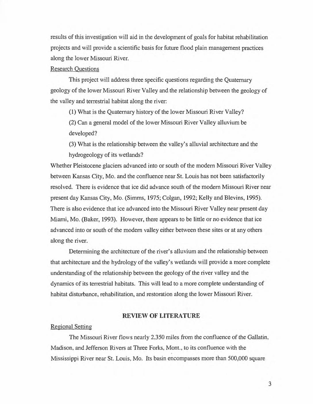
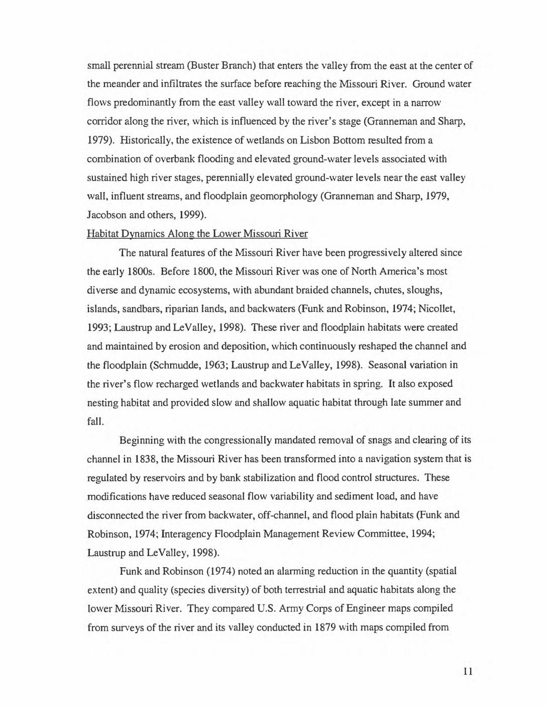
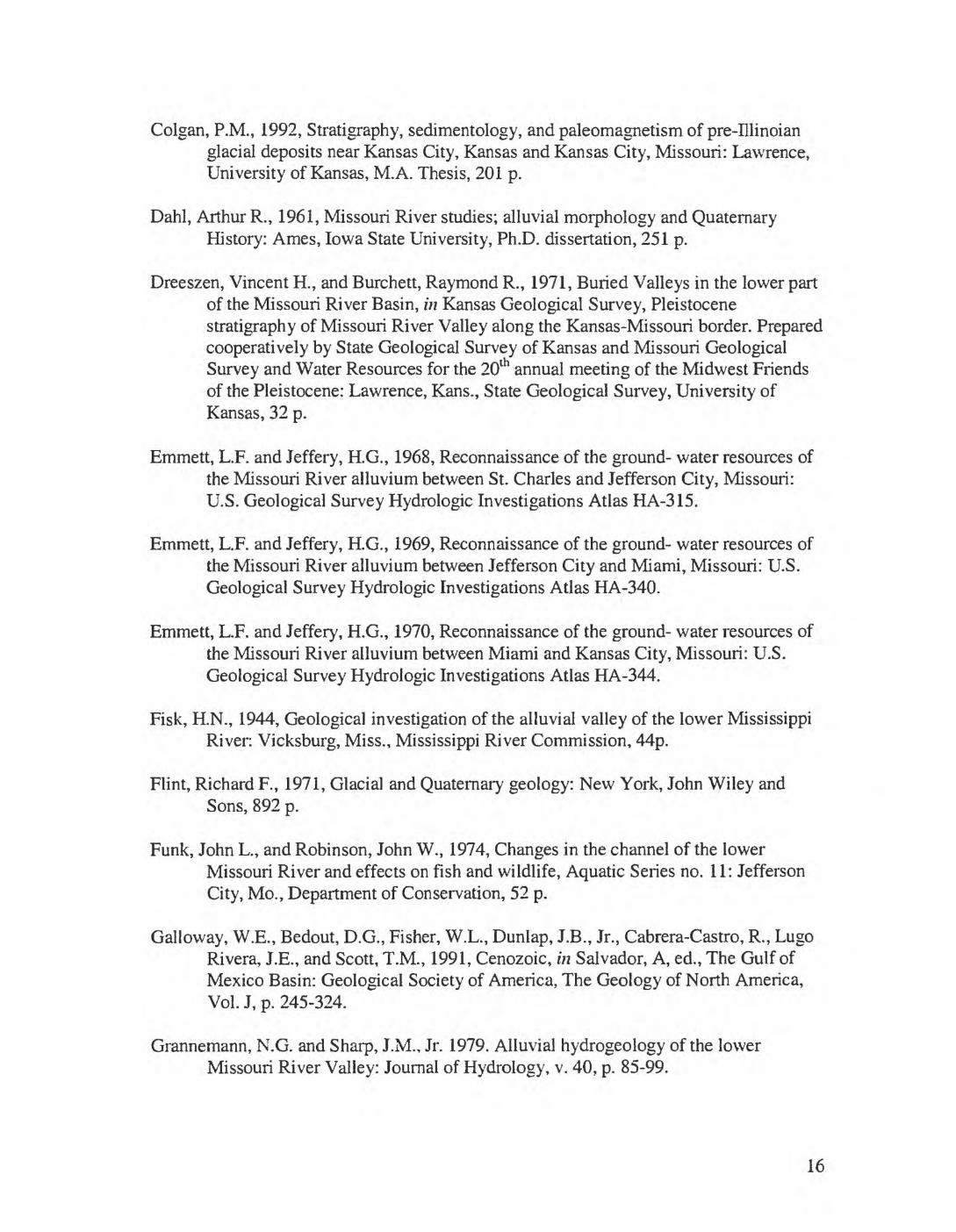
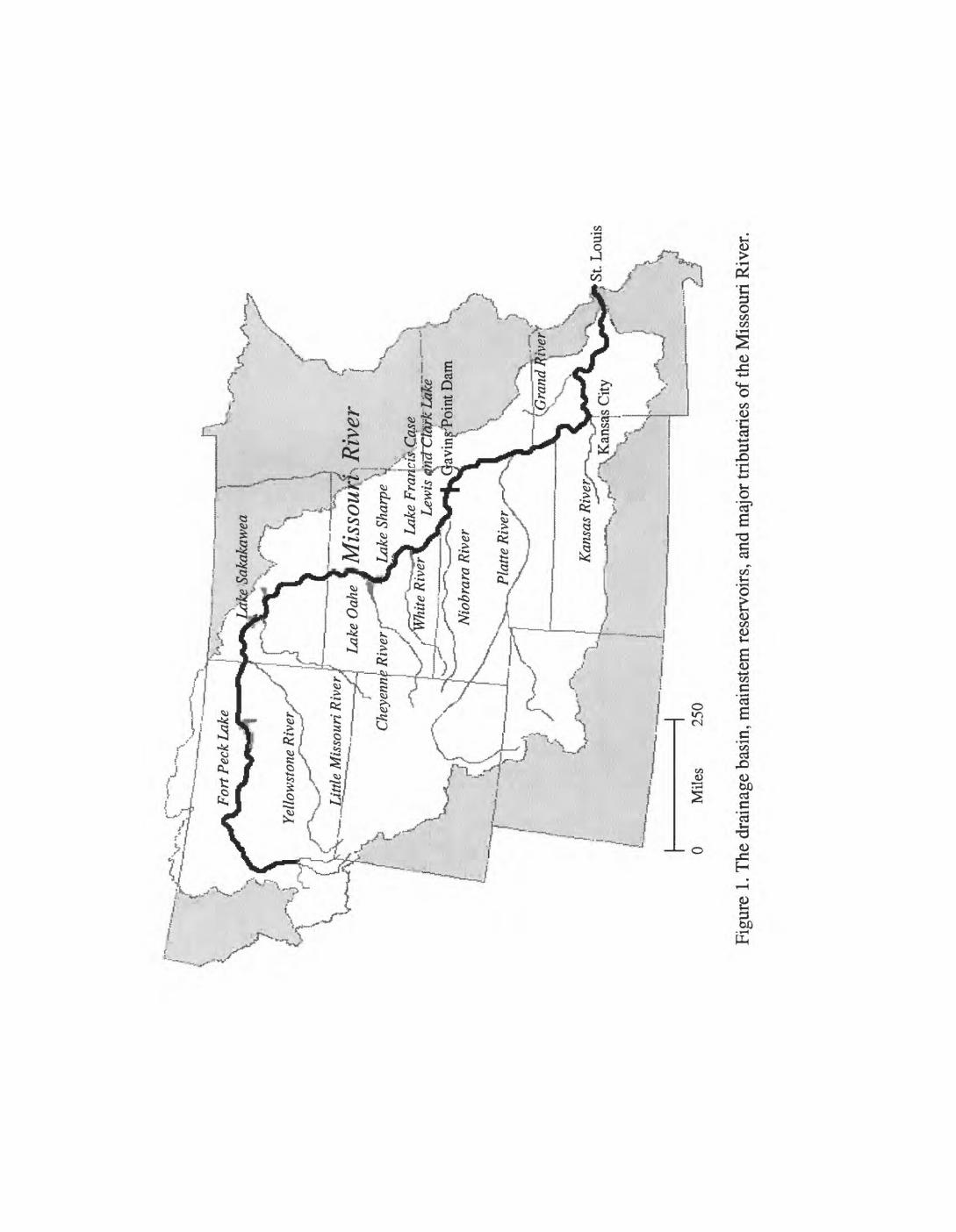
The Missouri River flows nearly 2.350 miles from the confluence of the Gallatin,
Madison, and Jefferson Rivers at Three Forks, Mont., to its confluence with the
Mississippi River near St. Louis, Mo. Its basin encompasses more than 500,000 square
miles (fig. 1). From its headwaters in southwestern Montana, the Missouri River flows
north then east across Montana and into North Dakota, where it turns southeast and
crosses South Dakota. Leaving South Dakota, the river turns east and forms part of the
boundary between South Dakota and Nebraska before turning south again to form the
boundaries between Nebraska and Iowa, Nebraska and Missouri, and Kansas and
Missouri. At Kansas City, the river turns east, crosses Missouri, and enters the
Mississippi River approximately 20 miles north of St. Louis.
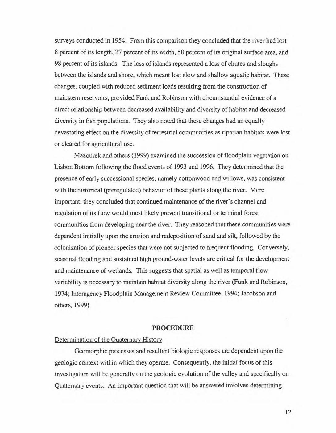
Broadhead (1889) divided the Missouri River Valley into three general areas: the
upper or mountain district, the plains, and the lower valley region. Today, the river can
still be subdivided into three major sections. However, unlike Broadhead's more
geographical classification, today's subdivisions are based on the degree to which each
section has been modified by mainstem reservoirs or bank stabilization and flood control
structures. These three divisions include the free-flowing upper section, the impounded
middle section, and the channelized lower section. The free-flowing upper section
extends from the confluence of the Gallatin, Madison, and Jefferson Rivers in
southwestern Montana to Fort Peck Lake in central Montana. The impounded middle
section extends from Fort Peck Lake to Gavins Point Dam near Yankton, S. Dak., and
includes Fort Peck Lake, Lake Sakakawea, Lake Oahe, Lake Shaipe, Lake Francis Case,
and Lewis and Clark Lake. The channelized lower section extends from Gavins Point
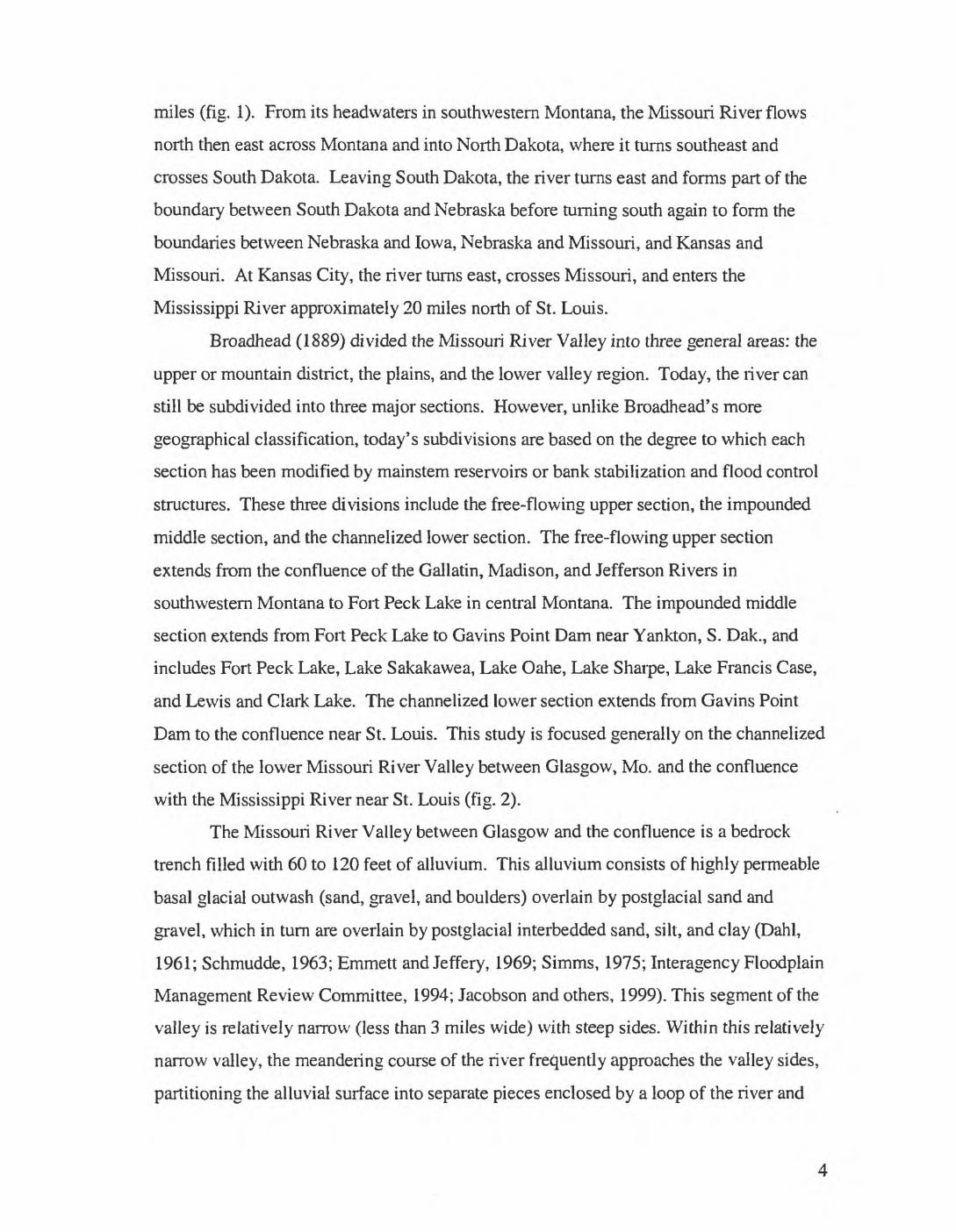
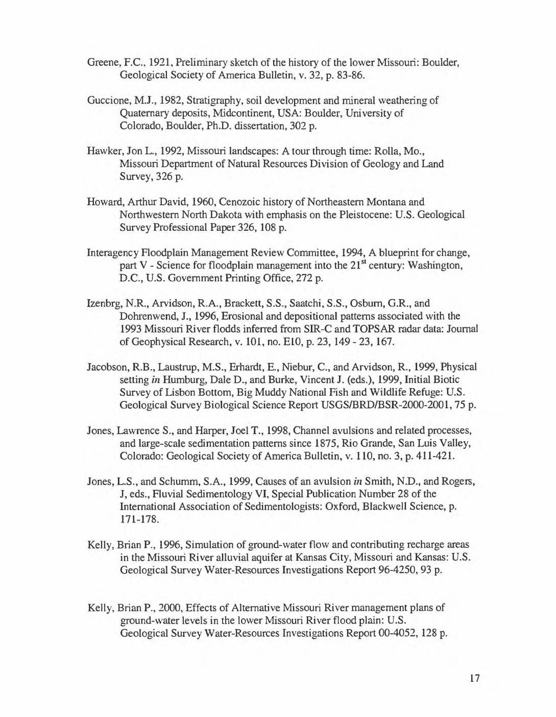
Dam to the confluence near St. Louis. This study is focused generally on the channelized
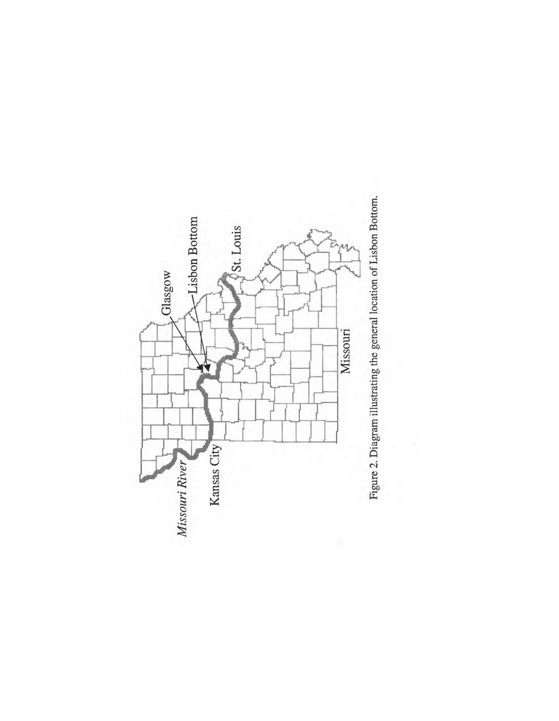
section of the lower Missouri River Valley between Glasgow, Mo. and the confluence
with the Mississippi River near St. Louis (fig. 2).
The Missouri River Valley between Glasgow and the confluence is a bedrock
trench filled with 60 to 120 feet of alluvium. This alluvium consists of highly permeable
basal glacial outwash (sand, gravel, and boulders) overlain by postglacial sand and
gravel, which in turn are overlain by postglacial interbedded sand, silt, and clay (Dahl,
1961; Schmudde, 1963; Emmett and Jeffery, 1969; Simms, 1975; Interagency Floodplain
Management Review Committee, 1994; Jacobson and others, 1999). This segment of the
valley is relatively narrow (less than 3 miles wide) with steep sides. Within this relatively
narrow valley, the meandering course of the river frequently approaches the valley sides,
partitioning the alluvial surface into separate pieces enclosed by a loop of the river and
the side of the valley. These distinct, nearly level partitions of the floodplain are locally
referred to as bottoms.
Schmudde (1963) defined two types of Missouri River bottoms: long and loop.
Long bottoms are much longer than they are wide. Long bottoms are terminated where
the river cuts diagonally across the valley. Conversely, loop bottoms are relatively small
and partly enclosed by a single, curving, meander-like loop of the river. Between
Glasgow and the confluence, Schmudde (1963) identified eight long bottoms, five well-
formed loop bottoms (where the length and width within the enclosing meander loop are
approximately equal), four less well formed loop bottoms, and several bottoms that have
shapes and sizes intermediate between long and loop types. This project focuses
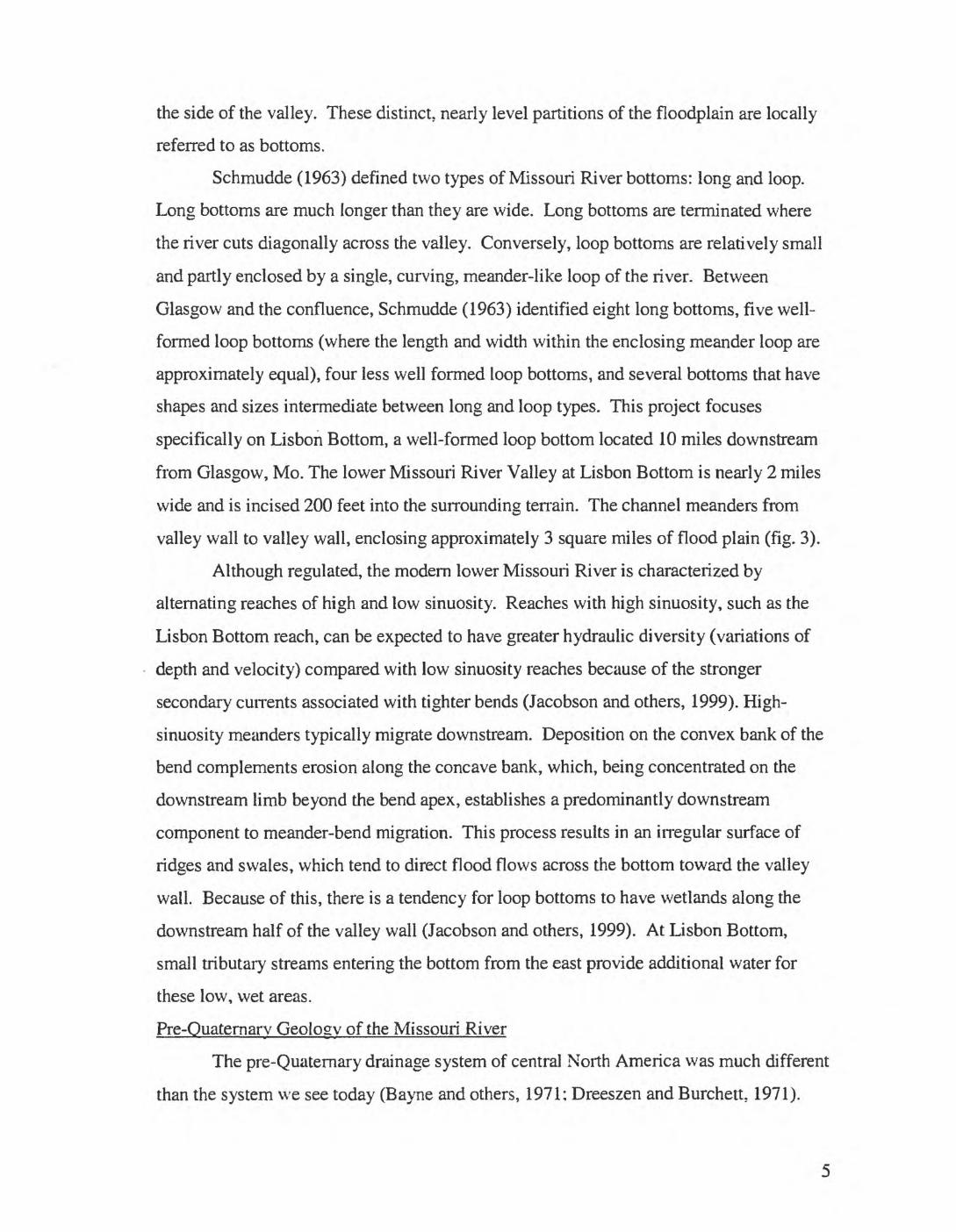
specifically on Lisbon Bottom, a well-formed loop bottom located 10 miles downstream
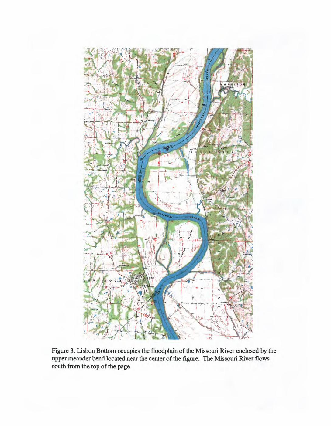
from Glasgow, Mo. The lower Missouri River Valley at Lisbon Bottom is nearly 2 miles
wide and is incised 200 feet into the surrounding terrain. The channel meanders from
valley wall to valley wall, enclosing approximately 3 square miles of flood plain (fig. 3).
Although regulated, the modern lower Missouri River is characterized by
alternating reaches of high and low sinuosity. Reaches with high sinuosity, such as the
Lisbon Bottom reach, can be expected to have greater hydraulic diversity (variations of
depth and velocity) compared with low sinuosity reaches because of the stronger
secondary currents associated with tighter bends (Jacobson and others, 1999). High-
sinuosity meanders typically migrate downstream. Deposition on the convex bank of the
bend complements erosion along the concave bank, which, being concentrated on the
downstream limb beyond the bend apex, establishes a predominantly downstream
component to meander-bend migration. This process results in an irregular surface of
ridges and swales, which tend to direct flood flows across the bottom toward the valley
wall. Because of this, there is a tendency for loop bottoms to have wetlands along the
downstream half of the valley wall (Jacobson and others, 1999). At Lisbon Bottom,
small tributary streams entering the bottom from the east provide additional water for
these low, wet areas.
Pre-Quaternary Geology of the Missouri River
The pre-Quaternary drainage system of central North America was much different
than the system we see today (Bayne and others, 1971; Dreeszen and Burchett, 1971).
During the Oligocene, the Rio Grande was the continent's major drainage system
(Galloway and others, 1991). However, a shift during the Miocene, possibly resulting
from continental tectonism, reorganized the continent's drainage systems and established
the Mississippi as the dominant drainage system (Winker, 1982). By the end of the
Tertiary, the Mississippi River drainage was established as the dominant system for the
continent and was actively prograding into the Gulf of Mexico, with the Laramide
orogeny and subsequent intracontinental uplifts providing significant amounts of
sediment.
The continental glaciations of the Pleistocene rearranged the interior drainage
systems of the North American continent. Before the Pleistocene, the ancestral rivers of
the northern Great Plains (the Missouri, Yellowstone, Little Missouri, and Cheyenne
Rivers) drained north then east into Hudson Bay, while the ancestral rivers of the middle
Great Plains (the White, Niobrara, Platte, and Kansas Rivers) drained east and southeast
into the Gulf of Mexico (Todd, 1914; Fisk, 1944; Meneley and others, 1957; Howard,
1960; Flint, 1971; Wayne and others, 1991; Langer and others, 1994). The ancestral
Platte River followed the course of the modern Grand River across northwestern Missouri
and joined the ancestral Kansas River near the confluence of the modern Grand and
Missouri Rivers (Todd, 1914; Dreeszen and Burchett, 1971; Simms, 1975; Anderson,
1979; Whitfield, 1982; Aber, 1991; Whitfield and others, 1993).
It is generally accepted that the present course of the Missouri River from Kansas
City to the confluence near St. Louis is coincident with the pre-Quaternary course of the
ancestral Kansas River (Todd, 1914; Greene, 1921; Fisk, 1944; Bretz, 1965; Flint, 1971;
Dreeszen and Burchett, 1971; Anderson, 1979; Whitfield, 1982; Whitfield and others,
1993). However, Whitfield and others (1993) provide an alternative, more northern
route for the ancestral Kansas River across the eastern half of Missouri. They suggest
that rather than following the modern channel, which turns south near Boonville, Mo., the
ancestral Kansas River continued east to join the Mississippi River near the present
confluence of the modern Missouri River. Although their suggestion of an alternative
route is unique, the idea is certainly consistent with the widely held view that the modern
Missouri River marks approximately the southern extent of Pleistocene glaciation. which
in some areas relocated the channels of existing rivers.
Quaternary Evolution of the Missouri River Valley
The pre-Illinoian glaciations of the early Pleistocene and. to a lesser extent, the
Illinoian and Wisconsin glaciations of the middle and late Pleistocene rearranged the
interior drainage systems of the North American continent. The modern Missouri River
marks the approximate southern extent of pre-Illinoian glaciers (Todd, 1914; Flint, 1971;
Guccione, 1982; Blum and others, 2000). Preglacial rivers that flowed east across the
Great Plains were dammed and diverted south while the advancing ice buried earlier
systems that drained the northern and central interior of the continent.
Langer and his coauthors (1994) described the Missouri River from Great Falls,
Mont., to Kansas City, Mo., as a glacial-margin stream. As the ice advanced, it would
dam eastward-flowing streams. Lakes that formed as a result of these dams would
eventually spill over into adjacent basins. Following the retreat of the ice, the river
would either remain in the new channel or reoccupy its former channel. The Missouri
River Valley from Omaha, Neb., to Kansas City, Mo., provides an example of the river
remaining in its new channel. Two examples of the Missouri River abandoning glacial
bypasses and reoccupying its preglacial channel following the retreat of the ice can be
observed near Kansas City, Mo. The Blue (Simms, 1975) and Little Blue Rivers (Kelly
and Blevins, 1995) each became temporary diversion channels during pre-Illinoian
glacial advances across the ancestral river valley. An additional bypass has been
suggested near Miami, Mo., where several authors have suggested that the river was
diverted south through the valley of the North Fork of the Salt River, into the Lamine,
and on to the Missouri River (Todd, 1914; Whitfield and others, 1993). These diversions
of the Missouri River have led some to believe that pre-Illinoian ice advanced south of
the modern Missouri River Valley between Kansas City and Jefferson City (Anderson,
1979; Aber, 1991; Whitfield and others, 1993; Seller, 1998; Aber, 1999). Alternatively,
others believe that the ice did not advance south of the modern river valley (Bretz, 1965;
Hawker, 1992).
Present Geology of the Lower Missouri River Valley
Schumm and Winkley (1994) observed that the character of almost every alluvial
river reflects its geologic history, and the modern lower Missouri River is no exception.
Its present form has resulted from a sequence of events that included the following:
incision of the ancestral Kansas River into Pennsylvanian, Mississippian,
and Ordovician shale, limestone, and dolomite;
- the accumulation of Pleistocene glacial outwash deposits;
- migration of channels during the Holocene; and
- clearing of the channel and stabilization of its banks by the U.S. Army
Corps of Engineers (Schalk and Jacobson, 1997).
The river valley between Glasgow, Mo., and the confluence has been characterized as a
bedrock trench filled with 60 to 120 feet of silt and sand with intermixed gravel and
boulders near its base (Dahl, 1961; Schmudde,1963; Emmett and Jeffery, 1969; Simms,
1975; Interagency Floodplain Management Review Committee, 1994; and Jacobson and
others, 1999). The valley is relatively narrow (less than 3 miles wide) with steep sides. It
is incised 200 to 400 feet into adjoining Mississippian limestone and dolomite, which are
abundantly exposed in bluffs overlooking the floodplain. In many places, these bedrock
bluffs rise vertically above the river's surface.
Along the lower Missouri River, bedrock lithology is a critical control on valley
and channel morphology, as well as the thickness of the alluvial fill (Emmett and Jeffery,
1969; Schalk and Jacobson, 1997). The Missouri River Valley is cut into nearly flat-
lying limestone, dolomite, shale, and sandstone. Upstream from Glasgow, the river flows
in a wide valley (5 to 10 miles) that has cut into relatively soft Pennsylvanian-aged
sedimentary rocks dominated by interbedded limestone and shale. Within this section,
the river meanders in broad, sinuous curves. Downstream from Glasgow, the valley is
entrenched in harder, more resistant Ordovician and Mississippian sedimentary rocks
dominated by limestone and dolomite. Here, the valley narrows to a uniform width that
averages 2.2 miles wide, and the river is characterized by alternating reaches of high and
low sinuosity.
The lower Missouri River Valley at Lisbon Bottom is nearly 2 miles wide and
incised 200 feet into the surrounding terrain. The channel meanders from valley wall to
valley wall, enclosing approximately 3 square miles of flood plain. The valley at Lisbon
Bottom is filled with approximately 60 feet of material consisting of highly permeable
glacial outwash (sand, gravel, and boulders) overlain by postglacial sand and gravel in
the lower part, and interbedded sand, silt, and clay in the uppermost part (Dahl, 1961;
Schumde, 1963; Emmett, 1969; Simms, 1975; Grannemann and Sharp, 1979; Interagency
Floodplain Management Review Committee, 1994; Kelly and Blevins, 1995; Schaulk and
Jacobson, 1997; Jacobson and others, 1999). Emmett and Jeffery (1969) have suggested
that irregularities on the surface of the bedrock under Lisbon Bottom control the
thickness of the alluvium.
An important characteristic of the preregulated Missouri River was the migration
of its channel meanders, resulting in the reworking of its floodplain deposits (Schmudde,
1963; Interagency Floodplain Management Review Committee, 1994; Izenberg and
others, 1996). Typically, channel meanders tend to migrate owing to lateral erosion at
the upstream or outside margins of meander bends and deposition of sediments on their
downstream or inside margins (Leopold, 1997; Knighton, 1998). Along the lower
Missouri River, the process of downstream and lateral meander migration has resulted in
floodplain surface features that include levees, terraces, abandoned channels, and oxbow
lakes. In addition, downstream and lateral channel migrations have resulted in a
floodplain stratigraphy that includes point bar, channel fill, and overbank deposits
(Schmudde, 1963, Interagency Floodplain Management Review Committee, 1994).
Along the preregulated lower Missouri River, channel avulsions have also been
responsible for the relocation of the channel and reworking of floodplain deposits
(Izenberg and others, 1996; Schalk and Jacobson, 1997). The term "avulsion" is widely
used to describe a relocation of the channel that is achieved by a jump rather than a
progressive shift (Smith and others, 1989; Jones and Harper, 1998; Bristow, 1999; Jones
and Schumm, 1999). Although it was not specifically suggested, channel avulsions can
explain the rapid and frequent relocation of the Missouri River's channel described in
historic observations of the river and its behavior. Recently, channel avulsion, like
progressive meander migration, has become a rare occurrence along the lower Missouri
because of the bank stabilization efforts of the U.S. Army Corps of Engineers. However,
the chute across Lisbon Bottom provides an opportunity to study the mechanics of
channel avulsion along the lower Missouri River (Jacobson and others, 1999).
Hvdrogeology of the Missouri River Valley
Relatively few studies have focused on the hydrogeology of the lower Missouri
River Valley. Those that have been conducted have included studies of the alluvial
9
aquifer at Kansas City (Kelly and Blevins, 1995; Kelly, 1996; Kelly, 2000);
reconnaissance mapping of the ground-water resources of the lower Missouri River
Valley (Emmett and Jeffery, 1968,1969, and 1970); an overview of the hydrology of the
lower Missouri River following the 1993 flood event (Interagency Floodplain
Management Review Committee, 1994); and the study of the hydrogeology of the
Missouri River Valley near Glasgow, Mo. (Granneman and Sharp, 1979). Granneman
and Sharp (1979) concluded that the hydrogeology of the lower Missouri River Valley is
considerably more complicated than generally assumed and that the most important
influence on that hydrogeology is the river itself.
As noted earlier, the alluvial deposits of the lower Missouri River consist of
highly permeable boulders, cobbles, gravel, and sand, which are overlain by interbedded
sand, silt, and clay. This characteristic distribution of sediment creates an exponential
increase in hydraulic conductivity with depth. With the relatively high permeability of the
deepest parts of the alluvium, the possibility exists for an upper flow system (primarily
influenced by river stage, tributary streams, and local precipitation) superimposed on a
deep down-valley flow system. Granneman and Sharp (1979) dismiss this hypothesis
through analytical modeling and conclude that only one flow system exists in the
alluvium.
Generally, ground water flows away from the valley walls toward the Missouri
River and down the valley (Emmett and Jeffery, 1969, 1970; Granneman and Sharp,
1979; Kelly and Blevins, 1995). Granneman and Sharp (1979) determined that ground-
water flow direction in the Missouri River Valley is influenced by the stage of the river,
distance from the river, geometry of the river meanders and valley walls, and existence
and character of tributary streams. They conclude that it is the interdependence of these
factors that determines the flow direction of ground water within the valley. For
example, during periods of sustained high river stages, seepage through the river's bed
and banks keeps ground-water levels high. As river levels fall, the flow direction is
reversed, and ground water flows predominantly toward the river (Granneman and Sharp,
1979; Kelly and Blevins, 1995).
The hydrogeology of Lisbon Bottom results from a combination of characteristic
alluvial stratigraphy, the geometry of the valley and river meander, and the influence of a
10
small perennial stream (Buster Branch) that enters the valley from the east at the center of
the meander and infiltrates the surface before reaching the Missouri River. Ground water
flows predominantly from the east valley wall toward the river, except in a narrow
corridor along the river, which is influenced by the river's stage (Granneman and Sharp,
1979). Historically, the existence of wetlands on Lisbon Bottom resulted from a
combination of overbank flooding and elevated ground-water levels associated with
sustained high river stages, perennially elevated ground-water levels near the east valley
wall, influent streams, and floodplain geomorphology (Granneman and Sharp, 1979,
Jacobson and others, 1999).
Habitat Dynamics Along the Lower Missouri River
The natural features of the Missouri River have been progressively altered since
the early 1800s. Before 1800, the Missouri River was one of North America's most
diverse and dynamic ecosystems, with abundant braided channels, chutes, sloughs,
islands, sandbars, riparian lands, and backwaters (Funk and Robinson, 1974; Nicollet,
1993; Laustrup and LeValley, 1998). These river and floodplain habitats were created
and maintained by erosion and deposition, which continuously reshaped the channel and
the floodplain (Schmudde, 1963; Laustrup and Le Valley, 1998). Seasonal variation in
the river's flow recharged wetlands and backwater habitats in spring. It also exposed
nesting habitat and provided slow and shallow aquatic habitat through late summer and
fall.
Beginning with the congressionally mandated removal of snags and clearing of its
channel in 1838, the Missouri River has been transformed into a navigation system that is
regulated by reservoirs and by bank stabilization and flood control structures. These
modifications have reduced seasonal flow variability and sediment load, and have
disconnected the river from backwater, off-channel, and flood plain habitats (Funk and
Robinson, 1974; Interagency Floodplain Management Review Committee, 1994;
Laustrup and Le Valley, 1998).
Funk and Robinson (1974) noted an alarming reduction in the quantity (spatial
extent) and quality (species diversity) of both terrestrial and aquatic habitats along the
lower Missouri River. They compared U.S. Army Corps of Engineer maps compiled
from surveys of the river and its valley conducted in 1879 with maps compiled from
11
surveys conducted in 1954. From this comparison they concluded that the river had lost
8 percent of its length, 27 percent of its width, 50 percent of its original surface area, and
98 percent of its islands. The loss of islands represented a loss of chutes and sloughs
between the islands and shore, which meant lost slow and shallow aquatic habitat. These
changes, coupled with reduced sediment loads resulting from the construction of
mainstem reservoirs, provided Funk and Robinson with circumstantial evidence of a
direct relationship between decreased availability and diversity of habitat and decreased
diversity in fish populations. They also noted that these changes had an equally
devastating effect on the diversity of terrestrial communities as riparian habitats were lost
or cleared for agricultural use.
Mazourek and others (1999) examined the succession of floodplain vegetation on
Lisbon Bottom following the flood events of 1993 and 1996. They determined that the
presence of early successional species, namely cottonwood and willows, was consistent
with the historical (preregulated) behavior of these plants along the river. More
important, they concluded that continued maintenance of the river's channel and
regulation of its flow would.most likely prevent transitional or terminal forest
communities from developing near the river. They reasoned that these communities were
dependent initially upon the erosion and redeposition of sand and silt, followed by the
colonization of pioneer species that were not subjected to frequent flooding. Conversely,
seasonal flooding and sustained high ground-water levels are critical for the development
and maintenance of wetlands. This suggests that spatial as well as temporal flow
variability is necessary to maintain habitat diversity along the river (Funk and Robinson,
1974; Interagency Floodplain Management Review Committee, 1994; Jacobson and
others, 1999).
PROCEDURE
Determination of the Quaternary History
Geomorphic processes and resultant biologic responses are dependent upon the
geologic context within which they operate. Consequently, the initial focus of this
investigation will be generally on the geologic evolution of the valley and specifically on
Quaternary events. An important question that will be answered involves determining
12
the southern extent of Pleistocene glaciation. Identifying and mapping the southern
limits of Pleistocene glacial advances between Kansas City and St. Louis Mo., is a
necessary for a complete understanding of the valley's evolution. If continental glaciers
advanced south of the modern Missouri River, then physical evidence, such as glacial
landforms, till deposits, or abandoned channels of the pre-Pleistocene ancestral Missouri
River, should still exist. Identifying and interpreting these features will be accomplished
through the analysis of well logs, field observations, and mapping.
Field observations will be supplemented with the analysis of high-resolution
digital elevation data. Image processing and geographic information systems will be
used to display high-resolution digital elevation data in order to make a visual inspection
of the entire region. In addition to visually inspecting the data, we will do numeric
searches for potential abandoned channels or other landforms, such as terraces. The
results of these analyses may indicate Pleistocene alternatives to the modem course of the
Missouri River.
Model Development
The second focal point of this investigation will be to develop a general model
that demonstrates the spatial and temporal relationships between geologic processes and
riverine habitat dynamics at Lisbon Bottom. These relationships will be dependent upon
the architecture of the valley-filling alluvium. This architecture will be determined and
modeled through the analysis and interpretation of well logs; field reconnaissance; a
review of bridge, levee, and channel management engineering diagrams; and the analysis
of ground-penetrating radar and acoustic streambed data. Hydrogeology will be
determined through the analysis of local well-pumping test data, combined with the
model of the alluvium. The relationship between the architecture of the valley-filling
alluvium and the hydrology of the valley's wetlands will be based on the interpretation of
the valley's architecture, its hydrogeology, and the spatial and temporal distribution of
wetlands at Lisbon Bottom.
Large-scale maps of physical habitat on Lisbon Bottom will be prepared using
historical aerial photographs, historical cartographic data, and high-resolution digital
elevation data. These maps will delineate historical channels, wetlands, sand bodies,
woodlands, and nonwoodland vegetation. The maps will be compiled using image
13

processing and geographic information systems. Historical aerial photographs will be
acquired, digitized, and georeferenced to map control points. Photographs from the late
1930s through 2000 will be used to develop a retrospective image archive. In addition,
historical river charts will be acquired, digitized, and coregistered with the aerial
photographs.
14
References
Aber, James S., 1991, The glaciation of northeastern Kansas: Boreas, vol. 20, p. 297-314.
Aber, James S., 1999, Pre-Illinoian glacial geomorphology and dynamics in the central United States, west of the Mississippi in Mickelson, D.M., and Attig, J.W., eds., Glacial Processes Past and Present: Boulder, Colorado, Geological Society of America Special Paper 337, p. 113-119.
Anderson, Kenneth H., 1979, Geologic Map of Missouri: Jefferson City,Missouri Department of Natural Resources Division of Geology and Land Survey, scale 1:500,000.
Baker, John L., 1993, Soil survey of Saline County, Missouri: Washington, D.C., U.S. Department of Agriculture, Soil Conservation Service, 190 p.
Bayne, C.K., Davis, S.N., Howe, W.B., and O'Connor, H.G., 1971, Regional Pleistocene stratigraphy, in Kansas Geological Survey, Pleistocene stratigraphy of Missouri River valley along the Kansas-Missouri border. Prepared cooperatively by State Geological Survey of Kansas and Missouri Geological Survey and Water Resources for the 20th annual meeting of the Midwest Friends of the Pleistocene: Lawrence, Kans., State Geological Survey, University of Kansas, 32 p.
Berg, Richard C, Bluer, Ned K., Jones, Berwyn E., Kincare, Kevin A., Pavey, Richard R., and Stone, Byron D., 1999, Mapping the glacial geology of the Central Great Lakes region in three dimensions - A model for State-Federal cooperation: U.S. Geological Survey Open-File Report 99-349.
Blum, M.D., Guccione, M.J., Wysocki, D.A., Robnett, P.C., Rutledge, E.M., 2000, Late Pleistocene evolution of the lower Mississippi River Valley, southern Missouri to Arkansas: Geological Society of America Bulletin, v. 112, p. 221-235.
Bretz, Harlan J., 1965, Geomorphic history of the Ozarks of Missouri: Rolla, Mo., Missouri Department of Business and Administration Division of Geological Survey and Water Resources, 147 p.
Bristow, C.S., 1999, Gradual avulsion, river metamorphosis and reworking by underfit streams: A modem example from the Brahmaputra River in Bangladesh and a possible ancient example in the Spanish Pyrenees, in Smith, N.D., and Rogers, J, eds., Fluvial Sedimentology VI, Special Publication Number 28 of the International Association of Sedimentologists: Oxford, Blackwell Science, p. 221- 230.
Broadhead, G.C., 1889, The Missouri River: The American Geologist, v. 4, no. 1, p. 148- 155.
15
Colgan, P.M., 1992, Stratigraphy, sedimentology, and paleomagnetism of pre-Hlinoian glacial deposits near Kansas City, Kansas and Kansas City, Missouri: Lawrence, University of Kansas, M.A. Thesis, 201 p.
Dahl, Arthur R., 1961, Missouri River studies; alluvial morphology and Quaternary History: Ames, Iowa State University, Ph.D. dissertation, 251 p.
Dreeszen, Vincent H., and Burchett, Raymond R., 1971, Buried Valleys in the lower part of the Missouri River Basin, in Kansas Geological Survey, Pleistocene stratigraphy of Missouri River Valley along the Kansas-Missouri border. Prepared cooperatively by State Geological Survey of Kansas and Missouri Geological Survey and Water Resources for the 20th annual meeting of the Midwest Friends of the Pleistocene: Lawrence, Kans., State Geological Survey, University of Kansas, 32 p.
Emmett, L.F. and Jeffery, H.G., 1968, Reconnaissance of the ground- water resources of the Missouri River alluvium between St. Charles and Jefferson City, Missouri: U.S. Geological Survey Hydrologic Investigations Atlas HA-315.
Emmett, L.F. and Jeffery, H.G., 1969, Reconnaissance of the ground- water resources of the Missouri River alluvium between Jefferson City and Miami, Missouri: U.S. Geological Survey Hydrologic Investigations Atlas HA-340.
Emmett, L.F. and Jeffery, H.G., 1970, Reconnaissance of the ground- water resources of the Missouri River alluvium between Miami and Kansas City, Missouri: U.S. Geological Survey Hydrologic Investigations Atlas HA-344.
Fisk, H.N., 1944, Geological investigation of the alluvial valley of the lower Mississippi River: Vicksburg, Miss., Mississippi River Commission, 44p.
Flint, Richard F., 1971, Glacial and Quaternary geology: New York, John Wiley and Sons, 892 p.
Funk, John L., and Robinson, John W., 1974, Changes in the channel of the lowerMissouri River and effects on fish and wildlife, Aquatic Series no. 11: Jefferson City, Mo., Department of Conservation, 52 p.
Galloway, W.E., Bedout, D.G., Fisher, W.L., Dunlap, J.B., Jr., Cabrera-Castro, R., Lugo Rivera, J.E., and Scott, T.M., 1991, Cenozoic, in Salvador, A, ed., The Gulf of Mexico Basin: Geological Society of America, The Geology of North America, Vol. J, p. 245-324.
Grannemann, N.G. and Sharp, J.M., Jr. 1979. Alluvial hydrogeology of the lower Missouri River Valley: Journal of Hydrology, v. 40, p. 85-99.
16
Greene, F.C., 1921, Preliminary sketch of the history of the lower Missouri: Boulder, Geological Society of America Bulletin, v. 32, p. 83-86.
Guccione, M.J., 1982, Stratigraphy, soil development and mineral weathering of Quaternary deposits, Midcontinent, USA: Boulder, University of Colorado, Boulder, Ph.D. dissertation, 302 p.
Hawker, Ton L., 1992, Missouri landscapes: A tour through time: Rolla, Mo.,Missouri Department of Natural Resources Division of Geology and Land Survey, 326 p.
Howard, Arthur David, 1960, Cenozoic history of Northeastern Montana andNorthwestern North Dakota with emphasis on the Pleistocene: U.S. Geological Survey Professional Paper 326, 108 p.
Interagency Floodplain Management Review Committee, 1994, A blueprint for change, part V - Science for floodplain management into the 21 st century: Washington, D.C., U.S. Government Printing Office, 272 p.
Izenbrg, N.R., Arvidson, R.A., Brackett, S.S., Saatchi, S.S., Osburn, G.R., andDohrenwend, J., 1996, Erosional and depositional patterns associated with the 1993 Missouri River flodds inferred from SIR-C and TOPSAR radar data: Journal of Geophysical Research, v. 101, no. E10, p. 23, 149 - 23, 167.
Jacobson, R.B., Laustrup, M.S., Erhardt, E., Niebur, C., and Arvidson, R., 1999, Physical setting in Humburg, Dale D., and Burke, Vincent J. (eds.), 1999, Initial Biotic Survey of Lisbon Bottom, Big Muddy National Fish and Wildlife Refuge: U.S. Geological Survey Biological Science Report USGS/BRD/BSR-2000-2001,75 p.
Jones, Lawrence S., and Haiper, Joel T., 1998, Channel avulsions and related processes, and large-scale sedimentation patterns since 1875, Rio Grande, San Luis Valley, Colorado: Geological Society of America Bulletin, v. 110, no. 3, p. 411-421.
Jones, L.S., and Schumm, S.A., 1999, Causes of an avulsion in Smith, N.D., and Rogers, J, eds., Fluvial Sedimentology VI, Special Publication Number 28 of the International Association of Sedimentologists: Oxford, Blackwell Science, p. 171-178.
Kelly, Brian P., 1996, Simulation of ground-water flow and contributing recharge areas in the Missouri River alluvial aquifer at Kansas City, Missouri and Kansas: U.S. Geological Survey Water-Resources Investigations Report 96-4250, 93 p.
Kelly, Brian P., 2000, Effects of Alternative Missouri River management plans of ground-water levels in the lower Missouri River flood plain: U.S. Geological Survey Water-Resources Investigations Report 00-4052, 128 p.
17
Kelly, Brian P., and Blevins, Dale W., 1995, Vertical hydraulic conductivity of soil and potentiometric surface of the Missouri River alluvial aquifer at Kansas City, Misouri and Kansas - August 1992 and January 1993: U.S. Geological Survey Open-File Report 95-322, 19 p.
Knighton, David, 1998, Fluvial forms and processes: A new perspective: Oxford University Press, New York, 383 p.
Langer, W.H., Throckmorton, C.K., and Schilling S.P., 1994, Earth science issues in the Missouri River basin; man's adaptation to the changing landscape: U.S. Geological Survey Open-File Report 94-195,42 p.
Laustrup, Mark, LeValley, Mike, 1998, Missouri River Environmental AssessmentProgram: Columbia, Mo., Missouri River Natural Resources Committee, USGS BRD Columbia Environmental Research Center, 33 p.
Leopold, Luna B., 1997, Water, rivers, and creeks: University Science Books, Saulsalito, Calif., 183 p.
Mazourek, Joyce, Martin, Dianne, Humburg, Dale D., and Fedrickson, Leigh H., 1999, Postflood vegetation communities in Humburg, Dale D., and Burke, Vincent J. (eds.), 1999, Initial Biotic Survey of Lisbon Bottom, Big Muddy National Fish and Wildlife Refuge: U.S.Geological Survey Biological Science Report USGS/BRD/BSR-2000-2001, 75 p.
Meneley, W.A., Christiansen, E.A., and Kupsch, W.O., 1957, Preglacial Missouri River in Saskatchewan: Journal of Geology, v. 65, p. 441-447.
Nicollet, J. N., 1993, Joseph N. Nicollet's 1839 manuscript maps of the Missouri River and Upper Mississippi Basin / compiled by W. Raymond Wood: Springfield, Illinois State Museum, 96 p.
Schalk, Gregg K., and Jacobson, Robert B., 1997, Scour, sedimentation, and sediment characteristics at six levee-break sites in Missouri from the 1993 Missouri River flood: U.S. Geological Survey Water-Resources Investigations Report 97-4110, 72 p.
Schmudde, T.H., 1963, Some aspects of land forms of the lower Missouri RiverFloodplain: Annals of the Association of American Geographers, v. 53, p. 60-73.
Schumm, S.A., and Winkley, B.R., 1994, The character of large alluvial rivers inSchumm, S.A., and Winkley, B.R., eds., The variability of large alluvial rivers: New York, American Society of Engineers Press, 467 p.
18
Simms, John J., 1975, A study of the bedrock valleys of the Kansas and Missouri Rivers in the vicinity of Kansas City: Lawrence, University of Kansas, M.S. Thesis, 106p.
Smith, Norman D., Cross, Timothy A., Dufficy, Joseph P., and Clough, Stephen R., 1989, Anotomy of an avulsion: Sedimentology, v. 36, p. 1-23.
Seller, David R., 1998, Map showing the thickness and character of Quaternarysediments in the glaciated United States east of the Rocky Mountains Northern and Central Plains States (90degrees to 102degrees West longitude): U.S. Geological Survey Miscellaneous Investigations Series Map I-1970-C, scale 1:1,000,000.
Todd, J.E., 1914, The Pleistocene history of the Missouri River: Science v. 39, p. 263-274.
Wayne, W.J., Aber, J.S., Agar, S.S., Bergantino, R.N., Bluemle, J.P., Coates, D.A., Cooley, M.E., Madole, R.F., Martin, J.E., Mears, B. Jr., Morrison, R.B., Sutherland, W.M., 1991, Quaternary geology of the Northern Great Plains in Morrison, R.B. ed., Quaternary nonglacial geology; Conterminous United States: Boulder, Colo., Geological Society of America, The Geology of North America v. K-2, 682 p.
Whitfield, John W., 1982, Surficial Material Thickness Map of Missouri; Jefferson City, Missouri Department of Natural Resources Division of Geology and Land Survey, scale 1:1,000,000.
Whitfield, John W., Ward, Ronald A., Denne, Jane E., Holbrook, Rew F., Bush, William V., Lineback, Jerry A., Luza, Kenneth V., Jensen, Katheryn M., Fishman, William D., Richmond, Gerald M., and Weide, David L., 1993, Quaternary geologic map of the Ozark Plateau 4°x 6° quadrangle, United States: U.S. Geological Survey Miscellaneous Investigation Series, Map 1-1420 (NJ 15), U.S. Geological Survey, scale 1:1,000,000.
Winker, C.D., 1982, Cenozoic shelf margins, northwestern Gulf of Mexico; Gulf Coast Association of Geological Societies Transactions, v. 32, p. 427-448.
Winkley, B.R., and Schumm, S.A., 1994, River variability - engineering significance in Schumm, S.A., and Winkley, B.R., eds., The variability of large alluvial rivers: New York, American Society of Engineers Press, 467 p.
19
__
"ke
Saka
kaw
ea
V _U
Mis
souf
fi^ R
iver
t
\l I
cis
Lew
isvi
ns'i'
oint
Dam
''~\K
ansa
s C
ityV
-.
X_
1
St. L
ouis
Mile
s25
0
Figu
re 1
. The
dra
inag
e ba
sin,
mai
nste
m r
eser
voir
s, a
nd m
ajor
trib
utar
ies
of th
e M
isso
uri R
iver
.
Mis
sour
i Riv
erI
Kan
sas
City
Gla
sgow
Lis
bon
Bot
tom
i St. L
ouis
Figu
re 2
. Dia
gram
illu
stra
ting
the
gene
ral l
ocat
ion
of L
isbo
n B
otto
m.
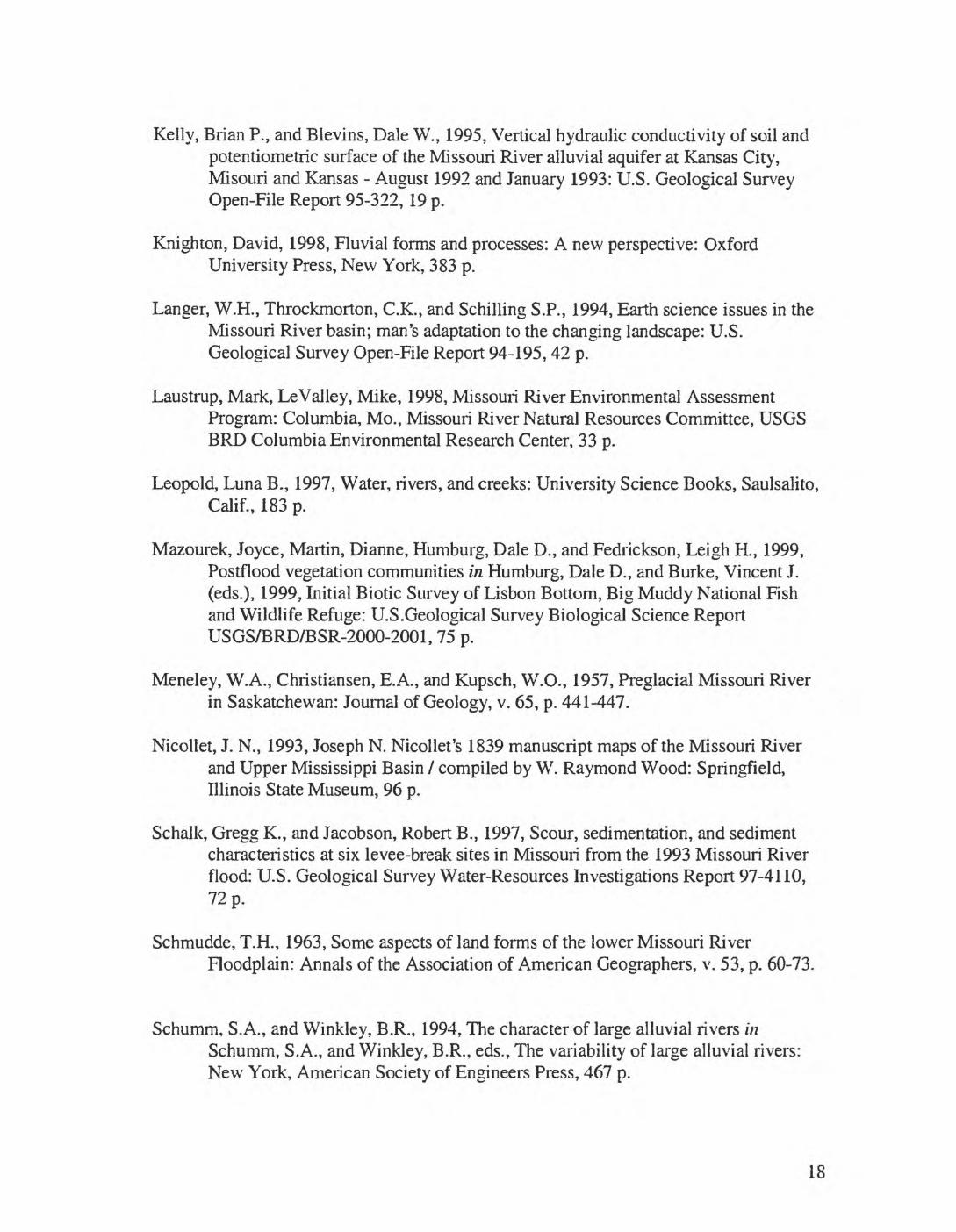
- M
Figure 3. Lisbon Bottom occupies the floodplain of the Missouri River enclosed by the upper meander bend located near the center of the figure. The Missouri River flows south from the top of the page