
5th FISC - USGS Publications Repository
83
SECTION 10 MAN-CAUSED PROBLEMS AND THEIR CONTROL CHANNEL INSTABILITY IN A STRIP-MINED BASIN -- Andrew J. Miller s............................................... 10-l STABILITY ANALYSIS OF NONCONNAH CREEK, MEMPHIS, TN -- Jerry W. Webb, David P. Berretta and William A. Thomas.......... 10-p CHANNEL RESPONSE IN CLAYSOILS TO DOWNSTREAM MODIFICATIONS -- Walter M. Linder . . . . . . . . . . . . . . . . . . . . . . . . . . . . . . . . . . . . . . . . . . . . . . . . 10-17 NAPA RIVER SRDINZNTSTlTDIES WORKPLAN -- C. G. Wolff and 1. R. Peterson....:............................. 10-25 HYDRAULIC CHANGES IN RIVERS DUE TO NAVIGATION Nani G. Bhowmik................................................. 10-33 SEDIMENT WARDATION AT URBAN DEvELOPMENI,SITES -- Rick Morse and Geoff Mcvey...................................... 10-41 LANDSLIDE RESPONSE TU TIMBRR HARVFST IN SODTHRAST ALASKA -- Douglas N. Swanston and Daniel A. Marion........................ 10-49 "DUMP CRBEK" A MAN MADE ECOLOGICAL DISASTER -- Elizabeth Rieffenberger and Dan W. Baird........................ IO-57 RECLAMATION OF SOUTHEAST TENNESSEE'S COPPER BASIN -- Roger W. Bollinger.............................................. 10-61 PLACER MINING AND SEDIMENT PROBLEMS IN INTERIOR ALASKA -- Bruce P. Van Haveren............................................ lo-69 RESERVOIR CAPACITY PRESERVING PRACTICE IN TAIWAN --' C. M. ~........................................................ 10-75 , :
-
Upload
khangminh22 -
Category
Documents
-
view
0 -
download
0
Transcript of 5th FISC - USGS Publications Repository

SECTION 10
MAN-CAUSED PROBLEMS AND THEIR CONTROL
CHANNEL INSTABILITY IN A STRIP-MINED BASIN -- Andrew J. Miller s............................................... 10-l
STABILITY ANALYSIS OF NONCONNAH CREEK, MEMPHIS, TN -- Jerry W. Webb, David P. Berretta and William A. Thomas.......... 10-p
CHANNEL RESPONSE IN CLAY SOILS TO DOWNSTREAM MODIFICATIONS -- Walter M. Linder . . . . . . . . . . . . . . . . . . . . . . . . . . . . . . . . . . . . . . . . . . . . . . . . 10-17
NAPA RIVER SRDINZNTSTlTDIES WORKPLAN -- C. G. Wolff and 1. R. Peterson....:............................. 10-25
HYDRAULIC CHANGES IN RIVERS DUE TO NAVIGATION Nani G. Bhowmik................................................. 10-33
SEDIMENT WARDATION AT URBAN DEvELOPMENI,SITES -- Rick Morse and Geoff Mcvey...................................... 10-41
LANDSLIDE RESPONSE TU TIMBRR HARVFST IN SODTHRAST ALASKA -- Douglas N. Swanston and Daniel A. Marion........................ 10-49
"DUMP CRBEK" A MAN MADE ECOLOGICAL DISASTER -- Elizabeth Rieffenberger and Dan W. Baird........................ IO-57
RECLAMATION OF SOUTHEAST TENNESSEE'S COPPER BASIN -- Roger W. Bollinger.............................................. 10-61
PLACER MINING AND SEDIMENT PROBLEMS IN INTERIOR ALASKA -- Bruce P. Van Haveren............................................ lo-69
RESERVOIR CAPACITY PRESERVING PRACTICE IN TAIWAN --' C. M. ~........................................................ 10-75
,
:

CHANNEL INSTABILITY IN A STRIP-MINED BASIN
by Andrew J. Miller, Associate Professor, University of Maryland Baltimore County, Baltimore, Maryland, and Hydrologist, U.S. Geological Survey, Reston, Virginia
ABSTRACT
Smoky Creek, a tributary (draiuage area = 85 km’) of the New River in the Cumberkand Plateau of eastern Tennessee, dmius one of the most heavily strip-mined basins of its size io the eastern U.S. Strip mining has caused radical increases in sediment yield, including a large increase in the supply of ccarse sediment to the channel system. Patterns of geomorphic adjustment to these changes have been variable along its length; channel instability occurs primarily at major deposition zones below tributary contluences or at channel bends, and these sites of aggradation are marked by slope breaks on the longitudinal profile. A 50~year record of change at one such location documents the downstream propagation of a wave of instability. Mart of the bar growth and bank erosion camed in conjunction with h~creased strip-mine activity after 1968, with a maximum bank retreat of 50 m between 1971 and 1983. Other deposition zones are occupied ty vegetated barrwland mmplexes that have remained in the same position since 1938. Some of these may have formed during a previous phase of channel instability caused by logging iu the Smoky Creek basin t&vat 1912 and 1929.
INTRODUCTION
Surface mining has long been recognized as a significant form of landscape disturbance with potentially serious downstream hnpacts, particularly in mountain envimnments. Inundation of fluvial systems by coarse sediment derived from mine spoils leads to aggmdation, gravel-bar formation, channel widening, local steepening of channel gradiems and onset of braiding, as well as accumulation of coarse sediment on adjacent flood plains (Gilbert, 1917; Collier, 1970; Osterkamp and others, 1984). Reduced infiltration capacities may lead to flashier hydrologic responses during rainfall events and increased peak discharge; where increased sediment transport capacity of the resulting flow exceeds the increase in sediment supplied to the channel system, channel widening may be accompanied by stream entrenchment rather than aggradation (Graf, 1979; Touysinhthiphonexay and Gardner, 1984).
Study area
Smoky Creek (drainage area = 85 km’) is a tributary of the New River, which in turn drains into the Cumtxrland River and is located in the Cumhxland Plateau of northeastern Tennessee (fig.1). Xx Smoky Creek basii is underlain by flat-lying Pennsylvanian shales with intercalated siltstones, sandstones, and axI beds (Avery and Luther, 1970). Where coal seams crop out on mountain slopes they are subject to surface 01 strip mining along the slope contour, creating benches and spoil banks that may alter hydrologic response of the land surface and contribute large amountS of sediment in headwater basins. Mountain slopes in the region typic+ are steep, averaging from 20 to 60 percent. Local relief from the channel to the basin divide is approximately 350 m and total basin relief is atout 603 m.
Hvdmlow and Sediment vield
Average daily discharge for the period of record (1976-1983) at the gage on Smoky Creek at Hembree (drainage area = 44.5 km’) was 1.3 m3/s and the average value of annual peak discharge was 91.5 m3/s. Because the longest stream gage record in the Smoky Creek basin extends only fmm 1975 to 1983, hydrologic effects of strip mining must be inferred from other regional studies. Paired-basin studies indicate higher peak diiharge and shorter lag times for the rising limb of the hydmgraph in mined basins as compared with ““mined basins (McCabe, 1970; Minear and Tschantz, 1974; Curtis, 1972, 1979). These results are consistent with a reduction of infiltration capacity in the basin. An additional study of paired basins in the Cumberland Plateau of Kentucky (Bryan and Hewlett, 1981) suggested that mining caused an increase in the runoff emsivity index of Williams (1972).
Published comparisons of mined and unmined basins in eastern Kentucky and northeastern Tennessee indicate that suspended sediment yields are higher in the mined basins by factors ranging from 50 to 200 (Collier, 1970; Osterkamp and others, 1984). Comparisons tabulated for this paper, including three locations in the Smoky Creek basin, indicate that suspended sediment yields in the mined basins are at least an order of magnitude greater than in the unmined basins (table 1).
Movement of tractive load also increases as a result of strip mining. This fraction of the total sediment load is not generally documented by routine suspended-sediment sampling but it plays a critical role in promoting ted aggradation, bar formation, and channel instability. Traction load accounts for at least 8 percent (65 t/km2) and possibly as much as 10 to 15 percent of the total sediment discharge from the upper Smoky Creek basin (Osterkamp and others, 1984). An estimated 52 percent
10-l

THE SMOKY CREEK BASIN
(Hembree gage)
Figure 1. Location map of Smoky Creek basin with cartoon of valley floor showing major sites of deposition Light shaded area 9” location map shows extent of active, abandoned, and reclaimed snip mines as of March 1983.
lo,-2

of the traction load is cosl, indicating that mine spoil is the dominant sediient souxe. Because of its lmver density, the coal fraction of the tracdve load moves through the Smoky Creek basin more rapidly than the coarse rock debris.
Sand-use history
Mining activity began in the early 1940’s. The percent of basin area in active, abandoned, or reclaimed strip mines increased from less than 1% in 1941 to ne&y 15% by 1983, with most of the increase oxwing between 1%8 and 1979. Mining practices probably were less considerate of envimnmental consequences prior to passage of the federal Surface Mining Control and Reclamation Act of 1977 than atienvard, and thus would have generated more sediment per unit area of disturbed land. However, because of the lag time involved in flushing sediment out of the system, an immediate reduction in sediment load would not be expected even if the passage of the 1977 law caused a rapid change in management practices.
Only about 23 percent of basin area is devoted to agriculture, and this figure has not changed significantiy Table 1. cnlnpati” al sediment yields
selected Streams fmom the cllrntedand Plateau Of Te”“es.% over the last several decades. Prior to the onset of strip mining there was a period of timber barvexing in thk Basin Drainage area earlier pan of this century; there are no statistics on W’)
sediment yield Oh?
exactly how much of the timber in the basii was cut. Unmined The typical pattern followed by loggers in this part of west Fork obey R; II*. Alpine 298 13 Tennessee in the early years of this century was to cut all Clear Fork nr. RObbillS 704 32 of the marketable timber as rapidly as passihk. Steep crabapple ck Dr. la Follette 2.8 M skid roads were built to haul the lumber down the mountain; another common practice called “J-logging” m invohzd construction of a chute that would allow large Nnv R. at New River 989 348 trains of logs to slide downslope along a bed of peeled smoky CL. at Hembree 44.5 758 logs, with a log landing at the bottom of the slope to Bilk Bra”& (Vib. to SIX&y) 1.7 415 absorb the impact. Slash debris left behind on the slopes shack ck pib. to Smoky) 5.1 494 often burned down to the mineral soil within a year after logging, leading to accelerated soil erosion (Donald Todd, resident of Wartburg, Tennessee, personal communication, 1990). Thus there is a strong likelihood that timber cutting in the Smoky Creek basin was associated with rapid erosion and large sediment yields. Large-scale timber harvesting apparently came to an end in the 1920’s; after a major flood in 1929, the branch of the Tennessee Railroad used to carry timber out of the basin fell into disuse (Ianier, 1968).
CHANNEL MORPHOLOGY
Smoky Creek occupies a narrow valley bounded by steep bedrock walls. Valley-floor width typically is less than 300 m and at some locations is less than 50 m. As Smoky Creek is constrained by its narrow valley from the free meandering pattern typical of many alluvial rivers, hs channel pattern consists of a series of straight reaches alternating with short meandering reaches that usually coincide with a change in valley orientation or with a tributary confluence immediately upstream. Most of the meandering reaches include only one or two meander bends, and in many instances the concave bank of one or both bends abuts a bedrock wall. A pool-riffle sequence with a thalweg that meanders past alternating lateral bars is typical of the straight reaches. Channel instability occurs primarily at meander bends and is characterized by accumulation of large gravel bars, bank erosion and channel widening, and formation of anabranching channels that frequently shift location.
For the purpwes of this paper, major areas of sediment deposition and storage along Smoky Creek are assigned to two categories. Large active gravel bars are mostly unvegetated or colonized by woody plants no more than a few years old and are characterized by evidence of ongoing aggradation, lateral migration, or irregular episodes of cutting and tilling in response to sediment transport by annual high flow. Surficial sediment is dominated by gravel but may include sand lenses; coal fragments are common and often occur in pockets or lenses, due to hydraulic sorting. Vegetated bar/island complexes are larger geomorphic features, typically consisting of multiple bars and islands covered by woody vegetation including mature trees; they are separated by anabranching channels, and individual bars or islands are frequently dissected by shallow overflow channels. Tbe entire complex is inset at an elevation slightly lower than the main valley floor and at or above the highest elevation on nearby active gravel bars, and is bounded by a scarp leading up to the main level. Evidence of deposition during frequent high flow events is wmmon but lew pervasive than on the active bars, and recent deposits are dominated by sand.
Major deposition sites are located dmvnstream of every tributary confluence shown (fig.1) with the exception of Little Brimstone Creek. In addition, a couple of the bariiiland complexes are located about halfway between tributary confluences.
10-3

lh”s the spatial pattern of deposition is influenced by kxal hydraulic conditions along the channel, as well as by loCatiOnS Of major sediment wwces. Virtualiy a” of the large act&e bars are found in close prtimity to larger vegetated bars and islands. Downsveam of point S o” fig.1 there are no major bars or bar/island complexes.
Loneitudinal ~roflle
Average channel gradient along the reach illustrated in tig.2 is about 0.004. llz longitudinal watersurface profile of Smoky Creek at base flow is strongly stepped. ‘lIvea? of the four tributaty junctions along the surveyed portion of the channel downstream of point E are. awciated with a sharp break in slope - (figs.l,2), which ca” be attributed to bed aggmdation 5
where a” influx of coarse sediment lwaliy exceeds the transport capacity of the “xii” channel. The channel
E
gradient along reaches occupied by bar-island complexes generally is steeper than along the straight reaches imnwxliateiy upstream or downstream. For barMind reaches shown in fig.1 (other than R-5, where the gradient was altered with a bulldmer two Distance downstream, in meters years before the 1985 survey), the ratios of gradient along the reach to gradient along the adjacent Figure 2. Longihxlinal water-surface profile of Smoky Creek at low flow. upstream and downstream reaches averaee 29 and - Reference c&t locations are indicated in fig. 1. Pmfde of Ications E-T 3.6, respenively. surveyed &ust 1985; profile of locations i-0 surveyed July 1988.
Cross-section characteristics
Of 10 monumented sections established in 1981 along the main channel of Smoky Creek, 7 were established at locations where the channel was straight, the top of the bank was reasonably welldetined, and the section was “early trapezoidal. Three sections were established at locations with active gravel bars. Bankfull channel width at the straight sections ranged from 15 to 25 m and for 6 of the 7 sections the ratio of width to bankfull depth ranged from 9.1 t” 12.4 (the ratio at the seventh section was 22.8). Bankfull width at the bar sites ranged from 30 t” 70 m and width/depth ratio ranged from 12.5 to 28.5. Repeat surveys over a period of several years indicated much greater year-@-year variation and greater cumulatiie change at the cross-sections wcupied by gravel bars than at the sites along straight reaches.
Bed surface material at alI of these crosssections was a mixture of gravel, mbbles, and boulders. Bed matrix is dominated by gravel in all oses, most banks are composed primarily of silty sand, but sane are mixtwes of gravel and sand (table 2). Average coal content of samples from mined basins is lower in the bed material than in the .bank sediments, but is quite variable in both cases; field observations indicate that its distribution on bars and in bank materials is patchy.
Sediments exposed on bar surfaces are composed primarily of gravel, but spatial patterns on individual bars are heterogeneous
10-4

owing to the combined influences of microtopography and vegetation on local patterns of erosion and deposition at high flow. Dcndrogcomorphic evidence obtained at several sites indicates vertical accumulation rat&s up to about 30 cn@r and lateral migration rates up to 1 “I&T during periods without major floods (B.A. Bryan and CR. Hupp, U.S. Geological Su~ey, written mmmunicatio”, 1988). Field observations at the nxxt active site along Smoky Creek indicate m&urn bank erosion on the order of 10 m in a single year (fig. 3-z), with vertical bar growth of up to 0.5 “I.
DEVELOPMENT OF A BAR/ISLAND COMPLEX
A 50year record of channel change at one site affected by recent bar growth and bank erosion was obtained using digital photogrammetrlc tccbniqucs (Miller, 1986). The observed series of changes may save as a” analogue to explain development of vegetated bariiiland complexes elsewhere along the channel. The study site extends atout 650 m downstream from the contluence with Bowling Branch. The sequence of changes, beginning with the earliest available aerial photographs, ls illustrated in fig. 3. Arcal extent of channel bars is not strictly comparable bctwccn dates, as the amount of the bed exposed to view varies with water level from one date to another. Ncvcrthelcss the shifting location of the major bars and the overall trend toward channel widening associated with progressive growth of the bar complex is clearly show”. Maximum bank retreat of 50 “I occurred bchvcc” 1971 and 1983 (figs. 3d,e).
‘Ihe sequence of changes illustrates the downstream propagation of a wave of instability. In the summer of 1983, the property owner attempted to reclaim his land by scraping gravel out of the main series of bars and pushing it against the right bank, straightening the tank line. Although thii stabilized the right bank temporarily, by 1987 the fill material was again being eroded. In addition the wave of instability had migrated around the bend and an entire new meander wavelentb was superimpwed on a previously straight section of the channel (fig. 3f). Field mcasurcmcnts made along the right bank following conversations with the property owner during sununer 1987 indicated that bank retreat of up to 10 m had occurred during spring 1987 at location 1 in fig. 3f.
The patter” of channel evolution at this site is heavily influenced by the role of vegetation in stabilizing bar surfaces and trapping fine sediment on the higher parts of bars. Rapid vertical accretion at sites of dense vegetation growth on the inner part of a bar can cause annealing of part of the bar to the fled plain. By 1987 the old bank line that formed the inner margin of the bar complex along the left side of the channel in 1983 (figs 3c,f) was obscured by sediment accretion and vegetation growth and was very diftiieult to locate in the field. The cut bank that was visible when the site was visited in 1987 was c”t into a vegetated surface that had accrcted upward almost to the floodplain level since 1983. Extrapolation of deposition patterns observed between 1938 and 1989 suggests that as the wave of instability passes, bars and b&Island complexes will anneal to banks. Tbii process results in a bottomland mosaic with scafps separating the younger from the older deposits ln some cases and with no relief across the contact in other cases. The complex, episodic evolution of the flood plain would only be evident through detailed stratigraphic analysis or comparison of historical aerial photography.
Relation to stria-mine activity
Measured changes in channel width and in the position of the wave of instability indicate tit the period of bar growth, acccleratcd bank erosion, and rapid downstream propagation of disturbance at the study site was contemporaneous with the increase in extent of upstream strip mining (fig. 4). The property owner claims that the hydrologic response of Smoky Creek during rainfall events has changed ova the past several decades, with the creek rising more rapidly than it did in the past, overbank flow and sedimentation occurring more frequently, pools filling with gravel, and a general reduction in water depth. All of thii is consistent with the evidence presented here. The anmunt of oxl deposited on bar surfacw throughout the reach implies that strip mining has been the source of the sediment. Although there have been several large tlocds during the period of rapid bar growth and channel widening, one or two catastrophic events cannot acwunt for the changes observed at this site; incremental changes have occwred during each time period for which information ca” be obtained.
CHANNEL INSTABILITY AT OTHER LOCATIONS
Dendrochronological evidence from three other active gravel bars along Smoky Creek also indicates that rapid bar growth has occurred during the past three decades, coinciding with the period of rapidly increasing mining activity (B.A Bryan and C.R. Hupp, U.S. Geological Survey, written communication, 1988). At two of these locations, the stratigraphic sequence exposed in an eroding bank provides evidence that coarse sediments generated ty mining activity ha? become annealed to the bank and incorporated in the flocrd plain.
A typical composite sequence bawd on observations of both profiles (at locations C and H in fig. 1) has the following characteristics: 0.15 to 0.45 m of brown fine sand, with organic litter at the surfxe and disseminated coal fragments; 0.6-0.9 m of wbbbes and gravel, embedded in a matrix of brown sandy loam with abundant coal fragments up to cobble size; 0.3 m
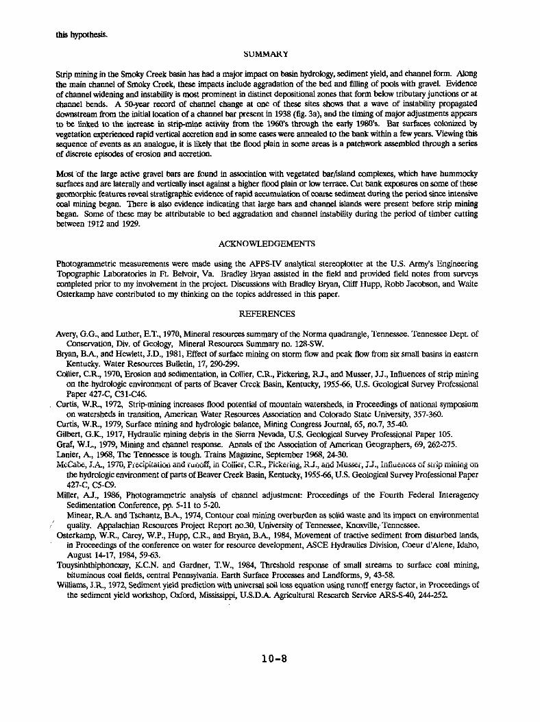
10-5

Figure 3. Channel changes on Smoky Creek downstream of Bowling Branch, 1938 - 1987.
10-6

of lmizontaliy laminated sands and clays, with coal fragments in the sandy laminae; 0.15 m of gravel, cobbles, and coal fragments embedded in a sand matrix. The entire sequence is underlain by channel gravels at the base of the bank.
Fxcavatlon of mot collars of buried trees and wunting of rings from tilt sprouts of trees affected by flood damage indicates that the upper coal-rich cobble-gravel layer at one of these sitea was deposited after 1958 and may have been deposited during a large flood that occurred in 1977 (B..4 Bryan and C.R. Hupp, U.S. Geological Survey, written communication, 1988). In both locations the coal-rich, pwriy sated deposits underlie a hummocky vegetated surface laterally and verticaliy inset against a flwd plain or low terrace that is 0.5-1.5 m higher. Cut-bank exposures of tbe alluvium underlying this higher, older surface typically reveal a basal layer of channel gravels overlain by a finiog- kp-,d sequence of structureless silty
In the absence of additional evidence one might reasonabiy conclude that the inset deposits arc representative of vegetated barKsland complexes along the length of Smoky Creek, and that most of the major deposition features have formed during the period since strip mining began. However, sediments underlying some vegetated islands are better sorted and contain much less mat than modem sediments, suggesting deposition before strio minine. began. Some of the trees
Figure4. Comparison of channel changes at site dowweeam of Bowling Branch with historical trend in pacent of basin area in ship mines.
gr&g oniege&d islands and bars are too old (up to &I years, with some large rotting stumps that could not be dated but are probably older) to have germinated on a surface formed after strip mining began. Several of the vegetated barfiland complexes (as well as the large active gravel bar upstream of location J in fig. 1) are visible in aerial photographs taken in 1938 at the same locations that they occupy today.
At several locations along the channel of Smoky Creek there is a grey clayey sand, full of organic litter and wood fragments, overlying the basal channel deposits and underlying the silty sand that predate intensive strip mining. Large logs observed protruding from this layer clearly were buried in place rather than being pushed up against the base of the bank Similar deposits can be observed forming today at locations where a muddy gravel mixed with leaf litter and wood fragments progrades into a deep pool or eddy along a low-gradient reach of the channeL At present there is no conclusive evidence to date the layer found at the base of the bank; but it seems plausible to attribute its formation to the period of timber cutting that occurred after 1912 and came to an end in 1929. ‘Ibis would have been the mat signiticant episode of lamlscapc disturbance to affect the Smoky Creek basin prior to the introduction of strip mining. Individuals who witnwed the impacts of logging in other nearby basins have commented on the tremendous amount of soil erosion that occurred on the steep mountain slopes and on the large amount of organic debris that accumulated in stream channels.
The implication of this obsavation is that some of the vegetated barfisland complexes may have formed during an aggmdational phase associated with the period of timber cutting, and that these assumed a faiily stable configuration following the end of the logging operation and prior to the onsct of strip mining. The vegetated bar/island complcxcs cover a much larger area than the large gravel bars that are presentty active; thus, if they arc attributable to a previous episode of erosive land use, that episode may have had an even greater net impact on the morphology of Smoky Creek than the more recent episode of strip mining. Altemativciy, mmc of thevegetated bar/island complexes may be attributable to natural causes; stable patterns of istands separated by anastomcsing channels may have formed at some locations along Smoky Creek before human activity played a significant role in altering the system. Further investigations of bank stmtigraphy arc needed in order to test
10-7
this hypothesis.
SUMMARY
Strip mining in the Smoky Creek basin has had a major impact on basin hydrology, sediment yield, and channel form. Along the main channel of Smoky Creek, these impacts include aggradation of the bed and fill@ of pools with gravel. Evidence of channel widening and instability is most prominent in distinct depositional zones that form below tributary junctions or at channel bends. A 50.year record of channel change at ooc of these sites shows that a wave of instability propagated downstream from the initial location of a channel bar present in 1938 (fig. 3a), and the timing of major adjustments appears to be lhked to the lnacasc in strip-mice aetlvlty l?om the 1960’s through the early 1980’s. Bar surfaces colonized by vegetation experienced rapid vertical accretion and in some cases were annealed to the bank within a few years. Viewing this sequence of events as an aualogue, it is likely that the flood plain in some arcas is a patchwork assembled through a series of disncte epiwdca of erosion and secretion.
Most bf the large active gravel bars arc found in association with vegetated bar~lalaad complcxca, which have hummoeky surfaces and arc laterally and vertically iosct against a higher flood plain or low terrace. Cut bank cxpxwes on some of these gcomorphie features reveal stratigraphic evidence of rapid aeeumulation of coarse sediment during the period siucc intensive coal mining began. There ls also evidence indicating that large bars and channel islands were present before strip mining began. Some of these may bc attributable to bed aggradation and channel instability during the period of timber cutting between 1912 and 1929.
ACKNOWLEDGEMENTS
Photogmmmetric measurcmcnts were made using the APPS-IV analytical stereoplotter at the U.S. Army’s Engineering Topographic Laboratories in Ft. Belvoir, Va. Bradley Bryan assisted in the field and provided field notes from surveys completed prior to my involvement ln the project. Discussions with Bradley Bryan, Cliff Hupp, Robb Jacobson, and Waite Osterkamp have contributed to my thinking on the topics addressed in this paper.
REFERENCES
Avery, G.G., and Luther, E.T., 1970, Mineral resources summary of the Norma quadrangle, Tennessee. Tennessee Dept. of Conservation, Div. of Geology, Mineral Resources Summary no. 12SSW.
Bryan, B.A, and Hewlett, J.D., 1981, Effect of surface mining ou storm flow and peak flow from six small basins in eastern Kentucky. Water Resources Bulletin, 17, 290-299.
Collier, C.R., 1970, Erosion and sedimentation, in Collier, CR., Pickering, RJ., and Musscr, JJ., Influences of strip mining on the hydrologic environment of parts of Beaver Creek Basin, Kentucky, 195566, U.S. Geological Survey Professional Paper 427-C, C31-C%5.
Curtis, W.R.. 1972, Strip-mining incxascs flocd potential of mountain watersheds, in Proceedings of national symposium on watersheds in transition, American Water Resources Association and Colorado State University, 357-360.
Curtis, W.R., 1979, Surface mining and hydrologic balance, Mining Congress Journal, 65, “0.7, 3540. Gilbert, G.K., 1917, Hydraulic mining debris in the Sierra Nevada, U.S. Geological Survqr Professional Paper 105. Graf, W.L., 1979, Mining and channel response. Anoals of the Association of American Geographers, 69,X%275. tinier, A, 1968, lix Tenncsscc is tough. Trains Magazine, September 1968, 24-30. McCabe, J.A., 1970, Precipitation and runoff, in Collier, CR., Pickering, RJ., and Musser, J.J., Intluenc.cs of strip mining on
the hydrologic environment of parts of Beaver Creek Basin, Kentucky, 195566, U.S. Geological Survey Professional Paper 427-C, CSC9.
Miller, A.J., 1986, Photogrammetric analysis of channel adjustment: Proceedings of the Fourth Federal Interagency Sedimentation Conference, pp. 5-11 to 5-20.’ Mincar, RA and Tschantz, B.A, 1914, Contour coal mining overburden as solid waste and its impact on euvironmcutal
’ quality. Appalachian Resources Project Report 00.30, University of Tennessee, Kn&Ue;Tennw.ce. Gsterkamp, W.R., Carey, W.P., Hupp, CR., and Bryan, B.A, 1984, Movement of tractive sediment from disturbed lands,
in Proceedings of the conference on water for resource development, ASCE Hydraulics Division, Gxur d’Alene, Idaho, August 14-17, 19S4, 59-53.
Touysinhthiphonexay, KCN. and Gardner, T.W., 19S4, Tlxeahold response of small streams to surface coal mining, bituminous coal fields, central Pennsylvania. Earth Surface Processes and Landforms, 9, 43-58.
Wiiams, J.R., 1972, Sediment yield prediction with universal soil loss equation using runoff energy facmr, in Proceedings of the Sediment yield workshop, oxford, Mississippi, U.S.D.A Agricultural Research Service ARS-S-40, 244252.
10-8

STABILITY ANALYSIS. OF NONCONNAH CREEK, MEMPHIS, TN
By Jerry W. Webb & David P. Berretta, U.S. Army Corps of Engineers, Memphis, TN and William A. Thomas, Waterways Experiment Station, Vicksburg, MS
INTRODUCTION
Purnose and Scope of the Study
The Nonconnah Creek Drainage Basin includes portions of Shelby and Fayette Counties in southwest Tennessee, and portions of Desoto and Marshall Counties in northwest Mississippi. Approximately one-half of Memphis, Tennessee, is located within this drainage basin which is one of the fastest urbanizing areas in western Tennessee. The basin is approximately 32 miles long, 8 miles wide, and generally rectangular in shape. The total drainage area of Noncon- nah Creek is 117,000 acres (183.1 square miles). The stream slope is approxi- mately 5 feet per mile with topography varying from gently rolling hills and ridges in the upland areas, to moderately wide valleys. This report describes the results of sedimentation and stability analysis performed during the evaluation of flood control alternatives. The design procedure and rationale for the design of this project are typical of most flood control projects with the exception of the high degree of protection that the existing channel provides. Special key issues that were of interest in this project include protective measures, water surface profile stability, and approach and exit channels. The proposed channel improvements have been designed using the guidance provided in ER 1110-2-1405 which states:
"The hydraulic design of a local flood protection project must result in a safe, efficient, reliable, and cost effective project with appropriate consid- eration of environmental and social aspects."
Physical Settinq
Historically, Nonconnah Creek was a natural meandering stream, but commercial activities and increasing urbanization resulted in drastic changes in the streams configuration. The existing channel is rather narrow and deep and is bedded in sand or gravel throughout the study reaches. The banks are predomi- nantly clay or silt, occasionally intermixed with a strata of sand. The upper reaches of Nonconnah Creek were modified by local interests over 50 years ago. Little is known as to the stability of the channel immediately following the channel improvements. Aerial photographs taken in 1958 show that a rather artificial looking channel had been cut through the meander traces even though the area south of Nonconnah Creek was practically undeveloped. At this time there were 15 bridges between the mouth and Winchester Road which consequently locked in the channel alignment. More recent aerial photographs show no trace of historical meander patterns and prove that the basin has urbanized at a rapid rate. Two areas, one located downstream of Perkins Road (Mile 11.53) and the other located downstream of Mt. Moriah Road (Mile 12.59), were extensively excavated for commercial development in the floodplain. Other locations have served to support mining operations. Although the stream was, and continues to be, highly disturbed by commercial activities, a low flow channel has formed alternate bars indicating a tendency to reestablish a meander pattern. In the early 1980's. the local governments began an extensive bridge monitor- ing and rehabilitation program after the catastrophic failure of one bridge
10-9

facility. Improvements consisted of riprap and ~gabion channel and bank pro- tection around bridge facilities. These improvement nbtonly are protecting the facilities, but are also serving as grade control structures.
STUDY APPROACH
This study utilizes a staged sedimentation study approach similar to the descriptions in EM 1110-2-4000. During the early stages of project formula- tion, there was little or no sediment data. Since the channel and floodplain have been so dramatically disturbed, calibration bf a numerical model was not possible, and an initial sediment impact assessment was performed. Based on the results of that analysis and information gathered during the hydraulic studies, protective measures were designed for all structural components of the project. Subsequent to submission of the Phase II GDM, reviewing authori- ties required a detailed sedimentation study., The following paragraphs dis- cuss available data, methodology, and results of both levels of the analysis.
Initial Assessment
Available Data during Initial Assessment
Data necessary for conducting the sedimentation study were of three types: geometric, sediment, and hydrologic. Visual inspections of the Nonconnah Creek basin also aided in the sediment study.
The geometric data consisted of channel cross sections which were obtained from field surveys. Analysis of aerial photographs, quadrangle maps, and proposed channel improvements were also used. From this data, bed profiles and channel alignments were obtained.
Sediment data consisted of the channel bed composition, the strata underlying the bed material, and the inflowing sediment load. Due to commercial activi- ties throughout the basin, no bed samples were taken. Visual inspections were used in determining the bed composition. The existing bed consists of sands and gravels throughout the study reaches. Twenty-nine channel borings and associated grain size distribution curves were used to define the underlying strata and bed material.
The hydrologic data included extensive land use studies which indicated that the total basin is currently 43 percent urbanized with a projected increase to 66 percent by the year 2043. The basin area below John's Creek (Mile 11.94) is approximately 7% percent urbanized with a projected increase to 97 percent by the year 2043. The study area was modeled using the HEC-1 Flood Hydrograph computer package as part of the hydrologic and hydraulic analyses. The hydro- logic studies estimate that these future projected increases in urbanization will increase the loo-year discharge by approximately 20 percent. For this level of study, the hypothetical discharges for a 2-year frequency event were multiplied by a range of ratios (25, 50, and 75 percent) to better evaluate in-bank flows under normal, daily conditions. These discharges were input into the hydraulic model to determine variables needed in this evaluation. Observed 24 hour rainfall from 1977 to 1986 was used in estimating the number Of events per year that could be expected for a estimated discharge.
10-10

General Procedures Adopted in Initial Assessment
The following discussion addresses the initial assessment of channel stability with respect to the existing conditions and the recommended improvements. The stability analysis performed includes a qualitative and relative quantitative evaluation of potential problems and betterments resulting from proposed channel improvements. Representative channel reaches with respect to hydrau- lic characteristics wsre designated along Nonconnah Creek. Hydraulic, hydro- logic, and geometric data were extracted from the HEC-1 and HEC-2 computer models for the 2-year frequency event and several lesser flows including ratios of 25, 50, and 75 percent. Average reach parameters were determined from actual parameters of the cross sections thru that reach. The total bed- material load for each reach for the different events was estimated using Toffaleti's Method as included in the Waterways Experiment Station (WES) program HOg26, Corps Library for Hydraulic Design.
Results of Initial Assessment
The degree and location of channel aggradation and/or degradation and overall channel stability were evaluated by comparing the sediment transport for existing conditions with that under the proposed plan of improvement. The sediment transport capability derived from Toffaleti's Method was computed for each reach of channel for the a-year frequency event and several more frequent events. These results present a snapshot of deposition and erosion rates and were used to estimate relative rates of scour and deposition (i.e. not long term volumes). Table 1 presents the results of the analysis.
Table 1 HATE OF SCOUR AND DEPOSITION
Stream Mile From To
(au.1 (mi.) 0.29 2.35 2.65 3.14 3.23 4.32 4.35 5.54 5.62 6.86 6.90 7.63 7.70 8.09 8.18 10.35
10.46 11.44 11.50 11.94 12.02 12.46 12.63 14.37 14.46 15.53 15.62 17.25 17.37 21.01
1 2 3 4 5 6 7 a 9
10 11 12 13 14 15
Existino Conditions gQgg Deoosition
( fthr) (ft/yr)
0.3-0.6 1.9-4.5 0.0-0.6 0.0-1.8 1.8-2.9
0.3-0.5 2.5-5.0
1.2-3.2 0.4-1.0
0.7-1.5 4.7-9.3
0.3-0.9 0.0-0.2 0.0-0.1 0.3-0.6 0.2-0.4
---- ----
ImDroved Conditions Scour DeDOSitiOn
(ft/yr) (fthr)
0.0-1.9 0.0-0.4 0.0-2.1 0.0-2.1 0.0-0.2 0.0-0.1 0.0-1.2 0.0-1.3 0.1-0.6 0.0-1.2 0.0-1.2 0.0-1.2 0.0-0.2 0.2-0.5
1.2-1.8 7.9-12.7
0.7-1.3 0.0-0.1 0.0-0.2 0.3-0.9 0.3-0.7
----- ------
Based on historic information and field observations, the results in Table 1 give a good indication of existing conditions. Reaches 13 thru 15 have not experienced significant modifications over the past several years. Reach 12 has oscillatory tendencies; aggrading under certain flow conditions, and
10-11

degrading under other flow conditions. Reach 11 is a depositional reach and has been an active borrow area. Reach 10 is a very dynamic reach with active bank caving and erosion. This reach is critical in that commercial develop- ment has been allowed to encroach to topbank and Johns Creek, the major tribu- tary , enters Nonconnah Creek in this reach and aggravates the problem. In August 1987, Reach 10 was extensively modified by a local developer. The channel bottom width was approximately doubled and the side slopes improved. The developer has implemented some bank stabilization measures. Reach 9 is also a depositional reach and has been an active borrow area. Reach 8 shows signs of instability through channel widening and bank caving. Reach 7 exhib- its depositional tendencies which is substantiated by current dredging opera- tions that have gone on for several years. Reaches 3 thru 6 show the same scouring and/or depositional tendencies as previously explained. Reaches 1 and 2 are located in the Mississippi River backwater areas. Results indicate headwater scouring; however, these reaches have been relatively stable over the past few years.
The proposed improvements give a relative indication of conditions after the project is in place and identified problem areas. Most reaches develop oscil- latory tendencies seeking a state of quasi-equilibrium. Historic depositional reaches 9 and 11 will continue to follow this trend. Reach 10 shows an in- crease in scouring tendency which will require channel and bank stabilization., Otherwise, the responses to natural morphological changes would be propagated to reaches above and below and cause changes to their respective channel characteristics. The proposed improvements also recognize the need for in- creased channel stability around bridge structures and in certain bendways. Protection will be provided at all facilities as required by accepted crite- ria. This protection will also function as grade control of the channel. Bendways located between Mile 0.76 and Mile 0.94, Mile 4.77 and Mile 4.90, and the outlet channel for Nonconnah Pump Station will also be protected.
Interpretation of Results of Initial Assessment
In alluvial streams it is expected that banks will erode, sediment will be deposited, and floodplains and tributaries will undergo modification with time. The Nonconnah Creek basin in recent years has experienced rapid growth which has altered channel characteristics. Channel velocities are high, and man’s activities have caused extensive instability. The proposed improvements will be constructed along the existing channel alignment. The improvements will essentially provide a consistent drainage system to convey future flows through the basin. From the initial sediment impact assessment, it was deter- mined that impacts to the existing river morphology will consist of accentuat- ing the oscillatory tendencies along various reaches of the channel.
Detailed Analytical Study
Available Data during Detailed Studies
Data necessary for conducting the sedimentation study were similar to the initial assessment and consisted of three general types: geometric, sediment, and hydrologic. This analysis utilized geometric data from the previous study.
Additional sediment data was taken in April 1988 when 54 sediment samples were taken from the channel bed at 27 locations spaced along the 20 mile study
10-12

area. Two samples were taken in the dry at each location, one from near the water's edge and the other from the point bar deposits midway of the channel. Grain size distribution curves were developed for the samples. In addition, channel borings and associated grain size distribution curves were used to define the underlying strata.
In order to develop a histogram for the detailed sediment model, rainfall - runoff simulations were generated using historical rainfall (1964-1987) ob- served at the National Weather Service Office at Memphis International Air- port. The procedure used involved computation of composite unit hydrographs from the lo-year and loo-year flood hydrographs from the HEC-1 models. Daily discharges were computed using the observed rainfall applied to the composite unit hydrograph. The computation of daily discharge uses the antecedent precipitation index method to compute losses. This data was reduced to blocked histograms using the Sediment Weighted Histogram Generator (SWHG) developed by the Hydrologic Engineering Center, Davis, California. The program processes daily discharges into representative discharges and time periods. Histograms were computed at four locations for existing and improved condi- tions using Total Water Volume as a basis for proportioning tributary inflows.
General Procedures Adopted for Detailed Study
The following discussion addresses the analytical approach taken during the detailed studies of channel stability with respect to existing conditions and the recommended improvements. Following the initial assessment, a sedimenta- tion study was performed by Mr. William A. Thomas, Hydraulics Laboratory, Waterways Experiment Station (WES) and personnel from Memphis District. The results of the study are published in Miscellaneous Paper HL-90-1 entitled "Nonconnah Creek Sedimentation Study Analysis Using A Numerical Modeling Approach," dated January 1990. These results are summarized in this section and serve as a basis for establishing operation and maintenance requirements of the project sponsors. The WES computer program, "Sedimentation in Stream Networks" (TABS-I) was used to investigate the adequacy of proposed channel invert controls by forecasting channel aggradation and degradation over the next 10 to 25 years. Nonconnah Creek has been disturbed too severely to permit the normal model confirmation. Therefore, the investigation used a long term runoff record developed from rainfall, and single event runoff hydrographs developed using HEC-1. The objective was to calculate the proba- ble aggradation and degradation of the stream bed profile as the creek re- sponded to the modeling approach. The model is unconfirmed, and consequently, the results do not meet standards associated with a numerical model. There- fore, the approach provided a theoretical treatment of the degradationlaggra- dation processes along Nonconnah Creek. It also provides a numerical model which could be confirmed if adequate field data were available. Finally, the approach utilized the fullest extent of present technology to study a project which involves mobile bed hydraulics and all the channel bed dynamics associ- ated with fluvial processes.
Evaluation of Inflowing Sediment Load
No suspended sediment measurements are available, but sands and gravels are the predominant sediment sizes on the bed of the existing channel. Therefore, sediment transport theory was used to calculate the bed material sediment discharge for existing conditions. These calculations require hydraulic
10-13

parameters plus the gradation of the bed surface. The portion of Nonconnah Creek upstream from Winchester Road (Mile 18.10 to Mile 20.98) was selected for the transport capacity calculations. The existing conditions geometry and n-values formed the geometric model. Four flood discharges were selected, and the starting elevations for the water surface profiles were taken from the HEC-2 model. TABS-l was used for the calculations.
Since the bed samples from "mid-bar locations" were the most likely to have bean deposited during floods, they were used to describe the bed material for sediment transport calculations for the four selected flood discharges. Starting with the 2-year flood peak discharge, a zero sediment inflow was prescribed for the TABS-l code. The Laursen Transport function as modified by Madden in 1985 was used to calculate the total sand and gravel load moving in the model and the concentration by size class. The average transport capacity was calculated by averaging the 11-cross sectional values from Mile 18.10 to Mile 20.98. Those values were then coded as the inflow to the upstream end of the model and the calculation repeated for that same water discharge. After three iterations, the inflow was in balance with the average transport in that reach as shown by a zero trapping efficiency and negligible bed change at each cross section. That value was selected; the next water discharge was pre- scribed and the procedure started over.
The sediment inflow from tributaries was assumed to be zero. This was based on the fact that no bars were found at the mouths of tributaries, and there was noticeable degradation downstream from existing drop structures on Johns Creek and Ten Mile Creek. There were no significant deposits within the concrete lined tributaries. This supported the assumption that no significant sediment load was being introduced by the tributaries. Also this assumption resulted in more erosion occurring in the model than would occur in the proto- type.
Results of Detailed Analytical Study
With respect to predicted bed surface profiles, the existing profile was compared to the predicted profile calculated for the end of the 24 year period of analysis. A degradational trend is indicated through the study limits. It should be noted that the lower two miles are not representative of long term trends because of the influence of Mississippi River backwater. For improved conditions, it can be shown that the recommended improvements will make the Nonconnah Creek channel invert more stable than it would be without the project. This improvement is attributed to the localized grade control pro- vided by the protective measures included as project features at bridges and pipelines.
Most of the major tributaries that enter Nonconnah Creek have been either concrete lined or stabilized with some type of stone protection. A reconnais- sance of the major tributaries was made with a representative of the City of Memphis to assess the existing condition of each confluence, to discuss the proposed improvements along the main stem of Nonconnah Creek, and to agree on protection requirements. It was determined that the confluence with Days Creek, Mile 6.16, and Ten Mile Creek, Mile 9.46, will be protected as a part of the improvement to Nonconnah Creek, but no additional protection will be placed at other confluences.
10-14

Interpretation of Results of Analytical Study
Although this study predicts a degradational trend with the project in place, this study supports the fact that the project will provide a more stable channel than will exist without the project. The calculated bed change in the approach channel is less than 1 foot. This is attributed to the stone prOteC- tion proposed at the bridge crossings for Winchester Road, Hacks Cross Road, and Forest Hill-Irene Road. The calculated water surface profiles show no appreciable base level lowering in the 3 miles of approach channel to the project. Nonconnah Creek empties into McKellar Lake which flows into the Mississippi River. Maintenance dredging is required at the mouth of Nonconnah Creek. From this study it can be inferred that the proposed project should decrease sediment outflow by 28 percent. This is a direct reduction of a major sediment source to the lake which should reduce maintenance dredging quantities for that portion of the navigation project. Within the limits of study, the calculated maximum amount of degradation is about the same with the project as without it. However, the average amount of degradation over the 18.2 mile project length is 1.5 feet with the project and 2.0 feet without the project for the 24 year period of analysis. These values show that the project will reduce the rate of bed degradation by 25 percent. The average amount of aggradation is 0.25 feet without the project and 0.20 feet with the project for a reduction of 20 percent.
There is every indication that degradational and aggradational trends will continue past the 24 year projection at no decrease in rates. In other words, in 50 years the average depth of degradation is expected to be 3 feet with the project and 4 feet without the project. Continued downcutting of the stream bed, either with or without the project, will eventually increase bank heights to produce instabilities. The project sponsor has been made aware that the project will not cause such a condition; however, the proposed design does not stabilize Nonconnah Creek to the point of preventing such a condition from occurring.
PROJECT PERFORMANCE AND SAFETY RECOMMENDATIONS
Existina and Future Stability of Project Features.
The recommended plan of improvement to be separately implemented by the Corps of Engineers includes features for flood control, fish and wildlife enhance- ment, and recreation. Flood control is the primary project purpose, and its implementation is separate from the two supplemental features. Flood control measures include improving the lower la.2 miles of Nonconnah Creek, of which 10.5 miles will be channel clearing and snagging only, and the remaining 7.7 miles will be channel enlargement. This improvement will provide a loo-year frequency level of flood protection.
The stream bed profile is generally degrading as evidenced by gabions, and other types of grade stabilization at several bridges. However, the banks appear remarkably stable to be so high and steep. There is evidence of bank failure downstream of Getwell Road where banks are wet from seepage. Else- where, point bars have developed indicating the reestablishment of meander patterns in the straight channel alignment. The sedimentation study has shown that the project will make the Nonconnah Creek channel invert more stable than it would be without the project under both existing and future hydrologic
10-15

conditions described above. The calculated maximum amount of degradation is about the same with the project as without the project. However, the average amount of degradation over the 18.2 mile project length is 1.5 feet with the project and 2.0 feet without the project for the 24-year period used in the analysis. Continued downcutting of the stream bed, either with or without the project, will eventually increase bank heights to the point of failure.
CONCLUSIONS
The sedimentation studies define the damage potential and potential hazard to life, and provide essential information for local sponsors to assess the functionality of the project. The requirements of RR 1110-2-1405 have been met and guidance provided in the EN 1110-2-4000 have been utilized in develop- ing the study methodology and procedure. The initial assessment was accurate with respect to relative trends, but was not detailed enough to fully define long term performance and reliability. The more detailed analytical analysis was considered necessary for use in establishing recommendations and/or re- quirements of project sponsors. Even though adequate field data could not be obtained to confirm the numerical model to normal standards, the study com- bined engineering judgment with a theoretical treatment of the degra- dationlaggradation processes along Nonconnah Creek. It utilized the fullest extent of present mobile boundary technology to study a project in which mobile bed hydraulics, and the channel bed dynamics associated with the fluvi- al processes, are expected to be highly significant during the life of the project.
The model results provided the basis for establishing guidelines for operation and maintenance of the project which were furnished to the project sponsor. Provisions of the proposed operation and maintenance agreements include: 1. A moratorium on mining until the monitoring program can establish a base- line condition from which future activities can be regulated. 2. Periodic inspections of the channel and appurtenant works made by the local sponsor or his representative prior to the beginning of the flood season and immediately following each major highwater period. 3. Preparation and submission of reports regarding the condition of the flood control project. 4. The establishment of an effective monitoring program. This program should include the establishment of permanent ranges along Nonconnah Creek at approx- imately ten key locations for making periodic surveys of channel cross-sec- tions. This should allow comparisons of cross-sections over time to monitor scour and deposition, thalweg fluctuations, and changes in rating curves.
REFERENCES - U.S. Army Corps of Engineers (USACE)
Hydrologic Engineering Center, 1985 & 1982, Flood Hydrograph Package (HEC-1) and Water Surface Profile (HEC-2). Users Manuals, Davis, CA.
Memphis District, 1990, Nonconnah Creek, Tennessee and Mississippi. Phase II General Design Memorandum No. 101, Memphis, TN.
Office of the Chief of Engineers, 1982, Hydraulic Design for Local Flood Prot- ection Projects. Engineering Regulation 1110-2-1405, Washington, DC.
Office of the Chief of Engineers, 1989, Sedimentation Investigations of Rivers and Reservoirs. Engineering Manual 1110-2-4000, Washington, DC.
Waterways Experiment Station (WES),(undated), Sedimentation in Stream Networks (TABS-l). WES Computer Program, Vicksburg, MS
10-16

CHANNEL RESPONSE IN CLAY SOILS TO DOWNSTREAM MODIFICATIONS
by Walter M. Linder, Chief, Hydrologic Engineering Branch, U.S. Army Corps of Engineers, Kansas City, Missouri
ABSTRACT
A number of streams in the Kansas City District have experienced severe degra- dation in the form of channel deepening and widening as a result of downstream channel modifications. This has resulted in loss of agricultural lands and damage to public utilities and transportation facilities. Channel straighten- ing and enlargement for purposes of flood control have been the primary causes. Degradation has occurred in clay soils that normally would be con- sidered relatively erosion resistant. This paper describes changes that have occurred on several streams, causes of the degradation, predictions of future degradation and actions taken or proposed to prevent channel deterioration.
INTRODUCTION
It is a well known principle of geomorphology that lowering the water surface or increasing the flow velocity by channel modifications can have adverse consequences both upstream and downstream. This principle is frequently over- looked or disregarded. A common error is to assume that degradation will be minimal if the soils in the bed and banks of the stream are predominantly clays. In reality, the clay soils only modify the rate and type of erosion. Degradation in clay soils may be somewhat slower, but it frequently creates a deep channel that continually widens due to bank instability and failure as the channel becomes deeper.
SOLDIER CREEK
Physical Characteristics
Soldier Creek, a left bank tributary of the Kansas River, drains 330 square miles of dissected till plains in northeastern Kansas. The stream enters the Kansas River valley in the vicinity of Topeka, Kansas and flows along the left or north edge of the valley for approximately 8 miles before entering the Kansas River. Silver Lake Ditch, a major right bank tributary, joins Soldier Creek near its entrance on the Kansas River valley. A second large tributary, Little Soldier Creek, enters from the left bank approximately 3 miles upstream of Silver Lake Ditch.
The upper 30 feet (ft.) of the Soldier Creek valley alluvium consists of lean to fat clays with a predominance of fat clays. Up to 30 ft. of silty sands and gravels underlie the clays. The average depth to the underlying sands in the Kansas River valley is somewhat less and averages 25 ft. The underlying bedrock consists of clay shales, siltstones, sandstone and limestone.
History
Numerous channel modifications for purposes of flood control were made in the lower reaches of Soldier Creek. Sometime prior to 1933 the length of the channel was shortened by approximately one-third in the 5-mile reach down- stream of its entrance on the Kansas River flood plain. This same reach of
10-17

channel was shortened to about 60 percent of its original length by 1950. Cross section surveys in 1933 and 1958 indicate this channel straightening did not cause significant channel changes.
The Corps of Engineers constructed the Soldier Creek Diversion Unit between 1957 and 1961 as part of the Topeka, Kansas, flood control project. This work consisted of additional channel straightening, channel enlargement and con- struction of levees along the lower 10 miles of the stream. The straightening further reduced the length of the lower Soldier Creek channel to about 50 percent of its pre 3933 length. The junction with the Kansas River was also relocated farther downstream on the Kansas River. However, this did not result in any significant change in channel length. The modified bed slope was 0.00026 (1.37 ft./mi.) for the downstream first mile and flattened to 0.00003 (0.16 ft./mi.) for the next 3 miles. The slope was steepened to 0.001 (5.28 ft./mi.) for the next 3 miles. Bed slopes for the remaining 2.5 miles of the project varied from 0.0006 (3.17 ft./mi.) to a maximum of 0.001. The enlargement consisted of a loo-foot bottom width channel with 1V on 2H side slopes from the Kansas River upstream to Silver Lake Ditch. At Silver Lake Ditch the bottom width was narrowed to 40 ft. for the remaining 2 miles. Depth of the modified channel below natural ground varied from 20 to 28 ft. Continuous rock slope protection was provided on both sides of the modified channel for the lower 4.5 miles. Slope protection in the upstream portion was provided only at bridges and adjacent to tributary mouths. The design discharge was 50,000 cubic feet per second (c.f.s.1. This provided 200-year flood protection for over 5,000 acres of agricultural, commercial and residential lands.
Channel deepening and widening started within a few years after completion of construction. Surveys in 1969 and 1972 showed the bottom had lowered 4 ft. just downstream of Silver Lake Ditch and 4 to 6 ft. near the upstream end of the project. Very little widening occurred in the loo-foot bottom width channel below Silver Lake Ditch. Upstream of Silver Lake Ditch the bottom width increased from 40 to between 50 and 70 ft. Degradation extended over 4 miles upstream of the project by 1984.
The Union Pacific Railroad parallels the right edge of the lower Big Soldier Creek valley for a distance of about 5 miles. The tracks then follow the center of the valley and cross the channel twice before leaving the valley about 3 miles farther upstream. Within this 8 mile reach the channel is adjacent to the railroad at six locations. At four of these locations channel degradation seriously threatens the stability of the road bed. The tracks also cross several small tributaries where degradation threatens the stability of the tributary bridges. The railroad has attempted to stabilize the channel slopes adjacent to the tracks with large rock and timber piling. However, these efforts have not been entirely successful.
Construction of a multipurpose dam was proposed at a location just below the confluence of Soldier and Little Soldier Creek. This dam may have reduced or eliminated degradation problems on Soldier Creek. However, the project did not receive the required local support and it was deauthorized by the 1986 Water Resources Development Act.
The project sponsor has expended considerable effort in attempting to control degradation. This has consisted of repairing slide areas, placing heavy rock
lo-18

and rubble toes at the base of unstable side slopes, and constructing several rock and rubble grade control structures under bridges and at other critical locations. These efforts have been quite successful in preventing degradation from becoming totally out of control.
Degradation Study
Because of concerns expressed by the project sponsor and the Union Pacific Railroad, a study was initiated to determine if there might be a feasible solution to controlling the degradation. The reach considered in the study extended approximately 16 miles upstream from just below the junction of Soldier Creek with the Kansas River valley. The study was essentially con- fined to the Big Soldier Creek channel since there was only a limited amount of data available for Little Soldier Creek.
Bed or low water profiles plotted from cross section data showed 10 or more feet of degradation by 1984 in the first 6 miles upstream of Silver Lake Ditch. Substantial degradation extended farther upstream, but the actual extent was unknown because of lack of historic data. It appeared some degra- dation extended to the upstream railroad crossing, more than 5 miles above the upstream end of channel modifications.
Several sets of cross section survey data were available for comparison at three locations between Silver Lake Ditch and the upstream end of the channel modification. These included two surveys prior to construction of the channel modification and two surveys after construction. A 1933 survey indicated top widths averaging 110 ft. with bottom widths of 10 to 15 ft. Surveys prior to construction of the project indicated only minor changes occurred between 1933 and 1958. Surveys in 1969 indicated significant enlargement of the channel. Bottom widths had increased from 40 ft. to between 65 and 70 ft. and top widths from 140 to about 180 ft.
Channel top and bottom widths were plotted against depth using cross section data spanning a period of years prior to and after construction. These plots showed a reasonably consistent relationship between the parameters. An eye fit upper envelope curve’was defined and used to predict probable future channel dimensions with continued degradation.
The plasticity index versus liquid limit was plotted using data from previous soil borings obtained near the channel. Comparison of the plotted points with trends of erosion characteristics for fine grained cohesive soils, presented by Gibbs in a U.S. Bureau of Reclamation report, indicated the soils in the bed and banks of Soldier Creek should be quite resistant to erosion. However, the data also indicated expansive characteristics of the soil. This indicates that during low-flow periods the soils in the banks shrink and crack with drying, allowing removal of surface soils during the next high flow event. The side slopes also become unstable and slump with continued deepening providing more material for removal by high flows.
Future Conditions
A tractive force approach was tried in an attempt to determine if a future stable channel dimension and slope could be achieved. Tractive force versus discharge relationships were developed for three typical channel cross sec-
10-19

tions using depths and velocities derived from water surface profile compu- tations with and without grade control structures. The results gave a wide range of permissible forces indicating either a stable channel condition could not be obtained or the channel was already stable. Since this approach was inconclusive, no further attempt was made to use a tractive force method.
A number of channel controls in the form of rock and rubble sills and valley wall contacts occur within the study reach. Field reconnaissance verified the stream either flows over a rock outcrop or there are extensive rock and gravel bars over a significant length of the channel at each of the valley wall contacts. These controls will exert a significant influence on future channel changes. In long reaches without controls, the channel can be expected to continue to degrade in an attempt to achieve a more stable condition. Some additional deepening will occur at locations of rock outcrops because of the poor quality of the rock. The channel may also continue to widen in these areas as one bank is generally,,free to continue eroding.
A future bed profile was estimated considering existing bed controls, bed gradients prior to degradation, and channel characteristics within reaches between controls. Future channel dimensions were estimated using depths determined from the future bed profile and the relationships developed between channel depth and channel top and bottom widths. An estimate of future land loss was developed by multiplying the average increase in top width by the length of the study reach and converting the resulting area to acres. These estimates indicated that 5 to 10 feet of additional degradation could ultimately extend from the upstream end of the modified channel to the upstream end of the study reach. This would result in nearly 200 additional acres of land loss, failure of the railroad grade at several locations, and severe damage to county roads, bridges and culverts at numerous locations either on the main or tributary channels.
Potential Solutions
Solutions proposed for stabilizing the existing channel and preventing additional upstream degradation consist of grade control structures and bank protection. Two grade control structures are being considered, one located just below the junction of Big and Little Soldier Creeks and the other just below the downstream-most railroad crossing of Soldier Creek. The structure below the junction of Big and Little Soldier Creeks would stabilize the chan- nel through three county road bridges and the location of the most severe area of instability adjacent to the railroad. The upstream structure would prevent degradation from extending farther upstream. The structures would be the baffled chute type because of their ability to function effectively with additional downstream degradation. Rock revetments would be used to stabilize areas where the degradation is threatening the railroad and county roads and bridges. Implementation of these proposals will depend upon the results of further studies and cost sharing by a local sponsor.
SHOAL CREEK
History
Shoal Creek, a right bank tributary of the Chariton River, drains 178 square miles of agricultural land in south central Iowa and northern Missouri. It
10-20

presently joins the Chariton River a few miles south of the Iowa-Missouri border. It previously followed a former channel of the Chariton River approx- imately 5 miles before joining the Chariton River which was straightened many years ago by local drainage districts.
The 1965 Flood Control Act authorized the Corps of Engineers to enlarge and straighten the lower 2 miles of Shoal Creek to an alignment directly to the Chariton River. Design studies in 1966 and 1967 proposed a 20 ft. bottom width channel with 1V on 3H side slopes. The proposed bed grade was 0.0004 (2.11 ft./mi.) for the upstream 2,300 feet and then steepened to 0.0014 (7.25 ft./mile) for the remaining 9,000 feet to the Chariton River. This bed grade would have entered the Chariton River about 2 ft. above the flow line of that stream. Five soil borings were obtained along the proposed alignment. One boring indicated highly erodible silts, one lean clay, and the remaining three were heavy or fat clays. Since the proposed slope was quite steep, constructing a pilot channel and letting the channel further enlarge by erosion was considered. However, it was concluded the soils were too erosion resistant for a pilot channel to be effective.
Environmental concerns related to maintaining low flows in the former Chariton River channel resulted in major changes to the final design. The project as built consisted of a 30-foot bottom width channel with 1V on 2H side slopes for the upstream 8,000 ft. The depth of this portion averaged about 12 ft. A high flow cutoff extended another 3,900 feet directly to the Chariton River. This high flow cutoff had a 60-foot bottom width with 1V on 2H side slopes. Depth below adjacent low spoil bank levees was about 10 ft. The entrance to the high flow cutoff was 5.5 ft. above the upstream flow line. At its down- stream end the invert was 10.5 ft. above the flow line of the Chariton River. A large structural plate pipe was placed in the right bank just upstream of the high flow cutoff and a small channel excavated to the former Chariton River channel. The higher bed elevation of the cutoff channel was intended to divert low flows through the pipe into the former channel of the Chariton River. Flows in excess of the pipe capacity would pass down the high flow cutoff into the Chariton River. A sheet piling and rock grade control struc- ture was proposed near the upstream end of the high flow cutoff. This was modified to a lo-foot wide, 3-foot thick layer of rock across the channel with the top of the rock flush with the channel bottom. A 2-foot thick layer extended up the side slopes. The design discharge was 3,500 c.f.s., slightly greater than the estimated average annual discharge. The project provided flood protection for 4,200 acres of farmland, most of ijhich was located in the Chariton River flood plain. Construction started in the spring of 1974 and was completed in the fall of 1975.
Severe erosion of the high flow cutoff started in May 1975 before construction was complete. Erosion started at the Chariton River as a 6 to ‘I-foot high head cut and by July had proceeded 1,600 feet upstream. During one period, 500 ft. of head cutting occurred in 16 days. In less than 2 years the headcut progressed completely through the high flow channel. Surveys in November 1980 showed 8 to 10 ft. of degradation had occurred in the high flow channel, with 4 to 5 ft. of degradation extending to the upstream end of the project. The top and bottom widths of the high flow channel had increased by about 10 ft. Upstream of the high flow cutoff, channel widths had increased about 25 ft. Erosion undermined the low flow diversion pipe to the extent that the upstream portion of the pipe collapsed into the channel. Severe head cutting also
10-21

extended up the ditches at the highway crossing the upstream end of the project. Recent inspections indicate the channel below the highway bridge may be stabilizing, as vegetation is developing on the lower channel side slopes. However, active erosion extends nearly one-half mile upstream of the project.
Causes of Erosion
Numerous reasons were given for the rapid erosion. The area where the high flow channel was located was swampy and the soils had a high initial moisture content. One opinion was that drying of the soils was accompanied by con- siderable shrinkage and cracking. This allowed the flow to pluck out and erode dry clay blocks rather than remove individual soil particles from a homogeneous mass. This may account for the manner in which the head cutting occurred. However, the basic cause was the 10.5-foot of vertical drop in bed grade into the Chariton River at the downstream end of the high flow channel. Construction of an adequate grade control structure at this location would have prevented the head cutting and the project would have functioned as intended. However, the cost of an adequate structure may have made the project economically infeasible. The Missouri Department of Natural Resources has expressed concerns over the project‘s failure to maintain flows in the former channel. Unfortunately there is no longer a practical or economical way to accomplish this. The project presently provides a far greater degree of flood control than originally intended, and at the present time there are no plans for corrective action.
LITTLE BLUE RIVER
Description
The Little Blue River, a right bank tributary of the Missouri River, drains 224 square miles of rolling terrain at the eastern edge of the Kansas City metropolitan area. The lower 7 miles of the stream are confined by the Mis- souri River bluffs on the right bank and by part of the Missouri River levees system on the left bank. The stream follows an ancient channel of the Mis- souri River for the next 6 miles upstream. The valley soils are predominately clays which extend to the underlying bedrock, except in the area where the stream follows the former Missouri River channel. In that area, the surface soils are underlain by sand at a depth of 16 to 28 ft. In the downstream half of this 6 mile reach the lower portion of the channel is located in the under- lying sand.
Channel Modification
Between 1975 and 1981 a 20-mile reach of the stream, starting from the Mis- souri River tieback levee, was modified to provide flood control for the Little Blue valley. The project was designed to contain the loo-year flood in conjunction with two upstream multipurpose lakes. The design discharge varied from 18,000 c.f.s. at the downstream end to 11,200 c.f.s. at the upstream end. The modified channel was also designed to minimize adverse environmental impacts. This was accomplished by the use of a composite channel shape con- sisting of a low flow channel with high flow berms 5 feet above the low flow channel bottom. The project sponsor has provided additional environmental enhancement by purchasing and maintaining a green belt or parkway along both sides of the modified channel for its entire length. Wherever possible, one
10-22

bank was left undisturbed by limiting excavation for the high flow berm to only one side of the existing channel. Excavation of the high flow berm was also switched to alternate sides. High flow channels, also 5 ft. above the low flow invert, were cut across existing channel loops. Sheet pile and rock control sills were used at the downstream ends of the high flow cutoffs to maintain normal flows in the natural channel and to prevent heady cutting through the high flow channel. Excavated low flow channel bottom widths varied from 30 ft. at the downstream end to 10 ft.~ at the upstream end. Side slopes of the low flow channel were 1V on 2H. The high flow berms varied in width from 10 to 40 ft. where excavated on each side of the low flow channel and from 25 to about 80 ft. where excavated on one side only. Xigh flow channel cutoffs had bottom widths varying from 50 to 80 ft. Side slopes of the high flow cutoffs and berms were 1V on 3.5I-l. The slope of the high flow channel varied between 0.00046 and 0.0007 (2.45 and 3.7 ft./mi.). The high flow cutoffs and the.elimination of a limited number of meander loops reduced the travel distance for high flows about 30 percent or from 20.4 to 14.4 miles.
Six sheet pile and rock grade control structures were constructed in the low flow channel in the lower 4 miles of the project to prevent degradation in the area where the channel extended into the underlying sand. Each structure provided a 2 foot drop in the channel flow line. Several structures also served to protect existing pipelines that crossed under the stream. Rock riprap was used on one or both side slopes of the low flow channel in the same reach. In areas where the sand was above the level of the high flow berm, the side slopes were protected with riprap, and the sand on the horizontal portion of the berm was covered with several feet of compacted clay. Riprap was also used on the side slopes of both the high and low flow channels through bridges.
A reinforced concrete grade control structure was built at the upstream end of the modified channel to prevent upstream channel degradation. The structure consists of a 61-foot wide v,ertical weir with the crest 9 ft. above the up- stream channel flow line. A 61-foot long stilling basin downstream of the weir with a floor elevation 2.75 ft. below the upstream flow line and a 2.75- foot high end sill provides for energy dissipation. The upstream head walls are 29.25 ft. above the stilling basin floor and several feet above the adja- cent left overbank. The right head wall ties into the valley wall and a low berm extends ‘from the left head wall several hundred feet laterally across the left overbank. Flows that exceed the design capacity of the structure can by- pass around the left overbank and return to the downstream channel some dis- tance below the structure. This prevents the structure from being damaged by flows overtopping the headwalls and washing out the backfill adjacent to the basin sidewalls. A short section of expanded channel was constructed down- stream of the stilling basin and the side slopes adjacent to and for 200 ft. downstream were protected with heavy rock riprap. Ponding of water in the upstream channel is prevented by a 4-foot wide slot that extends from the center of the weir crest down to the flow line of the upstream channel.
Project Performance
The project has experienced several flows that approached and greatly exceed the design discharge. Prior to completion of the channel modification, heavy rains in the Kansas City area in September 1977 resulted in a discharge of
lo-23

17,000 c.f.s. at the downstream end of the channel modification. This was only 1,000 c.f.s. less than the loo-year design discharge. In August 1982, after completion of the channel modification and prior to completion of the dams, the lower end of the project experienced a discharge of 42,300 c.f.s., nearly 10,000 c.f.s. greater than a 500-year discharge of 31,500 c.f.s. Damage to the project in both events was limited to minor erosion of the high flow berms and a few areas of bank erosion.
The grade control structure at the upstream end of the channel modification has performed its intended function extremely well. There has been no degra- dation of the upstream channel, and the slot in the weir crest has prevented the formation of sediment deposits upstream of the structure. The high flows in 1982 nearly overtopped the structure headwalls, and a minor amount of flow bypassed around the berm on the left overbank. However, there was no erosion where overbank flows returned to the downstream channel.
The project sponsor failed to adequately maintain the project for several years in the mid 1980s. For a period of about 3 years the high flow berms and high flow cutoff channels were not mowed. This resulted in extensive growth of vegetation and a significant amount of sediment deposition in some areas. This has caused some loss of project capacity. Failure to remove accumulated drift and debris in the natural channel meanders resulted in sediment deposits that blocked the entrances to several meanders. At these locations the low flow follows the high flow cutoffs. The structures at the downstream ends of the high flow cutoffs have prevented head cutting through the cutoffs. Some erosion and enlargement of the low flow channel has occurred. However, this has not been serious enough to be of concern. In general it can be concluded that the project has performed very well in providing flood control and mini- mizing adverse environmental impacts.
CONCLUSIONS
Whenever channel modifications are proposed, the designer must consider the potential for upstream degradation. Even though the soils are relatively erosion resistant, the ultimate consequences can be as severe as in the case of more erodible soils. The use of a composite channel shape with high flow berms and cutoffs can minimize adverse environmental impacts and channel instability within the modified reach. Care should be taken that the high flow berms are not so low that they are frequently inundated and thus become so wet that they are difficult to maintain. Grade control can prevent degradation within and upstream of channel modifications.
REFERENCES
Gibbs, H. J., 1962, A Study of Erosion and Tractive Force Characteristics in Relation to Soil Mechanics Properties, U.S. Bureau of Reclamation, No. EM-643
10-24

NAPA RIVER SEDIMENT STUDIES WORK PIAN
By C.G. Wolff, MR. Peterson, Hydraulic Engineers, Water Engineering and Technology, Inc. Fort CoIlinS, CO, and M. Deering, Hydraulic Engineer, U.S. Army Corps of Engineers, Sacramento District, Sacramento, CA
ABSTRACT
The Napa River Flood Control Project that extends from Edgerley Island (RM 6) to Trancas Road bridge (RM 17.3) is designed to provide 100-year flood protection, Frequent flooding in the past has caused severe damage to both agricultural and urban developments. A Sediment Studies Work Plan (SSWP) was developed to address: 1) the impact of sediment on project petformance, and 2) the impact of the project on the behavior of the stream system and the limits of the project’s influence on the morphology of the stream system.
Under pre-project conditions, the channel within the project reach shows no signs of accelerated erosion even though the channel has been subjected to: 1) dredging and bend cutoffs as a result of the implementation of a navigation channel in 1950, and 2) sand and gravel mining. The lack of adverse channel response can be attributed to the erosion resistance of the channel perimeter sediments. The historical need for maintenance dredging of the navigation channel shows that significant aggradation problems exist in the lower end of the project reach, which is tidally influenced. The problems are the result of upstream channel degradation and high watershed sediment yield. The cause of upstream channel degradation is unknown but could be due to a combination of downstream channel dredging, channel maintenance activities, and land use changes in the watershed. The development of hillside vineyards has increased watershed sediment yield significantly.
Under project conditions, cutoff of the channel bendway between RM 14.7 and RM 15.6 will increase the potential for degradation in the channel upstream of the cutoff, resulting in a significant increase in the aggradation problem downstream of the cutoff. A bed stabilization structure located upstream of the proposed cutoff would limit degradation in the upstream portion of the project reach and mitigate project impacts upstream of the project limits.
INTRODUCTION
Napa River, located in Napa County, California (Fig. l), has a long history of flooding that has resulted in severe damage to agricultural and urban developments. The Napa River Flood Control Project, as described in the 1975 General Design Memorandum (GDM) (COE, 1975) is designed to provide loo-year flood protection in the study reach (RM 6 to RM 17.3) (Fig. 2). The current plan as proposed by the Corps Of Engineers includes channel improvements from John F. Kennedy Memorial Park (RM 11.8) to the Trancas Road bridge (RM 17.3). The improvements will consist of channel excavation and setback levees and floodwalls from the downstream end (RM 11.6) to the confluence with Napa Creek (RM 14.7). The bendway between RM 14.7 and RM 15.6 will be cut off. Upstream of the proposed cutoff (RM 15.6) levees and floodwalls will be constructed as needed to protect developments on the west side of the river. Although not a part of the original flood control project as described in the 1975 GDM, channel improvements are proposed for Napa Creek extending from Jefferson Street to the confluence with Napa River (Fig. 3). Channel improvements on Napa Creek will consist of channel excavation, bridge removal and construction of a box culvert bypass channel.
A Sediment Studies Work Plan (SSWP) was developed to address: 1) the impact of sediment on project performance, and 2) the impact of the project on the behavior of the stream system and the limits of the project’s influence on the morphology of the stream system. The study was divided into three phases: 1) field data collection and geomorphic analysis of the pre-project channel conditions, 2) sediment transport analysis of pre-project conditions and development of stable channel design criteria, and 3) sediment transport analysis and evaluation of the proposed project design wlth development of design changes based on project performance. The work was performed by Water Engineering &Technology, Inc. under contract to the U.S. Army Corps of Engineers, Sacramento District.
10-25

Figure 1. General location map for Napa River Flood Control Project.
lo-26

1
Figure 2. Location map for study reach of Napa River, RM 6 to RM 17.3.
lo-27

Figure 3. Project reach of Napa Creek showing location of bypass channel.
GEOMORPHIC ANALYSIS
Napa River has been subjected to a number of perturbations that include dredging of a navigation channel, bend cutoff, sand and gravel mining, channel maintenance excavation and significant changes in land use in the watershed. A navigation channel originally was dredged in 1950 and was followed by maintenance dredging in 19621963, 1961-1982 and 1968. The upstream limit of the dredging was RM 14.7. Aerial photographs taken in 1968 show that durfng that time, sand and gravel were removed from Napa River and channel maintenance work that included clearing and snagging of the channel was conducted. Accelerated development of the watershed for grape production has resulted in the use of steeper valley margin lands that have the potential to significantly increase the sediment yield from the watershed. Conservative estimates suggest that development of the hillside vineyards could increase the sediment delivery from these areas to about 59,000 tons/year. Increased sediment delivery from the watershed could increase the need for maintenance dredging both to permit navigation and to maintain flood protection,
Field evidence that includes the presence of: 1) strath terraces, 2) knickzones in the bed of the channel, and 3) exposed bridge footings indicates that Napa River upstream of Oak Knoll bridge is degrading. Field evidence also indicates that some degradation has progressed upstream as far as Zinfandel Avenue bridge (RM 34). Total amounts of recent channel incision range from 4.5 feet to 6 feet. The presence of several knickaones in the channel bed between Oak Knoll Avenue bridge and Zinfandel Avenue bridge suggests that the degradation has been punctuated, and may not be attributed to any single event. Because active channel maintenance practices at numerous locations along Napa River were observed in the 1968 aerial photographs, several small pulses of degradation likely were activated at that time. The cause of the degradation could be channel dredging, sand and gravel mining, channel maintenance, tectonic uplift of the valley, or a combination of all possible factors.
Degradation generally predisposes channels to bank failure and channel widening (Schumm et al., 1984; Harvey and Watson, 1986; Harvey and Schumm, 1987). However, field observation of Napa River indicates that bank erosion is not a serious problem in the study reach. The lack of bank erosion is probably due to the resistance of the bank materials. Bay and marsh sediments, cohesive fan margin sediments and cemented fanglomerates form the lower channel banks and provide considerable stability to the banks. In the multi-channded reach of Napa River upstream of the project reach (RM 21.5 to RM 23) cohesive bank materials are locally absent, which could provide a significant source of sediment for continued degradation in this area. Base level lowering of Milliken Creek, the result of Napa River degradation, appears to have
lo-28

accelerated bank erosion along the lower reaches of Milliken Creek as evidenced by the large tributary mouth bar at the confluence. Soda Creek, Dry Creek and Conn Creek have incised in response to base level lowering.
The presence of a tributary mouth bar at the confluence of Napa Creek and Napa River indicates that significant quantities of sediment are being transported by Napa Creek. The size of the sediment in the tributary bar (d 50 = 3.9 mm) appears smaller than that found in the majority of the bed, which appears to be well-armored. The channd banks of Napa Creek in the project area are almost completely protected.
SEDIMENT TRANSPORT ANALYSIS OF PRE-PROJECT CONDITIONS
An erosion and sedimentation analysis of pre-project conditions was performed to establish the baseline aggradation/degradation trends in the area. The analysis was performed using a sediment continuity model based on joint application of the Meyer-Peter, Mueller (MPM) bed load and Einstein suspended load equations. Armoring calculations were used to establish the limit of degradation potential. Sediment transport in the project reach of Napa River is complicated by tidal backwater, which results in the deposition of fine material (wash load) derived from upstream sources. A separate analysis of fine sediment deposition was performed to supplement the bed material sediment continuity analysis.
The bed material sediment continuity analysis on Napa River showed that aggradation downstream of RM 14.7 is the most significant problem in the project reach. The average annual bed material aggradation volume computed for the reach downstream of RM 14.7, the reach with historical maintenance dredging was 16,660 cubic yards. The aggradation problem is due largely to the effect of tidal backwater. The project reach upstream of RM 14.7 was shown to be near equilibrium.
To address the deposition of fines not considered in the bed material sediment continuity analysis a relatively simple model was developed based on an algorithm used in the HEC-6 model (COE, 1977). The algorithm determines deposition above a critical shear stress as an exponential decay function of stream velocity and fall velocity of the sediment. The model was calibrated to historical dredge volumes using the fact that approximately half of the material dredged from the project reach is composed of fines. Due to the complexity of fine sediment deposition processes and the fact that the model was calibrated to only one data point (the historical dredge volumes), the use of this model as a predictive tool under project conditions is limited to the determination of direction of change from existing conditions.
The sediment continuity analysis of Napa Creek showed that flooding conditions on Napa River have a signifkcant effect on the computed aggradation/degradation trends downstream of Peari Street. Under low flooding conditions on Napa River, this section of the project reach showed a significant degradation potential. Under high flooding conditions on Napa River, this same section showed a significant aggradation potential. Napa Creek upstream of Pearl Street is little affected by flooding conditions on Napa River. This section was shown to be slightly degradational to slightlyaggradational depending on flow conditions. Field evidence indicates that the bed of Napa Creek in the project is well-armored against degradation. It thus appears that sediment being transported in the project reach is derived from upstream sources with little deposition or scour of the channel bed.
Stable Channel Desian Criteria
A large portion of the project area is influenced by tides and the transported sediment contains a large bed material load component, making regime equations inappropriate for use in designing the proposed flood control channels on Napa River and Napa Creek. The designs should be based on goals of maintaining sediment transport equilibrium and ensuring that the channel banks are resistant to erosion. Because aggradation appears to be the biggest potential problem in the project reach of Napa River, either the transport rate needs to be increased or the upstream supply reduced. Tidal influence and the goals of the flood control project may make significant increases in transport capacity impractical. Upstream sediment supply can be reduced by controlling upstream channel degradation and watershed sediment supply. Since the project reach of Napa Creek appears to be relatively stable under project conditions, a major goal of the flood control channel design should be to maintain the existing sediment transport equilibrium. Since an armored channel bed appears to contribute to the reach stability on Napa Creek, the construction
10-29

process should minimize disturbances to the channel bed. If this is not possible, it may be necessary to use bad stabllization structures to maintain bed stability. Assurlng bank stability under project condltlons entalls analyzing the erosion resistance of the channel bank sediments and provldlng bank protection measures where the natural bank sediments are erodible.
SEDIMENT TRANSPORT ANALYSIS OF PROJECT CONDITIONS
The bed material sediment continuity analysis of Napa River under project conditions showed that degradation potential upstream of the proposed cutoff is the most significant problem associated with the proposed flood control plan, Maximum computed degradation depths for this area were equal to 1.3 feet for major storms and 0.7 feet for average annual conditions. The degradation potential upstream of the proposed cutoff results in a significant aggradation potential in the cutoff and bendway. Maximum aggradation computed in this area was equal to 3.1 feet for major storms and 2.1 feet for average annual conditions. Downstream of the proposed cutoff, relatively small aggradation/degradation potential was computed.
The average annual bed material aggradation volume computed for the project reach of Napa River downstream of Third Street (the area of historical dredging activities) was computed as 8,300 cubic yards. This volume is signticantly less than the value of 16,600 cubic yards computed for existing conditions. The computed volume for project conditions does not consider the significant aggradation potential computed for the cutoff and bendway. When the aggradation potential in these areas is included, the total volume is equal to 48,000 cubic yards, much greater than that for existing conditions. This result illustrates the need to control degradation in the project reach upstream of the cutoff. Armoring calculations showed that armoring does not appear to limit computed degradation for any case analyzed because the computed degradation depths were less than the computed armor depths.
Using the simple model of the fine sediment settling process calibrated for pre-project conditions, the settling volume for project conditions was computed as 13,900 cubic yards per year. This is approximately 30 percent less than the 19,990 cubic yards per year computed under pre-project conditions, indicating a decrease in deposltion problems under project conditions. The results should be used only to indicate a direction of change under project conditions since the fine sediment model is a simple conceptualization of the actual physical processes and has been calibrated to only one data point.
The sediment continuity analysis of Napa Creek under project conditions showed a similar trend as pre- project conditions, with the lower portion of the study reach being affected by flooding conditions on Napa River. Assuming that the armored nature of the existing channel bed will be maintained or the bed stabilized, the analysis was repeated by not allowing the channel bed to degrade. This analysis showed that the project reach of Napa Creek will be in equilibrium under these conditions.
The bed material sediment transport analyses presented in this report assume that the project will not have Upstream impacts that would change sediment supply to the project area. It was shown that the only area wkh a significant potential for upstream impacts is the upstream end of the project reach on Napa River, which also would affect Milliken Creek. Bed stabilization in this area would limit upstream impacts. Although the water surface profile is lowered at the upstream end of Napa Creek, no upstream impacts are anticipated due to the armored nature of the Napa Creek bed.
The bed material sediment transport analysis on Napa River was repeated assuming complete stabilization of the channel bed upstream of the proposed cutoff (RM 15.6). The results showed a significant reduction in the aggradation potential of the cutoff and bendway. The average annual aggradation potential of the project reach including the cutoff and bendway was computed as 22,100 cubic yards, significantly less than the 48,000 cubic yards computed wkh no upstream stabilization,
A single bed stabilization structure located in the vicin’ky of Lincoln Avenue would limit upstream degradation caused by the proposed cutoff. An equilibrium slope analysis showed that the average bed slope of 0.0014 for project reach between the cutoff and Lincoln Avenue is much greater than the equilibrium slope of 0.00046. The average bed slope of the project reach upstream of Lincoln Avenue is equal to 0.00047, nearly identical to the average equilibrium slope of 0.00648 computed for this area. Assuming the channel bed
10-30

downstream of Lincoln Avenue degrades to the equilibrium slope, a bed stabilization structure located at Lincoln Avenue would be exposed on the downstream end by approximately 2 feet (This fgure ignores local scour). Using design charts for a sheet pile bed stabilization structure (Under, 1963) it was shown that the degradation downstream of the structure would have only minor effects upstream.
CONCLUSIONS
The following conclusions can be drawn from the Phase I investigation:
1)
2)
3)
4)
5)
6)
7)
Upstream of the project reach (RM 6 to RM 17.3) Napa River is presently degrading.
The cause of the degradation is unknown, but it could be due to at least four factors: a) dredging of the navigation channel, b) sand and gravel mining, c) channel clearing and axcavation, d) tectonic uplift or any combination of the four factors.
Degradation of Napa River has lowered base level for its tributaries. Milliken Creek, Dry Creek, Conn Creek and Soda Creek have responded by degrading.
Field evidence and air photo analysis indicate that some degradation has progressed as far upstream as Zinfandel Avenue bridge (RM 34).
The resistance of the channel perimeter sediments along the degraded reach has prevented the occurrence of severe bank erosion as a result of channel degradation.
Erosion-resistant sediments are locally absent upstream of the project reach of Napa River. Continued channel degradation, therefore, may cause localized channel erosion and result in the delivery of significant quantities of sediment to the project reach.
Napa Creek within the project area appears to be stable with an armored channel bed and mostly protected channel banks.
The following conclusions can be drawn from the Phase II investigation:
1) The project reach of Napa River has significant aggradation problems under pre-project conditions as manifested by the need for maintenance dredging of the navigation channel. These problems are the result of upstream channel degradation and high watershed sediment yield.
2) The need for maintenance dredging is likely to continue under project conditions unless upstream sediment supply is reduced significantly. This supply can be reduced either by controlling upstream channel degradation through the use of bed stabilization structures or by controlling watershed sediment yield or both.
3) Sediment being transported in the project reach of Napa Creek is derived from upstream sources with little deposition or scour of the channel bed.
The following conclusions can be drawn from the Phase Ill investigation:
1) The most significant aggradation/degradation related problem for the project reach of Napa River under project conditions is a signtiicant degradation potential upstream of the cutoff (RM 15.6). This degradation results in a significant aggradation problem downstream.
2) The project reach of Napa Creek appears to be stable under project conditions, assuming the armored nature of the channel bed is maintained or adequate bed stabilization measures are implemented.
10-31

3) Stabiliiion of the project reach of Napa River upstream of the cutoff will reduce downstream aggradation problems significantly. Stabilization of this reach also will mitigate upstream impacts.
4) A single bed stabilization structure located upstream of the proposed cutoff would provide adequate stabilization of the upstream reach. The structure could be installed at-grade using grouted or ungrouted rock, sheet piling or a concrete sill.
ACKNOWLEDGEMENTS
This paper is based on work performed by Water Engineering and Technology, Inc. (WET) for the U.S. Army Corps of Engineers, Sacramento District, under Contract No. DACWO5-S9-D9044, Delivery orders 0007 and 00012. Details of the work are contained in two reports (WET, 199Oa and 199Ob). The results presented in this paper are those of the authors and do not necessarily reflect the view of the U.S. Army Corps of Engineers.
REFERENCES
Harvey, M.D. and Schumm, S.A., 1997. Response of Dry Creek, California, to land use change, gravel. mining, and dam closure: Erosion and Sedimentation in the Pacific Rim, IAHS Publ. No. 155, p. 291-282.
Harvey, M.D. and Watson, CC., 1986. Fluvial Processes and Morphological Thresholds in Incised Channel Restoration, Water Res. Bull., v. 3, (3):359-369.
Under, WM., 1963. Stabilization of stream beds with sheet piling and rock sills. Prepared for Federal Interagency Sedimentation Conference of the Subcommittee on Sedimentation, ICWR.
Schumm, S.A., Gregory, D.I., Lattman, L.H. and Watson, C.C., 1994. River response to active tectonics: Final Report Phase I to National Science Foundation, 124 p.
United States Army Corps of Engineers, 1970. Hydraulic design of flood control channels, EM 1110-2-1901.
United States Army Corps of Engineers, 1975. General design memorandum and appendices, Napa River Flood Control Project, Napa County, California.
United States Army Corps of Engineers, 1977. HECS, Scour and Deposition in Rivers and Reservoirs, Users Manual.
Water Engineering & Technoicgy, 1990a. Napa River Sediment Engineering Study, Phases I and II. Prepared for U.S. Army Corps of Engineers, Sacramento District, Contract No. DACW05-99D-004.
Water Engineering Ei Technology, 1993b. Napa River Sediment Engineering Investigation, Phase I. Prepared for U.S. Army Corps of Engineers, Sacramento District, Contract No. DACWO5-99-D-004.
lo-32

HYDRAULIC CHANGES IN RIVERS DUE TO NAVIGATION
By Nani G. Bhowmik, Principal Scientist, Illinois State Water Survey, Champaign, Illinois.
ABSTRACT
Movement of river trafiic such as tows, barges, or recreational craft in navigable rivers and streams can temporarily alter the hydraulic characteristics of the river cross section. These changes may include bow, stern, or transverse waves; resuspension of bed sediments; changes in velocity structures either in close proximity to the moving vessel or within the water body; altered flow direction; and transport of sediment and water into side channels, sloughs, or backwater lakes. Beseerch is being conducted at the Illinois State Water Survey to determine and evaluate the changes that may accompany the movement of river tra& within the Upper Mississippi River System (UMBS). The UMBS extends Tom Cairo, Illinois, at the junction of the Mississippi River with the Ohio River, to the headwaters of the Mississippi River in Minnesota. The major tributary of this system is the Illinois River.
Data were collected on waves, drawdown, sediment, and.velocities by using state-of-the-art equipment and instrumentation. Analysis of the data has shown that barge traffic can temporarily increase the concentrations of suspended sediments; that it will alter the two components of the velocities, the magnitudes of which are dependent upon the relative distances of the measuring points; and that it can generate waves and drawdown. The duration of the increases in suspended sediment concentrations and velocities is dependent on the tra6ic characteristics and ambient flow conditions of the river. It was also observed that flows near the shore zone can change direction as a result of the movement of loaded or unloaded barges.
Physical changes associated with the river tra& may alter some biological habitats. Besearch on physical changes resulting from river tra3ic is geared toward determining the relative importance of alterations in the river environment and how they may affect the aquatic habitats.
INTRODUCTION
This paper briefly describes some of the analyses performed on the physical changes associated with river trafBc on the Illinois Biver. The analyses dealt primarily with increases in suspended sediment concentrations after the passage of barge tows at a section of the Illinois River. Analyses are also presented on the changes in velocity structures near the shore zone as the barges passed the site. The maximum configuration of a barge tow convoy on the Illinois River is three barges wide and five barges long. Barges are 59.5 m long and 10.7 m wide. Each tow is about 30.5 m long. Fully loaded barges have a draft of 2.74 m. Thus a fully loaded 3 by 5 barge convoy will occupy a volume of water about 328 m by 32.1 m by 2.74 m. Normally barges move at a speed of about 1.3 to 4 m/s. In many instances a tow will push either a single barge or multiple barges which may or may not be fully loaded. An unloaded barge normally displaces about 0.61 m of water.
10-33

Movement of such a large body through a river channel such as the Illinois River can temporarily change the tlow pattern, with an associated increase in suspended sediment concentrations. At many locations, the Illinois River is about 250 to 275 m wide with an average depth of 3.6 to 4.5 m. Thus a fully loaded 3 by 5 barge convoy can occupy as much as 9 to 10 percent of the cross-sectional area at any time.
BACKGROUND
The general nature of the flow field around a barge tow or other vessel is dependent upon the river cross section, water depth, draft of the barge, and speed and direction of movement. For a typical barge-tow convoy, the flow field near the barges changes, and at the same time flow is accelerated below the main body of the barge. The emount of acceleration will be greatest when the water is shallow relative to the draft of the barges.
The physical impacts of the movement of barge tows on the riverine environment are given by Bhowmik and Masumder (19901 and include velocity and pressure fields of flow around the vessel and through its propulsion propellers, surge, drawdown, and waves caused by the displacement of river flow by the vessel, surface waves, and resuspension and movement of sediment The magnitude of each effect depends on the size, geometry, direction, end speed of the vessel; the sise and shape of the channel, and the position of the vessel track within the channel; and the characteristics of the river bed materials and suspended sediment particles.
The Illinois State Water Survey (ISWS) was involved in the Master Plan studies of navigation impacts for the Upper Mississippi River System. Though these studies were truncated in scope, valuable information was obtained and reported to the UMKBC (Bhowmik et al., 1981a, 1981b, 1981c, 1981d, 1982). These studies showed that barge trafEc can temporarily increase suspended sediment concentrations and create waves and drawdown. The magnitude and duration of increased sediment concentration, waves, and drawdown depend on the physical and dynamic characteristics of the waterway and the barges.
Kes+rxh on changes in suspended sediment concentrations and turbidity resulting from navigation wes conducted by Johnson (1976) on the Illinois and Mississippi Rivers. He measured dissolved oxygen and collected water samples for suspended sediments following passage of commercial vessels in upper, middle, and lower reaches of the Illinois and Upper Mississippi Rivers. Johnson’s work showed that the tows did not increase the suspended sediment concentrations above those present during flood stages on the Upper Mississippi River. In the Illinois Kiver, some additive effect on the increase in suspended sediment concentrations was observed
ISWS researchers are now conducting an investigation on the changes in velocity, turbulence, drawdown, waves, and suspended sediment concentrations associated with the movement of barge tra& in a few selected reaches of the Mississippi and Illinois Rivers. This investigation has been initiated as part of the environmentel monitoring of the Upper Mississippi River System associated with the construction of the Melvin Price Lock and Dam (second lock) on the Mississippi River near Alton, Illinois. Field data are being
10-34

collect&, and a very preliminary analysis of some of those data on suspended sediment concentrations and velocity changes are described in this paper.
DATA COLLECMON
The present project by the ISWS was initiated in late 1988, and data were collected from the Illinois River in 1988 and 1989. Additional data from the Mississippi River were collected in May 1990, and several more field trips will be ‘made during 1990 and subsequent years. During this time, data on physical changes due to navigation traffic will be collected The data presented in this article were collected from the Illinois River at River Mile 50.1 near McEvers Island The chennel at this location is 290 m wide and about 4 to 5 m deep. Data on changes in suspended sediment concentrations and velocities were collected Corn this site.
The suspended sediment samples were collected Corn either two or three intakes at each of three different locations. The water and sediment samples were pumped by vinyl tubing with DH-48 nozzles attached at the end of the tubes. All the samples were pumped to a shore station where standard suspended sediment sampling bottles were filled The sediment intake structures were located in a line perpendicular to the shore and at distances of 14, 18, and 24 m from the shore. All the nozzles were pointed upstream. The intakes were located 0.15 and 0.6 m above the bed at Station l(14 m Corn the shore), 0.15, 0.6 and 1.2 m above the bed at Station 2 (18 m from the shore); and 0.15, 0.6, and 1.8 m above the bed at Station 3 (24 m from the shore). Background samples were collected at 20- minute intervals end the event sampling frequency varied from 2- to 3-minute intervals. Descriptions of these sampling techniques ere given by Adams and Delisio (1990).
The velocity data were collected at four locations by using two-dimensional current meters. The current meters used were two 54 interoceanic velocity meters, one Marsh-McBiruey 527 current meter, and four Marsh-McBirney 511 meters. Three MM5lls were installed on a vertical array to gather data on the vertical distribution and variability of the altered velocity changes. Velocity data were collected at l-second intervals Corn all the meters at all times.
ANALYSES OF DATA
The’ analyses of the data performed for three events for both the suspended sediment and velocity changes are briefly described here. The data presented here are confined to the set of data collected during the week of May 1619,lSSS.
Suspended Sediment
During the above-mentioned period, 1,700 suspended sediment samples for 10 tow passage events were collected (Adams and Delisio, 1990). The draft-to-depth ratio for this section of the river was 1.66 for a 2.74 m draft (fully loaded) and 5.96 for a 0.75 m draft (unloaded). The blocking factor, d&ued as the inverse of the ratio of submerged vessel cross-sectional
10-35

area to channel area, ranged from about SO for one empty barge to about 8.6 for a three- wide loaded barge for this location.
The variability in suspended sediment concentrations during a tow passage event is illmtrated in figure 1. The example chosen is for the tow boat Mobil Leader, which has twin screws, 5,000 horsepower (3,725 lsw), and ducted or Kort nozzle propellers. It was pushing six-wide loaded barge with a 2.74 m draft in the upstream direction at a speed of 3.62 m/s. The barge was sailing about 122 m from the shore. The three parts of this figure illustrate the changes in susnended sediment concentrations at the three stations and also
480,
1 440
400
360 1
at two to three different elevations.
Illinois River McEvers Island, RM50.1 May 18.1989 Tow: Mobil Leader Direction: Upstream Speed: 3.62 m/s
i
+ 320-
f 5 280- 0 5 E
240-
5 Y
zoo-
8 1w-
STATION 1
280 -
2 240-
E i zoo-
STATION 2
- 0.16 from b6ttom m --.---. 0.6 m from bonom --a-- 1.2 m ‘ram bottom
----- 1.8 m from boftom
Figure 1. Variability in suspended sediment concentration due to the movement of a barge tow
For Station 1, located 14 m from the shore, the maximum increased suspended sediment concentration at the 0.15 m elevation above the bed is about 10 to 12 times more than the ambient sediment concentration. Similarly, at the 0.6 m elevation at the same location, the increased concentration is about 6 to 7 times more than the ambient concentration. When these increases arc compared with the increases at the other two stations - Station 2 (18 m from the shore) and Station 3 (24 m from the shore) - it will be found that these increases are smaller than those observed at Station 1. However, in all cases, there is a
lo-36

distinct trend in that the increase in suspended sediment concentration near the bed at the $I5 m elevation is always greater than those observed at the 0.6 m, 1.2 m, or 1.8 m elevations. As a matter of fact, there is a vertical gradient at all the stations, where the increase in concentration is greatest near the bed with a gradual decrease toward the surface. It should be pointed out here that the top intake at all locations was about 0.76 m below the water surface.
Data collected from other barge events also showed similar variability. It should also be mentioned that these data were in the near-shore zone, where the bed material is composed of 40 percent sand, 40 percent silt, and 20 percent clay.
Velocity Data
A substantial amount of velocity data were also collected for this project. Only two sets of data for a single component of velocity are described in this paper. These data were collected from the same site and at the same time as the sediment data. Figure 2 shows the net velocity changes at different locations for two events. For one event the tow was moving in the upstream direction, and for the other event the tow was moving in the downstream direction. Both the tows were moving at or near the sailing line, which was about 122 m Corn the shoreline. Since the velocity data were collected continuously throughout the whole day, it was quite easy to determine an ambient velocity at the sampling point both before and after the passage of the tow. These ambient velocities were then subtracted from the increased velocities to determine the net changes in velocities. These values are shown in figure 2. The component of the velocity shown in then figure is the one parallel to the direction of the main flow. Even thrugh all the meters sre not located at the same elevations at all the stations, comparisons can be made about the changes in velocities at various locations for the same event and also for the same time interval.
When a tow Reliance with 15 barges moves upstream with an effective dra6 of 2.1 m and a speed of 2.63 m/s (figure 2a), the net increase in velocity at 10.6 m from the shore is higher than increases observed at distances of 15.3, 36.6, and 45.8 m from the shore. Moreover, increases at the 0.15 m elevation above the bed at distances 10.6 and 36.6 m Corn the shore are higher than those observed at the 0.92 m elevation above the bed at distances of 15.3 and 45.8 m from the shore. As the barge moves upstream, it pushes water in front of it with an associated return tlow in the downstream direction on both sides of the barge. This is exactly what was observed for this case, where the net increase in flow velocity was as much as 0.4 m/s and the increase lasted for about 3 minutes. This figure also illustrates the lag in time between the maximum increases in velocities at various locations. The increased velocity was initially felt close to the shore before it was felt at other locations away from the shoreline.
The illustration in figure 2b shows the changes in velocities at three different locations when the tow Illini, pushing 11 fully loaded barges, was moving in the downstream direction with a speed of 1.95 m/s. Again, the velocity changes shown are the net velocity changes obtained by subtracting the ambient velocity from the measured velocities during this event.
10-37

0.4
Moving Upstream
-0.2 - InterOcean m S4. 45.8 from shore, 0.92 m above bed -.-.-. MM 527.15.3 m from shore, 0.92 m above bed ---- MM 511. 36.6from shore, 0.15 above bed m ~~‘~~~~‘~~~“” MM 511, 10.6 m from shore, 0.15 above bed m
-0.4 ’ “1 ’ 11 ’ 11 11 1’ ‘I ’ 1 ’ 1 I I I ‘1 III 726 128 730 732 734 736 738 740 742 744 746 748 750 752 754
TIME, minutes
lllini Moving Downstream Speed: 1.95 m/s 0518-89 Y-Component
---.-MM 527. 15.3 m from shore, 0.92 m above bed ----MM 511.36.6from shore, 0.15 m above bed ‘-“““.“‘- MM 511, 10.6 m from shore, 0.15 m above bed
-0.4 I I I I I I I I I I I I I I I I I 862 864 866 868 870 872 874 876 878 880
TIME, minutes
Figure 2. Net velocity changes due to barge movement
lo-38

It is quite clear that the movement of this barge-tow configuration in the downstream direction generated return flows in the upstream direction on both sides of the barges between the barges and the shoreline. This return flow was strong enough to temporarily alter the direction of tlow at all three locations for about 3 minutes. Again, for this case also, the maximum increase in return velocities was observed at the 0.15 m elevation above the bed at distences of 10.6 m and 36.6 m from the shore. The increase in velocity at the 0.92 m elevation above the bed at a distance 15.3 m from the shore was smaller than those observed at the other two stations. This figure also illustrates the fact that the changes in velocities are higher near the bed than away from the bed The return flow was as much as 0.3 m/s end lasted for about 3 minutes.
Velocity data collected from other barge events also showed similar variabilities. The other components of velocity perpendicular to the main flow showed that the return flow does not move parallel to the shoreline, that the pattern of altered velocity regime is quite complex, and that the resultant velocity should be considered in any further analyses even though the component of the velocity perallel to the shoreline is normally considered in one- dimensional modeling efforts.
SUMMARY
This paper has briefly described the changes associated with the movement of barge tra6ic within a restricted waterway such as the Illinois River. For such a river having a sand, silt, and clay bed, fully loaded barge trafBc can temporarily increase the suspended sediment concentrations, especially near the channel border areas. These increasesare greater near the bed than in the near-surface zone, and they can last tiom about 40 to 60 minutes or more. Similarly, ~movement of the barges can alter the velocity regime, with the maximum changes occurring near the bed Upstream movement of trafiic can increase the downstream velocity component between the barge and the shoreline. At the same time, barges moving downstream can temporarily reverse the flow in the upstream direction between the barges and the shoreline. In all these cases, the maximum increases in velocities were observed to occur very close to the bad
ACKNOWLEDGMENTS
The research results presented here are based on work partially supported by the Environmental Management Technical Center of the U.S. Fish and Wildlife Service, La Crosse, WI, as part of the Environmentsl Management Program for the Upper Mississippi River System. The original support for this program was provided by the U.S. Army Corps of Engineers, North Central Division, Chicago, to the USFWS. Many Water Survey staff members worked on this project, including the data collection end analyses. Some of them are Badger Adams, Bill Bogner, Ed Delisio, Bijoy Maxumder, Walter Beichelt, and David Soong. The camera-ready copy of the paper was typed by Becky Howard, and Gail Taylor edited it.
10-39

REFERENCES
Adams, J.R., and Delisio, E., 1990, Temporal and lateral distributions of resuspended sediment following barge tow passage on the IIIinois River. Proceedings, 1990 National Conference on Hydraulic Engineering and the International Symposium on the HydrauIic/Hydrology of Arid Lands, San Diego, CA, July 30 - Aug. 3.
Bhowmik, N.G., Schnepper, D., HiII, T., HulIinger, D., and Evans, R., 1981a, physical characteristics of bottom sedimenta in the Alton Pool, Illinois Waterway. Illinois State Water Survey contrad Report 263, Champaign, IL.
Bhowmik, N.G., Adams, J.R., Bonini, A.P., GUO, C.-Y., Kisser, D.J., and Sexton, M.A., 1981b, Resuspension and lateral movement of sediment by tow traffic on the Upper Mississippi and Illinois Rivers. IlIinois State Water Survey Contract Report 269, Champaign, IL.
Bhowmik, N.G., Demissie, M., and Osakada, S., 1981c, Waves and drawdown generated by river traffic on the Illinois and Mississippi Rivers. Illinois State Water Survey Contract Report 271, Champaign, IL.
Bhowmik, N.G., Lee, M.T., Bogner, W.C., and Fitzpatrick, W., 1981d, The Effects of IUinois River tra& on water and sediment input to a side channel. Illinois State Water Survey Contract Report 270, Champaign, IL.
Bhowmik, N.G., and Mazumder, B.S, 1990, Physical forces generated by navigation traflic within a navigable waterway. Proceedings, 1990 National Conference on Hydraulic Engineering and the International Sympc&m on the Hydraulic/Hydrology of Arid Lands, San Diego, CA, July 30 - Aug. 3.
Bhowmik, N.G., Demissie, M., and Guo, C.-Y., 1982, Waves generated by river tra.tlic and wind on the Illinois and Mississippi Rivers. University of Illinois Water Resources Center Research Report No. 167.
Johnson, J.H., 1976, Effecta of tow tra0ic on the resuspension of sediments and on dissolved oxygen concentration in the Illinois and Upper Mississippi Rivers under normal pool conditions. Technical Report Y-76-1, U.S. Army Engineer Waterways Experiment Station, Envinmm ental Effeds Laboratory, Vicksburg, Mississippi.
10-40

SEDIMENT RETARDATION AT URBAN DEVELOPMENT SITES
By Rick Morse, Urban Soil Conservationist, and Geoff McVey, Civil Engineer, Morse McVey % Associates, PO Box 138, Picton NSW 2571, AUSTRALIA.
ABSTRACT
Many government planning and/or control agencies in Australia, are now strongly recommending the preparation of soil and water management plans as a condition of development consent on urban lands. One element of such plans includes delineation of structures to minimise sediment pollution to downslope lands and waterways, particularly during any nominated development.
This paper reviews some of the methods and techniques currently employed in sediment control, especially on larger subdivisions in New South Wales (NSW). In particular, design criteria are discussed in terms of: addressing the volume of soil materials available for sediment pollution, providing for adequate settling time, and ensuring appropriate stability of structures.
INTRODUCTION
Most land degradation associated with urban development in NSW results from high rates of erosion by water and consequent sediment pollution to downslope lands and waterways. Other pollutants are often associated with the sediment, including nutrients, pesticides and other contaminants (Lake Illawarra Management Committee, 1985).
In the past, the high rates of erosion have resulted from inappropriate development of urban lands through lack of a soil conservation ethic by many planners. Such planners have often regarded economic viability as the prin- ciple constraint to development and have had minimal consideration for long term environmental protection.
I Further, soil conservation advice at the government level has been restricted largely, to providing urban capability information to only a small number of planners (Junor, 1989) with very little assistance being given to those required to implement soil conservation works on the ground. This has been because the Soil Conservation Service of NSW has committed very limited staff resources to urban matters.
The problem seems to have increased markedly in recent years, particularly as the more “marginal” lands are developed around the principal urban centres of Sydney, Newcastle and 1 Fig. 1. New South Wales, Australia. Wollongong (figure 1).
10-41

However, in recent years, the general community has become far more aware of environmental needs. This awsreness has placed considerable pressure on government to the extent that in the last election in the State of Tasmania, the sitting government lost power principally~on environmental issues (Dodd & Massey, 1989). Further, many would argue that the party which won the recent Federal elections, won by default, with a major reason being that key opposition parties did not present acceptable environmental platforms - it suffered a 6.6 percent swing, gaining only 39.7 percent of the primary vote. Effects such as these have promoted an environmental awakening of our leaders, with many labelling themselves as “greenies” (Austin, 1990).
Accordingly, environmental issues are now concerns of high priority and have resulted in the NSW Government adopting the principles of Total Catchment Management (TCM) (Cunningham, 1986) which aims, among other things, to ensure that any development is sustainable’.
In addition, the Soil Conservation Service of NSW is currently upgrading its text on erosion and sediment control in urban areas (Hunt, in prep) while the Department of Housing is preparing a “cook book” (Dept. Housing, in prep) on soil and water management for use by all contractors on development sites under their control. The latter handbook is likely to be adopted by many other consent authorities in the Sydney, Newcastle and Wollongong regions. Further, the Lake Illawarra TCM Committee, comprising members of State and Local Government authorities, has prepared a set of draft guidelines on soil and water management for urban development sites (TCM Committee of Lake Illawarra, 1989) and has been adopted by three local government authorities.
The preparation of these documents has prompted considerable debate on techniques for soil and water management likely to be applied in the near future during urban development in NSW. This paper reviews some of the techniques relating to sediment retardation being considered by the Department of Housing and reflects the requirements of the Soil Conservation Service of NSW (Quilty, Hunt % Hicks, 1978) and the State Pollution Control Commission (SPCC, 1989).
SEDIMENT RETARDATION CRITERIA
General Criteria
1. Any sediment laden stormwater runoff should be filtered through a trap or retarding basin designed to minimise pollution to lands, waterways and services located further downslope on all sites where soil and water management plans are required with development proposals. These sites occur generally, where the disturbed area exceeds that shown in Table 1.
2. Sediment trapping or retarding devices should be located to keep sediment as close to source as possible , and upstream of nutrient removal ponds.
3. Sediment control measures should be installed before the construction program commences and be maintained in an effective condition until all earthwork activities are completed and the site rehabilitated.
1 The Brundtland Beport (1987) describes "sustainable development" as developaant that meets the needs of present generations without cwpromising the likely needa of future generations.
lo-42

4.
5.
TABLE 1 Threshold area for need for soil and water management plans.
Physical Limitations to Development
Slope Grsdient Class
Area of Disturbed Lands
Low2
Moderate3
High*
less than 10 percent 5 000 square metres above 10 percent 1 500 square metres
all classes 300 square aetres
all classes 100 square metres
Trash racks should be constructed upstream of permanent retarding basins and wetlands which have a capacity greater than 500 m3 [17 660 ft31, and elsewhere as required by officers of the Department of Housing.
Other drainage works, particularly those affecting possible erosion of soil and consequent pollution of trash and sediment, should be installed as a first step in the construction program to convey stormwater safely through, and away from, the site.
Design Criteria
With the design criteria below , sediment basins and sediment traps5 are categorised into one of two groups:
(a) Type C - includes all sediment traps and those sediment basins (preferably dry) on lands where mire than one third of the subsoil particles have a diameter greater than 0.02 millimetres; and
(b) Type F - includes only those sediment basins (always wet) on lands where &qq than one third of the subsoil particles have a diameter greater than 0.02 millimetres.
The design criteria are as follows.
1. Where possible, only sediment laden run-off water should enter sediment basins and sediment traps.
2. Sediment basins and sediment traps should have -
2 Limitations can be overcome using standard engineering and site management techniques.
3 Generally, limitations can be overcome only with sgecialised ewineering and site mawzdement techniques. tlay contain undifferentiated pockets of land where standard methods apply.
4 The limitationa on these lands cm overccme usina specialised, site specific engineering and q ana~enant methods only.
5 Not including sediment harriers which may he placed at starwater inlets.
10-43

(a) capacities greater than -
(i) Type C basins and traps -
* the maximum volume of water that will enter in six minutes in a Q, ihr storm event, and
* that indicated by the USLE and indicating the volume of subsoil materials likely to enter over one year when the vegetative cover and topsoil are removed, or
(ii) Type Fbasins - the maximum volume of water that will enter in twelve minutes in a QS,ihr storm event;
(b) storage depth, including both settling and sediment sones, of at least one metre [40 inches] in either basin type (does not relate to traps);
(c) internal dimensions in either basin type (does not relate to traps) which provides -
* maximum distance from the inlet to the outlet and at least twice the width, and
* maximua surface area;
Cd) an outlet of sufficient width so that water does not exceed 10 centimetres (4 inches1 depth during a QS,ihr storm event;
(e) a wall and spillway/outlet designed to withstand at least the erosive forces from the Qx,, tc storm event. In some situations, particularly where failure ‘is likely to result in severe degradation, substantial loss of property or be a potential danger to human life, it may be necessary to design for stability in a higher year storm event.
3. Sediment control structures should be maintained such that:
(i) Type C basins have -
* sediment removed when 40 percent of their capacity is lost to pollution, and
* a minimum settling zone depth of at least 0.5 metres 120 inches] over 80 percent of the structure’s surface area:
(ii) Type C traps have -
* sediment removed when 40 percent of their capacity is lost to pollution, and
* any straw materials replaced within 6 months and geofabric materials replaced within 12 months;
10-44

(iii) Type Fbasins -
* are treated with gypsum (320 mg/L) whenever capacity is reduced by more than 20 percent by water and sediment, and drainage commenced 36 to 48 hours later, and
* have sediment removed when 10 percent of capacity is lost to pollution.
Any waste material should be disposed in sediment dumps where further pollution to downslope lands and waterways is unlikely.
CONSTRUCTION TECHNIQUES
NSW contractors are rarely given instructions on the methods to be used for construction of sediment basins or traps, providing they meet the relevant design criteria. However, options may be suggested. Some of these options are included in the comments below.
Dewaterina Drv Sediment Basins
Techniques for dewatering dry sediment basins commonly involve the use of geofabric. The use of sand or gravel as a filtering medium is not encouraged because it is more difficult to maintain. Geofabric is usually placed:
(i) on the inside of gabions,
(ii) on 50 to 75 millimetre [2 to 3 inch] aggregate (maximum batter gradient 1.5(H):l(V)) placed on the inside of a wall constructed from local rock materials, or
(iii) around a perforated riser structure held in place with a light wire mesh.
Which ever method is used, the geofabric should be replaced each alternate time sediment is removed from the basin to minimise the likelihood of the pores blocking and becoming essentially a wet basin.
Design of Sediment Traos
The same design criteria as above should be used for sediment trapse, however, calculations are not usually presented in the soil and water management plan for more than about one structure in five. Sufficient information is presented to ensure that, generally, they will achieve their task of mitigating sediment pollution up to the Q,,,,, storm event and not failing before the Q,,,,, storm event.
Accordingly, straw bale dykes and “silt” fences should rarely be placed along the contour, because water will invariably run to a low point in large storm
6 Sediment traps differ from sediment basins in that they BP* very easy and, generally, inexpensive to con*truct. Materials used include straw bales, geofabric attached to wire fences, s-fabric over straw bales, earth berms, etc.
10-45

events and the structure will fail. Rather, they should be placed with small returns at about five to thirty metres, creating a series of small sediment traps in line. The catchment area of each trap should be small enough so that Q se te does not exceed 25 litres [4 gallons] per second. This system has the added benefit of avoiding concentrated flows.
Gabion Baskets in Wet Sediment Basins
Gabion baskets are occasionally suggested for use in the walls of basins where a dry basin is required during the construction phase to trap sediment, and an artificial wetlands required once the residential phase is well established to trap nutrient pollutants. Figure 2 is taken from a soil and water management plan for urban development on a site north of Sydney (Gutteridge, Haskins & Davey, 19BB) and shows a diagrammatic cross section of part of a proposed artificial wetlands, where:
Total Catchment Area = 3.20 ha [7.9 acl Average Annual rainfall = 1 070~mm [42 in
Q J zotc = 1.64 m3 [58 ft I/set (tc = 5 min)
Q 5 IhP = 0.30 m3 110.6 f?l/sec Disturbed catchment a&a = 0.70 ha II.72 acl
Full storage capacity (USLE) = 250 m3 I8 830 ft31/hadisturbed = 175 m3 [6 180 ft31
Full storage capacity for 6 min, QS,lhr = 108 m3 [3 810 ft3]
Frill storage cauacity for wetlands = 328 m3 [ll 580 ft31 (3.83% average annual runoff - Hartigan, 1986)
Actual Design Capacity q 484 m3 [17 100 ft31
Fig. 2. Nutrient retarding basin.
During the “dry” phase, only the outer layer of gabions are installed and lined on the upstream side with geofabric.
lo-46

Sediment Basins, First Flush and Wetland Design
A number of options have been suggested in the literature to mitigate sediment and nutrient pollution (Maryland Department of Natural Resources, 1987; Livingston, E.H., et al, 1988; Gutteridge, Haskins & Davey Pty Ltd, 1989). The example, below (figure 3) is to be constructed in Picton, NSW (Morse McVey & Associates, 1990) and is somewhat different. It is designed to:
(i) trap most sediment particles coarser than 0.02 mm,
(ii) take all trickle flows and the first flush (based on the first 10 millimetres LO.4 inches] of runoff),
(iii) ensure stability of the wetlands in large storm events.
/ ,
Fig. 3. Combined sediment and nutrient retardation basins.
Basic design is based on similar principles to those given for figure 2. Additional criteria are in this instance are:
(a) The total design capacity of the sediment basin is 920 m3 [32 500 ft3] (of which 620 m3 [21 900 ftsl are permanent and 300 m3 [lo 600 ft31 are temporary). The reduced level of the first flush discharge spillway is midway between the average flow pipe (25 percent of Q,,,,,, ) and the system outlet.
(b) The total design capacity of the artificial wetland is 1 350 m3 [47 680 ft31 (3.83% of average annual runoff - 950 m3 [33 550 ft31 are permanent and 400 m3 [I4 130 ft31 are temporary). The outlet is a V-Notch weir designed initially to discharge the temporary storage over 5 days, and, when temporary capacity is reached, to discharge at 25 percent of Q1,s4nr.
10-47

CONCLUSIONS
Protection of the environment has become a priority matter with government authorities in NSW since the mid 1980s. Part of this issue is the evolution of the need for soil and water planning as conditions of development consent in urban areas, and mitigation of sediment pollution is an essential component of such plans. While a number of innovative systems are being installed, techniques for sediment control are still very much in their infancy.
REFERENCES
Austin, P., 1990, "Hawke steps up pitch for green preference vote". The Australian, 3 March, 1990.
Cunningham, G.M., 1986, Total Catchment Management: resource management for the future. J. Soil Cons. N.S.W., 42 (1): 4-5.
Department of Housing, in prep., Soil and Water Management at Urban Construction Sites. Sydney, NSW.
Dodd, T. and Massey, M., 1989, "Voters continue to desert main parties". The Australian Financial Review, 15 May, 1989.
Gutteridge, Haskins and Davey Pty Ltd, 1988, Erosion and sediment control plan for St. John's Wood, plan number WD16, prepared by LANDSCAN, Sydney.
Gutteridge, Haskins and Davey Pty Ltd, 1989, Guidelines for Erosion and Sediment Control on Building Sites. Pollution Control Authority, Canberra, ACT. 51 PP.
Hannam, I.D., 1990, Pursuing sustainable development: soil conservation in NSW. Aust. J. Soil & Water Cons., 3 (2): 13-19
Hartigan, J.P., 1986, "Regional BMP Master Plans", in Urban Runoff Quality - Imuact and Qualitv Enhancement Technology. Proceedings from Engineering Foundation Conference, Henniker, NH: 351-365.
Hunt, J.S., in prep, Urban Erosion and Sediment Control. Soil Conservation Service of New South Wales, Sydney, NSW.
Junor, R., 1989, Urban runoff - options and solutions: a Soil Conservation Service of NSW perspective. Paper presented at Urban Runoff Seminar, Royal Botanic Gardens, Sydney, NSW, 3 June, 1989.
Lake Illawarra Management Committee, 1986, The nutrient problem. Bulletin No. 3, Wollongong City Council, Wollongong, NSW.
Livingston, E.H. et al., 1988, The Florida DeveloDment Manual: A Guide to Sound Land and Water Management. Florida Department of Environmental Regulation, Tallahassee, FL.
Maryland Department of Natural Resources, Water Resources Administration, 1987, Guidelines for Constructing Wetland Stormwater Basins. Annapolis, MD.
Morse McVey & Associates, 1990, Water management for an extension to the Botanical Gardens, Picton. Plan number 1901/l, Morse McVey BE Associates, Picton, NSW.
Quilty, J.A., Hunt, J.S. & Hicks, R.W, 1978, Urban Erosion and Sediment Control. Soil Conservation Service Technical Handbook No. 2. Soil Conservation Service of New South Wales, Sydney, NSW. 170 pp.
State Pollution Control Commission, 1989, Pollution Control Manual for Urban Stormwater. Sydney, NSW. 111 pp.
TCM Committee of Lake Illawarra, 1989, Draft Soil and Water Guidelines and Specifications for Urban, Industrial and Resort DeveloDments. Wollongong City Council, Wollongong, NSW. 29 pp
World Commission on Environment and Development, 1987, Our Common Future (The Brundtland Report). Oxford University Press.
lo-48

LANDSLIDE RESPONSE TO TIMBER HARVEST IN SOUTHEAST ALASKA
by Douglas N. Swanston, Principal Geolqgist, USDA Forest Service Pacific Northwest Research Station, Juneau, Alaska and Daniel A. Marion, Research Hydrologist, USDA Forest Service Southern Forest Experiment Station, Oxford, Mississippi.
ABSTRACT
Forest harvest operations in southeast Alaska have influenced both frequency and size of landslide events. The landslide occurrence rate in undisturbed areas over the 21-year period 1963-83 is 1.5~‘~ landslidwkm*&r. The occurrence rate in harvest areas over this same time period is 5.3x1Cr3 landslidwkm?yr., 3.5 times greater. As a general role, landslides in harvest areas are significantly smaller, occur at lower elevations, develop on gentler gradients, and tend to travel shorter distances.
INTRODUCTION
Southeast Alaska is characterized by naturally steep slopes, shallow soils, and a thick, old-growth forest cover of western Hemlock and Sitka spruce. Climate is maritime--cool and moist--with abundant rainfall distributed throughout the year. Precipitation ranges from 1524 and 5080 mm a year with maximum accumulations in the fall (September, October, November) associated with storms crossing the north Pacific. Because of high soil permeabilities, slope drainage Is primarily by subsurface flow with little or no overland flow outside established channels. When overland flow does occur, the thick mat of forest vegetation is adequate to protect the mineral soil from surface erosion. During major storm periods, high soil moisture levels and local areas of saturation are produced on slopes, greatly increasing the unstable character of the surfacial materials. Under these conditions, soil mass movements (landslides) are a dominant process of soil erosion and sediment transport from steep mountain slopes to the valley floor and adjacent stream channels. This paper presents the initial results of research into how landslides in southeast Alaska are affected by timber harvesting. The research differs from past work in that we assess landslide occurrence over a much larger area (over 42,ooO km*) and evaluate a time period (1963-1983) during which the vast majority of timber harvesting in Southeast Alaska has occurred.
LANDSLIDES IN THE UNDISTURBED ENVIRONMENT
In the early 1960’s, prior to large scale harvest activities, unpublished aerial photographic studies (Helmers’) documented the occurrence of 1374 failures greater than 77 m3 (100 yd3) in initial failure volume at forested sites scattered over the Tongass National Forest south of the 59th Parallel (Figure 1). Failure sites older then 50 years, which were generally revegetated with alder and spruce, were not counted. Smaller failures abounded, but were not consistently identifiable beneath old-growth forest cover at the aerial photographic scales available (1:12OC!O to 1:15840), and were also excluded from the tallies. Within the limits of this sample, most failures occurred in unique topographic situations and appeared to be directly linked to initiation by temporaty water table development during high intensity storms (Swanston, 1969). That mass erosion has been a continuing process over much of the Holocene is demonstrated by the common occurrence of talus cones with buried and overturned soil profiles along the toe or foot-slopes of most stream valleys, and widespread occurrence of shallow linear depressions and headwall scarps on middle and upper slope sites.
‘Austin E. Helmers. Unpublished data on file at USDA Forest Service, Pacific Northwest Research Station, Forestry Sciences Laboratory Box 20909, Juneau, Alaska 998CL?.
10-49

Figure l-Planimetric map of southeast Alaska showing location of major study areas.
Of the natural (undisturbed) failures identified in this early survey, 87% were of the debris avalanche/debris flow type (Varnes, 1978) developed on open slopes or interfluves unassociated with active stream courses. Almost all of these failures originated as debris avalanches in shallow, linear depressions oriented perpendicular to the slope contour in which convergent ground water flows and associated prehistoric landslides had occurred. Released material, a mixture of rock, soil, organic debris, and entrained water was generally carried to the base of the slope as a debris flow. On reaching the toe-slope or valley floor, deposition occurred rapidly due to reduced gradients and the buttressing of intervening trees. Only about 15% of these debris flows reached perennial streams directly, because of the characteristically broad, flattened valley floors. The remaining 13% of natural failures were debris torrents (also called debris floods) (Vames,
SOUTHEAST ALASKA ___ y3 -$
“GEL2 SC&E IN MILES
1978) resulting from rapid deposition of large volumes of material released from adjacent slopes into confining gullies and canyons during periods of storm flow. While the number of such failures was small, more than 34% of the debris torrents cataloged reached low gradient stream sections and caused clearly identifiable changes in channel morphology. Such changes included alterations in channel flow path, riparian area destruction adjacent to the active channel, channel aggradation, and movement and redistribution of large woody debris.
CONTROLLING CHARACTERISTICS AND MANAGEMENT EFFECTS
An early analysis of post-logging landslide activity at Hollis on Prince of Wales Island, and at Neets Bay and Gedney Pass on Revillagigedo Island (Bishop and Stevens, 1%2) (Figure 1) documented an acceleration rate 4 times the natural rate following the first clearcut harvesting on a major scale in southeast Alaska. Roads were restricted to stable locations on lower slopes and the valley floor in these areas so that road impacts did not enter into the analysis. Later work has identified controlling climatic, materials, and terrain characteristics and has linked increased landslide activity to alterations in ground water/surface water flow regimes and the destruction of stabilizing root systems due to timber harvest (Swanston, 1967, 1969, 1970, 1972; Wu et. al., 1979; Wu and Swanston, 1980; Sidle, 1984, 1985; Sidle and Swanston, 1982). Prominent among these controlling characteristics are:
* the occurrence. of high rainfall intensity and duration zones due to the orographic effects of steep mountain slopes and controlled circulation of major storm cells by valley lineamenu; ”
10-50

. exceptional slope steepness and the presence of structural gullies and shallow linear depressions (old landslide tracks) which increase gravitational stresses, foster subsurface water convergence, and increase potential runout length;
I strongly glaciated bedrock surfaces with an intermittent veneer of glacial till and colluvial debris, which control landslide location and type, and the strength or resistance of overburden to failure.
INFLUENCE OF TERRAIN CHARACTERISTICS AND CURRENT MANAGEMENT PRACTICES ON HlLLSLOPE AND CHANNEL ALTERATIONS
We know what these landslide processes are and how they operate. Limited quantitative data is available, however, on timber harvest impacts and on the magnitude of resulting slope and channel alterations in southeast Alaska. From 1984 to 1988, detallcd aerial photographic analyses and a field mapping program were instituted jointly by the USDA Forest Service Juneau Forestry Sciences Laboratory and Tongass National Forest _ Chatham Area to address the effects of controlling characteristics and timber harvest activities on where landslides occur, how they occur, and their impacts downslope from the point of initiation. An aerial photographic survey of landslides occurring over the last 21 years (1963-1983) in forested terrain on the Tongass National Forest provided region-wide data on landslide type, frequency, distribution, and general relationships to harvest activities. In the field, landslide failure, transport, and deposition zone characteristics were determined or measured at selected sites to provide more detailed information on size, quantity of sediment temporarily stored on the slope, and the quantity of sediment delivered to the valley floor and stream channel in harvested and non-harvested areas.
Aerial Photographic Survey. This survey involved the location, typing, and terrain characterization of all post-1962 landslides greater then 77 m3 (100 yd’) in initial failure volume. The same sample restrictions as those used in the pre-1962 study applied here because of similar photographic scales and resolution limitations. Map transfer of all identified failures was made to standard U.S.G.S. 15-minute quadrangle maps at a scale of 1:63360, using a zoom-transfer stereoscope. As part of the inventory process, slope gradient, failure zone elevation, and initial failure area were estimated from the aerial photos and topographic maps by use of parallax bar and hand scaling. Estimates were also made of slope run length (meaning the distance from failure site to deposition site). No estimates of the deposition area were made because of the difficulty in defining deposition zone boundaries ln all but the most recent failures.
Using aerial photographs taken between 1971 and 1984, 1395 discrete landslides were identified and mapped. None of these landslides were identifiable on 1962 photos so that each is assumed to have occurred within the twenty-one-year period 1963-1983, a period which essentially bridges the development of large-scale clearcutting in southeast Alaska. Of this total number of landslides 103, or about 7%, occurred in clearcut areas or were directly associated with timber harvesting (Figure 2). Fifteen landslides were identified as being associated with road construction, but these are not considered further here. The greatest number of landslides (1277) occurred in uncut areas. If we consider these processes in terms of their occurrence rate per unit of land area, the response of landslides to timber harvesting is clearly illustrated. Using the most current data available for the Tongass National Forest’, the occurrence rate of natural landslides over this 20-year period (1277 landslides distributed over 41,503 km2) is 1.5 x 10³ landslides/square kilometer/year.
?‘hese data were obtained from USDA Forest Sew& Tongass Land Management Planning Team, 8505 Old Dairy Road, Juneau, AK 99801. Data were generated using a Geographic Information System for the Tongass National Forest.
10-51

Figure 2. Comparison of landslide occurrence in cat and uncut areas in southeast Alaska based on aerial photographic analysis.
The landslide occurrence rate in harvested areas over this same time period (103 landslides distributed over 980 km’) is 5.3 x 10³ landslides/square kilometer&x, or 3.5 times the natural rate. This agrees well with the acceleration rate (4 times) reported for post-logging landslide activity at Hollis, Neets Bay, and Gedney Pass, the first areas to undergo large-scale clearcut logging in southeast Alaska (Bishop and Stevens, 1962).
On a region-wide basis, without regard to management disturbance, 77% of all landslides arc of the debris avalanche/debris flow type and 23% are debris torrents (Figure 3). These results differ by about 10% from those derived from the earlier pre-logging survey and indicate a larger number of debris torrents relative to debris flows occurred during the sampling period. We are unable to account for this difference, but timber harvesting does not appear to have had an appreciable effect since respective percentages of these failure types for cot and uncut areas are very similar. Seventy-five percent of all landslides identified occurred on slopes with gradients in excess of 34 degrees (67%) (Figure 4). a value which approximates an average effective angle of internal friction of many of the undisturbed, coarse-grained soils derived from colluvium and glacial till in southeast Alaska (Swanston, 1967, 1969, 1970). On these soil types, the effective angle of internal friction controls the inherent stability of the material and defines a boundary of critical risk above which landslides are likely to occur with any kind of disturbance. An additional 15% occurred on slope gradients between 26 and 33 degrees (49%-66%), a gradient range which brackets the lower limits of the effective angle of internal friction of these soil types (Schroeder and Swanston 1987), and defines a zone of potential risk requiring careful planning, layout, and engineering before any kind of entry. The remaining 10% of landslides were identified on lower gradient sites and probably reflect local zones of higher gradient undetected on the photographs or failures occurring in elevated marine clays and glacio-lacustrine deposits which have characteristically lower angles of internal friction.
Figure 3. Comparison of landslide type occurrence in southeast Alaska based on aerial photographic analyses. Codes: ‘62 = pre-1962 survey; ‘83 = 1963-83 survey; Tor. = Debris torrent/flood; Avl. = Debris avalanche/flow, UC = Uncut; Cc = Clearcut.
The majority of landslides also occur within a limited range of elevations, with 79% of all failures occurring within a band between 100 and 500 meters (328 to 1640 feet) (Figure 5). On these convex, glacially modified slopes, this range encompasses the greatest proportion of surface area and corresponds to the zone of steepest gradient where most failures can be expected. It also encompasses a substantial portion of the commercial forest land on the Forest and is subject to increasing disturbance from harvest entries.
lo-52

Figure 4. Distribution of landslides by gradient class in southeast Alaska without regard to management area, based on regional aerial photographic analysis.
Only 14% of all landslides occur on slopes with northerly aspects (NE, N, NW). The remaining 86% are initiated on warmer sites or sites controlled by the northwest-southeast structural trends of the valleys and ridges in southeast Alaska (sites with E, SE, S, W, and SW exposures). Such sites receive the
Figure 5. Distribution of landslides in southeast Aalaska by elevation class without regard to management, based on regional aerial photographic interpretation.
majority of the low-angle solar radiation prevalent at these latitudes and are exposed to major frontal weather systems moving in from the north Pacific (Figure 6). This suggests that aspect may have an important influence on slope stability in southeast Alaska. Constant exposure to high intensity fall storms provides the necessary excess water to generate temporary water tables at unstable hillslope sites. Possible differences in snowpack development and seasonal melting may also play a much greater role in landslide occurrence then previously thought by providing increased soil water levels both earlier and later in the year on southern aspects, and facilitating more rapid development of temporary water tables during storms.
Only about 3% of all the failures counted reached potential anadromous stream channels, defined as perennial channels with no major obstructions and gradients below 12%.
Figure 6. Association of landslide initiation sites with exposure along cardinal compass directions. “q,”
q7-Jp-J
0 70 20 32 40 50 !ade..hCldcw.Y
T-tests were used to test whether differences exist in landslide size and location characteristics at cut and uncut sites. Initial data analysis revealed that most distributions were not normal and that variances for cut and uncut groups were not equal. Therefore, approximate t statistics were calculated using unequal group variances and estimated degrees of freedom (SAS Institute,~ Inc., 1988). Results of these tests are shown in table 1.
Nonparametric tests of the same variables yielded the same results as,did the t-tests and help to confirm these findings. There are significant differences in the general character of landslides in cut and uncut areas. Landslides in uncut areas are significantly larger, occur at higher elevations, develop on steeper gradients, and travel greater distances. In part, this is a reflection of more. stable conditions over broader areas of undisturbed slope. On undisturbed slopes with a substantial old-growth timber cover, larger or more intense triggering events are needed to initiate a failure, and failures tend to develop where
10-53

maximum stress or minimum strength conditions exist, such as where steeper slopes, shallower soils, greater ground water convergence, and more rapid water table developments occur.
Field Survey This portion of the study involved detailed mapping and sampling of individual landslides from headwall to the toe to define site characteristics not interpretable from aerial photographs. Sampling was carried out in both cut and uncut areas and on both the northern and southern portions of the Forest in order to ascertain any diierences in these characteristics. Because of high management interest and logistical ease, sampling was concentrated in areas of active harvesting and with a well developed road network. These areas encompassed the east side of Chichagof Island and central and northern Prince of Wales Island. A total of 164 landslides were mapped, 71 in the norther portion and 93 in the southern. All of these landslides were of the debris flow type.
A comparison of initial failure sires, transport distances, erosion in the transport zones, and volumes of deposited materials at the base of the hillslope and delivered to channels, supports the findings of the regional survey and indicates that landslides are larger and potentially more damaging in unloaeed portions of the Forest. All of these variables are signlticantly different at the 1.0% level. However, statistical analysis of failure zone depth clearly demonstrates that this landslide characteristic remains unaffected by timber harvest. A t-test comparing the two management regimes indicates that there is insufficient evidence available to reject the assumption that failure zone depth is the same in cut areas as in uncut areas (Table 1).
Table 1. Statistical test results for comparison of landslide dimension and location characteristics, cut and uncut areas of the Tongass National Forest.
Landslide Mgt. Feature Class
Headwall cut Elevation (m) uncut
Sample Size
103 1275
MMt Standard t Degrees of Deviation Stat. Freedom
637.0 313.0 13.14 158.5 1088.0 547.0
Failure Slope cut 103 33.0 9.4 7.57 1375.0 (degrees) uncut 1275 40.0 8.5
Failure Zone cut 103 38.0 17.5 8.53 167.7 Length (m) uncut 1275 55.0 33.0
Failure Zone cut 103 23.0 11.4 5.92 177.0 Width (m) uncut 1275 31.0 22.8
Volume of Failed cut 103 313.0 300.0 7.76 277.7 Material (m3) uncut 1275 610.0 870.6
Hcadwall to Toe I I cut 103 I 174.0 I 155.1 I 5.40 I 154.5 Distance (m) uncut 1275 265.0 263.6
Note: Data are from the 1963-1983 aerial photographic survey for all features except Failure Zone Depth which uses Field Survey data (see text for explanation). All t statistics have an occurrence probability of less then O.ooOl except for Failure Zone Depth (P = 0.74). All tests except for Failure Slope used unequal variance procedures and estimated degrees of freedom (SAS Institute Inc., 1988).
10-54

Nonparametric testS yield results which also strongly support this conclusion. Soil depths to bedrock are generally less then 2 m for the steep to very steep slopes where landslides most often occur in southeast Alaska. With the apparent lack of deep-seated mass movement processes, soil depth is probably the primary control of failure depths in this region. Since timber harvest does not change soil depths, it seems reasonable that failure depths in cut and uncut areas should not be different. Failure zone depths are generally less then 1.0 m, with SO% of the values falling between 0.36 m and 0.86 m. The fact that failure zone depth is so consistent was used in estimating erosion volumes in the aerial photographic survey.
Along with quantitative measurements of failure and flow characteristics, notations of microtopography and parent material type were also made for each initiation site. In unlogeed areas, more then half of the landslides (58%) originated in shallow, poorly defined depressions less then 1 m deep. An additional 32% developed in well-defined depressions or wales 13 m deep. Such depressions are generally well drained and serve as major subsurface drainage paths. During storms they focus converging ground-water flows from upslope to create zones of local saturation and temporary water table development, a process identified as a major triggering mechanism for landslide+ in southeast Alaska (Swanston, 1974; Sidle, 1985). Only a small number of deeply incised, struct&lly-controlled gullies (>3 m deep) were directly involved in initial failure (10% of sample). In m areas, the number of structural gullies involved in initial failure is substantially increased (30% of sample), possibly reflecting the increased disturbance of gully walls and loading of the gully floor with soil and organic debris during yarding operations.
Eighty-eight percent of all landslides sampled in unloeeed areas occurred in shallow colluvial soils overlying bedrock. Only a small percentage (approximately 12%) occurred in shallow soils derived from glacial till. This is in sharp contrast to the landslides occurrence in m areas, where over 45% of the landslides occurred in soils developed over glacial till. This represents a four-fold increase in till-related failures at clearcut sites and indicates a substantial reduction in the stability of this material as the result of ground surface disturbance and overstory removal.
CONCLUSIONS
Timber harvesting in southeast Alaska has had a significant influence on size, frequency, and location of landslides. The frequency or rate of landslide occurrence in clearcut units is 3.5 times that in unlogged areas. Landslides in clearcuts also occur at lower slope angles and elevations than do landslides from uncut areas. However, landslides in clearcuts tend to be smaller, and travel shorter distances than their counterparts from undisturbed sites.
Under natural, undisturbed conditions, most failures occur associated with shallow linear depressions ranging from l-3 m deep and are probably initiated by excess water from upslope converging into these depressions. Only about 10% occur in gullies. In contrast, more than 30% of landslides from clearcut units are initiated in gullies, probably reflecting the destabilizing effect of vegetation removal and yarding on gully sidewalls, and the increased accumulation of unstable debris on gully floors. The number of landslides occurring at sites underlain by glacial till is also substantially increased in clearcut units, reflecting the destruction of stabilizing root systems on these normally heavily vegetated sites.
Three-quarters of all failures, regardless of management activity, are initiated on slope gradients of 34 degrees or greater, a value which approximates a critical angle of stability for these hillslope soils. Eighty- six percent of these failures also developed on warmer, southerly aspects suggesting that aspect may substantially influence slope stability, possibly through its effect on hillslope water balance conditions.
10-55

REFERENCES CITED
Bishop, Daniel M.; Stevens, Mervin E. 1964. Landslides in logged areas in southeast Alaska. USDA Forest Service Research Paper NOR-l. Northern Forest Experiment Station, Juneau, Alaska; 18 p.
SAS Institute, Inc. 1988. SAS/STAT users guide, release 6.03 edition. Gary, NC:SAS Institute, Inc., pp. 941-948.
Sidle, R.C. 1984. Relative importance of factors influencing landsliding in coastal Alaska. In: Proceedings of the 21st Annual Engineering Geology and Soils Engineering Symposium. University of Idaho, Moscow.
Sidle, R.C. 1985. Shallow ground water fluctuations in unstable hillslopes of coastal Alaska. Zeitschrift far Gletscherkunde Glazialgeologie.
Sidle, R.C, Swanston, D.N. 1982 Analysis of a small debris slide in coastal Alaska. Canadian Geotechnical Journal 19(2):X7-174.
Swanston, D.N. 1967. Debris avalanching in thin soils derived from bedrock. USDA Forest Service Research Note PNW-64. Pacific Northwest Research Station, Portland, Oregon; 7 p.
Swanston, D.N. 1969. Mass wasting in coastal Alaska. USDA Forest Service Research Paper PNW-83. Pacific Northwest Research Station, Portland, Oregon; 15 p.
Swanston, D.N. 1970. Mechanics of debris avalanching in shallow till soils of southeast Alaska. USDA Forest Service Research Paper PNW-103. Pacific Northwest Research Station, Portland, Oregon; 17 p.
Swanston. D.N. 1972. Judging impact and damage of timber harvesting to forest soils in mountainous regions of western North America. 62nd Western Forestry Conference Proceedings, 1971; pp. 14-19.
Vames, David J. 1978. Slope movement types and processes. In: Robert L. Schuster and Raymond J. Krizek, eds. Landslides-Analysis and control. National Academy of Science, Transportation Research Board Special Report 176. Washington D.C pp. 12-33.
Wu, T.H.; McKinnel, W.P.; Swanston, D.N. 1979. Strength of tree roots and landslides on Prince of Wales Island, Alaska. Canadian Geotechnical Journal 16 (1):19-33.
Wu, T.H.; Swanston, D.N. 1980. Risk of landslides in shallow soils and its relation to clearcutting in southeast Alaska. Forest Science 26(3):495-510.
lo-56

‘DUMP CREEK: A MAN MADE ECOLOGICAL DISASTER’
Elizabeth Rieffenberger, Forest Hydrologist, Salmon National Forest, Salmon, Idaho, and Dan Baird, Branch Chief, Recreation, Range, Wildlife and Watershed, Salmon National Forest, Salmon, Idaho
INTRODUCTION
Placer mining for gold was an important event in the Salmon River Mountains from the late IBBO’s to the turn of the century. During thii time a significant placer mining operation was carried out in the Moose Creek drainage near Salmon, Idaho. As a course of the mining activity in the Moose Creek area a tunnel was cut from the Moose Creek drainage into the adjacent Dump Creek drainage for disposal of waste rock from the placer operation. Upstream of this tunnel a dam was constructed on Moose Creek to impound water for mining purposes. A commonly held belief is that a flood event occurred which breached the dam releasing the impounded water which flowed downstream and was diverted into the tunnel and the Dump Creek drainage. This created a gully which caused the waters from Upper Moose Creek to flow down Dump Creek. Because the area has been extensively placer mined it is impossible to determine the exact original channel locations prior to the water diversion. It appears that a low hydrologic divide separated the Moose Creek drainage from the head of the Dump Creek drainage. As a result of this water diversion channel downcutting and massive slope failures occurred in the Dump Creek drainage.
Prior to the water diversion Dump Creek had a drainage area of approximately eight square miles with natural flows in the range of .5 to 10 cfs. In contrast Upper Moose Creek has a drainage area of approximately 25 square miles with flow volumes ranging from several cfs to over 100 cfs during snowmett runoff. Flood events in excess of 400 cfs have occurred on Moose Creek. Because of its homogeneous aspect and elevation the snowmelt from the Upper Moose Creek drainage occurs in a relatively short period of time causing high peak flows.
Dump Creek with the increased flows from Upper Moose Creek downcut through the unconsolidated sedimentary and volcanic materials that were found in this drainage until a deep chasm developed. Channel downcutting caused the side slopes to be undercut resulting in massive slope failures. In places the existing chasm is up to one-half mile wide and 300 feet deep. Massive slope failures deposited large volumes of material in the Dump Creek channel that would flush out during snowmett runoff and high intensity storms into the Salmon River. This material was predominately transported as suspended sediment down the Salmon River. The coarse bedload from the drainage formed a large alluvial fan at the mouth of Dump Creek and bar formations in the Salmon River below Dump Creek. As of 1974 an estimated 9 million cubic yards of material had been transported from Dump Creek into the Salmon River.
MITIGATION
One of the earliest records of an evaluation of the Dump Creek problem was a January IO, 1950 report from the Salmon National Forest to the Regional Forester proposing to divert the water from Dump Creek to Moose Creek. At that point in time the project apparently died when someone from the Regional Office in Ogden decided that Dump Creek waters had never flowed down Moose Creek. In 1956, the Army Corps of Engineers worked on removing part of the alluvial fan at the mouth of Dump Creek to widen the Salmon River channel in hopes of eliminating the slack water above Dump Creek to stop the ice buildup and the upstream flooding resulting from the ice dams. They moved 12,500 cubic yards before winter weather shut them down. Before they could start up in the spring high flows from Dump Creek washed out their workings and buiit up the alluvial fan larger than it had been before their work. After further study the Corps decided that further work on Dump Creek was not economically justified for flood control purposes.
In the 1960’s the concern over Dump Creek surfaced again and a study was initiated to determine the watershed restoration needs for the area. Four alternatives were reviewed: (1) Diverting Moose Creek back into its original channel. This would entail channel and diversion dam construction. (2) Construction of drop structures and retaining walls in Dump Creek to control velocity and store sediment. (3) Construction of a
10-57

flood control reservoir to store water during periods of high runoff and slowly release it over the summer. (4) Diverting the water back into Moose Creek plus mechanical treatment of the slopes adjacent to the Dump Creek chasm to speed up slope stabilization.
Alternative 1 to divert the water back into Moose Creek would remove the transport mechanism for carrying the eroded material into the Salmon River. Under this alternative the side slopes of Dump Creek would slough until they reached a natural angle of repose. A rough cost estimate of this alternative was $177,600 in 1968.
Alternative 2 was considered in depth but abandoned primarily because it wasfek that it would be infeasible to construct structures large enough to store the anticipated sediment from the Dump Creek drainage. The planned sediment storage would handle only about 300,000 cubic yards of material. It was estimated that this would handle only about one additional foot of gully wall slough. At this time near the chasm head slabs of ground several hundred feet in width and IO+ feet in depth were cracking and sloughing into the chasm. In 1968, a rough estimate of the cost of this alternative was S4,700,000.
Alternative 3, a flood control reservoir, was considered cost prohibitive and would flood productive timber lands. Also because of the extreme water level fluctuation fishing and recreation opportunities associated with the reservoir would be minimal.
Aiternative 4 involved mechanical stabilization of the Dump Creek chasm in addition to water diversion. The cost of this alternative was never estimated because the technical feasibility of stabilizing the slopes in Dump Creek with heavy equipment was questioned. This was not considered a viable alternative.
After evaluation of these four ‘action’ alternatives k was felt that Afternative 1 was the most effective and economically feasible alternative. At this point an indepth hydrologic study was initiated on Moose Creek to evaluate the stability of the existing channel to determine t t could handle the anticipated streamflows. Following a thorough evaluation it was determined that Moose Creek, which is primarily located in granitic parent materials, was stable and there was no apparent opportunity for excessive downcutting. A concern still existed as to what effects rediveding the water into a channel that had been conditioned to significantly lower flows for 70 years would have on the channel stability and flood flows. A thorough review involving personnel from the Forest, Regional and Washington Offices., and Research determined that the existing Moose Creek channel had carried higher flows in the past and would be capable of handling the increased flows after some channel clearing.
In 1974, a Project Plan was completed and efforts initiated to secure funding for the Dump Creek Project. This proposed project consisted of the following:
1. Construction of a water diversion structure with control gates to divert the water back into Moose Creek.
2. Construction of about 6,000 feet of stream channel below the diversion structure.
3. Vegetation removal in the historic Moose Creek channel that had encroached on the channel in the past 75 years. The estimated project costs in 1974 were $405,300.
Construction of about one mile of new channel below the diversion structure was necessary because placer mining in this area had obliterated the original stream channel. Because of the proximity of the new channel to Dump Creek, about 4,000 feet of the new channel was lined with an impermeable membrane to reduce subsurface seepage from the new channel. The concern was that subsurface seepage might lubricate the unstable side slopes in the Dump Creek channel.
Funding for the approved project was received in 1977. Starting that fall some channel clearing was inkiated and finished up the summer of 1978. Final engineering design was completed in the winter of 1978 and the project contract was awarded in September.
1 O-58

Construction acthrtties commenced in the fall of 1976 and were completed by the fall of 1979. These activities included construction of the diversion structure, the new channel, and the drop structures which were designed to control the channel gradient in the new channel. Also included in the project package was construction of a treated timber bridge, access road and protective fencing.
The designed diversion structure is a small earth611 dam with a spillway and outlet works. An overflow spillway was designed to carry flows in excess of 600 cfs. Flows in excess of the 660 cfs, the designed 100 year flood flow, would flow into the Dump Creek channel. An outlet structure to release the water into the new channel was designed so that flows could be regulated in the new channel to condition it to increased flows over a several year period.
The new channel was excavated to connect the diversion structure with the historic channel. After excavation the PVC liner was placed in the channel and keyed into the banks. Fifteen drop structures constructed of rock filled gabion baskets were placed in the new channel to control channel gradient. The drop structures were designed to keep the channel gradient under .5 percent in the unlined segment and .25 percent in the lined channel. Finally atwo foot cover of pit run material from the placer tailings was placed on the liner. The original design called for a sand blanket to be placed on the liner, but the manufactures felt that the rounded tailing materials would not puncture the liner. The final contract cost for the project was $526,063. This amount did not include the force account work done on channel clearing, engineering and contract administration, or the cost of acquisition of private land necessary to complete the project.
In the fall of 1979 water was finally diverted into the newly constructed channel. Numerous discussions and consultations were held to determine what volume of flow should be released into the new channel during the first spring runoff. The initial proposal was to release one half of the design flow, or 300 cfs, the first year. This was scaled down to 130 cfs for the initial release to allow for some deposition of fines on the channel bottom to reduce the permeability of the channel materials covering the liner.
Initially, several problems were observed in the newly constructed channel. There was some channel scouring which exposed the liner below the drop structures. Voids appeared in the gabion baskets at the drop structures from disintegration of the rounded, weathered rocks which were used to fill the baskets. The voids in the gabions were refilled with more competent rock and riprap was placed below the drop structures were the gabions were scouring. Eventually, the drop structures were altered to reduce the scouring action resulting from the hydraulic jump below the lower gabions.
Additional channel clearing was required in the existing channel below the constructed channel following the water diversion. There was considerable concern over some downcutting in the channel above the tailings ponds. This situation was observed for several years to determine if any remedial work would be required. Eventually, the channel bed became armored and the downcutting ceased.
During the high flow of 1964, a considerable volume of water was observed lowing over the dam spillway. At this time a review of the spillway design showed that the spiltway did not have the capacity to handle the design flow. An error in the choice of hydraulic equations was determined to be the cause of the inadequate spillway capacity. In 1988 the spillway was reconstructed by widening the weir and the cross sectional area of the downstream spillway.
In retrospect it is apparent that changes in the original drop structure and spillway design would have prevented some of the maintenance costs experienced on this project. To date the total maintenance costs on the Dump Creek Project over the last ten years are approaching $100,000. Currently, all the features of the project are functtoning as planned and no additional major maintenance needs have been identtfied.
10-59

MONITORING
The Dump Creek Project Monitoring Program was initiated in 1979 to document the prediversion cork&ions in the project area. Permanent photo points and transects were established at that time. Project monftorfng has continued since then to document the conditions since the water diversion.
Several kerns of concern have been addressed in the monitoring program. Channel monitoring has been designed to assess the impacts, both beneficial and detrimental, on the Dump Creek and Moose Creek channels. Mass movement of the unstable banks adjacent to Dump Creek has been monitored by exten- siometers and convergence meters. The uppermost headcut on Dump Creek has been monitored to detect any upstream migration following water diversion. An other area of monitoring has been the critical section where the new channel and Dump Creek are the closest. This area has been monitored to detect any subsurface seepage from the new channel. In addition some water quality monitoring has been done to assess water quality changes as a resuit of the project.
Monkoring during~1989 showed that the Moose Creek channel has adjusted to the increased flows and any initial downcutting which occurred in the channel below the constructed portion has stopped and for the most part the bed is armored and the banks are stabilizing. In the constructed portion of the channel the banks are revegetated and the drop structures, though now functioning more as a chute, are stable and the scouring below them has ceased.
The Upper Dump Creek channel between the diversion structure and chasm has significantly stabilized. In this reach the downcutting was minimal, relatively speaking, and the raw banks were less than 30 feet high. No movement of the uppermost headcut has been detected. Trees over 15 feet tall are growing in the channel bottom which prior to diversion scoured to the extent that there was almost no vegetation present. The slope in the critical section, where the two channels are closest, has stabilized and no additional bank sloughing has occurred in this vicinity since the water diversion,
Dump Creek below the waterfall where the chasm begins will continue to erode for centuries. Mass land movement as a result of undercut slopes will continue for an indefinite period of time. These unstable slopes will continue to slough until a natural angle of repose is achieved. Water from several small drainages, tributary to Dump Creek below the diversion, still flows down Dump Creek. However, this small volume of water is incapable of carrying the material once transported down Dump Creek.
The alluvial fan at the mouth of Dump Creek has showed significant signs of stability in recent years. Prior to water diversion very liktle vegetation grew on the fan because peak flows braided across the fan and the channels were constantly changing. Now with the reduced flows a distinct channel has developed across the fan and riparian vegetation is rapidly establishing on the fan.
A significant improvement in the water quaff in the Salmon River has been observed since the sediment loading from Dump Creek has essentially been stopped. No longer is the unmistakable sediment plume from Dump Creek observed every spring along the Salmon River.
lo-60

RECLAMATIOU OF SOUTHEAST TRRRESSEE'S COPPER BASIR
By Roger W. Bollinger, Manager, Reclamation Program, Tennessee Valley Authority, Uorris, Tennessee
ABSTRACT
In 1843 copper was discovered in an area of southeast Tennessee and north Georgia. Crude smelting (heap roasting) techniques, logging of timber for fuel for open-pit roasters, open range grazing, and annual burning of lesser vegetation saw, by the 192Os, over 23,000 acres totally denuded and another 9.000 acres severely impacted by these activities--the largest contiguous denuded area in the eastern United States. Smelting resulted in high concentrations of sulfur dioxide (SO21 which settled into the soils lowering pH and further reducing any chance of natural vegetative recovery. Severe soil erosion and gullying resulted. Water quality in the Ocoee River was degraded and uses of three Tennessee Valley Authority (TVA) reservoirs and hydrogenerating plants have been diminished.
Bevegetation efforts were initiated in the 1930s. Since then several government agencies and private companies have researched the problems and implemented various onsite treatments. This paper reports on efforts to control soil erosion through establishment of vegetative cover. For the first time since the environmental degradation began , a reasonable end can be seen.
IRTRODUCTIOU
Deserts: landscape commonly associated with the western United States or other countries. And, in its rightful place it is a thing of special beauty and interest. Yet, out of place, it becomes a stat-k, naked blight on the land and sometimes a reflection of man's follies with his natural environment. This is a situation I wish to present to you today, a story of a desert location (7)1 in the southeast corner of Tennessee known as the Copper Basin.
The basin is surrounded by verdant green with an average annual rainfall of 58 inches. Once it, too, yielded lush stands of upland hardwood and pine forests common to its surroundings. It was home to the Cherokee Indians who frequented these hills and valleys of the southern Appalachian Hountains. Its clear streams meandered through the basin, emptying into the Ocoee River on its rush through the Ocoee Gorge to the Hiwassee and Tennessee Rivers.
The denudation of the basin lead to the single largest contiguous barren landscape in the eastern United States. It points to man's insensitivity to his natural resources, but also illustrates what man and time can change.
%mbers in parentheses refer to references in Literature Cited.
10-61

It is a lesson we should learn from and apply as we become ever mindful of our environment and that of OUP world.
Location
The Copper Basin is located in a basin-like landform at the junction of the States of Georgia, Rorth Carolina, and Tennessee. Elevations within the basin range from 1,500 to 1,800 feet above sea level. The steeply rolling to hill-like terrain is surrounded on the north, east, and west by mountains ranging from 2,000 to 4,200 feet in elevation. All told, the basin covers about 60 square miles of the western side of Polk County, Tennessee, reaching southward across the Ocoee River into Fannin County, Georgia. Cherokee County, Rorth Carolina, forms the eastern boundary. Copperhill and Ducktown, Tennessee, and McCaysville, Georgia, are the largest communities found within the basin.
Geology and Soils
A limited background on the geology of the Copper Basin and specifically the Copper Basin/Ducktoun District places the basin in the Blue Ridge metamorphic province of Tennessee, Georgia, and Rorth Carolina (7). The lithology consists of metamorphic rocks found within the Great Smoky Group of the Ocoee Supergroup. The Copperhill formation, found within this group consists of metagraywacke, mica schists, and metaquartzite hosting nine massive sulfide deposits. The deposits are approximately 65 percent massive sulfides and 35 percent gangue minerals. The mineralization is composed of approximately 60 percent pyrrhotite, 30 percent pyrite, 4 percent chalcopyrite, 4 percent sphalerite, and 2 percent magnetite (14).
Basin soils are placed in the Evard soils series. Evard soils consists of deep, well-drained loamy soils formed in residuum of acid crystalline rock cormnonly associated with low mountains and foothills. Slopes range from lo-40 percent. Upper horizons are brown to strongly brown in color with a loam to clay loam structure. It is friable with a few fine flakes of mica, and strongly acid. B horizons are yellowish red to red in color. also of clay loam; friable and very strongly acid. The even lower C horizon occurs as a saprolite of granite that crushes to a sandy loam, red to yellowish red in color. Solum thickness ranges from 30-40 inches. Depth to hard granite gneiss ranges from 5-12 feet. Reaction is strongly acid or very strongly acid throughout (14).
The inherent colors of the Evard soils aptly reflect denuded portions of the basin to this day. The U.S. Soil Conservation Service (SCS), through personal discussions, noted they had made some efforts to estimate soil loss in the basin. Their estimate indicated, on average, some 4 feet of upper soil horizons have eroded away over the past 125 years. Only the yellowish-red to red subsoils typical of the lower horizons remain giving the basin its rich, desert-like quality. These subsoils are poor in nutrients, high in metals and very acid--all of which complicates restoration of vegetation.
lo-62

RIRIUG AND RESULTART SRVIRORRERTAL IRPACTS
The discovery of copper in the basin in the mid 1840s led to the start-up of small scale (underground) mining and smelting activities by the 1850s. As rail lines were laid into the basin in 1891. mining accelerated signifi- cantly. These early mining operations relied on a crude smelting'method called "heap roasting" or open burning of copper ore to purge the sulfur-laden impurities.
Layers of wood cut from the surrounding countryside were alternated with layers of ore and then set on fire. The numerous huge piles burned constantly and as the metal was recovered new fires were started. This activity, for the most part, continued around-the-clock up to the turn of the century. Thick clouds of fumes and smoke lay in the basin year-in and year-out. At times the smoke was so thick that mule teams hauling ore or copper wore bells to prevent collisions (2). (7).
As the smoke settled back to the earth, its acid nature, combining with generally acid soils, rainfall, and the rapid deforestation for wood to fuel the smelting fires, made it more and more difficult for vegetation to reestablish. Additionally, open range grazing of cattle and indescriminate burning of pastures and forests accelerated the loss of vegetation (7). (9). As the forest cover was removed, even stumps were uprooted to meet the insati- able demand for wood to fuel the smelting fires (31, (12). By 1875 no vegeta- tion of significance was left on a large part of the basin. Eventually, over 50 square miles (32,000 acres) was affected with over 23,000 acres denuded. Vegetation on peripheral areas was badly damaged or stunted by the fumes.
Bewer smelting processes ware adopted in 1907. This led to the recovery of the SO2 gases for the manufacture of sulfuric acid, thus lessening air pollutants. A slow but steady improvement to the basin's air quality began and gradually offered the first real chance to initiate revegetation efforts (9).
Soil erosion was a prime result of the denudation occurring in the basin. TVA studies in the 1940s showed that barren lands were eroding at a rate oft 39 acre-feet/mile2/year. This was in comparison to only 0.44 acre-feet/ mile2/year 11 ton/acre/year) across the rest of the Ocoee River watershed (13). A similar study by TVA in 1951 showed a rate of 69 acre-feet/ mile2/year or 1.8 times greater than the 1944 estimates (9). VNPB Incorporated, a consultant firm, employed by Tennessee Chemical Company (TCC) studied erosion rates in 1987-88 in two subwatersheds and noted similar findings (195 tons/acre/year) in the unreclaimed watershed (5).
The highly mineralized soils washing into receiving streams also affects water quality. High levels of iron, manganese, copper, lead and zinc are common in waters below the basin and in portions reaching levels toxic to aquatic life (51, (61, (9). Sediments reduce water storage space and hamper electric power generation at TVA's downstream hydroelectric facilities. Periodic sluicing of sediments is required at the Ocoee Bo. 3 Dam to keep penstocks clear. The river's condition also detracts from the recreational
lo-63

experience by the multitude of whitewater rafters and others using it (9). Keeping soils onsite will significantly improve the river for many purposes.
EARLY REVNGSTATION
Revegetation efforts began in the 1936's with the development and enhancement of public conservation agencies, and with the improving interest by mining companies, cooperative revegetation opportunities soon materialized. The Tennessee extension Forester, the U.S. Forest Service (USFS), and the U.S. Bureau of Plant Industry began small scale plantings on peripheral areas where some topsoil and ground cover existed (9).
These early efforts were expanded in 1939 by TVA in a joint undertaking with the Tennessee Copper Company. In 1941, TVA established a Civilian Conservation Corps (CCC) camp which accelerated the reclamation efforts. TVA also set up a comprehensive research program to identify trees, grasses, and leguminous plants that would best adapt to these harsh conditions. While several plants showed possibilities, loblolly pine (Pinus taeda L.) has been the tree species of preference because of availability, adaptability, consistency in response and ultimate forest product use. Other species included Virginia pine (Pinus Virginiana Will.) and black locust (Robinia pseudoacacia L.) in gullies and on ridgetops. The grasses and legumes that showed promise included weeping lovegrass (Eranrostis curvula (Schrad.) Nees) and sericea lespedeza (Lesuedeza cuneata), (9), (12), (13). However, establishing ground cover did not become a standard practice until later periods.
In 1945 TVA presented a report (13) to Tennessee Copper Company, suvanarizing years of research and outlining an overall effort to reclaim the basin. While a large scale reclamation effort was never implemented, the company continued its annual effort to hand plant tree seedlings.
In 1954 the company employed an agricultural specialist to formally oversee the reclamation. Tree planting continued to be the main activity but along some of the wider and flatter ridgetops, legumes were seeded in with both pine and locust plantings. Additional research efforts with State and Federal agencies and Tennessee, North Carolina, and Georgia universities also occurred. Other plants, kudzu (Pueraria m (Willd.) Ohwi) and Japanese fleeceflower (Polynonum cusnidatum Sieb. and Zucc.) were tried. However, their use has been discontinued because of the competitive nature of kudzu and until more was known about the compatibility of fleeceflower with other plants (9), (lo), (12).
Cities Service Company bought the operation in 1963. It not only continued but accelerated revegetation activities and in 1973 entered into a five-year research effort with the USFS's Southeastern Forest Experiment Station (3), (10). Studies by the SCS and the University of Tennessee's Plant Raterials Committee helped with revegetation recommendations and plans. Limited aerial seeding and fertilization was also tried (lo). The company field tested and adopted use of fertilizer tablets planted along with tree seedlings (1). Results showed greatly improved survival and early tree growth.
lo-64

During the early 1980's the SCS carried out two significant activities. One, in Tennessee, was designed to maximize revegetation and surface water control, another reforested many of the remaining denuded lands in the Georgia portion of the basin (ll), (12). The Tennessee project demonstrated significant land grading, use of rock checkdams, hydroseeding grasses and legumes, using erosion control netting, and direct seeding black locust. Costs approached $4,000 per acre (91. The Georgia effort limited site preparation to deep subsoiling or "ripping" and planting superior loblolly pine seedlings donated by Bowater Incorporated (31, (91, (13). Fertilizer tablets were also set with the pines. Costs for this effort was $625 an acre.
From the 1930's to about 1982, these activities along with volunteer encroachment of plants on perimeter lands saw nearly two-thirds of the basin reclaimed or reforested. This included the planting of some 14.5 million seedlings and establishment of ground cover on limited areas. Nevertheless, over 12,600 acres remained in need of some level of reclamation to control erosion and the influx of sediment and heavy metals into nearby streams.
CURREBT RECLABATIOR
Uew opportunities for expanded reclamation developed in 1982 with acquisition of the properties and facilities by TCC. Also the Blue Ridge (Georgia) Soil and Water Conservation District approached TVA's Board of Directors for assistance in reclaiming denuded lands on the Georgia side of the basin (11). As previously noted, this group had already established trees on these lands, but no ground cover had been incorporated and soils continued to erode. TVA's Water Quality Department offered to help fund expanded reclamation work in Georgia and in Tennessee if the new company owners showed interest.
A cooperative agreement was completed with the Blue Ridge Soil and Water Conservation District in 1984 (11). Under this agreement, TVA would aerially seed and fertilize all remaining disturbed areas. The seed mixture consisted of an acid tolerant blend of grasses and legumes which included weeping lovegrass, sericea lespedeza, kobe lespedesa (LesDedeza striata). Kentucky 31 fescue (Festuca arundinacea. Schreb.), and the tree species, black locust. Commercial fertilizer (19-19-19) was applied at the rate of 600 pounds/acre.
While aerial seeding and fertilization was not a new approach, TVA's Reclamation and Aviation staffs had refined this approach, using helicopters, into a very efficient and cost-effective method for treating small, scattered mountainous sites in reclaiming abandoned non-coal mineral mines in western Uorth Carolina and southwest Virginia. It was concluded that this was the most feasible method for treating even larger sites where tree seedlings had already been established, and in situations having extensive areas of severe gullies and thus largely not accessible to typical ground equipment (81.
Also during the period both the Reclamation and Water Quality Department staffs were meeting with TCC representatives to explore interest in cooperative reclamation activities. The company expressed interest in reforestation and establishing ground cover, but were concerned with overall costs. TVA pointed to the work planned for establishing ground cover in 1984 with the Georgia group. Perhaps, TCC would want to assess the helicopter seeding and fertilization. Since the company had recently planted trees on a
lo-65

32-8~~ portion of adjacent Tennessee lands, they agreed to participate. If results and costs were favorable the company indicated a willingness to extend their efforts.
The process of testing and demonstrating techniques and encouraging the participation of others has long been an important element in TVA's approach. In this way cooperation and partnership roles have developed to accelerate reclamation in a number of project areas far better than a single entity could achieve.
This initial effort to seed and fertilize 32 acres in Tennessee and 28 acres in Georgia by helicopter worked well and within the estimated costs of slightly over $ZOO/acre. Even though droughty,weather set in following the spring seeding, response of weeping lovegrass was excellent with fair response occurring with the other species. Response by,black locust was good, and, as a leguminous tree, it will add longer term nitrogen fixation for the previously planted pines. The fertilizer greatly benefited both the grasses and legumes and the established pines. Pines planted in the infertile basin soils typically show slow growth and the yellowish, weak color of chlorotic plants. Following fertilization, visible improvement in color and growth was readily evident.
With these early but visible results and cost experience, TCC elected to become a significant partner. They agreed to undertake site preparation or subsoiling, to lime soils where feasible, to purchase seed and fertilizer, and conduct tree and shrub plantings using soil moisterisers (9). TVA agreed to provide its helicopter treatment capabilities, additional seed and fertilizer, and provide technical assistance to the company for an extended period, with the ultimate goal of reclaiming the remaining problem lands.
Thus, in 1985 a new cooperative effort began. Both a spring and fall seeding was conducted. During the spring of 1985, 400 acres in Tennessee and 83 acres in Georgia were treated. Another 230 acres in Tennessee were treated in the fall of 1985. Better results occurred during the spring planting periods. This has become the norm. Trees and shrub seedlings are planted during the late winter or early spring period.
From 1985 through 1988 the region, including the Copper Basin, experienced some of the most severe droughts recorded, yet reclamation proceeded with very favorable results. Only in some instances was it necessary to reseed areas, although treated sites are refertilized about the third growing season. This assures that the herbaceous cover and trees are well established. Tbe nitrogen fixing, leguminous plants also enhances the self maintaining capability of the vegetative cover.
In 1986 TVA published a report (9) that outlined the environmental problem associated with eroding basin lands, summarized the status of reclamation activities over the years, identified the remaining problem lands and proposed practical treatment techniques to achieve final results. The plan noted that 12,612 acres needed reclamation. This consisted of 2,406 acres of totally denuded land and 10,206 acres of partially vegetated land. Partially vegetated lands are those with various age class plantings of trees (predominately pine) but no ground cover (9).
lo-66

In 1987, the Polk County Soil Conservation District published a cooperative erosion control plan in cooperation with TVA and TCC (12). In support of this plan the SCS prepared a proposed funding document (measure plan) to begin in 1990. Bowater Incorporated became a cooperator in a 1988 agreement with TCC whereby Bowater, under its landowner assistance program, would contribute approximately 150,000 improved loblolly and Virginia pine seedings annually. Also, in 1987, TVA's power program began contributing funds to this effort since reductions in sedimentation would benefit operation of their downstream reservoirs and hydroelectric plants. This combined effort is seeing significant results in reclamation with 2,435 acres treated since 1984. Only 10,177 acres remain to be reclaimed.
For this period, TCC committed $636,000, TVA $827.000, the Georgia Soil Conservation Service $52,000, the Tennessee Soil Conservation Service $28,000 (first of five commitments) and Bowater Incorporated approximately $18,000 in improved tree seedlings. Cooperative expenditures total $1.56 million for an average cost per acre of $641. TCC is also planting species beneficial to wildlife. These include autumn olive (Elaeaanus umbellata Thunb.) and bicolor lespedeza (Lespedeaa bicolor. Turez.).
Cooperative results are paying off. Erosion along city streets and road- ways in the basin is being lessened, and studies conducted by TCC's consultant, EWE Incorporated, speak well of controlling runoff and sedimentation (8-10 tons/acre/year in reclaimed watersheds) (5). While additional studies would be desirable to document restored ground cover, enhanced tree growth due to fertilization and the addition of leguminous plants, reductions in temperature extremes, rebuilding soil and improvements in aesthetics, we know from past experiences and current observations that these are now tangible results. The available, but limited funds, are better spent in achieving actual on-the-ground results. However, others may want to study and report on these improvements.
sumlARY
For nearly 150 years the Copper Basin has been a major source of sediments in the Ocoee River. Mining, and particularly the smelting of copper ore, was the culprit. With the discovery of copper in 1843 the basin underwent drastic changes and today still remains as a significant nonpoint source of pollution. However, with nearly a half century of various kinds and levels of reclamation, over two-thirds of the basin's 32,000 acres (50 square miles) is on the road to recovery.
Once, the degraded water quality and poor aquatic habitat of the Ocoee River downstream was accepted because the goal of revegetating the denuded lands in the Copper Basin seemed unachievable. However, through cooperative efforts of various private companies and government agencies, control of erosion from the Copper Basin is now an attainable goal (4). Since 1984, 2,435 acres have been reclaimed leaving only 908 acres of denuded lands and 9,269 acres of partially vegetated lands. With continued activities and reasonable funding by cooperators, the job can be accomplished.
lo-67

1.
2.
3.
4.
5.
6.
7.
8.
9.
10.
11.
12.
13.
14.
Literature Cited
Berry, C. R., 1979, "Slit Application of Fertilizer Tablets and Sewage Sludge Improve Initial Growth of Loblolly Pine Seedlings in Tennessee Copper Basin." Reclamation Review, Vol. 2, pp. 33-38.
Clay, Grady, 1983, Copper Basin Cover-up. Landscape Architecture July 1983. pp. 49-55.
Cities Service Company, 1973, Engineering Report on Land Reclamation for the Copper Basin. Unpublished Report, Copperhill Operations, Copperhill, TN. pp. 20.
Cox, J., 1989, Surface Water Resources Issues Analysis: Hiwassee River Watershed. Tennessee Valley Authority. Chattanooga, TU. pp. 56, Appendices.
RBPE Inc. 1988, Nonpoint Source Pollution Investigation of the Copper Basin, Nashville, TN. pp. 20.
Farmer, A. 2.. 1985, Ocoee River Survey. Tennessee Department of Health and Environment, Chattanooga, TN. pp. 52, Appendices.
Foehner, Nora Lynn, 1980, The Historical Geography of Environmental Change in the Copper Basin. Masters Thesis, University of Tennessee, Knoxville. TN. pp. 85.
Uuncy, J. A. 1986, Aerial Treatment Activities for Revegetating Disturbed Lands. Presented at Eighth Annual National Abandoned Mine Land Conference, Billings, HT. pp. 18.
Huncy, J. A., 1986, A Plan for Revegetation Completion of Tennessee's Copper Basin. Tech. note 859, Tennessee Valley Authority, Norris, TN. pp. 32.
Sierra Chemical Company, 1971, Land Reclamation in Tennessee's Copper Basin. Newark, CA. pp. 4.
Conservation Service, 1984, Copper Basin Critical Area Treatment. USDA, RChD Measure Plan (13-6005-111-424). pp. 23.
Soil Conservation Service, 1987, A Cooperative Erosion Control Plan for the Copper Basin. US SCS, Nashville, TN. pp. 40.
Tennessee Valley Authority, 1945, A Proposal for Erosion Control and Restoration of Vegetation in the Copper Basin. Department of Forestry Relations, Norris, TN. pp. 104.
Smalley, G. W. and Paugh, J. Ii., 1986, Field Notes for the Seventh Central States Forest Soils Workshop. USFS, So. Forest Exp. Station and U.S. Soil Conservation Service. pp. 57, illustrated.
10-68

PLACER MINING AND SEDIMENT PROBLEMS IN INTERIOR ALASKA
by Bruce P. Van Haveren, Supervisory Hydrologist, U.S. Bureau of Land Management, Lakewood, Colorado, and Adjunct Professor, Colorado School of Mines, Golden, Colorado
INTRODUCTION
The ~turalre.source contYicU associated with placer mining in interior Alaska havebeen well documented (USDI- BLM, 1988: Dworsky and Levine, 1989; Van Haveren, 1989). In this paper I explore the fluvial issues associated with placer mining in the Birch Creek watershed, which drains alargeportion of the Circle Mining District in interior Alaska. Specilically, I discuss mining-sediment relationships, stream behavior, and valley-floor stability.
AREA DESCRIPTION
TheBirchCreekwatershedislocatedapproximatelybehveen65and66degreesnahlatitudeandbetween 144aad 146 degrees west longitude and has a drainage area of 557Okm2 at the Steese Highway Bridge (Pigare I). Birch Creek ranges in elevation from approximately lu) m at its confluence with the Yukon River to approximately 1500 m at the watershed divide. A sixth-order stream, Birch Creek drains about one-eighth of the total area of the Yukon- ‘faaaaa
LIE ll? Rlli us Lldh
guure 1. Birch Creek Watershed, Yukon Region of Interior Alaska.
lo-69

Uplands Physiographic Provioce., which is part of the great centi plateau province Of Interior Alaska. This Region is a~~~gap~dch~terizedbydiscon~uousgroupsofhighermounrainsandridgec~stsofrelativelyoniformheight. Ridge tops vary from about 800 m to nearly 1500 m above sea level: a few summits exceed 1500 m.
The geology is characterized by early pre-Cambti Birch Creek schist with narrow bands of Quaternary alluvium occupying the valleys of Biih Creek and its major tributaries. The Birch Creek schist consists of r@XyStallized sex&en- rocks which are very resistant to erosion. Chemical weathering do-es not readily occur in the ChatiC conditions of interior Alaska, particularly where permafrost exists. Weathering is primarily by freeze-thaw action. Metie (1937) reported that the total amooot of weathering at higher elevations is substantial and produces significant amoums of debris which is transported down the steep headwater valley slopes as colluviom and alluvium.
The headwater drainage systems are overwhelmed and underpowered and cannot easily transport the material downstream. This fluvial incompetence is evidenced in many of the first and second order stream systems, where channels are choked with large sediments. Inteffluve areas are well-vegetated and quite stable: hillslope erosion is virtually nonexistent except on roadcuts.
Ibis region escaped continental glaciation during the Pleistocene, but alpine glaciers were present above the 1200 m level. Many of the headwater streams flow through wide, open valleys that are dispropxtionately large in compari- son to their sueam channels. Mertie (1937) believed that these underfit streams indicate a long and uninterrupted erosional cycle prior to the Pleistocene, accompanied perhaps by greater precipitation and stceamflow.
Mean annual precipitation in the central portion of the basin is 260 mm with 60 to 70 percent of that coming as tin between June and September. Snowfall averages about 130 cm, but the moistax content is quite low. Although precipitationrecords;nenotavailableforthehigherelevationsinthebasin,rainfallandsnowfalltotalsprobablyincrease with elevation. Summers are cool and often rainy, while winters are very cold and relatively dry. A mean annual temperature of -9 C is responsible for the discontinuous permafrost found throughout the region.
A mosaic of vegetation communities has developed within the Birch Creek watershed in response to climate, physiography, smiicial geology, soil types, permafrost occurrence, and disturbances such as fire, flooding, and human activity. On the lower slopes, the better-drained sites contain herbaceous plants, mosses, and lichens. Poorly-drained sites are characterized by alder, willow, sedge tussocks, sphagnum, and lichens. The upper slopes support deciduous forests, including birch on silt-loam ridges; black spruce on gender, colder, poorly drained sites, especially north-facing slopes; and white spruce on the drier south and west-facing slopes.
Riparian communities include white spruce and cottonwood in the lower stream reaches and tall and low shrubs in the upper drainages. White spruce is the climax tree species on floodplains, while the poplar-spruce community may beanintermediatestage. Ripariaoshrubcommonitiesmaybetallsh~borlowshrubinform. Thetallsbrubcommunity includeswillowthicketsandsbmbswampsofalderandwillow. Lowshrubcommunitiesmaybedwarfbirch/ericaceo~s shrub bog, mixed shrub/sedge tossock bog, shrub birch/willow, and willow/gmminoid bog. Some ripariao zones are essentially devoid of vegetation due to placer mining.
Soils are shallow and poorly developed. Permafrost is extensive except on south-facing slopes and in the active channels of perennial streams. Because of these factm, there is little water storage capacity in the soil. The muskeg is several centimeters deep doe to the slow rates of decomposition and is capable of storing all the precipitation from smaller sulrms (Reynolds et al., 1989). Evaporation rates are low and the muskeg may stay moist through- out the summer. This region occasionally experiences large convective storm events that can produce rainfall amooots of6 cm Or greater. Because of its low storage capacity, the Birch Creek watershed, particularly at higher elevations, cannot store rainfall of large magnitude. Prindle (1905) observed that Birch Creek was capable of rising several feet in a few hours following rain and then quickly receding back to normal levels. He attributed this quick hydrologic response to the presence of tYoz.en ground.
Aufeis or valley ice is a phenomenon cbamcteristic of northern latitudes including Interior Alaska. Aufeis is the seasond aCCumdation of ice soperim~sed on the frozen surface of a stream, river, floodplain, or spring (Slaughter, 1990). In response to hydrostatic pressure, water is forced upward through cracks io the existing ice cover and subsequently freezes (Kane, 1981). This process results in very thick ice deposits of large areal extent.
Aufeis can be an important agent io fluvial geomwhic activity ifit directs stream energy toward channel formation and enlargement (Slaughter, 1990). Plow capacities may be reduced if large ice volornea occupy the act& channels. Ifthechannelistotallyoccupied byaufeisearly in thespring,flowmaybegin on topofandfiengrad&lyerodehugh the ice. On the other hand, aufeis may play a protective role, dissipating flow energies that would normally be d&ted at channel banks. According to Mertie (1937). aofeis deposits have the effect of widening valley floors because of the iCe acting as a channel obsmction during snowmelt runoff. Plows are either diverted around the ice tow& ch-1 banks, initiating lateral erosion, or forced into the channel bed, initiating bed scour (Figaro 2).
10-70

PROBLEM DEFINITION AND ANALYSIS
The Placer Mining Issue
In a typical modem placer mining operation, crawler-type tractors are used to scrape away the vegetation mat and silt and organic layers that overlay the. valley alluvium. Coarser gravels and fractured bedrock that do not contain gold- bearing rocks may also be treated as overburden and piled at the pwimeter of the operation. The “pay dirt” (gold-bearing mat&al) is then moved by crawler tractor of front-end loader to the processing plant, where it is scrcencd and sorted to remove largerrocks. Avarieryofmethodsareemployedtoextract the gold from the sortedmaterial. The basic principle, however, is the same for all medmds. Since gold has a higher specific gravity than the material it is associated with, gravity and water are utilized to separate and wash the gold particles. Placer gold is sometimes referred to as “free gold” because it is not tied up in an ore complex.
The separation and washing pro- cess-commonly called “sluicing”- re- sults in a large quantity of silt- and sand- sized material being discharged from the placer operation. These tine-grained “tailiigs” traditionally were discharged directly to the stream channel because the mines were located in the valley bottoms close to the placer deposits (Figore 3). Coarser tailings drop out of suspension quickly but the fmer particles continue in suspension and are transported down- stream. Both inorganic sediments and organic debris may wash into the swam channels as a result of erosion of seipped ground and stored overburden (Reynolds et al., 1989).
Sediment Problems Defied Figure 2. Aofeis influences stream channel morphology and behavior.
Placer mining is considered a significant sediment-producing land-use activity (Madison, 198 1). Placer mining has been shown to result in an increase in the sedimentation of stream channels (with sediment coming from mine operations as well as from roads): loss of ripariao vegetation and associated soils; elimin- ation of stream banks and floodplains, diversion of sh’eam channels: loss of meanders and pools; widening of channels; change in substrate; adverse changes in water quality; depressed aquatic inver- tebrate populations; and elimination of fwhhabitat(WeberandPost,1985;USDI- BLM, 1988). Resuspension of deposited sediments occurs at high flows, but bankfull flows are insufficient for re- moving fine sediments that settle into gravel substrate. A cementing process was observed to occur on the. channel bed (Weba and Post, 1985).
Suspended sediment concentrations and turbidity are key conceros in Birch Creek, a National Wild and Scenic River. Tarbidities of only 5 NTU’s (nephelo- metric turbidity units) can decrease the primary productivity of shallow, clear- water interior Alaskan streams. Arctic grayling avoid water having turbidit& Figure 3. A typical placer mine in interior AIsska.
10-71

greater than 30 NTU’s (Lloyd et al., 1987). Reynolds et al. (1989) and Lloyd et al. (1987) agree that the EPA standard of SNTIJ abovenaturalconditionsisreasonable forahighlevelofptionfor stream ecosystems. TheStateof Alaska has applied effluent performance standards to placer mine operations. The standard for settleable solids is 0.2 ml/L. However, placer mines may discharge water that is still highly turbid even though it meets the set&able solids standard.
Although turbidity may be due in part to the presence of organic material in the water, Lloyd et al. (1987) sampled streams in the Birch Creek drainage and reported that turbidity and suspended sediment concentration were directly related. Reynoldsetal. (1989)reportedthattwbiditiesinBirchCreekdwing 1982and 1983 usuallyexceeded lOOONTU, while turbidi!& in the confluent control stream, Twelvemile Creek, were usually less than 5 NTU. Suspended sediment concentrations averaged greater than 500 mgiL in Birch Creek and less than 100 mg/L in Twelvemile Creek.
Mining and Stream Channel Stability
The regulatory community has been concerned primarily with suspended solids and turbidity issues. Of equal importance is the channel instability that results from traditional mining practices. Sediment overloading leads to aggradation, channel widening wherever banks aie ercdible, and bar and island development (Heede, 1980). Such channels tend to be laterally unstable (Van Haveren and Jackson, 1986). Extreme channel instability, frequent lateral migmtion, and an inability to effectively convey upstream inputs of water and sediment are characteristics of these channels(JacksonandVanHaveren, 1984). Inextremecases,channelwideningmayleadtomulh~lefloodflowchannels and braiding (Heede, 1980).
A reach of Birch Creek below a placer mine exhibits many of these. instability characteristics (Figure 4). The miner moved the active channel of Birch Creek to a new location in the valley. As Birch Creek cut and formed a new channel, alargequantityofmaterialwastransporteddownstreamanddepositedatawidespotinthevalley. Thislwalsggradation caused the braiding evident in the photograph.
There are critical thresholds of stream gradient and discharge (or stream power) that if exceeded will convert an alluvial channel from straight to meandering and from meandering to braid&d. Valley width determines how that stream power is distributed. ‘Ihus. valley madieot, valley-floor width, and stream discharge will interact to determine. channel &am or form. According to &i;,mm and Beatbard (1976), thresholds of the.% variables may be either intrinsic (gee- morphic) or exhinsic (dependent on ex- ternal variables). An example of an ex- trinsic threshold would be. placer mining activitythatresultsinanincreaseinstream power. Changes in sediment transport capacity willwcorwithchangesinswam power (Phillips, 1989).
” ^ . ., ,, / . ,_ I , 1
,. ,, I , * * I
,,
-.
Achangeinsedimenttypeorloading may result in a change. in channel mar- phology and form, followed by a long period of chaonel instability (Schumm, 1969). Smaller panicle sizes have been observed in stream teds below placer mines (Van Haveren, 1989) and greater silt-clay plus sand fractions were found in the bed sediments of mined basins as ComparedtounminedbasinsOIanMaanen and Solin, 1988) in interior Alaska.
Figure 4. Channel aggmdation caused by an upsueam channel diversion around a mining operation.
MANAGEMENT IMPLICATIONS
Basin-Wide Approach
Van Haveren (1989) suggested that a basin-wide watershed management approach be used for the Birch Creek watershed. A basin-wideapproachisrecommendedastheappropriateframeworkwithin whichnatmalrcsourceconflict
lo-72

resolution should proceed (Dixon and Baster, 1986). The majority of land in the Birch Creek watershed is Federally- ownedandmanagedbytheU.S.BoreaaofLandManagement. TheBureaaofLandManagementmanagesplacermining under the 1872 General Mining Law, which provides for the exploration, development and production of mineral re- sources on public lands. Other laws require the Bureau to manage the lands to prevent undue and unnecessary environmental degradation. Inaddition,theagencyisresponsibleforthemanagementoftheBirchCreelrNationalWild River. TheStateofAlaskahasaresponsibilityfor managing waterqualityinalls~a~wa~rsof thestate. Forexample, the U. S. Environmental Protection Agency and the State of Alaska have set turbidity and settleable solids standards, respectively, for mine placer effluent. Although federal and state agencies have similar environmental standards and management goals, the degree of enforcement varies considerably. A greater consistency of enforcement is needed within a basin-wide context.
Mining Impact Mitigation and Rehabilitation
Within a region of similar climate, geology, and land use, hydrologic varia- b1e.s can be correlated with variables which express the geomorphic character of the drainage system (Schumm, 1969). The sensitivity of a given valley and stream system depends on the extent of disturbance, stream power relation- ships, flow resistance characteristics, and the ability of the valley-stream system to distribute and dissipate flow energies. Land-use planning, especially reclamation prescriptions and mining practices, could be based on valley characteristics (Hardy and Associates, 1979). Of particular concern is the potential for significant and long-term stream channel erosion if mined valleys are not stabilizedtbroughproperrcclamation. Elliott(1989)relatedv~ey-flooremsion~threegeomorphicvariables: drainage area, valley gradient, and valley-floor width. Narrow valleys tend to concentrate water, which increases tlow velocities and s!xam erosive power. Wide valleys have the ability to disperse flow energy. Valley-floor widths in the Birch Creek watershed are a function of drainage areabut may also be influenced by local geology, historical erosion and deposition processes, and aufeis formation. The objective of placer-mine rehabilitation should be m fmt stabilize disturbed upland sites and then to create a new stream equilibrium condition capable of supporting a viable riparian zone (Van Haveren and Jackson, 1986). Rehabilitation prescriptions should be based in part on the relationships between drainage area, valley gradient, and valley-floor width.
LITERATURE CITED
Carey, K. L. 1973. Icings developed from sarface water and groundwater. U. S. Army Cold Regions Research and Engineering Laboratory, Monograph III-D3.71pp.
Dixon, J. A. and K. W. Easter. 1986. Integrated watershed management: an approach to resoorce management. In Watershed Resources Management, pp 3-16, K. W. Easter, J. A. Dixon, and M. M. Hufschmidt (eds.). Westview Press, Inc., Boulder, CO.
Dworsky, R. F. and H. Levine. 1989. The development of a sediment methodology in Alaska. In Symposium Proceedings on Headwaters Hydrology, pp. 413418. American Water Resources Association, Bethesda, Mary- land.
Elliott, J. G. 1989. AgeomoIphically determinedvalley-erosionthresholdforreclaimedsurface-mineddrainage basins, northwestern Colorado. b Symposium Proceedings on Headwaters Hydrology, pp.,419-429. American Water Resources Association, Bethesda, Maryland.
Hardy, R. M. and Associates, Ltd. 1979. Guidelines for reclamation of placer mining operations-Klondike Region. Report for Yukon Territorial Water Board 43pp.
He&, B. H. 1980. Stream dynamics: an overview for land managers. USDAForest Service General Tech. Rep. RM- 72. 26~~.
Jackson, W.L. andB.P. VanHaveren. 1984. Designforastablechannelincoarsealluviumforriparianzone~toration. Water Res. Ball. 20(5):695-703.
Kane, D. L. 1981. Physical mechanics of aufeis growth. Canad. Jow. Civ. Eng. 8(2):186-195. Lloyd, D. S., J. P. Koenigs, andI. D. LaPerriere. 1987. Effects of turbidity in fresh waters of Alaska. North Amer. low.
of Fisheries Manage. 7(1):18-33. h4adison,R. J. 1981. Effectsofplacerminingonhydmlogicsystemsin Alaska: statosofknowledge. BLM-AlaskaTech.
Rep. 7. 32pp. Mertie, J. B., Jr. 1937. The Yukon-TananaRegion, Alaska U. S. Geological Survey Bulletin 872. 276pp.
10-73

Phillips, J. D. 1989. Hillslopeandchannelsedimentdeliveryandimpactsofsoilemsionon waterresources. InSediment and the Environment, Inter. Assoc. Sci. Hydrol. Pabl. No. 184~183-190.
Prindle, L. M. 1905. The gold placers of the Fortymile., Birch Creek, and Fairbanks Regions, Alaska U. S. Geological Survey Bull&n 251. 89pp.
Reynolds, J. B., R. C. Simmons, and A. R. Borkholder. 1989. Effects of placer mining discharge on health and food of arctic grayling. Water Res. Boll. 25(3):625-635.
Schumm, S. A. 1969. River metamorphosis. Amer. Sot. Civ. Eng. Jour. Hydraulics Div. 95(HY 1):255-273. Schumm, S. A. and R. M. Beatbard. 1976. Geomorphic thresholds: an approach to river management. In Proc. Symp.
on Inland Waterways for Navigation, Flood Control, and Water Diversions, Vol. I, pp. 707-724. Amer. Sot. Civ. Eng., New York.
Slaughter, C. W. 1990. Aufeis formation and prevention. Amer. Sot. Civ. Eng. Cold Regions Hydrology Monograph, in press. 26pp.
U. S. Department of the Interior, Bureau of Land Management. 1988. Birch Creek Placer Mining Final Cumulative Environmental Impact Statement. BLM Alaska State Oftice, Anchorage.
U. S. Department of the Interior, Bureau of Land Management. 1989. Birch Creek placer mining record of decision. BLM-AK-ES-89-015-3809-918. 13~~.
Van Haveren, B. P. 1989. Placer mining in the headwaters of Birch Creek, Al&a-problems and some potential solutions. In Proc. Internat. Conf. on Headwater Conaol, pp. 224-232. Agricultural University of Prague, Prague, Czechoslovakia.
Van Haveren, B. P. and W. L. Jackson. 1986. Concepts in stream riparian rehabilitation. Tram. North Amer. Wildlife and Nat. Res. Conf. 51:280-289.
Van Maanen, J. L. and G. L. Solin. 1988. Hydraulic and channel charactexistics of selected streams in the Kandshna HillsArea,DenaliNationalParkandPreserve, Alaska, 1982-84. U.S. Geol. SurveyOpen-FileRep. 88-325. 105~~.
Weber,P.andR.Post. 1985. AquatichabitatassessmentsinminedandonminedportionsoftheBirchCr~kWatersh~. Technical Report No. 85-2, Alaska Department of Fish and Game, Division of Habitat, Juneau, Alaska. 65 pp.
10-74

Reservoir Capacity Preserving Practice in Taiwan
Chian Fin Wu Water Resources Planning Commission, MOEA
Taipei, Taiwan
ABSTRACT
The prevailing measures for preserving reservoir capacity in Taiwan are described.In general they can be classified into three categories,i.e.minimizing sediment deposition,maximizing sediment flow through a reservoir, and recovering storage capacity. Recently two of the measures, sluicing by desilting tunnel and evacuation by dredging have been demonstrated to be economically feasible. Hydraulic properties of these measures are elaborated in this paper.
INTRODUCTION
Most major reservoirs in the world are subject to sediment problems of some degree. Reservoir siltation creates major problems in the planning, design and operation of a h-ater resources system. The useful life of a reservoir may be reduced rapidly because of high sediment yield from its drainage basins. The conventional design of a dam and reservoir usually only takes into account the retention of sediment-laden inflow. This results in a rapid decrease in the storage capacity of 'the reservoir. Thus, in planning, designing or operating a reservoir system, the engineer should further consider the preventive measures to reduce the sediment deposits and to estimate the long-term usable storage capacity to be kept in the future for beneficial purposes of the reservoir operation. In general, these measures may be classified into the following three categories:
1. Measures to minimize sediment deposit in reservoirs. 2. Measures to maximize sediment flow through reservoirs. 3. Measures to recover storage capacity of silted reservoirs.
Being affected by the unfavorable upstream physical conditions the major reservoirs in Taiwan are all subject to sedimentation problems of some degree. Hence, SeVeral sedimentation free measures were considered or undertaken in the past. Experiences obtained during past century of reservoir operation will be briefly introduced. Two measures, namely , sluicing by desilting tunnel and evacuation by dredging have been used and demonstrated to be economically feasible means for reservoir sediment removal. These measures illustrated the successful application of hyper- concentrated flow as an aid to either gravitational or mechanical reservoir sediment removal. They are further elaborated herein.
Trapping and retaining sediment by a vegetative screen,reduc- ing of sediment inflow by soil conservation, reducing sediement
10-75

flow and retaining sediment by check dams,and bypassing sediment- laden flows are considered to be fallen into this category .
Soil conservation in preventing the movement of soil particles or preventing the transport of sediment to the reservoir include agricultural measures like land treatment in the watershed, and engineering measures like watershed structuresin upstream regions.
Agricultural screening, using land treatment measures such as terraced fields,afforestation,grassland,has long been considered to be the most effective measure in preventing the sediment from entering reservoir or lake systems. Such screening measures, either naturally or artificially created at the watershed or head of the reservoir system,serve to filter the incoming flow, reduce the flow velocity and cause the sediment to deposit before it entering the river or reservoir system. Engineering measures considered to reduce the sediment inflow include: stream bank erosion reduction by crib dam drop structures and riprap bank protection; stabilization of landslides by concrete retaining structures and a combination of rock riprap and horizontal drains; reduction of road erosion by culvert installation and improvement and stabilization of road fills, cuts , and gutters by various means. These measures are considered to be standard practice in Taiwan. However,in spite of comprehensive sediment control by soil conservation using these practices in different fields , damages created by sediment deposition are varied and extensive. The coverage of these watershed treatment measures would be large that none of them is considered to be economically justifiable for a basin wide or a subbasin wide application . Furthermore,the effectiveness of such soil conservation practices for large catchment areas can not be estimated with accuracy. In addition to the above mentioned standard practice several other attempts were also tried in Taiwan. These include consolidation of reservoir deposits, construction of large scale check dams, and bypassing of sediment-laden flows by offset reservoirs. They are described below:
Reservoir Bed Consolidation __------------------------- At the begining of the operation of the Coral Lake Reservoir in 1930,the reservoir was purposely emptied once every four years so that the silt settled in the reservoir bed could be consolidated. The unit weight of the deposited fines might b? consolidate
9 from its original state of approximately 410 kg/m
to 650 kg/m , however, such an increase in unit weight could not easily be predicted geotechnically. Furthermore this type of operation was not considered to be practical to cope with the downstream water demand. Hence,this practice was only tried twice since 1930 .
Large Scale Check Dams _--_-------------------- The effects of a check dam on reducing sediment transport are, first, to trap sediment and diminish sediment loads flowing into the reservoir; and second, to raise the bed of the upstream channels and flatten the gully bottom, so that various types of
lo-76

erosion are controlled or checked. Based on the statistical data, there are more than 850 check dams of different sizes in the upstream areas of 33 major reservoirs in Taiwan . However, their effect might be varied, and from visual observation , the larger the check capacity , the higher the check dam and the higher the checking effect would be . Examples are the check dams in Shihmen Reservoir,i.e. Palin Dam , a check dam of 25.0 -m in height, and Yishing Dam with height of 31.5-m , and Jonghua Dam with height of 81-m. The byproduct of these dams are the hydropower generation .
Offset Reservoirs .-___-________-____ Of the different measures adopted in Taiwan, studies showed that offset reservoir with effective diversion intake control is the only solution to the sedimentation problem. To date nine out of the 33 major reservoirs are the offset type. Of which the Sun Moon Lake reservoir, built in 1935, and Coral Lake Reservoir, built in 1930, are representatives ,
Generally, most sediment is carried by the river flow during flood periods. If it is possible to construct a reservoir away from the main stream so that during sediment-laden flow periods the flow is returned to the main stream. This will permit a control of the inflow of sediment to the impounding off-set reservoir. The efficiency of bypassing the inflow sediment ,however, is greatly affected by the design and operation of the diversion structures . Of the above mentioned reservoirs, the Sun Moon Lake is comparatively free from sediment problem because of its higher settlement efficiency at the diversion intake area. Table 1 compares the bypassing efficiency of the Sun Moon Lake and Coral Lake Reservoir . The ratio of the average deposit sediment content and the main channel sediment content for Sun Moon Lake Reservoir and the Coral Lake Reservoir is 1:14.2 and 1:2.43, respectively. Apparently the Sun Moon Lake Reservoir has a higher bypassing efficiency of the~inflow sediment. However, as a side effect of this bypassing,its diversion dam,Wu-Cheih Dam, a gravity dam of 58 -m high was completely silted up within a six- year period. Thus the benefit of the offset reservoir is achieved at the expense of the diversion intake works.
Table 1. Sediment bypassing efficiency of off-set reservoir
Item Sun Moon Lake Coral Lake
Main Watershed area K Reservoir Capacity 10 8‘ m3
501 523
Main Channel Dischar e Offset discharge
log m$~~rm3/yr l,i$%:$ 137.8
1,391.6
~~~~~~tSI~b~~~~tD~~~h~~~~r106 m3 7:18 411.5
13.4 0.25 1.63
Deposit/Main Flow Sediment 1:28.7 1:8.22 Offset /Main Channel Discharge 1:2.02 1:3.38 Deposit Sediment /Main Channel Sediment content 1:14.2 1:2.43
10-77

MAXIMIZING SEDIMENT FLOW THROUGH RESERVOIRS
Maximizing sediment flow through reservoirs can be achieved by increasing the hydraulic gradient of the flow during flood season and releasing as much sediment as possible from the reservoir by making use of the sediment carrying capacity of the floods. Examples are lowering the dam crest or installing deep or bottom outlet facilities.
Increasing Sediment Transport Capacity --------------------------------------
Hsinkueishan Dam is one of the typical examples of removing part of the dam structure to increase the sediment transport capacity of a dam system. On the Hsintein River, the reach near Wulai aggraded considerably due to the silting of Hsinkueishan Dam. At 1.8 km upstream from the dam there is a powerhouse named Wulai power House. Constructed initially in 1941 as a free overflow dam, Hsinkueishan Da with overflow crest at El.110 m , has a drainage area of 313 km 8, . Backwater extended 2 km upstream including the river reach of Wulai powerhouse to provide sufficient tailwater for the tailrace. In September 1948, a flood inundated the generator floor. In the mean time, the river bed near the tailrace , formed by silting behind the Hsinkueishan dam , was raised from its original elevation of 109.5 to 116.5 m, an increase of 7 m . As a result, the entire tailrace was filled with river deposit.
To cope with the difficulties, the dam crest of the Hsinkueishan Dam was truncated some 7 m lower and the spillway was changed from an ungated to a gated structure in the years between 1949 and 1951 to provide additional storage and regulation. It was assumed that lowering the spillway crest nearly the same amount as the depth of aggradation at the powerhouse, would result in parallel degradation and solve the tailrace problems at the powerhouse. Subsequent operation of the modified gated spillway has verified the expected results. The sediment behind the dam has been flushed out because of the increased sediment carrying capacity of the stream and as a result the river bed at Wulai tailrace has been kept free from the backwater effect of the downstream dam. Similar operation was also performed at Tienlung and Wuchieh Dam.
RECOVERY OF STORAGE
Recovery of storage may be achieved by dredging,flushing of deposited sediment, and siphoning. During the 1950-th siphoning was tested extensively at Gen-Shan-Pei reservoir, however it was concluded that the effective area is localized. In order to increase its efficiency, a flexible pipeline is needed to connect to the bottom sluice . The head part of the pipe is movable so that sediment deposits may be reached and siphoned out by the water head above the outlet.
lo-78

Dredging - - - - - - - -
&silting is an expensive and frustrating operation that involves sluicing and subsequent removal from downstream works or mechanical excavation and disposal. At Shihmen Reservoir the site condition is favorable to dredging. The Shihmen Dam is of an embankment type, 133 meter in height, 360 meters in
6 ength,
forming a reservoir whose total capacity is 316 *lO cubic meters. The dam was put into operation in May 1963. However , when the first flood brought about by typhoon Gloria hit the reservoir,the maximum inflow was reported to be 10,200 ems, almost identical to the design s illway
8 capacity of 10,900 ems.
In that single flood ,10.5 *lO cubic meters of sediment was trapped in the reservoir. Succeeding surveys show that the annual rate of siltation has been more than three times as high as that estimated at the time of project design. Afterwards, the intake tower was reconstructed , hundreds of small scale check dams and three high check dams were installed, of which the highest one, JoBghua Dam is 81 meters high with a reservoir capacity of 12.4 * 10 cubic meters . In spite of silting rate still remained as high as 2.1 *lO
these expensive i$v;g"/yeyf., ;tz
effect of the sediment deposit was so serious that it even affected the daily operation of the intake tower. Finally, a mechanical excavation and disposal plan was set.
Hydraulic dredger was utilized to remove the deposited materials as deep as 80 meters. A submersible dredge pump with pumping capacity of 900 cubic meters/ hour , a suction head of 25 meters, and power of 170 kw * 10~ * 60 Hz was used to draw the deposited materials. Ths suction head was enhanced with water jetting nozzles of 3.2 m /min flow,150 m head, and as a result of the powerful ejecting effect, earth and sand dredged by jetted water were effectively'sucked into the suction pipe. The mixture was then pumped ashore by a boost dredge pump with 560 Kw * 4p * 60 Hz power. The dredging was conducted from the seriously affected downstream intake area. Because of the sorting action of the storage reservoir,the materials deposited in this part of the reservoir are mainly fine ones. With the vertical suction method, high dredging capacity was possible and the mud concentration could be up to 30 %. This makes the sediment removal by dredging economically justified. Though, from past five years of prototype operation, the dredging method has been proved to be very powerful in clearing the deposit near the intake area and greatly reduces the burden for reservoir release, the water pollution problem induced by disposal of dredged materials in the downstream channel is extensive. It is an issue that should be addressed in the near future.
Desilting by Sluicing ----------_----------
One solution to the recovery of deposited reservoir capacity is the hydraulic flushing of sediment deposits through low-level sluices. This is a practice that has been successfully applied in Taiwan in the past three decades. Towards the end of the water supply season and before the beginning of the high flow season, a reservoir normally retains some water; this can be used to
10-79

desilt the sediment deposits from the previous years. When the desilting sluices are opened, the water level in the reservoir begins to fall, and flow towards the sluices is generated. The reservoir can be flushed by either pressurized condition or free flow condition. Such an operation is being applied for reservoirs with fine or coarse sediments.
Gen-Shan-Pei Reservoir is one of the typical example adopting desilting tunnel with fine sediments. In the southern part of Taiwan there are many watersheds which are characterized by their easily erodable mudstone formation where the sediments are fine in size, uniform in gradation and are easily eroded after saturation. Completed in 1938, Gen-Shan-Pei reservoir is one of the reservoirs located within this region. It is an earth dam 30.0 meters high an
g 256 meters long with an initial storage
capacity of 6.98 *lO m3 . However, since its initial impoundment it has suffered from severe sedimentation problems. In 1951, prototype operation of the reservoir showed that quite a large amount of deposit materials was desilted through the intake tower. Hence, the proposal of constructing a new desilting tunnel was comprehensively studied in a hydraulic model. A 1:50 scale non-distorted model of the main pocket area was constructed and the most effective means of desilting the reservoir sediments was studied. Froude law was adopted to determine the model scale, and coal powders were used as movable bed materials. The movable bed material was scaled down using the particle fall velocity.It was found that the qualitative behavior of sediment movement near the existing intake area was in good agreement with the prototype . After the completion of the tunnel, thre-e years of prototype experiments were followed. Using the prototype desilting data, the applicability of different sediment transport parameters was studied and several desilting capacity equations were proposed. It was found with the fine sediment deposit hyper-concentrated flow of as high as 45% content can be expected. The proposed equation for the desilting capacity of the sluices was
Cw = 847.1 (V3/gdw) -Os4' or
Cw = 369.3 (Vs/w) -O"'
where Cw = the sediment concentration, in kg/m3 v= the flow velocity in the tunnel, in m/set s = the energy gradient of flow in the tunnel d= the depth of flow in the tunnel, in m w = the falling velocity of the particle, in m/set
However,in other parts of Taiwan many rivers are characterized by another extreme composition of coarse sediments ranging from gravel to cobble. Tachia river is one of the typical examples, where a series of dams,from upstream to downstream, Te-chi,Chin- shan,Kukuan and Tien-lun were built. In this series of dams and reservoirs , hydraulic flushing through low-level sluices was applied at Kukuan and Tien-lun Dam. The problems related to their operation are uncertainty of desilting capacity of the sluices , blockage of the gates by sediments and abrasion/erosion of concrete structures. In order to solve these problems hydraulic
lo-80

models were used and from the model data the desilting capacity of the sluice was obtained as
Cw = 0.024 (V3/gdw)~2'66 or
Cw = 181.4 (Vs/w) 2'54
The difference of desilting equation between the coarse and the fine sediment is considered to be due to the hydraulic properties of the hyper-concentrated flow, however , further studies are needed.
CONCLUSIONS
The experience gained in the last five decades of reservoir operation in Taiwan has been valuable and has cleared many of the misconceptions about the reservoir sedimentation problem. Recently sluicing by desilting tunnels and evacuation of sediment by dredging have demonstrated to have sufficient economic value. Both show the successful applications of hyper-concentrated flow for reservoir desilting either by gravity or mechanical means. With these experiment results‘at hand it is now possible to have a more realistic assessment of the sediment prevention measures for many reservoirs.
REFERENCRS _..-.._-- 1.
2.
3.
A4 .
Kira,H "Hydraulic Studies on the Sedimentation in Reservoirs" . Memoirs of Faculty of Agr.Kagawa University.No.l2,1963.
Wu,Chian Min,"Sedimentation Damage of Hydraulic Structures in Taiwan",Proc.Int. Symp.on River Mechanics,IAHR,Vol.l.Jan.l973 ,pp A14-1 - A14-12.
Wu,Chian Min,"Reservoir Sedimentation and Desilting in Taiwan" ,Water Forum '86, Vol 1 , ASCE,1986.
Wu,Chian Min, "Model and Prototype Studies for Reservoir Desiltation", Proc. Int. Conference on Physical Modeling of Transport and Dispersion", IAHR,Aug.1990 ,pp 8C 19 - 8C 24.
lo-81