department of the interior - USGS Publications Repository
118
DEPARTMENT OF THE INTERIOR U.S. GEOLOGICAL SURVEY United States Earthquakes, 1959 By Robert A. Eppley and William K. Cloud Open-File report 84-959 Prepared in cooperation with National Oceanic and Atmospheric Administration, This report has not been reviewed for conformity with U.S. Geological Survey editorial standards. 1984
-
Upload
khangminh22 -
Category
Documents
-
view
0 -
download
0
Transcript of department of the interior - USGS Publications Repository

DEPARTMENT OF THE INTERIOR
U.S. GEOLOGICAL SURVEY
United States Earthquakes, 1959
By
Robert A. Eppley
and
William K. Cloud
Open-File report 84-959
Prepared in cooperation with National Oceanic and Atmospheric Administration,
This report has not been reviewed for conformity with U.S. Geological Survey editorial standards.
1984

CONTENTS
PageIntroduction____-__-_--_-------_-_--_-_---_-_---_-_----__--__---_--_----__- 1
Earthquake information services.-___--__-------__-_-__-__.___---__--___-- 1Modified Mercalli Intensity Scale of 1931 .................................. 2Epicenter maps. .^...................................................... 3Teleseismic results ...................................................... 3Magnitude and Intensity (Damage) Ratings. .--___--___-.________________- 4Strong-motion seismograph results. ....................................... 4Earthquake History.--_--_----_----__----_---__----___-____--__________- 4
Noninstrumental results- --__---__----_-_-__-_----------________-_---_--____- 7Earthquake activity in the various States.___-_--___-._______._-____--____- 7Earthquake activity outside the United States.----__---_______--_-__---___- 7Northeastern region._--_----___---_____-__----__---______________---____ 7Eastern region.._.______________________________________________________ 7Central region._________________________________________________________ 11Western Mountain region._______________________________________________ 13California and Western Nevada......_____________________________________ 41Washington and Oregon._---____-_________--..__.__.__.___.__.___-._____ 56Alaska.. --____---_-----_--_____-____-________________________________._ 59Hawaiian Islands. -_-_---_-___.__--__---________--__.___________________ 60Panama Canal Zone.....________________________________________________ 61Puerto Rico.----_-____--_-_---_-_-_---_--_---__-_____---___--_____-____ 61
Miscellaneous activities...--___--____---____-.__-____-______________________- 63Geodetic work of seismological interest. -.---.---.-----_-----.---.-.--._-.- 63Tidal disturbances of seismic origin ....................................... 63Geophysical surveys related to 1958 Lituya Bay earthquake. ................. 63
Fluctuations in well-water levels._-._-._-__--_._.-._.._-_...__.___..._..._.... 65Introduction__-_----_---_---_._---__-_-________--___._________.________ 65Well descriptions--_-.--_.-.--_-.--------_.--.-..__.._...._._.._..-..._. 65Table 1. Fluctuations in well-water levels, January 1 through December, 1959. 69
Seismological observatory results...____-___-. -_-.-__..___-._..._._.-__._--__.. 76Table 2. Summary of instrumental epicenters for 1959....--________________ 77Table 3. Principal earthquakes of the world from January 1 through December
31, 1959.____________________________________________________________ 102Strong-motion seismograph results--._..-_.__--__-__._._-...-.....-.....-..._. 103
Introduction ___________________________________________________________ 103Table 4. Coast and Geodetic Survey strong-motion stations in operation as of
December 31, 1959.---_.--__-._____-_-._______________________________ 104Table 5. List of shocks recorded and records obtained on strong-motion seismo
graphs in 1959.. -_.--___--___.-_______._________.___.___-_._________._ 106Table 6. Summary of outstanding instrumental and noninstrumental data for
1959. _-___.._---._---.--.-..--_._...__._.___......-___.-..__._.__.... 107Table 7. Composite of strong-motion instrumental data for 1959..__________ 108
Tilt observations..__---_---_--_--___-____-________.___-_________._____-_-___ 115Publication notices.----_-----_-_-_-_-_-___-_-__--_____-__________--____--___ 115

ILLUSTRATIONS
Page Figure 1. Destructive and near destructive earthquakes in the United States through
1959._______--___-______________________________-______---_----_--_-_- ivFigure 2. United States earthquake epicenters, 1959---_____---_-_-------------- 6Figure 3. Area affected by earthquake of August 3_____________________________ 9Figure 4. Area affected by earthquake of October 26.__________________________ 10Figure 5. Area affected by earthquake of June 17_.____________________________ 12Figure 6. Area affected by earthquake of August 17.___________________________ 16Figure 7. Epicentral areas of Hebgen Lake, Montana earthquake of August 17____ 18Figure 8. Area affected by earthquake of March 2_____________.____._________- 43Figure 9. Area affected by earthquake of March 22____________________________ 46Figure 10. Area affected by earthquake of April 1______________________________ 47Figure 11. Area affected by earthquake of June 23_-__--___-___-_-__-__-____-_- 51Figure 12. Area affected by earthquake of August 5____________________________ 57Figure 13. Tracings of accelerograph records obtained at Bozeman on August 17___ 111 Figure 14. Tracings of accelerograph records obtained at Butte on August 17-_____ 112Figure 15. Tracings of accelerograph records obtained at Hebgen Dam on August
23-25, and at West Yellowstone on August 23--__----__-_-___--_--_-_-____- 113 Figure 16. Tracings of accelerograph records obtained at Hebgen Dam on August
27, and at Hollister on December 28__ ____________________________________ 114
in

DE
ST
RU
CT
IVE
AN
DN
EA
R
DE
ST
RU
CT
IVE
E
AR
TH
QU
AK
ES
OF
TH
E U
NIT
ED
ST
AT
ES
TH
RO
UG
H
1959
CO
MP
ILE
D B
Y
CO
AST
AN
D G
EO
DE
TIC
SU
RV
EY
U.
S.
DE
PA
RT
ME
NT
OF
CO
MM
ER
CE
FIG
UR
E
1.
Dest
ructi
ve a
nd n
ear
des
tru
ctiv
e ea
rthquak
es i
n th
e U
nit
ed S
tate
s th
rough 1
959.

UNITED STATES EARTHQUAKES, 1959
INTRODUCTION
This publication is a summary of earthquake activity in the United States and regions under its jurisdiction for the calendar year 1959. The sources of noninstrumental information used in the compilation include the United States Weather Bureau, whose observers prepare periodic reports on local seismic activity; telegraphic information collected by Sci ence Service, Washington, D.C.; Bulletins of the Seismological Society of America; special reports of the Jesuit Seismological Association and the Northeastern Seismo logical Association; the Hawaiian Volcano Observatory Summary; newspaper clip pings; and reports from interested indi viduals. Instrumental data used in locat ing earthquakes are obtained from the network of Coast and Geodetic Survey stations listed on page 76 and from other cooperating Seismological stations in the United States and throughout the world.
The Coast and Geodetic Survey endeavors to coordinate efforts in collect ing all types of earthquake information with the special object of correlating instrumental earthquake locations with noninstrumental reports received from the epicentral areas. This is done by local organizations making intensive re gional investigations in California and elsewhere, and, when necessary, by the Coast and Geodetic Survey. This infor mation serves to map the seismic areas of the country adequately and promote public safety through a better under standing of earthquake phenomena. Since the success of the general information service depends largely on the cooperation of local officials and citizens, all are urged
to fill out and return earthquake ques tionnaires.
Earthquake information services. The Coast and Geodetic Survey maintains a Seismological Field Survey in San Francisco to collect earthquake informa tion and make field investigations of strong shocks in the Pacific coast and western mountain States. Details con cerning damage, destruction, and other effects are enumerated in the quarterly Abstracts of Earthquake Reports for the Pacific Coast and the Western Mountain Region. This report is available on request from the Director of the Coast and Geodetic Survey, Washington 25, D.C. Active cooperation in this work is received from the University of California Seismographic Station, Berkeley (Dr. Perry Byerly, in charge); and the Seismo logical Laboratory, Pasadena (Dr, Frank Press, Director); as well as State Col laborators in Seismology. The following Collaborators served as agents of" the Coast and Geodetic Survey in their respective States in 1959:
Arizona. Dr. Eldred D. Wilson, Uni versity of Arizona, Tucson.
Colorado. Prof. W. Warren Longley, University of Colorado, Boulder.
Idaho. Dr. Earl F. Cook, Idaho Bu reau of Mines and Geology, Moscow.
Montana. Prof. Stephen W. Nile, Montana School of Mines, Butte.
Nevada. Dr. David B. Slemmons, Uni versity of Nevada, Reno.
New Mexico. Prof. Stuart A. North rop, University of New Mexico, Albu querque.
Oregon. Dr. Ira S. Allison, Oregon State College, Corvallis.

COAST AND GEODETIC SURVEY
Utah. Prof. J. Stewart Williams, Utah State University, Logan.
Washington. Prof. Howard A. Coombs, University of Washington, Seattle.
Wyoming. Prof. Horace D. Thomas, University of Wyoming, Laramie.
Among the commercial agencies on the west coast rendering valuable services are telephone, power, oil, railroad, and espe cially insurance companies. Certain con cerns interested in the manufacture of earthquake-resistant building materials are also active together with various organ izations of structural engineers and archi tects.
In other parts of the country the Jesuit Seismological Association with central office at St. Louis University collects in formation in the central Mississippi Valley area (Rev. Dr. Victor J. Blum, S.J., Dean of the Institute of Technology). The Northeastern Seismological Association with headquarters at Weston College, Weston, Mass. (Rev. Daniel J. Linehan,
S.J., in charge), undertakes similar work in the northeastern States. Additional information is furnished regularly by Mr. Berlen C. Moneymaker, Chief Geologist, Tennessee Valley Authority, Knoxville, Tenn., for earthquakes in the State of Tennessee, and Dr. Gerald R. MacCarthy, Department of Geology, University of North Carolina, Chapel Hill, N.C., for earthquakes in the State of North Caro lina.
Canadian "felt" information on the Hebgen Lake, Montana series of earth quakes was furnished by W. G. Milne, Dominion Astrophysical Observatory, British Columbia, Canada.
Modified Mercalli Intensity Scale oj 1931. All intensities used by the Coast and Geodetic Survey refer to the Modified Mercalli Intensity Scale of 1931. 1 The abridged version of this scale is given here with equivalent intensities according to the Rossi-Forel scale.
MODIFIED MERCALLI INTENSITY SCALE OF 1931(ABRIDGED)
I. Not felt except by a very few under specially favorable circumstances. (I Rossi-Forel scale.)
II. Felt only by a few persons at rest, espe cially on upper floors of buildings. Delicately suspended objects may swing. (I to II Rossi-Forel scale.)
III. Felt quite noticeably indoors, especially on upper floors of buildings, but many people do not recognize it as an earth quake. Standing motorcars may rock slightly. Vibration like passing of truck. Duration estimated. (Ill Rossi-Forel scale.)
IV. During the day felt indoors by many, out doors by few. At night some awak ened. Dishes, windows, doors dis turbed; walls make creaking sound. Sensation like heavy truck striking building. Standing motorcars rocked noticeably. (IV to V Rossi-Forel scale.)
V. Felt by nearly everyone, many awakened. Some dishes, windows, etc., broken; a few instances of cracked plaster; un stable objects overturned. Disturb
ances of trees, poles, and other tall objects sometimes noticed. Pendulum clocks may stop. (V to VI Rossi-Forel scale.)
VI. Felt by all, many frightened and run out doors. Some heavy furniture moved; a few instances of fallen plaster or dam aged chimneys. Damage slight. (VI to VII Rossi-Forel scale.)
VII. Everybody runs outdoors. Damage neg ligible in buildings of good design and construction; slight to moderate in well- built ordinary structures; considerable in poorly built or badly designed struc tures; some chimneys broken. Noticed by persons driving motorcars. (VIII Rossi-Forel scale.)
VIII. Damage slight in specially designed struc tures; considerable in ordinary sub stantial buildings with partial collapse; great in poorly built structures. Panel walls thrown out of frame structures. Fall of chimneys, factory stacks, col umns, monuments, walls. Heavy fur-
i Modified Mercalli Intensity Scale of 1931. Harry O. Wood and Frank Neumann, Bulletin of the Seismological Society of America, vol. 12, No. 4, December 1931.

UNITED STATES EARTHQUAKES, 1959
niture overturned. Sand and mud ejected in small amounts. Changes in well water. Persons driving motorcars disturbed. (VIII + to IX- Rossi- Forel scale.)
IX. Damage considerable in specially de signed structures; well-designed frame structures thrown out of plumb; great in substantial buildings, with partial collapse. Buildings shifted off founda tions. Ground cracked conspicuously. Underground pipes broken. (IX + Rossi-Forel scale.)
X. Some well-built wooden structures de stroyed; most masonry and frame struc tures destroyed with foundations; ground badly cracked. Rails bent. Landslides considerable from river- banks and steep slopes. Shifted sand and mud. Water splashed (slopped) over banks. (X Rossi-Forel scale.)
XI. Few, if any, (masonry) structures remain standing. Bridges destroyed. Broad fissures in ground. Underground pipe lines completely out of service. Earth slumps and land slips in soft ground. Rails bent greatly.
XII. Damage total. Waves seen on ground surfaces. Lines of sight and level dis torted. Objects thrown upward into
Epicenter maps. Figure 1 is designed to show the existence of destructive and near destructive earthquakes in the United States through 1959. The smallest dots indicate the shock was strong enough to overthrow chimneys or affect an area of more than 25,000 square miles (intensity VII to VIII); the largest solid dots may be associated with damage ranging from several thousand dollars to one hundred thousand dollars, or to shocks usually perceptible over more than 150,000 square miles (intensity VIII to IX); the smaller encircled dots represent damage ranging from approximately one hundred thou sand to one million dollars, or an affected area greater than 500,000 square miles (intensity IX to X); the larger encircled dots represent damage of a million dollars or more, or an affected area usually greater than 1,000,000 square miles (inten sity X to XII).
Figure 2 shows earthquake distribution in the United States during 1959. In a few cases where instrumental control is not satisfactory or where results of inves tigations are inadequate, the plotted epi centers should be considered as showing the existence of the earthquake rather than the precise location.
In figure 2, those earthquakes occurring in the California area are plotted when felt reports are received from several places. Earthquakes reported as feeble are not plotted on the epicenter map of the United States, nor are minor after shocks plotted for heavy earthquakes in California or any other region. The num ber after a dot indicates the number of shocks which have occurred at or near the location shown. Bulletins of the University of California Seismographic Station, Berkeley and the Seismological Laboratory, Pasadena, should be con sulted for further details regarding epi centers and often for data on additional shocks.
The selection of isoseismal or "felt area" maps (figs. 3-12) is governed largely by the size of the area affected, the minimum radius ganerally being of the order of 50 miles. In the case of sharp localized shocks this means that some earthquakes of intensity VI (mostly in California) will not be shown on such maps whereas others of intensity IV and V (largely in the eastern and central areas) will be shown.
Teleseismic results. On page 76 is a list of Survey and cooperating teleseismic sta tions for which the Survey publishes re sults. During the year the locations of 1265 epicenters were announced promptly on Preliminary Determination of Epicenter cards. Those desiring to receive these cards should request addition of their name to the PDE mailing list. All seismo- gram interpretations are published in the monthly Seismological Bulletin, MSI se ries, available on mailing list CGS-7 from the Director, Coast and Geodetic Survey, Washington 25, D.C. During the year
COAST AND GEODETIC SURVEY
1959, MSI-217 through 228 for the monthly bulletins of 1959 were published.
Magnitude and Intensity (Damage) Rat ings. Magnitude Rating, stated accord ing to The Gutenberg-Kichter scale, is a measure of the energy-release at the focus of the earthquake, having therefore a fun damental relation to the shock. It is estimated by the analysis of seismograph records, as explained in the Bulletin of Seismological Society of America, Vol. 32, No. 3, 1942. Intensity (Damage) Rat ing, usually expressed on the Modified Mercalli Scale of 1931, is a local measure of the effects on people and objects at any affected locality, being, therefore a result of many factors, including energy- release of the earthquake, distance, geo logical and topographic conditions, and structural properties of buildings. It varies from place to place. The two ratings ar3 not simply comparable.
Strong-motion seismograph results. The maintenance of a network of strong- motion seismographs and analysis of the records of destructive earthquake motions thus obtained are functions of the Bureau in connection with a broad cooperative program of research being carried out in the Pacific Coast with a number of local organizations and institutions interested in the engineering aspects of the earth quake problem. The details of this pro gram are described in S.P. 201, Earthquake Investigations in California, 1934~35.
The preliminary analyses of strong- motion records are published in the
Quarterly Engineering Seismology Bulletin which is available upon request from the Director, Coast and Geodetic Survey, Washington 25, D.C. The revised anal yses are given in table 7.
Earthquake history. A history of the more important shocks of the country appears in Publication 41-1, Earthquake History of the United States. Part I covers continental United States and Alaska, ex clusive of California and western Nevada; Part II covers the stronger earthquakes of California and western Nevada. The first part was revised in 1958 and the latter in 1961.
A history of minor activity is covered largely in a series of references listed in Publication 41-1, in recent reports of the Coast and Geodetic Survey, and in the Bulletin of the Seismological Society of America, volume 29, No. 1, January 1939. The last two references give detailed infor mation for all California earthquakes. The last one contains all information ap pearing in early catalogs published by the Smithsonian Institution.
A summary of the earthquake program as carried out in the United States is briefly outlined in S.P. 282, Earthquake Investigation in the United States, revised 1958. The major organizations and sta tions are listed together with a list of the independent and/or privately operated stations. This publication is available from the Superintendent of Documents, Government Printing Office, Washington 25, D.C., for 20 cents.

125°
12
0°10
0*
95'
90°
85*
Earth
quak
es o
f int
ensit
y I-V
Earth
quak
es o
f int
ensit
ies
VI-V
IIIEa
rthqu
akes
of i
nten
sitie
s IX
-XII
Smal
l fig
ure
indica
tes
num
ber
of e
arth
quak
es r
epor
ted
durin
g th
e ye
ar.
No fi
gure
indi
cate
s on
e sh
ock
only,
exc
ept f
or m
inor
fore
- and
afte
rsho
cks
OF
M
EX
ICO
FIG
UR
E 2
. U
nit
ed
Sta
tes
eart
hquak
e ep
icen
ters
, 19
59.

UNITED STATES EARTHQUAKES, 1959
NONINSTRUMENTAL RESULTS
NOTE. The following symbols are used to indicate authority for times or reported epicenters: P, reported by the Seismological Laboratory, California Institute of Technology, Pasadena; B, reported by the Seismographic Station, University of California, Berkeley; NESA, reported by the Northeastern Seismological Association, Weston, Mass.; JSA, reported by the Jesuit Seismo logical Association, Saint Louis, Mo.; S, reported by the Seismo graph Station, University of Washington, Seattle, Wash.; and W, reported by the Washington Office, Coast and Geodetic Survey.
An asterisk (*) indicates instrumental origin time of the earth quake when coordinates of the epicenter are given. Otherwise, instrumental times shown with asterisks are those of first motion.
When more than one degree of intensity is reported from a town, the town is listed under the highest intensity reported. More details will be found in the quarterly Abstracts of Earth quake Reports for the Pacific Coast and Western Mountain Region, MS A series, issued on mailing list COS-3 by the Coast and Geodetic Survey, Washington 25, B.C.
EARTHQUAKE ACTIVITY IN THE VARIOUS STATES
NOTE. The intensities of the earthquakes for which no ratings are given range from I to IV.
Alabama: August 12, VI.Alaska: January 9, IV; 9, 20, 24, 29; February
2, 4, IV; 9, 17, 18; March 7, IV; 18, 25; April 12; May 13; June 4, 6, 8 (3); July 2, IV; 17, 22, 24; August 1 (3), 2, 27, 28, 29, 30; November 2, 30; December 3, 14, 24, IV; 26 (2); 29.
Arizona: February 11, V; April 27, IV; July 21, VI; October 5, III; 13, V; November 9, IV.
Arkansas: July 20.California: (Intensity V and above) January
5, V; 12, V; March 2, VI, V (2); 22, V; April 1, VII; 5, VI; May 23, V; 26, VI; June 12, V; 13, V; 17, VI; 23, V; July 1, V; August 3, VI; 4, V (2); 19, V; 25, V; September 24, VI; 30, VI; October 24, VI; December 5, V; 21, V; 28, VI.
Georgia: August 3, V.Hawaii: January 29, 30; February 9, 19;
March 5, 6, 9, 12, 17; June 3, 9, 24, 26; July 10, 29, 31; August 12; September 18; October 4; November 10, 11, 12, 13, 14 (24); 16, 23; De cember 2, 12, 27, 28, 29.
Idaho: January 4, V; August 17, VII (Hebgen Lake, Montana earthquake; numerous after shocks ranging from I to IV, felt from August 18-21); 18, V (2); September 4.
Louisiana: October 15, IV.Missouri: January 6.Montana: January 18, III; April 19, IV;
May 17, V; August 17, X (Hebgen Lake, Mon tana earthquake; numerous aftershocks ranging from I to IV, from August 18-December 30); 20, V; 23, VI; (23?), VII; 30, V; September 1, V (3); 4, V; 13, VI; 28, V; October 18, V; 19, V; November 3, VI; December 8, V; 13, V.
Nevada: March 11, IV; 18, 22, VI; April 1, V; 3, 5, IV; June 9, IV; 13, IV; 23, VI; August 2, IV; 17, IV.
North Carolina: June 12; October 26, IV.North Dakota: August 17, IV.Oklahoma: June 15, V; 17, VI.Oregon: January 20, V; August 4, V; 17, VI.South Carolina: August 3, VI; October 26,
VI.South Dakota: January 12, IV; August 17,
IV.Tennessee: January 21, IV; February 13, V;
June. 12, IV; August 12, IV; December 21, V.Texas: June 17, IV.Utah: February 27, VI; July 21, VI; 27, IV;
August 17, V; 18; September 16, IV.Virginia: April 23, VI; July 7, IV; August 21,
IV.Washington: July 11, IV; 11 (2), 14; August
4, V; 5, VI; 17, VI; 18 (2); October 14, V; November 18 (2); 23, V; December 11, V.
West Virginia: April 23, IV.Wyoming: January 27, IV; August 9, IV; 17,
VIII (Hebgen Lake, Montana, earthquake, nu merous aftershocks ranging from I to IV, felt from August 18-December 30); 18, VI; September 5, VI; 24, V; 29, VI; November 1, V; 4 V; December 13, V; 25, V.
EARTHQUAKE ACTIVITY OUTSIDE THE UNITED STATES
Panama Canal Zone: April 9, I; June 22, IV; July 8, I; 14, I; 15, I; December 21, III.
Puerto Rico: January 7, 26, VI; March 29, V; April 14, 25; May 23; June 30; July 21, IV; September 4; November 21.
NORTHEASTERN REGION(75TH MERIDIAN OR EASTERN STANDARD TIME)
No earthquakes reported felt in the North eastern Region during 1959.
EASTERN REGION(75TH MERIDIAN OR EASTERN STANDARD TIME)
April 23: 15:58:41*. Epicenter 37^° north, 80^° west, Virginia-West Virginia border, W. Felt over an area of approximately 1,100 square miles. Maximum intensity (damage) VI in Giles County, Va., where several chimneys were damaged, plaster on walls cracked and articles fell from shelves.
INTENSITY (DAMAGE) VI IN VIRGINIA:
Eggleston. Felt by and alarmed many. A few bricks fell from a chimney. Small trees fell across railroad tracks. Pictures were knocked off walls; knickknacks fell to the floor; groceries fell from shelves in store. Buildings creaked; light pole and power lines shook. Rocking motion in north- south direction. Many residents heard moder-

8 COAST AND GEODETIC SURVEY
ately loud subterranean sounds at the same time they felt the earthquake.
Pembroke. Felt by and alarmed many. Slight damage to buildings; plaster on walls cracked; 3 or 4 rows of bricks fell from several chimneys. Abrupt onset; trembling motion. Buildings creaked; loose objects rattled. Canned goods in stores fell from shelves; general direction of fall ing objects west. One resident reported "it shook the coffee out of my cup." Subterranean sounds heard by several.
INTENSITY (DAMAGE) V IN VIKGINIA:
Bluff City. Felt by and alarmed many. Two shocks about 1 or 2 seconds apart. Bumping motion. Buildings creaked; loose articles rattled; merchandise thrown from shelves. Pendulum on scales swung. Roaring subterranean sounds heard.
Hoges Chapel. Felt by many. Abrupt onset; trembling motion. Buildings creaked; loose objects rattled; pictures fell from walls; articles fell from store shelves.
Pearisburg. Felt by nearly all. Bottles rat tled and fell from shelves; floor vibrated; rattled and cracked windows. Shook and rattled dishes. Abrupt onset; trembling motion.
INTENSITY (DAMAGE) IV IN VIKGINIA: Blacks-
burg, Glen Lyn, Goldbond, McCoy, Narrows, Poplar, Hill, Radford, Rich Creek, Ripplemead, Orchard Hill, Staffordville, and Williamson Road area.
INTENSITY (DAMAGE) IV IN WEST VIEGINIA:
Lindside.INTENSITY (DAMAGE) I TO III IN VIKGINIA: Bent
Mountain, Ironto, Kimballton, Long Spur, Mag gie, Mechanicsburg, Newport, Roanoke, Thes- salia, Whitehorse.
INTENSITY (DAMAGE) I TO III IN WEST VIRGINIA:
Rock Camp.June 12: (between 20:00 and 20:30). Tellico
Plains, Tenn. IV. Felt over an area of about 900 square miles of Monroe, Polk, McMinn, Loudon, and Blount counties, Tenn., and Chero- kee County, N.C. At Tellico Plains and Mount Vernon, nearly everyone felt the shock; doors, windows, and dishes rattled; loud rumbling noise heard. Also felt at Ducktown, Englewood, Etowah, Farmer, Greenback, Madisonville, Phil adelphia, and Vonore, Tenn.; and Cherokee County, N.C.
July 7: 18:17. Giles County, Va. Maximum intensity (damage) IV. No damage reported. Felt by many at Bluff City, Newport, and Pem broke, where windows and loose objects rattled. Abrupt onset; trembling motion. Moderately loud subterranean sounds heard. Dishes and windows rattled at Goldbond and Pearisburg. Also felt at Hoges Chapel, Kimballton, and Ripplemead.
August 3: 01:08:30*. Epicenter 33° north,
west, South Carolina, W. Felt by and alarmed many over an area of approximately 25,000 square miles of South Carolina and Georgia. (See map, p. 9.) Maximum intensity (damage) VI. Slight damage to several chim neys; plaster on walls cracked; objects and store merchandise fell from shelves.
INTENSITY (DAMAGE) VI IN SOUTH CAROLINA:
Charleston. Felt by many; plaster fell from ceiling; chimney slightly damaged. Walls in Weather Bureau office were cracked. Buildings and furniture shook; beds swayed; mirror "danced crazily." Trembling motion; roaring sounds heard.
Summerville. Felt by nearly all of population. Chimney fell; plaster on walls cracked and thrown down; ceiling cracked. Canned goods fell from store shelves. Buildings creaked; windows and loose objects rattled. Roaring sounds heard.
Wadmalaw Island. Felt by several. Slight damage to buildings; plaster cracked and fell; a few chimney bricks were dislodged. Rapid onset; rocking and swaying motion. Buildings creaked; loose objects rattled. Rumbling noise heard.
INTENSITY (DAMAGE) V IN GEORGIA:
Augusta. Felt by many. One resident re ported horizontal hair-like cracks in plaster on east-west walls. Buildings rattled and cracked; beds and chairs trembled; lamps and mirrors swayed. Rapid onset; trembling motion.
INTENSITY (DAMAGE) V IN SOUTH CAROLINA:
Columbia. Felt by nearly all. Very slight cracks in plaster; one resident reported a small crack in brick mantle over fireplace. Large mirror displaced; television "rabbit ears" fell; houses and beds shaken. Deep rumbling noises heard.
Johns Island. Felt by many. Slight damage to plaster on walls. Loose objects rattled.
Meggett. Felt by many. Slight cracks in walls. Buildings, chimneys, and trees swayed. Loose objects rattled. Thunderous noise heard.
Pierpont. Felt. Plaster on walls cracked.Yonges Island. Felt by many. Buildings
shook; doors swung; ornaments displaced; loose objects rattled. Trembling, with some rocking motion. Rumbling sounds heard.
INTENSITY (DAMAGE) IV IN GEORGIA: Ludowici,
Midway, Millen, Savannah, and Waycross.INTENSITY (DAMAGE) IV IN SOUTH CAROLINA:
Aiken, Andrews, Beaufort, Bluffton, Camden, Dorchester, Edisto Island, Hollywood, McClel- lanville, Orangeburg, Osborn, Port Royal, Ravenel, Sheldon, Sumter, Tillman, Walterboro, and Winnsboro.
INTENSITY (DAMAGE) I TO III IN GEORGIA:
Brunswick, Eastman, Nahunta, Pembroke, Springfield, and Vidalia.
INTENSITY (DAMAGE) i TO in IN SOUTH CARO LINA: Abbeville, Adams Run, Anderson, Bam-

UNITED STATES EARTHQUAKES, 1959
3 August 1959, 01:08:30 EST
FIGURE 3. Area affected by earthquake of August 3.
berg, Folly Beach, Frogmore, Greenville, Green wood, Hardeeville, Lobeco, Mount Pleasant, North Augusta, Newberry, and Seabrook.
August 12: 13:06:07*. Epicenter 35° north, 87° west, Alabama-Tennessee border, W. Felt over an area of approximately 2800 square miles of Alabama and Tennessee. Maximum intensity (damage) VI. Recorded by the Saint Louis seismograph.
INTENSITY (DAMAGE) VI IN ALABAMA:
Hazel Green. Felt by nearly all. Bricks shaken from chimneys. "Ceiling beams shook like they were coming down." People fled from their homes. Dishes, doors, and windows rattled. Moderately loud roaring sounds heard.
Meridianville. -Felt by nearly all. A chimney and a newly constructed concrete block building were damaged. Dishes, doors, and windows rattled.
New Sharon. Felt by all. School children raced into yard when building shook violently. People fled from homes. The ceiling in a grocery store "wavered," and the entire building ap peared to buckle; canned goods thrown from
shelves. A roaring sound accompanied the shock.INTENSITY (DAMAGE) V IN ALABAMA:
Huntsville. Felt by many. Two shocks felt. Groceries thrown from shelves falling in north east direction. Slight cracking of plaster on walls. Pictures and mirrors displaced. Rapid onset; trembling motion. Thunderous sounds heard.
Normal. Felt by and alarmed many. People fled from homes. Windows and doors rattled; buildings shook. Rumbling sounds heard.
INTENSITY (DAMAGE) IV IN ALABAMA: Athens,
Chase, Elkmont, Laceys Spring, Madison, New Market, Princeton, Tanner, Toney, Valhermoso, and Walnut Grove.
INTENSITY (DAMAGE) IV IN TENNESSEE: ArdmOre,
Belfast, Dellrose, Elkton, Estill Springs, Elora, Fayetteville, Frankewing, Howell, Kelso, Law- renceburg, Lynchburg, Lynnville, Mulberry, Prospect, Pulaski, Taft, and Winchester.
INTENSITY (DAMAGE) I TO III IN ALABAMA:
Belle Mina (2 miles north of), Gurley (1 mile north of), Harvest, Owens Cross Roads, and Ryland.
10 COAST AND GEODETIC SURVEY
INTENSITY (DAMAGE) I TO III IN TENNESSEE:
Minor Hill and Owl Hollow.August 21: 12:20. Giles County, Va. Maxi
mum intensity (damage) IV at Pearisburg and Pembroke, where windows and loose objects rattled. Abrupt onset; trembling motion. Moderately loud subterranean sounds heard. Also reported felt at Eggleston, and Mechanics- burg.
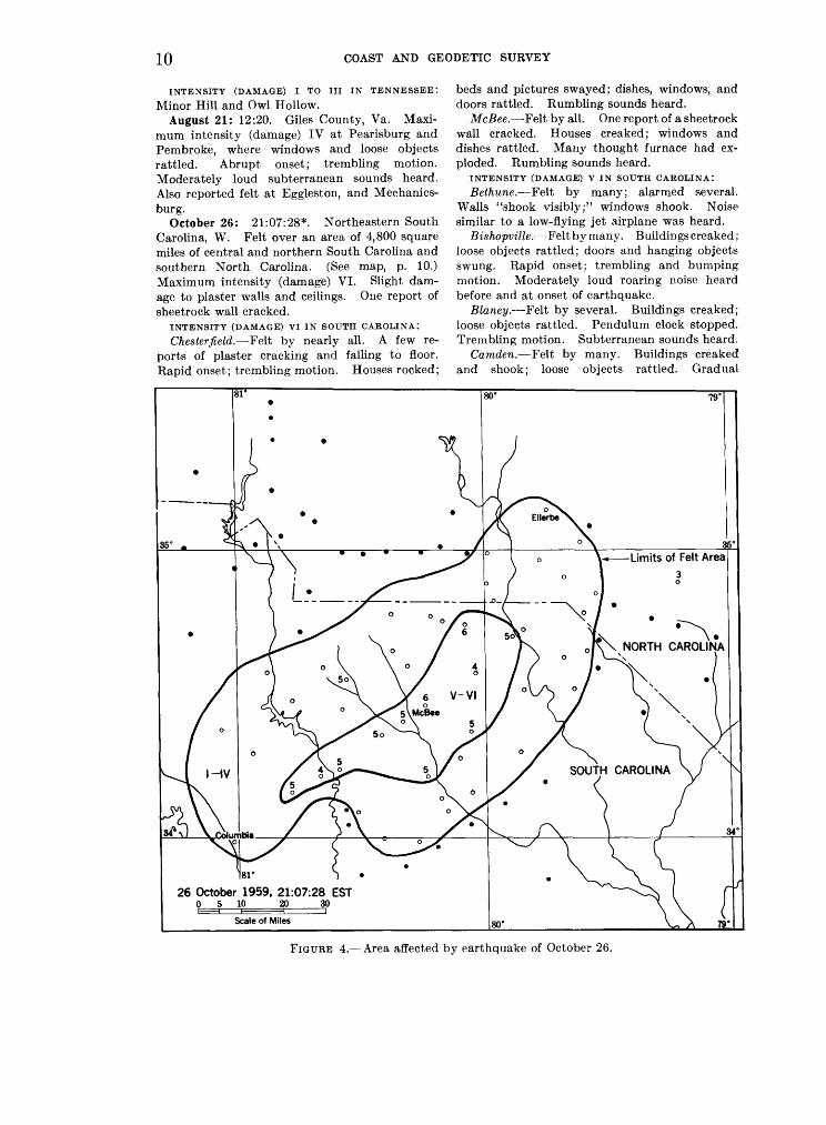
October 26: 21:07:28*. Northeastern South Carolina, W. Felt over an area of 4,800 square miles of central and northern South Carolina and southern North Carolina. (See map, p. 10.) Maximum intensity (damage) VI. Slight dam age to plaster walls and ceilings. One report of sheetrock wall cracked.
INTENSITY (DAMAGE) VI IN SOUTH CAROLINA:
Chesterfield. Felt by nearly all. A few re ports of plaster cracking and falling to floor. Rapid onset; trembling motion. Houses rocked;
beds and pictures swayed; dishes, windows, and doors rattled. Rumbling sounds heard.
McBee. Felt by all. One report of a sheetrock wall cracked. Houses creaked; windows and dishes rattled. Many thought furnace had ex ploded. Rumbling sounds heard.
INTENSITY (DAMAGE) V IN SOUTH CAROLINA:
Bethune. Felt by many; alarmed several. Walls "shook visibly;" windows shook. Noise similar to a low-flying jet airplane was heard.
Bishopville. Felt by many. Buildings creaked; loose objects rattled; doors and hanging objects swung. Rapid onset; trembling and bumping motion. Moderately loud roaring noise heard before and at onset of earthquake.
Blaney. Felt by several. Buildings creaked; loose objects rattled. Pendulum clock stopped. Trembling motion. Subterranean sounds heard.
Camden. Felt by many. Buildings creaked and shook; loose objects rattled. Gradual
26 October 1959, 21:07:28 EST0 5 10 20 30
FIGURE 4. Area affected by earthquake of October 26.

UNITED STATES EARTHQUAKES, 1959 11
onset; trembling motion. Rumbling sound sim ilar to a passing train heard.
Cassett. Felt by and alarmed nearly all. Doors, vsnetian blinds, and loose objects rattled; cabinet doors opened. Rapid onset. Roaring sounds heard.
Cheraw. Felt by nearly all. Houses shook; dishes and windows rattled; pictures swayed. Rumbling sounds heard.
Hartsville. Felt by all. Lamps and chande liers swayed; automobiles rocked slightly; fire- truck shook and gasoline in tank sloshed around. Abrupt onset. Thunderous and roaring sounds heard.
Kershaw. Felt by many. Floors trembled; windows and loose objects rattled. One report of cracked plaster on wall. Rapid onset; trembling and bumping motion. Rumbling sounds heard.
Kershaw (about 3 to 5 miles from). One report of cracked plaster on wall.
INTENSITY (DAMAGE) IV IN NORTH CAROLINA:
Ellerbe, Hamlet, Laurel Hill (Scotland County), McFarlan, Morven, and Rockingham.
INTENSITY (DAMAGE) IV IN SOUTH CAROLINA:
Angelus, Columbia, Darlington, Dovesville, Elliott, Great Falls, Heath Springs, Jefferson, Liberty Hill, Lugoff, Lydia, Mount Croghan, Pageland, Patrick, Ruby, Wallace, Westville, Winnsboro, and Wisacky.
INTENSITY (DAMAGE) I TO III IN NORTH CARO LINA: Cordova, Gibson, Lilesville, Marston, and Red Springs.
INTENSITY (DAMAGE) I TO III IN SOUTH CARO LINA: Bennettsville, Blenheim, Dalzell, Horatio, Lamar, Midway, Oswego, Rambert, Ridgeway, Society Hill, and Tatum.
CENTRAL REGION
(90TH MERIDIAN OR CENTRAL STANDARD TIME)
January 6: 09:07. North Saint Louis County, Mo. Felt.
January 12: Between 07:00 and 07:30. Doland, S. Dak. IV. Felt by many. Rumbling sound followed by what sounded like a boiler explosion. Dishes and windows rattled.
January 21: 09:35. Ridgely, Tenn. IV. A light shock felt by many and lasting three to five seconds. Buildings vibrated; dishes, doors, and windows rattled; cans and bottles on shelves were shaken. Preceded by explosive sound.
February 13: 02:37. Bogota, Tenn. V. Felt over an area of about 170 square miles of Dyer, Lake and Obion counties. At Bogota many were awakened. Houses were shaken; dishes, doors, and windows rattled. Two separate shocks about 2 minutes apart reported by one observer. Roaring sounds heard. Felt
intensity (damage) IV at Miston. Also felt at Lane, Lenox, and Ridgely.
June 15: 06:45. Seminole, Pontotoc and Johnston counties, Okla. V. Felt by many. Dishes broken at Ada. Trembling motion.
June 17: 04:27:07*. Epicenter 34>^° north, 98K° west, southwestern Oklahoma, W. Felt over an area of approximately 12,000 square miles of Oklahoma and Texas. (See map, page 12.) Maximum intensity (damage) VI. Damage slight. Few reports of plaster cracking. Minor cracks in pavement reported.
INTENSITY (DAMAGE) VI IN OKLAHOMA:
Duncan. Felt by and startled many. Crack observed in concrete curbing. Press reported several water lines broken cause uncertain. One report of a crack in foundation of home. Buildings shook and creaked; beds were shaken; knickknacks fell from shelf; windows and floor furnaces rattled.
Lawton. Felt by and alarmed many. Cracks in pavement observed. Plaster on walls cracked. Houses were shaken and buildings swayed. One resident felt and saw walls move; another resident reported his house moved "3 inches east, then back again." Disturbed objects observed by many. Thunderous and roaring sounds heard. Many residents thought shock was due to firing of a heavy weapon at Fort Sill.
INTENSITY (DAMAGE) V IN OKLAHOMA:
Cache. Felt by and alarmed several. Slight damage; plaster on walls cracked. Abrupt onset; swaying motion. Thunderous noise heard at Lawton (9 miles east, 1% miles south of). Strong shaking that "rattled everything in the house." Clock developed mechanical difficulties and made a strange noise after the earthquake.
INTENSITY (DAMAGE) I TO IV IN OKLAHOMA:
Ada, Anadarko, Ardmore, Chattanooga, Eldo rado, Faxon, Frederick, Guthrie, Hobart, Madill, Marietta, Marlow, Norman, Oklahoma City, Pauls Valley, Pontotoc, Purcell, Tulsa, and Walters (5 miles northeast of).
INTENSITY (DAMAGE) I TO IV IN TEXAS: Dallas,
Gainsville, Nocona, and Wichita Falls.July 20: 02:15:26*. Blytheville, Ark. Felt
by several. Abrupt onset; bumping motion.October 15: 09:45. Southwestern Louisiana.
IV. At Creole windows and light furniture rattled; work tables in post office were moved slightly. Felt by several at DeQuincy and Grand Chenier where loose objects and windows rattled. Two shocks at one minute interval reported. A muffled rumbling noise which sounded like a distant explosion was heard. Also felt at Cameron, Lake Arthur, and Welsh.
December 21: 10:25. Finley, Tenn. V. Felt over an area of approximately 400 square miles of Dyer, Lake, and Lauderdale counties, Tenn., and Pemiscot County, Mo. At Finley,

12 COAST AND GEODETIC SURVEY
00° 99°
17 June 1959, 04:27:07 CST0 10 20 40 60 80 100
FIGURE 5. Area affected by earthquake of June 17,

UNITED STATES EARTHQUAKES, 1959 13
people were alarmed and ran outside; plastered walls and ceilings cracked; objects thrown from shelves; doors jarred open; furniture shifted. A washing machine in operation "started dancing around." A chimney cracked at Lenox. At McCullough's Chapel, 2.7 miles northeast of Finley, one observer had to hold on to a table to keep from falling. The shock was strongly felt at Bogota, Boothsville, Dyersburg, and Miston. Felt by one at Caruthersville, Mo.
WESTERN MOUNTAIN REGION
(105TH MERIDIAN OR MOUNTAIN STANDARD TIME)
January 4: 00:22:54*. Southeastern Idaho. V. Felt over an area of approximately 500 square miles of southeastern Idaho, north of Rear Lake. Scores of persons in the Bear Lake Valley were awakened by the explosivelike shock. Felt by, awakened, and frightened many in community at Bern. Awakened many at Bloomington; moderate earth noises heard 10 seconds before shock; motion rapid; windows, doors, and dishes rattled; house creaked. Awakened many at Ovid; windows rattled; loud earth noises from east heard; motion slow. Intensity (damage) IV at Dingle and Paris. Reported as quite sharp at Montpelier. Also felt at Raymond. Light shock at 05:00 felt by some at Dingle on same day. Recorded by the Salt Lake City seismograph station.
January 18: 20:41. Helena, Mont, (east section). III. Felt by several; motion rapid, brief; rumbling earth noises heard.
January 27: 17:14:33*. Yellowstone Na tional Park (Old Faithful), Wyo. IV. Felt by several in home; frightened few. Windows, dishes, and piano rattled; motion rapid, brief. Recorded by Butte, Bozeman, Montana and Eureka, Nevada seismograph stations.
February 11: 07:01. Flagstaff, Ariz. V. Many in community awakened by a rapid, 3-5- second shock, which rattled windows, doors, and dishes.
February 27: 15:19:52*. Epicenter 38° north, 112^° west, southwestern Utah, W. Felt over an area of approximately 1,500 square miles of southwestern Utah. Maximum intensity (dam age) VI at Panguitch where slight damage occurred. Plaster and walls cracked; plaster fell; dishes and windows broken. Frightened many. Pendulum clock stopped; furnishings shifted; small objects overturned. Explosivelike motion; loud earth noises heard. Felt by and frightened many at Bear Valley Junction (10 miles north of Panguitch) where loud earth noises from northwest were heard a few seconds before shock; windows rattled. Rapid, very brief, blastlike shock felt by all and frightened few at Paragonah; windows and doors rattled.
Intensity (damage) IV at Antimony, Greenville, and Hatch.
March 11: 04:00. Rander, Nev. (north of Austin, Callaghan's Ranch at northwest foot of Mount Callaghan, T21N, R45E). IV. Three rocking jolts felt by observer lying down (awake). Bed moved slightly.
April 5: 22:30. Rander, Nev. (north of Austin, Callaghan's Ranch at northwest foot of Mount Callaghan, T21N, R45E). IV. Four bumping, sharp, east-west jolts awakened ob server. Reported as much stronger than the shock felt on March 11.
April 19: 23:10:54*. Helena, Mont. IV. Abrupt vibration felt by many, particularly in the east section of Helena. Buildings creaked; windows, dishes, and loose objects rattled. Recorded by Butte seismograph station.
May 17: 03:56:52*. Northwestern Montana. V. Epicenter 47J4° north, 113° west, about 30 miles northeast of Seeley Lake, Mont., W. Felt over an area of approximately 3,000 square miles of northwestern Montana. Although no damage was reported, the shock was the sharpest Montana earthquake since the Philipsburg shock of May 1958. Awakened all in community at Ovando; house creaked; motion slow, from east. About 42 miles northeast of Missoula, at Sperry Grade Headquarters of the State Forestry Department, located in canyon of the Big Blackfoot River in section 36, T15N, R14W, the shock sounded and felt like heavy blasting; awakened all in community. Some fracturing was discovered in Ophir Cave up Ophir Creek in either section 17 or 18, TUN, R7W, about 44 miles, on a south 61° bearing, from Sperry Grade Headquarters. North wall of cave fractured and roof and south wall slipped down about a foot. It was not determined if the fracturing was due to a shock. At Woodworth (midway between Seeley Lake and Ovando), felt by and awakened all in home; walls creaked; hanging objects swung. Large subsidence on Highway 35 (east shore of Flathead Lake) about 2 miles south of Yellow Bay, was thought to have occurred on the day of the shock. Intensity (damage) IV at Augusta (Gibson Dam, 47°36' north, 112°46' west); Helmville, and Seeley Lake. Also felt at Poison
June 9: 03:53. Boulder City and Hoover Dam, Nev. IV. Felt by several in community at Boulder City; awakened all in home; windows rattled; motion slow, lasted 2 seconds. Felt by two outdoors at Hoover Dam. Brief shock. Faint to moderate earth noises heard 1-2 seconds before shock.
July 21: 10:39:29*. Epicenter 37° north, 112J/£° west, Arizona-Utah border, W. Magnitude 5H~524, P. Felt over an area of approximately 8,000 square miles of Arizona and Utah. Limits of the felt area in Utah extended from Hurricane,

14 COAST AND GEODETIC SURVEY
northeasterly to Cedar City, east to Tropics, southwest of Kanab; in Arizona, from Fredonia, southeast to Jacobs Lake, Cedar Ridge, to 1 mile northeast of Winslow, thence northwest to the Flagstaff area, to Grand Canyon (south rim), to Tuweep (Grand Canyon National Monument) to Short Creek, thence to Hurricane. Maximum intensity (damage) VI at Fredonia and Kanab where some chimney damage and plaster crack ing were reported; a rock slide at Mather Point in the Grand Canyon was attributed to the shock.
INTENSITY (DAMAGE) VI IN ARIZONA:
Fredonia. Felt by all; some alarm. Several bricks fell; windows cracked; few plastered walls had small cracks. Dishes fell from cupboards and cans fell in grocery store. Water splashed from fish pond.
Grand Canyon (Mather Point, near Canyon Rim). Rock slide was attributed to the shock.
INTENSITY (DAMAGE) VI IN UTAH:
Kanab. Felt by all and frightened many in community. Bricks fell from at least one house chimney; plaster fell from walls of the Kane County Courthouse. Water sloshed from fish aquarium. Some thought the shock lasted as long as 2 minutes.
INTENSITY (DAMAGE) V IN ARIZONA: Moccasin.
INTENSITY (DAMAGE) v IN UTAH: Kanarraville, Mount Carmel, and Orderville.
INTENSITY (DAMAGE) IV IN ARIZONA: Flagstaff
(Fort Valley Road), Grand Canyon Lodge (north rim at Bright Angel Point), Jacob Lake, Short Creek, Tuweep (Tuweep Valley), and Winslow (1 mile northeast of).
INTENSITY (DAMAGE) iv IN UTAH: Cedar City, Hurricane, Rockville, Springdale, Tropic, and Virgin.
INTENSITY (DAMAGE) I TO III IN ARIZONA:
Grand Canyon Village (south rim) and near Grand Canyon Village.
INTENSITY (DAMAGE) i TO in IN UTAH: Glendale and Zion National Park. Also felt at Cedar Ridge (about 110 miles by road from Kanab on U.S. Highway 89) and at House Rock (about 60 miles by road from Kanab on U.S. Highway 89).
July 27: 04:15. Kanarraville, Utah. IV. Shock was described as like a distant blast. Buildings swayed; dishes rattled; rumbling sound heard. Woman living about 5 miles north of town said she and her husband were awakened; thought a tremor was felt a night or two before.
August 2: 15:16:44*. Epicenter 39^° north, 118° west, Western Nevada, W. Austin (8 miles east of, Simpson Park Ranch). IV. Sharp, north-south jolt felt by several in home. Person standing by bed felt bed move and touch leg. Sound like gust of wind heard just as shock was felt. At Austin, person sitting on porch felt sharp shock.
August 9: 18:45. Yellowstone National Park, Wyo. (Mount Holmes Lookout). IV. Slow, west-east motion felt by lookout. Faint earth noises heard. Walls creaked; hanging objects swung.
August 17: 23:37:15* (main shock). Epi center 44°50' north, 111°05' west, Hebgen Lake, Mont., W. Magnitude 7.1, P. X. Felt over an area of approximately 600,000 square miles of United States and Canada. (See map, pages 16 and 17, showing felt area and intensity zones; and map, page 18, showing locations of fault scarps, slides, and distribution of intensities in the epicentral areas.) Maximum intensity (dam age) X assigned to the fault scarp zones in the Hebgen Lake area. Nine persons were killed and 19 presumed dead; many injured. Most of the persons killed and presumed dead were engulfed by the great Madison Canyon slide. It was estimated that timber and road damage would exceed $11 million.
INTENSITY (DAMAGE) X TO VIII IN MONTANA:
Hebgen Lake and Vicinity. "The more prominent surface faulting associated with the earthquake occurred north and northeast of Hebgen Lake. One zone of scarps can be followed for 6 miles a short distance above the northeast shore of the northwest arm of Hebgen Lake, and past Hebgen Dam for an additional \Yz miles to the northwest. Height of these scarps is as much as 15 feet, southwest (or lake) side everywhere down with respect to the uphill side. Another zone of breakage is nearly continuous from a point southeast of the junction of highways U.S. 191 and Montana 1, north westward along the base of the mountains north of the Grayling Arm of Hebgen Lake, thence northward up Red Canyon, where it bends to the northwest and then west along the north wall of Kirkwood Canyon toward Hebgen Dam. This zone of breakage is at least 14 miles in length, and includes 10 or more miles of spectacular vertical scarps. Near Red Canyon Creek, 3 miles north of Grayling, a maximum vertical displacement of 21 feet was measured (southwest side down), and the Red Canyon Trail was offset to the left 8-10 feet, southwest side moving southeast. In general, however, lateral offsetting of linear features crossing these vertical scarps was not evident . . . " (BSSA, October 1959.)
The most spectacular and disastrous effect of the earthquake was the great avalanche of rock, dirt, and trees which cascaded from the steep south wall of the Madison River Canyon, about 1,300 feet above the canyon floor, forming a barrier which completely blocked the gorge and the flow of the Madison River, and creating a lake within a few weeks nearly 175 feet deep which stretched almost to Hebgen Dam, about 7 miles upstream. This was the largest of four

UNITED STATES EARTHQUAKES, 1959 15
large slides in the area, the others being at Cliff Lake (two persons killed by slides at this place), Wade Lake, and Raynolds Pass. Extensive road damage occurred to Montana Highway 1. Beginning at a point near the Duck Creek Y (intersection of U.S. Highway 191), slides, sub merging, cracking, and shifting of the roadway made the road impassable for a distance of nearly 35 miles. Hebgen Dam sustained cracks in the concrete core, the spillway was cracked and broken, and there were cracks and settlement in the earthfill portion. Many summer homes and cabins in the Hebgen Lake area were con siderably damaged. Some houses and cabins shifted off foundations; foundations cracked; chimneys fell; windows broken; pipelines at some places broken. At one place along the north shore of Hebgen Lake a well became an artesian well; at another, the well water dropped 10 feet.
At Culligan's Ranch (about }i mile east of Red Canyon entrance) two fences appeared snakelike, as if distance between posts had been shortened. Unreinforced concrete-block barn leveled; unreinforced concrete-block house se verely damaged. Practically all buildings on this place severely damaged. Fault ran through this property. The Beaver Creek concrete bridge (west of Hebgen Dam) worked against end fills; railings broke; considerable spalling; expansion joints worked. Grayling Creek Bridge had concrete bridge railings broken in several places; cracking and spalling of substructure; worked against end fills. At Cliff Lake the water was full of trees and debris and many rocks and trees fell in the camping area, where it is presumed two persons were killed. Slides also occurred at Wade Lake; man said his trailer bounced 3 feet off ground and that he saw 10-foot-high waves on the lake. Owners of Elliott's Resort on Wade Lake reported about 60 percent damage to buildings and facilities: Concrete foundations were especially damaged; septic tank shook up out of ground; bridge off foundation, anchor bolts sheared; large fir trees fell; springs went dry; 18-inch wide cracks in ground and ground offset 24 inches in places. Five miles north of Wade Lake large amounts of water and sand came up through cracks in the earth; many small rock and dirt slides; some buildings shaken down or shifted on foundations; many chimneys fell.
West of Horse Buttes (southwest shore areas between Grayling Arm and Madison Arm of Hebgen Lake) vertical displacement up to 9 inches and horizontal displacement up to 4 inches was observed; shear zone extended 60-70 feet. Compression indicated by overlapping of ground by several inches. Springs formed below Horse Buttes and water flowed from small cracks in road. Many slump cracks one-quarter mile beyond Buttes. Shoreline (south shore) of the
Horse Buttes Peninsula was uplifted to such an extent that a small peninsula was created out of what was formerly an island. At Romsett (south shore of Hebgen Lake) road cracked; chimney fell; large spring completely dried up. Two men camping at head of the South Fork Arm reported they saw ground waves coming from direction of highway and ran to lake edge where they saw water wave kick water 30 feet into the air.
INTENSITY (DAMAGE) VIII IN WYOMING:
Yellowstone National Park. Fallen rocks, slides, damaged roads and retaining walls, blocked roads in the northwestern section of the park from Mammoth Hot Springs southward to Norris Junction, from Norris Junction to Madison Junction, from Old Faithful northward to Madison Junction, and from Madison Junction to West Yellowstone, Mont. At Golden Gate, about 3 miles south of Mammoth Hot Springs, large rock fall, retaining wall broken, fissures in road, concrete bridge cracked. Chimneys fell at Mammoth Hot Springs. Large rock fall on west face of Mount Holmes (about 10 miles northwest of Norris Junction) and many cracks along the sides of the mountain. At Gibbon Falls, large fissures and settlement in roadway, broke and shifted masonry retaining wall. About 2 miles south of Madison Junction longitudinal fissures in road; large rock fall in Firehole of the Cascades; large rock fall on nearby cliffs. Fountain Paint Pots more active, new geyser; heat damaged roads and walks. Firehole Lake ceased to over flow, deep fissures around lake and in road; road settled. At Biscuit Basin (2}i miles northwest of Old Faithful) fissure 200 yards long near Lower Lake; Sapphire Pool boiled continuously. New geyser (formerly hot springs) started erupting every hour after the major shock, throwing hot water 25-30 feet in the air. In addition to the new geysers, several new steam fissures were found in the Lower Basin. At Twin Buttes (between the Lower Geyser Basin and the western border of the park and south west of Madison Junction), large steaming cracks, judged to be the result of massive slumping dur ing the earthquake, were observed on both sides of the Buttes. At Old Faithful, large chimney fell; water main in building broken, several large cracks in concrete foundation; basement windows broken. It was reported this type of damage was general in all Old Faithful Inn buildings. About 6 miles south of Old Faithful in the Shoshone Geyser Basin, Union Geyser, a major and very spectacular geyser, and which had not erupted for several years prior to the earth quake, was reported to have erupted at least three times in 3 days following the shock. Many hot springs at Shoshone were muddy and a number of springs and geysers showed increased

16 COAST AND GEODETIC SURVEY
120°
so
17 August 1959 (Main Shock) 23:37:15 MST
0 50 100 150 200 H H H h- I I
Scale of Miles 115°
FIGURE 6. Area affected by earthquake of August 17.

UNITED STATES EARTHQUAKES, 1959 17
;SOUTH DAKOTA
o RAP/0 CITY
FIGURE 6. Continued

YE
LL
OW
ST
toN
E
NA
TIO
NA
L
PA
RK
Epi
cent
ral
Are
as
HE
BG
EN
LA
KE
, M
ON
TAN
AE
AR
THQ
UA
KE
17 A
ugus
t 19
59 (
Mai
n S
hock
) 23
:37:
15
MS
TF
AU
LT
S
CA
RP
S
/GR
OU
ND
C
RA
CK
S
\LA
ND
SL
IDE
A
RE
AS
FIG
UR
E 7
. E
pic
en
tral
area
s of
Heb
gen
Lak
e, M
onta
na
eart
hquak
e of
Aug
ust
17.

UNITED STATES EARTHQUAKES, 1959 19
activity. About 5 miles west of Madison Junc tion deep fissures and settlement were observed in new road fill. Bridge deck displaced longi tudinally; showed signs of working; slight spalling at ends; possible stretching and bending of anchor bolts. Trees fell. At the Snake River south entrance to the park, water supply (cold spring) was muddy for 3-4 days after the shock. Some creeks in the area were milky colored to October 8. About 1 mile northeast of Mammoth Hot Springs, large rock fall on Mount Everts. On the Tower Junction Road (about 2 miles southeast of Mammoth) minor shifting and cracks on bridge. Rock fall on Sheepeater Cliffs (about 1 mile southeast of bridge). Major cracks in road retaining wall at Undine Falls. Other areas within the park reported intensities ranging from VI to V.
INTENSITY (DAMAGE) VII IN MONTANA:
Centennial Valley (about 30 miles southwest of Hebgen Dam). Awakened and frightened all in community. Chimneys cracked. Springs in creased flow; new springs formed; some springs muddied; great water movement underground. Many tremors felt after the two hard shocks, some 30-40 minutes apart.
Gardiner (about 1.4 miles south of, on U.S. Highway 89). Large slides, 100 yards long. Felt by and awakened all in community at Gardiner. Plaster and chimneys cracked; plaster fell. Dishes broken.
Lionhead Ski Area (about 10 miles south of Hebgen Dam on Continental Divide). Some per sons left the area in panic. Girl thrown to floor. Chimney fell; sink torn from wall; window screens popped off cabin; cement foundations of cabins crumbled. Man reported: "After crossing the Continental Divide there appeared to be no damage at all."
Seven L Ranch (about 35 miles southwest of Hebgen Dam). Felt by, awakened and frightened all in community. Plaster, walls, and chimneys cracked; plaster fell; chimneys twisted and fell. Damage about $400.
West Fork Madison River Ranger Station (Sec. 7, T12S, R2W, about 27 miles southwesterly from Hebgen Dam). Felt by, awakened, and fright ened many in community. Plaster, chimneys, and ground cracked; windows broken. Damage considerable to masonry.
West Yellowstone. Some persons ran to the streets in panic. Most chimneys fell; much plaster cracked. Pumps leveled at service sta tion. Several thousand gallons of water sloshed from railway tank; tank footings lifted, some broken. Several buildings were considerably damaged, due to fallen chimneys, exterior brick wall cracks, and twisted columns. At Union Pacific Depot and Lodge, large stone pillars at
depot out of line 8 inches; large stone chimney toppled through lodge roof. Concrete-block structure torn down and rebuilt. Brick veneer fell from front of West Yellowstone School; back wall of school garage had severe diagonal cracks and was torn down; west parapet leaned on tree. Large west-east ground waves observed by man standing in street. It was reported a slide cov ered the Union Pacific Railway tracks about 7 miles west of West Yellowstone; much damage to tracks; rails bent rather badly in several places; at places the earth was out from under the tracks; large crack, 12 feet by 20 feet, required nine car loads of gravel to fill. Nearby cabins severely damaged. On road west of West Yellowstone concrete highway bridge railing shattered. It was also reported two or three other bridge rail ings, to 30 miles southwest of West Yellowstone, showed battering.
INTENSITY (DAMAGE) VII IN IDAHO:
Big Springs (about 5 miles east of Mack's Inn). Felt by, awakened, and frightened all. Dishes broken. Damage slight. Well water increased and muddy. Small objects shifted and over turned; knickknacks fell. Trees, bushes shaken strongly. Big Springs heavy with silt, rusty-red color, and running about 15 percent above nor mal volume; Lucky Dog Creek extremely muddy.
Henry's Lake Area. At Edward's Lodge man knocked down. Considerable damage to build ings; water roily; new springs formed near the lake. Every movement seemed north-south. At Henry's Lake Lodge, man could not get out of bed due to motion. Trees swayed violently; one 16-foot tree bent 45° eastward. Car jumped up and down. At the Wild Rose Trailer Park, cash register thrown to north; trees leaned 30° toward northeast; tree roots broken. Top 12 feet of fireplace thrown southeast. Rocks in chimney broken; concrete and rock dock, 7 feet thick, cracked. Flattened barn. Cracks in in ground near lake shore (wet ground); cracks parallel to shore for most part and were 400 feet long and 2-10 feet wide (filled with water); dirt moved southward into the lake. Much dam age reported. It was reported water level of the lake came up over the road at the western ex tremity of the lake, and that a new road had to be built.
Island Park Area. Some chimneys on summer homes toppled. All springs in the area muddied, also many rivers and creeks roily and muddied. At Island Park Lodge, trees whipped north- south. Well water muddy for weeks. Wells muddied and heavy with silt at Island Park Ranger Station. Felt by all; general alarm at Island Park Dam. Large mirror and small knickknacks fell from fireplace mantle. Do mestic well was muddy for about four days.

20 COAST AND GEODETIC STJRVEY
Trees swayed north-south. Eight aftershocks felt up to 04:00 on the 18th, then shocks felt at 07:45, 08:25, and 08:35. Press reported there was no damage to the dam or reservoir. Felt by, awakened, and frightened all at the Buffalo Ranger Station. Spring-fed streams silt laden and showed definite increase in flow. Buffalo River heavy with silt and reddish colored. Wells cloudy for one day. Small objects shifted. At Pond's Lodge, felt by and awakened all; fright ened many. Trees, bushes shaken strongly. Well water muddied. At Last Chance (about 5 miles south of Pond's Lodge) it took nine hours to pump mud out of well. At Mack's Inn, felt by, awakened and frightened all; small girl thrown from bed; hysteria among some guests. Windows, plaster, and chimneys cracked; chim neys fell; dishes broken. Trees, bushes shaken strongly. North-south waves seen in roof line. Slight power stoppage. Wells muddy. Many lesser shocks felt before noon on the 18th; shocks felt to August 20. Fairly strong shock felt on night of September 4. At the Targhee Ranch (Targhee Pass), felt by, awakened, and frightened all. Plaster cracked slightly; dishes broken. Damage slight. Trees, bushes shaken strongly. Knickknacks, books, and guns fell.
INTENSITY (DAMAGE) VI IN MONTANA:
Alder. Felt by all and awakened many in community; frightened many. Plaster and chimneys cracked. Ground cracked around trees. Damage slight to brick and masonry. Some chimneys cracked and plaster fell -in some houses in upper Ruby Valley River area. Small slides and some rocks rolled.
Anaconda. Felt by, awakened, and frightened many in community (some outdoors; active). Thousands of persons left homes and went to the streets. Press reported broken dishes, toppling of few chimneys was principal damage at Anaconda and Deer Lodge. Dust arose from basement of hotel to such an extent that it was at first believed to be on fire. Other shocks felt at 02:00, 03:00 and 09:25 on the 18th.
Armstead. Felt by, awakened and frightened all in community. Small objects overturned.
Austin. Felt by, awakened, and frightened all in community. Plaster cracked on inside of wall no visible damage.
Basin. Felt by and awakened all in com munity; frightened many. Damage slight. Plaster and windows cracked; plaster fell; win dows broken. Small objects shifted and over turned.
Belgrade. Felt by, awakened, and frightened many in community. Damage slight. Some reports of plaster, windows, walls, and chimneys cracking; few reports of windows breaking and chimneys twisting. Vases and small objects fell.
Billings and vicinity. Felt by and awakened all in community; frightened many. Very minor and scattered damage to buildings in general area. Some walls cracked. Visible swaying of trees; houses and buildings swayed and rocked. Few pendulum clocks stopped. In March 1960, the Billings press reported the shock was being cited as a possible cause of damage to the 3-million gallon reservoir above Rimrock Road. There were leaking and widening cracks in the steel and concrete floor of the structure; floor sagged. Also, long cracks in runways at Logan Field may have been caused by the earthquake.
Bozeman. Press reported damage was not extensive in Bozeman. Tops of chimneys toppled at many homes, particularly on South Wilson and in the southern section of the city. Some concrete fell from the tower of church onto roof, making a small hole. No extensive damage to buildings on campus at Montana State College, although bricks were dislodged from chimneys, window ledges, and other protruding sections on outside of buildings. The most extensive damage was to Montana Hall where a number of bricks were dislodged. No county bridges were out and no severe damage, according to reports from bridge crews in the area. Many stores reported merchandise and displays toppled and many glass-packaged items broken. One mile west of Bozeman, family said they had to hang onto doorway to stay on their feet. A pier, which holds up carport made of masonry and standing on approximately a 3-foot concrete base, was about 1 inch out of line. Concrete curbing along side walk broken in six places. Observer reported he did not sleep rest of night; aftershocks were so severe he became sea sick trying to stay in bed. "The house jumped up and down and sideways. I thought it was the end. I've never experienced anything like it."
Box Elder. Felt by, awakened, and frightened many in community. Plaster cracked; several reported leaky roofs. Small objects overturned; knickknacks fell.
Bridger. Felt by all; awakened and frightened many in community. Damage slight. Trees, bushes shaken moderately. Vases, small objects and furnishings shifted and overturned; knick knacks and pictures fell.
Broadview. Felt by and awakened many in community. Plaster and chimneys cracked. Small objects and furnishing shifted; vases, small objects overturned; knickknacks and pictures fell. Trees, bushes shaken moderately.
Browning. Felt by many; awakened and frightened few in community. Plaster, windows, walls, chimneys, and ground cracked. Pendulum clock facing south stopped.
UNITED STATES EARTHQUAKES, 1959 21
Brusett. Awakened many in community. Cement foundation of new building cracked. Few cutbanks knocked off. Small objects shifted. Beds moved around; chickens knocked from roosts.
Busby. Felt by several in community. Some damage at school to brick building. "Didn't feel shock but 'saw' movement twice about 15 seconds apart. Thought I was dizzy."
Butte. Most persons were awakened by severe shaking. Some persons badly frightened and ran to the streets. Generally there was no building damage in Butte, although several schools were jarred. Worst hit was the Franklin where the chimney tumbled down and the walls badly cracked. Estimated cost of repairs $5,000 to $10,000. A large block fell from the top entrance to the Emerson, and the front steps were destroyed. Bricks in the chimney at the Harrison were cracked and the cement columns fell from under the windows at the Longfellow. First floor on south wing of Butte Public High School (old section) slightly damaged: walls in hall and woodworking shop cracked, shop floor separated. At the Federal Building, several walls cracked, concrete crumbled from the ceiling in the basement, plaster fell in many offices, and floors were damaged. Some bricks fell from chimney at hospital. Merchandise fell in stores. Large plate glass window broken. Men at work in mine felt the shocks distinctly and were hoisted to the surface. Power company reported a small outage along a section of street. Chan delier swayed in 1-foot arc. Woman said she was violently thrown from bed. Some persons reported two slight but distinct shocks after the major shock, and some reported two small tremors shortly after midnight, and one at 01:35 on the 18th. No injuries were reported in Butte.
Cameron. Awakened all in home. Damage slight. In the Abe area, about 7 miles south of Cameron, felt by, awakened, and frightened all in home. Chimney cracked; dishes broken. Damage slight. Small objects shifted; vases over turned. "We were so frightened, we couldn't tell from which direction it came."
Canyon Ferry. Plaster fell. Small objects and furnishings shifted; small objects and furniture overturnedj'knickknacks, books, pictures fell.
Cardwell. Felt by and awakened all in com munity; frightened many. Plaster, windows, walls, chimneys and ground cracked. Furniture overturned; knickknacks, books, pictures, fell. Chimney fire. Trees, bushes shaken strongly. "Motion so violent could hardly stand. Air hazy from dust." Eight miles up the North Boulder, felt by all in home; frightened few. Damage slight.
Clancey. Felt by all, awakened and frightened
many in community. Small objects shifted and overturned. Trees, bushes shaken slightly.
Clyde Park. Awakened and frightened all in community. Furnishings shifted. Pendulum clock stopped. Trees, bushes shaken moderately.
Connor. Felt by and awakened all in com munity; frightened few. Plaster cracked.
Cooke City. Felt by and awakened all; frightened many. Small objects and furnishings shifted. Trees, bushes shaken strongly.
Corvallis. Felt by and awakened all in com munity; frightened many. Plaster, windows, walls, chimneys cracked; plaster fell. Pendulum clock stopped. Small objects and furnishings shifted. Trees, bushes shaken moderately.
Corwin Springs. Felt by and awakened all in community; frightened many. Plaster and chimneys cracked; twisting and fall of chimneys. Dishes broken. Small objects shifted and over turned; knickknacks and pictures fell.
Crow Agency. Felt by all; awakened and frightened few in community. Plaster cracked. Damage reported only to old brick buildings. Caged birds and chickens made a great disturb ance. Trees, bushes shaken moderately.
Darby. Felt by, awakened, and frightened all in community. Plaster and chimneys cracked. Small objects and furnishings shifted; knick knacks and books fell. Trees, bushes shaken moderately.
Deer Lodge. Felt by all in community. Press reported a cellblock at the Montana State Prison was damaged so extensively it was ordered razed. Walls of the 90-year-old, 4-story brick cellblock separated 6 inches from the roof, causing the roof to sag. Daylight was visible between the roof and the brick walls. It was reported there was very little damage at Deer Lodge, except to few old brick chimneys and some fallen merchandise in grocery stores. One elderly man died from heart attack. Many smaller shocks felt for several days. A press report, dated October 24, gave the following report on the Deer Lodge National Forest: "An allocation of $2,000 has been made to the Deer Lodge National Forest to repair earthquake damaged roads, trails, and buildings. Damage consisted of boulders and slides blocking both roads and trails. Two springs were opened up by the shock in the Highland area and flowed across the road. Some ranger buildings were cracked in the Whitehall area and the Emerine lookout tower in the Philipsburg area was twisted so that doors would not close; braces on the tower were loosened. Crews cleared several trails in the Anaconda- Pintlar area and in the Boulder and Deer Lodge districts."
Denton. Awakened many in community. Plaster and walls cracked. Pictures fell.

22 COAST AND GEODETIC SURVEY
Dillon. Awakened and frightened many in community. Press reported severe shocks. Two hotels evacuated. Food stores suffered damage to stock; numerous homes and apartment build ings reported broken mirrors, windows, etc. Chimney fell at library. Furniture overturned.
Divide. Felt by and awakened all in com munity; frightened many. Plaster, windows, walls, and chimneys cracked. Trees, bushes shaken strongly.
Elk Park (about 12 miles northeast of Butte). Awakened and frightened all in home. Plaster fell. Damage slight. Small objects and fur nishings shifted and overturned; knickknacks, books, pictures fell.
Ennis. Felt by, awakened, and frightened all in community. Damage slight. "I was bounced out of bed onto the floor. We all ran out and stayed outdoors until the shocks stopped." Not much shifting of objects. Three heavy clocks part'y twisted around.
Fergus. Felt by several in community; awakened few in home. Foundation cracked. Damage slight. Pendulum clock facing west stopped. Chickens flew from roosts.
Fishtail. Awakened and frightened all in community. Two small cracks in new cement basement. Few instances of furniture, etc., moving. Trees, bushes shaken slightly.
Florence. Awakened many and frightened few in community. Plaster, windows, walls, and chimneys cracked. Pendulum clock facing east stopped.
Fort Harrison. Felt by, awakened, arid fright ened all in community. Small objects shifted; bed moved slightly; clock on bedside table fell to floor. Damage slight. Trees, bushes shaken slightly.
Francis. Felt by and awakened all in com munity; frightened few. Walls cracked. Dam age slight to brick.
Gallatin Gateway. Felt by all; awakened and frightened many in community. Dishes, win dows and furniture broken. Small objects and furnishings shifted. Large pendulum clock started. Trees, bushes shaken slightly to moder ately. At the Black Butte Ranch on the Gal latin River; felt by and frightened many; awakened all. Plaster cracked. Damage slight. Small objects shifted and overturned; knick- knacks and books fell. Trees, bushes shaken strongly.
Garneill. Felt by and awakened many in community; frightened few. One house shifted on foundation. One artesian well showed con siderable increase in water. Small objects shifted.
Garrison. Felt by, awakened, and frightened many in community. Plaster and walls cracked. Damage slight to brick. Dishes broken. Small objects and furnishings shifted; vases and small objects overturned; knickknacks fell.
Geyser (14 miles northeast of). Felt by, awakened, and frightened many in community. Plaster and windows cracked; plaster fell. Damage slight. Small objects and furnishings shifted and overturned; some knickknacks fell. Shock also felt on the 18th at about 08:30.
Glen. Awakened and frightened all in com munity. One roof cracked. Damage slight. Trees, bushes shaken strongly. Small objects and furnishings shifted; small objects overturned. Several tremors felt following the major shock. Strong shock felt on the 18th at 08:30 and one at 21:05. Several reported feeling tremors all during the night of the 18th.
Gold Creek. Awakened and frightened all. Very strong shock. Canned goods fell to floor in store. Felt several shocks after the major shock. Shocks also felt on the 18th at 00:39 and 08:30.
Grant. Felt by, awakened and frightened all in community. Plaster cracked in one room. Canned goods fell from shelves in store. Pictures moved. Very strongly felt all over the Grant area.
Great Falls. Felt by majority of population; many alarmed. Damage slight to buildings. Small objects and furnishings shifted and over turned. Doors swung north. Disturbed objects observed by many. Shocks also felt at 23:45; on the 18th at 08:30; minor tremors felt at intervals through the 18th.
Grey Cliff. Felt by and awakened all in community; frightened few. Doors swung. Small objects shifted and overturned; knick knacks fell. Several tremors felt after the first shock and some felt the following day.
Hall. Felt by, awakened, and frightened many in community. Slight plaster cracking. Damage slight. Pendulum clock facing west stopped. Doors swung north-south. Lesser tremor but very noticeable, north-south, felt at 23:45; one or two more felt before midnight.
Hamilton. Felt by and awakened many in community; frightened few. Press reported telephone exchange was flooded with calls. Attendants at hospital had difficulty quieting patients, many left beds. Bricks fell from some tall chimneys, but otherwise there was no material damage. Few plaster cracks reported. Small objects shifted slightly.
Hardin. Felt by many in community; awakened and frightened all in home. Plaster cracked. Damage slight. Doors swung.

UNITED STATES EARTHQUAKES, 1959 23
Harrison. Felt by and awakened all in community; frightened many. Plaster, walls, chimneys cracked; plaster and chimneys fell. Damage considerable. Brick siding on front of post office building broken loose and daylight was visible through cracks in corner; plaster loosened and some fell. Small objects and desk shifted; small objects overturned; pictures fell. Trees, bushes shaken strongly.
Hedgesville. Felt by and awakened all in community; frightened many. Plaster cracked. Small objects shifted and overturned; books fell.
Helena. Felt by and awakened all in com munity; frightened many. No serious damage reported in Helena. Old building (already condemned) was reported in worse condition and probably will be razed. Some reports of plaster cracking. Visible swaying of buildings and trees. Few knickknacks, etc., fell from shelves. Frightened all at East Helena. Trees, bushes shaken moderately. "Damage reported as slight in the city." Sharp, jolting shock, felt at 23:45, lasted 7-8 seconds.
Helmville. Awakened many and frightened few in community. Damage slight. Pendulum clock facing east-west stopped. Small objects and furnishings shifted; canned goods fell in store.
Highwood. Awakened many and frightened few in community; felt by some outdoors (active). Plaster cracked. One grain elevator settled about 6 inches on one side. Damage slight.
Homestake. Awakened and frightened all in community. Plaster, windows, walls, and chim neys cracked; windows broken; twisting and fall of chimneys. Trees, bushes shaken strongly. Small objects and furnishings shifted.
Inverness. Felt by, awakened, and frightened many in community. Few instances of plaster, windows, walls, and chimneys cracking; some plaster fell; few chimneys twisted and fell. Dam age varied considerably within any small area. Small objects and furnishings shifted and over turned; few knickknacks, books, and pictures fell.
Jardine. Felt by and awakened all in com munity; frightened many. Pendulum clock fac ing northeast stopped. Small objects overturned.
Jeffers. Felt by, awakened, and frightened all in community. Trees, bushes shaken strongly. Small objects and furnishings shifted; canned goods and packaged cereals fell from shelves in store; jars of fruit on upstairs shelves broken.
Jefferson City. Felt by, awakened, and fright ened all in community. Plaster cracked. Dam age slight.
Jordan. Felt by and awakened many; fright ened few. Chimneys cracked. Doors swung. Bed shook. Chickens flew from roosts in all directions.
Judith Gap. Felt by, awakened, and fright ened many in community. Two places reported concrete facing on foundations cracked off, and one house appeared to have moved on founda tion. Plaster and windows cracked; plaster fell; dishes and windows broken. Chickens fell from roosts; horses and cattle very excited and ran all over, making much noise. Beds and houses shaken very strongly; lights weaved; doors swung. Small objects shifted and overturned; knick knacks and pictures fell. Fourteen miles east of Judith Gap, near mountains, windows cracked in chicken house. Dishes, etc., fell.
Kremlin. Felt by several in community; awakened and frightened few. Basement ground cracked. Damage slight. Small objects over turned.
Laurel. Felt by several in community; awak ened and frightened all in home. Plaster cracked. Damage slight. Pendulum clock facing south stopped. Trees, bushes shaken strongly. Small objects shifted; knickknacks fell.
Laurin. Felt by and awakened all; frightened few in community. Trees, bushes shaken strongly. Small objects shifted and overturned.
Lavina. Felt by, awakened, and frightened many in community. Plaster cracked. Damage slight to masonry. Child thrown from bed. Car facing north moved back and forth about 1 foot. Trees, bushes shaken moderately. Small objects shifted and overturned. Other shocks felt during the night.
Lewiston. Awakened and frightened all. Damage slight. Trees, bushes shaken moder ately. Small objects and furnishings shifted; knickknacks fell.
Lima. Felt by and awakened all in home; frightened few in community. Plaster cracked. Woman fell out of bed.
Lincoln. Felt by all in community; awakened and frightened many. Merchandise in store broken; dishes broken. Damage slight. Small objects shifted and overturned. Trees, bushes shaken strongly. Light shocks felt every 2-3 minutes for the next hour and several light to moderate shocks felt during the succeeding days. Shocks felt to 21 August.
Livingston. Awakened all and frightened many in community. Trees, bushes shaken strongly. Small objects shifted. Fifteen miles southeast of Livingston, felt by and awakened all in home; frightened few. Pendulum clock facing south stopped. Small objects shifted.
Lodge Grass. Felt by all and awakened many in community; frightened few. Plaster and windows cracked. Small objects and furnishings shifted. Trees, bushes shaken moderately. In tensity (damage) V, 11 miles southeast of Lodge
24 COAST AND GEODETIC SURVEY
Grass, 20 miles southwest of, and 22 miles south east of.
Logan. Felt by all in community; frightened many. Dishes and windows broken; damage slight to plaster. Pendulum clock facing east stopped. Small objects and furnishings shifted and overturned.
Lothair. Felt by and awakened many in com munity. Cement floors cracked. Small objects overturned.
Manhattan. Awakened and frightened all in home. Plaster cracked. Damage slight. Small objects shifted.
Marysville. Felt by and awakened all in community. Dishes and windows broken. Damage slight. Buildings badly shaken. Dis lodged rocks and dead trees along the Gulch Road. Pendulum clock stopped. Small objects shifted; vases overturned; knickknacks and books fell.
McAllister. Awakened all in home and com munity. Trees, bushes shaken strongly. Small objects and furnishings shifted. Chickens greatly disturbed.
McLeod. Felt by, awakened, and frightened all in community. Plaster and chimneys cracked. Small objects shifted and overturned; knick- knacks and books fell.
Melrose. Felt by and frightened all in com munity; awakened many. Trees, bushes shaken strongly. Hanging objects swung.
Melville. Awakened all in home; felt outdoors by some (active). Small objects shifted. Trees, bushes shaken moderately. Eighteen miles east of Melville, felt by and awakened all in com munity; frightened few. Trees, bushes shaken moderately.
Miner. Felt by, awakened, and frightened all in community. Creek muddied and showed increased flow; well muddied. Small objects shifted and overturned; knickknacks and pictures fell.
Moiese. Felt by all and frightened few in community. Damage slight to concrete. Hang ing objects swung northeast.
Monida. Awakened and frightened all in community. Plaster cracked and fell; dishes broken. Damage slight. Pendulum clock stop ped. Trees, bushes shaken moderately. Ob server felt 13 shocks; some reported several more. Shocks felt from few minutes to hours apart. Small tremors were felt to August 21.
Norris. Felt by and awakened all in com munity; frightened many. Small objects and furnishings shifted. Clock stopped. Chimney cracked about 2}i to 3 miles northwest of Norris. Several tremors felt.
Nye. Felt by and awakened all in com munity; frightened few. One water main broken;
dishes broken. Several areas had rocks broken off, causing bright places on the face of the mountains; very few rocks on roadways. Con crete foundations cracked. Trees, bushes shaken moderately. Stove poker in basement swung east-west.
Park City. Felt by awakened, and frightened many in community; some near hysteria. Plaster cracked. Damage slight. Small objects shifted and overturned. Trees, bushes shaken strongly. "Strongest shock ever felt in this locality."
Perma. Felt by all and frightened few in com munity. Mineral-surfaced roof cracked in sev eral places and nails loosened. Damage slight. Small objects and furnishings shifted. Trees, bushes shaken strongly. Shock also felt about 10 minutes later, lasted 10 seconds.
Philipsburg Area (T Bar 3 Ranch). Felt by, awakened, and frightened many. Windows and pictures cracked. Damage slight. Small ob jects shifted; beds shifted 3-4 feet in log cook house (with foundation). Trees shaken vio lently. At the W. M. Carey Ranch, felt by several and awakened few. Plaster fell from porch. Damage slight. Doors swung.
Polaris. Felt by and frightened many in community; awakened all. Small objects shifted and overturned; knickknacks fell. Chickens knocked from roosts and cackled wildly.
Pony. Awakened and frightened all in com munity. Chimneys twisted and fell. Small objects shifted and overturned; knickknacks fell. Trees, bushes shaken strongly.
Pray. Felt by and awakened all in com munity; frightened few. Ground cracked. Small objects shifted. Numerous small tremors later.
Ramsay. Felt by and awakened all in com munity; frightened many. Plaster and chimneys cracked; one chimney fell. Small objects over turned; knickknacks fell. Trees, bushes shaken moderately.
Red Rock Lakes National Wildlife Refuge. Felt by and awakened many. Damage slight. Small objects and furnishings shifted and over turned; knickknacks fell. Pendulum clock facing west stopped. Trees, bushes shaken strongly.
Reedpoint. Awakened and frightened all. Trees, bushes shaken strongly. Small objects and furnishings shifted. Dresser drawer opened. Many felt slight tremors on the 18th at 08:26.
Ringling. Felt by and awakened all in com munity; frightened many. Few chimneys fell in vicinity.
Roscoe. Awakened many and frightened few in community. Pendulum clock stopped. Water sloshed from swimming pool 4 miles from Roscoe. At East Rosebud Lake, 14 miles above Roscoe, rocks rolled down mountain.
Rothiemay. Felt by all in community; awak-
UNITED STATES EARTHQUAKES, 1959 25
ened all and frightened two in home. Cellar wall cracked. Doors swung northeast.
Ryegate. Felt by 95 percent of population; awakened many and frightened few. Small objects and furnishings shifted and overturned. Trees, bushes shaken moderately. Locked day lock on time-lock safe in post office.
Saco. Felt by and awakened many in com munity; frightened few in home. Slight cracks in wallboard of strongly built new house. Dam age slight. Water tower swayed; lamps rocked; curtains swayed; table moved slightly on li noleum-covered floor. Trees, bushes shaken moderately.
Shepherd. Felt by, awakened, and frightened all in home. Plaster and chimneys cracked. Trees, bushes shaken strongly.
Silverbow. Awakened many and frightened all in community. Small objects shifted and overturned. Hanging objects swung east-west.
Silver Gate. Felt by and awakened all in community; frightened few. Few concrete and rock foundations cracked. Furnishings shifted; small objects overturned.
Silver Star. Felt by and awakened all in community; frightened few. Damage slight. Most damage in store. All canned goods shaken from shelves. Small objects shifted and overturned; furnishings shifted. Pendulum clock facing north-south stopped. Trees, bushes shaken strongly.
Springdale. Felt by and awakened all in community; frightened few. Plaster cracked. Trees, bushes shaken moderately. House rocked back and forth; cement floor of porch made very loud thumping sound. At Hunters Hot Springs, the springs increased "a great deal" in flow; a number of new springs bubbled up. "We didn't notice the shock very severely here."
Sun River. Felt by and awakened all in community; frightened few. All chickens piled up in chicken houses. Trees, bushes shaken moderately. Underground water pipe broken on farm 2 miles southwest of Sun River.
Superior. Felt by several (some outdoors); awakened and frightened few. Dishes broken. Damage slight. Small objects shifted; vases and furniture overturned; knickknacks and pictures fell.
Tarkio. Felt by and frightened all in com munity; awakened many. Small objects shifted. Water in fish bowls slopped. Noise like water running through metal culvert heard 15 miles west; also felt by persons living in the mountains.
Three Forks. Felt by and frightened many in community. Plaster, walls, and chimneys cracked; one chimney fell. Dishes broken. Trees, bushes shaken moderately. Small objects and furnishings shifted; vases and small objects
overturned. Press reported the shock was believed responsible for a big rock slide 6 miles west of Three Forks on Highway 10S.
Toston. Awakened and frightened all in strongly built stucco-wood house; observer active. Well water "messed up."
Trident. Felt by and awakened all in com munity; frightened many. Plaster, windows, and wall cracked; plaster fell. Damage slight to concrete. Small objects and furnishings shifted; small objects overturned; knickknacks, books, and pictures fell. Trees, bushes shaken moderately.
Twin Bridges. Felt by and awakened all in community; frightened many. Walls and chim neys cracked. Dishes broken. Trees, bushes shaken moderately. Hanging objects swung in all directions. Small objects shifted and over turned; knickknacks, books, and pictures fell. Thirteen miles south of Twin Bridges, on high way at Point Rocks, awakened many in com munity. Bed swung quite strongly. Weak shocks felt for 2 days.
Ulm. Awakened all and frightened few in community. Plaster cracked. Damage slight.
Virginia City. Felt by all; awakened and frightened many in community. Press reported there was little damage in Virginia City, except for two brick buildings. One ceiling of the old Courthouse and one wall of an old school house partly collapsed, otherwise, a broken window or board ajar in a few places was about the only damage. Another observer reported: plaster cracked. Walls cracked in at least three build ings and a section of wall dislodged in one building. Knocked down or damaged several chimneys. Courthouse, school, church, Elks and Masonic buildings, and mortuary, all show undetermined damage. Trees and bushes shaken strongly. Small objects shifted and overturned; knick knacks fell.
Walkerville. Felt by, awakened, and frightened all in community. Damage slight. Small objects shifted and overturned; knickknacks fell. Trees and bushes shaken moderately. Shocks felt to August 21.
Warm Springs. Felt by and awakened all in community; frightened many. Pendulum clock facing southeast stopped. Trees and bushes shaken moderately. Small objects shifted; knick knacks fell. Seven shocks felt during the next 11 hours.
Washoe. Felt by, awakened, and frightened all in community. Plaster cracked. Bed moved; can in pantry moved.
Waterloo. Felt by, awakened, and frightened all in community. Chimneys cracked; plaster
fell. Trees, bushes shaken strongly. Small

26 COAST AND GEODETIC SURVEY
objects shifted and overturned; knickknacks, books, pictures fell.
Watson (35 miles northwest of White Sulphur Springs). Felt by several and awakened and frightened few in home. Pulled mortar away from rocks \Yz feet long on inside of fireplace and cracked large field stones on outside of fireplace, but didn't weaken it structurally in any way. Log house felt like boat on water.
Whitehall. Felt by and awakened all in com munity; frightened many. Chimneys cracked; windows broken. Small objects shifted and over turned; knickknacks fell. Doors, etc., swung east-west.
White Sulphur Springs. Felt by several; awakened all; frightened many. Five or six chimneys damaged. Water flow of sulphur springs increased ten times; water table raised 2 feet. Small objects shifted and overturned. Eight or ten shocks felt.
Willow Creek. Felt by and awakened all in community; frightened many. Walls and chim neys cracked; chimneys twisted. Damage con siderable to brick. Dishes broken. Small objects and furnishings shifted; small objects overturned; knickknacks fell.
Wilsall. Felt by and awakened all in commu nity; frightened many. Small objects shifted. Pendulum clock stopped.
Winnett. Felt by and awakened all in com munity; frightened many. Small objects shifted. Pendulum clock facing northwest stopped. Twenty-five miles north of Winnett and 5 miles west of Dovetail School, felt by several; awakened and frightened few in community. Bed shifted. Doors swung northeast. Chickens disturbed. Twelve miles south of Winnett in the Flatwillow area, felt by several in home; awakened few in community. Hanging objects swung east-west.
Wise River. Felt by and awakened all in com munity; frightened few. Small objects and fur nishings shifted. Trees, bushes shaken moder ately.
Wyola. Felt by and awakened many in com munity; frightened few. At least two basement floors and one concrete driveway in town cracked. One home had ground crack about an inch wide all around basement wall. Damage slight to concrete. Pendulum clock stopped. Chickens greatly disturbed. About 18 miles southwest of Wyola at the Fuller Ranch, felt by several and awakened few in home and community. Small objects shifted; doors swung.
INTENSITY (DAMAGE) vi IN WYOMING:Clark. Felt by many, no great alarm. Wash
ing machine overturned. Bell rang in Clark Fork Valley. Three shocks felt after first one; last one felt at 05:15 on 18th.
Crandall Area (Crandall Creek, northwest Park
County). Felt by and alarmed many. Visible swaying of buildings and trees. Beds, chairs, and dishes displaced; lights swung. Shock also felt at 00:30 on 18th. At Crandall, felt by several and awakened few; windows, doors, and dishes rattled. Trees, bushes shaken slightly.
Dayton. Felt by and awakened many. Base ment walls cracked.
Jackson Lake Dam (Moran). Felt by majority of population. Domestic water well, 216 feet deep, was roily for several days, as were several springs north of Jackson Lake Dam. Float type river height recorder on river 400 feet from build ing (float operating in 5-foot diameter well) re corded a wave of 1.23 feet inside of well. Several reported visible swaying of buildings and auto mobiles.
J. Y. Ranch (about 10 miles northwest of Jack son). Felt by, awakened, and frightened all in home. Bed and lamps shifted. "We were awakened by what we thought was a violent windstorm, but when we looked out we realized it was a severe earthquake and ran for the front door." Log house and bed rocked north-south at 23:45.
Moose. Awakened and frightened all in com munity. Trees swayed as if blown by strong wind. Small objects shifted. Doors swung. One or two persons in the area felt shocks on 18th at 02:30 and 08:15.
Pahaska. Felt by, awakened, and frightened all in community. Doors swung north. Trees, bushes shaken moderately.
Shell Area (about 15 miles east of Greybull, Big Horn County). In the Beaver Creek area, 8 miles north of the Martin Howe Ranch, the whole side of a high foothill cracked and slid down some 15 feet. Wide cracks opened in many places. An irrigation ditch for the John Anderson Ranch completely disappeared in the slide. Water from broken irrigation ditch streamed down the hill, washing out part of the road. Sharp tremors reported in this region. Other ranchers in the area all reported heavier tremors than were experienced in Greybull. Another observer on Beaver Creek reported, felt by several; awakened and frightened few in community. Fruit fell in cellar. Bed shook.
Shell. Felt by all. Plaster cracked in one- story block house.
INTENSITY (DAMAGE) vi IN IDAHO:Arco. Felt by, awakened, and frightened
nearly all; sensation of dizziness and unsteadiness. Damage slight to wood, brick, and concrete. Press reported the shock as not strong enough to cause much damage, although a number of persons reported small cracks in walls of homes and other structures. Water in large canal, running east-west and containing water to a
UNITED STATES EARTHQUAKES, 1959 27
depth of 18 feet, was slopped over on west end. In order to do this the water wave had to be 18-24 inches high, as the water was about that distance below the banks of the canal. Small objects shifted and overturned; groceries fell in store. Trees shaken strongly. Lamps swung; pictures on walls danced. At Craters of the Moon National Monument, the tremors were described as similar to those caused by a volcano; shock also felt at 23:43. Fairly strong shock felt by many in Arco at 21:05 on the 18th. Fifteen miles southwest of Arco, felt by, awakened, and frightened all in home. Small objects and furnishings shifted.
Ashton. Awakened many and frightened all in community. Two water mains broken. Observer reported only a few old buildings had very slight damage. West wall of one old brick building cracked; plaster cracked slightly on some walls; plaster cracked at Ashton Hotel. Small objects shifted; vases and small objects overturned. Press reported Union Pacific Rail way trains were held up by a slide 7 miles east of Ashton. Operators at the Utah Power and Light Co. plant on the north fork of the river also felt a decided shock. First shock tripped the switch on the powerline to West Yellowstone. Second shock forced operator to hold onto door to avoid falling.
Atomic City. Felt by several (outdoors; active), awakened, and frightened many in community. Damage slight to concrete. Ground cracked.
Boise. Press reported a slow, rolling earth quake rocked Boise, alarming thousands, but causing very little damage. A large percentage of callers to fire department and newspaper offices were not certain they had felt an earth quake. Street lights off in some sections for a few minutes. Sidewalks cracked around some new office buildings on north Latah Street. Building inspector reported there were instances of very minor damage, such as cracked plaster, slight distortion in ceiling-mounted light fixtures, and a few cracked windows. At Crescent Rim, water pipes were broken in basement of house; at Sunrise Rim a full swimming pool (40,000 gallons) had water sloshed 6 feet from pool, reducing water level by 4 inches. Another observer saw 8-inch east-west waves on swimming pool.
Challis. Felt by many; awakened and frightened few in community. Plaster and walls cracked. Damage slight to masonry. Furniture overturned. Pendulum clock stopped. Light fixtures, pictures, and mirrors swayed; floor lamps nearly fell.
Chester. Felt by and frightened all. Small objects shifted.
Clementsville (via Newdale). Felt by, awakened, and frightened all in home. Plaster cracked. Damage slight. Small objects shifted.
Drummond. Felt by, awakened, and frightened many. Few bricks fell from schoolhouse; chim neys cracked. Small objects shifted.
Dubois. Felt by most of population; awakened and frightened many. Plaster, windows, and walls cracked; dishes and windows broken. False front on top of school building loosened; all rooms cracked along the ceiling; chimney dam aged, to be torn down. Small objects and fur nishings shifted; small objects overturned. Water cooler and teletype machines swayed north-south, then bounced up and down. Visi ble bouncing of buildings. Canned and bottled goods fell from shelves in stores. At Lidy Hot Springs, southwest of Dubois, water gushed out of natural springs with double the average vol ume. Groceries fell from store shelves; windows broken; plaster fell. Water flowed at such an increased rate that it flooded the area in back of building. At one place where a caterpillar tractor had made a depression in the ground the water spouted into the air like a geyser.
Fairfield. Felt by and awakened many in community; general alarm. Many persons dizzy and nauseated. Downtown utility lines whipped, signs swung as much as possible, and noticeable sounds could be heard from huge wooden' grain elevators. Oil in huge tanks sloshed at terrific rate. Increase and decrease in flow of artesian wells and springs. Visible swaying of grain elevators and trees. Rocking chairs, tables, cuckoo clock, doors, door chimes, gas and oil storage tanks, all swayed east-west. Pendulum clock stopped. At Scheer Ranch, southeast of Fairfield, spring was muddied and contaminated. Previous to shock the spring was only about 4 feet deep; since shock the apparent depth was 10 feet.
Farnum. Cement steps moved at dwelling.Felt. Felt by, awakened, and frightened all in
community; some ran outdoors. Plaster, win dows, walls, and chimneys cracked. Practically all wells, creeks, and springs muddied. Few ob jects fell from store shelves. Trees, bushes shaken strongly. "I was too scared to move."
Genesee. Felt by and awakened many in com munity; frightened few. Plaster cracked. Dam age slight. Most everyone reported indoor movement.
Glenns Ferry. Felt by most everyone; some felt nauseated. Minor cracks. Street lights in some sections swayed quite violently. Beds moved as much as 6 inches; floor lamp was caught or would have fallen; small objects and furnish ings shifted. Trees, bushes shaken moderately.
Grangeville (Moose Creek Ranger Station).
28 COAST AND GEODETIC SURVEY
Felt by all; few alarmed. Upstairs beds and loose articles could be heard moving about and bounc ing. Beds facing north-south moved out from north-south walls about 10 inches. Hanging gasoline lanterns and mirrors swayed. In Grangeville, frightened many in community. Trees, bushes shaken moderately.
Hailey. Press reported the shock as the strong est ever felt in Blaine County. Second floor ceil ing cracked in hospital. Damage slight. Pen dulum clock stopped. Third floor hotel guests all came to lobby. Some felt nauseated. At the Easley Hot Springs Resort, flow of hot springs doubled and temperature increased; pool which normally filled in 24 hours, filled in a few hours after the shock.
Heise (Kelly Canyon, east of Heise). Press re ported one forest road was blocked by a slide for a short time. At Heise, felt by and awakened many; frightened few. Door chimes on east-west wall hit together; chickens knocked off roosts at several places.
Howe (south section, in valley at edge of foot hills). Felt by majority of community. Land slides in mountains. Natural-gas fires broke out along mountainside for about 10 miles and burned for about 30 minutes. Considerable rock move ment where fires appeared. Canned goods on shelves displaced. Electric clock stopped. Few slight shocks after major shock.
Howe (Bernice Area). Felt by all in home; awakened many and frightened few in com munity. Damage slight: doors sprung. Domes tic water well roiled until noon on the 18th and again 2 days later. Small objects shifted; vases and small objects overturned.
Howe (4 miles northwest of Clyde School). Felt by several; awakened many; frightened few in home. Trees down in Basinger Canyon. Tar paper on roof cracked. Damage slight.
Howe. Felt by all; awakened many and fright ened few in community. Pendulum clock facing south stopped. Hanging objects swung north.
Kilgore. Felt by, awakened, and frightened many in community. Press reported chimneys on school will be torn down due to damage. Much canned goods and bottles fell off shelves in store; several bottles broke a. Small slide on Slide Mountains about 11 miles north of Kilgore (approximately Sec. 9, T14N, R39E.).
Lamont. Felt by and awakened all in com munity; frightened many. Chimneys twisted and cracked; some fell; plaster cracked. Small objects shifted and overturned; knickknacks fell.
Leadore. Felt by, awakened, and frightened all in community. Damage slight.
Lemhi. Frightened all in community. New cinder-block building cracked. Dobbing fell
out of log cabin. Dishes broken. Damage slight. Small objects shifted; vases overturned; knickknacks and pictures fell. Pendulum clock stopped. Several small shocks followed main shock. Shocks also felt at 08:30 and 21:10 on the 18th.
Mackay. Felt by all; awakened many; fright ened all in community. Windows cracked and broken. Damage slight. Small objects and furnishings shifted; small objects overturned; knickknacks and pictures fell.
Mackay (Dickie Area). Awakened few in log house. Small objects and vases overturned; one flower pot fell from shelf. Hanging electric fix tures swung erratically; bed and furniture trem bled rapidly. Two miles distant, deep well casing was distorted; few pumps pumped muddy water.
Mackay (Mackay Ranger Station). Felt by and alarmed many. Cars rocked. Disturbed objects observed by many.
Medicine Lodge Creek (Dubois rural area). Awakened and frightened all in community. Damage slight to brick and masonry. Chickens flew in all directions. Trees, bushes shaken moderately.
Medicine Lodge Canyon (l l/2 miles north of Old Argora School, Dubois Star Route). Felt by several; awakened and frightened all in home. Well murky for 2 days after shock. Hanging objects swung.
Middleton. Press reported jangling doorbells, violent vibrating of beds, and other strange noises aroused residents; many sound sleepers not awakened. Some said it felt as though their houses were lifted from the ground and tilted. Water in several wells too cloudy for use. Dogs howled; chickens cackled.
Moscow. Felt by all; awakened and frightened many. Plaster cracked. Damage slight. Pic tures shifted; knickknacks fell.
North Fork. Felt by, awakened, and fright ened all in community. Small objects shifted. Trees, bushes shaken strongly. Two slight shocks followed main shock; shock at 08:30 on the 18th (slight); and slightly stronger one at 21:10.
Potlatch. Felt by several; awakened many and frightened few in community. Plaster cracked. Damage slight. Small objects shifted. Pendu lum clock stopped.
Reno Ranch (Dubois rural route). Felt by, awakened, and frightened all. Boxes and fur nishings in basement shifted; jars of fruit over turned and broken.
Rexburg. Awakened all; frightened many. Press reported slight damage. Plaster broken in one building; mirror fell and broke. Some stock fell in grocery stores. Small objects

UNITED STATES EARTHQUAKES, 1959 29
shifted. Pendulum clock facing east stopped. Guests in hotel rushed from rooms.
Rigby (near). Observer awakened by the sensation of being carried on a wave in a boat the shock had carried the mattress to the floor. Whole countryside was alive with the sound of crowing pheasants. Water ran bright red for nearly an hour the next morning. Press reported chandeliers swung dizzily.
Riggins. Felt by, awakened, and alarmed many. Sidewalk buckled at high school. Land slide on new road construction at Slate Creek. Disturbed objects observed by many. Shock also felt at 21:04:03* on the 18th.
Rupert and vicinity. Felt by and awakened many in community. Press reported damage was light in the Rupert area. Most local damage occurred at the Western Seed Warehouse in Heyburn where a wall collapsed, spilling 75,000 bushels of grain through a doorway. Several wells went dry. Furniture moved in a number of places. Whole civic building shaken.
St. Anthony. Felt by and awakened all; frightened many. Press reported a few minor cracks in cement floors or walls and few broken dishes constituted the damage. Plaster cracked. Slight cracks in basement walls and floors. Small objects and furnishings shifted. Visible swaying of buildings and trees.
Salmon. Felt by and awakened many; fright ened few in community. Many persons ran to the streets. Press reported there was little or no visible damage, although the shock was severe. Two parked cars rolled toward each other. A good deal of canned goods fell in stores; chickens fell from roosts. Street lights swung; bedroom walls swayed very perceptibly; bed shaken strongly. Trees, bushes shaken moderately. Water increased in Salmon Hot Springs; new springs formed near Warm Springs Creek. Lighter shocks followed the major shock through the 18th, one occurring at 08:26:06* and the other at 21:04:03*.
Shenton (Dubois rural area). Felt by, awak ened, and frightened all in community. Plaster and walls cracked. Damage slight. Trees, bushes shaken strongly.
Spencer. Felt by and awakened all in com munity and surrounding areas; frightened many. Plaster cracked; chimneys loosened; slight dam age to wood. Several cans and packages fell off shelves in store; small objects and furnishings shifted; vases and small objects fell. Every thing shifted in store. Milk and water spilled out of open pans. Door chimes rang. Objects swung or were displaced in east-west direction. Other shocks felt on the 18th at 00:05; one hard shock at 00:20, lasted 10 seconds; another at
591796 O 61 3
08:30, lasted 3-4 seconds. Quite heavy shock at 21:04:03*, strong enough to overturn small vase and other small objects.
Squirrel (about 8 miles southeast of Ashton, near Drummond). Press reported a chicken house was cracked in the center and windows were broken at a ranch.
Sugar City. Felt by, awakened, and fright ened many in community. Furnishings shifted; vases, etc., overturned. Pendulum clock facing east stopped. Trees shaken strongly.
Swan Valley. Felt by, awakened, and fright ened many. Walls cracked. Small objects and furnishings shifted; small objects overturned.
Tetonia Area (15 miles east of Horseshoe Creek). Porch torn off and fence detached from cabin. Stove overturned. Moved men sleeping on ground floor.
INTENSITY (DAMAGE) VI IN WASHINGTON:
Coif ax. Felt by all in community; awakened and frightened few. Concrete cracked in base ment of post office. Four water pipes broken in town.
Farmington. Felt by, awakened, and fright ened many in community. Plaster cracked. Small objects shifted.
Garfield. Felt by and awakened many in community; frightened few. Plaster cracked; few dishes broken. Damage slight. Small objects shifted and overturned; knickknacks fell. Pendulum clock stopped. Trees, bushes shaken moderately.
Loon Lake. Felt by many in community. Plaster and walls cracked. Damage slight to concrete.
Mead. Felt by all; awakened many; fright ened few in community. Plaster and few chim neys cracked; one chimney fell. Small objects and furnishings shifted. Trees, bushes shaken moderately.
St. John. Felt by, awakened, and frightened many in community. Plaster and few walls cracked. Damage slight to water pipes.
Tekoa. Felt by many in community. Plaster cracked. Hanging objects swung.
INTENSITY (DAMAGE) VI IN OREGON:
Richland. Awakened and frightened few in community. Chimneys cracked at two places. Damage slight. Plants fell from windows; books thrown from cases. Small objects and furnishings shifted. Pendulum clock facing west stopped.
INTENSITY (DAMAGE) v IN MONTANA: Absarokee, Acton, Adel, Arlee, Ashland and 12 miles east of, Augusta, Avon, Babb, Ballatine, Bearcreek, Belfry, Belknap, Belmont and Painted Robe Coulee, Belt, Biddle, Bigfork, Big Sandy, Big Timber, Black Eagle, Bloomfield, Blossburg, Bonner (also slight tremor at 23:55 and slight tremors on 18th at about 08:45 and 10:00),

30 COAST AND GEODETIC SURVEY
Boulder, Boyd, Buffalo, Caryle, Carter, Cascade, Cat Creek, Chester, Chinook, Clinton (also slight shock at 23:50 and 09:30 on 18th), Coalwood, Coffee Creek, Cohagen, Collings, Colstrip, Colum bia Falls, Columbus and 10 miles west of (also shock at 08:30 on 18th), Condon, Coram, Craig, Creston, Culbertson, Cushman, Custer and 20 miles east and west of, Danvers, Dayton, Dell, Delphia, Devon, Dixon, Dodson, Dutton, East Glacier Park, Eddy, Edgar, Ekalaka, Elliston, Enid, Fairfield, Floweree (also shocks felt during day and evening of 18th), Fort Benton, Fort Peck, Fort Shaw, Fro id, Fromberg, Galata, Gareyowen, Geraldine, Gilford, Glasgow, Glen- tana, Grantsdale, Grassrange, Greenough and Sperry Grade (also shocks felt through following day and night, small tremor at 10:00; small tremor at 23:00 on 19th; one heavier tremor at 23:00 on 27th), Hammond, Harlem, Harlowton, Hathaway and 4 miles south of, Haugan, Havre, Hays, Heron, Hilger, Hingham, Hinsdale, Hob- son, Hodges, Hogeland, Hot Springs, Hungry Horse, Huntley, Huson, Hysham, Joliet, Kali- spell, Kevin, Kirby (Rosebud Valley), Kolin, Lake McDonald, Lambert, Landusky, Larslan, Lennep, Lolo and Lolo Hot Springs, Loma, Lonepine, Lustre, Luther, McLeod (10 miles southeast of at Elk Creek), Malta, Marion, Martinsdale and 15 miles north of, Maxville (also slight tremors at about 23:50 and on 18th at 08:30, 21:10, and 22:15), Melstone, Millegan and Carlile Ranch on Hound Creek, Milltown, Missoula (shocks also felt on 18th at 01:00, 08:26:06*, 08:30, 21:04:03*, and 21:15), Moccasin (several shocks felt after first one), Molo, Monarch, Montague, Neilhart, Niarada, Olney, Opheim, Otter, Ovando (shock also felt at 08:26:06* on 18th), Pablo, Paradise, Philipsbu~g area, Plains, Pompey's Pillar, Poplar, Potomac, Power, Pryor (also light shock at 14:00 on 24th), Radersburg, Rapelje, Raynesford, Redstone, Rexford, Roberts, Roundup, Rudyard, Saint Regis, Saint Xavier, Saltese, Sandcoulee, Seeley Lake (also slight tremor at 21:40 on 18th), Shawmut, Shelby, Sheridan, Shonkin (also shocks felt at 00:00, 00:30 and several light tremors), Silesia, Simms, Simpson, Snider, Somers, Square Butte, Stanford, Stevensville, Stockett, Stryker and 28 miles southeast of, Suffolk, Sula, Swan Lake, Tampico, Teigen, Thompson Falls, Town- send, Trout Creek, Troy, Two Dot, Vandalia, Vaughan, Victor, Vida, Wagner, Waltham, Wickes (also several tremors felt during the night and later shocks), Windham, Windfield, Wolf Creek, Wolf Point, Woodworth, and Worden.
INTENSITY (DAMAGE) V IN WYOMING: Afton,
Aladdin, Alpine, Alta (shock also felt at 23:50 and 00:00), Banner, Basin (shock also felt at 23:45), Buffalo, Byron, Cody and Buffalo Bill
Dam, Cowley, Deaver (shocks also felt at 08:30 and 11:50 on 18th), Dubois, Elk, Emblem, Etna, Farson, Freedom, Garland, Gillette, Grass Creek, Greybull, Jackson, Jenny Lake (about 4 miles south of the south shore of Jackson Lake), also a number of tremors later), Kane, Kelly, Lovell, Manderson, Meeteetse (about 10 miles southwest of, Sunshine), Pinedale and 30 miles northwest of, on Green River, Powell, Ranchester, Saddle- string, Sheridan, Thermopolis and Anchor Dam, Ulm, Wilson, Wolf, and Wyarno.
INTENSITY (DAMAGE) v IN IDAHO: Aberdeen and Aberdeen Branch Experiment Station, American Falls, Anderson Dam (central Elmore County), Blackfoot, Bovil, Bruneau, Burley (also seven other distinct shocks between main shock and 02:30 on 18th, also heavy shock at 03:15 and shock at 04:00), Caldwell, Cambridge, Carey, Cascade, Chockberry, Clark Fork, Clayton (Livingston Mine), Cobalt (shocks also felt at 00:05 and 21:04:03* on 18th), Coeur d'Alene, Council, Craigmont (Boulder rural area), Craters of the Moon National Monument (also seven other shocks felt: 23:42, on 18th at 00:05, 00:36, 00:56:18*, 01:41:50*, 04:03:52*,'and 08:26:06*), Downey, Driggs, Elk City and Red River Hot Springs (12 miles southeasterly from Elk City), Emmett, Fenn Ranger Station (Kooskia), Fruit- land, Gibbonsville, Gooding, Homedale, Idaho Falls, Jerome, Kamiah, Kellogg, Ketchum, Kooskia, Lapwai, Lava Hot Springs, Lewiston, McCall, McCammon, Malad City, Marsing, Meridian, Monteview, Montepelier, Mountain Home, Mullen, Nampa, New Meadows, Orofino, Palisades (shock also felt at 23:50), Payette (shock also felt at 00:00 on 18th), Parma, Pierce, Pocatello, Priest River, Richfield, Ririe, St. Maries, Sandpoint, Shelly, Shoshone (shock also felt at 00:00 on 18th), Shoup (about 15 miles southwest of, at End of Road), Soda Springs, Stanley, Tetonia, Troy, Twin Falls, Ucon, Victor, Wallace, Wardner, Weiser, Winsper (about 15 miles southwest of Dubois), Wyan, and Yellow Pine.
INTENSITY (DAMAGE) V IN WASHINGTON: AlmOta,
Asotin, Belmont, Carnation, Clarkston, Colbert, Colville, Fairfield, Fruitland, Lament, Metaline, Miles, Newport, Okanogan, Oroville, Palouse, Prescott, Pullman, Rockport, Spokane, (also two shocks just before 08:00 MST on 18th), Spring- dale, Uniontown, Usk, Walla Walla, Wellpinit, and Wenatchee.
INTENSITY (DAMAGE) V IN OREGON: Alicel,
Baker, Bridgeport, Crowley Ranch (about 25 miles southwest of Riverside), Durkee, Elgin, John Day, McNary, Nyssa, Ontario, Pleasant Valley, Prairie City, Seneca, Summerville, and Willowcreek.
INTENSITY (DAMAGE) V IN UTAH: Newton.

UNITED STATES EARTHQUAKES, 1959 31
INTENSITY (DAMAGE) V IN CANADA: Alberta
Lethbridge. British Columbia Creston, Grand Forks, Penticton, and Slocan. Saskatchewan Maple Creek.
INTENSITY (DAMAGE) IV IN MONTANA: Alber-
ton, Alzada, Bainville, Barber (Ryegate) (also 03:00 on 18th), Big Arm, Boyes, Broadus, Brockton, Brockway, Charlo, Choteau, Christina, Circle, Cut Bank, Decker, Essex, Ethridge, Eureka, Fairview, Ferdig, Fife (also light shock one-half hour later and slight shocks on 18th), Forsyth, Fortine (Dickey Lake), Frazer, French- town, Haxby, Joplin, Kila, Libby, Lloyd, Loring, Mildred, Miles City, Moore, Musselshell, Nashua, Noxon, Oilmont, Olive, Oswego, Outlook, Pend- roy, Plentywood, Plevna, Polebridge, Poison, Proctor, Quietus, Ravalli, Red Lodge, and Red Lodge Creek, Regina, Richey, Richland, Rollins, Ronan, Rosebud, Sand Springs, Santa Rita, Sonette, Stacey, Sweetgrass, Terry, Turner, Utica, Whitefish, Whitelash (shock also felt at 00:20 and three or four more), Whitepine, White- water, Wibaux, Willard, and Zurich.
INTENSITY (DAMAGE) IV IN WYOMING: Arvada,
Bedford, Big Horn, Big Piney, Burlington, Coke- ville, Daniel, Dickie (Worland star route), Fort Washakie, Frannie, Grover, La Barge, Lander, Mayoworth, Otto, Parkman, Rock Springs, Rockypoint (6 miles west of), Ten Sleep, Wapiti, Weston, and Worland.
INTENSITY (DAMAGE) IV IN IDAHO: ArrOwrOCk
Dam (northeast Elmore County), Avery area, Bonners Ferry, Clarkia (Clarkia Ranger Station, section 6, T42N, R2E), Cottonwood, Firth, Fort Hall, Franklin, Grace, Hagerman, Hatch, Hazel- ton, Juliaetta, Kendrick, Kimberly, Kuna, Malta, Murphy, Paris, Porthill, St. Charles, Silverton, Sun Valley, Three Creek, and Wendel.
INTENSITY (DAMAGE) IV IN WASHINGTON: Am ber, Anatone, Benje, Boyds, Connell, Danville, Ellensburg, Eureka, Evans, Everett, Grand Coulee, Harrah, Hay, lone, Kahlotus, Keller, Kittitas, Lacrosse, Laurier, Liberty Lake, Malo, Marblemount, Metaline Falls, Moses Lake, Newhalem, Odessa, Othello, Palisades, Pine City, Prosser, Redmond, Renton, Republic, Rockford, Seattle, Skykomish, Tiger, Touchet, Turn Turn, Valleyford, Washtucna, and Wawawai.
INTENSITY (DAMAGE) IV IN OREGON: Adrian,
Enterprise, Flora, Halfway, Hereford, Home stead, Huntington, Imbler, Ironside, Jamieson Joseph, La Grande, Milton-Freewater, Unity Wallowa, and Westfall.
INTENSITY (DAMAGE) IV IN NEVADA: Beowawe.
Deeth, Elko, Flanigan (about 10 miles northeast of, at Smoke Creek), Gerlach, and Wells.
INTENSITY (DAMAGE) iv IN UTAH: Bear River Valley (also 05:00 on 18th), Clarkston, Cornish, Garland, Grouse Creek, Hooper, Hyde Park,
Lewiston, Lynn, Park Valley, Portage, Smith- field, Salt Lake City, Tremonton, and Wellsville.
INTENSITY (DAMAGE) IV IN NORTH DAKOTA:
Alexander, Alkabo, Beach, Belfield, Bowman, Cartwright, Crosby, Dore, Grenora, Hanks, Medora, Trotters, and Williston.
INTENSITY (DAMAGE) IV IN SOUTH DAKOTA:
Buffalo.INTENSITY (DAMAGE) IV IN CANADA: Alberta
Cereal, Drumheller, Hanna, High River, Medi cine Hat, Raymond, Sibbald, Taber, and Vulcan. British Columbia Cranbrook, Fernie, Golden, Kelowna, Merritt, Nelson, Osoyoos, Radium, Salmo, Salmon Arm, Trail, Vernon, Estevan, Gravelbourg (8 miles north, 2 miles east), Kindersley, Moose Jaw, Pontieux, Regina, Shaunavon, and Weyburn.
INTENSITY (DAMAGE) I TO III IN MONTANA: De
Borgia, Locate, McCabe, Nohly, Sidney, Sun burst, and Trego.
INTENSITY (DAMAGE) I TO III IN WYOMING:
Acme, Alva, Casper, Eden, Edgerton, Hat Creek (10 miles west of), Hulett, Linch, Reliance, Spotted Horn, Sundance and 12 miles north of at Warren Peak.
INTENSITY (DAMAGE) I TO III IN IDAHO: Atlanta,
Eden, Fish Haven, Geneva, and Preston.INTENSITY (DAMAGE) I TO III IN WASHINGTON'.
Brief, Carlton, Coulee Dam, Dayton, Duvall, Issaquah, Kennydale, Lind, Manchester, Marlin, Mazama, Milan, Pine Creek, Ritzville, Tonasket, Trentwood, and Waitsburg.
INTENSITY (DAMAGE) I TO III IN OREGON: Cove,
Fossil, Harper, Jordan Valley, Juntura, Portland and vicinity.
INTENSITY (DAMAGE) i TO in IN NEVADA: Jar- bridge and Ruby Valley.
INTENSITY (DAMAGE) I TO III IN UTAH: Corrine,
Howell, Laketown, Mendon, Provo, and Snow- ville.
INTENSITY (DAMAGE) I TO III IN NORTH DAKOTA:
Amidon and Gorham.INTENSITY (DAMAGE) I TO III IN SOUTH DAKOTA:
Ludlow and Rapid City.INTENSITY (DAMAGE) I TO III IN CANADA:
Alberta Banff, Bassano, and Fort Macleod. British Columbia Hope, Montrose, and Yahk. Saskatchewan Oxbow.
August 18: The following are the larger aftershocks of the Hebgen Lake, Montana, earthquake recorded on the 18th:
00:54:32*. Epicenter 45° north, 111° west, W. 00:56:18*. Epicenter 45° north, 110}£° west,
W. Magnitude 6J4, B. 01:41:50*. Epicenter 44.8° north, 110.7°
west, W. Magnitude 6, B. 04:03:52*. Epicenter 44.8° north, 111.1°
west, W. Magnitude 5 1/? 5%, B.

32 COAST AND GEODETIC SURVEY
08:26:06*. Epicenter 44°53' north, 110°44' west, W. Magnitude 6% P.
21:04:03*. Epicenter 44°54' north, 111°38'west, W. Magnitude 6, B.
These and many more aftershocks on the 18th were reported felt over a wide area of Montana, Wyoming, and Idaho. It was reported shocks were being felt about every 10 minutes at West Yellowstone, Montana. At Old Faithful Ranger Station, Yellowstone National Park, 156 aftershocks were reported felt up to 21:04:03*. Places in Montana reporting after shocks were: Anaconda . (02:00, 03:00, 09:24), Barber (03:00), Billings and vicinity, IV at 00:04, 01:41:50*, other shocks felt at 08:26:06*, 08:35, 21:04:03*, Bonner (08:45, 10:00, IV at 21:04:03*) Butte (shortly after midnight and 01:35, IV at 08:26:06*, 15:00, 21:04:03*, 23:49), Clinton (08:30), Columbus (10 miles west of) 08:30, Ennis (00:04, 00:19, 00:35, 00:56:18*), Fife (00:07 and others), Floweree (shocks felt during day and evening), Geyser (08:30), Glen (08:30, 21:04:03* and others), Gold Creek (00:39, 08:30), Great Falls, IV at 08:26:06*, also shock at 08:30, and others, Greenough (Sperry Grade) 10:00, Grey Cliff (several tremors after first one and some next day), Hall, IV at 02:30 and 21:04:03*, shocks also felt at 08:26:06*, 22:49, and others, Helena (08:26:06*, 09:24, 21:04:03*, 11 aftershocks felt), Helmsville, IV at 08:26:06* and 22:54, Judith Gap (14 miles east of) 04:00, Lavina, IV at 08:26:06*, others during night, Lincoln (shocks felt every 2-3 minutes for hour after main shock), McLeod (shocks felt all night and some next day), Maxville (08:30, 21:10, 22:15), Miner (tremor felt), Missoula (01:00, 08:00, 08:26:06*, 21:04:04*, 21:15), Monida (13 shocks felt minutes to hours apart), Ovando (08:26:06*, 22:54), Seeley Lake 08:26:- 06*, 21:40, Shonkin (00:00, 00:30), Twin Bridges (shocks felt for 2 days), Warm Springs (7 shocks felt during next 11 hours), White Sulphur Springs (8 or 10 shocks felt), Whitelash, IV at 00:19, and others, West Yellowstone (00:15, shocks felt every 10 minutes).
Wyoming: Alt a (00:00), Clark (05:15), Dea- ver (08:30, 11:50), Jackson Lake Dam (Moran) 01:30, 02:00, 02:30, 04:30, 08:30, 21:30, Moose (02:30, 08:15), Lake Ranger Station, Yellowstone National Park (00:58, 01:13, 01:43, 08:30, 09:05, 10:25, 10:50, 13:50, 15:00, 15:12, 15:15, 15:16, 15:45, 16:30, 17:30), Old Faithful Ranger Station, Yellowstone National Park (shocks described as heavy) at 00:35, 01:41:50* broke chimney, VI; 08:36, 14:54, 17:37, shocks also felt at 00:54:32*, 00:56:18*, 04:03:52*, 08:26:06*, 21:04:03*, (146 other shocks reported felt), Lamar Ranger Station (08:30), Fishing Bridge Station (08:30,
09:00, 13:30), Mammoth Hot Springs (08:28), Mount Holmes Lookout (08:00).
Idaho: Burley (02:30, 03:15, 03:00, and others), Cobalt (00:04, 21:04:03*), Craters of the Moon National Monument (00:05, 00:36, IV 00:56:18*, 01:41:50*, 04:03:52*, 08:26:06*, 08:38, 09:00, 21:04:03*), Dubois (08:30, 21:04:03*), Fairfield, V (01:45, may be 01:41:50*, others at 01:00, 01:30, 04:00, 08:26:06*), Howe (few shocks since major shock), Island Park Dam (04:00 07:45, 08:26:06*, 08:35), Island Park Reservoir (northwest of, south slope of Centennial Moun tains, 10-11 miles north by west of west end of Island Park Reservoir) (08:10, 08:15, 20:00), Lemhi (08:30, 21:10), Mack's Inn (many shocks felt before noon), North Fork (08:30, 21:10), Payette (00:00), Rigby, IV (00:04), Riggins (21:04:03*), St. Anthony (01:41:50*, four felt before this one), St. Maries (21:15), Salmon (08:26:06*, 21:04:03* and others), Sandpoint (00:05), Spencer, V (21:04:03*, others at 00:05, 00:20, 08:30).
Utah: Bear City (05:00).Washington:- Spokane (just before 08:00).Canada : Saskatchewan Gravelbourg (about
07:30).August 19: The following are the larger
aftershocks of the Hebgen Lake, Montana, earth quake recorded on the 19th:
12:06:29*. Epicenter 45.0° north, 111.4° west, W. Magnitude 5, B.
12:43:47.5*. Epicenter 45° north, 110^° west, W. Magnitude 5, B.
14:45:57*. Epicenter 45° north, 111^° west, W. Magnitude 4*4-5, B. One or all of these shocks caused additional slides in the Hebgen Lake area. Press reported rescue workers were endangered as huge rocks tumbled off hillsides. Other aftershocks were reported felt in Montana, Wyoming, and Idaho, as follows:
Montana: Bozeman (03:00), Greenough (Sperry Grade) 23:00, Hall (two tremors in early morning), Helena (02:04, 02:38, 03:37), Tarkio (several slight shocks left).
Wyoming: Mammoth Hot Springs (slight shock caused rock slide), Mount Holmes Lookout (moderate shocks all day), Old Faithful Ranger Station (10:24, 10:25, 11:12, 11:50, 12:43:47*).
Idaho: Dubois (03:42).August 19: (no time given). Casper, Wyo.
Short trembling shock, lasting about 20 seconds.August 20: 03:59:11*, 12:11:27*. Epicenter
45° north, 111° west, W. Hebgen Lake, Mon tana, aftershocks. West Yellowstone and Heb gen Lake area, Mont. V. Press reported three hard shocks were felt. The noon shock sent people running from building. Rock slide set off just west of Hebgen Dam some time in afternoon. An underwater search for survivors of the major
UNITED STATES EARTHQUAKES, 1959 33
shock was called off at noon. Eleven aftershocks reported felt. At Helena, the shock at 12:11:27* was described as a weak tremor. Other after shocks reported felt In Wyoming and Idaho: In Wyoming at Yellowstone National Park, Lake Ranger Station (06:45, strong tremor), Mount Holmes Lookout, (moderate shocks all day), Old Faithful Ranger Station (02:40, 08:07, 08:54, 10:41, 12:11:27*, 13:53, 14:12). In Idaho, south slope of Centennial Mountains, 10-11 miles north by west of west end of Island Park Reservoir (12:15, probably the 12:11:27* shock).
August 21: Hebgen Lake, Montana, after shocks. Shocks were reported felt in Montana, Wyoming, and Idaho, as follows: Montana: Walker ville (shocks felt), West Yellowstone (three tremors between 06:07 and 07:15). Wyoming: Lake Ranger Station (12:35, 13:50, 16:53) strong; Mount Holmes Lookout (mild shocks all day); Old Faithful Ranger Station (08:33, 08:50, 10:54, 22:49, 23:08). Idaho: South slope of Centennial Mountains, 10-11 miles north by west of west end of Island Park Reservoir (06:15).
August 22: Hebgen Lake, Montana, after shocks. Shocks reported felt in Montana and Wyoming, as follows: Montana: West Yellow- stone. Press reported at least eight tremors felt during night. Strong shock at 06:30, last shock felt at 07:30. Wyoming: Mount Holmes Lookout (mild shocks all day), Old Faithful Ranger Sta tion (02:00, 03:40, 04:10, 06:20, 06:45, 08:25, 08:29 (heavy), 08:32 (continuous), 08:35, 08:42, 11:25, 11:35 (heavy), 11:37, 11:59, 12:10, 12:48, 12:50, 14:57).
August 22: 6:10 (a.m. or p.m. not given). South Pass City, Wyo. Slight shock noticed by movement of cans and bottles on shelves. Quite a jolt felt at Louis Lake (about 10 miles north by west of South Pass City). Second jolt also felt there. (This is probably not related to the Hebgen Lake earthquakes.)
August 23: Hebgen Lake, Montana, 'after shocks. Shocks reported felt in Montana and Wyoming, as follows:
Montana: Hebgen Lake Area (01:40), VI. Large rock slide just above Hebgen Dam blocked road. Awakened many at West Yellowstone. Shock also felt at West Yellowstone at about 16:31, IV, windows rattled; house creaked; lamps wiggled. Person outdoors felt ground move.
Wyoming: Lake Ranger Station (08:45, tremor); Mount Holmes Lookout (three hard jolts, mild shocks all day); Old Faithful Ranger Station (01:40, 15:42 (heavy), 17:05, 17:07, 17:40, 23:02. The shock at 01:40 brought rangers and tourists from beds.
August 23: Hebgen Lake, Montana, after shocks. Exact date or time unknown. Hebgen
Dam (north of, between Kirkwood Creek and Boat Mountain). VII. "These new phenomena have occurred since August 22, according to Dr. Hadley, U.S. Geological Survey, Denver Office, my chief informant. Outstanding are the general churned-upness of the area, with new fissures and the possible development of a new fault scarp, and a large earth flow, 3,600 feet wide, still alive and moving as of September 18. Large, solid rocks, 18 inches in diameter, have been turned upside down, with the fractured, unweathered sides uppermost seemed to have been flipped into the air and then landed with fractured sides up. The very large earth slide, 3,600 feet long, is located on the east side of Boat Mountain Ridge in the drainage of Kirk- wood Creek near the divide with Cabin Creek. The slide is so alive that one can hear the move ment hear trees or their roots snapping as late as September 18, the last day Dr. Hadley was up in the area. He saw one tree fall over as a result of the movement of the slide." (Report from Dr. S. W. Nile.)
August 24: Hebgen Lake, Montana, after shocks. Montana: Pryor (14:00, light shock felt by few). Wyoming: Mount Holmes Lookout (very mild shocks all day); Old Faithful Ranger Station (04:00, 07:38).
August 24: 18:54. Fort Washakie, Wyo. (Earthquake?) Disturbance felt by one family sitting. Noise like heavy objects falling on floor. On investigation, plastered wall, facing north, was cracked from ceiling to floor. Wind blowing hard.
August 25: 14:08, 17:30, 19:00. Hebgen Lake, Montana, aftershocks. Yellowstone National Park, Wyo. All three shocks felt at Old Faithful Ranger Station. Two moderate jolts felt at Mount Holmes Lookout.
August 26: 03:29, 20:00, 22:41. Hebgen Lake, Montana, aftershocks. Helena, Mont. Weak tremor felt at 03:29. Yellowstone Na tional Park, Wyo. Shocks at 20:00 and 22:41 felt at Old Faithful Ranger Station; four moder ate jolts at Mount Holmes Lookout.
August 27: 01:35, 10:45, 16:33, 19:25, 23:00. Hebgen Lake, Montana, aftershocks. Montana. IV. Shock at 16:33 felt by observer and others sitting on road, in north shore area of Hebgen Lake about 3)4 miles southeast of Hebgen Dam. Direction southwest-northeast, also vertical. Small tremor felt at Greenough (Sperry Grade) at 23:00. At Yellowstone National Park: Lake Ranger Station (10:45, tremor); Mount Holmes Lookout (several shocks felt during he day); Old Faithful Ranger Station (01:35, 19:25).
August 29: 12:45. Yellowstone National Park, Wyo. (Old Faithful Ranger Station). Heavy shock.

34 COAST AND GEODETIC SURVEY
August 30: 00:50, 08:30, 09:10, 12:45, 18:48, 19:00, 20:50. Hebgen Lake, Montana, after shocks. Montana. West Yellowstone (00:50). V. Awakened many. Shock also felt at 18:48 by few sitting in restaurant. Yellowstone National Park, Wyo., Mount Holmes Lookout (08:30, 09:10, severe shocks); Old Faithful Ranger Station (00:50, 19:00, 20:50).
August 31 : Yellowstone National Park, Wyo. (Mount Holmes Lookout). Slight tremors all day.
September 1 : (no times given). Hebgen Lake, Montana, aftershocks. V. Montana. Cliff Lake Area (Sheep Creek). New slides; three shocks felt. Workman reported 5 shocks in last 24 hours at Rock Creek area. In Yellow- stone National Park (road from Madison Junc tion to West Yellowstone), flagman reported five small slides.
September 3: 03:25. Hebgen Lake, Mon tana, aftershock. Yellowstone National Park, Wyo. (Old Faithful Ranger Station). Felt.
September 4: 12:09:48*. Epicenter 45° north, 111}£° west, W. Hebgen Lake, Montana, after shock. Gallatin Gateway, Mont. (320 Ranch). Strongly felt.
September 4: 12:18. Whitehall, Mont. V. Felt by observer at airport and several others in community. Sounded like heavy truck passing. Pendulum clock stopped. Brief power stoppage.
September 4: 22:10. Miles City, Mont. Light shock felt by several.
September 4: (no time given). Mack's Inn, Idaho. Fairly strong shock.
September 5: 05:10, 21:33. Hebgen Lake, Montana, aftershock. Yellowstone National Park, Wyo. VI. "Dishes and plumbing were broken at Canyon. A viewing platform and stairway in the Grand Canyon were smashed by rock slides." (BSSA, January I960.} At Lamar Ranger Station, moderately strong. At Mount Holmes Lookout, severe shock. In the Old Faithful area (Sapphire Pool, about 2 miles below Old Faithful), the pool began a series of major eruptions 75-100 feet high every 2 or 3 hours. Sharp shock at Old Faithful Ranger Station at 21:33.
September 6: 04:05,09:39. Yellowstone Na tional Park, Wyo. (Old Faithful Ranger Sta tion.) Felt.
September 7: 02:54 and others. Yellow- stone National Park, Wyo. Old Faithful Ranger Station (02:54); few mild shocks at Mount Holmes Lookout.
Septembers: 00:09:48*. Epicenter 45° north, 111^° west, W. Hebgen Lake, Montana, after shocks. Helena, Mont., two shakes felt by several, III. Yellowstone National Park, felt at
Old Faithful Ranger Station; few mild shocks felt on September 8 at Mount Holmes Lookout.
September 13: 12:49:36*, 13:20, 13:40:41*, 14:23:31*, 14:40 (2), 14:45, 16:48, 19:40. Heb gen Lake, Montana, aftershocks. Epicenter for first and fourth shocks 45° north, 111° west; third shock, 45° north, 110^° west, W. Mon tana. VI. Hebgen Lake Area. (13:20, 14:15, 14:45) Rocks fell (14:45) between two ranches on Hebgen Lake, the Parade Rest Ranch and Culli- gan's Ranch. Grayling Creek, which flows into Hebgen Lake at Parade Rest Ranch was muddied again after the shocks. At least 12 lighter shocks interspersed between the 3 shocks. Direction of motion north-south. At Gallatin Gateway (320 Ranch) about 37 miles north of West Yellowstone, people thought the 14:45 shock stronger than the 12:49:36* shock. Motion seemed east-west. The shock at 14:45 seemed to have been felt most strongly from Hebgen Dam northward towards the 320 Ranch. It was reported the shock at 12:49:36* was felt most strongly in the West Yellowstone vicinity. Yellowstone National Park, Wyo., shock at 12:49:36* felt by many at Lake Ranger Station where windows rattled; walls creaked; at Old Faithful Ranger Station, 12:49:36*, sharp; 13:40:41*, 14:23:31*, 14:40 (2), 16:48, sharp; 19:40, sharp.
September 14: 02:34:52*. Hebgen Lake, Montana, aftershock. Epicenter 45° north, 111° west, W. Gallatin Gateway, Mont. (320 Ranch). Sharp shock. Most thought direction of motion east-west. Strong shock at the Old Faithful Ranger Station.
September 16: 23:20. Marysvale, Utah. IV. Felt by most of population; slight alarm. Sudden bump from west-east. To most it felt like a truck had bumped the house; some went outdoors to investigate.
September 19: 14:53:38*. Epicenter 45° north, 111}£° west, W. Hebgen Lake, Montana, aftershock. West Yellowstone, Mont., strongly felt. At Yellowstone National Park, Wyo., Old Faithful Ranger Station, it was reported as stronger than any felt on the 13th. Seemed to be underfoot, with strong vertical vibrations. Roaring noise heard.
September 24, 25 (05:40), 26 (02:04). Hebgen Lake, Montana, aftershocks. Yellowstone Na tional Park, Wyo. V. Shock at 05:40 awakened many at the Lake Ranger Station; windows rattled. Shock at 02:04 awakened many at Old Faithful Ranger Station; frightened few; windows and doors rattled. Minor shocks were reported felt along Yellowstone Lake on September 24, 25, 26.
September 28: 01:05:42*. Hebgen Lake, Mon tana, aftershock. Epicenter 45° north, 111° west, W. Gallatin Gateway, Mont. (320 Ranch). V.

UNITED STATES EARTHQUAKES, 1959 35
Felt by several. Small objects shifted; vases overturned.
September 29: 18:36:00*. Hebgen Lake, Montana, aftershock. Epicenter 45° north, 111° west, W. Yellowstone National Park, Wyo. (Old Faithful Ranger Station). VI. Rocks fell from cliffs along road east of Old Faithful. Felt by many at the Ranger Station where windows rattled; walls creaked.
September 30: 20:50 (about). Gallatin Gate way, Mont. (320 Ranch). IV. Slight tremor; windows rattled; walls of log house creaked.
October 5: 01:10. Fredonia, Ariz. III. Slight shock felt by several. Roaring earth noises heard before and after shock. Rapid, trembling motion, from west.
October 6: 02:45, 04:37:21*, 20:00, 20:02. Hebgen Lake, Montana, aftershocks. Epicenter of second shock 45° north, 111J4 0 west, Papoose Creek at Madison River (Helland Ranch, about 12 miles northwest of Hebgen Dam, Mont.). IV. First two shocks awakened family, windows rattled, etc.; second shock also rattled windows; third shock strongest for some time, everything rattled, curtains moved, etc., family very fright ened; fourth shock rattled windows but was not felt. All shocks of very brief duration. All sharply recorded at Butte, Mont.
October 12: 05:45. Hebgen Lake, Montana, aftershock. Papoose Creek at Madison River (Helland Ranch), Mont. IV. Felt by and awakened all in home; frightened few. Ex plosive-like, rapid motion. Sharply recorded at Butte, Mont.
October 12: 21:10. Hebgen Lake, Montana, aftershock. Papoose Creek at Madison River (Helland Ranch), Mont. Shock barely felt; roar heard. Recorded at Butte, Mont.
October 13: 01:15:00*. Epicenter 35>X2° north 111^° west, W. Arizona. V. Magnitude 5. Felt by and awakened many at Flagstaff. Buildings creaked; windows, doors, and dishes rattled. Roaring noise heard.
October 15: 12:00. Dillon, Mont. IV. Slow, east-west, minor tremor felt by and fright ened all in home.
October 15: 13:25. Hebgen Lake, Mon tana, aftershock. Papoose Creek at Madison River (Helland Ranch), Mont. IV. Felt by all and frightened few in home; windows rattled; log walls creaked.
October 15: 14:03. Hebgen Lake, Montana, aftershock. Papoose Creek at Madison River (Helland Ranch), Mont. IV. Felt by and frightened one; windows rattled; log walls creaked. Roaring noise heard.
October 16: 09:18. Hebgen Lake, Montana, aftershock. Yellowstone National Park, Wyo.
(Canyon). IV. Slow, 3-second shock felt by observer; windows rattled; direction northeast.
October 18: 05:08:33*. Hebgen Lake, Mon tana, aftershock. West Yellowstone, Mont. V. Awakened many in community. House creaked. Motion trembling, jolting, preceded by rumble. Sharply recorded at Butte, Mont.
October 18: 05:13:05*. Hebgen Lake, Mon tana, aftershock. West Yellowstone, Mont. IV. Jolt from east with thudding sound; win dows rattled. Sharply recorded at Butte, Mont.
October 18: 12:14:39*. Hebgen Lake, Mon tana, aftershock. West Yellowstone, Mont. Felt. Recorded at Butte, Mo^t.
October 19: 02:00:04*, 06:49:55*. Hebgen Lake, Montana, aftershocks. West Yellowstone, Mont. V. Awakened many in community; house creaked. Lasted about 2 seconds each. Six other small tremors, lasting about 1 second each, were felt between 01:55 and 06:10. First shock recorded strongly at Butte, Mont.
October 19: 03:12:34*. Hebgen Lake, Mon tana, aftershock. Yellowstone National Park, Wyo. (Mammoth). IV. Felt by two, one awakened; windows rattled; house creaked. Recorded at Butte.
October 19: 13:47:18*. Hebgen Lake, Mon tana, aftershock. Papoose Creek at Madison River (Helland Ranch), Mont. IV. Frightened few; windows rattled; walls creaked. Lasted half a second. Recorded at Butte.
October 19. 14:47:12*, 17:01:23*, 18:34:16*, 23:36:53*, 21:30. Hebgen Lake, Montana, aftershocks. West Yellowstone, Mont. IV. Felt by several in home and community; house creaked. Lasted 1-2 seconds each. First four shocks strongly recorded at Butte.
October 19: 16:53:26*. Hebgen Lake, Mon tana, aftershock. McAllister (north of Ennis), Mont. Mild shock. Recorded at Butte
October 19: 20:43. Hebgen Lake, Montana, aftershock. Yellowstone National Park, Wyo. (Mammoth Hot Springs). IV. Felt by two; windows and dishes rattled; hanging objects swung.
October 19: 21:05. Hebgen Lake, Montana, aftershock. Yellowstone National Park, Wyo. (Mammoth Hot Springs). III. Rapid, south east motion, lasting 10 seconds felt by two.
October 21: 14:06:02*. Hebgen Lake, Mon tana, aftershock. Yellowstone National Park, Wyo. (Old Faithful). IV. Felt by several; building creaked; windows and doors rattled. Beehive Geyser erupted immediately after the shock; though it was due to erupt, the shock may have triggered its eruption. Strongly recorded at Butte.
October 22: 17:29:31*. Hebgen Lake, Mon-
36 COAST AND GEODETIC SURVEY
tana, aftershock. Cliff Lake, Mont. "Good" shake reported. Strongly recorded at Butte.
October 22: 20:40. Hebgen Lake, Montana, aftershock. West Yellowstone, Mont. III. Felt by observer and wife. Four rapid shakes.
October 22: 22:05:34*. Hebgen Lake, Mon tana, aftershock. West Yellowstone, Mont. IV. Felt by two in home. Windows rattled; house shaken. Rapid, 1-second heavy tremor, accompanied by some noise. Recorded at Butte and Hungry Horse, Mont.
October 23: 00:31:26*, 01:30. Hebgen Lake, Montana, aftershocks. West Yellowstone, Mont. First shock felt by two in home; second shock awakened one. First shock recorded at Butte.
October 23: 16:32:30*. Hebgen Lake, Mon tana, aftershock. West Yellowstone, Mont. IV. Felt by one indoors and one outdoors; one outdoors felt ground move. Windows rattled; house creaked; lamps wiggled. Strongly re corded at Butte.
October 24: 21:09:31*. Hebgen Lake, Mon tana, aftershock. Yellowstone National Park, Wyo. (Mammoth Hot Springs). IV. Felt by two sitting; frame creaked. Recorded at Butte.
October 24: 23:45:23*. Hebgen Lake, Mon tana, aftershock. IV. Awakened observer at Ennis, Mont.; window curtains swung out from wall. Accompanied by odd noise. Also felt at West Yellowstone, Mont. Recorded at Butte.
October 27: 03:53:28*, 03:59:19*, 14:25:17*. Hebgen Lake, Montana, aftershocks. Montana. Two shocks felt at Ennis. Shock at 14:25:17* felt at Hutchins Bridge (Upper Madison Valley). Shocks at 03:53:28* and 14:25:17* felt at Papoose Creek at Madison River (Helland Ranch) with intensity IV; windows rattled; walls creaked. First and third shocks strongly recorded at Butte; second, weakly recorded.
October 27: 04:05:42*. Hebgen Lake, Mon tana, aftershock. Hutchins Bridge, Mont. (Upper Madison Valley). Felt. Sharply re corded at Butte.
October 27: 22:04:24*, 22:09:30*, 22:32, 23:47:59*. Hebgen Lake, Montana, aftershocks. Yellowstone National Park, Wyo. (Mammoth Hot Springs). IV. Time given as 22:32. Felt by two sitting; windows and doors rattled; frame creaked; hanging objects swung. One good jolt, followed by trembling. At Black Butte Ranch (upper Gallatin River Canyon, near Specimen Creek), Mont., shock felt around 23:00 plus or minus 30 minutes. Quilt shaken off bed. Dog barked. (Record indicated that any of the three shocks could have been felt in the Upper Galla tin.) First shock sharply recorded at Butte; second weakly; fourth, moderately.
October 29: 02:34:56*, 02:35:00*. Hebgen Lake, Montana, aftershocks. Felt sharply at
Ennis., Mont. Child nearly shaken out of bed. Recorded at Butte.
October 29: 04:09:02*. Hebgen Lake, Mon tana, aftershock. Felt at Hutchins Bridge, Mont. (Upper Madison Valley). Recorded at Butte.
October 29: 17:26:26*. Hebgen Lake, Mon tana, aftershock. West Yellowstone, Mont. IV. One good jolt felt by four sitting; widows rat tled. Felt by several at Mammoth Hot Springs, Yellowstone National Park, Wyo. Sharply re corded at Butte.
October 29: 18:40:50*. Hebgen Lake, Mon tana, aftershock. Yellowstone National Park, Wyo. (Mammoth Hot Springs). IV. Good stiff jolt felt by several sitting; windows and doors rattled; hanging objects swung. Strongly record ed at Butte.
October 29 : 21:07:25*. Hebgen Lake, Montana, aftershock. Yellowstone National Park, Wyo. (Mammoth Hot Springs). III. Very faint, east- west vibration felt by few. Sharply recorded at Butte.
October 29: 21:10:51*. Hebgen Lake, Mon tana, aftershock. Gardiner, Mont. (near, Stevens Creek Ranger Headquarters). Slight tremor felt by two; lasted 2 seconds.
October 30: 05:10 or 05:14. Hebgen Lake, Montana, aftershock. Felt by two at West Yellowstone, Mont.; lasted 4 seconds.
October 30: 21:10. Hebgen Lake, Montana, aftershock. Felt by two sitting at Madison Junction, Yellowstone National Park, Wyo. Jolt lasted 3 seconds.
October 30: 23:00:27*. Hebgen Lake, Mon tana, aftershock. West Yellowstone, Mont. IV. Heavy jolt felt by two sitting; windows, doors and dishes rattled; building creaked. Re corded at Butte.
October 31: 13:30:13*, 18:53:32*, 18:55:02*. Hebgen Lake, Montana, aftershocks. West Yel lowstone, Mont. IV. Shock at 13:30:13* felt by several in community; two in parked car; house creaked. Shocks at 18:53:32 or 18:55:02 felt by two sitting; lasted 1 second. Recorded at Butte; first shock, strongly recorded.
October 31: 22:07:31*. Hebgen Lake, Mon tana, aftershock? Montana. IV. Mild shock felt by many at Bozeman; some patients in hos pital disturbed. Motion seemed to swing around. Felt by person (active) at Butte. Felt as mild shock by man walking outdoors at Ennis; also reported as sudden hard jolt. Felt by all in home at Gallatin Gateway; doors rattled Recorded at Butte.
October 31: 22:53:25*, 23:23:57*. Hebgen Lake, Montana, aftershock. Hutchins Bridge, Mont. (Upper Madison Valley). Felt and heard at trailer park.
UNITED STATES EARTHQUAKES, 1959 37
November 1: 05:13:10*. Hebgen Lake, Montana, aftershock. Epicenter 44>£° north, 111° west, W. Felt at Ennis, Mont. Recorded at Butte.
November 1: 15:42 (about). Hebgen Lake, Montana, aftershock. Yellowstone National Park, Wyo. IV. Rapid, north-south, 2-second shock felt by many at Sapphire Geyser (some active). Trees, bushes shaken slightly. Felt by several at Mammoth Hot Springs; windows, doors, and dishes rattled; building creaked. (These reports may relate to the following shock.)
November 1: 16:03:25*. Hebgen Lake, Mon tana, aftershock. Epicenter 45° north, 111° west, W. Yellowstone National Park, Wyo. V. Rooks fell from mountain at Madison Junction; capin creaked; felt by several. Also felt at Biscuit Basin. At Hebgen Lake, Mont. (Parade Rest Ranch), fairly strong shock, north-south; dishes strongly shaken. Also felt at West Yel lowstone. Recorded at Butte.
November 1: 22:58:59*. Hebgen Lake, Mon tana, aftershock. West Yellowstone, Mont. IV. Two small tremors, accompanied by noise, felt by two; windows, doors, and dishes rattled. Recorded at Butte.
November 1: 23:20:27*, 23:22:30*. Hebgen Lake, Montana, aftershocks. Dillon, Mont.III. Minor shock; bed shook. Recorded at Butte.
November 2: 02:30. Hebgen Lake, Mon tana, aftershock. Cameron, Mont. (Armitage Ranch). III. Slight, east-west shock felt by two.
November 2: 08:58:01*. Hebgen Lake, Mon tana, aftershock. West Yellowstone, Mont.IV. Brief, north-south shock felt by two; house creaked. Recorded at Butte.
November 3: 10:03:08*. Hebgen Lake, Montana, aftershock. Duck Creek, Mont, (intersection of U.S. 191 and Montana State 1). VI. Stove moved a foot from wall; sewing ma chine moved from window to middle of floor. Roaring noise accompanied shock. Felt by all at West Yellowstone where small objects and furnishings shifted. One thought house would collapse; another thought it was the sharpest jolt since August 17. Felt by man (active) at Old Faithful (Yellowstone National Park). Re corded at Butte.
November 4: 21:41:55*. Hebgen Lake, Montana, aftershock. Yellowstone National Park, Wyo. (Old Faithful). V. Felt by all in area. Small objects and furnishings shifted; knickknacks fell. Sharply recorded at Butte.
November 6: 11:35. Hebgen Lake, Mon tana, aftershock. Ennis, Mont. III. Slow, 2-3 second shock felt by observer; walls creaked slightly; lamps swung.
November 9: 23:58:43*. Fredonia, Ariz. IV. Awakened and frightened few in home. Windows rattled. Recorded at Eureka, Nev., and Tucson, Ariz.
November 10: 01:45, 01:55. Hebgen Lake, Montana, aftershocks. Gallatin Gateway, Mont, (where French Creek joins Squaw Creek). Slight, east-west jerking motion.
November 10: 14:40. Hebgen Lake, Montana, aftershock. Gallatin Gateway, Mont, (where French Creek joins Squaw Creek). Slight tremor.
November 12: 13:00 (about). Hebgen Lake, Montana, aftershock. Gallatin Gateway, Mont, (where French Creek joins Squaw Creek). North-south tremor.
November 14: 02:54:59*. Hebgen Lake, Montana, aftershock. Felt at Cameron, Mont. (Ruby Creek). Recorded at Butte.
November 15: 15:58:19. Hebgen Lake, Montana, aftershock. Hebgen Lake, Mont. (Parade Rest Ranch). Mild east-west shock. Recorded at Butte.
November 15: 16:55. Hebgen Lake, Mon tana, aftershock. Yellowstone National Park, Wyo. (Mammoth Hot Springs). IV. Rapid 5-second, southwest shock felt by several; windows rattled; hanging objects swung.
November 16: 00:10. Hebgen Lake, Mon tana, aftershock. Yellowstone National Park, Wyo. (Mammoth Hot Springs). IV. Felt by many; awakened few; windows and doors rattled; frame creaked.
November 16: 04:00. Hebgen Lake, Mon tana, aftershock. Yellowstone National Park, Wyo. (Mammoth Hot Springs). IV. Sharp, 2-second jolt awakened two; windows and doors rattled; house creaked.
November 16: (between 06:00 and 07:00). Hebgen Lake, Montana, aftershock. Felt by one at West Yellowstone, Mont.
November 16: 13:26:32*, 13:31:59*, 13:33:- 10*. Hebgen Lake, Montana, aftershocks. Yel lowstone National Park, Wyo. (Old Faithful). IV. (13:35). Rapid, 2-second shock felt by several; windows, doors, and dishes rattled; building creaked; stovepipe shaken. Recorded at Butte; last two shocks strongly recorded.
November 16: 15:26:21*, 15:34:17*, 15:34:35*. Hebgen Lake, Montana, aftershocks. IV. Yellowstone National Park, Wyo. (Old Faithful) (15:35), rapid, 2-second shock felt by several; windows, doors, and dishes rattled; building creaked; stovepipe shaken. Felt by many at West Yellowstone, Mont. (15:30), three rapid jolts, north-south; windows, doors, and dishes rattled; house creaked. First and third shocks recorded sharply; third, strongly at Butte.

38 COAST AND GEODETIC SURVEY
November 16: 20:49:34*. Hebgen Lake, Montana, aftershock. Yellowstone National Park, Wyo. (Old Faithful). IV. Rapid, 3- second, west-east shock felt by one; windows, doors, and dishes rattled; house creaked; rumble heard. Recorded sharply at Butte.
November 17: 03:56:33*. Hebgen Lake, Montana, aftershock. Yellowstone National Park, Wyo. (Mammoth Hot Springs). IV. Rapid, 2-second shock felt by several; awakened few; windows rattled. Strongly recorded at Butte.
November 17: 22:39. Hebgen Lake, Mon tana, aftershock. Ennis, Mont. III. Slow, 4-second, west-east shock felt by several; awakened one.
November 18: 01:16:30*. Hebgen Lake, Montana, aftershock. Yellowstone National Park, Wyo. IV. Rapid, 3-4 second, west-east shock felt by four; awakened few; windows, doors, and dishes rattled; house creaked. Also felt at Cameron, Mont. (Ruby Creek). Strongly re corded at Butte.
November 19: 05:14, 05:22, 05:30, 05:31, 05:41, 05:43. Bozeman, Mont. area. IV. Awakened people at Bridger Canyon (just out of Bozeman on the east or northeast end of town). Felt like bulldozer hit house about 10 miles from Bozeman, in the Bridger Canyon area. Intensity seemed to taper about 14 miles up the canyon near the Flaming Arrow Ranch and in the vicinity of the Government Fish Hatchery about 5 miles east of Bozeman. All shocks recorded strongly to weakly at Bozeman.
November 19: 14:30. Hebgen Lake, Mon tana, aftershock. Gallatin Gateway, Mont, (where French Creek joins Squaw Creek). Very light tremor.
November 21: 01:00 and 07:00 (about). Hebgen Lake, Montana, aftershocks. Cliff Lake, Mont. (near). IV. Slow, strong, 3-4 second, north-south shock felt by many; awakened few; windows, doors, and dishes rattled; door swung.
November 21: 23:05. Hebgen Lake, Mon tana, aftershock? Bozeman, Mont. (Sec. 20 TIN, R7E). III. Swaying, north-south, abrupt shock felt by few.
November 23: 03:15. Hebgen Lake, Mon tana, aftershock. Ennis, Mont, (about 15 miles south of, U.S. Fish Hatchery). Lasted 7-10 seconds.
November 23: 10:00. Hebgen Lake, Mon tana, aftershock. Yellowstone National Park, Wyo. (Mammoth Hot Springs). IV. Hard jolt, lasting 2 seconds, felt by several.
November 23: 21:00. Hebgen Lake, Mon tana, aftershock. Ennis, Mont, (about 15 miles south of, U.S. Fish Hatchery). Several shocks felt.
November 24: 22:15. Hebgen Lake, Mon tana, aftershock. Ennis, Mont, (about 15 miles south of, U.S. Fish Hatchery). Lasted 3-4 sec onds. Also felt at Ennis.
November 24: 23:00. Hebgen Lake, Mon tana, aftershock. Felt at Ennis, Mont.
November 25: 07:00. Hebgen Lake, Mon tana, aftershock. Felt at Ennis, Mont.
November 26: 15:30. Hebgen Lake, Mon tana, aftershock. Yellowstone National Park. Wyo. (Mammoth Hot Springs). IV. Steady, 10-second tremor felt by two; windows and dishes rattled; frame creaked.
November 27: 01:30. Hebgen Lake, Mon tana, aftershock. Ennis, Mont. IV. Slow, north-south, 10-second shock felt by two; house creaked.
November 27: 01:40. Hebgen Lake, Mon tana, aftershock. Felt at Ennis, Mont., lasted 12 seconds.
November 27: 01:54. Hebgen Lake, Mon tana, aftershock. Gentle shock, lasting 8-12 seconds, felt at Ennis, Mont.
November 27: 02:38. Hebgen Lake, Mon tana, aftershock. Gentle, east-west shock, last ing 10 seconds felt at Ennis, Mont. Low rumble.
November 27: 06:30. Hebgen Lake, Mon tana, aftershock. Gallatin Gateway, Mont, (where French Creek joins Squaw Creek). Settlinglike tremor.
November 29: 15:25.5*, 15:33:01*. Mon tana. IV. Bozeman (15:25.5*), generally felt; dishes rattled. Papoose Creek (Helland Ranch) 15:33:01*, felt by all in home; frightened few; walls creaked.
November 30: 02:54*, 07:49*. Montana. Gallatin Gateway, Mont. (River Road), (07:49*). IV. Windows rattled; house made snapping sounds. At Bozeman, small tremor at 02:54* felt by some persons; at 07:59* a relatively large shock of short duration was felt and was ac companied by noise.
November 30: 18:13:43*. Jefferson City, Mont. IV, One jolt felt by several in com munity. Dishes "tossed around."
November 30: 20:00. Gallatin Gateway, Mont, (where French Creek joins Squaw Creek). Slight tremor.
December 1: (a.m.). Hebgen Lake, Mon tana, aftershock. Ennis, Mont, (about 15 miles south of, U.S. Fish Hatchery). IV. Awakened few; motion slow.
December 2: 23:04:34*. Hebgen Lake, Montana, aftershock. West Yellowstone, Mont. IV. Rapid, 1-second shock felt by two; house creaked. Sharply recorded at Butte.
December 2: 23:41:43*. Hebgen Lake, Montana, aftershock. IV. West Yellowstone, Mont. Rapid, 2-second shock felt by two; win-
UNITED STATES EARTHQUAKES, 1959 39
dows rattled; house creaked. Yellowstone Na tional Park, Wyo. (Old Faithful), rapid, 2-second shock felt by several; house creaked.
December 4: 13:56:47*. Hebgen Lake, Mon tana, aftershock. Montana. IV. Reported as felt throughout the Madison Valley. At Cameron hard shock; water in pitcher moved north-south; windows, doors, and dishes rattled; house creaked. Felt by several; frightened few; felt by workmen at mine. At Papoose Creek (Helland Ranch), felt by all in home; frightened few; walls creaked; roar heard before shock. Also felt at Bear Creek (Madison Valley), and two places near Ennis. Strongly recorded at Butte.
December 4: 20:10 and 20:15. Hebgen Lake, Montana, aftershocks. Yellowstone National Park, Wyo. (Mammoth Hot Springs). IV. Rapid, 2-3 second shock felt by two; windows rattled.
December 5: 02:15 or 03:15. Ennis, Mont. (Madison Power Plant). IV. Felt by several; dishes rattled; moderate earth noises heard. Also felt in vicinity of Norris.
December 5: 18:53:33*. Hebgen Lake, Mon tana, aftershock. Cameron, Mont, (on ranch 3^2 miles east of). IV. Felt by all on ranch; frightened few; windows and doors rattled; very intense creaking of house; rumblings heard. Strongly recorded at Butte.
December 6: 23:30. Hebgen Lake, Montana, aftershock. Ennis, Mont. IV. Slow, west-east, 7-10 second shock awakened all in home; moder ate earth noises from west-east heard by few 2 seconds before shock.
December 6: 23:50. Hebgen Lake, Montana, aftershock. Ennis, Mont. III. Slow, west-east 7-8 second shock awakened one.
December 7: 01:00. Hebgen Lake, Montana, aftershock. Felt at Ennis, Mont.
December 7: 21:55:11*. Hebgen Lake, Mon tana, aftershock. Felt at Ennis, Mont. Recorded at Butte.
December 7: 23:01:17*. Hebgen Lake, Mon tana, aftershock. Cameron, Mont, (near, Holt Ranch). IV. Sharp, brief, felt by and awakened one; windows, doors, and dishes rattled.
December 8: 00:14:25* 03:42:04* 07:44:01*, 08:32:59* 08:35:37*. Ennis, Mont. V. Felt by and awakened many in community; frightened observer. Small objects and furnishings shifted in drugstore; knickknacks fell. (This report probably applies to the shock at 00:14:25*.) Other shocks felt between 07:00 and 09:00. Felt by several and awakened few at Cameron (Armi- tage Ranch); house creaked. (Time given as 06:00; probably applies to shock at 07:44:01*.) Shocks recorded at Butte; first sharply recorded.
December 8: 14:15. Cameron, Mont. (Yellow-
stone Mine). III. Slow, 10-second shock felt by several.
December 8: 22:45. Hebgen Lake, Montana, aftershock. Yellowstone National Park, Wyo. (Mammoth Hot Springs). IV. One rapid, hard, 2-second jolt felt by two; windows and doors rattled.
December 9: 18:00, 18:40, 19:00. Hebgen Lake, Montana, aftershocks. Yellowstone Na tional Park, Wyo. (Mammoth Hot Springs). (18:40) IV. Felt by many in community; doors rattled; buildings shook. Shocks at 18:00 and 19:00 felt by several at West Yellowstone, Mont.; motion rapid, lasted 1 second each.
December 10: 06:45. Hebgen Lake, Mon tana, aftershock. Yellowstone National Park, Wyo. (Mammoth Hot Springs). III. Rapid, very slight shock felt by two; rattled plate glass mirror.
December 10: 07:03:01*. Hebgen Lake, Mon tana, aftershock. Epicenter 44J^° north, 111° west, W. West Yellowstone, Mont. IV. Rapid. 1-second shock felt by several in community; awakened one; furniture rattled. Small tremor felt by two at Mammoth Hot Springs, Wyo.; plate glass mirror rattled.
December 10: (before midnight). Hebgen Lake, Montana, aftershock. Shocks felt at Ennis, Mont. Other tremors felt by several (no times given).
December 10 and 11: (early morning, mid- afternoon, and early evening). Gallatin Gate way, Mont, (where French Creek joins Squaw Creek). "There seemed to be very light tremors at these times."
December 11: 01:40. Hebgen Lake, Montana, aftershock. Ennis, Mont. IV. Felt by several; one very frightened.
December 11: 06:38. Hebgen Lake, Montana, aftershock. Yellowstone National Park, Wyo. (Mammoth Hot Springs). IV. Rapid, sharp, 7-second jolt felt by several in community; windows rattled.
December 11: 23:22:33*. Hebgen Lake, Montana, aftershock. West Yellowstone, Mont. V. Generally felt; awakened few. Merchandise toppled from shelves in store. At Duck Creek (north of West Yellowstone at intersection of U.S. Highway 191 and Montana State 1), dresser moved from wall. Strongly recorded at Butte.
December 12: 06:30. Gallatin Gateway, Mont, (where French Creek joins Squaw Creek). Light east-west shock lasting several seconds.
December 12: 10:39:31*. Hebgen Lake, Montana, aftershock. West Yellowstone, Mont. IV. Generally felt; windows, doors, and dishes rattled. Felt by several at Old Faithful, Yellow- stone National Park, Wyo.; trees, bushes shaken slightly. Strongly recorded at Butte.
40 COAST AND GEODETIC SURVEY
December 12: 10:46:55*. Hebgen Lake, Montana, aftershocks. West Yellowstone, Mont. V. Merchandise fell from shelves in store. Felt by all in home at Hebgen Dam where windows rattled; house creaked. Strongly recorded at Butte.
December 12: 18:41:51*. Hebgen Lake, Montana, aftershock. West Yellowstone, Mont. IV. Generally felt; windows, doors, and dishes rattled; furniture shook and rattled. Heavy shock. Felt slightly at Old Faithful, Yellowstone National Park, Wyo.
December 13: 00:50:20*. Hebgen Lake, Montana, aftershock. Epicenter 45° north, 110J^° west, W. West Yellowstone, Mont. V. Felt by and awakened many in community; windows, doors, and dishes rattled; small objects and furnishings shifted; merchandise fell from shelves in stores.
December 13: 00:52. Hebgen Lake, Mon tana, aftershock. West Yellowstone, Mont. IV. Felt by many and awakened few in com munity.
December 13: 00:57:04*. Hebgen Lake, Montana, aftershock. Yellowstone National Park, Wyo. (Mammoth Hot Springs). V. Awakened and frightened all; windows, doors, and dishes rattled; house creaked; small objects and furnishings shifted. Sharply recorded at Butte.
December 13: 00:59:46*. Hebgen Lake, Montana, aftershock. West Yellowstone, Mont. IV. Generally felt; awakened few. Light, 1- second motion. Moderately recorded at Butte.
December 13: 01:05:10*. Hebgen Lake, Montana, aftershock. IV. Generally felt and awakened few at West Yellowstone, Mont. Felt by and awakened all in home at Hebgen Dam, where windows and doors rattled. Felt by sev eral and awakened few at Old Faithful, Yellow- stone National Park, Wyo. Sharply recorded at Butte.
December 13: 01:54:53*. Hebgen Lake, Montana, aftershock. Yellowstone National Park, Wyo. (Mammoth Hot Springs). IV. Felt by many and awakened all in home; win dows, doors, and dishes rattled; hanging objects swung. Weakly recorded at Butte.
December 13: 03:15. Hebgen Lake, Mon tana, aftershock. Yellowstone National Park, Wyo. IV. Rapid, 10-second shock felt by several; windows, doors, and dishes rattled; house creaked.
December 13: 04:39:31*. Hebgen Lake, Montana, aftershock. Yellowstone National Park, Wyo. (Mammoth Hot Springs). IV. Rapid, 5-6 second shock awakened all in home; windows and doors rattled; house creaked.
December 13: 07:20. Hebgen Lake, Mon
tana, aftershock. West Yellowstone, Mont. IV. Generally felt; awakened few in community.
December 13: 11:48. Hebgen Lake, Mon tana, aftershock. West Yellowstone, Mont. IV. Light, 1-second shock felt by many.
December 13: 19:53:39*. Hebgen Lake, Montana, aftershock. Yellowstone National Park Wyo. (Mammoth Hot Springs). IV. Felt by several; windows, and doors rattled; house creaked. Weakly recorded at Butte.
December 13: 23:35. Gallatin Gateway, Mont, (where French Creek joins Squaw Creek). Light, east-west rocking, lasting several seconds. Also felt at Gallatin Gateway.
December 14: 00:19:51*. Hebgen Lake, Montana, aftershock. West Yellowstone, Mont. IV. Generally felt; awakened few; windows, doors, and dishes rattled; house creaked.
December 14: 06:34:03*. Hebgen Lake, Montana, aftershock. Yellowstone National Park, Wyo. (Mammoth Hot Springs). IV. Sharp, 2-3 second shock felt by several; windows, doors, and dishes rattled; walls creaked.
December 14: 07:04:49*. Hebgen Lake, Montana, aftershock. West Yellowstone, Mont. IV. Felt by several; awakened few; windows, doors, and dishes rattled.
December 14: 09:30 and 11:30. Hebgen Lake, Montana, aftershocks. Yellowstone Na tional Park, Wyo. (Mammoth Hot Springs). East-west rolling motion.
December 15: 02:09. Hebgen Lake, Mon tana, aftershock. West Yellowstone, Mont. IV. Felt by several; awakened few. Felt like someone hit wall with fist.
December 15: 02:35:36*. Hebgen Lake, Montana, aftershock. Yellowstone National Park, Wyo. (Mammoth Hot Springs). IV. Slow, 1-second shock felt by one in home; windows, doors, and dishes rattled. Sharply recorded at Butte.
December 15: 02:38:23*. Hebgen Lake, Montana, aftershock. Epicenter 45° north, 111° west, W. IV. Generally felt at West Yellowstone, Mont.; windows, doors, and dishes rattled; roaring noise heard. At Mammoth Hot Springs, felt by several; awakened few; windows rattled. One-second shock felt by several and awakened few at Old Faithful. Strongly re corded at Butte.
December 15: 02:41:19*. Hebgen Lake. Montana, aftershock. West Yellowstone, Mont. IV. Felt by several; windows, doors, and dishes rattled; noise heard. Sharply recorded at Butte.
December 15: 05:40. Hebgen Lake, Mon tana, aftershock. West Yellowstone, Mont. IV. Felt by several; awakened few; windows, doors, and dishes rattled; noise heard.
December 15: 08:16:48*. Hebgen Lake,

UNITED STATES EARTHQUAKES, 1959 41
Montana, aftershock. IV. Rapid, 2-second shock felt by one at Mammoth Hot Springs; windows, doors, and dishes rattled. Slow, 2-3 second shock felt by several at Old Faithful. Also felt at West Yellowstone, Mont. Strongly recorded at Butte.
December 15: 09:45. Hebgen Lake, Mon tana, aftershock. West Yellowstone, Mont.III. One-second shock felt by several; windows, doors, rattled slightly.
December 15: 09:47. Hebgen Lake, Mon tana, aftershock. West Yellowstone, Mont.IV. Two-second shock felt by several; windows, doors, and dishes rattled.
December 17: 00:00. Ennis, Mont. IV. Slow, west-east, 12-second shock felt by all in home; awakened few in community.
December 17: 05:45 (about). Ennis, Mont. Gentle shock, lasting at least 50 seconds.
December 18: 01:50. Hebgen Lake, Mon tana, aftershock. West Yellowstone, Mont. IV. Awakened all in home; windows, doors, and dishes rattled; house creaked.
December 18: 02:11:55*. Hebgen Lake, Montana, aftershock. Epicenter 45^° north, 111° west, W. West Yellowstone, Mont. IV. Awakened all in home; doors, and dishes rattled; house creaked.
December 18: 02:30. Hebgen Lake, Mon tana, aftershock. West Yellowstone, Mont. IV. One rapid thump awakened all in home.
December 18: 06:35. Hebgen Lake, Mon tana, aftershock. Yellowstone National Park, Wyo. (Mammoth Hot Springs). III. Slight, very brief jolt; noise heard.
December 18: 12:00. Ennis, Mont. IV. Slow, 8-10 second shock felt by several; awakened few.
December 19: 02:25, 03:15. Vainey, Mont, (near U.S Fish Hatchery, about 15 miles south of Ennis). Felt by one lying down.
December 19: 23:40. Ennis, Mont. IV. Felt by several; awakened few in community. Pendulum clock stopped. Windows, doors, and dishes rattled.
December 23: 03:05 or 03:15. Gardiner, Mont. IV. Slow, rolling, east-west, 3-4 second shock felt by several; awakened few; house creaked. Roar or rumble preceded shock.
December 24: 23:40. Ennis, Mont. IV. Slow, 12-15 second shock felt by many; awakened few.
December 25: 07:20. Hebgen Lake, Mon tana, aftershock. Hebgen Dam, Mont. IV. Windows and doors rattled.
December 25: 09:50. Wyoming. Foxpark (central section). V. Felt by many. Slight cracks in concrete-block building under construc tion. Windows and dishes rattled. Described
as pretty solid jolt. At Jelm (about 8 miles northeast of Foxpark), felt by all in community; walls creaked.
December 29: 01:00, 10:00. Ennis, Mont. IV. First shock awakened few in community; second shock felt by some outdoors.
December 30: 12:50. Hebgen Lake, Mon tana, aftershock. Papoose Creek, Mont. (Hel- land Ranch). IV. Slow, 1-second shock fright ened few; windows rattled; log walls creaked. Loud roar accompanied shock.
CALIFORNIA AND WESTERN NEVADA(120TH MERIDIAN OR PACIFIC STANDARD TIME)
NOTE. All places are in California unless otherwise stated. The Bulletin of the Seismologkal Society of America is referred to as the BSSA.
January 5: 04:36:03*. Epicenter 36°08' north, 117°58' west, near Haiwee, P. Magnitude 4.7. V. Awakened and startled all at Haiwee Power Plant where windows, doors, and dishes rattled; house creaked. Felt by many in com munity at Olancha where pendulum clock stopped; windows and doors rattled; hanging objects swung. Felt by and awakened all in community at South Haiwee Reservoir; fright ened few; hanging objects swung. Also felt at China Lake and Porterville. Ten miles south of Olancha, shock felt about 45 minutes later,
v January 6: 08:10:20*. Epicenter 36°08' north, 117°58' west, near Haiwee, P. Magnitude 3.7. Olancha. IV. Felt by and frightened few in community; windows and doors rattled; walls creaked. Also felt at the South Haiwee Reservoir.
JanuaryG: 15:37:07*. Epicenter 36°08'north, 117°58' west, near Haiwee, P. Magnitude 3.1. South Haiwee Reservoir. IV. Rapid, 15-second shock felt by several; windows rattled; hanging objects swung.
January 6: 16:20:41*, 18:07:19*, 19:04:57*. Epicenter 35° 17' north, 117°47' west, near China Lake, P. Magnitudes 3.2, 3.1, 3.0, respectively. Shocks felt at China Lake.
January 7: 12:04:40*. Epicenter 35°17' north, 117°47' west, near China Lake, P. Felt at China Lake.
January 8: 22:41:05*. Epicenter 35°17' north, 117°47' west, near China Lake, P. Mag nitude 3.3. Felt at China Lake.
January 12: 04:36:06*. Epicenter 36°09' north, 117°59' west, near Haiwee, P. Magni tude 3.9. South Haiwee Reservoir. V. Rapid, 30-second shock awakened all in home; windows and dishes rattled. Also felt at China Lake.
January 14: 09:20. Light shock reported felt at Fresno. Noise like distant blasting heard at LeGrand. (Possibly sonic boom; nothing recorded.)

42 COAST AND GEODETIC SURVEY
January 15: 16:10:06*. Epicenter 36°08' north, 117°59' west, near Haiwee, P. Magni tude 4.3. Felt at Lone Pine.
January 19: 13:46:00*. Epicenter 36°08' north, 117°58' west, near Haiwee, P. Magni tude 4.1. IV. Slow, 5-second shock felt by many at Darwin; doors rattled. Rapid, 3-5 second shock felt by several at Haiwee where faint earth noises were heard.
January 21: 02:04:27*. Epicenter 40°53' north, 123°57' west, east of Arcata, B. Eureka. II. Felt by several.
January 21: 16:27, 22:32. San Diego. II. Rapid, felt by observer in home.
January 22: 15:25. Wawona (southern entrance Yosemite National Park). III. Trem bling; rapid; lasted 2-3 seconds; door and frame trembled.
January 24: 19:45:38*. Epicenter 32° 15' north, 115°45' west, Baja California, near Laguna Salada, P. Magnitude 4.0. Descanso. IV. Described as quite strong; felt like jolt under house; objects swayed east-west. Also felt slightly at San Diego.
January 29: 08:41:23*. Epicenter 37°08' north, 121 °34' west, north of Gilroy, B. Morgan Hill. IV. Sharp, jolting, 2-second shock felt by many; frightened few. Liquids in pans moved; dishes rattled. (Reported felt only at Morgan Hill.)
February 2: 03:59:33*. Epicenter 37°45' north, 122°07' west, northeast of San Leandro, B. Felt at San Leandro.
February 4: 18:43:30*. Epicenter 34°11' north, 116°57' west, south of Big Bear Lake, P. Magnitude 3.3. Fawnskin. IV. Rapid, 1-sec- ond shock felt by many in community; windows and doors rattled.
February 24: 20:13:03*. Epicenter 36°44' north, 121 °23' west, south of Hollister, B. Hollister. IV. Light shock rattled windows and dishes. Felt by all and frightened few 7J^2 miles south of Hollister; windows, doors, and dishes rattled; house creaked. Also felt at Big Sur.
March 2: 15:27:17*. Epicenter 36°59' north, 121 °36' west, near Gilroy, B. VI. Magnitude 5.3. Felt over an area of approximately 8,000 square miles. (See map, page 43.) Slight damage reported from several localities, consisting prin cipally of cracked plaster, broken windows, and loss from fallen objects and merchandise. Minor earth slide occurred on Chittenden Pass Road east of Watsonville and boulders fell on Hecker Pass Highway between Gilroy and Watsonville. On Hecker Pass Road a chimney was pulled out ward 6 inches from the wall. At San Francisco, 70 windowpanes were reported broken in the old Sears Roebuck store (Mission District).
INTENSITY (DAMAGE) VI:
Aromas. Felt by all; frightened many. Vases overturned. Trees, bushes shaken strongly.
Ben Lomond. Felt by all. Plaster cracked. Small objects shifted; knickknacks fell. Damage slight.
Boulder Creek. Felt by all; frightened few in community. Small objects overturned; knick- knacks and pictures fell.
Felton. Felt by all; frightened few in com munity. Small objects shifted and overturned.
Freedom. Felt by and frightened all. Small objects and furnishings shifted; vases overturned; knickknacks fell. Damage slight.
Gilroy. Felt by all; frightened many. Plaster fell from ceilings in the Gilroy City Hall and a number of other buildings; windows, walls, and chimneys cracked; dishes and windows broken. No reports of serious damage. Many objects fell in homes and buildings.
Hollister. People all over town rushed to the streets. "Couple" of pipes buckled and light bulbs broken at iceplant. Some plaster fell. Dishes danced off shelves and pictures fell from walls in homes.
Holy City. Felt by all. Small objects and furnishings shifted.
Madrone. Frightened many. Much grocery stock fell from shelves; knickknacks, books, and pictures fell.
Morgan Hill. Felt by and frightened all. Plaster cracked. Damage slight. Small objects and furnishings shifted; vases and small objects overturned and fell.
New Almaden. Felt by and frightened many. Small objects shifted. Pictures and mirrors on walls slapped back and forth, making loud sound.
San Francisco. Generally felt. Damage slight. About 70 windowpanes broken on the south side of the 30-year-old Sears Roebuck store at Army and Mission Streets damage estimated at $2,500. Some wall cracks and flaking ceiling plaster reported.
San Jose. Felt by many; frightened few. Plaster cracked. Damage slight. Trees, bushes shaken moderately.
San Juan Bautista. Felt by many or all. At San Juan Bautista Mission "ground seemed to roll right along the side of building." On the San Juan-Hollister Highway, motorists said trees shook and ground rolled "like a snake."
San Martin. Felt by and frightened many. Walls cracked. Few dishes broken. Damage slight. Knickknacks and pictures fell.
Santa Cruz. Felt by and frightened many. Interior cornice in courtroom fell and plaster cracked in another room; old Telephone Building cracked. Dishes danced off shelves and pictures fell from walls in homes.
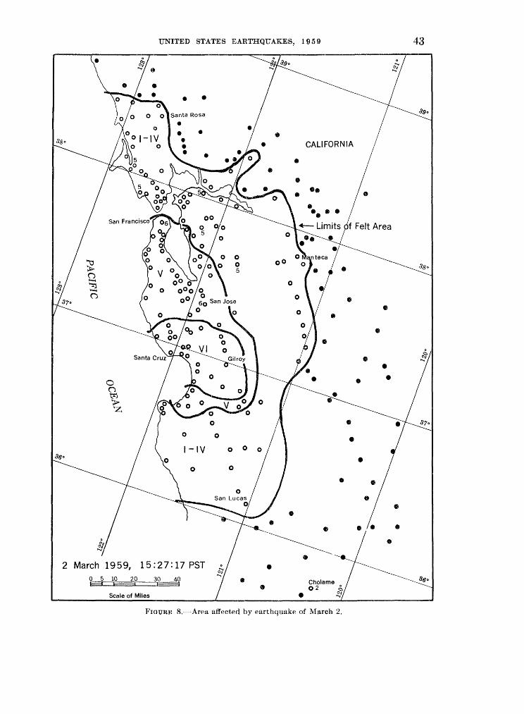
UNITED STATES EARTHQUAKES, 1959 43
2 March 1959, 15:27:17 PST
Scale of Miles
FIGURE 8. Area affected by earthquake of March 2.

44 COAST AND GEODETIC SURVEY
Watsonville and Vicinity. Minor earth slide occurred on Chittenden Pass Road between the Manuel Ferriera and Souza properties. Boulders fell on Hecker Pass Highway. At 208 Hecker Pass Road, chimney pulled outward 6 inches from wall and plaster cracked. Much merchandise fell in stores. People in theater left building.
INTENSITY (DAMAGE) v: Agnew, Alameda, Alviso, Aptos and 3.7 miles north of, Big Basin State Park, Bolinas, Brisbane, Campbell, Cap- itola, Carmel Valley, Castroville, Coyote, Daly City-Colma, Fort Ord, Freemont, Half Moon Bay, Hayward, La Honda, Livermore (Arroyo Sanitarium), Menlo Park, Millbrae, Milpitas, Mission San Jose, Moffett Field, Monterey, Moraga, Moss Landing, Mountain View, Mount Hermon, Niles, Palo Alto, Point Reyes Station, Port Costa, Redwood City, Redwood Estates, Salinas, San Benito, San Gregorio, San Tomas (Campbell), Scotts Valley (Santa Cruz Area), Seaside, Soquel, and Tassajara Hot Springs.
INTENSITY (DAMAGE) iv: Alamo, Alvarado, Banta, Benicia, Big Sur, Camp McCallum (about 8 miles southeast of Salinas), Carmel, Chualar, Corte Madera, Crows Landing, Cuper- tino, Davenport, Diablo, El Cerrito, El Granada, El Sobrante, Forest Knolls, Gonzales, Gustine (8 miles south of), Holt, Inverness, Isleton, King City, Lafayette, Lagunitas, Larkspur, Los Gatos, Marina, Marshall, Mill Valley, Montara, Monte Rio, Moss Beach, Mount Hamilton, Novato, Oakland, Olema, Pacific Grove, Paicines, Patter- son, Permanente, Pescadero, Pinole, Pinnacles National Monument (Paicines), Pittsburg, Pleas- anton, Richmond, Eodeo, San Anselmo, San Bruno, San Carlos, San Leandro, San Lucas, San Pablo, San Quentin, San Rafael, San Ramon, South San Francisco, Stinson Beach, Sunnyvale, Sunol, Tracy, Tres Pinos, Vernalis, Walnut Creek, and Warm Springs.
INTENSITY (DAMAGE) i TO in: Belvedere- Tiburon, Canyon, Cholame, Dillon Beach, El- mira, Fairfax, Fulton, Geyserville, lone, Jenner, Lathrop, Manteca, Napa, Petaluma, Port Chi cago, Santa Rosa, Sebastopol, Sharp Park, Snell- ing, Stockton, Suisun City, and Tomales.
March 2: 20:03:49*. Aftershock of 15:27:17*. Felt at Gilroy and Watsonville.
March 2: 23:23:44*. Aftershock of 15:27:17*. Epicenter 37° north, 122° west, near coast of California, W. Magnitude 4.5, B. V. Awak ened many at Madrone. Felt by many; awak ened and frightened few in community at Morgan Hill where small objects shifted. Awakened all in home at Soquel. Merchandise fell from food market at Watsonville; numerous calls to news paper office. Intensity (damage) IV at Aptos (4 miles north of), Hollister (7*4 miles south of),
Moss Landing, and San Francisco. Also felt at Ben Lomond and Gilroy.
March 3: 00:20:06*, 00:22:58*. Aftershocks of 15:27:17*. Felt at Gilroy.
March 3: 01:30. Madrone. IV. Awakened observer.
March 3: 10:32:10*. Aftershock of 15:27:17*. Epicenter 37° north, 122° west, near coast of California, W. Magnitude 4.1, B. IV. Slow, 10-second shock felt by observer 4 miles north of Aptos; door rattled. Felt by several at Aptos where windows and doors rattled. Felt by all on first floor of school at Gilroy. Short, sharp shock 7 l/2 miles south of Hollister. Also felt at Madrone and San Francisco.
March 3: 22:25:14*. Aftershock of 15:27: 17*. Aptos (4 miles north of). III. Slight, 2-second shock felt by observer; motion north. Also felt at Aptos.
March 4: 00:01:43*. Aftershock of 15:27: 17*. Aptos (4 miles north of). IV. Awakened observer; inside door rattled and banged against partition. At Gilroy, reported as third heaviest of the aftershocks.
March 4: 20:21:08*, 22:06 (possibly very small aftershock recorded at 22:20:25* with magnitude 2.1). Felt at Gilroy.
March 4: 12:55:06*, 13:06:21*. Aftershocks of 15:27:17*. IV. Four miles north of Aptos, felt by observer; doors rattled; house creaked (first shock only). Second shock just a tremor with east-west motion. Shock at 12:55:06* felt at Aptos where windows rattled; motion slow, lasted 3 seconds.
March 8: 11:34:03*. Epicenter 37°43'north, 122°34' west, southwest of San Francisco, B. Magnitude 1.7. Point Bonita Lighthouse (west of the Golden Gate, about 1 mile south of Fort Barry). Horizontal crack in J4-inch-thick plate glass window. It was reported the breakage occurred "around noon on Sunday." The keeper reported earth movements were felt at the light house recently.
March 12: 01:51:08*. Aftershock of March 2 at 15:27:17*. Aptos (4 miles north of). IV. Slow, 2-second shock awakened observer; door rattled; door swung north.
March 14: 20:24:08*. Epicenter 33°22' north, 116°48' west, near Palomar, P. Magni tude 3.3 Hemet. IV. Rapid, slight jar, north east-southwest, pause, then larger and longer shock. Windows rattled.
March 18: 06:20:36*. Epicenter 38°39' north, 118°30' west, northeast of Hawthorne, Nev., B. Magnitude 4.3. Press reported the shock was felt in Churchill and Lander counties of Nevada; also felt at Reno.
March 21: 08:02:59*. Epicenter 41°00' north, 121 °28' west, northeast of Burney, B.

UNITED STATES EARTHQUAKES, 1959 45
Pit River Powerhouse No. 1 (Sec. 10, T36N, R4E). IV. Slow, 1-second shock. Windows rattled.
March 22: 23:10:20*. Epicenter 39°36' north, 118°0r west, Dixie Valley, Nev., B. Magnitude 6.3. Felt over an area of approximately 50,000 square miles of Nevada and northeastern Califor nia. (See map, page 46.) Maximum intensity (damage) VI. Slight plaster cracking reported at Frenchman's Station and Carson City, Nev. Reports from Dixie Valley indicated the shock had a rolling motion and was not too strong; peo ple at Frenchman's Station thought the motion came from the north.
INTENSITY (DAMAGE) VI IN NEVADA.'
Carson City. Felt by many; awakened and frightened few. Plaster cracked. Damage slight. Trees, bushes shaken moderately.
Frenchman's Station. Felt by all; frightened few. Plaster cracked. Damage slight. Small objects shifted.
INTENSITY (DAMAGE) V IN NEVADA: Austin,
Eureka, Fallon, Fernley, Flanigan, Genoa, Gerlach, Golconda, Hawthorne, Hazen, Imlay, Lovelock, Luning, Minden, Palisade, Schurz, Silver Springs, Smith, Steamboat, Stewart, Tungsten, Virginia City, Wabuska, Wellington (2 miles north of), and Yerington.
INTENSITY (DAMAGE) v: Coleville.
INTENSITY (DAMAGE) IV IN NEVADA: Babbitt,
Battle Mountain, Black Springs, Carlin, Dyer, Gabbs, Gardnerville, Goldfield, Mason, Nixon, Owyhee, Reno, Round Mountain, Sparks, Still- water, Tonopah, Valmy, Verdi, and Winnemucca.
INTENSITY (DAMAGE) iv: Kings Beach and Yosemite National Park (central section).
INTENSITY (DAMAGE) I TO III IN NEVADA:
Cherry Creek and Silver City.INTENSITY (DAMAGE) I TO III: Los BanoS
(State Highway 152, just east of the S. P. Railway crossing) and Fresno.
March 23: 18:21:13*. Epicenter 37°16' north, 121 °43' west, southwest of Mount Hamil ton, B. Magnitude 4.1. IV. Felt by observer at Moss Landing PG&E substation; annunciator drops fell. Slow, 2-second, south-north shock felt by observer at San Mateo where walls creaked. Slow, 2-second, east-west rocking felt 4 miles north of Aptos. Felt by several at San Francisco; police received several calls. Also felt at Moraga PG &E substation.
March 24: 21:34:17*. Epicenter 34°15' north, 119°35' west, Santa Barbara Channel, P. Carpinteria. IV. One sharp, sudden jolt felt by many; awakened and frightened one.
March 29: 15:42:11*. Epicenter 34°02' north, 118°30' west, near Santa Monica, P. Magnitude 2.7 Two decided tremors felt by one family at Pacific Palisades.
691796 O 61 4
April 1: 10:18:30*. Epicenter 39°43' north, 120°12' west, northeast of Loyalton, B. Magni tude 5.6. Felt over an area of approximately 25,000 square miles of northeastern California and western Nevada. (See map, page 47.) Maximum intensity (damage) VII at Loyalton, where several chimneys fell; walls, plaster, and windows cracked; and considerable glassware and merchandise fell and broke in homes and stores. The Wiechert seismograph at the University of Nevada, Reno, had both recording needles flipped and considerable damage in the linkage system.
INTENSITY (DAMAGE) VII:
Loyalton. Felt very strongly by all; many alarmed. Buildings cracked. About one-quarter of old chimneys lost upper bricks; plaster cracked and fell; windows broken. Goods on shelves fell in stores and homes. Damage estimated at pos sibly $5,000. East-west seemed to be the main direction of the movement.
INTENSITY (DAMAGE) VI:
Baxter. Felt by all and frightened few in community. Masonry cracked. Damage slight. Transmission wires swung 3-4 feet. Parked milk truck shaken so that driver thought he had been hit.
Beckwourth (2 miles east of). Felt by all in community; frightened all in home. Walls cracked. Damage slight to concrete. Trees, bushes shaken strongly. Small objects over turned.
Blue Canon. Felt by all and frightened many in community. Chimneys cracked. Damage slight to brick. Dishes broken. Trees, bushes shaken strongly. Small objects shifted.
Chilcoot. New cracks in brick store; glass of one window and one display case broken; few bricks down from chimneys with loose mortar. Metal chimney separated. Canned goods strewn on floors in stores. Very slight damage to West ern Pacific Railroad tunnel.
Crescent Mills. Felt by several in community; frightened few. Plaster in tile store, 40 x 70 feet, cracked all over ceiling.
Doyle. Felt by all in community; frightened many. Small objects shifted and overturned; knickknacks fell. Press reported the central traffic control system of the Western Pacific
Railroad center was temporarily knocked out.Hallelujah Junction (about 20 miles northwest of
Reno, Nev.). Felt by and frightened all in com munity. Plaster cracked. Dishes broken. Damage slight. Small objects and furnishings
shifted; vases, etc., small objects overturned; knickknacks fell. Trees, bushes shaken strongly.
Kings Beach. Plaster cracked. Damage slight to brick.

46 COAST AND GEODETIC SURVEY
22 March 1959, 23:10:20 PSTn 50 100
FIGURE 9. Area affected by earthquake of March 22.
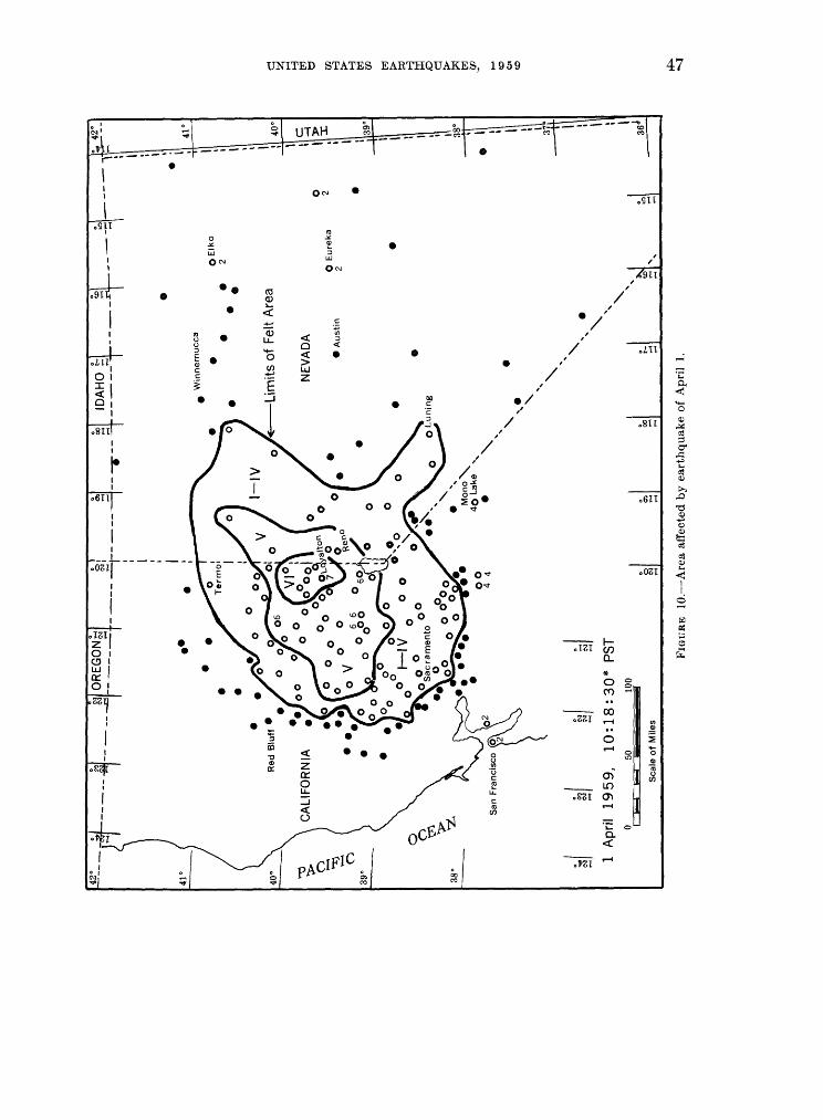
r&
l ~
j|_
S
OR
EG
ON
^!
[T
^- --- -rj_
__
^
Win
ne
mu
cca
"
:
Lim
its o
f F
elt
Are
a
NE
VA
DA
A
ust
in
QE
Iko
2
O E
ure
ka
2
\
\
1 A
pril
1959,
10:1
8:3
0*
PS
T\
5010
0
Sca
le o
f M
iles
Jjk
38°
36J
CP
FIG
UR
E
10.
Are
a a
ffec
ted
by e
arth
quak
e of
Apr
il 1
.

48 COAST AND GEODETIC SURVEY
Portola. Felt by all and frightened few in community. Canned goods strewn on floors in stores. Damage slight.
Vinton( Felt by all and frightened many in community. Plaster, walls, and chimneys cracked; plaster fell. Two sides of an ancient stone farm building collapsed. Damage to brick and masonry.
INTENSITY (DAMAGE) v: Alleghany, Berry Creek, Blairsden, Chicago Park, Clio, Cromberg, Downieville, Durham, Emigrant Gap, Floriston, Forest Ranch, Georgetown, Graeagle, Granite- ville, Greenville, Grizzly Flats, Herlong, Home- wood, Kyburz, La Porte, Live Oak, Magalia, Marysville and Yuba City, Mather Air Force Base (near Sacramento), Meadow Valley, Nevada City, Norden, Quincy, Richvale, Sattley and 4 miles north of, Sierra City, Sierraville, Sierra Valley, Sloat, Spring Garden, Strawberry Valley, Tahoe Vista, Twain, Twin Bridges, Weimar, West Point, Woodland, and Woodleaf.
INTENSITY (DAMAGE) v IN NEVADA: Flanigan, Gerlach, Reno, and Stead Air Force Base (near Reno).
INTENSITY (DAMAGE) iv: Alta Powerhouse (PG&E, Sec. 25, T16N, R10E), Auburn, Bangor, Blue Canon Airport (Emigrant Gap), Brock way, Browns Valley (2 miles east of), Brownsville, Camptonville, Canyondam, Caribou and Caribou Powerhouse, Challenge, Clements, Clipper Mills, Colfax, Coloma, Colusa, Courtland, Deer Creek Powerhouse (Sec. 34, T17N, R10E), Dobbins (2 miles south of, Colgate Powerhouse), Dunnigan, El Dorado Powerhouse Camp (Sec. 22, TUN, R12E), Feather and South Yuba Canyon areas (PG&E), Foresthill, Glenn, Goodyears Bar (2 miles west of), Grass Valley, Gridley, Grimes, Halsey Powerhouse (Sec. 25, T13N, R8E), lone, Iowa Hill, Janesville, Keddie, Knights Landing, Lake Spaulding Powerhouse No. 1 (Sec. 20, T17N, R12E), Madison, Mono Lake, Narrows Powerhouse (Sec. 23, T16N, R6E), North San Juan, Oroville (between Oroville and Berry Creek School), Pacific House, Palermo, Paradise, Par- rish Place (1 mile south of Lime Saddle Power house (Sec. 6, T21N, R4E), Pioneer, Placerville, Rackerby, Sacramento, Somerset, Sonora, Soulsbyville, Stirling City, Storrie and about 1 mile north of, Taylorsville, Termo, Truckee, Valley Springs, Virgilia, Volcanoville, Washing ton, Wendel, Westwood, Wheatland, Yolo, and Zamora.
INTENSITY (DAMAGE) IV IN NEVADA: Babbitt,
Carson City, Fernley, Lovelock, Minden, Nixon, and Yerington.
INTENSITY (DAMAGE) I TO in: Applegate, Arbuckle, Belden, Big Bend Powerhouse (Sec. 14, T21N, R4E), Biggs, Broderick, Butte City, Carnelian Bay (Lake Tahoe), Cedar Ridge, Clarks
burg, Cool, Dixon, Drum Powerhouse (Sec. 17, T16N, RUE), East Nicolaus, Electra Powerhouse (Sec. 33, T6N, R12E), Esparto, Forbestown, Gait, Isleton, Markleeville, Meridian, Mineral, Mountain Ranch, Newcastle area, Nicolaus, Oakland, Omo Ranch, Oregon House, Pine Grove, Robbins, San Francisco, Sheepranch, Smartville, Standish, Stateline, Susanville, Sutter, Tahoe City, Tahoma, Trowbridge, Vade, Wallace, White Pines, and Williams.
INTENSITY (DAMAGE) I TO III IN NEVADA: Cherry
Creek, Elko, Eureka, Gardnerville, Hazen, Imlay, Luning, Schurz, and Wabuska.
April 1: 20:33:44*. Epicenter 36°59' north, 121 °35' west, near Gilroy, B. Aftershock of March 2 at 15:27:17*. Hollister (7>i miles south of). IV. Rapid, brief, northeast-southwest shock felt by several; walls creaked. Also felt slightly 3.7 miles north of Aptos.
April 1: 21:47:58*. Epicenter 32°46' north, 115°21' west, east of El Centre, P. Lightly felt at El Centre.
April 3: 05:00. Sattley. IV. House creaked; bed shook slightly. Felt slightly 4 miles north of Sattley.
April 3: 09:12:00*. Epicenter 39.8° north, 120.2° west, B. Aftershock of April 1 at 10:18:30*. Sharp, short shock felt in Sierraville (weakly), more strongly at Chilcoot and Loyal- ton, and Reno, Nev. (weakly).
April 4: 01:00:13*. Aftershock of April 1 at 10:18:30*. Sattley. Light shock. Also felt 4 miles north of Sattley.
April 5: 22:08:19*. Epicenter 39.3° north, 123.2° west, north of Ukiah, B. Magnitude 3.6. Felt over an area of approximately 1,200 square miles of Mendocino and Lake counties in north western California, principally in the Redwood Valley-Ukiah areas. Maximum intensity (dam age) VI at Redwood Valley where slight damage was reported: chimneys cracked; dishes broken.
INTENSITY (DAMAGE) VI:
Redwood Valley. Felt by, awakened, and frightened many in community. Chimneys cracked; dishes broken. Groceries fell from shelves. Damage slight.
INTENSITY (DAMAGE) v: Calpella, Lakeport, Potter Valley, and Witter Springs.
INTENSITY (DAMAGE) iv: Finley, Laytonville, Mendocino PG & E Substation (6 miles north of Ukiah), Orrs Hot Springs, Talmage, Ukiah, Upper Lake, and Willits.
INTENSITY (DAMAGE) i TO in: Comptche and Kelseyville.
April 11: 20:52:44*. Epicenter 34°07'north, 117°25' west, near Fontana, P. Magnitude 2.3. IV. Fontana area. Mild shock felt over a mile- square area. Police Department at Fontana received hundreds of calls reporting dishes and
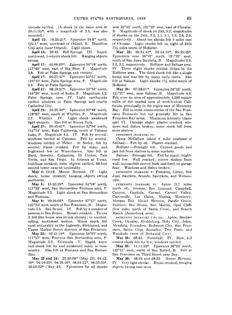
49
utensils rattled. (A shock in the same area at 20:31:35*, with a magnitude of 2.5, was also recorded.)
April 13: 10:35:21*. Epicenter 39.8° north, 122.1° west, northeast of Orland, B. Hamilton City area (near Orland). Light shock.
April 13: 20:45. Bell Springs. III. Rapid, northwest, 1-minute shock felt. Hanging objects swung.
April 17: 05:06:03*. Epicenter 34°18'north, 117°03' west, east of Big Bear, P. Magnitude 2.8. Felt at Palm Springs and vicinity.
April 17: 06:27:47*. Epicenter 33°51'north, 116°10' west, Palm Springs area, P. Magnitude 3.6. Felt at Palm Springs.
April 17: 08:18:57*. Epicenter 33°55'north, 116°20' west, north of Indio, P. Magnitude 4.2. Palm Springs area. IV. Light earthquake rattled windows in Palm Springs and nearby Cathedral City.
April 23: 23:25:30*. Epicenter 33°48'north, 118°07' west, south of Whittier, P. Magnitude 2.7. Whittier. IV. Light shock awakened light sleepers. Also felt at Buena Park.
April 27: 09:45:07*. Epicenter 32°04'north, 115° 14' west, Baja California, south of Volcano Lake, P. Magnitude 4.5. IV. Felt by several; windows rattled at Calexico. Felt by several; windows rattled at Heber. At Seeley, felt by several; frame creaked. Felt by many and frightened few at Winterhaven. Also felt at Bard, Brawley, Calipatria, El Centre, Palo Verde, and San Diego. In Arizona at Yuma, buildings creaked; loose objects rattled; 80-foot control tower swayed noticeably.
May 4: 10:18. Mount Hermon. IV. Light shock; house creaked; hanging objects swung northwest.
May 6: 15:23:29*. Epicenter 34°04' north, 117°22' west, San Bernardino-Fontana area, P. Magnitude 3.3. Light shock at San Bernardino and Fontana.
May 9: 09:26:03*. Epicenter 37°37' north, 122°30' west, south of San Francisco, B. Magni tude 3.5. San Bruno. IV. Felt by a number of persons in San Bruno. Houses creaked. To one it felt like house was struck sharply; to another, rolling, southwest motion. Minor shock felt most noticeably in the Ingleside, Richmond, and Upper Market Street districts of San Francisco.
May 23: 03:21:16*. Epicenter 34°07'north, 117°27' west, Fontana-San Bernardino area, P. Magnitude 3.3. Etiwanda. V. Rapid, 4-sec- ond shock felt by and awakened many in com munity. Also felt at Fontana and San Bernar dino.
May 23 and 24: 22:59:08* (May 23), 04:12: 19* 04:14:53* 04:16:10* 08:01:21* 08:33:33* 12:03:32* (May 24). Epicenters for all shocks
near 36°35' north, 121°25' west, east of Chualar, B. Magnitude of shock on 23d, 3.2; magnitudes of shocks on the 24th, 3.2, 3.1, 3.1, 3.2, 2.8, 2.0, respectively. About ten shocks felt 9 miles east of Chualar. Light shocks felt on night of 24th 7*^ miles south of Hollister.
May 25: 02:51:41* 02:54:15*, 05:35:48*. Epicenters near 36°47' north, 121 °32' west, south of San Juan Bautista, B. Magnitudes 3.0, 3.0, 3.1, respectively. Hollister and Salinas area. IV. Three slight shocks rattled dishes in the Hollister area. The third shock felt like a single bump and was felt by many early risers. Also felt at Salinas. Light shocks 7J^ miles south of Hollister.
May 26: 07:58:01*. Epicenter 36°43'north, 121 °37' west, near Salinas, B. Magnitude 4.6. Felt over an area of approximately 4,500 square miles of the coastal area of west-central Cali fornia, principally in the region east of Monterey Bay. Felt in some communities of the San Fran cisco Peninsula but not generally felt in San Francisco Bay areas. Maximum intensity (dam age) VI. Damage slight: plaster cracked, win dows and dishes broken; some stock fell from store shelves.
INTENSITY (DAMAGE) VI:
Camp McCallum (about 8 miles southeast of Salinas). Felt by all. Plaster cracked.
Hollister. Strongly felt. Canned goods and jars fell from shelves in some markets.
Salinas. Strongly felt. Felt by many; fright ened few. Wall cracked; mirror shaken from wall; automobile moved back and forth on garage floor. Windows and dishes broken.
INTENSITY (DAMAGE) v: Freedom, Gilroy, San Juan Bautista, Seaside, Spreckels, and Watson- ville.
INTENSITY (DAMAGE) iv: Aptos (3.7 miles north of), Aromas, Ben Lomond, Campbell, Canyon, Capitola, Carmel, Carmel Valley, Castroville, Los Gatos, Marina, Monterey, Morgan Hill, Mount Hermon, Pacific Grove, Paicines, San Bruno, San Martin, Opal Cliffs (few miles north of Santa Cruz), and Search Ranch (Jamesburg area).
INTENSITY (DAMAGE) i TO in: Aptos, Boulder Creek, Chualar, Healdsburg, Holy City, Jolon, Mendota, Pescadero, Redwood City, San Fran cisco, Santa Cruz, Sausalito, Tres Pinos, and Woodside (west of Redwood City).
May 26: 08:31. Foresthill. IV. Slow, 4-5 second shock felt by few; windows rattled.
May 28: 11:11:23*. Epicenter 38°03'north, 122°31' west, north of San Rafael, B. Felt at San Francisco on Third Street near Bay.
May 30: 08:34 and 08:35 Mount Hermon. IV. Very light shocks. House creaked; hanging objects swung east-west.

50 COAST AND GEODETIC SURVEY
June 3 or 4: (no time given). Modesto. Several calls reporting a possible earthquake were received by police.
June 8: 02:23:38*. Epicenter 36°37' north, 121 °14' west, northeast of Gonzales, B. Salinas PG&E Substation. III. Hanging objects swung; motion rapid.
June 10: 17:28:58*. Epicenter 37°20'north, 121°39' west, near Mount Hamilton, B. Mag nitude 3.7. IV. Rapid, east, 2-minute shock felt by some in San Jose. Trees, bushes shaken moderately; hanging objects swung. Slow, very slight, 4-second shock felt at Mount Hermon where house creaked. Also felt 3.7 miles north of Aptos, Boulder Creek, Gerber Ranch (8 miles east of Mount Hamilton), and Mount Hamilton.
June 12: 03:03:13*. Epicenter 33°30'north, 116°46' west, near Palomar, P. Magnitude 4.0. Hemet. V. Felt by and awakened many; frightened few; windows rattled; house creaked. Awakened some in Fallbrook. Also felt at San Diego.
June 13: 17:26:32*. Epicenter 39°40'north, 120°33' west, near the Sierra Buttes, B. Mag nitude 4.5. Felt over an area of approximately 4,500 square miles of northeastern California; felt at two places in Nevada. Maximum inten sity (damage) V. Some stock fell from store shelves at Portola. No damage reported. In tensity (damage) V at Beckwourth, Chilcoot, Downieville, Emigrant Gap (Lake Spaulding Powerhouse), Nevada City, Portola, Sattley, Sierra City, and Sloat, where the shock was generally felt, frightened many; small objects shifted at few places. Intensity (damage) IV at Alleghany, Blairsden, Blue Canon, Clio, Dobbins, Georgetown, Herlong, Janesville, Las Plumas, Loyalton, Quincy, Soda Springs, and Taylorsville; in Nevada, Verdi. Also felt at Greenville, Norden, Strawberry Valley, Tahoe Vista; and at Pyramid, Nev.
June 17: 16:29:40*. Epicenter 37°33' north, 118°34' west, northwest of Bishop, B. Magni tude 4.7. Felt over an area of approximately 3,000 square miles of east-central California, prin cipally in the region southeast of Yosemite National Park. Maximum intensity (damage) VI at Mammoth Lakes where the shock was felt by all in community; frightened few; plaster cracked; small objects overturned. Intensity (damage) V at Bass Lake, Big Creek, Long Val ley Dam (about 20 miles northwest of Bishop), strongly felt by practically all. Fishermen back in the area near Mono Hot Springs said the jolt was very heavy. Intensity (damage) IV at Bishop, Huntington Lake, Laws, and Mono Hot Springs. Also felt at Benton and June Lake.
June 17: 22:01:40*. Epicenter 36°11'north, 118°00' west, near Haiwee, P. Magnitude 2.7.
Haiwee Powerhouse (Coso Junction). IV. Mod erate, 3-second shock awakened two; windows and doors rattled; house creaked.
June 22: (no time given). Series of light- earthquakes felt in the Lake Tahoe area.
June 23: 06:32:35*, 06:35:00* (main shock), 07:03:44*, 07:04:34*. Epicenter of main shock 39°05' north, 118°49' west, north of Schurz, Nev., B. Magnitudes 4.4, 6.1, 3.9, 5.5, respectively. The main shock was felt over an area of approxi mately 35,000 square miles of California and western Nevada. (See map, page 51.) Maxi mum intensity (damage) VI. Principal effects of the shock occurred at and near Schurz, Nev. At Schurz, a garage attached to frame house was separated 2 inches from house; chimneys twisted and cracked; plaster cracked. Minor rock slides in adjacent mountains. New road bed, leading to microwave station on Black Mountain (about 5 miles west of Schurz) was cracked.
INTENSITY (DAMAGE) VI IN NEVADA:
Genoa. Felt by and awakened many in com munity. Plaster cracked. Small objects shifted and overturned; knickknacks fell. Observer awakened by rolling shock at 07:00 (probably 07:04:34*).
Mason. Felt by all and awakened many in community; frightened few. Canned goods fell in store. Pendulum clock facing south stopped.
Schurz. Felt by and awakened all in com munity; frightened many. Damage slight. Chimneys twisted; plaster cracked; dishes and lamps broken; groceries fell (mostly canned goods on upper east-west shelves). Four separate shocks felt within one-half hour.
Wabuska. Felt by and awakened all. Small objects shifted; doors swung northeast; trees, bushes shaken moderately.
INTENSITY (DAMAGE) V IN NEVADA: Babbitt,
Crystal Bay, Dayton, Fallen and 3J^ miles west of, Fernley, Frenchman's Station, Gabbs, Haw thorne (also 07:04:34*), Hazen, Lovelock, Luning (also 07:04:34*), Mount Montgomery, Nixon, Reno, Rawhide (Nevada Scheelite Mine), Smith, Sparks (near Reno), Stewart, Stillwater, Welling ton and Colony District (northwest Smith Valley).
INTENSITY (DAMAGE) v: Camp Richardson (south end Lake Tahoe), Chilcoot, Coleville, Doyle, Kings Beach, Knights Ferry, Marklee- ville, Pinecrest, Salt Springs Powerhouse (Sec. 33, T8N, R16E) (also 07:04:34*), San Andreas, Soulsbyville, Twain Harte, and West Point.
INTENSITY (DAMAGE) IV IN NEVADA' Austin
and 10 miles east of at two ranches about 10 miles apart, Black Springs, Carson City (also 07:04:34*), Dyer (Fish Lake Valley) (also 07:04:34*), Eureka (also 07:04:34*), Glenbrook, Goldfield, Minden, Pyramid, Reese River, Round Mountain, Thorne (also 07:04:34*), Tonopah

23
June
19
59,
06:3
5:0
0*P
ST
<£> c* <£>
FIG
UR
E
11
. A
rea a
ffec
ted
by e
arth
quak
e of
June
23.
52 COAST AND GEODETIC SURVEY
(also 07:04:34*), Verdi, Weed Heights, and Zephyr Cove.
INTENSITY (DAMAGE) iv: Arnold, Baxter, Balch Camp (PG&E Camp, 25 miles northeast of Fresno), Blue Canon, Bridgeport, Brockway, Camanche, Camp Connell, Dardanelle, Downie- ville, Electra Powerhouse (PG&E, Sec. 33, T6N, R12E), El Portal (also 07:04:34*), Homewood, Jackson, LaGrange, Lake Alpine, Leevining, Loyalton, Mountain Ranch, Placerville, Railroad Flat, River Pines, Sacramento, Sierra City, Snelling, Spring Garden, Stanislaus and Stanis laus Powerhouse (Sec. 6, T3N, RISE) shock at 07:04:34*, Strawberry, Tahoe City, Tahoe Vista, Tiger Creek Powerhouse (Sec. 24, T7N, R13E), (also shock at 07:04:34*), Topaz (also 07:04:34*), Valley Home, Washington, White Pines, and Yosemite National Park.
INTENSITY (DAMAGE) I TO III IN NEVADA:
Steamboat.INTENSITY (DAMAGE) i TO in: Chinese Camp,
Citrus Heights, Collinsville, Floriston, June Lake, Linden, Mammoth Lakes, Marysville (6 miles southeast of), Oakdale, Sonora Junction (east of Walker River near Devil's Gate), Sonora, Tahoma, Waterford, Wendel; also reported felt by PG&E (no details) at Fresno, Martinez, Mokelumne River area, and San Francisco.
June 25: 03:03:52*. Epicenter 37°41' north, 121 °59' west, east of Hayward, B. Felt at Hay- ward.
June 27: 08:22:11*. Epicenter 34°02' north, 116°51' west, north of Banning in the San Gorgonio Mountains, P. Magnitude 4.0. Felt at Palm Springs.
June 29: 23:58:01*. Epicenter 38.7° north, 122.7° west, near Mt. Saint Helena, B. Magni tude 3.4. IV. Felt by several (some outdoors) and awakened few at Calistoga. Two awakened by hard shake at Forestville; pictures tilted. Felt by all in home at Healdsburg; windows rattled. At Middletown, felt by several and awakened few in home; windows rattled. Sharp jolt at Saint Helena, windows and doors rattled; house creaked; rapid, southeast-northwest mo tion.
July 1: 11:38:24*, 11:50:42*, 15:49:24* (main shock). Epicenter of first shock 35°10' north, 119°14' west, east of Taft; second, 35°13' north, 119°07' west, east of Taft; third, 35°12' north, 119 °03' west, south of Bannister, P. Magni tudes 3.2, 3.4, 4.7, respectively. The main shock was felt over an area of approximately 6,000 square miles of south-central California, princi pally in Kern County. Maximum intensity (damage) V. Sharply and generally felt at Bakersfield, causing widespread alarm; few ob jects fell from shelves; large buildings shaken. Pendulum clock stopped. At the Paloma Cycling
Plant (20 miles southwest of Bakersfield), small objects shifted and overturned; some knickknacks fell; columns swayed; mercoid switches shut down all engines. Felt by all not active at Shafter; frightened few; observer gave negative answers to all questions of movement or damage yet re ported: "Very little damage noticed to brick or concrete buildings." Felt by many in commu nity (some outdoors) at Tupman; awakened few; few small objects overturned; slight, rolling shock also felt by several between 11:30 and 12:30. At Wheeler Ridge, felt by several in community; small objects shifted. Intensity (damage) IV at Bitterwater Pumping Station (about 20 miles southeast of Cholame), Buttonwillow, Edison, Fellows, Frazier Park, Johnsondale, Kern Canyon Powerhouse (about 10 miles east of Bakersfield), Lost Hills, McFarland, McKittrick, Maricopa, Onyx, Parkfield, Posey, Taft, Terra Bella, and Upland.
INTENSITY (DAMAGE) i TO in: Boron, Brecken- ridge, Caliente, Camp Nelson, Corcoran, Di Giorgio (about 18 miles southeast of Bakersfield), Glennville, Huntington Lake, Mojave, Paris- Loraine (about 10 miles east of Caliente), Pond, Porterville, Pumpkin Center (about 12 miles south of Bakersfield), Santa Maria, Sequoia Na tional Park (Colony Mill Range Station, about 5 miles north of Ash Mountain Park Headquarters) Tehachapi, Tipton, Wasco, and Weldon.
July 8: 08:37,21:30. Keene. III. Felt by several in community; house creaked slightly; moderate earth noises heard; motion slow.
July 10: 06:44:59*. Epicenter 33°57' north, 118°25' west, near Venice, P. Magnitude 2.5. Felt at Beverly Hills and Culver.
July 11: 03:21:04*. Epicenter 37°24' north, 121 °48' west, northeast of San Jose, B. Magni tude 2.2. Felt at San Jose.
July 20: 03:41:49*. Epicenter 33°22' north, 116° 33' west, near Warner Hot Springs, P. Magnitude 3.8. IV. Windows rattled in the El Cajon Valley; sharply felt at Alpine, Descanso, and El Cajon.
July 22: 19:21:03*. Epicenter 33°56' north, 117°15' west, east of Riverside, P. Magnitude 3.5. Slight shock felt at Fontana, Riverside, and San Bernardino.
July 23: 17:23:09*. Epicenter 41°08' north, 125°18' west, northwest of Arcata, B. Magni tude 5.8. IV. "Shook a wide area of Humboldt County as far north as Crescent City and south to Rio Dell. Windows and dishes rattled, but there were no reports of damage." (BSSA, January I960.). At Eureka, felt by most indoors and many outdoors; some alarmed. Disturbed objects observed by many. Third shock reported at 17:44 alarmed some persons; shock also re ported felt at 16:59.

UNITED STATES EARTHQUAKES, 1959 53
July 24: 22:37:42*. Epicenter 37°52' north, 122°13' west, near Berkeley, B. Magnitude 2.8. Felt by a number of persons at Berkeley and Oakland.
July 29: 13:01:55*. Epicenter 38°05'north, 122°30' west, northwest of Berkeley, B. Magni tude 2.4. Some doubt as to whether this shock was actually felt.
July 29: 08:48:35*, 13:29:09*. Epicenter 34°00' north, 117°48' west, east of Walnut, P. Magnitudes 2.9 and 3.3, respectively. IV. At least 10 light earthquakes jolted the Pomona area. First noticeable shock was felt at 08:48: 35*, with the heaviest shock occurring at 13:29: 09*. Heavy shock at 13:29:09* caused a rolling motion, lasted several seconds. Reported felt at Covina, La Puente, Pomona, and San Dimas. (From July 29 to August 5, 25 shocks of magni tudes 2.2 to 3.5 were recorded.)
August 3: 07:26:42*, 09:54:14*. Epicenter 34°00' north, 117°48' west, east of Walnut, P. Magnitudes 3.5 and 2.9, respectively. Light shocks felt in the Pomona area. First shock felt at La Habra, La Puente, Pomona, and Tustin; second at Pomona.
August 3: 23:36:59* (main shock), 23:41:33*, 23:44. Epicenter of first shock 37°21' north, 118°33' west; second, 37°21' north, 118°39' west, both west of Bishop, P. Magnitudes 5.2 and 4.2, . respectively. The main shock was felt over an area of approximately 12,000 square miles of central California. Maximum intensity (damage) VI at Bishop where numerous rock slides oc curred. No damage was reported.
INTENSITY (DAMAGE) VI:
Bishop. Awakened many; frightened few. Numerous rock slides in the area. Small objects and furnishings shifted. Shock at 23:41:33* awakened many at Gorge Power Plant (Bishop) ; shock at 23:44 felt by several.
INTENSITY (DAMAGE) v: Badger, Balch Power house (25 miles northeast of Fresno), Bass Lake, Big Creek, Bigpine, Burrell, Coalinga, Dinkey Creek, Dunlap, El Portal, Exeter, Fresno, Ivan- hoe, Johnsondale, June Lake Kings Canyon Na tional Park (Grant Grove and 6 miles northeast of Miramonte), Lakeshore, Laton, Laws (also 23:41:33*, 23:44), Long Valley Dam (also 23:41:33* and 23:44), Miramonte, Prather, Sequoia Na tional Park (Ash Peak Lookout and Colony Mill Ranger Station), Shaver Lake, Tollhouse, Wishon, and Woodlake.
INTENSITY (DAMAGE) iv: Auberry, Avenal, Bagby, Bartlett, Benton, California Hot Springs, Camp Nelson, Camp Sierra (2 miles south of Big Creek Powerplant (also felt shock at 23:44), Cathay, Clovis, Corcoran, Cutler, Dinuba, Ducor, Firebaugh, Friant, Hanford, Helm, Hern- don, Hume, Huntington Lake (also felt shock at
23:41:33*), Huron, Independence and Tinemaha Reservoir, Kaweah, Keeler, Kettleman City, Lemoore, Lone Pine, Madera, Mammoth Lakes, Mariposa, Midpines, Orosi, Pinedale, Porterville, Raisin, Raymond, Riverdale, San Joaquin, Selma, Snelling, Springville, Stratford, Terra Bella, Three Rivers, Tipton, Traver, and Yosemite Valley.
INTENSITY (DAMAGE) i TO in: Biola, Camp Mather (9 miles southwest of O'Shaughnessy Dam), Deep Springs, El Nido, Hornitos, and Oakhurst; at Dyer, Nevada, some persons said they were awakened at about time of shock but no one could say definitely if an earthquake had been felt.
August 4: 01:55. Pacifica (Pedro Valley) District. IV. Awakened observer who was alarmed enough to stand in doorway.
August 4: 10:25:22*. Epicenter 33°57' north, 115°40' west, southeast of Twentynine Palms, P. Magnitude 4.1. Twentynine Palms. V. Slow,2-second, east-west shock felt by many in office. Pendulum clock stopped.
August 4: 10:50:54*. Epicenter 37°41' north, 122°32' west, southwest of San Francisco, B. Magnitude 2.2. Aftershock of March 22, 1957. San Francisco Bay area. IV. Mild shock; dishes rattled at Daly City.
August 4: 11:12:35*. Epicenter 37°28' north, 118°39' west, west of Bishop, P. Magnitude 4.0. Aftershock of August 3. V. Minor rock slides at Bishop. Rapid, abrupt, northeast, 5-second shock felt at Control Gorge Powerplant (Bishop). Felt by several at Bartlett; windows rattled; low rumble.
August 4: 19:00:34*. Epicenter 35°57' north, 120°29' west, southwest of Coalinga, near Park- field, B. Magnitude 3.5. IV. Felt by several at Paso Robles; windows rattled. Reported as strongest in the Parkfield area. Slightly felt at Coalinga.
August 18: 13:52:22*. Epicenter 33°08' north, 116°29' west, northeast of Julian, P. Magnitude 4.3. Jamul. IV. Rapid, east-west,3-5 second shock rattled windows.
August 19: 19:48:56*. Epicenter 40°16' north, 124°25' west, southwest of Ferndale, B. Magni tude 4.2. V. Felt most strongly throughout the Eel River Valley, particularly at Rio Dell where merchandise fell from some store shelves; felt by many. Light shock felt by several at Garber- ville.
August 23: 08:01:57*. Epicenter 34°08' north, 117°47' west, near La Verne, P. Magnitude 3.6. Maywood. IV. Jerking, 2-second shock awak ened few in community; windows, doors, and dishes rattled; house creaked. Homes shaken at Anaheim, Covina, East Whittier, Fullerton, Pomona, and adjacent communities. Anaheim residents reported "pretty severe jolt."
591796 O 61-

54 COAST AND GEODETIC SURVEY
August 23 : 23:59:00*. Epicenter 34°03' north, 117°49' west, east of La Puente, P. Magnitude 2.9. Felt at La Puente.
August 24: 07:19:36*. Epicenter 37°47' north, 122 °08' west, southeast of Berkeley, B. Magnitude 2.1. Oakland. III. House shaken.
August 25: 02:00 (about). Felt at San Diego.August 25: 21:32:51*. Epicenter 34°03'
north, 116°33' west, Morongo Valley, P. Magni tude 4.3. Sharp shock felt over approximately 10,000 square miles of southern California. Maximum intensity (damage) V. No damage was reported, except one small plaster crack at Ranchita in northeast San Diego County. At Hesperia, heavy objects moved, possibly 1 inch. Maximum intensity (damage) V at Aguanga, Banning, Boulevard, Big Bear City, Cabazon, Fallsvale, Hemet, Hesperia, Idyllwild, Joshua Tree, Morongo Valley, North Palm Springs, Pala, Palm Springs, Patton, Perris, Ranchita, San Jacinto, and White Water.
INTENSITY (DAMAGE) iv: Alberhill, Anza, Calimesa, Covina, Escondido, Fawnskin, Fuller- ton, Indio, Julian, Lakeside, Lucerne Valley, Maywood, Mira Loma, Norwalk, Pioneertown, Rancho Mirage, Riverside, Running Springs, Santee, Seven Oaks, Temecula, Twentynine Palms, and Yorba Linda.
INTENSITY (DAMAGE) i TO in: Alpine, Beau mont, Colton, Dulzura, El Centre, Fallbrook, Lakeview, Long Beach, Palomar Mountain, Potrero, San Diego, South Gate, Thermal, Valley Center, and Yucca Valley.
September 3: 04:11:20*. Epicenter 36°59' north, 121 °42' west, east of Santa Cruz, B. Mag nitude 2.6. Felt at Watsonville.
September 11: 10:05:03*. Epicenter 36.7° north, 121.3° west, southeast of Vinyard, B. Magnitude 4.0. Sharp jolt at Hollister. Also felt at Salinas.
September 22: 21:20, 21:25, 21:32:36*. Epi center 35°16' north, 118°38' west, south of Caliente. Shocks at 21:20 and 21:25 showed some motion on Isabella and Woody station records, P. Magnitude of third shock 3.1. Keene, IV. Felt by several in community; windows rattled; house creaked. Loud earth noises heard 1 second before third shock; lasted 3 seconds each.
September 24: 09:02:09*. Epicenter 39.4° north, 123.0° west, northeast of Ukiah, B. Magnitude 3.6. Willits. VI. Press reported a sharp earthquake jarred the Willits area, toppling merchandise from store shelves, but causing no major damage. Some homes reported cracked plaster. (This shock was apparently very limited in felt area as no other felt reports were received.)
September 30: 20:35:35*. Epicenter 34°26'
north, 120°34' west, off coast of southern Cali fornia at Point Concepcion, P. Gaviota Pass. VI. Magnitude 4.5. Felt over an area of ap proximately 4,500 square miles, principally in Santa Barbara County. At Gaviota Pass (about 2 miles northwest of Gaviota) several large boulders fell and partially blocked U.S. Highway 101. Press reported the shock caused only minor damage. Intensity (damage) V at Gaviota (felt by all; awakened and frightened few; knick- knacks fell), Goleta (felt by all; frightened few in community; house creaked strongly), Lompoc (felt by all; frightened few in community; dishes fell from shelves).
INTENSITY (DAMAGE) iv: Carpinteria, Cuyama, Los Alamos, Los Olivos, Los Prietos Ranger Station (about 20 miles north-northwest of Santa Barbara), Maricopa, Point Arguello Light Sta tion, Santa Barbara, Santa Ynez and San Lucas Ranch (about 5 miles southeast of Santa Ynez), Solvang, Summerland, and Taft.
INTENSITY (DAMAGE) i TO in: Avila Beach, Buellton, Casmalia, Fillmore, Moorpark, Ojai, Port Hueneme, Santa Margarita (east of Pozo Guard Station), Ventura, and Wheeler Springs.
October 4: 17:12:20*. Epicenter 39.1° north, 122.7° west, east of Ukiah, B. Magnitude 2.8. Talmage and Ukiah areas. Minor shock.
October 10: 18:03:09*. Epicenter 36°27' north, 121 °07' west, southwest of Llanada, B. Magnitude 4.1. Minor shock felt at Salinas.
October 12 (about): Onyx (about 7 miles east of). Several light shocks felt in evening around October 12.
October 14: 00:37:51*. Epicenter 36°52' north, 121 °29' west, west of Hollister, B. Mag nitude 3.6. Moderate earthquake shook the Hollister area. Foreshocks were recorded on the 13th at 23:57:01* (magnitude 3.4) and 23:59:01* (magnitude 2.5); aftershock at 00:46:26* (mag nitude 2.9).
October 21: 04:42:30*. Epicenter 35°06' north, 118°35' west, south of Tehachapi, P. Magnitude 3.4. Tehachapi (central section). IV. Heavy jolt felt by many; buildings creaked; loose objects rattled.
October 24: 07:35:15* 08:09:33* 08:11:25*, 11:58:20*. Epicenters (1) 35°44' north, 118°00' west, (2) 35°45' north, 117°53' west, (3) 35°44' north, 118°00' west, (4) 35°44' north, 117°58' west, all near Owens Park, P. Magnitudes 4.2, 2.9, 3.8, 3.4, respectively. Sand Canyon (3% miles north of the Old Goat Ranch and about 20 miles above junction of Highways 6 and 395). VI. Landslide in canyon. Dead trees snapped off their tops. Boulders tumbled down the mountain. These effects observed by two hunters. Aftershock also felt. Felt by all in community at Onyx; windows, doors, and dishes

UNITED STATES EARTHQUAKES, 1959 55
rattled; house creaked. About six light after shocks felt during rest of the day. One about 15:00 felt by several.
October 28: 20:52:12*. Epicenter 35°36' north, 118°08/ west, east of Isabella, P. Mag nitude 3.1. Onyx. IV. Rapid, 5-second shock felt by all in home; windows, doors, and dishes rattled. Two light aftershocks felt at 21:00.
November 16: 04:05:35*. Epicenter 35°42' north, 117°59' west, south of Haiwee, P. Mag nitude 3.8. Felt by dam keeper at Haiwee Reservoir (about 6 miles north of Coso Junction).
November 28: 03:07. Baja California shock. San Diego. Rapid motion felt by observer. (Pasadena reported this was a small shock and that it was very unlikely that it was felt in San Diego.)
December 5: 00:13:42*. Epicenter 40°18' north, 125°25' west, off Cape Mendocino, B. Magnitude 5.1. Felt over an area of approxi mately 2,000 square miles of Hurnboldt County. Maximum intensity (damage) V. Felt by and awakened many at Alton; windows rattled; quite heavy. Felt by and awakened all at Bayside. Awakened many at Briceland. At Ferndale, felt by, awakened, and frightened many; walls creaked. Felt by, awakened, and frightened all at Fields Landing; windows rattled; walls creaked. Awakened many and frightened few in community at Garberville; windows, doors, and dishes rattled; house creaked. Felt by and awakened all in home at Holmes; house creaked. Felt by and awakened many at Laytonville; frightened few. At Loleta, felt by and awakened all in community; frightened few; dishes rattled; frame creaked. Awakened many in community at Pepperwood. Felt by and awakened many in community at Rio Dell; windows rattled; resi dents reported a sharp jolt which was followed by a series of smaller ones.
INTENSITY (DAMAGE) iv: Arcata, Crannell, Denny, Ettersburg, Fort Seward, Fortuna, Kneeland, Korbel, Miranda, Piercy, Rohnerville, Salyer, Scotia, Shively, and Westport.
INTENSITY (DAMAGE) i TO in: Leggett, Showers Pass area, South Fork, and Trinidad.
December 6: 00:05. Caribou Powerhouse Camp (Sec. 24 and 25, T26N, R7E, western Plumas County). IV. Felt by several in home; awakened few in community; dishes rattled.
December 14: 01:19:08*. Epicenter 37°58' north, 122°01' west, near Concord, B. Mag nitude 3.4. Canyon. IV. Felt by and awak ened few; windows rattled; small Christmas tree shaken. Reported as sharp shock at Concord, Martinez, Northern Oakland, Orinda, Pleasant Hill, Port Chicago, and Walnut Creek.
December 15: 07:24:14*. Epicenter 31>^° north
west, W. Baja, California. Magnitude 4, P. Light shock reported felt in San Diego area. (Pasadena reported this was a small shock and that it was very unlikely if it was felt in San Diego.)
December 15: 18:28:42*. Epicenter 38°35' north, 122°22' west, northeast of St. Helena, B. Magnitude 4.1. Guerneville area. IV. Dishes rattled. Also reported felt at Calistoga, Napa, St. Helena, and San Francisco.
December 17: 14:55:22*. Epicenter 37°58' north, 122°19' west, near San Pablo, B. "Quite severe" at El Cerrito. Felt by several at Rich mond. Also felt at El Sobrante.
December 21: 18:38:57*. Epicenter 40°16' north, 124°31' west, off Punta Gorda, B. Mag nitude 4.7. Felt over an area of approximately 3,000 square miles of the coastal areas of north western California, principally in Humboldt County. Maximum intensity (damage) V. Felt by persons outdoors (active) at Briceland; groceries fell from shelf in store. Felt by all and frightened many in community at Ferndale. Felt by and frightened all at Fields Landing; windows rattled; walls creaked. Felt by all and frightened few in community at Garberville; small objects shifted. Felt by all in community at Honeydew, windows, doors, and dishes rattled; house creaked. At Loleta, felt by all in com munity; dishes rattled.
INTENSITY (DAMAGE) iv: Alderpoint, Arcata, Bayside, Bell Springs, Blocksburg, Carlotta, Crannell, Eureka, Eel Rock, Fort Seward, Fortuna, Harris, Holmes, Korbel (5 miles east of), Leggett, Rio Dell, and Westport.
INTENSITY (DAMAGE) i TO in: Alton, Etna, Hoopa, Hydesville, Kneeland, Laytonville, Trini dad, Willits, and Zenia.
December 23: 23:40:16*. Epicenter 35°38' north, 118°22' west, near Isabella, P. Magni tude 2.9. Felt at Isabella.
December 24: 08:45:37*. Epicenter 35°40' north, 118°23' west, near Isabella. Magnitude 3.3. Felt at Isabella.
December 28: 18:32:53*. Epicenter 36°54' north, 121 °29' west, northwest of Hollister, B. Magnitude 4.7. Felt over an area of approxi mately 5,000 square miles of the coastal areas of west-central California, from San Francisco to San Miguel and inland to a distance of about 30 miles. Maximum intensity (damage) VI at Hollister where few chimneys toppled; piece of timber fell from roof of City Hall; merchandise fell from shelves in grocery stores. All damage minor. Reported as the heaviest shock felt in years, with an east-west rolling motion.
INTENSITY (DAMAGE) v: Castroville, Gilroy, Harris Ranch (7 miles south of Hollister),

56 COAST AND GEODETIC SURVEY
Morgan Hill, San Juan Bautista, and San Martin.
INTENSITY (DAMAGE) iv. Aptos and 4 miles north of, Big Sur, Boulder Creek, Chualar (9 miles east of), Coalinga, Coyote, Felton, Green- field, King City, Marina, Milpitas, Pacific Grove, San Carlos, San Lucas, San Francisco, Seaside, Sunny vale, Tres Pinos, and Watson ville.
INTENSITY (DAMAGE) i TO in: Aromas, Big Basin State Park, Freedom, Gonzales, Half Moon Bay, Hayward, Monterey, Moss Landing, Mount Hamilton, Mount Hermon, Oakland, Pacifica, Pescadero, San Jose, San Mateo, San Miguel, South San Francisco, and Soledad.
December 29: 06:53:08*. Epicenter 35°45' north, 120°18' west, near Cholame, P. Magni tude 3.5. Paso Robles. Reported as sharp, rolling motion. Felt by several in community.
December 31: 10:27:05*. Epicenter 34°03' north, 118°40' west, near Malibu Beach, P. Magnitude 2.2. Reported felt at West Los Angeles and Wilshire District.
WASHINGTON AND OREGON
(120TH MERIDIAN OR PACIFIC STANDARD TIME)
January 20: 23:15 (about). Milton-Free- water, Oreg. V. Slow, 8-10 second shock awakened many in community; frightened few; pictures swayed. Milton-Freewater area is about 12 miles south of Walla Walla, Wash. In the Walla Walla area, a number of persons at College Place and the State Line district felt tremors; house rattled and shook at State Line; awakened one.
July 11: 00:02*. Felt at Coulee City and Deep Lake, Wash. At Deep Lake (about 5 miles southwest of Coulee City); house shaken; rolling, rumbling motion.
July 11: 10:10. Deep Lake, Wash. IV. Felt by caretaker and by person on lake in boat; felt pressure on bottom of boat. Lake water visibly disturbed.
July 11: 15:00. Deep Lake, Wash. Boom ing sound heard.
July 14: 11:00. Deep Lake, Wash. Rumble in Sun Lake State Park heard at Deep Lake. Water level in Deep Lake raised 6 inches in 7 days (lake 135 feet deep). Bureau of Reclama tion aquifers Nos. 5 and 6 in nearby areas showed drop of 1-2 feet in water level.
August 4: 15:53:30*. Epicenter 45°41' north, north, 122°16' west, about 13 miles northeast of Portland, Oreg., in Washington, S. Felt over a limited area of Washington and Oregon, approxi mately 600 square miles. Maximum intensity (damage) V. At Fairview, Oreg., felt by several in community (some outdoors). Small objects shifted; pendulum clock facing south stopped.
Hard jolting motion. At Portland, felt by many. Sharp, explosivelike motion. Bookcases swayed; several reams of paper thrown northward to floor. Sharply felt in large downtown buildings; court house swayed back and forth. Intensity (dam age) IV in Oregon; Cascade Locks, Clackamas, Corbett, Gresham, and Troutdale; in Washington about IV to III at Camas and Washougal; also felt at Oregon City and Tigard, Oreg.
August 5: 19:44:35* (main shock), 20:36:10*. Washington. Epicenter 47°49' north, 120°00' west, near Chelan and Chelan Falls, S. Felt over a large area of Washington, approximately 25,000 square miles, (See map, page 57.) Max imum intensity (damage) VI. Minor damage at several localities; rock slides from steep hills near Chelan and W'aterville.
INTENSITY (DAMAGE) VI:
Brief (about 10 miles upstream from Arden- voir). Furniture bounced off floor. Sounded like tons of dynamite exploding in vicinity of Mount Tyee foothills. Second shock very light.
Chelan. Felt by all and frightened many. Damage slight. Rocks fell from hills, 200 cubic yards at one place. Part of chimney fell; bricks fell; slight damage reported in office. Dishes broken. Two major shocks felt, plus two slight shocks after 20:45.
Douglas. Felt by all; frightened many. Dam age slight. Small objects shifted and over turned; knickknacks fell. "These two shocks were the most severe that we have felt since moving here in 1935."
Entiat. Felt by all and frightened few in community. Damage slight. Small objects shifted; knickknacks fell.
Manson. Felt by all; frightened many in community. Small objects shifted.
Orondo. Felt by all; frightened few. Chim neys cracked. Damage slight. Canned goods fell from store shelves; knickknacks fell.
Waterville. Felt by all and frightened many in community. Rocks fell from steep canyon walls onto highway. Chimneys cracked; many bricks loosened and fell from church and 2-story houses; one large brick church suffered extensive inside plaster damage. "Probably the most severe shock felt in Waterville." First shock was followed by two smaller but quite definite shocks; third shock barely noticeable.
INTENSITY (DAMAGE) v: Aeneas, Ardenvoir, Azwell (also felt shock at 20:36:10*), Baring, Cashmere (also felt shocks at 20:00 and 20:36:10*, heavy), Creston, Davenport, Electric City (also 20:36:10*), Grand Coulee (also felt shock at 20:36:10*), Grotto, Hartline, Hunters, Hyak, Keller, Leavenworth, Lester, Methow (also felt shock at 20:36:10*), Monitor, Moses Lake (three shocks), North Bend and 7, 15, and 18 miles

5
oo
0
WA
SH
ING
TO
N
\Li
mits
of
Felt
Are
a
5 A
ugus
t 19
59
19:4
4:35
PS
T
FIG
UR
E 12. A
rea
affe
cted
by
eart
hquak
e of
Aug
ust
5.

58 COAST AND GEODETIC SURVEY
east of, Palisades, Pateros, Peshastin, Preston, Randle, Skykomish, Steiliko Ranger Station (near Entiat), Warden, Wauconda, Wenatchee, Winthrop, and Withrow.
INTENSITY (DAMAGE) iv: Almira (also felt shock at 20:36:10*), Beverly (also felt shock at 20:36:10*), Black Diamond, Brewster, Bridge port, Carbonado, Carlton, Chesaw, Cle Elum, Colbert, Colfax, Conconully, Cougar, Coulee City, Coulee Dam (second shock also felt), Des Moines, Dryden (also felt shock at 20:36:10*), Elbe, Eureka, Fall City (two shocks felt), Farmer (both shocks felt), Harrington, Hatton ^two shocks felt), Hooper, Inchelium, Lamona, Laurier, Lowell, Loomis, Lucerne, Malaga, Malott, Mans field, Marcus (also felt shock at 20:36:10*), Marengo, Marlin (shocks also felt at 20:36:10* and about 21:00), Mazama, Mold (second shock also felt), Monroe, Monse, Naches and 20 miles northwest of, Okanogan (second shock also felt), Olympia (also felt shock at 20:36:10*), Omak, Orillia, Othello, Packwood, Parkland, Port Orchard, Prescott (also felt shock at 20:36:10*), Puyallup (also felt shock at 20:36:10*), Ralston (shock also felt in morning), Redmond, Redondo, Retsil, Ritzville, Ronald, Smyrna, Snohomish, Snoqualmie, Spokane, Stratford, Sultan, Tacoma (also felt shock at 20:36:10*), Thorp, Tonasket, Twisp, Wellpinit, Wilson Creek, and Winchester.
INTENSITY (DAMAGE) i TO in: Alder Dam, Amboy, Ashford, Auburn, Bellevue, Cedar Falls, Cusick, Darrington, Dayton, Dockton, Duvall, Easton, Ellensburg, Elmer City (three shocks felt during hour), Ephrata (5 miles north of), Govan, Index, Issaquah, Kettle Falls, Lacrosse, Lakebay, Lakewood, Malo, Marshall, Mayfield, Molson (6 miles west of), Nighthawk, Odessa (both shocks felt), Olalla, Orient, Orting, Portage, Port Gamble, Quincy, Ravensdale, Richmond Beach, Riverdale, Roslyn, Ruff, Seattle, Silverdale, Soap Lake, South Bend, South Prairie, Springdale, Spangle, Startup, Tieton, Tillicum, Touchet, Vail, and Wilbur.
August 17: See "Western Mountain Region" for shocks felt in Washington and Oregon on August 17 (Hebgen Lake, Montana earthquake).
August 18: 10:08. Chelan, Wash. Felt by some persons.
October 14: 13:35:39*. Washington. Epi center 47°51' north, 121 °58' west, near Monroe on Mount Si Fault, S. V. Felt over an area of approximately 2,800 square miles, principally in the area on the east side of Puget Sound. Felt by all at Monroe where small objects and furnishings shifted; trees, bushes shaken moderately. Felt by all at Sultan; windows, doors, and dishes rattled. Felt by all at Pinehurst where small objects shifted; doors swung east. Intensity (damage) IV at Carnation, Elbe, Everett (Paine
Air Force Base), Granite Falls, Lake Stevens, Longmire, Maple Valley, Marysville, Mukilteo (about 6 miles west of), North Bend Ranger Sta tion (North Bend), Oso, Preston, Seattle, Startup, and Snohomish. Intensity (damage) I to III at Alderwood Manor, Bothell, Bremerton, Burley, Duvall, Retsil, Sedro, Wooley, and Silvana.
November 18: 15:48:51*, 20:38:08*. Mount Vernon and Anacortes areas, Washington. Slight shocks felt.
November 23: 10:15:25*. Washington. Epi center 46°40' north, 121°45' west, near Long mire, S. V. Felt over an area of approximately 1,000 -square miles. At Ashford, rapid, brief; felt by and awakened many. Felt by all and awakened many at Longmire; windows and doors rattled; frame creaked. Intensity (damage) IV at Randle. Intensity (damage) I to III at Alder, Elbe (2^4 miles east of), and Packwood.
December 11: 22:24:17*. Epicenter 48°44' north 123° 15' west, northwest of Orcas Island, S. V. Felt over an area of approximately 8,000 square miles of northwestern Washington. Very slight damage reported: windows broken at Port Angeles; window cracked at Marysville.
INTENSITY (DAMAGE) V:
Anacortes. Rapid, north-south motion felt by all.
Blanchard. Felt by and awakened all. Small objects shifted.
Burlington. Small objects and furnishings shifted.
East Sound (Orcas Island). Frightened all in community. Pendulum clock facing north stopped; small objects and furnishings shifted; one cup fell from shelf.
Friday Harbor. Felt by all; frightened few.Hoodsport. Felt by several. Small objects
shifted.Joyce. Awakened many and frightened few
in community; felt outdoors by some.La Conner. Felt by all; awakened and
frightened few.Langley. Felt by many (some outdoors);
awakened and frightened few. Small objects shifted.
Lopez. Felt by and awakened all.Marietta. Felt by and awakened many.Marysville. Window cracked.Orcas Island. Sharply felt. Loud bang and
boom at beginning of shock. Felt throughout the San Juan Islands.
Port Angeles. Felt by several; awakened and frightened few. Windows broken.
Roche Harbor. Felt by several; awakened few; frightened all in home. Trees, bushes shaken slightly.
Sequim. Felt by several; awakened all.Sinclair Island (Urban). Felt by and awak-

59
ened many. Rapid, jolting motion; loud blast- like earth noises.
Waldron (on Waldron Island). Felt by sev eral (some outdoors); frightened few. Small objects shifted. Jolting, south-north motion; loud frightening rumble.
INTENSITY (DAMAGE) iv: Blaine, Bow, Brem erton, Clallam Bay, Clearlake, Clinton, Clipper, Concrete, Coupeville, Darrington, Decatur, Deer Harbor, Des Moines, East Stanwood, Ferndale, Glacier, Greenbank, Hansville, Lakewood, Long- branch, Lynden, Neah Bay, Oakville, Olga, Pinehurst, Port Gamble, Port Ludlow, Rockport, Seattle, Sedro Woolley, Sekiu, Silvana, Shaw Island, Startup, Sumas, Van Zandt, Westsound, and Wickersham (vicinity of).
INTENSITY (DAMAGE) i TO in: Bellingham, Carlsborg, Custer, Everett (near Paine Air Force Base), Everson, Fall City, Granite Falls, Index, Marblemount, Mount Vernon, Nordland, Oso, Port Townsend, Raymond, and Vashon. Also reported felt at Victoria, B. C., Canada.
ALASKA
(150TH MERIDIAN OR ALASKA STANDARD TIME)
January 9: 07:25:25*. Yakutat. IV. Felt by many. Trembling and swaying motion. Buildings creaked; loose objects rattled. Over head lights swung; disturbed objects observed by many. One resident reported that a puzzle on table was dispersed.
January 9: 08:30. Homer and 5 miles north west of Homer. Slight shock of brief duration.
January 20: 18:43. Adak. Slight shock of brief duration.
January 24: 21:00. LaTouche. Slight shock of brief duration.
January 29: 19:45. LaTouche. Slight shock of brief duration.
February 2: 19:45:16*. Epicenter 60° north, 151° west, Kenai Peninsula, W. Homer (5 miles northwest of). Slight tremor.
February 4: 10:19:40*. Epicenter 59y2 ° north, 138° west, southeastern Alaska-Canada border, W. Yakutat. IV. Felt by many at Yakutat. Rapid onset. Trembling motion followed by a sharp jar. Buildings creaked; loose objects rat tled. Buildings swayed. Pictures on wall swung.
February 9: 08:44. Adak. Slight tremor.February 17: 16:10. Wasilla (3 miles south
of). Slight tremor.February 19: 11:14:14*. Homer (5 miles
northwest of). Slight tremor. Also felt at Kasilof and Kenai.
March 7: 11:26:21*. McGrath. IV. Felt by several. Bumping motion; abrupt onset. Buildings creaked; loose objects rattled. Dis turbed objects observed by many. The Weather
Bureau Office reported light fixtures swaying in an east-west direction.
March 18: 23:37:53*. Epicenter 61^° north, 148° west, southern Alaska, W. Depth about 100 km. Valdez. Slight shock.
March 25: 04:00. Valdez. Slight shock.April 12: 01:13. Adak. Slight tremor.
Abrupt onset.May 13: 19:27:44*. Girdwood.. Slight
shock of brief duration.June 4: 02:31:56*. Epicenter 59j-£° north,
153° west, Cook Inlet W. Depth about 100 km. Magnitude 5J^. Slight shock of brief duration felt at Homer (5 miles northwest of).
June 6: 19:36:49*. Homer (5 miles north west of). Slight shock of brief duration.
June 8: 20:10. Kasilof. Slight shock of brief duration.
June 8: 21:18. Homer (5 miles northwest of). Slight shock of brief duration.
June 8: 23:25. Homer (5 miles northwest of). Slight shock of brief duration.
July 2: 19;21:13*. Epicenter 58^° north, 152° west, Kodiak Island region W. Intensity (damage) IV at Venta (27 miles northeast of Homer). Felt by few. Gentle shaking motion. Gradual onset. Duration about 1 minute. Stove pipe creaked; world globe on shelf rattled. Continuous shaking on 2d floor of building. In dividuals outside felt slight swaying motion, producing effect of dizziness.
July 17: 13:21:28*. Epicenter 60^° north, 1533^2° west, southern Alaska, W. Homer (5 miles northwest of). Depth about 150 km. Slight shock.
July 22: 20:25. Homer (5 miles northwest of). Slight shock.
July 24: 22:18. Homer (5 miles northwest of). Slight shock.
August 1: 10:05. Seward. Slight shock.August 1: 22:05. Homer. Slight shock.August 1: (No time given). Kasilof. Slight
shock of prolonged duration.August 2: (No time given). Girdwood.
Slight shock.August 27: 11:20. Matanuska Agriculture
Experiment Station and Palmer. Very slight shock.
August 28: 02:07:44*. Epicenter 63^° north, 149° west, central Alaska, W. Felt at College and Fairbanks. Very slight shock felt at Matanuska Agriculture Experiment Station.
August 29: 08:43. Seward. Slight shock.August 30: 02:20. Girdwood. Slight shock.November 2: 03:30:44*. Epicenter 59° north,
152° west, Kenai Peninsula, W. Homer (5 miles northwest of). Slight shock.
November 30: 05:18:37*. Epicenter 59^° north 152° west Kenai Peninsula W. Homer

60 COAST AND GEODETIC SURVEY
(5 miles northwest of). Slight shock. Also felt at Kasilof and Seward.
December 3: 13:40. Anchorage. Slight shock.
December 14: 18:00. Homer (5 miles north west of). Slight shock.
December 24: 12:00. Kodiak. IV. Felt by several. Abrupt onset. "One sharp shock similar to that created by an explosion." Pans rattled. Disturbed objects observed by many; liquid in shallow pans spilled.
December 26: 08:19:10*. Epicenter 59^° north, 151 1A° west, Kenai Peninsula, W. Mag nitude 6J^. Homer (5 miles northwest of). Slight shock.
December 26: 20:45. Homer (5 miles north west of). Slight shock.
December 29: 02:29. Homer (5 miles north west of). Slight shock.
HAWAIIAN ISLANDS
(160TH MERIDIAN OR HAWAIIAN STANDARD TIME)
NOTE. Data on the following local disturbances were deter mined from seismograph stations on the islands of Hawaii and Maui by the Hawaiian Volcano Observatory of the U.S. Geo logical Survey. For additional information, see the Hawaiian Volcano Observatory Summary 13 through 16.
January 29: 16:10:46*. Shallow origin be neath Kilauea caldera. Felt. Magnitude 1.6.
January 30: 05:32:41*. Epicenter 19°16' north, 155°07' west, 10 km. east northeast of Apua Point at a depth of about 10 km. Felt at Hi o. Magnitude 2.9.
February 9: 23:28:51*. Epicenter 19°21' north, 155° 17' west, 5 km. south of Kilauea caldera at a depth of about 5 km. Felt at Kilauea caldera and Hilo. Magnitude 3.5.
February 19: 19:58:01*, 20:00:28*, 20:35:04*. All three earthquakes from same epicenter, 19°21' north, 155°09' west, 5 km. southeast of Makaopuhi at a depth of about 5 km. All three earthquakes were felt at scattered points over the island of Hawaii (Captain Cook, Hawaii National Park, Hilo, and Honokaa). Magnitudes 4.0, 4.5, 3.5, respectively.
March 5: 05:32:10*. Epicenter 19°20'north, 155° 17' west, 8 km. south of Kilauea caldera at a depth of about 5 km. Felt from Kapapala to Hilo. Magnitude 3.5.
March 6: 16:45:15*. Epicenter 19°44' north, 155°12' west, 15 km. west of Keahole Point at a depth of about 15 km. Felt at Captain Cook. Magnitude 4.0.
March 9: 04:25:42*. Epicenter 19°50' north, 155°38' west, 5 km. southeast of Waikiki at a depth of about 15 km. Felt at Pohakuloa. Mag nitude 3.5.
March 12: 07:44:55*. Epicenter 20°01' north, 155°25' west, 10 km. southeast of Honokaa
at a depth of about 15 km. Felt at Kukuihaele. Magnitude 4.0.
March 17: 07:49:07*. Epicenter 19°24' north, 155°32' west, 10 km. southeast of Moku- aweoweo caldera at a depth of about 5 km. Felt at Kilauea caldera and Captain Cook. Magni tude 3.5.
June 3: 04:31:29*. Epicenter 20°55' north, 156°10' west, 5 km. east of Huelo Point, Maui, at a depth of about 15 km. Felt on the island of Maui. Magnitude 3.3.
June 9: 21:25:50*. Epicenter 19°23' north, 155°25' west, 3 km. north of Ainapo at a depth of about 5 km. Felt at Kilauea caldera. Magni tude 2.8.
June 24: 20:01:18*. Epicenter 19^26' north, 155°36' west, at the southwest end of Moku- aweoweo caldera. Felt from Kilauea caldera to Captain Cook. Magnitude 3.7.
June 26: 12:16:34*. Epicenter 19°13' north, 156°22' west, 50 km. west of Milolii at a depth of about 15 km. Felt at Captain Cook. Magni tude 4.2.
July 10: 02:19:17*. Near Kealakekua at a shallow depth. Felt at Captain Cook. Magni tude 2.
July 29: 15:27:29*. West coast of Hawaii near Hookena at a shallow depth. Felt at Captain Cook. Magnitude 3.0.
July 31: 18:43:54*. Epicenter 19°25' north, 155°36' west, 5 km. south of Mokuaweoweo at a depth of about 30 km. Felt at Kilauea caldera. Magnitude 3.5.
August 12: 16:13:51*. Epicenter 19°44' north, 156° 16' west, 20 km. west of Keahole Point at a depth of about 15 km. Felt at Captain Cook. Magnitude 3.4.
September 18: 14:50:04*. Epicenter 19°24' north, 155°06' west, 3 km. west of Kalalua crater at a shallow depth. Felt at Kilauea caldera and Hilo. Magnitude 4.0.
October 4: 05:37:08*. Epicenter 20°43' north, 155°45' west, 80 km. east of Haleakala at a depth of about 45 km. Felt in the Kula district, Maui, and at Captain Cook, Hawaii. Magnitude 4.5.
November 10: 14:08:11*. Kilauea caldera at a shallow depth. Felt on the west rim of Kilauea caldera. Magnitude about 0.5.
November 11: 18:49:02*. Ki'auea ca'dera at a shallow depth. Felt on the east rim of Kilauea caldera.
November 12: 18:04:37*. Kilauea caldera at a shallow depth. Felt on the northeast rim of Kilauea caldera. Magnitude 2.
November 13: 16:40:33*. Kilauea caldera at a shallow depth. Felt on the east rim of Kilauea caldera. Magnitude 1.

UNITED STATES EARTHQUAKES, 1959 61
November 14: During the 4 hours preceding the outbreak of an eruption in Kilauea Iki Crater at about 20:08, many earthquakes were felt in the vicinity of Kilauea caldera. Origin times (to the nearest minute) and approximate magnitudes for these earthquakes are listed below:
Time
16:0516:3417:1717:2417:2817:3217:3917:4117:4417:4818:0318:25
Magnitude
2.03.52.52.52.0i.o2.61.11.21.01.00.9
Time
18:2718:3018:3518:3618:3918:4318:4418:4918:5318:5419:2620:10
Magnitude
1.00.60.50.52.41.01.80.91.80.92.52.4
02:40:16*. Kilauea caldera at Felt at Kilauea caldera. Mag-
November 16:a shallow depth, nitude about 1.
November 23: 18:01:40*. Epicenter 20°18' north, 155 °38' west, 25 km. east of Upolu Point at a depth of about 45 km. Felt at Hilo and Honokaa. Magnitude 4.1.
December 2: 02:22:47*. Epicenter 19°14' north, 155 °38' west, 20 km. north of Naalehu at a shallow depth. Felt at Captain Cook. Mag nitude 3.5.
December 12: 19:28:54*. Epicenter 19°31' north, 155°18' west, near Kulani cone at a depth of about 50 km. Felt on the eastern side of Kilauea caldera. Magnitude 2.8.
December 27: 20:57:52*. East rift zone of Kilauea southeast of Pahoa. east of Pahoa. Magnitude 2.
December 28: 15:29:11*. Kilauea southeast of Pahoa. east of Pahoa. Magnitude 3.0.
December 29: 23:38:01*. East rift zone of Kilauea southeast of Pahoa. Felt 5 km. south east of Pahoa. Magnitude 3.3.
PANAMA CANAL ZONE(60TH MERIDIAN TIME)
April 9: 12:45. Intensity (damage) I at Balboa Heights.
June 22: 13:17:16*. Intensity (damage) IV at Balboa Heights.
Intensity (damage)
Felt 5 km. south-
East rift zone of Felt 5 km. south-
July 8: 05:27:45*. Balboa Heights.
July 14: 01:25:18*. Balboa Heights.
July 15: 22:35:54*. Balboa Heights.
December 21: 13:27:06*. Ill at Balboa Heights.
I at
Intensity (damage) I at
Intensity (damage) I at
Intensity (damage)
PUERTO RICO(60TH MERIDIAN TIME)
January 7: 11:44:22*. Felt by and alarmed many at Cabo Rojo and San German. Felt by many at the Second Caribbean Geological Con ference at Mayaguez. Also felt at San Juan.
January 26: 20:20:22*. Epicenter 18° north, 68J^° west, eastern Dominican Republic, W. Depth about 100 km. Intensity (damage) VI at Moca, P.R., where cracks were reported in concrete wall of home. Felt at Morovis, where windows, doors, and loose objects rattled. Also felt at Mayaguez and San Juan.
March 29: 01:39:58*. Epicenter 19° north, 643^° west, Virgin Islands, W. Maximum in tensity (damage) V in Puerto Rico and in the Virgin Islands.
INTENSITY (DAMAGE) V IN PUERTO RICO:
Cayey. Felt by and alarmed many. Two shocks were reported each about 5 seconds. Buildings creaked; loose objects rattled. Gradual onset; trembling motion from southwest to north east.
Fajardo. Felt by nearly all; alarmed few. ''Severe, rapid shake lasting several seconds."
Lares. Felt by and alarmed many. Abrupt onset; trembling motion.
INTENSITY (DAMAGE) V IN THE VIRGIN ISLANDS:
Saint Thomas Island. Felt by and alarmed many. Dishes fell from shelves; furniture moved. Buildings creaked; loose objects rattled. Rapid onset; trembling motion; direction east-west. Subterranean sounds heard.
INTENSITY (DAMAGE; iv IN PUERTO RICO: Aibonito, Arecibo, Jayuya, Mayaguez, and Utuado.
INTENSITY (DAMAGE; iv IN THE VIRGIN ISLANDS: Cruz Bay, St. John Island.
INTENSITY (DAMAGE) I TO III IN PUERTO RICO'
Isabela.April 14: 00:08:18*. Felt at San Juan.April 25: 02:06:04*. Epicenter 19^° north,
66° west, Puerto Rico region, W. Felt at San Juan.
May 23: 20:09:29*. Epicenter 193^° north, 64J^ ° west, Virgin Islands, W. Felt at San Juan and on St. Thomas Island.
June 30: 21:13:03*. Epicenter 19° north, 65° west, Virgin Islands region, W. Depth about 100 km. Felt at San Juan.
July 21: 05:17:51*. Epicenter 19° north, 683^° west, near north coast of Dominican Republic, W. Magnitude 6. Maximum in tensity (damage) IV. Felt on Puerto Rico.
MAXIMUM INTENSITY (DAMAGE) IV:
Aibonito. Felt by several. Loose objects rattled; doors and beds creaked. Abrupt onset; bumping motion.
62 COAST AND GEODETIC SURVEY
Coloso. Felt by many. Gradual onset; trembling motion direction, north-south.
Corozal. Felt by many.Isabela. Felt by many. Buildings creaked;
loose objects rattled.Lares. Felt by many. Gradfoal onset with
trembling motion coming from south to north.Maricao. Felt by nearly all. Wooden build
ings creaked. Rapid onset; trembling motion.Mayaguez. Felt by many. Building creaked.
Gradual onset; swing motion direction north- south.
Quebradillas. Felt by about 30 percent of the population. Buildings creaked; loose objects rattled. Gradual onset.
Rincon. Felt by many. Gradual onset; trem bling motion.
San Sebastian. Felt by many. Gradual on set; rocking motion.
Utuado. Felt by several. Buildings creaked; loose objects rattled. Gradual onset.
MAXIMUM INTENSITY (DAMAGE) I TO III: Jayuya,
Lajas, San Juan, Toa Baja, and Trujillo Alto.September 4: 16:48:58*. Felt by few at San
Juan, where house creaked; table and chair shook; wires leading to radio and loose objects swayed. Also felt by few at Caguas.
November 21: 07:21:23* Felt by and alarmed many at Sabana Grande. Also felt at
,San Sernea and Lajas.

UNITED STATES EARTHQUAKES, 1959
MISCELLANEOUS ACTIVITIES
63
GEODETIC WORK OF SEISMOLOGICAL INTEREST
The program of repeating geodetic con trol surveys for the purpose of detecting horizontal and vertical movement in the earth's crust was continued in 1959.
Second-order leveling was established in 1934 in the region of the Hebgen Lake, Montana, earthquake of August 17, 1959 (epicenter 44°50' north, 111°05' west, magnitude 7.1). First-order releveling was undertaken along 115 miles of lines from West Yellowstone to Sappington, Mont., during September and October 1959. The maximum benchmark settle ment was 18.8 feet. This is the largest vertical change resulting from earthquake activity measured through geodetic level ing in the United States. Additional re- leveling is planned for the summer of 1960 and it has been estimated there are some vertical changes of about 30 feet. It very seldom happens, however, that previously established bench marks are at the location of greatest change.
TIDAL DISTURBANCES OF SEISMIC ORIGIN
Following an earthquake off northern Peru on February 7, there was evidence of a tsunami on the tide gage at Talara. An earthquake near Kamchatka on ,May 4 produced a small tsunami that was re corded on tide gages in the Aleutian Islands and Hawaii. A maximum height of 1.4 feet was recorded at Kahului. Japanese sources reported a faint tsunami at Miyako following an earthquake on January 22 near the east coast of Honshu; there was no evidence of a tsunami on Coast and Geodetic tide gages.
GEOPHYSICAL SURVEYS RELATED TO 1958 LITUYA BAY EARTHQUAKE
A program making use of 20 portable tide gages was carried out in southeast Alaska. In general, stations were selected
at places where tidal bench marks had been previously established so that rela tive changes in elevation could be de termined. Shortly after the Lituya Bay shocks, changes in elevation had been re ported over a widespread area. Previous tidal measurements had established that long term changes had also taken place in the area. The following information, based on half-tide level (the plane midway between mean high water and mean low water) datum, shows the changes in eleva tion that have taken place at the various stations during stated intervals. It is believed that these changes represent land uplift in southeast Alaska.
Changes in land elevation evidenced by plane of half-tide level
Place
Lynn Canal:
Glacier Bay:
North Inian Pass:
Cross Sound-Icy Strait, etc. :
Greely Point____________
Period
1909-591922-591922-59
1940-591939-591938-59
1902-59
1917-591938-591923-591901-591922-591937-591911-591937-591937-59
Years
503737
192021
57
422136583722482222
Change ft.
+2.94+2.73+2.74
+2.18+1.75+2.73
+4.33
+1.90+1.34+1.87+3.25+1.71+1.39+2.05+1.02+1.02
Rate of change ft./yr.
+0.06+0.07+0.07
+0.11+0.09+0.13
+0.08
+0.05+0.06+0.05+0.06+0.05+0.06+0.04+0.05+0.05
Photogrammetric surveys were run fro m Lituya Bay to Yakutat Bay covering the Fairweather Fault zone for the most part. The major landslides and faults of the Lituya epicentral area, the only section that has been processed to date, document the close relationship of the shocks with the Fairweather Fault. Faults observed on the photographs show that the north west side has moved up relative to the

64 COAST AND GEODETIC SURVEY
southwest side. There was no evidence of horizontal offset as was reported by in dividuals afoot in the area; however, this component of displacement without op timum reference points is not readily dis cernible. By differencing the elevation contours of this survey with those of an earlier survey approximate volumes of landslide debris have been calculated for the major slide adjacent to Gilbert Inlet and across the inlet from the 1800-foot denuded promontory within Lituya Bay. Based on this volume and existing param eters it seems reasonable that the mam moth landslide may have caused the denudation of the point.
Hydrographic resurveys were carried out in Yakutat Bay and Lituya Bay in an attempt to discover submarine faulting
and to measure the changes in depth due to deposition and redistribution of sedi mentary materials.
The variations in depth since previous surveys were mapped in detail. Some recent features attributable to the action of the earthquake of July 9, 1958, were noted south of Kantaak Island in Yakutat Bay, where 65 meters of the south end of the island subsided leaving a marked trough and forming a knoll 740 meters offshore which rises 18 meters above the bay bottom.
In Lituya Bay, where the earthquake caused extensive avalanching and violent wave action, there was major shoaling of the bottom, a large part of which is believed to have resulted from the deposi tion of the avalanche material.
UNITED STATES EARTHQUAKES, 1959
FLUCTUATIONS IN WELL WATER LEVELS
65
INTRODUCTION
The following data are tabulated for the purpose of associating fluctuations in well-water levels with earthquakes. The data are made available by the Ground Water Branch of the United States Geological Survey. Complete informa tion on earthquakes may be obtained from the Preliminary Determination of Epicenter cards issued by the Coast and Geodetic Survey or from registers of seismographic stations nearest the locality.
Similar data for 1943 were published by the Coast and Geodetic Survey in United States Earthquakes, 1943, and those for 1944 through 1949 appeared in United States Earthquakes, 1949. Data for the the years subsequent to 1950 were pub lished annually in United States Earth quakes, 1950 through 1958.
WELL DESCRIPTIONSALABAMA
Well No. C-33-T, artesian, Decatur, SW^ NWM Sec. 21, T. 5 S., R. 4 W. Owner, U.S. Geological Survey. Depth, 294.8 feet; diameter, 6*4 inches; depth of casing, 23 feet; finish, open hole. Aquifer, solution cavity in chert; Ft. Payne chert; Mississippian.
Well No. CT-2, artesian, Athens, SE^NW^ Sec. 5, T. 3 S., R. 4 W. Owner, U.S. Geological Survey. Depth, 132.5 feet; diameter, 6% inches; depth of casing, 50.5 feet; finish unknown. Aquifer, solution cavity in chert; Ft. Payne chert; Mississippian.
Well No. CT-79, artesian, Huntsville, SE^- NW^NWM Sec. 32, T. 3 S., R. 1 W. Owner, C. P. Andrews. Depth, 146.4 feet; diameter, 6% inches; depth of casing, 70.6 feet; finish, open hole. Aquifer, cavity in limestone; Ft. Payne chert; Mississippian.
Well No. D-3, artesian, Huntsville, NW^SE^ Sec. 25, T. 3 S., R. 1 W. Owner Dallas Mills. Depth, unknown; diameter, 7 inches; finish, unknown. Aquifer, solution cavity in limestone; Tuscumbia limestone; Mississippian.
Well No. J-OBS-1, artesian, Athens, NW^- SEM Sec. 5, T. 3 S., R. 4 W. Owner, H. N. Louvvorn. Depth, 142.0 feet; diameter, 8 inches; depth of casing, 42.0 feet; finish, open hole. Aquifer, solution cavity in chert; Ft. Payne chert; Mississippian.
Well No. TW-2, artesian, Anniston, NEMSWM Sec. 32, T. 16 S., R. 7 E. Owner, National Gypsum Co. Depth, 355 ieet; diameter, 6 inches; depth of casing, 82 feet; finish, open hole. Aquifer, shale with streaks of limestone; Cambrian.
Well No. TW-7, artesian, Jacksonville, NE^- NWMNEM Sec. 23, T. 14 S., R. 8 E. Owner, Greenleaf Estate. Depth, 95 feet; diameter 6*4 inches; depth of casing 34.5 feet; finish open hole. Aquifer Conasauga formation; Cambrian.
Well No. TW-9, artesian, Piedmont, NE^- NWM Sec. 7, T. 13 S., R. 10 E. Owner, City of Piedmont. Depth, 144.5 feet; diameter, 6*4 inches; depth of casing, 101 feet; finish, open hole. Aquifer, Rome formation; Cambrian.
Well No. TW-11, artesian, Lauderdale County, SE^NE^SWM Sec. 33, T. 2 S., R. 11 W. Owner, U.S. Geological Survey. Depth, 227.0 feet; diameter, 6 inches; depth of casing, 48.0 feet; finish, open hole. Aquifer, limestone; Fort Payne chert; Mississippian.
Well No. TW-14, artesian, Anniston, SE^- SE^ Sec. 6, T. 15 S., R. 8 E. Owner, Calhoun County Board of Education. Depth, 212.5 feet; diameter, 6*4 inches; depth of casing, 74.5 feet; finish, open hole. Aquifer, Conasauga formation; Cambrian.
Well No. TW-15, artesian, Tuscumbia, NW^- NE^SWM Sec. 9, T. 4 S., R. 11 W. Owner, U.S. Geological Survey. Depth, 286 feet; diameter, 6 inches; depth of casing, 10 feet; finish open hole. Aquifer, solution cavity in limestone; Tuscumbia limestone; Mississippian.
Well No. TW-16, artesian, Colbert County, NEMNE^SE^ Sec. 4, T. 4 S., R. 11 W. Owner, U.S. Geological Survey. Depth, 327 feet; diameter, 6 inches; depth of casing, 40 feet; finish, open hole. Aquifer, limestone; Fort Payne chert; Mississippian.
Well No. TW-24, artesian, Tuscumbia, NW^- NE^NW^. Sec. 15, T. 4 S., R. 11 W. Owner, U.S. Geological Survey. Depth, 351.5 feet; diameter, 6 inches; depth of casing, 51 feet; finish, open hole. Aquifer, solution cavity in limestone; Tuscumbia limestone; Mississippian.
Well No. TW-42, artesian, Tuscumbia, NE^- NW^NWM Sec. 22, T. 4 S., R. 11 W. Owner, U.S. Geological Survey. Depth, 325 feet; diameter, 6 inches; depth of casing, 40 feet; finish, open hole. Aquifer, solution cavity in chert; Tuscumbia limestone; Mississippian.
Well No. MT-3, artesian, Huntsville, SW^- NE^SWM Sec. 29, T. 5 S., R. 1 E. Owner, Spragins and Carlton, Redstone Nurseries. Depth, 356 feet; diameter, 6 inches; depth of

66 COAST AND GEODETIC SURVEY
casing, 28.5 feet; finish, open hole. Aquifer, solution cavity in limestone; Tuscumbia lime stone; Mississippian.
Well No. W-6 or MT-18, artesian, Huntsville, NEJ4NWJ4SEJ4 Sec. 12, T. 5 S., R. 1 W. Owner, Mrs. Nelle Brown. Depth 258 feet; diameter, Q% inches; depth of casing, 19 feet; finish, open hole. Aquifer, solution cavity in limestone; Tuscumbia limestone; Mississippian.
Well No. Anc 50, artesian, Airport Way, Anchorage, SEJ^SWM Sec. 9, T. 13 N., R. 3 W. Owner, City of Anchorage. Depth, 370 feet; diameter, 8 inches; depth of casing, 363 feet; finish, perforated. Aquifer, sand and gravel; Pleistocene.
Well No. Ill A, artesian, Airport Heights Road, Anchorage, NE^SW^ Sec. 16, T. 13 N., R. 3 W. Owner, City of Anchorage. Depth 470 feet; diameter, 8 inches; depth of casing, 274 feet; finish, perforated. Aquifer, sand and gravel; Pleistocene.
AEIZONA
Well No. (D-4-2)13bcc (Maricopa), Final County, SWMSWMNWM Sec. 13, T. 4 S., R. 2 E. Owner, A. A. Williams. Depth, 534 feet; diameter, 20 inches; depth of casing, 534 feet.
CALIFOENIA
Well No. 6/30-29D3, water table, Santa Ynez River Valley, southeast of Santa Ynez, 34°34'25" N., 120°04'15" W. Owner, U.S. Geological Survey. Depth, 43 feet; diameter, 4 inches; depth of casing, 40 feet; finish, open end. Aquifer, coarse sand, gravel; alluvium; Recent.
Well No. 7/35-22N2, confined, Santa Ynez River Valley, 6 miles west of Lompoc, 34°40'12" N., 120°33'35" W. Owner, U.S. Navy. Depth. 194 feet; diameter, 8 inches; depth of casing, 194 feet; finish, natural gravel pack. Aquifer, sandy gravel; alluvium; Recent.
Well No. 7/35-33R1, confined, Lompoe Can yon, 6 miles west of Lompoc, 34°38'47" N., 120°23'54" W. Owner, U.S. Navy. Depth, 420 feet; diameter, 8 inches; depth of casing, 420 feet; finish, natural gravel pack. Aquifer, coarse gravel; Careaga sand; Pliocene.
Well No. 8/2-20B2, Riverside County, NWM NEJ4 Sec. 20, T. 8 S., R. 2 W., SSB and M. Owner, Pauba Ranch. Depth, 220 feet when drilled, 213.1 feet measured; diameter, 12 inches; finish, perforated.
Well No. 8/2-20L1, Riverside County, NEJ4 SWJ4 Sec. 20, T. 8 S., R. 2 W., SBB and M. Owner, Pauba Ranch. Depth, 524 feet when drilled, 190.9 feet measured; diameter, 16 inches; finish, perforated.
Well No. 10/33-7R1, nonartesian to semi- artesian, 2.75 miles east of Santa Maria, 34°57'10" N., 129°23'10" W. Owner, P. T. Bonnetti. Depth, 210 feet; diameter, 16 inches; depth of casing, 210 feet; finish, gravel pack(?). Aquifer, sand, gravelly sand, scattered clay layers; alluvium; Quaternary.
Well No. 11/5-2B1, San Diego County, Camp Pendleton Marine Base, 120' E. of Vandergrift Blvd., approximately 4,750' N., and 675' W. of SE corner of Sec. 2. Owner, U.S. Government. Depth, 53.5 feet; diameter, 12 inches; finish, unknown. Aquifer, alluvium; Recent.
Well No. 12/12-16H5, Fresno County, SEJ4 NEJ4 Sec. 16, T. 12 S., R. 12 E., MDB and M. Owner, USER. Depth, 720 feet; diameter, 4 inches; finish, perforated casing, 670 to 712 feet.
Well No. 14/14-5H1, Fresno County, SEJ4 SE# Sec. 5, T. 14 S., R. 14 E., MDB and M. Owner, Vista del Llano. Depth, 800 feet re ported, 401 feet, sounded; diameter, 16 inches; finish, gravel pack. Aquifer, undifferentiated alluvium; Recent and Pleistocene(?).
Well No. 16/16-2M1, Fresno County, NWJ4 SWJ4 Sec. 2, T. 16 S., R. 16 E., MDB and M. Owner, James Irrigation District. Depth, 1047 feet; diameter, 18 inches; finish, per forated casing, 600 to 1047 feet. Aquifer, gravel and sand; Undifferentiated alluvium Recent and Pleistocene(?).
Well No. 17/17-21N1, Fresno County, SWJ4 SWM Sec. 21, T. 17 S., R. 17 E., MDB and M. Owner, A. B. Gardiner. Depth, 1,005 feet; diameter, 16 inches; finish, perforated cas ing. Aquifer, upper and lower water-bearing zone.
Well No. 22/27-36N1, confined or semi-con fined, Tulare County, SWtfSWtf Sec. 36, T. 22 S., R. 27 E., MDB and M. Owner, J. S. Green. Depth, 696 feet; diameter, 12 inches; finish, perforated casing, 250 to 296 feet. Aquifer, older alluvium.
Well No. 23/25-16N3, Tulare County, SWJ4 SWJ4 Sec. 16, T. 23 S., R. 25 E., MDB and M. Depth, 430 feet; diameter, 8 inches; finish, perforated casing, 360 to 420 feet.
Well No. 23/25-16N4, Tulare County, SWJ4 SWJ4 Sec. 16, T. 23 S., R. 25 E., MDB and M. Depth, 250 feet; diameter 8 inches; finish, per forated casing, 200 to 240 feet.
Well No. 24/26-29R1, confined or semi- confined, Tulare County, SEtfSEtf Sec. 29, T. 24 S., R. 26 E., MDB and M. Owner, Di Giorgio Fruit Corporation. Depth, 1,300 feet; diameter, 16 inches; finish, perforated casing, 288 to 1,245 feet. Aquifer, younger alluvium.
Well No. 24/26-29R2, confined or semi- confined, Tulare County, SE#SE# Sec. 29, T. 24 S., R. 26 E., MDB and M. Owner, Di

UNITED STATES EARTHQUAKES, 1959 67
Giorgio Fruit Corporation. Depth, 604 feet; diameter, 16 inches; finish, unknown. Aquifer, younger alluvium.
Well No. 26/26-10R1, confined, or semi- confined, Kern County, SEJ4SEJ4 Sec. 10, T. 26 S., R. 26 E., MDB and M. Owner, Robert Farms. Depth, 1,000 feet; diameter, 14 inches; finish, perforated casing, 400-1,000 feet. Aquifer, older alluvium.
FLORIDA
Well No. 045, Orange County, Sec. 9, T. 23 S., R. 30 E. Owner, Orange County. Depth, 452 feet; diameter, 8 inches.
Well No. G820, Broward County, east half of SWJ4 Sec. 9, T. 49 S., R. 42 E. Owner, U.S. Geological Survey. Depth, originally 224 feet, later casing was dynamited at 215 feet; diameter, 4 inches.
Well No. 7, artesian, Meldrim, 32°08' N., 81°21' W. Owner, Central of Georgia Railroad. Depth, 431 feet; diameter, 8 inches; depth of casing, 273 feet; finish unknown. Aquifer, Ocala limestone.
Well No. 17, artesian, Savannah, 32°03' N., 81°06' W. Owner, City of Savannah. Depth, 505 feet; diameter, 16 inches; depth of casing, 220 feet; finish unknown. Aquifer, Ocala limestone.
Well No. 46, artesian, on SAL RR 3 mi. S. of Okatie, S.C., 32°17' N., 81°58' W. Owner, Seaboard Airline Railroad. Depth, 334 feet; diameter 8 inches; depth of casing, unknown; finish, unknown. Aquifer, Ocala limestone.
Well No. 63, artesian, Savannah, 32°05' N., 81°06' W. Owner, Colonial Ice Co. Depth, 525 feet; diameter, 12 inches; depth of casing, 120 feet; finish, unknown. Aquifer, Ocala limestone.
Well No. 82, artesian, Savannah, 32°06' N., 81°08' W. Owner, Savannah & Atlanta Rail road. Depth, 332 feet; diameter, 4 inches; depth of casing, 236 feet; finish unknown. Aquifer, Ocala limestone.
Well No. 99, artesian, Savannah, 32°04' N., 81°04' W. Owner, Atlantic Coast Line Railroad. Depth, 500 feet; diameter, 6 inches; depth of casing, 260 feet; finish, unknown. Aquifer, Ocala limestone.
Well No. 317, artesian, Cockspur Island, 32°03'N., 80°53' W. Owner, National Park Service. Depth, 354 feet; diameter, 8 inches; depth of casing, 110 feet; finish, open hole. Aquifer, Ocala limestone.
Well No. 382 artesian, Savannah, 32°06' N., 81°09' W. Owner, Layne-Atlantic Co. Depth, unknown; diameter, 4 inches; depth of casing, unknown; finish, unknown. Aquifer, Ocala limestone.
Well No. 193. Depth, 399 feet; diameter, 10 inches; depth of casing, 69 feet. Well was filled with rock and cement on November 3, 1959 and was replaced by Well No. T-75.
Well No. T-75, Waimalu, about 30 feet east of Moanlua Road and 750 feet southeast of highway bridge over Waimalu Stream. Depth, 250 feet; diameter, 6 inches; depth of casing, 75 feet.
IDAHO
Well No. 3N-2E-25bb2, nonartesian, Ada County, 2 miles SE. of Boise, 43°35' N., 116°10' W. Owner, U.S. Bureau of Reclamation. Depth, 52 feet; diameter, 6 inches; depth of casing, 52 feet; finish, perforated. Aquifer, sand and gravel; Quaternary.
Well No. 4N-lW-35aal, nonartesian, Ada County, 2 miles N., 1 mile W. of Meridian, 43°39' N., 116°25' W. Owner, A. A. Waite. Depth, 44 feet; diameter 24 inches; depth of casing, unknown; finish, open bottom. Aquifer, sand and gravel; Quaternary.
Well No. 4N-45E-13adl, nonartesian, Teton County, about 3.5 miles SE. of Driggs, 43°41' N., 111°5' W. Owner, U.S. Bureau of Reclamation. Depth, 304 feet; diameter, 16 inches; depth of casing, 301 feet; finish, open end. Aquifer, sand and gravel; Quaternary alluvium.
Well No. 5S-17E-26acl, nonartesian, Lincoln County, about 2 miles N. of Shoshone, 42°58' N., 114°24' W. Owner, U.S. Bureau of Reclamation. Depth, 255 feet; diameter, 16 inches; depth of casing, 202 feet; finish, open hole. Aquifer, Snake River Basalt; Quaternary.
Well No. 5S-33E-35ccl, nonartesian, Power County, about 6 miles NW. of Pocatello, 42°57' N., 112°34' W. Owner, U.S. Geological Survey. Depth, 60 feet; diameter, 6 inches; depth of casing, 60 feet; finish, open end. Aquifer, gravel and sand; Quaternary.
Well No. 7N-34E-4cdl, nonartesian, 3 miles east and 1 mile north of Monteview, 43°51' N., 112°28' W. Owner, U.S. Government. Depth, 57.3 feet; diameter, 6 inches; depth of casing, unknown; finish, open end. Aquifer, lava and cinders with inter-bedded sand, gravel, and clay; Snake River lava; Quaternary.
Well No. 7N-35E-20cbl, nonartesian, Jeffer son County, on North Lake Game Refuge, 43°55' N., "ll2°22' W. Owner, Idaho Depart ment of Fish and Game. Depth, 65 feet; di ameter, 20 inches; depth of casing, 45 feet; finish, open end. Aquifer, lava and cinders with some sand, gravel, and clay; Snake River basalt; Quaternary.
Well No. 8S-24E-20 dbl, nonartesian, Mini- doka County, 5.5 miles N. of Rupert, 42°43' N.,

68 COAST AND GEODETIC SURVEY
113°40' W. Owner, U.S. Bureau of Reclamation. Depth, 297 feet; diameter, 24 inches; depth of casing, 25 feet; finish, open hole. Aquifer, inter- bedded basalt flows; Snake River basalt; Ple istocene.
Well No. 9S-25E-23 dbl, nonartesian, Cassia County, 8.5 miles east and 0.5 miles north of Rupert, 42°35' N., 113°30' W. Owner, U.S. Bureau of Reclamation. Depth, 174 feet; di ameter, 8 inches from 0 to 11 feet, 6 inches from 11 to 170 feet; depth of casing, 170 feet; finish, open bottom, perforated. Aquifer, basalt; Snake River basalt; Quaternary.
Well No. ANL-20, artesian, Du Page County, SW^NE^ Sec. 10, T. 37 N., R. 11 E. Owner, Argonne National Laboratory. Depth, 168 feet; diameter, 6 inches; depth of casing, 160 feet; finish, open hole. Aquifer, Niagara dolomite; Silurian.
Well No. ANL-38, artesian, Du Page County, 55940 N., 29940 E. Owner, Argonne National Laboratory. Depth, 173 feet; diameter, 6 inches; depth of casing, 153 feet; finish, open. Aquifer, Niagara dolomite; Silurian.
INDIANA
Well No. C(25/3-10Al), artesian, NE^NE^ Sec. 10, T. 25 N., R. 3 E. Owner, U.S. Govern ment, Bunker Hill Air Force Base, Peru. Depth, 130 feet; diameter, 4 inches; depth of casing, 96 feet; finish, open hole. Aquifer, Silurian limestone.
Well No. Ma31, artesian, NE^NE^ Sec. 6, T. 16 N., R. 5 E. Owner, Fort Benjamin Harri- son, Indianapolis. Depth, 347 feet; diameter, 8 inches; depth of casing, 195 feet; finish, open hole. Aquifer, Niagaran limestone.
Well No. Ma32, artesian, NE^SW^ Sec. 36, T. 17 N., R. 3 E. Owner, Indianapolis Water Co., Indianapolis. Depth, 322 feet; diameter, 10 inches; depth of casing, 60 feet; finish, open hole. Aquifer, Niagaran limestone.
Well No. Md8, artesian, NW^SE^ Sec. 15, T. 21 N., R. 6 E. Owner, Die Casting Corpora tion, Elwood. Depth, 415 feet; diameter, 8 inches; depth of casing, unknown; finish, open hole. Aquifer, Silurian limestone.
Well No. Mi(25/3-lHl), artesian, SE^NE^ Sec. 1, T. 25 N., R. 3 E. Owner, U.S. Govern ment, Bunker Hill Air Force Base, Peru. Depth, 182 feet; diameter, 6 inches; depth of casing, 70 feet; finish, open hole. Aquifer, Silurian lime stone.
Well No. Mi(25/3-lH2), artesian, SE^NE^ Sec. 1, T. 25 N., R. 3 E. Owner, U.S. Govern
ment, Bunker Hill Air Force Base, Peru. Depth, 183 feet; diameter, 6 inches; depth of casing, 64.5 feet; finish, open hole. Aquifer, Silurian lime stone.
Well No. Mi(25/3-lH4), artesian, SE^NE^ Sec. 1, T. 25 N., R. 3 E. Owner, U.S. Govern ment, Bunker Hill Air Force Base, Peru. Depth, 182 feet; diameter, 6 inches; depth of casing, 68 feet; finish, open hole. Aquifer, Silurian lime stone.
Well No. Mi(26/3-35Cl), artesian, NE^ NWJ4 Sec. 35, T. 26 N., R. 3 E. Owner, U.S. Government, Bunker Hill Air Force Base, Peru. Depth, 143 feet; diameter, 6 inches; depth of casing, about 66 feet; finish, open hole. Aquifer, Silurian limestone.
Well No. Pu6(29/4W-4Ll), artesian, NE^ SWJ4 Sec. 4, T. 29 N., R. 4 W. Owner, Earl Overmyer, Francisville. Depth, 663 feet; diam eter, 8 inches; depth of casing, 15 feet; finish, open hole. Aquifer, Niagaran limestone.
Well No. Ri5, artesian, NE^NE^C, Sec. 16, T. 9 N., R. 13 E. Owner, Sunman Water Works, Sunman. Depth, 92 feet; diameter, 6 inches; depth of casing, 50 feet; finish, open hole. Aquifer, cemented gravel.
MICHIGAN
Well No. 2N.4E.9-1, artesian, Howell, on Michigan TB Sanatorium property, NW^NE^ Sec. 9, T. 2 N., R. 4 E. Owner, Michigan TB Sanatorium. Depth, 280 feet; diameter, 6 inches. Aquifer, Saginaw formation and possi bly the Michigan and Marshall formations.
Well No. 3N.10E.32-1, artesian, Pontiac, 45 feet east of C/L Walnut St., and 235 feet south of C/L Wessen Street., SE^NWM Sec. 32, T. 3 N., R. 10 E. Owner, City of Pontiac. Depth, 160 feet; diameter, 8 inches. Aquifer, sand and gravel; Pleistocene.
Well No. 7N.7E.17-1, artesian, Flint, 130 feet south of Sunnyside St., and 140 feet east of Franklin Ave., SE^NE^ Sec. 17, T. 7 N., R. 7 E. Owner, Consumers Power Co. Depth, 222 feet below Isd; diameter, 12 inches. Aquifer, Saginaw formation.
Well No. 39N.23W.28-3, artesian, SW corner of SW^NE^ Sec. 28, T. 39 N., R. 23 W. Owner, Marshall and Sherman Blake, Escanaba. Depth, 530 feet; diameter, 5 inches. Aquifer, Munising sandstone; Cambrian.
Well No. 41N.5W.23-1, artesian, 0.45 miles north of U.S. Highway 2 and 285 feet west of C/L of road from U.S. Highway 2 north to Brefort Lake, SW^NW^ Sec. 23, T. 41 N., R. 5 W. Owner, Michigan Department of Conservation. Depth, 47 feet below Isd; diameter, 6 inches. Aquifer, Salina formation; Late Silurian.

UNITED STATES EARTHQUAKES, 1959 69
NEVADA
Well No. S20/60-25adbl, artesian, Las Vegas, NW^SE^NE^ Sec. 25, T. 20 S., R. 60 E. Owner, L. T. Jones. Depth, 438 feet; diameter, 10 inches to 8 inches; depth of casing, 430 feet; finish, open hole. Aquifer, sand and gravel; Quaternary alluvium.
NEW JERSEY
Well No. 31.1.6.4.8, artesian, Camden, 39°57'~ 00" N., 75°07'30" W. Owner, Esterbrook Pen Company. Depth, 300 feet; diameter, 6 inches; depth of casing, unknown; finish, cased to rock. Aquifer, Raritan formation; Cretaceous.
WISCONSIN
Well No. Lf-95, SE^NW^ Sec. 17, T. 1. N. R. 2E. Owner, B. H. Mullen. Depth, 164 feet; unused mine shaft; 8 feet by 15 feet; curbed to 15 feet.
Well No. Lf-121, artesian, SE^SE^ Sec. 35^ T. 1 N., R. 2 E. Owner, Arthur Hancock. Depth, 237 feet; diameter, 6 inches; cased to 20 feet.
Well No. Lf-175, artesian, NW^NE^ Sec. 28, T. 1. N., R. 2 E. Owner, American Zinc, Lead and Smelting Co. Depth, 420 feet; diameter, 6 inches; cased to 140 feet.
TABLE 1. Fluctuations in well-water levels, January 1 through December 31, 1959
NOTE. Complete information on earthquakes possibly associated with the following tabulations may be obtained from the Preliminary Determination of Epicenter cards issued by the Coast and Geodetic Survey, or from registers of seismographic stations nearest the locality.
ALABAMA
Well No.
C-33-T _ __ _..CT-2CT-79 _ -- - _D-3.. ....... ......-.-..-.-........- .....J-Obs-l __ __ ..........................TW-11..... ............ ....................TW-15 - TW-16 ... L TW-24... .._.._..- .._.-_-..__-. ...._TW-42 _ - MT-3.. ..._.._-_ _. _. - .. .Vf-&............ ............................fVf-^....... ...............................TW-7........... ...........................TW-9.. .................................TW-14......... ............................
Date
Aug. 18,1959 ._ do........ do ... do .....do.............do.... . do........_ -do .....do _____ -do -do ....-do -... .do.... . ..do do - .do
Time G.C.T.
06:40 06:40 06:40 06:40 06:40 06:40 06:40 06:40 06:40 06:40 06:40 06:40 12:40 12:40 12:40 12:40
Depth to water
Before disturb
ance
13.41 13.55 11.89 35.01 17.55 14.14 21.42 74.29 60.40 28.80 16.87 11.90 20.44 13.51 11.79 50.65
After disturb
ance
13.41 13.55 11.92 35.01 17.55 14.17 21.42 74.29 60.40 28.80 16.85 11.90 20.44 13.52 11.79 50.65
At highest point
13.36 13.30 11.74 34.95 17.35
21.40 74.17 60.18 28.48 16.70 11.46 20.08
11.74 50.21
At lowest point
13.46 13.80 12.09 35.10 17.75
21.44 74.40 60.60 29.13 16.99 12.39 20.72
11.83 51.06
Ampli tude of fluctua
tion
0. 1( .« .3£ .H .40
Over 1 ft .04 .23 .42 .65 .29 .93 .64
Over 1 ft. .09 .85
Footnotes at end of table.
591796 O 61 6
ALASKA
AnclllA -_ _ - .
AnclllA ......... ................ .......
July 13,1959-....do ..-
A n a 7 IQ^Q
Aug. 28,1959
12:3012:40
2 10-00211:50
0.89
.57
.53
0.90
.57
.53
48.83CC
.52
0.9048.84
.58
.53
0.01.01.02.01
ARIZONA
(D-4-2) 13 bcc (Maricopa) .............(D-5-8) 16dda (Coolldge) ........ ...(D-6-5) 25ccc (Casa Grande)... ...........
-do do
07:0007:0007:00
73.73129.0854.25
73.73129. 1054.25
73.71129.0754.12
73.76129.1354.42
0.05.06.30

70 COAST AND GEODETIC SURVEY
TABLE 1. Fluctuations in well-water levels, January 1 through December 31, 1959 Con.
CALIFORNIA
Well No.
11/5-2B1 .......22/27-36N1..... ............................24/26-29R1-. ................................24/26-29R2 ......................10/33-7R1.... . - .- ......7/34-12B1............... ....................10/33-7R1 . .. ... ........12/12-16H5-... - . 16/16-2M1... . . . ... ..........23/25-16N4.. ...............................23/25-17Q3 ...... ....... ........26/26-10R1......... ...... ................6/30-29D3.... ....... .......................7/35-22N2..................................7/35-33R1................. ..................8/2-20B2.. ........................ ..........8/2-20L1..................... ...............14/14-5H1.. ............ ....... .......15/16-34E1.. ................... ....... ......26/40-17N1.. ...............................26/40-22P1.... -. .-. .-. ..--......2N/7E-2C1 _2N/7E-4H1... ......... .....................3/8-29C1.....-.....-.............. .......26/40-22N1. ................................15A6-20R1... __....17/17-21N1. ................................23/25-16N3--. 26/26-10R1...... ............................t5/16-20Rl..................................26/26-10R1... ........................... ....26/26-10R1...... .............. ..... ......
Date
Jan. 15,1959 Feb. 17,1959 .....do June 4, 1959 July 21,1959 Aug. 18,1959 .do -.... .do.. ...........do.... ... ...-..do.... ......do .--...-.do. ......-.do.. ...... ..do..... ........do.... ...... do ... ..do .do do do .....do. ........ do .....do .... ..do -do ..... do. .-.....do... ..-... do ....-do- ........do Sept. 11, 1959 Sept. 26, 1959
Time G.C.T.
* 21:00 2 18:00 » 20:00 » 13:00
12:30 '06:00 * 06:00 * 06:00 * 06:00 * 06:00 * 06:00 '06:00 206:30 '06:30 * 06:30
07:00 07:00 07:00 07:00 07:00 07:00 07:01 07:01 07:30 07:30 08:00 08:00 08:00 13:00 18:00
* 11:00 11:00
Depth to water
Before disturb
ance
9.92 222.27 174. 32 170. 62 111.09 305.50 112.06 130.00 184.94 118. 62 121. 71 373.88
14.18 6.34
109.70 25.98 40.35 94.88
179.99 100.90 67.96 40.96
191. 36 88.97 72.21 79.93
295.03 232.64 373.96
79.91 375. 26 372.24
After disturb
ance
9.94 222.05 174.33 170.63 111.09 305.51 112.06 130.03 185.29 118. 62 121. 71 373.88 14.18 6.34
109.71 25.98 40.35 94.88
180.00 100.96 67.97 40.96
191.41 88.97 72.21 79.96
295.06 232.20 373. 96
79.91 375. 26 372.24
At highest point
9.80 221.16 174.28 170. 59 111. 07 305.50 112.04 129.88 184.90 118.58 121.29 373. 70
14.16 6.03
109.68 25.84 40.32 94.86
179. 87 100.90 67.87 40.63
191. 31 88.88 72.20 79.38
295.00 232.40 373.94 79.89
375. 18 372. 21
At lowest point
10.25 224.77 174. 38 170. 69 111. 10 305. 52 112. 08 130. 15 185.33 118.68 122.36 374.09
14.20 6.73
109.74 26.05 40.38 94.90
180.03 100.96 68.06 41.19
191.43 89.02 72.28 80.49
295.10 232.90 373. 98
79.93 375.50 372. 32
Ampli tude of fluctua
tion
0.45 3.61 .10 .10 .03 .02 .04 .27 .43 .10
1.07 .39 .04 .70 .06 .21 .06 .04 .16 .06 .19 .56 .12 .14 .08
1.11 .10 .50 .04 .04 .32 .11
NORTHERN FLORIDA
M92 . . _. . ,. ,. P45... _,-,.-..... -,. __D206 . .. . . .H500-. ......... ....... ...............D206 . . -. . . -H30 . P246. - .........._..-........ ......D206.. ..................................H500.............. .........................P45-. ......................................O47.. ......................................M92 ...................................P45-. ...................................O47.. ......................................D206.. .......... ........................M92... .....................................P16-. --............... .-._.-. .......P45-. .............. ........................O47.. ....... ...............................P16..... _ .......... _ ...................89... ........................... ...........H500- ..................................P45.. ......................................H30. -..... . P13.. .......................... ............
Feb. 7, 1959,..-do... ..........do ...._-_.do_ ..Apr. 26, 1959TVTav 4. IQ^Q
.....do........
.....do........
.....do. ..
.....do ....
. .do .....
.....do. ....May 24, 1959
.....do .....
... ..do .....
..... do.... ....
.....do........June 14,1959Aug. 18,1959. .do _ . ..do _ ......do. .........do........ ..do........ ..do........
09:4510:1010:3010:4522:1008:0008:0008:1008:1508:1508:2008:30
2 18: 50* 19:00
19:3019:4519:4500:3007:1207:1907:2007:2407:4307:4407:46
92.1467.9412.8150.9211.13
J-1 47
25.8611.7753.5666.282 OQ
43.2466.872.38
12.1345.4762.7066.582.35
58.921.11
49.1962.57
+9.408.34
92.1367.9312.8050.8911.12
+5.4725.8711.7653.5666.272.29
43.2366.852.38
12.1245.4462.6966.592.38
58.901.10
49.1862.54
+9.438.36
92.1167.8912.7650.8811.09
+5.4525.8511.7053.5466.202.27
43.1866.802.37
12.1045.4362.6866.572.35
58.811.08
49.1362.49
+9.388.32
92.1567.9612.8250.9211.16
+5.4825.8911.7753.5866.362.30
43.2266.922.39
12.1645.4762.7066.612.38
59.001.12
49.2562.62
+9.448.46
0.04.07.06.04.07.03.04.04.07.16.03.04.12.02.06.04.02.04.03.19.04.12.13.06.14
Footnotes at end of table.

UNITED STATES EARTHQUAKES, 1959 71
TABLE 1. Fluctuations in well-water levels, January 1 through December 31, 1959 Con.
NORTHERN FLORIDA Continued
P246... ....................................D206... ....................................T36-. -........._-._.....-.-.- .. ......V31-. ......................................H600.. ........ .............................T35-. ............... .......................P246... ....................................T35.. ......................................P45-... ....... .............................D206..... ............. .....................T36-. .............. ............... __ ......
.....do........
.....do. ..
.....do........ do...... ..Aug. 26,1959
.....do........
..... do....... .Sept. 14, 1959
.....do........
.. do. ..Oct. 24,1959
07:46 07:47 07:59 08:24 11:04 11:04 11:55 16:19 16:28 16:42
» 15:34
24.69 12.68 7.88 4.61
49.05 18.90 24.62 17.52 63.18 12.56 5.34
24.72 12.65 7.87 4.62
49.07 18.92 24.64 17.60 63.19 12.57 5.32
24.68 12.58 7.86 4.58
49.05 18.82 24.61 17.48 63.17 12.53 5.34
24.77 12.75 7.89 4.66
49.07 18.88 24.63 17.56 63.21 12.60 5.31
0.09 .17 .03 .08 .02 .06 .02 .08 .04 .07 .03
SOUTHERN FLORIDA »
F291.. . _ ..0553 -..... .....-.........-...........819. . -..... ...... ......... ...........F210 -. - .. .F291 - - ... - --.. -- -819.- ........................ ...........F210.... ._.... ._..._-...G553- . ...G580-.- _. .. -..-_..-.-.. ....... ....G820.. ........ ...................... .....S19- 868... ........ ....................... ....F210 G820.... ....................................819.-...--.. ............................. ..868 ..... .-... -. -.-..-..- ......8329 .F210 -..-... ......... ......G820. ...................... .............819.. ....................................
Feb. 7, 1959 .. do.............do. .May 24,1959
.....do........ ..do........Aug. 18,1959 do.............do.............do ......do . do ..Aug. 26,1959 do.............do........ do.............do ......do ......do.............do........
10:00 10:00 10:00
» 19:00 » 19:00 > 19:00
06:50 06:50 06:50 06:50 06:50 06:50 08:30 08:30 08:30 08:30 08:30 10:50 10:50 10:60
2.19 4.17 .87
2.09 1.67 .95
2.37 6.75 3.95 5.35 1.45 .52
2.79 5.17 1.22 .42
3.60 2.79 5.17 1.22
2.19 4.17 .87
2.09 1.67 .95
2.36 6.72 3.95 5.35 1.44 .53
2.79 5.17 1.22 .42
3.60 2.79 5.17 1.22
2.20 4.18 .89
2.12 1.73 .99
2.46 6.78 4.05 5.43 1.68 .65
2.82 5.28 1.27 .43
3.62 2.80 5.20 1.24
2.18 4.16 .85
2.06 1.61 .89
2.27 6.64 3.82 5.26 1.20 .42
2.76 5.06 1.17 .41
3.58 2.78 5.14 1.20
0.02 .02 .04 .06 .12 .10 .19 .14 .23 .17 .48 .23 .06 .22 .10 .02 .04 .02 .06 .04
GEORGIA
48..........................................317.........................................7........ ............ .......................17..........................................63. .... ....... .....................82....... ...................................99..........................................382... .
Aug. 18,1959 .....do. .....do ..........do.............do.............do. .........do.............do........
11:30 11:30 12:00 12:00 12:00 12:00 12:00 12:00
20.67 22.50 14.74
108.50 103. 25 104.42 74.20 92.66
20.65 22.50 14.74
108.50 103.25 104.42 74.20 92.66
20.48 22.34 14.65
108.35 103.10 104.35 74.05 92.43
20.77 22.71 14.83
108.61 103.32 104.45 74.32 92.78
0.29 .37 .18 .23 .22 .10 .27 .35
HAWAII
T-24-. .....................................193...... ...................................T-52... ....................................T-52... ....................................T-75.. .....................................T-75.. .....................................
May 4,1959 Aug. 18,1959
... ..do.... ....Sept. 14, 1959 Dec. 15,1959 Dec. 21.1959
> 07:00 » 06:00
07:30 14:30 00:20 14:00
34.52 +5.36 148.41 148.83
8.27 8.23
34.53 +5.31 148.41 148.83
8.28 8.23
34.52 +5.37 148.38 148.82
8.25 8.19
34.55 +5.27 148.44 148.84
8.30 8.26
0.03 .10 .06 .02 .05 .07
Footnotes at end of table.

72 COAST AND GEODETIC SURVEY
TABLE 1. Fluctuations in well-water levels, January 1 through December 31, 1959 Con.
IDAHO
Well No.
8S-26E-33bcl- -- - .............
!S-19E-3cc2._ _-.- _--..._ ___-
7N-34E-4cdl._--_-. ....-._-_. ___._
9S-20E-ldal..... ....... .................
5S-31E-27abl-_ --.-.--.--...-...............
8S-24E-20dbl..... ..........................
9S-26E-10aal. ............. .................
2S-20E-lac2... .............................
5S-33E-35ccl....... ........................
6N-31E-13dbl.. ............................
7N-35E-20cbl.. ............................
9S-20E-ldal............ ....................
9S-26E-7bcl.._. ............................
8S-24E-20dbl._ ............................
1S-19E-3CC2.. ..............................
3N-2E-25bb2... -.------ --.._............
5S-17E-26acl...............................
7N-35E-20cbl. .............................
5N-34E-9bdl. _- ._-.--- _ ... ......7N-34E-4cdl. ..-..--.-..-...-.....-.......53N-2W-9aal.. ..----.--....-.. ....4S-24E-6bbl. ..-.-------.-................
5S-31E-27abl. ..-.-----------.-.-...-.......
7N-36E-22ac2.---.......-........ . .. .
18-19E-3cc2...... --.--.----.. -----
3N-29E-14adl... _- -- ---.._.._.___._.
4N-lW-35aal. ................... . . .. .
18-30E-15bcl. ....... -.--.-.--- -----4N-45E-13adl. ................ _ -_ _5N-29E-23cdl. .-...._-_. ----------- . .4N-45 E-13adl._ .............. .5N-34E-9bdl...............................5S-23E-17acl. ..--.- -..-.-...... ........
6N-31E-13dbl. ................ -_ _
7N-34E-4cdl__ ................ . .. ...9S-25E-23dbl ........ ..... .4S-24E-6bbl. ------- .. ...5N-29E-23cdl. --- .- . .. ..7N-36E-22ac2. .............9S-25E-23dbl...... .. ......
Date
Feb. 7, 1959
Mar. 23,1959
.....do.... ....
Aug. 17,1959
... ..do... .....
Aug. 18,1959
-..-.do -...
..... do ... ..
.. do .
.....do... .....
... ..do ...
.....do........
do
..... do ...
.....do. ....
...-do. ....
... ..do...
do
--.do --..-do ....- do ---do ...
---.do ...
--.-.do -.-
-do
-.-.do .
----.do -----
..--.do -.
.---.do ...-.-.do- ...... ..do ..... do ....--do ..
.....do ..
... -do... .-...do ..---do ----.do. .-.- do ---.-.do ---
Time Q.C.T.
'09:30 f 06:00 i 08:00 1 06:00 { 08:00 | 21:00 I 23:00 I 23:00 1 01:00 f 03:00 I 05:00 | 04:00 [ 06:00 | 05:00 1 07:00 f 05:00 I 07:00 | 05:00 I 07:00 | 05:00 I 07:00 f 05:00 1 07:00 f 05:00 1 07:00
05:30 f 06:00 1 08:00 f 06:00 1 08:00 f 06:00 1 08:00 f 06:00 1 08:00
'06:30 '06:30 S 06:30
07:00 f 07:00 1 09:00
07:00 [ 07:00 [ 09:00 [ 07:00 [ 09:00 [ 07:00 [ 09:00
07:30 07:30 07:30 08:00 08:00 08:00
f 08:00 [ 10:00
08:00 08:00 08:30 08:30 08:30 08:30
Depth to water
Before disturb
ance
105. 07
I 17. 91
| 7.54
| 354. 06
12. 25
151. 87
78. 11
143. 32
24.25
215. 14
50.75
| 355. 01
| 66.77
154.43
j 13. 24
| 9.17
| 186. 62
[ 50.76
258.95 24.94
230.99 413. 35
L 12.23
8.02
13.24
452.04
5.18
712.90 173. 02 272. 31 173. 07 258.95 305.81
215. 13
24.94 123.46 413. 35 272.30
8.00 123.45
After disturb
ance
105. 07
17.91
7.54
354.06
12.24
151. 91
78.11
143.32
24.24
215. 14
50.75
355. 01
66.65
154.43
13.24
9.20
186.62
50.76
258. 95 24.94
230.99 413. 35
12.24
8.01
13.24
452.04
5.20
712.88 173. 02 272. 31 173. 07 258.95 305.81
215. 13
24.94 123.46 413. 37 272.30
7.99 123. 44
At highest point
105.06
17.89
7.52
354.75
12.06
151. 71
78.00
142.90
24.17
214. 87
50.61
354. 97
66.57
154.17
12.27
9.18
186. 57
50.73
256.24 22.00
230.87 412.96
12.22
6.20
13.19
452.00
5.10
712. 52 173. 01 270. 15 173. 01 258.86 305.74
215. 08
24.55 123. 35 413.33 272. 25
7.88 123. 39
At lowest point
105. 07
17.92
7.57
355. 21
12.42
152. 08
78.21
143. 85
24.27
215. 49
50.85
355. 09
66.99
154.66
13.95
9.26
186.67
50.77
260.91 26.91
231. 13 413. 89
12.25
9.55
13.29
452. 11
5.26
713. 21 173. 12 273.96 173. 39 259. 03 305.89
215. 20
25.33 123.55 413. 41 272. 34
8.10 123.49
Ampli tude of fluctua
tion
0.0
.0
.0
.4
.3
.3
.2
.9
.1
.6
.2
.1
.4
.4
1.6
.1
.1
.4
4.6 4.9
.21
.9
.0
3.3
.1
.1
.1
.6
.1 3.8
.3!
.1
.1
.1
.78
.2(
.OS
.0?
.25
.!(
Footnotes at end of table.

UNITED STATES EARTHQUAKES, 1959 73
TABLE 1. Fluctuations in well-water levels, January 1 through December 31, 1959 Con.
IDAHO Continued
Well No.
4N-45E-13adl. .-.. .. ..-.._ 5N-29E-23cdl... ........ .................. _7N-34E-4cdl. ..............................7N-36E -22ac2.. ....................... _____7N-34E-4cdl... ........................ ....9S-25E-23dbl-.. -- .. ... 4N-45E-13adl. _____________________________
!S-19E-3cc2_ _______________________________
5S-17E-26acl. _____________________ _____._._
2S-20E-lac2.. ....-. .........
4N-45E-13adl. 5N-34E-9bdl .-... ._-..________-__---7N-34E-4cdl. -.. . 7N-36E-22ac2. -. _. .53N-2W-9aal......... _____________________4S-24E-6bbl....-----___.-. _-____-.____--_5N-29E-23cdl__. .._-..______.________-__---
2S-20E-lac2 _____________________ ________
6N-31E-13dbl.. --.- --_--.-..._. _....-
4N-45E-13adl. - .. 7N-34E-4cdl_. ...... .-_ 53N-2W-9aal. ...-___________-. ____________5N-29E-23cdl.. - 7N-36E-22ac2 _.._...... _.. 7N-34E-4cdl __ _.-._..-
Date
____.do_...____..... do _... ..do .... . do. .......do............do... ..........do... -----
..do...--..
____-do -_--
---.do _____
.do --.do ---_._--do _____ ..do..... ____-do _____..--.do... ---- ..do ----
Aug. 19,1959
..-.do..... -.-
... ..do.. ... do .--.do... ---- do...... .......do -.Aug. 26,1959
Time G.C.T.
09:00 09:00 09:00 09:00
Ul:00 211:00
11:30 f 14:00 1 16:00 f 14:00 1 16:00 I 15:00 1 17:00
15:30 15:30 15:30 15:30 15:30 16:00 16:00
| 02:00 1 04:00 f 02:00 1 04:00
04:00 2 04:00 2 04:00
04:30 04:30 10:30
Depth to water
Before disturb
ance
173. 08 272. 30 24.94 7.98
24.95 123. 44 173. 15
| 13. 26
| 186. 71
| 144. 13
173. 25 258. % 24.95
7.95 231. 01 413. 39 272. 28
| 143. 36
| 215.20
173. 52 24.96
231. 02 272. 27
7.98 25.12
After disturb
ance
173. 08 272. 30 24.94 7.97
24.95 123. 46 173. 15
13.26
186. 71
144. 13
173. 25 258. 97 24.95 7.95
231. 01 413.40 272.28
143. 36
215. 20
173. 54 24.96
231.02 272. 27
7.97 25.13
At highest point
173. 01 272. 27 24.84 7.96
24.88 123. 43 173. 20
13.12
186.60
144.09
173. 01 258. 71 24.15 7.74
230. 98 413. 24 , 272. 11
143. 35
215. 08
173. 45 24.81
231.01 272. 25
7.94 25.10
At lowest point
173.21 272 32 25.06 8.00
25.04 123. 47 173. 10
13.42
186. 84
144. 16
173.64 259. 26 25.91 8.16
231. 03 413. 53 272. 47
143. 39
215. 35
173. 66 25.11
231. 03 272. 30
7.99 25.17
Ampli tude of fluctua
tion
0.20 .05 .22 .04 .16 .04 .10
.30
.24
.07
.63
.55 1.76 .42 .05 .29 .36
.04
.27
.21
.30
.02
.05
.05
.07
ILLINOIS
ANL-38 .......... _...ANI/-20 . .... ANL-10 ------------ . . - -...-ANI/-9- ----. _ ..- ANL-10 . . . _.
Aug. 18,1959.....do ._-__.... .do... ......._ ..do -_-_.....do ___
05:30206:00206:30
07:00215:00
101. 7642.7479.8594.6179.87
101. 7742.7279.7894.6379.89
101. 7442.6779.3594.5079.81
101. 7642.7880.3194.6479.95
0.0.1.9.1.1
INDIANA
Ma 32... -___._.......-.Ma 32... ..-.__.___..... ------------Ma32.__ __.. ... .. ...... .Pu 6 (29/4W-4L1). .___...._.. __._.... ....Mi (25/3-lHl)... _. . ... .Ma 32-----.-----_......Pu 6 (29/4 W-4L1) ------- ......... ... .....Ma 31... -.. . .- .Mi (25/3-lHl). .......Mi (25/3-1H2)... ________._ ___.-,_--Mi (26/3-35cl)._. _ ___------ .Cs (25/3-lOAl)... ... .--_----._ . ,Mi (25/3-1H4) _____....Pu 6 (29/4W-4L1) . .
Md8 .........Mi (25/3-1 HI).. . .
Footnotes at end of table .
Mar. 23, 1959
.__ -do... ... __
do
Aug. 18,1959____.dO .____._. __dO _.... do ........ -do.. ..._____do._. _ ____
do... ..do ..
17:3007:45
08:4509:0020:0020:2020:15
"- 06:30206:30206:30
06:4506:4506:45
07:0015:30
9 7O
10.10
15.4110.5110.9812.1721.0618.09
20.9623.2016.15
102. 1030.7721.04
9.739.74
10.098.53
15.4310.5010.9712.1621.0418.0730.5020.9523.1716.14
102.1030.7621.05
9.739.74
10.088.49
15.3910.4510.9512.1620.8017.9930.3220.8922.9716.07
101. 8230.7221.03
9.749.75
10.118.57
15.4510.5410.9812.1721.3018.1630.6221.0023.3216.27
102.3830.7921.06
0.01.01.03.08.06.09.03.01.50.17.30.11.35.20.56.07.03

74 COAST AND GEODETIC SURVEY
TABLE 1. Fluctuations in well'icater levels, January 1 through December 31, 1959 Con.
INDIANA Continued
Well No.
Mi (25/3-1H2)- .........................Mi (26/3-35C1). .._.______.____... _____ ...Ma 32.. ........ ...... ..-..-.. .--.-.-.-.Mi (25/3-lHl) ... ... Mi (25/3-1H2)... ... ... R15 -Pu 6 (29/4W-4L1). ...... ...................Ma 32... . Mi (25/3-lHl).----.. ........ ----.--...-..
Date
... ..do
. .do Aug. 19,1959 Aug. 26,1959 Sept. 14,1959 -do ...... do.. ...... do. ... ..do ___
Time G.C.T.
15:30 15:30
204:00 11:00 15:00 15:00 15:15 15:30 16:30
Depth to water
Before disturb
ance
18.08 29.70 13.05 21.47 19.30 13.39 17.86 11.54 22.26
After disturb
ance
18.08 29.68 13.05 21.49 19.30 13.39 17.86 11.54 22.26
At highest point
18.07 29.67 13.02 21.49 19.30 13.38 17.85 11.53 22.25
At lowest point
18.03 29.70 13.07 21.51 19.31 13.40 17.86 11.55 22.28
Ampli tude of fluctua
tion
0.0 .0 .0 .0 .0 .0 .0 .0 .0
MICHIGAN
7N.7E.17-1. ------ -------------- ---.7N.7E.17-1 ..7N.7E.17-1 - - 7N.7E. 17-1 ------- -- - 39N. 23W.28-3. ---------------------------2N.4E.9-0 -.-.- -. - _. .3N.10E.32-1. ------ --.._- .- 7N.7E.17-1-. ---------------------------- --39N.23W.28-3 ... ....41N.5W.23-1. ..-.- 7N.7E. 17-1-.-- ------------------------ ---7N.7E.17-1 - 7N.7E. 17-1... -----------------------------7N.7E.17-1 .
Jan. 22,1959Feb. 7, 1959Mar. 16,1959May 4, 1959 do. Aug. 18,1959
..... do .Aug. 18,1959.. do. ......... do ___ _.do ..Aug. 19,1959Sept. 14,1959Sept. 15,1959
2 04:3010:00
M7:0007:3007:3006:4506:4506:4507:0007:0015:4504:1515:3007:20
27.3727.3727.2326.562.57
112.04116.4035.683.11
14.4535.8336.1332.8033.44
27.3727.3727.23
2.57112.04116.4035.683.11
14.4535.8336.1332.8033.44
27.3527.3127.2126.51
111.87116. 3335.382.98
14.4035.8036.0832.7333.40
27.3927.4327.2626.622.58
112.08116. 47
3.2414.5335.8636.1532.8433.47
0.04.12.05
.03
.21
.14
.60
.2610
.06
.07
.11
.07
NEVADA
S19/16-9bccl -- - - - ---------
S19/60-33baal_. ----------------------------S20/60-25adbl. --. -------------------------S22/61-4bccl .- -- -------- . S19/60-9bccl . -.- ---------------------- ---
S22/61-4bccl . -__-...
S19/60-9bccl_ ----------------------- -----
S19/60-9bccl. ------------------------- -----S19/60-9bccl ---------- -------------------S19/60-9bccl
Feb. 7, 1959May 4, 1959.... .do do.... . do July 24,1959Aug. 18,1959 ..do .do ..do _Aug. 26,1960 do Sept. 14,1959Sept. 15, 1959Sept. 26, 1959
209:0007:3007:3007:3007:30
2 00:3007:0007:0007:0008:3008:4510:3014:3007:0008:30
91.4494.3718.2069.9094.3798.7499.5621.8699.0099.7098.0298.0297.7497.6397.86
91.4494.3718.2069.7594.3798.7499.7021.8099.2399.7098.0298.0297.7497.6397.86
91.4194.1218.1969.7594.1299.7299.10?21.6598.9499.6997.9997.9897.7097.6297.82
91.4994.5018.2369.9294.5099.76
100. 10?22.1099.2399.7298.0598.0697.7797.6597.89
0.08.38.04.17.38.04
1.004
.29
.03
.06
.08
.07
.03
.07
Footnotes at end of table.

UNITED STATES EARTHQUAKES, 1959 75
TABLE 1. Fluctuations in well-water levels, January 1 through December 31, 1959 Con.
NEW JERSEY i
Well No.
26.22.4.4.4-_.__ .. - 26.22.4.4.4. _. ...............................31. 1.6.4.8____ __....... ______________________26.22.4.4.4.__ _______________________ _____
26.22.4.4.4.. ____________________________ _
26.22.4.4.4-- -22.22.4.4.4__._ ............................. _25.14.8.2.2- _________________________________25.14.9.4.1.--.----.....--.--.-...---..--.-..26.22.4.4.4. __.___________-......._..________31.1.6.4.8--_---._.-..-.- -----------26.22.4.4.4.. - - -. _- 26.22.4.4.4. _________________________________26.22.4.4.4-. .
Date
Feb. 7, 1959 Mar. 1, 1959 Apr. 23,1959
, Apr. 26, 1959
May 4, 1959
July 19,1959 Aug. 17,1959 Aug. 18,1959 __do_. _______ .do ______ .' do __-..
doSept. 14,1959 Sept. 26, 1959
Time G.C.T.
09:45 17:50 21:00 21:40
f 08:00 1 08:20
15:30 22:00 07:00 07:00 07:00 07:00 16:00 14:30 08:45
Depth to water
Before disturb
ance
+26. 92 +29. 33 -7.19
+29. 58
| +29. 79
+28.04 +25. 47
+189. 64 +174. 18 +23. 68 -8.80
+24. 04 +26. 95 +23.68
After disturb-
+26. 91 +29. 34 -7.19
+29.58
+29. 77
+28. 04 +25. 47
+189. 63 +174. 17 +23.68 -8.80
+24. 03 +26. 95 +23.68
At highest point
+26. 93 +29. 33 -7.17
+29. 59
+29.85
+28.05 +25. 48
+189. 68 +174. 21 +24. 40 -8.76
+24. 10 +27. 02 +23. 71
At lowest point
+26.90 +29. 35 -7.20
+29. 57
+29. 72
+28.04 +25. 45
+189. 60 +174. 12 +22. 98 -8.85
+24.00 +26. 91 +23. 67
Ampli tude of fluctua
tion
0.0 .0 .0 .0
.1
.0
.0
.Of
.0 1.4 .0 .!( .1 .0'
NEW YORK
Sa 529... ------ --------------------Sa 529------- - -- ------------------Sa529- ----- - --- - ---------
Feb. 7, 1959Mar. 1, 1959Apr. 26,1959May 4, 1959June 14,1959June 18, 1959
10:1518:0021:45
2 07:1500:4516:15
44.7343.9546.6646.4645.2546.04
44.7343.9546.6546.4545.2546.05
44.7243.9546.6446.4145.2446.04
44.7443.9646.6646.5045.2546.05
0.02.01.02.09.01.01
Lf-57. ...... . .. -.
Lf-183 . -.-. --MI-121 .------...__-------_. ----------Lf-57. . MI-148 .._________. ......... ... .-FL-12 ..... ........Lf-121 _ _.._._... ..-.. Lf-183 .- . --.-Lf-57. ---------_--_---- -----------------Lf-95. Lf-175 - . Mt-5. ------- .---.-____,____-__-..._____ ____Lf-183 _______ _._. _-.Lf-57 - --- -- ------Lf-121_.____. ___ _ ____________ _ __________Lf-57 .._ - . ...Lf-121 .. ._ .. ..
Aug. 18,1959- do... -.-..do -____.do_______. do ... ..do... -_..- do ..do..... _.- .do ........do .-_ .do ... .do -do .....do
____. do.. ______
| 08:001 09:00
2 06:002 06:002 06:302 06:30
07:0007:0007:0008:45
2 10:3011:0011:30
2 14:3015:3016:30
2 04:0005:00
| 132. 01
91.4767.82
134. 5732.2769.2374.6491.48
134. 5377.46
327. 3922.6491 49
134. 5474.80
134. 4774.80
132. 03
91.4867.80
134. 5332.3469.28
91.48134. 5377.47
327. 4122.03
134. 5674.82
134. 4774.81
131.90
91.2467.79
32.2169.2074.3591.47
134. 5177.46
327. 3922.0391 49
134. 4674 79
134. 4574.80
132. 15
91.7067.86
32.3469.3174.9091.48
134. 5477.48
327. 4122.7691.51
134.6474.82
134. 4974.82
0.2
.46
.07
.13
.11
.55
.01
.03
.02
.02
.73
.02
.18
.03
.04
.02
+Water surface above mean sea level or land surface datum. Water surface below mean sea level.1 Values refer to mean sea level.2 Accuracy of most well recorders is ±1 hour; therefore time of fluctuation may be recorded before actual time of earthquake.

76 COAST AND GEODETIC SURVEY
SEISMOLOGICAL OBSERVATORY RESULTS
The Coast and Geodetic Survey pub lishes the results of its teleseismic stations and cooperating stations in the monthly Seismological Bulletin. All seismogram interpretations are tabulated together with epicenters based on the published data and instrumental results received from seismological stations in all parts of the world. Instrumental results are pub lished for the following stations:Balboa Heights
(The Panama Canal Co.) Boulder City, Nev.
(Bureau of Reclamation) Bozeman, Mont.
(Montana State College) Butte, Mont.
(Montana School of Mines) Byrd, Antarctica Chicago, 111.
(University of Chicago and U.S. WeatherBureau)
College, Alaska College-Outpost, Alaska Columbia, S.C.
(University of South Carolina) Eureka, Nev.
(Eureka Corporation Limited) Guam, Mariana Islands Honolulu, Hawaii Hungry Horse, Mont. Kipapa, Hawaii Lincoln, Nebr.
(Nebraska Wesleyan University) Philadelphia, Pa.
(The Franklin Institute) Rapid City, S. Dak.
(South Dakota State School of Mines and Technology)
Salt Lake City, Utah(University of Utah)
San Juan, Puerto Rico Sitka, Alaska South Pole, Antarctica Thule, Greenland
Tucson, Ariz. Tucson-Telemeter, Ariz. Ukiah, Calif.
(International Latitude Observatory) Washington, D.C.
College, Honolulu, Hungry Horse, Ki papa, San Juan, Sitka, Tucson, Ukiah, and Washington are Coast and Geo detic Survey stations.
The Byrd, Guam, South Pole, and Thule stations were established by the Coast and Geodetic Survey for the IGY and con tinued in operation during 1959.
Boulder City is a cooperating station of the Bureau of Reclamation. Eureka is operated by personnel of the Eureka Corporation Limited.
Bozeman, Butte, Chicago, Columbia, Lincoln, Rapid City, and Salt Lake City are cooperating university stations.
Balboa Heights and Philadelphia are independent stations.
All readings were made or revised at the Washington Office except those for Balboa Heights, which may be obtained on loan by addressing the Seismograph Station Director, Meteorological and Hydrograph- ic Office, Panama Canal Co., Balboa Heights, C. Z.
For detailed instrumental data regard ing these stations, including instrumenta tion, constants, and other information, see Seismological Bulletin, MSI-2%9, Jan uary 1960. Those desiring to receive this publication as issued should request ad dition of their name to the CGS-7 mailing list. All requests should be made to the Director, Coast and Geodetic Survey, Washington 25, D.C.

UNITED STATES EARTHQUAKES, 1959
TABLE 2. Summary of instrumental epicenters for 1959
77
1959
Jan. 1.. .......1... ......11.........2 2.. .......2.. ...... .2... ......3 ......3.. ...... .4.........4. .......4.4.4....... .4..... . .5 .-. 5... ______55_______.._5___. ......5..........6.____.__._6_. __...___6.6__ ..6.7.. _____._.7___._ _7_ _8_________.
8.8.__ _ _8_____8__.._9.. ..__....9.
11..
11 11- . ....11-.11.11. .........12--. ....12.-12-12.. ._...._.12.1313..........13.........13..
13... .......13...... .13-13.13... .......13_13-. _ . . .14.. __......
Origin Time O.C.T.
h m s 02 06 38* 07 26 07* 07 48 01* 07 49 35* 03 15 40** 05 19 36* 11 57 04** 20 03 19* 07 59 12* 11 17 38* 03 16 36* 03 32 15* 03 58 09* 07 56 27* 21 08 52* 23 14 38* 02 37 28* 04 53 56** 05 00 30* 09 35 13* 09 46 42* 12 36 03 10 39 08* 11 53 39* 12 05 40* 12 29 45* 14 48 03* 05 13 01* 20 04 40 22 21 55* 01 33 48*
04 06 46* 15 54 41** 18 01 37* 22 36 08* 01 55 05* 20 52 07*
04 27 23*
07 22 40* 08 37 20* 13 26 00* 16 43 46* 18 54 57 03 00 38** 12 26 27** 12 36 06 14 16 28* 17 41 29* 01 15 25* 07 20 58* 07 33 43* 08 34 08*
09 05 02* 09 37 18* 11 49 15* 14 32 00* 16 32 37* 19 06 40* 20 35 54* 03 05 52*
Region, focal depth, and remarks
Near coast of Brittany, France. Slight damage in Channel Islands..
Kurile Islands. Depth about 100 km. __ . ___________ ....
Southwestern Turkey. Felt at Fethiye..... _________ _._ ..Windward Islands. Felt on Trinidad. Depth about 100 km. Mag.
6}-_H%
Guatemala-El Salvador border. Felt in western El Salvador. Depth about 150 km.
Near south coast of Turkey. Extensive property damage at Kara- caoren.
Guatemala. Depth about 200 km...... _ ___________
Tonga Islands... ________ . ..-.- --.... ......................
Costa Rica region. Felt at El Volcan, Panama. Depth about 100 km.
Fiji Islands. ........ ...... .................
Central Chile. Slight damage at Santiago. Depth about 100 km_. Solomon Islands. ........ ___________ _ ... . . ... .
Coordinates of provisional epicenter
Latitude
84 N. 18^ S. 35 N. 18^ S.
48 N.
3 X. 35^ N.14^ S. 10 S. 21 S. 15H N.46^ N.
8 S. 35 N.11^ N.
72 N. 7 S.
22 S. 36 08 N. 29 N. 6^ S.
52 N. 47^ N. 7H S.
26^ N. 35 17 N. 37 N. 15^ N.
5 S.
7 S. 4H S.
36 N. 14 N.
36V^ N.
15 N. 40 N. 21 S. 37 N. 36 09 N.
36 09 N. 44 N. UV3 N. 13^ N. 53 N. 3 S. 9 N.
19 S. 9 S. 5 S.
44V.. N. 7H N.
16H S. 34H S. 10 S.
Longitude
2 E. 175^ W. 29 E.
177 W.
4 W.
92^ W. 29^ E. 75 1A W.
111^ E.m^ w.5i E.
151 E. 123^ E. 28 E.
141 E.
92 W. 156J4 E. 171^ E. 117 58 W. 139^ E. 155 E. 168 W 153^ E 105^ E. 54 E.
117 47 W. 29^ E. 61 W.
151^ E.
155^ E. 138^ E. 21 E. W 1A W.
29 E.
90 W. 139}.. E. 174}.. W. 79 E.
118 03 W.
117 59 W. 146 E. 145 E 146 E. 167^ W. 102 E. 83M W.
176M E. 67H E.
153Vi E. 149H E. 74V£ W. 71H W. 71 W.
161 E.
Footnotes at end of table.
78 COAST AND GEODETIC SURVEY
TABLE 2. Summary of instrumental epicenters for 1959 Continued
1959
IS. ...15.__ 15 . .15. ......15. .15 ......
16. 16 16 17
17 17 18 18 18 18.... ..18 .18. 19 19 .19 20 21. .21 21.. 22 .
22 .22 22 22 22 23. 23 24. 24 24. ..24- 24 24 25-_.-.-.-._26 26- .26... _______26._- -------26____-_.--_
27.. ______..27 27-.-...--.27 28
28__. _______29.-____-__.29-____._._29---.-----.29-_. -------29... _.---__
Origin Time O.C.T.
h m s 13 17 39* 08 42 09* 15 39 12* 16 38 47** 16 43 45* 19 16 23* 21 20 26* 00 10 06 01 31 25* 10 51 52* 16 50 40* 09 24 35*
10 17 19* 11 30 46* 07 37 20* 14 41 06* 15 48 18* 17 15 03* 19 25 45* 22 23 15* 08 12 46* 10 43 42* 21 46 00 16 46 11* 10 04 27 11 08 10* 13 57 25* 05 10 25*
05 36 06* 07 33 14* 09 46 40* 11 51 30* 12 35 54* 10 20 57* 18 52 11* 05 08 35* 07 50 52* 15 34 01* 15 51 47* 19 42 20* 19 55 14* 03 45 38 03 18 35* 05 48 27* 11 38 35* 17 46 51* 21 43 12* 00 20 22*
03 35 29* 20 07 30** 21 05 29* 23 32 52* 01 21 16* 10 04 10* 13 59 53* 16 41 23 20 21 27* 20 58 18* 22 35 54** 23 24 30* 00 13 48*
Region, focal depth, and remarks
South of Fiji Islands. Depth about 500 km. Mag. 614... .........
Near north coast of Mindanao, Philippine Islands. Felt at Hina- tuan, Mambajao and Suriagao.
Fox Islands, Aleutian Islands. . __ _ ... __________
Fiji Islands. Depth about 450 km. Mag. 6^.-... .. ____ _ ..
Near coast of Honshu, Japan. Felt in northern Honshu. Small seismic sea wave at Miyako. Mag. 6.^-7.
New Britain region. Felt at Rabaul. Depth about 100 km ___
Baja California. Felt. Mag. 4.0..___. ............................
Eastern Dominican Republic. Felt at Mayaguez, Moca, Morovis, and San Juan, Puerto Rico. Depth about 100 km.
Celebes Sea. Depth about 200 km._________. ______ ... ...
North of Gilroy, California. Felt... ....._.._________. ___________
Andreanof Islands, Aleutian Islands. Mag. 514. -------------------
Central Peru. De:>th about 60 km.. __..___.___ _ .._____-.______
Coordinates of provisional epicenter
Latitude
0 1
21 S.44 N. 27 N.
9 N. 49J_> N. 2514 S. 36 08 N. 52 N. 22 S. 52 N. 10V£ N.
45H N. 10 S. 57^ N.
5 S. 52 - N.44 N.
5 S. 19 S. 30 N. 16 S. 36 08 N.
9 S. 40 53 N. 19 N. 13 N. 3714 N.
4 N. 43H N. 38H N. 52 N. 51 N. 1614 N. 55 1A N. 37\4 N.m s.5 S.
17V3 S. 15 N. 37V£ N. 32 15 N. 25 S. 16^ S. 37 N.
1 S. 27 N. 18 N.
1\ 1A N.
4 N. 52 N. 38^ N. 3Q}4 S. 2814 N. 37 08 N. 52 N. 52 N.
71 N. 1VA S.
Longitude
179 W. 130 W. 128 E.
83V^ W. 128 W. 180 117 59 W. 171 W. 170 E. 131Ji W. 126 E.
153 E. 162J.: E. 35 W.
152H E. 166Ji W.
152H E. 178 W. 132 E. 16814 E. 117 58 W. 126 E. 123 57 W. 120 E. 52 E.
142 E.
132H E. 144Ji E. 142 E. 159 E. 180 47 W.
160 W. 141 E. 116>i E. 152V6 E. 175 W. 92>i W. 24H W.
115 45 W. 71H W.
174^ W.
77 W. 128}i E. 68}i W.
2 W.
126 E. 159J.J E. 142^ E.
79 W. 138 E. 121 34 W. 174 W. 174 W.
8 E. 74H W.
Footnotes at end of table.

UNITED STATES EARTHQUAKES, 1959 79
TABLE 2. Summary of instrumental epicenters for 1959 Continued
1959
30 -30 -30 - _-
30---.---.
30 -----Feb. I, ...- ..
1 . -----1 I...-- .-I.. ..2... ------2---.-----.2 .3-- .--.3---------.4..--_- .,44---....4---- .5 .---...5- -.--5-----_---.6.------- _6--.------.6.. .....7-_____._ .
7 _7 7
8--.. ..8.-. ...8--. ..... ._9... _.9... .--10 --..11 .11--.---..11 11.... ...11 11...... ..12..... ......12... ........12...........13 .13 ..14. 14. 14 -.. .15 -.. .15 -.- .15 15 16. 16 -. .16 ..16 .......17...........
Origin Time G.C.T.
h m s 00 19 25* 05 17 32* 16 15 58* 18 09 48*
20 38 58*
22 16 47* 03 13 32* 04 16 12* 05 29 31* 06 30 20* 08 39 18* 03 56 12* 11 59 33 19 20 37* 05 45 16* 23 23 10* 00 06 25* 04 56 46* 08 35 15* 20 19 40* 01 04 50* 02 43 30 10 05 42* 07 19 27* 08 08 00** 14 33 02* 09 36 51*
10 11 39* 10 52 59* 16 45 35* 20 08 17*
01 02 26* 05 46 15* 15 54 06* 04 42 33* 21 13 18* 18 03 50* 01 41 20** 03 43 38* 12 49 08* 13 52 13* 19 57 05* 21 36 46* 09 15 58* 17 03 10* 17 56 40* 01 45 28* 15 09 05* 04 36 10* 22 10 43* 22 25 50* 03 59 25* 04 02 22* 04 42 35* 23 26 17* 00 39 32* 07 54 28* 12 16 27* 17 54 12** 02 51 56*
Region, focal depth, and remarks
Kermadec Islands region. Felt at Raoul Island. Depth about 450 km.
Hokkaido, Japan. Slight damage southeast of Teshikaga region. Fissures and crevasses east of Mount Pekere. Mag. 5%-6.
Off north coast of Mindanao, Philippine Islands. Felt at Cebu..
Southeastern Alaska-Canada border. Felt at Yakutat, Alaska. ...
South of Big Bear Lake, California. Felt. Mag. 3.3-------,---. ..
Andreanof Islands, Aleutian Islands. Depth about 60 km. Mag. 6_ Near coast of northern Peru. Felt strongly at Guayaquil. Mag.
7H-7V*.
Near west coast of Greece. Felt at Acarnanie, Aetolie, Elide and the offshore islands.
North Atlantic Ocean. Mag. 6M-634- ------ ---- --..South of Fiji Islands. Depth about 600km __ _ _ __
Sandwich Islands. Mag. 6'/i- M- ........ __ ... ____ ___ ..
..do ................. ............ ....................... .South of Fiji Islands. Depth aboat 500 km.. ___ .. . . .Off coast of Ecuador---. __ ... .. ____ ... ______ . _ . .......
Near coast of Ecuador ___ ....... .... . . .... ... .
Coordinates of provisional epicenter
Latitude
10 S. 61 N. 26J4 S. 31 S.
44 N.
44 N. 36V£ N.
7 S. VA S.
54 N. 1714 S. 6J4 S.
37 45 N. 35 N. 60 N. 39 J4 S. 51 N. VSYi N. 22 S. 59V$ N. 57 N. 34 11 N. 37 N. 43V£ N.
51 N. 4 S.
16 N. 13 N. 6J4 S.
38 N.
49 N. 23 S.32 S. 50J4 N.
5 S. 39J4 N.
9 N. 12 S. 16 N. 4 S.
15 S. 50J4 N. 22 S. 7M N.
25 S. 20 S.
7H S. 28 N. 28 N. 59M S. 44'4 N. 5914 S. 1M S. 1 S.
25 S. 2 N.
1 S.
Longitude
161 E. 78M W. 71 W.
179H E.
144 E.
144 E. 71J4 E. 12H W.
158J4 E. 165 W. 178 W. 126 E. 122 07 W. 24 E.
151 W. 175 E. 1771$ W. 125J4 E. 179 W. 138 W. 157 W. 116 57 W. 141 '/i E. 144^ E.
nV/2 W. 81M W.
146 E. 45 W.
113 E. 21 E.
28J4 W. 180 176J4 W. 177J4 W. 154 E. 119 W.
127 E. 166J4 E.
97 W. 82H W.
173^ W. 177 W. 173 E. 126 E. 180 177J4 W. 122 E. 96 E. 97 E. 25 W. 83M E. 26 W.siy2 w.81H W.
180 80 W.
80M W.
Footnotes at end of table.

80 COAST AND GEODETIC SURVEY
TABLE 2. Summary of instrumental epicenters for 1959 Continued
1959
Feb. 17 .....17.........17 .____17... ......17.........17.........18 18.........
18.........18.........20.........
20.........20...... _21. ........22.........22.........
22.. .......22.........23.........23.........23.........23.. ...... _23. 23.........23.......
24.........24....... .
24.........25.........25........25-... .25 __25.........26 ...-.
26.........27.........27.. . ......27.........27..... . .28.........28-. ..28.. ...28.........28 .28.. ...... .
Mar. 1... ......1
112 _22..... .___2 _. . ..
2. _______3.. ...... .
Origin Time G.C.T.
Am* 11 21 15* 11 49 59* 12 03 05* 12 49 20* 15 50 29* 20 11 50* 01 57 21* 12 05 36*
17 29 07* 23 37 21* 04 12 54*
12 01 57* 18 16 22* 08 27 15* 03 30 38* 03 35 43*
10 26 06* 23 56 01* 01 58 38* 07 49 21* 10 31 14* 11 53 28* 16 04 48* 20 31 00* 22 20 58* 00 48 03* 11 10 41* 12 45 41*
16 12 40* 04 13 03 10 02 43* 11 19 07* 20 08 09* 23 40 55** 01 42 31* 04 41 00* 07 00 13* 15 20 27* 18 47 05* 20 56 30* 22 19 52* 01 32 22* 03 53 51* 05 59 58* 06 50 40* 11 44 05** 13 25 18** 00 31 20* 16 49 13*
19 55 43* 20 42 14* 01 37 53* 09 13 S?* 11 22 34* 15 51 41*
23 27 17 07 23 44*
Region, focal depth, and remarks
Near south coast of Hokkaido, Japan. Felt at Hiroo and Urakawa. Depth about 150 km.
Central Chile. Widely felt over the provmat-s of Aconcagua, Atacama, Coquimbo, and Valparaiso. Dc-pth about 100 km. Mag. eK-6 1-^-
Near south coast of Hokkaido, Japan. Felt a r Mori, Muroran, and Suttsu.
Panay Island, Philippine Islands. Felt at Iloilo and Roxas on Panay, also at Cebu and Cuyo Island. Depth about 100 km.
Near north coast of New Guinea. Slight damage at Manokwari. Depth about 100 km. Mag. 7.
Hindu Kush. Felt at Lahore, Peshawar, Rawalpindi, and War- sak. Depth about 250 km.
California aftershock. Felt. Mag. 4.5 (Berk).-.. ...._____._ __ ..
Coordinates of provisional epicenter
Latitude
15 15
323^ 56
?442
14
18
14
443^ 54
16
45 50 16
44 11
36 44 19
2
72 22Vi
7
38 53 3
S.N. N. N. N. N.
N'
N. N. S.
S.N. N N. N.
S.N. S.N. N. N. N. S. S. N. N. N.
S.N. S. N. S.
N. S. N. S. S. N. N. N. S. S. S.
1A
37MM
36 59 37
N. S.
N. S. S.s.N. N.
N. N.
Longitude
168^2 E. 1423-3 E. 171 W. UOl/2 E. 158,4 W. 126 W. 179J-? W.
' 143 E.
144 E. 12&A W.
71 W.
178V3 W. 91 W.
1203^6 E. 91 1A E.
142J-3 E.
131 E. 149 E. 150 E. 46 W.
159 E. 149 E. 157 E.
67 E. 177 W. 149 E. 149 E. 122V2 E.
112 E. 121 23 W. 177 W. 139 E. 129 E.
125 E. 147 E. 2934 W.
175 W. 126 E. 129 E. 112H W. 1683^ W. 129V6 E. 17934 E. 177 W.
9 E. 1343^ E.
29M E. 135 E. 104 E. 1273-3 E.
50 E. 701A E.
121 36 W. 122 W.
Footnotes at end of table.

UNITED STATES EARTHQUAKES, 1959 81
TABLE 2. Summary of instrumental epi f-enters for 1959 Continued
1959
Mar. 3______.4.4. ______4. ______4. ______
4____ _
5. ____..5_._____5_.____.5_..____5. 5_._____
5_______5________6_. ______67.. ......7_.__8. . ______8. .._____8. _______8. _______9______
9.. __.._.9.. ______
10. _______11......11-.---.11. ___.._11..12.. ______12.. ______13________13__-.___.13.. ______14. _______14.. ______15- -..15. ..15-.--..15-. 16 16.. ___-..16.. ______16.16.. ______17-. 17. 17. ._-_.._18. 18- .18_______-18. .
18 19. 19 19 19.. ______19.. ______
Origin Time G.C.T.
h m s 18 32 10* 00 52 49* 06 43 16* 18 55 03* 19 57 57*
23 00 30*
00 15 08* 02 57 27* 05 04 10* 05 43 13* 07 26 50* 14 09 47*
16 28 54* 22 55 39* 20 28 43* 20 41 53* 09 12 35* 15 42 17* 11 17 09* 14 48 50* 17 07 55* 23 02 42* 10 18 09*
18 44 21** 22 08 58* 22 49 39* 02 59 51* 07 06 58* 09 30 48* 14 31 33* 01 29 07* 09 00 30* 15 33 34* 16 40 15* 19 08 06* 02 55 24* 06 57 08* 04 24 08 10 44 35* 21 28 24* 22 18 47** 01 36 45* 08 02 10* 17 36 30* 22 08 23** 23 34 48* 08 25 22* 12 58 57* 22 00 06** 00 41 17* 07 26 47* 12 38 46* 14 20 36
14 56 05* 01 58 43* 07 24 11* 08 25 32* 09 37 53* 14 14 53*
Region, focal depth, and remarks
California aftershock. Felt. Mag. 4.1 (Berk) ___________________
Andaman Islands. Slightly deeper than normal. Felt at Port Blair.
Near west coast of Honshu, Japan. Felt at Kakioka, Mito, and Onahama.
Kurile Islands. Felt at Kushiro and Nemuro. Depth about 100 km.
Near north coast of Samar, Philippine Islands. Felt at Legaspi and Virao.
Solomon Islands region. Felt at Rabaul. Depth about 60 km_____
Western Nevada. Felt in Churchill, Lander, and Washoe coun ties. Mag. 4.3 (Berk).
Off east coast of Honshu. Jaoan. Felt at Tokvo.... _______________
Coordinates of provisional epicenter
Latitude
37 N. 5iy2 N. 11 S. 20y2 S. 12 N.
38 N.
54 N.wy2 s.44V£ N. 29^ S. 14 N. 44 V£ N.
1&A S. 2 N.
11 S. Wy2 S.VA s.
53y2 N. 40 N. 36 N. 21 S. HJi S. 13^ N.
15V2 N. 14 N. 28 N.
6 S. 49 N. Uy2 N. 7 N. 5 S.
18V3 N. 21 S. 34 V£ N. 45 N. 18 S. 33 22 N. 12 N. 18 S.
53^ N. 45^ N. 39 N.
53 N. 27 y2 N. 57 S.
27 N. 37 N. 16 N. 38 39 N.
8 S. GY2 S.
27 N. 35 N. 61^ N. 35 N.
Longitude
122 W. I59y2 E. 165J^ E. 175^ W. 93 E.
138 E.
160 E. 169 E. 149 E. 178 W. U5y2 E. 147 E.
179 W. 97 E.
162 E. 162 E. 102 E. 161^ W. 20 E. 53 E.
170 E.7$y2 w.
125 V$ E.
91 W. WA W.
104J^ E. 127J^ E. 1541-3 E. 92 W.
145 E. 154H E.
72 W. 176V£ W. 26 Vi E.
I5iy2 E. 166 E. 116 48 W. 85 W.
i7ty2 w.
164J^ W. 151 E. 116 W.
168^ W. 130 E. 25 W.
129 E. 141 E. 96^ W.
118 30 W.
73^ W. 12; J^ E. 130 E. 36 W.
148 W. 142 E.
Footnotes at end of table.

82 COAST AND GEODETIC SURVEY
TABLE 2. Summary of instrumental epicenters for 1959 Continued
1959
Mar. 20_____ 20. .......20.. 20. 20- 21 21. ...... .21.......22.......
23
23.. .23- .24-. ..24. .......24...--..24 25- 25. 25. 25. _..25.. 25_ _25 26 26 26- 26 27 27 28 28 28- .28 28 28. 29-. 29.. ..29- 29 29 29... ..
30 . 30 30 31 31. .......
Apr. 1_. .. ..
I.. 1........1 ...1. .......
1 1__ 1-.. .
2 2-.._-..2
Origin Time G.C.T.
A m s 01 02 42* 02 10 33* 15 41 30* 15 44 31* 23 53 24* 04 27 21* 19 37 08* 19 46 00* 22 36 38*
07 10 20
11 49 27* 13 24 16* 02 21 13 05 05 37** 17 12 51* 17 18 24* 00 00 13* 00 11 15* 04 27 50** 05 34 17 06 03 48* 07 02 12** 11 14 25* 02 24 12* 05 24 42* 07 48 28** 11 04 35* 07 02 07* 22 57 36* 07 45 14* 14 49 44* 17 11 16* 18 42 45* 19 47 07* 21 08 23* 05 39 58* 09 31 56* 19 09 33* 23 07 16* 23 22 45** 23 42 11
07 18 20* 12 41 03* 18 19 04* 01 05 24* 07 20 45* 00 34 18*
12 19 29** 14 11 30* 14 48 34* 18 18 30
19 15 38* 22 47 54* 23 33 45*
04 02 31* 04 34 20*05 47 58
Region, focal depth, and remarks
Fiji Islands..... ................................................Near west coast of France. Felt In Bretagne, Charente, Qironde,
Maritime, and Vendee. Dixie Valley, Nevada. Slight damage at Carson City and French
man's Station. Also felt in northeastern California. Mag. 6.3 (Berk).
Nevada aftershock. Mag. 4j£ (Berk). ___ . __ . ___ ........
Southwest of Mount Hamilton. Felt. Mag. 4.1 (Berk)..
New Hebrides Islands. Felt at Vate.... _ . ___ . .......
Fiji Islands. Depth about 650 km. _________ . .........
West Pakistan. Depth about 100 km __ .. _ . ..
Tadzhik S.S.R. __ ............. .............. ........... .
New Britain. Felt at Rabaul... ___ . ...Off south coast of Formosa... .......... . .Hindu Kush. Depth about 200 km __ . _ .Fiji Islands. Depth about 600 km. Mag. 5^-6Near south coast of Formosa... __ ...Virgin Islands. Felt on Puerto Rico and in Virgin Islands
Sikhota Alin. Depth about 300 km.. ...Near east coast of Greece. Felt at Athens, Corinth, and Euboia ... Greece aftershock. Felt .. .Near Santa Monica, California. Felt at Pacific Palisades. Mag.
2.7. Near south coast of Panama........Yunnan Province, China...... . .Tonga Islands. _ Fox Islands, Aleutian Islands .Samoa Islands region. Felt at Apia. Mag. 6Canary Islands. Felt on Palma. Depth slightly greater than
normal. Mag. 6J£.
Indian Ocean.. ..............
California. Slight damage. Also felt in western Nevada. Mag. 5.6 (Berk).
Tonga Islands region. __ . ___ .. . . ...
Solomon Islands. Felt at Pomio and Rabaul. Depth about 100 km.
Northwestern Turkey. Extensive damageEast of El Centre, California. Felt- .....
Coordinates of provisional epicenter
Latitude
52 N. 20H S. 44 N. 36H N. 10 S. 19 S. 53H N. 20 S. 46Ji N.
39 36 N.
39H N. 16 S. 37 16 N.
1&\4 S.34 N. 17H S.
5 S.
34 15 N. 30 N.
m s.7 S. 0
39 N. 17V2 N.
1 N. 48 N. 4H S.
21 N. 35V£ N. 20 S. 1\Vi N. 19 N. 7 S.
45H N. 38 N.
34 02 N.
8 N. 25H N. 17H S. 53 N. 15 S. 27H N.
48 S. 18Ji S. 39 43 N.
17 S. 17 S.6 S.
26 N. 40 N. 32 46 N.
Longitude
159 E. 174^ W. 128 W. 112H E. 117 E. 178 W. 165 W. 177*4 W.
3H W.
118 01 W.
118 W. ml4 W. 121 43 W.
167 E. 142 E. 180 78H W.
119 35 W. 70 E.
110Y2 E. 155^ E. 125 E.
71\i E. 63 W. 85 W.
153 E. 152 E. 120 E. 71 E.
178H W. 120H E. 64^ W.
149^ E. 137H E. 24H E.
118 30 W.
82 W. lOO 1̂ E. 172 W. 167 W. 173 W. 21 W.
98H E. 169 E. 120 12 W.
173 W. 168H E. 154 E.
125 E. 29 E.
115 21 W.
Footnotes at end of table.
UNITED STATES EARTHQUAKES, 1959 83
TABLE 2. Summary of instrumental epicenters for 1959 Continued
1959
Apr. 2.......2--._.._2.......3. ......3 ......3. ......3_._____3....4-.--...4. ......5.......5......
5.......5 .5.......5.......5.......
5.......6.......6.......
6.......6........6......7........7........8........8.......8........9........9........9........9........9........9...... .
10......11..11........11........11.. .. .12......12......
12........
12........12. ..12........13.. ______13 ...14 ..14____._14.. ______14______._14 15.. ......15. ...... .15 ..15........15 ...16........16
Origin Time O.C.T.
h m s 12 00 51* 19 21 34* 21 48 20** 01 27 06* 05 19 05* 05 48 45* 14 22 48* 19 33 50* 03 08 44** 19 04 59* 05 37 18* 10 47 52*
15 12 10* 18 13 30* 19 59 58* 20 32 48* 21 05 54*
23 29 25* 05 24 11* 06 08 19
13 52 04* 14 12 36* 23 58 52* 05 43 54** 10 29 42* 01 23 26* 08 01 36* 11 44 25* 04 43 58* 06 18 34* 12 24 20* 12 45 32* 17 08 30* 17 36 10* 05 47 34* 09 25 08* 11 28 50* 14 46 16* 17 55 53* 06 04 18** 08 10 44"
09 54 51*
10 59 21* 15 22 33* 20 54 00* 18 31 57* 22 32 34* 02 51 13** 02 53 04* 06 19 46** 06 45 04** 07 20 28* 00 15 21* 04 59 14* 17 02 45* 19 11 20* 23 52 40* 07 27 27* 16 13 56*
Region, focal depth, and remarks
.....do.. ....... . ... ...... ....................
Southeastern France. 2 injured and moderate property damage. Also felt in Italy.
New Hebrides Islands. Felt at Santo and Mallicollo. Depth about 150 km.
North of Ukiah, California. Slight damage at Redwood Valley. Mag. 3.6 (Berk).
Chile-Bolivia border. Felt at Baquedano, Calama, Coya Sur, and Quillagua, Chile.
Mexico. Damage at Cordoba and Juchitan. Depth about 100 km. Mag. 6Ji.
Gulf of California. Mag. S^-S^..... ..............................
Mariana Islands region. Depth about 100 km. Mag. 6J^......... .
Coordinates of provisional epicenter
Latitude
8 WA
5iy251 24 11V.
4
5452>_ 44
7 46 46 6
15Vi
5V.soy239.3
21A
10 13
7V_ 32V. 17 50V. 14J* 36 44>_ 50V. 25
7 25 9V. 1 7
15
S.N.
N. N. N. N. S.
N. N. N.
S.N. N. N. S.
S.N. N.
N. S.N.
N. S. S. S.s. s.N. N. N. N. S. N. S. N. S.
17J4
24 V. 4V.
15H 23 50 1A
24
N.
N. S. S.N. N.
N.
57>_ 41V. 53>_ 51 54 23 23Ji WA
N. N. S. N. N. S. S. N.
Longitude
129 121
179 179 122 167 81
161 169V.
7
11317
151 77>_
167^
146 177 123.2
72 120 Vi 146J.
74 179H 174J^ 73
167V. 77
149 180 95 82
178 Vi 83
128 71 Vi
173>_
E. E.
E. E. E. E. W.
E. W. E.
E. E. E. W. E.
E. W.W.
W. E.E.
W. E. W. W. E. E. E.
E. W. E. W. E. W. W.
95
122 134 173 93>_
180
109V.
W.
E. E. W. E.
W.
155 143 135 177 160V. 180 179 143
W.E. W. W.E.
E. E.
Footnotes at end of table.

84 COAST AND GEODETIC SURVEY
TABLE 2. Summary of instrumental epicenters for 1959 Continued
1959
Apr. 17
18 .
19. ...1 Q
1 Q
19 1 Q
19 19... .....20
20. .20 20 .. 21 21 .22 22. 22......22 . 22.. 23 ..
24. 24 25 .
25 - .25 26-....-.26.. 26 26 26. 26 -
26.--. .
27 .27- .27 27. 28... 28 28........
28. . 28. . ......28 28......29 29. 30 .--.30 . _
1 ...1. ...1. ......
2... .... .3
Origin Time Q.C.T.
A TO S
00 49 42* 10 31 35* 06 18 00*
06 43 29** 07 26 15* 08 59 17* 14 51 03* 15 03 26* 17 38 50* 19 43 04* 03 27 52*
04 21 10* 12 33 44* 19 26 01* 10 02 30* 12 42 50* 03 36 49** 10 55 05* 17 24 05* 19 01 41* 20 26 46* 20 58 41*
09 31 33*17 57 58* 00 26 40*
01 05 37** 06 06 04* 05 17 47* 05 47 28* 06 21 56** 08 47 28* 12 34 49** 14 45 16*
20 40 38*
09 48 09* 12 47 27* 13 09 20* 17 45 07 01 44 21* 11 09 30* 13 00 57*
14 18 10** 15 58 13* 17 11 15* 22 01 04* 00 23 50* 15 35 45* 22 40 20** 13 25 35* 05 53 26* 07 19 16* 08 23 57* 14 56 57*
05 25 33* 03 01 38*
Region, focal depth, and remarks
New Ireland region. Felt at Londolovit, Rabaul, and Taliligap. Depth about 100 km.
Yukon, Canada region.... ___ ... . ________ .. .. . __ . .......
New Britain. Felt at Kandrian, Lingalinga, and Walindi. Depth about 100 km. Mag. 6.
Virginia- West Virginia border. Slight damage in Giles County, Virginia.
Turkey. Extensive damage in Mugla Province. 100 buildings demolished, 600 more damaged.
Off coast of Chile........ _ __ _-_-_- - __ __ .. _
Italy- Austria border. Minor damage in northeast Italy; felt also in southern Austria.
Xear northeast coast of Formosa. 2 killed, minor damage at Taipei. Depth about 150 km. Mag. 7^-7%.
New Britain. Felt at Karlai, Rabaul, and Rangarera. Depth about 100 km.
Solomon Islands region. Felt at Londolovit, Rabaul, and Taliligap. Depth about 60 km.
Solomon Islands .......... . _ .......... .. .. ... . . . . ...... .
Coordinates of provisional epicenter
Latitude
1321
45 40
58 37^ 16 6
VA 40 54 45 56
54
31 37
16
S. S. S.
s.N. N. N. N. S. S.
N. N. N. N. N.
N.N. N.S.N.
N. S.N.
N. S. S.
lYi S.
25
7
32 04 4
15 5
52 36 28
36}^ 5
32
N.
N.
S. S.N. N. S. N. S.
S.N. N. N. N.
S. N.S.X.s.
N.S.
Longitude
167^ 178
82 43
142
21 172
83118
152Ji 162H
167 72
80^
178
66
157
13
129 124
93 115 14 135 93
150 173 141
55 145
26 104
52 154
136H 161 H
E. W. E.
W. E. E. W. E. W. E.
W. W. E. E. W.
W. W. W. W. W.
W. W.E.
W. W.E.
E.
E.
E.
E. E. E. W. E. W. E.
E. W. E. E. E.
W. E. E. E. E.
E. E.
Footnotes at end of table.

UNITED STATES EARTHQUAKES, 1959 85
TABLE 2. Summary of instrumental epicenters for 1959 Continued
1959
May 3 ----__
3 3 .4. __._
4... _____4. ....4-___
55 66 6 7 ... ..7... 7.. ......7 7 -----8. _______
8... 8.. _8- .9...--_9 .....9
10. 10. 10 11 12 12. 12 12 12 12 12 ..12 12 .13.... ...13 1313 14.. 14 14. 1414.. ______14.. 14
14 .14 14 14 15-.. ..1515 .16 ..16.. ______
Origin Time Q.C.T.
h m s 04 41 24*
07 26 22* 18 32 58** 03 17 34* 07 15 42*
15 16 30** 17 18 33* 22 44 00** 05 30 15* 11 40 08* 19 04 16* 07 44 25* 17 29 26* 18 52 22* 00 03 24* 09 03 46* 11 17 16* 18 10 49** 20 22 41* 05 15 17* 06 46 18* 11 34 50* 15 28 58* 22 13 44* 08 42 07* 12 46 22* 23 57 03* 09 44 02* 10 49 18* 22 58 22* 16 28 49* 00 35 46* 03 42 47* 04 57 35* 08 06 01* 09 46 51* 10 14 00* 17 56 07* 21 40 22* 21 59 56* 00 48 54* 01 00 49* 09 51 52** 16 30 48* 00 48 40** 04 21 19* 06 27 02** 06 36 57* 08 18 23* 09 33 22* 10 41 56*
11 49 20* 13 19 32* 19 22 18* 19 59 00* 01 30 35* 07 49 30* 14 42 48** 04 58 25* 06 16 23*
Region, focal depth, and remarks
Near coast of Nicaragua. Felt at San Vicente, El Salvador. Depth about 100 km.
Sunda Strait . - __ ... __ ..
Near east coast of Kamchatka. 1 killed and 13 injured. Buildings damaged at Petropavlovsk. Depth about 60 km. Mag. 8.
Tibet
. -do
Tibet-India border. _ .
Crete foreshock. Felt. _. . ___. _
New Hebrides Islands. Felt at Lenakel and Whitesands. Depth about 100 km.
New Britain. Felt at Karoola, Rabaul, and Talilig&p. Depth about 60 km. Mag. ($i.
Coordinates of provisional epicenter
Latitude
12Yz N.
37 Yz N.
23 Yz
29
9
53
18 3
53 Yz
51
52 Yz 45 48 Yz 45 19
5V/2
23 1/. 20^ 18 51 Vi
22 17
N. N.
N.
S.N. N. N. S. S. S.s.s.
s.N. N. N.N. N. S. N. N. N. N. S. N. N. N. N. S. S. S. S. N. N. S. S.
22V£ S.
17
35^ 7
19 19
19 19 40 20 54 14
65 V^
S.
N.S. S.s.
s. s.N. S.N. N.
N. S.
Longitude
141
123
92
159 176 179 128 148 Yz
150
123 Yz 127.H2 159/^
175 146 168 Yz 149 148 150 178 160 79 77
168 159
63 V$174 177 177 179^
75
W.
E.
E. E.
E.
W. E. E. W. W. E. E. E. E.
E. E. E. E. E. W. E. W. E. E. E. W. E. E. W. E. E. W. W. W. W. W. E. E.
63V£ "W".
173 Yz
24 Yv 154^_> 170 170
170 170 24 68
158 Yz 93
156 153 Yz
W.
E. E. E. E.
E. E. E. W. E. W.
W.E.
Footnotes at end of table.
591796 O 61-

86 COAST AND GEODETIC SURVEY
TABLE 2. Summary of instrumental epicenters for 1959 Continued
1959
May 16 17________17 17 18 18 18 18 19 19 19. 19 19 20 20 20. _______
20 20 20________21________21 ..21.---.21 21________ 22________22________
22________23.._._-__23________ 24 24 24--.. _.24 24 24.......
24
25. 25 25 .26 26.. 26. ....26........27.. 27.. ...27 27 28 28 .28 28
29 29 29 29 30 .31 .31 31-
Origin Time Q.C.T.
h m s 07 31 18* 10 56 52* 10 57 27** 19 15 42* 05 40 09* 06 12 56* 07 24 11* 19 00 33** 02 52 16* 07 50 38* 08 35 23* 15 17 44* 18 57 27* 00 50 03* 01 36 42** 11 26 28*
16 36 51* 19 35 03* 19 49 12* 02 22 56* 06 51 40* 11 34 23* 17 51 40* 22 31 50** 04 41 57* 06 57 08*
08 31 00* 09 55 29* 11 21 16 00 09 29* 04 39 27* 11 28 18* 13 19 41* 14 00 10* 19 17 40*
20 04 33*
05 03 07** 17 06 24* 19 20 48* 04 13 01* 05 27 36* 06 36 00* 15 58 01 04 51 45* 13 49 47* 20 38 26* 21 55 25* 04 06 15** 07 35 30* 15 14 29* 22 27 15*
10 42 48* 12 28 06* 17 52 42* 18 29 27* 03 07 03* 05 36 25* 09 28 09* 12 15 51*
Region, focal depth, and remarks
New Britain region. Felt at Rabaul. Depth about 60 km_ _ ..
Northern Mariana Islands region __ .
New Britain region. Felt at Taliligap. Depth about 100 km.. ...Southeastern Australia. Felt in New South Wales and Victoria, _
Near North Island, New Zealand... ... - - --_____Off coast of New Britain. Depth about 100 km.. . ........ ....Mindoro, Philippine Islands. . __ .......................Tonga Islands region.. ...................................Eastern Afghanistan..... .__ _Volcano Islands region... _.__ ________. _______ ......South Pacific Ocean.. . _ .. __ . _ .....About 250 miles off south coast of Java. ___.. ............South of Honshu, Japan. Felt at Utosunomiya. Depth about 450
km. Dodecanese Islands. Felt... . ____Kurile Islands. Felt at Kushiro .... .. .. ._ ... __Georgia S.S.R... ......... . ... ....... ........
Fox Islands, Aleutian Islands. ... .__.._Northern Chile- Arg-ntina border. Depth about 60 km. Mag. 6.. Western Nevada. Mag. 4% (Berk) .............Fox Islands region, Aleutian Islands.. .......... .......Off southeast coast of Kamchatka. ___. North Island, New Zealand. Minor damage at Blenheim, Picton,
and Wellington. Depth about 60 km. Northern Burma __ ........................ _
Fontana-San Bernardino area, California. Felt. Mag. 3 3Virgin Islands. Felt at San Juan and St. Thomas.. _ . _Fiji Islands region. Depth about 700 km... ___.____.._Bhutan-India border... . .. ... . . ..Off north coast of Algeria. Felt ....... .. ....Kurile Islands. __ ......... ........ ..Oaxaca, Mexico. 5 killed, 10 injured and minor property damage.
Felt also in Mexico City. Depth about 100 km. Mag. 63A-7. New Britain region. Felt at Pomlo, Rabaul, and Taliligap.
Slightly deeper than normal.
Eastern India _ _ .. __ .. __ .. __ .... ... ..
Leeward Islands. Felt... __ . ___ . ______ ....Afghanistan-Tadzhik border __ . ___________ ..
Luzon, Philippine Islands. Felt at Catarman and Catbalogan.....
Mariana Islands. Depth about 100 km ___ .... . ...Luzon, Philippine IslandsNew Guinea. Felt at Ambunti, Lumi, and Telefomin. Depth
about 100 km. New Hebrides Islands. Felt. Depth about 100 km. Mag. 6V.J.
.... do ... ... ... ..... ........Near south coast of Kamchatka. .Salta Province, Argentina. Depth about 500 km. . . ..Cayman Islands. . . . .Solomon Islands. Mag. 6H--Romania. Felt...........
Coordinates of provisional epicenter
Latitude
4H S.47^ N.
54 N. 4Vi S.
36 S. 52V£ N.
5V£ S. 13 N. 16 S. 33 N. 23 N. 23 S.
32H N.
37 N. 44H N. 4\M N. 1&4 N. 52V* N. 28 S. 39V£ N.
51H N. 41 S.
25H N. 10^ N. 34 07 N. 19H N. 20H S. 26H N. MM N. 44^ N. 17^ N.
5X S.
18V£ N. 27 N. 27H N. 17 N. 37J-. N. 36 43 N. 33 N. 23H N. 46 N. 13 N.
17 N. 13 N. 4 S.
19 S. 21 N. 21M N. 50 1/. N. 22 S. 20 N. 6^ S.
46V£ N.
Longitude
153^ E. 113 W.
159H E. 153H E. 148 E. 173^ E.
153 E. 120H E. 174 W. 68^ E.
142H E. 114 W.
136 J^ E.
26H E. 149 E.
42 E. 121 E. HQVz W.
69 WT . 118 W.
159 E. 174Ji E.
95^ E. 63 W.
117 27 W. 64H W.
179 W. 90H E.
4 E. 149 E. 97 W.
152 E.
147 E. 94 E.
126H E. 61 W. 70 E.
121 37 W. 141 E. 1201/. E. 21 E.
124K E.
147 E. 124 E. 141 M E.
169H E. 146 Ji E. 145V. E. 157 E. 63 W. 80 W.
155 E. 27 E.
Footnotes at end of table.

UNITED STATES EARTHQUAKES, 1959 87
TABLE 2. Summary of instrumental epicenters for 1959 Continued
1959
Mav 31 ______31-. 31 31. -------
1 .
1. ._-_.__2__ ......
2.. ___._.2_. .---.-2_-_.__._
2. ...... .2 -_-__2 2. . ......
2 3..... 3. -..__..3. ._._-_.3. .... ...4-- 4.-.-...4........4.......5 5.. .--...5 -6........6 6 7...-.-..7.. ......7.. ...7.. ......7........8 8.. .....8. .......9.... ....9 - 9 .-_-
10-... _10 10........10........11 ..-11 .11 11--..---.12 .12.-.
1313131314
Origin Time G.C.T.
h m s 13 01 44* 15 01 10* 17 17 41* 17 45 02* 05 31 31* 12 32 26*
17 07 23* 00 47 17* 01 56 32* 02 23 12* 02 37 46* 03 31 55* 03 48 13* 03 52 06* 04 57 18* 05 42 26* 05 42 34* 17 18 16**
19 13 30* 03 43 42* 05 43 28* 08 36 04* 22 17 45** 01 57 49* 12 31 56* 21 34 21** 21 52 26** 05 58 40* 18 28 57* 20 37 15* 10 15 36* 11 28 13* 20 51 19* 02 34 51** 03 45 21* 08 34 32** 13 39 38* 17 36 19* 09 44 25** 10 23 38 14 12 05* 06 19 54* 14 53 30* 23 10 38* 04 16 01* 09 49 53* 10 50 32* 23 54 46* 01 09 31* 01 28 58 21 09 30** 23 32 47* 00 45 se ll 03 13 22 25 53** 12 02 00* 12 58 07** 21 56 40* 22 16 24** 00 11 57*
Region, focal depth, and remarks
Solomon Islands. Felt at Rabaul, New Britain. Depth about 400 km.
Near coast of Kyushu, Japan. Felt at Kagoshima and MyazakL. _ Off south coast of Minahasa, North Celebes. Depth about 200 km..
do... .......... ................... ........... do. . _ _ .
South Island, New Zealand. Felt at Blenheim, Nelson, and Wai- paua.
Cook Inlet. Felt. Depth about 100 km. Mag. 5\4. ............ ..
.....do .. _ - - . .
Crete. Felt on Crete, Cyclades Islands, and in southern Greece...
..do... . - ._.. ..... . -_ _-__
Southwestern Bolivia. 1 killed and minor damage in northern Chile. Depth about 100 km. Mag. 7J£-7M..
Coordinates of provisional epicenter
Latitude
512m
6 4
0 25 21
25
21 43 21H
23 4
52H
9
N. N. N. S. S. S.
s.N.
S.N. S. S.s.N. S.N.
N. N. N. N.
N. N.
7 3J-.
12 15
10 \4
19
36 37
6 3358 36 13 1/2
37 20
sm33 30
36
S. N. N. S. N. S.
N.
N. S.
N. S. S. S.s.N. N. S. S. S. X.
s.X. X.
X.
WA X.
20 J^ S.
Longitude
49 130 14614 156K
155
155J4
176 121 176 176 176
72
121V. 77
170 163
84 Vi 153
E. W. E. E. E. E.
E. E. E. W. E. W. W. W. E. W. E.
E. W. W.E.
W. W.
155V.; 126^
155^
126
18 174
121 14 76
146J-.
24 120 179 179 176 121 39
175 116 46
32
13
68
E. E. W.
E.
E.
W. W.
W. W. E. W. W. E. E. W. W. W. W.
W. W. W.
E.
E.
W.
Footnotes at end of table.

COAST AND GEODETIC SURVEY
TABLE 2. Summary of instrumental epicenters for 1959 Continued
1959
14.......14.......14.......14.......14- --14-----15------16------16..-.-..16____-__16------16------16-.---..17.____-_
17--..--.17_--.-_.17.-..-.18. ______
18--...-.18 --18 18-- 18..- .18 .19_. -_.._.19 .20 21 ...21 . 21. ...21.. ......21 ..21-.---.21 . 21 . 22---..-.22 --22........22.... .23--.----.23.. ......23.--..--23------_.
23-----..23 24--_ 24- 25------.25-----.-.25-----.-25----.--.25----.---25 - 25- 26 26------26------..26--.----.26-.----..
Origin Time G.C.T.
h m s 01 26 32
08 10 16" 11 23 00* 14 56 57* 16 47 04* 20 48 42* 21 02 32* 02 38 48* 00 32 17* 02 40 34* 03 28 45* 08 02 05* 12 45 55* 14 43 45* 10 27 07*
10 43 44' 19 47 40* 20 46 03* 00 29 40
00 33 33* 06 01 40 06 50 45* 08 49 55* 15 31 25* 15 58 38* 01 37 51* 20 34 40* 16 42 25* 03 28 10* 05 47 27* 11 12 55* 14 13 23* 15 01 45* 22 11 51* 23 25 46* 23 30 05** 03 22 51* 09 16 34* 13 04 53* 14 06 50* 10 44 55* 11 55 43* 14 32 35* 14 35 00
15 03 44 15 04 34 04 24 22* 04 26 39* 03 12 28** 06 46 55* 06 16 30* 09 50 48* 11 03 52 13 37 10* 14 34 57* 00 05 50* 03 55 32* 05 24 12* 08 35 51* 13 44 41*
Region, focal depth, and remarks
|
California. Felt in northeastern California and Nevada. Mag. 4.5 (Berk)
Southwestern Oklahoma. Minor damage at Duncan and Lawton. Also felt in Texas.
East-Central California. Slight damage at Mammoth Lakes. Mag. 4.7 (Berk)
Gulf of California. _-.---.-_-_ _-__ _.__ - __ - _
Near coast of northern Peru . - . --------
Fiji Islands.... - .. .. .. _-- - .
Western Nevada. Minor damage at Genoa and Schurz. Also felt in eastern California. Mag. 6.1.
Hindu Kush
Iceland aftershock. -Fox Islands, Aleutian Islands..-.-,- . . ... .. .. _-___-_-_______
Kermadec Islands
Romania. Depth about 100 km. - ...
Coordinates of provisional epicenter
Latitude
39 40 N.
45 X. 20 S. 27 N. 64 \T . &Vi S. 25 N. 42^ N. V4 S.
44 N. 15 N. \51A X. 51 X. 34H X.
3 S. &&/2 X. 12^ S. 37 33 X.
16 S. 36 11 X. 55 S. 16 S. 54 N. 54 X. 6 X.
Z? 1A X. 32 N.
3 S. 4H S.
17 S. 0
21 S. 11H S. 29 S.
4 S. 6 S.
54H X. 17 S. 41H N. W1A S. 39 05 X. 39 05 X.
39 05 X. 39 05 X.54 X. 51 X.
62 X. 62 X. 5l lA X. 37 41 X. 30^ X.
5 S. 51^ N.
6 S. 3Q 1A S. 31 X. 46 X.
Longitude
120 33 W.
110H W. 173H W. 143^ E. 152 W. 179^ W. 122H E.
24 E. 143 E.
19 E. 93^ W. 99H W.
177 W. 98H W.
135H E. 12 E.
167M E. 118 34 W.
167 E. 118 00 W. 129 W. 168 E. 160 E. 161 E. 82^ W.
Ill W. 40 W.
146 E. 151H E. 174H W. 124 E. 67 W.
167 E. 178 W.
81 W. 152H E. 159 E. 177 W. 82 E.
162H E. 118 49 W. 118 49 W.
118 49 W. 118 49 W. 160 E.158^ E.
27H W. 27 W.
170 W. 121 59 W. 131 E. 152 E. 179 E. 107 W. 177V£ W. 139 E. 27 E.
Footnotes at end of table.
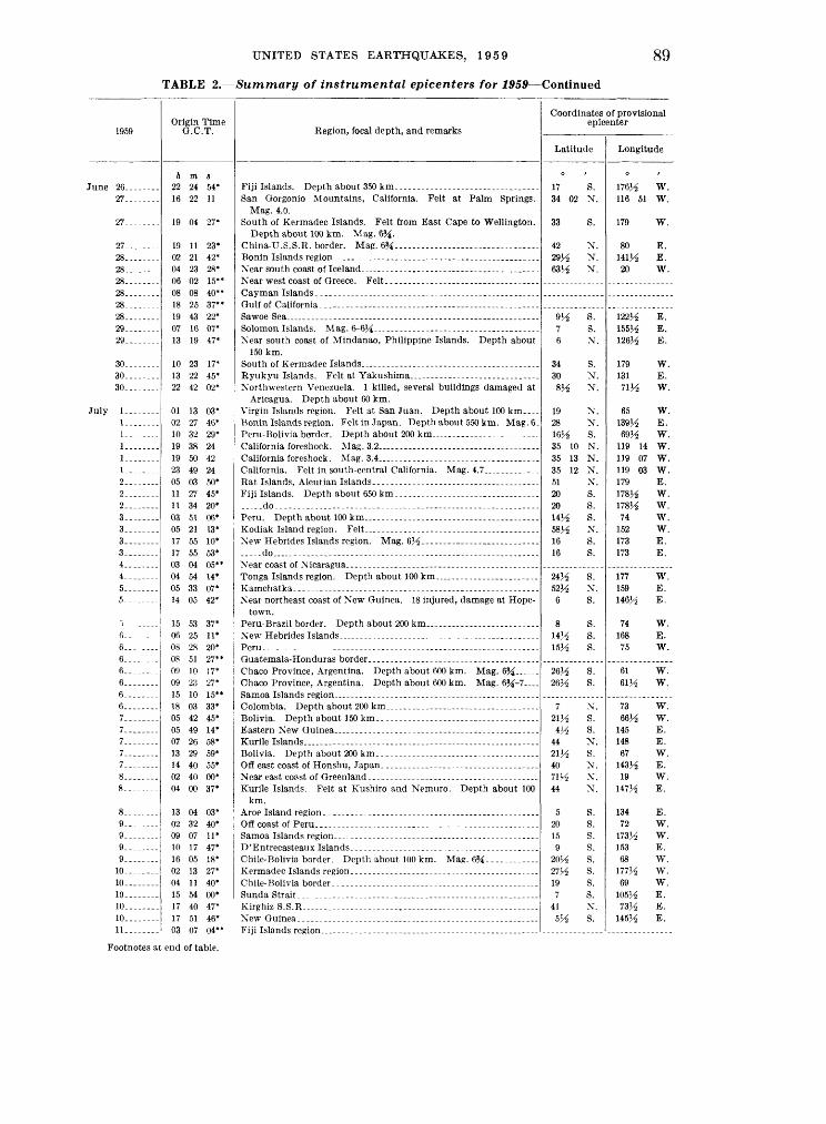
UNITED STATES EARTHQUAKES, 1959 89
TABLE 2. Summary of instrumental epicenters for 1959 Continued
1959
27. .......
27_-___-
27.-.---.28- 28- 28. --28 28 -28 .- 29 29
30_-_-__30 - 30
July I . !_-. ...-I.. -.--I... -1... -___I - 2---.---.2 -2. .......3 3. ...--..3 3- 4 .,-.45-- -5--.
6.. ... 6-_ ....6--.- 6- .-6. .__.-._6-- .6_ .7. .......7. T. .......7 7 8 . 8
8_ .9 9 ------9.- --.9_ 10 - 10 10 10--- 10---.--.11 -
Origin Time Q.C.T.
A m S
22 24 54*16 22 11
19 04 27*
19 11 23*02 21 42*04 23 28*06 02 15**
18 25 37**19 43 22*07 16 07*13 19 47*
10 23 17*13 22 45*22 42 02*
01 13 03*
10 32 29*19 38 2419 50 4223 49 2405 03 50*11 27 45*11 34 20*03 51 06*05 21 13*17 55 10*
03 04 05**04 54 14*
15 53 37* 06 25 11*08 28 20*
09 10 17*09 23 27*15 10 15**18 03 33*05 42 45*
H Art (;(;*
04 00 37*
13 04 03*
10 17 47*16 05 18*02 13 27*
15 54 00*17 40 47*17 51 46*03 07 04**
Region, focal depth, and remarks
San Qorgonio Mountains, California. Felt at Palm Springs. Mag. 4.0.
South of Kermadec Islands. Felt from East Cape to Wellington. Depth about 100 km. Mag. 6Ji.
China-U.S.S.R. border. Mag. &/i. ....... _ ._____
Gulf of California- ------------------------------------
Near south coast of Mindanao, Philippine Islands. Depth about 150 km.
Northwestern Venezuela. 1 killed, several buildings damaged at Aricagua. Depth about 60 km.
Virgin Islands region. Felt at San Juan. Depth about 100 km. Benin Islands region. Felt in Japan. Depth about 550 km. Mag. 6_
do-. - - --Peru. Depth about 100km . -
..-.do _- _ . ...
Xear northeast coast of New Guinea. 18 injured, damage at Hope- town.
Chaco Province, Argentina. Depth about 600 km. Mag. 6Ji-7
Bolivia. Depth about 200 km. .
Kurile Islands. Felt at Kushiro and Nemuro. Depth about 100 km.
Off coast of Peru...
Chile-Bolivia border. Depth about 100 km. Mag. f>%.. ..........
Chile-Bolivia border -.... ..-..........--..--...-.--....-..
KirghizS.S.R - - --
Fiji Islands reeion.
Coordinates of provisional epicenter
Latitude
17 S. 34 02 N.
33 S.
42 N. 29% N. 63% N.
9^ S. 7 S. 6 N.
34 S. 30 N. 8^ N.
19 N. 28 N. 16J-S S. 35 10 N. 35 13 N. 35 12 N. 51 N. 20 S. 20 S. 14^ S. 58^ X. 16 S. 16 S.
24^ S. 52 1A N. 6 S.
8 S. 14^ S. 15H S.
26^6 S. 26H S.
7 X. 21^ S. 4J^ S.
44 N. 21^ S. 40 N. 71H X. 44 N.
5 S. 20 S. 15 S. 9 S.
20H S. 27H S. 19 S.
7 S. 41 X. 5H S.
Longitude
176^6 W. 116 51 W.
179 W.
80 E. UVA E. 20 W.
122^6 E. 155^6 E. 126^6 E.
179 W. 131 E. 71^ W.
65 W. 139^6 E. 69^6 W.
119 14 W. 119 07 W. 119 03 W. 179 E. 178J-S W. 178^ W. 74 W.
152 W. 173 E. 173 E.
177 W.159 E. 146^ E.
74 W. 168 E. 75 W.
61 W.61^ W.
73 W. 66^6 W.
145 E. 148 E. 67 W.
143^6 E. 19 W.
147H E.
134 E. 72 W.
173% W. 153 E. 68 W.
177% W. 69 W.
105J/3 E. 73% E.
145% E.
Footnotes at end of table.

90 COAST AND GEODETIC SURVEY
TABLE 2. Summary of instrumental epicenters for 1959 Continued
1959
10
1 3
13. ...... _13.-.-....
1Q
16.......17 17 ...17......18 18.. ...18 ___18 ...
19 19 19. .......19 20 20 20.. 20 20 21 21 21.....21... ....
21 .21 21. ...... .
22... .22.... ..22 ....22 22. . ...22--.....23.. .23... _____23 23.. ....._23 23
23_.23 24
24. .......24_. . ..
Origin Time O.C.T.
h m s 04 51 30* 12 01 39* 18 23 00* 00 13 30* 00 24 22* 19 21 57* 01 39 12* 04 36 00** 12 28 45* 15 24 44* 23 59 59* 08 40 48* 11 33 51* 13 00 24* 18 14 51* 22 31 22* 07 00 05* 15 17 27* 19 13 52* 07 34 45** 22 52 08* 23 21 28* 07 00 36* 12 18 35* 19 29 22** 19 54 57*
03 42 02* 13 44 52* 15 06 10* 15 36 17* 00 46 30* 02 41 04* 09 16 35* 11 41 49 16 53 38* 00 43 38* 01 32 55** 07 43 13* 09 17 51*
12 29 09* 13 03 31* 17 39 29*
04 51 30* 11 15 33* 15 53 53* 16 36 40* 19 24 17* 23 02 27* 00 04 49* 02 08 31** 03 48 12* 04 24 35* 08 15 12* 13 45 38*
14 56 45* 21 25 39* 01 23 09
03 35 24* 05 12 40*
Region, focal depth, and remarks
Luzon, Philippine Islands. Felt. Depth about 150 km. Mag.
SundaStrait . _ . .. .......... _ . __ . ___ __ ... _ ...
Peru. Felt in Xort hern Chile. Depth about 200 km. Mag. 7.. .
Central Chile...... ._. .. ...... ...-- -...
Mag. 6.
do. . ... . . ... ......... ...Utah-Arizona border. Minor damage at Kanab, Utah and
Fredonia, Arizona. Mag. 5V_j-55i.
Honshu, Japan. Felt at Hachinoho, Kushiro, and Yamagata. Depth about 150 km.
Tonga Islands region. Depth about 60 km. Mag. 5% (Berk)...
Off coast of northern California. Felt in Humboldt County. Mag.5.8.
Chile..... ...........
Coordinates of provisional epicenter
Latitude
\$>}/2 S. 37 S. 44J/6 X.
8J/6 S. W 1A S. 42 N. 1\yn \T
52 X.25^6 S. 50 J-. X. 5l lA X.57 X. 16!/6 S. 21 S.
yz x.54 X. 50'/6 X.213^ s.
7'/6 X. 60V£ X.2iy2 s. 5oy2 x.
15'/2 X.
6J/2 S. 23 l̂ S. 15 S. 15}^ S. 30J-6 S.
6 S. 15H S. 33 22 X. 23 l/£ S. 9 S.
1V/2 S.
19 X.
16 X.16 X.
37 X.
15J/2 X. 2 X.
l5 l/2 X. 30 S. 53 X.
5 S. 5 S.
3 X. 3 X.
44J/2 X. 38 V£ X.
241/2" g_ 25 X. 41 08 X.
41 X. 21 S.
Longitude
169 E. 79 E.
148J-3 E. 157!/2 E. 177VS W. 72 V£ E. "H W.
172 /^ \V. 180 170 W. 172 \V. 158 W. 173 E. 179 W. 120 E. 161 W. 177 W. 169 E.
7m w.I53y2 W. 179 W. 130 W.
1201/6 E.
105 E. 179 E.70 y-i w.71 W. 71 W.
Ill E.
116 33 W. 179 E. 151 E.
167 V£ E. 68V£ W.
98 W. 98 W.
1121/6 W.
126 H E. 97K W.
178^ W. 153 E. 152y2 E. 152H E.
76 W. 761/6 W.
124^ W. 140 E.
176 \V.125 !/6 E. 125 18 W.
125M W. 70 l/6 W.

UNITED STATES EARTHQUAKES, 1959 91
TABLE 2. Summary of instrumental epicenters for 1959 Continued
1959
July 2424. . ..
25OC
2526.......26
29
30-,- 303131313101
31
Aug. 1 . ...1 .-2 22223...- 3344.. ...4........4 ..4
5..
5
5 6 .67. -_--_..
7888 ...8
9999
10.. ......10.. .10.... .11. ...... .1111... 12 .12..
Origin Time O.C.T.
h m s 16 17 43* 19 20 03* 23 03 08* 15 58 50* 19 23 54* 21 20 35* 17 07 03* 19 37 40* 05 27 45** 00 30 54* 18 54 03* 06 12 18* 12 53 56* 16 45 55* 01 51 45* 04 59 23* 18 23 10* 18 35 12* 19 53 02* 20 40 31*
10 01 30* 10 16 04* 11 57 56* 20 11 07* 20 29 55** 22 16 44* 23 45 19* 06 08 30* 15 36 37** 16 10 02** 03 00 33* 07 36 59 08 02 17* 19 12 35 23 53 30
05 16 39*
13 48 55*
19 52 54* 03 44 35 04 36 10* 10 43 32* 19 10 59* 21 45 26* 00 47 38* 01 50 27** 02 54 53* 23 56 05*
02 34 57* 09 09 53* 20 29 28* 23 40 03* 00 36 35* 00 36 41* 23 07 27* 08 09 02* 15 24 30* 21 49 42* 00 33 38* 00 35 36*
Region, focal depth, and remarks
Sakhalin
Kamchatka ...._
Kermadec Islands
Solomon IslandsTadzhik S.S.RNorth Island, New Zealand. Felt at Foxton, Wanganwi, and Well
ington. Depth about 200 km.
Solomon Islands
Indian Ocean, near 46^° S., 98° E...... __ ._._ _ ... ______ ..
Chile-Argentina border
West of Bishop, California. Felt. Mag. 4.0....... .......... ....Washington State. Felt in southwestern Washington and north
western Oregon. Samar, Philippine Islands. Felt at Borongan, Catarman, Catball-
ogan, and Legaspi. Near south coast of Mindanao, Philippine Islands. Felt at General
Santos and Davao. Depth about 100 km. Mariana Islands
Washington aftershockKodiak Island region. Mag. 5j^Solomon Islands
Northwestern Colombia
Solomon Islands. Felt at Karoola and Rabaul. Depth about 100 km.
do
Near east coast of CreteShansi Province, China
Nicaragua. Depth about 100 km . -. do
Coordinates of provisional epicenter
Latitude
24M N.sy2 s.
5GY2 S. 50 N. 49H N. 37 N. 41 N. 53 N.
18H S. 5V2 S.
49 S. 31^ S. 36 N. 16V6 S.
5 S. 441/6 N. &A S.
38^ N. 40 S.
27^ S. 15Y2 S.
6V£ S. 42 S.
39V3 N. 49H N. 33 N.
27 S. 37 21 N. 20V2 S. 37 28 N. 45 41 N.
\VA N.
5M N.
14 N. 47 49 N. 47 49 N. 56 N. 10M S. 56V3 N. 55 N.
14 S.6 S.
2M N. 17 N. 10 S. 8K S.
5514 S. 35M N. 35 N. 19J^ N. 44}^ N. 11 S. 12 N. 12 N.
Longitude
95H E. 153 E. 28^ W.
142M E. 142ii E. 140M E. 27J^ E.
160 E.
178 W. 154 E. 117^ E. 177H W. 70Y2 E. 71 W.
152VS E. 100 E. 154^ E.
70 E. 174 E.
65 W. 1741^ W. 154M E. 83 W.
118 W. 129^ W. 79!^ W.
68^ W. 118 33 W. 178 W. 118 39 W. 122 16 W.
125 E.
126 E.
142 E. 120 00 W. 120 00 W. 154 W. 162^ E. 154 W. 162H E.
76 W. 155 E.
127 E. 146 E. 161 E. 159 E. 146 E. 27!^ E.
Ill E. 65 W.
148H E. 163 E. 86 W. 86 W.
Footnotes at end of table.

92 COAST AND GEODETIC SURVEY
TABLE 2. Summary of instrumental epicenters for 1959 Continued
1959
Aug. 12........12........12........
1 O
13.. ......13........14........14........15.---...
15........15 ..15........15. .......15- 16. 16 16 ..16.. ......16........16
17___._ 17.. ...17.. ..17.. ...
18 ISIS 18 . 18... ..
18 18 ....18........IS ..18 ..._-.18 18. 19.. 19 ....
1919 20.... .20.......20.-.-.-..on
20 .. 20 20.. 21 21 21.-- 22 .-..23. 24 . 24 24 24 ..24 .......24 ...
Origin Time Q.C.T.
h m s 02 00 52* 04 05 20* 09 58 22* 18 06 07* 00 33 09* 15 30 42* 19 06 59* 04 39 07* 09 41 07** 08 57 07*
13 14 26* 18 28 57* 18 41 56* 21 29 42* 22 56 15* 00 51 40* 01 21 05* 09 53 52* 11 07 41* 17 49 50* 18 41 59*
01 02 37* 01 33 11* 04 29 00* 21 04 40*
00 30 00* 00 34 03* 05 13 30* 05 38 39* 06 37 15.0
07 54 32* 07 56 18* 08 41 50 11 03 52 15 26 06.5 21 13 09* 22 04 01* 04 04 03.0 07 08 28* 19 06 29 19 43 47. 5 21 45 57* 01 59 06* 03 48 56 07 18 34* 08 54 59** 10 59 11* 12 20 08* 19 11 27* 07 13 19* 08 03 15* 09 37 49* 21 28 02* 22 21 30* 12 29 20* 15 41 40* 16 40 04* 21 30 46* 23 32 23* 23 41 34*
Region, focal depth, and remarks
Formosa. 16 killed, 63 injured and extensive property damage. Depth about 60 km. Mag. 6^-7.
Costa Rica. Depth about 200 km.. - . . _ .
Fiji Islands. Depth about 350 km. ___ ... .... ...... ...New Britain. Felt at Oavit, Pondo, and Rabaul.. ... .. .. . .
Greece. Damage at Diavolitsion, Kalliroi, Katsaro, and Zacharo. Felt throughout southern Greece.
____.do_ _ . Solomon Islands. Considerable damage in the New Georgia group.
Mag. 7J*. Northern Celebes. Depth about 200 km. __Near east coast of Formosa. Depth about 200 km.....-------......
Hebgen Lake, Montana. 28 killed and many injured. Moderate property damage. Mag. 7.1.
Hebgen Lake aftershock. Felt. Mag. 6}i (Berk). _______Hebgen Lake aftershock. Felt. Mag. 6 (Berk)..__.. ......Hebgen Lake aftershock. Felt. Mag. 5Vf-5% (Berk)..... .......Hebgen Lake aftershock. Felt. Mag. 6j^_ ._ _. ._._ _ ___
__ do.. ------Hebgen Lake aftershock. Felt. Mag. 4 1/_i-5 (Berk). __ _.
Near Ferndale, California. Felt. Mag. 4.2 (Berk).. _. _ __.Off coast of Peru.
Mediterranean Sea, north of Spanish Morocco. Felt at Melilla.___
.... .do....
.do
Coordinates of provisional epicenter
Latitude
3 15 16M 35 40 51V£ 43V_i
0
22
218
55 17H 10 21 22 18
5 PA
37M
22V_ 41 41m0
22M 42 22V£ 44 50
45 45 44.8 44.8 44 53 11 41 44 54 21M 45.0 45 45 10H 40 16
7
45 38H 45 38 V£ SOU 50M 17V* 35H 53 WMwy2 wy2 wy2W l/2
s.s. s.N. N. N. N.
N.
S. S.N. S. N. S. N. S. S. S. N.
N. N. N. S.
N. N. S.N.
N. N. N. N. N. S. N. N. N. N. N. N. S. N. S.
N. S. N. N. S. S. S. N. N. S. S.s. s. s.
Longitude
80V2 W. 28 E.
177M W. 87 W. 48M E.
176 W. 126H W. 125^ E.
121 E.
174 W. 79K W.
162V£ E. 177 W.
85 Y2 W. 169 E. 121 E. 178 W. 152 E. 144 E. 22 E.
121 E. 20 E. 20 E.
156 E.
123 E. 122 E. 127 W. 172 E. Ill 05 W.
Ill W.110H W. 110.7 W. 111.1 W. 110 44 W. 162M E. 20 E.
Ill 38 W. 121 E. 111.4 W. 110^ W.niy2 w.161 E. 124 25 W.85 W.
Ill W. 78 E.
Ill W. 104 E. 139K E. 140 E. 69M W.
3 W. 159H E. 161H E. 161V3 E. 161 E.i&iy2 E. wiy2 E.
Footnotes at end of table.

UNITED STATES EARTHQUAKES, 1959 93
TABLE 2. Summary of instrumental epicenters for 1959 Continued
1959
Aug. 25_ .._25 .25 26 26 ___.26_ ___26.
26.-_._.26-._____27_---___27 27 27
2828 28 29 29.......29--.....29. .__.__30- SO-SO 30.
30 _30 31 31
Sept. I.. .1 .1-1-
1 _2. __...__
2 2... .....3_. ______33 .....3 _ _4.._ -__4... _4........4. .---.-_44. ..._-__4 __5 .5 _____555 5... _____6_-_-__._6______..6... .....
7.---...T. .......
Origin Time Q.C.T.
h m s 12 24 18** 13 40 06* 17 51 49* 02 29 37* 04 53 00* 05 32 51 08 25 30*
10 27 41* 13 01 26* 05 05 44* 07 50 28* 13 36 50* 23 53 10* 01 56 56* 02 37 00* 12 07 44* 15 52 10* 03 21 07** 10 52 27** 17 03 10* 21 20 27* 02 53 08* 03 24 54* 13 44 07* 18 48 34* 21 45 07* 22 57 00* 23 36 42* 09 05 56* 20 33 52* 00 38 27** 00 52 04* 10 49 43* 11 37 42*
11 46 45** 00 05 05* 08 03 00* 09 31 36* 12 52 20* 02 39 04* 04 02 00* 06 27 30* 21 48 56* 08 52 55* 12 30 00* 17 47 15* 18 36 41* 19 09 48* 19 22 32* 23 22 56* 06 07 38* 07 00 26* 15 34 44* 21 12 02* 21 53 22** 23 05 00* 00 27 59* 04 10 54* 13 18 03* 18 55 26* 04 03 20* 04 05 55*
Region, focal depth, and remarks
Verz Cruz, Mexico. 20 killed, many injured and extensive damage throughout Tehuantepec Isthmus. Mag. 6%.
.....do...... .......................................................
Central Alaska. Felt al Col 'ge, Fairbanks, and Matanuska_. ...
Lake Baikal, U.S.S.R. Mag. &A~^A---- ---- __ - ____ -----
Mediterranean Sea, north of Spanish Morocco. Felt at Melilla...
Albania. 2 killed, 34 injured and extensive property damage in the d'Elvasan and Veration regions. -Mag. 5J4-6.
.-.-do
Northern Chile. Depth about 200 km__. _._... _________ _ ___ _ __
Near north coast of New Guinea. ______ ..... .....................
Coordinates of provisional epicenter
Latitude
0 ,
5
34 0318
51 50y2
5 0
45 25 48
9 63^ 17
S. S.s. s.N.N.
N.N. S.
S.N. N. S.N. S.
5217 8
63 23 36^. 37 53
17
11 20
44 60 20 5520J/2
41
15
31 \i
145 52 \i 47
1 62
1
18
10
15V<?
N. S. S. N. N. S. S. N. N. N. S.
S. N. N.
N. N. N. N. S. N. S. S.s.s.N. S. N. N. S. N. S. N. N.
S. N. S. N. S. S. R
Longitude
0
155 71
152 15314 116 33
132 130V6
122
96 155 158 149167
E. W. E. E. W. W.
W. W.E. E. W. E. E. E. W. E.
168
3150m\4
68 Vi 106 171 167M
74^
20
110 151 65
164 178H 20
123
152 177 142 24
HIM
75 129 156 129
126V.:
124 69Vi
147
E. E. E. W. W. E. E. E. E. W. E.
W. W. E.
W. W. W. E. W. E. E. W. E. W. E. W. W. W. W. E. E. E. E.
W. E. E. E. W. W. E.
Footnotes at end of table.

94 COAST AND GEODETIC SURVEY
TABLE 2. Summary of instrumental epicenters for 1959 Continued
1959
Sept. 7.......8-----..8
8.......8.-- _8... ..9........9 ---.
10... ..10-..-..10-.-....10 11 11 .11
11 12 ..12 12 - 12.----..12 .12.. .12........12 -12______.
13... ..13 13 13 13- 13 ISIS 14 14 14........14 14 14. .14 .14 14 14 14 14. 14. 15 ..15 .15 ISIS 15 15 15 15 15 15 15
15 16-...-.
Origin Time G.C.T.
h m s 11 39 30* 07 09 48* 10 03 29*
13 12 04** 19 19 39* 20 18 37* 01 50 05** 05 44 38** 05 35 04* 15 43 28* 16 18 09* 22 56 56* 02 32 11* 11 05 33* 14 18 07* 19 43 10* 23 08 38* 00 22 01* 01 41 03* 01 53 47* 07 01 45* 08 47 33* 11 24 27* 14 40 10* 16 59 05* 21 19 57*
03 56 11* 04 38 05* 19 15 52* 19 49 36* 20 40 41* 21 23 31* 22 40 36* 23 39 46* 06 22 59* 08 42 56** 09 34 52* 13 15 49* 13 36 12* 14 09 39* 14 58 40* 16 22 01* 16 56 13* 17 06 15* 17 22 28* 20 27 10* 22 23 53* 01 30 59* 05 58 11* 05 59 42* 06 08 35* 06 17 28* 08 00 23* 10 48 44* 11 05 33* 12 00 20* 12 54 25* 13 46 17* 15 08 23*
22 34 42* 02 03 34*
Region, focal depth, and remarks
Honshu, Japan. Felt at Kakioka, Mite, Onahama, and Shirakawa. Depth about 100 km.
Hokkaido, Japan. Felt at Hiroo, Kushiro, Obihiro, and Urakawa
___ do... ___ do
Hindu Kush. Felt at Peshawar and Sargodha. Depth about 200 km.
.do. .... do
-..-do
do .... ..... . -
..-do
....do .. ... .. .-..- _ do . _ do... ------
Near east coast of Hokkaido, Japan. Felt at Kushiro and Nemuro. Depth about 100 km.
---do..- ---.---...-.
Coordinates of provisional epicenter
Latitude
45 45 36H
42H 5814
N. N. N.
N. S.
6H 45H VA
47 17 44^ 42M
6 12
6 20
3 3 3 VA 5
17!^ 36
& 1AVA
39^ 45 45 45
1 45 45
45 24 4528J/22&y2 2&y229 29 46 28V3 29 29 28 28H 28V2 28^ 28M 29 21^ 28^ 2114 29 43
29 29
S. N. S. N. S. N. N. S. N. S. S.s. s. s. s. s.N. N.
S. S.N. N. N. N. N. N. N.
N. S. N. S. S. S.s. s.N. S.s. s. s. s. s. s. s. s. s. s. s. s.N.
s. s.
Longitude
111 111^ 140
142^ 24^
W. W. E.
E. W.
15414 148J^ 151H 151 178 112 29H
155 87^
106 68
146H 146^ 146 156 152H 106
71
130 146H 74^
111 HOVi 111 129 111 111
111176M 111 177 176Vi 176 Vi 176H 176V$ 1S1J* 176V$ 177 176H 176J^ 177 176^ 176M 177 177 179^ 176V£ 177H 177 147
176V2 176^
E. E. E. E. W. W. W. E. W. E. W. E. E. E. E. E. \V. E.
E. E. E. \V. W. W. E. W. \V.
W. W. W. W. W.\v.W. W. E. \V. \V. W. W. W. W. W.\v.W. W. W.\v.W. E.
W. W.
Footnotes at end of table.

UNITED STATES EARTHQUAKES, 1959 95
TABLE 2. Summary of instrumental epicenters for 1959 Continued
1959
16-...-.-.
16.,..-...16 --.16-..-.--.16-..--...16.-..-..
17.. _..._.17--.---17. . ....17- . .17--- 17.-. --..
17....-.-18. .......18. ......IS........19........20-...-.-.20.......21........21.--.-21.. ......21. . . _-22..-.-.-.22.-. ....23-.-..--.23........23........24. .24.24... ._24........24. .--_...25........25.--.-.-.25.... ...25.-..-.25--..-.26.... ...26. .26........26. .......27..-. ...27... .28_-..._.28... ..28.......28.29........29. .......29. __29...29-.....-.30-......-30....-.-.30--..--.30.... ..30...30.. .
Origin Time G.C.T.
h m s 02 35 59* 05 13 50* 10 07 45* 15 57 03* 19 14 53* 20 53 54* 21 15 28* 21 43 57* 23 20 05* 00 25 31* 02 29 53* 14 07 54* 14 36 11* 14 51 40* 21 24 27*
22 14 40* 09 24 35* 12 01 11* 16 52 48* 21 53 38* 06 07 59* 23 1 7 34* 02 08 28* 12 19 30* 13 09 36* 16 16 19* 07 45 55* 11 44 15* 09 38 27* 10 38 59* 22 23 11* 05 43 38* 17 02 09 18 25 47* 18 55 09* 19 44 29* 00 14 30* 01 39 09* 02 36 48* 07 18 38* 23 34 57* 04 48 53* 08 20 51* 10 18 20* 12 35 38* 07 16 40** 10 20 18* 01 11 20* 01 50 27* 04 20 27* 08 05 42* 15 31 57* 15 41 21* 16 13 53* 17 07 50* 17 38 19* 01 36 00* 03 30 05* 04 56 21* 13 31 30* 16 57 30* 20 25 58*
Region, focal depth, and remarks
--do _____-__-----.------------------ ----------_
-..-do ____.--_.___------------------------------.--_ ___-do .. .._--- ---------------------------------- --_.....do .___--------- ------------------ ----- .....do.. -..- ---- --- ---- - -----------
El Salvador. One killed, slight damage in southern El Salvador. Depth about 60 km.
Gulf of California. Mag. 5^--- ------------------------------------
Northeast of Ukiah, California. Slight damage. Mag. 3.6 (Berk) .
-.--do..... -___-.____-.----_.--. --.----_---.._-..-._--_ ..
Off coast of Oregon. Mag. 6-6J4 (Berk). ........................
....Ao......... .....................................................
....Ao......... ............................. . .-_... ....--..do ..... ..
..-.do __.________.__-._._._-__._._....-___. _-___...
New Hebrides Islands. Felt at Port Vila and Vate. Mae. 6V4
Coordinates of provisional epicenter
Latitude
29 35H 29 28H
7 7H
45 45Ji 45 45 45 28H 28H 28H 13K
30H 28H 57H 5H
45 13H 22H 9H
40 10 62H 53H 16
7 83H 35H 83H 39.4 45 45 29^
9 29 22 44 29 44 43H 22 79H
5H 81H 42 26H 45 29 29 29 29 29 45 27 28^ 29 35 18
S.N. S. S.N. N.N. N. N. N. N. S. S. S. N.
N. S. S.s.N. S.s. s.N. S. N. N. S. N. N. N. N. N. N. N. S. S. S. N. N. S. N. N. S. N.
S.N. N. N. N. S. S.s.s. s.N. N. S.s.N. S.
Longitude
176^ 26
176H 176 77Ji 77H
111 111 111 112 111 176H 176 176H 88H
114 176J^ 24
147 111H 111H 67H
149 74H
120 159 166 173H KYi
H3J4 138H H2H 123.0 111 111 176H H3H 177 122 39
176H 128 128y2 68H 12
129H 26
127 128 111 176H 176 176H 176H 176H 111 125 176H 176H
3 168
W. E. W. W. W. W. W. W. W. W. W. W. W. W. W.
W. W. W. E. W. W. W. E. E. E. W. W. W. W. E. E. E. W. W. W. W. E. W. E. E. W. W. W. W. W.
E. E. W. E. W. W. W. W. W. W. W. E. W. W. W. E.
Footnotes at end of table.
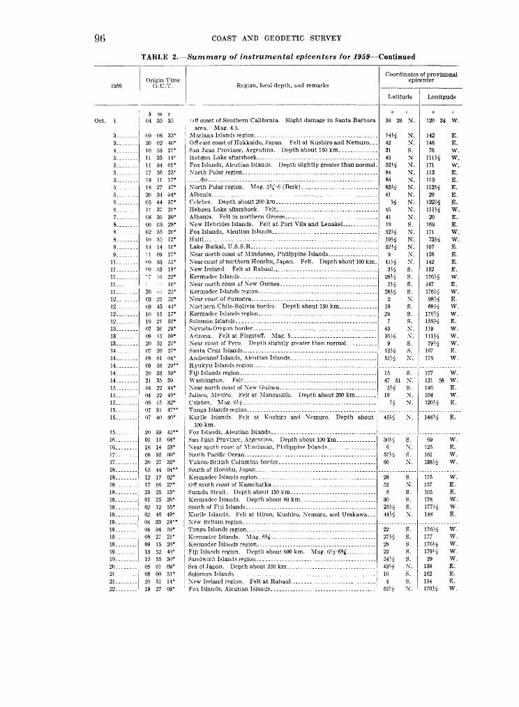
96 COAST AND GEODETIC SURVEY
TABLE 2. Summary of instrumental epicenters for 1959 Continued
1959
Oct. 1
3. . ------
5.. ------5... _----5
5... .-..6 _ 6. .. .7.. ------8.-..-.-.
g11 -
11
12-------.12 .. 12..-...--10
1Q
13. . ------
14........14------
14 15 15 15 ._ 15........15----
1 C
16------
17. -------
is
18 18 .- 191919.. ------19 . 19 . .19.. ------19 19-. ......
20--.. -21 - 21 .22. -----
Origin Time O.C.T.
h m s 04 35 35
09 08 33* 20 02 40*
10 53 27* 11 33 14* 11 34 01* 17 56 25* 18 11 17* 18 27 47* 20 34 04* 05 44 37* 11 37 21* 08 30 39" 00 03 28* 02 35 20* 10 55 12* 14 14 10* 11 09 27* 09 33 55* 09 53 18* ' 7 .M) 22* : ' - 10* 20 <« 25* 03 21 52* 03 43 44* 10 15 17* 19 21 50* 07 30 29* 08 15 00* 20 52 25* 07 20 27* 08 01 04* 09 56 29** 20 33 59* 21 35 39 04 22 44* 04 22 49* 06 15 32* 07 31 47** 07 40 40*
20 33 45** 01 15 08* 16 14 53* 08 35 00* 20 27 35* 05 44 04** 12 17 02* 17 06 27* 23 25 13* 01 25 26* 02 12 55* 02 46 49* 04 33 24** 04 34 59* 08 27 21* 09 15 20* 13 52 40* 15 55 30* 08 01 09* 06 00 51* 20 51 14* 19 27 08*
Region, focal depth, and remarks
oft coast of Southern California. Slight damage in Santa Barbara area. Mag. 4.5.
Off east coast of Hokkaido, Japan. Felt at Kushiro and Nemuro...
Fox Islands, Aleutian Islands. Depth slightly greater than normal.
.....do ........ . - ..........North Polar region. Mag. 5%-6 (Berk). _._.__ __________________
New Hebrides Islands. Felt at Port Vila and Lenakel. . _ _
Lake Baikal, U. S.S.R... ... - . ............
Near coast of northern Honshu, Japan. Felt. Depth about 100 km.
Near coast of Peru. Depth slightly greater than normal. _. ...
Kurile Islands. Felt at Kushiro and Nemuro. Depth about 100km.
Sumda Strait. Depth about 150 km.. ...........-..... _.___..
KurilP Islands. Felt at Iliroo, Kushiro, Xemuro, and Urakawa...
Fiji Islands region. Depth about 600 km. Mag. 65^-6^ ..._...
Fox Islands, Aleutian Islands..--... ......
Coordinates of provisional epicenter
Latitude
34 26
42 31 45
84 84
41
45 41 19
9
28^
28^ 2
19 29
7 43
9
15 47 51
191A
WA
6
60
28 52
6 30 25^ 44^
2227^ 28 22
10 4
SPA
N.
N. N. S. N N. N. N. N. N. N. N. N. S. N. N. N. N. X. S. S.s. s.N.S.s. s.X. X.s. s.N.
S. X.s.N.X.
X.
s.X.s.X.
s.N.S.s. s.X.
s. s.s. s. s.X.s. s.X.
Lonitgude
120 34 W.
142 E. 146 E.
70 W. ll\ lA W. 171 W. 113 E. 113 E. 1121A E. 20 E.
122^ E. 1U 1A W. 20 E.
169 E. 171 W.
107 E. 126 E. 142 E. 152 E.
147 E.176^ W. 983^ E.
176^ W. 155H E. 119 W.ni lA w.79^ W.
167 E. 176 W.
177 W. 121 58 W. 146 E. 104 W. 120^ E.
148^ E.
69 W. 125 E. 161 W. 138^ W.
175 W. 157 E. 105 E. 178 W.n~lA w.148 E.
177 W. 176^ W. 179^ W. 29 W.
139 E. 162 E. 154 E. 170Y2 W.

UNITED STATES EARTHQUAKES, 1959 97
TABLE 2. Summary of instrumental epicenters for 1959 Continued
1959
Oct. 23. .-...-23 23
24- .25. -25
25-- 26 .
26 -27.. ------
27. ------27 --. 27 . 28 -29.. 29 .
29- -.29 30 30- 30.. SO-SO . 30. 30.. --30. 30 31 31..
Nov. 1... .....1- 2..-. ..2.... .,2 2. ....
2 ....2-..
23.. 3 ......3.. 4...4.... .4........5 5 5 5 5- 5 6 -....6 -.6..6 ...6 6-..
Origin Time G.C.T.
h m s 03 43 32* 06 17 54* 16 54 23* 13 43 39* 15 35 15 23 40 34* 06 51 09** 15 57 51*
17 07 41** 07 35 12*
10 29 09* 02 07 28**
06 12 17* 06 52 50* 13 18 51* 09 21 51* 10 35 20* 14 19 51*
14 30 24* 19 49 45** 00 32 29* 04 00 26* 05 20 36* 06 24 38* 07 04 48* 11 10 16** 11 27 33** 13 58 25* 21 37 35* 04 27 12* 18 31 18* 12 13 10* 23 03 25* 08 44 01* 09 02 20* 12 02 46* 13 15 40*
13 30 44* 20 03 32*
21 53 05* 00 32 19* 09 04 58* 09 40 05* 17 13 50** 18 22 40** 19 07 36* 05 45 23* 10 59 40* 11 50 17* 14 59 37* 17 37 40' 17 38 08* 01 07 31* 01 11 36* 07 37 18* 11 32 50* 11 43 06* 12 25 06*
Region, focal depth, and remarks
New Ireland region. Depth about 150 km . ............Chile-Bolivia border. Depth about 200 km. . . _ __ _.
Kazakh S. S.R. ________ ...... ... . . .-...... -... . -... .. ...
Eastern Turkey. 18 killed, many injured and extensive property damage at Hinis and Varto. Felt at Ezurum.
Talaud Islands region, ... ... ___ . - - ........Near east coast of Honshu, Japan. Felt. Depth about 60 km.
Mag. 64.
South Carolina. Slight damage at Chesterfield, Kershaw, and McBee. Also felt in southern North Carolina.
Off coast of Oregon. Mag. 5-5)4 (Berk) _Kurile Islands. Depth about 100 km. Mag. 64_ _ _
Kermadec Islands. Felt on Raoul. Depth about 60 km. Mag. 5M (Berk).
Yakutsk A. S. S.R. ......... . _ -__- _ . __ _
Fiji Islands. Depth about 600 km.... . ._ __ . .. ... .Fiji Islands. Felt at Apia. Depth about 450 km. Mag. 64-6%..
-do
Kirghiz S. S.R. Depth about 100 km. __ __ . .... Pakistan-Burma border. Felt at Chittagong. Depth about 100
km.
New Britain. Felt at Karlai, Pomio, Rabaul, and Walindi. Depth about 60 km. Mag. 6%.
..do. . . - . .-. .
Ryukyu Islands region. Felt at Yakashima. Depth about 250 km.
.do ... do . ..... ...-.. ......
Solomon Islands _____ _ ______ ____ . ... __ ____._.___.
Coordinates of provisional epicenter
Latitude
4 201.. 334504 35 44 414
39
374
514
424 454 46 22 46 294
43
84 66
4
19
S. S. N. N. N. N.
X.
N.
X.
X. N. N.S. X.
X.
X. X.s. s. s.
23.4 19 164 2
444 45 224 22 404 22
59 54
234 34
234104
s. s. s.X. NT .
X. N. X. X. X.
N.S.
s.X.s. s.
2044 54
13 30
9 84 8,4 9
42 3
24 10
s. s. s. s.N.S.s. s. s.N.S.s.s.
Longitude
154 684 59
130 118 00 70
42
1424
157"^
127 151 151 1784 151 1764
131
138 1364 804
1234 1774
E. W. E. W. W. E.
E.
E.
E.
W.E. E. W. E. W.
E.
E. E. W. E. W.
1754 1774 178 774
111 111 1444 144}^ 734 92^
1521514
1754 1264 1754 111
W. W.W. W. W. W. E. P. E. E.
W. E.
W.E. W. E.
1694 153 68
1664 129 158 1574 1574 1574 204
1464 1744 1614
E. E. E. E. E. E. E. E. E. E. E. W. E.

98 COAST AND GEODETIC SURVEY
TABLE 2. Summary of instrumental epicenters for 1959 Continued
1959
Nov. 7... ...
8... .88. ---g9
10-. ------10. .......12131414
15. . ------15-._----.IS.......
15- .16. 16.. ______16........16--.-...17
17. --17..----.18--__-___19. -.191919_-____..
19..-----.
19-...-...19. 20.------.20..-----.20 20 22 ...22.. ______22._______22.. -__--_23---....23..______23-____-_.23.. ____..24.----. _ 24---. 24... .24.--_____25...----26---.----26 ..26 26---...26.. -.27 27------
Origin Time G.C.T.
h m s 02 32 07*
08 17 59* 22 16 14* 13 54 55* 14 27 37* 16 36 16* 00 05 36* 13 35 40* 08 08 18* 10 40 45* 20 56 10* 20 30 12* 10 06 14* 10 33 56* 12 13 27**
08 04 45** 10 25 22*17 08 41*
17 31 25** 00 59 22* 10 21 17* 23 43 40* 23 50 35* 02 32 37* 15 16 59* 17 23 28* 23 55 01* 13 32 08** 04 34 57* 05 25 53* 07 57 24* 11 08 41*
14 00 24*
14 08 20* 23 53 49* 10 56 59* 15 16 45* 16 30 45* 19 29 38* 12 47 56* 16 26 34* 19 34 35* 22 42 49* 14 41 42* 16 14 47* 18 15 25 21 05 18* 12 41 00* 14 04 17* 14 57 15* 20 06 35* 19 04 20* 00 41 35* 07 06 19* 07 39 49* 16 06 03** 23 09 23* 00 22 30* 10 42 10*
Region, focal depth, and remarks
Xear coast of Algeria. Several injured. Moderate damage at Ameur-el Ain, Bou-medfa, and Hamman-Righa.
Mexico
Tibet.. _...--. --_-.. ........ -_ . - - _ _ _.-...
South of Fiji Islands. Depth about 600 km.. ...... .._...___.....-.
Guatemala-El Salvador border. Slight damage in western El Salvador.
Tadzhik S.S.R.-China border. Depth about 150 km. ...........Xear west coast of Greece. Felt in Greece and Italy. Several
injured at Agrinion, Greece. Slight damage. Mag. 6}^-65<t.
Indian Ocean
Xear north coast of New Guinea. Slight damage at Lae and Madang. Depth about 100 km. Mag. 7.
Off west coast of Turkey. Felt at Burhaniye, Edremit, Izmir, and Lesbos.
Off coast of Oregon
Samoa Islands regionBanda Sea
Tonga Islands region. Depth about 250 km__ . .. ._..._...._.____
Coordinates of provisional epicenter
Latitude
36H
11^ 23J^ 44 13 4H
18J^ 6J^ 3,4 7
36 11 23
3
X.
S. S. X.s. s.X.s. s. s.X.s. s.s.
38 H37J^
35 1 4
18 11 9 5
304
51H 24^
2 5H
38,4
1242^ 44
154 7 1 3
54 21H 19H
H20 46 4024J/2 25 19 174
7 1A
6 145H
154
54 38H 22
X. X.
s.X. X.N.s. s. s.X.
X.s.X.s.
X.
X. X.s. s. s.X.s.s. s. s. s. s.N. N.s. s.X. X. N. X.s.s.
s.X.s.
Longitude
2H
1664 176 140J^ 167 154 103 132 153J^ 156 88M
166H 179 148^
E.
E. W. E. E. E. W. E. E. E. E. E. E. E.
75H20'^
70 26J^
126}^ 147 66'i
119 141 94
175Ji 177 80
146
26
87 126^ 153 174 129 26 ! -2
140 136 178 5-i 175 128M 17414 121 45 122 176 178,4 120 37
127 127H 102M 175
10320H
1774
E. E.
\V. \V. E. E. E. E. E. E.
\V. W. W. E.
E.
W. W. E. W. E. W. E. W.\v.E. E. E. W. E. W. W. E. W. E. E. E. W.
E. E. W.
Footnotes at end of table.

UNITED STATES EARTHQUAKES, 1959 99
TABLE 2. Summary of instrumental epicenters for 1959 Continued
1959
Nov. 27 .....00
28..----.-9ft
9ft
00
28-, .90
9O
on
29-------.
30SO-.--.-..30._.-___.
11.!..,_..__1.. ...\. ......
1 ..22 . 2__.___._2___...__2...-_...2........2.. .___..3.. _..___3.. ___..4________4...--..5-. ______
5........6-..---..7-_......7.-..--..
7--..-...8.-.-.-..8.. ......8.. ......8........8. .......8.. ......9........9__._____
10........111112______._
IS-...-...13.. _.__..13. ......13.. ......14.. .,_...
14........14. .......14........
Origin Time G.C.T.
Am* 18 51 27* 02 45 45* 03 20 24* 11 06 17** 12 34 53* 21 18 32* 22 39 13* 01 30 52* 05 46 56* 19 17 40* 23 49 42*
11 12 53* 15 18 37* 21 06 30* 12 38 46* 12 51 58* 14 19 30** 14 59 40* 15 38 07* 18 11 49*
18 54 48* 07 02 52* 07 30 05* 07 43 55* 09 34 00* 18 20 11* 19 57 55* 22 52 45* 01 55 05* 13 16 26* 01 06 13* 09 24 04* 08 13 42
22 01 10** 17 14 20** 01 12 05* 03 01 44* 04 10 45** 05 15 24* 02 59 56* 04 30 06* 08 08 21* 12 20 55* 12 50 45* 13 33 59* 14 04 28* 21 28 57* 14 03 01* 00 31 40* 01 38 33* 06 24 17
03 20 38* 05 39 31* 07 50 20* 17 36 07* 17 58 33*
21 49 10* 22 00 50* 23 21 56*
Region, focal depth, and remarks
Chile. Mag. 6>2- -------------------------------------------------
..... do. ..-.... --..--..... .....-.-. .... .. . ...
Near south coast of Greece. Felt on the Island of Crete. Region of Chania, Mourniae, and Nerokourus.
Kenai Peninsula, Alaska. Felt at Homer, Kasilof, and Seward____.
Near west coast of Greece. Felt at Cephalonie and Zante Island. . _ _
Near south coast of Mindanao, Philippine Islands. Depth about 400km.
Celebes. Mag. 6M-6?.;-- -- --- -- --. ----------
Off coast of northern California. Felt in Humboldt County. Mag. 5.1 (Berk).
Puget Sound, Washington. Slight damage at Marysville and Port Angeles.
Near south coast of Mindanao, Philippine Islands. Felt at Davao, General Santos, and Hinatuan. Depth about 200 km.
Sandwich Islands. Mae. 7 _ _ _ ___ __ ___ __ _
Coordinates of provisional epicenter
Latitude
5H S. 19H S. 26 N.
28H S. 14M S. 13 S. 21 S.26K S. 57 S. 36 N.
44}.: N. 59H N. 24}i S. 38 N. 38 N.
63 S. 31M S.
5 N.
9 S. 9 S. 5 S.
21^ N. 1 S.
45 N. 4H S.
52 N. 56M S. 16M S. 15 S. 21 S. 40 18 N.
6 S. 18 S.
32Vi N. 36M N.
1 S. 67 N. 37^ N. 31 N. 42 N. 17 S.
. 5 S. 44M N. 5 S.
23 S. 48 44 N.
42 N. 9H S.
45 N. 18 S. 5Y2 N.
1 N.52^ N.59^ S.
Longitude
103 E. 174H E. 128H E.
71 W. 168 E. 167M E. 177 W. 178 W. 147Vi W. 23^ E.
80 Vi E. 152 W. 68H W. 21M E. 21 E.
154 E. 67>i W.
125 E.
124H E. 80 W.
104 E. 94H E.
123 E. 16 E.
140 E. 174 E, 24^ W.
vny* w.174^ W. 178H W. 125 25 W.
146H E. 178 W.
139H E. 141H E. 124 E.
18 W. 72H E. 57 E. 44Vi E.
177 1/.: W. 153 E. Ill W. 130 E. 175 W. 123 15 W.
142 E. 1063^ E. 110M W. 173H W. 125 Y2 E.
125 E. 168 W. 26 W.
Footnotes at end of table.

100 COAST AND GEODETIC SURVEY
TABLE 2. Summary of instrumental epicenters for 1959 Continued
1959
Dec. 15 15 15 15 _--_-15 15-------15 15. -___15-. ___--.
16
16. 17 17- 17 _____17. .17.18 18. 18 19. 19 .20. 20 -
21 21 _____21 .- 21 -...22. .--22. -.-.--
23 23.. -23 .-.-.
23 24. --__--.
24 _____24. -_-_--24.. .25 .25
26_-___--.26 .26 27 27- 27 27 27 27 27_ 27 27 27 27.__ _____27 27 28
Origin Time Q.C.T.
h m s 01 35 23* 05 04 14* 08 56 20* 09 30 22* 09 38 23* 10 47 42* 11 25 07* 12 15 45* 15 24 14* 17 05 30* 23 01 57* 02 28 42
11 21 47* 02 31 02* 02 55 58* 05 04 46* 05 53 46* 16 48 55* 09 11 55* 09 57 07* 16 24 50* 13 46 14* 15 07 00* 08 05 34** 12 53 37* 14 16 52* 02 23 58* 10 20 33* 11 14 17* 11 19 14* 02 38 57 17 20 19*
03 49 00* 04 31 00* 09 28 56*
13 59 02* 08 09 32*
09 14 24* 12 50 35* 13 08 34* 03 48 58* 10 18 47*
12 11 09* 18 19 10* 22 02 35* 04 47 45* 05 01 55* 05 06 14* 05 22 39* 06 18 08** 06 51 35* 07 45 25* 08 05 30* 11 48 55* 11 54 48* 12 39 09* 15 52 55* 19 28 39* 02 12 18*
Region, focal depth, and remarks
do - --. --. -.. . .._ _do _
California. Felt in Xapa, San Francisco, and Sonoma Counties. Mag. 4.1 (Berk).
Gulf of Aden. Mag. ^/rff/i. ......................................
Off east coast of Honshu, Japan. Felt at Tokyo. Depth slightly greater than normal.
Near north coast of Sicily. Several injured and minor damage at Catania and Palermo.
Vera Cruz, Mexico. Felt at Coatzacoalcos and Jaltipan. Depth about 200 km.
Chile-Argentina border region. Felt at Antofagasta, Chile. Depth about 100 km. Mag. W/r&A.
.....Ao............. ...................................... .......... __do.... -do
.-..do. _ - . - ..do - -. .do
do - . ... ._-_---__--_-_- ..do.... - Santiago del Estero Province, Argentina. Depth about 650 km
Hindu Rush. Deoth about 200km- - -
Coordinates of provisional epicenter
Latitude
17H N. 17 N. 17H N. 5^ N.
45 N. 37 N. 17 N. 59 S. 3114 N. 50Y2 N. WA X. 38 35 N.
47^ X.21 y* x.24 S. 4Q1A X.
51A S. 36^ S. 45^i X. 18 S. 53 X. 19 X. 27^ X.
10V£ X'. 17^ S. 45 X. 27Y2 S. 27H S. 14 N. 40 16 X. WA X.
56^ X. 28 S. 38 X.
273i S. 18H X.
27^ S. 13H S. 9 X.
27^ S. 25}^ S.
52 S. 59>i X. 53 N. 52^ X. 52^ X. 5VA X. 35 X.
WA X. 5214 X. 52M N. 52 V3 X. 52^ X. 28 S. 56 X. 56 X. 37 X.
Longitude
145 E. 145 E. 145 E. 125^ E. Ill W. 70 E.
145 E. 24 W.
116H W. 179 E. 11H E.
122 22 W.
152 E. 121 E. 177 W. 142^ E. 102^ E. 101^ W. Ill W. 178^ W.mlA w.71H W.
\\y-A. w.
126^ E. 174^ W.niy2 w.176 W. 176 W. 52 E.
124 31 W. 141^ E.
158 W. 176 W. 14^ E.
176 W. 95 W.
176^ W. 74^ W.
12&A E. 176 W. 68^ W.
101H E. 151^ W. 160 E. 160^ E. 160 E. 160 E. 26 E.
159^ E. 159^ E. 160 E. 160 E. 160 E. 63 W.
162^ E. 162 E.
70 1A E.
Footnotes at end of table.
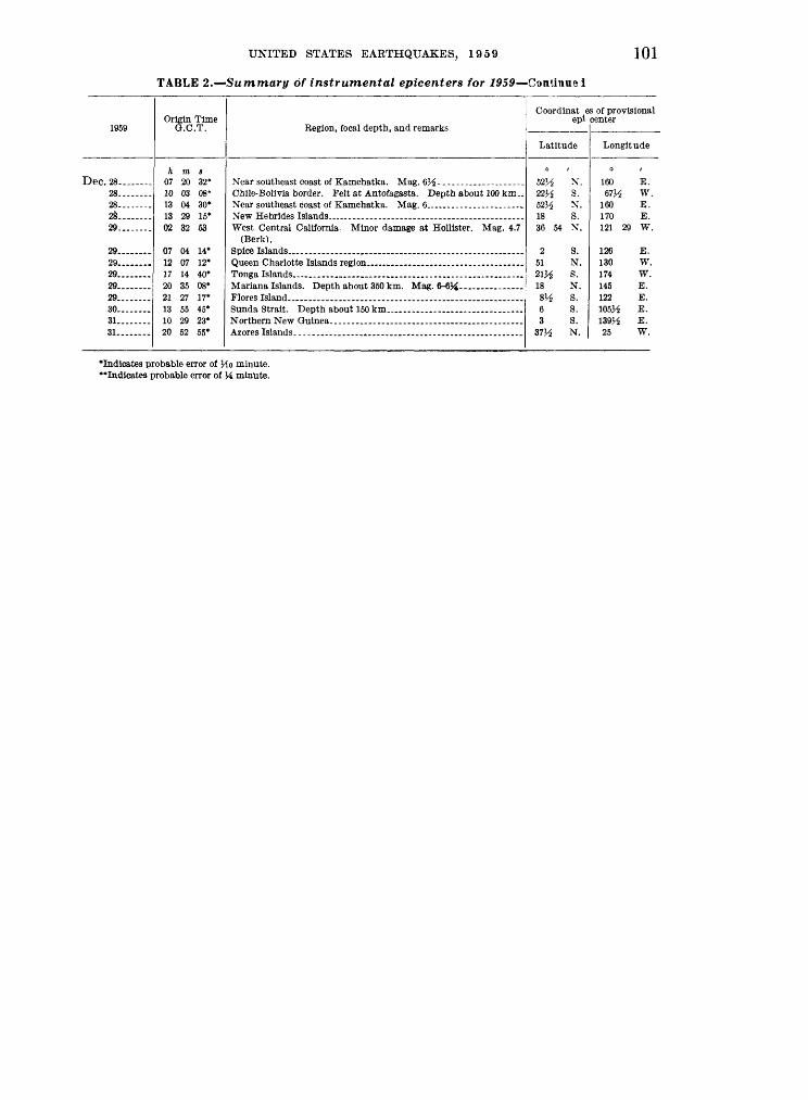
UNITED STATES EARTHQUAKES, 1959 101
TABLE 2. -Summary of instrumental epicenters for 1959 Continual
1959
Dec. 28. .28 28 28 29
90
29... .29 29 29 30 ...31........31
Origin Time G.C.T.
h m s 07 20 32* 10 03 08* 13 04 30* 13 29 15* 02 32 53
07 04 14* 12 07 12* 17 14 40* 20 35 08* 21 27 17* 13 55 45* 10 29 23* 20 52 55*
Region, focal depth, and remarks
Chile-Bolivia border. Felt at Antofagasta. Depth about 100 km..
West Central California. Minor damage at Hollister. Mag. 4.7 (Berk).
Coordinat es of provisional epi center
Latitude
52V 22V 52V 18 36
2 51 21}* 18 8V 6 3
37H
2 N.
2 S.
1 N.
S. 54 "V
s.N. S. N. S. S. S. N.
Longitude
160 E. 67^ W.
160 E. 170 E. 121 29 W.
126 E. 130 W.174 W. 145 E. 122 E. 105 V-i E. 139/^ E. 25 W.
Indicates probable error of Mo minute.** Indicates probable error of J4 minute.

102 COAST AND GEODETIC SURVEY
TABLE 3. Principal earthquakes of the world from January through December 1959
NOTE. This table lists (1) the strongest shocks of the period as revealed by seismographic records, particularly those of the Western Hemisphere stations; (2) important destructive and near-destructive earthquakes; (3) earthquakes of unusual interest outside the two preceding categories; and (4) magnitude as determined by Pasadena.
1959
Feb. 7..
Mar. !____--
8Apr. 24-.----
26. _-..-_.
24. ------
.Tnnp, 14
SO........
Ally 19----
Aug. 15-..__-
17........
18........
24... 26.__
Sept. \. .......
14__ __Oct. 25. ------
Nov. 19-----
Dec. 14. .-._-..27__.._
Origin Time O.C.T.
h m s 05 10 25*
09 36 51*
16 49 13*
23 02 42* 17 57 58* 20 40 38*
07 15 42*
19 17 40*
00 11 57*
22 42 02*
15 06 10*
08 57 07*
21 04 40*
06 37 15.0
21 30 46* 08 25 30*
11 37 42*
14 09 39* 15 57 51*
11 08 41*
23 21 56*15 52 55*
Region
Near coast of northern Peru-
Near north coast of New Guinea.
Near northeast coast of Formosa.
Near east coast of Kam chatka.
Oaxaca, Mexico
Northwestern Venezuela..
Peru. ...
Hebgen Lake, Montana.....
Near north coast of New Guinea.
Near east coast of Kam chatka.
Coordinates of provisional epicenter
Latitude
37V$ N.
4 S.
1A S.
ny2 s.31 S.25 N.
52 Y2 N.
17M N.
2oy2 s.
&4 N.
15 S.
22 N.
7 1A S.
44 50 N.
WA s.18 N.
41H N.
28 V£ S.39 N.
5\i S.
59H S. 56 N.
Longitude
142 E.
SHi W.
134 V$ E.
75\i W. 178 W. 122^ E.
159J-3 E.
97 W.
68 W.
n lA W.
WA W.
121 E.
156 E.
Ill 05 W.
161 E. 94J^ W.
20 E.
177 W. 42 E.
146 E.
26 W. 162^ E.
Remarks
Felt in eastern Honshu and southern Hokkaido. Small seismic sea wave at Miyako. Mag. 6%-7.
Felt strongly at Guayaquil. Mag. 7M-7M.
Slight damage at Manokwari. Depth about 100 km. Mag. 7.
5 killed and minor property damage. Mag. 6%-7. 2 killed, minor damage at Taipei.
Depth about 150 km. Mag. 7M-7M.
1 killed and 13 injured. Buildings damaged at Petropavlovsk. Depth about 60 km. Mag. 8.
5 killed, 10 injured and minor prop erty damage. Felt in Mexico City. Depth about 100 km, Mag. 8H-7.
1 killed and minor damage in north ern Chile. Depth about 100 km. Mag. 7J£-7Ji.
1 killed, several buildings damaged at Aricagua. Depth about 60 km.
Felt in northern Chile. Depth about 200 km. Mag. 7.
16 killed, 63 injured and extensive property damage. Eighty percent of brick and stone houses in Heng- Chung destroyed or damaged. Depth about 60 km. Mag. 6%-7.
Extensive damage in the New Georgia group. Mag. 7M-
28 killed and many injured by mas sive landslides. $11 million damage to timber and roads. Moderate property damage. Mag. 7.1.
Mag. 7. 20 killed, many injured and extensive
damage throughout Tehuantepec Isthmus. Mag. 6%.
2 killed, 34 injured and extensive property damage in the d'Elvasan and Veration regions. Mag. 5H-6.
Felt on Raoul. Mag. 7M- 18 killed, many injured and extensive
property damage at Hinis and Varto. Felt at Ezurum.
Slight damage at Lae and Madang. Depth about 100 km. Mag. 7.
Mag. 7. Mag. 65^-7.
'Indicates probable error of one-tenth minute.

UNITED STATES EARTHQUAKES, 1959 103
STRONG-MOTION SEISMOGRAPH RESULTSINTRODUCTION
During 1932, the Coast and Geodetic Survey inaugurated a program of record ing strong ground movements in the seis- mically active regions of the country to obtain basic data needed in the design of earthquake-resistant structures. Notes pertinent to this program will be found in the preceding issues of the United States Earthquake series and in S.P. 201, Earth quake Investigations in California, 1934-35. The latter is much broader in scope than the former, and contains data on struc tural and ground vibrations with detailed descriptions of the various activities which comprise the seismological program as a whole.
Interpretation oj records. The analyses appearing in tables 6 and 7 are based on the assumption of simple harmonic mo tion. This refers especially to the com putation of displacement from accelero- graph records. As most accelerograph records are of irregular character, and the character of the longer period waves is often obscured by the superposition of shorter period waves of relatively large amplitude, the estimates of displacement must be considered only rough approxi mations. These analyses are essentially condensations of material appearing in the Quarterly Engineering Seismology Bul letin available through mailing list CGS-5 from the Director, Coast and Geodetic Survey, Washington 25, D.C.
Units and instrumental constants. Quan titative results are expressed in c.g.s. units; centimeters or millimeters for dis placement; and centimeters per second per second for acceleration. It is some times desirable to express acceleration in terms of the acceleration of gravity, indi cated by "g" which is equal to 980 cm/ sec. 2 For practical purposes it is only necessary to point off three decimal places to convert cm/sec2 to "g."
Most of the instruments have been ad justed so that each will register the max imum acceleration to be expected on the particular type of geological formation
beneath the instrument. The following expectable earthquake accelerations were used in determining the accelerograph sensitivities: (a) rock foundation, 25 per cent of gravity; (b) residual clay and shale, 40 percent of gravity; (c) alluvium, 70 percent of gravity; and (d) top floors of tall buildings, 100 to 200 percent of gravity. The four sensitivities may be roughly listed as 26, 19.5, 13, and 6.5 mm. per 0.1 g., respectively.
Sensitivity of the seismographs is ex pressed as the deflection of the trace, or light spot, in centimeters, for a constant acceleration of 0.1 g.
Damping ratio of the pendulum is the ratio between successive amplitudes when the pendulum oscillates.
Seismogram illustrations. R epro duc- tions of records in this publication are tracings of the original records and must not be accepted as genuine copies. The tabulated instrumental constants refer to the original records. The tracings are in tended to show the nature of the data rather than furnish a means through which the reader can make his own measure ments. Those who desire true copies for critical study should make request to the Director, Coast and Geodetic Survey, Washington 25, D.C.
Acceleration and displacement scales representing the equivalent of 0.1 g. and 1 inch are indicated on the tracings of the acceleration and displacement curves. The scales provide the investigator with a quick means for making rough measure ments on the published curves. The measurements of period on records of this nature are dependent largely on the judg ment of the person reading them and considerable latitude must be allowed in appraising their accuracy. The aim of such analyses is primarily to give a fair picture of the magnitudes of the various elements involved, and the figures tabu lated should therefore not be used for important studies without first referring to the illustrations for some idea of the nature of the original records.

104 COAST AND GEODETIC SURVEY
TABLE 4. Coast and Geodetic Survey strong-motion stations in operation as of Dec. 31,1959
NORTHERN CALIFORNIA
Station
Monterey, City Hall...--..-...-.-....-----..-.----...-....-..--.--...-........-.-....-.Oakland, City Hall, basement. .-.-__.-.._____._.____ _ ..... _ ........... __ .. ......Oakland, City Hall, 16th floor _ ......._-.-._-._ _ .................. ____ . .........Oakland, Chabot Observatory.. . ..-....-. _ ... __ ....... __ ............ ......
San Francisco, Alexander Bldg., basement........ ..-.-.---.....-.-.......-...- _ ......
San Francisco, 450 Sutter St., basement...... .......-.- ..... ......-.........-.....-.San Francisco, 450 Sutter St., 29th floor. ................................................
San Francisco, Shell Bldg., 29th floor.. .................................................
Accelero- graph
11
1
11
1
111
1
11
Displacemeu meter
11
1
1
2
Weed
1
1
SOUTHERN CALIFORNIA
Long Beach, Public Utilities Building. .................................................
Taft_--. --.-.- -. -- --- ------- --.-.-.--. .- --.---. ---
111111111
1
1
11
111
1112
1
1
1
1
1
1
1

UNITED STATES EARTHQUAKES, 1959 105
TABLE 4. Coast and Geodetic Survey strong-motion stations in operation as of Dec. 31,1959 Continued
OUTSIDE CALIFORNIA
Station
Portland, Oreg., State Office Bldg... ................--.---.-...............-.-.-.-..-..
Accelero- graph
11
11111
11
1
Displacement meter
111
1
Weed
OUTSIDE UNITED STATES
Balboa Heights, C.Z................................ .................................... 1111111
62 21 11
NOTE. San Francisco, Golden Gate Park strong-motion station was discontinued March 3, 1959.

106 COAST AND GEODETIC SURVEY
TABLE 5. List of shocks recorded and records obtained on strong-motion seismographsin 1959
Date
Mar. 2.... ...... .
Apr. 27 May 26
June 23 _ . ......
Julyl. July 23..- ...Aug. 3. ... Aug. 17
Aug. 20-21 Aug. 22-23
Aug. 23-25
Aug. 25-26 Aug. 26-27 ..Aug. 27 Aug. 27-Sept. 4 Sept. 30- Oct. 13-- Dec. 21- .Dec. 28
Total- .,
Region and Recording Station
Central California, HoUister ...... .......
Oakland City Hall
San Francisco, Shell Building. ...... ....
Central California, Hollister. ........ __ .
Butte...... . . ........
-- do . ...... do..... , ... do... ...
Records
Accelero- graph
1
2 3 1
2 2 1 1 2 1 2 1 1 1 1 1 2 4 1 1 1 1 1 1 1 2 2 1 1 1
43
Survey displace
ment meter
11
1
1
4
Carder displace
ment meter
1
1 1 1
1
2
1
8
Weed
1
3
4

UNITED STATES EARTHQUAKES. 1959 107
TABLE 6. Summary of outstanding instrumental and noninstrumental data for 1959
CENTRAL CALIFORNIA EARTHQUAKE OP MARCH 2
Epicenter
36°59' N., 121°36' W., near Gil-roy, Calif., VI.* Mag. 5.3.
Recording Station and Distance Location of Instrument
Intensity >
VI
Accelera tion
cm. /sec. 1 47
Displace ment s
cm. (\ 3
NORTHERN CALIFORNIA EARTHQUAKE OF MAY 26
36°43' N., 121°37' W., near Salinas, Calif., VI.* Mag. 4.6.
VI 14 0.08
NEVADA EARTHQUAKE OF JUNE 23
39°05' N., 118°49' W., north of Schurz, Nev., VI.* Mag. 6.1.
V 12 0.01
MONTANA EARTHQUAKE OF AUGUST 17 (MAIN SHOCK)
44°50' N., 111°05' W., Hebgen Lake, Mont., X.* Mag. 7.1.
VI 54 0.04
MONTANA AFTERSHOCK OF AUGUST 23
Hebgen Lake aftershock, IV.*-.. IV 15 0.007
MONTANA AFTERSHOCK OF AUGUST 27
Hebgen Lake aftershock, IV.*. .. IV 3" 0.06
PERU EARTHQUAKE OF OCTOBER 13
9° S., 79V3° W., near coast of Peru. 13 0.001
CENTRAL CALIFORNIA EARTHQUAKE OF DECEMBER 28
36°54' N., 121°29' W., northwest of Hollister, VI.* Mag. 4.7.
Hollister, 7 miles.. .. ............. ...... VI 33 0, 12
1 Reported intensity of earthquake at recording station.2 Displacement is the maximum recorded at the station reporting the maximum acceleration of the earthquake. If displacement
is much greater at another location it is given along with the maximum acceleration at the same location. Following Intensity designation In epicenter column, indicates maximum reported intensity of earthquake.

108 COAST AND GEODETIC SURVEY
TABLE 7. Composite of strong-motion instrumental data for 1959
CENTRAL CALIFORNIA EARTHQUAKE OF MARCH 2
Station and component
Hollister: Vertical............S. 1° W.. ..........N 89° WN. 1°E. ...........N. 89° W...........
Oakland, Chabot Ob servatory (Weed) :
S. 56° W.. .........S. 34° E__ ..........
Oakland, City Hall 16th floor:
Vertical--....-. N. 26° E. ..........
S. 64° E............
Basement: Vertical............N. 26° E_. .........S. 64° E.. ..........
San Francisco, Alex ander Building, 16th floor.
S. 81° W. ..........
S.9° E.... .........
llth floor:
N. 81° E. ..........S. 9° E. ............
Basement: VerticalN. 9° W.... ........N. 81° E. ..........
San Francisco, Golden Gate Park:
VerticalN. 10° E. ..........S. 80° E.. ..........
San Francisco, Shell Bldg., 29th floor (Weed):
8. 81° W.. .........S. 9° E- ........
21st floor (Weed): N. 81° E. ..........N 9° W
Subbasement (Weed):
N. 81° E. ..........N. 9° W...... ......
Instru ment No.
239........240........CDM-6... CDM-5...
8..........8.......
226........227........
228...... .
235........236........
181........
180........
179
178... 177........176........
198........197
304one
306........
2..........2..........
3..........3..........
4..........4. ......
To
sec.
0.068 .066 .066
2.1 2.2
.207
.199
.043
.044
.044
.066
.066
.067
.045
.046
.046
.046
.048
.046
.063
.065
.067
.0768
.0758
.0781
.188
.189
.200
.203
.175
.174
V
123 123 122
1.0 1.0
7.0 7.0
117 115
117
113 120 113
119
120
121
121 122 118
119 120 120
119 121 119
7 7
7 7
7 7
Sensi tivity
em./g
14.2 13.5 13.3
7.6 7.0
5.5 5.7
5.8
12.6 13.2 12.7
6.2
6.5
6.4
6.2 6.4 6.6
11.8 12.8 13.7
17.3 17.2 18.0
6.2 6.2
6.7 6.7
5.3 5.3
«
11 9
12 1211
5 5
12 9
11
107 7
7
9
12
9 11 8
8 11 9
10 9
10
3 3
2 2
5 4
Acceleration
Period
sec.
0.3 .3 .3
.3
.3
.2 1.2
1.4
.1
.3
.5
.2
.5
.4
.2
.4
.2
.2
.2
.2
.1
.4
.1
.4
.4
1.0 1.0
.7
.7
Ampli tude
cm./sec. 1
7 15 9
48
15 13
14
368
21
22
25
14 10 6
5 5 6
2 2 2
29 38
24 9
44
Displacement
Period
sec.
0.8 1.7
Ampli tude*
cm.
0.14 .14
.007
.01
.02
.48
.69
.001
.01
.06
.03
.13
.12
.02
.04
.01
.008
.008
.01
.001
.007
.001
.14
.19
.56
.22
.053
.053
Remarks
Short period waves su perim posed.
Short period waves su perim posed.
Regular Ap pearance.
Regular Ap pearance.
Regular Ap pearance.
Footnote at end of table.

UNITED STATES EARTHQUAKES, 1959 109
TABLE 7. Composite of strong-motion instrumental data for 1959 ContinuedCENTRAL CALIFORNIA EARTHQUAKE OF MARCH 2-Continued
Station and component
San Francisco, South ern Pacific Bldg., 14th floor:
Vertical.... ........8.45° W.. .........N. 45° W_. ._.__.___
Basement: Vertical. ..... .....N. 45° W.... .......N. 45" E... ........
San Jose, Bank of America, 13th floor:
Vertical............N. 59° E__ .........S. 31° E .
Basement: Veitical.. ...... ...N. 59° E.__ _ ...S. 31° E_._. ....-.S. 59° W.. .........S. 31° E............
Instru ment No.
184........183........182
196--.....195....--..194........
175 174........173........
202 201... ..200- CDM-8... CDM-9
To
sec.
.0459
.0463
.0469
.0666
.0664
.0665
.0483
.0463
.0463
.0679
.0657
.0669 2.27 2.27
V
119 120 122
118 119117
120 120 119
117 119 116
.9
.9
Sensi tivity
cm./g
6.26.4 6.7
13.0 13.0 12.8
7.0 6.4 6.3
13.4 12.7 12.9
(
8 10 9
10 10 10
12108
10 8
11 10
Acceleration
Period
sec.
0.2 .4.5
.5
.5
.6
.2
.4
.2
.3
.2
.3
Ampli tude
cm. /sec. 1
9 41 47
5 16 14
10 19
8
47 8
Displacement
Period
sec,
2.3 1.3
Ampli tude*
cm.
0.007 .18 .30
.03
.12
.13
.02
.10
.01
.12
.07
Remarks
MONTANA EARTHQUAKE OF AUGUST 17
Bozeman: Vertical North East-.- --------
Butte: Vertical - . South. ------------West. _
Helena: Vertical- East. .South ___ .... ...
Hungry Horse: Vertical. ---------East-- -.
316.. _.___.317 318- -
301 302 ..303___.-.._
313 314 315
310 311 312
0.081 .080 .081
.079
.079
.080
.080
.078
.079
.079
.082
.080
124 124 123
116 117 118
125 124 121
124 125 124
20.3 19.9 19.7
18.5 18.5 19.2
21.5 19.3 19.2
19.2 20.7 20.3
9 108
11 9
10
1112 10
10 7
11
0.2 .2 .2
.2
.1
.2
.2
.3
.2
.3
.2
.2
25 54 32
21 33 42
8 13 11
1 11
0.02 .03 .04
.02
.01
.07
.01
.02
.01
.003
.002
.002
MONTANA AFTERSHOCK OF AUGUST 23
Hebgen Dam: Vertical - -
S. 30° W _.N. 60° W. ...... .
West Yellowstone: Vertical - -
West _._ -North-
1010
1011- 1012-.---
1058
1059 1060 .
0.1095
.1100
.1030
.1083
.1096
.1105
115
116 117
114
115 120
34.2
34.9 30.8
33.2
34.3 36.4
10
12 10
15
10 9
0.1
.1
.2
.1
.1
.1
1
2 3
15
12 10
0.001 .002
.007
.006
.004
Aftershock between 12:00 MST 22d Au gust and 15:30 23d August.
Do. Do.
Aftershock between 08:45 and 21:30 MST 23d Au gust.
Do. Do.
Footnote at end of table.

110 COAST AND GEODETIC SURVEY
TABLE 7. Composite of strong-motion instrumental data for 1959 Continued
MONTANA AFTERSHOCK OF AUGUST 27
Station and component
Hebgen Dam:
S. 30° W._ .........
N 60° W
Instru ment No.
1010.___-__1011. ......
To
sec.
0.1095 .1100
.1030
V
115 116
117
Sensi tivity
cm.lg
34.2 34.9
30.8
c
10 12
10
Acceleration
Period
sec.
0.1 .3
.3
Ampli tude
cm./sec. 2
4 37
32
Displacement
Period
sec.
Ampli tude*
cm.
0.001 .06
.05
Remarks
Very regu lar wave group.
PERU EARTHQUAKE OF OCTOBER 13
Lima:
N. 82° W . .......N. 8°E-.. -
286 287 288 -
0.0634 .0629 .0635
123 125 122
12.5 12.5 12.4
7 7
10
0.1 .1 .1
7 6
13
0.001 .001 .001
NORTHERN CALIFORNIA EARTHQUAKE OF DECEMBER 21
Ferndale:
S. 44° W. ......... .NT. 46° W... ........S. 44° W... .. ...S. 46° E . --------
247..-.---.248 249.. ----SDM-13-- SDM-13--
0.0662 .0671 .0658
10.55 10.00
123 124 124
1 1
13.6 14.1 13.6
10 10 11 1210
0.3 .2 .1
14 23 12
0.5 .4
0.09 .12
NORTHERN CALIFORNIA EARTHQUAKE OF DECEMBER 28
Hollister:
N. 1° E--- X. 89° W.... .......N. 1° E.. ..........N. 89° W -----
238 239 94nCDM-6... CDM-5
0.0676 .0657 .0655
2.12 2.23
123 123 122
1 1
14.2 13.5 13.3
11 9
12 1210
0.3 .3 .2
23 22 33
0.7 .5
0.12 .12
*Estimated from acceleration if no entry in displacement column.

UNITED STATES EARTHQUAKES, 1959 111
"a
o o
f "
o £^ 00
clc «I 8N<
QQ QO
'
QC
6
o|
OCQ

112 COAST AND GEODETIC SURVEY
AaaS

UNITED STATES EARTHQUAKES, 1959 113
Hebgen Dam, Montana August 23-25, 1959 Accelerograph Record
o.ig
Up
S30°W
/\^\j^r^^^N60°W
O.lg
0 Seconds 2
West Yellowstone, Montana August 23, 1959Accelerograph Record
o.ig
Up
o ^V\l\J\J\J\f\/^^
NorthA I NUI LI I
f}J\Sv/\J\[\^
O.lg0 Seconds
FIGURE 15. Tracings of accelerograph records obtained at Hebgen Dam on August 23-25, andat West Yellowstone on August 23.

114 COAST AND GEODETIC SURVEY
Hebgen Dam, Montana Accelerograph Record
o.ig
W\lf\ft\fC^^^
August 27, 1959
Up
S30°W
o.ig
Seconds
Hollister, California Accelerograph Record
December 28, 1959
Up
y*A^VY«\/l/A/\/vvr>W O.ig
S1°W
o |ty|p/^p/\A/W^ ^^
O.ig
^lylpjl^Seconds 10
FIGURE 16. Tracings of accelerograph records obtained at Hebgen Dam on August 27, and atHollister on December 28.

UNITED STATES EARTHQUAKES, 1959 115
TILT OBSERVATIONS
Three Merritt tiltmeter stations, Table Mountain, Santiago Peak, and University of California (library), continued in routine operation.
PUBLICATION NOTICES
The Coast and Geodetic Survey maintains mailing lists for notices of issuance of its publications. Should you desire to receive notices of seismo- logical publications, address your request to the Director, Coast and Geodetic Survey, Washington 25, D.C.
O
U.S. GOVERNMENT PRINTING OFFICE: 1961 O -591796